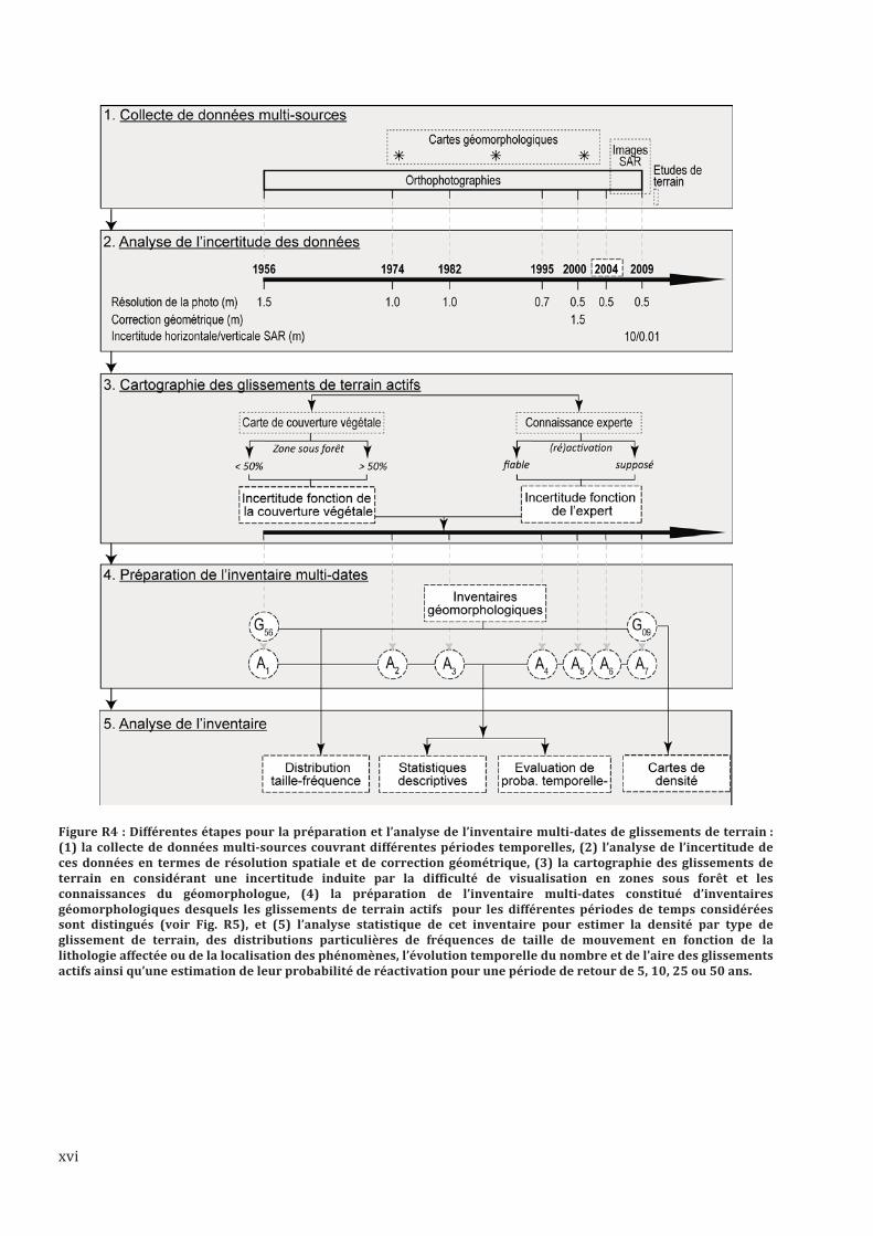
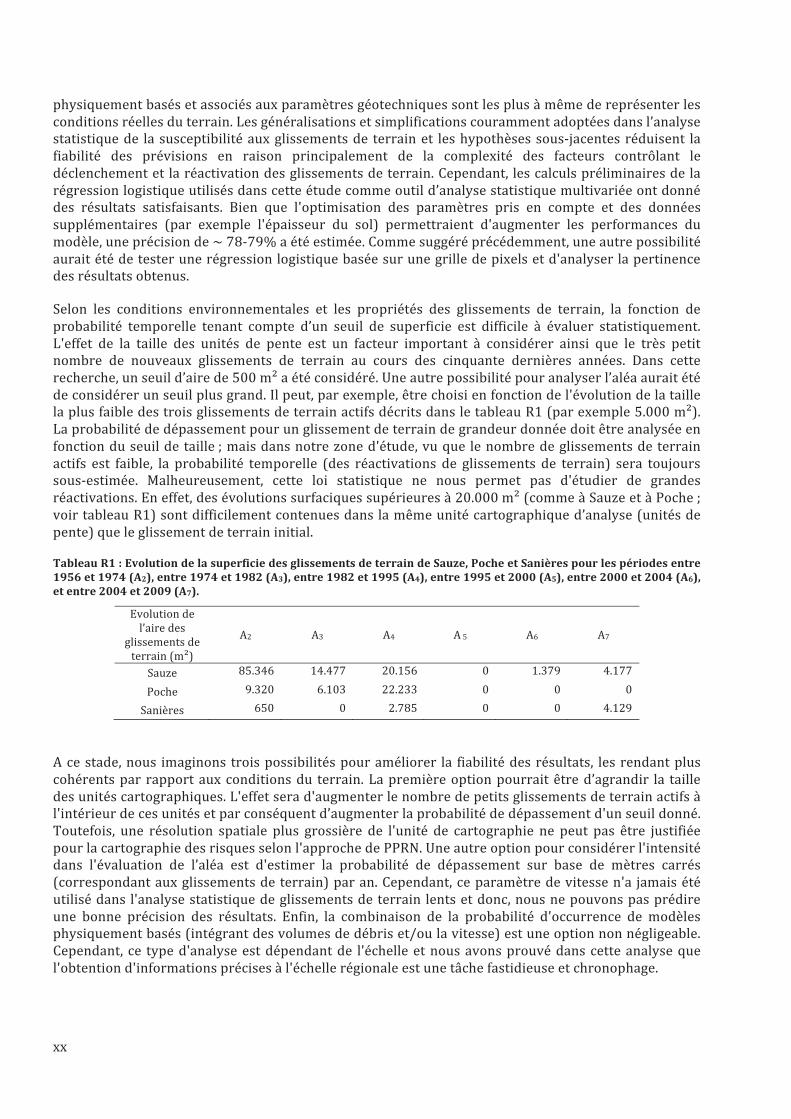
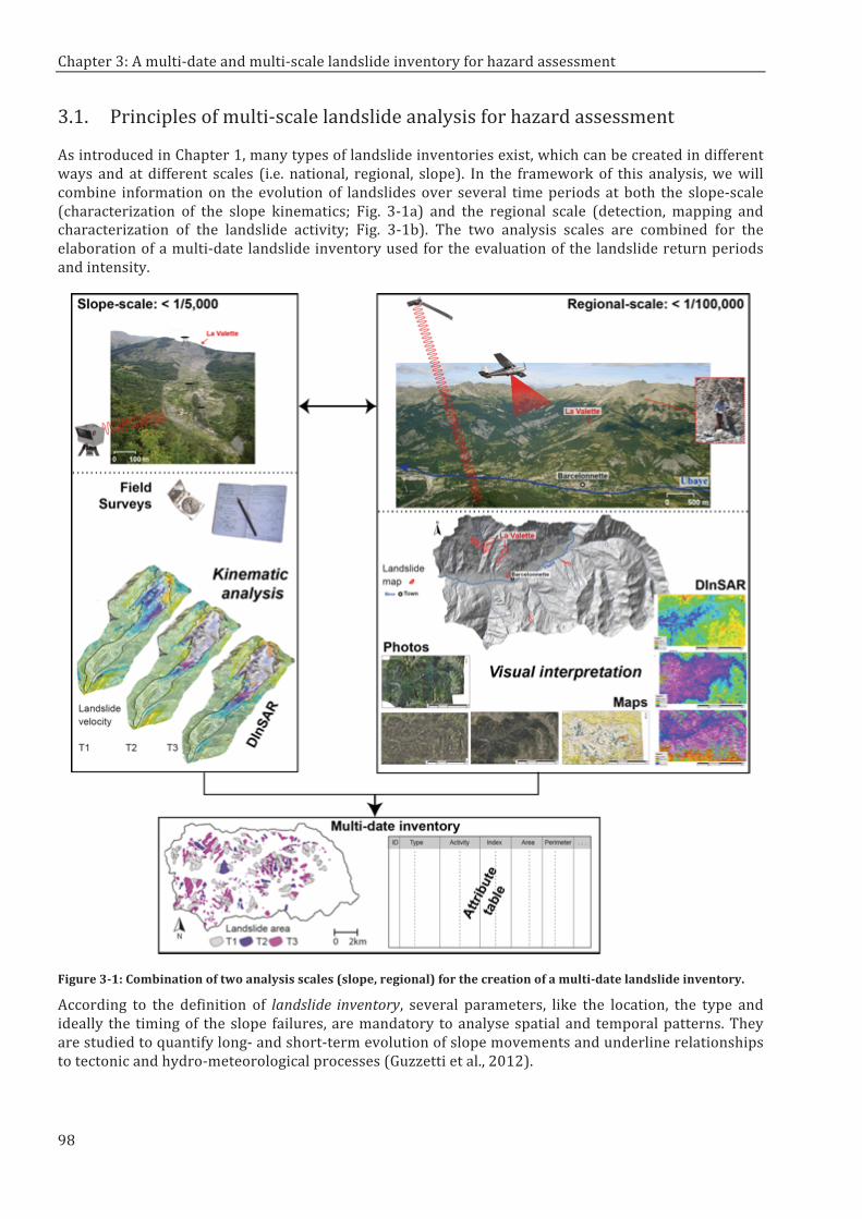
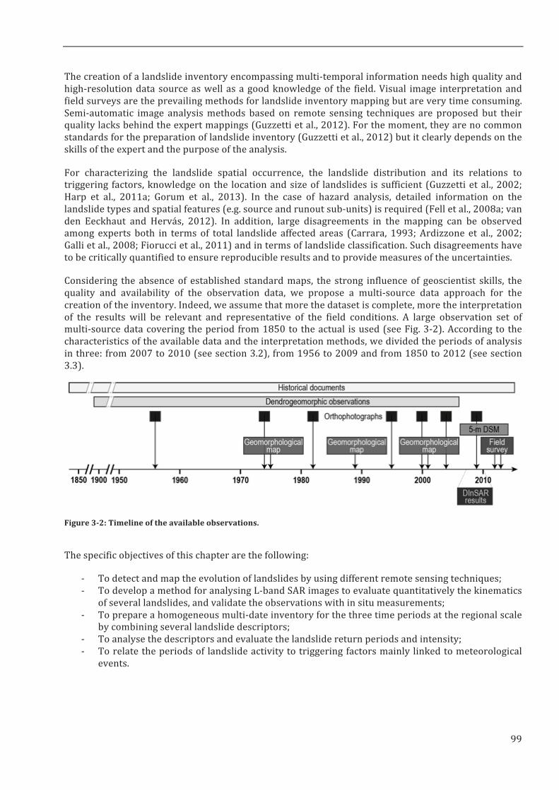
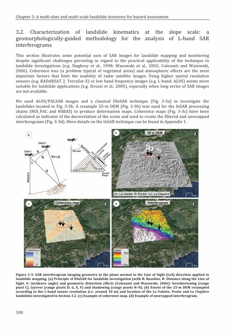
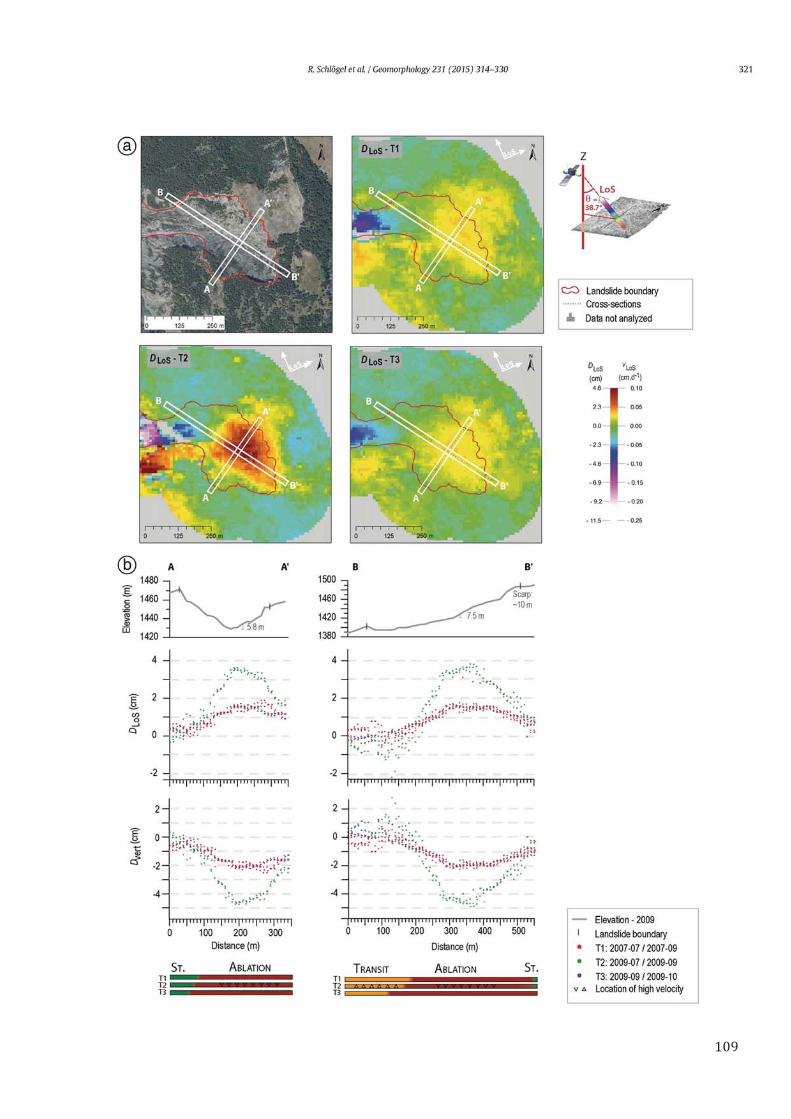
Social Vulnerability Assessment for Landslide Hazards ... - MDPI
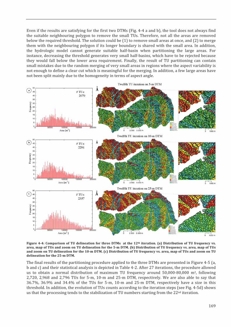
Upload
khangminh22Category
view
5download
0
HAL Id: tel-01244590https://tel.archives-ouvertes.fr/tel-01244590
Submitted on 23 Mar 2016
HAL is a multi-disciplinary open accessarchive for the deposit and dissemination of sci-entific research documents, whether they are pub-lished or not. The documents may come fromteaching and research institutions in France orabroad, or from public or private research centers.
L’archive ouverte pluridisciplinaire HAL, estdestinée au dépôt et à la diffusion de documentsscientifiques de niveau recherche, publiés ou non,émanant des établissements d’enseignement et derecherche français ou étrangers, des laboratoirespublics ou privés.
Quantitative landslide hazard assessment with remotesensing observations and statistical modelling
Romy Schlögel
To cite this version:Romy Schlögel. Quantitative landslide hazard assessment with remote sensing observations and sta-tistical modelling. Earth Sciences. Université de Strasbourg, 2015. English. �NNT : 2015STRAH009�.�tel-01244590�

UNIVERSITY OF STRASBOURG
ÉCOLE DOCTORALE DES SCIENCES DE LA TERRE, DE L’UNIVERS ET DE L’ENVIRONNEMENT
PhD Thesis presented by
ROMY SCHLÖGEL
For obtaining the degree
Doctor of the University of Strasbourg (PhD)
Quantitative landslide hazard assessment with remote sensing observations
and statistical modelling
Public defence on February 12th, 2015
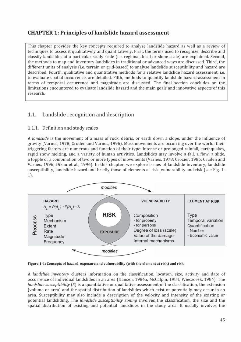
Examination committee Prof. Pascal Allemand Université Claude-Bernard, Lyon I Reviewer Laboratoire de Géologie de Lyon, Terre, Planètes, Environnement (LGTPE) Prof. Olivier Maquaire Université de Caen Basse-Normandie Reviewer Littoral, Environnement, Télédétection et Géomatique (LETG) Dr. Erwan Pathier Université Joseph Fourier, Grenoble Oral examiner Institut des Sciences de la Terre (ISTerre) Dr. Cécile Doubre Université de Strasbourg Oral examiner
Institut de Physique du Globe de Strasbourg (IPGS) Prof. Frédéric Masson Université de Strasbourg Thesis co-director Institut de Physique du Globe de Strasbourg (IPGS) Dr. Jean-Philippe Malet Université de Strasbourg Thesis co-director Institut de Physique du Globe de Strasbourg (IPGS)


•
-
- -
-

- -


•

•
•


•

•


σ
θ


(1)
(2)


(3)
(4)

(5)

(6)


°


σσ


θθ


π


π π
π π π π π π π π π

Extract AOI on each interferogram1.
Select interferograms- Study phase values2.
Map the sliding compartment(s)4.
Analyse kinematic5.1. Extract profiles and topography5.2. Profiles analysis
Kinematic evolution6.
Recalculate the interferograms- Subtract by median 3.
… …Ex. AOI: La Valette landslide
Ex. interferogram: July-September 2009
Ex. histogram of phase values in ‘stable zone’
med
ian
≈ -
2.0
Evolution of outlines
(5.) Profiles
(4.) Maps of outlines
Evolution of compartments
5.
Ex. longitudinal profile and interpretation
Stable zone
Translation function of mode/median value
Ex. new ‘interferogram’: July-September 2009 - mode
(2.) Selected interferograms
Ex. outline of the sliding zone for July-September 2009New ‘interferogram’ (3.)
New ‘interferogram’ (3.)
Profiles
Ex. AOI: La Valette landslide
Barcelonnette area
DTM(s)Accumulation Ablation
7. Create velocity maps
(4.) Maps of outlines
Coherence maps (0-1)
Velocity mapsVelocity mapsVelocity maps(cm/day)
Map of sliding area realized at 1:3 000
Extract outlines
Define coherence thresholds
Remove highly decorrelated areas


Copyright © 2022 FDOKUMEN