TERRAIN ANALYSIS USING SATELLITE IMAGERIES & LANDSLIDE HAZARD ZONATION (LHZ) MAPPING IN TEHRI...
9
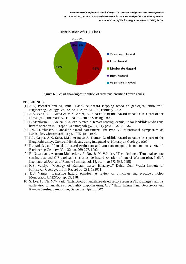
International Conference on Challenges in Disaster Mitigation and Management 15-17 February, 2013 at Centre of Excellence in Disaster Mitigation and Management, Indian Institute of Technology Roorkee – 247 667, INDIA TERRAIN ANALYSIS USING SATELLITE IMAGERIES & LANDSLIDE HAZARD ZONATION (LHZ) MAPPING IN TEHRI RESERVOIR REGION, UTTARAKHAND Department of Earth Sciences, Indian Institute of Technology Roorkee – 247 667, India Email: [email protected] ABSTRACT ASTER multispectral data and ASTER DEM data is used to create 3D model of Land-use land-cover (LULC) and digital terrain model of Tehri reservoir rim area. Drainage pattern, lineaments, structural features, lithologial features, and LULC are extracted using digital image processing techniques. Geological features are analysed using criteria such as colour, tones, topography and stream drainage pattern from the imageries. DEM data is further used to create slope map, aspect map, and relative relief map. DEM data is also used for the detailed drainage analysis. All the drainages are extracted from the DEM data in Arc Hydro tool of ESRI GIS package. Drainage is found as dendritic in nature with up to 5th order streams present in the area. For Landslide Hazard Zonation (LHZ) purpose, different thematic maps such as, Land-cover map, Slope map, relative relief map, structural map, lithology map, Lineament buffer map, drainage buffer map, soil map, are given weight according to the previous studies done by several authors. From this study, it has been found that 46% of the total area falls under low hazard zone. 43% of the area is comprised by moderate hazard zone and 5% falls under high hazard zone. Very low hazard zone comprises 6% and very high hazard zone comprise .002% of the total area. Keywords- ASTER, DEM, LHZ 1. INTRODUCTION Landslide is the result of a wide variety of processes which include geological, geomorphologic and meteorological factors. The main factors which influence land sliding are discussed by Varnes (1984) and Hutchinson (1995). Normally the most important factors are bedrock geology (lithology, structure, degree of weathering), geomorphology (slope gradient, aspect, and relative relief), soil (depth, structure, permeability, and porosity), land use and land cover, and hydrologic conditions. Landslides are triggered by many causative factors. Himalayan region is highly undulating and witnessing ongoing orogeny process, and also this area comes under major seismic zone. These reasons cause numerous occasions of landslides, and cause major loss of life and material. The highly undulating Himalayan landslides are sometimes highly inaccessible, and this gives planners a major setback. But geospatial technique provide capability of reaching every part of the area, identifying all types of landslides, determining landslide prone zone on the basis of major causative factors such as , terrain type, geology, vegetation, settlement, slope etc. Remote sensing based landslide hazard zonation is suggested by several authors. Mantovani et al. (1996), Gupta et al (1999), Saha et al (2002), Lee et al. (2007), Nagarajan et al (2010). Landslide hazard zonation in Himalayan region is done by several authors such as causative factor based hazard assessment done by Anbalagan et al (1992), Zonation based on geological attributes Pachauri et al (1992), GIS based landslide hazard zonation Gupta et al (1999), Saha et al (2002). In present study spectral character of satellite multispectral data are used to determine geology, structure, photo lineament, drainage, which are the major parameter for Landslide Hazard Zonation. Digital elevation model of area is used for terrain parameter extraction. High resolution remote sensing data is used for better results.
Transcript of TERRAIN ANALYSIS USING SATELLITE IMAGERIES & LANDSLIDE HAZARD ZONATION (LHZ) MAPPING IN TEHRI...
International Conference on Challenges in Disaster Mitigation and Management 15-17 February, 2013 at Centre of Excellence in Disaster Mitigation and Management,
Indian Institute of Technology Roorkee – 247 667, INDIA
TERRAIN ANALYSIS USING SATELLITE IMAGERIES & LANDSLIDE HAZARD ZONATION (LHZ) MAPPING IN TEHRI RESERVOIR REGION,
UTTARAKHAND
Department of Earth Sciences, Indian Institute of Technology Roorkee – 247 667, India Email: [email protected]
ABSTRACT ASTER multispectral data and ASTER DEM data is used to create 3D model of Land-use land-cover (LULC) and digital terrain model of Tehri reservoir rim area. Drainage pattern, lineaments, structural features, lithologial features, and LULC are extracted using digital image processing techniques. Geological features are analysed using criteria such as colour, tones, topography and stream drainage pattern from the imageries. DEM data is further used to create slope map, aspect map, and relative relief map. DEM data is also used for the detailed drainage analysis. All the drainages are extracted from the DEM data in Arc Hydro tool of ESRI GIS package. Drainage is found as dendritic in nature with up to 5th order streams present in the area. For Landslide Hazard Zonation (LHZ) purpose, different thematic maps such as, Land-cover map, Slope map, relative relief map, structural map, lithology map, Lineament buffer map, drainage buffer map, soil map, are given weight according to the previous studies done by several authors. From this study, it has been found that 46% of the total area falls under low hazard zone. 43% of the area is comprised by moderate hazard zone and 5% falls under high hazard zone. Very low hazard zone comprises 6% and very high hazard zone comprise .002% of the total area. Keywords- ASTER, DEM, LHZ 1. INTRODUCTION Landslide is the result of a wide variety of processes which include geological, geomorphologic and meteorological factors. The main factors which influence land sliding are discussed by Varnes (1984) and Hutchinson (1995). Normally the most important factors are bedrock geology (lithology, structure, degree of weathering), geomorphology (slope gradient, aspect, and relative relief), soil (depth, structure, permeability, and porosity), land use and land cover, and hydrologic conditions. Landslides are triggered by many causative factors. Himalayan region is highly undulating and witnessing ongoing orogeny process, and also this area comes under major seismic zone. These reasons cause numerous occasions of landslides, and cause major loss of life and material. The highly undulating Himalayan landslides are sometimes highly inaccessible, and this gives planners a major setback. But geospatial technique provide capability of reaching every part of the area, identifying all types of landslides, determining landslide prone zone on the basis of major causative factors such as , terrain type, geology, vegetation, settlement, slope etc. Remote sensing based landslide hazard zonation is suggested by several authors. Mantovani et al. (1996), Gupta et al (1999), Saha et al (2002), Lee et al. (2007), Nagarajan et al (2010). Landslide hazard zonation in Himalayan region is done by several authors such as causative factor based hazard assessment done by Anbalagan et al (1992), Zonation based on geological attributes Pachauri et al (1992), GIS based landslide hazard zonation Gupta et al (1999), Saha et al (2002). In present study spectral character of satellite multispectral data are used to determine geology, structure, photo lineament, drainage, which are the major parameter for Landslide Hazard Zonation. Digital elevation model of area is used for terrain parameter extraction. High resolution remote sensing data is used for better results.
user
Typewritten Text
user
Typewritten Text
user
Typewritten Text
user
Typewritten Text
user
Typewritten Text
user
Typewritten Text
user
Sticky Note
Marked set by user
user
Typewritten Text
R., Kumar, R Anbalagan
user
Typewritten Text
International Conference on Challenges in Disaster Mitigation and Management 15-17 February, 2013 at Centre of Excellence in Disaster Mitigation and Management,
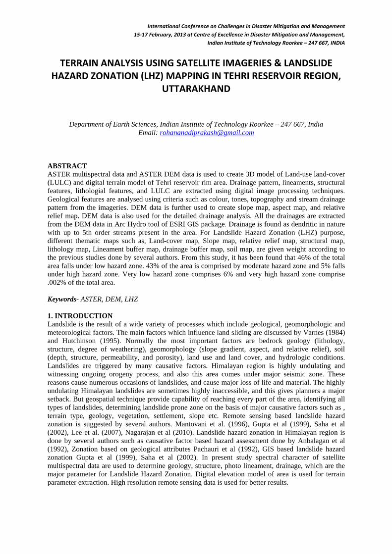
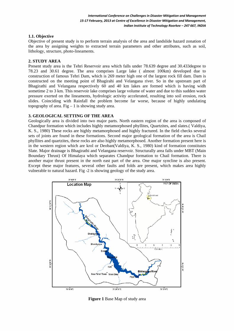
Indian Institute of Technology Roorkee – 247 667, INDIA 1.1. Objective Objective of present study is to perform terrain analysis of the area and landslide hazard zonation of the area by assigning weights to extracted terrain parameters and other attributes, such as soil, lithology, structure, photo-lineaments. 2. STUDY AREA Present study area is the Tehri Reservoir area which falls under 78.639 degree and 30.433degree to 78.23 and 30.61 degree. The area comprises Large lake ( almost 100km) developed due to construction of famous Tehri Dam, which is 269 meter high one of the largest rock fill dam. Dam is constructed on the meeting point of Bhagirahi and Velangana river. So in the upstream part of Bhagirathi and Velangana respectively 60 and 40 km lakes are formed which is having widh sometime 2 to 3 km. This reservoir lake comprises large volume of water and due to this sudden water pressure exerted on the lineaments, hydrologic activity accelerated, resulting into soil erosion, rock slides. Coinciding with Rainfall the problem become far worse, because of highly undulating topography of area. Fig – 1 is showing study area. 3. GEOLOGICAL SETTING OF THE AREA Geologically area is divided into two major parts. North eastern region of the area is composed of Chandpur formation which includes highly metamorphosed phyllites, Quartzites, and slates.( Valdiya, K. S., 1980) These rocks are highly metamorphosed and highly fractured. In the field checks several sets of joints are found in these formations. Second major geological formation of the area is Chail phyllites and quartzites, these rocks are also highly metamorphosed. Another formation present here is in the western region which are krol or Deoban(Valdiya, K. S., 1980) kind of formation constitutes Slate. Major drainage is Bhagirathi and Velangana reservoir. Structurally area falls under MBT (Main Boundary Thrust) Of Himalaya which separates Chandpur formation to Chail formation. There is another major thrust present in the north east part of the area. One major syncline is also present. Except these major features, several other faults and folds are present, which makes area highly vulnerable to natural hazard. Fig -2 is showing geology of the study area.
Figure 1 Base Map of study area
International Conference on Challenges in Disaster Mitigation and Management 15-17 February, 2013 at Centre of Excellence in Disaster Mitigation and Management,
Indian Institute of Technology Roorkee – 247 667, INDIA 4. DATA USED i. Topographic map of the survey of India at 1:25000 scale ii. Geological and Structural map representing lithology and structure iii. Satellite sensor data of ASTER (VNIR Band) and ASTER DEM (15 meter resolution) iv. Satellite sensor data of Landsat7(TM band) of 30 meter spatial resolution v. Field data involving GCP of landslide occasions. vi. To process these data ERDAS 9.2, ENVI 4.5 and ArcGIS 9.3 software are used. 5. METHODOLOGY Row ASTER data is processed in ENVI 4.5 software, different bands are extracted and georeferenced to UTM WGS1984 Zone 44. VNIR band of the data is selected for the study. These data are co registered 4 and subtracted according to area of study. Topo-normalization is performed on the basis of ASTER DEM. NDVI of the data is extracted and on the basis of that 5 classes are categorized. ASTER DEM data is downloaded from the NASA website. Some DEM enhancement techniques are performed such as DEM fill, Sink removal on the basis of reservoir lake shapefile. Slope, aspect, relative relief, hillshade, drainage maps are prepared. Photo lineaments are also prepared by using Laplace Edge enhancement filter. These lineaments are compared with lineaments prepared from ASTER VNIR data by onscreen digitization. Corrections are made in the lineament. Ancillary data such as geological map, soil map, are digitized and georeferenced in GIS environment. Landslide inventory map is prepared on the basis of data collected from field and satellite data. Weighted analysis is performed to generate Landslide Hazard Zonation Map of the area.
Figure 2 Geological map of Tehri reservoir area ( Rupke and Sharma )
International Conference on Challenges in Disaster Mitigation and Management 15-17 February, 2013 at Centre of Excellence in Disaster Mitigation and Management,
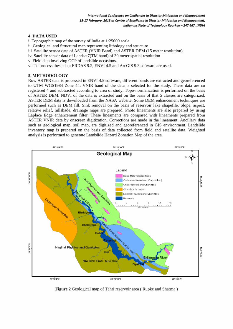
Indian Institute of Technology Roorkee – 247 667, INDIA 6. DATA LAYERS Following data layers are prepared for Landslide Hazard Zonation a) Landuse/Land cover map b) Slope map c) Relative relief map d) Drainage buffer map e) Lineament buffer map f) Soil map g) Lithological Map Methodology of data layer preparation is given in Fig - 3, based on Gupta et al. (1999).
Figure 3 Methodology flowchart of data layer preparation
International Conference on Challenges in Disaster Mitigation and Management 15-17 February, 2013 at Centre of Excellence in Disaster Mitigation and Management,
Indian Institute of Technology Roorkee – 247 667, INDIA 6.1. Drainage Analysis Drainage map is created from ASTER DEM data in Archydro tool of ESRI GIS package. Two different drainage maps are created a) major drainage, b) minor drainage. Drainage density is established. The area is found to containing large number of drainage, ordering up to 5th. Almost all the drainages are well connected to the reservoir. Due to highly undulating nature of the area large number of small drainage, which are basically active in rainy season are found. This drainage network has got compelling relation with the landslides. During the field study majority of landslides are found near to drainage area. To make the proper assessment of landslides, drainage buffer maps (25m, 50m, 100m, 150m) are prepared. 6.2. DEM Derivatives DEM derivatives such as slope, aspect, relative relief are of great importance in landslide studies. Slope in the present area varies from 0° to 72° with abrupt relief prevails all over the area. This high slope nature of the area combined with highly metamorphosed rocks and presence of major thrust and large number of small to large scale faults make the area very vulnerable to landslides. The potential landslide occasion can be related with different degree of slopes. Weights are given to different slope categories according to the potential of landslides, gathered from field experiences. Aspect is found to be mainly south to east faced, which can have huge impact on mass movement events because rainfall events are more in these faces. Another important DEM derivative is relative relief which is the difference between maximum and minimum elevation point within a facet or area. In present study relative relief varies from 0 to 367m. 6.3. Geology And Structure Geologically area is divided into three lithological classes. North-western part of the area comprises Chandpur group of phyllites, and Quatrzites which are highly fractured and jointed with cavity are present on several places. Eastern Part of the area is made up of Chail group of metamorphic rocks. The central zone of the study area comprises Carbonate formation of Krol, Deoban group. Small patches of meta-volcanic rocks are present in eastern part of the area. Geological attributes are most important factor for landslide hazard zonation studies. Present study area has mainly phyllite, and weathered quartzite rocks which can easily weathered. Progressive grade of metamorphism is found in phyllites and quartzites which are given weights accordingly in for landslide hazard zonation purpose. Carbonate rocks are having cementation property which makes them less prone for sliding. Meta-volcanic rocks are hard rocks and are having move shearing strength. Structural features such as joints, faults, thrusts are present in the area. Two major thrusts are found in the area. Joints are found mainly in quartzite and phyllite, which makes then even more vulnerable. Photo lineament are extracted from DEM data. Distance from these structural features have relative influence on the landslide,,,,, accordingly buffer map is prepared for landslide hazard zonation. 6.4. Land use and Land cover Land use/ Land cover has great influence in landslide hazard zonation study. Five classes of Land use/ Land cover are identified which are : water body, hill slope vegetation, settlement/barren land, Scrub vegetation, dense vegetation. These classes are prepared from ASTER multispectral data of 15 meter spatial resolution by performing NDVI (Normalized Difference Vegetation Index). 250 training pixels are selected for accuracy assessment. 80% accuracy is achieved in image classification. Ground validation is carried out for assessment of image classification. 6.5. Soil Soils in the present area are mainly alluvial, sandy loam, skeletal, forest soil, red soil. Soil quality varies with the relief/elevation and annual rainfall. Elevation varies roughly in 500 to 2600 ranges. Rainfall varies according to the aspect of slope faces (source – NBSSLUP Nagpur). At lower elevations (600 – 1000 m) mainly alluvial mixed with boulders are present. In 1000 to 1500m range sandy loamy soils are present. Above 1500 meter red/black forest soils are present. Each category of soil has corresponding influence on landslides. Forest soil is relatively less prone to weathering. Alluvial and
International Conference on Challenges in Disaster Mitigation and Management 15-17 February, 2013 at Centre of Excellence in Disaster Mitigation and Management,
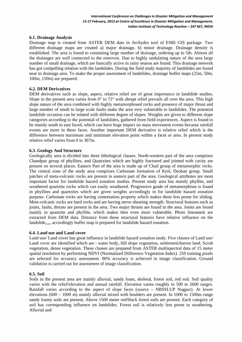
Indian Institute of Technology Roorkee – 247 667, INDIA 6.6. Landslides Landslide inventory map is prepared from satellite imageries and field investigations. ASTER and Worldview-2 data is used to map the landslides. Landslide data is used for the validation of landslide hazard zonation map. Fig – 4,
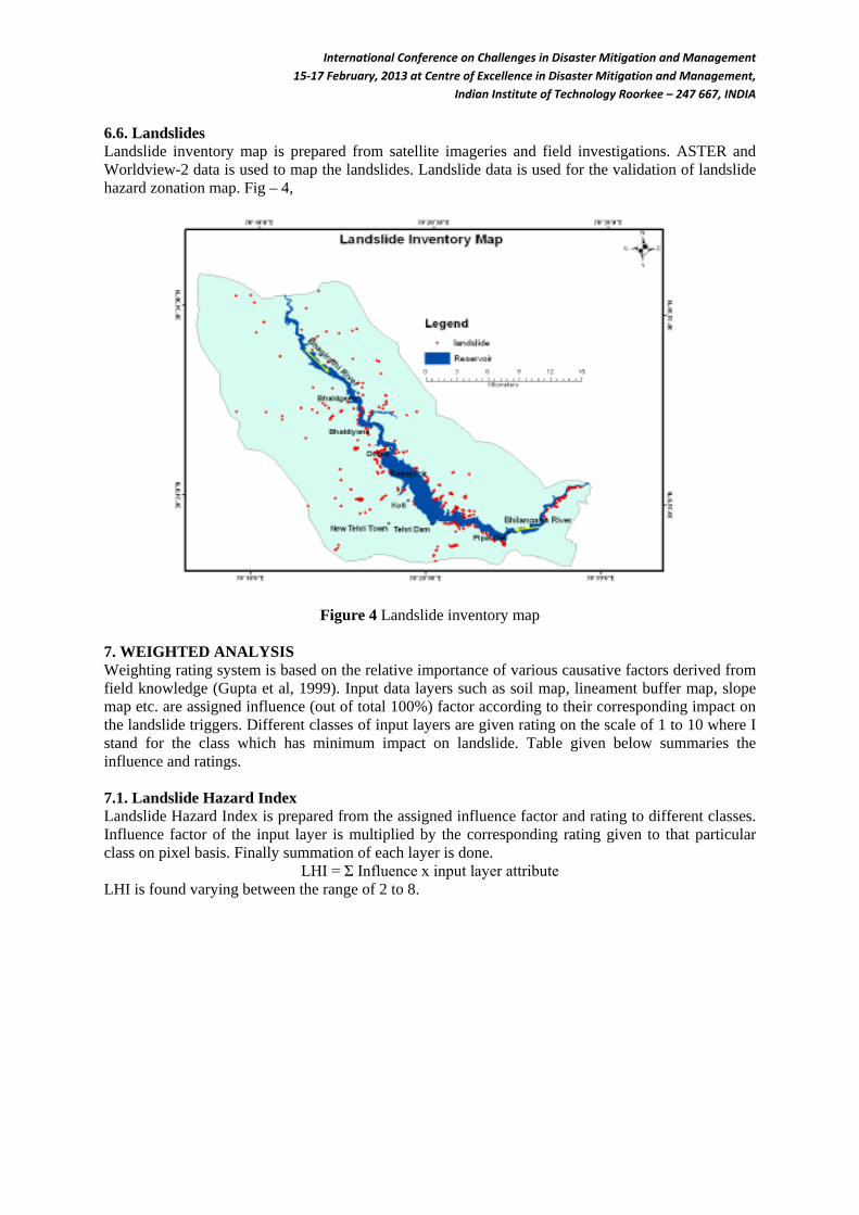
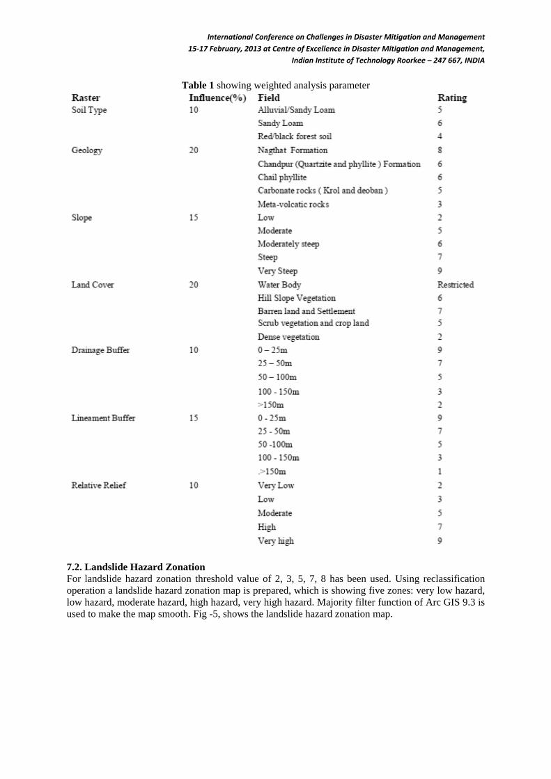
Figure 4 Landslide inventory map 7. WEIGHTED ANALYSIS Weighting rating system is based on the relative importance of various causative factors derived from field knowledge (Gupta et al, 1999). Input data layers such as soil map, lineament buffer map, slope map etc. are assigned influence (out of total 100%) factor according to their corresponding impact on the landslide triggers. Different classes of input layers are given rating on the scale of 1 to 10 where I stand for the class which has minimum impact on landslide. Table given below summaries the influence and ratings. 7.1. Landslide Hazard Index Landslide Hazard Index is prepared from the assigned influence factor and rating to different classes. Influence factor of the input layer is multiplied by the corresponding rating given to that particular class on pixel basis. Finally summation of each layer is done.
LHI = Σ Influence x input layer attribute LHI is found varying between the range of 2 to 8.
International Conference on Challenges in Disaster Mitigation and Management 15-17 February, 2013 at Centre of Excellence in Disaster Mitigation and Management,
Indian Institute of Technology Roorkee – 247 667, INDIA
Table 1 showing weighted analysis parameter
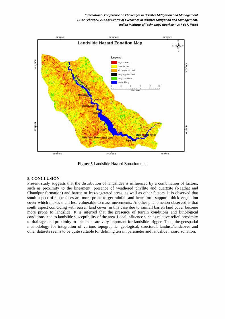
7.2. Landslide Hazard Zonation For landslide hazard zonation threshold value of 2, 3, 5, 7, 8 has been used. Using reclassification operation a landslide hazard zonation map is prepared, which is showing five zones: very low hazard, low hazard, moderate hazard, high hazard, very high hazard. Majority filter function of Arc GIS 9.3 is used to make the map smooth. Fig -5, shows the landslide hazard zonation map.
International Conference on Challenges in Disaster Mitigation and Management 15-17 February, 2013 at Centre of Excellence in Disaster Mitigation and Management,
Indian Institute of Technology Roorkee – 247 667, INDIA
Figure 5 Landslide Hazard Zonation map 8. CONCLUSION Present study suggests that the distribution of landslides is influenced by a combination of factors, such as proximity to the lineament, presence of weathered phyllite and quartzite (Nagthat and Chandpur formation) and barren or less-vegetated areas, as well as other factors. It is observed that south aspect of slope faces are more prone to get rainfall and henceforth supports thick vegetation cover which makes them less vulnerable to mass movements. Another phenomenon observed is that south aspect coinciding with barren land cover, in this case due to rainfall barren land cover become more prone to landslide. It is inferred that the presence of terrain conditions and lithological conditions lead to landslide susceptibility of the area. Local influence such as relative relief, proximity to drainage and proximity to lineament are very important for landslide trigger. Thus, the geospatial methodology for integration of various topographic, geological, structural, landuse/landcover and other datasets seems to be quite suitable for defining terrain parameter and landslide hazard zonation.
International Conference on Challenges in Disaster Mitigation and Management 15-17 February, 2013 at Centre of Excellence in Disaster Mitigation and Management,
Indian Institute of Technology Roorkee – 247 667, INDIA
Figure 6 Pi chart showing distribution of different landslide hazard zones REFERENCE [1] A.K, Pachauri and M, Pant, “Landslide hazard mapping based on geological attributes.”,
Engineering Geology, Vol.32, no. 1–2, pp. 81–100, February 1992. [2] A.K. Saha, R.P. Gupta & M.K. Arora, “GIS-based landslide hazard zonation in a part of the
Himalayas”, International Journal of Remote Sensing, 2002. [3] F. Mantovani, R. Soeters, C.J. Van Westen, “Remote sensing techniques for landslide studies and
hazard zonation in Europe.” Geomorphology, 15(3-4), pp 213–225, 1996. [4] J.N., Hutchinson, "Landslide hazard assessment". In: Proc VI International Symposium on
Landslides, Christchurch, 1: pp. 1805–184, 1995. [5] R.P. Gupta, A.K. Saha, M.K. Arora & A. Kumar, Landslide hazard zonation in a part of the
Bhagirathi valley, Garhwal Himalayas, using integrated re, Himalayan Geology, 1999. [6] R., Anbalagan, "Landslide hazard evaluation and zonation mapping in mountainous terrain",
Engineering Geology, Vol. 32, pp. 269-277, 1992. [7] R. Nagarajan , Anupam Mukherjee , A. Roy & M. V.Khire, “Technical note Temporal remote
sensing data and GIS application in landslide hazard zonation of part of Western ghat, India”, International Journal of Remote Sensing, vol. 19, no. 4, pp 573-585, 1998.
[8] K.S. Valdiya, “Geology of Kumaun Lesser Himalaya.” Dehra Dun: Wadia Institute of Himalayan Geology. Intrim Record pp. 291, 198011.
[9] D.J. Varnes, "Landslide hazard zonation: A review of principles and practice", IAEG Monograph, UNESCO, pp. 59, 1984.
[10] S. Lee, H. Oh, N.W Park, “Extraction of landslide-related factors from ASTER imagery and its application to landslide susceptibility mapping using GIS.” IEEE International Geoscience and Remote Sensing Symposium, Barcelona, Spain, 2007.