Scientists investigate recent Philippine landslide
10
A massive landslide devastated the commu- nity of Barangay Guinsaugon, Municipality of St. Bernard, Southern Leyte Province, Philip- pines, at about 10:30 local time on 17 February. The landslide occurred along the steep fault scarp of the Philippine Fault Zone (PFZ) (Fig- ure 1a), a large and active tectonic structure that traverses the entire length of the Philip- pines [Allen, 1962]. Barangay Guinsaugon is located at the foot of the scarp, directly in the path of the downward moving mass of earth. As of 24 February, the landslide caused 122 confirmed deaths; 1,328 people still are missing. To assist in the search and rescue operations that followed the landside, a team of geologists and physicists from the University of Philippines (UP-Diliman, Quezon City) and Ateneo de Manila University conducted an investigation of this area on 21–25 February. The UP-Ateneo team provided technical advice on the geology, which included the identification of the type and characteristics of the landslide. The Guinsaugon Rockslide-Debris Avalanche Satellite imageries taken in 2003 and 2004 show traces of two prominent structures, the north-northwest trending PFZ and a north- west trending structure oblique to the PFZ (Figure 1a and 1b). The horseshoe-shaped feature found along the trace of the oblique structure, at an elevation of 675 meters, is the site of the recent landslide. Another horse- shoe-shaped feature, 500 meters south-south- east of the present landslide head, is perhaps an old landslide scar (Figure 1b). The landslide has a planform area of approximately three million square meters and a distance of 4.0 kilometers from the crown to toe. It has a thickness of 6–7 meters near the toe and 30 meters at the base of the fault scar (Figure 2a). The volume of the deposit is in the order of 15–20 million cubic meters. On the basis of accounts from residents of the area of the duration and the distance traveled by the landslide, the flow velocity was approximately 100–140 kilometers per hour. The main sliding plane of the avalanche is a prominent north-northeast oriented plane at the head of the landslide intersected at an angle by a less planar feature (Figures 1c and 1d). The more planar surface exhibits slicken- sides (striations indicating movement) of a left-lateral fault. Below the crown are terraces composed of slope material that moved downward along sliding planes. The fan or foot portion of the slide has ridges, radial VOLUME 87 NUMBER 12 21 MARCH 2006 PAGES 121–128 Eos, Vol. 87, No. 12, 21 March 2006 EOS, TRANSACTIONS, AMERICAN GEOPHYSICAL UNION PAGES 121, 124 Scientists Investigate Recent Philippine Landslide BY A. M. A. LAGMAY , J. B. T. ONG, D. F. D. F ERNANDEZ, M. R. LAPUS, R. S. RODOLFO, A. M. P . T ENGONCIANG, J. L. A. SORIA, E. G. BALIATAN, Z. L. QUIMBA, C. L. UICHANCO, E. M. R. P AGUICAN, A. R. C. REMEDIO, G. R. H. LORENZO, W.V ALDIVIA, AND F. B. AVILA Fig. 1. (a) Shaded relief image generated from a Shuttle Radar Topography Mission (SRTM) digi- tal elevation model with interpreted northwest lineaments (white dashed lines) intersecting the Philippine Fault (black solid line); (b) False-color Landsat image that delineates the pre-landslide scar where the Guinsaugon landslide originated.The pre-2006 landslide scar (white dotted line) is found northwest of an older landslide scar (indicated by arrow). Raw image data were taken from http://www.landcover.org; (c) Oblique aerial photo showing the relative positions of the Philippine Fault and the town of Guinsaugon with respect to the landslide. Raw image courtesy of Michael D. Kennedy (U.S. Navy). http://www.navy.mil/view_single.asp?id=32073; (d) Close-up view of the landslide head.
Transcript of Scientists investigate recent Philippine landslide

A massive landslide devastated the commu-nity of Barangay Guinsaugon, Municipality of St. Bernard, Southern Leyte Province, Philip-pines, at about 10:30 local time on 17 February. The landslide occurred along the steep fault scarp of the Philippine Fault Zone (PFZ) (Fig-ure 1a), a large and active tectonic structure that traverses the entire length of the Philip-pines [Allen, 1962]. Barangay Guinsaugon is located at the foot of the scarp, directly in the path of the downward moving mass of earth. As of 24 February, the landslide caused 122 confirmed deaths; 1,328 people still are missing.
To assist in the search and rescue operations that followed the landside, a team of geologists and physicists from the University of Philippines (UP-Diliman, Quezon City) and Ateneo de Manila University conducted an investigation of this area on 21–25 February. The UP-Ateneo team provided technical advice on the geology, which included the identification of the type and characteristics of the landslide.
The Guinsaugon Rockslide-Debris Avalanche
Satellite imageries taken in 2003 and 2004 show traces of two prominent structures, the north-northwest trending PFZ and a north-west trending structure oblique to the PFZ (Figure 1a and 1b). The horseshoe-shaped feature found along the trace of the oblique structure, at an elevation of 675 meters, is the site of the recent landslide. Another horse-shoe-shaped feature, 500 meters south-south-east of the present landslide head, is perhaps an old landslide scar (Figure 1b).
The landslide has a planform area of approximately three million square meters and a distance of 4.0 kilometers from the crown to toe. It has a thickness of 6–7 meters near the toe and 30 meters at the base of the fault scar (Figure 2a). The volume of the deposit is in the order of 15–20 million cubic meters. On the
basis of accounts from residents of the area of the duration and the distance traveled by the landslide, the flow velocity was approximately 100–140 kilometers per hour.
The main sliding plane of the avalanche is a prominent north-northeast oriented plane at the head of the landslide intersected at an angle by a less planar feature (Figures 1c and 1d). The more planar surface exhibits slicken-sides (striations indicating movement) of a left-lateral fault. Below the crown are terraces composed of slope material that moved downward along sliding planes. The fan or foot portion of the slide has ridges, radial
VOLUME 87 NUMBER 12
21 MARCH 2006
PAGES 121–128
Eos, Vol. 87, No. 12, 21 March 2006
EOS, TRANSACTIONS, AMERICAN GEOPHYSICAL UNION
PAGES 121, 124
Scientists Investigate Recent Philippine Landslide
BY A. M. A. LAGMAY, J. B. T. ONG, D. F. D. FERNANDEZ, M. R. LAPUS, R. S. RODOLFO, A. M. P. TENGONCIANG, J. L. A. SORIA, E. G. BALIATAN, Z. L. QUIMBA, C. L. UICHANCO, E. M. R. PAGUICAN, A. R. C. REMEDIO, G. R. H. LORENZO, W. VALDIVIA, AND F. B. AVILA
Fig. 1. (a) Shaded relief image generated from a Shuttle Radar Topography Mission (SRTM) digi-tal elevation model with interpreted northwest lineaments (white dashed lines) intersecting the Philippine Fault (black solid line); (b) False-color Landsat image that delineates the pre-landslide scar where the Guinsaugon landslide originated. The pre-2006 landslide scar (white dotted line) is found northwest of an older landslide scar (indicated by arrow). Raw image data were taken from http://www.landcover.org; (c) Oblique aerial photo showing the relative positions of the Philippine Fault and the town of Guinsaugon with respect to the landslide. Raw image courtesy of Michael D. Kennedy (U.S. Navy). http://www.navy.mil/view_single.asp?id=32073; (d) Close-up view of the landslide head.

Eos, Vol. 87, No. 12, 21 March 2006
Fig. 2. (a) Schematic of the landslide at Guinsaugon, Leyte, showing the main parts of the deposit and the approximate location of Barangay Guinsaugon before and after the event; (b) Radial cracks at the southern distal part of the landslide; (c) Rescuers search for survivors below a hummock field. Inset shows a six-meter-wide by three-meter-high hummock.
cracks (Figure 2b), and numerous hills known as hummocks (Figure 2c). The deposit is com-posed of volcanic rocks from the Leyte Cen-tral Highland Volcanics, sedimentary rocks of the Calian Formation, and breccias produced by the movement of the Philippine Fault (e.g., J. D. Azares et al. (Southern Leyte revisited: New geologic data and insights, unpublished report 2003; R. M. Saturay Jr. and R. A. Tamayo Jr. (Southern Leyte field and structural evi-dence for major Cenozoic tectonic events in the Philippines, unpublished report, 2003)). On the basis of these characteristics, the land-slide was identified as a rockslide-debris avalanche.
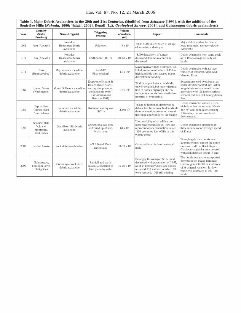
The Guinsaugon rockslide-debris avalanche is the second major landslide of this kind to be described in the twenty-first century, and the volume of its deposit falls within the range generated by debris avalanches from the twen-tieth century that are examined here. Deaths, casualties, and other damages associated with each of these events are listed in Table 1.
Causal Mechanisms
The factors suspected to have triggered the Guinsaugon rockslide-debris avalanche are rainfall and a 2.6 magnitude earthquake. Multi-satellite precipitation analysis from the NASA-Japan Aerospace Exploration Agency Tropical Rainfall Measuring Mission reported that 500 millimeters of rain fell in Southern Leyte between 4 and 7 February. The Philippine
Atmospheric, Geophysical, and Astronomical Services (PAGASA) rainfall station at Otikon, located seven kilometers southwest of the head of the landslide, recorded 683.6 millime-ters from 8–14 February. The highest rainfall over this duration was 171 millimeters recorded on 12 February (Figure 3a).
The earthquake reported by the Philippine Institute of Volcanology and Seismology occurred 25 kilometers west of the landslide area around the time of the event. However, this earthquake may have been too weak and distant to have caused the landslide. A proper assessment can be made on the significance of the earthquake as a trigger of the landslide when the exact time of the event is deter-mined and available seismic data is reviewed.
It is also worth mentioning that residents from Barangay Guinsaugon reported that the river in between the base of the fault scarp and Barangay Guinsaugon dried up two days before the landslide incident. Local mountain tribesmen also reported having felt an earth-quake two months prior to the disaster and noticed cracks on the ground. River and meteoric water may have seeped into these fractures and lubricated the slip planes.
An inventory of the location of the survi-vors, fatalities, and personal articles of the victims shows transport by the rockslide-debris avalanche toward the toe of the deposit. Houses, including a three-story con-crete building in front of the Barangay Guin-saugon grade school, were transported 550–600
meters southeast from their original posi-tions. Many collapsed houses found at or near the surface were transported downslope but remained relatively intact with minimal scattering. Neighboring houses that moved downward remained adjacent to each other. A refrigerator and a computer were found whole. These data suggest an en masse trans-port of the community.
Hazards
Ground-penetrating radar surveys con-ducted five days after the landslide at the original site of Barangay Guinsaugon indi-cate groundwater level at 14–15 meters below the present surface. Groundwater is closer to the surface at the distal portion of the rockslide-debris avalanche deposit. Heavy rainfall continued to saturate the debris deposit, causing an elevation of the water table, an accumulation of water at the surface of the deposit, and an increase in stream dis-charge, which may trigger mudflows and make retrieval operations difficult and dan-gerous (Figure 3b, item 1). Unstable material on the main scarp and on steep slopes may also cause subsequent smaller landslides to occur (Figure 3b, items 2 and 3).
Acknowledgments
We thank the Luis A. Yulo Foundation, Southern Leyte Governor Rosette Lerias, the

Eos, Vol. 87, No. 12, 21 March 2006
Philippine Army, the U.S. Marines, the Philip-pine Long Distance Company, the Philippine National Red Cross, the Provincial Disaster Coordinating Council, the Armed Forces of the Philippines Reserve Command, the Phil-ippine Department of Natural Resources, Secretary Angelo Reyes, the Asian Disaster Preparedness Center, the German Technical Cooperation, Earthprobe Inc., Republic Bis-cuit Company, civilian volunteers, and the rescue teams from Indonesia, Malaysia, Spain, Taiwan, and Turkey for supporting the search and rescue effort. We also thank Jose Ramon T. Villarin, S.J., Daniel J. McNamara, S.J., Emmanuel G. Anglo, Mariano A. Estoque, Tristan Calasanz, Gerald A. Galgana, and Gemma T. Narisma of the Manila Observa-tory, Philippines, for providing daily weather reports and advice.
References
Allen, C. R. (1962), Circum-Pacific faulting in the Philippine-Taiwan region, J. Geophys. Res., 67, 4795–4812.
Christiansen, R. L., and D. W. Peterson (1981), Chronol-ogy of the 1980 eruptive activity: The 1980 eruptions of Mount St. Helens, U.S. Geol. Surv. Prof. Pap., 1250.
Nakada, S. (2000), Hazards from pyroclastic flows and surges, in Encyclopedia of Volcanoes, edited by H. Sigurdsson et al., pp. 945–955, Elsevier, New York.
Schuster, R. L. (1996), The 25 most catastrophic land-slides of the 20th century, in Landslides: Proceed-ings of the 8th International Conference and Field Trip on Landslides, edited by Chacon et al., A. A. Balkema, Brookfield, Vt.
U.S. Geological Survey (2004), November 7, 2002, flight observations of M7.9 Denali Fault earth-quake, Glacier and Snow Program. (Available at http://ak.water.usgs.gov/glaciology/m7.9_quake/nov_7_flight_desc.htm)
Voight, B. (2002), Honoring the memory of David Varnes: The Boxing Day 1997 sector collapse, debris avalanche, and depressurization blast on Montserrat, BWI, paper presented at the Geological Society of America Annual Meeting, Denver, Colo., 27–30 Oct. (Available at http://gsa.confex.com/gsa/2002AM/finalprogram/abstract_36155.htm)
Author Information
Alfredo Mahar A. Lagmay, National Institute of Geological Sciences, University of the Philippines Diliman, Quezon City, E-mail: [email protected]; John Burtkenley T. Ong and Dan Ferdinand D. Fernandez, Manila Observatory, Ateneo de Manila University Campus, Loyola Heights, Quezon City; Mark R. Lapus, Raymond S. Rodolfo, Arlene
Mae P. Tengonciang, Janneli Lea A. Soria, Eden G. Baliatan, Zareth L. Quimba, Christopher L. Uichanco, and Engielle Mae R. Paguican, National Institute of Geological Sciences, University of the Philippines Diliman; Armelle Reca C. Remedio, Genevieve
Rose H. Lorenzo, and Francia B. Avila, Manila Observatory, Ateneo de Manila University Campus; and Waldemar Valdivia, National Institute of Geo-logical Sciences, University of the Philippines Diliman.
Fig. 3. (a) PAGASA Rainfall data at Otikon Station from 8–19 February 2006 shows an accumulated rainfall of 674 mm by 17 February 2006.; (b) Identified hazards: (1) ponding and an increase in discharge and mudflow; (2) potential landslide on the main scarp; and (3) steep slopes.
Eos, Vol. 87, No. 12, 21 March 2006
YearCountry(State/
Province)Name & Type(s)
Triggering Process
Volume of material
(m3)Impact Comments
1962 Peru (Ancash)Nevados
Huascaran debris avalanche
Unknown 13 x 106 4,000–5,000 killed; much of village of Ranrahirca destroyed.
Major debris avalanche from a local mountain, average velocity 170 km/hr.
1970 Peru (Ancash)Nevados
Huascaran debris avalanche
Earthquake (M7.7) 30–50 x 106
18,000 dead; town of Yungay destroyed; Ranrahirca partially destroyed.
Debris avalanche from same peak as in 1962; average velocity 280 km/hr.
1974Peru
(Huancavelica)Mayunmarca rockslide-
debris avalancheRainfall?
River erosion?1.6 x 10⁹
Mayunmarca village destroyed, 450 killed; subsequent failure of 150-m-high landslide dam caused major downstream flooding.
Debris avalanche with average velocity of 140 km/hr dammed Mantaro River.
1980United States (Washington)
Mount St. Helens rockslide-debris avalanche
Eruption of Mount St. Helens (Note: A M5.0 earthquake preceded the landslide event)
[Christiansen and Peterson, 1981]
2.8 x 10⁹
World’s largest historic landslide; only 5–10 killed, but major destruc-tion of homes, highways, and so forth; major debris flow; deaths low because of evacuation.
Evacuation saved lives; began as rockslide; deteriorated into 23-km-long debris avalanche with aver-age velocity of 125 km/hr; surface remobilized into 95-km-long debris flow.
1986Papua, New
Guinea (East New Britain)
Bairaman rockslide-debris avalanche
Bairaman earthquake (M7.1)
200 x 106
Village of Bairaman destroyed by debris flow from breached landslide dam; evacuation prevented casual-ties; huge effect on local landscape.
Debris avalanche formed 210-m-high dam that impounded 50-mil-lion-m3 lake; dam failed, causing 100-m-deep debris flow-flood downstream.
1997
Soufrière Hills Volcano,
Montserrat, West Indies
Soufrière Hills debris avalanche
Growth of a lava lobe and build-up of lava-
block talus64 x 106
The possibility of an edifice col-lapse was recognized in 1996, and a precautionary evacuation in late 1996 prevented loss of life in this violent event.
Debris avalanche emplaced in three minutes at an average speed of 40 m/s.
2002 Central Alaska Rock debris avalanchesM7.9 Denali Fault
earthquake10–70 x 106 Occurred in an isolated national
park.
Three, largely rock debris ava-lanches crossed almost the entire one-mile width of Black Rapids Glacier; total glacier area covered with rock debris is about 13 km2.
2006Guinsaugon,
Southern Leyte, Philippines
Guinsaugon rockslide- debris avalanche
Rainfall and earth-quake. Lubrication of fault plane by water.
15–20 x 106
Barangay Guinsaugon, St. Bernard destroyed with population of 1,857; as of 24 February 2006: 122 bodies retrieved, 410 survived of which 20 were rescued; 1,328 still missing.
The debris avalanche transported downslope en masse Barangay Guinsaugon 500–600 m southwest of its original location. Its flow velocity is estimated at 100–140 km/hr.
Table 1. Major Debris Avalanches in the 20th and 21st Centuries. (Modified from Schuster [1996], with the addition of the Soufrière Hills [Nakada, 2000; Voight, 2002], Denali [U.S. Geological Survey, 2004], and Guinsaugon debris avalanches.)

Eos, Vol. 87, No. 12, 21 March 2006
The critically endangered ivory-billed wood-pecker (Campephilus principalis) apparently has been rediscovered in old-growth bald cypress (Taxodium distichum, Figure 1) and swamp tupelo (Nyssa aquatica) forests of Bay-ou DeView, located seven kilometers north-west of Brinkley, Ark. [Fitzpatrick et al., 2005]. The evaluation of the impact of drought on forest history and wildlife population levels is critical to the conservation of the ivory-billed woodpecker and other similarly endangered species. Tree ring chronologies have been developed from old-growth forests at Bayou DeView to aid in this assessment.
This article also describes a conceptual model that has proven useful for the dis-covery of other noncommercial old-growth cypress-tupelo remnants in the Southeast. These relict cypress-tupelo stands may be candidates for conservation, restoration, and perhaps the eventual reintroduction of the ivory bill and other increasingly rare species native to this ecosystem.
Tree Ring Chronologies and Drought
For this study, tree ring chronologies were developed at three sites in the Western Low-lands of northeast Arkansas (Figure 2a), the area that contains Bayou DeView. The chronol-ogies are all at least 850 years long, and were based on core samples from centuries-old liv-ing bald cypress trees and fallen logs.
The simple mean ring-width chronologies exhibit the slow centuries-long decline in radial growth rates typical of trees that mature and senesce in a natural forest setting (Fig-ure 2a). Bald cypress radial growth is driven primarily by precipitation during the growing season [Stahle and Cleaveland, 1992], and recent research indicates a similar response for tupelo. However, the mean and variance of the simple mean ring-width chronologies increase in the twentieth
century, especially at Bayou DeView and at another Western Lowlands area, Mayberry Slough (Figure 2a), which may reflect both precipitation changes and human alterations of the drainage basin.
The three bald cypress tree-ring chro-nologies are significantly cross-correlated and have been used to develop a regional ring-width index chronology, where non-cli-matic growth trends have been removed with detrending and standardization (Figure 2b). The three most severe episodes of low growth in the Western Lowlands occurred during the fourteenth, fifteenth, and sixteenth centuries (Figure 2b).
The severe sustained droughts of the four-teenth and fifteenth centuries were concen-trated over the central United States (Figure 2c; Cook et al. [2004]) and appear to have shaped the age structure of the oldest bald cypress still surviving along Bayou DeView. Both droughts lasted for 10 consecutive years and must have caused the deaths of millions of forest trees in the lower Mississippi Valley. Though only a frac-tion of the living bald cypress exceed 600 years in age (Figure 2b), the oldest bald cypress ger-minated before 1380 A.D. and appear to be the last living members of a cohort that survived the extreme fourteenth- and fifteenth-century droughts.
The Effects of Decadal Drought
These decadal droughts may have created the ideal conditions for cypress regeneration. Bald cypress is “a tree of even-age groups within all-age stands” [Mattoon, 1915]. Cypress is exceptionally long lived, but cypress seeds will not germinate in water, and seedlings will not tolerate prolonged inundation. Con-sequently, old-growth cypress forests often included distinctive cohorts of even-age trees that regenerated infrequently when low water conditions persisted sufficiently long for both germination and seedling height growth. The inner ring and pith dates for many cypress in the Western Lowlands date soon after these droughts (Figure 2b). All cores were taken above the basal swell of the tree and under-estimate the true age of germination. Nev-ertheless, most of these trees, and no doubt millions of other cypress in the Western Low-lands, probably germinated during the pro-longed drought and low water conditions of the fourteenth- and fifteenth-century droughts.
Ivory bill numbers also likely increased in the wake of the decadal droughts. Ivory-billed woodpeckers feed predominantly on wood-boring larvae in the Cerambycidae, Bupresti-dae, and Elateridae beetle families, especially in large old trees subject to decay and in recently dead trees [Tanner, 1942]. Early twentieth century observations indicate that the abundance of beetles and ivory bills both increased in areas with recently killed stand-ing timber [Tanner, 1942]. Other species also respond to disasters, including Bachman’s warbler (Vermivora bachmanii, now likely extinct), which seems to have increased in numbers following habitat changes caused by the New Madrid and Charleston earthquakes of 1811–1812 and 1886, respectively [Shugart, 2004].
Old-Growth Cypress-Tupelo Conservation
Bald cypress grew in a variety of wetland conditions and produced several grades of
cypress lumber, some of which was more valuable for timber production than others (Figure 3). The commercially valuable virgin cypress forests with tall columnar trees were a preferred habitat for ivory-billed woodpeck-ers [Tanner, 1942] and were among the most heavily logged forest ecosystems in the world. Very few stands of virgin bald cypress with huge trees have been preserved. Mattoon [1915] estimated that the ‘permanent swamp’ ecosystem of the South covered nearly 17 mil-lion hectares, but it is estimated that no more than 5000 hectares of virgin cypress remain, perhaps only 0.0002% of the original uncut ecosystem. The best cypress growth was often observed in the large back swamps away from the main stream channels where cypress trees were obliged to grow under an unbroken canopy over 30 meters high, producing the remarkable forests of tall, ‘clear’ cypress stems (free of branching) so heavily exploited for lumber production.
Only three reasonably large tracts of virgin cypress with commercial grade timber are known to remain: a 1400-hectare tract on pri-vate property in southwestern Arkansas; and the National Audubon Society sanctuaries at Four Holes Swamp, S.C. (713 hectares), and at Corkscrew Swamp, Fla. (283 hectares).
Fortunately, a few small stands of old, ‘over-mature’ bald cypress and tupelo in noncom-mercial settings survived the era of massive timber cutting and agricultural land clear-ing. The old-growth cypress-tupelo at Bayou DeView have suffered selective logging (pri-marily for tupelo), but thousands of decrepit, overmature cypress and tupelo still exist, including small parcels of uncut centuries-old forest in the Dagmar Wildlife Management Area and the Cache River National Wildlife Refuge, located near Brinkley. The Bayou DeView woodlands are representative of other
Decadal Drought Effects on Endangered Woodpecker Habitat
BY D. W. STAHLE, M. K. CLEAVELAND, R. D. GRIFFIN, M. D. SPOND, F. K. FYE, R. B. CULPEPPER, AND D. PATTON
PAGES 121, 125
Fig. 1. An ancient bald cypress tree in the 800-year age class at Bayou DeView, Ark., the rediscovery site of the ivory-billed wood-pecker (diameter 2.6 meters at 2 meters above ground). David Stahle pictured for scale. Photo by Mark Spond.

Eos, Vol. 87, No. 12, 21 March 2006
Fig. 2. (a) Mean ring-width chronologies for Bayou DeView, Black Swamp, and Mayberry Slough are plotted without detrending for the past 850 years. (b) The standardized ring-width chronol-ogy of bald cypress for the Western Lowlands is based on these three sites and documents severe sustained drought in the fourteenth, fifteenth, and sixteenth centuries (shaded red). The sample size profile (dashed curve indicates living trees, solid curve indicates trees and logs) suggests a survivorship effect and a subsequent recruitment event for cypress-tupelo forests in the Western Lowlands during the fourteenth- and fifteenth-century droughts (arrows). (c) The spatial pattern of tree-ring reconstructed Palmer Drought Severity Indices for North America during these epic droughts is based on Cook et al. [2004].

Eos, Vol. 87, No. 12, 21 March 2006
selectively logged or uncut noncommercial cypress-tupelo stands still scattered sparingly across the southeastern United States.
Black River, N.C., is a premier example of noncommercial ancient cypress, dominated by smaller cypress trees too shaky, pecky, and heart-rotten to justify logging. The Black River site today contains the oldest-known living trees in the eastern United States, including one tree at least 1700 years old and several partly hollow trees likely over 2000 years old [Stahle et al., 1988]. Noncommercial cypress timber was often found in acidic, nutrient-poor blackwater streams like the Black River, and in deeper water along bayous where smaller, heavily buttressed, and branching trees were common.
This environmental gradient in the form and size of cypress trees across virgin south-ern floodplains was discussed by Dickeson and Brown [1848] and illustrated by Mat-toon [1915]. Mattoon’s intricate drawings highlight the uneven distribution of both valuable and noncommercial cypress across the subtle topographic and hydrologic gra-dients of southern floodplains and swamps (Figure 3).
These two important historical sources pro-vide a clear predictive model for where in the complex, highly altered southern floodplains old-growth bald cypress–tupelo remnants can still be found in noncommercial set-tings, proven in part by dendrochronological discoveries of centuries-old cypress at Bayou DeView, Black River, Choctawhatchee River (Fla.), Pascagoula (Miss.), and elsewhere (e.g., http://www.uark.edu/dendro/oldgrowth).
How much old-growth cypress-tupelo forest still remains in noncommercial timberlands of the southeastern United States and how they might be integrated into conservation and restoration efforts is not known. However, the discovery of at least one surviving popula-tion of ivory bills proves the habitat value of even the ‘decrepit overmature’ cypress-tupelo stands such as Bayou DeView and adds urgency to the identification and protection of other ancient swamp forests throughout the bottomlands of the South.
Acknowledgments
This research was supported by the U.S. National Science Foundation (grant ATM-0400713), and facilitated by the Arkansas Game and Fish Commission.
References
Cook, E. R., C. A. Woodhouse, C. M. Eakin, D. M. Meko, and D. W. Stahle (2004), Long-term aridity changes in the western United States, Science, 306, 1015–1018.
Dickeson, M. W., and A. Brown (1848), On the cypress timber of Mississippi and Louisiana, Am. J. Sci. Arts, 5(13), 515–522.
Fitzpatrick, J. W., et al. (2005), Ivory-billed woodpecker (Campephilus principalis) persists in continental North America, Science, 308, 1460–1462.
Mattoon, W. R. (1915), The Southern Cypress, Bull. 272, 74 pp., U.S. Dep. of Agric., Washington, D.C.
Shugart, H.H. (2004), How the Earthquake Bird Got Its Name and Other Tales of an Unbalanced Nature, 288 p., Yale University Press, New Haven.
Stahle, D. W., and M. K. Cleaveland (1992), Recon-struction and analysis of spring rainfall over the
southeastern U.S. for the past 1000 years, Bull. Am. Meteorol. Soc., 73, 1947–1961.
Stahle, D. W., M. K. Cleaveland, and J. G. Hehr (1988), North Carolina climate changes reconstructed from tree rings: A.D. 372–1985, Science, 240, 1517–1519.
Tanner, J. T. (1942), The Ivory-Billed Woodpecker, 111 pp., Natl. Audubon Soc., New York.
Author Information
David W. Stahle, Malcolm K. Cleaveland, R. Daniel
Griffin, Mark D. Spond, and Falko K. Fye, Tree-Ring
Laboratory, Department of Geosciences, University of
Arkansas, Fayetteville: E-mail: [email protected]; R.
Brian Culpepper, Center for Advanced Spatial Tech-
nologies, University of Arkansas, Fayetteville; and
David Patton, Ancient Cross Timbers Consortium,
Checotah, Okla.
Fig. 3. These drawings illustrate the variable age structure and timber value typically found in vir-gin cypress swamps (redrawn from Mattoon [1915]) and provide a conceptual model for where old-growth ‘noncommercial’ cypress-tupelo woodlands can still be found in the southeastern Unit-ed States. (a) The transect across Okeefenokee Swamp, Ga., illustrates young cypress surrounding open water, moving outward to a pure stand of large cypress, and then to the oldest edges of the swamp where ‘overmature cypress’ and mixed hardwoods were typically encountered, a vegeta-tion chronosequence reflecting the increasing age and infilling of the swamp. The pure stands of large cypress were heavily logged across the South, but the stands of decrepit overmature cypress were sometimes left uncut and a few survive today as core habitat for obligate old-growth spe-cies. (b) Mattoon’s cross section of a typical southern floodplain also illustrates the ‘deep cypress swamp’ where large commercial timber was often found and was heavily cut. Stunted, poorly formed noncommercial timber was typical of deeper ‘cypress sloughs,’ where ancient trees can sometimes still be found lining these picturesque southern bayous.
Eos, Vol. 87, No. 12, 21 March 2006
Minerals created under high temperature conditions have been found in particles col-lected from the comet Wild 2 and may have come from the formation of the Sun or another solar system, NASA mission scien-tists said at a 13 March press conference.
The Stardust spacecraft trapped the parti-cles in an aerogel detector when it passed within 240 kilometers of the comet on 2 Jan-uary 2004. Mission scientists have been pro-cessing the tiny grains, which range in size from 50 microns to less than one micron, since a few days after the Stardust return capsule landed in the Utah desert on 15 Jan-uary 2006.
Stardust principal investigator Donald Brownlee, from the University of Washington,
Seattle, said, “The interesting thing is we are finding these high-temperature minerals in materials from the coldest place in the solar system.” The minerals, which include peridot, olivine, and titanium nitride, formed at tem-peratures above 1400 K, whereas the comet itself formed at about 30 K.
Michael Zolensky, Stardust curator and co-investigator at NASA’s Johnson Space Center in Houston, Tex., suggested that if the high-temperature minerals originated from the Sun, they could have been ejected and car-ried out to the edge of the solar system on some sort of ‘conveyor belt.’
Stardust scientists are still determining how best to handle these small samples, and so far only six of the 132 cells in the aerogel tray have been processed. Zolensky said that more than 150 samples—pieces of particles
recovered from the aerogel—had been pro-vided to scientists on five continents. After this processing phase concludes in the next several months, qualified scientists anywhere in the world will be able to request samples for analysis.
A second aerogel detector on Stardust collected samples of interstellar dust, parti-cles much smaller than those collected from the comet. After a detailed scan of the tray and its samples, which should start in about a month, the images will be sent to partici-pants in the Stardust at Home project. Using a ‘virtual microscope,’ project participants will search these images for evidence of interstellar dust impacts.
Information about Stardust is available at http://stardust.jpl.nasa.gov, and details about Stardust at Home is available at http://stardustathome.ssl.berkeley.edu/
—SARAH ZIELINSKI, Staff Writer
Fire-Made Minerals Found in Icy Comet
news
PAGE 122
A newly developed advanced research air-craft will allow researchers to directly study the atmosphere for extended periods of time at altitudes that approach the troposphere-stratosphere boundary.
The plane, called the High-performance Instrumented Airborne Platform for Environ-mental Research (HIAPER), can carry nearly 3000 kilograms of scientific instrumentation, reach an altitude of more than 15,500 meters, and cruise without refueling for over 11,200 kilometers. Owned by the U.S. National Sci-ence Foundation (NSF) and operated by the National Center for Atmospheric Research (NCAR) in Boulder, Colo., HIAPER will be used to collect detailed information on the
meteorology of the upper edges of hurricanes and thunderstorms, high-altitude chemical reactions that are believed to affect climate, and other research concerns.
HIAPER embarked on its first science mis-sion on 2 March to study atmospheric whirl-winds called rotors, which form on the lee side of steep mountains and have contributed to several aircraft accidents. Through April, HIAPER is flying over rotors near California’s Sierra Nevada range, as part of a project named the Terrain-Induced Rotor Experiment (T-REX).
The current science campaign “could not have been done without the long-range capa-bilities of such an aircraft,” explained Marga-ret Leinen, assistant director for geosciences at NSF. HIAPER’s ability to reach high altitudes
will allow researchers to observe rotors from above and release surveying instruments into the most turbulent areas.
Leinen added that HIAPER’s communica-tions and data capabilities will allow the entire T-REX science team to participate in the experiment. Other researchers stationed on the ground are probing rotors though observing techniques including radar, lidar, and wind profilers.
“With our advanced instrument payload and our flight paths, the amount of data we will collect will be unprecedented for describing airflow over mountains,” said T-REX scientist Jorgen Jensen of NCAR.
For more information, visit the Web site: http://www.haiper.ucar.edu
—MOHI KUMAR, Staff Writer
Research Aircraft Helps Scientists Study Troposphere
PAGE 122

Eos, Vol. 87, No. 12, 21 March 2006
Efforts over the past several decades toward increasing the number of women entering science and engineering fields have largely been successful, with under-graduate and graduate school enrollments averaging between 30 and 50 percent women (see Nelson Diversity Survey, http://cheminfo.chem.ou.edu/faculty/djn/diversity/top50.html). Ph.D. attainments show similar progress. However, the percentage of women occupying tenure-track positions has not risen commensurably. Across the board, women in science and engineering fill on average only 15 to 25 percent of aca-demic positions.
Since the number of women in graduate school has been sufficiently large for at least a decade, it is difficult to ascribe the lower percentage of women in faculty positions to a small pool of potential candidates. As reported in the Chronicle of Higher Education (3 December 2004), the disparity between the number of women trained in a field and the number of women occupying positions in that field is instead attributed by some to sub-tle biases that keep women out of research or academic positions; others, according to the report, argue that women are simply staying away of their own accord from these positions.
Though the possibility of the first attribu-tion cannot be discounted, the focus of a community mentoring effort initiated within the physical oceanographic community is on the latter attribution, namely, that women are opting out of the ‘pipeline’ in the early years of their scientific careers. Thus, while recruitment efforts should be lauded, the community also needs to turn its attention to retention to capitalize on the investment that funding agencies and universities have made on the education of women students and to create a scientific workforce whose diversity matches that of the student popula-tion and more closely mirrors that of the U.S. population as a whole.
Ocean sciences provide no exception to these trends. For example, the number of women receiving their Ph.D. in physical oceanography has approached 40 percent at most major oceanographic institutions; how-ever, the number of women with principal investigator (PI) status remains fairly low. Though not a direct accounting of the num-ber of women in the field, it is interesting to note that in the past 10 years, only 12 per-cent of all proposals submitted to the physi-cal oceanography program at the U.S. National Science Foundation (NSF) have had women as the lead PI.
It is important to recognize that in the field of oceanography, a sizeable fraction of women, as well as men, are employed in non-academic positions. Though the recent national diversity study cited above focused on academic positions, and the statistic from NSF primarily sheds light on the retention issue in academia and research institutions, the community mentoring effort concerns women employed in the myriad places that oceanographers apply their skill: government labs, consulting firms, universities, research institutions, and so forth. One of the goals of this effort is to gather firm statistics on the retention of women in the field in order to assess, among other things, whether these workplaces differ in the hiring and retention of women oceanographers.
MPOWIR Workshop
There are many factors that contribute to the lack of retention of women scientists: competition between family building and career building, competition between the career goals of a spouse/partner, lack of female role models, lack of adequate mentor-ing, and so forth. While some of these prob-lems are best met with institutional changes, the lack of adequate mentoring is one the physical oceanographic community can address. Toward this end, an NSF- and U.S. Office of Naval Research-funded workshop, called Mentoring Physical Oceanography Women to Increase Retention (MPOWIR), recently was conducted on this topic.
Twenty-nine physical oceanographers, men as well as women, from a spectrum of workplaces, assembled at the workshop to design a mentoring program for junior women in the field of physical oceanogra-phy to help remove barriers, real or per-ceived, in their career development. The overall goal of this community mentoring effort is to develop a program within the physical oceanographic community essen-tially as a pilot project that, if successful, could be expanded to include women in all areas of ocean sciences, or geosciences, at a later date. Additionally, efforts toward retaining women in the field could be transferable to the retention of minorities, a goal endorsed by the MPOWIR steering committee.
The initial goal of the workshop was to identify the obstacles that junior women face in their career development and to determine which of those obstacles could be met by a community effort rather than by institutional efforts. Toward this end, work-shop participants learned of institutional
efforts facilitated by NSF’s ADVANCE program and of local mentoring programs, such as one recently implemented at the Woods Hole Oceanographic Institution in Massa-chusetts. Results from a survey available on the MPOWIR Web site (http://www.mpowir.org) prior to the workshop also provided key background information.
In addition, participants read of mentor-ing efforts in other disciplines; however, they recognized that the physical oceanog-raphy community cannot simply adopt a program that has been developed for another discipline. A career in oceanogra-phy is unique in that it often requires sea time; there are few, if any, industry jobs; the number of geographical locations where oceanography jobs are available is limited; there are a relatively large proportion of research positions versus academic posi-tions; and the field is relatively small com-pared with computing sciences, mathematics, physics, and so forth.
From workshop discussions, background readings, presentations, and survey results, it was concluded that the transitions from Ph.D. to postdoctoral student and then from postdoc to entry-level position were the most vulnerable times for a junior woman in the field. Obstacles identified include exclusion from large research programs; lack of collaboration and collaborators; lack of senior women role models; and lack of advice on career development and on balancing family and work. Importantly, the survey results showed that only 30 percent of the respondents had formed an impor-tant mentoring relationship during their postdoctoral years.
Given the identified obstacles and the known importance of mentoring, MPOWIR workshop participants decided to design a community-mentoring program that would provide continuity from the Ph.D. attainment through the early years of a young woman’s career. Workshop participants decided to focus on the collective community respon-sibility for mentoring rather than on men-toring that matched a single junior scientist with a single senior scientist. The group’s goal is to create a network of mentors that can fulfill the various needs of a junior scientist.
Because the goal is to make mentoring accessible to junior women in a wide variety of positions and at different types of work-places (e.g., research institutions, government labs, and universities), the implementation of the program is multi-pronged. From the meeting’s deliberations, three main elements for a community-mentoring program emerged:
1. An Internet-based mentoring program is to be composed of four components: (a) a moderated, anonymous community forum to address issues related to the success of junior women in physical oceanography, but accessible to the entire community; (b) a searchable database for mentors to be used as a resource for junior women; (c) a list-server with important information available to interested scientists about mentoring and funding activities; and (d) a resource library
Mentoring Program for Women in Physical Oceanography
PAGES 123, 126
MEETINGS

Eos, Vol. 87, No. 12, 21 March 2006
on mentoring issues, data and statistics, and links to funding opportunities.
2. The centerpiece of the MPOWIR pro-posed program, an annual ‘Pattullo confer-ence’, would provide an opportunity for all junior women in the field to talk to senior scientists about their current and planned work. The goal is for senior scientists, men and women, to provide feedback, give advice, and make connections for these young women. The conference would also include round-table discussions on career development issues. (In 1957, June Grace Pattullo was the first woman to receive a Ph.D. in physical oceanography from the Scripps Institution of Oceanography, and she is believed to be the first to receive such a degree in the United States.)
3. AGU social gatherings on mentoring would take place at all Ocean Sciences meetings and at the AGU Fall Meeting in alternate years. The goal of these socials would be to facilitate connections between
junior scientists and more senior scientists in the field. Talks and/or panel discussions on career and mentoring issues are also planned. As part of this plan, a town hall meeting was recently held at the Ocean Sci-ences 2006 meeting in Honolulu, Hawaii for the express purpose of providing the com-munity with information about MPOWIR. Over 150 people attended the meeting and reception.
In order to implement these initiatives and to measure their success, workshop par-ticipants decided to establish an ongoing committee that would take responsibility for the implementation of the proposed pro-gram elements, establish mechanisms to identify mentees and attract mentors, and create a statistical database in order to quantify success. This committee has since been established and is in the process of securing funds to implement the above pro-gram elements.
The physical oceanographic community cannot change the structure of family life nor can it make major organizational changes to the structure of scientific careers; however, it can begin to make a dif-ference in the mentoring of women junior scientists. If successful, the MPOWIR com-munity-run program will aid capitalization on the investment the funding agencies and universities have made on the education of women, and it will help create a more diverse scientific workforce. Additionally, it is believed that by creating a scientific community that facilitates the retention of women, a community will be created that is more attractive to minorities as well.
The MPOWIR workshop was held 9–12 October 2005 at the Airlie Center in Warren-ton, Va.
—M. SUSAN LOZIER, Earth and Ocean Sciences,
Duke University, Durham, N.C.; E-Mail: mslozier@
duke.edu
! 27–29 March 2006 External Controls on Deep Water Depositional Systems, Piccadilly, London, U.K. Sponsors: Geological Society of Lon-don; Society for Sedimentary Geology. (A. Johnson, The Geological Society, Burlington House, Picca-dilly, London, U.K. W1J 0BG; Tel.: +011-44-020-7434-9944; Fax: +011-44-020-7434-0579; E-mail: [email protected]; Web Site: http://www.geolsoc.org.uk/deepwater)
Conference topics include links between cli-mate and sea level, fluvial erosion and transport, paleoclimate modeling, ancient climate controls, and ancient shelf-edge systems.
! 18–20 April 2006 Guiding National Ocean Research Investment: Public Workshop on the Ocean Research Priorities Plan, Denver, Colo., USA. Sponsor: National Science and Technol-ogy Council Joint Subcommittee on Ocean Sci-ence and Technology. (S. Walker, USGCRP/CCSP Office, 1717 Pennsylvania Avenue, Suite 250, Wash-ington, D.C., USA 20006; Tel.: +1-202-419-3464; Fax: +1-202-223-3064; E-mail: [email protected]; Web Site: http://ocean.ceq.gov/about/jsost_workshop/welcome.html)
The workshop will focus on key aspects of the Ocean Research Priorities Plan. Themes include the ocean’s roles in climate variability and change, marine transportation and security, ocean educa-tion, and ocean observations and technology. The workshop will allow participants to address com-
mon research needs and provide input on the establishment of national ocean research priorities.! 26–27 April 2006 National Commission on Science for Sustainable Forestry Forest Dis-turbance, Management and Biodiversity Sym-posium, Denver, Colo., USA. Sponsors: National For-est Foundation; Surdna Foundation; The David and Lucile Packard Foundation; others. (A. Lien, National Council for Science and the Environment, 1707 H Street NW, Suite 200, Washington, D.C., USA 20006; Tel.: +1-202-530-5810; Fax: +1-202-628-4311; E-mail: [email protected]; Web Site: http://www.ncseonline.org/NCSSF)
The symposium will bring together a diverse group of scientists, decision makers, and forest users to learn about current research and issues in the area of forest disturbance. Topics include the effects of invasive species, insect outbreaks, and fires on biodiversity.
! 19–21 June 2006 Academic Science and Its Role in the Development of the Productive Forces in the Northern Regions of Russia, Arkhangelsk, Russia. Sponsors: Russian Academy of Science; Council for Research Productive Forces of the Administration of Arkhangelsk. (Y. Borovaya, Arkhangelsk Scientific Centre, Russian Academy of Science, ul. Sadovaya 3, Archangel, Russia 163000; Tel.: +011-007-8182-215765; E-mail: [email protected])
The conference is dedicated to the centennial anniversary of the opening of the first station of the Russian Academy of Science. Topics include
the development of oil and gas fields, research on shelf seas and continental reservoirs, and problems in biodiversity and the conditions of ecosystems in the northern regions of Russia.
! 2–7 July 2006 XII International Symposium on Vulcanospeleology, Tepoztlan, Morelos, Mex-ico. Sponsors: International Union of Speleology; Mexican Society for Underground Exploration; Association for Mexican Cave Studies; others. (R. Espinasa; E-mail: [email protected]; Web Site: http://www.saudicaves.com/symp06/index.html)
The symposium will include presentations on lava caves as well as three days of field trips to Iglesia Cave. There will be post-symposium field trips to the longest lava tube in the Americas and to the lava tubes of El Volcancillo Veracruz, which begin from a crater more than 100 meters deep. Abstract deadline is 31 March.
! 16–21 July 2006 7th International Confer -ence on the Occurrence, Properties, and Utilization of Natural Zeolites, Socorro, N.M., USA. Sponsors: International Natural Zeolite Association; Biolite, Inc.; GSA Resources, Inc.; others. (R. Bowman, New Mexico Tech, Depart-ment of Earth and Environmental Science, 801 Leroy Place, Socorro, N.M., USA 87801; Tel.: +1-505-835-5992; Fax: +1-505-835-6436; E-mail: [email protected]; Web Site: http://www.ees.nmt.edu/Zeolite06)
Meeting topics will include zeolite formation and occurrence, mineralogy of natural zeolites, zeolites in radioactive waste control, and the envi-ronmental applications of zeolites. There will also be a mid-week excursion and a post-meeting field trip to zeolite localities in the southwestern U.S. Abstract deadline is 1 April.
PAGE 122
M E E T I N GA N N O U N C E M E N T S