CASSAS Landslide - Susa Valley, Piedmont, Italy
18
CASSAS Landslide - Susa Valley, Piedmont, Italy Ferruccio Forlati Stefano Campus Lidia Giacomelli Luca Paro Herbert Sarri
-
Upload
independent -
Category
Documents
-
view
2 -
download
0
Transcript of CASSAS Landslide - Susa Valley, Piedmont, Italy

CASSAS Landslide - Susa Valley, Piedmont, Italy
Ferruccio Forlati Stefano Campus Lidia Giacomelli Luca Paro Herbert Sarri
IMIRILAND – Impact of Large Landslides in the Mountain Environment: Identification and Mitigation of Risk
Cassas Landslide D2-WP1
2
1 INTRODUCTION....................................................................................................................................... 3
2 REGIONAL FRAMEWORK ..................................................................................................................... 3
2.1 CLIMATE................................................................................................................................................. 3 2.2 REGIONAL MORPHOLOGY ........................................................................................................................ 4 2.3 REGIONAL GEOLOGY AND STRUCTURAL SETTING .................................................................................... 4
3 LOCAL FRAMEWORK ............................................................................................................................ 5
3.1 LOCAL GEOLOGY AND STRUCTURAL SETTING........................................................................................... 5 3.2 WATER CONDITIONS ............................................................................................................................... 6
4 LANDSLIDE............................................................................................................................................... 7
4.1 LANDSLIDE IDENTIFICATION .................................................................................................................... 7 4.2 LANDSLIDE DETAIL ................................................................................................................................. 7 4.3 LANDSLIDE MORPHOMETRY .................................................................................................................... 8 4.4 LANDSLIDE MORPHOLOGY ...................................................................................................................... 8 4.5 LANDSLIDE HISTORY............................................................................................................................... 8
5 INVESTIGATION AND MONITORING................................................................................................ 10
5.1 SURVEY AND MONITORING OF LANDSLIDE ACTIVITY ............................................................................... 10 5.2 MONITORING OF METEOROLOGICAL AND HYDRAULIC CONDITIONS ......................................................... 11
6 MODELLING........................................................................................................................................... 14
7 STABILIZATION AND PROTECTION WORKS.................................................................................. 14
8 LAND USE AND RISK ASSESSMENT/MANAGEMENT..................................................................... 14
8.1 LAND USE............................................................................................................................................. 14 8.2 ELEMENTS AT RISK ............................................................................................................................... 14
9 FIRST SCENARIOS................................................................................................................................. 15
10 REFERENCES......................................................................................................................................... 16
11 PICTURES AND TABLES...................................................................................................................... 18
IMIRILAND – Impact of Large Landslides in the Mountain Environment: Identification and Mitigation of Risk
Cassas Landslide D2-WP1
3
1 INTRODUCTION
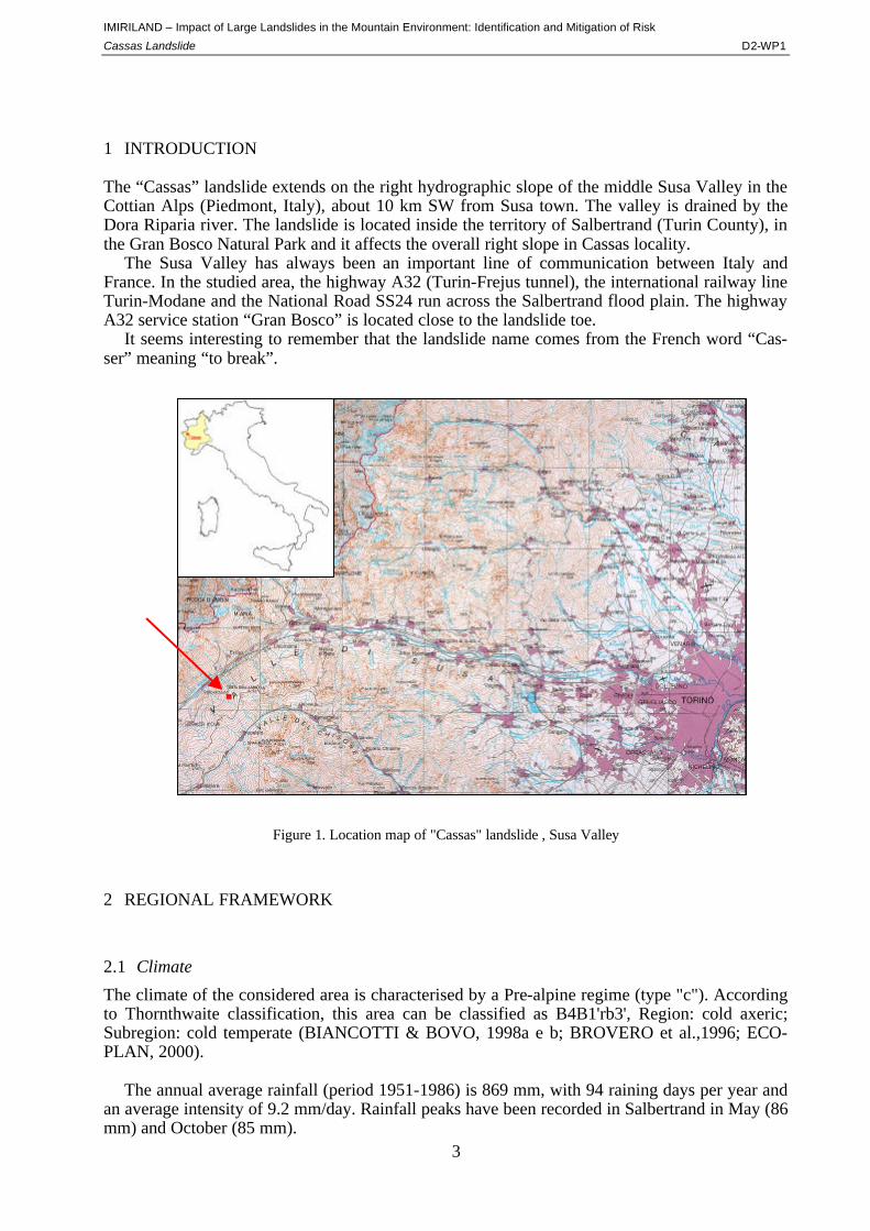
The “Cassas” landslide extends on the right hydrographic slope of the middle Susa Valley in the Cottian Alps (Piedmont, Italy), about 10 km SW from Susa town. The valley is drained by the Dora Riparia river. The landslide is located inside the territory of Salbertrand (Turin County), in the Gran Bosco Natural Park and it affects the overall right slope in Cassas locality.
The Susa Valley has always been an important line of communication between Italy and France. In the studied area, the highway A32 (Turin-Frejus tunnel), the international railway line Turin-Modane and the National Road SS24 run across the Salbertrand flood plain. The highway A32 service station “Gran Bosco” is located close to the landslide toe.
It seems interesting to remember that the landslide name comes from the French word “Cas-ser” meaning “to break”.
Figure 1. Location map of "Cassas" landslide , Susa Valley
2 REGIONAL FRAMEWORK
2.1 Climate
The climate of the considered area is characterised by a Pre-alpine regime (type "c"). According to Thornthwaite classification, this area can be classified as B4B1'rb3', Region: cold axeric; Subregion: cold temperate (BIANCOTTI & BOVO, 1998a e b; BROVERO et al.,1996; ECO-PLAN, 2000).
The annual average rainfall (period 1951-1986) is 869 mm, with 94 raining days per year and
an average intensity of 9.2 mm/day. Rainfall peaks have been recorded in Salbertrand in May (86 mm) and October (85 mm).
IMIRILAND – Impact of Large Landslides in the Mountain Environment: Identification and Mitigation of Risk
Cassas Landslide D2-WP1
4
As regards thermometric regime, these are the monthly mean temperatures [°C] recorded by the station of Salbertrand-Le Selle (alt. 1950 m amsl – period 1991-1999): Jan -1,25; Feb –0.99; Mar 0.72; Apr 1.89; May 6.6; Jun 9.37; Jul 12.42; Aug 12.66; Sep 7.86; Oct 4.7; Nov 1.1; Dec –1.74.
Mean snow covering [cm] measured at the Salbertrand-Le Selle station (alt. 1950 m amsl –
period 1991-1999): Jan 56.4; Feb 67.3; Mar 65; Apr 33; May 5.7; Jun 11.9; Jul 8; Au 6; Sep 2.4; Oct 3.2; Nov 8.4; Dec 32.2.
2.2 Regional Morphology
The upper Susa Valley is mainly characterised by fluvial and glacial morphogenesis and by land-slide activity.
Salbertrand plain was originally a lake generated by the valley damming due to old landslides (in correspondence of Serre La Voute locality) and the Susa-Chisone watershed is characterised by bilateral extension of top ridges. Geological evidences indicate that the regional geodynamic stress field and the gravity slope deformations are interactive systems (CAPELLO, 1941; see references in BROVERO et al., 1996).
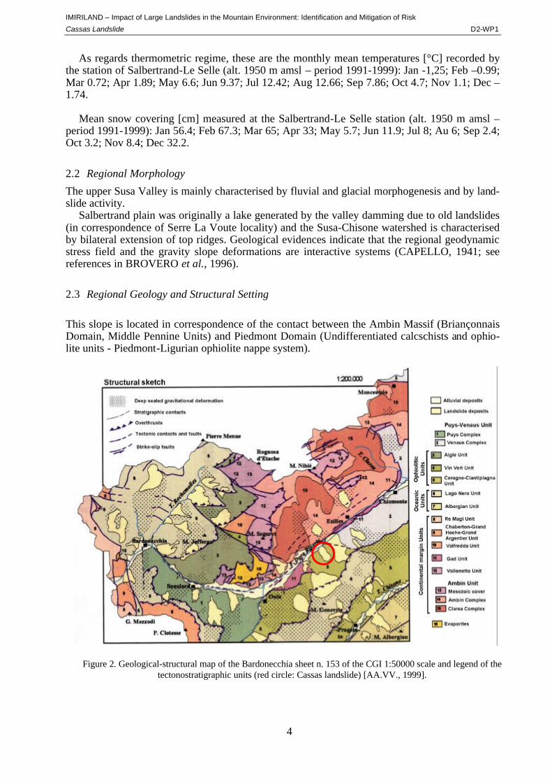
2.3 Regional Geology and Structural Setting
This slope is located in correspondence of the contact between the Ambin Massif (Briançonnais Domain, Middle Pennine Units) and Piedmont Domain (Undifferentiated calcschists and ophio-lite units - Piedmont-Ligurian ophiolite nappe system).
Figure 2. Geological-structural map of the Bardonecchia sheet n. 153 of the CGI 1:50000 scale and legend of the tectonostratigraphic units (red circle: Cassas landslide) [AA.VV., 1999].
IMIRILAND – Impact of Large Landslides in the Mountain Environment: Identification and Mitigation of Risk
Cassas Landslide D2-WP1
5
The Ambin tectonostratigraphy is represented by: - Clarea Serie (micaschists and fine-grained gneisses, pervasively albitized, re-equilibrated
to blueschist-facies), - Ambin Serie (metacomglomerates with quartz pebbles; quartzose micaschists and quartz-
ites; glaucophane-, white mica- and chlorite-bearing micaschists with rare marbles in decimetric levels; quartzose micaschists with chlorite and rare glaucophanic schist boudins.
- Mesozoic cover (carbonate-rich micaschists; grey marbles, dolomite and subordinates mi-caschists; micaceous quartzites layers, green-white, locally quartz-micaschists at chlori-toid levels; quartzitic conglomerates).
The Ambin Massif outcrops on the left slope of the valley and, subordinately, at the bottom of
the right one. Piedmont Domain outcrops on the right slope and is represented by: - Gad tectonostratigraphic unit (lawsonite - phengite - chlorite bearing calcschists; car-
bonatic breccias with dolomitic and quartzic clasts; grey massive dolomitic limestones with subordinate levels of carbonatic breccias).
- Cerogne-Ciantiplagna tectonostratigraphic unit (calcschists with glaucophane and epidote) - Chiomonte-Venaus complex, pertaing to the Puys-Venaus tectonostratigraphic unit (glau-
cophane and epidote bearing blackish schists and massive carbonate calcschists and inter-layers of mica and chlorite bearing quartzites and gneiss).
Quaternary deposits are represented by: glacial deposits (lodgment, ablation and undifferenti-
ated till), landslide deposits, mixed origin deposits, scree, alluvial deposits. Recent eluvial-colluvium deposits are represented by heterogeneous and incoherent mass of soil material and rock fragments.
The regional synmetamorphic deformation is characterized by a tectonic foliation (S1) that overgrew on the pre-Alpine layering with development of folds P1 (first folding phase); S1 is re-folded by a second folding phase P2 that gave origin to crenulation cleavage S2. The S2 foliation corresponds to the main Alpine regional schistosity (SR). P2 folds are refolded by a third folding phase (P3 folds) with associated crenulation cleavage S3; decametric folds P4 and schistosity S4 (related to the fourth phase) are also observed.
The regional brittle tectonic deformation is characterized by: - N60 normal and left-lateral strike-slip conjugated fault systems; - N100-120 normal and right-lateral strike-slip fault systems; - N-S dip-slip fault systems.
These brittle structures are recognizable at all scales (from kilometric to outcrop scale).
3 LOCAL FRAMEWORK
3.1 Local Geology and structural setting
The landslide site is located in the Cerogne-Ciantiplagna tectonostratigraphic unit (Undif-ferentiated calcschists and ophiolite units) that is characterized by several Alpine ductile defor-mation phases followed by intense brittle deformation.
At local scale, bedrock exposures belonging to the Cerogne Complex are constituted by undif-ferentiated calcschists into blueschist-facies at glaucophane and epidote with interlayers of car-bonatic calcschists with ochre alteration patina; metabasites more or less layered with locally ba-

IMIRILAND – Impact of Large Landslides in the Mountain Environment: Identification and Mitigation of Risk
Cassas Landslide D2-WP1
6
Figure 3. Stereographic representation to the discontinu-ity systems (Sp=SR, Sd=SL) [BROVERO et al., 1996].
saltic metabreccias; quartzites with Mn mineralization; micaceous quartzites at Na-anphibole; phyllitic micaschists and blocks of serpentinite. The main discontinuities observed (with dip-direction and dip), mainly carried out from field investigation (1991, 1996, 2000), are listed below: SR - (150°/45°): Regional schistosity, sub-parallel to the tectonic contact between the Ambin tectonostratigraphic unit and undif-ferentiated calcschists and ophiolite units. SL - (301°/15°): Local schistosity foliation with variable orientation near the main scarp. K1 - (351°/80°): Main fracture system: sub-vertical joint system N and S dipping, gener-ally highly persistent; generally low altera-tion with rare presence of soft filling of cataclasite and breccia. K2 - (269°/88°) - Main fracture system: E and W dipping sub-vertical fracture systems partially sub-parallel to sub-meridian regional dip-slip fault system; generally low alteration with rare presence of soft filling. K3 (230°/60°) - This system is well distributed and less persistent and pervasive than K1 and K2; generally low alteration with rare presence of soft filling (microbreccia, silt and gouge). K4 (350°/45°) - This system is less persistent and pervasive than K1 and K2; carbonatic striae (dipping 40°-45° to WNW) have been observed on some K4 joints in the detachment zone; gen-erally low alteration with rare presence of soft filling (calcite, cataclasite and microbreccia). K (330°/90°) – Sub-vertical joint system striking NE and SW; generally low alteration with rare presence of soft filling (microbreccia and silt).
3.2 Water Conditions
No surface waters have been observed on landslide area; some drainage lines correspond to the external margins (starting approximately at 1250 m amsl). Flow regime is related to seasonal cy-cle, fading during dry periods. Aquifer is represented by very permeable landslide debris cover. The basic level corresponds to the underlying calcschists bedrock. Groundwater level varies ac-cording to rainfall regime. Main infiltration zone (rain and snow melting) is located in the upper part of Cassas accumulation zone. Highly fractured bedrock enables deep water circulation.
Two springs are present in the lower part of landslide (estimated flow on July 1997: from 2·10-4 to 8·10-4 m3/s). There are also some springs along the scarp crossing the displaced mass between 1350 m amsl and 1550 m amsl. (EPIFANI, 1991; BROVERO et al., 1996; PARO, 1997; ECOPLAN, 2000).
IMIRILAND – Impact of Large Landslides in the Mountain Environment: Identification and Mitigation of Risk
Cassas Landslide D2-WP1
7
4 LANDSLIDE
4.1 Landslide Identification
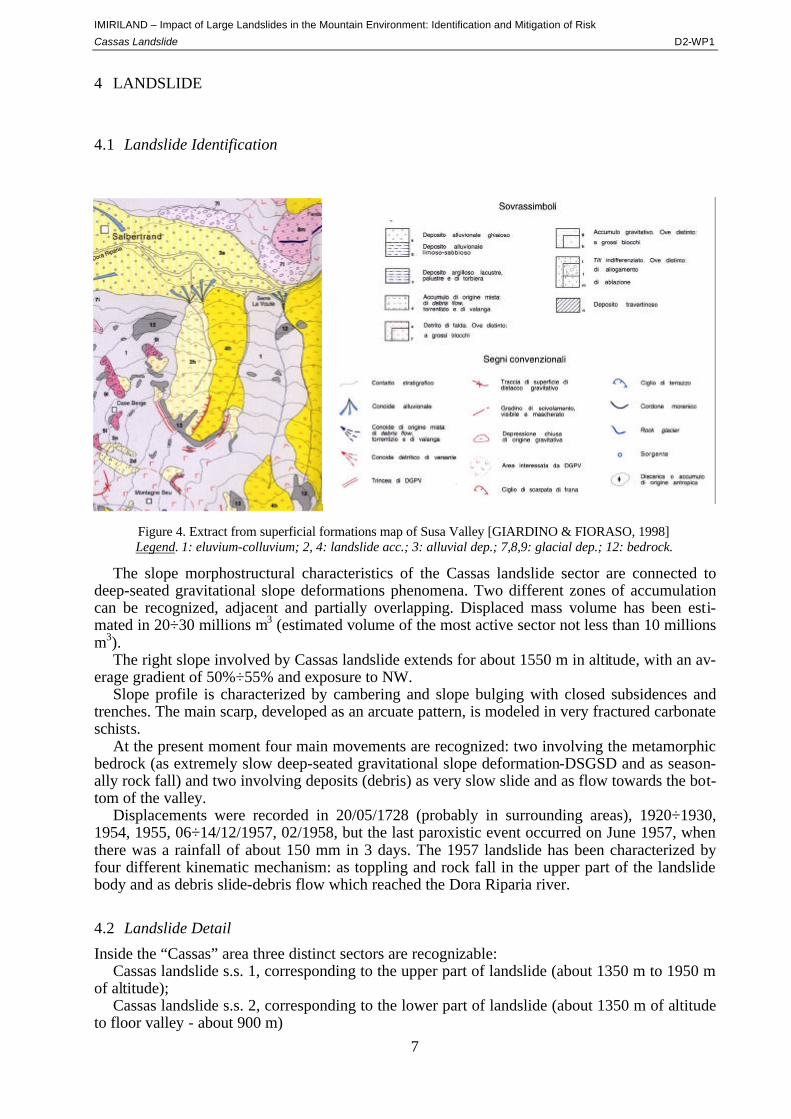
The slope morphostructural characteristics of the Cassas landslide sector are connected to deep-seated gravitational slope deformations phenomena. Two different zones of accumulation can be recognized, adjacent and partially overlapping. Displaced mass volume has been esti-mated in 20÷30 millions m3 (estimated volume of the most active sector not less than 10 millions m3).
The right slope involved by Cassas landslide extends for about 1550 m in altitude, with an av-erage gradient of 50%÷55% and exposure to NW.
Slope profile is characterized by cambering and slope bulging with closed subsidences and trenches. The main scarp, developed as an arcuate pattern, is modeled in very fractured carbonate schists.
At the present moment four main movements are recognized: two involving the metamorphic bedrock (as extremely slow deep-seated gravitational slope deformation-DSGSD and as season-ally rock fall) and two involving deposits (debris) as very slow slide and as flow towards the bot-tom of the valley.
Displacements were recorded in 20/05/1728 (probably in surrounding areas), 1920÷1930, 1954, 1955, 06÷14/12/1957, 02/1958, but the last paroxistic event occurred on June 1957, when there was a rainfall of about 150 mm in 3 days. The 1957 landslide has been characterized by four different kinematic mechanism: as toppling and rock fall in the upper part of the landslide body and as debris slide-debris flow which reached the Dora Riparia river.
4.2 Landslide Detail
Inside the “Cassas” area three distinct sectors are recognizable: Cassas landslide s.s. 1, corresponding to the upper part of landslide (about 1350 m to 1950 m
of altitude); Cassas landslide s.s. 2, corresponding to the lower part of landslide (about 1350 m of altitude
to floor valley - about 900 m)
Figure 4. Extract from superficial formations map of Susa Valley [GIARDINO & FIORASO, 1998] Legend. 1: eluvium-colluvium; 2, 4: landslide acc.; 3: alluvial dep.; 7,8,9: glacial dep.; 12: bedrock.
IMIRILAND – Impact of Large Landslides in the Mountain Environment: Identification and Mitigation of Risk
Cassas Landslide D2-WP1
8
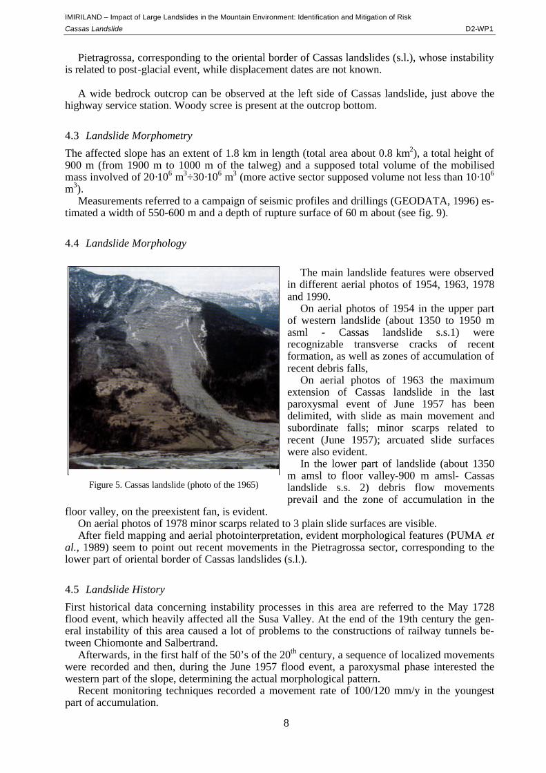
Figure 5. Cassas landslide (photo of the 1965)
Pietragrossa, corresponding to the oriental border of Cassas landslides (s.l.), whose instability is related to post-glacial event, while displacement dates are not known.
A wide bedrock outcrop can be observed at the left side of Cassas landslide, just above the
highway service station. Woody scree is present at the outcrop bottom.
4.3 Landslide Morphometry
The affected slope has an extent of 1.8 km in length (total area about 0.8 km2), a total height of 900 m (from 1900 m to 1000 m of the talweg) and a supposed total volume of the mobilised mass involved of 20·106 m3÷30·106 m3 (more active sector supposed volume not less than 10·106 m3).
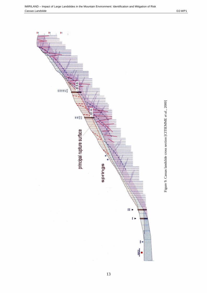
Measurements referred to a campaign of seismic profiles and drillings (GEODATA, 1996) es-timated a width of 550-600 m and a depth of rupture surface of 60 m about (see fig. 9).
4.4 Landslide Morphology
The main landslide features were observed
in different aerial photos of 1954, 1963, 1978 and 1990.
On aerial photos of 1954 in the upper part of western landslide (about 1350 to 1950 m asml - Cassas landslide s.s.1) were recognizable transverse cracks of recent formation, as well as zones of accumulation of recent debris falls,
On aerial photos of 1963 the maximum extension of Cassas landslide in the last paroxysmal event of June 1957 has been delimited, with slide as main movement and subordinate falls; minor scarps related to recent (June 1957); arcuated slide surfaces were also evident.
In the lower part of landslide (about 1350 m amsl to floor valley-900 m amsl- Cassas landslide s.s. 2) debris flow movements prevail and the zone of accumulation in the
floor valley, on the preexistent fan, is evident. On aerial photos of 1978 minor scarps related to 3 plain slide surfaces are visible. After field mapping and aerial photointerpretation, evident morphological features (PUMA et
al., 1989) seem to point out recent movements in the Pietragrossa sector, corresponding to the lower part of oriental border of Cassas landslides (s.l.).
4.5 Landslide History
First historical data concerning instability processes in this area are referred to the May 1728 flood event, which heavily affected all the Susa Valley. At the end of the 19th century the gen-eral instability of this area caused a lot of problems to the constructions of railway tunnels be-tween Chiomonte and Salbertrand.
Afterwards, in the first half of the 50’s of the 20th century, a sequence of localized movements were recorded and then, during the June 1957 flood event, a paroxysmal phase interested the western part of the slope, determining the actual morphological pattern.
Recent monitoring techniques recorded a movement rate of 100/120 mm/y in the youngest part of accumulation.
IMIRILAND – Impact of Large Landslides in the Mountain Environment: Identification and Mitigation of Risk
Cassas Landslide D2-WP1
9
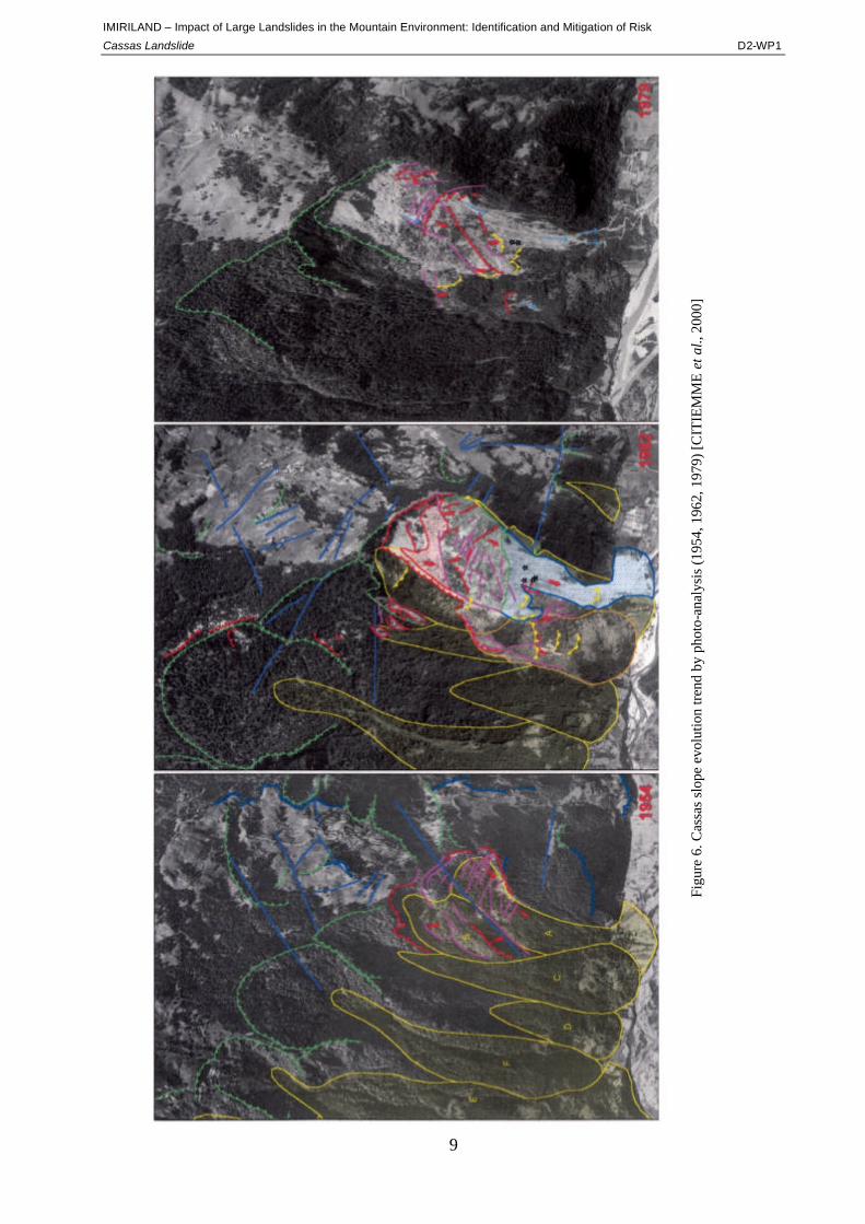
Figu
re 6
. Cas
sas
slop
e ev
olut
ion
trend
by
phot
o-an
alys
is (1
954,
196
2, 1
979)
[CIT
IEM
ME
et a
l., 2
000]
IMIRILAND – Impact of Large Landslides in the Mountain Environment: Identification and Mitigation of Risk
Cassas Landslide D2-WP1
10
5 INVESTIGATION AND MONITORING
Several studies related to historical analysis, field works and deep investigations of Cassas land-slide have been carried out since 1980.
In order to preserve the important transportation infrastructures (international highway and railway) laying at the bottom of the investigated slope, a monitoring system and a series of pro-tection works have been designed and installed.
The organisation of geological-structural data and the subsequent realisation of a geological
model are necessary to understand the instability phenomenon evolution. Thus, it is relevant to link the different data sets referring to a proper local tectonic and/or kinematic model and to con-struct geologic profiles and 3D models.
Mechanical, hydraulic, hydrogeological information are then needed to build up and run geo-technical models.
Last, but not least, displacement measurements and deformation monitoring allow to control the landslide evolution which is important for prevention as well as for calibrating the models prediction.
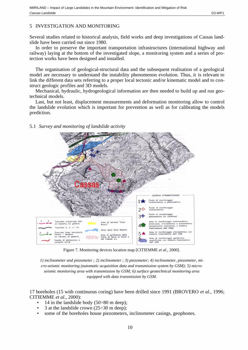
5.1 Survey and monitoring of landslide activity
17 boreholes (15 with continuous coring) have been drilled since 1991 (BROVERO et al., 1996; CITIEMME et al., 2000):
• 14 in the landslide body (50÷80 m deep); • 3 at the landslide crown (25÷30 m deep); • some of the boreholes house piezometers, inclinometer casings, geophones.
1
2 3
4
5 6
Figure 7. Monitoring devices location map [CITIEMME et al., 2000].
1) inclinometer and piezometer ; 2) inclinometer ; 3) piezometer; 4) inclinometer, piezometer, mi-cro-seismic monitoring (automatic acquisition data and transmission system by GSM); 5) micro-
seismic monitoring area with transmission by GSM; 6) surface geotechnical monitoring area equipped with data transmission by GSM.
IMIRILAND – Impact of Large Landslides in the Mountain Environment: Identification and Mitigation of Risk
Cassas Landslide D2-WP1
11
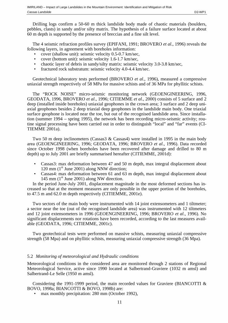
Drilling logs confirm a 50-60 m thick landslide body made of chaotic materials (boulders, pebbles, clasts) in sandy and/or silty matrix. The hypothesis of a failure surface located at about 60 m depth is supported by the presence of breccias and a fine silt level.
The 4 seismic refraction profiles survey (EPIFANI, 1991; BROVERO et al., 1996) reveals the
following layers, in agreement with boreholes information: • cover (shallow unit): seismic velocity 0.5-0.7 km/sec, • cover (bottom unit): seismic velocity 1.6-1.7 km/sec, • chaotic layer of debris in sandy/silty matrix: seismic velocity 3.0-3.8 km/sec, • fractured rock substratum: seismic velocity 4.0-4.4 km/sec.
Geotechnical laboratory tests performed (BROVERO et al., 1996), measured a compressive
uniaxial strength respectively of 58 MPa for massive schists and of 36 MPa for phyllitic schists. The “ROCK NOISE” micro-seismic monitoring network (GEOENGINEERING, 1996,
GEODATA, 1996, BROVERO et al., 1996; CITIEMME et al., 2000) consists of 5 surface and 2 deep (installed inside boreholes) uniaxial geophones in the crown area; 3 surface and 2 deep uni-axial geophones besides 2 deep triaxial deep geophones in the landslide main body. One triaxial surface geophone is located near the toe, but out of the recognised landslide area. Since installa-tion (summer 1994 – spring 1995), the network has been recording micro-seismic activity; rou-tine signal processing have been carried out in order to distinguish “local” and “far” events (CI-TIEMME 2001a).
Two 50 m deep inclinometers (Cassas3 & Cassas4) were installed in 1995 in the main body
area (GEOENGINEERING, 1996; GEODATA, 1996; BROVERO et al., 1996). Data recorded since October 1998 (when boreholes have been recovered after damage and drilled to 80 m depth) up to July 2001 are briefly summarised hereafter (CITIEMME, 2001d):
• Cassas3: max deformation between 47 and 50 m depth, max integral displacement about
120 mm (1st June 2001) along NNW direction; • Cassas4: max deformation between 61 and 63 m depth, max integral displacement about
145 mm (1st June 2001) along NW direction. In the period June-July 2001, displacement magnitude in the most deformed sections has in-
creased so that at the moment measures are only possible in the upper portion of the boreholes, to 47.5 m and 62.0 m depth respectively (CITIEMME, 2001e).
Two sectors of the main body were instrumented with 14 joint extensometers and 1 tiltmeter;
a sector near the toe (out of the recognised landslide area) was instrumented with 12 tiltmeters and 12 joint extensometers in 1996 (GEOENGINEERING, 1996; BROVERO et al., 1996). No significant displacements nor rotations have been recorded, according to the last measures avail-able (GEODATA, 1996; CITIEMME, 2001c).
Two geotechnical tests were performed on massive schists, measuring uniaxial compressive
strength (58 Mpa) and on phyllitic schists, measuring uniaxial compressive strength (36 Mpa).
5.2 Monitoring of meteorological and Hydraulic conditions
Meteorological conditions in the considered area are monitored through 2 stations of Regional Meteorological Service, active since 1990 located at Salbertrand-Graviere (1032 m amsl) and Salbertrand-Le Selle (1950 m amsl).
Considering the 1991-1999 period, the main recorded values for Graviere (BIANCOTTI &
BOVO, 1998a; BIANCOTTI & BOVO, 1998b) are: • max monthly precipitation: 280 mm (October 1992),
IMIRILAND – Impact of Large Landslides in the Mountain Environment: Identification and Mitigation of Risk
Cassas Landslide D2-WP1
12
• average max monthly precipitation: 100 mm (October), • max monthly height of snow covering: 168 cm (February 1994), • average max monthly snow covering height: 233 cm (February), • annual average annual temperature: 7.6 °C (ECOPLAN, 2000).
For the same period at Le Selle station (BIANCOTTI & BOVO, 1998a; BIANCOTTI &
BOVO, 1998b): • max monthly precipitation: 232 mm (June 1992), • average max monthly precipitation: 119 mm (May), • max monthly snow covering height: 124 cm (January 1997), • average max monthly snow covering height: 67 (February), • average annual temperature: 4.5 °C (ECOPLAN 2000).
Two electrical resistence strain gauge piezometers (Pz3 and Pz4) were installed in the main
body; three electrical resistence strain gauge (Cas1, Cas2, Cas3) and the Cas4 absolute pressure transmitter (since an artesian water table was encountered) were installed near the landslide bot-tom (GEOENGINEERING, 1996; GEODATA, 1996; BROVERO et al., 1996; CITIEMME et al., 2000).
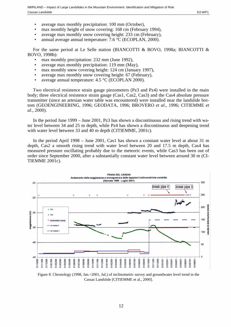
In the period June 1999 – June 2001, Pz3 has shown a discontinuous and rising trend with wa-
ter level between 34 and 25 m depth, while Pz4 has shown a discontinuous and deepening trend with water level between 33 and 40 m depth (CITIEMME, 2001c).
In the period April 1998 – June 2001, Cas1 has shown a constant water level at about 31 m
depth, Cas2 a smooth rising trend with water level between 20 and 17.5 m depth, Cas4 has measured pressure oscillating probably due to the meteoric events, while Cas3 has been out of order since September 2000, after a substantially constant water level between around 30 m (CI-TIEMME 2001c).
Figure 8. Chronology (1998, Jan.÷2001, Jul.) of inclinometric survey and groundwater level trend in the Cassas Landslide [CITIEMME et al., 2000].
IMIRILAND – Impact of Large Landslides in the Mountain Environment: Identification and Mitigation of Risk
Cassas Landslide D2-WP1
13
Figu
re 9
. Cas
sas
land
slid
e cr
oss
sect
ion
[CIT
IEM
ME
et a
l., 2
000]
IMIRILAND – Impact of Large Landslides in the Mountain Environment: Identification and Mitigation of Risk
Cassas Landslide D2-WP1
14
6 MODELLING
Two different approaches have been followed to model "Cassas" landslide behaviour and evolu-tion.
Landslide triggering has been studied by means of a method which couples probabilistic and deterministic approaches (OBONI & BOURDEAU 1983). A stochastic evaluation of mechanical parameters (shear strength angle, cohesion, water table position have been defined by mean value and standard deviation) and forces has been carried out, while local failure is analysed through markovian approach, in order to point out the landslide mechanism (OBONI & RUSSO 1986).
Two slope sectors, 1957 landslide (2 profiles) and west mountain spur have been considered (CITIEMME et al. 2000). The output consists of transition diagrams that represent failure prob-ability vs. slope foot distance.
A runout scenario, concerning rockfall, has been outlined according to the lumped mass the-
ory. Blocks have been represented by material points defined by mass and velocity; sliding has been characterised by a friction coefficient; rebound by normal and tangent reaction coefficient. The output is represented by path, stop probability area and kinetic energy of blocks (CI-TIEMME et al. 2000).
7 STABILIZATION AND PROTECTION WORKS
Catch fences and attenuators, Woven wire-rope nets covering an area of 1650 m2 were realized, as well as scaling of very unstable small to middle rock portions and surface drainage (EPIFANI, 1991).
8 LAND USE AND RISK ASSESSMENT/MANAGEMENT
8.1 Land Use
Land use of the landslide involved area is represented by: • artificial/urbanized area in correspondence of the slope toe (fan), • forest at the external borders of 1957 landslide (deciduous in the lower portion of slope,
coniferous in the middle-upper part), • shrub scattered on the landslide accumulation zone.
8.2 Elements at Risk
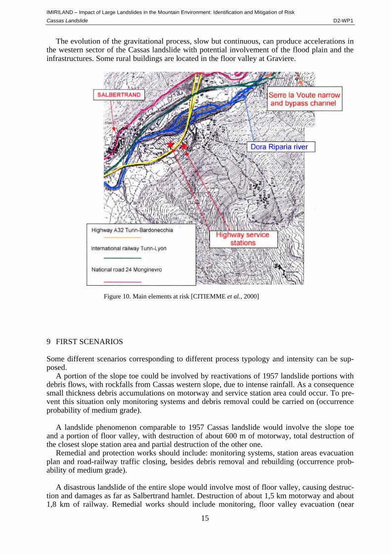
Near the gravitative phenomenon of Cassas there are the highway A32 (Turin-Frejus tunnel-France), the service stations “Gran Bosco”, the National Road SS 24 “del Monginevro”and the international railway line Turin-Modane.
With the Monte Bianco tunnel closure and the 2006 winter Olympic Games that will take
place in this alpine sector, these infrastructures will hold a strategic role.
IMIRILAND – Impact of Large Landslides in the Mountain Environment: Identification and Mitigation of Risk
Cassas Landslide D2-WP1
15
Figure 10. Main elements at risk [CITIEMME et al., 2000]
The evolution of the gravitational process, slow but continuous, can produce accelerations in the western sector of the Cassas landslide with potential involvement of the flood plain and the infrastructures. Some rural buildings are located in the floor valley at Graviere.
9 FIRST SCENARIOS
Some different scenarios corresponding to different process typology and intensity can be sup-posed.
A portion of the slope toe could be involved by reactivations of 1957 landslide portions with debris flows, with rockfalls from Cassas western slope, due to intense rainfall. As a consequence small thickness debris accumulations on motorway and service station area could occur. To pre-vent this situation only monitoring systems and debris removal could be carried on (occurrence probability of medium grade).
A landslide phenomenon comparable to 1957 Cassas landslide would involve the slope toe
and a portion of floor valley, with destruction of about 600 m of motorway, total destruction of the closest slope station area and partial destruction of the other one.
Remedial and protection works should include: monitoring systems, station areas evacuation plan and road-railway traffic closing, besides debris removal and rebuilding (occurrence prob-ability of medium grade).
A disastrous landslide of the entire slope would involve most of floor valley, causing destruc-
tion and damages as far as Salbertrand hamlet. Destruction of about 1,5 km motorway and about 1,8 km of railway. Remedial works should include monitoring, floor valley evacuation (near
IMIRILAND – Impact of Large Landslides in the Mountain Environment: Identification and Mitigation of Risk
Cassas Landslide D2-WP1
16
Salbertrand) and road-railway traffic closing. Debris removal and rebuilding (occurrence prob-ability of low grade).
The risk analysis has been extended to the western portion of Cassas slope (CITIEMME et al., 2000), out of landslide area, but the results appear unreliable due to the lack of information about the general slope assessment.
10 REFERENCES
AA.VV. (1908) - Carta Geologica delle Alpi Occidentali, Regio Ufficio Geologico. AA.VV. (1981) - Carta degli Elementi di Neotettonica del Territorio Italiano, ENEL. AA.VV. (1999) - Carta Geologica d’Italia alla scala 1:50.000 Foglio 132-152-153 “Bardonecchia”, Servizio Geo-
logico d’Italia e Regione Piemonte. ALLENBACH B. & CARON J.M. (1986) - Relations litostratigraphiques et tectoniques entre les séries mésozoi-
ques de la bordure sud-ouest du Massif d'Ambin (Alpes Occidentales), Eclog. Geol. Helv., 79 (1). ANSELMO V., GOVI M., LEPORATI P., TROPEANO D. (1971) - L'evento alluvionale del 12/14 Giugno 1957: i
danni nei bacini del Piemonte e della Valle d'Aosta, XXI Congresso Geografico Italiano "Le calamità naturali delle Alpi".
BARETTI M. (1881) - Relazioni sulle condizioni geologiche del versante destro della valle della Dora Riparia tra Chiomonte e Salbenrtrand, Tip. E Lit. Camilla e Bertolero, Torino.
BIANCOTTI A. & BOVO S. [Editors] (1998a) - Le precipitazioni nevose sulle Alpi piemontesi, Regione Piemonte, Università degli Studi di Torino. Studi climatologici in Piemonte, Vol. 2, 80 pp.
BIANCOTTI A. & BOVO S. [Editors] (1998b) - Distribuzione regionale di piogge e temperature, Regione Piemon-te, Università degli Studi di Torino. Studi climatologici in Piemonte, Vol. 1, 79 pp.
BIANCOTTI A. & BOVO S. [Editors] (1999) - Serie climatiche ultracentenarie, Regione Piemonte, Università de-gli Studi di Torino. Studi climatologici in Piemonte, Vol. 3, 79 pp.
BOGGE A. (1975) - L'alluvione del 1728 in Val di Susa, Centro Studi Piemontesi, 4 (2). BROVERO M., CAMPUS S., FORLATI F., RAMASCO M., SCAVIA C., SUSELLA G. (1996) - La frana del
"Cassas". Salbertrand, Val di Susa, in Rischi generati dai grandi movimenti franosi, Regione Piemonte-Université J. Fourier, Testo di Raccomandazioni, Programma Interreg I Italia-Francia, pp. 71÷103.
CALLEGARI E., SACCHI R., BOVO S., TORASSA G. (1980) - Osservazioni strutturali sul versante italiano del massiccio dell'Ambin (Alpi Graie), Boll. Soc. Geol. It., 90.
CAPELLO C.F. (1941) - Il lago quaternario della conca di Salabertano (Valle di Susa), Boll. Com. Glac. It., 90, pp. 395÷404.
CARON J.M. & GAY M. (1977) - La couverture mésozoique du Massif d'Ambin, transition entre le Domaine brianconnais et le Domaine piémontais ?, Eclog. Geol. Helv., 70 (3).
CARRARO F., DRAMIS F., PIERUCCINI U. (1979) - Large scale landslides connected with neotectonic activity in the alpine and apennine ranges, I.G.U.-U.N.E.S.C.O. Proc. 15th Plenary Meeting Commission on Geomor-phological Survey and Mapping – Modena (Italy), 7-15 September 1979, pp. 213÷220.
CARRARO F., FERRERO E., FORNO M.G., RICCI B. (1980) - Dati preliminari sull'evoluzione neotettonica del-l'arco delle Alpi occidentali, Contr. prelim Carta Neotettonica d'Italia, pubbl. n. 251 Prog. Fin. Geodinamica, pp. 235÷249.
CITIEMME, POLITHEMA, OBONI (2000) - Frane di Serre La Voute e del Cassas, internal report, unpublished. CITIEMME (2001a) – Frana del Cassas, impianto di monitoraggio microsismico. Misura strumentazione, rapporto
interpretativo n. 14. Aprile 2001. SITAF (Autostrada A32 Torino-Bardonecchia), internal report, unpublished. CITIEMME (2001b) – Frana del Cassas, impianto di monitoraggio geotecnica. Misura strumentazione, rapporto
interpretativo n. 14. Maggio 2001. SITAF (Autostrada A32 Torino-Bardonecchia), internal report, unpublished. CITIEMME (2001c) – Frana del Cassas, impianto di monitoraggio delle falde superficiali. Misura strumentazione,
rapporto interpretativo n. 16. Giugno 2001. SITAF (Autostrada A32 Torino-Bardonecchia), internal report, un-published.
CITIEMME (2001d) – Frana del Cassas, impianto di monitoraggio inclinometrico. Misura strumentazione, rappor-to interpretativo n. 7. Giugno 2001. SITAF (Autostrada A32 Torino-Bardonecchia), internal report, unpublished.
CITIEMME (2001e) – Frana del Cassas, impianto di monitoraggio inclinometrico. Misura strumentazione, rappor-to interpretativo n. 8. Luglio 2001. SITAF (Autostrada A32 Torino-Bardonecchia), internal report, unpublished.
CNR (1984) - Neotectonic Map of Italy, CNR Progetto Finalizzato Geodinamica. DAL PIAZ G.V [Editor] (1992) - Le Alpi dal Monte Bianco al Lago Maggiore, Guide Geologiche Regionali, Soc.
Geol. It., n.3, vol 1. ECOPLAN (2000) - Studio Idrogeologico (bilancio idrogeologico dell'area interessata dalla frana del Cassas), SI-
TAF s.p.a., unpublished.
IMIRILAND – Impact of Large Landslides in the Mountain Environment: Identification and Mitigation of Risk
Cassas Landslide D2-WP1
17
EPIFANI (1991) - Studio geologico e geomorfologico del versante a monte delle aree di servizio di Salbertrand, SITAF s.p.a., unpublished.
FORNO M.G. & MASSAZZA G. (1987) - Movimenti gravitativi diffusi e ripetuti nel versante sinistro della Val Cenischia (Alpi Graie) e loro relazione con il sistema di fratture, Geogr. Fis. Dinam. Quat. 10.
FRANCESCHETTI B., STOPPATO M., TURITTO O. (1990) - Le modificazioni del corso della Dora Riparia tra Susa ed Alpignano dal 1881 al 1977, Riv. Geogr. It., 97 (4).
FRANCHI S., MATTIROLO E., STELLA A. (1960, rist.) - Foglio 54 “Oulx”, Servizio Geologico Carta Geologica d'Italia.
GAY M. (1972) - Le massif d'Ambin et son cadre de schistes lustrés (Alpes franco-italienne). Evolution structurale, Archives des Sciences, 25 (2).
GEO ENGINEERING (1996) - Impianto di monitoraggio del versante a monte delle aree di servizio di Salbertrand, unpublished.
GEODATA (1993) - Interventi di sistemazione del versante destro a protezione delle aree di servizio di Salber-trand, Stralci funzionali del progetto esecutivo , SITAF s.p.a., unpublished.
GEODATA (1996) - Monitoraggio versanti Impianto del Cassas, unpublished. GIARDINO M. & POLINO R. (1997) - Le deformazioni di versante dell'alta Valle di Susa: risposta pellicolare del-
l'evoluzione tettonica recente, Il Quaternario Italian Journal of Quaternary Sciences, 10(2), pp. 293÷298. GIARDINO M. & FIORASO G. (1998) – Cartografia geologica delle deformazioni superficiali in aree di catena
montuosa: il rilevamento del Foglio “Bardonecchia” nell’ambito del progetto CARG, Mem. Sci. Geol. 50, pp. 133÷153.
ISNEV (1982) - Archivio dei dati nivometrici della Regione Piemonte, Ass. Reg. Viab. Trasp. Reg. Piem. LORENZONI S. (1965) - Studio geo-petrografico del versante italiano del Massiccio d'Ambin, Soc. Coop. Tipog.
Padova, 25. MORTARA G. & SORZANA P.F. (1987) - Fenomeni di deformazione gravitativa profonda nell'arco alpino
occidentale italiano. Considerazioni lito-strutturali e morfologiche, Boll. Soc. Geol. It., 106. OBONI F. & BOURDEAU P.L. (1983) - Determination of the critical slip surface in stability problems, in Proceed-
ings of Fourth International Conference on Applications of Statistics and Probability in Soil and Structural Engi-neering, Università di Firenze, Pitagora Editrice.
OBONI F. & RUSSO F. (1986) - Interpretation of a probabilistic analysis method on microcomputers and mark-ovian approaches, Bangkok Symposium on Computer Aided Design and Monitoring in Geotechnical Engineer-ing, Asian Institute of Technology.
PARO L. (1997) - Carta degli elementi deformativi superficiali, Regione Piemonte-CSI Piemonte, Graduation thesis in Geological Sciences. Università di Torino
PERETTI L. (1967) - Collegamento autostradale del traforo del Frejus con Torino, La rivista della Strada, anno 36, n.310
PERETTI L. (1969) - Premesse geoapplicative per la realizzazione coordinata dell'autostrada Torino-Oulx e della sistemazione Idrogeologica della Valle di Susa, Cronache da Palazzo Cisterna - Periodico della Provincia di To-rino, n.1
PUMA F., RAMASCO M., STOPPA T. & SUSELLA G. (1989) - Movimenti di massa nelle alte valli di Susa e Chisone, Boll. Soc. Geol. It., 108, pp. 391÷399
RAMASCO M. & SUSELLA G. (1978) - Studi geologici per il collegamento stradale tra il traforo del Frejus e To-rino (tratto Bardonecchia-Susa), unpublished
SACCO F. (1910) - Il gruppo del Cenisio-Ambin-Frejus. Studio Geologico Applicativo al progetto di una nuova galleria ferroviaria tra la Valle della Dora, Comitato Pro Cenisio, Tip. Baravale e Falconieri, Torino
SACCO F. (1921) - Il glacialismo della Valle di Susa, Rivista "L'Universo", Torino, anno II SACCO F. (1948) - La degradazione delle montagne (con esemplificazione nell'alta Val di Susa), "L'Universo",
Rivista dell'I.G.M., anno XXVIII, n.2 TROPEANO D. & OLIVE P. (1993) - Eventi geomorfologici nelle Alpi Italiane e nella pianura occidentale del Po:
inquadramento cronologico in base a radiodatazioni, Il Quaternario 6 (2) TROPEANO D., CORDOLA R., MASSOBRIO R. (1990) - Indagini quantitative sul carico in sedimenti sospesi nel
F. Dora Riparia in località Serre la Voute (alta Val di Susa - Piemonte Occidentale), Boll. Ass. Min. Subalp., anno XXVII, n. 1-2
IMIRILAND – Impact of Large Landslides in the Mountain Environment: Identification and Mitigation of Risk
Cassas Landslide D2-WP1
18
11 PICTURES AND TABLES
Figure Explanation Page 1 Location map of “Cassas” landslide, Susa Valley. 3 2 Geological-structural map of the Bardonecchia sheet n. 153 of the CGI 1:50000 scale and legend of
the tectonostratigraphic units (red circle: Cassas landslide) [AA.VV., 1999]. 4 3 Stereographic representation to the discontinuity systems [BROVERO et al., 1996]. 6 4 Extract from superficial formations map of Susa Valley [GIARDINO & FIORASO, 1998]. 7 5 Cassas landslide (photo of 1965). 8 6 Cassas slope evolution trend by photo-analysis (1954, 1962, 1979) [CITIEMME et al., 2000]. 9 7 Monitoring devices location map [CITIEMME et al., 2000]. 10 8 Chronology (1998, Jan.÷2001, Jul.) of inclinometric survey and groundwater level trend in the Cassas
Landslide [CITIEMME et al., 2000]. 12 9 Cassas landslide cross section [CITIEMME et al., 2000]. 13 10 Main elements at risk [CITIEMME et al., 2000]. 15