Flash Flood and Landslide in Vietnam
167
Flash Flood and Landslide in Vietnam MINISTRY OF AGRICULTURE AND RURAL DEVELOPMENT VIETNAM DISASTER MANAGEMENT AUTHORITY Present: Science, Technology and International Department Hanoi, 10/2019
-
Upload
khangminh22 -
Category
Documents
-
view
4 -
download
0
Transcript of Flash Flood and Landslide in Vietnam

Flash Flood and Landslide in Vietnam
MINISTRY OF AGRICULTURE AND RURAL DEVELOPMENT
VIETNAM DISASTER MANAGEMENT AUTHORITY
Present: Science, Technology and International Department
Hanoi, 10/2019

2
1. Overview of Flash Flood and Landslide in Vietnam
3. Solutions of Flash Flood and Landslide Management in Vietnam
4. Conclusion and Recommendation
Outline
2. Legal Document on Management of Flash Flood and Landslide in Vietnam

o Occur in most of the provinces in the North
and Middle of Vietnam
o 1953 - 2016: 448 times
(Ave.: 7 times /year)
o 2000 – 2015: 779 ppl.
426 ppl.
250 times 9.700 houses
(Ave.: 15-16 times/year) 100.000 houses
75.000 ha3
1. Overview of Flash Flood and Landslide in Vietnam
Damage caused by flash flood and landslide

4
1. Overview of Flash Flood and Landslide in Vietnam
In 2018, in the north mountainous area:
14 times
82 ppl. (70%)
10.300 billion VND (52%)
Damage caused by flash flood and landslide

5
1. Overview of Flash Flood and Landslide in Vietnam
o Most of flash flood and
landslide occurred in
remote locations
o Those disasters happen
every year in Vietnam,
and its frequency tends to
increase
Characteristics of Flash flood and Landslide in Vietnam
Phong Tho
(1958,1992,1996,2002,2014)
Cam Duong
(1960,1993)
Mai Son
(1975, 1991)
Muong Lay
(1970-1997: 6 times, 1994: 2 times)
Sapa
(1974,1993,2013)
6
1. Overview of Flash Flood and Landslide in Vietnam
Bat Xat, Lao Cai 05/8/2016
11
143
Nam Pam, Son La 02-03/8/2017
15
15
279

7
1. Overview of Flash Flood and Landslide in Vietnam
Mu Cang Chai, Yen Bai 03/8/2017
14
156
Sa Na, Thanh Hoa 03/8/2019
10
22

8
2. Legal Documents on Management of Flash Flood and Landslide in VietnamcThe Vietnam Parliament and Government have provided laws and strategies
related to disaster risk management which include flash flood and landslide:
✓ Law on Natural Disaster Prevention and Control (2013)
✓ Law on Dyke Management
✓ Law on Forestry and Forest Development Strategy
✓ Law on Environment Protection Strategy
✓ Law on Water Resources
✓ Land Law
✓ Law on Mineral Resources

9
2. Legal Documents on Management of Flash Flood and Landslide in Vietnam
o June 18, 2018, the Government promulgated Resolution No. 76/NQ-CP
on natural disaster risk management, in which it emphasizes “
identifying the location where flash flood and landslide have high chance
to occur in order to implement structural and non-structural solutions”.
o July 13, 2018, Prime Minister promulgated Directive No. 19/CT-TTg on
flash flood and landslide prevention.
o November 29, 2018, the Government promulgated Decree No.
160/2018/NĐ-CP on guideline of implementing the law on natural
disaster prevention.
10
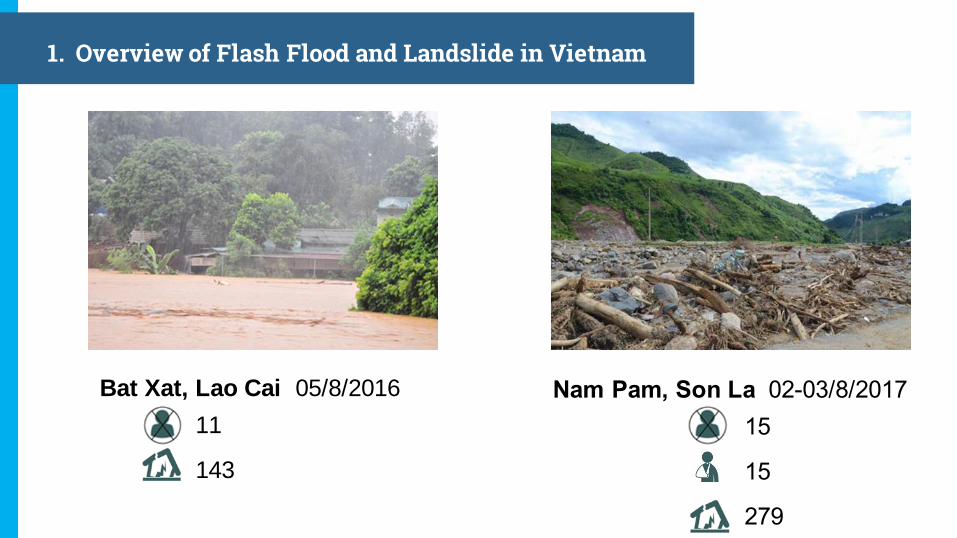
03. Solutions on Flash Flood and Landslide Prevention
Debris flow early warning
design in Ban Khoang, Sapa
Distr., Lao Cai Province
(Cooperation of VIGMR and
SWCB, Agrimedia)
3.1. Enhance the early
warning system

11
03. Solutions on Flash Flood and Landslide Prevention
3.1. Enhance the early warning system

03. Solutions on Flash Flood and Landslide Prevention
3.2. Raise community awareness of flash flood and landslide
VNDMA applies technology and science in communication and raising public
awareness of natural disaster in general and flash flood and landslide in particular
Smartphone App
Social NetworkE-learning
Visualization
Message
Workshop

13
03. Solutions on Flash Flood and Landslide Prevention
3.2. Raise community awareness of flash flood and landslide
14
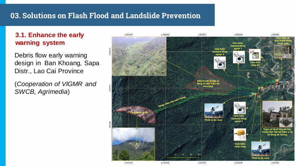
03. Solutions on Flash Flood and Landslide Prevention
3.3. Provide warning equipment for communities where flash
flood and landslide can occur
Instruction of portable speaker in Phong
Binh commune(Thua Thien Hue Province)
Hand over the early warning equipment
to local authorities; training community
based disaster risk reduction
• Green Annamites project (USAID)(7/2019)
• Thanh Phat Co. Ltd. handed over
500 sets of portable speaker to
village chiefs in 09 provinces in the
North mountainous region (5/2018)

15
03. Solutions on Flash Flood and Landslide Prevention
3.3. Provide warning equipment for communities where flash
flood and landslide can occur
July 2018, VNDMA and Agrimedia provided:
o 500 automatic early warning devices for rainfall in 09
provinces in the North region;
o 10 automatic early warning devices for flood water
level, traffic lights and 02 iMetos (intelligent automatic meteorology station, EU standard) in Lao
Cai and Yen Bai Province.
Rain gauge and threshold
measurement
Flood early warning
system

16
03. Solutions on Flash Flood and Landslide Prevention
3.3. Provide warning equipment for communities where flash
flood and landslide can occur
Advantage: Have effect
immediately, help people in the
disaster zone to respond promptly
Disadvantage: Depend on the user’s responsibility
Mr. Ca Van Bien – Village chief, Nam Pam Com.,
Muong La Distr., Son La Province

17
03. Solutions on Flash Flood and Landslide Prevention
WATEC developed the automatic
rain gauge system VRAIN
August 2018: 300 stations
3.4 Strengthening activities of private sector
Agrimedia provides solutions
for weather and agriculture
Number of station
(6/2019)167
Water level station 34
Rain gauge station 85
Multi-purpose station 48
o Complete equipment,
service packages
from installation to
operation and
maintenance
o Easy access via
internet (browse,
smart phone
application)

18
03. Solutions on Flash Flood and Landslide Prevention
Data output by Vrain (web browse)
Automatic Rain Gauge station in
Hoa Binh (09/2019)

19
03. Solutions on Flash Flood and Landslide Prevention
Data Output and station system of Agrimedia
Agrimedia stations

20
03. Solutions on Flash Flood and Landslide Prevention
Advantage:
o Utilize the resources from private
sector
o These companies (Watec,
Agrimedia…) are capable to research and apply up-to-date
technology that is suitable for
Vietnam
o Provide many services
Disadvantage:
Lack of National standard for
imported equipments
3.4. Strengthening activities of private sector

21
03. Solutions on Flash Flood and Landslide Prevention
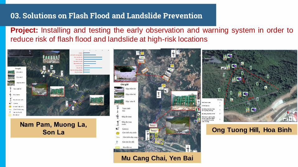
o Project “Installing and testing the early observation and warning system in order
to reduce risk of flash flood and landslide at high-risk locations” (2020 -2025)
o Program “Building observation, warning systems and construction to prevent
and respond debris flow at high-risk locations in the north mountainous area”(2021-2025)
o In cooperation with JICA: Strengthening the capacity to cope with and minimize
damages caused by flash floods and landslides for the north mountainous area
(2019-2022)
3.5. VNDMA is proposing programs and projects to prevent flash flood and
landslide
22
03. Solutions on Flash Flood and Landslide Prevention
Project: Installing and testing the early observation and warning system in order to
reduce risk of flash flood and landslide at high-risk locations
Nam Pam, Muong La,
Son La Ong Tuong Hill, Hoa Binh
Mu Cang Chai, Yen Bai

23
03. Solutions on Flash Flood and Landslide Prevention
Program: Building observation, warning systems and construction to prevent and
respond debris flow at high-risk locations in the north mountainous area
Program
1. Building observation, warning system on flash flood
and landslide
2. Building dam and supporting construction to prevent debris flow
3. Improving management of structure and non-
structure system, communication on flash
flood and landslide

24
4. Conclusions and Recommendations
4.1 Conclusions
oFlash flood and landslide occur more often and cause huge loss,
especially in mountain area
oSocialize in field of disaster prevention has utilized resources from
private sector and proved its potential
oThe early warning system that was invested by foreign organizations
has only created an approach to new technology and it requires more
time to evaluate.

25
4. Conclusions and Recommendations
4.2 Recommendations
o Mandate immediately the Resolution No. 76/NQ-CP on natural disaster risk
management
o Focus more on flash flood and landslide research
o Taking more actions on education; rise community awareness; complete
guideline for flash flood and landslide
o It need to implement soon the pilot project of early observation and warning
system for debris flow in the north mountainous area
o Develop planning on flash flood and landslide prevention, especially at the
high-risk locations
o Provide policies to support private sector for disaster management in generaland flash flood and landslide in particular

Kết luận và kiến nghị
26

Ha Noi, October 2019
REPORT
FLASHFLOOD AND LANDSLIDE IN QUAN SƠN DISTRICT, THANH HÓA PROVINCE
AND EXPERIENCE LESSONS
The Central Steering Committee for Natural Disaster Prevention and Control
STANDING OFFICE

28 | Hôi nghi KHCN trong Phòng chống thiên tai | Hà Nôi, 18/8/2019
CONTENTS
FLASHFLOOD AND LANDSLIDE IN SA NÁ AND IN SOME OTHER LOCATIONS
CAUSES AND LESSONS LEANRT
THINGS TO BE DONE
CHALLENGES AND SOLUTIONS
11
2
3
4

29 | Hôi nghi KHCN trong Phòng chống thiên tai | Hà Nôi, 18/8/2019
I. FLASHFLOOD AND LANDSLIDE IN SA NÁ VILLAGE AND IN SOME
OTHER LOCATIONS
Mường Lát- Thanh Hóa (2018)
06 deaths; damages: VND 732
billion
Thanh Hóa (aftermath of typhoon No. 3 ):
➢16 deaths and missing (Quan Sơn 13, Mường Lát 3)
➢ Estimated damages: VND 914 billion
Mường La -Sơn La (2017)
15 deaths; damages: VND 705
billion
Sìn Hồ - Lai Châu (2018)
23 deaths; damages: VND 270
billion
I.1 MAINTENANCE AREAS: NORTH AND NORTH CENTRAL REGIONS
2018: 14 floods; deaths and missing: 82 people (70% nationwide), damages: VND 10,300 billion (52%nationwide)
Early 2019 so far: 6 floods; 27 deaths and missing and damages estimated at VND 1,000 billion .

30 | Hôi nghi KHCN trong Phòng chống thiên tai | Hà Nôi, 18/8/2019
I. FLASHFLOOD AND LANDSLIDE IN SA NÁ AND IN SOME OTHER LOCATIONS
➢ 10 deaths and missing (06 people are buriedin soil and rocks, not yet rescue)
I.2 SA NÁ VILLAGE, NA MÈO COMMUNE, QUAN SƠN DISTRICT
➢ 35 houses completely collapsed; 02 schools
and 01 cultural house are drifted away.
➢Damages: VND 120 billion
➢ 156.3 ha of rice and upland crops are swept away
Cultural house
Sa Ná village

31 | Hôi nghi KHCN trong Phòng chống thiên tai | Hà Nôi, 18/8/2019
II.1 TOPOGRAPHICAL CHARACTERISTICS, ECONOMIC PEOPLE
❑ Sa Na village is located along Son stream which originates in
Laos. The elevation of the catchment area (the highest point
of the basin) is 1,722m; (in Sa Na, it is at el. 1,600m). About 2.4km away from Sa Na village, the Son stream is narrowed
(57m in difference between the widest and narrowest
sections).
❑ 74 households are allocated along the stream which is 6-7m
higher than stream bed;❑ Transport condition: there is a unique path along the Son
stream to the Sa Na Village.
❑ The combined community cultural house and shelter is
located 10m higher than the stream bed;
❑ In the flood season, the Sa Na village is often flooded;
Causes
❑ The catchment area is large and steep
which relates to quick concentration of
flood water and flashflood is inevitable.
❑ The Son stream bed becomes narrow
and widen to create bottlenecks as a
precondition of a natural dam to raise
water level.
II. CAUSES AND LESSONS LEARNT
Where the Son stream isnarrowed (57m in differencebetween the widest and
narrowest sections).
Lessons learnt:
❑ It is risky for residents living near the
stream banks
❑ The shrunken parts of streams can result in swollen sections and cause flashflood.

32 | Hôi nghi KHCN trong Phòng chống thiên tai | Hà Nôi, 18/8/2019
- FORECASTDay 2 August (National Centre for Hydro-Meteorological Forecasting (NCHMF) in Thanh
Hoa Province: Heavy rain with a total rainfall of 200-400mm (the specific rainfall inQuan Son district cannot be forecasted).
- REALITYHeavy rain during 3 a.m. -7 a.m. o 03 August in Na Meo district; the rainfall is over
200mm and increases by 70.3mm / h (at 7a.m. on 3 August).
Causes:It is impossible to forecast rainfall in a short period of time, especially high intensity
rainfall.It is impossible to forecast rainfall from the upstream part in other territories
Lessons learnt:Install immediately rain gauging stations and disaster warning devices in areas prone to flash floods and landslides.
II.2 Flood forecast and warning:
II. CAUSES AND LESSONS LEARNT

33 | Hôi nghi KHCN trong Phòng chống thiên tai | Hà Nôi, 18/8/2019
-All people in the village were timely informed so they carried following activitiesvery quickly:
-- At 7h40 a.m. (3 August) during the first flood: all local people have beenevacuated to the community cultural houses, and they returned to their home
after that.
-- 8 a.m. (3 August), the second flood has swept away 22 houses; 11 houses andcultural houses collapsed and 02 schools collapsed
II.3 DISASTER RESPONSE STEERING ACTIVITIES
Causes:
The flood was too big and happened unexpectedly
The obstructed section on Son stream where the stream becomes narrow
burst and caused flash floods;
Lesson learnt:
There should be response plans for heavy rain and floods
Obstructed flow should be cleared.
Evacuation areas must be minimally equipped and ensure safety of people
II. CAUSES AND LESSONS LEARNT

34 | Hôi nghi KHCN trong Phòng chống thiên tai | Hà Nôi, 18/8/2019
III. MỘT SỐ TỒN TẠI VÀ GIẢI PHÁP KHẮC PHỤC
III.1 CÔNG TÁC PHÒNG NGỪA
CHALLENGES SOLUTIONS
➢ Most of local authorities have not
inspected residential areas to ensure that they will be safe enough before flashfloods and landslides;
➢ Flashflood and landslide preparedness and response plans are
not specific and practical and are not synchronously implemented at grassroots level.
➢ 4-on-the-spot: limited supplies and equipment (life jackets, minimum
equipment needed for rescue are not available).
➢ Proactively check safe shelters for
the possible evacuation of affected people; Check, detect and clear flows at blocked points.
➢ Prepare evacuation plans for people living in areas of high flashflood
risks; prepare plans to approach the isolated areas.
➢ Prepare food, daily necessities,
medicines, natural disaster prevention and control facilities
(flashlights, life jackets ...). Equip traditional devices (portable speakers, gongs…)

35 | Hôi nghi KHCN trong Phòng chống thiên tai | Hà Nôi, 18/8/2019
CHALLENGES SOLUTIONS
• The area was reached only 2 days after the
disaster
• The area is isolated area for a long time
- Communication system is interrupted and
no information of the affected area is
available and
AND as the result, search and rescue and
response measures cannot be worked out and
launched to timely save affected people
❑ There must be a plan to mobilize
vehicles and equipment for
response activities ((installing
floating bridges, amphibious
vehicles, string guns ...).
❑ Having backup equipment to
ensure smooth communication;
❑ There is a plan to immediately
reach affected people.
❑ Having equipment (drone etc.) to
get necessary information of the
disaster affected areas.
III. SOME CHALLENGES AND SOLUTIONS
III.2 DISASTER RESPONSE ACTIVITIES
It takes 4 – 5 hours before
the search and rescue team
arrived the site

36 | Hôi nghi KHCN trong Phòng chống thiên tai | Hà Nôi, 18/8/2019
1. Immediately prevent illegal logging activities (if
any);
2. Prepare plans to ensure smooth communication
in all situations;
3. Mobilize forces to restore traffic, information
system, electricity grids, public works, utilities...
4. Collate data and estimate damages, propose
supports and allocate resources appropriately
and to right people in need as regulated;
5. Reconstruct after natural disaster adopting “build
back better” in association with new rural
development; resettlement of relocated people
should be associated with sustainable livelihoods
and production transformation.
IV. THINGS TO BE DONE
Mường Lát-Thanh Hóa
Mường La -Sơn La

The Central Steering Committee for Natural Disaster Prevention and Control
STANDING OFFICE
ADDRESS: BUILDING A4, NO. 2 NGỌC HÀ, BA ĐÌNH, HÀ NỘITEL: (84-4) 3733 5694 - FAX: (84-4) 3733 5701
Web: phongchongthientai.vn


BỘ NÔNG NGHIỆP VÀ PHÁT TRIỂN NÔNG THÔN
TỔNG CỤC PHÒNG CHỐNG THIÊN TAI
INTRODUCTION OF JAPAN TECHNICAL STANDARD
FOR DESIGNING COUNTERMEASURES AGAINTS
DEBRIS FLOW AND APPLICATION IN VIETNAM
1. Hydraulic Construction Institute (HyCI), Vietnam Academy for Water Resources;
2. Department of Science Technology and International Corporation;
3. MARD JICA experts;
4. Nippon Steel & Sumikin Metal Products Vietnam Co., Ltd.
Dr. Ba Thao VU,
Head of Department of Geotechnical Engineering, HyCI;
Email: [email protected]
VIETNAM MINISTRY OF AGRICULTURE AND RURAL DEVELOPMENT
DISASTER MANAGEMENT AUTHORITY

40 | Lắp đặt thử nghiệm hệ thống giám sát, cảnh báo lũ quét, sạt lở đất | Hà Nôi, 05/11/2018
BỘ NÔNG NGHIỆP VÀ PHÁT TRIỂN NÔNG THÔN | TỔNG CỤC PHÒNG CHỐNG THIÊN TAI
1. OVERVIEW ON STRUCTURAL COUNTERMEASURES
AGAINST DEBRIS FLOWS
2. MAIN CONTENTS OF SABO DESIGN STANDARD
3. APPLICATION OF STANDARD FOR MU CANG CHAI
DEBRIS FLOW
4. CONCLUSIONS
OUTLINE

1. OVERVIEW ON STRUCTURAL COUNTERMEASURES
AGAINST DEBRIS FLOWS

42
DEBRIS FLOW IN MƯỜNG LAY 1994 ( V.C. MINH)
DEBRIS FLOW WITH ROCK, SOIL,
DRIFTWOOD IS THE MAIN FACTOR OF
HARZARD

In the last 20 years, natural disasters have resulted in about 10.800 people
dead or missing and caused an annual loss of 1.0-1.5% of GDP (VND
20.000 billion). Northern mountainous region: Frequently occurrences of
natural disasters such as flash floods, landslides, heavy rainfall,
thunderstorms, etc., especially debris flow, flash floods and landslides
caused serious damage and tend to increase.
Year
Dead and missing
By Flash flood, landslides in
Northern mountainous
Whole
countryRate %
2014 19 133 15
2015 20 154 13
2016 31 264 12
2017 95 376 25
Average 47 375 12
VIETNAM DEBRIS FLOW DISASTERS

0
5
10
15
20
25
30
Số lần xuất hiện …
• Debris flow, landslides most often occur in the mountainous andmidland provinces in the territory of Vietnam.
• From 2000 to 2016, occurred more than 250 debris flow andlandslides
• Density of debris flow and landslides tend to be increasing andintense, especially in 2017.
NUMBER OF DEBRIS FLOW, LANSLIDE INCREASING

45 | Lắp đặt thử nghiệm hệ thống giám sát, cảnh báo lũ quét, sạt lở đất | Hà Nôi, 05/11/2018
BỘ NÔNG NGHIỆP VÀ PHÁT TRIỂN NÔNG THÔN | TỔNG CỤC PHÒNG CHỐNG THIÊN TAI
PRINCIPLE OF DEBRIS FLOW
OCCURRENCE AREA
FLOW AREA
DEPOSITION AREA
DEBRIS FLOW WITH ROCK, SOIL,
DRIFTWOOD IS THE MAIN FACTOR OF
HARZARD
DISASTER AREA

46 | Lắp đặt thử nghiệm hệ thống giám sát, cảnh báo lũ quét, sạt lở đất | Hà Nôi, 05/11/2018
BỘ NÔNG NGHIỆP VÀ PHÁT TRIỂN NÔNG THÔN | TỔNG CỤC PHÒNG CHỐNG THIÊN TAI

47
Capturing debris flow, Reduce flow
energy, Erosion Control
Occurrence and Erosion Control
Capturing debris flow, Sediment
Deposition, Direction Control,
Guiding debris flow
STRUCTURAL
COUNTERMEASURES
OCCURRENCE AREA
FLOW AREA
DEPOSITION AREA

48
OCCURRENCE CONTROL:
1. Close sabo dams
2. Plants
FLOWING CONTROL
1. Open or haft-open sabo
dams
2. Plants
HAZARD MITIGATION:
1. Open or haft-open
sabo dams2. Sand pond
3. Chanel work
4. Training wall
5. Forest

49http://www.sabo-int.org/dott/river.html
FUNCTIONS OF SABO DAMS
(1) The accumulation of sediment prevents the erosion of the riverbed andalso makes the riverbed slope less steep to make the water flow slower

50http://www.sabo-int.org/dott/river.htmlhttp://staff.civil.uq.edu.au/h.chanson/sabo.html
FUNCTIONS OF SABO DAMS
A sabo dam prevents riverbed erosion, hillside landslide and
a large amount of sediment flow at a time by accumulating
sediment in it.

51
PLANING OF SABO DAMS BASED ON PROTECTIVE AREA
OCCURRENCE
AREA
FLOW AREA
DEPOSITION AREA
LESS RESIDENT >> DENSITY RESIDENT

52 | Lắp đặt thử nghiệm hệ thống giám sát, cảnh báo lũ quét, sạt lở đất | Hà Nôi, 05/11/2018
BỘ NÔNG NGHIỆP VÀ PHÁT TRIỂN NÔNG THÔN | TỔNG CỤC PHÒNG CHỐNG THIÊN TAI
EFFECTIVE OF DEBRIS FLOW
EFFECTIVE
OPEN DAM
OPEN TYPE
IS USEFUL
TO CAPTURE
DRIFTWOOD

53 | Lắp đặt thử nghiệm hệ thống giám sát, cảnh báo lũ quét, sạt lở đất | Hà Nôi, 05/11/2018
BỘ NÔNG NGHIỆP VÀ PHÁT TRIỂN NÔNG THÔN | TỔNG CỤC PHÒNG CHỐNG THIÊN TAI
SIZE OF OPEN TYPE IS TOO
LARGE
CLOSED DAM IS NOT GOOD
FOR CAPTURING DRIFTWOOD DEBRIS FLOW CAUSED BY
DAM FAILURE
EFFECTIVE OF DEBRIS FLOW

2. MAIN CONTENT OF SABO DAM DESIGN STANDARD
MARD decided to
apply Japan Sabo
dam design
standard in Vietnam
from 2019 to 2024.

55 | Lắp đặt thử nghiệm hệ thống giám sát, cảnh báo lũ quét, sạt lở đất | Hà Nôi, 05/11/2018
BỘ NÔNG NGHIỆP VÀ PHÁT TRIỂN NÔNG THÔN | TỔNG CỤC PHÒNG CHỐNG THIÊN TAI

56 | Lắp đặt thử nghiệm hệ thống giám sát, cảnh báo lũ quét, sạt lở đất | Hà Nôi, 05/11/2018
BỘ NÔNG NGHIỆP VÀ PHÁT TRIỂN NÔNG THÔN | TỔNG CỤC PHÒNG CHỐNG THIÊN TAI
57 | Lắp đặt thử nghiệm hệ thống giám sát, cảnh báo lũ quét, sạt lở đất | Hà Nôi, 05/11/2018
BỘ NÔNG NGHIỆP VÀ PHÁT TRIỂN NÔNG THÔN | TỔNG CỤC PHÒNG CHỐNG THIÊN TAI

58 | Lắp đặt thử nghiệm hệ thống giám sát, cảnh báo lũ quét, sạt lở đất | Hà Nôi, 05/11/2018
BỘ NÔNG NGHIỆP VÀ PHÁT TRIỂN NÔNG THÔN | TỔNG CỤC PHÒNG CHỐNG THIÊN TAI

59
Have to
remove
Have to
remove
No need to remove
No need
to remove

60
Have to
remove
Have to
remove
No need to remove
No need
to remove

61

62 | Lắp đặt thử nghiệm hệ thống giám sát, cảnh báo lũ quét, sạt lở đất | Hà Nôi, 05/11/2018
BỘ NÔNG NGHIỆP VÀ PHÁT TRIỂN NÔNG THÔN | TỔNG CỤC PHÒNG CHỐNG THIÊN TAI

63 | Lắp đặt thử nghiệm hệ thống giám sát, cảnh báo lũ quét, sạt lở đất | Hà Nôi, 05/11/2018
BỘ NÔNG NGHIỆP VÀ PHÁT TRIỂN NÔNG THÔN | TỔNG CỤC PHÒNG CHỐNG THIÊN TAI
Case study
Structural and nun-structural countermeasures for a debris flow area in Taiwan
3. APPLICATION OF SABO DESIGN STANDARD
FOR DEBRIS FLOW IN MU CANG CHAI, YEN BAI
PROVINCE
1. Dr. Vu Ba Thao, Hydraulic Construction Institute, VAWR, VIETNAM
2. Dr. Akihiko IKEDA, Sabo & Landslide Technical Center, JAPAN

65 | Lắp đặt thử nghiệm hệ thống giám sát, cảnh báo lũ quét, sạt lở đất | Hà Nôi, 05/11/2018
BỘ NÔNG NGHIỆP VÀ PHÁT TRIỂN NÔNG THÔN | TỔNG CỤC PHÒNG CHỐNG THIÊN TAI
65
Field survey on debris flow
in Tokyo, June 2019
Closed dam, channel works
behind the dam are needed,
Kyushu, June 2019
Closed dam was repaired to be an
open dam for capturing more
driftwoodA large open sabo dam in Kyushu
Debris flow model test
at Kyushu University
Visiting a closed dam in Kyushu,
June 2019
Recent activities on application of sabo standards

66 | Lắp đặt thử nghiệm hệ thống giám sát, cảnh báo lũ quét, sạt lở đất | Hà Nôi, 05/11/2018
BỘ NÔNG NGHIỆP VÀ PHÁT TRIỂN NÔNG THÔN | TỔNG CỤC PHÒNG CHỐNG THIÊN TAI
Location: MCC dist., Yen Bai province
Date: 4 a.m. 2/8/2017
Damage: 15 dead and missing,
279 houses collapsed and
destroyed, road and bridge seriously damaged
Trigger: Rain
Field Survey 29/8/2018
(1) Outline of 2017 debris flow

67 | Lắp đặt thử nghiệm hệ thống giám sát, cảnh báo lũ quét, sạt lở đất | Hà Nôi, 05/11/2018
BỘ NÔNG NGHIỆP VÀ PHÁT TRIỂN NÔNG THÔN | TỔNG CỤC PHÒNG CHỐNG THIÊN TAI
Flow direction
8/2017
2015
(1) Outline of 2017 debris flow

68 | Lắp đặt thử nghiệm hệ thống giám sát, cảnh báo lũ quét, sạt lở đất | Hà Nôi, 05/11/2018
BỘ NÔNG NGHIỆP VÀ PHÁT TRIỂN NÔNG THÔN | TỔNG CỤC PHÒNG CHỐNG THIÊN TAI
(1) Outline of 2017 debris flow
68
Occurrence Area
Flow Section
Deposition Area
Main source area of debris flow (shallow landslide)
Disaster area (muddy debris flow, driftwood)
Huge rocks (main part of debris flow) deposits at
upstream of school

69 | Lắp đặt thử nghiệm hệ thống giám sát, cảnh báo lũ quét, sạt lở đất | Hà Nôi, 05/11/2018
BỘ NÔNG NGHIỆP VÀ PHÁT TRIỂN NÔNG THÔN | TỔNG CỤC PHÒNG CHỐNG THIÊN TAI
69
3 August 2017
2019
(1) Outline of 2017 debris flow

70 | Lắp đặt thử nghiệm hệ thống giám sát, cảnh báo lũ quét, sạt lở đất | Hà Nôi, 05/11/2018
BỘ NÔNG NGHIỆP VÀ PHÁT TRIỂN NÔNG THÔN | TỔNG CỤC PHÒNG CHỐNG THIÊN TAI
70
Occurrence/Source (slope/hillside) area of debris flow (shallow landslide)
➢ The surface of shallow landslides are covered with vegetation.
➢ Depth of landslides are approximately 0.5m-1.0m.
➢ Base rock of the landslides are
weathered.➢ Landslide soils are not remained at
the foot of landslides. It may flushed toward downstream by the debris
flow.
(2) Recent Condition of Catchment
71 | Lắp đặt thử nghiệm hệ thống giám sát, cảnh báo lũ quét, sạt lở đất | Hà Nôi, 05/11/2018
BỘ NÔNG NGHIỆP VÀ PHÁT TRIỂN NÔNG THÔN | TỔNG CỤC PHÒNG CHỐNG THIÊN TAI
71
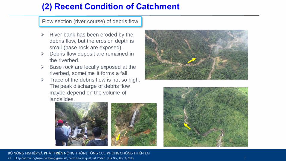
Flow section (river course) of debris flow
➢ River bank has been eroded by the debris flow, but the erosion depth is
small (base rock are exposed).➢ Debris flow deposit are remained in
the riverbed.
➢ Base rock are locally exposed at the riverbed, sometime it forms a fall.
➢ Trace of the debris flow is not so high. The peak discharge of debris flow
maybe depend on the volume of
landslides.
(2) Recent Condition of Catchment
72 | Lắp đặt thử nghiệm hệ thống giám sát, cảnh báo lũ quét, sạt lở đất | Hà Nôi, 05/11/2018
BỘ NÔNG NGHIỆP VÀ PHÁT TRIỂN NÔNG THÔN | TỔNG CỤC PHÒNG CHỐNG THIÊN TAI
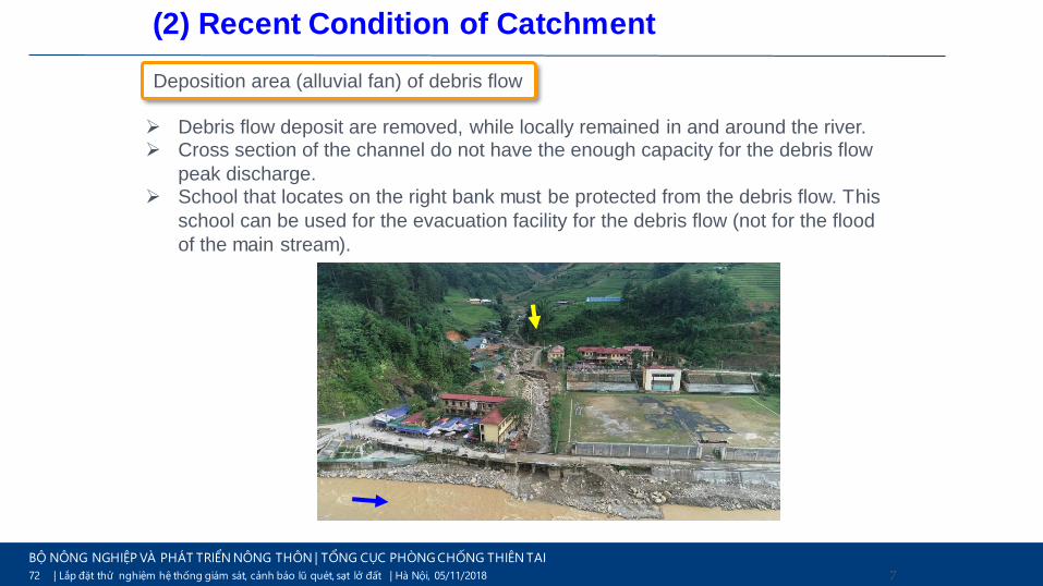
72
Deposition area (alluvial fan) of debris flow
➢ Debris flow deposit are removed, while locally remained in and around the river.➢ Cross section of the channel do not have the enough capacity for the debris flow
peak discharge.➢ School that locates on the right bank must be protected from the debris flow. This
school can be used for the evacuation facility for the debris flow (not for the flood
of the main stream).
(2) Recent Condition of Catchment

73 | Lắp đặt thử nghiệm hệ thống giám sát, cảnh báo lũ quét, sạt lở đất | Hà Nôi, 05/11/2018
BỘ NÔNG NGHIỆP VÀ PHÁT TRIỂN NÔNG THÔN | TỔNG CỤC PHÒNG CHỐNG THIÊN TAI
73
Occurrence Area
Flow Section
Deposition Area
Occurrence and Erosion Control
Capturing debris flow, Reduce flow energy, Erosion Control
Capturing debris flow, Sediment Deposition, Direction Control, Guiding debris flow
(3) Policy of Sediment Control Plan

74 | Lắp đặt thử nghiệm hệ thống giám sát, cảnh báo lũ quét, sạt lở đất | Hà Nôi, 05/11/2018
BỘ NÔNG NGHIỆP VÀ PHÁT TRIỂN NÔNG THÔN | TỔNG CỤC PHÒNG CHỐNG THIÊN TAI
74
Occurrence and Erosion Control
Capturing debris flow, Reduce flow energy, Erosion Control
Capturing debris flow, Sediment Deposition, Direction Control, Guiding debris flow
(3) Policy of Sediment Control Plan

75 | Lắp đặt thử nghiệm hệ thống giám sát, cảnh báo lũ quét, sạt lở đất | Hà Nôi, 05/11/2018
BỘ NÔNG NGHIỆP VÀ PHÁT TRIỂN NÔNG THÔN | TỔNG CỤC PHÒNG CHỐNG THIÊN TAI
75
If possible (2nd Stage) ;
Close type sabo dam (H=10.0m)
- Source of debris flow is the
landslide, capture as possible
Close type sabo dam (H=5.0m)
Close type sabo
dam (H=5.0m)
(4) Countermeasure Facilties Plan

76 | Lắp đặt thử nghiệm hệ thống giám sát, cảnh báo lũ quét, sạt lở đất | Hà Nôi, 05/11/2018
BỘ NÔNG NGHIỆP VÀ PHÁT TRIỂN NÔNG THÔN | TỔNG CỤC PHÒNG CHỐNG THIÊN TAI
76
Close type sabo dam (H=10.0m)
(4) Countermeasure Facilties Plan

77 | Lắp đặt thử nghiệm hệ thống giám sát, cảnh báo lũ quét, sạt lở đất | Hà Nôi, 05/11/2018
BỘ NÔNG NGHIỆP VÀ PHÁT TRIỂN NÔNG THÔN | TỔNG CỤC PHÒNG CHỐNG THIÊN TAI
77
DIFFICULT TO CONSTRUTION
- Flow section of debris flow
- River is narrow and steep
- No road to access the river
(4) Countermeasure Facilties Plan

78 | Lắp đặt thử nghiệm hệ thống giám sát, cảnh báo lũ quét, sạt lở đất | Hà Nôi, 05/11/2018
BỘ NÔNG NGHIỆP VÀ PHÁT TRIỂN NÔNG THÔN | TỔNG CỤC PHÒNG CHỐNG THIÊN TAI
78
Close type sabo dam (H=10.0m)
Open type sabo dam (H=10.0m)
Channel work;
- Full capacity of planned peak
discharge of debris flow
(4) Countermeasure Facilties Plan

79 | Lắp đặt thử nghiệm hệ thống giám sát, cảnh báo lũ quét, sạt lở đất | Hà Nôi, 05/11/2018
BỘ NÔNG NGHIỆP VÀ PHÁT TRIỂN NÔNG THÔN | TỔNG CỤC PHÒNG CHỐNG THIÊN TAI
79
Training dyke;
- Change the direction
of debris flow toward
the sediment basin
(left bank)
Channel work;
- Full capacity of
planned peak
discharge of debris
flow
(4) Countermeasure Facilties Plan

80 | Lắp đặt thử nghiệm hệ thống giám sát, cảnh báo lũ quét, sạt lở đất | Hà Nôi, 05/11/2018
BỘ NÔNG NGHIỆP VÀ PHÁT TRIỂN NÔNG THÔN | TỔNG CỤC PHÒNG CHỐNG THIÊN TAI
4. CONCLUSION
• Unlike flooding, flash floods on rivers, the debris flow occurs at
valleys/streams with great destructive power, in which rock, mud and
driftwood are the main factors causing disasters on infrastructure,
people and properties. Rock, mud and driftwood must be controlled to
minimize damage.
• The sabo dam prevents riverbed erosion, hillside landslide and a large
amount of sediment flow at a time by accumulating sediment in it.
• According to the experiences of many foreign countries such as US,
Austria, Italy, Japan, China, Indonesia, Malaysia, Sri Lanka, etc., the
sabo dam is the most effective countermeasure to prevent and mitigate
the damage caused by debris flow, but not yet applied in Vietnam due
to limited economic, technical, cognitive, etc.
• Vietnam MARD had been decided to apply Japan Sabo dam design
standard in Vietnam from 2019 to 2024.

81 | Lắp đặt thử nghiệm hệ thống giám sát, cảnh báo lũ quét, sạt lở đất | Hà Nôi, 05/11/2018
BỘ NÔNG NGHIỆP VÀ PHÁT TRIỂN NÔNG THÔN | TỔNG CỤC PHÒNG CHỐNG THIÊN TAI
Thank you!


Outline of Measures forsediment disaster in Japan
(Especially for debris flow countermeasures)
October 11, 2019
IMAMORI Naoki
Sabo Planning Division, Sabo Department
Water and Disaster Management Bureau
Ministry of Land, Infrastructure, Transport and Tourism

introduction

JAPANSABOSediment disasters in Japan in recent years
0
500
1.000
1.500
2.000
2.500
3.000
3.500
2008 2009 2010 2011 2012 2013 2014 2015 2016 2017 2018
Slope failure Landslide
Nearly 10 years(2008~2017)Average 1,106
3,459
85

JAPANSABOClassification of Landslide andClassification of Sediment disasters in Japan
Cruden and Varnes, 1996 Classification of sediment disasters in Japan
Slope Failure
Landslide
Debris Flow
86

JAPANSABOWhy do we classify it in this way?
• Different appropriate measures should be respectively taken to prevent the disasters caused by each one of those phenomena.
• Japanese classification comes from disaster prevention-oriented approach.
Debris Flow Landslide Slope Failure
Measures such as catch dams or debris basins are taken to catch the debris flow.
Measures such as groundwater drainage, anchors are taken to stabilize a slope.
Measures such as retaining wall are taken to retain a soil to a slope.
87

JAPANSABOExamples and Features of Sediment Disasters Occurring in Recent Years
• In 2018, a landslide that caused enormous damage occurred in Hiroshima Prefecture. More than 80 people died.
• In the upstream region, many debris flows occurred, and the sediment that flowed into the river was carried downstream and accumulated.
• As a result, flooding occurred downstream, causing a combination of sediment and flood disasters.
Damage caused by debris flows
Damage caused by debris floods88
Laws, organization and budget for sediment disaster reduction in Japan
89

JAPANSABO
Facility
Construction
Early Warning
And
Evacuation
Regulation
And
Control
Development regulation
Protect human lives/ Conserve assets
Protect human lives
Non structural measures
Three main actions for Sediment Disaster Reduction
90

JAPANSABOFour acts concerning Sediment Disaster Reduction
Sediment Disaster Prone Area
Sediment Disaster Prevention Act【2000】
Non-contraction measures• Establishment of Early Warning systems• Regulation of development activities• Regulation of building structures• Relocation recommendations
Non-structural Countermeasure• Restrictions on the collection of soil.
Debris flow, landslide andslope failure Prone areas
Structural Measures• Erosion control work• Landslide prevention work• Steep slope failure prevention work
91
Sabo Act (Erosion Control Act) 【1897】Landslide Prevention Act【1958】Steep Slope Failure Prevention Act【1969】
Potential Debris flow, landslide and slope failure initiation areas

JAPANSABO
Other ministries
• Disaster Countermeasures Basic Act
• Act on Special Measures concerning Countermeasures for Large-scale Earthquakes
• Act on Special Measures against Tokyo Inland Earthquake
• Act on Special Measures for Active Volcanoes
• Fire Service Act• Disaster Relief Act• Act on Special Financial
Support to Deal with the Designated Disaster of Extreme Severity
etc.
MLIT
• River Act• Act on Specified
Multipurpose Dams
• Coast Act• Flood Control Act• Building Standards
Act• City Planning Act• Meteorological
Service Actetc.
Sabo Department
• Sabo Act• Landslide Prevention
Act• Steep Slope Failure
Prevention Act• Sediment Disaster
Prevention Act
Laws related to disaster risk management
92

JAPANSABO
Ministry of Land, Infrastructure, Transport and Tourism (MLIT)
Sabo Department Sabo Planning Division
Land Conservation Division
Regional Development Bureau (9) Office (40*)
National Institute for Land
& Infrastructure Management
(NILIM)
Sabo Department
Public Works Research Institute
(PWRI)
Sediment Control
Research Group
Public Works Department Sabo Division
Branch Office
-*Works for sediment disasters
Prefectures (47)
Organizations for Erosion Control and Sediment Disaster Reduction
93

JAPANSABOBudget for Erosion Control and Sediment Disaster Reduction
For MLIT’s direct implementation
Subsidized to Prefectures from MLIT
Annual budget regarding Sabo projects:about 310 billion JPY (approx. 2.3 billion USD)
MLITBudget
150 billion JPY
National govt. expenditure 66.7%
Prefecture burden 33.3%
Prefecture (47)Budget
160 billion JPY
Prefecture expenditure 50%
National govt. subsidy 50%
-2019 Japanese Fiscal Year94

JAPANSABOSystem for implementing acts Based on Laws- Example of Sabo Act -
Determination of Area for Sabo act
◼ Land subject to the determination• Land requiring sabo facilities• Land where certain acts should be prohibited or restricted for flood control and erosion control.◼ The designation shall be made by the Minister of MLIT.
Restrictions
◼ Operator• Prefectural Governors• Minister of MLIT*
Enforcement of Sabo act
◼ Operator• Prefectural Governors• Minister of MLIT*
Maintenance
◼ Operator• Prefectural Governors• Minister of MLIT*
Involvement of Minister of MLIT
◼ instructions for sabo act by prefectural governors, if necessary◼ Approval for the plan of sabo act
• Execution of sabo act is an obligation of prefectures.• The national government can also implement the sabo act if the interests of more than
two prefectures are involved.
*Cases in which interests are not limited to one prefecture , etc. 95

Structural measuresandNon structural measures
96

JAPANSABO
Measures for Sediment Disaster
Structural Measures
Sabo Dam
Retaining Wall
Pile Work etc.
Non-structural Measures
Hazard Zoning
Alerting Information
Regulation of Land Use
Basic Framework Established in 1969 in Japan
Basic Framework of Measures for Sediment Disaster
97
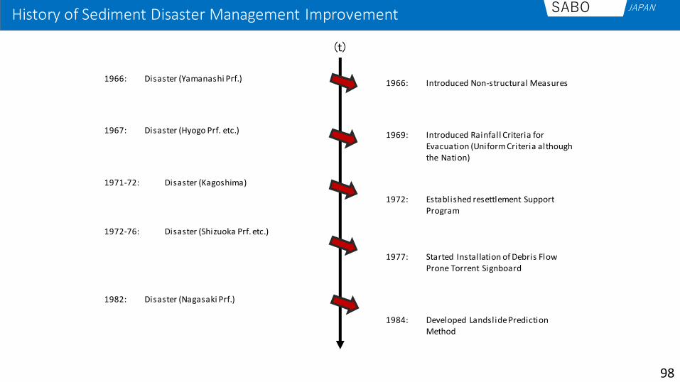
JAPANSABOHistory of Sediment Disaster Management Improvement
(t)
1966: Disaster (Yamanashi Prf.)
1967: Disaster (Hyogo Prf. etc.)
1971-72: Disaster (Kagoshima)
1972-76: Disaster (Shizuoka Prf. etc.)
1982: Disaster (Nagasaki Prf.)
1966: Introduced Non-structural Measures
1969: Introduced Rainfall Criteria for Evacuation (Uniform Criteria although the Nation)
1972: Established resettlement Support Program
1984: Developed Landslide Prediction Method
1977: Started Installation of Debris Flow Prone Torrent Signboard
98

JAPANSABOHistory of Sediment Disaster Management Improvement
(t)
2014: Disaster (Hiroshima Prf.)
2014: Amended Sediment Disaster Prevention Act. Pref. Governor was obliged to disseminate Sediment Disaster Alert etc.
2004: Disaster (Niigata Prf.)
1999: Disaster (Hiroshima Prf.)
2005: Amended Sediment Disaster Prevention Act. Mayor was to disseminate Hazard Maps.
2000: Enacted Sediment Disaster Prevention Act. Pref. Governor was legally obliged to investigation to designate Sediment Disaster Alert Areas.
99

JAPANSABOWhat is the danger?- Sediment Disaster Alert and Special Alert Area -
• Sediment Disaster Prevention Law has been enforced as of April 1, 2001.
• Further promotion is needed to designate all hazardous
areas , in addition to cooperation by municipalities.
• Strengthening information sharing and warning and
evacuation system
• Informing residents of relevant points of warning and
evacuation
Designation of sediment disaster alert areas
• Permission system for specified development activities
• Targets: Development activities for residential
houses and land sales, social welfare facilities, etc
• Restrictions to building structures (areas other than
urban planning areas are to be confirmed) • Recommendation for transfer and so on to
buildings with risks of serious damages in case of
sediment disasters
• Securing finances and budgets to those who are
recommended to move
Designation of special sediment
disaster alert areas
(Areas with high risks for building damages and
loss of lives or physical damages)
Sediment disaster alert areas (Yellow Zone)
Yellow
Red
Sediment Disaster Special Alert areas (Red Zone)
Controlling increases of hazardous areas
by development
100

JAPANSABO
* Total number of Yellow Zones estimated to be conclusively designated by prefectures as of the end of FY 2019.
Hazard Zoning (Basic Investigation)
383.493 423.021
481.556
532.358 574.582
629.063
200.000
300.000
400.000
500.000
600.000
700.000About 668,000*
↓
101

JAPANSABOWhen is the danger?- Sediment disaster alert -
Prefectures & Local Meteorological Observatories, etc.
Municipalities
TV, Radio, Internet
Residents
breaking news, etc.
• Municipalities will issue evacuation orders, etc. based on the information.• Residents evacuate based on evacuation orders, etc.• The mass media mediates various information from the administration to the
inhabitants.
TV, Radio, Internetbreaking news, etc.
Evacuation order, etc.
Sediment disaster alert
102

JAPANSABOAbout Sediment disaster alert
Purpose: To assist mayors in determining whether to issue evacuation recommendations/orders, and to provide residents with useful information for evacuation, during times of elevated danger due to rainfall.
Concept of Sediment Disaster Alert
Critical line set based onpast disaster records
Sediment disaster alert is issued.
Snake line(Actual rainfall)
Now
2 hrsbefore
3 hrsbefore
1 hrbefore
Rainfall forecastedin the coming 1 hr
Rainfall forecasted in the coming 2 hrs
High risk
Rai
nfa
ll (6
0 m
in)
Soil water index (Long-term rainfall index)
Low risk
103• http://www.mlit.go.jp/river/sabo/seisaku/tebiki_r106.pdf• http://www.mlit.go.jp/river/shishin_guideline/sabo/dsk_tebiki_h1706.pdf

JAPANSABOInformation to supplement the Sediment disaster alert
distribution of risk Color Legend
104

JAPANSABOEfforts to make disaster prevention weather information more accessible
To enable municipalities to make more effective use of the information provided by the Japan Meteorological Agency (JMA) through the judgment of evacuation advisories, the resolution of the landslide disaster warning judgment mesh information provided by the JMA has been increased from the 5km mesh to a 1km mesh.
Before After
105
Debris flow countermeasures in Japan
106

JAPANSABOManuals for debris flow and driftwood
Manual of Technical Standard for establishing Sabo master plan for debris flow and driftwood
Manual of Technical Standard for design Sabo facilities against debris flow and driftwood
107• http://www.nilim.go.jp/lab/bcg/siryou/tnn/tnn0904pdf/ks0904.pdf• http://www.nilim.go.jp/lab/bcg/siryou/tnn/tnn0905pdf/ks0905.pdf

JAPANSABO
Sabo master plan
(Estimated sediment and driftwood runoff volume)
Sabo master plan (Facility location planning)
Sabo research (Desk and on-the-spot researches)
Preliminary designing of sabo facility
(Comparison of facility structure and location)
Detailed designing of sabo facility
(Details of structure, design drawing, quantifying)
Site research and surveying
Site acquisition and application for designation as sabo site
Implementation of countermeasure construction
Related to Technical Standards for establishing the Sabo master plan for debris flow and drift wood
Related to Technical Standards for designing Sabo facilities against debris flow and driftwood
A flow from investigation to construction of sabo facilities
108
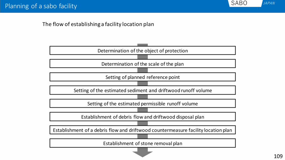
JAPANSABOPlanning of a sabo facility
The flow of establishing a facility location plan
Determination of the object of protection
Determination of the scale of the plan
Setting of planned reference point
Setting of the estimated sediment and driftwood runoff volume
Setting of the estimated permissible runoff volume
Establishment of debris flow and driftwood disposal plan
Establishment of a debris flow and driftwood countermeasure facility location plan
Establishment of stone removal plan
109

JAPANSABO
Movable sediment volume- The amount of sediment that may
possibly flow out downstream into the basin by debris flows and collapse
Transportable sediment volume- Transportable sediment volume is
calculated from the estimated-scale rainfall as well as the basin area and stream bed gradient at the planned reference point
Compare
Regard the smaller one as the estimated sediment runoff volume
Example of sabo facility planning- Setting of the estimated sediment runoff volume -
110

JAPANSABOExample of sabo facility planning- Setting of the estimated sediment runoff volume -
■+■
■+■
■+■+■
111

JAPANSABOExample of sabo facility planning- Establishment of a facility location plan
112

JAPANSABOExample of sabo facility planning- Select tyepe of Sabo dam-
Open type sabo dam Partially-Open type sabo dam sabo dam
• Select an appropriate type of erosion control dam at the site.• It is necessary to understand the characteristics of each kind well.
113
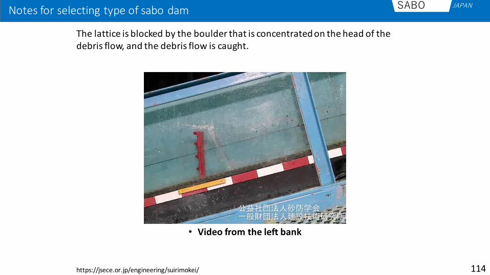
JAPANSABONotes for selecting type of sabo dam
114
• Video from the left bank
The lattice is blocked by the boulder that is concentrated on the head of the debris flow, and the debris flow is caught.
https://jsece.or.jp/engineering/suirimokei/

JAPANSABONotes for selecting type of sabo dam
115
• Video from the left bank
Because the lattice spacing is large relative to the particle size of the debris flow, the blockage structure collapses and it is impossible to keep the trapped state of sediment, and sediment flow downstream.

JAPANSABONotes for selecting type of sabo dam
116• Video from the left bank
• Some driftwood will be caught, but some float in the water and flow downstream.
• Sediment will be caught until the sabo dam is filled. In addition, even after filling up the sediment, the sediment will be trapped on the upper surface of the sediment while flowing down to the downstream.

JAPANSABOEffect of Sabo dam
Debris flow
Sabo Dam
Sabo dam caught debris flow and driftwood
Sabo dams caught the debris flow and driftwood, so assets such as houses downstream were protected.
117

Maintenance of Sabo Facility
118

JAPANSABOSystem for implementing acts Based on Laws- Example of Sabo Act -
• As with the implementation of sabo act, the maintenance of facilities is a duty of prefectures.
• The budgets for maintenance and management are to be prepared by prefectural governments with some exceptions.
Determination of Area for Sabo act
◼ Land subject to the determination• Land requiring sabo facilities• Land where certain acts should be prohibited or restricted for flood control and erosion control.◼ The designation shall be made by the Minister of MLIT.
Restrictions
◼ Operator• Prefectural Governors• Minister of MLIT*
Enforcement of Sabo act
◼ Operator• Prefectural Governors• Minister of MLIT*
Maintenance
◼ Operator• Prefectural Governors• Minister of MLIT*
Involvement of Minister of MLIT
◼ instructions for sabo act by prefectural governors, if necessary◼ Approval for the plan of sabo act
*Cases in which interests are not limited to one prefecture , etc. 119

JAPANSABOTechnical standard for maintenance of Sabo facilities
Guideline of establishing to extend the life of Sabo facilities (Provisional translation) Outline for maintenance of Sabo facilities (Provisional translation)
120• http://www.mlit.go.jp/river/shishin_guideline/sabo/tyoujyu.pdf• http://www.mlit.go.jp/river/shishin_guideline/sabo/tenken.pdf

JAPANSABORemoval
Before After
After the Sabo dam cough the debris flow, sediment that was caught by Sabo dam need to remove for the next debris flow.
121

JAPANSABOReform
Before After
Sabo dams that have deteriorated in function need to repaire.In some case, Sabo dams that have been built according to old manuals are reconstructed.
image122

JAPANSABOWeeding
Before After
It is necessary to mow the grass which becomes an obstacle in the channel in the downstream of Sabo dam.
123

JAPANSABOPatrol and Inspection
A patrol and inspection is carried out to check for damage to Sabo dams, etc.
124

JAPANSABOImprovement Mechanism
Disaster
Review the Action
(After Action Report)Improvement
of Disaster Management
System
Technical Development

Thank you for
your attention!!
126

127
Maintenance and Inspection of River Facilities and Dam and Upgrade of Existing Dam
Takashi SUZUKI, Deputy Director,Water and Disaster Management Bureau,
Ministry of Land, Infrastructure, Transport and Tourism (MLIT)
October 10th, 2019

128
Maintenance and Inspection of River Facilities and Dam and Upgrade of Existing Dam
Takashi SUZUKI, Deputy Director,Water and Disaster Management Bureau,
Ministry of Land, Infrastructure, Transport and Tourism (MLIT)
October 10th, 2019
Contents1. Disaster-prone Country (background)
2. Management of River Facilities incl. banks3. Inspection and Preservation of River Facilities4. Management and Inspection of Dams5. Upgrade of Existing Dams (advanced topic)

129
Maintenance and Inspection of River Facilities and Dam and Upgrade of Existing Dam
Takashi SUZUKI, Deputy Director,Water and Disaster Management Bureau,
Ministry of Land, Infrastructure, Transport and Tourism (MLIT)
October 10th, 2019
Contents1. Disaster-prone Country (background)
2. Management of River Facilities incl. banks3. Inspection and Preservation of River Facilities4. Management and Inspection of Dams5. Upgrade of Existing Dams (advanced topic)

■日本の洪水は短距離ランナー型
◆ Stream Gradient of Major Rivers
Altitude (m)
Shinano River
Kitakami R.
Rhein
Loir
Seine
Colorado
Mekong
Yoshino R.
ChikugoR.
Abe R.Tone R.
Joganji R.
Rivers in Japan : Steep and Short
Disaster-prone Country
130
River Mouth
0 200 400 600 Distance from the mouth (Km)
1,000800

Zero-meter area below sea surface
1
3
1
Tokyo
Tokyo
Skytree
Area below the surface of high tide
60–50 m
50–40 m
40–30 m
30–20 m
20–10 m
10–5 m
5–4 m
4–3 m
3–2 m
2–1 m
1–0 m
Below 0 m
Water area
Height (T.P.)
Arakawa River
Area below the surface of low tide
Tokyo
Tower
Disaster-prone Country
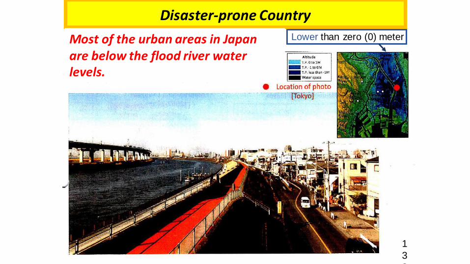
Eastern Tokyois low.

1
3
2
Most of the urban areas in Japanare below the flood river water levels.
Urban areas are formed on low-lying areas
⚫Tokyo & Edogawa River, Arakawa River, and Sumida River
Sum
ida
Riv
er
Altitude (m)
Keihin Tohoku Line
Ara
kaw
a R
ive
r
Nak
agaw
a R
iver
Aya
seR
iver
Saka
gaw
a R
iver
Ob
a R
iver
Edo
gaw
a R
iver
Mu
sash
ino
Line
Shin
-sak
agaw
aR
iver
Job
an L
ine Nat
ion
al R
ou
te 6
Kita-ku Arakawa-ku Adachi-ku Katsushika-ku Misato City Matsudo City
Thames River
⚫London and Thames River
Disaster-prone Country
Tokyo (Arakawa River etc.), Japan
London (Thames River), UK.
◆ Crosssection of the Cities
Disaster-prone Country
Tokyo (Arakawa River), Japan
Lower than zero (0) meterMost of the urban areas in Japanare below the flood river water levels.
1
3
3

Disaster-prone Country
Tone River, near Tokyo, 1947
Tone River
Levee brokenLevee broken
One of the largest rivers in Japan, flooding due to Kathleen Typhoon 1947
(just 2 years after the World War II).Eastern Tokyo were widely inundated… 7

135
Maintenance and Inspection of River Facilities and Dam and Upgrade of Existing Dam
Takashi SUZUKI, Deputy Director,Water and Disaster Management Bureau,
Ministry of Land, Infrastructure, Transport and Tourism (MLIT)
October 10th, 2019
Contents1. Disaster-prone Country (background)
2. Management of River Facilities incl. banks3. Inspection and Preservation of River Facilities4. Management and Inspection of Dams5. Upgrade of Existing Dams (advanced topic)

Kanto-Tohoku torrential rain
(2015)
Tokai torrential rain (2000)
Near Nagoya-City
River Bank (Embankment) is important !
Wide areas are affected
when the bank collapse.
11bank collapsing

River management facilities (river structures)
Weir Sluice gate Sluice pipes
Drainage pumping station Lock gateGround sills
⚫ Various river management facilities are installed in rivers, including
dams, sluice gates/sluice pipes and pumping stations, as well as river
embankment.
137

Management of river course
⚫ Rivers, which are public property, each have unique characteristics and there are even
different sections in each river.
⚫ River conditions change both in the short term and in the long term due to flooding, daily
water flow and changes in vegetation, etc.
⚫ Those changes are not necessarily uniform, and there are occasionally sudden changes.
➔ Conditions should be observed regularly.
138
Corrosion of riverbed and riverside
Growth of trees and shrubs in river
channels
Deposits of earth and sand

Issues of river course/ bank management
⚫ Forms of river channels and banks are constantly changing due to the effects of water flow, etc.
⚫ Banks are linear structures with extremely long extension, and flood control functions of a whole section will be lost if even one point has been broken.
⚫ As even a small hole will cause a dike break, the local safety of a series of
banks is regulated.⚫ Serious damage occurs when the banks of a large river break.
River water surface
level is higher than
house roofs
Sept. 2001 Typhoon no. 15Flooding of Edo River
Dike break in Yabe river system on July 14, 2012
139
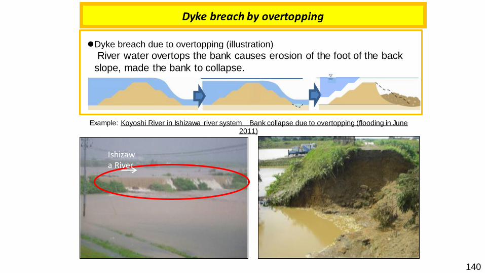
Dyke breach by overtopping
⚫Dyke breach due to overtopping (illustration)
River water overtops the bank causes erosion of the foot of the back
slope, made the bank to collapse.
Example: Koyoshi River in Ishizawa river system Bank collapse due to overtopping (flooding in June 2011)
パイピング破壊
遮水壁遮水壁 遮水壁遮水壁遮水壁
浸透を抑制
対策前
対策後
【堤外】 【堤内】
【堤外】 【堤内】
H.W.L
基礎地盤
堤体
降雨
堤体漏水
堤体内の浸潤面(河川水+降雨)
H.W.L
基礎地盤
堤体
降雨
堤体内の浸潤面の低下
堤脚水路
浸透
浸透
ドレーン工
堤体内浸透水を速やかに排出
工法②
対策前
対策後
【堤外】 【堤内】
【堤外】 【堤内】
H.W.L
基礎地盤
堤体
降雨
堤体漏水
堤体内の浸潤面(河川水+降雨)
H.W.L
基礎地盤
堤体
降雨
堤体内の浸潤面の低下(河川水+降雨)
断面拡大工法(粘性土材料)
断面拡大工法(砂質土材料)
浸透
浸透
降雨による浸透水を速やかに排水河川水の
浸透を抑制
工法①浸透破壊 降雨による浸透水
を速やかに排水
H.W.L
対策前
対策後
【堤外】 【堤内】
【堤外】 【堤内】
H.W.L
基礎地盤
堤体
降雨
堤体漏水
堤体内の浸潤面(河川水+降雨)
H.W.L
基礎地盤
堤体
降雨
堤体内の浸潤面の低下(河川水+降雨)
断面拡大工法(粘性土材料)
断面拡大工法(砂質土材料)
浸透
浸透
降雨による浸透水を速やかに排水河川水の
浸透を抑制
堤体
河道掘削により越水を防止
堤防の嵩上げにより越水を防止
河川水の浸透を抑制
堤体内浸透水を速やかに排出
H.W.L
対策前
対策後
【堤外】 【堤内】
【堤外】 【堤内】
H.W.L
基礎地盤
堤体
降雨
堤体漏水
堤体内の浸潤面(河川水+降雨)
H.W.L
基礎地盤
堤体
降雨
堤体内の浸潤面の低下(河川水+降雨)
断面拡大工法(粘性土材料)
断面拡大工法(砂質土材料)
浸透
浸透
降雨による浸透水を速やかに排水河川水の
浸透を抑制
護岸堤体
基礎地盤
護岸により侵食・洗堀を防止
盛土(粘性土)又は遮水シート
(浸透破壊の一種)
侵食・洗堀破壊H.W.L
対策前
対策後
【堤外】 【堤内】
【堤外】 【堤内】
H.W.L
基礎地盤
堤体
降雨
堤体漏水
堤体内の浸潤面(河川水+降雨)
H.W.L
基礎地盤
堤体
降雨
堤体内の浸潤面の低下(河川水+降雨)
断面拡大工法(粘性土材料)
断面拡大工法(砂質土材料)
浸透
浸透
降雨による浸透水を速やかに排水河川水の
浸透を抑制
護岸堤体
基礎地盤
護岸により侵食・洗堀を防止
H.W.L
対策前
対策後
【堤外】 【堤内】
【堤外】 【堤内】
H.W.L
基礎地盤
堤体
降雨
堤体漏水
堤体内の浸潤面(河川水+降雨)
H.W.L
基礎地盤
堤体
降雨
堤体内の浸潤面の低下(河川水+降雨)
断面拡大工法(粘性土材料)
断面拡大工法(砂質土材料)
浸透
浸透
降雨による浸透水を速やかに排水河川水の
浸透を抑制
護岸堤体
基礎地盤
護岸により侵食・洗堀を防止
護岸により侵食・洗堀を防止
流下能力
H.W.L
対策前
対策後
【堤外】 【堤内】
【堤外】 【堤内】
H.W.L
基礎地盤
堤体
降雨
堤体漏水
堤体内の浸潤面(河川水+降雨)
H.W.L
基礎地盤
堤体
降雨
堤体内の浸潤面の低下(河川水+降雨)
断面拡大工法(粘性土材料)
断面拡大工法(砂質土材料)
浸透
浸透
降雨による浸透水を速やかに排水河川水の
浸透を抑制
堤体
河道掘削により越水を防止
堤防の嵩上げにより越水を防止H.W.L
対策前
対策後
【堤外】 【堤内】
【堤外】 【堤内】
H.W.L
基礎地盤
堤体
降雨
堤体漏水
堤体内の浸潤面(河川水+降雨)
H.W.L
基礎地盤
堤体
降雨
堤体内の浸潤面の低下(河川水+降雨)
断面拡大工法(粘性土材料)
断面拡大工法(砂質土材料)
浸透
浸透
降雨による浸透水を速やかに排水河川水の
浸透を抑制
堤体
河道掘削により越水を防止
堤防の嵩上げにより越水を防止
H.W.L
対策前
対策後
【堤外】 【堤内】
【堤外】 【堤内】
H.W.L
基礎地盤
堤体
降雨
堤体漏水
堤体内の浸潤面(河川水+降雨)
H.W.L
基礎地盤
堤体
降雨
堤体内の浸潤面の低下(河川水+降雨)
断面拡大工法(粘性土材料)
断面拡大工法(砂質土材料)
浸透
浸透
降雨による浸透水を速やかに排水河川水の
浸透を抑制
堤体
河道掘削により越水を防止
堤防の嵩上げにより越水を防止
H.W.L
対策前
対策後
【堤外】 【堤内】
【堤外】 【堤内】
H.W.L
基礎地盤
堤体
降雨
堤体漏水
堤体内の浸潤面(河川水+降雨)
H.W.L
基礎地盤
堤体
降雨
堤体内の浸潤面の低下(河川水+降雨)
断面拡大工法(粘性土材料)
断面拡大工法(砂質土材料)
浸透
浸透
降雨による浸透水を速やかに排水河川水の
浸透を抑制
堤体
河道掘削により越水を防止
堤防の嵩上げにより越水を防止
H.W.L
対策前
対策後
【堤外】 【堤内】
【堤外】 【堤内】
H.W.L
基礎地盤
堤体
降雨
堤体漏水
堤体内の浸潤面(河川水+降雨)
H.W.L
基礎地盤
堤体
降雨
堤体内の浸潤面の低下(河川水+降雨)
断面拡大工法(粘性土材料)
断面拡大工法(砂質土材料)
浸透
浸透
降雨による浸透水を速やかに排水河川水の
浸透を抑制
堤体
河道掘削により越水を防止
堤防の嵩上げにより越水を防止
H.W.L
対策前
対策後
【堤外】 【堤内】
【堤外】 【堤内】
H.W.L
基礎地盤
堤体
降雨
堤体漏水
堤体内の浸潤面(河川水+降雨)
H.W.L
基礎地盤
堤体
降雨
堤体内の浸潤面の低下(河川水+降雨)
断面拡大工法(粘性土材料)
断面拡大工法(砂質土材料)
浸透
浸透
降雨による浸透水を速やかに排水河川水の
浸透を抑制
堤体
河道掘削により越水を防止
堤防の嵩上げにより越水を防止河道掘削により
越水を防止堤防の嵩上げにより越水
を防止
Ishizawa River
パイピング破壊
遮水壁遮水壁 遮水壁遮水壁遮水壁
浸透を抑制
対策前
対策後
【堤外】 【堤内】
【堤外】 【堤内】
H.W.L
基礎地盤
堤体
降雨
堤体漏水
堤体内の浸潤面(河川水+降雨)
H.W.L
基礎地盤
堤体
降雨
堤体内の浸潤面の低下
堤脚水路
浸透
浸透
ドレーン工
堤体内浸透水を速やかに排出
工法②
対策前
対策後
【堤外】 【堤内】
【堤外】 【堤内】
H.W.L
基礎地盤
堤体
降雨
堤体漏水
堤体内の浸潤面(河川水+降雨)
H.W.L
基礎地盤
堤体
降雨
堤体内の浸潤面の低下(河川水+降雨)
断面拡大工法(粘性土材料)
断面拡大工法(砂質土材料)
浸透
浸透
降雨による浸透水を速やかに排水河川水の
浸透を抑制
工法①浸透破壊 降雨による浸透水
を速やかに排水
H.W.L
対策前
対策後
【堤外】 【堤内】
【堤外】 【堤内】
H.W.L
基礎地盤
堤体
降雨
堤体漏水
堤体内の浸潤面(河川水+降雨)
H.W.L
基礎地盤
堤体
降雨
堤体内の浸潤面の低下(河川水+降雨)
断面拡大工法(粘性土材料)
断面拡大工法(砂質土材料)
浸透
浸透
降雨による浸透水を速やかに排水河川水の
浸透を抑制
堤体
河道掘削により越水を防止
堤防の嵩上げにより越水を防止
河川水の浸透を抑制
堤体内浸透水を速やかに排出
H.W.L
対策前
対策後
【堤外】 【堤内】
【堤外】 【堤内】
H.W.L
基礎地盤
堤体
降雨
堤体漏水
堤体内の浸潤面(河川水+降雨)
H.W.L
基礎地盤
堤体
降雨
堤体内の浸潤面の低下(河川水+降雨)
断面拡大工法(粘性土材料)
断面拡大工法(砂質土材料)
浸透
浸透
降雨による浸透水を速やかに排水河川水の
浸透を抑制
護岸堤体
基礎地盤
護岸により侵食・洗堀を防止
盛土(粘性土)又は遮水シート
(浸透破壊の一種)
侵食・洗堀破壊H.W.L
対策前
対策後
【堤外】 【堤内】
【堤外】 【堤内】
H.W.L
基礎地盤
堤体
降雨
堤体漏水
堤体内の浸潤面(河川水+降雨)
H.W.L
基礎地盤
堤体
降雨
堤体内の浸潤面の低下(河川水+降雨)
断面拡大工法(粘性土材料)
断面拡大工法(砂質土材料)
浸透
浸透
降雨による浸透水を速やかに排水河川水の
浸透を抑制
護岸堤体
基礎地盤
護岸により侵食・洗堀を防止
H.W.L
対策前
対策後
【堤外】 【堤内】
【堤外】 【堤内】
H.W.L
基礎地盤
堤体
降雨
堤体漏水
堤体内の浸潤面(河川水+降雨)
H.W.L
基礎地盤
堤体
降雨
堤体内の浸潤面の低下(河川水+降雨)
断面拡大工法(粘性土材料)
断面拡大工法(砂質土材料)
浸透
浸透
降雨による浸透水を速やかに排水河川水の
浸透を抑制
護岸堤体
基礎地盤
護岸により侵食・洗堀を防止
護岸により侵食・洗堀を防止
流下能力
H.W.L
対策前
対策後
【堤外】 【堤内】
【堤外】 【堤内】
H.W.L
基礎地盤
堤体
降雨
堤体漏水
堤体内の浸潤面(河川水+降雨)
H.W.L
基礎地盤
堤体
降雨
堤体内の浸潤面の低下(河川水+降雨)
断面拡大工法(粘性土材料)
断面拡大工法(砂質土材料)
浸透
浸透
降雨による浸透水を速やかに排水河川水の
浸透を抑制
堤体
河道掘削により越水を防止
堤防の嵩上げにより越水を防止H.W.L
対策前
対策後
【堤外】 【堤内】
【堤外】 【堤内】
H.W.L
基礎地盤
堤体
降雨
堤体漏水
堤体内の浸潤面(河川水+降雨)
H.W.L
基礎地盤
堤体
降雨
堤体内の浸潤面の低下(河川水+降雨)
断面拡大工法(粘性土材料)
断面拡大工法(砂質土材料)
浸透
浸透
降雨による浸透水を速やかに排水河川水の
浸透を抑制
堤体
河道掘削により越水を防止
堤防の嵩上げにより越水を防止
H.W.L
対策前
対策後
【堤外】 【堤内】
【堤外】 【堤内】
H.W.L
基礎地盤
堤体
降雨
堤体漏水
堤体内の浸潤面(河川水+降雨)
H.W.L
基礎地盤
堤体
降雨
堤体内の浸潤面の低下(河川水+降雨)
断面拡大工法(粘性土材料)
断面拡大工法(砂質土材料)
浸透
浸透
降雨による浸透水を速やかに排水河川水の
浸透を抑制
堤体
河道掘削により越水を防止
堤防の嵩上げにより越水を防止
H.W.L
対策前
対策後
【堤外】 【堤内】
【堤外】 【堤内】
H.W.L
基礎地盤
堤体
降雨
堤体漏水
堤体内の浸潤面(河川水+降雨)
H.W.L
基礎地盤
堤体
降雨
堤体内の浸潤面の低下(河川水+降雨)
断面拡大工法(粘性土材料)
断面拡大工法(砂質土材料)
浸透
浸透
降雨による浸透水を速やかに排水河川水の
浸透を抑制
堤体
河道掘削により越水を防止
堤防の嵩上げにより越水を防止
H.W.L
対策前
対策後
【堤外】 【堤内】
【堤外】 【堤内】
H.W.L
基礎地盤
堤体
降雨
堤体漏水
堤体内の浸潤面(河川水+降雨)
H.W.L
基礎地盤
堤体
降雨
堤体内の浸潤面の低下(河川水+降雨)
断面拡大工法(粘性土材料)
断面拡大工法(砂質土材料)
浸透
浸透
降雨による浸透水を速やかに排水河川水の
浸透を抑制
堤体
河道掘削により越水を防止
堤防の嵩上げにより越水を防止
H.W.L
対策前
対策後
【堤外】 【堤内】
【堤外】 【堤内】
H.W.L
基礎地盤
堤体
降雨
堤体漏水
堤体内の浸潤面(河川水+降雨)
H.W.L
基礎地盤
堤体
降雨
堤体内の浸潤面の低下(河川水+降雨)
断面拡大工法(粘性土材料)
断面拡大工法(砂質土材料)
浸透
浸透
降雨による浸透水を速やかに排水河川水の
浸透を抑制
堤体
河道掘削により越水を防止
堤防の嵩上げにより越水を防止河道掘削により
越水を防止堤防の嵩上げにより越水
を防止
140

Dyke breach by erosion
Example: Arakawa River in Abukuma river system Bank collapse due to erosion(Sept. 1998 Typhoon no. 5)
⚫Dyke breach caused by erosion/scouring (illustration)
Erosion caused by river water develops to the scouring of the foot of bank slope etc. and lead to the bank collapse.
パイピング破壊
遮水壁遮水壁 遮水壁遮水壁遮水壁
浸透を抑制
対策前
対策後
【堤外】 【堤内】
【堤外】 【堤内】
H.W.L
基礎地盤
堤体
降雨
堤体漏水
堤体内の浸潤面(河川水+降雨)
H.W.L
基礎地盤
堤体
降雨
堤体内の浸潤面の低下
堤脚水路
浸透
浸透
ドレーン工
堤体内浸透水を速やかに排出
工法②
対策前
対策後
【堤外】 【堤内】
【堤外】 【堤内】
H.W.L
基礎地盤
堤体
降雨
堤体漏水
堤体内の浸潤面(河川水+降雨)
H.W.L
基礎地盤
堤体
降雨
堤体内の浸潤面の低下(河川水+降雨)
断面拡大工法(粘性土材料)
断面拡大工法(砂質土材料)
浸透
浸透
降雨による浸透水を速やかに排水河川水の
浸透を抑制
工法①浸透破壊 降雨による浸透水
を速やかに排水
H.W.L
対策前
対策後
【堤外】 【堤内】
【堤外】 【堤内】
H.W.L
基礎地盤
堤体
降雨
堤体漏水
堤体内の浸潤面(河川水+降雨)
H.W.L
基礎地盤
堤体
降雨
堤体内の浸潤面の低下(河川水+降雨)
断面拡大工法(粘性土材料)
断面拡大工法(砂質土材料)
浸透
浸透
降雨による浸透水を速やかに排水河川水の
浸透を抑制
堤体
河道掘削により越水を防止
堤防の嵩上げにより越水を防止
河川水の浸透を抑制
堤体内浸透水を速やかに排出
H.W.L
対策前
対策後
【堤外】 【堤内】
【堤外】 【堤内】
H.W.L
基礎地盤
堤体
降雨
堤体漏水
堤体内の浸潤面(河川水+降雨)
H.W.L
基礎地盤
堤体
降雨
堤体内の浸潤面の低下(河川水+降雨)
断面拡大工法(粘性土材料)
断面拡大工法(砂質土材料)
浸透
浸透
降雨による浸透水を速やかに排水河川水の
浸透を抑制
護岸堤体
基礎地盤
護岸により侵食・洗堀を防止
盛土(粘性土)又は遮水シート
(浸透破壊の一種)
侵食・洗堀破壊H.W.L
対策前
対策後
【堤外】 【堤内】
【堤外】 【堤内】
H.W.L
基礎地盤
堤体
降雨
堤体漏水
堤体内の浸潤面(河川水+降雨)
H.W.L
基礎地盤
堤体
降雨
堤体内の浸潤面の低下(河川水+降雨)
断面拡大工法(粘性土材料)
断面拡大工法(砂質土材料)
浸透
浸透
降雨による浸透水を速やかに排水河川水の
浸透を抑制
護岸堤体
基礎地盤
護岸により侵食・洗堀を防止
H.W.L
対策前
対策後
【堤外】 【堤内】
【堤外】 【堤内】
H.W.L
基礎地盤
堤体
降雨
堤体漏水
堤体内の浸潤面(河川水+降雨)
H.W.L
基礎地盤
堤体
降雨
堤体内の浸潤面の低下(河川水+降雨)
断面拡大工法(粘性土材料)
断面拡大工法(砂質土材料)
浸透
浸透
降雨による浸透水を速やかに排水河川水の
浸透を抑制
護岸堤体
基礎地盤
護岸により侵食・洗堀を防止
護岸により侵食・洗堀を防止
流下能力
H.W.L
対策前
対策後
【堤外】 【堤内】
【堤外】 【堤内】
H.W.L
基礎地盤
堤体
降雨
堤体漏水
堤体内の浸潤面(河川水+降雨)
H.W.L
基礎地盤
堤体
降雨
堤体内の浸潤面の低下(河川水+降雨)
断面拡大工法(粘性土材料)
断面拡大工法(砂質土材料)
浸透
浸透
降雨による浸透水を速やかに排水河川水の
浸透を抑制
堤体
河道掘削により越水を防止
堤防の嵩上げにより越水を防止H.W.L
対策前
対策後
【堤外】 【堤内】
【堤外】 【堤内】
H.W.L
基礎地盤
堤体
降雨
堤体漏水
堤体内の浸潤面(河川水+降雨)
H.W.L
基礎地盤
堤体
降雨
堤体内の浸潤面の低下(河川水+降雨)
断面拡大工法(粘性土材料)
断面拡大工法(砂質土材料)
浸透
浸透
降雨による浸透水を速やかに排水河川水の
浸透を抑制
堤体
河道掘削により越水を防止
堤防の嵩上げにより越水を防止
H.W.L
対策前
対策後
【堤外】 【堤内】
【堤外】 【堤内】
H.W.L
基礎地盤
堤体
降雨
堤体漏水
堤体内の浸潤面(河川水+降雨)
H.W.L
基礎地盤
堤体
降雨
堤体内の浸潤面の低下(河川水+降雨)
断面拡大工法(粘性土材料)
断面拡大工法(砂質土材料)
浸透
浸透
降雨による浸透水を速やかに排水河川水の
浸透を抑制
堤体
河道掘削により越水を防止
堤防の嵩上げにより越水を防止
H.W.L
対策前
対策後
【堤外】 【堤内】
【堤外】 【堤内】
H.W.L
基礎地盤
堤体
降雨
堤体漏水
堤体内の浸潤面(河川水+降雨)
H.W.L
基礎地盤
堤体
降雨
堤体内の浸潤面の低下(河川水+降雨)
断面拡大工法(粘性土材料)
断面拡大工法(砂質土材料)
浸透
浸透
降雨による浸透水を速やかに排水河川水の
浸透を抑制
堤体
河道掘削により越水を防止
堤防の嵩上げにより越水を防止
H.W.L
対策前
対策後
【堤外】 【堤内】
【堤外】 【堤内】
H.W.L
基礎地盤
堤体
降雨
堤体漏水
堤体内の浸潤面(河川水+降雨)
H.W.L
基礎地盤
堤体
降雨
堤体内の浸潤面の低下(河川水+降雨)
断面拡大工法(粘性土材料)
断面拡大工法(砂質土材料)
浸透
浸透
降雨による浸透水を速やかに排水河川水の
浸透を抑制
堤体
河道掘削により越水を防止
堤防の嵩上げにより越水を防止
H.W.L
対策前
対策後
【堤外】 【堤内】
【堤外】 【堤内】
H.W.L
基礎地盤
堤体
降雨
堤体漏水
堤体内の浸潤面(河川水+降雨)
H.W.L
基礎地盤
堤体
降雨
堤体内の浸潤面の低下(河川水+降雨)
断面拡大工法(粘性土材料)
断面拡大工法(砂質土材料)
浸透
浸透
降雨による浸透水を速やかに排水河川水の
浸透を抑制
堤体
河道掘削により越水を防止
堤防の嵩上げにより越水を防止河道掘削により
越水を防止堤防の嵩上げにより越水
を防止
141

Dyke breach by seepage
Yabe River in the Yabe river system Bank collapsed due to destruction of piping (July 2012)
Yabe River
⚫ Dyke breach by seepage (illustration)
River water percolates the bank, causing the water level inside the bank to rise, which
weakens the bank and causes it to collapse.
パイピング破壊
遮水壁遮水壁 遮水壁遮水壁遮水壁
浸透を抑制
対策前
対策後
【堤外】 【堤内】
【堤外】 【堤内】
H.W.L
基礎地盤
堤体
降雨
堤体漏水
堤体内の浸潤面(河川水+降雨)
H.W.L
基礎地盤
堤体
降雨
堤体内の浸潤面の低下
堤脚水路
浸透
浸透
ドレーン工
堤体内浸透水を速やかに排出
工法②
対策前
対策後
【堤外】 【堤内】
【堤外】 【堤内】
H.W.L
基礎地盤
堤体
降雨
堤体漏水
堤体内の浸潤面(河川水+降雨)
H.W.L
基礎地盤
堤体
降雨
堤体内の浸潤面の低下(河川水+降雨)
断面拡大工法(粘性土材料)
断面拡大工法(砂質土材料)
浸透
浸透
降雨による浸透水を速やかに排水河川水の
浸透を抑制
工法①浸透破壊 降雨による浸透水
を速やかに排水
H.W.L
対策前
対策後
【堤外】 【堤内】
【堤外】 【堤内】
H.W.L
基礎地盤
堤体
降雨
堤体漏水
堤体内の浸潤面(河川水+降雨)
H.W.L
基礎地盤
堤体
降雨
堤体内の浸潤面の低下(河川水+降雨)
断面拡大工法(粘性土材料)
断面拡大工法(砂質土材料)
浸透
浸透
降雨による浸透水を速やかに排水河川水の
浸透を抑制
堤体
河道掘削により越水を防止
堤防の嵩上げにより越水を防止
河川水の浸透を抑制
堤体内浸透水を速やかに排出
H.W.L
対策前
対策後
【堤外】 【堤内】
【堤外】 【堤内】
H.W.L
基礎地盤
堤体
降雨
堤体漏水
堤体内の浸潤面(河川水+降雨)
H.W.L
基礎地盤
堤体
降雨
堤体内の浸潤面の低下(河川水+降雨)
断面拡大工法(粘性土材料)
断面拡大工法(砂質土材料)
浸透
浸透
降雨による浸透水を速やかに排水河川水の
浸透を抑制
護岸堤体
基礎地盤
護岸により侵食・洗堀を防止
盛土(粘性土)又は遮水シート
(浸透破壊の一種)
侵食・洗堀破壊H.W.L
対策前
対策後
【堤外】 【堤内】
【堤外】 【堤内】
H.W.L
基礎地盤
堤体
降雨
堤体漏水
堤体内の浸潤面(河川水+降雨)
H.W.L
基礎地盤
堤体
降雨
堤体内の浸潤面の低下(河川水+降雨)
断面拡大工法(粘性土材料)
断面拡大工法(砂質土材料)
浸透
浸透
降雨による浸透水を速やかに排水河川水の
浸透を抑制
護岸堤体
基礎地盤
護岸により侵食・洗堀を防止
H.W.L
対策前
対策後
【堤外】 【堤内】
【堤外】 【堤内】
H.W.L
基礎地盤
堤体
降雨
堤体漏水
堤体内の浸潤面(河川水+降雨)
H.W.L
基礎地盤
堤体
降雨
堤体内の浸潤面の低下(河川水+降雨)
断面拡大工法(粘性土材料)
断面拡大工法(砂質土材料)
浸透
浸透
降雨による浸透水を速やかに排水河川水の
浸透を抑制
護岸堤体
基礎地盤
護岸により侵食・洗堀を防止
護岸により侵食・洗堀を防止
流下能力
H.W.L
対策前
対策後
【堤外】 【堤内】
【堤外】 【堤内】
H.W.L
基礎地盤
堤体
降雨
堤体漏水
堤体内の浸潤面(河川水+降雨)
H.W.L
基礎地盤
堤体
降雨
堤体内の浸潤面の低下(河川水+降雨)
断面拡大工法(粘性土材料)
断面拡大工法(砂質土材料)
浸透
浸透
降雨による浸透水を速やかに排水河川水の
浸透を抑制
堤体
河道掘削により越水を防止
堤防の嵩上げにより越水を防止H.W.L
対策前
対策後
【堤外】 【堤内】
【堤外】 【堤内】
H.W.L
基礎地盤
堤体
降雨
堤体漏水
堤体内の浸潤面(河川水+降雨)
H.W.L
基礎地盤
堤体
降雨
堤体内の浸潤面の低下(河川水+降雨)
断面拡大工法(粘性土材料)
断面拡大工法(砂質土材料)
浸透
浸透
降雨による浸透水を速やかに排水河川水の
浸透を抑制
堤体
河道掘削により越水を防止
堤防の嵩上げにより越水を防止
H.W.L
対策前
対策後
【堤外】 【堤内】
【堤外】 【堤内】
H.W.L
基礎地盤
堤体
降雨
堤体漏水
堤体内の浸潤面(河川水+降雨)
H.W.L
基礎地盤
堤体
降雨
堤体内の浸潤面の低下(河川水+降雨)
断面拡大工法(粘性土材料)
断面拡大工法(砂質土材料)
浸透
浸透
降雨による浸透水を速やかに排水河川水の
浸透を抑制
堤体
河道掘削により越水を防止
堤防の嵩上げにより越水を防止
H.W.L
対策前
対策後
【堤外】 【堤内】
【堤外】 【堤内】
H.W.L
基礎地盤
堤体
降雨
堤体漏水
堤体内の浸潤面(河川水+降雨)
H.W.L
基礎地盤
堤体
降雨
堤体内の浸潤面の低下(河川水+降雨)
断面拡大工法(粘性土材料)
断面拡大工法(砂質土材料)
浸透
浸透
降雨による浸透水を速やかに排水河川水の
浸透を抑制
堤体
河道掘削により越水を防止
堤防の嵩上げにより越水を防止
H.W.L
対策前
対策後
【堤外】 【堤内】
【堤外】 【堤内】
H.W.L
基礎地盤
堤体
降雨
堤体漏水
堤体内の浸潤面(河川水+降雨)
H.W.L
基礎地盤
堤体
降雨
堤体内の浸潤面の低下(河川水+降雨)
断面拡大工法(粘性土材料)
断面拡大工法(砂質土材料)
浸透
浸透
降雨による浸透水を速やかに排水河川水の
浸透を抑制
堤体
河道掘削により越水を防止
堤防の嵩上げにより越水を防止
H.W.L
対策前
対策後
【堤外】 【堤内】
【堤外】 【堤内】
H.W.L
基礎地盤
堤体
降雨
堤体漏水
堤体内の浸潤面(河川水+降雨)
H.W.L
基礎地盤
堤体
降雨
堤体内の浸潤面の低下(河川水+降雨)
断面拡大工法(粘性土材料)
断面拡大工法(砂質土材料)
浸透
浸透
降雨による浸透水を速やかに排水河川水の
浸透を抑制
堤体
河道掘削により越水を防止
堤防の嵩上げにより越水を防止河道掘削により
越水を防止堤防の嵩上げにより越水
を防止
⚫ Dyke breach by piping (illustration)
A pipe-shaped water path is formed inside the ground, and when this water path widens it
causes the bank to collapse.
Water path
パイピング破壊
遮水壁遮水壁 遮水壁遮水壁遮水壁
浸透を抑制
対策前
対策後
【堤外】 【堤内】
【堤外】 【堤内】
H.W.L
基礎地盤
堤体
降雨
堤体漏水
堤体内の浸潤面(河川水+降雨)
H.W.L
基礎地盤
堤体
降雨
堤体内の浸潤面の低下
堤脚水路
浸透
浸透
ドレーン工
堤体内浸透水を速やかに排出
工法②
対策前
対策後
【堤外】 【堤内】
【堤外】 【堤内】
H.W.L
基礎地盤
堤体
降雨
堤体漏水
堤体内の浸潤面(河川水+降雨)
H.W.L
基礎地盤
堤体
降雨
堤体内の浸潤面の低下(河川水+降雨)
断面拡大工法(粘性土材料)
断面拡大工法(砂質土材料)
浸透
浸透
降雨による浸透水を速やかに排水河川水の
浸透を抑制
工法①浸透破壊 降雨による浸透水
を速やかに排水
H.W.L
対策前
対策後
【堤外】 【堤内】
【堤外】 【堤内】
H.W.L
基礎地盤
堤体
降雨
堤体漏水
堤体内の浸潤面(河川水+降雨)
H.W.L
基礎地盤
堤体
降雨
堤体内の浸潤面の低下(河川水+降雨)
断面拡大工法(粘性土材料)
断面拡大工法(砂質土材料)
浸透
浸透
降雨による浸透水を速やかに排水河川水の
浸透を抑制
堤体
河道掘削により越水を防止
堤防の嵩上げにより越水を防止
河川水の浸透を抑制
堤体内浸透水を速やかに排出
H.W.L
対策前
対策後
【堤外】 【堤内】
【堤外】 【堤内】
H.W.L
基礎地盤
堤体
降雨
堤体漏水
堤体内の浸潤面(河川水+降雨)
H.W.L
基礎地盤
堤体
降雨
堤体内の浸潤面の低下(河川水+降雨)
断面拡大工法(粘性土材料)
断面拡大工法(砂質土材料)
浸透
浸透
降雨による浸透水を速やかに排水河川水の
浸透を抑制
護岸堤体
基礎地盤
護岸により侵食・洗堀を防止
盛土(粘性土)
又は遮水シート
(浸透破壊の一種)
侵食・洗堀破壊H.W.L
対策前
対策後
【堤外】 【堤内】
【堤外】 【堤内】
H.W.L
基礎地盤
堤体
降雨
堤体漏水
堤体内の浸潤面(河川水+降雨)
H.W.L
基礎地盤
堤体
降雨
堤体内の浸潤面の低下(河川水+降雨)
断面拡大工法(粘性土材料)
断面拡大工法(砂質土材料)
浸透
浸透
降雨による浸透水を速やかに排水河川水の
浸透を抑制
護岸堤体
基礎地盤
護岸により侵食・洗堀を防止
H.W.L
対策前
対策後
【堤外】 【堤内】
【堤外】 【堤内】
H.W.L
基礎地盤
堤体
降雨
堤体漏水
堤体内の浸潤面(河川水+降雨)
H.W.L
基礎地盤
堤体
降雨
堤体内の浸潤面の低下(河川水+降雨)
断面拡大工法(粘性土材料)
断面拡大工法(砂質土材料)
浸透
浸透
降雨による浸透水を速やかに排水河川水の
浸透を抑制
護岸堤体
基礎地盤
護岸により侵食・洗堀を防止
護岸により侵食・洗堀を防止
流下能力
H.W.L
対策前
対策後
【堤外】 【堤内】
【堤外】 【堤内】
H.W.L
基礎地盤
堤体
降雨
堤体漏水
堤体内の浸潤面(河川水+降雨)
H.W.L
基礎地盤
堤体
降雨
堤体内の浸潤面の低下(河川水+降雨)
断面拡大工法(粘性土材料)
断面拡大工法(砂質土材料)
浸透
浸透
降雨による浸透水を速やかに排水河川水の
浸透を抑制
堤体
河道掘削により越水を防止
堤防の嵩上げにより越水を防止H.W.L
対策前
対策後
【堤外】 【堤内】
【堤外】 【堤内】
H.W.L
基礎地盤
堤体
降雨
堤体漏水
堤体内の浸潤面(河川水+降雨)
H.W.L
基礎地盤
堤体
降雨
堤体内の浸潤面の低下(河川水+降雨)
断面拡大工法(粘性土材料)
断面拡大工法(砂質土材料)
浸透
浸透
降雨による浸透水を速やかに排水河川水の
浸透を抑制
堤体
河道掘削により越水を防止
堤防の嵩上げにより越水を防止
H.W.L
対策前
対策後
【堤外】 【堤内】
【堤外】 【堤内】
H.W.L
基礎地盤
堤体
降雨
堤体漏水
堤体内の浸潤面(河川水+降雨)
H.W.L
基礎地盤
堤体
降雨
堤体内の浸潤面の低下(河川水+降雨)
断面拡大工法(粘性土材料)
断面拡大工法(砂質土材料)
浸透
浸透
降雨による浸透水を速やかに排水河川水の
浸透を抑制
堤体
河道掘削により越水を防止
堤防の嵩上げにより越水を防止
H.W.L
対策前
対策後
【堤外】 【堤内】
【堤外】 【堤内】
H.W.L
基礎地盤
堤体
降雨
堤体漏水
堤体内の浸潤面(河川水+降雨)
H.W.L
基礎地盤
堤体
降雨
堤体内の浸潤面の低下(河川水+降雨)
断面拡大工法(粘性土材料)
断面拡大工法(砂質土材料)
浸透
浸透
降雨による浸透水を速やかに排水河川水の
浸透を抑制
堤体
河道掘削により越水を防止
堤防の嵩上げにより越水を防止
H.W.L
対策前
対策後
【堤外】 【堤内】
【堤外】 【堤内】
H.W.L
基礎地盤
堤体
降雨
堤体漏水
堤体内の浸潤面(河川水+降雨)
H.W.L
基礎地盤
堤体
降雨
堤体内の浸潤面の低下(河川水+降雨)
断面拡大工法(粘性土材料)
断面拡大工法(砂質土材料)
浸透
浸透
降雨による浸透水を速やかに排水河川水の
浸透を抑制
堤体
河道掘削により越水を防止
堤防の嵩上げにより越水を防止
H.W.L
対策前
対策後
【堤外】 【堤内】
【堤外】 【堤内】
H.W.L
基礎地盤
堤体
降雨
堤体漏水
堤体内の浸潤面(河川水+降雨)
H.W.L
基礎地盤
堤体
降雨
堤体内の浸潤面の低下(河川水+降雨)
断面拡大工法(粘性土材料)
断面拡大工法(砂質土材料)
浸透
浸透
降雨による浸透水を速やかに排水河川水の
浸透を抑制
堤体
河道掘削により越水を防止
堤防の嵩上げにより越水を防止河道掘削により
越水を防止堤防の嵩上げにより越水
を防止
パイピング破壊
遮水壁遮水壁 遮水壁遮水壁遮水壁
浸透を抑制
対策前
対策後
【堤外】 【堤内】
【堤外】 【堤内】
H.W.L
基礎地盤
堤体
降雨
堤体漏水
堤体内の浸潤面(河川水+降雨)
H.W.L
基礎地盤
堤体
降雨
堤体内の浸潤面の低下
堤脚水路
浸透
浸透
ドレーン工
堤体内浸透水を速やかに排出
工法②
対策前
対策後
【堤外】 【堤内】
【堤外】 【堤内】
H.W.L
基礎地盤
堤体
降雨
堤体漏水
堤体内の浸潤面(河川水+降雨)
H.W.L
基礎地盤
堤体
降雨
堤体内の浸潤面の低下(河川水+降雨)
断面拡大工法(粘性土材料)
断面拡大工法(砂質土材料)
浸透
浸透
降雨による浸透水を速やかに排水河川水の
浸透を抑制
工法①浸透破壊 降雨による浸透水
を速やかに排水
H.W.L
対策前
対策後
【堤外】 【堤内】
【堤外】 【堤内】
H.W.L
基礎地盤
堤体
降雨
堤体漏水
堤体内の浸潤面(河川水+降雨)
H.W.L
基礎地盤
堤体
降雨
堤体内の浸潤面の低下(河川水+降雨)
断面拡大工法(粘性土材料)
断面拡大工法(砂質土材料)
浸透
浸透
降雨による浸透水を速やかに排水河川水の
浸透を抑制
堤体
河道掘削により越水を防止
堤防の嵩上げにより越水を防止
河川水の浸透を抑制
堤体内浸透水を速やかに排出
H.W.L
対策前
対策後
【堤外】 【堤内】
【堤外】 【堤内】
H.W.L
基礎地盤
堤体
降雨
堤体漏水
堤体内の浸潤面(河川水+降雨)
H.W.L
基礎地盤
堤体
降雨
堤体内の浸潤面の低下(河川水+降雨)
断面拡大工法(粘性土材料)
断面拡大工法(砂質土材料)
浸透
浸透
降雨による浸透水を速やかに排水河川水の
浸透を抑制
護岸堤体
基礎地盤
護岸により侵食・洗堀を防止
盛土(粘性土)又は遮水シート
(浸透破壊の一種)
侵食・洗堀破壊H.W.L
対策前
対策後
【堤外】 【堤内】
【堤外】 【堤内】
H.W.L
基礎地盤
堤体
降雨
堤体漏水
堤体内の浸潤面(河川水+降雨)
H.W.L
基礎地盤
堤体
降雨
堤体内の浸潤面の低下(河川水+降雨)
断面拡大工法(粘性土材料)
断面拡大工法(砂質土材料)
浸透
浸透
降雨による浸透水を速やかに排水河川水の
浸透を抑制
護岸堤体
基礎地盤
護岸により侵食・洗堀を防止
H.W.L
対策前
対策後
【堤外】 【堤内】
【堤外】 【堤内】
H.W.L
基礎地盤
堤体
降雨
堤体漏水
堤体内の浸潤面(河川水+降雨)
H.W.L
基礎地盤
堤体
降雨
堤体内の浸潤面の低下(河川水+降雨)
断面拡大工法(粘性土材料)
断面拡大工法(砂質土材料)
浸透
浸透
降雨による浸透水を速やかに排水河川水の
浸透を抑制
護岸堤体
基礎地盤
護岸により侵食・洗堀を防止
護岸により侵食・洗堀を防止
流下能力
H.W.L
対策前
対策後
【堤外】 【堤内】
【堤外】 【堤内】
H.W.L
基礎地盤
堤体
降雨
堤体漏水
堤体内の浸潤面(河川水+降雨)
H.W.L
基礎地盤
堤体
降雨
堤体内の浸潤面の低下(河川水+降雨)
断面拡大工法(粘性土材料)
断面拡大工法(砂質土材料)
浸透
浸透
降雨による浸透水を速やかに排水河川水の
浸透を抑制
堤体
河道掘削により越水を防止
堤防の嵩上げにより越水を防止H.W.L
対策前
対策後
【堤外】 【堤内】
【堤外】 【堤内】
H.W.L
基礎地盤
堤体
降雨
堤体漏水
堤体内の浸潤面(河川水+降雨)
H.W.L
基礎地盤
堤体
降雨
堤体内の浸潤面の低下(河川水+降雨)
断面拡大工法(粘性土材料)
断面拡大工法(砂質土材料)
浸透
浸透
降雨による浸透水を速やかに排水河川水の
浸透を抑制
堤体
河道掘削により越水を防止
堤防の嵩上げにより越水を防止
H.W.L
対策前
対策後
【堤外】 【堤内】
【堤外】 【堤内】
H.W.L
基礎地盤
堤体
降雨
堤体漏水
堤体内の浸潤面(河川水+降雨)
H.W.L
基礎地盤
堤体
降雨
堤体内の浸潤面の低下(河川水+降雨)
断面拡大工法(粘性土材料)
断面拡大工法(砂質土材料)
浸透
浸透
降雨による浸透水を速やかに排水河川水の
浸透を抑制
堤体
河道掘削により越水を防止
堤防の嵩上げにより越水を防止
H.W.L
対策前
対策後
【堤外】 【堤内】
【堤外】 【堤内】
H.W.L
基礎地盤
堤体
降雨
堤体漏水
堤体内の浸潤面(河川水+降雨)
H.W.L
基礎地盤
堤体
降雨
堤体内の浸潤面の低下(河川水+降雨)
断面拡大工法(粘性土材料)
断面拡大工法(砂質土材料)
浸透
浸透
降雨による浸透水を速やかに排水河川水の
浸透を抑制
堤体
河道掘削により越水を防止
堤防の嵩上げにより越水を防止
H.W.L
対策前
対策後
【堤外】 【堤内】
【堤外】 【堤内】
H.W.L
基礎地盤
堤体
降雨
堤体漏水
堤体内の浸潤面(河川水+降雨)
H.W.L
基礎地盤
堤体
降雨
堤体内の浸潤面の低下(河川水+降雨)
断面拡大工法(粘性土材料)
断面拡大工法(砂質土材料)
浸透
浸透
降雨による浸透水を速やかに排水河川水の
浸透を抑制
堤体
河道掘削により越水を防止
堤防の嵩上げにより越水を防止
H.W.L
対策前
対策後
【堤外】 【堤内】
【堤外】 【堤内】
H.W.L
基礎地盤
堤体
降雨
堤体漏水
堤体内の浸潤面(河川水+降雨)
H.W.L
基礎地盤
堤体
降雨
堤体内の浸潤面の低下(河川水+降雨)
断面拡大工法(粘性土材料)
断面拡大工法(砂質土材料)
浸透
浸透
降雨による浸透水を速やかに排水河川水の
浸透を抑制
堤体
河道掘削により越水を防止
堤防の嵩上げにより越水を防止河道掘削により
越水を防止堤防の嵩上げにより越水
を防止
142

143
Maintenance and Inspection of River Facilities and Dam and Upgrade of Existing Dam
Takashi SUZUKI, Deputy Director,Water and Disaster Management Bureau,
Ministry of Land, Infrastructure, Transport and Tourism (MLIT)
October 10th, 2019
Contents1. Disaster-prone Country (background)
2. Management of River Facilities incl. banks3. Inspection and Preservation of River Facilities4. Management and Inspection of Dams5. Upgrade of Existing Dams (advanced topic)

Various deformations that occur in banks
Usually most of these deformations gradually expand and become major causes of dike
breaks when floods occur
➔ Daily maintenance and management is important
Formation of rut
Photo
Photo
Slope slippage
during rainfall or flooding
Photo
Land subsidence
Growth of
vegetation
Photo
Formation of holes by animals
Gully erosion
due to rainfall
Raised by approx. 1m
Example of Tone River
144
Formation of cracks

River inspection is carried out in
normal times in order to ascertain
the conditions of river
management facilities, etc.
Sometimes PDAs are used to record conditions observed in inspections as electronic data.
Past records are also displayed immediately.
River inspection in normal times
27

Inspection of river management facilities
⚫ River inspections, checks and observations are performed in order to
maintain facility functions and restore the functions of damaged facilities.
Bank check (cracks and collapse, etc.)
146
Bank weeding
River management facility checksRiver inspection (generally watching)
River geographical Survey
Hydraulic/hydrogeological observation
Water level
velocity

⚫ Based on condition monitoring results, carry out repairs, etc., in
order to maintain the functionality of facilities and restore the
functionality of damaged facilities.
Slope gully corrosion repairs
147
Bank crack repairs
Preservation Measures for River Management Facilities
Dike crack repairs

Strategic Maintenance/Renewal
Conventional maintenance “Scheduled maintenance”・Equipment that has a fatal effect on the functionality of facilities if broken, and
machinery for which condition monitoring is currently difficult to carry out.
・Fatal damage is protected against by means of regular replacement and renewal
according to age
[Target Equipment]Electronic control devices, and
pump facility shafts, etc.
Use until there is a decline in functionality,
and derive maximum cost-effectiveness.
Corrective maintenance Condition monitoring maintenance
In the future, equipment that tends to deteriorate that is managed by condition will switchover to
condition monitoring maintenance
Ascertain the damage by means of an inspection, and prevent fatal damage by carrying out
replacement/renewal at the optimal time
[Target Equipment]Gates,opening devices, etc.
Switchover to corrective maintenance for equipment that does not have a fatal
effect on facilities when broken
[Target Equipment] Operational support devices, duplexed equipment, etc.
Gate Opening device
開閉装置 Control panel Impeller (blade)
Operational support device
Gate roller
Fuel transfer pump 148

Strategic Maintenance/Renewal
149
⚫ Implement countermeasures against deterioration by using highly-durable materials, etc.,
when renewing facilities in order to reduce the total cost of renewal
Reduce future coating costs, etc., by
replacing deteriorated steel sluice pipe
gates with stainless steel gates.
Reduce future maintenance costs by
replacing water-cooling on deteriorated
pump shaft seals with air cooling.
Sluice pipes Drainage pumping stations
Steel gates
Stainless steel gates
Water-cooling
Air cooling

150
Maintenance and Inspection of River Facilities and Dam and Upgrade of Existing Dam
Takashi SUZUKI, Deputy Director,Water and Disaster Management Bureau,
Ministry of Land, Infrastructure, Transport and Tourism (MLIT)
October 10th, 2019
Contents1. Disaster-prone Country (background)
2. Management of River Facilities incl. banks3. Inspection and Preservation of River Facilities4. Management and Inspection of Dams5. Upgrade of Existing Dams (advanced topic)

How Dams Work
Katsura River, Kyoto (Yodo River System)Typhoon No. 18 in September, 2013
flow
Inundated at Sightseeing Area (Traditional Townscape) in Kyoto
Traditional Bridge
1
4

Flood Control
Hiyoshi Dam dealing with the flooding due to Typhoon No. 18 in September, 2013
Hiyoshi Dam in Normal Time
How Dams Work
45 million m3 stored
1
5

Increasing of Water Demand
Source; JWA ( Aichi Canal Project )
Agriculture Domestic Industry
To meet the demand of water use Construction of Large Dams started
Makio-dam Yagisawa-dam
Instruction by foreign engineers
Construction by Japanese engineers
→
153
How Dams Work

154 8
Dam Canal Water UserYagisawa Dam(Gunma Pref..)
Shimokubo Dam(Saitama, Gunma Pref.)
Kusaki Dam(Gunma Pref.)
Tone Estuary Barrage(Chiba, Ibaraki Pref.)
Kasumi Lake Development(Chiba, Ibaraki Pref.)
Naramata Dam(Gunma Pref..)
Kawaji Dam(Tochigi Pref.)
Watarase Detention Reservoir(Saitama, Gunma, Tochigi Pref.)
To
kyoS
aita
ma
Gu
nm
aT
och
igi
Iba
raki
Ch
iba
Tone Canal
Gunma Canal
Hokusou Toubu Canal
Narita Canal
Tousou Canal
kasumiGaura Canal
Bousou Canal
Inba Pond DevelopmentCanal
Kita Chiba Canal
Kinu Tyuo Irrigation Canal(Example)
Tone&Ara River Basin
JWA’s
Project
Non-JWA’s
Project
Tap Water WorksIndustrial Water
WorksAgricultural Water
(Legend)
Usage and Distribution of Water (agricultural, industry, drinking, etc.)
How Dams Work

✓On Japan’s land extending over 3,000 km with various climatic zones, 2,666 dams have been constructed.
31%
4%45%
5%
15%1%
Multipurpose
Flood Control
Irrigation
Water-supply
Industrial
Hydro-power
●
Toky
o
Approx.
3,000km
2,666 dams by purpose 123 dams managed by MLIT and
JWA (Japan Water Agency)
Dams in Japan
2
3

◆ Legal Classification of Dam Types
River
Act
River management
facilities
(Flood control dams)
Managed by
river administrators
Authorized works
(water development
dams)
Combined works
(Flood control and water development
dams)Managed by
establisher of dams
Act on Specified
Multipurpose Dams
River
management
facilities
Managed by the
Minister (directly
managed dams)
(Flood control and water development dams managed by the Minister as a special case of combined works)
Japan Water
Agency Act
Specified facilities (River management facilities)
Other water resource development
facilities etc. (water development dams) 24
Legal and Institutional Framework in Dam Inspection

- River Act
(River management facility operation regulations)
- Specified Multipurpose Dams Act
(Operation regulations)
- Japan Water Agency Act
(Special cases under the River Act)
- River Act
(Special Regulations concerning Dams)
Prevention of Artificial Disasters
occurred by dams
Operation
regulations
Dams as River Management Facilities
Special Dam Provisions (Water Development)
Dam
Management
◆ Dam Management and Roles (Legal Classifications)
157
Legal and Institutional Framework in Dam Inspection

➢ Methods of storage and discharge and high and low water levels as specified for flood periods and irrigation periods etc.
➢ Inspection and maintenance of equipment and instruments necessary for multipurpose dams and multipurpose dam operation.
➢ Necessary weather and water condition observations for the operation of multipurpose dams.
➢ Measures to be taken when discharging.➢ Other necessary matters related to the operation of multipurpose dams.
Specified Multipurpose
Dams Act
Japan Water
Agency Act
Operation regulations
(Operation basics, operation principles)
Detailed operation regulations
(important matters for operation)
Inspection and maintenance
standards
Survey and measurement
standards
Other management
instructions
Notice preparation procedures
Facility
management
regulations
[Minister][Governors]
[Director][Manager]
[Chief] (Dam management requirements)
River Act
27
Legal and Institutional Framework in Dam Inspection

159
Maintenance and Inspection of River Facilities and Dam and Upgrade of Existing Dam
Takashi SUZUKI, Deputy Director,Water and Disaster Management Bureau,
Ministry of Land, Infrastructure, Transport and Tourism (MLIT)
October 10th, 2019
Contents1. Disaster-prone Country (background)
2. Management of River Facilities incl. banks3. Inspection and Preservation of River Facilities4. Management and Inspection of Dams5. Upgrade of Existing Dams (advanced topic)

160
Japan’s Dam Maintenance and Management
Rockfill Dam
Arch DamHigh Dam
✓ The Japan’s first concrete dam, Nunobiki-Gohonmatsu Dam, has been supplying water to Kobe City over 100 years, relaying on appropriate maintenance based on technical standards.
160
Nunobiki-Gohonmatsu Dam,33.3m height, built in 1900
Kobuchi Dam20.5m height, built in 1951
Maruyama Dam98.2m height, built in 1955
Kamishiiba Dam110m height, built in 1955
The 1st
Gravity Dam
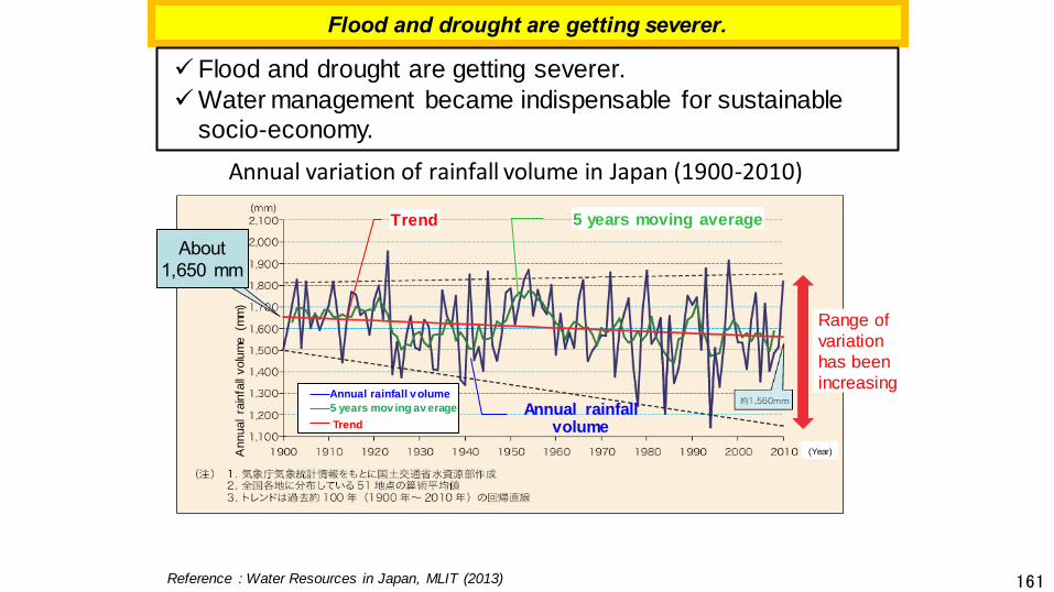
161
Annual variation of rainfall volume in Japan (1900-2010)
Range of
variation
has been
increasing
Flood and drought are getting severer.
Trend
Annual rainfall volume
(Year)
5 years moving average
Reference : Water Resources in Japan, MLIT (2013)
Annual
rain
fall
volu
me (m
m)
About
1,650 mm
Annual rainfall v olume
5 years mov ing av erage
Trend
✓Flood and drought are getting severer.
✓Water management became indispensable for sustainable
socio-economy.

162
Dam Upgrading under Operation
DamDam sluice Check dam
Dam body
heightning
New tunnel spillway is installed Sedimentation is controlled by installing
sediment bypass tunnel
Capacity Enlargement Capacity Transfer
Spillway Expansion Dam Life Extention
New outlet
drilling
under dam
operationDead water capacity
Flood control
capacity
Sedimentation
capacity
Water utilization
capacity
Adding new outlet
Sedimentation
capacity
Flood control
capacity
Water utilization
capacity
New large cross section
water channel tunnelSediment bypass
channel
Increase
discharge
capacity
Permanent sedimentation measures
Flood control capacity
Sedimentation capacity
Raise dam body
Existing dam
✓ Remake existing dams effective.
✓ Solve emerging problems like water shortage and flooding.(Problems can be found through the dam inspections.)
Increase
capacity
Increase
capacity

163
Concept of Dam Upgrading
✓Dam upgrading takes smaller cost than newly constructing a dam.
✓Also it affects less on the local community and environment.
Smaller Cost,
Smaller impact*
Large Cost,
Severe impact*
Upgrading existing dam
Existin
g
Ne
w
Constructing a new dam
*(e.g.) Newly inundated land,
Substitute roads, Ecosystem

164
Enlarging Capacity by Raising the Existing Dam Body
○ As the New-Katsurazawa Dam, the capacity of existing Katsurazawa Dam is
enlarged by raising the height
○ By slightly raising the dam body (approx. 20%), the total storage capacity of the
resernoir will be increased by 60%.
New-Katsurazawa Dam
- Location: Hokkaido
- Purpose: flood control, maintenance of
normal water flow functions, municipal
water, industrial water, hydropower
- Specifications: gravity concrete dam
(New Height 75.5m,
New storage capacity 147.3 million m3)
Capacity
Enlargment
Hokkaido
by raising the existing dam body
New-Katsurazawa Dam

165
Additional Spillway to Increase the Flood Discharge
✓At the Amagase Dam, a tunnel-type flood spillway is newly installed.
✓ Increases the flood discharge and the flood control function without
increasing the total capacity of the reservoir.
- Location: Uji City, Kyoto
- Purpose: Flood, municipal water supply, hydropower
- Specifications: Arch type concrete dam
Height 73.0m, Total storage capacity 26.28 million m3
Improving flood control function
Improving water utilization function

166
Dam Body Drilling Technologies for Dam Upgrading
✓ At the Tsuruda Dam, constructing new discharge tunnel through the
dam body to optimize the operation.
✓ Installing deep-water structures for re-arrange the active storage
capacities without the restriction on the operational function of the
existing dam.
✓ Significantly reduces underwater work, increases safety, and shortens
the construction period.
Floating type coffering facility
Drilling from
downstream
Dam bodyFoundation
Pedestal concrete
Is Not Required
Improving flood control
functionBy Dam Body Drilling

167
Dam Life Extension by Sediment Control Measures
✓ At the Koshibu Dam, sedimentation within dam’s effective capacity is
controlled to extend dam life by installing a bypass tunnel, etc.
✓ Allows sediment to be discharged downstream.
- Location: Nagano Prefecture
- Purpose: Control sedimentation in the reservoir,
improve downstream river environment
- Specifications: arch type concrete dam
Height:105m, Total storage capacity: 58 million m3
sediment transport by
installing diversion weir and
bypass tunnel
Dam Life Extention
Sediment
bypass
tunnel
diversion weir
Sediment trap dam
Koshibu Dam
Sediment bypass tunnel


![0 [Type the document subtitle] [Pick the date] Dasar-Dasar Membuat Media Pembelajaran Dengan Dengan Dengan Dengan Flash Flash Flash Flash](https://static.fdokumen.com/doc/165x107/632259f164690856e109202b/0-type-the-document-subtitle-pick-the-date-dasar-dasar-membuat-media-pembelajaran.jpg)