A Case Study of the Seti River Flash Flood 2012
14
Prithvi Journal Research and Innovation 12 | Page --------------------------------------------------------------------- ORIGINAL RESEARCH ARTICLE Assessment of Natural Hazard in the Himalayas: A Case Study of the Seti River Flash Flood 2012 Khagendra Raj Poudel 1 Ramesh Hamal 2 1 Department of Geography, Prithvi Narayan Campus, Pokhara 2 Independent Researcher Based in Kathmandu ABSTRACT The Himalayan mountain ranges have been commonly known as one of the most vulnerable places on earth for natural hazards like landslides and flash floods. A catastrophic flash flood was witnessed in the Seti River on 5 May 2012, which exemplified how destructive it can be not just for the physical and economical loss, but also it was the loss of environment and cultural heritage sites. This paper aims to assess the flash flood event for future implications. The field study was conducted aftermath of the event, where interviews were conducted with the victims' families. It also reviewed the studies conducted by various research groups regarding this disaster. It revealed that the result of mass failure from the Annapurna IV created a temporary dam, and the sudden burst of collected water resulted in the flash flood. Overall, it took 72 lives and huge destruction of physical properties like houses, bridges, vehicles and agricultural land. The existing settlements around the Seti basin are at high risk, where it is highlighted that the concerned authority should take initiatives to minimize the possible impact by promoting awareness, installing an early warning system and building better community- based preparedness. KEYWORDS: Flash floods, landslides, natural hazards, mountain ranges INTRODUCTION The Himalayan mountain ranges run for about 2400 km, which are one of the geologically most active mountain ranges on the planet. The ranges are the shelters of millions of people who are living across the mountain terrains in northern India, northern Prithvi Journal of Research and Innovation [A Peer-Reviewed, Open Access Multidisciplinary Bilingual Journal; Indexed in NepJOL] ISSN 2705-4888 [Print]; ISSN 2705-4896 [Online] Special Issue “Research & Practice”, 15 June 2021, pp. 12-25 eJournal Site: http://ejournals.pncampus.edu.np/ejournals/pjri/ Article History: Submitted 10 May 2021 Reviewed 25 May 2021 Accepted 01 June 2021 Corresponding Author: Khagendra Raj Poudel Email: [email protected] Article DOI: https://doi.org/10.3126/pjri.v3i1.37432 Copyright Information: Copyright 2021 © Author/s and Centre for Research and Innovation. This work is licensed under a Creative Commons Attribution-NonCommercial 4.0 International License. Publisher: Centre for Research and Innovation Prithvi Narayan Campus Tribhuvan University Pokhara, Nepal [Accredited by UGC, Nepal] Tel.: +977-61-576837 Email: [email protected] URL: www.pncampus.edu.np
-
Upload
khangminh22 -
Category
Documents
-
view
4 -
download
0
Transcript of A Case Study of the Seti River Flash Flood 2012

www.pncampus.edu.np Prithvi Journal Research and Innovation
Assessment of Natural Hazard in the Himalayas: A Case Study
12 | P a g e
--------------------------------------------------------------------- ORIGINAL RESEARCH ARTICLE
Assessment of Natural Hazard in the Himalayas: A Case
Study of the Seti River Flash Flood 2012
Khagendra Raj Poudel1
Ramesh Hamal2
1Department of Geography, Prithvi Narayan Campus, Pokhara 2Independent Researcher Based in Kathmandu
ABSTRACT
The Himalayan mountain ranges have been
commonly known as one of the most vulnerable
places on earth for natural hazards like
landslides and flash floods. A catastrophic flash
flood was witnessed in the Seti River on 5 May
2012, which exemplified how destructive it can
be not just for the physical and economical loss,
but also it was the loss of environment and
cultural heritage sites. This paper aims to assess
the flash flood event for future implications. The
field study was conducted aftermath of the event,
where interviews were conducted with the
victims' families. It also reviewed the studies
conducted by various research groups regarding
this disaster. It revealed that the result of mass
failure from the Annapurna IV created a
temporary dam, and the sudden burst of collected
water resulted in the flash flood. Overall, it took
72 lives and huge destruction of physical
properties like houses, bridges, vehicles and
agricultural land. The existing settlements
around the Seti basin are at high risk, where it is
highlighted that the concerned authority should
take initiatives to minimize the possible impact
by promoting awareness, installing an early
warning system and building better community-
based preparedness.
KEYWORDS: Flash floods, landslides, natural hazards, mountain ranges
INTRODUCTION
The Himalayan mountain ranges run for about 2400 km, which are one of the
geologically most active mountain ranges on the planet. The ranges are the shelters of
millions of people who are living across the mountain terrains in northern India, northern
Prithvi Journal of Research and Innovation [A Peer-Reviewed, Open Access Multidisciplinary Bilingual Journal; Indexed in NepJOL]
ISSN 2705-4888 [Print]; ISSN 2705-4896 [Online]
Special Issue “Research & Practice”, 15 June 2021, pp. 12-25
eJournal Site: http://ejournals.pncampus.edu.np/ejournals/pjri/
Article History:
Submitted 10 May 2021
Reviewed 25 May 2021
Accepted 01 June 2021
Corresponding Author:
Khagendra Raj Poudel
Email: [email protected]
Article DOI:
https://doi.org/10.3126/pjri.v3i1.37432
Copyright Information:
Copyright 2021 © Author/s and Centre
for Research and Innovation.
This work is licensed under a Creative
Commons Attribution-NonCommercial
4.0 International License.
Publisher:
Centre for Research and Innovation
Prithvi Narayan Campus
Tribhuvan University
Pokhara, Nepal
[Accredited by UGC, Nepal]
Tel.: +977-61-576837
Email: [email protected]
URL: www.pncampus.edu.np

www.pncampus.edu.np Prithvi Journal Research and Innovation
Assessment of Natural Hazard in the Himalayas: A Case Study
13 | P a g e
Pakistan, Nepal, Bhutan and some areas of other Asian nations (Dahal & Hasegawa,
2008). The Himalayas, one of the youngest mountain ranges on earth is categorized by an
intense energy environment because of rugged topography, high relief, steep slopes,
unstable geological structures along the active tectonic process and continued seismic
activities (ICIMOD, 2007). In addition to this, these areas have a complex climatic
system with great seasonality in rainfall. In combination, the possibility of having natural
hazards such as landslides, flash floods, etc. is significantly high in the region (Tiwari &
Rayamajhi, 2018).
In the Himalaya region, landslides are scale-dependent, from the huge extent of
whole mountain ranges (gravity tectonics) via a failure of single peaks to very small slope
failures (Shroder & Bishop, 1998). These slope failures are hugely vulnerable not just
due to their uncertainty, but also due to the possibility it possesses to trigger other natural
hazards like flash floods. Flood is an unexpected outflow of the large volume of water
(Ahnert et al., 1965), which considered as a destroyable natural disaster in the world.
Flash floods are one of the most devastating natural disasters in terms of people affected
because of their rapid and sudden occurrence, little lead time for warning and the
tremendous volume of water and debris load transported with immense energy (Barredo,
2007). There are many types of flash floods that may occur such as intense rainfall floods
(IRF), glacial lake outburst flood (GLOF), landslide dam outburst flood (LDOF) and
flash flood due to rapid melting of snow and ice that are the common types of flash
floods. They are mostly recorded in the Himalayas region.
Generally, landslides dams are formed in steep-walled, narrow valleys due to the
little space for the landslide debris to spread out (Costa and Schuster, 1988). Thousands
of people, their lives, livelihood and homes, along with expensive infrastructure are at
great risk from flash floods in the Himalayan region every year. The threat to
downstream people is likely to increase in the face of climate and environmental change
(ICIMOD, 2007). In the Himalayas, flash floods are prompted by extreme cloudbursts,
glacial lake outbursts, or the failure of man-made dams or dams caused by landslides,
debris, ice, or snow. Flash floods can have an impact on the way upto hundreds of
kilometers downstream; yet the warning time available is counted in minutes or, at the
most, hours (Shrestha, 2008). He further highlighted that thousands of people, their lives,
livelihoods and homes, along with expensive infrastructure investments are at great risk
from flash floods in the Himalayan region every year.
A catastrophic flash flood incidence occurred in the morning of 5 May 2012; a
heavy glacial-fluvial clay sediment-laden surge rumbled down to the high-sloped Seti
river bed in the northern part of Pokhara. Within a very short period, the surge
immediately reached Sadal Village (then Machhapuchhre Village Development
Committee), and after a few minutes, it reached Kharapani, a popular scenic picnic spot
in Sardikhola VDC. The flood swallowed away drowned unsuspecting tourists,
picnickers, laborers and residents of Kharapani Village. It killed 72 people and displaced
many more families (MOHA, 2015). The flood also killed livestock, wiped out local
livelihoods, destroyed monuments like temples, roads, community buildings and vital
infrastructures such as suspension bridges, electric poles, and drinking pipes, disrupting
normal water supply to Pokhara. This is one of the examples of a flash flood incident,
which exemplifies how destructive and catastrophic it can be. Due to the unique
topographic, geological and climatic conditions, the vulnerability of flash floods has been
a presence in these areas of Himalaya ranges. Despite this severe exposure to flash flood
risks, in most areas of Nepal, there are still no forecasting, warning and management
systems in operation to avoid or mitigate flash flood disasters. This paper aims to assess
the flash flood incident considering the case of the Seti River flash flood in 2012. It

www.pncampus.edu.np Prithvi Journal Research and Innovation
Assessment of Natural Hazard in the Himalayas: A Case Study
14 | P a g e
mainly focused on finding the cause of the incident and its casualties and highlighted the
various possible implications, which could become a reference for other similar regions.
STUDY AREA
The Seti River is one of the perennial rivers in Nepal, which originates from the
southern flank of the Annapurna Himalaya range. It is situated between the eastern face
of Annapurna III and the western face of Annapurna IV to the northern part of the
Machhapuchhre Rural Municipality of Kaski District in the Gandaki Province of Nepal
(Fig. 1). It is also known as the disaster-prone river, which flows through the Pokhara
valley floor, where vulnerability is high in terms of landslide occurrences (Poudel et al.,
2020).
Figure 1
Location of the study area
The Seti River has three tributaries in the source area. The river gets its name Seti
only after joining these tributaries at Tinsiri. The main tributary of Seti is originated from
Annapurna III. All these three rivulets are snow-fed and therefore perennial. Since it
transverses calcareous landscape, the river water is rich in calcium and looks white (K.C.,
2012). It is considered a religiously sacred and economically valuable river in the western
Nepal. It flows by making deep and narrow gorges on the Pokhara plain that have been
picturesque tourist products for the visitors. The river openings have also been the source
of sand and stone as construction materials for the Pokhara valley. Many slum dwellers
are eking out their livelihood by quarrying sand and stone from the river. The location of
settlements along with fragile and marginal areas of the Seti River corridor and the
extraction of sand and stone from river courses have increased the risk of flood hazards.
Thus, the susceptibility of both human and physical property loss is high during the flood
because it might be devastated for life and property on its way to the sudden down flow.

www.pncampus.edu.np Prithvi Journal Research and Innovation
Assessment of Natural Hazard in the Himalayas: A Case Study
15 | P a g e
METHODS AND MATERIALS
In this study, both primary and secondary data are used (Table 1). For the first-
hand data, informal interviews with various concerned parties were conducted during the
field survey. In addition, different types of ancillary data were collected to examine the
casualties, causes and implications from various institutions and other government
agencies. A helicopter-borne observation was also conducted for aerial outlook. In
addition, the findings of other studies regarding this case are also analyzed.
Table 1
List of data used in this research
_________ ______
Data Type Year Source: _____________
Topographical Map 1998 Survey Department, Nepal
Google Earth Image Access 2020-12 Google Earth
SRTM – DEM data 30m. USGS
Ancillary data CBS 2001, 2011 CBS, Kathmandu
Local level boundary - Survey Department, Nepal
Field Survey 2012 Pokhara valley area__________
The fieldwork mainly consisted of the geological mapping at 1:25000 scale.
Various studies conducted regarding this event are reviewed. In addition, other secondary
sources such as books, journals, reports were also used. Maps were analyzed and
presented using Remote Sensing and ArcGIS tools and techniques.
FINDINGS AND DISCUSSIONS
The overall affected area covers household settlements from the Seti River
courses, particularly from Ramghat of Pokhara Metropolitan City to Jimirebari of
Machhapuche Rural Municipality. The Seti River Flood Disaster Area (SRFDA) covers
Machhapuchre, Sardikhola, Ghachowk, Lahachowk, Puranchaur, Lamachaur, Hemja and
some areas of Pokhara Metropolitan City. According to the population census 2011, the
total population of SRFDA is 289358 residing within 76,556 households. Out of the total
households, only 810 (1.06%) households fall within the 50-meter margin from the Seti
River. Out of total marginal households, only 163 (20%) households were purposively
selected for finding characteristic features of population and settlement. For simplicity,
the marginal area from Ramghat to Jimirebari were designated as Seti River Corridor
(SRC) and divided into three sections viz. Upper Seti, Middle Seti, and Lower Seti. The
area above Kharapani is named as Upper Seti, [Photo:1&2] Kaskeri to Kharapani as
Middle Seti [Photo:3] and Ramghat to Kaskeri as Lower Seti, [Photo:4] respectively.
Table 2
Number of household and population within the Seti confluence, 2011
Places Number of
Household Total Population
Affected
Household*
Machhapuchre 395 1729 8
Sardikhola 879 3442 7
Ghachowk 588 2707 0
Lahachowk 829 3129 0
Puranchaur 865 3597 0
Hemja 3019 12262 17

www.pncampus.edu.np Prithvi Journal Research and Innovation
Assessment of Natural Hazard in the Himalayas: A Case Study
16 | P a g e
Lamachaur 1745 7027 0
Pokhara Sub-
metropolitan City 68236 255465 0
Total 76556 289358 32
Source: (CBS, 2011); Field Survey 2012
Photo 1, 2, 3 & 4
Areas Affected by Flash Floods
These divisions represent the spatial variation in the socio-economic profile of the
population (Table 2 & Fig.2).
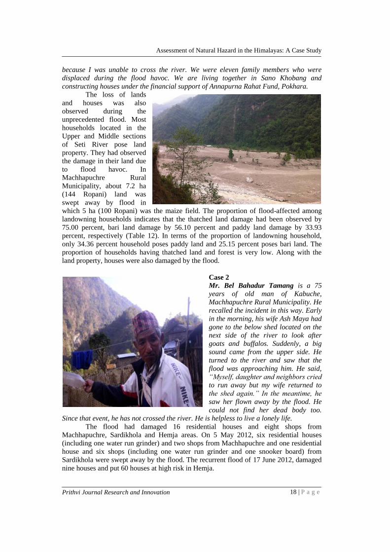
Human and Physical Damage The unusual flooding in the Seti River devastated life and property along the
river corridor. It had affected human lives, livestock and poultry, land and houses and
physical infrastructure. Table 3 indicates that during the flood 72 people died and five
persons injured. Out of 72 deaths, 28 corpses were identified in the recognizable firm
whereas four corpses were identified based on available parts of the dead bodies, and the
remaining 30 were never found. But injured persons have to return to their shelter after
[Photo: 1]. Upper part of Pokhara valley, near
Talunge
[Photo 2]. Devastated Kharapani
(Tatopani) Area
[Photo 3]: Highly vulnerable houses
(Masina Bagar of Hemja) within 50m Seti
River course.
[Photo 4]: Seti Dam and vulnerable
settlement within 50m of Seti River
course.

www.pncampus.edu.np Prithvi Journal Research and Innovation
Assessment of Natural Hazard in the Himalayas: A Case Study
17 | P a g e
Upper Seti
Middle
Seti
Lower
Seti
Pokhara
treatment. The data indicates that seven children from the flood-affected area have
become orphans after the flood. Likewise, flood had swept away the domesticated
livestock and poultry, particularly from Machhapuchre and Sardikhola. During flooding
three buffalos, two oxen, 47 goats, and 37 chickens swept away (Table 3).
Figure 2
Location of major affected area of Seti river course
Case 1
Mr. Kaile Magar is living in a new settlement at Sano
Khobang. He recalled the incident, saying that he was
taking lunch at the time of the flood. He said, “I heard a
big sound suddenly. I came out of the house and saw
around. When I turned to the riverside, I saw a terrible
flood. Reluctantly I took my family members and ran to the
forest to save lives. From my eyesight, the bridge linking
Karuwa and Sadal was swept away by the flood. In
absence of a bridge, my terrace field remained barren
www.pncampus.edu.np Prithvi Journal Research and Innovation
Assessment of Natural Hazard in the Himalayas: A Case Study
18 | P a g e
because I was unable to cross the river. We were eleven family members who were
displaced during the flood havoc. We are living together in Sano Khobang and
constructing houses under the financial support of Annapurna Rahat Fund, Pokhara.
The loss of lands
and houses was also
observed during the
unprecedented flood. Most
households located in the
Upper and Middle sections
of Seti River pose land
property. They had observed
the damage in their land due
to flood havoc. In
Machhapuchre Rural
Municipality, about 7.2 ha
(144 Ropani) land was
swept away by flood in
which 5 ha (100 Ropani) was the maize field. The proportion of flood-affected among
landowning households indicates that the thatched land damage had been observed by
75.00 percent, bari land damage by 56.10 percent and paddy land damage by 33.93
percent, respectively (Table 12). In terms of the proportion of landowning household,
only 34.36 percent household poses paddy land and 25.15 percent poses bari land. The
proportion of households having thatched land and forest is very low. Along with the
land property, houses were also damaged by the flood.
Case 2
Mr. Bel Bahadur Tamang is a 75
years of old man of Kabuche,
Machhapuchre Rural Municipality. He
recalled the incident in this way. Early
in the morning, his wife Ash Maya had
gone to the below shed located on the
next side of the river to look after
goats and buffalos. Suddenly, a big
sound came from the upper side. He
turned to the river and saw that the
flood was approaching him. He said,
“Myself, daughter and neighbors cried
to run away but my wife returned to
the shed again.” In the meantime, he
saw her flown away by the flood. He
could not find her dead body too.
Since that event, he has not crossed the river. He is helpless to live a lonely life.
The flood had damaged 16 residential houses and eight shops from
Machhapuchre, Sardikhola and Hemja areas. On 5 May 2012, six residential houses
(including one water run grinder) and two shops from Machhapuchre and one residential
house and six shops (including one water run grinder and one snooker board) from
Sardikhola were swept away by the flood. The recurrent flood of 17 June 2012, damaged
nine houses and put 60 houses at high risk in Hemja.

www.pncampus.edu.np Prithvi Journal Research and Innovation
Assessment of Natural Hazard in the Himalayas: A Case Study
19 | P a g e
Case 3
Mr. Kumar Gurung is a resident of Chaur of
Sardikhola VDC. He was busy in Arghaun
program (Death ritual of Gurungs) when a
flood came in the Seti River. He says, “I and
others heard the news that Kharapani Bazaar
has been swept up by the Seti flood. Reluctantly
our youth club friends including myself reached
Kharapani for rescue. I saw the deserted
bazaar. An old woman about 70 years old was
crying for rescue. She was hanging by catching
a branch of a muddy bush. We rescued her
from mud. Again we saw two children in mud.
We also pulled them out of the mud and sent
them to Pokhara for treatment. I felt this event as terrible and hazardous.
The unusual flood had also
swept up vehicles from riversides that
were deployed for hauling sand and
stone extracted from the river. Seven
tractors, two trucks, two motorbikes
and a van were flown down by the
flood.
The flood had also destroyed
four suspension bridges, three
kilometers of road, 25 electric poles,
eight inns, two water taps and 45
meters of water transmission pipes
with supporting pillars over the river. Besides these, two schools and one dairy firm were
also put at high risk by the flood.
Table 3
Description of loss of life and property during Seti River flood
Lost or Damaged Items Number
Human Life
Dead 72
Injured 5
Orphaned 7
Livestock and Poultry
Buffalos 3
Oxen 2
Goats 47
Chickens 37
Houses and Land
Residential Houses 16
Shops 8
Traditional Grinders 2
Land 7.2 ha
Vehicles
Tractor 7
Truck 2
Motorbike 2
Van 1
Physical Infrastructure Inn 8

www.pncampus.edu.np Prithvi Journal Research and Innovation
Assessment of Natural Hazard in the Himalayas: A Case Study
20 | P a g e
Suspension Bridge 4
Electric Poles (with wires) 25
Water Taps 2
Drinking-Water Transmission Pipes
including Supporting Pillars 45 Meters
Blacktopped Road 1 Km
Graveled Road 2 Km
Other Infrastructure in
High Risk
Annapurna Lowe Secondary School,
Machhapuchre-7 1
Balkallyan Primary School, Hemja 1
Houses of Masina Village 60
Dairy Firm of Puranchaur village 1
Source: (MOHA, 2015)
Geological Implications
According to the regional geological map and cross-section of the Seti River
Basin that cover the area north of Pokhara (Kargelet al., 2013), the lithology of the area
was separated into several mappable units based on distinctions of lithology, presence or
absence of fossils, sediment consolidation, and the position within the overall rock
sequence. The lithological boundaries observed along the accessible routes were
extended to the inaccessible areas based on the orientation of the beds and foliation
(strike and dip). The bedrock of the area can be divided into three tectonic units, i.e., the
Lesser Himalaya, Higher Himalaya, and the Tethys Himalaya separated by major
regional faults, namely, the Main Central Thrust (MCT) and Annapurna Detachment
(AD). The unconsolidated materials are much younger and include the Annapurna
formation (calcareous silts, sands and gravels) and recent glaciers, moraines, debris flows
and alluvial gravels. As we have described below, the 2012 disaster has a strong
involvement from the deep Seti River gorge and the high, steep peaks of the Annapurna
Range; these are erosional features developed in the rocks of the Tethys Himalaya and
Higher Himalaya.
The Karst topography is formed in easily soluble rocks such as carbonates
(limestone and dolomites) and evaporates (gypsum and salt). It is evident from the
present geological mapping that about a 7 km stretch of the Seti River flows across the
carbonate rocks (marbles, calc‐schists, and calc‐gneisses) (Fig. 3). These rocks are
mainly composed of calcite (CaCO3). The Karst topography is very common in the
Pokhara valley in the carbonate cemented terraces. Mahendra Cave, Chamere Cave and
Gupteshor Cave are some examples. Therefore, underground channels and caves may
also be present in the Seti River gorge. This would increase the volume available to store
water when the gorge is dammed and hence increase the potential flood volumes when
the dam is broken.
Review of Seti River Flood Studies
There are several studies that were done about the flood havoc on 5 May 2012, of
the Seti River. According to the Department of Geography (2012), a sudden flood was
witnessed in the Seti River on 5 May 2012, which eventually started from the southwest
slope of Annapurna IV. The findings suggest that the Annapurna formation, made of
unconsolidated and poorly consolidated/weakly lithified glacial deposits and glacial lake
deposits, was the source for the massive outflows of sediment and floods that formed the
terraces and valley bottom of Pokhara valley. Similarly, K.C. (Seti River Flood Disaster

www.pncampus.edu.np Prithvi Journal Research and Innovation
Assessment of Natural Hazard in the Himalayas: A Case Study
21 | P a g e
Figure 3
Simplified, Schematic Geological Cross‐Section across the Pokhara Valley
Source: (Kargel et al., 2013)
in Pokhara Valley: Causes and Preventive Measueres, 2012) also states that the sudden
occurrence of unprecedented flood havoc in the Seti River once again memorizes the
earlier high flood events of geological history resulting in the extensive deposit of
Pokhara Gravel from Bharabhari to Bhimad. This disastrous flood in the form of
mudflow was originated from the southern flank of the Annapurna Himalayan region due
to the avalanche and rock slope failure. The volume of the rock is estimated to be 22
million cubic meters. Suddenly, an enormous quantity of mudflow from the headwater
area of Seti river in the form of heavy flood has made the inhabitants residing in the
upper Seti valley stunned and put a great threat to the inhabitants of Pokhara city, too.
Furthermore, the hazardous condition started by a rockfall blockage, a few weeks
before the disaster, of the Seti River gorge and then filling of the impoundment reservoir
by early spring melting of the snowfields and glaciers (Kargel et al., 2014). It further
insisted that a rock and ice avalanche from Annapurna IV (~7500 m) dislodged the
previous rock fall dam when the rock‐ice avalanche mixture swept into the reservoir. A
hyper-concentrated slurry flow then swept down the Seti River. The possibilities of
landslide dam outburst flood (LDOF) for the debris and flood event witnessed in a
completely dry time. A key among the clues is the evidence that the rockfall activity into
the Seti River gorge had taken place in the years and weeks before the disaster; an
unusually large rock/ice/snow avalanche/landslide occurred in the minutes before the
disaster; material from the avalanche/landslide, including some airborne materials and
possibly some ground-flowing materials, reached as far as the Seti River gorge (OI et al.,
2014).
Based on the field observations, interviews and various studies, the following are
the sequences of events that occurred during this disaster.
The water flow in the Seti River was virtually cut off to Pokhara and the
upstream villages in the days and weeks before the disaster, according to many
eyewitness reports. This implies a nearly complete stream blockage. The blockage must
www.pncampus.edu.np Prithvi Journal Research and Innovation
Assessment of Natural Hazard in the Himalayas: A Case Study
22 | P a g e
have been below the point where the major tributaries within the Sabche Cirque join but
above the upstream villages where the diminished (almost zero) flow was observed. This
constrains the point of blockage to a short segment of the Seti River. Had the blockage
been above the point where the two major tributaries (the north branch and west branch)
join in the gorge area, perhaps half (more or less) of the water would have been blocked
but much flow would have continued. This first clue tends to rule out the glacier ice and
the Annapurna formation as hosts of the reservoir, but it allows the gorge and also could
allow any karstic cavernous spaces connected to the gorge that could have been filled due
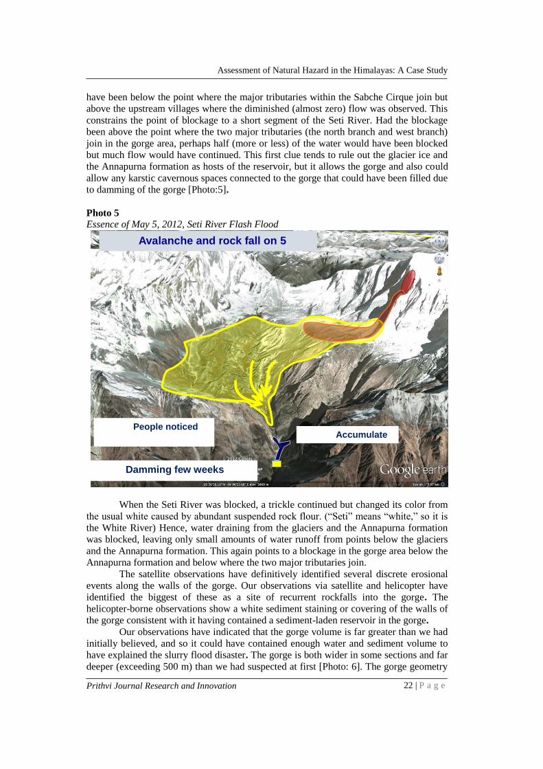
to damming of the gorge [Photo:5].
Photo 5 Essence of May 5, 2012, Seti River Flash Flood
When the Seti River was blocked, a trickle continued but changed its color from
the usual white caused by abundant suspended rock flour. (“Seti” means “white,” so it is
the White River) Hence, water draining from the glaciers and the Annapurna formation
was blocked, leaving only small amounts of water runoff from points below the glaciers
and the Annapurna formation. This again points to a blockage in the gorge area below the
Annapurna formation and below where the two major tributaries join.
The satellite observations have definitively identified several discrete erosional
events along the walls of the gorge. Our observations via satellite and helicopter have
identified the biggest of these as a site of recurrent rockfalls into the gorge. The
helicopter-borne observations show a white sediment staining or covering of the walls of
the gorge consistent with it having contained a sediment-laden reservoir in the gorge.
Our observations have indicated that the gorge volume is far greater than we had
initially believed, and so it could have contained enough water and sediment volume to
have explained the slurry flood disaster. The gorge is both wider in some sections and far
deeper (exceeding 500 m) than we had suspected at first [Photo: 6]. The gorge geometry
People noticed
the change in hydrology
Avalanche and rock fall on 5
May 2012
Damming few weeks
before flood
Accumulate
d water

www.pncampus.edu.np Prithvi Journal Research and Innovation
Assessment of Natural Hazard in the Himalayas: A Case Study
23 | P a g e
is such that a contained volume of more than 107 m3 is possible, i.e., enough to explain
the 2012 outburst flood volume. Furthermore, there remains some speculation with some
limited supporting observations that the gorge geometry may widen at the bottom with
karst cave-like structures, which may add to the present estimations of contained volume.
Consequently, our earlier assessment that the flood water volume required multiple
sources is no longer a requirement. The gorge alone with or without additional water-
filled karstic caverns-might be sufficient to explain the flood volume.
Photo 6
Flattened forest blown down by the avalanche winds. Gorge starts from Upper Seti basin
nearly 3000m height from asl
IMPLICATION FOR FUTURE HAZARDS
Landslide, Rockfall and Rock Avalanche
The bedrock in the upper Seti Basin is quite unstable due to the steep slopes and
high relief and the known history of large and small mass movements. A huge rock
sliding along the bedding plane (plane failure) is quite common in the area. Freeze and
thaw action of water is playing a significant role in the failure of slopes, including failure
according to knickpoint theory (García & Mahan, 2012). A large rock sliding along the
gorge wall of the Seti River may cause frequent damming of the Seti River. The similar
flash floods are thus possible in the future by the failure of the landslide dam.
Ice Avalanche
Ice from a cornice was involved in the 5 May 2012 avalanche. Hanging glaciers
are also present high on the walls of the Sabche Cirque. Collapsing ice could impart
enough energy to the unconsolidated sediment of the Annapurna formation to generate
large sediment of mass movement. An ice avalanche into a glacial lake could generate a
GLOF.

www.pncampus.edu.np Prithvi Journal Research and Innovation
Assessment of Natural Hazard in the Himalayas: A Case Study
24 | P a g e
Debris Flow Hazard by Liquefaction
The Annapurna formation is loose sediment of about 500-600 m thick (more in
some areas) covered in the upper part by glaciers and kettle lakes. In the spring and
summer, huge amounts of ice and snow are melted and this meltwater saturates the
sediments, potentially weakening the cohesion of the sediment. The strong monsoon rains
could likely saturate the sediment. Many debris flows are observed in the Annapurna
formation, so we pressure that sediment flow is a frequent occurrence. The recent debris
flows we have observed are relatively small, and events of that magnitude do not pose a
threat. However, if a strong earthquake occurs in this situation, or if a large discrete
monsoonal rain event adds onto already-saturated conditions, the sediment may liquefy
from a large area and flow downstream, and potentially cause a huge disaster in the
Pokhara valley.
CONCLUSION
The Seti River flash flood was one of the examples of catastrophic flash flood
disaster, which consequently took 72 lives and destroyed many physical properties. In
brief, consisted of a rockslide into a gorge and the formation of an impounded lake in the
gorge; then a huge rock and ice avalanche off Annapurna IV, which violently swept
debris into the impounded lake and caused the rupture of the gorge dam, and thus
unleashing of the flood. Additional sources of water may have been incorporated into the
avalanche mass movement, including small supraglacial ponds, subglacial water bodies,
wet snow and frictional melting of snow and ice. The ingestion of ancient lake sediments,
and especially powder-like silt, added much mass to the avalanche flows and is what
caused the high sediment content of the floodwaters.
The disaster caused a significant damage to properties like houses, vehicles,
livestock, bridges, agricultural land and so on. Many children became orphans, which
brought the uncertainty of their upbringings. It indicates that disasters like this not only
impact economically but also impact hugely from a social and environmental perspective.
On the other hand, geologically, the Seti River is composed of soft soil with lime mixed,
therefore, it remains fragile all the time, which ultimately demands supervision along
with the application of both preventive as well as protective measures.
Rapid urbanization is observed in the Pokhara valley, which forced to have
settlements along the basin of the Seti River, which are hugely considered as vulnerable
to a disaster like this one. So, the settlements on the sides must be taken care of, if found
risky, they have to be shifted to the safe side. Likewise, the damage that was made by this
event could have minimized if an early warning would have made in those areas.
However, the lack of effective early warning systems further exaggerated the losses.
Moreover, raising awareness and knowledge about flash floods at all levels among
communities, practitioners and policymakers would also enhance preparedness. In
addition, empowering communities could play a central role in the flash flood
management, including preparedness, adaptation and mitigation.
ACKNOWLEDGEMENT
This paper is built upon our mini research report submitted to the Centre for Research
and Innovation (CRI), Prithvi Narayan Campus, Pokhara and approved in 2013. We
thank the centre for granting us the research award.
REFERENCES
Ahnert, F., Leopold, L. B., Wolman, M. G., & Miller, J. P. (1965). Fluvial processes in
geomorphology. Geographical Review, 55(3), 452. https://doi.org/10.2307/213147

www.pncampus.edu.np Prithvi Journal Research and Innovation
Assessment of Natural Hazard in the Himalayas: A Case Study
25 | P a g e
Barredo, J. I. (2007). Major flood disasters in Europe: 1950–2005. Natural Hazards,
42(1), 125–148. https://doi.org/10.1007/s11069-006-9065-2
CBS. (2012). National Population and Housing Census 2011(National Report).
Government of Nepal, National Planning Commission Secretariat, Central Bu Reau
of Statistics.
COSTA, J. E., & SCHUSTER, R. L. (1988). The formation and failure of natural dams.
Geological Society of America Bulletin, 100(7), 1054–1068.
https://doi.org/10.1130/0016-7606(1988)100<1054:TFAFON>2.3.CO;2
Dahal, R. K., & Hasegawa, S. (2008). Representative rainfall thresholds for landslides in
the Nepal Himalaya. Geomorphology. https://doi.org/10.1016/ j.geomorph.
2008.01.014
Department of Geography. (2012). Prelininry Study Report of Seti River Flash Flood.
Pokhara : Prithvi Narayan Campus.
García, A. F., & Mahan, S. A. (2012). The influence of upper-crust lithology on
topographic development in the central Coast Ranges of California.
Geomorphology, 138(1), 243–262. https://doi.org/10.1016/j.geomorph.2011.09.009
ICIMOD. (2007). Information on the Occasion of World Flash Floods in the Himalayas
(Issue July 1993). https://www.weadapt.org/sites/weadapt.org/files/legacy-
new/placemarks/files/ 52fa5 cbedbde2icimod-flashfloods07a.pdf
Kargel, J., Leonard, G., Paudel, L., Regmi, D., Bajracharya, S., Fort, M., Joshi, S.,
Poudel, K., Thapa, B., & Watanabe, T. (2013). The 2012 Seti River flood disaster
and alpine cryospheric hazards facing Pokhara, Nepal. EGU General Assembly
Conference Abstracts, 16. http://adsabs.harvard.edu/abs/2014EGUGA..1612448K
Kargel J. Leonard G, Regmi D, Joshi S, Poudel K, Thapa B, Watanabe T, Fort M, P. L.
(2013). Causes and human impacts of the Seyi River (Nepal) disaster of 2012.
Glacial Flodding and Disaster Risk Management, 0–9.
K.C., K. (2012). Seti River flood disaster in Pokhara Valley: Causes and preventive
measueres. 7. Pokhara : The Himalayan Geographers.
MOHA. (2015). Nepal disaster report 2015. In Government of Nepal (Vol. 58, Issue 12).
https://doi.org/10.1128/AAC.03728-14
Oi, H., Higaki, D., Yagi, H., Usuki, N., & Yoshino, K. (2014). Report of the investigation
of the flood disaster that occurred on May 5, 2012 along the Seti River in Nepal.
International Journal of Erosion Control Engineering, 7(4), 111–117.
https://doi.org/10.13101/ijece.7.111
Poudel, K. R., Hamal, R., & Paudel, N. (2020). Landslide susceptibility assessment:
identification and hazard mapping of Gandaki Province, Nepal. Prithvi Academic
Journal. https://doi.org/10.3126/paj.v3i0.29555
Shrestha, A. B. (2008). Resource manual on flash flood risk management: Module 2:
Non-Structural measures. ICIMOD. http://lib.icimod.org/record/7892
Shroder, J. F., & Bishop, M. P. (1998). Mass movement in the Himalaya: New insights
and research directions. Geomorphology. https://doi.org/10.1016/S0169-
555X(98)00049-X
Tiwari, K. R., & Rayamajhi, S. (2018). Devastating monsoon: Water induced disaster
management practices in Nepal. Forestry: Journal of Institute of Forestry, Nepal,
15, 57–76. https://doi.org/10.3126/forestry.v15i0.24921