Prepared for Los Angeles County Flood Control District Flood ...
641
Prepared for Los Angeles County Flood Control District Flood Maintenance Division 900 South Fremont Avenue, Annex Building, 2 nd Floor Alhambra, California 91803 Prepared by BonTerra Consulting 225 South Lake Avenue, Suite 1000 Pasadena, California 91101 T: (626) 351-2000 F: (626) 351-2030 May 2013
-
Upload
khangminh22 -
Category
Documents
-
view
0 -
download
0
Transcript of Prepared for Los Angeles County Flood Control District Flood ...

Prepared for Los Angeles County Flood Control District
Flood Maintenance Division
900 South Fremont Avenue, Annex Building, 2nd Floor
Alhambra, California 91803
Prepared by BonTerra Consulting
225 South Lake Avenue, Suite 1000
Pasadena, California 91101
T: (626) 351-2000 F: (626) 351-2030
May 2013

Los Angeles River Watershed Feasibility Study
R:\PAS\Projects\CoLADPW\J210\Rvsd BioTech Assessment.docx i Biological Technical Assessment
TABLE OF CONTENTS Section Page
Section 1.0 Introduction ....................................................................................................... 1
Section 2.0 Literature Review .............................................................................................. 4
Section 3.0 Biological Surveys ............................................................................................ 5
Section 4.0 Vegetation Transects ...................................................................................... 25
Section 5.0 Cram Analysis ................................................................................................. 30
Section 6.0 Recommendations .......................................................................................... 34
Section 7.0 References ...................................................................................................... 37
TABLES
Table Page 1 Biological Technical Assessment Report 26 Soft-Bottom Channel Reaches .................. 2 2 Database Search Information ......................................................................................... 4 3 Vegetation Types ........................................................................................................... 6 4 Focused Plant Survey Dates and Personnel................................................................... 9 5 Focused Survey Results Summary for Wildlife ..............................................................11 6 Wildlife Surveys Reaches Less Than One Acre .............................................................14 7 Wildlife Surveys Reaches Greater Than One Acre ........................................................16 8 Summer Bird Diversity and Abundance at the 12 Soft-Bottom Channel Reaches
(Greater Than One Acre and Ranked High to Low for Bird Density) ..............................18 9 Migratory Bird Surveys ..................................................................................................22 10 Vegetation Analysis Transects ......................................................................................25 11 Total Vegetated and Unvegetated Percent Cover ..........................................................27 12 Summary of Cram Attributes and Metrics ......................................................................30 13 Summary of 2010 Cram Scores.....................................................................................32 14 2010 Cram Scores Ranked High to Low ........................................................................33 15 Summary of Biological Values .......................................................................................34 16 Biological Value Scores Ranked High to Low ................................................................35
EXHIBITS
Exhibit Follows Page 1A Recommendations – Reach 22......................................................................................38 1B Recommendations – Reach 25......................................................................................38 1C Recommendations – Reach 1 .......................................................................................38 1D Recommendations – Reach 20 and 21 ..........................................................................38 1E Recommendations – Reach 19......................................................................................38 1F Recommendations – Reach 9 .......................................................................................38
Los Angeles River Watershed Feasibility Study
R:\PAS\Projects\CoLADPW\J210\Rvsd BioTech Assessment.docx ii Biological Technical Assessment
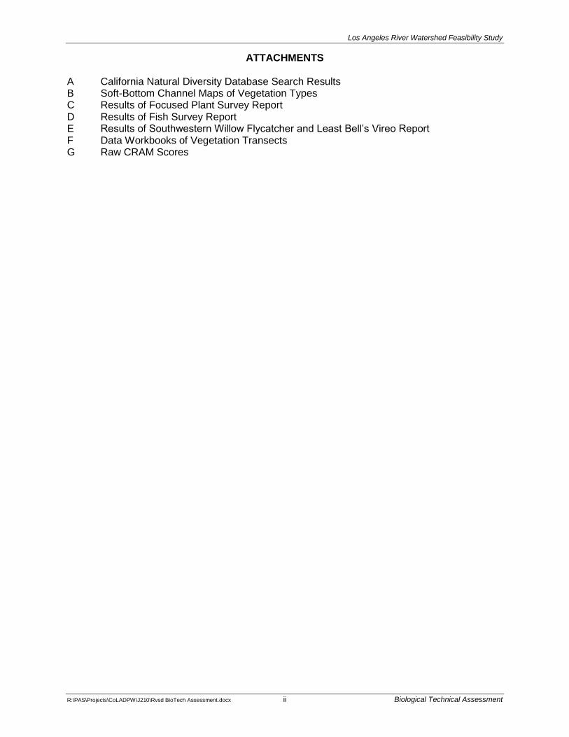
ATTACHMENTS A California Natural Diversity Database Search Results B Soft-Bottom Channel Maps of Vegetation Types C Results of Focused Plant Survey Report D Results of Fish Survey Report E Results of Southwestern Willow Flycatcher and Least Bell’s Vireo Report F Data Workbooks of Vegetation Transects G Raw CRAM Scores

Los Angeles River Watershed Feasibility Study
R:\PAS\Projects\CoLADPW\J210\Rvsd BioTech Assessment.docx 1 Biological Technical Assessment
SECTION 1.0 INTRODUCTION
This Biological Technical Assessment Report (Report) has been prepared to satisfy requirements of Waste Discharge Requirements Order No. R4-2010-0021 (WDR) adopted by the California Regional Water Quality Control Board (RWQCB), Los Angeles Region, on February 4, 2010, for the Soft-bottom Flood Control Channels Project maintained by the Los Angeles County Flood Control District (LACFCD). The WDR requires that a Feasibility Study be conducted for all watersheds containing soft-bottom channel (SBC) reaches maintained by the LACFCD. The WDR requires that the first Feasibility Study be done of the Los Angeles River Watershed. The 251 SBC reaches within the Los Angeles River Watershed are listed and described below in Table 1.
The purpose of the Feasibility Study is to provide an “on-going assessment of channel conditions and hydraulic capacity” in order to “determine where a potential may exist for native vegetation to remain within the soft-bottom portion of the channel or if additional hydraulic capacity is needed” (WDR, Condition 45). As required by the WDR, a Work Plan was submitted to the RWQCB that provided proposed study methods for the Feasibility Study, including an “assessment of biological functions and values of these reaches” so that “comparisons of habitat type, maturity and extent of native or invasive plants can be made between reaches” (WDR, Condition 48). The LACFCD was required to “include an assessment of the biological function and values for each reach” (WDR, Condition 50).
This Report assesses the biological function and values for each SBC reach, as required by the WDR, Condition 50. The results of this assessment are incorporated into the final recommendations identifying which SBC reaches can sustain additional vegetation and/or replacement of non-native with native vegetation, without affecting the reaches’ hydraulic capacity.
1 It was originally believed that there were 26 soft-bottom channel reaches maintained by the LACFCD within the
Los Angeles River watershed. One of those reaches, Reach 17, has since been determined to be owned, operated and maintained by the City of Glendale, as noted below. While Reach 17 is discussed in this Report it is not part of any recommendations. This report is being provided to the City of Glendale.

Los Angeles River Watershed Feasibility Study
R:\PAS\Projects\CoLADPW\J210\Rvsd BioTech Assessment.docx 2 Biological Technical Assessment
TABLE 1 BIOLOGICAL TECHNICAL ASSESSMENT REPORT
26 SOFT-BOTTOM CHANNEL REACHES
Reach No. Reach Name
Reach Limits Reach Length (ft)
Area (acres) Upstream Downstream
1 Bell Creek-MTD 963 M.C.I. 962 ft u/s of Highlander Road 766 ft u/s of Highlander Road 196 0.90
2 Dry Canyon (Calabasas) PD T1845 676 ft u/s of Park Ora 870 ft d/s of Park Ora 1,546 1.24
3 Santa Susana Creek M.C.I. 5,560 ft north of Devonshire Street 5,635 ft north of Devonshire Street 75 0.06
4 Browns Creek 1,895 ft u/s of Rinaldi Street 556 ft u/s of Rinaldi Street 1,243 3.00
5 Caballero Creek M.C.I. (West Fork) 890 ft u/s of Reseda Boulevard 238 ft u/s of Reseda Boulevard 652 1.30
6 Caballero Creek M.C.I. (East Fork) 588 ft u/s of Reseda Boulevard 428 ft u/s of Reseda Boulevard 160 0.35
7 Bull Creek M.C.O. 165 ft d/s of Victory Boulevard Confluence with Los Angeles River
2,6021
5.61
8 Project 470 Outlet Havenhurst Avenue Ventura (101) Freeway 529 0.30
9 Project 106 Outlet 400 ft d/s of Victory Boulevard 520 ft d/s of Victory Boulevard 120 0.12
10 Project No. 469 751 ft d/s of Victory Boulevard Confluence with Los Angeles River 4,194 7.12
12 Haines Canyon M.C.O. 791 ft d/s of Wentworth Street 1,228 d/s of Wentworth Street 437 0.40
13 Project No. 5215 Unit 1 1,030 ft d/s of Foothill Boulevard 1,535 ft d/s of Foothill Boulevard 537 0.55
14 May Channel (M.C.O. into Pacoima
Canyon) 3,038 ft d/s of Hubbard Street
Confluence with Pacoima Canyon Wash
690 0.63
15 Pacoima Wash 159 ft d/s of Parthenia Street 1,187 ft d/s Lanark Street 4,762 5.25
16 Verdugo Wash-Las Barras Canyon
(Channel Inlet) 157 ft u/s of Confluence with Las Barras Canyon Channel
27 ft u/s of Confluence with Las Barras Canyon Channel
130 0.07
172 Sheep Corral Channel 1,150 ft u/s of Forest Glen Drive 850 ft u/s of Forest Glen Drive 300 0.14
18 Engleheard Channel 800 ft u/s of Confluence with Verdugo
Wash Confluence with Verdugo Wash 800 1.10
19 Pickens Canyon d/s edge of Panorama Drive
produced Pickens Debris Basin 2,406 3.42
20 Webber Channel (stream at private
bridge) 861 ft u/s of Los Amigos Street 746 ft u/s of Los Amigos Street 115 0.13
21 Webber Channel
(main channel inlet d/s bridge) 496 ft u/s of Los Amigos Street 471 ft u/s of Los Amigos Street 25 0.03
2 Owned and maintained by City of Glendale.

Los Angeles River Watershed Feasibility Study
R:\PAS\Projects\CoLADPW\J210\Rvsd BioTech Assessment.docx 3 Biological Technical Assessment
TABLE 1 BIOLOGICAL TECHNICAL ASSESSMENT REPORT
26 SOFT-BOTTOM CHANNEL REACHES
Reach No. Reach Name
Reach Limits Reach Length (ft)
Area (acres) Upstream Downstream
22 Halls Canyon 1,370 ft u/s of Jessen Drive Halls Canyon Debris Basin 2,290 2.63
24 Compton Creek COE Station 199+31.00 Confluence with Los Angeles River 11,000 30.30
25 Los Angeles River Willow Street Pacific Coast Highway 4,800 56.20
96 PD 1591 85 ft u/s of culvert under Vicasa Drive 360 ft d/s of culvert under Vicasa
Drive 320 0.92
99 Kagel Canyon Blue Sage Drive City of Los Angeles Boundary 4,858 1.67
100 Dry Canyon Calabasas 1,835 ft u/s of Avenue San Luis 1,775 ft u/s of Avenue San Luis 60 0.05
Note: 1
The LACFCD Maintenance Plan for Bull Creek states that maintenance work will be limited to “the first 400 feet of natural channel downstream from the concrete channel outlet,” so this study is limited to that area.
Source: LACFCD as provided in WDR Order No. R4-2010-0021.

Los Angeles River Watershed Feasibility Study
R:\PAS\Projects\CoLADPW\J210\Rvsd BioTech Assessment.docx 4 Biological Technical Assessment
SECTION 2.0 LITERATURE REVIEW
A literature review was conducted to review and update existing information gathered through the SBC maintenance program about plant and wildlife species that (1) have been afforded special status by State, federal, and local resource agencies and organizations and (2) have potential to occur within the Los Angeles River Watershed.
Sources reviewed include: (1) special status species lists from the California Department of Fish and Wildlife (CDFW)3; the U.S. Fish and Wildlife Service (USFWS), and the California Native Plant Society (CNPS); (2) database searches of the CDFW’s California Natural Diversity Database (CNDDB) (CDFW 2010a) and the CNPS’ Electronic Inventory of Rare and Endangered Vascular Plants of California (CNPS 2010); see Table 2 below for the U.S. Geological Survey (USGS) quadrangles used during the searches); (3) the most recent Federal Register listing package and critical habitat determination for each federally listed Endangered or Threatened species potentially occurring within the Los Angeles River Watershed; (4) the CDFW Annual Report on the status of California’s listed Threatened and Endangered plants and wildlife; and (5) other biological studies conducted in the Los Angeles River Watershed that were relevant to this Report, including those conducted previously by BonTerra Consulting for the LACFCD. Table 2 provides the USGS 7.5-minute quadrangles included in the database searches for the various reaches.
TABLE 2 DATABASE SEARCH INFORMATION
Reach Numbers USGS 7.5-minute Quadrangles Included in Search Area
1, 3, and 4 Santa Susana, Oat Mountain, Calabasas, and Canoga Park
2, 96, and 100 Calabasas, Canoga Park, Malibu Beach, and Topanga
5, 6, 7, 8, 9, and 10 Canoga Park, Van Nuys, Topanga, and Beverly Hills
12, 13, 14, 15, and 99 San Fernando, Sunland, Van Nuys, and Burbank
16, 17,4 18, 19, 20, 21, and 22 Sunland, Condor Peak, Burbank, and Pasadena
24 and 25 Long Beach, South Gate, San Pedro, Torrance, and Inglewood
USGS: U.S. Geological Survey
The information gathered during the literature search, including the above CNDDB database searches was used by the biologists to develop appropriate survey methods (see Appendix A for database search results).
3 The California Department of Fish and Game changed its name to the California Department of Fish and Wildlife
effective January 1, 2013. 4 Owned and maintained by City of Glendale.

Los Angeles River Watershed Feasibility Study
R:\PAS\Projects\CoLADPW\J210\Rvsd BioTech Assessment.docx 5 Biological Technical Assessment
SECTION 3.0 BIOLOGICAL SURVEYS
Biological surveys for plant and wildlife species were performed at each of the SBC reaches (see Table 1). Most of the surveys were conducted in the spring and summer seasons prior to LACFCD’s annual maintenance activities, which are performed during the fall. The surveys at each of these 26 SBC reaches included mapping of vegetation types; focused searches for special status including Threatened and Endangered plant and wildlife species; and summer season bird surveys. In addition, migratory bird surveys were conducted at Compton Creek (Reach 24). The methodologies for these surveys are described below.
The survey areas for each reach included habitats within the channel and on the adjacent channel banks, generally following the descriptive information presented for all 26 SBC reaches shown above in Table 1. One exception is Bull Creek (Reach 7), for which the downstream limit is described as the confluence with the Los Angeles River. The LACFCD Maintenance Plan (February 2, 1999) approved with the original permits for the Soft-Bottom Flood Control Channels Project, states that maintenance activities in Reach 7 will be limited to “the first 400 feet of natural channel downstream from the concrete channel outlet” just downstream of Victory Boulevard (LACDPW and CDFW 1999). Reach 7 was transformed in 2008 by construction of the Bull Creek Ecosystem Restoration Project, which included this SBC reach and an additional section of Bull Creek downstream to North Balboa Boulevard within the Sepulveda Dam Recreation Area. Although the original earth-bottom invert is still present, the banks of Reach 7 are now covered by riprap. A pedestrian bridge was constructed for the Bull Creek Ecosystem Restoration Project about 350 feet (ft) downstream of the concrete channel outlet and was used as the downstream limits of Reach 7 for the surveys described in this Feasibility Study.
Vegetation Mapping Surveys
Twelve vegetation types and 5 other areas were identified during the vegetation mapping surveys of the SBC reaches described in this Report (Table 3). Mapping of the vegetation types was accomplished concurrent with the final focused plant surveys conducted in 2010 for each of these reaches. Recent aerial photographs at a scale of 1 inch = 100 feet were used to map vegetation types. Nomenclature for the vegetation types identified in these surveys generally follows the List of Vegetation Alliances and Associations, Vegetation Classification and Mapping Program (CDFW 2010b). The vegetation types identified in the surveys generally reflected the vegetation shown on the aerial maps along the alignment of each SBC reach. For some of the SBC reaches, particularly the wider reaches, the mapped vegetation represents the actual vegetation growing on the channel invert, but for most of the smaller SBC reaches, the mapped vegetation is of the canopies that cover the channel invert from trees either rooted outside or on the channel banks. These small reaches were mapped as southern coast live oak riparian forest (Reaches 6 and 17); disturbed southern coast live oak riparian forest (Reaches 3, 20, 21, 22, and 99); willow riparian forest (Reaches 1, 2, and 5); southern willow scrub (Reaches 6, 12, and 14); and ornamental (Reaches 2, 3, 9, 12, 18, 22, and 100). In these cases, all or most of the channel invert is regularly maintained and the mapped riparian resources are not impacted. As a result, the maintained inverts of these reaches contain only unvegetated wash, riparian herb, ruderal, open water, and developed areas. The vegetation maps for each SBC reach are included in Appendix B.

Los Angeles River Watershed Feasibility Study
R:\PAS\Projects\CoLADPW\J210\Rvsd BioTech Assessment.docx 6 Biological Technical Assessment
TABLE 3 VEGETATION TYPES
Vegetation Type Reach Numbers
Scale Broom Scrub 13, 14, 19, 22
Disturbed Scale Broom Scrub 13, 14
Southern Coast Live Oak Riparian Forest 4, 6, 16, 17,5 96
Disturbed Southern Coast Live Oak Riparian Forest 3, 20, 21, 22, 99
Willow Riparian Forest 1, 2, 5, 96
Southern Willow Scrub 4, 6, 7, 12, 14, 25
Cattail Wetland 2, 5, 6, 10, 24, 25, 96
Cattail Wetland/Open Water 24
Disturbed Cattail Wetland 15, 25
Riparian Herb 15, 99
Ruderal 1, 2, 3, 4, 8, 10, 12, 13, 14, 15, 16, 22, 24, 25, 96, 99
Ornamental 3, 9, 12, 18, 19, 21, 22, 96, 99, 100
Non-Vegetation Type Reach Numbers
Unvegetated Wash 12, 15, 19, 21, 22, 25
Open Water 2, 4, 5, 7, 8, 10, 12, 15, 24, 25
Disturbed Areas 4, 13, 14, 18
Ungrouted Riprap 1, 7, 10, 25
Developed Areas 2, 5, 7, 8, 10, 12, 14, 15, 18, 19, 21, 22, 24, 25, 96, 99
Descriptions of Vegetation Types
Scale broom scrub is present in SBC Reaches 13, 14, 19, and 22. This native vegetation type is dominated one or more of the following species: California sagebrush (Artemisia californica), scale broom (Lepidospartum squamatum), California buckwheat (Eriogonum fasciculatum), and thick-leaved yerba santa (Eriodictyon crassifloium). Other perennial shrubs present include white sage (Salvia apiana) and mule fat (Baccharis salicifolia). The understory is relatively open and dominated by small native annual forbs including lastarriaea (Lastarriaea coriacea), popcorn flower (Cryptantha spp.), and non-native grasses.
Disturbed scale broom scrub is present in SBC Reaches 13 and 14. This native vegetation type is in the vicinity of the scale broom scrub described above. The overstory of this vegetation type is dominated by California sagegbrush, scale broom, California buckwheat, and thick-leaved yerba santa. The shrub cover is much less dense in these areas due to disturbance. The understory is dominated by non-native forbs, including black mustard (Brassica nigra), shortpod mustard (Hirschfeldia incana), Italian thistle (Carduus pycnocephalus), and non-native grasses.
Southern coast live oak riparian forest is present in SBC Reaches 4, 6, 16, 17, and 96. This native vegetation type is dominated by dense stands of coast live oak (Quercus agrifolia) rooted in or adjacent to the banks of the SBC reaches. The understory is sparse, and dominated by oak seedlings, leaf litter, and native forbs, including caterpillar phacelia (Phacelia cicutaria).
Disturbed southern coast live oak riparian forest is present in SBC Reaches 3, 20, 21, 22, and 99. This native vegetation type is dominated by species as shown for the riparian forest described above. The understory is dominated by non-native ornamental species such as English ivy (Hedera helix) and ruderal species such as smilo grass (Piptatherum miliaceum).
5 Owned and maintained by City of Glendale.

Los Angeles River Watershed Feasibility Study
R:\PAS\Projects\CoLADPW\J210\Rvsd BioTech Assessment.docx 7 Biological Technical Assessment
Some native forbs, including branching phacelia (Phacelia ramosissima), are also present in the understory vegetation.
Willow riparian forest is present at SBC Reaches 1, 2, 5, and 96. This native vegetation type is dominated by Goodding’s black willow (Salix gooddingii) and western sycamore (Platanus racemosa). This vegetation type varies from the southern willow scrub vegetation type in that the canopy contains larger trees (i.e., greater than 20 ft in height) and the canopy tends to be more dense. The understory is sparse and dominated by willow seedlings and saplings with the occasional mule fat distributed throughout.
Southern willow scrub is present at SBC Reaches 4, 6, 7, 12, 14, and 25. This native vegetation type is dominated by Goodding’s black willow, arroyo willow (Salix lasiolepis), red willow (Salix laevigata), and narrow-leaved willow (Salix exigua). This vegetation type typically consists of relatively small stands of willows. The willows are of various sizes and heights due to differing frequencies of scouring from rain events. The willows range from seedlings to trees, which are approximately 20 ft high. This vegetation type differs from the willow riparian forest vegetation type by the size of the patch; overall height of the patch; and density of the understory. The willow riparian forest described above has more than a few large willow trees in each patch; has trees over 10 ft tall; and has a denser understory. The understory in southern willow scrub varies at each SBC reach in the amount of non-native and native herbaceous species to unvegetated wash under the trees. The herbaceous species in some of the understory areas include mugwort (Artemisia douglasiana), knotweed (Polygonum spp.), and Mexican sprangletop (Leptochloa fusca ssp. uninervia).
Cattail wetland is present in SBC Reaches 2, 5, 6, 10, 24, 25, and 96. This native vegetation type is dominated by cattails (Typha spp.), which are emergent plants that grow in one or more feet of water. Cattails readily hybridize between the three species known to occur in California, these species include T. angustifolia, T. domingensis, and T. latifolia. This vegetation type is typically found in the center of the SBC reach where open water is present. This vegetation type’s boundaries are constantly changing due to changes in the water levels and the rapid growth of this species. Plant species in low densities within the cattails include rush (Juncus spp.), sedges (Cyperus spp.), and water cress (Nasturtium officinale). Ruderal species such as the Spanish sunflower (Pulicaria paludosa) are also present in some of these SBC reaches.
Cattail wetland/open water is present in SBC Reach 24. This native vegetation type is similar in species composition and density to the cattail wetlands listed above. The difference between the two vegetation types is that the cattail wetlands/open water have areas of deeper water that do not contain vegetation. It was not possible to delineate the open water on the aerial photograph or visually from above due to the height of the cattails, which at the time of the surveys exceeded 10 ft.
Disturbed cattail wetland is present in SBC Reaches 15 and 25. This native vegetation type is also similar in species composition to the cattail wetlands, but at the time of the surveys, these areas appeared to be dying due to lack of water. Some of the areas are also heavily invaded with non-native herbaceous species.
Riparian herb is present in SBC Reaches 15 and 99. This vegetation type is dominated by low-growing herbaceous native and non-native species that are either rooted in the water or rooted directly adjacent to the water. The riparian herb in these SBC reaches is dominated by watercress, duckweed (Lemna sp.), knotweed, and Spanish sunflower.

Los Angeles River Watershed Feasibility Study
R:\PAS\Projects\CoLADPW\J210\Rvsd BioTech Assessment.docx 8 Biological Technical Assessment
Ruderal (weedy) areas are present in SBC Reaches 1, 2, 3, 4, 8, 10, 12, 13, 14, 15, 16, 22, 24, 25, 96, and 99. This vegetation type consists of areas that have been previously disturbed and now primarily support non-native vegetation that is well-adapted to disturbed conditions and high nitrogen soils. These areas occur adjacent to the developed areas or in the more upland areas of the SBC reaches. Species present in these areas include Russian thistle (Salsola tragus), black mustard, common sow thistle (Sonchus oleraceus), bristly ox-tongue (Helminthotheca echioides), and sticktight (Bidens frondosa).
Ornamental areas are present in SBC Reaches 3, 9, 12, 18, 19, 21, 22, 96, 99, and 100. This non-native vegetation type consists of introduced trees and shrubs planted for aesthetic purposes. A wide variety of ornamental landscaping occurs adjacent to the SBC reaches in conjunction with existing developments. Many of these ornamental species, including trees, shrubs, and ground covers, have spread into the channel reaches in varying amounts. Ornamental vegetation has formed large patches in some channel reaches. Widespread ornamental species present in these SBC reaches include gum trees (Eucalyptus spp.), Brazilian pepper trees (Schinus terebinthifolius), and acacia (Acacia spp.).
Unvegetated wash is present in SBC Reaches 12, 15, 19, 21, 22, and 25. Unvegetated wash is not a vegetation type, but is delineated as a mapping unit on the vegetation maps. Unvegetated wash in the SBC reaches consists of bare sand or silt that does not contain any vegetation. These areas have been scoured and are typically colonized by riparian vegetation following scouring events.
Open water is present at the time of surveys and mapped in SBC Reaches 2, 4, 5, 7, 8, 10, 12, 15, 24, and 25. Open water is not a vegetation type, but is delineated as a mapping unit on the vegetation maps. Open water typically consists of fresh water in the center of the SBC reaches that was either flowing or ponding. These areas occasionally contain a few cattails and/or duckweed.
Disturbed areas are present in SBC Reaches 4, 13, 14, and 18. This is not a vegetation type, but is delineated as a mapping unit on the vegetation maps. In these SBC reaches, it consists of dirt roads, cleared areas, and ungrouted riprap. These areas typically contain exposed soil without concrete or development and little to no vegetation.
Ungrouted Riprap is present in SBC Reaches 1, 7, 10, and 25. Both grouted riprap and riprap that is not grouted are generally mapped as developed areas on vegetation maps. Ungrouted riprap, however, can support substantial amounts of vegetation while grouted riprap typically supports very little vegetation. As a result, ungrouted riprap is delineated as a separate mapping unit on the vegetation maps for the SBC reaches. Ungrouted riprap is present on portions of the channel banks. The only vegetation present is ornamental or weedy native species that may grow in the small cracks in the concrete.
Developed areas are present in SBC Reaches 2, 5, 7, 8, 10, 12, 14, 15, 18, 19, 21, 22, 24, 25, 96, and 99. This is not a vegetation type, but is delineated as a mapping unit on the vegetation maps. These areas are man-made structures that contain little to no vegetation. Any vegetation that is present typically consists of ruderal species similar to that described above or invasive species such as fan palms (Washingtonia sp.), tree of heaven (Ailanthus altissima), and tree tobacco (Nicotiana glauca).

Los Angeles River Watershed Feasibility Study
R:\PAS\Projects\CoLADPW\J210\Rvsd BioTech Assessment.docx 9 Biological Technical Assessment
Special Status Plant Surveys
Focused surveys for special status plant species are conducted on a periodic basis for the 100 plus SBC reaches maintained by the LACFCD through the area of the District, including the Los Angeles River Watershed. These special status plant species surveys are discussed in more detail below for the SBC reaches covered by this Report.
Habitat assessments for federally and/or State-listed special status plant species were conducted for the LACFCD’s SBC maintenance program in 2002. Although potentially suitable habitat for the federally and State-listed Endangered slender-horned spineflower (Dodecahema leptoceras) was identified at several SBC reaches—including Reaches 13 and 19 in the Los Angeles River Watershed—surveys were not conducted in 2002 due to the prevailing drought conditions. The slender-horned spineflower is an annual species that appears only after seasons with sufficient rainfall. The federally and State-listed Endangered Nevin’s barberry (Berberis nevinii), a large and conspicuous shrub that can be identified year-round, was not present at the SBC reaches (Reaches 4, 12, 13, 14, 17, 18, 19, 20, 21, 22, and 99) that were identified as having potentially suitable habitat during the 2002 habitat assessments (BonTerra Consulting 2002). After a season of sufficient rainfall, focused surveys were conducted in 2003 for the slender-horned spineflower at all LACFCD SBC reaches with potentially suitable habitat for this species. In 2003, these reaches included four Los Angeles River Watershed SBC reaches (Reaches 12, 13, 14, and 19) identified as having potentially suitable habitat. The 2003 focused survey results for slender-horned spineflower were negative at all LACFCD SBC reaches, including the four Los Angeles River Watershed reaches, and no further surveys were recommended as long as the existing maintenance plan and associated access routes were followed (BonTerra Consulting 2003).
As part of this Report, focused surveys for special status plant species were performed in 2010 at each of the SBC reaches in the Los Angeles River Watershed by BonTerra Consulting Senior Botanists Sandra J. Leatherman and Jeff S. Crain; Senior Biologist Brian E. Daniels, Jennifer S. Pareti, Allison D. Rudalevige; and Consulting Botanist Pam DeVries. The survey dates and personnel are listed below in Table 4. Each of the SBC reaches was surveyed 3 times during 2010 (in April, May, and June), except for the Webber Channel SBC reaches (Reaches 20 and 21), which were inaccessible in May 2010 due to corrective measures taken by a private landowner to repair fire and storm damages to its property.
TABLE 4 FOCUSED PLANT SURVEY DATES AND PERSONNEL
Reach No.
Survey 1 Survey 2 Survey 3
Dates Personnel Dates Personnel Dates Personnel
1 20-Apr-10 JSC, BED 26-May-10 SJL, BED 16-Jun-10 JSC, BED
2 20-Apr-10 JSC, BED 10-May-10 SJL, PDV 23-Jun-10 JSC, BED
3 20-Apr-10 JSC, BED 26-May-10 SJL, BED 23-Jun-10 JSC, BED
4 20-Apr-10 JSC, BED 26-May-10 SJL, BED 23-Jun-10 JSC, BED
5 16-Apr-10 JSC, ADR 10-May-10 SJL, PDV 16-Jun-10 JSC, BED
6 16-Apr-10 JSC, ADR 10-May-10 SJL, PDV 16-Jun-10 JSC, BED
7 16-Apr-10 JSC, ADR 17-May-10 SJL, PDV 17-Jun-10 JSC, BED
8 16-Apr-10 JSC, ADR 17-May-10 SJL, PDV 16-Jun-10 JSC, BED
9 16-Apr-10 JSC, ADR 17-May-10 SJL, PDV 17-Jun-10 JSC, BED
10 16-Apr-10 JSC, ADR 17-May-10 SJL, PDV
17-Jun-10 JSC, BED 24-May-10 SJL, JSP
12 16-Apr-10 SJL, PDV 24-May-10 SJL, JSP 17-Jun-10 JSC, BED

Los Angeles River Watershed Feasibility Study
R:\PAS\Projects\CoLADPW\J210\Rvsd BioTech Assessment.docx 10 Biological Technical Assessment
TABLE 4 FOCUSED PLANT SURVEY DATES AND PERSONNEL
Reach No.
Survey 1 Survey 2 Survey 3
Dates Personnel Dates Personnel Dates Personnel
13 16-Apr-10 SJL, PDV 24-May-10 SJL, JSP 17-Jun-10 JSC, BED
14 16-Apr-10 SJL, PDV 17-May-10 SJL, PDV 17-Jun-10 JSC, BED
15 22-Apr-10 JSC, BED 26-May-10 SJL, BED 28-Jun-10 SJL, BED
16 19-Apr-10 JSC, JSP 19-May-10 SJL, PDV 18-Jun-10 JSC, BED
176 19-Apr-10 JSC, JSP 19-May-10 SJL, PDV 18-Jun-10 JSC, BED
18 19-Apr-10 JSC, JSP 19-May-10 SJL, PDV 18-Jun-10 JSC, BED
19 30-Apr-10 SJL, PDV 19-May-10 SJL, PDV 18-Jun-10 JSC, BED
20 30-Apr-10 SJL, PDV No survey 18-Jun-10 JSC, BED
21 30-Apr-10 SJL, PDV No survey 18-Jun-10 JSC, BED
22 30-Apr-10 SJL, PDV 24-May-10 SJL, JSP 18-Jun-10 JSC, BED
24 19-Apr-10 JSC, JSP
21-May-10 SJL, JSP 28-Jun-10 SJL, BED 21-Apr-10 JSC, JSP
25 21-Apr-10 JSC, JSP 21-May-10 SJL, JSP 29-Jun-10 SJL, BED
96 20-Apr-10 JSC, BED 10-May-10 SJL, PDV 16-Jun-10 JSC, BED
99 22-Apr-10 JSC, BED 26-May-10 SJL, BED 29-Jun-10 SJL, BED
100 20-Apr-10 JSC, BED 10-May-10 SJL, PDV 16-Jun-10 JSC, BED
JSC: Jeff S. Crain (BonTerra Consulting); BED: Brian E. Daniels (BonTerra Consulting); SJL: Sandy J. Leatherman (BonTerra Consulting); ADR: Allison D. Rudalevige (BonTerra Consulting); PDV: Pam DeVries (Consulting Biologist); JSP: Jennifer S. Pareti (BonTerra Consulting).
Source: BonTerra Consulting 2011b.
Of the 26 SBC reaches surveyed in this Report, Sheep Corral Channel (Reach 17) was the only one in which a special status plant species, ocellated lilies (Lilium humboldtii ssp. ocellatum), was observed. As noted above, this reach is owned by the City of Glendale, which has exclusive responsibility for its maintenance. Numerous ocellated lilies, which have a California Rare Plant Rank (CRPR) of 4, were observed on the slope directly above the right bank7 of Reach 17. Prior to the second survey, the vegetation within and next to Reach 17 (including the ocellated lilies observed during the first survey) was removed during fire-abatement activities conducted by an unknown entity. As a result, the ocellated lilies observed during the first survey were removed before they were able to bloom and reach maturity. During the third survey, however, blooming ocellated lilies were observed in the open space upstream of Reach 17. No other special status plant species were observed at any other SBC reaches during the surveys. The complete focused plant survey is included in Appendix C.
Special Status Wildlife Surveys
Focused surveys for special status wildlife species are conducted on a regular basis for the 100 plus SBC reaches managed by the LACFCD. Table 5 provides a summary of these surveys performed at the SBC reaches discussed in this Report. These special status wildlife species surveys are discussed in more detail below.
6 Owned and maintained by City of Glendale.

Los Angeles River Watershed Feasibility Study
R:\PAS\Projects\CoLADPW\J210\Rvsd BioTech Assessment.docx 11 Biological Technical Assessment
TABLE 5 FOCUSED SURVEY RESULTS SUMMARY FOR WILDLIFE
Reach Number Reach Name Santa Ana Sucker
Arroyo Toad
California Red-legged Frog
Southwestern Willow Flycatcher Least Bell’s Vireo
1 Bell Creek-MTD 963 M.C.I. N/A N/A N/A N/A N/A
2 Dry Canyon (Calabasas)
PD T1845 N/A N/A N/A N/A N/A
3 Santa Susana Creek M.C.I. N/A N/A N/A N/A N/A
4 Browns Creek N/A N/A 2002 HA – No Suitable
Habitat/No Further Surveys Warranted
N/A N/A
5 Caballero Creek M.C.I.
(West Fork) N/A N/A N/A N/A N/A
6 Caballero Creek M.C.I.
(East Fork) N/A N/A N/A N/A N/A
7 Bull Creek M.C.O. N/A N/A N/A FS 2002, 2003, 2005, 2007, 2009, 2011 – Negative Results
FS 2002, 2003, 2005, 2007 – Negative
Results; N/A in 2009, 2011.
8 Project 470 Outlet N/A N/A N/A N/A N/A
9 Project 106 Outlet N/A N/A N/A N/A N/A
10 Project No. 469 N/A N/A N/A N/A N/A
12 Haines Canyon M.C.O. FS 2002 to Present;
Negative Results 2002 to 2012
N/A 2002 HA – No Suitable
Habitat/No Further Surveys Warranted
FS 2002, 2003, 2005, 2007, 2009, 2011 – Negative Results
FS 2002, 2003, 2005, 2007, 2009, 2011 – Negative Results.
13 Project No. 5215 Unit 1
HA 2002 to resent; Negative Results/No
Focused Survey (seining) Conducted
N/A 2002 HA – No Suitable
Habitat/No Further Surveys Warranted
N/A N/A
14 May Channel (M.C.O. into
Pacoima Canyon) N/A N/A
2002 HA – No Suitable Habitat/No Further Surveys Warranted
FS 2002, 2003, 2005, 2007, 2009, 2011 – Negative Results
FS 2002, 2003, 2005, 2007, 2009, 2011 – 1 pair in 2005; absent in
2007; 2 solitary males in 2009; 3 pairs in 2011.
15 Pacoima Wash N/A N/A N/A N/A N/A
16 Verdugo Wash-Las Barras
Canyon (Channel Inlet) N/A N/A N/A N/A N/A

Los Angeles River Watershed Feasibility Study
R:\PAS\Projects\CoLADPW\J210\Rvsd BioTech Assessment.docx 12 Biological Technical Assessment
TABLE 5 FOCUSED SURVEY RESULTS SUMMARY FOR WILDLIFE
Reach Number Reach Name Santa Ana Sucker
Arroyo Toad
California Red-legged Frog
Southwestern Willow Flycatcher Least Bell’s Vireo
178 Sheep Corral Channel N/A N/A
2002 HA – No Suitable Habitat/No Further Surveys Warranted
N/A N/A
18 Engleheard Channel N/A N/A 2002 HA – No Suitable
Habitat/No Further Surveys Warranted
N/A N/A
19 Pickens Canyon N/A N/A 2002 HA – No Suitable
Habitat/No Further Surveys Warranted
N/A N/A
20 Webber Channel (stream at
private bridge) N/A N/A
2002 HA – No Suitable Habitat/No Further Surveys Warranted
N/A N/A
21 Webber Channel (main channel inlet d/s bridge)
N/A N/A 2002 HA – No Suitable
Habitat/No Further Surveys Warranted
N/A N/A
22 Halls Canyon N/A N/A 2002 HA – No Suitable
Habitat/No Further Surveys Warranted
N/A N/A
24 Compton Creek N/A N/A N/A N/A N/A
25 Los Angeles River N/A N/A N/A
2002 FS – Negative Results; Habitat
Determined to be Unsuitable/No Further
Surveys Warranted
2002 FS – Negative Results; Habitat
Determined to be Unsuitable/No Further
Surveys Warranted
96 PD 1591 N/A N/A N/A N/A N/A
99 Kagel Canyon
FS 2002: Negative Results; Habitat Determined to be
Unsuitable/No Further Surveys Warranted
N/A 2002 HA – No Suitable
Habitat/No Further Surveys Warranted
N/A N/A
100 Dry Canyon Calabasas N/A N/A N/A N/A N/A
LEGEND: HA = Habitat Assessment Survey FS = Focused Survey N/A = Not Applicable (no suitable habitat and/or outside known range)
8 Owned and maintained by City of Glendale.

Los Angeles River Watershed Feasibility Study
R:\PAS\Projects\CoLADPW\J210\Rvsd BioTech Assessment.docx 13 Biological Technical Assessment
As required by the regulatory permits, annual focused (pre-clearing) surveys for the State- and federally listed Endangered unarmored threespine stickleback (Gasterosteus aculeatus williamsoni) and federally listed Threatened Santa Ana sucker (Catostomus santaanae) are conducted in those SBC reaches with appropriate habitat. The unarmored threespine stickleback no longer occurs in the Los Angeles River Watershed, but the Santa Ana sucker is present in the Big Tujunga Creek drainage of the Los Angeles River Watershed. Of the 26 SBC reaches surveyed for this Report, only Haines Canyon Main Channel Outlet (Reach 12), Project No. 5215 Unit 1 (Reach 13), and Kagel Canyon (Reach 99) were identified in 2002 as having the potential to support the Santa Ana sucker (BonTerra Consulting 2002). All three of these SBC reaches are tributaries of Big Tujunga Creek. Reach 12 has contained sufficient amounts of water for focused surveys9 every year since 2002. The Santa Ana sucker has been absent in all surveys conducted at Reach 12 since 2002, but the arroyo chub (Gila orcuttii), a California Species of Special Concern, has been present since 2002. Reach 13 has not yet held sufficient enough amounts of water to be seined, but it is checked annually since there are no obstructions between it and Big Tujunga Creek (which is located less than a quarter mile to the south). A focused survey was conducted at Reach 99 in 2002, but no fish were found (BonTerra Consulting 2002). The survey found a barrier to upstream movement of fish at the intersection of Vineyard Trail and Creek Trail. Here the water in the creek enters a drain, flows through a pipe, and drops vertically about 7 ft. The fishery biologists that conducted the survey determined that no further surveys for fish were required at Reach 99 (BonTerra Consulting 2002). The most recent fish survey report prepared for the LACFCD’s SBC maintenance program is included as Appendix D.
Habitat assessments were conducted in 2002 for the federally listed Endangered arroyo toad (Anaxyrus californicus) and federally listed Threatened California red-legged frog (Rana draytonii) at those LACFCD SBC reaches within the known range of the species. The arroyo toad occurs in the Santa Clara River Watershed, but not the Los Angeles River Watershed. Therefore, no habitat assessments for the arroyo toad were conducted in 2002 at any of the SBC reaches addressed in this Report. At that time, the final designation of Critical Habitat for the California red-legged frog included areas in the vicinity of Big Tujunga Creek (USFWS 2001). As a result, habitat assessments for the California red-legged frog were conducted in 2002 at Reaches 4, 12, 13, 14, 17, 18, 19, 20, 21, 22, and 99 in the general area surrounding Big Tujunga Creek. These surveys found no suitable habitat for the California red-legged frog at any of these SBC reaches and concluded that no further surveys for the species were required (BonTerra Consulting 2002). Since 2001, Los Angeles County south of Santa Clarita has been eliminated as Critical Habitat for the California red-legged frog. New Critical Habitat areas, however, were added in the southeast corner of Ventura County, abutting the Los Angeles County line west of the San Fernando Valley. These properties include Ahmanson Ranch, where a California red-legged frog population was discovered in 1999 within Las Virgenes Creek drainage. The new final designation of Critical Habitat for the Californiared-legged frog includes this Unit of Critical Habitat in Ventura County that is named “Upper Las Virgenes Canyon” (USFWS 2010). Part of this new Unit of Critical Habitat includes drainages (Bell Canyon) that are within the Los Angeles River Watershed. The Bell Creek-MTC 963 Main Channel Inlet (Reach 1) is located just over ¼ mile from the Ventura County line and is within this new Unit of Critical Habitat. Although no formal Habitat Assessment has been performed, the habitat at Reach 1 is considered unsuitable for the California red-legged frog due to the lack of deep ponding water.
9 If the habitat assessment determines that sufficient amounts of water are present to hold fish, then a focused
survey is conducted in which the water is seined for fish.

Los Angeles River Watershed Feasibility Study
R:\PAS\Projects\CoLADPW\J210\Rvsd BioTech Assessment.docx 14 Biological Technical Assessment
Focused surveys for the southwestern willow flycatcher (Empidonax traillii extimus) and least Bell’s vireo (Vireo bellii pusillus), which are both State- and federally listed Endangered Species, have been conducted at those SBC reaches in the Los Angeles River Watershed that contain potentially suitable habitat for these two bird species. In 2002, surveys were conducted at Reaches 7, 12, 14, and 25. As discussed above, Bull Creek (Reach 7) was transformed in 2008 by construction of the Bull Creek Ecosystem Restoration Project. Focused surveys conducted in 2002, 2003, 2005, and 2007 at Reach 7 were negative for the southwestern willow flycatcher and least Bell’s vireo (BonTerra Consulting 2002, 2003, 2005, and 2007). Further surveys at Reach 7 have been discontinued due to lack of suitable habitat for these two species. Surveys at Haines Channel Outlet (Reach 12) since 2002 have been negative for these two species (BonTerra Consulting 2002, 2003, 2005, 2007, 2009, and 2011a). Surveys for the southwestern willow flycatcher at May Channel (Reach 14) have been negative for southwestern willow flycatcher, but the least Bell’s vireo has been present in 2005 (pair), 2009 (two solitary males), and 2011 (three pairs) (BonTerra Consulting 2002, 2003, 2005, 2007, 2009, 2011a).
Surveys at the Los Angeles River (Reach 25) were negative in 2002 and discontinued thereafter due to lack of suitable habitat. A federally funded project implemented by the U.S. Army Corps of Engineers (USACE) to increase the flood-carrying capacity of the lower Los Angeles River in 2000 resulted in the removal of most of the 9.37 acres of vegetation that had been allowed to remain since 1997 in Reach 25 by the LACFCD. The remaining willow trees are too isolated and lack the understory vegetation necessary to support breeding southwestern willow flycatchers and least Bell’s vireos. As a result, no further surveys for these two species have been performed at Reach 25 since 2002. The most recent focused survey report for the southwestern willow flycatcher and least Bell’s vireo prepared for the LACFCD’s SBC maintenance program is included as Appendix E.
Summer Season Birds Surveys
In conjunction with the plant surveys discussed above, summer season surveys for birds were conducted at each of the SBC reaches. These surveys focused not only on identifying the birds using the habitats in the SBC reaches, but also included searches for amphibians, reptiles, and mammals (Tables 6 and 7). All wildlife surveys were conducted by BonTerra Consulting Senior Biologist/Ornithologist Brian E. Daniels on the following dates: June 16, 18, 24, 28, and 29, 2010. Since these surveys were performed after the spring migration season, most of the bird species recorded can be assumed to be breeding or potentially breeding in or near the SBC reach where they were observed. There were exceptions; in particular, most of the waterbirds recorded at the Los Angeles River (Reach 25) were non-breeders summering at this location.
TABLE 6 WILDLIFE SURVEYS
REACHES LESS THAN ONE ACRE
Reach Number
1 3 7 8 9 13 14 16 1710 20 21 96 100
Amphibians
Pacific treefrog (Pseudacris regilla) – X – – – – – – – – – – –
bullfrog (Rana catesbeiana)* – X – – – – – – – – – – –
Reptiles
western fence lizard (Sceloporus occidentalis) X X – – – – – – – – – – –
10
Owned and maintained by City of Glendale.

Los Angeles River Watershed Feasibility Study
R:\PAS\Projects\CoLADPW\J210\Rvsd BioTech Assessment.docx 15 Biological Technical Assessment
TABLE 6 WILDLIFE SURVEYS
REACHES LESS THAN ONE ACRE
Reach Number
1 3 7 8 9 13 14 16 1710 20 21 96 100
Birds
mallard (Anas platyrhynchos) – – – – – – – – – – – – 8
killdeer (Charadrius vociferus) 3 – – – – – – – – – – – –
mourning dove (Zenaida macroura) 1 – – – 1 – – – – 1 – 2 1
Anna’s hummingbird (Calypte anna) – 1 – 1 – – – – – – – – 1
Allen’s hummingbird (Selasphorus sasin) – – – – – – – – – – – 2 –
Nuttall’s woodpecker (Picoides nuttallii) – – – – – – – – 1 1 – – –
Pacific-slope flycatcher (Empidonax difficilis) – – – – – – – 1 1 – 1 1 –
black phoebe (Sayornis nigricans) 1 1 1 – 2 – – – – 1 – 1 1
ash-throated flycatcher (Myiarchus cinerascens)
– – – – – – 1 – – – – – –
Hutton’s vireo (Vireo huttoni) – – – – – – – – 1 – – – –
western scrub-jay (Aphelocoma californica) – – – – – – – 1 – – – – –
American crow (Corvus brachyrhynchos) – – – – – – 1 – – – – – –
common raven (Corvus corax) – – – – – – 2 – – – – – –
northern rough-winged swallow (Stelgidopteryx serripennis)
– – 4 – – 2 – – – – – – –
cliff swallow (Petrochelidon pyrrhonota) – – 10 – – – 1 – – – – – –
barn swallow (Hirundo rustica) – – 1 6 – – – – – – – 2 –
oak titmouse (Baeolophus inornatus) – – – – – – – – – 1 – – –
house wren (Troglodytes aedon) – 1 – – – – – – – – – – –
Bewick’s wren (Thryomanes bewickii) – – – – – 2 1 – – – 2 2 –
wrentit (Chamaea fasciata) – – – – – 1 – – 1 – 1 – –
American robin (Turdus migratorius) – – – – – – – – – – 1 – –
northern mockingbird (Mimus polyglottos) – – – – – – – – – – – – 1
phainopepla (Phainopepla nitens) – – – – – 1 – – – – – – –
common yellowthroat (Geothlypis trichas) – – 1 – – – 2 – – – – – –
yellow warbler (Setophaga coronata) – – – – – – – – – – – 1 –
spotted towhee (Pipilo maculatus) – – – – – 2 1 1 2 1 2 2 –
California towhee (Melozone crissalis) – – – – – 2 2 – 1 – 1 2 –
song sparrow (Melospiza melodia) – 2 1 – – – 3 – – – – 2 –
black-headed grosbeak (Pheucticus melanocephalus)
– – – – – – – – – – – 1 –
red-winged blackbird (Agelaius phoeniceus) – – 2 – – – – – – – – – –
hooded oriole (Icterus cucullatus) – – – – – – – – 1 – – – –
Bullock’s oriole (Icterus bullockii) – – – – 2 – – – – – – – –
house finch (Haemorhous mexicanus) 2 2 – 1 3 2 10 – 2 – – 1 –
lesser goldfinch (Spinus psaltria) – 2 – – – 2 4 1 2 1 – – –
American goldfinch (Spinus tristis) – – 1 2 – – 3 – – – – – –
house sparrow (Passer domesticus) * – – – 6 – – – – – – – – –
Mammals
California ground squirrel (Spermophilus beecheyi)
– X – – – – – – – – – – –
X: Detected during survey; numbers of individuals present not recorded during survey
* Introduced non-native species with established breeding population in California ** Exotic or escaped non-native species that may or may not be breeding in California

Los Angeles River Watershed Feasibility Study
R:\PAS\Projects\CoLADPW\J210\Rvsd BioTech Assessment.docx 16 Biological Technical Assessment
TABLE 7 WILDLIFE SURVEYS
REACHES GREATER THAN ONE ACRE
Reach Number
2 4 5/6 10 12 15 18 19 22 24 25 99
Amphibians
western toad (Bufo boreas) – – – – – X – – – – – –
Pacific treefrog (Pseudacris regilla) X X X – – X – – – – – X
Reptiles
western fence lizard (Sceloporus occidentalis) – X – – – – – – X – – X
side-blotched lizard (Uta stansburiana) – X – – – – – – – – – –
western whiptail (Aspidoscelis tigris) – X – – – – – – – – – –
southern alligator lizard (Elgaria multicarinata) – X – – – – – – – – – –
Birds
mallard (Anas platyrhynchos) – – 1 13 4 18 – – – 12 100 –
cinnamon teal (Anas cyanoptera) – – – – – – – – – 5 3 –
double-crested cormorant (Phalacrocorax auritus) – – – – – – – – – – 14 –
great blue heron (Ardea herodias) – – – – – – – – – 2 1 –
great egret (Ardea alba) – – – – – – – – – – 2 –
snowy egret (Egretta thula) – – – – – – – – – – 1 –
green heron (Butorides virescens) – – – – – – – – – 2 1 –
black-crowned night-heron (Nycticorax nycticorax) – – – – – – – – – 4 9 –
red-shouldered hawk (Buteo lineatus) – – 1 – – – – – – 1 – 1
common gallinule (Gallinula galeata) – – – – – – – – – – 1 –
American coot (Fulica americana) – – – – – – – – – 8 10 –
killdeer (Charadrius vociferus) – – – – – 1 – – – 5 2 –
black-necked stilt (Himantopus mexicanus) – – – – – – – – – – 12 –
western gull (Larus occidentalis) – – – – – – – – – – 2 –
Caspian tern (Hydroprogne caspia) – – – – – – – – – – 3 –
Forster’s tern (Sterna forsteri) – – – – – – – – – – 1 –
rock pigeon (Columba livia)* – – – – – 1 – – – 8 1 –
Eurasian collared-dove (Streptopelia decaocto)* – – – – – – – – – 4 – –
mourning dove (Zenaida macroura) 2 – – 3 2 26 – 1 2 1 – 1
white-throated swift (Aeronautes saxatalis) – 20 – – – – – – – – – –
black-chinned hummingbird (Archilochus alexandri) 2 – 1 – – – – – 1 – – –
Anna’s hummingbird (Calypte anna) – – – 2 – – – – – – – 1
Allen’s hummingbird (Selasphorus sasin) 5 – 1 3 1 – – – 2 2 – –
acorn woodpecker (Melanerpes formicivorus) – – – – – – – – – – – 4
Nuttall’s woodpecker (Picoides nuttallii) 1 1 1 – – – – – 1 – – 1
American kestrel (Falco sparverius) – – – – – – – – – – 1 –
Pacific-slope flycatcher (Empidonax difficilis) 1 – – – – – – – 1 – – 4
black phoebe (Sayornis nigricans) – 2 1 3 2 3 1 – 1 15 1 5
Cassin’s kingbird (Tyrannus vociferans) – – – 1 – – – – – 1 – –
western kingbird (Tyrannus verticalis) – – 1 – – – – – – – – –
Steller’s jay (Cyanocitta stelleri) – – – – – – – – 2 – – –
western scrub-jay (Aphelocoma californica) 1 – – – – 1 – – 6 – – –
American crow (Corvus brachyrhynchos) – – – – 1 1 – – – – 2 6

Los Angeles River Watershed Feasibility Study
R:\PAS\Projects\CoLADPW\J210\Rvsd BioTech Assessment.docx 17 Biological Technical Assessment
TABLE 7 WILDLIFE SURVEYS
REACHES GREATER THAN ONE ACRE
Reach Number
2 4 5/6 10 12 15 18 19 22 24 25 99
northern rough-winged swallow (Stelgidopteryx serripennis)
– 2 – 3 8 – – – – – 16 –
cliff swallow (Petrochelidon pyrrhonota) – – – – – – – – – 1 8 –
barn swallow (Hirundo rustica) 1 – – 6 – 4 – – – 10 1 –
oak titmouse (Baeolophus inornatus) – – 1 – – – – – 2 – – 3
bushtit (Psaltriparus minimus) – – 10 15 – – – – – – – 2
house wren (Troglodytes aedon) – – – – – – – – 1 – – –
Bewick’s wren (Thryomanes bewickii) 1 – 3 – – – – – 1 – – 1
wrentit (Chamaea fasciata) – – – – – – – – 4 – – –
American robin (Turdus migratorius) – – – – – – – – 2 – – –
northern mockingbird (Mimus polyglottos) – – – 2 – 3 – 1 1 5 – –
California thrasher (Toxostoma redivivum) – – – – – – – – 2 – – –
European starling (Sturnus vulgaris) – – – – – 30 – – – 17 1 –
common yellowthroat (Geothlypis trichas) 2 – – 6 1 – – – – 57 11 –
yellow warbler (Setophaga coronata) 1 – 1 – 4 – – – – – – 1
spotted towhee (Pipilo maculatus) 2 – – – – – – 1 5 – – 2
California towhee (Melozone crissalis) 1 – 2 5 – 1 – – 3 – – 5
song sparrow (Melospiza melodia) 6 – 3 29 2 – – – 3 42 3 4
northern cardinal (Cardinalis cardinalis)** – – 1 – – – – – – – – –
black-headed grosbeak (Pheucticus melanocephalus)
– – – – – – – – 1 – – –
red-winged blackbird (Agelaius phoeniceus) – – – – – 3 – – – 78 14 –
brown-headed cowbird (Molothrus ater) – – – – – – – – – 4 – –
hooded oriole (Icterus cucullatus) – – – – 1 – – – – 1 – 1
Bullock’s oriole (Icterus bullockii) – – – – 1 – – – – – – –
purple finch (Haemorhous purpureus) – – – – – – – – 2 – – –
house finch (Haemorhous mexicanus) 1 5 3 115 2 – 1 2 3 79 21 1
lesser goldfinch (Spinus psaltria) 2 3 – 2 – – 2 – 15 – – 4
American goldfinch (Spinus tristis) – – – 9 – – – – – 18 – –
house sparrow (Passer domesticus)* – – – 1 – 6 – – – 8 4 2
orange bishop (Euplectes franciscanus)** – – – 2 – – – – – 11 1 –
nutmeg mannikin (Lonchura punctulata)** – – – – – – – – – 23 – –
Mammals
desert cottontail (Sylvilagus audubonii) – X – X – – – – – X – –
California ground squirrel (Spermophilus beecheyi) – X – X – – – – X X X X
western gray squirrel (Sciurus griseus) – – – – – – – – – – – –
Botta’s pocket gopher (Thomomys bottae) X – – – – – – – – – – –
coyote (Canis latrans) – – – – – – – X – – – –
common raccoon (Procyon lotor) – X – – – – – – – – – X
X: Detected during survey; numbers of individuals present not recorded during survey
* Introduced non-native species with established breeding population in California ** Exotic or escaped non-native species that may or may not be breeding in California

Los Angeles River Watershed Feasibility Study
R:\PAS\Projects\CoLADPW\J210\Rvsd BioTech Assessment.docx 18 Biological Technical Assessment
For about half of the SBC reaches, the survey areas were less than one acre, and those survey results are shown in Table 6. One of these smaller reaches, Haines Canyon Main Channel Outlet (Reach 12) is included in Table 7 (SBC reaches greater than one acre) because, based on the longest transect length of 110 ft used in the vegetation transects (see Table 10 below), the survey area size was 1.10 acres. In addition, the small Caballero Creek Main Channel Inlet (East Fork) (Reach 6) is contiguous with the larger Caballero Creek Main Channel Inlet (West Fork) (Reach 5), and so both have been combined and included in Table 7 as Reaches 5/6.
Table 6 shows a combined total of 36 bird species that were recorded at the 13 small SBC reaches, with an average of 7 species per reach. The SBC reaches with the most diverse avifauna were May Channel (Reach 14) and PD 1591 (Reach 96), where a total of 12 species each were recorded. Reach 14 consists primarily of southern willow scrub vegetation but is surrounded by the natural open spaces of Pacoima Wash, which includes a mix of coastal sage scrub, alluvial sage scrub, and disturbed/ruderal habitats. Reach 96 is dominated by willow riparian forest habitat downstream of Vicasa Drive that is surrounded by private residences with relatively large yards supporting dense and lush ornamental vegetation. The presence of Pacific-slope flycatcher (Empidonax difficilis) and yellow warbler (Setophaga petechia) during the summer season bird survey of Reach 96 indicates high quality riparian woodland. The yellow warbler is listed as a California Bird Species of Special Concern (Shuford and Gardali 2008). A more diverse assemblage of breeding birds is present at both of these SBC reaches because the adjacent habitats are of relatively high quality for birds.
For the 12 SBC reaches with areas greater than 1 acre (Table 7), a combined total of 64 bird species was recorded, with an average of 15 species per SBC reach. A brief discussion of these reaches is provided below.
TABLE 8 SUMMER BIRD DIVERSITY AND ABUNDANCE AT THE
12 SOFT-BOTTOM CHANNEL REACHES (GREATER THAN ONE ACRE AND RANKED HIGH TO LOW FOR BIRD DENSITY)
Reach Number Reach Name
Area (acres)
Total Bird Species/ Species Diversity (species per acre)
Total Bird Abundance/ Bird Density
(birds per acre)
10 Project No. 469 7.12 18/2.5 220/30.9
99 Kagel Canyon 1.67 19/11.4 49/29.3
12 Haines Canyon M.C.O. 1.10 12/11.0 29/26.4
2 Dry Canyon (Calabasas) PD
T1845 1.24 15/12.1 29/23.4
22 Halls Canyon 2.63 23/8.7 61/23.2
5/6 Caballero Creek M.C.I. (West and East Fork)
1.65 15/9.0 31/18.8
15 Pacoima Wash 5.25 13/2.5 98/18.7
24 Compton Creek 30.30 28/0.9 424/14.0
4 Browns Creek 3.00 6/2.0 33/11.0
25 Los Angeles River 56.20 29/0.5 247/4.4
18 Engleheard Channel 1.10 3/2.7 4/3.6
19 Pickens Canyon 3.42 4/1.2 5/1.5

Los Angeles River Watershed Feasibility Study
R:\PAS\Projects\CoLADPW\J210\Rvsd BioTech Assessment.docx 19 Biological Technical Assessment
The Los Angeles River (Reach 25) and Compton Creek (Reach 24) supported the greatest diversity and abundance of birds, but are also by far the two largest reaches. As illustrated by the bird count results shown in Tables 6 and 7, the larger SBC reaches generally support a greater diversity and overall number of summering birds. There are exceptions, however, such as Pickens Canyon (Reach 19), Browns Creek (Reach 4), and Engleheard Channel (Reach 18) (among the larger SBC reaches) and Reaches 14 and 96 (among the smaller reaches).
Project No. 469 (Reach 10) is located off Woodley Avenue in the Sepulveda Basin Recreation Area and, as a result, is sometimes referred to as “Woodley Channel.” The downstream end of this SBC reach is formed by its confluence with the Los Angeles River. The channel invert and banks are dominated by ruderal vegetation, but there is typically water in this SBC reach, and it is used by many birds that reside in the Sepulveda Basin. Adjacent open space areas consist of Woodley Avenue and ruderal fields to the east and the Woodley Lakes Golf Course to the west. The summer bird surveys produced the highest relative density of birds at Reach 10 and included relatively large numbers of song sparrow (Melospiza melodia) and house finch (Haemorhous mexicanus) (see Table 7).
Kagel Canyon (Reach 99) is a long and narrow SBC reach with an aging wire and pipe revetment on the steep banks. It winds through a rural residential area that has retained many of the native coast live oaks in the canyon, but generally none of the native understory vegetation that would characterize natural coast live oak habitats. The narrow invert is generally less than ten feet wide and is shaded for most of its length by coast live oaks and some ornamental trees. Surface or open water was present on the invert during the summer season bird survey. The presence of acorn woodpecker (Melanerpes formicivorus), Nuttall’s woodpecker (Picoides nuttallii), and oak titmouse (Baeolophus inornatus) during the survey was indicative of the dominance of coast live oaks at Reach 99. One yellow warbler detected during the survey was associated with a short stretch of Reach 99 where willows were mixed in with the coast live oaks.
The Haines Canyon Main Channel Outlet (Reach 12) is located on the south side of the alluvial sage scrub wash that contains Big Tujunga Creek. A residential area borders the concrete levee on the south side of Reach 12. Haines Canyon Creek flows westerly from the concrete box channel and passes through the Angeles National Golf Club course west of Reach 12. Near the mouth of the outlet, and connected to the grouted riprap of the left bank, are two concrete weirs, or aprons, which slow and direct high flows of water that may exit the outlet during storm events. The habitats of Reach 12 include a mix of native and ornamental species, but the southern willow scrub habitat provides suitable breeding habitat for the yellow warbler. A total of four yellow warblers were identified during the survey representing at least two breeding territories.
Dry Canyon Calabasas PD T1845 (Reach 2) is located in a residential community and is divided into two halves at the Park Ora Bridge. The half of the reach upstream of the bridge has vertical crib walls that form both banks of Reach 2. Downstream of the bridge, the left bank is a natural earthen bank that supports a mix of native and non-native vegetation, while the right bank is a continuation of the vertical crib wall. The willow riparian forest that dominates most of Reach 2 provides suitable breeding habitat for the yellow warbler, and one territorial individual was present during the surveys.

Los Angeles River Watershed Feasibility Study
R:\PAS\Projects\CoLADPW\J210\Rvsd BioTech Assessment.docx 20 Biological Technical Assessment
Reach 19 and Hall’s Canyon (Reach 22) are situated at the base of the San Gabriel Mountains, less than ½ mile apart, and surrounded by similar residential communities. Both reaches are covered by the same maintenance plan, under which the crib structures are cleared of vegetation but the remainder of the SBC reach is allowed to support vegetation. The survey noted 23 species recorded at Reach 22 and 4 species observed at Reach 19. This disparity can be explained, in part, by the fact that the natural earthen channel banks in Reach 22 are largely covered with both native and non-native ornamental vegetation while the left (east) bank of Reach 19 is an unvegetated concrete levee. In addition, the surrounding residential vegetation at Reach 22 is diverse, with dense understory vegetation combined with a canopy of trees, while Reach 19 is surrounded by less dense understory vegetation with far fewer trees. While Reach 22 would be expected to support a higher diversity of summer birds than Reach 19, the difference (23 species to 4) is greater than would be expected. Both reaches support a mix of scrub vegetation (ornamental and native) on the channel banks (only the right bank of Reach 19), but Reach 22 supports more of it and, perhaps most importantly, is closer to an open space area that supports large amounts of native chaparral vegetation. Two bird species observed at Reach 22—the wrentit (Chamaea fasciata) and California thrasher (Toxostoma redivivum)—are generally restricted to chaparral habitats, although the California thrasher does occupy locally some riparian habitats and is unusual in developed areas. The presence of these two species in Reach 22 is a strong indication of high quality habitat on the banks of this reach. Furthermore, the presence of Steller’s jay (Cyanocitta stelleri), black-headed grosbeak (Pheucticus melanocephalus), and purple finch (Haemorhous purpureus) at Reach 22 indicates the woodland characteristics of this reach. The vegetation on the channel invert of both these reaches was severely impacted by debris flows in late October 2009 following the Station Fire and the diversity of birds at both reaches, especially Reach 19, was probably affected negatively.
The confluence of the West and East Forks of Caballero Creek Main Channel Inlet (Reaches 5 and 6) is located between Reseda Boulevard and the El Caballero Country Club golf course. The main channel inlet is a concrete box channel just upstream of Reseda Boulevard, where the creek becomes an underground flood-control facility. Outside the canopy of trees, the channel invert supports a bed of cattails at the confluence. The East Fork upstream supports a mix of willows, coast live oaks, and ornamental trees. Willow riparian forest habitat dominates the West Fork upstream of the confluence. One yellow warbler territory was detected during the survey. A singing male northern cardinal (Cardinalis cardinalis) at this location is considered to be an exotic non-native species rather than part of the introduced population in the Whittier Narrows area of east Los Angeles County.
Pacoima Wash (Reach 15) is similar to Reach 10 in that most of the birds that use it are attracted to the water. This reach is surrounded by an urban residential area with moderate amounts of ornamental vegetation. The channel invert contains a mix of disturbed cattail wetland and ruderal vegetation that is generally of poor quality for birds. The non-native European starling (Sturnus vulgaris) was the most numerous species using Reach 15 during the survey.
A comparison of Reaches 24 and 25 reveals that the diversity of bird life at Reach 25 is dominated by waterbirds, while landbirds dominate at Reach 24. “Waterbirds” is a general ornithological term for birds that live at least part of their life around water and either swim, dive, or wade in it. “Landbirds” refers to birds that live their life on land and only use water for drinking and bathing. Reach 25, as part of the Los Angeles River estuary, contains brackish water. Estuaries generally support a high diversity of birds. Among the 29 species observed at Reach 25 were 15 species of waterbirds including cinnamon teal (Anas cyanoptera) and common gallinule (Gallinula galeata), which are both uncommon and local in the region during the summer season. Only 7 of the 28 species observed at Reach 24 are considered to be

Los Angeles River Watershed Feasibility Study
R:\PAS\Projects\CoLADPW\J210\Rvsd BioTech Assessment.docx 21 Biological Technical Assessment
waterbirds. The summer bird survey of Reach 24 produced relatively high numbers of landbirds such as common yellowthroat (Geothlypis trichas), song sparrow, red-winged blackbird (Agelaius phoeniceus), and house finch (see Table 7). A total of 18 American goldfinches (Spinus tristis) were observed foraging in the cattails and ruderal vegetation during this survey, which was of interest as there is no nearby breeding habitat (i.e., willows11). Also observed at Reach 24 were the exotic non-native orange bishop (Euplectes franciscanus) and nutmeg mannikin (Lonchura punctulata). The orange bishop nested in the cattails on the channel invert and the nutmeg mannikin nested in ornamental trees bordering Reach 24.
All vegetation is removed from Reach 4 during LACFCD’s annual maintenance activities conducted during the fall, so the vegetation on the channel invert during the summer season was observed to consist of less than one year old southern willow scrub (surface water was present during survey) and ruderal vegetation. The channel banks are earthen but are relatively steep and covered with an aging rail and timber revetment. Vegetation on the banks is limited and mostly consists of ruderal and ornamental species, including a few trees. The Simi Valley Freeway crosses high over this channel reach and provides nesting opportunities for aerial specialists such as the white-throated swift (Aeronautes saxatalis). A flock of about 20 white-throated swifts were observed to be foraging on insects over Reach 4 during the survey. Other than the bridge, this SBC reach provides few nesting opportunities and bird activity in the summer would generally be limited to foraging birds.
Except during storm flows, Reach 18 is a dry SBC reach that supports minimal vegetation. The channel banks of this reach are earthen, relatively steep, and covered by an aging wire and pipe revetment. Vegetation on the banks is limited and primarily consists of ruderal and non-native ornamental species, but there are a few native scrub species at the downstream end, including deerweed (Acmispon glaber). Some large ornamental trees (primarily gum trees) and a few native coast live oaks are adjacent to this reach and cover the channel invert with their canopies. Other than the tree canopies, this reach provides few summer nesting and foraging opportunities.
Migratory Bird Surveys
Migratory bird surveys were performed before and after LACFCD’s annual fall maintenance activities at Compton Creek (Reach 24). “Migratory birds” refer to those species that regularly migrate to and from distant areas where they nest and spend the winter. In North America, about 75 percent of breeding birds migrate, with the rest remaining year-round in the same general area (Sibley 2001). Peak migration periods in North America occur during the spring (April–May) and fall (September–October) seasons, but many bird migrations take place throughout the year, especially in warmer regions such as Southern California. Depending on the species, migrations occur at night (nocturnal) or during the day (diurnal) and are subject to a variety of environmental influences, particularly weather.
The migratory bird surveys were conducted by BonTerra Consulting Senior Biologist/Ornithologist Brian E. Daniels. Wilmington Drain (Reach 27) was selected as a reference location, since this SBC reach contains mature willow riparian habitats not present in Reach 24. Although Reach 27 is in the Dominguez Channel Watershed, it is less than six miles from Reach 24 and is also maintained by the LACFCD. Reach 27 extends 3,584 ft from the Harbor Freeway (Interstate 110) downstream to Pacific Coast Highway (PCH). The survey area for Reach 27 is 7.87 acres, of which approximately half is willow riparian forest habitat. Downstream of PCH, Reach 27 flows into Machado Lake, located within Ken Malloy Harbor Regional Park. Owned and operated by the City of Los Angeles, the Park is a wildlife sanctuary
11
The resident subspecies salicamans of the American goldfinch in the region has the common name of the “willow goldfinch.”

Los Angeles River Watershed Feasibility Study
R:\PAS\Projects\CoLADPW\J210\Rvsd BioTech Assessment.docx 22 Biological Technical Assessment
well known for the wide variety of birds it supports. Public access has been limited at Reach 27, but it is an integral part of the riparian ecosystem of Ken Malloy Harbor Regional Park and Wilmington Drain and is also a well known bird watching location.
The migratory bird survey results for Reaches 24 and 27 are shown below in Table 9. The pre-clearing surveys for both channel reaches were conducted in September 2010 during the peak of fall migration, although the survey results show relatively few species that would be considered as “transients” (a term used for migratory birds being at a location for a relatively short stay during migration). None of the 17 species observed at Reach 24 on September 15, 2010 can be considered transients, as they potentially either nested or spent the summer at or near this location (see Table 7). For example, the two red-tailed hawks (Buteo jamaicensis) observed foraging at Reach 24 were in juvenal plumage, indicating they were born during the 2010 breeding season and, for this species at this time and place, are birds that have dispersed from their natal territory in search of prey. For Reach 27, of the 24 species observed on September 21, 2010, only the Wilson’s warbler (Cardellina pusilla) and western tanager (Piranga ludoviciana) would be considered transients.
TABLE 9 MIGRATORY BIRD SURVEYS
Species
Compton Creek (Reach No. 24)
Wilmington Drain (Reach No. 27)
15-Sept-10 1-Dec-10 21-Sept-10 1-Dec-10
Gadwall (Anas strepera) – – – 8
Mallard (Anas platyrhynchos) – 11 12 90
Cinnamon teal (Anas cyanoptera) – 12 – –
Northern pintail (Anas acuta) – – – 1
Pied-billed grebe (Podilymbus podiceps) – 2 – –
Great blue heron (Ardea herodias) – 2 1 3
Great egret (Ardea alba) 1 2 – 3
Snowy egret (Egretta thula) 1 1 10
Black-crowned night-heron (Nycticorax nycticorax) 1 – – 4
Red-shouldered hawk (Buteo lineatus) 1 2 1 1
Red-tailed hawk (Buteo jamaicensis) 2 – – –
American kestrel (Falco sparverius) 1 – – 2
American coot (Fulica americana) – 55 1 –
Killdeer (Charadrius vociferus) – 26 – –
Greater yellowlegs (Tringa melanoleuca) – 1 – –
Wilson’s snipe (Gallinago delicata) – 22 – –
Rock pigeon (Columba livia) * 1 4 15 11
Mourning dove (Zenaida macroura) – 1 2 1
Anna’s hummingbird (Calypte anna) – – 3 4
Rufous/Allen’s hummingbird (Selasphorus sp.) – – 1 1
Belted kingfisher (Ceryle alcyon) – – – 1
Black phoebe (Sayornis nigricans) 5 6 3 6
Say’s phoebe (Sayornis saya) – 1 – –
American crow (Corvus brachyrhynchos) 2 4 4 –
Common raven (Corvus corax) – 2 4 4
Barn swallow (Hirundo rustica) 6 – – –
Bushtit (Psaltriparus minimus) – – – 10

Los Angeles River Watershed Feasibility Study
R:\PAS\Projects\CoLADPW\J210\Rvsd BioTech Assessment.docx 23 Biological Technical Assessment
TABLE 9 MIGRATORY BIRD SURVEYS
Species
Compton Creek (Reach No. 24)
Wilmington Drain (Reach No. 27)
15-Sept-10 1-Dec-10 21-Sept-10 1-Dec-10
House wren (Troglodytes aedon) – – – 2
Ruby-crowned kinglet (Regulus calendula) – – – 3
Northern mockingbird (Mimus polyglottos) 4 2 – –
European starling (Sturnus vulgaris) * – 4 – –
Orange-crowned warbler (Oreothlypis celata) – – 3 2
Yellow warbler (Dendroica petechia) – – 1 –
Yellow-rumped warbler (Dendroica coronata) – 26 – 25
Townsend’s warbler (Dendroica townsendi) – – – 1
Common yellowthroat (Geothlypis trichas) 32 28 22 11
Wilson’s warbler (Wilsonia pusilla) – – 1 1
California towhee (Melozone crissalis) – – 1 2
Song sparrow (Melospiza melodia) 19 12 5 2
Lincoln’s sparrow (Melospiza lincolnii) – – – 4
White-crowned sparrow (Zonotrichia leucophrys) – – – 3
Western tanager (Piranga ludoviciana) – – 2 –
Blue grosbeak (Passerina caerulea) – – 2 –
Red-winged blackbird (Agelaius phoeniceus) 40 15 – –
House finch (Carpodacus mexicanus) 25 35 13 12
Lesser goldfinch (Spinus psaltria) – – 5 –
American goldfinch (Spinus tristis) 1 2 – 1
House sparrow (Passer domesticus) * – 3 2 –
Orange bishop (Euplectes franciscanus) ** 7 – – –
Nutmeg mannikin (Lonchura punctulata) ** 25 – 35 5
TOTAL SPECIES 17 26 24 31
TOTAL BIRD ABUNDANCE / BIRD DENSITY (bird per acre)
190 (6.3)
307 (10.1)
164 (20.8)
265 (33.7)
* Introduced Species – Non-native species that have received recognition by the California Bird Records Committee (CBRC) as having established breeding populations in California. ** Exotic Species – Non-native species that may or may not breed in California and, if breeding, have not yet reached the population level considered necessary by the CBRC for recognition as an Introduced Species.
As shown on Table 9, the post-clearing migratory bird survey was conducted on December 1, 2010. This survey was delayed past the peak fall migration period due to unavoidable delays in the maintenance of the channels caused by renewal of Nationwide Permit Number 31 for Maintenance of Existing Flood Control Facilities on September 7, 2010, as well as by an early and active rainy season, which further delayed LACFCD maintenance. Maintenance activities were ongoing during the December 1, 2010, survey at Reach 27, although generally confined to one area just downstream of Lomita Boulevard and were nearly complete. The December 1, 2010 post-clearing survey noted numerous migratory birds at both SBC reaches; birds present at this time are typically considered winter visitors rather than transients. Distinguishing individual birds as migrants in these results may not be possible with some species, since there may be a mix of resident and migratory birds. For example, the mallards (Anas platyrhynchos) observed at both channel reaches may include individuals that migrated into the region from the north, but also probably include individuals that are resident in the region and quite possibly bred at both of these SBC reaches.

Los Angeles River Watershed Feasibility Study
R:\PAS\Projects\CoLADPW\J210\Rvsd BioTech Assessment.docx 24 Biological Technical Assessment
Some species, particularly the waterbirds, may remain through the summer season but are rare breeders in the region. For example, the great egret (Ardea alba) and snowy egret (Egretta thula) are fairly common during summer, but their breeding only takes place at rookeries, of which there are very few in the region. Great and snowy egrets migrate, but the individuals observed at both channel reaches may represent non-breeding birds that summered rather than migrated. The following 12 species observed during the December 1, 2010 survey were considered to consist solely of migrants: gadwall (Anas strepera), northern pintail (Anas acuta), greater yellowlegs (Tringa melanoleuca), Wilson’s snipe (Gallinago delicata), Say’s phoebe (Sayornis saya), house wren (Troglodytes aedon), ruby-crowned kinglet (Regulus calendula), yellow-rumped warbler (Dendroica coronata), Townsend’s warbler (Dendroica townsendi), Wilson’s warbler (Wilsonia pusilla), Lincoln’s sparrow (Melospiza lincolnii), and white-crowned sparrow (Zonotrichia leucophrys). Nine of these 12 species (totaling 48 individuals) were recorded at Reach 27, and four of these species (totaling 50 individuals) were recorded at Reach 24 (see Table 9).
The most noteworthy occurrence among this list of species was the relatively high total of 22 Wilson’s snipes recorded at Reach 24 on December 1, 2010. Wilson’s snipe requires freshwater marsh habitats, but will also use flooded fields and ditches with sparse vegetation. Although generally considered to be a fairly common wintering species in the region, it has been declining due to loss of habitat (Unitt 2004). The overall survey totals for migratory birds at thesetwo channel reaches are considered to be relatively low, particularly for the pre-clearing surveys, but this is not unexpected, as migratory bird surveys typically show great variety in numbers between years and on any given day.

Los Angeles River Watershed Feasibility Study
R:\PAS\Projects\CoLADPW\J210\Rvsd BioTech Assessment.docx 25 Biological Technical Assessment
SECTION 4.0 VEGETATION TRANSECTS
BonTerra Consulting biologists quantitatively assessed the percent cover of the vegetation within each of the SBC reaches. The quantification was accomplished by selecting transect locations that were correlated to the maps that depicted Manning’s or hydraulic roughness coefficient values (n values) developed by LACFCD hydrologists for the reaches. Transects were conducted before and after LACFCD’s annual fall season maintenance activities. Each transect was conducted perpendicular to the flow of water (i.e., across the width of each reach). Global Positioning System (GPS) points were taken at both the beginning and ending locations for each transect. The start point of each transect was generally located at the top of the bank to the right when facing upstream. For SBC reaches that had flowing water and where the water was too deep to cross, the transect was broken up into three segments: A, B, and C. The A and B segments had GPS points taken at both the beginning and ending locations of the segment, with the starting point of each segment at the water’s edge in the middle of the channel then working out to the top of the bank. The A segment was to the left when facing upstream, and the B segment was to the right when facing upstream. Segment C, the width of the open water (i.e., the span of the channel that was too deep to cross), was calculated to be the distance between the starting GPS points of Segments A and B across the water.
Data were collected, using the point-intercept method, at one-foot intervals along each transect. Except for sites with high diversity of plant species, the results of the line-intercept method do not differ significantly from the point-intercept method. Since the point-intercept method is less time consuming, and flood control channels in general support relatively low diversity, the line-intercept method was selected as the most appropriate method for the vegetation transects. Table 10 below lists each reach and the distance of each transect. Data included identification and documentation of each plant species and the ground cover that occurred at one-foot intervals along each transect. Data workbooks are included as Appendix F, and the transect locations are shown on the vegetation maps of Appendix B. Non-native grass species were generally compiled together into one non-native grass category. Tree sizes were identified as mature, medium shrub, or seedling. Trees and other plants rooted on upper banks outside of the drainage were not included in the data (i.e., the tree canopy of a tree rooted outside the channel was not included12). Photographs were also taken from the starting and ending points of each transect or transect segment.
TABLE 10 VEGETATION ANALYSIS TRANSECTS
Reach No. Transect
No.
Transect Length
(ft) Reach No. Transect
No.
Transect Length
(ft) Reach No. Transect
No.
Transect Length
(ft)
1 1 65 14
1 35 96
1 55
2
1 85 2 45 2 55
2 65 15
1 85
99
1 10
3 35 2 80 2 20
3 1 40 16 1 20 3 10
4 1 65 17
13 1 30 100 1 40
2 64 18
1 20 – – –
5 1 50 2 20 – – –
2 50 19 1 75 – – –
12
Note that this differs from the methods used to map vegetation types of the SBC reaches as tree canopies of trees rooted outside the banks of the channel were used to determine the vegetation type.
13 Owned and maintained by City of Glendale.

Los Angeles River Watershed Feasibility Study
R:\PAS\Projects\CoLADPW\J210\Rvsd BioTech Assessment.docx 26 Biological Technical Assessment
TABLE 10 VEGETATION ANALYSIS TRANSECTS
Reach No. Transect
No.
Transect Length
(ft) Reach No. Transect
No.
Transect Length
(ft) Reach No. Transect
No.
Transect Length
(ft)
6 1 30 2 93 – – –
7 1 115 20 Not
accessible Not
accessible – – –
8 1 40 21 1 15 – – –
2 50
22
1 55 – – –
9 1 25 2 45 – – –
10
1 65 3 45 – – –
2 74
24
1 221 – – –
3 75 2 214 – – –
4 85 3 235 – – –
12 1 75 4 233 – – –
2 110
25
1 537 – – –
13
1 40 2 520 – – –
2 40 3 557 – – –
3 40 4 525 – – –
Pre- and Post-clearing Vegetation Transects
Transect data was collected at each of the SBC reaches by BonTerra Consulting Senior Botanist Sandy Leatherman, BonTerra Consulting Botanist/Restoration Ecologist Jeff Crain, and BonTerra Consulting Biologist Jennifer Pareti on August 19, 23, 26, 27 and 31 and September 1, 9 and 16, 2010, prior to the onset of LACFCD annual maintenance activities. These are the “pre-clearing” vegetation transects shown below in Table 11.
Transect data were also collected (using the same methodology as for pre-clearing transects) after maintenance activities on December 2, 7, and 14, 2010, by Senior Botanist Sandy Leatherman, Botanist/Restoration Ecologist Jeff Crain, Biologist Jennifer Pareti, and Botanist Andrea Edwards, all of BonTerra Consulting. These transects, conducted at the same locations as the pre-clearing vegetation transects, are shown in Table 11. Because vegetation clearing occurred for different SBC reaches on different dates, a variable but generally small amount of vegetative re-growth occurred before post-clearing transect data collection was performed. If vegetation clearing did not occur, no post-clearing transect data was collected; Table 11 below indicates this with “N/A”.

Los Angeles River Watershed Feasibility Study
R:\PAS\Projects\CoLADPW\J210\Rvsd BioTech Assessment.docx 27 Biological Technical Assessment
TABLE 11 TOTAL VEGETATED AND UNVEGETATED PERCENT COVER
Reach Transect
Pre-Vegetation Clearing Post-Vegetation Clearing* Vegetation Clearing Effect on Percent Cover
(Post-Clearing minus Pre-Clearing)*
Native Non-native Unvegetated Native Non-native Unvegetated Native Non-native Unvegetated
1 1 100.0 63.1 0.0 98.5 32.3 0.0 -1.5 -30.8 0.0
2
1 97.7 60.0 0.0 9.4 64.7 25.9 -88.2 4.7 25.9
2 66.2 69.2 0.0 46.2 20.0 36.9 -20.0 -49.2 36.9
3 50.8 29.2 5.7 27.7 4.6 48.6 -23.1 -24.6 42.9
3 1 60.0 32.5 12.5 45.0 7.5 50.0 -15.0 -25.0 37.5
4 1 1.5 83.1 16.9 1.5 67.7 32.3 0.0 -15.4 15.4
2 57.8 48.4 17.2 18.8 29.7 53.1 -39.1 -18.8 35.9
5 1 100.0 26.0 0.0 100.0 14.0 0.0 0.0 -12.0 0.0
2 34.0 28.0 58.0 22.0 6.0 72.0 -12.0 -22.0 14.0
6 3 100.0 40.0 0.0 50.0 36.7 26.7 -50.0 -3.3 26.7
7 1 63.5 2.6 35.7 n/a n/a n/a n/a n/a n/a
8 1 0.0 22.5 77.5 0.0 2.5 97.5 0.0 -20.0 20.0
2 2.0 46.0 52.0 0.0 16.0 84.0 -2.0 -30.0 32.0
9 1 16.0 0.0 84.0 16.0 0.0 84.0 0.0 0.0 0.0
10
1 24.6 46.2 43.1 16.9 6.2 76.9 -7.7 -40.0 33.8
2 10.8 87.8 10.8 0.0 14.9 85.1 -10.8 -73.0 74.3
3 0.0 28.0 72.0 0.0 1.0 74.0 0.0 -27.0 2.0
4 14.1 29.4 61.2 1.2 15.3 83.5 -12.9 -14.1 22.4
12 1 56.7 8.0 33.3 28.0 2.7 70.7 -28.7 -5.3 37.3
2 82.7 31.8 4.6 83.6 17.3 4.6 0.9 -14.6 0.0
13
1 0.0 92.5 7.5 0.0 77.5 22.5 0.0 -15.0 15.0
2 60.0 42.5 10.0 65.0 40.0 10.0 5.0 -2.5 0.0
3 20.0 82.5 15.0 0.0 35.0 65.0 -20.0 -47.5 50.0
14 1 100.0 0.0 0.0 68.6 62.9 11.4 -31.4 62.9 11.4
2 2.2 53.3 44.4 n/a n/a n/a n/a n/a n/a
15 1 49.4 15.3 74.1 0.0 5.9 94.1 -49.4 -9.4 20.1
2 24.0 66.0 47.5 10.0 4.0 91.3 -14.0 -62.0 43.8

Los Angeles River Watershed Feasibility Study
R:\PAS\Projects\CoLADPW\J210\Rvsd BioTech Assessment.docx 28 Biological Technical Assessment
TABLE 11 TOTAL VEGETATED AND UNVEGETATED PERCENT COVER
Reach Transect
Pre-Vegetation Clearing Post-Vegetation Clearing* Vegetation Clearing Effect on Percent Cover
(Post-Clearing minus Pre-Clearing)*
Native Non-native Unvegetated Native Non-native Unvegetated Native Non-native Unvegetated
16 1 0.0 50.0 50.0 0.0 40.0 60.0 0.0 -10.0 10.0
1714
1 0.0 0.0 100.0 0.0 0.0 100.0 0.0 0.0 0.0
18 1 0.0 70.0 30.0 0.0 45.0 55.0 0.0 -25.0 25.0
2 5.0 0.0 95.0 0.0 0.0 100.0 -5.0 0.0 5.0
19 1 18.7 36.0 64.0 0.0 33.3 66.7 -18.7 -2.7 2.7
2 2.2 1.1 95.7 9.7 2.2 89.3 7.5 1.1 -6.5
21 1 0.0 13.3 86.7 0.0 0.0 100.0 0.0 -13.3 13.3
22
1 7.3 1.8 90.9 14.6 10.9 74.6 7.3 9.1 -16.4
2 2.2 6.7 91.1 4.4 11.1 84.4 2.2 4.4 -6.7
3 62.2 0.0 37.8 11.1 8.9 88.9 -51.1 8.9 51.1
24
1 20.3 43.6 56.4 n/a n/a n/a n/a n/a n/a
2 6.1 53.9 40.4 6.9 17.9 75.3 0.8 -36.0 34.9
3 2.7 31.8 67.1 8.9 22.5 68.6 6.2 -9.3 1.5
4 3.2 68.4 31.7 1.4 21.0 77.3 -1.8 -47.4 45.6
25
1 46.6 46.7 36.8 26.5 17.0 58.6 -20.1 -29.7 21.7
2 19.4 34.4 51.7 n/a n/a n/a n/a n/a n/a
3 25.6 54.0 34.6 n/a n/a n/a n/a n/a n/a
4 48.9 19.1 40.0 n/a n/a n/a n/a n/a n/a
96 1 81.8 78.2 7.3 70.9 54.6 12.7 -10.9 -23.6 5.5
2 56.4 34.6 21.8 20.0 23.6 60.0 -36.4 -10.9 38.2
99
1 0.0 10.0 90.0 0.0 0.0 100.0 0.0 -10.0 10.0
2 35.0 65.0 20.0 0.0 75.0 25.0 -35.0 10.0 5.0
3 100.0 40.0 0.0 0.0 10.0 90.0 -100.0 -30.0 90.0
100 1 60.0 35.0 22.5 0.0 10.0 90.0 -60.0 -25.0 67.5
Average 35.9** 38.2** 39.6** 19.6 21.9 61.7 -16.3 -16.3 22.1
* n/a indicates that a post-clearing survey was not completed because vegetation as this transect location had not been cleared ** averages exclude pre-clearing transect data from the 6 reaches where post-clearing transects were not performed
14
Owned and maintained by City of Glendale.

Los Angeles River Watershed Feasibility Study
R:\PAS\Projects\CoLADPW\J210\Rvsd BioTech Assessment.docx 29 Biological Technical Assessment
Table 11 shows the results of the pre- and post-clearing transects of percent cover of native vegetation, non-native vegetation, and unvegetated areas for each of the SBC reaches. Data in Table 11 also summarize the net changes in percent cover between pre- and post-clearing transects to measure the effect of vegetation clearing on percent cover relative to native vegetation, non-native vegetation, and unvegetated areas. The combined totals of 4515 pre- and post-clearing vegetation transects on Table 11 for the SBC reaches show an average net loss of 16.3 percent cover for both native and non-native vegetation, and an average net gain of 22.1 percent cover for unvegetated areas following the 2010 clearing activities.
The overall percent cover of unvegetated areas in the SBC reaches would be expected to increase after clearing activities. Table 11 shows an average net gain of 22.1 percent cover for the SBC reaches. The post-clearing transects were conducted in early December 2010, about one month on average after completion of the LACFCD’s annual fall clearing activities. Post-clearing transects performed immediately after clearing activities at each SBC reach would produce higher percentages of unvegetated areas. Regrowth is rapid, however, for most SBC reaches as winter rains generally occur not long after completion of the fall clearing activities.
15
Six of the 51 vegetation transects conducted prior to the LACFCD’s fall clearing activities were not repeated during the post-clearing surveys for the following reasons: transect was placed in an area of the channel where no clearing occurs (Reach 14 – one transect), flooded conditions (Reach 24 – one transect), and LACFCD decision not to work in those areas in 2010 (Reach 25 – three transects). Furthermore, pre- and post-clearing transects were not conducted at Reach 21 due to access issues. These transects were designated as N/A on Table 11 and not used for computations.

Los Angeles River Watershed Feasibility Study
R:\PAS\Projects\CoLADPW\J210\Rvsd BioTech Assessment.docx 30 Biological Technical Assessment
SECTION 5.0 CRAM ANALYSIS
The California Rapid Assessment Method (CRAM) is a wetland monitoring tool that is designed to quickly evaluate the overall condition of a wetland and identify stressors that affect its condition. CRAM scores result from the evaluation of four equally-weighted attributes: (1) buffer and landscape context; (2) hydrology; (3) physical structure; and (4) biotic structure (Collins et al 2008a). A summary of the ten metrics and six sub-metrics that comprise these attributes is provided in Table 12.
TABLE 12 SUMMARY OF CRAM ATTRIBUTES AND METRICS
Attribute Metric Description
Buffer and Landscape
Context
Landscape Connectivity
Measures connectivity along the riparian corridor for wildlife movement; non-buffer land types are identified 500 meters upstream and downstream of Assessment Area
Buffer Condition Combination of the three sub-metric scores described below
Su
b-
me
tric
s
Percent of Assessment Area with Buffer
Measures percentage of Assessment Area perimeter that contains land cover types that provide a buffer
Average Buffer Width Measures the average width of identified buffer land types around Assessment Area
Buffer Condition Qualitatively evaluates buffer condition
Hydrology
Water Source Qualitatively evaluates impacts to the extent, duration, and frequency of saturated or ponded conditions
Hydroperiod/Channel Stability Qualitatively evaluates channel equilibrium, degradation, or aggradation
Hydrologic Connectivity Measures the entrenchment of the channel to determine the ability for water to inundate adjacent upland areas.
Physical Structure
Structural Patch Richness Measures the diversity of physical riparian features that may potentially provide habitat for aquatic species (e.g. vegetated islands, pools, riffles, etc.).
Topographic Complexity Qualitatively evaluates the variety of elevations (i.e. micro-topographic heterogeneity)
Biotic Structure
Plant Community Average of the three sub-metric scores described below
Su
b-
me
tric
s
Number of Plant Layers Identifies of number of plant strata
Number of Co-dominant Species
Identifies the number of co-dominant plant species based on visual estimation
Percent Invasive Species Measures the percent of invasive plant species among the co-dominant species identified above
Horizontal Interspersion Qualitatively evaluates the variety and distribution of plant associations
Vertical Biotic Structure Identifies the number and distribution of plant strata
In 2006, the U.S. Environmental Protection Agency (USEPA) recommended a framework for comprehensive wetland monitoring to help states meet the requirements described in the Clean Water Act. This framework consists of the following three-tiered approach (USEPA 2006):
Level 1 assessments: map-based inventories of wetland resources.
Level 2 assessments: evaluation of general wetland condition using relatively simple field indicators.

Los Angeles River Watershed Feasibility Study
R:\PAS\Projects\CoLADPW\J210\Rvsd BioTech Assessment.docx 31 Biological Technical Assessment
Level 3 assessments: collection of quantitative data about selected functions or beneficial uses of wetlands.
CRAM is designed as a Level 2 assessment tool that provides scientifically defensible, standardized data on the trends and condition of wetlands and on stressors that affect wetlands (Collins et al. 2008b). The ten metrics (and six sub-metrics) used in CRAM evaluations are derived from Level 3 studies that are designed to show relationships between the ecological functions of the wetlands and anthropogenic stress. Stein et al. (2009) tested the validity of the CRAM approach by correlating CRAM scores to existing monitoring and assessment data on avian diversity, benthic macroinvertebrate indices, and plant community composition. The results of this analysis indicate that rapid assessment methods, including CRAM, can provide a meaningful and reliable tool for assessing wetland conditions.
CRAM scores for each of the 4 attributes range from 25 to 100. The four attribute scores are then averaged to determine the final CRAM score for a site. The final score is a relative measurement to indicate how an individual site compares to the best achievable conditions. For example, the Southern California Coastal Water Research Project (SCCWRP 2010) performed CRAM evaluations throughout the San Gabriel River Watershed. The highest score in this study was 91, recorded in areas of the upper San Gabriel River watershed, while the lowest score was 35, recorded in the channelized mainstem of the river.
On August 17, 19, 20, 23, 25, and 30, 2010, BonTerra Consulting Restoration Ecologist David Hughes, who is certified to conduct CRAM assessments, visited each of the SBC reaches. Prior to visiting each SBC reach, one or more Assessment Areas (AA) were identified on aerial photographs, consistent with CRAM guidelines. The AA is the CRAM study area for each SBC reach; the number of AAs is dependent on the size of the area to be assessed and the variability of conditions. Generally, the minimum length of an AA is 100 meters; however, several of the SBC reaches analyzed for this study were less than 100 meters in length (Reaches 3, 6, 16, 20, 21, 96, and 100). For these reaches, the AA was shortened to the total length of each SBC reach, because areas outside the boundaries of the SBC reach were not consistent with conditions within the reach (e.g., considering an adjacent concrete-lined channel would lower the overall score). Reaches 1, 9, and 17 were also less than 100 meters in length, but the AA extended beyond the limits of these reaches because it was determined in the field that extending the AA would provide better data to evaluate the condition of the SBC reach.
Field investigations at each of these reaches consisted of performing channel measurements; visually estimating conditions; and identifying features on standardized checklists to determine scores for the following metrics and sub-metrics: buffer condition, hydroperiod/channel stability, hydrologic connectivity, structural patch richness, topographic complexity, number of plant layers, number of co-dominant species, percent invasive species, horizontal interspersion, and vertical biotic structure. The following metrics were initially analyzed in the office via aerial photo analysis with results confirmed or adjusted in the field: landscape connectivity, percent of AA with buffer, average buffer width, and water source.
All SBC reaches examined in this Report have been engineered and regularly maintained to some degree, which affects their CRAM scores. The principal stressors noted at most SBC reaches include the presence of adjacent urban residential areas (affecting the buffer and landscape context attribute); non-point source discharges and flow diversions/unnatural inflows (affecting the hydrology attribute); vegetation management and presence of trash (affecting the physical structure attribute); and tree removal/sapling removal and treatment of non-native plant species (affecting the biotic structure attribute). The banks of several SBC reaches are lined with concrete or riprap (Reaches 7, 8, 10, 15, 18, 19, 24, and 25), which significantly affects the buffer quality. The banks of Reaches 2, 4, and 99 had been altered so that they were vertical,

Los Angeles River Watershed Feasibility Study
R:\PAS\Projects\CoLADPW\J210\Rvsd BioTech Assessment.docx 32 Biological Technical Assessment
which negatively affects the hydrological connectivity and landscape connectivity scores. Other noted stressors include the presence of drop structures at Reaches 19 and 22.
CRAM scores for the SBC reaches range from a maximum score of 65.3 for Reach 1 to a minimum score of 38.5 for Reach 7. A summary of attribute scores and final scores for each of the SBC reaches is provided below in Table 13. Final CRAM scores are listed from high to low in Table 14. Raw CRAM scores of all of the individual metrics are provided in Appendix G.
TABLE 13 SUMMARY OF 2010 CRAM SCORES
Channel Reach No.
CRAM Attributes
Final Scorea
Buffer and Landscape
Context Hydrology Physical Structure Biotic Structure
1 43.1 83.3 62.5 72.2 65.3
2 51.7 79.2 37.5 75.0 60.9b
3 33.5 83.3 37.5 58.3 53.2
4 40.4 83.3 43.8 72.2 59.9b
5 33.5 58.3 50.0 66.7 52.1
6 41.0 58.3 37.5 63.9 50.2
7 37.5 58.3 25.0 33.3 38.5
8 25.0 41.7 50.0 41.7 39.6
9 27.4 58.3 37.5 36.1 39.8
10 50.4 54.2 37.5 31.9 43.5b
12 51.6 66.7 50.0 80.6 62.2
13 52.8 66.7 37.5 44.4 50.4
14 47.2 70.8 43.8 62.5 56.1b
15 25.0 66.7 25.0 44.4 40.3b
16 42.2 100.0 37.5 27.8 51.9
1716
45.4 100.0 62.5 47.2 63.8
18 27.4 75.0 37.5 63.9 50.9
19 55.2 66.7 25.0 33.3 45.0
20 55.8 58.3 37.5 38.9 47.6
21 47.9 58.3 37.5 41.7 46.3
22 89.1 66.7 37.5 66.7 65.0
24 75.0 70.9 25.0 36.1 51.7b
25 67.7 75.1 37.5 50.0 57.5
96 43.1 66.7 37.5 63.9 52.8
99 54.2 52.8 25.0 51.9 46.0b
100 25.0 58.3 50.0 66.7 50.0
CRAM: California Rapid Assessment Method
a Final score is calculated as the average of the four attribute scores (refer to Appendix G for raw scores).
b More than one Assessment Area was utilized for these channel reaches, the final score reflects the average score of
the Assessment Areas.
16
Owned and maintained by City of Glendale.

Los Angeles River Watershed Feasibility Study
R:\PAS\Projects\CoLADPW\J210\Rvsd BioTech Assessment.docx 33 Biological Technical Assessment
TABLE 14 2010 CRAM SCORES RANKED HIGH TO LOW
Channel Reach No.
CRAM Attributes
Final Scorea
Buffer and Landscape
Context Hydrology Physical Structure
Biotic Structure
1 43.1 83.3 62.5 72.2 65.3
22 89.1 66.7 37.5 66.7 65.0
1717
45.4 100.0 62.5 47.2 63.8
12 51.6 66.7 50.0 80.6 62.2
2 51.7 79.2 37.5 75.0 60.9b
4 40.4 83.3 43.8 72.2 59.9b
25 67.7 75.1 37.5 50.0 57.5
14 47.2 70.8 43.8 62.5 56.1b
3 33.5 83.3 37.5 58.3 53.2
96 43.1 66.7 37.5 63.9 52.8
5 33.5 58.3 50.0 66.7 52.1
16 42.2 100.0 37.5 27.8 51.9
24 75.0 70.9 25.0 36.1 51.7b
18 27.4 75.0 37.5 63.9 50.9
13 52.8 66.7 37.5 44.4 50.4
6 40.1 58.3 37.5 63.9 50.2
100 25.0 58.3 50.0 66.7 50.0
20 55.8 58.3 37.5 38.9 47.6
21 47.9 58.3 37.5 41.7 46.3
99 54.2 52.8 25.0 51.9 46.0b
19 55.2 66.7 25.0 33.3 45.0
10 50.4 54.2 37.5 31.9 43.5b
15 25.0 66.7 25.0 44.4 40.3b
9 27.4 58.3 37.5 36.1 39.8
8 25.0 41.7 50.0 41.7 39.6
7 37.5 58.3 25.0 33.3 38.5 a
Final score is calculated as the average of the four attribute scores. b More than one Assessment Area was utilized for these channel reaches, the final score reflects the average score of
the Assessment Areas.
17
Owned and maintained by City of Glendale.

Los Angeles River Watershed Feasibility Study
R:\PAS\Projects\CoLADPW\J210\Rvsd BioTech Assessment.docx 34 Biological Technical Assessment
SECTION 6.0 RECOMMENDATIONS
In order to provide the LACFCD with recommendations for allowing additional vegetation in those SBC reaches identified by the hydraulic analysis as having sufficient flood-control capacity to allow such vegetation, BonTerra Consulting developed biological value rankings for all 26 SBC reaches. The biological value rankings are a synthesis of results from all biological surveys conducted for this Report, including the CRAM analysis. The results are presented below in Tables 15 and 16.
TABLE 15 SUMMARY OF BIOLOGICAL VALUES
Reach Number
Native Vegetation
Typesa
Special Status Plants
Special Status
Wildlifeb
Summer (Breeding)
Birdsc
Transects - Native
Vegetationd
CRAM Results
e Final Score
1 1 – – – 1 1 3
2 1 – 1 1 1 1 5
3 0.5 – – – 1 1 2.5
4 1 – – – 0.5 1 2.5
5 1 – 1 1 1 1 5
6 1 – 1 1 1 0.5 4.5
7 1 – – – 1 0.5 2.5
8 0.5 – – – 0.5 0.5 1.5
9 0.5 – – 0.5 0.5 0.5 2
10 1 – – – 0.5 0.5 2
12 1 – 1.5 1 1 1 5.5
13 1 – 0.5 0.5 0.5 0.5 2.5
14 1 – 1 0.5 1 1 4.5
15 0.5 – – 0.5 0.5 0.5 2
16 1 – – 1 0.5 1 3.5
1718
1 1 – 1 0.5 1 4.5
18 0.5 – – – 0.5 0.5 1.5
19 1 – – – 0.5 0.5 2
20 0.5 – – 1 0.5 0.5 2.5
21 0.5 – – 0.5 0.5 0.5 2
22 1 – – 1 0.5 1 3.5
24 1 – – 1 0.5 1 3.5
25 1 – – 1 0.5 1 3.5
96 1 – 1 1 1 1 5
99 0.5 – 1 1 0.5 0.5 3.5
100 0.5 – – – 1 0.5 2 a
A score of 1 was assigned if a native vegetation type was present in the reach; score was reduced by one-half if the native vegetation type was identified as disturbed.
b A score of 1 was assigned if a special status species has been located in the reach during focused surveys; a one-half score was assigned for those reaches with continued potential for special status species but focused surveys have not yet had positive results for that species (Santa Ana sucker at Reach 13); a score of 1 was also assigned to this column if a special status species was located in the reach during the summer breeding bird surveys conducted for this FS (i.e., yellow warbler) with one exception – a score of 1 was already existing for Reach 12 due to presence of arroyo chub identified during focused fish surveys and so an additional half-point was assigned to this column for the yellow warblers identified in this reach during the summer season bird surveys.
18
Owned and maintained by City of Glendale.

Los Angeles River Watershed Feasibility Study
R:\PAS\Projects\CoLADPW\J210\Rvsd BioTech Assessment.docx 35 Biological Technical Assessment
TABLE 15 SUMMARY OF BIOLOGICAL VALUES
Reach Number
Native Vegetation
Typesa
Special Status Plants
Special Status
Wildlifeb
Summer (Breeding)
Birdsc
Transects - Native
Vegetationd
CRAM Results
e Final Score
c A score of 1 was assigned if more than one of the following bird species considered to be uncommon and/or local and/or declining breeding species in the lowlands of the Los Angeles River Watershed were detected during this survey: cinnamon teal, green heron, common gallinule, black-chinned hummingbird, acorn woodpecker, pacific-slope flycatcher, ash-throated flycatcher, hutton’s vireo, oak titmouse, yellow warbler, black-headed grosbeak, and Bullock’s oriole.
d A score of 1 was assigned if the pre-clearing transects produced greater than 50% native vegetation on average for the reach.
e A score of 1 was assigned to the 13 reaches with highest CRAM scores; a score of one-half was assigned to the 13 reaches with the lowest CRAM scores.
TABLE 16
BIOLOGICAL VALUE SCORES RANKED HIGH TO LOW
Reach Number
Native Vegetation
Types
Special Status Plants
Special Status Wildlife
Summer (Breeding)
Birds
Transects Native
Vegetation CRAM
Results Final
Scorea
12 1 – 1.5 1 1 1 5.5
2 1 – 1 1 1 1 5
96 1 – 1 1 1 1 5
5 1 – 1 1 1 1 5
1719
1 1 – 1 0.5 1 4.5
14 1 – 1 0.5 1 1 4.5
6 1 – 1 1 1 0.5 4.5
22 1 – – 1 0.5 1 3.5
16 1 – – 1 0.5 1 3.5
25 1 – – 1 0.5 1 3.5
24 1 – – 1 0.5 1 3.5
99 0.5 – 1 1 0.5 0.5 3.5
1 1 – – – 1 1 3
4 1 – – – 0.5 1 2.5
3 0.5 – – – 1 1 2.5
13 1 – 0.5 0.5 0.5 0.5 2.5
20 0.5 – – 1 0.5 0.5 2.5
7 1 – – – 1 0.5 2.5
100 0.5 – – – 1 0.5 2
21 0.5 – – 0.5 0.5 0.5 2
19 1 – – – 0.5 0.5 2
10 1 – – – 0.5 0.5 2
15 0.5 – – 0.5 0.5 0.5 2
9 0.5 – – 0.5 0.5 0.5 2
18 0.5 – – – 0.5 0.5 1.5
8 0.5 – – – 0.5 0.5 1.5 a
Final scores of equal value were sorted from high to low based on their final CRAM score (see Table 14). For example, Reaches 2 and 96 have equal biological value scores of 5, but Reach 2 was ranked higher than Reach 5 as it had a final CRAM score of 60.9 compared to 52.8 for Reach 96.
Table 16 shows a strong correlation between higher CRAM scores and higher Biological Value scores. Caballero Creek Main Channel Inlet (East Fork) (Reach 6) is ranked in the lower half of CRAM scores (see Table 14), but is ranked No. 7 in Table 16 in large part because it is contiguous with the larger Caballero Creek Main Channel Inlet (West Fork) (Reach 5) and the
19
Owned and maintained by City of Glendale.

Los Angeles River Watershed Feasibility Study
R:\PAS\Projects\CoLADPW\J210\Rvsd BioTech Assessment.docx 36 Biological Technical Assessment
confluence of these two creeks was surveyed as one reach (see Table 7) for the summer season bird surveys. Reach 6 benefited from the shared survey results with Reach 5.
As noted in the Hydraulic Analysis Technical Assessment Report prepared by the LACFCD, 17 SBC reaches, some of which already are being cleared of vegetation, were found to lack sufficient hydraulic capacity to support additional vegetation. No recommendations for additional vegetation were therefore made for these reaches (2, 3, 4, 5, 6, 8, 10, 12, 13, 14, 15, 16, 18, 24, 96, 99, 100). The LACFCD requested that BonTerra Consulting develop recommendations for additional vegetation for the remaining 7 SBC Reaches (1, 9, 19, 20, 21, 22, and 25). Reach 7 was eliminated due to concerns about West Nile Virus issues. The recommendations for these SBC Reaches, following review by LACFCD channel maintenance personnel, are provided below as Exhibit 1. Note that they are presented in order according to their ranked biological value from high to low (see Table 16).

Los Angeles River Watershed Feasibility Study
R:\PAS\Projects\CoLADPW\J210\Rvsd BioTech Assessment.docx 37 Biological Technical Assessment
SECTION 7.0 REFERENCES
BonTerra Consulting. 2013 (February). 2012 Focused Survey Results: Los Angeles County Soft-Bottom Channels. Pasadena, CA: BonTerra Consulting (Appendix D).
———. 2011a (August). 2011 Focused Survey Results: Los Angeles County Soft-Bottom Channels. Pasadena, CA: BonTerra Consulting (Appendix E).
———. 2011b (February). Results of Focused Surveys for Special Status Plant Species for the 26 Flood Control Channel Reaches in the Los Angeles River Watershed, Los Angeles County, California. Pasadena, CA: BonTerra Consulting (Appendix C).
———. 2009 (November). 2009 Focused Survey Results: Los Angeles County Soft-Bottom Channels. Pasadena, CA: BonTerra Consulting.
———. 2007 (November). Los Angeles County Soft Bottom Channels: 2007 Focused Survey Results. Pasadena, CA: BonTerra Consulting.
———. 2005 (August). Los Angeles County Soft Bottom Channels: 2005 Focused Survey Results. Pasadena, CA: BonTerra Consulting.
———. 2003 (October). Los Angeles County Soft Bottom Channels: 2003 Focused Survey Results. Pasadena, CA: BonTerra Consulting.
———. 2002 (September). Los Angeles County Channels: Focused Survey Results. Pasadena, CA: BonTerra Consulting.
California Department of Fish and Game (CDFG)20. 2010a. California Natural Diversity Database. Records of Occurrence for the USGS 7.5-minute quadrangles listed in Table 2. Sacramento, CA: CDFG, Natural Heritage Division.
———. 2010b (September). List of Vegetation Alliances and Associations, Vegetation Classification and Mapping Program. Sacramento, CA: CDFG.
California Native Plant Society (CNPS). 2010. Electronic Inventory of Rare and Endangered Vascular Plants of California. Records of Occurrence for the USGS 7.5-minute quadrangles listed in Table 2. Sacramento, CA: CNPS. http://www.cnps.org/inventory.
California Regional Water Quality Control Board, Los Angeles Region (LARWQCB). 2010 (February). Order No. R4-2010-0021, Waste Discharge Requirements (WDR) for: Los Angeles County Flood Control District (Discharger), Proposed Maintenance Clearing of Engineered Earth-Bottom Flood Control Channels, Los Angeles County (File No. 99-011, CI 9580).
Collins, J.N., E.D. Stein, M. Sutula, R. Clark, A.E. Fetscher, L. Grenier, C. Grosso, and A. Wiskind. 2008a. California Rapid Assessment Method (CRAM) for Wetlands (Version 5.0.2).
Collins, J.N., E.D. Stein, M. Sutula, R. Clark, A.E. Fetscher, L. Grenier, C. Grosso, and A. Wiskind. 2008b. California Rapid Assessment Method (CRAM) for Wetlands. http://www.cramwetlands.org.
20
The California Department of Fish and Game (CDFG) changed its name to the California Department of Fish and Wildlife (CDFW) effective January 1, 2013.

Los Angeles River Watershed Feasibility Study
R:\PAS\Projects\CoLADPW\J210\Rvsd BioTech Assessment.docx 38 Biological Technical Assessment
Los Angeles, County of, Department of Public Works (LACDPW) and California Department of Fish and Game (CDFG). 1999 (February). Memorandum of Understanding between Los Angeles County, Department of Public Works and California Department of Fish and Game regarding Routine Maintenance Activities in Earthen-Bottom Improved Channels (5-076-99).
Shuford, W.D. and T. Gardali (Eds.). 2008. California Bird Species of Special Concern: A Ranked Assessment of Species, Subspecies, and Distinct Populations of Birds of Immediate Conservation Concern in California. Studies of Western Birds 1. Camarillo, CA and Sacramento, CA: Western Field Ornithologists and CDFG (respectively).
Sibley, D.A. 2001. The Sibley Guide to Bird Life & Behavior. New York, NY: Alfred A. Knopf.
Southern California Coastal Water Research Project (SCCWRP). 2011 (October 19, last updated). Project: Demonstration of CRAM in the San Gabriel River Watershed. Costa Mesa, CA: SCCWRP. http://www.sccwrp.org/ResearchAreas/Wetlands/WetlandMonitoringAndAssessment/RapidSiteAssessment/DemonstrationOfCRAMInTheSanGabrielRiverWatershed.aspx.
Stein E.D., A.E. Fetscher, R.P. Clark, A. Wiskind, J.L. Grenier, M. Sutula, J.N. Collins, and C. Grosso. 2009. Validation of a Wetland Rapid Assessment Method: Use of EPA’s Level 1-2-3 Framework for Method Testing and Refinement. Wetlands 29(2):648–665. Madison, WI: Society of Wetland Scientists.
Unit, P. 2004. San Diego County Bird Atlas. Proceedings of the San Diego Society of Natural History, No. 39. San Diego Natural History Museum. San Diego.
U.S. Environmental Protection Agency (USEPA). 2006. Application of elements of a state water monitoring and assessment program for wetlands. Washington, D.C.: USEPA, Wetlands Division, Office of Wetlands, Oceans and Watersheds http://www.epa.gov/owow/wetlands/pdf/Wetland_Elements_Final.pdf.
U.S. Fish and Wildlife Service (USFWS). 2010 (March 17). Endangered and Threatened Wildlife and Plants; Revised Designation of Critical Habitat for the California Red-Legged Frog; Final Rule. Federal Register 75(51): 12815–12959. Washington, D.C.: USFWS.
———. 2001 (March 13). Endangered and Threatened Wildlife and Plants; Final Determination of Critical Habitat for the California Red-legged Frog; Final Rule. Federal Register 66(49) 14626–14674. Washington, D.C.: USFWS.

Recommendations - Reach 22 Los Angeles River Watershed Feasibility Study
Exhibit 1A
(Rev: 5-01-2013 JAZ) PAS\Projects\CoLADPW\J210\Graphics\Bio\Ex1_Recommendations.pdf
Reach 22Except for on the crib structures, allow native shrubs (but not trees) to grow on the invert of the entire channel reach. Selectively protect native shrubs by removing non-native vegetation. Native trees will not be allowed to mature on the channel invert.
125 0 12562.5Feet²
D:\Pr
ojects
\COL
ADPW
\J138
\mxd
\Ex_re
comm
enda
tions
.mxd
Vegetation Typesscale broom scrub
! ! ! !
! ! ! !
! ! ! ! disturbed scale broom scrubsouthern coast live oak riparian forestdisturbed southern coast live oak riparian forestwillow riparian forest
southern willow scrubcattail wetlandcattail wetland/open waterdisturbed cattail wetlandriparian herbruderal
ornamentalunvegetated washopen waterdisturbedungrouted riprapdeveloped

Recommendations - Reach 25 Los Angeles River Watershed Feasibility Study
Exhibit 1B
(Rev: 5-01-2013 JAZ) PAS\Projects\CoLADPW\J210\Graphics\Bio\Ex1_Recommendations.pdf
Reach 25In the last 500 ft of the reach (downstream end of reach) and on the left bank looking downstream, allow four willow trees to grow and mature at edge of water. Note that these willow trees will be maintained under existing maintenance plan that allows for trimming of lower branches.
125 0 12562.5Feet²
D:\Pr
ojects
\COL
ADPW
\J138
\mxd
\Ex_re
comm
enda
tions
.mxd
Vegetation Typesscale broom scrub
! ! ! !
! ! ! !
! ! ! ! disturbed scale broom scrubsouthern coast live oak riparian forestdisturbed southern coast live oak riparian forestwillow riparian forest
southern willow scrubcattail wetlandcattail wetland/open waterdisturbed cattail wetlandriparian herbruderal
ornamentalunvegetated washopen waterdisturbedungrouted riprapdeveloped

Recommendations - Reach 1 Los Angeles River Watershed Feasibility Study
Exhibit 1C
(Rev: 5-01-2013 JAZ) PAS\Projects\CoLADPW\J210\Graphics\Bio\Ex1_Recommendations.pdf
Proposed newchain-link fence location
Reach 1Allow willow canopy to spread outside channel. Allow native shrubs such as coyote bush and mule fat to become established in this area. Relocate existing chainlink fence as shown on exhibit to protect this area.
125 0 12562.5Feet²
D:\Pr
ojects
\COL
ADPW
\J138
\mxd
\Ex_re
comm
enda
tions
.mxd
Vegetation Typesscale broom scrub
! ! ! !
! ! ! !
! ! ! ! disturbed scale broom scrubsouthern coast live oak riparian forestdisturbed southern coast live oak riparian forestwillow riparian forest
southern willow scrubcattail wetlandcattail wetland/open waterdisturbed cattail wetlandriparian herbruderal
ornamentalunvegetated washopen waterdisturbedungrouted riprapdeveloped

Recommendations - Reaches 20 and 21 Los Angeles River Watershed Feasibility Study
Exhibit 1D
(Rev: 5-01-2013 JAZ) PAS\Projects\CoLADPW\J210\Graphics\Bio\Ex1_Recommendations.pdf
Reach 21
Reach 20
Reach 20Allow native herbaceous and shrub species to grow on right bank looking downstream. Selectively remove non-native species from right bank. Do not allow oaks or other additional trees to grow on the banks.
Reach 21Allow native herbaceous and shrub species to grow on left bank looking downstream underneath the coast live oak woodland. Selectively remove non-native ground cover species (e.g. ivy) from left bank. Do not allow additional oaks or other trees to grow on the banks.
125 0 12562.5Feet²
D:\Pr
ojects
\COL
ADPW
\J138
\mxd
\Ex_re
comm
enda
tions
.mxd
Vegetation Typesscale broom scrub
! ! ! !
! ! ! !
! ! ! ! disturbed scale broom scrubsouthern coast live oak riparian forestdisturbed southern coast live oak riparian forestwillow riparian forest
southern willow scrubcattail wetlandcattail wetland/open waterdisturbed cattail wetlandriparian herbruderal
ornamentalunvegetated washopen waterdisturbedungrouted riprapdeveloped

Recommendations - Reach 19 Los Angeles River Watershed Feasibility Study
Exhibit 1E
(Rev: 5-01-2013 JAZ) PAS\Projects\CoLADPW\J210\Graphics\Bio\Ex1_Recommendations.pdf
Reach 19Except for on the crib structures, allow native shrubs to grow on the invert of the channel reach from the upstream end to the pedestrian bridge at Mountain Ave. Selectively protect native shrubs by removing non-native vegetation. Native trees will not be allowed to grow in the invert.
125 0 12562.5Feet²
D:\Pr
ojects
\COL
ADPW
\J138
\mxd
\Ex_re
comm
enda
tions
.mxd
Vegetation Typesscale broom scrub
! ! ! !
! ! ! !
! ! ! ! disturbed scale broom scrubsouthern coast live oak riparian forestdisturbed southern coast live oak riparian forestwillow riparian forest
southern willow scrubcattail wetlandcattail wetland/open waterdisturbed cattail wetlandriparian herbruderal
ornamentalunvegetated washopen waterdisturbedungrouted riprapdeveloped

Recommendations - Reach 9 Los Angeles River Watershed Feasibility Study
Exhibit 1F
(Rev: 5-01-2013 JAZ) PAS\Projects\CoLADPW\J210\Graphics\Bio\Ex1_Recommendations.pdf
Reach 9Remove non-native ash trees at top of both banks and replace with native trees. Sycamore trees are the preferred native trees to be planted per the maintenance plan that will be prepared for this task at a later date.
125 0 12562.5Feet²
D:\Pr
ojects
\COL
ADPW
\J138
\mxd
\Ex_re
comm
enda
tions
.mxd
Vegetation Typesscale broom scrub
! ! ! !
! ! ! !
! ! ! ! disturbed scale broom scrubsouthern coast live oak riparian forestdisturbed southern coast live oak riparian forestwillow riparian forest
southern willow scrubcattail wetlandcattail wetland/open waterdisturbed cattail wetlandriparian herbruderal
ornamentalunvegetated washopen waterdisturbedungrouted riprapdeveloped

APPENDIX A
CALIFORNIA NATURAL DIVERSITY DATABASE SEARCH RESULTS


APPENDIX B
SOFT-BOTTOM CHANNEL MAPS OF VEGETATION TYPES

Vegetation Types - Reach 1 Los Angeles River Watershed Feasibility Study
Appendix B-1
(Rev: 2-12-2013 JAZ) PAS\Projects\CoLADPW\J208\Graphics\Bio\Ex1_veg_mapbook.pdf
Tran
sect
165
ft
Elmsbury Ln
Woodglade Ln
Bell Canyon Blvd
Highlander Rd
Gardenstone Ln
Heavenly Ct
Crabapple Ct
Briars
tone
Ln
Fieldmont Pl
Shado
w Ridg
e Ct
Starlight Ln
Blue Sky Ct
Plumtree Ct
125 0 12562.5Feet²
D:\P
roje
cts\
CoL
AD
PW\J
138\
mxd
\Ex_
veg_
map
book
_201
3021
1.m
xd Transects
Vegetation Types
scale broom scrub
! !
! !
disturbed scale broom scrub
southern coast live oak riparian forest
disturbed southern coast live oak riparian forest
willow riparian forest
southern willow scrub
cattail wetland
cattail wetland/open water
disturbed cattail wetland
riparian herb
ruderal
ornamental
unvegetated wash
open water
disturbed
ungrouted riprap
developed

Vegetation Types - Reach 2 Los Angeles River Watershed Feasibility Study
Appendix B-2
(Rev: 2-12-2013 JAZ) PAS\Projects\CoLADPW\J208\Graphics\Bio\Ex1_veg_mapbook.pdf
Transect 1
85 ft
Transect 2
65 ft
Transect 3
35 ft
Alley
Valmar R
d
Park Ora
Park Arroyo
Park
Sor
rent
o
Park Paloma
Lita Pl
Gre
er R
d
Bretton Pl
Park Veneto
Brenford St
Park
Mon
te N
ord
Park Dulce
Park Este
Park Privado
Darien St
Park Jazmin
Peacock Ct
125 0 12562.5Feet²
D:\P
roje
cts\
CoL
AD
PW\J
138\
mxd
\Ex_
veg_
map
book
_201
3021
1.m
xd Transects
Vegetation Types
scale broom scrub
! !
! !
disturbed scale broom scrub
southern coast live oak riparian forest
disturbed southern coast live oak riparian forest
willow riparian forest
southern willow scrub
cattail wetland
cattail wetland/open water
disturbed cattail wetland
riparian herb
ruderal
ornamental
unvegetated wash
open water
disturbed
ungrouted riprap
developed

Vegetation Types - Reach 3 Los Angeles River Watershed Feasibility Study
Appendix B-3
(Rev: 2-12-2013 JAZ) PAS\Projects\CoLADPW\J208\Graphics\Bio\Ex1_veg_mapbook.pdf
Tra
nsec
t 1
40 ft
Santa Susana Pass Rd
Farr
alon
e Av
e
Bee
Can
yon
Rd
Redm
esa Rd
125 0 12562.5Feet²
D:\P
roje
cts\
CoL
AD
PW\J
138\
mxd
\Ex_
veg_
map
book
_201
3021
1.m
xd Transects
Vegetation Types
scale broom scrub
! !
! !
disturbed scale broom scrub
southern coast live oak riparian forest
disturbed southern coast live oak riparian forest
willow riparian forest
southern willow scrub
cattail wetland
cattail wetland/open water
disturbed cattail wetland
riparian herb
ruderal
ornamental
unvegetated wash
open water
disturbed
ungrouted riprap
developed

Vegetation Types - Reach 4 Los Angeles River Watershed Feasibility Study
Appendix B-4
(Rev: 2-12-2013 JAZ) PAS\Projects\CoLADPW\J208\Graphics\Bio\Ex1_veg_mapbook.pdf
Transect 1
65 ft
Transect 2
64 ft
State Hwy 118
De Soto Ave
Ramp
Browns Canyon Rd
Ramp
State Hwy 118
De Soto Ave
State Hwy 118
Ramp
125 0 12562.5Feet²
D:\P
roje
cts\
CoL
AD
PW\J
138\
mxd
\Ex_
veg_
map
book
_201
3021
1.m
xd Transects
Vegetation Types
scale broom scrub
! !
! !
disturbed scale broom scrub
southern coast live oak riparian forest
disturbed southern coast live oak riparian forest
willow riparian forest
southern willow scrub
cattail wetland
cattail wetland/open water
disturbed cattail wetland
riparian herb
ruderal
ornamental
unvegetated wash
open water
disturbed
ungrouted riprap
developed

Vegetation Types - Reaches 5 and 6 Los Angeles River Watershed Feasibility Study
Appendix B-5
(Rev: 2-12-2013 JAZ) PAS\Projects\CoLADPW\J208\Graphics\Bio\Ex1_veg_mapbook.pdf
Reach 5
Reach 6
Transect 1
50 ft
Transect 2
50 ft
Transect 1
30 ft
Res
eda
Blv
d
Palomino Dr
Rocoso Pl
Paseo Nuevo Dr
Angostura Pl
Pasa
dero
Dr
Trancas Pl
125 0 12562.5Feet²
D:\P
roje
cts\
CoL
AD
PW\J
138\
mxd
\Ex_
veg_
map
book
_201
3021
1.m
xd Transects
Vegetation Types
scale broom scrub
! !
! !
disturbed scale broom scrub
southern coast live oak riparian forest
disturbed southern coast live oak riparian forest
willow riparian forest
southern willow scrub
cattail wetland
cattail wetland/open water
disturbed cattail wetland
riparian herb
ruderal
ornamental
unvegetated wash
open water
disturbed
ungrouted riprap
developed

Vegetation Types - Reach 7 Los Angeles River Watershed Feasibility Study
Appendix B-6
(Rev: 2-12-2013 JAZ) PAS\Projects\CoLADPW\J208\Graphics\Bio\Ex1_veg_mapbook.pdf
Transect 1
115 ft
Victory Blvd
Alley
Petit
Ave
Forb
es A
ve
Gilmore St
Whi
take
r Ave
Alley
Gilmore St
125 0 12562.5Feet²
D:\P
roje
cts\
CoL
AD
PW\J
138\
mxd
\Ex_
veg_
map
book
_201
3021
1.m
xd Transects
Vegetation Types
scale broom scrub
! !
! !
disturbed scale broom scrub
southern coast live oak riparian forest
disturbed southern coast live oak riparian forest
willow riparian forest
southern willow scrub
cattail wetland
cattail wetland/open water
disturbed cattail wetland
riparian herb
ruderal
ornamental
unvegetated wash
open water
disturbed
ungrouted riprap
developed

Vegetation Types - Reach 8 Los Angeles River Watershed Feasibility Study
Appendix B-7
(Rev: 2-12-2013 JAZ) PAS\Projects\CoLADPW\J208\Graphics\Bio\Ex1_veg_mapbook.pdf
Transect 2
50 ft
Transect 140 ft
Ramp
US Hwy 101
Otsego St
Hay
venh
urst
Ave
Alle
y
Hartsook St
Magnolia Blvd
Ger
ald
Ave
Ode
ssa
Ave
Noe
line
Ave
Ramp
US Hwy 101
125 0 12562.5Feet²
D:\P
roje
cts\
CoL
AD
PW\J
138\
mxd
\Ex_
veg_
map
book
_201
3021
1.m
xd Transects
Vegetation Types
scale broom scrub
! !
! !
disturbed scale broom scrub
southern coast live oak riparian forest
disturbed southern coast live oak riparian forest
willow riparian forest
southern willow scrub
cattail wetland
cattail wetland/open water
disturbed cattail wetland
riparian herb
ruderal
ornamental
unvegetated wash
open water
disturbed
ungrouted riprap
developed

Vegetation Types - Reach 9 Los Angeles River Watershed Feasibility Study
Appendix B-8
(Rev: 2-12-2013 JAZ) PAS\Projects\CoLADPW\J208\Graphics\Bio\Ex1_veg_mapbook.pdf
Transect 1
25 ft
I 405
Ramp
Victory Blvd
Unn
amed
Str
eet
Has
kell
Ave
Whi
tman
Ave
Dem
psey
Ave
Friar St
Ram
p
Ram
p
I 405
Ram
p
125 0 12562.5Feet²
D:\P
roje
cts\
CoL
AD
PW\J
138\
mxd
\Ex_
veg_
map
book
_201
3021
1.m
xd Transects
Vegetation Types
scale broom scrub
! !
! !
disturbed scale broom scrub
southern coast live oak riparian forest
disturbed southern coast live oak riparian forest
willow riparian forest
southern willow scrub
cattail wetland
cattail wetland/open water
disturbed cattail wetland
riparian herb
ruderal
ornamental
unvegetated wash
open water
disturbed
ungrouted riprap
developed

Vegetation Types - Reach 10 Los Angeles River Watershed Feasibility Study
Appendix B-9
(Rev: 2-12-2013 JAZ) PAS\Projects\CoLADPW\J208\Graphics\Bio\Ex1_veg_mapbook.pdf
Transect 4
96 ft
Transect 3
80 ft
Woo
dley
Ave
Unnamed Street
Unnamed Street
125 0 12562.5Feet²
D:\P
roje
cts\
CoL
AD
PW\J
138\
mxd
\Ex_
veg_
map
book
_201
3021
1.m
xd Transects
Vegetation Types
scale broom scrub
! !
! !
disturbed scale broom scrub
southern coast live oak riparian forest
disturbed southern coast live oak riparian forest
willow riparian forest
southern willow scrub
cattail wetland
cattail wetland/open water
disturbed cattail wetland
riparian herb
ruderal
ornamental
unvegetated wash
open water
disturbed
ungrouted riprap
developed

Vegetation Types - Reach 10 Los Angeles River Watershed Feasibility Study
Appendix B-10
(Rev: 2-12-2013 JAZ) PAS\Projects\CoLADPW\J208\Graphics\Bio\Ex1_veg_mapbook.pdf
Transect 2
74 ft
Transect 1
65 ft
Woodley Ave
125 0 12562.5Feet²
D:\P
roje
cts\
CoL
AD
PW\J
138\
mxd
\Ex_
veg_
map
book
_201
3021
1.m
xd Transects
Vegetation Types
scale broom scrub
! !
! !
disturbed scale broom scrub
southern coast live oak riparian forest
disturbed southern coast live oak riparian forest
willow riparian forest
southern willow scrub
cattail wetland
cattail wetland/open water
disturbed cattail wetland
riparian herb
ruderal
ornamental
unvegetated wash
open water
disturbed
ungrouted riprap
developed

Vegetation Types - Reach 10 Los Angeles River Watershed Feasibility Study
Appendix B-11
(Rev: 2-12-2013 JAZ) PAS\Projects\CoLADPW\J208\Graphics\Bio\Ex1_veg_mapbook.pdf
Unnamed Street
125 0 12562.5Feet²
D:\P
roje
cts\
CoL
AD
PW\J
138\
mxd
\Ex_
veg_
map
book
_201
3021
1.m
xd Transects
Vegetation Types
scale broom scrub
! !
! !
disturbed scale broom scrub
southern coast live oak riparian forest
disturbed southern coast live oak riparian forest
willow riparian forest
southern willow scrub
cattail wetland
cattail wetland/open water
disturbed cattail wetland
riparian herb
ruderal
ornamental
unvegetated wash
open water
disturbed
ungrouted riprap
developed

Vegetation Types - Reach 12 Los Angeles River Watershed Feasibility Study
Appendix B-12
(Rev: 2-12-2013 JAZ) PAS\Projects\CoLADPW\J208\Graphics\Bio\Ex1_veg_mapbook.pdf
Tra
ns
ec
t 2
110
ft
Tra
ns
ec
t 1
75
ft
Wentworth St
Le Berthon St
Sher
man
Gro
ve A
ve
Tujunga Valley St
125 0 12562.5Feet²
D:\P
roje
cts\
CoL
AD
PW\J
138\
mxd
\Ex_
veg_
map
book
_201
3021
1.m
xd Transects
Vegetation Types
scale broom scrub
! !
! !
disturbed scale broom scrub
southern coast live oak riparian forest
disturbed southern coast live oak riparian forest
willow riparian forest
southern willow scrub
cattail wetland
cattail wetland/open water
disturbed cattail wetland
riparian herb
ruderal
ornamental
unvegetated wash
open water
disturbed
ungrouted riprap
developed

Vegetation Types - Reach 13 Los Angeles River Watershed Feasibility Study
Appendix B-13
(Rev: 2-12-2013 JAZ) PAS\Projects\CoLADPW\J208\Graphics\Bio\Ex1_veg_mapbook.pdf
! ! ! !
! ! ! !
! ! ! !
! ! ! !
! ! ! !
! ! ! !
! ! ! !
! ! ! !
! ! ! !
! ! ! !
! ! ! !
! ! ! !
! ! ! !
! ! ! !
Transect 1
40 ft
Transect 3
40 ft
Transect 2
40 ft
Woldrich St
Chr
isty
Ave
I 210
125 0 12562.5Feet²
D:\P
roje
cts\
CoL
AD
PW\J
138\
mxd
\Ex_
veg_
map
book
_201
3021
1.m
xd Transects
Vegetation Types
scale broom scrub
! !
! !
disturbed scale broom scrub
southern coast live oak riparian forest
disturbed southern coast live oak riparian forest
willow riparian forest
southern willow scrub
cattail wetland
cattail wetland/open water
disturbed cattail wetland
riparian herb
ruderal
ornamental
unvegetated wash
open water
disturbed
ungrouted riprap
developed

Vegetation Types - Reach 14 Los Angeles River Watershed Feasibility Study
Appendix B-14
(Rev: 2-12-2013 JAZ) PAS\Projects\CoLADPW\J208\Graphics\Bio\Ex1_veg_mapbook.pdf
! ! !
! ! !
! ! !
! ! !
! ! !
! ! !
! ! !
! ! !
! ! !
! ! !
! ! !
! ! !
! ! !
Transect 1
57 ft
Transect 2
45 ft
Unna
med
Stre
et
125 0 12562.5Feet²
D:\P
roje
cts\
CoL
AD
PW\J
138\
mxd
\Ex_
veg_
map
book
_201
3021
1.m
xd Transects
Vegetation Types
scale broom scrub
! !
! !
disturbed scale broom scrub
southern coast live oak riparian forest
disturbed southern coast live oak riparian forest
willow riparian forest
southern willow scrub
cattail wetland
cattail wetland/open water
disturbed cattail wetland
riparian herb
ruderal
ornamental
unvegetated wash
open water
disturbed
ungrouted riprap
developed

Vegetation Types - Reach 15 Los Angeles River Watershed Feasibility Study
Appendix B-15
(Rev: 2-12-2013 JAZ) PAS\Projects\CoLADPW\J208\Graphics\Bio\Ex1_veg_mapbook.pdf
Transect 1
85 ft
Nob
le A
ve
Kes
ter A
ve
Parthenia St
Salo
ma
Ave
Nor
wic
h A
ve
Napa St
Alley
Malden St
Bryant StC
onne
ctin
g R
oad
Parthenia St
Napa St
125 0 12562.5Feet²
D:\P
roje
cts\
CoL
AD
PW\J
138\
mxd
\Ex_
veg_
map
book
_201
3021
1.m
xd Transects
Vegetation Types
scale broom scrub
! !
! !
disturbed scale broom scrub
southern coast live oak riparian forest
disturbed southern coast live oak riparian forest
willow riparian forest
southern willow scrub
cattail wetland
cattail wetland/open water
disturbed cattail wetland
riparian herb
ruderal
ornamental
unvegetated wash
open water
disturbed
ungrouted riprap
developed

Vegetation Types - Reach 15 Los Angeles River Watershed Feasibility Study
Appendix B-16
(Rev: 2-12-2013 JAZ) PAS\Projects\CoLADPW\J208\Graphics\Bio\Ex1_veg_mapbook.pdf
Nob
le A
ve
Kes
ter A
ve
Roscoe Blvd
Chase St
Brim
field
Ave
Community St
Salo
ma
Ave
Schoenborn St
Nor
wic
h Av
e
Community St
Brim
field
Ave
Community St
Chase St
Salo
ma
Ave
125 0 12562.5Feet²
D:\P
roje
cts\
CoL
AD
PW\J
138\
mxd
\Ex_
veg_
map
book
_201
3021
1.m
xd Transects
Vegetation Types
scale broom scrub
! !
! !
disturbed scale broom scrub
southern coast live oak riparian forest
disturbed southern coast live oak riparian forest
willow riparian forest
southern willow scrub
cattail wetland
cattail wetland/open water
disturbed cattail wetland
riparian herb
ruderal
ornamental
unvegetated wash
open water
disturbed
ungrouted riprap
developed

Vegetation Types - Reach 15 Los Angeles River Watershed Feasibility Study
Appendix B-17
(Rev: 2-12-2013 JAZ) PAS\Projects\CoLADPW\J208\Graphics\Bio\Ex1_veg_mapbook.pdf
Transect 2
80 ft
Brim
field Ave
Lanark St
Lem
ona
Ave
Nor
wic
h A
ve
Cantara St
Willard St
Kes
ter A
ve
Lorne St
Salo
ma
Ave
Titus St
Burton St
Lanark St
125 0 12562.5Feet²
D:\P
roje
cts\
CoL
AD
PW\J
138\
mxd
\Ex_
veg_
map
book
_201
3021
1.m
xd Transects
Vegetation Types
scale broom scrub
! !
! !
disturbed scale broom scrub
southern coast live oak riparian forest
disturbed southern coast live oak riparian forest
willow riparian forest
southern willow scrub
cattail wetland
cattail wetland/open water
disturbed cattail wetland
riparian herb
ruderal
ornamental
unvegetated wash
open water
disturbed
ungrouted riprap
developed

Vegetation Types - Reach 15 Los Angeles River Watershed Feasibility Study
Appendix B-18
(Rev: 2-12-2013 JAZ) PAS\Projects\CoLADPW\J208\Graphics\Bio\Ex1_veg_mapbook.pdf
Raymer St
Salo
ma
Ave
Cabrito Rd
Marson St
Brim
field Ave
Lem
ona
Ave
Nor
wic
h A
ve
Lorne St
Blythe St
Strathern St
Kester Ave
Blythe St
Strathern St
125 0 12562.5Feet²
D:\P
roje
cts\
CoL
AD
PW\J
138\
mxd
\Ex_
veg_
map
book
_201
3021
1.m
xd Transects
Vegetation Types
scale broom scrub
! !
! !
disturbed scale broom scrub
southern coast live oak riparian forest
disturbed southern coast live oak riparian forest
willow riparian forest
southern willow scrub
cattail wetland
cattail wetland/open water
disturbed cattail wetland
riparian herb
ruderal
ornamental
unvegetated wash
open water
disturbed
ungrouted riprap
developed

Vegetation Types - Reach 16 Los Angeles River Watershed Feasibility Study
Appendix B-19
(Rev: 2-12-2013 JAZ) PAS\Projects\CoLADPW\J208\Graphics\Bio\Ex1_veg_mapbook.pdf
Tra
ns
ec
t 1
20
ft
I 210
Ramp
La Tuna Canyon Rd
Honolulu Ave
TujungaC
anyonBlvd
Unnam
edSt
reet
I 210
125 0 12562.5Feet²
D:\P
roje
cts\
CoL
AD
PW\J
138\
mxd
\Ex_
veg_
map
book
_201
3021
1.m
xd Transects
Vegetation Types
scale broom scrub
! !
! !
disturbed scale broom scrub
southern coast live oak riparian forest
disturbed southern coast live oak riparian forest
willow riparian forest
southern willow scrub
cattail wetland
cattail wetland/open water
disturbed cattail wetland
riparian herb
ruderal
ornamental
unvegetated wash
open water
disturbed
ungrouted riprap
developed

Vegetation Types - Reach 17 Los Angeles River Watershed Feasibility Study
Appendix B-20
(Rev: 2-12-2013 JAZ) PAS\Projects\CoLADPW\J208\Graphics\Bio\Ex1_veg_mapbook.pdf
Tra
ns
ec
t 1
30
ft
El Lado Dr
Cedarbend Dr
Ferntree Pl
Beechglen Dr
Tanbark Pl
Bos
ton
Ave
Unnamed Street
125 0 12562.5Feet²
D:\P
roje
cts\
CoL
AD
PW\J
138\
mxd
\Ex_
veg_
map
book
_201
3021
1.m
xd Transects
Vegetation Types
scale broom scrub
! !
! !
disturbed scale broom scrub
southern coast live oak riparian forest
disturbed southern coast live oak riparian forest
willow riparian forest
southern willow scrub
cattail wetland
cattail wetland/open water
disturbed cattail wetland
riparian herb
ruderal
ornamental
unvegetated wash
open water
disturbed
ungrouted riprap
developed

Vegetation Types - Reach 18 Los Angeles River Watershed Feasibility Study
Appendix B-21
(Rev: 2-12-2013 JAZ) PAS\Projects\CoLADPW\J208\Graphics\Bio\Ex1_veg_mapbook.pdf
Tra
ns
ec
t 1
20
ft
Tra
ns
ec
t 2
20
ft
Shirlyjean St
Dolorita Ave
Invale Dr
Glenwood Ave
Eilinita
Ave
Camann St
125 0 12562.5Feet²
D:\P
roje
cts\
CoL
AD
PW\J
138\
mxd
\Ex_
veg_
map
book
_201
3021
1.m
xd Transects
Vegetation Types
scale broom scrub
! !
! !
disturbed scale broom scrub
southern coast live oak riparian forest
disturbed southern coast live oak riparian forest
willow riparian forest
southern willow scrub
cattail wetland
cattail wetland/open water
disturbed cattail wetland
riparian herb
ruderal
ornamental
unvegetated wash
open water
disturbed
ungrouted riprap
developed

Vegetation Types - Reach 19 Los Angeles River Watershed Feasibility Study
Appendix B-22
(Rev: 2-12-2013 JAZ) PAS\Projects\CoLADPW\J208\Graphics\Bio\Ex1_veg_mapbook.pdf
Oce
an V
iew
Blv
d
El S
eren
o Av
e
El Moreno St
Panorama Dr
Los Amigos St
Orange Cove Ave
Colmena St
Laughlin St
Los Amigos St
125 0 12562.5Feet²
D:\P
roje
cts\
CoL
AD
PW\J
138\
mxd
\Ex_
veg_
map
book
_201
3021
1.m
xd Transects
Vegetation Types
scale broom scrub
! !
! !
disturbed scale broom scrub
southern coast live oak riparian forest
disturbed southern coast live oak riparian forest
willow riparian forest
southern willow scrub
cattail wetland
cattail wetland/open water
disturbed cattail wetland
riparian herb
ruderal
ornamental
unvegetated wash
open water
disturbed
ungrouted riprap
developed

Vegetation Types - Reach 19 Los Angeles River Watershed Feasibility Study
Appendix B-23
(Rev: 2-12-2013 JAZ) PAS\Projects\CoLADPW\J208\Graphics\Bio\Ex1_veg_mapbook.pdf
Transect 293 ft
Transect 1
75 ft
Oce
an V
iew
Blv
d
Mountain Ave
Cross St
El S
eren
o Av
e
Cyp
ress
St
125 0 12562.5Feet²
D:\P
roje
cts\
CoL
AD
PW\J
138\
mxd
\Ex_
veg_
map
book
_201
3021
1.m
xd Transects
Vegetation Types
scale broom scrub
! !
! !
disturbed scale broom scrub
southern coast live oak riparian forest
disturbed southern coast live oak riparian forest
willow riparian forest
southern willow scrub
cattail wetland
cattail wetland/open water
disturbed cattail wetland
riparian herb
ruderal
ornamental
unvegetated wash
open water
disturbed
ungrouted riprap
developed

Vegetation Types - Reaches 20 and 21 Los Angeles River Watershed Feasibility Study
Appendix B-24
(Rev: 2-12-2013 JAZ) PAS\Projects\CoLADPW\J208\Graphics\Bio\Ex1_veg_mapbook.pdf
Reach 21
Reach 20
Tran
sec
t 1
15 ft
Cas
tle K
noll
Rd
Jess
en D
r
Lamp Post Ln
Los Amigos St
La Forest Dr
Earl Canyon Mtwy
Earl Canyon Mtwy
125 0 12562.5Feet²
D:\P
roje
cts\
CoL
AD
PW\J
138\
mxd
\Ex_
veg_
map
book
_201
3021
1.m
xd Transects
Vegetation Types
scale broom scrub
! !
! !
disturbed scale broom scrub
southern coast live oak riparian forest
disturbed southern coast live oak riparian forest
willow riparian forest
southern willow scrub
cattail wetland
cattail wetland/open water
disturbed cattail wetland
riparian herb
ruderal
ornamental
unvegetated wash
open water
disturbed
ungrouted riprap
developed

Vegetation Types - Reach 22 Los Angeles River Watershed Feasibility Study
Appendix B-25
(Rev: 2-12-2013 JAZ) PAS\Projects\CoLADPW\J208\Graphics\Bio\Ex1_veg_mapbook.pdf
Tra
ns
ec
t 1
55
ft
Palm Dr
Hall Ln
Earl C
anyo
n Mtw
y
LaSier
raD
r
Palm Dr
125 0 12562.5Feet²
D:\P
roje
cts\
CoL
AD
PW\J
138\
mxd
\Ex_
veg_
map
book
_201
3021
1.m
xd Transects
Vegetation Types
scale broom scrub
! !
! !
disturbed scale broom scrub
southern coast live oak riparian forest
disturbed southern coast live oak riparian forest
willow riparian forest
southern willow scrub
cattail wetland
cattail wetland/open water
disturbed cattail wetland
riparian herb
ruderal
ornamental
unvegetated wash
open water
disturbed
ungrouted riprap
developed

Vegetation Types - Reach 22 Los Angeles River Watershed Feasibility Study
Appendix B-26
(Rev: 2-12-2013 JAZ) PAS\Projects\CoLADPW\J208\Graphics\Bio\Ex1_veg_mapbook.pdf
Tra
ns
ec
t 1
55
ft
Tra
ns
ec
t 3
45
ft
Transect 2
45 ft
Jess
en D
r
Palm
Dr
Solli
den
Ln
Earl Canyon Mtwy
Lamp Post Ln
Fairmount Ave
Los Amigos St
La Sier
raDr
Hall Canyon Dr
Earl Canyon
Mtw
y
125 0 12562.5Feet²
D:\P
roje
cts\
CoL
AD
PW\J
138\
mxd
\Ex_
veg_
map
book
_201
3021
1.m
xd Transects
Vegetation Types
scale broom scrub
! !
! !
disturbed scale broom scrub
southern coast live oak riparian forest
disturbed southern coast live oak riparian forest
willow riparian forest
southern willow scrub
cattail wetland
cattail wetland/open water
disturbed cattail wetland
riparian herb
ruderal
ornamental
unvegetated wash
open water
disturbed
ungrouted riprap
developed

Vegetation Types - Reach 22 Los Angeles River Watershed Feasibility Study
Appendix B-27
(Rev: 2-12-2013 JAZ) PAS\Projects\CoLADPW\J208\Graphics\Bio\Ex1_veg_mapbook.pdf
La Forest Dr
Solli
den
Ln
Tulip Tree Ln
Sunnybank Dr
Countryman Ln Hall Canyon Dr
Jess
en D
r
Via Venado St
125 0 12562.5Feet²
D:\P
roje
cts\
CoL
AD
PW\J
138\
mxd
\Ex_
veg_
map
book
_201
3021
1.m
xd Transects
Vegetation Types
scale broom scrub
! !
! !
disturbed scale broom scrub
southern coast live oak riparian forest
disturbed southern coast live oak riparian forest
willow riparian forest
southern willow scrub
cattail wetland
cattail wetland/open water
disturbed cattail wetland
riparian herb
ruderal
ornamental
unvegetated wash
open water
disturbed
ungrouted riprap
developed

Vegetation Types - Reach 24 Los Angeles River Watershed Feasibility Study
Appendix B-28
(Rev: 2-12-2013 JAZ) PAS\Projects\CoLADPW\J208\Graphics\Bio\Ex1_veg_mapbook.pdf
Transect 1
91 ft
Transect 1
70 ft
Transect 1
60 ft
Alam
eda St
Santa Fe Ave
Ramp
Stanley St
Homestead Pl
Manville St
Ramp
Alam
eda St
Ram
p
125 0 12562.5Feet²
D:\P
roje
cts\
CoL
AD
PW\J
138\
mxd
\Ex_
veg_
map
book
_201
3021
1.m
xd Transects
Vegetation Types
scale broom scrub
! !
! !
disturbed scale broom scrub
southern coast live oak riparian forest
disturbed southern coast live oak riparian forest
willow riparian forest
southern willow scrub
cattail wetland
cattail wetland/open water
disturbed cattail wetland
riparian herb
ruderal
ornamental
unvegetated wash
open water
disturbed
ungrouted riprap
developed

Vegetation Types - Reach 24 Los Angeles River Watershed Feasibility Study
Appendix B-29
(Rev: 2-12-2013 JAZ) PAS\Projects\CoLADPW\J208\Graphics\Bio\Ex1_veg_mapbook.pdf
Ala
med
a St
Connecting Road
Ala
med
a St
125 0 12562.5Feet²
D:\P
roje
cts\
CoL
AD
PW\J
138\
mxd
\Ex_
veg_
map
book
_201
3021
1.m
xd Transects
Vegetation Types
scale broom scrub
! !
! !
disturbed scale broom scrub
southern coast live oak riparian forest
disturbed southern coast live oak riparian forest
willow riparian forest
southern willow scrub
cattail wetland
cattail wetland/open water
disturbed cattail wetland
riparian herb
ruderal
ornamental
unvegetated wash
open water
disturbed
ungrouted riprap
developed

Vegetation Types - Reach 24 Los Angeles River Watershed Feasibility Study
Appendix B-30
(Rev: 2-12-2013 JAZ) PAS\Projects\CoLADPW\J208\Graphics\Bio\Ex1_veg_mapbook.pdf
Transect 2
105 ft
Transect 2
80 ft
Transect 2
29 ft
Ala
med
a St
Sant
a Fe A
ve
Reyes Ave
Ala
med
a St
125 0 12562.5Feet²
D:\P
roje
cts\
CoL
AD
PW\J
138\
mxd
\Ex_
veg_
map
book
_201
3021
1.m
xd Transects
Vegetation Types
scale broom scrub
! !
! !
disturbed scale broom scrub
southern coast live oak riparian forest
disturbed southern coast live oak riparian forest
willow riparian forest
southern willow scrub
cattail wetland
cattail wetland/open water
disturbed cattail wetland
riparian herb
ruderal
ornamental
unvegetated wash
open water
disturbed
ungrouted riprap
developed

Vegetation Types - Reach 24 Los Angeles River Watershed Feasibility Study
Appendix B-31
(Rev: 2-12-2013 JAZ) PAS\Projects\CoLADPW\J208\Graphics\Bio\Ex1_veg_mapbook.pdf
Ana
St
Sant
a Fe
Ave
Connecting Road
Santa
Fe A
ve
125 0 12562.5Feet²
D:\P
roje
cts\
CoL
AD
PW\J
138\
mxd
\Ex_
veg_
map
book
_201
3021
1.m
xd Transects
Vegetation Types
scale broom scrub
! !
! !
disturbed scale broom scrub
southern coast live oak riparian forest
disturbed southern coast live oak riparian forest
willow riparian forest
southern willow scrub
cattail wetland
cattail wetland/open water
disturbed cattail wetland
riparian herb
ruderal
ornamental
unvegetated wash
open water
disturbed
ungrouted riprap
developed

Vegetation Types - Reach 24 Los Angeles River Watershed Feasibility Study
Appendix B-32
(Rev: 2-12-2013 JAZ) PAS\Projects\CoLADPW\J208\Graphics\Bio\Ex1_veg_mapbook.pdf
Santa Fe Ave
125 0 12562.5Feet²
D:\P
roje
cts\
CoL
AD
PW\J
138\
mxd
\Ex_
veg_
map
book
_201
3021
1.m
xd Transects
Vegetation Types
scale broom scrub
! !
! !
disturbed scale broom scrub
southern coast live oak riparian forest
disturbed southern coast live oak riparian forest
willow riparian forest
southern willow scrub
cattail wetland
cattail wetland/open water
disturbed cattail wetland
riparian herb
ruderal
ornamental
unvegetated wash
open water
disturbed
ungrouted riprap
developed

Vegetation Types - Reach 24 Los Angeles River Watershed Feasibility Study
Appendix B-33
(Rev: 2-12-2013 JAZ) PAS\Projects\CoLADPW\J208\Graphics\Bio\Ex1_veg_mapbook.pdf
Santa Fe Ave
125 0 12562.5Feet²
D:\P
roje
cts\
CoL
AD
PW\J
138\
mxd
\Ex_
veg_
map
book
_201
3021
1.m
xd Transects
Vegetation Types
scale broom scrub
! !
! !
disturbed scale broom scrub
southern coast live oak riparian forest
disturbed southern coast live oak riparian forest
willow riparian forest
southern willow scrub
cattail wetland
cattail wetland/open water
disturbed cattail wetland
riparian herb
ruderal
ornamental
unvegetated wash
open water
disturbed
ungrouted riprap
developed

Vegetation Types - Reach 24 Los Angeles River Watershed Feasibility Study
Appendix B-34
(Rev: 2-12-2013 JAZ) PAS\Projects\CoLADPW\J208\Graphics\Bio\Ex1_veg_mapbook.pdf
Transect 4
120 ft
Transect 3
114 ft
Transect 3
100 ft
Transect 4
95 ft
Transect 3
21 ft
Transect 4
18 ft
Del Amo Blvd
Santa Fe Ave
Connecting R
oad
Del Amo Blvd
125 0 12562.5Feet²
D:\P
roje
cts\
CoL
AD
PW\J
138\
mxd
\Ex_
veg_
map
book
_201
3021
1.m
xd Transects
Vegetation Types
scale broom scrub
! !
! !
disturbed scale broom scrub
southern coast live oak riparian forest
disturbed southern coast live oak riparian forest
willow riparian forest
southern willow scrub
cattail wetland
cattail wetland/open water
disturbed cattail wetland
riparian herb
ruderal
ornamental
unvegetated wash
open water
disturbed
ungrouted riprap
developed

Vegetation Types - Reach 24 Los Angeles River Watershed Feasibility Study
Appendix B-35
(Rev: 2-12-2013 JAZ) PAS\Projects\CoLADPW\J208\Graphics\Bio\Ex1_veg_mapbook.pdf
Transect 4
95 ft
Transect 4
120 ft
I 710
Ram
p
Susa
na R
d
I 710
Ram
p
125 0 12562.5Feet²
D:\P
roje
cts\
CoL
AD
PW\J
138\
mxd
\Ex_
veg_
map
book
_201
3021
1.m
xd Transects
Vegetation Types
scale broom scrub
! !
! !
disturbed scale broom scrub
southern coast live oak riparian forest
disturbed southern coast live oak riparian forest
willow riparian forest
southern willow scrub
cattail wetland
cattail wetland/open water
disturbed cattail wetland
riparian herb
ruderal
ornamental
unvegetated wash
open water
disturbed
ungrouted riprap
developed

Vegetation Types - Reach 25 Los Angeles River Watershed Feasibility Study
Appendix B-36
(Rev: 2-12-2013 JAZ) PAS\Projects\CoLADPW\J208\Graphics\Bio\Ex1_veg_mapbook.pdf
Transect 1
220 ft
Transect 1
182 ft
Transect 1
106 ft
I 710
Ram
p
Willow St
De
Fore
st A
ve
San
Fran
cisc
o Av
e
25th St
26th Way
25th Way
I 710Sa
n Fr
anci
sco
Ave
Ram
p
Ram
p
Ramp
Ram
pR
amp
Willow St
De
Fore
st A
ve
125 0 12562.5Feet²
D:\P
roje
cts\
CoL
AD
PW\J
138\
mxd
\Ex_
veg_
map
book
_201
3021
1.m
xd Transects
Vegetation Types
scale broom scrub
! !
! !
disturbed scale broom scrub
southern coast live oak riparian forest
disturbed southern coast live oak riparian forest
willow riparian forest
southern willow scrub
cattail wetland
cattail wetland/open water
disturbed cattail wetland
riparian herb
ruderal
ornamental
unvegetated wash
open water
disturbed
ungrouted riprap
developed

Vegetation Types - Reach 25 Los Angeles River Watershed Feasibility Study
Appendix B-37
(Rev: 2-12-2013 JAZ) PAS\Projects\CoLADPW\J208\Graphics\Bio\Ex1_veg_mapbook.pdf
Transect 2
240 ft
Transect 2
196 ft
Transect 2
86 ft
I 710
De
Fore
st A
ve
San
Fran
cisc
o Av
e
Alley
Ram
p
23rd St
Burnett St
23rd St
I 710
Burnett St
125 0 12562.5Feet²
D:\P
roje
cts\
CoL
AD
PW\J
138\
mxd
\Ex_
veg_
map
book
_201
3021
1.m
xd Transects
Vegetation Types
scale broom scrub
! !
! !
disturbed scale broom scrub
southern coast live oak riparian forest
disturbed southern coast live oak riparian forest
willow riparian forest
southern willow scrub
cattail wetland
cattail wetland/open water
disturbed cattail wetland
riparian herb
ruderal
ornamental
unvegetated wash
open water
disturbed
ungrouted riprap
developed

Vegetation Types - Reach 25 Los Angeles River Watershed Feasibility Study
Appendix B-38
(Rev: 2-12-2013 JAZ) PAS\Projects\CoLADPW\J208\Graphics\Bio\Ex1_veg_mapbook.pdf
Transect 3
342 ft
Transect 3
122 ft
Transect 3
53 ft
I 710
San
Fran
cisc
o Av
e
Alley
Hill St
20th St
21st St
De
Fore
st A
ve
Hill St
I 710
21st St
125 0 12562.5Feet²
D:\P
roje
cts\
CoL
AD
PW\J
138\
mxd
\Ex_
veg_
map
book
_201
3021
1.m
xd Transects
Vegetation Types
scale broom scrub
! !
! !
disturbed scale broom scrub
southern coast live oak riparian forest
disturbed southern coast live oak riparian forest
willow riparian forest
southern willow scrub
cattail wetland
cattail wetland/open water
disturbed cattail wetland
riparian herb
ruderal
ornamental
unvegetated wash
open water
disturbed
ungrouted riprap
developed

Vegetation Types - Reach 25 Los Angeles River Watershed Feasibility Study
Appendix B-39
(Rev: 2-12-2013 JAZ) PAS\Projects\CoLADPW\J208\Graphics\Bio\Ex1_veg_mapbook.pdf
Transect 4
413 ft
Transect 4
70 ft
Transect 4
37 ft
Ramp
I 710
Pacific Coast HwySa
n Fr
anci
sco
Ave
20th St
19th St
Unnamed Street
Ram
p
Ram
p
Ramp
Ram
p
I 710
125 0 12562.5Feet²
D:\P
roje
cts\
CoL
AD
PW\J
138\
mxd
\Ex_
veg_
map
book
_201
3021
1.m
xd Transects
Vegetation Types
scale broom scrub
! !
! !
disturbed scale broom scrub
southern coast live oak riparian forest
disturbed southern coast live oak riparian forest
willow riparian forest
southern willow scrub
cattail wetland
cattail wetland/open water
disturbed cattail wetland
riparian herb
ruderal
ornamental
unvegetated wash
open water
disturbed
ungrouted riprap
developed

Vegetation Types - Reach 96 Los Angeles River Watershed Feasibility Study
Appendix B-40
(Rev: 2-12-2013 JAZ) PAS\Projects\CoLADPW\J208\Graphics\Bio\Ex1_veg_mapbook.pdf
Transect 1
55 ft
Transect 2
55 ft
Vicasa Dr
Old
Top
anga
Can
yon
Rd
Wrencrest Dr
Kin
gfis
her R
d
Mea
dow
Lar
k D
r
Peacock CtPark Veneto
Temm
a CtPark Palom
a
Valmar R
d
125 0 12562.5Feet²
D:\P
roje
cts\
CoL
AD
PW\J
138\
mxd
\Ex_
veg_
map
book
_201
3021
1_R
each
96.m
xd
Transects
Vegetation Types
scale broom scrub
! !
! !
disturbed scale broom scrub
southern coast live oak riparian forest
disturbed southern coast live oak riparian forest
willow riparian forest
southern willow scrub
cattail wetland
cattail wetland/open water
disturbed cattail wetland
riparian herb
ruderal
ornamental
unvegetated wash
open water
disturbed
ungrouted riprap
developed

Vegetation Types - Reach 99 Los Angeles River Watershed Feasibility Study
Appendix B-41
(Rev: 2-12-2013 JAZ) PAS\Projects\CoLADPW\J208\Graphics\Bio\Ex1_veg_mapbook.pdf
Transect 1
10 ft
Transect 2
20 ft
Kag
el C
anyo
n R
d
Blue Sage Dr
North Trl
Shafer Pl
Trail 06
Santol Dr
El M
errie
del
Dr
Sprin
g Tr
l
Moonhill Rd
Tra i
l04
Trail 03
Trai
l 02
Trai
l 01
Trail 05
Forest TrlVeranda Dr
Trai
l 07
Dexter Park Rd
Unnamed Street
Valley View Ct
Trail 04
Trai
l 06
Trail 05
125 0 12562.5Feet²
D:\P
roje
cts\
CoL
AD
PW\J
138\
mxd
\Ex_
veg_
map
book
_201
3021
1.m
xd Transects
Vegetation Types
scale broom scrub
! !
! !
disturbed scale broom scrub
southern coast live oak riparian forest
disturbed southern coast live oak riparian forest
willow riparian forest
southern willow scrub
cattail wetland
cattail wetland/open water
disturbed cattail wetland
riparian herb
ruderal
ornamental
unvegetated wash
open water
disturbed
ungrouted riprap
developed

Vegetation Types - Reach 99 Los Angeles River Watershed Feasibility Study
Appendix B-42
(Rev: 2-12-2013 JAZ) PAS\Projects\CoLADPW\J208\Graphics\Bio\Ex1_veg_mapbook.pdf
Sprin
g Tr
l
Kag
el C
anyo
n R
d
Fore
st T
rl
Summit Trl
Wildwood Trl
Park Trl
Market Trl
Alta Trl
Short Trl
125 0 12562.5Feet²
D:\P
roje
cts\
CoL
AD
PW\J
138\
mxd
\Ex_
veg_
map
book
_201
3021
1.m
xd Transects
Vegetation Types
scale broom scrub
! !
! !
disturbed scale broom scrub
southern coast live oak riparian forest
disturbed southern coast live oak riparian forest
willow riparian forest
southern willow scrub
cattail wetland
cattail wetland/open water
disturbed cattail wetland
riparian herb
ruderal
ornamental
unvegetated wash
open water
disturbed
ungrouted riprap
developed

Vegetation Types - Reach 99 Los Angeles River Watershed Feasibility Study
Appendix B-43
(Rev: 2-12-2013 JAZ) PAS\Projects\CoLADPW\J208\Graphics\Bio\Ex1_veg_mapbook.pdf
Transect 310 ft
East
Trl
Creek Trl
Kagel C
anyon Rd
Wes
t Trl
Vineyard Trl
Wildwood TrlM
ount
ain
View
Trl
Overlook Trl
Orchard Trl
East Trl
125 0 12562.5Feet²
D:\P
roje
cts\
CoL
AD
PW\J
138\
mxd
\Ex_
veg_
map
book
_201
3021
1.m
xd Transects
Vegetation Types
scale broom scrub
! !
! !
disturbed scale broom scrub
southern coast live oak riparian forest
disturbed southern coast live oak riparian forest
willow riparian forest
southern willow scrub
cattail wetland
cattail wetland/open water
disturbed cattail wetland
riparian herb
ruderal
ornamental
unvegetated wash
open water
disturbed
ungrouted riprap
developed

Vegetation Types - Reach 99 Los Angeles River Watershed Feasibility Study
Appendix B-44
(Rev: 2-12-2013 JAZ) PAS\Projects\CoLADPW\J208\Graphics\Bio\Ex1_veg_mapbook.pdf
East Trl
West Trl
Osborne S
t
Biltm
ore Ave
Sunburst St
Kamloops S
t
Kagel C
anyon Rd
Kagel Canyon St
Creek Trl Vi
neya
rd T
rl
Creek Trl
125 0 12562.5Feet²
D:\P
roje
cts\
CoL
AD
PW\J
138\
mxd
\Ex_
veg_
map
book
_201
3021
1.m
xd Transects
Vegetation Types
scale broom scrub
! !
! !
disturbed scale broom scrub
southern coast live oak riparian forest
disturbed southern coast live oak riparian forest
willow riparian forest
southern willow scrub
cattail wetland
cattail wetland/open water
disturbed cattail wetland
riparian herb
ruderal
ornamental
unvegetated wash
open water
disturbed
ungrouted riprap
developed

Vegetation Types - Reach 100 Los Angeles River Watershed Feasibility Study
Appendix B-45
(Rev: 2-12-2013 JAZ) PAS\Projects\CoLADPW\J208\Graphics\Bio\Ex1_veg_mapbook.pdf
Transect 1
40 ft
Mulholland Dr
Almidor Ave
Heaven Ave
Abbeyville Ave
Heiss St
Liahona Pl
Spielberg Dr
Cum
orah Crest D
r
El Canon Ave
125 0 12562.5Feet²
D:\P
roje
cts\
CoL
AD
PW\J
138\
mxd
\Ex_
veg_
map
book
_201
3021
1.m
xd Transects
Vegetation Types
scale broom scrub
! !
! !
disturbed scale broom scrub
southern coast live oak riparian forest
disturbed southern coast live oak riparian forest
willow riparian forest
southern willow scrub
cattail wetland
cattail wetland/open water
disturbed cattail wetland
riparian herb
ruderal
ornamental
unvegetated wash
open water
disturbed
ungrouted riprap
developed

APPENDIX C
RESULTS OF FOCUSED PLANT SURVEY REPORT

February 13, 2011
Jemellee Cruz VIA U.S. MAIL AND EMAILFlood Maintenance Division [email protected] of Public WorksCounty of Los Angeles900 South Fremont Ave., 2nd Floor AnnexAlhambra, California 91803
Subject: Results of Focused Surveys for Special Status Plant Species for the 26 Flood Control Channel Reaches in the Los Angeles River Watershed, Los Angeles County, California
Dear Ms. Cruz:
This Letter Report presents the findings of focused surveys for special status plant species conducted in the 26 Flood Control Channel Reaches of the Los Angeles River Watershed in Los Angeles County (Exhibits 1, 2A to 2F, and 3A to 3M). All 26 channel reaches are maintained by the Los Angeles County Flood Control District (LACFCD). These focused surveys were performed for the Los Angeles River Watershed Feasibility Study. Table 1 below lists the number, length, and name of each channel reach, and their locations in a Thomas Guide.
TABLE 1 CHANNEL REACH INFORMATION
26 Soft-Bottom Channel ReachesReach
No.Reach Length
(feet) Reach Name Thomas Guide Location1 196 Bell Creek-MTD 963 M.C.I. 529, D52 1,546 Dry Canyon (Calabasas) PD T1845 559, G53 75 Santa Susana Creek M.C.I. 499, J24 1,243 Browns Creek 500, B25 652 Caballero Creek M.C.I. (West fork) 560, J56 160 Caballero Creek M.C.I. (East fork) 560, J57 350 Bull Creek M.C.O 531, D78 529 Project 470 outlet 561, E39 120 Project 106 outlet 531, G7
10 4,194 Project No. 469 531, F7 to 561, F112 437 Haines Canyon M.C.O. 503, F213 537 Project No. 5215 unit 1 503, B2

Ms. Jemellee Cruz February 13, 2011 Page 2
TABLE 1(Continued) CHANNEL REACH INFORMATION
26 Soft-Bottom Channel ReachesReach
No.Reach Length
(feet) Reach Name Thomas Guide Location14 690 May Channel (M.C.O. into Pacoima Canyon) 482, E315 4,762 Pacoima Wash 531, H1, H2, J2, J316 130 Verdugo Wash – Las Barras Cyn (channel inlet) 504, C717 300 Sheep Corral Channel 534, D118 800 Engleheard Channel 534, F319 2,406 Pickens Canyon 504, H7 to 534, H120 115 Webber Channel (strm @ private bridge) 504, J721 25 Webber Channel (main channel inlet d/s bridge) 504, J722 2,290 Halls Canyon 534, J124 11,000 Compton Creek 735, A7 to 765, A1-A3, B3-B4, C425 4,800 Los Angeles River 795, C3-C596 320 PD 1951 559, G599 4,858 Kagel Canyon 482, J5-J7
100 60 Dry Canyon Calabasas 559, G4
METHODS
Botanical surveys were floristic in nature and consistent with the current protocols created by the California Department of Fish and Game (CDFG) (CDFG 2009). Reference populations were monitored for annual and difficult-to-detect target species to ensure a comprehensive survey schedule. According to the National Weather Service, downtown Los Angeles received 16.3 inches of precipitation for Water Year 2010 (October 1, 2009 through Spring 2010), which is about 114 percent of the normal average (National Weather Service 2010). The 2010 survey season (Spring 2010 through Summer 2010) was therefore suitable for special status plant surveys.
TABLE 2 SPECIAL STATUS PLANT SPECIES REFERENCE POPULATIONS
Date Checked Species Status General Location
April 22, 2010 Chorizanthe parryi var. fernandinaSan Fernando Valley spineflower Flowering West of San Fernando Valley
April 22, 2010 Dodecahema leptoceras slender-horned spineflower Flowering Soledad Canyon
April 28, 2010 Astragalus brauntonii Braunton's milk-vetch Flowering Monrovia
May 2, 2010 Calochortus clavatus var. gracilis slender mariposa lily Flowering Bouquet Canyon
May 18, 2010 Dudleya multicaulismany-stemmed dudleya Flowering San Dimas
June 8, 2010 Calochortus plummerae Plummer’s mariposa lily Flowering Monrovia
July 8, 2010 Centromadia parryi ssp. australissouthern tarplant Flowering Newport Beach

Ms. Jemellee Cruz February 13, 2011 Page 3
TABLE 2 (Continued) SPECIAL STATUS PLANT SPECIES REFERENCE POPULATIONS
Date Checked Species Status General Location
August 17, 2010 Pseudognaphalium leucocephalum white rabbit-tobacco Flowering San Juan Capistrano
August 18, 2010 Symphyotrichum [Aster] greatae Greata's aster Flowering Angeles National Forest near
Hidden Springs/Singing Springs
A literature search was conducted to identify special status plants and habitats known to occur in the vicinity of the survey areas. Sources reviewed include the Beverly Hills, Burbank, Calabasas, Canoga Park, Condor Peak, Oat Mountain, Pasadena, San Fernando, Santa Susana, Sunland, Topanga, and Van Nuys quadrangles in the California Native Plant Society’s (CNPS) Electronic Inventory of Rare and Endangered Vascular Plants of California(CNPS 2010) and the CDFG’s California Natural Diversity Database (CNDDB) (CDFG 2010a). All of the species from these electronic database searches and their status are listed in Table 3.
TABLE 3 SPECIAL STATUS PLANT SPECIES
KNOWN FROM THE VICINITY OF THE STUDY AREAS AND THEIR STATUS
Species
Status
Species
StatusUSFWS CDFG CNPS USFWS CDFG CNPS
Aphanisma bilitoidesAphanisma — — 1B.2
Dudleya cymosa ssp. ovatifoliaSanta Monica dudleya
FT — 1B.2
Astragalus brauntoniiBraunton’s milk-vetch FE — 1B.1 Dudleya multicaulis
Many-stemmed dudleya — — 1B.2
Astragalus pycnostachyus var. lanosissimusVentura Marsh milk-vetch
FE SE 1B.1 Dudleya virens ssp. insularisIsland green dudleya — — 1B.2
Astragalus tener var. titiCoastal dunes milk-vetch FE SE 1B.1 Harpagonella palmeri
Palmer’s grapplinghook — — 4.2
Atriplex coulteri Coulter’s saltbush — — 1B.2
Helianthus nuttallii ssp.parishiiLos Angeles sunflower
— — 1A
Atriplex parishii Parish’s saltbush — — 1B.1
Horkelia cuneata ssp. puberulaMesa horkelia
— — 1B.1
Atriplex serenana var.davidsoniiDavidson’s saltbush
— — 1B.2 Imperata brevifoliaCalifornia satintail — — 2.1
Berberis nevinii Nevin’s barberry FE SE 1B.1
Juglans californica var.californica Southern California black
walnut
— — 4.2
Baccharis malibuensis Malibu baccharis — — 1B.1
Lasthenia glabrata ssp.coulteriCoulter’s goldfields
— — 1B.1
California macrophyllaRound-leaved filaree — — 1B.1
Lilium humboldtii ssp.ocellatum Ocellated lily
— — 4.2

Ms. Jemellee Cruz February 13, 2011 Page 4
TABLE 3 (Continued) SPECIAL STATUS PLANT SPECIES
KNOWN FROM THE VICINITY OF THE STUDY AREAS AND THEIR STATUS
Species
Status
Species
StatusUSFWS CDFG CNPS USFWS CDFG CNPS
Calochortus clavatus var. gracilisSlender mariposa lily
— — 1B.2 Linanthus concinnusSan Gabriel linanthus — — 1B.2
Calochortus plummerae Plummer’s mariposa lily — — 1B.2 Linanthus orcutti
Orcutt’s linanthus — — 1B.3
Calystegia peirsonii Peirson’s morning-glory — — 4.2
Lycium brevipes var. hasseiSanta Catalina Island
desert-thorn— — 1B.1
Camissonia lewisiiLewis’ evening-primrose — — 3 Malacothamnus davidsonii
Davidson’s bush-mallow — — 1B.2
Castilleja gleasoniiMt. Gleason paintbrush — SR 1B.2 Nama stenocarpum
Mud nama FT — 2.2
Calystegia peirsonii Peirson’s morning-glory
— —4.2 Navarretia fossalis
Moran’s navarretia FT — 1B.1
Centromadia parryi ssp.australisSouthern tarplant
— — 1B.1Navarretia prostrataProstrate vernal pool
navarretia— — 1B.1
Chorizanthe parryi var. fernandinaSan Fernando Valley
spineflower
FC SE 1B.1Nemacaulis denudata var.denudataCoast woolly-heads
— — 1B.2
Chorizanthe parryi var.parryiParry’s spineflower
— — 1B.1 Nolina cismontana Peninsular nolina — — 1B.2
Cordylanthus maritimusssp. maritimusSalt marsh bird’s-beak
FE SE 1B.2 Orcuttia californica California Orcutt grass FE SE 1B.1
Crossosoma californicumCatalina crossosoma — — 1B.2 Pentachaeta lyonii
Lyon’s pentachaeta FE SE 1B.1
Dithyrea maritimaBeach spectaclepod — ST 1B.1 Phacelia stellaris
Brand’s star phacelia FC — 1B.1
Deinandra minthorniiSanta Susana tarplant SR 1B.2
Pseudognaphalium leucocephalumWhite rabbit-tobacco
— — 2.2
Dodecahema leptoceras Slender-horned
spineflowerFE SE 1B.1
Ribes divaricatum ssp.parishiiParish’ gooseberry
— — 1A
Dudleya blochmaniae ssp. blochmaniaeBlochman’s dudleya
— — 1B.1 Sidalcea neomexicanaSalt spring checkerbloom — — 2.2

Ms. Jemellee Cruz February 13, 2011 Page 5
TABLE 3 (Continued) SPECIAL STATUS PLANT SPECIES
KNOWN FROM THE VICINITY OF THE STUDY AREAS AND THEIR STATUS
Species
Status
Species
StatusUSFWS CDFG CNPS USFWS CDFG CNPS
Dudleya cymosa ssp. agourensisAgoura Hills liveforever
— — 1B.2 Suaeda esteroaEstuary seablite — — 1B.2
Dudleya cymosa ssp. marcescensMarcescent dudleya
FT SR 1B.2 Symphyotrichum greatae Greata’s aster — — 1B.3
LEGEND:Federal (USFWS) State (CDFG)FE Endangered SE EndangeredFC Candidate ST Threatened
SR RareCalifornia Native Plant Society (CNPS) List CategoriesList 1A Plants Presumed Extinct in CaliforniaList 1B Plants Rare, Threatened, or Endangered in California and ElsewhereList 2 Plants Rare, Threatened, or Endangered in California But More Common ElsewhereList 3 Plants About Which We Need More Information - A Review ListList 4 Plants of Limited Distribution � A Watch List
California Native Plant Society (CNPS) Threat Rank Extensions.1 Seriously threatened in California (high degree/immediacy of threat) .2 Fairly threatened in California (moderate degree/immediacy of threat).3 Not very threatened in California (low degree/immediacy of threat or no current threats known)
The surveys were conducted by BonTerra Consulting Senior Botanists Sandra Leatherman (SJL) and Jeff Crain (JSC); Senior Biologist Brian Daniels (BED); Biologists Jennifer Pareti (JSP) and Allison Rudalevige (ADR); and Consulting Botanist Pam DeVries (PDV). The survey dates and personnel are listed below in Table 4. Surveys 1 and 2 were focused plant surveys. Survey 3 was a focused plant survey conducted concurrently with vegetation mapping. Survey 2 was not conducted for Reaches 20 and 21 as the sites were temporarily inaccessible due to corrective measures taken by a private landowner to repair fire and storm damages.
TABLE 4 SURVEY DATES AND PERSONNEL
ReachNo.
Survey 1 Survey 2 Survey 3Dates Personnel Dates Personnel Dates Personnel
1 20-Apr-10 JSC, BED 26-May-10 SJL, BED 16-Jun-10 JSC, BED2 20-Apr-10 JSC, BED 10-May-10 SJL, PDV 23-Jun-10 JSC, BED3 20-Apr-10 JSC, BED 26-May-10 SJL, BED 23-Jun-10 JSC, BED4 20-Apr-10 JSC, BED 26-May-10 SJL, BED 23-Jun-10 JSC, BED5 16-Apr-10 JSC, ADR 10-May-10 SJL, PDV 16-Jun-10 JSC, BED6 16-Apr-10 JSC, ADR 10-May-10 SJL, PDV 16-Jun-10 JSC, BED7 16-Apr-10 JSC, ADR 17-May-10 SJL, PDV 17-Jun-10 JSC, BED8 16-Apr-10 JSC, ADR 17-May-10 SJL, PDV 16-Jun-10 JSC, BED9 16-Apr-10 JSC, ADR 17-May-10 SJL, PDV 17-Jun-10 JSC, BED
10 16-Apr-10 JSC, ADR17-May-10 SJL, PDV
17-Jun-10 JSC, BED24-May-10 SJL, JSP

Ms. Jemellee Cruz February 13, 2011 Page 6
TABLE 4 (Continued) SURVEY DATES AND PERSONNEL
ReachNo.
Survey 1 Survey 2 Survey 3Dates Personnel Dates Personnel Dates Personnel
12 16-Apr-10 SJL, PDV 24-May-10 SJL, JSP 17-Jun-10 JSC, BED13 16-Apr-10 SJL, PDV 24-May-10 SJL, JSP 17-Jun-10 JSC, BED14 16-Apr-10 SJL, PDV 17-May-10 SJL, PDV 17-Jun-10 JSC, BED15 22-Apr-10 JSC, BED 26-May-10 SJL, BED 28-Jun-10 SJL, BED16 19-Apr-10 JSC, JSP 19-May-10 SJL, PDV 18-Jun-10 JSC, BED17 19-Apr-10 JSC, JSP 19-May-10 SJL, PDV 18-Jun-10 JSC, BED18 19-Apr-10 JSC, JSP 19-May-10 SJL, PDV 18-Jun-10 JSC, BED19 30-Apr-10 SJL, PDV 19-May-10 SJL, PDV 18-Jun-10 JSC, BED20 30-Apr-10 SJL, PDV No survey 18-Jun-10 JSC, BED21 30-Apr-10 SJL, PDV No survey 18-Jun-10 JSC, BED22 30-Apr-10 SJL, PDV 24-May-10 SJL, JSP 18-Jun-10 JSC, BED
2419-Apr-10 JSC, JSP
21-May-10 SJL, JSP 28-Jun-10 SJL, BED21-Apr-10 JSC, JSP
25 21-Apr-10 JSC, JSP 21-May-10 SJL, JSP 29-Jun-10 SJL, BED96 20-Apr-10 JSC, BED 10-May-10 SJL, PDV 16-Jun-10 JSC, BED99 22-Apr-10 JSC, BED 26-May-10 SJL, BED 29-Jun-10 SJL, BED
100 20-Apr-10 JSC, BED 10-May-10 SJL, PDV 16-Jun-10 JSC, BED
A systematic survey was conducted in all areas of suitable special status plant habitat within the survey area for each of the 26 channel reaches. The survey area included habitats on the earthen bottom of each channel reach but also the adjacent channel banks where appropriate. All plant species observed were recorded in field notes. Plant species were identified in the field or collected for later identification. Plants were identified to the taxonomic level necessary to determine whether or not they are a special status species. Plants were identified using taxonomic keys, descriptions, and illustrations in Hickman (1993), Munz (1974), Abrams (1923, 1944, 1951), and Abrams and Ferris (1960). All voucher specimens collected were deposited in the herbarium at Rancho Santa Ana Botanic Gardens in Claremont, California by Ms. Leatherman in December 2010. Taxonomy and nomenclature follows Hickman (1993), the CNPS (2010), and current scientific journals for scientific and common names.
SITE DESCRIPTION
Vegetation types and other areas mapped in the survey areas consist of scalebroom scrub, disturbed scalebroom scrub, mule fat scrub, southern coast live oak riparian forest, disturbed southern coast live oak riparian forest, disturbed southern coast live oak woodland, willow riparian forest, southern willow scrub, cattail wetland, cattail wetland/open water, disturbed cattail wetland, riparian herb, ruderal, ornamental, unvegetated wash, open water, disturbed, rip-rap, and developed. The vegetation was mapped in the drainages, but not the overhanging canopy. The special status plant species known to occur in the study area vicinity and their potential to occur on the project sites are listed below in Table 5. The potential was determined based upon the suitability of the habitat present in each study area. The results of the survey are listed below.

Ms.
Jem
elle
e C
ruz
Febr
uary
13,
201
1 Pa
ge 7
TAB
LE 5
SP
ECIA
L ST
ATU
S PL
AN
T SP
ECIE
S K
NO
WN
FR
OM
TH
E VI
CIN
ITY
OF
THE
STU
DY
AREA
S AN
D T
HEI
R P
OTE
NTI
AL
(P) T
O O
CC
UR
IN E
ACH
CH
ANN
EL R
EAC
H
Spec
ies
12
34
56
78
910
1213
1415
1617
1819
2021
2224
2596
9910
0A
phan
ism
a bi
litoi
des
Aph
anis
ma
--
--
--
--
--
--
--
--
--
--
--
--
--
Ast
raga
lus
brau
nton
ii B
raun
ton’
s m
ilk-v
etch
--
-P
--
--
--
--
--
--
-P
--
P-
--
--
Ast
raga
lus
pycn
osta
chyu
s va
r. la
nosi
ssim
usV
entu
ra m
arsh
milk
-vet
ch-
--
--
--
--
--
--
--
--
--
--
--
--
-
Ast
raga
lus
tene
r var
. titi
Coa
stal
dun
es m
ilk-v
etch
--
--
--
--
--
--
--
--
--
--
--
--
--
Atri
plex
cou
lteri
Cou
lter’s
sal
tbus
h-
--
--
--
--
--
--
--
--
--
--
--
--
-
Atri
plex
par
ishi
i P
aris
h’s
saltb
ush
--
--
--
--
--
--
--
--
--
--
--
--
--
Atri
plex
ser
enan
ava
r. da
vids
onii
Dav
idso
n’s
saltb
ush
--
--
--
--
--
--
--
--
--
--
--
--
--
Ber
beris
nev
inii
Nev
in’s
bar
berr
y-
--
P-
--
--
--
--
--
--
P-
-P
--
--
-
Bac
char
is m
alib
uens
is
Mal
ibu
bacc
haris
--
--
--
--
--
--
--
--
--
--
--
--
--
Cal
iforn
ia m
acro
phyl
laR
ound
-leav
ed fi
lare
e-
--
--
--
--
--
--
--
--
--
--
--
--
-
Cal
ocho
rtus
clav
atus
var.
grac
ilis
Sle
nder
mar
ipos
a lil
y-
--
P-
--
--
--
-P
--
--
--
--
--
--
-
Cal
ocho
rtus
plum
mer
ae
Plu
mm
er’s
mar
ipos
a lil
y-
--
P-
--
--
--
PP
--
--
P-
-P
--
--
-
Cam
isso
nia
lew
isii
Lew
is’ e
veni
ng-p
rimro
se-
--
--
--
--
--
--
--
--
--
--
--
--
-
Cas
tille
ja g
leas
onii
Mt.
Gle
ason
pai
ntbr
ush
--
--
--
--
--
--
--
--
--
--
--
--
--
Cal
yste
gia
peirs
onii
Pei
rson
’s m
orni
ng-g
lory
--
-P
--
--
--
-P
--
--
-P
--
P-
--
--
Cen
trom
adia
par
ryi s
sp.a
ustra
lisS
outh
ern
tarp
lant
P-
--
PP
--
-P
--
-P
--
--
--
-P
P-
--

Ms.
Jem
elle
e C
ruz
Febr
uary
13,
201
1 Pa
ge 8
TAB
LE 5
(Con
tinue
d)
SPEC
IAL
STAT
US
PLA
NT
SPEC
IES
KN
OW
N F
RO
M T
HE
VIC
INIT
Y O
F TH
E ST
UD
Y AR
EAS
AND
TH
EIR
PO
TEN
TIA
L (P
) TO
OC
CU
R IN
EAC
H C
HAN
NEL
REA
CH
Spec
ies
12
34
56
78
910
1213
1415
1617
1819
2021
2224
2596
9910
0C
horiz
anth
e pa
rryiv
ar.
fern
andi
naS
an F
erna
ndo
Val
ley
spin
eflo
wer
--
-P
--
--
--
-P
P-
--
--
--
--
--
--
Cho
rizan
the
parry
i var
. par
ryi
Par
ry’s
spi
neflo
wer
--
-P
--
--
--
-P
P-
--
--
--
--
--
--
Cor
dyla
nthu
s m
ariti
mus
ssp.
m
ariti
mus
Sal
t mar
sh b
ird’s
-bea
k-
--
--
--
--
--
--
--
--
--
--
--
--
-
Cro
ssos
oma
calif
orni
cum
Cat
alin
a cr
osso
som
a-
--
--
--
--
--
--
--
--
--
--
--
--
-
Dith
yrea
mar
itim
aB
each
spe
ctac
lepo
d-
--
--
--
--
--
--
--
--
--
--
--
--
-
Dei
nand
ra m
inth
orni
iS
anta
Sus
ana
tarp
lant
--
--
--
--
--
--
--
--
--
--
--
--
--
Dod
ecah
ema
lept
ocer
as
Sle
nder
-hor
ned
spin
eflo
wer
--
--
--
--
--
PP
P-
--
--
--
--
--
--
Dud
leya
blo
chm
ania
ess
p.
bloc
hman
iae
Blo
chm
an’s
dud
leya
--
--
--
--
--
--
--
--
--
--
--
--
--
Dud
leya
cym
osa
ssp.
ago
uren
sis
Ago
ura
Hills
live
fore
ver
--
--
--
--
--
--
--
--
--
--
--
--
--
Dud
leya
cym
osa
ssp.
m
arce
scen
sM
arce
sent
dud
leya
--
--
--
--
--
--
--
--
--
--
--
--
--
Dud
leya
cym
osa
ssp.
ova
tifol
iaS
anta
Mon
ica
dudl
eya
--
--
--
--
--
--
--
--
--
--
--
--
--
Dud
leya
mul
ticau
lis
Man
y-st
emm
ed d
udle
ya-
--
--
--
--
--
--
--
--
--
--
--
--
-
Dud
leya
vire
nsss
p. in
sula
risIs
land
gre
en d
udle
ya-
--
--
--
--
--
--
--
--
--
--
--
--
-
Har
pago
nella
pal
mer
iP
alm
er’s
gra
pplin
ghoo
k-
--
--
--
--
--
P-
--
--
--
--
--
--
-
Hel
iant
hus
nutta
llii s
sp. p
aris
hii
Los
Ang
eles
sun
flow
er-
--
--
--
--
--
--
--
--
--
--
--
--
-

Ms.
Jem
elle
e C
ruz
Febr
uary
13,
201
1 Pa
ge 9
TAB
LE 5
(Con
tinue
d)
SPEC
IAL
STAT
US
PLA
NT
SPEC
IES
KN
OW
N F
RO
M T
HE
VIC
INIT
Y O
F TH
E ST
UD
Y AR
EAS
AND
TH
EIR
PO
TEN
TIA
L (P
) TO
OC
CU
R IN
EAC
H C
HAN
NEL
REA
CH
Spec
ies
12
34
56
78
910
1213
1415
1617
1819
2021
2224
2596
9910
0H
orke
lia c
unea
tass
p. p
uber
ula
Mes
a ho
rkel
ia-
--
--
--
--
--
--
--
--
--
--
--
--
-
Impe
rata
bre
vifo
liaC
alifo
rnia
sat
inta
il-
--
--
--
--
--
--
--
--
--
--
--
--
-
Jugl
ans
calif
orni
ca v
ar.
calif
orni
ca
Sou
ther
n C
alifo
rnia
bla
ck
wal
nut
-P
-P
PP
--
P-
--
--
--
-P
--
--
-P
P-
Last
heni
a gl
abra
ta s
sp. c
oulte
riC
oulte
r’s g
oldf
ield
s-
--
--
--
--
--
--
--
--
--
--
--
--
-
Liliu
m h
umbo
ldtii
ssp
.oce
llatu
m
Oce
llate
d lil
y-
--
--
--
--
--
--
--
P-
-P
P-
--
--
-
Lina
nthu
s co
ncin
nus
San
Gab
riel l
inan
thus
--
--
--
--
--
--
--
--
--
--
--
--
--
Lina
nthu
s or
cutti
Orc
utt’s
lina
nthu
s-
--
--
--
--
--
--
--
--
--
--
--
--
-
Lyci
um b
revi
pes
var.
hass
eiS
anta
Cat
alin
a Is
land
des
ert-
thor
n-
--
--
--
--
--
--
--
--
--
--
--
--
-
Mal
acot
ham
nus
davi
dson
ii D
avid
son’
s bu
sh-m
allo
w-
--
--
--
--
-P
PP
--
--
--
--
--
--
-
Nam
a st
enoc
arpu
mM
ud n
ama
--
--
--
--
--
--
--
--
--
--
--
--
--
Nav
arre
tia fo
ssal
is
Mor
an’s
nav
arre
tia-
--
--
--
--
--
--
--
--
--
--
--
--
-
Nav
arre
tia p
rost
rata
Pro
stra
te v
erna
l poo
l na
varr
etia
--
--
--
--
--
--
--
--
--
--
--
--
--
Nem
acau
lis d
enud
ata
var.
denu
data
Coa
st w
oolly
-hea
ds-
--
--
--
--
--
--
--
--
--
--
--
--
-
Nol
ina
cism
onta
na
Pen
insu
lar n
olin
a-
--
P-
--
--
--
--
--
--
--
--
--
--
-
Orc
uttia
cal
iforn
ica
Cal
iforn
ia O
rcut
t gra
ss-
--
--
--
--
--
--
--
--
--
--
--
--
-

Ms.
Jem
elle
e C
ruz
Febr
uary
13,
201
1 Pa
ge 1
0
TAB
LE 5
(Con
tinue
d)
SPEC
IAL
STAT
US
PLA
NT
SPEC
IES
KN
OW
N F
RO
M T
HE
VIC
INIT
Y O
F TH
E ST
UD
Y AR
EAS
AND
TH
EIR
PO
TEN
TIA
L (P
) TO
OC
CU
R IN
EAC
H C
HAN
NEL
REA
CH
Spec
ies
12
34
56
78
910
1213
1415
1617
1819
2021
2224
2596
9910
0P
enta
chae
ta ly
onii
Lyon
’s p
enta
chae
ta-
--
--
--
--
--
--
--
--
--
--
--
--
-
Pha
celia
ste
llaris
Bra
nd’s
sta
r pha
celia
--
--
--
--
--
--
--
--
--
--
--
--
--
Pse
udog
naph
aliu
m
leuc
ocep
halu
mW
hite
rabb
it-to
bacc
o-
--
--
--
--
--
--
--
--
P-
-P
--
--
-
Rib
es d
ivar
icat
um s
sp.p
aris
hii
Par
ish’
goo
sebe
rry
--
--
--
--
--
--
--
--
--
--
--
--
--
Sid
alce
a ne
omex
ican
aS
alt s
prin
g ch
ecke
rblo
om-
--
--
--
--
--
--
--
--
--
--
--
--
-
Sua
eda
este
roa
Est
uary
sea
blite
--
--
--
--
--
--
--
--
--
--
--
--
--
Sym
phyo
trich
um g
reat
ae
Gre
ata’
s as
ter
--
--
--
--
--
--
--
-P
--
--
--
--
--


Ms. Jemellee Cruz February 13, 2011 Page 12
REFERENCES
Abrams, L. 1951. Illustrated Flora of the Pacific States. Vol. III: Geraniums to Figworts (Geraniaceae to Scrophulariaceae). Stanford, CA: Stanford University Press.
———. 1944. Illustrated Flora of the Pacific States. Vol. II: Buckwheats to Kramerias (Polygonaceae to Krameriaceae). Stanford, CA: Stanford University Press.
———. 1923. Illustrated Flora of the Pacific States. Vol. I: Ferns to Birthworts (Ophioglossaceaeto Aristolochiaceae). Stanford, CA: Stanford University Press.
Abrams, L. and R. Ferris. 1960. Illustrated Flora of the Pacific States. Vol. IV: Bignonias to Sunflowers (Bignoniaceae to Compositae). Stanford, CA: Stanford University Press.
California Department of Fish and Game (CDFG). 2010a. California Natural Diversity Database.Records of Occurrence for the Beverly Hills, Burbank, Calabasas, Canoga Park, Condor Peak, Oat Mountain, Pasadena, San Fernando, Santa Susana, Sunland, Topanga, and Van Nuys USGS 7.5-minute quadrangle maps. Sacramento, CA: CDFG, Natural Heritage Division.
———. 2010b. Special Vascular Plants, Bryophytes, and Lichens List. Sacramento, CA: CDFG, Natural Heritage Division.
———. 2009 (November 24). Protocols for Surveying and Evaluating Impacts to Special Status Native Plant Populations and Natural Communities. Sacramento, CA: CDFG.
California Native Plant Society (CNPS). 2010. Electronic Inventory of Rare and Endangered Vascular Plants of California. Records of Occurrence for the Beverly Hills, Burbank, Calabasas, Canoga Park, Condor Peak, Oat Mountain, Pasadena, San Fernando, Santa Susana, Sunland, Topanga, and Van Nuys USGS quadrangle maps. Sacramento, CA: CNPS. http://www.cnps.org/inventory.
Hickman, J.C., Ed. 1993. The Jepson Manual of Higher Plants of California. Berkeley, CA: University of California Press.
Jepson Flora Project. 2010 (June 19, last update). Jepson Online Interchange for California Floristics (Consortium of California Herbaria). [Data for: all plants listed in Table 3],Oakland, CA: Regents of the University of California. http://ucjeps.berkeley.edu/ interchange.html.
Munz, P.A. 1974. A Flora of Southern California. Berkeley, CA: University of California Press.
National Weather Service (NWS). 2010 (June 16). Daily Climate Report. Silver Spring, MD: NWS, National Oceanic and Atmospheric Administration. http://www.weather.gov/ climate/index.php.

Regional LocationPlant Report for the Los Angeles River Watershed Feasibility Study
Exhibit 1
(Rev12/04/10 CJS) PAS\Projects\CoLADPW\J138\Graphics\Plant_Rpt\Ex1_plant_RL.pdf
Angeles
National
Forest
Los Angeles
Ventura
Santa Monica MountainsNational Recreation Area
3 4
1
100296
56
8
7 10
9
15
14
99
12
1617
18
192122
20
24
25
13
PACIFIC OCEAN
Exhibit 2F
Exhibit 2E
Exhibit 2B
Exhibit 2A
Exhibit 2C
Exhibit 2D
§̈405
§̈210
§̈105
§̈10
§̈710§̈110
ST118
ST27
ST2
ST19
ST1
ST170
ST107
ST134
ST110
ST91
ST213
ST187
ST14
ST710ST2
ST1
£¤101
Pasadena
Long Beach
Los Angeles
Santa Monica
Downey
Carson
Lakewood
Glendale
Hawthorne
Calabasas
Seal Beach
Palos Verdes
West Hollywood
D:\P
roje
cts\
CoL
AD
PW\J
138\
mxd
\Ex_
plan
t_R
L.m
xd
5 0 52.5Miles²
Los Angeles River
Reach Location and Number#

Local VicinityPlant Report for the Los Angeles River Watershed Feasibility Study
Exhibit 2A
(Rev 12/04/10 CJS) PAS\Projects\CoLADPW\J138\Graphics\Plant_Rpt\Ex2_LV_mapbook.pdf
Reach 3Reach 4
D:\P
roje
cts\
CoL
AD
PW
\J13
8\m
xd\E
x_LV
_map
book
.mxd
4,000 0 4,0002,000Feet²

Local VicinityPlant Report for the Los Angeles River Watershed Feasibility Study
Exhibit 2B
(Rev 12/04/10 CJS) PAS\Projects\CoLADPW\J138\Graphics\Plant_Rpt\Ex2_LV_mapbook.pdf
Reach 100
Reach 2
Reach 96
Reach 1
D:\P
roje
cts\
CoL
AD
PW
\J13
8\m
xd\E
x_LV
_map
book
.mxd
4,000 0 4,0002,000Feet²

Local VicinityPlant Report for the Los Angeles River Watershed Feasibility Study
Exhibit 2C
(Rev 12/04/10 CJS) PAS\Projects\CoLADPW\J138\Graphics\Plant_Rpt\Ex2_LV_mapbook.pdf
Reach 5
Reach 6
Reach 8
Reach 10
Reach 7
Reach 9
Reach 15
£¤101
D:\P
roje
cts\
CoL
AD
PW
\J13
8\m
xd\E
x_LV
_map
book
.mxd
4,000 0 4,0002,000Feet²

Local VicinityPlant Report for the Los Angeles River Watershed Feasibility Study
Exhibit 2D
(Rev 12/04/10 CJS) PAS\Projects\CoLADPW\J138\Graphics\Plant_Rpt\Ex2_LV_mapbook.pdf
Reach 14
Reach 99
Reach 13Reach 12
D:\P
roje
cts\
CoL
AD
PW
\J13
8\m
xd\E
x_LV
_map
book
.mxd
4,000 0 4,0002,000Feet²

Local VicinityPlant Report for the Los Angeles River Watershed Feasibility Study
Exhibit 2E
(Rev 12/04/10 CJS) PAS\Projects\CoLADPW\J138\Graphics\Plant_Rpt\Ex2_LV_mapbook.pdf
Reach 16
Reach 17
Reach 18
Reach 19
Reach 21 Reach 20
Reach 22
D:\P
roje
cts\
CoL
AD
PW
\J13
8\m
xd\E
x_LV
_map
book
.mxd
4,000 0 4,0002,000Feet²

Local VicinityPlant Report for the Los Angeles River Watershed Feasibility Study
Exhibit 2F
(Rev 12/04/10 CJS) PAS\Projects\CoLADPW\J138\Graphics\Plant_Rpt\Ex2_LV_mapbook.pdf
Reach 24
Reach 25
D:\P
roje
cts\
CoL
AD
PW
\J13
8\m
xd\E
x_LV
_map
book
.mxd
4,000 0 4,0002,000Feet²

Project Location - Reach 1Plant Report for the Los Angeles River Watershed Feasibility Study
Exhibit 3A
(Rev 12/04/10 CJS) PAS\Projects\CoLADPW\J138\Graphics\Plant_Rpt\Ex3_aerial_mapbook.pdf
Reach 1Va
lley
Circ
le B
lvd
Vanowen St
Victory Blvd
Plat
t Ave
Roscoe Blvd
D:\P
roje
cts\
CoL
AD
PW
\J13
8\m
xd\E
x_ae
rial_
map
book
.mxd
1,500 0 1,500750Feet²

Project Location - Reaches 2, 96, and 100Plant Report for the Los Angeles River Watershed Feasibility Study
Exhibit 3B
(Rev 12/04/10 CJS) PAS\Projects\CoLADPW\J138\Graphics\Plant_Rpt\Ex3_aerial_mapbook.pdf
Reach 100
Reach 2
Reach 96
Mulholland Dr
US Hwy 101
Mulholland Hwy
D:\P
roje
cts\
CoL
AD
PW
\J13
8\m
xd\E
x_ae
rial_
map
book
.mxd
1,500 0 1,500750Feet²

Project Location - Reaches 3 and 4Plant Report for the Los Angeles River Watershed Feasibility Study
Exhibit 3C
(Rev 12/04/10 CJS) PAS\Projects\CoLADPW\J138\Graphics\Plant_Rpt\Ex3_aerial_mapbook.pdf
Reach 3
Reach 4
State Hwy 118
Topa
nga
Can
yon
Blv
d
Devonshire St
De
Sot
o A
ve
Chatsworth St
D:\P
roje
cts\
CoL
AD
PW
\J13
8\m
xd\E
x_ae
rial_
map
book
.mxd
1,500 0 1,500750Feet²

Project Location - Reaches 5 and 6Plant Report for the Los Angeles River Watershed Feasibility Study
Exhibit 3D
(Rev 12/04/10 CJS) PAS\Projects\CoLADPW\J138\Graphics\Plant_Rpt\Ex3_aerial_mapbook.pdf
Reach 5
Reach 6
Ventura Blvd
Valley Vista Blvd
Vana
lden
Ave
D:\P
roje
cts\
CoL
AD
PW
\J13
8\m
xd\E
x_ae
rial_
map
book
.mxd
1,500 0 1,500750Feet²

Project Location - Reaches 7, 8, 9, and 10Plant Report for the Los Angeles River Watershed Feasibility Study
Exhibit 3E
(Rev 12/04/10 CJS) PAS\Projects\CoLADPW\J138\Graphics\Plant_Rpt\Ex3_aerial_mapbook.pdf
Reach 8
Reach 10
Reach 7
Reach 9
Bal
boa
Blv
d
Ventura Blvd
Hay
venh
urst
Ave
Has
kell
Ave
US Hwy 101
Burbank Blvd
I 405
Victory Blvd
Hay
venh
urst
Ave
Bal
boa
Blv
d
Vanowen StD
:\Pro
ject
s\C
oLA
DP
W\J
138\
mxd
\Ex_
aeria
l_m
apbo
ok.m
xd
1,500 0 1,500750Feet²

Project Location - Reach 12Plant Report for the Los Angeles River Watershed Feasibility Study
Exhibit 3F
(Rev 12/04/10 CJS) PAS\Projects\CoLADPW\J138\Graphics\Plant_Rpt\Ex3_aerial_mapbook.pdf
Reach 12
I 210
Foothill Blvd
Foothill Blvd
Oro
Vis
ta A
ve
D:\P
roje
cts\
CoL
AD
PW
\J13
8\m
xd\E
x_ae
rial_
map
book
.mxd
1,500 0 1,500750Feet²

Project Location - Reaches 13 and 99Plant Report for the Los Angeles River Watershed Feasibility Study
Exhibit 3G
(Rev 12/04/10 CJS) PAS\Projects\CoLADPW\J138\Graphics\Plant_Rpt\Ex3_aerial_mapbook.pdf
Reach 99
Reach 13
Kagel Canyon St
Osborne St
Foothill Blvd
I 210
Wentworth St
D:\P
roje
cts\
CoL
AD
PW
\J13
8\m
xd\E
x_ae
rial_
map
book
.mxd
1,500 0 1,500750Feet²

Project Location - Reach 14Plant Report for the Los Angeles River Watershed Feasibility Study
Exhibit 3H
(Rev 12/04/10 CJS) PAS\Projects\CoLADPW\J138\Graphics\Plant_Rpt\Ex3_aerial_mapbook.pdf
Reach 14
I 210
Foothill Blvd
Maclay St Lope
zC
anyo
nRd
D:\P
roje
cts\
CoL
AD
PW
\J13
8\m
xd\E
x_ae
rial_
map
book
.mxd
1,500 0 1,500750Feet²

Project Location - Reach 15Plant Report for the Los Angeles River Watershed Feasibility Study
Exhibit 3I
(Rev 12/04/10 CJS) PAS\Projects\CoLADPW\J138\Graphics\Plant_Rpt\Ex3_aerial_mapbook.pdf
Reach 15
I 405
Roscoe Blvd
Nordhoff St
Sepu
lved
a B
lvd
Parthenia St
Van
Nuy
s B
lvd
Van
Nuy
s B
lvd
D:\P
roje
cts\
CoL
AD
PW
\J13
8\m
xd\E
x_ae
rial_
map
book
.mxd
1,500 0 1,500750Feet²

Project Location - Reaches 16, 17, and 18Plant Report for the Los Angeles River Watershed Feasibility Study
Exhibit 3J
(Rev 12/04/10 CJS) PAS\Projects\CoLADPW\J138\Graphics\Plant_Rpt\Ex3_aerial_mapbook.pdf
Reach 16
Reach 17
Reach 18
I 210
Honolulu Ave
Low
ell A
ve
Penn
sylv
ania
Ave
Foothill Blvd
Honolulu Ave
La C
resc
enta
Ave
Orange Ave
D:\P
roje
cts\
CoL
AD
PW
\J13
8\m
xd\E
x_ae
rial_
map
book
.mxd
1,500 0 1,500750Feet²

Project Location - Reaches 19, 20, 21, and 22Plant Report for the Los Angeles River Watershed Feasibility Study
Exhibit 3K
(Rev 12/04/10 CJS) PAS\Projects\CoLADPW\J138\Graphics\Plant_Rpt\Ex3_aerial_mapbook.pdf
Reach 19
Reach 21
Reach 20
Reach 22
Foothill Blvd
I 210
Honolulu Ave
Oce
an V
iew
Blv
d
Foothill Blvd
Verdugo Blvd
D:\P
roje
cts\
CoL
AD
PW
\J13
8\m
xd\E
x_ae
rial_
map
book
.mxd
1,500 0 1,500750Feet²

Project Location - Reach 24Plant Report for the Los Angeles River Watershed Feasibility Study
Exhibit 3L
(Rev 12/04/10 CJS) PAS\Projects\CoLADPW\J138\Graphics\Plant_Rpt\Ex3_aerial_mapbook.pdf
Reach 24
Artesia Blvd
Long Beach B
lvd
I 710
Del Amo Blvd
Santa Fe Ave
Alam
eda
St
Del Amo Blvd
D:\P
roje
cts\
CoL
AD
PW
\J13
8\m
xd\E
x_ae
rial_
map
book
.mxd
1,500 0 1,500750Feet²

Project Location - Reach 25Plant Report for the Los Angeles River Watershed Feasibility Study
Exhibit 3M
(Rev 12/04/10 CJS) PAS\Projects\CoLADPW\J138\Graphics\Plant_Rpt\Ex3_aerial_mapbook.pdf
Reach 25
Sant
a Fe
Ave
Mag
nolia
Ave
Long
Bea
ch B
lvd
Willow St
I 710
Pacific Coast Hwy
Anaheim St
Paci
fic A
ve
Stat
e H
wy
47
D:\P
roje
cts\
CoL
AD
PW
\J13
8\m
xd\E
x_ae
rial_
map
book
.mxd
1,500 0 1,500750Feet²

Vegetation Types - Reach 1Los Angeles River Watershed Feasibility Study
Exhibit 4A
(Rev 01/31/11 CJS) PAS\Projects\CoLADPW\J138\Graphics\Plant_Rpt\Ex4_veg_mapbook.pdf
Elmsbury Ln
Woodglade Ln
Bell Canyon Blvd
Gardenstone Ln
Heavenly Ct
Crabapple Ct
Briars
tone
Ln
Fieldmont Pl
Shado
w Ridg
e Ct
Blue Sky Ct
Starlight Ln
120 0 12060Feet²
D:\P
roje
cts\
CoL
AD
PW
\J13
8\m
xd\E
x_ve
g_m
apbo
ok.m
xd
Vegetation Types
scalebroom scrub
disturbed scalebroom scrub
mule fat scrub
southern coast live oak riparian forest
Disturbed southern coast live oak riparian forest
Disturbed southern coast live oak woodland
willow riparian forest
southern willow scrub
cattail wetland
cattail wetland/open water
disturbed cattail wetland
riparian herb
ruderal
ornamental
unvegetated wash
open water
disturbed
rip-rap
developed

Vegetation Types - Reaches 2 and 96Los Angeles River Watershed Feasibility Study
Exhibit 4B
(Rev 01/31/11 CJS) PAS\Projects\CoLADPW\J138\Graphics\Plant_Rpt\Ex4_veg_mapbook.pdf
Alley
Valmar R
d
Park Ora
Park Arroyo
Park
Sor
rent
o
Lita Pl
Dese
ret D
r
Park Paloma
Bretton Pl
Park Dulce
Brenford St
Park Este
Park Privado
Mulholland Dr
Park Jazmin
Darien St
Park
Mon
te N
ord
120 0 12060Feet²
D:\P
roje
cts\
CoL
AD
PW
\J13
8\m
xd\E
x_ve
g_m
apbo
ok.m
xd
Vegetation Types
scalebroom scrub
disturbed scalebroom scrub
mule fat scrub
southern coast live oak riparian forest
Disturbed southern coast live oak riparian forest
Disturbed southern coast live oak woodland
willow riparian forest
southern willow scrub
cattail wetland
cattail wetland/open water
disturbed cattail wetland
riparian herb
ruderal
ornamental
unvegetated wash
open water
disturbed
rip-rap
developed

Vegetation Types - Reaches 2 and 96Los Angeles River Watershed Feasibility Study
Exhibit 4C
(Rev 01/31/11 CJS) PAS\Projects\CoLADPW\J138\Graphics\Plant_Rpt\Ex4_veg_mapbook.pdf
Vicasa Dr
Old
Top
anga
Can
yon
Rd
Park Paloma
Wrencrest Dr
Peacock Ct
Valmar R
d
Kin
gfis
her R
d
Ardwick St
Park Veneto
Temm
a Ct
ParkArroyo
Meadow
Lark Dr
Mea
dow
Lark
Dr
120 0 12060Feet²
D:\P
roje
cts\
CoL
AD
PW
\J13
8\m
xd\E
x_ve
g_m
apbo
ok.m
xd
Vegetation Types
scalebroom scrub
disturbed scalebroom scrub
mule fat scrub
southern coast live oak riparian forest
Disturbed southern coast live oak riparian forest
Disturbed southern coast live oak woodland
willow riparian forest
southern willow scrub
cattail wetland
cattail wetland/open water
disturbed cattail wetland
riparian herb
ruderal
ornamental
unvegetated wash
open water
disturbed
rip-rap
developed
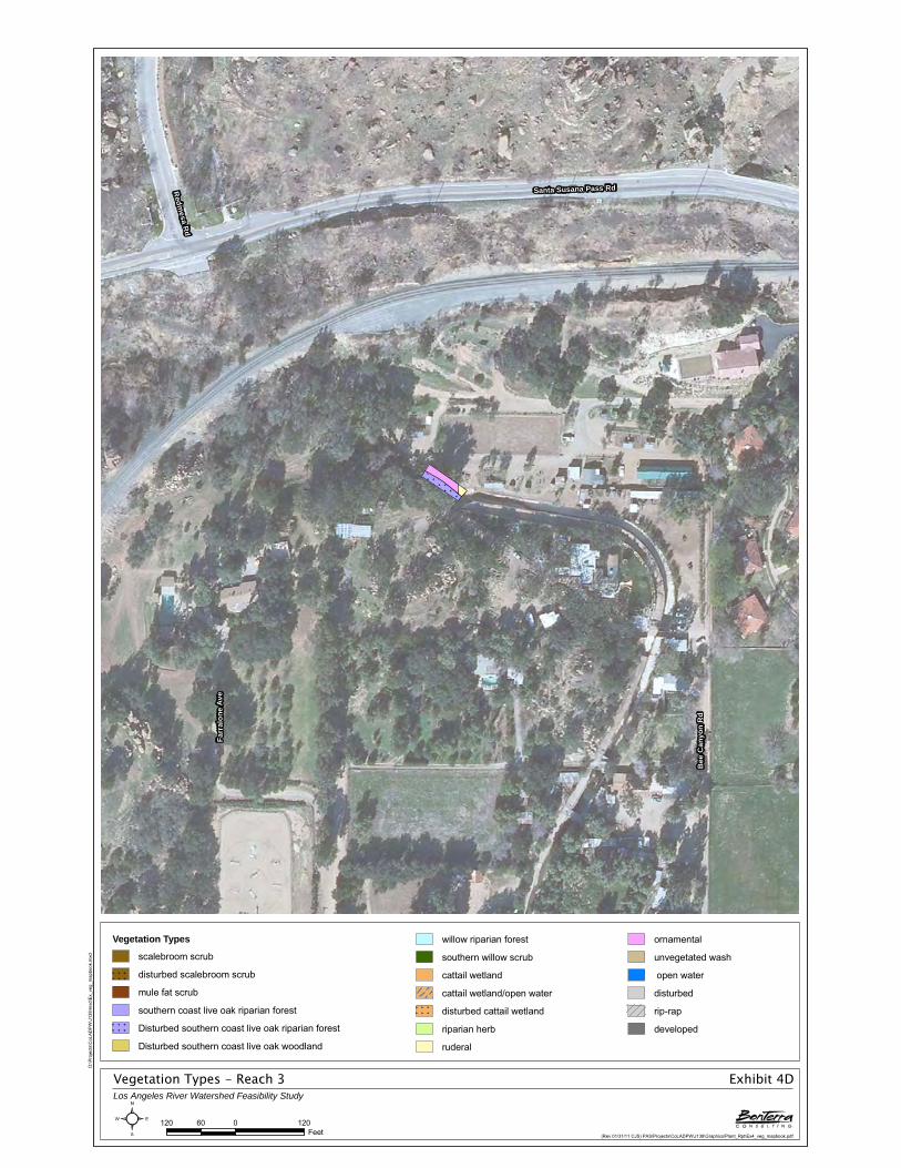
Vegetation Types - Reach 3Los Angeles River Watershed Feasibility Study
Exhibit 4D
(Rev 01/31/11 CJS) PAS\Projects\CoLADPW\J138\Graphics\Plant_Rpt\Ex4_veg_mapbook.pdf
Farr
alon
e Av
e
Santa Susana Pass Rd
Bee
Can
yon
Rd
Redm
esa Rd
120 0 12060Feet²
D:\P
roje
cts\
CoL
AD
PW
\J13
8\m
xd\E
x_ve
g_m
apbo
ok.m
xd
Vegetation Types
scalebroom scrub
disturbed scalebroom scrub
mule fat scrub
southern coast live oak riparian forest
Disturbed southern coast live oak riparian forest
Disturbed southern coast live oak woodland
willow riparian forest
southern willow scrub
cattail wetland
cattail wetland/open water
disturbed cattail wetland
riparian herb
ruderal
ornamental
unvegetated wash
open water
disturbed
rip-rap
developed

Vegetation Types - Reach 4Los Angeles River Watershed Feasibility Study
Exhibit 4E
(Rev 01/31/11 CJS) PAS\Projects\CoLADPW\J138\Graphics\Plant_Rpt\Ex4_veg_mapbook.pdf
State Hwy 118
De Soto Ave
Ramp
Browns Canyon RdDe Soto Ave
State Hwy 118State Hwy 118
State Hwy 118
Ramp
Ramp
120 0 12060Feet²
D:\P
roje
cts\
CoL
AD
PW
\J13
8\m
xd\E
x_ve
g_m
apbo
ok.m
xd
Vegetation Types
scalebroom scrub
disturbed scalebroom scrub
mule fat scrub
southern coast live oak riparian forest
Disturbed southern coast live oak riparian forest
Disturbed southern coast live oak woodland
willow riparian forest
southern willow scrub
cattail wetland
cattail wetland/open water
disturbed cattail wetland
riparian herb
ruderal
ornamental
unvegetated wash
open water
disturbed
rip-rap
developed
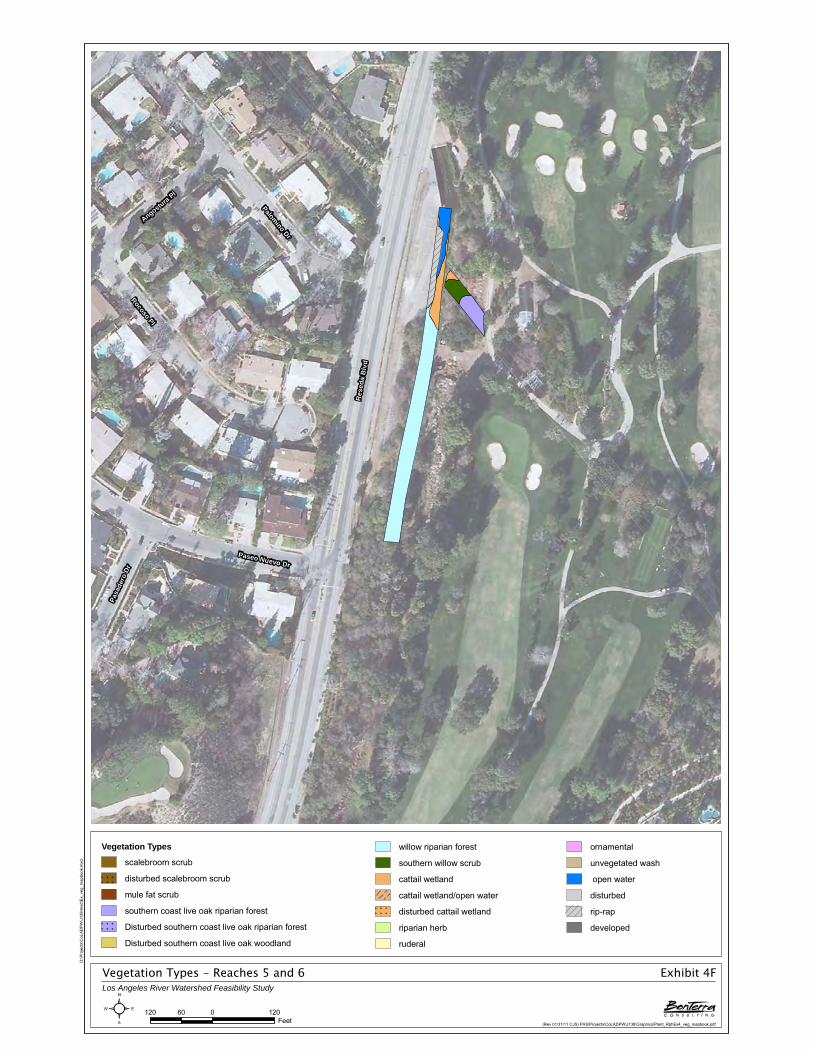
Vegetation Types - Reaches 5 and 6Los Angeles River Watershed Feasibility Study
Exhibit 4F
(Rev 01/31/11 CJS) PAS\Projects\CoLADPW\J138\Graphics\Plant_Rpt\Ex4_veg_mapbook.pdf
Res
eda
Blv
d
Rocoso Pl
Palomino Dr
Paseo Nuevo Dr
Angostura Pl
Pasa
dero
Dr
120 0 12060Feet²
D:\P
roje
cts\
CoL
AD
PW
\J13
8\m
xd\E
x_ve
g_m
apbo
ok.m
xd
Vegetation Types
scalebroom scrub
disturbed scalebroom scrub
mule fat scrub
southern coast live oak riparian forest
Disturbed southern coast live oak riparian forest
Disturbed southern coast live oak woodland
willow riparian forest
southern willow scrub
cattail wetland
cattail wetland/open water
disturbed cattail wetland
riparian herb
ruderal
ornamental
unvegetated wash
open water
disturbed
rip-rap
developed

Vegetation Types - Reach 7Los Angeles River Watershed Feasibility Study
Exhibit 4G
(Rev 01/31/11 CJS) PAS\Projects\CoLADPW\J138\Graphics\Plant_Rpt\Ex4_veg_mapbook.pdf
Victory Blvd
Alley
Petit
Ave
Forb
es A
ve
Gilmore St
Whi
take
r Ave
Alley
Gilmore St
120 0 12060Feet²
D:\P
roje
cts\
CoL
AD
PW
\J13
8\m
xd\E
x_ve
g_m
apbo
ok.m
xd
Vegetation Types
scalebroom scrub
disturbed scalebroom scrub
mule fat scrub
southern coast live oak riparian forest
Disturbed southern coast live oak riparian forest
Disturbed southern coast live oak woodland
willow riparian forest
southern willow scrub
cattail wetland
cattail wetland/open water
disturbed cattail wetland
riparian herb
ruderal
ornamental
unvegetated wash
open water
disturbed
rip-rap
developed

Vegetation Types - Reach 8Los Angeles River Watershed Feasibility Study
Exhibit 4H
(Rev 01/31/11 CJS) PAS\Projects\CoLADPW\J138\Graphics\Plant_Rpt\Ex4_veg_mapbook.pdf
Ramp
Otsego St
US Hwy 101
Hay
venh
urst
Ave
Alle
y
Hartsook St
Magnolia Blvd
Ger
ald
Ave
Ode
ssa
Ave
Noe
line
Ave
Ramp
US Hwy 101
120 0 12060Feet²
D:\P
roje
cts\
CoL
AD
PW
\J13
8\m
xd\E
x_ve
g_m
apbo
ok.m
xd
Vegetation Types
scalebroom scrub
disturbed scalebroom scrub
mule fat scrub
southern coast live oak riparian forest
Disturbed southern coast live oak riparian forest
Disturbed southern coast live oak woodland
willow riparian forest
southern willow scrub
cattail wetland
cattail wetland/open water
disturbed cattail wetland
riparian herb
ruderal
ornamental
unvegetated wash
open water
disturbed
rip-rap
developed

Vegetation Types - Reach 9Los Angeles River Watershed Feasibility Study
Exhibit 4I
(Rev 01/31/11 CJS) PAS\Projects\CoLADPW\J138\Graphics\Plant_Rpt\Ex4_veg_mapbook.pdf
I 405
Ramp
Victory Blvd
Unn
amed
Str
eet
Has
kell
Ave
Whi
tman
Ave
Dem
psey
Ave
Friar St
Ram
p
Ram
p
Ram
p
I 405
Ram
p
120 0 12060Feet²
D:\P
roje
cts\
CoL
AD
PW
\J13
8\m
xd\E
x_ve
g_m
apbo
ok.m
xd
Vegetation Types
scalebroom scrub
disturbed scalebroom scrub
mule fat scrub
southern coast live oak riparian forest
Disturbed southern coast live oak riparian forest
Disturbed southern coast live oak woodland
willow riparian forest
southern willow scrub
cattail wetland
cattail wetland/open water
disturbed cattail wetland
riparian herb
ruderal
ornamental
unvegetated wash
open water
disturbed
rip-rap
developed

Vegetation Types - Reach 10Los Angeles River Watershed Feasibility Study
Exhibit 4J
(Rev 01/31/11 CJS) PAS\Projects\CoLADPW\J138\Graphics\Plant_Rpt\Ex4_veg_mapbook.pdf
Woo
dley
Ave
Unnamed Street
Unnamed Street
120 0 12060Feet²
D:\P
roje
cts\
CoL
AD
PW
\J13
8\m
xd\E
x_ve
g_m
apbo
ok.m
xd
Vegetation Types
scalebroom scrub
disturbed scalebroom scrub
mule fat scrub
southern coast live oak riparian forest
Disturbed southern coast live oak riparian forest
Disturbed southern coast live oak woodland
willow riparian forest
southern willow scrub
cattail wetland
cattail wetland/open water
disturbed cattail wetland
riparian herb
ruderal
ornamental
unvegetated wash
open water
disturbed
rip-rap
developed

Vegetation Types - Reach 10Los Angeles River Watershed Feasibility Study
Exhibit 4K
(Rev 01/31/11 CJS) PAS\Projects\CoLADPW\J138\Graphics\Plant_Rpt\Ex4_veg_mapbook.pdf
Woodley Ave
120 0 12060Feet²
D:\P
roje
cts\
CoL
AD
PW
\J13
8\m
xd\E
x_ve
g_m
apbo
ok.m
xd
Vegetation Types
scalebroom scrub
disturbed scalebroom scrub
mule fat scrub
southern coast live oak riparian forest
Disturbed southern coast live oak riparian forest
Disturbed southern coast live oak woodland
willow riparian forest
southern willow scrub
cattail wetland
cattail wetland/open water
disturbed cattail wetland
riparian herb
ruderal
ornamental
unvegetated wash
open water
disturbed
rip-rap
developed

Vegetation Types - Reach 10Los Angeles River Watershed Feasibility Study
Exhibit 4L
(Rev 01/31/11 CJS) PAS\Projects\CoLADPW\J138\Graphics\Plant_Rpt\Ex4_veg_mapbook.pdf
Unnamed Street
120 0 12060Feet²
D:\P
roje
cts\
CoL
AD
PW
\J13
8\m
xd\E
x_ve
g_m
apbo
ok.m
xd
Vegetation Types
scalebroom scrub
disturbed scalebroom scrub
mule fat scrub
southern coast live oak riparian forest
Disturbed southern coast live oak riparian forest
Disturbed southern coast live oak woodland
willow riparian forest
southern willow scrub
cattail wetland
cattail wetland/open water
disturbed cattail wetland
riparian herb
ruderal
ornamental
unvegetated wash
open water
disturbed
rip-rap
developed

Vegetation Types - Reach 12Los Angeles River Watershed Feasibility Study
Exhibit 4M
(Rev 01/31/11 CJS) PAS\Projects\CoLADPW\J138\Graphics\Plant_Rpt\Ex4_veg_mapbook.pdf
Wentworth St
Le Berthon St
Sher
man
Gro
ve A
ve
Tujunga Valley St
120 0 12060Feet²
D:\P
roje
cts\
CoL
AD
PW
\J13
8\m
xd\E
x_ve
g_m
apbo
ok.m
xd
Vegetation Types
scalebroom scrub
disturbed scalebroom scrub
mule fat scrub
southern coast live oak riparian forest
Disturbed southern coast live oak riparian forest
Disturbed southern coast live oak woodland
willow riparian forest
southern willow scrub
cattail wetland
cattail wetland/open water
disturbed cattail wetland
riparian herb
ruderal
ornamental
unvegetated wash
open water
disturbed
rip-rap
developed

Vegetation Types - Reach 13Los Angeles River Watershed Feasibility Study
Exhibit 4N
(Rev 01/31/11 CJS) PAS\Projects\CoLADPW\J138\Graphics\Plant_Rpt\Ex4_veg_mapbook.pdf
Woldrich St
Chr
isty
Ave
120 0 12060Feet²
D:\P
roje
cts\
CoL
AD
PW
\J13
8\m
xd\E
x_ve
g_m
apbo
ok.m
xd
Vegetation Types
scalebroom scrub
disturbed scalebroom scrub
mule fat scrub
southern coast live oak riparian forest
Disturbed southern coast live oak riparian forest
Disturbed southern coast live oak woodland
willow riparian forest
southern willow scrub
cattail wetland
cattail wetland/open water
disturbed cattail wetland
riparian herb
ruderal
ornamental
unvegetated wash
open water
disturbed
rip-rap
developed

Vegetation Types - Reach 14Los Angeles River Watershed Feasibility Study
Exhibit 4O
(Rev 01/31/11 CJS) PAS\Projects\CoLADPW\J138\Graphics\Plant_Rpt\Ex4_veg_mapbook.pdf
Harding St
Unna
med
Stre
et
Harding St
120 0 12060Feet²
D:\P
roje
cts\
CoL
AD
PW
\J13
8\m
xd\E
x_ve
g_m
apbo
ok.m
xd
Vegetation Types
scalebroom scrub
disturbed scalebroom scrub
mule fat scrub
southern coast live oak riparian forest
Disturbed southern coast live oak riparian forest
Disturbed southern coast live oak woodland
willow riparian forest
southern willow scrub
cattail wetland
cattail wetland/open water
disturbed cattail wetland
riparian herb
ruderal
ornamental
unvegetated wash
open water
disturbed
rip-rap
developed

Vegetation Types - Reach 15Los Angeles River Watershed Feasibility Study
Exhibit 4P
(Rev 01/31/11 CJS) PAS\Projects\CoLADPW\J138\Graphics\Plant_Rpt\Ex4_veg_mapbook.pdf
Kes
ter A
ve
Parthenia St
Salo
ma
AveN
orw
ich
Ave
Napa St
Alley
Malden St
Bryant StC
onne
ctin
g R
oad
Parthenia St
Napa St
120 0 12060Feet²
D:\P
roje
cts\
CoL
AD
PW
\J13
8\m
xd\E
x_ve
g_m
apbo
ok.m
xd
Vegetation Types
scalebroom scrub
disturbed scalebroom scrub
mule fat scrub
southern coast live oak riparian forest
Disturbed southern coast live oak riparian forest
Disturbed southern coast live oak woodland
willow riparian forest
southern willow scrub
cattail wetland
cattail wetland/open water
disturbed cattail wetland
riparian herb
ruderal
ornamental
unvegetated wash
open water
disturbed
rip-rap
developed

Vegetation Types - Reach 15Los Angeles River Watershed Feasibility Study
Exhibit 4Q
(Rev 01/31/11 CJS) PAS\Projects\CoLADPW\J138\Graphics\Plant_Rpt\Ex4_veg_mapbook.pdf
Kes
ter A
ve
Roscoe Blvd
Chase St
Brim
field
Ave
Community St
Salo
ma
Ave
Schoenborn St
Nor
wic
h A
ve
Community St
Brim
field
Ave
Community St
Chase St
Salo
ma
Ave
120 0 12060Feet²
D:\P
roje
cts\
CoL
AD
PW
\J13
8\m
xd\E
x_ve
g_m
apbo
ok.m
xd
Vegetation Types
scalebroom scrub
disturbed scalebroom scrub
mule fat scrub
southern coast live oak riparian forest
Disturbed southern coast live oak riparian forest
Disturbed southern coast live oak woodland
willow riparian forest
southern willow scrub
cattail wetland
cattail wetland/open water
disturbed cattail wetland
riparian herb
ruderal
ornamental
unvegetated wash
open water
disturbed
rip-rap
developed

Vegetation Types - Reach 15Los Angeles River Watershed Feasibility Study
Exhibit 4R
(Rev 01/31/11 CJS) PAS\Projects\CoLADPW\J138\Graphics\Plant_Rpt\Ex4_veg_mapbook.pdf
Brim
field Ave
Lanark St
Lem
ona
Ave
Nor
wic
h A
ve
Cantara St
Willard St
Kes
ter A
ve
Lorne St
Salo
ma
Ave
Titus St
Burton St
Lanark St
120 0 12060Feet²
D:\P
roje
cts\
CoL
AD
PW
\J13
8\m
xd\E
x_ve
g_m
apbo
ok.m
xd
Vegetation Types
scalebroom scrub
disturbed scalebroom scrub
mule fat scrub
southern coast live oak riparian forest
Disturbed southern coast live oak riparian forest
Disturbed southern coast live oak woodland
willow riparian forest
southern willow scrub
cattail wetland
cattail wetland/open water
disturbed cattail wetland
riparian herb
ruderal
ornamental
unvegetated wash
open water
disturbed
rip-rap
developed

Vegetation Types - Reach 15Los Angeles River Watershed Feasibility Study
Exhibit 4S
(Rev 01/31/11 CJS) PAS\Projects\CoLADPW\J138\Graphics\Plant_Rpt\Ex4_veg_mapbook.pdf
Raymer St
Salo
ma
Ave
Cabrito Rd
Marson St
Brim
field Ave
Lem
ona
Ave
Nor
wic
h A
ve
Lorne St
Blythe St
Strathern St
Blythe St
Strathern St
120 0 12060Feet²
D:\P
roje
cts\
CoL
AD
PW
\J13
8\m
xd\E
x_ve
g_m
apbo
ok.m
xd
Vegetation Types
scalebroom scrub
disturbed scalebroom scrub
mule fat scrub
southern coast live oak riparian forest
Disturbed southern coast live oak riparian forest
Disturbed southern coast live oak woodland
willow riparian forest
southern willow scrub
cattail wetland
cattail wetland/open water
disturbed cattail wetland
riparian herb
ruderal
ornamental
unvegetated wash
open water
disturbed
rip-rap
developed

Vegetation Types - Reach 16Los Angeles River Watershed Feasibility Study
Exhibit 4T
(Rev 01/31/11 CJS) PAS\Projects\CoLADPW\J138\Graphics\Plant_Rpt\Ex4_veg_mapbook.pdf
I 210
Ramp
La Tuna Canyon RdHonolulu Ave
TujungaCanyon
Blvd
I 210
120 0 12060Feet²
D:\P
roje
cts\
CoL
AD
PW
\J13
8\m
xd\E
x_ve
g_m
apbo
ok.m
xd
Vegetation Types
scalebroom scrub
disturbed scalebroom scrub
mule fat scrub
southern coast live oak riparian forest
Disturbed southern coast live oak riparian forest
Disturbed southern coast live oak woodland
willow riparian forest
southern willow scrub
cattail wetland
cattail wetland/open water
disturbed cattail wetland
riparian herb
ruderal
ornamental
unvegetated wash
open water
disturbed
rip-rap
developed

Vegetation Types - Reach 17Los Angeles River Watershed Feasibility Study
Exhibit 4U
(Rev 01/31/11 CJS) PAS\Projects\CoLADPW\J138\Graphics\Plant_Rpt\Ex4_veg_mapbook.pdf
Cedarbend Dr
El Lado Dr
Ferntree Pl
Beechglen Dr
Tanbark Pl
Bos
ton
Ave
Unnamed Street
120 0 12060Feet²
D:\P
roje
cts\
CoL
AD
PW
\J13
8\m
xd\E
x_ve
g_m
apbo
ok.m
xd
Vegetation Types
scalebroom scrub
disturbed scalebroom scrub
mule fat scrub
southern coast live oak riparian forest
Disturbed southern coast live oak riparian forest
Disturbed southern coast live oak woodland
willow riparian forest
southern willow scrub
cattail wetland
cattail wetland/open water
disturbed cattail wetland
riparian herb
ruderal
ornamental
unvegetated wash
open water
disturbed
rip-rap
developed

Vegetation Types - Reach 18Los Angeles River Watershed Feasibility Study
Exhibit 4V
(Rev 01/31/11 CJS) PAS\Projects\CoLADPW\J138\Graphics\Plant_Rpt\Ex4_veg_mapbook.pdf
Shirlyjean St
Dolorita Ave
Inva
le D
r
Eilinita
Ave
Glenwood Ave
Camann St
120 0 12060Feet²
D:\P
roje
cts\
CoL
AD
PW
\J13
8\m
xd\E
x_ve
g_m
apbo
ok.m
xd
Vegetation Types
scalebroom scrub
disturbed scalebroom scrub
mule fat scrub
southern coast live oak riparian forest
Disturbed southern coast live oak riparian forest
Disturbed southern coast live oak woodland
willow riparian forest
southern willow scrub
cattail wetland
cattail wetland/open water
disturbed cattail wetland
riparian herb
ruderal
ornamental
unvegetated wash
open water
disturbed
rip-rap
developed

Vegetation Types - Reach 19Los Angeles River Watershed Feasibility Study
Exhibit 4W
(Rev 01/31/11 CJS) PAS\Projects\CoLADPW\J138\Graphics\Plant_Rpt\Ex4_veg_mapbook.pdf
Oce
an V
iew
Blv
d
El S
eren
o Av
e
El Moreno St
Mountain Ave
Los Amigos St
Colmena St
Los Amigos St
120 0 12060Feet²
D:\P
roje
cts\
CoL
AD
PW
\J13
8\m
xd\E
x_ve
g_m
apbo
ok.m
xd
Vegetation Types
scalebroom scrub
disturbed scalebroom scrub
mule fat scrub
southern coast live oak riparian forest
Disturbed southern coast live oak riparian forest
Disturbed southern coast live oak woodland
willow riparian forest
southern willow scrub
cattail wetland
cattail wetland/open water
disturbed cattail wetland
riparian herb
ruderal
ornamental
unvegetated wash
open water
disturbed
rip-rap
developed

Vegetation Types - Reach 19Los Angeles River Watershed Feasibility Study
Exhibit 4X
(Rev 01/31/11 CJS) PAS\Projects\CoLADPW\J138\Graphics\Plant_Rpt\Ex4_veg_mapbook.pdf
Oce
an V
iew
Blv
d
Mountain Ave
Cross St
Cyp
ress
St
Leir
Dr
120 0 12060Feet²
D:\P
roje
cts\
CoL
AD
PW
\J13
8\m
xd\E
x_ve
g_m
apbo
ok.m
xd
Vegetation Types
scalebroom scrub
disturbed scalebroom scrub
mule fat scrub
southern coast live oak riparian forest
Disturbed southern coast live oak riparian forest
Disturbed southern coast live oak woodland
willow riparian forest
southern willow scrub
cattail wetland
cattail wetland/open water
disturbed cattail wetland
riparian herb
ruderal
ornamental
unvegetated wash
open water
disturbed
rip-rap
developed

Vegetation Types - Reaches 20 and 21Los Angeles River Watershed Feasibility Study
Exhibit 4Y
(Rev 01/31/11 CJS) PAS\Projects\CoLADPW\J138\Graphics\Plant_Rpt\Ex4_veg_mapbook.pdf
Cas
tle K
noll
Rd
Los Amigos St
La Forest Dr
Earl Canyon Mtwy
120 0 12060Feet²
D:\P
roje
cts\
CoL
AD
PW
\J13
8\m
xd\E
x_ve
g_m
apbo
ok.m
xd
Vegetation Types
scalebroom scrub
disturbed scalebroom scrub
mule fat scrub
southern coast live oak riparian forest
Disturbed southern coast live oak riparian forest
Disturbed southern coast live oak woodland
willow riparian forest
southern willow scrub
cattail wetland
cattail wetland/open water
disturbed cattail wetland
riparian herb
ruderal
ornamental
unvegetated wash
open water
disturbed
rip-rap
developed

Vegetation Types - Reach 22Los Angeles River Watershed Feasibility Study
Exhibit 4Z
(Rev 01/31/11 CJS) PAS\Projects\CoLADPW\J138\Graphics\Plant_Rpt\Ex4_veg_mapbook.pdf
Palm Dr
Hall Ln
Earl C
anyo
n Mtw
y
Bonita Vista Dr
Bubbling W
ell Ln
La Sier
raDr
120 0 12060Feet²
D:\P
roje
cts\
CoL
AD
PW
\J13
8\m
xd\E
x_ve
g_m
apbo
ok.m
xd
Vegetation Types
scalebroom scrub
disturbed scalebroom scrub
mule fat scrub
southern coast live oak riparian forest
Disturbed southern coast live oak riparian forest
Disturbed southern coast live oak woodland
willow riparian forest
southern willow scrub
cattail wetland
cattail wetland/open water
disturbed cattail wetland
riparian herb
ruderal
ornamental
unvegetated wash
open water
disturbed
rip-rap
developed

Vegetation Types - Reach 22Los Angeles River Watershed Feasibility Study
Exhibit 4AA
(Rev 01/31/11 CJS) PAS\Projects\CoLADPW\J138\Graphics\Plant_Rpt\Ex4_veg_mapbook.pdf
Jess
en D
r
Palm
Dr
Solli
den
Ln
Earl Canyon Mtwy
Lamp Post Ln
Fairmount Ave
La Sier
raDr
Los AmigosSt
Hall CanyonDr
Earl Canyon
Mtw
y
120 0 12060Feet²
D:\P
roje
cts\
CoL
AD
PW
\J13
8\m
xd\E
x_ve
g_m
apbo
ok.m
xd
Vegetation Types
scalebroom scrub
disturbed scalebroom scrub
mule fat scrub
southern coast live oak riparian forest
Disturbed southern coast live oak riparian forest
Disturbed southern coast live oak woodland
willow riparian forest
southern willow scrub
cattail wetland
cattail wetland/open water
disturbed cattail wetland
riparian herb
ruderal
ornamental
unvegetated wash
open water
disturbed
rip-rap
developed

Vegetation Types - Reach 22Los Angeles River Watershed Feasibility Study
Exhibit 4BB
(Rev 01/31/11 CJS) PAS\Projects\CoLADPW\J138\Graphics\Plant_Rpt\Ex4_veg_mapbook.pdf
La Forest Dr
Sunnybank Dr
Solli
den
Ln
Hall Canyon Dr
Countryman Ln
Tulip
Tre
e Ln
Via Venado St
Jess
enD
r
120 0 12060Feet²
D:\P
roje
cts\
CoL
AD
PW
\J13
8\m
xd\E
x_ve
g_m
apbo
ok.m
xd
Vegetation Types
scalebroom scrub
disturbed scalebroom scrub
mule fat scrub
southern coast live oak riparian forest
Disturbed southern coast live oak riparian forest
Disturbed southern coast live oak woodland
willow riparian forest
southern willow scrub
cattail wetland
cattail wetland/open water
disturbed cattail wetland
riparian herb
ruderal
ornamental
unvegetated wash
open water
disturbed
rip-rap
developed

Vegetation Types - Reach 24Los Angeles River Watershed Feasibility Study
Exhibit 4CC
(Rev 01/31/11 CJS) PAS\Projects\CoLADPW\J138\Graphics\Plant_Rpt\Ex4_veg_mapbook.pdf
Alam
eda St
Santa Fe Ave
Ramp
Stanley St
Homestead Pl
Manville St
Ram
p
Alam
eda St
Ramp
120 0 12060Feet²
D:\P
roje
cts\
CoL
AD
PW
\J13
8\m
xd\E
x_ve
g_m
apbo
ok.m
xd
Vegetation Types
scalebroom scrub
disturbed scalebroom scrub
mule fat scrub
southern coast live oak riparian forest
Disturbed southern coast live oak riparian forest
Disturbed southern coast live oak woodland
willow riparian forest
southern willow scrub
cattail wetland
cattail wetland/open water
disturbed cattail wetland
riparian herb
ruderal
ornamental
unvegetated wash
open water
disturbed
rip-rap
developed

Vegetation Types - Reach 24Los Angeles River Watershed Feasibility Study
Exhibit 4DD
(Rev 01/31/11 CJS) PAS\Projects\CoLADPW\J138\Graphics\Plant_Rpt\Ex4_veg_mapbook.pdf
Ala
med
a St
Connecting Road
Ala
med
a St
120 0 12060Feet²
D:\P
roje
cts\
CoL
AD
PW
\J13
8\m
xd\E
x_ve
g_m
apbo
ok.m
xd
Vegetation Types
scalebroom scrub
disturbed scalebroom scrub
mule fat scrub
southern coast live oak riparian forest
Disturbed southern coast live oak riparian forest
Disturbed southern coast live oak woodland
willow riparian forest
southern willow scrub
cattail wetland
cattail wetland/open water
disturbed cattail wetland
riparian herb
ruderal
ornamental
unvegetated wash
open water
disturbed
rip-rap
developed

Vegetation Types - Reach 24Los Angeles River Watershed Feasibility Study
Exhibit 4EE
(Rev 01/31/11 CJS) PAS\Projects\CoLADPW\J138\Graphics\Plant_Rpt\Ex4_veg_mapbook.pdf
Ala
med
a St
Sant
a Fe
Ave
Reyes Ave
Ala
med
a St
120 0 12060Feet²
D:\P
roje
cts\
CoL
AD
PW
\J13
8\m
xd\E
x_ve
g_m
apbo
ok.m
xd
Vegetation Types
scalebroom scrub
disturbed scalebroom scrub
mule fat scrub
southern coast live oak riparian forest
Disturbed southern coast live oak riparian forest
Disturbed southern coast live oak woodland
willow riparian forest
southern willow scrub
cattail wetland
cattail wetland/open water
disturbed cattail wetland
riparian herb
ruderal
ornamental
unvegetated wash
open water
disturbed
rip-rap
developed

Vegetation Types - Reach 24Los Angeles River Watershed Feasibility Study
Exhibit 4FF
(Rev 01/31/11 CJS) PAS\Projects\CoLADPW\J138\Graphics\Plant_Rpt\Ex4_veg_mapbook.pdf
Sant
a Fe
Ave Ana
St
Connecting Road
Santa
Fe A
ve
120 0 12060Feet²
D:\P
roje
cts\
CoL
AD
PW
\J13
8\m
xd\E
x_ve
g_m
apbo
ok.m
xd
Vegetation Types
scalebroom scrub
disturbed scalebroom scrub
mule fat scrub
southern coast live oak riparian forest
Disturbed southern coast live oak riparian forest
Disturbed southern coast live oak woodland
willow riparian forest
southern willow scrub
cattail wetland
cattail wetland/open water
disturbed cattail wetland
riparian herb
ruderal
ornamental
unvegetated wash
open water
disturbed
rip-rap
developed

Vegetation Types - Reach 24Los Angeles River Watershed Feasibility Study
Exhibit 4GG
(Rev 01/31/11 CJS) PAS\Projects\CoLADPW\J138\Graphics\Plant_Rpt\Ex4_veg_mapbook.pdf
Santa Fe Ave
120 0 12060Feet²
D:\P
roje
cts\
CoL
AD
PW
\J13
8\m
xd\E
x_ve
g_m
apbo
ok.m
xd
Vegetation Types
scalebroom scrub
disturbed scalebroom scrub
mule fat scrub
southern coast live oak riparian forest
Disturbed southern coast live oak riparian forest
Disturbed southern coast live oak woodland
willow riparian forest
southern willow scrub
cattail wetland
cattail wetland/open water
disturbed cattail wetland
riparian herb
ruderal
ornamental
unvegetated wash
open water
disturbed
rip-rap
developed

Vegetation Types - Reach 24Los Angeles River Watershed Feasibility Study
Exhibit 4HH
(Rev 01/31/11 CJS) PAS\Projects\CoLADPW\J138\Graphics\Plant_Rpt\Ex4_veg_mapbook.pdf
Santa Fe Ave
120 0 12060Feet²
D:\P
roje
cts\
CoL
AD
PW
\J13
8\m
xd\E
x_ve
g_m
apbo
ok.m
xd
Vegetation Types
scalebroom scrub
disturbed scalebroom scrub
mule fat scrub
southern coast live oak riparian forest
Disturbed southern coast live oak riparian forest
Disturbed southern coast live oak woodland
willow riparian forest
southern willow scrub
cattail wetland
cattail wetland/open water
disturbed cattail wetland
riparian herb
ruderal
ornamental
unvegetated wash
open water
disturbed
rip-rap
developed

Vegetation Types - Reach 24Los Angeles River Watershed Feasibility Study
Exhibit 4II
(Rev 01/31/11 CJS) PAS\Projects\CoLADPW\J138\Graphics\Plant_Rpt\Ex4_veg_mapbook.pdf
Del Amo Blvd
Connecting R
oad
Del Amo Blvd
120 0 12060Feet²
D:\P
roje
cts\
CoL
AD
PW
\J13
8\m
xd\E
x_ve
g_m
apbo
ok.m
xd
Vegetation Types
scalebroom scrub
disturbed scalebroom scrub
mule fat scrub
southern coast live oak riparian forest
Disturbed southern coast live oak riparian forest
Disturbed southern coast live oak woodland
willow riparian forest
southern willow scrub
cattail wetland
cattail wetland/open water
disturbed cattail wetland
riparian herb
ruderal
ornamental
unvegetated wash
open water
disturbed
rip-rap
developed

Vegetation Types - Reach 24Los Angeles River Watershed Feasibility Study
Exhibit 4JJ
(Rev 01/31/11 CJS) PAS\Projects\CoLADPW\J138\Graphics\Plant_Rpt\Ex4_veg_mapbook.pdf
I 710
Ram
p
Susa
na R
d
I 710
Ram
p
120 0 12060Feet²
D:\P
roje
cts\
CoL
AD
PW
\J13
8\m
xd\E
x_ve
g_m
apbo
ok.m
xd
Vegetation Types
scalebroom scrub
disturbed scalebroom scrub
mule fat scrub
southern coast live oak riparian forest
Disturbed southern coast live oak riparian forest
Disturbed southern coast live oak woodland
willow riparian forest
southern willow scrub
cattail wetland
cattail wetland/open water
disturbed cattail wetland
riparian herb
ruderal
ornamental
unvegetated wash
open water
disturbed
rip-rap
developed

Vegetation Types - Reach 25Los Angeles River Watershed Feasibility Study
Exhibit 4KK
(Rev 01/31/11 CJS) PAS\Projects\CoLADPW\J138\Graphics\Plant_Rpt\Ex4_veg_mapbook.pdf
I 710
Ram
p
Willow St
De
Fore
st A
ve
San
Fran
cisc
o Av
e
25th St
26th Way
25th Way
I 710
Ram
p
Ram
p
Ram
p
Willow St
Ram
p
Ramp
De
Fore
st A
ve
San
Fran
cisc
o Av
e
120 0 12060Feet²
D:\P
roje
cts\
CoL
AD
PW
\J13
8\m
xd\E
x_ve
g_m
apbo
ok.m
xd
Vegetation Types
scalebroom scrub
disturbed scalebroom scrub
mule fat scrub
southern coast live oak riparian forest
Disturbed southern coast live oak riparian forest
Disturbed southern coast live oak woodland
willow riparian forest
southern willow scrub
cattail wetland
cattail wetland/open water
disturbed cattail wetland
riparian herb
ruderal
ornamental
unvegetated wash
open water
disturbed
rip-rap
developed

Vegetation Types - Reach 25Los Angeles River Watershed Feasibility Study
Exhibit 4LL
(Rev 01/31/11 CJS) PAS\Projects\CoLADPW\J138\Graphics\Plant_Rpt\Ex4_veg_mapbook.pdf
I 710
De
Fore
st A
ve
San
Fran
cisc
o Av
e
Alley
Ram
p
23rd St
Burnett St
23rd St
I 710
Burnett St
120 0 12060Feet²
D:\P
roje
cts\
CoL
AD
PW
\J13
8\m
xd\E
x_ve
g_m
apbo
ok.m
xd
Vegetation Types
scalebroom scrub
disturbed scalebroom scrub
mule fat scrub
southern coast live oak riparian forest
Disturbed southern coast live oak riparian forest
Disturbed southern coast live oak woodland
willow riparian forest
southern willow scrub
cattail wetland
cattail wetland/open water
disturbed cattail wetland
riparian herb
ruderal
ornamental
unvegetated wash
open water
disturbed
rip-rap
developed

Vegetation Types - Reach 25Los Angeles River Watershed Feasibility Study
Exhibit 4MM
(Rev 01/31/11 CJS) PAS\Projects\CoLADPW\J138\Graphics\Plant_Rpt\Ex4_veg_mapbook.pdf
I 710
San
Fran
cisc
o Av
e
20th St
21st St
Hill St
21st St
I 710
Hill St
120 0 12060Feet²
D:\P
roje
cts\
CoL
AD
PW
\J13
8\m
xd\E
x_ve
g_m
apbo
ok.m
xd
Vegetation Types
scalebroom scrub
disturbed scalebroom scrub
mule fat scrub
southern coast live oak riparian forest
Disturbed southern coast live oak riparian forest
Disturbed southern coast live oak woodland
willow riparian forest
southern willow scrub
cattail wetland
cattail wetland/open water
disturbed cattail wetland
riparian herb
ruderal
ornamental
unvegetated wash
open water
disturbed
rip-rap
developed

Vegetation Types - Reach 25Los Angeles River Watershed Feasibility Study
Exhibit 4NN
(Rev 01/31/11 CJS) PAS\Projects\CoLADPW\J138\Graphics\Plant_Rpt\Ex4_veg_mapbook.pdf
Ramp
I 710
Pacific Coast HwySa
n Fr
anci
sco
Ave
20th St
19th St
Unnamed Street
Ramp
Ramp
Ram
p
I 710
120 0 12060Feet²
D:\P
roje
cts\
CoL
AD
PW
\J13
8\m
xd\E
x_ve
g_m
apbo
ok.m
xd
Vegetation Types
scalebroom scrub
disturbed scalebroom scrub
mule fat scrub
southern coast live oak riparian forest
Disturbed southern coast live oak riparian forest
Disturbed southern coast live oak woodland
willow riparian forest
southern willow scrub
cattail wetland
cattail wetland/open water
disturbed cattail wetland
riparian herb
ruderal
ornamental
unvegetated wash
open water
disturbed
rip-rap
developed

Vegetation Types - Reach 99Los Angeles River Watershed Feasibility Study
Exhibit 4OO
(Rev 01/31/11 CJS) PAS\Projects\CoLADPW\J138\Graphics\Plant_Rpt\Ex4_veg_mapbook.pdf
Blue Sage Dr
Kag
el C
anyo
n R
d
Trail 04
North Trl
Shafer Pl
Trail 06Santol Dr
El M
errie
del
Dr
Sprin
g Tr
l
Moonhill Rd
Trail 05
Trail 03
Trai
l 02
Trai
l 01
Veranda Dr
Trai
l 07
Forest Trl
Unnamed Street
Dexter Park Rd
Valley View Ct
Trai
l 06
Trai
l04
Trail 05
120 0 12060Feet²
D:\P
roje
cts\
CoL
AD
PW
\J13
8\m
xd\E
x_ve
g_m
apbo
ok.m
xd
Vegetation Types
scalebroom scrub
disturbed scalebroom scrub
mule fat scrub
southern coast live oak riparian forest
Disturbed southern coast live oak riparian forest
Disturbed southern coast live oak woodland
willow riparian forest
southern willow scrub
cattail wetland
cattail wetland/open water
disturbed cattail wetland
riparian herb
ruderal
ornamental
unvegetated wash
open water
disturbed
rip-rap
developed

Vegetation Types - Reach 99Los Angeles River Watershed Feasibility Study
Exhibit 4PP
(Rev 01/31/11 CJS) PAS\Projects\CoLADPW\J138\Graphics\Plant_Rpt\Ex4_veg_mapbook.pdf
Sprin
g Tr
l
Kag
el C
anyo
n R
d
Fore
st T
rl
Summit Trl
Wildwood Trl
Park Trl
Market Trl
Alta Trl
Short Trl
120 0 12060Feet²
D:\P
roje
cts\
CoL
AD
PW
\J13
8\m
xd\E
x_ve
g_m
apbo
ok.m
xd
Vegetation Types
scalebroom scrub
disturbed scalebroom scrub
mule fat scrub
southern coast live oak riparian forest
Disturbed southern coast live oak riparian forest
Disturbed southern coast live oak woodland
willow riparian forest
southern willow scrub
cattail wetland
cattail wetland/open water
disturbed cattail wetland
riparian herb
ruderal
ornamental
unvegetated wash
open water
disturbed
rip-rap
developed

Vegetation Types - Reach 99Los Angeles River Watershed Feasibility Study
Exhibit 4QQ
(Rev 01/31/11 CJS) PAS\Projects\CoLADPW\J138\Graphics\Plant_Rpt\Ex4_veg_mapbook.pdf
East
Trl
Creek Trl
Kagel Canyon Rd
Vineyard Trl
Wes
t Trl
Wildwood Trl
Mou
ntai
n Vi
ew T
rl
Orchard Trl
Overlook Trl
East Trl
120 0 12060Feet²
D:\P
roje
cts\
CoL
AD
PW
\J13
8\m
xd\E
x_ve
g_m
apbo
ok.m
xd
Vegetation Types
scalebroom scrub
disturbed scalebroom scrub
mule fat scrub
southern coast live oak riparian forest
Disturbed southern coast live oak riparian forest
Disturbed southern coast live oak woodland
willow riparian forest
southern willow scrub
cattail wetland
cattail wetland/open water
disturbed cattail wetland
riparian herb
ruderal
ornamental
unvegetated wash
open water
disturbed
rip-rap
developed

Vegetation Types - Reach 99Los Angeles River Watershed Feasibility Study
Exhibit 4RR
(Rev 01/31/11 CJS) PAS\Projects\CoLADPW\J138\Graphics\Plant_Rpt\Ex4_veg_mapbook.pdf
East Trl
West Trl
Osborn
e St
Biltm
ore Ave
Sunburst St
Kamloops St
Kagel C
anyon Rd
Kagel Canyon St
Creek Trl
Creek Trl
120 0 12060Feet²
D:\P
roje
cts\
CoL
AD
PW
\J13
8\m
xd\E
x_ve
g_m
apbo
ok.m
xd
Vegetation Types
scalebroom scrub
disturbed scalebroom scrub
mule fat scrub
southern coast live oak riparian forest
Disturbed southern coast live oak riparian forest
Disturbed southern coast live oak woodland
willow riparian forest
southern willow scrub
cattail wetland
cattail wetland/open water
disturbed cattail wetland
riparian herb
ruderal
ornamental
unvegetated wash
open water
disturbed
rip-rap
developed

Vegetation Types - Reach 100Los Angeles River Watershed Feasibility Study
Exhibit 4SS
(Rev 01/31/11 CJS) PAS\Projects\CoLADPW\J138\Graphics\Plant_Rpt\Ex4_veg_mapbook.pdf
Mulholland Dr
Almidor Ave
Heaven Ave
Abbeyville Ave
Heiss St
Liahona Pl
Spielberg Dr
Cum
orah Crest D
r
120 0 12060Feet²
D:\P
roje
cts\
CoL
AD
PW
\J13
8\m
xd\E
x_ve
g_m
apbo
ok.m
xd
Vegetation Types
scalebroom scrub
disturbed scalebroom scrub
mule fat scrub
southern coast live oak riparian forest
Disturbed southern coast live oak riparian forest
Disturbed southern coast live oak woodland
willow riparian forest
southern willow scrub
cattail wetland
cattail wetland/open water
disturbed cattail wetland
riparian herb
ruderal
ornamental
unvegetated wash
open water
disturbed
rip-rap
developed

ATTACHMENT A
PLANT COMPENDIUM

26 F
lood
Con
trol C
hann
el R
each
es in
the
Los
Ang
eles
Riv
er W
ater
shed
R:\P
AS\P
roje
cts\
CoL
ADPW
\J20
8\A
ppen
dice
s\A
pp C
\Pla
nt R
epor
t.doc
x A
-1
Atta
chm
ent A
– P
lant
Com
pend
ium
LOS
ANG
ELES
RIV
ER W
ATER
SHED
PLA
NT
CO
MPE
ND
IUM
Spec
ies
Rea
ch #
12
34
56
78
910
1213
1415
1617
1819
2021
2224
2596
9910
0PT
ERID
OPH
YTES
-FER
NS
AN
D A
LLIE
SD
RY
OP
TER
IDA
CE
AE
-WO
OD
FE
RN
FA
MIL
YD
ryop
teris
arg
uta
coas
tal w
ood
fern
xP
TER
IDA
CE
AE
-BR
AK
E F
AM
ILY
Pel
laea
and
rom
edifo
lia
coffe
e fe
rnx
Pen
tagr
amm
a tri
angu
laris
ssp
. tria
ngul
aris
gold
enba
ck fe
rnx
xG
YMN
OSP
ERM
SP
INA
CE
AE
-PIN
E F
AM
ILY
Pin
us c
anar
iens
isC
anar
y Is
land
pin
ex
Pin
us h
alep
ensi
sA
lepp
o pi
nex
Pin
us s
p.or
anam
enta
l pin
eA
NG
IOSP
ERM
AE
-FLO
WER
ING
PLA
NTS
DIC
OTY
LED
ON
ESA
DO
XA
CE
AE
-MU
SK
RO
OT
FAM
ILY
Sam
bucu
s ni
gra
ssp.
cana
dens
is [S
ambu
cus
mex
ican
a]bl
ue e
lder
berr
yx
xx
xx
xx
xA
IZO
AC
EA
E-F
IG-M
AR
IGO
LD F
AM
ILY
Apt
enia
cor
difo
liare
d ap
ple
icep
lant
xx
AM
AR
AN
THA
CE
AE
-AM
AR
AN
TH F
AM
ILY
Am
aran
thus
alb
us*
tum
blew
eed
xA
mar
anth
us re
trofle
xus*
red-
root
pig
wee
dx
Am
aran
thus
sp.
pigw
eed
xA
NA
CA
RD
IAC
EA
E-S
UM
AC
FA
MIL
YM
alos
ma
laur
ina
laur
el s
umac
xx
xS
chin
us te
rebi
nthi
foliu
s*B
razi
lian
pepp
er tr
eex
xx
xx
xx
xTo
xico
dend
ron
dive
rsilo
bum
wes
tern
poi
son
oak
xA
PIA
CE
AE
(UM
BE
LLIF
ER
AE
)-C
AR
RO
T FA
MIL
YA
nthr
iscu
s ca
ucal
isbu
r-ch
ervi
lx
xx
xA
pium
gra
veol
ens*
com
mon
cel
ery
xx
xx
xC
oniu
m m
acul
atum
*po
ison
hem
lock
xx
Dau
cus
pusi
llus
rattl
esna
ke w
eed
xFo
enic
ulum
vul
gare
* sw
eet f
enne
lx
Lom
atiu
m s
p.co
mm
on lo
mat
ium
xP
etro
selin
um c
rispu
m*
pars
ley
xTo
rilis
sp.
*kn
otte
d he
dge
pars
ley
xA
PO
CY
NA
CE
AE
-DO
GB
AN
E F
AM
ILY
Ner
ium
ole
ande
r*co
mm
on o
lean
der
xx
Vin
ca m
ajor
*gr
eate
r per
iwin
kle
xx
xx
xx
xA
RA
LIA
CE
AE
-GIN
SE
NG
FA
MIL
YH
eder
a he
lix*
Eng
lish
ivy
xx
xx
xx
xx
xA
STE
RA
CE
AE
(CO
MP
OS
ITA
E)-
SU
NFL
OW
ER
FA
MIL
YA
mbr
osia
aca
nthi
carp
aan
nual
bur
-sag
ex
xx
xx
xA
mbr
osia
psi
lost
achy
aw
este
rn ra
gwee
dx
xx
xx
xx
Arte
mis
ia c
alifo
rnic
aC
alifo
rnia
sag
ebru
shx
xx
xA
rtem
isia
dou
glas
iana
mug
wor
tx
xx
xx
xx
xx
xS
ymph
yotri
chum
[Ast
er] s
ubul
atum
var
. lig
ulat
umsl
ende
r ast
erx
x

26 F
lood
Con
trol C
hann
el R
each
es in
the
Los
Ang
eles
Riv
er W
ater
shed
LOS
ANG
ELES
RIV
ER P
LAN
T C
OM
PEN
DIU
M (C
ontin
ued)
R:\P
AS\P
roje
cts\
CoL
ADPW
\J20
8\A
ppen
dice
s\A
pp C
\Pla
nt R
epor
t.doc
x A
-2
Atta
chm
ent A
– P
lant
Com
pend
ium
Spec
ies
Rea
ch #
12
34
56
78
910
1213
1415
1617
1819
2021
2224
2596
9910
0B
acch
aris
pilu
laris
co
yote
bru
shx
Bac
char
is s
alic
ifolia
ssp
. sal
icifo
liam
ule
fat
xx
xx
xx
xx
xx
xx
Bid
ens
frond
osa
stic
ktig
htx
Bid
ens
pilo
sa*
com
mon
beg
gar-
ticks
xx
Car
duus
pyc
noce
phal
us v
ar.p
ycno
ceph
alus
*Ita
lian
this
tlex
xx
xx
xx
xx
xx
Cen
taur
ea m
elite
nsis
*to
calo
te/M
alte
se s
tar t
hist
lex
xx
xx
Mat
ricar
ia d
isco
idea
[Cha
mom
illa
suav
eole
ns]*
pine
appl
e w
eed
xG
lebi
onis
cor
onar
ia [C
hrys
anth
emum
cor
onar
ium
]*ga
rland
dai
syx
xC
irsiu
m o
ccid
enta
leco
bweb
this
tlex
Cirs
ium
vul
gare
*bu
ll th
istle
xx
xx
xx
xC
onyz
a bo
narie
nsis
*fla
x-le
aved
hor
sew
eed
xx
Con
yza
cana
dens
isco
mm
on h
orse
wee
dx
xx
xx
xx
xx
xx
xC
onyz
a flo
ribun
daho
rsew
eed
xC
otul
a au
stra
lis*
Aus
tralia
n co
tula
xx
Cot
ula
coro
nopi
folia
*br
ass-
butto
nsx
xC
ynar
a ca
rdun
culu
s*ca
rdoo
n / g
lobe
arti
chok
ex
Ecl
ipta
pro
stra
tafa
lse
dais
yx
Erio
phyl
lum
con
ferti
floru
mgo
lden
-yar
row
xE
utha
mia
occ
iden
talis
wes
tern
gol
denr
odx
xLo
gfia
[Fila
go] g
allic
a*da
gger
leaf
cot
tonr
ose
xG
azan
ia li
near
is*
gaza
nia
xP
seud
ogna
phal
ium
[Gna
phal
ium
] cal
iforn
icum
Cal
iforn
ia e
verla
stin
gx
xx
xP
seud
ogna
phal
ium
[Gna
phal
ium
] lut
eoal
bum
*w
eedy
cud
wee
dx
xG
naph
aliu
m p
alus
trelo
wla
nd c
udw
eed
xx
xx
xH
elia
nthu
s an
nuus
wes
tern
sun
flow
er
xx
xx
xH
eter
othe
ca g
rand
iflor
ate
legr
aph
wee
dx
Lact
uca
serri
ola*
pric
kly
lettu
cex
xx
xx
xx
xx
xx
xLe
pido
spar
tum
squ
amat
umsc
ale-
broo
mx
xx
xM
alac
othr
ix s
axat
ilis
cliff
mal
acot
hrix
x
xx
xH
elm
inth
othe
ca [P
icris
] ech
ioid
es*
bris
tly o
x-to
ngue
xx
xx
xD
elai
rea
odor
ata
[Sen
ecio
mik
anio
ides
]*G
erm
an iv
yx
Sen
ecio
vul
garis
*co
mm
on g
roun
dsel
xx
xS
ilybu
m m
aria
num
*m
ilk th
istle
xx
xx
xS
onch
us a
rven
sis*
pere
nnia
l sow
this
tlex
xS
onch
us a
sper
ssp
. asp
er*
pric
kly
sow
this
tlex
xx
xS
onch
us o
lera
ceus
*co
mm
on s
ow th
istle
xx
xx
xx
xx
xx
xx
xx
xx
Ste
phan
omer
ia v
irgat
a ss
p. v
irgat
ata
ll w
reat
h pl
ant
xTa
raxa
cum
offi
cina
le*
com
mon
dan
delio
nx
xx
Xan
thiu
m s
trum
ariu
mco
ckle
bur
xx
xx
xx
BE
TULA
CE
AE
-BIR
CH
FA
MIL
YA
lnus
rhom
bifo
liaw
hite
ald
erx
xB
IGN
ON
IAC
EA
E-B
IGN
ON
IA F
AM
ILY
Teco
mar
ia c
apen
sis
cape
hon
eysu
ckle
xB
OR
AG
INA
CE
AE
-BO
RA
GE
FA
MIL
YA
msi
ncki
a in
term
edia
com
mon
fidd
lene
ckx

26 F
lood
Con
trol C
hann
el R
each
es in
the
Los
Ang
eles
Riv
er W
ater
shed
LOS
ANG
ELES
RIV
ER P
LAN
T C
OM
PEN
DIU
M (C
ontin
ued)
R:\P
AS\P
roje
cts\
CoL
ADPW
\J20
8\A
ppen
dice
s\A
pp C
\Pla
nt R
epor
t.doc
x A
-3
Atta
chm
ent A
– P
lant
Com
pend
ium
Spec
ies
Rea
ch #
12
34
56
78
910
1213
1415
1617
1819
2021
2224
2596
9910
0E
riodi
ctyo
n cr
assi
foliu
mth
ick-
leaf
yer
ba s
anta
xE
ucry
pta
chry
sant
hem
ifolia
com
mon
euc
rypt
ax
xP
ecto
cary
a lin
earis
ssp
.fer
ocul
asl
ende
r pec
toca
rya
xP
hace
lia b
rach
ylob
a sh
ort-l
obed
pha
celia
xP
hace
lia c
icut
aria
cate
rpilla
r pha
celia
xx
xx
xx
xP
hace
lia d
ista
nsco
mm
on p
hace
liax
Pha
celia
gra
ndifl
ora
larg
e-flo
wer
ed p
hace
liax
xP
hace
lia s
p.ph
acel
iax
xx
Pha
celia
ram
osis
sim
abr
anch
ing
phac
elia
xx
Pla
giob
othr
ys s
p.po
pcor
n flo
wer
xB
RA
SS
ICA
CE
AE
(CR
UC
IFE
RA
E)-
MU
STA
RD
FA
MIL
YB
rass
ica
nigr
a*bl
ack
mus
tard
xx
xx
xx
xx
xx
xC
apse
lla b
ursa
-pas
toris
*sh
ephe
rd's
pur
sex
Lepi
dium
dity
otum
[Cor
onop
us d
idym
us]*
less
er w
art c
ress
xH
irsch
feld
ia in
cana
*sh
ortp
od m
usta
rdx
xx
xx
xx
xx
xx
xx
xLe
pidi
um la
sioc
arpu
mss
p.la
sioc
arpu
mha
iry p
eppe
rgra
ss /
sand
pe
pper
gras
sx
Lepi
dium
latif
oliu
m*
broa
d-le
aved
pep
perg
rass
xLe
pidi
um p
erfo
liatu
m*
roun
d-le
aved
pep
perg
rass
xLo
bula
ria m
ariti
ma*
swee
t aly
ssum
xR
apha
nus
sativ
us*
radi
shx
xx
Nas
turti
um o
ffici
nale
[Ror
ippa
nas
turti
um-a
quat
icum
]*w
ater
cre
ssx
xx
xx
xx
xx
xx
Sis
ymbr
ium
alti
ssim
um*
tum
ble
mus
tard
xS
isym
briu
m ir
io*
Lond
on ro
cket
xx
xS
isym
briu
m o
ffici
nale
*he
dge
mus
tard
xS
isym
briu
m o
rient
ale*
hare
's e
ar c
abba
gex
CA
CTA
CE
AE
-CA
CTU
S F
AM
ILY
Cyl
indr
opun
tia c
alifo
rnic
a va
r.pa
rker
i [O
punt
ia p
arry
i]P
arry
's c
holla
xO
punt
ia fi
cus-
indi
ca*
mis
sion
pric
kly-
pear
xx
CA
PR
IFO
LIA
CE
AE
-HO
NE
YS
UC
KLE
FA
MIL
YLo
nice
ra s
ubsp
icat
a va
r.de
nuda
taso
uthe
rn h
oney
suck
lex
xx
xC
AR
YO
PH
YLL
AC
EA
E-P
INK
FA
MIL
YC
ardi
onem
a ra
mos
issi
mum
sand
mat
xC
eras
tium
font
anum
ss
p.vu
lgar
e*co
mm
on m
ouse
-ear
ch
ickw
eed
x
Spe
rgul
aria
mar
ina
salt-
mar
sh s
and
spur
rey
xS
tella
ria m
edia
*co
mm
on c
hick
wee
dx
xx
xx
xx
CH
EN
OP
OD
IAC
EA
E-G
OO
SEF
OO
T FA
MIL
YA
tripl
ex tr
iang
ular
isx
Bas
sia
hyss
opifo
liafiv
e-ho
ok b
assi
ax
Che
nopo
dium
alb
um*
lam
b's
quar
ters
xx
xx
xD
ysph
ania
[Che
nopo
dium
] am
bros
ioid
es*
Mex
ican
tea
xD
ysph
ania
[Che
nopo
dium
] bot
rys*
Jeru
salu
m o
akx
xC
heno
podi
um m
ural
e*ne
ttle-
leav
ed g
oose
foot
xx
Sal
sola
trag
us*
Rus
sian
this
tlex
x

26 F
lood
Con
trol C
hann
el R
each
es in
the
Los
Ang
eles
Riv
er W
ater
shed
LOS
ANG
ELES
RIV
ER P
LAN
T C
OM
PEN
DIU
M (C
ontin
ued)
R:\P
AS\P
roje
cts\
CoL
ADPW
\J20
8\A
ppen
dice
s\A
pp C
\Pla
nt R
epor
t.doc
x A
-4
Atta
chm
ent A
– P
lant
Com
pend
ium
Spec
ies
Rea
ch #
12
34
56
78
910
1213
1415
1617
1819
2021
2224
2596
9910
0C
ON
VO
LVU
LAC
EA
E-M
OR
NIN
G-G
LOR
Y FA
MIL
YC
onvo
lvul
us a
rven
sis*
bind
wee
dx
xC
uscu
ta c
alifo
rnic
ach
apar
ral d
odde
rx
xIp
omoe
a pu
rpur
ea*
com
mon
mor
ning
-glo
ryx
xC
UC
UR
BIT
AC
EA
E-G
OU
RD
FA
MIL
YM
arah
mac
roca
rpus
chilic
othe
xx
xx
xx
xE
UP
HO
RB
IAC
EA
E-S
PU
RG
E F
AM
ILY
Cha
mae
syce
alb
omar
gina
tara
ttles
nake
wee
dx
Cha
mae
syce
mac
ulat
a*sp
otte
d sp
urge
xC
roto
n ca
lifor
nicu
sC
alifo
rnia
cro
ton
xx
Eup
horb
ia c
renu
lata
Chi
nese
cap
sx
xx
Eup
horb
ia s
p.*
cape
r spu
rge
/ gop
her s
purg
ex
Eup
horb
ia p
eplu
s*pe
tty s
purg
ex
xR
icin
us c
omm
unis
*ca
stor
bea
nx
xx
xx
xx
xx
xx
FAB
AC
EA
E (L
EG
UM
INO
SA
E)-
LEG
UM
E F
AM
ILY
Aca
cia
sp.*
acac
iax
xx
xA
stra
galu
s tri
chop
odus
loco
wee
dx
Cyt
isus
sp.
broo
mx
Acm
ispo
n am
eric
anus
[Lot
us p
ursh
ianu
s]S
pani
sh c
love
rx
Acm
ispo
n he
erm
anni
iva
r. he
erm
anni
i [Lo
tus
heer
man
nii v
ar. h
eerm
anni
i]so
uthe
rn w
oolly
lotu
sx
Acm
ispo
n m
ariti
mus
var
. mar
itim
us [L
otus
sal
sugi
nosu
s ss
p. s
alsu
gino
sus]
alka
li lo
tus
x
Acm
ispo
n gl
aber
[Lot
us s
copa
rius]
deer
wee
d / C
alifo
rnia
bro
omx
xx
Acm
ispo
n [L
otus
] stri
gosu
sst
rigos
e lo
tus
xx
Lupi
nus
bico
lor
min
iatu
re lu
pine
xLu
pinu
s hi
rsut
issi
mus
stin
ging
lupi
nex
Lupi
nus
succ
ulen
tus
arro
yo lu
pine
xx
xLu
pinu
s tru
ncat
ustru
ncat
e lu
pine
/ co
llar l
upin
ex
Med
icag
o po
lym
orph
a*C
alifo
rnia
bur
clov
erx
xx
xx
Mel
ilotu
s al
ba*
whi
te s
wee
tclo
ver
xx
xx
xx
xx
xx
xM
elilo
tus
indi
ca*
sour
clov
erx
xx
xx
xx
Mel
ilotu
s sp
.*sw
eetc
love
rx
xx
xR
obin
ia p
sued
oaca
cia*
blac
k lo
cust
xS
parti
um ju
nceu
m*
Spa
nish
bro
omx
xTr
ifoliu
m s
p.ra
nche
ria c
love
rx
FAG
AC
EA
E-O
AK
/ B
EE
CH
FA
MIL
YQ
uerc
us a
grifo
liaco
ast l
ive
oak
xx
xx
xx
xx
xx
xx
xG
ER
AN
IAC
EA
E-G
ER
AN
IUM
FA
MIL
YE
rodi
um b
otry
s*lo
ng-b
eake
d fil
aree
xx
Ero
dium
bra
chyc
arpu
m*
shor
t-fru
ited
filar
eex
Ero
dium
cic
utar
ium
*re
d-st
emm
ed fi
lare
ex
xx
xx
xx
xG
eran
ium
car
olin
ianu
mC
arol
ina
gera
nium
xG
RO
SS
ULA
RIA
CE
AE
-GO
OS
EB
ER
RY
FAM
ILY
Rib
es a
ureu
mgo
lden
cur
rant
xx
xx

26 F
lood
Con
trol C
hann
el R
each
es in
the
Los
Ang
eles
Riv
er W
ater
shed
LOS
ANG
ELES
RIV
ER P
LAN
T C
OM
PEN
DIU
M (C
ontin
ued)
R:\P
AS\P
roje
cts\
CoL
ADPW
\J20
8\A
ppen
dice
s\A
pp C
\Pla
nt R
epor
t.doc
x A
-5
Atta
chm
ent A
– P
lant
Com
pend
ium
Spec
ies
Rea
ch #
12
34
56
78
910
1213
1415
1617
1819
2021
2224
2596
9910
0JU
GLA
ND
AC
EA
E-W
ALN
UT
FAM
ILY
Jugl
ans
calif
orni
caS
outh
ern
Cal
iforn
iabl
ack
wal
nut
x
Jugl
ans
sp.
orna
men
tal w
alnu
tx
xLA
MIA
CE
AE
(LA
BIA
TAE
)-M
INT
FAM
ILY
Mar
rubi
um v
ulga
re*
com
mon
hor
ehou
ndx
xS
alvi
a ap
iana
whi
te s
age
xS
alvi
a m
ellif
era
blac
k sa
gex
Sta
chys
sp.
bugl
e he
dge-
nettl
ex
xLA
UR
AC
EA
E-L
AU
RE
L FA
MIL
YC
inna
mom
um c
amph
ora
Cam
phor
tree
xU
mbe
llula
ria c
alifo
rnic
aC
alifo
rnia
bay
xLO
AS
AC
EA
E-L
OA
SA
FA
MIL
YM
entz
elia
sp.
hydr
a st
ick-
leaf
xM
ALV
AC
EA
E-M
ALL
OW
FAM
ILY
Mal
va p
arvi
flora
*ch
eese
wee
dx
xx
xx
ME
LIA
CE
AE
-MA
HO
GA
NY
FAM
ILY
Mel
ia a
zeda
rach
*ch
ina
berr
yx
MO
NTI
AC
EA
E -
MO
NTI
AFA
MIL
YC
layt
onia
per
folia
ta s
sp.p
erfo
liata
com
mon
min
er's
-lettu
cex
xC
layt
onia
sp.
min
er's
-lettu
cex
xM
OR
AC
EA
E-F
IG F
AM
ILY
Ficu
s ca
rica*
edib
le fi
gx
xx
xx
xx
Ficu
s re
pens
*cr
eepi
ng fi
cus
xM
orus
alb
a*w
hite
mul
berr
yx
MY
RS
INA
CE
AE
-M
YR
SIN
E F
AM
ILY
A
naga
llis a
rven
sis*
scar
let p
impe
rnel
xM
YR
TAC
EA
E-M
YRTL
E F
AM
ILY
Euc
alyp
tus
sp.*
gum
xO
LEA
CE
AE
-OLI
VE
FA
MIL
YFr
axin
us d
ipet
ala
Cal
iforn
ia a
shx
Frax
inus
sp.
ash
xx
xx
xx
ON
AG
RA
CE
AE
-EV
EN
ING
PR
IMR
OS
E F
AM
ILY
Eul
obus
cal
iforn
icus
[C
amis
soni
a ca
lifor
nica
]m
usta
rd-li
ke e
veni
ng
prim
rose
xx
x
Cam
isso
nia
inte
rmed
iain
term
edia
te p
rimro
sex
Cla
rkia
sp.
punc
hbow
l cla
rkia
xC
lark
ia u
ngui
cula
tax
xx
Epi
lobi
um c
anum
Cal
iforn
ia fu
chsi
ax
xE
pilo
bium
cili
atum
will
ow-h
erb
xx
xLu
dwig
ia p
eplo
ides
*ye
llow
wat
erw
eed
xx
xx
xO
enot
hera
ela
tass
p. h
irsut
issi
ma
grea
t mar
sh e
veni
ng
prim
rose
xx
OX
ALI
DA
CE
AE
-WO
OD
-SO
RR
EL F
AM
ILY
Oxa
lis p
es-c
apra
e*B
erm
uda
butte
rcup
/ so
ur
gras
sx
xx
xx
xx

26 F
lood
Con
trol C
hann
el R
each
es in
the
Los
Ang
eles
Riv
er W
ater
shed
LOS
ANG
ELES
RIV
ER P
LAN
T C
OM
PEN
DIU
M (C
ontin
ued)
R:\P
AS\P
roje
cts\
CoL
ADPW
\J20
8\A
ppen
dice
s\A
pp C
\Pla
nt R
epor
t.doc
x A
-6
Atta
chm
ent A
– P
lant
Com
pend
ium
Spec
ies
Rea
ch #
12
34
56
78
910
1213
1415
1617
1819
2021
2224
2596
9910
0P
AP
AV
ER
AC
EA
E-P
OP
PY
FAM
ILY
Esc
hsch
olzi
a ca
lifor
nica
Cal
iforn
ia p
oppy
xx
Rom
neya
cou
lteri
Cou
lter's
mat
ilija
popp
yx
PH
RY
MA
CE
AE
-LO
PS
EE
D F
AM
ILY
Mim
ulus
car
dina
lis
scar
let m
onke
yflo
wer
xM
imul
us g
utta
tus
seep
mon
keyf
low
erx
xP
LAN
TAG
INA
CE
AE
-PLA
NTA
IN F
AM
ILY
Kec
kiel
la c
ordi
folia
hear
t-lea
ved
bush
-pe
nste
mon
x
Pla
ntag
o la
nceo
lata
*E
nglis
h pl
anta
in
xx
xx
xP
lant
ago
maj
or*
com
mon
pla
ntai
nx
xx
xx
xP
lant
ago
ovat
aw
oolly
pla
ntai
nx
Ver
onic
a an
agal
lis-a
quat
ica*
wat
er s
peed
wel
lx
xx
xx
xx
PLA
TAN
AC
EA
E-S
YCA
MO
RE
FA
MIL
YP
lata
nus
race
mos
aw
este
rn s
ycam
ore
xx
xx
xx
PO
LEM
ON
IAC
EA
E-P
HLO
X FA
MIL
YG
ilia
ange
lens
isch
apar
ral g
ilia
xP
OLY
GO
NA
CE
AE
-B
UC
KWH
EA
T FA
MIL
YE
riogo
num
elo
ngat
umva
r.el
onga
tum
long
-ste
mm
ed w
ild
buck
whe
atx
Erio
gonu
m fa
scic
ulat
umC
alifo
rnia
buc
kwhe
atx
xx
Last
arria
ea c
oria
cea
leat
her-
spin
eflo
wer
xP
ersi
caria
[Pol
ygon
um] a
mph
ibiu
mw
ater
sm
artw
eed
xP
olyg
onum
avi
cula
re s
sp.d
epre
ssum
[Pol
ygon
um a
rena
stru
m]*
com
mon
kno
twee
dx
xx
xx
xx
Per
sica
ria m
acul
osa
[Pol
ygon
um p
ersi
caria
]*la
dy's
thum
bx
xx
xx
xP
ersi
caria
[Pol
ygon
um] s
p.sm
artw
eed
xx
xx
xx
xR
umex
cris
pus*
curly
doc
kx
xx
xx
xx
Rum
ex h
ymen
osep
alus
wild
-rhu
barb
xR
umex
mar
itim
usgo
lden
doc
kx
Rum
ex s
p.x
xx
xP
OR
TULA
CA
CE
AE
-P
UR
SLA
NE
FA
MIL
YP
ortu
laca
ole
race
a*co
mm
on p
ursl
ane
xR
AN
UN
CU
LAC
EA
E-C
RO
WFO
OT
FAM
ILY
Cle
mat
is s
p.ch
apar
ral c
lem
atis
, pip
este
m
clem
atis
x
RH
AM
NA
CE
AE
-B
UC
KTH
OR
N F
AM
ILY
Cea
noth
us m
egac
arpu
s ss
p. m
egac
arpu
sbi
gpod
cea
noth
usx
Rha
mnu
s ilic
ifolia
holly
leaf
redb
erry
xx
xR
OS
AC
EA
E-R
OS
E F
AM
ILY
Cer
coca
rpus
bet
uloi
des
var.
betu
loid
esbi
rch-
leaf
mou
ntai
n-m
ahog
any
x
Het
erom
eles
arb
utifo
liato
yon
/ chr
istm
as b
erry
xx
xx
Pho
tinia
x fr
aser
iph
otin
iax
Pru
nus
sp.
xR
ubus
urs
inus
Cal
iforn
ia b
lack
berr
yx
x

26 F
lood
Con
trol C
hann
el R
each
es in
the
Los
Ang
eles
Riv
er W
ater
shed
LOS
ANG
ELES
RIV
ER P
LAN
T C
OM
PEN
DIU
M (C
ontin
ued)
R:\P
AS\P
roje
cts\
CoL
ADPW
\J20
8\A
ppen
dice
s\A
pp C
\Pla
nt R
epor
t.doc
x A
-7
Atta
chm
ent A
– P
lant
Com
pend
ium
Spec
ies
Rea
ch #
12
34
56
78
910
1213
1415
1617
1819
2021
2224
2596
9910
0R
UB
IAC
EA
E-M
AD
DE
R F
AM
ILY
Gal
ium
apa
rine
goos
e gr
ass
xx
xx
xx
xx
xx
SA
LIC
AC
EA
E-W
ILLO
W F
AM
ILY
Pop
ulus
frem
ontii
ssp
.fre
mon
tiiFr
emon
t cot
tonw
ood
xS
alix
exi
gua
narr
ow-le
aved
will
owx
xx
xx
Sal
ix g
oodd
ingi
iG
oodd
ing'
s bl
ack
will
owx
xx
xx
xx
Sal
ix la
evig
ata
red
will
owx
xx
xx
xx
Sal
ix la
siol
epis
arro
yo w
illow
xx
xx
xx
xx
xx
xx
xx
Sal
ix la
siol
epis
x la
evig
ata
paci
fic w
illow
xx
xS
AU
RU
RA
CE
AE
-LIZ
AR
D'S
-TA
IL F
AM
ILY
Ane
mop
sis
calif
orni
caye
rba
man
sax
SIM
AR
OU
BA
CE
AE
-QU
AS
SIA
FA
MIL
YA
ilant
hus
altis
sim
a*tre
e of
hea
ven
xx
xx
xS
OLA
NA
CE
AE
-NIG
HTS
HA
DE
FA
MIL
YD
atur
a st
ram
oniu
m*
jimso
n w
eed
xx
Dat
ura
wrig
htii
jimso
n w
eed
xx
Nic
otia
na g
lauc
a*tre
e to
bacc
ox
xx
xx
xx
xx
Sol
anum
am
eric
anum
whi
te n
ight
shad
ex
Sol
anum
dou
glas
iiD
ougl
as' n
ight
shad
ex
xx
xx
xx
xx
Sol
anum
xan
tich
apar
ral n
ight
shad
ex
xTA
MA
RIC
AC
EA
E-T
AM
AR
ISK
FA
MIL
YTa
mar
ix ra
mos
issi
ma*
Med
iterr
anea
n ta
mar
ixx
ULM
AC
EA
E-E
LM F
AM
ILY
Ulm
us p
arvi
folia
*C
hine
se e
lmx
xU
RTI
CA
CE
AE
-NE
TTLE
FA
MIL
YP
arie
taria
hes
pera
Cal
iforn
ia p
ellit
ory
xU
rtica
dio
ica
ssp.
hol
oser
icea
hoar
y ne
ttle
xx
xx
Urti
ca u
rens
*dw
arf n
ettle
xx
xx
VE
RB
EN
AC
EA
E-V
ER
VA
IN F
AM
ILY
Ver
bena
sp.
*ve
rben
ax
VIT
AC
EA
E-G
RA
PE
FA
MIL
YP
arth
enoc
issu
s sp
.V
irgin
ia c
reep
erx
xx
xx
ZYG
OP
HY
LLA
CE
AE
-CA
LTR
OP
FA
MIL
YTr
ibul
us te
rres
tris*
punc
ture
vin
ex
xM
ON
OC
OTY
LED
ON
ES-M
ON
OC
OTS
AG
AV
AC
EA
E-C
EN
TUR
Y P
LAN
TFA
MIL
YA
gave
am
eric
ana*
cent
ury
plan
tx
Hes
pero
yucc
a [Y
ucca
] whi
pple
iO
ur L
ord'
s ca
ndle
xx
AR
EC
AC
EA
E (P
ALM
AE
)-P
ALM
FA
MIL
YP
hoen
ix s
p.*
Can
ary
Isla
nd p
alm
xx
Was
hing
toni
a ro
bust
a*M
exic
an fa
n pa
lmx
xx
xW
ashi
ngto
nia
sp.*
fan
palm
xx
xx
xx
xx
AS
PA
RA
GA
CE
AE
(LIL
IAC
EA
E) -
AS
PA
GR
AG
US
FA
MIL
YA
spar
agus
aet
hiop
icus
aspa
ragu
s fe
rnx
x

26 F
lood
Con
trol C
hann
el R
each
es in
the
Los
Ang
eles
Riv
er W
ater
shed
LOS
ANG
ELES
RIV
ER P
LAN
T C
OM
PEN
DIU
M (C
ontin
ued)
R:\P
AS\P
roje
cts\
CoL
ADPW
\J20
8\A
ppen
dice
s\A
pp C
\Pla
nt R
epor
t.doc
x A
-8
Atta
chm
ent A
– P
lant
Com
pend
ium
Spec
ies
Rea
ch #
12
34
56
78
910
1213
1415
1617
1819
2021
2224
2596
9910
0C
OM
ME
LIN
AC
EA
E-S
PID
ER
WO
RT
FAM
ILY
Com
mel
ina
sp.
tropi
cal s
pide
rwor
tx
CY
PE
RA
CE
AE
-SE
DG
E F
AM
ILY
Cyp
erus
sp.
sedg
ex
xx
xx
xx
xx
Cyp
erus
era
gros
tista
ll um
brel
la-s
edge
xx
xC
yper
us in
volu
crat
us*
Afri
can
umbr
ella
-sed
gex
xx
xx
xx
xS
cirp
us s
p.se
dge
xx
Sch
oeno
plec
tus
[Sci
rpus
] am
eric
anus
Oln
ey's
bul
rush
xS
choe
nopl
ectu
s [S
cirp
us] c
alifo
rnic
usso
uthe
rn b
ulru
shx
xx
xJU
NC
AC
EA
E-R
US
H F
AM
ILY
Junc
us b
ufon
ius
toad
rush
xx
Junc
us x
iphi
oide
siri
s-le
aved
rush
xP
OA
CE
AE
[GR
AM
INE
AE
] -G
RA
SS
FA
MIL
YA
gros
tis s
p.*
wat
er b
entg
rass
xA
rund
o do
nax*
gian
t ree
dx
xx
xx
Ave
na b
arba
ta*
slen
der w
ild o
atx
Ave
na fa
tua*
wild
oat
xx
xx
xx
xx
xA
vena
sp.
*cu
ltiva
ted
oat
xB
rom
us a
rizon
icus
Ariz
ona
ches
sx
Bro
mus
dia
ndru
s*rip
gut g
rass
xx
xx
xx
xx
xx
xx
xx
xx
xx
Bro
mus
hor
deac
eus*
soft
ches
sx
Bro
mus
mad
riten
sis
ssp.
rube
ns*
foxt
ail c
hess
xx
xx
xx
xx
xx
Bro
mus
tect
orum
*ch
eat g
rass
xC
orta
deria
sel
loan
a*pa
mpa
s gr
ass
xC
ynod
on d
acty
lon*
berm
uda
gras
sx
xx
Dis
tichl
is s
pica
tasa
lt gr
ass
xE
chin
ochl
oa c
rus-
galli
*ba
rnya
rd g
rass
xx
xx
xx
Ehr
harta
cal
ycin
a*pe
renn
ial v
eldt
gra
ssx
xx
xx
xx
Era
gros
tis s
p.lo
vegr
ass
xH
orde
um m
urin
um v
ar.l
epor
inum
*ha
re b
arle
yx
xx
xx
xx
Hor
deum
vul
gare
*cu
ltiva
ted
barle
yx
xLe
ptoc
hloa
fusc
a ss
p. u
nine
rvia
[uni
nerv
ia]
Mex
ican
spr
angl
etop
xx
xLo
lium
mul
tiflo
rum
*Ita
lian
ryeg
rass
xx
xx
xLo
lium
per
enne
*pe
renn
ial r
yegr
ass
xx
xx
xx
xx
xx
xM
elic
a im
perfe
cta
little
Cal
iforn
ia m
elic
gra
ssx
Pas
palu
m d
ilata
tum
*da
llis g
rass
xx
xP
enni
setu
m s
etac
eum
*cr
imso
n fo
unta
in g
rass
xx
xP
hala
ris s
p.*
hard
ing
gras
sx
Phr
agm
ites
aust
ralis
com
mon
reed
xP
ipta
ther
um m
iliac
eum
*sm
ilo g
rass
/ m
illett
riceg
rass
xx
xx
xx
xx
xx
Pol
ypog
on m
onsp
elie
nsis
*an
nual
bea
rd g
rass
xx
xx
xx
xx
Sch
ism
us b
arba
tus*
Med
iterr
anea
n sc
hism
usx
xx
xx
Sor
ghum
hal
epen
se*
John
son
gras
sx
xS
poro
bolu
s sp
.sp
orob
olus
xS
teno
taph
rum
sec
unda
tum
*S
aint
Aug
ustin
e gr
ass
x

26 F
lood
Con
trol C
hann
el R
each
es in
the
Los
Ang
eles
Riv
er W
ater
shed
LOS
ANG
ELES
RIV
ER P
LAN
T C
OM
PEN
DIU
M (C
ontin
ued)
R:\P
AS\P
roje
cts\
CoL
ADPW
\J20
8\A
ppen
dice
s\A
pp C
\Pla
nt R
epor
t.doc
x A
-9
Atta
chm
ent A
– P
lant
Com
pend
ium
Spec
ies
Rea
ch #
12
34
56
78
910
1213
1415
1617
1819
2021
2224
2596
9910
0Fe
stuc
a m
icro
stac
hys
[Vul
pia
mic
rost
achy
s va
r.pa
ucifl
ora]
Pac
ific
fesc
uex
Vul
pia
myu
ros
foxt
ail f
escu
ex
xTY
PH
AC
EA
E-C
ATT
AIL
FA
MIL
YTy
pha
sp.
catta
ilx
xx
xx
xx
xx
xx
xx
xx
*non
-nat
ive
plan
t spe
cies
to th
e re
gion

APPENDIX D
RESULTS OF FISH SURVEY REPORT

Prepared for County of Los Angeles Department of Public Works Flood Maintenance Division 900 South Fremont Avenue Annex Building, 2nd Floor Alhambra, California 91802 Contact: Jemellee Cruz
Prepared by BonTerra Consulting 225 South Lake Avenue, Suite 1000 Pasadena, California 91101 T: (626) 351-2000 F: (626) 351-2030 Contact: Marc Blain
February 26, 2013


Los Angeles County Soft-Bottom Channels
R:\PAS\Projects\CoLADPW\J208\Appendices\App D\2012 FSR.docx i Table of Contents
TABLE OF CONTENTS Section Page
Executive Summary ................................................................................................................. 1
Section 1.0 Introduction ....................................................................................................... 4
1.1 Environmental Setting ............................................................................. 4
1.1.1 Regional Setting .......................................................................... 4 1.1.2 Local Setting ................................................................................ 5
1.2 Proposed Project ..................................................................................... 6
1.2.1 Background ................................................................................. 6 1.2.2 Project Description ....................................................................... 6
1.3 Special Status Species Background ........................................................ 7
1.3.1 Unarmored Threespine Stickleback ............................................. 8 1.3.2 Santa Ana Sucker ...................................................................... 10
Section 2.0 Survey Methodologies .................................................................................... 12
2.1 Unarmored Threespine Stickleback and Santa Ana Sucker ...................12
Section 3.0 Survey Results ................................................................................................ 14
3.1 Los Angeles River Area ..........................................................................14
3.1.1 Reach 12 – Haines Canyon Main Channel Outlet ...................... 14 3.1.2 Reach 13 – Project No. 5215 Unit 1 ........................................... 14
3.2 San Gabriel River Area ...........................................................................15
3.2.1 Reach 39 – Beatty Channel Outlet at San Gabriel River ............ 15
3.3 Santa Clara River Area ...........................................................................16
3.3.1 Reach 47 – Santa Clara River (PD 1733 Unit 1) ........................ 16 3.3.2 Reach 51 – Mint Canyon Main Channel Outlet
(PD 1984)/Santa Clara River – Main Channel ............................ 16 3.3.3 Reach 54 – Santa Clara River Non-Main Channel
(PD 832) Main Channel Outlet ................................................... 17 3.3.4 Reach 55 – Santa Clara River Channel
(PDS 910, 832, 1758, & 1562 Unit 2) ......................................... 17 3.3.5 Reach 56 – Santa Clara River Channel (PD 1562 Unit 2) .......... 18 3.3.6 Reach 58 – Santa Clara Main River Channel (PD 374) .............. 18 3.3.7 Reach 59 – Santa Clara River Main Channel (PD 374) .............. 19 3.3.8 Reach 60 – Santa Clara River Main Channel
(PD 1339 and 374) .................................................................... 19 3.3.9 Reach 61 – Santa Clara River (PD 659) .................................... 20 3.3.10 Reach 62 – Santa Clara River (PD 754) .................................... 20 3.3.11 Reach 63 – Oak Ave Road Drainage (CDR 523.081) ................ 21 3.3.12 Reach 64 – Soledad Canyon Road Drainage
(CDR 523.071D Outlet) .............................................................. 21 3.3.13 Reach 66 – Santa Clara River (PD 1538) .................................. 22 3.3.14 Reach 67 – Bouquet Canyon Creek Upper
(PDS 1201, 802, 700B, and 625B) ............................................. 22

Los Angeles County Soft-Bottom Channels
R:\PAS\Projects\CoLADPW\J208\Appendices\App D\2012 FSR.docx ii Table of Contents
3.3.15 Reach 69 – Bouquet Canyon Creek Middle (PDS 772, 773, 1365, 1065, and 451) ....................................... 23
3.3.16 Reach 70 – Bouquet Canyon Creek Lower (PDS 544 and 345) . 24 3.3.17 Reach 71 – Santa Clara River Main Channel (PD 1946) ............ 24 3.3.18 Reach 79 – South Fork – Santa Clara River
(Valencia Boulevard Bridge Stabilizer) ....................................... 25 3.3.19 Reach 80 – South Fork – Santa Clara River
(PDS 1947 and 1946) ................................................................ 25 3.3.20 Reach 82 – Santa Clara River Main Channel (PD 2278) ............ 26 3.3.21 Reach 86 – Violin Canyon Main Channel Outlet ........................ 26 3.3.22 Reach 87 – Castaic-Old Road Drainage
(CDR 525.021D) Outlet .............................................................. 27 3.3.23 Reach 97 – Castaic Creek (PD 1982) ........................................ 27 3.3.24 Reach 103 – Bouquet Canyon Channel (PD 2225) .................... 28 3.3.25 Reach 104 – Castaic Creek (PD 2441 – Units 1 and 2) ............. 29 3.3.26 Reach 105 � San Francisquito Channel (PD 2456) .................... 29 3.3.27 Reach 109 – Santa Clara River – South Bank
West of McBean Parkway (MTD 1510) ...................................... 30
Section 4.0 References ...................................................................................................... 31
TABLES
Table Page
ES-1 Summary of 2012 Results of Focused Surveys for the Los Angeles County Soft-Bottom Channels .................................................................................................... 2
1 Status of Species Addressed .......................................................................................... 8 2 Reach 12 – Haines Canyon Main Channel Outlet ..........................................................14 3 Reach 13 – Project No. 5215 Unit 1 ..............................................................................15 4 Reach 39 – Beatty Channel Outlet at San Gabriel River ................................................15 5 Reach 47 – Santa Clara River (PD 1733 Unit 1) ............................................................16 6 Reach 51 – Mint Canyon Main Channel Outlet (PD 1984) / Santa Clara River –
Main Channel ................................................................................................................16 7 Reach 54 – Santa Clara River Non-Main Channel (PD 832) Main Channel Outlet ........17 8 Reach 55 – Santa Clara River Channel (PDS 910, 832, 1758, and 1562 Unit 2) ...........17 9 Reach 56 – Santa Clara River Channel (PD 1562 Unit 2) ..............................................18 10 Reach 58 – Santa Clara River Channel (PD 374) ..........................................................18 11 Reach 59 – Santa Clara River Channel (PD 374) ..........................................................19 12 Reach 60 – Santa Clara River Channel (PD 1339 and 374) ..........................................19 13 Reach 61 – Santa Clara River (PD 659) ........................................................................20 14 Reach 62 – Santa Clara River (PD 754) ........................................................................20 15 Reach 63 – Oak Ave Road Drainage (CDR 523.081) ....................................................21 16 Reach 64 – Soledad Canyon Road Drainage (CDR 523.071D Outlet)...........................21 17 Reach 66 – Santa Clara River (PD 1538) ......................................................................22 18 Reach 67 – Bouquet Canyon Creek Upper (PDS 1201, 802, 700B, & 625B) .................22 19 Reach 69 – Bouquet Canyon Creek Middle (PDS 772, 773, 1365, 1065, and 451) .......23 20 Reach 70 – Bouquet Canyon Creek Lower (PDS 544 and 345) ....................................24 21 Reach 71 – Santa Clara River Main Channel (PD 1946) ...............................................24 22 Reach 79 – South Fork – Santa Clara River (Valencia Boulevard Bridge Stabilizer) .....25 23 Reach 80 – South Fork – Santa Clara River (PDS 1947 and 1946) ...............................25

Los Angeles County Soft-Bottom Channels
R:\PAS\Projects\CoLADPW\J208\Appendices\App D\2012 FSR.docx iii Table of Contents
24 Reach 82 – Santa Clara River Main Channel (PD 2278) ...............................................26 25 Reach 86 – Violin Canyon Main Channel Outlet ............................................................26 26 Reach 87 – Castaic-Old Road Drainage (CDR 525.021D) Outlet ..................................27 27 Reach 97 – Castaic Creek (PD 1982) ............................................................................28 28 Reach 103 – Bouquet Canyon Channel (PD 2225) .......................................................28 29 Reach 104 – Castaic Creek (PD 2441 � Unit 2) .............................................................29 30 Reach 105 � San Francisquito Channel (PD 2456) .......................................................29 31 Reach 109 – Santa Clara River – South Bank West of McBean Parkway (MTD 1510) ..30
EXHIBITS
Exhibit Follows Page1 Regional Location of All Reaches Surveyed ..................................................................12 2 Survey Results – Regional ............................................................................................24 3 Survey Results – Reach #69 – Bouquet Canyon Creek .................................................24 4A Site Photos ....................................................................................................................24 4B Site Photos ....................................................................................................................24
APPENDICES
A Surveyor Certificate Statement B California Natural Diversity Database (CNDDB) Field Survey Form C California Natural Diversity Database (CNDDB) Search Results

Los Angeles County Soft-Bottom Channels
R:\PAS\Projects\CoLADPW\J208\Appendices\App D\2012 FSR.docx iv Table of Contents
This page intentionally left blank

Los Angeles County Soft-Bottom Channels
R:\PAS\Projects\CoLADPW\J208\Appendices\App D\2012 FSR.docx 1 2011 Focused Survey Results
EXECUTIVE SUMMARY
Focused surveys for Threatened and Endangered species are conducted on a regular basis at selected soft-bottom channel reaches maintained by the Los Angeles County Department of Public Works (LACDPW). Annual biological monitoring and periodic habitat assessments of all LACDPW channel reaches serves to update and revise, when necessary, the particular channel reaches and species for which surveys are recommended. This report describes the methods and results of focused surveys for two Endangered species—unarmored threespine stickleback (Gasterosteus aculeatus williamsoni) and Santa Ana sucker (Catostomus santaanae)—conducted at 30 channel reaches in 2012. Also included is a maintenance overview with respect to these species. The 2012 survey results are summarized below.
FISH
UNARMORED THREESPINE STICKLEBACK
Focused surveys for unarmored threespine stickleback were conducted in 2012 within the Santa Clara River drainage at the following 27 soft-bottom channel reaches:
� Santa Clara River Reaches 47, 51, 54, 55, 56, 58, 59, 60, 61, 62, 63, 64, 66, 71, 82, and 109.
� Bouquet Canyon Creek Reaches 67, 69, 70, and 103.
� South Fork Santa Clara River Reaches 79 and 80, at the confluence of the Santa Clara and South Fork Santa Clara Rivers.
� Castaic Creek Reaches 86, 87, 97, and 104.
� San Francisquito Creek Reach 105.
These channel reaches have previously been identified as having potentially suitable breeding habitat during the spring and summer season for unarmored threespine stickleback when water is present.
The focused surveys followed the U.S. Fish and Wildlife Service (USFWS) protocol for this species. Since the protocol does not require handling of the species, a Section 10(a)(1)(A) permit (Scientific Permit) for “take” under the Endangered Species Act is not necessary for performance of these surveys. Only one reach—Reach 69, Bouquet Canyon Middle (PDs 722, 773, 1365, 1065, and 45)—was found to contain unarmored threespine stickleback during the 2012 focused surveys (Table ES-1). Although not detected during the 2012 surveys, previous focused surveys have detected unarmored threespine stickleback at Reaches 67, 103, and 109 (BonTerra Consulting 2011).
Unarmored threespine stickleback typically breed in the spring and early summer and are normally found in pools and slow flowing clean water with abundant vegetation. As a result, this species would not be expected to occur in the reach until after storm events. Soft-bottom channel maintenance is conducted in the dry months between September and November.Therefore, if unarmored threespine stickleback were present, the maintenance activity would not be expected to impact breeding activities.

Los Angeles County Soft-Bottom Channels
R:\PAS\Projects\CoLADPW\J208\Appendices\App D\2012 FSR.docx 2 2011 Focused Survey Results
SANTA ANA SUCKER
Focused surveys for Santa Ana sucker were conducted in 2012 within the San Gabriel River and Los Angeles River drainages at three soft-bottom channel reaches:
� San Gabriel River Reach 39 (Beatty Channel Outlet).
� Los Angeles River Reaches 12 (Haines Creek Main Channel Outlet) and 13 (Project No. 5215 Unit 1).
These channel reaches have previously been identified as having potentially suitable breeding habitat for Santa Ana sucker during the spring and summer season when water is present.
The focused surveys followed the USFWS protocol for this species. Since the protocol does not require handling the species, a Section 10(a)(1)(A) permit (Scientific Permit) for “take” under the Endangered Species Act is not necessary to perform these surveys. Results of focused surveys for the Santa Ana sucker were negative at all reaches. Previous focused surveys have not detected for Santa Ana sucker at any of the reaches surveyed (Table ES-1).
Santa Ana sucker typically breed in the spring and early summer and are normally found in clean, flowing water habitat containing a mixed structure of riffles, runs, glides, and pools.Soft-bottom channel maintenance is conducted in the dry months between September andNovember. Therefore, if Santa Ana sucker were present, these maintenance activities would not be expected to impact the species’ breeding activities.
TABLE ES-1SUMMARY OF 2012 RESULTS OF FOCUSED SURVEYS FOR THE
LOS ANGELES COUNTY SOFT-BOTTOM CHANNELS
Reach Number Reach Name/Tributary
Survey Date
Unarmored Threespine Stickleback
P/ASanta Ana Sucker P/A
Easting/Northingfor
2012 Presence*Prior Presence
(Year)**Los Angeles River (LAR)
12 Haines Creek Main Channel Outlet 9/5/12 N/A Absent – –
13 Project No. 5215 Unit 1 8/30/12 N/A Absent – –San Gabriel River (SGR)
39 Beatty Channel Outlet at SGR
9/14/12 N/A Absent – –
Santa Clara River (SCR)47 SCR (PD 1733 Unit 1) 8/29/12 Absent N/A – –
51Mint Canyon Main
Channel Outlet (PD1984) at SCR Main
Channel
9/5/12 Absent N/A – –
54 SCR Non-main Channel (PD 832) 9/6/12 Absent N/A – –
55SCR Channel (PDs 910, 832, 1758, and
1562 Unit 2)9/6/12 Absent N/A – –
56 SCR (PD 1562 Unit 2) 9/6/12 Absent N/A – –58 SCR (PD 374) 9/6/12 Absent N/A – –59 SCR (PD 374) 9/6/12 Absent N/A – –

Los Angeles County Soft-Bottom Channels
R:\PAS\Projects\CoLADPW\J208\Appendices\App D\2012 FSR.docx 3 2011 Focused Survey Results
TABLE ES-1SUMMARY OF 2012 RESULTS OF FOCUSED SURVEYS FOR THE
LOS ANGELES COUNTY SOFT-BOTTOM CHANNELS
Reach Number Reach Name/Tributary
Survey Date
Unarmored Threespine Stickleback
P/ASanta Ana Sucker P/A
Easting/Northingfor
2012 Presence*Prior Presence
(Year)**
60 SCR (PD 1339 and374) 9/6/12 Absent N/A – –
61 SCR (PD 659) 9/5/12 Absent N/A – –62 SCR (PD 754) 8/29/12 Absent N/A – –
63Oak Avenue Rd
Drainage (CDR 523.081)
8/29/12 Absent N/A – –
64Soledad Canyon Rd
Drainage (CDR 523.071 D Outlet)
8/29/12 Absent N/A – –
66 SCR (PD 1358) 8/29/12 Absent N/A – –
67Bouquet Canyon Upper (PDs 1201, 802, 700B
and 625)8/30/12 Absent N/A – 2005, 2006, 2007
and 2008
69Bouquet Canyon Middle
(PDs 722, 773, 1365, 1065 and 45)
8/30/12 Present N/A 11S 360810.56/E 3812287.51
2005, 2006, 2007 and 2008
70 Bouquet Canyon Lower (PDs 544 and 345) 8/30/12 Absent N/A – –
71 SCR Main Channel(PD 1946) 8/29/12 Absent N/A – –
79South Fork SCR
Valencia Blvd Bridge Stabilizer
8/29/12 Absent N/A – –
80 South Fork SCR (PDs 1947 and 1946) 8/29/12 Absent N/A – –
82 SCR Main Channel (PD 2278) 9/6/12 Absent N/A – –
86 Violin Canyon Main Channel Outlet 8/29/12 Absent N/A – –
87 Castaic Old Road Drain (CDR 525.021D) Outlet 8/30/12 Absent N/A – –
97 Castaic Creek (PD 1982) 8/30/12 Absent N/A – –
103 Bouquet Canyon Channel (PD 2225) 9/5/12 Absent N/A – 2005, 2006, 2007
and 2008
104 Castaic Creek (PD 2441 Unit 2) 9/5/12 Absent N/A – –
105 San Francisquito Channel (PD 2456) 9/5/12 Absent N/A – –
109SCR south bank west
of McBean Pkwy (MTD 1510)
9/5/12 Absent N/A – 2009, 2010 and 2011
N/A: Not applicable; no potential habitat for the species; therefore no survey conducted; P: present; A: absent.
* Easting/Northing information is provided only for those reaches where unarmored threespine stickleback or Santa Ana sucker were present.** Sources: BonTerra Consulting; 2005, 2006, 2007, 2008, 2009, 2010, and 2011.

Los Angeles County Soft-Bottom Channels
R:\PAS\Projects\CoLADPW\J208\Appendices\App D\2012 FSR.docx 4 2011 Focused Survey Results
SECTION 1.0 INTRODUCTION
In 2002, focused surveys and habitat assessments were conducted at 54 soft-bottom channel reaches that included 53 of the original channel reaches plus 1 new channel reach identified as Reach 101 (Violin Canyon – PD 2312). The County of Los Angeles Department of Public Works (LACDPW) has continued to maintain all 53 original channel reaches under the required regulatory permits, but Reach 101 and other new channel reaches have yet to be permitted. The purpose of these surveys was to update baseline information on the occurrence or potential occurrence of Threatened or Endangered plant and wildlife species for permitted and non-permitted channel reaches.
Following the 2002 surveys, 22 of the 54 channel reaches were determined to have no suitable habitat for Threatened or Endangered species or, assuming habitat conditions are similar to 2002 survey conditions, species were determined to be absent and not expected to occur in the future. However, due to the drought conditions of 2002, focused surveys could not beconducted for some species, such as the slender-horned spineflower (Dodecahema leptoceras).Therefore, the habitat assessments conducted in 2002 made recommendations for further surveys in 2003. The 2003 surveys were conducted at 35 of the 54 channel reaches surveyed in 2002 and included among others, focused surveys for unarmored threespine stickleback and Santa Ana sucker (BonTerra Consulting 2002, 2003).
Focused pre-clearing fish surveys for unarmored threespine stickleback and Santa Ana sucker were conducted by biologists with the necessary permits in accordance with the requirements of the regulatory permits for maintenance of soft-bottom channel reaches. The methods and results of these surveys are provided in this report. The survey information provides baseline data to support future regulatory agency permitting of the ongoing maintenance of these soft-bottom channel reaches. Appendix A includes a signed Surveyor Certificate Statement verifying the accuracy of the survey methods and results presented in this report.
1.1 ENVIRONMENTAL SETTING
1.1.1 REGIONAL SETTING
The topography in Los Angeles County is diverse, containing coastline, flatlands, mountains, and desert within approximately 4,000 square miles. Elevations within the County range from sea level to over 10,000 feet above mean sea level (msl). The climate ranges from mild near the coast to severe in the high mountains and in the desert. This variation in environments has created a unique and diverse collection of biological resources (England and Nelson 1976).
The San Gabriel Mountains are a prominent topographic feature that include a portion of the headwaters of the Santa Clara, Los Angeles, Rio Hondo, and San Gabriel Rivers, and are the source of streams that drain into the Antelope and Fremont Valleys. The San Gabriel Mountains rise 7,000 feet above msl from the Antelope and Santa Clarita Valleys, and exert considerable influence on the climate, hydrology, and ecology of the lands around them. The San Andreas and other numerous faults have fractured the mountains so that they erode at a rapid rate such that stream basins along the northern slope are generally characterized by steep headwaters and sloping alluvial beds on the adjacent flatlands (CRA et al. 2001).
There are 4 major rivers in Los Angeles County: the Los Angeles River is approximately 51 miles long (main stem) and drains 830 square miles; the Rio Hondo River is approximately 20 miles long (main stem) and drains 125 square miles; the San Gabriel River is approximately 59 miles long (main stem) and drains 350 square miles; and the Santa Clara River is approximately 75 miles long (main stem) and drains 1,616 square miles

Los Angeles County Soft-Bottom Channels
R:\PAS\Projects\CoLADPW\J208\Appendices\App D\2012 FSR.docx 5 2011 Focused Survey Results
(LACDPW 2002). Numerous other streams also occur in Los Angeles County. Surface water in streams and rivers is generally only present during the winter and spring, in particular after storm events. Many storms do not generate sufficient runoff to sustain surface flow in all streams. In some areas, flows are supplemented with reclaimed water and agricultural and urban runoff. Particularly intense storms can result in flash floods or debris flows, which can carry large amounts of sediment, rocks, and debris to be deposited in the valley below (CRA et al. 2001).
The Los Angeles River system has been extensively channelized to provide flood protection as it passes through several cities on its way to the Pacific Ocean. The Los Angeles River tributaries include Bell Creek, Calabasas Creek, Burbank Western Channel, Pacoima Wash, Tujunga Wash, Verdugo Wash, Arroyo Seco, Compton Creek, and the Rio Hondo River (LACDPW 2002). There are now over 400 miles of concrete-lined tributaries that feed into the main channel (LACDPW 2002). Approximately 47.9 miles of the 51-mile river is concrete-lined. The two stretches where the river is not lined (i.e., soft- or earthen-bottom channels) included the Sepulveda Flood Control Basin through the Glendale Narrows and south of Willow Street in Long Beach (LACDPW 2002). Reclaimed water enters the Los Angeles River at the Sepulveda Basin, where the Department of Water and Power releases as many as 75 million gallons of reclaimed water daily from the Donald C. Tillman Water Reclamation Plant.
The San Gabriel River begins in the Angeles National Forest and also flows through several cities on its way to the Pacific Ocean. The San Gabriel River tributaries include Walnut Creek, San Jose Creek, Coyote Creek, and numerous storm drains (LACDPW 2002). The headwaters of the San Gabriel River begin just north of Pasadena and northwest of Mount Wilson, where they flow through a steep canyon to Cogswell Reservoir. The west fork of the river then merges with the east fork and flows into the San Gabriel Reservoir. Below the reservoir, the main stem of the San Gabriel River flows through San Gabriel Canyon to Morris Reservoir. Below Morris Reservoir, the river flows through cities from Azusa to Seal Beach and empties into Long Beach Harbor.
The Santa Clara River is unique because it is the only major unchannelized river that drains the San Gabriel Mountains. The Santa Clara River is fed by five major tributaries: Sand Canyon, Mint Canyon, Bouquet Canyon, South Fork, and San Francisquito Canyon (LACDPW 2002). Further west, Castaic, Piru, Sespe, and Santa Paula Creeks join the river (CRA et al. 2001). The headwaters of the Santa Clara River are located near Acton, and the river runs approximately 100 miles to its outlet in the City of Ventura in Ventura County. Most development adjacent to the river is located in or near the City of Santa Clarita (LACDPW 2002).
1.1.2 LOCAL SETTING
In 2002, the LACDPW maintained 95 soft-bottom channel reaches located within the boundaries of the Los Angeles County Flood Control District, which consisted of 885.58 acres that require management. Since 2002, ten soft-bottom channel reaches have been removed due to development or ownership change, but several more have been added to the list. As of 2012,the LACDPW manages 106 channel reaches (1 thru 116) that are located in 7 identified watersheds1 of Los Angeles County:
� Los Angeles River – 29 channel reaches (includes Reach 27).
� Dominguez Channel – 1 channel reach.
1 Cerritos Channel is located in Long Beach and drains into the Long Beach Harbor at Pacific Coast Highway. This soft-bottom channel has not been associated yet with any watershed and appears to be separate from the above-identified watersheds.

Los Angeles County Soft-Bottom Channels
R:\PAS\Projects\CoLADPW\J208\Appendices\App D\2012 FSR.docx 6 2011 Focused Survey Results
� Malibu Creek – 9 channel reaches.
� San Gabriel River – 8 channel reaches (not splitting Reaches 40 and 43).
� Santa Clara River – 56 channel reaches.
� Ballona Creek – 1 channel reach.
� Antelope Valley – 1 channel reach.
� Cerritos Channel – 1 channel reach.
1.2 PROPOSED PROJECT
1.2.1 BACKGROUND
To effectively control flood waters from the mountainous watersheds surrounding the Los Angeles basin, the U.S. Army Corps of Engineers (USACE) and the Los Angeles County Flood Control District (LACFCD) constructed concrete-bottom and earth-bottom channels leading from dams and debris basins located along the frontal slopes of the San Gabriel, Santa Monica, Verdugo, and Santa Susanna Mountains. Construction began in the 1930s. These channels, as a system, provide flood protection for Los Angeles County.
Channel maintenance activities have been performed regularly in Flood Control District channels for over 50 years. Originally constructed by the USACE, upon completion, most of the channel facilities were transferred to the Los Angeles County Flood Control District for cyclic maintenance. The USACE’s maintenance guidelines require that debris, objectionable growth, shoals, and waste materials must not encroach on the invert. Excess materials that will not move readily with low flows must be removed. Measures must be taken to control objectionable growth by approved chemical or mechanical means.
The County formerly maintained channels clear of any vegetation, as required under the Code of Federal Regulations (33 CFR 208.10), until the California Department of Fish and Game (CDFG) (now known as the California Department of Fish and Wildlife [CDFW]) began requiring the County to clear vegetation on alternating sides of the channels each year. The USACE allowed limited clearing to occur between 1993 and 1995. Anticipated heavy rains during the 1997/1998 storm season caused by El Niño conditions resulted in a statewide need to remove vegetation and sediment from soft-bottom channels to restore their flood-carrying capacity. The LACDPW obtained all necessary permits to conduct this work in the 1997/1998 storm season and has continued the ongoing maintenance as approved by the permits.
1.2.2 PROJECT DESCRIPTION
Vegetative growth in a channel system reduces channel capacity. All soft-bottom channels were designed and constructed as relatively clean, unvegetated channels. As vegetation grows more densely, the roughness of the channel increases and the velocity of flows decrease, which corresponds to a loss in the channel’s carrying capacity. The vegetation also traps some of the sediments being transported by flood flows which, when deposited, further reduce channelcapacity. Studies have shown that increased vegetation and sediments in the channels result in reduced flow area with a concomitant decrease in flow velocity (LACDPW 1996). A loss of carrying capacity in the channels could cause flood flows to escape the channel systems and impact adjacent properties (LACDPW 1996).
Vegetation can also affect the structural integrity of bridges during a major storm event. Vegetation slows flood flows, which creates a backwater effect and increases water surface elevations upstream. Bridges are not normally designed to withstand the forces that

Los Angeles County Soft-Bottom Channels
R:\PAS\Projects\CoLADPW\J208\Appendices\App D\2012 FSR.docx 7 2011 Focused Survey Results
result from significantly increased flood-water elevations. Additionally, increased flood depths upstream can result in flooding of adjacent properties and erosion of channel banks.
The LACDPW performs annual vegetation clearing in channels and minor grading to retrain channel flows consistent with the clearing limits established by the permitted maintenance plan (BonTerra Consulting 1999). This ongoing program is necessary to maintain the design capacities of the channels and to ensure the proper functioning of these facilities located within LACFCD boundaries.
Within each reach, the LACDPW proposes to clear the same areas (and acreage) that have been cleared annually since 1997. Biological impacts to these channel reaches associated with the initial clearing of vegetation for maintenance activities were previously mitigated through maintaining and enhancing 62.7 acres of riparian habitats at the Big Tujunga Wash Mitigation Bank site (BonTerra Consulting 1999).
Channel clearing activities are performed primarily by mechanical means, using heavy equipment (such as trucks, bulldozers, dump trucks, and loaders), as well as other specialized equipment designed for this type of work. Hand clearing is conducted in areas where mechanical equipment cannot be used or where important biological resources exist nearby. Herbicides approved by regulatory agencies are applied, as necessary, to eradicate invasive and/or non-native vegetation including, but not limited to, giant reed (Arundo donax) and castor bean (Ricinus communis).
The channel clearing activities are performed under an existing Maintenance Plan approved by the Los Angeles Regional Water Quality Control Board (RWQCB) and USACE and are modified by the CDFW under the existing Streambed Alteration Agreement between CDFG and the LACDPW. BonTerra Consulting has reviewed the Maintenance Plan and has extensive knowledge of channel clearing activities in all channel reaches, having worked with the LACDPW since 1997 to provide biological monitoring of flood-control channel maintenance work. Pre-clearing and post-clearing photos have been taken every year to document the biological resources in these channel reaches in compliance with the mitigation requirements of existing permits from the USACE, RWQCB, and CDFG.
1.3 SPECIAL STATUS SPECIES BACKGROUND
In order to comply fully with the regulatory permits issued to the LACDPW, surveys are performed for a variety of special status species at soft-bottom channel reaches where suitable or potentially suitable habitat has been identified. These permits include required annual pre-clearing surveys for the federally and California State-listed Endangered, unarmored threespine stickleback and federally listed Threatened and California State-listed Species of Special Concern, Santa Ana sucker. Table 1 below shows the federal and State status of these two species.

Los Angeles County Soft-Bottom Channels
R:\PAS\Projects\CoLADPW\J208\Appendices\App D\2012 FSR.docx 8 2011 Focused Survey Results
TABLE 1 STATUS OF SPECIES ADDRESSED
SpeciesStatus
USFWS CDFWGasterosteus aculeatus williamsoni
Unarmored threespine stickleback FE SE
Catostomus santaanaeSanta Ana sucker FE SSC
U.S. Fish and Wildlife Service (USFWS)FE Federally Endangered
California Department of Fish and Wildlife (CDFW)SE State EndangeredSSC State Species of Special Concern
1.3.1 UNARMORED THREESPINE STICKLEBACK
In California, the presence of ‘threespine stickleback’ (Gasterosteus aculeatus) in most coastal drainages is well documented going back to 1800s (e.g., Girard 1854). At one time naturally occurring sticklebacks were abundant throughout the Los Angeles River Basin (Culver and Hubbs 1917) but are no longer found, presumably due to increased urbanization in the region (Baskin and Bell 1976; Irwin and Soltz 1982).
Miller and Hubbs (1969) recognized three subspecies in California based mainly on lateral plate polymorphism (different number of bony plates found on subspecies), and subsequent studies confirmed this (Bell 1975, 1976, 1981):
1. Fully armored threespine stickleback (Gasterosteus aculeatus aculeatus) is atypically anadromous (marine and fresh water) subspecies with a complete row of lateral plates extending from the anterior portion of the body to the caudal peduncle (fully armored),
2. Partially armored threespine stickleback (Gasterosteus aculeatus microcephalus) isa freshwater resident subspecies with the lateral plates restricted to the anterior portion of the body (partially armored), and
3. Unarmored threespine stickleback (Gasterosteus aculeatus williamsoni) is afreshwater subspecies that lacks lateral plates (unarmored) and has a limited distribution within Southern California.
Unarmored threespine stickleback is a fully protected species in California. This subspecies was listed by the USFWS as an Endangered species in 1970, and is currently restricted to three areas: the upper Santa Clara River and its tributaries in Los Angeles County; San Antonio Creek on Vandenberg Air Force Base in Santa Barbara County; and the Shay Creek vicinity (Shay Pond, Sugarloaf Pond, Juniper Springs, Motorcycle Pond, Shay Creek, Wiebe Pond, and Baldwin Lake) in San Bernardino County.
The California Natural Diversity Database (CNDDB) contains several records of unarmored threespine stickleback (Appendix C) from the vicinity of the survey areas (CDFG 2012):
� A section of the Santa Clara River at Lang Station Road upstream Arrastre Canyon in Acton.

Los Angeles County Soft-Bottom Channels
R:\PAS\Projects\CoLADPW\J208\Appendices\App D\2012 FSR.docx 9 2011 Focused Survey Results
� Agua Dulce Creek, 0.5 mile downstream from State Route (SR) 14 and west of Agua Dulce Road, a Santa Clara River tributary north of Soledad Canyon.
� A section of Santa Clara river behind Greenbrier Mobile Estates (near Reach 64) in Santa Clarita.
� Santa Clara River near McBean Bridge in Valencia.
� Bouquet Canyon Creek at Texas Canyon Road in Santa Clarita.
� Castaic creek, 0.8 mile north of the SR-126 and Interstate (I) 5.
Unarmored threespine stickleback is threatened by habitat degradation from urbanization, channelization, and lower water quality. The introduction of many non-native predators and competitors into the Santa Clara River has also threatened unarmored threespine stickleback populations. Further, since 1990, a number of oil spills indicate the real threat posed by the pipeline and transportation corridors along and across the Santa Clara River.
Unarmored threespine stickleback is a small, primarily annual fish requiring shallow, slow, marginal stream flows with abundant aquatic vegetation for cover. They can be found throughout a given stream of suitable habitat, but tend to mill in areas of slow flow or standing water, such as within eddies behind obstructions or in edgewater where vegetation slows the stream flow. Under optimal conditions, several hundred unarmored threespine stickleback can exist within approximately ten meters of a stream. While strong storm flows can severely reduce localized populations, as the stream stabilizes in the spring, unarmored threespine stickleback can quickly recover. Moreover, Unarmored threespine stickleback use backwater habitats in the Santa Clara River as refugia during storm events.
Male sticklebacks develop a distinctive nuptial coloration – a red throat, blue sides and blue eyes – during the breeding season and defend territories adjacent to vegetation where they construct a nest. Males attract females to the nest, each of which can spawn between 50 and 300 eggs. After courtship, males defend the eggs and care for them while they develop. The eggs take approximately 6 to 8 days to hatch at 64 to 68 degrees Fahrenheit (°F). The fry remain in the nest for the first couple days, during which time the male continues to guard them (Wootton 1976; Haglund 1981).
Two features of unarmored threespine stickleback habitat appear to be essential for the survival of fry and juveniles; (1) slow flowing, clear water for the proper development of the eggs, with any form of pollution or small amounts of turbidity interfering with normal development and (2) aquatic vegetation along the edge of the shoreline to supply cover and microscopic food organisms for the fry (Ono et al. 1983). While unarmored threespine stickleback rely upon a wide variety of foods, they prefer insects and some snails in their diet.
Critical habitat is not specifically delineated in the Unarmored Threespine Stickleback Recovery Plan (USFWS 1985), but is defined as: (1) the specific areas within the geographic area occupied by a species, at the time it is listed in accordance with the Endangered Species Act of 1973 as amended, on which are found those physical or biological features (a) essential to the conservation of the species and (b) that may require special management considerations or protection and (2) specific areas outside the geographic area occupied by a species at the time it is listed, upon a determination that such areas are essential for the conservation of the species (45 Federal Register 76012-76015). “Conservation” means the use of all methods and procedures that are necessary to bring an Endangered or a Threatened species to the point at which listing under the Act is no longer necessary (USFWS 1998).

Los Angeles County Soft-Bottom Channels
R:\PAS\Projects\CoLADPW\J208\Appendices\App D\2012 FSR.docx 10 2011 Focused Survey Results
Three Essential Habitat zones within the Santa Clara River watershed are described under the Unarmored Threespine Stickleback Revised Recovery Plan (USFWS 1985):
1. Del Valle Zone. An area of land and water with the following components (San Bernardino meridian): Santa Clara River within T4N, R16W and R17W, beginning at its confluence with San Martinez Grande Canyon, at a point 0.9 of a mile (1.5 kilometers) southwest of Del Valle settlement, and extending upstream approximately 5.6 miles (8.8 kilometers) to the Interstate Highway 5 Bridge.
2. San Francisquito Creek Zone. An area of land and water with the following components (San Bemardino meridian): San Francisquito Canyon watercourse, within T5N, R16W and T6N, R15W, beginning at a point where the Angeles National Forest boundary intersects the San Francisquito Canyon watercourse, approximately 2.5 miles southwest of San Francisquito Powerhouse No. 2, and extending upstream in San Francisquito Canyon approximately 8.4 miles (13.5 kilometers) to San Francisquito Powerhouse No. 1, near its junction with Clearwater Canyon.
3. Soledad Canyon Zone. An area of land and water in Los Angeles County, with the following components (San Bernardino meridian): Santa Clara River within T4N, R13W, and R14W, beginning at a point 1.4 miles (2.3 kilometers) upstream in Soledad Canyon from the community of Lang, at the downstream end of the area called River’s End Park, at 34″26′ 7″ N, 118″21′ 51″ W, thence extending upstream approximately 8.5 miles (13.7 kilometers) to its confluence with Arrastre Canyon, at a point located about 0.6 of a mile (1 kilometer) southwest of Los Angeles County Rehabilitation Camp, thence upstream in Arrastre Canyon approximately 0.8 of a mile (1.4 kilometers) to 34″ 26′ 7″ N, 118″11′ 51″ W.
1.3.2 SANTA ANA SUCKER
Santa Ana sucker is a federally listed Threatened species and a California Species of Special Concern. Its historic range consisted of the Los Angeles, San Gabriel, and Santa Ana River systems; only these populations within its historic range are federally protected.
The CNDDB contains several records of Santa Ana sucker (Appendix C) from the vicinity of the survey area (CDFG 2012):
� East Fork San Gabriel River on east side of Camp Oak Grove.
� East Fork San Gabriel River at Coyote Flat.
� East Fork San Gabriel River about 0.7 miles north of Coyote Flat.
� Cattle Canyon/Creek near junction with Dime Canyon.
� North Fork San Gabriel and West Fork San Gabriel River, approximately .5 miles below mouth of East Fork and Bear Creek in the Angeles Forest.
� Hasley Canyon approximately 2 miles east of Val Verde.
� Tujunga Creek at Foothill Bridge, downstream to junction with Haines Creek.
� Haines Creek and outlets from ponds north of creek.
� Castaic Creek, upstream of Highway 126.
� Fish Canyon, 0.7 miles downstream from confluence of Fern Canyon.
� Santa Clara River, from Lang to Arrastre Canyon.

Los Angeles County Soft-Bottom Channels
R:\PAS\Projects\CoLADPW\J208\Appendices\App D\2012 FSR.docx 11 2011 Focused Survey Results
Santa Ana sucker is found in small, shallow streams with flows that run from slow to swift. It is most abundant where water is clear and unpolluted, although it can withstand seasonal turbidity. It is often associated with bottom materials of boulders, gravel, and cobble where there are growths of filamentous algae, though it is also occasionally found on sand or mud substrates (Thompson et al. 2010). Although Santa Ana sucker has generalized stream habitat requirements, it is intolerant of polluted or highly modified streams (Moyle 2001). It is presumed that the majority of its diet consists of algae, including lithic diatoms, and detritus that it scrapes from rock surfaces, as well as occasional aquatic insect larvae (Haglund, pers comm.).
Adult Santa Ana sucker rarely exceed a standard length of eight inches (measured from snout tip to anterior of the caudal fin [tail fin]). It possesses a broad mouth with notches at the junction of the upper and lower lips, and the median notch on the lower lip is less well defined. Its body coloration is silver on the ventral (belly/underside) surface and darker with irregular blotches on the dorsal (back/top) surface. Its scale pattern has longitudinal lateral (along the length of their body) striping. The interradial membrane (membrane between the spines) of the caudal fin is pigmented, and the anal and pelvic fins normally lack pigment (Moyle 2001).
Santa Ana sucker are relatively short-lived; they become reproductively mature by the first year and spawn during the first and second years. Most Santa Ana sucker do not survive past the second year, although a few live three to four years. There is no sexual dimorphism (appearances between males and females are distinguishable), although reproductive males develop breeding tubercles (small bumps) over most of the body (Moyle 2001).
Santa Ana sucker spawning occurs from April until early July, but peaks in late May and early June. Santa Ana sucker spawn over gravel beds in flowing water where the female deposits the eggs in fine gravel substrate. The eggs hatch within 36 hours at 55.5 degrees Fahrenheit (°F), and the fry (fish hatchlings) congregate in shallow, slow-moving waters along the stream margins in water depths ranging from 1 to 5.5 inches, often over very soft sandy or muddysubstrates. Edgewater habitat is probably used by fry because (1) it typically contains fewer predatory fish and (2) shallow water is warmer and probably allows the suckers to grow more quickly (USFWS 2010).
Santa Ana sucker are currently threatened by water diversions; alteration of stream channels; changes in the watershed that result in erosion and debris flows; pollution; and predation by non-native fishes. The primary cause for the extirpation of the Santa Ana sucker from lowland reaches of the Los Angeles, San Gabriel, and Santa Ana Rivers is most likely due to increased urbanization (Swift 1993).
On January 4, 2005, the USFWS published a Final Rule designating 8,305 acres of critical habitat for Santa Ana sucker (USFWS 2010). Two areas were designated in Los Angeles County: one along the San Gabriel River (Unit 2) and the other along Big Tujunga Creek (Unit 3). This designation did not include habitat for the species in Orange, Riverside, or San Bernardino Counties. Following lawsuits, the USFWS proposed a Revised Critical Habitat on December 9, 2009, adding habitat along the Santa Ana River in Orange, Riverside, and San Bernardino Counties to critical habitat for the species (USFWS 2010). This increased the critical habitat designation to 9,331 acres. On December 14, 2010, the USFWS published the Final Rule formalizing the Revised Critical Habitat (USFWS 2010).
It should be noted that, while the survey areas for the Los Angeles River (13 and 14) are within the 2010 revised critical habitat for Santa Ana sucker, the survey area for the San Gabriel River (39) is not within the 2010 revised critical habitat for Santa Ana sucker.

Los Angeles County Soft-Bottom Channels
R:\PAS\Projects\CoLADPW\J208\Appendices\App D\2012 FSR.docx 12 2011 Focused Survey Results
SECTION 2.0 SURVEY METHODOLOGIES
Focused surveys for unarmored threespine stickleback and Santa Ana sucker were conducted according to USFWS protocols. The biologists conducted the surveys at the most appropriate time of day to ensure maximum opportunity to observe the species.
2.1 UNARMORED THREESPINE STICKLEBACK AND SANTA ANA SUCKER
The initial studies conducted in 2002 included a background literature review and habitat assessment for each of the soft-bottom channel reaches that represented potentially suitable unarmored threespine stickleback habitat. The literature review included the documentation of relevant literature on the presence of the unarmored threespine stickleback within each reach including areas both upstream and downstream. This included review of Federal Registerlistings, protocols, and species data provided by the USFWS and the CNDDB; consultation with qualified experts familiar with the distribution and natural history of unarmored threespine stickleback; and review of unpublished biological resource letter reports and assessments conducted in the region.
Unarmored Threespine Stickleback: Focused surveys for unarmored threespine stickleback were conducted in 2012 at 27 channel reaches (see Exhibit 1):
� Santa Clara River Reaches 47, 51, 54, 55, 56, 58, 59, 60, 61, 62, 63, 64, 66, 71, 82, 105, and 109.
� Bouquet Canyon Creek Reaches 67, 69, 70, and 103.
� South Fork Santa Clara River Reaches 79 and 80 at the confluence of the Santa Clara and South Fork Santa Clara Rivers.
� Castaic Creek Reaches 86, 87, 97 and 104.
These channel reaches may provide suitable breeding habitat for unarmored threespine stickleback during the spring and summer season when water is present.
Santa Ana Sucker: Focused surveys for Santa Ana sucker were conducted in 2012 in the San Gabriel River and Los Angeles River drainages at three channel reaches (see Exhibit 1):
� San Gabriel Reach 39 (Beatty Channel Outlet at San Gabriel River).
� Los Angeles River Reaches 12 (Haines Canyon Main Channel Outlet)and 13 (Project No. 5215 Unit 1, within the Tujunga Wash Watershed).
These channel reaches may provide suitable breeding habitat for Santa Ana sucker during the spring and summer season when water is present.
Surveys were conducted by Consulting Fisheries Biologist Dr. Jonathan Baskin (TE 781-377-5), BonTerra Consulting Fisheries Biologists, Dr. Carl Demetropoulos (TE-72044A-0), Jennifer Pareti, and Nathan Moffett. Prior to the surveys, Dr. Baskin consulted John O’Brien from the CDFG for approval to conduct the surveys for special status fish species in the survey area. Survey methods included underwater video recording, dip netting, seining, and snorkeling depending on the location/stream morphology within the survey area and the species being surveyed.

Regi
onal
Loc
atio
n of
All
Reac
hes
Surv
eyed
Pr
e an
d Po
st C
lear
ing
for S
oft-B
otto
m C
hann
els
2012
-201
3
Exhi
bit 1
(Rev
: 2-2
0-20
13 J
AZ)
Pro
ject
s\C
oLAD
PW
\J19
0\G
raph
ics\
Mis
c\Ex
1_LV
_Rea
ches
69
67
70
55
60
6280
56
61
47
97
63
86
103
51
82
66
59
105
109
54
79
64
104
58
71
87
104
D:\Projects\CoLADPW\J190\MXDs\Ex_LV_Reaches.mxd
1.5
01.
50.
75M
iles
²
39
App
roxi
mat
e R
each
Alig
nmen
t
13
12


Los Angeles County Soft-Bottom Channels
R:\PAS\Projects\CoLADPW\J208\Appendices\App D\2012 FSR.docx 13 2011 Focused Survey Results
Surveys followed the current presence/absence protocol for both unarmored threespine stickleback and Santa Ana sucker and were conducted from August 29 to September 14, 2012. During surveys, all accessible areas of the creeks were surveyed using dip nets, seine nets, and underwater videography. While using underwater video and seining, care was taken to avoid algal mats and dense vegetation in the creek to avoid impacts on refugia for potential young fish.
Netting
Dip netting and seining methods were used in shallow water down to depths of approximately three feet for Santa Ana sucker only. Seining was conducted using a 20-foot by 4-foot deep nylon knotless delta weave bagged seine with ¼-inch mesh. Captured fishes were immediately transferred into a container of clean water taken from the creek and were visually identified.
Underwater Videography
For the purpose of this study, use of underwater cameras was determined be an effective means of determining unarmored threespine stickleback presence/absence. Depending on the habitat type, the two following underwater cameras with high lumen light-emitting diode (LED) lighting systems and weighted platforms were used to observe pool and deep creek habitat: (1) high definition remote underwater color video camera (Aqua Vu, Inc AV760cz Color Underwater Video Camera) providing depth, temperature, and time on an underwater video monitor and (2) a high definition 360-degree view camera (Aqua Vu, Inc AV360 Black/White Underwater Video Camera) with a selectable 4-way split screen.
Surveyors viewed the creek in real time and could simultaneously record targets for later review output from the video camera on a Digital Video Recorder (DVR). The location of the image (in Universal Transverse Mercator [UTM]) could be correlated to global positioning system (GPS) location by a time stamp. After the survey and in order to validate and map the location of fish that may not have been seen during the survey, any potential video targets were analyzed on a computer at 0.25 real time speed.

Los Angeles County Soft-Bottom Channels
R:\PAS\Projects\CoLADPW\J208\Appendices\App D\2012 FSR.docx 14 2011 Focused Survey Results
SECTION 3.0 SURVEY RESULTS
The following section presents the results of the biological surveys conducted within each channel reach. Channel reaches are grouped by watershed and include Los Angeles River, San Gabriel River, and the Santa Clara River. Table ES-1 above summarizes the results of these 2012 surveys.
3.1 LOS ANGELES RIVER AREA
3.1.1 REACH 12 – HAINES CANYON MAIN CHANNEL OUTLET
Project Location
Reach 12, Haines Canyon Main Channel Outlet, is located within the Tujunga Wash Watershed, approximately one mile northwest of the Mount Gleason Avenue and Foothill Boulevard intersection, in the community of Sunland in the City of Los Angeles (Exhibit 1). The limits of Reach 12 are approximately 791 feet downstream of Wentworth Street to approximately 1,228 feet downstream of Wentworth Street. Reach 12 is 437 feet in total length. The reach is found on the U.S. Geological Survey’s (USGS’) Sunland 7.5-minute quadrangle map (Also, refer to Thomas Guide, Los Angeles County, page 503-F2).
Survey Results
The table below summarizes the type of survey completed, the survey date, and the surveying biologists.
TABLE 2 REACH 12 – HAINES CANYON MAIN CHANNEL OUTLET
Survey Type Survey Date Surveying Biologists
Focused survey for the Santa Ana sucker September 5, 2012 Dr. Carl Demetropoulos
Dr. Jonathan Baskin
Santa Ana sucker was not observed in Reach 12 during this survey, but arroyo chub, a California Species of Special Concern, was present. Water was abundant but appeared to be mostly from urban runoff and was not considered to be of high enough quality for Santa Ana sucker. Further, use of videography showed no Santa Ana sucker in this reach.
3.1.2 REACH 13 – PROJECT NO. 5215 UNIT 1
Project Location
Reach 13, Project No. 5215 Unit 1, is located within the Tujunga Wash Watershed, approximately one mile northwest of the Foothill Freeway (I-210) and Wentworth Street intersection in the community of Shadow Hills in the City of Los Angeles (Exhibit 1). The limits of Reach 13 are between approximately 1,030 feet downstream of Foothill Boulevard and approximately 1,535 feet downstream of Foothill Boulevard. Reach 13 is 537 feet in total length. The reach is found on the Sunland USGS 7.5 x 15-minute quadrangle map (Refer to Thomas Guide, Los Angeles County, page 503-B2).

Los Angeles County Soft-Bottom Channels
R:\PAS\Projects\CoLADPW\J208\Appendices\App D\2012 FSR.docx 15 2011 Focused Survey Results
Survey Results
The table below summarizes the type of survey completed, the survey date, and the surveying biologists.
TABLE 3 REACH 13 – PROJECT NO. 5215 UNIT 1
Survey Type Survey Date Surveying Biologists
Focused survey for the Santa Ana sucker August 30, 2012 Dr. Carl Demetropoulos
Dr. Jonathan Baskin
Santa Ana sucker was not observed in Reach 13 during this survey. No water was present in the reach.
3.2 SAN GABRIEL RIVER AREA
3.2.1 REACH 39 – BEATTY CHANNEL OUTLET AT SAN GABRIEL RIVER
Project Location
Reach 39, Beatty Channel Outlet at San Gabriel River, is located within the San Gabriel River watershed, approximately 0.8 mile north of the Foothill Boulevard and Irwindale Avenue intersection in the City of Azusa (Exhibit 1). The limits of Reach 39 are approximately 2,323 feet downstream of Todd Avenue to approximately 2,415 feet downstream of Todd Avenue. Reach 39 is 145 feet in total length. The reach is found on the USGS Azusa 7.5-minute quadrangle map (Refer to Thomas Guide, Los Angeles County, page 568-F4).
Survey Results
The table below summarizes the type of survey completed, the survey date, and the surveying biologist.
TABLE 4 REACH 39 – BEATTY CHANNEL OUTLET AT SAN GABRIEL RIVER
Survey Type Survey Date Surveying BiologistFocused survey for the Santa Ana
sucker September 14, 2012 Dr. Carl Demetropoulos
Santa Ana sucker was not observed in Reach 39 during this survey. While some water was present in the reach, it was shallow (< 9 inches deep) and was not determined to be suitable for Santa Ana sucker. Further, use of videography showed no fish of any species in this reach.

Los Angeles County Soft-Bottom Channels
R:\PAS\Projects\CoLADPW\J208\Appendices\App D\2012 FSR.docx 16 2011 Focused Survey Results
3.3 SANTA CLARA RIVER AREA
3.3.1 REACH 47 – SANTA CLARA RIVER (PD 1733 UNIT 1)
Project Location
Reach 47, Santa Clara River (PD 1733 unit 1), is located within the Santa Clara River Watershed, approximately 1.5 miles southwest of the SR-14 and Sand Canyon Road intersection in the City of Santa Clarita (Exhibit 1). The limits of Reach 47 are the downstream edge of SR-14 to approximately 1,875 feet downstream of SR-14. Reach 47 is approximately 1,875 feet in total length. The reach is found on the Mint Canyon USGS 7.5 x 15-minute quadrangle map (Refer to Thomas Guide, Los Angeles County, pages 4552- A3 to 4551-J3).
Survey Results
The table below summarizes the type of survey completed, the survey date, and the surveying biologists.
TABLE 5 REACH 47 – SANTA CLARA RIVER (PD 1733 UNIT 1)
Survey Type Survey Date Surveying BiologistsFocused survey for the unarmored
threespine stickleback August 29, 2012 Dr. Carl Demetropoulos Dr. Jonathan Baskin
Unarmored threespine stickleback was not observed in Reach 47 during this survey. No water was present in the reach.
3.3.2 REACH 51 – MINT CANYON MAIN CHANNEL OUTLET (PD 1984)/SANTA CLARA RIVER – MAIN CHANNEL
Project Location
Reach 51, Mint Canyon Main Channel Outlet (PD 1984)/Santa Clara River – Main Channel, is located within the Santa Clara River Watershed in the City of Santa Clarita (Exhibit 1). The limits of Reach 51 are approximately 1,044 feet downstream from Soledad Canyon Road to Soledad Canyon Road on the downstream side of Sierra Highway. Reach 51 is approximately 932 feet in total length. The reach is found on the Mint Canyon USGS 7.5 x 15-minute quadrangle map (Refer to Thomas Guide, Los Angeles County, pages 4551 G3/G4 to 4552 B2/B3).
Survey Results
The table below summarizes the type of survey completed, the survey date, and the surveying biologists.
TABLE 6 REACH 51 – MINT CANYON MAIN CHANNEL OUTLET (PD 1984) / SANTA
CLARA RIVER – MAIN CHANNEL
Survey Type Survey Date Surveying BiologistsFocused survey for the unarmored
threespine stickleback September 5, 2012 Dr. Carl Demetropoulos Dr. Jonathan Baskin

Los Angeles County Soft-Bottom Channels
R:\PAS\Projects\CoLADPW\J208\Appendices\App D\2012 FSR.docx 17 2011 Focused Survey Results
Unarmored threespine stickleback was not observed in Reach 51 during this survey. Very little water was present in the reach.
3.3.3 REACH 54 – SANTA CLARA RIVER NON-MAIN CHANNEL (PD 832) MAIN CHANNEL OUTLET
Project Location
Reach 54, Santa Clara river non-main channel (PD 832) main channel outlet is located within the Santa Clara River Watershed in the City of Santa Clarita (Exhibit 1). The limits of Reach 54 are approximately 821 feet downstream of Sierra Highway to 1,098 feet downstream of Sierra Highway. Reach 54 is approximately 298 feet in total length. The reach is found on the Mint Canyon USGS 7.5 x 15-minute quadrangle map (Refer to Thomas Guide, Los Angeles County, page 4551 H3 to H4).
Survey Results
The table below summarizes the type of survey completed, the survey date, and the surveying biologist.
TABLE 7 REACH 54 – SANTA CLARA RIVER NON-MAIN CHANNEL (PD 832)
MAIN CHANNEL OUTLET
Survey Type Survey Date Surveying BiologistFocused survey for the unarmored
threespine stickleback September 6, 2012 Dr. Carl Demetropoulos
Unarmored threespine stickleback was not observed in Reach 54 during this survey. Very little water was present in the reach and it appeared to come from urban runoff.
3.3.4 REACH 55 – SANTA CLARA RIVER CHANNEL (PDS 910, 832, 1758, & 1562 UNIT 2)
Project Location
Reach 55, Santa Clara River Channel (PDs 910, 832, 1758, and 1562 Unit 2), is located within the Santa Clara River Watershed in the City of Santa Clarita (Exhibit 1). The limits of Reach 55 are from the downstream edge of Sierra Highway to approximately 3,049 feet downstream of Sierra Highway. Reach 55 is approximately 3,049 feet in total length. The reach is found on the Mint Canyon USGS 7.5 x 15-minute quadrangle map (Refer to Thomas Guide, Los Angeles County, pages 4551-H3 to G4).
Survey Results
The table below summarizes the type of survey completed, the survey date, and the surveying biologist.
TABLE 8 REACH 55 – SANTA CLARA RIVER CHANNEL
(PDS 910, 832, 1758, AND 1562 UNIT 2)
Survey Type Survey Date Surveying BiologistFocused survey for the unarmored
threespine stickleback September 6, 2012 Dr. Carl Demetropoulos

Los Angeles County Soft-Bottom Channels
R:\PAS\Projects\CoLADPW\J208\Appendices\App D\2012 FSR.docx 18 2011 Focused Survey Results
Unarmored threespine stickleback was not observed in Reach 55 during this survey. No water was present in this reach.
3.3.5 REACH 56 – SANTA CLARA RIVER CHANNEL (PD 1562 UNIT 2)
Project Location
Reach 56, Santa Clara River Main Channel (PD 1562 unit 2), is located within the Santa Clara River Watershed in the City of Santa Clarita (Exhibit 1). The limits of Reach 56 are approximately 3,049 feet downstream of Sierra Highway to approximately 3,501 feet downstream of Sierra Highway. Reach 56 is 452 feet in total length. The reach is found on the Mint Canyon USGS 7.5 x 15-minute quadrangle map (Refer to Thomas Guide, Los Angeles County, pages 4551- G3).
Survey Results
The table below summarizes the type of survey completed, the survey date, and the surveying biologists.
TABLE 9 REACH 56 – SANTA CLARA RIVER CHANNEL (PD 1562 UNIT 2)
Survey Type Survey Date Surveying BiologistFocused survey for the unarmored
threespine stickleback September 6, 2012 Dr. Carl Demetropoulos
Unarmored threespine stickleback was not observed in Reach 56 during this survey. No water was present in this reach.
3.3.6 REACH 58 – SANTA CLARA MAIN RIVER CHANNEL (PD 374)
Project Location
Reach 58, Santa Clara River Main Channel (PD 374), is located within the Santa Clara River Watershed in the City of Santa Clarita (Exhibit 1). The limits of Reach 58 are from a point approximately 2,114 feet upstream of the Old Soledad Canyon Road Bridge to the upstream edge of Soledad Canyon Road Bridge. Reach 58 is 2,064 feet in total length. The reach is found on the Mint Canyon USGS 7.5 x 15-minute quadrangle map (Refer to Thomas Guide, Los Angeles County, pages 4551-G3 to F3).
Survey Results
The table below summarizes the type of survey completed, the survey date, and the surveying biologist.
TABLE 10REACH 58 – SANTA CLARA RIVER CHANNEL (PD 374)
Survey Type Survey Date Surveying BiologistFocused survey for the unarmored
threespine stickleback September 6, 2012 Dr. Carl Demetropoulos
Los Angeles County Soft-Bottom Channels
R:\PAS\Projects\CoLADPW\J208\Appendices\App D\2012 FSR.docx 19 2011 Focused Survey Results
Unarmored threespine stickleback was not observed in Reach 58 during this survey. No water was present in this reach.
3.3.7 REACH 59 – SANTA CLARA RIVER MAIN CHANNEL (PD 374)
Project Location
Reach 59, Santa Clara River Main Channel (PD 374), is located within the Santa Clara River Watershed in the City of Santa Clarita (Exhibit 1). The limits of Reach 59 are the upstream side of the Old Soledad Canyon Road Bridge to the downstream side of the new Soledad Canyon Road Bridge. Reach 59 is 640 feet in total length. The reach is found on the Mint Canyon USGS 7.5 x 15-minute quadrangle map (Refer to Thomas Guide, Los Angeles County, page 4551-F3).
Survey Results
The table below summarizes the type of survey completed, the survey date, and the surveying biologists.
TABLE 11REACH 59 – SANTA CLARA RIVER CHANNEL (PD 374)
Survey Type Survey Date Surveying BiologistFocused survey for the unarmored
threespine stickleback September 6, 2012 Dr. Carl Demetropoulos
Unarmored threespine stickleback was not observed in Reach 59 during this survey. No water was present in this reach.
3.3.8 REACH 60 – SANTA CLARA RIVER MAIN CHANNEL (PD 1339 AND 374)
Project Location
Reach 60, Santa Clara River Main Channel (PD 1339 & 374), is located within the Santa Clara River Watershed in the City of Santa Clarita (Exhibit 1). The limits of Reach 60 are the downstream side of the new Soledad Canyon Road Bridge to its confluence with PD 313, which is downstream of Newhouse Street. Reach 60 is 3,258 feet in total length. The reach is found on the Mint Canyon USGS 7.5 x 15-minute quadrangle map (Refer to Thomas Guide, Los Angeles County, page 4551-F3 to E2).
Survey Results
The table below summarizes the type of survey completed, the survey date, and the surveying biologist.
TABLE 12REACH 60 – SANTA CLARA RIVER CHANNEL (PD 1339 AND 374)
Survey Type Survey Date Surveying BiologistFocused survey for the unarmored
threespine stickleback September 6, 2012 Dr. Carl Demetropoulos
Unarmored threespine stickleback was not observed in Reach 60 during this survey. No water was present in this reach.

Los Angeles County Soft-Bottom Channels
R:\PAS\Projects\CoLADPW\J208\Appendices\App D\2012 FSR.docx 20 2011 Focused Survey Results
3.3.9 REACH 61 – SANTA CLARA RIVER (PD 659)
Project Location
Reach 61, Santa Clara River (PD 659), is located within the Santa Clara River Watershed in the City of Santa Clarita (Exhibit 1). The limits of Reach 61 are the downstream side of the new Soledad Canyon Road Bridge to a point approximately 1,634 feet further downstream. Reach 61 is 1,634 feet in total length. The reach is found on the Mint Canyon USGS 7.5 x 15-minute quadrangle map (Refer to Thomas Guide, Los Angeles County, page 4551-E2).
Survey Results
The table below summarizes the type of survey completed, the survey date, and the surveying biologist.
TABLE 13REACH 61 – SANTA CLARA RIVER (PD 659)
Survey Type Survey Date Surveying BiologistFocused survey for the unarmored
threespine stickleback September 5, 2012 Dr. Carl Demetropoulos
Unarmored threespine stickleback was not observed in Reach 61 during this survey. No water was present in this reach.
3.3.10 REACH 62 – SANTA CLARA RIVER (PD 754)
Project Location
Reach 62, Santa Clara River (PD 754), is located within the Santa Clara Watershed in the City of Santa Clarita (Exhibit 1). The limits of Reach 62 are approximately 1,634 feet downstream of the new Soledad Canyon Road Bridge to Honby Avenue. Reach 62 is 3,032 feet in total length. The reach is found on the Newhall USGS 7.5 x 15-minute quadrangle map (Refer to Thomas Guide, Los Angeles County, pages 4551-E2 – D2).
Survey Results
The table below summarizes the type of survey completed, the survey date, and the surveying biologists.
TABLE 14REACH 62 – SANTA CLARA RIVER (PD 754)
Survey Type Survey Date Surveying BiologistsFocused survey for the unarmored
threespine stickleback August 29, 2012 Dr. Carl DemetropoulosDr. Jonathan Baskin
Unarmored threespine stickleback was not observed in Reach 62 during this survey. While some water was present in this reach, it was outside the zone of disturbance.

Los Angeles County Soft-Bottom Channels
R:\PAS\Projects\CoLADPW\J208\Appendices\App D\2012 FSR.docx 21 2011 Focused Survey Results
3.3.11 REACH 63 – OAK AVE ROAD DRAINAGE (CDR 523.081)
Project Location
Reach 63, Oak Avenue Road Drainage (CDR 523.081), is located within the Santa Clara Watershed in the City of Santa Clarita (Exhibit 1). The limits of Reach 63 are approximately 1,400 feet north of Soledad Canyon Road at the Southern California Edison (SCE) lines to 2,300 feet north of Soledad Canyon Road at the SCE lines. Reach 63 is 900 feet in total length. The reach is found on the Newhall USGS 7.5 x 15-minute quadrangle map (Refer to Thomas Guide, Los Angeles County, page 4551 C2).
Survey Results
The table below summarizes the type of survey completed, the survey date, and the surveying biologists.
TABLE 15REACH 63 – OAK AVE ROAD DRAINAGE (CDR 523.081)
Survey Type Survey Date Surveying BiologistsFocused survey for the unarmored
threespine stickleback August 29, 2012 Dr. Carl Demetropoulos Dr. Jonathan Baskin
Unarmored threespine stickleback was not observed in Reach 63 during this survey. While some water was present in this reach (<10 inches) it appeared to come from urban runoff and would not be suitable for this species.
3.3.12 REACH 64 – SOLEDAD CANYON ROAD DRAINAGE (CDR 523.071D OUTLET)
Project Location
Reach 64, Soledad Canyon Road Drainage (CDR 523.071 D Outlet), is located within the Santa Clara Watershed in the City of Santa Clarita (Exhibit 1). The limits of Reach 64 are the east side of the Los Angeles Aqueduct north of Soledad Canyon Road, approximately 980 feet to 1,250 feet northwest of Soledad Canyon Road and the Los Angeles Aqueduct. Reach 64 is 577 feet in total length. The reach is found on the Newhall USGS 7.5 x 15-minute quadrangle map (Refer to Thomas Guide, Los Angeles County, pages 4551 B2 to B3).
Survey Results
The table below summarizes the type of survey completed, the survey date, and the surveying biologists.
TABLE 16REACH 64 – SOLEDAD CANYON ROAD DRAINAGE
(CDR 523.071D OUTLET)
Survey Type Survey Date Surveying BiologistsFocused survey for the unarmored
threespine stickleback August 29, 2012 Dr. Carl Demetropoulos Dr. Jonathan Baskin

Los Angeles County Soft-Bottom Channels
R:\PAS\Projects\CoLADPW\J208\Appendices\App D\2012 FSR.docx 22 2011 Focused Survey Results
Unarmored threespine stickleback was not observed in Reach 64 during this survey. While some water was present in this reach (< 5 inches) and water quality appeared to be good, no fish were found. Further, use of videography showed no fish of any species in this reach.
3.3.13 Reach 66 – Santa Clara River (PD 1538)
Project Location
Reach 66, Santa Clara River (PD 1358), is located within the Santa Clara River Watershed in the City of Santa Clarita (Exhibit 1). The limits of Reach 66 are approximately 706 feet upstream of Bouquet Canyon Road to approximately 1,417 feet upstream of Bouquet Canyon Road. Reach 66 is 711 feet in total length. The reach is found on the Newhall USGS 7.5 x 15-minute quadrangle map (Refer to Thomas Guide, Los Angeles County, page 4550-H2).
Survey Results
The table below summarizes the type of survey completed, the survey date, and the surveying biologists.
TABLE 17REACH 66 – SANTA CLARA RIVER (PD 1538)
Survey Type Survey Date Surveying BiologistsFocused survey for the unarmored
threespine stickleback August 29, 2012 Dr. Carl Demetropoulos Dr. Jonathan Baskin
Unarmored threespine stickleback was not observed in Reach 66 during this survey. While some water was present in this reach (<6 inches), no fish were found.
3.3.14 REACH 67 – BOUQUET CANYON CREEK UPPER (PDS 1201, 802, 700B, AND 625B)
Project Location
Reach 67, Bouquet Canyon Upper (PDs 1201, 802, 700B, and 625), is located within the Santa Clara River Watershed in the City of Santa Clarita and the Bouquet Canyon community in unincorporated Los Angeles County (Exhibit 1). The limits of Reach 67 are approximately 63 feet downstream of Hob Avenue to approximately 153 feet upstream of Urbandale Avenue. Reach 67 is 6,176 feet in total length. The reach is found on the Newhall USGS 7.5 x 15-minute quadrangle map (Refer to Thomas Guide, Los Angeles County, pages 4461-D1 to C6).
Survey Results
The table below summarizes the type of survey completed, the survey date, and the surveying biologists.
TABLE 18REACH 67 – BOUQUET CANYON CREEK UPPER
(PDS 1201, 802, 700B, & 625B)
Survey Type Survey Date Surveying Biologists
Focused survey for the unarmored threespine stickleback August 30, 2012
Dr. Carl DemetropoulosDr. Jonathan Baskin
Jennifer ParettiNathan Moffett

Los Angeles County Soft-Bottom Channels
R:\PAS\Projects\CoLADPW\J208\Appendices\App D\2012 FSR.docx 23 2011 Focused Survey Results
Unarmored threespine stickleback was not observed in Reach 67 during this survey. While some water was present in this reach (< 12 inches) and water quality appeared to be good, no fish were found and use of videography showed no fish of any species in this reach. However, unarmored threespine stickleback were previously found in this reach in 2005, 2006, 2007 and 2008 (BonTerra Consulting 2005, 2006, 2007, 2008).
3.3.15 REACH 69 – BOUQUET CANYON CREEK MIDDLE (PDS 772, 773, 1365, 1065,AND 451)
Project Location
Reach 69, Bouquet Canyon Middle (PDs 722, 773, 1365, 1065, and 45), is located within the Santa Clara River Watershed in the City of Santa Clarita (Exhibit 1). The limits of Reach 69 are approximately 122 feet downstream of Urbandale Avenue to approximately 54 feet downstream of the middle crossing of Bouquet Canyon Road. Reach 69 is 6,812 feet in total length. The reach is found on the Newhall USGS 7.5 x 15-minute quadrangle map (Refer to Thomas Guide, Los Angeles County, pages 4461-C6 to A7).
Survey Results
The table below summarizes the type of survey completed, the survey date, and the surveying biologists.
TABLE 19REACH 69 – BOUQUET CANYON CREEK MIDDLE
(PDS 772, 773, 1365, 1065, AND 451)
Survey Type Survey Date Surveying Biologists
Focused survey for the unarmored threespine stickleback August 30, 2012
Dr. Carl DemetropoulosDr. Jonathan Baskin
Jennifer ParettiNathan Moffett
Unarmored threespine stickleback was observed in Reach 69 during this survey. Underwater videography showed several unarmored threespine stickleback in a cement constructed riprap plunge pool with dimensions of approximately 3 feet deep by 6.5 feet by 18 feet, with the longest dimension running perpendicular to the main axis of the reach. The pool is located at GPS coordinates 11S 360810.56/E 3812287.51 (Exhibits 2 and 3). Water quality parameters: Temperature = 73°F, Dissolved oxygen (DO) = 9.22 milligrams per liter (mg/L), hydrogen potential (pH) = 9.3, total dissolved solids (TDS) = 0.368 mg/L, and Salinity = 1.2 parts per trillion (ppt).
Vegetation was present on both the south and north sides of this pool and would have provided cover for larval, juvenile, and adult unarmored threespine stickleback. Further, the habitat is consistent with locations where unarmored threespine stickleback presence would be expected in this area (Exhibits 4A and 4B). Unarmored threespine stickleback were previously found in this reach in 2005, 2006, 2007 and 2008 (BonTerra Consulting 2005, 2006, 2007, 2008).
Presence of unarmored threespine stickleback at this reach was submitted to the CNDDB database (Appendix B).

Los Angeles County Soft-Bottom Channels
R:\PAS\Projects\CoLADPW\J208\Appendices\App D\2012 FSR.docx 24 2011 Focused Survey Results
3.3.16 REACH 70 – BOUQUET CANYON CREEK LOWER (PDS 544 AND 345)
Project Location
Reach 70, Bouquet Canyon Lower (PDs 544 and 345) is located within the Santa Clara River Watershed in the City of Santa Clarita (Exhibit 1). The limits of Reach 70 are 2,866 feet upstream of the lower crossing with Bouquet Canyon Road to the downstream side of the lower crossing with Bouquet Canyon Road. Reach 70 is 2,954 feet in total length. The reach is found on the Newhall USGS 7.5 x 15-minute quadrangle map (Refer to Thomas Guide, Los Angeles County, pages 4550-J1 to H1).
Survey Results
The table below summarizes the type of survey completed, the survey date, and the surveying biologists.
TABLE 20REACH 70 – BOUQUET CANYON CREEK LOWER (PDS 544 AND 345)
Survey Type Survey Date Surveying Biologists
Focused survey for the unarmored threespine stickleback August 30, 2012
Dr. Carl DemetropoulosDr. Jonathan Baskin
Jennifer ParettiNathan Moffett
Unarmored threespine stickleback was not observed in Reach 70 during this survey. While some water was present in this reach (< 10 inches), and water quality appeared to be marginal to good, no fish were found. Further, use of videography showed no fish of any species in this reach.
3.3.17 REACH 71 – SANTA CLARA RIVER MAIN CHANNEL (PD 1946)
Project Location
Reach 71, Santa Clara River Main Channel (PD 1946), is located within the Santa Clara River-South Fork watershed in the City of Santa Clarita (Exhibit 1). The limits of Reach 71 are approximately 276 feet upstream of McBean Parkway (at the confluence with the South Fork of the Santa Clara River) to the downstream edge of McBean Parkway. Reach 71 is 346 feet in total length. The reach is found on the USGS Newhall 7.5-minute quadrangle map (Refer to Thomas Guide, Los Angeles County, page 4550-E2).
Survey Results
The table below summarizes the type of survey completed, the survey date, and surveying biologist.
TABLE 21REACH 71 – SANTA CLARA RIVER MAIN CHANNEL (PD 1946)
Survey Type Survey Date Surveying BiologistFocused survey for the unarmored
threespine stickleback August 29, 2012 Dr. Carl Demetropoulos

Surv
ey R
esul
ts -
Reg
iona
l Pr
e an
d Po
st C
lear
ing
for S
oft-B
otto
m C
hann
els
2012
-201
3
Exhi
bit 2
(Rev
: 2-2
0-20
13 M
MD
) Pro
ject
s\C
oLAD
PW
\J19
0\G
raph
ics\
Mis
c\E
x2_S
urve
yRes
ults
_Reg
iona
l.pdf
! (U
narm
ored
Thr
eesp
ine
Stic
kleb
ack
69
67
70
55
60
6280
56
61
47
97
63
86
103
51
82
66
59
105
109
54
79
64
104
58
71
87
104
D:\Projects\CoLADPW\J190\MXDs\ex_SurveyResults_Regional.mxd
1.5
01.
50.
75M
iles
²
39
13
12
! (U
narm
ored
Thr
eesp
ine
Stic
kleb
ack
App
roxi
mat
e R
each
Alig
nmen
tS
ourc
e: U
SG
S 7
.5 M
inut
e Q
uadr
angl
eLa
ncas
ter,
Los
Ang
eles
& S
an B
erna
rdin
o C
A

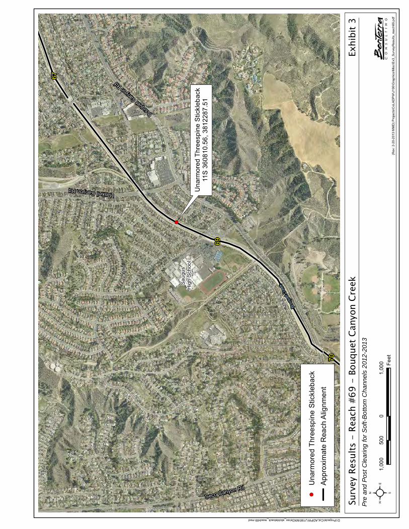
Surv
ey R
esul
ts -
Rea
ch #
69 -
Bou
quet
Can
yon
Cree
kPr
e an
d Po
st C
lear
ing
for S
oft-B
otto
m C
hann
els
2012
-201
3
Exhi
bit 3
(Rev
: 2-2
0-20
13 M
MD
) Pro
ject
s\C
oLAD
PW
\J19
0\G
raph
ics\
Mis
c\E
x3_S
urve
yRes
ults
_rea
ch69
! (
Una
rmor
ed T
hree
spin
e S
tickl
ebac
k11
S 36
0810
.56,
381
2287
.51
69
67
70
Sau
gus
Hig
h S
choo
l
Bouqu
et Can
yon R
d
Haskell Canyon Rd
Seco Canyon Rd
Bouq
uet C
reek
D:\Projects\CoLADPW\J190\MXDs\ex_stickleback_reach69.mxd
1,00
00
1,00
050
0Fe
et²! (
Una
rmor
ed T
hree
spin
e S
tickl
ebac
kA
ppro
xim
ate
Rea
ch A
lignm
ent


Site Photos Exhibit 4APre Clearing Surveys - Sensitive Fish Species
(Rev 02/11/13 MMD) Projects\CoLADPW\J190\Graphics\Misc\Ex4A_SP.pdf
D:\P
roje
cts\
CoL
AD
PW
\J19
0\G
raph
ics\
App
_A1_
SP.
mxd
Bouquet Canyon reach 69, Facing north. Unarmored threespine stickleback (UTS) habitat.
Bouquet Canyon reach 69, facing northeast. Unarmored threespine stickleback habitat.


Site Photos Exhibit 4BPre Clearing Surveys - Sensitive Fish Species
(Rev 02/11/13 MMD) Projects\CoLADPW\J190\Graphics\Misc\Ex4B_SP.pdf
D:\P
roje
cts\
CoL
AD
PW
\J19
0\G
raph
ics\
App
_A2_
SP.
mxd
Bouquet Canyon reach 69, facing south. Unarmored threespine stickleback pool.
Bouquet Canyon reach 69, Facing south. Unarmored threespine stickleback surveyors at pool.


Los Angeles County Soft-Bottom Channels
R:\PAS\Projects\CoLADPW\J208\Appendices\App D\2012 FSR.docx 25 2011 Focused Survey Results
Unarmored threespine stickleback was not observed in Reach 71 during this survey. No water was present in this reach.
3.3.18 REACH 79 – SOUTH FORK – SANTA CLARA RIVER (VALENCIA BOULEVARD BRIDGE STABILIZER)
Project Location
Reach 79, South Fork – Santa Clara River (Valencia Boulevard Bridge Stabilizer), is located within the Santa Clara River-South Fork Watershed (Exhibit 1). The limits of Reach 79 are the downstream edge of Valencia Boulevard to approximately 167 feet downstream of Valencia Boulevard. Reach 79 is 167 feet in total length. The reach is found on the USGS Newhall 7.5-minute quadrangle map (Refer to Thomas Guide, Los Angeles County, page 4550-G3).
Survey Results
The table below summarizes the type of survey completed, the survey date, and the surveying biologists.
TABLE 22REACH 79 – SOUTH FORK – SANTA CLARA RIVER
(VALENCIA BOULEVARD BRIDGE STABILIZER)
Survey Type Survey Date Surveying BiologistsFocused survey for the unarmored
threespine stickleback August 29, 2012 Dr. Carl DemetropoulosDr. Jonathan Baskin
Unarmored threespine stickleback was not observed in Reach 79 during this survey. While some water was present in this reach (< 8 inches), it appeared to come from residential and/or commercial sources and be of marginal quality. Further, use of videography showed no fish of any species in this reach.
3.3.19 REACH 80 – SOUTH FORK – SANTA CLARA RIVER (PDS 1947 AND 1946)
Project Location
Reach 80, South Fork-Santa Clara River (PDs 1947 and 1946), is located in the Santa Clara River-South Fork Watershed (Exhibit 1). The limits of Reach 80 are approximately 3,080 feet upstream of McBean Parkway to approximately 276 feet upstream of McBean Parkway and the confluence with Santa Clara River. Reach 80 is 2,804 feet in total length. The reach is found on the USGS Newhall 7.5-minute quadrangle map (Refer to Thomas Guide, Los Angeles County, page 4550-F2).
Survey Results
The table below summarizes the type of survey completed, the survey date, and the surveying biologist.
TABLE 23REACH 80 – SOUTH FORK – SANTA CLARA RIVER (PDS 1947 AND 1946)
Survey Type Survey Date Surveying BiologistFocused survey for the unarmored
threespine stickleback August 29, 2012 Dr. Carl Demetropoulos

Los Angeles County Soft-Bottom Channels
R:\PAS\Projects\CoLADPW\J208\Appendices\App D\2012 FSR.docx 26 2011 Focused Survey Results
Unarmored threespine stickleback was not observed in Reach 80 during this survey. No water was present in this reach.
3.3.20 REACH 82 – SANTA CLARA RIVER MAIN CHANNEL (PD 2278)
Project Location
Reach 82, Santa Clara River Main Channel (PD 2278), is located in the Santa Clara River Watershed, approximately 0.75 mile east of the I-5 and Magic Mountain Parkway intersection in the City of Santa Clarita (Exhibit 1). The upstream limits of Reach 82 are approximately 740 feet southeast of the intersection of Hopkins Avenue and Rockefeller Avenue to just south of the intersection of Hopkins Avenue and Rockefeller Avenue. Reach 82 is 865 feet in total length. The reach is found on the USGS Newhall 7.5-minute quadrangle map (Refer to Thomas Guide, Los Angeles County, page 4550-D1).
Survey Results
The table below summarizes the type of survey completed, the survey date, and the surveying biologist.
TABLE 24REACH 82 – SANTA CLARA RIVER MAIN CHANNEL (PD 2278)
Survey Type Survey Date Surveying BiologistFocused survey for the unarmored
threespine stickleback September 6, 2012 Dr. Carl Demetropoulos
Unarmored threespine stickleback was not observed in Reach 82 during this survey. No water was present in this reach.
3.3.21 REACH 86 – VIOLIN CANYON MAIN CHANNEL OUTLET
Project Location
Reach 86, Violin Canyon Main Channel Outlet, is located in the Castaic Creek Watershed in the community of Castaic in unincorporated Los Angeles County, approximately 0.5 mile southeast of the I-5 and Lake Hughes Road intersection (Exhibit 1). The limits of Reach 86 are approximately 1,021 feet downstream of Ridge Route Road to the confluence with Castaic Creek. Reach 86 is 946 feet in total length. The reach is found on the USGS Newhall 7.5-minute quadrangle map (Refer to Thomas Guide, Los Angeles County, page 4369-J7).
Survey Results
The table below summarizes the type of survey completed, the survey dates, and the surveying biologist.
TABLE 25REACH 86 – VIOLIN CANYON MAIN CHANNEL OUTLET
Survey Type Survey Date Surveying BiologistFocused survey for the unarmored
threespine stickleback August 29, 2012 Dr. Carl Demetropoulos

Los Angeles County Soft-Bottom Channels
R:\PAS\Projects\CoLADPW\J208\Appendices\App D\2012 FSR.docx 27 2011 Focused Survey Results
Unarmored threespine stickleback was not observed in Reach 86 during this survey. While some water was present in this reach (< 2 inches), it appeared to come from residential and/or commercial sources and to be of marginal quality.
3.3.22 REACH 87 – CASTAIC-OLD ROAD DRAINAGE (CDR 525.021D) OUTLET
Project Location
Reach 87, Castaic – Old Road Drainage (CDR 525.021D) Outlet, is located in the Castaic Creek Watershed, approximately one mile northwest of the I-5 and Henry Mayo Drive (SR-126) in the Castaic Junction community of unincorporated Los Angeles County (Exhibit 1). The limits of Reach 87 are approximately 610 feet downstream of the intersection of Hasley Canyon Road and The Old Road to the confluence with Castaic Creek. Reach 87 is 240 feet in total length. The reach is found on the USGS Newhall 7.5-minute quadrangle map (Refer to Thomas Guide, Los Angeles County, page 4459-H5).
Survey Results
The table below summarizes the type of survey completed, the survey date, and the surveying biologists.
TABLE 26REACH 87 – CASTAIC-OLD ROAD DRAINAGE (CDR 525.021D) OUTLET
Survey Type Survey Date Surveying Biologists
Focused survey for the unarmored threespine stickleback August 29, 2012
Dr. Carl DemetropoulosDr. Jonathan Baskin
Jennifer ParettiNathan Moffett
Unarmored threespine stickleback was not observed in Reach 87 during this survey. While some water was present in this reach (< 3 inches), it appeared to come from residential and/or commercial sources and be of marginal quality.
3.3.23 REACH 97 – CASTAIC CREEK (PD 1982)
Project Location
Reach 97, Castaic Creek (PD 1982), is located within the Castaic Creek Watershed in the Castaic Junction community of unincorporated Los Angeles County (Exhibit 1). The limits of Reach 97 are approximately 300 feet downstream to 2,300 feet downstream of The Old Road. Reach 97 is 2,000 feet in total length. The reach is found on the USGS Newhall 7.5-minute quadrangle maps (Refer to Thomas Guide, Los Angeles County, page 4459-H5 to 4459-H6).

Los Angeles County Soft-Bottom Channels
R:\PAS\Projects\CoLADPW\J208\Appendices\App D\2012 FSR.docx 28 2011 Focused Survey Results
Survey Results
The table below summarizes the type of survey completed, the survey date, and the surveying biologists.
TABLE 27REACH 97 – CASTAIC CREEK (PD 1982)
Survey Type Survey Date Surveying Biologists
Focused survey for the unarmored threespine stickleback August 29, 2012
Dr. Carl DemetropoulosDr. Jonathan Baskin
Jennifer ParettiNathan Moffett
Unarmored threespine stickleback was not observed in Reach 97 during this survey. While water was present in this reach (< 26 inches), it appeared to come mainly from residential and/or commercial sources and be of marginal quality. Underwater videography in deeper areas associated with cement constructed riprap pools, channels, and associated vegetation showed no fish in the reach.
3.3.24 REACH 103 – BOUQUET CANYON CHANNEL (PD 2225)
Project Location
Reach 103, Bouquet Canyon Channel (PD 2225), is located within the Santa Clara River Watershed (Exhibit 1). The limits of Reach 103 are approximately 173 feet downstream of the centerline of Newhall Ranch Road (beginning of Grouted Stone Toe) to the Metropolitan Water District Fee Right-of-Way on the right bank and the embankment turn at the Santa Clara River on the left bank. Reach 103 is 1,824 feet in total length. The reach is found on the USGS Newhall 7.5-minute quadrangle map (Refer to Thomas Guide, Los Angeles County, page 4550-H1, 4550-H2, and 4550-G2).
Survey Results
The table below summarizes the type of survey completed, the survey date, and the surveying biologists.
TABLE 28REACH 103 – BOUQUET CANYON CHANNEL (PD 2225)
Survey Type Survey Date Surveying BiologistsFocused survey for the unarmored
threespine stickleback September 5, 2012 Dr. Carl Demetropoulos Dr. Jonathan Baskin
Unarmored threespine stickleback was not observed in Reach 103 during this survey. Very little water was present in the reach. Further, use of videography showed no fish of any species in this reach. However, unarmored threespine stickleback were previously found in this reach in 2005, 2006, 2007 and 2008 (BonTerra Consulting 2005, 2006, 2007, 2008).

Los Angeles County Soft-Bottom Channels
R:\PAS\Projects\CoLADPW\J208\Appendices\App D\2012 FSR.docx 29 2011 Focused Survey Results
3.3.25 REACH 104 – CASTAIC CREEK (PD 2441 – UNITS 1 AND 2)
Project Location
Reach 104, Castaic Creek (PD 2441 – Unit 2), is located in the Castaic Creek Watershed. The limits of Reach 104 are approximately 669 feet upstream of the Muirfield Lane Centerline to 478 feet downstream of the Turnberry Lane Centerline (Exhibit 1). Reach 104 is 2,186 feet in total length. The reach is found on the USGS Newhall 7.5-minute quadrangle map (Refer to Thomas Guide, Los Angeles County, page 4459- H6 to 4459-H7).
Survey Results
The table below summarizes the type of survey completed, the survey date, and the surveying biologist.
TABLE 29REACH 104 – CASTAIC CREEK (PD 2441 �� UNIT 2)
Survey Type Survey Date Surveying BiologistFocused survey for the unarmored
threespine stickleback September 5, 2012 Dr. Carl Demetropoulos
Unarmored threespine stickleback was not observed in Reach 104 during this survey. Very little water was present in the reach.
3.3.26 REACH 105 � SAN FRANCISQUITO CHANNEL (PD 2456)
Project Location
Reach 105, San Francisquito Channel (PD 2456), is located in the Santa Clara River Watershed in unincorporated Los Angeles County (Exhibit 1). The limits of Reach 105 are approximately 417 feet upstream of the Decoro Drive Centerline to 416 feet downstream of the Decoro Drive Centerline. Reach 105 is 833 feet in total length. The reach is found on the USGS Newhall 7.5-minute quadrangle map (Refer to Thomas Guide, Los Angeles County, page 4460-F6).
Survey Results
The table below summarizes the type of survey completed, the survey date, and the surveying biologist.
TABLE 30REACH 105 � SAN FRANCISQUITO CHANNEL (PD 2456)
Survey Type Survey Date Surveying BiologistFocused survey for the unarmored
threespine stickleback September 5, 2012 Dr. Carl Demetropoulos
Unarmored threespine stickleback was not observed in Reach 105 during this survey. No water was present in the reach.

Los Angeles County Soft-Bottom Channels
R:\PAS\Projects\CoLADPW\J208\Appendices\App D\2012 FSR.docx 30 2011 Focused Survey Results
3.3.27 REACH 109 – SANTA CLARA RIVER – SOUTH BANK WEST OF MCBEAN PARKWAY (MTD 1510)
Project Location
Reach 109, Santa Clara River – South Bank West of McBean Parkway (MTD 1510), is an outlet located on the south bank (concrete levee), just west or downstream of McBean Parkway (Exhibit 1). The limits of Reach 109 are from the outlet, approximately 300 feet downstream of the McBean Parkway centerline, downstream 371 feet (Exhibit 3). The reach is found on the USGS Newhall 7.5-minute quadrangle map (Refer to Thomas Guide, Los Angeles County, page 4550-E2).
Survey Results
The table below summarizes the type of survey completed, the survey date, and the surveying biologist.
TABLE 31REACH 109 – SANTA CLARA RIVER – SOUTH BANK WEST OF MCBEAN
PARKWAY (MTD 1510)
Survey Type Survey Date Surveying BiologistFocused survey for the unarmored
threespine stickleback September 5, 2012 Dr. Carl Demetropoulos
Unarmored threespine stickleback was not observed in Reach 109 during this survey. No water was present in the reach. However, unarmored threespine stickleback were previously found in this reach in 2009, 2010, and 2011 (BonTerra Consulting 2009, 2010, 2011).

Los Angeles County Soft-Bottom Channels
R:\PAS\Projects\CoLADPW\J208\Appendices\App D\2012 FSR.docx 31 2011 Focused Survey Results
SECTION 4.0 REFERENCES
Baskin, J.N. and M.A. Bell. 1976. Unarmored Threespine Stickleback Survey and Report (Report for the U.S. Dept. Agr. Forest Service Contract No. 39-5495).
Bell, M.A. 1981. Lateral plate polymorphism and ontogeny of the complete morph of threespine sticklebacks (Gasterosteus aculeatus). Evolution 35: 67–74. Lawrence, KS: Allen Press, Inc.
———. 1976. The Evolution of Phenotypic Diversity in Threespine Sticklebacks (Gasterosteus aculeatus) (Ph.D. dissertation for the University of California, Los Angeles).
———. 1975. The Distribution and Systematics of the Unarmored Threespine Stickleback, Gasterosteus aculeatus williamsoni (Girard), in the Santa Clara River System (Unpublished Report for the California Department of Fish and Game,2 Contract No. AB-23).
BonTerra Consulting. 2011 (August). 2011 Focused Survey Results: Los Angeles County Soft-Bottom Channels. Pasadena, CA: BonTerra Consulting (Appendix E).
———. 2010 (October). Los Angeles County Soft Bottom Channels: 2010 Focused Survey Results . Pasadena, CA: BonTerra Consulting.
———. 2009 (November). 2009 Focused Survey Results: Los Angeles County Soft-Bottom Channels. Pasadena, CA: BonTerra Consulting.
———. 2008 (October). Los Angeles County Soft Bottom Channels: 2008 Focused Survey Results . Pasadena, CA: BonTerra Consulting.
———. 2007 (November). Los Angeles County Soft Bottom Channels: 2007 Focused Survey Results. Pasadena, CA: BonTerra Consulting.
———. 2006 (October). Los Angeles County Soft Bottom Channels: 2006 Focused Survey Results. Pasadena, CA: BonTerra Consulting.
———. 2005 (August). Los Angeles County Soft Bottom Channels: 2005 Focused Survey Results. Pasadena, CA: BonTerra Consulting.
———.2003 (October). Los Angeles County Soft Bottom Channels: 2003 Focused Survey Results. Pasadena, CA: BonTerra Consulting.
———. 2002 (September). Los Angeles Channels Focused Survey Results. Pasadena, CA: BonTerra Consulting.
———. 1999 (August). Los Angeles County Channel Maintenance Project Initial Study. Costa Mesa, CA: BonTerra Consulting.
California Department of Fish and Game (CDFG). 2013 (January). State & Federally Listed Endangered & Threatened Animals of California. Sacramento, CA: CDFG, Natural Heritage Division. http://www.dfg.ca.gov/biogeodata/cnddb/pdfs/TEAnimals.pdf.
2 The California Department of Fish and Game (CDFG) changed its name to the California Department of Fish and Wildlife (CDFW) effective January 1, 2013.

Los Angeles County Soft-Bottom Channels
R:\PAS\Projects\CoLADPW\J208\Appendices\App D\2012 FSR.docx 32 2011 Focused Survey Results
———. 2012 California Natural Diversity Database. Records of Occurrence for the USGS Sunland, San Fernando, Torrance, Point Dume, Azusa, Baldwin Park, Whittier, Newhall, and Val Verde 7.5-minute quadrangles. Sacramento, CA: CDFG, Natural Heritage Division.
California Resources Agency, San Gabriel and Lower Los Angeles Rivers and Mountains Conservancy, and Santa Monica Mountains Conservancy (CRA et al.). 2001 (October). Common Ground from the Mountains to the Sea: Watershed and Open Space Plan San Gabriel and Los Angeles Rivers. Alhambra, CA: Rivers and Mountains Conservancy. http://www.rmc.ca.gov/plans/common_ground/Common%20Ground.pdf.
Culver, G.B. and C.L. Hubbs. 1917. The Fishes of the Santa Ana System of Streams in Southern California. Lorquinia 1:82–83. Los Angeles, CA., Lorquin Natural History Club.
England and Nelson Environmental Consultants. 1976. Los Angeles County Significant Ecological Area Study (Prepared for Los Angeles County, Department of Regional Planning and Environmental Systems Research Institute). Riverside, CA: England and Nelson Environmental Consultants.
Girard, C. 1854. Descriptions of New Fishes, Collected by Dr. A.L. Heermann, Naturalist Attached to the Survey of The Pacific Railroad Route, Under Lieut. R.S. Williamson, U.S.A. Proceedings of the Academy of Natural Sciences of Philadelphia 7:129–140, Philadelpha, PA, The Academy of Natural Sciences of Philadelphia.
Haglund, T.R. 2011 (December 12). Personal communiation. Phone call between T.R. Haglund and C. Demetropoulos regarding Santa Ana sucker feeding habits.
———.1981. Differential Reproduction Among the Lateral Plate Phenotypes of Gasterosteus aculeatus, the Threespine Stickleback (PhD Dissertation for the University of California, Los Angeles).
Irwin, J.F. and D.L. Soltz. 1982. The Distribution and Natural History of the Unarmored Threespine Stickleback, Gasterosteus aculeatus williamsoni (Girard), in San Antonio Creek, California (an Unpublished Report prepared for the U.S. Fish and Wildlife Service, Endangered Species Office, Sacramento, CA).
Los Angeles, County of Department of Public Works (LACDPW). 2002. Los Angeles River Watershed. Los Angeles, CA: LACDPW. http://ladpw.org/wmd/watershed/LA/
Los Angeles Regional Water Quality Control Board (RWQCB). 1999. Conditional Certification Under Clean Water Act (CWA) Section 401: Maintenance Clearing for 100 Reaches of Engineered Earth-Bottom Flood Control Channels, Various Watersheds Within Los Angeles County (File No. 99-011). Los Angeles, CA: RWQCB.
Miller, R.R. and C.L. Hubbs. 1969. Systematics of Gasterosteus aculeatus, with Particular Reference to Intergradation and Introgression Along the Pacific Coast of North America: A Commentary on a Recent Contribution. Copeia 1969: 52–69. Miami, FL: American Society of Ichthyologists and Herpetologists.
Moyle, P.B. 2001. Inland Fishes of California (2nd ed.). Berkeley, CA: University of California Press.
Ono, R.D., J.D. Williams, and A. Wagner. 1983. Vanishing Fishes of North America.Washington, D.C.: Stone Wall Press.

Los Angeles County Soft-Bottom Channels
R:\PAS\Projects\CoLADPW\J208\Appendices\App D\2012 FSR.docx 33 2011 Focused Survey Results
Swift, C.C., T.R. Haglund, M. Ruiz, and R.N. Fisher. 1993. The Status and Distribution of the Freshwater fishes of Southern California. Bulletin of the Southern California Academy of Sciences 92:101–167. Los Angeles, CA: Southern California Academy of Sciences.
Thompson, A.R., J.N. Baskin, J.N, C.C. Swift, T.R. Haglund, R. Nagel. 2010. Influence of habitat dynamics on the distribution and abundance of the federally threatened Santa Ana Sucker, Catostomus santaanae, in the Santa Ana River. Environmental Biology of Fishes. 87 (4): 321 - 332.
U.S. Fish and Wildlife Service (USFWS). 2010 (December 14). Endangered and Threatened Wildlife and Plants; Revised Critical Habitat for Santa Ana Sucker; Final Rule. FederalRegister 75(239): 77961–78027. Washington, D.C.: USFWS.
———. 1985. Unarmored Threespine Stickleback Recovery Plan (Revised). Portland, OR: USFWS.
———. 1980 (November 17). Proposed Designation of Critical Habitat for Endangered Unarmored Threespine Stickleback. Federal Register 45(223): 76012–76015. Washington, D.C.: USFWS.
U.S. Fish and Wildlife Service (USFWS) and National Marine Fisheries Service (NMFS). 1998 (March). Endangered Species Consultation Handbook: Procedures for Conducting Consultation and Conference Activities Under Section 7 of the Endangered Species Act. Washington, D.C.: USFWS and NMFS. http://www.fws.gov/endangered/esa-library/ pdf/esa_section7_handbook.pdf.
Wootton, R.J. 1976. The Biology of Sticklebacks. London, England: Academic Press.

Los Angeles County Soft-Bottom Channels
R:\PAS\Projects\CoLADPW\J208\Appendices\App D\2012 FSR.docx 34 2011 Focused Survey Results
This page intentionally left blank

APPENDIX A
SURVEYOR CERTIFICATE STATEMENT


APPENDIX B
CALIFORNIA NATURAL DIVERSITY DATABASE (CNDDB) FIELD SURVEY FORM


APPENDIX C
CALIFORNIA NATURAL DIVERSITY DATABASE (CNDDB) SEARCH RESULTS

Map Index Number: 02738 EO Index: 14835
Key Quad: Glendora (3411727) Element Code: AFCJC02190
Occurrence Number: 2 Occurrence Last Updated: 2010-11-19
Scientific Name: Catostomus santaanae Common Name: Santa Ana sucker
Listing Status: Federal: Threatened Rare Plant Rank:
State: None
CNDDB Element Ranks: Global: G1
State: S1
Other Lists: AFS_TH-ThreatenedCDFW_SSC-Species of Special ConcernIUCN_VU-Vulnerable
General Habitat: Micro Habitat:
ENDEMIC TO LOS ANGELES BASIN SOUTH COASTAL STREAMS. HABITAT GENERALISTS, BUT PREFER SAND-RUBBLE-BOULDER BOTTOMS, COOL, CLEAR WATER, & ALGAE.
Last Date Observed: 2006-08-XX Occurrence Type: Natural/Native occurrence
Last Survey Date: 2006-08-XX Occurrence Rank: Good
Owner/Manager: USFS-ANGELES NF Trend: Unknown
Presence: Presumed Extant
Location:
EAST FORK SAN GABRIEL RIVER (EFSGR) & CATTLE CANYON/CREEK (CC).Detailed Location:
S1 = EFSGR, E SIDE OF CAMP OAK GROVE. S2 = EFSGR AT COYOTE FLAT. S3 = EFSGR ABOUT 0.7 MI N OF COYOTE FLAT. S4 = CC NEAR JUNCTION WITH DIME CANYON. EFSGR-N = EFSGR NORTH OF CC. SWIFT OBS THROUGHOUT EFSGR & CC. ALSO SEE OCC#3 FOR SKI OBS.Ecological:
MONTANE STREAM WITH COBBLE, BOULDERS, GRAVEL. OVERHANGING TREE CANOPY OF WILLOWS, ALDERS, AND MISC OTHERS. SKIDMORE MARKED HABITAT AS 'GOOD,' CHAPMAN, MARTIN & SAIKI MARKED IT AS 'EXCELLENT.'Threats:
TUNGSTEN MINE MAY THREATEN HABITAT. MAN MADE DAMS FOR MINING. 2003: 2002 FIRE & THEN RAINY SEASON. 2006: OHV.General:
'75: OBS IN CC & EFSGR-N. '97: 236 OBS IN EFSGR & 107 IN CC. '99: 369 OBS AT S2 & 164 AT S3. '00-'02: 300+ OBS AT HEATON FLAT. '03: 9 OBS AT S1, 22 AT S2 & 4 AT S4. '04: 376 OBS AT S1. '06: 16,496 OBS IN EF&WFSGR (SKI).
PLSS: T02N, R09W (S) Accuracy: specific area Area (acres): 852
2,000Elevation (feet):Latitude/Longitude: 34.25100 / -117.75914UTM: Zone-11 N3790247 E430101
Los Angeles Mt. Baldy (3411726), Glendora (3411727), Mount San Antonio (3411736), Crystal Lake (3411737)
Quad Summary:County Summary:
Report Printed on Tuesday, February 12, 2013
Page 1 of 31Commercial Version -- Dated February, 5 2013 -- Biogeographic Data Branch
Information Expires 8/5/2013
Occurrence ReportCalifornia Department of Fish and ��������
California Natural Diversity Database

Sources:ALL04R0001 ALLY, J.R. RAYMOND (CALIFORNIA DEPARTMENT OF FISH AND WILDLIFE) - RESULTS OF ELECTROFISHING SURVEYS DONE IN
THE SAN GABRIEL RIVER (WEST, NORTH AND EAST FORKS) AND TRIBUTARIES OF BEAR CREEK AND CATTLE CANYON DURING JUNE AND JULY 2003. 2004-03-30
CHA04F0050 CHAPMAN, TODD (CHAMBERS GROUP, INC.) - FIELD SURVEY FORM FOR CATOSTOMUS SANTAANAE 2004-05-02
CHA04F0063 CHAPMAN, TODD (CHAMBERS GROUP, INC.) - FIELD SURVEY FORM FOR CATOSTOMUS SANTAANAE 2004-10-10
CHA04F0064 CHAPMAN, TODD (CHAMBERS GROUP, INC.) - FIELD SURVEY FORM FOR CATOSTOMUS SANTAANAE 2004-10-10
CSU83U0002 CSUTI, BLAIR - TNC ELEMENT PRESERVATION PLAN WRITTEN BY B. CSUTI WITH EDITORIAL COMMENTS BY CAMM SWIFT. 1983-08-09
DFG97R0001 CALIFORNIA DEPARTMENT OF FISH & GAME - MEMO, REGION 5: WITH SUBJECT "FISH SURVEY ON THE EAST FORK OF THE SAN GABRIEL RIVER (EFSGR) AND CATTLE CREEK." 1997-08-20
HAG02R0001 HAGLUND, T. & J. BASKIN (CALIFORNIA STATE POLYTECHNIC UNIVERSITY, POMONA) - HABITAT AND RESOURCE UTILIZATION BY THE SANTA ANA SUCKER (CATOSTOMUS SANTANNAE) AND THE SANTA ANA SPECKLED DACE (RHINICHTHYS OSCULUS SSP) IN THE EAST FORK OF THE SAN GABRIEL RIVER 2002-01-21
MAR99F0019 MARTIN, BARBARA (U.S. GEOLOGICAL SURVEY) - FIELD SURVEY FORM FOR CATOSTOMUS SANTAANAE 1999-09-14
MAR99F0020 MARTIN, BARBARA (U.S. GEOLOGICAL SURVEY) - FIELD SURVEY FORM FOR CATOSTOMUS SANTAANAE 1999-09-15
MAR99F0021 MARTIN, BARBARA (U.S. GEOLOGICAL SURVEY) - FIELD SURVEY FORM FOR CATOSTOMUS SANTAANAE 1999-12-14
MAR99F0022 MARTIN, BARBARA (U.S. GEOLOGICAL SURVEY) - FIELD SURVEY FORM FOR CATOSTOMUS SANTAANAE 1999-12-15
SAI98F0002 SAIKI, MICHAEL K. (U.S. GEOLOGICAL SURVEY) - 2 FIELD SURVEY FORMS FOR CATOSTOMUS SANTAANAE (SANTA ANA SUCKER) [BOTH FORMS FROM DECEMBER] 1998-12-17
SAI99F0003 SAIKI, MICHAEL K. (U.S. GEOLOGICAL SURVEY) - 4 FIELD SURVEY FORMS FOR CATOSTOMUS SANTAANAE (SANTA ANA SUCKER) [2 FORMS FROM MARCH AND 2 FROM JUNE] 1999-06-18
SKI06F0003 SKIDMORE, S. (CHAMBERS GROUP, INC.) - FIELD SURVEY FORM FOR CATOSTOMUS SANTAANAE 2006-06-13
SWI83M0001 SWIFT, CAMM - PARTIAL DISTRIBUTION MAPS FOR CATOSTOMUS SANTAANAE - WITH CORRECTIONS 1983-08-XX
WEL75R0001 WELLS, A.W. & J.S. DIANA (CALIFORNIA STATE UNIVERSITY, LONG BEACH) - SURVEY OF THE FRESHWATER FISHES AND THEIR HABITATS IN THE COASTAL DRAINAGES OF SOUTHERN CALIFORNIA. 1975-XX-XX
Report Printed on Tuesday, February 12, 2013
Page 2 of 31Commercial Version -- Dated February, 5 2013 -- Biogeographic Data Branch
Information Expires 8/5/2013
Occurrence ReportCalifornia Department of Fish and ��������
California Natural Diversity Database

Map Index Number: 75007 EO Index: 28610
Key Quad: Azusa (3411728) Element Code: AFCJC02190
Occurrence Number: 3 Occurrence Last Updated: 2010-05-06
Scientific Name: Catostomus santaanae Common Name: Santa Ana sucker
Listing Status: Federal: Threatened Rare Plant Rank:
State: None
CNDDB Element Ranks: Global: G1
State: S1
Other Lists: AFS_TH-ThreatenedCDFW_SSC-Species of Special ConcernIUCN_VU-Vulnerable
General Habitat: Micro Habitat:
ENDEMIC TO LOS ANGELES BASIN SOUTH COASTAL STREAMS. HABITAT GENERALISTS, BUT PREFER SAND-RUBBLE-BOULDER BOTTOMS, COOL, CLEAR WATER, & ALGAE.
Last Date Observed: 2006-08-XX Occurrence Type: Natural/Native occurrence
Last Survey Date: 2006-08-XX Occurrence Rank: Good
Owner/Manager: USFS-ANGELES NF Trend: Unknown
Presence: Presumed Extant
Location:
N FORK SAN GABRIEL RIVER, W FORK SAN GABRIEL RIVER, FROM 1 KM BELOW MOUTH OF E FORK, & BEAR CREEK (BC), ANGELES NF.Detailed Location:
S1=WFSGR @ BEAR CREEK. S2=WFSGR JUST WEST OF LITTLE MERMAIDS CYN. S3=WFSGR BETWEEN NFSGR & RESERVOIR. S4=WFSGR @ GLEN CAMPGROUND. S5=BC NEAR WFSGR. S6=BC 1.6KM ABOVE WFSGR. S7=BC AT WEST FORK BC. S8=NFSGR 1.1 MI N OF WFSGR.Ecological:
1975: RIPARIAN OF ALDER, WILLOW, & OAK. 1999: RIPARIAN W/ POPULUS, PLATANUS RACEMOSA & SALIX. 2003: STREAM VARIES FROM WIDE/SHALLOW TO NARROW/DEEP. ASSOC W/ SPECKLED DACE, RAINBOW TROUT N FORK; ASSOC W/ RAINBOW TROUT, BLACK BULLHEAD W FORK.Threats:
POLLUTION & HUMAN RECREATION. LOW RAINFALL IN 2001-02. 2 WILDFIRES IN 2002 THEN HEAVY RAIN. BASS. 2006: OHV.General:
1974: 4 OBS AT S4. 45 OBS IN '75. '99: 3 @ S1. '00: UNK # AT S3 & MANY JUV'S @ E FORK BRIDGE. '01: 15 @ S1. '02: 600+ LARV, JUV'S & YOY MOUTH OF W& E FORKS TO HWY 39. '03: 545 @ MULT STATIONS. '04: 74 AT S1. '06:16,496 AT EF&WFSGR (OCC#2).
PLSS: T02N, R10W, Sec. 22 (S) Accuracy: specific area Area (acres): 1,293
1,600Elevation (feet):Latitude/Longitude: 34.24265 / -117.91970UTM: Zone-11 N3789444 E415308
Los Angeles Glendora (3411727), Azusa (3411728), Crystal Lake (3411737), Waterman Mtn. (3411738)
Quad Summary:County Summary:
Report Printed on Tuesday, February 12, 2013
Page 3 of 31Commercial Version -- Dated February, 5 2013 -- Biogeographic Data Branch
Information Expires 8/5/2013
Occurrence ReportCalifornia Department of Fish and ��������
California Natural Diversity Database

Sources:ALL00F0001 ALLY, J.R. RAYMOND (CALIFORNIA DEPARTMENT OF FISH AND WILDLIFE) - FIELD SURVEY FORM FOR CATOSTOMUS
SANTAANAE (SANTA ANA SUCKER) 2000-05-09ALL04R0001 ALLY, J.R. RAYMOND (CALIFORNIA DEPARTMENT OF FISH AND WILDLIFE) - RESULTS OF ELECTROFISHING SURVEYS DONE IN
THE SAN GABRIEL RIVER (WEST, NORTH AND EAST FORKS) AND TRIBUTARIES OF BEAR CREEK AND CATTLE CANYON DURING JUNE AND JULY 2003. 2004-03-30
CHA01F0011 CHAPMAN, T. (CHAMBERS GROUP, INC.) - FIELD SURVEY FORM FOR CATOSTOMUS SANTAANAE 2001-08-25
CHA03F0006 CHAPMAN, T. (CHAMBERS GROUP, INC.) - FIELD SURVEY FORM FOR CATOSTOMUS SANTAANAE 2003-08-02
CHA03F0007 CHAPMAN, T. (CHAMBERS GROUP, INC.) - FIELD SURVEY FORM FOR CATOSTOMUS SANTAANAE 2003-08-02
CHA03F0014 CHAPMAN, T. (CHAMBERS GROUP, INC.) - FIELD SURVEY FORM FOR CATOSTOMUS SANTAANAE 2003-11-02
CHA03F0015 CHAPMAN, T. (CHAMBERS GROUP, INC.) - FIELD SURVEY FORM FOR CATOSTOMUS SANTAANAE 2003-11-02
CHA04F0049 CHAPMAN, T. (CHAMBERS GROUP, INC.) - FIELD SURVEY FORM FOR CATOSTOMUS SANTAANAE 2004-05-01
CHA04F0061 CHAPMAN, T. (CHAMBERS GROUP, INC.) - FIELD SURVEY FORM FOR CATOSTOMUS SANTAANAE 2004-10-09
CHA04F0062 CHAPMAN, T. (CHAMBERS GROUP, INC.) - FIELD SURVEY FORM FOR CATOSTOMUS SANTAANAE 2004-10-09
CSU83U0002 CSUTI, BLAIR - TNC ELEMENT PRESERVATION PLAN WRITTEN BY B. CSUTI WITH EDITORIAL COMMENTS BY CAMM SWIFT. 1983-08-09
DAV99F0007 DAVIS, N. & D. SOLTZ - FIELD SURVEY FORM FOR CATOSTOMUS SANTAANAE (SANTA ANA SUCKER) 1999-10-30
SKI06F0003 SKIDMORE, S. (CHAMBERS GROUP, INC.) - FIELD SURVEY FORM FOR CATOSTOMUS SANTAANAE 2006-06-13
SWI09R0001 SWIFT, C. (ENTRIX, INC.) - ESA RECOVERY PERMIT TE-793644-6 2008 ANNUAL REPORT 2009-03-19
SWI83M0002 SWIFT, C. - PARTIAL DISTRIBUTION MAPS FOR CATOSTOMUS SANTAANAE - WITH CORRECTIONS 1983-08-XX
SWI83M0003 SWIFT, C. - PARTIAL DISTRIBUTION MAPS FOR CATOSTOMUS SANTAANAE - WITH CORRECTIONS 1983-08-XX
SWI83M0004 SWIFT, C. - PARTIAL DISTRIBUTION MAPS FOR CATOSTOMUS SANTAANAE - WITH CORRECTIONS 1983-08-XX
TEN01U0001 TENNANT, P. - RESULT OF SURVEYS CONDUCTED FOR THE SANTA ANA SUCKER ON THE SAN GABRIEL RIVER, AUGUST 25 AND 26 2001. 2001-10-06
WEL75R0001 WELLS, A.W. & J.S. DIANA (CALIFORNIA STATE UNIVERSITY, LONG BEACH) - SURVEY OF THE FRESHWATER FISHES AND THEIR HABITATS IN THE COASTAL DRAINAGES OF SOUTHERN CALIFORNIA. 1975-XX-XX
Report Printed on Tuesday, February 12, 2013
Page 4 of 31Commercial Version -- Dated February, 5 2013 -- Biogeographic Data Branch
Information Expires 8/5/2013
Occurrence ReportCalifornia Department of Fish and ��������
California Natural Diversity Database

Sources:CSU83U0002 CSUTI, BLAIR - TNC ELEMENT PRESERVATION PLAN WRITTEN BY B. CSUTI WITH EDITORIAL COMMENTS BY CAMM SWIFT. 1983
-08-09SWI83M0007 SWIFT, C. - PARTIAL DISTRIBUTION MAPS FOR CATOSTOMUS SANTAANAE 1983-08-XX
WEL75R0001 WELLS, A.W. & J.S. DIANA (CALIFORNIA STATE UNIVERSITY, LONG BEACH) - SURVEY OF THE FRESHWATER FISHES AND THEIR HABITATS IN THE COASTAL DRAINAGES OF SOUTHERN CALIFORNIA. 1975-XX-XX
Map Index Number: 00850 EO Index: 28607
Key Quad: Val Verde (3411846) Element Code: AFCJC02190
Occurrence Number: 6 Occurrence Last Updated: 2009-05-13
Scientific Name: Catostomus santaanae Common Name: Santa Ana sucker
Listing Status: Federal: Threatened Rare Plant Rank:
State: None
CNDDB Element Ranks: Global: G1
State: S1
Other Lists: AFS_TH-ThreatenedCDFW_SSC-Species of Special ConcernIUCN_VU-Vulnerable
General Habitat: Micro Habitat:
ENDEMIC TO LOS ANGELES BASIN SOUTH COASTAL STREAMS. HABITAT GENERALISTS, BUT PREFER SAND-RUBBLE-BOULDER BOTTOMS, COOL, CLEAR WATER, & ALGAE.
Last Date Observed: 1975-07-12 Occurrence Type: Natural/Native occurrence
Last Survey Date: 1975-07-12 Occurrence Rank: Unknown
Owner/Manager: PVT Trend: Unknown
Presence: Presumed Extant
Location:
HASLEY CANYON 3.2 KM EAST OF VAL VERDE, SANTA CLARA RIVER DRAINAGE.Detailed Location:
WELLS LOCATION AT STATION 5, HASLEY CANYON 3.2 KM E OF VAL VERDE, T04N R17W S11. ALSO CITED IN CSU & MAPPED IN SWI. MAP WITH LOCATION PROVIDED IN ALL THREE SOURCES.Ecological:
BANK PLANTS ARE WILLOW, SALT CEDAR & COTTONWOOD.Threats:
General:
1 CAPTURED ON 12 JUL 1975.
PLSS: T04N, R17W, Sec. 11 (S) Accuracy: nonspecific area Area (acres): 51
1,120Elevation (feet):Latitude/Longitude: 34.44940 / -118.63052UTM: Zone-11 N3813192 E350214
Los Angeles Newhall (3411845), Val Verde (3411846)
Quad Summary:County Summary:
Report Printed on Tuesday, February 12, 2013
Page 5 of 31Commercial Version -- Dated February, 5 2013 -- Biogeographic Data Branch
Information Expires 8/5/2013
Occurrence ReportCalifornia Department of Fish and ��������
California Natural Diversity Database

Sources:CSU83U0002 CSUTI, BLAIR - TNC ELEMENT PRESERVATION PLAN WRITTEN BY B. CSUTI WITH EDITORIAL COMMENTS BY CAMM SWIFT. 1983
-08-09LAC02S0003 LACM - LOS ANGELES COUNTY MUSEUM FISH COLLECTION RECORDS FOR CATOSTOMUS SANTAANAE COLLECTED IN 2002.
2002-05-08SWI09R0001 SWIFT, C. (ENTRIX, INC.) - ESA RECOVERY PERMIT TE-793644-6 2008 ANNUAL REPORT 2009-03-19
SWI83M0005 SWIFT, C. - PARTIAL DISTRIBUTION MAPS FOR CATOSTOMUS SANTAANAE - WITH CORRECTIONS 1983-08-XX
SWI93R0001 SWIFT, C., T. HAGLUND, M. RUIZ & R. FISHER - THE STATUS AND DISTRIBUTION OF THE FRESHWATER FISHES OF SOUTHERN CALIFORNIA. BULLETIN OF THE SOUTHERN CALIFORNIA ACADEMY OF SCIENCE 92(3):101-167. 1993-12-XX
WEL75R0001 WELLS, A.W. & J.S. DIANA (CALIFORNIA STATE UNIVERSITY, LONG BEACH) - SURVEY OF THE FRESHWATER FISHES AND THEIR HABITATS IN THE COASTAL DRAINAGES OF SOUTHERN CALIFORNIA. 1975-XX-XX
Map Index Number: 01933 EO Index: 14836
Key Quad: Sunland (3411833) Element Code: AFCJC02190
Occurrence Number: 7 Occurrence Last Updated: 2010-05-19
Scientific Name: Catostomus santaanae Common Name: Santa Ana sucker
Listing Status: Federal: Threatened Rare Plant Rank:
State: None
CNDDB Element Ranks: Global: G1
State: S1
Other Lists: AFS_TH-ThreatenedCDFW_SSC-Species of Special ConcernIUCN_VU-Vulnerable
General Habitat: Micro Habitat:
ENDEMIC TO LOS ANGELES BASIN SOUTH COASTAL STREAMS. HABITAT GENERALISTS, BUT PREFER SAND-RUBBLE-BOULDER BOTTOMS, COOL, CLEAR WATER, & ALGAE.
Last Date Observed: 2007-05-10 Occurrence Type: Natural/Native occurrence
Last Survey Date: 2007-05-10 Occurrence Rank: Poor
Owner/Manager: USFS-ANGELES NF, PVT Trend: Decreasing
Presence: Presumed Extant
Location:
BIG TUJUNGA CREEK & PART OF HAINES CREEK, FROM HANSEN DAM E TO DELTA FLAT, N OF SUNLAND, LOS ANGELES COUNTY.Detailed Location:
SWIFT: SPECIES COLLECTED AT HANSEN DAM IN 1972. 2001-06: TUJUNGA CRK @ FOOTHILL BRIDGE DOWNSTREAM TO JUNCTION WITH HAINES CREEK. 1999-2007: HAINES CREEK AND OUTLET STREAMS OF PONDS N OF HAINES CREEK, SW OF I-215 - NO FISH FOUND IN PONDS.Ecological:
BANK VEGETATION IS ALNUS SP. AQUATIC VEGETATION OF CHARA & POTOMOGETON. ALSO FILAMENTOUS GREEN ALGAE IN PLACES. LOWER REACH DRIES EVERY YEAR.Threats:
General:
1975: 15 FISH @ HANSEN DAM. FISH OBS IN '83. 5-7 ADULTS, 200 LARV & 1 JUV 18 MAY 2001. 12 FISH 1.5 KM S OF I-210 ON 8 MAY '02. 15 ADULTS & 50+ LARV APR '03. 0 OBS IN FOOTHILL POOL '06. 2001-06: SUCKERS COMMON IN HAINES CREEK, NONE IN PONDS.
PLSS: T02N, R14W, Sec. 11 (S) Accuracy: nonspecific area Area (acres): 634
1,200Elevation (feet):Latitude/Longitude: 34.27299 / -118.31712UTM: Zone-11 N3793210 E378752
Los Angeles Sunland (3411833), San Fernando (3411834)
Quad Summary:County Summary:
Report Printed on Tuesday, February 12, 2013
Page 6 of 31Commercial Version -- Dated February, 5 2013 -- Biogeographic Data Branch
Information Expires 8/5/2013
Occurrence ReportCalifornia Department of Fish and ��������
California Natural Diversity Database

Map Index Number: 00497 EO Index: 13484
Key Quad: Piru (3411847) Element Code: AFCJC02190
Occurrence Number: 9 Occurrence Last Updated: 2010-05-03
Scientific Name: Catostomus santaanae Common Name: Santa Ana sucker
Listing Status: Federal: Threatened Rare Plant Rank:
State: None
CNDDB Element Ranks: Global: G1
State: S1
Other Lists: AFS_TH-ThreatenedCDFW_SSC-Species of Special ConcernIUCN_VU-Vulnerable
General Habitat: Micro Habitat:
ENDEMIC TO LOS ANGELES BASIN SOUTH COASTAL STREAMS. HABITAT GENERALISTS, BUT PREFER SAND-RUBBLE-BOULDER BOTTOMS, COOL, CLEAR WATER, & ALGAE.
Last Date Observed: 2007-10-09 Occurrence Type: Natural/Native occurrence
Last Survey Date: 2007-10-09 Occurrence Rank: Good
Owner/Manager: PVT Trend: Unknown
Presence: Presumed Extant
Location:
SANTA CLARA RVR FROM SANTA PAULA TO VALENCIA, 9MI OF SESPEE CRK, PIRU CRK S OF LAKE, & CASTAIC CRK FROM 126 TO COMMERCE.Detailed Location:
FAW: "SESPE CRK AT RR CROSSING." WEL STATIONS WITH OBS: #4-5, 7-12, 28-29 & 31. LACM: "SANTA CLARA RIVER @ FILLMORE" & "SANTA CLARA RIVER BETWEEN HWY23 & SESPE CRK." COU05F05: "CASTAIC CRK U/S OF HWY 126 & D/S OF COMMERCE CENTER BRIDGE."Ecological:
HYBRIDIZES W/OWENS SUCKER IN LOWER PARTS OF DRAINAGE (S OF FILMORE).Threats:
General:
18 OBS AT STATION #8 & 14 AT #4 IN JUL '75 (WEL/CSU).4 OBS IN '92. 2 OBS IN '96, 22 IN '97, 455 IN '98, 1 IN '99. 51 IN 2000. 60 PIT IN DEC '00. 80 COLL IN '03; DEP @ LACM. 1 OBS IN '04 & 111 IN '05. COMMON OBS IN '07. 39 DEAD OBS OCT '07.
PLSS: T04N, R18W, Sec. 29 (S) Accuracy: nonspecific area Area (acres): 3,770
650Elevation (feet):Latitude/Longitude: 34.39926 / -118.78686UTM: Zone-11 N3807874 E335753
Los Angeles, Ventura Moorpark (3411838), Newhall (3411845), Val Verde (3411846), Piru (3411847), Fillmore (3411848), Santa Paula (3411931)
Quad Summary:County Summary:
Report Printed on Tuesday, February 12, 2013
Page 7 of 31Commercial Version -- Dated February, 5 2013 -- Biogeographic Data Branch
Information Expires 8/5/2013
Occurrence ReportCalifornia Department of Fish and ��������
California Natural Diversity Database

Sources:BEL78R0001 BELL, MICHAEL A. (UNIVERSITY OF CALIFORNIA, LOS ANGELES) - FISHES OF THE SANTA CLARA RIVER SYSTEM, SOUTHERN
CALIFORNIA. NATURAL HISTORY MUSEUM OF LOS ANGELES COUNTY CONTRIBUTIONS IN SCIENCE. NUMBER 295. MAY 15, 1978. 1978-XX-XX
COU00F0037 COURTOIS, L. - FIELD SURVEY FORM FOR CATOSTOMUS SANTAANAE IN THE SANTA CLARA RIVER AT CASTAIC JUNCTION 2000-05-23
COU00F0038 COURTOIS, L. - FIELD SURVEY FORM FOR CATOSTOMUS SANTAANAE IN THE SANTA CLARA RIVER BETWEEN HUMBLE CROSSING AND LONG CANYON CROSSING 2000-08-03
COU00F0039 COURTOIS, L. - FIELD SURVEY FORM FOR CATOSTOMUS SANTAANAE IN THE SANTA CLARA RIVER BETWEEN ALFALFA AND MAYO CROSSINGS 2000-08-03
COU00F0040 COURTOIS, L. - FIELD SURVEY FORM FOR CATOSTOMUS SANTAANAE IN THE SANTA CLARA RIVER BETWEEN MAYO AND SALT CREEK CROSSINGS 2000-08-10
COU00F0041 COURTOIS, L. - FIELD SURVEY FORM FOR CATOSTOMUS SANTAANAE IN THE SANTA CLARA RIVER BETWEEN SALT CREEK AND SUMMER CROSSINGS 2000-08-10
COU00F0042 COURTOIS, L. - FIELD SURVEY FORM FOR CATOSTOMUS SANTAANAE IN THE SANTA CLARA RIVER BETWEEN SUMMER CROSSING AND CAMULOS DIVERSION 2000-08-16
COU00F0043 COURTOIS, L. - FIELD SURVEY FORM FOR CATOSTOMUS SANTAANAE 2000-10-12
COU04F0003 COURTOIS, L. - FIELD SURVEY FORM FOR CATOSTOMUS SANTAANAE AT MAYO CROSSING ON THE SANTA CLARA RIVER 2004-03-29
COU05F0003 COURTOIS, L. (AQUATIC CONSULTING SERVICES) - FIELD SURVEY FORM FOR CATOSTOMUS SANTAANAE 2005-01-21
COU05F0006 COURTOIS, L. (AQUATIC CONSULTING SERVICES) - FIELD SURVEY FORM FOR CATOSTOMUS SANTAANAE 2005-02-15
COU05F0009 COURTOIS, L. (AQUATIC CONSULTING SERVICES) - FIELD SURVEY FORM FOR CATOSTOMUS SANTAANAE 2005-02-17
COU05F0011 COURTOIS, L. (AQUATIC CONSULTING SERVICES) - FIELD SURVEY FORM FOR CATOSTOMUS SANTAANAE 2005-07-05
COU05F0013 COURTOIS, L. (AQUATIC CONSULTING SERVICES) - FIELD SURVEY FORM FOR CATOSTOMUS SANTAANAE 2005-07-06
COU93F0002 COURTOIS, L. - FIELD SURVEY FORM FOR CATOSTOMUS SANTAANAE (SANTA ANA SUCKER) 1993-04-04
COU97F0003 COURTOIS, L. - 3 FIELD SURVEY FORMS FOR CATOSTOMUS SANTAANAE (SANTA ANA SUCKER), DATES COLLECTED: 4/14; 9/2; 12/22. 1997-12-22
COU98F0003 COURTOIS, L. - 15 FIELD SURVEY FORMS FOR CATOSTOMUS SANTAANAE (SANTA ANA SUCKER); DATES COLLECTED: 2/13, 19; 3/4, 12, 13, 19, 20, 24, 27; 4/30; 5/26; 6/25; 10/20. 1998-10-20
COU99F0044 COURTOIS, L. - FIELD SURVEY FORM FOR CATOSTOMUS SANTAANAE 1999-10-14
CSU83U0002 CSUTI, BLAIR - TNC ELEMENT PRESERVATION PLAN WRITTEN BY B. CSUTI WITH EDITORIAL COMMENTS BY CAMM SWIFT. 1983-08-09
FAW94U0001 FAWCETT, M.H. - SCIENTIFIC COLLECTING PERMIT FOR ARROYO CHUB, SANTA ANA SUCKER, TIDEWATER GOBY, SOUTHERN STEELHEAD & RED-LEGGED FROG. 1994-02-19
LAC03S0001 LACM - LOS ANGELES COUNTY MUSEUM FISH COLLECTION RECORDS FOR CATOSTOMUS SANTAANAE FROM 2003. 2003-XX-XX
SWI09R0001 SWIFT, C. (ENTRIX, INC.) - ESA RECOVERY PERMIT TE-793644-6 2008 ANNUAL REPORT 2009-03-19
SWI83M0006 SWIFT, C. - PARTIAL DISTRIBUTION MAPS FOR CATOSTOMUS SANTAANAE - WITH CORRECTIONS 1983-08-XX
WEL75R0001 WELLS, A.W. & J.S. DIANA (CALIFORNIA STATE UNIVERSITY, LONG BEACH) - SURVEY OF THE FRESHWATER FISHES AND THEIR HABITATS IN THE COASTAL DRAINAGES OF SOUTHERN CALIFORNIA. 1975-XX-XX
Report Printed on Tuesday, February 12, 2013
Page 8 of 31Commercial Version -- Dated February, 5 2013 -- Biogeographic Data Branch
Information Expires 8/5/2013
Occurrence ReportCalifornia Department of Fish and ��������
California Natural Diversity Database

Sources:CSU83U0002 CSUTI, BLAIR - TNC ELEMENT PRESERVATION PLAN WRITTEN BY B. CSUTI WITH EDITORIAL COMMENTS BY CAMM SWIFT. 1983
-08-09HOS86F0003 HOSHOVSKY, M. - FIELD SURVEY FORM FOR CATOSTOMUS SANTAANAE 1986-07-02
SWI83M0008 SWIFT, C. - PARTIAL DISTRIBUTION MAPS FOR CATOSTOMUS SANTAANAE 1983-08-XX
WEL75R0001 WELLS, A.W. & J.S. DIANA (CALIFORNIA STATE UNIVERSITY, LONG BEACH) - SURVEY OF THE FRESHWATER FISHES AND THEIR HABITATS IN THE COASTAL DRAINAGES OF SOUTHERN CALIFORNIA. 1975-XX-XX
Map Index Number: 75017 EO Index: 28605
Key Quad: Azusa (3411728) Element Code: AFCJC02190
Occurrence Number: 11 Occurrence Last Updated: 2009-05-13
Scientific Name: Catostomus santaanae Common Name: Santa Ana sucker
Listing Status: Federal: Threatened Rare Plant Rank:
State: None
CNDDB Element Ranks: Global: G1
State: S1
Other Lists: AFS_TH-ThreatenedCDFW_SSC-Species of Special ConcernIUCN_VU-Vulnerable
General Habitat: Micro Habitat:
ENDEMIC TO LOS ANGELES BASIN SOUTH COASTAL STREAMS. HABITAT GENERALISTS, BUT PREFER SAND-RUBBLE-BOULDER BOTTOMS, COOL, CLEAR WATER, & ALGAE.
Last Date Observed: 1975-XX-XX Occurrence Type: Natural/Native occurrence
Last Survey Date: 1986-07-02 Occurrence Rank: None
Owner/Manager: PVT Trend: Unknown
Presence: Possibly Extirpated
Location:
FISH CANYON, 0.7 MILES DOWNSTREAM FROM CONFLUENCE OF FERN CANYON.Detailed Location:
SWI83 & CSU83 BOTH REFER TO WEL75 OCCURANCE, AT AN "ADDITIONAL POOL APPROX 200 M UPSTREAM FROM STATION 4," WHERE STATION 4 WAS PLOTED ON A MAP. HOS CITES LOCATION AS "FISH CYN - EO#11."Ecological:
1975: ARROYO CHUB, SPECKLED DACE & RAINBOW TROUT ALSO FOUND IN THE LOWER REACHES. 1986: RAINBOW TROUT & DACE FOUND.Threats:
General:
1975: 9 OBS BY WELLS. 1986: NONE OBS; PRESUMED EXTIRPATED. IT APPEARS THAT SWI83 & CSU83 REFER TO THE WELLS 1975 OBSERVATION.
PLSS: T01N, R10W, Sec. 21 (S) Accuracy: nonspecific area Area (acres): 33
800Elevation (feet):Latitude/Longitude: 34.16060 / -117.92510UTM: Zone-11 N3780350 E414728
Los Angeles Azusa (3411728)
Quad Summary:County Summary:
Report Printed on Tuesday, February 12, 2013
Page 9 of 31Commercial Version -- Dated February, 5 2013 -- Biogeographic Data Branch
Information Expires 8/5/2013
Occurrence ReportCalifornia Department of Fish and ��������
California Natural Diversity Database

Sources:CSU83U0002 CSUTI, BLAIR - TNC ELEMENT PRESERVATION PLAN WRITTEN BY B. CSUTI WITH EDITORIAL COMMENTS BY CAMM SWIFT. 1983
-08-09SWI83M0006 SWIFT, C. - PARTIAL DISTRIBUTION MAPS FOR CATOSTOMUS SANTAANAE - WITH CORRECTIONS 1983-08-XX
WEL75R0001 WELLS, A.W. & J.S. DIANA (CALIFORNIA STATE UNIVERSITY, LONG BEACH) - SURVEY OF THE FRESHWATER FISHES AND THEIR HABITATS IN THE COASTAL DRAINAGES OF SOUTHERN CALIFORNIA. 1975-XX-XX
Map Index Number: 00563 EO Index: 508
Key Quad: Cobblestone Mtn. (3411857) Element Code: AFCJC02190
Occurrence Number: 12 Occurrence Last Updated: 2009-08-24
Scientific Name: Catostomus santaanae Common Name: Santa Ana sucker
Listing Status: Federal: Threatened Rare Plant Rank:
State: None
CNDDB Element Ranks: Global: G1
State: S1
Other Lists: AFS_TH-ThreatenedCDFW_SSC-Species of Special ConcernIUCN_VU-Vulnerable
General Habitat: Micro Habitat:
ENDEMIC TO LOS ANGELES BASIN SOUTH COASTAL STREAMS. HABITAT GENERALISTS, BUT PREFER SAND-RUBBLE-BOULDER BOTTOMS, COOL, CLEAR WATER, & ALGAE.
Last Date Observed: 1975-07-11 Occurrence Type: Natural/Native occurrence
Last Survey Date: 1975-07-11 Occurrence Rank: Unknown
Owner/Manager: USFS-LOS PADRES NF Trend: Unknown
Presence: Presumed Extant
Location:
PIRU CREEK FROM ABOUT BLUE POINT CAMPROUND TO ABOUT 1.4 MI SOUTH OF ELLIS APIARY CAMPGROUND, LOS PADRES NATIONAL FOREST.Detailed Location:
WELLS' OBSERVATIONS AT STATION 4 (AT "R18W T5N SEC10, 0.1 KM ABOVE BLUE POINT CAMPGROUND") AND AT STATION 44 (GENERAL LOC PLOTTED ON A MAP - NORTH HALF OF FEATURE). SWI83 & CSU83 DATA ARE BASED ON WEL75 DATA.Ecological:
Threats:
General:
UNKNOWN NUMBER DETECTED AT STATION 44 IN 1975 (WEL). 19 TAKEN AT STATION 4 ON 11 JUL 1975 (WEL). IT APPEARS THAT SWI83 & CSU83 REFER TO A CNDDB OCC WHICH IN TURN WAS BASED ON THE WELLS 1975 OBSERVATIONS.
PLSS: T05N, R18W, Sec. 10 (S) Accuracy: nonspecific area Area (acres): 118
1,120Elevation (feet):Latitude/Longitude: 34.53898 / -118.76055UTM: Zone-11 N3823328 E338441
Ventura Cobblestone Mtn. (3411857)
Quad Summary:County Summary:
Report Printed on Tuesday, February 12, 2013
Page 10 of 31Commercial Version -- Dated February, 5 2013 -- Biogeographic Data Branch
Information Expires 8/5/2013
Occurrence ReportCalifornia Department of Fish and ��������
California Natural Diversity Database

Sources:BAU93F0002 BAUTISTA, S. - FIELD SURVEY FORM FOR CATOSTOMUS SANTAANAE (SANTA ANA SUCKER) 1993-08-04
BEL78R0001 BELL, MICHAEL A. (UNIVERSITY OF CALIFORNIA, LOS ANGELES) - FISHES OF THE SANTA CLARA RIVER SYSTEM, SOUTHERN CALIFORNIA. NATURAL HISTORY MUSEUM OF LOS ANGELES COUNTY CONTRIBUTIONS IN SCIENCE. NUMBER 295. MAY 15, 1978. 1978-XX-XX
Map Index Number: 01944 EO Index: 14833
Key Quad: Agua Dulce (3411843) Element Code: AFCJC02190
Occurrence Number: 13 Occurrence Last Updated: 2006-09-06
Scientific Name: Catostomus santaanae Common Name: Santa Ana sucker
Listing Status: Federal: Threatened Rare Plant Rank:
State: None
CNDDB Element Ranks: Global: G1
State: S1
Other Lists: AFS_TH-ThreatenedCDFW_SSC-Species of Special ConcernIUCN_VU-Vulnerable
General Habitat: Micro Habitat:
ENDEMIC TO LOS ANGELES BASIN SOUTH COASTAL STREAMS. HABITAT GENERALISTS, BUT PREFER SAND-RUBBLE-BOULDER BOTTOMS, COOL, CLEAR WATER, & ALGAE.
Last Date Observed: 1993-08-04 Occurrence Type: Natural/Native occurrence
Last Survey Date: 1993-08-04 Occurrence Rank: Fair
Owner/Manager: PVT Trend: Decreasing
Presence: Presumed Extant
Location:
SANTA CLARA RIVER, FROM LANG TO ARRASTRE CYN (1978). 2.5 MILES EAST FROM LANG & THE ANELOPE VALLEY FREEWAY (1993).Detailed Location:
COLLECTED AT 8 SITES ALONG STREAM LENGTH SEARCHED (1978).Ecological:
WILLOW/ BACCHARIS RIPARIAN WITH OVERSTORY OF COTTONWOOD AND LIVE OAK. RECENTLY SCOURED BY HEAVY RAINS AND HIGH WATER FLOWS IN PREVIOUS 2 WINTERS (1993).Threats:
(1993) WATER DIVERSIONS & IMPOUNDMENTS FROM PVT CAMPGROUNDS, URBANIZATION, HAZARDOUS WASTE FROM SP RAILROAD & RECREATIONGeneral:
1993 SAMPLE SITE WAS LOCATED, T4N, R14W, SECTION 11. THERE WERE 15 SAMPLE POINTS WITH A TOTAL OF 4 FISH OBSERVED AT 3 OF THOSE POINTS. OTHER RARE SPECIES SEEN GASTEROSTEUS ACULEATUS WILLIAMSONI & GILA ORCUTTI
PLSS: T04N, R14W, Sec. 12 (S) Accuracy: specific area Area (acres): 701
2,000Elevation (feet):Latitude/Longitude: 34.43990 / -118.29916UTM: Zone-11 N3811699 E380642
Los Angeles Acton (3411842), Agua Dulce (3411843)
Quad Summary:County Summary:
Report Printed on Tuesday, February 12, 2013
Page 11 of 31Commercial Version -- Dated February, 5 2013 -- Biogeographic Data Branch
Information Expires 8/5/2013
Occurrence ReportCalifornia Department of Fish and ��������
California Natural Diversity Database

Sources:BOW85R0002 BOWLER, P. & S. BROWN - AREAS OF CRITICAL ENVIRONMENTAL CONCERN IN ORANGE COUNTY, CALIFORNIA. PUBLISHED BY
SEA AND SAGE AUDUBON SOCIETY. 1985-03-XX
Map Index Number: 17708 EO Index: 11603
Key Quad: Orange (3311777) Element Code: AFCJC02190
Occurrence Number: 14 Occurrence Last Updated: 1991-10-31
Scientific Name: Catostomus santaanae Common Name: Santa Ana sucker
Listing Status: Federal: Threatened Rare Plant Rank:
State: None
CNDDB Element Ranks: Global: G1
State: S1
Other Lists: AFS_TH-ThreatenedCDFW_SSC-Species of Special ConcernIUCN_VU-Vulnerable
General Habitat: Micro Habitat:
ENDEMIC TO LOS ANGELES BASIN SOUTH COASTAL STREAMS. HABITAT GENERALISTS, BUT PREFER SAND-RUBBLE-BOULDER BOTTOMS, COOL, CLEAR WATER, & ALGAE.
Last Date Observed: XXXX-XX-XX Occurrence Type: Natural/Native occurrence
Last Survey Date: XXXX-XX-XX Occurrence Rank: Unknown
Owner/Manager: UNKNOWN Trend: Unknown
Presence: Presumed Extant
Location:
WALNUT CANYON, BELOW WALNUT CANYON RESERVOIRDetailed Location:
Ecological:
Threats:
General:
OBSERVATION BY ROBERT FISHER, UC IRVINE.
PLSS: T04S, R08W (S) Accuracy: nonspecific area Area (acres): 29
500Elevation (feet):Latitude/Longitude: 33.84262 / -117.76416UTM: Zone-11 N3744969 E429300
Orange Orange (3311777)
Quad Summary:County Summary:
Report Printed on Tuesday, February 12, 2013
Page 12 of 31Commercial Version -- Dated February, 5 2013 -- Biogeographic Data Branch
Information Expires 8/5/2013
Occurrence ReportCalifornia Department of Fish and ��������
California Natural Diversity Database

Sources:CAN91F0007 CANTON, S.P. (CHADWICK ECOLOGICAL CONSULTANTS, INC.) - FIELD SURVEY FORM FOR CATOSTOMUS SANTAANAE 1991-XX-
XXCAN91U0001 CANTON, S. (CHADWICK ECOLOGICAL CONSULTANTS, INC.) - REPORT OF SPECIMENS TAKEN UNDER 1990 SCIENTIFIC
COLLECTING PERMIT #2018 (MULTIPLE FISH SPECIES). 1991-XX-XXCHA92R0001 CHADWICK & ASSOCIATES, INC. - SANTA ANA RIVER USE - ATTAINABILITY ANALYSIS VOL. 2 AQUATIC BIOLOGY, HABITAT &
TOXICITY ANALYSIS. 1992-05-XXSWI09R0001 SWIFT, C. (ENTRIX, INC.) - ESA RECOVERY PERMIT TE-793644-6 2008 ANNUAL REPORT 2009-03-19
Map Index Number: 21784 EO Index: 10040
Key Quad: Riverside West (3311784) Element Code: AFCJC02190
Occurrence Number: 18 Occurrence Last Updated: 2010-06-29
Scientific Name: Catostomus santaanae Common Name: Santa Ana sucker
Listing Status: Federal: Threatened Rare Plant Rank:
State: None
CNDDB Element Ranks: Global: G1
State: S1
Other Lists: AFS_TH-ThreatenedCDFW_SSC-Species of Special ConcernIUCN_VU-Vulnerable
General Habitat: Micro Habitat:
ENDEMIC TO LOS ANGELES BASIN SOUTH COASTAL STREAMS. HABITAT GENERALISTS, BUT PREFER SAND-RUBBLE-BOULDER BOTTOMS, COOL, CLEAR WATER, & ALGAE.
Last Date Observed: 2002-05-31 Occurrence Type: Natural/Native occurrence
Last Survey Date: 2002-05-31 Occurrence Rank: Unknown
Owner/Manager: CITY OF RIVERSIDE, UNKNOWN Trend: Unknown
Presence: Presumed Extant
Location:
LAKE EVANS DRAIN, N OF TEQUESITO ARROYO CONFLUENCE, 0.5 MI S OF POMONA FWY (SR 60) & JCT OF SANTA ANA RIVER, RIVERSIDE.Detailed Location:
CHADWICK & ASSOCIATES SITE #R-1. JUST SOUTH OF FAIRMONT PARK GOLF COURSE. MAPPED ACCORDING TO MAP AND DETAILED LOCATION PROVIDED.Ecological:
Threats:
General:
1991: 10 INDIVIDUALS COLLECTED, EST 109 FISH/KM. 7 APR 2000: FEW ADULTS OBS. 22 JUNE '00: JUV SUCKERS ABUNDANT. JUVENILE SUCKERS COMMON IN EVANS LAKE DRAIN AND RIVER ON 31 MAY 2002.
PLSS: T02S, R05W, Sec. 15 (S) Accuracy: 1/5 mile Area (acres): 0
780Elevation (feet):Latitude/Longitude: 33.99445 / -117.38397UTM: Zone-11 N3761608 E464538
Riverside Riverside West (3311784)
Quad Summary:County Summary:
Report Printed on Tuesday, February 12, 2013
Page 13 of 31Commercial Version -- Dated February, 5 2013 -- Biogeographic Data Branch
Information Expires 8/5/2013
Occurrence ReportCalifornia Department of Fish and ��������
California Natural Diversity Database

Map Index Number: 21786 EO Index: 701
Key Quad: Riverside West (3311784) Element Code: AFCJC02190
Occurrence Number: 21 Occurrence Last Updated: 2010-07-30
Scientific Name: Catostomus santaanae Common Name: Santa Ana sucker
Listing Status: Federal: Threatened Rare Plant Rank:
State: None
CNDDB Element Ranks: Global: G1
State: S1
Other Lists: AFS_TH-ThreatenedCDFW_SSC-Species of Special ConcernIUCN_VU-Vulnerable
General Habitat: Micro Habitat:
ENDEMIC TO LOS ANGELES BASIN SOUTH COASTAL STREAMS. HABITAT GENERALISTS, BUT PREFER SAND-RUBBLE-BOULDER BOTTOMS, COOL, CLEAR WATER, & ALGAE.
Last Date Observed: 2005-03-29 Occurrence Type: Natural/Native occurrence
Last Survey Date: 2005-03-29 Occurrence Rank: Fair
Owner/Manager: PVT, UNKNOWN, RIV COUNTY Trend: Unknown
Presence: Presumed Extant
Location:
SANTA ANA RIVER, 1.7MI W OF VAN BUREN BLVD, E TO SUNNYSLOPE CHANNEL, TEQUESQUITO ARROYO, & ANZA PARK NARROWS, RIVERSIDE.Detailed Location:
FROM SOUTH OF PARADISE KNOLLS GOLF COURSE UPSTREAM TO 0.8 MILES ABOVE THE UNION PACIFIC RAILROAD TRACKS, & UP SUNNYSLOPE CHANNEL, TEQUESQUITO ARROYO, & ANZA PARK NARROWS.Ecological:
SOUTHERN COTTONWOOD WILLOW RIPARIAN FOREST. DOWNSTREAM FROM RIVERSIDE NARROWS WHERE GROUNDWATER IS FORCED TO THE SURFACE & FLOWS MORE PERENNIAL & STABLE. 2005: SUNNYSLOPE CREEK MUCH ELONGATED DUE TO CHANGES IN MAINSTREAM CHANNEL OR RIVER.Threats:
FLOWS INCREASE QUICKLY DUE TO UPSTREAM DISCHARGE BRINGING TURBID WATER DOWNSTREAM. DEVELOPMENT.General:
OBS/COLLECTIONS FROM VARIOUS SITES THROUGHOUT THIS AREA. 6 APR 1987: LACM #44622 FROM NEAR MCLEON RIDING PARK. 1991: 533 FISH. '95: 20. '96: 45. '97: 113. '98: 40. '99: 130. 2000: 122. '01: 39. SUNNYSLOPE CHANNEL 2000-'05: COMMON.
PLSS: T02S, R05W, Sec. 30 (S) Accuracy: nonspecific area Area (acres): 602
700Elevation (feet):Latitude/Longitude: 33.96837 / -117.44198UTM: Zone-11 N3758736 E459168
Riverside Riverside West (3311784)
Quad Summary:County Summary:
Report Printed on Tuesday, February 12, 2013
Page 14 of 31Commercial Version -- Dated February, 5 2013 -- Biogeographic Data Branch
Information Expires 8/5/2013
Occurrence ReportCalifornia Department of Fish and ��������
California Natural Diversity Database

Sources:BUR00F0002 BURTON, C. (U.S. GEOLOGICAL SURVEY) - FIELD SURVEY FORM FOR CATOSTOMUS SANTAANAE (SANTA ANA SUCKER) 2000-
07-12BUR00F0031 BURTON, C. - FIELD SURVEY FORM FOR CATOSTOMUS SANTAANAE 2000-09-20
BUR01F0006 BURTON, C. - FIELD SURVEY FORM FOR CATOSTOMUS SANTAANAE 2001-07-27
BUR99F0004 BURTON, C. - FIELD SURVEY FORM FOR CATOSTOMUS SANTAANAE (SANTA ANA SUCKER) 1999-07-27
CAN91F0003 CANTON, S.P. (CHADWICK ECOLOGICAL CONSULTANTS, INC.) - FIELD SURVEY FORM FOR CATOSTOMUS SANTAANAE 1991-XX-XX
CAN91F0004 CANTON, S.P. (CHADWICK ECOLOGICAL CONSULTANTS, INC.) - FIELD SURVEY FORM FOR CATOSTOMUS SANTAANAE 1991-XX-XX
CAN91F0008 CANTON, S.P. (CHADWICK ECOLOGICAL CONSULTANTS, INC.) - FIELD SURVEY FORM FOR CATOSTOMUS SANTAANAE 1991-XX-XX
CAN91F0009 CANTON, S.P. (CHADWICK ECOLOGICAL CONSULTANTS, INC.) - FIELD SURVEY FORM FOR CATOSTOMUS SANTAANAE 1991-XX-XX
CAN91F0010 CANTON, S.P. (CHADWICK ECOLOGICAL CONSULTANTS, INC.) - FIELD SURVEY FORM FOR CATOSTOMUS SANTAANAE 1991-XX-XX
CAN91U0001 CANTON, S. (CHADWICK ECOLOGICAL CONSULTANTS, INC.) - REPORT OF SPECIMENS TAKEN UNDER 1990 SCIENTIFIC COLLECTING PERMIT #2018 (MULTIPLE FISH SPECIES). 1991-XX-XX
CHA92R0001 CHADWICK & ASSOCIATES, INC. - SANTA ANA RIVER USE - ATTAINABILITY ANALYSIS VOL. 2 AQUATIC BIOLOGY, HABITAT & TOXICITY ANALYSIS. 1992-05-XX
LAC87S0004 LACM - LOS ANGELES COUNTY MUSEUM OF NATURAL HISTORY COLLECTION RECORD FOR CATOSTOMUS SANTAANAE IN THE SANTA ANA RIVER. 1987-04-06
MAR99F0015 MARTIN, B. - FIELD SURVEY FORM FOR CATOSTOMUS SANTAANAE 1999-09-16
MAR99F0016 MARTIN, B. - FIELD SURVEY FORM FOR CATOSTOMUS SANTAANAE 1999-12-16
MAR99F0017 MARTIN, B. - FIELD SURVEY FORM FOR CATOSTOMUS SANTAANAE 1999-09-17
MAR99F0018 MARTIN, B. - FIELD SURVEY FORM FOR CATOSTOMUS SANTAANAE 1999-12-17
ROD96F0005 RODRIGUEZ, R. (CALIFORNIA DEPARTMENT OF FISH AND WILDLIFE) - FIELD SURVEY FORM FOR CATOSTOMUS SANTAANAE (SANTA ANA SUCKER) 1996-08-22
SAI98F0004 SAIKI, M.K. - 2 FIELD SURVEY FORMS FOR CATOSTOMUS SANTAANAE (SANTA ANA SUCKER) [BOTH FORMS FROM DECEMBER] 1998-12-14
SAI99F0005 SAIKI, M.K. - 4 FIELD SURVEY FORMS FOR CATOSTOMUS SANTAANAE (SANTA ANA SUCKER) [2 FORMS FROM MARCH AND 2 FROM JUNE] 1999-06-21
SWI09R0001 SWIFT, C. (ENTRIX, INC.) - ESA RECOVERY PERMIT TE-793644-6 2008 ANNUAL REPORT 2009-03-19
WIN95F0004 WINKLE, P. (CHADWICK ECOLOGICAL CONSULTANTS, INC.) - FIELD SURVEY FORM FOR CATOSTOMUS SANTAANAE (SANTA ANA SUCKER) 1995-08-02
WIN96F0005 WINKLE, P. (CHADWICK ECOLOGICAL CONSULTANTS, INC.) - FIELD SURVEY FORM FOR CATOSTOMUS SANTAANAE (SANTA ANA SUCKER) 1996-08-23
WIN97F0003 WINKLE, P. (CHADWICK ECOLOGICAL CONSULTANTS, INC.) - FIELD SURVEY FORM FOR CATOSTOMUS SANTAANAE (SANTA ANA SUCKER) 1997-08-05
WIN98F0008 WINKLE, P. (CHADWICK ECOLOGICAL CONSULTANTS, INC.) - FIELD SURVEY FORM FOR CATOSTOMUS SANTAANAE (SANTA ANA SUCKER) 1998-08-05
Report Printed on Tuesday, February 12, 2013
Page 15 of 31Commercial Version -- Dated February, 5 2013 -- Biogeographic Data Branch
Information Expires 8/5/2013
Occurrence ReportCalifornia Department of Fish and ��������
California Natural Diversity Database

Sources:CAN91F0012 CANTON, S.P. (CHADWICK ECOLOGICAL CONSULTANTS, INC.) - FIELD SURVEY FORM FOR CATOSTOMUS SANTAANAE 1991-XX-
XXCAN91U0001 CANTON, S. (CHADWICK ECOLOGICAL CONSULTANTS, INC.) - REPORT OF SPECIMENS TAKEN UNDER 1990 SCIENTIFIC
COLLECTING PERMIT #2018 (MULTIPLE FISH SPECIES). 1991-XX-XXCHA92R0001 CHADWICK & ASSOCIATES, INC. - SANTA ANA RIVER USE - ATTAINABILITY ANALYSIS VOL. 2 AQUATIC BIOLOGY, HABITAT &
TOXICITY ANALYSIS. 1992-05-XXSWI09R0001 SWIFT, C. (ENTRIX, INC.) - ESA RECOVERY PERMIT TE-793644-6 2008 ANNUAL REPORT 2009-03-19
TEN01R0001 TENNANT, P. - RESULTS OF SURVEY ACTIVITIES FOR THE SANTA ANA SUCKER (CATOSTOMUS SANTAANAE) ON THE SANTA ANA RIVER AT RIVER ROAD IN RIVERSIDE, CALIFORNIA. 2001-11-01
WIN97F0001 WINKLE, P. (CHADWICK ECOLOGICAL CONSULTANTS, INC.) - FIELD SURVEY FORM FOR CATOSTOMUS SANTAANAE (SANTA ANA SUCKER) 1997-08-06
Map Index Number: 21446 EO Index: 20193
Key Quad: Corona North (3311785) Element Code: AFCJC02190
Occurrence Number: 22 Occurrence Last Updated: 2010-05-12
Scientific Name: Catostomus santaanae Common Name: Santa Ana sucker
Listing Status: Federal: Threatened Rare Plant Rank:
State: None
CNDDB Element Ranks: Global: G1
State: S1
Other Lists: AFS_TH-ThreatenedCDFW_SSC-Species of Special ConcernIUCN_VU-Vulnerable
General Habitat: Micro Habitat:
ENDEMIC TO LOS ANGELES BASIN SOUTH COASTAL STREAMS. HABITAT GENERALISTS, BUT PREFER SAND-RUBBLE-BOULDER BOTTOMS, COOL, CLEAR WATER, & ALGAE.
Last Date Observed: 2001-09-25 Occurrence Type: Natural/Native occurrence
Last Survey Date: 2002-07-09 Occurrence Rank: Unknown
Owner/Manager: UNKNOWN Trend: Unknown
Presence: Presumed Extant
Location:
SANTA ANA RIVER, FROM HAMNER AVENUE BRIDGE UPSTREAM TO CALIFORNIA AVE, JUST DOWNSTREAM FROM HIDDEN VALLEY WA, NORCO.Detailed Location:
MAPPED ACCORDING TO MAP AND DETAILED LOCATION PROVIDED. NO SUCKERS FOUND IN JUNE 2000 SURVEY OR JULY 2002 SNORKEL SURVEY.Ecological:
FISH COMMUNITY DOMINATED BY MOSQUITOFISH, FATHEAD MINNOWS & YELLOW BULLHEADS.Threats:
General:
1991:3 COLL (CAN). 18 IN JUNE & 9 IN NOV. 3 ADULTS & 2 JUV'S ON 6 AUG '97. JUN 2000: 0 OBS. JULY 2000: SNORKELED & SEINED 6 JUV'S OBS. SEINING MAY '01: JUV'S COMMON. 25 SEP '01:1 FISH TRANSPLANTED FROM ARCHIBALD AVE BRIDGE. JUL 2002: 0 OBS.
PLSS: T02S, R06W, Sec. 31 (S) Accuracy: nonspecific area Area (acres): 147
600Elevation (feet):Latitude/Longitude: 33.95446 / -117.54575UTM: Zone-11 N3757240 E449573
Riverside Corona North (3311785)
Quad Summary:County Summary:
Report Printed on Tuesday, February 12, 2013
Page 16 of 31Commercial Version -- Dated February, 5 2013 -- Biogeographic Data Branch
Information Expires 8/5/2013
Occurrence ReportCalifornia Department of Fish and ��������
California Natural Diversity Database

Sources:CAN91F0011 CANTON, S.P. (CHADWICK ECOLOGICAL CONSULTANTS, INC.) - FIELD SURVEY FORM FOR CATOSTOMUS SANTAANAE 1991-XX-
XXCAN91U0001 CANTON, S. (CHADWICK ECOLOGICAL CONSULTANTS, INC.) - REPORT OF SPECIMENS TAKEN UNDER 1990 SCIENTIFIC
COLLECTING PERMIT #2018 (MULTIPLE FISH SPECIES). 1991-XX-XXCHA92R0001 CHADWICK & ASSOCIATES, INC. - SANTA ANA RIVER USE - ATTAINABILITY ANALYSIS VOL. 2 AQUATIC BIOLOGY, HABITAT &
TOXICITY ANALYSIS. 1992-05-XXLAC87S0001 LACM - LOS ANGELES COUNTY MUSEUM OF NATURAL HISTORY COLLECTION RECORD FOR CATOSTOMUS SANTAANAE IN
THE SANTA ANA RIVER. 1987-09-15SWI09R0001 SWIFT, C. (ENTRIX, INC.) - ESA RECOVERY PERMIT TE-793644-6 2008 ANNUAL REPORT 2009-03-19
WIN95F0003 WINKLE, P. (CHADWICK ECOLOGICAL CONSULTANTS, INC.) - FIELD SURVEY FORM FOR CATOSTOMUS SANTAANAE (SANTA ANA SUCKER) 1995-08-01
WIN96F0008 WINKLE, P. (CHADWICK ECOLOGICAL CONSULTANTS, INC.) - FIELD SURVEY FORM FOR CATOSTOMUS SANTAANAE (SANTA ANA SUCKER) 1996-08-19
Map Index Number: 21422 EO Index: 10042
Key Quad: Orange (3311777) Element Code: AFCJC02190
Occurrence Number: 23 Occurrence Last Updated: 2010-05-10
Scientific Name: Catostomus santaanae Common Name: Santa Ana sucker
Listing Status: Federal: Threatened Rare Plant Rank:
State: None
CNDDB Element Ranks: Global: G1
State: S1
Other Lists: AFS_TH-ThreatenedCDFW_SSC-Species of Special ConcernIUCN_VU-Vulnerable
General Habitat: Micro Habitat:
ENDEMIC TO LOS ANGELES BASIN SOUTH COASTAL STREAMS. HABITAT GENERALISTS, BUT PREFER SAND-RUBBLE-BOULDER BOTTOMS, COOL, CLEAR WATER, & ALGAE.
Last Date Observed: 2000-09-25 Occurrence Type: Natural/Native occurrence
Last Survey Date: 2000-09-25 Occurrence Rank: Unknown
Owner/Manager: ORA COUNTY Trend: Unknown
Presence: Presumed Extant
Location:
SANTA ANA RIVER, AT IMPERIAL HIGHWAY (SR 90) BRIDGE JUST NORTH OF RIVERSIDE FWY (SR 91) JCT, YORBA LINDA, ORANGE COUNTY.Detailed Location:
PART OF SANTA ANA RIVER GREENBELT. MAPPED ACCORDING TO T&R AND LOCATION PROVIDED. 1996: SUCKERS WERE RARE IN THIS SECTION OF THE RIVER. 11 FISH/KM FOUND IN JUNE, 0 IN AUGUST, & 11 FISH/KM IN NOVEMBER.Ecological:
Threats:
SITE DOMINATED BY CARP, LARGEMOUTH BASS, FATHEAD MINNOW & YELLOW BULLHEAD.General:
15 SEP 1987: LACM #44383.001. 1991: CHADWICK & ASSOCSITE #12; 2 COLLECTED. 1995: 3 ADULTS, 50 JUV'S OBS. 1996:1 JUV OBS. 2000: NONE IN 17 SEINE HAULS ON 24 MAR. 10 FISH TRAPPED & RELOCATED NEAR MISSION BLVD BETWEEN 20-25 SEPT.
PLSS: T04S, R09W, Sec. 02 (S) Accuracy: nonspecific area Area (acres): 57
280Elevation (feet):Latitude/Longitude: 33.85793 / -117.78823UTM: Zone-11 N3746683 E427086
Orange Orange (3311777)
Quad Summary:County Summary:
Report Printed on Tuesday, February 12, 2013
Page 17 of 31Commercial Version -- Dated February, 5 2013 -- Biogeographic Data Branch
Information Expires 8/5/2013
Occurrence ReportCalifornia Department of Fish and ��������
California Natural Diversity Database

Sources:HOO82F0001 HOOVER, F. - NDDB FIELD REPORT FORM DICTATED ON PHONE TO JOHN ELLISON, REGARDING SOUTH COASTAL
MINNOW/SUCKER STREAM AND ASSOCIATED TAXA. 1982-08-XX
Map Index Number: 25143 EO Index: 5940
Key Quad: Harrison Mtn. (3411722) Element Code: AFCJC02190
Occurrence Number: 24 Occurrence Last Updated: 2000-02-24
Scientific Name: Catostomus santaanae Common Name: Santa Ana sucker
Listing Status: Federal: Threatened Rare Plant Rank:
State: None
CNDDB Element Ranks: Global: G1
State: S1
Other Lists: AFS_TH-ThreatenedCDFW_SSC-Species of Special ConcernIUCN_VU-Vulnerable
General Habitat: Micro Habitat:
ENDEMIC TO LOS ANGELES BASIN SOUTH COASTAL STREAMS. HABITAT GENERALISTS, BUT PREFER SAND-RUBBLE-BOULDER BOTTOMS, COOL, CLEAR WATER, & ALGAE.
Last Date Observed: 1982-08-XX Occurrence Type: Natural/Native occurrence
Last Survey Date: 1982-08-XX Occurrence Rank: Good
Owner/Manager: UNKNOWN Trend: Unknown
Presence: Presumed Extant
Location:
WEST FORK CITY CREEK, 3.5 MILES NORTH OF HIGHLAND AVENUE. 0.5 MILE UPSTREAM OF CROSSING OF FOREST SERVICE RD 1N32.Detailed Location:
Ecological:
HABITAT CONSISTS OF A SOUTH COAST MINNOW/SUCKER STREAM. ASSOCIATED AQUATIC TAXA INCLUDE RED-LEGGED FROG, PACIFIC SPECKLED DACE, PACIFIC TREE FROG, & INTRODUCED BROWN TROUT.Threats:
General:
UNKNOWN NUMBER COLLECTED FROM A SINGLE COLLECTION SITE.
PLSS: T01N, R03W, Sec. 10 (S) Accuracy: nonspecific area Area (acres): 41
2,600Elevation (feet):Latitude/Longitude: 34.19026 / -117.18409UTM: Zone-11 N3783267 E483037
San Bernardino Harrison Mtn. (3411722)
Quad Summary:County Summary:
Report Printed on Tuesday, February 12, 2013
Page 18 of 31Commercial Version -- Dated February, 5 2013 -- Biogeographic Data Branch
Information Expires 8/5/2013
Occurrence ReportCalifornia Department of Fish and ��������
California Natural Diversity Database

Sources:CAN91F0006 CANTON, S.P. (CHADWICK ECOLOGICAL CONSULTANTS, INC.) - FIELD SURVEY FORM FOR CATOSTOMUS SANTAANAE 1991-03-
29CAN91U0001 CANTON, S. (CHADWICK ECOLOGICAL CONSULTANTS, INC.) - REPORT OF SPECIMENS TAKEN UNDER 1990 SCIENTIFIC
COLLECTING PERMIT #2018 (MULTIPLE FISH SPECIES). 1991-XX-XXCHA92R0001 CHADWICK & ASSOCIATES, INC. - SANTA ANA RIVER USE - ATTAINABILITY ANALYSIS VOL. 2 AQUATIC BIOLOGY, HABITAT &
TOXICITY ANALYSIS. 1992-05-XXRUS03F0001 RUSSELL, K. (RIVERSIDE COUNTY RESOURCE CONSERVATION DISTRICT) - FIELD SURVEY FORM FOR CATOSTOMUS
SANTAANAE 2003-07-22RUS04F0002 RUSSELL, K. (RIVERSIDE COUNTY RESOURCE CONSERVATION DISTRICT) - FIELD SURVEY FORM FOR CATOSTOMUS
SANTAANAE 2004-09-22SWI09R0001 SWIFT, C. (ENTRIX, INC.) - ESA RECOVERY PERMIT TE-793644-6 2008 ANNUAL REPORT 2009-03-19
WIN96F0006 WINKLE, P. (CHADWICK ECOLOGICAL CONSULTANTS, INC.) - FIELD SURVEY FORM FOR CATOSTOMUS SANTAANAE (SANTA ANA SUCKER) 1996-08-23
Map Index Number: 78871 EO Index: 29581
Key Quad: Riverside West (3311784) Element Code: AFCJC02190
Occurrence Number: 25 Occurrence Last Updated: 2010-05-18
Scientific Name: Catostomus santaanae Common Name: Santa Ana sucker
Listing Status: Federal: Threatened Rare Plant Rank:
State: None
CNDDB Element Ranks: Global: G1
State: S1
Other Lists: AFS_TH-ThreatenedCDFW_SSC-Species of Special ConcernIUCN_VU-Vulnerable
General Habitat: Micro Habitat:
ENDEMIC TO LOS ANGELES BASIN SOUTH COASTAL STREAMS. HABITAT GENERALISTS, BUT PREFER SAND-RUBBLE-BOULDER BOTTOMS, COOL, CLEAR WATER, & ALGAE.
Last Date Observed: 2004-09-22 Occurrence Type: Natural/Native occurrence
Last Survey Date: 2004-09-22 Occurrence Rank: Poor
Owner/Manager: RIV COUNTY FLOOD CONTROL Trend: Unknown
Presence: Presumed Extant
Location:
SANTA ANA RIVER, FROM MISSION BOULEVARD BRIDGE CROSSING UPSTREAM TO JUST SOUTH OF MARKET STREET, RIVERSIDE.Detailed Location:
INCLUDES EVANS LAKE DRAINAGE AT MISSION BLVD. MAPPED ACCORDING TO MAP AND LOCATION PROVIDED.Ecological:
HABITAT CONSISTS OF DISTURBED RIPARIAN, POOR WILLOW SCRUB, MANAGED GROWTH, AND SHIFTING SUBSTRATE/SANDS. SURROUNDING LAND USE IS RESIDENTIAL AND PARK.Threats:
THREATS INCLUDE FLOODING, TRASH, HOMELESS, NON-POINT SOURCE POLLUTION, AND PREDATION.General:
1 JUV 29 MAR 1991. 9 ADULTS & 6 JUV 23 AUG '96. 11 JAN 2000 @ MARKET ST: 15 SUCKERS OBS. 2000-'03: LARVAE-ADULT SUCKERS ABUNDANT FROM MISSION BLVD TO MARKET ST. 50 JUV'S OBS 22 JUL '03 & 88 JUV'S OBS ON 22 SEP '04 NEAR MISSION ST BRIDGE.
PLSS: T02S, R05W, Sec. 15 (S) Accuracy: nonspecific area Area (acres): 89
770Elevation (feet):Latitude/Longitude: 33.99876 / -117.38636UTM: Zone-11 N3762086 E464319
Riverside Riverside West (3311784), Fontana (3411714)
Quad Summary:County Summary:
Report Printed on Tuesday, February 12, 2013
Page 19 of 31Commercial Version -- Dated February, 5 2013 -- Biogeographic Data Branch
Information Expires 8/5/2013
Occurrence ReportCalifornia Department of Fish and ��������
California Natural Diversity Database

Sources:WIN96F0007 WINKLE, P. (CHADWICK ECOLOGICAL CONSULTANTS, INC.) - FIELD SURVEY FORM FOR CATOSTOMUS SANTAANAE (SANTA
ANA SUCKER) 1996-08-22
Map Index Number: 34089 EO Index: 16691
Key Quad: Black Star Canyon (3311776) Element Code: AFCJC02190
Occurrence Number: 26 Occurrence Last Updated: 1997-01-31
Scientific Name: Catostomus santaanae Common Name: Santa Ana sucker
Listing Status: Federal: Threatened Rare Plant Rank:
State: None
CNDDB Element Ranks: Global: G1
State: S1
Other Lists: AFS_TH-ThreatenedCDFW_SSC-Species of Special ConcernIUCN_VU-Vulnerable
General Habitat: Micro Habitat:
ENDEMIC TO LOS ANGELES BASIN SOUTH COASTAL STREAMS. HABITAT GENERALISTS, BUT PREFER SAND-RUBBLE-BOULDER BOTTOMS, COOL, CLEAR WATER, & ALGAE.
Last Date Observed: 1996-08-22 Occurrence Type: Natural/Native occurrence
Last Survey Date: 1996-08-22 Occurrence Rank: Unknown
Owner/Manager: ORA COUNTY Trend: Unknown
Presence: Presumed Extant
Location:
SANTA ANA RIVER, FEATHERLY REGIONAL PARK, SANTA ANA CANYON, ALONG HIGHWAY 91.Detailed Location:
THE RIVER IN FEATHERLY REGIONAL PARK.Ecological:
SOUTHERN CALIFORNIA ARROYO CHUB/SANTA ANA SUCKER STREAM.Threats:
General:
1996, ONE ADULT OBSERVED. SURROUNDING LAND USE IS REGIONAL PARK.
PLSS: T03S, R08W, Sec. 29 (S) Accuracy: nonspecific area Area (acres): 38
370Elevation (feet):Latitude/Longitude: 33.86859 / -117.72068UTM: Zone-11 N3747819 E433343
Orange Black Star Canyon (3311776)
Quad Summary:County Summary:
Report Printed on Tuesday, February 12, 2013
Page 20 of 31Commercial Version -- Dated February, 5 2013 -- Biogeographic Data Branch
Information Expires 8/5/2013
Occurrence ReportCalifornia Department of Fish and ��������
California Natural Diversity Database

Sources:SWI09R0001 SWIFT, C. (ENTRIX, INC.) - ESA RECOVERY PERMIT TE-793644-6 2008 ANNUAL REPORT 2009-03-19
WIN96F0009 WINKLE, P. (CHADWICK ECOLOGICAL CONSULTANTS, INC.) - FIELD SURVEY FORM FOR CATOSTOMUS SANTAANAE (SANTA ANA SUCKER) 1996-08-23
WIN98F0001 WINKLE, P. (CHADWICK ECOLOGICAL CONSULTANTS, INC.) - FIELD SURVEY FORM FOR CATOSTOMUS SANTAANAE (SANTA ANA SUCKER) 1998-08-06
WIN98F0002 WINKLE, P. (CHADWICK ECOLOGICAL CONSULTANTS, INC.) - FIELD SURVEY FORM FOR CATOSTOMUS SANTAANAE (SANTA ANA SUCKER) 1998-08-03
Map Index Number: 78873 EO Index: 30063
Key Quad: San Bernardino South (3411713) Element Code: AFCJC02190
Occurrence Number: 27 Occurrence Last Updated: 2010-05-18
Scientific Name: Catostomus santaanae Common Name: Santa Ana sucker
Listing Status: Federal: Threatened Rare Plant Rank:
State: None
CNDDB Element Ranks: Global: G1
State: S1
Other Lists: AFS_TH-ThreatenedCDFW_SSC-Species of Special ConcernIUCN_VU-Vulnerable
General Habitat: Micro Habitat:
ENDEMIC TO LOS ANGELES BASIN SOUTH COASTAL STREAMS. HABITAT GENERALISTS, BUT PREFER SAND-RUBBLE-BOULDER BOTTOMS, COOL, CLEAR WATER, & ALGAE.
Last Date Observed: 2005-10-06 Occurrence Type: Natural/Native occurrence
Last Survey Date: 2005-10-06 Occurrence Rank: Unknown
Owner/Manager: UNKNOWN Trend: Unknown
Presence: Presumed Extant
Location:
SANTA ANA RIVER (SAR), 0.35 NE OF RIVERSIDE AVE UPSTREAM TO S LA CADENA AVE, 1.8 MILES SSW OF COLTON PO, SAN BERNARDINO.Detailed Location:
SITE #3 JUST W OF LA CADENA DRIVE AND S OF COLTON SEWAGE TREATMENT PLANT. SITE #4 0.3 MILES EAST OF COLTON-SAN BERNARDINO SEWAGE TREATMENT PLANT AT RIALTO DRAIN. MAPPED ACCORDING TO MAP PROVIDED AND DETAILED LOCATION GIVEN.Ecological:
SOUTHERN CALIFORNIA RIVER, SOUTHERN COTTONWOOD WILLOW RIPARIAN FOREST.Threats:
General:
5 OBS 23 AUG 1996 & 1 ON 6 AUG '98 @ SITE #4. 95 JUV'S @ SITE #3 ON 3 AUG '98. '00: SAR @ RIALTO DRAIN: LARV, JUV'S & ADULTS COMMON. '01:4 ADULTS & 25 YOY IN RIALTO. 100'S OBS FROM RIALTO TO RIVERSIDE '02 & 50 IN '05. 150 LARV IN RIALTO '05
PLSS: T01S, R05W, Sec. 36 (S) Accuracy: nonspecific area Area (acres): 184
880Elevation (feet):Latitude/Longitude: 34.04610 / -117.35058UTM: Zone-11 N3767323 E467641
San Bernardino San Bernardino South (3411713)
Quad Summary:County Summary:
Report Printed on Tuesday, February 12, 2013
Page 21 of 31Commercial Version -- Dated February, 5 2013 -- Biogeographic Data Branch
Information Expires 8/5/2013
Occurrence ReportCalifornia Department of Fish and ��������
California Natural Diversity Database

Sources:WIL00U0001 WILSON, KEN (CALIFORNIA DEPARTMENT OF FISH AND WILDLIFE) - PERSONAL COMMUNICATION BY EMAIL, REGARDING
SANTA ANA SUCKER (CATOSTOMUS SANTAANAE) AND ARROYO CHUB (GILA ORCUTTII). 2000-04-18
Map Index Number: 15800 EO Index: 42842
Key Quad: Santa Paula Peak (3411941) Element Code: AFCJC02190
Occurrence Number: 28 Occurrence Last Updated: 2000-05-01
Scientific Name: Catostomus santaanae Common Name: Santa Ana sucker
Listing Status: Federal: Threatened Rare Plant Rank:
State: None
CNDDB Element Ranks: Global: G1
State: S1
Other Lists: AFS_TH-ThreatenedCDFW_SSC-Species of Special ConcernIUCN_VU-Vulnerable
General Habitat: Micro Habitat:
ENDEMIC TO LOS ANGELES BASIN SOUTH COASTAL STREAMS. HABITAT GENERALISTS, BUT PREFER SAND-RUBBLE-BOULDER BOTTOMS, COOL, CLEAR WATER, & ALGAE.
Last Date Observed: 2000-02-28 Occurrence Type: Natural/Native occurrence
Last Survey Date: 2000-02-28 Occurrence Rank: Unknown
Owner/Manager: UNKNOWN Trend: Unknown
Presence: Presumed Extant
Location:
SANTA PAULA CREEK, APPROX. 5 MILES UPSTREAM FROM CONFLUENCE OF SANTA PAULA CREEK AND SANTA CLARA RIVER, ALONG OJAI ROAD.Detailed Location:
OIL SPILL AREA IS STICKLE PARK TO THE FISH LADDER, JUST UPSRTEAM OF MUD CREEK CANYON.Ecological:
Threats:
OIL SPILL KILLED FISH.General:
2 SUCKERS COLLECTED, ALSO FOUND ARROYO CHUB, AND STEELHEAD OR RAINBOW TROUT.
PLSS: T04N, R21W, Sec. 21 (S) Accuracy: nonspecific area Area (acres): 138
780Elevation (feet):Latitude/Longitude: 34.41198 / -119.08199UTM: Zone-11 N3809802 E308650
Ventura Santa Paula Peak (3411941)
Quad Summary:County Summary:
Report Printed on Tuesday, February 12, 2013
Page 22 of 31Commercial Version -- Dated February, 5 2013 -- Biogeographic Data Branch
Information Expires 8/5/2013
Occurrence ReportCalifornia Department of Fish and ��������
California Natural Diversity Database

Sources:BUR00F0001 BURTON, C. (U.S. GEOLOGICAL SURVEY) - FIELD SURVEY FORM FOR CATOSTOMUS SANTAANAE (SANTA ANA SUCKER) 2000-
07-14SWI09R0001 SWIFT, C. (ENTRIX, INC.) - ESA RECOVERY PERMIT TE-793644-6 2008 ANNUAL REPORT 2009-03-19
Map Index Number: 43785 EO Index: 43785
Key Quad: Prado Dam (3311786) Element Code: AFCJC02190
Occurrence Number: 29 Occurrence Last Updated: 2010-07-30
Scientific Name: Catostomus santaanae Common Name: Santa Ana sucker
Listing Status: Federal: Threatened Rare Plant Rank:
State: None
CNDDB Element Ranks: Global: G1
State: S1
Other Lists: AFS_TH-ThreatenedCDFW_SSC-Species of Special ConcernIUCN_VU-Vulnerable
General Habitat: Micro Habitat:
ENDEMIC TO LOS ANGELES BASIN SOUTH COASTAL STREAMS. HABITAT GENERALISTS, BUT PREFER SAND-RUBBLE-BOULDER BOTTOMS, COOL, CLEAR WATER, & ALGAE.
Last Date Observed: 2000-07-14 Occurrence Type: Natural/Native occurrence
Last Survey Date: 2002-07-10 Occurrence Rank: Good
Owner/Manager: DPR, PVT Trend: Unknown
Presence: Presumed Extant
Location:
SANTA ANA RIVER, AROUND JCT W/WARDLOW WASH, N OF SR 91(RIVERSIDE FWY) & 0.3-0.7 MI W FROM JCT WITH SR 71, LA SIERRA.Detailed Location:
0.5 MILES SSW OF PRADO DAM. MAPPED ACCORDING TO MAP PROVIDED AND LOCATION STATED.Ecological:
RIPARIAN HABITAT IS GOOD WITH WILLOWS AND COTTONWOODS, MOSTLY SHADED. WATER IS VERY TURBID. SURROUNDING LAND USE IS PARKSThreats:
General:
1 JUVENILE CAPTURED DURING ELECTROSHOCKING & SEINING 14 JUL 2000. NONE FOUND 10 JUL 2002. NO NATIVE FISH FOUND AMONG THE MANY EXOTICS.
PLSS: T03S, R07W, Sec. 30 (S) Accuracy: nonspecific area Area (acres): 39
449Elevation (feet):Latitude/Longitude: 33.88208 / -117.65042UTM: Zone-11 N3749271 E439851
Riverside Prado Dam (3311786)
Quad Summary:County Summary:
Report Printed on Tuesday, February 12, 2013
Page 23 of 31Commercial Version -- Dated February, 5 2013 -- Biogeographic Data Branch
Information Expires 8/5/2013
Occurrence ReportCalifornia Department of Fish and ��������
California Natural Diversity Database

Sources:SWI09R0001 SWIFT, C. (ENTRIX, INC.) - ESA RECOVERY PERMIT TE-793644-6 2008 ANNUAL REPORT 2009-03-19
TEN01R0001 TENNANT, P. - RESULTS OF SURVEY ACTIVITIES FOR THE SANTA ANA SUCKER (CATOSTOMUS SANTAANAE) ON THE SANTA ANA RIVER AT RIVER ROAD IN RIVERSIDE, CALIFORNIA. 2001-11-01
Map Index Number: 48191 EO Index: 48191
Key Quad: Corona North (3311785) Element Code: AFCJC02190
Occurrence Number: 30 Occurrence Last Updated: 2010-05-10
Scientific Name: Catostomus santaanae Common Name: Santa Ana sucker
Listing Status: Federal: Threatened Rare Plant Rank:
State: None
CNDDB Element Ranks: Global: G1
State: S1
Other Lists: AFS_TH-ThreatenedCDFW_SSC-Species of Special ConcernIUCN_VU-Vulnerable
General Habitat: Micro Habitat:
ENDEMIC TO LOS ANGELES BASIN SOUTH COASTAL STREAMS. HABITAT GENERALISTS, BUT PREFER SAND-RUBBLE-BOULDER BOTTOMS, COOL, CLEAR WATER, & ALGAE.
Last Date Observed: 2002-07-16 Occurrence Type: Natural/Native occurrence
Last Survey Date: 2002-07-16 Occurrence Rank: Unknown
Owner/Manager: UNKNOWN Trend: Unknown
Presence: Presumed Extant
Location:
SANTA ANA RIVER, 1.5 KM DOWNSTREAM & 2 KM UPSTREAM OF RIVER RD/ARCHIBALD ST BRIDGE, W OF LAKE NORCONIAN, RIVERSIDE CO.Detailed Location:
TRAPS, SNORKELING, DIPNETS, AND SEINES USED NORTH AND SOUTH OF RIVER ROAD BRIDGE BETWEEN 2000-JULY 2002.Ecological:
RIVER DEEPEST NEAR SHORE & MORE SHALLOW NEAR CENTER WITH SUBTRATE PRIMARILY OF SAND. VEGETATION OVER-HANGING BANKS INCLUDES SHRUBS WITH HERBACEOUS COVER EXTENDING ONTO WATER. SOME DEEPER POOLS WITH GRAVEL SUBSTRATE.Threats:
DIVERSION OF WATER (TO DEWATER PROJECT SITE) TO REMOVE SAND FROM BOTTOM OF RIVER TO INCREASE CLEARANCE UNDER BRIDGE.General:
BLUFF ST SITE: 2000: 0 FOUND ON 6 MAY, 24 FISH ON 20 JUN. RIVER RD & UPSTREAM SITE: 2000: 0 OBS IN FEB & APR. FEW IN MAY, JUN, JUL, SEP. 2001: 5 OBS IN SEP. 2002: SOME JUV OBS IN APR, ABUNDANT IN MAY & JUN. 50+ OBS IN JUL.
PLSS: T03S, R07W, Sec. 10 (S) Accuracy: nonspecific area Area (acres): 143
520Elevation (feet):Latitude/Longitude: 33.92364 / -117.59728UTM: Zone-11 N3753850 E444792
Riverside Corona North (3311785)
Quad Summary:County Summary:
Report Printed on Tuesday, February 12, 2013
Page 24 of 31Commercial Version -- Dated February, 5 2013 -- Biogeographic Data Branch
Information Expires 8/5/2013
Occurrence ReportCalifornia Department of Fish and ��������
California Natural Diversity Database

Sources:BUR00F0033 BURTON, C. (U.S. GEOLOGICAL SURVEY) - FIELD SURVEY FORM FOR CATOSTOMUS SANTAANAE 2000-09-20
RUS04F0001 RUSSELL, K. - FIELD SURVEY FORM FOR CATOSTOMUS SANTAANAE 2004-08-31
SWI09R0001 SWIFT, C. (ENTRIX, INC.) - ESA RECOVERY PERMIT TE-793644-6 2008 ANNUAL REPORT 2009-03-19
Map Index Number: 52810 EO Index: 50090
Key Quad: San Bernardino South (3411713) Element Code: AFCJC02190
Occurrence Number: 31 Occurrence Last Updated: 2010-05-18
Scientific Name: Catostomus santaanae Common Name: Santa Ana sucker
Listing Status: Federal: Threatened Rare Plant Rank:
State: None
CNDDB Element Ranks: Global: G1
State: S1
Other Lists: AFS_TH-ThreatenedCDFW_SSC-Species of Special ConcernIUCN_VU-Vulnerable
General Habitat: Micro Habitat:
ENDEMIC TO LOS ANGELES BASIN SOUTH COASTAL STREAMS. HABITAT GENERALISTS, BUT PREFER SAND-RUBBLE-BOULDER BOTTOMS, COOL, CLEAR WATER, & ALGAE.
Last Date Observed: 2004-08-31 Occurrence Type: Natural/Native occurrence
Last Survey Date: 2004-08-31 Occurrence Rank: Fair
Owner/Manager: UNKNOWN Trend: Unknown
Presence: Presumed Extant
Location:
SANTA ANA RIVER, JUST NORTH OF MARKET STREET CROSSING, UPSTREAM TO NORTH OF RIVERSIDE AVENUE, RIVERSIDE.Detailed Location:
BURTON: SITE #9. MAPPED ACCORDING TO MAP AND LOCATION PROVIDED.Ecological:
GRAVEL/SAND SUBSTRATE, DEPTH ABOUT 0.5 M. VEG: ARUNDO, COTTONWOOD/WILLOW SCRUB & ALLUVIAL SAGE SCRUB. SURROUNDING AREA IS URBAN, HORSE LOTS & WASTEWATER TREATMENT PLANTS. FLOW MAINTAINED BY TREATED WASTEWATER. ARROYO CHUB FOUND HERE TOO.Threats:
LOTS OF OFF-ROAD VEHICLE USE, HOMELESS ENCAMPMENTS.General:
APR-JUNE 2000: SUCKERS COMMON. 20 SEP '00: 26 FISH OBS ABOVE RIVERSIDE AVE. MAY-SEP 01: VISUAL, SEINE, ELECTROSHOCK & PIT: LARVE-ADULTS COMMON. 53 ADULTS BETWEEN MAR '02-MAY '03 & 72 JUVS CAPT 31 AUG '04 ALL AROUND RIVERSIDE AVE CROSSING.
PLSS: T02S, R05W, Sec. 11 (S) Accuracy: nonspecific area Area (acres): 118
838Elevation (feet):Latitude/Longitude: 34.01870 / -117.37058UTM: Zone-11 N3764291 E465784
Riverside, San Bernardino San Bernardino South (3411713), Fontana (3411714)
Quad Summary:County Summary:
Report Printed on Tuesday, February 12, 2013
Page 25 of 31Commercial Version -- Dated February, 5 2013 -- Biogeographic Data Branch
Information Expires 8/5/2013
Occurrence ReportCalifornia Department of Fish and ��������
California Natural Diversity Database

Sources:LAC87S0002 LACM - LOS ANGELES COUNTY MUSEUM OF NATURAL HISTORY COLLECTION RECORD FOR CATOSTOMUS SANTAANAE IN
THE SANTA ANA RIVER. 1987-09-08
Map Index Number: 52818 EO Index: 52818
Key Quad: Orange (3311777) Element Code: AFCJC02190
Occurrence Number: 32 Occurrence Last Updated: 2003-10-06
Scientific Name: Catostomus santaanae Common Name: Santa Ana sucker
Listing Status: Federal: Threatened Rare Plant Rank:
State: None
CNDDB Element Ranks: Global: G1
State: S1
Other Lists: AFS_TH-ThreatenedCDFW_SSC-Species of Special ConcernIUCN_VU-Vulnerable
General Habitat: Micro Habitat:
ENDEMIC TO LOS ANGELES BASIN SOUTH COASTAL STREAMS. HABITAT GENERALISTS, BUT PREFER SAND-RUBBLE-BOULDER BOTTOMS, COOL, CLEAR WATER, & ALGAE.
Last Date Observed: 1987-09-08 Occurrence Type: Natural/Native occurrence
Last Survey Date: 1987-09-08 Occurrence Rank: Unknown
Owner/Manager: UNKNOWN Trend: Unknown
Presence: Presumed Extant
Location:
SANTA ANA RIVER, ABOUT 1.25 MILES EAST OF IMPERIAL HWY. YORBA LINDA.Detailed Location:
FISH COLLECTED NEAR NEAR SALIX AND BACCLARIS GROVES.Ecological:
Threats:
General:
10 COLLECTED 8 SEP 1987 BY ROBERT FISHER (LACM #44378.001)
PLSS: T03S, R09W, Sec. 36 (S) Accuracy: nonspecific area Area (acres): 34
300Elevation (feet):Latitude/Longitude: 33.86524 / -117.77030UTM: Zone-11 N3747481 E428751
Orange Orange (3311777)
Quad Summary:County Summary:
Report Printed on Tuesday, February 12, 2013
Page 26 of 31Commercial Version -- Dated February, 5 2013 -- Biogeographic Data Branch
Information Expires 8/5/2013
Occurrence ReportCalifornia Department of Fish and ��������
California Natural Diversity Database

Sources:LAC87S0003 LACM - LOS ANGELES COUNTY MUSEUM OF NATURAL HISTORY COLLECTION RECORD FOR CATOSTOMUS SANTAANAE IN
THE SANTA ANA RIVER. 1987-09-14
Map Index Number: 52819 EO Index: 52819
Key Quad: Orange (3311777) Element Code: AFCJC02190
Occurrence Number: 33 Occurrence Last Updated: 2003-10-06
Scientific Name: Catostomus santaanae Common Name: Santa Ana sucker
Listing Status: Federal: Threatened Rare Plant Rank:
State: None
CNDDB Element Ranks: Global: G1
State: S1
Other Lists: AFS_TH-ThreatenedCDFW_SSC-Species of Special ConcernIUCN_VU-Vulnerable
General Habitat: Micro Habitat:
ENDEMIC TO LOS ANGELES BASIN SOUTH COASTAL STREAMS. HABITAT GENERALISTS, BUT PREFER SAND-RUBBLE-BOULDER BOTTOMS, COOL, CLEAR WATER, & ALGAE.
Last Date Observed: 1987-09-14 Occurrence Type: Natural/Native occurrence
Last Survey Date: 1987-09-14 Occurrence Rank: Unknown
Owner/Manager: UNKNOWN Trend: Unknown
Presence: Presumed Extant
Location:
SANTA ANA RIVER NEAR TAYLOR ST BRIDGE, YORBA LINDA.Detailed Location:
MUSEUM RECORD LOCATION GIVEN AS "NEAR LAKEVIEW & SANTA ANA RIVER"Ecological:
Threats:
General:
1 COLLECTED BY ROBERT FISHER 14 SEP 1987 (LACM #44381.001)
PLSS: T04S, R09W, Sec. 04 (S) Accuracy: 1/10 mile Area (acres): 0
260Elevation (feet):Latitude/Longitude: 33.85641 / -117.81756UTM: Zone-11 N3746536 E424372
Orange Orange (3311777)
Quad Summary:County Summary:
Report Printed on Tuesday, February 12, 2013
Page 27 of 31Commercial Version -- Dated February, 5 2013 -- Biogeographic Data Branch
Information Expires 8/5/2013
Occurrence ReportCalifornia Department of Fish and ��������
California Natural Diversity Database

Sources:SKI08F0022 SKIDMORE, S. - FIELD SURVEY FORM FOR CATOSTOMUS SANTAANAE 2008-08-22
Map Index Number: 73896 EO Index: 74894
Key Quad: Glendora (3411727) Element Code: AFCJC02190
Occurrence Number: 34 Occurrence Last Updated: 2009-03-12
Scientific Name: Catostomus santaanae Common Name: Santa Ana sucker
Listing Status: Federal: Threatened Rare Plant Rank:
State: None
CNDDB Element Ranks: Global: G1
State: S1
Other Lists: AFS_TH-ThreatenedCDFW_SSC-Species of Special ConcernIUCN_VU-Vulnerable
General Habitat: Micro Habitat:
ENDEMIC TO LOS ANGELES BASIN SOUTH COASTAL STREAMS. HABITAT GENERALISTS, BUT PREFER SAND-RUBBLE-BOULDER BOTTOMS, COOL, CLEAR WATER, & ALGAE.
Last Date Observed: 2008-08-22 Occurrence Type: Natural/Native occurrence
Last Survey Date: 2008-08-22 Occurrence Rank: Poor
Owner/Manager: UNKNOWN Trend: Unknown
Presence: Presumed Extant
Location:
PUDDINGSTONE DIVERSON DAM (SAN DIMAS DAM), SAN DIMAS WASH, ABOUT 1 MILE NNE OF HWY 30 & HWY 66 INTERCHANGE, LA VERNE.Detailed Location:
NE END OF PUDDINGSTONE DIVERSION DAM IN WETLAND HABITAT. MAPPED TO PROVIDED COORDINATES.Ecological:
WETLAND HABITAT IN RESERVOIR. SURROUNDING AREA DESCRIBED AS URBAN, RESIDENTIAL, GOLF COURSE, AND OPEN SPACE.Threats:
THREATENED BY ALTERED HYDROLOGY: LOW WATER FLOWS DUE TO DAM.General:
30 JUVENILES WERE CAPTURED AT THIS SITE AND RELOCATED TO HIGHER QUALITY HABITAT APROXIMATELY 1 MILE NNE (OCCURRENCE #35) ON 22 AUG 2008.
PLSS: T01N, R09W, Sec. 36 (S) Accuracy: 80 meters Area (acres): 0
1,160Elevation (feet):Latitude/Longitude: 34.13423 / -117.77870UTM: Zone-11 N3777313 E428200
Los Angeles Glendora (3411727)
Quad Summary:County Summary:
Report Printed on Tuesday, February 12, 2013
Page 28 of 31Commercial Version -- Dated February, 5 2013 -- Biogeographic Data Branch
Information Expires 8/5/2013
Occurrence ReportCalifornia Department of Fish and ��������
California Natural Diversity Database

Sources:SKI08F0022 SKIDMORE, S. - FIELD SURVEY FORM FOR CATOSTOMUS SANTAANAE 2008-08-22
Map Index Number: 73899 EO Index: 74896
Key Quad: Glendora (3411727) Element Code: AFCJC02190
Occurrence Number: 35 Occurrence Last Updated: 2009-03-12
Scientific Name: Catostomus santaanae Common Name: Santa Ana sucker
Listing Status: Federal: Threatened Rare Plant Rank:
State: None
CNDDB Element Ranks: Global: G1
State: S1
Other Lists: AFS_TH-ThreatenedCDFW_SSC-Species of Special ConcernIUCN_VU-Vulnerable
General Habitat: Micro Habitat:
ENDEMIC TO LOS ANGELES BASIN SOUTH COASTAL STREAMS. HABITAT GENERALISTS, BUT PREFER SAND-RUBBLE-BOULDER BOTTOMS, COOL, CLEAR WATER, & ALGAE.
Last Date Observed: 2008-08-22 Occurrence Type: Natural/Native occurrence
Last Survey Date: 2008-08-22 Occurrence Rank: Good
Owner/Manager: UNKNOWN Trend: Unknown
Presence: Presumed Extant
Location:
SAN DIMAS WASH, WEST OF SAN DIMAS CYN RD, ABOUT 2 MILES NNE OF HWY 30 & HWY 66 INTERCHANGE, NORTH OF LA VERNE.Detailed Location:
ABOUT 0.4 MILES NNW OF GOLDEN HILLS RD AT WHEELER AVE (BM 1408). MAPPED TO PROVIDED COORDINATES.Ecological:
WITHIN STREAM OF SAN DIMAS WASH. SURROUNDING AREA DESCRIBED AS URBAN, RESIDENTIAL, GOLF COURSE, AND OPEN SPACE.Threats:
THREATENED BY ALTERED HYDROLOGY: LOW WATER FLOWS DUE TO DAM.General:
30 JUVENILES WERE RELEASED AT THIS SITE WHERE ONE ADULT WAS OBSERVED AND THE HABITAT WAS CONSIDERED HIGHER QUALITY. THE JUVENILES WERE REMOVED FROM A SITE APROXIMATELY 1 MILE SSW (OCCURRENCE #34) ON 22 AUG 2008.
PLSS: T01N, R09W, Sec. 25 (S) Accuracy: 80 meters Area (acres): 0
1,305Elevation (feet):Latitude/Longitude: 34.14911 / -117.77485UTM: Zone-11 N3778961 E428568
Los Angeles Glendora (3411727)
Quad Summary:County Summary:
Report Printed on Tuesday, February 12, 2013
Page 29 of 31Commercial Version -- Dated February, 5 2013 -- Biogeographic Data Branch
Information Expires 8/5/2013
Occurrence ReportCalifornia Department of Fish and ��������
California Natural Diversity Database

Sources:SWI09R0001 SWIFT, C. (ENTRIX, INC.) - ESA RECOVERY PERMIT TE-793644-6 2008 ANNUAL REPORT 2009-03-19
Map Index Number: 78743 EO Index: 79684
Key Quad: Oxnard (3411922) Element Code: AFCJC02190
Occurrence Number: 36 Occurrence Last Updated: 2010-04-29
Scientific Name: Catostomus santaanae Common Name: Santa Ana sucker
Listing Status: Federal: Threatened Rare Plant Rank:
State: None
CNDDB Element Ranks: Global: G1
State: S1
Other Lists: AFS_TH-ThreatenedCDFW_SSC-Species of Special ConcernIUCN_VU-Vulnerable
General Habitat: Micro Habitat:
ENDEMIC TO LOS ANGELES BASIN SOUTH COASTAL STREAMS. HABITAT GENERALISTS, BUT PREFER SAND-RUBBLE-BOULDER BOTTOMS, COOL, CLEAR WATER, & ALGAE.
Last Date Observed: 2003-10-08 Occurrence Type: Natural/Native occurrence
Last Survey Date: 2003-10-08 Occurrence Rank: Unknown
Owner/Manager: UNKNOWN Trend: Unknown
Presence: Presumed Extant
Location:
SANTA CLARA RIVER, W OF HWY 101 DOWNSTREAM TO THE NATURE CONSERVANCY AT STRATHMORE, 1.9 MILES W OF EL RIO, VENTURA.Detailed Location:
JUST N/NE OF RIVER RIDGE GOLF CLUB. LOCATION IN REPORT GIVEN AS "VENTURA COUNTY, SANTA CLARA RIVER FROM U.S. HWY 101 FREEWAY TO ONE MILE DOWNSTREAM." MAPPED ACCORDING TO LOCATION STATED IN REPORT.Ecological:
RIVER FLOW INTERMITTENT. "STICKLEBACK ONLY NATIVE FISH TAKEN WITH ABUNDANT NON-NATIVE FISH: GREEN SUNFISH, MOSQUITOFISH, ARROYO CHUBS, SANTA ANA, AND OWENS SUCKERS." HOWEVER, IT IS UNDETERMINED WHETHER THEY ARE NATIVE OR INTRODUCED HERE.Threats:
General:
19 SEINE HAULS ALONG GROINS OF SOUTH SHORE OF SANTA CLARA RIVER ON 8 OCT 2003 CAPTURED UNKNOWN NUMBER OF SANTA ANA SUCKERS. AMOUNT GIVEN AS "ABUNDANT."
PLSS: T02N, R22W, Sec. 21 (S) Accuracy: nonspecific area Area (acres): 71
57Elevation (feet):Latitude/Longitude: 34.23792 / -119.19662UTM: Zone-11 N3790719 E297695
Ventura Oxnard (3411922)
Quad Summary:County Summary:
Report Printed on Tuesday, February 12, 2013
Page 30 of 31Commercial Version -- Dated February, 5 2013 -- Biogeographic Data Branch
Information Expires 8/5/2013
Occurrence ReportCalifornia Department of Fish and ��������
California Natural Diversity Database

Sources:SWI09R0001 SWIFT, C. (ENTRIX, INC.) - ESA RECOVERY PERMIT TE-793644-6 2008 ANNUAL REPORT 2009-03-19
WEL75R0001 WELLS, A.W. & J.S. DIANA (CALIFORNIA STATE UNIVERSITY, LONG BEACH) - SURVEY OF THE FRESHWATER FISHES AND THEIR HABITATS IN THE COASTAL DRAINAGES OF SOUTHERN CALIFORNIA. 1975-XX-XX
Map Index Number: 78812 EO Index: 79756
Key Quad: Condor Peak (3411832) Element Code: AFCJC02190
Occurrence Number: 37 Occurrence Last Updated: 2010-05-05
Scientific Name: Catostomus santaanae Common Name: Santa Ana sucker
Listing Status: Federal: Threatened Rare Plant Rank:
State: None
CNDDB Element Ranks: Global: G1
State: S1
Other Lists: AFS_TH-ThreatenedCDFW_SSC-Species of Special ConcernIUCN_VU-Vulnerable
General Habitat: Micro Habitat:
ENDEMIC TO LOS ANGELES BASIN SOUTH COASTAL STREAMS. HABITAT GENERALISTS, BUT PREFER SAND-RUBBLE-BOULDER BOTTOMS, COOL, CLEAR WATER, & ALGAE.
Last Date Observed: 2001-11-XX Occurrence Type: Natural/Native occurrence
Last Survey Date: 2002-07-17 Occurrence Rank: Unknown
Owner/Manager: USFS-ANGELES NF, PVT Trend: Unknown
Presence: Presumed Extant
Location:
BIG TUJUNGA CREEK, FROM DELTA FLAT AT TRAIL CANYON, EAST TO BIG TUJUNGA RESERVOIR DAM, LOS ANGELES COUNTY.Detailed Location:
1975: STATION #3 (IN SECTION 3), 0.7 KM NW OF BIG TUJUNGA STATION. MAPPED ACCORDING TO MAP AND DETAILED LOCATIONS PROVIDED.Ecological:
Threats:
General:
1975: 21 FISH TAKEN AT STATION 3. 17 JUL 2002: NO FISH OBS DURING SNORKELING SURVEY FROM DAM TO BIG TUJUNGA CANYON ROAD, BUT DAMKEEPER STATED SUCKERS WERE PRESENT PREVIOUS NOV (2001) IN POOL ABOVE GUNNITED SECTION BY BRIDGE.
PLSS: T02N, R13W, Sec. 10 (S) Accuracy: specific area Area (acres): 388
Elevation (feet):Latitude/Longitude: 34.27910 / -118.22091UTM: Zone-11 N3793778 E387618
Los Angeles Condor Peak (3411832), Sunland (3411833)
Quad Summary:County Summary:
Report Printed on Tuesday, February 12, 2013
Page 31 of 31Commercial Version -- Dated February, 5 2013 -- Biogeographic Data Branch
Information Expires 8/5/2013
Occurrence ReportCalifornia Department of Fish and ��������
California Natural Diversity Database

Map Index Number: 02048 EO Index: 5409
Key Quad: Agua Dulce (3411843) Element Code: AFCPA03011
Occurrence Number: 4 Occurrence Last Updated: 2010-05-26
Scientific Name: Gasterosteus aculeatus williamsoni Common Name: unarmored threespine stickleback
Listing Status: Federal: Endangered Rare Plant Rank:
State: Endangered
CNDDB Element Ranks: Global: G5T1
State: S1
Other Lists: AFS_EN-EndangeredCDFW_FP-Fully Protected
General Habitat: Micro Habitat:
WEEDY POOLS, BACKWATERS, AND AMONG EMERGENT VEGETATION AT THE STREAM EDGE IN SMALL SOUTHERN CALIFORNIA STREAMS.
COOL (<24 C), CLEAR WATER WITH ABUNDANT VEGETATION.
Last Date Observed: 2007-12-13 Occurrence Type: Natural/Native occurrence
Last Survey Date: 2007-12-13 Occurrence Rank: Fair
Owner/Manager: PVT, USFS-ANGELES NF Trend: Unknown
Presence: Presumed Extant
Location:
SANTA CLARA RIVER AT LANG AROUND RIVERS END PARK, THROUGH SOLEDAD CANYON, UPSTREAM TO & 1 MILE UP ARRASTRE CANYON.Detailed Location:
FLOODS IN 1993 ELIMINATED MOST BREEDING POOLS; WATERFALL CREATED BY DYNAMITING RIVER HAS PREVENTED UPSTREAM RECOLONIZATION, FURTHER ISOLATING THE POPULATION. HISTORIC INFO IN 1996 REPORT.Ecological:
EMERGENT VEGETATION (GRASSES) GROWING OUT FROM SHORE LEAVING ONLY ABOUT A 3' CHANNEL. SANTA ANA SUCKER AND ARROYO CHUB ALSO AT THIS SITE. 2007: CREEK UNDERGOING RESTORATION AFTER CLEAN WATER ACT SEC 404 VIOLATION. 20 OBSThreats:
STREAM ALTERATION, FLOODS, RECREATION & AFRICAN CLAWED FROGS. 2009 STATION FIRE COULD CAUSE 500% INCREASE IN WATER FLOW.General:
1987: 51 COLL & DEP @ UCLA. '81-95: UTS SAMPLING (SOLEDAD CAMPGROUND): HIGH OF 784 IN '91, LOW OF 13 IN '95. SEINING-VIC OF RUSS: 57 IN '99, 123 IN 2000 & 80 IN '01. 30 ON 19 DEC '01. 6 OBS 6 MAY '05. 20 OBS 3 MAR '07. 1 OBS 13 DEC '07.
PLSS: T04N, R13W, Sec. 07 (S) Accuracy: nonspecific area Area (acres): 774
2,440Elevation (feet):Latitude/Longitude: 34.43992 / -118.28597UTM: Zone-11 N3811685 E381854
Los Angeles Acton (3411842), Agua Dulce (3411843)
Quad Summary:County Summary:
Report Printed on Tuesday, February 12, 2013
Page 1 of 10Commercial Version -- Dated February, 5 2013 -- Biogeographic Data Branch
Information Expires 8/5/2013
Occurrence ReportCalifornia Department of Fish and ��������
California Natural Diversity Database

Sources:BAU93F0001 BAUTISTA, S. (U.S. FOREST SERVICE-ANGELES NATIONAL FOREST) - FIELD SURVEY FORM FOR GASTEROSTEUS ACULEATUS
WILLIAMSONI & SOUTHERN CALIFORNIA THREESPINE STICKLEBACK STREAM 1993-08-04BAU95F0001 BAUTISTA, S. (U.S. FOREST SERVICE-ANGELES NATIONAL FOREST) - FIELD SURVEY FORM FOR GASTEROSTEUS ACULEATUS
WILLIAMSONI (UNARMORED THREESPINE STICKLEBACK) 1995-07-25COO01U0006 COOK, J. (U.S. FOREST SERVICE) - PERSONAL COMMUNICATION BETWEEN J. COOK AND A. BADGLEY REGARDING AN ANNUAL
REPORT FOR ENDAGERED SPECIES ACT RECOVERY PERMIT TE-016443-2 AND ANGENF-1 2001 2001-12-03DEL05F0001 DELLITH, C. (U.S. FISH AND WILDLIFE SERVICE) - FIELD SURVEY FORM FOR GASTEROSTEUS ACULEATUS WILLIAMSONI
(UNARMORED THREESPINE STICKLEBACK) 2005-05-06DEL07F0001 DELLITH, C. (U.S. FISH AND WILDLIFE SERVICE) - FIELD SURVEY FORM FOR GASTEROSTEUS ACULEATUS WILLIAMSONI
(UNARMORED THREESPINE STICKLEBACK) 2007-12-13HAG88U0001 HAGLUND, T.R. - SCIENTIFIC COLLECTING PERMIT REPORT AND FIELD NOTES REGARDING GASTEROSTEUS ACULEATUS
WILLIAMSONI. 1988-06-16HAG96R0001 HAGLUND, T.R. & J.N. BASKIN - FINAL REPORT: STATUS AND MONITORING OF THE AGUA DULCE UNARMORED THREESPINE
STICKLEBACK POPULATION. 1996-05-XXHOV09U0001 HOVEY, T. & K. MCKEE-LEWIS (CALIFORNIA DEPARTMENT OF FISH AND WILDLIFE-REGION 5) - CALIFORNIA DEPARTMENT OF
FISH AND GAME INLAND FISHERIES SURVEY MEMORANDUM REGION 5 2009-09-15SAS77R0001 SASAKI, S. ET AL. - RECOVERY PLAN FOR THE UNARMORED THREESPINE STICKLEBACK. 1977-02-10
SWI09R0001 SWIFT, C. (ENTRIX, INC.) - ESA RECOVERY PERMIT TE-793644-6 2008 ANNUAL REPORT 2009-03-19
Report Printed on Tuesday, February 12, 2013
Page 2 of 10Commercial Version -- Dated February, 5 2013 -- Biogeographic Data Branch
Information Expires 8/5/2013
Occurrence ReportCalifornia Department of Fish and ��������
California Natural Diversity Database

Sources:MCG84F0004 MCGRIFF, D. (CALIFORNIA DEPARTMENT OF FISH AND WILDLIFE) - FIELD SURVEY FORM FOR GASTEROSTEUS ACULEATUS
WILLIAMSONI (UNARMORED THREESPINE STICKLEBACK) 1984-XX-XX
Map Index Number: 13137 EO Index: 12443
Key Quad: Casmalia (3412075) Element Code: AFCPA03011
Occurrence Number: 8 Occurrence Last Updated: 1994-05-26
Scientific Name: Gasterosteus aculeatus williamsoni Common Name: unarmored threespine stickleback
Listing Status: Federal: Endangered Rare Plant Rank:
State: Endangered
CNDDB Element Ranks: Global: G5T1
State: S1
Other Lists: AFS_EN-EndangeredCDFW_FP-Fully Protected
General Habitat: Micro Habitat:
WEEDY POOLS, BACKWATERS, AND AMONG EMERGENT VEGETATION AT THE STREAM EDGE IN SMALL SOUTHERN CALIFORNIA STREAMS.
COOL (<24 C), CLEAR WATER WITH ABUNDANT VEGETATION.
Last Date Observed: 1984-06-19 Occurrence Type: Introduced Back into Native Hab./Range
Last Survey Date: 1984-06-19 Occurrence Rank: Unknown
Owner/Manager: DOD-VANDENBERG AFB Trend: Unknown
Presence: Presumed Extant
Location:
SHUMAN CREEK, VANDENBERG AFB.Detailed Location:
POP PROBABLY CURRENTLY EXTENDS ONLY A FEW HUNDRED YDS U/S OR D/S FROM MAPPED TRANSPLANT LOCATION.Ecological:
AREA USED FOR GRAZING IN THE PAST BUT CATTLE HAVE BEEN REMOVED & AREA NOW FENCED.Threats:
General:
500 STICKLEBACKS FROM SAN ANTONIO CR TRANSPLANTED HERE IN 1984.
PLSS: T09N, R35W, Sec. 27 (S) Accuracy: specific area Area (acres): 36
200Elevation (feet):Latitude/Longitude: 34.83105 / -120.55481UTM: Zone-10 N3857033 E723609
Santa Barbara Casmalia (3412075)
Quad Summary:County Summary:
Report Printed on Tuesday, February 12, 2013
Page 3 of 10Commercial Version -- Dated February, 5 2013 -- Biogeographic Data Branch
Information Expires 8/5/2013
Occurrence ReportCalifornia Department of Fish and ��������
California Natural Diversity Database

Sources:HAG96R0001 HAGLUND, T.R. & J.N. BASKIN - FINAL REPORT: STATUS AND MONITORING OF THE AGUA DULCE UNARMORED THREESPINE
STICKLEBACK POPULATION. 1996-05-XX
Map Index Number: 37950 EO Index: 32957
Key Quad: Agua Dulce (3411843) Element Code: AFCPA03011
Occurrence Number: 9 Occurrence Last Updated: 1998-01-22
Scientific Name: Gasterosteus aculeatus williamsoni Common Name: unarmored threespine stickleback
Listing Status: Federal: Endangered Rare Plant Rank:
State: Endangered
CNDDB Element Ranks: Global: G5T1
State: S1
Other Lists: AFS_EN-EndangeredCDFW_FP-Fully Protected
General Habitat: Micro Habitat:
WEEDY POOLS, BACKWATERS, AND AMONG EMERGENT VEGETATION AT THE STREAM EDGE IN SMALL SOUTHERN CALIFORNIA STREAMS.
COOL (<24 C), CLEAR WATER WITH ABUNDANT VEGETATION.
Last Date Observed: 1996-05-XX Occurrence Type: Natural/Native occurrence
Last Survey Date: 1996-05-XX Occurrence Rank: Unknown
Owner/Manager: PVT Trend: Stable
Presence: Presumed Extant
Location:
AGUA DULCE CREEK, 0.5 MILE DOWNSTREAM FROM HIGHWAY 14 AND W OF AGUA DULCE RD, SANTA CALRA RIVER TRIB. N OF SOLEDAD CYN.Detailed Location:
FISH FOUND IN A ~0.3 MILE SECTION OF THE STREAM WHERE THE UNDERFLOW IS FORCED TO A SURFACE FLOW BY BEDROCK.Ecological:
GOOD SUN EXPOSURE, BED ROCK CONFINED. FILAMENTOUS ALGAE DEVELOPES ON PEA GRAVEL/COARSE SAND BOTTOM. DEEPER WATER FOR REPRODUCTION, EMERGENT VEGETATION DOMINATED BY WILD CELERY.Threats:
ANY DECREASED SURFACE FLOW. DEVELOPMENT. TOXIC SPILLS. NON-NATIVE PREDATOR (CLAWED FROG, GREEN SUNFISH, MOSQUITO FISH).General:
58 FISH TRAPPED 7/94. 30 TRAPPED 8/95. 104 FISH 5/96. OTHER DATA IN 1996 REPORT: STANDARD LENGTH, STREAM MEASUREMENTS, CAPTURES / SEINE HAUL, # YOY, ARROYO CHUB DATA.
PLSS: T04N, R14W, Sec. 03 (S) Accuracy: specific area Area (acres): 29
2,060Elevation (feet):Latitude/Longitude: 34.45885 / -118.33100UTM: Zone-11 N3813838 E377745
Los Angeles Agua Dulce (3411843)
Quad Summary:County Summary:
Report Printed on Tuesday, February 12, 2013
Page 4 of 10Commercial Version -- Dated February, 5 2013 -- Biogeographic Data Branch
Information Expires 8/5/2013
Occurrence ReportCalifornia Department of Fish and ��������
California Natural Diversity Database

Sources:COU99F0003 COURTOIS, L. - FIELD SURVEY FORM FOR GASTEROSTEUS ACULEATUS WILLIAMSONI (UNARMORED THREESPINE
STICKLEBACK) 1999-02-02
Map Index Number: 47495 EO Index: 47495
Key Quad: Newhall (3411845) Element Code: AFCPA03011
Occurrence Number: 10 Occurrence Last Updated: 2002-03-26
Scientific Name: Gasterosteus aculeatus williamsoni Common Name: unarmored threespine stickleback
Listing Status: Federal: Endangered Rare Plant Rank:
State: Endangered
CNDDB Element Ranks: Global: G5T1
State: S1
Other Lists: AFS_EN-EndangeredCDFW_FP-Fully Protected
General Habitat: Micro Habitat:
WEEDY POOLS, BACKWATERS, AND AMONG EMERGENT VEGETATION AT THE STREAM EDGE IN SMALL SOUTHERN CALIFORNIA STREAMS.
COOL (<24 C), CLEAR WATER WITH ABUNDANT VEGETATION.
Last Date Observed: 1999-02-02 Occurrence Type: Natural/Native occurrence
Last Survey Date: 1999-02-02 Occurrence Rank: Fair
Owner/Manager: PVT-NEWHALL LAND & FARMING Trend: Unknown
Presence: Presumed Extant
Location:
SANTA CLARA RIVER IN SOLEDAD CANYON, ABOUT 1.75 MILES EAST OF BOUQUET CANYON BRIDGEDetailed Location:
SECTION OF SANTA CLARA RIVER JUST BEHIND GREENBRIER TRAILER PARK.Ecological:
FOUND IN ISOLATED POOL, NO SURFACE FLOW PRESENT. RIPARIAN IS SOUTHERN WILLOW SCRUB.Threats:
TIRE TRACKS IN RIVER BED.General:
26 OBSERVED ON 4 SEPARATE DAYS BETWEEN 26 JAN & 2 FEB 1999.
PLSS: T04N, R16W, Sec. 24 (S) Accuracy: 1/10 mile Area (acres): 0
300Elevation (feet):Latitude/Longitude: 34.41991 / -118.51381UTM: Zone-11 N3809755 E360888
Los Angeles Newhall (3411845)
Quad Summary:County Summary:
Report Printed on Tuesday, February 12, 2013
Page 5 of 10Commercial Version -- Dated February, 5 2013 -- Biogeographic Data Branch
Information Expires 8/5/2013
Occurrence ReportCalifornia Department of Fish and ��������
California Natural Diversity Database

Sources:COU99F0004 COURTOIS, L. - FIELD SURVEY FORM FOR GASTEROSTEUS ACULEATUS WILLIAMSONI (UNARMORED THREESPINE
STICKLEBACK) 1999-08-04
Map Index Number: 47497 EO Index: 47497
Key Quad: Newhall (3411845) Element Code: AFCPA03011
Occurrence Number: 11 Occurrence Last Updated: 2002-03-26
Scientific Name: Gasterosteus aculeatus williamsoni Common Name: unarmored threespine stickleback
Listing Status: Federal: Endangered Rare Plant Rank:
State: Endangered
CNDDB Element Ranks: Global: G5T1
State: S1
Other Lists: AFS_EN-EndangeredCDFW_FP-Fully Protected
General Habitat: Micro Habitat:
WEEDY POOLS, BACKWATERS, AND AMONG EMERGENT VEGETATION AT THE STREAM EDGE IN SMALL SOUTHERN CALIFORNIA STREAMS.
COOL (<24 C), CLEAR WATER WITH ABUNDANT VEGETATION.
Last Date Observed: 1999-10-14 Occurrence Type: Natural/Native occurrence
Last Survey Date: 1999-10-14 Occurrence Rank: Good
Owner/Manager: PVT-NEWHALL LAND & FARMING Trend: Unknown
Presence: Presumed Extant
Location:
SANTA CLARA RIVER AT THE MCBEAN BRIDGE, VALENCIADetailed Location:
Ecological:
HABITAT CONSISTS OF A SMALL STREAM CHANNEL UNDER THE BRIDGE, WITH TULES ALONG EDGE AND SHALLOW WATER.Threats:
General:
TOTAL OF 112 OBSERVED ON 4 DATES BETWEEN 4 AUG-14 OCT 1999.
PLSS: T04N, R16W, Sec. 16 (S) Accuracy: 80 meters Area (acres): 0
1,100Elevation (feet):Latitude/Longitude: 34.42463 / -118.56210UTM: Zone-11 N3810346 E356458
Los Angeles Newhall (3411845)
Quad Summary:County Summary:
Report Printed on Tuesday, February 12, 2013
Page 6 of 10Commercial Version -- Dated February, 5 2013 -- Biogeographic Data Branch
Information Expires 8/5/2013
Occurrence ReportCalifornia Department of Fish and ��������
California Natural Diversity Database

Sources:HAG05F0001 HAGLUND, T.R. - FIELD SURVEY FORM FOR GASTEROSTEUS ACULEATUS WILLIAMSONI (UNARMORED THREESPINE
STICKLEBACK) 2005-04-16HOV09U0001 HOVEY, T. & K. MCKEE-LEWIS (CALIFORNIA DEPARTMENT OF FISH AND WILDLIFE-REGION 5) - CALIFORNIA DEPARTMENT OF
FISH AND GAME INLAND FISHERIES SURVEY MEMORANDUM REGION 5 2009-09-15
Map Index Number: 62526 EO Index: 62563
Key Quad: Mint Canyon (3411844) Element Code: AFCPA03011
Occurrence Number: 12 Occurrence Last Updated: 2009-09-29
Scientific Name: Gasterosteus aculeatus williamsoni Common Name: unarmored threespine stickleback
Listing Status: Federal: Endangered Rare Plant Rank:
State: Endangered
CNDDB Element Ranks: Global: G5T1
State: S1
Other Lists: AFS_EN-EndangeredCDFW_FP-Fully Protected
General Habitat: Micro Habitat:
WEEDY POOLS, BACKWATERS, AND AMONG EMERGENT VEGETATION AT THE STREAM EDGE IN SMALL SOUTHERN CALIFORNIA STREAMS.
COOL (<24 C), CLEAR WATER WITH ABUNDANT VEGETATION.
Last Date Observed: 2005-04-16 Occurrence Type: Natural/Native occurrence
Last Survey Date: 2005-04-16 Occurrence Rank: Fair
Owner/Manager: UNKNOWN Trend: Unknown
Presence: Presumed Extant
Location:
BOUQUET CANYON CREEK, AT TEXAS CANYON ROAD, 5 MILES NORTH OF SOLEMINTDetailed Location:
Ecological:
BOUQUET CANYON CR DOWNSTREAM OF USFS BOUNDARY SCOURED IN 2004-2005 BY HIGH-FLOW EVENTS; RIPARIAN MARGIN WAS REMOVED. ONLY FILAMENTOUS GREEN ALGAE WAS FOUND; NO EMERGENT VEGETATION. SUBSTRATE WAS PRIMARILY SAND, SOME FINE GRAVEL/COBBLES.Threats:
THREATENED BY FLOODING AND DEVELOPMENT.General:
NOT FOUND HERE UNTIL 1979; MIGHT HAVE BEENINTRODUCED DURING FISH STOCKING. MIX OF UNARMORED & PARTIALLY ARMORED FISH. GENETIC WORK IN PROGRESS. ADULTS OBS 18 NOV 1998. STREAM DRY 19 MAR 2000. ADULTS OBS 5 JUN 2001. 1 ADULT OBS 16 APR 2005.
PLSS: T05N, R15W, Sec. 28 (S) Accuracy: 80 meters Area (acres): 0
1,615Elevation (feet):Latitude/Longitude: 34.49116 / -118.46061UTM: Zone-11 N3817586 E365891
Los Angeles Mint Canyon (3411844)
Quad Summary:County Summary:
Report Printed on Tuesday, February 12, 2013
Page 7 of 10Commercial Version -- Dated February, 5 2013 -- Biogeographic Data Branch
Information Expires 8/5/2013
Occurrence ReportCalifornia Department of Fish and ��������
California Natural Diversity Database

Sources:HAG05F0002 HAGLUND, T.R. - FIELD SURVEY FORM FOR GASTEROSTEUS ACULEATUS WILLIAMSONI (UNARMORED THREESPINE
STICKLEBACK) 2005-04-16HAG05F0003 HAGLUND, T.R. - FIELD SURVEY FORM FOR GASTEROSTEUS ACULEATUS WILLIAMSONI (UNARMORED THREESPINE
STICKLEBACK) 2005-04-16HOV09U0001 HOVEY, T. & K. MCKEE-LEWIS (CALIFORNIA DEPARTMENT OF FISH AND WILDLIFE-REGION 5) - CALIFORNIA DEPARTMENT OF
FISH AND GAME INLAND FISHERIES SURVEY MEMORANDUM REGION 5 2009-09-15
Map Index Number: 62527 EO Index: 62564
Key Quad: Mint Canyon (3411844) Element Code: AFCPA03011
Occurrence Number: 13 Occurrence Last Updated: 2009-09-29
Scientific Name: Gasterosteus aculeatus williamsoni Common Name: unarmored threespine stickleback
Listing Status: Federal: Endangered Rare Plant Rank:
State: Endangered
CNDDB Element Ranks: Global: G5T1
State: S1
Other Lists: AFS_EN-EndangeredCDFW_FP-Fully Protected
General Habitat: Micro Habitat:
WEEDY POOLS, BACKWATERS, AND AMONG EMERGENT VEGETATION AT THE STREAM EDGE IN SMALL SOUTHERN CALIFORNIA STREAMS.
COOL (<24 C), CLEAR WATER WITH ABUNDANT VEGETATION.
Last Date Observed: 2005-04-16 Occurrence Type: Natural/Native occurrence
Last Survey Date: 2005-04-16 Occurrence Rank: Fair
Owner/Manager: UNKNOWN Trend: Unknown
Presence: Presumed Extant
Location:
BOUQUET CANYON CREEK, DOWNSTREAM OF ESGUERRA ROAD, ~3 MILES NNW OF SOLEMINTDetailed Location:
TWO AREAS CHECKED AT THIS SITE.Ecological:
BOUQUET CANYON CR DOWNSTREAM OF USFS BOUNDARY SCOURED IN 2004-2005 BY HIGH-FLOW EVENTS; RIPARIAN MARGIN WAS REMOVED. ONLY FILAMENTOUS GREEN ALGAE WAS FOUND; NO EMERGENT VEGETATION. SUBSTRATE WAS PRIMARILY SAND, SOME FINE GRAVEL/COBBLES.Threats:
THREATENED BY FLOODING AND DEVELOPMENT.General:
NOT FOUND HERE UNTIL 1979; MIGHT HAVE BEEN INTRODUCED DURING FISH STOCKING. MIX OF UNARMORED & PARTIALLY ARMORED FISH. GENETIC WORK IN PROGRESS. ADULTS & JUV OBS 18 NOV 1998. STREAM DRY 19 MAR 2000. ADS OBS 5 JUN 2001. 2 ADS OBS 16 APR 2005
PLSS: T04N, R15W, Sec. 05 (S) Accuracy: specific area Area (acres): 13
1,470Elevation (feet):Latitude/Longitude: 34.46563 / -118.47486UTM: Zone-11 N3814772 E364541
Los Angeles Mint Canyon (3411844)
Quad Summary:County Summary:
Report Printed on Tuesday, February 12, 2013
Page 8 of 10Commercial Version -- Dated February, 5 2013 -- Biogeographic Data Branch
Information Expires 8/5/2013
Occurrence ReportCalifornia Department of Fish and ��������
California Natural Diversity Database

Sources:HAG05F0004 HAGLUND, T.R. - FIELD SURVEY FORM FOR GASTEROSTEUS ACULEATUS WILLIAMSONI (UNARMORED THREESPINE
STICKLEBACK) 2005-04-16HOV09U0001 HOVEY, T. & K. MCKEE-LEWIS (CALIFORNIA DEPARTMENT OF FISH AND WILDLIFE-REGION 5) - CALIFORNIA DEPARTMENT OF
FISH AND GAME INLAND FISHERIES SURVEY MEMORANDUM REGION 5 2009-09-15
Map Index Number: 62528 EO Index: 62565
Key Quad: Mint Canyon (3411844) Element Code: AFCPA03011
Occurrence Number: 14 Occurrence Last Updated: 2009-09-29
Scientific Name: Gasterosteus aculeatus williamsoni Common Name: unarmored threespine stickleback
Listing Status: Federal: Endangered Rare Plant Rank:
State: Endangered
CNDDB Element Ranks: Global: G5T1
State: S1
Other Lists: AFS_EN-EndangeredCDFW_FP-Fully Protected
General Habitat: Micro Habitat:
WEEDY POOLS, BACKWATERS, AND AMONG EMERGENT VEGETATION AT THE STREAM EDGE IN SMALL SOUTHERN CALIFORNIA STREAMS.
COOL (<24 C), CLEAR WATER WITH ABUNDANT VEGETATION.
Last Date Observed: 1998-11-18 Occurrence Type: Natural/Native occurrence
Last Survey Date: 2005-04-16 Occurrence Rank: None
Owner/Manager: UNKNOWN Trend: Unknown
Presence: Possibly Extirpated
Location:
BOUQUET CANYON CREEK, AT VASQUEZ CANYON ROAD, ~2 MILES NNW OF SOLEMINTDetailed Location:
Ecological:
BOUQUET CANYON CR DOWNSTREAM OF USFS BOUNDARY SCOURED IN 2004-2005 BY HIGH-FLOW EVENTS; RIPARIAN MARGIN WAS REMOVED. ONLY FILAMENTOUS GREEN ALGAE WAS FOUND; NO EMERGENT VEGETATION. SUBSTRATE WAS PRIMARILY SAND, SOME FINE GRAVEL/COBBLES.Threats:
THREATENED BY FLOODING AND DEVELOPMENT.General:
NOT FOUND HERE UNTIL 1979; MIGHT HAVE BEEN INTRODUCED DURING FISH STOCKING. MIX OF UNARMORED & PARTIALLY ARMORED FISH. GENETIC WORK IN PROGRESS. ADULTS & JUV OBS 18 NOV 1998. STREAM DRY 19 MAR 2000. NONE OBS 5 JUN 2001 OR 16 APR 2005.
PLSS: T05N, R15W, Sec. 33 (S) Accuracy: 80 meters Area (acres): 0
1,515Elevation (feet):Latitude/Longitude: 34.47379 / -118.46715UTM: Zone-11 N3815667 E365262
Los Angeles Mint Canyon (3411844)
Quad Summary:County Summary:
Report Printed on Tuesday, February 12, 2013
Page 9 of 10Commercial Version -- Dated February, 5 2013 -- Biogeographic Data Branch
Information Expires 8/5/2013
Occurrence ReportCalifornia Department of Fish and ��������
California Natural Diversity Database

Sources:COU05F0005 COURTOIS, L. (AQUATIC CONSULTING SERVICES) - FIELD SURVEY FORM FOR GASTEROSTEUS ACULEATUS WILLIAMSONI 2005
-02-15
Map Index Number: 71282 EO Index: 72186
Key Quad: Newhall (3411845) Element Code: AFCPA03011
Occurrence Number: 15 Occurrence Last Updated: 2008-05-12
Scientific Name: Gasterosteus aculeatus williamsoni Common Name: unarmored threespine stickleback
Listing Status: Federal: Endangered Rare Plant Rank:
State: Endangered
CNDDB Element Ranks: Global: G5T1
State: S1
Other Lists: AFS_EN-EndangeredCDFW_FP-Fully Protected
General Habitat: Micro Habitat:
WEEDY POOLS, BACKWATERS, AND AMONG EMERGENT VEGETATION AT THE STREAM EDGE IN SMALL SOUTHERN CALIFORNIA STREAMS.
COOL (<24 C), CLEAR WATER WITH ABUNDANT VEGETATION.
Last Date Observed: 2005-02-15 Occurrence Type: Natural/Native occurrence
Last Survey Date: 2005-02-15 Occurrence Rank: Poor
Owner/Manager: PVT Trend: Unknown
Presence: Presumed Extant
Location:
CASTAIC CREEK, 0.80 MI NORTH OF THE JUNCTION OF HWY 126 & I-5.Detailed Location:
LOCATION GIVEN AS "CASTAIC CREEK UPSTREAM OF HWY 126 & DOWNSTREAM OF CONFERENCE CENTER BRIDGE".Ecological:
SCOURED STREAMBED, SCATTERED PLANT DEBRIS. SURROUNDING LAND IS USED FOR FARMING.Threats:
General:
1 INDIVIDUAL OBSERVED ON 15 FEB 2005.
PLSS: T04N, R17W, Sec. 12 (S) Accuracy: 1/10 mile Area (acres): 0
1,030Elevation (feet):Latitude/Longitude: 34.45162 / -118.61467UTM: Zone-11 N3813415 E351674
Los Angeles Newhall (3411845)
Quad Summary:County Summary:
Report Printed on Tuesday, February 12, 2013
Page 10 of 10Commercial Version -- Dated February, 5 2013 -- Biogeographic Data Branch
Information Expires 8/5/2013
Occurrence ReportCalifornia Department of Fish and ��������
California Natural Diversity Database

APPENDIX E
RESULTS OF SOUTHWESTERN WILLOW FLYCATCHER AND LEAST BELL’S VIREO REPORT

2011 Focused Survey Results LOS ANGELES COUNTY SOFT-BOTTOM CHANNELS
Prepared for County of Los Angeles Department of Public Works Flood Maintenance Division 900 South Fremont Avenue Annex Building, 2nd Floor Alhambra, California 91802 Contact: Jemellee Cruz
Prepared by BonTerra Consulting 151 Kalmus Drive, Suite E-200 Costa Mesa, California 92626 T: (714) 444-9199 F: (714) 444-9599 Contact: Brian Daniels
August 30, 2011

Los Angeles County Soft-Bottom Channels
R:\PAS\Projects\CoLADPW\J159\SBC Report 2011\Focused Srvy Rpt-083011.docx i Table of Contents
TABLE OF CONTENTS Section Page
Executive Summary .................................................................................................................... 1�
Section 1.0� Introduction ......................................................................................................... 5�
1.1� Environmental Setting ........................................................................................... 5�
1.1.1� Regional Setting ............................................................................. 5�
1.1.2� Local Setting .................................................................................. 7�
1.2� Proposed Project ................................................................................................... 8�
1.2.1� Background .................................................................................... 8�
1.2.2� Project Description ......................................................................... 8�
1.3� Special Status Species Background...................................................................... 9�
1.3.1� Arroyo Toad ................................................................................. 10�
1.3.2� Least Bell’s Vireo ......................................................................... 11�
1.3.3� Southwestern Willow Flycatcher .................................................. 12�
Section 2.0� Survey Methodologies ...................................................................................... 15�
2.1� Special Status Amphibian Species ...................................................................... 15�
2.1.1� Arroyo Toad ................................................................................. 15�
2.2� Special Status Bird Species ................................................................................ 16�
Section 3.0� Survey Results .................................................................................................. 19�
3.1� Los Angeles River/San Pedro Bay Area.............................................................. 19�
3.1.1� Reach 12 – Haines Canyon Main Channel Outlet ....................... 19�
3.1.2� Reach 14 – May Channel (Main Channel Outlet into Pacoima Canyon) ....................................................................................... 20�
3.1.3� Reach 27 – Wilmington Drain ...................................................... 20�
3.2� Santa Monica Bay Area ....................................................................................... 21�
3.2.1� Reach 28 – Triunfo Creek (PD T2200) ........................................ 21�
3.3� San Gabriel River Area ....................................................................................... 22�
3.3.1� Reach 39 – Beatty Channel Outlet at San Gabriel River (25+99.00+50') ............................................................................. 22�
3.3.2� Reach 40b – San Gabriel River/Santa Monica (I-10) Freeway to Thienes Avenue ........................................................................... 22�
3.3.3� Reach 43a – San Gabriel River – Upper ..................................... 23�
3.3.4� Reach 43b – San Gabriel River – Lower ..................................... 24�

Los Angeles County Soft-Bottom Channels
R:\PAS\Projects\CoLADPW\J159\SBC Report 2011\Focused Srvy Rpt-083011.docx ii Table of Contents
3.4� Santa Clara River Area ....................................................................................... 24�
3.4.1� Reach 71 – Santa Clara River Main Channel (PD 1946) ............. 24�
3.4.2� Reach 75 – South Fork-Santa Clara River (PDs 725, 916, 1041, 1300) ............................................................................................ 25�
3.4.3� Reach 79 – South Fork – Santa Clara River (Valencia Boulevard Bridge Stabilizer) .......................................................................... 26�
3.4.4� Reach 80 – South Fork-Santa Clara River (PDs 1947 and 1946)27�
3.4.5� Reach 82 – Santa Clara River Main Channel (PD 2278) ............. 27�
3.4.6� Reach 86 – Violin Canyon Main Channel Outlet .......................... 28�
3.4.7� Reach 87 – Castaic-Old Road Drain (CDR 525.021D) Outlet ..... 29�
3.4.8� Reach 97 – Castaic Creek – The Old Road (PD 1982) ............... 29�
3.4.9� Reach 103 – Bouquet Canyon Channel (PD 2225) ..................... 30�
3.4.10� Reach 104 – Castaic Creek (PD 2441 – UnitS 1 and 2) .............. 31�
3.4.11� Reach 105 � San Francisquito Channel (PD 2456) ..................... 31�
3.4.12� Reach 106 – Castaic Drain Outlet (RMD Channel) ..................... 32�
3.4.13� Reach 109 – Santa Clara River – South Bank West of McBean Parkway (MTD 1510) ................................................................... 33�
3.4.14� Reach 110 – Hasley Canyon Channel (PD 2262) ....................... 34�
Section 4.0� References ......................................................................................................... 35�

Los Angeles County Soft-Bottom Channels
R:\PAS\Projects\CoLADPW\J159\SBC Report 2011\Focused Srvy Rpt-083011.docx iii Table of Contents
TABLES
Table Page
ES-1 Summary of 2011 Results of Focused Surveys for the Los Angeles County Soft-Bottom Channels ....................................................................................................... 2
1 Status of Species Addressed .......................................................................................... 10�2 Reach 12 – Haines Canyon Main Channel Outlet .......................................................... 19�3 Reach 14 – May Channel (Main Channel Outlet Into Pacoima Canyon) ........................ 20�4 Reach 27 – Wilmington Drain ......................................................................................... 21�5 Reach 28 – Triunfo Creek (PD T2200) ........................................................................... 21�6 Reach 39 – Beatty Channel Outlet at San Gabriel River (25+99.00+50’) ....................... 22�7 Reach 40b – San Gabriel River/Santa Monica (I-10) Freeway to Thienes Avenue ........ 23�8 Reach 43a – San Gabriel River – Upper ......................................................................... 23�9 Reach 43b – San Gabriel River – Lower ......................................................................... 24�10 Reach 71 – Santa Clara River Main Channel (PD 1946) ................................................ 25�11 Reach 75 – South Fork – Santa Clara River ................................................................... 25�12 Reach 79 – South Fork – Santa Clara River (Valencia Boulevard Bridge Stabilizer) ..... 26�13 Reach 80 – South Fork – Santa Clara River (PDs 1947 and 1946) ................................ 27�14 Reach 82 – Santa Clara River Main Channel (PD 2278) ................................................ 28�15 Reach 86 – Violin Canyon Main Channel Outlet ............................................................. 28�16 Reach 87 – Castaic-Old Road Drain (CDR 525.021D) Outlet......................................... 29�17 Reach 97 – Castaic Creek – The Old Road (PD 1982) .................................................. 30�18 Reach 103 – Bouquet Canyon Channel (PD 2225) ........................................................ 30�19 Reach 104 – Castaic Creek (PD 2441 � Unit 2).............................................................. 31�20 Reach 105 � San Francisquito Channel (PD 2456) ........................................................ 32�21 Reach 106 – Castaic Drain Outlet (RMD Channel) ......................................................... 32�22 Reach 109 – Santa Clara River – South Bank West of McBean Parkway (MTD 1510) .. 33�23 Reach 111 – Hasley Canyon Channel (PD 2262) ........................................................... 34�

Los Angeles County Soft-Bottom Channels
R:\PAS\Projects\CoLADPW\J159\SBC Report 2011\Focused Srvy Rpt-083011.docx iv Table of Contents
EXHIBITS
Exhibit Follows Page
1� Project Location: Reach #12 � Haines Canyon Main Channel Outlet ............................. 19�2� Project Location: Reach #14 � May Channel (Main Channel Outlet into Pacoima
Canyon) ........................................................................................................................... 20�3� Least Bell’s Vireo Locations: Reach #14 – May Channel (Main Channel Outlet into
Pacoima Canyon) ............................................................................................................ 20�4� Least Bell’s Vireo Location: Reach #14 – May Channel (Main Channel Outlet into
Pacoima Canyon) ............................................................................................................ 20�5� Project Location: Reach #27 � Wilmington Drain ............................................................ 20�6� Least Bell’s Vireo Locations: Reach #27 – Wilmington Drain ......................................... 21�7� Least Bell’s Vireo Location: Reach #27 – Wilmington Drain ........................................... 21�8� Project Location: Reach #28 � Triunfo Creek ................................................................. 21�9� Project Location: Reach #39 � Beatty Channel Outlet at San Gabriel River
(25+99.00+50’) ................................................................................................................ 22�10� Least Bell’s Vireo Locations: Reach #39 � Beatty Channel Outlet at San Gabriel River
(25+99.00+50’) ................................................................................................................ 22�11� Least Bell’s Vireo Location: Reach #39 � Beatty Channel Outlet at San Gabriel River
(25+99.00+50’) ................................................................................................................ 22�12� Project Location: Reach #40b � I-10 Freeway to Thienes Avenue ................................. 22�13� Least Bell’s Vireo Locations: Reach #40b – 1-10 Freeway to Thienes Avenue .............. 23�14� Least Bell’s Vireo Location: Reach #40b – 1-10 Freeway to Thienes Avenue................ 23�15� Project Location: Reach #43a � San Gabriel River � Upper ........................................... 23�16� Least Bell’s Vireo Locations: Reach #43a � San Gabriel River � Upper ......................... 23�17� Least Bell’s Vireo Location: Reach #43a � San Gabriel River � Upper .......................... 23�18� Project Location: Reach #43b � San Gabriel River � Lower ........................................... 24�19� Project Location: Reach #71 – Santa Clara River Main Channel (PD 1946) .................. 24�20� Least Bell’s Vireo Locations: Reach #71 – Santa Clara River Main Channel (PD 1946) .. 25�21� Least Bell’s Vireo Location: Reach #71 – Santa Clara River Main Channel (PD 1946) .... 25�22� Project Location: Reach #75 � South Fork � Santa Clara River (PDs 725, 916, 1041,
1300) ............................................................................................................................... 25�23� Project Location: Reach #79 � South Fork � Santa Clara River (Valencia Boulevard
Bridge Stabilizer) ............................................................................................................. 26�24� Project Location: Reach #80 � South Fork – Santa Clara River (PDs 1947 and 1946) .. 27�25� Project Location: Reach #82 � Santa Clara River Main Channel (PD 2278) .................. 27�26� Project Location: Reach #86 � Violin Canyon Main Channel Outlet ............................... 28�27� Project Location: Reach #87 � Castaic Creek � Old Road Drain (CDR 525.021D) Outlet
........................................................................................................................................ 29�28� Project Location: Reach #97 � Castaic Creek – The Old Road (PD 1982) ..................... 29�29� Project Location: Reach #103 � Bouquet Canyon Channel (PD 2225) ........................... 30�30� Project Location: Reach #104 � Castaic Creek (PD 2441 Units 1 and 2) ....................... 31�31� Project Location: Reach #105 � San Francisquito Canyon Channel (PD 2456) ............. 31�32� Least Bell’s Vireo Locations: Reach #105 � San Francisquito Canyon Channel (PD 2456)
........................................................................................................................................ 32�33� Least Bell’s Vireo Location: Reach #105 � San Francisquito Canyon Channel (PD 2456)
........................................................................................................................................ 32�34� Project Location: Reach #106 � Castaic Drain Outlet (RMD Channel) ........................... 32�35� Project Location: Reach #109 � Santa Clara River – South Bank West of McBean Pkwy
(MTD 1510) ..................................................................................................................... 33�36� Project Location: Reach #110 � Hasley Canyon Channel (PD 2262) ............................. 34�

Los Angeles County Soft-Bottom Channels
R:\PAS\Projects\CoLADPW\J159\SBC Report 2011\Focused Srvy Rpt-083011.docx v Table of Contents
APPENDICES
Appendix A Bird Compendia Appendix B Wildlife Compendia (Arroyo Toad Surveys) Appendix C Surveyor Certificate Statement Appendix D California Natural Diversity Database (CNDDB) Field Survey Forms

Los Angeles County Soft-Bottom Channels
R:\PAS\Projects\CoLADPW\J159\SBC Report 2011\Focused Srvy Rpt-083011.docx vi Table of Contents
This page intentionally left blank

Los Angeles County Soft-Bottom Channels
R:\PAS\Projects\CoLADPW\J159\SBC Report 2011\Focused Srvy Rpt-083011.docx 1 2011 Focused Survey Results
EXECUTIVE SUMMARY
Focused surveys for Threatened and Endangered species are conducted on a regular basis at selected soft-bottom channel reaches maintained by the Los Angeles County Department of Public Works (LACDPW). Annual biological monitoring and periodic habitat assessments of all LACDPW channel reaches serves to update and revise, when necessary, the particular channel reaches and species for which surveys are recommended. The following summary is of 3 Endangered animal species for which focused surveys were conducted at 22 channel reaches in 2011 and includes a maintenance overview with respect to these species. The 2011 survey results are also summarized below in Table ES-1.
AMPHIBIANS
ARROYO TOAD
Focused surveys for the arroyo toad (Anaxyrus californicus) were conducted at 11 channel reaches in 2011: Castaic Creek Reaches 86, 87, and 97 and Reach 104 in the Castaic Creek watershed; San Francisquito Wash Reach 105; South Fork Santa Clara River Reaches 75 (but only the northern part of Reach 75 from Magic Mountain Parkway upstream to the Via Princessa bridge) and 79; Reach 80 at the confluence of the Santa Clara and South Fork Santa Clara Rivers; and Santa Clara River Reaches 71, 82, and 109. These channel reaches may provide suitable breeding habitat during the spring season for the arroyo toad when water is present. Portions of these channel reaches also provide potentially suitable aestivating and foraging habitat. These surveys followed the U.S. Fish and Wildlife Service (USFSW) protocol for this species. Since the protocol does not require handling of the species, a Section 10(a)(1)(A) permit (Scientific Permit) for “take” under the Endangered Species Act is not necessary for performance of these surveys. Although not detected during the 2011 surveys, previous focused surveys have detected the arroyo toad at Reaches 71 and 82 (BonTerra Consulting 2003) and these two channel reaches are considered to be occupied (USFWS 2004). No arroyo toads were observed during the 20011 focused surveys.
The arroyo toad is not typically active during the time period when the soft-bottom channel maintenance occurs (September to November), with the exception of a limited number of juveniles, which stay near the active channel, and increased activity of some adults after storms (Ramirez 2003). Therefore, even if the arroyo toads were present, the maintenance activity would not be expected to impact the arroyo toad’s foraging or breeding activities. The arroyo toad would not be expected to aestivate in the maintenance area because the area that is maintained has compacted soil; therefore, the maintenance activities would not be expected to affect aestivation of this species.
BIRDS
LEAST BELL'S VIREO AND SOUTHWESTERN WILLOW FLYCATCHER
Focused surveys for the least Bell’s vireo (Vireo bellii pusillus) and southwestern willow flycatcher (Empidonax traillii extimus) were conducted in 2011 at a total of 21 channel reaches where they have potential to occur: 4 channel reaches in the Los Angeles River/San Pedro Bay/Santa Monica Bay areas (Reaches 12, 14, 27, and 28); 4 channel reaches in the San Gabriel River (Reaches 39, 40b, 43a, and 43b); and 13 channel reaches in the Santa Clara River and Castaic Creek drainages (Reaches 71, 75, 79, 80, 82, 87, 97, 103, 104, 105, 106, 109, and 110). Surveys followed the U.S. Fish and Wildlife Service (USFWS) protocol for both species. The southwestern willow flycatcher was not present during the 2011 focused surveys or during previous surveys in 2009, 2007, 2005, 2003, and 2002. The least Bell’s vireo was
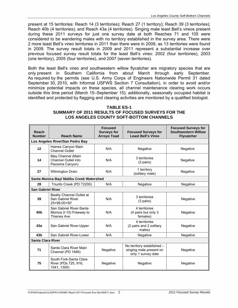
Los Angeles County Soft-Bottom Channels
R:\PAS\Projects\CoLADPW\J159\SBC Report 2011\Focused Srvy Rpt-083011.docx 2 2011 Focused Survey Results
present at 15 territories: Reach 14 (3 territories); Reach 27 (1 territory); Reach 39 (3 territories); Reach 40b (4 territories); and Reach 43a (4 territories). Singing male least Bell’s vireos present during these 2011 surveys for just one survey date at both Reaches 71 and 105 were considered to be wandering males with no territory established in the survey area. There were 2 more least Bell’s vireo territories in 2011 than there were in 2009, as 13 territories were found in 2009. The survey result totals in 2009 and 2011 represent a substantial increase over previous focused survey result totals for the least Bell’s vireo: 2002 (four territories), 2003 (one territory), 2005 (four territories), and 2007 (seven territories).
Both the least Bell's vireo and southwestern willow flycatcher are migratory species that are only present in Southern California from about March through early September. As required by the permits (see U.S. Army Corps of Engineers Nationwide Permit 31 dated September 30, 2010, with Informal USFWS Section 7 Consultation), in order to avoid and/or minimize potential impacts on these species, all channel maintenance clearing work occurs outside this time period (March 15–September 15); additionally, seasonally occupied habitat is identified and protected by flagging and clearing activities are monitored by a qualified biologist.
TABLE ES-1 SUMMARY OF 2011 RESULTS OF FOCUSED SURVEYS FOR THE
LOS ANGELES COUNTY SOFT-BOTTOM CHANNELS
Reach Number Reach Name
Focused Surveys for Arroyo Toad
Focused Surveys for Least Bell’s Vireo
Focused Surveys for Southwestern Willow
Flycatcher Los Angeles River/San Pedro Bay
12 Haines Canyon Main Channel Outlet N/A Negative Negative
14 May Channel (Main Channel Outlet into Pacoima Canyon)
N/A 3 territories (3 pairs) Negative
27 Wilmington Drain N/A 1 territory (solitary male) Negative
Santa Monica Bay/ Malibu Creek Watershed28 Triunfo Creek (PD T2200) N/A Negative Negative
San Gabriel River
39 Beatty Channel Outlet at San Gabriel River 25+99.00+50'
N/A 3 territories (3 pairs) Negative
40b San Gabriel River-Santa Monica (I-10) Freeway to Thienes Ave
N/A4 territories
(4 pairs but only 3 females)
Negative
43a San Gabriel River-Upper N/A 4 territories
(2 pairs and 2 solitary males)
Negative
43b San Gabriel River-Lower N/A Negative Negative Santa Clara River
71 Santa Clara River Main Channel (PD 1946) Negative
No territory established – singing male present on
only 1 survey date Negative
75 South Fork-Santa Clara River (PDs 725, 916, 1041, 1300)
Negative Negative Negative

Los Angeles County Soft-Bottom Channels
TABLE ES-1 (Continued) SUMMARY OF 2011 RESULTS OF FOCUSED SURVEYS FOR THE
LOS ANGELES COUNTY SOFT-BOTTOM CHANNELS
R:\PAS\Projects\CoLADPW\J159\SBC Report 2011\Focused Srvy Rpt-083011.docx 3 2011 Focused Survey Results
79 South Fork-Santa Clara River (Valencia Blvd Bridge Stabilizer)
Negative Negative Negative
80 South Fork-Santa Clara River (PDs 1947 and 1946)
Negative Negative Negative
82 Santa Clara River Main Channel (PD 2278) Negative Negative Negative
86 Violin Canyon M.C.O. Negative N/A N/A
87 Castaic-Old Road Drain (CDR 525.021D) Outlet Negative Negative Negative
97 Castaic Creek – The Old Road (PD 1982) Negative Negative Negative
103 Bouquet Canyon Channel (PD 2225) N/A Negative Negative
104 Castaic Creek (PD 2441 Units 1 and 2) Negative Negative Negative
105 San Francisquito Canyon Channel (PD 2456) Negative
No territory established – singing male present on
only 1 survey date Negative
106 Castaic Drain Outlet (RMD Channel) N/A Negative Negative
109 Santa Clara River – south bank west of McBean Pkwy (MTD 1510)
Negative Negative Negative
110 Hasley Canyon Channel (PD 2262) N/A Negative Negative
N/A = Not applicable; no potential habitat for the species; therefore no survey conducted.

Los Angeles County Soft-Bottom Channels
R:\PAS\Projects\CoLADPW\J159\SBC Report 2011\Focused Srvy Rpt-083011.docx 4 2011 Focused Survey Results
This page intentionally left blank

Los Angeles County Soft-Bottom Channels
R:\PAS\Projects\CoLADPW\J159\SBC Report 2011\Focused Srvy Rpt-083011.docx 5 2011 Focused Survey Results
SECTION 1.0 INTRODUCTION
In 2002, focused surveys and habitat assessments were conducted at 54 soft-bottom channel reaches that included 53 of the original channel reaches plus 1 new channel reach identified as Reach 101 (Violin Canyon – PD 2312). All 53 original channel reaches have continued to be maintained by the LACDPW under the required regulatory permits, but Reach 101 and other new channel reaches have yet to be permitted. The purpose of these surveys was to provide baseline information on the occurrence or potential occurrence of Threatened or Endangered plant and wildlife species for permitted and non-permitted channel reaches.
Following the 2002 surveys, a total of 22 of the 54 channel reaches were determined to have no suitable habitat for Threatened or Endangered species or, assuming habitat conditions are similar to 2002 survey conditions, species were determined to be absent and not expected to occur in the future. However, due to the drought conditions of 2002, focused surveys could not be conducted for some species, such as the slender-horned spineflower (Dodecahema leptoceras). Therefore, the habitat assessments conducted in 2002 made recommendations for further surveys in 2003. The 2003 surveys were conducted at 35 of the 54 channel reaches surveyed in 2002 and included focused surveys for the slender-horned spineflower, Santa Ana sucker (Catostomus santaanae), unarmored threespine stickleback (Gasterosteus aculeatus williamsoni),arroyo toad (Bufo [Anaxyrus] californicus), southwestern willow flycatcher (Empidonax traillii extimus), and least Bell’s vireo (Vireo bellii pusillus). Focused surveys for arroyo toad, southwestern willow flycatcher, and least Bell’s vireo were repeated in 2005, 2007, and 2009; these surveys included previously surveyed channel reaches and also some new channel reaches to be maintained by the LACDPW once permits are obtained. Except for new channel reaches yet to be permitted, surveys for the slender-horned spineflower have not been performed since 2003 as the 2002 and 2003 survey results concluded the species was absent from the permitted channel reaches. Note that annual surveys for the Santa Ana sucker and unarmored threespine stickleback are conducted per requirements of the regulatory permits. These pre-clearing fish surveys are conducted by biologists with the necessary permits and the survey results are reported separately to the LACDPW.
Focused surveys for the arroyo toad, southwestern willow flycatcher, and least Bell’s vireo were repeated in 2011 in channel reaches with suitable or potentially suitable habitat. These surveys were conducted to provide current information on the distribution of these species and to satisfy resource agency permit conditions. The survey information provides baseline data to support future regulatory agency permitting of the ongoing maintenance of these soft-bottom channel reaches.
1.1 ENVIRONMENTAL SETTING
1.1.1 REGIONAL SETTING
The topography in Los Angeles County is diverse, containing coastline, flatlands, mountains, and desert within approximately 4,000 square miles. Elevations within the County range from sea level to over 10,000 feet above mean sea level (msl). The climate ranges from mild near the coast to severe in the high mountains and in the desert. This variation in environments has created a unique and diverse collection of biological resources (England and Nelson 1976).
The San Gabriel Mountains are a prominent topographic feature that include a portion of the headwaters of the Santa Clara, Los Angeles, Rio Hondo, and San Gabriel Rivers, and are the source of streams that drain into the Antelope and Fremont Valleys. The San Gabriel Mountains rise 7,000 feet above msl from the Antelope and Santa Clarita Valleys, and exert considerable influence on the climate, hydrology, and ecology of the lands around them. The San Andreas and

Los Angeles County Soft-Bottom Channels
R:\PAS\Projects\CoLADPW\J159\SBC Report 2011\Focused Srvy Rpt-083011.docx 6 2011 Focused Survey Results
other numerous faults have fractured the mountains so that they erode at a rapid rate. Hence, the stream basins along the northern slope are generally characterized by steep headwaters and sloping alluvial beds on the adjacent flatlands (CRA et al. 2002).
The Santa Monica Mountains are also a prominent topographic feature and include the headwaters of Malibu Creek and Topanga Creek; these are the source of streams that drain the Malibu Coast. The Santa Monica Mountains are up to 10 miles wide and reach an elevation of 3,100 feet above msl at Sandstone Peak. The Santa Monica Mountains have a complex structure because they have been uplifted and then eroded several times over the past 200 million years (Dale 1986; England and Nelson 1976).
There are 4 major rivers in Los Angeles County: the Los Angeles River is approximately 51 miles long (main stem) and drains 830 square miles; the Rio Hondo River is approximately 20 miles long (main stem) and drains 125 square miles; the San Gabriel River is approximately 59 miles long (main stem) and drains 350 square miles; and the Santa Clara River is approximately 75 miles long (main stem) and drains 1,616 square miles (LACDPW 2002). Numerous other streams also occur in Los Angeles County. Surface water in streams and rivers is generally only present during the winter and spring, in particular after storm events. Many storms do not generate sufficient runoff to sustain surface flow in all streams. In some areas, flows are supplemented with reclaimed water and agricultural and urban runoff. Particularly intense storms can result in flash floods or debris flows which can carry large amounts of sediment, rocks, and debris to be deposited in the valley below (CRA et al. 2002).
The Los Angeles River system has been extensively channelized to provide flood protection as it passes through several cities on its way to the Pacific Ocean. The Los Angeles River tributaries include Bell Creek, Calabasas Creek, Burbank Western Channel, Pacoima Wash, Tujunga Wash, Verdugo Wash, Arroyo Seco, Compton Creek, and the Rio Hondo River (LACDPW 2002). There are now over 400 miles of concrete-lined tributaries that feed into the main channel (LACDPW 2002). Approximately 47.9 miles of the 51-mile river is concrete-lined. The two stretches where the river is not lined (i.e. soft or earthen bottom channels) included the Sepulveda Flood Control Basin through the Glendale Narrows and south of Willow Street in Long Beach (LACDPW 2002). Reclaimed water enters the Los Angeles River at the Sepulveda Basin where the Department of Water and Power releases as much as 75 million gallons of reclaimed water daily from the Donald C. Tillman Water Reclamation Plant.
The San Gabriel River begins in the Angeles National Forest and also flows through several cities on its way to the Pacific Ocean. The San Gabriel River tributaries include Walnut Creek, San Jose Creek, Coyote Creek, and numerous storm drains (LACDPW 2002). The headwaters of the San Gabriel River begin just north of Pasadena and northwest of Mount Wilson, where they flow through a steep canyon to Cogswell Reservoir. The west fork of the river then merges with the east fork and flows into the San Gabriel Reservoir. Below the reservoir, the east fork converges with the main stem of the San Gabriel River and flows through San Gabriel Canyon to Morris Reservoir. Below Morris Reservoir, the river flows through cities from Azusa to Seal Beach and empties into Long Beach Harbor.
The Santa Clara River is unique because it is the only major unchannelized river that drains the San Gabriel Mountains. The Santa Clara River is fed by five major tributaries: Sand Canyon, Mint Canyon, Bouquet Canyon, South Fork, and San Francisquito Canyon (LACDPW 2002). Further west, Castaic, Piru, Sespe, and Santa Paula Creeks join the river (CRA et al. 2002). The headwaters of the Santa Clara River are located near Acton, and the river runs approximately 100 miles to its outlet in the City of Ventura in Ventura County. Most development adjacent to the river is located in or near the City of Santa Clarita (LACDPW 2002).

Los Angeles County Soft-Bottom Channels
R:\PAS\Projects\CoLADPW\J159\SBC Report 2011\Focused Srvy Rpt-083011.docx 7 2011 Focused Survey Results
The Malibu Creek watershed is a system of independent streams that drains approximately 109 square miles in northwest Los Angeles County from the Santa Monica Mountains to the Pacific Ocean. These include Las Virgenes, Triunfo, and Cold Creeks, as well as other small streams that flow from the Santa Monica Mountains to Santa Monica Bay. These creeks flow through the cities of Agoura Hills, Calabasas, Malibu, Thousand Oaks, Westlake Village, unincorporated Los Angeles County, and Ventura County (LACDPW 2002).
The Ballona Creek watershed is a ten-mile-long flood-control channel that drains the Los Angeles basin from the Santa Monica Mountains to the north, the Harbor Freeway (Interstate [I] 110) to the east, and the Baldwin Hills to the south. All together, the Ballona Creek Watershed drains approximately 130 square miles of the Los Angeles Basin. Creeks or drainages of this watershed include Centinela Creek, Sepulveda Channel, and Benedict Canyon Channel. These drainages pass through the communities of Beverly Hills, Culver City, Inglewood, Los Angeles, and West Hollywood (LACDPW 2002).
The Dominguez Watershed is situated in south Los Angeles County and drains approximately 133 square miles of the Los Angeles Basin into the Los Angeles Harbor. Parts of the communities of Hawthorne, Torrance, Gardena, Carson, and Wilmington drain into the Dominguez Channel. Over 40 percent of this watershed consists of industrial, commercial, and transportation land uses.
The Antelope Valley watershed is a system of independent streams that drains approximately 1,200 square miles in north Los Angeles County from the San Gabriel Mountains and Kern County into the valley floor. These include Little Rock, Big Rock, and Mill Creeks, as well as other small streams that flow from the San Gabriel Mountains into the Antelope Valley. Due to the surrounding topography, these streams do not drain into the sea, but into dry lakebeds on the valley floor, with most surface flows infiltrating into groundwater basins or evaporating (CRA et al. 2002; LACDPW 2002). Because the valley lacks defined natural channels outside the foothills, it is subject to unpredictable sheet flow patterns (LACDPW 2002). The portion of the Antelope Valley watershed within Los Angeles County includes the cities of Lancaster and Palmdale, with scattered clusters of sparse development outside these cities (LACDPW 2002). None of the channel reaches discussed in this report are located in the Antelope Valley Watershed.
1.1.2 LOCAL SETTING
In 2002, the LACDPW maintained 95 soft-bottom channel reaches located within the boundaries of the Los Angeles County Flood Control District, consisting of 885.58 acres that require management. Since 2002, ten soft-bottom channel reaches have been lost due to development or ownership change, but several more have been added to the list. As of 2011, the LACDPW manages 106 channel reaches (1 thru 116) that are located in 7 identified watersheds1 of Los Angeles County:
� Los Angeles River – 29 channel reaches (includes Reach 27)
� Dominguez Channel – 1 channel reach
� Malibu Creek – 9 channel reaches
� San Gabriel River – 8 channel reaches (not splitting Reaches 40 and 43)
� Santa Clara River – 56 channel reaches
1 Cerritos Channel is located in Long Beach and drains into the Long Beach Harbor at Pacific Coast Highway.
This soft-bottom channel has not been associated yet with any watershed and appears to be separate from the above-identified watersheds.

Los Angeles County Soft-Bottom Channels
R:\PAS\Projects\CoLADPW\J159\SBC Report 2011\Focused Srvy Rpt-083011.docx 8 2011 Focused Survey Results
� Ballona Creek – 1 channel reach
� Antelope Valley – 1 channel reach
� Cerritos Channel – 1 channel reach
In 1997, the 95 soft-bottom flood control channel reaches encompassed 885.58 acres that included 205.27 acres of vegetation. Based on vegetation categories developed at the time, the 205.27 acres of vegetation included an estimated 105.32 acres of riparian vegetation, 63.40 acres of mule fat vegetation, and 36.55 acres of scrub vegetation (BonTerra Consulting 1999). The acreages noted above have not been updated since that time and are presented to indicate the large amount of habitat under LACDPW jurisdiction.
1.2 PROPOSED PROJECT
1.2.1 BACKGROUND
To effectively control flood waters from the mountainous watersheds surrounding the Los Angeles basin, the U.S. Army Corps of Engineers (USACE) and the Los Angeles County Flood Control District constructed concrete-bottom and earth-bottom channels leading from dams and debris basins located along the frontal slopes of the San Gabriel, Santa Monica, Verdugo, and Santa Susanna Mountains. Construction began in the 1930s.These channels, as a system, provide flood protection for Los Angeles County.
Channel maintenance activities have been performed regularly in Flood Control District channels for over 50 years. Originally constructed by the USACE, upon completion, most of the channel facilities were transferred to the Los Angeles County Flood Control District for cyclic maintenance. The USACE’s maintenance guidelines require that “debris, objectionable growth, shoals, and waste materials must not encroach on the invert. Excess materials that will not move readily with low flows must be removed. Measures must be taken to control objectionable growth by approved chemical or mechanical means” (USACE 1996).
The County formerly maintained channels clear of any vegetation, as required under the Code of Federal Regulations (33 CFR 208.10), until the California Department of Fish and Game (CDFG) began requiring the County to clear vegetation on alternating sides of the channels each year. The USACE allowed limited clearing to occur between 1993 and 1995. Anticipated heavy rains during the 1997/1998 storm season caused by El Niño conditions resulted in a statewide need to remove vegetation and sediment from soft-bottom channels to restore their flood-carrying capacity. The LACDPW obtained all necessary permits to conduct this work in the 1997/1998 storm season and has continued the ongoing maintenance as approved by the permits.
1.2.2 PROJECT DESCRIPTION
Vegetative growth in a channel system reduces channel capacity. All soft-bottom channels were designed and constructed as relatively clean, unvegetated channels. As vegetation grows more densely, the roughness of the channel increases and the velocity of flows decrease, which corresponds to a loss in the channel’s carrying capacity. The vegetation also traps some of the sediments being transported by flood flows which, when deposited, further reduce channel capacity. Studies have shown that increased vegetation and sediments in the channels result in reduced flow area with a concomitant decrease in flow velocity (LACDPW 1996). A loss of carrying capacity in the channels could cause flood flows to escape the channel systems and impact adjacent properties (LACDPW 1996).

Los Angeles County Soft-Bottom Channels
R:\PAS\Projects\CoLADPW\J159\SBC Report 2011\Focused Srvy Rpt-083011.docx 9 2011 Focused Survey Results
Vegetation can also affect the structural integrity of bridges during a major storm event. Vegetation slows flood flows, which creates a backwater effect and increases water surface elevations upstream. Bridges are not normally designed to withstand the forces that result from significantly increased flood water elevations. Additionally, increased flood depths upstream can result in flooding of adjacent properties and erosion of channel banks.
The LACDPW performs annual vegetation clearing in channels and minor grading to retrain channel flows consistent with the clearing limits established by the permitted maintenance plan (BonTerra Consulting 1999). This ongoing program is necessary to maintain the design capacities of the channels and to ensure the proper functioning of these facilities located within the Los Angeles County Flood Control District boundaries.
Within each reach, the LACDPW proposes to clear the same areas (and acreage) that have been cleared annually since 1997. Biological impacts to these channel reaches associated with the initial clearing of vegetation for maintenance activities were previously mitigated through maintaining and enhancing 62.7 acres of riparian habitats at the Big Tujunga Wash Mitigation Bank site (BonTerra Consulting 1999).
Channel clearing activities are performed primarily by mechanical means, using heavy equipment (such as trucks, bulldozers, dump trucks, and loaders), as well as other specialized equipment designed for this type of work. Hand clearing is conducted in areas where mechanical equipment cannot be used or where important biological resources exist nearby. Herbicides approved by regulatory agencies are applied, as necessary, to eradicate invasive and/or non-native vegetation including, but not limited to, giant reed (Arundo donax) and castor bean (Ricinus communis).
The channel clearing activities are performed under an existing Maintenance Plan approved by the Los Angeles Regional Water Quality Control Board (RWQCB) and USACE and modified by the CDFG under the existing Streambed Alteration Agreement between CDFG and the LACDPW. BonTerra Consulting has reviewed the Maintenance Plan and has extensive knowledge of channel clearing activities in all channel reaches, having worked with the LACDPW since 1997 to provide biological monitoring of flood-control channel maintenance work. Pre-clearing and post-clearing photos have been taken every year to document the biological resources in these channel reaches in compliance with the mitigation requirements of existing permits from the USACE, RWQCB, and CDFG.
1.3 SPECIAL STATUS SPECIES BACKGROUND
In order to comply fully with the regulatory permits issued to the LACDPW, surveys are performed for a variety of special status species at soft-bottom channel reaches where suitable or potentially suitable habitat has been identified. For example, the permits require annual pre-clearing surveys for the federally and State-listed Endangered unarmored threespine stickleback (Gasterosteus aculeatus williamsoni) and federally listed Threatened Santa Ana sucker (Catostomus santaanae). Results of these fish surveys were included with previous survey efforts (BonTerra Consulting 2002, 2003), but have since been reported separately to the LACDPW. This report provides the results of surveys for the arroyo toad (Anaxyrus californicus),southwestern willow flycatcher (Empidonax traillii extimus), and least Bell’s vireo (Vireo bellii pusillus). Table 1 below shows the federal and State status of these three species.

Los Angeles County Soft-Bottom Channels
R:\PAS\Projects\CoLADPW\J159\SBC Report 2011\Focused Srvy Rpt-083011.docx 10 2011 Focused Survey Results
TABLE 1 STATUS OF SPECIES ADDRESSED
SpeciesStatus
USFWS CDFGAmphibiansAnaxyrus californicus
arroyo toad FE SSC
BirdsVireo bellii pusillus
least Bell’s vireo FE SE
Empidonax traillii extimussouthwestern willow flycatcher FE SE*
USFWSFE Federally Endangered CDFGSE State Endangered SSC State Species of Special Concern * The State listing included all subspecies of willow flycatcher that breed in California.
1.3.1 ARROYO TOAD
The arroyo toad was listed as a federally Endangered species by the USFWS on January 17, 1995 (CDFG 2011a) and is a California Species of Special Concern (CDFG 2011b). At the time of listing, the arroyo toad was one of two subspecies of the southwestern toad (Bufo microscaphus), but subsequent genetic studies (Gergus 1998) resulted in the separation of arroyo toad (B. californicus) from the Arizona toad (B. microscaphus). Recent research (Frost et al. 2006) placed both species in the genus Anaxyrus.
This is a rather uniformly warty and stocky toad with a light-colored stripe across the head that includes the eyelids. The parotoid glands are oval-shaped, widely separated, and pale toward the front. The underside of the arroyo toad is usually buff-colored and unspotted, and the cranial crests are absent or weak. The typical size (snout to vent) range of reproductive adult toads is 2 to 2.6 inches for males and 2.6 to 3.1 inches for females (Sweet 1992, 1993). Tadpoles reach an average maximum length of 1.3 inches (maximum of 1.6 inches) and are black at hatching. Soon after hatching, the tadpoles develop a tan-colored dorsum with crossbars on the tail and an opaque, white abdomen (venter) before metamorphosing (Sweet 1992).
Early descriptions of the habitat requirements for the arroyo toad are based on detailed life history studies conducted over a period of years by Sweet (1992, 1993). Much of that work was conducted in the Los Padres National Forest in Santa Barbara County. Subsequent to this work, additional studies of populations in other portions of the range have resulted in a somewhat broader habitat description (e.g., Griffin et al. 1999; Ramirez 1999, 2000, 2001, 2002a, 2002b, 2002c). It can generally be said that the arroyo toad frequents third order washes, streams, and arroyos in semiarid parts of the southwest. Stream substrates range from sands to small cobble, with sandy banks supporting mule fat (Baccharis salicifolia), willows (Salix spp.), cottonwoods (Populus spp.), and/or sycamores (Platanus racemosa). The arroyo toad breeds both within streams and in small backwater pools that form along the stream margins, usually in relatively shallow water (about four inches) with sand or gravel substrate.
Arroyo toads are primarily nocturnal, except during the breeding season when they are sometimes active during daylight hours. These toads will move extensively in upland habitats, at least seasonally. Adult males will sometimes travel 1.2 to 1.9 miles along a stream course, often becoming more sedentary once reaching a large size (Sweet 1992). Females are more sedentary, typically maintaining an area of movement less than 330 feet in diameter

Los Angeles County Soft-Bottom Channels
R:\PAS\Projects\CoLADPW\J159\SBC Report 2011\Focused Srvy Rpt-083011.docx 11 2011 Focused Survey Results
(Sweet 1992). Adults mostly feed on ants, particularly nocturnal ants such as the trail-forming tree ants (Liometopum occidentale), but will also consume other invertebrates (Sweet 1992). Tadpoles are substrate gleaners, feeding on detritus and microbial mats from just beneath the surface layer of fine sediments or within the interstices of gravel deposits (Sweet 1992).
On February 7, 2001, the USFWS published a final rule designating 182,360 acres of land in California including parts of Monterey, Santa Barbara, Ventura, Los Angeles, San Bernardino, Riverside, Orange, and San Diego Counties as critical habitat for the arroyo toad (USFWS 2005a). Following the designation of critical habitat, several lawsuits were filed challenging various aspects of the designation. In response to these lawsuits, the critical habitat designation was vacated and the USFWS was instructed by the court to re-evaluate its previous position.
On April 28, 2004, the USFWS published a final rule designating 11,695 acres of critical habitat for the arroyo toad in portions of Santa Barbara, Ventura, Los Angeles, San Bernardino, and Riverside Counties (USFWS 2005a). Further lawsuits were filed that successfully challenged this final rule and resulted in another proposed rule for revised critical habitat that was published in the Federal Register on October 13, 2009 (USFWS 2009). The revised critical habitat final rule was released on February 8, 2011 (USFWS 2011a).
Four Castaic Creek channel reaches (Reaches 86, 87, 97, and 104) are located in Unit 6, Subunit B, of this final critical habitat revision (USFWS 2011a). Another surveyed channel reach (Reach 110) is located just upstream of Unit 6, Subunit B of this final critical habitat (USFWS 2011a). One surveyed channel reach (Reach 82) previously located within proposed critical habitat (USFWS 2005a), is now located about 1,000 feet upstream of Unit 6, Subunit B of this final critical habitat (USFWS 2011a). None of the other 106 channel reaches managed by the LACDPW are located in this final critical habitat.
1.3.2 LEAST BELL’S VIREO
The least Bell’s vireo was formerly a common, even locally abundant summer resident of Southern California’s lowland riparian woodlands (Grinnell and Miller 1986). The substantial population decline of this avian species over the latter half of the twentieth century is attributable to the loss and degradation of riparian habitats and, perhaps more importantly, brood parasitism by the brown-headed cowbird (Molothrus ater). The least Bell’s vireo was listed by the CDFG as State Endangered on October 2, 1980, and by the USFWS as federally Endangered on May 2, 1986 (USFWS 1986).
The Bell’s vireo is a neotropical migrant that breeds in central and southwestern North America from northern Mexico to Southern California, Nevada, and Utah, east to Louisiana, and north to North Dakota, Wisconsin, and Indiana in the central U.S. (AOU 1998). The winter range of this vireo, although not well known, is believed to be the west coast of Central America from southern Sonora south to northwest Nicaragua, including the cape region of Baja California, Mexico (Brown 1993). Of the four Bell’s vireo subspecies, only two breed in California: the least Bell’s vireo and the Arizona Bell's vireo (V. b. arizonae), which occurs in the Colorado River Valley (Garrett and Dunn 1981; Rosenberg et al. 1991). Though the least Bell’s vireo was formerly considered a common breeder in riparian habitats throughout the Central Valley and other low elevation river systems in California and Baja California, Mexico (Franzreb 1989), it had been eliminated from much of its historical range by the time of its listing in 1986 (Franzreb 1989; Brown 1993). Recovery efforts since its listing have included habitat protection, removal of exotic species particularly giant reed, and trapping programs for the brown-headed cowbird (USFWS 2006). The least Bell’s vireo population has increased tenfold from 291 territories in the early 1980s to an estimated 2,968 territories 20 years later (USFWS 2006). After a decade or more of absence in Los Angeles County, the least Bell’s vireo returned by the mid-1980s with a pair reported from Whittier Narrows in 1985 and 1986 (Long 1993). Numbers

Los Angeles County Soft-Bottom Channels
R:\PAS\Projects\CoLADPW\J159\SBC Report 2011\Focused Srvy Rpt-083011.docx 12 2011 Focused Survey Results
of least Bell’s vireo have continued to increase since that time, and it is now known to occur at several other locations in Los Angeles County such as the San Fernando (Van Norman) Dam; the San Gabriel River at Fish Canyon and Van Tassel Canyon; the Sepulveda Basin Wildlife Area; and the Castaic Lagoon Recreation Area (CDFG 2009). The two largest populations in the county are at Hansen Dam in the northeastern corner of the San Fernando Valley where 44 least Bell’s vireo territories were present in 2009 (Griffith Wildlife Biology 2009) and on the Santa Clara River from the I-5 Freeway downstream to the Las Brisas bridge where 56 least Bell’s vireo territories were present in 2007 (Bloom Biological, Inc. 2007).
Least Bell’s vireo breeding habitat is primarily riparian habitats dominated by willows with dense understory vegetation. Shrubs such as mule fat and California rose (Rosa californica) are often a component of the understory (Goldwasser 1981). The least Bell’s vireo is often found in areas that include trees such as willow, sycamore, or cottonwood, particularly where the canopy is within or immediately adjacent to an understory layer of vegetation (Salata 1983). The least Bell’s vireo generally nests in early successional stages of riparian habitats, with vireo nest sites frequently located in willows that are between four and ten years of age (RECON 1988; Franzreb 1989). The most critical factor in habitat structure is the presence of a dense understory shrub layer from approximately two feet to ten feet above ground (Goldwasser 1981; Salata 1983; Franzreb 1989).
On February 2, 1994, the USFWS published a final critical habitat for the least Bell’s vireo designating approximately 37,560 acres of land in Santa Barbara, Ventura, Los Angeles, San Bernardino, Riverside, and San Diego Counties, California (USFWS 1994b). Designated critical habitat in Los Angeles County is located only in the Santa Clara River from the Golden State (I-5) Freeway west to the Ventura County line. The surveyed soft-bottom channel reaches are all located outside the critical habitat for this species.
1.3.3 SOUTHWESTERN WILLOW FLYCATCHER
The southwestern willow flycatcher was formerly a common summer resident of southern California’s lowland riparian woodlands and up into mountain canyons (Garrett and Dunn 1981). By the 1970s, the southwestern willow flycatcher was considered to be absent as a breeder in Southern California (McCaskie 1975). The virtual extirpation of this species as a breeder in Southern California has been attributed to the loss and degradation of riparian habitats and brood parasitism by the brown-headed cowbird. All willow flycatchers breeding in California-which include the subspecies E. t. brewsteri and E. t. adastus in addition to the southwestern willow flycatcher—were listed by the CDFG as State Endangered on January 2, 1991. The USFWS listed the southwestern willow flycatcher as federally Endangered on February 7, 1995 (USFWS 1993b).
The willow flycatcher is a neotropical migrant that breeds in the west from northern Baja California, Mexico to central British Columbia, Canada and generally east through the northern half of the United States to the Atlantic coast (AOU 1998). The willow flycatcher winters in Central America from Nayarit, Mexico (Pacific coast) and Honduras (Gulf of Mexico coast) to Panama and also to northern Colombia and northwest Venezuela (Sedgwick 2000). Depending on the authority, there are four or five recognized subspecies of willow flycatcher (Sedgwick 2000). The breeding range of the southwestern willow flycatcher includes Southern California, Arizona, New Mexico, western Texas, and extreme southern parts of Nevada and Utah (USFWS 1993b).
The California population of southwestern willow flycatchers breeds along the coast north of Baja California to the Santa Ynez River, Santa Barbara County, and north in the interior to about Independence, Inyo County (Unitt 1987). Besides the Colorado River, there are five drainages in California that support major breeding populations of southwestern willow flycatcher:

Los Angeles County Soft-Bottom Channels
R:\PAS\Projects\CoLADPW\J159\SBC Report 2011\Focused Srvy Rpt-083011.docx 13 2011 Focused Survey Results
the South Fork of the Kern River in Kern County; the Santa Margarita River on Camp Pendleton and the San Luis Rey River in San Diego County; the Santa Ana River in Riverside and San Bernardino Counties; and the Owen’s River in Inyo and Mono Counties (Durst et al. 2007). In the 1970s, the southwestern willow flycatcher was believed to have been extirpated from coastal Southern California (Remsen 1978), but small numbers were found during the late 1970s and early 1980s in San Diego County (Unitt 1984). An early population estimate for the southwestern willow flycatcher in California was 70 pairs (USFWS 1993b). More recent population estimates are higher, such as 200 territories in 2004 and 190 territories in 2006 (Durst et al. 2005; Durst et al. 2007), and are more likely the result of increased survey effort rather than a population increase (Durst et al. 2007).
The southwestern willow flycatcher breeds in willow dominated riparian habitats that are similar to least Bell’s vireo nesting habitats. The southwestern willow flycatcher differs from least Bell’s vireo in that it shows a stronger dependency on willow thickets for all its requirements (Grinnell and Miller 1944). In addition, the southwestern willow flycatcher appears to have a preference for sites with surface water in the vicinity, such as along streams, on the margins of a pond or lake, and at wet mountain meadows (Grinnell and Miller 1944; Flett and Sanders 1987; Harris et al. 1987); in Arizona, the southwestern willow flycatcher invariably nests near surface water (Phillips et al. 1964). Recently, the southwestern willow flycatcher has adapted to introduced vegetation present in riparian vegetation types, such as tamarisk (Tamarix sp.) and Russian olive (Elaeagnus angustifolia) (USFWS 1993b).
The willow flycatcher is a common migrant in the interior of California and a rare to uncommon migrant along the coastal slope, with most birds moving through Southern California between May 15 and June 20 during the spring season (Garrett and Dunn 1981; Unitt 1987). The spring migration of southwestern willow flycatcher is earlier than that of the northern subspecies (Unitt 1987; USFWS 1993b). As a result, surveys for nesting southwestern willow flycatcher are complicated by the presence of more abundant subspecies migrating through its range during its breeding season.
The final rule designating critical habitat for the southwestern willow flycatcher includes 7,212 acres in Kern, Santa Barbara, San Bernardino, and San Diego Counties in California (USFWS 2005b). Although this designation is still current, a proposed revision to this critical habitat was published on August 15, 2011 (USFWS 2011b). The revised critical habitat includes stream segments not previously included as critical habitat since they were not occupied by the southwestern willow flycatcher at the time of listing, but are considered to be essential for the long-term conservation of the species. These new stream segments include Castaic Creek (3.0 miles), Little Tujunga (1.4 miles), Big Tujunga (3.0 miles), and the San Gabriel River (8.8 miles) (USFWS 2011b). Three Castaic Creek channel reaches (Reaches 87, 97, and 104), four Santa Clara River channel reaches (Reaches 71, 80, 82, and 109), and one San Gabriel River channel reach (Reach 39) are located within this proposed revised critical habitat.

Los Angeles County Soft-Bottom Channels
R:\PAS\Projects\CoLADPW\J159\SBC Report 2011\Focused Srvy Rpt-083011.docx 14 2011 Focused Survey Results
This page intentionally left blank

Los Angeles County Soft-Bottom Channels
R:\PAS\Projects\CoLADPW\J159\SBC Report 2011\Focused Srvy Rpt-083011.docx 15 2011 Focused Survey Results
SECTION 2.0 SURVEY METHODOLOGIES
BonTerra Consulting has worked with the LACDPW since 1997 to provide biological monitoring of flood control channel maintenance work in soft-bottom channel reaches. In addition to the biological monitoring of the maintenance work, pre-clearing and post-clearing photos have been taken every year to document the biological resources in these channel reaches in compliance with the mitigation requirements of existing permits from the USACE, RWQCB, and CDFG. BonTerra Consulting has assisted the LADPW in preparation of their maintenance plan for the channels, which follows permit conditions from the USACE, RWQCB, and CDFG. These permit conditions recommend surveys for arroyo toad, least Bell’s vireo, and southwestern willow flycatcher where there is suitable habitat for these species; these conditions have been incorporated into the LACDPW’s 2005 Maintenance Plan for Annual Clearing of Soft-bottom Flood Control Channels.
For each species surveyed, the surveys were conducted according to USFWS protocols. The biologists conducted the surveys at the most appropriate time of day to ensure maximum opportunity to observe the species.
2.1 SPECIAL STATUS AMPHIBIAN SPECIES
2.1.1 ARROYO TOAD
The initial studies conducted in 2002 included a background literature review and habitat assessment for each of the soft-bottom channel reaches that represented suitable arroyo toad breeding and/or upland habitat. The literature review included the documentation of relevant literature on the presence of the arroyo toad within and/or adjacent to each reach including areas both upstream and downstream. This included review of Federal Register listings, protocols, and species data provided by the USFWS, CDFG’s California Natural Diversity Database (CNDDB); consultation with qualified experts familiar with the distribution and natural history of the arroyo toad; and review of unpublished biological resource letter reports and assessments conducted within the region.
Focused surveys for the arroyo toad were conducted in 2011 at 11 channel reaches: Castaic Creek Reaches 86, 87, and 97, and Reach 104 in the Castaic Creek watershed; San Francisquito Wash Reach 105; South Fork Santa Clara River Reaches 75 (but only the northern part of Reach 75 from Magic Mountain Parkway upstream to the Via Princessa bridge) and 79; Reach 80 at the confluence of the Santa Clara and South Fork Santa Clara Rivers; and Santa Clara River Reaches 71, 82, and 109.
The surveys followed the guidelines presented in the USFWS’ Survey Protocol for the Arroyo Toad (1999b). Each of the channel reaches were surveyed on foot to characterize aquatic (breeding) and upland habitat (refugia) types and to document any characteristic sign (clutches, larvae, juveniles, adults). Also, as stated in the USFWS protocol, areas within 0.6-mile of documented arroyo toad sites (previously documented by the presence of eggs, larvae, juveniles, or adults) that have suitable habitat would be presumed to have arroyo toads (USFWS 1999b). In addition to following the guidelines outlined above, all field surveys adhered to recommended equipment decontamination procedures outlined in Appendix B of the California Red-legged Frog survey guidelines (USFWS 2005c).
Six surveys following USFWS recommended protocol were conducted at each of the channel reaches. These surveys included both a diurnal and nocturnal component. The initial (diurnal) surveys included walking each reach in an effort to assess and document the suitability of breeding and upland habitat for the arroyo toad. These initial surveys also focused on locating any areas of inundation that may have represented suitable breeding pools (egg clutches

Los Angeles County Soft-Bottom Channels
R:\PAS\Projects\CoLADPW\J159\SBC Report 2011\Focused Srvy Rpt-083011.docx 16 2011 Focused Survey Results
and/or tadpoles). These surveys identified portions within each reach with the highest probability to support the arroyo toad. Following the initial surveys, areas identified during the daytime surveys were visited again at night in order to detect active toads. The same routes were covered repeatedly throughout the evening to ensure that no individuals went undetected. A list of all wildlife species encountered during these surveys is included in Appendix B.
2.2 SPECIAL STATUS BIRD SPECIES
The initial literature review in 2002 included all relevant and available documentation on the presence of the least Bell’s vireo and southwestern willow flycatcher in Los Angeles County. This included review of Federal Register listings, protocols, and species data provided by the USFWS; the CDFG’s CNDDB; consultation with qualified experts familiar with the distribution and natural history of the least Bell’s vireo and southwestern willow flycatcher; and review of unpublished biological resource letter reports and assessments.
Based on the results of prior BonTerra Consulting surveys (2009 focused surveys and annual monitoring surveys) of the channel reaches, 2011 focused surveys for the least Bell’s vireo and southwestern willow flycatcher were conducted at a total of 21 channel reaches where they have potential to occur: 4 channel reaches in the Los Angeles River/San Pedro Bay/Santa Monica Bay area (Reaches 12, 14, 27, and 28); 4 channel reaches in the San Gabriel River (Reaches 39, 40b, 43a, and 43b); and 13 channel reaches in the Santa Clara River and Castaic Creek drainages (Reaches 71, 75, 79, 80, 82, 87, 97, 103, 104, 105, 106, 109, and 110). The channel reaches were surveyed by BonTerra Consulting Biologists Brian Daniels (Scientific Permit No. 821401-3), Lindsay Messett, and Amber Oneal (Scientific Permit No. 148554-1), and Consulting Biologist James Pike (Scientific Permit No. 832946-3). Surveys followed the USFWS protocol for both species.
The USFWS survey protocol for southwestern willow flycatcher was updated in June 2010 (Sogge et al. 2010). The changes affected the timing of surveys, not the number or method of conducting each survey. A minimum of five surveys must still be performed to determine absence from a project site. As previously, the five surveys must be performed within three specified time periods at least five days apart. As before, the first survey must still be conducted between May 15 and May 31, but now two surveys are required in the second survey window which has been increased in length by three days from June 1 to June 24. The third survey window is now three days shorter, but only two surveys need to be conducted between June 25 and July 17. The survey protocol for least Bell’s vireo remains the same with a minimum of eight surveys being conducted at least ten days apart between April 10 and July 31. Surveys for the least Bell’s vireo and southwestern willow flycatcher can be performed simultaneously because of their similar habitat requirements.
The survey area consisted of all riparian habitats in each reach. The riparian habitat was systematically surveyed by walking slowly and methodically along two transects (downstream then upstream or the reverse) with some variance depending on streambed width. Recorded vocalizations of southwestern willow flycatcher were used to elicit a response from any potentially territorial southwestern willow flycatcher; recorded vocalizations of least Bell’s vireo were not used according to the protocol for this species. If no southwestern willow flycatchers were detected after the initial playing of the vocalization, the recording was usually replayed at least once. Any observations of willow flycatcher (all subspecies) and least Bell’s vireo, including any pertinent behavior, were recorded and their locations mapped in the field. It should be noted that all subspecies of the willow flycatcher breeding in California are listed as State Endangered species; however, only breeding locations are protected.

Los Angeles County Soft-Bottom Channels
R:\PAS\Projects\CoLADPW\J159\SBC Report 2011\Focused Srvy Rpt-083011.docx 17 2011 Focused Survey Results
The surveys were conducted under optimal weather conditions and during the early morning hours when bird activity is at its peak. Numbers were recorded for all bird species detected during the surveys, including notable observations of any special status species or other birds such as the brown-headed cowbird. Daily tallies of all bird species recorded during these surveys are included in Appendix A.

Los Angeles County Soft-Bottom Channels
R:\PAS\Projects\CoLADPW\J159\SBC Report 2011\Focused Srvy Rpt-083011.docx 18 2011 Focused Survey Results
This page intentionally left blank

Los Angeles County Soft-Bottom Channels
R:\PAS\Projects\CoLADPW\J159\SBC Report 2011\Focused Srvy Rpt-083011.docx 19 2011 Focused Survey Results
SECTION 3.0 SURVEY RESULTS
The following section presents the results of the biological surveys conducted within each channel reach. Channel reaches are grouped by watershed and include Los Angeles River/San Pedro Bay, Santa Monica Bay, San Gabriel River, and the Santa Clara River. Table ES-1 above summarizes the results of these 2011 surveys.
3.1 LOS ANGELES RIVER/SAN PEDRO BAY AREA
3.1.1 REACH 12 – HAINES CANYON MAIN CHANNEL OUTLET
Project Location
Reach 12, Haines Canyon Main Channel Outlet, is located within the Tujunga Wash watershed, approximately one mile northwest of the Mount Gleason Avenue and Foothill Boulevard intersection, in the community of Sunland in the City of Los Angeles (Exhibit 1). The limits of Reach 12 are approximately 791 feet downstream of Wentworth Street to approximately 1,228 feet downstream of Wentworth Street. Reach 12 is 437 feet in total length. The reach is found on the U.S. Geological Survey’s (USGS’) Sunland 7.5-minute quadrangle map (Also, refer to Thomas Guide, Los Angeles County, page 503-F2).
TABLE 2 REACH 12 – HAINES CANYON MAIN CHANNEL OUTLET
Survey Type Survey Dates Surveying BiologistFocused survey for the least Bell’s vireo and southwestern
willow flycatcher
April 4 and 26; May 6 and 27 Lindsay Messett May 18; June 7, 17, and 30; and
July 12 Brian Daniels
Least Bell’s Vireo
The least Bell’s vireo was not observed in Reach 12 during these surveys.
Southwestern Willow Flycatcher
Migrant willow flycatchers were observed in Reach 12 on June 7 and 30, 2011 (see Appendix A). Two singing willow flycatchers were present on June 7 at the downstream end of the channel reach. Based on behavior, song type, and plumage characteristics, these birds were judged as migrants. A willow flycatcher on June 30 at the upstream end of the channel reach was unexpected. This flycatcher was found foraging in scrubby willows adjacent to the pond at the mouth of the concrete channel outlet. It was essentially quiet, but sang once about one hour after the initial observation. Behavior appeared consistent with a migratory bird, and since no willow flycatchers were detected on the previous survey of June 17 or on the last survey of July 12, this willow flycatcher was judged to be a very late migrant.

Project LocationReach #12 - Haines Canyon Main Channel Outlet
Exhibit 1
(Rev: 8-02-2011 WAD) R:\PAS\Projects\CoLADPW\J159\Graphics\2011 Focused Survey Results\Ex1_PL.pdf
Tujunga WashTujunga Wash
Haines Canyon Channel
§̈¦210
FoothillSunland
Wentworth
Mou
nt G
leas
on
La Tuna Canyon
BigTujung
aCa
nyon
Whe
atla
nd
Kyle
Apperson
Hillrose
Mcv
ine
Wentworth
Mcgroarty
Com
mer
ce
O ro V
ista
Conover
Johanna
Nas
sau
Parr
Ebey Herreres Truck
Tujunga Canyon
Mat
her
Irma
Wils
ey
La Canada
Alpine
Mou
ntai
r
Fenwic k
Summitrose
Wor
nom
Ellenbogen
Hill
have
n
Scov
ille
Hel
enda
le
Big Tujunga Canyon
ValahoRe
verie
T inke
rYates
Denivelle
Mcc
lem
ont
Eldo
ra
Flor
alita
M cbroom
Ode
ll Seve
n hill
sCardamine
Cora
Foothill
Plainview
Las
Luni
tas
CatskillM
ar y Bell
Rhod
esia
Green Verdugo Fire
OwensRiderw
ood
Mulberry
Lang
mui
r
Day
Water And PowerJa
rdin
e
Qui
ll
Whi
tega
te
Wayside
Sher
man
Gro
ve
Esko
Valmont
Wyngate
Leol
ang
Oswego
Green Verdugo Pine
Sabl
e
Wo odw
a rd
Russett
New
home
Betty LouSu
nlan
d
ElmoFe
rngl
en
Wes
cott
Estepa
Beckett
Grove
Redm
ont
Ba rling
Eb
y Canyon
Del Arro
yo
Nohles
Dellmo nt
Radwin
Oak BendKu
rt
Del
iban
Lonzo
Shel
ly Vi
sta
Airlie
Teazle Canyon
Jayseel
Oliv
er C
anyo
n
Alethea
Grenoble
Graystone
Cott
onw
ood
Inspir
ation
Pear
son
Shadow Island
Mustang
Rotta
Tranquil
Le Berthon
Shadow Hills
Greeley
Shar
on
Chap
inForsythe
Pla teau
Power And Light
Viva
Topley
Rancho Caballo
Estaban
Pelu
so
Jaydee
Machrea
Skyland
Verdugo Crestline
Caer
n
Holland
Big Bend
Moy
Zach
au
Dom
inic
a
Gre
enbu
rn
Garret
Flora Morgan
Tujunga Valley
Dotyhill
UnderhillPa
rr
Day
Cora
Mather
Kyle
Hill
have
n
Lang
mui
r
Fenwick
Esta
ban
Beckett
Parr
Hillrose
Nassau
Ode
ll
Odell
Grove
Kyle
Hillrose
Fenwick
Day
Kyle
Plai
nvie
w
Oro
Vis
ta
Day
Wes
cott
Eldo
ra
Day
Le Berthon
Owens
Valmont
Machrea
Woo
dwar
d
Cora
Hill
have
n
Jard
ine
Scov
ille
Le Berthon
D:\P
roje
cts\
CoL
AD
PW\J
159\
mxd
\Ex_
PL_
map
book
.mxd
0.5 0 0.50.25Miles²
Project Location

Los Angeles County Soft-Bottom Channels
R:\PAS\Projects\CoLADPW\J159\SBC Report 2011\Focused Srvy Rpt-083011.docx 20 2011 Focused Survey Results
3.1.2 REACH 14 – MAY CHANNEL (MAIN CHANNEL OUTLET INTO PACOIMA CANYON)
Project Location
Reach 14, May Channel (Main Channel Outlet into Pacoima Canyon), is located within the Pacoima Wash watershed, approximately 1.25 miles east of the Foothill (I-210) Freeway and Hubbard Street intersection in the City of Los Angeles (Exhibit 2). The limits of Reach 14 are 3,038 feet downstream of Hubbard Street to approximately 3,728 feet downstream of the confluence of Hubbard Street with Pacoima Canyon. Reach 14 is 690 feet in total length. The reach is found on the USGS San Fernando 7.5-minute quadrangle map (Refer to Thomas Guide, Los Angeles County, page 482-E3).
TABLE 3 REACH 14 – MAY CHANNEL
(MAIN CHANNEL OUTLET INTO PACOIMA CANYON)
Survey Type Survey Dates Surveying BiologistFocused survey for the least Bell’s vireo and southwestern
willow flycatcher
April 18 and 28; May 10 and 20; June 1, 11, and 21; July 5
and 14, 2011 Brian Daniels
Least Bell’s Vireo
Three least Bell’s vireo territories were established in Reach 14 during these surveys. Each of these 3 males paired with females and nests were located (see Exhibits 3 and 4). Two males established territories and paired with females in the side drainages on the opposite side of Pacoima Wash from Reach 14. The nest of Pair #1 was in mule fat and contained two eggs on May 10, but on June 1 it held just one cold cowbird egg that was removed. Pair # 1 was still present on June 1 and presumed to be nesting in an area of dense willows that precluded searching for the new nest. The nest of Pair #2 was also in mule fat and contained two nestlings on June 11; two fledglings were observed in this territory being fed by the adults on June 21. A singing male in the willows of Reach 14 was followed to the southeast corner of the alluvial sage scrub “field” where it joined a female least Bell’s vireo. A nest was found at the southeast corner of this field in a blue elderberry (Sambucus nigra) on June 11 that contained a two- or three-day old cowbird nestling (removed) and four least Bell’s vireo eggs. This nest contained no eggs on June 21, but the adults were in the willows of Reach 14 without any fledglings. Also, in the willows of Reach 14 on June 21, an adult female least Bell’s vireo was actively feeding an older cowbird fledgling that was presumably from the Pair #1 territory on the other side of Pacoima Wash. A male feeding a full-grown, begging juvenile in the willows of Reach 14 was presumed to be from the territory of Pair #2.
Southwestern Willow Flycatcher
The southwestern willow flycatcher was not observed in Reach 14 during these surveys.
3.1.3 REACH 27 – WILMINGTON DRAIN
Project Location
Reach 27, Wilmington Drain, is located within the San Pedro Bay watershed in unincorporated Los Angeles County and within the Wilmington community of the City of Los Angeles (Exhibit 5). The limits of Reach 27 are the Harbor (I-110) Freeway to Pacific Coast Highway. Reach 27 is approximately 3,584 feet in total length. The reach is found on the USGS Torrance 7.5-minute quadrangle map (Refer to Thomas Guide, Los Angeles County, page 794-B4 to 794-B5).

Project LocationReach #14 - May Channel (Main Channel Outlet into Pacoima Canyon)
Exhibit 2
(Rev: 8-02-2011 WAD) R:\PAS\Projects\CoLADPW\J159\Graphics\2011 Focused Survey Results\Ex2_PL.pdf
Pacoim
a Was
h
§̈¦210
UV134
UV118
UV118 WESTBOUND
UV134
UV118
Foothill
Maclay
Glenoaks
Paxton
Lope
z C
anyo
n
Hubbard
Pierce
Truman
Eldridge
Polk
Van Nuys
GladstoneSan Fernando
Sayre
5Th
Polk
7Th
8ThFenton
Arroyo
Eldridge
Hubba
rd
Vaugh
n
Knox
Astoria
Hagar
Raja
h
Harps
Borden
Park
Beav
er
210
Griswold
Gavina
Library
Tyler
Berg
Harding
Celis
Jessie
Filmore
Shablow
Pico
Maclay
Dronfield
Simshaw
Tucker
Rave
n
Brand
Orange G
rove
6
Lucas
Del Su
r
Aztec
Lazard
Aults
Montford
Workman
Paco
im
a Ca
nyon
CometaFellows
1St
Brussels
Herrick
Terra B
ella
Luanda
Judd
4
Baile
y
Newton
Egbert
Huntington
De Garmo
Ferm
oore
Garrick
118
Los Angeles C
ity Dump
Graber
Hoyt
Olive View
Kinbrook
Tibb
etts
Adelphia
Carl
Phillippi
Tripol i
Terra Vista
Rex
Badger
Dyer
Gridley
Kismet
Cath
y
Chivers
Louvre
Herron
Marchant
Almetz
Wallabi
Sant
iago
Warren
3
Wheeler
Eusta
ce
Mindora
3Rd
4Th
Van Nuys
West
Linfield
5
Macne
il
Bromont
Fox
Lyle
Trego
Weidne
r
Shafer
Leac
h
Boy
Scou
t Low
er Mtwy
Brownell
Padd
ock
Mercer
Barn
er
Meyer
Vanport
Gladstone
Bradley
Candlewood
Prager
Aldergrove
Fritz
Desmon
d
6Th
Fern
mont
Alexan
der
Clay
woo
d
Shen
ley
2Nd
San Felipe
Berm
ax
Montero
Leedy
Nurmi
Norris
Corcora
n
Goleta
Ryan
San Diego
JannaSanta M
arta
Cranston
Hollister
Veranda
Hunnewell
7
De Foe
Chippew
a
Park
land
Gain
10
Mountain View
Sproule
Pinney
Azores
Corneli
us
San Ricardo
Clarett
a
Fielding
Daventry
Altano
Berg
stro
m
Calcutt
a
Oro G
rande
Parks
ide
Glencrest
Hela
Breg
er
Stratton
Kelowna
Bom
bay
Harley
Lexicon
Tarq
uin
Oberlin
Chadron
Cutler
Santa Barbara
Lindie
Dyer
Aztec
Phillippi
Adelphia
Hu bbar
d
KismetBrow
nell
Newton
Warren
Rave
n
Hunnewell
Herro
n
Berg
Leac
h
Clarett
a
Fenton
Bom
bay
Beav
er
Herro
n
Cometa
Azores
Aztec
Macneil
Lucas
Brand
Dyer
Nurm
i
Cometa
Louvre
Bromont
Rajah
Meyer
Bromont
Lazard
Almetz
Fento n
Workman
Hagar
Fenton
Kismet
Beav
er
Sim
shaw
Brand
Glencrest
Garrick
Lucas
Wheeler
Alexan
der
2Nd
Newt
on
Harding
FellowsLa
zard
Beav
er
Corcora
nLibrary
Asto
ria
Cranston
Sproule
Pinne
y
Gridley
Beav
er
Gladstone
Dyer
Kismet
Chivers
Mercer1St
Hunnewell
Harding
Gladstone
Borden
Berg
Herro
n
Paco
ima
Ca
nyon
Newton
Tripoli
Indi
anCa
nyon
Boy
Scout Upper Mtwy
Kagel T
ruck
Kag
elIndian
Canyon M
twy
D:\P
roje
cts\
CoL
AD
PW\J
159\
mxd
\Ex_
PL_
map
book
.mxd
0.5 0 0.50.25Miles²
Project Location

Least Bell's Vireo LocationsReach #14 - May Channel (Main Channel Outlet into Pacoima Canyon)
Exhibit 3
(Rev: 8-02-2011 WAD) R:\PAS\Projects\CoLADPW\J159\Graphics\2011 Focused Survey Results\Ex3_LBV_Aerial.pdf
Nest
NestNest
#1 Pair
#3 Pair #2 Pair
D:\P
roje
cts\
CoL
AD
PW\J
159\
mxd
\Ex_
LBV
_Aer
ial_
map
book
.mxd
300 0 300150Feet²
Least Bell's Vireo Locations
Project Location

Least Bell's Vireo LocationReach #14 - May Channel (Main Channel Outlet into Pacoima Canyon)
Exhibit 4
(Rev: 8-02-2011 WAD) R:\PAS\Projects\CoLADPW\J159\Graphics\2011 Focused Survey Results\Ex4_LBV_USGS.pdf
Pacoim
a Was
h
NestNest  Pair
#3 Pair Nest  Pair
USGS QuadrangleSAN FERNANDO
D:\P
roje
cts\
CoL
AD
PW\J
159\
mxd
\Ex_
LBV
_US
GS_
map
book
.mxd
2,000 0 2,0001,000Feet²
Least Bell's Vireo Locations
Project Location

Project LocationReach #27 - Wilmington Drain
Exhibit 5
(Rev: 8-02-2011 WAD) R:\PAS\Projects\CoLADPW\J159\Graphics\2011 Focused Survey Results\Ex5_PL.pdf
Harbor LakeHarbor Lake
§̈¦110
UV1UV1
Avalon
Wes
tern
Lomita
223Rd
Figu
eroa
Mai
n
Verm
ont
SepulvedaN
orm
andi
e
Gaffey
Anaheim
235Th
Palos Verdes
Harry Bridges
Wilm
ingt
on
John
S G
ibso
n
Narbonne
Wilm
ington
Anaheim
E
G
C
L
D
228Th
Opp
Wal
nut
Marine
Oak
R
Q
Frig
ate
King
F
253Rd
Gulf
M
220Th
Cabr
illo
Dol
ores
Bayview
I
Del Amo
Arlin
gton
Eshe
lman
Denni
Broad
Neptune
263Rd
254Th
Figueroa
Quay
262Nd
Nar
bonn
e
A
Mcdonald
Cats
kill
Gra
ce
Eubank
261St
Water
Ronan
255Th
238Th
Westmont
259Th
Fram
pton
225Th
257Th
256Th
251St
Banning
Mey
ler
Lecouvreur
Bord
er
Lakme
221St
Mai
n
Haw
aiian
234Th
Boni
ta
Den
ker
247Th
Jay
252Nd
Mon
eta
Taper
227Th
237Th
Har
vard
Appian
235Th
Bay View
Fiat
Pier A
231St
Mar Vista
229Th
Joel
Don
232Nd
Men
lo
N
Eudora
260Th
250Th
246Th
Mcc
oy
Realty
240Th
Athena
Caro
ldal
e
Woo
dwar
d
Pacific
236Th
Frie
s
Rege
nt
Aprenda
Ebon
y
East
Anch
or
230Th
233Rd
Island
248Th
LincolnM
arip
osa
Avalon
222Nd
Feliciano
242Nd
Andr
eo
Ozo
ne
Papeete
Koleeta
Governor
Stonebryn
Batey
Fernrest
Alton
Senator
Pana
ma
Redonde la
Sadd
le
Alex
andr
ia
245Th
Reynosa
Encanto
Oakhorne
Cayu
gaH
uber
Appl
e
Mar
igol
d
Lowen
Dod
ge
Agajanian
President
Bonds
Fale
naAb
alon
e
Lago
on
Van
Dee
ne
CarriagedaleN
orm
andi
e
Middlebrook
O
Yach
t
Van Tress
223Rd
Cluff
Deloras
Sandwood
Rave
nna
Pasati
empo
Lock
ness
Cam
elba
ck
Mar
bella
Pont
eved
ra
226Th
Watson Center
Gra
mer
cy
Cary
Belle
Por
te
224Th
Dalmatia
Bere
ndo
Montere ina
Mauretania
Woodbury Maribel
John Sloat
249Th
Storm
243Rd
Statler
Santa Fe
Chandler
Cruces
Bols
a
Belson
Eldena
Fulmar
Halld
ale
Gian
Bays
ide
Ga lerita
Madonna
Lomita
Dor
ia
Amelia
Oakfair
Des
mon
de
Sesa
me
Kathy
Rolling Vista
Young
Gina
Canal
Grant
New
kirk
Swope
Jody
Oakheath
Carm
el
264Th
241St
Ross
Rash
dall
Cuaderno
Broa
dwel
l
Ston
ewoo
d
Sidlee
Scot
tsda
le
Pine Cre
ek
Enola
John Montgomery
Nic
olle
Werbel
Bland
Dob
le
Mar
tina
Schilling
Washington
Kippen
Pine
knol
l
Sandison
Orc
hard
Ashpark
Bri dle
woo
d
Bayport
Lynton
Mill
Val
ley
Shadwell
Dors
et
Bran
di
Basin
Seag rove
Arch
ibal
d
Cad i
z
Sorock
Barrywood
Harbor R
idge
Turrell
Peninsula Verde
Kina
rd
Hunt
Carriage
Naf
fa
Alaf
lora
Harbor Village
Dunwich
244Th
Delford
258Th
Parkside
Oliv
e
Callison
Sam
uel D
up
o nt
Avoc
ado
Maxfield
Nordman
Conestoga
Laveen
Com
al
Craven
Dan
a
Dawn
Uss M issouri
Arabic
Magma
Rutgers
Emden
Oce
an V
iew
Meh
den
Leola
Baypoint
Spic
ewoo
d
Fabr
y
GalavanRayland
Martinshire
Har
line
Sheryl
S Princeton Ct
Lam
our
Ambassador
222Nd
244Th
Gul
f
254Th
Ronan
233Rd
248Th
226Th
220Th
253Rd
I
227Th
Mon
eta
229Th
Frampton
Island
226Th
Lakme
Archibald
241St
Jay
Nic
olle
251St
236Th
Sandison
246Th
236Th
Bayview
Fram
pton
Rave
nna
238Th
F
249Th
235Th
R
227Th
D
244Th
252Nd
Banning
245Th
Cats
kill
256Th
234Th
I
Lincoln
Lincoln
N
O
247Th
CaryFiat
Lagoon
236Th
255Th
230Th
Hal
ldal
e
M
246Th
Seagrove
Canal
Denni
Jay
233Rd
Island
251St
Lagoon
G
Huber
242Nd
Sena tor
Gian
236Th
248Th
249Th247Th
Aval
on
Sena
tor
Broa
d
Frig
ate
231St
233Rd
222Nd
Frie
s
235Th
Dolores
Mcdonald
Arabic
QCa
rold
ale
2 3 2Nd
I
M
242Nd
G ram
ercy
Broad
I
Ravenna
252Nd
Pres
iden
t
Bann
ing
Gulf
Santa Fe
Ravenna
I
226Th
229Th
248Th
Jay
Neptune
L
226Th
248Th
240Th
221St
Bere
ndo
Cary
259Th
Don
224Th
Sidlee
Fries
235Th
Ronan
231St231St
Fries
Realty
Andr
eo
Mar
ine
Pana
ma
N
244Th
Andr
eo
L
224Th
221St
243Rd
R
G
220Th
Bann
ing
Anch
or
Pacific
Lakm
e
E
D
D:\P
roje
cts\
CoL
AD
PW\J
159\
mxd
\Ex_
PL_
map
book
.mxd
0.5 0 0.50.25Miles²
Project Location

Los Angeles County Soft-Bottom Channels
R:\PAS\Projects\CoLADPW\J159\SBC Report 2011\Focused Srvy Rpt-083011.docx 21 2011 Focused Survey Results
TABLE 4 REACH 27 – WILMINGTON DRAIN
Survey Type Survey Dates Surveying BiologistFocused survey for the least Bell’s vireo and southwestern
willow flycatcher
April 13 and 26; May 6, 16, and 26; June 6, 16, and 29;
and July 11, 2011 Brian Daniels
Least Bell’s Vireo
One least Bell’s vireo territory was established in Reach 27 during these surveys. This territory consisted of a late arriving male that was first detected on May 26 and remained until at least June 26 (see Exhibits 6 and 7). This male remained a bachelor throughout its stay at Reach 27.
Southwestern Willow Flycatcher
The southwestern willow flycatcher was not observed in Reach 27 during these surveys.
3.2 SANTA MONICA BAY AREA
3.2.1 REACH 28 – TRIUNFO CREEK (PD T2200)
Project Location
Reach 28, Triunfo Creek (PD T2200), is located within the Malibu Creek watershed in unincorporated Los Angeles County, approximately 0.1-mile east of the Mulholland Highway and Troutdale Drive intersection (Exhibit 8). The limits of Reach 28 are approximately 384 feet upstream of Mulholland Highway to the downstream edge of Mulholland Highway. Reach 28 is approximately 474 feet in total length. The reach is found on the USGS Point Dume 7.5-minute quadrangle map (Refer to Thomas Guide, Los Angeles County, page 587-H3).
TABLE 5 REACH 28 – TRIUNFO CREEK
(PD T2200)
Survey Type Survey Dates Surveying BiologistFocused survey for the least Bell’s vireo and southwestern
willow flycatcher
April 13 and 26; May 6, 16, and 26; June 6, 16, and 29;
and July 11, 2011 Brian Daniels
Least Bell’s Vireo
The least Bell’s vireo was not observed in Reach 28 during these surveys.
Southwestern Willow Flycatcher
The southwestern willow flycatcher was not observed in Reach 28 during these surveys.

Least Bell's Vireo LocationsReach #27 - Wilmington Drain
Exhibit 6
(Rev: 8-02-2011 WAD) R:\PAS\Projects\CoLADPW\J159\Graphics\2011 Focused Survey Results\Ex6_LBV_Aerial.pdf
4
3
2
1
D:\P
roje
cts\
CoL
AD
PW\J
159\
mxd
\Ex_
LBV
_Aer
ial_
map
book
.mxd
400 0 400200Feet²
Project Location
Least Bell's Vireo Locationsfor Solitary Male1 - May 26, 20112 - June 6, 20113 - June 16, 20114 - June 29, 2011

Least Bell's Vireo LocationReach #27 - Wilmington Drain
Exhibit 7
(Rev: 8-02-2011 WAD) R:\PAS\Projects\CoLADPW\J159\Graphics\2011 Focused Survey Results\Ex7_LBV_USGS.pdf
Harbor LakeHarbor Lake
4
3
2
1
USGS QuadrangleTORRANCE
D:\P
roje
cts\
CoL
AD
PW\J
159\
mxd
\Ex_
LBV
_US
GS_
map
book
.mxd
2,000 0 2,0001,000Feet²
Project Location
Least Bell's Vireo Locationsfor Solitary Male1 - May 26, 20112 - June 6, 20113 - June 16, 20114 - June 29, 2011

Project LocationReach #28 - Triunfo Creek
Exhibit 8
(Rev: 8-02-2011 WAD) R:\PAS\Projects\CoLADPW\J159\Graphics\2011 Focused Survey Results\Ex8_PL.pdf
Triunfo Canyon Creek
Malibu LakeMalibu Lake
£¤101
Kanan
Mulholland
Agoura
Lindero Canyon
Troutdale
Agoura
Corn
ell
Crags
Castro Mtwy
Agoura
Canwood
Roadside
Wagon
Bulldog Mtwy
Triunfo CanyonLake Vista
Latigo Canyon
Lake Shore
Thrift
Foxfield
Triunfo
Bull dog Lateral
G lenbrid
ge
Lower Brewster
Newt
on Mtwy
Lookout
Lobo Canyon
Cadenhorn
Girovard
Sherwood
Crest
Apache
Caleta
Vejar
Der
ry
B i rde lla
Simes
Silver Creek
Ridgeford
Paiute
Ma libu
Redc
oat
Navaho
Maqueketa
Saddletree
Seminole
Olivera
Careful
Germaine
Village Center
Medea Mesa
Clar
eton
Lobo Vista
View
Ladyface
Paramount Ranch
Lower Brewster Mtwy
Oak Crest
La
keside Lateral
Castle View
Malibu Rancho
Sioux
Saddlecrest
Shilo
h Ranch
Tina
ja
Old Mill Creek
Sideway
Pinecrest
Highpoint
Clubhouse
Medea Creek
Laguna
Rosecrest
Ove
rhill
Sierra Creek
Overh
ill
Canwood
Agoura
Newton Canyon
D:\P
roje
cts\
CoL
AD
PW\J
159\
mxd
\Ex_
PL_
map
book
.mxd
0.5 0 0.50.25Miles²
Project Location

Los Angeles County Soft-Bottom Channels
R:\PAS\Projects\CoLADPW\J159\SBC Report 2011\Focused Srvy Rpt-083011.docx 22 2011 Focused Survey Results
3.3 SAN GABRIEL RIVER AREA
3.3.1 REACH 39 – BEATTY CHANNEL OUTLET AT SAN GABRIEL RIVER (25+99.00+50')
Project Location
Reach 39, Beatty Channel Outlet at San Gabriel River 25+99.00+50', is located within the San Gabriel River watershed, approximately 0.8-mile north of the Foothill Boulevard and Irwindale Avenue intersection in the City of Azusa (Exhibit 9). The limits of Reach 39 are approximately 2,323 feet downstream of Todd Avenue to approximately 2,415 feet downstream of Todd Avenue. Reach 39 is 145 feet in total length. The reach is found on the USGS Azusa 7.5-minute quadrangle map (Refer to Thomas Guide, Los Angeles County, page 568-F4).
TABLE 6 REACH 39 – BEATTY CHANNEL OUTLET AT SAN GABRIEL RIVER
(25+99.00+50’)
Survey Type Survey Dates Surveying BiologistFocused survey for the least Bell’s vireo and southwestern
willow flycatcher
April 4 and 26; May 6 and 27 Lindsay Messett May 18; June 7, 17, and 30;
and July 12 Brian Daniels
Least Bell’s Vireo
Three least Bell’s vireo territories were established in Reach 39 during these surveys (see Exhibits 10 and 11). All three were established in April, but breeding success was first detected with Pair #3 on July 12 when the male was observed feeding at least one begging juvenile. The nest of Pair #1 was first detected on June 1 when the adults were observed constructing a nest in an ash (Fraxinus sp.) tree. This nest was complete and contained three least Bell’s vireo eggs on June 17, but on June 30 it held just one cold cowbird egg that was removed. Pair #1 was still present on June 30 and was observed taking nesting material into nearby dense clump of willows and mule fat. The male of Pair #2 was last observed on June 17 with no positive or negative information collected on nesting success.
Southwestern Willow Flycatcher
The southwestern willow flycatcher was not observed in Reach 39 during these surveys, but one migrant willow flycatcher was detected on June 7 (see Appendix A).
3.3.2 REACH 40B – SAN GABRIEL RIVER/SANTA MONICA (I-10) FREEWAY TO THIENES AVENUE
Project Location
Reach 40b, San Gabriel River, is located within the San Gabriel River watershed, in the San Gabriel Valley area (Exhibit 12). The limits of Reach 40b are the Santa Monica (I-10) Freeway (upstream) and Thienes Avenue (downstream). Reach 40b has a total length of approximately 10,800 feet. The reach is found on the USGS Baldwin Park 7.5-minute quadrangle map (Refer to Thomas Guide, Los Angeles County, page 637-G1 to 637-D5).

Project LocationReach #39 - Beatty Channel Outlet at San Gabriel River (25+99.00+50')
Exhibit 9
(Rev: 8-02-2011 WAD) R:\PAS\Projects\CoLADPW\J159\Graphics\2011 Focused Survey Results\Ex9_PL.pdf
San G
abrie
l Rive
r
§̈¦210§̈¦605
1St
39
Foothill
Azu
sa
Irwin
dale
San
Gab
riel
Huntington
5Th
Vern
on
San Gabriel C
anyon
Sierra Madre
6Th
9Th
Gladstone
1St
3Rd
Todd
11Th
Pasa
dena
Sold
ano
Royal Oaks
Ange
leno
Enca
nto
2Nd
Las
Lom
as
8ThCentral
5Th
10Th
4Th
Mot
or
Sierra
Mad
re
Duarte
Vine
yard
Paramount
Vern
on
Russell
Gardi
Mason
Rim
Orkney
Hillt
opD
alto
n
Ellio
t
Fish
Cany
on
12Th
Enid
Van Tassel Mtwy
Maynard
13Th
Woodlyn
Aspa
n
Lore
n
Toci
no
Ayon
Alam
eda
Atlin
Gre
enba
nk
Brookridge
Hollyvale
Mount Olive
Hacienda
Crescent
Du ell
Fernley
Loui
se
Lem
on
Mel
Can
yon
Ornelas
Suns
etEdie
Cona
ta
Barb
ara
Bloomsdale
Ora
nge
Woo
dblu
ff
Industrial
Cone
jo
Roland
Virg
inia
Chesson
Jack
son
Mckinley
Gra
ndin
Bashor
Vinc
ent
Date
Sunnydale
Cerr
itos
Bett
yhill
Lee
Del Sol
Kirkwall
Mountain Cr est
Stei
n
Virginia Ann
Freeborn
Adelante
Cone
y
Aerojet
Spinks
Canyo
n
Adra
Elda
Tannencrest
El Cielo
Dux
ford
Fair
lee
Cr es t fie ld
Montoya
Azusa
Treefern
Old
Mill
Leaf Conw
ell
Lark
Elle
n
Azusa San Gab Canyon
Renwick
Fair
woo
d
Clydebank
Laur
el Va
lley
Hea
thda
le
Opal Canyon
Dug
gan
Ranc
ho
Chim
es
Mck
eeve
r Palm
Deerlane
Glen
dora
Ridge Mtwy
Boulder
Scot
t
High Mesa
Flow
er
Nob
le
Payson
Dur
rell
Ebel
l
Celeste
Clar
kvie
w
Wes
tval
e
Danlee
Ceda
rwoo
d
Deb
orah
Rode
cker
Sant
o D
omin
go
Dia
z
Markwood
Ayal
a
Brad
bour
ne
San
Gab
riel
Mon tecito
San Pablo
Hanks
Mar
tin
Elkhorn
Oakwood
Durant
Oakhaven
Bradbury Hills
Cany
on V
iew
San
Ram
on
Eva Miranda
Annandale
Ora
nge
3Rd
Dal
ton
Aspa
n
Loui
se
2Nd
Gardi
Virg
inia
10Th
Sunset
Conata
4Th
8Th
Sold
ano
Enid
Elda
Gardi
San Gabriel
Ora
nge
Virg
inia
Renwick
Loui
se
HollyvaleAl
amed
aAl
amed
a
Cerr
itos
2Nd
Duell
Vernon
Enid
Cerr
itos
D:\P
roje
cts\
CoL
AD
PW\J
159\
mxd
\Ex_
PL_
map
book
.mxd
0.5 0 0.50.25Miles²
Project Location

Least Bell's Vireo LocationsReach #39 - Beatty Channel Outlet at San Gabriel River (25+99.00+50')
Exhibit 10
(Rev: 8-02-2011 WAD) R:\PAS\Projects\CoLADPW\J159\Graphics\2011 Focused Survey Results\Ex10_LBV_Aerial.pdf
Nest
#3 Pair
#2 Pair
#1 Pair
D:\P
roje
cts\
CoL
AD
PW\J
159\
mxd
\Ex_
LBV
_Aer
ial_
map
book
.mxd
500 0 500250Feet²
Least Bell's Vireo Locations
Project Location

Least Bell's Vireo LocationReach #39 - Beatty Channel Outlet at San Gabriel River (25+99.00+50')
Exhibit 11
(Rev: 8-02-2011 WAD) R:\PAS\Projects\CoLADPW\J159\Graphics\2011 Focused Survey Results\Ex11_LBV_USGS.pdf
Nest
#3 Pair
#2 Pair
#1 Pair
USGS QuadrangleAZUSA
USGS QuadrangleBALDWIN PARK
D:\P
roje
cts\
CoL
AD
PW\J
159\
mxd
\Ex_
LBV
_US
GS_
map
book
.mxd
2,000 0 2,0001,000Feet²
Least Bell's Vireo Locations
Project Location

Project LocationReach #40b - I-10 Freeway to Thienes Avenue
Exhibit 12
(Rev: 8-29-2011 WAD) R:\PAS\Projects\CoLADPW\J159\Graphics\2011 Focused Survey Results\Ex12_PL.pdf
S
San Gabriel River
San Gabriel River
Walnut CreekWalnut Creek
San Jose CreekSan Jose CreekHerbert Legg LakeHerbert Legg Lake
Diversion ChannelDiversion Channelnd
ond
o
§̈¦605
§̈¦10
UV19
UV60
UV72
UV19
UV72
Valley
Peck
Ramona
Tyle
r
Puen
te
Gale
Santa
Anita
Amar
Rush
7Th
Live Oak
Beverly
Haci
enda
Arrow
Baldw
in
Lower Azusa
Baldwin
Park
Sunset
Stim
son
Las Tunas
Turn
bull C
anyo
n
Durfee
Temple C
ity
Francisquito
Los Angeles
Merced
Norwalk
Workman
Mill
Mission Pacific
Broadway
SanGabriel
Stewart
Garvey
Myr
tle
Sa
n Gabriel River
Los Robles
Crossroads
Valley Mal
Badillo
Colima
Railroad
Garvey
Peck
Durfee
Longden
Temple
Nelson
Skyline
Orang
e
Elliott
Enci
nita
Proctor
Arde
n
4Th
3Rd
Oak
Palm
5Th
Lom
a
Cent
ral
Olive
Dur
fee
Maine
Mer
ced
Bryant
Freer
El M
onte
Vinela
nd
Unru
hFlair
Chic
o
Lambert
6Th
Frazie
r
Potr
ero
Willow
Sulta
na
Garibaldi
Park
way
Ranchito
La Rosa
7Th
Calif
ornia
Basye
Pal Mal
Atho
l
Guess
Ceda
r
Pione
er
Kwis
Foster
Exline
La M
ader
a
Klingerman
Bart
lett
Ralph
Maxso
nFern
Cypr
ess
Bres
ee
2Nd
Sunk
ist
Bodger
Iris
Sycamore Canyon
Har
t
Land
is
Burke
tt
Ivar
Steele
Troy
Halifax Clark
Magnolia
Big D
alton
Shirl
ey
La R
ica
Waco
Floral
Mildred
Ramona
Millbu
ry
Walnut
Thienes
Lynd
Gilm
an
Killian
Workman
Garvey
Fineview
Las Flores
Reno
Marshall
Broadway
Deana
Rio
Hon
do
Rooks
La Subida
Lee
Evan
wood
Har
lan
Hemlock
Cogsw
ell
Patr
itti
Tetley
Pelliss
ier
Elm
Golden W
est
Weaver
Rall
Don Julian
1St
Siphon
Gle
ndor
a
Rivergrade
Citr
us
Farn
a
Stafford
Elto
n
Gibs
on
Wildwood
Rush
Lomitas
10Th
Kruse
Mcgirk
Barn
es
Duff
Burt
on
Agnes
Halliburton
Beverly
Rose
Syra
cuse
Laym
an
Valle
cito
Newton
Dela
nd
Hermosa
Woodruff
Nevada
Lind
sey
Nubia
Lincoln
Stra
ng
Avon
Ferris
Fairgrove
Loumont
Jerr
y
8Th
Salto
Emery
Cortada
Montecito
Acacia
Bassetdale
Roseglen
Bess
Rang
er
La Monde
Grand
SerenoSalt Lake
Phel
anNoe
l
Foss
Parriot
Cutle r
Guinea
Banta
Garo
Oly
mpu
s
El Rey
Amar
Blee
ker
Binney
Morril
l
9Th
Tam
ar
Alta
Ram
a
Homeward
De Adalena
Dor
een
Vista
Edge ri dge
Adele
Oak Canyon
Dork
Alwood
Welland
Loftus
Sandoval
See
Dalewood
Pintura
Siest
a
La Belle
Kella
Michael Hunt
Pickering
Schmidt
Capito
l
Live
Oak
Leno
re
Ange
l cre
st
Green
Meeke
r
Prim
rose
Bisby
Le B
orgn
eBonelli
Kings
Aric
a
Tonopah
G allatin
Mus
cate
l
Orange Grove
Livia
Rive
rsid
e
Pa rk
Amador
Perth
Ellis
Cliota
Deveron
Sand
ia
Danb
y
Felipe
Heleo
Edra
Warren
Farm
stea
d
Littl
ejohn
Dow
ning
Greg
g
Sigman
Tobi
as
Covi
na
Athel
Cosb
ey
Ben
Alde
r
River
Sa nta B
ianca
Estrella
Star
Asher
Kisk
a
Enloe
Alanwood
Clov
erle
af
Redm
an
Estella
Los Robles
Aldg
ate
Foxw
orth
Commerce
Scott
Prichard
Mavis
Mulhall
San
Ange
lo
Croto
n
Brooks
Persimm
on
Las Lomitas
Circle
Palja
y
Euni
ce
Lang
Gidley
Hor
nbro
ok
Ardi
lla
Barela
Olney
Florad
ale
Kayde
l
Gatli
n
Chur
ch
Dade
Sast
re
Flynn
Del Prado
Hill
Ledford
Row
land
Dodson
Torch
Tyle
r
Du ra nzo
Van
Horn
Ector
Wim
mer
Cavette
Daines
Heintz
Caba
na
Celine
Arthur
Judith
Carinthia
Boga
rt
Mar
shbu
rn
Illinois
Vane
Ednuel
Esto
Brui
n
Vacco
Mines
Glensh
aw
Allgey
er
Durness
Cate
Stingle
L a Mes
ita
Old
Can
yon
Ridgegate
Myr
tus
Farago
Dilo
Bexley
Sarato ga
Filh
urst
Maple
Amel
ux
en
Hol
ly
Easy
Cent
er
Rive
rview
Pass
ons
Fals
tone
Los Altos
Zerelda
Stewart
Glenmere
Regalado
Ansford
West
Dayt
ona
Sier
ra
Folger
E lliot
Hal ino
r
L inard
T e ton
Yarnell
Joanbridge
Ott
Langhill
Mcbean
Elro
via
Denholm
Gra
ce
Adel
iaHallwood
Loui
se
Penn
Mar
O melia
Sandra
Goo dson
Dale
view
Almo
Espe
ranz
a
Brom
ley
Cherrylee
Gree
ndale
Alesia
Caric
ia
Salazar
Glen
elde
r
Cristalino
Ci
elo
Pam
ela K
ay
Clora
Moccasin
Maylan
d
S
o uthwind
Banyan Rim
Railroad
By ways
Shaver
Channing
Oranu
t
Norino
Hoig
Las Tunas Manzanita
Greenbrier
Cog Hill
Coyle
Crai
ghto
n
Remer
At i tlan
Rich
wood
Via Verita
Ragus
Elfo
rd
Overcrest
Rosemarie
Rath
Elwyn
Orang
e Blo
ssom
Dunia
Unin
c
Trailside
El Poche
Blue Sky
Wils
on
Folk
ston
e
Hillv
iew
Pinehurst
Maryvine
San
Pierre
Javalambre
Famosa
Long
Bann
iste
r
Abbe
ywoo
d
Brinnon
Somerset
Morgan
Gypsy
High Pine
Fairbury
Northview
Palm
Olive
Palm
Bess
Lom
a
Ivar
Bexley
Rath
Sunk
ist
Lee
8Th
Don Julian
Che rrylee
Salt Lake
4Th
Grace
Live Oak
La Rosa
Barela
Reno
Ragus
Garo
Ardi
lla
6Th
Palm
Fern
Stew
art
Beverly
Tyle
rAsher
Mulhall
Grand
Cosbey
Ivar
Burt
on
Clark
Steele
Rio Hondo
Duff
Hallwood
Adel
ia
Max
son
Clora
Bartle tt
Ellis
Cogsw
ell
Muscate
l
Rich
woo
d
Mus
cate
l
Cogs
wel
l
Ardi
lla
Burt
on
Durfe
e
Willow
Rush
Hallwood
Cherrylee
Ramona
2Nd
Kwis
Mcgirk
Hill
D:\P
roje
cts\
CoL
ADPW
\J15
9\m
xd\E
x_PL
_map
book
.mxd
1 0 10.5Miles²
Project Location

Los Angeles County Soft-Bottom Channels
R:\PAS\Projects\CoLADPW\J159\SBC Report 2011\Focused Srvy Rpt-083011.docx 23 2011 Focused Survey Results
TABLE 7 REACH 40B – SAN GABRIEL RIVER/SANTA MONICA (I-10) FREEWAY TO
THIENES AVENUE
Survey Type Survey Dates Surveying BiologistFocused survey for the least Bell’s vireo and southwestern
willow flycatcher
April 11 and 24; May 12 and 22; June 1, 12, and 22; July 2
and 17, 2011 James Pike
Least Bell’s Vireo
Four least Bell’s vireo territories were established in Reach 40b during these surveys. Each of the four males paired with females and nests were located during these surveys (see Exhibits 13 and 14). The nest of Pair #1 was in a narrow-leaved willow (Salix exigua) and contained four eggs on May 12, but was found to have been depredated on June 1. No additional nests were found in this territory. On May 22, the nest of Pair #2, also in a narrow-leaved willow, contained four 3-day-old nestlings, and four fledglings were present on June 1. The nest of Pair #3 was also in a narrow-leaved willow and held four 5-day-old nestlings on June 1; four fledglings were present in this territory on June 12. The fourth territory was established by a bachelor or solitary male, but two young fledglings present on July 17 indicated a coupling occurred, possibly with the female from Pair #3.
Southwestern Willow Flycatcher
The southwestern willow flycatcher was not observed in Reach 40b during these surveys.
3.3.3 REACH 43A – SAN GABRIEL RIVER – UPPER
Project Location
Reach 43a, San Gabriel River – Upper, is located within the San Gabriel River watershed, in the San Gabriel Valley area (Exhibit 15). The limits of Reach 43a are between Whittier Narrows Dam and San Gabriel River Parkway. Reach 43a has a total length of approximately 3,450 feet. The reach is found on the USGS Whittier 7.5-minute quadrangle map (Refer to Thomas Guide, Los Angeles County, pages 677-A1 and 676-J2).
TABLE 8 REACH 43A – SAN GABRIEL RIVER – UPPER
Survey Type Survey Dates Surveying BiologistFocused survey for the least Bell’s vireo and southwestern
willow flycatcher
April 11 and 24; May 12 and 22; June 1, 12, and 22; July 2
and 17, 2011 James Pike
Least Bell’s Vireo
Four least Bell’s vireo territories were established in Reach 43a during these surveys. Two of the four territories consisted of paired males, but the other two males remained unpaired (i.e., solitary) during these surveys (see Exhibits 16 and 17). The nest was not located but the male of Pair #2 was found with two fledglings on May 22. The nest of Pair #3 was found in a blue elderberry and contained three eggs on May 12. This nest held four eggs on May 22 followed by four 5-day old nestlings on June 1. Four fledglings were observed in this territory on June 12.

Least Bell's Vireo LocationsReach #40b - I-10 Freeway to Thienes Avenue
Exhibit 13
(Rev: 8-04-2011 WAD) R:\PAS\Projects\CoLADPW\J159\Graphics\2011 Focused Survey Results\Ex13_LBV_Aerial.pdf
#4 Pair
Nest  Pair
Nest  Pair
Nest  Pair
D:\P
roje
cts\
CoL
AD
PW\J
159\
mxd
\Ex_
LBV
_Aer
ial_
map
book
.mxd
500 0 500250Feet²
Least Bell's Vireo Locations
Project Location

Least Bell's Vireo LocationReach #40b - I-10 Freeway to Thienes Avenue
Exhibit 14
(Rev: 8-02-2011 WAD) R:\PAS\Projects\CoLADPW\J159\Graphics\2011 Focused Survey Results\Ex14_LBV_USGS.pdf
abriel River
abriel River
Walnut CreekWalnut Creek
San Jose CreekSan Jose Creek
Nest  Pair
Nest  Pair
Nest  Pair
Nest  Pair
USGS QuadrangleELMONTE
USGS QuadrangleBALDWIN PARK
D:\P
roje
cts\
CoL
AD
PW\J
159\
mxd
\Ex_
LBV
_US
GS_
map
book
.mxd
2,000 0 2,0001,000Feet²
Least Bell's Vireo Locations
Project Location

Project LocationReach #43a - San Gabriel River - Upper
Exhibit 15
(Rev: 8-02-2011 WAD) R:\PAS\Projects\CoLADPW\J159\Graphics\2011 Focused Survey Results\Ex15_PL.pdf
San Gabriel River
San Gabriel RiverHerbert Legg LakeHerbert Legg Lake
Diversion ChannelDiversion Channel
Rio Hondo
Rio Hondo §̈¦605
UV19
UV60
UV72
UV19
UV72
UV19
UV72
Beverly
Peck
Durfee
Norwalk
San Gabriel
Wor
kman
Mill
Pass
ons
Broadway
Santa
Anita
Para
mou
nt
San
Gabr
iel R
iver
Rose Hills
Montebello
Tyler
HillRush
Durfee
Dur
fee
Palm
Beverly
Lincoln
Skyline
Pione
er
Camilla
Mines
Floral
Pine
Thienes
Citr
us
Central
Orange
Pelliss
ier
Siphon
Sycamore Canyon
Lerm
a
Kruse
Alta
Mag
nolia
Rose
Lom
a
Del
ta
Laym
anD
elan
d
Cord
Lind
sey
New
lin
Zola
Milt
on
Gallatin
Potr
ero
Oak
Rush
Carle
y
Pick
erin
g
Par
Banta
El Rey
Balfour
Hill
Morril
l
Brig
ht
Mer
ced
Whitley
Adele
Mission Mill
Dork
Sandoval
See
Rea
Kella
Michael Hunt
Ibsen
Gr een leaf
Arroyo
Sanc
hez
Cogsw
ell
Frie
nds
Cliota
Pain
ter
Deveron
Dan
by
Strozier
Greg
g
Spy Glass Hill
Harrell
Tobi
as
Broadway
Melita
Burke
tt
Dicky
Ben
Alde
r
Redm
an
Howard
Scott
Millet
Clare
Chic
o
Strong
Wal
nut G
rove
Mavis
Millu
x
Croton
Fair way
Circle
Amistad
Penn
Mar
Olympic
Allgey
er
Kayd
el
Herb
Chur
ch
Lorene
Com
stoc
k
Aldrich
Lind
ell
Hoo
ver
Azalea
Stephens
Orange Grove
West
Cana
l
Carinthia
Adobe
Bradhurst
Drayer
Vacco
Alpaca
Walnut
Woodford
Fawcett
Cate
Citro
nell
Verner
Bridg
eview
Ridgegate
Los Toros
Lock
heed
Bexley
Rincon
Saratoga
Isora
Mesag
rove
Rock
ne
Maris
Maple
Barto
lo
Florad
ale
Pass
ons
Glen
garry
Town Center
Tilmont
Galax
Dulin
Berk
shire
Village
Fir
Para
mou
nt
Railton
Rideout
Los Amigos
Linard
Eglis
eSa
n Ga
brie
l
Sierra Sky
Oaklawn
Rideau
Culp
Fruitv
ale
Friendship
Noyes
Ellingbrook
Pear
son
Townley
Dorland
Illinois
Lawr
ence
Velsir
OrchardOmelia
Lidco
mbe
Cope
Elba
Broadmead
Maplefield
El Rancho
Rose
glen
Espe
ranz
aMcn
ees
Parkw
ay
Seam
an
Fineview
Lexh
am
Alesia
Orcutt
Lexin
gton
Gall
atin
Gre
tna
Arma
Adel
ia
Calic
o
Acac
ia
Wes
tern
Pra
Pasadena
Rosehedge
Banyan Rim
Dunlap Crossing
Honolulu
Byw ays
Holbrook
Westm
ont
Cadbury
Hazel
Muscatel
Balmoral
Union
Brierfield
Farm
er
Norino
Sarah
Brian
Starca
Keith
Vicki
P ico
Vist
a
Speedway
Woodm
ar
Farndon
Juar
ez
Elnora
Rio Del
Sol
Cog Hill
Gre
gory
Indiana
Rim
bank
Havi
land
Kathleen
Remer
Cour
t
Loch
Ale
ne
Merit
Loch Lomond
Scenic
Reichling
Wav
erly
Elford
Park
Cala
da
Leafd
ale
Havenwood
Overcrest
Bleeker
Beverly Hills
Cr ain
Moonridge
Esteb
an To
rres
Catherine
Rimvie
w
Yarrow
Shep
herd
Springland
Chosen
Gang
el
Seel
ert
Greenglade
Hayward
Paci
fic P
ark
Miln
a
Lorin
Pocasset
Elsmore
Crossway
Coolhurst
Grande Vista
Cano
bie
Fam osa
Bradgate
Migue
l
Jackson
Ardell
Abbe
ywoo
d
Pico
Powers
Eduardo
Cresta Verde
Cameta
Kratt
Arlin
gton
La P
resa
Stardell
Darlington
Madrid
Haig
Domo
Tagus
Lenv
ale
Rosemead
Arma
Elba
Cord
Rosehedge
Leafd
ale
Beverly
Floral
Tobi
as
Alpaca
Dorland
Dunlap Crossing
See
Milna
Orange
Zola
Pico
Vist
a
See
Isora
Court
See
Howard
Rock
ne
Mar
is
Tobi
as
Orange
Pion
eer
Rush
Beverly
Townley
Alpaca
Citr
us
Speedway
Fairw
ay
Norino
Palm
Durfee
Fawcett
Juar
ez
Durfee
Rem er
Alesia
Reichling
El Rancho
Dorland
El Rey
Wal
nut
Floral
Rim
bank
Friendship
Camilla
Rose
Remer
Arma
Lind
sey
Pellissier
Adele
Sand
oval
Howard
D:\P
roje
cts\
CoL
AD
PW\J
159\
mxd
\Ex_
PL_
map
book
.mxd
0.5 0 0.50.25Miles²
Project Location

Least Bell's Vireo LocationsReach #43a - San Gabriel River - Upper
Exhibit 16
(Rev: 8-04-2011 WAD) R:\PAS\Projects\CoLADPW\J159\Graphics\2011 Focused Survey Results\Ex16_LBV_Aerial.pdf
Nest  Pair
#2 Pair
#4 Solitary Male
#1 Solitary Male
D:\P
roje
cts\
CoL
AD
PW\J
159\
mxd
\Ex_
LBV
_Aer
ial_
map
book
.mxd
400 0 400200Feet²
Least Bell's Vireo Locations
Project Location

Least Bell's Vireo LocationReach #43a - San Gabriel River - Upper
Exhibit 17
(Rev: 8-02-2011 WAD) R:\PAS\Projects\CoLADPW\J159\Graphics\2011 Focused Survey Results\Ex17_LBV_USGS.pdf
San Gabriel River
San Gabriel RiverHerbert Legg LakeHerbert Legg Lake
Diversion ChannelDiversion Channel
Nest  Pair
Nest  Pair
#4 Solitary Male
#1 Solitary Male
USGS QuadrangleELMONTE
USGS QuadrangleWHITTIER
D:\P
roje
cts\
CoL
AD
PW\J
159\
mxd
\Ex_
LBV
_US
GS_
map
book
.mxd
2,000 0 2,0001,000Feet²
Least Bell's Vireo Locations
Project Location

Los Angeles County Soft-Bottom Channels
R:\PAS\Projects\CoLADPW\J159\SBC Report 2011\Focused Srvy Rpt-083011.docx 24 2011 Focused Survey Results
Southwestern Willow Flycatcher
The southwestern willow flycatcher was not observed in Reach 43a during these surveys.
3.3.4 REACH 43B – SAN GABRIEL RIVER – LOWER
Project Location
Reach 43b, San Gabriel River – Lower, is located within the San Gabriel River watershed, in the San Gabriel Valley area (Exhibit 18). The limits of Reach 43b are San Gabriel River Parkway (upstream) and Beverly Boulevard (downstream). Reach 43b has a total length of approximately 3,050 feet. The reach is found on the USGS Whittier 7.5-minute quadrangle map (Refer to Thomas Guide, Los Angeles County, pages 677-A1 and 676-J2).
TABLE 9 REACH 43B – SAN GABRIEL RIVER – LOWER
Survey Type Survey Dates Surveying BiologistFocused survey for the least Bell’s vireo and southwestern
willow flycatcher
April 11 and 24; May 12 and 22; June 1, 12, and 22; July 2
and 17, 2011 James Pike
Least Bell’s Vireo
The least Bell’s vireo was not observed in Reach 43b during these surveys.
Southwestern Willow Flycatcher
The southwestern willow flycatcher was not observed in Reach 43b during these surveys.
3.4 SANTA CLARA RIVER AREA
3.4.1 REACH 71 – SANTA CLARA RIVER MAIN CHANNEL (PD 1946)
Project Location
Reach 71, Santa Clara River Main Channel (PD 1946), is located within the Santa Clara River-South Fork watershed in the City of Santa Clarita (Exhibit 19). The limits of Reach 71 are approximately 276 feet upstream of McBean Parkway (at the confluence with the South Fork of the Santa Clara River) to the downstream edge of McBean Parkway. Reach 71 is 346 feet in total length. The reach is found on the USGS Newhall 7.5-minute quadrangle map (Refer to Thomas Guide, Los Angeles County, page 4550-E2).
Survey Results
The table below summarizes the type of surveys completed, survey dates, and surveying biologist for each survey within this reach.

Project LocationReach #43b - San Gabriel River - Lower
Exhibit 18
(Rev: 8-04-2011 WAD) R:\PAS\Projects\CoLADPW\J159\Graphics\2011 Focused Survey Results\Ex18_PL.pdf
San Gabriel River
San Gabriel RiverHerbert Legg LakeHerbert Legg Lake
Diversion ChannelDiversion Channel
Rio Hondo
Rio Hondo §̈¦605
UV19
UV60
UV72
UV19
UV72
UV72
Beverly
Peck
Durfee
Norwalk
Pass
ons
Broadway
Param
ount
Wor
kman
Mill
San Gabriel
Montebello
Gre
enle
af
Santa Anita
San
Gabr
iel R
iver
Washington
Rose Hills
Durfee
Para
mou
nt
Hadley
Dur
fee
Lincoln
Palm
Fir
Beverly
Mines
Pione
er
New
lin
Popl
ar
Milt
on
Brig
ht
Camilla
Citr
usFloral
Pine
Pick
erin
g
Mag
nolia
Pain
ter
Rea
Frie
nds
Mill
ux
Skyline
Orange
Bailey
Siphon
Nan Gret
na
Kruse
Rose
Bexley
Arroyo
Laym
an
Glen
garry
Cord
Del
and
Ivy
Lind
sey
2Nd
Duch
ess
Zola
See
Philadelphia
Gallatin
Rincon
Cully
Oak
Sycamore Canyon
Carle
y
Was
hing
ton
Dicky
Pico
Vis
ta
Par
Banta
El ReyMorril
l
Whitley
Elnora
Adele
Mission Mill
Los Amigos
Dork
Whi
ttie
r
Sandoval
Edna
Kella
Ibsen
Pelliss
ier
Green leaf
Reichling
Sanc
hez
Cliota
Central
Olympic Deveron
Keith
Dan
by
Myr
tle
Hoo
ver
Greg
g
Spy Glass Hill
Vanp
ort
Balfour
Harrell
Tobi
as
Melita
Lerma
De La Merced
Ben
Alde
r
1St
Redm
an
Howard
Scott
Canford
Clare
Strong
Mavis
Croton
Fair way
Loch
Ale
ne
Circle
Amistad
Forb
es
Haney
Allgey
er
Chur
ch
Lorene
Culp
Aldrich
Lind
ell
Azalea
Stephens
Victoria
West
Cana
l
Carinthia
Almo
Adobe
Los T
oros
Bradhurst
Shub
in
Walnut
Woodford
Fawcett
Cate
Citro
nell
Verner
Bridgevi
ew
Ridgegate
Ellingbrook
Farndon
Lock
heed
Leafd
ale
Wilb
er
Saratoga
Isora
Mesag
rove
Rock
ne
Mar
is
Maple
Barto
lo
Gre
gory
Pass
ons
Goodbee
Townley
Town Center
Boer
Tilmont
Sore
nsen
Dulin
Lexi
ngto
n
Berk
shire
Village
Para
mou
nt
Railton
Rideout
Linard
Pleasant
Eglis
eSa
n Ga
brie
l
Sierra Sky
Oaklawn
Rideau
Loch Lomond
Friendship
Noyes
Pear
son
Dorland
Cogsw
ell
Holger
Illinois
Coffman And Pico
Velsir
HibiscusOrchard
Omelia
Cope
Elba
Van
Nor
man
Maplefield
El Rancho
Rose
glen
Espe
ranz
a
Indu
stry
Mcnee
s
Lexh
am
Lem
oran
Orcutt
Lexin
gton
Gall
atin
Maiden
Arma
Calic
o
Acac
ia
Wes
tern
Pra
Bequ
ette
Dunlap Crossing
Rosehedge
Banyan Rim
Honolulu
Byw ays
Holbrook Westm
ontCadbury
Hazel
Muscatel
Balmoral
Union
Rim
bank
Brierfield
Farm
erNorino
Blos
som
Brian
Carron
Starca
Redbird
Vick
i
Speedway
Woodm
ar
Juar
ezRio D
el So
l
Wem
ar
Cog Hill
Crossway
Gar
rick
Havenwood
Loch Avon
Kathleen
Spruce
Cour
t
Saragosa
Glencannon
Winodee
Wav
erly
Elford
Park
Cala
da
Coolhurst
Oakmont
Guild
Overcrest
Elm
er
Moonridge
Pier
ce
Esteb
an Torr
es
Catherine
Fishman
Rimvie
w
Rieshel
Shep
herd
SpringlandGa
ngel
Hillview
Hunter
Burke
Potr
ero
Manzanar
Leon
a Jo
an
Paci
fic P
ark
Crav
ell
Miln
a
Lorin
Pocasset
Winchell
Scenic
Grande Vista
Madison
Can
obie
Bradgate
Chapelle
Migue
l
Jackson
Sierra Morena
Abbe
ywoo
d
Pico
Powers
Eduardo
Cresta Verde
Hast
y
Kratt
Bert
Dowl
ing
Arlin
gton
Prather
La P
resa
Darlington
Domo
Tagus
Citru
s Gro
ve
Lenv
ale
Rosemead
Zola
Howard
Linds
ey
Adele
Hoo
ver
Rincon
Calico
Howard
Beverly
Loch Avon
Aldrich
Loch Lomond
Olympic
Dorland
P alm
El Rancho
Vick
i
See
Gre
gory
El Rey
Bradhurst
Cala
da
Crossway
Keith
Rock
ne
Orange
Redm
an
Sand
oval
Wilb
er
Lind
sey
Arma
Cano
bie
Beverly
Rosehedge
Rosehedge
Tobi
as
Rock
ne
Danb
y
Maple
Milna
Pione
er
Mines
Acac
ia
Bexley
Wal
nut
Fawcett
Arma
Orange
Reichling
Cord
Rose
Rim
ban k
Juar
ez
Havenwood
Durfee
West
Fairw
ay
Floral
Maris
Loch Avon
Loch Avon
See
Vick
i
Speedway
Citr
us
Rose
Tobi
as
Aldrich
Rincon
D:\P
roje
cts\
CoL
AD
PW\J
159\
mxd
\Ex_
PL_
map
book
.mxd
0.5 0 0.50.25Miles²
Project Location

Project LocationReach #71 - Santa Clara River Main Channel (PD 1946)
Exhibit 19
(Rev: 8-02-2011 WAD) R:\PAS\Projects\CoLADPW\J159\Graphics\2011 Focused Survey Results\Ex19_PL.pdf
Santa Clara RiverSanta Clara River
§̈¦5
126
Mcbean
Valencia
The Old
Decoro
Seco Canyon
Bouqu
etCa
nyon
Soledad Canyon
Orchard Village
Magic
Mountain
Newhall Ranch
Stanford
Anza
Scott
Hall
Rye Canyon
Smyth
Tourney
Decoro
Mcb
ean
Brady
Gran
dvie
w
LosCopper Hill
Pamplico
East
Fairview
Wes
t
Hills
boro
ugh
Dicka son
Crocker
CreeksideBa
rra
Tibbitts
Hopkins
Feedmill
Navarre
Del M
onte
Princes
sa
Arriba
El Paseo
Cinema
Santa Clar it a
Citr
us
Edison
Carrizo
Frisca
Suns
et H
ills
Syca
mor
e Cr
eek
Cerca
Alta
Rockwel l Can yon
Espuella
Kavenagh
Goldcrest
Avignon
Oak Ridge
Boskovich
Cuervo
Northpark
Twain
Springbrook
Las Mananitas
Festividad
Bellis
Mill Valley
Barcotta
Cortina
Conde
Wiley C
anyon
Rockefeller
Oxford
Sheffield
Magic
Mounta
in
Alican
t e
O hara
Rio Pecos
Rana
Posada
Dalgo
Arbor
Alta Madera
V ista Del
gado
Jaca
ra
Mir
asol
B rig
hton
Woo
dlan
ds
Cardiff
Es taban
Lupi
ta
Cher
ry C
reek
John Rus
sell
Diaz
Qui
lla
Cheyenne
Salceda
Town Center
Summit
Calvello
Benito
Blueridg e
Carroll
Sk
ycrest
Elder
View
Jolita
Bidwell
T u la
Sing
ing
Hill
s
Seren
a
Singe
r Don
a Ch
rista
Briarclif f
Mar
sala
Barbacoa
Palo
mita
Bennington
La Rochelle
SpandauTerraza
Bate
s
Tupelo Ridge
Tournament
Heraldo
Pacifica
The Old
Magnolia Glen
Real
Kearny
Par k Vi
ew
Nas
hua
K irsten
gary
OriolBla
ke
Park
lane
Rosemont
Preston
Turquesa
Circle J Ranch
Sequoia Glen
Hemingway
Luga
r De
Oro
Crookshank
Chaparro
White Wing
Drayton
Fenwall
Paolino
Holmes
Mentry
Chadsford
Tossano
Bajada
Arroyo Park
PhilbrookGarzota
Mesa
Clearidge
Hammet
Mulber
ry Glen
Silv
erhawk
Brid
gew
a ter
Huerta
Almendra
Morn ington
Espinoza
Ham
pton
Moreno
Burns
Vista Encantada
Little Ceder
Auto
Cen
ter
Heather Vale
Cameron
Woodfield
Lupo
na
Cold
Spr
ings
Cuestport
Jeniel
Edenton
Latana
Saludo
Hunt
ingt
on
Adolfo
Tampico
16Th
Bungalow Court
Weston
Rodi
n
Fremont
Barfield
Derby
Ruth
erfo
rd
Mem
ory
Lorik
eet
Faisan
Sarkis
Laur
el G
len
Norton
Denoya
Ca ndice
Garland
Savory
Bals
am
Birch
DabnaAlesna
Baleria
Timberlane
Mon
et
Flored
Crown Court
Sageview
Highlands
Turnberry
Robindale
Knol lwood
Summerhill
Zermatt
Dega
s
Hillc
rest
Pelham
Shawna
Reg
ents
Park
Los Altos
Redbud Ridge
New
acre
Beckett
Sabado
Chiffchaff
American
Calvello
Edison
Mentry
Spr ingbrook
Decoro
7
D:\P
roje
cts\
CoL
AD
PW\J
159\
mxd
\Ex_
PL_
map
book
.mxd
0.5 0 0.50.25Miles²
Project Location

Los Angeles County Soft-Bottom Channels
R:\PAS\Projects\CoLADPW\J159\SBC Report 2011\Focused Srvy Rpt-083011.docx 25 2011 Focused Survey Results
TABLE 10 REACH 71 – SANTA CLARA RIVER MAIN CHANNEL (PD 1946)
Survey Type Survey Dates Surveying Biologist
Focused survey for the arroyo toad
March 30; April 28; May 11, and 24, 2011 Sam Stewart and Jason Mintzer
June 8, 2011 Sam Stewart and Jonas Winbolt
June 23, 2011 James Huelsman and Jason Mintzer
Focused survey for the least Bell’s Vireo and southwestern
willow flycatcher
April 10 and 23; May 4, 21, 31; June 11 and 21: July 3
and 16, 2011 James Pike
Arroyo Toad
The arroyo toad was not observed in Reach 71 during these surveys.
Least Bell’s Vireo
A singing male least Bell’s vireo was present on May 21 on the north side of the river at Reach 71 for just a moment (“sang for 20 seconds”) before, apparently, moving on (see Exhibits 20 and 21).
Southwestern Willow Flycatcher
The southwestern willow flycatcher was not observed in Reach 71 during these surveys.
3.4.2 REACH 75 – SOUTH FORK-SANTA CLARA RIVER (PDS 725, 916, 1041, 1300)
Project Location
Reach 75, South Fork – Santa Clara River (PDs 725, 916, 1041, 1300), is located within the Santa Clara River-South Fork watershed in the City of Santa Clarita (Exhibit 22). The limits of Reach 75 are approximately 255 feet downstream of Lyons Avenue to the downstream edge of Magic Mountain Parkway. Reach 75 is 13,965 feet in total length. The reach is found on the USGS Newhall 7.5-minute quadrangle map (Refer to Thomas Guide, Los Angeles County, pages 4640-F1 to 4550-G2).
Survey Results
The table below summarizes the type of surveys completed, survey dates, and surveying biologist for each survey within this reach.
TABLE 11 REACH 75 – SOUTH FORK – SANTA CLARA RIVER
(PDS 725, 916, 1041, AND 1300)
Survey Type Survey Dates Surveying Biologist
Focused Survey for the arroyo toad
March 30; April 28; May 11 and 24, 2011 Sam Stewart and Jason Mintzer
June 8, 2011 Sam Stewart and Jonas Winbolt
June 23, 2011 James Huelsman and Jason Mintzer
Focused Survey for the least Bell’s vireo and southwestern
willow flycatcher
April 10 and 23; May 4, 21, and 31; June 11 and 21: July 3
and 16, 2011 James Pike
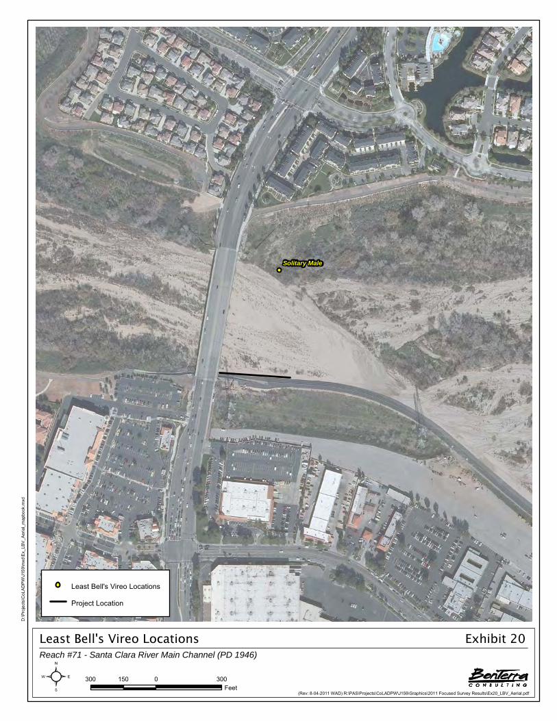
Least Bell's Vireo LocationsReach #71 - Santa Clara River Main Channel (PD 1946)
Exhibit 20
(Rev: 8-04-2011 WAD) R:\PAS\Projects\CoLADPW\J159\Graphics\2011 Focused Survey Results\Ex20_LBV_Aerial.pdf
Solitary Male
D:\P
roje
cts\
CoL
AD
PW\J
159\
mxd
\Ex_
LBV
_Aer
ial_
map
book
.mxd
300 0 300150Feet²
Least Bell's Vireo Locations
Project Location

Least Bell's Vireo LocationReach #71 - Santa Clara River Main Channel (PD 1946)
Exhibit 21
(Rev: 8-02-2011 WAD) R:\PAS\Projects\CoLADPW\J159\Graphics\2011 Focused Survey Results\Ex21_LBV_USGS.pdf
Santa Clara RiverSanta Clara RiverUSGS Quadrangle
NEWHALL
Solitary Male
D:\P
roje
cts\
CoL
AD
PW\J
159\
mxd
\Ex_
LBV
_US
GS_
map
book
.mxd
2,000 0 2,0001,000Feet²
Least Bell's Vireo Locations
Project Location

Project LocationReach #75 - South Fork - Santa Clara River (PDs 725, 916, 1041, 1300)
Exhibit 22
(Rev: 8-02-2011 WAD) R:\PAS\Projects\CoLADPW\J159\Graphics\2011 Focused Survey Results\Ex22_PL.pdf
Santa Clara RiverSanta Clara River
§̈¦5
126
Mcbean
Lyons
Valencia
Valley
Soledad Canyon
Wiley Canyon
Orchard Village
Bouq
uet C
anyo
n
Pico Canyon
Wiley
Canyon
The Old
Pine
WalnutNewhall
Newhall Ranch
8Th
Apple
Princessa
Oxford
Race
Anza
Cross
East
Parvin
West
Market
16Th
Maple
Ronada
Tour nament
9Th
Creekside
Ba
rra
Rotu
nda
Aden
Cardiff
Arcadia
Rotella
Fourl
Tourney
Powell
Railroad
Placeritos
Vermont
Navarre
Del M
onte
Mea
dvie
w
Sarda
El Paseo
Everett
S agecrest
Aven
idaPlacerita Canyon
Cinema
Wheeler
Atwood
Citr
us
Edison
Carrizo
Peachland
Trevino
Mill Valley
Wayman
Claibourne
Alta
15Th
Espuella
Rockwell Canyon
Haci
enda
Goldcrest
Evans
Avignon
14Th
Oak R
idge
11Th
Wile
y Can
yon
12Th
Festividad
Oak
Springbrook
Scott
Spruce
Bellis
3Rd
Circle J Ranch
Cortina
Vist
a
Hills
Alderbrook
Frasca
Sheffield
Hawkbryn
Alican
te
Hopkins
Balita
Cherry
Smokewood
Entrana
KarieRa
na
Steinbeck
Tibbitts
Chestnut
Dalgo
Arbor
Alta Madera
Dalbey
13Th
Jaca
ra
Mir
asol
B rig
hton
Rolling Ridge
Escalera
Woo
dlan
ds
Fambrough
Es taban
Highspri ng
Artin
a
Lupi
ta
John Rus
sell
Diaz
Qui
lla
Cheyenne
Jasmine
Salceda
Vela
n
Blake
Rondel
Car
iz
Town Center
Summit
Benito
Andorra
6Th
Redview
Qui
gley
Can
yon
Oak Vale
Jolita
Bras
a
Oak Orchard
Sing
ing
Hill
s
La Glorita
Corsa
Seren
a
Don
a C
h ris
ta
Aranda
Ignacio
Mar
sala
Bracken
Palo
mita
Park
Heraldo
Pacifica
Markel
Real
Fedala
Dicken
s
Par k Vie
w
Hog
an
Eliso
Nas
hua
Amado
Barnhill
K irstengary
Play
er
Oriol
Des
ert
Golf View
Turquesa
Co
nstitution
Arch
White Wing
Brav
a
Drayton
Neargate
Bocina
5Th
Paolino
Dorena
Birmingham
Tossano
Valle
Del
Oro
Wabuska
Bajada
Arroyo Park
Bellerive
Laurel
crest
Vista Ridge
Tana
ra
Escovar
Mesa
Brei
Ca non
Cleardale
Crestview
Sist
i ne
Croc
kett
Huerta
Farro
w
Almendra
Morn ington
Espinoza
Ham
pton
Moreno
Hazelcrest
Little Ceder
Auto
Cen
ter
Heather Vale
Adorna
Lupo
na
Loch
moo
r
JenielSaludo
Yvett
e
Adolfo
Juana
Tampico
Las Mananita
s
Arlen
Bungalow Court
Log dell
Jennifer
Rodi
n
Golden Triangle
Lyon
s Ra
nch
Derby
Lorik
eet
Faisan
Kitf ox
Copeta
C a ndice
Elliot
Garland
Bighorn
Pem
broo
k
Masters Cup
Lola
DabnaAlesna
Hilse
Baleria
Candela
Davey
Mon
et
Rose
park
Flored
Nor
fork
Corn
wal
l
Alamos
Chic
ory
Wintergreen
Acorde
Palomino
Knol lwood
Oakrun
Zermatt
Dega
s
Happy Valley
Dolarita
Dog
woo
d
Shawna
Reg
ents
Park
New
cast
le
Bella Vista
Millston
Los Altos
New
acre
Pepperidge
Columbia
Larios
Sabado
Piedros
Chiffchaff
American
Bam
boo
Spr ingbr ook
Hampton
8Th
The Old
8Th
Chestnut
13Th
Pine
Market
7
Brier
Bramble
D:\P
roje
cts\
CoL
AD
PW\J
159\
mxd
\Ex_
PL_
map
book
.mxd
0.5 0 0.50.25Miles²
Project Location

Los Angeles County Soft-Bottom Channels
R:\PAS\Projects\CoLADPW\J159\SBC Report 2011\Focused Srvy Rpt-083011.docx 26 2011 Focused Survey Results
Arroyo Toad
The arroyo toad was not observed in Reach 75 during these surveys.
Least Bell’s Vireo
The least Bell’s vireo was not observed in Reach 75 during these surveys.
Southwestern Willow Flycatcher
The southwestern willow flycatcher was not observed in Reach 75 during these surveys.
3.4.3 REACH 79 – SOUTH FORK – SANTA CLARA RIVER (VALENCIA BOULEVARD BRIDGE STABILIZER)
Project Location
Reach 79, South Fork-Santa Clara River (Valencia Boulevard Bridge Stabilizer), is located within the Santa Clara River-South Fork watershed (Exhibit 23). The limits of Reach 79 are the downstream edge of Valencia Boulevard to approximately 167 feet downstream of Valencia Boulevard. Reach 79 is 167 feet in total length. The reach is found on the USGS Newhall 7.5-minute quadrangle map (Refer to Thomas Guide, Los Angeles County, page 4550-G3).
Survey Results
The table below summarizes the type of surveys completed, survey dates, and surveying biologist for each survey within this reach.
TABLE 12 REACH 79 – SOUTH FORK – SANTA CLARA RIVER
(VALENCIA BOULEVARD BRIDGE STABILIZER)
Survey Type Survey Dates Surveying Biologist
Focused survey for arroyo toad
March 30; April 28; May 11 and 24, 2011 Sam Stewart and Jason Mintzer
June 8, 2011 Sam Stewart and Jonas Winbolt
June 23, 2011 James Huelsman and Jason Mintzer
Focused survey for the least Bell’s vireo and southwestern
willow flycatcher
April 10 and 23; May 4, 21, and 31; June 11 and 21: July 3 and 16,
2011 James Pike
Arroyo Toad
The arroyo toad was not observed in Reach 79 during these surveys.
Least Bell’s Vireo
The least Bell’s vireo was not observed in Reach 79 during these surveys.
Southwestern Willow Flycatcher
The southwestern willow flycatcher was not observed in Reach 79 during these surveys.

Project LocationReach #79 - South Fork - Santa Clara River (Valencia Boulevard Bridge Stabilizer)
Exhibit 23
(Rev: 8-02-2011 WAD) R:\PAS\Projects\CoLADPW\J159\Graphics\2011 Focused Survey Results\Ex23_PL.pdf
Santa Clara RiverSanta Clara River
§̈¦5
126Mcbean
Valencia
Decoro
Bouq
uet Canyon
The Old
Seco Canyon
Soledad Canyon
Orchard Village
Wile
y Can
yon
Stev
enso
n Ra
nch
Newhall Ranch
Anza
Scott
Smyth
Garza
Pamplico
Edison
Tourney
Decoro
Princessa
Stanford
Oxford
Gran
dvie
w
Catal aLos
Rye Canyon
East
Fairview
Wes
t
Hills
boro
ugh
16Th
Dicka son
Copper Hill
Creekside
Ba
rra
Tibbitts
Cardiff
Mcb
ean
Hopkins
Arriba
The Old
Navarre
Del M
onte
Sarda
El Paseo
Walnut
Tournament
Cinema
Brady
Parvin
Citr
us
Carrizo
Frisca
Cerca
Trevino
Mill Valley
Festividad
Claibourne
AltaEspuella
Newhall
Rockwel l Canyon
Goldcrest
Avignon
Oak R
idge
Boskovich
Cuervo
Wile
y Can
yon
Springbrook
Las Mananitas
Bellis
GroveparkO
nlee
Circle J Ranch
Cortina
Conde
Haci
enda
Elias
Kris
tin
Rockefeller
Sheffield
15Th
Alican
te
Rio Pecos
Rana
Steinbeck
PosadaChestnut
Dalgo
Arbor
Alta Madera
Hemingway
V ista Del
gado
Jaca
ra
Al
amogordo
Mir
asol
Ron
Ridg
e
Brig
hton
Rolling Ridge
Escalera
Woo
dlan
ds
Es taban
Sy
cam
ore
Cree
k
Ronada
Lupi
ta
John Rus
sell
Diaz
Alderbrook
Qui
lla
Barb
acoa
Cheyenne
Salceda
Aden
Vela
n
Blak
e
Town Center
Santa Clarita
Arriola
Summit
Benito
Blueridg e
Sk
ycrest
Elder
View
Oak Vale
Jolita
Bidwell
T u la
Mea
dvie
w
Sing
ing
Hill
s
Jodi
Northp ark
Seren
aC
abre
ra
Don
a C
h ris
ta
Ignacio
Mar
sala
Palo
mita
Bennington
La Rochelle
Terraza
Caceras
Heraldo
Pacifica
Suns
et H
ills
Centurion
Real
Briarcli f f
Fedala
Kearny
Scallio n
Park V
iew
Hog
an
Nas
hua
Fitzgerald
Barnhill
K irsten
gary
Banuelo
Play
er
OriolPa
rkla
ne
Rosemont
Cuatro Milpas
Dalbey
Cheraw
Golf View
Preston
Turquesa
Napa
Luga
r De
Oro
Chaparro
White Wing
Drayton
Croc
kett
Fenwall
Paolino
Artine
Birmingham
Mentry
Chadsford
Tossano
Bajada
Bake
r
Arroyo Park
Bellerive
PhilbrookGarzota
Mesa
Can ones
Per lman
Clearidge
Silv
erhawk
Brid
gew
a ter
Huerta
Almendra
Morn ington
Espinoza
Ham
pton
Moreno
Whey
Vista Encantada
Little Ceder
Auto
Cen
ter
Heather Vale
Cameron
Adorna
Woodfield
Lupo
na
Loch
moo
r
Cuestport
Jeniel
Edenton
Latana
Saludo
Bea
Yvett
e
Adolfo
Tristin
Juana
Tampico
Weston
Rodi
n
Fremont
Barfield
Derby
Ruth
erfo
rd
Lorik
eet
Faisan
Laur
el G
len D
enoya
Ca ndice
Garland
Bighorn
Championship
Pem
broo
k
Masters Cup
Alaya
Birch
DabnaAlesna
Hilse
Baleria
Marjoram
Com
mut
er
Timberlane
Mon
et
Flored
Nor
fork
Corn
wal
l
Highlands
Turnberry
Peppercorn
Camargo
Abordo
Palomino
Rio Bosque
Knol lwood
Zermatt
Dega
s
Hil l
crest
Pelham
Shawna
Reg
ents
Park
New
cast
le
Rosa Linda
Los Altos
Redbud Ridge
New
acre
Cataro
Sabado
Chiffchaff
American
Mentry
Hampton
Decoro
Spr ingbr ook
Oakdale
7
D:\P
roje
cts\
CoL
AD
PW\J
159\
mxd
\Ex_
PL_
map
book
.mxd
0.5 0 0.50.25Miles²
Project Location

Los Angeles County Soft-Bottom Channels
R:\PAS\Projects\CoLADPW\J159\SBC Report 2011\Focused Srvy Rpt-083011.docx 27 2011 Focused Survey Results
3.4.4 REACH 80 – SOUTH FORK-SANTA CLARA RIVER (PDS 1947 AND 1946)
Project Location
Reach 80, South Fork-Santa Clara River (PDs 1947 and 1946), is located within the Santa Clara River-South Fork watershed (Exhibit 24). The limits of Reach 80 are approximately 3,080 feet upstream of McBean Parkway to approximately 276 feet upstream of McBean Parkway and the confluence with Santa Clara River. Reach 80 is 2,804 feet in total length. The reach is found on the USGS Newhall 7.5-minute quadrangle map (Refer to Thomas Guide, Los Angeles County, page 4550-F2).
Survey Results
The table below summarizes the type of surveys completed, survey dates, and surveying biologist for each survey within this reach.
TABLE 13 REACH 80 – SOUTH FORK – SANTA CLARA RIVER (PDS 1947 AND 1946)
Survey Type Survey Dates Surveying Biologist
Focused survey for the arroyo toad
March 30; April 28; May 11 and 24, 2011 Sam Stewart and Jason Mintzer
June 8, 2011 Sam Stewart and Jonas Winbolt
June 23, 2011 James Huelsman and Jason Mintzer
Focused survey for the least Bell’s vireo and southwestern
willow flycatcher
April 10 and 23; May 4, 21, and 31; June 11 and 21: July 3,
and 16, 2011 James Pike
Arroyo Toad
The arroyo toad was not observed in Reach 80 during these surveys.
Least Bell’s Vireo
The least Bell’s vireo was not observed in Reach 80 during these surveys.
Southwestern Willow Flycatcher
The southwestern willow flycatcher was not observed in Reach 80 during these surveys.
3.4.5 REACH 82 – SANTA CLARA RIVER MAIN CHANNEL (PD 2278)
Project Location
Reach 82, Santa Clara River Main Channel (PD 2278), is located within the Santa Clara River watershed, approximately 0.75-mile east of the I-5 and Magic Mountain Parkway intersection in the City of Santa Clarita (Exhibit 25). The upstream limits of Reach 82 are approximately 740 feet southeast of the intersection of Hopkins Avenue and Rockefeller Avenue to just south of the intersection of Hopkins Avenue and Rockefeller Avenue. Reach 82 is 865 feet in total length. The reach is found on the USGS Newhall 7.5-minute quadrangle map (Refer to Thomas Guide, Los Angeles County, page 4550-D1).

Project LocationReach #80 - South Fork - Santa Clara River (PDs 1947 and 1946)
Exhibit 24
(Rev: 8-02-2011 WAD) R:\PAS\Projects\CoLADPW\J159\Graphics\2011 Focused Survey Results\Ex24_PL.pdf
Santa Clara RiverSanta Clara River
§̈¦5
126
Mcbean
Valencia
The Old
Decoro
Seco Canyon
Bouq
uet C
anyo
n
Soledad Canyon
OrchardVillage
Magic
Mountain
Newhall Ranch
Anza
Scott
Rye Canyon
Smyth
Garza
Stanford
Edison
Tourney
Decoro
Pamplico
Brady
Gran
dvie
w
C atal a
Mcb
ean
Los
East
Copper Hill
Fairview
Wes
t
Hills
boro
ugh
Princes
sa
Dickason
Creekside
Ba
rra
Tibbitts
Barcotta
Oxford
Hopkins
Hall
Arriba
Cardiff
Navarre
Del M
onte
Sarda
El Paseo
Crocker
Cinema
Citr
us
Carrizo
Frisca
Suns
et H
ills
16Th
Cerca
Mill Valley
Festividad
Alta
Espuella
Rockwell Canyon
Sant
a Cl
arita
Goldcrest
Avignon
Oak Ridge
Boskovich
Cuervo
Syca
mor
e Cr
eek
Wile
y Can
yonTw
ain
Springbrook
Las Mananitas
Bellis
Cortina
Circle J Ranch
Tournament
Conde
Rockefeller
Sheffield
The Old
Alica n
te
Northpark
Ohara
Rio Pecos
Rana
Posada
Dalgo
Arbor
Alta Madera
V ista D
elga
do
Jaca
ra
Mir
asol
B rig
hton
Feedmill
Woo
dlan
ds
Es taban
Lupi
ta
John Rus
sell
Diaz
Qui
lla
Barb
acoa
Cheyenne
Salceda
Blak
e
Hemingway
Kavenagh
Town Center
Summit
Calvello
Benito
Blueridge
Sk
ycrest
Elder
View
Bidwell
T u la
Bronte
Velan
Sing
ing
Hill
s
Carne
gie
Seren
a
Singe
r
Cabr
era
Don
a Ch
rista
Briarclif f
Mar
sala
Palo
mita
Bennington
La Rochelle
Terraza
Heraldo
Pacifica
Magnolia Glen
Real
Fedala
Kearny
Dicken
s
Par k Vi
ew
Claibourne
Nas
hua
Fitzgera ld
K irstengary
Oriol
Park
lane
Rosemont
Cuatro M
ilpas
Cheraw
Golf View
Preston
Turquesa
Luga
r De
Oro
Chaparro
White Wing
Crookshank
Drayton
Fenwall
Paolino
Holmes
Mentry
London
Hacienda
Chadsford
Tossano
Bajada
Arroyo Park
PhilbrookGarzota
Mesa
Canones
Clearidge
Hammet
Mulberr
y Glen
Silv
erhawk
Brid
gew
a ter
Huerta
Almendra
Morn ington
Espinoza
Ham
pton
Moreno
Burns
Vista Encantada
Little Ceder
Auto
Cen
ter
Heather Vale
Newhall
Cameron
Woodfield
Lupo
na
Loch
moo
r
Cuestport
Jeniel
Edenton
Latana
Saludo
Adolfo
Shaw
Juana
Tampico
Bungalow Court
Cher
ry C
reek
Weston
Rodi
n
Fremont
Barfield
Derby
Ruth
erfo
rd
Perlman
Lorik
eet
Faisan
Sarkis
Laur
el G
len
Kitfox
Denoya
Ca ndice
Garland
Pem
broo
k
Alaya
Bals
am
Birch
DabnaAlesna
Hilse
Baleria
Com
mut
er
Timberlane
Mon
et
Sa vory
Clar
k
Flored
Nor
fork
Crown Court
Sageview
Highlands
Turnberry
Camargo
Abordo
Bloo
mfie
ld
Robindale
Rio Bosque
Knol lwood
Tary
n
Summerhill
Zermatt
Dega
s
Hil lc
rest
Pelham
Shawna
Reg
ents
Park
Los Altos
Redbud Ridge
New
acre
Cataro
Sabado
Piedros
Chiffchaff
American
Santa Clarita
Mentry
DecoroSpringbr ook
7
D:\P
roje
cts\
CoL
AD
PW\J
159\
mxd
\Ex_
PL_
map
book
.mxd
0.5 0 0.50.25Miles²
Project Location

Project LocationReach #82 - Santa Clara River Main Channel (PD 2278)
Exhibit 25
(Rev: 8-02-2011 WAD) R:\PAS\Projects\CoLADPW\J159\Graphics\2011 Focused Survey Results\Ex25_PL.pdf
Santa Clara RiverSanta Clara River
§̈¦5
126
Mcbean
The Old
Valencia
Decoro
Bouq
uetCan
yon
Magic
Mountain
Stanford
Hall
Newhall Ranch
Anza
Mcb
ean
Scott
Rye Canyon
Smyth
Copper Hill
Tourney
Decoro
Feedmill
Brady
Gran
dvie
w
East
FairviewW
est
Hills
boro
ugh
Dicka son
CrockerCreekside
Tibbitts
Nort
hpar
k
Hopkins
Navarre
Del M
onte
El Paseo
Lian
a
CinemaCi
trus
Edison
Carrizo
Suns
et H
ills
Cerca
Alta
Magic
Mounta
in
Rockwel l C
anyon
Goldcrest
Avignon
Boskovich
Pa
mpl
ico
Springbrook
Bellis
Frisca
Cuervo
Syca
mor
e Cr
eek
Cortina
Calvello
Conde
Rockefeller
Alican
te
Dalgo
Posada
Alta Madera
Jaca
ra
Mir
asol
B rig
hton
Woo
dlan
ds
Es taban
Lupi
ta
John Rus
sell
Cheyenne
Salceda
Tupelo Ridge
Town Center
Summit
Benito
Blueridge
Sk
ycrest
Elder
View
Bidwell
Carroll
Seren
a
Don
a C
h ris
ta
Fir
Briarclif f
Mar
sala
Vista Delg
ado
Palo
mita
Bennington
Oak Ridge
Bate
s
Heraldo
Pacifica
Magnolia Glen
Real
Twain
Kearny
Park V
iew
Singe
r
K irsten
gary
Jolita
Park
lane
Rosemont
Preston
Turquesa
Napa
Drayton
Tech
nolog y
Paolino
Mentry
Sing
ing
Hill
s
Chadsford
Palmetto Ridge
Tossano
Bajada
Arroyo Park
Philbrook
Wiley Canyon
Mesa
Sorrel
Redwood Glen
Clearidge
Mulberr
y Glen
Silv
erhawk
Brid
gew
a ter
Huerta
Alabastro
Almendra
Morn ington
Espinoza
Ham
pton
Moreno
Vista Encantada
Auto
Cen
ter
Cameron
Woodfield
Arbor
Knudsen
Lupo
na
Cold
Spr
ings
Cuestport Edenton
Latana
Saludo
Hunt
ingt
on
Adolfo
Cabr
illo
Tampico
Bungalow Court
Weston
Rodi
n
Fremont
Barfield
Ruth
erfo
rd
Mem
ory
Lorik
eet
Faisan
Laur
el G
len
Ca ndice
Garland
Bighorn
Bals
am
Birch
DabnaAlesna
Baleria
Ohara
Timberlane
Mon
et
Flored
Crown Court
SageviewHighlands
Turnberry
Oak
Robindale
Knol lwood
Summerhill
Dega
s
Hil lc
rest
Laur
el C
reek
Pelham
Reg
ents
Park
Los Altos
New
acre
Sabado
Chiffchaff
American
Edison
Spr ingbr ook
Mentry
7
D:\P
roje
cts\
CoL
AD
PW\J
159\
mxd
\Ex_
PL_
map
book
.mxd
0.5 0 0.50.25Miles²
Project Location

Los Angeles County Soft-Bottom Channels
R:\PAS\Projects\CoLADPW\J159\SBC Report 2011\Focused Srvy Rpt-083011.docx 28 2011 Focused Survey Results
Survey Results
The table below summarizes the type of surveys completed, survey dates, and surveying biologist for each survey within this reach.
TABLE 14 REACH 82 – SANTA CLARA RIVER MAIN CHANNEL (PD 2278)
Survey Type Survey Dates Surveying Biologist
Focused survey for the arroyo toad
March 30; April 28; May 11 and 24, 2011 Sam Stewart and Jason Mintzer
June 8, 2011 Sam Stewart and Jonas Winbolt
June 23, 2011 James Huelsman and Jason Mintzer
Focused survey for the least Bell’s vireo and southwestern
willow flycatcher
April 15 and 27; May 9 and 31, 2011, Lindsay Messett
May 19; June 10 and 20; July 1 and 13, 2011 Brian Daniels
Arroyo Toad
The arroyo toad was not observed in Reach 82 during these surveys.
Least Bell’s Vireo
The least Bell’s vireo was not observed in Reach 82 during these surveys.
Southwestern Willow Flycatcher
The southwestern willow flycatcher was not observed in Reach 82 during these surveys.
3.4.6 REACH 86 – VIOLIN CANYON MAIN CHANNEL OUTLET
Project Location
Reach 86, Violin Canyon Main Channel Outlet, is located within the Castaic Creek watershed in the community of Castaic in unincorporated Los Angeles County, approximately 0.5 mile southeast of the I-5 and Lake Hughes Road intersection (Exhibit 26). The limits of Reach 86 are approximately 1,021 feet downstream of Ridge Route Road to the confluence with Castaic Creek. Reach 86 is 946 feet in total length. The reach is found on the USGS Newhall 7.5-minute quadrangle map (Refer to Thomas Guide, Los Angeles County, page 4369-J7).
Survey Results
The table below summarizes the type of surveys completed, survey dates, and surveying biologist for each survey within this reach.
TABLE 15 REACH 86 – VIOLIN CANYON MAIN CHANNEL OUTLET
Survey Type Survey Dates Surveying Biologist
Focused survey for the arroyo toad April 6; May 2; May 12 and 23; June 6 and 21, 2011 Sam Stewart and Jason Mintzer

Project LocationReach #86 - Violin Canyon Main Channel Outlet
Exhibit 26
(Rev: 8-02-2011 WAD) R:\PAS\Projects\CoLADPW\J159\Graphics\2011 Focused Survey Results\Ex26_PL.pdf
Castaic LakeCastaic LakeLagoonLagoon
Cas
taic
Cre
ekC
asta
ic C
reek
Cre
ekC
reek
§̈¦5
Rid
geTh
e O
ld
Lake Hughes
Parker
Sloa
nC
anyo
n
Ridge
Castaic
The Old
Hillcrest
Charlie
Canyo
n
Tap ia CanyonGreen Hill
Sloan Canyon
Wayside C
anyon
Cher
ry
Bery
l
Royal
Victoria
Cascade
Ruby
Onyx
Big Oak
Vaca
Oak Valley
Quartz
Rainier
Sagu
aro
Yosemite
Branch
Emerald
Lassen
Heather
Park
er
Park
Vis
ta
Bryce
Firebrand
Villa Canyon
Oly
m
pic
Yucc
a
Lake
hills
Bridlewood
Fa
lls
El k R
idge
Foothill
Desert
Knoll
Meadow Grass
Mariposa
Ferguson
Polson
Gr eenwood
Qua
il Val
ley
Desert Rose
Hun
ter
Stallion
Barcelona
Agate
Zion
Ponderosa
Muir Grove
Servilla Lupine
Pinecone
Gelding
Fantastic
Pine Crest
V
alley Vie w
Elkwood
WindyN
eely
Navajo
Timber
Cors
ica
Gilm
an
Ridge
Bis
cailu
z
Cha
nnel
Dum
p
D:\P
roje
cts\
CoL
AD
PW\J
159\
mxd
\Ex_
PL_
map
book
.mxd
0.5 0 0.50.25Miles²
Project Location

Los Angeles County Soft-Bottom Channels
R:\PAS\Projects\CoLADPW\J159\SBC Report 2011\Focused Srvy Rpt-083011.docx 29 2011 Focused Survey Results
Arroyo Toad
The arroyo toad was not observed in Reach 86 during these surveys.
3.4.7 REACH 87 – CASTAIC-OLD ROAD DRAIN (CDR 525.021D) OUTLET
Project Location
Reach 87, Castaic – Old Road Drain (CDR 525.021D) Outlet, is located within the Castaic Creek watershed, approximately one mile northwest of the I-5 and Henry Mayo Drive (Highway 126) in the Castaic Junction community of unincorporated Los Angeles County (Exhibit 27). The limits of Reach 87 are approximately 610 feet downstream of the intersection of Hasley Canyon Road and Old Road to the confluence with Castaic Creek. Reach 87 is 240 feet in total length. The reach is found on the USGS Newhall 7.5-minute quadrangle map (Refer to Thomas Guide, Los Angeles County, page 4459-H5).
Survey Results
The table below summarizes the type of surveys completed, survey dates, and surveying biologist for each survey within this reach.
TABLE 16 REACH 87 – CASTAIC-OLD ROAD DRAIN (CDR 525.021D) OUTLET
Survey Type Survey Dates Surveying Biologist
Focused survey for the arroyo toad April 6; May 2; May 12 and 23; June 6 and 21, 2011 Sam Stewart and Jason Mintzer
Focused survey for the least Bell’s vireo and southwestern
willow flycatcher
April 11 and 22; May 2 and 24; June 6, 16, and 28;
and July 14, 2011 Amber Oneal
Arroyo Toad
The arroyo toad was not observed within Reach 87 during these surveys.
Least Bell’s Vireo
The least Bell’s vireo was not observed in Reach 87 during these surveys.
Southwestern Willow Flycatcher
The southwestern willow flycatcher was not observed in Reach 87 during these surveys.
3.4.8 REACH 97 – CASTAIC CREEK – THE OLD ROAD (PD 1982)
Project Location
Reach 97, Castaic Creek – The Old Road (PD 1982), is located within the Castaic Creek watershed in the Castaic Junction community of unincorporated Los Angeles County (Exhibit 28). The limits of Reach 97 are approximately 300 feet downstream to 2,300 feet downstream of The Old Road. Reach 97 is 2,000 feet in total length. The reach is found on the USGS Newhall 7.5-minute quadrangle maps (Refer to Thomas Guide, Los Angeles County, page 4459-H5 to 4459-H6).

Project LocationReach #87 - Castaic Creek - Old Road Drain (CDR 525.021D) Outlet
Exhibit 27
(Rev: 8-02-2011 WAD) R:\PAS\Projects\CoLADPW\J159\Graphics\2011 Focused Survey Results\Ex27_PL.pdf
Cas
taic
Cre
ekC
asta
ic C
reek
Cas
taic
Cre
ekC
asta
ic C
reek
§̈¦5
UV126
The Old
Hasley Canyon
Del V
alle
Hillcrest
Hall
126
Stanford
Fran
klin
Feedmill
Seas
oned
Tapia Canyon
Crocker
Live Oak
Bery
l
Brady
Commerce Center
Livingston
Quincy
Cascade
Knud
sen
Industry
Whitherspoon
Pain
e
Rainier
Ram
p
Rye C
anyo
n
F irebrand
Yosemite
IrisLassen
Hancock
Wak
efiel
d
Park
Vis
ta
Bryce
Cambridge
Hasley Canyon
Villa Canyon
Oly
m
pic
Yucc
a
Castaic Canyon
Wayside C
anyo
n
Magic
Mounta
in
Biscailuz
Fa
lls
Foothill
Buck
skin
Desert
Saint Tropez
Knoll
Harriso
n Tech
nolog y
Polson
Hartford
Dia
blo
8 Th
CastaicM
arig
old
Chelsea
Stageline
Edison
Barcelona
Thornton
Zion
Sher
man
Ponderosa
Hunt
ingt
on
Lupine
Pinecone
V
alley Vie w
Elkwood
Sedona
Marseille
Wolcott
Gallo
ping
Henry Mayo
Braxton
Fenw
ay
Gilm
an
Seasoned
Seasoned
Bis
cailu
z
Dum
pC
hann
el
D:\P
roje
cts\
CoL
AD
PW\J
159\
mxd
\Ex_
PL_
map
book
.mxd
0.5 0 0.50.25Miles²
Project Location

Project LocationReach #97 - Castaic Creek - The Old Road (PD 1982)
Exhibit 28
(Rev: 8-02-2011 WAD) R:\PAS\Projects\CoLADPW\J159\Graphics\2011 Focused Survey Results\Ex28_PL.pdf
Cas
taic
Cre
ekC
asta
ic C
reek
Cas
taic
Cre
ekC
asta
ic C
reek
§̈¦5
UV126
The Old
Hasley Canyon
Del V
alle
Hillcrest
Hall
126
Seasoned
Fran
klin
Stanford
Feedmill
Crocker
Tapia Canyon
Live Oak
Bery
l
Commerce Center
Livingston
Quincy
Cascade
Brady
Knud
sen
Industry
Whitherspoon
Pain
e
Magic
Mounta
in
Rainier
Ram
pF irebrand
Yosemite
IrisLassen
Rye C
anyo
n
Hancock
Hasley Canyon
Wak
efiel
d
Park
Vis
ta
Bryce
Cambridge
Villa Canyon
Oly
m
pic
Yucc
a
Castaic Canyon
Biscailuz
Bass
et
F a
lls
Saint Tropez
Buck
skin
Desert
Knoll
Harriso
n Tech
nolog y
Polson
Hartford
Dia
blo
8 Th
Mar
igol
d
Chelsea
Way
side C
anyon
Stageline
Edison
Barcelona
Thornton
Zion
Sher
man
Ponderosa
Hunt
ingt
on
Lupine
Pinecone
V
alley Vie w
E lkwood
Sedona
Marseille
Wolcott
Sorr
ento
Henry Mayo
Braxton
Fenw
ay
Gilm
an
Seasoned
Seasoned
Bis
cailu
z
Dum
pC
hann
el
D:\P
roje
cts\
CoL
AD
PW\J
159\
mxd
\Ex_
PL_
map
book
.mxd
0.5 0 0.50.25Miles²
Project Location

Los Angeles County Soft-Bottom Channels
R:\PAS\Projects\CoLADPW\J159\SBC Report 2011\Focused Srvy Rpt-083011.docx 30 2011 Focused Survey Results
Survey Results
The table below summarizes the type of surveys completed, survey dates, and surveying biologist for each survey within this reach.
TABLE 17 REACH 97 – CASTAIC CREEK – THE OLD ROAD (PD 1982)
Survey Type Survey Dates Surveying Biologist
Focused survey for the arroyo toad April 6; May 2; May 12 and 23; June 6 and 21, 2011 Sam Stewart and Jason Mintzer
Focused survey for the least Bell’s vireo and southwestern
willow flycatcher
April 11 and 22; May 2 and 24; June 6, 16, and 28;
and July 14, 2011 Amber Oneal
Arroyo Toad
The arroyo toad was not observed within Reach 97 during these surveys.
Least Bell’s Vireo
The least Bell’s vireo was not observed in Reach 97 during these surveys.
Southwestern Willow Flycatcher
The southwestern willow flycatcher was not observed in Reach 97 during these surveys.
3.4.9 REACH 103 – BOUQUET CANYON CHANNEL (PD 2225)
Project Location
Reach 103, Bouquet Canyon Channel (PD 2225), is located within the Santa Clara River watershed (Exhibit 29). The limits of Reach 103 are approximately 173 feet downstream of the centerline of Newhall Ranch Road (beginning of Grouted Stone Toe) to the Metropolitan Water District Fee Right-of-Way on the right bank and the embankment turn at the Santa Clara River on the left bank. Reach 103 is 1,824 feet in total length. The reach is found on the USGS Newhall 7.5-minute quadrangle map (Refer to Thomas Guide, Los Angeles County, page 4550-H1, 4550-H2, and 4550-G2).
Survey Results
The table below summarizes the type of surveys completed, survey dates, and surveying biologist for each survey within this reach.
TABLE 18 REACH 103 – BOUQUET CANYON CHANNEL (PD 2225)
Survey Type Survey Dates Surveying BiologistFocused survey for the least Bell’s vireo and southwestern
willow flycatcher
April 10 and 23; May 4, 21, and 31; June 11 and 21: July 3
and 16, 2011 James Pike

Project LocationReach #103 - Bouquet Canyon Channel (PD 2225)
Exhibit 29
(Rev: 8-02-2011 WAD) R:\PAS\Projects\CoLADPW\J159\Graphics\2011 Focused Survey Results\Ex29_PL.pdf
Santa Clara RiverSanta Clara River
§̈¦5
126Mcbean
Valencia
Bouquet Canyon
Decoro
Seco Canyon
Soledad Canyon
Orchard Village
Newhall Ranch
Scott
Smyth
Garza
Pamplico
Mcb
ean
Anza
Decoro
Princessa
Oxford
Gran
dvie
w
Catala
Los
Caraway
Copper Hill
East
Fairview
West
Hills
boro
ugh
Dick ason
Creekside
Tibbitts
Cardiff
Barcotta Ha
skel
l Can
yon
Hopkins
Jef fers
Arriba
Santa Clarita
Navarre
Del M
onte
El Paseo
Grovepark
Syca
mor
e Cr
eek
Cinema
Barra
Citr
us
Northpark
Carrizo
Frisca
Suns
et H
ills
Paragon
Cerca
Festividad
Carne
gie
Claibourne
Alta
Stanfor
d
Espuella
Rockwell Canyon
Kenf
el
Goldcrest
Centurion
Avignon
Oak R
idge
Boskovich
Cuervo
Redview
Kent
on
Hyssop
Springbrook
Las Mananitas
Bellis
Onlee
Cortina
Conde
Elias
Kris
tin
Rockefeller
Sheffield
Alican
te
Guilf
ord
Che r
ry C
reek
Rio Pecos
Circle J Ranch
Posada
Dalgo
Arbor
Alta Madera
V ista Del
gado
Jaca
ra
Alamogordo
Mir
asol
Ron
Ridg
e
Brig
hton
Rolling Ridge
Woo
dlan
ds
Es taban
Lupi
taWile
y Canyon
John Rus
sell
Diaz
Lynette
Barb
acoa
Cheyenne
Salceda
Tupelo Ridge
Town Center
Rana
Arriola
Summit
Calvello
Lian
a
Dex ter
Benito
Blueridge
Crookshank
Sk
ycrest
Elder
View
Bidwell
T u la
Sing
ing
Hill
s
Jodi
Barr
ett
Seren
a
Cabr
era
Don
a Ch
rist a
Ston
ingt
on
Briarclif f
Mar
sala
Palo
mita
Agajanian
Bennington
La Rochelle
Terraza
Cacera
s
Heraldo
Pacifica
Qui
lla
Magnolia Glen
Real
Kearny
Par k Vi
ew
Diane
Mar
ie
K irstengary
Bobw
hite
Oriol
Grano
Park
lane
Ridgegrove
Rosemont
Faircliff
Cuatro M
ilpa s
Cheraw
Preston
Turquesa
Sequoia Glen
Napa
Rain
danc
e
Tourney
Luga
r De
Oro
Chaparro
White Wing
Drayton
Fenwall
Golden Triangle
Paolino
Nas
hua
Artine
Rosedell
Birmingham
Mentry
Chadsford
Whey
Palmetto Ridge
Barnhill
Tossano
Bajada
Arroyo Park
H on nold
Philbrook
Karie
Mesa
Can ones
Peppercorn
Clearidge
Mulber
ry Glen
Silv
erhawk
Brid
gew
a ter
Huerta
Carol Sue
Almendra
Mar jora
m
Spice
Morn ington
Espinoza
Ham
pton
Moreno
Featherstar
Vista Encantada
Little Ceder
Auto
Cen
ter
Heather Vale
Cameron
Woodfield
Tournament
Lupo
na
Rodeffer
Cold
Spr
ings
Cuestport
Jeniel
Edenton
Latana
Saludo
Bea
Adolfo
Mari am
Cabr
illo
Edison
Tampico
Ginger
Bungalow Court
Weston
Rodi
n
Barfield
Derby
Ruth
erfo
rd
Mem
ory
Lorik
eet
Faisan
Sarkis
Laur
el G
len D
enoya
Ca ndice
Garland
Bighorn
Farmington
Pem
broo
k
Alaya
Savory
Bals
am
Birch
DabnaAlesna
Baleria
Timberlane
Mon
et
Clar
k
Flored
Nor
fork
Crown Court
Corn
wal
l
Sageview
Highlands
Abordo
The Old
Robindale
Rio Bosque
Knol lwood
Tary
n
Summerhill
Nutmeg
Zermatt
Dega
s
Hillc
re st
Pelham
Shawna
Reg
ents
Park
Bedford
New
cast
leAcanthus
Los Altos
Redbud Ridge
Sims
New
acre
Cataro
Sabado
Chiffchaff
Beau
Rose Lee
American
Calvello
Springbrook
Mentry
Decoro
Hampton
Alta
Kno
ll7
Brier
Jim
ps
on
D:\P
roje
cts\
CoL
AD
PW\J
159\
mxd
\Ex_
PL_
map
book
.mxd
0.5 0 0.50.25Miles²
Project Location
Los Angeles County Soft-Bottom Channels
R:\PAS\Projects\CoLADPW\J159\SBC Report 2011\Focused Srvy Rpt-083011.docx 31 2011 Focused Survey Results
Least Bell’s Vireo
The least Bell’s vireo was not observed in Reach 103 during these surveys.
Southwestern Willow Flycatcher
The southwestern willow flycatcher was not observed in Reach 103 during these surveys.
3.4.10 REACH 104 – CASTAIC CREEK (PD 2441 – UNITS 1 AND 2)
Project Location
Reach 104, Castaic Creek (PD 2441 – Unit 2), is located within the Castaic Creek watershed. The limits of Reach 104 are approximately 669 feet upstream of the Muirfield Lane Centerline to 478 feet downstream of the Turnberry Lane Centerline (Exhibit 30). Reach 104 is 2,186 feet in total length. The reach is found on the USGS Newhall 7.5-minute quadrangle map (Refer to Thomas Guide, Los Angeles County, page 4459- H6 to 4459-H7).
Survey Results
The table below summarizes the type of surveys completed, survey dates, and surveying biologist for each survey within this reach.
TABLE 19 REACH 104 – CASTAIC CREEK (PD 2441 � UNIT 2)
Survey Type Survey Dates Surveying Biologist
Focused survey for the arroyo toad April 6; May 2; May 12 and 23; June 6 and 21, 2011 Sam Stewart and Jason Mintzer
Focused survey for the least Bell’s vireo and southwestern
willow flycatcher
April 11 and 22; May 2 and 24; June 6, 16, and 28; and July 14, 2011 Amber Oneal
Arroyo Toad
The arroyo toad was not observed within Reach 104 during these surveys.
Least Bell’s Vireo
The least Bell’s vireo was not observed in Reach 104 during these surveys.
Southwestern Willow Flycatcher
The southwestern willow flycatcher was not observed in Reach 104 during these surveys.
3.4.11 REACH 105 � SAN FRANCISQUITO CHANNEL (PD 2456)
Project Location
Reach 105, San Francisquito Channel (PD 2456), is located within the Santa Clara River watershed in unincorporated Los Angeles County (Exhibit 31). The limits of Reach 105 are approximately 417 feet upstream of the Decoro Drive Centerline to 416 feet downstream of the Decoro Drive Centerline. Reach 105 is 833 feet in total length. The reach is found on the USGS Newhall 7.5-minute quadrangle map (Refer to Thomas Guide, Los Angeles County, page 4460-F6).

Project LocationReach #104 - Castaic Creek (PD 2441 Units 1 and 2)
Exhibit 30
(Rev: 8-02-2011 WAD) R:\PAS\Projects\CoLADPW\J159\Graphics\2011 Focused Survey Results\Ex30_PL.pdf
Cas
taic
Cas
taic
Cas
taic
Cre
ekC
asta
ic C
reek
§̈¦5
UV126
The Old
Hasley Canyon
Del Valle
126
Hillcrest
Seasoned
Hall
126
Stanford
Fran
klin
Feedmill
Brady
Crocker
Live Oak
Bery
l
Commerce Center
Livingston
Quincy
Cascade
Knud
sen
Industry
Whitherspoon
Pain
e
Magic
Mounta
in
Rainier
Ram
p
F irebrand
Yosemite
Iris
Rye Canyon
Lassen
Hancock
Wakef
ield
Park
Vis
ta
Bryce
Cambridge
Villa Canyon
Oly
m
pic
Yucc
a
Castaic Canyon
Hasley Canyon
Biscailuz
Fa
lls
Buck
skin
Desert
Knoll
Harriso
n
Tech
nolog y
Polson
Hartford
Dia
blo
8 Th
Mar
igol
d
ChelseaStageline
Edison
Saint Tropez
Barcelona
Thornton
Zion
Sher
man
Ponderosa
Hunt
ingt
on
Servilla Lupine
Pinecone
Elkwood
Sedona
Wolcott
Henry Mayo
Braxton
Fenw
ay
Gilm
an
Rye C
anyo
n
Seasoned
Bis
cailu
z
Dum
pC
hann
el
D:\P
roje
cts\
CoL
AD
PW\J
159\
mxd
\Ex_
PL_
map
book
.mxd
0.5 0 0.50.25Miles²
Project Location

Project LocationReach #105 - San Francisquito Canyon Channel (PD 2456)
Exhibit 31
(Rev: 8-02-2011 WAD) R:\PAS\Projects\CoLADPW\J159\Graphics\2011 Focused Survey Results\Ex31_PL.pdf
Santa Clara RiverSanta Clara River
§̈¦5
126
Mcbea
n
The Old
Valencia
Decoro
Seco Canyon
Bouq
uet C
anyo
n
Soledad Canyon
Copper HillSan
FrancisquitoC
anyon
Fir
Newhall Ranch
Mcb
ean
Copper Hill
Anza
Scott
Stanford
Rye Canyon
Smyth
Garza
Decoro
Pamplico
Brady
Gran
dvie
w
Los
Fairview
Hills
boro
ugh
Dicka son
Tam
arac
k
Seco
Can
yon
Hall
Nor
thpark
Creekside
Farmer John Lat
Tibbitts
Catala
Crocker
HopkinsArrib
a
Barcotta
Santa Clarita
Para
gon
Syca
mor
e Cr
eek
Boxwood
Lian
a
Cinema
Raintree
Citr
us
Frisca
Suns
et H
ills
Cerca
Festividad
Calex
Espuella
Avignon
Boskovich
Cuervo
Las Mananitas
Faircliff
Star
tree
Feedmill
Conde
Rockefeller
Rio Pecos
Posada
Tupelo Ridge
V ista D
elga
do
Lem
on
Diaz
Barb
acoa
Cheyenne
Hazel
Lobe
lia
San F
rancis
quito
Mtw
y
Mill
iken
Town Center
Calvello
Dex ter
B lueridge
Crookshank
Carne
gie
Popl
ar
Sk
ycrest
Elder
View
Bidwell
T u la
Ever
gree
n
Magic
Mounta
in
Briarclif f
Bennington
La Rochelle
Terraza
Magnolia Glen
Ediso n
Kearny
Cypress
Mag
nolia
Mir asol
Park
lane
Rosemont
Cuatro M
ilpas
Cheraw
Preston
Sequoia Glen
Luga
r De
Oro
Avoc
ado
Chaparro
Fenwall
Deo
dar
Mentry
Chadsford
Palmetto Ridge
Gib
son
Honnold
PhilbrookGarzota
Can ones
Sorrel
Clearidge
Mulber
ry Glen
Silv
er
hawk
Brid
gew
a ter
Huerta
Red Pine
Vista Encantada
Auto
Cen
ter
Cameron
Woodfield
Suga
r Pin
e
Cold
Spr
ings
Cuestport Edenton
Pueb
lo
Melodi
Cabr
illo
Spr ingbr ook
Weston
Rodi
n
Fremont
Barfield
Willow Tree
Mem
ory
Sarkis
Laur
el G
len D
enoya
Championship
Alaya
Bals
am
Birch
Com
mut
er
Red
Ceda
r
Timberlane
Hickory
Mon
et
Skylane
Crown Court
Sageview
Highlands
Turnberry
Med
lar
Camargo
Abordo
Meadow
lark
Robindale
Rio Bosque
Tary
n
Summerhill
Dega
s
Hil lc
rest
Gran
ite
Dant
on
Pelham
Redwood
Spru
ce C
reek
Gumtree
Redbud Ridge
New
acre
Cataro
Piedros
American
Edison
Calvello
Citr
us
Copper Hill
Decoro
Mentry
D:\P
roje
cts\
CoL
AD
PW\J
159\
mxd
\Ex_
PL_
map
book
.mxd
0.5 0 0.50.25Miles²
Project Location

Los Angeles County Soft-Bottom Channels
R:\PAS\Projects\CoLADPW\J159\SBC Report 2011\Focused Srvy Rpt-083011.docx 32 2011 Focused Survey Results
Survey Results
The table below summarizes the type of surveys completed, survey dates, and surveying biologist for each survey within this reach.
TABLE 20 REACH 105 � SAN FRANCISQUITO CHANNEL (PD 2456)
Survey Type Survey Dates Surveying BiologistFocused survey for the
arroyo toad April 6; May 2, 3, 12, 13, and 23;
June 6 and 21, 2011 Sam Stewart and Jason Mintzer
Focused survey for the least Bell’s vireo and southwestern
willow flycatcher
April 15 and 27; May 9 and 31, 2011 Lindsay Messett
May 19; June 10 and 20; July 1 and 13, 2011 Brian Daniels
Arroyo Toad
The arroyo toad was not observed in Reach 105 during these surveys.
Least Bell’s Vireo
A singing male least Bell’s vireo was present on June 10 on the west side of the wash at Reach 105 (see Exhibits 32 and 33). This male sang persistently from one patch of riparian vegetation during the course of this survey, but was not present on subsequent survey dates.
Southwestern Willow Flycatcher
The southwestern willow flycatcher was not observed in Reach 105 during these surveys.
3.4.12 REACH 106 – CASTAIC DRAIN OUTLET (RMD CHANNEL)
Project Location
Reach 106, Castaic Drain Outlet (RMD Channel), is located within the Santa Clara River watershed. The limits of Reach 106 are approximately the toe of grouted rip-rap apron to approximately 147 feet downstream of grouted rip-rap apron (Exhibit 34). Reach 106 is 147 feet in total length. The reach is found on the USGS Newhall 7.5-minute quadrangle map (Refer to Thomas Guide, Los Angeles County, page 4459-H1).
Survey Results
The table below summarizes the type of surveys completed, survey dates, and surveying biologist for each survey within this reach.
TABLE 21 REACH 106 – CASTAIC DRAIN OUTLET (RMD CHANNEL)
Survey Type Survey Dates Surveying BiologistFocused survey for the least Bell’s vireo and southwestern
willow flycatcher
April 11 and 22; May 2 and 24; June 6, 16, and 28; and July 14, 2011 Amber Oneal

Least Bell's Vireo LocationsReach #105 - San Francisquito Canyon Channel (PD 2456)
Exhibit 32
(Rev: 8-02-2011 WAD) R:\PAS\Projects\CoLADPW\J159\Graphics\2011 Focused Survey Results\Ex32_LBV_Aerial.pdf
Solitary Male
D:\P
roje
cts\
CoL
AD
PW\J
159\
mxd
\Ex_
LBV
_Aer
ial_
map
book
.mxd
300 0 300150Feet²
Least Bell's Vireo Locations
Project Location

Least Bell's Vireo LocationReach #105 - San Francisquito Canyon Channel (PD 2456)
Exhibit 33
(Rev: 8-02-2011 WAD) R:\PAS\Projects\CoLADPW\J159\Graphics\2011 Focused Survey Results\Ex33_LBV_USGS.pdf
Santa Clara RiverSanta Clara River
USGS QuadrangleNEWHALL
Solitary Male
D:\P
roje
cts\
CoL
AD
PW\J
159\
mxd
\Ex_
LBV
_US
GS_
map
book
.mxd
2,000 0 2,0001,000Feet²
Least Bell's Vireo Locations
Project Location

Project LocationReach #106 - Castaic Drain Outlet (RMD Channel)
Exhibit 34
(Rev: 8-02-2011 WAD) R:\PAS\Projects\CoLADPW\J159\Graphics\2011 Focused Survey Results\Ex34_PL.pdf
Castaic LakeCastaic LakeLagoonLagoon
Cas
taic
Cre
ekC
asta
ic C
reek
Cas
taic
Cre
ekC
asta
ic C
reek
§̈¦5
Rid
geTh
e O
ld
Lake Hughes
Parker
DelValle
Hasley Canyon
Sloa
nC
anyo
n
Hasley
Canyon
Ridge
Castaic
The Old
Hillcrest
Charlie
Canyon
Tapia Canyon
W
ayside C
anyo
n
Sloan Canyon
Green Hill
Cher
ry
Bery
l
Royal
Oak Valley
Victoria
Cascade
Ruby
Onyx
Avion
Big Oak
Vaca
Quartz
Rainier
F irebrand
Sagu
aro
Yosemite
Branch
Lassen
Heather
Park
er
P ark
Vis
ta
Bryce
Villa Canyon
Cinnabar
Yucc
a
Hasley Canyon
Quincy
Lake
hills
Bridlewood
Fa
lls
Elk R
idge
Desert
Knoll
Meadow Grass
Mariposa
Ferguson
Polson
Hartford
Saint Tropez
Greenwood
Qua
il Val
ley
Desert Rose
Hun
ter
Chelsea
Stallion
Be
acon
Barcelona
Agate
Rye
Cany
on
Zion
Ponderosa
Muir Grove
June R
ose
Glade
Servilla Lupine
Pinecone
Gelding
Fantastic
Live
Oak
Pine Crest
V
alley Vie w
Elkwood
Sedona
Windy
Nee
ly
Timber
Gilm
an
Ridge
Bis
cailu
z
Dum
pC
hann
el
D:\P
roje
cts\
CoL
AD
PW\J
159\
mxd
\Ex_
PL_
map
book
.mxd
0.5 0 0.50.25Miles²
Project Location

Los Angeles County Soft-Bottom Channels
R:\PAS\Projects\CoLADPW\J159\SBC Report 2011\Focused Srvy Rpt-083011.docx 33 2011 Focused Survey Results
Least Bell’s Vireo
The least Bell’s vireo was not observed in Reach 106 during these surveys.
Southwestern Willow Flycatcher
The southwestern willow flycatcher was not observed in Reach 106 during these surveys.
3.4.13 REACH 109 – SANTA CLARA RIVER – SOUTH BANK WEST OF MCBEAN PARKWAY (MTD 1510)
Project Location
Reach 109, Santa Clara River – South Bank West of McBean Parkway (MTD 1510), is an outlet located on the south bank (concrete levee) just west or downstream of McBean Parkway (Exhibit 35). The limits of Reach 109 are from the outlet, approximately 300 feet downstream of the McBean Parkway centerline, downstream 371 feet (Exhibit 35). The reach is found on the USGS Newhall 7.5-minute quadrangle map (Refer to Thomas Guide, Los Angeles County, page 4550-E2).
Survey Results
The table below summarizes the type of surveys completed, survey dates, and surveying biologist for each survey within this reach.
TABLE 22 REACH 109 – SANTA CLARA RIVER – SOUTH BANK WEST OF MCBEAN
PARKWAY (MTD 1510)
Survey Type Survey Dates Surveying Biologist
Focused survey for the arroyo toad
March 30; April 28; May 11 and 24, 2011 Sam Stewart and Jason Mintzer
June 8, 2011 Sam Stewart and Jonas Winbolt
June 23, 2011 James Huelsman and Jason Mintzer
Focused survey for the least Bell’s vireo and southwestern
willow flycatcher
April 15 and 27; May 9 and 31, 2011 Lindsay Messett
May 19; June 10 and 20; July 1 and 13, 2011 Brian Daniels
Arroyo Toad
The arroyo toad was not observed in Reach 109 during these surveys.
Least Bell’s Vireo
The least Bell’s vireo was not observed in Reach 109 during these surveys.
Southwestern Willow Flycatcher
The southwestern willow flycatcher was not observed in Reach 109 during these surveys.

Project LocationReach #109 - Santa Clara River - South Bank West of McBean Pkwy (MTD 1510)
Exhibit 35
(Rev: 8-02-2011 WAD) R:\PAS\Projects\CoLADPW\J159\Graphics\2011 Focused Survey Results\Ex35_PL.pdf
Santa Clara RiverSanta Clara River
§̈¦5
126
Mcbean
The Old
Valencia
Decoro
Seco Canyon
Bouq
uet C
anyo
n
Soledad Canyon
Orchard Village
Magic
Mountain
Newhall Ranch
Stanford
Hall
Anza
Scott
Rye Canyon
Smyth
Tourney
Decoro
Mcb
ean
Brady
Gran
dvie
w
Copper Hill
East
Fairview
Wes
t
Hills
boro
ugh
Dick ason
Los
Pamplico
Feedmill
Crocker
Creekside
Tibbitts
Barra
Hopkins
Navarre
Del M
onte
El Paseo
Santa ClaritaCa
rroll
Cinema
Citr
us
Princes
sa
EdisonSy
cam
ore
Cree
kCarri
zo
Frisca
Suns
et H
ills
Garzota
Cerca
Alta
Rockwell Canyon
Northpark
Kavenagh
Goldcrest
Avignon
Oak Ridge
Boskovich
Cuervo
Twain
Arriba
Springbrook
Magic
Mounta
in
Las Mananitas
Bellis
Cortina
Conde
Rockefeller
Sheffield
Alican
te
O hara
Wiley C
anyon
Rio Pecos
Rana
Espuella
Posada
Dalgo
Arbor
Alta Madera
V ista Del
gado
Jaca
ra
Mir
asol
B rig
hton
Festividad
Cher
ry C
reek
Woo
dlan
ds
Es taban
Lupi
ta
John Rus
sell
Qui
lla
Cheyenne
Salceda
Town Center
Summit
Calvello
Benito
Blueridge
Barcotta
Sk
ycrest
Elder
View
Jolita
Bidwell
T u la
Sing
ing
Hill
s
Tupelo Ridge
Seren
a
Singe
r Don
a Ch
rista
Briarclif f
Mar
sala
Palo
mita
Bennington
Span
dau
Terraza
Bate
s
Heraldo
Pacifica
Magnolia Glen
Real
Oxford
Fedala
Kearny
Par k Vi
ew
Nas
hua
K irstengary
Oriol
Park
lane
Rosemont
Tournament
Preston
Turquesa
Sequoia Glen
Luga
r De
Oro
Chaparro
White Wing
The Old
Drayton
Fenwall
Paolino
Holmes
La Rochelle
Mentry
Chadsford
Tossano
Bajada
Arroyo Park
Philbrook
Hemingway
Novela
Mesa
Clearidge
Hammet
Mulber
ry Glen
Silv
erhawk
Brid
gew
a terH
uerta
Almendra
Morn ington
Espinoza
Ham
pton
Moreno
Burns
Blake
Vista Encantada
Little Ceder
Tech
nology
Auto
Cen
ter
Heather Vale
Palmetto Ridge
Cameron
Woodfield
Clift
on
Lupo
na
Cold
Spr
ings
Cuestport
Jeniel
Edenton
Latana
Saludo
Hunt
ingt
on
Adolfo
Faulkner
Tampico
Bungalow Court
Weston
Rodi
n
Fremont
De rby
Ruth
erfo
rd
Mem
ory
Lorik
eet
Faisan
Laur
el G
len
Norton
Ca ndice
Garland
Bighorn
Savory
Bals
am
Birch
DabnaAlesna
Baleria
Marcia
Timberlane
Mon
et
Flored
Crown Court
Sageview
Highlands
Turnberry
Lynham
Robindale
Knol lwood
Summerhill
Zermatt
Dega
s
Pelham
Moc
ha
Shawna
Reg
ents
Park
Los Altos
Redbud Ridge
New
acre
Sabado
Chiffchaff
American
Edison
Calvello
Decoro
Springbr ook
Mentry
7
D:\P
roje
cts\
CoL
AD
PW\J
159\
mxd
\Ex_
PL_
map
book
.mxd
0.5 0 0.50.25Miles²
Project Location

Los Angeles County Soft-Bottom Channels
R:\PAS\Projects\CoLADPW\J159\SBC Report 2011\Focused Srvy Rpt-083011.docx 34 2011 Focused Survey Results
3.4.14 REACH 110 – HASLEY CANYON CHANNEL (PD 2262)
Project Location
Reach 110, Hasley Canyon Channel (PD 2262), is located within the Santa Clara River watershed (Exhibit 36). It is a narrow channel of about ½ mile long with a relatively steep gradient. The reach is found on the USGS Val Verde (and close to the edge of Newhall) 7.5-minute quadrangle map (Refer to Thomas Guide, Los Angeles County, page 4459-G6).
Survey Results
The table below summarizes the type of surveys completed, survey dates, and surveying biologist for each survey within this reach.
TABLE 23 REACH 111 – HASLEY CANYON CHANNEL (PD 2262)
Survey Type Survey Dates Surveying Biologist
Focused survey for the least Bell’s vireo and southwestern
willow flycatcher
April 15 and 27; May 9 and 31, 2011 Lindsay Messett
May 19; June 10 and 20; July 1 and 13, 2011 Brian Daniels
Least Bell’s Vireo
The least Bell’s vireo was not observed in Reach 110 during these surveys.
Southwestern Willow Flycatcher
The southwestern willow flycatcher was not observed in Reach 110 during these surveys.

Project LocationReach #110 - Hasley Canyon Channel (PD 2262)
Exhibit 36
(Rev: 8-02-2011 WAD) R:\PAS\Projects\CoLADPW\J159\Graphics\2011 Focused Survey Results\Ex36_PL.pdf
Cas
taic
Cre
ekC
asta
ic C
reek
Cas
taic
Cre
ekC
asta
ic C
reek
§̈¦5
UV126
UV126
The Old
DelValle
Chi
quito
Can
yon
Hasley Canyon
Hunstock
Hillcrest
Seasoned
126
Fran
klin
Sloa
n Ca
nyon
Hasley Canyon
Live Oak
Linc
oln
Bery
l
Arroyo Oak
Commerce Center
Livingston
Quincy
Cascade
Knud
sen
Si lver
Industry
Whitherspoon
Pain
e
Tapia Canyon
Cent r al
Hunstock
Feedmill
Rainier
Stanford
Ramp
F irebrand
Yosemite
Seal
IrisLassen
Cromwell
Bass
et
Cool
idg
e
Hancock
Thom
pson
Wak
efiel
dPa
rk V
ista
Bryce
Cambridge
Villa Canyon
Oly
m
pic
Yucc
a
Castaic Canyon
Miller
Rom
ero
Cany
on
V iew
Fa
lls
Saint Tropez
Buck
skin
Desert
Knoll
Harriso
n
Quail Oaks
Polson
Hart ford
Dia
blo
8 Th
Mar
igol
d
Chelsea
Stageline
Walnut Or chard
Barcelona
Hawkset
Thornton
Zion
Sher
man
Anvik
Ponderosa
Sharp
Hall
Bass
Taylor
Sher
idan
Servilla Lupine
Pinecone
Madloy
C otton
Valley View
Elkwood
Sedona
Wolcott
Sorr
ento
Trot
ters
Suns
et C
reek
Braxton
Fenw
ay
Gilm
an
Seasoned
Ram
p
Rom
ero
Cany
on
Bis
cailu
z
Dum
pC
hann
el
D:\P
roje
cts\
CoL
AD
PW\J
159\
mxd
\Ex_
PL_
map
book
.mxd
0.5 0 0.50.25Miles²
Project Location

Los Angeles County Soft-Bottom Channels
R:\PAS\Projects\CoLADPW\J159\SBC Report 2011\Focused Srvy Rpt-083011.docx 35 2011 Focused Survey Results
SECTION 4.0 REFERENCES
American Ornithologists' Union. 1998. Check-list of North American Birds, 7th ed. Washington, D.C.: The American Ornithologists' Union. Bloom Biological, Inc. 2007 (June). Report on Interim Late Winter and Spring Survey of Raptors and Special-Status Bird Species on Portions of Newhall Land and Farming Company Property. (Prepared for Newhall Land & Farming Company). Bloom Biological, Inc.
BonTerra Consulting. 2003 (October). Los Angeles County Soft Bottom Channels: 2003 Focused Survey Results (Prepared for the Los Angeles County Department of Public Works). Costa Mesa, CA: BonTerra Consulting.
———. 2002 (September). Los Angeles Channels Focused Survey Results (Prepared for the Los Angeles County Department of Public Works). Costa Mesa, CA: BonTerra Consulting.
———. 1999 (August). Los Angeles County Channel Maintenance Project Initial Study. Costa Mesa, CA: BonTerra Consulting.
Brown, B.T. 1993. Bell’s Vireo (Vireo bellii). The Birds of North America, No. 35 (A. Poole, P. Stettenheim and F. Gill, Eds.). Philadelphia: The Academy of Natural Sciences and Washington, D.C.: The American Ornithologists’ Union.
Brown, H.A. 1967. Embryonic Temperature Adaptations and Genetic Compatibility of Two Allopatric Populations of the Spadefoot Toad, Scaphiopus hammondii. Evolution 21(4): 742–761. Lawrence, KS: Allen Press, Inc.
California Department of Fish and Game (CDFG). 2011a (January). State & Federally Listed Endangered & Threatened Animals of California. Sacramento, CA: CDFG, Natural Heritage Division. http://www.dfg.ca.gov/biogeodata/cnddb/pdfs/TEAnimals.pdf.
_____. 2011b (January). Special Animals. Sacramento, CA: CDFG, Natural Heritage Division.
_____. 2009. California Natural Diversity Database. Records of Occurrence for the USGS Sunland, San Fernando, Torrance, Point Dume, Azusa, Baldwin Park, Whittier, Newhall, and Val Verde 7.5-minute quadrangles. Sacramento, CA: CDFG, Natural Heritage Division.
California Resources Agency, San Gabriel and Lower Los Angeles Rivers and Mountains Conservancy, and Santa Monica Mountains Conservancy (CRA et al.). 2001 (October). Common Ground from the Mountains to the Sea: Watershed and Open Space Plan San Gabriel and Los Angeles Rivers. Alhambra, CA: Rivers and Mountains Conservancy . http://www.rmc.ca.gov/plans/common_ground/Common%20Ground.pdf.
Campbell, L., T. Graham, L. Thibault, and P. Stine. 1996. The Arroyo Toad (Bufo microscaphus californicus), Ecology, Threats, Recovery Actions, and Research Needs (Technical Report NBS/CSC-96-01 for the U.S. Fish and Wildlife Service, Ventura Field Office). Davis, CA: U.S. Department of the Interior, National Biological Service, California Science Center.
Dale, N. 1986. Flowering Plants: The Santa Monica Mountains Coastal & Chaparral Regions of Southern California. Santa Barbara, CA: Carpa Press.

Los Angeles County Soft-Bottom Channels
R:\PAS\Projects\CoLADPW\J159\SBC Report 2011\Focused Srvy Rpt-083011.docx 36 2011 Focused Survey Results
Durst, S.L., M.K. Sogge, S.D. Stump, S.O. Williams, B.E. Kus and S.J. Sferra. 2007. Southwestern Willow Flycatcher Breeding Site and Territory Summary – 2006 (Open File Report 2007-1391). Reston, VA: USGS. http://pubs.usgs.gov/of/2007/1391/.
Durst, S.L., M.K. Sogge, H.C. English, S.O. Williams, B.E. Kus and S.J. Sferra. 2005. Southwestern Willow Flycatcher Breeding Site and Territory Summary – 2004 (Report to the U.S. Bureau of Reclamation). Flagstaff, AZ: USGS Southwest Biological Science Center, Colorado Plateau Research Station.
England and Nelson Environmental Consultants. 1976. Los Angeles County Significant Ecological Area Study (Prepared for Los Angeles County, Department of Regional Planning and Environmental Systems Research Institute). Riverside, CA: England and Nelson Environmental Consultants.
Feaver, P.E. 1971. Breeding Pool Selection and Larval Mortality of Three California Amphibians: Ambystoma tigrinum californiense, Hyla regilla, and Scaphiopus hammondii(Masters Thesis). Fresno, CA: Fresno State College.
Fellers, G.M. and K.L. Freel. 1995. A Standardized Protocol for Surveying Aquatic Amphibians (Technical Report NPS/WRUC/NRTR-95-01). Davis, CA: University of California and U.S. Department of the Interior, National Park Service, National Biological Service, Cooperative Park Studies Unit.
Flett, M.A. and S.D. Sanders. 1987. Ecology of a Sierra Nevada Population of Willow Flycatchers. Western Birds 18(1):37–42. San Diego, CA: Western Field Ornithologists.
Franzreb, K.E. 1989. Ecology and Conservation of the Endangered Least Bell’s Vireo(Biological Report 89[1]. Washington, D.C.: USFWS, Endangered Species Office.
Frost, D.R. et al. 2006. The Amphibian Tree of Life. Bulletin of the American Museum of Natural History 297:1–291. New York: NY: American Museum of Natural History.
Garrett, K.L., and J.L. Dunn. 1981. Birds of Southern California: Status and Distribution.Los Angeles, CA: Audubon Press.
Gergus, E.W.A. 1998. Systematics of the Bufo microscaphus complex: allozyme evidence. Herpetologica 54:317–325. Salt Lake City, UT: Society for the Study of Amphibians and Reptiles.
Goldwasser, S. 1981. Habitat Requirements of the Least Bell’s Vireo (Final Report, Job IV-38.1). Sacramento, CA: CDFG.
Griffin, P.C., T.J. Case, and R.N. Fisher. 1999. Radio Telemetry Study of Bufo californicus,Arroyo Toad Movement Patterns and Habitat Preferences (Contract Report to the California Department of Transportation Southern Biology Pool).
Griffith Wildlife Biology. 2009. The Status of the Least Bell’s Vireo and Southwestern Willow Flycatcher at Los Angeles County Drainage Area Sites in 2009 (Unpublished report prepared for U.S. Army Corps of Engineers, Los Angeles District Operations Branch).
Grinnell, J., and C.L. Camp. 1917. A Distributional List of the Amphibians and Reptiles of California. University of California Publications in Zoology 17(10): 127–208. Oakland, CA: University of California Press.

Los Angeles County Soft-Bottom Channels
R:\PAS\Projects\CoLADPW\J159\SBC Report 2011\Focused Srvy Rpt-083011.docx 37 2011 Focused Survey Results
Grinnell, J., and A.H. Miller. 1944. The distribution of the birds of California. Pacific Coast Avifauna No. 27. Lee Vining, CA: Artemisia Press Reprint.
Harris, J.H., S.D. Sanders, M. A. Flett. 1987. Willow Flycatcher Surveys in the Sierra Nevada. Western Birds 18(1):27–36. San Diego, CA: Western Field Orinthologists.
Holland, D.C. and R.H. Goodman, Jr. 1998. A guide to the amphibians and reptiles of MCB Camp Pendleton, San Diego County, California (Final report prepared for the AC/S Environmental Security Resources Management Division under Contract M00681-94-0039).
Holland, D.C. and N.R. Sisk. 2001. Habitat Use and Population Demographics of the Arroyo Toad (Bufo californicus) on MCB Camp Pendleton, San Diego County, California 1998-2000 (Unpublished report).
Holland, D.C., N.R. Sisk, and R.H. Goodman. 2001. Linear Transect Censusing of the Arroyo Toad (Bufo californicus) from 1996-2000 on MCB Camp Pendleton, San Diego County, California (Unpublished report).
Jennings, M.R. 1994 (January). Status of Aquatic Amphibians in the Sheep Mountain Wilderness Area, Angeles National Forest. San Simeon, CA: National Biological Survey Alaska Fish and Wildlife Research Center.
Jennings, M.R. and M.P. Hayes. 1994. Amphibian and Reptile Species of Special Concern in California (Contract 8023). Sacramento, CA: CDFG, Inland Fisheries Division.
Los Angeles County Department of Public Works (LACDPW). 2002. Los Angeles River Watershed. Los Angeles, CA: LACDPW. http://ladpw.org/wmd/watershed/LA/
———. 1999. Memorandum of Understanding Between Los Angeles County, Department of Public Works and California Department of Fish and Game Regarding Routine Maintenance Activities in Earthen-Bottom Improved Channels 5-076-99. Sacramento, CA: CDFG.
———. 1996. Effects of Vegetation on Capacity of Soft Bottom Channels. Los Angeles, CA: LACDPW.
Los Angeles Regional Water Quality Control Board (RWQCB) File No. 99-011. 1999. Conditional Certification Under Clean Water Act (CWA) Section 401: Maintenance Clearing for 100 Reaches of Engineered Earth-Bottom Flood Control Channels, Various Watersheds Within Los Angeles County. Los Angeles, CA: RWQCB.
Long, M.C. 1993. Birds of the Whittier Narrows Recreation Area; Los Angeles County, California. South El Monte, CA: Whittier Narrows Nature Center Associates.
McCaskie, G. 1975. The Nesting Season: June 1 through July 31, 1975; Southern Pacific Coast Region. American Birds 29(5):1029–1036. New York, NY: National Audubon Society.
Morey, S.R. and D.A. Guinn. 1992. Activity Patterns, Food Habits, and Changing Abundance in a Community of Vernal Pool Amphibians (pp. 149–158). Endangered and Sensitive Species of the San Joaquin Valley, California: their Biology, Management, and Conservation (D.F. Williams, S. Byrne, and T.A. Rado, Eds.). Sacramento, CA: the California Energy Commission, and the Western Section of the Wildlife Society.

Los Angeles County Soft-Bottom Channels
R:\PAS\Projects\CoLADPW\J159\SBC Report 2011\Focused Srvy Rpt-083011.docx 38 2011 Focused Survey Results
Phillips, A.R., J. Marshall, and G. Monson. 1964. The Birds of Arizona. Tucson, AZ: University of Arizona Press.
Ramirez, Jr., R.S. 2003. Personal communication. Phone call between R.S. Ramirez, Jr., Biologist, and Brian Daniels, Senior Biologist (BonTerra Consulting) regarding the arroyo toad.
———. 2002a. Arroyo Toad (Bufo californicus) Radio Telemetry Study, Little Rock Creek, Los Angeles County, California (Final Report for the USDA Forest Service, Angeles National Forest, Arcadia, California). Unpublished report.
———. 2002b. Arroyo Toad (Bufo californicus) Radio Telemetry, San Juan Creek, Orange/Riverside Counties, California (Interim Report for the USDA Forest Service, Cleveland National Forest, Rancho Bernardo, California). Unpublished report.
———. 2002c. Arroyo Toad (Bufo californicus) Radio Telemetry & Pitfall Trapping Studies, Little Horsethief Canyon, Summit Valley Ranch, San Bernardino County, California (Final Report for Caltrans, District 8, San Bernardino County, California). Unpublished report.
———. 2001. Arroyo Toad (Bufo californicus) Radio Telemetry Study, Little Rock Creek, Los Angeles County, California (Iterim Report 2 for the USDA Forest Service, Angeles National Forest, Arcadia, California). Unpublished report.
———. 2000. Arroyo Toad (Bufo californicus) Radio Telemetry Study, Little Rock Creek, Los Angeles County, California (Interim Report for the USDA Forest Service, Angeles National Forest, Arcadia, California). Unpublished report.
———. 1999. Results of Focused California Red-legged Frog Surveys at Ahmanson Ranch, Ventura County, California.
RECON Regional Environmental Consultants, 1988. Draft Comprehensive Species Management Plan for the Least Bell’s Vireo (Prepared for the San Diego Association of Governments). San Diego, CA: RECON.
Remsen, J.V., Jr. 1978. Bird Species of Special Concern in California: An Annotated List of Declining or Vulnerable Bird Species (Administrative Report No. 78-1). Sacramento, CA: CDFG, Wildlife Management Branch.
Rosenberg, K.V., R.D. Ohmart, W.C. Hunter, and B. W. Anderson. 1991. Birds of the Lower Colorado Valley. Tucson, AZ: University of Arizona Press.
Ruibal, R., L. Tevis, Jr., and V. Roig. 1969. The Terrestrial Ecology of the Spadefoot Toad Scaphiopus hammondii. Copeia 3: 571–584. Miami, FL: American Society of Ichthyologists and Herpetologists.
Salata, L.R. 1983. Status of the Least Bell’s Vireo on Camp Pendleton, California: Report on Research Done in 1983. Laguna Niguel, CA: USFWS Publication.
Sedgwick, J.A. 2000. Willow Flycatcher (Empidonax traillii). The Birds of North America, No. 533 (A. Poole and F. Gill, eds.). Philadelphia, PA: The Birds of North America, Inc.
Sogge, M.K., D. Ahlers, and S.J. Sferra. 2010. A Natural History Summary and Survey Protocol for the Southwestern Willow Flycatcher: U.S. Geological Survey Techniques and Methods (prepared in cooperation with the Bureau of Reclamation and the U.S. Fish and Wildlife Service). Menlo Park, CA: USGS, Western Region.

Los Angeles County Soft-Bottom Channels
R:\PAS\Projects\CoLADPW\J159\SBC Report 2011\Focused Srvy Rpt-083011.docx 39 2011 Focused Survey Results
Stebbins, R.C. 2003. A Field Guide to Western Reptiles and Amphibians (3rd ed.). Boston, MA: Houghton-Mifflin Company.
Sweet, S.S. 1993. Second Report on the Biology and Status of the Arroyo Toad (Bufo microscaphus californicus), on the Los Padres National Forest of Southern California(Report to United States Department of Agriculture, Forest Service, Los Padres National Forest). Goleta, CA: USDA.
———. 1992. Ecology and Status of the Arroyo Toad (Bufo microscaphus californicus), on the Los Padres National Forest of Southern California, with Management Recommendations(Report to United States Department of Agriculture, Forest Service, Los Padres National Forest). Goleta, CA: USDA.
———. 1989. Observations on the Biology and Status of the Arroyo Toad, (Bufo microscaphus californicus), with a Proposal for Additional Research. Unpublished report.
Unitt, P. 1987. Empidonax traillii extimus: An endangered subspecies. Western Birds 18(3):137-162. San Diego, CA: Western Field Ornithologists.
———. 1984. The Birds of San Diego County (Memoir 13). San Diego, CA: San Diego Society of Natural History.
U.S. Army Corps of Engineers (USACE) 1996 (November). Navigation and Dredging Operations and Maintenance Guidance and Procedures (Pamphlet No. 1130-2-520). Washington, D.C.: USACE. http://www.tpub.com/content/ USACEengineeringpamplets2/EP-1120-2-520/EP-1120-2-5200002.htm.
U.S. Fish and Wildlife Service (USFWS). 2011a (February 9). Endangered and Threatened Wildlife and Plants; Revised Critical Habitat for the Arroyo Toad; Final Rule. Federal Register 76(27): 7245–7467. Washington, D.C.: USFWS.
———. 2011b (August 15). Endangered and Threatened Wildlife and Plants; Designation of Revised Critical Habitat for Southwestern Willow Flycatcher; Proposed Rule. FederalRegister 76 (157): 50542–50629. Washington, D.C.: USFWS.
———. 2009 (October 13). Endangered and Threatened Wildlife and Plants; Revised Critical Habitat for the Arroyo Toad (Anaxyrus californicus); Proposed Rule. Federal Register74(196): 52611–52664. Washington, D.C.: USFWS.
———. 2006 (September). Least Bell’s Vireo (Vireo bellii pusillus): 5-Year Review, Summary and Evaluation. Carlsbad, CA: U.S. Fish and Wildlife Service.
———. 2005a (April 13). Endangered and Threatened Wildlife and Plants; Final Designation of Critical Habitat for the Arroyo Toad (Bufo californicus); Final Rule. Federal Register70(70): 19561–19633. Washington, D.C.: USFWS.
———. 2005b (October 19). Endangered and Threatened Wildlife and Plants; Designation of Critical Habitat for the Southwestern Willow Flycatcher (Empidonax traillii extimus); Final Rule. Federal Register 70(201): 60885–61009. Washington, D.C.: USFWS.
USFWS. 2005c. Revised Guidance on Site Assessments and Field Surveys for the California Red-legged Frog. Washington, D.C.: USFWS.

Los Angeles County Soft-Bottom Channels
R:\PAS\Projects\CoLADPW\J159\SBC Report 2011\Focused Srvy Rpt-083011.docx 40 2011 Focused Survey Results
———. 2004 (October). Biological Opinion for Santa Clara River Reaches 71 and 82, Los Angeles County, California (File No. 98-0002701-AoA) (1-8-04-F-4).
———. 2001 (January 19). Least Bell's Vireo Survey Guidelines. Carlsbad, CA: USFWS Carlsbad Field Office.
———. 1999a. Arroyo Southwestern Toad (Bufo microscaphus californicus) Recovery Plan.Portland, OR: USFWS.
———. 1999b. Survey Protocol for the Arroyo Toad. Ventura, CA: USFWS.
———. 1996. The Arroyo Toad (Bufo microscaphus californicus), Ecology, Threats, and Research Needs (Technical Report NBS/CSC-96-01). Ventura, CA: USFWS..
———. 1994a (December 16). Endangered and Threatened Wildlife and Plants; Determination of Endangered Status for the Arroyo Southwestern Toad. Federal Register 59(241): 64859–64867. Washington, D.C.: USFWS.
———. 1994b (February 2). Endangered and Threatened Wildlife and Plants; Designation of Critical Habitat for the Least Bell’s Vireo. Federal Register 59(22): 4845–4867. Washington, D.C.: USFWS.
———. 1993a. Endangered and Threatened Wildlife and Plants; Proposed Endangered Status for the Arroyo Southwestern Toad. Federal Register 58(147): 41231–41236. Washington, D.C.: USFWS.
———. 1993b (July 23). Endangered and Threatened Wildlife and Plants; Proposed Rule to List the Southwestern Willow Flycatcher as Endangered with Critical Habitat. FederalRegister 58(14): 39495–39522. Washington, D.C.: USFWS.
———. 1986 (May 2). Endangered and Threatened Wildlife and Plants; Determination of Endangered Status for the Least Bell’s Vireo. Federal Register 51(85): 16474–16482. Washington, D.C.: USFWS.
Zeiner, D. C., W. F. Laudenslayer Jr., K. E. Mayer, M. White, eds. 1988. California’s Wildlife, Vol. 1: Amphibians and Reptiles. Sacramento, CA: CDFG, The Resources Agency,.

APPENDIX A
BIRD COMPENDIA
Los Angeles County Soft-Bottom Channels
R:\PAS\Projects\CoLADPW\J159\SBC Report 2011\App A-Bird Compendia-083011.docx i Appendix A – Table of Contents
APPENDIX A BIRD COMPENDIA TABLE OF CONTENTS
Reach Page
Reach 12 – Haines Canyon Main Channel Outlet .................................................................... A-1
Reach 14 – May Channel (Main Channel Outlet Into Pacoima Canyon) .................................. A-4
Reach 27 – Wilmington Drain ................................................................................................... A-7
Reach 28 – Triunfo Creek (PD T2200) ................................................................................... A-10
Reach 39 – Beatty Channel Outlet at San Gabriel River (25+99.00+50’) ............................... A-13
Reach 40b – San Gabriel River/Santa Monica (I-10) Freeway to Thienes Avenue ................ A-17
Reach 43a – San Gabriel River – Upper ................................................................................ A-21
Reach 43b – San Gabriel River – Lower ................................................................................ A-24
Reach 71, 79, and 80 – Santa Clara River Main Channel (PD 1946) South Fork – Santa Clara River (Valencia Blvd. Bridge Stabilizer) South Fork – Santa Clara River (PD’s 1947 & 1946) ................................................. A-27
Reach 75 – South Fork – SCR (PD’s725, 916, 1041 ,& 1300) ............................................... A-30
Reach 82 and 109 – Santa Clara River Main Channel (PD 2278) and Santa Clara River – South Bank West of McBran Pkwy (MTD 1510) .................................................................... A-33
Reach 87 and 97 – Castaic – Old Road Drain (CDR 525.012D) Outlet and Castaic Creek – The Old Road 2 ......................................................................... A-36
Reach 103 – Bouquet Canyon Channel (PD 2225) ................................................................ A-38
Reach 104 – Castaic Creek (PD 2441 � Unit 2) ....................................................................... A-40
Reach 105 � San Francisquito Channel (PD 2456) .................................................................. A-42
Reach 106 – Castaic Drain Outlet (RMD Channel) ................................................................ A-44
Reach 110 – Hasley Canyon Channel (PD 2262) .................................................................. A-46

Los Angeles County Soft-Bottom Channels
R:\PAS\Projects\CoLADPW\J159\SBC Report 2011\App A-Bird Compendia-083011.docx ii Appendix A – Table of Contents
This page intentionally left blank

Los Angeles County Soft-Bottom Channels
R:\PAS\Projects\CoLADPW\J159\SBC Report 2011\App A-Bird Compendia-083011.docx A-1 Appendix A – Bird Compendia
REACH 12 HAINES CANYON MAIN CHANNEL OUTLET
Species Survey Dates - 2011
14-Apr 26-Apr 6-May 18-May 27-May 7-Jun 17-Jun 30-Jun 12-JulMallard (Anas platyrhynchos) 4 3 2 20 2 3 5 1
California Quail (Callipepla californica) 1 1
Green Heron (Butorides virescens) 1 1
Turkey Vulture (Cathartes aura) 1 Cooper's Hawk (Accipiter cooperii) 1
Red-shouldered Hawk (Buteo lineatus) 1 1 1 1
Red-tailed Hawk (Buteo jamaicensis) 1 2
Killdeer (Charadrius vociferous) 2 1 1 Western Gull (Larus occidentalis) 5 Mourning Dove (Zenaida macroura) 1 5 2
Greater Roadrunner (Geococcyx californianus) 1 Black-chinned Hummingbird (Archilochus alexandri) 1 1
Anna's Hummingbird (Calypte anna) 4 2 5 3 1 1
Costa's Hummingbird (Calypte costae) 1 Allen's Hummingbird (Selasphorus sasin) - males 1 Allen's/Rufous Hummingbird (Selasphorus sp.) 2 2 1 3 3 6
Nuttall's Woodpecker (Picoides nuttallii) 2 1 1
Western Wood-Pewee (Contopus sordidulus) 1 1 Willow Flycatcher (Empidonax traillii) 2 1
Black Phoebe (Sayornis nigricans) 2 2 3 1 4 2 1 2 4
Say's Phoebe (Sayornis saya) 1 Ash-throated Flycatcher (Myiarchus cinerascens) 2 1 2
Cassin's Kingbird (Tyrannus vociferans) 2 1 5
Western Kingbird (Tyrannus verticalis) 2 2
Warbling Vireo (Vireo gilvus) 1 1

Los Angeles County Soft-Bottom Channels
REACH 12 (Continued) HAINES CANYON MAIN CHANNEL OUTLET
R:\PAS\Projects\CoLADPW\J159\SBC Report 2011\App A-Bird Compendia-083011.docx A-2 Appendix A – Bird Compendia
Species Survey Dates - 2011
14-Apr 26-Apr 6-May 18-May 27-May 7-Jun 17-Jun 30-Jun 12-JulWestern Scrub-Jay (Aphelocoma insularis) 2 1 1 2 1
American Crow (Corvus brachyrhynchos) 3 2 5 5
Common Raven (Corvus corax) 1 2 3 2 6 2 5
Violet-green Swallow (Tachycineta thalassina) 1 Northern Rough-winged Swallow (Stelgidopteryx serripennis)
4 5 5 4 5 5 6 2
Cliff Swallow (Petrochelidon pyrrhonota) 5 2 10 2
Barn Swallow (Hirundo rustica) 10
Bushtit (Psaltriparus minimus) 10 2 2 25
Bewick's Wren (Thryomanes bewickii) 4 5 2 1 1 2 2
Western Bluebird (Sialia mexicana) 1 2 Swainson's Thrush (Catharus ustulatus) 1 American Robin (Turdus migratorius) 1
Northern Mockingbird (Mimus polyglottos) 2 1 2 4 6
Orange-crowned Warbler (Oreothlypis celata) 2 1
Common Yellowthroat (Geothlypis trichas) 2 2 1 2 1 2 5 6
Yellow Warbler (Setophaga petechia) 6 3 3 1 3 3
Yellow-rumped Warbler (Setophaga coronata) 15 Wilson's Warbler (Wilsonia pusilla) 2 2 Spotted Towhee (Pipilo maculates) 2 3 1 1 1
California Towhee (Melozone crissalis) 6 6 5 2 5 2 4 2 4
Song Sparrow (Melospiza lincolnii) 2 4 4 2 3 4 6 3 4
White-crowned Sparrow (Zonotrichia leucophrys) 15 5 Western Tanager (Piranga ludoviciana) 11 4 Black-headed Grosbeak (Pheucticus melanocephalus) 1 1 2
Great-tailed Grackle (Quiscalus mexicanus) 1

Los Angeles County Soft-Bottom Channels
REACH 12 (Continued) HAINES CANYON MAIN CHANNEL OUTLET
R:\PAS\Projects\CoLADPW\J159\SBC Report 2011\App A-Bird Compendia-083011.docx A-3 Appendix A – Bird Compendia
Species Survey Dates - 2011
14-Apr 26-Apr 6-May 18-May 27-May 7-Jun 17-Jun 30-Jun 12-JulBrown-headed Cowbird (Molothrus ater) 1
Hooded Oriole (Icterus cucullatus) 1 1 1 2 2
Bullock's Oriole (Icterus bullockii) 2 2 1 1 1
House Finch (Carpodacus mexicanus) 12 5 10 8 10 4 5 10 25
Lesser Goldfinch (Spinus psaltria) 11 6 13 8 5 8 1 5 2
American Goldfinch (Spinus tristis) 2 1
House Sparrow (Passer domesticus)* 2 2 5
* Introduced non-native species with established breeding population in California ** Exotic or escaped non-native species that may or many not be breeding in California

Los Angeles County Soft-Bottom Channels
R:\PAS\Projects\CoLADPW\J159\SBC Report 2011\App A-Bird Compendia-083011.docx A-4 Appendix A – Bird Compendia
REACH 14 MAY CHANNEL
(MAIN CHANNEL OUTLET INTO PACOIMA CANYON)
Species Survey Dates - 2011
18-Apr 28-Apr 10-May 20-May 1-Jun 11-Jun 21-Jun 5-Jul 14-JulCanada Goose (Branta canadensis) 2 12 15
Mallard (Anas platyrhynchos) 2 1 3 2 California Quail (Callipepla californica) 1 4 2
Red-shouldered Hawk (Buteo lineatus) 1 1 1 2 1 1
Mourning Dove (Zenaida macroura) 1 1 3 1
Barn Owl (Tyto alba) 1 Vaux's Swift (Chaetura vauxi) 5 4 White-throated Swift (Aeronautes saxatalis) 2 1
Black-chinned Hummingbird (Archilochus alexandri) 4 3 1 2 3 3 1 2
Anna's Hummingbird (Calypte anna) 1 2 2 1 4 1 1
Allen's/Rufous Hummingbird (Selasphorus sp.) 2 1 1 1 2
Nuttall's Woodpecker (Picoides nuttallii) 1 2 2
Downy Woodpecker (Picoides pubescens) 1 1
Black Phoebe (Sayornis nigricans) 8 2 2 1
Say's Phoebe (Sayornis saya) 1 1 1 2 Ash-throated Flycatcher (Myiarchus cinerascens) 6 1 1
Cassin's Kingbird (Tyrannus vociferans) 2 Western Kingbird (Tyrannus verticalis) 1 1 Bell's Vireo (Vireo bellii) 3 3 4 4 4 6 7 4 3
Warbling Vireo (Vireo gilvus) 2 1 Western Scrub-Jay (Aphelocoma insularis) 2
American Crow (Corvus brachyrhynchos) 3 9 3 3 4 2 6 1 7
Common Raven (Corvus corax) 1 1 1 2
Northern Rough-winged Swallow (Stelgidopteryx serripennis) 2 1 2 4

Los Angeles County Soft-Bottom Channels
REACH 14 (Continued) MAY CHANNEL
(MAIN CHANNEL OUTLET INTO PACOIMA CANYON)
R:\PAS\Projects\CoLADPW\J159\SBC Report 2011\App A-Bird Compendia-083011.docx A-5 Appendix A – Bird Compendia
Species Survey Dates - 2011
18-Apr 28-Apr 10-May 20-May 1-Jun 11-Jun 21-Jun 5-Jul 14-JulCliff Swallow (Petrochelidon pyrrhonota) 5 1 4 5 8 10 2 2 5
Barn Swallow (Hirundo rustica) 1 Bushtit (Psaltriparus minimus) 2 3 2 18 1 2 20
Bewick's Wren (Thryomanes bewickii) 2 2 3 3 3 3 3 4 5
House Wren (Troglodytes aedon) 1 American Robin (Turdus migratorius) 1 1 1 Wrentit (Chamaea fasciata) 1 1 1 1 2 1 1 1
Northern Mockingbird (Mimus polyglottos) 1 1 California Thrasher (Toxostoma redivivum) 1 2 1
European Starling (Sturnus vulgaris)* 1 Phainopepla (Phainopepla nitens) 3 1 Orange-crowned Warbler (Oreothlypis celata) 2 Nashville Warbler (Oreothlypis ruficapilla) 1 Common Yellowthroat (Geothlypis trichas) 4 2 3 Yellow Warbler (Setophaga petechia) 1 1 2 1
Yellow-rumped Warbler (Setophaga coronata) 2 Wilson's Warbler (Wilsonia pusilla) 1 6 2 Yellow-breasted Chat (Icteria virens) 1 1 1 1
Spotted Towhee (Pipilo maculates) 4 1 2 4 3 3 1 1 5
California Towhee (Melozone crissalis) 9 3 2 5 7 6 3 1 4
Lark Sparrow (Chondestes grammacus) 2 Song Sparrow (Melospiza lincolnii) 8 7 6 3 3 4 6 5 1
White-crowned Sparrow (Zonotrichia leucophrys) 3 Western Tanager (Piranga ludoviciana) 1 1 1 Black-headed Grosbeak (Pheucticus melanocephalus) 1 1

Los Angeles County Soft-Bottom Channels
REACH 14 (Continued) MAY CHANNEL
(MAIN CHANNEL OUTLET INTO PACOIMA CANYON)
R:\PAS\Projects\CoLADPW\J159\SBC Report 2011\App A-Bird Compendia-083011.docx A-6 Appendix A – Bird Compendia
Species Survey Dates - 2011
18-Apr 28-Apr 10-May 20-May 1-Jun 11-Jun 21-Jun 5-Jul 14-JulBlue Grosbeak (Passerina caerulea) 1 3 1 2 1 1
Red-winged Blackbird (Ageaius phoeniceus) 3 Western Meadowlark (Sturnella neglecta) 1
Brown-headed Cowbird (Molothrus ater) 3 1 2 2 1 1 Hooded Oriole (Icterus cucullatus) 1 1
Bullock's Oriole (Icterus bullockii) 2 1 1
House Finch (Carpodacus mexicanus) 5 2 35 40 25 14 22 16 30
Lesser Goldfinch (Spinus psaltria) 7 6 11 12 17 10 11 7 2
Lawrence's Goldfinch (Spinus lawrencei) 1 2
American Goldfinch (Spinus tristis) 6 5 6 7 4 2 5 1 1
House Sparrow (Passer domesticus)* 1 * Introduced non-native species with established breeding population in California ** Exotic or escaped non-native species that may or many not be breeding in California

Los Angeles County Soft-Bottom Channels
R:\PAS\Projects\CoLADPW\J159\SBC Report 2011\App A-Bird Compendia-083011.docx A-7 Appendix A – Bird Compendia
REACH 27 WILMINGTON DRAIN
Species Survey Dates - 2011
13-Apr 26-Apr 6-May 16-May 26-May 6-Jun 16-Jun 29-Jun 11-JulCanada Goose
(Branta canadensis) 2 Wood Duck
(Aix sponsa) 1 Mallard
(Anas platyrhynchos) 10 12 25 22 12 15 1 2
Cinnamon Teal (Anas cyanoptera) 4
Pied-billed Grebe (Podilymbus podiceps) 1 1
Double-crested Cormorant (Phalacrocorax auritus) 1 1 3 1
Great Blue Heron (Ardea herodias) 2 1 2 1 3 1 1
Great Egret (Ardea alba) 3 1 2 1 1 1 2
Snowy Egret (Egretta thula) 2 3 1 1 3 3 3
Cattle Egret (Bubulcus ibis) 1
Green Heron (Butorides virescens) 1 2 1
Black-crowned Night-Heron (Nycticorax nycticorax) 2
Cooper's Hawk (Accipiter cooperii) 1
Red-shouldered Hawk (Buteo lineatus) 1 1 1 1 2 1 1
American Coot (Fulica americana) 7 1 1 1
Western Gull (Larus occidentalis) 1 2 1 4 2 3 5 1 3
Rock Pigeon (Columba livia)* 4 1 1 8 2 2 3 2
Mourning Dove (Zenaida macroura) 10 4 2 4 5 1 1
Vaux's Swift (Chaetura vauxi) 3
White-throated Swift (Aeronautes saxatalis) 1
Anna's Hummingbird (Calypte anna) 2 3 4 1 2 1
Allen's Hummingbird (Selasphorus sasin) - male 2 2 1 2 1 1
Allen's/Rufous Hummingbird (Selasphorus sp.) 4 5 5 7 4 7 5 4 4
Belted Kingfisher (Ceryle alcyon) 1
Downy Woodpecker (Picoides pubescens) 2 1 1 2 1 1

Los Angeles County Soft-Bottom Channels
REACH 27 (Continued) WILMINGTON DRAIN
R:\PAS\Projects\CoLADPW\J159\SBC Report 2011\App A-Bird Compendia-083011.docx A-8 Appendix A – Bird Compendia
Species Survey Dates - 2011
13-Apr 26-Apr 6-May 16-May 26-May 6-Jun 16-Jun 29-Jun 11-JulWestern Wood-Pewee
(Contopus sordidulus) 1
Black Phoebe (Sayornis nigricans) 4 7 6 5 6 10 7 6 7
Ash-throated Flycatcher (Myiarchus cinerascens) 1
Western Kingbird (Tyrannus verticalis) 1
Bell's Vireo (Vireo bellii) 1 1 1 1
Warbling Vireo (Vireo gilvus) 1 2 6 10 1
Western Scrub-Jay (Aphelocoma insularis) 1
American Crow (Corvus brachyrhynchos) 1 1 1 2 8 10 3
Common Raven (Corvus corax) 2 1 2
Northern Rough-winged Swallow (Stelgidopteryx serripennis)
4 2 2 1 1 2
Cliff Swallow (Petrochelidon pyrrhonota) 2
Barn Swallow (Hirundo rustica) 12 12 8 7 4 6 5 10 10
Bushtit (Psaltriparus minimus) 10 9 10 16 15 15 25 10 10
Marsh Wren (Cistothorus palustris) 2 1 2 2
Swainson's Thrush (Catharus ustulatus) 1
Northern Mockingbird (Mimus polyglottos) 1 2 2 3 4 1 3 2 1
European Starling (Sturnus vulgaris)* 13 4 4 22 15 4 7 1 1
Cedar Waxwing (Bombycilla cedrorum) 25 15
Orange-crowned Warbler (Oreothlypis celata) 5 10 4 4 4 2 2
Nashville Warbler (Oreothlypis ruficapilla) 4
Common Yellowthroat (Geothlypis trichas) 5 6 12 8 12 5 6 7 8
Yellow Warbler (Setophaga petechia) 2 2 2 11 21 6 3 3 2
Yellow-rumped Warbler (Setophaga coronata) 30 12 6
Black-throated Gray Warbler (Setophaga nigrescens) 1
Townsend's Warbler (Setophaga townsendi) 5 5
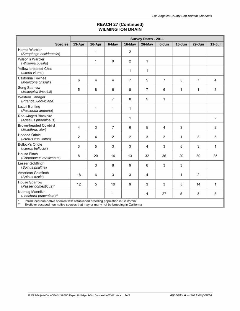
Los Angeles County Soft-Bottom Channels
REACH 27 (Continued) WILMINGTON DRAIN
R:\PAS\Projects\CoLADPW\J159\SBC Report 2011\App A-Bird Compendia-083011.docx A-9 Appendix A – Bird Compendia
Species Survey Dates - 2011
13-Apr 26-Apr 6-May 16-May 26-May 6-Jun 16-Jun 29-Jun 11-JulHermit Warbler
(Setophaga occidentalis) 1 2 Wilson's Warbler
(Wilsonia pusilla) 1 9 2 1
Yellow-breasted Chat (Icteria virens) 1 1
California Towhee (Melozone crissalis) 6 4 4 7 5 7 5 7 4
Song Sparrow (Melospiza lincolnii) 5 8 6 8 7 6 1 1 3
Western Tanager (Piranga ludoviciana) 7 8 5 1
Lazuli Bunting (Passerina amoena) 1 1 1
Red-winged Blackbird (Ageaius phoeniceus) 1 2
Brown-headed Cowbird (Molothrus ater) 4 3 7 6 5 4 3 2
Hooded Oriole (Icterus cucullatus) 2 4 2 2 3 3 1 3 5
Bullock's Oriole (Icterus bullockii) 3 5 3 3 4 3 5 3 1
House Finch (Carpodacus mexicanus) 8 20 14 13 32 36 20 30 35
Lesser Goldfinch (Spinus psaltria) 3 8 9 6 3 3
American Goldfinch (Spinus tristis) 18 6 3 3 4 1 2
House Sparrow (Passer domesticus)* 12 5 10 9 3 3 5 14 1
Nutmeg Mannikin (Lonchura punctulata)** 1 4 27 5 8 5
* Introduced non-native species with established breeding population in California ** Exotic or escaped non-native species that may or many not be breeding in California

Los Angeles County Soft-Bottom Channels
R:\PAS\Projects\CoLADPW\J159\SBC Report 2011\App A-Bird Compendia-083011.docx A-10 Appendix A – Bird Compendia
REACH 28 TRIUNFO CREEK (PD T2200)
Species Survey Dates - 2011
13-Apr 26-Apr 6-May 16-May 26-May 6-Jun 16-Jun 29-Jun 11-JulCanada Goose
(Branta canadensis) 2 Wood Duck
(Aix sponsa) 1 1 Mallard
(Anas platyrhynchos) 5 2 12 1 1 2 2 4
California Quail (Callipepla californica) 10
Common Peafowl (Pavo cristatus)** 5 2 4 2 2 6 6 15 12
Great Blue Heron (Ardea herodias) 1 1 1
Green Heron (Butorides virescens) 1 1 1 2 1
Black-crowned Night-Heron (Nycticorax nycticorax) 1
Cooper's Hawk (Accipiter cooperii) 1 2 1 1
Red-shouldered Hawk (Buteo lineatus) 1 1 1 2 1 1 2
Red-tailed Hawk (Buteo jamaicensis) 2
American Coot (Fulica americana) 1
Band-tailed Pigeon (Patagioenas fasciata) 3
Mourning Dove (Zenaida macroura) 4 1 1 1
Black-hooded Parakeet (Nandayus nenday)** 16 15 30 7 10 4 5 5
Vaux's Swift (Chaetura vauxi) 1
White-throated Swift (Aeronautes saxatalis) 2
Anna's Hummingbird (Calypte anna) 1 1
Allen's/Rufous Hummingbird (Selasphorus sp.) 1 1
Belted Kingfisher (Ceryle alcyon) 1
Acorn Woodpecker (Melanerpes formicivorus) 6 2 3 5 4 2 4 5
Nuttall's Woodpecker (Picoides nuttallii) 2 2 4 3 2 2 3 1 3
Northern Flicker (Colaptes auratus) 1 1 1 1
Pacific-slope Flycatcher (Empidonax difficilis) 1 1 1 2 1 1
Black Phoebe (Sayornis nigricans) 2 2 3 2 2 2 2 3
Los Angeles County Soft-Bottom Channels
REACH 28 (Continued) TRIUNFO CREEK (PD T2200)
R:\PAS\Projects\CoLADPW\J159\SBC Report 2011\App A-Bird Compendia-083011.docx A-11 Appendix A – Bird Compendia
Species Survey Dates - 2011
13-Apr 26-Apr 6-May 16-May 26-May 6-Jun 16-Jun 29-Jun 11-JulAsh-throated Flycatcher
(Myiarchus cinerascens) 1 2 1 1
Warbling Vireo (Vireo gilvus) 1
Western Scrub-Jay (Aphelocoma insularis) 2 4 4 2 2 1 2
American Crow (Corvus brachyrhynchos) 25 11 20 15 40 8 18 18 25
Violet-green Swallow (Tachycineta thalassina) 6 2
Northern Rough-winged Swallow (Stelgidopteryx serripennis)
2 2 1 3 2 1 3
Cliff Swallow (Petrochelidon pyrrhonota) 1
Oak Titmouse (Baeolophus inornatus) 5 4 3 4 1 4 4 8 3
Bushtit (Psaltriparus minimus) 6 4 10
White-breasted Nuthatch (Sitta carolinensis) 1 4 2 4 3 3
Bewick's Wren (Thryomanes bewickii) 2 2 2 3
House Wren (Troglodytes aedon) 10 8 7 4 3 5 7 7 3
Western Bluebird (Sialia mexicana) 1 1 2 2
American Robin (Turdus migratorius) 2 1 1 1
Wrentit (Chamaea fasciata) 1 1 1 2 2 4 2
European Starling (Sturnus vulgaris)* 15 14 11 8 6 5 4 5 2
Cedar Waxwing (Bombycilla cedrorum) 12
Orange-crowned Warbler (Oreothlypis celata) 1 1 3 1 1
Common Yellowthroat (Geothlypis trichas) 2 3 2
Yellow Warbler (Setophaga petechia) 1 1 1 1
Yellow-rumped Warbler (Setophaga coronata) 5
Spotted Towhee (Pipilo maculates) 5 2 5 4 1 6 4 6 4
California Towhee (Melozone crissalis) 3 3 5 5 1 2 5 3 2
Song Sparrow (Melospiza lincolnii) 8 7 10 9 7 4 10 6 6
Dark-eyed Junco (Junco hyemalis) 1 1 2 1 1 2 1 1

Los Angeles County Soft-Bottom Channels
REACH 28 (Continued) TRIUNFO CREEK (PD T2200)
R:\PAS\Projects\CoLADPW\J159\SBC Report 2011\App A-Bird Compendia-083011.docx A-12 Appendix A – Bird Compendia
Species Survey Dates - 2011
13-Apr 26-Apr 6-May 16-May 26-May 6-Jun 16-Jun 29-Jun 11-JulWestern Tanager
(Piranga ludoviciana) 1 Black-headed Grosbeak
(Pheucticus melanocephalus) 1 3 4 4 3 5
Brown-headed Cowbird (Molothrus ater) 4 1 1 2 3 3 2 2
Hooded Oriole (Icterus cucullatus) 2 1 3 2 3 3 2
Bullock's Oriole (Icterus bullockii) 1 3 2 2 6 2 6 2 2
House Finch (Carpodacus mexicanus) 2 2 7 3 4 4 5 10 7
Lesser Goldfinch (Spinus psaltria) 4 4 5 2 1 7
* Introduced non-native species with established breeding population in California ** Exotic or escaped non-native species that may or many not be breeding in California

Los Angeles County Soft-Bottom Channels
R:\PAS\Projects\CoLADPW\J159\SBC Report 2011\App A-Bird Compendia-083011.docx A-13 Appendix A – Bird Compendia
REACH 39 BEATTY CHANNEL OUTLET AT SAN GABRIEL RIVER
25+99.00+50’
Species Survey Dates - 2011
14-Apr 26-Apr 6-May 18-May 27-May 7-Jun 17-Jun 30-Jun 12-JulMallard
(Anas platyrhynchos) 8 7 4 15 4 10 6 30 20
California Quail (Callipepla californica) 17 7 10 7 10 3 5 2 1
Double-crested Cormorant (Phalacrocorax auritus) 1 1 1
Great Blue Heron (Ardea herodias) 1
Great Egret (Ardea alba) 1 1 2
Snowy Egret (Egretta thula) 1 2 3 1
Black-crowned Night-Heron (Nycticorax nycticorax) 6
Turkey Vulture (Cathartes aura) 4 2 11 2 4 1
Osprey (Pandion haliaetus) 1
Cooper's Hawk (Accipiter cooperii) 1 1 1 1
Red-tailed Hawk (Buteo jamaicensis) 1
Virginia Rail (Rallus limicola) 1
American Coot (Fulica americana) 11 1
Killdeer (Charadrius vociferous) 4 4 3 1 2 2 1 1 2
Rock Pigeon (Columba livia)* 5 1
Band-tailed Pigeon (Patagioenas fasciata) 1
Mourning Dove (Zenaida macroura) 9 10 6 14 6 6 8 5 7
Red-crowned Parrot (Amazona viridigenalis)* 6 5
Lesser Nighthawk (Chordeiles acutipennis) 1
Vaux's Swift (Chaetura vauxi) 1
White-throated Swift (Aeronautes saxatalis) 6 10 8 5 3
Black-chinned Hummingbird (Archilochus alexandri) 1 1 1 2
Anna's Hummingbird (Calypte anna) 7 4 2 2 2 1 2
Costa's Hummingbird (Calypte costae) 1 1

Los Angeles County Soft-Bottom Channels
REACH 39 (Continued) BEATTY CHANNEL OUTLET AT SAN GABRIEL RIVER
25+99.00+50’
R:\PAS\Projects\CoLADPW\J159\SBC Report 2011\App A-Bird Compendia-083011.docx A-14 Appendix A – Bird Compendia
Species Survey Dates - 2011
14-Apr 26-Apr 6-May 18-May 27-May 7-Jun 17-Jun 30-Jun 12-JulAllen's Hummingbird
(Selasphorus sasin) - males 1 Allen's/Rufous Hummingbird
(Selasphorus sp.) 2 1 1 3 3
Nuttall's Woodpecker (Picoides nuttallii) 2 2 2 1 1 1
Downy Woodpecker (Picoides pubescens) 1
Western Wood-Pewee (Contopus sordidulus) 1
Willow Flycatcher (Empidonax traillii) 1
Black Phoebe (Sayornis nigricans) 6 6 5 5 4 6 11 4 7
Say's Phoebe (Sayornis saya) 2 1
Ash-throated Flycatcher (Myiarchus cinerascens) 1 2
Cassin's Kingbird (Tyrannus vociferans) 1 2
Western Kingbird (Tyrannus verticalis) 2 2 1 4
Bell's Vireo (Vireo bellii) 1 3 3 5 3 4 4 3 3
Western Scrub-Jay (Aphelocoma insularis) 5 6 4 3 6 4 4 3 2
American Crow (Corvus brachyrhynchos) 5 2 2 3 2
Common Raven (Corvus corax) 12 6 5 4 2 5
Violet-green Swallow (Tachycineta thalassina) 12
Northern Rough-winged Swallow (Stelgidopteryx serripennis)
10 8 5 12 30 2
Cliff Swallow (Petrochelidon pyrrhonota) 20 10 9 20 14 8 10 5 15
Barn Swallow (Hirundo rustica) 8 2 1 2
Bushtit (Psaltriparus minimus) 10 21 8 10 12 25 20 10 10
Bewick's Wren (Thryomanes bewickii) 15 10 5 6 4 8 8 5
House Wren (Troglodytes aedon) 2
Swainson's Thrush (Catharus ustulatus) 1
Wrentit (Chamaea fasciata) 2 3 5 6 8 8 7

Los Angeles County Soft-Bottom Channels
REACH 39 (Continued) BEATTY CHANNEL OUTLET AT SAN GABRIEL RIVER
25+99.00+50’
R:\PAS\Projects\CoLADPW\J159\SBC Report 2011\App A-Bird Compendia-083011.docx A-15 Appendix A – Bird Compendia
Species Survey Dates - 2011
14-Apr 26-Apr 6-May 18-May 27-May 7-Jun 17-Jun 30-Jun 12-JulNorthern Mockingbird
(Mimus polyglottos) 4 5 4 5 4 4 10 5
California Thrasher (Toxostoma redivivum) 2 2 2 2 3
European Starling (Sturnus vulgaris)* 2
Red-whiskered Bulbul (Pycnonotus jocosus)** 5 2 1
Phainopepla (Phainopepla nitens) 1 1 1 7
Orange-crowned Warbler (Oreothlypis celata) 2 2 2 2
Common Yellowthroat (Geothlypis trichas) 12 10 13 12 8 8 12 9 13
Yellow Warbler (Setophaga petechia) 2 7 3 4 4 1
Yellow-rumped Warbler (Setophaga coronata) 8 6
Yellow-breasted Chat (Icteria virens) 1 1 1 2 1 4 4 3 2
Spotted Towhee (Pipilo maculates) 9 8 5 6 6 7 3 9 2
California Towhee (Melozone crissalis) 10 11 9 10 10 14 11 6
Song Sparrow (Melospiza lincolnii) 18 18 15 27 11 25 34 13 6
White-crowned Sparrow (Zonotrichia leucophrys) 4 4
Western Tanager (Piranga ludoviciana) 2 1
Black-headed Grosbeak (Pheucticus melanocephalus)
3 5 2 2 2 2 1 1 1
Blue Grosbeak (Passerina caerulea) 2 1 1 1 2
Red-winged Blackbird (Ageaius phoeniceus) 20 14 15 9 10 4 13 4 10
Great-tailed Grackle (Quiscalus mexicanus) 2 1
Brown-headed Cowbird (Molothrus ater) 4 2 2 6 6 9 5
Hooded Oriole (Icterus cucullatus) 1 1 2
Bullock's Oriole (Icterus bullockii) 4 3 2 1
Purple Finch (Carpodacus purpureus) 1 2 1
House Finch (Carpodacus mexicanus) 11 8 15 30 12

Los Angeles County Soft-Bottom Channels
REACH 39 (Continued) BEATTY CHANNEL OUTLET AT SAN GABRIEL RIVER
25+99.00+50’
R:\PAS\Projects\CoLADPW\J159\SBC Report 2011\App A-Bird Compendia-083011.docx A-16 Appendix A – Bird Compendia
Species Survey Dates - 2011
14-Apr 26-Apr 6-May 18-May 27-May 7-Jun 17-Jun 30-Jun 12-JulLesser Goldfinch
(Spinus psaltria) 10 10 6 10 12 9 2
American Goldfinch (Spinus tristis) 10 7 9 7 3
House Sparrow (Passer domesticus)* 15
Nutmeg Mannikin (Lonchura punctulata)** 1 2 1
Orange Bishop (Euplectes franciscanus)** 2 1
* Introduced non-native species with established breeding population in California ** Exotic or escaped non-native species that may or many not be breeding in California

Los Angeles County Soft-Bottom Channels
R:\PAS\Projects\CoLADPW\J159\SBC Report 2011\App A-Bird Compendia-083011.docx A-17 Appendix A – Bird Compendia
REACH 40B SAN GABRIEL RIVER – I-10 FREEWAY TO THIENES AVENUE
Species Survey Dates - 2011
11-Apr 24-Apr 12-May 22-May 1-Jun 12-Jun 22-Jun 2-Jul 17-JulCanada Goose (Branta canadensis) 2 2
Egyptian Goose (Alopochen aegyptiacus)** 2
Gadwall (Anas strepera) 9 2 1
Mallard (Anas platyrhynchos) 20 15 20 12 12 15 2 7
Cinnamon Teal (Anas cyanoptera) 2 2 2 1 2
Bufflehead (Bucephala albeola) 10
Ruddy Duck (Oxyura jamaicensis) 12 8
Pied-billed Grebe (Podilymbus podiceps) 1 1 1 2 2 3 2 3
Double-crested Cormorant (Phalacrocorax auritus) 2 1 2 2 2 3 1 5
Great Blue Heron (Ardea herodias) 1 1 2 1 1
Great Egret (Ardea alba) 1 2
Snowy Egret (Egretta thula) 2 1 3 2 1
Green Heron (Butorides virescens) 2 1 1 2
Black-crowned Night-Heron (Nycticorax nycticorax) 2 1 1 6
Turkey Vulture (Cathartes aura) 1
Red-tailed Hawk (Buteo jamaicensis) 1 2 2 1
American Kestrel (Falco sparverius) 1 1 1 1 1 1
Common Gallinule (Gallinula galeata) 1 1 1
American Coot (Fulica americana) 30 18 2 2 2 8 8 10 8
Killdeer (Charadrius vociferous) 7 7 5 2 6 10 5 4 3
Black-necked Stilt (Himantopus mexicanus) 14 8 5 2 2
American Avocet (Recurvirostra americana) 2 2 1 2
Greater Yellowlegs (Tringa melanoleuca) 2 1
Whimbrel (Numenius phaeopus) 2
Least Sandpiper (Calidris minutilla) 3

Los Angeles County Soft-Bottom Channels
REACH 40B (Continued) SAN GABRIEL RIVER – I-10 FREEWAY TO THIENES AVENUE
R:\PAS\Projects\CoLADPW\J159\SBC Report 2011\App A-Bird Compendia-083011.docx A-18 Appendix A – Bird Compendia
Species Survey Dates - 2011
11-Apr 24-Apr 12-May 22-May 1-Jun 12-Jun 22-Jun 2-Jul 17-JulLong-billed Dowitcher (Limnodromus scolopaceus) 35 5
Western Gull (Larus occidentalis) 4 3 2 2 2
California Gull (Larus californicus) 20 50 180 1
Forster's Tern (Sterna forsteri) 3 4
Rock Pigeon (Columba livia)* 5 16 1 2 6 5
Band-tailed Pigeon (Patagioenas fasciata)
Eurasian Collared-Dove (Streptopelia decaocto)* 1 1 1 2 2 1 2 10
Mourning Dove (Zenaida macroura) 5 3 1 3 8 6 2 6
Yellow-chevroned Parakeet (Brotogeris chiriri)** 4 6 3
Red-crowned Parrot (Amazona viridigenalis)* 18 6 11 4
White-throated Swift (Aeronautes saxatalis) 3 1 1
Anna's Hummingbird (Calypte anna) 4 5 3 2 2 1 1 3 2
Allen's Hummingbird (Selasphorus sasin) 2 1
Allen's/Rufous Hummingbird (Selasphorus sp.) 1 1 1 1 2 4
Nuttall's Woodpecker (Picoides nuttallii) 1 1 1 2
Downy Woodpecker (Picoides pubescens) 2 1 1 1 1 1
Black Phoebe (Sayornis nigricans) 6 4 3 5 5 5 5 7 4
Cassin's Kingbird (Tyrannus vociferans) 2 1 3 3 2 1 1
Western Kingbird (Tyrannus verticalis) 3
Bell's Vireo (Vireo bellii) 1 4 3 4 3 3 4 4 4
Warbling Vireo (Vireo gilvus) 1 2
American Crow (Corvus brachyrhynchos) 2 5 1 2 3 3 1 2
Common Raven (Corvus corax) 1 1
Northern Rough-winged Swallow (Stelgidopteryx serripennis)
6 20 2 2 5 6 12 12 6
Cliff Swallow (Petrochelidon pyrrhonota) 50 35 10 25 12 35 30 5 20

Los Angeles County Soft-Bottom Channels
REACH 40B (Continued) SAN GABRIEL RIVER – I-10 FREEWAY TO THIENES AVENUE
R:\PAS\Projects\CoLADPW\J159\SBC Report 2011\App A-Bird Compendia-083011.docx A-19 Appendix A – Bird Compendia
Species Survey Dates - 2011
11-Apr 24-Apr 12-May 22-May 1-Jun 12-Jun 22-Jun 2-Jul 17-JulBarn Swallow (Hirundo rustica) 8 24 2 5 6 6 5 12 12
Bushtit (Psaltriparus minimus) 16 16 22 30 22 22 30 22 18
American Robin (Turdus migratorius) 1 1
Northern Mockingbird (Mimus polyglottos) 2 2 2 8 2 2 3 3 8
European Starling (Sturnus vulgaris)* 3 8 4 4 25 4 15 50 10
American Pipit (Anthus rubescens) 2
Cedar Waxwing (Bombycilla cedrorum) 10 3 1
Phainopepla (Phainopepla nitens) 1
Orange-crowned Warbler (Oreothlypis celata) 1 4
Nashville Warbler (Oreothlypis ruficapilla) 1
Common Yellowthroat (Geothlypis trichas) 11 8 12 11 16 20 16 12 10
Yellow Warbler (Setophaga petechia) 5 8 10 16 9 10 8 8 7
Yellow-rumped Warbler (Setophaga coronata) 8 2
Black-throated Gray Warbler (Setophaga nigrescens) 1
Townsend's Warbler (Setophaga townsendi) 1 2 1
Wilson's Warbler (Wilsonia pusilla) 1 1 7 2
Yellow-breasted Chat (Icteria virens) 1
California Towhee (Melozone crissalis) 2 5 6 6 4 8 6 4 6
Song Sparrow (Melospiza lincolnii) 16 14 20 16 30 24 18 10 8
White-crowned Sparrow (Zonotrichia leucophrys) 12
Western Tanager (Piranga ludoviciana) 5 1
Black-headed Grosbeak (Pheucticus melanocephalus) 1 1 3 1
Blue Grosbeak (Passerina caerulea) 1 2 1 1 2 2
Lazuli Bunting (Passerina amoena) 1
Red-winged Blackbird (Ageaius phoeniceus) 6 10 15 10 10 15 4

Los Angeles County Soft-Bottom Channels
REACH 40B (Continued) SAN GABRIEL RIVER – I-10 FREEWAY TO THIENES AVENUE
R:\PAS\Projects\CoLADPW\J159\SBC Report 2011\App A-Bird Compendia-083011.docx A-20 Appendix A – Bird Compendia
Species Survey Dates - 2011
11-Apr 24-Apr 12-May 22-May 1-Jun 12-Jun 22-Jun 2-Jul 17-JulGreat-tailed Grackle (Quiscalus mexicanus) 12 16 15 15 15 12 8 5
Brown-headed Cowbird (Molothrus ater) 3 7 3 2 4 1 2 3
Hooded Oriole (Icterus cucullatus) 1 1 1
Bullock's Oriole (Icterus bullockii) 2 3 4 2 4 5 4 7 1
House Finch (Carpodacus mexicanus) 14 45 14 20 22 24 20 12 25
Lesser Goldfinch (Spinus psaltria) 5 12 5 8 5 4 6
American Goldfinch (Spinus tristis) 3 2 5 4 5 5 5 2 13
House Sparrow (Passer domesticus)* 18 5 22 16 70 45 35 30 35
Orange Bishop (Euplectes franciscanus)** 1 1 1
* Introduced non-native species with established breeding population in California ** Exotic or escaped non-native species that may or many not be breeding in California

Los Angeles County Soft-Bottom Channels
R:\PAS\Projects\CoLADPW\J159\SBC Report 2011\App A-Bird Compendia-083011.docx A-21 Appendix A – Bird Compendia
REACH 43A SAN GABRIEL RIVER – UPPER
Species Survey Dates - 2011
11-Apr 24-Apr 12-May 22-May 1-Jun 12-Jun 22-Jun 2-Jul 17-JulGadwall
(Anas strepera) 2 Mallard
(Anas platyrhynchos) 5 5 2 3 3 2 1 3
Cinnamon Teal (Anas cyanoptera) 1 1 1 1 1
Double-crested Cormorant (Phalacrocorax auritus) 1 1 2 3 1
Great Blue Heron (Ardea herodias) 1 1 1 1 1 5
Great Egret (Ardea alba) 1 1 1 1 5
Snowy Egret (Egretta thula) 2 1 2 2 2 16
Green Heron (Butorides virescens) 1 1 1 1 1
Black-crowned Night-Heron (Nycticorax nycticorax) 1 1 1 2
Cooper's Hawk (Accipiter cooperii) 2
Red-tailed Hawk (Buteo jamaicensis) 1
Common Gallinule (Gallinula galeata) 1 1 1
Killdeer (Charadrius vociferous) 1
Western Gull (Larus occidentalis) 1
California Gull (Larus californicus) 2 5 60
Caspian Tern (Hydroprogne caspia) 1
Forster's Tern (Sterna forsteri) 1 8
Rock Pigeon (Columba livia)* 20 10 15 5 2 8 1 3
Eurasian Collared-Dove (Streptopelia decaocta) 1
Mourning Dove (Zenaida macroura) 3 6 1 3 3 2 4 2 2
White-throated Swift (Aeronautes saxatalis) 2
Black-chinned Hummingbird (Archilochus alexandri) 1
Anna's Hummingbird (Calypte anna) 5 5 1 2 2 1 2
Allen's Hummingbird (Selasphorus sasin) 3 1
Allen's/Rufous Hummingbird (Selasphorus sp.) 1 2 4 6
Nuttall's Woodpecker (Picoides nuttallii) 1 2 1 1

Los Angeles County Soft-Bottom Channels
REACH 43A (Continued) SAN GABRIEL RIVER – UPPER
R:\PAS\Projects\CoLADPW\J159\SBC Report 2011\App A-Bird Compendia-083011.docx A-22 Appendix A – Bird Compendia
Species Survey Dates - 2011
11-Apr 24-Apr 12-May 22-May 1-Jun 12-Jun 22-Jun 2-Jul 17-JulDowny Woodpecker
(Picoides pubescens) 1 2 1 2 1 1
Western Wood-Pewee (Contopus sordidulus) 1
Black Phoebe (Sayornis nigricans) 2 1 5 4 5 4 4 2 2
Say's Phoebe (Sayornis saya) 1
Ash-throated Flycatcher (Myiarchus cinerascens) 1 2
Cassin's Kingbird (Tyrannus vociferans) 1 1 1 1
Western Kingbird (Tyrannus verticalis) 1
Bell's Vireo (Vireo bellii) 1 2 4 4 4 4 4 2 4
Hutton's Vireo (Vireo huttoni) 1 2 1 1
Warbling Vireo (Vireo gilvus) 1 4 1 3
Western Scrub-Jay (Aphelocoma insularis) 1
American Crow (Corvus brachyrhynchos) 1
Common Raven (Corvus corax) 2 1
Northern Rough-winged Swallow (Stelgidopteryx serripennis) 3 2 2 3 2
Cliff Swallow (Petrochelidon pyrrhonota) 15 40 15 4 25 15 35
Barn Swallow (Hirundo rustica) 2 2 6 2 1 5 7 10
Bushtit (Psaltriparus minimus) 10 20 28 25 20 24 30 26 25
Bewick's Wren (Thryomanes bewickii) 1 1 1 1 1
House Wren (Troglodytes aedon) 2 1 1
Swainson's Thrush (Catharus ustulatus) 1 4 1 1
American Robin (Turdus migratorius) 2 2 1 3
Northern Mockingbird (Mimus polyglottos) 1
European Starling (Sturnus vulgaris)* 12
Cedar Waxwing (Bombycilla cedrorum) 8
Orange-crowned Warbler (Oreothlypis celata) 1 2 1 1 1
Yellow Warbler (Setophaga petechia) 12 14 13 14 14 18 15 17 14

Los Angeles County Soft-Bottom Channels
REACH 43A (Continued) SAN GABRIEL RIVER – UPPER
R:\PAS\Projects\CoLADPW\J159\SBC Report 2011\App A-Bird Compendia-083011.docx A-23 Appendix A – Bird Compendia
Species Survey Dates - 2011
11-Apr 24-Apr 12-May 22-May 1-Jun 12-Jun 22-Jun 2-Jul 17-JulCommon Yellowthroat
(Geothlypis trichas) 18 15 18 14 15 16 13 8 4
Yellow-rumped Warbler (Setophaga coronata) 12 1
Townsend's Warbler (Setophaga townsendi) 1
Wilson's Warbler (Wilsonia pusilla) 3 4 3 4
Yellow-breasted Chat (Icteria virens) 2 4 3 3 3 3 3 3
Spotted Towhee (Pipilo maculates) 5 5 4 3 4 5 5 4 5
California Towhee (Melozone crissalis) 2 3 6 4 4 6 5 3 2
Chipping Sparrow (Spizella passerina) 1
Grasshopper Sparrow (Ammodramus savannarum) 1
Song Sparrow (Melospiza lincolnii) 21 24 22 16 20 29 16 7 2
Western Tanager (Piranga ludoviciana) 2 2
Northern Cardinal (Cardinalis cardinalis)* 2 1 1 1 1 1 1 1
Black-headed Grosbeak (Pheucticus melanocephalus) 5 5 3 2 2 2 2 2
Blue Grosbeak (Passerina caerulea) 1 2 3 1 1 2 2
Red-winged Blackbird (Ageaius phoeniceus) 1 6
Great-tailed Grackle (Quiscalus mexicanus) 1 1
Brown-headed Cowbird (Molothrus ater) 1 3 1 4 1 2 1 3
Hooded Oriole (Icterus cucullatus) 1 1 2 1 1
Bullock's Oriole (Icterus bullockii) 1 2 2 2 5 3 2
House Finch (Carpodacus mexicanus) 12 30 22 18 25 28 20 30 30
Lesser Goldfinch (Spinus psaltria) 10 25 20 16 20 25 8 25 25
American Goldfinch (Spinus tristis) 10 5 14 6 4 5 16 3
House Sparrow (Passer domesticus)* 2
Nutmeg Mannikin (Lonchura punctulata)** 1 1 1
Orange Bishop (Euplectes franciscanus)** 1 1 1
* Introduced non-native species with established breeding population in California ** Exotic or escaped non-native species that may or many not be breeding in California

Los Angeles County Soft-Bottom Channels
R:\PAS\Projects\CoLADPW\J159\SBC Report 2011\App A-Bird Compendia-083011.docx A-24 Appendix A – Bird Compendia
REACH 43B SAN GABRIEL RIVER – LOWER
Species Survey Dates - 2011
11-Apr 24-Apr 12-May 22-May 1-Jun 12-Jun 22-Jun 2-Jul 17-JulCanada Goose
(Branta canadensis) 3 3 3 14
Gadwall (Anas strepera) 2 2
American Wigeon (Anas americana) 10 12 12
Mallard (Anas platyrhynchos) 25 25 25 40 40 35 30 28 45
Cinnamon Teal (Anas cyanoptera) 8
Pied-billed Grebe (Podilymbus podiceps) 1 2 2 3 1 1 1
Double-crested Cormorant (Phalacrocorax auritus) 4 3 8 5 6 5 6 8 14
Great Blue Heron (Ardea herodias) 1 1 1 1 3
Great Egret (Ardea alba) 1 1 3
Snowy Egret (Egretta thula) 16 3 1 3 1 2 1 1
Green Heron (Butorides virescens) 3 2 2 2
Black-crowned Night-Heron (Nycticorax nycticorax) 1 1 3 3 3 12 3 4
Cooper's Hawk (Accipiter cooperii) 1 1 3
American Kestrel (Falco sparverius) 1
Common Gallinule (Gallinula galeata) 1 2 2 4 4 1 4
American Coot (Fulica americana) 30 6 2 2 1 6 2 1 3
Killdeer (Charadrius vociferous) 3 8 5 2 8 3 1
Black-necked Stilt (Himantopus mexicanus) 2
Western Gull (Larus occidentalis) 10 1 25 8 1 3 4
California Gull (Larus californicus) 6 7 75 1
Caspian Tern (Hydroprogne caspia) 1 1
Forster's Tern (Sterna forsteri) 2 4
Rock Pigeon (Columba livia)* 10 17 5 2 4 20 3 8 16
Eurasian Collared-Dove (Streptopelia decaocto) 1 2 1 3
Mourning Dove (Zenaida macroura) 6 5 2 3 2 4 3

Los Angeles County Soft-Bottom Channels
REACH 43B (Continued) SAN GABRIEL RIVER – LOWER
R:\PAS\Projects\CoLADPW\J159\SBC Report 2011\App A-Bird Compendia-083011.docx A-25 Appendix A – Bird Compendia
Species Survey Dates - 2011
11-Apr 24-Apr 12-May 22-May 1-Jun 12-Jun 22-Jun 2-Jul 17-JulRed-crowned Parrot
(Amazona viridigenalis)* 1 Anna's Hummingbird
(Calypte anna) 3 3 2 3 2 1
Allen's/Rufous Hummingbird (Selasphorus sp.) 1 1 5
Nuttall's Woodpecker (Picoides nuttallii) 1 1
Downy Woodpecker (Picoides pubescens) 1
Western Wood-Pewee (Contopus sordidulus) 1
Black Phoebe (Sayornis nigricans) 2 2 4 3 3 3 3 3 4
Cassin's Kingbird (Tyrannus vociferans) 2 1 1 2 1 3
Western Kingbird (Tyrannus verticalis) 1 1 2
Warbling Vireo (Vireo gilvus) 2 1
Western Scrub-Jay (Aphelocoma insularis) 1 1
American Crow (Corvus brachyrhynchos) 1 2 2 11 11 1
Common Raven (Corvus corax) 2
Tree Swallow (Tachycineta bicolor) 2 2 1 1 1 1
Northern Rough-winged Swallow (Stelgidopteryx serripennis) 5 12 3 4 1 3 5 2 5
Cliff Swallow (Petrochelidon pyrrhonota) 50 25 12 60 65 50 8 20 60
Barn Swallow (Hirundo rustica) 2 1 8 2 12 10 25
Bushtit (Psaltriparus minimus) 2 12 12 20 15 28 20 12 8
Swainson's Thrush (Catharus ustulatus) 1
Northern Mockingbird (Mimus polyglottos) 2 4 2 3 3 2 5 4 2
European Starling (Sturnus vulgaris)* 5 4 2 2 3 15 1 1 3
Orange-crowned Warbler (Oreothlypis celata) 1 1
Common Yellowthroat (Geothlypis trichas) 3 4 4 5 5 4 7 4 4
Yellow Warbler (Setophaga petechia) 2 8 8 9 7 7 7 7 7
Yellow-rumped Warbler (Setophaga coronata) 18 2 1

Los Angeles County Soft-Bottom Channels
REACH 43B (Continued) SAN GABRIEL RIVER – LOWER
R:\PAS\Projects\CoLADPW\J159\SBC Report 2011\App A-Bird Compendia-083011.docx A-26 Appendix A – Bird Compendia
Species Survey Dates - 2011
11-Apr 24-Apr 12-May 22-May 1-Jun 12-Jun 22-Jun 2-Jul 17-JulBlack-throated Gray Warbler
(Setophaga nigrescens) 1 Wilson's Warbler
(Wilsonia pusilla) 1 1 1 Yellow-breasted Chat
(Icteria virens) 1 Spotted Towhee
(Pipilo maculates) 1
California Towhee (Melozone crissalis) 4 3 7 4 3 3 5 1 3
Song Sparrow (Melospiza lincolnii) 6 14 14 6 9 11 11 8 2
White-crowned Sparrow (Zonotrichia leucophrys) 4
Black-headed Grosbeak (Pheucticus melanocephalus) 1 1
Blue Grosbeak (Passerina caerulea) 1 2 2 1 1
Red-winged Blackbird (Ageaius phoeniceus) 30 35 25 20 20 30 40 6 5
Great-tailed Grackle (Quiscalus mexicanus) 3 1
Brown-headed Cowbird (Molothrus ater) 2 3 4 2 4 2 1 3
Hooded Oriole (Icterus cucullatus) 1 1 1 1 1 3 1 1
Bullock's Oriole (Icterus bullockii) 1 2 2
House Finch (Carpodacus mexicanus) 10 12 18 10 15 14 15 8 13
Lesser Goldfinch (Spinus psaltria) 5 1 6 4 5 3 5 6 3
American Goldfinch (Spinus tristis) 6 3 1 3 4 5 2 2
House Sparrow (Passer domesticus)* 3 8 5 4
Nutmeg Mannikin (Lonchura punctulata)** 1 2 1 1
Orange Bishop (Euplectes franciscanus)** 1 1 1
* Introduced non-native species with established breeding population in California ** Exotic or escaped non-native species that may or many not be breeding in California

Los Angeles County Soft-Bottom Channels
R:\PAS\Projects\CoLADPW\J159\SBC Report 2011\App A-Bird Compendia-083011.docx A-27 Appendix A – Bird Compendia
REACH 71, 79, AND 80 SANTA CLARA RIVER MAIN CHANNEL (PD 1946)
SOUTH FORK – SANTA CLARA RIVER (VALENCIA BLVD. BRIDGE STABILIZER) SOUTH FORK – SANTA CLARA RIVER (PD’s 1947 & 1946)
Species Survey Dates - 2011
10-Apr 23-Apr 4-May 21-May 31-May 11-Jun 21-Jun 3-Jul 16-JulCanada Goose
(Branta canadensis) 4 2 Mallard
(Anas platyrhynchos) 4 2 1 California Quail
(Callipepla californica) 3 5 8 12 8 10 4 5 3
Cooper's Hawk (Accipiter cooperii) 1 1 1
Red-shouldered Hawk (Buteo lineatus) 1 1 1 1
Red-tailed Hawk (Buteo jamaicensis) 1 2 3 1 3 2 1 1
American Kestrel (Falco sparverius)
Killdeer (Charadrius vociferous) 2 1 1 2 1 2 1
Western Gull (Larus occidentalis) 1 1
Rock Pigeon (Columba livia)* 8 1
Mourning Dove (Zenaida macroura) 6 82 6 5 8 10 5 20 12
Anna's Hummingbird (Calypte anna) 5 5 3 4 5 2 2 1
Allen's Hummingbird (Selasphorus sasin) – males 3
Allen's/Rufous Hummingbird (Selasphorus sp.) 2
Nuttall's Woodpecker (Picoides nuttallii) 2 2 3 3 3 1 1 3 1
Downy Woodpecker (Picoides pubescens) 1
Black Phoebe (Sayornis nigricans) 4 1 1 1 5 2 2 2
Say's Phoebe (Sayornis saya) 1 1 2 2 1 1
Ash-throated Flycatcher (Myiarchus cinerascens) 3 1 1 1 2
Cassin's Kingbird (Tyrannus vociferans) 3 1 3 3 3 3 3 5 3
Western Kingbird (Tyrannus verticalis) 2 1 2 6 2 1 2 2 1
Bell's Vireo (Vireo bellii) 1
Western Scrub-Jay (Aphelocoma insularis) 8 5 6 6 5 4 3 4 3
American Crow (Corvus brachyrhynchos) 3 4 10

Los Angeles County Soft-Bottom Channels
REACH 71, 79, AND 80 (Continued) SANTA CLARA RIVER MAIN CHANNEL (PD 1946)
SOUTH FORK – SANTA CLARA RIVER (VALENCIA BLVD. BRIDGE STABILIZER) SOUTH FORK – SANTA CLARA RIVER (PD’s 1947 & 1946)
R:\PAS\Projects\CoLADPW\J159\SBC Report 2011\App A-Bird Compendia-083011.docx A-28 Appendix A – Bird Compendia
Species Survey Dates - 2011
10-Apr 23-Apr 4-May 21-May 31-May 11-Jun 21-Jun 3-Jul 16-JulCommon Raven
(Corvus corax) 6 2 5 8 4 2 1 2 3
Northern Rough-winged Swallow (Stelgidopteryx serripennis) 3 5 3 8 1 3 5 3 2
Cliff Swallow (Petrochelidon pyrrhonota) 1 6 18 32 1 5
Oak Titmouse (Baeolophus inornatus) 1 1 1 1 2 5 2 2 4
Bushtit (Psaltriparus minimus) 4 14 10 18 10 20 14 24
Bewick's Wren (Thryomanes bewickii) 9 11 6 12 9 4 8 12 5
Western Bluebird (Sialia mexicana) 1
Swainson's Thrush (Catharus ustulatus) 1
American Robin (Turdus migratorius) 2
Northern Mockingbird (Mimus polyglottos) 6 4 3 3 3 3 1 2 2
California Thrasher (Toxostoma redivivum) 3 1 3 1 1 2 2
European Starling (Sturnus vulgaris)* 5 4 6 8 4 46 7
Cedar Waxwing (Bombycilla cedrorum) 3
Phainopepla (Phainopepla nitens) 2 11 5 3
Orange-crowned Warbler (Oreothlypis celata) 4 1
Nashville Warbler (Oreothlypis ruficapilla) 2
Common Yellowthroat (Geothlypis trichas) 2 1 1
Yellow Warbler (Setophaga petechia) 1 2 7 4 1 2 2 1
Yellow-rumped Warbler (Setophaga coronata) 4 4
Wilson's Warbler (Wilsonia pusilla) 1 2 2 3
Spotted Towhee (Pipilo maculates) 2 4 4 2 3 3 1
California Towhee (Melozone crissalis) 3 3 5 3 5 6 6 5 1
Song Sparrow (Melospiza lincolnii) 8 4 2 3 3 1 1
White-crowned Sparrow (Zonotrichia leucophrys) 1 1

Los Angeles County Soft-Bottom Channels
REACH 71, 79, AND 80 (Continued) SANTA CLARA RIVER MAIN CHANNEL (PD 1946)
SOUTH FORK – SANTA CLARA RIVER (VALENCIA BLVD. BRIDGE STABILIZER) SOUTH FORK – SANTA CLARA RIVER (PD’s 1947 & 1946)
R:\PAS\Projects\CoLADPW\J159\SBC Report 2011\App A-Bird Compendia-083011.docx A-29 Appendix A – Bird Compendia
Species Survey Dates - 2011
10-Apr 23-Apr 4-May 21-May 31-May 11-Jun 21-Jun 3-Jul 16-JulBlack-headed Grosbeak
(Pheucticus melanocephalus) 1 2 3 2 3 1 1 3 1
Blue Grosbeak (Passerina caerulea) 1
Lazuli Bunting (Passerina amoena) 1
Red-winged Blackbird (Ageaius phoeniceus) 1 1 20
Brewer's Blackbird (Euphagus cyanocephalus) 2 2 2 6 5 2
Hooded Oriole (Icterus cucullatus) 1 1 1
Bullock's Oriole (Icterus bullockii) 3 2 1 1 1 1 2
House Finch (Carpodacus mexicanus) 12 12 24 18 40 22 32 30 12
Lesser Goldfinch (Spinus psaltria) 3 6 4 6 2 2 3 4 2
Lawrence's Goldfinch (Spinus lawrencei) 1
American Goldfinch (Spinus tristis) 25 2
House Sparrow (Passer domesticus)* 3 4
* Introduced non-native species with established breeding population in California ** Exotic or escaped non-native species that may or many not be breeding in California

Los Angeles County Soft-Bottom Channels
R:\PAS\Projects\CoLADPW\J159\SBC Report 2011\App A-Bird Compendia-083011.docx A-30 Appendix A – Bird Compendia
REACH 75 SOUTH FORK – SCR (PD’s725, 916, 1041 ,& 1300)
Species Survey Dates - 2011
10-Apr 23-Apr 4-May 21-May 31-May 11-Jun 21-Jun 3-Jul 16-JulMallard
(Anas platyrhynchos) 1 1
California Quail (Callipepla californica) 3 12 6 8 8 8 3 2
Great Egret (Ardea alba) 1
Turkey Vulture (Cathartes aura) 5 1 1 4
Cooper's Hawk (Accipiter cooperii) 1
Red-shouldered Hawk (Buteo lineatus) 1
Red-tailed Hawk (Buteo jamaicensis) 1 1 1
Killdeer (Charadrius vociferous) 1 2
Rock Pigeon (Columba livia)* 3 3 10
Mourning Dove (Zenaida macroura) 6 6 2 1 3 4 5 3 1
Greater Roadrunner (Geococcyx californianus) 1
White-throated Swift (Aeronautes saxatalis) 9 3 3 6 3 4 5 8
Black-chinned Hummingbird (Archilochus alexandri) 1 3 1 2 2 1 1
Anna's Hummingbird (Calypte anna) 4 6 4 2 4 2 3 4 4
Allen's/Rufous Hummingbird (Selasphorus sp.) 1 3 6
Nuttall's Woodpecker (Picoides nuttallii) 3 1 2 1 3 3 2 2
Western Wood-Pewee (Contopus sordidulus) 1 1
Black Phoebe (Sayornis nigricans) 3 1 7 5 14 6 8 8 5
Say's Phoebe (Sayornis saya) 1
Ash-throated Flycatcher (Myiarchus cinerascens) 1
Cassin's Kingbird (Tyrannus vociferans) 4 2 2 3 2 3 3 1
Western Kingbird (Tyrannus verticalis) 3 1 2 2
Western Scrub-Jay (Aphelocoma insularis) 5 5 4 1 3 4 2 2 2
American Crow (Corvus brachyrhynchos) 10 3 3 2 1 2 7

Los Angeles County Soft-Bottom Channels
REACH 75 (Continued) SOUTH FORK – SCR (PD’s725, 916, 1041 ,& 1300)
R:\PAS\Projects\CoLADPW\J159\SBC Report 2011\App A-Bird Compendia-083011.docx A-31 Appendix A – Bird Compendia
Species Survey Dates - 2011
10-Apr 23-Apr 4-May 21-May 31-May 11-Jun 21-Jun 3-Jul 16-JulCommon Raven
(Corvus corax) 6 3 5 5 5 2 1 2 3
Northern Rough-winged Swallow (Stelgidopteryx serripennis) 4 3 7 6 7 2 2 3
Cliff Swallow (Petrochelidon pyrrhonota) 6 2
Barn Swallow (Hirundo rustica) 2
Oak Titmouse (Baeolophus inornatus) 3 2 3 3 9 6 8 3 2
Bushtit (Psaltriparus minimus) 6 12 12 16 14 22 12 22 12
Bewick's Wren (Thryomanes bewickii) 6 14 10 12 9 5 7 6 3
House Wren (Troglodytes aedon)
Western Bluebird (Sialia mexicana) 1 3 2 2 1
American Robin (Turdus migratorius) 1 3 2
Wrentit (Chamaea fasciata) 1 1 1 1 1 2 1 1
Northern Mockingbird (Mimus polyglottos) 4 6 2 4 4 4 3 5 4
California Thrasher (Toxostoma redivivum) 3 3 8 3 1 4 3 4 1
European Starling (Sturnus vulgaris)* 2 1
Cedar Waxwing (Bombycilla cedrorum) 1
Nashville Warbler (Oreothlypis ruficapilla) 1
Common Yellowthroat (Geothlypis trichas) 1 2
Yellow Warbler (Setophaga petechia) 1 3 1 1 4
Yellow-rumped Warbler (Setophaga coronata) 6 3
Wilson's Warbler (Wilsonia pusilla) 1 3
Yellow-breasted Chat (Icteria virens)
Spotted Towhee (Pipilo maculates) 2 4 4 3 4 1 2 3 5
California Towhee (Melozone crissalis) 5 5 5 9 5 5 6 6 2
Song Sparrow (Melospiza lincolnii) 4 4 2 1 4 4 2 3 2
White-crowned Sparrow (Zonotrichia leucophrys) 8

Los Angeles County Soft-Bottom Channels
REACH 75 (Continued) SOUTH FORK – SCR (PD’s725, 916, 1041 ,& 1300)
R:\PAS\Projects\CoLADPW\J159\SBC Report 2011\App A-Bird Compendia-083011.docx A-32 Appendix A – Bird Compendia
Species Survey Dates - 2011
10-Apr 23-Apr 4-May 21-May 31-May 11-Jun 21-Jun 3-Jul 16-JulWestern Tanager
(Piranga ludoviciana) 2 5 5 1 Black-headed Grosbeak
(Pheucticus melanocephalus)
4 2 4 2 2 2 1
Red-winged Blackbird (Ageaius phoeniceus) 2 1
Brown-headed Cowbird (Molothrus ater) 2 1 1 2
Hooded Oriole (Icterus cucullatus) 1 2 2 1 2 1 1 2
Bullock's Oriole (Icterus bullockii) 2 3 2 2 2 4 5 3 2
House Finch (Carpodacus mexicanus) 8 10 12 16 25 18 16 18 15
Lesser Goldfinch (Spinus psaltria) 3 4 6 3 3 5 8 3
Lawrence's Goldfinch (Spinus lawrencei) 1 2 1
American Goldfinch (Spinus tristis) 50 18 2
House Sparrow (Passer domesticus)* 1 8 6 6 14 3 5
* Introduced non-native species with established breeding population in California ** Exotic or escaped non-native species that may or many not be breeding in California

Los Angeles County Soft-Bottom Channels
R:\PAS\Projects\CoLADPW\J159\SBC Report 2011\App A-Bird Compendia-083011.docx A-33 Appendix A – Bird Compendia
REACHES 82 AND 109 SANTA CLARA RIVER MAIN CHANNEL (PD 2278)
AND SANTA CLARA RIVER – SOUTH BANK WEST OF MCBRAN PKWY (MTD 1510)
Species Survey Dates - 2011
15-Apr 27-Apr 9-May 19-May 31-May 10-Jun 20-Jun 1-Jul 13-JulMallard
(Anas platyrhynchos) 2 2 California Quail
(Callipepla californica) 10 14 2 3 2
Turkey Vulture (Cathartes aura) 2
White-tailed Kite (Elanus leucurus) 1
Cooper's Hawk (Accipiter cooperii) 1 1 1 4
Red-shouldered Hawk (Buteo lineatus) 1 2 1 1 1 2
Red-tailed Hawk (Buteo jamaicensis) 2 1
Killdeer (Charadrius vociferous) 2 2 2 2 2
Rock Pigeon (Columba livia)* 3 3
Mourning Dove (Zenaida macroura) 2 4 3 5 2 1 7
Greater Roadrunner (Geococcyx californianus) 1
White-throated Swift (Aeronautes saxatalis) 6 6 6
Anna's Hummingbird (Calypte anna) 5 5 5 2 8 1 1 1
Acorn Woodpecker (Melanerpes formicivorus) 2 4
Nuttall's Woodpecker (Picoides nuttallii) 2 4 4 6 2 6 5 2
Downy Woodpecker (Picoides pubescens) 3 2 1 3
Hairy Woodpecker (Picoides villosus) 1 1
Pacific-slope Flycatcher (Empidonax difficilis) 3 2 3
Black Phoebe (Sayornis nigricans) 4 4 3 4 2 5 2 4 8
Say's Phoebe (Sayornis saya) 1
Ash-throated Flycatcher (Myiarchus cinerascens) 4 2 4 4 2 2 2 8 5
Hutton's Vireo (Vireo huttoni) 1
Warbling Vireo (Vireo gilvus) 8 4 1
Western Scrub-Jay (Aphelocoma insularis) 4 3 2 9 2 6 3 3 4

Los Angeles County Soft-Bottom Channels
REACHES 82 AND 109 (Continued) SANTA CLARA RIVER MAIN CHANNEL (PD 2278)
AND SANTA CLARA RIVER – SOUTH BANK WEST OF MCBRAN PKWY (MTD 1510)
R:\PAS\Projects\CoLADPW\J159\SBC Report 2011\App A-Bird Compendia-083011.docx A-34 Appendix A – Bird Compendia
Species Survey Dates - 2011
15-Apr 27-Apr 9-May 19-May 31-May 10-Jun 20-Jun 1-Jul 13-JulAmerican Crow
(Corvus brachyrhynchos) 2 2 3 7 30 7 2 60
Common Raven (Corvus corax) 4 6 12 11 3 9 3
Northern Rough-winged Swallow (Stelgidopteryx serripennis) 2 5 4 12 2 2
Cliff Swallow (Petrochelidon pyrrhonota) 6 6 8 2 4 5
Barn Swallow (Hirundo rustica) 1
Oak Titmouse (Baeolophus inornatus) 2 4 4 4 3 2 2
Bushtit (Psaltriparus minimus) 5 5 6 7 6 15 12 20 10
White-breasted Nuthatch (Sitta carolinensis) 2 2
Bewick's Wren (Thryomanes bewickii) 6 23 9 16 18 13 17
House Wren (Troglodytes aedon) 6 3
Western Bluebird (Sialia mexicana) 1
Swainson's Thrush (Catharus ustulatus) 2
Northern Mockingbird (Mimus polyglottos) 4 4 4 2 2 1 1 1
California Thrasher (Toxostoma redivivum) 2 1 8 3 7 5 6
European Starling (Sturnus vulgaris)* 8 6 2
Cedar Waxwing (Bombycilla cedrorum) 15
Orange-crowned Warbler (Oreothlypis celata) 7 8
Common Yellowthroat (Geothlypis trichas) 6 4 8 4 9 2 9 3
Yellow Warbler (Setophaga petechia) 3 2 2 14 1 9 6 7 3
Black-throated Gray Warbler (Setophaga nigrescens) 4 4
Wilson's Warbler (Wilsonia pusilla) 9 1
Spotted Towhee (Pipilo maculates) 6 6 15 4 9 11 11 12
California Towhee (Melozone crissalis) 5 3 9 4 2 3
Song Sparrow (Melospiza lincolnii) 12 11 10 25 6 21 16 7 5

Los Angeles County Soft-Bottom Channels
REACHES 82 AND 109 (Continued) SANTA CLARA RIVER MAIN CHANNEL (PD 2278)
AND SANTA CLARA RIVER – SOUTH BANK WEST OF MCBRAN PKWY (MTD 1510)
R:\PAS\Projects\CoLADPW\J159\SBC Report 2011\App A-Bird Compendia-083011.docx A-35 Appendix A – Bird Compendia
Species Survey Dates - 2011
15-Apr 27-Apr 9-May 19-May 31-May 10-Jun 20-Jun 1-Jul 13-JulWestern Tanager
(Piranga ludoviciana) 2 2 1 Black-headed Grosbeak
(Pheucticus melanocephalus) 6 6 3 10 1 10 11 9 6
Red-winged Blackbird (Ageaius phoeniceus) 3
Brewer's Blackbird (Euphagus cyanocephalus) 5 5 1
Great-tailed Grackle (Quiscalus mexicanus) 1 1
Brown-headed Cowbird (Molothrus ater) 2 1 2 1
Hooded Oriole (Icterus cucullatus) 4
Bullock's Oriole (Icterus bullockii) 6 3
House Finch (Carpodacus mexicanus) 6 10 9 11 17 18 17 22 14
Lesser Goldfinch (Spinus psaltria) 15 15 15 7 20 5 6 8 1
American Goldfinch (Spinus tristis) 1 1
House Sparrow (Passer domesticus)* 6 5
* Introduced non-native species with established breeding population in California ** Exotic or escaped non-native species that may or many not be breeding in California

Los Angeles County Soft-Bottom Channels
R:\PAS\Projects\CoLADPW\J159\SBC Report 2011\App A-Bird Compendia-083011.docx A-36 Appendix A – Bird Compendia
REACHES 87 AND 97 CASTAIC – OLD ROAD DRAIN (CDR 525.012D) OUTLET
AND CASTAIC CREEK – THE OLD ROAD 2
Species Survey Dates - 2011
11-Apr 22-Apr 2-May 24-May 6-Jun 16-Jun 28-Jun 14-JulMallard
(Anas platyrhynchos) 1 2 1 1
California Quail (Callipepla californica) 4 4 1 2
Great Blue Heron (Ardea herodias) 1
Green Heron (Butorides virescens) 1 1
Cooper's Hawk (Accipiter cooperii) 1
Red-shouldered Hawk (Buteo lineatus) 1 1 1 1
Killdeer (Charadrius vociferous) 2
Mourning Dove (Zenaida macroura) 9 19 1 2 1 2 2 3
Greater Roadrunner (Geococcyx californianus) 1 1
Anna's Hummingbird (Calypte anna) 6 2 2 5 2 1 1 5
Nuttall's Woodpecker (Picoides nuttallii) 1 1 1 1 2 2
Downy Woodpecker (Picoides pubescens) 1 1 1 1
Pacific-slope Flycatcher (Empidonax difficilis) 1
Black Phoebe (Sayornis nigricans) 1 2 1 1 2 9 4 4
Say's Phoebe (Sayornis saya) 1 1
Ash-throated Flycatcher (Myiarchus cinerascens) 2
Western Kingbird (Tyrannus verticalis) 1 1
Western Scrub-Jay (Aphelocoma insularis) 5 4 3 4 7 8 2 3
American Crow (Corvus brachyrhynchos) 3 1 3 1 8 4 6 5
Common Raven (Corvus corax) 3 5
Northern Rough-winged Swallow (Stelgidopteryx serripennis)
3 1 6 7 2
Cliff Swallow (Petrochelidon pyrrhonota) 4 3 5
Oak Titmouse (Baeolophus inornatus) 2 2 1
Los Angeles County Soft-Bottom Channels
REACHES 87 AND 97 (Continued) CASTAIC – OLD ROAD DRAIN (CDR 525.012D) OUTLET
PD 1992
R:\PAS\Projects\CoLADPW\J159\SBC Report 2011\App A-Bird Compendia-083011.docx A-37 Appendix A – Bird Compendia
Species Survey Dates - 2011
11-Apr 22-Apr 2-May 24-May 6-Jun 16-Jun 28-Jun 14-JulBushtit
(Psaltriparus minimus) 1 5 1 3 1 2 4
Bewick's Wren (Thryomanes bewickii) 2 3 1 2 2 1 2 3
House Wren (Troglodytes aedon) 1
Western Bluebird (Sialia mexicana) 2
Northern Mockingbird (Mimus polyglottos) 1
California Thrasher (Toxostoma redivivum) 1 1
European Starling (Sturnus vulgaris)* 13 1
Common Yellowthroat (Geothlypis trichas) 2 1 1 3 2 3
Yellow-rumped Warbler (Setophaga coronata) 1
Spotted Towhee (Pipilo maculates) 4 3 1 1 2 2 3 1
California Towhee (Melozone crissalis) 1 3 1 6 4 2
Song Sparrow (Melospiza lincolnii) 4 3 1 2
White-crowned Sparrow (Zonotrichia leucophrys) 12
Western Tanager (Piranga ludoviciana) 2
Black-headed Grosbeak (Pheucticus melanocephalus) 2 2 1 2
Blue Grosbeak (Passerina caerulea) 1
House Finch (Carpodacus mexicanus) 6 5 3 4 4 7 7 13
Lesser Goldfinch (Spinus psaltria) 1 2 1 1
American Goldfinch (Spinus tristis) 2
House Sparrow (Passer domesticus)* 2 3
* Introduced non-native species with established breeding population in California ** Exotic or escaped non-native species that may or many not be breeding in California
�

Los Angeles County Soft-Bottom Channels
R:\PAS\Projects\CoLADPW\J159\SBC Report 2011\App A-Bird Compendia-083011.docx A-38 Appendix A – Bird Compendia
REACH 103 BOUQUET CANYON CHANNEL (PD 2225)
Species Survey Dates - 2011
10-Apr 23-Apr 4-May 21-May 31-May 11-Jun 21-Jun 3-Jul 16-JulMallard
(Anas platyrhynchos) 2 1 1 2
California Quail (Callipepla californica) 2 2 2
Red-shouldered Hawk (Buteo lineatus) 1 1
Rock Pigeon (Columba livia)* 2
Mourning Dove (Zenaida macroura) 2 1 1 2
Barn Owl (Tyto alba)
Anna's Hummingbird (Calypte anna) 2 2 3 3 3 1 2 1 2
Costa's Hummingbird (Calypte costae) 1 1
Allen's Hummingbird (Selasphorus sasin) - male 1
Allen's/Rufous Hummingbird (Selasphorus sp.) 1 1
Nuttall's Woodpecker (Picoides nuttallii) 1 1 1 1
Black Phoebe (Sayornis nigricans) 2 1 1 1 3 2 4 2
Say's Phoebe (Sayornis saya) 1 1
Ash-throated Flycatcher (Myiarchus cinerascens) 1
Cassin's Kingbird (Tyrannus vociferans) 7
Western Kingbird (Tyrannus verticalis) 1
Western Scrub-Jay (Aphelocoma insularis) 1 1 1
American Crow (Corvus brachyrhynchos) 1 1 10
Common Raven (Corvus corax) 18 2 2 2 5 8 6 4 30
Northern Rough-winged Swallow (Stelgidopteryx serripennis) 2 4 4 5 2 7 3 3
Cliff Swallow (Petrochelidon pyrrhonota) 2 1 4 1
Bushtit (Psaltriparus minimus) 2 10 6 6 6 10 8 8
Bewick's Wren (Thryomanes bewickii) 3 4 2 2 1 3 2
California Thrasher (Toxostoma redivivum) 1 1

Los Angeles County Soft-Bottom Channels
REACH 103 (Continued) BOUQUET CANYON CHANNEL (PD 2225)
R:\PAS\Projects\CoLADPW\J159\SBC Report 2011\App A-Bird Compendia-083011.docx A-39 Appendix A – Bird Compendia
Species Survey Dates - 2011
10-Apr 23-Apr 4-May 21-May 31-May 11-Jun 21-Jun 3-Jul 16-JulEuropean Starling
(Sturnus vulgaris)* 8 Yellow Warbler
(Dendroica petechia) 1 Common Yellowthroat
(Geothlypis trichas) 1 1 3
Yellow-rumped Warbler (Setophaga coronata) 1
Wilson's Warbler (Wilsonia pusilla) 1
Spotted Towhee (Pipilo maculates) 1 1
California Towhee (Melozone crissalis) 1
Song Sparrow (Melospiza lincolnii) 7 4 7 5 6 10 6 4 4
Black-headed Grosbeak (Pheucticus melanocephalus) 2 3 2 1 1 1 2 2
Lazuli Bunting (Passerina amoena) 1
Red-winged Blackbird (Ageaius phoeniceus) 2
Brown-headed Cowbird (Molothrus ater) 1 1
House Finch (Carpodacus mexicanus) 3 3 8 6 12 14 18 12 12
Lesser Goldfinch (Spinus psaltria) 3 2 5 5 5 3 2 3 3
American Goldfinch (Spinus tristis) 5
House Sparrow (Passer domesticus)* 3 2 4 2
* Introduced non-native species with established breeding population in California ** Exotic or escaped non-native species that may or many not be breeding in California

Los Angeles County Soft-Bottom Channels
R:\PAS\Projects\CoLADPW\J159\SBC Report 2011\App A-Bird Compendia-083011.docx A-40 Appendix A – Bird Compendia
REACH 104 CASTAIC CREEK (PD 2441 UNITS 1 AND 2)
Species Survey Dates - 2011
11-Apr 22-Apr 2-May 24-May 6-Jun 16-Jun 28-Jun 14-Jul California Quail
(Callipepla californica) 3 4 3 2 2 2 8
Great Egret (Ardea alba) 1
Cooper's Hawk (Accipiter cooperii) 1 1 1 1
Red-shouldered Hawk (Buteo lineatus) 1 1 1 2
Killdeer (Charadrius vociferous) 1 1 1
Mourning Dove (Zenaida macroura) 1
Anna's Hummingbird (Calypte anna) 4 3 2 5 2 4 6
Nuttall's Woodpecker (Picoides nuttallii) 1 2 2 2 2 2
Downy Woodpecker (Picoides pubescens) 1 1 1 1
Pacific-slope Flycatcher (Empidonax difficilis) 1 2
Black Phoebe (Sayornis nigricans) 3 2 1 2 1
Ash-throated Flycatcher (Myiarchus cinerascens) 1 1 2 3 4
Western Kingbird (Tyrannus verticalis) 1
Warbling Vireo (Vireo gilvus) 2
Western Scrub-Jay (Aphelocoma insularis) 2 2 4 6 2 5 3
American Crow (Corvus brachyrhynchos) 3 2
Common Raven (Corvus corax) 4 5 5 4
Northern Rough-winged Swallow (Stelgidopteryx serripennis) 10
Cliff Swallow (Petrochelidon pyrrhonota) 4
Oak Titmouse (Baeolophus inornatus) 1 1 3 4 3 5 3
Bushtit (Psaltriparus minimus) 1 12 3 10 8 4
Bewick's Wren (Thryomanes bewickii) 3 7 1 5 1 12 5 2
House Wren (Troglodytes aedon) 2
Western Bluebird (Sialia mexicana) 2 2 2
American Robin (Turdus migratorius) 1

Los Angeles County Soft-Bottom Channels
REACH 104 (Continued) CASTAIC CREEK (PD 2441 UNITS 1 AND 2)
R:\PAS\Projects\CoLADPW\J159\SBC Report 2011\App A-Bird Compendia-083011.docx A-41 Appendix A – Bird Compendia
Species Survey Dates - 2011
11-Apr 22-Apr 2-May 24-May 6-Jun 16-Jun 28-Jun 14-Jul Northern Mockingbird
(Mimus polyglottos) 1 1 California Thrasher
(Toxostoma redivivum) 1 1 Orange-crowned Warbler
(Oreothlypis celata) 1 Spotted Towhee
(Pipilo maculates) 4 5 2 12 6 2
California Towhee (Melozone crissalis) 1 5 2 2 1 7 3 4
Song Sparrow (Melospiza lincolnii) 1 1
White-crowned Sparrow (Zonotrichia leucophrys) 2
Western Tanager (Piranga ludoviciana) 3
Black-headed Grosbeak (Pheucticus melanocephalus) 2 2 1 1 3
Blue Grosbeak (Passerina caerulea) 1
Brown-headed Cowbird (Molothrus ater) 1
Bullock's Oriole (Icterus bullockii) 1
House Finch (Carpodacus mexicanus) 2 1 1 3 32
Lesser Goldfinch (Spinus psaltria) 2 2 2 4 2 5 6 2
American Goldfinch (Spinus tristis) 1 1 3 2 1
* Introduced non-native species with established breeding population in California ** Exotic or escaped non-native species that may or many not be breeding in California
�

Los Angeles County Soft-Bottom Channels
R:\PAS\Projects\CoLADPW\J159\SBC Report 2011\App A-Bird Compendia-083011.docx A-42 Appendix A – Bird Compendia
REACH 105 SAN FRANCISQUITO CANYON CHANNEL (PD 2456)
Species Survey Dates - 2011
15-Apr 27-Apr 9-May 19-May 31-May 10-Jun 20-Jun 1-Jul 13-JulMallard
(Anas platyrhynchos) 2 California Quail
(Callipepla californica) 5 10 8 5 5 1 4
Great Blue Heron (Ardea herodias) 1
Turkey Vulture (Cathartes aura) 3
Red-shouldered Hawk (Buteo lineatus) 1 1 1 1 1
American Kestrel (Falco sparverius) 1 2 1 1 1
Killdeer (Charadrius vociferous) 1
Mourning Dove (Zenaida macroura) 4 4 3 3 2 1 7 5 3
Common Ground-Dove (Columbina passerina) 2
White-throated Swift (Aeronautes saxatalis) 5
Anna's Hummingbird (Calypte anna) 2 2 4 3 1
Allen's/Rufous Hummingbird (Selasphorus sp.) 1
Nuttall's Woodpecker (Picoides nuttallii) 1 1 2 1
Black Phoebe (Sayornis nigricans) 2 2 2 3 2 2
Say's Phoebe (Sayornis saya) 1 1 1 1 2
Ash-throated Flycatcher (Myiarchus cinerascens) 2 2 1 2 1
Bell's Vireo (Vireo bellii) 1
Warbling Vireo (Vireo gilvus) 2
Western Scrub-Jay (Aphelocoma insularis) 2 3 5
American Crow (Corvus brachyrhynchos) 4
Common Raven (Corvus corax) 2 2 4 1 4 2 1
Northern Rough-winged Swallow (Stelgidopteryx serripennis)
5 3 4 2 2
Cliff Swallow (Petrochelidon pyrrhonota) 3 1 2 10
Barn Swallow (Hirundo rustica) 3 4 2 1 3 2

Los Angeles County Soft-Bottom Channels
REACH 105 (Continued) SAN FRANCISQUITO CANYON CHANNEL (PD 2456)
R:\PAS\Projects\CoLADPW\J159\SBC Report 2011\App A-Bird Compendia-083011.docx A-43 Appendix A – Bird Compendia
Species Survey Dates - 2011
15-Apr 27-Apr 9-May 19-May 31-May 10-Jun 20-Jun 1-Jul 13-JulOak Titmouse
(Baeolophus inornatus) 2
Bushtit (Psaltriparus minimus) 4 5 5 2 10 10 8 10
Bewick's Wren (Thryomanes bewickii) 2 2 3 1 7 5
Northern Mockingbird (Mimus polyglottos) 2 1 4 1 1 1 2
California Thrasher (Toxostoma redivivum) 1 1 2 2 2
European Starling (Sturnus vulgaris)* 1 3
Orange-crowned Warbler (Oreothlypis celata) 2 1
Common Yellowthroat (Geothlypis trichas) 3 2 1
Yellow Warbler (Setophaga petechia) 2 2 2 1 2
Spotted Towhee (Pipilo maculates) 1 1
California Towhee (Melozone crissalis) 4 3 4 3 2 4 6 4 2
Song Sparrow (Melospiza lincolnii) 6 5 1 1
Black-headed Grosbeak (Pheucticus melanocephalus) 1
Blue Grosbeak (Passerina caerulea) 1 1
Great-tailed Grackle (Quiscalus mexicanus) 1
House Finch (Carpodacus mexicanus) 6 10 8 6 6 12 12
Lesser Goldfinch (Spinus psaltria) 9 8 9 10 6 2 2 2 6
American Goldfinch (Spinus tristis) 1
* Introduced non-native species with established breeding population in California ** Exotic or escaped non-native species that may or many not be breeding in California

Los Angeles County Soft-Bottom Channels
R:\PAS\Projects\CoLADPW\J159\SBC Report 2011\App A-Bird Compendia-083011.docx A-44 Appendix A – Bird Compendia
REACH 106 CASTAIC DRAIN OUTLET (RMD CHANNELS)
Species Survey Dates - 2011
11-Apr 22-Apr 2-May 24-May 6-Jun 16-Jun 28-Jun 14-JulRed-shouldered Hawk
(Buteo lineatus) 1
Killdeer (Charadrius vociferous) 1
Rock Pigeon (Columba livia)* 2
Eurasian Collared-Dove (Streptopelia decaocto)* 1
Mourning Dove (Zenaida macroura) 1 1 1 1
Anna's Hummingbird (Calypte anna) 1 2 1 1 1
Nuttall's Woodpecker (Picoides nuttallii) 1
Black Phoebe (Sayornis nigricans) 1 1 1 2 2 2 1 2
Western Kingbird (Tyrannus verticalis) 2
Western Scrub-Jay (Aphelocoma insularis) 1
American Crow (Corvus brachyrhynchos) 8 3 1
Common Raven (Corvus corax) 1 1 11
Northern Rough-winged Swallow (Stelgidopteryx serripennis) 1 4 1
Cliff Swallow (Petrochelidon pyrrhonota) 3
Barn Swallow (Hirundo rustica) 3 5 2 1 1 2
Bushtit (Psaltriparus minimus) 1
Bewick's Wren (Thryomanes bewickii) 1
Western Bluebird (Sialia mexicana) 1
California Thrasher (Toxostoma redivivum) 1
European Starling (Sturnus vulgaris)* 1 3 1 30
Yellow Warbler (Setophaga petechia) 1 1 1
Yellow-rumped Warbler (Setophaga coronata) 1
California Towhee (Melozone crissalis) 1 1 1 2 4
Song Sparrow (Melospiza lincolnii) 1 2 2 4 3 5 1
Red-winged Blackbird (Ageaius phoeniceus) 20

Los Angeles County Soft-Bottom Channels
REACH 106 (Continued) CASTAIC DRAIN OUTLET (RMD CHANNELS)
R:\PAS\Projects\CoLADPW\J159\SBC Report 2011\App A-Bird Compendia-083011.docx A-45 Appendix A – Bird Compendia
Species Survey Dates - 2011
11-Apr 22-Apr 2-May 24-May 6-Jun 16-Jun 28-Jun 14-JulBrewer's Blackbird
(Euphagus cyanocephalus) 2 10 20
Brown-headed Cowbird (Molothrus ater) 1
House Finch (Carpodacus mexicanus) 1 1 1 1 1 2 22
Lesser Goldfinch (Spinus psaltria) 2 2 2 6
Lawrence's Goldfinch (Spinus lawrencei) 3
* Introduced non-native species with established breeding population in California ** Exotic or escaped non-native species that may or many not be breeding in California
�

Los Angeles County Soft-Bottom Channels
R:\PAS\Projects\CoLADPW\J159\SBC Report 2011\App A-Bird Compendia-083011.docx A-46 Appendix A – Bird Compendia
REACH 110 HASLEY CANYON CHANNEL (PD 2262)
Species Survey Dates - 2011
15-Apr 27-Apr 9-May 19-May 31-May 10-Jun 20-Jun 1-Jul 13-JulCalifornia Quail
(Callipepla californica) 8 1 1 2
Turkey Vulture (Cathartes aura) 3 5 1
Cooper's Hawk (Accipiter cooperii) 1
Red-tailed Hawk (Buteo jamaicensis) 1 1 1 1
Western Gull (Larus occidentalis) 1
Mourning Dove (Zenaida macroura) 4 2 6 1 3 2 3 1
White-throated Swift (Aeronautes saxatalis) 10
Anna's Hummingbird (Calypte anna) 3 2 4 4 1 1
Nuttall's Woodpecker (Picoides nuttallii) 3 1
Black Phoebe (Sayornis nigricans) 2 4 3 2 1 1
Say's Phoebe (Sayornis saya) 1 1 1 1 1
Ash-throated Flycatcher (Myiarchus cinerascens) 2 2 1
Cassin's Kingbird (Tyrannus vociferans) 2
Western Kingbird (Tyrannus verticalis) 2
Western Scrub-Jay (Aphelocoma insularis) 2 4 2 1
American Crow (Corvus brachyrhynchos) 5 6 4 5 1 4
Common Raven (Corvus corax) 3 17 3 6 5 3
Northern Rough-winged Swallow (Stelgidopteryx serripennis) 4 6 1
Cliff Swallow (Petrochelidon pyrrhonota) 6 2 2
Oak Titmouse (Baeolophus inornatus) 2
Bushtit (Psaltriparus minimus) 8 10 2 6
Bewick's Wren (Thryomanes bewickii) 4 4 6 4 3 3 3 3 1
House Wren (Troglodytes aedon) 2 1
Wrentit (Chamaea fasciata) 1 2
Northern Mockingbird (Mimus polyglottos) 1 1

Los Angeles County Soft-Bottom Channels
REACH 110 (Continued) HASLEY CANYON CHANNEL (PD 2262)
R:\PAS\Projects\CoLADPW\J159\SBC Report 2011\App A-Bird Compendia-083011.docx A-47 Appendix A – Bird Compendia
Species Survey Dates - 2011
15-Apr 27-Apr 9-May 19-May 31-May 10-Jun 20-Jun 1-Jul 13-JulCalifornia Thrasher
(Toxostoma redivivum) 2 1 1 1
Common Yellowthroat (Geothlypis trichas) 3 5 5 9
Yellow Warbler (Setophaga petechia) 4
Spotted Towhee (Pipilo maculates) 2 3 2 3 1
Rufous-crowned Sparrow (Aimophila ruficeps) 2
California Towhee (Melozone crissalis) 6 5 3 4 4 2 1 2 1
Lark Sparrow (Chondestes grammacus) 2 11
Song Sparrow (Melospiza lincolnii) 2 6 1
Western Tanager (Piranga ludoviciana) 1 1
Black-headed Grosbeak (Pheucticus melanocephalus) 1 3 1 4
Blue Grosbeak (Passerina caerulea) 1
Red-winged Blackbird (Ageaius phoeniceus) 5
Brewer's Blackbird (Euphagus cyanocephalus) 5 5
Brown-headed Cowbird (Molothrus ater) 3
Bullock's Oriole (Icterus bullockii) 2 1 1
House Finch (Carpodacus mexicanus) 8 10 20 20 20 35
Lesser Goldfinch (Spinus psaltria) 10 12 13 3 2 5 5 2
House Sparrow (Passer domesticus)* 2
* Introduced non-native species with established breeding population in California ** Exotic or escaped non-native species that may or many not be breeding in California
�
�
�
�

APPENDIX B
WILDLIFE COMPENDIA (ARROYO TOAD SURVEYS)

Los Angeles County Soft-Bottom Channels
R:\PAS\Projects\CoLADPW\J159\Arroyo-Toad-Focused-Surveys-082911.doc B-1 Appendix B – Wildlife Compendia (Arroyo Toad Surveys)
TABLE 2 WILDLIFE COMPENDIA (ARROYO TOAD SURVEYS)
Scientific Name Common Name Status Channel Reach
Survey Area1USFWS CDFGFish CYPRINIDAE – MINNOWS Cyprinus carpio* common carp - - Reach 97
Gila orcutti arroyo chub - SSC
Reach 97 (at the base of the concrete levee within the maintenance area)
Reach 109 (in the pool at the base of the outlet structure within the maintenance area)
Reach 79 (within Santa Clara River approximately 900 meters northeast of maintenance area - Saugus Newhall Reclamation Plant outflow)
Rhinichthys osailolus Santa Ana speckled dace - SSC
Reach 97 (within Castaic Creek at the base of the concrete levee)
Reach 109 (within the Santa Clara River at the outlet structure)
Reach 79 (within Santa Clara River approximately 900 meters northeast of maintenance area - Saugus Newhall Reclamation Plant outflow)
Catostomus santaanae2 Santa Ana sucker - -
Reach 97 (within Castaic Creek at the base of the concrete levee)
Reach 109 (within the Santa Clara River at the outlet structure)
Reach 79 (within Santa Clara River approximately 900 meters northeast of maintenance area - Saugus Newhall Reclamation Plant outflow)
LORRICARIIDAE – ARMOURED CATFISHES
Hypostomus plecostomus* plecostomus sucker - -
Reach 79 (within Santa Clara River approximately 900 meters northeast of maintenance area - Saugus Newhall Reclamation Plant outflow)
ICTALURIDAE – CATFISHES
Ameiurus nebulosus* brown bullhead - -
Reach 79 (within Santa Clara River approximately 900 meters northeast of maintenance area - Saugus Newhall Reclamation Plant outflow)
POECILIDAE - LIVEBEARERS
Gambusia affinis* western mosquitofish - -
Reaches 75, 80, 86, 87, 97, 104, 109
Reach 79 (within Santa Clara River approximately 900 meters northeast of maintenance area - Saugus Newhall Reclamation Plant outflow)
GASTEROSTERIDAE - STICKLEBACKS
Gasterosteus aculeatus unarmored threespine stickleback E E, FP
Reach 109 (within Santa Clara River approximately 250 meters northwest of maintenance area - 11S 356094, 3810408)

Los Angeles County Soft-Bottom Channels
TABLE 2 (Continued) WILDLIFE COMPENDIA (ARROYO TOAD SURVEYS)
R:\PAS\Projects\CoLADPW\J159\Arroyo-Toad-Focused-Surveys-082911.doc B-2 Appendix B – Wildlife Compendia (Arroyo Toad Surveys)
CICHLIDAE - CICHLIDS
Amatitlania nigrofasciata* convict cichlid - -
Reach 79 (within Santa Clara River approximately 900 meters northeast of maintenance area - Saugus Newhall Reclamation Plant outflow)
Amphibians BUFONIDAE – TRUE TOADS Anaxyrus boreas western toad - - All Reaches HYLIDAE – TREEFROGS Pseudacris hypochondriaca Baja California treefrog - - All Reaches
RANIDAE – TRUE FROGS Lithobates catesbeiana* American bullfrog - - Reaches 87, 97, 109 PIPIDAE – TONGUELESS FROGS
Xenopus laevis* African clawed frog - -
Reaches 79, 82, 87, 97, 105, 109 Reach 79 (within Santa Clara River approximately 900 meters northeast of maintenance area - Saugus Newhall Reclamation Plant outflow)
Reptiles EMYDIDAE – WATER AND BOX TURTLES
Emys marmorata western pond turtle - SSC Reach 109 (within Santa Clara River approximately 530 meters downstream [west] of maintenance area)
ANNIELLIDAE - LEGLESS LIZARDS
Anniella pulchra silvery legless lizard
- SSC Reach 79 (north bank of Santa Clara River approximately 100 meters northeast of maintenance area) Reach 80 (north bank of Santa Clara River approximately 80 meters northeast of maintenance area)
MammalsMYOCASTORIDAE – COYPU AND NUTRIA
Myocastor coypus* Nutria - - Santa Clara River between Reaches 82 and 109
Federal DesignationsFE Listed by the federal government as an Endangered species S Listed by the U.S. Forest Service as “Sensitive” State DesignationsSE Listed by the state government as an Endangered species SSC Species of Special Concern FP Fully Protected * Introduced species. 1 Focused surveys for arroyo toad extend up to 1 kilometer from the maintenance areas. Specific locations are provided
where special status species were observed. 2 The population of Santa Ana sucker in the Santa Clara River is currently considered introduced and is not listed as special
status by state and/or federal resources agencies.

APPENDIX C
SURVEYOR CERTIFICATE STATEMENT


APPENDIX D
CALIFORNIA NATURAL DIVERSITY DATABASE (CNDDB) FIELD SURVEY FORMS


APPENDIX F
DATA WORKBOOKS OF VEGETATION TRANSECTS

F-1
PRE-CLEARANCE TRANSECT DATA

Vegetation Species Class Cover Ground Cover Material
Reach: 1Transect Number: 1
VegetationHits per foot Cyp
erus s
p.
Non-N
ative
grass
Ricinu
s com
munis
Salix l
asiol
epis
cross
Native
Non-N
ative
Both No Plan
t
Leaf
litter
Wate
rMud
1 1 1 12 1 1 13 1 1 14 1 1 1 15 1 1 1 16 1 1 1 17 1 1 18 1 1 19 1 1 1
10 1 1 111 1 1 1 112 1 1 113 1 1 114 1 1 115 1 1 1 116 1 1 1 117 1 1 1 118 1 1 1 119 1 1 1 120 1 1 1 121 1 1 1 122 1 1 1 123 1 1 1 124 1 1 1 125 1 1 1 126 1 1 1 127 1 1 1 128 1 1 1 129 1 1 1 130 1 1 131 1 1 132 1 1 133 1 1 134 1 1 135 1 1 136 1 1 137 1 1 138 1 1 139 1 1 140 1 1 141 1 1 142 1 1 1 143 1 1 1 144 1 1 1 145 1 1 1 146 1 1 1 147 1 1 1 148 1 1 1 149 1 1 1 150 1 1 1 151 1 1 1 152 1 1 1 153 1 1 1 154 1 1 1 155 1 1 1 156 1 1 1 157 1 1 1 158 1 1 1 159 1 1 1 160 1 1 1 161 1 1 1 162 1 1 1 163 1 1 1 164 1 1 165 1 1 1
Totals 7 32 2 65 24 0 41 0 47 12 6
Summary Percent:Total Native Class Cover 100.0Total Non-native Class Cover 63.1Total Unvegetated 0.0

Veg
etat
ion
Spe
cies
Gro
und
Cov
er M
ater
ial
Cla
ss C
over
Rea
ch: 2
Tran
sect
Num
ber:
1
Veg
etat
ion
Hits
per
foot
Apium gr
aveo
lens Arte
misia d
ougla
siana Lo
nicera
subs
picata Non
-Nati
ve gr
ass Part
heno
cissu
squinq
uefol
ia
Phace
liacic
utaria
Piptath
erum m
iliace
um Platan
us ra
cemos
a Rubus
ursin
usRori
ppa n
astur
tium-aq
uatic
um
Rumex
sp. (N
on-na
tive)
Salixlae
vigata
Sonch
us ol
erace
us Tecom
aria c
apen
sis
Native
Non-N
ative
Both
No Plan
t
Leaf
litter
Wate
r
Mud
Wate
r with
Lemna
sp.
11
11
11
21
11
13
11
11
41
11
11
51
11
11
61
11
17
11
11
81
11
91
11
101
11
11
111
11
112
11
113
11
114
11
115
11
11
161
11
117
11
11
118
11
11
119
11
11
201
11
11
211
11
11
122
11
11
231
11
124
11
125
11
126
11
127
11
11
281
11
129
11
11
301
11
131
11
11
321
11
133
11
11
341
11
135
11
11
361
11
137
11
11
381
11
139
11
11
401
11
141
11
11
421
11
143
11
11
441
11
145
11
11
461
11
147
11
11
481
11
149
11
11
501
11
511
11
152
11
153
11
11
541
11
551
11
561
11
571
11
158
11
11
591
11
601
11
611
11
162
11
163
11
11
164
11
11
165
11
11
661
11
167
11
11
681
11
169
11
11
701
11
171
11
11
721
11
173
11
11
741
11
751
11
176
11
177
11
178
11
179
11
180
11
181
11
182
11
183
11
11
841
11
851
11
1To
tals
41
31
418
211
42
275
11
342
490
713
92
Sum
mar
yP
erce
nt:
Tota
l Nat
ive
Cla
ss C
ove r
97.6
Tota
l Non
-nat
ive
Cla
ss C
over
60.0
Tota
l Unv
eget
ated
0.0

Veg
etat
ion
Spe
cies
Cla
ss C
over
Gro
und
Cov
er M
ater
ial
Rea
ch: 2
Tran
sect
Num
ber:
2
Veg
etat
ion
Hits
per
foot
Apium gr
aveo
lens Arte
misia c
alifor
nica Card
uus p
ycno
ceph
alus
Melilot
usalb
a
Nerium
olea
nder
Non-N
ative
gras
s Parthe
nocis
susqu
inque
folia
Roripp
a nas
turtiu
m-aqua
ticum
Salix l
asiol
epis
Sambu
cusmex
icana Tec
omari
a cap
ensis Typ
ha sp
.
Verben
a sp.
(non-n
ative
) Native
Non-N
ative
Both
No Plan
t
Leaf
litter
Wate
r
Wate
r with
Lemna
sp.
11
11
12
11
11
31
11
11
14
11
11
15
11
11
16
11
11
71
11
18
11
11
91
11
110
11
111
11
11
121
11
131
11
114
11
11
151
11
116
11
11
171
11
118
11
119
11
11
201
11
11
211
11
11
221
11
123
11
124
11
125
11
11
261
11
271
11
281
11
291
11
301
11
311
11
321
11
331
11
341
11
135
11
136
11
137
11
138
11
139
11
140
11
141
11
142
11
143
11
144
11
11
451
11
146
11
11
471
11
148
11
149
11
150
11
11
511
11
152
11
11
531
11
154
11
11
551
11
11
561
11
157
11
11
581
11
159
11
11
601
11
161
11
11
621
11
163
11
11
641
11
651
11
Tota
ls1
814
53
1223
210
75
201
2022
230
565
4
Sum
mar
yP
erce
nt:
Tota
l Nat
ive
Cla
ss C
ove r
66.2
Tota
l Non
-nat
ive
Cla
ss C
over
69.2
Tota
l Unv
eget
ated
0.0

Veg
etat
ion
Spe
cies
Cla
ss C
over
Gro
und
Cov
er M
ater
ial
Rea
ch: 2
Tran
sect
Num
ber:
3
Veg
etat
ion
Hits
per
foot
Non-N
ative
gras
s Parthe
nocis
sus q
uinqu
efolia
Piptath
erum
miliace
um Platan
us ra
cemos
a Roripp
a nas
turtiu
m-aqua
ticum
Salixsp
.
Tecom
aria c
apen
sis
Native
Non-N
ative
Both
NoPlant
Bare
Leaf
litter
Coarse
woo
dy de
bris
11
11
12
11
11
31
11
14
11
11
15
11
11
61
11
71
11
81
11
91
11
101
11
111
11
11
121
11
113
11
114
11
115
11
11
161
11
117
11
11
181
119
11
201
11
211
11
221
11
231
11
241
11
251
11
261
11
271
11
128
11
11
291
11
130
11
11
311
11
132
11
11
331
11
134
11
11
351
11
Tota
ls5
32
175
165
140
192
1419
2
Sum
mar
yP
erce
nt:
Tota
l Nat
ive
Cla
ss C
over
50.8
Tota
l Non
-nat
ive
Cla
ss C
over
29.2
Tota
l Unv
eget
ated
5.7

Ground Cover MaterialVegetation Species Class Cover
Reach: 3Transect Number: 1
VegetationHits per foot Pha
celia
ramos
sima
Piptath
erum m
iliace
um
Non-N
ative
gras
s
Quercu
s agri
folia
Native
Non-N
ative
Both No Plant
Leaf
litter
1 1 1 12 1 13 1 1 14 1 1 15 1 16 1 1 17 1 1 18 1 19 1 1
10 1 111 1 1 1 112 1 1 113 1 1 114 1 1 115 1 1 116 1 1 117 1 1 118 1 1 119 1 1 120 1 1 121 1 1 1 122 1 1 123 1 1 124 1 1 1 125 1 1 1 126 1 1 1 127 1 1 1 128 1 1 129 1 1 130 1 1 131 1 1 132 1 1 133 1 1 134 1 1 135 1 1 136 1 1 137 1 1 138 1 1 139 1 1 140 1 1 1
Totals 11 10 3 17 22 11 2 5 40
Summary Percent:Total Native Class Cover 60Total Non-native Class Cover 32.5Total Unvegetated 12.5

Ground Cover MaterialVegetation Species Class Cover
Reach: 4Transect Number: 1
VegetationHits per foot Arte
misado
uglas
iana
Loliu
mpe
renne
Melilot
usalb
a
Non-N
ative
gras
s
Salix e
xigua
Native
Non-N
ative
Both No Plant
Bare Leaf
litter*
This le
aflitt
er
isno
n-nati
vegra
ss
thatch
with
out li
vegre
en
grass
1 1 12 1 1 13 1 1 14 1 15 1 1 16 1 17 1 18 1 1 19 1 1 1
10 1 1 111 1 1 112 1 113 1 1 114 1 1 115 1 1 116 1 1 117 1 1 118 1 1 119 1 1 120 1 1 121 1 1 1 122 1 1 1 123 1 1 124 1 1 125 1 126 1 1 127 1 1 1 128 1 1 1 129 1 1 1 130 1 1 131 1 1 1 132 1 1 1 133 1 1 1 134 1 1 135 1 1 136 1 1 137 1 1 138 1 1 139 1 1 140 1 1 141 1 1 142 1 143 1 144 1 145 1 146 1 1 147 1 1 1 148 1 1 1 149 1 1 150 1 1 151 1 1 1 152 1 1 153 1 1 1 154 1 1 1 155 1 1 156 1 1 157 1 1 158 1 1 159 1 1 160 1 1 161 1 1 1 162 1 1 163 1 1 164 1 1 165 1 1
Totals 2 3 28 32 3 0 53 1 11 12 53
Summary Percent:Total Native Class Cover 1.5Total Non-native Class Cover 83.1Total Unvegetated 16.9

Vegetation Species Ground Cover MaterialClass Cover
Reach: 4Transect Number: 2
VegetationHits per foot Bac
chari
s sali
cifoli
a
Hirsch
feldia
incan
a
Lactu
ca se
rriola
Non-N
ative
gras
s
Melilot
us al
ba
Salix e
xigua
Salix l
aevig
ata
Native
Non-N
ative
Both No Plan
t
Bare Rock/c
obble
Leaf
litter
Concre
te
1 1 12 1 13 1 14 1 1 15 1 1 16 1 1 17 1 1 18 1 1 19 1 1 1
10 1 1 111 1 1 112 1 1 113 1 1 114 1 1 115 1 1 116 1 1 1 117 1 1 1 118 1 1 1 119 1 1 1 120 1 1 1 121 1 122 1 1 123 1 1 1 124 1 1 1 125 1 1 126 1 1 127 1 128 1 129 1 130 1 131 1 132 1 1 1 133 1 1 1 134 1 1 1 135 1 1 1 136 1 1 1 137 1 1 1 138 1 139 1 1 140 1 1 141 1 1 142 1 1 1 143 1 1 1 1 144 1 1 1 145 1 1 146 1 1 147 1 1 148 1 1 149 1 1 150 1 1 151 1 1 1 1 152 1 1 1 1 153 1 1 154 1 1 1 155 1 1 1 1 156 1 1 1 157 1 1 158 1 1 1 1 159 1 1 160 1 1 161 1 1 162 1 1 163 1 1 164 1 1
Totals 11 4 1 9 23 24 8 22 16 15 11 22 4 34 4
Summary Percent:Total Native Class Cover 57.8Total Non-native Class Cover 48.4Total Unvegetated 17.2

Veg
etat
ion
Spe
cies
Cla
ss C
over
Gro
und
Cov
er M
ater
ial
Rea
ch: 5
Tran
sect
Num
ber:
1
Veg
etat
ion
Hits
pe
r foo
t
Ambrosia
psilo
stach
ya Eucaly
ptussp
.Rori
ppana
sturtiu
m-aqua
ticum
Salixlas
iolep
isSali
xlasiol
epis
xlaevig
ataNati
ve
Non-N
ative
Both
No Plan
t
Leaf
Litter
Wate
r
Mud
Grouted
riprap
11
11
12
11
11
31
11
14
11
11
51
11
16
11
11
71
11
18
11
19
11
110
11
111
11
112
11
113
11
11
141
11
115
11
116
11
11
171
11
118
11
11
191
11
120
11
11
211
11
122
11
11
231
11
124
11
11
251
11
126
11
127
11
128
11
129
11
130
11
131
11
132
11
133
11
134
11
135
11
136
11
137
11
138
11
139
11
140
11
141
11
142
11
143
11
144
11
145
11
146
11
147
11
148
11
149
11
150
11
1To
tals
66
714
3637
013
029
95
7
Sum
mar
yTo
tal N
ativ
e C
lass
Cov
er10
0.0
Tota
l Non
-nat
ive
Cla
ss C
over
26.0
Tota
l Unv
eget
ated
0.0

Veg
etat
ion
Spe
cies
Cla
ss C
over
Gro
und
Cov
er M
ater
ial
Rea
ch: 5
Tran
sect
Num
ber:
2
Veg
etat
ion
Hits
per
foot
Hirsch
feldia
inca
na Malosm
a lau
rina
Nicotia
na gl
auca
Roripp
a nas
turtiu
m-aqua
ticum
Typha
sp.
Native
Non-N
ative
Both
No Plan
t
Bare
Rock/C
obble
Leaf
Litter
Wate
r
Mud
Grouted
riprap
11
11
21
11
13
11
11
41
11
51
11
61
11
71
11
18
11
11
91
11
101
11
111
11
11
121
11
131
11
141
11
115
11
11
161
11
171
11
181
11
191
11
120
11
11
211
11
122
11
231
124
11
251
126
11
271
128
11
291
130
11
311
132
11
331
134
11
351
136
11
371
138
11
391
140
11
411
142
11
431
144
11
451
146
11
471
148
11
491
150
11
Tota
ls1
28
81 3
74
1029
21
311
528
Sum
mar
yTo
tal N
ativ
e C
lass
Cov
er34
.0To
tal N
on-n
ativ
e C
lass
Cov
er28
.0To
tal U
nveg
etat
ed58
.0

Vegetation Species Class Cover Ground Cover Material
Reach: 7Transect Number: 1
VegetationHits per foot Bac
chari
s salic
ifolia
Hirsch
feldia
inca
na
Lepto
chloa
unine
rvia
Ludw
igia p
eploi
des
Non-N
ative
gras
ses
Salix ex
igua
Salix las
iolep
is (m
id-siz
ed tre
es)
Solanu
m xanti
Typha
sp.
Native
Non-N
ative
Both No Plan
t
Leaf
Litter
Wate
rW
ater w
ith Le
mna sp
.
Ungrou
tedrip
rap
1 1 1 12 1 1 13 1 1 14 1 1 15 1 1 16 1 1 17 1 1 18 1 1 19 1 1 1
10 1 1 111 1 1 112 1 1 113 1 1 114 1 1 115 1 1 116 1 1 117 1 1 118 1 1 119 1 1 120 1 1 121 1 1 122 1 1 123 1 1 124 1 1 125 1 1 126 1 127 1 128 1 1 129 1 1 130 1 1 131 1 1 132 1 1 133 1 1 134 1 1 135 1 1 136 1 1 137 1 1 138 1 1 1 1 139 1 1 1 1 140 1 1 1 141 1 1 142 1 1 1 143 1 1 1 144 1 1 145 1 146 1 147 1 148 1 149 1 150 1 151 1 152 1 153 1 154 1 155 1 156 1 157 1 158 1 159 1 160 1 161 1 162 1 163 1 164 1 1 165 1 1 166 1 1 167 1 1 168 1 1 169 1 1 170 1 1 171 1 1 172 1 1 173 1 1 174 1 1 1 1 175 1 1 1 1 176 1 1 1 1 177 1 1 1 178 1 1 1 1 179 1 1 1 180 1 1 1 181 1 1 1 182 1 1 183 1 1 184 1 1 185 1 186 1 187 1 188 1 189 1 190 1 191 1 192 1 193 1 194 1 195 1 196 1 197 1 198 1 199 1 1
100 1 1101 1 1102 1 1103 1 1 1104 1 1105 1 1 1106 1 1 1107 1 1 1108 1 1109 1 1 1 1110 1 1111 1 1 1112 1 1 1113 1 1 1 1114 1 1 1115 1 1 1
Totals 8 1 3 4 2 6 53 4 13 71 1 2 41 10 20 13 72
SummaryTotal Native Class Cove 63.5Total Non-native Class Cove 2.6Total Unvegetated 35.7

Veg
etat
ion
Spe
cies
Cla
ss C
over
Gro
und
Cov
er M
ater
ial
Rea
ch: 8
Tran
sect
Num
ber:
1
Veg
etat
ion
Hits
per
foot
Echino
chloa
crus-g
alli
Medica
gopo
lymorp
ha Polygo
num ar
enas
trum
Veronic
aanag
allis-
aqua
tica
Was
hingto
niarob
usta
Native
Non-N
ative
Both
NoPlant
Leaf
Litter
Wate
r
Grouted
riprap
11
12
11
31
14
11
51
16
11
71
18
11
91
110
11
111
11
11
121
11
113
11
141
115
11
161
117
11
181
119
11
201
121
11
221
123
11
241
11
251
11
126
11
127
11
11
281
11
291
11
301
131
11
321
133
11
341
135
11
361
137
11
381
139
11
401
1To
tals
42
24
10
90
314
1521
Sum
mar
yTo
tal N
ativ
e C
lass
Cov
er0
Tota
l Non
-nat
ive
Cla
ss C
over
22.5
Tota
l Unv
eget
ated
77.5

Veg
etat
ion
Spe
cies
Cla
ss C
over
Gro
und
Cov
er M
ater
ial
Rea
ch: 8
Tran
sect
Num
ber:
2
Veg
etat
ion
Hits
per
foot
Cyperu
s erag
rostis Ech
inoch
loa cr
us-ga
lliMeli
lotus
alba
Plantag
oovata
Polygo
nun s
p.Poly
pogo
n mon
speli
ensis
Sonch
usas
per
Veronic
a ana
gallis
-aqua
tica
Was
hingto
nia ro
busta
Native
Non-N
ative
Both
No Plan
t
Bare
Leaf
Litter
Wate
r
Mud
11
12
11
31
14
11
51
16
11
71
18
11
91
110
11
111
112
11
131
114
11
151
116
11
117
11
118
11
119
11
201
11
211
11
221
11
123
11
11
241
11
251
11
126
11
127
11
128
11
11
291
11
301
11
131
11
11
321
11
11
331
11
344
11
351
11
361
11
137
11
138
11
139
11
140
11
141
11
421
143
11
441
145
11
461
147
11
481
149
11
501
1To
tals
39
34
23
29
11
230
2617
1310
10
Sum
mar
yTo
tal N
ativ
e C
lass
Cov
er2.
0To
tal N
on-n
ativ
e C
lass
Cov
e r46
.0To
tal U
nveg
etat
ed52
.0

Veg
etat
ion
Spe
cies
Cla
ss C
over
Gro
und
Cov
er M
ater
ial
Rea
ch: 9
Tran
sect
Num
ber:
1
Veg
etat
ion
Hits
per
foot
Fraxinu
sdipeta
la(m
ature
trees
)
Fraxinu
sdipeta
la(su
cker)
Piptath
erum m
iliace
umNati
ve
Non-N
ative
Both
No Plan
t
Bare
Rock/C
obble
Leaf
Litter
Coarse
woo
dy de
bris W
ater
Ungrou
ted rip
rapDeb
ris- c
oncre
te
11
11
21
11
31
11
41
11
11
51
16
11
71
18
11
91
110
11
111
112
11
131
114
11
151
116
11
171
118
11
191
120
11
211
122
11
231
124
11
251
1To
tals
41
14
00
211
43
114
11
Sum
mar
yTo
tal N
ativ
e C
lass
Cov
er16
Tota
l Non
-nat
ive
Cla
ss C
0To
tal U
nveg
etat
ed84

Veg
etat
ion
Spe
cies
Cla
ss C
over
Gro
und
Cov
er M
ater
ial
Rea
ch: 1
0Tr
anse
ct N
umbe
r: 1
Veg
etat
ion
Hits
per
foot
Anemop
sis ca
liforni
ca Artemisia
doug
lasian
aCyp
erus s
p.
Echino
chloa
crus
-galli
Hirsch
feldia
incan
a Melilot
us al
ba
Non-N
ative
gras
s Oenoth
era el
ataPoly
gonu
m aren
astru
mSali
x las
iolep
is (se
edlin
gs)
Typha
sp.
Native
Non-N
ative
Both
No Plan
t
Bare
Leaf
Litter
Water
Mud
Water w
ith al
gae
Geotec
h mat
11
12
11
31
14
11
51
16
11
71
18
11
91
11
101
111
11
121
113
11
141
11
151
11
116
11
117
11
118
11
119
11
120
11
11
211
11
122
11
11
123
11
124
11
125
11
11
261
11
127
11
11
128
11
11
291
130
11
131
11
321
133
11
341
135
11
361
11
371
11
381
139
11
401
141
11
421
143
11
441
145
11
461
147
11
481
11
491
11
501
11
511
11
152
11
11
153
11
11
541
11
155
11
11
156
11
11
571
11
581
11
159
11
11
601
11
611
11
621
11
631
11
641
11
165
11
1To
tals
11
55
126
142
21
97
219
285
1028
44
14
Sum
mar
yTo
tal N
ativ
e C
lass
Cov
er24
.6To
tal N
on-n
ativ
e C
lass
Cov
er46
.2To
tal U
nveg
etat
ed43
.1

Veg
etat
ion
Spe
cies
Cla
ss C
over
Gro
und
Cov
er M
ater
ial
Rea
ch: 1
0Tr
anse
ct N
umbe
r: 2
Veg
etat
ion
Hits
per
foot
Carduu
s pyc
noce
phalu
sCon
yza c
anad
ensis Cyp
erus s
p.
Cuscu
taca
liforni
ca Hirsch
feldia
inca
na Melilot
us al
ba
Polygo
num
persi
caria Rap
hanu
ssativ
usRum
ex cr
ispus
Sorghu
m halep
ense Xan
thium
strum
arium
Native
Non-N
ative
Both
NoPlant
Bare
Leaf
Litter
11
12
11
31
14
11
15
11
16
11
17
11
18
11
19
11
110
11
111
11
121
113
11
141
115
11
161
117
11
118
11
119
11
120
11
121
11
122
11
11
231
11
124
11
125
11
126
11
127
11
128
11
11
291
11
130
11
11
131
11
11
321
11
331
11
341
11
135
11
11
361
11
137
11
138
11
139
11
11
140
11
11
411
11
142
11
11
11
431
11
144
11
11
451
11
461
11
147
11
11
481
11
491
11
501
11
511
11
521
11
153
11
154
11
155
11
156
11
157
11
158
11
159
11
160
11
161
11
162
11
11
631
164
11
165
11
166
11
11
671
11
168
11
169
11
11
701
11
171
11
172
11
173
11
174
11
1To
tals
271
141
102
25
116
121
587
89
65
Sum
mar
yTo
tal N
ativ
e C
lass
Cov
er10
.8To
tal N
on-n
ativ
e C
lass
Cov
er87
.8To
tal U
nveg
etat
ed10
.8

Vegetation Species Class Cover Ground Cover Material
Reach: 10Transect Number: 3
VegetationHits per foot Meli
lotus
alba
Polygo
num sp
.
Native
Non-N
ative
Both No Plan
t
Wate
rW
ater with
Lemna
sp.
Geotec
h mat
1 1 12 1 13 1 14 1 15 1 16 1 17 1 18 1 19 1 1
10 1 111 1 1 112 1 1 113 1 1 114 1 1 115 1 1 116 1 117 1 118 1 119 1 120 1 121 1 122 1 123 1 124 1 125 1 126 1 127 1 128 1 129 1 130 1 131 1 132 1 133 1 134 1 135 1 136 1 137 1 138 1 139 1 140 1 141 1 142 1 143 1 144 1 145 1 146 1 147 1 148 1 149 1 150 1 151 1 152 1 153 1 154 1 155 1 156 1 157 1 158 1 159 1 160 1 161 1 1 162 1 1 163 1 1 164 1 1 165 1 1 166 1 1 167 1 1 168 1 1 169 1 1 170 1 1 171 1 1 172 1 1 173 1 1 174 1 1 175 1 1 1
Totals 15 5 0 21 0 54 2 40 33
SummaryTotal Native Class Cover 0.0Total Non-native Class Cover 28.0Total Unvegetated 72.0
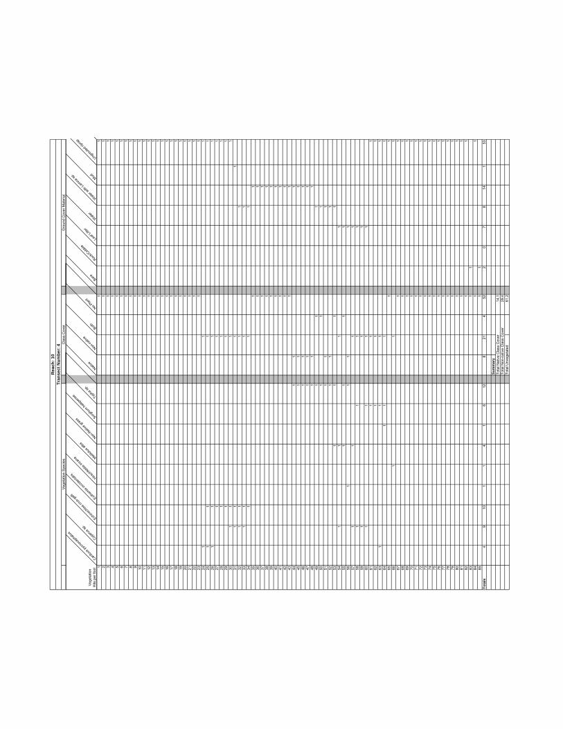
Veg
etat
ion
Spe
cies
Cla
ss C
over
Gro
und
Cov
er M
ater
ial
Rea
ch: 1
0Tr
anse
ct N
umbe
r: 4
Veg
etat
ion
Hits
per
foot
Carduu
s pyc
noce
phalu
sCyp
erus s
p.
Echino
chloa
crus
-galli
Eutham
ia oc
ciden
talis
Hirsch
feldia
inca
na Melilot
us al
ba
Non-N
ative
gras
s Sorghu
m halep
ense Typ
ha sp
.
Native
Non-na
tive
Both
No Plan
t
Bare
Rock/C
obble
Leaf
Litter
Wate
r
Wate
r with
Lemna
sp.
Mud
Ungrou
ted rip
rap
11
12
11
31
14
11
51
16
11
71
18
11
91
110
11
111
112
11
131
114
11
151
116
11
171
118
11
191
120
11
211
122
11
231
124
11
125
11
11
261
11
127
11
128
11
129
11
130
11
11
311
11
132
11
11
331
11
134
11
135
11
361
137
11
381
139
11
401
141
11
421
143
11
441
11
451
11
461
11
471
11
481
11
491
11
501
11
511
11
521
11
531
11
154
11
11
551
11
156
11
11
571
11
158
11
11
591
11
601
11
161
11
162
11
163
11
11
641
11
165
11
661
11
671
168
11
691
170
11
711
172
11
731
174
11
751
176
11
771
178
11
791
180
11
811
182
11
831
184
11
851
1To
tals
49
101
14
16
128
214
522
07
814
153
Sum
mar
yTo
tal N
ativ
e C
lass
Cov
er14
.1To
tal N
on-n
ativ
e C
lass
Cov
er29
.4To
tal U
nveg
etat
ed61
.2

Class Cover Ground Cover MaterialVegetation Species
Reach: 12Transect Number: 1
VegetationHits per foot Meli
lotus
alba
Polygo
num
sp.
Salix g
oodd
ingii
Salix l
asiol
epis
Typha
sp.
Native
Non-N
ative
Both No Plan
t
Bare Leaf
Litter
Water
Mud Water with
Lemna
sp.
Grouted
riprap
1 1 12 1 13 1 14 1 15 1 16 1 17 1 18 1 19 1 1
10 1 1 111 1 1 112 1 1 113 1 1 114 1 1 115 1 1 1 116 1 1 1 117 1 1 1 118 1 1 119 1 1 120 1 1 121 1 1 122 1 1 123 1 1 1 124 1 1 125 1 1 126 1 1 127 1 1 128 1 1 129 1 1 130 1 1 131 1 1 132 1 1 133 1 134 1 135 1 136 1 137 1 138 1 139 1 140 1 141 1 142 1 143 1 144 1 145 1 146 1 147 1 148 1 1 149 1 1 150 1 1 151 1 1 152 1 1 153 1 1 154 1 1 155 1 1 156 1 1 157 1 1 158 1 1 159 1 1 1 1 160 1 1 1 1 161 1 1 1 1 162 1 1 1 1 163 1 1 1 1 164 1 1 1 1 165 1 1 1 1 166 1 1 1 1 167 1 1 1 1 168 1 1 1 1 169 1 1 170 1 1 171 1 1 172 1 1 173 1 1 174 1 1 175 1 1
Totals 3 3 19 10 39 44 6 0 25 4 12 36 2 10 11
SummaryTotal Native Class Cover 58.7Total Non-native Class Cover 8.0Total Unvegetated 33.3

Vegetation Species Class Cover Ground Cover Material
Reach: 12Transect Number: 2
VegetationHits per foot Cotu
la co
ronop
ifolia
Datura
stram
onium
Hirsch
feldia
inca
na
Melilot
us sp
.
Non-N
ative
gras
s
Polygo
num sp
.
Roripp
a nas
turtiu
m-aqua
ticum
Salix g
oodd
ingii
Solanu
m doug
lasii
Urtica d
ioica
ssp.
holos
erice
a
Xanthi
umstr
umari
um
Native
Non-N
ative
Both No Plant
Bare Rock/C
obble
Leaf
Litter
Water
Mud Water w
ithLe
mna sp
.
Grouted
riprap
1 1 1 12 1 1 13 1 1 14 1 1 15 1 1 16 1 1 17 1 1 18 1 1 19 1 1 1
10 1 1 111 1 1 1 112 1 1 1 113 1 1 1 114 1 1 1 115 1 1 116 1 1 117 1 1 118 1 1 1 119 1 1 1 120 1 1 1 121 1 1 1 122 1 1 123 1 1 124 1 1 125 1 1 126 1 1 127 1 1 128 1 1 129 1 1 130 1 1 131 1 1 132 1 1 1 133 1 1 134 1 1 135 1 1 136 1 1 137 1 1 138 1 1 139 1 1 140 1 1 141 1 1 142 1 1 143 1 1 144 1 1 145 1 1 146 1 1 147 1 1 148 1 1 149 1 1 150 1 1 151 1 1 152 1 1 153 1 1 154 1 1 155 1 1 156 1 1 157 1 1 158 1 1 159 1 1 160 1 1 1 161 1 1 162 1 1 163 1 1 1 164 1 1 165 1 1 166 1 1 167 1 1 168 1 1 169 1 1 170 1 1 171 1 1 172 1 1 173 1 1 174 1 1 175 1 1 176 1 1 177 1 1 1 178 1 1 1 179 1 1 1 180 1 1 1 1 181 1 1 1 182 1 1 1 183 1 1 1 184 1 1 1 185 1 1 186 1 1 187 1 188 1 189 1 1 190 1 1 191 1 1 1 192 1 1 193 1 1 1 194 1 1 1 195 1 1 196 1 1 197 1 1 1 198 1 1 1 199 1 1 1
100 1 1 1101 1 1 1 1102 1 1 1103 1 1 1104 1 1 1105 1 1 1106 1 1 1107 1 1108 1 1109 1 1 1110 1 1
Totals 1 1 1 9 7 15 3 85 5 1 3 70 14 21 5 6 5 25 25 9 29 11
SummaryTotal Native Class Cover 82.7Total Non-native Class Cover 31.8Total Unvegetated 4.5

Veg
etat
ion
Spe
cies
Cla
ss C
over
Gro
und
Cov
er M
ater
ial
Rea
ch: 1
3Tr
anse
ct N
umbe
r: 1
Veg
etat
ion
Hits
per
foot
Centau
rea m
eliten
sis Melilot
us sp
.
Non-N
ative
gras
s
Native
Non-N
ative
Both
No Plan
t
Bare
Leaf
Litter
11
11
21
11
31
11
41
11
51
16
11
17
11
81
19
11
110
11
111
11
112
11
113
11
114
11
115
11
11
161
11
171
11
181
11
119
11
120
11
121
11
122
11
123
11
11
241
11
251
11
126
11
127
11
128
11
129
11
130
11
131
11
132
11
133
11
134
11
135
11
136
11
137
11
138
11
139
11
140
11
1To
tals
104
270
370
34
36
Sum
mar
yTo
tal N
ativ
e C
lass
Cov
er0
Tota
l Non
-nat
ive
Cla
ss C
over
92.5
Tota
l Unv
eget
ated
7.5

Veg
etat
ion
Spe
cies
Cla
ss C
over
Gro
und
Cov
er M
ater
ial
Rea
ch: 1
3Tr
anse
ct N
umbe
r: 2
Veg
etat
ion
Hits
per
foot
Artemisia
califo
rnica Cen
taurea
meli
tensis Le
pidos
partu
m squa
matum
Non-N
ative
gras
s Sambu
cusmex
icana
Native
Non-N
ative
Both
No Plan
t
Bare
Leaf
Litter
11
11
21
11
31
11
41
11
51
11
61
11
71
11
81
11
91
11
110
11
111
11
112
11
113
11
114
11
115
11
116
11
171
118
11
11
191
11
11
201
11
211
11
221
11
231
11
241
11
251
126
11
127
11
11
281
11
129
11
130
11
131
11
132
11
133
11
134
11
135
11
136
11
137
11
138
11
139
11
140
11
1To
tals
81
1417
219
125
45
36
Sum
mar
yTo
tal N
ativ
e C
lass
Cov
er60
.0To
tal N
on-n
ativ
e C
lass
Cov
er42
.5To
tal U
nveg
etat
ed10
.0

Veg
etat
ion
Spe
cies
Cla
ss C
over
Gro
und
Cov
er M
ater
ial
Rea
ch: 1
3Tr
anse
ct N
umbe
r: 3
Veg
etat
ion
Hits
per
foot
Carduu
s pyc
noce
phalu
sHirs
chfel
diainc
ana Non
-Nati
ve gr
ass Sam
bucu
smexica
na Typha
sp.
Native
Non-N
ative
Both
No Plan
t
Bare
Rock/C
obble
Leaf
Litter
Wate
r
Mud
11
11
21
11
31
11
41
15
11
61
11
71
11
81
11
91
11
101
111
11
121
113
11
114
11
115
11
11
161
11
117
11
118
11
11
191
11
120
11
11
211
11
122
11
11
231
11
124
11
125
11
126
11
127
11
128
11
129
11
130
11
131
11
132
11
133
11
134
11
135
11
136
11
11
371
11
381
11
391
11
401
1To
tals
27
252
71
267
62
126
110
Sum
mar
yTo
tal N
ativ
e C
lass
Cov
er20
.0To
tal N
on-n
ativ
e C
lass
Cov
er82
.5To
tal U
nveg
etat
ed15
.0

Veg
etat
ion
Spe
cies
Cla
ss C
over
Gro
und
Cov
er M
ater
ial
Rea
ch: 1
4Tr
anse
ct N
umbe
r: 1
Veg
etat
ion
Hits
per
foot
Bacch
aris s
alicif
olia Sali
xgood
dingii
Salixlas
iolep
is
Native
Non-N
ative
Both
NoPlant
Bare
Rock/C
obble
Leaf
Litter
Wate
r
Mud
11
11
21
11
31
11
41
11
51
11
61
11
71
11
81
11
91
11
101
11
111
11
121
11
113
11
11
141
11
151
11
161
11
171
11
181
11
191
11
201
11
211
11
221
11
231
11
241
11
251
11
261
11
271
11
281
11
291
11
301
11
311
11
132
11
11
331
11
134
11
11
351
11
1To
tals
524
1335
00
016
18
28
Sum
mar
yTo
tal N
ativ
e C
lass
Cov
er10
0To
tal N
on-n
ativ
e C
lass
Cov
er0
Tota
l Unv
eget
ated
0

Veg
etat
ion
Spe
cies
Cla
ss C
over
Gro
und
Cov
er M
ater
ial
Rea
ch: 1
4Tr
anse
ct N
umbe
r: 2
Veg
etat
ion
Hits
per
fo
ot
Carduu
s pyc
noce
phalu
sHirs
chfel
dia in
cana Meli
lotus
alba
Mimulu
s card
inalis Non
-Nati
ve gr
ass Poly
gonu
m sp.
Native
Non-N
ative
Both
No Plan
t
Bare
Rock/C
obble
Leaf
Litter
Water
Mud
Concre
te
11
11
21
11
31
11
41
11
51
11
61
11
71
11
81
11
91
11
101
11
111
11
121
11
131
11
141
115
11
161
117
11
181
119
11
120
11
121
11
11
221
11
231
124
11
125
11
126
11
127
11
128
11
129
11
130
11
311
11
321
11
331
134
11
351
136
11
371
138
11
391
140
11
411
142
11
431
144
11
451
1To
tals
211
71
14
124
020
171
202
41
Sum
mar
yTo
tal N
ativ
e C
lass
Cov
er2.
2To
tal N
on-n
ativ
e C
lass
Cov
er53
.3To
tal U
nveg
etat
ed44
.4

Vegetation Species Class Cover Ground Cover Material
Reach: 15Transect Number: 1
VegetationHits per foot Cyp
erus s
p.
Lepto
chloa
unine
rvia
Ludw
igia p
eploi
des
Non-N
ative
gras
s
Typha
sp.
Native
Non-N
ative
Both No Plant
Rock/C
obble
Water
Concre
te
1 1 12 1 13 1 14 1 15 1 16 1 17 1 18 1 19 1 1
10 1 111 1 112 1 113 1 114 1 115 1 116 1 117 1 118 1 119 1 120 1 121 1 122 1 1 123 1 1 124 1 1 1 125 1 1 126 1 1 1 127 1 1 128 1 1 1 129 1 1 130 1 1 1 131 1 1 1 132 1 1 1 133 1 1 1 134 1 1 1 135 1 1 1 136 1 1 1 137 1 1 1 1 138 1 1 139 1 1 140 1 1 141 1 1 1 142 1 1 143 1 1 144 1 1 145 1 1 1 146 1 1 1 147 1 1 1 148 1 1 149 1 1 1 150 1 1 151 1 1 152 1 1 153 1 1 154 1 1 155 1 1 156 1 1 157 1 1 158 1 1 159 1 1 160 1 1 161 1 1 162 1 1 163 1 1 164 1 1 165 1 1 166 1 1 167 1 168 1 169 1 170 1 171 1 172 1 173 1 174 1 175 1 176 1 177 1 178 1 179 1 180 1 181 1 182 1 183 1 184 1 185 1 1
Totals 6 1 39 8 8 32 3 10 40 1 44 40
SummaryTotal Native Class Cover 49.4Total Non-native Class Cover 15.3Total Unvegetated 47.1

Vegetation Species Class Cover Ground Cover Material
Reach: 15Transect Number: 2
VegetationHits per foot Meli
lotus
alba
Non-N
ative
grass
Typha
sp.
Native
Non-N
ative
Both No Plant
Rock/C
obble
Water
Mud Concre
te
1 1 12 1 13 1 14 1 15 1 16 1 17 1 18 1 19 1 1
10 1 111 1 112 1 113 1 114 1 115 1 116 1 1 117 1 1 118 1 1 119 1 120 1 121 1 1 122 1 1 123 1 1 124 1 1 125 1 1 126 1 1 127 1 1 1 128 1 1 1 129 1 1 130 1 1 131 1 1 132 1 1 133 1 1 134 1 1 135 1 1 136 1 1 137 1 1 138 1 1 139 1 1 140 1 1 141 1 1 142 1 1 143 1 1 144 1 1 145 1 1 146 1 1 147 1 1 148 1 1 149 1 1 150 1 1 151 1 1 1 152 1 1 153 1 1 154 1 1 155 1 1 1 156 1 1 1 157 1 1 158 1 1 159 1 160 1 1 161 1 162 1 163 1 164 1 165 1 166 1 167 1 168 1 169 1 170 1 171 1 172 1 173 1 174 1 175 1 176 1 177 1 178 1 179 1 180 1 1
Totals 2 34 11 9 30 3 38 2 20 28 30
SummaryTotal Native Class Cover 24.0Total Non-native Class Cover 66.0Total Unvegetated 47.5

Veg
etat
ion
Spe
cies
Cla
ss C
over
Gro
und
Cov
er M
ater
ial
Rea
ch: 1
6Tr
anse
ct N
umbe
r: 1
Veg
etat
ion
Hits
per
foot
Hirsch
feldia
incan
a Non-N
ative
grass
Native
Non-N
ative
Both
NoPlant
Bare
Rock/C
obble
Leaf
Litter
11
12
11
31
14
11
15
11
61
17
11
81
11
91
11
101
11
111
11
121
11
131
11
141
11
151
11
161
117
11
181
119
11
201
11
Tota
ls1
90
100
103
512
Sum
mar
yTo
tal N
ativ
e C
lass
Cov
er0
Tota
l Non
-nat
ive
Cla
ss C
over
50To
tal U
nveg
etat
ed50

Veg
etat
ion
Spe
cies
Cla
ss C
over
Gro
und
Cov
er M
ater
ial
Rea
ch: 1
7Tr
anse
ct N
umbe
r: 1
Veg
etat
ion
Hits
per
foot
Native
Non-N
ative
Both
NoPlant
Bare
Rock/C
obble
Leaf
Litter
Concre
te
Grouted
riprap
11
12
11
31
14
11
51
16
11
71
18
11
91
110
11
111
112
11
131
114
11
151
116
11
171
118
11
191
120
11
211
122
11
231
124
11
251
126
11
271
128
11
291
130
11
Tota
ls0
00
030
13
231
2
Sum
mar
yTo
tal N
ativ
e C
lass
Cov
er0
Tota
l Non
-nat
ive
Cla
ss C
over
0To
tal U
nveg
etat
ed10
0

Veg
etat
ion
Spe
cies
Cla
ss C
over
Gro
und
Cov
er M
ater
ial
Rea
ch: 1
8Tr
anse
ct N
umbe
r: 1
Veg
etat
ion
Hits
per
foot
Non-N
ative
grass
Ricinus
commun
is
Native
Non-N
ative
Both
NoPlant
Leaf
Litter
Sand
11
11
21
11
31
11
41
11
51
16
11
71
18
11
91
11
101
11
111
11
121
11
131
11
141
11
151
11
161
11
171
11
181
11
191
120
11
Tota
ls13
10
140
616
4
Sum
mar
yTo
tal N
ativ
e C
lass
Cov
er0
Tota
l Non
-nat
ive
Cla
ss C
over
70To
tal U
nveg
etat
ed30

Veg
etat
ion
Spe
cies
Cla
ss C
over
Gro
und
Cov
er M
ater
ial
Rea
ch: 1
8Tr
anse
ct N
umbe
r: 2
Veg
etat
ion
Hits
per
foot
Gnaph
alium
califo
rnicu
mNati
ve
Non-N
ative
Both
NoPlant
Leaf
Litter
Sand
11
12
11
31
14
11
51
16
11
17
11
81
19
11
101
111
11
121
113
11
141
115
11
161
117
11
181
119
11
201
1To
tals
11
00
1910
10
Sum
mar
yTo
tal N
ativ
e C
lass
Cov
er5
Tota
l Non
-nat
ive
Cla
ss C
over
0To
tal U
nveg
etat
ed95

Vegetation Species Class Cover Ground Cover Material
Reach: 19Transect Number: 1
VegetationHits per
foot Malosm
a lau
rinia
Pinus c
anari
ensis
Native
Non-N
ative
Both No Plant
Rock/C
obble
Leaf
Litter
Sand
1 1 12 1 13 1 14 1 15 1 16 1 17 1 18 1 19 1 1
10 1 111 1 112 1 113 1 114 1 115 1 116 1 117 1 118 1 119 1 120 1 121 1 122 1 123 1 124 1 125 1 126 1 127 1 128 1 129 1 130 1 131 1 132 1 133 1 134 1 135 1 136 1 137 1 138 1 139 1 140 1 141 1 142 1 143 1 144 1 145 1 146 1 147 1 148 1 149 1 1 150 1 1 151 1 1 152 1 1 153 1 1 1 154 1 1 1 155 1 1 1 156 1 1 1 157 1 1 1 158 1 1 1 159 1 1 1 160 1 1 1 161 1 1 1 162 1 1 1 163 1 1 1 164 1 1 1 165 1 1 1 166 1 1 1 167 1 1 168 1 1 169 1 1 170 1 1 171 1 1 172 1 1 173 1 1 174 1 1 175 1 1 1
Totals 14 27 0 13 14 48 28 31 16
SummaryTotal Native Class Cover 18.7Total Non-native Class Cover 36.0Total Unvegetated 64.0

Vegetation Species Class Cover Ground Cover Material
Reach: 19Transect Number: 2
VegetationHits per foot Erio
gonu
m fasc
iculat
um
Lepid
ospa
rtum sq
uamatu
m
Nicotia
na gl
auca
Spartiu
m junc
eum
Native
Non-N
ative
Both No Plan
t
Rock/C
obble
Leaf
Litter
Sand
Concre
te
1 1 12 1 13 1 14 1 15 1 16 1 17 1 18 1 19 1 1
10 1 111 1 112 1 113 1 114 1 115 1 116 1 117 1 118 1 119 1 120 1 121 1 122 1 123 1 124 1 125 1 126 1 127 1 128 1 129 1 130 1 131 1 132 1 133 1 134 1 135 1 136 1 137 1 138 1 139 1 140 1 141 1 142 1 143 1 144 1 145 1 146 1 147 1 148 1 149 1 150 1 151 1 152 1 153 1 154 1 155 1 156 1 157 1 158 1 159 1 160 1 161 1 162 1 163 1 164 1 165 1 166 1 167 1 168 1 169 1 170 1 171 1 172 1 173 1 174 1 175 1 176 1 177 1 178 1 179 1 180 1 181 1 182 1 183 1 184 1 185 1 186 1 187 1 1 188 1 1 189 1 1 190 1 1 1 191 1 1 1 192 1 1 1 193 1 1 1 1
Totals 1 5 1 5 2 1 0 89 39 8 45 1
SummaryTotal Native Class Cover 2.2Total Non-native Class Cover 1.1Total Unvegetated 95.7

Was not accessible, not surveyed.Reach: 20

Veg
etat
ion
Spe
cies
Cla
ss C
over
Gro
und
Cov
er M
ater
ial
Rea
ch: 2
1Tr
anse
ct N
umbe
r: 1
Veg
etat
ion
Hits
per
foot
Vinca m
ajor
Native
Non-N
ative
Both
NoPlant
Leaf
Litter
Coarse
woo
dy de
bris San
d1
11
21
13
11
41
15
11
61
17
11
81
19
11
101
111
11
121
113
11
141
11
151
11
Tota
ls2
02
013
40
11
Sum
mar
yTo
tal N
ativ
e C
lass
Cov
er0.
0To
tal N
on-n
ativ
e C
lass
Cov
er13
.3To
tal U
nveg
etat
ed86
.7

Vegetation Species Class Cover Ground Cover Material
Reach: 22Transect Number: 1
VegetationHits per foot Arte
misia d
ougla
siana
Bacch
aris s
alicif
olia
Ricinu
s com
munis
Native
Non-N
ative
Both No Plant
Rock/C
obble
Leaf
Litter
Sand
1 1 12 1 13 1 1 14 1 15 1 16 1 17 1 18 1 1 19 1 1 1
10 1 1 111 1 112 1 113 1 114 1 115 1 116 1 117 1 118 1 119 1 120 1 121 1 122 1 123 1 124 1 125 1 126 1 127 1 128 1 129 1 130 1 131 1 132 1 133 1 134 1 135 1 136 1 137 1 138 1 139 1 140 1 141 1 142 1 143 1 144 1 145 1 146 1 147 1 148 1 149 1 150 1 151 1 152 1 153 1 154 1 1 155 1 1
Totals 3 1 1 4 1 0 50 14 24 17
SummaryTotal Native Class Cover 7.3Total Non-native Class Cover 1.8Total Unvegetated 90.9

Vegetation Species Class Cover Ground Cover Material
Reach: 22Transect Number: 2
VegetationHits per foot Gilia
ange
lensis
Hedera
helix
Nicotia
na gl
auca
Native
Non-N
ative
Both No Plant
Rock/C
obble
Leaf
Litter
Sand
1 1 1 12 1 1 13 1 14 1 15 1 16 1 17 1 18 1 19 1 1
10 1 111 1 112 1 113 1 114 1 115 1 116 1 117 1 118 1 1 119 1 120 1 121 1 122 1 123 1 124 1 1 125 1 126 1 127 1 128 1 129 1 130 1 131 1 132 1 133 1 134 1 135 1 136 1 137 1 138 1 139 1 140 1 141 1 142 1 143 1 144 1 145 1 1
Totals 1 2 1 1 3 0 41 14 14 17
SummaryTotal Native Class Cover 2.2Total Non-native Class Cover 6.7Total Unvegetated 91.1

Vegetation Species Class Cover Ground Cover Material
Reach: 22Transect Number: 3
VegetationHits per foot Arte
misia d
ougla
siana
Platan
usrac
emos
a
Native
Non-N
ative
Both No Plant
Rock/C
obble
Leaf
Litter
Sand
1 1 12 1 13 1 14 1 15 1 16 1 17 1 18 1 19 1 1
10 1 111 1 112 1 113 1 114 1 115 1 116 1 117 1 118 1 1 119 1 1 120 1 1 121 1 1 122 1 1 123 1 1 124 1 1 125 1 1 126 1 1 127 1 1 128 1 1 129 1 1 130 1 1 131 1 1 132 1 1 133 1 1 134 1 1 135 1 1 136 1 1 1 137 1 1 138 1 1 1 139 1 1 1 140 1 1 1 141 1 1 1 142 1 1 1 143 1 1 1 144 1 1 1 145 1 1 1 1
Totals 28 9 28 0 0 17 7 16 22
SummaryTotal Native Class Cover 62.2Total Non-native Class Cover 0.0Total Unvegetated 37.8

Total Class Cover Percent Average for 24-1A,B, and C:Total Native Class Cover 20.3Total Non-native Class Cover 43.6Total Unvegetated 56.4

Veg
etat
ion
Spe
cies
Cla
ss C
over
Gro
und
Cov
er M
ater
ial
Rea
ch: 2
4Tr
anse
ct N
umbe
r: 1
A
Veg
etat
ion
Hits
per
foot
Conyz
a bon
arien
sis Cyperu
s sp.
Melilot
us al
ba
Plantag
o lan
ceola
ta Non-N
ative
gras
s Ricinu
scommun
is Sonch
us ol
erace
us Typha
sp.
Native
Non-N
ative
Both
No Plan
t
Bare
Rock/C
obble
Leaf
Litter
Water
Mud
Trash
Grouted
riprap
11
11
11
21
11
11
31
11
11
41
11
11
51
11
11
61
11
71
11
81
11
91
11
101
11
111
11
121
11
131
11
141
11
151
11
161
11
117
11
11
181
11
191
11
201
11
211
11
221
11
231
11
124
11
11
251
11
261
11
271
128
11
291
11
301
11
311
11
132
11
11
133
11
134
11
135
11
136
11
137
11
381
139
11
401
141
11
421
143
11
441
145
11
461
147
11
481
149
11
501
151
11
521
153
11
541
155
11
561
157
11
581
159
11
601
161
11
621
163
11
641
165
11
661
167
11
681
169
11
701
1To
tals
25
131
71
175
029
536
24
175
21
39
Sum
mar
yTo
tal N
ativ
e C
lass
Cov
er7.
1To
tal N
on-n
ativ
e C
lass
Cov
er48
.6To
tal U
nveg
etat
ed51
.4

Vegetation Species Class Cover Ground Cover Material
Reach: 24Transect Number: 1B
VegetationHits per foot Con
yza bo
narie
nsis
Ludw
igia p
eploi
des
Plantag
o lance
olata
Sonch
usole
raceu
s
Native
Non-N
ative
Both No Plant
Rock/C
obble
Wate
rMud San
dGrou
tedrip
rap
1 1 1 12 1 1 13 1 1 14 1 1 15 1 1 16 1 1 17 1 1 18 1 1 19 1 1 1
10 1 1 111 1 1 112 1 1 113 1 1 1 114 1 1 1 115 1 1 116 1 117 1 118 1 1 119 1 120 1 121 1 1 122 1 123 1 124 1 125 1 126 1 127 1 128 1 129 1 130 1 131 1 132 1 133 1 134 1 135 1 136 1 137 1 138 1 139 1 140 1 141 1 142 1 143 1 144 1 145 1 146 1 147 1 148 1 149 1 150 1 151 1 152 1 153 1 154 1 155 1 156 1 157 1 158 1 159 1 160 1 1
Totals 2 15 1 1 0 17 0 43 2 10 1 2 45
SummaryTotal Native Class Cover 0.0Total Non-native Class Cover 28.3Total Unvegetated 71.7

Ground Cover MaterialVegetation Species Class Cover
Reach: 24Transect Number: 1C
VegetationHits per foot Lu
dwigi
a pep
loide
s
Scirpu
s sp.
Typha
sp.
Native
Non-N
ative
Both No Plan
t
Water
1 1 1 1 1 12 1 1 1 1 13 1 1 1 1 14 1 1 1 1 15 1 1 1 1 16 1 1 1 1 17 1 1 1 1 18 1 1 1 1 19 1 1 1 1 1
10 1 1 1 1 111 1 1 1 1 112 1 1 1 1 113 1 1 1 1 114 1 1 1 1 115 1 1 1 1 116 1 1 1 1 117 1 1 1 1 118 1 1 1 1 119 1 1 1 1 120 1 1 1 1 121 1 1 1 1 122 1 1 1 1 123 1 1 1 1 124 1 1 1 1 125 1 1 1 1 126 1 1 1 1 127 1 1 1 1 128 1 1 1 1 129 1 1 1 1 130 1 1 1 1 131 1 1 1 1 132 1 1 1 1 133 1 1 1 1 134 1 1 1 1 135 1 1 1 1 136 1 1 1 1 137 1 1 1 1 138 1 1 1 1 139 1 1 1 1 140 1 1 1 1 141 1 1 1 1 142 1 1 1 1 143 1 1 1 1 144 1 1 1 1 145 1 1 1 1 146 1 1 1 1 147 1 1 1 1 148 1 1 1 1 149 1 1 1 1 150 1 151 1 152 1 153 1 154 1 155 1 156 1 157 1 158 1 159 1 160 1 161 1 162 1 163 1 164 1 165 1 166 1 167 1 168 1 169 1 170 1 171 1 172 1 173 1 174 1 175 1 176 1 177 1 178 1 179 1 180 1 181 1 182 1 183 1 184 1 185 1 186 1 187 1 188 1 189 1 190 1 191 1 1
Totals 49 49 49 0 0 49 42 91
SummaryTotal Native Class Cover 53.8Total Non-native Class Cover 53.8Total Unvegetated 46.2

Total Class Cover Percent Average for 24-2A,B, and C:Total Native Class Cover 6.1Total Non-native Class Cover 53.9Total Unvegetated 40.4

Vegetation Species Class Cover Ground Cover Material
Reach: 24Transect Number: 2A
VegetationHits per foot Chry
santh
emum
coron
arium
Conyz
a bon
arien
sis
Melilot
us al
ba
Non-N
ative
gras
s
Plantag
o lan
ceola
ta
Rapha
nus sa
tivus
Sonch
usole
raceu
s
Typha
sp.
Native
Non-N
ative
Both No Plant
Bare Leaf
Litter
Grouted
riprap
1 1 1 1 12 1 1 13 1 1 14 1 1 15 1 1 16 1 1 17 1 1 1 18 1 1 19 1 1 1
10 1 1 111 1 1 1 112 1 1 113 1 114 1 1 115 1 1 116 1 1 117 1 1 118 1 1 119 1 1 120 1 1 121 1 1 122 1 1 123 1 1 124 1 1 125 1 1 126 1 1 127 1 1 128 1 1 129 1 1 130 1 131 1 132 1 133 1 134 1 135 1 136 1 137 1 138 1 139 1 1 140 1 1 141 1 1 142 1 1 143 1 1 144 1 1 145 1 1 146 1 147 1 148 1 149 1 150 1 151 1 1 152 1 1 153 1 1 154 1 1 1 155 1 1 156 1 1 157 1 1 158 1 1 1 159 1 1 160 1 1 161 1 1 162 1 1 163 1 1 164 1 1 165 1 1 166 1 1 167 1 1 168 1 1 169 1 1 170 1 171 1 172 1 173 1 174 1 175 1 176 1 177 1 178 1 179 1 180 1 181 1 182 1 183 1 184 1 185 1 186 1 187 1 188 1 189 1 190 1 191 1 192 1 193 1 194 1 195 1 196 1 197 1 198 1 199 1 1
100 1 1101 1 1102 1 1103 1 1104 1 1105 1 1
Totals 2 2 15 7 5 2 25 1 0 53 1 51 14 51 40
SummaryTotal Native Class Cover 1.0Total Non-native Class Cover 51.4Total Unvegetated 48.6

Vegetation Species Class Cover Ground Cover Material
Reach: 24Transect Number: 2B
VegetationHits per foot Con
yza b
onari
ensis
Ludw
igia p
eploi
des
Melilot
us al
ba
Plantag
o lan
ceola
ta
Sonch
us ol
erace
us
Native
Non-N
ative
Both No Plan
t
Bare Leaf
Litter
Water
Grouted
riprap
1 1 1 12 1 1 13 1 1 1 14 1 1 1 15 1 1 16 1 1 17 1 1 18 1 1 1 19 1 1 1
10 1 1 111 1 1 112 1 1 113 1 1 1 114 1 1 115 1 1 116 1 1 117 1 1 1 118 1 1 119 1 1 120 1 1 121 1 1 122 1 1 123 1 1 124 1 1 125 1 1 126 1 1 127 1 1 128 1 1 129 1 130 1 131 1 132 1 133 1 1 134 1 1 135 1 1 136 1 1 137 1 138 1 139 1 140 1 141 1 142 1 143 1 144 1 145 1 146 1 147 1 148 1 149 1 150 1 151 1 152 1 153 1 154 1 155 1 156 1 157 1 158 1 159 1 160 1 161 1 162 1 163 1 164 1 165 1 166 1 167 1 168 1 169 1 170 1 171 1 172 1 173 1 174 1 175 1 176 1 177 1 178 1 179 1 180 1 1
Totals 5 1 7 9 15 0 33 0 47 2 32 1 45
SummaryTotal Native Class Cover 0.0Total Non-native Class Cover 41.3Total Unvegetated 58.8

Gro
und
Cov
er M
ater
ial
Veg
etat
ion
Spe
cies
Cla
ss C
over
Rea
ch: 2
4Tr
anse
ct N
umbe
r: 2
C
Veg
etat
ion
Hits
per
foot
Ludw
igiape
ploide
s Typha
sp.
Native
Non-N
ative
Both
No Plan
t
Wate
r1
11
12
11
13
11
14
11
15
11
16
11
17
11
18
11
19
11
110
11
111
11
112
11
113
11
114
11
115
11
116
11
117
11
118
11
119
11
120
11
121
11
122
11
123
11
124
11
125
11
126
11
271
128
11
291
1To
tals
205
520
04
29
Sum
mar
yTo
tal N
ativ
e C
lass
Cov
er17
.2To
tal N
on-n
ativ
e C
lass
Cov
er69
.0To
tal U
nveg
etat
ed13
.8

Total Class Cover Percent Average for 24-3A,B, and C:Total Native Class Cover 2.7Total Non-native Class Cover 31.8Total Unvegetated 67.1

Vegetation Species Class Cover Ground Cover Material
Reach: 24Transect Number: 3A
VegetationHits per foot Ambro
sia ps
ilosta
chya
Cyperu
s sp.
Melilot
us al
ba
Plantag
o lan
ceola
ta
Sonch
us ol
erace
us
Native
Non-N
ative
Both No Plan
t
Leaf
Litter
Mud Grouted
riprap
1 1 1 1 12 1 1 13 1 1 1 14 1 1 1 15 1 1 16 1 1 17 1 1 18 1 1 19 1 1 1
10 1 1 111 1 1 1 112 1 1 113 1 1 114 1 1 115 1 1 1 116 1 1 117 1 1 118 1 1 119 1 1 120 1 1 121 1 1 122 1 1 123 1 1 124 1 1 125 1 1 126 1 1 127 1 1 128 1 1 129 1 1 1 130 1 1 131 1 1 132 1 1 133 1 1 134 1 1 135 1 1 136 1 1 137 1 1 138 1 1 139 1 1 140 1 1 141 1 1 142 1 1 143 1 1 144 1 1 145 1 1 146 1 1 147 1 1 148 1 149 1 150 1 151 1 152 1 153 1 154 1 155 1 156 1 157 1 158 1 159 1 160 1 161 1 162 1 163 1 164 1 165 1 166 1 167 1 168 1 169 1 170 1 171 1 172 1 173 1 174 1 175 1 176 1 177 1 178 1 179 1 180 1 181 1 182 1 183 1 184 1 185 1 186 1 187 1 188 1 189 1 190 1 191 1 192 1 193 1 194 1 195 1 196 1 197 1 198 1 199 1 1
100 1 1Totals 2 1 37 8 5 0 45 2 53 32 1 67
SummaryTotal Native Class Cover 2Total Non-native Class Cover 47Total Unvegetated 53

Vegetation Species Class Cover Ground Cover Material
Reach: 24Transect Number: 3B
VegetationHits per foot Ambro
sia ps
ilosta
chya
Aster s
ubula
tus
Melilot
us al
ba
Plantag
o lan
ceola
ta
Scirpu
s cali
fornic
us
Sonch
us ol
erace
us
Native
Non-N
ative
Both No Plan
t
Bare Leaf
Litter
Wate
rGrou
ted rip
rap
1 1 1 12 1 1 13 1 1 14 1 1 1 15 1 1 1 16 1 1 17 1 1 1 18 1 1 19 1 1 1 1 1
10 1 1 111 1 1 112 1 113 1 1 1 114 1 1 115 1 1 1 116 1 1 1 117 1 1 1 118 1 1 1 119 1 1 1 120 1 1 1 121 1 1 1 122 1 1 1 123 1 1 124 1 1 125 1 1 126 1 1 127 1 1 128 1 1 129 1 1 130 1 1 131 1 1 132 1 1 133 1 1 1 134 1 1 1 135 1 1 136 1 1 137 1 1 138 1 1 139 1 1 140 1 1 141 1 1 142 1 1 143 1 1 144 1 1 145 1 1 146 1 1 147 1 1 148 1 1 149 1 1 150 1 1 151 1 1 152 1 1 153 1 1 154 1 1 155 1 1 156 1 1 157 1 1 158 1 1 159 1 1 160 1 161 1 162 1 163 1 164 1 165 1 166 1 167 1 168 1 169 1 170 1 171 1 172 1 173 1 174 1 175 1 176 1 177 1 178 1 179 1 180 1 181 1 182 1 183 1 184 1 185 1 186 1 187 1 188 1 189 1 190 1 191 1 192 1 193 1 194 1 195 1 196 1 197 1 198 1 199 1 1
100 1 1101 1 1102 1 1103 1 1104 1 1105 1 1106 1 1107 1 1108 1 1109 1 1110 1 1111 1 1112 1 1113 1 1114 1 1
Totals 8 1 48 9 6 3 3 51 4 55 2 50 4 58
SummaryTotal Native Class Cover 6.1Total Non-native Class Cover 48.2Total Unvegetated 48.2

Veg
etat
ion
Spe
cies
Gro
und
Cov
er M
ater
ial
Cla
ss C
over
Rea
ch: 2
4Tr
anse
ct N
umbe
r: 3
C
Veg
etat
ion
Hits
per
foot
Native
Non-N
ative
Both
NoPlant
Wate
r
11
12
11
31
14
11
51
16
11
71
18
11
91
110
11
111
112
11
131
114
11
151
116
11
171
118
11
191
120
11
211
1To
tals
00
00
2121
Sum
mar
yTo
tal N
ativ
e C
lass
Cov
er0
Tota
l Non
-nat
ive
Cla
ss C
over
0To
tal U
nveg
etat
ed10
0

Total Class Cover Percent Average for 24-4A,B, and C:Total Native Class Cover 3.2Total Non-Native Class Cover 68.4Total Unvegetated 31.7

Vegetation Species Class Cover Ground Cover Material
Reach: 24Transect Number: 4A
VegetationHits per foot Ambro
sia ps
ilosta
chya
Conyz
a bon
arien
sis
Helian
thus a
nnuu
s
Ludw
igia p
eploi
des
Melilot
us al
ba
Polygo
num
sp.
Scirpu
s cali
fornic
us
Sonch
us ol
erace
us
Native
Non-N
ative
Both No Plan
t
Leaf
Litter
Water
Mud Grouted
riprap
1 1 1 1 12 1 1 1 13 1 1 1 14 1 1 1 15 1 1 1 1 16 1 1 1 17 1 1 1 18 1 1 19 1 1 1 1
10 1 1 1 111 1 1 1 112 1 1 1 113 1 1 1 114 1 1 115 1 1 116 1 1 117 1 1 118 1 1 119 1 1 120 1 1 121 1 1 122 1 1 123 1 1 124 1 1 125 1 1 126 1 1 127 1 1 128 1 1 129 1 1 130 1 1 131 1 1 132 1 1 133 1 1 134 1 1 135 1 1 136 1 1 137 1 1 138 1 1 139 1 1 140 1 1 141 1 1 142 1 1 143 1 1 144 1 1 145 1 1 146 1 1 147 1 1 148 1 1 149 1 1 150 1 1 151 1 1 152 1 1 153 1 1 154 1 1 155 1 1 156 1 1 157 1 1 158 1 1 1 159 1 1 160 1 1 161 1 1 1 162 1 1 163 1 1 164 1 165 1 166 1 167 1 168 1 169 1 170 1 171 1 172 1 173 1 174 1 175 1 176 1 177 1 178 1 179 1 180 1 181 1 182 1 183 1 184 1 185 1 186 1 187 1 188 1 189 1 190 1 191 1 192 1 193 1 194 1 195 1 196 1 197 1 198 1 199 1 1
100 1 1101 1 1102 1 1103 1 1104 1 1105 1 1106 1 1107 1 1108 1 1109 1 1110 1 1111 1 1112 1 1113 1 1114 1 1115 1 1116 1 1117 1 1118 1 1119 1 1120 1 1
Totals 3 2 5 5 54 1 4 4 0 54 9 57 57 5 1 57
SummaryTotal Native Class Cover 7.5Total Non-native Class Cover 52.5Total Unvegetated 47.5

Vegetation Species Class Cover Ground Cover Material
Reach: 24Transect Number: 4B
VegetationHits per foot Ambro
sia ps
ilosta
chya
Conyz
a bon
arien
sis
Melilot
us al
ba
Polygo
num sp
.
Scirpu
s cali
fornic
us
Native
Non-N
ative
Both No Plan
t
Leaf
Litter
Mud Grouted
riprap
1 1 1 1 12 1 1 1 13 1 14 1 15 1 1 16 1 1 1 17 1 1 18 1 1 19 1 1 1 1
10 1 1 1 111 1 1 112 1 1 113 1 1 114 1 1 115 1 1 116 1 1 117 1 1 118 1 1 119 1 1 120 1 1 121 1 1 122 1 1 123 1 1 124 1 1 125 1 1 126 1 1 127 1 1 128 1 1 129 1 1 130 1 1 131 1 1 132 1 1 133 1 1 134 1 1 135 1 1 136 1 1 137 1 1 138 1 1 139 1 1 140 1 1 141 1 1 142 1 1 143 1 1 144 1 1 145 1 1 146 1 1 147 1 1 148 1 149 1 150 1 151 1 152 1 153 1 154 1 155 1 156 1 157 1 158 1 159 1 160 1 161 1 162 1 163 1 164 1 165 1 166 1 167 1 168 1 169 1 170 1 171 1 172 1 173 1 174 1 175 1 176 1 177 1 178 1 179 1 180 1 181 1 182 1 183 1 184 1 185 1 186 1 1 187 1 1 188 1 1 189 1 1 190 1 1 191 1 192 1 193 1 194 1 195 1 1
Totals 4 1 46 2 2 0 48 2 45 33 1 61
SummaryTotal Native Class Cover 2.1Total Non-native Class Cover 52.6Total Unvegetated 47.4

Veg
etat
ion
Spe
cies
Gro
und
Cov
er M
ater
ial
Cla
ss C
over
Rea
ch: 2
4Tr
anse
ct N
umbe
r: 4
C
Veg
etat
ion
Hits
per
foot
Ludw
igia p
eploi
des
Native
Non-N
ative
Both
NoPlant
Wate
r
11
11
21
11
31
11
41
11
51
11
61
11
71
11
81
11
91
11
101
11
111
11
121
11
131
11
141
11
151
11
161
11
171
11
181
11
Tota
ls18
018
00
18
Sum
mar
yTo
tal N
ativ
e C
lass
Cov
er0
Tota
l Non
-nat
ive
Cla
ss C
over
100
Tota
l Unv
eget
ated
0

Total Class Cover Percent Average for 25-1A,B, and C:Total Native Class Cover 46.6Total Non-native Class Cover 46.7Total Unvegetated 36.8

Veg
etat
ion
Spe
cies
Cla
ss C
over
Gro
und
Cov
er M
ater
ial
Rea
ch: 2
5Tr
anse
ct N
umbe
r: 1
A
Veg
etat
ion
Hits
per
foot
Cyperu
s sp.
Conyz
a bon
arien
sis Eutham
ia oc
ciden
talis
Ludw
igia p
eploi
des Meli
lotus
alba
Non-N
ative
gras
s Plantag
o lan
ceola
ta Polygo
num sp
.Rap
hanu
s sati
vus Rici
nus c
ommun
is Salix g
oodd
ingii (
seed
ling)
Salix g
oodd
ingii (
shrub
)Scir
pus c
alifor
nicus Sola
num am
erica
num Typ
ha sp
.
Xanthi
um st
rumari
um
Native
Non-N
ative
Both
No Plan
t
Bare
Rock/C
obble
Leaf
Litter
Water
Mud
Trash
Ungrou
ted rip
rap
11
11
12
11
13
11
14
11
15
11
16
11
11
71
11
81
11
91
11
101
11
111
11
112
11
113
11
114
11
115
11
11
161
11
11
171
11
11
118
11
11
119
11
11
201
11
121
11
11
221
11
123
11
11
241
11
125
11
11
261
11
127
11
11
281
11
11
291
11
301
11
311
11
321
11
133
11
134
11
11
351
11
11
361
11
137
11
11
381
11
11
391
11
11
401
11
141
11
11
421
11
431
11
441
11
451
11
146
11
147
11
148
11
149
11
150
11
151
11
152
11
153
11
154
11
155
11
156
11
157
11
158
11
159
11
11
601
11
11
611
11
162
11
11
631
11
164
11
11
651
11
166
11
11
671
11
681
11
691
11
701
11
711
11
721
11
731
11
174
11
11
751
11
11
761
11
11
771
11
11
781
11
11
791
11
180
11
11
811
11
182
11
11
831
11
184
11
11
851
11
186
11
11
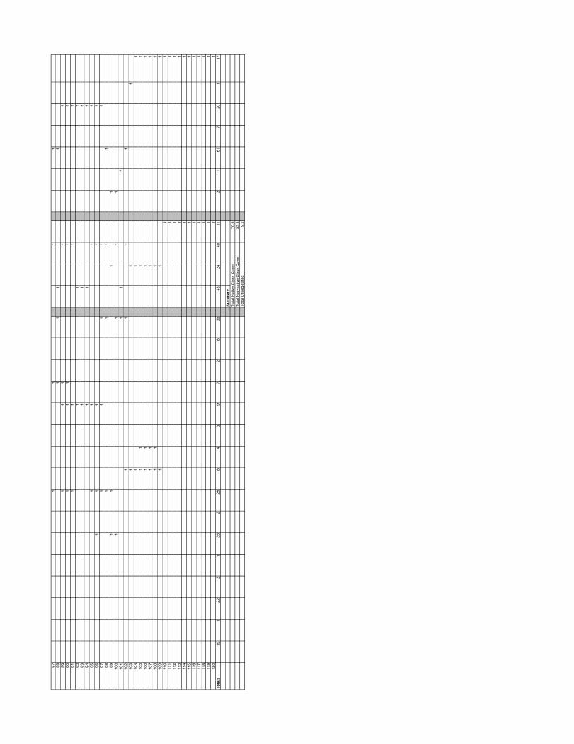
871
11
188
11
11
891
11
11
901
11
11
911
11
192
11
193
11
194
11
195
11
11
961
11
11
971
11
11
981
11
199
11
11
100
11
11
101
11
110
21
11
110
31
11
104
11
110
51
11
110
61
11
110
71
11
110
81
11
110
91
11
110
11
111
11
112
11
113
11
114
11
115
11
116
11
117
11
118
11
119
11
120
11
Tota
ls19
122
31
352
288
43
97
28
3945
2440
113
161
1720
117
Sum
mar
yTo
tal N
ativ
e C
lass
Cov
er70
.8To
tal N
on-n
ativ
e C
lass
Cov
er53
.3To
tal U
nveg
etat
ed9.
2

Cla
ss C
over
Gro
und
Cov
er M
ater
ial
Veg
etat
ion
Spe
cies
Rea
ch: 2
5Tr
anse
ct N
umbe
r: 1
B
Veg
etat
ion
Hits
per
foot
Amaranth
usret
roflex
usAmbro
sia ps
ilosta
chya
Bacch
arissa
licifo
lia Cynod
onda
ctylon
Echino
chloa
crus
-galli
Eclipta
prostr
ataLe
pidium
perfo
liatum Meli
lotus
alba
Native
gras
s
Paspa
lum di
latatu
m Plantag
o lan
ceola
ta Pennis
etum sp
.Poly
gonu
msp
.Rap
hanu
s sati
vus Sali
x goo
dding
ii(se
edlin
g)
Salix g
oodd
ingii(
mature
tree)
Scirpu
s cali
fornic
us Sonch
us ol
erace
us Sporob
olus s
p.(na
tive)
Washin
gtonia
sp. Xan
thium
strum
arium
Native
Non-N
ative
Both
No Plan
t
Rock/C
obble
Leaf
Litter
Water
Mud
Sand
11
11
21
11
31
11
14
11
11
51
11
16
11
11
17
11
18
11
11
91
11
101
11
111
11
121
11
131
11
114
11
11
151
11
161
11
117
11
11
181
11
191
11
120
11
11
211
11
122
11
11
231
11
241
11
251
11
261
11
127
11
11
128
11
11
11
291
11
11
301
11
131
11
11
321
11
133
11
134
11
135
11
136
11
11
371
11
138
11
11
139
11
11
140
11
11
411
11
142
11
143
11
144
11
11
451
11
11
461
11
147
11
11
11
481
11
11
491
11
150
11
11
151
11
11
521
11
153
11
154
11
155
11
156
11
157
11
158
11
159
11
160
11
161
11
162
11
631
11
641
165
11
661
11
671
11
681
11
691
11
701
171
11
172
11
173
11
11
741
175
11
176
11
177
11
781
11
791
11
801
181
11
182
11
183
11
184
11
185
11
186
11
11
871
11
188
11
11
891
11
190
11
191
11
192
11
193
11
194
11
195
11
196
11
197
11
198
11
11
991
11
100
11
11
101
11
11
102
11
11
103
11
11
104
11
11
105
11
11
106
11
11
107
11
110
81
110
91
11
110
11
111
11
11
112
11
113
11
114
11
115
11

116
11
117
11
118
11
119
11
120
11
112
11
11
122
11
123
11
124
11
125
11
112
61
112
71
112
81
112
91
113
01
113
11
113
21
113
31
113
41
113
51
113
61
113
71
113
81
113
91
114
01
114
11
114
21
114
31
114
41
11
145
11
146
11
147
11
148
11
149
11
150
11
151
11
152
11
153
11
154
11
155
11
156
11
157
11
158
11
159
11
160
11
116
11
116
21
116
31
116
41
116
51
116
61
116
71
11
168
11
169
11
170
11
171
11
117
21
11
173
11
174
11
175
11
176
11
177
11
178
11
179
11
180
11
181
11
182
11
183
11
184
11
185
11
186
11
187
11
188
11
189
11
190
11
191
11
192
11
193
11
194
11
119
51
119
61
11
197
11
119
81
11
199
11
200
11
120
11
120
21
11
203
11
120
41
11
205
11
206
11
207
11
208
11
209
11
210
11
121
11
11
212
11
121
31
11
214
11
121
51
11
216
11
121
71
11
218
11
121
91
11
122
01
11
122
11
11
122
21
11
11
223
11
11
122
41
11
122
51
11
226
11
122
71
11
228
11
122
91
11
230
11
231
11
232
11
233
11
234
11
235
11
Tota
ls1
54
6317
113
513
31
127
21
216
53
114
3370
3696
106
361
2567
Sum
mar
yTo
tal N
ativ
e C
lass
Cov
er29
.4To
tal N
on-n
ativ
e C
lass
Cov
er45
.1To
tal U
nveg
etat
ed40
.9

Vegetation Species Class Cover Ground Cover Material
Reach: 25Transect Number: 1C
VegetationHits per foot Poly
gonu
m sp.
Scirpu
s cali
fornic
us
Typha
sp.
Native
Non-na
tive
Both No Plant
Water
Mud
1 1 12 1 13 1 14 1 15 1 16 1 17 1 18 1 19 1 1
10 1 111 1 112 1 113 1 114 1 115 1 116 1 117 1 118 1 119 1 120 1 121 1 122 1 123 1 124 1 125 1 126 1 127 1 128 1 129 1 130 1 131 1 132 1 133 1 134 1 135 1 136 1 137 1 138 1 139 1 140 1 141 1 1 1 1 142 1 1 1 1 143 1 1 1 1 144 1 1 1 1 145 1 1 1 1 146 1 1 1 1 147 1 1 1 1 148 1 1 1 1 149 1 1 1 1 150 1 1 1 1 151 1 1 1 1 152 1 1 1 1 153 1 1 1 1 154 1 1 1 1 155 1 1 1 1 156 1 1 1 1 157 1 1 1 1 158 1 1 1 1 159 1 1 1 1 160 1 1 1 1 161 1 1 1 1 162 1 1 1 1 163 1 1 1 1 164 1 1 1 1 165 1 1 1 1 166 1 1 1 1 167 1 1 1 1 168 1 1 1 1 169 1 1 1 1 170 1 1 1 1 171 1 172 1 173 1 174 1 175 1 176 1 177 1 178 1 179 1 180 1 181 1 182 1 183 1 184 1 185 1 186 1 187 1 188 1 189 1 190 1 191 1 192 1 1

93 1 194 1 195 1 196 1 197 1 198 1 199 1 1
100 1 1101 1 1102 1 1103 1 1104 1 1105 1 1106 1 1107 1 1108 1 1109 1 1110 1 1111 1 1112 1 1113 1 1114 1 1115 1 1116 1 1117 1 1118 1 1119 1 1120 1 1121 1 1122 1 1123 1 1124 1 1125 1 1126 1 1127 1 1128 1 1129 1 1130 1 1131 1 1132 1 1133 1 1134 1 1135 1 1136 1 1137 1 1138 1 1139 1 1140 1 1141 1 1 1 1 1142 1 1 1 1 1143 1 1 1 1 1144 1 1 1 1 1145 1 1 1 1 1146 1 1 1 1 1147 1 1 1 1 1148 1 1 1 1 1149 1 1 1 1 1150 1 1 1 1 1151 1 1 1 1 1152 1 1 1 1 1153 1 1 1 1 1154 1 1 1 1 1155 1 1 1 1 1156 1 1 1 1 1157 1 1 1 1 1158 1 1 1 1 1159 1 1 1 1 1160 1 1 1 1 1161 1 1 1 1 1162 1 1 1 1 1163 1 1 1 1 1164 1 1 1 1 1165 1 1 1 1 1166 1 1 1 1 1167 1 1 1 1 1168 1 1 1 1 1169 1 1 1 1 1170 1 1 1 1 1171 1 1 1 1 1172 1 1 1 1 1173 1 1 1 1 1174 1 1 1 1 1175 1 1 1 1 1176 1 1 1 1 1177 1 1 1 1 1178 1 1 1 1 1179 1 1 1 1 1180 1 1 1 1 1181 1 1 1 1 1182 1 1 1 1 1
Totals 72 72 72 0 0 72 110 110 72
SummaryTotal Native Class Cover 39.6Total Non-native Class Cover 39.6Total Unvegetated 60.4

Total Class Cover Percent Average for 25-2A,B, and C:Total Native Class Cover 19.4Total Non-native Class Cover 34.4Total Unvegetated 51.7

Veg
etat
ion
Spe
cies
Cla
ss C
over
Gro
und
Cov
er M
ater
ial
Rea
ch: 2
5Tr
anse
ct N
umbe
r: 2
A
Veg
etat
ion
Hits
per
foot
Ambrosia
psilo
stach
yaEuth
amia
occid
ental
isFoe
niculu
m vulga
re Helian
thusan
nuus Non
-Nati
ve gr
ass Orna
mental
sp.
Phragm
ites a
ustra
lis (n
ative
)
Rapha
nus s
ativu
s Ricinu
s com
munis Son
chus
olera
ceus Typ
ha sp
.
Native
Non-N
ative
Both
No Plan
t
Leaf
Litter
Wate
r
Mud
Ungrou
ted rip
rap
11
12
11
31
14
11
51
16
11
71
18
11
91
110
11
111
112
11
131
114
11
151
116
11
171
118
11
119
11
120
11
121
11
122
11
123
11
124
11
125
11
11
261
11
127
11
11
281
11
129
11
11
301
11
131
11
11
321
11
133
11
11
341
11
135
11
11
361
11
137
11
11
381
11
139
11
11
401
11
141
11
11
421
11
143
11
11
441
11
11
451
11
146
11
11
471
11
481
11
491
11
150
11
11
151
11
11
521
11
153
11
11
154
11
11
155
11
11
561
11
157
11
11
158
11
11
591
11
11
601
11
161
11
11
621
11
631
11
641
11
651
11
661
11
671
11
681
11
169
11
170
11
171
11
172
11
173
11
174
11
175
11
11
761
11
177
11
11
781
11
791
11
801
11
811
11
821
11
831
11
841
11
851
1To
tals
728
82
121
322
11
2732
2510
1833
1033
9
Sum
mar
yTo
tal N
ativ
e C
lass
Cov
er49
.4To
tal N
on-n
ativ
e C
lass
Cov
er41
.2To
tal U
nveg
etat
ed21
.2

Cla
ss C
over
Gro
und
Cov
er M
ater
ial
Veg
etat
ion
Spe
cies
Rea
ch: 2
5Tr
anse
ct N
umbe
r: 2
B
Veg
etat
ion
Hits
per
foot
Bacch
aris s
alicif
olia Cotu
la co
ronop
ifolia Cyp
erussp
.
Cynod
onda
ctylon
Helian
thus a
nnuu
s Melilot
usalb
a
Non-na
tive g
rass(Lo
lium
sp.a
ndEch
inoch
ola cr
us-ga
lli)
Plantag
olance
olata Poly
gonu
m sp.
Ricinus
commun
is Rumex
crisp
usWas
hingto
niasp
. Xanthi
umstr
umari
um
Native
Non-na
tive
Both
No Plan
t
Metalp
ipe
Rock/C
obble
Leaf
Litter
Mud
Sand
Concre
te/as
phalt
Trash
Ungrou
tedrip
rap
11
11
12
11
11
31
11
14
11
11
51
11
61
11
17
11
11
81
11
19
11
11
101
11
111
11
121
11
131
11
141
11
151
11
161
11
171
11
181
11
191
11
201
11
211
11
221
11
231
11
241
11
251
11
261
11
271
11
281
11
291
11
301
11
311
11
321
11
331
134
11
135
11
136
11
371
11
381
11
391
11
401
11
411
11
142
11
431
144
11
451
11
461
147
11
481
11
491
11
501
11
511
152
11
531
11
541
155
11
561
11
571
11
581
11
159
11
160
11
611
162
11
631
164
11
165
11
166
11
671
168
11
691
170
11

711
172
11
173
11
174
11
175
11
176
11
771
178
11
791
11
801
11
811
11
821
11
831
11
841
11
851
11
861
11
871
188
11
891
190
11
191
11
11
921
193
11
194
11
195
11
961
11
971
11
981
11
199
11
110
01
11
11
101
11
102
11
110
31
11
110
41
11
105
11
110
61
110
71
110
81
11
109
11
110
11
111
11
111
21
11
113
11
111
41
11
115
11
111
61
11
117
11
118
11
119
11
120
11
121
11
112
21
11
112
31
11
112
41
11
125
11
11
126
11
112
71
11
128
11
112
91
113
01
113
11
113
21
113
31
113
41
11
135
11
113
61
11
137
11
11
138
11
113
91
11
114
01
11
114
11
11
114
21
11
143
11
11
144
11
11
145
11
11
146
11
11
147
11
114
81
11
149
11
11
150
11
11
151
11
11
152
11
11
153
11
11
154
11
11
155
11
11
156
11
11
157
11
11
158
11
11
159
11
1
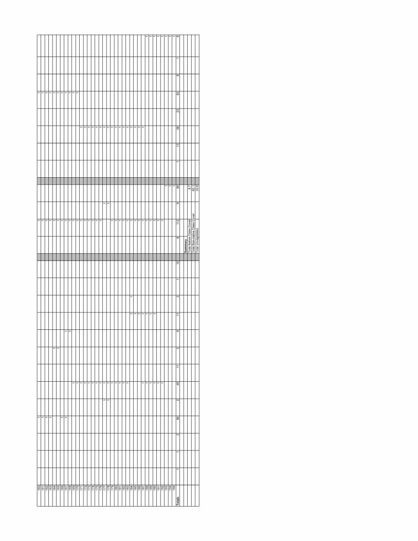
160
11
116
11
11
162
11
116
31
11
164
11
116
51
11
166
11
116
71
11
116
81
11
169
11
117
01
11
171
11
117
21
11
173
11
117
41
11
175
11
117
61
11
177
11
11
178
11
11
179
11
118
01
11
181
11
118
21
11
183
11
118
41
11
118
51
11
186
11
118
71
11
118
81
11
118
91
11
119
01
11
119
11
11
192
11
119
31
119
41
119
51
1To
tals
11
286
249
113
811
31
158
112
966
113
5823
838
18
Sum
mar
yTo
tal N
ativ
e C
lass
Cov
er8.
7To
tal N
on-n
ativ
e C
lass
Cov
er62
.1To
tal U
nveg
etat
ed33
.8

Vegetation Species Ground Cover MaterialClass Cover
Reach: 25Transect Number: 2C
VegetationHits per foot Nati
veNon
-nativ
e
Both No Plant
Wate
r
1 1 12 1 13 1 14 1 15 1 16 1 17 1 18 1 19 1 1
10 1 111 1 112 1 113 1 114 1 115 1 116 1 117 1 118 1 119 1 120 1 121 1 122 1 123 1 124 1 125 1 126 1 127 1 128 1 129 1 130 1 131 1 132 1 133 1 134 1 135 1 136 1 137 1 138 1 139 1 140 1 141 1 142 1 143 1 144 1 145 1 146 1 147 1 148 1 149 1 150 1 151 1 152 1 153 1 154 1 155 1 156 1 157 1 158 1 159 1 160 1 161 1 162 1 163 1 164 1 165 1 166 1 167 1 168 1 169 1 170 1 171 1 172 1 173 1 174 1 175 1 176 1 177 1 178 1 1

79 1 180 1 181 1 182 1 183 1 184 1 185 1 186 1 187 1 188 1 189 1 190 1 191 1 192 1 193 1 194 1 195 1 196 1 197 1 198 1 199 1 1
100 1 1101 1 1102 1 1103 1 1104 1 1105 1 1106 1 1107 1 1108 1 1109 1 1110 1 1111 1 1112 1 1113 1 1114 1 1115 1 1116 1 1117 1 1118 1 1119 1 1120 1 1121 1 1122 1 1123 1 1124 1 1125 1 1126 1 1127 1 1128 1 1129 1 1130 1 1131 1 1132 1 1133 1 1134 1 1135 1 1136 1 1137 1 1138 1 1139 1 1140 1 1141 1 1142 1 1143 1 1144 1 1145 1 1146 1 1147 1 1148 1 1149 1 1150 1 1151 1 1152 1 1153 1 1154 1 1155 1 1156 1 1157 1 1158 1 1159 1 1160 1 1161 1 1162 1 1163 1 1

164 1 1165 1 1166 1 1167 1 1168 1 1169 1 1170 1 1171 1 1172 1 1173 1 1174 1 1175 1 1176 1 1177 1 1178 1 1179 1 1180 1 1181 1 1182 1 1183 1 1184 1 1185 1 1186 1 1187 1 1188 1 1189 1 1190 1 1191 1 1192 1 1193 1 1194 1 1195 1 1196 1 1197 1 1198 1 1199 1 1200 1 1201 1 1202 1 1203 1 1204 1 1205 1 1206 1 1207 1 1208 1 1209 1 1210 1 1211 1 1212 1 1213 1 1214 1 1215 1 1216 1 1217 1 1218 1 1219 1 1220 1 1221 1 1222 1 1223 1 1224 1 1225 1 1226 1 1227 1 1228 1 1229 1 1230 1 1231 1 1232 1 1233 1 1234 1 1235 1 1236 1 1237 1 1238 1 1239 1 1240 1 1
Totals 0 0 0 0 240 240
SummaryTotal Native Class Cover 0Total Non-native Class Cover 0Total Unvegetated 100

Total Class Cover Percent Average for 25-3A,B, and C:Total Native Class Cover 25.6Total Non-native Class Cover 54.0Total Unvegetated 34.6

Veg
etat
ion
Spe
cies
Cla
ss C
over
Gro
und
Cov
er M
ater
ial
Rea
ch: 2
5Tr
anse
ct N
umbe
r: 3
A
Veg
etat
ion
Hits
per
foot
Amaranth
us re
trofle
xus
Ambrosia
psilo
stach
yaEuth
amia
occid
ental
isNon
-Nati
ve gr
ass Poly
gonu
m sp.
Rapha
nus s
ativu
s Solanu
m ameri
canu
m Sonch
us ol
erace
us Xanthi
um st
rumari
um
Native
Non-N
ative
Both
No Plan
t
Leaf
Litter
Wate
r
Mud
Ungrou
ted rip
rap
11
11
12
11
11
31
11
14
11
11
51
11
61
11
71
11
81
11
91
11
101
11
111
11
121
11
131
11
141
11
151
11
116
11
11
117
11
118
11
11
191
11
11
201
11
11
211
11
122
11
11
123
11
11
241
11
251
11
261
11
127
11
11
281
11
129
11
130
11
11
311
11
321
11
331
11
341
11
351
11
361
11
371
11
381
11
391
11
140
11
11
141
11
11
421
11
431
11
441
11
451
11
461
11
471
11
481
11
491
11
501
11
511
11
521
11
531
11
541
155
11
Tota
ls6
21
2914
147
13
340
102
391
78
Sum
mar
yTo
tal N
ativ
e C
lass
Cov
er23
.6To
tal N
on-n
ativ
e C
lass
Cov
er90
.9To
tal U
nveg
etat
ed3.
6

Veg
etat
ion
Spe
cies
Cla
ss C
over
Gro
und
Cov
er M
ater
ial
Rea
ch: 2
5Tr
anse
ct N
umbe
r: 3
B
Veg
etat
ion
Hits
per
foot
Aster s
ubula
tusAmbro
sia ac
anthi
carpa Euth
amia
occid
ental
isHeli
anthu
s ann
uus Meli
lotus
alba
Non-N
ative
gras
s (Cyn
odon
dacty
lon an
d Ech
inoch
ola cr
us-ga
lli)
Phace
lia ci
cutar
ia Plantag
o lan
ceola
ta Polygo
num sp
.Xan
thium
strum
arium
Native
Non-N
ative
Both
No Plan
t
Rock/C
obble
Leaf
Litter
Mud
Sand
Ungrou
ted rip
rap
11
11
21
11
13
11
11
41
11
11
51
11
16
11
17
11
18
11
11
91
11
101
11
111
11
11
121
11
131
11
141
11
151
11
11
161
11
117
11
11
181
11
191
11
201
11
211
11
221
11
231
11
124
11
11
251
11
261
11
127
11
11
281
11
291
11
301
11
311
11
321
11
331
11
341
11
351
136
11
371
138
11
139
11
140
11
141
11
421
143
11
441
145
11
146
11
147
11
148
11
11
149
11
11

501
11
151
11
11
521
11
531
11
541
11
551
11
561
11
571
11
158
11
11
591
11
160
11
11
611
11
162
11
11
631
11
641
11
165
11
11
661
11
167
11
11
681
11
169
11
170
11
171
11
172
11
173
11
174
11
175
11
176
11
177
11
178
11
179
11
11
801
11
811
11
182
11
183
11
184
11
185
11
186
11
187
11
188
11
189
11
190
11
191
11
192
11
193
11
11
941
11
951
11
961
11
197
11
11
981
11
199
11
110
01
11
110
11
11
102
11
11
103
11
11
104
11
110
51
11
106
11
11
107
11
11
108
11
110
91
11
110
11
11
111
11
111
21
11
113
11
111
41
11
115
11
111
61
11
111
71
11
11
118
11
11

119
11
11
112
01
11
121
11
112
21
11
123
11
11
124
11
11
125
11
112
61
11
127
11
112
81
11
129
11
113
01
11
131
11
113
21
11
133
11
113
41
11
135
11
113
61
11
137
11
113
81
11
139
11
114
01
11
141
11
114
21
11
143
11
114
41
11
145
11
114
61
11
147
11
114
81
11
149
11
115
01
11
151
11
152
11
153
11
154
11
155
11
156
11
157
11
158
11
159
11
160
11
Tota
ls1
2514
260
531
12
3640
6934
171
569
7915
Sum
mar
yTo
tal N
ativ
e C
lass
Cov
er46
.3To
tal N
on-n
ativ
e C
lass
Cov
er64
.4To
tal U
nveg
etat
ed10
.6

Class Cover Ground Cover MaterialVegetation Species
Reach: 25Transect Number: 3C
VegetationHits per foot Amara
nthus
retrof
lexus
Eutham
ia oc
ciden
talis
Non-N
ative
gras
s
Polygo
num sp
.
Xanthi
um st
rumari
um
Native
Non-na
tive
Both No Plant
Wate
rMud
1 1 12 1 13 1 14 1 15 1 16 1 17 1 18 1 19 1 1
10 1 111 1 112 1 113 1 114 1 115 1 116 1 117 1 118 1 119 1 120 1 121 1 122 1 123 1 124 1 125 1 126 1 127 1 128 1 129 1 130 1 131 1 132 1 133 1 134 1 135 1 136 1 137 1 138 1 139 1 140 1 141 1 142 1 143 1 144 1 145 1 146 1 147 1 148 1 149 1 150 1 151 1 152 1 153 1 154 1 155 1 156 1 157 1 158 1 159 1 160 1 161 1 162 1 163 1 164 1 165 1 166 1 167 1 168 1 169 1 170 1 171 1 172 1 173 1 174 1 175 1 176 1 177 1 178 1 179 1 180 1 1

81 1 182 1 183 1 184 1 185 1 186 1 187 1 188 1 189 1 190 1 191 1 192 1 193 1 194 1 195 1 196 1 197 1 198 1 199 1 1
100 1 1101 1 1102 1 1103 1 1104 1 1105 1 1106 1 1107 1 1108 1 1109 1 1110 1 1111 1 1112 1 1113 1 1114 1 1115 1 1116 1 1117 1 1118 1 1119 1 1120 1 1121 1 1122 1 1123 1 1124 1 1125 1 1126 1 1127 1 1128 1 1129 1 1130 1 1131 1 1132 1 1133 1 1134 1 1135 1 1136 1 1137 1 1138 1 1139 1 1140 1 1141 1 1142 1 1143 1 1144 1 1145 1 1146 1 1147 1 1148 1 1149 1 1150 1 1151 1 1152 1 1153 1 1154 1 1155 1 1156 1 1157 1 1158 1 1159 1 1160 1 1161 1 1162 1 1163 1 1164 1 1165 1 1166 1 1167 1 1168 1 1169 1 1170 1 1

171 1 1172 1 1173 1 1174 1 1175 1 1176 1 1177 1 1178 1 1179 1 1180 1 1181 1 1182 1 1183 1 1184 1 1185 1 1186 1 1187 1 1188 1 1189 1 1190 1 1191 1 1192 1 1193 1 1194 1 1195 1 1196 1 1197 1 1198 1 1199 1 1200 1 1201 1 1202 1 1203 1 1204 1 1205 1 1206 1 1207 1 1208 1 1209 1 1210 1 1211 1 1212 1 1213 1 1214 1 1215 1 1216 1 1217 1 1218 1 1219 1 1220 1 1221 1 1222 1 1223 1 1224 1 1225 1 1226 1 1227 1 1228 1 1229 1 1230 1 1231 1 1232 1 1233 1 1234 1 1235 1 1236 1 1237 1 1238 1 1239 1 1240 1 1241 1 1242 1 1243 1 1244 1 1245 1 1246 1 1247 1 1248 1 1249 1 1250 1 1251 1 1252 1 1253 1 1254 1 1255 1 1256 1 1257 1 1258 1 1259 1 1260 1 1

261 1 1262 1 1263 1 1264 1 1265 1 1266 1 1267 1 1268 1 1269 1 1270 1 1271 1 1272 1 1273 1 1274 1 1275 1 1276 1 1277 1 1278 1 1279 1 1280 1 1281 1 1282 1 1283 1 1284 1 1285 1 1286 1 1287 1 1288 1 1289 1 1290 1 1291 1 1292 1 1293 1 1294 1 1295 1 1296 1 1297 1 1298 1 1299 1 1300 1 1301 1 1302 1 1303 1 1304 1 1305 1 1306 1 1307 1 1 1308 1 1 1 1309 1 1 1310 1 1 1311 1 1 1312 1 1 1 1313 1 1 1314 1 1 1315 1 1 1316 1 1 1317 1 1 1 1318 1 1 1 1319 1 1 1320 1 1 1 1321 1 1 1322 1 1 1 1323 1 1 1 1324 1 1 1325 1 1 1 1326 1 1 1327 1 1 1328 1 1 1329 1 1 1 1330 1 1 1331 1 1 1 1332 1 1 1333 1 1 1 1334 1 1 1335 1 1 1336 1 1 1337 1 1 1 1338 1 1 1 1339 1 1 1 1340 1 1 1 1341 1 1 1342 1 1 1
Totals 9 11 12 12 7 13 12 11 306 326 16
SummaryTotal Native Class Cover 7.0Total Non-native Class Cover 6.7Total Unvegetated 89.5

Total Class Cover Percent Average for 25-4A,B, and C:Total Native Class Cover 44.9Total Non-native Class Cover 19.1Total Unvegetated 40.0

Vegetation Species Class Cover Ground Cover Material
Reach: 25Transect Number: 4A
VegetationHits per foot Ambro
sia ps
ilosta
chya
Eutham
ia oc
ciden
talis
Lepid
ium la
tifoliu
m
Non-N
ative
gras
s
Rapha
nus s
ativu
s
Typha
sp.
Native
Non-N
ative
Both No Plan
t
Leaf
Litter
Mud Ungrou
ted rip
rap
1 1 1 12 1 1 13 1 1 14 1 1 15 1 1 16 1 1 17 1 1 18 1 1 19 1 1 1
10 1 1 111 1 1 112 1 1 113 1 1 114 1 1 115 1 1 116 1 1 117 1 1 118 1 1 119 1 1 120 1 1 121 1 1 122 1 1 123 1 1 124 1 1 125 1 1 126 1 1 127 1 1 128 1 1 129 1 1 130 1 1 131 1 1 132 1 1 133 1 1 134 1 1 135 1 1 136 1 1 137 1 1 138 1 1 139 1 1 140 1 1 141 1 1 142 1 1 143 1 1 144 1 1 145 1 1 146 1 1 147 1 1 148 1 1 149 1 1 1 150 1 1 151 1 1 152 1 1 153 1 1 154 1 1 155 1 1 1 156 1 1 1 157 1 1 1 158 1 1 159 1 1 160 1 1 161 1 1 162 1 1 1 163 1 1 1 164 1 1 1 165 1 1 1 166 1 1 1 167 1 1 1 168 1 1 169 1 1 1 170 1 1 171 1 1 172 1 173 1 174 1 175 1 1
Totals 1 38 13 14 6 10 47 22 2 4 24 45 6
SummaryTotal Native Class Cover 65.3Total Non-native Class Cover 32.0Total Unvegetated 5.3

Veg
etat
ion
Spe
cies
Cla
ss C
over
Gro
und
Cov
er M
ater
ial
Rea
ch: 2
5Tr
anse
ct N
umbe
r: 4
B
Veg
etat
ion
Hits
per
foot
Ambrosia
acan
thica
rpa Astersu
bulat
usAtrip
lextria
ngula
ris Conyz
acana
dens
is Eutham
ia oc
ciden
talis
Helian
thusan
nuus Meli
lotus
alba
Non-na
tivegra
ss(E
chino
chola
crus
-galli)
Polygo
num
sp.
Rapha
nussa
tivus
Scirpu
scalifo
rnicu
s Sporob
olussp
.(nati
ve)
Xanthi
umstr
umari
um
Native
Non-na
tive
Both
NoPlant
Bare
Leaf
Litter
Wate
r
Mud
Sand
Ungrou
tedrip
rap
11
11
21
11
31
11
41
11
51
11
61
11
71
11
81
11
91
11
101
11
111
11
121
11
131
11
141
11
151
11
116
11
117
11
11
118
11
119
11
11
201
11
121
11
122
11
123
11
11
241
11
251
11
126
11
11
271
11
281
11
11
291
11
301
11
311
11
321
133
11
134
11
135
11
11
361
11
371
11
381
11
391
11
140
11
11
411
11
421
11
431
11
441
11
451
11
146
11
471
148
11
149
11
11
501
11
151
11
521
153
11
541
155
11
561
157
11
581
11
591
11
601
11
611
11
621
11
631
11
641
11
165
11
11
661
11
11
671
11
681
11
691
11
170
11
171
11
11
721
11
731
11
741
11
751
1To
tals
73
101
45
93
16
225
1045
127
111
144
4110
5
Sum
mar
yTo
tal N
ativ
e C
lass
Cov
er69
.3To
tal N
on-n
ativ
e C
lass
Cov
er25
.3To
tal U
nveg
etat
ed14
.7

Vegetation Species Ground Cover MaterialClass Cover
Reach: 25Transect Number: 4C
VegetationHits per foot Nati
veNon
-Nati
ve
Both No Plant
Wate
r
1 1 12 1 13 1 14 1 15 1 16 1 17 1 18 1 19 1 1
10 1 111 1 112 1 113 1 114 1 115 1 116 1 117 1 118 1 119 1 120 1 121 1 122 1 123 1 124 1 125 1 126 1 127 1 128 1 129 1 130 1 131 1 132 1 133 1 134 1 135 1 136 1 137 1 138 1 139 1 140 1 141 1 142 1 143 1 144 1 145 1 146 1 147 1 148 1 149 1 150 1 151 1 152 1 153 1 154 1 155 1 156 1 157 1 158 1 159 1 160 1 161 1 162 1 163 1 164 1 165 1 166 1 167 1 168 1 169 1 170 1 171 1 1

72 1 173 1 174 1 175 1 176 1 177 1 178 1 179 1 180 1 181 1 182 1 183 1 184 1 185 1 186 1 187 1 188 1 189 1 190 1 191 1 192 1 193 1 194 1 195 1 196 1 197 1 198 1 199 1 1
100 1 1101 1 1102 1 1103 1 1104 1 1105 1 1106 1 1107 1 1108 1 1109 1 1110 1 1111 1 1112 1 1113 1 1114 1 1115 1 1116 1 1117 1 1118 1 1119 1 1120 1 1121 1 1122 1 1123 1 1124 1 1125 1 1126 1 1127 1 1128 1 1129 1 1130 1 1131 1 1132 1 1133 1 1134 1 1135 1 1136 1 1137 1 1138 1 1139 1 1140 1 1141 1 1142 1 1143 1 1144 1 1145 1 1146 1 1147 1 1148 1 1149 1 1150 1 1

151 1 1152 1 1153 1 1154 1 1155 1 1156 1 1157 1 1158 1 1159 1 1160 1 1161 1 1162 1 1163 1 1164 1 1165 1 1166 1 1167 1 1168 1 1169 1 1170 1 1171 1 1172 1 1173 1 1174 1 1175 1 1176 1 1177 1 1178 1 1179 1 1180 1 1181 1 1182 1 1183 1 1184 1 1185 1 1186 1 1187 1 1188 1 1189 1 1190 1 1191 1 1192 1 1193 1 1194 1 1195 1 1196 1 1197 1 1198 1 1199 1 1200 1 1201 1 1202 1 1203 1 1204 1 1205 1 1206 1 1207 1 1208 1 1209 1 1210 1 1211 1 1212 1 1213 1 1214 1 1215 1 1216 1 1217 1 1218 1 1219 1 1220 1 1221 1 1222 1 1223 1 1224 1 1225 1 1226 1 1227 1 1228 1 1229 1 1

230 1 1231 1 1232 1 1233 1 1234 1 1235 1 1236 1 1237 1 1238 1 1239 1 1240 1 1241 1 1242 1 1243 1 1244 1 1245 1 1246 1 1247 1 1248 1 1249 1 1250 1 1251 1 1252 1 1253 1 1254 1 1255 1 1256 1 1257 1 1258 1 1259 1 1260 1 1261 1 1262 1 1263 1 1264 1 1265 1 1266 1 1267 1 1268 1 1269 1 1270 1 1271 1 1272 1 1273 1 1274 1 1275 1 1276 1 1277 1 1278 1 1279 1 1280 1 1281 1 1282 1 1283 1 1284 1 1285 1 1286 1 1287 1 1288 1 1289 1 1290 1 1291 1 1292 1 1293 1 1294 1 1295 1 1296 1 1297 1 1298 1 1299 1 1300 1 1301 1 1302 1 1303 1 1304 1 1305 1 1306 1 1307 1 1308 1 1

309 1 1310 1 1311 1 1312 1 1313 1 1314 1 1315 1 1316 1 1317 1 1318 1 1319 1 1320 1 1321 1 1322 1 1323 1 1324 1 1325 1 1326 1 1327 1 1328 1 1329 1 1330 1 1331 1 1332 1 1333 1 1334 1 1335 1 1336 1 1337 1 1338 1 1339 1 1340 1 1341 1 1342 1 1343 1 1344 1 1345 1 1346 1 1347 1 1348 1 1349 1 1350 1 1351 1 1352 1 1353 1 1354 1 1355 1 1356 1 1357 1 1358 1 1359 1 1360 1 1361 1 1362 1 1363 1 1364 1 1365 1 1366 1 1367 1 1368 1 1369 1 1370 1 1371 1 1372 1 1373 1 1374 1 1375 1 1
Totals 0 0 0 0 375 375
SummaryTotal Native Class Cover 0Total Non-native Class Cover 0Total Unvegetated 100

Veg
etat
ion
Spe
cies
Cla
ss C
over
Gro
und
Cov
er M
ater
ial
Rea
ch: 9
6Tr
anse
ct N
umbe
r: 1
Veg
etat
ion
Hits
per
foot
Artemisi
a dou
glasia
na Carduu
s pyc
noce
phalu
sFicu
scaric
a
Parthe
nocis
sus s
p. Roripp
a nas
turtiu
m-aqua
ticum
Salixlae
vigata
Schinu
s tere
binthi
folius Son
chus
olera
ceus
Native
Non-N
ative
Both
No Plan
t
Bare
Leaf
Litter
Wate
r
Mud
Sand
11
11
12
11
11
31
11
14
11
11
51
11
61
11
17
11
18
11
11
91
11
101
11
111
11
112
11
113
11
114
11
11
151
11
116
11
11
171
11
118
11
11
191
11
201
11
121
11
11
221
11
123
11
11
241
11
251
11
126
11
11
271
11
281
11
129
11
130
11
131
11
11
321
133
11
341
135
11
361
11
137
11
11
381
11
139
11
11
401
11
141
11
11
142
11
11
143
11
11
441
11
145
11
11
461
11
147
11
11
481
11
149
11
11
501
11
151
11
11
521
11
153
11
11
541
11
155
11
11
Tota
ls1
51
363
442
18
637
44
319
56
Sum
mar
yTo
tal N
ativ
e C
lass
Cov
er81
.8To
tal N
on-n
ativ
e C
lass
Cov
er78
.2To
tal U
nveg
etat
ed7.
3

Veg
etat
ion
Spe
cies
Cla
ss C
over
Gro
und
Cov
er M
ater
ial
Rea
ch: 9
6Tr
anse
ct N
umbe
r: 2
Veg
etat
ion
Hits
per
foot
Melilot
us al
ba
Parthe
nocis
sus s
p. Picris
echio
ides
Roripp
a nas
turtiu
m-aqua
ticum
Salix l
asiol
epis
Sonch
usole
raceu
s Typha
sp.
Xanthi
um st
rumari
um
Native
Non-N
ative
Both
NoPlant
Bare
Rock/C
obble
Leaf
Litter
Wate
r
Mud
Grouted
riprap
11
12
11
31
14
11
51
16
11
71
18
11
19
11
110
11
111
11
112
11
113
11
114
11
11
151
11
116
11
117
11
11
181
11
11
191
11
11
201
11
211
11
221
11
231
11
241
11
11
251
11
126
11
127
11
128
11
129
11
130
11
131
11
132
11
133
11
134
11
135
11
136
11
137
11
138
11
11
391
11
401
11
411
11
421
11
4 31
11
441
11
451
11
461
11
471
11
481
11
491
11
501
11
511
152
11
531
154
11
551
1To
tals
162
11
122
191
2412
712
17
154
1513
Sum
mar
yTo
tal N
ativ
e C
lass
Cov
er56
.4To
tal N
on-n
ativ
e C
lass
Cov
er34
.5To
tal U
nveg
etat
ed21
.8

Veg
etat
ion
Spe
cies
Cla
ss C
over
Gro
und
Cov
er M
ater
ial
Rea
ch: 9
9Tr
anse
ct N
umbe
r: 1
Veg
etat
ion
Hits
per
foot
Hedera
helix
Native
Non-N
ative
Both
NoPlant
Rock/C
obble
Leaf
Litter
Sand
Concre
te
11
11
21
13
11
41
15
11
61
17
11
81
19
11
101
1To
tals
10
10
91
71
1
Sum
mar
yTo
tal N
ativ
e C
lass
Cov
er0
Tota
l Non
-nat
ive
Cla
ss C
over
10To
tal U
nveg
etat
ed90

Veg
etat
ion
Spe
cies
Cla
ss C
over
Gro
und
Cov
er M
ater
ial
Rea
ch: 9
9Tr
anse
ct N
umbe
r: 2
Veg
etat
ion
Hits
per
foot
Aptenia
cordi
folia
Arundo
dona
xChe
nopo
dium al
bum Cyp
erussp
.
Nicotia
nagla
uca
Non-N
ative
gras
s Roripp
anastu
rtium-aq
uatic
um
Rumex
mari
timus
Native
Non-N
ative
Both
NoPlant
Bare
Leaf
Litter
Wate
r
Mud
11
11
12
11
13
11
14
11
11
51
11
11
61
11
71
11
18
11
11
91
11
110
11
11
111
11
121
11
131
11
141
11
151
11
161
11
171
118
11
191
120
11
Tota
ls5
43
31
34
39
44
311
24
Sum
mar
yTo
tal N
ativ
e C
lass
Cov
er35
Tota
l Non
-nat
ive
Cla
ss C
over
65To
tal U
nveg
etat
ed20

Veg
etat
ion
Spe
cies
Cla
ss C
over
Gro
und
Cov
er M
ater
ial
Rea
ch: 9
9Tr
anse
ct N
umbe
r: 3
Veg
etat
ion
Hits
per
foot
Epilob
ium ci
liatum
Polygo
num am
phibi
um Roripp
anastu
rtium-aq
uatic
um Native
Non-N
ative
Both
NoPlant
Wate
r
Mud
11
11
12
11
11
13
11
11
41
11
51
11
16
11
17
11
18
11
19
11
110
11
1To
tals
14
106
04
07
3
Sum
mar
yTo
tal N
ativ
e C
lass
Cov
er10
0To
tal N
on-n
ativ
e C
lass
Cov
er40
Tota
l Unv
eget
ated
0

Veg
etat
ion
Spe
cies
Cla
ss C
over
Gro
und
Cov
er M
ater
ial
Rea
ch: 1
00Tr
anse
ct N
umbe
r: 1
Veg
etat
ion
Hits
per
foot
Hedera
helix
Non-N
ative
gras
s Parthe
nocis
sus s
p. Salixgo
oddin
gii
Native
Non-N
ative
Both
No Plan
t
Bare
Rock/C
obble
Leaf
Litter
Wate
r
Mud
11
11
12
11
11
31
11
14
11
11
51
11
16
11
11
71
11
81
11
91
11
101
11
111
11
121
11
131
11
141
11
151
11
161
11
171
11
181
11
119
11
120
11
121
11
122
11
123
11
124
11
125
11
261
127
11
281
129
11
301
131
11
321
11
331
134
11
351
11
361
11
371
11
381
11
391
11
401
11
Tota
ls12
11
2417
77
96
416
95
Sum
mar
yTo
tal N
ativ
e C
lass
Cov
er60
Tota
l Non
-nat
ive
Cla
ss C
o35
Tota
l Unv
eget
ated
22.5

F-2
POST-CLEARANCE TRANSECT DATA

Vegetation Species Class Cover Ground Cover Material
Reach: 1Transect Number: 1
VegetationHits Per Foot Cyp
erus sp
.
Non-N
ative
grass
Ricinu
s com
munis
Salix l
asiol
epis
(matu
re tre
es)
Native
Non-N
ative
Both No Plan
t
Leaf
litter
Coarse
woo
dyde
bris
Water
Mud
1 1 1 12 1 1 13 1 1 14 1 1 1 15 1 1 1 16 1 1 1 17 1 1 1 18 1 1 1 19 1 1 1 1
10 1 1 1 111 1 1 1 112 1 1 113 1 1 114 1 1 115 1 1 116 1 1 117 1 1 118 1 1 119 1 1 1 120 1 1 1 121 1 1 122 1 1 123 1 1 124 1 1 125 1 1 126 1 1 1 127 1 1 1 128 1 1 1 129 1 1 130 1 1 131 1 1 132 1 1 133 1 1 134 1 1 135 1 1 136 1 1 137 1 1 138 1 1 139 1 1 140 1 1 141 1 1 142 1 1 143 1 1 144 1 1 145 1 1 146 1 1 147 1 1 148 1 1 149 1 1 150 1 1 1 151 1 1 152 1 1 153 1 1 154 1 1 155 1 1 156 1 1 1 157 1 1 1 158 1 1 1 159 1 1 1 160 1 1 1 161 1 1 1 162 1 1 1 163 1 1 164 1 1 165 1 1 1
Totals 4 16 2 64 44 1 20 0 41 11 12 1
Summary Percent:Total Native Class Cover 98.5Total Non-Native Class Cover 32.3Total Unvegetated 0.0

Vegetation Species Class Cover Ground Cover Material
Reach: 2Transect Number: 1
VegetationHits per Foot Arte
misia c
alifor
nica
Brassic
a nigr
a
Carduu
s pyc
noce
phalu
s
Non-N
ative
grass
Phace
lia ra
mosiss
ima
Plantag
o majo
r
Toxico
dend
ron di
versi
lobum
Native
Non-N
ative
Both No Plan
t
Leaf
litter
Water
1 1 1 12 1 1 13 1 1 14 1 1 15 1 1 16 1 1 17 1 1 18 1 1 19 1 1 1 1
10 1 1 1 111 1 1 1 112 1 1 1 113 1 1 1 114 1 1 1 115 1 1 1 116 1 1 1 117 1 1 1 118 1 1 1 119 1 1 1 120 1 1 1 121 1 1 1 122 1 1 1 123 1 1 1 124 1 1 1 125 1 1 1 126 1 1 1 127 1 1 1 128 1 1 1 129 1 1 1 130 1 1 131 1 1 132 1 1 133 1 1 134 1 1 135 1 1 136 1 1 137 1 1 138 1 1 139 1 1 140 1 1 141 1 1 142 1 1 143 1 1 144 1 1 145 1 1 146 1 1 1 147 1 1 1 148 1 1 1 149 1 1 1 150 1 1 151 1 152 1 153 1 154 1 155 1 156 1 157 1 158 1 159 1 160 1 161 1 162 1 163 1 164 1 165 1 166 1 167 1 168 1 169 1 1 1 170 1 1 171 1 172 1 173 1 1 1 174 1 175 1 1 176 1 1 177 1 1 178 1 1 179 1 1 180 1 1 1 181 1 1 1 182 1 1 1 183 1 1 1 184 1 1 1 185 1 1
Totals 3 2 27 54 4 4 1 8 55 0 22 74 11
Summary Percent:Total Native Class Cover 9.4Total Non-Native Class Cover 64.7Total Unvegetated 25.9

Veg
etat
ion
Spe
cies
Gro
und
Cov
er M
ater
ial
Cla
ss C
over
Rea
ch: 2
Tran
sect
Num
ber:
2
Veg
etat
ion
Hits
per
Foo
t
Ambrosia
psilo
stach
yaApiu
m grav
eolen
s Artemisi
acalifo
rnica Arte
misiado
uglas
siana
Brassic
a nigr
aCard
uuspy
cnoc
epha
lusClay
tonia
sp.
Nerium
olean
der Non
-Nati
vegra
ssSali
x las
iolep
is (sa
pling
s)
Tecom
ariaca
pens
is Typha
sp.
Native
Non-N
ative
Both
NoPlant
Leaf
litter
Wate
r
Concre
te1
11
11
21
11
13
11
11
41
11
15
11
11
61
11
17
11
18
11
19
11
11
101
11
111
11
121
11
131
11
114
11
115
11
116
11
117
11
118
11
119
11
201
121
11
221
123
11
241
125
11
126
11
127
11
281
11
291
11
301
131
11
132
11
133
11
134
11
135
11
136
11
137
11
138
11
391
140
11
411
11
421
11
431
11
144
11
11
451
11
146
11
11
471
11
481
11
491
11
501
11
511
11
521
11
531
154
11
551
156
11
571
158
11
591
160
11
611
162
11
631
164
11
651
1To
tals
30
05
11
86
44
614
2811
224
5510
1
Sum
mar
yP
erce
nt:
Tota
l Nat
ive
Cla
ss C
over
46.2
Tota
l Non
-Nat
ive
Cla
ss C
over
20.0
Tota
l Unv
eget
ated
36.9

Vegetation Species Ground Cover MaterialClass Cover
Reach: 2Transect Number: 3
VegetationHits per Foot Non
-Nati
ve gr
ass
Salix s
p.(M
ature
trees
)
Native
Non-N
ative
Both No Plant
Leaf
litter
Coarse
woody
debri
s
Wate
rMud
1 1 12 1 13 1 14 1 15 1 16 1 17 1 18 1 19 1 1
10 1 111 1 112 1 113 1 114 1 115 1 116 1 117 1 118 1 1 119 1 1 120 1 1 121 1 1 122 1 1 123 1 1 124 1 1 125 1 1 126 1 1 127 1 1 128 1 1 1 129 1 1 1 130 1 1 1 131 1 1 132 1 1 133 1 1 134 1 1 135 1 1 1
Totals 3 18 15 0 3 17 18 1 8 8
Summary Percent:Total Native Class Cover 27.7Total Non-Native Class Cover 4.6Total Unvegetated 48.6

Gro
und
Cov
er M
ater
ial
Veg
etat
ion
Spe
cies
Cla
ss C
over
Rea
ch: 3
Tran
sect
Num
ber:
1
Veg
etat
ion
Hits
per
Foo
t
Phace
lia ci
cutar
iaNon
-Nati
ve gr
ass Que
rcus a
grifol
ia
Native
Non-N
ative
Both
NoPlant
Bare
Rock/c
obble
Leaf
litter
Coarse
woody
debri
s Wate
r
Mud
Wate
rwith Le
mna sp
.
11
21
31
14
15
16
17
11
81
91
101
111
121
131
141
151
161
117
118
119
120
121
122
123
124
11
125
11
126
11
271
128
11
291
130
11
311
132
11
331
134
11
351
136
11
371
138
11
391
140
11
Tota
ls2
317
172
120
00
00
00
0
Sum
mar
yP
erce
nt:
Tota
l Nat
ive
Cla
ss C
over
45.0
Tota
l Non
-Nat
ive
Cla
ss C
over
7.5
Tota
l Unv
eget
ated
50.0

Vegetation Species Ground Cover MaterialClass Cover
Reach: 4Transect Number: 1
VegetationHits per Foot Ambro
sia ps
ilosta
chya
Brassic
a nigr
a
Medica
go po
lymorp
ha
Non-N
ative
grass
Native
Non-N
ative
Both No Plan
t
Bare Leaf
litter*
This le
af litt
er is
non-n
ative
gras
s thatch
withou
t live
gree
n gras
s
Wate
rMud
1 1 1 12 1 1 13 1 14 1 1 15 1 1 16 1 1 17 1 1 18 1 1 19 1 1 1
10 1 1 111 1 1 112 1 113 1 1 114 1 115 1 1 116 1 1 117 1 1 118 1 119 1 120 1 121 1 1 122 1 1 123 1 1 1 124 1 1 125 1 1 126 1 127 1 1 128 1 1 129 1 130 1 1 131 1 1 132 1 1 133 1 1 134 1 1 135 1 1 136 1 1 137 1 138 1 139 1 1 140 1 141 1 142 1 143 1 144 1 145 1 146 1 147 1 148 1 149 1 1 150 1 1 151 1 1 152 1 1 153 1 1 154 1 1 155 1 156 1 157 1 1 158 1 1 159 1 1 1 160 1 1 1 161 1 1 162 1 1 163 1 1 164 1 1 165 1 1 1
Totals 1 1 3 42 0 43 1 21 8 46 4 7
Summary Percent:Total Native Class Cover 1.5Total Non-Native Class Cover 67.7Total Unvegetated 32.3

Veg
etat
ion
Spe
cies
Cla
ss C
over
Gro
und
Cov
er M
ater
ial
Rea
ch: 4
Tran
sect
Num
ber:
2
Veg
etat
ion
Hits
per
Foo
t
Bacch
aris s
alicif
olia Bras
sica n
igra
Non-N
ative
gras
s Salix e
xigua
(sap
ling) Sali
x lae
vigata
(sap
ling)
Salix l
asiol
epis
(sapli
ng) Nati
ve
Non-N
ative
Both
No Plan
t
Bare
Leaf
litter
Water
Concre
te
Mud
11
11
21
13
11
41
15
11
16
11
17
11
81
19
11
101
111
11
121
11
131
11
141
11
151
116
11
117
11
118
11
119
11
11
201
11
211
11
221
123
11
124
11
125
11
261
127
11
281
129
11
301
131
11
321
133
11
341
135
11
361
137
11
138
11
139
11
401
141
11
142
11
431
144
11
145
11
146
11
471
148
11
149
11
150
11
151
11
152
11
531
154
11
551
11
561
157
11
158
11
591
160
11
161
11
162
11
163
11
164
11
1To
tals
11
149
24
1118
134
648
32
5
Sum
mar
yP
erce
nt:
Tota
l Nat
ive
Cla
ss C
over
18.8
Tota
l Non
-Nat
ive
Cla
ss C
over
29.7
Tota
l Unv
eget
ated
53.1
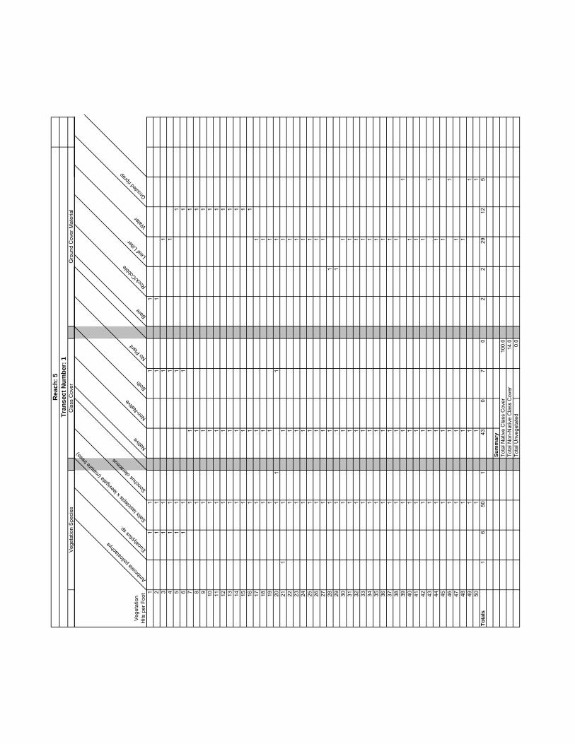
Veg
etat
ion
Spe
cies
Cla
ss C
over
Gro
und
Cov
er M
ater
ial
Rea
ch: 5
Tran
sect
Num
ber:
1
Veg
etat
ion
Hits
per
Foo
t
Ambrosia
psilo
stach
yaEuc
alyptu
s sp.
Salix l
asiol
epis
x lae
vigata
(matu
re tre
es)
Sonch
us ol
erace
us
Native
Non-N
ative
Both
NoPlant
Bare
Rock/C
obble
Leaf
Litter
Water
Grouted
riprap
11
11
12
11
11
31
11
14
11
11
51
11
16
11
11
71
11
81
11
91
11
101
11
111
11
121
11
131
11
141
11
151
11
161
11
171
11
181
11
191
11
201
11
121
11
11
221
11
231
11
241
11
251
11
261
11
271
11
281
11
291
11
301
11
311
11
321
11
331
11
341
11
351
11
361
11
371
11
381
11
391
11
401
11
411
11
421
11
431
11
441
11
451
11
461
11
471
11
481
11
491
11
501
11
Tota
ls1
650
143
07
02
229
125
Sum
mar
yTo
tal N
ativ
e C
lass
Cov
er10
0.0
Tota
l Non
-Nat
ive
Cla
ss C
over
14.0
Tota
l Unv
eget
ated
0.0

Vegetation Species Class Cover Ground Cover Material
Reach: 5Transect Number: 2
Vegetation Hits per Foot Non
-Nati
ve gr
ass
Roripp
a nastu
rtium-aq
uatic
um
Typha
sp.
Native
Non-N
ative
Both No Plant
Bare Rock/C
obble
Leaf
Litter
Wate
rMud Grou
tedrip
rap
1 1 12 1 13 1 1 14 1 15 1 16 1 17 1 18 1 1 19 1 1 1
10 1 1 111 1 1 112 1 1 113 1 1 114 1 1 115 1 1 116 1 1 117 1 1 118 1 1 119 1 1 120 1 1 121 1 122 1 123 1 124 1 125 1 126 1 127 1 128 1 129 1 130 1 131 1 132 1 133 1 134 1 135 1 136 1 137 1 138 1 139 1 140 1 141 1 142 1 143 1 144 1 145 1 146 1 147 1 148 1 149 1 150 1 1
Totals 1 2 11 11 3 0 36 1 2 8 9 2 28
SummaryTotal Native Class Cover 22.0Total Non-Native Class Cover 6.0Total Unvegetated 72.0

Vegetation Species Class Cover Ground Cover Material
Reach: 6Transect Number: 1
VegetationHits per Foot Non
-Nati
ve gr
ass
Roripp
a nas
turtiu
m-aqua
ticu
Salix l
asiol
epis
(matu
re tre
e)
Native
Non-N
ative
Both No Plant
Leaf
Litter
Wate
rMud
1 1 12 1 13 1 14 1 1 15 1 1 16 1 1 17 1 1 18 1 1 19 1 1 1
10 1 1 111 1 112 1 113 1 114 1 115 1 116 1 1 1 117 1 1 118 1 1 1 119 1 1 1 120 1 1 1 121 1 1 122 1 1 123 1 1 124 1 1 125 1 1 126 1 1 127 1 1 128 1 1 129 1 1 130 1 1 1
Totals 9 2 15 11 7 4 8 12 5 13
SummaryTotal Native Class Cover 50.0Total Non-Native Class Cover 36.7Total Unvegetated 26.7

Transect Number: 1 - not sampled during post clearance surveys because the area had not been cleared.Reach: 7

Vegetation Species Class Cover Ground Cover Material
Reach: 8Transect Number: 1
VegetationHits per Foot Son
chus
aspe
r
Native
Non-N
ative
Both No Plan
t
Wate
rMud Grou
ted rip
rap
Sand
1 1 12 1 13 1 14 1 15 1 16 1 17 1 18 1 19 1 1
10 1 111 1 112 1 113 1 114 1 115 1 116 1 117 1 118 1 119 1 120 1 121 1 122 1 123 1 124 1 125 1 126 1 127 1 128 1 129 1 130 1 1 131 1 132 1 133 1 134 1 135 1 136 1 137 1 138 1 139 1 140 1 1
Totals 1 0 1 0 39 14 3 21 2
SummaryTotal Native Class Cover 0Total Non-Native Class Cover 2.5Total Unvegetated 97.5

Veg
etat
ion
Spe
cies
Cla
ss C
over
Gro
und
Cov
er M
ater
ial
Rea
ch: 8
Tran
sect
Num
ber:
2
Veg
etat
ion
Hits
per
Foo
t
Erodium
cicu
tarium
Non-N
ative
gras
s Polygo
num ar
enas
trum
Sonch
usas
per
Native
Non-N
ative
Both
NoPlant
Bare
Leaf
Litter
Wate
r
Mud
Roots
11
12
11
31
14
11
51
16
11
71
18
11
91
110
11
111
112
11
131
114
11
151
116
11
171
118
11
191
120
11
211
122
11
231
124
11
251
11
126
11
271
128
11
11
291
130
11
311
11
321
11
331
134
11
135
11
136
11
371
138
11
391
11
401
11
411
142
11
431
144
11
451
146
11
471
148
11
491
150
11
Tota
ls4
41
10
80
4225
17
16
Sum
mar
yTo
tal N
ativ
e C
lass
Cov
er0.
0To
tal N
on-N
ativ
e C
lass
Cov
er16
.0To
tal U
nveg
etat
ed84
.0

Vegetation Species Class Cover Ground Cover Material
Reach: 9Transect Number: 1
VegetationHits per Foot Frax
inus dip
etala
(matu
retre
e)
Native
Non-N
ative
Both No Plant
Bare Rock/C
obble
Water
Mud
1 1 1 12 1 1 13 1 1 14 1 1 15 1 16 1 17 1 18 1 19 1 1
10 1 111 1 112 1 113 1 114 1 115 1 116 1 117 1 118 1 119 1 120 1 121 1 122 1 123 1 124 1 125 1 1
Totals 4 4 0 0 21 2 4 17 2
SummaryTotal Native Class Cover 16.0Total Non-Native Class Cover 0.0Total Unvegetated 84.0

Vegetation Species Class Cover Ground Cover Material
Reach: 10Transect Number: 1
VegetationHits per Foot Bras
sica n
igra
Cyperu
s sp.
Plantag
o majo
r
Typha
sp.
Native
Non-N
ative
Both No Plan
t
Leaf
Litter
Wate
rGeo
tech m
at
Trash
1 1 12 1 13 1 14 1 15 1 16 1 17 1 18 1 19 1 1
10 1 111 1 112 1 113 1 114 1 1 115 1 116 1 117 1 1 118 1 119 1 120 1 121 1 122 1 123 1 124 1 125 1 126 1 127 1 128 1 129 1 130 1 131 1 132 1 133 1 134 1 135 1 1 136 1 1 137 1 1 138 1 1 139 1 1 140 1 1 141 1 1 142 1 1 143 1 1 144 1 1 145 1 1 146 1 147 1 148 1 149 1 150 1 151 1 152 1 153 1 154 1 155 1 156 1 1 157 1 158 1 159 1 160 1 161 1 162 1 163 1 164 1 1 165 1 1
Totals 1 1 2 11 11 4 0 50 3 37 24 1
SummaryTotal Native Class Cover 16.9Total Non-Native Class Cover 6.2Total Unvegetated 76.9

Class Cover Ground Cover MaterialVegetation Species
Reach: 10Transect Number: 2
VegetationHits per Foot Bras
sica n
igra
Cerasti
um fo
ntanu
m ssp.
vulga
re
Non-N
ative
gras
s
Piptath
erum m
iliace
um
Native
Non-N
ative
Both No Plan
t
Bare Leaf
Litter
Wate
rMud
1 1 12 1 13 1 14 1 15 1 16 1 17 1 18 1 19 1 1
10 1 111 1 112 1 113 1 114 1 115 1 116 1 117 1 118 1 1 119 1 120 1 1 121 1 122 1 1 123 1 124 1 1 125 1 126 1 127 1 128 1 1 129 1 1 130 1 131 1 132 1 133 1 134 1 135 1 136 1 137 1 138 1 139 1 140 1 141 1 142 1 143 1 144 1 145 1 1 146 1 147 1 148 1 149 1 150 1 151 1 152 1 153 1 154 1 155 1 156 1 1 157 1 158 1 159 1 160 1 161 1 162 1 163 1 164 1 165 1 166 1 1 167 1 1 168 1 169 1 1 170 1 171 1 172 1 173 1 174 1 1
Totals 5 1 4 1 0 11 0 63 36 20 4 14
SummaryTotal Native Class Cover 0.0Total Non-Native Class Cover 14.9Total Unvegetated 85.1

Vegetation Species Class Cover Ground Cover Material
Reach: 10Transect Number: 3
VegetationHits per Foot Cyp
erus sp
.
Native
Non-N
ative
Both No Plan
t
Leaf
Litter
Wate
rGeo
tech mat
1 1 12 1 13 1 14 1 15 1 16 1 17 1 18 1 19 1 1
10 1 111 1 112 1 113 1 114 1 115 1 116 1 117 1 118 1 119 1 120 1 121 1 122 1 123 1 124 1 125 1 126 1 127 1 128 1 129 1 130 1 131 1 132 1 133 1 134 1 135 1 136 1 137 1 138 1 139 1 140 1 141 1 142 1 143 1 144 1 145 1 146 1 147 1 148 1 149 1 150 1 151 1 152 1 153 1 154 1 155 1 156 1 157 1 1 158 1 159 1 160 1 161 1 162 1 163 1 164 1 165 1 166 1 167 1 168 1 169 1 170 1 171 1 172 1 173 1 174 1 175 1 1
Totals 1 0 1 0 74 9 40 26
SummaryTotal Native Class Cover 0.0Total Non-Native Class Cover 1.3Total Unvegetated 98.7

Vegetation Species Class Cover Ground Cover Material
Reach: 10Transect Number: 4
VegetationHits per Foot Non
-Nati
ve gr
ass
Native
Non-N
ative
Both No Plant
Leaf
Litter
Water
Mud Ungrou
ted rip
rap
1 1 12 1 13 1 14 1 15 1 16 1 17 1 18 1 19 1 1
10 1 111 1 112 1 113 1 114 1 115 1 116 1 117 1 118 1 119 1 120 1 121 1 122 1 123 1 124 1 1 125 1 1 126 1 1 127 1 1 128 1 1 129 1 1 130 1 1 131 1 132 1 133 1 134 1 135 1 136 1 137 1 138 1 139 1 140 1 141 1 142 1 143 1 144 1 145 1 146 1 147 1 148 1 149 1 150 1 151 1 152 1 153 1 154 1 155 1 156 1 157 1 158 1 159 1 160 1 161 1 162 1 163 1 164 1 165 1 166 1 167 1 168 1 169 1 170 1 171 1 172 1 173 1 174 1 175 1 176 1 177 1 178 1 179 1 180 1 181 1 182 1 183 1 184 1 185 1 1
Totals 7 1 13 0 71 6 22 4 53
SummaryTotal Native Class Cover 1.2Total Non-Native Class Cover 15.3Total Unvegetated 83.5

Vegetation Species Class Cover Ground Cover Material
Reach: 12Transect Number: 1
VegetationHits per Foot Mim
ulus g
uttatu
s
Non-N
ative
gras
s
Polygo
num sp
.
Salix go
oddin
gii (s
eedli
ng)
Typha
sp.
Native
Non-N
ative
Both No Plan
t
Bare Leaf
Litter
Water
Mud Grouted
riprap
1 1 1 12 1 13 1 14 1 15 1 16 1 17 1 18 1 19 1 1
10 1 111 1 112 1 113 1 1 1 114 1 1 115 1 1 116 1 117 1 118 1 119 1 120 1 1 121 1 1 122 1 123 1 124 1 125 1 126 1 127 1 128 1 129 1 130 1 1 131 1 132 1 133 1 134 1 135 1 136 1 137 1 138 1 139 1 140 1 141 1 142 1 143 1 144 1 145 1 146 1 147 1 148 1 149 1 150 1 151 1 152 1 153 1 154 1 155 1 156 1 157 1 158 1 159 1 160 1 161 1 1 1 162 1 1 1 163 1 1 1 164 1 1 1 165 1 1 1 166 1 1 1 167 1 1 1 168 1 1 1 169 1 1 1 170 1 1 171 1 1 172 1 1 173 1 1 174 1 1 175 1 1 1
Totals 1 1 1 16 13 20 1 1 53 1 4 36 23 11
SummaryTotal Native Class Cover 28.0Total Non-Native Class Cover 2.7Total Unvegetated 70.7

Vegetation Species Class Cover Ground Cover Material
Reach: 12Transect Number: 2
VegetationHits per Foot Non
-Nati
ve gr
ass
Oxalis
pes-c
aprae
Polygo
num
sp.
Salix g
oodd
ingii
Native
Non-N
ative
Both No Plant
Rock/C
obble
Leaf
Litter
Coarse
woo
dy de
bris
Wate
rMud Grou
ted rip
rap
Trash
1 1 12 1 1 1 13 1 14 1 15 1 16 1 17 1 1 18 1 1 19 1 1 1
10 1 1 111 1 1 112 1 1 113 1 1 114 1 1 115 1 1 116 1 1 117 1 1 118 1 1 119 1 1 120 1 1 121 1 1 122 1 1 123 1 1 124 1 1 125 1 1 126 1 1 127 1 1 128 1 1 129 1 1 130 1 1 131 1 1 132 1 1 133 1 1 134 1 1 135 1 1 136 1 1 137 1 1 138 1 1 139 1 1 140 1 1 141 1 1 142 1 1 143 1 1 144 1 1 145 1 1 146 1 1 147 1 1 148 1 1 149 1 1 150 1 1 151 1 1 152 1 1 153 1 1 154 1 1 155 1 1 156 1 1 157 1 1 158 1 1 159 1 1 160 1 1 161 1 1 162 1 1 163 1 1 164 1 1 165 1 1 166 1 1 167 1 1 168 1 1 169 1 1 170 1 1 171 1 1 172 1 1 173 1 1 174 1 1 175 1 1 176 1 1 177 1 1 178 1 1 179 1 1 180 1 1 181 1 1 182 1 1 183 1 1 184 1 1 185 1 1 186 1 1 187 1 1 188 1 1 189 1 1 190 1 1 191 1 1 192 1 1 193 1 1 194 1 1 195 1 1 196 1 1 1 197 1 1 1 198 1 1 1 199 1 1 1
100 1 1 1101 1 1 1102 1 1 1103 1 1 1104 1 1 1105 1 1 1106 1 1 1107 1 1 1108 1 1 1109 1 1 1110 1 1 1
Totals 1 1 15 92 86 13 6 5 1 35 8 26 21 17
SummaryTotal Native Class Cover 83.6Total Non-Native Class Cover 17.3Total Unvegetated 4.5

Vegetation Species Class Cover Ground Cover Material
Reach: 13Transect Number: 1
VegetationHits per Foot Non
-Nati
ve gr
ass
Native
Non-N
ative
Both No Plant
Bare Rock/C
obble
Leaf
Litter
1 1 1 12 1 13 1 14 1 1 15 1 1 16 1 1 17 1 1 18 1 1 19 1 1 1
10 1 1 111 1 1 112 1 1 113 1 1 114 1 1 115 1 1 116 1 1 117 1 1 118 1 1 119 1 1 120 1 1 121 1 1 122 1 123 1 124 1 125 1 1 126 1 127 1 1 128 1 1 129 1 1 130 1 1 131 1 1 132 1 1 133 1 134 1 1 135 1 1 136 1 1 137 1 1 138 1 1 139 1 140 1 1
Totals 31 0 31 0 9 5 1 34
SummaryTotal Native Class Cover 0Total Non-Native Class Cover 77.5Total Unvegetated 22.5

Veg
etat
ion
Spe
cies
Cla
ss C
over
Gro
und
Cov
er M
ater
ial
Rea
ch: 1
3Tr
anse
ct N
umbe
r: 2
Veg
etat
ion
Hits
per
Foo
t
Artemisia
califo
rnica Le
pidos
partu
m squa
matum
Non-N
ative
gras
s Sambu
cusmex
icana
Native
Non-N
ative
Both
No Plan
t
Bare
Leaf
Litter
Mud1
11
12
11
13
11
14
11
15
11
16
11
17
11
18
11
19
11
110
11
111
11
112
11
113
11
114
11
115
11
161
117
11
118
11
191
11
201
11
121
11
11
221
11
231
11
124
11
125
11
11
261
11
271
128
11
129
11
11
301
11
311
11
321
11
331
11
134
11
11
351
11
136
11
11
371
11
138
11
139
11
140
11
1To
tals
1113
166
2010
64
137
2
Sum
mar
yTo
tal N
ativ
e C
lass
Cov
er65
.0To
tal N
on-N
ativ
e C
lass
Cov
er40
.0To
tal U
nveg
etat
ed10
.0

Vegetation Species Class Cover Ground Cover Material
Reach: 13Transect Number: 3
VegetationHits per Foot Non
-Nati
ve gr
ass
Was
hingto
nia sp
.
Native
Non-N
ative
Both No Plant
Bare Rock/C
obble
Leaf
Litter
Mud
1 1 12 1 13 1 1 14 1 1 15 1 1 16 1 1 17 1 1 18 1 19 1 1 1
10 1 1 111 1 112 1 1 113 1 1 114 1 115 1 116 1 117 1 118 1 119 1 120 1 121 1 122 1 123 1 1 124 1 125 1 126 1 127 1 128 1 129 1 130 1 131 1 132 1 133 1 134 1 135 1 1 136 1 1 137 1 138 1 139 1 1 140 1 1 1
Totals 13 1 0 14 0 26 3 3 29 5
SummaryTotal Native Class Cover 0.0Total Non-Native Class Cover 35.0Total Unvegetated 65.0

Veg
etat
ion
Spe
cies
Cla
ss C
over
Gro
und
Cov
er M
ater
ial
Rea
ch: 1
4Tr
anse
ct N
umbe
r: 1
Veg
etat
ion
Hits
per
Foo
t
Brassic
a nigr
aNon
-Nati
ve gr
ass Ribe
s aure
um
Salix l
aevig
ata
Native
Non-N
ative
Both
No Plan
t
Leaf
Litter
Mud1
11
12
11
13
11
14
11
11
51
11
61
11
71
11
18
11
11
91
11
110
11
11
111
11
112
11
113
11
114
11
115
11
116
11
11
171
11
118
11
11
191
11
120
11
11
211
11
122
11
123
11
11
241
11
125
11
126
11
271
128
11
291
130
11
11
311
11
132
11
11
331
11
341
11
351
11
1To
tals
718
321
97
154
827
Sum
mar
yTo
tal N
ativ
e C
lass
Cov
er68
.6To
tal N
on-N
ativ
e C
lass
Cov
er62
.9To
tal U
nveg
etat
ed11
.4

Transect Number: 2 - not sampled during post clearance surveys because the area had not been clearedReach: 14

Vegetation Species Class Cover Ground Cover Material
Reach: 15Transect Number: 1
VegetationHits per Foot Cyp
erus s
p.
Non-N
ative
gras
s
Wahing
tonia
robus
ta
Native
Non-N
ative
Both No Plant
Bare Leaf
Litter
Water
Concre
te
Sand
1 1 12 1 13 1 14 1 15 1 16 1 17 1 18 1 19 1 1
10 1 111 1 112 1 113 1 114 1 115 1 116 1 117 1 118 1 119 1 120 1 121 1 122 1 123 1 124 1 125 1 126 1 127 1 128 1 129 1 130 1 131 1 132 1 133 1 134 1 135 1 136 1 137 1 138 1 139 1 140 1 141 1 142 1 143 1 144 1 145 1 146 1 147 1 148 1 1 149 1 1 150 1 1 1 151 1 1 1 152 1 1 153 1 154 1 155 1 156 1 157 1 158 1 159 1 160 1 161 1 162 1 163 1 164 1 165 1 166 1 167 1 168 1 169 1 170 1 171 1 172 1 173 1 174 1 175 1 176 1 177 1 178 1 179 1 180 1 181 1 182 1 183 1 184 1 185 1 1
Totals 3 3 1 0 5 0 80 2 3 35 44 1
SummaryTotal Native Class Cover 0.0Total Non-Native Class Cover 5.9Total Unvegetated 94.1

Class Cover Ground Cover MaterialVegetation Species
Reach: 15Transect Number: 2
VegetationHits per Foot Dist
ichlis
spica
ta
Typha
sp.
Native
Non-N
ative
Both No Plant
Rock/C
obble
Leaf
Litter
Water
Mud Concre
te
1 1 12 1 13 1 14 1 15 1 16 1 17 1 18 1 19 1 1
10 1 111 1 112 1 113 1 114 1 115 1 116 1 117 1 118 1 119 1 120 1 121 1 122 1 123 1 124 1 125 1 126 1 127 1 128 1 1 129 1 130 1 1 131 1 132 1 133 1 134 1 135 1 136 1 137 1 138 1 139 1 140 1 141 1 142 1 143 1 144 1 145 1 1 146 1 147 1 148 1 149 1 150 1 151 1 152 1 153 1 154 1 155 1 156 1 157 1 1 158 1 1 159 1 160 1 161 1 162 1 163 1 164 1 165 1 166 1 167 1 168 1 169 1 170 1 171 1 172 1 173 1 174 1 175 1 176 1 177 1 178 1 179 1 180 1 1
Totals 3 2 5 2 0 73 9 6 26 10 29
SummaryTotal Native Class Cover 10.0Total Non-Native Class Cover 4.0Total Unvegetated 91.3

Veg
etat
ion
Spe
cies
Cla
ss C
over
Gro
und
Cov
er M
ater
ial
Rea
ch: 1
6Tr
anse
ct N
umbe
r: 1
Veg
etat
ion
Hits
per
Foo
t
Non-N
ative
grass
Non-N
ative
herb
Native
Non-N
ative
Both
NoPlant
Rock/C
obble
Leaf
Litter
Mud
11
12
11
31
14
11
51
16
11
71
11
81
11
91
11
101
11
111
112
11
131
11
141
115
11
161
117
11
118
11
191
11
201
11
Tota
ls6
20
80
128
93
Sum
mar
yTo
tal N
ativ
e C
lass
Cov
er0.
0To
tal N
on-N
ativ
e C
lass
Cov
er40
.0To
tal U
nveg
etat
ed60
.0

Vegetation Species Ground Cover MaterialClass Cover
Reach: 17Transect Number: 1
VegetationHits per Foot Nati
veNon
-Nati
ve
Both No Plant
Leaf
Litter
1 1 12 1 13 1 14 1 15 1 16 1 17 1 18 1 19 1 1
10 1 111 1 112 1 113 1 114 1 115 1 116 1 117 1 118 1 119 1 120 1 121 1 122 1 123 1 124 1 125 1 126 1 127 1 128 1 129 1 130 1 1
Totals 0 0 0 0 30 30
SummaryTotal Native Class Cover 0Total Non-Native Class Cover 0Total Unvegetated 100

Veg
etat
ion
Spe
cies
Cla
ss C
over
Gro
und
Cov
er M
ater
ial
Rea
ch: 1
8Tr
anse
ct N
umbe
r: 1
Veg
etat
ion
Hits
per
Foo
t
Non-N
ative
grass
Native
Non-N
ative
Both
NoPlant
Bare
Leaf
Litter
Mud1
11
21
13
11
41
11
51
16
11
71
18
11
91
110
11
111
11
121
11
131
11
141
11
151
11
161
11
171
11
181
11
191
120
11
Tota
ls9
09
011
18
11
Sum
mar
yTo
tal N
ativ
e C
lass
Cov
er0.
0To
tal N
on-N
ativ
e C
lass
Cov
er45
.0To
tal U
nveg
etat
ed55
.0

Veg
etat
ion
Spe
cies
Cla
ss C
over
Gro
und
Cov
er M
ater
ial
Rea
ch: 1
8Tr
anse
ct N
umbe
r: 2
Veg
etat
ion
Hits
per
Foo
t
Native
Non-N
ative
Both
NoPlant
Rock/C
obble
Leaf
Litter
Mud
11
12
11
31
14
11
51
16
11
71
18
11
91
110
11
111
112
11
131
114
11
151
116
11
171
118
11
191
120
11
Tota
ls0
00
020
17
12
Sum
mar
yTo
tal N
ativ
e C
lass
Cov
er0
Tota
l Non
-Nat
ive
Cla
ss C
over
0To
tal U
nveg
etat
ed10
0

Vegetation Species Class Cover Ground Cover Material
Reach: 19Transect Number: 1
VegetationHits per Foot Pinu
s can
arens
is
Native
Non-N
ative
Both No Plant
Rock/C
obble
Leaf
Litter
Sand
Concre
te
1 1 12 1 13 1 14 1 15 1 16 1 17 1 18 1 19 1 1
10 1 111 1 112 1 113 1 114 1 115 1 116 1 117 1 118 1 119 1 120 1 121 1 122 1 123 1 124 1 125 1 126 1 127 1 128 1 129 1 130 1 131 1 132 1 133 1 134 1 135 1 136 1 137 1 138 1 139 1 140 1 141 1 142 1 143 1 144 1 145 1 146 1 147 1 148 1 149 1 150 1 151 1 1 152 1 1 153 1 1 154 1 1 155 1 1 156 1 1 157 1 1 158 1 1 159 1 1 160 1 1 161 1 1 162 1 1 163 1 1 164 1 1 165 1 1 166 1 1 167 1 1 168 1 1 169 1 1 170 1 1 171 1 1 172 1 1 173 1 1 174 1 1 175 1 1 1
Totals 25 0 25 0 50 18 29 24 4
SummaryTotal Native Class Cover 0.0Total Non-Native Class Cover 33.3Total Unvegetated 66.7

Vegetation Species Class Cover Ground Cover Material
Reach: 19Transect Number: 2
VegetationHits per Foot Erio
gonu
m fasc
iculat
um
Lepid
ospa
rtum sq
uamatu
m
Lotus
scop
arius
Medica
go po
lymorp
ha
Non-N
ative
gras
s
Native
Non-N
ative
Both No Plan
t
Bare Rock/C
obble
Leaf
Litter
Sand
Concre
te
1 1 12 1 13 1 14 1 15 1 16 1 17 1 18 1 19 1 1
10 1 111 1 112 1 113 1 114 1 115 1 116 1 117 1 118 1 119 1 120 1 121 1 122 1 123 1 124 1 125 1 126 1 127 1 128 1 129 1 130 1 131 1 132 1 133 1 134 1 135 1 136 1 137 1 138 1 139 1 140 1 141 1 142 1 143 1 144 1 145 1 146 1 147 1 148 1 149 1 150 1 151 1 1 152 1 153 1 154 1 155 1 1 156 1 157 1 158 1 159 1 160 1 161 1 162 1 163 1 164 1 165 1 166 1 167 1 168 1 169 1 170 1 1 171 1 172 1 173 1 174 1 175 1 176 1 177 1 178 1 179 1 180 1 181 1 182 1 183 1 184 1 185 1 1 186 1 187 1 1 1 188 1 1 189 1 1 190 1 1 191 1 1 192 1 1 193 1 1 1
Totals 3 5 1 1 1 8 1 1 83 1 37 11 44 1
SummaryTotal Native Class Cover 9.7Total Non-Native Class Cover 2.2Total Unvegetated 89.2

Reach: 20Was not accessible; not surveyed.


Vegetation Species Class Cover Ground Cover Material
Reach: 21Transect Number: 1
VegetationHits per Foot Nati
veNon
-Nati
ve
Both No Plant
Leaf
Litter
Sand
1 1 12 1 13 1 14 1 15 1 16 1 17 1 18 1 19 1 1
10 1 111 1 112 1 113 1 114 1 115 1 1
Totals 0 0 0 0 15 7 8
SummaryTotal Native Class Cover 0Total Non-Native Class Cover 0Total Unvegetated 100

Vegetation Species Class Cover Ground Cover Material
Reach: 22Transect Number: 1
VegetationHits per Foot Arte
misia do
uglas
iana
Non-N
ative
gras
s
Ricinu
s commun
is
Native
Non-N
ative
Both No Plant
Rock/C
obble
Leaf
Litter
Sand
1 1 1 12 1 13 1 14 1 15 1 1 16 1 1 17 1 18 1 19 1 1 1
10 1 1 111 1 1 112 1 1 113 1 1 114 1 115 1 116 1 117 1 118 1 119 1 120 1 121 1 122 1 123 1 124 1 125 1 126 1 127 1 128 1 1 129 1 130 1 131 1 132 1 133 1 134 1 135 1 136 1 137 1 138 1 139 1 140 1 141 1 142 1 143 1 144 1 145 1 146 1 147 1 148 1 1 149 1 1 150 1 151 1 152 1 1 153 1 1 154 1 1 155 1 1
Totals 8 4 2 8 6 0 41 7 30 18
SummaryTotal Native Class Cover 14.5Total Non-Native Class Cover 10.9Total Unvegetated 74.5

Vegetation Species Class Cover Ground Cover Material
Reach: 22Transect Number: 2
VegetationHits per Foot Hed
erahe
lix
Lotus
scop
arius
Non-N
ative
grass
Native
Non-N
ative
Both No Plant
Rock/C
obble
Leaf
Litter
Sand
Concre
te
1 1 1 12 1 13 1 14 1 15 1 16 1 17 1 18 1 19 1 1
10 1 111 1 112 1 113 1 114 1 115 1 116 1 117 1 118 1 119 1 120 1 121 1 122 1 123 1 124 1 125 1 126 1 127 1 128 1 1 129 1 1 130 1 131 1 132 1 133 1 134 1 135 1 136 1 137 1 138 1 139 1 140 1 141 1 1 142 1 143 1 1 144 1 1 145 1 1 1
Totals 1 2 4 2 5 0 38 9 10 25 1
SummaryTotal Native Class Cover 4.4Total Non-Native Class Cover 11.1Total Unvegetated 84.4

Vegetation Species Class Cover Ground Cover Material
Reach: 22Transect Number: 3
VegetationHits per Foot Arte
misia d
ougla
siana
Galium
apari
ne
Native
Non-N
ative
Both No Plant
Rock/C
obble
Leaf
Litter
Sand
1 1 12 1 13 1 14 1 15 1 16 1 17 1 18 1 19 1 1
10 1 111 1 112 1 113 1 114 1 115 1 116 1 117 1 118 1 119 1 120 1 121 1 122 1 123 1 124 1 125 1 126 1 127 1 128 1 129 1 130 1 131 1 132 1 133 1 134 1 135 1 136 1 137 1 138 1 139 1 1 140 1 141 1 142 1 1 1 143 1 1 1 144 1 1 1 145 1 1 1 1
Totals 5 4 1 0 4 40 10 24 11
SummaryTotal Native Class Cover 11.1Total Non-Native Class Cover 8.9Total Unvegetated 88.9

Transect Number: 1A - not sampled during post clearance surveys because the area had not been cleared.Reach: 24


Transect Number: 1B - not sampled during post clearance surveys because the area had not been cleared.Reach: 24

Transect Number: 1C - not sampled during post clearance surveys because the area had not been cleared.Reach: 24

Total Class Cover Percent Average for 24-2A,B, and C:Total Native Class Cover 6.9Total Non-Native Class Cover 17.9Total Unvegetated 75.2

Class Cover Ground Cover MaterialVegetation Species
Reach: 24Transect Number: 2A
VegetationHits per Foot Bide
nsfro
ndos
a
Brassic
a nigra
Helian
thus a
nnuu
s
Melilot
ussp
.
Non-N
ative
gras
s
Non-N
ative
herb
Picris
echio
ides
Plantag
o lance
olata
Polygo
num sp
.
Native
Non-N
ative
Both No Plan
t
Leaf
Litter
Wate
rGrou
tedrip
rap
Mud Trash
1 1 1 12 1 1 13 1 1 1 14 1 15 1 1 16 1 1 17 1 1 18 1 19 1 1
10 1 111 1 112 1 113 1 114 1 115 1 116 1 117 1 118 1 119 1 120 1 121 1 122 1 123 1 1 124 1 125 1 126 1 127 1 128 1 129 1 130 1 131 1 132 1 133 1 134 1 135 1 136 1 137 1 138 1 139 1 140 1 141 1 142 1 143 1 144 1 1 145 1 1 146 1 147 1 148 1 149 1 1 150 1 151 1 1 152 1 1 153 1 1 154 1 1 155 1 1 156 1 1 157 1 158 1 1 159 1 160 1 1 161 1 162 1 163 1 164 1 165 1 166 1 167 1 168 1 169 1 170 1 171 1 172 1 173 1 174 1 175 1 176 1 177 1 178 1 179 1 180 1 181 1 182 1 183 1 184 1 185 1 186 1 187 1 188 1 189 1 190 1 191 1 192 1 193 1 194 1 195 1 196 1 197 1 198 1 199 1 1
100 1 1101 1 1102 1 1103 1 1104 1 1105 1 1
Totals 1 1 1 1 4 1 6 3 1 0 30 0 75 6 9 42 47 1
SummaryTotal Native Class Cover 0.0Total Non-Native Class Cover 28.6Total Unvegetated 71.4

Vegetation Species Class Cover Ground Cover Material
Reach: 24Transect Number: 2B
VegetationHits per Foot Non
-Nati
vegra
ss
Picris
echio
ides
Native
Non-N
ative
Both No Plant
Mud Grouted
riprap
1 1 12 1 1 13 1 1 14 1 1 15 1 1 16 1 1 17 1 18 1 1 19 1 1
10 1 111 1 112 1 113 1 1 114 1 115 1 116 1 117 1 1 118 1 119 1 1 120 1 1 121 1 122 1 123 1 124 1 1 125 1 126 1 1 127 1 1 128 1 1 129 1 1 130 1 1 131 1 1 132 1 133 1 1 134 1 1 135 1 136 1 137 1 138 1 139 1 1 140 1 141 1 142 1 143 1 144 1 145 1 146 1 147 1 148 1 149 1 150 1 151 1 152 1 153 1 154 1 155 1 156 1 157 1 158 1 159 1 160 1 161 1 162 1 163 1 164 1 165 1 166 1 167 1 168 1 169 1 170 1 171 1 172 1 173 1 174 1 175 1 176 1 177 1 178 1 179 1 180 1 1
Totals 10 10 0 20 0 60 33 47
SummaryTotal Native Class Cover 0Total Non-Native Class Cover 25Total Unvegetated 75

Ground Cover MaterialVegetation Species Class Cover
Reach: 24Transect Number: 2C
VegetationHits per Foot Lu
dwigi
a pep
loide
s
Typha
angu
stifol
ia
Native
Non-N
ative
Both No Plant
Wate
r
1 1 12 1 13 1 14 1 15 1 1 16 1 1 17 1 1 18 1 1 1 19 1 1 1 1
10 1 1 111 1 112 1 113 1 114 1 115 1 116 1 117 1 118 1 119 1 120 1 121 1 122 1 123 1 124 1 125 1 126 1 127 1 128 1 129 1 1
Totals 2 6 6 0 0 23 29
SummaryTotal Native Class Cover 20.689655Total Non-Native Class C 0

Total Class Cover Percent Average for 24-3A,B, and C:Total Native Class Cover 8.9Total Non-Native Class Cover 22.5Total Unvegetated 68.6

Vegetation Species Class Cover Ground Cover Material
Reach: 24Transect Number: 3A
VegetationHits per Foot Meli
lotus
sp.
Non-N
ative
gras
s
Non-N
ative
herb
Picris
echio
ides
Plantag
o lan
ceola
ta
Solanu
m doug
lasii
Native
Non-N
ative
Both No Plan
t
Rock/C
obble
Leaf
Litter
Mud Grouted
riprap
1 1 1 12 1 1 13 1 1 14 1 15 1 1 16 1 17 1 1 18 1 1 19 1 1 1
10 1 1 111 1 1 112 1 113 1 114 1 1 115 1 1 116 1 1 117 1 118 1 1 119 1 120 1 121 1 1 122 1 123 1 1 124 1 1 125 1 1 126 1 127 1 128 1 1 129 1 130 1 1 131 1 1 132 1 1 133 1 134 1 1 135 1 136 1 137 1 1 138 1 1 139 1 1 140 1 1 141 1 1 142 1 1 143 1 144 1 145 1 146 1 1 147 1 1 148 1 149 1 150 1 151 1 152 1 153 1 154 1 155 1 156 1 157 1 158 1 159 1 160 1 161 1 162 1 163 1 164 1 165 1 166 1 167 1 168 1 169 1 170 1 171 1 172 1 173 1 174 1 175 1 176 1 177 1 178 1 179 1 180 1 181 1 182 1 183 1 184 1 185 1 186 1 187 1 188 1 189 1 190 1 191 1 192 1 193 1 194 1 195 1 196 1 197 1 198 1 199 1 1
100 1 1Totals 6 5 1 12 4 2 2 28 0 70 1 3 38 58
SummaryTotal Native Class Cover 2.0Total Non-Native Class Cover 28.0Total Unvegetated 70.0

Vegetation Species Class Cover Ground Cover Material
Reach: 24Transect Number: 3B
VegetationHits per Foot Ambro
sia ps
ilosta
chya
Helian
thus a
nnuu
s
Melilot
ussp
.
Non-N
ative
grass
Picris
echio
ides
Plantag
o lan
ceola
ta
Native
Non-N
ative
Both No Plant
Mud Grouted
riprap
1 1 12 2 1 13 1 1 14 1 1 15 1 1 16 1 1 17 1 1 18 1 1 19 1 1 1
10 1 1 111 1 1 112 1 1 113 1 114 1 115 1 116 1 117 1 118 1 119 1 120 1 121 1 1 122 1 1 123 1 1 124 1 1 125 1 1 126 1 1 127 1 1 128 1 129 1 1 130 1 1 131 1 1 132 1 1 133 1 1 1 134 1 1 135 1 1 136 1 1 137 1 1 138 1 1 139 1 1 140 1 1 141 1 1 142 1 143 1 1 144 1 1 145 1 1 146 1 1 147 1 1 148 1 1 149 1 1 150 1 1 151 1 1 152 1 1 153 1 1 154 1 1 155 1 1 156 1 1 157 1 1 158 1 159 1 160 1 161 1 162 1 163 1 164 1 165 1 166 1 167 1 168 1 169 1 170 1 171 1 172 1 173 1 174 1 175 1 1

76 1 177 1 178 1 179 1 180 1 181 1 182 1 183 1 184 1 185 1 186 1 187 1 188 1 189 1 190 1 191 1 192 1 193 1 194 1 195 1 196 1 197 1 198 1 199 1 1
100 1 1101 1 1102 1 1103 1 1104 1 1105 1 1106 1 1107 1 1108 1 1109 1 1110 1 1111 1 1112 1 1113 1 1114 1 1
Totals 2 1 22 10 9 4 1 45 0 68 52 62
SummaryTotal Native Class Cover 0.9Total Non-Native Class Cover 39.5Total Unvegetated 59.6

Veg
etat
ion
Spe
cies
Gro
und
Cov
er M
ater
ial
Cla
ss C
over
Rea
ch: 2
4Tr
anse
ct N
umbe
r: 3
C
Veg
etat
ion
Hits
per
Foo
t
Scirpu
s sp.
Native
Non-N
ative
Both
NoPlant
Wate
r
11
12
11
31
14
11
51
16
11
71
18
11
91
110
11
111
112
11
131
114
11
151
116
11
171
11
181
11
191
11
201
11
211
11
Tota
ls5
50
016
21
Sum
mar
yTo
tal N
ativ
e C
lass
Cov
er23
.8To
tal N
on-N
ativ
e C
lass
Cov
er0.
0To
tal U
nveg
etat
ed76
.2

Vegetation Species Class Cover Ground Cover Material
Reach: 24Transect Number: 4A
VegetationHits per Foot Che
nopo
dium al
bum
Ludw
igia p
eploi
des
Melilot
us sp
.
Non-N
ative
gras
s
Non-N
ative
herb
Picris
echio
ides
Plantag
o lan
ceola
ta
Scirpu
s cali
fornic
us
Native
Non-N
ative
Both No Plan
t
Leaf
Litter
Mud Grouted
riprap
1 1 1 1 12 1 1 1 13 1 1 14 1 1 15 1 1 16 1 17 1 1 18 1 1 19 1 1 1
10 1 1 111 1 1 112 1 113 1 1 114 1 1 115 1 1 116 1 1 117 1 1 118 1 119 1 1 120 1 1 121 1 1 122 1 1 123 1 1 124 1 125 1 126 1 1 127 1 1 128 1 129 1 130 1 1 131 1 1 132 1 1 133 1 134 1 1 135 1 1 136 1 1 1 137 1 1 138 1 1 139 1 1 140 1 1 141 1 1 142 1 1 143 1 1 144 1 1 145 1 1 146 1 147 1 1 148 1 1 149 1 150 1 1 151 1 1 152 1 1 153 1 1 154 1 1 155 1 1 156 1 1 157 1 1 158 1 1 159 1 1 160 1 161 1 162 1 163 1 164 1 165 1 166 1 167 1 168 1 169 1 170 1 171 1 172 1 173 1 174 1 175 1 176 1 177 1 178 1 179 1 180 1 181 1 182 1 183 1 184 1 185 1 186 1 187 1 188 1 189 1 190 1 191 1 192 1 193 1 194 1 195 1 196 1 197 1 198 1 199 1 1
100 1 1101 1 1102 1 1103 1 1104 1 1105 1 1106 1 1107 1 1108 1 1109 1 1110 1 1111 1 1112 1 1113 1 1114 1 1115 1 1116 1 1117 1 1118 1 1119 1 1120 1 1
Totals 1 2 11 9 3 16 6 5 5 44 0 70 4 55 61
SummaryTotal Native Class Cover 4.2Total Non-Native Class Cover 36.7Total Unvegetated 58.3

Vegetation Species Class Cover Ground Cover Material
Reach: 24Transect Number: 4B
VegetationHits per Foot Che
nopo
dium al
bum
Melilot
us sp
.
Picris
echio
ides
Plantag
o lan
ceola
ta
Native
Non-N
ative
Both No Plan
t
Mud Grouted
riprap
1 12 13 14 15 16 17 18 19 1
10 111 1 112 113 1 114 115 1 1 116 1 1 117 1 1 118 1 1 119 1 1 120 1 1 121 1 122 1 1 123 1 1 124 1 1 125 1 1 126 1 1 1 127 1 1 128 1 1 129 1 130 1 1 131 1 132 1 1 133 1 1 134 1 1 135 1 136 1 1 137 1 1 138 1 1 139 1 1 140 1 1 141 1 142 1 143 1 144 1 145 1 146 1 147 1 148 1 149 1 150 1 151 1 152 1 153 1 154 1 155 1 156 1 157 1 158 1 159 1 160 1 161 1 162 1 163 1 164 1 165 1 166 1 167 1 168 1 169 1 170 1 171 1 172 1 173 1 174 1 175 1 176 1 177 1 178 1 179 1 180 1 181 1 182 1 183 1 184 1 185 1 186 1 187 1 188 1 189 1 190 1 191 1 192 1 193 1 194 1 195 1 1
Totals 1 10 10 4 0 25 0 70 24 57
SummaryTotal Native Class Cover 0.0Total Non-Native Class Cover 26.3Total Unvegetated 73.7

Veg
etat
ion
Spe
cies
Gro
und
Cov
er M
ater
ial
Cla
ss C
over
Rea
ch: 2
4Tr
anse
ct N
umbe
r: 4
C
Veg
etat
ion
Hits
per
Foo
t
Native
Non-N
ative
Both
NoPlant
Wate
r
11
12
11
31
14
11
51
16
11
71
18
11
91
110
11
111
112
11
131
114
11
151
116
11
171
118
11
Tota
ls0
00
018
18
Sum
mar
yTo
tal N
ativ
e C
lass
Cov
er0
Tota
l Non
-Nat
ive
Cla
ss C
over
0To
tal U
nveg
etat
ed10
0

Total Class Cover Percent Average for 25-1A,B, and C:Total Native Class Cover 26.5Total Non-Native Class Cover 17.0Total Unvegetated 58.6

Vegetation Species Class Cover Groud Cover Material
Reach: 25Transect Number: 1A
VegetationHits per Foot Euth
amia
occid
ental
is
Ipomoe
a purpu
rea
Non-N
ative
gras
s
Polygo
num
sp.
Rumex
sp.
Salix g
oodd
ingii (
mature
tree)
Scirpu
s califo
rnicu
s
Typha
latifo
lia
Native
Non-N
ative
Both No Plant
Rock/C
obble
Leaf
Litter
Wate
rMud Tras
h
1 1 1 1 12 1 1 13 1 1 14 1 1 15 1 1 1 16 1 1 17 1 18 1 1 19 1 1
10 1 111 1 112 1 113 1 1 114 1 1 1 115 1 1 1 1 116 1 1 1 117 1 1 118 1 1 119 1 120 1 121 1 122 1 123 1 1 124 1 1 125 1 126 1 1 127 1 1 128 1 1 129 1 130 1 1 131 1 1 132 1 133 1 134 1 135 1 1 136 1 1 137 1 138 1 1 139 1 140 1 141 1 142 1 143 1 144 1 1 145 1 146 1 147 1 148 1 1 149 1 150 1 151 1 152 1 153 1 154 1 155 1 156 1 157 1 158 1 159 1 160 1 161 1 162 1 163 1 164 1 165 1 1 166 1 1 167 1 1 168 1 1 169 1 170 1 171 1 172 1 1 173 1 1 1 174 1 1 175 1 1 176 1 177 1 178 1 179 1 180 1 181 1 1 182 1 1 183 1 1 184 1 1 185 1 1 1 186 1 1 187 1 1 188 1 189 1 1 190 1 1 191 1 192 1 193 1 1 194 1 1 195 1 196 1 197 1 198 1 199 1 1
100 1 1 1101 1 1 1 1102 1 1 1103 1 1 1104 1 1 1105 1 1 1106 1 1 1
Totals 5 4 2 7 1 11 9 20 38 9 5 55 1 72 5 22 6
SummaryTotal Native Class Cover 40.6Total Non-Native Class Cover 13.2Total Unvegetated 51.9

Class Cover Groud Cover MaterialVegetation Species
Reach: 25Transect Number: 1B
VegetationHits per Foot Bac
chari
s sali
cifoli
a
Cotula
austr
alis
Cyperu
s sp.
Lepto
chloa
unine
rvia
Ludw
igia p
eploi
des
Non-N
ative
gras
s
Non-N
ative
herb
Plantag
o lan
ceola
ta
Polygo
num sp
.
Scirpu
s cali
fornic
us
Typha
sp.
Native
Non-N
ative
Both No Plan
t
Rock/C
obble
Leaf
Litter
Wate
rMud Tras
h
1 1 1 12 1 1 13 1 1 14 1 1 15 1 1 16 1 17 1 18 1 19 1 1
10 1 1 111 1 1 112 1 113 1 114 1 1 115 1 116 1 117 1 118 1 119 1 120 1 121 1 1 122 1 1 123 1 1 124 1 1 125 1 1 126 1 1 1 127 1 1 128 1 1 129 1 1 130 1 1 131 1 1 132 1 1 133 1 1 134 1 1 1 135 1 1 136 1 1 137 1 1 138 1 1 139 1 1 140 1 141 1 142 1 1 143 1 1 144 1 1 145 1 1 146 1 147 1 1 148 1 1 149 1 1 150 1 1 151 1 1 152 1 1 153 1 1 154 1 1 155 1 1 156 1 1 1 157 1 1 158 1 1 159 1 1 160 1 1 161 1 1 162 1 1 163 1 1 164 1 1 165 1 1 166 1 1 167 1 1 168 1 1 169 1 1 170 1 1 171 1 1 172 1 1 173 1 1 174 1 1 175 1 1 176 1 1 177 1 1 178 1 1 179 1 1 180 1 1 181 1 1 182 1 1 183 1 1 184 1 1 185 1 1 186 1 1 187 1 1 188 1 189 1 190 1 1 191 1 192 1 193 1 194 1 195 1 196 1 197 1 1 198 1 199 1 1 1
100 1 1101 1 1102 1 1103 1 1104 1 1105 1 1106 1 1107 1 1108 1 1 1109 1 1110 1 1111 1 1112 1 1113 1 1114 1 1115 1 1116 1 1117 1 1 1118 1 1119 1 1120 1 1121 1 1122 1 1123 1 1 1

124 1 1125 1 1126 1 1127 1 1128 1 1129 1 1130 1 1131 1 1132 1 1133 1 1134 1 1135 1 1136 1 1137 1 1138 1 1139 1 1140 1 1141 1 1142 1 1143 1 1144 1 1145 1 1146 1 1147 1 1148 1 1149 1 1150 1 1151 1 1 1152 1 1153 1 1154 1 1155 1 1156 1 1157 1 1158 1 1159 1 1160 1 1161 1 1162 1 1163 1 1164 1 1165 1 1 1166 1 1167 1 1168 1 1169 1 1170 1 1171 1 1172 1 1173 1 1174 1 1175 1 1176 1 1177 1 1 1178 1 1179 1 1180 1 1181 1 1182 1 1183 1 1184 1 1185 1 1186 1 1187 1 1 1188 1 1189 1 1 1190 1 1191 1 1 1192 1 1193 1 1 1194 1 1 1195 1 1196 1 1197 1 1 1198 1 1 1199 1 1 1200 1 1 1201 1 1 1202 1 1 1203 1 1 1204 1 1 1205 1 1 1206 1 1 1207 1 1 1208 1 1 1209 1 1 1210 1 1 1211 1 1212 1 1213 1 1214 1 1215 1 1216 1 1217 1 1 1218 1 1219 1 1 1220 1 1 1
Totals 4 1 2 2 6 67 1 1 11 1 10 20 82 1 117 79 40 2 98 1
SummaryTotal Native Class Cover 9.5Total Non-Native Class Cover 37.7Total Unvegetated 53.2

Vegetation Species Class Cover Groud Cover Material
Reach: 25Transect Number: 1C
VegetationHits per Foot Typ
ha sp
.
Native
Non-N
ative
Both No Plan
t
Water
Mud
1 1 12 1 13 1 14 1 15 1 16 1 17 1 18 1 19 1 1
10 1 111 1 1 112 1 1 113 1 1 114 1 1 115 1 1 116 1 1 117 1 1 118 1 1 119 1 1 120 1 1 121 1 1 122 1 1 123 1 124 1 125 1 126 1 127 1 128 1 129 1 130 1 131 1 132 1 133 1 134 1 135 1 136 1 137 1 138 1 139 1 140 1 141 1 142 1 143 1 144 1 145 1 146 1 147 1 148 1 149 1 150 1 151 1 152 1 153 1 154 1 155 1 156 1 157 1 158 1 159 1 160 1 161 1 162 1 163 1 164 1 165 1 166 1 167 1 168 1 169 1 170 1 171 1 172 1 173 1 174 1 175 1 176 1 177 1 178 1 179 1 180 1 1 181 1 1 182 1 1 183 1 1 184 1 1 185 1 1 186 1 1 187 1 1 188 1 1 189 1 1 190 1 1 191 1 1 192 1 1 193 1 1 194 1 1 195 1 1 196 1 1 197 1 1 198 1 1 199 1 1 1
100 1 1 1101 1 1 1102 1 1 1103 1 1 1104 1 1 1105 1 1 1106 1 1 1

107 1 1 1108 1 1 1109 1 1 1110 1 1 1111 1 1 1112 1 1 1113 1 1 1114 1 1 1115 1 1 1116 1 1 1117 1 1 1118 1 1 1119 1 1 1120 1 1 1121 1 1 1122 1 1 1123 1 1 1124 1 1 1125 1 1 1126 1 1 1127 1 1 1128 1 1 1129 1 1 1130 1 1131 1 1132 1 1133 1 1134 1 1135 1 1136 1 1137 1 1138 1 1139 1 1140 1 1141 1 1142 1 1143 1 1144 1 1145 1 1146 1 1147 1 1148 1 1149 1 1150 1 1151 1 1152 1 1153 1 1154 1 1155 1 1156 1 1157 1 1158 1 1159 1 1160 1 1161 1 1162 1 1163 1 1164 1 1165 1 1166 1 1167 1 1168 1 1169 1 1170 1 1171 1 1172 1 1173 1 1174 1 1175 1 1176 1 1177 1 1178 1 1179 1 1180 1 1181 1 1182 1 1183 1 1184 1 1185 1 1186 1 1187 1 1188 1 1189 1 1190 1 1191 1 1192 1 1193 1 1194 1 1195 1 1196 1 1197 1 1198 1 1199 1 1200 1 1201 1 1202 1 1203 1 1204 1 1205 1 1206 1 1207 1 1208 1 1209 1 1210 1 1211 1 1
Totals 62 62 0 0 149 161 50
SummaryTotal Native Class Cover 29.4Total Non-Native Class Cover 0.0Total Unvegetated 70.6

Transect Number: 2A - not sampled during post clearance surveys because the area had not been cleared.Reach: 25

Transect Number: 2B - not sampled during post clearance surveys because the area had not been cleared.Reach: 25

Transect Number: 2C - not sampled during post clearance surveys because the area had not been cleared.Reach: 25

Transect Number: 3A - not sampled during post clearance surveys because the area had not been cleared.Reach: 25

Transect Number: 3B - not sampled during post clearance surveys because the area had not been cleared.Reach: 25

Transect Number: 3C - not sampled during post clearance surveys because the area had not been cleared.Reach: 25

Transect Number: 4A - not sampled during post clearance surveys because the area had not been cleared.Reach: 25

Transect Number: 4B - not sampled during post clearance surveys because the area had not been cleared.Reach: 25

Transect Number: 4C - not sampled during post clearance surveys because the area had not been cleared.Reach: 25

Veg
etat
ion
Spe
cies
Cla
ss C
over
Gro
und
Cov
er M
ater
ial
Rea
ch: 9
6Tr
anse
ct N
umbe
r: 1
Veg
etat
ion
Hits
per
Foo
t
Arundo
dona
xBac
chari
s sali
cifoli
a Brassic
a nigr
aCard
uus p
ycno
ceph
alus
Clayton
ia sp
.
Cyperu
s sp.
Melilot
us sp
.
Non-N
ative
gras
s Rubus
ursin
usSali
x lae
vigata
Vinca m
ajor
Native
Non-N
ative
Both
No Plan
t
Rock/C
obble
Leaf
Litter
Wate
r
Sand
11
11
12
11
11
31
11
41
11
15
11
11
16
11
11
17
11
11
81
19
11
101
11
111
112
11
113
11
114
11
115
11
116
11
171
11
181
119
11
201
11
211
11
122
11
11
231
11
241
11
125
11
11
261
127
11
128
11
129
11
130
11
131
11
132
11
133
11
134
11
135
11
136
11
137
11
138
11
139
11
140
11
11
411
11
142
11
11
431
11
144
11
11
451
11
146
11
11
471
11
148
11
11
491
11
150
11
11
511
11
152
11
11
531
11
154
11
11
551
11
1To
tals
31
84
92
19
131
718
921
72
3014
9
Sum
mar
yTo
tal N
ativ
e C
lass
Cov
er70
.9To
tal N
on-N
ativ
e C
lass
Cov
er54
.5To
tal U
nveg
etat
ed12
.7

Cla
ss C
over
Gro
und
Cov
er M
ater
ial
Veg
etat
ion
Spe
cies
Rea
ch: 9
6Tr
anse
ct N
umbe
r: 2
Veg
etat
ion
Hits
per
Foo
t
Brassic
a nigr
aCard
uus p
ycno
ceph
alus
Clayton
ia sp
.
Non-N
ative
gras
s Rubus
ursin
usSali
xlasiol
epis
Typha
sp.
Native
Non-N
ative
Both
No Plan
t
Rock/C
obble
Leaf
Litter
Wate
r
Mud
Grouted
riprap
Sand
11
12
11
31
14
11
51
16
11
71
18
11
91
110
11
11
111
11
11
121
11
113
11
114
11
115
11
116
11
117
11
118
11
119
11
120
11
121
11
221
123
11
124
11
251
126
11
271
11
281
11
129
11
301
131
11
321
133
11
341
135
11
136
11
137
11
381
11
391
140
11
411
142
11
143
11
441
145
11
11
461
11
471
11
481
149
11
501
11
511
152
11
531
154
11
551
1To
tals
41
712
12
19
112
333
269
211
4
Sum
mar
yTo
tal N
ativ
e C
lass
Cov
er20
.0To
tal N
on-N
ativ
e C
lass
Cov
er23
.6To
tal U
nveg
etat
ed60
.0

Vegetation Species Class Cover Ground Cover Material
Reach: 99Transect Number: 1
VegetationHits per Foot Nati
veNon
-Nati
ve
Both No Plant
Leaf
Litter
Mud
1 1 12 1 13 1 14 1 15 1 16 1 17 1 18 1 19 1 1
10 1 1Totals 0 0 0 0 10 7 3
SummaryTotal Native Class Cover 0Total Non-Native Class Cover 0Total Unvegetated 100

Veg
etat
ion
Spe
cies
Cla
ss C
over
Gro
und
Cov
er M
ater
ial
Rea
ch: 9
9Tr
anse
ct N
umbe
r: 2
Veg
etat
ion
Hits
per
Foo
t
Arundo
dona
xNon
-Nati
ve gr
ass Rori
ppa n
astur
tium-aq
uatic
um
Rumex
mari
timus
Silybu
mmari
anum
Sonch
usole
raceu
s Urtica u
rens
Native
Non-N
ative
Both
NoPlant
Leaf
Litter
Wate
r
Mud
11
12
11
13
11
41
15
11
61
11
11
71
11
81
11
11
91
11
11
101
11
111
11
121
11
131
11
141
11
151
11
161
11
171
11
181
11
191
11
201
11
Tota
ls5
52
43
21
015
05
61
13
Sum
mar
yTo
tal N
ativ
e C
lass
Cov
er0
Tota
l Non
-Nat
ive
Cla
ss C
over
75To
tal U
nveg
etat
ed25

Veg
etat
ion
Spe
cies
Cla
ss C
over
Gro
und
Cov
er M
ater
ial
Rea
ch: 9
9Tr
anse
ct N
umbe
r: 3
Veg
etat
ion
Hits
pe
r Foo
t
Roripp
anastu
rtium-aq
uatic
um Native
Non-N
ative
Both
NoPlant
Rock/C
obble
Leaf
Litter
Wate
r
Mud
11
11
21
13
11
41
15
11
61
17
11
81
19
11
101
1To
tals
10
10
91
61
2
Sum
mar
yTo
tal N
ativ
e C
lass
Cov
er0
Tota
l Non
-Nat
ive
Cla
ss C
over
10To
tal U
nveg
etat
ed90

Vegetation Species Class Cover Ground Cover Material
Reach: 100Transect Number: 1
VegetationHits per Foot Hed
erahe
lix
Native
Non-N
ative
Both No Plant
Rock/C
obble
Leaf
Litter
Water
1 1 12 1 13 1 14 1 15 1 16 1 17 1 18 1 19 1 1
10 1 111 1 112 1 113 1 114 1 115 1 116 1 117 1 118 1 119 1 120 1 121 1 122 1 123 1 124 1 125 1 126 1 127 1 128 1 129 1 130 1 131 1 132 1 133 1 134 1 135 1 136 1 1 137 1 138 1 1 139 1 1 140 1 1 1
Totals 4 0 4 0 36 4 27 9
SummaryTotal Native Class Cover 0Total Non-Native Class Cover 10Total Unvegetated 90

APPENDIX G
RAW CRAM SCORES

ATT
AC
HM
ENT
ASU
MM
AR
Y O
F C
RA
M S
CO
RES
- 20
10
Cha
nnel
Rea
ch N
umbe
r 1
22
34
45
67
89
1010
1213
1414
1515
1617
Wet
land
Cla
ssriv
erin
eriv
erin
eriv
erin
eriv
erin
eriv
erin
eriv
erin
eriv
erin
eriv
erin
eriv
erin
eriv
erin
eriv
erin
eriv
erin
eriv
erin
eriv
erin
eriv
erin
eriv
erin
eriv
erin
eriv
erin
eriv
erin
eriv
erin
eriv
erin
eW
etla
nd S
ubcl
ass
non-
conf
ined
non-
conf
ined
non-
conf
ined
conf
ined
non-
conf
ined
non-
conf
ined
conf
ined
conf
ined
conf
ined
conf
ined
non-
conf
ined
conf
ined
conf
ined
non-
conf
ined
non-
conf
ined
conf
ined
conf
ined
conf
ined
conf
ined
non-
conf
ined
conf
ined
Atti
bute
Met
ricLa
ndsc
ape
Con
nect
ivity
33
123
33
33
33
33
123
33
33
33
3B
uffe
r Con
ditio
n7.
356.
843.
005.
0510
.39
3.00
5.05
6.84
6.00
3.00
3.57
3.00
6.18
9.39
9.67
7.90
8.74
3.00
3.00
7.14
7.90
% o
f AA
with
Buf
fer
129
312
123
69
123
63
69
1212
123
312
12A
vera
ge B
uffe
r Wid
th3
33
612
33
312
33
33
69
96
33
69
Buf
fer C
ondi
tion
99
33
93
69
33
33
912
96
93
36
6A
ttrib
ute
Scor
e43
.12
40.9
962
.50
33.5
255
.80
25.0
033
.52
40.9
937
.50
25.0
027
.37
25.0
075
.75
51.6
352
.80
45.4
048
.91
25.0
025
.00
42.2
345
.40
Wat
er S
ourc
e6
66
99
96
66
66
66
66
66
66
1212
Hyd
rope
riod
1212
1212
99
99
123
63
912
129
1212
1212
12H
ydro
logi
c C
onne
ctiv
ity12
129
912
126
63
69
312
66
126
66
1212
Attr
ibut
e Sc
ore
83.3
383
.33
75.0
083
.33
83.3
383
.33
58.3
358
.33
58.3
341
.67
58.3
333
.33
75.0
066
.67
66.6
775
.00
66.6
766
.67
66.6
710
0.00
100.
00S
truct
ural
Pat
ch R
ichn
ess
66
33
33
63
36
33
33
33
33
33
6To
pogr
aphi
c C
ompl
exity
96
36
96
66
36
66
69
69
63
36
9A
ttrib
ute
Scor
e62
.50
50.0
025
.00
37.5
050
.00
37.5
050
.00
37.5
025
.00
50.0
037
.50
37.5
037
.50
50.0
037
.50
50.0
037
.50
25.0
025
.00
37.5
062
.50
Pla
nt C
omm
unity
8.00
9.00
9.00
6.00
10.0
09.
009.
008.
006.
006.
004.
005.
006.
008.
007.
009.
006.
005.
006.
004.
005.
00N
o. o
f Pla
nt L
ayer
s9
1212
912
1212
123
96
66
129
129
99
66
No.
of C
o-do
min
ant S
peci
es6
99
69
99
63
63
33
96
96
33
36
Per
cent
Inva
sion
96
63
96
66
123
36
93
66
33
63
3In
ters
pers
ion
66
96
96
66
33
33
312
36
96
63
3V
ertic
al B
iotic
Stru
ctur
e12
129
99
99
93
66
33
96
96
63
39
Attr
ibut
e Sc
ore
72.2
275
.00
75.0
058
.33
77.7
866
.67
66.6
763
.89
33.3
341
.67
36.1
130
.56
33.3
380
.56
44.4
466
.67
58.3
347
.22
41.6
727
.78
47.2
2
Ove
rall
AA
Sco
re65
.362
.359
.453
.266
.753
.152
.150
.238
.539
.639
.831
.655
.462
.250
.459
.352
.941
.039
.651
.963
.8
FIN
AL
65.3
53.2
52.1
50.2
38.5
39.6
39.8
62.2
50.4
51.9
63.8
Buf
fer a
nd L
ands
cape
C
onte
xt
Hyd
rolo
gy
Phy
sica
l Stru
ctur
e
Bio
tic S
truct
ure
60.9
59.9
43.5
56.1
40.3
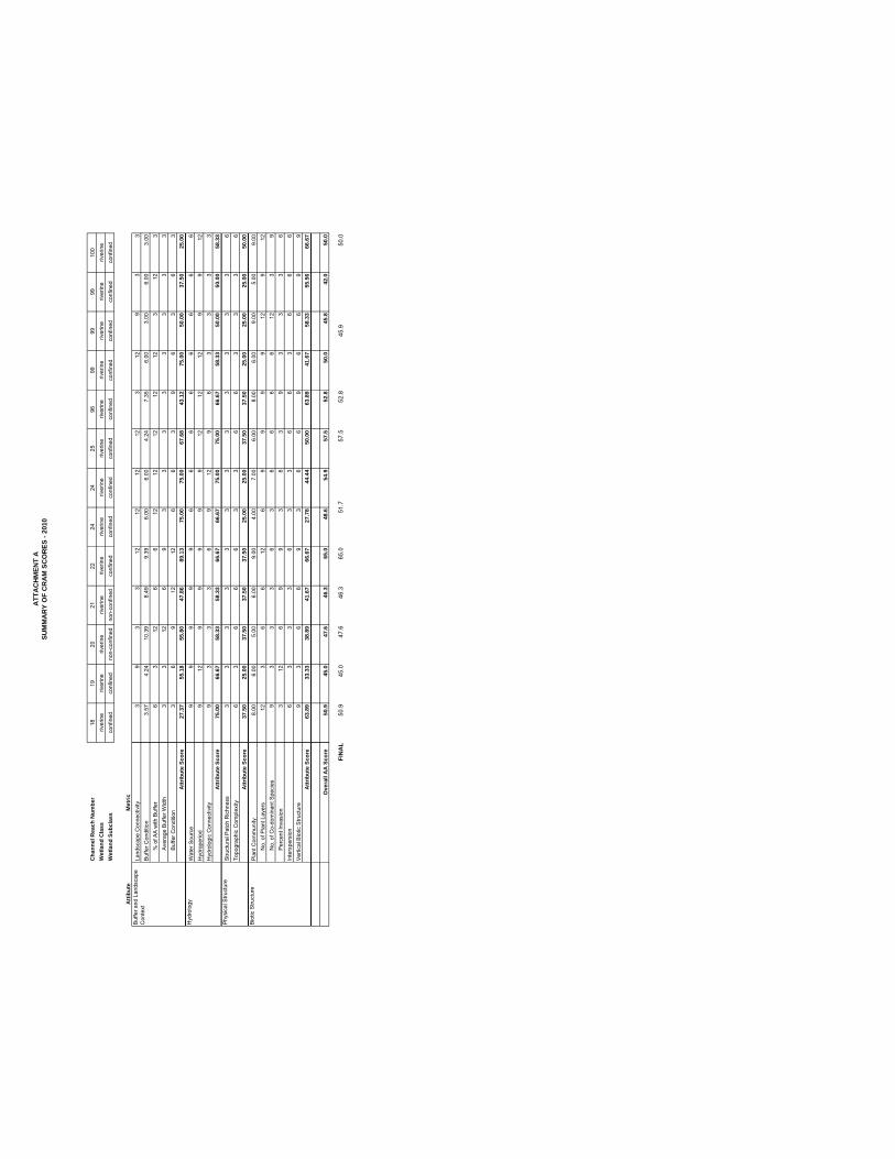
ATT
AC
HM
ENT
ASU
MM
AR
Y O
F C
RA
M S
CO
RES
- 20
10
Cha
nnel
Rea
ch N
umbe
r W
etla
nd C
lass
Wet
land
Sub
clas
s
Atti
bute
Met
ricLa
ndsc
ape
Con
nect
ivity
Buf
fer C
ondi
tion
% o
f AA
with
Buf
fer
Ave
rage
Buf
fer W
idth
Buf
fer C
ondi
tion
Attr
ibut
e Sc
ore
Wat
er S
ourc
eH
ydro
perio
dH
ydro
logi
c C
onne
ctiv
ityA
ttrib
ute
Scor
eS
truct
ural
Pat
ch R
ichn
ess
Topo
grap
hic
Com
plex
ityA
ttrib
ute
Scor
eP
lant
Com
mun
ityN
o. o
f Pla
nt L
ayer
sN
o. o
f Co-
dom
inan
t Spe
cies
Per
cent
Inva
sion
Inte
rspe
rsio
nV
ertic
al B
iotic
Stru
ctur
eA
ttrib
ute
Scor
e
Ove
rall
AA
Sco
re
FIN
AL
Buf
fer a
nd L
ands
cape
C
onte
xt
Hyd
rolo
gy
Phy
sica
l Stru
ctur
e
Bio
tic S
truct
ure
1819
2021
2224
2425
9699
9999
100
river
ine
river
ine
river
ine
river
ine
river
ine
river
ine
river
ine
river
ine
river
ine
river
ine
river
ine
river
ine
river
ine
conf
ined
conf
ined
non-
conf
ined
non-
conf
ined
conf
ined
conf
ined
conf
ined
conf
ined
conf
ined
conf
ined
conf
ined
conf
ined
conf
ined
39
33
1212
1212
312
93
33.
574.
2410
.39
8.49
9.39
6.00
6.00
4.24
7.35
6.00
3.00
6.00
3.00
63
126
612
1212
1212
312
33
312
69
33
33
33
33
36
912
126
63
96
36
327
.37
55.1
855
.80
47.8
689
.13
75.0
075
.00
67.6
843
.12
75.0
050
.00
37.5
025
.00
99
99
96
66
66
66
69
129
99
99
1212
129
912
93
33
69
129
63
33
375
.00
66.6
758
.33
58.3
366
.67
66.6
775
.00
75.0
066
.67
58.3
350
.00
50.0
058
.33
33
33
33
33
33
33
66
36
66
33
66
33
36
37.5
025
.00
37.5
037
.50
37.5
025
.00
25.0
037
.50
37.5
025
.00
25.0
025
.00
50.0
08.
006.
005.
006.
009.
004.
007.
006.
008.
006.
009.
005.
009.
0012
36
612
69
99
912
912
93
33
63
66
66
123
93
126
99
36
39
33
36
63
33
63
36
63
66
69
36
69
36
69
66
99
63.8
933
.33
38.8
941
.67
66.6
727
.78
44.4
450
.00
63.8
941
.67
58.3
355
.56
66.6
7
50.9
45.0
47.6
46.3
65.0
48.6
54.9
57.5
52.8
50.0
45.8
42.0
50.0
50.9
45.0
47.6
46.3
65.0
57.5
52.8
50.0
45.9
51.7