Appendix E - Los Angeles City Planning
324
Appendix E Cultural Resources
-
Upload
khangminh22 -
Category
Documents
-
view
0 -
download
0
Transcript of Appendix E - Los Angeles City Planning

Appendix E Cultural Resources

Appendix E.1 6701 Sunset Boulevard Historic Resources
Technical Report

CONFIDENTIAL DRAFT FOR INTERNAL REVIEW ONLY
6701 Sunset Boulevard Historic Resources Technical Report December 2016 HISTORIC RESOURCES GROUP

CONFIDENTIAL DRAFT FOR INTERNAL REVIEW ONLY
6701 Sunset Boulevard Historic Resources Technical Report December 2016 HISTORIC RESOURCES GROUP
TABLE OF CONTENTS
5 1.0 Introduction
7 2.0 Project Description 7 2.1 Introduction 7 2.2 Project Location and Surrounding Uses 8 2.3 Existing Project Site Conditions 9 2.4 Project Characteristics
14 3.0 Regulatory Review 14 3.1 Historic Resources under CEQA 15 3.2 Historic Designations 19 3.3 Hollywood Community Plan 19 3.4 Hollywood Redevelopment Plan 20 3.5 Historic Significance and Integrity
22 4.0 Identification of Potential Historic Resources
22 4.1 Project Site Development Parcel A 22 4.2 Project Site Development Parcel B 24 4.3 Project Site Development Parcel C 27 4.4 Project Site Development Parcel D 28 4.5 Historic Resources Adjacent to Development Parcels 29 4.6 Summary of Historic Resources
37 5.0 Potential Impacts 37 5.1 Significance Threshold 38 5.2 Additional Guidance 41 5.3 Demolition of Significant Resources 41 5.4 Relocation and Alteration of Significant Resources 43 5.5 Adjacent New Construction

CONFIDENTIAL DRAFT FOR INTERNAL REVIEW ONLY
6701 Sunset Boulevard Historic Resources Technical Report December 2016 HISTORIC RESOURCES GROUP
53 5.6 Impacts Analysis Using Los Angeles CEQA Thresholds 54 5.7 Summary of Impacts on Historic Resources
59 6.0 Recommended Mitigation Measures 59 6.1 Mitigation of Impacts to a Less-Than-Significant Level 60 6.2 Additional Mitigation
62 Bibliography
65 Appendix A: Photos of Historic Resources Located in Project Development Parcels
67 Appendix B: Photos of Historic Resources Located Adjacent to Project Development Parcels

CONFIDENTIAL DRAFT FOR INTERNAL REVIEW ONLY
6701 Sunset Boulevard Historic Resources Technical Report December 2016 HISTORIC RESOURCES GROUP
PREPARED FOR
CRE-HAR Crossroads SPV, LLC 6363 Wilshire Boulevard, Ste. 600 Los Angeles, CA 90031

CONFIDENTIAL DRAFT FOR INTERNAL REVIEW ONLY
6701 Sunset Boulevard Historic Resources Technical Report December 2016 HISTORIC RESOURCES GROUP
51.0 INTRODUCTION
The purpose of this technical report is to determine if historic resources as defined by the California Environmental Quality Act (CEQA)1 are present in the Crossroads of the World Project Site and, if so, to identify potential impacts to historic resources caused by the proposed Project. This report is intended to inform environmental review of the proposed Project.
Under CEQA the potential impacts of a project on historic resources must be considered. The purpose of CEQA is to evaluate whether a proposed project may have a significant adverse effect on the environment and, if so, if that effect can be reduced or eliminated by pursuing an alternative course of action or through mitigation measures.
The impacts of a project on an historic resource may be considered an environmental impact. CEQA states that:
A project that may cause a substantial adverse change in the significance of an historical resource is a project that may have a significant effect on the environment.2
Thus, an evaluation of project impacts under CEQA requires a two-part inquiry: (1) a determination of whether the project site contains or is adjacent to a historically significant resource or resources, and if so, (2) a determination of whether the proposed project will result in a “substantial adverse change” in the significance of the resource or resources. This report investigates the proposed Project Site to determine if historic resources exist either within or adjacent to its boundaries and analyzes project impacts for any adverse change in the significance of such resources.
This report contains:
A review of the existing properties within and adjacent to the Project Site.
A review of any previous historic evaluations through historic survey, environmental review or other official action.
Analysis and evaluation of any potential historic resources.
Review of the required consideration of historic resources under the California Environmental Quality Act (CEQA).
1 California PRC, Section 21084.1. 2 Ibid.

CONFIDENTIAL DRAFT FOR INTERNAL REVIEW ONLY
6701 Sunset Boulevard Historic Resources Technical Report December 2016 HISTORIC RESOURCES GROUP
6This report was prepared using sources related to the Project Site’s development. The following documents were consulted:
Historic building permits
Sanborn Fire Insurance maps
Historic photographs, aerial photos and local histories
Previous environmental evaluations within the Project site
California State Historic Resources Inventory for Los Angeles County
Department of Parks and Recreation Historic Resources Inventory Forms
2010 Community Redevelopment Agency Historic Survey of the Hollywood Redevelopment Area

CONFIDENTIAL DRAFT FOR INTERNAL REVIEW ONLY
6701 Sunset Boulevard Historic Resources Technical Report December 2016 HISTORIC RESOURCES GROUP
72.0 PROJECT DESCRIPTION3
2.1 Introduction
CRE-HAR Crossroads SPV, LLC, the Project Applicant, proposes to construct a mixed-use development (the Project) across four City blocks in the Hollywood Community of the City of Los Angeles (the Project Site). The 8.0-acre (348,419-square-foot) Project Site is generally bounded by Selma Avenue to the north; the Blessed Sacrament Catholic Church and School to the east; Sunset Boulevard to the south; and Highland Avenue to the west. The Project Site includes the Crossroads of the World complex (Crossroads of the World), which is a designated City Cultural-Historic Monument (Monument #134) and also appears on the National Register of Historic Places and the California Register of Historic Resources. The Project would retain, preserve, and rehabilitate Crossroads of the World and remove all other existing uses on the Project Site, including surface parking lots and approximately 86,947 square feet of existing floor area consisting of 84 residential units (including 80 multi-family dwelling units and two duplexes) and commercial/retail and office uses. The Project would integrate Crossroads of the World into a new, mixed-use development that would include eight new mixed-use buildings with residential, hotel, commercial/retail, office, entertainment, and restaurant uses. Upon build-out, the Project (including existing uses to be retained) would include approximately 1,432,000 square feet of floor area consisting of 950 residential units, 308 hotel rooms, approximately 95,000 square feet of office uses, and approximately 185,000 square feet of commercial/ retail uses. The proposed floor area ratio (FAR) would be approximately 4.69:1 averaged across the Project Site.1
2.2 Project Location and Surrounding Uses
The Project Site is located in the Hollywood Community of the City of Los Angeles, approximately 7 miles northwest of downtown Los Angeles and approximately 12 miles east of the Pacific Ocean. Primary regional access is provided by the US-101 Freeway (Hollywood Freeway), which runs southeast-northwest approximately 1 mile east of the Project Site. The major arterials providing regional and sub-regional access to the Project Site vicinity include Hollywood Boulevard to the north, Cahuenga Boulevard to the east, Sunset Boulevard to the south, and Highland Avenue to the west. A regional map of the Project area is provided in Figure A-1 on page A-3.
The Project Site is irregular-shaped consisting of 29 individual parcels across four City blocks. As shown in the aerial map in Figure A-2 on page A-4, the individual parcels are grouped into four Project areas referred to as Development Parcels A, B, C, and D. Generally, the Project Site is bounded by Selma Avenue to the north; the Blessed
3 Description of existing conditions and the proposed project as provided by the Applicant.

CONFIDENTIAL DRAFT FOR INTERNAL REVIEW ONLY
6701 Sunset Boulevard Historic Resources Technical Report December 2016 HISTORIC RESOURCES GROUP
8Sacrament Church and School and associated surface parking to the east; Sunset Boulevard to the south; and Highland Avenue to the west. Development Parcel D is located on the northeast corner of Selma Avenue and Las Palmas Avenue. The remaining Development Parcels are located south of Selma Avenue.
The surrounding area is urbanized and includes historic and modern low- to high-rise buildings occupied by neighborhood-serving commercial, tourist and entertainment-related commercial uses, offices, hotels, educational institutions, and single-family and multi-family residences. In the immediate vicinity of the Project Site are the Blessed Sacrament Catholic Church and First Baptist Church, a plant nursery, commercial strip malls, a Rite-Aid pharmacy, Panavision, a multi-family apartment building, LA Recording School, a multi-story office building, and surface parking lots. Several school facilities are located within 0.25 mile of the Project Site, including the Blessed Sacrament Catholic School to the east, Hollywood High School to the west, and Selma Avenue Elementary School and the Larchmont Charter School West facility (located within Selma Avenue Elementary School grounds) to the north. On the southern boundary of the Project Site, fronting Sunset Boulevard, are a mix of commercial retail and restaurant uses, entertainment-related uses, and nightclubs. The Hollywood and Highland shopping center and entertainment complex is located less than 1,000 feet from the Project Site at the corner of Hollywood Boulevard and Highland Avenue. The Hollywood/Highland Red Line Station, part of the Los Angeles County Metropolitan Transportation Authority (Metro) rail system, is also located at this intersection. The Project area is characterized by considerable pedestrian activity.
2.3 Existing Project Site Conditions
As detailed below, the Project Site is currently developed with various uses including low-density commercial and office uses in the historic Crossroads of the World property; two residential duplexes; three two-story, multi-family apartment buildings housing a total of 80 dwelling units; one- and two-story structures used for commercial office and retail uses; and surface parking lots. Existing on-site uses include a total of approximately 154,947 square feet of floor area. Intermittent landscaping is dispersed throughout the Project Site and generally consists of ornamental trees and shrubs.
Development Parcel A of the Project Site includes one- and two-story commercial/retail uses and surface parking areas. Development Parcel B includes a single-story commercial use fronting McCadden Place, two residential duplexes on the south side of Selma Avenue, two two-story multi-family residential buildings along Selma Avenue and Las Palmas Avenue, a small single-story chiropractic office along Las Palmas Avenue, a one- to two-story building consisting of community-serving small retail shops along Sunset Boulevard, and a one- to three-story office building also along Sunset Boulevard.

CONFIDENTIAL DRAFT FOR INTERNAL REVIEW ONLY
6701 Sunset Boulevard Historic Resources Technical Report December 2016 HISTORIC RESOURCES GROUP
9Existing development on Development Parcel C of the Project Site includes the Crossroads of the World, which is a designated City Cultural-Historic Monument (Monument #134) and also listed on the National Register of Historic Places and the California Register of Historic Resources. The approximate 68,000-square-foot Crossroads of the World complex consists of one- and two-story office, retail and restaurant shops in a variety of architectural styles such as Streamline Moderne, and French, English, Moorish and Spanish influenced styles. The shops are connected by a series of landscaped walkways with pedestrian entrances on Sunset Boulevard, Las Palmas Avenue, and Selma Avenue. The complex was designed in 1936 to create an “Old World” Atmosphere and was the City’s first outdoor pedestrian village that included a mix of shopping, dining, and entertainment uses.
Development Parcel C of the Project Site includes a two-story office/retail building west of Crossroads of the World and along Sunset Boulevard, one- and two-story office buildings along Las Palmas Avenue, and a surface parking lot serving Crossroads of the World. Existing development on Development Parcel D of the Project Site includes a two story commercial/retail building and a surface parking lot.
2.4 Project Characteristics
Project Overview
The Project proposes to redevelop the Project Site with a cohesive, mixed-use development that blends the distinguishing character of Crossroads of the World with a collection of new buildings of modern design and creates an open-air pedestrian district with a mix of shopping, dining, and entertainment uses. Crossroads of the World, which is a designated City Cultural-Historic Monument (Monument #134) and is also listed on the National Register of Historic Places and the California Register of Historic, would be retained, preserved, and rehabilitated as part of the Project. Eighty-four existing residential units (including 80 multi-family dwelling units and two duplexes) and low-density commercial/retail and office uses, as well as surface parking lots, would be demolished and replaced with eight new mixed-use buildings that would include residential, hotel, commercial/retail, office, entertainment, and restaurant uses.
Upon build-out, the Project would include approximately 950 residential units, 308 hotel rooms, approximately 95,000 square feet of office uses, and approximately 185,000 square feet of commercial/retail uses, totaling approximately 1,432,000 square feet of floor area (including existing uses to be retained). The Project would demolish a total of approximately 86,947 square feet of existing floor area. In total, the Project would result in an increase of approximately 1,345,053 square feet of net new floor area on the Project Site.

CONFIDENTIAL DRAFT FOR INTERNAL REVIEW ONLY
6701 Sunset Boulevard Historic Resources Technical Report December 2016 HISTORIC RESOURCES GROUP
10The Project also includes vehicular and pedestrian circulation improvements, including the re-alignment of Las Palmas Avenue at Sunset Boulevard. Currently, the Las Palmas Avenue street segment north of Sunset Boulevard lies east of its street segment south of Sunset Boulevard, creating an offset intersection. The Project would realign the street to create a four-legged intersection, with Las Palmas Avenue becoming a continuous street at Sunset Boulevard. The Project also proposes to establish a new pedestrian passageway that would extend diagonally from Sunset Boulevard from the front of Crossroads of the World to the corner of Selma Avenue and McCadden Place.
The Project Site includes four areas referred to as Development Parcels A, B, C, and D. The Development Parcels include nine sub-areas: Parcel A includes Building A1; Parcel B includes Buildings B1, B2, B3, and B4; Parcel C includes Buildings C1, C2, and Crossroads of the World; and Parcel D includes Building D1. These sub-areas are discussed in further detail below.
Development Parcel A—Hotel Area (Building A1)
The Project would remove all existing land uses on Development Parcel A and construct Building A1 which would be located on the southeast corner of Selma Avenue and Highland Avenue. Building A1 would consist of an approximately 348,500-square-foot high-rise structure with a 308-room hotel, ancillary meeting rooms, a lobby lounge and bar, a rooftop bar and lounge, and ground floor restaurant and retail uses. Approximately 10,500 square feet of ground-floor commercial/retail uses would also be located in Building A1. Building A1 would be approximately 32-stories tall and would reach a maximum height of approximately 365 feet.
Development Parcels B and D—Mixed-Use Residential and Retail Area (Buildings B1, B2, B3, B4, and D1)
The Project would remove all existing land uses on Development Parcels B and D and construct a total of five mixed-use residential buildings with ground-floor commercial/ retail uses: Buildings B1, B2, B3, B4, and D1. Development Parcel B, consisting of Buildings B1, B2, B3, and B4, would include a total of approximately 872 residential units and approximately 58,500 square feet of commercial retail uses. Specifically, Building B1 would consist of 190 residential units and approximately 15,500 square feet of ground-floor commercial/retail uses. Building B1 would consist of 30 floors and would reach a maximum height of approximately 402 feet above grade. Building B2 would consist of 70 residential units and approximately 12,000 square feet of ground-floor commercial/retail uses. Building B2 would consist of 6 floors and would reach a maximum height of approximately 90 feet above grade. Building B3 would consist of 489 residential units and approximately 11,000 square feet of ground-floor commercial/retail uses. Building B3 would consist of 32 floors and would reach a

CONFIDENTIAL DRAFT FOR INTERNAL REVIEW ONLY
6701 Sunset Boulevard Historic Resources Technical Report December 2016 HISTORIC RESOURCES GROUP
11maximum height of approximately 390 feet above grade. Building B4 would consist of 123 residential units and approximately 20,000 square feet of ground-floor commercial/retail uses. Building B4 would consist of 6 floors in addition to a mezzanine floor and would reach a maximum height of approximately 95 feet above grade.
Development Parcel D consists of Building D1, which would include approximately 78 residential units and approximately 4,500 square feet of ground-floor commercial/retail uses. Building D1 would consist of 6 floors and would reach a maximum height of approximately 85 feet above grade.
In total, Development Parcels B and D would have 950 residential units and approximately 63,000 square feet of ground-floor commercial/retail uses. Of the 950 residential units proposed, 80 units would be affordable housing rental units. These affordable housing rental units would replace the existing 80 rent-stabilized units located in Development Parcel B that would be removed.
Development Parcel C—Commercial Area (Buildings C1 & C2, Crossroads of the World)
The commercial portion of the Project consisting of creative office and retail/ restaurant uses would be located in Development Parcel C located east of Las Palmas Avenue and directly adjacent to the historic Crossroads of the World site. As previously discussed, Crossroads of the World, which includes approximately 68,000 square feet of office and retail uses, would be retained, preserved, and rehabilitated as part of the Project.
New development on Development Parcel C would include Buildings C1 and C2. Building C1 would consist of approximately 50,000 square feet of office uses and approximately 27,000 square feet of ground-floor retail uses. Building C1 would consist of 3 floors and would reach a maximum height of approximately 65 feet above grade. Building C2 would consist of approximately 45,000 square feet of office uses and 16,500 square feet of ground-floor retail uses. Building C2 would consist of two floors and would reach a maximum height of approximately 80 feet above grade. In total, Development Parcel C would consist of approximately 95,000 square feet of office uses and approximately 111,500 square feet of retail uses (including existing uses to be retained).
Setback and FAR
The Project would include approximately 1,432,000 square feet of developed floor area (including existing uses to be retained) corresponding with a total FAR of approximately 4.69:1 averaged across the Project Site.3 Setbacks for individual buildings across the Project Site would be provided in accordance with LAMC-required setbacks for the C4

CONFIDENTIAL DRAFT FOR INTERNAL REVIEW ONLY
6701 Sunset Boulevard Historic Resources Technical Report December 2016 HISTORIC RESOURCES GROUP
12zone. Specifically, the C4 zone does not require front, side, or rear yard setbacks for commercial uses. Residential uses in the C4 zone must provide setbacks corresponding with R4 zone requirements at the lowest residential story, which include 15-foot front and rear yards and 3- to 5-foot side yards.
Access, Circulation, and Parking
The Project proposes the re-alignment of Las Palmas Avenue at Sunset Boulevard. Currently, the Las Palmas Avenue street segment north of Sunset Boulevard lies east of its street segment south of Sunset Boulevard, creating an offset intersection. The Project would realign the street to create a four-legged intersection, with Las Palmas Avenue becoming a continuous street at Sunset Boulevard. This improved connectivity and integration would improve vehicular circulation, automobile and pedestrian safety, and the condition of the public right-of-way.
Vehicular access to the Project would be provided via several access points. Access to Development Parcel A would be via McCadden Place; residential parking for Development Parcel B would be accessible via McCadden Place and Las Palmas Avenue; visitor parking for Development Parcel C would be accessible via two driveways on Las Palmas Avenue; and parking for Development Parcel D would be via a single driveway on Las Palmas Avenue. Loading areas would be located within Development Parcels B and C and would be accessible via Las Palmas Avenue. Valet drop-off would also be available along Las Palmas Avenue and handicap drop-off would be available on Las Palmas Avenue and Selma Avenue. The locations of the driveway cuts are new and would require review and approval by the Los Angeles Department of Transportation (LADOT) for placement, width, and spacing.
New, below-grade parking would be provided for all portions of the Project. Specifically, Development Parcels A, B, and C would have five levels of subterranean parking, while Development Parcel D would have three levels of subterranean parking. Development Parcel A would provide approximately 409 parking spaces for hotel and retail visitors, Development Parcels B and C would provide approximately 2,083 parking spaces, and Development Parcel D would provide approximately 104 parking spaces. In total, the Project would provide approximately 2,596 parking spaces for residents and visitors to the Project Site. Furthermore, Development Parcel A would provide approximately 40 bicycle parking spaces, Development Parcels B and C would provide approximately 1,149 bicycle parking spaces, and Development Parcel D would provide approximately 92 bicycle parking spaces. In total, approximately 1,281 bicycle parking would be provided to the residents and visitors of the Project.
CONFIDENTIAL DRAFT FOR INTERNAL REVIEW ONLY
6701 Sunset Boulevard Historic Resources Technical Report December 2016 HISTORIC RESOURCES GROUP
13The Project also proposes to establish a new pedestrian passageway that would extend diagonally from Sunset Boulevard/Crossroads of the World to the corner of Selma Avenue and McCadden Place. The pedestrian passageway would be linked through additional landscaped public walkways and connect the entire Project Site while promoting access from Sunset Boulevard, Las Palmas Avenue, Selma Avenue, and McCadden Place.

CONFIDENTIAL DRAFT FOR INTERNAL REVIEW ONLY
6701 Sunset Boulevard Historic Resources Technical Report December 2016 HISTORIC RESOURCES GROUP
143.0 REGULATORY REVIEW
3.1 Historic Resources under CEQA
CEQA requires that environmental protection be given significant consideration in the decision making process. Historic resources are included under environmental protection. Thus, any project or action which constitutes a substantial adverse change on a historic resource also has a significant effect on the environment and shall comply with the State CEQA Guidelines.
When the California Register of Historical Resources was established in 1992, the Legislature amended CEQA to clarify which cultural resources are significant, as well as which project impacts are considered to be significantly adverse. A “substantial adverse change” means “demolition, destruction, relocation, or alteration such that the significance of a historical resource would be impaired.”
CEQA defines a historic resource as a resource listed in, or determined eligible for listing, in the California Register of Historical Resources. All properties on the California Register are to be considered under CEQA. However, because a property does not appear on the California Register does not mean it is not significant and therefore exempt from CEQA consideration. All resources determined eligible for the California Register are also to be considered under CEQA.
The courts have interpreted CEQA to create three categories of historic resources:
Mandatory historical resources are resources “listed in, or determined to be eligible for listing in, the California Register of Historical Resources.”
Presumptive historical resources are resources “included in a local register of historical resources, as defined in subdivision (k) of Section 5020.1, or deemed significant pursuant to criteria set forth in subdivision (g) of Section 5024.1” of the Public Resources Code, unless the preponderance of the evidence demonstrates that the resource is not historically or culturally significant.
Discretionary historical resources are those resources that are not listed but determined to be eligible under the criteria for the California Register of Historical Resources.4
4 League for the Protection of Oakland’s Architectural and Historic Resources vs. City of Oakland, 52 Cal. App. 4th 896, 906-7 (1997)

CONFIDENTIAL DRAFT FOR INTERNAL REVIEW ONLY
6701 Sunset Boulevard Historic Resources Technical Report December 2016 HISTORIC RESOURCES GROUP
15To simplify the first three definitions provided in the CEQA statute, an historic resource is a resource that is:
Listed in the California Register of Historical Resources (California Register);
Determined eligible for the California Register by the State Historical Resources Commission; or
Included in a local register of historic resources.
Section 15064.5 of the CEQA Guidelines (California Code of Regulations, Title 14, Chapter 3) supplements the statute by providing two additional definitions of historical resources, which may be simplified in the following manner. An historic resource is a resource that is:
Identified as significant in an historical resource survey meeting the requirements of Public Resources Code 5024.1 (g);
Determined by a Lead Agency to be historically significant or significant in the architectural, engineering, scientific, economic, agricultural, educational, social, political, military, or cultural annals of California. Generally, this category includes resources that meet the criteria for listing on the California Register (Pub. Res. Code SS5024.1, Title 14 CCR, Section 4852).
The fact that a resource is not listed in, or determined eligible for listing in, the California Register, not included in a local register of historic resources, or not deemed significant pursuant to criteria set forth in subdivision (g) of Section 5024.1, does not preclude a lead agency from determining that the resource may be an “historic resource” for purposes of CEQA.
Properties formally determined eligible for listing in the National Register of Historic Places are automatically listed in the California Register. Properties designated by local municipalities can also be considered historic resources. A review of properties that are potentially affected by a project for historic eligibility is also required under CEQA.
3.2 Historic Designations
A property may be designated as historic by National, State, and local authorities. In order for a building to qualify for listing in the National Register or the California Register, it must meet one or more identified criteria of significance. The property must also retain sufficient architectural integrity to continue to evoke the sense of place and time with which it is historically associated.

CONFIDENTIAL DRAFT FOR INTERNAL REVIEW ONLY
6701 Sunset Boulevard Historic Resources Technical Report December 2016 HISTORIC RESOURCES GROUP
16National Register of Historic Places
The National Register of Historic Places is an authoritative guide to be used by Federal, State, and local governments, private groups and citizens to identify the Nation's cultural resources and to indicate what properties should be considered for protection from destruction or impairment.5 The National Park Service administers the National Register program. Listing in the National Register assists in preservation of historic properties in several ways including: recognition that a property is of significance to the nation, the state, or the community; consideration in the planning for federal or federally assisted projects; eligibility for federal tax benefits; and qualification for Federal assistance for historic preservation, when funds are available.
To be eligible for listing and/or listed in the National Register, a resource must possess significance in American history and culture, architecture, or archaeology. Listing in the National Register is primarily honorary and does not in and of itself provide protection of an historic resource. The primary effect of listing in the National Register on private owners of historic buildings is the availability of financial and tax incentives. In addition, for projects that receive Federal funding, a clearance process must be completed in accordance with Section 106 of the National Historic Preservation Act. Furthermore, state and local regulations may apply to properties listed in the National Register.
The criteria for listing in the National Register follow established guidelines for determining the significance of properties. The quality of significance in American history, architecture, archeology, engineering, and culture is present in districts, sites, buildings, structures, and objects:
A. That are associated with events that have made a significant contribution to the broad patterns of our history; or
B. That are associated with the lives of persons significant in our past; or
C. That embody the distinctive characteristics of a type, period, or method of construction, or that represent the work of a master, or that possess high artistic values, or that represent a significant and distinguishable entity whose components may lack individual distinction; or
D. That have yielded, or may be likely to yield, information important in prehistory or history. 6
5 36CFR60, Section 60.2.6 36CFR60, Section 60.3.

CONFIDENTIAL DRAFT FOR INTERNAL REVIEW ONLY
6701 Sunset Boulevard Historic Resources Technical Report December 2016 HISTORIC RESOURCES GROUP
17In addition to meeting any or all of the criteria listed above, properties nominated must also possess integrity of location, design, setting, materials, workmanship, feeling, and association.
California Register of Historical Resources
The California Register is an authoritative guide in California used by State and local agencies, private groups, and citizens to identify the State's historic resources and to indicate what properties are to be protected, to the extent prudent and feasible, from substantial adverse change.7
The criteria for eligibility for listing in the California Register are based upon National Register criteria. These criteria are:
1. Associated with events that have made a significant contribution to the broad patterns of local or regional history or the cultural heritage of California or the United States.
2. Associated with the lives of persons important to local, California or national history.
3. Embodies the distinctive characteristics of a type, period, region or method of construction or represents the work of a master or possesses high artistic values.
4. Has yielded, or has the potential to yield, information important to the prehistory or history of the local area, California or the nation.
The California Register consists of resources that are listed automatically and those that must be nominated through an application and public hearing process. The California Register includes the following:
California properties formally determined eligible for (Category 2 in the State Inventory of Historical Resources), or listed in (Category 1 in the State Inventory), the National Register of Historic Places.
State Historical Landmarks No. 770 and all consecutively numbered state historical landmarks following No. 770. For state historical landmarks preceding No. 770, the Office of Historic Preservation (OHP) shall review their eligibility for
7 California PRC, Section 5023.1(a).

CONFIDENTIAL DRAFT FOR INTERNAL REVIEW ONLY
6701 Sunset Boulevard Historic Resources Technical Report December 2016 HISTORIC RESOURCES GROUP
18the California Register in accordance with procedures to be adopted by the State Historical Resources Commission (commission).
Points of historical interest which have been reviewed by the OHP and recommended for listing by the commission for inclusion in the California Register in accordance with criteria adopted by the commission. 8
Other resources which may be nominated for listing in the California Register include:
Individual historic resources.
Historic resources contributing to the significance of an historic district.
Historic resources identified as significant in historic resources surveys, if the survey meets the criteria listed in subdivision (g).
Historic resources and historic districts designated or listed as city or county landmarks or historic properties or districts pursuant to any city or county ordinance, if the criteria for designation or listing under the ordinance have been determined by the office to be consistent with California Register criteria.
Local landmarks or historic properties designated under any municipal or county ordinance. 9
Local Designation Programs
The Los Angeles City Council designates Historic-Cultural Monuments on recommendation of the City’s Cultural Heritage Commission.
Chapter 9, Section 22.171.7 of the City of Los Angeles Administrative Code defines an historical or cultural monument as:
“… a Historic-Cultural Monument (Monument) is any site (including significant trees or other plant life located on the site), building or structure of particular historic or cultural significance to the City of Los Angeles, including historic structures or sites in which the broad cultural, economic or social history of the nation, State or community is reflected or exemplified; or which is identified with historic personages or with important events in the main currents of national, State or local history; or which embodies the distinguishing characteristics of an architectural type specimen, inherently valuable for a
8 California PRC, Section 5023.1(d). 9 California PRC, Section 5023.1(e).

CONFIDENTIAL DRAFT FOR INTERNAL REVIEW ONLY
6701 Sunset Boulevard Historic Resources Technical Report December 2016 HISTORIC RESOURCES GROUP
19study of a period, style or method of construction; or a notable work of a master builder, designer, or architect whose individual genius influenced his or her age.”
Designation recognizes the unique architectural value of certain structures and helps to protect their distinctive qualities. Any interested individual or group may submit nominations for Historic-Cultural Monument status. Buildings may be eligible for historical cultural monument status if they retain their historic design and materials. Those that are intact examples of past architectural styles or that have historical associations may meet the criteria in the Cultural Heritage ordinance.
3.3 Hollywood Community Plan
The Project Site is located within the planning boundary of the Hollywood Community Plan, adopted in December 1988. The Hollywood Community Plan is one of thirty-five Community Plans that comprise the Land Use Element of the City of Los Angeles’ General Plan. The General Plan is the City’s fundamental policy document, directing the City’s future growth and development.
The 1988 Hollywood Community Plan does not specifically address historic resources; however, a stated objective of the 1988 Plan is to “encourage the protection and enhancement of the varied and distinctive residential character of the Community…” In addition, Housing Policy in the 1988 Plan version “encourages the protection and enhancement of well-defined residential neighborhoods in Hollywood through (1) application of Historic Preservation Overlay Zones where appropriate, and/or (2) preparation of neighborhood preservation plans which further refine and tailor development standards to neighborhood character.”10
The Plan also reiterates that it is “the City’s policy that the Hollywood Community Plan incorporate the sites designated on the Cultural and Historical Monuments Element of the General Plan.”11
3.4 Hollywood Redevelopment Project12
The Project Site is contained within the Hollywood Redevelopment Project area generally bounded by Franklin Avenue on the north, Serrano Avenue on the east, Santa Monica Boulevard and Fountain Avenue on the south, and La Brea Avenue on the west. The Hollywood Project area was established in 1984 by the Community Redevelopment Agency (CRA). The CRA was dissolved on February 6, 2012, and
10 Hollywood Community Plan. http://cityplanning.lacity.org/cpu/hollywood/HwdPlanUpdates.htm 11 Hollywood Community Plan. http://cityplanning.lacity.org/cpu/hollywood/HwdPlanUpdates.htm 12 California Redevelopment Agencies were abolished in 2011. The future of CRA projects is being determined as of this
writing.

CONFIDENTIAL DRAFT FOR INTERNAL REVIEW ONLY
6701 Sunset Boulevard Historic Resources Technical Report December 2016 HISTORIC RESOURCES GROUP
20administration of the Hollywood Redevelopment Project area has been transferred to the CRA/LA, a Designated Local Authority (DLA) and successor to the CRA, and may transfer to the City Planning Department.
The Hollywood Redevelopment Project’s goals include “the retention, restoration and appropriate reuse of existing buildings, groupings of buildings, and other physical features especially those having significant historic and/or architectural value and ensure that new development is sensitive to these features through land use and development criteria.”13 Policies and guidelines for the preservation, rehabilitation and retention of historic properties are discussed in Section 5.11 of the Redevelopment Plan.14
As part of its responsibilities in implementing the Hollywood Redevelopment Plan, the CRA compiled historic survey data on properties within the Hollywood Redevelopment Project Area. Property evaluations from historic surveys in 1986, 1997, and 2003 were compiled in a data table that was made available on the CRA website. A more recent intensive-level survey of the Hollywood Redevelopment Project Area was conducted in 2010.15 It provides relevant information regarding the status of properties within the redevelopment area and is used by agencies and the community to identify potential historic resources.16
3.5 Historic Significance and Integrity
Significance
The definition of historic significance used by the California Office of Historic Preservation (OHP) in its administration of the California Register is based upon the definition used by the National Park Service for the National Register:
Historic significance is defined as the importance of a property to the history, architecture, archaeology, engineering, or culture of a community, state, or the nation.17 It is achieved in several ways:
Association with important events, activities or patterns
13 Hollywood Community Plan. http://cityplanning.lacity.org/cpu/hollywood/HwdPlanUpdates.htm . Section 3 [300.11]. 14 The CRA released draft Urban Design Guidelines for the Hollywood Boulevard District and Franklin Avenue Design District areas in the autumn of 2011 to guide development within the Hollywood Redevelopment Plan area. These guidelines “encourage preservation, restoration, and appropriate reuse of historically or architecturally significant structures.” 15 Historic Resources Survey Hollywood Redevelopment Area, prepared by Chattel Architecture, Planning & Preservation, February 2010. 16 The 2010 Hollywood Redevelopment Project Area Survey results are available on the SurveyLA website: http://preservation.lacity.org/surveyla-field-survey-findings-and-reports 17 National Register Bulletin 16A. How to Complete the National Register Registration Form. Washington D.C.: National Park Service, U.S. Department of the Interior, 1997. (3)

CONFIDENTIAL DRAFT FOR INTERNAL REVIEW ONLY
6701 Sunset Boulevard Historic Resources Technical Report December 2016 HISTORIC RESOURCES GROUP
21 Association with important persons
Distinctive physical characteristics of design, construction, or form
Potential to yield important information
A property may be significant individually or as part of a grouping of properties.
Historic Integrity
Historic integrity is the ability of a property to convey its significance and is defined as the “authenticity of a property’s historic identity, evidenced by the survival of physical characteristics that existed during the property’s historic period.”18 The National Park Service defines seven aspects of integrity: location, design, setting, materials, workmanship, feeling, and association. These qualities are defined as follows:
Location is the place where the historic property was constructed or the place where the historic event took place.
Design is the combination of elements that create the form, plan, space, structure, and style of a property.
Setting is the physical environment of a historic property.
Materials are the physical elements that were combined or deposited during a particular period of time and in a particular pattern or configuration to form a historic property.
Workmanship is the physical evidence of the crafts of a particular culture or people during any given period in history or prehistory.
Feeling is a property's expression of the aesthetic or historic sense of a particular period of time.
Association is the direct link between an important historic event or person and a historic property.19
18 Ibid, p. 3. 19 National Register Bulletin 15: How to Apply the National Register Criteria for Evaluation. Washington D.C.:
National Park Service, U.S. Department of Interior, 1995.

CONFIDENTIAL DRAFT FOR INTERNAL REVIEW ONLY
6701 Sunset Boulevard Historic Resources Technical Report December 2016 HISTORIC RESOURCES GROUP
224.0 IDENTIFICATION OF POTENTIAL HISTORIC RESOURCES
Individual properties located both within and immediately adjacent to the Project Site are examined in the following analysis for the purposes of identifying potential historic resources. Properties that were previously evaluated as an historic resource, meet the fifty-year age threshold, or exhibit characteristics or associations known to be significant are reviewed. The context of their previous evaluations, criteria for significance and integrity issues are explored.
4.1 Project Site Development Parcel A20
Development Parcel A contains one property, 1547-49 McCadden Place, which was previously identified as eligible for listing in the California Register by the 2010 Hollywood Redevelopment Project Area Historic Resources Survey. 1547-49 McCadden is a single-story wood-frame vernacular21 house constructed in 1907. It is one of a small number of remaining properties in Hollywood constructed prior to Hollywood’s consolidation with Los Angeles.
Development Parcel A also contains three one-story commercial office and storefront buildings located facing Highland Avenue. All three were developed between 1949 and 1952. A one- and two-story commercial office building, constructed in 1965, is located at the southwest corner of Selma Avenue and McCadden Place.
With the exception of 1547-49 McCadden Place, none of the other properties located on Parcel A have been previously identified as historically significant. All have sustained substantial alteration since their original construction. None of these buildings represents a distinctive example of type, style or method of construction, and no important historic associations were discovered.
4.2 Project Site Development Parcel B
Development Parcel B contains three buildings that have been previously identified as historically significant:
1. 1542 McCadden Place is a one-story Craftsman style house constructed in 1910. It was found eligible for listing in the California Register in the 2010 Hollywood Redevelopment Project Area Historic Resources Survey. Located in the
20 Development parcels B and C contain a number of properties that are listed in a historic register, or were found eligible for listing, as individual properties. These properties are discussed in Sections 4.1 and 4.2. The 2010 CRA Historic Resources also identified a historic district, the “Sunset Potential Historic District,” comprised of these properties and additional properties that were also identified as individually eligible. The historic significance of the potential district is not stated and the relationship of these individually eligible properties to each other is not explained. It is therefore unclear why it was determined that this collection of properties would also meet criteria collectively as a historic district. 21 The term “vernacular” is used to describe buildings that do not generally display any particular architectural style.

CONFIDENTIAL DRAFT FOR INTERNAL REVIEW ONLY
6701 Sunset Boulevard Historic Resources Technical Report December 2016 HISTORIC RESOURCES GROUP
23northwestern portion of Development Parcel B, the property is an example of early residential development in Hollywood.
2. 6700-6718 Selma Avenue and 1535-1555 N. Las Palmas Avenue is a complex of three, two-story courtyard apartment buildings located on the east portion of Development Parcel B. Constructed in1939, the property contains three two-story apartment buildings designed in a Regency Revival style. Two of the buildings are rectangular in plan, each containing a central courtyard. The third is U-shaped with an open courtyard facing Selma Avenue. All three buildings are excellent examples of the courtyard apartment property type and representative of Hollywood’s transition to higher-density housing that began in the 1920s. Two of the buildings feature a central rectangular open courtyard surrounded on all four sides. The other building is U-shaped with the central courtyard open to Selma Avenue. The apartment complex was found eligible for listing in the California Register in the 2010 Hollywood Redevelopment Project Area Historic Resources Survey.
3. 6713-15 Sunset Boulevard is a two- and three-story building constructed in stages in 1927, 1936 and 1948. The building consists of a two-story volume fronting Sunset Boulevard with a three-story office volume behind. A one-story building with a truss roof sits behind the three-story office. The street-facing façade features a curving Moderne façade clad with polished marble and contrasting ribbed concrete surfaces. 6713-15 Sunset Boulevard is historically significant for its association with publisher and businessman William Wilkerson and his entertainment trade newspaper The Hollywood Reporter. Wilkerson founded The Hollywood Reporter in 1930, and moved its operations to the 6713 Sunset Boulevard location in 1936 where it remained through the 1990s. Wilkerson was responsible for developing the property during the 1930s and 40s, incorporating an existing one-story commercial building that was constructed in the mid-1920s. The building is also significant as a rare example of Moderne architecture in Hollywood. Architects Douglas Honnold and George Vernon Russell were responsible for the 1936 remodel which resulted in the building’s signature Moderne façade. 6713-15 Sunset Boulevard was found eligible for listing in the California Register in the 2010 Hollywood Redevelopment Project Area Historic Resources Survey.
With the exception of these three buildings, none of the other properties located on Parcel B have been previously identified as historically significant. Two residential properties are located at the northwest corner of Parcel B facing Selma Avenue. Both were originally constructed as duplexes in the 1920s and have been substantially altered. Parcel B also contains a small, one-story Spanish Revival residential duplex constructed in 1921 and now used as offices at 1507 Las Palmas. A one- and two-story

CONFIDENTIAL DRAFT FOR INTERNAL REVIEW ONLY
6701 Sunset Boulevard Historic Resources Technical Report December 2016 HISTORIC RESOURCES GROUP
24commercial building facing Sunset Boulevard is also located within Parcel B. None of these buildings represent a distinctive example of type, style or method of construction, and no important historic associations were discovered.
4.3 Project Site Development Parcel C
Over half of Development Parcel C is occupied by the Crossroads of the World complex at 6671 Sunset Boulevard.22 Nine structures occupy the site. They consist of a series of small one-and two-story office and retail buildings designed in a variety of fanciful architectural styles intended to evoke international locations. The buildings are unified by a series of landscaped walkways with entrances at Sunset Boulevard, Las Palmas Avenue and Selma Avenue. Crossroads of the World was declared HCM#134 by the Los Angeles Cultural Heritage Board on December 4, 1974. In 1980, Crossroads of the World was listed in the National Register. By virtue of being listed on the National Register, it is also listed on the California Register. The buildings and site features that comprise the Crossroads of the World property have been identified and listed collectively as single historic resource.
Crossroads of the World was designed in 1936 as a pedestrian shopping, dining and entertainment complex by architect Robert Vincent Derrah, AIA.23 The architecture of the shopping center revolves around an international theme. The focal point of the main entrance on Sunset Boulevard is the stand-alone Streamline Moderne building in the shape of a ship with a vertical pier supporting a revolving globe. Around the “ship” building are clusters of shops representing various village streetscapes from around the world designed in fanciful interpretations of regional styles. The “ship” building is flanked by buildings with Italian, French and Spanish influenced designs, which were remodels of two previously existing rectangular apartment buildings.24 The building accessed from Las Palmas Avenue contains shops designed in American Colonial Revival styles, whereas the structures on Selma Avenue (“Continental Villa” on the architect’s plan) represent a Central European village with steep pitched roofs, half-timbering and shingles. A Moorish-styled building evoking North African locations sits near the center of the property on the eastern edge.
The architect’s plan, (Figure 1) however, shows the original plan included several buildings that were not realized: an additional L-shaped building positioned north of the
22 City of Los Angeles, Department of Public Works Electronic Vault, Tract Map for A.E. Winstanley Tract recorded in 1905, Map Book 8, Page 11. 23 U.S. Department of the Interior, National Register of Historic Places Inventory Nomination Form, “Crossroads of the World,” September 8, 1980, 4. 24 Derrah, Robert V., “Unique Architectural Treatment of Hollywood Shopping Center,” Southwest Builder and Contractor, November 13, 1936, 13.
CONFIDENTIAL DRAFT FOR INTERNAL REVIEW ONLY
6701 Sunset Boulevard Historic Resources Technical Report December 2016 HISTORIC RESOURCES GROUP
25Early American building and another linear building of storefronts along the eastern property line that connected the buildings on Sunset Boulevard to the buildings accessible on Selma Avenue. Finally, a proposed theatre is shown at the heart of the complex along the west property line connecting the unrealized shops accessed via Las Palmas Avenue with those on Selma Avenue. The original plan included no provision for vehicle parking. Approximately three-quarters of the original design for the complex was built.
Architect Robert V. Derrah, AIA, (1895-1946) received degrees from the Massachusetts Institute of Technology and Harvard University. He became a member of the American Institute of Architects (AIA) in 1941.25 He came to Southern California in 1924 and opened his practice, Derrah and Associates in Beverly Hills.
Crossroads of the World opened October 29, 1936 during the midst of the Great Depression. The $500,000 complex was marketed as “an international city” of over 100 studios, shops and restaurants.26 Media coverage of the day identified “future plans” for the complex to include “a proposed theater at which foreign films will be featured.”27 And social columnist Lee Shippey touted the complex as being “…planned as an ‘Olvera Street’ for shops of many nations…”28 Advertisements for the opening emphasize the pedestrian experience and make no reference to vehicular accommodation.
The additional proposed shops and theatre were never realized and the un-built portions of the lot were used for parking. As early as 1948, aerial photographs show automobile parking on the northern part of Parcel 7 and 6 along Las Palmas Avenue.29 A 1951 Sanborn Map confirms this usage.30 After World War II, imported goods declined and lost favor with American consumers, and Crossroads of the World changed to more commercial and professional occupancy. By the mid-1960s, 80% of its structures were unoccupied.31
25 American Institute of Architects Historical Directory, http://public.aia.org/sites/hdoaa/wiki/Wiki%20Pages/Browse%20De.aspx 26 “Hollywood’s Unique ‘Crossroads of the World” Project Makes Bow to Public in Premiere Tonight,” Los Angeles Times, October 29, 1936. 27 “Architects’ Ideas Vie,” Los Angeles Times, October 29, 1936, 6. 28 Shippey, Lee. “The Lee Side o’ LA,” Los Angeles Times, September 1, 1936, A4. 29 www.historicareals.com 1948 Aerial photograph. 30 Sanborn Map, 1906-1951, Volume 10, Sheet 1049. 31 “Landmark to Keep Its Familiar Face,” Los Angeles Times, November 14, 1965, M13.

CONFIDENTIAL DRAFT FOR INTERNAL REVIEW ONLY
6701 Sunset Boulevard Historic Resources Technical Report December 2016 HISTORIC RESOURCES GROUP
26
Figure 1: Original Crossroads of the World PlanArchitect Robert V. Derrah’s plan for Crossroads of the World as published in California Arts + Architecture, January 1937.
In 1965, the Los Angeles Times reported “…the purchase of Crossroads of the World will not be followed by its demolition and replacement by a massing high-rise structure…instead of following such landmarks as the Garden of Allah into oblivion.”32 New plans called for a $250,000 restoration project and transformation into office usage instead of retail. A review of available building department permits for the site after 1974 (the year of HCM designation) as well as those on file with the Office of Historic Resources reveals no significant alterations have been made. Alterations consist primarily of the installation of interior partitions in office/store spaces, earthquake compliance efforts with no effect on the exterior of the building,33 and a partial roof replacement. A plan of the existing building configuration on the Crossroads of the World property is shown in Figure 2.
32 “Landmark to Keep Its Familiar Face,” Los Angeles Times, November 14, 1965, M13. 33 Los Angeles Department of Building and Safety, LA06472, 1985.

CONFIDENTIAL DRAFT FOR INTERNAL REVIEW ONLY
6701 Sunset Boulevard Historic Resources Technical Report December 2016 HISTORIC RESOURCES GROUP
27
Figure 2: Crossroads of the World Site
1. “Ship Building” 2. “Italian Building” 3. “Spanish Building” 4. “Mediterranean Building” 5. “French Building” 6. “Early American Building” 7. “Moroccan Building” (includes attached shed) 8. “Central European Building East” 9. “Central European Building West”

CONFIDENTIAL DRAFT FOR INTERNAL REVIEW ONLY
6701 Sunset Boulevard Historic Resources Technical Report December 2016 HISTORIC RESOURCES GROUP
28In addition to Crossroads of the World, Parcel C contains one additional building that has been identified as historically significant:
1. 6683 Sunset Boulevard is a two-story commercial block constructed in 1923. It is located directly west of Crossroads of the World facing Sunset Boulevard. The two-story, brick clad building is rectangular in plan with a chamfered corner entry facing the intersection of Sunset Boulevard and Las Palmas Avenue. Storefronts line the first floor facing Sunset Boulevard with offices on the second floor. The building is an example of an early 20th century commercial building often referred to as “streetcar commercial” in recognition of the primary form of urban transportation at the time of its development. It was found eligible for listing in the California Register California Register in the 2010 Hollywood Redevelopment Project Area Historic Resources Survey.
Two additional buildings are located on the west side of Parcel C facing Las Palmas. One at 1512 Las Palmas is a one-story single-family house constructed in the mid-1920s. It was converted to office space in 1946. A two-story office and studio space is located directly south at 1510 Las Palmas. It was constructed in 1956. Both properties have sustained substantial alteration since their original construction. Neither of these buildings represent a distinctive example of type, style or method of construction, and no important historic associations were discovered.
4.4 Project Site Development Parcel D
Development Parcel D contains a two-story Craftsman style duplex at 1606-08 Las Palmas Avenue. Constructed in 1912, the building was originally constructed as a residential building and is now used for commercial purposes. 1606-08 Las Palmas Avenue is an example of an early duplex residential building in Hollywood. It was found eligible for listing in the California Register in the 2010 Hollywood Redevelopment Project Area Historic Resources Survey.
No other buildings or structures are located on Parcel D. The majority of the parcel is developed as a surface parking lot.
4.5 Resources Located Adjacent to the Project Development Parcels
One property located in the near vicinity of the project area has been designated as a historic resource:
1. 1521 Highland Avenue contains the campus of Hollywood High School. The Hollywood High School campus was listed in the National Register of Historic Places

CONFIDENTIAL DRAFT FOR INTERNAL REVIEW ONLY
6701 Sunset Boulevard Historic Resources Technical Report December 2016 HISTORIC RESOURCES GROUP
29as a historic district in 2012.34 By virtue of being listed on the National Register, the Hollywood High School Historic District is also listed on the California Register.
Originally established as a school in 1903, the Hollywood High School Historic District is significant under National Register Criterion A as the first school serving the (then) newly incorporated municipality of Hollywood. Hollywood High School has been in continuous use as an educational facility since its inception, and has played an important role in the civic and social development of Hollywood and the development of entertainment industry. The Hollywood High School Historic District is also significant under National Register Criterion C as an excellent example of PWA Moderne architecture as applied to a high school campus, and as a signature work by the Los Angeles architectural firm of Marsh, Smith and Powell.
The Hollywood High School Historic District contains approximately 13.5 acres and is bounded by Hawthorn Avenue to the north, Highland Avenue to the east, Sunset Boulevard to the south, and Orange Drive to the west. The period of significance is 1910-1956, signifying the original construction date of the Library, the earliest extant building on campus, through the completion of alterations to the Auditorium which have achieved significance over time. Five buildings and one site are considered contributors to the historic district and it retains a high level of integrity.35
Five additional properties located immediately adjacent to the Project Development Parcels have been previously found eligible for listing through survey evaluation. These properties are as follows:
1. 1523 McCadden Place is a five-story apartment building constructed in 1928. It is a largely intact example of an apartment building associated with the population boom of the 1920s and Hollywood’s transition to higher density residential development. The property was determined to be ineligible for the National Register through Section 106 evaluation in 2002 but was not evaluated for the California Register or local listing (Status Code 6Y). It was found eligible for listing in the California Register in the 2010 Hollywood Redevelopment Project Area Historic Resources Survey.
2. 1618 N. Las Palmas Avenue is a two-story Art Deco office building constructed in 1932. It was previously found eligible for listing in the National Register through survey evaluation in 1997, 2003 and in the 2010 Hollywood Redevelopment Project Area Historic Resources Survey.
34 Letter from Milford Wayne Donaldson, FAIA, State Historic Preservation Officer to Christine Lazzaretto, January 26, 2012. 35 Hollywood High School Historic District National Register of Historic Places Registration Form

CONFIDENTIAL DRAFT FOR INTERNAL REVIEW ONLY
6701 Sunset Boulevard Historic Resources Technical Report December 2016 HISTORIC RESOURCES GROUP
303. 6684 Selma Avenue contains the Neo-Classical style Hollywood First Baptist Church, constructed in 1917. This building is an excellent example of the Neo-Classical style applied to a church building and a rare, intact example of an early-20th century church building in Hollywood. It was found eligible for listing in the California Register in the 2010 Hollywood Redevelopment Project Area Historic Resources Survey.
4. 6641-6657 Sunset Boulevard contains the Blessed Sacrament Church and School constructed in 1927 and 1925 respectively. The church sanctuary building is a combination of Spanish Baroque and Art Deco styles. The school building is Neo-Classical in style. The Property was found eligible for listing in the California Register in the 2010 Hollywood Redevelopment Project Area Historic Resources Survey.
5. 6720-6722 Sunset Boulevard contains several buildings now used as the Hollywood Center Motel. The property contains a three-story Queen Anne style house constructed in 1901. The property was determined eligible for the California Register in the 2010 Hollywood Redevelopment Project Area Historic Resources Survey.
4.6 Summary of Historic Resources
The Project Site contains one (1) historic resource – the Crossroads of the World Property at 6671 Sunset Boulevard – that is listed in the National Register, California Register and has been designated as an HCM. The Project Site also contains six (6) properties that have been found eligible for the National and/or California Registers through survey evaluation. A summary of the buildings located within the Project Development areas is provided in Table 1.
One (1) property – the Hollywood High School Historic District – is listed in the National Register of Historic Places and is located in the immediate vicinity of the Project Site. Four (4) additional properties that have been found eligible for the National and/or California Registers through survey evaluation are also located immediately adjacent to the Project Site. A summary of these resources is provided in Table 2.
All of these properties are considered historic resources for the purposes of CEQA. A map showing their location can be found in Figure 3.

CONFIDENTIAL DRAFT FOR INTERNAL REVIEW ONLY
6701 Sunset Boulevard Historic Resources Technical Report December 2016 HISTORIC RESOURCES GROUP
3110. ”
Table 1: Review of Existing Buildings Located in the Project Development Areas
APN # ADDRESS DESCRIPTION DATE STATUS CEQA
RESOURCE?
DEVELOPMENT PARCEL A
5547020025 1547‐49 McCadden Vernacular single‐
family house. 1907
Determined eligible for the
CR through survey
evaluation.
YES
5547020007 1550‐52 Highland One‐story
commercial office
building.
1952
Appears altered. Not a
distinctive example of type,
style or method of
construction. No important
historic associations were
discovered.
NO
5547020036 6750‐60 Selma One‐ and two‐story
commercial office
building.
1965
Appears altered. Not a
distinctive example of type,
style or method of
construction. No important
historic associations were
discovered.
NO
5547020008 1546 Highland One‐story
commercial
storefront building.
1951
Appears altered. Not a
distinctive example of type,
style or method of
construction. No important
historic associations were
discovered.
NO
5547020046 1538‐36 Highland One‐story
commercial
storefront building.
1957, 1962
Appears altered. Not a
distinctive example of type,
style or method of
construction. No important
historic associations were
discovered.
NO

CONFIDENTIAL DRAFT FOR INTERNAL REVIEW ONLY
6701 Sunset Boulevard Historic Resources Technical Report December 2016 HISTORIC RESOURCES GROUP
32APN # ADDRESS DESCRIPTION DATE STATUS
CEQA RESOURCE?
5547020045 1540‐42 Highland One‐story
commercial
storefront building.
1949, 1954
Not a distinctive example
of type, style or method of
construction. No important
historic associations were
discovered.
NO
DEVELOPMENT PARCEL B
5547020001 1535‐55 Las Palmas 6700‐18 Selma
Three, two‐story,
Regency Revival
courtyard
apartment
buildings.
1939
Determined eligible for the
CR through survey
evaluation.
YES
5547020029 1542 McCadden Single‐family
Craftsman house. 1910
Determined eligible for the
CR through survey
evaluation.
YES
5547020005 6713‐15 Sunset
One‐ and two‐story
commercial offices
and printing plant
with a Moderne
façade. Former
headquarters for
the Hollywood
Reporter.
1927, 1936, 1948
Determined eligible for the
CR through survey
evaluation.
YES
5547020003 1505‐07 Las Palmas
Single‐story Spanish
Revival duplex.
(now offices)
1921
Not a distinctive example
of type, style or method of
construction. No important
historic associations were
discovered.
NO
5547020028 6732‐34 Selma Two‐story
residential duplex. 1920
Substantially altered. Not a
distinctive example of type,
style or method of
construction. No important
NO

CONFIDENTIAL DRAFT FOR INTERNAL REVIEW ONLY
6701 Sunset Boulevard Historic Resources Technical Report December 2016 HISTORIC RESOURCES GROUP
33APN # ADDRESS DESCRIPTION DATE STATUS
CEQA RESOURCE?
historic associations were
discovered.
5547020027 6736‐38 Selma
Two‐story
residential building
originally
constructed as a
duplex.
1920
Substantially altered. Not a
distinctive example of type,
style or method of
construction. No important
historic associations were
discovered.
NO
5547020003 6705 Sunset
One‐ and two‐story
commercial
building.
1960
Not a distinctive example
of type, style or method of
construction. No important
historic associations were
discovered.
NO
DEVELOPMENT PARCEL C
5547019032 6671 Sunset
“Crossroads of the
World” commercial
retail and office
complex. Includes
nine buildings and
related site
features that
together constitute
a single resource.
1936 Listed in NR; listed in CR;
HCM #134 YES
5547019023 6683 Sunset
Two‐story
commercial
building.
1923
Determined eligible for the
CR through survey
evaluation.
YES
5547019022 1510 Las Palmas Two‐story office
and studio building.1954
Appears altered. Not a
distinctive example of type,
style or method of
construction. No important
historic associations were
discovered.
NO

CONFIDENTIAL DRAFT FOR INTERNAL REVIEW ONLY
6701 Sunset Boulevard Historic Resources Technical Report December 2016 HISTORIC RESOURCES GROUP
34APN # ADDRESS DESCRIPTION DATE STATUS
CEQA RESOURCE?
5547019022 1512 Las Palmas
One‐story house
converted for office
use.
1926
Substantially altered. Not a
distinctive example of type,
style or method of
construction. No important
historic associations were
discovered.
NO
DEVELOPMENT PARCEL D
5547014027 1608 Las Palmas
Two‐story
Craftsman duplex.
(now commercial)
1912
Determined eligible for the
CR through survey
evaluation.
YES
NR: National Register of Historic Places
CR: California Register of Historical Resources
HCM: Los Angeles Historic‐Cultural Monument

CONFIDENTIAL DRAFT FOR INTERNAL REVIEW ONLY
6701 Sunset Boulevard Historic Resources Technical Report December 2016 HISTORIC RESOURCES GROUP
35Table 2: Summary of Historic Properties Adjacent to the Project Development Areas
APN # ADDRESS DESCRIPTION DATE STATUS CEQA
RESOURCE?
5548014900
1521 Highland Avenue
Hollywood High
School Historic
District.
1910‐195636
Listed in the NR as a
historic district. YES
5547014024 1618 Las Palmas Two‐story Art Deco
office building. 1932
Determined eligible for the
NR through survey
evaluation.
YES
5547020020 1523 McCadden
Place Five‐story
apartment building.1928
Determined eligible for the
CR through survey
evaluation.
YES
5547019034 6684 Selma Avenue Hollywood First
Baptist Church. 1917
Determined eligible for the
CR through survey
evaluation.
YES
5547020008 6641‐57 Sunset
Boulevard Blessed Sacrament
Church and School.
1925;1927
Determined eligible for the
CR through survey
evaluation.
YES
5547022011 6720‐6722 Sunset
Boulevard
Three‐story Queen
Anne house
(Hollywood Center
Motel).
1901 Determined eligible for the
CR through survey
evaluation.
YES
36 Period of Significance determined for National Register Listing.

CONFIDENTIAL DRAFT FOR INTERNAL REVIEW ONLY
36
Figure 3: Historic Resources Within and Adjacent to the Project Site
1. 6661 Sunset Boulevard; “Crossroads of the World” 2. 6684 Selma Avenue; Hollywood First Baptist Church 3. 6700-18 Selma Avenue and 1535-55 N. Las Palmas Avenue; Courtyard Apartment Buildings 4. 6683 Sunset Boulevard; Commercial Building 5. 6713-15 Sunset Boulevard; Former Hollywood Reporter Building 6. 1523 McCadden Place; Apartment Building 7. 1542 McCadden Place; Craftsman Style House 8. 1547-49 McCadden Place; Vernacular House 9. 1606-08 Las Palmas Avenue; Craftsman Style Duplex 10. 1618 Las Palmas Avenue; Art Deco Office Building 11. 6641-57 Sunset Boulevard; Blessed Sacrament Church and School 12. 1521 Highland Avenue; Hollywood High School Historic District 13. 6720-22 Sunset Boulevard; Queen Anne House (Hollywood Center Motel)
CONFIDENTIAL DRAFT FOR INTERNAL REVIEW ONLY
6701 Sunset Boulevard Historic Resources Technical Report December 2016 HISTORIC RESOURCES GROUP
375.0 POTENTIAL IMPACTS
5.1 Significance Threshold
The City of Los Angeles CEQA Thresholds Guide (2006, p. D.3-2) states that a project would normally have a significant impact on historic resources if it would result in a substantial adverse change in the significance of a historic resource. A substantial adverse change in significance occurs if the project involves:
Demolition of a significant resource;
Relocation that does not maintain the integrity and (historical/architectural) significance of a significant resource;
Conversion, rehabilitation, or alteration of a significant resource which does not conform to the Secretary of the Interior’s Standards for Rehabilitation and Guidelines for Rehabilitating Historic Buildings; or
Construction that reduces the integrity or significance of important resources on the site or in the vicinity.
In addition to this guidance provided by the City of Los Angeles, the State Legislature, in enacting the California Register, also amended CEQA to clarify which properties are considered historic resources , as well as which project impacts are considered to be significantly adverse.
A project with an effect that may cause a substantial adverse change in the significance of a historic resource is a project that may have a significant effect on the environment.37 A substantial adverse change in the significance of a historic resource means demolition, destruction, relocation, or alteration of the resource or its immediate surroundings such that the significance of a historical resource would be materially impaired.38
The Guidelines go on to state that “[t]he significance of an historic resource is materially impaired when a project… [d]emolishes or materially alters in an adverse manner those physical characteristics of an historical resource that convey its historical significance and that justify its inclusion in, or eligibility for, inclusion in the California Register of
37 CEQA Guidelines, section 15064.5(b).
38 CEQA Guidelines, section 15064.5(b) (1).

CONFIDENTIAL DRAFT FOR INTERNAL REVIEW ONLY
6701 Sunset Boulevard Historic Resources Technical Report December 2016 HISTORIC RESOURCES GROUP
38Historical Resources… local register of historic resources… or its identification in a historic resources survey.”39
5.2 Additional Guidance
Secretary of the Interior’s Standards
The Secretary of the Interior’s Standards for the Treatment of Historic Properties (the “Standards”) provide guidance for reviewing proposed projects that may affect historic resources.
The intent of the Standards is to assist the long-term preservation of a property’s significance through the preservation, rehabilitation, and maintenance of historic materials and features. The Standards pertain to historic buildings of all materials, construction types, sizes, and occupancy and encompass the exterior and interior of the buildings. The Standards also encompass related landscape features and the building’s site and environment, as well as attached, adjacent, or related new construction.
From a practical perspective, the Standards have guided agencies in carrying out their historic preservation responsibilities including State and local officials when reviewing projects that may impact historic resources. The Standards have also been adopted by state and local jurisdictions across the country including the City of Pasadena.
In addition, the Standards are a useful analytic tool for understanding and describing the potential impacts of substantial changes to historic resources. However, these Guidelines and Regulations are not part of the CEQA process. CEQA requires analysis of physical impacts to the environment and the only relationship of the Secretary of the Interior Standards to the CEQA process are discussed under CEQA Guidelines Section 15064.5(b)(3):
“Generally, a project that follows the Secretary of the Interior’s Standards for the Treatment of Historic Properties with Guidelines for Preserving, Rehabilitating, Restoring, and Reconstructing Historic Buildings or the Secretary of the Interior’s Standards for Rehabilitation and Guidelines for Rehabilitating Historic Buildings” (1995), Weeks and Grimmer, shall be considered as mitigated to a level of less than a significant impact on the historical resource.”
39 CEQA Guidelines, section 15064.5(b)(2).

CONFIDENTIAL DRAFT FOR INTERNAL REVIEW ONLY
6701 Sunset Boulevard Historic Resources Technical Report December 2016 HISTORIC RESOURCES GROUP
39The statutory language above references the Secretary of the Interior’s Standards and Guidelines for four distinct historic “treatments,” including: (1) preservation; (2) rehabilitation; (3) restoration; and (4) reconstruction. The specific standards and guidelines associated with each of these possible treatments are provided on the National Park Service’s website regarding the treatment of historic resources.40
For analytical purposes, a threshold decision must be made regarding which “treatment” standards should be used to analyze a project’s potential effect on historic resources. “Preservation” refers to the straightforward stabilization and maintenance of a historic property. “Restoration” addresses the return of a property to a specific time period and includes reconstruction of features missing from that time period. “Reconstruction” addresses the depiction of a no longer extant historic property through new construction.
The use of the Secretary of the Interior’s “rehabilitation” standards (the Rehabilitation Standards) address the most prevalent and widely used treatment. "Rehabilitation" is defined as "the process of returning a property to a state of utility, through repair or alteration, which makes possible an efficient contemporary use while preserving those portions and features of the property which are significant to its historic, architectural, and cultural values." 41 “Rehabilitation” recognizes necessary alteration for contemporary use and therefore provides a more appropriate impact analysis than the other treatment standards, and accounts for the fact that the adjacent properties will likely require some form of protection during construction activities and ongoing maintenance over the term of the construction.
Rehabilitation Standards 42
The National Park Service encourages maintaining the integrity of a historic resource through the appropriate design of infill buildings at sites adjacent to historic resources. The Standards are intended as general guidance for work on any historic building. The Rehabilitation Standards expand the discussion to sites and neighborhoods.
As written in the Rehabilitation Standards, there is a distinction, but not a fundamental difference, between the concerns for additions to historic buildings and new construction, or “infill” adjacent to historic buildings on a property or within a historic
40 http://www.nps.gov/hps/tps/standguide/ 41 https://www.nps.gov/tps/standards/rehabilitation/rehab/stand.htm 42 Kay D. Weeks and Anne E. Grimmer, The Secretary of the Interior’s Standards for the Treatment of Historic Properties: with Guidelines for Preserving, Rehabilitating, Restoring & Reconstructing Historic Buildings (Washington D.C.: National Park Service, United States Department of the Interior, 1995), pp. 63-115.
CONFIDENTIAL DRAFT FOR INTERNAL REVIEW ONLY
6701 Sunset Boulevard Historic Resources Technical Report December 2016 HISTORIC RESOURCES GROUP
40district. As with most matters of design and planning, the differences are defined by the scale, site, setting, and project.
National Park Service: Preservation Briefs 14
In addition to the Standards and Guidelines for Rehabilitation, the National Park Service publishes a series of briefs that includes “Preservation Briefs 14, New Exterior Additions to Historic Buildings: Preservation Concerns,” as revised and republished in 2010.43 Among the concepts presented are a balance between differentiation and compatibility, and subordination of the new to the old.
Preservation Briefs 14 states:
1. There is no formula or prescription for designing a new addition that meets the Standards. A new addition to a historic building that meets the Standards can be any architectural style -- traditional, contemporary or a simplified version of the historic building. However, there must be a balance between differentiation and compatibility in order to maintain the historic character and the identity of the building being enlarged. New additions that too closely resemble the historic building or are in extreme contrast to it fall short of this balance. Inherent in all of the guidance is the concept that an addition needs to be subordinate to the historic building.
2. The intent of the Preservation Briefs is to provide guidance to owners, architects and developers on how to design a compatible new addition…. A new addition to a historic building should preserve the building’s historic character. To accomplish this and meet the Secretary of the Interior’s Standards for Rehabilitation, a new addition should:
Preserve significant historic materials, features and form;
Be compatible; and
Be differentiated from the historic building.
43 Anne E. Grimmer and Kay D. Weeks, “Preservation Briefs 14: New Exterior Additions to Historic Buildings: Preservation Concerns” (Washington D.C.: National Park Service, United States Department of the Interior, 2010).
CONFIDENTIAL DRAFT FOR INTERNAL REVIEW ONLY
6701 Sunset Boulevard Historic Resources Technical Report December 2016 HISTORIC RESOURCES GROUP
415.3 Demolition of Significant Resources
Impacts from Demolition
The proposed Project will demolish the following properties that have been identified as historically significant through survey evaluation:
One-story vernacular house at 1547-49 McCadden Place (1907) Three, two-story Regency Revival courtyard apartment buildings at 6700 Selma
Avenue and 1535-55 Las Palmas Avenue (1939) One-story, single-family Craftsman style house at 1542 McCadden Place (1910) Two-story commercial block at 6683 Sunset Boulevard (1923) Two-story Craftsman style duplex at 1606-08 Las Palmas Avenue (1912) Hollywood Reporter Building at 6713 Sunset Boulevard
Demolition of these buildings will result in significant impacts to historic resources. These impacts cannot be mitigated to a less-than-significant level.
5.4 Relocation and of Significant Resources
The Crossroads of the World property is composed of nine buildings and their related circulation and site features. Together, these elements create a single historic resource. The Project proposes to relocate one small building located at the southwest portion of the property. Referred to as the “Early American Building,” the building to be relocated is designed in an exaggerated and fanciful interpretation of American Colonial Revival styles. The building consists of a linear configuration of individual store spaces just east of Las Palmas Avenue. The Early American Building is currently oriented east-west and located between Las Palmas Avenue and the northwest corner of the Crossroads of the World “French Building.” It would be relocated to the center of the Crossroads of the World property and relocated north-south in alignment with the other Crossroads buildings along the property’s north-south pedestrian axis. (See Figure 2 on page 30.)
Removal of a historic resource from its original physical location and setting has the potential to diminish the historic significance of a building. As discussed in Section 4.5 of this report, location is one of seven aspects of historic integrity. Location is defined as the place where the historic property was constructed or the place where the historic event took place. In the context of established preservation practice, relocating historic buildings is generally not recommended. When considering the criteria for eligibility, the National Park Service cautions that “the National Register criteria limit the consideration of moved properties because significance is embodied in locations and settings as well as in the properties themselves” when evaluating properties for listing in the National

CONFIDENTIAL DRAFT FOR INTERNAL REVIEW ONLY
6701 Sunset Boulevard Historic Resources Technical Report December 2016 HISTORIC RESOURCES GROUP
42Register.44 This can be particularly sensitive for historic properties containing multiple building such as Crossroads of the World where the configuration of multiple buildings and the spatial relationships established by that configuration are important character-defining features of the historic resource. For evaluation of Crossroads of the World, it is important to reiterate that the buildings that comprise the Crossroads property are not considered historic resources individually but together form a single historic resource.
The National Park Service has established a special criterion for moved properties, Criteria Consideration B, as a guide to evaluating their potential historic significance. According to Criteria Consideration B, “a property removed from its original or historically significant location can be eligible if it is significant primarily for architectural value or it is the surviving property most importantly associated with a historic person or event.” The guidance, however, goes on to state that “a moved property that is part of a complex but is of less significance than the remaining (unmoved) buildings” does not need to meet Criteria Consideration B in order to be considered.45 Because the Early American Building is one component of the larger Crossroads of the World complex and is the smallest of nine component buildings, Criteria Consideration B does not apply.
Issues relating to relocation are also addressed in the Secretary of the Interior’s Standards for Rehabilitation. Standard 2 states that “The historic character of a property will be retained and preserved. The removal of distinctive materials or alteration of features, spaces, and spatial relationships that characterize a property will be avoided.”
Relocation of the Early American Building would alter the original plan and configuration of the Crossroads of the World property by relocating one of its nine component buildings. The Early American Building was constructed in an east-west orientation with its shopfronts facing north. It was designed in anticipation of a second phase of Crossroads development that would have added additional storefronts located north and parallel to the Early American Building with storefronts facing south to create a second, east-west pedestrian axis connecting Crossroads to Las Palmas Avenue. Additional construction would have filled in the open space between the northern and southern Crossroads buildings along the north-south axis to create a T-shaped internal circulation pattern with access from Sunset Boulevard, Selma Avenue and Las Palmas Avenue. Because the second phase was never built, the Early American Building’s
44 National Register Bulletin 15. How to Apply the National Register Criteria for Evaluation. Washington D.C.: National Park Service, U.S. Department of the Interior, 1995. p. 29 45 National Register Bulletin 15. How to Apply the National Register Criteria for Evaluation. Washington D.C.: National Park Service, U.S. Department of the Interior, 1995. p. 29

CONFIDENTIAL DRAFT FOR INTERNAL REVIEW ONLY
6701 Sunset Boulevard Historic Resources Technical Report December 2016 HISTORIC RESOURCES GROUP
43storefronts face a surface parking lot and the originally intended east-west internal “street” was never built.
All of the other eight Crossroads buildings would remain in their original location after implementation of the proposed Project. These buildings, oriented along the north-south central pedestrian axis between Sunset Boulevard and Selma Avenue, establish the primary configuration of buildings and open spaces that characterize the property and define the property’s important spatial relationships. The Early American Building is the smallest of the nine Crossroads buildings and because of its location and orientation, has little spatial relationship with the other buildings. After relocation of the Early American Building, the majority of the original configuration of buildings and spatial relationships that characterize the Crossroads of the World property would remain intact and unaltered.
Relocation of the Early American Building also has the potential to imply a false historic condition. As stated in Standard 3 of the Secretary of the Interior’s Standards, “Each property will be recognized as a physical record of its time, place, and use. Changes that create a false sense of historical development, such as adding conjectural features or elements from other historic properties, will not be undertaken.” Moving existing historic fabric to a new location has the potential to create a false sense of historical development at Crossroads of the World. Without mitigation to make clear that the building has been relocated from its original location, relocation of the Early American Building has the potential to create a false sense of historic development of the Crossroads of the World property which would result in a significant impact to historic resources.
5.5 Impacts from Adjacent New Construction
The additional guidance provided by the National Park Service for reviewing proposed new construction that may affect an historic resource, as stated above, be it an addition to an existing building or an infill building within an historic district, strive for the same outcome: a balance between compatibility and differentiation, and the retention of integrity.
Standard 9 in part states: “New additions, exterior alterations, or related new construction will not destroy historic materials, features, and spatial relationships that characterize the property. The new work shall be differentiated from the old and will be

CONFIDENTIAL DRAFT FOR INTERNAL REVIEW ONLY
6701 Sunset Boulevard Historic Resources Technical Report December 2016 HISTORIC RESOURCES GROUP
44compatible with the historic materials, features, size, scale and proportion, and massing to protect the integrity of the property and its environment.”46
Standard 10 states: “New additions and adjacent or related new construction will be undertaken in such a manner that, if removed in the future, the essential form and integrity of the historic property and its environment would be unimpaired.”47
Realignment of Las Palmas Avenue
The Project would realign the segment of Las Palmas Avenue just north of Sunset Boulevard so that it becomes continuous with its segment south of Sunset Boulevard. The realignment would shift Las Palmas Avenue to the west mid-block between Selma Avenue and Sunset Boulevard.
The segment of Las Palmas Avenue adjacent to the Hollywood First Baptist Church will remain in its existing alignment. Realignment of Las Palmas Avenue will have no impact on the Hollywood First Baptist Church.
The Crossroads of the World property is located east of the existing Las Palmas Avenue alignment and the proposed realignment will pull Las Palmas Avenue further to the west. Therefore, the realignment of Las Palmas Avenue will have no impact on Crossroads of the World.
All other potential historic resources located along Las Palmas Avenue between Selma Avenue and Sunset Boulevard, including the courtyard apartment buildings at 6700 Selma Avenue and 1535-55 Las Palmas Avenue, the two-story commercial block at 6683 Sunset Boulevard, and the Hollywood Reporter Building at 6713 Sunset Boulevard will have been demolished prior to the realignment of Las Palmas Avenue. The demolition of these resources will result in significant impacts to historic resources as noted in Section 5.3 above. Realignment of Las Palmas Avenue will not result in any additional impacts to historic resources.
New Construction on Development Parcel A
A single building, Building A1, will be constructed on Development Parcel A. It is described as 31 floors of hotel with ancillary commercial uses over a below grade parking garage. Because the 1907 vernacular house at 1547 McCadden Place would be demolished to allow for construction of Building A1, no historic resources would be present immediately adjacent to Building A1 after its completion.
46 http://www.nps.gov/hps/tps/standguide/rehab/rehab_standards.htm 47 http://www.nps.gov/hps/tps/standguide/rehab/rehab_standards.htm

CONFIDENTIAL DRAFT FOR INTERNAL REVIEW ONLY
6701 Sunset Boulevard Historic Resources Technical Report December 2016 HISTORIC RESOURCES GROUP
45Two historic resources have been identified in the near vicinity of Development Parcel A. These are the 1928 apartment building at 1523 McCadden Place south of Development Parcel A, and the Hollywood High School Historic District located west of Development Parcel A across Highland Avenue.
The 1928 five-story apartment building at 1523 McCadden Place is located several parcels south of Development Parcel A and construction of Building A1 would not result in any physical impact to 1523 McCadden Place. The full height of Building A1 would be set back from the south above the 5th floor, further distancing the majority of the new building’s height and mass from the properties to the south. Construction of Building A1 would, however, alter the surroundings of 1523 McCadden Place by placing substantial height and mass on a site currently occupied by modest one-and two-story buildings.
The surroundings of the apartment building at 1523 McCadden Place have been altered by successive demolition and construction on neighboring parcels since its construction in 1928 and the existing setting is not critical to understanding the building’s historic significance. The historic significance of 1523 McCadden Place is conveyed primarily through the plan, massing, spatial configuration, architecture and design features of the apartment building. It is through the experience of the building that its historic significance as a property type and its association with 1920s development in Hollywood is understood. 1523 McCadden Place would continue to convey its historic significance after construction of Building A1. Construction of Building A1 would not result in a significant impact to 1523 McCadden Place.
Similarly, the Hollywood High School Historic District is located across Highland Avenue from Parcel A1 outside the Project site and would not be physically altered by the construction of Building A1. The Hollywood High School Historic District is significant as the first school serving Hollywood that has been in continuous use as an educational facility since its inception, and has played an important role in the civic and social development of Hollywood. It is also significant as an excellent example of PWA Moderne architecture as applied to a high school campus, and as a signature work by the Los Angeles architectural firm of Marsh, Smith and Powell. The historic significance of the Hollywood High School Historic District is conveyed primarily through the plan, massing, spatial relationships, architecture and design of its contributing buildings and features. The Hollywood High School Historic District would remain intact after construction of Building A1, and its plan, spatial relationships, massing, architecture and design features would continue to convey its historic significance.
Building A1 would be located two blocks west of the Hollywood Baptist Church at 6684 Sunset Boulevard, Crossroads of the World at 6661 Sunset Boulevard, the Art

CONFIDENTIAL DRAFT FOR INTERNAL REVIEW ONLY
6701 Sunset Boulevard Historic Resources Technical Report December 2016 HISTORIC RESOURCES GROUP
46Deco office building at 1618 Las Palmas Avenue, and the Blessed Sacrament Church and School at 6641-57 Sunset Boulevard. Building A1 would also be located substantially north and west of the Queen Anne House at 6720-22 Sunset Boulevard. Because it would be located a substantial distance from these resources, construction of Building of A1 would not demolish or physically alter any of these resources or their immediate surroundings. Construction of Building A1 would not materially impact the integrity of the Hollywood Baptist Church, Crossroads of the World, the Art Deco office building at 1618 Las Palmas Avenue, or the Queen Anne House at 6720-22 Sunset Boulevard, and all four would continue to convey their historic significance after construction of Building A1.
Finally, Building A1 would include substantial foundation work and the construction of a five-level subterranean parking garage. Without mitigation to ensure the protection of historic resources from damage due to underground excavation and general construction procedures and to reduce the possibility of damage from vibration and settlement due to the removal of adjacent soil, new construction on Development Parcel A has the potential to de-stabilize the adjacent historic buildings resulting in significant impacts.
New Construction on Development Parcel B
The Project will construct four new buildings on Development Parcel B. consisting of Buildings B1, B2, B3, and B4. Specifically, Building B1 would consist of 30 floors and would reach a maximum height of approximately 402 feet above grade. Building B2 would consist of 6 floors and would reach a maximum height of approximately 90 feet above grade. Building B3 would consist of 32 floors and would reach a maximum height of approximately 390 feet above grade. Building B4 would consist of 6 floors in addition to a mezzanine floor and would reach a maximum height of approximately 95 feet above grade.
All of the historic buildings contained within Parcel B would be demolished prior to the new construction. Consequently, no resources would be located immediately adjacent to any of the four new buildings to be constructed on Parcel B.
Two historic resources have been identified in the near vicinity of Development Parcel B. These are the Hollywood First Baptist Church located east of Development Parcel B at the southeast corner of Las Palmas Avenue and Selma Avenue; and the Queen Anne house located south of Development Parcel B on the south side of Sunset Boulevard. Both buildings are located on opposite sides of the street from Development Parcel B and new construction will not result in the demolition or physical alteration of either resource.

CONFIDENTIAL DRAFT FOR INTERNAL REVIEW ONLY
6701 Sunset Boulevard Historic Resources Technical Report December 2016 HISTORIC RESOURCES GROUP
47Proposed construction on Development Parcel B includes Building B1 which would be constructed on the west side of Las Palmas Avenue, across the street from the Hollywood First Baptist Church at 6684 Selma Avenue. The Hollywood Baptist Church would remain intact and physically unchanged after construction of Building B1, and its massing, form and architectural detailing would continue to be viewable and understandable by the public. Construction of Building B1 would not materially impact the integrity of the Hollywood Baptist Church and it would continue to convey its historic significance after construction of Building B1.
The proposed construction on Development Parcel B includes Building B3 which would consist of 32 floors and would reach a maximum height of approximately 390 feet above grade. Building B3 would be constructed on the northwest corner of Sunset Boulevard and Las Palmas Avenue, across Sunset Boulevard from the Queen Anne house located on the Hollywood Center Motel property. The Queen Anne house is set back from Sunset Boulevard and there would be a substantial distance between it and Building B3. The Queen Anne house would remain intact and in its original location after construction of Building B3 and its setting within the Hollywood Center Motel property will remain unchanged.
New construction on Development Parcel B would be separated by the proposed new construction on Development Parcel C from Crossroads of the World at 6661 Sunset Boulevard and the Blessed Sacrament Church and School at 6641-57 Sunset Boulevard. Development Parcel B would also be located south and west of the Art Deco office building at 1618 Las Palmas Avenue. Because it would be located a substantial distance from these resources, construction on Development Parcel B would not demolish or physically alter any of these resources or their immediate surroundings. As such, construction on Development Parcel B would not materially impact the integrity of Crossroads of the World, the Blessed Sacrament Church and School, or the Art Deco office building at 1618 Las Palmas Avenue, and all three would continue to convey their historic significance after the new construction on Development Parcel B.
Finally, the proposed new construction on Development Parcel B would include substantial foundation work and the construction of subterranean parking. Without mitigation to ensure the protection of nearby historic resources from damage due to underground excavation and general construction procedures and to reduce the possibility of damage from vibration and settlement due to the removal of adjacent soil, new construction on Development Parcel B has the potential to de-stabilize nearby historic buildings resulting in significant impacts.

CONFIDENTIAL DRAFT FOR INTERNAL REVIEW ONLY
6701 Sunset Boulevard Historic Resources Technical Report December 2016 HISTORIC RESOURCES GROUP
48New Construction on Development Parcel C: Potential Impacts to Crossroads of the World
The Project proposes to construct three new buildings that have the potential to impact Crossroads of the World. A new building (C1) would be constructed just west of Crossroads of the World on a site made vacant by the demolition of the 1923 commercial building at 6683 Sunset Boulevard, and the relocation of the Crossroads of the World Early American Building. A second building (C2) would be constructed on the surface parking lot west of Crossroads of the World. A third building (C3) would be constructed on the east side of the Crossroads property between the Moorish influenced “Moroccan Building” and east “Central European Building.” As noted in Section 4.3 of this report, the buildings and site features that comprise the Crossroads of the World property have been identified and listed collectively as single historic resource. Therefore, the proposed adjacent new construction is evaluated for potential impacts to the Crossroads of the World property as a whole. Potential impacts to the Crossroads of the World property from the construction of buildings C1, C2, and C3 is analyzed below.
Construction of Building C1
Building C1 is described as three floors of office and retail space reaching a maximum height of 65 feet above grade. Because Building C1 would occupy a portion of the Crossroads of the World property at its southwest end and be constructed directly adjacent to two Crossroads of the World buildings, it has the potential to result in significant impacts to the Crossroads of the World property. The plan and orientation of Building C1 would reconfigure the Las Palmas Avenue approach to Crossroads of the World from an east-west orientation to a northwest-southwest orientation. As shown in the conceptual drawings, Building C1 would rise over twice the height of the adjacent Crossroads of the World buildings.
This difference in height would be moderated by massing that sets the tallest portions of Building C1 back from Crossroads of the World. The Building C1 podium would be the same height as the two-story height of the neighboring Crossroads of the World buildings, and the ground-floor (podium) level façades would be articulated to establish a clear relationship with the eave height of the neighboring Crossroads buildings. The Building C1 ground floor would also be articulated with retail windows and entryways that are similar in scale, proportion and rhythm to those of the existing Crossroads of the World buildings.
Above its podium, Building C1’s upper floors would be set back from Sunset Boulevard and the Crossroads property so that the additional height is not immediately juxtaposed

CONFIDENTIAL DRAFT FOR INTERNAL REVIEW ONLY
6701 Sunset Boulevard Historic Resources Technical Report December 2016 HISTORIC RESOURCES GROUP
49with the Crossroads buildings. Above the podium level, curtain walls of horizontally articulated glass in metal frames would further reduce the visual impression of height and create a simple backdrop to the highly articulated historical profile of the Crossroads buildings.
In accordance with Standard 9, Building C1 would not destroy historic materials, or features that characterize the Crossroads of the World property. The new construction would emphasize simple forms and contemporary materials to differentiate it from the neighboring Crossroads buildings. With setbacks from the eastern and southern facades to reduce the overall height and mass, Building C1 would also be compatible in size, scale and massing with Crossroads of the World. In accordance with Standard 10, the essential form and integrity of the Crossroads of the World property would be unimpaired if Building C1 were removed in the future. With mitigation to ensure that Building C1 is designed in a manner that is compatible with the historic materials and features of Crossroads of the World, construction of Building C1 would not result in a significant impact to historic resources.
Construction of Building C2
Building C2 is described as two floors of office and retail space. The building would occupy a portion of the existing surface parking west of the Crossroads of the World pedestrian area. A one-story hyphen48 would connect Building C2 to the relocated Early American Building which will be oriented north-south, continuing the building line south from the west Central European Building at the north end of the Crossroads of the World property.
The construction of Building C2 will alter the Early American Building by attaching it to the proposed new construction. As discussed above, the buildings and site features that comprise the Crossroads of the World property have been identified and listed collectively as a single historic resource. The Early American Building is one of nine buildings that comprise the Crossroads property and is not considered a historic resource individually. Therefore, any alteration to the Early American Building must be evaluated for potential impacts to the Crossroads of the World property as a whole.
Attachment of the Early American Building to Building C2 would require removal of historic fabric from the rear façade of the Early American Building. This façade (the existing south façade) was constructed as the back of the Early American Building facing a neighboring property line and its features are simple and utilitarian. The rear façade
48 A hyphen is a connecting link between two larger building elements.

CONFIDENTIAL DRAFT FOR INTERNAL REVIEW ONLY
6701 Sunset Boulevard Historic Resources Technical Report December 2016 HISTORIC RESOURCES GROUP
50does not contain the expressive design features prominent on the front and side façades that give the Early American Building its distinctive appearance and are defining characteristics of the Crossroads of the World property. Removal of historic fabric from the rear façade of the Early American Building would not result in a substantial loss of integrity to Crossroads of the World because the majority of the original fabric and character-defining features of the Early American Building, and all of the existing original fabric and character-defining features of the eight additional component buildings will remain intact. With mitigation to ensure that the proposed connection is executed with minimal impact to the important character-defining features of the Early American Building, alteration of the Early American Building would not result in a significant impact to Crossroads of the World.
As shown in the conceptual drawings, Building C2 would rise over twice the height of the attached Early American Building and at its highest point be taller than any of the other existing Crossroads of the World buildings. Similar to Building C1, this difference in height would be moderated by massing that sets the tallest portions of Building C2 back from Crossroads of the World. Building C2 would include a ground-floor (podium) level articulated to relate to the existing eave level of the relocated and attached Early American Building. The upper levels would be set back from the Early American Building and other component Crossroads of the World buildings to reduce the perception of height and mass when experienced at ground level. The ground-floor level facades would also be articulated with retail windows and entryways that are similar in scale, proportion and rhythm to those of the existing Crossroads of the World buildings. Above the podium level, curtain walls of horizontally articulated glass in metal frames would further reduce the visual impression of height and create a simple backdrop to the highly articulated historical profile of the Crossroads buildings.
In accordance with Standard 9, Building C2 would not destroy historic materials or features that characterize the Crossroads of the World property. Building C2 would utilize simple forms and contemporary materials to differentiate it from the Crossroads buildings. With setbacks from the eastern and southern façades to reduce the overall height and mass, Building C2 would also be compatible in size, scale and massing with Crossroads of the World. In accordance with Standard 10, the essential form and integrity of the Crossroads of the World property would be unimpaired if Building C2 were removed in the future. With mitigation to ensure that Building C2 is designed in a manner that is compatible with the historic materials and features of Crossroads of the World, and that connecting Building C2 to the Early American Building would not destroy historic materials and features that characterize the Crossroads of the World property, construction of Building C2 would not result in a significant impact to historic resources.

CONFIDENTIAL DRAFT FOR INTERNAL REVIEW ONLY
6701 Sunset Boulevard Historic Resources Technical Report December 2016 HISTORIC RESOURCES GROUP
51Construction of Building C3
Building C3 is a one-story retail pavilion to be located between the existing Moroccan Building and the east Central European Building on a site currently used for surface parking. The one-story height of the new building would be consistent with the one- and two-story heights of the existing Crossroads of the World buildings and continue the north-south building line on the east side of the main pedestrian axis.
Building C3 will be set back to allow for unobstructed views of the side facades of the existing, adjacent Crossroads buildings. The new building would be of a simple, rectangular form and utilize clear glass on its primary façade to emphasize lightness and transparency. The minimal design of Building C3 would be clearly differentiated and would be subordinated to the architectural expression of the historic Crossroads buildings.
In accordance with Standard 9, Building C3 would not destroy historic materials and features that characterize the Crossroads of the World property. Building C3 would utilize simple forms and contemporary materials to differentiate it from the highly articulated Crossroads buildings. The one-story, rectangular building would be compatible in size, scale and massing with the one- and two-story buildings that characterize Crossroads of the World. In accordance with Standard 10, the essential form and integrity of the Crossroads of the World property would be unimpaired if Building C1 were removed in the future. With mitigation to ensure that Building C3 is designed in a manner that is compatible with the historic materials and features of Crossroads of the World, construction of Building C3 would not result in a significant impact to historic resources.
The proposed new construction on Development Parcel C would include substantial foundation work and the construction of subterranean parking underneath the Crossroads of the World property. Without mitigation to ensure the protection of historic resources from damage due to underground excavation, vibration and general construction procedures and to reduce the possibility of settlement due to the removal of adjacent soil, new construction on Development Parcel C has the potential to de-stabilize the Crossroads of the World historic buildings resulting in significant impacts to historic resources.
New Construction on Development Parcel D
A single building, Building D1, would be constructed on Development Parcel D. It is described as 6 floors of residential and retail uses over a subterranean parking garage. Two historic resources have been identified in the near vicinity of Development Parcel D. These are the Hollywood First Baptist Church located south of Development Parcel

CONFIDENTIAL DRAFT FOR INTERNAL REVIEW ONLY
6701 Sunset Boulevard Historic Resources Technical Report December 2016 HISTORIC RESOURCES GROUP
52D at the southeast corner of Las Palmas Avenue and Selma Avenue; and the two-story Art Deco office building at 1618 Las Palmas Avenue located north of Development Parcel D. The Hollywood First Baptist Church is located on opposite side of Selma Avenue from Development Parcel B; the Art Deco office building is separated from Parcel D by a surface parking lot. The proposed new construction on Development Parcel D will not physically impact either resource because it does not propose construction on these sites.
The 1932 Art Deco office building at 1618 Las Palmas Avenue is located just north of Parcel D, separated by a surface parking lot and construction of Building D1 would not result in any physical impact to the Art Deco office building. Construction of Building D1 will, however, alter the surroundings and setting of the Art Deco office building by constructing a new building on a site currently occupied by surface parking. The surroundings of the Art Deco office building at 1618 Las Palmas, however, have been altered by successive demolition and construction on neighboring parcels since its construction in 1932 and the existing setting is not critical to understanding the building’s historic significance. The historic significance of 1618 Las Palmas is conveyed primarily through the plan, massing, spatial configuration, architecture and design features of the building, all of which would remain intact and understandable. 1523 McCadden Place would continue to convey its historic significance after construction of Building A1 and would remain eligible for historic listing.
Building D1 would be constructed on the northeast corner of Las Palmas Avenue and Selma Avenue, across the street from the Hollywood First Baptist Church at 6684 Selma Avenue. The Hollywood Baptist Church would remain intact and physically unchanged after construction of Building D1, and its massing, form and architectural detailing would continue to be viewable and understandable by the public. Construction of Building D1, would not materially impact the integrity of the Hollywood Baptist Church and it would continue to convey its historic significance after construction of Building D1.
Building D1 would also be located north of and across the street from the northern end of Crossroads of the World property, and north and to the west of the Blessed Sacrament Church and School at 6641-57 Sunset Boulevard. Construction of Building D1 would not demolish or physically alter either of these resources and would not materially impact their integrity. Because both Crossroads of the World and the Blessed Sacrament Church and School would remain intact and unaltered by the construction of Building D1, both resources would continue to convey their historic significance after the construction of Building D1.

CONFIDENTIAL DRAFT FOR INTERNAL REVIEW ONLY
6701 Sunset Boulevard Historic Resources Technical Report December 2016 HISTORIC RESOURCES GROUP
53Finally, the proposed new construction on Development Parcel D would include substantial foundation work and the construction of subterranean parking. Without mitigation to ensure the protection of adjacent historic resources from damage due to underground excavation, vibration and general construction procedures and to reduce the possibility of settlement due to the removal of adjacent soil, new construction on Development Parcel D has the potential to de-stabilize the adjacent and nearby historic buildings resulting in significant impacts to historic resources.
5.6 Impact Analysis Using Los Angeles CEQA Thresholds
The following analysis uses the thresholds provided in the City of Los Angeles CEQA Thresholds Guide.
1. Would the Project involve the demolition of a significant resource?
Yes, the Project would demolish six properties that have been determined eligible for historic listing or designation. Therefore, the Project does involve demolition of significant historic resources.
2. Would the Project involve relocation that does not maintain the integrity of a significant resource?
No. The Project will relocate one building – the “Early American Building” -- located within the Crossroads of the World complex. Relocation of the “Early American Building” would alter the original plan and configuration of the Crossroads of the World property but the other eight buildings that comprise the Crossroads of the World property would remain intact and in their original locations. Therefore, the Project would not involve relocation that does not maintain the integrity of a significant resource.
3. Would the Project involve conversion, rehabilitation or alteration of a significant resource which does not conform to the Secretary of the Interior’s Standards for Rehabilitation and Guidelines for Rehabilitating Historic Buildings?
Yes. The Project would construct a new building (C2) that would be connected to the Crossroads of the World “Early American Building” by a narrow hyphen. Without mitigation to ensure that the proposed addition will be done in conformance with the Secretary of the Interior’s Standards for Rehabilitation, alteration of the “Early American Building” has the potential to result in a significant impact to a historic resource.
4. Would the Project involve construction that reduces the integrity or significance of important resources on the site or in the vicinity?
Yes. The Project will construct three buildings, Building C1, Building C2 and Building C3 that have the potential to result in significant impacts to the Crossroads of the World

CONFIDENTIAL DRAFT FOR INTERNAL REVIEW ONLY
6701 Sunset Boulevard Historic Resources Technical Report December 2016 HISTORIC RESOURCES GROUP
54property without mitigation to ensure that they are designed in a manner that is compatible with the historic materials, features, size, scale, proportion, and massing to protect the integrity of the Crossroads of the World property.
In addition, the proposed new construction would require substantial foundation work and the construction of subterranean parking. Without mitigation to ensure the protection of historic resources from damage due to underground excavation and general construction procedures and to reduce the possibility of settlement due to the removal of adjacent soil, new construction associated with the Project may result in additional impacts to historic resources.
5.7 Summary of Impacts on Historic Resources
Analysis of potential impacts using the Los Angeles CEQA thresholds, the Secretary of the Interior’s Standards and National Park Service guidance reveals the following:
1) The Project would require the demolition of six properties identified as historic resources through survey evaluation.
2) The Project would relocate one building on the Crossroads of the World property that has the potential to create a false sense of historic development without mitigation.
3) The Project would construct a new building that connects to one original building on the Crossroads of the World property. This connection has the potential to reduce the historic integrity of the Crossroads of the World property without mitigation.
4) The Project would construct three new buildings that have the potential to reduce the historic integrity of the Crossroads of the World property without mitigation.
5) The Project would require substantial foundation work and the construction of subterranean parking. Without mitigation to ensure the protection of historic resources from damage due to underground excavation and general construction procedures and to reduce the possibility of settlement due to the removal of adjacent soil, new construction associated with the Project may result in additional impacts to adjacent historic resources.

CONFIDENTIAL DRAFT FOR INTERNAL REVIEW ONLY
6701 Sunset Boulevard Historic Resources Technical Report December 2016 HISTORIC RESOURCES GROUP
55The Project will require demolition of six properties identified as historic resources for the purposes of CEQA. These impacts cannot be mitigated to less-than-significant level.
With proper mitigation, potential impacts to the Crossroads of the World property can be reduced to a less-than-significant level.

CONFIDENTIAL DRAFT FOR INTERNAL REVIEW ONLY
6701 Sunset Boulevard Historic Resources Technical Report December 2016 HISTORIC RESOURCES GROUP
56Table 3: Summary of Impacts to Historical Resources
IMPACT LEVEL OF IMPACT
Development Parcel A
Demolition of the 1907 vernacular house at 1547‐49 McCadden
Place. Historically significant as an intact example of pre‐
consolidation residential development in Hollywood. Identified as
eligible for listing in the California Register through survey
evaluation.
SIGNIFICANT
Underground excavation and general construction procedures. LESS THAN
SIGNIFICANT with
mitigation.
Development Parcel B
Demolition of the 1939 two‐story Colonial Revival courtyard apartment complex at 6700 Selma Avenue and 1535‐55 Las Palmas Avenue. Historically significant as an excellent example of a pre‐World War II courtyard apartment complex. Identified as eligible for listing in the California Register through survey evaluation.
SIGNIFICANT
Demolition of the 1910 one‐story, single‐family Craftsman house
at 1542 McCadden Place, an example of early residential
development in Hollywood. Identified as eligible for listing the
California Register through survey evaluation.
SIGNIFICANT

CONFIDENTIAL DRAFT FOR INTERNAL REVIEW ONLY
6701 Sunset Boulevard Historic Resources Technical Report December 2016 HISTORIC RESOURCES GROUP
57
IMPACT LEVEL OF IMPACT
Demolition of the former Hollywood Reporter Building at 6713
Sunset Boulevard. Significant for its association with publisher and
businessman William Wilkerson and his entertainment trade
newspaper The Hollywood Reporter. Also significant for
architecture.
SIGNIFICANT
Underground excavation and general construction procedures. LESS THAN
SIGNIFICANT with
mitigation.
Development Parcel C
Demolition of the 1923 two‐story commercial block at 6683
Sunset Boulevard. Example of a 1920s streetcar commercial
building. Identified as eligible for listing in the California Register
California Register through survey evaluation.
SIGNIFICANT
Relocation of the Crossroads of the World “Early American
Building” from its original location to a new location at the eastern
edge of the property. Will alter historic plan and configuration of
the Crossroads of the World property.
LESS THAN
SIGNIFICANT with
mitigation.
Alteration of the “Early American Building” after relocation by
constructing an addition at the rear.
LESS THAN
SIGINICANT with
mitigation.
New construction at the southwest corner of Parcel C. (Building
C1)
LESS THAN
SIGNIFICANT with
mitigation.
New construction on a portion of the surface parking adjacent to
the Crossroads of the World property. (Building C2)
LESS THAN
SIGNIFICANT with
mitigation.
New construction on the center east portion of the Crossroads of
the World property currently used for surface parking. (Building
C3)
LESS THAN
SIGNIFICANT with
mitigation.

CONFIDENTIAL DRAFT FOR INTERNAL REVIEW ONLY
6701 Sunset Boulevard Historic Resources Technical Report December 2016 HISTORIC RESOURCES GROUP
58IMPACT LEVEL OF IMPACT
Underground excavation and general construction procedures. LESS THAN
SIGNIFICANT with
mitigation.
Development Parcel D
Demolition of a 1917 two‐story Craftsman duplex at 1606‐08 Las
Palmas Ave.
SIGNIFICANT
New construction adjacent to the two‐story Art Deco office
building at 1618 Las Palmas Ave. Potential to have an adverse
impact to the historic resource.
LESS THAN
SIGINICANT with
mitigation.
Underground excavation and general construction procedures. LESS THAN
SIGNIFICANT with
mitigation.

CONFIDENTIAL DRAFT FOR INTERNAL REVIEW ONLY
6701 Sunset Boulevard Historic Resources Technical Report December 2016 HISTORIC RESOURCES GROUP
596.0 RECOMMENDED MITIGATION MEASURES
The Project would demolish six buildings identified as eligible for historic listing or designation through survey evaluation. These impacts cannot be mitigated to a less-than significant level.
6.1 Mitigation of Potential Impacts to a Less-Than-Significant Level
Mitigation of Potential Impacts to the Crossroads of the World Property
The following mitigation measures would reduce potential impacts to the Crossroads of the World property to a less-than-significant level.
1. The existing condition of the Crossroads of the World property would be documented in accordance with Historic American Building Survey (HABS) guidelines and standards. Documentation shall include historic narrative, existing drawings and plans, and photographs of the property.
2. Planning and implementation of the relocation of the Crossroads of the World “Early American Building” would include consultation with a preservation architect or other qualified professional to ensure minimal loss of original materials and character-defining features during and after relocation.
3. The connection of the proposed Building C2 to the Crossroads of the World “Early American Building” would be designed and completed in accordance with the Secretary of the Interior’s Standards and Guidelines for Rehabilitation. The final design would require the approval of the Planning Department Office of Historic Resources.
4. The Crossroads of the World “Early American Building” would be rehabilitated in accordance with the Secretary of the Interiors Standards and Guidelines for Rehabilitation. The final rehabilitation plan would require the approval of the Planning Department Office of Historic Resources.
5. The Project would include an interpretive program located on the Crossroads of the World property which addresses the original location and relocation of the Early American Building and informs the public about the history and original configuration of the Crossroads of the World property.
6. The Project design team would consult with a preservation architect or other qualified professional to ensure that Building C1, Building C2 and Building C3 are designed and constructed in accordance with the Secretary of the Interior’s Standards for Rehabilitation to ensure that the proposed new construction

CONFIDENTIAL DRAFT FOR INTERNAL REVIEW ONLY
6701 Sunset Boulevard Historic Resources Technical Report December 2016 HISTORIC RESOURCES GROUP
60would be compatible in design with Crossroads of the World in order to protect its historic integrity. The final design would require the approval of the Planning Department Office of Historic Resources.
7. The Project shall include a shoring plan to ensure the protection of adjacent historic resources during construction from damage due to underground excavation and general construction procedures and to reduce the possibility of settlement due to the removal of adjacent soil.
8. A Historic Structure Report (HSR) will be developed for the Crossroads of the World property to document its historic significance, identify character-defining features and establish treatments for its continued preservation. The HSR will be developed in accordance with Preservation Brief 43, The Preparation and Use of Historic Structure Reports available from the National Park Service.
Mitigation of Potential Impacts to Other Historic Resources
The following mitigation measures would reduce potential impacts to other historic resources located in the near vicinity to a less-than-significant level.
1. The Project design team would consult with a preservation architect or other qualified professional to ensure that Building D1 is designed and constructed in accordance with the Secretary of the Interior’s Standards for Rehabilitation in order to protect the historic integrity of the adjacent 1932 Art Deco office building at 1618 Las Palmas Avenue.
2. The Project shall include a shoring plan to ensure the protection of adjacent historic resources during construction from damage due to underground excavation and general construction procedures and to reduce the possibility of settlement due to the removal of adjacent soil.
6.2 Additional Mitigation
The following recommended mitigation measures would reduce potential impacts on historic resources associated with the Project, although not to a less-than-significant level.
1. Prior to their demolition, the 1910 Craftsman house at 1542 McCadden Place, the 1907 Colonial Revival house at 1547 McCadden Place and the 1912 Craftsman Duplex at 1606-08 Las Palmas Avenue will be documented in accordance with Historic American Building Survey (HABS) guidelines and standards.
2. Prior to its demolition, the complex of three courtyard apartments at 6700 Selma Avenue and 1535-55 Las Palmas Avenue will be documented in

CONFIDENTIAL DRAFT FOR INTERNAL REVIEW ONLY
6701 Sunset Boulevard Historic Resources Technical Report December 2016 HISTORIC RESOURCES GROUP
61accordance with Historic American Building Survey (HABS) guidelines and standards.
3. Prior to its demolition, the two-story commercial building at 6683 Sunset Boulevard shall be documented in accordance with Historic American Building Survey (HABS) guidelines and standards.
4. Prior to its demolition, the former Hollywood Reporter Building at 6713 Sunset Boulevard shall be documented in accordance with Historic American Building Survey (HABS) guidelines and standards.
CONFIDENTIAL DRAFT FOR INTERNAL REVIEW ONLY
6701 Sunset Boulevard Historic Resources Technical Report December 2016 HISTORIC RESOURCES GROUP
62BIBLIOGRAPHY
American Institute of Architects Historical Directory, http://public.aia.org/sites/hdoaa/wiki/Wiki%20Pages/ahd1010800.aspx
“Architects’ Ideas Vie,” Los Angeles Times, October 29, 1936, 6.
California Public Resources Code (Sections 21000-21177)
California Code of Regulations, (Title 14, Division 6, Chapter 3, Sections 15000-15387).
California State Department of Parks and Recreation Historic Resources Inventory Forms
City of Los Angeles Office of Historic Resources website, http://www.preservation.lacity.org/monuments
City of Los Angeles, Department of Building and Safety
City of Los Angeles, Department of Public Works Electronic Vault
City of Los Angeles, Office of Historic Resources, HCM #134 file.
Code of Federal Regulations, (Title 36, Part 60)
“Cross Roads of the World (sic),” California Arts + Architecture, January 1937, 24-5.
Derrah, Robert V., “Unique Historical Treatment of Hollywood Shopping Center,” Southwest Builder and Contractor, November 13, 1936, 12-13.
Digital Sanborn Maps
“Display Ad 6,” Los Angeles Times, October 29, 1936, 6.
“Display Ad 7,” Los Angeles Times, October 29, 1936, 6.
Draft Hollywood Community Plan, City of Los Angeles Department of City Planning, July 15, 2010.
Gebhard, David and Robert Winter, An Architectural Guidebook to Los Angeles, Revised Edition, Gibbs, Smith Publisher (Salt Lake City, UT 2003)
Gebhard, David and Harriette Von Breton, Los Angeles in the Thirties: 1931-1941, Hennessy & Ingalls, Los Angeles, 1989.
“Grade-Market Lumber Attracts, Los Angeles Times, October 18, 1936, E5.

CONFIDENTIAL DRAFT FOR INTERNAL REVIEW ONLY
6701 Sunset Boulevard Historic Resources Technical Report December 2016 HISTORIC RESOURCES GROUP
63www.historicaerials.com
“Hollywood’s Unique “Crossroads of the World” Project Makes Bow to Public Premiere Tonight,” Los Angeles Times, October 29, 1936, 6.
Historic Resources Inventory, California State Office of Historic Preservation, August 2011
“Historic Resources Survey: Hollywood Redevelopment Project Area.” Community Redevelopment Agency, February 2010. Prepared by Chattel Architecture, Planning & Preservation, Inc.
“Hollywood Redevelopment Plan for the Hollywood Redevelopment Project.” Los Angeles Community Redevelopment Agency website, accessed August 2013. http://www.crala.net/internet-site/Projects/Hollywood/upload/HollywoodRedevelopmentPlan.pdf
“Hollywood’s Unique “Crossroads of the World” Project Makes Bow to Public Premiere Tonight,” Los Angeles Times, October 29, 1936, 6.
“Landmark to Keep Its Familiar Face,” Los Angeles Times, November 14, 1965, M13.
Los Angeles Public Library Digital Photo Collection.
Los Angeles County Building Permits
National Register Bulletin 15. How to Apply the National Register Criteria for Evaluation. Washington D.C.: National Park Service, U.S. Department of the Interior, 1995.
National Register Bulletin 16A. How to Complete the National Register Registration Form. Washington D.C.: National Park Service, U.S. Department of the Interior, 1997.
Pacific Coast Architecture Database, http://digital.lib.washington.edu/architect/
Secretary of the Interior’s Standards for Rehabilitation. http://www.cr.nps.gov/hps/tps/tax/rhb/stand.htm, 18 September 2008.
Shippey, Lee, “The Lee Side o’ LA,” Los Angeles Times, September 1, 1936.
U.S. Department of the Interior, National Register of Historic Places Inventory Nomination Form, “Crossroads of the World,” September 8, 1980, 5.
Wolf, Evelyn, “Cross Roads (sic) to Fete 50th Anniversary,” Los Angeles Times, October 26, 1986, L2.

CONFIDENTIAL DRAFT FOR INTERNAL REVIEW ONLY
6701 Sunset Boulevard Historic Resources Technical Report December 2016 HISTORIC RESOURCES GROUP
64ZIMAS, http://zimas.lacity.org/
2011 California Environmental Quality Act (CEQA) Statute and Guidelines, California Association of Environmental Professionals, www.califaep.org

CONFIDENTIAL DRAFT FOR INTERNAL REVIEW ONLY
6701 Sunset Boulevard Historic Resources Technical Report December 2016 HISTORIC RESOURCES GROUP
65APPENDIX A: HISTORIC RESOURCES LOCATED IN PROJECT DEVELOPMENT AREA
Vernacular House (1907) 1547 McCadden Place
Courtyard Apartment Buildings (1939) 1535 Las Palmas Ave. and 6700 Selma Ave.
Craftsman House (1910) 1542 McCadden Place
Hollywood Reporter Building (1927; 1936; 1948) 6713 Sunset Blvd.

CONFIDENTIAL DRAFT FOR INTERNAL REVIEW ONLY
6701 Sunset Boulevard Historic Resources Technical Report December 2016 HISTORIC RESOURCES GROUP
66
Crossroads of the World (1936) 6671 Sunset Boulevard
Two-story Commercial Block (1923) 6683 Sunset Boulevard
Craftsman Duplex (1912) 1608 Las Palmas
Hollywood Center Motel (1901)…

CONFIDENTIAL DRAFT FOR INTERNAL REVIEW ONLY
6701 Sunset Boulevard Historic Resources Technical Report December 2016 HISTORIC RESOURCES GROUP
67APPENDIX B: HISTORIC RESOURCES LOCATED ADJACENT TO THE PROJECT DEVELOPMENT AREA
Art Deco Office Building (1932) 1618 Las Palmas
Five-story Apartment Building (1928) 1523 McCadden Place
Hollywood First Baptist Church (1917) 6684 Selma Ave.
Blessed Sacrament Church and School (1925; 1927) 6641 Sunset Blvd.

CONFIDENTIAL DRAFT FOR INTERNAL REVIEW ONLY
6701 Sunset Boulevard Historic Resources Technical Report December 2016 HISTORIC RESOURCES GROUP
68
Hollywood Center Hotel ( (1901) 6720-22 Sunset Boulevard
Hollywood High School (1910-1956) 1521 Highland Avenue
Appendix E.2 South Central Coastal Information Center
Response Letter

South Central Coastal Information Center California State Universityr Fullerton Department of Anthropology MH-426
800 North State College Boulevard Fullertonr CA 92834-6846
657.278.5395
California Historical Resources Information System Los Ange/es/ Orange/ Ventura and San Bernardino Counties
12/14/2015
Stephanie Eyestone-Jones Eyestone Environmental 6701 Center Drive West, Ste. 900 Los Angeles CA 90045
SCCIC File #: 15767.1894
Re: Cultural! Archaeological Resources Records Search for the Crossroads Hollywood Project, City of Los Angeles, California
The South Central Coastal Information Center received your records search request for the project area referenced above, located on the Hollywood, CA USGS 7.5' quadrangle. The following summary reflects the results of the records search for the project area and a ~-mile radius. The search includes a review of all recorded archaeological and built-environment resources as well as a review of cultural resource reports on file. In addition, the California Points of Historical Interest (SPHI), the California Historical Landmarks (SHL), the California Register of Historical Resources (CAL REG), the National Register of Historic Places (NRHP), the California State Historic Properties Directory (HPD), and the City of Los Angeles Historic-Cultural Monuments (LAHCM)) listings were reviewed for the above referenced project site. Due to the sensitive nature of cultural resources, archaeological site locations are not released.
RECORDS SEARCH RESULTS SUMMARY
Archaeological Resources Within project area: 0 Within project radius: 3
Built-Environment Resources Within project area: 3 Within project radius: 75
Reports and Studies Within project area: 2 Within project radius: 47
OHP Historic Properties Directory Within project area: 5 (HPD) Within project radius: 102 California Points of Historical Within project area: 0 Interest (SPHI) Within project radius: 0 California Historical Landmarks Within project area: 0 (SHL) Within project radius: 0 California Register of Historical Within project area: 1 Resources (CAL REG) Within project radius: 21 National Register of Historic Places Within project area: 1 (NRHP) Within project radius: 21

Archaeological Determinations of Within project area: 0 Eligibility (ADOE): Within project radius: 0 City of Los Angeles Historic- Within project area: 0 Cultural Monuments (LAHCM)
HISTORIC MAP REVIEW - Santa Monica, CA (1902, 1921) USGS 15': indicated that in 1902, there were
three buildings within the project site. There were also several roads and buildings within the vicinity of
the project area. The Hollywood and Cahuenga Valley Railroad ran to the north of the project site. The
project site was located to the south of the Santa Monica Mountains and Cahuenga Pass. Historic place
names nearby included Hollywood and Colegrove. In 1921, the project area and the radius were now
located in a dense urban environment. The railroad was no longer visible; however, there were now
four visible churches. Historic place names nearby included Hollywood and Colegrove.
RECOMMENDATIONS
According to our records, the subject properties have not been surveyed for the presence of archaeological resources. However, there are 3 recorded built-environment properties within the project areas that have been recorded and evaluated for historical significance. The oldest property dates from 1905. One of these properties (Crossroads of the World) is listed on the National Register of Historic Places. It is therefore recommended that a qualified archaeological consultant be retained to monitor all ground disturbing activities for the presence of buried cultural resources. Furthermore, the effect of this project on architectural resources within and adjacent to the project area needs further evaluation by a qualified architectural historian. It is also recommended that any historic buildings, structures or objects (45 years and older and in the area of potential effect) be identified, recorded, and evaluated for local, state, or national Significance prior to the approval of project plans. Finally, the Native American Heritage Commission should be consulted to identify if any additional traditional cultural properties or other sacred sites are known to be in the area.
For your convenience, you may find a professional consultant* at www.chrisinfo.org. Any resulting reports by the qualified consultant should be submitted to the South Central Coastal Information Center as soon as possible. *The SCCIC does not endorse any particular consultant and makes no claims about the qualifications of any person listed. Each
consultant on this list self-reports that they meet current professional standards.
If you have any questions regarding the results presented herein, please contact the office at 657.278.5395 Monday through Thursday 9:00 am to 3:30 pm.
Should you require any additional information for the above referenced project, reference the SCCIC number listed above when making inquiries. Requests made after initial invoicing will result in the preparation of a separate invoice.
Thank you for using the California Historical Resources Information System,
Stacy St. James 2015.12.14 11 :36:34 -08'00'
Lindsey Noyes Lead Staff Researcher

Enclosures:
(X) Invoice #15767.1894
Due to processing delays and other factors, not all of the historical resource reports and resource records that have been submitted to the Office of Historic Preservation are available via this records search. Additional information may be available through the federal, state, and local agencies that produced or paid for historical resource management work in the search area. Additionally, Native American tribes have historical resource information not in the California Historical Resources Information System (CHRIS) Inventory, and you should contact the California Native American Heritage Commission for information on local/regional tribal contacts.
The California Office of Historic Preservation (OHP) contracts with the California Historical Resources Information System's (CHRIS) regional Information Centers (ICs) to maintain information in the CHRIS inventory and make it available to local, state, and federal agencies, cultural resource professionals, Native American tribes, researchers, and the public. Recommendations made by IC coordinators or their staff regarding the interpretation and application of this information are advisory only. Such recommendations do not necessarily represent the evaluation or opinion of the State Historic Preservation Officer in carrying out the OHP's regulatory authority under federal and state law.

Appendix E.3 Natural History Museum of Los Angeles County
Response Letter

Vertebrate Paleontology SectionTelephone: (213) 763-3325
Fax: (213) 746-7431e-mail: [email protected]
20 November 2015
Eyestone Environmental6701 Center Drive West, Suite 900Los Angeles, California 90045
Attn: Stephanie Eyestone-Jones, President
re: Paleontological resources for the proposed Crossroads Hollywood Project, in the City ofLos Angeles, Los Angeles County, project area
Dear Stephanie:
I have conducted a thorough check of our paleontology collection records for the localityand specimen data for the proposed Crossroads Hollywood Project, in the City of Los Angeles,Los Angeles County, project area as outlined on the portion of the Hollywood quadrangle mapthat Allyson Dong sent to me via e-mail on 5 November 2015. We have no vertebrate fossillocalities that lie directly within the proposed project area, but we do have localities nearby fromthe same sedimentary deposits that occur within the proposed project area.
Surface deposits throughout the entire proposed project area consist of soil on top of olderQuaternary Alluvium, derived as alluvial fan deposits from the Hollywood Hills immediately tothe north. The uppermost layers of these deposits in this area typically do not contain significantfossil vertebrate remains. Northeast of the proposed project area east of the Hollywood Freeway(Highway 101), however, we have four vertebrate fossil localities, LACM 6297-6300, collectedfrom these late Pleistocene deposits at depths between 47 and 80 feet below the surface alongHollywood Boulevard between the Hollywood Freeway (Highway 101) and Western Avenueduring excavations for the Metrorail Red Line tunnels and stations. Fossil horse, Equus, bison,Bison, camel, Camelops, and mastodon, Mammut americanum, specimens were recovered fromthese localities.

Further afield, especially to the south-southwest near the Rancho La Brea asphalt depositsin the Hancock Park region, fossil vertebrates have been recovered at shallower depths. Ourclosest vertebrate fossil locality in these older Quaternary sediments at shallow depth though isLACM 5845, southeast of the proposed project area near the intersection of Western Avenue andCouncil Street, that produced a specimen of fossil mastodon, Mammutidae, at a depth of only 5-6feet below the surface. To the southeast of the proposed project area, east-northeast of localityLACM 5845 at about the intersection of Madison Avenue and Middlebury Street, our vertebratefossil locality LACM 3250 produced a fossil specimen of mammoth, Mammuthus, at a depth ofabout eight feet below street level. To the southwest of the proposed project area, near theintersection of Sierra Bonita Avenue and Oakwood Avenue, our vertebrate fossil locality LACM3371 produced specimens of fossil bison, Bison antiquus, at a depth of 12 feet below the surface.
Very shallow excavations in the older Quaternary Alluvium exposed throughout theproposed project area are unlikely to uncover significant vertebrate fossils. Deeper excavationsthat extend down into older deposits, however, however, may well encounter significantvertebrate fossil remains. Any substantial excavations in the proposed project area, therefore,should be monitored closely to quickly and professionally recover any fossil remains discoveredwhile not impeding development. Also, sediment samples should be collected and processed todetermine the small fossil potential in the proposed project area. Any fossils collected should beplaced in an accredited scientific institution for the benefit of current and future generations.
This records search covers only the vertebrate paleontology records of the Natural HistoryMuseum of Los Angeles County. It is not intended to be a thorough paleontological survey ofthe proposed project area covering other institutional records, a literature survey, or any potentialon-site survey.
Sincerely,
Samuel A. McLeod, Ph.D.Vertebrate Paleontology
enclosure: invoice

Appendix E.4 Native American Heritage Commission
Sacred Lands File Search Results
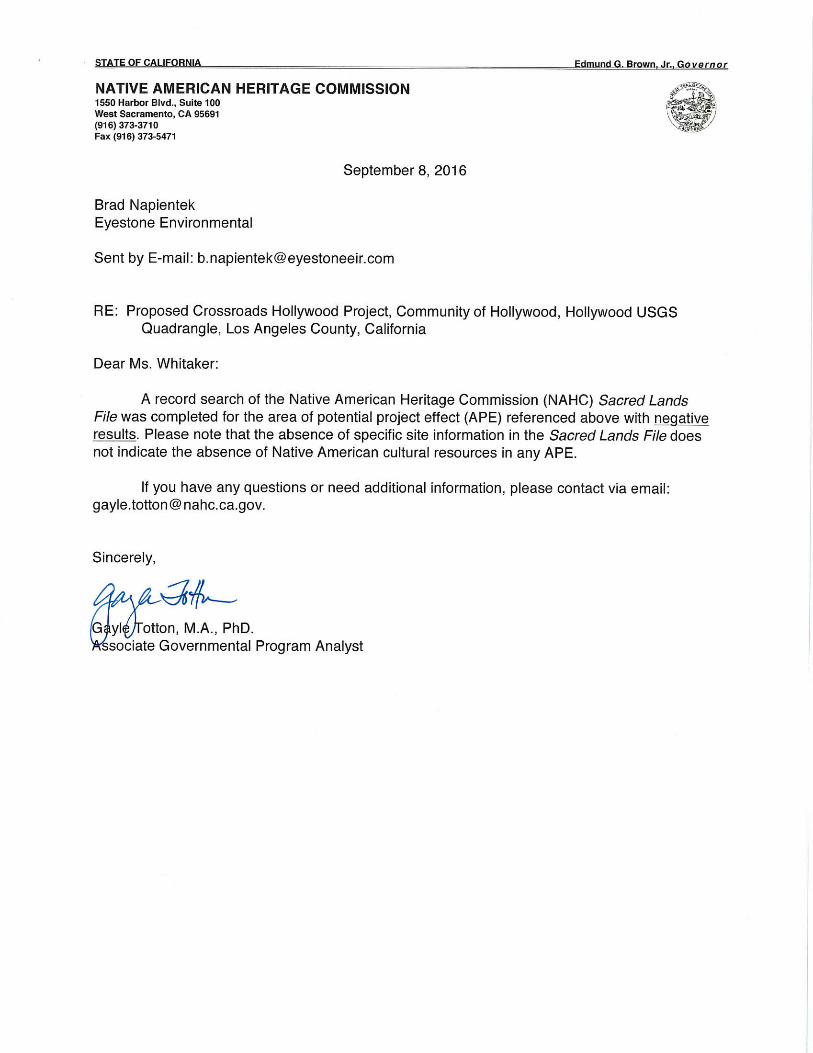
Appendix E.5 AB 52 Response Letters

November 20,2015
Attn: Alejandro Huerta, Planning Assistant City of Los Angeles Department of City Planning, Environmental Analysis Section 200 North Spring Street, Room 750 Los Angeles, CA 90012
RE: Crossroads Hollywood; Case No. ENV-2015-2026-EIR
RECEIVED f:ITY OF LOS ANGF.lF~
DEC 15 2015
ENV1RONMENTAL UNIT
EST. JUNE 19, 1883
The Soboba Band of Luisefio Indians appreciates your observance of Tribal Cultural Resources and their preservation in your project. The information provided to us on said project(s) has been assessed through our Cultural Resource Department, where it was concluded that although it is outside the existing reservation, the project area does fall within the bounds of our Tribal Traditional Use Areas. At this time the Soboba Band does not have any specific concerns regarding known cultural resources in the specified areas that the project encompasses, but does request that the appropriate consultation continue to take place between the tribes, project proponents, and government agencies.
Also, working in and around traditional use areas intensifies the possibility of encountering cultural resources during any future construction/excavation phases that may take place. For this reason the Soboba Band of Luisefio Indians requests that approved Native American Monitor(s) be present during any future ground disturbing proceedings, including surveys and archaeological testing, associated with this project. The Soboba Band wishes to defer to Gabrielefio Tribal Consultants, who are closer to the project area. Please feel free to contact me with any additional questions or concerns.
Sincerely,
Joseph Ontiveros Cultural Resource Director Soboba Band of Luisefio Indians P.O. Box 487 San Jacinto, CA 92581 Phone (951) 654-5544 ext. 4137 Cell (95 1) 663-5279 [email protected]
Confidentiality: The entirety of the contents of this letter shall remain confidential between Soboba and the City of Los Angeles. No part of the contents of this letter may be shared, copied, or utilized in any way with any other individual, entity, municipality, or tribe, whatsoever, without the expressed written permission of the Soboba Band of Luisefio Indians.

1019 Second Street, Suite 1 | San Fernando | California, 91340 | (818) 837-0794 | Fax (818) 837-0796
Rudy Ortega Jr.
Tribal President
Fernandeño Tataviam Band of Mission Indians
Tribal Historic & Cultural Preservation
Tribal Historic & Cultural
Preservation Committee
Steve Ortega
Chairman
Arturo Paredes Jr.
David Ortega
January 14, 2016
Alejandro Huerta Los Angeles Department of City Planning Plan Implementation Division 200 N. Spring Street, Room 750 Los Angeles, CA 90012 RE: Formal Request for Tribal Consultation Pursuant to the California Environmental Quality Act
(CEQA), Public Resources Code section 21080.3.1, subdivision (b), (d) and (e) for the Crossroads Hollywood Project; Case No. ENV-2015-2026-EIR
Dear Mr. Huerta,
This letter constitutes a formal request for tribal consultation under the provisions of the California Environmental Quality Act (CEQA) (Public Resources Code section 21080.3.1 subdivisions (b), (d) and (e)) for the mitigation of potential project impacts to tribal cultural resource for the Project.
Be advised that the Fernandeño Tataviam Band of Mission Indians (Tribe) must conduct an Initial Review of the project to conduct consultation. For the purpose of our Initial Review, the Tribe requests that the lead agency forward to our Tribal Historic and Cultural Preservation Department (THCP) (1) all permit applications and associated attachments for the Project, and (2) the site plans for the Project and all associated data, including the estimated cubic yards of soil to be removed from or shifted on Project site. The Fernandeño Tataviam Band of Mission Indians expects to begin consultation within 30 days, by receipt of the requested documentation from the lead agency. Please contact the Caitlin Gulley with any questions or comments.
Sincerely, Caitlin B. Gulley, Director Tribal Historic and Cultural Preservation Department [email protected]

1019 Second Street, Suite 1 | San Fernando | California, 91340 | (818) 837-0794 | Fax (818) 837-0796
Rudy Ortega Jr.
Tribal President
Fernandeño Tataviam Band of Mission Indians
Tribal Historic & Cultural Preservation
Tribal Historic & Cultural
Preservation Committee
Steve Ortega
Chairman
Arturo Paredes Jr.
David Ortega
January 25, 2016
Alejandro Huerta Los Angeles Department of City Planning Plan Implementation Division 200 N. Spring Street, Room 750 Los Angeles, CA 90012 RE: Tribal Consultation Pursuant to the California Environmental Quality Act (CEQA), Public
Resources Code section 21080.3.1, subdivision (b), (d) and (e) for Crossroads Hollywood Project; Case No. ENV-2015-2026-EIR
Dear Mr. Huerta,
This letter constitutes the conclusion of the Fernandeño Tataviam Band of Mission Indians (Tribe) Initial Review and the beginning of the Tribe’s assessment of the potential impacts to tribal and cultural resources for the Project. The Tribe requests that the lead agency please forward this letter and associated attachments to the applicant.
The applicant is advised that the Tribe must charge a fee for consultation in order to defray the Tribe’s costs associated with its participation in consultation activities. The attached Consultation Form contains information about the applicable fee.
Assessing the Project’s potential impact also requires a lengthy review of dense documentation and analysis of specialized tribal information, including but not limited to the following:
Tataviam Sacred Sites Tribal resources (such as botanicals or ritual sites) Gathering places Hunting zones Habitation sites Villages Burials Elders Council review
The lead agency is advised that the Tribe must receive a completed Consultation Form from the applicant or a designated agent to conduct consultation in a timely manner and provide mitigation recommendations for the Project. Please contact the Caitlin Gulley with any questions or comments.

1019 Second Street, Suite 1 | San Fernando | California, 91340 | (818) 837-0794 | Fax (818) 837-0796
Sincerely, Caitlin B. Gulley, Director Tribal Historic and Cultural Preservation Department [email protected]

1019 Second Street, Suite 1 | San Fernando | California, 91340 | (818) 837-0794 | Fax (818) 837-0796
Rudy Ortega Jr.
Tribal President
Fernandeño Tataviam Band of Mission Indians
Tribal Historic & Cultural Preservation
Tribal Historic & Cultural
Preservation Committee
Steve Ortega
Chairman
Arturo Paredes Jr.
David Ortega
June 9, 2016 Alejandro Huerta Los Angeles City Planning 200 N. Spring St. Los Angeles, CA 90012 RE: Tribal Consultation Pursuant to the California Environmental Quality Act (CEQA), Public
Resources Code section 21080.3.1, subdivision (b), (d) and (e) for Case No.: ENV-2015-2026-EIR (Crossroads Hollywood)
Dear Mr. Huerta, This letter constitutes the conditional conclusion of the Fernandeño Tataviam Band of Mission Indians (Tataviam) consultation on the above referenced project (Project). Due to the facts that the Project properties were developed prior to CEQA and that the properties are located within the sensitivity zone of 2 Tataviam villages and one spring, Tataviam recommends that the Project Environmental Impact Report (EIR) adopt the language below as mitigation measures. Provided that the following mitigation recommendations are adopted into the EIR, consultation is hereby concluded:
All ground disturbing activities performed on the Project properties shall be monitored by professional Native American monitors.
The applicant shall retain one professional Native American monitor per excavation team to monitor all ground disturbing activities performed on the Project properties.
The applicant shall enter into an agreement with the Fernandeño Tataviam Band of Mission Indians (Tataviam), as a condition of project approval by the lead agency, in which Tataviam shall be identified to provide the following professional services:
o Consultation and project support during the project planning stages related to cultural resources and mitigation under the California Environmental Quality Act (CEQA), Public Resources Code section 21080.3.1, subdivision (b), (d) and (e).
o Professional Native American monitoring procurement o Management of Native American monitoring activities and related project oversight
Sincerely, Caitlin B. Gulley, Director Tribal Historic and Cultural Preservation Department cgulley@tataviam-nsn.

1 Consultation Form 2015 Ver. 1
FOR STAFF USE ONLY:
Date Recv.:_______________________________________
File No.:__________________________________________
Project No.:_______________________________________
Zone:_____________________________________________
Plan Category:_____________________________________
Previous/Pending cases:____________________________
__________________________________________________
1. APPLICANTCOMPANY PROJECT MANAGER
ADDRESS TELEPHONE
CITY STATE ZIP EMAIL
2. AGENT if different from applicantCOMPANY PROJECT MANAGER
ADDRESS TELEPHONE
CITY STATE ZIP EMAIL
3. SUBJECT PROPERTYCOUNTY
ASSESSOR’S PARCEL NUMBER TOWNSHIP AND RANGE
PROPERTY ADDRESS
CITY STATE ZIP
CONSULTATION FORM PURSUANT TO THE CALIFORNIA ENVIRONMENTAL QUALITY ACT (CEQA)
PUBLIC RESOURCES CODE 21080.3.1, SUBDS. (B), (D), AND (E)
Fernandeño Tataviam Band of Mission IndiansTribal Historic and Cultural Preseveration Department

2 Consultation Form 2015 Ver. 1
4. CULTURAL PROJECT AND PROPERTY DATA
Has the area been previously developed? o Yes o No
Were tribal monitors used during any past or present construction/ground disturbance? o Yes o No(If yes, please include copies of the monitor records)
Has the site been previously surveyed for archaeological resources? o Yes o No(If yes, please include copies of previous archaeological surveys.)
Is the project in or near an area containing known archaeological resources or containing features (drainage course, spring, knoll, rock outcroppings, or oak trees) that indicate potential archaeological sensitivity? o Yes o No
Has a Sacred Lands File or other cultural resource records search been completed? o Yes o No
SOURCE OF RECORDSDid the search indicate the presence of cultural resources within the project site? o Yes o NoIf no known archaeological resources were specified within the site, within how many feet of the site, are resources known or believed to be present? ________________ ft.
5. CONSULTATION SERVICES AND FEESThrough initial review and consultation with the lead agency, the Project has been designated as a Category 4 Please see the table below for details on how the Categories are determined:
(1)$500 consultation fee for projects with an estimated 0.25 to 50 cubic yards of planned ground disturbance* and/or in areas of low sensitivity. The fee covers Services 1-3 listed below, plus mitigation recommendations, if found necessary
(2)$2,545 consultation fee for projects with an estimated 50.01 to 1,000 cubic yards of planned ground disturbance* and/or in areas of low to medium sensitivity. The fee covers Services 1-6 listed below.
(3)$3,750 consultation fee for projects with an estimated 1,000.01 to 10,000 cubic yards of planned ground disturbance* and/or in areas of medium to high sensitivity. The fee covers Services 1-8 listed below.
(4)$5,560 for projects with an estimated 10,000.01 or greater cubic yards of planned ground disturbance* and/or in areas of high to extreme sensitivity. The fee covers Services 1-12 listed below.
* “Ground Disturbance” is defined as: any man-made disturbance of the ground surface, which includes movements of soil, dirt, or rock. Ground disturbance includes, but is not limited to, grading, trenching, coring, boring, cutting, and sluffing.
SERVICES1. Retrieval and Review of Cultural and Archaeological Documents/Surveys/Reports from the lead agency 2. Tribal Record Search 3. Project Review 4. Cultural Resource Analysis Report 5. One of the following: Declaration of Need for Native American Monitoring, Declaration of Need for Limited Native American
Monitoring, Declaration of Need for Daily Tribal Inspections Only, or Declaration of No Native American Monitoring or Tribal Inspections Required
6. Fernandeño Tataviam Band of Mission Indians Ethnography-Excerpt (excerpt only and provided for inclusion in cultural reports produced for the project)
7. Tataviam Elders Council Review 8. Negative Declaration or Negative Mitigated Declaration, with mitigation recommendations included, if applicable 9. Tribal Historic and Cultural Preservation Committee Hearing (held on behalf of the project, which is found to require additional
consultation within the tribal government)10. Declaration of Archaeologist Needed Onsite or Declaration of Archaeologist Not Needed Onsite11. Fernandeño Tataviam Band of Mission Indians Ethnography (localized to the project area and provided for inclusion in cultural
reports produced for the project)12. Consultation Status Reports
o Enclosed is a check addressed to the Fernandeno Tataviam Band of Mission Indians for the amount of $5,560

3 Consultation Form 2015 Ver. 1
8. DOCUMENT DISTRIBUTIONThe Services provided (see Section 5) include the forwarding of documentation to the applicant or agent. If the designated recipient of documentation has already been listed above in Section 1 or 2, please be certain that the contact information is accurate and mark one of the following to recieve service documentation: o Applicant o Agent
If the designated recipient of documentation is different than the identified Applicant or Agent, please fill out the following:
NAME
ADDRESS EMAIL TELEPHONE
CITY STATE ZIP
Which form of document distribution should be used? (choose one) o Certified Mail o Email
7. APPLICANT OR AGENT CERTIFICATIONI hereby certify that: 1. The information provided in this application, including all attachments, are accurate and correct; and 2. I have carefully reviewed all items under Section 5 and 6 and included all applicable required information; and3. I understand that the submittal of inaccurate or incomplete information and plans may result in extension of the consultation period.
SIGNATURE DATE
6. APPLICANT CONSENTI have read, understand, and consent to the submission of this form to begin consultation with the Fernandeño Tataviam Band of Mission Indians. If an agent/consultant signs for the applicant, please submit a letter of authorization from the applicant with original signature(s):
SIGNATURE DATE
If the record owner is a company, corporation, or association, include a copy of Statement by Domestic Corporation. It is the responsibility of the owner to notify the Tribe of any changes in ownership during processing.

4 Consultation Form 2015 Ver. 1
San Gabriel
Tribal boundary depicted is based on registered tribal citizens’ ancestral villages. Due to kinship networks and social exchange, this hard boundary does not include all of the abundant locations associated with Tataviam cultural resources and ancestry. Therefore, the overlap yellow boundary accommodates the natural mobility of ancestral and contemporary Tataviam people, which are also known to be well associated with the tribe and sensitive cultural resources.
All projects breaking soil within the tribal boundary are subject to Tataviam jurisdiction, whereas any projects occurring within the yellow boundary may be subject to further analysis by other surrounding Tribal Governments.

Alejandro Huerta <[email protected]>
Re: Crossroads Hollywood Project 1 message
Kimia Fatehi <[email protected]> Wed, Mar 15, 2017 at 11:39 AMTo: Alejandro Huerta <[email protected]>
Dear Alejandro,
Thank you for your telephone call earlier. I would like to reinstate that I do not believe that the cultural sites I listed in myMarch 7 2017 e-mail will be impacted due to the proposed activity conducted under this Project. Therefore, the Tribe'spreviously proposed mitigation measures need not be implemented on this Project. I apologize for any confusion thismay have caused.
Thank you so much,Kimia
On Wed, Mar 15, 2017 at 9:31 AM, Kimia Fatehi <[email protected]> wrote: Hi Alejandro, I've just received your letter dated March 9 2017 in which you state that mutual agreement cannot be reached. I findthis wording confusing, as my last e-mail clarified that the project does not impact sites that I am aware of. Are we notagreeing that there is no archaeological evidence to implement the previously suggested mitigation measures? I wouldconsider this a mutual agreement. Please clarify at your earliest convenience. Thank you,Kimia On Thu, Mar 2, 2017 at 10:04 AM, Kimia Fatehi <[email protected]> wrote:
*Confidential* Good Morning Alejandro, Thank you again for forwarding me Caitlin's letter and following-up on this project via telephone. In reviewing our database, I notice that the Project is under 3.4 miles from LAN-1261H and LAN-0159 (La BreaWoman) . Although these sites are less than 5 miles from this project, the tribe does not necessarily believe thatthese two particular areas are related, necessarily. In addition, the spring that is referenced in our records is about12 miles west, so unless there is another spring within the immediate area that I am unaware of, I also do notbelieve that would impact the sensitivity of this project. I hope this helps clarify the letter. Please let me know if I can submit anything else. Sincerely,Kimia On Thu, Mar 2, 2017 at 8:40 AM, Alejandro Huerta <[email protected]> wrote:
Dear Kimia: Thank you for your response. To clarify, specifically if you have any substantial evidence or additional informationfor the record related to the content of the June 9, 2016 letter. Sincerely,

ALEJANDRO A. HUERTALos Angeles City PlanningMajor Projects213•978•1454 On Wed, Mar 1, 2017 at 6:14 PM, Kimia Fatehi <kfatehi@tataviamnsn.us> wrote: Dear Alejandro, Thank you so much for your message. I will review the attached letter from Caitlin and get you moreinformation as soon as possible. To be clear, are you requesting substantial evidence for the mitigationmeasures she submitted? Thank you for your understanding. Sincerely,Kimia On Wed, Mar 1, 2017 at 4:32 PM Alejandro Huerta <[email protected]> wrote: Dear Kimia: Thank you for taking the time to talk briefly over the phone today. I understand that you are busy and, at yoursuggestion, I'm emailing you my question. I'm following up on the Crossroads Hollywood Project. I waswondering if you had any other information to provide regarding Tataviam's letter to the City dated June 9,2016, attached for your reference. Please let me know if you have any questions. Sincerely,ALEJANDRO A. HUERTA Los Angeles City PlanningMajor Projects213•978•1454
Kimia Fatehi Director, Public Relations Fernandeño Tataviam Band of Mission Indians 1019 Second St., San Fernando, CA 91340 Mobile: (949)2352838
Kimia FatehiDirector, Public RelationsOfficer, Tribal Historic and Cultural PreservationFernandeño Tataviam Band of Mission Indians1019 Second Street, Suite 1San Fernando, California 91340 Mobile: (949) 2352838Office: (818) 8370794Website: http://www.tataviamnsn.us
Kimia FatehiDirector, Public RelationsOfficer, Tribal Historic and Cultural PreservationFernandeño Tataviam Band of Mission Indians1019 Second Street, Suite 1San Fernando, California 91340

Mobile: (949) 2352838Office: (818) 8370794Website: http://www.tataviamnsn.us
Kimia FatehiDirector, Public RelationsOfficer, Tribal Historic and Cultural PreservationFernandeño Tataviam Band of Mission Indians1019 Second Street, Suite 1San Fernando, California 91340 Mobile: (949) 2352838Office: (818) 8370794Website: http://www.tataviamnsn.us

Alejandro Huerta <[email protected]>
Crossroads Hollywood Project 1 message
Kimia Fatehi <kfatehi@tataviamnsn.us> Wed, Mar 29, 2017 at 11:35 AMTo: Alejandro Huerta <[email protected]>
Good Morning Alejandro,
Thank you again for followingup on this project via telephone. I would like to conclude consultation on this projectthat was initiated by Ms. Gulley, as I did not locate cultural resources in the immediate (1 mile) range that would bepotentially impacted as result of the project plans.
Sincerely,Kimia
Kimia FatehiDirector, Public RelationsOfficer, Tribal Historic and Cultural PreservationFernandeño Tataviam Band of Mission Indians1019 Second Street, Suite 1San Fernando, California 91340 Mobile: (949) 2352838Office: (818) 8370794Website: http://www.tataviamnsn.us

Ethnographic Overview of the Angeles National Forest Tataviam and San Gabriel Mountain Serrano Ethnohistory

Ethnographic Overview of the Angeles National Forest Tataviam and San Gabriel Mountain Serrano Ethnohistory
Prepared for U.S. Department of Agriculture
Southern California Province Angeles National Forest
Arcadia, CA 91006
By Northwest Economic Associates 12009 N.E. 99th Street, Suite 1410
Vancouver, WA 98682-2497 and
Chester King Topanga Anthropological Consultants
P.O. Box 826 Topanga, CA 90290
February 6, 2004

Northwest Economic Associates i
Table of Contents
Preface 1 Background ............................................................................................................................................ 1 Organization of the Report ..................................................................................................................... 3
Chapter 1 - Introduction 5 Sources ................................................................................................................................................... 7
Chapter 2 - Analysis of Mission Registers 11
Chapter 3 - Pre-Mission Ethnic Affiliation of Settlements in the Vicinity of San Gabriel and San Fernando Missions 15
Recruitment at San Gabriel .................................................................................................................. 20 Population............................................................................................................................................. 33
Chapter 4 - The Tongva/Gabrielino Tribe 39
Chapter 5 - Names and Titles 41 kika Quiqua........................................................................................................................................... 42 paha, Paga, Paja ................................................................................................................................... 44 tcaka, Caca, Eacuc................................................................................................................................ 44 Chari ..................................................................................................................................................... 46 Nu ......................................................................................................................................................... 47 Tamet.................................................................................................................................................... 49 Veat - Wiyot ......................................................................................................................................... 50 Tomear.................................................................................................................................................. 50 Antapa .................................................................................................................................................. 51 Caroni ................................................................................................................................................... 51 Tapi....................................................................................................................................................... 53 Taoc ...................................................................................................................................................... 54 Toco...................................................................................................................................................... 54 Manisar................................................................................................................................................. 54 Tamy and Cupa or Cupe....................................................................................................................... 54
Chapter 6 - San Gabriel Mountains and Antelope Valley - Serrano Settlements 56 Amuscopiabit........................................................................................................................................ 57 Tusicabit ............................................................................................................................................... 58
Ties................................................................................................................................................. 59 Toibipet ................................................................................................................................................ 61 Guinibit................................................................................................................................................. 63 Asùcsabit .............................................................................................................................................. 63
Ties to Small Settlements and Places............................................................................................. 64 Ties to Other Settlements............................................................................................................... 65

Northwest Economic Associates ii
Jaibepet................................................................................................................................................. 67 Ties to Small Settlements and Places............................................................................................. 67 Ties to Other Settlements............................................................................................................... 68
Acurabit ................................................................................................................................................ 68 Topisabit............................................................................................................................................... 70 Mujubit muhú’nga............................................................................................................................... 71 Vijabit wiqánga ................................................................................................................................... 72 Tujubit .................................................................................................................................................. 72 Japchibit (Japchina) .............................................................................................................................. 74
Ties to Small Settlements and Places............................................................................................. 75 Ties to Other Settlements............................................................................................................... 77
Tomijaibit ............................................................................................................................................. 80 Punibit .................................................................................................................................................. 81 Quissaubit ............................................................................................................................................. 82 Jotatbit .................................................................................................................................................. 82 Tameobit............................................................................................................................................... 82 Najayabit .............................................................................................................................................. 84 Najaba................................................................................................................................................... 86 Atongaybit ............................................................................................................................................ 86 Guapiabit .............................................................................................................................................. 86 Cayyubit ............................................................................................................................................... 87 Topipabit .............................................................................................................................................. 89 Giribit ................................................................................................................................................... 90 Tochaburabit = Tobanjbepet ................................................................................................................ 90 Chibubit, Chibuna ................................................................................................................................ 92 Tucsibit, Tuusinga ................................................................................................................................ 93
Chapter 7 - Gabrielino and Fernandeño Settlements Located Immediately South of Serrano Settlements 95
Pomoquin and Yomquin....................................................................................................................... 95 Uchubit ................................................................................................................................................. 96 Ajuibit................................................................................................................................................... 96 Sibapet .................................................................................................................................................. 98 Juyubit (Cuyubit).................................................................................................................................. 99 Tobpet................................................................................................................................................... 99 Yabit ................................................................................................................................................... 101 Jajamobit ............................................................................................................................................ 105 Cabuepet............................................................................................................................................. 106 Siuccabit ............................................................................................................................................. 108
Chapter 8 - Tataviam Settlements 110 Momonga (momónga, Caluschocho) ................................................................................................. 110

Northwest Economic Associates iii
Chechebe (sesébenga) ........................................................................................................................ 112 Passenga (pasiknga) ........................................................................................................................... 112 Pacoinga ............................................................................................................................................. 114 Achoicominga .................................................................................................................................... 114 Tochonanga ........................................................................................................................................ 116 Tobimobit ........................................................................................................................................... 119 Chaguayanga (tsawayung, takuyama’m)............................................................................................ 119 Mapipibit ............................................................................................................................................ 121 Coyobit - Camulus.............................................................................................................................. 121 Piru pi’irukung ................................................................................................................................... 123 Pinga (Piibit)....................................................................................................................................... 127 Pujaubit (Pajauvinga) ......................................................................................................................... 128 Moomga.............................................................................................................................................. 128 Cacuycuyjabit..................................................................................................................................... 128 Ajuavit ................................................................................................................................................ 129 Juubit .................................................................................................................................................. 129 Najabatabit.......................................................................................................................................... 130 Pabutan (Pauvit) ................................................................................................................................. 130 Payuchina ........................................................................................................................................... 131 Tebacbena........................................................................................................................................... 131 Cuinamona.......................................................................................................................................... 131 Siutasegena......................................................................................................................................... 132 Cuecchao [kwitsa’o]........................................................................................................................... 132
Chapter 9 - Ties between Settlements and Differences between Settlements 135 Japchibit and Tomijaibit ..................................................................................................................... 137 Archaeological Sites - Residential, Gathering, and Hunting Areas in the Angeles Forest................. 138 Other Significant Places ..................................................................................................................... 139
Chapter 10 - Outreach to Native American Communities 141 Introduction and Approach................................................................................................................. 141
Objectives .................................................................................................................................... 141 Approach...................................................................................................................................... 142
Cultural Importance of Forest Land ................................................................................................... 143 Family Stories and Cultural Heritage........................................................................................... 143 Religious Connections ................................................................................................................. 143 Traditional Lifestyle .................................................................................................................... 144
Tribal Uses of Forestland ................................................................................................................... 144 Traditional Plant Gathering and Identification ............................................................................ 144 Animal Life and Hunting ............................................................................................................. 146 Haramokngna American Indian Cultural Center ......................................................................... 146 Learning and Teaching ................................................................................................................ 147

Northwest Economic Associates iv
Recreation .................................................................................................................................... 147 Values and Beliefs about Forest Land Management .......................................................................... 147
Respect for Natural Balance ........................................................................................................ 147 Conservation Not Exploitation .................................................................................................... 148 Fire Control.................................................................................................................................. 148
Places of Importance to Modern Day Native Americans ................................................................... 148 Social and Economic Implications of Forest Management ................................................................ 149
Building Respect for Tribes ......................................................................................................... 149 Improving Relationships.............................................................................................................. 149 Tourism, Ecotourism, and Recreation.......................................................................................... 150
Practical Recommendations ............................................................................................................... 150 Shared Problems, Shared Solutions ............................................................................................. 150 Information and Communication ................................................................................................. 151 Native American Archeologists and Rangers .............................................................................. 151
Summary ............................................................................................................................................ 151 Native American Uses of the Forest ............................................................................................ 151 Social and Economic Implications of Forest Management.......................................................... 152 Issues and Areas of Concern........................................................................................................ 152
Bibliography 153
Appendix A: Native American Outreach Materials and Contact List
Index

Northwest Economic Associates v
List of Figures
Figure 1 Angeles National Forest Boundary................................................................................................. 4
Figure 2 Map of Settlements Recruited at San Fernando and San Gabriel Missions in Relation to the Angeles National Forest ..................................................................................................................... 21
Figure 3 Ages of 69 of the First 73 Baptisms (four not plotted are described as children [2] and small children [2])........................................................................................................................................ 25
Figure 4 Recruitment from Ajuibit ............................................................................................................. 26
Figure 5 Recruitment from Sibapet............................................................................................................. 26
Figure 6 Extent of Recruitment at San Gabriel at End of 1776 .................................................................. 27
Figure 7 San Gabriel Recruitment at End of 1785...................................................................................... 29
Figure 8 San Gabriel Recruitment at the End of 1794 ................................................................................ 32
Figure 9 Recruitment of Eastern Gabrielino at San Gabriel Mission ......................................................... 35
Figure 10 Recruitment of Western Gabrielino at San Gabriel Mission ...................................................... 36
Figure 11 Recruitment at San Gabriel Mission from Close Serrano Settlements ....................................... 37
Figure 12 Recruitment at San Gabriel Mission from Mojave Desert Serrano Settlements......................... 38
Figure 13 Map of Kinship Ties between Settlements Recruited from San Gabriel and San Fernando Missions ............................................................................................................................................. 58
List of Tables
Table 1 Number of Recruits from Selected Western Gabrielino Settlements.......................................... 104
Table 2 Village Sites in and Adjacent to the Angeles National Forest ..................................................... 140
Table 3 Some Plants Frequently Gathered in the Forests ......................................................................... 145

Northwest Economic Associates 1
Preface
The purpose of this ethnographic overview is to describe the cultures of the people who inhabited and used the Angeles National Forest (ANF) in the past, and to document some of the uses, places of importance, issues, and concerns identified by current Native American descendents of these historical tribal groups. These data will be useful in updating the Forest Land Management Plans, protecting culturally sensitive areas, and ensuring that tribes have the opportunity to participate in the planning process. The study provides ethnohistoric information not previously available.
Background
This report is being prepared for the Forest Service by a team led by Northwest Economic Associates (NEA) under contract number 53-91U4-2-1B104. The contract came about after NEA responded to a Forest Service request for proposals to produce ethnographic overviews for three forests in Southern California, and the Santa Rosa and San Jacinto Mountains National Monument. This will be the first such document to assess the state of the ethnographic information available for the Angeles National Forest. This information will be useful for planning purposes, and for the ongoing maintenance and operation of the forest.
The report in part determines what places within the Angeles Forest have ethnographic and ethnohistorical significance, in order that the Forest Service be able to comply with the provisions of American Indian Religious Freedom Act (42 USC 1996, P.L. 95-341), and National Forest Management Act (16 USC 16000 et seq.). Insofar as possible this report attempts to determine what groups traditionally used the various parts of the forest; and to determine the attitudes of present-day Native Americans toward possible impacts on the cultural resources of the forest.
Working with NEA, Dr. Chester King developed the primary ethnographic and ethnohistorical information. Dr. King has completed many dozens of studies for the area

Northwest Economic Associates 2
including the Angeles National Forest. He has conducted ethnohistoric studies of many Indian peoples in Central and Southern California, including the Malibu area, and served as City Archaeologist for the City of Malibu. He is the Principal Investigator for cultural resources for the Santa Monica Mountains National Recreation Area and he previously completed an archaeological inventory of the area. Dr. King has analyzed Indian beads recovered from excavations at sites throughout the study area. He has prepared or reviewed the archaeological elements of various EIS and EIR documents and has published extensively in refereed journals and books.
NEA staff members coordinated the effort to contact representatives from Native American communities for input about forest management practices so that this information might be used in current efforts to update Forest Land Management Plan for the ANF. The native people associated with the ANF are located in different places throughout southern California, and none of these groups of people actually continue to live in, or directly near the forest service land. However, modern day Native Americans continue to maintain a cultural affiliation with much of the land, despite the loss of a clear and direct identification with particular locations within the forest. This document, especially Dr. King’s work, is an effort to establish what is known about settlements prior to the establishment of the Spanish Missions, and may assist these groups of people in their efforts to reestablish ties to the land of their ancestors.
NEA staff worked with Geographic Information Systems (GIS) data provided by the Forest Service to assist in the analysis conducted by Dr. King. Because the ethnographic information is not available in sufficient level of detail to be considered sensitive, the ethnographic maps are contained within this document and not presented as a separate GIS coverage or exhibit.
Throughout the process of developing this report, several questions were asked frequently and merited a point of clarification. These questions and clarifications are shown below:
How does the Ethnographic Overview differ from the Forest Archeology?
• Archeology is the study of the material remains of past human life.
• Ethnographers use archeological evidence; as well as other types of evidence to say something about the way people lived.
• Some of the archeological documentation for the forests will also be of ethnographic significance; but cultural places of importance may also have ethnographic significance without having any physical artifacts.

Northwest Economic Associates 3
How does the Ethnographic Overview fit into the Forest Plan Revision?
• Both documents should include information and opinions from Native American communities about issues and concerns regarding forest management.
• Because both documents are being prepared at roughly the same time, information gathered for one purpose may be useful in the other.
How does the Ethnographic Overview differ from the Forest Plan Revision?
• The Ethnographic Overview is a USFS document specifically about past and present Indian uses of the forest.
• The Forest Plan Revision is a process to update the management plan that allows for multiple uses of the forests. The USFS seeks input from all forest user groups including, but not limited to, tribes.
Organization of the Report
The primary contribution to this report is the analysis of the ethnography of settlements based on mission register analysis by Dr. King. This material makes up the first nine chapters of the report. Following these, Chapter Ten outlines the efforts to contact modern day descendents of the Native American groups associated with the forests, and reports the findings of this effort. A map of the general vicinity of the ANF is provided on the following page.

Northwest Economic Associates 4
Figure 1 Angeles National Forest Boundary

Northwest Economic Associates 5
Chapter 1 - Introduction
People who lived in and adjacent to the Angeles National Forest were recruited into Spanish missions between 1770 and 1816. Ethnographers and other historically minded scholars have interviewed descendants of these people. The ethnographers recorded oral tradition and information concerning material, culture, language, and place names. The Spanish mission registers were analyzed in this study to determine the distribution of historic settlements and the kinship ties between settlements.
The body of this study consists of information concerning locations of settlements and the kinship ties between these settlements. The populations and locations of the settlements can sometimes be determined from information in diaries or letters, but most settlements are not described in diaries. The locations of many settlements are described in ethnographic notes or historic sources such as land grant diseños. Information about people recruited at missions includes cases where settlements are consistently located by ethnographic and historic data at a place and where archaeological remains indicate occupation during the period of recruitment at missions. In other cases, however, the only information that indicates the location of a settlement is the time of recruitment, proportion of people recruited at different missions, kin ties to other settlements, and the locations of archaeological sites occupied during the period of mission recruitment. Unfortunately, the latter situation is the case [with a few other historic clues] for all settlements that were located within the Angeles National Forest, the Santa Clara River drainage east of Santa Clarita, and the southern half of the Antelope Valley. Historic and ethnographic information allows identification of the locations of most of the settlements south of the San Gabriel Mountains, settlements near the Mojave River, and the larger Tataviam settlements in the Santa Clarita–Piru area.
Marriage and other kinship ties between settlements reflect native social organization. In areas occupied by Takic people, there are often strong ties between two settlements, but there is often an absence of ties between neighboring settlements. Takic groups differ from Chumash settlements which often have marriage ties to all close villages. Serrano desert settlements were more dispersed and moiety outmarriage excluded marriage partners from many settlements, thereby increasing the average distance of marriage ties. Japchibit and

Northwest Economic Associates 6
Tomijaibit have many ties to chiefly families and many ties to different settlements. There is also evidence for neolocal and matrilocal residence at Japchibit. Japchibit was not a typical Serrano settlement and may have been the political center of Serrano society.
Johnson and Earle have described Tataviam settlements (1990). Johnson has also analyzed the San Fernando Mission records and has created a computerized data file. Earle recently prepared a document concerning Tataviam places in the Angeles Forest (2002). There is no similar analysis of San Gabriel Mountains area settlements. Research conducted to prepare this report and a report concerning the most likely descendants of the Chilao Flat area in the San Gabriel Mountains has concentrated on the analysis of the San Gabriel registers. Steven Hackel has entered data from San Gabriel registers into a database for the Huntington Library and has used the data to assist with the identification of individuals for this report.
The organization and analysis of mission registers is discussed. Groups recruited at San Gabriel Mission and San Fernando Mission are described. This information is relevant to distinguishing different ethnic groups at the mission. It is also important because it provides background on the system of Spanish colonization and the removal of Indians from their lands.
The numbers of baptisms from individual settlements allows comparison of the sizes of settlements in small areas. It does not allow comparison of settlements over larger areas because the histories of recruitment, epidemic, and endemic disease all differ. Mathematical analysis of register data is necessary to discover the pre-conquest populations of large areas of California.
The names of people are often titles and study of these names reveals information concerning pre-conquest political organization. A study of the names in the registers indicates that there were many important hereditary positions in Serrano, Tataviam, and Gabrielino societies.
Ethnohistoric research has determined that boundaries indicated by Kroeber (1925), Heizer (1966), and The Handbook of North American Indians (Heizer 1978) are incorrect for many California groups. In this paper, boundaries are established on the basis of kin ties between settlements documented in mission registers, and historic and ethnographic information concerning boundaries between groups. The most important new development is the movement of the boundary between the Serrano and Gabrielino from the crest of the San Gabriel Mountains to valley floors south of the mountains. There has been a similar movement of the boundaries between the Costanoan and Salinan and the Yokuts from the crest of the mountains on the west side of the San Joaquin Valley east to the edge of the valley floor. An assumption that mountains divided groups was often wrong. It appears that groups often lived at settlements that encircled mountains. In the San Bernardino Mountain area, ethnographic data documented the presence of Serrano settlements on both the north and south sides of the San Bernardino Mountains. There is no similar ethnographic data for

Northwest Economic Associates 7
the San Gabriel Mountains. This paper provides comparable ethnohistoric data for the San Gabriel Mountains.
Most of the permanent settlements sites associated with the San Gabriel Mountains were located outside of the Angeles Forest. It appears that Japchibit, Quissaubit (or perhaps another settlement), and several small settlements associated with Japchibit were located within the forest boundary. In the Tataviam area, the large settlement of Piru was located close to Forest Service lands and several small settlements were probably located on Forest Service lands. No native settlement names can be identified with particular places in the Angeles Forest using only historic data. Most of the archaeological sites that have been identified on Forest Service lands are the remains of camps, yucca ovens, and small settlements.
Other places that are important include the locations of rock paintings and petroglyphs including cupule and grooved rocks, rocks near Tujunga mentioned in traditions as people and animals that were turned to stone, and other rocks, mountain peaks, and caves including Bowers’ Cave. Stone and mineral sources used for artifacts include talc and chlorite schist from Sierra Pelona used for beads, ornaments, pipes, and vessels. Schists may also have been obtained from sources in the San Gabriel Mountains.
This report was produced under contract with Northwest Economic Associates. In addition to information produced under contract with Northwest Economic Associates, the detailed information concerning Japchibit and close neighbors of Japchibit was produced under contract with the Angeles Forest to assist in the identification of people who are the closest related to the people who were buried at Chilao Flat. Steve Hackel, Steve O’Neil, and John Johnson have assisted with the analysis of mission registers and historic documents. Father Biasiol Virgilio and Cress and Dale Olmstead assisted with work at the Santa Barbara Mission Archive Library.
Sources
Information concerning Native American places in the vicinity of the Angeles National Forest is derived from many sources. Mission registers and correspondence during the mission period often included native place names. In Southern California, the baptismal records of recruits to the Spanish missions usually listed native names of settlements. The names and locations of Indian settlements have also been recorded in land title documents, on maps, and as the names of historic settlements or places.
Two educated men who resided in California and were interested in the traditions of California Indians began recording native place names during the middle of the nineteenth century. In 1852, Hugo Reid, who was married to a Western Gabrielino woman from San

Northwest Economic Associates 8
Gabriel mission, had a series of letters concerning the Indians of the Los Angeles Basin published in the Los Angeles Star. In these letters, he listed the names of many Los Angeles Basin settlements and their modern equivalents (Reid 1968). In 1863, Alexander Taylor included information on place names in a series of articles in the California Farmer entitled “The Indianology of California” (1860-63). Both Taylor and Reid used archives as well as information from interviews with native people to prepare their descriptions of native Californian societies.
Alfred Kroeber, who began work at the University of California at Berkeley in 1901, collected information concerning southern California place names. In 1907, he published “Shoshonean Dialects of California.” This article presented information collected by Reid and additional information collected by Kroeber concerning Gabrielino place names. In a supplemental report, Kroeber included additional information (1909). Kroeber summarized information on place names in a paper (1916) and in his Handbook of California Indians (1925).
In 1912, John P. Harrington began collecting information concerning the native languages of southern California for the Bureau of American Ethnography. He used mission registers and records of place names to compile lists of names that he then used while interviewing native consultants. He took trips with consultants for the purpose of obtaining place name information. Harrington’s skillful use of ethnographic techniques allowed him to collect more information than anyone else on native place names. It is necessary to assess the information gathered by Harrington in terms of the context of his questions and consistency of information given by particular consultants. Sometimes Harrington collected native translations of Spanish place names or attempted to obtain pronunciations of names given in historic records. Harrington attempted to record as much information as possible. Validation of the information requires the determination of consistency with information provided by other consultants and historic documents. Harrington made summary lists of the place name information that is scattered throughout his notes. The lists were made for different regions and are organized alphabetically for each region. These lists were relied on for this study and there is information concerning places in Harrington’s notes that is not included. The consultants who provided place name information used in this study included Chumash, Gabrielino/Tongva, and Serrano/Kitanemuk speakers (Harrington n.d.).
Septimo Lopez of Fernandeño descent provided Harrington with information concerning San Fernando Valley place names. José Maria Zalvidea (Z), a Tongva of mixed island and mainland descent, José de los Santos Juncos of Juaneño (Kuhn) ancestry, but reared at San Gabriel (Hudson 1979: 356), and Felicitas Serrano Montaña (F), of mixed island and mainland descent, were Harrington’s San Gabriel area consultants (Hudson and Blackburn 1982:32-33, Harrington 1942:5). Manuel Santos was a Harrington Serrano consultant who provided information on place names. Place names north and east of the San Gabriel Mountains collected by Harrington from Manuel Santos are included in a compilation by Bean, Vane, Lerch and Young (1981: Appendix). Copies of Kitanemuk notes made by Tom

Northwest Economic Associates 9
Blackburn were also consulted. These notes are not referenced according to the microfilm reels produced by the Smithsonian. Harrington consultants that contributed information concerning the California desert north of the San Gabriel Mountains included Eugenia Mendez, Magdalena Olivas, and José Juan Olivas from Tejon, and Manuel Santos from San Manuel Reservation.
Stella Clemence worked for C. Hart Merriam and collected the names of California Indian settlements from registers kept at California missions. Her lists of names and baptism dates from San Fernando and San Gabriel missions provide information concerning the number of people recruited and dates of recruitment from native settlements. The lists are not entirely accurate and in several cases group different settlements with similar names together. The lists were published under the direction of Robert Heizer (Merriam 1968).
Thomas Workman Temple III abstracted information from the registers of California missions for genealogical research. He made useful abstracts of the registers of San Fernando Mission (Temple n.d.).
Bernice Johnston’s book, California’s Gabrielino Indians, contains place name information that was obtained by J.P. Harrington (1962). Unfortunately only some of Harrington’s place name notes were used and mission registers were not used as a source. The book contains errors concerning the locations of some places. Bill McCawley published a book on the Gabrielino (1996). The book contains information from Harrington’s Gabrielino notes and historic sources.
In 1979, Richard Applegate published a list of Chumash place names that includes linguistic transcriptions and translations of most known Chumash place names (1979). The list includes several Tataviam settlements.
In 1981, Jeanne Munoz directed the production of a listing of the baptismal entries of San Gabriel Mission for the years 1771 to 1820. The lists include baptismal number, month and year of baptism, sex, and age of the person being baptized, village affiliation, and other information, including frequent correlation with the death registers. The coding of village names is not entirely accurate. This list is useful for identifying the baptisms from particular villages and was used in this study to abstract information from the registers of San Gabriel Mission. The information for many San Bernardino Mountain and Mojave Desert settlements includes most native marriages.
Bob Edberg has conducted research concerning ethnohistory and place names in both Chumash and Gabrielino areas of the Santa Monica Mountains and San Fernando Valley (1982, n.d.).
John Johnson has conducted ethnohistoric research concerning San Clemente and Santa Catalina Islands. He demonstrated many marriage ties between the islands and the mainland

Northwest Economic Associates 10
village of Guashna in the vicinity of the Ballona wetlands (1988). He has also compiled a summary spreadsheet of the San Fernando Mission registers and he and Sally McLendon prepared a study for the National Park Service concerning descendants from Chumash settlements in the Santa Monica Mountains and on the Channel Islands. The Appendices in Volume 2 contain information relevant to Tataviam ethnohistory (McLendon and Johnson 1999). Johnson has also written papers that provide information concerning the Tataviam (Johnson 1978, 1997a and b, 2000, and Johnson and Earle 1990).
Dr. King has synthesized information from J.P. Harrington notes, ethnohistoric information concerning settlement locations, and archaeological data concerning the distribution of protohistoric settlements. He has prepared a paper concerning native place names in the Santa Monica Mountains (1992). He prepared studies of places in the vicinity of a Pacific Pipeline project that included the Los Angeles River drainage (1993 a and b).
Northwest Economic Associates 11
Chapter 2 - Analysis of Mission Registers
In the course of this study, information has been gathered concerning settlements around and within the San Gabriel Mountains and the Tataviam of the middle Santa Clara River drainage. This has involved the collection of information from baptismal, confirmation, marriage, and burial registers and the 1824 padron of San Gabriel Mission. John Johnson has compiled information from the San Fernando registers into a database that includes baptism, marriage, and death registers. The database was supplemented with information concerning kin ties listed in the register, such as relative, cousin, and uncle, from the Temple copies. Information discovered concerning ties between villages is presented in this paper. Information gathered includes marriage ties, other kinship ties, and shifts in village designation between different registers at San Gabriel Mission. The shifts in designations are usually regular and reflect interaction between settlements that are usually adjacent. John Johnson has discussed problems of working with the San Gabriel registers (1988: 11-13). One of the most serious problems is the absence of pages in the baptism and marriage registers. Many missing entries have been reconstructed by using the padron, death, confirmation, and marriage registers.
Abbreviations that are used to refer to register entries are:
F= San Fernando Mission G= San Gabriel Mission V= San Buenaventura Mission J= San Juan Capistrano Mission b= baptism number c= confirmation number m= marriage number d= burial number p= year padron first prepared
When people were baptized, information was entered concerning their sex and age, their settlement of origin (birth and/or residence), the identity of their parents (especially if mission born), and often relationships with previously baptized people. Before 1800, margin entries of mission born children indicated the settlement of origin of the father or if the father was dead, the settlement of the mother. After 1800 (the change did not occur abruptly), mission

Northwest Economic Associates 12
born children were designated “of the mission.” If people were baptized before November 1794 and they lived to be present during the times when people were confirmed, information concerning them was entered into the record of confirmations. The confirmation records often include information concerning the identity of parents and other relationships not included in the baptismal entry. The confirmations also present relatively standardized spellings and designations for settlements that can be cross-referenced to the baptismal record. If people were married before baptism, their marriages were renewed at the time the last spouse was baptized. (If one spouse is baptized in danger of death but survives and the other spouse is baptized later, the marriage will be renewed after the later baptism.) The renewal is usually recorded in the marriage entry. If the marriage occurs after the people have been baptized, the previous status as singles or widows is stated, and parents are often listed. The marriage register entries usually include information concerning settlement affiliation. Deaths were recorded in a death register. This register usually included information concerning settlement affiliation and ties to a spouse or parents. The baptism, confirmation, marriage, and death registers all include dates of entry.
The surviving 1824 padron was used from January 1, 1824, to the end of 1835. The entries that are not lined out may be a census of the people under the jurisdiction of San Gabriel Mission at the beginning of 1836. The padron was organized with columns that include name, village of origin, age at baptism, date of baptism, and baptism number. The padron begins by listing married couples alphabetically by the husband’s name. The unmarried children are listed below the entry for their parents. The next section of the padron is widowers with children who are listed below their father’s name. The next section is widowers without children, then widows with children followed by widows without children. The last section lists unmarried people without baptized living parents. When the padron was created in 1824 by copying from a previously used padron, the entries of children without parents were neatly made and sometimes placed in order of sequence of baptism. When people died, their entry in the padron was lined out. If they had a surviving spouse, that person’s entry was lined out and moved to the appropriate widow or widower sections. If a woman with a child is widowed, her entry along with her child’s entry is moved to the widows with children section. The child is then designated as having the village of origin of the mother instead of the dead father as it would have been if the father had not died. This change is reflected in entries in the confirmation register and baptism register. If people married, they were moved into the section of married couples. As spouses died and people remarried, or single children of deceased parents married, their entries were moved around the register. Whenever an entry was made in the baptism, marriage, or death register, entries were made in the padron. This rapidly resulted in many lined out entries. After the mission was secularized, there was no longer a need to maintain counts of neophytes or prepare reports concerning the status of the mission and padrons were no longer maintained.

Northwest Economic Associates 13
Strong observed of Serrano clans:
This clan included, therefore, all the males and descendants of males in the group and the wives of these males as well. … A Serrano woman also retained her own lineage name, but on her marriage was incorporated into the clan of her husband. This transfer of women, from ceremonial affiliation with one clan to another on marriage, seems to have been characteristic of all the southern California [Takic] groups [Strong 1972: 15].
The San Gabriel registers often followed native practice and identified wives as of their husband’s clan. This occurred after previously unmarried women were married at the mission as well as when native marriages were renewed. Many of the confirmation entries of married women give the name of the husband’s clan. The practice of designating wives by their husband’s clan names has often obscured information concerning marriage ties between settlements. Often the information has been lost. The death entries and marriage entries of widowed people sometimes give a clue as to the natal clan of married women. The natal clans of women are more often recorded for married women baptized after 1806 than for early baptisms. The registers refer to most married women from Sibapet, Ajuibit, and other clans recruited early at San Gabriel, according to their husband’s clan. It has been most difficult to identify marriage or other kin ties between the clans recruited earliest at San Gabriel Mission.
The registers can be used to build mini life histories for everyone baptized at San Gabriel Mission (except for entries on missing pages that can not be reconstructed using other register entries). Dates of birth, death, marriage, and settlement affiliation, marriage affiliation, and other kinship information are given in the registers. The registers usually include the native names of people baptized after 1810 and occasionally include native names of people baptized before 1810. [It appears that the names of leaders were most apt to be recorded.]
The Jeanie Munoz index of the registers was used to list the baptismal numbers and dates of death of recruits from the villages located in the vicinity of the Angeles National Forest. The baptism register was then used to add the names and relationships of the people. It was also used to correct errors of settlement designation that are present in the Munoz index. After collecting information from the baptism register, information including confirmation number was added from the register of confirmations. Marriage entries were added both during and after gathering the information from the baptism register. Death register entries were also consulted to obtain information including parent names or other relationships and changes in settlement designation. They were also used to add information from missing pages in the baptism register. The 1824 padron was then read through to locate additional information concerning the settlements and to determine which people were alive in 1824. This data was then added to the information previously gathered. The focus of the research was the discovery of relationships between settlements before recruitment into the mission.

Northwest Economic Associates 14
To extract as much information as possible concerning ties between clans baptized earliest at San Gabriel Mission, Dr. King correlated all of the entries in the confirmation register in November 1778 with the baptism and marriage registers. The deaths prior to November 1778 were also correlated with the baptism register. Except for two men confirmed at the beginning of the next group of confirmations, the death and confirmation registers account for all native people baptized before November 1778 (baptism number 438). The identification of parents of children from the confirmation, death, and marriage register resulted in the identification of most kin ties recorded by the missionaries.

Northwest Economic Associates 15
Chapter 3 - Pre-Mission Ethnic Affiliation of Settlements in the Vicinity of San Gabriel and San Fernando Missions
There has been little ethnohistoric research concerning the groups recruited at San Gabriel Mission. In general, studies concerning the Indians of the Los Angeles Basin and adjoining mountain ranges have assumed that all the settlements in the vicinity of the mission belonged to one ethnic group. Ethnohistoric documents indicate the presence of at least three distinct groups in the near vicinity of the mission. In their June 28, 1814, response to a questionnaire [question 3], Fray Luis Gil y Taboada and Fray José Maria de Zalvidea made the following statement concerning native languages at San Gabriel Mission:
En esta Mision hablan quarto distintos Ydiomas a proporcion de los quarto rumbos de su establecimento. El uno se llama Kokomcar: el otro Quiquitamcar: el tercero Corbonanga; y el ultimo Sibamga.
At this mission four distinct dialects are spoken corresponding to the four directions of its location. One is called Kokomcar: another Quiquitamcar: the third Corbonanga; and last Sibamga [Photocopy of original at Santa Barbara Mission archives].
The four languages recognized at San Gabriel can be identified with groups recognized by anthropologists.
• Kokomcar= Jose Zalvidea told John Harrington that kukúmkaris was the Gabrielino name for Serrano. It was derived from the place Cucamonga. Cucamonga was the only remaining native settlement along the southern base of the San Gabriel Mountains in 1814. The Serrano lived north of the Mission.
• Quiquitamcar= Quinquiibit- people of San Clemente Island. The name designated people living west of the Mission. These people lived in settlements along the Los Angeles River and the beaches to the west. They have been called Fernandeño. They are here called

Northwest Economic Associates 16
Western Gabrielino. There are statements in Harrington’s notes concerning the similarity of San Fernando and Island dialects.
Felicitas Montaña: San Pedro and San Gabriel speak differently. San Fernando quite different from Gabrielino and contains many words she doesn’t understand.
Jesus Javaro: Catalina and San Pedro spoke Gabrielino, similar to Fernandeño.
Some to many men from Western Gabrielino settlements have native names similar to Chumash names. These names were most frequently recorded close to the Chumash boundary and the ocean.
In 1966, Jack Forbes made the following observation:
Chumash-speaking groups may have resided further to the east than has usually been supposed. The Simi Valley and Las Virgenes-Triunfo region was inhabited by the Chumash, but in addition, the personal names of Indians converted from El Escorpión, Topanga, Siutcanga [Encino] and Castac are definitely Chumash. ... Tentatively, it would appear that the Chumash inhabited the coast as far as Topanga, and perhaps beyond, and in the El Escorpión section of the San Fernando Valley [1966:138].
Alan Brown also noted that the western San Fernando Valley and Topanga appeared to be Chumash:
Though Malibu is the last Chumash place-name on the shore toward Los Angeles, the few personal names unequivocally reported at Shoshonean-speaking Mission San Fernando from Topanga, just beyond Malibu, are Chumash, and the same is clearly true of the much larger inland village called El Escorpión by the Spaniards, at the northwest end of the San Fernando Valley: the language boundary is drawn accordingly on Map 1. ... In mission records, occasional Chumash personal names occur as far and beyond Encino, where the explorers of 1769 had found a large village or villages showing, as the Spanish writers themselves realized, typical Chumash traits [1967:8].
• Corbonanga= Corbonabit was apparently a Cahuilla village near Saboba. In 1814, Cahuilla speakers had recently arrived at San Gabriel Mission. The Cahuilla lived east of the Mission.
• Sibamga= Sibapet village at the mission. Harrington’s Fernandeño and Kitanemuk consultants called the Gabrielino shivaviatam. The name designated people from south of the Mission. These were the people called Jenegueches by Font in 1776. They lived on the lower San Gabriel and Santa Ana Rivers (and possibly, as indicated by Font, the lower San Jacinto River) and are here called Eastern Gabrielino.

Northwest Economic Associates 17
In 1774, Anza traveled to San Gabriel. At the crossing of the Santa Ana River, below Mt. Rubidoux, on March 20, Anza wrote:
Right here and a little further back were several villages of heathen. They were not disturbed on seeing us, but they were excited when they asked the native Californian, whom they recognized, if he came from the same Peninsula, for when he said “No,” and pointed in the direction from which we had come, they marveled greatly. This native understood their language, which he says is the same as that spoken in the new mission of San Gabriel [Bolton 1930:204].
At the end of March 1774, most of the baptized people were from Ajuibit and Sibapet and a few were from Juyubit and one was from Jutucabit. These villages (clans) were closely related. Anza indicated that people on the Santa Ana River in the southern part of Riverside were related to the people at the mission.
On December 29, 1775, Font observed:
Before we halted [on San Jacinto River 3 miles above San Jacinto] a few Indians who were camped on the banks of the river, armed with their bows and arrows, permitted themselves to be seen at a distance, but they did not wish to come near us although we called them. These Indians are of the Jeniguechi tribe and are very similar in all respects to the Jecuiches of the sierras [Bolton 1930:163].
At San Gabriel Mission, on January 5, 1776, Font observed:
The converted Indians of this mission, who are of the Beñeme [Serrano] tribe and also the Jeniguechi tribe appear to be gentile, friendly, and of good hearts [Bolton 1930:178].
At the beginning of 1776, approximately 112 people had been baptized from Ajuibit, 79 from Sibapet and six others from Pomoquin that are not identified as Sibapet or Ajuibit where the Sibapet and Ajuibit clans apparently lived together. Six people were baptized from Tobpet (most with ties to Sibapet). Eight had been baptized from Juyubit, 20 from Jutucabit, and four from Uchubit (235 Jenegueches [Eastern Gabrielino]). These clans lived on the lower Santa Ana and San Gabriel Rivers and had close ties between them. Three people had been baptized from Asucsabit, three from Jaibepet, three from Topisabit, and two from Acurabit (11 Beñemé [Serrano]). Many of these first Beñeme people had ties to the south. There were no baptized recruits from the west or southwest except for people from Tobpet with ties to Sibapet. It is probable that many of the older people baptized during the following year were living at the mission and undergoing instruction at the time of Font’s visit. They are not included in the above summary of baptized recruits. Their addition would increase the proportion of Beñeme living at the mission.

Northwest Economic Associates 18
Font’s use of the term Jeniguechi appears to apply to the people living at San Jacinto [probably Paimabit], the Santa Ana River, and San Gabriel Mission. His diary indicates he crossed the boundary between the Jecuiche [Cahuilla] and the Jeniguechi between Saboba and San Jacinto.
Francisco Garcés understood that the Jaluchidines used a route that passed through Cahuilla territory to trade with the Jeniqueches. He also recognized that they lived on the Santa Ana River and extended to the Pacific Ocean. On August 6, 7, or 8, 1776, Jaluchidun chiefs told Garcés:
“You could have well come through here, since we also have a way to the Jequiches” –they are the Danzarines- “as well as to the Jenigueches” (who are of the Valley of San José [Garcés San José Valley = San Bernardino Valley, Font’s was San Jacinto Valley] and Santa Anna [Jutucabit]) [Galvin 1965:83].
Garcés also said:
This place [the pools of Tesquien] makes it possible to travel from the land of the Jaluchidunes to that of the Jeniqueches, who are the people of the Santa Anna River [Galvin 1965:31].
Garcés observed:
I assume that these Indians wear clothes because besides growing some cotton, they bring in from Moqui, blankets, sashes, and a coarse wollen cloth, and so have clothing for themselves and for trade with the Jamijabs, Yumas, and Jenigueches [Galvin 1965:83].
The Jalchedunes have always been well disposed … toward the Jequiches and Jenigueches of the sierra who extend to the sea [Coues 1900:451].
Garcés believed that the Jenigueches extended from the land of the Jalchedunes to the Pacific Ocean. Although he never visited the area, he believed the Jenigueches lived in the San Bernardino Mountains southeast of the Mojave River and west of the Jalchedunes. He said:
… it is possible from the nearest Jequiches to proceed by the skirt of the Sierra Nevada to the Jenigueches of the same sierra; and from these in a day’s journey to the Arroyo de los Martires [Mojave River] and thence to San Gabriel [Coues 1900:468].
Garces believed it was possible to follow the northern edge of Cahuilla territory and turn northwest and follow the northern base of the San Bernardino Mountains through Jenigueche territory to Beñeme territory at the headwaters of the Mojave River. Historic and ethnographic data indicate that the San Bernardino Mountains north of the Cahuilla were all

Northwest Economic Associates 19
Serrano territory. The Beñemé settlements Garcés visited on the Mojave River had strong ties to Big Bear Valley and other settlements in the San Bernardino Mountains southeast of the Mojave River. The San Bernardino Mountains were within Beñemé territory which was bounded on its south by the Cahuilla. The occupants of the lower Santa Ana River extending to the coast were Jenigueches. Santa Ana River people from Uchubit and Jutucabit were the only Santa Ana River people living at the Mission in 1776. Historic data indicate that Jenigueche was the name used by Colorado River people for the Gabrielino of the Santa Ana and San Gabriel River Plains.
In the night of October 25, 1785, there was an attempted uprising at San Gabriel Mission. The investigation of the uprising indicated that the Indians of the Mission, three plains settlements, and five mountain settlements were involved. Two mountain settlements are mentioned. Toypurina, a non-Christian woman of Taichivit [Japchivit] was a leader from a mountain village. Another mountain village was Asucsabit where people had gathered in preparation for the attack. One plains settlement, Juyubit is identified. Tomasajaquichi [Temasajaguichi], the chief of Juyubit, and warriors under him had joined the uprising. Aliyivit (Ajillivit) chief of Jajamobit was also apprehended. He claimed observer status and apparently was not accompanied by other men from Jajamobit. Nicolas Joseph [Baptism 87 of Sibapet the first married adult baptized from Sibapet] was a leader in the uprising [Nicolas Joseph continued to have children by two wives after recruitment into the mission]. (AGN Provincias Internas 120: 31-47. Temple 1958.) The distinction of mountain and plains groups corresponds to the distinction between Serrano (Beñemé, Kokomcar, north of Mission) and Gabrielino (Jenigueche, Sibamga, at and south of the Mission).
Earle analyzed information from historic diaries and Harrington notes and concluded that territory of the Serrano speaking clans included the northern slopes of the San Gabriel Mountains, the Mojave River, and the Antelope Valley (Earle 1990, 1991).
Historic data concerning native language groups at San Gabriel Mission, the patterns of recruitment of native groups and grouping of settlements through marriage ties independently indicate that the south as well as the north slopes of the San Gabriel Mountains were owned and occupied by Serrano speakers. Evidence for boundaries indicated by ties between settlements will be further reviewed in the discussion of ties between Japchibit and other settlements. The boundaries indicated in Figure 2 are consistent with ethnohistoric evidence.
At San Fernando Mission, four different ethnic groups were recruited. The first people recruited into San Fernando Mission were Tataviam. The Tataviam lived in the Santa Clara River drainage east of Piru and west of Acton. They also lived in the vicinity of the mission. It appears that San Fernando Mission was founded to recruit Tataviam speakers. Northeast of the mission, Serrano [Beñeme] settlements were recruited. These included settlements also recruited by San Gabriel Mission. South of the Mission along the Los Angeles River and on the southern Channel Islands were the settlements of people, here called the Western Gabrielino, who were recruited at San Fernando Mission. No Eastern Gabrielino people were

Northwest Economic Associates 20
recruited at San Fernando Mission. Generally close Serrano and Los Angeles River settlements were recruited before the Chumash whose settlements were further away. Tataviam and Serrano settlements are in and adjacent to the Angeles National Forest and are further discussed in this study. The Chumash settlement of Matapjajua was adjacent to the northwestern edge of the Angeles Forest and people from this settlement used lands of the Angeles Forest. The Chumas settlement of Castaic was north of the Forest. The Chumash lived on the western edge of the San Fernando Valley and south on the Malibu coast. The boundaries indicated in Figure 2 are used in this study.
Recruitment at San Gabriel
Studies of the records of California missions indicate they first recruited from settlements that were closest. After many people from close settlements were recruited, recruitment increased from the next most distant settlements. This process continues over time and the area recruited from often expands as roughly concentric circles around the mission. Deviations from a pattern of recruitment from equal distances often reflect the presence of boundaries between native groups. The differences in recruitment rates and pattern apparently reflect different strategies of Spanish colonists and different strategies of native groups.
Fáges described the founding of San Gabriel Mission:
The mission was founded on September 8, 1771; the Indians of the nearby village, showing themselves to be very discontented [thereat] from the first formed a confederacy with their neighbors for the purpose of besieging the camp. This they did a few days later, but our men, placed in a state of defense succeeded in killing the leader or chief who commanded the Indians, whereupon the engagement was ended without further activity, the victory remaining with our men, and the Indians taking to flight, having learned a good lesson; they did not suffer themselves to be seen for a long time. Subsequently they have been much more amenable, and many had been baptized by November of ‘73 although no marriages had taken place [Priestley 1972: 18].

Northwest Economic Associates 21
Figure 2 Map of Settlements Recruited at San Fernando
and San Gabriel Missions in Relation to the Angeles National Forest
Pedro Bonito Cambon O.F.M. wrote an account of the founding that provides more details than Fáges’ account. His report was one of many missionary reports that were written to document Fáges’ behavior. He described the founding of the Mission on September 8, 1771, by the Spanish expedition:
They kept moving along in spite of the determined opposition of the Indios, who in full war-paint and brandishing their bows and arrows, with hostile gestures and blood-curdling yells, tried to prevent them from crossing the [San Gabriel] river. Our people finally fought their way to the chosen spot, dangerously pressed by the whole multitude of savages. And having dug themselves into fox-holes behind some bales and packing boxes as best they

Northwest Economic Associates 22
could the padres took out a canvas picture of Our Lady of Sorrows. This they unfurled… [Temple 1960:154].
At the sight of the painting, everyone threw their bows and arrows on the ground and two chiefs took off their necklaces of beads and placed them at the feet of the painting. After this Indians continued to visit the painting and place baskets of seeds at the feet of the painting. The Indians treated the painting as the location of a shrine. After establishment of the shrine, local Indians invited more distant Indians to visit the shrine. They also assisted with the construction of the mission. In the following days, many Indians came to the mission and shrine. Cambon said:
The number of those who came was so large that the soldiers of the guard insisted they had not seen one tenth as many on their first entry into the valley in July of 1769 nor when they traversed it twice in January and April of 1770 … [Temple 1960:156].
According to Cambon the Indians allowed their sons to receive instruction from the priests and allowed them to stay within the mission stockade. He noted that Fáges arrived when there were many Indians and instructed the guard to only allow four or five Indians to enter the mission stockade at a time. He observed that when the order was put into effect it resulted in serious disturbances. He wrote:
Now, resentment and hatred incited them to trample the sentry under foot, elbowing their way into camp and wantonly plundering (something they had not dared to do up to this point). Finally they armed themselves with clubs … and threatened to attack us should we make any show of resistance [Temple 1960:157].
On October 9, infuriated by the rape of a chief’s wife:
A great number of Indians crowded into the mission stockade demanding food for everyone, otherwise they would leave but return in a stronger force. They snatched away all the boys who were under instruction except five who on their own concealed themselves in the cabins of the padres [Temple 1960:157].
The chief leading the Indians said they would return tomorrow and shoot arrows at the Spanish. On October 10:
… at daybreak, a great host of savages led by the Capitan of the Porciuncula (sic) Rancheria fell upon the mission. They began by surrounding the stockade, making offensive gestures and signs of provocation. Our men endured these taunts to the limit until they quieted down and kept their place, they would either have to leave or be punished. Part of the multitude grudgingly dispersed, hurling threats and challenges. The rest of the Indians made a tight knot at the very gates of the stockade.

Northwest Economic Associates 23
Just then, one of the Catachumens (boys under instruction) rushed past the warriors into the stockade. He told us excitedly that in the nearby cañada or gully, the Principal Capitan had assembled a large number of armed Indians to come and shoot arrows at us. Also that his plan was to stampede the horse herd and kill the two soldiers guarding it. With this report, muskets and other weapons were readied. All that remained to do was warn the two with the horses and two other soldiers who were out in the brush looking for some stray cows.
But heaven ordained that one of the latter should return at the very moment that we heard a great uproar in the cañada. We saw five bands of Indios on an adjacent hill, and three of these hid in ambush just a musket shot away from the mission. The other two groups trooped down into the gully to swell the number already there.
At this instant, the soldier who had just come in rushed out of the stockade to warn the two, with the Indios who had remained in camp, fast at his heels in an effort to cut him off. But they were not fast enough and when he got to the spot, he found that they were already discharging arrows at the two who had been guarding the horse herd.
Quickly the soldier yelled at his besieged companions to fire, while he donned his leather jacket. This they did with such telling effect that the Chief fell dead, not twenty paces away. The latter had buried the entire point of his first arrow in the heavy thickness of the bull-hide shield of the soldier who had fired the fatal shot. With the second volley they killed two more Indios [Temple 1960:158].
Corporal Aguilar ordered the slain chief’s head cut off and impaled on the highest pole of the stockade, thus to strike terror into these savages who dared insult and raise a hand against the soldiers of His Majesty, Don Carlos III [Temple 1960:159].
The Spanish founding of San Gabriel Mission changed political relations between native settlements. Cambon observed:
… the Corporal and seven men saddled eight of the horses they had with difficulty retrieved from the hills and galloped off in the direction of the Indian rancheria. … What few straggling Indios had the temerity of coming out of their huts to meet them, begged for peace. This was granted after the soldiers had taken away their bows and arrows and broken them to pieces.
On the following day, October 11, 1771, we awoke to find plumes of smoke signals along the entire horizon. We investigated and learned that this was a general pow-wow of all the surrounding rancherias, convoked to make peace between those of the sierra [Serrano] and those from the coast [Gabrielino], mortal enemies up to this time. That same day two chiefs came from the west [If the chief who was killed was of the Porciuncula Rancheria, he was from Yabit located in present downtown Los Angeles] to the mission to sue

Northwest Economic Associates 24
for peace, offering it on their own behalf. After several parlays and a good lecture which we gave them, along with gifts of beads and ribbons, they left, giving us many promises of their future good conduct [Temple 1960:159].
The treaty with the Indians to the west may explain the delay in recruitment of Western Gabrielino settlements and the apparent lack of military involvement in their recruitment. The founding of the Pueblo of Los Angeles in 1781 also affected recruitment from the area west of the mission because of opportunities for wage labor. Spanish colonists wanted the labor provided by Indians and did not want them recruited by missions.
On October 16, Indians besieged the mission. On October 17, the contingent to found San Buenaventura arrived and the siege was lifted. Cambon wrote:
… they made themselves so scarce that even months later, one hardly saw a single Indio in the entire neighborhood, except occasionally a boy hanging around with an adult of some 20 years, who from the start has become quite attached to us. The local rancheria moved away to another site far away from us [Temple 1960:160].
The first baptism was on November 27, 1771. It was of a two-year old boy Fernando Salvador. The entry is the most elaborate in the register. Part of it said:
… (The father of the child) is popularly known as the Interpreter, for having been the first who began to explain a few words of his language to us. (He) is from the Rancheria which is located to the east of this Mission in a field surrounded by water from all sides(.) It appears that in their language the Indians call this Rancheria Gui-chi [Uchibit], and so that it may be better known I have named the said Rancheria San Francisco Guichi [Munoz 1982:3].
Confirmation number 11 says that Fernando Salvador was of Ajuibit and his parents were Gb 125, Melchor Maria, 28 years old, and Gb 131, 20 years old, both of Ajuibit. Perhaps Melchor Maria was the twenty-year old man mentioned by Cambon.
By November 1773, seventy-three Indians had been baptized. Except for a recently baptized 22 year old, they were less than sixteen years old. They included most of the youths baptized from Sibapet and Ajuibit. The first married native adults were the Capitan of Ajuibit and his wife on June 6, 1774.

Northwest Economic Associates 25
Figure 3 Ages of 69 of the First 73 Baptisms
(four not plotted are described as children [2] and small children [2])
0
2
4
6
8
10
0 1 2 3 4 5 6 7 8 9 10 11 12 13 14 15 16 17 18 19 20 21 22
Age
Freq
uenc
y
Most early baptisms were listed as being from the village of Pomoquin. Later register entries identify most of people as from Sibapet and Ajuibit. Pomoquin was apparently the nearby village mentioned by Fages. It is not clear if the nearby village is the settlement associated with the mission. Fages said:
At a short distance [from the stockade containing the garrison, church, dwellings and offices of colonists] is the village in which the unconverted natives and the new Christians live; the latter attend regularly at Mass and the recital of the doctrine, and some of the former come that the missionary fathers may catechize them [Priestley 1972: 19].
Near November 1774, the mission was moved from the Whitier Narrows to its present location because of its greater agricultural potential through irrigation. In 1773, Fages observed the following concerning the new site:
One league to the westward from the mission [the first site of San Gabriel Mission] there are great forests of oak, from which a supply of Acorns is obtained. A great many Indians live there, hidden in their villages, which are also found on the seashore and on the plain throughout the eight leagues mentioned ... nor are there lacking in the vicinity of the forest to which reference has been made, small streams from which water can be taken for the cultivation of the adjacent fields. [Priestley 1972: 20]
The following graphs illustrate the pattern of recruitment from the Ajuibit and Sibapet Clans at San Gabriel Mission.

Northwest Economic Associates 26
Figure 4 Recruitment from Ajuibit
0
10
20
30
40
50
60
70
1771 1772 1773 1774 1775 1776 1777 1778
msn born18+1 to 170 to 1
Figure 5 Recruitment from Sibapet
0
10
20
30
40
1771 1772 1773 1774 1775 1776 1777 1778

Northwest Economic Associates 27
Recruitment of the Sibapet and Ajuibit clans was completed in 1778. Figure 6 indicates the extent of recruitment in 1776. The percentage (%) indicates the lowest percentage of recruitment within a contour interval.
Figure 6 Extent of Recruitment at San Gabriel at End of 1776
Military actions similar to those conducted during the founding of San Gabriel were conducted in association with the founding of other early California missions. They demonstrated the power of the Spanish government and reminded the Indians of the consequences of protesting Spanish authority. Many priests identified with the Indians as they found themselves overruled by a military force that allowed the rape of Indian women, encouraged prostitution, contracted for native labor, and otherwise related to the native population in a manner contrary to the values and desires of missionaries.

Northwest Economic Associates 28
Reid described a pattern of recruitment from native settlements:
Baptism could not be administered by force to adults, it required a free act; so taking an Indian guide. Part of the soldiers or servants proceeded on expeditions after converts. On one occasion they went as far as present Rancho del Chino, where they tied and whipped every man, woman and child in the lodge, and drove part of them back with them. On the road they did the same with the lodge at San José [there were no groups of young people baptized from Toibipet and Uchubit at the same time. Groups were baptized from Uchubit in May 1781 and February 1787 (probably settlement for the 1785 uprising), and from Toibipet on January 20, 1803]. On arriving home the men were instructed to throw their bows and arrows at the feet of the priest, and make due submission. –The infants were then baptized, as were also all children under eight years of age; the former were left with their mothers, but the latter kept from all communication with the parents. The consequence was, first the women consented to the rite and received it, for the love they bore their offspring; and finally the males gave way for the purpose of enjoying once more the society of wife and family [1852:Letter 17].
The graphs of recruitment from Sibapet and Ajuibt and the history of the founding of San Gabriel Mission reflect a pattern of recruitment similar to that described by Reid (except husbands and wives were usually baptized at the same time after baptism of their children). Military assisted recruitment was most common at settlements whose members are recorded as participating in attempts to end Spanish rule.
After the attempts by people in the vicinity of the mission to end Spanish rule, the next major attempt involved settlements near the southern base of the San Gabriel Mountains and the interior of the mountains and settlements on the plains of the San Gabriel and Santa Ana Rivers and the people recruited into San Gabriel Mission. The aborted uprising of October 1785 was believed by Spanish authorities to have been led by Nicolas José of the Mission and Toypurina of Japchibit. Involvement of native settlements was probably a consequence of increased recruitment from settlements involved in the uprising. In 1785, few people were recruited at San Gabriel Mission before or after the uprising. Figure 7 indicates the extent of recruitment at San Gabriel Mission at the end of 1785.
Plains settlements that were involved were Juyubit, and probably Uchubit and Jaisobit. The Sibapet and Ajuibit Clans were all recruited at the mission and were apparently led by Nicolas José, chief of Sibapet. Jutucabit was almost completely recruited by October 1785. The mountain settlements included Japchibit, Asucsabit and probably Guinibit, Jaibipet and Topisabit.

Northwest Economic Associates 29
Figure 7 San Gabriel Recruitment at End of 1785
Almost a year later on August 15, 1786, José Zuñiga in San Diego wrote to Governor Fages concerning insurrection of San Gabriel Indians
You are informed that on last July 26 the captain of the guard at San Gabriel was advised that the Indian chief of the rancheria of Subsabit [Asucsabit = Asusa] had come two times to say that the chief of the rancheria of Jauchibit [Japchibit] went inviting people to fight the troops and that they occupied themselves preparing arrows. As a consequence of this information, Zunniga commanded a captain and 5 men to apprehend the leaders. Having apprehended the Capitanejo of Jauchivit (Japchibit) and two others, and inquired the cause of their desire and the case against the Indian, nevertheless he said: “even the accounts that agree divide into imperceptible parts and weave together all the disturbance[. It was said] in scattered voices that a

Northwest Economic Associates 30
non-Christian told the non-Christians that the Christians had given beads to get them to kill the Indians and chief of Jabchivit, and that this angered them to say they were going to kill Christians and soldiers.”
“The Indian of Jabchivit (Japchibit) affirms that the Indians of the Colorado River had come last month to the Rancheria of Tongallavit (Atongaibit = Hesperia) a day by road from the mission and assured them they would come to fight with the troops and other expressions that the Indian uttered.” He says it has been ordered that the Indians be kept prisoners while evidence is produced to elucidate this matter and that necessary precautions have been taken [Bancroft Library - CA 3: 293-4 from Provincial State Papers Tom VI 1786: 35-36].
On October 27, 1786, in a letter by José Zuñiga of the San Diego Presedio to Governor Fages concerning couriers he stated: “You are informed that Juan Maria Olivera and six men have been ordered to explore Tomigayavit” (Bancroft Library - CA 3: 296 from Provincial State Papers Tom IV).
Much of 1786 was spent investigating the uprising, dealing with continued threats from the Serrano and determining the sentences of participants. There were few baptisms from Serrano settlements in 1786. On May 12, 1786, Toypurina’s two day old infant son Gb 1326 Nero Joaquin was baptized. Fifteen-month old Nero Joaquin died on August 29, 1787 (Gd 514), perhaps after Toypurina was exiled. In early 1787, people from settlements that were involved or probably involved in the attempted uprising were baptized between February 17 and April 14. Many of the people baptized had ties to Asucsabit. People were from Asucsabit, Jaibepet, Guinibit, Topisabit, Uchubit [with ties to Asucsabit and Toibipet], Juyubit, and Jaisobit. Toypurina was the only person baptized at this time from Japchibit
On March 8, 1787, Toypurina (Regina Josepha) was baptized along with a married couple from Asucsabit, Gb 1402 and Gb 1407 (Gm 281). Also on the same day, three adults from Uchubit were baptized: Gb 1403 a 40 year old man husband of Gb 1696 of Asucsabit (Gm 341 and Gc 1216) and father of Gb 702 of Uchubit, Gb 1405 of Uchubit, 23 year old husband of Gb 1504 of Toibipet and Gb 1410 a 40 year old woman of Uchubit who married Gb 1414 a 50 year old man of Uchubit after baptism. Both married men of Uchubit were married to women from Serrano settlements north of Uchubit. It appears that many of the people recruited from Uchibit in early 1787 had ties to the Serrano settlements of Asucsabit and Toibipet.
A group of children between one month and seven years of age were baptized on April 14, 1787. They included three sons and three daughters of the chief of Asucsabit (Gb 1438, 1439, 1440, 1445, 1446, and 1447) and three children baptized as from Jamamcovit and later listed as of Japchibit (Gb 1443, 1444 [Gc 936 brother of 1443] and 1448). They also included three other children of Asucsabit Gb 1441, 1449 and Guinibit Gb 1442. The parents of two of the Jamamcovit baptisms are identified as Gb 2022 of Japchibit and Gb 2035 of

Northwest Economic Associates 31
Asucsabit (Gm 415) [baptized on February 24, 1791 among the next married group of people from Asucsabit after Gb 1673 and 1680 below]. The third, a girl, was probably also their daughter. There are no other baptisms recorded from Jamamcovit Gb 1443 is listed as from Jajamobit in the 1824 padron; his brother Gb 1444 is listed in the 1824 padron as of Guinibit.
The texts of their baptism entries said they were from Asucsabit. Gb 1441(Gc 1334) baptized as Asucsabit was son of Gb 3716 (Gp 1824) (Cesaria) of Asucsabit; his grandmother was Gb 3110 of Asucsabit. His mother, Gb 3716, was baptized on March 3, 1804, along with the last married couple baptized from the settlement. Gb 1442 was baptized in the text as of Asucsabit in the margin he is listed as from Guinibit; his burial entry (Gd 494) listed Guinibit. Gb 1449 of Asucsabit was daughter of Gb 1673 and Gb 1680 of Asucsabit (Gm 338)[they were the next married couple baptized from Asucsabit and were baptized almost two years later on February 23, 1789].
These April 14, 1787, baptisms included children of Serrano leaders involved in the 1785 uprising. Apparently the chief of Asucsabit and other important people from Uchubit and Guinibit were required to give up their children for baptism as part of a peace settlement. In return, they were allowed to remain at their native settlements and maintain their native society. Most of the important leaders of Serrano settlements remained at their settlements until their ultimate recruitment terminated the settlements.
Figure 8 indicates the extent of recruitment at the end of 1794 at San Gabriel Mission. In 1795, recruitment began at more distant Serrano settlements.
In November 1808, Palomares took troops out to the Antelope Valley and the Mojave River to capture fugitives. Earle states:
He finds that inhabitants of five villages in the Antelope Valley and the upper Mojave River (including Maviajik [Mavalla], Atongaibit, Guapiabit and Amutscupiabit) have assembled as a group to gather acorns in the eastern San Gabriel Mountains west of Cajon Pass [in a more recent version, Earle says they were in the San Bernardino Mountains southeast of Guapiabit 1995:7]. He finds the Indian villages abandoned except for the presence of elderly Indian women. Palomares sends an emissary to negotiate with the leaders of the villages at their gathering site. His request that runaway fugitives be returned to him is rejected. The Indian chiefs bitterly recount how they had been promised belts of cloth by the San Gabriel Mission Fathers if they would bring runaway Indians back to the mission. They said that when they did so, they were whipped for nine days for their trouble. They said they were no longer interested in cooperating with the Spanish [Earle 1991:16].

Northwest Economic Associates 32
Figure 8 San Gabriel Recruitment at the End of 1794
In 1809, 1811 and 1812 many people were recruited from Serrano, Cahuilla and Gabrielino settlements south and east of the Santa Ana River and in the Western Mojave Desert. The sudden rise in recruitment was associated with many military expeditions. The recruitment included the last unbaptized people from Serrano settlements near San Gabriel Mission.
McCawley states:
However, in October and November 1810 a massive revolt was staged against Mission San Gabriel. The rebellion included both neophytes and non-Christian Indians, the total number of participants being estimated at

Northwest Economic Associates 33
800. Although the rebels did not reach San Gabriel they came within five miles of the mission and made of with 3,000 sheep which were later recaptured. Indians participated in this revolt from as far as the Cajon and San Gorgonio Passes… The revolt was brought to an end when Gabriel Moraga arrived from Northern California with seven additional soldiers in January 1811. Forays were made against the rancherias involved in the raids, and many Indians were taken prisoner.
By June 1811 the revolt was over. Twenty one neophytes and twelve non-Christian Indians were imprisoned as a result of the affair. They were later sent to the Presidio at Santa Barbara, lashed for nine consecutive days, and forced to labor on the public works [McCawley 1996:199].
The Eastern Gabrielino who lived north of the Santa Ana River and outside the Dominguez and Nietos ranches were recruited before other groups. The Gabrielino settlements within the areas of the Nietos and Dominguez ranches provided relatively few converts to San Gabriel Mission and their occupants often lived their lives as unbaptized employees of the ranchers. Chaubit, Jaisobit, and Seobit are the only ranch area settlements included in the graphs of recruitment.
Figures 9 through 12 indicate the extent of recruitment at selected time periods. They indicate the degree that recruitment varied from the expectations of similar pattern of recruitment from settlements. They indicate that recruitment from Western Gabrielino settlements was less intense than from other areas and more of the reproducing population continued to live in native settlements. The graphs of recruitment from Serrano settlements in Figures 11 and 12 are important in the discussion of the locations of settlements.
There was recruitment at San Gabriel Mission from Tataviam and Serrano settlements in the area north of where San Fernando Mission was to be founded in the late 1780s and early 1790s. Some of these people transferred to San Fernando when it was founded. The recruitment of Tataviam people at San Gabriel was apparently in part preparation for the founding of San Fernando Mission; it was also probably a consequence of military expeditions in Tataviam and Serrano areas in 1785-1787 and 1790.
Population
The numbers of people recruited from settlements is a function of the sizes of the settlements. It is a measure that applies to all settlements not just those along expedition routes where population counts were made. It is not, however, a direct measure of population size at particular time periods that allows for simple comparison of settlement size over large areas. The number of people recruited is a function of historic factors in addition to its pre-conquest population size. Historic factors include: 1) spread of diseases introduced by Spanish

Northwest Economic Associates 34
colonists through native populations and consequent reduction of population sizes [diseases appear to have caused greater reduction in areas of high population density than areas of low density]. 2) The periods during which people were recruited depended on the time when particular missions were established and the distance of settlements from the missions. Settlements that are baptized later are more apt to have been reduced in size by introduced diseases or Spanish military actions. 3) In many cases, mostly children are baptized for many years and the continued birth of children accompanied by the baptism of most old people who are dying can result in a larger number of recruits than lived at a settlement at one time. Settlements in the interior such as Castac were only partly recruited into missions and many people continued living and dying at settlements until after the American conquest.
The registers and other sources provide information that can be used to measure the effects of diseases, military campaigns, and changes over time in the composition of populations. The determination of the actual populations that lived at settlements before the beginning of the Spanish conquest can be determined from the data contained in mission registers. The determination will require the integration of historic data and use of complex mathematical models.

Northwest Economic Associates 35
Figure 9 Recruitment of Eastern Gabrielino at San Gabriel Mission

Northwest Economic Associates 36
Figure 10 Recruitment of Western Gabrielino at San Gabriel Mission

Northwest Economic Associates 37
Figure 11 Recruitment at San Gabriel Mission from Close Serrano Settlements

Northwest Economic Associates 38
Figure 12 Recruitment at San Gabriel Mission from Mojave Desert Serrano Settlements

Northwest Economic Associates 39
Chapter 4 - The Tongva/Gabrielino Tribe
The information in the previous section indicates San Gabriel Mission was located near the boundaries of three different dialects or languages. Cahuilla, the fourth language spoken at the mission in 1814, was from the San Jacinto Mountains which are far from the mission.To the west were people speaking the language spoken on San Clemente, Catalina, and San Nicolas Islands along the Los Angeles River and the area west of the Los Angeles River. To the south and at the mission were the people who lived along the plains adjacent to the lower San Gabriel and Santa Ana Rivers. To the north were people associated with the mountains called Serrano. People from all of these places were recruited into San Gabriel Mission. After 1811, Cahuilla speakers were also recruited into San Gabriel Mission. At the mission, people more often married people from more distant settlements where different languages were spoken than they did before living at the mission. The program of mission recruitment resulted in the formation of the Gabrielino/Tongva tribe that recognizes descent from all people recruited into San Gabriel Mission.
Review of the 1824 padron indicates that the majority of the population at San Gabriel Mission in the 1820s was from Serrano and Cahuilla settlements in the San Bernardino and San Jacinto Mountains and the Mojave Desert. Settlements in this area provided most of the converts baptized after 1805 by which time most of the people from the settlements west of the mission to the ocean, north of the mission to the crest of the San Gabriel Mountains and south of the mission to the Santa Ana River had been recruited.
In the 1820s and early 1830s, the mission maintained a station in San Bernardino and people born there are mentioned in the San Gabriel 1824 padron. Some of these people may be ancestors of the people of the San Manuel Reservation. After secularization, it appears that many of the people baptized from the San Bernardino Mountains and San Jacinto Mountains returned to their homelands. The native population that remained in the vicinity of the mission were probably mostly people recruited or descended from recruits from settlements along the drainages of the lower Santa Ana River, the San Gabriel River, and the Los Angeles River and in and around the San Gabriel Mountains and the Western Mojave Desert. Except for small parcels near San Gabriel Mission, the land in this area was granted to non-native

Northwest Economic Associates 40
people and it was usually not possible to return to native villages except as servants of the Mexican ranchers.
Both San Fernando Mission and San Gabriel Mission recruited from four different native groups. The descendants of San Fernando Mission Indians have different mixtures of Tataviam, Serrano, Western Gabrielino, and Chumash ancestors. Descendants of San Gabriel Mission Indians have different mixtures of Western and Eastern Gabrielino, Serrano, Cahuilla, and Luiseño ancestors. The missions resulted in the creation of new native groups because they removed people from their native settlements and placed them in mission compounds. After the Indians were placed in missions, most of their lands were granted to Mexican citizens and it was not possible to re-establish native settlements after secularization.

Northwest Economic Associates 41
Chapter 5 - Names and Titles
Takic societies were organized on the basis of patrilineal lineages. Women often resided at their husband’s settlements. Among the Serrano and probably their Gabrielino and Tataviam neighbors the lineages were divided into exogamous moieties. Settlements or Clans of opposite moieties were often grouped together through marriage. This is reflected in groups of settlements tied together by many marriages and consequent extensive kin ties between them.
Harrington noted that titles that designated social position were frequently recorded in the registers of San Juan Capistrano Mission as personal names. Analysis of information concerning Serrano and Gabrielino/Tongva names indicate that names designating political position were often recorded in registers as personal names. The following names include terms described by Strong, terms listed by Boscana, several mentioned by Hugo Reid and others whose contexts in the registers and/or similarity to names of deities indicate they are titles.
Boscana noted:
A custom was observed in all their new settlements to appoint as chief or capitan, the oldest of the families, and to him was given the name ‘Nu’ and to the second in power that of ‘Eyacque’. Their wives were named also; the first ‘Coronne,’ and the second ‘Tepi’ [Harrington 1978: 84].
The registers indicate that the use of many titles was not restricted to particular Takic languages. Many of them were used in common by Serrano, Gabrielino, and Tataviam speakers. In at least one case, the name was first recorded in the register in its Gabrielino forms and later in its Serrano form. There was more than one type of political leader. Old European societies recognized Kings, Princes, Dukes, Earles, Bishops, etc. as land owning leaders who inherited their positions. Takic societies apparently also had political leaders with different degrees of power and with different responsibilities based on descent from royal and mythical ancestors.

Northwest Economic Associates 42
The registers indicate that the Serrano in the vicinity of the San Gabriel Mountains recognized (1) Quiqua (kika, kika’y), (2) Caca (tcaka) = Gabrielino Eacuc, (3) Chari, (4) Nuú = (Luiseño nota, Cupeño nuut, Cahuilla net) (5) Tamet, (6) Paja (paha), (7) Caroni, (8) Tapi, and probably (9) Taoc as political titles. The first six were men’s titles and the last three women’s. It is probable that many names for chiefs and their relatives varied according to moiety or other larger group membership (Strong 1972). The ethnographic studies that have been conducted have assumed that most different titles for political and religious leaders are translations of the titles in different languages. For instance, the Serrano term tcaka (Caca) is the equivalent of Gabrielino Eacuc. In most cases this assumption is apparently wrong. The names in the mission registers indicate that titles attributed ethnographically to Gabrielino or Serrano were shared although the relative frequency of use of names and possible moiety affinity was different. There were apparently many different political and religious positions in Gabrielino and Serrano society. The society of their Hopi relatives to the east includes many types of political and religious leaders. Each leader is responsible for regulating different activities including planting, watering, festivals, dances, and warfare. Further study of the registers and linguistic analysis of names listed in the registers will reveal additional political titles used in preconquest Serrano and Gabrielino societies and by their protolanguage ancestors. Linguistic analysis and analysis of the way the names are used in mythology will result in a deeper understanding of the organization and operation of preconquest Takic and other Uto-aztecan societies. Additional historic evidence of the political complexity of preconquest Serrano societies will be presented in the discussion of ties between settlements and the people from Japchibit.
kika Quiqua
Strong identified the Serrano chiefs responsible for providing for Mourning Ceremonies as kika:
Formerly the mâriña clan always had a male kika or clan leader; the office in theory passing from the incumbent to his eldest son. …. The mâriña, aturaviatum and mohîatniyum clans usually went on hunting and food-gathering expeditions together, under the leadership of the mâriña clan’s kika [Strong 1972: 17-18].
Strong observed that the kika was usually associated with Serrano clans of the coyote moiety. The Kitanemuk also called chiefs kika’y (Bean and Blackburn 1978: 567).
Gb 5003 (Sebastian) Riquiqua (Eriququa)(Gp 1824) of Toibipet was husband of Gb 5004 of Cucamobit (Gm 1210). He was also father of Gb 4587 of Toibipet, Gb 4192 of Toibipet, Gb 4136 of Toibipet, Gb 3423 of Japchibit, Gb 3413 (Gd 3827) of Toibipet and 3412 Gb of Toibipet. His mother (Gb 5356) of Toibipet was the last person baptized from Toibipet. He,

Northwest Economic Associates 43
his wife, mother, and three of his children were the only people baptized from Toibipet after April 1807.
Gb 4303 Quiqui Atilano was husband of Gb 4304 both of Guinibit. Gb 3178 was an aunt of Atiliano the Capitan of the settlement. Quiqui and his wife were one of the last two couples baptized from Guinibit on April 1, 1809.
Gb 5366 Rufo Quiquipat of Japchibit (Gp 1824 Tomijaibit) was husband of a Cucamonga woman and father of Amuscopiabit children.
Gb 4295 Miguel Quiquinobit of Amuscopiabit
Fb 98 M 25 Deogracias Puyoquicay of Tochaboronga [Tobanj.
Fb 848 Liquiqunassum [Ajuny] of Tochaboronga
One woman’s name may indicate a relationship to the kika position. The mother of Gb 3606 and Gb 4018 of Tomijaibit was Yanquiquina. The father of Gb 3606 was Apuit. Note the two Gabrielino woman names below.
Tataviam - Fb 1194 Quijay of Piru
Gabrielino/Tongva
Gb 3639 Cornelio Quaquay of Tobpet
Gb 4928 (Gp 1824) Chiriquiqui husband of Gb 4927 Tapiy both of Seobit.
Gb 3796 Quiquiche of Geberobit was husband of Gb 3797 of Pimubit.
Gb 5373 Pancracio Quiquabit of Equinapet alias Cuquina was husband of Gb 4756, Nera Cupasbam, of Corobonabit (Gp 1824 married). Cuquina was a settlement located south of the Santa Ana River.
Gb 5273 [Gp 1824 married] Antonio Quiquicha of Guaspet was husband of Gb 5274, Signogmoguina [g=q?] a widow of Pimubit.
Several women have kika or kiki as parts of their names.
Gb 4931 Apariquiqui of Jujuabit was wife of Gb 4930 of Pimubit
Valeriana Riquiqa of Yitna [possibly not Gabrielino] was the mother of Gb 6897.

Northwest Economic Associates 44
paha, Paga, Paja
Strong described the office of paha:
Almost equal to the kíka in authority and influence was the paha. Of the three clans just mentioned only the mohiatniyum clan had a paha, and he had charge of the sacred matting, muurte, and the sacred feathers, vumte, of both his own and the marina clan. … Likewise the mamaitum clan had the kika but a clan of opposite moiety had the sacred bundle. …
The paha besides being in charge of all ceremonial impediments notified the people when ceremonies were due, carried the shell money between groups, and attended to the division of shell money and food at all ceremonies. The office was passed from father to son in the same male lineage [1972: 18].
Strong observed that the paha was associated with Serrano clans of the wildcat moiety.
Kitanemuk: ceremonial manager= paha’ (Bean and Blackburn 1978: 567).
Gb 5532 Pagayuinat of Cayyubit (Gp 1824 Parobia, Gm 1345 Cayubit) was husband of Gb 5568 of Parobia (Gp 1824 Cayubit, Gm 1345 Cochovipabet).
Gb 4475 Payuneit (Payaunat) of Atongaybit . Gb 5085 of Tameobit was a wife of Pajajay. She was mother of Gb 4454 of Najayabit. Gb 5073 of Tamegobit and Atongai was brother of Gb 4454. His father was Pajajai, and his mother was Monicubibam. Pajajai of Atongai had wives from both Najayabit and Tameobit. His children were recorded as natives of the settlements of their mother’s birth.
tcaka, Caca, Eacuc
Strong described the office of singer:
Another hereditary office was that of tcaka or singer. So far as can be ascertained, this office is only reported for the mâriña clan, but it seems that the office is identical with that of hauinik among the Cahuilla, and that there was at least one for every ceremonial group. This man knew all of the myths of the creation and all the clan songs [1972: 18-19].
Boscana’s description of titles listed: “ the second in power that of ‘Eyacque’” (Harrington 1978: 84, 126)
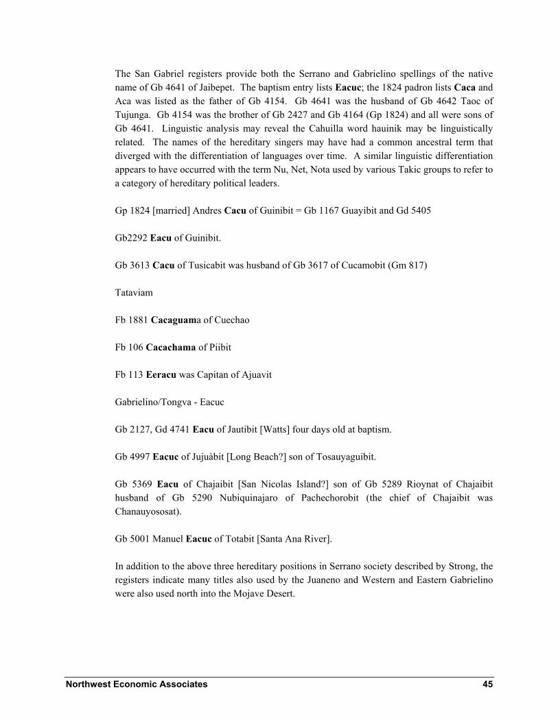
Northwest Economic Associates 45
The San Gabriel registers provide both the Serrano and Gabrielino spellings of the native name of Gb 4641 of Jaibepet. The baptism entry lists Eacuc; the 1824 padron lists Caca and Aca was listed as the father of Gb 4154. Gb 4641 was the husband of Gb 4642 Taoc of Tujunga. Gb 4154 was the brother of Gb 2427 and Gb 4164 (Gp 1824) and all were sons of Gb 4641. Linguistic analysis may reveal the Cahuilla word hauinik may be linguistically related. The names of the hereditary singers may have had a common ancestral term that diverged with the differentiation of languages over time. A similar linguistic differentiation appears to have occurred with the term Nu, Net, Nota used by various Takic groups to refer to a category of hereditary political leaders.
Gp 1824 [married] Andres Cacu of Guinibit = Gb 1167 Guayibit and Gd 5405
Gb2292 Eacu of Guinibit.
Gb 3613 Cacu of Tusicabit was husband of Gb 3617 of Cucamobit (Gm 817)
Tataviam
Fb 1881 Cacaguama of Cuechao
Fb 106 Cacachama of Piibit
Fb 113 Eeracu was Capitan of Ajuavit
Gabrielino/Tongva - Eacuc
Gb 2127, Gd 4741 Eacu of Jautibit [Watts] four days old at baptism.
Gb 4997 Eacuc of Jujuàbit [Long Beach?] son of Tosauyaguibit.
Gb 5369 Eacu of Chajaibit [San Nicolas Island?] son of Gb 5289 Rioynat of Chajaibit husband of Gb 5290 Nubiquinajaro of Pachechorobit (the chief of Chajaibit was Chanauyososat).
Gb 5001 Manuel Eacuc of Totabit [Santa Ana River].
In addition to the above three hereditary positions in Serrano society described by Strong, the registers indicate many titles also used by the Juaneno and Western and Eastern Gabrielino were also used north into the Mojave Desert.

Northwest Economic Associates 46
Chari
The title Chari designated important Gabrielino, Serrano and Tataviam political leaders and their sons. Many Gabrielino men with the name Chari are said to be chiefs. It appears that the title Chari passed from fathers to sons. The title like nu, the next described, is found at some of the same settlements including Seobit that also have kiki it appears that men with different titles only inherited their father’s title.
Gb 4649 (Gp 1824) Fausto Chary of Cucamobit was husband of Gb 4650 (Gp 1824) of Amuscopiabit (Gm 1113). He was brother of Gb 2060.
The father of Fb 1848 of Topipabit was Taari. Her name was Gigiuco
San Juan Capistrano baptism 583 (1785) was Nazario Manuel Tari of Tosicavit [Tusicabit]
Tataviam Fb 16 Chori of Tochonanga.
Gabrielino
Chari father of Gb 4284 and 4016 of Guaspet [Gp 1824 parents of Gb 4284 of Guaspet were Chari and Ginuiba]. The father may be the same man, Gb 6111, discussed next.
Gb 6611 Manuel Chari of Seobit (Gd 4364)(Amupubit Gp 1824) was father of Gb 5128 (also called Chari Gd 5642 of Amupubit father Jose Maria Chari), 4540, and Gb 4541 (father Gerizchari). His widow [sic. he was baptized after her while ill] was Gd 4300 (7-8-20) Magdalena Caroni [her baptism was apparently on a missing page]. Her death entry says Chari was of Amupubit.
Gb 3697 of Juyubit, was a 6 month old brother of Jose Maria and Calisto Chary.
Fb 2234 [Fd 1680] Chari of Chaubina at the Ensenada of San Pedro was husband of Fb 2235 of Santa Rosa Island
The father of Fb 200 of Caguenga was Fb 277 Echari of Cabuenga. Fb 591 of Cahuenga was a son of Chari. Fb 615 was daughter of Chari Chupin the father was Fb 1370 Chari of Cahuenga. The Capitan of Cahuenga was Fb 1364 Tomimenaguit who was baptized on the same day as Chari. Chari was the next man from Cahuenga baptized after the chief
Fb 233 Chari Capitan of Siutcabit
Fb 358 Chari of Siutcanga

Northwest Economic Associates 47
Fb 961 and Fb 974 of San Vincente father called Chari [he was probably same as one of the men named Chari at Siutcabit].
Nu
Strong gave the equivalence of Cahuilla net, Luiseno nota, nu [and equated the position to kika] (Strong 1972: 340). The term nu was also used as names of Serrano chiefs.
Boscana described Nu as the oldest son of chief (Harrington 1978: 84, 220-221). Among the Serrano baptisms, most are from villages identified in this study as wildcat moiety. At Seobit and some Western Gabrielino settlements there were often three more men’s titles including kiki, nu or canu, Temia- and or Chari used at the same settlement. These settlements were probably ceremonial centers.
Gb 3614 Nuú of Puaitamaibit husband of Gb 3618 of Topipabit [Barstow]
Fb 176 Nu of Tujunga
Fb 923 Nu Capitan of Quisaubit
Gb 5307 was baptized as the wife of Nuri Capitan of Amuscopiabit. Nuuri was Fb 2128 Suniririmobit Capitan of Amuscopiabit (Gb 6207).
Fb 1847 Nuuri child of Atongaibit
Fb 2222 Cunu of Tujunga.
Gb 4947 Nucupapat of Guaaschna [San Bernardino] was husband of Gb 4948 Carony of Jujuàbit. They had a child Gb 4306 at Apiagma.
Gb 4501 Rumalado Pinout of Cayyubit?
Tataviam
Fb 149 Mu of Tochonanga
Fb 151 Nu of Tochonanga
Fb 383 Nuguit of Tochonanga
Fb 687 Genu of Chaguayanga

Northwest Economic Associates 48
Fb 22 Nuchqui of Passenga
Gabrielino
The father of Gb 3999 of Cabuenga was Gb 5541, Vicente Nu of Cabuenga. His mother was Tapi of Jautna [Jautbit].
Fb 440 Nu husband of Fb 479 (Fm 103); no rancheria given.
Fb 196, Nuu, a one year old of Siutcabit
Gp 1824, Gb 1978 (Gc 3953), Ambrosio Nu [also Menamchaneo] of Pububit son of Gb 3953 of Puvuvit.
Gb 5271 (5-13-13) Juan Nuusqui of Jautbit was the father of Gb 4333 in whose entry Juan is called Yupucamo.
Gp 1824, Gb 1825 Jose Antonio Canó of Jautbit one year old (Gp 1824)
Gp 1824, Gb 2071 Jose Maria Canó of Jautbit (Gm 1233).
Gb 1927 Jose Maria Chino of Yabit.
Gp 1824, Gb 1236 Agapito Chaneo of b= Nasin, p= Asiuquibit (A mission born child, Gb 2583, was baptized as of Nahsin. Her death entry says Comicraibit [Gd 6-99]. Perhaps these are Gabrielino names for Lisichi at Arroyo Sequit. The Spanish name is more similar to Asiuqui than the Chumash name).
Gp 1824, Gb 5361 Andres Cuna ? of Chajaibit was husband of Gb 5362, Guizazyabit, of Jautbit (Gm 1283).
Gb 6247 Chianno of Soabit
Gb 2927 Panu of Jautbit husband of Gebit woman Gb 2999
Gb 3905 Jacinto Cano-i-mor of Tobpet
Fb 2608 [August 9, 1825] Pastor Cano husband of Fb 2606 Maria del Carmen Caroni (Fm 751). One daughter was Fb 2029 [July 11, 1812] of heathen parents Cani and Caroni of the Pueblo of Los Angeles. Another daughter was baptized at San Gabriel, Juana daughter of Cano Capitan of Pimubit Ysla (Gp 1824 single women).
Pastor Cano is mentioned by Hugo Reid:

Northwest Economic Associates 49
The last case of bigamy or rather polygamy was one of the Chiefs from Santa Catharina who was ordered by the priest to San Gabriel and there baptized, he had three wives, the first of which was allowed him and the others discarded. .... He is still alive [March 20, 1852] and now resides in San Fernando: his name as known at present is Canou or Canoe: he is still a Capitan and accounted a great wizard.
Cano was also mentioned by Strong:
... Alec’ Arguello, the last survivor of the Cahuilla who lived in San Timoteo pass, said that the mûketem, shell money, was brought to Juan Antonio, the Mountain Cahuilla capitan who brought the Cahuillas to San Bernardino by kãnuk, a very old chief of the San Fernando people, who also brought new songs and ceremonies. This happened before Arguello was born, and he was told of it by his father [Strong 1972: 96].
Tamet
Reid Letter 2: The sun = tamit. See Harrington below, Caroni the mother of Timét ‘Awí’ [‘Awí’=eagle]. This name like Wiyot, Manisar and Caroni were apparently both mythical names and titles of important living people.
Tamet was the father of Gb 6817 of Huahona [the 1824 padron lists as from Guaaschna = San Bernardino]. The mother of Gb 6817 was Caroni. Apparently there was an association of “sun chief” with Guaaschna [Huahona]. He was probably the same Tamet or Tamiot who was father of Gb 6276 of Guaspet [apparently Guaaschna in San Bernardino, Guaspet is most often used to refer to the Guashna near the mouth of Ballona Creek] as listed in the 1824 padron. He was the father of Gb 6053 and Gb 6319 of Guaspet whose parents were Tamet and Bereroninat (Gp 1824). Tamet had apparently not been baptized before the end of use of the 1824 padron.
Gb 5682 Tametoomobit of Guaschna is the only other person with Tamet as part of his name. It appears that Guashna at San Bernardino was a ceremonial center.
Hudson and Blackburn suggest that Tamet, Tobet and Tomear may have had related meanings. They note that Merriam said the title of the chief’s son who performed the eagle dance during the Mourning Ceremony was To-vet. Tobet was a Luiseño synonym for Chinngichnich (Hudson and Blackburn 1978:228).

Northwest Economic Associates 50
Veat - Wiyot
Fb 168 Vueti of Tussinga [Tejon Kitanemuk Rancheria]
Tataviam -Fb 266 Piguoit of Tubimobit = Wiyot – wot?
Tomear
In 1776, Font described the Santa Barbara Channel as of the Quabajay tribe. He observed:
Their language is entirely distinct from the others. The capitan they recognize in the villages they call Temí, just as the Jeniguechis [Gabrielino] and Benyemé [Serrano] call him Tomiár [1930:251].
Earlier while in Cahuilla territory Font had noted:
To the commander, whom they [Jecuiche – Cahuilla] and the Jeniguechis, who are further ahead, call Tomiár they gave as a present a piece of mescal head [1930:146].
Tomear was the eldest son of chief (Reid in Harrington 1978: 156). Kitanemuk notes say Fernandeño Tomiar = capitan. Gabrielino: Chief tumiar (Bean and Smith 1978:544). In the registers, the name appears as the prefix of a compound name. The following six Serrano men’s names began with Tomea-:
Fb 1862 Tomearsaxabia of Najayabit.
Gb 5372 Tomeaiminat of Najayabit
Gb 3279 Tomeiaunit of Tobanjbepet [Tochaburabit at F] was married to a woman from Giribit.
Gb 4470 daughter of Tomeasoguit Capitan of Jajaubabit and relative of Gb 3625 of Topipabit [Barstow]
Gb 5281 Tomeasoguimobit of Cayyubit was husband of Gb 5282 of Paorbia and father of Gb 4501, 4375, 4320 and 5211.
Gb 3883 of Guinibit was wife of Gb 3870 Tomeajogoi of Cucamobit. She was listed in her death entry as of Cucamobit (Gd 4591).

Northwest Economic Associates 51
The following six Gabrielino names begin with Tomea- or a similar prefix:
Gb 3979 Tomeaguich of Guaspet,
Tomeananioy of Gebet
father of Gb 3826 of Yabit was Tomeaunijijionat, ,
Gb 4998 Tamemanaibit text- Jujuabit, margin Jaisobit
Fb 1364 Tomimenaguit capitan of Cahuenga (note that two people designated in registers as chiefs have endings -guit commonly found on Chumash men’s names)
Tomasajaquichi [Temasajaguichi] was the chief of Juyubit in reports of the 1785 uprising.
Antapa
The Chumash word ‘antap referred to initiated dancers who performed at festivals and did police duties under the direction of the chief and paqa. T he last person baptized from Tobpet was a man named Antapa [Gb 4657, Antapa, of Tobpet husband of Gb 4658 Taoc of Japchibit (Gm 1117)]. Tobpet had ties to Eastern Gabrielino settlements, to Jajamobit a Western Gabrielino settlement and to Serrano settlements. The mission records indicate ambiguity between membership in Topisabit and Tobpet and other neighboring settlements. Tobpet was probably in Western Gabrielino territory but its social ties indicate it was a boundary settlement with ties across all boundaries. Merriam stated that To-ve’t [see Tamet above] was the title of the chief’s son who performed the eagle dance during the Mourning Ceremony. Tobet is a Luiseño synonym for Chingichnich (Hudson and Blackburn 1978:228). The name Tobpet is similar to Tobet and may have a related root Tov-. The name Antapa is consistent with the name of a Tobet or Chingichnich dancer. Tobpet’s location, near the vortex of the boundaries between the Eastern and Western Gabrielino and the Serrano, is consistent with expectations for the location of a shrine or ceremonial center. The presence of the name Antapa at this location supports the suggestion of Hudson and Blackburn that there was an integration of the “Northern Complex” the “Chingichnich Religion” and Chumash ritual practice in the Los Angeles Basin.
Caroni
Caroni wife of first chief (Harrington 1978: 84, 212-214; name of a wife of many chiefs at San Juan Capistrano and San Gabriel.

Northwest Economic Associates 52
Gb 4948 Carony of Jujuàbit [Jujuàbit said to mean center, probably Long Beach] was wife of Gb 4947, Nucupapat of Guaaschna [San Bernardino]. They had a child Gb 4306 at Apiagma. Carony had other children: Gb 2817 of Tobpabit [lower Santa Ana River] and Gb 3704 of Pimubit [Catalina Island] from earlier marriages. This Carony although living at a Serrano settlement was born and had lived much of her life at Eastern and Western Gabrielino/Tongva settlements.
After Carony of Jujuàbit was baptized, a non-Christian woman also with the name Caroni had a child at Guaaschna. She was the mother of Gb 6817 of Huahona [the 1824 padron lists as from Guaaschna = San Bernardino] the father was Tamet [see above]. Harrington note concerning spelling of name Coronne in San Juan Capistrano registers and by Boscana: “… might have led one to think the word had phonetics similar to those of Tuvonni, name of the mother of Timét ‘Awí’(which name occurs in a story about eagle gathering [‘Awí’=eagle])” (Harrington 1978:212). The marriage of a Caroni to a Tamet might support this possibility.
The 1824 padron says the non-Christian parents of Gb 2548 of Guinibit were Yoyoba and Caroni.
Evidence has not been found for the use of the name Caroni on the north side of the San Gabriel and San Bernardino Mountains. It is possible that all of the above women named Caroni were married into Serrano settlements from lower Santa Ana and San Gabriel River settlements. Guinibit, Guaaschna, Huahona and Actababit were all a short distance north of the boundary between the Serrano and Gabrielino. Marriages between elite families often crossed ethnic boundaries. If women usually went to live at their husband’s settlements, the presence of four or more Gabrielino/Tongva women named Caroni at Serrano settlements near the boundary would be expected.
Gabrielino
Gb 2890 Caroni = Guadiosa de los Reyes of Chaubit was daughter of Gb 3234 of Comicraibit.
Mother of Gb 7264 of Suanga = Carony wife of Ququina [San Juan Capistrano Viejo] man
Caroni was mother of Gb 4189 Sucuinpa? not clear writing=Gp 1824 Comicrabit a sister of Gb 2491 of Seobit .
Caroni was the heathen mother of Gb 5850 of Atababit; her father was Pomajoyoyunat (Gp 1824).
Fb 2606 Caroni was wife of Fb 2608 Cano of Pimunga.

Northwest Economic Associates 53
Gb 4654 Serafina Caroni of Uchubit (Gd 3166 Jaisobit) was wife of Gb 4653 of Jaisobit (Gm 1115). Gb 4662 Tapiy of Uchubit was baptized on the same day.
Tapi
Tapi was wife of second chief [probably second wife of chief] (Harrington 1978: 84, 221-222). Two women named Tapi were baptized from the most carefully studied Serrano settlements. One from Toibipet was the wife of the Capitan of Cayyubit. The other from Asucsabit was the wife of a man from Tomijaibit [possibly Japchibit].
Gb 5337 Serbiana Tapii of Guapiabit (Gp 1824 Tapiy) was mother of Gb 4446 Zeferina of Cayyubit. The father of Gb 4446 was Ajonijajomobit Capitan of Cayubit. The baptism of Gb 4446 says her mother was of Toibipet. She was sister of Gb 3880 of Toibipet the wife of Gb 3869 of Guapiabit.
Gb 4647 Tobanjaiat (Jobinchayet) of Tomijaibit [baptism of a son (Gb 4050) lists him as of Japchibit] The second to last person identified as baptized from Tomijaibit was husband of Tapi (Topi)=Asaminaba (Gb 4648) of Asucsabit (Gm 1112). She was residing at Tomijaibit when she was baptized. She had a child, Gb 4588, baptized from Tomijaibit. Another child (Gb 4050) was baptized January 11, 1806 as from Japchebit. Gb 4648 was apparently the last native of Asucsabit baptized in March 1811. Gb 4647 was the last married man baptized from Tomijaibit. He had other children Gb 3631 and 3632 [mother of Gb 3631 was Saiot]. They were baptized on January 24, 1804 as from Tomjaibit.
Gabrielino
Mother of Gb 4540, 4540 and 5128 of Seobit = Gb 4927 Tapiy of Seobit [at baptism married to man not father of her children] father of children was Gb 6611 Chari of Seobit.
Parents of Gb 3999 of Cabuenga = father Nu of Cabuenga (Gb 5541) mother Tapi of Jautna [Watts].
Gb 1863 Rufina Tapiy was the mission born daughter of Gb 2 of Sibapet and Gb 184 of Sibapet (Gp 1824).
Gb 4662 Tapiy of Uchubit.
The 1824 padron says the parents of Gb 6339 of Quinquina were non-Christians Noibi and Tapiy.

Northwest Economic Associates 54
Taoc
Gb 4641 Eacuc [Gp 1824 Caca fa of Gb 4154 Aca] of Jaybipet [Santa Anita] husband of Gb 4642 Taoc of Tujunga and father of Gb 4154 of Santa Anita whose mother was Cupe.
Gb 4657, Antapa, [see above Antapa] of Tobpet was husband of Gb 4656 Taoc of Tachicpiat (Japchibit) (Gm 1117).
Toco
Hugo Reid said the Gabrielino word for Woman was tocór (Letter 2). Toco is used as name for women at Tameobit and Momonga neither of which were Gabrielino settlements. The name like many others listed above was probably cognate in all northern Takic languages.
Fb 2278 Toco of Tameobit was wife of Fb 2273 Zaiti of Najayabit. They were parents of Fb 2253, 2254 and 2255 of Najayabit.
The native name of Maria Raymunda, Fb 64 of Momonga, was Toco
Manisar
The mother of Gb 3816 of Suabit was named Manisar. His father was Tocopriquinat (Gp 1824). Hugo Reid wrote that Manisar was the title of the daughter of a chief (Reid in Harrington 1978: 156). Hudson and Blackburn note a connection between Manic or Manit and Manisar. All were associated with a female goddess of datura and the moon [Chumash Momoy] (Hudson and Blackburn 1978:228).
Tamy and Cupa or Cupe
Two other names are associated with the wives of Serrano nobility and are possibly titles.
The 1824 padron lists Gb 4839 Tamiyt of Guaaschna wife of Gb 4838 Soypajasch (Sopujooch) Capitan of Junnoabit.
Gb 4553 and 4313 and 4360 were children of Juyucbra chief of Apiacomobit and Tany of Guaaschna.

Northwest Economic Associates 55
Gb 4916 Tamyt of Atongaibit was wife of Guaopiyuja of Apuimabit.
Gb 5351 Taniy of Tusicabit was wife of Juan de Mata Pagumaiminat of Cochovipabet
Gb 4663 Tamy of Cucamonga
Cupe was the name of the mother of Gb 4154. She was a second wife of Gb 4641 Eacuc [Caca] of Jaibepet (See Taoc and Caca above).
In the desert, many Serrano women have names beginning with Cup-. Some of these are listed here.
Gb 4262 Cupabuiban of Tameomit {Tameobit]
Fb 2211 Cupuseseyba of Najayabit
Gb 5318 Acacia Cupasaibit (Cusasiba) of Topipabit. Father of child Gb 5088 was Joyoyoich of Guapiabit.
Mother of Gb 4693 Cupainibam of Gayaba, Gb 5019 mother Cupasorbam of Gaayuba
Gb 5325 of Najayabit was a widow as non-Christian wife of Soctar of Gaayaba and was mother of Gb 5347 Cupiabam of Cuyubit wife of Aijaraonat of Guapiabit.
Gb 5373 Pancracio Quiquabit of Equinapet alias Cuquina was husband of Gb 4756, Nera Cupasbam, of Corobonabit (Gp 1824 married). Cuquina was a settlement located south of the Santa Ana River and Coronabit was near Saboba and apparently a Cahuilla settlement.
Linguistic and further contextual analysis of names recorded in mission and other historic records will further elucidate the organization of Takic groups recruited at Spanish missions. Information compiled for this study indicates that people described as Capitan [chief] often had two wives at the same time. The native terms indicate that the Spanish term, Capitan, included several different types of leaders.

Northwest Economic Associates 56
Chapter 6 - San Gabriel Mountains and Antelope Valley - Serrano Settlements
In this section, settlements along the south side of the San Gabriel Mountains are discussed in order from the east to the west end of the Mountains. They are followed by settlements in and on the north side of the mountains. The settlement of Tomijaibit is discussed after Japchibit. It was probably located northeast of Japchibit. The settlements adjacent to the San Gabriel Mountains west of the eastern boundary of the Angeles Forest were studied in the most detail. Toibipet is the first settlement along a stream flowing out of the Angeles Forest. Finally settlements in the Antelope Valley and near the Mojave River are discussed.
Most of the permanent settlements sites associated with the San Gabriel Mountains were located outside of the Forest. The locations of settlements in the San Gabriel Mountains that are listed in mission registers but whose locations are not identified have been inferred from:
1) The presence of baptisms at both San Gabriel and San Fernando Missions and their relative frequencies. It appears that settlements mostly recruited at San Fernando Mission were west of Tomijaibit and Japchibit.
2) At San Fernando, the occurrence of baptisms later than baptisms from the earlier settlements recruited at San Fernando including Tujunga, but earlier than from settlements known to be located further away indicate location at intermediate distances. At San Gabriel, recruitment later than closer settlements most of whose locations are known but earlier than more distant desert settlements indicate location at intermediate distances from the mission. Japchibit was recruited earlier than Tomijaibit and both were recruited earlier than Tameobit, Najayabit, Atongaibit, Cayyubit, Amuscopiabit, or Guapiabit.
3) At San Gabriel, cessation of recruitment after establishment of San Fernando or continued recruitment indicates if the settlements are in the area exclusively recruited from at San Fernando or are still in the area being recruited at San Gabriel. Japchibit and Tomajaibit were in the latter category. Few people were baptized at San Gabriel from settlements west of Japchibit or Tomijaibit after 1797.

Northwest Economic Associates 57
4) The locations and sizes of archaeological sites occupied at the time of mission recruitment. The largest sites are expected to match settlements with the largest numbers of recruits.
It appears that Japchibit, Quissaubit (or perhaps another settlement), and several small settlements associated with Japchibit were located within the Angeles Forest boundary. In the Tataviam area, the large settlement of Piru was located close to Forest Service lands and several small settlements were probably located on Forest Service lands. No native settlement or clan names recorded in mission registers can be identified with particular places in the Angeles Forest using only historic data. Most of the archaeological sites that have been identified on Forest Service lands are the remains of camps, yucca ovens, and small settlements not listed in mission registers.
Figure 13 indicates the locations of settlements, ethnic boundaries, and the number of marriage ties between settlements discovered during study of the San Gabriel and San Fernando Mission records. The San Fernando records often do not identify the villages of wives and document fewer ties than the San Gabriel records made at the same time. San Fernando also started recruiting much later than San Gabriel and was recruiting the survivors of epidemics and military actions. There may also have been more settlement endogamy at San Fernando mission settlements.
Amuscopiabit
This village in Cajon Pass lies within and between the San Gabriel and San Bernardino mountains. Historic artifacts found at archaeological site SBr-425/H indicates it is the remains of the settlement of Amuscopiabit. This settlement had many ties to Guapiabit.
On August 13 the 1806 Zalvadea expedition arrived at Moscopiabit. Zalvidea wrote: “We saw 15 to 18 adult heathen and a few children” (Cook 1960:247).
Bean, Vane, Lerch, and Young provide information concerning this settlement (1981:58-59).

Northwest Economic Associates 58
Figure 13 Map of Kinship Ties between Settlements Recruited
from San Gabriel and San Fernando Missions
Tusicabit
The recruitment dates from this settlement indicates it was west of San Bernardino and Riverside and east of Cucamonga.

Northwest Economic Associates 59
Ties
Gb 1249 of Jutucabit is listed in the death register as of Tusicabit (Gd 2039). This was the first person baptized that apparently was a native of Tusicabit.
Gb 3128 a 15-16 year old of Tusicabit was pre-baptism husband of Chipin of Jaiavit.
Gb 3613 Cacu of Tusicabit was husband of Gb 3617 of Cucamobit (Gm 817)
Gb 4545 Naschi of Tusicabit was husband of Gb 4546 of Guaschipet
Gb 4932 Guirarralnobit capitan of Tusicabit was husband of Gb 4933 of Paviana [Pabiabit]
Gb 4942 Machectuba of Tusicabit was mother of Anna Maria baptized at San Juan Capistrano.
Gb 5383 Pagumaiminat of Cochovipabet was husband of Gb 5351 Taniy of Tusicabit
Gb 6282 Ocandedio of Tusicabit was husband of Gb 6282 of Jurupet.
Cucamobit kukúmonga
McCawley noted:
The name of the Gabrielino community of Kuukamonga survives in the modern city name of Cucamonga. Manuel Santos reported to Harrington that the name Kuukamonga meant “I shuffle my feet on the ground” (Harrington 1986:R102 F166). Although José Zalvidea offered no meaning for the name Kuukamonga ... [McCawley 1996:50].
Reid: Cucomong-na = Cucamonga
Kroeber 1907:142 Cucamungabit - Cucamonga
Kokomcar = JPH kukúmkaris - G. name for Serrano (Z). The community of Cucamonga was the closest Serrano community to San Gabriel Mission in 1811.
Bean and Mason noted:
In 1819 Gabriel Moraga stopped at Cucamonga on his way to fight the Mojaves. Apparently the location was a cattle rancho of the San Gabriel Mission and later became part of the Cucamonga Rancho which was granted to Tiburico Tapia [Bean and Mason 1962:99].

Northwest Economic Associates 60
The community of Cucamobit was apparently occupied as late as 1814. Although ties with Cucamonga were not researched as thoroughly as for the settlements to its west, information concerning ties between adults contained in the baptismal and marriage registers was gathered. The following list includes the ties found:
Gb 1299 was daughter of Gb 1463 and a non-Christian father of Toibipet (Gd 672). When baptized Gb 1463 was married to Gb 1460 (Gm 285). Their baptisms said they were both of Cucamobit. The confirmation of Gb 1463 said she was of Toibipet and wife of Gb 1460 (Gc 1205). Her death entry also said Toibipet (Gd 12-19).
Gb 1305 Cucamobit = Gd 1263 Toibipet.
Gb 1538 Toibipet = Gd 827 Cucamobit.
Gb 1663 (Gc 1211) of Guinibit was wife of Gb 1623 of Cucamobit (Gm 324).
Gb 1910 (Gc 1220) of Guinibit was wife of Gb1906 of Cucamobit (Gm 389).
Gb 1927 of Guinibit was husband of Gb 1931 of Cucamobit (Gm 395).
Gb 2170 of Pimucabit [Reid – Pimocagna = Rancho de los Ybaras- near Walnut (McCawley 1996:46-47)] was son of a Pimocabit father (Gb 2119) and a non-Christain mother of Cucamobit. Gb 2171 of Pimocabit was his sister.
Gb 2418 a 70 year old woman of Cucamobit was listed as of Jajabit (see Japchibit for ties to Jajabit, an unlocated place) in the death register (Gd 1118).
The father of Gb 2633 was a non-Christian of Guinibit. The mother was a non-Christian of Cucamobit.
The father of Gb 2640 was a non-Christian of Cucamobit. The mother was a non-Christian of Toibipet.
The father of Gb 2692 was a non-Christian of Cucamobit.. The mother was a non-Christian of Toibipet.
Gb 3199 of Guinibit was mother of Gb 2025 of Cucamonga.
Gb 3207 of Toibipet was the daughter of Jujuiya a non-Christian of Toibipet and his wife Gb 3204 of Cucamobit.
Gb 3433 of Cucamobit was husband of Gb 3441 of Púraaitambit [Apuritaimbit] (Gm 759).
Northwest Economic Associates 61
Gb 3617 of Cucamobit wife of Gb 3613 Cacu of Tusicabit (Gm 817).
Gb 3689 of Toibipet was husband of Gb 3717 of Cucamobit (Gm 856).
Gb 3780 of Cucamobit wife of Gb Gb 3713 of Tameobit (Gm 873).
Gb 3883 of Guinibit was wife of Gb 3870 Tomeajogoi of Cucamobit. She was listed in her death entry as of Cucamobit (Gd 4591).
Gb 4126 of Toibipet was wife of Gb 4198 of Cucamobit (Gm 1007). She was mo of Tomaso Gb 4351 of Cucamonga, Matilde and Augustin & relative of Gb 2025 of Cucamonga.
Gb 4646 of Guinibit was wife of Gb 4645 of Cucamobit (Gm 1111). She was apparently residing at Cucamovit.
Gb 4649 (Gp 1824) Chary of Cucamobit was husband of Gb 4650 (Gp 1824) of Amuscopiabit (Gm 1113).
Gb 4803 of Cucamobit was wife of Gb 4802 of Apuritaimbit (Gm 1154)
Gb 5003 (Sebastian) Riguigua (Erigugua) (Gp 1824) of Toibipet was husband of Gb 5004 of Cucamobit (Gm 1210). He was also father of Gb 4587 of Toibipet, Gb 4192 of Toibipet, Gb 4136 of Toibipet, Gb 3423 of Japchibit, Gb 3413 (Gd 3827) of Toibipet and 3412 Gb of Toibipet. His mother (Gb 5356) of Toibipet was the last person baptized from Toibipet. He, his wife, mother, and three of his children were the only people baptized from Toibipet after April 1807.
Gb 5533 of Cucamobit was husband of Gb 4286 of Junubabit (Gm 1346).
Toibipet
Toibipet was perhaps in the vicinity of the Los Angeles County Fair Grounds near Pomona and Clairmont. Reid: Toybipet = San José. Toibipet = San Jose = Clairmont (Kroeber 1907:142).
McCawley notes:
The community of Tooypinga lay near the base of the San José Hills on land that was once part of Rancho San José (Reid 1852:8; Harrington 1986:R102F294, R103 F88). According to Zalvidea, the name Tooypinga “is derived from tojtsh, the devil woman who is there at El Rincon, near San José.” Harrington added that the “Inf [informant i.e., José Zalvidea] knows

Northwest Economic Associates 62
old San José at Pamona. There was lots of tunas [tuna cactus, Opuntia sp.] there at S. José [McCawley 1996:48].
On December 15, 1823, Estudillo described the place after the native settlement was abandoned:
This place called San José is a little pass which the sierra forms from east to west as an opening of about two leagues, and on the road in the middle of it a swamp which has sufficient water, and a runoff in small quantity for about a quarter of a league. In a year of plentiful rainfall it may be more [Bean and Mason 1962:32].
The following list includes all ties found except those listed under Cucamobit above.
Gb 1403 of Uchubit was husband of Gb 1696 of Asucsabit (Gm 341 and Gc 1216).
Gb 1606 of Uchubit was the wife of Gb 1622 of Toibipet (Gm 321). She was the mother of Gb 1379 and 1382 of Uchubit.
Gb 1504 of Toibipet was wife of Gb 1405 of Uchubit (Gm 293).
Gb 1539 Toibipet = Gd 727 Jaybepet.
Gb 2946 (Gp 1824 and Gd 4958) of Toibipet was pre-baptism wife of Ycaibit a non-Christian of Jajovit.
Gb 3453 of Toibipet was husband of Gb 3457 of Puraytambit (Gm 762).
Gb 3880 of Toibipet was wife of Gb 3869 of Guapiabit (Gm 909).
Gb 4048 of Toibipet was husband of Gb 4045 of Puritamibit (Gp 1824). He was baptized on January 10, 1806. Their children (Gb 3411 and 3414 (Gp 1824) [baptized at the same time as the first three of Gb 5003’s children - below]) were of Toibipet. They were the second to last family baptized from Toibipet.
Three people were baptized as from Toibipet at San Juan Capistrano. One Emilio is listed as a transfer in the San Gabriel 1824 padron and is listed as Jaibepet. He is further discussed under Jaibepet. The other two were:
Jb 523 (1784) Braulio Ocasiquenemovit of Toivepexr a 34 year old man whose father was jarar torquemovix, and Jb 985 (1789) an 18 year old woman Maria de los Santos Quichensajainam of Toijavet. Her father was dead Pamaya? Her mother was Yhuiha? (Steve O’Neil, personal communication, 2003).

Northwest Economic Associates 63
Guinibit
McCawley states:
According to Felicitas Serrano Montanno, the Gabrielino community of Weniinga was located where the modern city of Covina was founded. José Zalvidea reported that the name Weniinga means,” one of the place[s] where metates, etc or anything está tirado [is discarded] as about an Indian camp.” A variant name for Weniinga is “Guinibit“ (Harrington 1986: R102 F323-324)[McCawley 1996:45, Johnston 1962:144].
Gb 4303 Quiqui Atilano was husband of Gb 4304 both of Guinibit. Gb 3178 was an aunt of Atiliano the Capitan of the settlement. Quiqui and his wife were one of the last two couples baptized from Guinibit on April 1, 1809.
The following list includes all ties found except those listed under Cucamobit above and Asucsabit below
Gb 1904 (Gc 1013) of Jaibepet was husband of Gb 1907 (Gc 1199) of Guinibit (Gm 387).
Gb 1940 (12-18-90) Gd 3434 Maria Esperanza 6 or 7 of Guinibit = Gc 1283 Maria Esperanza of Japchibit non-Christain parents. She was a daughter of Gb 2023 of Guinibit and a non-Christain father (Gm 591). The father was probably of Japchivit.
Gb 2373 Josepha del Rosario of Guinibit = Gd 1071 Maria Josepha of Guinibit was mother of Gb 2371; the father was a non-Christian of Tujunga.
Gb 1672–Jacome Francisco of Guinibit Gd 1-01 wife at bapt =Regina Josepha, Gb 1554, Gc 1212 (Gd 1942:12-30-00) of Guinibit (Gm 337).
Gb 3638 (Gd 3614) Paguisar of Guinibit was husband of Gb 3651 of Guoguavit (only mention of this settlement).
Gb 4651 of Jachibit [Japchibit] was husband of Gb 4652 of Guinibit (Gm 1114), the last person found baptized from Guinibit. She may have been living at Japchivit.
Asùcsabit
McCawley notes:

Northwest Economic Associates 64
The community of ‘Ashuukshanga’ lay a short distance south of the mouth of San Gabriel canyon. Manuel Santos reported that the name means poco vuelta [little turn], and that “the real place is by the bend of the canyon” (Harrington 1986:R102 F77). According to José Zalvidea however, the name ‘Ashuukshanga, which survives in the modern city name of Aszusa comes from ‘asúk,’ ‘his grandmother.’ It means ‘su abuela la tierra’ [his grandmother the earth].” Zalvidea suggested that “the grandmother must have turned to stone. There were people everywhere that turned to stone” (Harrington 1988: R102 F75). Kroeber offered yet another translation of this place name suggesting that it may have meant “skunk place” (Kroeber 1925:859) [McCawley 1996:44-46].
Reid equated Azucsag-na with Azuza (1852).
Asucsabit was one of five Serrano villages involved in the 1785 uprising.
A month after the baptism of Toypurina of Japchibit Gb 1408 on March 8, 1787, on April 14, 1787, three sons and three daughters of the chief of Asucsabit (Gb 1438, 1439, 1440, 1445, 1446, and 1447) were baptized along with the three children baptized as from Jamamcovit and three other children of Asucsabit and Guinibit.
Eighty year old Gb 3162 was mother of the Capitan of Asucsabit.
Gb 1438 (Gc 1075) of Asucsabit (the oldest son [7 years at time of baptism] of the chief of Asucsabit baptized on 4-14-87 was married to of Gb 2473 (Gc 1810, Gd 1857) of Toibipet shortly after her baptism (Gm 519).
The last families from Asucsabit were baptized in the winter of 1804.
Ties to Small Settlements and Places
The following include all people discovered as listed from infrequently named places.
Cupsabit
Gb 441 baptized as of Cupsabit was husband of Gb 428 (Gd 282) of Chibanga (Sibapet;) his death entry (Gd 94) said he was from Asucsabit.
Gb 1903 of Asucsabit is listed in her confirmation (Gc 1283) and death records (Gd 1581) as from Cupsabit; the text of the death register says Acupsabit.
The marriage of Gb 627 (Gc 771) of Asucsabit (Gm 609) says he was single and his parents were Gb 2205 and Gb 2206 of Asucsabit. The baptism entry of his mission born child (Gb

Northwest Economic Associates 65
3337) says he was of Cupsabit [His death entry says Yabit (Gd 2117)]. His parents Gb 2205 (Gc 1688) and Gb 2206 (Gc 1701) (Gm 449) are listed in their baptism, confirmation and marriage records as of Cupsabit.
Aoyobit
Gb 1451 text of Aoyobit, margin Aoyobit vel Asucsabit (Gc 1040 of Aoyobit, Gd 1482) mission married husband of Gb 603 of Yabit (Gm 331).
Gb 2685 (Fd 544) Zoa Maria of Aoyobit was wife of Gb 2605 of Pasecubit (near the site of San Fernando Mission). Gb 2590 of Pasecubit was daughter of both (Fm 225). All three transferred to San Fernando when it was founded.
Ajubquebit
Gb 2227 of Asucsabit was baptized while dying in the rancheria of Ajubquebit.
Jamamcovit
This settlement is most closely related to Japchivit and is discussed under Japchibit below. The texts of two of the Jamamcovit (Japchibit) baptism entries said they were from Asucsabit. Their mother Gb 2035 was from Asucsabit. Their father was from Japchibit.
Ties to Other Settlements
The first person baptized from Asucsabit (Gb 113, Gm 11 mission marriage to a Sibapet man) is listed in her death entry (Gd 130) and confirmation (Gc 227) as from Sibapet.
The second person from Asucsabit (Gb 119) was her sister; her baptism and death entries (Gd 68) list her as from Asucsabit.
The third person listed from Asucsabit was Gb 252, a 50 year old woman, her death entry (Gd 136) says she was from Ajuibit.
Gb 349 of Tobpet was husband of Gb 363 of Asucsabit (Gm 73).
Gb 473 of Asucsabit was husband of Gb 482 of Jaibepet (Gm 108).
Gb 608 of Tobpet (text: parents non-Christians of Asucsabit)= Gc 792 of Asucsabit =Gd Acurabit – see below.

Northwest Economic Associates 66
Gb 627 (Gc 589) of Asucsabit is said to be from Jaibepet in the death entry (Gd 2023).
Gb 698 (Gc 390) of Uchubit is said to be from Asucsabit in his death entry (Gd 4472), his father was Gb 3707 of Asucsabit and his mother Gb 2323 of Asucsabit.
Gb 759 baptized as from Asucsabit was a 2 year old son of Gb 425 of Asucsabit (husband of Gb 370 of Asucsabit [Gm 101]) and a non-Christian woman of Guinibit.
Gb 1070 (Gc 1191) of Asucsabit was married to a widower Gb 359 of Topisabit the day after her baptism (Gm 204); his wife at the time of his baptism was Gb 361 of Topisabit.
Gb 1377 (Gc 1383) of Jaibepet was daughter of Gb 1543 of Jaibepet and Gb 1679 (Gc 1197) of Asucsabit (Gc 1383).
A 4-5 month old girl, Gb1586, of Guinibit = Gc 1276 of Asucsabit.
A 6-7 year old girl, Gb1686, of Guinibit = Gc 1354 of Asucsabit.
Gb 1403 of Uchubit was husband of Gb 1696 [b=Uchubit] of Asucsabit (Gm 341 and Gc 1216).
Gb 1973 (Gc 1461) of Asucsabit was wife of Gb 1970 of Guinibit (Gm 400).
Gb 2037 (Gc 1576) of Topisabit was wife of Gb 2020 of Asucsabit (Gm 414).
Gb 2035 (Gc 1574) of Asucsabit was wife of Gb 2022 of Japchibit (Gm 415).
Gb 1982 of and at Jaibepet was husband of Gb 2235 (Gc 1737) of Asucsabit (Gm 450).
Gb 2300 of Asucsabit was daughter of Gb 2790 of Guinibit and his wife Maria de la Pasion of Asucsabit (Gm 595 on 11-8-97).
Gb 3124 of Asucsabit was a brother of Gb 2315 of Cucamobit.
Gb 3212 (Gd 1932) of Jaibepet was mother of Gb 627 of Asucsabit (Gc 584 of Asucsabit, Gd 2023 of Jaibepet).
Gb 3648 of Asucsabit and Gb 3649 of Asucsabit were the parents of Gb 2872 (Gp 1824, Gd 5389) and Gb 2445 (Gc 1804, Gd 7-29) of Jaibepet.
Gb 4647 Tobanjaiat (Jobinchayet) of Tomijaibit [baptism of a son (Gb 4050) lists him as of Japchibit]. The second to last person identified as baptized from Tomijaibit was husband of Tapi (Topi) = Asaminaba (Gb 4648) of Asucsabit (Gm 1112). She was residing at Tomijaibit

Northwest Economic Associates 67
when she was baptized. She had a child, Gb 4588, baptized from Tomijaibit. Another child (Gb 4050) was baptized January 11, 1806 as from Japchebit. Gb 4648 was apparently the last native of Asucsabit baptized in March 1811. Gb 4647 was the last married man baptized from Tomijaibit. He had other children Gb 3631 and 3632 [mother of Gb 3631 was Saiot]. They were baptized on January 24, 1804, as from Tomjaibit.
Jaibepet
The following renderings are present in the San Gabriel registers: Jaibepet, Jaybepet, Jaybenga, Jaibena. The registers indicate that the Spanish name Santa Anita is the equivalent of Jaibepet. Gb 4154 of Santa Anita = Jaybipet (Gp 1824) was son of Gb 4641 Jose Miguel (Gp 1824) of Jaybipet Eacuc (Eacu, Caca, Aca) of Jaibepet, his mother was Gb 4642 of Tujunga. Gb 4154 was the brother of Gb 2427 (Gp 1824 of Jayobit, Jayopit) and all were sons of Gb 4641. Gb 4642, Gb 4641 (baptized on March 21, 1811) and Gb 4154 were the only people baptized from Jaibepet after March 1804.
Estaquio Maria, Gb 468, was a witness in 1800 for Gb 3183. The entry said he was Capitan of Jaybepet and husband of Prisca. Gb 468 was 5 years old when he was baptized in 1779.
Ties to Small Settlements and Places
The following include all people discovered as listed from infrequently named places.
Picubit
Gb 3180 at Picuvit was wife of the capitan of the settlement; her death entry (Gd 1851) said of Jaybepet ó Picubit.
Gb 3173 of Picauvit was a relative of Gb 475 of Jaibepet. He was husband of Gb 3619 of Jaibipet; a son Gb 3183 of Picuvit and a mother Quiquinchuguinam of Tobpet; she was possibly Gb 3619.
Mairobit
Gb 572 non-Christian parents of Mayrobit = Gd 241 Jaibepet.
The other native baptism from Mairobit was Gb 737 (Gc 545) Mairobit = Gp1824 Mairobit = Gm 452 (5-31-92) soltero of Mayrobit.

Northwest Economic Associates 68
Acurabit
See also Acurabit below for ties to Acurabit apparently a satellite settlement close to San Gabriel Mission.
Ties to Other Settlements
See Asucsabit above and Acurabit below for ties to Jaibipet not listed below.
Gb 172 was the first person baptized from Jaybepet; his confirmation record Gc 44 said Jaivepet; when he was married at the mission he was said to be from Topisabit (Gm 332); his death entry Gd 2034 says he was from Tobpet. He had two mission born children listed as Topisabit by a mission married Asucsabit wife: Gb 2496 (Gd 1166) and Gb 2804.
Gb 200 was the second person baptized from Jaibepet; her husband Gb 201 was from Ajuinga (Gm 31).
Gb 610 was baptized from Topisabit; his confirmation Gc 533 listed Jaibepet.
Gb 1867 (Gc 950) of Topisabit = Gd 1908 of Jaibepet; Gb1867 was a brother of Gb 1426 (Gc 949), Gb 1425 and Gb 1424 (Gc 1069) all of Topisabit.
Gb 1904 (Gc 1013) of Jaibepet was husband of Gb 1907 (Gc 1199) of Guinibit (Gm 387).
Gb 2041 (Gc 1543) of Jaibepet was husband of Gb 2037 of Topisabit (Gm 424).
Gb 4642 Cupe, Taoc of Tujubit was wife of Gb 4641 Eacuc of Jaibepet [son Gb 4154 of Santa Anita = Jaybipet Gp 1824 see above discussion of identity of Jaibepet].
Emilio was listed as of Toibipet at San Juan Capistrano. He is listed as a transfer in the San Gabriel 1824 padron and is listed as of Jaibepet. He was baptized Jb 2574 {1805) Emilio Torosomcupimobit of Toibepet; both his parents were dead and he was 15 when baptized (Steve O’Neil personal communications 2003).
Acurabit
McCawley noted:
Reid (1852:7) placed ;Akuuronga near “the presa,” a stone dam built to serve Mission San Gabriel. The dam which is still standing is located

Northwest Economic Associates 69
between present La Presa Street and San Gabriel Boulevard on the north side of Huntington Drive. José Zalvadea reported that “ ‘akurangna , where there is much wood (fire wood)” was the Indian name of La Presa” (Harrington 1986: R102 F63, R104 F42). Indians lived at or near Akuronga until the 1870s or later …[McCawley 1996:42-43].
Acurabit was the closest community north of San Gabriel Mission listed in the registers. If it were further from the mission, it would probably have been grouped under Jaibepet which had close ties to it. The community of Acurabit also had ties to Jajamobit, Tobpet, and Sibapet to its south. The community may not have been occupied throughout the year. The two married couples listed as of Acurabit were recruited at the end of 1778 and the beginning of 1779. This was the earliest date of completion of recruitment at a settlement located north of the mission.
There are two cases where different mission born children have the same father but he is listed as from different settlements in their register entries. These indicate links between Acurabit and the adjacent settlement of Jaibepet.
Gb 474 was baptized as from Jaibepet and his confirmation marriage and death entries all list him as from Jaibepet (Gc 501, Gm 155, Gd 2210). He was married at the mission and his first born child (Gb 1031) was listed as having an Acurabit father. The entry of another child (Gb 2691) said he was from Jaibepet. The children had the same mother.
Gb 651 was baptized as from Jaibepet and his confirmation marriage and death entries all list him as from Jaibepet (Gc 522, Gm 241). An entry for a mission born child (Gb 2252) lists him as from Acurabit, the mother was a native of Jajamobit. Another entry (Gb 1646) says he is from Jaibepet. The children had the same mother.
Gb 180 was baptized as from Sibapet; his marriage entry (Gm 27) says both he and his native wife (Gb 181) were of Sibapet, his confirmation (Gc 140) says Tobpet; and his death entry (Gd 1587) says Acurabit.
Gb 452 (Gc 486 Uvaldo Maria) of Acurabit was husband of Gb 479 (Gc 562) of Jajamobit (Gm 106). The confirmation entry (Gc 562) said Gb 479 was of Acurabit. On January 19, 1779, they were the last married adults recruited from Acurabit. The other married adults from Acurabit were Gb 408 and Gb 412 (Gm 85) baptized October 16, 1778. It appears the community included two resident families.
Gb 3170 of Topisabit was listed in her burial entry (made the same day as her baptism) as of Acuravit (Gd 1806).

Northwest Economic Associates 70
Topisabit
Ties to probable adjacent settlements indicate Topisabet was in the Altadena or La Canada Flintridge area between Jaibepet and Tujubit. As is the case of Tobpet, probably south of Topisabit, this village name has not been specifically identified with a modern place name. The Sheldon Reservoir site in Pasadena may be the site of Topisabit (Walker 1952:70-80).
The first person baptized as from Topisabit was Gb 159; his burial entry Gd 1690 said he was of Tobpet.
The first adult baptized from Topisabit was Gb 359 (Gc 163, Gd 1325) (Estevan Maria). Gb 359 had three before baptism children (Gb 315, 309, 306) by the wife he renewed marriage at the mission Gb 361(Gc 283, Gd 139) (Gm 72) and one child, Gb 381, born of Gb 362 (Gc 319) approximately five months after the parents were baptized. All of the referenced entries indicate the people were from Topisabit. They were the first family baptized from Topisabit. The burial entry for Gb 362 (Gd 845) indicates she was from Ajuibit. At the mission, Gb 359 of Topisabit married Gb 1070 of Asucsabit after his first mission married wife died. The marriage was the day after the baptism of Gb 1070 (Gm 204). They had a mission born son, Gb 1435, baptized as of Topisabit, they also had a daughter whose baptism is missing. Her confirmation entry (Gc 1381) apparently erroneously says Gb 359 was of Guinibit and Gb 1070 was of Topisabit (Gc 1381).
Gb 1671 (Gc 1009, Gd 1503) (Pablo Antonio) of Topisabit was husband of Gb 1678 (Gc 1196) of Tujunga (Gm 336). They were parents of Gb 972 (Gc 902) of Topisabit. On February 23, 1789, they were the last married couple recruited from Topisabit at San Gabriel Mission.
Gb 610 was baptized from Topisabit; his confirmation Gc 533 listed Jaibepet
Gb 1867 (Gc 950) of Topisabit = Gd 1908 of Jaibepet; Gb1867 was a brother of Gb 1426 (Gc 949), Gb 1425 and Gb 1424 (Gc 1069) all of Topisabit.
Gb 2041 (Gc 1543) of Jaibepet was husband of Gb 2037 of Topisabit (Gm 424).
In addition to the adults listed above the other adults baptized from Topisabit at San Gabriel Mission include an 80 year old woman who was ill and soon after died (Gb 1724, Gd 633); Gb 464 the 26 year old mother of Gb 446; Gb 3688 a 40 year old woman and Gb 3892 a 67 year old man baptized in danger of dying.
Fb 1297 of Canabanga was mother of Fb 410 of Topasabit the wife of Fb 391 chief of Tujunga.

Northwest Economic Associates 71
Mujubit muhú’nga
Harrington notes:
Jose Zalvidea: muhú’nga - “name of a village where they shot them with arrows. It is a village about two and one half miles from San Fernando, farther up the Canyon from San Fernando. The people were shot treacherously. There are rocks at muhú’nga which resemble people with head bent foreword as if shot. Only one escaped. That one leaped over when they shot and alighted in the sea or rather at Santa Catalina Island and cried (he imitates the call of the turtle dove) and that was the turtle dove.
The turtle dove jumped from muhu’nga to the sea. All the fish and animals of the sea had been invited to muh’unga to attend a festival and suspected nothing. The fiesteros all of a sudden killed them all and only the turtle dove escaped. He jumped so far that he landed in the sea (or rather in the island of Santa Catalina) and felt so badly that he began to cry and that is why he is crying yet: hu’u ‘u ‘u ‘u ‘u ‘u (Harrington n.d.).
Setimo: muqunga - The great canyon northeast of us [from San Fernando] and having its mouth east [southeast] of Little Tejunga is muqunga [Big Tujunga Canyon]. This is an enormous canyon, the chief canyon of which comes down from the north,...(Harrington n.d. b:2).
A story that corresponds to the Juan Melendrez ra’wiyawi story was told by Hugo Reid it began: “In Muhuvit, which lies behind the hills of San Fernando, a woman married a Capitan of the Verdugas” [Reid 1968].
Kinship ties to other villages indicated in the registers of San Fernando Mission:
Fb 203 Mujunga father of Fb 118 and 162 Tujunga.
Fb 251 Mujunga nephew of Fb 181 Tujunga.
Fb 365 Mujunga father of Fb 123 Tujunga.
Fb 392 chief of Vijabit husband of Fb 411 of Mujubit [Fm 75].
Fb 409 Capitan of Apebit husband of Fb 433 Mujubit [Fm 87].

Northwest Economic Associates 72
Vijabit wiqánga
Wiqánga is probably Vijabit of the San Fernando Mission registers.
Harrington notes: Setimo said wiqánga means “cañada de las espinas” [canyon of the thorns] in Fernandeño, and corresponds to the Canada de las Tunas in Spanish. wiqár means “espina” [thorn] in Fernandeño. Setimo remembers perfectly wiqánga as an old name. “The hills of descanso [tranquility] are between [Setimo’s house and wiqánga?] (Harrington n.d. a:12). La Tuna Canyon is at the west end of Verdugo Hills south of Tujunga.
Kinship ties to other villages indicated in the registers of San Fernando Mission.
Fb 392 Capitan of Vijabit husband of Fb 411 Mujubit and brother of Fb 190 Tujunga, Fb 401 Tuusinga [brother of Fb 1235 and 1356 of Giribit] husband of Fb 430 Vyjabit, Fb 1343 Caguenga mother of Fb 425 Vijabit.
Fb 425 Viajabit wife of Fb 463 Giribit [Fm 101].
Fb 1373 of Cabuepet wife of Fb 1372 Capitan of Vijavit.
Tujubit
Harrington notes:
Jose Zalvidea: tuhúnga “ it is a place this side [east] of San Fernando. It means old woman. tuXu’u, old woman.” Setimo Lopez: Means ‘la vieja’ - tuqú’, old woman. It is called by Americans Little Tejunga Canyon. The old adobe house of tuqunga still stands at the mouth of Little Tujunga Canyon, on the east side of mouth where a tall big eucalyptus tree is.. There was a rock shaped like an old woman in tuhunga canyon hence name. Informant never saw the rock. She was in a sitting position. But informant knows rock like altar there and old Christain gravesite (now road passes over it) near mouth. But informant doesn’t know petrified whale.
McCawley references Martin Feliz a Harrington consultant:
... an old name for Tujunga Canyon was “La Reina,” or “The Queen,” probably in reference to Mary, the mother of Jesus. According to Feliz this name was bestowed upon the canyon because the “the queen came in” the “form of a whale and petrified at the mouth of that canyon, as a red rock 25 ft. long, which can be seen by going to Sunland.” Feliz also reported that an old Indian cemetery was located near the mouth of Tujunga Canyon.

Northwest Economic Associates 73
Edberg:
By Monte Vista there is a round hill on the other [west] side of the river from Monte Vista. That was the site of the Indian village of tohúng’avit. Monte Vista is on the east side of the river. “De los Verdugos entra el camino para Monte Vista. Los Verdugos no tienen nombre.[the Verdugo Hills have no name?].” (Harrington 1944, Johnston 1962).
The ra’wiyawi story which was given to Harrington by Juan Melendrez ended with: “ra’wiyawi [chief of Tujunga] coming to the sierra of Tujunga seating himself and becoming stone. ra’wiyawi and his wife, turned into stone, are still seated there in the sierra, facing the rancheria of Tujunga.” A similar version of apparently the same story recorded by Hugo Reid involved the villages of Mujunga and Jajamonga. The chief of the Melendrez story was said to be of Tujunga.
Jack Forbes wrote an article concerning the ethnohistory of the village of Tujunga (1966).
Kinship ties to other villages indicated in the registers of San Gabriel and San Fernando Missions:
Gb 611 de Jajamobit y Tujubit [Gd 1969 Tujubit, Gc 629 Jajamobit].
Gb 1678 Tujunga spouse Gb 1671 of Topisabit.
Gb 2371 Tujubit son of a Tujubit father and Maria Josefa of Guinibit [Covina].
Gb 4642 Tujubit wife of Gb 4641 = Gp 1824 Jaybipet text of b Jashpet [son Gb 4154 of Santa Anita = Jaybipet Gp 1824].
Fb 61 Acosiubit [Asucsabit ?] husband of Fb 85 Tujunga [Fm 9].
Fb 154 of Ceegena [Tataviam village] husband of Fb 162 of Tujubit.
Fb 184 of Chojobit was cousin of Fb 176 of Tujunga.
Fb 176 Tujunga husband of Fb 177 Caguenga.
Fb 203 Mujunga father of Fb 118 and 162 Tujunga.
Fb 251 Mujunga [son of Fb 396 Capitan of Mujunga] nephew of Fb 181 Tujunga.
Fb 288 Tujunga baptized at Jajamonga was mother of Fb 133 [father of Fb 133 was Fb 277 Caguenga husband of Fb 278 Siutcabit] and 138 Caguenga.

Northwest Economic Associates 74
Fb 295 of Quissaubit in the Rancheria of Tujunga mother of Fb 72 Tujunga [Fb 287 of Quissaubit = daughter of Capitan of Quissaubit (Fb 923) niece of Fb 72].
Fb 307 Siutcabit [sister of Fb 233 Capitan of Siutcanga] wife of Fb 306 Tujubit [son of Fb 391 Capitan of Tujubit].
Fb 318 of Pujavinga cousin of Fb 54 of Tujunga. Only other tie found = Fb 592 of Pajauvinga wife of Fb 612 of Piirubit [Fm 139].
Fb 365 Mujunga father of Fb 123 Tujunga.
Fb 391 Capitan of Tujubit husband of Fb 410 Topusabit.
Fb 392 Capitan of Vijabit husband of Fb 411 Mujubit and brother of Fb 190 Tujunga.
Fb 393 Tujubit husband of Fb 412 Jajamonga.
The village of Tugunga, or at least part of the village, has been identified as LAN-167 (Ruby 1966).
Japchibit (Japchina)
The number of settlements with ties to Japchibit was greater than with any other settlement north and west of the mission. Most other settlements have many ties with two or three settlements. Japchibit had few ties with any settlement except the apparently close Jajaibit and Tomijaibit but had ties to many different settlements. It appears that Japchibit was a political center of the San Gabriel Mountains.
The community of Japchibit appears to be the only large settlement located in the San Gabriel Mountains. People were recruited from Japchibit at both San Gabriel Mission and San Fernando Mission (this indicates the settlement was located between San Fernando Mission and San Gabriel Mission). People were recruited from Japchibit generally later than from settlements along the south slope of the Mountains and earlier than those on the north slope of the Mountains. The settlement of Japchibit was probably centered at the archaeological sites on Alder Creek near Chilao Flat. People from sites such as Chilao Flat may have often been baptized as members of the Japchibit community. There are three places or small communities listed in the San Gabriel registers that are places associated with Japchibit. They are Jamamcovit, Jombit, and Jajaibit. One of these places may be Chilao Flat.
Japchibit was one of the principal communities that participated in the planned October 25, 1785 uprising led by 27 year old Toypurina (Gb 1408 [3-8-87] Regina Josefa) of Japchibit

Northwest Economic Associates 75
and Nicolas Joseph of Sibapet. Japchebit and Asucsabit were the two named of five Serrano communities said to be involved in the uprising.
After the failure of the October 25, 1785, uprising, Japchibit continued to lead local resistance against the Spanish. On August 8, 1786, José Zuñiga wrote to Governor Fages concerning insurrection of San Gabriel Indians.
You are informed that on last July 26 the captain of the guard at San Gabriel was advised that the Indian chief of the rancheria of Subsabit [Asucsabit] had come two times to say that the chief of the rancheria of Jauchibit [Japchibit] went inviting people to fight the troops and that they occupied themselves preparing arrows. As a consequence of this information, Zunniga commanded a captain and 5 men to apprehend the leaders. Having apprehended the Capitanejo of Jauchivit (Japchibit) and two others, and inquired the cause of their desire and the case against the Indian, nevertheless he said: “even the accounts that agree divide into imperceptible parts and weave together all the disturbance. [It was said] in scattered voices that a non-Christian told the non-Christians that the Christians had given beads to get them to kill the Indians and chief of Jabchivit, and that this angered them to say they were going to kill Christians and soldiers.”
“The Indian of Jabchivit (Japchibit) affirms that the Indians of the Colorado River had come last month to the Rancheria of Tongallavit (Atongaibit = Mojave River settlement) a day by road from the mission and assured them they would come to fight with the troops and other expressions that the Indian uttered.”
He says it has been ordered that the Indians be kept prisoners while evidence is produced to elucidate this matter and that necessary precautions have been taken [Bancroft Library - CA 3: 293-4 from Provincial State Papers Tom VI 1786: 35-36].
Ties to Small Settlements and Places
The community of Japchibit appears to be the only large settlement located in the San Gabriel Mountains. People were recruited from Japchibit at both San Gabriel Mission and San Fernando Mission (this indicates the settlement was located between San Fernando Mission and San Gabriel Mission). People were recruited from Japchibit generally later than from settlements along the south slope of the Mountains and earlier than those on the north slope of the Mountains. The settlement of Japchibit was probably centered at the archaeological sites on Alder Creek near Chilao Flat. People from sites such as Chilao Flat may have often been baptized as members of the Japchibit community. There are three places or small communities listed in the San Gabriel registers that are places associated with Japchibit. They are Jamamcovit, Jombit, and Jajaibit. One of these places may be Chilao Flat.

Northwest Economic Associates 76
Jamamcovit
A month after the baptism of Toypurina of Japchibit Gb 1408 on March 8, 1787, on April 14,1787, three sons and three daughters of the chief of Asucsabit (Gb 1438, 1439, 1440, 1445, 1446, and 1447) were baptized along with the three children baptized as from Jamamcovit (Gb 1443, 1444 [Gc 936 brother of 1443] and 1448) all are listed in their confirmations (Gc 935, 936, and 1351) as from Japchibit. Gb 1443 had two mission born children (Gb 3230 and 3344 listed from Japchibit). His marriage, Gm 625, says his parents were Gb 2022 of Japchibit and Gb 2035 of Asucsabit listed below. Gb 1443 is listed as from Jajamobit in the 1824 padron, Gb 1444 is listed in the 1824 padron as of Guinibit and the burial entry of Gb 1448 lists Japchibit (Gd 2119); her marriage entry indicates she was of Japchibit (Gm 564). The texts of two of the Jamamcovit baptism entries said they were from Asucsabit.
Jombit
Gb 2690 of Jombit [the only person listed as from Jombit in the San Gabriel registers] was wife of Gb 2697 of Topipabit (near Barstow) they were listed as a married couple in the 1824 padron. The entry for Gb 2690 says she was of Jombit uel Japchebit. She was the sister of Gb 3489 of Japchibit and the daughter of Gb 3720 of Japchibit.
Jajaibit, Jayabit and Jajobiabit
Gb 3832 Ujubimor (Ujupimor) of Japchibit was husband of Gb 3844 (Gd 3113) of Jajabit (Gm 890).
Gb 3834 (Gd 3717) Jununcmérabit of Japchibit was husband of Gb 3846 of Jajaibit (Gm 892).
Gb 3865 (Gd 2781) Jununsajaibit of Japchibit was husband of Gb 3878 (Gd 4238) of Jajaibit (Gm 905). The marriage entry says both of Jajaibit.
Gb 3773 Conamearmor of Jajaibit was husband of Gb 3779 of Jajamobit (Gm 872).
Gb 3885 was a 40 year old single woman (Gd 4476); she was mother of Gb 672 of Jautbit.
Gb 2418 a 70 year old woman of Cucamobit was listed as of Jajabit in the death register (Gd 1118).
At San Gabriel, Jajabit baptisms of recruits in addition to the above include Gb 2061 (Gc 1545) a 22 year old single man (Gm 437), Gb 2779 a 60 year old man baptized while dying

Northwest Economic Associates 77
in the rancheria of Uchubit, and Gb 2949 a 20 year old man. People were baptized from a village called Jajaibit at San Juan Capistrano Mission. It may be another settlement with a similar or same name. The three marriages of Jajaibit women to Japchibit men indicate Jajaibit was a small settlement located close to Japchibit. The other ties to the Western Gabrielino settlements of Jajamobit and Jautbit and to Cucamonga are similar to Japchibit’s many distant ties.
Gb 2234 was baptized as Jajabit but was listed in the 1824 padron and Gd 5326 as of Jayabit. If Jajabit and Jayabit were the same place, the people baptized as of Jayabit should be added to the list of Jajabit baptisms. Gb 3128 of Tusicabit was the pre-baptism husband of Chipin of Jaiavit. Gb 2427 of Jayabit was apparently the last person baptized as of Jayabit on March 3, 1794 [apparently after this baptism a Jajabit or Jajaibit spelling was used]. Gb 2427 is listed in the 1824 padron as Hemeterio Jara of Jayobit. He was the father of Gb 7146 born on February 16, 1824 and was said to be of Juyabit. The other Jayabit baptisms were Gb 1417 (Gd 2096), a husband and wife Gb 1199 and Gb 1204 (Gm 243), and Gb 2316. The 1824 padron also lists Gb 4154 of Santa Anita (Jaibepet) and Gb 4641 Jose Miguel Caca of Jaibepet as of Jayopit.
Entries for Roberto Miguel indicate Jayabit and Jajobiabit are related. There are three pre-1810 native baptisms from Jajobiabit at San Gabriel. On August 6, 1785, the brothers Mauricio Joseph (28 years old) and Roberto Miguel (8 years old) were baptized as Gb 1234 and Gb 1235. Gb 1234 died in 1800 (Gd 1841). Roberto Miguel married Maria de la Pasion of Yabit (Gm 423). Roberto Miguel was witness to marriage Gm 564 where he is said to be from Jayabit. The other baptism from Jajobiabit was Gb 4470 (1809), Serviana, a daughter of Tomiaseguit chief of Jajaubabit and relative of Serviana of Topipabit.
At San Juan Capistrano, people were baptized from Jajabit [1787(1), 1789(1), 1793(1), 1795(1), and 1805(1)[5], from Jayabit 1805 (7), 1806(2)[9] and from Jajaviabit [Jajobiabit] 1787(1), 1789(3), 1801 (1)[5]. Whether these are the same settlement or settlements recruited at San Gabriel has not been determined. Three people were recruited at both missions during the same time. There are no other settlements except Genga where there were similar numbers of recruits at both missions.
Ties to Other Settlements
Japchibit had ties to seventeen settlements in addition to the above small settlements. All the ties appear to have been important. The ties are listed in clockwise order beginning with Quisaubit. The list includes information concerning ties to Tomijaibit.
Quisaubit – Fb 682 of Japchibit was the wife of Fb 678 Asumpajimasum of Quissaubit. Fb 923 Nu the chief of Quisaubit was the husband of Fb 940 of Tomijaibit sister of Fb 1241 of Tomijaibit wife of Fb 1240 brother of the chief of Puinga.

Northwest Economic Associates 78
Jotatbit - Fb 1475 of Japchibit was the wife of Fb 1440 the chief of Jotativit.
Cayyubit – Gb 2700 of Japchibit was wife of Gb 2835 of Cayyubit the second person baptized from Cayyubit. They were parents of Gb 2711 a ten year old of Japchibit. Gb 3429, a 26 year old woman of Cayyubit, was their daughter. It appears they first resided at Cayyubit and then moved to Japchibit where they had been living for at least 10 years. Gb 3429 was said to be a sister of Gb 4587 of Toibipet a daughter of Gb 5003 Riquiqua of Toibipet and Gb 5004 Nasayocauban (Orcayan) of Cucamonga. See Toibipet below.
Tomijaibit – Gb 2018 (Gc 1297) of Japchibit was husband of Gb 2036 (Gc 1575) of Tomijaibit (Gm 416). Gb 4647 Tebansaiet (Tobanchayet) of Tomijaibit was husband of Gb 4648 Tapi of Asucsabit (Gm 1112). Three of their children, Gb 3631, 3632 and 4588, were baptized as from Tomijaibit and one, Gb 4050, was baptized as from Japchibit (at the mission Gb 2334 was born; her father was Gb 2018 and her mother was Gb 2033 of Guinibit; the father was at the mission for over a year before birth of the child). Gb 3238 of Tomijaibit was the husband of Fb 1503 of Japchibit. Gb 4032 (11-24-05) Ycaibitnusum of Tomijaibit was probably husband of Gb 4033 of Japchibit. Fb 1477 was married to Gb 3238 of Tomijaibit (Fm 401 9-12-05). See also Guinibit below for children from Tomijaibit of Japchibit and Guinibit parents.
Topipabit – Gb 2690 of Jombit (Gp 1824 Japchibit) was sister of Gb 3489 of Japchibit and the wife of Gb 2697 of Topipabit. Gb 2697 was the third person baptized from Topipabit and may have been living at Japchibit.
Atongaibit - Gb 3489 of Japchibit was wife of Gb-Pancracio-- of Atongaibit (Gm 791).
Guapiabit – Gb 2624 (Gd 1386) of Japchibit was the son of non-Christians. His father was of Japchibit and his mother of Guapiabit.
Amuscopiabit – Gb 3683 of Japchibit was wife of Gb 3682 Tobiriguinat of Amuscopiabit (Gb 838). Fb 1460 of Japchibit was the brother of Fb 1450 of Amuscopiabit. Fb 1450 was the sister of Fb 1421 and 1449 of Amuscopiabit and Fb 467 of Sajanga. Fb 467 was the son of Fb 1277 Puussa Capitan of Tameobit and Gb 5007 Pagainat of Tomijaibit. See also following Cucamobit with children of Amuscopiabit.
Cucamobit – Gb 5366 Quinquipat of Japchibit was husband of Gb 5367 of Cucamobit (Gm 1284). He was the father of children from Amuscopiabit, Gb 4444, 4443 and 4547, and possibly Tomijaibit.
Toibipet - Gb 3429 of Cayyubit (see Cayyubit above) was said to be a sister of Gb 4587 of Toibipet a daughter of Gb 5003 (Sebastian) Riquiqua (Eriququa)(Gp 1824) apparently chief of Toibipet and Gb 5004 Nasayocauban (Orcayan) of Cucamonga (Gm 1210). Gb 3423 of Japchibit was also said to be a daughter of Gb 5003. The mother of Gb 5003, Gb 5356, of

Northwest Economic Associates 79
Toibipet was the last person baptized from Toibipet. Gb 5003, his wife, mother, and three of his children were the only people baptized from Toibipet after April 1807. There appear to have been reciprocal ties between the chiefly families of Toibipet and Cayyubit. The chief of Toibipet may have had a wife from Japchibit or he had lived there neo-locally.
Guinibit – Gb 4651 Nonniguimobit (Jicavinanatsun) of Japchibit was husband of Gb 4652 of Guinibit. They were parents of Gb 1985, Gb 3630 (Gp 1824 and Gd 5288 of Japchibit) and Gb 3673 all baptized as of Tomijaibit. Gb 4562 was the last person found as baptized as of Guinibit in 1811. She was perhaps living at Japchibit.
Gb 1940 (12-18-90) Gd 3434 Maria Esperanza 6 or 7 of Guinibit = Gc 1283 Maria Esperanza of Japchivit non-Christain parents. She was a daughter of Gb 2023 of Guinibit and a non-Christain father (Gm 591). The father was probably of Japchivit.
Asucsabit – Gb 2022 (Gc 1298) of Japchibit was husband of Gb 2035 of Asucsabit (Gm 415). Two sons, Gb 1443 and Gb 1444 were baptized as Jamamcovit. They were later listed as of Japchibit and finally as Jajamobit and Guinibit. Their sons and a probable daughter all baptized on the same day as six children of the chief of Asucsabit comprised all the people baptized as from Jamamcovit. See also Tomijaibit – Asucsabit couple above with Japchibit child.
Tobpet - Gb 4656 Taoc of Japchibit was the wife of Gb 4657, Antapa , the last man baptized from Tobpet in 1811 six years after the next to the last recruits from Tobpet (Gm 1117).
Topisabit – Gb 3686 Yainasu of Japchibit was husband of Gb 3687 of Topisabit (Gm 840).
Comicraibit – Gb 3671 of Japchibit was wife of Gb 3661 Vezavan (Niguouit) of Comicraibit (Santa Monica?) (Gm 832). Their children were Gb 3233 and Gb 3418 of Japchibit. In the 1824 padron, Gb 3661 was listed as a widower of Japchibit.
Tusinga – Fb 559 of Japchibit was a son of Gb 4297 and 4298 (Gm 1048) baptized from Japchibit on April 1, 1809. He was a cousin of Fb 274 of Tusinga. Fb 559 transferred to San Gabriel Mission where he was listed in the padron as from Jajamobit (Gp 1824). Gb 2826 of Tomijaibit was a son of non-Christians. His father was of Tomijaibit and his mother was of Tucsibit.
Jajaibit – Gb 3832 Ujubimor of Japchibit was husband of Gb 3844 of Jajaibit (Gm 890). Gb 3834 Jununemárabit of Japchibit was husband of Gb 3846 of Jajaibit (Gm 892). Gb 3865 Jununsajabit of Japchibit was husband of Gb 3878 of Jajaibit (Gm 905).
Cuinamona – Fb 1964 Yaramaguina of Japchibit was the wife of Fb 1878 Guanguariraysu of Cuinamona.

Northwest Economic Associates 80
Gb 2100 of Japchibit was baptized in danger of death at the rancheria of Soàbit.
Tomijaibit
JPH timîXauvit = “estoy callado la boca” = I am keeping my mouth quiet.
10-27-1786 San Diego, José Zuñiga to Governor Fages concerning couriers. “You are informed that Juan Maria Olivera and six men have been ordered to explore Tomigayavit” (Bancroft Library - CA 3: 296 from Provincial State Papers Tom IV).
The presence of baptisms at both San Gabriel and San Fernando Mission and kinship ties to other settlements indicate Tomijaibit was located on the north slope of the San Gabriel Mountains in the vicinity of Big Rock Creek. The frequencies of baptisms at San Fernando indicate that Punibit was west of Tomijaibit. No settlements are indicated in the mission registers or expedition diaries between Tomijaibit and Amuscopiabit. It is possible that Jajaibit was located in the area.
Father José Maria de Zalvidea wrote on August 10, 1806:
After mass, we resumed our journey and went all day through hills adjacent to the San Gabriel Mountains. At noon we saw the remains of a village and a few wells. One league further on we came upon a stream full of water [Big Rock Creek] but without land for cultivation nor much pasturage in its vicinity [Cook 1960:247].
The expedition then traveled 13 leagues east to Atongaibit. The village was probably abandoned because of mission recruitment. Most people from Tomijaibit were baptized before 1806. Three people were baptized at San Gabriel Mission in 1811 as natives of Tomijaibit. They may have not resided at Tomijaibit after 1806. Two of the baptisms were the husband and daughter of a native of Asucsabit.
Ties to Tomijaibit include:
Gb 2826 fa of Tomijaibit mother of Tucsibit (Tuusinga).
Gb 3490 of Punivit = Gm 782 single of Tomijaibit, Gd 3564.
Gb 3521 Jaraguionobit of Apijanvit [only mention of place- possibly Punibit]= Gp1824 of Tomijaibit.
Gb 3630 of Tomijaibit = Gp 1824 and Gd 5288 of Japchebit. Gb 3630 was son of Jicovinanatsun and brother of Gb 1985 (Gc 1748) and Gb 3673 of Tomijaibit

Northwest Economic Associates 81
Gb 4032 Ycaibitnusum of Tomijaibit was probably husband of Gb 4033 of Japchibit.
Gb 5007 Pagainat of Tomijaibit was mother of Fb 467 Juan Ygnacio of Sajanga.
Gb 2018 0f Japsibit Gm 416 husband of Gb 2036 of Tomaijaibit.
Gb 3630 of Tomijaibit= Gd 5288 Japchivit and Gp1824 Japchivit her sister Gb 1985 (Gc 1748) was one of the first three people baptized from Tomijaibit in January 1791. Another sister, Gb 3673, was also of Tomijaibit.
Gb 4443 of Amuscopiabit father Quiquibat of Tomijaibit.
Gb 4647 Tobanchayet, Tobansaiat [or Jobanchayet] of Tomijaibit was husband of Gb 4648 Asuminaba (Tapi) of Asucsabit (Gm 1112). The entry of a son on January 11, 1806, Gb 4050, said Gb 4647 was of Japchibit. The entry of another daughter of Tomijaibit, Gb 4588, said she was also sister of Gb 3631 (Gp 1824) and Gb 3632 of Tomijaibit. Gb 3631 and Gb 3632 were baptized on January 24, 1804 as from Tomijaibit. The entry for Gb 3631 listed his mother as Saiot it also said he was a relative of Domingo. The padron lists Gb 3632 as of Asusabit (Gp1824).
At San Fernando Mission:
Fb 587 Tubanquinaassum of Tumijaibit married Gb 2689 of Tumaijaibit (Fm 131). Gb 2689 was the daughter of Fb 671 of Tumijaibit. Fb 1239 of Tumijaibit was uncle of Fb 587. Fb 1241 of Tumijaibit was daughter of Fb 1239. Fb 1241 was wife of Fb 1240 Jayinat brother of the chief of Punivit.
Punibit
JPH: (see Chibuna below) “The pu’nijam was another nacion. Old Rogerio, captain of San Fernando, was pu’nijam. All three were Jaminot in speech.”
The registers indicate a close association between Tomijaibit and Punibit. There are four baptisms at San Fernando and one at San Gabriel Mission. The higher frequency of baptisms at San Fernando indicates Puinbit was west of Tomijaibit. Two people were baptized in March 1803 and two in March 1804 from Punibit at San Fernando Mission.
Gb 3490 of Punivit = Gm 782 single of Tomijaibit, Gd 3564.
Fb 1241 of Tomijaibit was wife of Fb 1240 of Punivit.

Northwest Economic Associates 82
The links to Tomijaibit and dates of recruitment indicate the site of Puinibit was located near Little Rock Creek. It may have been at Totem Pole Ranch (AVC-187) where historic beads were found or at Barrel Springs (LAn-82) (Earle 1995: 2-8, 2.9, 6-1).
Quissaubit
The baptisms from Quissaubit are earlier than those from Puinibit, Jotatbit, Tomijaibit, and Japchibit at San Fernando. Two people were baptized in 1800, thirteen in 1802 (most Nov-Dec), one in 1803, and one in 1805. The earlier baptisms indicate that Quissaubit was closer to San Fernando than the other settlements. For ties see Tujunga, Giribit, and Japchibit.
Beads used during the historic period have been found at site LAn-902 on NFS lands near Acton. The site may be the settlement of Quissaubit.
Jotatbit
One person was baptized from Jotatbit at San Fernando in 1800, two in 1801, three in 1803, and four in 1805.
Jotativit ties see Japchibit - Gm 403 = Gb 1987 Jotatbit husband of Gb 1955 of Mapitbit.
Protohistoric beads have been found from a site near Ono Lake. There are other midden sites in the vicinity of Ono Lake that could be the remains of Jotatbit.
Tameobit
The pattern of recruitment of Tameobit indicates that it was the closest settlement recruited from the Mojave Desert north of the San Gabriel Mountains at both San Gabriel and San Fernando Missions. Beads used during the Spanish mission period have been found at Lovejoy Butes (Lake Los Angeles). Lovejoy Butes was the closest “oasis” to both San Fernando and San Gabriel Missions. The settlement of Tameobit may have been located at Lovejoy Butes.
The Harrington Serrano notes describe a place that is apparently Lovejoy Butes:
When on the road about five miles from Hesperia toward the Tejon Pass, I got to understand better where apavu’tshiveat is. It is on the big plain

Northwest Economic Associates 83
between the Sierra Madre [San Gabriel Mountain] and the Tehachapi several miles San Francisco ward of Victorville or Hesperia and also several miles out on the plain from Sebastian’s piñon hills. It is a broad cienega [wet place] at a place where there are some small hills on the plain. When Manuel and Thomas went to the Tejon sixty years ago, they took the trail that skirts the inside of the Sierra Madre range to Sebastian’s piñon hills.(which they usually describe as the inland point of jukaits [Mount Baldy]) and then striking off for Tejon they passed apavu’tshiveat way out on the plain. They are sure Americans have a town or ranch there now.
apavu’tshiveat- a place where there are big rocks and meadows in the center of a great plain between Sebastian’s country and the Tehachapi. This is the second place by this name, informant volunteers [Bean, Vane, Lerch and Young 1981: Appendix 20-21].
Harrington collected information on a place called Támipiat along the Mojave River from Manuel Santos:
Although informant for the first time volunteered the name Támipiat this morning (our first morning at Barstow. I understood informant to say clearly that támipiat is a section of the Mojave River Barstow ward of Victorville and not as Barstow ward as mâviat, tonight when I question him at leisure and in a good mood, he says that mâviat is the section of the Mojave River between Victorville and Barstow where so many trees are and that is why Indians from that section were called mâviatam (information worded thus) [Bean, Vane, Lerch and Young 1981: Appendix 176].
He also said that (tamipiat) is where the Americans fought the Payuches (at Rock Springs I had told him that the Americans fought the Payuches and he seemed never to have heard of that fight at all) (evidently referring to Rock Springs) [Bean, Vane, Lerch and Young 1981: Appendix 250].
When I suggest tamini’t., says it is the same as tamipiat, both meaning ‘at the knees’[Bean, Vane, Lerch and Young 1981: Appendix 250].
The Tameobit clan may be named after this section of the river. Perhaps the Tameobit and Najayabit clans owned sections of the Mojave River. Their kinship ties and recruitment at San Fernando as well as San Gabriel indicate that they lived in the desert west of the Mojave River.
Ties to other settlements include:
Gb 3780 of Cucamobit was wife of Gb 3713 of Tameobit (Gm 873).
Gb 4480 Napjaumobit of Tameobit was a relative of Gb 3713 and brother of Gb 5072 Gigneoconat of Atongai [Atongaibit] was son of Agount of Atongay and Gb 5315 Cayucayu of Tameogna.

Northwest Economic Associates 84
Gb 5031 and Gb 4478 of Cayyubit were children of Riquijararmobit of Cayyubit and Gb 5313 Yaguiarimbam (Nararpujibam) of Tameona.
Gb 5073 of Tameobit was brother of Gb 4454 of Najayabit their father was Pajasay of Atongai mother Gb 5085 Momicubibam of Tamegobit [Tamet].
Gb 6819 Momijapit of Atongaibit was husband of Gb 6826 Apacunaguirarbam of Tameobit (Gm 1609 4-6-22).
Gb 4252 (d Atongai) and Gb 4253 of Tamonibit were children of Momisaguainat [of Atongai?] and Gb 4262 Cupabuibam of Tamoemit.
Fb 448 of Tamon was wife of Fb 571 of Jajamobit (Fm 125). They were parents of Fb 437 of Mapibit.
Fb 1933 of Tameobit was mother of Fb 1915 Cubii of Atongai. Fb 1915 was mother of Fb 1837 Ponoguibina of Atongai. The father of Fb 1837 was named Atongayebit.
Fb 2278 Toco of Tameobit was wife of Fb 2273 Zaiti of Najayabit. They were parents of Fb 2253, 2254 and 2255 of Najayabit.
Najayabit
When the 1808 Palomares expedition was at Lake Hughes they were told that fugitives were with Quipagui at Tejon, others were at Muscupian (Amuscopiabit – Cajon) and one at Mavalla both far to the east (Cook 1960: 256). Mavalla or Mavaya was probably Najayabit. Najayabit and Amuscopiabit were not intensively recruited from until after 1808.
In November 1808 Palomares took troops out to the Antelope Valley and the Mojave River to capture fugitives. Earle states:
He finds that inhabitants of five villages in the Antelope Valley and the upper Mojave River (including Maviajik [Mavalla], Atongaibit, Guapiabit and Amutscupiabit) have assembled as a group to gather acorns in the eastern San Gabriel Mountains west of Cajon Pass. He finds the Indian villages abandoned except for the presence of elderly Indian women. Palomares sends an emissary to negotiate with the leaders of the villages at their gathering site [1991:16].
The Harrington notes mention a place on the Mojave River that might be Najayabit: Nákaveat. A place on the Mojave River downstream from huaveat and hitherward from pa’tkaits. Nákaviat is the name of the Mojave River just hitherward of Victorville. It is not

Northwest Economic Associates 85
far this side of pa’tkaits—cerquita. Pa’tkaits. Antes no tiene agua (Bean, Vane, Lerch and Young 1981: Appendix 175).
Earle says in reference to Harrington notes:
Maviajik was said by one informant to have been located near a cinenga and to have had sugar carrizo grass growing there. The inhabitants were said to have spoken a dialect quite similar to tehapachi Kitanemuk but to have been of a different ethnic group [1990: 93].
The times of recruitment, the relatively high proportion of people baptized at San Fernando Mission (especially after 1816) and the above references are consistent with a location of Najayabit near Buckthorn Lake.
Gb 4451(11-1-09) father is Riguoyobit Capitan of Najayabit see Fb 2220 below.
Gb 3684 Ayucbit of Najayabit was husband of Gb 3685 of Cayyuyubit (Cayyubit) (Gm 839).
Gb 4475 Payuneit (Payaunat) of Atongaybit was husband of Fb 1780 of Najayabit (Gp 1824, Gd 5646 2-12-32). She had children Gb 5922 and Gb 7221 by a previous marriage to Sandalia (Gp 1824).
Gb 4692 of Najayabit was a child of Topeapapasmobit of Najayabit and Cupainibam of Gayaba.
Gb 5026 (Gd 3205) of Cayyubit was son of Ajonijajomobit Capitan of Cayubit and his wife Zegnoinat of Najayabit.
Gb 5085 of Tamet was a wife of Pajajay. She was mother of Gb 4454 of Najayabit. Gb 5073 of Tamegobit and Atongai was brother of Gb 4454. His father was Pajajai, and his mother was Monicubibam. Pajajai of Atongai had wives from both Najayabit and Tameobit. His children were born at the settlements of their mother’s birth.
Gb 5325 of Najayabit was a widdow as non-Christian wife of Soctar of Gaayaba and was mother of Gb 5347 of Cayyubit.
Gb 6434 Pusiguinat of Cacaumeat was husband of Gb 6435 Yupiynibam of Najayabit (Gm 1544).
Gb 6723 Caychanuti of Najayabit was husband of Gb 6478 Apeamejuizazbam of Tameobit (Gm 1575). Children included Gb 4452, 6394, and 6395.

Northwest Economic Associates 86
Fb 2220 (9-21-16) Capitan of Najayabit was husband of Gb 2238 ra? Fb 2220 was father of Fb 2223 Chochoni and Fb 2224 of Najayabit.
Fb 2271 Guimatobit of Topipabit was father of Fb 2260 of Najayabit.
Fb 2274 Xaycutiba of Topipabit was husband of Fb 2279 Guachucuba or Coiyoto of Najayabit they were parents of Fb 2256 Zeumariguiguina, Fb 2257 Garurgiyauti and Fb 2258 all of Najayabit.
Fb 2278 Toco of Tameobit was wife of Fb 2273 Zaiti of Najayabit. They were parents of Fb 2253 Puibinanata, 2254 Yantriguiban and 2255 all of Najayabit.
Najaba
Najaba is possibly shorthand for Najayabit. The first two baptisms were in 1811. Fb 1885 Soguemenat of Najaba was husband of Fb 1919 Zanijauba of Atongaina. They were parents of Fb 1927 Yaumi of Nayaba. The father and child account for the first two of the five Najabit baptisms from San Fernando Mission. The other three were adults (baptized in 1814, 1816, and 1817) and were not married at the time of their baptism.
Atongaybit
A village on the Mojave River near present-day Hesperia (Bean, Vane, Lerch and Young 1981:14).
Garces apparently visited this settlement on March 20, 1776. He estimated there were 70 people. He was greeted by two chiefs (Galvin 1965:38).
On August 11, the 1806 Zalvadea expedition arrived at Atongai. Zalvidea wrote: “The village consists of 32 men, 36 women and 15 children” (Cook 1960:247).
Guapiabit
Guapiabit (wá’peat) A village on what was later to be the Las Flores Ranch (Bean, Vane, Lerch and Young 1981:14).

Northwest Economic Associates 87
Garces apparently visited this settlement on March 21, 1776. He estimated there were 80 people (Galvin 1965:38).
On August 11, the 1806 Zalvadea expedition arrived at Guapiabit. On the 12th Zalvidea wrote: “The village has 19 men, 16 women and 11 children” (Cook 1960:247).
Cayyubit
Manuel Santos described a mountain west of Barstow that was home to the Kái’ujam tribe. This clan can be identified as Cayyubit in the San Gabriel Mission registers. Kroeber said Kayuwat was on the Mojave River, and the Amahavit [Mojave] were east of Kayuwat (1925: 618).
Santos Manuel described Kai’uvat as a dark large mountain that runs transversely on the San Bernardino side of pánumunt. The people who ranged thereabouts were Kái’ujam. Harrington made a sketch map showing the location of Kai’uvat. Barstow (tútu’peat) was on the right edge of the map and Tehahapai was on the left edge of the map. Kai’uva’t is indicated west of Barstow approximately a quarter of the way across the map (Bean, Vane, Lerch and Young 1981: Appendix 293). Black Mountain and adjoining mountains appear to be Kai’uvat Mountain.
In his Kitanemuk notes, Harrington says Kajam (note JPH j =y) was a tribe inhabiting the joaKa’j mountains in Antelope Valley. joaKa’j was the Serrano and Gabrielino name of Mount Baldy (Mount San Antonio) (Bean, Vane, Lerch and Young 1981: Appendix 187). Kái’ujam was used as a tribename by Manuel Santos to refer to clans in the vicinity of the Mojave River and the northern San Gabriel-western San Bernardino Mountains. The area between Black mountain (kai’uvat) and Mount Baldy (joaKa’j) was within the area described as the territory of the Kái’ujam. Harrington’s Kitanemuk Antelope Valley place names identify Mount Baldy as juaKa’j.
Eugenia: the easternmost extremity of the sierra that starts beyond Chico Lopez’s place and which you can see from above Dave’s place (up-canyon from here), running out toward the east. The easternmost extremity of this range is blackish looking and is high, like pukang, and in olden times never was free of snow. The snow on it was hard and in big blocks. In recent years snow has been melting off of it, but in ancient times it was perpetually covered with snow.
Manuel Santos described important resources associated with different parts of the Mojave River drainage:

Northwest Economic Associates 88
Up hereabouts (Barstowward) there used to be much mesquite and screw mesquite. People used to be here gathering it in great numbers—the plagues carried them all off. They pounded it in k. (wooden mortars). It was very sweet (mesquite is). Similarly down by pa’tkaîts [Hesperia- Atongaibit]. There was lots of pákats [reeds]. Used to cut it, dry it a little, and hold a branch in one hand up a little from a sheet or some such thing and hit with the other hand and the sugar would fall on the sheet. Used to make into bolas maybe a foot long and a few inches in diameter. (gesturing as to indicate slenderness) and tie with leaves (unwoven) of the Pákats running longitudinally liado with wivits pita.Sic. You could break off and eat only a small piece it was so sweet. Pákats apihi. Similarly at wa’p place (look up correct form of name [wá’peat]) this side of the Cajon pass– used to be flocked with people at harvest times of wa’t. They were of many tribes [Bean, Vane, Lerch and Young 1981: Appendix p. 61].
Manuel Santos observed that once the Serrano were united he said: “Antes people and capitans used to summon from far points, such as Kaîwîem points and the Tejon” (Bean, Vane, Lerch and Young 1981: Appendix p. 285).
At San Fernando Mission, two people can be identified as from Cayyubit. They are Fb 1930 (4-9-1811) Trifona Anocsiguban of Cayuba and Fb 2277 (5-7-1817) Atanasia Huxatubaxubi of Caycupea.
Gb 2700 of Japchibit was wife of Gb 2835 of Caiuiubit (Gm 594). She had a daughter Gb 2711 of Japchibit. Gb 3429 of Cayyubit was another child of Gb 2835 and 2700. Gb 4587 of Toibipet was a daughter of Roquiquse (Gb 5003 Rigusa of Toibipet) and sister of Gb 3429.
Gb 3684 Ayucbit of Najayabit was husband of Gb 3685 of Cayyuyubit (Cayyubit) (Gm 839). She was mother of Gb 5149 of Yrbona.
The mother of Gb 4488 of Cayyubit was Gb 5553 of Cochovipabet (eastern end of present Big Bear Lake [Bean, Vane, Lerch and Young 1981: 62, 67]).
The father of Gb 4498 of Cayyubit was Gb 4802 of Apuritaimbit (Seven Oaks vicinity [Bean, Vane, Lerch and Young 1981: 67]) husband of Gb 4803 of Cucamobit (Gm 1154).
Gb 4693 of Cayyubit was sister of Gb 5088 of Topipabit. Gb 5088 was daughter of Joyoyoich of Guapiabit and Gb 5318 Cupasaibit (Cusasiba) of Topipabit. Gb 4693 was daughter of Riguijavaray of Gaayaba and Cupasiibam of Topipabit.
Gb 5029 of Cayyubit was daughter of Gb 5554 of Cochovipabet.
Gb 5035 of Cayyubit was daughter of Gb 5316 of Amuscopiabit.
Northwest Economic Associates 89
Gb 5233 of Cayyubit was daughter of Gb 3713 of Tameobit and Gb 4199 (Gd-4-25) Paorbia.
Gb 5281 Tomeasoguimobit of Cayyubit was husband of Gb 5282 of Paorbia and father of Gb 4501, 4375, 4320 and 5211.
Gb 5285 Taguipuimobit of Cayyubit was husband of Gb 5286 of Cochovipabet and father of Gb 5182.
Gb 5287 Puich of Cayyubit was husband of Gb 5288 of Apiacobit.
Gb 5291 Cayuicuna of Cayyubit was husband of Gb 5292 of Apiacobit.
Gb 5309 of Cayyubit was wife of Gb 5530 of Guapiabit and mother of Gb 5390, 5020 and 4288 of Guapiabit.
Gb 5334 of Cayyubit was mother of Gb 4499 of Parobia.
Gb 5026 (Gd 3205) of Cayyubit was son of Ajonijajomobit Capitan of Cayubit and his wife Zegnoinat of Najayabit.
Gb 5325 of Najayabit was a widdow as non-Christian wife of Soctar of Gaayaba and was mother of Gb 5347 Cupiabam of Cuyubit wife of Aijaraonat of Guapiabit.
Gb 5031, 5374 and 4478 of Cayyubit were children of Gb 5567 Riguijararmobit of Cayyubit and Gb 5313 Yaguiarimbam (Nararpujibam) of Tameobit.
Gb 5513 was wife of Gb 5512 of Cochovipabet.
Gb 5521 Guijapuoimobit of Cayyubit was husband of Gb 5522 of Parobia.
Gb 5532 Pagayuinat of Cayyubit (Gp 1824 Parobia, Gm 1345 Cayubit) was husband of Gb 5568 of Parobia (Gp 1824 Cayubit, Gm 1345 Cochovipabet).
Gb 5536 Prijajaunat of Cayyubit was father of Gb 6560. The mother was Gb 5981, Oricabaibam of Maromat (Morongo) (Gp 1824).
Topipabit
Topipabit was located along the Mojave River near Barstow. Harrington notes: tútu’peat – beyond máviat at the punta –now Barstow (tútupeat).

Northwest Economic Associates 90
Giribit
Giribit and Tochaburabit were recruited at roughly the same time. There are more recorded ties between Giribit and settlements closer to the San Gabriel Mountains, and Tochaburabit has more ties to the north. Giribit is tentatively placed in the Leona Valley where many settlement sites have been identified and Tochaburabit at Lake Hughes.
Gb 3729 (Gd 2996), Tomeiaunit of Tobanbepet [Tochaburabit see below] was husband of Gb 3730 of Giribit. They had a daughter, Gb 3731 (Gp 1824), of Tobanbepet. Gb 3730 was the only Giribit person baptized at San Gabriel Mission.
Fb 463 Jongait of Giribit was husband of Gb 425 of Vijabit (Fm 101). He was father of Fb 154 of Ceegena husband of Fb 162 of Tujubit.
Fb 906 of Giribit was brother of Fb 931 of Juubit.
Fb 926 of Giribit was father of Miguel Chilé Fb 402 of Tuusinga (Gd 236).
Fb 947 of Giribit was wife of Fb 930 the chief of Tubimobit.
Fb 1009 of Giribit was mother of Fb 679 of Quissaubit.
Fb 1356 of Giribit was husband of Fb 1357 daughter of the Capitan of Juubit.
Fb 1436 of Giribit was husband of Fb 1437 of Jotativit.
Fb 1448 of Quissaubit (adulta tuerta) was mother of Fb 1043 of Giribit wife of Fb 1038 of Giribit.
Tochaburabit = Tobanjbepet
The village of Quaringa was visited on October 30 by an 1808 expedition to Tejon led by Palomares (Cook 1960:256). The JPH notes identify Kwarung with Lake Hughes [Magdalena stated that this is an aguage situated right near Elizabeth Lake. Inf. regards it apparently as the Jaminot name of Elizabeth Lake but Eugenia had previously said that mimijik= Elizabeth Lake. Eugenia says that Kwarung is the name of a small lake located this way from mimijik (Chico Lopez Lake)= Lake Elizabeth. Mimijam = person of the tribe which used to live at Laguna de Chico Lopez.

Northwest Economic Associates 91
Garces visited a settlement at Lake Hughes in 1776. On April 24, after traveling half a league northeast [sic northwest] from a marsh [probably Elizabeth Lake], Garces stated:
I came to a pool and near it a rancheria where there were signs that Captain Pedro Fages had passed that way. The Indians are very mild-mannered, and the women cleaner than the others of this Beñemé nation. In the afternoon two Indians of the north came, of the nation they call the Cubajai (Galvin 1965:44).
Or in Coues:
I went half a league northeast and found a laguna, and near to a rancheria where, according to the signs, had been Señor Capitan Faxes. The Indians were very affable, and the women cleanlier and neater than any I had seen before of this same Beñemé nation. In the evening came two Indians from the north, known to the Jamijabs by the name of Cubajay.
The name Quaringa does not appear in the registers of San Fernando or San Gabriel Mission. When the names of places and the names of Serrano clans associated with places were different the registers use clan names. It also appears that at the time of Palomares 1808 visit, the inhabitants of Quaringa had been recruited into San Fernando Mission and were on leave at their native rancheria for a fiesta.
Most people from Tochaburabit and Giribit were recruited in 1804. By 1806, the people from the northern San Gabriel Mountains had been recruited into missions and the Lake Hughes area was within the Spanish controlled area. Settlements north of Lake Hughes at La Liebre and Willow Springs were intensively recruited after 1811. There was little recruitment between 1806 and 1811 in the area north and west of Lake Hughes. Tochaburabit or Giribit is the probable clan that lived at Quaringa.
The 1824 San Gabriel padron, Gm 1424 (1-14-17), Gd 5413 and Gd 5528 all list Maria Carolata of Tobanpet wife of Gb 1703 Benedicto Francisco of Asucsabit [one year old in 1789; Gd 5413] as a transfer from San Fernando. She was Fb 1060 of Tochaboronga [Tochaburabit]. She was the second person baptized from Tochaburabit at San Fernando. She was a sister of the first person and daughter of the chief. Her father was Fb 1141 Tubiquariguisum Capitan of Tochaburabit. The transfer indicates that the four native Tobanjbepet baptisms at San Gabriel are from the settlement called Tochaburabit [probably the Tataviam name] at San Fernando.
Tochaburabit was apparently an important political center. Two men’s names indicate they were kika.
Fb 98 M 25 Deogracias Puyoquicay of Tochaboronga.

Northwest Economic Associates 92
Fb 848 Liquiqunassum [Ajuny] of Tochaboronga.
At San Gabriel, Gb 3729 of Tobanjbepet was husband of Gb 3730 of Giribit, and they had a daughter (Gb 3731 (Gp 1824)) native of Tobanjbepet. The mother was the only person baptized from Giribit at San Gabriel Mission. The father’s name Tomeiaunit indicates he was a chief of the Tobanjbepet settlement. Tomiaguit was father of Gb 3725 of Tobimobit. The other two San Gabriel baptisms from Tobanjbepet were single young men. A 13 year old boy, Gb 1886 of Tobanjbepet = Gc 1440 single of Tobanjbepet = Gp 1824 Yunepvit of Tobanibepet and Gb 1455 (Gc 1041) a 21 year old single (Gm 333) of Tobangbpet. Gb 1886 was said to be the son of the wife of Gb 3238 of Tomijaibit, stepfather of the chief of Japchibit.
Ties recorded to Tochaburabit at San Fernando were:
Fb 84 Jumus of Chibuna was husband of Fb 17 Guioguiraribam of Tochaburubit (Fm 10).
Fb 1216 Ajuny of Tochaburuna was husband of Fb 1217 Yarartobita of Chibubit (Fb 2449).
Fb 1858 Yaguina of Suitaasegena was husband of Fb 1905 Paginayamina of Tochaburubit. They had a child, Fb 1836 Siusiguaba of Tochaburubit.
Chibubit, Chibuna
JPH. Tsivung. Eugenia Mendez:
There is an aguage called tsivung near Willow Springs. The inhabitants are all extinct. Eugenia: tshihtshavea is a place over beyond Elizabeth Lake. People were called tshihtshajam. The tsivungajam was another nacion. The pu’nijam was another nacion. Old Rogerio, captain of San Fernando, was pu’nijam. All three were Jaminot in speech. Tsivung means amargosa agua (bitter water).
Clyde Price described a survey by the Archaeological Survey Association of Southern California at Willow Springs:
The site consists, in part, of, camps, mortar holes, and cairns. The main campsite is in a cluster of boulders. On the underside of one of these boulders --- which leans at a sixty degree angle, there is a large pictograph representing two impressionistic figures and several symbols. Some of those in our group believed the main figure may represent the Sky Father and Earth Mother --- revered personages in the mythology of the Shoshonean Indians who occupied this region. The pictographs were fashioned in black, red and white.

Northwest Economic Associates 93
There are numerous bedrock mortars in the immediate vicinity of the camp; the grinding holes in some being as much as twelve inches deep [1954].
Ties with Chibubit include:
Fb 84 Jumus of Chibuna was husband of Fb 17 Guioguiraribam of Tochaburubit (Fm 10).
Fb 680 of Chibuna was husband of Fb 685 of Moomga (Fm 155). Fb 680 was son of Fb 1456 of Moomga and his wife Fb 1457 of Chibuna (Fm 391).
Fb 1216 Luquiquinassum, Ajuny of Tochaburubit was husband of Fb 1217 Yarartobita of Chibuna (Fm 274, Fb 2449).
Fb 1852 Yataguopia, the Capitan of Chibuna, was husband of Fb 1912 Coguasu of Topipabit (Fm 510).
Fb 1871 Tacquato of Cuecchao was husband of Fb 1906 Quectalayegua of Chibuna (Fm 518).
Fb 1880 Cucusui of Chibuna was husband of Fb 1897 Tiriunatirigua of Cuecchao (Fm 521).
Fb 1881 Cacaguama of Cuecchao was husband of Fb 1886 Panegue of Chibuna (Fm 513). Their children were Fb 1842 Tegusmogigua and Fb 1855 Pamoya of Chibuna.
Fb 1883 Guangenotuisum of Chibuna was father of Fb 1849 Momingicaiban of Atongaina and husband of Fb 1914 Gecteberenan of Tebacbena (Fm 514). Gb 1883 was brother of Fb 1883 was brother of Fb 1852, Capitan of Chibuna.
Fb 1921 Tebagrchuynasu of Chibuna was son of a dead father, Cololo, and Fb 1936 Sinonoguerarayban of Cuecchao.
Fb 1923 Pagebayam of Chibuna was nephew of Fb 42 of Mapitga.
Tucsibit, Tuusinga
The Kitanemuk of Tejon were apparently the Tucsibit [Tuusinga] clan baptized at San Fernando Mission. Tusinga was probably also called El Monte at San Fernando. At Santa Barbara Mission the Kitanemuk settlement was called Actanamú. Fugitives from missions are often said to be ‘en el monte’- ‘in the forest’. At Tejon, El Monte was the English name of the Kitanemuk rancheria. The Palomares expedition in 1808 went to Quipagues rancheria at Tejon in search of fugitives (Cook 1960:256). The Harrington Kitanemuk notes state that

Northwest Economic Associates 94
tushri’pea is the mountain that juts out into the plain at Tejon called “Sierra del Oso” in Spanish.
Fb 2842 of Tussinga was a daughter of Equipagues (Fb 2826). Fb 2826, 2827, 2828 and 2829 del Monte were children of Fb 2842 and Gb 4741 Basilio of Paimabit [San Jacinto] a fugitive from San Gabriel in 1833. The children ranged from one day to six years old. Fb 2842 had previous children at Tussinga by Fruto (Fb 1441 of Tubimobit?). They were Fb 2869 and Fb 2899 of Tussinga.
Fb 16 Chori of Tochonanga (5 years old at time of baptism) and Fb 2457 of Acutuspeata [Kaiwaissu] were parents of Fb 2803 del Monte.
The father of Gb 2826 was a non-christain of Tomijaibit; the mother was a non-christain of Tucsibit.
Fb 274 of Tuusinga was husband of Fb 271 Tuusinga (Fm 48). Fb 271 was mother of: Fb 100 Guanisibam of Tusip (listed in Fm 12 as of Tupsic) and Fb 168 of Ypsic ó Zpsic, both Fb 274 and Fb 271 were parents of Fb 265 of Tuusinga. Fb 559 of Japsivit was a cousin of Fb 274 of Tuusinga, Fb 559 transfered to San Gabriel Mission where he was listed in the padron as from Jajamobit (Gp 1824).
Fb 401 Chile (?) of Tuusinga was husband of Fb 424 of Vyjabit [Las Tunas Canyon] (Fm 82). Fb 202 of Tujunga was their child. Fb 926 of Giribit was father of Fb 401 (Fd 236).

Northwest Economic Associates 95
Chapter 7 - Gabrielino and Fernandeño Settlements Located Immediately South of Serrano Settlements
South of the villages listed above for the San Gabriel Mountains were settlements that include Uchibit, Ajuibit (Puente Hills), Sibapet (near the site of San Gabriel Mission), Tobpet apparently west of San Gabriel Mission in the vicinity of the Arroyo Seco, Jajamobit (La Zanja near Grifith Park), Caguebit (Cahuenga) and Siutcabit (Encino). These settlements generally had stronger ties to each other and settlements to their south than to settlements to their north. Research was conducted to determine the frequency of ties to settlements to their north. This was done to assist in determination of the presence of the boundary between the Serrano and the Gabrielino.
Pomoquin and Yomquin
Most of the early baptisms at San Gabriel list the settlements of Pomoquim and Yomquim as the place of birth of neophytes. There are sixty-five Pomquin baptisms and five Yomquin baptisms. After these baptisms the village names are no longer used and names that are apparently clan names are used. After 1773, the confirmation, marriage, and death register entries usually use the clan names. The Pomoquin baptisms include 34 people later listed as of Ajuibit (of whom 3 are listed as Sibapet in the death register), 25 as Sibapet, one with a father from Juyubit and mother of Ajuibit and two with Uchubit parents Gb 244 (Gc 157) and Gb 245 (Gc 261). The Yomquin baptisms include four listed as Sibapet and one as Juyubit. These baptisms indicate that the Ajuibit and Sibapet clans often lived together at the settlement of Pomoquin. Descriptions of ties between Sibapet and Ajuibit follow.
Harrington’s Serrano notes indicate that pomókîn means ‘the home’. In reference to the Morongo they say that kirkimkam pomókîn means ‘la casa de los Serrano‘ [the home of the Serrano, kirkimkam=the Serrano that lived beyond San Bernardino] (Bean, Vane, Lerch and Young 1981:170, 232).

Northwest Economic Associates 96
Uchubit
Gb 1: Guiichi “from the Ranchería that is east of this mission in a plain surrounded by water on all sides … Gui-chi” and Gm 27 witness of “Rancheria of Uchubit alias del Rio de Santa Anna”. The confirmation entry for Gb 1 (Gc 11) identifies his parents as Gb 125, Melchor Maria, 28 years old, and Gb 131 20 years old both of Ajuibit. Gb 2794 of Uchubit was baptized at the Pueblo of Los Angeles. In the entry, Uchibit is identified as San Juan Capistrano el Viejo. This is the same location as Jutucabit. It is possible that the Uchubit and Jutucabit clans often lived together as did the Sibapet and Ajuibit clans at the settlement of Pomoquin. The following ties have been identified with Uchubit. Thorough study of the Uchubit records and thorough study of the records for Jutucabit will result in the identification of additional ties.
Gb 72 of Pomoquin (Gc 83 Uchubit) was daughter of Gb 244 and Gb 245 of Uchubit.
Gb 934 was wife of Gb 1093 Yabit or Gebit (Gm 210).
Gb 1403 of Uchubit was husband of Gb 1696 of Asucsabit (Gm 341 and Gc 1216).
Gb 1405 of Uchubit was husband of Gb 1504 of Toibipet (Gm 293).
Gb 1606 of Uchubit was the wife of Gb 1622 of Toibipet (Gm 321). She was the mother of Gb 1379 and 1382 of Uchubit.
Gb 1971 of Tupayam was wife of Antonio Maria of Uchubit (Gm 401).
Gb 4654 Caroni of Uchubit (Gd 3166 Jaisobit) was wife of Gb 4653 of Jaisobit (Gm 1115). Gb 4662 Tapiy of Uchubit was baptized on the same day.
Gb 5277 Gurusayacimobit of Uchubit was husband of Gb 5278 of Quijabipet (Gm 1272).
Ajuibit
McCawley notes:
The community of ‘Ahwiinga was located on Rancho La Puente, a location which was confirmed by both Reid and José Zalvidea. According to Manuel Santos, the name ‘Ahwiinga, means “quemada [burned]” [1996:45].

Northwest Economic Associates 97
The placename ‘Ahwiinga appears in the account of an expedition in 1821 by two missionary priests, fathers Payeras and Sanchez… They passed “Ajuenga” on their way to San Gabriel [1996: 46].
Ties to Ajuibit described in the mission registers include:
Gb 87 (Gc 127), Nicolas Joseph, Capitan of Sibapet, was husband of Gb 88 of Ajuibit (Gm [4]). Gb 87 was the father of Gb 8 (Gc 4) and Gb 78 (Gd 24) of Sibapet. Their mother was Gb 141 (Gc 301) of Sibapet.
Gb 117 (Gc 1 Ajuibit) and Gb 120 of Tobpet were the first two people baptized from Tobpet. They were daughters of Gb 81 Capitan of Ajuibit and Gb 197 of Tobpet. Gb 81 had another wife, Gb 82, of Ajuibit (Gm [2]). Gb 81 and Gb 82 were the parents of Gb 23, Gb 24, and Gb 57 of Ajuibit.
Gb 126 (Gc 338) of Ajuibit was husband of Gb 132 (Gc 230) of Sibapet (Gm 14). Their children Gb 171 and Gb 303 (Gc 14) were baptized as of Ajuibit. Gd 25 of Gb 171 said he was of Sibapet.
Gb 129 (Gc 134) of Sibapet was husband of Gb 135 of Ajuibit (Gc 233 of Sibapet) (Gm 17).
Gb 178 (Gc 340) of Ajuibit was husband of Gb 179 (Gc 241) of Sibapet (Gm 26).
Gb 200 of Jaibepet (Gc 145 Ajuibit) was husband of Gb 201 (Gc 247) of Ajuibit (Gm 31).
Gb 210 of Juyabit (Gc 269 Sibapet) was the mother of Gb 176 Juyubit crossed out and changed to Ajuinga (Gc 36 Juyubit) and Gb 177 margin Ajuibit, text Juyubit.
Gb 217 (Gc 252) Ajuibit was mother of Gb 121 Sibapet (Gc 88 Juyubit).
Gb 232 Bruno Espinoza of Juyubit (Gc 155 Ajuibit, Gd 190 Sibapet) was husband of Gb 233 of Sibapet (Gc 259 of Ajuibit) (Gm 43). Their child was Gb 195 (Gc 209) of Ajuibit. Gb 38 of Pomoquin (Gm 84) was the daughter of Gb 232 and Gb 222 of Ajuibit.
Gb 234 and Gb 235 (Gm 44) were baptized as from Ajuibit, their confirmations (Gc 153, Gc 257) list Juyubit. Their deaths list Sibapet (Gd 190) and Juyubit (Gd 95).
Gb 267 (Gc 159) Ajuibit was husband of Gb 268 (Gc 264) Sibapet (Gm 51). Their child was Gb 38 (Gc 85) Sibapet.
Gb 5 (Gc 112, Gd 1296) of Ajuibit was the son of Gb 214 (Gc 147) of Ajuibit and Gb 111 Ajuibit = Gd 6 Sibapet.

Northwest Economic Associates 98
Gb 118 (Gc 282) of Juyubit was sister of Gb 121 of Sibapet. The mother of Gb 118 was Gb 266 (Gc 263) of Juyubit. The marriage of Gb 118 says she was the daughter of Gb 266 of Ajuibit. Gb 121 was daughter of Gb 217 of Ajuibit and a dead non-Christain father.
Gb 18 (Gc 20) of Ajuibit = Gd (11-89) Sibapet. His brother (Gb 18, Gc 19, Gd 663) and parents Gb 151 (Gc 137) and Gb 150 (Gc 238) (Gm 23) were listed as of Ajuibit.
Gb 54 (Gc 343) of Ajuibit = Gd (1140) Sibapet. His parents Gb 188 (Gc 142) and Gb 191 (Gc 244) (Gm 29) were all listed as of Ajuibit.
Gb 85, (Gm 456) Sibapet = Gc 24 Ajuibit (Gd 2344), was brother of Gb 45 (Gc 207, Gd 203) and son of Gb 204 (Gc 144) and Gb 205 (Gc 246) (Gm 33) all of Ajuibit.
The widower Gb 246 was baptized as Ajuibit, his confirmation, Gc 183 lists Sibapet.
Gb 250 (Gc 270) of Ajuibit = Gd 127 Juyubit was mother of Gb 51 (Gd 35), Gb 52 (Gc 89, Gd 940) and Gb 233 (Gd 47) of Ajuibit.
Gb 73 of Juyubit = Gc 213 Ajuibit = Gd 829 Juyubit.
Gb 123 of Ajuibit = Gd 19 of Juyubit.
Gb 287 of Juyubit = Gc 274 of Ajuibit, Gd 99.
Gb 247 of Jaibepet is listed in his confirmation Gc 184 as of Ajuibit.
Gb 252 of Asucsabit is listed in her confirmation and death entries, Gc 314, Gd 136 as of Ajuibit.
Sibapet
McCawley notes:
According to historical and ethnographic data, Shevaanga was located near the present site of Mission San Gabriel. Reid reported that the community was at San Gabriel. One of Harrington’s consultants, perhaps José Zalvidea, reported “sivápet,” a variant name for Shevaanga, as the name “not of San Gabriel but of a place near San Gabriel -- a barrancoo [ravine] near where the old Los Angeles Road crossed the river.” He also noted that shivápit means ‘piedras [stones], … [and] refers to the whole locality around San Gabriel, or to a place a little beyond the mission.” Another consultant, Manuel Santos, reported that the name means “flint” [1996: 41].

Northwest Economic Associates 99
Sibapet – Ajuibit ties are listed above under Ajuibit, other Sibapet ties are:
Gb 138 (Gc 339) of Sibapet was husband of Gb 146 of Juyubit (Gc 236 of Sibapet) (Gm 20).
Gb 259 (Gc 86) was baptized as of Juyubit. The baptism of her brother Gb 291 (Gc 87) and the confirmations of the entire families list Sibapet. Her parents were Gb 269 (Gc 160) and Gb 270 (Gc 265).
Gb 436 (Gc 359) Juyubit was mother of Gb 255 (Gc 50) and Gb 397 (Gc 121) of Sibapet.
Gb 441 baptized as of Cupsabit was husband of Gb 428 (Gc 321, Gd 282) of Chibanga (Sibapet); his death entry (Gd 94) said he was from Asucsabit.
Juyubit (Cuyubit)
McCawley notes:
Another early placename in this region is Curunga. An historical account of Los Angeles prepared in 1876 notes that “Pico Crossing.” The site of an 1847 battle between the Californian forces under General Flores and the Americans under General Kearny, was “by the Californians always named CURUNGA” [1996: 58].
Curunga was probably derived from Cuyunga or Juyubit. Juyubit was certainly downstream from Sibapet and Ajuibit. The Pico-Rivera area was probably the location of the Juyubit clan settlement. Juyubit may have been the largest Gabrielino clan. It had ties with Sibapet and Ajuibit.
Tobpet
No ethnographic or historical information concerning the location of Tobpet beyond the San Gabriel Mission registers has been found. Perhaps the vocabulary of the Tobikhar Indians of San Gabriel recorded by Oscar Loew in 1875 was from a descendent of Tobpet (McCawley 1996:275). The dates of recruitment and kin ties indicated in the registers indicate the settlement was between Sibapet and Jajamonga. It is placed on the lower part of the Arroyo Seco.
Gb 341 Baltasar was son of the Capitan of Tobpet. His father was Francisco Solano and he had a non-Christain mother of Tobpet (Gm 432 on 7-14-91). Francisco Solano was Gb 450

Northwest Economic Associates 100
(Gc 507 widower). The number of political titles of people baptized from Tobpet in addition to Baltazar and Francisco Solano indicate it was an important political center.
Gb 117 (Gc 1 Ajuibit) and Gb 120 of Tobpet were the first two people baptized from Tobpet. They were daughters of Gb 81 Capitan of Ajuibit and Gb 197 of Tobpet. Gb 81 had another wife, Gb 82, of Ajuibit (Gm [2]). Gb 81 and Gb 82 were the parents of Gb 23, Gb 24, and Gb 57 of Ajuibit.
Gb 180 of Sibapet = Gc 140 of Tobet = Gd 1587 Acurabit was husband of Gb 181 (Gc 242) of Sibapet (Gm 27). Their children were Gb 170 Acurabit (Gc 206 Tobpet) and Gb 184 Sibapet.
The third person baptized from Tobpet was Gb 196; she is listed in her confirmation as a widow from Sibapet (Gc 303).
The fifth person baptized from Tobpet was Gb 198. The baptism margin lists Tobpet and the text says Sibapet. Her confirmation says Sibapet (Gc 249). She is listed in her marriage entry (Gm 35) as having non-christain parents of Sibapet.
Gb 226 (Gc 151) of Tobpet was husband of Gb 227 of Sibapet (Gm 40). Their child Gb 212 was baptized as Sibapet but listed in the death register Gd 55 as of Tobpet.
Gb 608 as Tobpet was said to have non-Christian parents of Asucsabit and was listed in the confirmation register as of Asucsabit (Gc 792).
Gb 3277 of Seobit was grandmother of Gb 1419 of Tobpet.
Gb 1677 of Tobpet was wife of Gb 1694 of Tobpet (Gm 340). She was listed in the death register as from Asucsabit (Gd 12-00).
Gb 1695 (Gc 1019) of Tobpet was husband of Gb 1681 of Jajamobit (Gm 339).
Gb 311, Bonifacio Guivara, of Tobpet was married at the mission to Gb 402 of Juyubit (Gm 98). After his baptism he had a child (Gb 1758) by a non-christain of Jajamobit.
Gb 1888 of Tobpet was son of a dead non-christain father and Gb 2564 [missing] (Gd2076) of Jajamobit (Gd 1323 9-15-96).
Gb 2014 (Gc 1495) of Tobpet was wife of Gb 1993 (Gc 1521) of Nonobit (Gm 418).
Gb 2059 (Gc 1544) was son of Gb 3737 and Gb 3759 of Tobpet. He was husband of Gb 2067 (Gc 1580, Gd 2471) of Jajamobit (Gm 428).

Northwest Economic Associates 101
Gb 4657, Antapa, of Tobpet was husband of Gb 4656 Taoc of Tachicpiat (Japchibit) (Gm 1117).
Yabit
Many sources identify Yabit or Yangna with downtown Los Angeles. Reid 1852 Yang-na = Los Angeles
Harrington notes: José Zalvidea jáng’ar = Los Angeles, people from Los Angeles = jávitam, javit= site of Los Angeles “alkalai, the earth is salty.”
References are present in the San Gabriel registers to the location of Yabit:
Gb 917 de Yabit proxima al Pueblo, Gb 1327 en la Rancheria immediata al Pueblo de la Reyna de los Angeles Porciuncula, Gb 1393 de la Rancheria de Yabit immediata a dicho Pueblo, and many more references to Yabit as the rancheria adjacent to the Pueblo.
Crespi apparently first met people from Yanga on August 2, 1769 when they came to visit the expedition camp.
Sage for refreshment is very plentiful at all three rivers and very good here at the Porciúncula. At once on our reaching here, eight heathens came over from a good sized village encamped at this pleasing spot among some trees. They came bringing two or three large bowls or baskets half full of very good sage with other sorts of grass seeds that they consume; all brought their bows and arrows but with the strings removed from the bows. In his hands the chief bore strings of shell beads of the sort that they use, and on reaching the camp they threw the handfuls of these beads at each of us. Some of the heathens came up smoking on pipes made of baked clay, and they blew three mouthfuls of smoke into the air toward each one of us. The Captain and myself gave them tobacco, and he gave them our own kind of beads, and accepted the sage [gruel] from them and gave us a share of it for refreshment; and very delicious sage it is for that purpose [Brown 2002:339-341].
On August 3, 1769 the expedition reached the village of Yanga. Here Crespi noted:
... we came upon the village belonging to this place, where they came out to meet and see us, and men, women, and children in good numbers, on approaching they commenced howling at us though they had been wolves, just as before back at the spot called San Francisco Solano. We greeted them and they wished to give us seeds. As we had nothing at hand to carry them in, we refused [Brown 2002:343].

Northwest Economic Associates 102
Kinship ties to other villages are indicated in the registers of San Gabriel and San Fernando Missions:
Gb 351 Jajamobit = Gc 318 Yabit was the widowed mother of Gb 327 margin Jajamobit, text Yabit = Gc 55 Yabit = Gd 1875 Jajamobit.
Gb 385 (Gc 172) Yabit was husband Gb 387 (Gc 288) Jajamobit (Gm 77). Their son was Gb 353 (Gc 38) of Yabit.
Gb 421 (Gc 196) of Yabit was husband of Gb 433 of Jautbit.
Gb 533 Yabit was wife of Gb 529 Juyubit.
Gb 599 Yabit granddaughter of Gb 3901 Jautbit.
Gb 410 Yabit father of Gb 556 Yabit - mother of Gb 556 was Gb 567 of Seobit same parents of Gb 752 Yabit = Gd 209 Seobit.
Gb 803 of Tobizcanga [the only person baptized from this place at San Gabriel Mission, Father. Junipero Serra on title page of San Gabriel Book of Confirmations: San Gabriel = Toviscanga] was father of Gb 589 of Yabit.
Gb 634 Yabit husband of Gb 718 Jautbit.
Gb 638 of Yabit husband of Gb 720 of Jautibit.
Gb 1275 Yabit = Gc 1153 Jautbit = Gd 1632 Jautbit = Gm 379 Yabit native wife of Gb 1860 of Juyubit.
Gb 2756 as Yabit = Gp1824 brother of Antonio Maria of Comicraibit.
Gb 3479 Jajamobit husband of Gb 3485 of Encino his father was Gb 3480 Yabit.
Gb 3486 of Jajamobit wife of Gb 3480 Yabit father of Gb 3479 of Jajamobit.
Gb 3660 Comicraibit = Gd 2434 Yabit parents = Gb 3833 and 3845 of Jautbit.
Gb 3678 Yabit husband of Gb 3679 Juyubit [Gm 843].
Gb 3698 of Yabit father Minaxachet = Gb 3836 Minánachet (Minaxachet father of Gb 3728 Comicraibit) Comicrabit.
Gb 3709 Seobit husband of Gb no entry of Yabit [Gm 836].

Northwest Economic Associates 103
Gb 3882 of Yabit was wife of Gb 3868 of Jaabit.
Gb 3890 of Yabit was wife of Gb 3872 of Chauvit.
Gb 4685 Guaspet father = Ryguinachet alias Reyes [possibly Ylivd the father of Gb 4073 of Yabit called Reyes by the Spanish] and mother = Gb 5298 of Suana.
Gb 5289 of Chajainga was husband of Gb 3892 of Yabit apparently another wife Gb 5290 of Pachechorobit was mother of Gb 5369 of Chajainga a son of Gb 5289.
Gb 3896 Yabit parents Gb 3835 and 3847 of Chajaibit.
Fb 1829 Humalibu mother of Gb 3973 Yana.
Gb 5345 of Chajaibit wife of Gb 5360 of Yabit [Gm 1282].
Gb 5460 of Yavit daughter of Apis of Guajaume and mother of Suanga.
Fb 1963 of Guashna husband of Fb 1953 of Yanga.
Gb 5271 Nusqui of Jautbit, father of Gb 4333 [father = Yupucamo] of Chipebit, was a relative of Gb 583 of Yabit.
References are present in the San Gabriel registers to the location of Yabit:
Gb 917 de Yabit proxima al Pueblo, Gb 1327 en la Rancheria immediata al Pueblo de la Reyna de los Angeles Porciuncula, Gb 1393 de la Rancheria de Yabit immediata a dicho Pueblo, and many more references to Yabit as the rancheria adjacent to the Pueblo.
Most people from this large village were baptized at San Gabriel Mission. The following table indicates the number of people baptized at missions who were born at the village of Yanga and the number of people baptized from other western Los Angeles area settlements. It appears that Yanga was the largest Western Gabrielino village.

Northwest Economic Associates 104
Table 1 Number of Recruits from Selected Western Gabrielino Settlements
Settlement San Gabriel San Fernando Total
Yanga 179 1 180
Cabuenga 18 105 123
Jautnga 107 0 107
Guashna 87 8 95
Siutcanga 12 77 89
Jajamonga 42 27 69
Comicranga 63 2? 65
Geveronga 23 0? 28
Chaubinga 26 3 29
Bernice Johnston noted:
.. some characteristic items were unearthed during the building of Union Station in 1939, and considerably more .. when the historic Bella Union Hotel was built [1870] [between Main and Los Angeles Streets north of Commercial] [Johnston 1962: 121].
Joan Brown analyzed the literature concerning archaeological sites in the vicinity of Union Station. She noted archaeological materials characteristic of a protohistoric site in the vicinity of Alameda Street (CA-LAn-7/H), in the area of tracks near Aliso Street and on the east side of the tracks in the vicinity of Union Station (1992: 10,12-14). She concluded:
Previous archaeological studies conducted at and near Union Station indicate that buried intact prehistoric and historic deposits exist in-situ beneath and in the vicinity of Union Station. The extent of the archaeological deposits is unknown at this time. Union Station was constructed on three to twenty feet of fill dirt placed over the original Los Angeles Chinatown. Chinatown, in turn, had been built over the remains of an Indian village, tentatively identified as the village of Yangna [Brown 1992:15]
Recent excavations at the Metropolitan Water District Headquarters LAN-175/H involved excavation in a protohistoric cemetery associated wit Yabit (Applied EarthWorks, Inc.1999). Excavations adjacent to the Plaza Church also recovered beads and other artifacts used during the period of mission recruitment. The area of downtown Los Angeles including Union Station, Oliverra Street and the Plaza Church was apparently the location of a central part of Yabit.

Northwest Economic Associates 105
Jajamobit
Jajamobit was located near Griffith Park. Hahamog-na = Rancho de los Verdugos Reid (1852).
McCawley reports:
José Zalvidea reported the name Hahamongna to mean “walking, they seated themselves” [1996:40].
Gudde noted:
.. one of the oldest land grants in California dated October 20, 1784 , and January 12, 1798. The grant conveyed to José Maria Verdugo was known as Hahaonuput, or Arroyo Hondo, or Zanja, and later as San Rafael”. It is one of two known grants made to Soldiers marrying Indian girls in accordance with a decree of August 12, 1768” (Gudde 1969: 292).
Verdugo did not marry an Indian woman. Gb 1099 Maria Antonia of Jajamobit married a Spaniard Joseph Maximo Rosas of the Pueblo of Los Angeles (Gm 211).
On August 20, 1795, Father Vicente de Santa Maria described Hahamonga in his expedition diary:
The first thing we met in this place [Paraje de la Zanja], which is the rancho of Corporal Verdugo (although we saw not a white person there was a great field of water melons, sugar melons, and beans, with a patch of corn belonging to an old gentile named Requi and to other gentiles of the same class, who live contiguous to the ranch of Verdugo [Engelhardt 1927: 6].
On August 24, Verdugo’s ranch was referred to as being located at the Portezuelo.
“... and reached the Portezuelo where Mariano Verdugo has his ranch, at six in the evening” (Engelhardt 1927: 6).
Kinship ties to other villages indicated in the registers of San Gabriel and San Fernando Missions. Ties to Yabit are listed under Yabit above.
Gm 106 - Gb 479 Jajamobit wife of Gb 452 Acurabit.
Gb 611 de Jajamobit y Tujubit [Gd 1969 Tujubit, Gc 629 Jajamobit].
Gb 1443 margin Jamacovit, text Acussabit = Gp 1824 Jajamobit.

Northwest Economic Associates 106
Gb 1681 of Jajamobit spouse of Gb 1695 of Tobpet [Gm 339].
Gb 1888 of Tobpet was son of a dead non-christain father and Gb 2564 [missing] (Gd 2076) of Jajamobit (Gd 1323 9-15-96).
Gb 3487 Jajamobit wife of Gb 3481 Tujuvit [Gp 1824 of Jajamovit].
Gb 3479 Jajamobit husband of Gb 3485 of Siutcabit his father was Gb 3480 Yabit.
Gb 3483 Tuguvit son of Gb 3481= Gp 1824 Jajamobit.
Fb 263 of Jajamonga wife of Fb 273 of Tochonabit.
Fb 412 of Jajamonga wife of Fb 393 of Tujunga.
Fb 1025 Capitan of Jajamonga husband of Fb 1026 of Chaguaybit.
Fb 1080 of Jajamonga wife of Fb 277 of Cabuenga.
Fb 1435 of Cabuepet was wife of Fb 1434 of Jajamovit.
Fb 1478 Jajamonga was wife of Fb 1370 of Cabuenga.
On the basis of archaeological evidence, Johnston placed the village: north of Griffith Park near the intersection of Forest Lawn and Crystal Spring Drives, 3 leagues from San Gabriel.(1962:145-7).
This village contributed recruits to both San Fernando and San Gabriel Missions and had many kin ties to Yabit, Cabuepet, and Tujubit.
Cabuepet
Cabuepet was located at Universal City near Cahuenga Pass. It contributed recruits to both San Fernando and San Gabriel missions. Reid: Cabueg-na = Cahuenga (1852).
kawenga, José Zalvides said kawe = mountain (McCawley 1996:40).
Ventureño Chumash = kawe’n Jose Juan Olivas.
The San Fernando registers provide information concerning the location of Cahuenga. Fb 88,43 San Joaquin alias Cahuenga. Fb 133 padrino = Josef Ygnacio Rendon soltero residente

Northwest Economic Associates 107
en un Rancho immediato á dha Rancheria. Fb 242 child of Mariano de la Luz Verdugo and his wife neighbors of the Rancho de San Joachin de Cahuenga.
Gb 1500, 1712, 2322, and 2938 of Cabuepet were baptized in the Pueblo of Los Angeles.
Kinship ties to other villages indicated in the registers of San Gabriel and San Fernando Missions. Ties to Jajamobit are listed under Jajamobit.
Gb 3116 margin corrected to Siucavit entry Cabuenga.
Gb 3999 father of Cabuenga mother Jopi heathen of Jautna.
Fb 130 Siutcabit wife of Fb 117 of Cabuenga.
Fb 138 of Cabuepet baptized by Francisco Felix at Maobit.
Fb 176 Tujunga husband of Fb 177 Caguenga.
Fb 278 Siutcabit was wife of Fb 277 of Cabuepet. Fb 1080 of Jajamonga was also wife of Fb 277 of Cabuenga.
Fb 281 Cabuepet father of Fb 61 Acosiubit [mother Fb 321 of Cabuepet] [Fm 9 Fb 61 husband of Fb 85 Tujunga] and Fb 145 Zegueyne.
Fb 307 Siutcabit wife of Fb 306 of Tujubit and sister of Fb 344 at Ra of Cabupet.
Fb 337 of Siutcabit father of Fb 356 mother was Fb 373 daughter of Fb 582 of Cabuepet.
Fb 362 Siutcabit son of Fb 520 of Cabuepet.
Fb 497 of Cabuepet baptized at San Vicente husband of Fb 376 of Siutcanga.
Fb 545 Siutcabit sister of Fb 499 Cabuepet.
Fb 592 Cabupet = father of Fb 2621 entry says father of Guijanay [Guinibit?].
Fb 581 of Cabuepet wife of Fb 580 of Siutcabit.
Fb 995 Siutcabit husband of Fb 998 of San Vicente [Fb 1057 of Apuvit mother of Fb 998] and brother of Fb 400 Cabuenga.
Fb 1044 Siutcabit wife of Fb 1040 Cabuenga.

Northwest Economic Associates 108
Fb 1373 of Cabuepet wife of Fb 1372 Capitan of Vijavit.
Fb 1377 Cabuenga brother of Fb 971 of Mauga.
A prehistoric mortuary site that was probably part of the village of Kawenga (CA-LAN-110) has been identified. The Harrington notes indicate a portion of a mound that was 50 feet long which was the remains of a large adobe house adjacent to Universal City.
Siuccabit
Syutkanga: Harrington notes: Jose Juan Olivas- Ventureño Chumash = siyuhi.
Harrington notes: Setimo sjútkanga = El Encino, sjútka= any encino.
Encino and Syutkanga are correlated on the basis of information in the San Fernando and San Gabriel Mission registers and information given to Harrington by Setimo Lopez and José Juan Olivas.
A provisional grant, Encino was made about 1840 and was regranted to three Indians on July 18, 1845 (Gudde 1969: 102). Granted to Ramon, Francisco and Roque in 1845, one league in size. Vicente da la Ossa was claimant for 4,461 acres, patented January 8, 1873 (Cowan 1977: 34).
Brown notes that the Portolá expedition observed a village at Encino that had multiple chiefs, regularly arraigned grass-roofed dwellings, underground dance houses, beads, and beautifully carved wooden flutes (1967:8).
Kinship ties to villages indicated in the registers of San Gabriel and San Fernando Missions in addition to those listed under Cabuepet above are:
Gb 1231 of Siuccabit at Yabit.
Gb 3485 del Encino wife of Gb 3479 Jajamobit.
Fb 665 of Siutcabit at San Vicente.
Fb 612 of Momonga was wife of Fb 498 of Siutcabit (Fm 140).
Three men’s names were recorded for Siutcabit that have Chumash suffixes: Gb 3842 Amaguináchet, Gb 3897 Najaguit, and the father of Fb 105, Tomapiyunachet.
Northwest Economic Associates 109
CA-LAn-43 in the vicinity of the intersection of Ventura Boulevard and Balboa Boulevard is the archaeological site of Siutcanga. The extent of the site has not been determined. A large area of the site has been destroyed by recent redevelopment work in the area. Part of the site is probably present at Encino State Park.

Northwest Economic Associates 110
Chapter 8 - Tataviam Settlements
Most Tataviam people were recruited into San Fernando Mission and many of their descendants continue to live in the San Fernando area. The Tataviam language was most closely related to Tongva/Gabrieleno, Serrano and other southern California Takic languages that are members of the Uto-Aztecan language family. Archaeological discoveries including the discovery of a cache of ceremonial artifacts at Bower’s Cave, excavations of cemeteries, recording of rock paintings and an area survey to gather data to be used for interpretation of the settlement at Vasquez Rocks County Park have increased our knowledge of pre-mission Tativiam society.
Earle notes:
John Johnson has recently reported to me that Edna Kimbroo has recently found an 1804 letter written by missionaries [Uria] at Mission San Fernando. In the letter it is noted that four languages are spoken at San Fernando. … The only language mentioned by name is that spoken in the vicinity of Camulos … “Tatabian” [2002:4].
In the 1780s and especially in the early 1790s before the founding of Mission San Fernando, Tataviam people were baptized at San Gabriel Mission.
The following listing of probable Tataviam settlements begins at the west end of the San Fernando Valley follows the foothills to Pacoima Canyon. Settlements north of the divide between the Santa Clara and Los Angeles River drainages are discussed in rough order of proximity to the mission. The northern most Tataviam settlements are discussed last.
Momonga (momónga, Caluschocho)
John Johnson has discovered that the Chumash name Caluschocho is used to designate this settlement for two baptisms at San Buenaventura Mission. Many people from the settlement

Northwest Economic Associates 111
of Momonga migrated to the new settlement of Achoicomunga at Reyes’ ranch. Tochonanga was the only settlement that contributed more people to Achoicomunga than Momonga. Momonga is equated with the rancheria de las Piedras. The name refers to the many large rocks in the Chatsworth area where the settlement was located.
Harrington notes: Setimo Lopez- momónga means mareño [marine?].
Thirty four people were baptized from Momonga at San Fernando between 1797 and 1804. Two were baptized at San Buenaventura and two at San Gabriel Mission.
Kinship ties to other villages indicated in the registers of San Fernando Mission.
The mother of Fb 16 of Tochonanga was Tocó she was probably Tóco Fb 64 of Momonga.
Fb 25 of Momonga was husband of Fb 78 of Tubimobit sister of the Capitan of Tubimobit (Fm 8).
Fb 155 Chemeujo of the rancheria de las Piedras was wife of Fb 67 Mayso of Momonga (Fm 25). Children of Fb 67 and Fb 155 included: Fb 1 Coyohuoch of Achoicominga, Fb 4 Setahpan of Achoicominga and Fb 7 Chichuan of Achoicominga.
Fb 8 of Achoicominga was daughter of Fb 476 of Momonga [Fm 497 Fb 8 is native of las Piedras = Momonga].
Fb 612 of Momonga was wife of Fb 498 of Siutcabit (Fm 140).
Fb 465 M40 of Achoycomiabit was brother of Raymunda Fb 64 of Momonga. They were children of Fb 252 and Fb 210 of Momonga. Fb 465 was husband of Fb 544 of Mapipibit (Fm 115).
Fb 173 of El Escorpion was grandmother of Fb 26 Jose Ygnacio see below of Momonga.
Fb 641 of El Escorpion was niece of Fb 547 Remigio of the rancheria de las Piedras,
Fm 7 Josef Ygnacio of the rancheria of Achoicominga = Fb 26 M15 son of non-Christians called Polomono (“and they say Pormom at the rancheria of the mission”) was son of Fb 528. Fb 60 was another son of Fb 528 and Fb 67 was a brother of Fb 528. Fb 60 and 67 were baptized as natives of Momonga. Fb 436 of Piibit was cuyñada [cuidar= to care for, caretaker?] of Fb 60.
At Ventura Mission, Vb1 1808 (7-24-03) (Vm 340, Vd 2355 in 1820) Claudio Jose Sujhau of Caluschocho was husband of Vb1 1816, Suspieulelene of Quimishaq . He was son of Fb

Northwest Economic Associates 112
1153b and Fb 1154 of Momonga (Vm 897). This tie indicates that Chumash Caluschocho = Momonga.
Vb1 2145 (2-6-06). Aluluyenahuan [Chumash woman’s name] of Caluschocho was the wife of Vb1 2140 Sicsancuigele of Ypuc (Vm 452).
At San Gabriel Mission, Gb 3843 Toribio Turi (Gp 1824 vo of Momonbit) and his wife Gb 3855 were baptized as of Momomibit. There is no information concerning their kin ties. The baptisms occurred in 1804 when the last people from Momonga were recruited at San Fernando.
Tochonanga, Chaguayanga [Tacuyaman].Tubimobit, Mapipibit and Piibit ties = five probable Tataviam ties. Ties to El Escorpion (2 distant) Ypuc, Quimishaq, Taapu (2), Simi = seven Chumash ties.
The Chatsworth site, CA-LAN-357, is part of the site of Momonga. This site covers a large area. One area of the Chatsworth site near the railroad is called CA-LAN-901. A mortuary area of this site (CA-LAN-21) is one of Walker’s five sites (Walker 1952).
Chechebe (sesébenga)
Harrington notes: Setimo Lopez- sesébenga means “Los Alisos” [The Sycamores] or “El Alisal” the Sycamore Grove] in Spanish. Harrington reported a big canyon of alisos in present day Northridge. This canyon is called Aliso Canyon on maps.
This is probably the place Chuchbe listed in the San Fernando baptismal register, Fb 46. The father of Fb 46 of Chechebe was Fb 713 of Mapabit. Fb 725 of Chaguayanga was the mother of Fb 46.
Passenga (pasiknga)
Reid 1852 [1966]: Pasecg-na = San Fernando.
Fb 127 in danger of death, “at the site of Passenga a short distance from the mission,” “en el sitio llamada Passenga poco distante de esta mission.”
Harrington notes: pasiknga, means ‘sunombre’ or ‘sanombre’. Jose [Zalvidea] slurred the later word so that it was not intelligible (Harrington n.d.).

Northwest Economic Associates 113
Setimo: “The whole place of the [San Fernando] Mission was called pasiknga.” “The rancheria of S.F. Mission was east of the mission- where the packing house is now.” A person from there would be called pasikjvit. This is the old rancheria - ring of Tunas there where a few old Indians lived. Patskunga is where Rogerio [Rocha] lived.
The village of Passenga was apparently the closest village occupied during the protohistoric period to the San Fernando Mission. The village of Achoicominga was at the Mission site. The statement that the village was where the packing house is now (1920s?) east of the mission needs to be checked out. It is probable that the village was at the Porter Ranch site complex (sites CA-LAN-407 to 412) described by Walker near the site of the origin of the old San Fernando Mission aqueduct (Walker 1952:19). The sites are apparently near the house of Rogerio Rocha who was wrongfully evicted (Rust 1904).
Kinship ties to other villages indicated in the registers of San Fernando and San Gabriel Missions:
Fb 18 of Passenga mother was Fb 264 of Tubimobit.
Fb 20 and 29 and father Fb 289 of Passenga wife and mother Gb 261 of Tubimobit.
Fb 238 of Maptpiga father of Fb 74, 75, 146 and husband of Fb 247 all of Passenga.
Fb 270 of Pacoinga was wife of Fb 253 of Pasenga (Fm 46).
Fb 266 of Tubimobit father of Fb 21, 24, 30 of Passenga and husband of Fb 276 village not given also Fb 239 of Tubimobit brother of Fb 21,24, and 30, Fb 260 of Mapabit wife of Fb 259 of Passenga.
Fb 314 of Mapipibit padrasto of Fb 47 of Passenga.
Fb 464 of Passenga brother of Patricio = Fb 84 of Sibunga (Chibubit).
Fb 532 of Passenga brother of Fb 531 of Tochonabit.
Fb 1254 of Patzanga daughter of Fb 929 of Mapabit.
Gb 2605 of Pasecubit was husband of Gb 2685 (Fd 1260) of Aoyobit. Their child was Gb 2590 of Pasecubit.
At San Fernando, thirty-four baptisms can be identified as from Passenga. Two people were baptized at San Gabriel from Pasecubit. These baptisms are earlier than those from Mapabit (27 baptisms) [Gb 2000 Mapitbit = Fd 136 “trahido enfermo de una de las rancherias de la Sierra”] and Tubimobit (22 baptisms) that generally come in later than Tochonanga and

Northwest Economic Associates 114
Momonga which are important villages that were recruited from at San Fernando Mission immediately after Achoicominga. The villages of Mapabit and Tubimobit have ties to Tochonanga and were probably located north of the mission.
Pacoinga
Harrington notes: Setimo: pakoijnga, means ‘la entrada [the entrance].’
Pacoima Canyon is a narrow canyon with sheer walls that form an entrance into the San Gabriel Mountains. Pacoinga was probably located at the base of the mountain along Pacoima Creek.
Four people have been identified in the registers of San Fernando Mission as natives of Pacoinga:
Fb 44 M6 of Pacoinga the mother’s name was Gepascuabit.
Fb 218 a recent born child of Pacoinga.
Fb 270 of Pacoinga was wife of Fb 253 of Passenga (Fm 46).
Fd 1685 child of Fb 493 Chemenjo of Pacoimebit mother of Fb 1, 4, and 7 of Achoicominga and native wife of Fb 206 of Tochonanga.
It appears that this settlement may have been abandoned at the time of or prior to the founding of Achoicominga. Its name indicates that it was located along Pacoima Creek.
Achoicominga
Historic documents indicate the migration of Indians to a ranching and farming center in the San Fernando Valley during the 1790s. This center became the site of San Fernando Mission in 1797. On August 19, 1795, Father Vicente de Santa Maria described Achoicominga in his expedition diary:
We went to explore the place where the alcalde of the pueblo (Los Angeles), Francisco Reyes, has his rancho. ... We found the place quite suitable for a mission, because it has much water, much humid land, and also limestone; for we came upon a party of gentiles who were finishing a kiln for burning lime which they had already heaped up. ... there is a lack of firewood; for the place has no more than is found in the arroyo, which is about one league

Northwest Economic Associates 115
long. There we found willows, poplars, alders, and a few live oaks, at a distance of a quarter or a half league from the mission, should it be founded there. In this place we came to a rancheria near the dwelling of said Reyes — with enough Indians. They take care of the field of corn, beans, and melons, belonging to said Reyes, which with that of the Indians could be covered with two fanengas of wheat. These Indians are the cowherds, cattlemen, irrigators, bird-catchers, foremen, horsemen etc. To this locality belong and they acknowledge it, the gentiles of other rancherias, such as the Taapa [Tapu], Tacuyama [takuyama’m = tsawayung or Chaguayabit], Tucuenga [Caguenga or Tujunga ?], Juyunga, Mapipinga, and others, who have not affiliated with Mission San Gabriel [Engelhardt 1927: 5].
The cover page of the San Fernando Mission book of baptisms says the Mission was founded at the place called by natives Achois Comihabit.
Kinship ties to other villages indicated in the registers of San Fernando Mission:
Fb 1, 4 and 7 of Achoicominga children of father Fb 206 of Tochonanga and mother of Fb 7 = [Fd 1685] Fb 493 Chemenjo of Pacoimebit, Fb 155 of the rancheria de las Piedras wife of Fb 67 of Momonga and mother of Fb 1 [sic Fb 1 mother name same as given for Fb 493], Fb 2 of Achoicominga child of mother Fb 272 of Tochonanga father =Yamar [possibly Fb 1155 Yamaut of Momonga], Fb 6 and 10 sisters of Achoicominga Fb 1797 of child of Fb 6 says mother is of Tochonanga, Fb 8 of Achoicominga daughter of Fb 476 of Momonga [Fm 497 Fb 8 is native of las Piedras = Momonga], Fb 459 M35 Capitan de Achoycomaibit Fm 94 husband of Fb 468 sister of Fb 383 of Tochonanga, Fb 465 M40 of Achoycomiabit brother of Raymunda Fb 64 of Momonga.
Fm 7 Josef Ygnacio of the rancheria of Achoicominga = Fb 26 M15 son of non-Christians called Polomono (“and they say Pormom at the rancheria of the mission”) was son of Fb 528. Fb 60 was another son of Fb 528 and Fb 67 was a brother of Fb 528. Fb 60 and 67 were baptized as natives of Momonga.
All other baptisms identified as natives of Achoicominga.
Fb 3 fa=Achiango mo = Yahuihicainan.
Fb 5 fa= Cacaiche, mo= Papomihahue [Papumiauna Fb 28 of Tujunga?].
Fb 9 fa= Chaaba, mo= Tebihua.
Fb 255 F90 of Achoisominga, en cuyo sitio esta Fundada la Mision.
It appears that Tochonanga was the most important source of migrants at Reyes’ rancho. It was followed in importance as a source of migrants by Momonga. At least one Chumash

Northwest Economic Associates 116
village is also indicated by the name of the mother of Fb 5 whose name has a -we ending that is present on many Chumash women’s names. The list of villages made by Father Vicente de Santa Maria included Tapu, a Chumash village. The migrants at Reyes’ rancho included Tataviam and Chumash. Most were apparently Tataviam.
Achoicominga is apparently part of site CA-LAN-169/H, the site of San Fernando Mission.
Tochonanga
“The important ranchería of Tochonanga documented in an 1843 land grant diseño (map) appears to have been located to the southeast of [old] Newhall” (Johnson and Earle 1990: 192).
On August 26, 1795, the Fr. Vicente de Maria expedition to locate the site for San Fernando Mission visited a village that was probably Tochonanga. “... a rancheria contiguous to a zanja of very copious water at the foot of a sierra. We followed this ditch to its begining which was about a league distant; and from here it is where the Rio de Santa Clara takes its origin” (Engelhardt 1927: 8).
Tochonanga is also described as located at the headwaters of the Santa Clara River in a description of the area under the jurisdiction of the Santa Barbara Presidio in 1834 (Garcia, Ygnacio Maria 1834).
On August 8, 1769, Crespi described descending into the Santa Clara River drainage from the San Fernando Valley and a visit to the village of Tochonanga:
...the descent being made on foot because of the steepness. Once down we entered a small valley in which there was a village of heathen, who had already sent messengers to us at the valley of Santa Catalina de Bononia to guide us and show us the best pass through the mountains. These poor Indians had many provisions ready to receive us, Seeing that it was our intention to go on in order not to lose the march, they urgently insisted that we should go to their village which was some distance off the road; and we were obliged to consent in order not to displease them. We enjoyed their good will and their presents, which consisted of some baskets of pinole, made of sage and other kinds of grasses, and at the side of these baskets they had others for us to drink from. They gave us also nuts and acorns, and were presented with beads in return [Bolton 1927: 152-153].
Crespi’s first revision included:
One of their chiefs at our arrival was making a long speech. We found about a hundred souls seated there, men, women, and children, having some 23

Northwest Economic Associates 117
quite large baskets set out in front of them for us, prepared with gruel and sage, others with a kind of very small raisins, and others with water – they making signs to gusto take some of this , that they were giving it to us … There were two old women who were making two very large rushwork-wicker-weave baskets like very large hampers, very finely done, made out of some large grasses which they harvest in this country … and so close woven that they fill them with water and not a drop escapes. There was what we understood to be a bride, here at this village: she was seated in their midst, wearing a great deal of paint and very much decked out in their fashion with all different sorts of their usual shell beads [Brown 2001:363].
The Chumash name for Tochonanga may be Tachicoyo. Soxoline from Tasicoo who participated in killing soldiers in 1790 was one of two non-Christians taken captive. On September 28, 1790, eight year old Sebastian Antonio Sumqiyuqui of Tachicoyo was baptized at Ventura Mission (Vb1 537). He was the only person baptized from the settlement. The time of baptism corresponds to the period that the September 1790 expedition to apprehend Indians was conducted, and he was probably baptized during the expedition. No entries for his death or marriage were found at Ventura. Perhaps Sebastian Antonio transferred to another mission. He was baptized on the same day as his sister, the only Tacuyaman baptism at Ventura Vb1 538. They had the same mother from Sespe.
Vb1 538, Japutammegue, of Tacuyaman [the Chumash name for the Tataviam settlement of Chaguayanga in Santa Clarita] was daughter of Vb1 2389 of Castec and Vb1 543, Sicsayeulelene, of Sespe. Vb1 538 was a sister of Vb1 537, Sumgiyuqui, son of a dead father of Tachicoyo; his mother was also Sicsayeulelene of Sespe.
In January 1788, Sargent Pablo Cota led twelve soldiers into the mountains somewhere northwest of San Fernando to recapture Domingo, a refugee. The natives of Tachicoó village were frightened and a battle ensued in which three soldiers and eight Indians were wounded and three Indians killed [Forbes 1966:142].
Tochononga was located in the mountains northwest of San Fernando and may be the same as place as Tachicoyo. When Harrington asked about Tachecoyo, Jose Juan Olivos told him tats’ik’oho was over by Los Alamos somewhere here in the Tejon Ranch.
Native kin ties with Tochonanga recorded in the registers of San Gabriel and San Fernando Missions include:
Fb 1, 4 and 7 of Achoicominga children, father of Fb 7 = Fb 206 of Tochonanga and mother of Fb 7 = [Fd 1685] Fb 493 Chemenjo of Pacoimebit.
Fb 2 of Achoicominga child of mother Fb 272 of Tochonanga father = Yamar [possibly Fb 1155 Yamaut of Momonga].

Northwest Economic Associates 118
Fb 6 and 10 sisters of Achoicominga Fb 1797 of child of Fb 6 says mother is of Tochonanga.
Fb 148 of Tochonanga at Pachanga, mother of Fb 16 of Tochonanga = Tocó possibly Tóco Fb 64 of Momonga.
Fb 246 of Tochonabit mother of Fb 19 of Amunga and sister of Fb 748 of Piru.
Fb 106 of Pütngna husband [Fm 27] of Fb 157 of Tochonanga.
Fb 245 of Tubimobit mother of Fb 57 of Tochonanga.
Fb 459 M35 Capitan de Achoycomaibit Fm 94 husband of Fb 468 sister of Fb 483 of Tochonanga.
Fb 470 of Tochonanga wife of [Fm 100] Fb 497 of Cabuenga.
Fb 532 of Passenga was brother of Fb 531 of Tochonabit.
Fb 543 of Mapipibit was sister of Fb 182 of Tochonanga.
Fb 548 of Ceegena was father of Fb 13 of Tochonanga.
Fb 1026 was wife of Fb 1025 of Jajamovit.
Fb 525 of Chaguayanga was grandmother of Gb 2063 of Tochonabit.
Fb 612 of Piiru had a five year old child, Fb 589 of Siutcabit, by Gb 1988 (Fd 36) of Tochonanga. Fb 589 was a brother of Fb 362 of Encino baptized at Cahuenga.
Fm 7 of Fb 26 M15 of Achoicominga = son of non-Christians called Polomono (“and they say Pormom at the rancheria of the mission”) was son of Fb 528. Fb 60 was another son of Fb 528 and Fb 67 was a brother of Fb 528. Fb 60 and 67 were baptized as natives of Momonga, Fm 7 was renewal of a native marriage with Fb 77 of Tochonanga, Fb 77 of Tochonanga was sister of Fb 519 of Chaguayabit.
Van Valkenberg: “La Salle Ranch. 1/4 mile to highway - Wity? [Wiley] Canyon. Stream runs down canyon - Spring next to foothills. Small canyons running into large flat - Evidence of culture -- manos, metates, basket mortars, pestles. Oak trees in area numerous. Many specimens recovered - Evidences a very large site. Headwater of the Santa Clara. Site may be one mentioned by Crespi. Is within 1 1/4 mile of Newhall.”
This site may be in the vicinity of Wiley Canyon. Recent surveys in the area have failed to relocate the site described by Van Valkenberg, perhaps it is buried.

Northwest Economic Associates 119
Tobimobit
At San Fernando Mission, baptisms from Tubimobit (22 baptisms) generally come in later than Tochonanga and Momonga which are important villages that were recruited from at San Fernando Mission immediately after Achoicominga. The villages of Mapabit and Tubimobit have ties to Tochonanga and Chaguayabit and were probably located north of the mission.
At San Gabriel Mission, nine people were recruited from Tobimobit second only to Tochonanga in number of recruits from a Tataviam settlement. It appears that Tobimobit and Tochonanga were neighboring settlements. Tobimobit is tentatively placed in Placerita Canyon.
Fb 65 of Chaguayanga was wife of Fb 62 of Tobimobit.
Fb 245 of Tubimobit was mother of Fb 57 of Tochonanga.
Fb 947 of Giribit was wife of Fb 930 the chief of Tubimobit.
At San Gabriel, Gb 3729 of Tobanjbepet [Tochaburabit] was husband of Gb 3730 of Giribit, and they had a daughter (Gb 3731 (Gp 1824)) native of Tobanjbepet. The mother was the only person baptized from Giribit at San Gabriel Mission. The father’s name Tomeiaunit indicates he was a chief of the Tobanjbepet settlement. Probably the same man, Tomiaguit, was also father of Gb 3725 of Tobimobit.
Other Tobimobit ties are listed under Passenga.
Chaguayanga (tsawayung, takuyama’m)
“tsawayung at the site of Rancho San Francisquito (Newhall Ranch), near Castaic Junction” (Johnson and Earle 1990: 192).
Chumash - takuyama’m (Applegate 1975:43). Pico-Henshaw 59. San Fransisquito, New Hall = Tacuyamam, Ta’-ku-yu’man.
Harrington notes:
Candelaria Box 747, Folder 15, leaf 6 Berkeley, pp. 35 : takujma’m, Jose Juan Olivas thinks it is over by San Francisquito but does not know and never did know just where. Setimo Lopez (San Fernando Tongva): The old adobe of San Francisquito ranch is on left side of road going from Newhall to

Northwest Economic Associates 120
Camulo, 3 miles from Newhall on a hill. Thinks when I say takujam it must be Rancho de San Francisquito but can’t remember well enough to tell if I say it right or wrong.
On August 8, 1769, the Portola Expedition apparently passed this village. Crespi wrote:
At a knoll close to this grove, we came upon another large village where there seemed to be running water at a nearby lush patch [Brown 2001:365].
Native kin ties with Chaguayanga recorded in the registers of San Buenaventura, San Fernando, and San Gabriel Missions include:
Fb 65 of Chaguayanga wife of Fb 62 of Tobimobit.
Fb 512 of Chaguiana [Fb 1997] son of Fb 480 baptized at the rancheria of Cabuenga [Cahuenga Pass], Fb 519 of Chaguayanga brother of Fb 77 of Tochonanga.
Fb 525 of Chaguayanga grandmother of Gb 2063 of Tochonabit.
Fb 529 of Chaguayanga brother of Fb 145 of Ceenga, Fm 24 to Gb 2306 (Gc 1504) Africano of Tochonabit.
The father of Fb 46 of Chechebe was Fb 713 of Mapabit. Fb 725 of Chaguayanga was the mother of Fb 46.
Fb 1026 wife of Fb 1025 of Jajamovit [La Zanja - Northeast Griffith Park].
Fb 1860 Punnaro of Chaguayanga husband of Fb 1888 Sisana of Payochina (Fm 520).
Vb1 538, Japutammegue, of Tacuyaman [the Chumash name for the Tataviam settlement of Chaguayanga] was daughter of Vb1 2389 of Castec and Vb1 543, Sicsayeulelene, of Sespe. Vb1 538 was a sister of Vb1 537, Sumgiyuqui, son of a dead father of Tachicoyo; his mother was also Sicsayeulelene of Sespe. Possibly Tachicoyo is the Chumash name of a Tataviam rancheria such as Tochonanga whose Chumash name is not known.
Fb 1148 [father of Fb 2132] of Coyabit Capitan of the ra. Father of Fb 757 and Fb 932 both of Coyabet Fm 247 [probably new marriage] to Fb 623 Chaguayanga.
Chauzuayo que es el Rancho de la Mision -1812.
The Chumash name for this settlement is given in both the registers of San Fernando and Ventura Missions: Fb 41 of Tayuam, Fb 647 and 648 of Tacuyam, and Vb 538 Tacuyaman.
Northwest Economic Associates 121
State Landmark 556 south of the Newhall Ranch is identified as the Rancho San Francisco. This is probably at or near the site of the village of tsawayung.
Mapipibit
Mapabit (27 baptisms at San Fernando between 1797 to 1805 and three Mapitbitat baptisms at San Gabriel) [Gb 2000 Mapitbit = Fd 136 “trahido enfermo de una de las rancherias de la Sierra”]. The pattern of recruitment at San Fernando Mission and kinship ties to other settlements indicate the settlement of Mapipibit may have been the settlement at Agua Dulce. The archaeological remains at Agua Dulce indicate a large settlement during the protohistoric period (King 1973). Kin ties indicate Mapipibit was possibly at the place called Ceengenga. Senga was said to be six leagues from San Fernando Mission (Fb 2319).
See many Mapabit ties above under Passenga.
Fb 571 of Jajamobit was husband of Fb 448 of Tameobit (Fm 125). They had a child Fb 437 native of Mapitbit.
The father of Fb 46 of Chechebe was Fb 713 of Mapabit. Fb 725 of Chaguayanga was the mother of Fb 46.
Fb 929 of Mapabit was husband of Fb 946 of Tezurubit (Fm 199). They were parents of Fb 50 of Tezurubit.
Fb 1923 Pagebayam of Chibuna was nephew of Fb 42 of Mapitga.
Gb 1987 (Gc 1490) of Jotatbit was husband of Gb 1995 (Gc 1552) of Mapipbit (Gm 403).
Coyobit - Camulus
kamulus V. ‘the juniper’, village at what is now Camulus (Applegate 1975:31).
Pico-Henshaw 60. Rancho Camulos Ca,mulus, Ka-mu’-lus.
On August 8, 1769, the Portola Expedition apparently camped near this village. Crespi wrote:
At once after camp was made, the whole nearest village belonging to this spot came over, bringing us a good sized present of five or six large packets

Northwest Economic Associates 122
of what at first appeared to be a very sweet sort of crushed honeycomb, but then we all thought instead it must be honeydew they had scraped from reed grasses [panoche – secreted by aphids on reeds and collected for use as sugar]…. Our officers presented them with beads, and they were well pleased. They also made a present of a great many baskets of gruel, sage, and raisins of the sort before mentioned, which are very well flavored; this is a very tiny fruit, yielded by some trees that are very plentiful in this hollow [elderberry, Sambucus mexicana]; many of them I saw were laden with this little fruit, which is like so many grape seeds, very small and turning black when ripe [Brown 2001:367].
On August 9, 1769, the Portola Expedition continued to camp near this village. Crespi wrote:
At morning, noon and evening, just as at the preceding spot, they have brought us large shares of gruels, sage and servings of the aforesaid small raisins while we have been lying by here today; in the afternoon, they brought us teepings made with the same sort of raisins, like nothing so much as a good sort of preserve that had been put to steep with wine. Six large-sized baskets of this they brought for us to refresh ourselves with, which I tasted and it was very good, Upon their heads the chiefs of these villages wear flint knives that are fastened to sticks that are so well worked, so polished and smooth, with such different-colored shell inlays and such fillets and moldings of the same sort that they make a wonderful effect. … We saw a belt among these folk that was about four yards long and three fingers broad, all woven from threads of their tiny many-colored beads so that it made a grand sight and until I had it in my hands I could not be entirely sure that it was made of what they said it was. Some heathens and chiefs came up here who they said were shore dwellers, all arriving very pleased and happy and one of these chiefs recognized Father Gómez and our officers Don Pedro Fages and Don Miguel Costanso, saying he had seen them in the ships… The father and the officers said that they had indeed seen him at the Islands, they believed. In the morning, on seeing we were going, they brought us a great many bowls of sage and gruel, and four or six ones with the aforesaid small raisins… They put a long beadwork around my neck like a rosary and did the same for our chief officers [Brown 2001:369-371].
On June 13, 1824, a man named Alisanaguit was baptized in danger of death at the Rancho of this mission called Camulos Fb 2576. The -wit suffix of the man’s name is characteristic of many male Chumash names. On March 6, 1819, a 28 year old single woman native of Camúlus called Chinutobigua Fb 2346 was baptized. This woman’s name appears to be from a Takic language. Of the other five baptisms from Camulus at San Fernando Mission, four were of two married couples. The remaining baptism was of a woman Fb 948 who was the native wife [Fm 209] of Fb 1027 of Tapu [Fm 661 of Camulus]. The daughter of the chief of Coyabit (Fb932) was married to a man from Piru (Fb915), Fm 185b. Coyabit was a three or more family settlement recruited at same time as Piru. John Johnson suggests that Coyabit is the Tataviam name of Camulus on the basis of a letter by Uria.

Northwest Economic Associates 123
The tie with Tapu (the closest village to the south) and the presence of a male Chumash name associated with the village indicate Chumash affiliation. The presence of one woman’s name and the tie to Piru indicate Tataviam affiliation. Kamulus was near the Tataviam-Chumash boundary.
Harrington interviewed Juventino del Valle at Camulus who told him:
Where a road crosses river 1 mile east of Camulus is where juniper was. Had rancheria there and another 110 feet north of del Valle house here [Martinez Chiquito Canyon] or so. The juniper tree was on side of river opposite del Valle place.
Harrington also interviewed the older Mr. del Valle:
Mr. del Valle says that Camulus is named for a juniper tree that used to be on south side of river one mile east of where he is living (Camulus Ranch house) where the main highway (2 blocks north of where del Valle is now living) crosses the Santa Clara River [747-15].
The del Valle information indicates that the Juniper tree was located near the mouth of the Tapo Canyon which flows into the Santa Clara River.
The diary of the 1824 Pablo de la Portilla expedition contains mention of Camulus:
...place called Camulos, situated on its [Santa Clara River] bank. It is a sheep ranch belonging to Mission San Fernando, and is 15 leagues from San Buenaventura.
June 6. We resumed our march along this river as far as the place called San Xavier [San Francisquito], a ranch of San Fernando, a distance of about 3 leagues (Cook 1962: 154-155).
A rancheria of Camulos is indicated on the 1843 diseño for Rancho San Francisco. It is shown as a jacal situated north of the Santa Clara River across from the Cañada de Camulus which is the equivalent of the northern Tapo Canyon shown on USGS Maps (Johnson and Earle 1990: 194). This rancheria was apparently in the vicinity of the Camulus ranch house.
Piru pi’irukung
“pi-idhuku - It is said that Piru took its name from its own Shoshonean dialect meaning sedge or grass” (Johnston 1962: 9).
kashtu = V. ‘the ear’ village at Piru (Applegate 1975:32).

Northwest Economic Associates 124
Pico Henshaw 61. El piru Cashtu, Kac-tu’.
Johnson and Earle present information concerning settlements on Piru Creek (1990).
Harrington notes: Harrington often spelled Piro. Juventino del Valle: Name of grant is Temescal - named from the Temescal in the Piru Canyon was outside of Temescal Ranch. Piru is Indian name of the Creek. Fustero: Chumash kashtu = Jam. aKavavea, they used to have a sweathouse at aKavavea. Called the place in Spanish - El Temescal. Candelaria Box 747 Folder 15, Leaf 6. Berkeley pp. 44: kashtu = Piro. Box 747 Folder 15, Leaf 6. Berkeley pp. 37: Fustero talks Serrano dialect mas como Tejon. Setimo Lopez (San Fernando Tongva): pi’i’ruk - is a place - esta Camulo par arriva. pi’íruknga - this name means tule in Serrano; it is Serrano informant volunteers.
Eighty-nine people from Piru were baptized at San Fernando Mission. Most were baptized in 1803 and 1804. People from Piru were married to people from other Tataviam, Serrano, and Chumash settlements.
Pajauvinga was a one family settlement recruited before Piru and Camulus. When she was baptized, Fb 612 of Pirubit was married to Fb 572 of Pajauvinga (Fm139) and had a seven7 year old daughter (Fb 510) by Fb 572. She also had a five year old son (Fb 589) by Gb 1988 of Tochonanga who had transferred from San Gabriel to San Fernando Mission (Fd 36). The son was said to be a brother of the witness at his baptism (Fb 362) who was from Siutcabit [Encino].
Tochononga was perhaps the most important Tataviam settlement and was recruited before Piru. One Tochonanga tie is described above. Marriage Fm 161 was between a man, Fb 708 of Chonabit [Tochononga] and a woman, Fb 719 of Piru.
Soon after her baptism, Fb 748 of Piru married Fb 502 (Fm 170) brother of a woman (Fb 293) who was wife of a man (Fb 301) with parents from Passenga.
The daughter of the chief of Coyabit (Fb 932) was married to a man from Piru (Fb 915), Fm 185b. Coyabit was a three or more family settlement recruited at same time as Piru. John Johnson suggests that Coyabit may be the Tataviam name of Camulus.
Fb 1125 Chagieu of Piiru is listed in his second marriage entry as a native of Piybit (Fm 472); his first marriage was a native marriage to Fb 1126 of Piru (Fm 236).
A man of Tochaboronga (Fb1207) was married to a woman from Piru (according to John Johnson compilation) (Fb1224), Fm 269. Tochaboronga was a medium sized settlement recruited at same time as the later recruits from Piru.

Northwest Economic Associates 125
The chief of Pabuttan (Fb1867) was married to a woman from Piru (Fb1890), Fm 511. The wife of a Piru man (Fb914) was from Pauvit (Fb933), Fm 186. Two natives of this possibly one family settlement (it may be the Tataviam name of a known Chumash settlement) were recruited after Piru in 1811. Pabuttan was probably north of Piru.
The daughter (Fb1203) of the chief of Taapu, the Chumash settlement south of Piru, was married to a Piru man (Fb1202), Fm267. A Piru man Fb859 was husband of a woman (Fb 864) from the Chumash village of Quimisac located southwest of Piru.
Small settlements such as Camulus (Coyabit) may have been satellite settlements of the Piru village.
Archaeological and ethnographic data indicate that the Piru settlement recruited into San Fernando Mission was located at La Esperanza, now under Piru Lake. Harrington recorded from Fustero:
pidukung= La Esperanza, place (plain, huerto) three miles below Fustero’s place. This is in the Castec [Tataviam] language. Fustero’s mother’s father talked that dialect which is much like the one that Fustero talks [Johnson and Earle 1990:198].
Van Valkenberg observed:
[Esperanza Ranch] was the site of the main Indian cemetery of the Piru Canyon. The last burial made there was that of Juan Fustero alias Lugo in 1879. A few years later Stephen Bowers, Dr.Guillberson and William Whitcare [sic.] excavated in the same cemetery [Van Valkenberg 1935:site 13].
This is apparently the Santa Felicia Canyon site prospected at by Bowers on May 22, 1879 (Benson 1997:133). Robert Lopez described the site:
..it was located on Rancho Esperanza which was later called Temescal Flats and which now is part of Lake Piru. The village site occupied a small knoll at the northern extent of the Temescal Flats area, and today during periods of low water in Lake Piru people flock to “Indian Island” and hunt for relics, ... The extent of the midden represented indicates the village may very well have dated from a period prior to Spanish contact [1974:50-51].
Casamiro once told Eug that the real pi’iruKung was by point of hill just below where J.J. Fustero lives now. Old cemetery there. Eug remembers distinctly what he told Eug.
Harrington notes: Setimo Lopez (San Fernando Tongva): pi’i’ruk - is a place above Camulo. pi’íruknga - this name means tule in Serrano [Tataviam]; it is Serrano informant volunteers.
Northwest Economic Associates 126
Juan Jose Fustero lived near Piru when he was interviewed by Kroeber and Harrington. Recent genealogical research demonstrates that Serrano speaking Juan Fustero had Tataviam ancestors baptized at San Fernando Mission. His father was a child of parents born at La Liebre, a Tataviam settlement. His mother’s father was born at Piru. His mother’s mother was of Serrano ancestry (Johnson and Earle 1990:198-201).
In 1857, Don Ygnacio del Valle purchased the Rancho Temescal. Smith observed:
But he found most of Piru Canyon’s grasslands occupied by Indians. Determined to run his herds on the virgin grass along Piru Creek, he induced Juan and other “survivors” of smallpox to move upstream. They settled on and near what is now the Lisk Ranch; and when the Jaynes bought some of the area upon the father’s death in 1878, Juan pestered them for several years, claiming they had not paid enough for the land [1969:5].
Smith said that del Valle gave Juan 40 horses to move out of the Temescal grant in 1857 (1969:4).
Harrington notes: Juventino del Valle: Name of grant is Temescal - named from the Temescal in the Piru Canyon was outside of Temescal Ranch. Piru is Indian name of the Creek. Van Valkenberg stated concerning the settlement of Akavavi:
The last Indian occupation was that of the mixed Haminot-San Fernandiño Fusteros, who were bribed by the Del Valles to vacate so that the title might be cleared. The remains of the Temescal can still be seen. This was last used in 1867 [Van Valkenberg 1935:site 11].
Van Valkenberg listed a site near the present town of Piru. He said:
... in the year of 1861 the Indian population of forty persons were made up of Ventureño Chumash, Kitanemuk, Haminot, San Fernandiño, and occasional San Luiseno and Yokuts [Van Valkenberg 1935:site 10].
This is probably the same settlement visited by Stephen Bowers on May 24, 1879.
About one mile above the mouth of the Piru we visited some Indians who are living in houses thatched with grass. Saw some fine metates and mortars [Benson 1997:133].
A list of Chumash settlements made by Juan Esteban Pico and Herbert Henshaw includes a Chumash name for Piru “61. El piru Cashtu, Kac-tu’”. Harrington notes: Fustero: Chumash kashtu = Jam.[Serrano-Jaminot] aKavavea, they used to have a sweathouse at aKavavea. kashtu = Ventureno Chumash. ‘the ear’ (Applegate 1975:32). The Serrano name also means ear. Whether these were the pre-mission names given by Chumash and Kitanemuk Serrano for the Piru village or were names of a later settlement in Piru canyon is not known.

Northwest Economic Associates 127
Settlements west and north of Piru were Chumash settlements. They included the settlements of Sespe, Chumpache, Matapjahua (‘village of the fox’ ha’w according to Harrington consultant Jose Juan Olivas (Jam. paKahung= reed place)), and Suijuijos.
Matapjahua and probably Suijuijos were in the upper Piru drainage.
Pinga (Piibit)
There were sixteen baptisms at San Fernando from Piibit most were between 1801 and 1804.
Harrington notes, Eugenia: pí’ing is a rinconada over toward the east and El Violin is a rinconada tambien, more to the west. pi’ing is the name of the aguage that is in the cañada that runs west of San Francisquito cañada. pí’ing is an aguage over this side of Newhall. Eugenia when a girl passed it on trail to La Liebre.
LAN-324 in Elderberry Canyon is probably the site of pí’ing. The site is under Castaic Lake.
Fb 703 Leyba was the 90 year old Capitan of Piibit. He was father of Fb 704 and brother of Fb 922 all of Piibit.
The mother of Fb 485 of Tececquayahua was Fb 542 of Piibit.
Fb 921 of Piibit was husband of Fb 938 of Moomga (Fm 191). He was the son of Fb 315 of Topanga.
Fb 515 of Piibit. Her baptism says she was mother of Patrico of the same rancheria. Patrico was Fb 864 Jumus of Chibuna.
Fb 1125 Chagieu of Piiru is listed in his second marriage entry as a native of Piybit (Fm 472); his first marriage was a native marriage to Fb 1126 of Piiru (Fm 236).
There are many places listed in the registers of San Fernando Mission where identity is not known. Most of these places were recruited from after 1802. The names are rarely found in the San Gabriel registers and they probably are the names of places generally north of San Fernando Mission. Some are the names of small one or two family Tataviam settlements; others may be small Serrano settlements. Some (especially those only listed once or twice are probably the Tataviam names of Serrano and/or Chumash settlements or the Chumash names of Tataviam settlements and were usually recorded under a different name.

Northwest Economic Associates 128
Pujaubit (Pajauvinga)
Five people were baptized at San Fernando from Pujaubit in 1800 and 1801. The dates of baptism indicate the settlement was slightly closer than Chaguayabit. The baptisms indicate the settlement included a man, his two wives, and their children.
Fb 572 of Pujaubit was husband of Fb 612 of Piiru (Fm 139). They had a seven year old daughter. Fb 572 also had children by Fb 496 of Pujaubit. One child, Fb 318, was a cousin of Fb 54 of Tujunga. The other was Fb 507. Fb 612 of Piiru previously had a child, Fb 589, by Gb 1988 (Fd 36) of Tochonanga. Fb 589 was brother of Fb 362 of Encino baptized at Cahuenga.
Moomga
Five people were baptized from Moomga at San Fernando Mission between 1802 and 1805.
Fb 921 of Piibit was husband of Fb 938 of Moomga (Fm 191).
Fb 680 of Chibuna was husband of Fb 685 of Moomga (Fm 155). Fb 680 was son of Fb 1456 of Moomga and his wife Fb 1457 of Chibuna (Fm 391). Fb 1456 was possibly son of Fb 1081 of Moomga.
Archaeological sites at Oak Flat (LAn-248), below Knapp Ranch (LAn-433 and LAn 434) are probably the remains of Moomga, Cacuycuyjabit, Ajuavit and/or Juubit. These settlements were recruited into San Fernando Mission between 1802 and 1805 and were probably the names of Tataviam settlements that are archaeological sites in the upper Piru, Castaic and San Francisquito Creek drainages. Cacuycuyjabit was apparently the largest of these settlements. One of these names may be the Tataviam name of the Chumach settlement of Matapjajua.
Cacuycuyjabit
Eleven people were baptized from Cacuycuyjabit at San Fernando Mission between 1802 and 1804.
Fb 689 Severo Pira of Papicma was 60 years old when baptized on 12-5-02. He was married to Fb 693 Severa of Cacuycuyjabit (Fm 156). He was the only person baptized from

Northwest Economic Associates 129
Papicma. He was married into Cacuycuyjabit. They had a child Fb 955 of Cacuycuyjabit. No other Cacuycuyjabit ties were discovered.
Ajuavit
Two people ware baptized at San Fernando from Ajauvat in 1804.
Fb 1138 Eeracu was Capitan of Ajuavit his wife was Fb 1139 (Fm 242). Fb 1140 Chipalet of Ajuavat was their son.
Juubit
Eight people were baptized at San Fernando from Juubit between 1803 and 1805. Nine were baptized from Juubit at San Gabriel Mission and one at San Beunaventura Mission [Juyunga]. The one person baptized at Ventura Mission was baptized during the 1795 Santa Maria expedition to find a site for San Fernando Mission. From a camp near Chaguayabit, Father Santa Maria traveled two leagues to the village of Juyunga to baptize a dying child (Engelhardt 1927:8).
Baptism 859 (8-26-95) at Ventura reads “Rancha de Juyunga territorio de la Mission de San Gavriel, distante de ella al rumbo del Les Nordeste como doce leguas” (Rancheria of Juyunga in the territory of San Gabriel. Twelve leagues from it (San Buenaventura) to the east-northeast). Piru is close to twelve leagues ENE from Ventura Mission.
A place called Hujung [Huvung, Huyung] is described in Harrington notes as located in the vicinity of Piru on El Aliso Creek at the Lechler Ranch (Earle 2002:20). The location is approximately two leagues from San Francisquito. Van Valkenberg said:
Huvung was the favorite camp of the Haminot during the acorn season. The site is archaic … The phenomenon of ball lightening occurs here at times, this being witnessed a few times by members of the Lechler family. The Fustero girls who worked for the Lechlers in later days were death afraid of the place [Van Valkenberg 1935:9].
The high proportion of baptisms at San Gabriel and the three identified kin ties to probable Antelope Valley area Serrano settlements indicate the Juubit settlement recruited at San Gabriel and San Fernando Missions was east of San Francisquito and not near Piiru. If Juubit was a Tataviam settlement, it like La Liebre had many ties with its eastern Serrano neighbors.
Fb 931 of Juubit was brother of Fb 906 of Giribit.

Northwest Economic Associates 130
Fb 1357 of Juubit was daughter of Capitan of Juuvit and his wife Fb 1356 of Giribit (Fm 359).
Fb 1227 of Tameobit was father of Fb 1041 of Juubit.
Najabatabit
This was apparently a far away place where at least one Indian took refuge while on flight from San Fernando Mission. Historic documents will probably provide further information concerning the settlement or place. Seven people were baptized from Najabatabit at San Fernando between 1804 and 1816 and one at San Gabriel in 1796.
Fb 1354 of Najabatabit was husband of Fb 1355 of Taapu. They had a child, Fb 1349 a native of Najabatabit.
Fb 106 Cacachena of Piibit was husband of Gb 2210 of Guanapeaata (Fm 631). They had a child, Fb 2205 of Najabatabit. When baptized, Fb 106 was husband of Fb 157 of Tochonanga (Fm 27). His second marriage occurred during an unauthorized leave from the mission. He was apparently residing at Najabatabit when Fb 2205 was born in 1816.
At San Gabriel Mission, Gb 2675 of Najabatabit was baptized in danger of death in 1796.
Pabutan (Pauvit)
There were three baptisms at San Fernando from Pabutan, one in 1804 and two in 1811. This was possibly the same place as pavuhave mentioned in the Harrington notes. Eugenia said it was a place over beyond La Liebre (gesture to the east). It was a place over back of the mountains of San Fernando. There used to be a rancheria of cazadores (hunters) there. The description of pavuhave indicates Pavutan may have been east or southeast of La Liebre, possibly southeast.
Fb 1867 Genunariguittasu Capitan of Pabutan was husband of Fb 1890 Simajpeo of Piru (Fm 511). They had a child Fb 1866 Cucma of Pabutan. Fb 1866 was husband of Fb 1928 Saliyotelen of Cuecchao (Fm 527).

Northwest Economic Associates 131
Payuchina
Five people were baptized from Payuchina in 1811. Earle identifies Cow Spring as Puyuchiwameneg (2002:11). Harrington said both Eugenia and Magdalena equated pujutsiwamin with Ojo de la Vaca and Neenach. Payuchina may have been at Cow Springs.
Fb 1860 of Chaguayabit was husband of Fb 1888 Sisana of Payuchina (Fm 520). Fb 1888 was mother of Fb 1864 of Payuchina.
Fb 1854 Suguepit Capitan of Payuchina was father of Fb 1835 of Payuchina. His mother was Fb 1896 Auchayo (Jauchayu) of Payuchina.
Tebacbena
Three people were baptized from Tebacbena in 1811 at San Fernando Mission.
Fb 1811 Huyi of Matapai was husband of Fb 1909 Alquegue or Viracchuguina of Tebacbena (Fm 552). Matapai appears to be a Chumash placename.
Fb 1883 Guangenotuisum of Chibuna was father of Fb 1849 Momingicaiban of Atongaina and husband of Fb 1914 Gecteberenan of Tebacbena (Fm 514). Gb 1883 was brother of Fb 1852, Capitan of Chibuna.
Cuinamona
Three people were baptized from Cuinamona in 1811.
Fb 1879 Chaamel of Quinnaa was brother of Fb 1875 of Cuecchao; he was husband of Fb 1938 of Cuecchao (Fm 528).
Fb 1964 of Japchibit was wife of Fb 1878 of Cuinamona.
Fb 1971 Paguac was an 80 year old woman of Cuinamona.

Northwest Economic Associates 132
Siutasegena
Five people were baptizd from Siutasegena in April 1811. Eugenia Mendez told Harrington that the Fernandeño name of Cashtec was atsϊnga. Perhaps Siutasegena was the Tataviam name of Cashtec.
Fb 1859 Ajobit of Siutasegena was husband of Fb 887 Sanayaniguina of Cuecchao (Fm 519).
Fb 1858 (Fd 2369 45) Yaguina of Siutasegena was husband of Fb 1905 Paginayamina of Tochaburabit (Fm 524).
Fb 1856 Oyogueninasu of Siutasegena was married to Fb 1901 of Cuecchao when he was baptized (Fm 525). They had a daughter, Fb 1924 (Fd 1323 19) Yaguinatebuigua, of Siutasegena. Fb 2902 and Fb 2904 of Quechao and their sister, Fb 2531, were children of Fb 1856 and Fb 2911 of Acutuspeata (Kawaiisu) (Fm 862).
Cuecchao [kwitsa’o]
Johnson and Earle (1990:201) identified kwitsa’o as the native name of La Liebre. They equated Cuecchao or Quechao with kwitsa’o. This was a historic Tataviam settlement. People were baptized at San Fernando Mission from Cuecchao. Thirty-one were baptized in 1811 and five in 1837. The registers indicate strong ties to the Serrano settlement of Chibuna at Willow Springs. There also appears to be frequent intermarriage across the Tataviam – Serrano boundary further south except at Tujunga. The high frequency of marriages between Quechao and Chibuna may also reflect historic changes caused by recruitment of the other Tataviam people into San Fernando Mission before 1805.
La Liebre was occupied during the Mexican period. On October 10, 1825, Juan Salizar [name spelling?] wrote to Capitan Don José de la Guerra y Noriega.
On the seventh, the Neophyte of this mission, Mayordomo of the Rancho of San Francisquito, Emeterio, told me that here had arrived at the Rancho a non-christain who said that at the place called “la Cueba de la liebre” [the cave of the jackrabbit] a portion of the neophytes of this mission had been reunited [Documentos Para la Historia de California Vol. IV parte 2a pp 311-621].
Eugenia Mendez told Harrington that the Jaminot (Serrano) name for La Liebre Ranch was hwi’t ahovea (hwi’t = jackrabbit, ahovea = cave]. The Spanish name was a translation of a native name. Perhaps the Tataviam name kwitsa’o also means Jackrabbit Cave (Tataviam

Northwest Economic Associates 133
kwit or kwets= Serrano hwi’t and Tataviam sa’o = Serrano ahovea. The name Quissaubit is apparently equated by Earle with kwitsa’o. The names are probably not equivalent. The word sa’o possibly meaning cave may be common to both names). Earle treats the Tataviam and Serrano names as indicating different places. He identifies La Liebre Ranch as hwi’t ahovea and the Knapp Ranch on the south side of Liebre Mountain as kwitsa’o (2002:14-15, 9-10). Eugenia identified kwitsa’o (sometimes she said kwitsa’ong) as a word in the Tataviam language for La Liebre Mountain. Dates of recruitment and documented kin ties indicate that the village of Quechao listed in the registers at San Fernando was at La Liebre Ranch. The reference to Indians from San Fernando regrouping at La Cueva de la Liebre goes on to say that these Indians were planning to attack other Indians. There must have been follow-up military expeditions to suppress the La Liebre Indians. The 1837 baptisms from Quechao may have resulted from military activity. The granting of La Liebre Ranch may have been part of an effort to control the Indians at La Liebre. Further research with historic documents and archaeological research could enable resolution of the location of the main Quechao settlement site. The settlement below the Knapp Ranch was probably one of the unlocated settlements listed above recruited before 1805 (perhaps Cacuycuyjabit).
The 1837 Cuecchao baptisms were children (4 to 7 years old) of three Indians who had been baptized from Cuecchao (2) and Siutasegena (1) in 1811, a Kawaiisu woman (Acutuspeata) Fb 2911 and a woman from Los Pinones (probably Tubatulabal) Fb 2912. A three year old daughter of one of the couples, Fb 2531, was baptized in 1823. Her parents were certainly some of the same people who were congregated at La Liebre in 1825 (see Siutasegena above).
Ties recorded in the registers include four ties to the Serrano settlement of Chibuna at Willow Springs. Four other ties are described in the entries for Pabutan, Cuinamona, and Siutasegena above. The ties to Chibuna were:
Fb 1871 Tacquato of Cuecchao was husband of Fb 1906 Quectalayegua of Chibuna (Fm 518).
Fb 1880 Cucusui of Chibuna was husband of Fb 1897 Tiriunatirigua of Cuecchao (Fm 521).
Fb 1881 Cacaguama of Cuecchao was husband of Fb 1886 Panegue of Chibuna (Fm 513). Their children were Fb 1842 Tegusmogigua and Fb 1855 Pamoya of Chibuna.
Fb 1921 Tebagrchuynasu of Chibuna was son of a dead father, Cololo, and Fb 1936 Sinonoguerarayban of Cuecchao.
In 1888, Bowers described remains of the settlement:
Some distance back of the springs the circular depressions of the Indian wigwams may be plainly seen. Near this spot is a conical hill 150 feet high,

Northwest Economic Associates 134
near the top of which seem to have been one or two Indian habitations, probably outlooks [Benson 1997: 148].

Northwest Economic Associates 135
Chapter 9 - Ties between Settlements and Differences between Settlements
The previous section listed Serrano and Tataviam settlements in the vicinity of the Angeles Forest. Figure 13 indicates the relative sizes of settlements and the number of kin (usually marriage) ties between settlements. The map is an interpretation of the data presented in the previous section. The apparently lower resolution of information concerning ties in the area recruited at San Fernando Mission reflects the poorer quality of data concerning village ties due both to more recruitment from settlements that had suffered major population losses from disease and frequent failure to record the settlement affiliation of both spouses in the baptism or marriage record.
The map indicates that within the area where Takic languages were spoken most marriage partners are from one or two other settlements. In cases where three settlements are joined, there are few ties between two of the settlements and the unlinked settlements have most of their ties to the third settlement. There are some settlements that have many ties with other settlements.
Near the western edge of the map where there were Chumash settlements, it can be seen that most Chumash settlements had ties to most nearby settlements (which were also often closer together) and the mesh of kin ties was finer. There are few cases where most ties were only between two or three settlements. These observations concerning differences between marriage networks are consistent with ethnographic and historic information concerning social organization. The Chumash did not have a lineage organization and most marriage was matrilocal. The Chumash did not have exogamous moieties. It appears that all Takic groups had patrilineal clans. Further research with the mission registers and other historic documents will assist in the discovery of the organization of Tataviam and Gabrielino clans. Because of the research conducted by Strong and Harrington, more is known concerning Serrano social organization. The ties between settlements that are within Serrano territory are generally consistent with expectations. Serrano settlements are coded as red or blue. Those coded red tend to have marriage ties to those coded blue and visa versa. This pattern was expected with exogamous moieties. What appear as exceptions to moiety exogamy may be cases where widows returned to their natal settlements with their children of opposite moiety, cases where missionaries have grouped small satellite settlements with a large settlement of

Northwest Economic Associates 136
opposite moiety, errors, and rare cases of moiety endogamy. Moiety endogamy may have been preferred in rare cases where “royal lineages” were involved. This will be further considered in the next section when Japchibit is discussed.
Strong’s information concerning groups of intermarrying clans of opposite moiety is consistent with the observed marriage patterns of the clans that lived south of the San Gabriel Mountains and in many other areas within Serrano territory. The settlements that are coded red and are on the largest streams were expected to be Coyote Moiety. When the distribution of names that appear to contain the root kika or paha was examined, it was found that men named kika were most often at blue settlements and those named paha were at red settlements. This caused Coyote Moiety to be associated with blue settlements and Wildcat Moiety with red settlements. The blue settlements are often closest to boundaries. The clans of the Coyote Moiety that also had the most important political leaders may have had more military responsibility.
The discovery in Harrington’s notes that Cayyubit was near Black Mountain northwest of Barstow and the discovery of ties to other settlements indicated in the Munoz correlation of marriages during the time people were being recruited enables an understanding of the significance of the “kawiem” Serrano group (Earle 1990 and Bean, Vane, Lerch and Young 1981:59-60). Cayyubit had ties to Najayabit, Tameobit, Japchibit, Toibipet (Pomona-Claremont), Amutscopiabit (Cajon Pass), Guapiabit (Las Flores Ranch), Apiacobit, Cochovipabet (Big Bear Valley) and Parobia (possibly Newberry area). These ties and other ties between settlements in the area included settlements on the north slopes of the San Gabriel Mountains and the north slopes of the San Bernardino Mountains to at least east of Big Bear Lake and the entire desert north of this area including the Mojave River to the Kawaiisu boundary. Further study of ties between Cochovipabet (Big Bear Valley) and other settlements east of the area indicated on the map are necessary to determine the degree of overlap between the “kawiem” (“people with ties to Cayyubit”) and other groups.
Moiety outmarriage excludes partners from half of the neighboring Serrano settlements. In the desert, settlements were more dispersed than settlements on the coastal side of the mountains. This dispersal and moiety exogamy resulted in marriage ties linking together large areas. Many of the settlements with ties to Cayyubit were over 50 miles away. In the Chumash area, marriages between settlements 50 miles apart occurred only between royalty and only two or three cases are documented. Most Chumash marriages were between settlements less than 15 miles apart. Yengoyan observed that in Australia there was a correlation between low population density and restrictions on choice of marriage partners. He observed that subsections occurred in the least densely populated areas, sections in the next more populous areas, moieties in the next more populated areas, and local group exogamy in the most populated areas. He related this correlation to the greater need to integrate large areas in areas of few and undependable food resources (Yengoyan 1968). The ties between Serrano settlements allowed many settlements to share resources.

Northwest Economic Associates 137
Japchibit and Tomijaibit
The degree to which Japchibit is unique can only be assessed after further study of other important Serrano political centers including Tobanjbepet (Tochaburabit), Tusinga at Tejon, Toibipet near Pomona, and Cochovipabet east of Big Bear Lake. Japchibit appears to be unique because it has many ties to chiefly families, some important families apparently established neolocal residence to have children at Japchibit, and there are several cases of matrilocal residence at Japchibit. Possibly the Japchibit clan was a royal clan that had power throughout Serrano territory. The Serrano may have had a level of political integration that disappeared as a result of the recruitment of Japchibit over 100 years before Strong and other ethnographers recorded information concerning Serrano social organization. The discussion in the previous section indicates that Strong’s conclusions concerning the separation and integration of social roles between Serrano moieties and the organization of marriage ties between settlements are strongly supported by the ethnohistoric data. The ethnohistoric data further indicates that Serrano society was integrated by a royal clan.
In 1776, Garces encountered a chief living with two wives a league upstream from his village (Galvin 1965:37-38). If blood feuds were allowed it would not be safe for chiefs to live separate from other people. The presence of chiefs living separate would be possible in a society with centralized leadership over all kin groups and laws that maintained national unity. The presence of a royal clan served to unite Serrano groups into a nation. Japchibit continued to resist the Spanish in 1786 after the failure of the October 1785 uprising despite loss of support from settlements closer to the mission. The virtual extinction of Japchibit before intensive recruitment of additional Serrano clans following 1808 was perhaps the consequence of Spanish effort to destroy the previous unity of Serrano society.
National unity was necessary because of the organization of surrounding groups. To the east on the Colorado River were the Mojave who Garces estimated to number 3000 people. The Mojave and their allies the Yuma (estimated 3000 people),and Chemehuevi took the lands of the Jaluchidunes, estimated 2500 people on the Colorado River (Galvin 1965:89). The Mojave or Jaluchidun would have been capable of conquering many Serrano clans at a time if there was no central political organization of an estimated 2000 to 3000 Serrano speakers at the time of Spanish colonization. The Gabrielino of the plains and the coast were said by Cambon to have been traditional enemies of the Serrano. It was necessary for the Serrano to match the military power of the Gabrielino to their south. David Earle has organized information that indicates Serrano settlements in the desert were terminated partly as the result of intrusion of people from the east (Earle 1995: 2-32 to 2-35). The loss of desert areas was probably the result of termination of allied Serrano settlements closer to the mission and consequent loss of Serrano military power. National unity facilitated the sharing of groves of oaks, mesquite, pinon, juniper, and other sources of food.
Japchibit had ties to eighteen settlements. All the ties appear to have been important. The ties are listed in the discussions of settlements. They include ties to: Quisaubit, Jotatbit,

Northwest Economic Associates 138
Cayyubit, Tomijaibit, Topipabit, Atongaibit, Guapiabit, Amuscopiabit, Cucamobit, Toibipet, Guinibit, Asucsabit, Tobpet, Topisabit, Comicraibit, Tusinga, Jajaibit, and Cuinamona. At the mission, Japchibit survivors continued to marry surviving nobility from Gabrielino and Serrano settlements.
Archaeological Sites - Residential, Gathering, and Hunting Areas in the Angeles Forest
Ethnohistoric research has demonstrated that most of the permanent settlements sites in the San Gabriel Mountains were located outside of the Angeles Forest. In the San Gabriel Mountains, it appears that Japchibit, perhaps Quissaubit, and probably several small settlements associated with Japchibit were located within the forest boundary. In the Tataviam area, the large settlement of Piru is located close to Forest Service lands and several small settlements were probably located on Forest Service lands. Most of the archaeological sites that have been identified on Forest Service lands are the remains of camps, yucca ovens, and small settlements.
Earle states concerning the later 1808 Palomares expedition:
He learned from his interpreter that the inhabitants of five rancherias had gathered at Guapiabit and gone several miles up into the sierra southeast of the ranchería to gather acorns, These villages included Guapiabit, Atongaibit, Maviajik [Mavalla], probably Amutscupiabit, and one other ranchería [Earle 1995:2-7].
In Serrano territory, there were forests where oak, pinon, juniper, and mesquite grew in abundance. These forests were large but relatively few in number. It appears that kinship ties between settlements allowed all Serrano clans to access these forests and other fields where particular food plants were found in abundance. The above reference indicates there may have been several hundred people camping together in different forests at different times of the year. These camps were probably larger in area than any of the constituent settlements. The camps may have included many separate archaeological sites.
The records indicate the presence of several one to five family settlements in both the Tataviam and Serrano areas of the Angeles National Forest.
Sites where cemeteries have been found, including Oak Flat, Rower Flats, and Chilao Flat, are the remains of small settlements. When evidence of late native occupation is present at midden sites, near where burials have been found, it is probable that the site is one of the small unlocated sites listed in this report.

Northwest Economic Associates 139
Other Significant Places
In addition to sites people lived at, other locations are significant in native traditions. These places include sites with rock paintings and petroglyphs including cupule rocks, places such as Bower’s cave where ritual artifacts was stored (Elsasser and Heizer 1963), and places where there is not necessarily physical evidence of human activity. These include rocks that are people and animals turned to stone, caves, and mountaintops that are important in native traditions.
David Earle has summarized information from Harrington’s Kitanemuk notes concerning shrines. The Kitanemuk called mountaintop shrines nahwinic. They were places where people prayed and made offerings of feathers, beads, and seeds. Shrines were described at the point where a trail crossed La Liebre Mountain, near Whitaker Summit in a pass and at Whitaker Ranch (Earle 2002:12, 19, 21).
Also significant are stone and mineral sources. Sierra Pelona in the Angeles National Forest has deposits of talc and chlorite schist that was used to manufacture pipes, bowls, and ornaments.

Northwest Economic Associates 140
Table 2 Village Sites in and Adjacent to the Angeles National Forest
Settlement Name
G Recruits
F Recruits
V Recruits
Total Recruits Years Recruited Archaeological Sites- Location
SERRANO Cucamobit 89 0 0 89 1785-1814 Rancho Cucamonga Toibipet 57 0 0 57 1785-1813 San José - Pomona-Claremount Guinibit 96 0 0 96 1778-1811 Covina Asucsabit 155 1 0 156 1774-1805 Asuza Cupsabit 5 0 0 5 1778-1792 location unknown-near Asucsabit Jaibepet 62 0 0 62 1775-1811 Santa Anita Acurabit 11 0 0 11 1775-1784 La Presa Topisabit 29 1 0 30 1775-1805 LAN- Sheldon Reservoir Mujubit 0 15 0 15 1799-1801 LAN-158? Big Tujunga Wash Vijabit 0 5 0 5 1801-1805 Las Tunas Canyon Tujubit 13 94 0 107 1778-1802 LAN-196 Tujunga Jajaibet 8 0 0 8 1791-1804 LAN-1010 [31] Chilao Flat ? Japchibit 57 15 0 72 1781-1813 LAN-1274 [50] Loomis Ranch Tomijaibit 21 6 0 27 1791-1806 [3-1811] near Big Rock Creek Puibit 1 4 0 5 1803-1804 LAN-82 [Barrel Springs], AVC-187 Jotatbit 4 10 0 14 1782-1805 Ono Lake ? Quissaubit 4 17 0 21 1790-1805 LAN-902 ? Giribit 1 46 0 47 1798-1805 Leona Valley Tochonaburabit 4 24 0 28 1797-1811 Lake Hughes Tucsibit [El Monte] 0 20 20 1798-1837 El Monte Rancheria - Tejon Ranch Chibubit 0 34 0 34 1798-1811 Willow Springs Nayaba ? 0 5 0 5 1811-1817 Lancaster ? Tameobit 10 6 0 16 1796-1817 LAN-192 [Lovejoy Butes ?] Najayabit 14 21 0 35 1795-1817 Buckthorn Lake ? Atongaibit 24 16 0 40 1795-1813 Hesperia Cayyubit 66 2 0 68 1796-1814+ Black Mountain TOTAL 731 342 1073 TATAVIAM Passenga 2 32 0 34 1795-1801 LAN-407-412 Porter Ranch Sites Pacoinga 0 4 0 4 1797-1801 Pacoima Wash?
Momomga* 2 33 2 35 1797-1804 LAN-357, 901, and 21 Chatsworth Sites
Tochonabit* 13 64 0 77 1785-1802 [1811] La Salle Ranch, Van Valkenberg Chaguayabit 2 64 1 66 1793-1804 [1811] Newhall Ranch Pirubit 1 89 0 90 1797-1804 [1811] La Esperanza Ranch Coyobit [Camulus} 0 11 0 11 1803-1804 [1819] Camulus Ranch Piibit 0 16 0 16 1798-1804 LAN-324 Elderberry Canyon Site Tobimobit 9 28 0 37 1780-1804 Placerita Canyon ?
Mapipibit 3 26 0 29 1787-1805 LAN-381 and others Vasquez Rocks Sites
Juubit 9 8 1 17 1791-1805 Ceenga 0 5 0 5 1799-1802 6 leagues from mission Moomga 0 5 0 5 1802-1805 Pajauvinga 0 5 5 Pabussapet ? 0 4 4 1805-1834 Upper Piru - rancheria of Tonoqui Cacuyuyjabit 0 11 0 11 1802-1805 Quechao 0 36 0 36 1811-1837 La Liebre TOTAL 41 441 4 482
*= many ties to Achoicominga.

Northwest Economic Associates 141
Chapter 10 - Outreach to Native American Communities
Introduction and Approach
Part of the ethnographic overview project involves documenting the perspectives of the modern day descendants of the people and cultures who inhabited the Forest Service land in prehistoric times. These modern day groups of people often continue to maintain a strong cultural affiliation with the land of their ancestors. The affiliation typically involves ongoing physical use of the land, an understanding of the ecology of these lands, and a feeling of stewardship. As the previous chapters have shown, the traditional cultures used and revered the natural geography for providing the essential resources needed in for daily life. As such, the natural world also provided a source of spiritual and religious identity and inspiration.
Objectives
The objectives of this section include:
• To identify the current Native American uses of the Angeles National Forest;
• Report the socioeconomic implications of forest uses; and
• To document Native American issues and areas of concern regarding forest management.
Northwest Economic Associates 142
Approach
Over the course of a year, efforts were made to contact and meet with representatives from Native American groups. Initially, representatives were each sent a letter describing the project. A copy of the letter and a list of representatives are included in Appendix A of this report. This letter encouraged participation from the tribal representatives, and provided contact information. Later, a workshop was held with USFS staff and tribal representatives. This workshop provided information on the Forest Service Plan Update process in the morning, and the Ethnographic Overview process in the afternoon. Copies of a list of questions that might elicit the desired information from Native American people were also circulated, accompanied with self-addressed, stamped envelopes, and interviews were conducted in person and by telephone with some of the Native American representatives. During the interviews, representatives were asked if they knew the names of other people who might be interviewed for the project, and these people were also contacted. Finally, several people were interviewed during the 2003 California Indian Conference, held in Watsonville, California on October 10-11.
The people interviewed for the Angeles National Forest outreach effort represent a number of groups of not yet federally recognized Native Americans whose ancestors were part of the Spanish mission system described in the first eight chapters of this document. These people are connected to Indians who were at the San Gabriel and San Fernando missions and are often called Gabrielino/Tongva or Fernandeno/Tataviam. However, as described earlier in the report, it is difficult to know for sure the heritage prior to the time of the missions. The blending of cultures that occurred at the missions further obscures traditional cultural lines. For this reason, many of the groups actively struggle to learn more about their ancestors’ traditional cultures, and may embrace different Indian cultures in their efforts to learn more about their own heritage.
Several themes emerged through the outreach interviews. These themes are summarized below. In most cases, no attempt is made to match comments with individuals or the tribal affiliation of the person who made the comment. This is because many of the interviews were conducted with more than one person at the same time and place; hence, comments were often developed as part of a group discussion. Also, in many cases more than one person interviewed made similar comments. A transcription of notes that were taken by NEA staff during the telephone and face-to-face interviews is included as an appendix to this document (See Appendix A).

Northwest Economic Associates 143
Cultural Importance of Forest Land
Many, though not all, of the tribal representatives contacted identify the forestland as the land of their people. This may or may not stem from the belief that their ancestors necessarily used the exact same land. In some cases the attachment may result from the fact that the forest provides public access to the natural environment their ancestors knew while in other cases history, religion, and cultural traditions are tied to specific places where ancestors lived. Previous chapters of this report have covered the scholarly evidence of cultural connections to the geography, but the ideas below are those expressed by Native American representatives.
Family Stories and Cultural Heritage
The Native American representatives interviewed were in all cases proud of their heritage. Much of the lifestyle for these groups has changed since the time of the grandparents, but there exists both pride and reverence for the knowledge, especially the ecological knowledge, that was part of the day-to-day lives of parents, grandparents, and ancestors when they were young. The stories told by an uncle, an aunt, or a grandmother are cherished and re-told with great pride. During the interviews, such stories mostly concerned land management strategies of previous generations of Indians.
Religious Connections
Because traditional religious stories occurred at locations sometimes within the forest, these places hold special importance for modern day tribal members. Examples of such places are springs, mountain peaks, significant rock formations, rock paintings, or village sites. However, when asked about religious connections with forestland, a frequent response was that all creatures, all plants, and all elements of the landscape are of equal religious importance. Examples of religious activities that were mentioned in interviews or on questionnaires include:
• You need to acknowledge resources in order for them to continue. For example, with water, you need to pray to it, talk to it, sing to it, or these resources will die. Condors, mockingbirds, all are part of the sacred life. They serve as a barometer of OUR lives. As Native peoples, we don’t have the resources to implement much of this, but we are active stewards of the land. It is our social obligation, a cultural responsibility to the institutions (USFS) to educate them.
• Our ancestors are in the rocks, in the trees. You must never mark the trees.

Northwest Economic Associates 144
Traditional Lifestyle
To modern Native Americans, the natural landscape of the forests provides a connection to the traditional cultural lifestyle. At present, there is a resurgence of interest in traditional lifestyles, especially among the younger Indians. Young Native Americans are interested in learning how their ancestors lived in a natural setting, and how their lives were shaped by close contact with the natural environment. Hence, the land provides an important source of education about traditional cultural life. As this trend continues, the importance of the role of the forestland as a source of knowledge about traditional lifestyles is likely to increase.
Tribal Uses of Forestland
Native Americans enjoy and use the forestland for many types of activities. These activities often reflect the unique relationship that exists between Indians and the forestlands. In other cases activities may be the same as those enjoyed by Indians and non-Indians alike.
Traditional Plant Gathering and Identification
One of the most important activities to occur in the ANF is the gathering of traditional plants. Through renewed interest in basket weaving in particular, knowledge of traditional uses of plants is a popular cultural and educational activity. The Southern California Indian Basketweavers Organization (Nex’wetem) currently has 70 voting members, who are descended from Native Americans, and another 75 associate members who are not Indians themselves, but who are practicing Indian basketweavers. Additionally, gathering of plants for medicinal use, for food, for ceremonial use, and for household products is critical to cultural preservation.
Some examples of traditional plants that are regularly gathered in the forest and used for a wide variety of traditional uses are listed in Table 3.
One comment from the interviews demonstrates that limiting the idea of gathering to plants alone does not cover the long list of forest products currently used by the tribal groups:
• Not only the plant life being important (Sage, Anise, Chia, Acorns, Elderberry, Yucca, Mugwart, Basil, Willow, Etc.) but the stone gathered for carving (soapstone). The stone gathered from ant holes for use in making rattles. Not only these things, but animal parts found in the forests (feathers, hides: bear, deer, rabbit, etc.). Why can’t these things be made available to us? We also gather wood, pine pitch and asphaltum.

Northwest Economic Associates 145
Table 3 Some Plants Frequently Gathered in the Forests
Plant Use
Acorns Food
Agave Food, Baskets, Fiber for Clothing, Nets
Beavertail Cactus Medicine, Food
Brittle Bush medicine
Brodiaea Soap, Brushes, Fishing
Bulrush (Tule) Cordage, Food, Baskets
Ceanothus Medicine, Soap
Cedar Bark for Ceremonial Dress, Toys, Games, Housing
Chia (thistle sage) Food, basketry, medicine
Cottonwood Basketry, Firewood, Medicine
Deer-Grass Basketry
Desert Willow Cordage, Sandals, Clothing, Construction, Medicine, Bowmaking
Juncos Basketry
Juniper Cordage, Food, Baskets, Medicine
Laurel Sumac Leaves for Lip Balm
Manzanita Basketry, Food, Firewood, Tools, Pipes
Mule-Fat Hair Rinse, Eyewash, Home Construction
Oaks Dyes, Toys, Baskets, Medicine
Pentsimon Medicinal
Pine (pitch, nuts, wood) Food, firewood, construction, medicine, basketry
Sage (white and purple) Herb, Medicine, food
Soap Plant (Amole) Soap, Brushes, Fishing
Stinking Gourd (Coyote Gourd) Baby Rattles, Bleach
Sumac (rhus trilobota) Basketry, Food, Medicine
Tobacco Ceremony
Watercress Food
Wild Buckwheat Basketry, Food, Medicine
Wild Cucumbers Basketry, Food
Wild Grapes Food
Wild Oats Food
Yerba Santa Food, Medicinal Tea and Liniment
Yucca Food, Basketry

Northwest Economic Associates 146
Several people interviewed also mentioned that the quality of the products gathered from the forest is very important. These products should be uncontaminated and natural:
• Gathering provides medicine, food, artistic supplies, and is a social experience. When you gather, you want it to be as clean and as pure as possible. You never want to gather along a roadside, or near an electrical source, or near any kind of toxic waste
Animal Life and Hunting
Animals of all types were mentioned as important inhabitants of the forests. Some of the species mentioned were bear, tortoise, fox, raven, eagle, hawk, and big-horned sheep. These animals were mentioned in the context of species that were culturally important
Very few people interviewed had hunted in the forest, but when asked, many said that their parents or grandparents used to hunt deer, rabbits, and quail, but that there were no more deer currently left in the forest.
Haramokngna American Indian Cultural Center
The Haramokngna American Indian Cultural Center (Center) is located in the ANF, and provides a place where Native Americans and the general public can gather to share Native American culture, history, and heritage. Haramokngna means “The Place Where People Gather” in the Tongva language. The first people of the area - the Gabrielino/Tongva and the Fernandeno/Tataviam use the center to share their knowledge of the ways given to them to care for the land, honor it, and to keep it renewed for all to experience and enjoy. The location of the center lies along the traditional trading route of the five tribes of the San Gabriels, the Tongva, Tataviam, Serrano, Kitanemuk, and Chumash.
The Harmokngna Center has a special use permit from the Angeles National Forest and Ne’ayuh, a non-profit native organization (Friends, in Tongva), formed to provide programs and events at the Center. Since the center opened in 2000 the non-profit organization has raised over $30,000 through 11 grants supporting the coordination and production of dozens of cultural events each year. Some of the granting institutions who have supported the Center’s activities are: California Council of Humanities, Los Angeles County Arts Endowment, Liberty Hill Foundation, The Fund for Folk Culture, and Rhino Records. Run with Volunteer labor, the center holds workshops on ethnobotony, Native American basketweaving, and Native American youth cultural leadership, story telling, and cosmology.
Haramokngna is a good example of a USFS successful program that responds to interests in Native American heritage. The multi-tribal nature of the Ne’ayuh organization is somewhat

Northwest Economic Associates 147
unique to the groups that use the ANF. The Center is an important facility that demonstrates the ability of the USFS to work in a flexible way with Native American groups and respond to the specific needs of the communities in the local area.
Learning and Teaching
The use of the Forest Service land as a site for cultural activities was also mentioned frequently as a way to help achieve traditional ideals of healthier forests. Several people support the idea of partnering with the Forest Service to educate others about the traditional ways of the Native Americans. In recent history, some Indians have felt that sharing of tribal wisdom about ecology, plants, or locations of culturally important spots has opened up those things to exploitation by the non-Indian public. However, this belief is changing to one where broader education about the traditional culture is seen as a better way to build the respect for nature that this population desires. One comment expresses this view:
• There is a changing consciousness. We have “protected” ourselves to death. We need to reveal some information now to preserve them [culturally important species].
Recreation
All of the Native Americans interviewed enjoyed hiking in the forest. Gathering was also frequently mentioned as a recreational activity along with camping and “cultural camping.”
Values and Beliefs about Forest Land Management
Tribal representatives interviewed expressed enthusiasm for the efforts the Forest Service has made to maintain good relations with Native Americans. Appreciation was expressed about being contacted for information to be used in this project. However, there is still some dissatisfaction with forest management, and these complaints more often than not stem from philosophical differences about land management. The main points expressed by those interviewed are reported below.
Respect for Natural Balance
The most common value expressed is that the Native Americans believe that the natural ecological balance of nature should be respected as a deity, or at least as part of a fundamental force of life for which we (they, and they would like to see the Forest Service) should be thankful and respectful. This balance is often perceived as a metaphor for their own community – with direct connections between the health of the human community and

Northwest Economic Associates 148
the condition of the ecological balance in the forest. If the trees are healthy, then the people will likewise be able to breathe and be strong and healthy. If the insect population is in good health, then small animals will fare well, and in turn the eagles will be strong, and able to be successful and robust.
Perhaps the best way to describe this as a focus on taking care of the ecosystem, and trusting that if this occurs, the ecosystem will provide for the community. This is in some contrast to public land management strategies that focus on balancing the interests of the many public groups who use the forest. Much of this respect manifests itself in a precautionary posture, through which advocates would be very slow to support a plan that would interfere with the natural balance of an ecosystem.
Conservation Not Exploitation
Most troubling in the spectrum of forest management activities that run counter to beliefs of Indian populations are activities that overuse one species or landscape feature for the sake of a passing fancy. Examples of this are over hunting, which has resulted in the loss of populations such as deer and turtles. Another example was how the Barrel Cactus became a popular plant used for landscaping, and then the population became depleted. Meanwhile the needles were needed, and the cactus was also used traditionally for food.
Fire Control
Without exception, the Native American representatives were frustrated with the situation regarding forest fires. The Indian traditional land management included the use of controlled fires to keep down underbrush, and to provide for the species that were important to the tribes, such as deer. The timing and method of safely burning were emphasized.
Places of Importance to Modern Day Native Americans
Representatives interviewed were somewhat reluctant to name specific places of importance for a number of different reasons. One reason is that in many cases the knowledge of important cultural places has been lost in the passing of information from generation to generation, and people are still in the process of trying to recover just such information. Another common reason given is that no one particular place is, or was important to their ancestors, but rather every spot had a name, and every place was respected. Some people interviewed still feel reluctant to share information about the locations of sacred sites, fearing that sharing of such information will lead to increased visitation at the site, and with visitation, eventually desecration of the site. Finally, some people answered that they knew

Northwest Economic Associates 149
that the USFS staff knew best the locations of the important sites for gathering, rock art, burial and village sites, and other important cultural locations.
Some people interviewed did answer the question posed, and below are some of the responses given to the question, “Are there places within the Forests or the Monument that are culturally important to you or your Tribe? Will you share the locations and/or names of these places with the Forest Service for documentation in this project?”
• Haramokngna, as well as the San Gabriel River and the site at Alder Creek – Japchibet? And the trails that connected the villages.
• All areas are important to us, from Frazier Park (Mt. Pinos), Santa Clarita (Leona Valley – La Palomas). The Santa Monica Mts, Anza Borrezo in San Diego. All the ocean areas. I feel there should be no limit to all Park Lands.
Social and Economic Implications of Forest Management
Forest management activities affect Native American people who use the forest, those who have values and beliefs about the forestland, and those who feel a cultural affiliation to the land. Current forest management strategies are often consistent with the views of Native Americans, in that much of the management has reinforced and supported education about the traditional culture of the tribal people. Haramokngna is a good example of such support.
Building Respect for Tribes
By supporting Native cultural activities, as well as educational activities about traditional land use, this helps to bring about respect for the Indian communities in the area. Although some Native Americans have recently come into positions of wealth and standing along with successful economic development activities such as Indian gaming, many of the local groups still suffer from chronic underemployment, high rates of poverty, and negative social stereotyping. Hence, the support that the Forest Service shows for the tribal communities serves to help build respect for the Native American communities among the larger population.
Improving Relationships
During conversations with Native American representatives, appreciation was always expressed for the work of current Forest Service Tribal Liaison and Heritage Resource

Northwest Economic Associates 150
Manager. The only a complaint was that the job is too big for one person. Below are some comments:
• We might be able to have closer contact with our tribal liaison. We seldom see him and he is out of the area for our events, which are on a regular basis. We need to strengthen and expand our cultural/interpretive center – Haramokngna.
• I feel that the forest service doesn’t completely understand the complexity of native cultures. They look at one small area opposed to the whole cultural landscape and make decisions based on their limited cultural understandings.
The importance of developing on-going personal relationships between USFS personnel and the Native Americans who use the forest cannot be understated. As one interviewee stated,
• You can’t really talk about the relationship between an agency and Native Americans. There are only relationships between people working for the Forest Service, and Native Americans. When you are working with Indian people, its always personal.
Tourism, Ecotourism, and Recreation
In the area of tourism, ecotourism, and recreation, Native American groups have an increasing area of overlap with the Forest Service. At present most of the cultural activities appear to have educational goals, but in the future there may be more interest among Native American groups in using tourism in conjunction with education about the ecosystem and traditional culture as a source of economic advancement. In other forests, traditional people are becoming more interested in this possibility.
Practical Recommendations
Shared Problems, Shared Solutions
Because many of the issues that the Forest Service is facing parallel issues that are of concern to Native American groups, there is a good potential to build on the positive relationships that have recently developed, and work together toward solutions that will satisfy both parties. The common spectrum of issues includes invasion of non-native species and loss of native species, fire control, balancing interests of present and future uses of the forests and forest products, developing the resource so that it can provide the most to all people, and determining how to carry out federal regulations regarding heritage resources to the

Northwest Economic Associates 151
satisfaction of descendents of Native Americans. At present, the representatives who were willing to participate in this project are most willing to continue to work with the Forest Service to achieve these common goals.
Information and Communication
Although much progress has been made in the area of communication, some Native American representatives still feel “out of the loop” regarding what is going on within the ANF. The best source of information seems to be through personal interaction with the Forest Service tribal liaisons. As the Haramokngna Center develops, the facility has the potential to serve as an excellent information conduit between Native American groups and USFS personnel. Another suggestion is that a website be kept up focusing on issues of interest to Native Americans.
Native American Archeologists and Rangers
A number of programs exist that introduce young Native Americans to archeology, and encourage them to pursue the education and training needed so that more Native Americans can work in the future with the Forest Service. These programs are extremely well received by the Indian communities, and any and all improvements and/or expansions of such programs will go a long way toward ensuring that the recent advances made in the relationship between the Forest Service and the tribal communities continue to develop. Similarly, if more of the young Native Americans can be trained as Forest Rangers, this will help tribal communities communicate their views, and help Native Americans and the Forest Service move toward their common goals.
Summary
The objectives of this section were to describe current Native American uses of the forest, document the socioeconomic implications of forest management, and to identify issues and areas of concern for modern Native American representatives. The results of outreach efforts in each area are summarized below:
Native American Uses of the Forest
Two activities were frequently noted as Native American uses of the ANF. These are:
♦ The gathering of native plants and forest products for basketweaving and other traditional cultural activities, and

Northwest Economic Associates 152
♦ Participation in educational and cultural programs sponsored through the Haramokngna Center.
Other uses of the forest include general hiking and recreational activities linked to enjoying Native American cultural heritage.
Social and Economic Implications of Forest Management
Continued good communication with the existing multi-tribal groups can serve to help build respect for Native American concerns. As the relationship between the Forest Service and these groups continues to improve, this can help prevent future potential conflicts between different Native American groups, as well as between Native American groups and other forest users. It is particularly appropriate in the ANF to adopt a policy of broad-based communication with Indian groups, because tribal affiliations are less well defined than in areas where there are federally recognized tribes. Finally, there is a possibility that in the near future, more Native Americans may become interested in cooperating with the Forest Service to participate in the growing ecotourism industry.
Issues and Areas of Concern
The issues identified as currently important to Native American group representatives are:
♦ The continued support of the Haramokngna American Indian Center;
♦ Management of the forest to support and protect the ecosystem to allow for ongoing gathering activities within the forest, and
♦ Returning to the use of fire as an ecosystem management tool.
As this report has shown, the Angeles National Forest provides a wealth of cultural heritage for Native Americans. People from the Gabrielino/Tongva, Fernadeno/Tataviam, and other groups are likely to continue to follow with great interest the unfolding story of their past that is held in the ANF landscape.

Northwest Economic Associates 153
Bibliography
Applegate, Richard
1975 An Index of Chumash Place names. Papers on the Chumash. San Luis Obispo County Archaeological Society, Occasional Paper 9:21-46.
Applied EarthWorks, Inc.
1999 Final report, The Metropolitan Water District of Southern California Headquarters Facility Project: The People of Yaanga?: Archaeological Investigations at CA-LAN-1575/H. Submitted on behalf of The Metropolitan Water District of Southern California Environmental Planning Branch, Los Angeles. Metropolitan Report No. 1170.
Bancroft, Hubert Howe
1886 History of California. Volumes 1-5. San Francisco: The History Company.
Bean, Lowell John and William M. Mason
1963 The Romero Expeditions 1823-1826.Diaries and Accounts of the Romero Expeditions in Arizona and California. Palm Springs Desert Museum.
Bean, Lowell John and Charles R. Smith
1978 Gabrielino. In Handbook of North American Indians Volume 8: California, pp. 538-549. Washington, D.C.
Bean, Lowell John; Sylvia Brakke Vane; Michael Lerch and Jackson Young
1981 Native American Places in the San Bernardino National Forest, San Bernardino and Riverside Counties, California. Report submitted by Cultural Systems Research, Inc. to United States Forest Service, South Zone Contracting Office, Arcadia, California. Contract Number 53-9JA9-0-212.

Northwest Economic Associates 154
Blackburn, Thomas C. and Lowell John Bean
1978 Kitanemuk. In Handbook of North American Indians Volume 8: California, pp. 564-569. Washington, D.C.
Bolton, Herbert Eugene (editor and translator)
1926 Historical Memoirs of New California by Fray Francisco Palou, O.F.M. Vols. 2 and 3. University of California, Berkeley.
1930 Anza’s California Expeditions Volume II. Opening a Land Route to California: Diaries of Anza, Díaz, Garcés and Palóu. University of California, Berkeley.
1931a Font’s Complete Diary, Anza’s California Expedition, 1774-1776. University of California, Berkeley.
1931b In the South San Joaquin Ahead of Garcés. California Historical Society Quarterly 10 :211-219
Benson, Arlene
1997 The Noontide Sun: The Field Journals of the Reverend Stephen Bowers, Pioneer California Archaeologist. Ballena Press Anthropological Papers No 44, Series editor Thomas C Blackburn
Brown, Alan K.
1967 The Aboriginal Population of the Santa Barbara Channel. Reports of the University of California Archaeological Survey No. 69. Berkeley.
Brown, Alan K. (editor and translator)
2001 A Description of Distant Roads: Original Journals of the First Expedition into California 1769-1770 by Juan Crespi. San Diego University Press.
Coues, Elliot (editor and translator)
1900 On the Trail of a Spanish Pioneer, The Diary and Itennary of Francisco Garcés (Missionary Priest) In His Travels Through Sonora, Arizona and California, 1775-1776. Francis P. Harper, New York.
Cowan, Robert
1977 Ranchos of California: a List of Spanish Concessions, 1775-1882, and Mexican Grants, 1822-1846. Historical Society of Southern California, Los Angeles.
Cook, S.F.

Northwest Economic Associates 155
1960 Expeditions to the Interior of California, Central Valley, 1800-1820. Anthropological Records 16:6. University of California Press, Berkeley.
Earle, David D.
1990 New Evidence on the Political Geography of the Antelope Valley and Western Mojave Desert at Spanish Contact. In Archaeology and Ethnohistory of Antelope Valley and Vicinity. Antelope Valley Archaeological Society, Occasional Papers No 2:87-116. Lancaster.
1991 Indians of the Upper Mojave River and Victor Valley: The Historic Period. Manuscript Commissioned by the Victor Valley College.
1995 Section 2- Regional Ethnohistoric-Ethnographic Overview. In Cultural Resource Overview of the Little Rock Watershed, Angeles National Forest, California. Prepared by Chambers Group, Inc. under US Forest Service Contract No. 53-91S8-4-FAF-6 Order No. 43-91T5-4-0510.
2002 Native Places and Place Names in the Western Part of Angeles National Forest. Partial Draft [5-15-2002]. Earle and Associates.
Edberg, B.
n.d. Fernandeño Place names. Manuscript on file with author.
Elsasser, Albert, and Robert Heizer
1963 The Archaeology of Bowers Cave, Los Angeles County, California. Reports of the University of California Archaeological Survey No 59. Department of Anthropology, Berkeley,
Englehardt, Fr. Zephyrin
1927 San Fernando Rey, The Mission of the Valley. Chicago: Herald Press.
Forbes, Jack D.
1966 The Tongva of Tujunga to 1801. Archaeological Survey Annual Report 1966: 137-150. University of California, Los Angeles.
Galvin, John (translator and editor)
1965 A Record of Travels in Arizona and California 1775-1776, Fr Francisco Garces. John Howell Books, San Francisco.
Garcia, Ygnacio Maria
1834 “Nota Analytica Sobre Santa Barbara.” Department State Papers, Benicia Military, Tomo 79:87-119. California Archives 20:147-180, Bancroft Library.

Northwest Economic Associates 156
Gudde, Erwin G.
1969 California Place names: The Origin and Etymology of Current Geographical Names. University of California Press, Berkeley.
Harrington, John Peabody
1978 Annotations to the Alfred Robinson Translation of Chinigchinich by Father Geronimo Boscana, Malki Museum Press, Morongo Indian Reservation.
n.d. Fieldnotes and Transcripts at the National Anthropological Archives, Smithsonian Institution. Collections of unpublished papers are also on file at the Santa Barbara Museum of Natural History.
Heizer, Robert F.
1955 (editor) California Indian Linguistic Records: The Mission Indian Vocabularies of H. W. Henshaw. Anthropological Records 15(2): 85-202. University of California Press, Berkeley.
1966 Languages, Territories and Names of California Indian Tribes. University of California Press, Berkeley and Los Angeles.
1978 (editor) Handbook of North American Indians Volume 8: California, pp. 535-537. Washington, D.C.
Horne, Stephen and John Johnson
1978 Hardluck Recreation Project, Archaeological Reconnaissance Report, Mt Pinos Ranger District, Los Padres National Forest.. ARR 05-07-110
Hudson, D. Travis and Thomas C. Blackburn
1978 The Integration of Myth and Ritual in South Central California: The ‘Northern Complex.’ The Journal of California Anthropology 5(2): 225-250. Banning, Malki Museum.
Johnson, J.K.
1978 The Trail to Kashtiq. Journal of California Anthropology 5:188-198. Malki Museum, Banning.
1988a The People of Quinquina: San Clemente Island’s Original Inhabitants as Described by Ethnohistoric Documents. Prepared for Natural Resources Office, Naval Air Station, North Island, San Diego. Submitted by Anthropology Department, Santa Barbara Museum of Natural History.
1988b Chumash Social Organization: An Ethnohistoric Perspective. Unpublished Ph.D. dissertation. University of California, Santa Barbara.

Northwest Economic Associates 157
1997a “Chapter 1: Chumash Indians in Simi Valley.” in Simi Valley: A Journey through Time. eds. Patricia Havens and Bill Appleton, Simi Valley Historical Society and Museum.
1997b The Indians of Mission San Fernando. Southern California Quarterly 69(3):249-290.
2000 Mat’apxwelxwel Ethnohistory. Archaeological Passages a volume in honor of Claude Nelson Warren. Edited by Joan Schneider, Robert Yohe II and Jill Gardner. Western Center for Archaeology and Paleontology, Publications in Archaeology Number 1.
Johnson, John R. and David D. Earle
1990 Tataviam Geography and Ethnohistory. Journal of California and Great Basin Anthropology. Vol. 2, No. 2, pp. 191-214. Malki Museum, Banning.
Johnston, Bernice
1962 California’s Gabrielino Indians. Publications of the Frederick Webb Hodge Anniversary Publication Fund, Volume VIII. Los Angeles, Southwest Museum.
King, Chester
1973 Archaeological Report Related to the Interpretation of Archaeological Resources Present at Vasquez Rocks County Park. On file with the Los Angeles County Parks Department.
1975 The Names and Locations of Historic Chumash Villages (assembled by Thomas Blackburn). The Journal of California Anthropology 2(2):171-179. Banning.
1976 Chumash Inter-village Economic Exchange. InNative Californians: A Theoretical Perspective, edited by L.J. Bean and T.C. Blackburn. Ballena Press, Ramona. (First Published in Indian Historian 4(1).)
1992 Native American Place names in the Vicinity of the Santa Monica Mountains. Prepared for the National Park Service, Santa Monica Mountains National Recreation Area.
1993a Native American Place names in the Vicinity of the Pacific Pipeline. Part 1: The Los Angeles Basin. Submitted to Ann Peak and Associates, Sacramento.
1993b Native American Place names in the Vicinity of the Pacific Pipeline. Part 2: Gaviota to the San Fernando Valley: Draft. Submitted to Ann Peak and Associates, Sacramento.
King, Chester and Thomas Blackburn
1978 “The Tataviam.” In Handbook of North American Indians Volume 8: California, pp. 535-537. Washington, D.C.
Kroeber, A. L.

Northwest Economic Associates 158
1907 Shoshonean Dialects of California. University of California Publications in American Archaeology and Ethnography 4(3):66-165. Berkeley.
1909 Notes on Shoshonean Dialects of Southern California. University of California Publications in American Archaeology and Ethnography 8(5):235-269. Berkeley.
1916 California Place names of Indian Origin. University of California Publications in American Archaeology and Ethnography 12(2):31-69. Berkeley.
1925 Handbook of the Indians of California. Bureau of American Ethnology Bulletin 78. Washington.
LaLone, Mary
1980 Gabrielino Indians of Southern California: An Annotated Ethnohistoric Bibliography. Occasional Paper 6, Institute of Archaeology, University of California, Los Angeles.
Lopez, Robert
1973 The Prehistory of the Lower Portion of the Piru Creek Drainage Basin, Ventura County, California. Masters thesis. California State University, Northridge.
Mason, William
1975 Fages’ Code of Conduct Toward Indians 1787. The Journal of California Anthropology 2(1):90-100.
1986 Alta California During the Mission Period, 1769-1835. The Masterkey 60(2;/3):4-13.
McCawley, William
1996 The First Angelinos, The Gabrielino Indians of Los Angeles. Malki Museum Press/Ballena Press Cooperative Publication.
McLendon, Sally and John R. Johnson
1999 Cultural Affiliation and Lineal Descent of Chumash Peoples in the Channel Islands and the Santa Monica Mountains, 2 volumes. Wsanta Barbara Museum of Natural History, Santa Barbara, and Hunter college, City University of New York. Report submitted to the Archaeology and Ethnography Program, National Park Service, Washington, D.C.
Merriam, C. Hart
1968 Village Names in Twelve California Mission Records. Reports of the University of California Archaeological Survey, No. 74. Berkeley.

Northwest Economic Associates 159
1970 Indian Rancheria names in four Mission Records. In Papers on California Ethnography. Contributions of the University of California Archaeological Research Facility No. 9. Department of Anthropology, Berkeley.
Priestley, Herbert Ingram (translator and editor)
1972 A Historical, Political, and Natural Description of California by Pedro Fages. Ballena, Ramona.
Price, Clyde
1954 Tehachapi Camps and Cairns. The Newsletter of the Archaeological Survey Association of Southern California. Volume 2, No.1. July 1954.
Reid, Hugo
1968 The Indians of Los Angeles County: Hugo Reid’s Letters of 1852, Edited and annoted by Robert F. Heizer. Los Angeles: Southwest Museum Papers 21.
Ruby, Jay
1966 Archaeological Investigations of the Big Tujunga Site (LAn-167). Archaeological Survey Annual Report 1966: 91-122. University of California, Los Angeles.
San Buenaventura Mission Registers
1797-1981 Books of Baptisms, Marriages and Deaths. Copy on file at Santa Barbara Mission Archives.
San Fernando Mission Registers
1771-1834 Books of Baptisms, Marriages and Deaths. Notes by Thomas Workman Temple III on file with Santa Barbara Mission Archives and Los Angeles County Museum of Natural History. Photocopy of the Book of Baptisms on file at Santa Barbara Mission Archives.
San Gabriel Mission Registers
1771-1815 Books of Baptisms, Marriages and Deaths. Copies on file with Santa Barbara Mission Archives.
Smith, Wallace E.
1969 Indian Juan, Last of the Pirus. The Ventura County Historical Society Quarterly Vol XIV, No. 4.pp. 2-10. Ventura.
Strong, William Duncan
1972 Aborginal Society in Southern California. Malki Museum Press, Banning.

Northwest Economic Associates 160
Taylor, Alexander
1860-3 The Indianology of California, First Series and Fourth Series, California Farmer and Journal for Useful Sciences. San Francisco
Temple, Thomas Workman
1958 Toypurina the Witch and the Indian Uprising at San Gabriel. The Masterkey 32:5:136-52. Southwest Museum, Highland Park.
1960 The Founding of Misión San Gabriel Archángel Part 2: Padre Cambon’s Contemporary Report of the Founding. The Masterkey 34 (1):153-161.Southwest Museum, Highland Park.
n.d. Extracts from Mission San Fernando baptismal, marriage and burial registers. The Thomas Workman Temple Collection. Chancery Archives of the Archdiocese of Los Angeles, Mission San Fernando.
Van Valkenburgh, Richard
1933 Ventura County Survey, Notes to Accompany Map. Manuscript on file Los Angeles County Museum.
1935 Notes on the Ethnography and Archaeology of the Ventureño Chumash Indians. Transcribed from Microfilm on file at the Smithsonian Institute, Washington , D.C. (6042- Archaeology of California).
Walker, Edwin F.
1952 Five Prehistoric Archaeological Sites in Los Angeles County, California. Publications of the Frederick Webb Hodge Anniversary Publication Fund, Volume VI. Southwest Museum, Los Angeles.
Yengoyan, Aram A.
1968 Demographic and Ecological Influences on Aboriginal Australian Marriage Sections. In, Man the Hunter edited by Richard Lee and Irven DeVore, pp. 185-199. Aldine Publishing Company, Chicago.

Northwest Economic Associates A-1
Appendix A: Native American Outreach Materials and Contact List
This appendix includes copies of the materials used in the Native American outreach process. The first item is a copy of a letter sent out to a list of Native American contacts for the Angeles National Forest. The second page of the letter was a one-page summary of the project purpose and scope. A list of the contacts that were sent a copy of the letter follows the one-page summary.
After the contact list is a complete transcription of the responses given by Native American representatives to a series of questions (see pp. A-5 through A-11). The responses are either directly transcribed from completed questionnaires that were returned to Northwest Economic Associates, or are based on notes taken by NEA staff members during interviews. Each letter represents a different person answering the question. The responses labeled A.) were all given by the same person, responses labeled B.) represent another person, and so on. The responses for A.) and B.) were taken directly from surveys that were mailed in, and responses labeled C.), D.), E.), and F.) are taken from NEA staff notes based on telephone, and in-person interviews.

Northwest Economic Associates A-2
November XX, 2002
Tribal Contact Tribe or Group address Town, California ZIP
Dear Contact:
The United States Forest Service (USFS) is currently developing an ethnographic overview of three Southern California Forests: the San Bernardino, Angeles, and Los Padres National Forests. We are doing the same for the Santa Rosa and San Jacinto Mountains National Monument. The information in the ethnographic overview will be used as the USFS updates its current Forest Management Plan.
As part of this project, we would like to meet with members of your tribe or organization to discuss several different things. One question is whether or not the information we are preparing is consistent with knowledge you may have about similar topics. A second purpose of the meeting is to collect any additional information you might have to contribute to our efforts. Finally, we would like to discuss current tribal uses of the forest, as well as any issues or concerns you may have about current forest management practices.
The USFS has contracted the work of the ethnographic overview to a firm named Northwest Economic Associates based in Vancouver, Washington. They are coordinating the work in conjunction with several local ethnographic experts. Someone from their office will be calling you soon to discuss arrangements for a possible meeting with them.
Your involvement in this effort will be greatly appreciated. A brief explanation of the project is enclosed for your perusal. If you have any further questions, please call Daniel McCarthy, the Tribal Relations Program Manager for the San Bernardino Forest, at (909) 383-5588, ext. 3112, or Gretchen Greene from Northwest Economic Associates at (360) 883-0191.
Thank you for your consideration in this matter.
Sincerely,
John Doe Regional Forest Supervisor

Northwest Economic Associates A-3
Ethnographic Overview of Three National Forests and the
Santa Rosa and San Jacinto Mountains National Monument
Purpose
The ethnographic overview will include descriptions of the cultures who inhabited and used the forest in the past (where, when, how, etc.), current Native American descendents, these tribes or communities/groups; their legal status (as in federally recognized, organized group, etc.); and their contemporary uses of the forests, places of importance, issues, and areas of concern. These data will be useful in updating the Forest Land Management Plans currently underway, protecting culturally sensitive areas, and ensuring that tribes have the opportunity to participate in the planning process.
Scope
The following tasks will be completed: • Review existing ethnographic files and reports (published and unpublished). • Provide a new or updated discussion on ethnohistoric and ethnographic background and
research for each Forest and the Monument. • Identify contemporary uses of National Forest and Monument lands, places of
importance, issues, and areas of concern. • Identify tribal social and economic issues through interviews with tribal leaders and
elders to assess current concerns regarding Forest Management, Monument Management, and Native American issues.
• Develop a historic context that will provide the basis for evaluating the significance of potential Traditional Cultural Properties.
• Map ethnographic place names and other resources identified during the project. • Prepare a written report addresssing the above points. • Provide updated GIS files for identified place names and areas of cultural sensitivity.
Time Frame
The ethnographic overview will be finished in its entirety by October 16, 2003. The portion of the overview dealing with the Santa Rosa and San Jacinto Mountains National Monument will need to be completed by February 16, 2003. Interviews with tribal contacts should occur between the months of December 2002, and April 2003.

Northwest Economic Associates A-4
Contact List
Barbara Drake
Mark F. Acuna
Kat High
James Castillo
Charlie Cooke
Valena Broussard Dismukes Alliance of Native Americans of Southern California
Robert Dorame
Lori Sisquoc Sherman Indian Museum
Andy & Anthony Morales
Rudy Ortega Jr
Vera Rocha
Julie Tumamait
Mathew Dorame, Secretary Gabrielino Tongva Indians of CA
Delia Dominguez
Cindi Alvitre
Ted A. Garcia
XoXa Hunut
Roxanne Salaza

QUESTIONS for TRIBAL CONTACTS
Northwest Economic Associates A-5
This information is to be used by the U.S. Forest Service in the development of Ethnographic Overviews of the Los Padres, Angeles, and San Bernardino National Forests, and the Santa Rosa and San Jacinto Mountains National Monument.
1. Which of the following areas are important to you or other members of your Tribe or Native American group (please circle the relevant Forests and/or Monument)?
Los Padres National Forest San Bernardino National Forest
Angeles National Forest Santa Rosa and San Jacinto Mountains National Monument
2. Do you or members of your Tribe or group currently use land in the Los Padres, Angeles, or San Bernardino National Forests, or the Santa Rosa and San Jacinto Mountains National Monument? For what purposes do you use the land?
A.) We use the Haramokngna American Indian Cultural Center (former Red Box fire station) in the Angeles
National Forest, as well as local trails and native plant gathering areas
B.) My family members use all areas as some family members reside closer to areas mentioned above. We use it
for ceremony, gathering and recreation.
C.) Goes for gathering, with different people from different people: Pine nuts, acorns, basket materials,
medicines, juncos, sage, white sage, herba sanat, manzanita, yucca, deergrass, wild buckwheat, wild
cucumbers, cianosis (soap for ceremonies), cedar, juniper, ceder, oaks, oak galls, Barbara just taught kids
ages 12 –18 Juice from Oak galls also medicinal, Indian toys, acorn tops, perpetuating culture, willow, all
kinds of willow, cottonwood, for baskets, toys and games, willow bark is medicine also for skirts ceremonial
dances, cactuses nopales or medicine prickly pear or beaver tail cactus, inside good for healing burns and
cuts. Agave edible and fibers from leaves. Cordage, sandals, bulrush, cattails – edible, basketry, cordage.
Bullrush matts, cradle board, tully for matting. Watercress for eating, mulefat for hair rinse, Penstimen, to
make a salve. Sumac, Loos trilabota, for baskets, and berries are edible. Laurel Sumac leaves are medicinal,
and lip balm. Cultural presentations, and hands on presentations. need digging sticks, rodea (bulb, root
edible) soap root (amole) for soap and brushes and also for fishing … makes fish go to sleep and you can catch
them. Stinking goard (coyote gourd) for little rattles. Also for use as bleach. also tobacco, mountain tobacco,
tree tobacco.
D.) Gathering, medicinal, food, artistic, social, when you gather, you want it to be as clean and as pure. Never
want to along a roadside, or electrical sources. Toxic waste
E.) Yes! Small food and fiber materials

QUESTIONS for TRIBAL CONTACTS
Northwest Economic Associates A-6
F.) We use the Haramokngna Heritage Center. We worked with Mike McIntyre to start it up.. it is a multi-tribal
facility. We learn about the people of the desert and the ocean. I am a Tongva. The people used to gather
pine nuts, cedar, acorns. At Harmokgna, we share stories, songs, games. Also, the Village of Jachibit is an
important place. Its on private land near Alder Creek. It is the birthplace of Tony Perina, who led a
revolution against the San Gabrielino fathers. At Haramokgna, we have a demonstration gathering camp.
We teach the importance of respecting the environment.
3. Are there places within the Forests or the Monument that are culturally important to you or your Tribe? Will you share the locations and/or names of these places with the Forest Service for documentation in this project?
A.) Haramokngna, as well as the San Gabriel River and the site at Alder Creek – Japchibet? And the trails that
connected the villages.
B.) All areas are important to us, from Frazier Park (Mt. Pinos), Santa Clarita (Leona Valley – La Palomas).
The Santa Monica Mts, Anza Borrezo in San Diego. All the ocean areas. I feel there should be no limit to all
Park Lands.
C.) Village sites, there are hundreds!! Known village sites of the Gabrielino, Cahuilla, Serano, Palpisa Village
(near Ramona), Bautista Canyon (in San Jacintos), all throughout there. Gathering sites. San Bernardino:
Tahquitz Rock area, but I don’t know the names! Pine Cove, Keen Summit, Hurky Creek area, Idyllwild
(two specific rock art sites). Food processing areas (grinding rock areas), nature center, fern valley site, at
county park site. Near Iddylwild school for music and art?
D.) Sugarloaf, at the top. San Gabriel Mountains, the canyon. Tahunga Angeles
E.) Yes. Grinding rocks, pictography paintings, numerous areas. Artist, feelings calling, documenting, gain,
persistent native call to nature, community, personal knowledge, strength, activist.
F.) The San Gabrielino Mountains are important to the Tongva, and the Hoopa.
4. Are there specific types of plants in the Forests or Monument that you or other members of your tribal group gather for sustenance? Are there plants used for medicinal, cultural, spiritual, production of traditional crafts, or other reasons? Which plants are important?
A.) Oak trees, White Sage, Mugwort, Willow, Yucca, Chia Sage, Pine Nuts, Bay Laurel, Manzanita, Cedar, Holly
Leaf Cherry, Junces, Tule, Elderberry, Milkweek, Soaproot, the list is endless.
B.) Not only the plant life being important (Sage, Anise, Chia, Acorns, Elderberry, Yucca, Mugwart, Basil,
Willow, Etc.) but the stone gathered for carving (soapstone). The stone gathered from ant holes for use in
making rattles. Not only these things, but animal parts found in the forests (feathers, hides: bear, deer,
rabbit, etc.) Why can’t these things be made available to us? We also gather wood, pine pitch and
asphaltum.

QUESTIONS for TRIBAL CONTACTS
Northwest Economic Associates A-7
C.) Pine Pitch. Chia, purple sage, brittle bush (sap powder, for teething), wild grapes, wild oats,
D.) Pine needles, Wood for ceremonial funerals. Healing, basketry, and ceremonial
E.) acorns, pine needles, manzanita berries, juice, juniper, pine nuts, fiddleheads, food, deer, quail
5. Do you feel it is important for the Forest Service to protect the environments near the locations of these plants? Do you have any suggestions about how the Forest Service might better protect these areas?
A.) Yes, set aside gathering and maintenance areas, with native participation in selection, access, maintenance.
Let us be part of the plan.
B.) It is very important. I am not sure other than not letting developers build in these areas.
C.) Yes. Maybe by working more with Tribal stewards of area – not publicizing the areas as gathering sites,
monitoring with Tribal Stewards, etc. Partnerships. I find that ONE person is the only person who knows.
Thus, all people in the Forest Service need to be educated about the importance of culturally sensitive sites.
Some rangers don’t even know that we are allowed to gather. More in the past than lately.
D.) You need to acknowledge resources in order for them to continue. E.G. Water. Need to pray to it, talk to it,
sing to it, they will die. Condors, mockingbirds, all are part of the sacred life. A barometer of OUR lives. As
Native peoples, we don’t have the resources to implement. WE are active stewards of the land, a social
obligation, a cultural responsibility to the institutions (USFS) the education about the access. Progressive
management is to utilize the people who have a relationship to the resources. Involve and use these people in
active management of the resources. Involve educators, youth, and environmental groups, Native Americans.
Must increase your volunteerism. Exchanges for volunteerism
E.) Entire environment! Native mandate creator inside forest. Yes, LISTEN TO US! Low intensity burning,
managing forests. Harvest in helpful ways, special pass, proper harvest passes to gather “nature”. Need
education. Stop spraying, use people for weed abatement. Food for service, animals get food! Use our
mouths as third hands.
6. Have you, or will you share information about the locations of these culturally important plant species with the Forest Service?
A.) You know where they are.
B.) I am more knowledgeable about soapstone locations.
C.) Yes we have, and will continue to because this helps protect the areas.

QUESTIONS for TRIBAL CONTACTS
Northwest Economic Associates A-8
D.) Sure! There is a changing consciousness. We have “protected” ourselves to death. We need to reveal some
information now to preserve them
E.) Have, but I regret it. Want to protect. How protect? Fence? Who has the key? Tribal councils? No one likes
them.
7. Are there any birds, animals, or specific types of habitats that are particularly important to protect? If so, which ones?
A.) eagle, hawk, owl, deer, bear, rabbit, wood rat, cougar
C.) Eagle, birds of prey. All of the indigenous birds, mockingbird, bluejays, there are songs and teachings about
how to live, e.g. the packrat always stores for winter, always has two doors, etc. Too bad the Grizzly bear are
gone. Big Horned Sheep is one of the most sacred – only the highest of shamus can use the rattles from the
hooves of the sheep. These stories are used by all – Cahuilla, Serrano, Luiseno, Cupeno, etc.
D.) REALLY REALLY concerned about the bears, the continued encroachment where development is
happening. Bald Eagle restoration on Catalina, fox population, raven communities The Forests are Islands
E.) Malcolm’s “Life on the Edge” Amphibious. Before the wilderness, Blackburn & Anderson countless
animals.
8. Do you or other members of your tribal group hunt on lands within the Forests or Monument during hunting season? What do you hunt? Are there any suggestions you have about how the Forest Service might manage the land better for hunting?
A.) some do hunt deer
B.) There are some members that hunt. I personally do not hunt. The forest is so huge people poach and kill
animals indiscriminately. I just wish it could be more controlled.
D.) Deer and Rabbits for food, but now its part of the ceremony. There are certain animals created for survival
in the older days, and in the creation stories. Was taken ceremoniously, and used ceremoniously
E.) No, but use the parts that the deer, acorn.. Bones of deer, claws, feathers, Quails. Manage the flora and the
fauna will be ok.
9. Is fire management on land within the Forests or the Monument a concern? If so, how?
A.) Yes, we need to begin again to cleanse and regenerate the under-story, preventing large fires and bringing
back the natural plants that balance the ecology.
B.) No

QUESTIONS for TRIBAL CONTACTS
Northwest Economic Associates A-9
C.) We would like to work more, working with the USFS to manage our basketry plants through fire
management. For example, the deer grass. We would like to do this once the drought is over.
D.) Catalina Island conservancy is against. But now new life
E.) Absolutely necessary to have fire. Good for them. In pre-contamination we were agriculturalists. Burn the
dogbane.
10. Do you or other members of your tribal group participate in any recreational activities within the Forests or Monument? Which recreational activities?
A.) hiking, gathering
B.) Hiking, gathering, camping and socializing
C.) Hiking, gathering, social recreational, get together, nature walks, with plant and animal identification. Not
D.) Hiking
E.) Camping, Hiking, bird-watching, botanizing, night sky resource, cosmology, sand paintings, Forest/Sky/Map,
spiritual matters
11. Are you or your Tribe interested in the tourism aspect of visitors to the public land?
A.) Yes, to Haramokngna
B.) Yes, as I think all people have a right to enjoy our natural areas, beaches, forests, and parks.
C.) No
D.) Education, tourism is V. Important !!! Education not a priority, but IMPORTANT. Astronomy tour
E.) We are struggling so hard for selves. Not now.
12. Do the activities of visitors to the Forests and Monument interfere with the activities of your Tribe or group? How?
A.) We welcome them, parking is often a problem when we have events, and bathroom facilities are a problem at
times.
B.) It does not. If we have an area set aside for ceremonies.

QUESTIONS for TRIBAL CONTACTS
Northwest Economic Associates A-10
C.) Privacy and security issues. White Sage got crazy, desecration of sites. If areas are open to recreation such as
biking or motorcycles, that destroys the land too
D.) They could. If visitors are impacting your gathering, or interferes with the health
E.) YES! Cameras! People obviously praying. Public Education needed. This is our home!
13. Are you satisfied with the Forest Service’s efforts to ensure protection of buried remains or other sensitive sites? Can you recommend any guidelines for how the Forest Service might better protect and identify such areas?
A.) They could share more info with us.
B.) No! I have seen the forestry department go into sensitive areas (burial sites, old village sites, etc) to expand
recreational areas and parking lots.
C.) Daniel McCarthy for governor of California! Looks out for people, is knowledgeable
D.) Upkeep of trails are important. Lack of funds is problematic, and dangerous. Lack of responsibility in
managing resources
E.) Would be nice to have open dialogue
14. Are there programs you would like to see implemented within the Forest Service that might help improve the relationships between Native Americans and the Forest Service? For example, do you feel there is a need for more cultural and interpretive centers within the Forests?
A.) We might be able to have closer contact with our tribal liaison. We seldom see him and he is out of the area
for our events which are on a regular basis. We need to strengthen and expand our cultural/interpretive
center – Haramokngna.
B.) Yes, and Yes I would definitely like to see a cultural center for us in the San Fernando Valley
C.) I was happy to see them work with us on our first gathering. We used some of Forestry land to have a
weekend gathering event
D.) More participation is bringing on Native folks as rangers
E.) Work with CIBA, Nationally recognized. Take account of Native American scholars. Forest Service Fire
Issues Need to educate personnel.
15. Do you have any other comments (please feel free to write more on the back)?
QUESTIONS for TRIBAL CONTACTS
Northwest Economic Associates A-11
B.) This questionnaire limits use of the public lands in the forest. We need the use of all public lands from
Northern CA. to Southern CA, inland, beaches, the Channel Islands, Military lands and any land we are
restricted to visit. I hope you understand that we would like to have access to all plants needed for medicinal
and ceremonial needs. Also, access to soapstone quarries that are privately kept or in a conservancy. We
would like to be able to obtain feathers, hides and in one case a pelican wing bone to finish a ceremonial pipe.
I know the forestry department and the state park people come across things such as these and they are either
destroyed, or packed away in a conservation in Oregon or Washington State. Please give us California
natives a chance to obtain some of these things. Also not all California Natives are federally recognized and
federally recognized natives seem to have more access to these things. Pardon me for I don’t mean to ramble
but one thing leads to another.
C.) I hope the USFS truly uses the input we have given, and not just file it away. Please continue working more
with the tribes, and continue protecting the forest. You know, continue using it, and protecting it
D.) Appreciate being asked
E.) Change from Smokey the Bear to Owl. Tribal folks felt the Administrative Pass should stay out. Bear is good
medicine.
Please include the name of the Tribe or Native American group of your affiliation:
Ne’ayah – the Friends of Haramokngna
Chumash - Tataviam

Northwest Economic Associates Index 12
Index
Achoicominga, 117, 118, 119, 120, 121, 122, 124, 125, 126, 150
Acurabit, 18, 68, 71, 72, 73, 105, 112, 148
Ajuavit, 46, 136
Ajubquebit, 68
Ajuibit, 13, 17, 25, 26, 27, 28, 29, 68, 73, 100, 101, 102, 103, 104, 105
Amuscopiabit, 44, 47, 48, 58, 59, 63, 82, 83, 84, 85, 89, 93, 146
Aoyobit, 67, 68, 120
Asucsabit, 18, 19, 29, 30, 31, 32, 54, 64, 65, 66, 67, 68, 69, 70, 71, 73, 77, 78, 79, 82, 83, 85, 96, 101, 104, 106, 146, 148
Atongaibit, 31, 32, 48, 56, 58, 79, 82, 85, 88, 89, 92, 146, 149
Atongaybit, 45, 90, 91
Cabuenga, 48, 49, 55, 110, 112, 113, 114, 125, 127
Cabuepet, 76, 112, 113, 114, 115
Cacuycuyjabit, 136, 141
Cacuyuyjabit, 149
Caguebit, 100
Cahuilla, 16, 18, 19, 33, 40, 41, 43, 45, 46, 48, 50, 51, 57
Cayyubit, 45, 49, 52, 54, 58, 82, 83, 88, 90, 92, 93, 94, 144, 146, 149
Ceenga, 127, 149
Chaguayabit, 121, 125, 126, 135, 137, 139, 149
Chaguayanga, 49, 118, 124, 125, 126, 127, 128
Chaubinga, 110
Chaubit, 34, 54
Chechebe, 118, 127, 128
Chibubit, 97, 98, 120, 148
Chumash, 5, 8, 9, 10, 16, 20, 41, 49, 52, 56, 113, 114, 115, 117, 118, 122, 123, 124, 126, 127, 128, 129, 130, 131, 132, 134, 135, 139, 143, 144, 156, 163, 166, 167, 168, 170
Comicranga, 110
Corbonabit, 16
Coyobit, 128, 149
Cucamobit, 43, 46, 47, 52, 61, 62, 63, 64, 65, 69, 80, 82, 83, 88, 93, 146, 148
Cucamonga, 15, 44, 56, 60, 61, 62, 63, 81, 82, 83, 148
Cuecchao, 98, 99, 138, 139, 140, 141
Cuinamona, 84, 139, 141, 146
Cupsabit, 67, 104, 148
Cuyubit, 57, 94, 105

Northwest Economic Associates Index 13
Eastern Gabrielino, 17, 20, 41
Fernandeño, 8, 16, 17, 51, 75, 100, 139, 165
Gabrielino, 6, 8, 9, 10, 15, 16, 17, 19, 20, 24, 25, 33, 34, 36, 37, 40, 41, 42, 43, 44, 45, 46, 47, 48, 49, 51, 52, 53, 54, 55, 61, 65, 81, 92, 100, 105, 109, 110, 143, 145, 146, 163, 167, 168, 4
Geveronga, 110
Giribit, 52, 75, 76, 86, 95, 96, 97, 99, 126, 137, 148
Guapiabit, 32, 54, 57, 58, 59, 65, 82, 89, 91, 92, 93, 94, 144, 146
Guashna, 10, 51, 109, 110
Guinibit, 29, 31, 32, 44, 46, 52, 53, 62, 63, 65, 66, 67, 69, 71, 74, 77, 80, 82, 83, 114, 146, 148
Jaibepet, 18, 31, 46, 56, 65, 66, 68, 69, 70, 71, 72, 73, 74, 81, 102, 104, 148
Jaisobit, 29, 31, 34, 52, 54, 101
Jajaibet, 148
Jajaibit, 78, 79, 80, 81, 84, 146
Jajamobit, 19, 32, 52, 72, 73, 77, 80, 81, 83, 84, 89, 99, 100, 106, 108, 111, 112, 113, 115, 128
Jajamonga, 76, 77, 78, 105, 110, 112, 113
Jajobiabit, 80, 81
Jamamcovit, 32, 67, 68, 78, 79, 80, 83
Japchibit, 6, 7, 20, 29, 30, 31, 32, 43, 44, 52, 54, 55, 58, 59, 62, 63, 66, 67, 68, 69, 70, 78, 79, 80, 81, 82, 83, 84, 85, 86, 87, 93, 97, 106, 139, 144, 145, 146, 148
Jautnga, 110
Jayabit, 80, 81
Jombit, 78, 79, 80, 82
Jotatbit, 82, 86, 87, 128, 146, 148
Juubit, 95, 136, 137, 149
Juyubit, 17, 19, 29, 31, 47, 52, 100, 102, 103, 104, 105, 106, 108
kukúmkaris, 15, 61
Luiseño, 41, 43, 51, 53
Mairobit, 71
Mapipibit, 117, 118, 119, 125, 128, 149
Momomga, 149
Momonga, 55, 56, 115, 117, 118, 120, 121, 122, 124, 125
Moomga, 98, 135, 136, 149
Mujubit, 74, 75, 78, 148
Najaba, 91
Najabatabit, 138
Najayabit, 45, 52, 56, 57, 58, 88, 89, 90, 91, 93, 94, 144, 149
Nayaba ?, 149
Pabussapet, 149
Pabutan, 138, 141
Pacoinga, 119, 120, 149
Pajauvinga, 77, 131, 135, 149
Passenga, 49, 119, 120, 125, 126, 128, 132, 149
Payuchina, 138, 139
Picubit, 70
Piibit, 46, 118, 134, 135, 136, 138, 149
Pinga, 134
Piru, 5, 7, 20, 44, 59, 124, 130, 131, 132, 133, 134, 136, 137, 138, 146, 149, 168
Pirubit, 131, 149
Pomoquin, 17, 26, 100, 101, 103
Puibit, 148
Quaringa, 96

Northwest Economic Associates Index 14
Quechao, 140, 141, 149
Quinquiibit, 15
Quisaubit, 48, 81, 82, 146
Quissaubit, 7, 59, 77, 82, 86, 95, 140, 146, 148
Seobit, 34, 44, 47, 48, 54, 55, 106, 108, 109
Serrano, 1, 2, 5, 6, 8, 13, 15, 17, 18, 19, 20, 24, 31, 32, 33, 34, 38, 39, 40, 41, 42, 43, 45, 46, 47, 48, 51, 52, 53, 54, 56, 58, 61, 65, 66, 78, 87, 92, 93, 96, 100, 101, 116, 131, 133, 134, 135, 137, 140, 141, 143, 144, 145, 146, 147, 148, 156
Sibapet, 13, 17, 19, 25, 26, 27, 28, 29, 55, 67, 68, 72, 73, 78, 100, 101, 102, 103, 104, 105, 106
Siuccabit, 114, 115
Siutasegena, 139, 140, 141
Siutcabit, 48, 49, 77, 100, 112, 113, 114, 115, 117, 125, 131
Siutcanga, 16, 48, 77, 110, 114, 115
Takic, 5, 13, 42, 43, 46, 55, 57, 116, 129, 143
Tameobit, 45, 55, 56, 58, 63, 82, 87, 88, 89, 90, 91, 94, 128, 137, 144, 149
Tataviam, 1, 2, 5, 6, 7, 9, 10, 11, 20, 34, 41, 42, 44, 46, 47, 49, 51, 59, 77, 97, 116, 118, 122, 124, 126, 127, 130, 131, 132, 133, 135, 136, 137, 139, 140, 143, 146, 147, 167
TATAVIAM, 149
Tebacbena, 99, 139
Tobimobit, 97, 125, 126, 127, 149
Tobpet, 17, 44, 50, 52, 55, 68, 71, 72, 73, 83, 100, 102, 105, 106, 112, 146
Tochaburabit, 52, 95, 96, 97, 126, 140, 145
Tochonabit, 112, 120, 124, 125, 127, 149
Tochonaburabit, 148
Tochonanga, 47, 49, 99, 117, 118, 120, 121, 122, 123, 124, 125, 126, 127, 131, 135, 138
Toibipet, 29, 31, 43, 54, 58, 62, 63, 64, 65, 67, 72, 82, 83, 93, 101, 144, 145, 146, 148
Tomijaibit, 6, 44, 54, 58, 59, 70, 78, 81, 82, 83, 84, 85, 86, 97, 99, 145, 146, 148
Tongva, 8, 40, 42, 44, 46, 53, 54, 116, 126, 131, 133, 152, 156, 162, 165, 4
Topipabit, 47, 48, 52, 57, 80, 81, 82, 90, 91, 93, 95, 98, 146
Topisabit, 18, 29, 31, 53, 69, 71, 72, 73, 74, 77, 83, 146, 148
Tucsibit, 84, 85, 99, 148
Tujubit, 72, 73, 76, 77, 78, 95, 112, 113, 148
Tusicabit, 46, 47, 56, 60, 61, 63, 81
Tusinga, 84, 99, 145, 146
Uchibit, 25, 31, 100, 101
Uchubit, 17, 19, 29, 31, 32, 54, 55, 64, 69, 80, 100, 101, 102
Vijabit, 75, 78, 95, 148
Yabit, 25, 49, 52, 67, 81, 101, 107, 108, 109, 111, 112, 115
Yanga, 107, 109, 110
Yomquin, 100

eScholarship provides open access, scholarly publishingservices to the University of California and delivers a dynamicresearch platform to scholars worldwide.
Journal of California and Great BasinAnthropology
UC Merced
Peer Reviewed
Title:Tataviam Geography and Ethnohistory
Journal Issue:Journal of California and Great Basin Anthropology, 12(2)
Author:Johnson, John R., Santa Barbara Museum of Natural History, CaliforniaEarle, David D., City of Lancaster City Museum/Art Gallery, California
Publication Date:1990
Permalink:https://escholarship.org/uc/item/9b23j0pt
Keywords:ethnography, ethnohistory, archaeology, native peoples, Great Basin
Abstract:Basic information about Tataviam linguistics and geography obtained from Fustero and otherKitanemuk speakers has been discussed in previous publications (Kroeber 1915, 1925; Harrington1935; Bright 1975; King and Blackburn 1978; Hudson 1982). What is not so well known is thatHarrington continued his Tataviam investigations among Indians of Yokuts, Tübatulabal, andSerrano descent, who had been associated with Tataviam speakers during the nineteenth century.More information about Tataviam history, territory, and language therefore is available than haspreviously been summarized. This justifies a new presentation and evaluation of existing evidence.We begin with a review of Tataviam ethnogeographic data.
Copyright Information:All rights reserved unless otherwise indicated. Contact the author or original publisher for anynecessary permissions. eScholarship is not the copyright owner for deposited works. Learn moreat http://www.escholarship.org/help_copyright.html#reuse

Journal of California and Great Basin Anthropology Vol. 12, No. 2, pp. 191-214 (1990).
Tataviam Geography and Ethnohistory J O H N R . J O H N S O N , Santa Barbara Museum of Natural History, 2559 Puesta del Sol Rd., Santa Barbara, CA
93105.
DA'STD D . E A R L E , City of Lanca.ster City Museum/Art Gallery, 44801 N. Sierra Hwy., Lancaster, CA 93535.
I^EVERAL important articles have appeared in recent years that have summarized information about the Tataviam, or Alliklik, one of the most enigmatic California Indian groups (Bright 1975; King and Blackburn^ 1978; Hudson 1982). So little actually is known about these people that their very existence as a distinct hnguistic community has remained in doubt. Indeed, some researchers have suggested that aU or most of their territory may have belonged to the Venturefio Chumash, Kitanemuk, or Serrano (Van Valkenburgh 1935; Beeler and Klar 1977). Because of the scarcity of data hitherto avaUable, there has been a need to di.scover new approaches to the problems of who the Tataviam were, what their linguistic affiliation was, and what territory they occupied.'
'What is known today regarding the Tataviam comes primarily from the ethnographic research of two anthropologists, Alfred L. Kroeber and John P. Harrington. Kroeber's Tataviam data came from a single consultant, Juan Jose Fustero, whom he interviewed for part of a day in Los Angeles in 1912 (Kroeber 1912, 1915). Harrington fh-st met Fustero in 1913 at his home near Piru in Ventura County and subsequently visited him on several occasions accompanied by his Tejon consultants during placename trips (Bright 1975; Harrington 1986:RI. 98, Fr. 536, 615, Rl. 181, Fr. 10-14; MUls and Brickfield 1986). Harrington also coUected some Tataviam lexical items and ethnogeographic information from several of his Kitanemuk consultants at Tejon Ranch. Only eleven
words and phrases in the Tataviam language have hitherto been pubhshed (Bright 1975).
Basic information about Tataviam linguistics and geography obtained from Fustero and other Kitanemuk speakers has been discussed in previous pubhcations (Kroeber 1915, 1925; Harrington 1935; Bright 1975; King and Blackburn 1978; Hudson 1982). What is not so well known is that Harrington continued his Tataviam investigations among Indians of Yokuts, Ttibatulabal, and Serrano descent, who had been associated with Tataviam speakers during the nineteenth century. More information about Tataviam history, territory, and language therefore is available than has previously been summarized. This justifies a new presentation and evttluation of existing evidence. We begin with a review of Tataviam ethnogeographic data.
CORROBORATION OF TATAVIAM ETHNIC IDENTITY'
Recent statements on Tataviam cultural geography by King and Blackburn (1978) and Hud.son (1982) identify the Santa Clarita Basin area (the upper Santa Clara River drainage) as the core territory of this group. Their analysis is based on Kroeber's and Harrington's interviews with Fustero and other Kitanemuk consultants. For reference on current maps of the area, the core territory is north of the Los Angeles metropolitan area. It partially overlaps the western part of the Angeles National Forest and includes the northwest portion of Los Angeles County as weU as part of Ventura County.

192 JOURNAL OF CALIFORNLA AND GREAT BASIN ANTHROPOLOGY
The Santa Clarita Basin was first identified as the home of a distinct linguistic and ethnic community in an important early Spanish account. This was the expedition diary of the Spanish missionary explorer. Father Francisco Garces, who passed through the region in early 1776. He visited the Cienaga de Santa Clara before heading northeast across the Liebre-SawmUl mountain range in the northern reaches of Tataviam territory and into the Antelope VaUey (Coues 1900:268; Earle 1990:89-92).
In traveUing northeast from the upper Santa Clara region, Garces was guided by Indians from the Antelope Valley who "promised to conduct me to their land." The vUlage in the Antelope VaUey to which these Indians took him (in the Lake Hughes-Ehzabeth Lake area) was later identified by him as being Beheme (the Mojave Desert branch of the Serrano), and its inhabitants were clearly distinguished from the Indians of Santa Clara. In discussing boundaries of indigenous hnguistic territories in Southern California, Garces elsewhere stated that the Beheme were bounded by the Indians of San Gabriel and Santa Clara (Coues 1900:444). Garces thus identified an Indian territorial and linguistic unit, "Santa Clara," which was, he indicated, distinct from that of San Gabriel (Gabriehno) and that of the Beiieme (Mojave Desert Serrano).
TATAVLAM SETTLEMENTS
King and Blackburn (1978:536) have hsted several major Tataviam rancheria sites on the basis of information from the Harrington notes and other sources. These include the major viUage of tsawayung at the site of Rancho San Francisquito (NewhaU Ranch), near Castaic Junction, tikatsing on upper Castaic Creek, andpi'ing, located at the intersection of Castaic Creek and Elizabeth Lake Canyon (Fig. 1). The important rancheria of
Tochonanga, documented in an 1843 land-grant diseho (map), appears to have been located to the southeast of NewhaU (Fig. 2). We have identified other viUages and campsites named by Harrington's informants (see Fig. 1). They include the foUowmg:c2fa^re'eng, located at the original NewhaU townsite spring; apatsitsing, situated on upper Castaic Creek near tikatsing and north of Redrock Mountain; and naqava'atang, farther downstream and east of Townsend Peak.' Several rancherias also were located on Piru Creek. The Piru viUages and several other rancherias located on the northern edge of Tataviam territory are discussed in the next section.
TERRITORIAL BOUNDARIES
A delineation of the territorial extent of Tataviam speech mvolves the problematic issue of boundaries. Two difficulties have presented themselves in analyzingterritoriahty among Takic groups. First, the disruptions and population decline that occurred in Mission times often made later recoUection difficult regarding what may have been former physicaUy marked boundaries. Later consultants were much clearer about core territories than about the locations of peripheral borders. Second, in discussing the "real world" significance of territoriahty, one must distinguish between the formal and substantive manifestations of territorial occupation and use. The boundaries of linguistic/ethnic units reflected the organization of society into a series of multi-lineage territorial pohtical units ("localized clans"). These clan units claimed certain territories as their own, but were not the only groups to gather resources in them or estabhsh temporary camps therein. The granting of permission by one group to another to gather and estabhsh seasonal camps in its erstwhUe territory was very common. Harrington's consultants at the Tejon Ranch noted this phenomenon in discussing areas

TATAVIAM GEOGRAPHY AND ETHNOHISTORY 193

194 JOURNAL OF CALIFORNLA AND GREAT BASIN ANTHROPOLOGY
id
^ 1^
e
s_
h
fr ca
C/l
r JD
> H J v.. <U
> Oi ca
ca
U
San
ta
a. Q . 3
Si
C
c o
loca
ca a > c o c o ca
o .3 j ;
•? o
n c ca
U H
San
o x ; u c ca
a; o
ap)
E 0
i r ^ j
.^ •x^
-gra
n
•a c ca
r o
^ 00
The
(N
an IJL,
C o Kn .•n c 3
K
O
feci)
^ -5 O
o <U
U
4=
• n 0)
3 • o r;
•^ JO
3 u 'U
P
c j
a i <
«; fS o o s
f i • o C ' "
CIO
r r
-s o K, o

TATAVIAM GEOGRAPHY AND ETHNOHISTORY 195
shared between the Kitanemuk and the Kawausu, and many other examples could be cited (Earle 1990:94-95, 98). Thus, whUe formal territorial frontiers appear to have existed in at least some areas of southern Cahfornia, their expression "on the ground" is complicated by this permission-granting and seasonal movement of visiting groups.
The trans-boundary occupation of campsites, as weU as historical changes in the location of ethnic frontiers, have made it difficult to use the linguistic affihations of local placenames to reconstruct hnguistic or political frontiers. As we shaU see, many cases are encountered for the Santa Clarita and Antelope VaUey areas where people of a certain hnguistic affUiation lived in rancherias historicaUy known by a name associated with a different language group. Such cases are most typical of ethnic frontier or boundary areas. Keeping these facts in mind, we will briefly outline what we know about the areal extent of Tataviam occupation. Questions have arisen in particular about the northern and eastern boundaries of Tataviam territory.
Our analysis of available sources on the northern boundary of the Tataviam indicates that their territory did include portions of the very west end of the Antelope Valley around modern QuaU Lake and Liebre Ranch (see Fig. 1). One rancheria, hwi'tahovea, located next to the Liebre Ranchhouse, was known to have been occupied by Tataviam descendants during the Historic Period. Directly behind and to the south of this site was a ridge associated with the name kwitsa'o, which is also listed as an important rancheria {Cuec-chao, Queccltao, Quissaubit) in Mission San Fernando documents (Merriam 1968; Earle 1990:94; Temple MS). Other communities located on the southern margin of the Antelope VaUey to the east of Liebre Ranch-pavuhavea, kwarung, tsivung, and pu'ning-were said by one of Harrington's principal
Kitanemuk consultants, Eugenia M6ndez, to have spoken a dialect of Serrano/Kitanemuk^ (Harrmgton 1986: Rl. 98, Fr. 675-676; Earle 1990:92-93).
Three of these four communities are mentioned in Mission-era documents (Cook 1960:256-257; Temple MS:49-53). The vUlage in the Antelope VaUey visited by Garces and identified as Beneme(Serrano/Kitanemuk) in hnguistic affiliation was most probably kwarung, located near Lake Hughes. Garces clearly indicated that the vihage was not Tataviam. Other Kitanemuk informants, besides Eugenia Mt!ndez, also identified pavuhavea, near tsivung and pu'ning, as speakingsome dialect of Serrano/Kitanemuk.
Such direct testimony has been crucial in sorting out the ethnogeography of the Tataviam northern frontier. In this area the linguistic affUiation of reported viUage names is of httle help. The name hwi'tahovea, for instance, applied to a known Tataviam rancheria at Liebre Ranchhouse, is Serrano/Kitanemuk. By the same token, the name kwarung, associated with a viUage occupied by Serrano/Kitanemuk speakers, was said to mean 'frog' in Fernandeno (Harrington 1986:R1. 106, Fr. 102).
Thus the northern boundary of Tataviam territory appears to have included the northern foothiUs of the Liebre Mountains (which include Liebre Mt. and Sawmill Mt.) on the southwestern edge of the vaUey. Their boundary with the Castac Chumash, apparently rather fluid, was situated somewhere between Oso Canyon and Bear Trap Canyon (upper Pastoria Creek) at the southern edge of the Tehachapi Mountains north-northwest of Liebre Ranch (north of the area shown on Fig. 1). Eugenia Mendez mentioned Twin Lakes orpatsrawvapea as a boundary between the Kitanemuk and the Tataviam (Harrington 1986:Rl. 98, Fr. 667). patsrawvapea is situated at the northwestern edge of the Antelope

196 JOURNAL OF CALIFORNLA AND GREAT BASIN ANTHROPOLOGY
VaUey just east of Cottonwood Creek and north of the so-caUed "Sand HUls" in the vaUey itself (north of the area shown on Fig. 1). This suggests that the vaUey floor itself north of Liebre Ranch and Neenach, and perhaps north of SawmiU Mountain, may have been considered Tataviam territory, although we have not mapped it that way in Figure 1.
Further to the east, whUe the Tataviam held the south-facing slope of SawmiU Mountain and Sierra Pelona as far east as Soledad Pass, they do not seem to have held the San Andreas Fault rift zone between the Pine Canyon-Lake Hughes area and Leona VaUey. The Rift Zone hes between the north-facing slopes of these mountains and the southern edge of the Antelope VaUey. This area included Ehzabeth Lake. Here a very approximate boundary appears to foUow the summit of the mountain range. The Three Points vicinity and the western shoulder of SawmiU Mountain may have been included in the territory of either the Tataviam or of Indians speaking a Serrano/Kitanemuk dialect.
The eastern and southeastern boundaries of Tataviam territory were not referred to in any detaU by Harrington's various Kitanemuk, Serrano, Fernandeno, and other consultants. One is left to infer from its geographic position that "La Soledad," the upper reaches of the Santa Clara River drainage, was included in Tataviam territory. The canyons lying immediately to the northwest of Soledad Canyon are clearly stated as having been occupied by the Tataviam. Archaeological evidence suggests that the upper Soledad Canyon-Acton area contained important settlements during the Late Prehistoric Period (King et al. 1974; Landberg 1980; Wessel and Wessel 1985; Mclntyre 1990). The upper Santa Clarita River drainage provided an important transportation corridor for travel from the western Mojave Desert to the coast. Unfortunately for the ethnohistoric record, both the
threat of desert Indian raids through the Soledad Canyon dramage after 1820 and later intensive mining activities appear to have led to avoidance of the area by local Indians in post-Mission times. This is indicated by the reminiscences of Harrington's consultants at Tej6n (Manly 1949:251, 475; Perkms 1958a, 1958b, 1958c; Harrmgton 1986:R1. 96, Fr. 219-287; Johnson and Johnson 1987:89; Mclntyre 1990:10-13).
The southern boundary of Tataviam territory was situated approximately at the high elevations of the western arm of the San Gabriel Mountains north of San Fernando and ran westward past Fremont or San Fernando Pass and along the crest of the Santa Susana Mountains towards the northwest. The boundary then swung north across the Santa Clara River and continued north along the high ground west of lower Piru Creek, probably including Hopper Canyon. It then passed across upper Piru Creek below Hungry VaUey and the Canada de los Alamos to turn northeast into the Antelope VaUey near Oso Canyon (Johnson 1978). Juan Jose Fustero and several other of Harrington's consultants provided information on this western boundary. This included the identification of Tataviam viUage sites and placenames in the Piru Creek drainage, including pi'irukung, akavavea, etseng, huyung, and kivung (Kroeber 1915; Lopez 1974; King and Blackburn 1978: 536; Harrmgton 1986:R1. 95, Fr. 219-287, Rl. 98, Fr. 37, 613-614, 673). Of these, only pi'irukung at La Esperanza (Fig. 3) may be correlated definitely with a rancheria mentioned in mission documents.
The accounts of the 1769 PortoM expedition also give us an indication of the location of vUlages m the Santa Clara River VaUey. Pedro Fages's account of the expedition suggests that the first Chumash settlement encountered, after traveUing through Tataviam territory, was situated weU to the west of the
TATAVLAM GEOGRAPHY AND ETHNOHISTORY 197
Fig. 3. Site of the Tataviam village of pi'irukung (or piiukung) at La Esperanza, now the location of Lake Piru, photographed by J. P. Harrington about 1917 (courtesy of the National Anthropological Archives).
mouth of Phu Creek (Bohon 1927:155-157; Priestly 1937:24-25). The affUiation of kam-ulus (Camulos), to the east of Piru Canyon, bearing a name that is undeniably Chumash, appears problematical; however. King and Blackburn (1978:535) viewed it as consisting of a mixed Chumash-Tataviam population.
This reconstruction of Tataviam cultural geography is derived primarUy from mterviews conducted by Kroeber and Harrington with consultants mainly of Kitanemuk ancestry at Tej6n and Piru. Harrington's fieldwork among other groups has, however, shed some additional hght on the issue of the linguistic and cultural status of the Tataviam. Serrano consultants, hving mainly at the San Manuel Reservation near San Bernardino, were interviewed by Harrington in 1918. They were famihar with the Antelope VaUey and Upper Mohave River drainage areas, and in decades past had visited the Tej6n rancheria. They considered the Tataviam to have been closely related in speech to both the Gabriehno and the Serrano. They in fact classified the Tataviam, along with the Gabrielino, as groups havmg both social connections and historical linkages with the Serrano clan
system. Theh hsts of Serrano territorial clans sometimes included the Tataviam as a component unit (Bean et al. 1981:256; Harrmgton 1986:R1. 101, Fr. 344).
Harrington also interviewed a Fernandeno Indian named S6timo in 1915. He apparently had worked as a shepherd or vaquero in the Elizabeth Lake area in his younger years. S6timo used the term "Serrano" to identify both the Tataviam of the Santa Clarita Basin and the Serrano/Vanyume to the northeast of them (Harrington 1986:R1.106, Fr. 89-90, 92). This identification is interesting because he did not in effect distinguish Tataviam speakers as radicaUy different in speech from the Serrano, as he did the Yokuts, Chumash, and Kawausu from the Kitanemuk and Serrano. He also noted a distant connection between what he caUed the "Serrano" language and Fernandeno, whUe he said that Fernandeno and Gabrielino were closely related (Harrington 1986:R1. 106, Fr. 90-91). Both Harrington's Serrano and Fernandeno data thereby suggest that Tataviam was a Takic language, supporting Bright's tentative conclusion based on Harrington's Kitanemuk data (Bright 1975:230).

198 JOURNAL OF CALIFORNIA AND GREAT BASIN ANTHROPOLOGY
GENEALOGICAL EVIDENCE
Yet there is even more we can say about the Tataviam than just presenting additional direct information on geography and linguistics gleaned from Harrington's consultants. WhUe coUecting ethnographic and linguistic data, Harrington frequently recorded biographical and genealogical detaUs regarding other Indians known to his consultants during their hfetimes. Among people mentioned were those said to be of Tataviam descent. With the names and places of origin mentioned in Harrington's notes, it becomes possible to turn to other ethnographic and historiographic sources for information on Tataviam descendants. Of greatest importance is genealogical evidence recorded in the San Fernando Mission sacramental registers that may be used to confirm and augment Harrington's data and to trace famUy ancestry to viUages occupied during the Mission Period.'* ViUages thus identified as ancestral viUages of Tataviam speakers provide an independent test of direct ethnographic and ethnohistoric statements regarding territoriality.
Juan Jose Fustero's Ancestry
Juan Jos6 Fustero (Fig. 4) was the first and primary source of information about the Tataviam as a distinct cultural and linguistic entity.' Fustero was fluent in both Kitanemuk and Spanish, but he told both Kroeber and Harrington that his grandparents had spoken a different language, of which he remembered only a few words (Kroeber 1915:773; Bright 1975; Harrmgton 1986:R1. 181, Fr. 10-12). ICroeber did not record which side of Fustero's famUy had spoken the different language, but did mention that his grandparents were from "San Francisquito," whUe his mother and father had been raised at Mission San Fernando.* Harrington's 1913 notes were not directed towards precisely determining the hnguistic affUiation of Fustero's ancestors
either, but satisfactory inferences may be made from the brief comments he recorded:
piSukung = La Esperanza, place (plaiin, huerto) three miles below Fustero's place. This is in the Castec language. Fustero's mother's father tafked that dialect which is much like the one that Fustero talks.
San Fernando [Fernandeno Indians] talked different from Castec and from what he talks.. . . [There is] no one left who talks [the] Castec language.
NewhaU talked the Soledad language -Fustero's father was from Soledad. Soledad is [the] sierra this side of Saugus.
ha-ikwi, = que hay amigo, in language of Castec and Soledad. But in Fustero's language say yatnei, "que hay, amigo." The old grandfather used to say ha-ikwi to Fustero [Harrington 1986:R1. 181, Fr. 10-12].'
From these selected extracts from Harrington's 1913 interview, it may be deduced that what Fustero termed the "Castec" and "Soledad" languages were the same. These two names for the Tataviam are preserved today as two canyon names, Castaic and Soledad, tributaries of the upper Santa Clara River.* Fustero exphcitly stated that his maternal grandfather spoke the "Castec" language, i.e., Tataviam, and because his father's parents were from Soledad, they presumably were Tataviam also. Fustero's opinion was that although the Tataviam language was distinctive, it was simUar to his own native speech, Kitanemuk.
When Harrington began his fieldwork at the Tejon Ranch Indian community in 1916, he obtained more information regarding Fustero's ancestry from his Kitanemuk consultants. He was told that Fustero's parents were named Jos6 and Sinforosa. Both had spoken Kitanemuk as their ordinary language, but they knew other languages too, because they had been raised in a mixed linguistic community at Mission San Fernando (Harrmgton 1986:R1. 98, Fr. 10, 23, 57). Sinforosa had a brother, Casimiro, who had

TATAVIAM G E O G R A P H Y A N D E T H N O H I S T O R Y 199
-•'• ' - J ^ ^ ^ ^ ' • - • ' ^ ' " ' ' • ^ " - - " ^ ' " ' ^
Fig. 4. Juan Jos6 Fustero (courtesy of the Ventura County Museum of History and Art).
also been known to Harrington's Tejon consultants and who had eventually moved to the Tule River Reservation where he died. '
Eugenia M6ndez, one of Harrington's most important Kitanemuk consultants, had the following to say about the Tataviam language and Fustero's mother 's descent:
When I read to Eugenia Fustero's "ha-ikwi," [she] says ikwi means "amigo" in that difficult language that Eugenia was telling me about the other day-that was spoken at La Liebre. This tribe was called tataviam. The deceased Simforosa [sic] spoke that because it was her language. Her father, Narciso, was tataviam [Harrington 1986:Rl. 98, Fr. 28].
Eugenia 's information reinforced that given by Fustero. She agreed that his maternal grandfather had spoken the Tataviam language. Additionally she provided another locality that was considered to have been in Tataviam territory: La Liebre, at the south
western fringe of the Antelope VaUey. Eugenia gave further information about Sinforosa's family: ' 'Casimiro was full brother of Sinforosa. Their father was Narciso and Narciso's wife (their mother) was Crisanta" (Harrington 1986:R1. 98, Fr. 10).
Eugenia also reported that Juan Jose Fustero's father, Jose, had a sister named Felipa, whose name she pronounced a.sxelipa (Harrington 1986:R1. 98, Fr. 10). Both of Harrington'sprincipalKitanemukconsultants, Eugenia Mendez and Magdalena Olivas, stated that they were relatives of Juan Jose Fustero in some way, and Magdalena noted that she used to hear her "Aunt Felipa" (like Eugenia, she also pronounced the name xelipa) speak the Tataviam language (Harrington 1986:R1. 98, Fr. 434). Because the names are identical and the linguistic affiliation is what we would expect based on the evidence given above, there is strong reason to identify Magdalena's "aunt" and Juan Jos6 Fustero's father's sister as the same individual.
The information recorded by Harrington makes it possible to identify Fustero's relatives in the mission registers of San Fernando and San Buenaventura and to reconstruct his family tree (see Figs. 5 and 6). Fustero's paternal grandparents were Zenon Chaamel and Zenona Gemiuna from the village of Cuecchao, and as Eugenia Mendez had said, his maternal grandparents were Narciso, whose village affihation was Piribit, and Crisanta, who was from Tectuagiiaguiya-javia. These rancheria names may be further identified using Harrington's placename notes. Cuecchao was apparently the Spanish spelling for kwitsa'o, a name that Eugenia Mendez said was in the Tataviam language and referred to the big range of mountains behind La Liebre (Harrington 1986:Rl. 98, Fr. 32; Earle 1990:94). Firibit referred to a person from the village of piSukung (Y^X. pi'irukung) on Piru Creek. Tectuaguagutyajavia may cor-

200 JOURNAL OF CALIFORNIA AND GREAT BASIN ANTHROPOLOGY
Dionisro Napcos
36 y.o (181 1] Cuecchao
Dionisia Aoc
35 V 0. (181 1)
German Genunchinugosu 12 y 0 (181 11
Cuecchao
Zenon Chdamel
17 V 0 (181 1) Cuecchao
Zenona Gemiuna
19 y 0 (1811) Cuecchao
See Figure 6 lor ancestry of Sinforosa
Jos^ [Fusterol 1 y 0 (18231 "venido de
la genfilidad"
Maria Teresa b 1864
Sinforosa b, 1834
Mission San Fernando
Jos6 de Jesus b 1867
Roman b 7
(confirmed 18711
Manuel b 1874
Fig. 5. Juan Jos6 Fustero's paternal ancestry.
£ Chief o( Punivit
Conrado Turugica
66 V 0. (18041 Tumijaivit
A » Georgio Jayinaf
38 v o . (1804) Punivit
Puncio WJ
Georgia 36 y o 11804)
Tumijaivit
Juan de los Santos
(18031
Narciso 5 Y 0 (1803)
Piribit
Ladislao Nangivit
15 V o (1804) Chisagua
Cnsanta 24 y.o. (18211
Tectuaguagulyajavia
9
Benvenuta 32 V 0 118031
Benvenuto 26 V 0. 11803)
Cbief of Ouissdubit
Aniceto b. 1822
Marcelina b. 1824
Julian b. 1829
Feliciana b. 1829
Palncio b. 1832
2623 >
Sinforosa b, 1834
IMother ol Juan Jos4 Fusterol
Canute b. 1837
Fig. 6. Juan Jose Fustero's maternal ancestry.
Casimiro b. 1839
Bernab6 b. 1842

TATAVIAM GEOGRAPHY AND ETHNOHISTORY 201
relate with the Kitanemuk placename tihtik-waka'hyavea, located at El Monte on what later became the Tejon Ranch (Harrington 1986:R1. 98, Fr. 671; Anderton 1988:522)."'
The first of Fustero's ancestors to have been baptized was Narciso, who came to the mission in 1803, when he was only five years old. Narciso's baptismal entry mentions that his father was an unconverted Indian named Puncto (Fig. 6).^' Zenon and Zenona, Fustero's father's parents, arrived at the mission in 1811 with a large group of other Indians from villages along the southern fringe of the Antelope Valley and in the neighboring mountains. They apparently left the mission community some years later, because their son, Jos6, was born away from the mission and was already a year old when he was baptized in 1823 (Fig. 5).^ Fustero had said that his father was from Soledad, so his grandparents may not have returned to their native village of Cuecchao after leaving the mission. The name "Soledad" may refer either to the Soledad Canyon region or to La Soledad, a Mission Period camp that once existed on the upper Santa Clara River in the vicinity of NewhaU."
Fustero's maternal grandmother, Crisanta, came to San Fernando relatively late in the Mission Period, being baptized in October, 1821 (Fig. 6). She was married later that year to Narciso. Two of Crisanta's grandparents and a great-grandfather previously had been baptized in 1804. Her grandfather's village affiliation was Punivit, a name correlated with Pu 'ning, a Serrano/Kitanemuk village located northwest of Elizabeth Lake in the Antelope Valley (Harrington 1986:Rl. 98, Fr. 675-676; Earle 1990:93). Crisanta's grandmother's affiliation was Tumijaivit, referring to an unlocated village. Her grandmother's sister was married to a Quissaubit chief. The latter village reference is likely an alternate Spanish spelling for kwitsa 'a near La Liebre.
The order of baptism of Fustero's grandparents reflects to some extent the incremental spread of Mission San Fernando's influence. After its establishment in 1797, the mission drew its earliest converts from the San Fernando Valley, then gradually expanded its proselytizing activities to the Upper Santa Clara River VaUey and the Santa Monica Mountains. By the end of 1805, the reduction of the Indian population in these latter areas was largely completed. The next region to receive missionary attention was the territory north of the San Gabriel Mountains at the southern fringe of the Antelope VaUey. A large group of Indians from villages located in this region was baptized in 1811, including Fustero's paternal grandparents. In smaUer groups, Indians from farther afield, especially Kitanemuk and Serrano, continued to join the mission community until the end of the Mission Period in the 1830s.
The information about Fustero's family relationships contained in Harrington's notes and the mission documents is consistent in the identification of villages that were Tataviam. Fustero's parents had apparently used Kitanemuk as their ordinary speech, but Fustero's maternal grandfather was Tataviam from Piru, and his paternal grandparents had come from a viUage with a Tataviam name, Cueccliao {kwitsa'o), located in the vicinity of La Liebre. Further information about the latter viUage comes from consideration of the ancestry of another Tataviam speaker.
Agustin and Teodora
The San Fernando baptismal records reveal that in 1837 a group of Indians arrived at the mission who had been living for some years in the vicinity of La Liebre.''* On June 8, 1837, five chUdren from Cuecchao, ranging in age from 4 to 7 years, were baptized (Entry Nos. 2900-2904). In aU cases these chUdren were progeny of former neophytes who had

202 J O U R N A L O F C A L I F O R N I A A N D G R E A T BASIN A N T H R O P O L O G Y
left the mission community and were living with spouses who had never been baptized. The father of two of these children, Theodora and Francisco, was a man identified as "Agustin, a widower of Juha." His new wife, the mother of the two above-named children, was baptized on July 26, 1837, and given the name "Ana Teodora ." Their marriage was consecrated in a September 6 ceremony at Mission San Fernando.
With this information from the mission registers as background, we may again turn to Harr ington 's notes about the Tataviam from a long interview with Eugenia Mendez at Tejon Ranch. The name "Pujadores," by which he refers to the Tataviam, is the Spanish translation of the Chumash word alliklik, meaning 'grunters, s tammerers ' (King and Blackburn 1978:537). It was a term he had learned from his Ineseiio Chumash consultant, Maria Solares.
tataviam. This form is singular and plural both [in Kitanemuk]. Pedro was here and says {Eugenia prompting him) that the Serrano [meaning Kawaiisu in this case] called the Tataviam by this same. . . . Eugenia never knew the word Pujadores until I came here and did not understand me when she first heard me. . . . Eugenia's aunt was married to a Pujador. She Hved many years with her husband at a rancheria at tikatsing, about as far this side of tsawayung as we arc from Tejon Viejo. The aunt had two children [who reached adulthood]. . . . Francisco (a son) and Teodora. Eugenia's aimt (their mother) also was named Teodora. They wore Christians. Teodora's husband (Pujador) was Avustin (for Agustin). Teodora . . . and Francisco died at Las Tunas, Agustin died at La Paston'a and Teodora (the daughter) died at El Piro.''^
tsawayung was a vaquero camp [Rancho San Francisco Xavicr of Mission San Fernando]. Agustin would go from tikatsing down to tsawayung to pick up meat when they slaughtered and would bring it home to us.
[Eugenia] thinks tikatsing is Pujador language name. The Pujadores lived at tsawayung and all up this way. [She] does not know
if they lived in the desert. From tikatsing the Liebre Mountain that is across [the horizon] looks big- from this [Tehachapi Montains] side it does not look so big. The name of that sierra grande is kwitsa'o. That is the correct name. Eugenia says kwitsa'ong sometimes. [She provides[ no etymology [because the name is from the[ Pujador language [Harrmgton 1986; Rl. 98, Fr. 110-112].
It is clear from this quotat ion that Eugenia 's aunt had been married to a Tataviam speaker and that Eugenia had lived for a t ime with their family at tikatsing. H e r s tatements regarding Tataviam linguistics and geography may be regarded as highly reliable.
Because the n a m e of his former wife, Julia, was mentioned in the 1837 register entries, "Agustin" may be identified as a man originally baptized as "Faust ino," who was among the large group of Ante lope Valley Indians who arrived at Mission San Fernando in 1811 (Bap. No. 1856). His Indian name was recorded as Oyoguenittasu. Faustino's Spanish name apparently became transformed into "Agustin" because of the difficulty the Indians had in pronouncing the Spanish /f/." He was twenty years old when he originally came to the mission from Siutasegena.
Although the location of Siutasegena is unknown, it may be presumed to have been a Tataviam village. Agustin's reconstructed genealogy (Fig. 7) reveals that both his father and first wife were from Cuecchao, a village previously identified as Tataviam. These kinship connections and Eugenia Mendez 's testimony that Agustin was a native Tataviam speaker suggest that Siutasegena may be added to the list of known Tataviam rancheria names.
To continue with what is known about Agustin's family history, we return to a section of Harr ington 's notes from his long interview in 1916 with Eugenia M6ndez, in which she described her family's participation in mourning ceremonies held at various fiestas:

TATAVIAM GEOGRAPHY AND ETHNOHISTORY 203
L
Tonbio Sopaseguit
42 v-o. (1811) Cuecchao
Georgia Paginayamin
20 y.o 1181 I I Tochaborunga
Romulo Yaguina
19 ¥ 0 (18111 Siutasegena
Norberto Siusiguaba
2 m o (181 1) Tochaborunga
Cirila Yaguinaleguigua
4 V 0 (181 I I Siutasegena
Juha Vauco
18 V o (18111 Cuecchao
"Agustin" IFaustino
Oyoguenmasu 20 V 0 (181 I I
Siutasegena
Teodora 7 V 0 ( 1 8 3 7 )
Cuchau
Fig. 7. Agustin's genealogical relationships.
Francisco 4 V 0. (18371 Cuchau
Eugenia was living at the place back of NewhjJl [tikatsing?] when [she] went to the San Fernando and mat'apqa'w fiestas. Then all [the] family went over to El Piro in that same summer and had [a] jacal there. Eugenia's aunt [Teodora] was married to a capitan [Agustin]-he was the capitan grande of La Oreja.''^ The fiesta was at La Oreja (not at pi'irukung). Later Eugenia's aunt and uncle (the capitan) went to Saticoy to help Luis Francisco and his wife Maria prepare the fiesta there - Eugenia's uncle [Agustin] also had other business there. Eugenia's mother and the rest of them remained at El Piro-her mother preparing bellota [acorn meal] to give to the capildn [Luis Francisco] at Saticoy. These food presents were not given as pay to the capitan fiestcro, but to assist him in feeding the people at his fiesta.'"'
Eugenia with her own eyes saw her aunt teike a silk scarf that . . . [had belonged to her] daughter (who had died some time . . . before the fiesta of San Fernando) and wrap it into a bundle . . . and tie the most costly kind of string [of beads] about it and put it into a fine basket. The aunt took this to Saticoy and there gave it to Maria (Luis Francisco's wife) to burn at the burning [mourning ceremony]. . . .
Eugenia's aunt was Teodora. Teodora's daughter that died (mentioned above) was also
named Teodora. She died in El Piro. Teodora's younger sister, Francisca, was just Eugenia's age and died shortly after Teodora died. . . . Teodora had [five children]: [1] Francisca (died-Eugenia never saw), [2] another girl (Eugenia did not know her name, [she] died early-Eugenia never saw her), [3] Francisca (no. 2) (died as said above - Eugenia saw her), [4] Francisco (grew up to manhood and died at Las Tunas), [5] Teodora . . . (died as said above).
No doubt Teodora and her husband [Agustin] burned things of [their daughter] Teodora at El Piro fiesta too, and may have sent things to the capitan of San Fernando for the fiesta there [Harrington 1986:R1. 98, Fr. 166-167].
The mission register data on Agustin's and Teodora's children corroborate some of Eugenia's testimony (Fig. 7). As has been mentioned, two children, Teodora and Francisco, were baptized in 1837. Although we have been unsuccessful in identifying her baptismal entry, a third chUd, Francisca, is documented when the latter was married on June 26, 1837 (Mar. No. 860).^' No mission register information has been found for the

204 J O U R N A L O F C A L I F O R N I A A N D G R E A T BASIN A N T H R O P O L O G Y
remaining rwo children of Agustin and Teodora mentioned by Eugenia.
Agustin was considered to have been a chief of a community of former Mission San Fernando Indians in Tataviam territory, and it may be significant in this regard that his daughter, Teodora, was married in 1846 to Bernabe, the son of the "Malibu Chief," Odon, one of the Indian grantees of Rancho El Escorpion in the San Fernando VaUey (Gayle 1965:22). Agu.stin's death occurred at La Pastoria, where apparently the family had relocated somet ime after the establishment in 1853 of the short-lived San Sebastian Indian Reservation on the Tejon Ranch (Giffen and Woodward 1942). Further information about the Pastoria Indian sett lement comes from consideration of another family of Tataviam Indian descendants.
Melchor, Estanis lao, and the Tataviam
Community at La Pastor ia
Melchor was another individual whose name would often arise during Harrington's questioning about the Tataviam. The following quotation from his notes is typical;
[I] interviewed old Pedro and Sebastiana together last night about the Pujadores.'^' Pedro says with a gesture that they lived over across the ridge from the Tej6n here (gesture indicating the region coastward from here). Sebastiana says that the deceased Melchor was one of that tribe, that they are now all dead [Harrington 1986:RI. 98, Fr. 143[.
Franlc Latta also recorded information about Melchor from Jos6 Jesus L6pez, the former mayordomo of the Tejon Ranch. Lopez described Melchor as a leader among the Indians and as someone who had worked as a shepherd for the ranch. He also mentioned that Melchor 's crippled brother, Mateo, served as chief and "medicine m a n " for their tribe (Latta 1976:129). This identification of Mateo as a brother of Melchor was corroborated by Jim Monte, a
consultant to Harrington [Harrington 1985: Rl. 101, Fr. 65].^'
Two brothers named Melchor and Mateo may be identified in the San Fernando baptismal register. Their parents were Estanislao Cabuti, the son of the chief of Tochonanga, and Epifania Saliyotelen from Cuecchao (Fig. 8). Tochonanga was situated near the head of the Santa Clara River Valley, according to ethnogeographic information contained in nineteenth-century Spanish manuscripts (King and Blackburn 1978; C. King, personal communicat ion 1990; and Fig. 2, this article). Cuecchao was located near La Liebre, as ment ioned above. Epifania was among the large group of Ante lope Valley Indians who came to Mission San Fernando in 1811, as has been mentioned previously. At that time, she was marr ied to the son of the chief of Pabutan and his wife, a Pirn woman (Fig. 8). Only Pabutan has not been located; all the other villages named accord weU with territory attributed to the Tataviam by Harrington's consultants.
An 1850 census of Los Angeles County lists a number of Mission San Fernando Indians living in separate communit ies and ranchos in inland regions. O n e of these ranching operat ions was headed by an overseer named Dolores Ochoa. Among his Indian laborers are Stanislaus (i.e., Estanislao), Melchor, Mateo, and Epifania. Also listed with this group is an Indian named Clemente (NewmarkandNewmark 1929:69-70). By 1854 this community of Indians had moved to the southern San Joaquin Valley. The Los Angeles Star reported on January 17 of that year that one of the Tej6n reservation settlements of too Indians was headed by "Stanislaus from the mountains near San Fernand o " and "under him Clemente from Lake Elizabeth" (Giffen and Woodward 1942: 30). Two years later, the name "Stanislau" appears as one of ten Tej6n Indian chiefs listed in

TATAVIAM GEOGRAPHY AND ETHNOHISTORY 205
Eusebio 70 y.o. (18011
Tochonabit
(^ Eusebia
60 V 0. (18011 Tochonabit
4 Jose Marfa
Seuyeuyeminasu 7 y.o (17991
Chief ot Tochonabit
© Tomasa Teuteu
34 V o (18001 Tochonabit
Eudoxia Neusai
9 y.o (1799) Tochonanga
Eusebio Mu
6 y o . (17991 Tochonanga
EKas Nu
9 m 0 (17991 Tochonanga
Estanislao Cabuti
3 V-O. (1799) Tochonanga
-n Julio
Genuanguinasu 39 V 0 1181 I I
Chief ol Pabutan
Epi(ani;i Saliyoleien
15 y 0 11811) Cuecchao
Epilanio Cucma
16 y 0 118111 Pabutan
Faustina Semajpeo
30 y 0 (181 I I Piru
Nazano b 181 1 Mission
Salvador b 1821
Sebasiiaria b 1828
Estevan b 1831
Fig. 8. Melchor's genealogy.
U.S. congressional documents (Merriam MS). The location where Estanislao and his
people settled may be identified as Pastoria Creek at the southern end of the San Joaquin Valley. Their village was called iipowhi by the Chumash, sripowhi by the Yokuts, and powiti by the Kitanemuk. The etymology of this name cannot be analyzed for any of the above languages. Eugenia Mendez told Harrington that the "correct real name [was] poxwi" and stated that it might be in the Tataviam language (Harrington 1986:Rl. 98, Fr. 92).
\poxwi was] the name of the bare stony hill which lies to the east of the mouth of Pastoria canyon, across the canyon from the Flying Squirrel Spring place. . . . It was in front of this stony knoll that there was a rancheria of Pujadores. Eugenia later explained to me that Sebastiana must have meant that there was a rancheria of them there in recent Christian times, because in primitive times the mouth of Pastoria canyon did not belong to the territory of the Pujadores but their territory was way over by La Liebre [Harrington 1985:R1. 89, Fr 573].
The name La Pastoria, meaning "the pasture land," seems to be related to the occupations of many of the former San Fernando Indians who settled there. Both Harrington's notes and the testimony of J. J. Lopez indicate that Estanislao, Melchor, and other members of their families were shepherds. The size of the settlement is described as consisting of only three or four jacales by the 1870s. It was abandoned before 1880when Melchor, Mateo, and their families were forced by the Tejon Ranch management to relocate their community to Paso Creek just above the ranch commissary. Melchor and his wife died not long after their move (Latta 1976:129; Harrington 1985:R1. 100, Fr. 1183).
More is known about Melchor's descendants and famUy history than for most of the Tataviam Indians who had settled in the Tejon region. His first marriage was to Angela at Mission San Fernando in 1839 (Mar. No. 871). A later wife was Felipa, the

206 J O U R N A L O F CALIFORNIA A N D G R E A T BASIN A N T H R O P O L O G Y
paternal aunt of Juan Jos6 Fustero, by whom he had a child, born in 1852 (San Buenaventura Bap. Bk. 2, No. 1590). This is the same Fehpa whom Magdalena Olivas called "aunt," who spoke Tataviam (see above) (Harrington 1986:R1. 98, Fr. 434).
Melchor had two sons who reached adulthood, Eusebio and Miguel Eli'as, both named, at least in part, for their grandfather's brothers (see Fig. 8). The former was murdered while shepherding on the Tejon Ranch (Harrington 1985:Rl. 89, Fr. 1482). The latter was once married to Josefa Cordero, a Yokuts woman who was to serve as a consultant to Harrington at Tejon Ranch in 1916 (Harrington 1986:R1. 100, Fr. 180-181). Miguel Elias later overstepped the bounds of the law and served nearly four years at San Quentin Prison.^ After his release, he did not return to the Tejon Ranch but moved to the Tule River Reservation where he married a Yawelmani Yokuts woman and raised two sons (Harrington 1986:R1. 97, Fr. 298, Rl. 100, Fr. 250). One of his sons, Rosendo Elias or "Ross EUis," later served as a Yokuts linguistic consultant for Harrington and Newman (Newman 1944:5; Mills 1985:148).
Altamirano Badillo
Another individual who had lived at La Pastoria was an Indian with the unusual name of Altamirano Badillo, two Spanish surnames strung together. Kroeber and Harrington both collected information about this man, and C. Hart Merriam actually interviewed him in 1905 (Merriam 1905, 1967:435).'' In the notes of these researchers, Badillo is variously speUed "Vadillo," "Vadilla," "Vadiyo," "Va-dio," "Vadeo," and even "Video!" Merriam recorded that "Alto Mirano Vadio" had been born on Piru Creek and as a child had lived at Camulos. H e later lived 15 years at Cahuenga before moving to La Pastoria,
where he lived for two years. His last residence was in Tej6n Canyon (Merriam MS). Merriam collected a vocabulary from Badillo that has been shown to be Kitanemuk (Anderton 1988:666-684).
Based on an interview at Tejon with Maria Ignacia, a Tulamni Yokuts woman, Kroeber made the following notes:
tcipowi en la Pastoria, creek to west of here. [The people there] talked different from San Emigdio, entirely. [Maria] does not know [their] language or tribal name; all dead. [They] said u u u u ior "yes." Badillo in next house to Maria knows a few words of the language. She thinks Badillo [was] born in Camulos [Kroeber 1906:27].
Harrington recorded additional information about Badillo from several of his consultants at Tejon in 1916:
Vadiyo (old man who lived . . . in the house just above here where the old Mexican lives . . . now) died here 2 years ago-it is now going on 3 years [c. 1913]. His family talked Pujador. . . . Jos6 Juan said that Vadiyo died here and that a man who came writing languages had worked with him [apparently Merriam]. Jose Juan said that it was a fine sounding language and had some cantar [singing quality] when they talked. Vadiyo had no other name known to Eugenia. All his relatives are dead [Harrington 1986:R1. 98, Fr. 98].
Badillo's father and mother both were from San Fernando. Eugenia does not know that either Badillo's father or mother or Badillo himself talked Tataviam. But many at San Fernando Mission did and so Eugenia imagined that Badillo may have.
Roroteo [Doroteo] was father of Badillo. lyermo [Guillermo] was father of Roroteo, paternal grandfather of Badillo. Roroteo and lyermo talked pure hita (Fernandeiio language). They did not talk Jaminat [Serrano/ Kitanemuk] at aU. Eugenia knew them. . . .
Badillo's mother was named Juana. She was daughter of Polonia. Juana and Polonia talked both Jaminat and Fernandeiio [Harrington 1986:R1. 98, Fr. 441].
From the information collected by Merriam, Kroeber, and Harrington, it is not

TATAVIAM GEOGRAPHY AND ETHNOHISTORY 207
at all clear that BadiUo actually grew up speaking any Indian languages other than Serrano/Kitanemuk and Fernandeno. Thanks to Harrington's genealogical information recorded from Eugenia Mendez, it is possible to determine that Badillo was indeed partially of Tataviam ancestry by reconstructing his family tree based on mission records (Fig. 9).
As was the case with others identified as Tataviam descendants, Badillo had ancestors from the Tataviam village of Cuecchao {kwitsa'o) in the Liebre Mountains. His maternal grandfather was Isaac Cacaguama from Cuecchao, who, when he was baptized, was described as tuerto mordido por un oso 'one-eyed [from being] bitten by a bear'. Isaac came to Mission San Fernando in 1811 with the large group of Indians from Antelope Valley villages. His wife, Apolonia Panegue, and two chUdren were natives of Chibuna {tsivung), a Serrano village near Elizabeth Lake.'"* Isaac's and Apolonia's mothers were also among those baptized in 1811; both originated from Cuecchao.
Eugenia's statements about the languages spoken by Badillo's parents and grandparents accord well with his reconstructed genealogy and do not conflict with other information that he was partly of Tataviam descent. His paternal grandfather, GuiUermo, was said to speak Fernandeno, which is consistent with someone whose parents were from viUages at the western end of the San Fernando Valley: Siutcanga (Encino) and Caltuenga (Fig. 9). His maternal grandmother's language was said to be Jaminat, usuaUy given as a synonym for Kitanemuk (Blackburn and Bean 1978:569), but, as used by Harrington's consultants, also referring to other Serrano dialects (Earle 1990:93).
BadiUo's own identity in the mission registers remains somewhat of a mystery. His parents, Doroteo and Juana, had four chUdren born between 1835 and 1840. The last of
these was a boy named Marin (Fig. 9). Given the way many Spanish names were pronounced in Indian languages, examples of which appear above, it is possible to suggest that Marin may have become "Alto Marin" (Big Marin), later to be transformed into "Altamirano."^'' The United State Census (U.S. Census Office 1860:Rl. 59, Fr. 541) lists a nineteen-year-old Indian boy named "BadiUo" on the same page as other Indians settled in the Piru Creek vicinity. His age would match that of Marin, if the latter had adopted the surname Badillo by this time.
Other Tataviam Speakers
Besides those whose genealogies have been presented above, there are several other Indians who were mentioned as being Tataviam descendants by Harrington's consultants. One of these was a blind man named Juan Jost; Lopez:
The grandfather, grandmother, mother, and uncle of Juan Jose of the dark glasses Eugenia saw at tikatsing. He used lo work down at [ihe] ranch all the lime, but since [he] cannot sec, [he] stays up around here [in Tejon Canyon]. His mother talked pure Jaminate and [the] Fernandeiio language, but his grandfather and grandmother talked Tataviam [Harrington 1986:R1. 98, Fr. 114].
Srits apa'ovea is Juan Jose Lopez' (the blind man's) farm. . . . He had board house there [and] raised barley there. Then [he] had good eyesight. [He was] unmarried. . . . Eugenia asked him a short time ago if he talks Fernandeiio. He answered real nicely thai it was true that Fernandeno is his language, but that they talked only Jaminate al home. When he was David's age, his mother died, his father having died still earlier, and he was raised by his godmother, who was named Catarina and was a member of the Lopez family at San Fernando. He talks no Tataviam. His maternal grandfather talked Tataviam, but it was never talked at home. Juan Jose Lopez talks Jaminate but poorly, very poorly [Harrington 1986:R1. 98, Fr. 209-210].

208 J O U R N A L O F C A L I F O R N L \ A N D G R E A T BASIN A N T H R O P O L O G Y
Juana Joset b 1814
Filomena Suastalmegue
50 y.o 1181 11
Cuecchao
Apolinaria Nuyugenunnuzman
48 y o . 1181 I I
Cuecchao
Isaac Cacaguama
35 V o. ( 1 8 1 1 1
Cuecchao
Apolonia Panegue 26 y 0 (18111
Chibuna
siOora Aniceto Teguomogigua t). 1811
3 y o (18111
Chibuna
Micaela b 1813
Felix b. 1816
Fig. 9. Altamirano Badillo's genealogy.
I asked Magdalena if Juan Jose L6pez talked Jaminate. Alejandro Sandoval had told me yesterday that Juan Jose Lopez does. Magdalena and Jose Juan [Ohvas] say that Juan Jos6 Lopez talks Jaminate but docs not talk it at all Ouently. He understands it perfectly, but does not talk it much. It is true that he is siUy and doesn't want to talk Indian, but he does not know how to talk it at aU well anyway. And when it comes to the possibility of his knowing Licbrciio [Tataviam], neither Magdalena nor Jos6 Juan [Olivas] thinks that he knows a word of it. They consider that language entirely dead with the death of BadUlo and Casimiro [Harrington 1989:R1. 2, Fr. 43].
Unfortunately, no baptismal entry for a Juan Jose has been identified in the late 1830s onward in the Mission San Fernando registers, and without any names for Juan Jose Lopez's parents or grandparents, it has not been possible to reconstruct his genealogy.^^ The fact that his family lived at tikatsing, where the Tataviam chief Agustin hved (see
above), suggests that an enclave of Tataviam people seems to have settled together in a part of their old territory in post-Mission times.
Another name of a Tataviam man was provided by Eugenia M6ndez from an event she witnessed as a girl:
paqa',payaso [ceremonial leader]. He is an old man who goes walking httle by httle, yelling. Eugenia saw [d]paqa' at El Piro fiesta. He was named Alefonso and was shouting in Tataviam language. Eugenia did not know what he was saying. That old man was not of El Piro-hved at San Fernando [Harrington 1986:R1. 98, Fr. 235].
A man named "Alifonso," "95" years old, is Usted in the 1850 census of Los Angeles County among other San Fernando Mission Indians (Newmark and Newmark 1929:71). The most Ukely candidate for this man is Ildefonso Liguiguinassum, an Indian from the village of Tochaborunga, who was baptized in
TATAVIAM GEOGRAPHY AND ETHNOHISTORY >09
1804 (Bap. No. 1216). The possibUity that the latter viUage might have been Tataviam gains support from identification of another former San Fernando Mission Indian, Norberto, who lived at Rancho El Tejon:
Old Camilo . . . was neighbor of Menchor [after Melchor moved to Paso Creek]. Camilo talked [the] Fernandeno language, and some Jaminat. Nolberto, who talked Jaminat, was also neighbor, and lived near Menchor, and may have been Tattavyam also [Harrington 1986:R1. 97, Fr. 298].
CamUo and Norberto may be identified with two individuals who have already appeared in the reconstructed genealogies presented earlier. CamUo was a great-uncle by marriage to Altamirano BadiUo (Fig. 9), and Norberto was a nephew of Agustin, a Tataviam chief (Fig. 7). Like Ildefonso (mentioned above), Norberto was a native of the village of Tochaborunga.
CONCLUSION
Our genealogical reconstructions for Tataviam descendants have demonstrated remarkable convergence and consistency in ancestral viUage affUiation. Most prominent in all of the genealogies is the vUlage of Cuecchao, identified with kwitsa 'o, a placename in the Tataviam language that referred to the Liebre Mountains. Genealogical research also supports the Tataviam affUiation attributed to Piru and Tochonanga (King and Blackburn 1978). Two additional viUages, not hitherto recognized as Tataviam, have also been identified: Siutasegena and Tocliaborunga.
The correspondence between (1) ancestral viUages traced using genealogical evidence and (2) independently eUcited information regarding Tataviam territoriality buUds confidence in the reliabUity of the ethnographic record compUed by Kroeber and Harrington. The distinctiveness of the Tataviam as an ethnic entity, separate from the Kitanemuk and Fernandeno, is supported by our research.
The process of working with genealogical records also has produced historical information regarding the fate of a number of Tataviam famUies and communities as they intermarried, moved, and were absorbed into other Indian settlements in south central California during the middle to late nineteenth century. Our research indicates that several famUies of Tataviam descendants persisted into the twentieth century, indicating some degree of genetic survival, although their language was largely lost to posterity.
NOTES
1. This article is anticipated to be the first in a two-part study of Tataviam ethnohistory and linguistics. An analysis of some new hnguistic data conducted in collaboration with Pamela Munro and Alice Anderton is in progress.
2. On akure'eng, see Harrington (1986:RI. 98, Fr. 543). Kroeber (1925:621) noted a rancheria called "Akuranga" as located at La Presa near Mission San Gabriel, but the latter is a locality distinct from the NewhaU spring site, notwithstanding the similarity in names. For naqava'atang, see Harrington (1986:R1. 95, Fr. 254, Rl. 98, Fr. 539-540); regarding tikatsing and apatsitsing, see Harrington (1986:RI. 95, Fr. 250-253). We have used ng for Harrington's /TJ/ in placenames and Tataviam words throughout this paper.
3. We have referred to the Beiiemc of Garces as Desert Serrano. These were speakers of dialects of the Serrano language who lived in the Mojave Desert. The Kitanemuk who lived west of them in the Tehachapi Mountains also spoke a dialect of Serrano which they called Jaminat (Haminot).
4. Problems in using mission register data for anthropological purposes have been described by Milliken (1987) and Johnson (1988), among others. For this study, we first consulted a partial transcript of the San Fernando registers prepared by Thomas Workman Temple (MS) and then supplemented Temple's information by working directly with photocopies of the original registers at the Archdiocese Archives of the Chancery of Los Angeles at Mission San Fernando. A useful guide to village names contained in the San Fernando baptismal register was prepared for C. Hart Merriam by Stella Clemcnce (Merriam 1968). Some of our transcriptions of Indian names differ in particulars from those copied by Temple and Clemence, an understandable situation given

210 J O U R N A L O F CALIFORNIA A N D G R E A T BASIN A N T H R O P O L O G Y
difficulties in reading missionary handwriting and varying degrees of familiarity with native languages.
5. See Smith (1969) for a short biography of Juan Jose Fustero.
6. Kroeber equated San Francisquito with the NewhaU Ranch. The name San Francisquito was derived from Rancho San Francisco Xavier, an outpost of Mission San Fernando, that was established there during Mission times (EngeUiardt 1927; Perkins 1957). Kroeber's notes do not make it clear whether Fustero's grandparents were hving at San Francisquito only as part of the community of Mission Indians stationed there or whether they had been associated with the aboriginal village of tsawayung that existed there prior to the mission rancho's establishment.
7. In this and other quotations from Harrington's notes, we have lightly edited the material: combining repetitive phrases, fully spelling abbreviated words, substituting the consultant's name for "inf," and translating some words and phrases originally written in Spanish. Our identifications of particular persons and places appear in brackets or are discussed more fully in the text of the article and in the end notes.
8. The name "Castec" or "Castaic" is derived from the Venturefio Chumash village kashtiq located at Castac Lake at the head of Grapevine Canyon. A historic trail that led up Castaic Creek towards Castac Lake was apparently responsible for a Chumash name being applied to a creek in Tataviam territory (Johnson 1978).
9. Juan Jose Fustero's uncle Casimiro was still living when Kroeber, Harrington, and Merriam undertook their earUest fieldwork at the Tule River Reservation. But at the time of their various visits, these researchers do not seem to have realized that Casimiro might have informed them about an undocumented language. Indeed, Kroeber's 1915 article reporting on the discovery of the Tataviam language had not yet appeared before Casimiro's death. Kroeber's information from his Yokuts consultant, Jos6 Maria Cholola, indicated that Casimiro spoke Fernandeno (Kroeber 1906:1, 58), while Harrington's various consultants stated that he had spoken Kitanemuk, Tataviam, Fernandeiio, and Ventureiio Chumash in addition to Spanish (Harrington 1985:RI. 89, Fr. 256, 438, 1986:R1. 98, Fr. 615, Rl. 106, Fr. 125)!
Harrington actually interviewed Casimiro in October, 1914, but only elicited two placenames {tsavayung dsiA apenga) from him during a brief visit (Harrington 1985:R1. 89, Fr. 2). C. Hart Merriam also may have met Casimiro, which he implies in a short notation about the Tej6n Indians:
At Tejon or Tule River. Old Man Casamero
[sic]-Came originaUy from Piru Creek emd Camulus. Lived for some time at Lievra [sic] (not an aboriginal rancheria at Lievra). His name for people (or tribe) is koo\ His name for place is mahll I don't seem to have any vocabuljuy from him [Merriam MS].
Although the two words Merriam wrote down from Casimiro seem to have been Chumash (one was doubtfuUy recorded), it is difficult to draw any conclusions from these, because of the diversity of languages attributed to him.
10. Only one other baptism at San Fernando listed a variation of this placename as a viUage affd-iation. In 1818 a year-old girl from Tectecuyayave, christened Maria de Jesiis, was listed into the baptismal register (Entry No. 2337). Her parents were unbaptized Indians named Patinetuyec and Cuiquam.
11. So far, we have been unable to identify Narciso's parents in the San Fernando registers, although it is likely they were baptized. A large number of people from Piru were baptized within a few months of Narciso's christening, including the chief of the village, but none of the men's Indian names match that given for Narciso's father.
12. Fugitivism seems to have been more prevalent at Mission San Fernando than at other missions in South Central California. There are a fair number of instances recorded in the registers, especially in the later Mission Period, the 1820s and 1830s, where evidence may be found regarding individuals cuid famihes who had fled from the mission to the Antelope Valley and southern Tehachapi Mountains.
13. The location of "La Soledad" on the "Rio de Santa Clara" is shown on a nineteenth-century diseno for Rancho San Francisco (Engstrand 1989:9; also see Figure 2 of this article for a different diseno of the same land grant). Perkins (1957:111) implied that "La Soledad" came to be used as the general name for the easterly end of the Rancho San Francisco grant.
14. One of these was Juan Jos6 Fustero's grandmother, Zenona, who as a widow had returned to her birthplace at Cuecchao. There she bore another chUd, Feliciana, who was among the chUdren baptized from "Cuchau" (i.e., Cuecchao) on June 8, 1837 at Mission San Fernando. Zenona remarried a man named Antonino in 1841 (San Fernando Mar. 883). The latter has been tentatively identified as a Serrano Indian from the village of Atongaina (San Fernando Bap. 2110).
15. Las Tunas and La Pastoria were nineteenth-century Indian settlements on the Tejon Ranch in the Southern San Joaquin Valley (Merriam 1967). "El Piro" refers to the Indian
TATA'VTAM GEOGRAPHY AND ETHNOHISTORY 211
community of former San Fernando Mission Indians on Piru Creek, where the Fustero famUy also hved.
16. SimUarly, Juan Jose Fustero's sister's name, Felipa, was pronounced "xelipa" by Kitanemuk spccikers, as has been previously noted. See Johnson (1988:17-18) for other examples of name transformations in the mission registers.
17. La Oreja was an Indian community on Piru Creek. The Spanish neime, meaning 'the ear', was a loan translation from its Indian placename: akavavea in Kitanemuk or kastu in Venturefio Chumash (Applegate 1975:32; Harrington 1986:RI. 98, Fr. 673; Anderton 1988:345).
18. The series of fiestas mentioned by Eugenia were held during the course of a single summer and have been described previously by Blackburn (1976:232). It is tempting to correlate the Saticoy fiesta she attended with a major gathering of 300 to 400 Indians that was held there in the faU of 1863 and that was reported in an early newspaper article (Heizer 1970:75). However, the Saticoy fiesta witnessed by Eugenia in her childhood may have occurred as much as a decade earher. Luis Francisco was the chief of the Saticoy Indians in post-Mission times (Hudson 1979:143; Taylor 1863).
19. Francisca is described in her marriage entry as being the daughter of Agustin and a gentUe mother (Ana Teodora had not yet been baptized). She married a man named Yginio de Jesiis, whose parents were from the Castac Chumash village of Sujuiojos. Francisca died sometime prior to 1845 when Yginio, her vwdowed husband, remarried (Mar. No. 918). The latter became the founding father of the Yginio family at Piru and Tejon (see Latta 1976:122-126). One of his daughters, Rosa, became the wife of Juan Jose Fustero in 1881 (San Buenaventura Mar. 1448).
20. Harrington referred to Pedro kuweye, an Indian resident of Tejon Ranch, as "old Pedro" to differentiate him from the latter's son-in-law, Pedro ViUareal. Sebastiana, of Yokuts ancestry and widow of Jos6 Yginio, was another consultant to Harrington at the Tejon Ranch (Mills 1985:145).
21. Latta (1976) also discussed a former San Fernando Indian named Camilo as being a brother of Mateo and Melchor. This is apparently srroneous, according to both mission register svidence and Harrington's notes. Estevan Miranda, a Ttibatulabal Indian, who had been raised in the rej6n Indian community, mentioned to Harrington that "Old CamUo" hveii near Melchor and Mateo on El Paso Creek on the Tejon Ranch, but claimed no relative status for him (Harrington 1985:R1. 101, Fr. 7). Another of Harrington's consultants. Bill Chico, named two other Indians, Ventura and Clemente, as Melchor's brothers, but these two are
not documented as sibhngs using mission register evidence (Harrmgton 1985:R1. 101, Fr. 15).
22. According to information contained in his prison register entry (No. 7789), "MagiU Melchou"" (sic) had been convicted of assault and served his sentence between October 7,1877, and May 7,1881. His age in 1877 was 22 years, and he was described as 5 ft. 5 in. (1.63 m.) tall, with "square features, wide jaws, mole on side of neck [and] on left coUar bone, scar [at] base of thumb [and] on back of left shoulder blade, stout buUt" (San Quentin Prison 1851-1855:87, entry no. 7789). Harrington recorded the story of Melchor's son Miguel Elias several times from his various consultants (e.g., Harrington 1986:R1. 97, Fr. 298, Rl. 100, Fr. 305).
23. Merriam's notes from his visits to the Tejon Ranch indicate that he photographed "Vadio" (Merriam MS), but no pictures of him are so identified in his photographic collection now on file at the Bancroft Library.
24. Eugenia Mdndez stated that tsixiing was Jaminat in speech (Harrington 1986;RI. 98, Fr. 676).
25. A case that may be parallel to that of BadUlo can be documented for an Indian man known as "Jim Alto," meaning "Big Jim." The latter was a Yokuts man born and raised at Tejon, who later served as an Indian pohceman at the Tule River Reservation (Harrington 1985:R1.100, Fr. 1043; MiUs 1985:145).
26. Juan Jose's Spanish surname, Lopez, was adopted from that of his godparents, who raised him. The latter were the parents of Jose Jesus Lopez, who later became mavordomo of Rancho El Tejon (Latta 1976:251).
ACKNOWLEDGEMENTS
The authors express their appreciation to the foUowing indi%'iduals for their comments and assistance in locating research materials used in preparing this article: Alice Anderton, Oklahoma State University; Kathleen Baxter and Elaine Mills, National Anthropological Archives; Fr. Virgilio Biasiol, Santa Barbara Mission Archive Library; Thomas Blackburn, Ccdifornia Polytechnic University, Pomona; Richard Buchen, Southwest Museum; WiUiam P. Frank, The Huntington Library; Msr. Wayne Hayes, Chancery Archives, Fresno Diocese; Stephen Home, Los Padres National Forest; Charles Johnson, Ventura County Museum of History and Art; Chester King, Topanga; Pamela Munro, University of California, Los Angeles; George Phillips, University of Colorado; Steve Schwartz, Pt. Mugu Naval Base; and Msr. Francis Weber, Archdiocese of Los Angeles Archives. An earlier version of this paper, "Who Were the

212 J O U R N A L O F CALIFORNIA AND G R E A T BASIN ANTHROPOLOGY
Tataviam?," was presented at the annual meeting of the Society for California Archaeology, Foster City, Cahfornia, AprU 5, 1990.
REFERENCES
Anderton, Alice 1988 The Language of the Kitanemuks of
California. Ph.D. dissertation, University of California, Los Angeles.
Applegate, Richard N. 1975 An Index of Chumash Placenames. In:
Papers on the Chumash, pp. 21-46. San Luis Obispo County Archaeological Society Occasional Paper No 9.
Bean, LoweU John, Sylvia Brakke Vane, Michael Lerch, and Jackson Young
1981 A Glossary of Serrano and Other Native American Placenames and Other Terms from the Ethnographic Notes of John Peabody Harrington. In: Native American Places in the San Bernardino National Forest, San Bernardino and Riverside Counties, L. J. Bean and S. B. Vane, eds., appendix. MS No. 81-45 on file at the San Bernardino Archaeological Information Center, San Bernardino County Museum, Redlands.
Beeler, Madison S., and Kathryn A. Klar 1977 Interior Chumash. The Journal of
California Anthropology 4:287-305.
Blackburn, Thomas C. 1976 Ceremonial Integration and Social
Interaction in Aboriginal California. In: Native Californians: A Theoretical Retrospective, L. J. Bean and T. Blackburn, eds., pp. 225-244. Socorro, NM: BaUena Press.
Blackburn, Thomas C , and LoweU John Bean 1978 Kitanemuk. In: Handbook of North
American Indians, Vol. 8, California, R. F. Heizer, ed., pp. 564-569. Washington: Smithsonian Institution.
Bolton, Herbert E. 1927 Fray Juan Crespi, Missionary Explorer.
Berkeley: University of California Press.
Bright, WUham 1975 The AUUdUc Mystery. The Journal of
California Anthropology 2:228-230.
Cook, Sherburne F. 1960 Colonial Expeditions to the Interior of
California, 1800-1820. University of Cahfornia Anthropological Records 16(6).
Coues, EUiot S. 1900 On the TraU of a Spanish Pioneer: The
Diary and Itinerary of Francisco Garces, 1775-1776. New York: Francis P. Harper.
Earle, David D. 1990 New Evidence on the Political Geogra
phy of the Antelope VaUey and Western Mojave Desert at Spanish Contact. In: Archaeology and Ethnohistory of Antelope VaUey and Vicinity, B. Love and W. H. DeWitt, eds., pp. 87-104. Antelope Valley Archaeological Society Occasional Paper No. 2.
Engelhardt, Zephyrin 1927 San Fernando Rey: The Mission of the
VaUey. Chicago: Franciscan Herald Press.
Engstrand, Iris H. W. 1989 California's Ranchos. Terra (Natural His
tory Museum of Los Angeles County) 28(2):7-l5.
Gayle, Laura B. 1965 The Last of the Old West: A Book of
Sketches about the Calabasas Area. Woodland HUls, CA: Bar-Kay Enterprises.
Giffen, Helen S., and Arthur Woodward 1942 The Story of El Tejon. Los Angeles:
Dawson's Book Shop.
Harrington, John P. 1935 Fieldwork among the Indians of Califor
nia. In: Explorations and Fieldwork of the Smithsonian Institution in 1934, pp. 81-84. Washington, DC.
1985 John P. Harrington Papers, Vol. 2: Northern and Centred California. Washington: Smithsonian Institution, National Anthropological Archives. [Microfilm edition. MiUwood, NY: Kraus International Pubhcations.]
1986 John P. Harrington Papers, Vol. 3: Southern California/Basin. Washington: Smithsonian Institution, National Anthropological Archives. [Microfilm edition. MiUwood, NY: Kraus International Pubhcations.]
1989 John P. Harrington Papers, Vol. 8: Notes amd Writings on Special Linguistic Studies. Washington: Smithsonian Institution, National Anthropological Archives. [MicrofUm edition. MiUwood, NY: Kraus International Pubhcations.]

TATAVIAM GEOGRAPHY AND ETHNOHISTORY 213
Heizer, Robert F. 1970 More J. P. Harrington Notes on Ven
turefio Chumash Basketry and Culture. Berkeley: University of California Archaeological Research Facihty Contributions No. 9:59-77.
Hudson, Travis 1979 Breath of the Sun: LU'e in Early Califor
nia as Told by a Chumash Indian, Fernando Librado, to John P. Harrington. Banning: Malki Museum Press.
1982 The AUUdUc-Tataviam Problem. Journal ofCalifornia and Great Basin Anthropology 4:222-232.
Johnson, John R. 1978 The TraU to Kashtiq. The Journal of
California Anthropology 5:188-198. 1988 Mission Registers as Anthropological
Questionnaires: Understanding Limitations of the Data. American Indian Culture and Research Journal 12(2):9-30.
Johnson, Leroy, and Jean Johnson 1987 Escape From Death Valley, As Told by
WUham Lewis Manly and Other '49ers. Reno and Las Vegas: University of Nevada Press.
King, Chester D., and Thomas C. Blackburn 1978 Tataviam. In; Handbook of North
American Indians, Vol. 8, California, R. F. Heizer, ed., pp. 535-537. Washington: Smithsonian Institution.
King, Chester, Charles Smith, and Thomas King 1974 Archaeological Report Related to the
Interpretation of Archaeological Resources Present at Vasquez Rocks County Park. MS on file at the Department of Parks and Recreation, Los Angeles County, and Northridge Center for Pubhc Archaeology.
Kroeber, Alfred L. 1906 Yokuts [and] Shoshonean, 1906. Kroeber
Notebook 65 on file at the Bancroft Library, Berkeley [A. L. Kroeber Papers, C-B 925].
1912 Diegueno [and] Shoshonean (Kitanemuk). Kroeber Notebook 104 on fUe at the Bancroft Library, Berkeley [A. L. Kroeber Papers, C-B 925].
1915 A New Shoshonean Tribe in California. American Anthropologist 17:773-775.
1925 Handbook of the Indians of California. Washington: Bureau of American Ethnology BuUetin No. 78.
Landberg, Leif C. W. 1980 Relocation of an Aboriginal Steatite
Quarry Reported by Richard F. Van Valkenburgh to be in the Sierra Pelona Range, Los Angeles County, California. In: Inland Chumash Archaeological Investigations, D. S. Whitley, E. L. McCann, and C. W. Clewlow, Jr., eds., pp. 11-42. Los Angeles: University of California Institute of Archaeology Monograph No. 15.
Latta, Frank F. 1976 Saga of Rancho El Tejon. Santa Cruz:
Bear State Books.
Lopez, Robert 1974 The Prehistory of the Lower Portion of
the Piru Creek Drainage Basin, Ventura County, California. MA. thesis, California State University, Northridge.
Manly, WiUiam L. 1949 Death VaUey m '49. [Reprint of 1894
edition.] Los Angeles: Borden Pubhshing Company.
Mclntyre, Michael J. 1990 Cultural Resources of the Upper Santa
Clara River Valley, Los Angeles and Ventura Coimties, California. In: Archaeology and Ethnohistory of Antelope Valley and Vicinity, B. Love and W. H. DeWitt, eds., pp. 1-19. Antelope VaUeyArchaeological Society Occasional Paper No. 2.
Merriam, C. Hart MS Unpubhshed notes on Tej6n Indians.
MS on fUe at the Bancroft Library, Berkeley [C. H. Merriam Papers, Misc./Calif./E89 and G60].
1905 Ke-tan-a-mu-kum (Ke-tah'-na'-mwits) Vocabulary [from Alto Mirando Vadio], Tejon Canyon, Cahf MS on fUe at the Bancroft Library, Berkeley [C. H. Merriam Papers, X/23aa/V123].
1967 Ethnographic Notes on California Indian Tribes III: Ethnological Notes on Central California Indian Tribes, R. F. Heizer, ed. Berkeley: University of California Archaeological Survey Reports No. 68(3).
1968 Village Names in Twelve Califorma Mission Records. Berkeley: University of Cahfornia Archaeological Survey Reports No. 74.

214 J O U R N A L O F CALIFORNLA A N D G R E A T BASIN A N T H R O P O L O G Y
MUliken, Randy 1987 Ethnohistory of the Rumsen. Papers in
Northern California Anthropology No. 2. Berkeley: Northern California Anthropological Group.
Mills, Elaine L. 1985 A Guide to the Field Notes: Native
American History, Language and Culture of Northern and Central California. The Papers of John Peabody Harrington in the Smithsonian Institution, 1907-1957, Vol. 2. White Plains: Kraus International Pubhcations.
Mills, Elaine L., and Ann J. Brickfield 1986 A Guide to the Field Notes: Native
American History, Language and Culture of Southern California/Basin. The Papers of John Peabody Harrington in the Smithsonian Institution, 1907-1957, Vol. 3. White Plains, NY: Kraus International Pubhcations.
Newman, Stanley 1944 Yokuts Language of California. Viking
Fund Pubhcations in Anthropology No. 2.
Newmark, Mairice H., and Marco R. Newmark 1929 Census of the City and County of Los
Angeles, California for the Year 1850. Los Angeles: Times-Mirror Press.
Perkins, Arthur B. 1957 Rancho San Francisco: A Study of a Cal
ifornia Land Grant. Historical Society of Southern California Quarterly 39:99-126.
1958a Mining Camps of the Soledad: PcU't I. Historical Society of Southern California Quarterly 40:149-173.
1958b Mining Camps of the Soledad: Part II. Historical Society of Southern California Quarterly 40:285-303.
1958c Mining Camps of the Soledad: Part III. Historical Society of Southern California Quarterly 40:373-392.
Priestly, Herbert I. 1937 A Historical, Political, and Natural Des
cription of California, by Pedro Fages, Soldier of Spain. Berkeley: University of Califorma Press.
San Quentin Prison 1851-1855 Prison Registers, MF 2:1(59). RoU
1 (1851-1855). Sacramento: California State Archives.
Smith, WaUace E. 1969 Indian Juan, Last of the Pirus. Ventura
County Historical Society Quarterly 14(4):2-10.
Taylor, Alexander S. 1863 The Indians of San Buenaventura Mis
sion in Santa Barbara County, 23 AprU, 1861. The Indianology of California No. 143. California Farmer and Journal of Useful Sciences 19(22): 171.
Temple, Thomas Workman MS Extracts from Mission San Fernando
registers. MS on fUe [The Thomas Workman Temple CoUection] at the Chancery Archives of the Archdiocese of Los Angeles, Mission San Fernando.
L'.S. Census Office 1860 Census Report, Eighth Census, Fresno,
Humboldt, Klamath, and Los Angeles Counties. Washington: National Archives No. M653, Reel 59.
Van Valkenburgh, Richard 1935 Notes on the Ethnography and Archaeol
ogy of the Venturefio Chumash Indians. MS on fUe at the National Anthropological Archives, Smithsonian Institution, Washington, D.C.
Wessel, Richard L., and Terri C. Wessel 1985 Archaeological Assessment of LAn-1235
Near Vasquez Canyon, Saugus Ranger District, Angeles National Forest. MS on fUe at the Cultural Resource Section, Angeles National Forest, Arcadia.

SCA Proceedings, Volume 26 (2012) Knight, p. 256
THREE CHUMASH-STYLE PICTOGRAPH SITES IN FERNANDEÑO TERRITORY
ALBERT KNIGHT SANTA BARBARA MUSEUM OF NATURAL HISTORY
There are three significant archaeology sites in the eastern Simi Hills that have an elaborate polychrome pictograph component. Numerous additional small loci of rock art and major midden deposits that are rich in artifacts also characterize these three sites. One of these sites, the “Burro Flats” site, has the most colorful, elaborate, and well-preserved pictographs in the region south of the Santa Clara River and west of the Los Angeles Basin and the San Fernando Valley. Almost all other painted rock art in this region consists of red-only paintings. During the pre-contact era, the eastern Simi Hills/west San Fernando Valley area was inhabited by a mix of Eastern Coastal Chumash and Fernandeño. The style of the paintings at the three sites (CA-VEN-1072, VEN-149, and LAN-357) is clearly the same as that found in Chumash territory. If the quantity and the quality of rock art are good indicators, then it is probable that these three sites were some of the most important ceremonial sites for the region. An examination of these sites has the potential to help us better understand this area of cultural interaction.
This article discusses the polychrome rock art at the Burro Flats site (VEN-1072), the Lake Manor site (VEN-148/149), and the Chatsworth site (LAN-357). All three of these sites are located in rock shelters in the eastern Simi Hills. The Simi Hills are mostly located in southeast Ventura County, although the eastern end is in Los Angeles County (Figure 1). This region is some 30-35 mi. northwest of downtown Los Angeles. The Simi Hills form part of the geomorphic province known as the Transverse Ranges. These scenic hills are about 16 mi. long southwest-northeast, and about half as wide or less northwest-southeast. The highest point is Simi Peak at 2,401 ft. (732 m). The three sites discussed here are all found in outcrops of the Chatsworth Formation, where small caves and rock shelters are common. Plant communities include coastal sage scrub, chaparral, coast live oak woodland, willow scrub, mulefat scrub, native and non-native grasslands, and riparian forest (King 2000:7-17; NASA 2010:9).
The eastern Simi Hills were an area of major cultural interaction, where the Eastern Coastal (or Ventureño) Chumash, the Fernandeño, and the Tataviam (who lived in the mountains to the north) came together (Grant 1978:509-519; Johnson 1997a; King 2000; King and Parsons 2000:14-17). The principal village of this region was the village of Humaliwu (in Chumash), which the Fernandeño called Ongobepet, and we call Malibu. Note that when the Spanish established Mission San Fernando in 1797 in the north-central San Fernando Valley, the mission was “staffed” not only with Fernandeño but with many of the easternmost Eastern Coastal Chumash, including many of the people from Humaliwu (King and Parsons 2000:13). These people and their descendants became the historic Fernandeño (Brown 1967:8; Johnson 1997b, 2006:5-10; King 2003:2). The (prehistoric) Fernandeño spoke a language that belongs to the Takic branch of Northern Uto-Aztecan. They called their linguistic cousins the Gabrielino shivaviatam, which specifically referred to those who “lived on the lower San Gabriel and Santa Ana Rivers” (King 2003:3). King does not use the tern Fernandeño, but instead distinguishes between the Eastern Gabrielino, who lived south of the San Gabriel Mountains, mainly in the San Gabriel Valley (these, to some, are the Tongva), and the Western Gabrielino, who lived along the western coast of Los Angeles County, from Malibu to Palos Verdes, and included most of the people living in the San Fernando Valley (King 2003:14).
The most important ceremonial events for these people included the Summer Solstice Ceremony, and the fall Hutash (in Chumash) harvest ceremony in honor of Mother Earth. Every few years, the final days of the Hutash ceremony were dedicated to the mourning ceremony in commemoration of the dead. Following the Hutash ceremony, a council was held to discuss the time and preparations for the forthcoming Winter Solstice Ceremony (Librado 1981:43-63; Romani 1981:43-56). The Winter

SCA Proceedings, Volume 26 (2012) Knight, p. 257
Figure 1. Simi Hills location map (courtesy of Horizon Surveys).
Solstice Ceremony, honoring Kakunupmawa (i.e., the sun), was the most important annual ceremony for the Chumash (Romani 1981:52). People came to the host villages for these important ceremonial occasions from a long distance:
An important Ventureno Chumash fiesta, for example, might be attended by sizeable numbers of people from as far away as Gaviota or the Santa Inez Valley, as far east as Malibu or the San Fernando Valley, and as far north as Tejon, while performances by Yokuts dancers were not uncommon [Blackburn 1974:100].
Based upon his research in the area, Romani (1981:91) believed that “the west San Fernando Valley was an area of religious and/or ceremonial prominence for both the Chumash and Fernandeño/Gabrielino.” It is likely that the three sites with polychrome pictographs were places where many of the more important ceremonies took place.
All three of these sites are characterized by the presence of a polychrome “main panel.” Based on the observations of Romani et al. (1985), the main panels at the Burro Flats site and the Chatsworth site may have been two of the focal points for village-level observations at the time of the solstices; the Lake Manor site has never been examined for any possible archaeoastronomical function.

SCA Proceedings, Volume 26 (2012) Knight, p. 258
The rock paintings of the Chumash include some of the most spectacular and best-known pictographs in California. They were called the Santa Barbara Painted Style in times past, but the style is found well beyond Santa Barbara, including in Ventura County and western Los Angeles County. The style is characterized as having angular and curvilinear elements in roughly equal proportions; circle and dot elements, sometimes in the form of large suns, targets, or mandalas; human, animal, and insect figures; and the “aquatic” motif. The latter presumably reflects the maritime orientation of coastal Chumash culture. The polychrome pictographs at all three of these sites are examples of the South Central California Painted variant of the California Tradition (Whitley 2000:46-48, 50-54, 75-77). Grant analyzed Chumash rock art and described it as having seven sub-styles. He included the Burro Flats site, and therefore by implication the Lake Manor and Chatsworth sites, within his Ventureño sub-style (Grant 1965:74-76).
There are several sites with red pictographs in the region (e.g., LAN-717/H, LAN-748, VEN-195), but no other extant sites in the region have a polychrome pictograph component; this situation may indicate that none of the other regional sites were as ritually important. Note that even though there are over 30 sites with rock art components in the region (Knight 1997, 2001), the lavish use of pigment and the excellent condition of the main panel at the Burro Flats site can only be compared to the rock art some 90 mi. to the west at Chumash Painted Cave in San Marcos Pass (SBA-506), or well to the north in Pleito Canyon (KER-77), or to the paintings in Burham Canyon (KER-273) in the southern Tehachapi Mountains. There is nothing comparable to the east, in Gabrielino territory, or to the northeast in Tataviam or Serrano territory, where pictographs are almost always red-only, and usually consist of mostly abstract motifs such as zigzag lines, chains of diamonds, and net patterns (Bleitz-Sanberg 1988; Edberg 1987; Knight 1997).
We know from ethnographic evidence that Chumash influence was felt across most of the San Fernando Valley, and all of the villages in the western part of the valley had both Chumash and Fernandeño names (Johnson 1997a:249-290, 2006:5-10, 30-34; Romani 1981:14-18, 127; Romani et al. 1988:119). One of John Peabody Harrington's Kitanemuk informants stated that
the religion of the yivar (siliyik) was the custom at Ventura and of the Castec (interior Ventureño) people, and of the Fernandeño . . . and Gabrielinos, also of the people of Santa Barbara and Santa Inez. . . . The religion of the coast . . . was not here (among the Kitanemuk). It was at Ventura and reached to San Gabriel -- it was very strong at San Gabriel. . . . The Gabrielino sang their long verses . . . in Ventureño Chumash [Hudson and Underhay 1978:30; Librado 1981:17-28, 31, 39-42].
From this we can see that the three sites discussed here would have been near the geographical center of a religious system that included at least the Eastern Coastal Chumash, the Fernandeño, and probably the Tataviam as well. Romani et al. (1988:120) believed that
Based on the evidence . . . the ceremonial activities occurring in this area were probably bi-ethnic . . . and manifestations of both groups may be present in the rock art at Burro Flats. . . . The Burro Flats pictograph panel may depict elements of symbolism and ritual from both groups. . . . It should be mentioned . . . that many Chumash stylistic elements occur in the Burro Flats panel, including attention to detail, bilateral symmetry, recurring symbols and particular paintings, such as use of dots, outlining, etc.
These comments are also valid for both the Chatsworth site and the Lake Manor site. Following Romani, then, these sites
possessed a significant ceremonial/religious importance, perhaps having had an integral religious function within the Humaliwu Province. In the proto-Historic and Historic periods, the influence of the Chumash ‘antap cult . . . must have certainly made its presence known within this cultural borderland [Romani 1981:127].

SCA Proceedings, Volume 26 (2012) Knight, p. 259
Figure 2. Burro Flats site main panel (photo by Albert Knight enhanced by Tom Robbins).
THE BURRO FLATS SITE (VEN-1072)
The Burro Flats site includes a large, complex polychrome main panel (Figure 2), which incorporates two groups of small cupules. The other rock art loci include: a few polychrome elements; monochrome pictographs in red, white, or black; simple black lines; deeply incised random grooves which are associated with red pigment; multiple loci of cupules; cupules and bedrock mortars together; and one locus with a few pictographs and two sets of two very faint petroglyphs.
According to NASA (2009:1-2),
The pictographs at Burro Flats are a remarkable record of prehistoric Native American art. Archaeologists who have visited the site have said that it includes some of the most dramatic and best preserved pictographs known and is among the finest examples of prehistoric pictographic art in North America. The site’s 1976 inclusion on the NRHP (#76000539) reflects its significance. While the main gallery is renowned for its aesthetic mastery, vibrant colors, and good state of preservation, the remaining galleries are generally in a poor state of preservation. Their ongoing degradation is a reminder that archaeological sites are often very fragile links to a knowledge of the past.
John Romani, the archaeologist who has studied the site in detail, felt that the Burro Flats site
is unquestionably ceremonial in nature, although its true complexity awaits proper analysis of the archaeological data. The site has a Late Period component, based on the presence of Spanish trade beads. Although glass trade beads can by no means suffice to confidently date the rock art . . . the well preserved appearance of these pictographs does

SCA Proceedings, Volume 26 (2012) Knight, p. 260
show that at least the most recent superimposition (i.e. of the bright red pigment) is probably of recent origin [Romani et al. 1988:112].
The first professional researcher to be made aware of the Burro Flats pictograph site was apparently the anthropologist John Peabody Harrington. Harrington lived in Simi Valley at times and worked for the Smithsonian Institution as an ethnologist from February 1914 until he retired in 1954. In 1916, he visited the west San Fernando Valley with a Fernandeño named Fernando Setimo Moraga. The two visited Charlie Bell at his ranch, where they discussed the western San Fernando Valley, including Bell Canyon. However, there was no discussion of Burro Flats, at least as reflected by the notes (Harrington 1917 Reel 106-117:3:1 to 106-117:5:7; Johnson 2006:24, 28-29, 34-35, 37; King 2000:47).
In 1917, Harrington visited the west San Fernando Valley again. This time he was accompanied by his wife Carobeth, Juan Jose Menendez, and Menendez’s wife, Juana Valenzuela de Menendez. Juan was “the grandson of the last Indian owner of Rancho El Escorpion, Odon Chihuya. . . . Menendez's mother was Espiritu, the common-law wife of Miguel Leonis” (Johnson 2006:29). Together, the four toured the northwest and west San Fernando Valley, with Juan and Juana providing names of places and mentioning whatever native history they could recall. One of the places they stopped at was just east of the mouth of Box Canyon. There they visited what are now recorded as sites VEN-148 and VEN-149 (Harrington 1917 Reel #106-151:3:4; Johnson 2006:40-42; McCawley 1996:37). The scenery is impressive, and they must have discussed the mountains above, for Harrington said, “Menendez's grandmother told him that at the Potrero de los Burros there used to be a very large rancheria” and that “there are painted caves which [the informant] knows near the Potrero de los Burros” (Harrington 1917 Reel #106-153:6:1 and 6:3).
The first archaeologist known to have visited the Burro Flats site was Mark Raymond Harrington. M. R. Harrington knew J. P. Harrington and was occasionally his boss, but they were not related. According to a note found by the author in the UCLA Rock Art Archives, M. R. Harrington visited the Burro Flats pictograph site when it was still private property, probably in the 1940s but perhaps even earlier (Apostolides 1978; Knight 2001:48). The author does not know if M. R. Harrington left any notes that mention this visit, but his papers may contain some mention of it.
The first archaeological excavations at the Burro Flats site were performed by the Archaeological Survey Association of Southern California (ASASC) in 1953 and 1954. Unfortunately, although many artifacts were recovered by the ASASC, no report was ever produced. However, an artifact list was published as an appendix to Curtis' Arroyo Sequit report (Curtis 1959:Appendix V). The Burro Flats collection was stored at the Southwest Museum of the American Indian for many years (Steele 1982:184). Romani, following Curtis, listed the artifacts from the Burro Flats site as including
concave base points, knives, blades, flake and core scrapers, drills, portable mortars, pestles, manos and metates, steatite bowls, sandstone bowls, hammerstones, perforated stones, stone beads, pendants and incised painted stones, arrow shaft straighteners, steatite beads, shell beads, pendant and disks, fish vertebrae beads, ochre, cremations, bone awls, and glass trade beads in the top levels [Romani 1981:109, 111].
One of the first people to describe the rock art at Burro Flats was Charles La Monk, who worked with the ASASC. As part of his research, La Monk made full-scale reproductions of some of the art on canvas (Anonymous 1963:57; La Monk 1953:87; Steele 1982:106-109). Gordon Redtfeldt also worked with the ASASC and with La Monk, and he made a number of sketches of some of the Burro Flats rock art (Redtfeldt 1954).
During the years 1959 and 1960, Charles Rozaire conducted the first general survey of the site complex. The features and areas he recorded became VEN-151 through VEN-161 (Rozaire 1959:2-6). Rozaire stated that the Burro Flats main panel was most like “those in the west-central coast ranges of Santa Barbara, Kern, Los Angeles, and Ventura Counties” (Rozaire 1959:4). Also in 1959 and 1960, Rozaire conducted excavations using a field class in archaeology from San Fernando Valley State College (now California State University Northridge [CSUN]) (Romani et al. 1988:111).

SCA Proceedings, Volume 26 (2012) Knight, p. 261
By the mid-1960s, the Burro Flats site was slowly becoming known to a broader spectrum of people. Campbell Grant, for example, visited the site several times, and he recorded the rock art at the main panel as his Ventura-4; he classified the pictographs as being Ventureño Chumash (Grant 1965:74-76, Plates 25 and 30).
In October 1973, Franklin Fenenga conducted the second general field survey of the Burro Flats site. Fenenga saw the Burro Flats site as one large complex, so he did not use Rozaire's earlier multisite designations. Fenenga estimated that the midden area covered 525 by 215 m and was as deep as 1.5 m in places, based on his visual observations of old excavation units that had not been backfilled (Fenenga 1973:6). Fenenga (1973:12) concluded that
because of its magnitude, the complex of features which are integral to it, the dramatic physiographic location, the unmodified natural landscape, and the fine state of preservation [it is] one of the major examples of aboriginal American art, one of the most important archaeological sites in America [and] it certainly meets the criteria for inclusion in the National Register of Historical Places.
Based on his recommendation, and with the assistance of Clement Meighan at UCLA, the site was nominated to and listed on the National Register in 1976. Other visitors during the 1970s included, in particular, Georgia Lee, who visited on September 9, 1978, when she made a few field sketches of selected examples of the rock art (Lee 1978).
On June 23, 1979, following the summer solstice, an interested group of researchers visited the Burro Flats site at the urging of John Romani, then a graduate student at CSUN. Romani and his party received access to the site because the husband of one of the CSUN professors (Nancy Walters) worked at the Santa Susana Field Laboratory (SSFL) and he arranged for access (Danny Larson, personal communication 2010). These researchers included John and Gwen Romani, Danny Larson, Rick Wessel, Bob Edberg, Arlene Benson, Edwin Krupp, Travis Hudson, Tom Blackburn, Charlie Cook, and Fred Couture of the SSFL. Several of these individuals subsequently wrote papers on the Burro Flats site (i.e., Benson 1980:16-19; Benson and Sehgal 1987:10-13; Edberg 1985:65-92; Krupp 1983:129-132; Romani et al. 1985:93-108).
These efforts followed ideas presented by Romani in his 1981 Master's thesis. Romani stated that “Archaeoastronomy, as a means by which information on native Chumash/Fernandeño astronomy and ceremonialism can be gained, is the main focus of this thesis” (Romani 1981:5). Romani's primary research questions were: 1. Does archaeological evidence for a native astronomy exist within the sites under investigation? 2. If so, what level of sophistication and precision do the data suggest? Romani (1981:1) pointed out that previous studies of prehistoric astronomy (outside of California) had been focused on agricultural societies, because it was believed that only in these societies would there be a functional need for astronomy, which would have stemmed from a necessity to establish an accurate calendar to regulate the planting and harvesting of crops to seasonal cycles. Romani (1981:2) noted:
Several recent publications (Blackburn 1963, 1974, 1975; Hudson, Blackburn, Curletti and Timbrook 1979; Hudson and Blackburn 1978; Hudson and Underhay 1978; Hudson, Lee, and Hedges 1979) have presented a body of ethnographic material which strongly suggests that for the Chumash, as well as other native California groups, a sophisticated astronomy and ritual calendar existed, which at historic contact . . . formed the nucleus for ceremonial integration on a regional scale.
Of his research, Romani (1981:131) said:
The specific research questions posed for this study parallel those expressed in other California archaeoastronomical studies. A major divergence from these studies relates to the complexity of the sites within this study area. The previous California studies have centered on isolated rock art features and their astronomical relationship to geographic features and/or the indirect effect created on the rock art during solstitial rise and set. Such solstitial elements are certainly a major focus of this present study; however, the

SCA Proceedings, Volume 26 (2012) Knight, p. 262
scope of analysis is far more complex since the sites chosen for this research represent major rock art/ceremonial complexes as well as peripherally related sites.
Romani et al. (1988:129) believed that astronomically based ceremonialism may have played a dominant role in the highly stratified, socially and technologically complex cultures the Spanish encountered in south-central California: “our central thesis is that an astronomically-based yearly cycle of ceremonial gatherings is not strictly bound to local environmental fluctuations. In fact, every year, whether the harvest was good or not, the ceremonies had to take place to maintain the balance of the universe.” They concluded by saying,
through our studies in the west San Fernando Valley, we are not only attempting to document and measure astronomical alignments, but also to discover the internal organization of the Malibu politico-religious province. . . . By these means we hope to reveal the structure of Chumash ceremonialism in our study area [Romani et al. 1988:131].
This line of research is worthy of additional study by a new generation of researchers.
Romani (1981:92-93, 97, 100-101, 126-127, 139) believed that the northern component of the village of Huwam (in Chumash), or Jacjauybit (in Fernandeño; i.e., LAN-413) was the host village for the regional Kakunupmawa or winter solstice festival, in honor of the return of the sun. Huwam/Jacjauybit, which was located at the mouth of Bell Canyon, was “a moderately large inland village” with midden up to 1 m deep. “Analysis of temporal . . . artifact types, specifically shell beads and projectile points, indicate a terminal middle, late to historic date of occupation” (Tartaglia and Romani 1978:2). Romani observed that almost 30 percent of the ecofactual material was comprised of marine resources (resources which, unfortunately, he does not specify), which showed that Huwam had a close relationship with people on the coast (some 10 mi. to the south), in particular with the large village at Humaliwu/Ongobepet; he noted that the presence of shellfish correlates well with the optimal season for shellfish consumption along the Chumash coast: late fall and winter. Romani also discussed the archaeological materials recovered from Huwam/Jacjauybit. Based on the materials recovered, Romani hypothesized that “this location was the ritual public viewing point for the solstitial event. . . . It may have been the location for the erection of the sacred siliyik enclosure” (Romani 1981:170-173).
Romani et al. (1985:100-106; NASA 2010:22) also examined the existing archaeological materials from the Burro Flats site. Their 1985 paper is important because it discusses the archaeological materials that were excavated during the years 1953-1960. It is clear that much of the excavation took place in what Rozaire recorded as VEN-151. Romani et al. (1985:101) noted that there was “a rather large quantity of artifactual and ecofactual materials . . . including cores and core tools, antler-tip flakers, projectile points, biface preforms, and one hammerstone.” Ground stone tools were uncommon, but they pointed out that there were quite a few bedrock mortars and cupules at the site. They observed that the site may have been established as early as A.D. 900 and was occupied as recently as 1820, and that the archaeological deposit “contains evidence of a range of activities indicating that it may have been a permanently occupied village” (NASA 2010:22).
The next article to mention Burro Flats was “Astronomy, Myth, and Ritual in the West San Fernando Valley,” by Romani et al. (1988). In this paper, Romani et al. continued their discussion about the archaeoastronomical aspects of the Burro Flats site, and they compared it to two other nearby sites with ceremonial components: the Castle Peak bead-shrine site (LAN-511), and the Chatsworth site (LAN-357). Romani et al. paid special attention to finding cupules and other small loci of rock art, and they succeeded in locating a total of 21 loci. The authors pointed out the similarities of the Burro Flats and Chatsworth sites, especially in that “both sites have one panel which is inescapably more elaborate and larger than the others” (Romani et al. 1988:112-114).
In 1986, Edwin Krupp of Griffith Observatory started making semi-regular observations of the solstices at the Burro Flats site (see Krupp 1988). Krupp is one of the leading experts on ancient and modern astronomical systems, and he pointed out that the Native Californians’ sky traditions have far-

SCA Proceedings, Volume 26 (2012) Knight, p. 263
reaching implications (Krupp 1983:132): “they tell us, at least in part, who some of the ancient skywatchers were and what motivated their vigils.” Krupp (1983:132) believed that
The Chumash shaman must have waited alone -- or with at most a few attendants -- solstice shrines are not suitable for large public gatherings. Our own observations of sunrises and sunsets on different sites demonstrate how difficult it is for a crowd to witness the event. Instead of great assemblies at these events, we must imagine a lone shaman striking out into the spirit lands of the soul from the privacy of a sacred shrine decorated by his own hand.
During the early 1990s, the author of this paper had the opportunity to visit Burro Flats with Dr. Krupp. These visits resulted in the recordation of four previously unrecorded sites: VEN-1065 through VEN-1068. The author subsequently consolidated all 15 sites into a one site, which became VEN-1072, with the 15 former sites now classified as loci, and he also completed site record supplements for several of the rock art loci (Knight 1995:11-12, 1997:39-40, 112-114, 2001:11, 47-48).
All three of the sites discussed here are listed in California Rock Art: An Annotated Site Inventory and Bibliography by Bill Sonin (1995:75-76, 227-228). Although Sonin's book has become a must-have guide to the rock art of California, much of the information Sonin provided for Burro Flats is incorrect. His description of VEN-151, for example, is actually a description of VEN-160. Sonin also stated that VEN-152, VEN-153, and VEN-154 have pictographs, which is not the case (Hyder 1996:9; Knight 1995:11-12).
The next significant mention of the Burro Flats Pictograph Site was in The First Angelinos, by William McCawley (1996). McCawley introduced no new research, but he did an excellent job of summarizing J. P. Harrington's research on the eastern Simi Hills and the western San Fernando Valley (McCawley 1996:35-38). McCawley discussed the Burro Flats site, and he illustrated the main panel in his Plate 3. A photograph of an important Gabrielino site in San Gabriel Canyon (LAN-164) with red-only pictographs was also provided (McCawley 1996:Figure 9). This is the first significant rock art site east of the three polychrome sites discussed here, and the differences in style are obvious: Chumash multicolored, largely naturalistic motifs, as opposed to the usually red-only, mostly abstract motifs in areas to the east, in areas occupied by speakers of languages in the Takic branch of the Northern Uto-Aztecan sub-family.
THE LAKE MANOR SITE (VEN-148/149)
VEN-148 is recorded as a midden site on the west side of the main (unnamed) drainage flowing south from Chatsworth Peak. VEN-149 is recorded as polychrome and red monochrome pictographs that are located on the east side of the drainage (Figure 3). Both sites were recorded by Rozaire during the period when he was doing research at the Burro Flats site, and VEN-148, like VEN-1072, was excavated by Rozaire in 1960. Apparently no description, report, or artifact catalogue has ever been prepared for this collection, the location of which the author could not determine. This site is located on multiple private residences near Chatsworth Reservoir.
J. P. Harrington visited the site in 1917 with his wife Carobeth, Juan Menendrez, and Juan's wife, Juana Valenzuela de Menendez. Juan was related to the Domec family (one-time owners of the ranch), and the group parked at the deserted Domec ranch house. Harrington said, “Although he [Juan] did not [know] the Ventureno [Chumash] name of that rancheria [in Spanish it] was El Escorpion de las Salinas” (Harrington 1917 Reel #106-152:1:7).
We walked up the arroyo which comes down from the Santa Susana Mountains. . . . We crossed the arroyo bed just downstream from a spring and waterbox for cattle and on the other side crossed a small and nice flat. . . . A short distance beyond the flat we reached a locality of great boulders. . . . On the cave-like wall of one we found . . . Indian paintings [i.e., VEN-149] . . . among the boulders a hundred feet Mugu-ward of the rock paintings. . . . Menendrez called my attention to fragments of bone and shell, also of flint and

SCA Proceedings, Volume 26 (2012) Knight, p. 264
Figure 3. Lake Manor site main panel (photo courtesy of Devlin Gandy).
arrowheads on the surface of the ground [i.e., VEN-148]. . . . Menendrez volunteered . . . that one long rancheria extended from where we were a couple of miles to the southwest and that fragments of shell, etc. . . . are picked up [along] this whole stretch [Harrington 1917 Reel 106-152:1:7; Johnson 2006:40].
The actual boundaries of the site remain undetermined today. The rock art is illustrated in Harrington (1917), Johnson (2006:41, Figures 23-24), Knight (1997:111, Figure 33), and Sanberg et al. (1978:33, 36, Figures 3-4, 6). Multiple field checks of this site by the author have shown that pictographs, cupules, artifacts, and midden are present on both sides of the arroyo. An especially large bedrock mortar is located on a low boulder ca. 100 ft. east of the main panel. The main panel at VEN-149 is similar to the

SCA Proceedings, Volume 26 (2012) Knight, p. 265
main panel at Burro Flats, but it is much smaller (3+ m wide at Burro Flats vs. less than 2 m wide at Lake Manor).
Sanberg et al. (1978:34) examined the rock art at the Lake Manor site. They reported that the pictographs included
a surrealistic figure with rake-like appendages . . . , an incomplete three-digited stick figure, and several red lines, a surrealistic representation with four upward-angling appendages . . . this time in white. . . . Each of the four main extremities is unique. . . . The upper right extremity makes use of an oval depression painted red, from which nine spokes radiate. The lower left appendage also carries a three-digit extension which ends in finger-paint dots. Three small white dots in triangular formation are placed below the appendage. . . . There is also a ten inch irregular, incomplete circle, containing red and white dots as well as other small red pictographs.
Sanberg et al. (1978:28) stated, “An attempt was made to determine their [i.e., LAN-357 and VEN-149] relationship to one another and to the rock art of adjacent areas. . . . This is particularly true in regard to the northern section of the boundary between the Chumash and the Fernandeño . . . for which there are several conflicting definitions.” They specifically stated that VEN-149 includes examples of all “five styles of Chumash painting as discussed by Heizer and Clewlow (1973:41): Type I (outline style), Type II (Linear red style), Type IIA (Linear black or white style), Type III (dotted style), Type IIIA (dotted polychrome style).” They pointed out that the use of rakes and the upward-angling appendages is indicative of Chumash rock painting, citing Heizer and Clewlow (1973:34). Line drawings of some of the VEN-149 rock art are illustrated in Heizer and Clewlow (1973:Figure 6).
The current property owners at VEN-149 have discovered several artifacts while tending to their property. During mid-2011, they invited Colleen Delany-Rivera of California State University Channel Islands to bring her students and two volunteers (including the author) to test-excavate the midden; the results of this excavation are pending. The author himself has seen a Santa Catalina Island steatite comal fragment, a Santa Catalina Island steatite bowl rim fragment, quartzite cores, quartzite scrapers, numerous quartzite flakes, a small black fused shale bird point, black fused shale flakes 1-4 cm in size, one 1 cm long obsidian flake, very few Monterey Chert flakes, much burnt rock, and a few small mammal bone fragments, some of which were burnt. An examination of the adjacent house lots to the south and west showed, most unfortunately, that the midden in those locations has been scraped away to level the lots.
THE CHATSWORTH SITE (LAN-357)
This site was apparently an important ceremonial location, part of the village called Momonga in Fernandeño, and Calucscoho in Chumash (Johnson 2006:15-23). The site has both fresh water and sulphur springs, which remain active today. The site includes numerous rock outcrops, rock shelters, and occasional small caves, many of which are decorated with rock art, including pictographs and cupules (Figure 4). When it was fully extant, the main panel may have been as impressive as the main panel at Burro Flats. The paintings are located in a very shallow sandstone rock shelter that is not well-protected from the elements, and natural exfoliation has destroyed much of the panel. The site includes a large, artifact-rich midden.
Robert Pence (from Pierce College) and Ken Kraft (from El Camino High School) directed the excavation of this site during 1970-1974. Pence and his students excavated again in 1976 (Romani 1981:115). According to Sanberg et al. (1978:30), “the site itself is 0.4 x 0.2 kms in dimension. The midden is black and well defined.” The artifact collection from the Chatsworth site is curated at the Pierce College Anthropology Laboratory in Woodland Hills. During 2008-2010, Pierce College students under the direction of Professor Noble Eisenlauer catalogued the collection, and sorted, measured, and weighed the artifacts, recording them in an electronic database. Recovered artifacts include
bone awls, hammer stones, tarring stones, steatite bowl fragments, manos, pestles, metate fragments, hammer stones, blades, choppers, beads (Olivella and steatite), pendants,

SCA Proceedings, Volume 26 (2012) Knight, p. 266
Figure 4. Chatsworth site main panel (photo courtesy of Devlin Gandy).
projectile points made from rhyolite, fused shale, chert, chalcedony and obsidian, flakes, 843kg. of burnt rock . . . and some 8000 faunal specimens [Nupuf 2010:1].
Sanberg et al. (1978) examined the rock art at LAN-357 and noted that the colors at the main panel include red, white, and black. Given the size and shape of the rock face, it can be estimated that the main panel was once about 3 m wide by 1 m in height. Motifs include anthropomorphs, raked anthropomorphs, aviforms, the aquatic motif, groups of short parallel lines, curvilinear lines, groups of dots, and other forms (Sanberg et al. 1978:30, 32, 35-36). The pictographs are now extremely weathered, with perhaps as little as 10 percent of the original panel still being clearly visible. Sanberg et al. (1978:28-32) stated that on the panel
naturalistic figures, typified by appendages that project away from the body with no bending, or bending down, and three digits on the arms and legs, are common. Rakes, unconnected groups of lines, and extremely abstract rectilinear alignments are seen. There are some curvilinear designs. These are all excellent examples of the Santa Barbara style associated with the Chumash. . . . Of some interest are the pecked pits, ground circles, and lines. . . . With the lack of rock art in any reported form from the Fernandeño-Gabrielino area, except at some considerable distance, it may be safe to assume this site to be the product of the Chumash with their near at hand comparable examples.

SCA Proceedings, Volume 26 (2012) Knight, p. 267
The Chatsworth site was discussed by Romani (1981:118-119, 140, 147-151, 161-169) in his Master's thesis. As at Burro Flats, Romani posited that some of the rock art, especially the main panel, was placed so as to help mark solstice events, but in this case sunsets, not sunrises as at VEN-1072. Romani observed that there is a single bedrock mortar on top of the outcrop where the main panel is located, and he used the mortar as a datum point to make direct observations of the winter (1978-1980) and the summer (1979) solstice sunsets. When standing at the mortar above the main panel, the summer solstice sunset occurs behind a high peak above the northwest corner of the San Fernando Valley (possibly Rocky Peak), while the winter solstice sunset occurs behind one of the highest outcrops at nearby LAN-89, or Stoney Point (Romani 1981:147-151, 161-169; Romani et al. 1988:119-122). To Romani, this showed that Native Americans had knowingly located the mortar, and therefore the polychrome painting below, on the particular rock formation from where, looking west, the sun would set no farther north than the highest peak to the northwest (at the summer solstice sunset), and the sun would set no farther south than the highest peak to the southwest (at the winter solstice sunset). As to the nature and date of the site, Romani et al. (1988:113-114, 118-119, 122) stated that
Archaeological information suggests that LAN-357 . . . appears to have been occupied from the Middle Period (1500 B.C. to 500 A.D.) until historic contact. . . . Historic occupation is based on the presence of Spanish trade beads. . . . The extensive rock art at the site suggests that it had a significant ceremonial component which distinguished it from other villages.
Romani (1981:167) also pointed out that
The presence of a sulfur spring -- often considered sacred and medicinal -- coupled with the extensive presence of rock art, clearly establishes a sacred/ceremonial value to this site. . . . The sanctity and magical power of rock art strongly implies that this is not a village of commoners or a more secular assortment of individuals, but rather a highly prestigious village occupied by high status individuals.
DISCUSSION
The three sites described here (VEN-1072, VEN-149, and LAN-357) all have rock art components that are most similar to Native American polychrome pictographs as seen across Chumash territory. All of these sites also have other rock art, including other pictographs, multiple loci with cupules and, at VEN-1072, one locus with red pictographs and four simple petroglyphs, which is the only group of petroglyphs in the region. All three sites also have well-developed, artifact-rich middens.
Primary research questions about these sites include: Why are there only three sites with polychrome pictographs in this region, which has dozens of small caves and rock shelters? Why are the sites with polychrome pictographs located where they are? From the size of these sites and the complexity of the archaeological remains, including the large number of artifacts recovered, the sites were apparently important places. Why? Who occupied these sites and made these particular pictographs? How long ago? What are the source areas for the many artifacts that have been recovered from these sites? Are the material types from which the artifacts were made the same, or different?
The sites discussed here are located in a region with multiple ethnolinguistic groups, and these groups shared many material and ideological traits. The sites are found in the eastern part of what has been referred to as the Chumash Interaction Sphere (Hudson and Blackburn 1979:24). All three sites were probably important ceremonial locations, and they were near the northern edge of influence of the large village on the coast at present-day Malibu, some 10-12 mi. (ca. 20 km) to the south. Huwam/Jucjauybit, at Bell Canyon, was a part of the Malibu Province, which was comprised of the villages from somewhere east of the large villages at Point Mugu (Muwu) at the west end of the Santa Monica Mountains, and included the villages at Century Ranch (Ta'lopop), Westlake (Hipuk), and Thousand Oaks (S'apwa) (Librado 1981; Romani 1981:18-25; Romani et al. 1988:110; Whitley and Simon 1979).

SCA Proceedings, Volume 26 (2012) Knight, p. 268
The reason for the presence of elaborate rock art at certain villages was explained by Yokuts natives who live in the foothills of the west-central Sierra Nevada Mountains as follows:
The Wukchumne said that the paintings generally were placed at an important village site, one which was inhabited permanently or at some place where ceremonies were performed. They stated that tribal equipment, such as symmetrical bowls or mortars and pestles used for mashing and cooking jimson weed (Datura) roots, and for grinding Yokuts tobacco, or costumes for tribal ceremonies, often were concealed near these paintings. . . . The idea furnished was that the paintings added prestige to the spot, indicated that it was tripne (supernatural) and served to awe the lesser characters of the tribe and instilled in them respect for the equipment concealed there [Latta 1977:600].
It seems likely that this statement is also true of the sites discussed here, and, if so, this supports the contention that all three eastern Simi Hills polychrome pictograph sites were important ceremonial locations.
In the future, it will be possible to study the archaeological assemblages from these important sites without doing any new excavations, since collections already exist that have never been analyzed or described in any detail. (It is assumed that the collection from VEN-148 will eventually be located.) Any number of studies could be done with these materials, especially the beads, projectile points, and any obsidian artifacts. The collection from the Chatsworth site has only recently been catalogued (Nupuf 2010). I feel that the clear similarity of rock art at these three sites, and the location of all three sites on the Fernandeño side of the Eastern Coastal Chumash/Fernandeño border, suggests that the archaeological collections will include many common elements as well. Research should be conducted that describes the collections from each site, and these materials should be reviewed and examined in light of the regional archaeological record. This information should be made available to local Native Americans, archaeologists, anthropologists, historians, etc., so as to encourage future research.
ACKNOWLEDGEMENTS
I would like to thank for their various contributions to this study Noble Eisenlauer (Pierce College), Merrilee Fellows (NASA), Devlin Gandy (for the use of Figures 3 and 4), David Hobbs of Horizon Surveys (for providing Figure 1), Edwin Krupp (Los Angeles Griffith Observatory), Chester King (Topanga Anthropological Consultants), and Danny Larson (Compass Rose Archaeology). Most importantly, I would like to thank all of the property owners and facility managers, past and present, for permitting continuing access to these sites.
This paper is dedicated to the memory of the John Romani (1950-2011).
REFERENCES CITED
Anonymous 1963 Museum Features Exhibit of La Monk Paintings. The Masterkey 37(2):57.
Apostolides, Alex 1978 Letter concerning the Burro Flats pictographs. On file, University of California, Los Angeles
Rock Art Archive.
Benson, Arlene 1980 California Sun-Watching Site. Archaeoastronomy 3(1):16-19.
Benson, Arlene, and Linda Sehgal 1987 The Light at the End of the Tunnel. Rock Art Papers 5:1-16.
Blackburn, Thomas 1963 A Manuscript Account of the Ventureno Chumash. Archaeological Survey Annual Reports
5:135-158. University of California, Los Angeles.

SCA Proceedings, Volume 26 (2012) Knight, p. 269
1974 Ceremonial Integration and Social Interaction in Aboriginal California. In 'Antap California Indian Political and Economic Organization, edited by Lowell J. Bean and Thomas F. King, pp. 93-110. Ballena Press Anthropological Papers No. 2. Ramona, California.
1975 December's Child: A Book of Chumash Oral Narratives. University of California Press, Berkeley.
Bleitz-Sanberg, Dana E. 1988 Stylistic Distinctions between Gabrielino Rock Art and the Pictograph Styles of Their
Chumash and Luiseno Neighbors. Manuscript on file, University of California, Los Angeles Rock Art Archive.
Brown, Alan K. 1967 The Aboriginal Population of the Santa Barbara Channel. University of California
Archaeological Survey Reports No. 69. Berkeley.
Curtis, Freddie 1959 Arroyo Sequit: Archaeological Investigations of a Late Coastal Site in Los Angeles County,
California. Archaeological Survey Association of Southern California Occasional Paper No. 4.
Edberg, Bob 1985 Shamans and Chiefs: Visions of the Future. In Earth and Sky: Papers from the Northridge
Conference on Archaeoastronomy, edited by Arlene Benson and Tom Hoskinson, pp. 65-92. Slo'w Press, Thousand Oaks, California.
1987 Pictograph Style Areas of Southern California. Manuscript on file, University of California, Los Angeles Rock Art Archive.
Fenenga, Frank 1973 An Archaeological Survey of Air Force Plant 57, Coco Test Area, Santa Susana Field
Laboratory, Ventura County, California. California State University, Long Beach.
Grant, Campbell 1965 The Rock Paintings of the Chumash. University of California Press, Berkeley. 1978 Eastern Coastal Chumash. In California, edited by Robert F. Heizer, pp. 509-519. Handbook
of the North American Indians, Vol. 8, William C. Sturtevant, general editor. Smithsonian Institution, Washington D.C.
Harrington, John Peabody 1917 J. P. Harrington's Field Notes: Fernandeno, Reel #106. J. P. Harrington Database Project.
Heizer, Robert F., and C. W. Clewlow, Jr. 1973 Prehistoric Rock Art of California. 2 vols. Ballena Press, Ramona, California.
Hudson, Travis, and Thomas C. Blackburn 1978 The Integration of Myth and Ritual in South-Central California: The Northern Complex.
Journal of California Anthropology 5:225-250. 1979 The Material Culture of the Chumash Interaction Sphere, Volume 1: Food Procurement and
Transportation. Ballena Press Anthropological Papers No. 25. Menlo Park, California.
Hudson, Travis, Thomas Blackburn, Rosario Curletti, and Janice Timbrook (editors) 1979 Eye of the Flute: Chumash Traditional History and Ritual as Told by Fernando Librado
Kitsepawit to John P. Harrington. Santa Barbara Museum of Natural History, Santa Barbara, California.
Hudson, Travis, Georgia Lee, and Ken Hedges 1979 Solstice Observers and Observatories in Native California. Journal of California and Great
Basin Anthropology 1:39-63.
Hudson, Travis, and Ernest Underhay 1978 Crystals in the Sky: An Intellectual Odyssey Involving Chumash Astronomy, Cosmology and

SCA Proceedings, Volume 26 (2012) Knight, p. 270
Rock Art. Ballena Press Anthropological Papers No. 10. Socorro, New Mexico.
Hyder, William D. 1996 Sonin Volume Co-published by UCLA and BARARA. La Pintura 22(3):8-9.
Johnson, John 1997a Chumash Indians in Simi Valley. In Simi Valley, A Journey Through Time, by Patricia Havens
and Bill Appleton, pp. 4-21. Simi Valley Historical Society and Museum, Simi Valley, California.
1997b The Indians of Mission San Fernando. Southern California Quarterly 79:249-290. 2006 Ethnohistoric Overview for the Santa Susana Pass State Historical Park Cultural Resources
Inventory Project. Santa Barbara Museum of Natural History, Santa Barbara, California.
King, Chester 2000 Native American Indian Cultural Sites in the Santa Monica Mountains. Topanga
Anthropological Consultants, Topanga, California. 2003 Japchibit Ethnohistory. Topanga Anthropological Consultants, Topanga California.
King, Chester, and Jeff Parsons 2000 Malu'liwini: Archaeological Record of Settlement and Activity in the Simi Hills. Topanga
Anthropological Consultants, Topanga, California.
Knight, Albert 1995 Recent Investigations at Burro Flats (VEN-1072), Ventura County, California. Society for
California Archaeology Newsletter 29(5):11-12. 1997 The Rock Art of Los Angeles County, California. Manuscript on file, Santa Barbara Museum
of Natural History. 2001 Rock Art of the Santa Monica and the Santa Susana Mountains. Manuscript on file, Santa
Barbara Museum of Natural History Department of Anthropology.
Krupp, Edwin C. 1983 Echoes of the Ancient Skies: The Astronomy of Lost Civilizations. Harper and Row, New
York. 1988 Foreword: Being There. In Visions of the Sky: Archaeological and Ethnological Studies of
California Indian Astronomy, edited by Robert A. Schiffman. Coyote Press Archives of California Prehistory No. 16. Salinas, California.
La Monk, Charles S. 1953 Pictograph Cave at Burro Flats. Archaeological Survey Association of Southern California
Newsletter 1(2):8-9.
Latta, Frank 1977 Handbook of the Yokuts Indians. 2nd ed. Bear State Books, Santa Cruz, California.
Lee, Georgia 1978 Field notes and sketches on Burro Flats. Manuscript on file, University of California, Los
Angeles Rock Art Archive.
Librado, Fernando 1981 The Eye of the Flute: Chumash Traditional History and Ritual as Told by Fernando Librado
Kitsepawit to John P. Harrington. Malki Museum Press, Banning, California.
McCawley, William 1996 The First Angelinos: The Gabrielino Indians of Los Angeles. Malki Museum Press, Banning,
California.
NASA (National Aeronautics and Space Administration) 2009 Cultural Resources at SSFL (Santa Susana Field Laboratory). Marshall Space Flight Center,
Huntsville, Alabama. 2010 Integrated Cultural Resources Management Plan for Santa Susana Field Laboratory, Ventura

SCA Proceedings, Volume 26 (2012) Knight, p. 271
County, California, January 2009-2013. Marshall Space Flight Center, Huntsville, Alabama.
Nupuf, Tina 2010 Pierce College archaeology program archived materials recording project, LAN-357,
Chatsworth, California. Manuscript on file, Pierce College, Woodland Hills, California.
Redtfeldt, Gordon 1954 Prehistoric Indian Rock Art of California. Manuscript on file, South Central Coastal
Information Center, California State University, Fullerton.
Romani, John 1981 Astronomy and Social Integration: An Examination of Astronomy in a Hunter and Gatherer
Society. Unpublished Master's thesis. Department of Anthropology, California State University, Northridge.
Romani, John, Daniel Larson, Gwen Romani, and Arlene Benson 1988 Astronomy, Myth, and Ritual in the West San Fernando Valley. In Visions of the Sky:
Archaeological and Ethnological Studies of California Indian Astronomy, edited by Robert A. Schiffman, pp. 109-134. Coyote Press Archives of California Prehistory No. 16. Salinas, California.
Romani, John, Gwen Romani, and Daniel Larson 1985 Astronomical Investigations at Burro Flats: Aspects of Ceremonialism at a
Chumash/Gabrielino Rock Art and Habitation Site. In Earth and Sky: Papers from the Northridge Conference on Archaeoastronomy, edited by Arlene Benson and Tom Hoskinson, pp. 93-108. Slo'w Press, Thousand Oaks, California.
Rozaire, Charles 1959 Pictographs at Burro Flats. Ventura County Historical Society Quarterly 4(2):2-6.
Sanberg, Delmer Jr., Dana Bleitz-Sanberg, Frank Bleitz, and Edith Bleitz 1978 Two Rock Art Sites in the San Fernando Valley: VEN-149 and LAN-357. Journal of New
World Archaeology 2(4):28-39.
Sonin, Bill 1995 California Rock Art: An Annotated Site Inventory and Bibliography. University of California
Los Angeles.
Steele, Laura 1982 The Thirty Year Search for Ancient Man: A History of the Archaeological Survey Association
of Southern California. Archaeological Survey Association of Southern California Paper No. 12.
Tartaglia, Louis, and John F. Romani 1978 Assessment of the Cultural Resources Located on 280 Acres of Land in Bell Canyon,
California (the Bell Canyon Site Complex), LAN-413, -416, -783, -784, -792, -793, -511, -900. California State University, Northridge.
Whitley, David S. 2000 The Rock Art of the Shaman: Rock Art of California. University of Utah Press, Salt Lake City.
Whitley, David S., and Joseph M. Simon 1979 The Organization Structure of the Lulapin and Humaliwo and Conclusions for Oak Park. In
The Archaeology of Oak Park, Ventura County, California, Vol. 3, edited by C. William Clewlow and David S. Whitley, pp. 149-174. University of California, Los Angeles.

Appendix E.6 Cultural Resources Consultant Review
of Submitted Materials and Articles
March 29, 2017
Madonna Marcelo Principal Planner Eyestone Environmental 6701 Center Drive West, Suite 900 Los Angeles, California 90045
Subject: Tataviam Tribal Cultural Resources Review of Correspondence and Academic Articles for the Crossroads Hollywood Project, Hollywood, California
Dear Ms. Marcelo:
This letter summarizes Dudek’s review of tribal cultural resources issues pertaining to the Crossroads Hollywood Project (6701 Sunset Boulevard).
Specifically, Dudek has analyzed information regarding the Fernandeño Tataviam Band of Mission Indians (Tataviam) statements relating to cultural resources and maps provided by the Tataviam. Documents reviewed include Assembly Bill (AB) 52 correspondence to the City of Los Angeles Department of City Planning (Planning Department) by the Tataviam, and materials provided to the Planning Department by the Tataviam that included a tribal territory map (herein referred to as the Historical Tribal Territory map) and the various maps included in three scholarly articles (Johnson and Earle 1990; NEA 2004; and King 1978).
Recognizing that Tribal identities evolve over time based on new information or interpretations, Dudek’s review was based primarily off of the information provided to the Planning Department by the Tataviam.
The nearest resources identified (two previously recorded archaeological sites) by the Tataviam during ongoing correspondence with the Planning Department were 3.4 miles from the Project Site. These sites are located well outside a standard archaeological records search buffer, which in this urban setting would most commonly include a half-mile radius surrounding the Project Site. The Tataviam have since also specified to the Planning Department (March 15, 2017) that they “do not believe that the cultural sites … will be impacted due to the proposed activity.”

Ms. Marcelo Subject: Tataviam Tribal Cultural Resources Review of Correspondence and Academic Articles
for the Crossroads Hollywood Project, Hollywood, California
2 March 2017
Tribal Territory
The Tataviam tribal territory is well documented from ethnohistoric studies, including interviews with surviving descendants, evidenced by the seminal work by Johnson and Earle (1990: Figure 1). Johnson and Earle (1990:196) state that:
“The southern boundary of Tataviam territory was situated approximately at the high elevations of the western arm of the San Gabriel Mountains north of San Fernando and ran westward past Fremont or San Fernando Pass along the crest of the Santa Susana Mountains toward the northwest. The boundary then swung north across the Santa Clara River and continued north along the high ground west of lower Piru Creek, probably including Hopper Canyon…”
Johnson and Earle’s (1990) description of the Tataviam southern boundary fits with other academic accounts of the same (see King and Blackburn 1978). This boundary is not consistent with the Historical Tribal Territory map provided by the Tataviam during consultation with the Planning Department. That Historical Tribal Territory map extends the traditional tribal territory based on “the natural mobility of ancestral and contemporary Tataviam people which are also known to be well associated with the tribe and sensitive cultural resources” (see Tataviam Historical Tribal Territory Map inset). Thus, there is a discrepancy between the Tataviam’s statements and maps and the evidence submitted for the record (i.e., the 1990 Johnson and Earle and 1978 King and Blackburn articles) by the Tataviam.
Also, through consultation with the Tataviam, an article by Albert Knight, entitled “Three Chumash-Style Pictograph Sites in Fernandeño Territory,” was provided to the Planning Department. This article was provided as evidence of Tataviam occupation of areas nearby to the project area. However, the three sites identified in this article are located more than 17 miles from the current project area. Thus, this article does not provide compelling evidence that Tataviam ancestors occupied the project vicinity.
Based on academic reviews of Tataviam tribal territory, Dudek recommends that the City adhere to the ethnohistoric maps identified by Johnson and Earle (1990) and King and Blackburn (1978) on which the Tataviam southern boundary is located farther to the north, outside of the current project area. These studies are more thoroughly grounded in the broader body of scientific archaeological documents that have been compiled for this region.
According to AB 52, the Lead Agency (i.e., City of Los Angeles Department of City Planning) has the responsibility to consult with tribes that are traditionally or culturally affiliated with the

Ms. Marcelo Subject: Tataviam Tribal Cultural Resources Review of Correspondence and Academic Articles
for the Crossroads Hollywood Project, Hollywood, California
3 March 2017
Project Site. It appears from consultation documents, that the Tataviam are claiming cultural affiliation with the Project Site. The exact boundaries of traditional use and affiliation are difficult to define and, at times, contemporary Native American perspectives may be at odds with the anthropological record. As an anthropologist and cultural resources specialist, I can only interpret and speak to the record of anthropological data. Given the absence of identified tribal resources and the established ethnographic record identifying the limits of Tataviam traditional tribal territory to be located to the north of the current project area, there is no substantial evidence to indicate that Tataviam tribal cultural resources are present on the Project Site and the sensitivity zone discussed further below is not supported by the submitted documents.
Tribal Cultural Resources
AB 52 requires the identification of Tribal Cultural Resources (TCRs). Public Resources Code 21074 provides some guidance for defining tribal cultural resources as either of the following:
1. Sites, features, places, cultural landscapes, sacred places, and objects with cultural value to a California Native American tribe that are either of the following: (A) Included or determined to be eligible for inclusion in the California Register of Historical Resources. (B) Included in a local register of historical resources as defined in subdivision (k) of §5020.1.
2. A resource determined by the lead agency, in its discretion and supported by substantial evidence, to be significant pursuant to criteria set forth in subdivision (c) of §5024.1. In applying the criteria set forth in subdivision (c) of §5024.1 for the purposes of this paragraph, the lead agency shall consider the significance of the resource to a California Native American tribe. (b) A cultural landscape that meets the criteria of subdivision (a) is a tribal cultural resource to the extent that the landscape is geographically defined in terms of the size and scope of the landscape. (c) A historical resource described in §21084.1, a unique archaeological resource as defined in subdivision (g) of Section 21083.2, or a “nonunique archaeological resource” as defined in subdivision (h) of §21083.2 may also be a tribal cultural resource if it conforms with the criteria of subdivision (a).
The Tataviam AB 52 consultation letter (dated June 9, 2016) and Tataviam Historical Tribal Territory map provided to the City states that the Project Site overlaps what the Tataviam reference as “the sensitivity zone of 2 Tataviam villages and one spring.” However, the aforementioned analysis shows a discrepancy between this map and the documents representing the archaeological record (i.e., the 1990 Johnson and Earle and 1978 King and Blackburn

Ms. Marcelo Subject: Tataviam Tribal Cultural Resources Review of Correspondence and Academic Articles
for the Crossroads Hollywood Project, Hollywood, California
4 March 2017
articles). In addition, no map is provided showing the specific geographic location of these resources to be considered Tribal Cultural Resources (TCRs) as required under CEQA (see below reference to Public Resources Code 21074).
Additional correspondence between the City and Tataviam occurred by telephone and email with the purpose of gaining more specific information relating to the location of these potential resources (i.e., two villages and one spring). The following is a summary of these exchanges; unquoted information from this communication has been paraphrased to maintain the confidentiality of resource locations. The Tataviam clarified as part of these communications their previously expressed statements regarding the spring mentioned in the June 9, 2016 letter, noting that it is more than 10 miles away and is, therefore, not located within the “sensitivity zone.” Furthermore, the Tataviam concluded consultation in an email dated March 29, 2017, stating that no cultural resources were located within a 1-mile range that would be potentially impacted by the Project. Based on these communications, there is no substantial evidence relating to the Project’s impacts to village sites or a spring. No referenced landscape, viewshed, or other broader areal cultural considerations were expressed by the Tataviam that might connect these resources to the Project Site. Standard archaeological practice for cultural resources records searches includes a half-mile or less radius surrounding the project location, though in some rare contexts (generally in rural settings) up to a one-mile buffer may apply. Therefore, the referenced distance to resources identified by the Tataviam of 1 mile is beyond a standard records search buffer, and based on existing information the Project Site should be considered outside of any surrounding “sensitivity zone” that might be attributed to these resources.
AB 52 requires a TCR to have tangible properties that can be impacted by an undertaking. Specifically, there are no TCRs identified by the Tataviam at the Project Site that would be impacted. No Native American resources were identified within the Project Site through the records search completed (December 12, 2015) at the South Central Coastal Information Center (SCCIC) or through a search of the Native American Heritage Commission (NAHC) Sacred Lands File (completed September 8, 2016). The absence of TCRs within the Project Site has been confirmed directly with the Tataviam though consultation.
In summary, it is recommended to the City that the resources identified by the Tataviam will not be impacted by the Project. This recommendation is based primarily on the absence of identified TCRs within the Project Site and the statements of the Tataviam provided through consultation with the Planning Department. Further, based on review of academic documentation, the Project Site does not fall within the limits of the Tataviam traditional use area.

Ms. Marcelo Subject: Tataviam Tribal Cultural Resources Review of Correspondence and Academic Articles
for the Crossroads Hollywood Project, Hollywood, California
5 March 2017
Please call me at Dudek (760.479.4276) if you have any questions.
Respectfully Submitted,
Micah J. Hale, Ph.D., RPA Archaeologist Cultural Resources Practice Lead References
Johnson, J.R. and David D. Earle 1990 “Tataviam Geography and Ethnohistory.” Journal of California and Great Basin
Anthropology. Vol. 12, No. 2, pp. 191-214.
King, Chester, and Thomas C. Blackburn 1978 Tataviam. In California, edited by R. F. Heizer, pp. 535-537. Handbook of North
American Indians, Vol. 8, William C. Sturtevant, general editor. Washington, D.C.: Smithsonian Institution.
Northwest Economic Associates (NEA) and Chester King 2004 Ethnographic Overview of the Angeles National Forest: Tataviam and San Gabriel
Mountain Serrano Ethnohistory. Prepared for the U.S. Department of Agriculture. February 6, 2004.

Appendix E.7 AB 52 Completion of Consultation

DEPARTMENT OF
CITY PLANNING
CITY PLANNING COMMISSION
DAVID H. J. AMBROZ PRESIDENT
RENEE DAKE WILSON VlCE·PRESIDENT
CAROLINE CHOE RICHARD KATZ JOHN W. MACK
SAMANTHA MILLMAN VERONICA PADILLA-CAMPOS
DANA M. PERLMAN VACANT
ROCKY WILES COMM ISSION OFFICE MANAGER
(213) 978-1300
March 15, 2017
Kimia Fatehi Director, Public Relations
CITY OF Los ANGELES CALIFORNIA
ERIC GARCETTI MAYOR
Officer, Tribal Historic and Cultural Preservation Fernandeiio Tataviam Band of Mission Indians 1019 Second Street, Suite 1 San Fernando, CA 91340
RE: AB 52 Completion of Consultation ("Correction Letter") Crossroads Hollywood at 6665-6713 % Sunset Boulevard (Case No. ENV-2015-2026-EIR)("Proposed Project")
Dear Ms. Fatehi:
EXECUTIVE OFFICES 200 N. SPRING STREET, ROOM 525 Los ANGELES, CA 90012-4801
VINCENT P. BERTONI, AICP DIRECTOR
(213) 978-1271
KEVIN J. KELLER, AICP DEPUlY DIRECTOR
(213) 978-1272
llSA M. WEBBER, AICP DEPUTY DIRECTOR
(213) 978-1274
JAN ZATORSKI DEPUTY DIRECTOR
(213) 978-1273
http://planning.lacity.org
Thank you for clarifying our misunderstanding of your earlier emails.This Correction Letter replaces the City's previous AB 52 Completion of Consultation letter dated March 9, 2017. As of today's date, the Tataviam and the City are in mutual agreement that the Proposed Project will not result in a potential significant impact to a tribal cultural resource. Therefore, the parties agree that no mitigation measures are necessary. Notwithstanding the above, as an additional protection, the City will add the attached condition of approval under its police powers to protect the inadvertent discovery of tribal cultural resources.
The City is expecting to release its Draft EI R for public review in the next couple of months. Please do not hesitate to contact me if you wish to share any additional information, comments, or concerns.
Respecttu lIy,
I Alejan ro A. Huerta City Planning Associate Department of City Planning - Major Projects
Attachment: Condition of Approval

AB 52 Consultation ENV-2015-2026-EIR PAGE 2
Attachment
Condition of Approval - Tribal Cultural Resource Inadvertent Discovery
In the event that objects or artifacts that may be tribal cultural resources are encountered during the course of any ground disturbance activities1, all such activities shall temporarily cease on the project site until the potential tribal cultural resources are properly assessed and addressed pursuant to the process set forth below:
• Upon a discovery of a potential tribal cultural resource, the project Permittee shall immediately stop all ground disturbance activities and contact the following: (1) all California Native American tribes that have informed the City they are traditionally and culturally affiliated with the geographic area of the proposed project; (2) and the Department of City Planning at (213) 978-1454.
• If the City determines, pursuant to Public Resources Code Section 21074 (a)(2) , that the object or artifact appears to be tribal cultural resource, the City shall provide any effected tribe a reasonable period of time, not less than 14 days, to conduct a site visit and make recommendations to the Project permittee and the City regarding the monitoring of future ground disturbance activities, as well as the treatment and disposition of any discovered tribal cultural resources.
• The project Permittee shall implement the tribe's recommendations if a qualified archaeologist, retained by the City and paid for by the project Permittee, reasonably concludes that the tribe's recommendations are reasonable and feasible.
• The project Permittee shall submit a tribal cultural resource monitoring plan to the City that includes all recommendations from the City and any effected tribes that have been reviewed and determined by the qualified archaeologist to be reasonable and feasible. The project Permittee shall not be allowed to recommence ground disturbance activities until this plan is approved by the City.
• If the project Permittee does not accept a particular recommendation determined to be reasonable and feasible by the qualified archaeologist, the project Permittee may request mediation by a mediator agreed to by the Permittee and the City who has the requisite professional qualifications and experience to mediate such a dispute. The project Permittee shall pay any costs associated with the mediation.
• The project Permittee may recommence ground disturbance activities outside of a specified radius of the discovery site, so long as this radius has been reviewed by the qualified archaeologist and determined to be reasonable and appropriate.
• Copies of any subsequent prehistoric archaeological study, tribal cultural resources study or report, detailing the nature of any significant tribal cultural resources, remedial actions taken, and disposition of any significant tribal cultural resources shall be submitted to the South Central Coastal Information Center (SCCIC) at California State University, Fullerton.
• Notwithstanding the above, any information determined to be confidential in nature, by the City Attorney's office, shall be excluded from submission to the SCCIC or the general public under the applicable provisions of the California Public Records Act, California Public Resources Code, and shall comply with the City's AB 52 Confidentiality Protocols.
1 Ground disturbance activities shall include the following: excavating, digging, trenching, plowing, drilling, tunneling, quarrying, grading, leveling, removing peat, clearing , pounding posts, augering, backfilling, blasting, stripping topsoil or a similar activity