Hazard Mitigation Plan - NC.gov
570
State of North Carolina Hazard Mitigation Plan February 2018 www.ncdps.gov
-
Upload
khangminh22 -
Category
Documents
-
view
3 -
download
0
Transcript of Hazard Mitigation Plan - NC.gov

State of North CarolinaHazard Mitigation Plan
February 2018www.ncdps.gov
State of North Carolina Hazard Mitigation Plan
NCHMP 2018 PAGE i
TABLE OF CONTENTS
Section 1. INTRODUCTION 1-1 1.1 Introduction to the State Hazard Mitigation Plan 1-1 1.1.1 What is the NC Enhanced Hazard Mitigation Plan? 1-1 1.1.2 What is the Purpose of the NC Enhanced Hazard Mitigation Plan? 1-3 1.2 North Carolina Emergency Management as the Responsible Agency 1-4 1.2.1 Authorities 1-4 1.2.2 Overview of North Carolina Emergency Management 1-4 1.2.2.1 State Emergency Response Team (SERT) 1-6 1.2.2.2 State Emergency Response Commission (SERC) 1-6 1.2.3 NCEM's Roles and Responsibilities Relates to the North Carolina State Enhanced Mitigation Plan 1-9 1.2.4 Plan Adoption and Approval 1-9 1.2.5 Assurances 1-10
Section 2. PLANNING PROCESS 2-1 2.1 General Description 2-1 2.2 Timeline and Milestones 2-3 2.3 Planning Team 2-5 2.4 Stakeholder Involvement 2-7 2.4.1 Governmental Agencies 2-7 2.5 Review and Integration of Other Planning Functions 2-9 2.5.1 Integration with State Planning Programs 2-9 2.5.2 Integration with FEMA Mitigation Program and Other Federal Initiatives 2-13 2.5.3 Integration with Local Planning Functions 2-14 2.6 Risk Management Tool 2-15
Section 3. RISK AND VULNERABILITY ASSESSMENT 3-1 3.1 Overview of Hazards Identified 3-1 3.1.1 Hazard Identification and Hazard Profiles Methodology 3-3 3.2 Natural Hazard Identification 3-5 3.2.1 Flooding 3-5 3.2.1.1 Description 3-5
Table of Contents
NCHMP 2018 PAGE ii
3.2.1.2 Extent 3-7 3.2.1.3 Location/Spatial Extent 3-7 3.2.1.4 Hazard History 3-8 3.2.1.5 Changing Future Conditions 3-15 3.2.1.6 Impact 3-16 3.2.1.7 Future Probability 3-16 3.2.1.8 NCEOP Reference 3-16 3.2.2 Hurricanes and Coastal Hazards 3-17 3.2.2.1 Description 3-17 3.2.2.2 Extent 3-17 3.2.2.3 Location/Spatial Extent 3-19 3.2.2.4 Hazard History 3-20 3.2.2.5 Changing Future Conditions 3-32 3.2.2.6 Impact 3-32 3.2.2.7 Future Probability 3-33 3.2.2.8 NCEOP Reference 3-33 3.2.3 Severe Winter Weather 3-33 3.2.3.1 Description 3-33 3.2.3.2 Extent 3-34 3.2.3.3 Location/Spatial Extent 3-35 3.2.3.4 Hazard History 3-35 3.2.3.5 Changing Future Conditions 3-41 3.2.3.6 Impact 3-41 3.2.3.7 Future Probability 3-42 3.2.3.8 NCEOP Reference 3-42 3.2.4 Excessive Heat 3-42 3.2.4.1 Description 3-42 3.2.4.2 Extent 3-43 3.2.4.3 Location/Spatial Extent 3-44 3.2.4.4 Hazard History 3-44 3.2.4.5 Changing Future Conditions 3-48 3.2.4.6 Impact 3-49 3.2.4.7 Future Probability 3-50 3.2.4.8 NCEOP Reference 3-50 3.2.5 Earthquakes 3-50 3.2.5.1 Description 3-50 3.2.5.2 Extent 3-52 3.2.5.3 Location/Spatial Extent 3-54 3.2.5.4 Hazard History 3-55 3.2.5.5 Changing Future Conditions 3-58 3.2.5.6 Impact 3-58 3.2.5.7 Future Probability 3-60 3.2.5.8 NCEOP Reference 3-62
Table of Contents
NCHMP 2018 PAGE iii
3.2.6 Wildfire 3-62 3.2.6.1 Description 3-62 3.2.6.2 Extent 3-64 3.2.6.3 Location/Spatial Extent 3-64 3.2.6.4 Hazard History 3-64 3.2.6.5 Changing Future Conditions 3-71 3.2.6.6 Impact 3-72 3.2.6.7 Future Probability 3-72 3.2.6.8 NCEOP Reference 3-73 3.2.7 Dam Failures 3-73 3.2.7.1 Description 3-73 3.2.7.2 Extent 3-74 3.2.7.3 Location/Spatial Extent 3-75 3.2.7.4 Hazard History 3-76 3.2.7.5 Changing Future Conditions 3-77 3.2.7.6 Impact 3-77 3.2.7.7 Future Probability 3-77 3.2.7.8 NCEOP Reference 3-77 3.2.8 Drought 3-77 3.2.8.1 Description 3-77 3.2.8.2 Location/Spatial Extent 3-81 3.2.8.3 Hazard History 3-82 3.2.8.4 Changing Future Conditions 3-87 3.2.8.5 Impact 3-87 3.2.8.6 Future Probability 3-88 3.2.8.7 NCEOP Reference 3-88 3.2.9 Tornadoes/Thunderstorms 3-88 3.2.9.1 Description 3-88 3.2.9.2 Extent 3-89 3.2.9.3 Location/Spatial Extent 3-91 3.2.9.4 Hazard History 3-93 3.2.9.5 Changing Future Conditions 3-103 3.2.9.6 Impact 3-104 3.2.9.7 Future Probability 3-104 3.2.9.8 NCEOP Reference 3-105 3.2.10 Geological 3-105 3.2.10.1 Description 3-105 3.2.10.2 Extent 3-107 3.2.10.3 Location/Spatial Extent 3-108 3.2.10.4 Hazard History 3-111 3.2.10.5 Changing Future Conditions 3-122 3.2.10.6 Impact 3-123 3.2.10.7 Future Probability 3-123
Table of Contents
NCHMP 2018 PAGE iv
3.2.10.8 NCEOP Reference 3-124 3.2.11 Infectious Disease 3-124 3.2.11.1 Description 3-124 3.2.11.2 Extent 3-125 3.2.11.3 Location/Spatial Extent 3-125 3.2.11.4 Hazard History 3-126 3.2.11.5 Changing Future Conditions 3-128 3.2.11.6 Impact 3-128 3.2.11.7 Future Probability 3-128 3.2.11.8 NCEOP Reference 3-128 3.3 Technological Hazard identification 3-129 3.3.1 Hazardous Substances 3-129 3.3.1.1 Description 3-129 3.3.1.2 Extent 3-130 3.3.1.3 Location/Spatial Extent 3-130 3.3.1.4 Hazard History 3-131 3.3.1.5 Changing Future Conditions 3-131 3.3.1.6 Impact 3-131 3.3.1.7 Future Probability 3-132 3.3.1.8 NCEOP Reference 3-132 3.3.2 Radiological Emergencies – Fixed Nuclear Facilities 3-132 3.3.2.1 Description 3-132 3.3.2.2 Extent 3-142 3.3.2.3 Location/Spatial Extent 3-145 3.3.2.4 Hazard History 3-146 3.3.2.5 Changing Future Conditions 3-146 3.3.2.6 Impact 3-147 3.3.2.7 Future Probability 3-147 3.3.2.8 NCEOP Reference 3-148 3.3.3 Terrorism 3-148 3.3.3.1 Description 3-148 3.3.3.2 Extent 3-148 3.3.3.3 Location/Spatial Extent 3-149 3.3.3.4 Hazard History 3-150 3.3.3.5 Changing Future Conditions 3-150 3.3.3.6 Impact 3-150 3.3.3.7 Future Probability 3-150 3.3.3.8 NCEOP Reference 3-150 3.3.4 Cyber 3-150 3.3.4.1 Description 3-150 3.3.4.2 Extent 3-152 3.3.4.3 Location/Spatial Extent 3-152 3.3.4.4 Hazard History 3-153
Table of Contents
NCHMP 2018 PAGE v
3.3.4.5 Changing Future Conditions 3-154 3.3.4.6 Impact 3-154 3.3.4.7 Future Probability 3-154 3.3.4.8 NCEOP Reference 3-155 3.3.5 Electromagnetic Pulse 3-155 3.3.5.1 Description 3-155 3.3.5.2 Extent 3-155 3.3.5.3 Location/Spatial Extent 3-155 3.3.5.4 Hazard History 3-156 3.3.5.5 Changing Future Conditions 3-156 3.3.5.6 Impact 3-156 3.3.5.7 Future Probability 3-156 3.3.5.8 NCEOP Reference 3-156 3.4 Vulnerability Assessment 3-157 3.4.1 Demographics 3-157 3.4.1.1 Census 2010 3-157 3.4.1.2 Projected Population Growth 3-160 3.4.1.3 Population Diversity Map 3-162 3.4.1.4 State Collected Synthetic Census Data 3-163 3.4.1.5 Social Vulnerability 3-164 3.4.2 Land Use and Development 3-166 3.4.2.1 Changes in the Past Ten Years 3-166 3.4.2.2 Current Conditions 3-167 3.4.2.3 Projected Future Changes 3-168 3.4.3 Economic Vulnerability 3-168 3.4.3.1 Major Employers 3-168 3.4.3.2 Locations 3-169 3.4.3.3 Type of Employers 3-169 3.4.3.4 Development 3-169 3.4.3.5 Agricultural Industry 3-172 3.4.4 Environmental Vulnerability 3-173 3.4.5 Vulnerability to Natural Hazards 3-174 3.4.5.1 General Vulnerability 3-175 3.4.5.2 Vulnerability for State-Owned Facilities 3-179 3.4.5.3 Flood Hazard Vulnerability 3-179 3.4.5.4 Hurricane/Coastal Hazards Vulnerability 3-203 3.4.5.5 Severe Winter Weather Hazard Vulnerability 3-208 3.4.5.6 Excessive Heat Vulnerability 3-214 3.4.5.7 Earthquake Hazard Vulnerability 3-215 3.4.5.8 Wildfire Hazard Vulnerability 3-221 3.4.5.9 Dam Failure Hazard Vulnerability 3-227 3.4.5.10 Drought Hazard Vulnerability 3-228 3.4.5.11 Tornado/Thunderstorm Hazard Vulnerability 3-234

Table of Contents
NCHMP 2018 PAGE vi
3.4.5.12 Geological Hazard Vulnerability 3-242 3.4.5.13 Infectious Disease Hazard Vulnerability 3-247 3.4.6 Vulnerability to Technological Hazards 3-249 3.4.6.1 Hazardous Substances Hazard Vulnerability 3-249 3.4.6.2 Radiological Emergency – Fixed Nuclear Facility Hazard Vulnerability 3-252 3.4.6.3 Terrorism Hazard Vulnerability 3-294 3.4.6.5 Cyber Attack Hazard Vulnerability 3-297 3.4.6.6 Electromagnetic Pulse (EMP) Hazard Vulnerability 3-298 3.4.7 Critical Asset Vulnerability 3-299 3.4.7.1 State and Local Critical Assets 3-299 3.4.8 Risk and Vulnerability Summary 3-304 3.4.8.1 Summary of Annualized Losses 3-304 3.4.8.2 Most Vulnerable Jurisdictions 3-305
Section 4. MITIGATION CAPABILITIES 4-1 4.1 State Planning Functions and Integration 4-2 4.1.1 North Carolina Emergency Operations Plan 4-3 4.1.2 Emergency Management Accreditation Program (EMAP) 4-3 4.1.3 Threats Hazards Identification and Risk Assessment/ State Preparedness Report 4-3 4.1.4 North Carolina State Homeland Security Strategy (NCSHSS) 4-4 4.1.5 CAMA Land Use Plans 4-4 4.1.6 Housing 4-4 4.1.7 Continuity of Operation Plan 4-4 4.2 Mitigation Programs Evaluation 4-5 4.2.1 North Carolina’s Administration of Federal Government Pre- and Post-Hazard Management Policies, Programs, Funding, and Capabilities 4-5 4.2.1.1 The Stafford Act/Disaster Mitigation Act of 2000 4-5 4.2.1.2 Unified Hazard Mitigation Assistance 4-7 4.2.1.3 National Flood Insurance Program/Community Rating System 4-8 4.2.1.4 Risk MAP and Cooperating Technical Partner 4-12 4.2.1.5 Emergency Management Program Grant (EMPG) 4-17 4.2.1.6 Public Assistance 4-18 4.2.1.7 Integration of the Plan with Federal Mitigation Programs and Initiatives 4-19 4.2.2 Other Pre- and Post-Hazard Management Policies, Programs, Funding, and Capabilities 4-19 4.2.2.1 CDBG-DR 4-19 4.2.2.2 Dam Safety 4-19 4.2.2.3 North Carolina Forest Service 4-21 4.2.2.4 Organizations Providing Local Government Support 4-21 4.3 Mitigation Funding 4-22 4.3.1 State Funding for Mitigation 4-22

Table of Contents
NCHMP 2018 PAGE vii
4.3.2 The State’s Use of FEMA Funding Sources 4-22 4.3.2.1 UHMA 4-23 4.3.2.2 Public Assistance Categories C-G and Individual Assistance 4-26 4.3.2.3 Cooperating Technical Partner 4-26 4.3.2.4 EMPG 4-26 4.3.2.5 CAP SSSE Funding 4-27 4.3.2.6 Wildfire Mitigation Grants 4-27 4.3.2.7 Earthquake Consortia Grant 4-27 4.3.2.8 Summary of Successes and Documented Losses Avoided 4-27 4.3.3 Prioritization of Mitigation Funds 4-29 4.3.3.1 Repetitive Loss and Severe Repetitive Loss Properties Prioritization 4-33 4.4 Local and Tribal Mitigation Capabilities 4-35 4.4.1 Summary and Evaluation of Local and Tribal Mitigation Capabilities 4-35 4.4.2 Effectiveness of Local Mitigation Capabilities 4-40 4.4.3 Tribal Capabilities 4-45 4.5 Mitigation Planning 4-46 4.5.1 Description 4-46 4.5.2 Training 4-48 4.5.3 Technical Assistance 4-48 4.5.4 Review of Local Plans 4-48 4.5.5 Mitigation Grants Management 4-49 4.6 Summary 4-49
Section 5. MITIGATION STRATEGY 5-1 5.1 Mitigation Strategy Overview 5-1 5.2 Mitigation Goals 5-2 5.2.1 Aligning State Goals and Changes Since Last Update 5-2 5.2.2 Goals 5-3 5.2.2.1 Repetitive Loss and Severe Repetitive Loss Specific Goals 5-4 5.3 Mitigation Objectives 5-4 5.4 Mitigation Actions 5-5 5.4.1 Identification of Potential Mitigation Actions 5-5 5.4.1.1 Identification Process 5-5 5.4.1.2 Assessment of Effectiveness of Actions 5-6 5.4.2 Prioritization, Changes in Priorities, and Funding of Actions 5-6 5.4.2.1 Prioritization of Actions 5-6 5.4.2.2 Changes in Priorities 5-7 5.4.2.3 Potential Funding Sources of Actions 5-7 5.4.2.4 Repetitive and Severe Repetitive Loss Specific Priorities 5-9 5.4.3 Mitigation Actions 5-11 5.4.4 Actions that were identified as combined, deleted, or completed during 2018 plan update 5-40
Table of Contents
NCHMP 2018 PAGE viii
Section 6. PLAN MAINTENANCE, MONITORING AND IMPLEMENTATION 6-1 6.1 Monitoring, Evaluating, and Updating the Plan 6-1 6.1.1 Effectiveness of the Past Process 6-1 6.1.2 Agency and Section Responsible 6-2 6.1.3 Schedule 6-2 6.2 Monitoring Implementation of Mitigation Measures and Project Closeouts 6-4 6.2.1 System of Tracking Implementation 6-4 6.2.2 System for Reviewing Progress on Achieving Goals 6-7 6.2.3 System for Reviewing Progress on Activities and Projects in the Mitigation Strategy 6-7 6.3 Evaluation of Implementation Progress 6-8
APPENDICES Appendix A – State Mitigation Plan Review Tool A-1 Appendix B – EMAP Accreditation B-1 Appendix C – Plan Maintenance Records C-1

State of North Carolina Hazard Mitigation Plan
NCHMP 2018 PAGE 1-1
Section 1. INTRODUCTION
1.1 INTRODUCTION TO THE STATE HAZARD MITIGATION PLAN
1.1.1 What is the NC Enhanced Hazard Mitigation Plan? The North Carolina Enhanced Hazard Mitigation Plan is a federally mandated plan that identifies hazards that could potentially affect North Carolina and identifies actions to reduce the loss of life and property from a disaster across the state. The plan is required to have the following components as mandated in the Disaster Mitigation Act of 2000: Planning Process, Risk Assessment, Mitigation Strategies, Coordination of Local Plans; Plan Maintenance; and Plan Adoption and Assurances. All of the requirements for each section are further defined in the 44 CFR §201.4, the FEMA State Plan Review Guide and the FEMA State Plan Review Tool. The North Carolina Enhanced Hazard Mitigation Plan also serves as the Hazard Identification and Risk Assessment or HIRA that informs all other State Emergency Management Plans. While the Disaster Mitigation Act of 2000 only requires natural hazards to be identified in the 322 Plan, North Carolina Emergency Management has determined it will be the sole hazard identification and risk assessment source for all hazards. Therefore, the North Carolina Enhanced Hazard Mitigation Plan also includes technological, manmade and human caused hazards. The 2018 version of this plan represents a shift in format and organization from previous versions. The intent of these changes is to help improve the readability and flow of the plan. Therefore, all sections of the plan have undergone revisions for the 2018 update. The main body of the plan is comprised of the following sections: Planning Process, Risk and Vulnerability Assessment, Mitigation Capability, Mitigation Strategy, Plan Maintenance, Monitoring, and Implementation. The plan is supplemented with three Appendices that include State Enhanced Plan Review Tool, EMAP Accreditation, Supporting Documentation, and Plan Maintenance Records. The Planning Process section describes how the plan was written and who was involved. This section contains the names of those on the planning teams, the agency they work for and the role each planning team member has for the update and maintenance of the plan. The Risk
Section 1 Introduction
NCHMP 2018 PAGE 1-2
Management Coordinating Council serves as the advisory committee for the planning process and plan maintenance of the North Carolina Enhanced Hazard Mitigation plan. There is also a North Carolina Emergency Management internal planning team that is responsible for the plan and coordinates its update and maintenance regularly. The Planning Process Section also documents meetings of the planning teams through minutes summaries, meeting attendance summaries and other important information as related to the planning process. The Risk and Vulnerability Assessment section provides an identification, description and assessment all major natural, technological, manmade and human caused hazards that impact North Carolina. In this context, vulnerability is the extent to which people and property will be adversely affected by a given hazard. The state's degree of vulnerability depends upon the risk of a particular natural hazard occurring (including such factors as scope, frequency, intensity, and destructive potential), as well as the degree to which the population, structures and facilities, economic activity, or environmental resources are exposed. Vulnerability levels are also affected by mitigation policies that are in place to reduce hazard impacts, as well as by policies that may exacerbate the state's vulnerability by facilitating development in hazardous areas. The risk assessment compiles the best available information for use in hazard mitigation policy formulation for the State of North Carolina. The State of North Carolina continues to make great investments in creating analyses that calculate hazard risk at the building level statewide. This is accomplished through a geospatial approach using multiple GIS datasets and intersecting building data with hazard data. Building footprints are intersected with the hazard areas most likely to be impacted in North Carolina. Based on the hazard, a damage curve (math problem that statistically shows how much damage can be expected due to a particular type of hazard event) is applied to each structure to give the percent damage. A cost based on the estimated structure value multiplied by the damage percentage illustrates the expected cost of damages. This approach for calculating vulnerability differs from previous versions of the plan which was more subjective based upon the subject matter expert’s opinion of a much larger geographical area of the state. The 2018 update of this plan represents the State’s initial attempt to begin integrating risk data into the Enhanced State Hazard Mitigation Plan. The Capability Assessment provides an overview of the State’s capabilities to implement the Mitigation Strategy. It includes: an identification, review, and analysis of the current resources for reducing hazard impacts including an evaluation of State laws, regulations, policies, and programs related to hazard mitigation and development in hazard-prone areas; a discussion of State funding capabilities for hazard mitigation projects; and a general description and analysis of the effectiveness of local mitigation policies, programs, and capabilities. This section was totally revised for the 2018 plan update. The Mitigation Strategy section consists of Goals, Objectives and specific Actions to address mitigation of all hazards and become as resilient as possible. The goals, objectives and actions are derived after the risk assessment to ensure that they address all hazards.

Section 1 Introduction
NCHMP 2018 PAGE 1-3
Coordination of local plans explains how North Carolina Emergency Management provides assistance to local governments to update the local hazard mitigation plans, including a description of how the state assists local governments with funding plan updates, the state’s review process for local plan updates, and the prioritization process for pursuit of local mitigation grants. The Plan Maintenance, Monitoring and Implementation section lays out a road map of how the plan will be maintained over the course of the five years cycle. It includes a description of how the process worked in the last five years and how it is changing to improve the process for the next five years. This includes who is responsible, the schedule of maintenance, and template documents to use for maintenance. The requirements found in 44 CFR §201.4 are embedded into the North Carolina Enhanced Hazard Mitigation Plan as an aid to plan review and maintenance. The North Carolina Enhanced Hazard Mitigation Plan goes above the minimum plan standards to meet the Enhanced Plan requirements as well as all Emergency Management Accreditation Program standards, therefore there are additional sections in the plan that detail additional criteria.
1.1.2 What is the Purpose of the NC Enhanced Hazard Mitigation Plan? In the year 2000, the 106th United States Congress passed the Disaster Mitigation Act of 2000 (DMA2K) into law to amend the Robert T. Stafford Disaster Relief and Emergency Assistance Act. The purpose of DMA2K is to lessen the vulnerability of citizens to the natural hazards affecting the United States through the strengthening of mitigation efforts at the state and local levels. Section 322 of the DMA2K conditions that each state create a natural hazard mitigation plan to be submitted for approval to the Federal Emergency Management Agency (FEMA). The North Carolina Enhanced Hazard Mitigation Plan has been updated three times since the initial plan was written and approved in 2004. The hazard mitigation plan was initially required by DMA2K to be updated and submitted to FEMA for review and approval every three years. However, in 2014 DMA2K was amended requiring the state plans to be updated and submitted for review and approval every five years. The hazard mitigation plan ensures that the state remains eligible for Public Assistance Categories C-G and Unified Hazard Mitigation Assistance which consist of the Hazard Mitigation Grant Program, Pre-Disaster Mitigation Program, and Flood Mitigation Assistance Program. The Hazard Mitigation Grant Program is 15% of the total disaster declaration in additional funds received specifically for mitigation purposes following a Presidential Disaster Declaration. States that maintain “enhanced” hazard mitigation plans are eligible for 20% of the total disaster declaration funds. The Pre-Disaster Mitigation Program and the Flood Mitigation Assistance Program are both non-disaster grants appropriated annually by Congress. All of these funding sources are critical to the State for the purposes of advancing the goals, objectives and actions that comprise the Mitigation Strategy so it is critical that this plan remain a FEMA-approved and meaningful document.
Section 1 Introduction
NCHMP 2018 PAGE 1-4
The current approved plan, the North Carolina Enhanced Hazard Mitigation Plan, was submitted for review by FEMA in June of 2013 with final approval in October of the same year. In November of 2013 the “enhanced” portion of the review tool was submitted to FEMA for review and approval as an appendix to the plan. On February 28 of 2014 NCEM received the approval letter from FEMA approving the “enhanced” portion of the hazard mitigation plan. The “enhanced” designation is met when the State meets additional criteria which are defined in 44 CFR 201.5.
1.2 NORTH CAROLINA EMERGENCY MANAGEMENT AS THE RESPONSIBLE AGENCY
1.2.1 Authorities The North Carolina Emergency Management Act (N.C.G.S. 166A), sets forth the authority and responsibilities of the Governor, state agencies, and local governments in the prevention and mitigation of, preparation for, response to, and recover from natural or manmade disasters. The North Carolina Emergency Management Act of 1977 (N.C.G.S. 166A-5 (3) (b)), assigns the responsibility for the preparation and maintenance of State’s Hazard Mitigation Plan to North Carolina Emergency Management (NCEM). In June 2001, the North Carolina General Assembly passed Senate Bill 300 (SB 300): An Act to Amend the Laws Regarding Emergency Management (N.C.G.S. 166A) as Recommended by the Legislative Disaster Response and Recovery Commission. Among other provisions, Senate Bill 300 requires that local governments have an approved hazard mitigation plan in place and participate in the National Flood Insurance Program in order to receive State Public Assistance funding.
1.2.2 Overview of North Carolina Emergency Management Organization of North Carolina Emergency Management The North Carolina Division of Emergency Management (NCEM) was created by the Emergency Management Act of 1977 (N.C.G.S. 166-A) and is responsible for protecting the people of North Carolina from the effects of disasters, natural and manmade. NCEM was reorganized in 1997 following Hurricane Fran into functional units, using the national model for managing emergency operations, “Incident Command System” (ICS). This organizational structure mirrors the local incident command structure and the federal Emergency Response Team structure, thus streamlining and simplifying intergovernmental coordination. Since the major reorganization in 1997 following Hurricane Fran, NCEM has undergone several additional reorganizations shaping the agency into the comprehensive emergency management agency it is today.
Section 1 Introduction
NCHMP 2018 PAGE 1-5
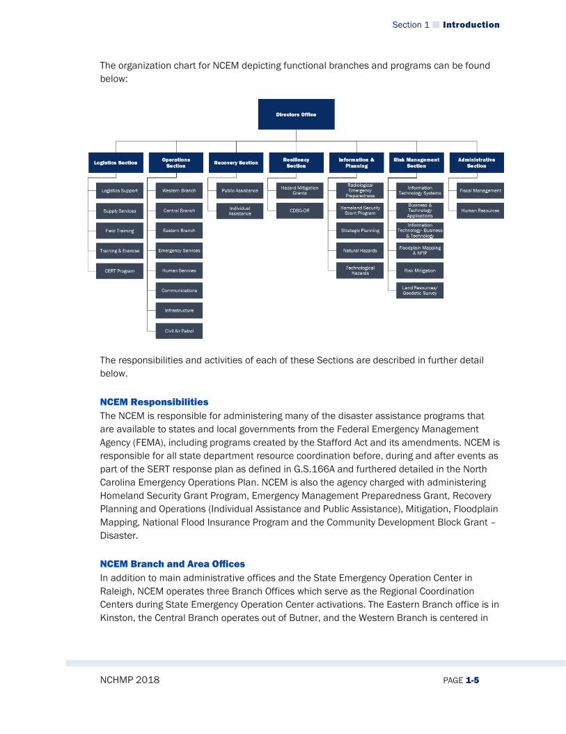
The organization chart for NCEM depicting functional branches and programs can be found below:
The responsibilities and activities of each of these Sections are described in further detail below. NCEM Responsibilities The NCEM is responsible for administering many of the disaster assistance programs that are available to states and local governments from the Federal Emergency Management Agency (FEMA), including programs created by the Stafford Act and its amendments. NCEM is responsible for all state department resource coordination before, during and after events as part of the SERT response plan as defined in G.S.166A and furthered detailed in the North Carolina Emergency Operations Plan. NCEM is also the agency charged with administering Homeland Security Grant Program, Emergency Management Preparedness Grant, Recovery Planning and Operations (Individual Assistance and Public Assistance), Mitigation, Floodplain Mapping, National Flood Insurance Program and the Community Development Block Grant – Disaster. NCEM Branch and Area Offices In addition to main administrative offices and the State Emergency Operation Center in Raleigh, NCEM operates three Branch Offices which serve as the Regional Coordination Centers during State Emergency Operation Center activations. The Eastern Branch office is in Kinston, the Central Branch operates out of Butner, and the Western Branch is centered in

Section 1 Introduction
NCHMP 2018 PAGE 1-6
Conover. Each Branch has a manager who has overall responsibility for personnel within the Branch. Each Branch is divided into five Areas, each of which is assigned a coordinator who works directly with the counties within his or her Area to coordinate communication between municipalities, counties and the state, and to provide technical assistance with grants and other aid requests. In addition to the Manager, each Branch Office has a Program Assistant and a two Emergency Management Planners who also assist the counties with Emergency Management Preparedness Grant and Homeland Security Grant Program administration as well as providing technical assistance with maintenance and annual reviews of the local emergency operation plans. The Area Coordinators are capable of providing local emergency operations center overhead support, and are the local government’s direct line to mutual aid and state resources upon request.
1.2.2.1 State Emergency Response Team (SERT) The Division of Emergency Management is also responsible for coordinating the activities of the State Emergency Response Team (SERT). In the event of an emergency, the SERT directs on-site response activities and is capable of directing the total response effort. The SERT provides the technical expertise and coordinates the delivery of the emergency resources used to support local emergency operations. The SERT is composed of representatives of state, local, and federal agencies as well as non-governmental organizations through the North Carolina Voluntary Organization Active in Disasters (NC-VOAD) such as the American Red Cross, Salvation Army, and other groups who coordinate disaster relief and recovery activities. In this way, prompt assistance can be provided to individuals and communities in need following a disaster. When disaster response and recovery is beyond the capability of local governments and communities, the Governor may use the full resources of the State to support recovery operations. When resource needs are beyond the capabilities of state agencies, mutual aid from other un-impacted local governments and states may be secured using the Statewide Mutual Aid Agreement and/or the Emergency Management Assistance Compact. When the disaster is beyond the capability of both the State and local governments, the Governor may request the President to declare the event a “Major Disaster.” This designation authorizes federal financial assistance and resources to supplement state and local response and recovery efforts.
1.2.2.2 State Emergency Response Commission (SERC) By Executive Order No. 6, dated April 20, 2017, Governor Roy Cooper ordered the continuation of the State Emergency Response Commission (SERC). This Executive Order supersedes and replaces all other executive orders on the subject. It shall remain in effect until December 31, 2019, pursuant to N.C. Gen. Stat.§ 147-16.2 or until rescinded. The Commission is designated as the State Emergency Response Commission as defined in the Emergency Planning and Community Right-to-Know Act of 1986 enacted by the United States Congress and hereinafter referred to as the "Act." The Department of Public Safety

Section 1 Introduction
NCHMP 2018 PAGE 1-7
shall provide administrative support and staff to the Commission as may be required. The Commission serves in three roles: 1) The Commission will perform all of the duties required under the Act and other
advisory, administrative, regulatory, or legislative actions. a. Designate emergency planning districts to facilitate preparation and
implementation of emergency plans as required under Section 301(b) of the Act.
b. Appoint local emergency planning committees described under Section 301(c) of the Act and supervise and coordinate the activities of such committees for each planning district.
c. Establish procedures for reviewing and processing requests from the public for information under Section 324 of the Act.
d. Designate additional facilities that may be subject to the Act under Section 302 of the Act.
e. Review the emergency plans submitted by the local emergency planning committees and recommend revisions of the plans that may be necessary to ensure their coordination with emergency response plans of adjacent districts and state plans.
2) The Commission will act in an advisory capacity to the Homeland Security Advisor
to provide input regarding the activities of the North Carolina State Homeland Security Program and the Domestic Preparedness Regions. Specifically, the Commission will: a. Review the State Homeland Security Strategy to ensure it is aligned with local,
state, and federal priorities as required by the United States Department of Homeland Security (DHS), and that its goals and objectives are being met in accordance with program intent.
b. Review applications and subsequent allocations for state and regional homeland security projects funded by DHS grant programs.
c. Review plans for preventing, preparing for, responding to, and recovering from acts of terrorism and all hazards, whether man-made or natural.
3) The Commission will act in an advisory capacity to provide coordinated stakeholder
input to the Secretary of the Department of Public Safety/Emergency Management in the preparation, implementation, evaluation, and revision of the North Carolina emergency management program. To this purpose, the Commission will work to: a. Increase state and local disaster/emergency response capabilities; and b. Coordinate training, education, technical assistance, and outreach activities.
The Secretary of the North Carolina Department of Public Safety shall serve as the Homeland Security Advisor to the Governor and Chairperson of the Commission. The Commission shall
Section 1 Introduction
NCHMP 2018 PAGE 1-8
consist of not less than 14 members and shall be composed of at least the following persons, or their designee as approved by the Commission Chairperson:
a. Director of Emergency Management, North Carolina Department of Public Safety, who shall serve as the Vice-Chairperson;
b. Director of the State Bureau of Investigation, North Carolina Department of Public Safety;
c. The Adjutant General of the North Carolina National Guard, North Carolina Department of Public Safety;
d. Commander of the State Highway Patrol, North Carolina Department of Public Safety;
e. Secretary of the North Carolina Department of Environmental Quality; f. Secretary of the North Carolina Department of Transportation; g. Chief of the Office of Emergency Medical Services, Division of Health Service
Regulation, North Carolina Department of Health and Human Services; h. Assistant State Fire Marshal, Office of the State Fire Marshal, North Carolina
Department of Insurance; i. State Chief Information Risk Officer, North Carolina Department of Information
Technology; j. Director, Division of Public Health, North Carolina Department of Health and
Human Services; k. Assistant Deputy Commissioner of Labor for Occupational Safety and Health,
North Carolina Department of Labor; l. President of the North Carolina Community College System; and m. Director of the Emergency Programs Division, North Carolina Department of
Agriculture and Consumer Services. In addition to the foregoing, up to eight (8) at-large members from local government, private industry and the public may be appointed by the Governor and serve terms of two (2) years at the pleasure of the Governor. These members may consist of the following persons:
a. A Chief of Police; b. A Sheriff; c. A Fire Chief; d. A representative of emergency medical services in North Carolina; e. A representative of emergency managers in North Carolina; f. A representative of medium or large sized public assembly venues in North
Carolina; g. A representative affiliated with the production, storage or transportation of hazardous materials; h. A private citizen of the state of North Carolina.
In addition, the state is actively involved in critical legislative action in a number of ways. First, high level NCEM staff are in frequent communication with legislators and

Section 1 Introduction
NCHMP 2018 PAGE 1-9
administrators in the executive branch to ensure that the state’s needs are being met with regard to funding and other key resources. This was especially apparent after Hurricane Matthew in 2016 when these relationships resulted in a coordinated effort between NCEM and the legislature to pass the Disaster Recovery Act of 2016. Another way that the state is involved in legislative efforts is through the North Carolina Emergency Management Association which is a key organization in the state that includes many local and state level Emergency Managers and others in the field. In 2017, representatives from the NCEMA traveled to Washington D.C. to visit the offices of North Carolina representatives to discuss national-level emergency management topics and to provide Congressional representatives with opinions and concerns on important issues.
1.2.3 NCEM’s Roles and Responsibilities Related to the North Carolina State Enhanced Hazard Mitigation Plan Between the years of 2000 and 2014 the State Hazard Mitigation Officer (SHMO) held the responsibility of leading the State Hazard Mitigation Advisory Group (SHMAG) and the update process of the State’s Hazard Mitigation Plan. In late 2013 a re-organization occurred within NCEM splitting the Hazard Mitigation Section into two parts. The new organization aligned the Risk Mitigation Planning Branch (formerly known as Hazard Mitigation Planning Branch) and the SHMO under the Risk Management Section of NCEM. The Risk Management Section houses Floodplain Mapping, National Flood Insurance Program (NFIP), Geographic Information Systems (GIS), Information Technology (IT), North Carolina Geodetic Survey and beginning in 2013, Risk Mitigation Planning. The Hazard Mitigation Branch was re-aligned under the Resilience Section of NCEM in 2018 under the supervision of the Hazard Mitigation Branch Section Manager. Under the new organization the SHMO is responsible for Risk Mitigation Planning. The Risk Mitigation Supervisor, who is under the SHMO, oversees reviews of local plans and is responsible for leading the development and periodic update of the State’s Hazard Mitigation Plan as determined by state and presidential disaster declarations, law, policy changes and innovations in hazard mitigations planning and activities. As part of the re-organization of NCEM the SHMAG was dissolved and the duties have been placed on the Risk Management Coordinating Council (RMCC). More details about the RMCC can be found in Section 2, Planning Process.
1.2.4 Plan Adoption and Approval The State of North Carolina will formally adopt the North Carolina Enhanced Hazard Mitigation Plan upon receipt of Federal Emergency Management Agency’s (FEMA) “Approved Pending Adoption” status. The plan will be formally adopted by the Governor or their designee. The FEMA Approval Letter and the formal adoption letter will then be integrated into the NC Enhanced Hazard Mitigation Plan.
Section 1 Introduction
NCHMP 2018 PAGE 1-10
1.2.5 Assurances The NCEHMP update was drafted to meet the requirement for a Standard State Plan under Rule 44 CFR 201.4, and the requirements of the Enhanced State Plan under Rule 44 CFR 201.5 published by the Office of the Federal Register. The State currently meets and will continue to comply with all applicable Federal statutes and regulations in effect with respect to the periods for which it receives grant funding, in compliance with 44 CFR 13.11(c). The State will amend its plan whenever necessary to reflect changes in State or Federal laws and statutes as required in 44 CFR 13.11(d). Continuing to meet the requirements of the regulations noted above keeps the state of North Carolina qualified to obtain all disaster assistance including Hazard Mitigation Grant Program funding available through the Robert T. Stafford Disaster Relief and Emergency Assistance Act, P.L. 93-288, as amended, and Unified Hazard Mitigation Assistance (UHMA) which includes the following funding streams: Hazard Mitigation Grant Program funding, Pre-Disaster Mitigation Program funding, and Flood Mitigation Assistance Program funding. The State of North Carolina assures that it will continue to monitor all applicable Federal statutes and regulations as referred to on FEMA Approval Letters for each respective grant award, to include management cost projects. The State closely monitors federal compliance as it works to develop and implement current projects, and while closing previous disaster as well as non-disaster grants to ensure full programmatic compliance with federal requirements.

State of North Carolina Hazard Mitigation Plan
NCHMP 2018 PAGE 2-1
Section 2. PLANNING PROCESS
44 CFR Reference
Requirement §201.4(b) Planning process. An effective planning process is essential in developing and maintaining a good plan. The mitigation planning process should include coordination with other State agencies, appropriate Federal agencies, interested groups, and be integrated to the extent possible with other ongoing State planning efforts as well as other FEMA mitigation programs and initiatives.
Requirement §201.4 (c) Plan content. To be effective the plan must include the following elements: (1) Description of the planning process used to develop the plan, including how it was prepared, who was involved in the process, and how other agencies participated.
2.1 GENERAL DESCRIPTION
This section serves as documentation of the planning process utilized to develop the 2018 update to the State of North Carolina’s Hazard Mitigation Plan and Enhanced State Mitigation Plan as required for Standard State Mitigation Plans under the Disaster Mitigation Act of 2000 (DMA 2000), Sections 201.4(c)(1) and 201.4(b) of the Standard State Hazard Mitigation Plan criteria, which addresses Documentation of the Planning Process, Coordination Among Agencies, and Program Integration. The Risk Mitigation Planning Branch began the update process in late 2016 with an internal review of each section of the current plan. Taking under advisement the FEMA reviewers’ comments made during the last update, it was determined that the plan should be reorganized for better flow and ease of use. The Risk Mitigation Planning Supervisor wrote an entirely new table of contents for the plan and sent it out to stakeholders and NCEM staff for review and comment. After some revisions were made to the table of contents, Risk Mitigation staff members were assigned sections to transfer into the new format and review for necessary updates. Once each section was reviewed and analyzed, staff identified points of contact through the Risk Management Coordinating Council and coordinated the inclusion of any updated contributions to the mitigation plan by section. In July of 2017, NCEM selected the team of ESP Associates and Atkins to provide consultant support for updating the planning and helping facilitate the planning process.

Section 2 Planning Process
NCHMP 2018 PAGE 2-2
The following paragraphs generally summarize the revisions made to this plan during the 2018 update. Planning Process During the internal review process, it was determined that Risk Mitigation Planning staff would review and identify key processes that could be rewritten to clarify and streamline the planning process. Following the 2014 SHMAG meeting, the SHMAG was dissolved and the new Risk Management Coordinating Council (RMCC) was created as a type of steering committee for the entire Risk Management Section. This announcement was made on a conference call with the former SHMAG members in December of 2015. The scope of the RMCC is much broader than that of the SHMAG. It serves as the advisory group for the NCHMP, Risk MAP, and the NC Floodplain Mapping Program’s discovery phase and fosters information and data sharing between state agencies. Risk and Vulnerability Assessment As part of the 2018 plan update process, NCEM Risk Mitigation staff and their consulting team reviewed the existing hazard identification, hazard descriptions, and the risk assessment. Through meetings with natural hazard experts from across the state (discussed in more detail in subsection 2.2) that provided a comprehensive representation of knowledge across all meteorological and geologic natural hazards that affect North Carolina, the risk and vulnerability assessment was completely reorganized. Through coordination with NCEM and these hazard experts, the consulting team collected preliminary information on previous occurrences, projections of future occurrences, and geographic locations of hazard events, which were later revised and supplemented with additional background research. With this information in hand, the planning team of NCEM and their consultants were able to develop a comprehensive analysis of risk across the state on a county by county basis. Risk Mitigation Planning staff reviewed and made revisions to this section of the plan, including changes to hazard profiles and history. The HM staff, with the assistance of subject matter experts and NCEM-Risk Management, coordinated to revise text, identify state-owned facilities, perform new vulnerability assessments for hazards, and examine hazards as listed in the hazards section. This data was revised to include information on recent hazard events and new information on exposure, which ultimately made it necessary to update the overall vulnerability information in the plan. Mitigation Strategy The implementation of the new format of the North Carolina Enhanced Hazard Mitigation Plan changed the section number of the Mitigation Strategy Section of the plan to Section 5. It includes the Goals, Objectives, and Actions of the plan. To highlight some of the changes to the Mitigation Strategy Section, the single goal was changed and additional goals were added, the objectives were changed to be the milestones of the goals, and actions where reviewed for cost effectiveness, overall feasibility,
Section 2 Planning Process
NCHMP 2018 PAGE 2-3
availability of potential funding, political will, and to meet the SMART action criteria. SMART is an acronym for Specific, Measurable, Achievable, Relevant, and Time-Bound. This is a new concept to the North Carolina Enhanced Hazard Mitigation Plan for this update. Each action must meet all of the aforementioned criteria, either as it is or through revision, otherwise it was identified for deletion. Risk Mitigation Planning staff reviewed the mitigation actions and made recommendations for revisions to the primary responsible agency through the RMCC members, various subject matter experts, and other stakeholders. After discussion with the responsible agencies, some actions have been identified for deletion and some new actions have been added. The deleted actions have been removed from the “Active” actions and put below in a new sub-section of the Mitigation Strategy Section. Coordination of Local Mitigation Planning The planning staff made some substantial changes to the part of the plan related to coordinating with local mitigation planning. This was especially notable in Risk and Vulnerability Assessment which includes a new methodology for evaluating local risk assessments (see section 3.4.5.1). That being said, the same basic process remains in place for coordinating local mitigation planning as described in Section 4. The major change over the past three years was that the planning staff became more adept at implementing the process and helping local governments develop their plans. Plan Maintenance Risk Mitigation Planning staff reviewed and made minimal grammatical revisions to this section of the plan. In this review, it made sure the plan maintenance process was still applicable and that it could be easily implemented. Severe Repetitive Loss Strategy Risk Mitigation Planning staff determined that the Severe Repetitive Loss Strategy would be integrated into all relevant sections of the plan, rather than having that information repeated and included in an Appendix.
2.2 TIMELINE AND MILESTONES
The State of North Carolina developed their first State Hazard Mitigation Plan in 2004. Updates to the plan have been completed in 2007, 2010, and 2013. Information about the planning processes used to develop previous version of this plan can be found within those plan documents, which are available upon request from NCEM. The process of updating the 2018 version of the plan began in January of 2017 with the first meeting of the RMCC. Next, planning staff identified specific actions of representative agencies and coordinated with key points of contacts to address the status and validity of mitigation actions and
Section 2 Planning Process
NCHMP 2018 PAGE 2-4
objectives. Once information for various sources was collected, this information was incorporated into the plan and completed by the mitigation planning team members. Each updated section was combined into a complete document for review by the SHMO, the RMCC, and stakeholders. A point of contact was identified for each agency represented in the Capabilities section of the plan, and each agency was contacted and asked to review the material contained within the plan relevant to their agency for currency, accuracy, and continued relevance. During the plan update, the SHMO and Risk Mitigation Planning staff participated in numerous conferences, workshops, meetings, and teleconference calls to discuss planning objectives, milestones, and improvements for both state and local plans. Throughout the update process, important data was collected from a variety of sources, including the National Weather Service, National Centers for Environmental Information, NCEM-RM, and other local, state, and federal partners. This data was analyzed and incorporated into many different sections of the plan, including the risk assessment, capabilities assessment, and mitigation strategy. New data was included pertaining to population, economic activities, frequency of hazard events, and mitigation actions. Much of this information was obtained through meetings and communication with identified points of contact described below. Once all necessary new data was collected and integrated into the plan, it was submitted to stakeholders for final approval and then submitted to FEMA for review and approval. 2018 Update The Risk Mitigation Planning Branch began the 2018 plan update process with an internal review of each section of the current plan after the 2017 planning team was chosen. Taking under advisement the FEMA reviewers’ comments made during the last update, it was determined that the plan should be reorganized for better flow and ease of use. The Risk Mitigation Planning Supervisor wrote an entirely new table of contents for the plan and sent it out to stakeholders and NCEM staff for review and comment. After some revisions were made to the table of contents, Risk Mitigation staff members were assigned sections to transfer into the new format and review for necessary updates. Once each section was reviewed and analyzed, staff identified points of contact through the RMCC and coordinated the inclusion of any updated contributions to the mitigation plan by section. The planning process was coordinated through the Risk Management Coordinating Council. More detail about specific meetings with the RMCC can be found in Section 2.3 below. In July of 2017, NCEM selected the consulting team of ESP Associates and Atkins to provide consultant support for updating the planning and helping facilitate the planning process. An internal planning team made up of the Risk Mitigation staff and the consulting team began meeting on August 10, 2017 and met weekly until the plan draft

Section 2 Planning Process
NCHMP 2018 PAGE 2-5
was completed in late December 2017. Table 2-1 below provides a summary of the meetings held with NCEM Risk Mitigation staff and the consultant team during the update of this plan.
Table 2-1. Summary of Meetings with NCEM Risk Mitigation Staff and the Consultant Team
NCEM Risk Mitigation Staff and Consultant Team Meetings
Meeting Theme Date of Meeting State Plan Update Kickoff 08/10/17 Integration with EMAP 08/23/17
NC Enhanced State HM Plan Weekly Meeting
08/24/17 08/31/17 09/07/17 09/14/17 09/21/17 09/28/17
10/05/17 10/12/17 10/19/17 11/02/17 11/09/17 12/21/17
Mitigation Strategy Discussion 08/30/17 Risk Assessment Discussion with NCEM GIS Staff 10/19/17 and 12/18/17
2.3 PLANNING TEAM
The process for coordinating with federal, state, local, and other interested groups involved the Risk Mitigation staff increasing outreach efforts to develop hazard-specific points of contact and subject matter experts. The SHMO led this effort with the maintenance and update of the RMCC list (Table 2-2) and by attending various conferences, work groups, and community meetings. These meetings allowed the state to highlight the importance of a state and local planning process and comprehensive program management. During the 2018 update, the planning team evaluated the process for coordinating with federal and state agencies and, although some changes to the process were noted, the coordination process remained basically the same.

Section 2 Planning Process
NCHMP 2018 PAGE 2-6
Table 2-2. Risk Management Coordinating Council Membership (2018)
Name Agency
Debora Antley NC Department of Information Technology Darryl Aspey Department of Homeland Security Tim Baumgartner NC Division of Mitigation Services – Environmental Enhancement Program Jacky Bell FEMA Region IV Gail Bledsoe NC Department of Agriculture and Consumer Services John Boland Johns Hopkins University Richard Bolyard NC Department of Insurance Scot Brooks NC Emergency Management Association Robert Carruth NC Association of County Commissioners Julie Casini NC Department of Health and Human Services Shane Cook NC Division of Energy, Mineral and Land Resources, NC Dam Safety Lee Cox NC Department of Health and Human Services Ryan Cox NCEM – Risk Management Chris Crew NCEM – Risk Management Todd Davidson NOAA Coastal Hazards Center Tracy E. Davis NC Division of Energy, Mineral and Land Resources Matthew Dolge NC Association of Regional Councils of Government John Dorman NCEM – Risk Management Ryan Draughn NC League of Municipalities Rebecca Ellin NC Coastal Reserve & National Estuarine Research Reserve Edward Finley NC Utilities Commission Matt Flint USDA James Fox UNC Asheville, National Environmental Modeling Gerald Galloway University of Maryland Wayne Goodwin NC Department of Insurance Frank Gorham NC Department of Environment Quality, Coastal Resource Commission Brent Herron UNC Campus Safety & Emergency Operations Shelia Holman NC Department of Environmental Quality John Howard NC Department of Agriculture & Consumer Services Frank Jennings NC Division of Coastal Management Michael Kelly NC Association of County Commissioners Jamie Kruse ECU, Center for Natural Hazards Research David Lane NC Department of Agriculture & Consumer Services Steve Lewis NC Department of Environment Quality Mike Lopazanski NCDCM Rick Luettich UNC-Marine Sciences Nancy Marsh EPA (Region 4) Ground Water Carl Martin NC Department of Insurance Dr. R. Douglas Meckes NC Department of Agriculture & Consumer Services Tancred Miller NC Division of Coastal Management Hope Morgan NCEM - Risk Management Jesse Munoz FEMA Region IV Burt Neily NC Department of Administration - State Construction

Section 2 Planning Process
NCHMP 2018 PAGE 2-7
Name Agency
Lee Padrick NC Department of Commerce Louis Panzer NC 811 Nick Petro NOAA/NWS, Raleigh Weather Forecast Office Brandon Puckett NC Coastal Reserve & Nat'l Estuarine Research Reserve Terry Quarreles FEMA Region IV - Public Assistance (406) Stan Riggs ECSU Linda Rimer EPA Jeanne Robbins USGS Spencer Rogers NC Sea Grant (NC State) Terri Ruch USDA-NRCS Cindy Safrit NC Department of Ag & Consumer Services Mina Shehee NC Department of Health and Human Services Aaron Sims NC State Climate Office Matt Slagel NCDCM Gavin Smith UNC Chapel Hill Dianne Suess NOAA/NWS Space Weather Prediction Center Ken Taylor NC Geologic Survey Maria Thompson NC Department of Information Technology Jay Twisdale NCDOT - Hydraulics Chris Vaughn FEMA Toby Vinson NC Division of Energy, Mineral, and Land Resources, NC Dam Safety Chad Wagner USGS North Carolina Office Rebecca Ward NC State Climate Office J Curtis Weaver USGS South Atlantic Water Science Center
The first meeting with the RMCC for the 2018 plan update was held on January 12, 2017. The purpose of the meeting was to lay out the vision of the council and to introduce the concept of a biennial risk management plan that helps identify the current state of Risk Management in North Carolina and identifies priorities, resources, and needs in the areas of hazards, data, models, applications, and plans. These priorities, resources, and needs became the goals and objectives for the updated Enhanced State Hazard Mitigation Plan.
2.4 STAKEHOLDER INVOLVEMENT
2.4.1 Governmental Agencies As described above, the RMCC served as the official stakeholder group for coordinating the 2018 plan update process. In addition to the meetings described in Section 2.3, Risk Mitigation staff and the consulting team held meetings with individual State and Federal agencies that serve on the RMCC to collect feedback on the plan in a more personal setting. Separate meetings were held with representatives from the following governmental agencies:

Section 2 Planning Process
NCHMP 2018 PAGE 2-8
North Carolina Forest Service North Carolina Dam Safety Program United States Army Corps of Engineers North Carolina Geological Survey North Carolina Department of Health and Human Services North Carolina Housing Finance Agency North Carolina Department of Agriculture North Carolina Department of Environmental Quality: Division of Coastal
Management North Carolina State Historic Preservation Office State Climate Office of North Carolina North Carolina Department of Insurance North Carolina Office of State Fire Marshall North Carolina Department of Transportation
The purpose of the meetings was to review specific information from those stakeholders related to the risk assessment (discussion of data needs and identification of any new data relevant for the plan update), capability assessment (updating existing capability assessment narratives and providing any new relevant information), and mitigation strategy (updating existing actions and providing any new actions). These meeting were very productive as these stakeholders provided information and led to new data being incorporated into the plan, mitigation action updates and new mitigation actions and updated capability assessment information. Table 2-3 below provides a summary of these meetings including the stakeholder, main topic discussed at the meetings and the dates of the meetings.
Table 2-3. Summary of Stakeholder Meetings
Summary of Stakeholder Meetings
Stakeholder (Discussion Topic) Date of Meeting North Carolina Forest Service (Wildfire) 9/27/17 NC DEQ: Dam Safety (Dam Failure) 10/3/17 and 10/10/17 USACE (Dam Failure, Levees) 10/10/17 NC DEQ: NC Geological Survey (Geological Hazards) 10/11/17 NC Department of Health and Human Services (Infectious Disease) 10/13/17 Housing Finance Agency (Housing Mitigation Programs/Mitigation Capabilities) 11/7/17 State Historic Preservation Officer (Historic and Cultural Resources) 11/8/17 NC Department of Agriculture (Mitigation Capabilities) 11/14/17 NC DEQ: Division of Coastal Management (Coastal Hazards, Mitigation Capabilities)
11/15/17
State Climate Office (Hazard Profiles, Risk Assessment Data) 11/20/17 NC Department of Insurance: State Fire Marshall’s Office (Mitigation Capabilities, Building Codes, State-Owned Facilities)
11/20/17
Section 2 Planning Process
NCHMP 2018 PAGE 2-9
In addition to regular RMCC representatives, state and local government representatives, emergency management practitioners, and subject matter experts were invited to comment on the plan.
2.5 REVIEW AND INTEGRATION OF OTHER PLANNING FUNCTIONS
The State of North Carolina continues to be proactive in developing, implementing, and sustaining hazard mitigation planning and activities with federal, tribal, state, local, and nongovernmental agencies and programs. Through partnerships with RMCC members and participation on various panels and work groups, risk mitigation planning efforts have been integrated to provide solutions to hazards identified in the State Enhanced Hazard Mitigation Plan and to become more disaster resilient. To maintain a high level of performance, knowledge of mitigation trends, and technology, the SHMO and Risk Mitigation Staff attend various trainings, conferences, and local meetings to augment ability to provide technical assistance to customers, RMCC members, and mitigation partners statewide. Risk Mitigation Staff coordinates with locals through 3 regional branches, with a total of 15 area specific coordinators who serve as intermediaries between local governments and staff in the office. A summary of how Risk Mitigation staff works with local, State and Federal agencies to integrate hazard mitigation into other State planning processes and planning initiatives is found below.
2.5.1 Integration with State Planning Programs Division of Emergency Management Planning Section The State Risk Mitigation Branch coordinates regularly and works very closely with the State Planning and Homeland Security Branch. This branch of NCEM is responsible for the State Emergency Operations Plan, THIRA, Radiological Emergency Plans, Strategic Plan, Division Directives, SARA Title III (Emergency Planning Community Right to Know Act), and the Continuity of Operations Plan. While their focus is generally Response and Preparedness statewide, staff works closely with them to ensure all hazards are identified as part of the All Hazards approach adopted by NCEM. The mitigation plan serves as the single Hazard Identification and Risk Assessment (HIRA) for all plans within NCEM. During review and update of all NCEM Plans and After-Action Reports, staff look at response and vulnerability to population, property, infrastructure, and development which is integrated using the HIRA from the NCHMP. Goals, risk assessments, threat assessments, and hazard identification efforts in local communities and statewide are also utilized in this effort. State Floodplain Mapping Program The State Risk Mitigation Planning Branch coordinates regularly and works very closely with the Floodplain Mapping program. This program is the basis by which many communities assess their flood hazards and how the state, as a whole, looks at flooding
Section 2 Planning Process
NCHMP 2018 PAGE 2-10
vulnerability to existing and future structures and development. Floodplain Mapping works across the state to help communities plan for development and avoid flooding in their communities, which is tied very closely to mitigation planning efforts in local communities and statewide. The efforts made by floodplain administrators have led to changes in the International Building Code to include freeboard for development in floodplains across North Carolina. The risk and vulnerability assessment utilized in this plan identifies areas that are subject to NFIP requirements. Division of Coastal Management (A Division of NC Department of Environmental Quality) The SHMO provides courtesy reviews of Coastal Area Management Act (CAMA) Land Use Plan updates for the 20 coastal counties upon request from DEQ. The review is designed to ensure that CAMA plans and hazard mitigation plans are consistent. Also, the State Risk Mitigation Branch coordinates with the Division of Coastal Management (DCM) when it comes to working in designated CAMA counties. For projects planned in these counties, staff coordinated with DCM to ensure that work will not conflict with an area of Environmental Concern according to CAMA regulations. North Carolina Department of Transportation Coordination The State Risk Mitigation Branch coordinates with NCDOT’s Project Development Unit any time there is a potential hazard mitigation project underway. NCEM sends NCDOT information about the location of the project, and they review it against their future plans to ensure no future conflict with deed restricted property and future road projects. Additionally, NCEM and NCDOT coordinate regularly to share data related to hazards and hazard impacts for pre-event and post-event planning purposes. North Carolina State Geologist Since the development of the 2004 State Hazard Mitigation Plan, North Carolina has attempted to gain funding to support mapping of landslides. However, recently much of the funding that had been allocated to that purpose was de-obligated, so efforts have more or less stopped as of 2018. Other recent work with the State Geologist has included outreach about the earthquake hazards in the western part of NC. The State Risk Mitigation Branch has worked with the State Geologist to develop a curriculum about earthquake hazards in NC to help communities and the state as a whole plan for earthquakes. North Carolina Housing Finance Agency Since its creation in 1973 by the General Assembly, the North Carolina Housing Finance Agency (NCHFA) has financed more than 255,000 affordable homes and apartments for North Carolina citizens. Its mission is to create affordable housing opportunities for North Carolinians whose needs are not met by the market.
Section 2 Planning Process
NCHMP 2018 PAGE 2-11
NCHFA is a self-supporting public agency. The Agency operates federal and state housing programs including the Low-Income Housing Tax Credit Program and the North Carolina Housing Trust Fund and provides financing through the sale of tax-exempt bonds and mortgage-backed securities. NCHFA also administers the federal HOME program for North Carolina, a block grant from the Department of Housing and Urban Development to finance affordable homes and apartments developed by local governments, nonprofits, and private entities. Using these and other sources of funds, including its own earnings, the Agency provides a variety of services ranging from low—cost mortgages and down payment assistance for qualified home buyers, helping local governments, non-profit organizations, and private entities develop affordable homes and apartments, financing the development of supportive housing for those with unique housing needs, financing the rehabilitation of substandard owner-occupied homes statewide, and providing foreclosure prevention help in partnership with HUD-approved housing counseling agencies. In response to damage from Hurricane Matthew and Tropical Storms Julia and Hermine the Essential Single-Family Rehabilitation Loan Pool – Disaster Recovery was created. The source of funds includes specially-appropriated loan funds from the NC General Assembly. The NCHFA is working closely with NCEM and NC Department of Commerce. Post Hurricane Matthew, Resilient Redevelopment Planning Initiative In October 2016, Hurricane Matthew caused widespread destruction in the State of North Carolina. At least 26 people lost their lives, and 100,000 homes, businesses, and government buildings sustained damage estimated at $4.8 billion.1 At the storm’s peak, 3,744 individuals fled to 109 shelters across the region. More than 800,000 households lost power and 635 roads were closed, including the major east-west and north-south corridors. In December 2016, the North Carolina General Assembly established the North Carolina Resilient Redevelopment Planning (NCRRP) program as part of the 2016 Disaster Recovery Act (Session Law 2016-124). The purpose of the program is to assist the communities that were damaged by the hurricane by providing a roadmap for community rebuilding and revitalization. The program empowers communities to prepare locally driven recovery plans that identify redevelopment strategies, innovative reconstruction projects, and other necessary actions to allow each community not only to survive, but also to thrive in an era when natural hazards are increasing in severity and frequency. The NCRRP consists of planning and implementation phases and was managed through NCEM.
1 State of North Carolina Supplemental Request for Federal Assistance Hurricane Matthew Recovery, https://governor-
new.s3.amazonaws.com/s3fs-public/documents/files/Hurricane%20Matthew%20Relief--2017%20Federal%20Request%20%28002%29.pdf.
Section 2 Planning Process
NCHMP 2018 PAGE 2-12
These planning documents provided a snapshot of the current needs of the impacted counties with regard to holistic recovery and redevelopment. The plans will evolve as the counties analyze the risk to its assets, identify needs and opportunities, determine the potential costs and benefits of projects, and prioritize projects. As projects are more fully defined, the potential impact on neighboring communities and the region may lead to modifications. Risk Mitigation Branch staff attended many of the meetings that were held during the development of the Resilient Redevelopment Plans (RRP). They provided input and technical assistance (particularly in how hazard mitigation should be related and integrated into the RRPs) that was used by the stakeholder groups as they developed their plans. Health and Social Services The North Carolina Department of Public Health and Human Service, Division of Public Health, Office of Public Health Preparedness and Response provides representation on the Risk Management Coordinating Council and has contributed their knowledge and expertise to the development of the Enhanced State Hazard Mitigation Plan. Their participation in the RMCC opened new channels of communication between NCEM and the Division of Public Health to address the critical issues of communicable disease and bioterrorism and other public health hazards that are being integrated into this plan. Coordination with Local Governments A tool that is used to help the state promote mitigation efforts at the local level is for Risk Mitigation staff to provide outreach, technical assistance, and guidance to local governments to ensure that information contained in their individual hazard mitigations plans meets the requirements set forth in the 44 CFR and is consistent with the state’s mitigation goal. Our office has adopted an outreach strategy that helps communities to produce viable and relevant hazard mitigation plans and establishes relationships that continue throughout the local and state hazard mitigation plan update cycle. Through amplified outreach activity, the Hazard Mitigation Branch staff provides technical assistance to community officials through scheduled meetings, conferences, and trainings to provide information on the annually available non-disaster mitigation program funding: the Pre-Disaster Mitigation (PDM) and Floodplain Mitigation Assistance (FMA) program. The outcome of this effort is the development of mitigation activity that may be funded through these programs, thus making the community more resilient to natural hazards. NCEM, FEMA, and various state and local government officials work to develop and implement project management efforts based on information from communities that have
Section 2 Planning Process
NCHMP 2018 PAGE 2-13
identified mitigation opportunities. This coordination effort provides an opportunity for the Risk Mitigation Branch to share information to help expedite the development and implementation of mitigation projects as well as recovery from events.
2.5.2 Integration with FEMA Mitigation Program and Other Federal Initiatives The state of North Carolina Division of Emergency Management has and will continue to seek federal partners that can assist the state with improving the quality of life for its citizens through administration of mitigation activities. We believe that coordination and planning with our federal partners will help make our state resilient to all hazards. The FEMA and federal programs that we administer and/or provide assistance include: The Hazard Mitigation Grant Program (HMGP) The Flood Mitigation Assistance (FMA) Program The Pre-Disaster Mitigation (PDM) Program Public Assistance (PA) Individual Assistance (IA) Earthquake Consortium Grant Emergency Management Performance Grants Program (EMPG) Homeland Security Grant Disaster Unmet Needs Increased Cost of Compliance (ICC) National Floodplain Management Program (NFIP)
Given the ever-changing climate, communities are looking for ways to incorporate whole community concepts while maintaining open space property to help reduce vulnerability. As such, we coordinate with FEMA on requests for variances from communities to utilize properties as farms, parks and various other uses allowed under 44 CFR. Public Assistance, Individual Assistance and Various Stakeholders After a presidential declaration, NCEM, FEMA, SBA, and various federal, state, and non-profit organizations operate in a Joint Field Office (JFO) setting. The state’s Resiliency Section consists of the Public Assistance, and Individual Assistance Branches. The Resiliency Section coordinates closely with FEMA in those situations to cultivate a cooperative approach for outreach, identification, development, and implementation of potential mitigation opportunities. Potential applicants are briefed on mitigation opportunities that are available under the Hazard Mitigation Program. Risk Mitigation staff also works with our FEMA, state, and local partners to complete Preliminary Damage Assessments (PDA) as well as mitigation planning and outreach efforts to identify 406 and 404 mitigation opportunities. Emergency Management Accreditation Program (EMAP) Developed through the collaboration of the International Association of Emergency Managers (IAEM), National Emergency Management Association (NEMA), Federal
Section 2 Planning Process
NCHMP 2018 PAGE 2-14
Emergency Management Association (FEMA), and other related agencies, EMAP is a voluntary accreditation process for federal, state, county, and municipal emergency response agencies. The accreditation process was developed to provide a framework for accountability and continuous improvement at the state and local level. The North Carolina Division of Emergency Management gained EMAP initial accreditation in November of 2008, received re-accreditation 2013, and will be going through the reaccreditation process again in the spring of 2018. Risk Mitigation coordinated with the Division’s Planning and Homeland Security Section to update the Mitigation Standards required for continued accreditation. Risk Mitigation has been included in the overall evaluation of the division as a whole and is an integral part of the NCEM EMAP Working Group which is the team that leads the process of developing proof of compliance documentation of the EMAP standards of accreditation. Risk Mitigation’s contribution to the EMAP process was the update of 2 standards and 7 sub-standards of the 73 required for EMAP accreditation. The EMAP process evaluates emergency management program elements compliance based on the NFPA 1600 Standard. Additionally, Risk Mitigation has improved its information on Mitigation’s Standard Operating Procedures and Best Practices. The National Integrated Drought Information System (NIDIS) Risk Mitigation staff also participates in workgroups with entities such as the National Drought Mitigation Center (NDMC) to promote the impact of drought on communities and the ecosystem. Our charge is to help develop activities that will help to mitigate the effects of drought on people and property. NIDIS was envisioned to be a dynamic and accessible drought information system that provides users with the ability to determine the potential impacts of drought and the associated risks they bring and the decision support tools needed to better prepare for and mitigate the effects of drought. In this, NIDIS forms the backbone of a national Drought Early Warning System in the U.S.
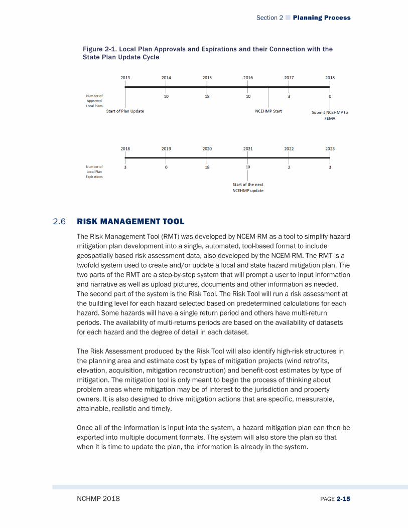
2.5.3 Integration with Local Planning Functions Local governments often reference the NCEHMP plan for assistance in identifying hazards, profiling hazards and for vulnerability assessment information to support their local mitigation planning efforts. The local plans and the single tribal plan in North Carolina are all generally updated early in the five-year cycle of the North Carolina Enhanced Hazard Mitigation plan. This would be in years one through three of the state plan update cycle. While there are four plans that are in the update process at the time we begin the state plan process, they are far enough into the process for the NCEM and RMCC to review those plans for coordination and linkage purposes. The planning team for the state plan review the local plans to ensure goals, objectives, actions, risk assessment and local capabilities are aligned to the extent necessary. Figure 2-1 below provides a graphical representation of the interconnectedness between NCEHMP update cycle and the local plan update and expiration schedule.
Section 2 Planning Process
NCHMP 2018 PAGE 2-15
Figure 2-1. Local Plan Approvals and Expirations and their Connection with the State Plan Update Cycle
2.6 RISK MANAGEMENT TOOL
The Risk Management Tool (RMT) was developed by NCEM-RM as a tool to simplify hazard mitigation plan development into a single, automated, tool-based format to include geospatially based risk assessment data, also developed by the NCEM-RM. The RMT is a twofold system used to create and/or update a local and state hazard mitigation plan. The two parts of the RMT are a step-by-step system that will prompt a user to input information and narrative as well as upload pictures, documents and other information as needed. The second part of the system is the Risk Tool. The Risk Tool will run a risk assessment at the building level for each hazard selected based on predetermined calculations for each hazard. Some hazards will have a single return period and others have multi-return periods. The availability of multi-returns periods are based on the availability of datasets for each hazard and the degree of detail in each dataset. The Risk Assessment produced by the Risk Tool will also identify high-risk structures in the planning area and estimate cost by types of mitigation projects (wind retrofits, elevation, acquisition, mitigation reconstruction) and benefit-cost estimates by type of mitigation. The mitigation tool is only meant to begin the process of thinking about problem areas where mitigation may be of interest to the jurisdiction and property owners. It is also designed to drive mitigation actions that are specific, measurable, attainable, realistic and timely. Once all of the information is input into the system, a hazard mitigation plan can then be exported into multiple document formats. The system will also store the plan so that when it is time to update the plan, the information is already in the system.
Section 2 Planning Process
NCHMP 2018 PAGE 2-16
The RMT was originally developed as part of the Integrated Hazard Risk Management (IHRM) pilot project which included Durham, Edgecombe, Macon and New Hanover counties. The pilot was successful and it was determined that there is a need and interest in a system designed to be used statewide and potentially nationwide in the future. NCEM is in the final stages of building out Version 2 of the RMT.
State of North Carolina Hazard Mitigation Plan
NCHMP 2018 PAGE 3-1
Section 3. RISK AND VULNERABILITY ASSESSMENT
44 CFR Reference
Requirement §201.4(c): [The Standard State Plan Maintenance Process must include a]
(2) Risk assessments that provide the factual basis for activities proposed in the strategy portion of the mitigation plan. Statewide risk assessments must characterize and analyze natural hazards and risks to provide a statewide overview. This overview will allow the State to compare potential losses throughout the State and to determine their priorities for implementing mitigation measures under the strategy, and to prioritize jurisdictions for receiving technical and financial support in developing more detailed local risk and vulnerability assessments. The risk assessment shall include the following:
(i) An overview of the type and location of all natural hazards that can affect the State, including information on previous occurrences of hazard events, as well as the probability of future hazard events, using maps where appropriate;
(ii) An overview and analysis of the State's vulnerability to the hazards described in this paragraph (c)(2), based on estimates provided in local risk assessments as well as the State risk assessment. The State shall describe vulnerability in terms of the jurisdictions most threatened by the identified hazards, and most vulnerable to damage and loss associated with hazard events. State owned or operated critical facilities located in the identified hazard areas shall also be addressed;
(iii) An overview and analysis of potential losses to the identified vulnerable structures, based on estimates provided in local risk assessments as well as the State risk assessment. The State shall estimate the potential dollar losses to State owned or operated buildings, infrastructure, and critical facilities located in the identified hazard areas.
This section is primarily divided into two main topics: Natural and technological hazard Identification and subsequent hazard profiles (found in Sections 3.2-3.5) and, Vulnerability assessment (found in Section 3.6).
3.1 OVERVIEW OF HAZARDS IDENTIFIED
The hazards identified in this document are all hazards that could potentially affect the state of North Carolina. These hazards span several categories including natural hazards, technological hazards, manmade hazards, public health hazards, and agricultural hazards. It is important to note that the Disaster Mitigation Act of 2000
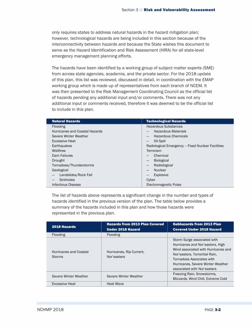
Section 3 Risk and Vulnerability Assessment
NCHMP 2018 PAGE 3-2
only requires states to address natural hazards in the hazard mitigation plan; however, technological hazards are being included in this section because of the interconnectivity between hazards and because the State wishes this document to serve as the Hazard Identification and Risk Assessment (HIRA) for all state-level emergency management planning efforts. The hazards have been identified by a working group of subject matter experts (SME) from across state agencies, academia, and the private sector. For the 2018 update of this plan, this list was reviewed, discussed in detail, in coordination with the EMAP working group which is made up of representatives from each branch of NCEM. It was then presented to the Risk Management Coordinating Council as the official list of hazards pending any additional input and/or comments. There was not any additional input or comments received, therefore it was deemed to be the official list to include in this plan. Natural Hazards Technological Hazards Flooding Hurricanes and Coastal Hazards Severe Winter Weather Excessive Heat Earthquakes Wildfires Dam Failures Drought Tornadoes/Thunderstorms Geological ― Landslides/Rock Fall ― Sinkholes Infectious Disease
Hazardous Substances ― Hazardous Materials ― Hazardous Chemicals ― Oil Spill Radiological Emergency – Fixed Nuclear Facilities Terrorism ― Chemical ― Biological ― Radiological ― Nuclear ― Explosive Cyber Electromagnetic Pulse
The list of hazards above represents a significant change in the number and types of hazards identified in the previous version of the plan. The table below provides a summary of the hazards included in this plan and how those hazards were represented in the previous plan.
2018 Hazards Hazards from 2013 Plan Covered Under 2018 Hazard
Subhazards from 2013 Plan Covered Under 2018 Hazard
Flooding Flooding
Hurricanes and Coastal Storms
Hurricanes, Rip Current, Nor’easters
Storm Surge associated with Hurricanes and Nor’easters, High Wind associated with Hurricanes and Nor’easters, Torrential Rain, Tornadoes Associates with Hurricanes, Severe Winter Weather associated with Nor’easters
Severe Winter Weather Severe Winter Weather Freezing Rain, Snowstorms, Blizzards, Wind Chill, Extreme Cold
Excessive Heat Heat Wave

Section 3 Risk and Vulnerability Assessment
NCHMP 2018 PAGE 3-3
2018 Hazards Hazards from 2013 Plan Covered Under 2018 Hazard
Subhazards from 2013 Plan Covered Under 2018 Hazard
Earthquakes Earthquakes Wildfires Wildfires Dam Failures Dam Failure
Drought Drought Agricultural Drought, Hydrological Drought
Tornadoes/Thunderstorms Tornado, Severe Thunderstorm
Hailstorm, Torrential Rain associated with Severe Thunderstorms, Thunderstorm Wind, Lightning, Waterspout, High Wind
Geological Hazards (Landslides/Rock Fall, Sinkholes, Coastal Erosion)
Debris Flow/Landslide, Sinkholes, Coastal Erosion
Infectious Disease (new to 2018 plan)
3.1.1 Hazard Identification and Hazard Profiles Methodology The Hazard Profiles subsections follow the same general format throughout the plan to provide the user with consistent information for each hazard. Each hazard profile is made up of a Description, Extent (as defined by FEMA), Location, Hazard History, Changing Future Conditions, Impact, Future Probability, and Emergency Operation Plan reference. Each one of the subsections are included to give the user an extensive understanding of the hazard and how it could affect North Carolina. As part of the methodology description of the hazard profile, each one of the subsections are further defined below. The hazard description provides a definition or scientific description of the hazard. Hazards often have multiple categories they will fall into depending on where or how the hazard affects North Carolina. These descriptions will also be examined in detail as part of the hazard description subsection. Natural hazard definitions were obtained primarily from National Oceanic and Atmospheric Administration and the National Weather Service. The Extent of a hazard as defined by FEMA is the strength or magnitude of the hazard. This subsection will define the scale of which the hazard is measured as well as the worst-case event to affect North Carolina. Extent should not be confused with the impact of a hazard. Extent is solely based on the scale of which the hazard is measured and not the effects of the hazard. To provide an example of extent for the purposed of this plan, a hurricane is measured on the Saffir-Simpson Scale with categories one through five. The extent subsection will define the Saffir-Simpson Scale in detail and provide information of the highest category hurricane event to affect North Carolina. Natural hazard extent data was obtained primarily from National Oceanic and Atmospheric Administration and the National Weather Service.

Section 3 Risk and Vulnerability Assessment
NCHMP 2018 PAGE 3-4
Location is a description of the geographical area that could potentially be affected by a hazard. Every hazard identified in this plan could affect North Carolina however it may not affect all geographic regions of North Carolina. To provide an example, a landslide is a hazard for the mountainous region but it is not a hazard for the coastal plains region due to the topographical differences of the two regions. The Hazard History will provide a list of previous occurrences of the hazard. It will also go into greater detail of the more significant events that have affected the state. This is also where a detailed list of previous State and Federal disasters declarations have occurred. Information can be found for each event regarding property losses, economic losses, crop losses, and injuries and deaths attributed to a specific event. Historical data for the hazard profiles was obtained from National Centers for Environmental Information (NCEI). The historical data was used to capture previous occurrences of the hazards. Changing Future Conditions is a description of how the hazard’s impact, frequency, and magnitude could potentially change in the future due to a variety of factors. These factors could be but are not limited to changing global weather patterns, future development in both the urban and rural areas, and changing local and global environmental conditions. Impact is the description of the effects or consequences of the hazard on the state. The description will include the potential effects or consequences of the hazard on state owned assets and the jurisdictions within the state. Effects of the hazard vary greatly depending up the capability to mitigate, prepare for, respond to, and recover from the event. This is also where a discussion can be found on the exposed population to the hazard. Future Probability describes the likelihood of a hazard event happening within the geographical boundaries of North Carolina in any given year. This is expressed by a scale that has been determined to be appropriate through the analysis of all hazards. The scale has been determined by reviewing the return periods of all of the hazards, historical occurrence data, the geographical area at risk for the hazard, and consideration of changing future conditions. The planning team, including subject matter experts, then assigned a general descriptor to each hazard. The general descriptors used are Unlikely, Likely and Highly Likely. The table below shows how these general descriptors correlate to a percentage range of probability however there is not a specific percentage determined for each hazard due to the subjectivity of the aforementioned factors. It is important to note the method used to determine the future probability is qualitative and not quantitative as well as the impact of a hazard is not factored into future probability. While some hazard’s impacts are far greater that others, it does not increase or decrease the likelihood of a significant hazard event occurring. Historical data for the hazard profiles was obtained from National Centers for Environmental Information (NCEI).

Section 3 Risk and Vulnerability Assessment
NCHMP 2018 PAGE 3-5
Category of Likelihood Correlating Percentages of Probability Unlikely 1% to 33.3% Likely 33.4% to 66.6% Highly Likely 66.7% to 100%
The North Carolina Emergency Operations Plan (NCEOP) Reference subsection is new to the 2018 update of the NCEHMP. While it is not a requirement of state planning guidance, it was determined that this addition would increase transparency among documentation. Planning efforts are coordinated among all staff within the agency in an effort to support an all-hazards approach using the operating procedures outlined in the NCEOP. The NCEOP may contain additional annexes that identify operating procedures for other cascading impacts. These annexes have been developed in regards to frequency of regional occurrence, the potential impact of a hazard, and the need for abnormal response procedures. Conversely, some hazards identified in Section 3.2 of this Hazard Mitigation Plan fall under the response outlined within the Basic Plan or other annexes of the NCEOP. For more information on the NCEOP, please visit the North Carolina Department of Public Safety website.
3.2 NATURAL HAZARD IDENTIFICATION
3.2.1 Flooding
3.2.1.1 Description Flooding is a localized hazard that generally results from excessive precipitation. Floods are generally considered to fall in one of two categories: flash floods, which are the product of heavy localized precipitation that occurs within a short period of time at a given location; and general floods, caused by precipitation that occurs during a longer period of time over a particular river basin.

Section 3 Risk and Vulnerability Assessment
NCHMP 2018 PAGE 3-6
Flooding is the most common environmental hazard to affect the United States, due to the widespread geographical distribution of river valleys and coastal areas, and the attraction of human settlements to these areas. Most recent presidential declarations concerning major disasters have been associated with flash floods and general flooding. Flash floods occur shortly after a heavy accumulation of rainfall or result from a dam or levee failure or from a sudden release of water held by an ice jam. Flash floods can destroy buildings and bridges, uproot trees, and scour out new drainage channels. Heavy rains that produce flash floods can also trigger mudslides. Most flash flooding is caused by slow-moving thunderstorms, repeated thunderstorms in one local area, or by heavy rains generated by hurricanes and tropical storms. Although flash flooding occurs often along western mountain streams, it is also common in urban areas throughout the state, especially in areas where much of the ground is covered by impermeable surfaces. Roads and buildings impervious to water infiltration generate greater amounts of runoff than typical forested land. Fixed drainage channels in urban areas may be unable to contain the runoff that is generated by relatively small but intense rainfall events. A combination of river basin physiography, local thunderstorm movement, past soil moisture conditions, and the degree of vegetative clearing and creation of impervious surfaces resulting from development determines the severity of a flooding event. Abnormal weather patterns may also contribute to the flooding of a local area. Large-scale climatic events (such as the El Nino-Southern Oscillation in the Pacific Ocean) have been linked to increased storm activity and flooding in the United States. Nationally, July is the month in which most flash flooding events occur in the United States, and nearly 90 percent of flash floods occur during the months of April through September (Frazier, 1979). While flash floods occur within hours of a rain event, general flooding is a longer-term event, and may last for several days or weeks. The primary types of flooding are riverine flooding, coastal flooding, and urban flooding. The periodic flooding of lands adjacent to non-tidal rivers and streams is a natural and inevitable occurrence. When stream flow exceeds the capacity of the normal water course, some of the above-normal stream flow spills over onto adjacent lands located within the floodplain. Floodplains are relatively low-lying areas adjacent to streams, lakes, rivers, or coast commonly prone to flooding. Floodplains are part of the natural hydrologic system, serving the important function of carrying and temporarily storing excess floodwater or dampening the energy of torrential rain or coastal storms. In addition, floodplains are useful for maintaining water quality, preserving groundwater supply, supporting natural vegetation and providing natural habitats, as well as offering many kinds of
Section 3 Risk and Vulnerability Assessment
NCHMP 2018 PAGE 3-7
recreational and educational activities. Floodplain boundaries are designated and routinely updated through Federal Emergency Management Agency (FEMA) Flood Insurance Study (FIS) reports and these revisions are then shown on Flood Insurance Rate Maps (FIRMs), according to various flood hazard zones. Flood hazard zone designations will depend upon local conditions and the date when the map was issued, but all will show the 100-year or base floodplain (1-percent annual chance), as well as areas of the 500-year floodplain (0.2-percent annual chance). Riverine flooding is a function of precipitation levels and water runoff volumes within the watershed of the stream or river. The recurrence interval of a flood is defined as the average time interval (in years) expected to take place between the occurrence of one flood of a particular magnitude and the occurrence of a flood of equal or larger magnitude. Generally, flood magnitude increases as recurrence intervals decrease. Coastal flooding is typically a result of storm surge, wind-driven waves, and heavy rainfall. These conditions are produced by tropical systems during the summer and fall, and nor'easters and other large coastal storms during the winter and spring. Storm surges may overrun barrier islands and push seawater up coastal rivers and inlets, blocking the downstream flow of inland runoff. Thousands of acres of crops and forestlands may be inundated by both saltwater and freshwater. Escape routes, particularly from barrier islands, may be cut off quickly, stranding residents in flooded areas and hampering rescue efforts. Urban flooding occurs where there has been development within stream floodplains or in coastal areas where there are high levels of development. This is partly a result of the use of waterways for transportation purposes in earlier times. Sites adjacent to rivers and coastal inlets provided convenient places to ship and receive commodities. The ultimate price of this accessibility was the increased flooding of ensuing urban areas. Urbanization increases the magnitude and frequency of floods by increasing the number of impermeable surfaces, increasing the speed of drainage collection, reducing the carrying capacity of the land and occasionally overwhelming sewer systems by infiltration and inflow.
3.2.1.2 Extent Flood extent can be measured by the amount of land in the floodplain as well as by flood height and velocity. According to the North Carolina Floodplain Mapping Program, the amount of land in the floodplain in North Carolina accounts for about 18.2 % of the total land area in the state.
3.2.1.3 Location/Spatial Extent The North Carolina Floodplain Mapping Program is currently in the process of developing and updating digital flood hazard data for the entire state of North Carolina. Currently, new digital flood hazard data exists for all of the state’s 100

Section 3 Risk and Vulnerability Assessment
NCHMP 2018 PAGE 3-8
counties which are summarized in Figure 3-1. The figure also includes the delineation of Coastal High Hazard Areas which is that part of the coastal floodplain where wave heights during the base flood event will be three feet or more (also designated by FEMA as “V Zones”). Based on historical events, flooding in some areas of the state could be up to 20 feet in depth and flooding generally could occur in any county in the state.
Figure 3-1 North Carolina Mapped Flood Hazard Areas Through 2017
3.2.1.4 Hazard History Many North Carolina counties have experienced major catastrophic flooding in recent years, and some have experienced multiple major flooding disasters. Since 1977, North Carolina has received Federal aid from the Small Business Administration (SBA) and/or FEMA for 23 major disasters that produced substantial flood damage to one or more counties. These major disasters are listed in Table 3-1.

Section 3 Risk and Vulnerability Assessment
NCHMP 2018 PAGE 3-9
Table 3-1 Presidential Flooding Disasters Since 1977
Event Location Damages
1977 Floods (11/1977) Western North Carolina $14,189,210 1979 Floods Surry County $56,084 Hurricane Diana (09/1984) Coast $67,000,000 Hurricane Gloria (09/1985) Coast $8,500,413 1989 Floods (09/1989) Fayetteville $10,000,000 1992 Flood (09/1992) Swain County $2,186,000 Hurricane Emily (08/1993) Dare County $12,500,000 Hurricane Opal (10/1995) Mountain Counties $9,400,000 Western Flooding (01/1998) Western North Carolina $7,000,000 Hurricane Bonnie (08/1998) Eastern North Carolina $22,000,000 Hurricane Dennis (08/1999) Eastern North Carolina $10,000,000 Hurricane Floyd (09/1999) Mid/East North Carolina $3,403,839,436 Hurricane Isabel (09/2003) Mid/East North Carolina $372,500,000 Tropical Storm Frances (09/2004) Western North Carolina $20,500,000 Hurricane Ivan (09/2004) Western North Carolina $13,800,00 Hurricane Ophelia (10/2005) Coastal North Carolina $70,000,000
Tropical Storm Hanna (10/08/2008) Beaufort, Brunswick, New Hanover and Person Counties $10,000,000
Severe Winter Storm and Flooding (02/02/2010)
Western North Carolina $10,000,000
Tropical Storm Nicole (10/14/2010) Eastern North Carolina $5,431,477 (IA only)
Hurricane Irene (08/31/2011) Eastern and Central North Carolina $115,431,919 (IA and PA)
Eastern Cherokee Flooding (01/14/2013)
Western North Carolina $3,161,875
2013 Flooding (07/2013) Western North Carolina $14,217,743 Hurricane Matthew (08/07/2016) Eastern and Central North Carolina $1,500,000,000 Source: FEMA.gov
Flooding in Western North Carolina Only five of these disasters were stand-alone flood events, and nine occurred in the mountains of Western North Carolina. Among these flooding-only disasters was a devastating flood that impacted several counties in early Nov. 1977—the beginning of this documented history. Storms for this event produced 8 to 14 inches of rain in 33 counties; the 17 counties most impacted by these storms were designated in (or later added to) a presidential disaster declaration.
Another significant flood event was the Western Flooding that occurred in January 1998, caused by a weather system that also devastated communities in bordering Tennessee. Heavy rains fell on snow-pack in the higher elevations and the resulting runoff caused flash flooding in streams below. Numerous homes, public buildings, and public and private infrastructure were lost within a very short span of time.

Section 3 Risk and Vulnerability Assessment
NCHMP 2018 PAGE 3-10
In 2004, the remnants of Tropical Storm Frances and Hurricane Ivan caused major flooding in Western North Carolina, where rainfall estimates from both storms ranged from 6 to 20 inches within a 10-day period. This unprecedented event caused significant flood and debris-flow damages, economic losses, environmental damages, and took 11 lives. The communities of Asheville, Biltmore Village, Brevard, Clyde, Canton, Newland, Morganton, Hendersonville, and Mountain Island Lake were heavily impacted, as well as other rural communities. Two weeks of snow and sleet beginning December 14, 2009 led to runoff and flash flooding in the 13 counties of Alleghany, Ashe, Avery, Buncombe, Burke, Caldwell, Haywood, Jackson, Madison, McDowell, Mitchell, Watauga, Yancey and the tribal lands of the Eastern Band of Cherokee Indians in Western NC. A PDA conducted in the last two weeks of January, 2010 led to a federal declaration for ice damage and flash flooding. A map of this data is pictured in Figure 3-2 below.
Figure 3-2 Counties Declared in FEMA DR-1871
Flooding in Eastern and Central North Carolina Flooding remains one of the major destructive forces of land-falling tropical storms and hurricanes, which have affected all parts of North Carolina, but have historically caused the largest impacts in the Eastern and Central parts of the state. Fifteen of the listed events are hurricanes or tropical storms that included devastating floods as part of their destructive force. In recent history alone, Hurricanes Irene (2011) and Matthew (2016) brought devastating flooding and heavy winds inland to many communities and counties in Eastern North Carolina. These events are more thoroughly discussed in the Hurricanes and Coastal

Section 3 Risk and Vulnerability Assessment
NCHMP 2018 PAGE 3-11
Hazards section found later in this risk assessment, but a brief overview of the flooding impacts is warranted here. In August of 2011, Hurricane Irene caused the worst flooding the state had experienced in nearly a decade. Although the storm was only a category 1 storm when it made landfall and its course did not continue inland, several coastal counties in Eastern North Carolina were hit hard. Counties located on the Pamlico Sound were particularly affected as storm surge and torrential rain caused flooding in many areas located along the sound. In Figure 3-3 below, a map displays all of the counties that were a part of the presidentially declared disaster area.
Figure 3-3 Counties Declared in FEMA DR-4019
The most recent flooding disaster occurred during Hurricane Matthew in October 2016. Most of the damage was in central and eastern North Carolina from torrential rainfall of 8 to 15 inches. Flooding from this storm directly caused 11 fatalities and caused record-setting river flooding along the Neuse, Cape Fear, and Tar River basins. A presidential disaster was declared on October 10, and a map of the affected counties is pictured in Figure 3-4 below. North Carolina is still in the process of recovering from the Hurricane Matthew disaster.

Section 3 Risk and Vulnerability Assessment
NCHMP 2018 PAGE 3-12
Figure 3-4 Counties Declared in FEMA DR-4285
According to NCEI data, between 1996 and 2017, North Carolina has experienced flooding in every county, resulting in 72 deaths and $ 1,663,464,754 in property and crop damages. A detailed summary of NCEI flooding event data by county is listed in Table 3-1 below. A graphic representation follows the table in Figure 3-5.
Table 3-2 North Carolina Flood Event Summary by County
County Number of events (1996-2017)
Fatalities Injuries Property Damage (Inflated to 2017 Dollars)
Crop Damage (Inflated to 2017 Dollars)
Alamance 32 0 0 $2,502,578 $0 Alexander 9 0 0 $130,661 $0 Alleghany 20 0 0 $658,993 $241,723 Anson 36 0 0 $0 $0 Ashe 63 0 0 $1,059,241 $0 Avery 28 0 0 $26,890,133 $9,152,034 Beaufort 27 0 0 $802,580 $62,254,856 Bertie 24 1 0 $10,289,555 $1,028,382 Bladen 41 2 0 $19,927,883 $0 Brunswick 75 0 0 $4,950,971 $0 Buncombe 35 2 0 $110,535,960 $1,306,611 Burke 52 0 0 $11,986,644 $0 Cabarrus 64 0 4 $14,948,945 $3,075,626 Caldwell 59 0 1 $2,355,460 $1,959,917 Camden 13 0 0 $519,922 $0 Carteret 39 0 0 $18,416 $0 Caswell 26 0 0 $430,735 $1,148,360

Section 3 Risk and Vulnerability Assessment
NCHMP 2018 PAGE 3-13
County Number of events (1996-2017)
Fatalities Injuries Property Damage (Inflated to 2017 Dollars)
Crop Damage (Inflated to 2017 Dollars)
Catawba 25 0 0 $1,050,442 $0 Chatham 24 0 0 $51,419 $0 Cherokee 15 0 0 $2,306,764 $0 Chowan 7 0 0 $514,191 $0 Clay 6 0 0 $1,279,792 $0 Cleveland 13 0 0 $84,921 $0 Columbus 30 1 0 $47,105,275 $15,129,685 Craven 27 1 0 $688,961 $565,953 Cumberland 50 2 0 $67,867,213 $20,567,650 Currituck 14 0 0 $7,113,258 $0 Dare 24 0 0 $9,374,362 $0 Davidson 45 1 0 $873,045 $0 Davie 9 0 0 $1,318,326 $156,793 Duplin 26 0 0 $208,953 $1,131,906 Durham 53 0 0 $403,687 $0 Edgecombe 35 8 0 $71,092,276 $20,567,650 Forsyth 37 0 0 $384,295 $0 Franklin 23 1 0 $0 $0 Gaston 22 0 0 $2,810,482 $0 Gates 14 1 0 $721,601 $8,740,888 Graham 11 0 0 $495,623 $0 Granville 17 0 0 $0 $0 Greene 18 1 0 $0 $0 Guilford 82 1 0 $3,262,483 $0 Halifax 36 2 0 $76,146,263 $20,567,650 Harnett 19 1 0 $9,383,989 $0 Haywood 29 3 0 $31,168,930 $2,613,223 Henderson 78 0 1 $7,817,825 $13,359,226 Hertford 16 0 0 $10,627,641 $18,518,832 Hoke 22 0 0 $4,605,291 $0 Hyde 7 0 0 $0 $0 Iredell 21 0 0 $3,070,931 $0 Jackson 38 0 0 $934,686 $9,146 Johnston 45 7 0 $25,416,683 $20,567,650 Jones 15 0 0 $565,953 $3,791,438 Lee 18 0 0 $550,184 $0 Lenoir 34 5 0 $14,360,204 $37,754,340 Lincoln 25 0 0 $2,277,544 $0 Macon 31 0 0 $5,414,897 $1,371,941 Madison 38 1 2 $23,023,809 $17,111,088 Martin 17 0 0 $290,210 $0 McDowell 24 0 0 $9,868,447 $1,306,611 Mecklenburg 99 6 4 $30,319,223 $11,319 Mitchell 23 0 0 $9,788,018 $0 Montgomery 34 0 0 $0 $0 Moore 32 0 0 $4,347,804 $0 Nash 29 4 0 $219,485,123 $20,567,650 New Hanover 136 0 2 $5,475,278 $0 Northampton 18 0 0 $2,294,611 $30,074,584 Onslow 35 0 0 $2,895,627 $6,791,438
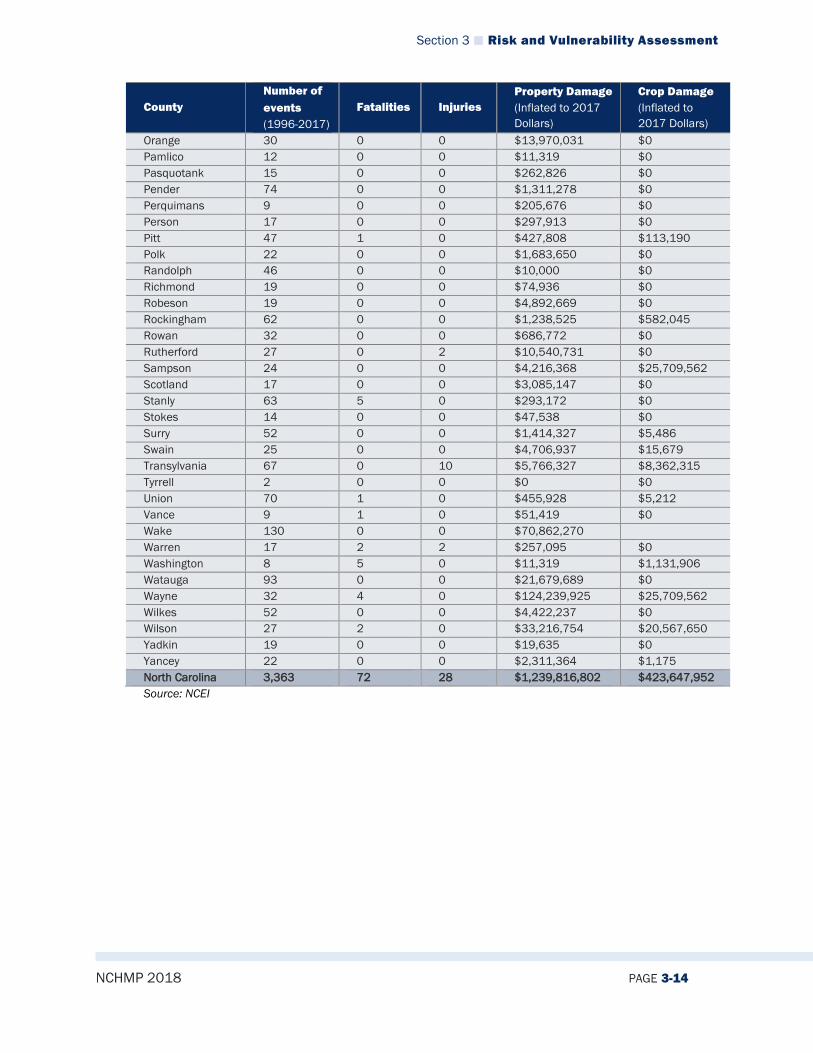
Section 3 Risk and Vulnerability Assessment
NCHMP 2018 PAGE 3-14
County Number of events (1996-2017)
Fatalities Injuries Property Damage (Inflated to 2017 Dollars)
Crop Damage (Inflated to 2017 Dollars)
Orange 30 0 0 $13,970,031 $0 Pamlico 12 0 0 $11,319 $0 Pasquotank 15 0 0 $262,826 $0 Pender 74 0 0 $1,311,278 $0 Perquimans 9 0 0 $205,676 $0 Person 17 0 0 $297,913 $0 Pitt 47 1 0 $427,808 $113,190 Polk 22 0 0 $1,683,650 $0 Randolph 46 0 0 $10,000 $0 Richmond 19 0 0 $74,936 $0 Robeson 19 0 0 $4,892,669 $0 Rockingham 62 0 0 $1,238,525 $582,045 Rowan 32 0 0 $686,772 $0 Rutherford 27 0 2 $10,540,731 $0 Sampson 24 0 0 $4,216,368 $25,709,562 Scotland 17 0 0 $3,085,147 $0 Stanly 63 5 0 $293,172 $0 Stokes 14 0 0 $47,538 $0 Surry 52 0 0 $1,414,327 $5,486 Swain 25 0 0 $4,706,937 $15,679 Transylvania 67 0 10 $5,766,327 $8,362,315 Tyrrell 2 0 0 $0 $0 Union 70 1 0 $455,928 $5,212 Vance 9 1 0 $51,419 $0 Wake 130 0 0 $70,862,270 Warren 17 2 2 $257,095 $0 Washington 8 5 0 $11,319 $1,131,906 Watauga 93 0 0 $21,679,689 $0 Wayne 32 4 0 $124,239,925 $25,709,562 Wilkes 52 0 0 $4,422,237 $0 Wilson 27 2 0 $33,216,754 $20,567,650 Yadkin 19 0 0 $19,635 $0 Yancey 22 0 0 $2,311,364 $1,175 North Carolina 3,363 72 28 $1,239,816,802 $423,647,952 Source: NCEI

Section 3 Risk and Vulnerability Assessment
NCHMP 2018 PAGE 3-15
Figure 3-5 North Carolina Flood Events by County
3.2.1.5 Changing Future Conditions Changing climate and weather patterns, environmental conditions, and urban and rural development may affect the frequency and intensity of flooding in North Carolina. Although flooding events have been recorded in all parts of the state, North Carolina is highly susceptible to severe coastal flooding, and the Environmental Protection Agency reports that it has the third highest land area vulnerable to changing sea levels. A 2017 report by the US Government Accountability Office also projects tidal flooding to increase in “depth, frequency, and extent this century.” The same report also mentions that over the last decade, $90 billion in losses has been incurred by the US government in combined flood and crop insurance payments due to extreme weather. Intensified flooding and increased periods of extreme precipitation would have severe impacts on the North Carolina’s economy, public health, and environment. Additionally, according to the National Climate Assessment, the increased likelihood of extreme participation events due to climate change will result in greater risks of flash flooding and impacts from stormwater runoff in the state. Indeed, even though there may be less precipitation overall in the long term (leading to more frequent drought events), the rainfall that does occur will be likely be during more intense, l events that may lead to flash flooding. While overall precipitation may decline, flooding impacts may actually intensify as a result of changing future conditions. This is especially true in the southeastern United States which is located in a middle ground between the southwestern states (which will likely be experiencing significant declines in precipitation) and northeastern states (which will likely be
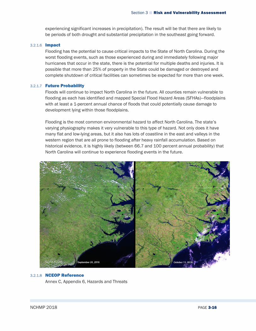
Section 3 Risk and Vulnerability Assessment
NCHMP 2018 PAGE 3-16
experiencing significant increases in precipitation). The result will be that there are likely to be periods of both drought and substantial precipitation in the southeast going forward.
3.2.1.6 Impact Flooding has the potential to cause critical impacts to the State of North Carolina. During the worst flooding events, such as those experienced during and immediately following major hurricanes that occur in the state, there is the potential for multiple deaths and injuries. It is possible that more than 25% of property in the State could be damaged or destroyed and complete shutdown of critical facilities can sometimes be expected for more than one week.
3.2.1.7 Future Probability Floods will continue to impact North Carolina in the future. All counties remain vulnerable to flooding as each has identified and mapped Special Flood Hazard Areas (SFHAs)—floodplains with at least a 1-percent annual chance of floods that could potentially cause damage to development lying within those floodplains. Flooding is the most common environmental hazard to affect North Carolina. The state’s varying physiography makes it very vulnerable to this type of hazard. Not only does it have many flat and low-lying areas, but it also has lots of coastline in the east and valleys in the western region that are all prone to flooding after heavy rainfall accumulation. Based on historical evidence, it is highly likely (between 66.7 and 100 percent annual probability) that North Carolina will continue to experience flooding events in the future.
3.2.1.8 NCEOP Reference Annex C, Appendix 6, Hazards and Threats
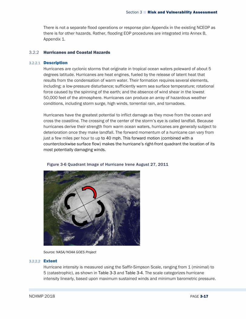
Section 3 Risk and Vulnerability Assessment
NCHMP 2018 PAGE 3-17
There is not a separate flood operations or response plan Appendix in the existing NCEOP as there is for other hazards. Rather, flooding EOP procedures are integrated into Annex B, Appendix 1.
3.2.2 Hurricanes and Coastal Hazards
3.2.2.1 Description Hurricanes are cyclonic storms that originate in tropical ocean waters poleward of about 5 degrees latitude. Hurricanes are heat engines, fueled by the release of latent heat that results from the condensation of warm water. Their formation requires several elements, including: a low-pressure disturbance; sufficiently warm sea surface temperature; rotational force caused by the spinning of the earth; and the absence of wind shear in the lowest 50,000 feet of the atmosphere. Hurricanes can produce an array of hazardous weather conditions, including storm surge, high winds, torrential rain, and tornadoes. Hurricanes have the greatest potential to inflict damage as they move from the ocean and cross the coastline. The crossing of the center of the storm’s eye is called landfall. Because hurricanes derive their strength from warm ocean waters, hurricanes are generally subject to deterioration once they make landfall. The forward momentum of a hurricane can vary from just a few miles per hour to up to 40 mph. This forward motion (combined with a counterclockwise surface flow) makes the hurricane’s right-front quadrant the location of its most potentially damaging winds.
Figure 3-6 Quadrant Image of Hurricane Irene August 27, 2011
Source: NASA/NOAA GOES Project
3.2.2.2 Extent Hurricane intensity is measured using the Saffir-Simpson Scale, ranging from 1 (minimal) to 5 (catastrophic), as shown in Table 3-3 and Table 3-4. The scale categorizes hurricane intensity linearly, based upon maximum sustained winds and minimum barometric pressure.
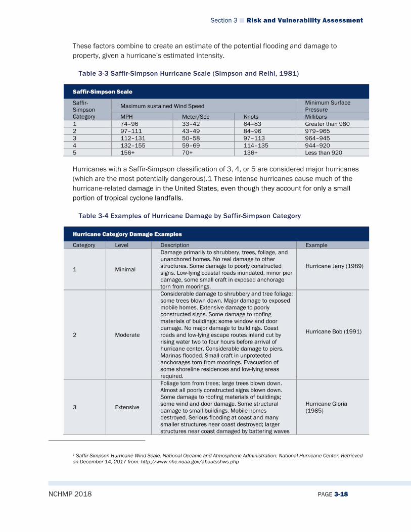
Section 3 Risk and Vulnerability Assessment
NCHMP 2018 PAGE 3-18
These factors combine to create an estimate of the potential flooding and damage to property, given a hurricane’s estimated intensity.
Table 3-3 Saffir-Simpson Hurricane Scale (Simpson and Reihl, 1981)
Saffir-Simpson Scale
Saffir-Simpson Category
Maximum sustained Wind Speed Minimum Surface Pressure
MPH Meter/Sec Knots Millibars 1 74–96 33–42 64–83 Greater than 980 2 97–111 43–49 84–96 979–965 3 112–131 50–58 97–113 964–945 4 132–155 59–69 114–135 944–920 5 156+ 70+ 136+ Less than 920
Hurricanes with a Saffir-Simpson classification of 3, 4, or 5 are considered major hurricanes (which are the most potentially dangerous).1 These intense hurricanes cause much of the hurricane-related damage in the United States, even though they account for only a small portion of tropical cyclone landfalls.
Table 3-4 Examples of Hurricane Damage by Saffir-Simpson Category
Hurricane Category Damage Examples
Category Level Description Example
1 Minimal
Damage primarily to shrubbery, trees, foliage, and unanchored homes. No real damage to other structures. Some damage to poorly constructed signs. Low-lying coastal roads inundated, minor pier damage, some small craft in exposed anchorage torn from moorings.
Hurricane Jerry (1989)
2 Moderate
Considerable damage to shrubbery and tree foliage; some trees blown down. Major damage to exposed mobile homes. Extensive damage to poorly constructed signs. Some damage to roofing materials of buildings; some window and door damage. No major damage to buildings. Coast roads and low-lying escape routes inland cut by rising water two to four hours before arrival of hurricane center. Considerable damage to piers. Marinas flooded. Small craft in unprotected anchorages torn from moorings. Evacuation of some shoreline residences and low-lying areas required.
Hurricane Bob (1991)
3 Extensive
Foliage torn from trees; large trees blown down. Almost all poorly constructed signs blown down. Some damage to roofing materials of buildings; some wind and door damage. Some structural damage to small buildings. Mobile homes destroyed. Serious flooding at coast and many smaller structures near coast destroyed; larger structures near coast damaged by battering waves
Hurricane Gloria (1985)
1 Saffir-Simpson Hurricane Wind Scale. National Oceanic and Atmospheric Administration: National Hurricane Center. Retrieved on December 14, 2017 from: http://www.nhc.noaa.gov/aboutsshws.php
Section 3 Risk and Vulnerability Assessment
NCHMP 2018 PAGE 3-19
and floating debris. Low-lying escape routes inland cut by rising water three to five hours before hurricane center arrives. Flat terrain five feet or less above sea level flooded inland eight miles or more. Evacuation of low-lying residences within several blocks of shoreline possibly required.
4 Extreme
Shrubs and trees blown down; all signs down. Extensive damage to roofing materials, windows and doors. Complete failures of roofs on many small residences. Complete destruction of mobile homes. Flat terrain 10 feet or less above sea level flooded inland as far as six miles. Major damage to lower floors of structures near shore, due to flooding and battering by waves and floating debris. Low-lying escape routes inland cut by rising water three to five hours before hurricane center arrives. Major erosion of beaches. Massive evacuation of all residences within 500 yards of shore possibly required, as well as the evacuation of single-story residences within two miles of shore.
Hurricane Harvey (2017)
5 Catastrophic
Shrubs and trees blown down; considerable damage to roofs of buildings; all signs down. Very severe and extensive damage to windows and doors. Complete failure of roofs on many residences and industrial buildings. Extensive shattering of glass in windows and doors. Some complete building failures. Small buildings overturned or blown away. Complete destruction of mobile homes. Major damage to lower floors of all structures less than 15 feet above sea level and within 500 yards of shore. Low-lying escape routes inland cut by rising water three to five hours before hurricane center arrives. Massive evacuation of residential areas on low ground within 5 to 10 miles of shore possibly required.
Hurricane Camille (1969)
Historically, the state has been impacted by a number of major storms that were categorized as major hurricanes (Category 3, 4, or 5) when they made landfall in the state. Therefore, North Carolina could be impacted by a storm up to a Category 5 based on the Saffir-Simpson Hurricane Scale.
3.2.2.3 Location/Spatial Extent All of the state’s 100 counties are at risk of hurricanes, although the effects are likely to vary. For example, the eastern part of the state is much more likely to be severely impacted by high winds and storm surge than the mountainous western part of the state. But all areas of the state are susceptible to winds and flooding from heavy rains that a hurricane may bring. Storm surge is limited to the coastal counties of North Carolina. Figure 3-7 provides a graphical representation of storm surge risk zones as determined by NOAA.
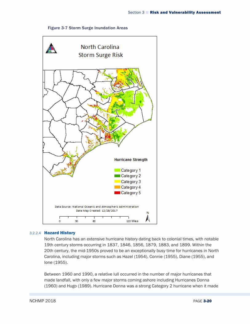
Section 3 Risk and Vulnerability Assessment
NCHMP 2018 PAGE 3-20
Figure 3-7 Storm Surge Inundation Areas
3.2.2.4 Hazard History North Carolina has an extensive hurricane history dating back to colonial times, with notable 19th century storms occurring in 1837, 1846, 1856, 1879, 1883, and 1899. Within the 20th century, the mid-1950s proved to be an exceptionally busy time for hurricanes in North Carolina, including major storms such as Hazel (1954), Connie (1955), Diane (1955), and Ione (1955). Between 1960 and 1990, a relative lull occurred in the number of major hurricanes that made landfall, with only a few major storms coming ashore including Hurricanes Donna (1960) and Hugo (1989). Hurricane Donna was a strong Category 2 hurricane when it made
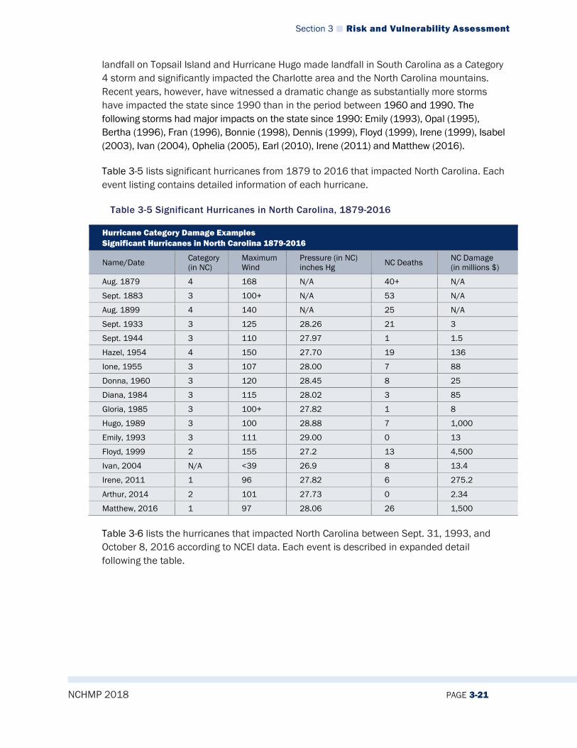
Section 3 Risk and Vulnerability Assessment
NCHMP 2018 PAGE 3-21
landfall on Topsail Island and Hurricane Hugo made landfall in South Carolina as a Category 4 storm and significantly impacted the Charlotte area and the North Carolina mountains. Recent years, however, have witnessed a dramatic change as substantially more storms have impacted the state since 1990 than in the period between 1960 and 1990. The following storms had major impacts on the state since 1990: Emily (1993), Opal (1995), Bertha (1996), Fran (1996), Bonnie (1998), Dennis (1999), Floyd (1999), Irene (1999), Isabel (2003), Ivan (2004), Ophelia (2005), Earl (2010), Irene (2011) and Matthew (2016).
Table 3-5 lists significant hurricanes from 1879 to 2016 that impacted North Carolina. Each event listing contains detailed information of each hurricane.
Table 3-5 Significant Hurricanes in North Carolina, 1879-2016
Hurricane Category Damage Examples Significant Hurricanes in North Carolina 1879-2016
Name/Date Category (in NC)
Maximum Wind
Pressure (in NC) inches Hg NC Deaths NC Damage
(in millions $)
Aug. 1879 4 168 N/A 40+ N/A
Sept. 1883 3 100+ N/A 53 N/A
Aug. 1899 4 140 N/A 25 N/A
Sept. 1933 3 125 28.26 21 3
Sept. 1944 3 110 27.97 1 1.5
Hazel, 1954 4 150 27.70 19 136
Ione, 1955 3 107 28.00 7 88
Donna, 1960 3 120 28.45 8 25
Diana, 1984 3 115 28.02 3 85
Gloria, 1985 3 100+ 27.82 1 8
Hugo, 1989 3 100 28.88 7 1,000
Emily, 1993 3 111 29.00 0 13
Floyd, 1999 2 155 27.2 13 4,500
Ivan, 2004 N/A <39 26.9 8 13.4
Irene, 2011 1 96 27.82 6 275.2
Arthur, 2014 2 101 27.73 0 2.34
Matthew, 2016 1 97 28.06 26 1,500
Table 3-6 lists the hurricanes that impacted North Carolina between Sept. 31, 1993, and October 8, 2016 according to NCEI data. Each event is described in expanded detail following the table.
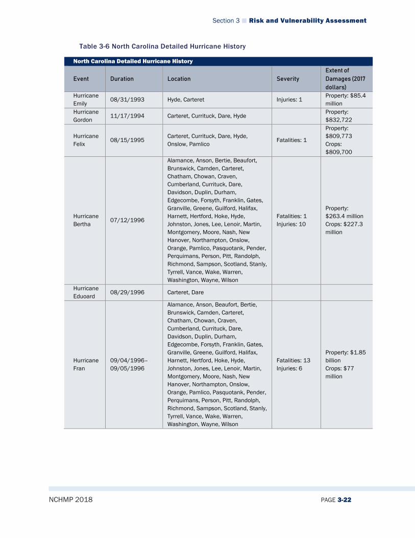
Section 3 Risk and Vulnerability Assessment
NCHMP 2018 PAGE 3-22
Table 3-6 North Carolina Detailed Hurricane History
North Carolina Detailed Hurricane History
Event Duration Location Severity Extent of Damages (2017 dollars)
Hurricane Emily
08/31/1993 Hyde, Carteret Injuries: 1 Property: $85.4 million
Hurricane Gordon
11/17/1994 Carteret, Currituck, Dare, Hyde Property: $832,722
Hurricane Felix
08/15/1995 Carteret, Currituck, Dare, Hyde, Onslow, Pamlico
Fatalities: 1
Property: $809,773 Crops: $809,700
Hurricane Bertha
07/12/1996
Alamance, Anson, Bertie, Beaufort, Brunswick, Camden, Carteret, Chatham, Chowan, Craven, Cumberland, Currituck, Dare, Davidson, Duplin, Durham, Edgecombe, Forsyth, Franklin, Gates, Granville, Greene, Guilford, Halifax, Harnett, Hertford, Hoke, Hyde, Johnston, Jones, Lee, Lenoir, Martin, Montgomery, Moore, Nash, New Hanover, Northampton, Onslow, Orange, Pamlico, Pasquotank, Pender, Perquimans, Person, Pitt, Randolph, Richmond, Sampson, Scotland, Stanly, Tyrrell, Vance, Wake, Warren, Washington, Wayne, Wilson
Fatalities: 1 Injuries: 10
Property: $263.4 million Crops: $227.3 million
Hurricane Eduoard
08/29/1996 Carteret, Dare
Hurricane Fran
09/04/1996–09/05/1996
Alamance, Anson, Beaufort, Bertie, Brunswick, Camden, Carteret, Chatham, Chowan, Craven, Cumberland, Currituck, Dare, Davidson, Duplin, Durham, Edgecombe, Forsyth, Franklin, Gates, Granville, Greene, Guilford, Halifax, Harnett, Hertford, Hoke, Hyde, Johnston, Jones, Lee, Lenoir, Martin, Montgomery, Moore, Nash, New Hanover, Northampton, Onslow, Orange, Pamlico, Pasquotank, Pender, Perquimans, Person, Pitt, Randolph, Richmond, Sampson, Scotland, Stanly, Tyrrell, Vance, Wake, Warren, Washington, Wayne, Wilson
Fatalities: 13 Injuries: 6
Property: $1.85 billion Crops: $77 million

Section 3 Risk and Vulnerability Assessment
NCHMP 2018 PAGE 3-23
North Carolina Detailed Hurricane History
Event Duration Location Severity Extent of Damages (2017 dollars)
Hurricane Bonnie
08/26/1998–08/28/1998
Beaufort, Bertie, Brunswick, Camden, Carteret, Chowan, Craven, Cumberland, Currituck, Dare, Duplin, Edgecombe, Franklin, Greene, Harnett, Hoke, Hyde, Johnston, Jones, Lenoir, Martin, Nash, New Hanover, Onslow, Pamlico, Pasquotank, Pender, Perquimans, Pitt, Sampson, Tyrrell, Wake, Washington, Wayne, Wilson
Fatalities: 1
Property: $139 million Crops: $359 million
Hurricane Dennis
08/30/1999–09/04/1999
Alamance, Anson, Beaufort, Bertie, Brunswick, Camden, Carteret, Chatham, Chowan, Craven, Cumberland, Currituck, Dare, Davidson, Duplin, Durham, Edgecombe, Forsyth, Franklin, Granville, Greene, Guilford, Halifax, Harnett, Hoke, Hyde, Johnston, Jones, Lee, Lenoir, Martin, Montgomery, Moore, Nash, New Hanover, Onslow, Orange, Pamlico, Pasquotank, Pender, Perquimans, Person, Pitt, Randolph, Richmond, Sampson, Scotland, Stanly, Tyrrell, Vance, Wake, Warren, Washington, Wayne, Wilson
Property: $162,900 Crops: $4.4 million
Hurricane Floyd
09/14/1999–09/15/1999
Alamance, Anson, Beaufort, Bertie, Brunswick, Camden, Carteret, Chatham, Chowan, Craven, Cumberland, Currituck, Dare, Davidson, Duplin, Durham, Edgecombe, Franklin, Granville, Greene, Guilford, Halifax, Harnett, Hoke, Hyde, Johnston, Jones, Lee, Lenoir, Martin, Montgomery, Moore, Nash, New Hanover, Onslow, Orange, Pamlico, Pasquotank, Pender, Perquimans, Person, Pitt, Randolph, Richmond, Sampson, Scotland, Stanly, Tyrrell, Vance, Wake, Warren, Washington, Wayne, Wilson
Fatalities: 13
Property: $5.2 billion Crops: $1.4 billion
Hurricane Irene
10/16/1999– 10/17/1999
Beaufort, Bertie, Camden, Carteret, Chowan, Craven, Currituck, Hyde, Onslow, Pamlico, Pasquotank, Perquimans
Fatalities: 1 Property: $45,923
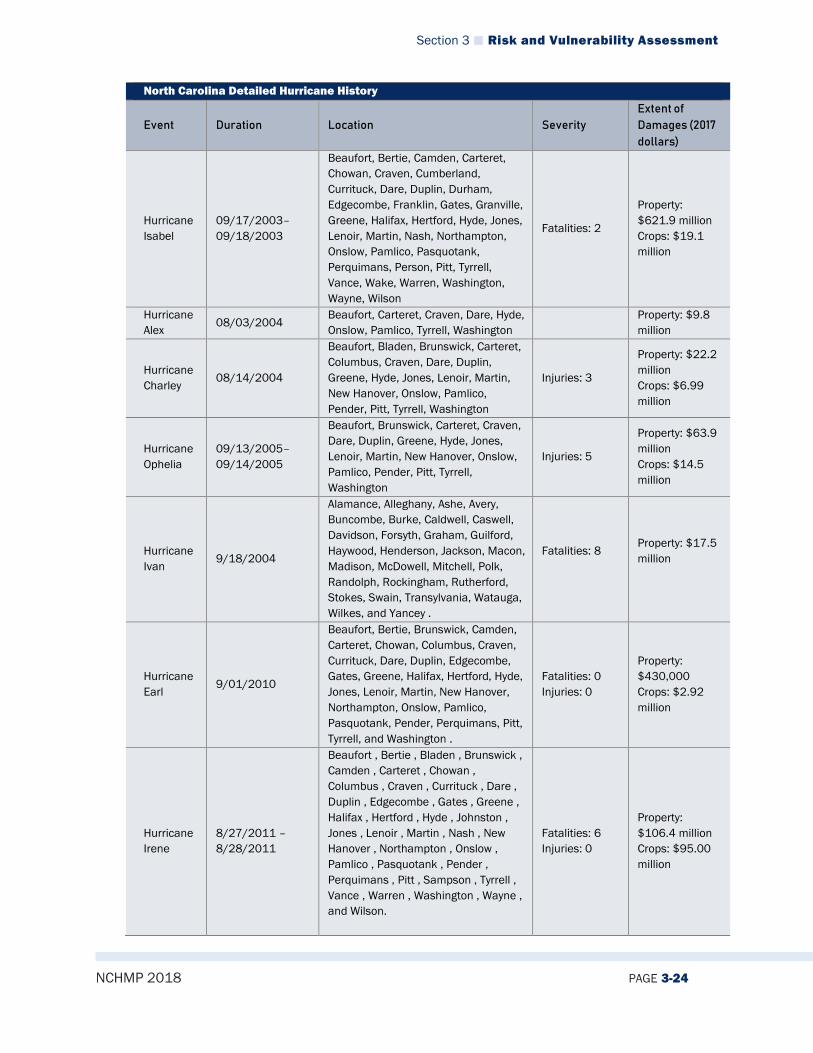
Section 3 Risk and Vulnerability Assessment
NCHMP 2018 PAGE 3-24
North Carolina Detailed Hurricane History
Event Duration Location Severity Extent of Damages (2017 dollars)
Hurricane Isabel
09/17/2003–09/18/2003
Beaufort, Bertie, Camden, Carteret, Chowan, Craven, Cumberland, Currituck, Dare, Duplin, Durham, Edgecombe, Franklin, Gates, Granville, Greene, Halifax, Hertford, Hyde, Jones, Lenoir, Martin, Nash, Northampton, Onslow, Pamlico, Pasquotank, Perquimans, Person, Pitt, Tyrrell, Vance, Wake, Warren, Washington, Wayne, Wilson
Fatalities: 2
Property: $621.9 million Crops: $19.1 million
Hurricane Alex 08/03/2004
Beaufort, Carteret, Craven, Dare, Hyde, Onslow, Pamlico, Tyrrell, Washington
Property: $9.8 million
Hurricane Charley
08/14/2004
Beaufort, Bladen, Brunswick, Carteret, Columbus, Craven, Dare, Duplin, Greene, Hyde, Jones, Lenoir, Martin, New Hanover, Onslow, Pamlico, Pender, Pitt, Tyrrell, Washington
Injuries: 3
Property: $22.2 million Crops: $6.99 million
Hurricane Ophelia
09/13/2005–09/14/2005
Beaufort, Brunswick, Carteret, Craven, Dare, Duplin, Greene, Hyde, Jones, Lenoir, Martin, New Hanover, Onslow, Pamlico, Pender, Pitt, Tyrrell, Washington
Injuries: 5
Property: $63.9 million Crops: $14.5 million
Hurricane Ivan
9/18/2004
Alamance, Alleghany, Ashe, Avery, Buncombe, Burke, Caldwell, Caswell, Davidson, Forsyth, Graham, Guilford, Haywood, Henderson, Jackson, Macon, Madison, McDowell, Mitchell, Polk, Randolph, Rockingham, Rutherford, Stokes, Swain, Transylvania, Watauga, Wilkes, and Yancey .
Fatalities: 8
Property: $17.5 million
Hurricane Earl
9/01/2010
Beaufort, Bertie, Brunswick, Camden, Carteret, Chowan, Columbus, Craven, Currituck, Dare, Duplin, Edgecombe, Gates, Greene, Halifax, Hertford, Hyde, Jones, Lenoir, Martin, New Hanover, Northampton, Onslow, Pamlico, Pasquotank, Pender, Perquimans, Pitt, Tyrrell, and Washington .
Fatalities: 0 Injuries: 0
Property: $430,000 Crops: $2.92 million
Hurricane Irene
8/27/2011 – 8/28/2011
Beaufort , Bertie , Bladen , Brunswick , Camden , Carteret , Chowan , Columbus , Craven , Currituck , Dare , Duplin , Edgecombe , Gates , Greene , Halifax , Hertford , Hyde , Johnston , Jones , Lenoir , Martin , Nash , New Hanover , Northampton , Onslow , Pamlico , Pasquotank , Pender , Perquimans , Pitt , Sampson , Tyrrell , Vance , Warren , Washington , Wayne , and Wilson.
Fatalities: 6 Injuries: 0
Property: $106.4 million Crops: $95.00 million
Section 3 Risk and Vulnerability Assessment
NCHMP 2018 PAGE 3-25
North Carolina Detailed Hurricane History
Event Duration Location Severity Extent of Damages (2017 dollars)
Hurricane Arthur 7/3/2014 Hyde, Carteret, Dare
Fatalities: 0 Injuries: 0
Property: $698,500
Hurricane Matthew
10/8/2016 Brunswick, New Hanover, Pender, Dare
Fatalities: Injuries:
Property: Crops:
Source: NCEI
Significant North Carolina Hurricane Event Overviews Hurricane Fran (09/04/1996–09/05/1996) Hurricane Fran moved onshore near Cape Fear on the evening of Sept. 6, 1996, and raced north toward Raleigh, cutting a swath of destruction as it traveled. The Category 3 hurricane destroyed or damaged 90 percent of the homes located in North Topsail Beach. The town hall and police station were destroyed. A 15-foot storm surge cut a 100-foot-wide inlet through the middle of the island. A Camp Lejeune-based Marine lost his life when he and two others mistakenly drove onto the island at the height of the storm. State Route 1568 was washed out and NC 210 was covered with sand. Damages in North Topsail Beach and Onslow County alone exceeded $500 million, as 6,688 structures were either destroyed or damaged. In Carteret County, Emerald Isle reported 67 homes destroyed and 409 that had experienced major damage. Thirty-three mobile homes were destroyed. The Emerald Isle fishing pier was destroyed, and Bogue Sound Pier lost 150 feet. Dune elevation was reduced by 5 to 20 feet due to erosion. Winds gusted up to 100 mph at Atlantic Beach. Storm surge in Swansboro was measured at 10 feet. Several businesses along the waterfront were destroyed and water covered Main Street. Storm surges approaching 9 feet flooded portions of Washington and Belhaven. The storm surge in Washington was the highest recorded since the unnamed hurricane that occurred on Sept. 3, 1912. New Bern experienced a storm surge of 10 feet on the Neuse River. One bridge was closed when an approach road collapsed. Other bridges were washed out near Stella and Swansboro. One motorist was killed near Greenville when his car struck a tree. In Duplin County (near Rose Hill), a resident perished when the chimney in her home collapsed. Another resident died when a tree fell through her trailer, located in Catherine Lake in Onslow County. Measured wind gusts approached speeds of 94 mph at the New River Marine Corps Air Station in Jacksonville, and 92 mph at Duke Marine Labs in Beaufort. Hurricane Fran was the worst natural disaster in terms of economics in North Carolina history. In the RAH county warning area alone, the damage exceeded $2 billion. Damage to crops, livestock, and farm equipment/buildings was more than $400 million. The agricultural damage was the greatest in Sampson, Johnston, and Wayne counties. Several hundred thousand trees were uprooted or broken. Tens of thousands of homes were damaged by falling trees. Almost every neighborhood in the path of the storm’s center was affected. The copious rainfall produced many severe flash floods and river floods. The flooding experienced by the Haw River (at the town of Haw River), the Neuse River (at Smithfield and Goldsboro), and the Tar River (at Louisburg and Rocky Mount) approached or exceeded the highest floods on record. Many homes located in the floodplain had to be evacuated. The most massive evacuation occurred in Goldsboro, where residents of 550 homes had to be relocated to public shelters. Hundreds of cars in Goldsboro were damaged by water; many of

Section 3 Risk and Vulnerability Assessment
NCHMP 2018 PAGE 3-26
these vehicles were so deeply submerged beneath floodwater that only the tops of their radio antenna were visible from the surface. Many homes and businesses incurred heavy losses. Along the Crabtree Creek in Raleigh, which crested at its highest peak since 1973, hundreds of new cars from local auto dealerships floated in 6 feet of water. Scores of businesses reported heavy damage at the area’s largest shopping center. Basic living necessities were unavailable for several days, including milk, bread, drinking water, power, and telephone service. It took more than 10 days for power to be restored to many areas. Schools were closed for a week in the hardest-hit counties. Automobile travel was hazardous for days after the storm, due to fallen and falling trees. A full 12 days after the event, 150 secondary roads remained closed. Spiral bands associated with Hurricane Fran affected northeast North Carolina from the evening of Sept. 5 through the morning of Sept. 6. The highest sustained wind speed recorded at the Elizabeth City Coast Guard Station (ECG) was 43 mph, with the highest gust recorded at 55 mph. There were no confirmed tornadoes, but numerous trees and power lines were blown down across northeast North Carolina, resulting in assorted structural damage and power outages. Coastal Pasquotank and Camden counties experienced approximately a 6-foot storm surge in the Albemarle Sound, flooding coastal sections of these counties, including the business district of downtown Elizabeth City. Chowan County experienced a 4-foot surge from the Albemarle Sound, causing some flooding in Edenton. Currituck County received only minor flooding from the Currituck Sound. The heaviest rain fell across the inland counties of northeast North Carolina, where amounts generally ranged from 1.5 to 3.5 inches. Some roads were flooded due to the rainfall. The eye of Hurricane Fran passed over eastern Brunswick County with winds measured as high as 109 mph at Long Beach. The storm surge was approximately 6 feet, with beach erosion around 15 feet on the eastern islands. Seven beach houses on the east end of Holden Beach were damaged or destroyed. Emergency shelters housed 1,750 residents and vacationers. The center of Fran’s eye (which measured approximately 25 miles across), passed up the Cape Fear River during the evening, with winds gusting around 110 mph, storm surge recorded at 12 feet MSL, and 40-foot beach erosion, which destroyed most docks and piers. County infrastructure suffered $5 million in damage. Schools experienced $2 million in damage. Power outages lasted for more than a week in some areas. Pleasure Island was hit hard, as 25 homes were carried off their foundations and many others were badly damaged. Wrightsville Beach was not hit as hard, but 15 homes suffered at least 75 percent damage. In Wilmington, 14 homes were destroyed and 385 homes suffered major damage. The 197-foot tall steeple of the 130-year-old First Baptist Church fell. Shelters housed 880 evacuees. Fran’s eye then moved across Pender County. On Topsail Island, a 12-foot storm surge caused 40 feet of beach erosion and wiped out dunes as overwash destroyed most of the first row of beach houses and heavily damaged the rest. Damage to Surfside Beach and Topsail Beach was $112 million. The rest of the county experienced more than $50 million in structural damage, with 161 buildings destroyed and 585 more sustaining major damage
Section 3 Risk and Vulnerability Assessment
NCHMP 2018 PAGE 3-27
(including the roof being blown off the county courthouse). Marketable timber loss was $37 million. Two people died: a woman found on a mattress in the marsh and a man floating in the Scotts Hill Marina Boat Basin. Shelters housed more than 600 evacuees. Hurricane Floyd (09/14/1999–09/15/1999) Hurricane Floyd caused the largest peacetime evacuation in the history of the United States up to that point in time. The storm also caused massive record flooding across inland sections of eastern North Carolina. At one time, Floyd was classified as a Category 4 hurricane on the Saffir-Simpson scale, and will likely be categorized as one of the most costly hurricanes to strike the United States during the 20th century. Tropical Depression 8 (Hurricane Floyd’s initial designation) was detected by the National Hurricane Center at 4 p.m. EST on Sept. 7. The broad center was located nearly 1,000 miles west of the Lesser Antilles. At that time, the depression was moving toward the west at 14 mph, with maximum sustained winds of 30 mph. Within 12 hours, the depression gained strength, became a tropical storm, and was named Floyd. As it neared the Virgin Islands on the afternoon of Sept. 10 (just 415 miles west of San Juan), Floyd was officially designated as a hurricane. Hurricane Floyd rapidly intensified and by the evening of Sept. 12 was classified as a Category 4 hurricane. The hurricane continued to intensify. At its peak on the morning of Sept. 13, the winds increased to 155 mph and the central pressure bottomed-out at 921 mb. The position was 525 miles east-southeast of Miami and moving west at 14 mph. Fortunately for Floridians, Hurricane Floyd soon made an expected turn to the north. By 5 p.m. EST on Sept. 14, the entire North Carolina coast was under a hurricane watch, which at midnight was upgraded to a hurricane warning. That same night, the first outer rain bands began affecting eastern North Carolina and, in turn, reports of flooding began filtering into the National Weather Service office in Morehead City/Newport (MHX). At least 40 official shelters were opened across the county warning area. Severe weather and rainfall preceded landfall. By the night of Sept. 16, 20 tornado warnings had been issued, with over half of the possible tornado occurrences being verified. The greatest rainfall estimates from the MHX Doppler radar were over Duplin, Jones, Lenoir, Greene, Pitt, Martin, Craven, and Onslow counties. Estimates were near 6 to 10 inches of rain, with isolated areas receiving 12 to 15 inches. The greatest amount of rainfall (15.48 inches) was reported by a Cooperative observer in Washington. Tyrrell, eastern Carteret, eastern Pamlico, Hyde, and Dare counties all reported estimates of less than 3 inches. Hurricane Floyd made landfall on the morning of Sept. 16 near North Topsail Beach, as a Category 2 hurricane. The eye moved northeast over Jacksonville, New Bern, Washington, Plymouth and continued over the eastern shores of Virginia. As the hurricane moved over the eastern coast of North Carolina, it accelerated and weakened. It lost its tropical characteristics early on Sept. 17. The University of Oklahoma Doppler-On-Wheels (DOW) team was positioned at Topsail Beach. Around 2 a.m. EST, the DOW recorded a sustained wind of 81 mph with gusts of up to 105 mph. The peak inland report in the MHX 15-county warning area was 82 mph at Cherry Point Marine Corp Air Station (NKT). The peak offshore report was 96 mph at Duck Pier. Similar to rainfall, the strongest ocean storm surges

Section 3 Risk and Vulnerability Assessment
NCHMP 2018 PAGE 3-28
occurred west and northwest of the eye. Ocean storm surges were about 4 to 6 feet above normal, generally affecting Onslow, Carteret, and Hyde counties. This caused extensive beach erosion on the south facing beaches. Ocracoke Island officials reported at least 10 new dune breaks along Highway 12. In Carteret County, Pine Knoll Shores lost some 50 feet of beach. Emerald Isle lost an average of 14 feet and 52 public beach access walkways. The Oceana Pier on Atlantic Beach lost a 200-foot section and the remaining 200-foot section of Iron Steamer Pier that Hurricane Bonnie spared was also wiped out. Along the Albemarle Sound, storm tides were about 5 to 6 feet above normal. The Pamlico River storm tides ranged between 6 to 8 feet above normal. Water levels were especially high in Hyde County, Sladesville, and Scranton. Along the Neuse River, storm tides were also near 6 to 8 feet above normal, especially in the Core Creek area. Extreme flooding was experienced across most counties. Inland flooding exceeded that generated by hurricanes Bertha, Fran, Bonnie, and Dennis combined. Most counties reported their worst flooding ever. The Tar River in Greenville and the Neuse River in Kinston were nearly 15 feet above their flood stages of 13 and 14 feet, respectively. The Tar River remained above flood stage for nearly two weeks, while the Neuse River remained above flood stage for more than a month. The Northeast Cape Fear River in Chinquapin was 8 to 10 feet above the flood stage of 13 feet. The Roanoke River in Williamston rose to nearly 3 feet above its flood stage. Unbelievable numbers of homes were covered with water and over half a million customers throughout the county warning area were left without power. In Greenville alone, a 100-acre parcel of land would be needed to store all the mobile homes that were destroyed due to flooding. Unofficially, the flooding from Hurricane Floyd has been compared to that of a 500-year flood. At least 13 fatalities have been reported during the event in the 15-county warning area. Unfortunately, a majority of the deaths could have been avoided had the victims not tried to drive on flooded roadways. As with most hurricanes, inland flooding is now responsible for the largest percentage of fatalities. Floyd also produced more human misery and environmental impact on North Carolina than any disaster in memory. The 15 to 20 inches of rain that fell across the eastern half of the state caused every river and stream to flood. Many rivers set new flooding records. Whole communities were submerged for days, and some areas remained underwater for weeks. Thousands of homes were lost. Crop damage was extensive. The infrastructure of the eastern counties (composed mainly of roads, bridges, water plants, etc.) was heavily damaged. By the end of 1999, $1.5 billion of emergency funding had already been spent, with estimates that the cost would ultimately reach $3 to $4 billion. The counties within the Raleigh county warning area probably sustained more than half of the state total. Even worse was the loss of life, which occurred mainly due to flooding. Many North Carolinians did not heed the call to evacuate and many more attempted to drive through flooded areas. In the central part of the state, 21 people lost their lives. Also, a significant loss of livestock occurred, mainly involving swine and poultry. Floyd, with wind gusts around 90 mph caused the widespread occurrences of downed trees and power outages. In Brunswick County, power was lost by 95 percent of the county. The wind did major damage to the roof of Brunswick Community Hospital. Storm surge was 7 to 9
Section 3 Risk and Vulnerability Assessment
NCHMP 2018 PAGE 3-29
feet on the east side of the county and 3 to 6 feet further west. Ocean Crest Pier, Long Beach Pier, and Sunset Beach Pier were hit hard. Ocean over wash was worst at Oak Island, where 4 miles of beach containing 100 oceanfront homes sustained $23 million in damage. Holden Beach sustained $8.8 million in damage, and 46 homes were condemned—many due to exposed septic tanks. Ocean Isle Beach suffered $6 million in damage: two houses were knocked off their foundations; 500 feet of roadway was lost; and 28 homes were declared unsafe. Sunset Beach experienced $1.25 million in damage and lost half its dune and a road, thus isolating 75 homes. However, it was the heavy rains that accumulated around 20 inches which caused the worst flooding in history. High water closed most roads (including US 17), isolating many areas. A dam broke at Boiling Springs Lakes, inundating the area. In New Hanover County, housing losses approached $25 million: eight homes were destroyed and more than 200 sustained major damage. Ocean storm surge was 9 to 10 feet, inundating barrier islands and causing extensive dune erosion. Record rainfall distinguished Floyd—the most rain ever in 24 hours at ILM Airport (14.84 inches) and a storm total 19.06 inches, causing widespread flooding. In Pender County, a 7- to 9-foot storm surge at the beach damaged the barrier islands, eroding half the dune. However, it was record rainfall with ensuing ponding and flooding of rivers that caused the most serious damage. The Northeast Cape Fear had the worst flood of the 20th Century, while the Black River flood was the worst experienced since 1945. Largely due to flooding, more than 1,000 homes suffered major damage and 200 more were condemned. More than 3,000 hogs, 90,000 turkeys, and 200 cows were lost due to drowning. Animal waste and septic tanks added pollution to the flooding. Two human fatalities occurred as motorists drove into flooded parts of highways. In Columbus and Bladen counties, wind gusts approached 75 mph in the eastern parts of the counties, downing trees and power lines. More than 15 inches of rain caused widespread flooding. In Robeson County, Hurricane Floyd caused wind gusts near 70 mph in eastern portions of the county, downing trees and power lines. Rainfall around 10 inches caused widespread flooding. Floyd was a Category 1 hurricane as it crossed the Wakefield WFO county warning area. Sustained tropical-storm-force winds with gusts up to near hurricane force occurred over the northwest quadrant of the storm, over interior portions of northeast North Carolina and along the coastal waters of the Wakefield marina area. The center of the storm crossed the county warning area along Elizabeth City to Currituck County, to Sandbridge Virginia Beach axis. The highest sustained wind speed recorded at the Elizabeth City Coast Guard Station (ECG) was 39 mph, with gusts to 64 mph. Two confirmed tornadoes occurred in association with Floyd, both in northeast North Carolina. Several thousand persons were evacuated and housed in several shelters from coastal jurisdictions. Hundreds of trees and power lines were blown down across northeast North Carolina, resulting in widespread power outages. Coastal Pasquotank and Camden counties experienced approximately a 5- to 6-foot surge in the Albemarle Sound, flooding coastal sections of those counties, including the business district of downtown Elizabeth City. Chowan County experienced a 5- to 6-foot surge from the Albemarle Sound, causing some flooding in Edenton. The lowest sea level pressure recorded at the ECG was 968.5 mb.
Section 3 Risk and Vulnerability Assessment
NCHMP 2018 PAGE 3-30
Hurricane Irene (08/27/2011–08/28/2011) Hurricane Irene moving northward over the outer banks of North Carolina and just off the Virginia coast produced hurricane force wind gusts across portions of coastal northeast North Carolina from early Saturday morning, August 27th into Sunday morning, August 28th. Announcing itself with howling winds and hammering rains, Hurricane Irene made landfall at Cape Lookout, on the Outer Banks of North Carolina, at about 7:30 a.m. on Saturday, August 27, 2011. However, tropical-storm-force winds began to affect the Outer Banks hours before landfall, producing waves of 6–9 ft (1.8–2.7 m). During Irene, some of the state’s worst flooding happened along the Pamlico and Albemarle sounds, in the state’s Inner Banks. Rescue crews fanned out late Saturday, August 27th and Sunday, August 28th in search of people trapped by the rising waters. Boats that were once docked in the Albemarle Sound were washed up on the side of N.C. 158 in Nags Head about a half mile down from the causeway bridge. The large hurricane left extensive damage in its wake and there were reports that tornadoes may have leveled homes and overturned vehicles. Following the touch down of a potent tornado, at least four homes were demolished in Columbia, while up to three others sustained significant damage. Preliminary assessment indicated multiple flooded areas and uprooted trees along coastlines; in Nash County, a snatched tree limb struck and killed one person. Prior to the storm, a resident in Onslow County suffered a fatal heart attack while applying plywood to his house. Two people in Pitt and Sampson Counties were additionally killed by falling trees, as were two others in Goldsboro and Pitt County in traffic accidents. A man also drowned in the flooded Cape Fear River. In all, over 1,100 homes were destroyed. The estimated $71 million in damage did not include agricultural losses. Hurricane Irene left downed and denuded trees, impassable roadways, damaged municipal buildings, and widespread flooding on its way. In Bay Drive in Kill Devil Hills, debris from the Albemarle Sound covered the street after overflowing with overnight rainfall. Storm surge from Hurricane Irene spilled over Kitty Hawk Bay in Albemarle Sound and Roanoke Island, Hatteras Island, Collington, Duck, and other parts of the islands were simply inundated by the Albemarle and Pamlico Sounds. In addition, heavy rains contributed to minor crop damage. Storm total rainfall generally ranged from ten to fourteen inches. Hurricane Matthew (10/8/2016-10/9/2016) Hurricane Matthew was an extraordinarily severe and sustained event that brought record-level flooding to many areas in eastern North Carolina’s coastal plain, sound, and coastal communities. Hurricane Matthew hit North Carolina on October 8, 2016, as a Category 1 storm. Communities were devastated by this slow-moving storm primarily by widespread rainfall. During a 36-hour period, up to 18 inches of heavy rainfall inundated areas in central and eastern North Carolina. Riverine flooding began several days after Hurricane Matthew passed and lasted for more than two weeks. New rainfall records were set in 17 counties in the Tar, Cape Fear, Cashie, Lumber, and Neuse River watersheds. Entire towns were flooded as water levels throughout eastern North Carolina crested well above previously seen stages.
Section 3 Risk and Vulnerability Assessment
NCHMP 2018 PAGE 3-31
During the peak of the hurricane, 800,000 households lost power and 635 roads were closed, including a section of I-40 West in Johnston County that was closed for seven days, and sections of I-95 North and South in Robeson and Cumberland Counties that were closed for 10 days. Approximately 88,000 homes were damaged and 4,424 residences were completely destroyed. Losses totaled more than $967 million, representing an economic loss as high as 68 percent of the damages, or $659 million, not expected to be covered by insurance or FEMA assistance. North Carolina Governor McCrory requested FEMA assistance on October 9, 2016, and FEMA subsequently declared a major disaster (DR-4285) for North Carolina on October 10, 2016, for 48 counties encompassing approximately 325 cities, towns, townships, and villages. Preliminary estimates indicate that more than 30,000 businesses suffered physical or economic damage, and 400,000 employees were affected as a result. Hurricane Matthew also had a significant impact on the agriculture and agribusiness economy in eastern North Carolina. The nearly 33,000 agricultural workers and 5,000 agriculture-support workers hit by the storm account for more than half of the state’s agricultural and agriculture-support workforce. Initial economic analysis of the impacts of crop and livestock losses caused by Hurricane Matthew estimated that there was a loss of more than 1,200 jobs and roughly $10 million in state and local income and sales tax revenue.2 North Carolina’s response to Hurricane Matthew included 2,300 swift-water rescues using 79 boats, and more than 90 air rescues. North Carolina also deployed more than 1,000 National Guard and State Highway Patrol to assist with rescue and sheltering missions. There were 3,744 individuals transported to 109 shelters across central and eastern North Carolina during the storm’s peak. FEMA’s disaster declaration made 50 counties eligible for FEMA assistance, 45 of which are eligible for Individual Assistance and Public Assistance and five of which are eligible for Public Assistance only. There were 81,832 individuals registered for FEMA/state assistance. Federal/state financial assistance in the amount of $92.5 million was approved to help flood survivors recover. Small Business Administration (SBA) loans approved for individuals after Hurricane Matthew totaled $65.6 million. SBA loans approved for businesses after Hurricane Matthew totaled $23.2 million.
2 Governor McCrory’s Request for Federal Assistance for Hurricane Matthew Recovery, November 14, 2016

Section 3 Risk and Vulnerability Assessment
NCHMP 2018 PAGE 3-32
3.2.2.5 Changing Future Conditions North Carolina’s coastal location makes it a prime target for hurricane landfalls, and changing climate and weather conditions may increase the number and frequency of future hurricane events. Hurricanes and other coastal storms may result in increased flooding, injuries, deaths, and extreme property loss. According to the US Government Accountability Office, national storm losses from changing frequency and intensity of storms is projected to increase anywhere from $4-6 billion in the near future. Additionally, as NOAA reports in Figure 3-8, weather extremes will likely cause more frequent, stronger storms in the future due to rising surface temperatures. That is to say, NOAA models predict that while there may be less frequent, low-category storm events (Tropical Storms, Category 1 Hurricanes), there will be more, high-category storm events (Category 4 and 5 Hurricanes) in the future. This means that there may be fewer hurricanes overall in any given year, but when hurricanes do form, it is more likely that they will become large storms that can create massive damage.
Figure 3-8: National Oceanic and Atmospheric Administration Climate Models Projection for Future Hurricanes
Source: National Oceanic and Atmospheric Administration GFDL
3.2.2.6 Impact North Carolina is susceptible to potentially catastrophic impacts from hurricane. While not highly likely, a Category 5 hurricane could strike North Carolina causing a high number of deaths/injuries possible and damaging or destroying more than 50% of the property in the State. It is not out of the realm of possibility that a major could hurricane could cause complete shutdown of some critical facilities for 30 days or more.

Section 3 Risk and Vulnerability Assessment
NCHMP 2018 PAGE 3-33
3.2.2.7 Future Probability North Carolina has an extensive hurricane history, partially due to its coastal location. Because hurricanes are able to impact large areas at one time, all parts of the state are vulnerable to being affected. Historical occurrences of hurricanes and coastal hazards show that North Carolina is likely (between 33.4 and 66.6 percent annual probability) to experience these types of events in the future.
3.2.2.8 NCEOP Reference Annex C, Appendix 6, Hazards and Threats Annex B, Appendix 1, Hurricane Operations Plan
3.2.3 Severe Winter Weather
3.2.3.1 Description The winter storms that typically impact North Carolina generally form in the Gulf of Mexico or off the southeast Atlantic Coast. The entire state has a likelihood of experiencing severe winter weather. The threat varies by location and by type of storm. Coastal areas typically face their greatest weather threat from nor’easters and other severe winter coastal storms. These storms can contain strong waves and result in extensive beach erosion and flooding. Freezing rain and ice storms typically occur once every several years at coastal locations and severe snowstorms have been recorded occasionally in coastal areas.
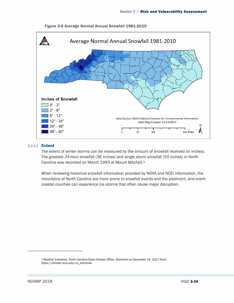
Section 3 Risk and Vulnerability Assessment
NCHMP 2018 PAGE 3-34
Figure 3-9 Average Normal Annual Snowfall 1981-2010
3.2.3.2 Extent The extent of winter storms can be measured by the amount of snowfall received (in inches). The greatest 24-hour snowfall (36 inches) and single storm snowfall (50 inches) in North Carolina was recorded on March 1993 at Mount Mitchell.3 When reviewing historical snowfall information provided by NOAA and NCEI information, the mountains of North Carolina are more prone to snowfall events and the piedmont, and event coastal counties can experience ice storms that often cause major disruption.
3 Weather Extremes. North Carolina State Climate Office. Retrieved on December 14, 2017 from: https://climate.ncsu.edu/nc_extremes
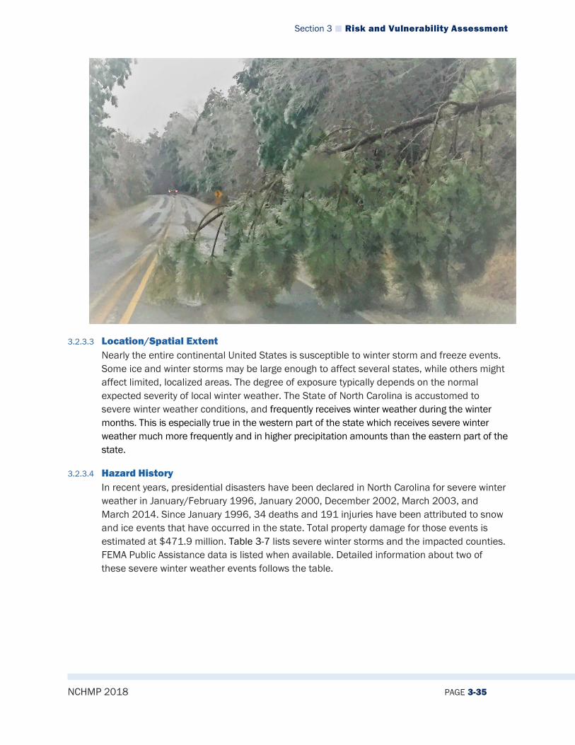
Section 3 Risk and Vulnerability Assessment
NCHMP 2018 PAGE 3-35
3.2.3.3 Location/Spatial Extent Nearly the entire continental United States is susceptible to winter storm and freeze events. Some ice and winter storms may be large enough to affect several states, while others might affect limited, localized areas. The degree of exposure typically depends on the normal expected severity of local winter weather. The State of North Carolina is accustomed to severe winter weather conditions, and frequently receives winter weather during the winter months. This is especially true in the western part of the state which receives severe winter weather much more frequently and in higher precipitation amounts than the eastern part of the state.
3.2.3.4 Hazard History In recent years, presidential disasters have been declared in North Carolina for severe winter weather in January/February 1996, January 2000, December 2002, March 2003, and March 2014. Since January 1996, 34 deaths and 191 injuries have been attributed to snow and ice events that have occurred in the state. Total property damage for those events is estimated at $471.9 million. Table 3-7 lists severe winter storms and the impacted counties. FEMA Public Assistance data is listed when available. Detailed information about two of these severe winter weather events follows the table.
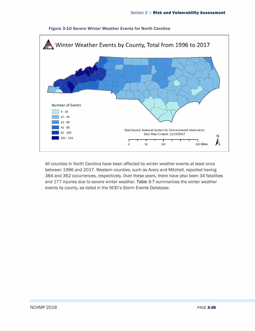
Section 3 Risk and Vulnerability Assessment
NCHMP 2018 PAGE 3-36
Figure 3-10 Severe Winter Weather Events for North Carolina
All counties in North Carolina have been affected by winter weather events at least once between 1996 and 2017. Western counties, such as Avery and Mitchell, reported having 384 and 362 occurrences, respectively. Over these years, there have also been 34 fatalities and 177 injuries due to severe winter weather. Table 3-7 summarizes the winter weather events by county, as listed in the NCEI’s Storm Events Database.
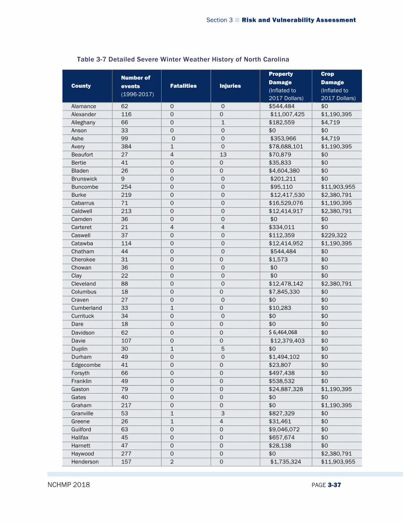
Section 3 Risk and Vulnerability Assessment
NCHMP 2018 PAGE 3-37
Table 3-7 Detailed Severe Winter Weather History of North Carolina
County Number of events (1996-2017)
Fatalities Injuries
Property Damage (Inflated to 2017 Dollars)
Crop Damage (Inflated to 2017 Dollars)
Alamance 62 0 0 $544,484 $0 Alexander 116 0 0 $11,007,425 $1,190,395 Alleghany 66 0 1 $182,559 $4,719 Anson 33 0 0 $0 $0 Ashe 99 0 0 $353,966 $4,719 Avery 384 1 0 $78,688,101 $1,190,395 Beaufort 27 4 13 $70,879 $0 Bertie 41 0 0 $35,833 $0 Bladen 26 0 0 $4,604,380 $0 Brunswick 9 0 0 $201,211 $0 Buncombe 254 0 0 $95,110 $11,903,955 Burke 219 0 0 $12,417,530 $2,380,791 Cabarrus 71 0 0 $16,529,076 $1,190,395 Caldwell 213 0 0 $12,414,917 $2,380,791 Camden 36 0 0 $0 $0 Carteret 21 4 4 $334,011 $0 Caswell 37 0 0 $112,359 $229,322 Catawba 114 0 0 $12,414,952 $1,190,395 Chatham 44 0 0 $544,484 $0 Cherokee 31 0 0 $1,573 $0 Chowan 36 0 0 $0 $0 Clay 22 0 0 $0 $0 Cleveland 88 0 0 $12,478,142 $2,380,791 Columbus 18 0 0 $7,845,330 $0 Craven 27 0 0 $0 $0 Cumberland 33 1 0 $10,283 $0 Currituck 34 0 0 $0 $0 Dare 18 0 0 $0 $0 Davidson 62 0 0 $ 6,464,068 $0 Davie 107 0 0 $12,379,403 $0 Duplin 30 1 5 $0 $0 Durham 49 0 0 $1,494,102 $0 Edgecombe 41 0 0 $23,807 $0 Forsyth 66 0 0 $497,438 $0 Franklin 49 0 0 $538,532 $0 Gaston 79 0 0 $24,887,328 $1,190,395 Gates 40 0 0 $0 $0 Graham 217 0 0 $0 $1,190,395 Granville 53 1 3 $827,329 $0 Greene 26 1 4 $31,461 $0 Guilford 63 0 0 $9,046,072 $0 Halifax 45 0 0 $657,674 $0 Harnett 47 0 0 $28,138 $0 Haywood 277 0 0 $0 $2,380,791 Henderson 157 2 0 $1,735,324 $11,903,955

Section 3 Risk and Vulnerability Assessment
NCHMP 2018 PAGE 3-38
County Number of events (1996-2017)
Fatalities Injuries
Property Damage (Inflated to 2017 Dollars)
Crop Damage (Inflated to 2017 Dollars)
Hertford 41 0 0 $0 $0 Hoke 30 0 0 $0 $0 Hyde 22 0 0 $0 $538,234 Iredell 113 0 0 $13,759,256 $1,190,395 Jackson 360 0 0 $4,115,936 $595,197 Johnston 49 0 0 $600,763 $0 Jones 25 0 0 $0 $0 Lee 44 0 0 $0 $0 Lenoir 31 1 10 $62,923 $0 Lincoln 86 0 0 $12,413,611 $1,190,395 Macon 172 0 0 $0 $2,380,791 Madison 298 0 0 $0 $3,751,186 Martin 31 1 14 $62,923 $0 McDowell 169 0 0 $12,417,530 $0 Mecklenburg 77 2 0 $58,272,063 $0 Mitchell 36 0 0 $32,956 $1,190,395 Montgomery 40 0 0 $0 $0 Moore 39 0 0 $0 $0 Nash 49 0 0 $554,767 $0 New Hanover 6 0 0 $0 $0 Northampton 43 0 0 $2,222,259 $0 Onslow 26 1 35 $222,211 $0 Orange 59 0 0 $3,892,063 $0 Pamlico 21 0 2 $23,596 $0 Pasquotank 33 0 0 $0 $0 Pender 23 2 0 $2,001,571 $0 Perquimans 37 0 0 $0 $0 Person 61 0 0 $1,095,275 $0 Pitt 31 0 92 $117,982 $0 Polk 109 0 0 $28,143,279 $0 Randolph 57 0 0 $3,770,566 $0 Richmond 34 0 0 $0 $0 Robeson 27 0 0 $5,947,616 $0 Rockingham 43 0 0 $346,605 $225,751 Rowan 100 5 0 $13,757,936 $1,190,395 Rutherford 142 0 0 $12,475,224 $2,380,791 Sampson 32 0 0 $0 $0 Scotland 31 0 0 $ $0 Stanly 39 0 0 $0 $0 Stokes 42 2 0 $307,279 $47,192 Surry 52 4 5 $1,149,945 $300,790 Swain 244 0 0 $0 $1,190,395 Transylvania 154 1 0 $9,832,875 $3,571,186 Tyrrell 34 0 0 $0 $0 Union 53 0 0 $15,745,072 $595,197 Vance 51 0 0 $817,035 $0 Wake 51 0 0 $1,087,349 $0 Warren 46 0 0 $793,227 $0 Washington 29 0 2 $23,596 $0

Section 3 Risk and Vulnerability Assessment
NCHMP 2018 PAGE 3-39
County Number of events (1996-2017)
Fatalities Injuries
Property Damage (Inflated to 2017 Dollars)
Crop Damage (Inflated to 2017 Dollars)
Watauga 100 0 0 $611,391 $4,719 Wayne 31 0 0 $10,283 $0 Wilkes 55 0 0 $914,712 $2,132,270 Wilson 42 0 0 $554,767 $0 Yadkin 37 0 0 $222,477 $661,903 Yancey 361 0 0 $33,226 $1,190,395 North Carolina 7500 34 177 $330,416,008 $65,039,781 Source: NCEI
Significant North Carolina Severe Winter Weather Events The following overview provides a synopsis of two notable severe winter weather events that have impacted North Carolina during this decade:
Ice Storm (02/27/2003) Another round of frozen precipitation moved into the area on the heels of a previous storm, bringing more freezing rain and sleet to areas that already had more than a quarter inch of ice frozen on trees. The total ice accumulations ranged from a trace near the coast to as much as three quarters of an inch of ice over interior sections. The weight of the ice caused major power outages from falling tree limbs, as well as significant structural damage to many residential structures. Some ice accumulations occurred on the roads, especially on bridges and overpasses, with numerous traffic accidents reported. Many residences were left without power for more than a week. Monetary damages totaled more than a million dollars per county in some parts of the state, due to the costs of debris cleanup, utility expenses, and home repair. Ice Storm (02/03/2005) Ice accretion began to cause damage across the southern mountains and foothills of North Carolina just prior to sunrise. By late morning, the ice storm had become severe, as thousands of trees fell across the area, and power outages became widespread. Numerous trees and large limbs fell on and damaged homes and vehicles. It was estimated that three-quarters of Henderson County’s residents lost power. Most who lost power went without it for at least 24 hours. In some areas, it took as much as five days to restore electricity. Despite the devastation, road problems occurred only rarely, as temperatures hovered right around the freezing mark for most of the event. Duke Power estimated costs for labor overtime and line repair at $72 million for the event, thought these costs are not reflected in the property damage values for the event. In Henderson County, two deaths occurred as an indirect result of the ice storm. One resident died of carbon monoxide poisoning after running an unventilated generator inside a garage. Another resident died of carbon monoxide poisoning due to a malfunctioning gas stove. Ice accumulation ranged from more than a half-inch along the Blue Ridge to one-eighth-of-an-inch or less along the Tennessee border. Several trees and large limbs fell on and damaged homes and vehicles. Numerous slick spots also developed on roadways, primarily in the North Carolina mountains, where a number of accidents occurred.
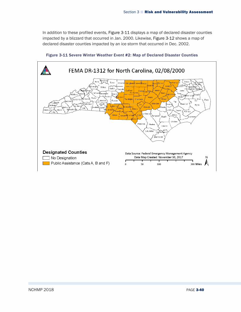
Section 3 Risk and Vulnerability Assessment
NCHMP 2018 PAGE 3-40
In addition to these profiled events, Figure 3-11 displays a map of declared disaster counties impacted by a blizzard that occurred in Jan. 2000. Likewise, Figure 3-12 shows a map of declared disaster counties impacted by an ice storm that occurred in Dec. 2002.
Figure 3-11 Severe Winter Weather Event #2: Map of Declared Disaster Counties

Section 3 Risk and Vulnerability Assessment
NCHMP 2018 PAGE 3-41
Figure 3-12 Severe Winter Weather Event #3: Map of Declared Disaster Counties
3.2.3.5 Changing Future Conditions The uncertainty associated with potentially changing climate conditions creates uncertainty for predicting future severe winter storms. If it is determined that global temperatures are indeed rising, this could cause shorter and warmer winters in many areas; however, the likelihood of dangerously low temperatures may increase due to continuing trends of temperature extremes. Warmer winters, however, mean that precipitation that would normally fall as snow may begin to fall as rain or freezing rain instead.
3.2.3.6 Impact North Carolina has received and will continue to receive dangerous winter storms. However, because the state is not prone to winter weather events like more northern states, rare winter storms have more of an impact. Roads easily become covered by snow and ice, making driving more dangerous. According to the North Carolina State University Climate Office, 70% of winter weather related injuries are from vehicle accidents. Winter weather can also cause power outages when ice accrues on power lines, and widespread outages may occur.

Section 3 Risk and Vulnerability Assessment
NCHMP 2018 PAGE 3-42
3.2.3.7 Future Probability Although North Carolina typically experiences a warmer climate, it still has been affected by severe winter weather. According to historical evidence, the state experiences on average 21 winter storm events per year. All parts of the state are vulnerable to winter storms, but they are more likely to occur in the western counties. Winter storm events will remain a likely (between 33.4 and 66.6 percent annual probability) occurrence, and the probability of future occurrences is certain. Fortunately, large-scale property damages and/or threats to human life and safety are rare with these events.
3.2.3.8 NCEOP Reference Annex C, Appendix 6, Hazards and Threats Annex B, Appendix 2, Winter Storm Operations Plan
3.2.4 Excessive Heat
3.2.4.1 Description Excessive heat is a dangerous and deadly occurrence in North Carolina. According to the National Weather Service, heat is one of the leading weather-related causes of loss of life in the United States.4 The Centers for Disease Control and Prevention indicates that 618
4 Heat Safety Tips and Resources. National Oceanic and Atmospheric Administration: National Weather Service. Retrieved on December 14, 2017 from: http://www.nws.noaa.gov/os/heat/
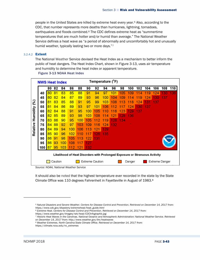
Section 3 Risk and Vulnerability Assessment
NCHMP 2018 PAGE 3-43
people in the United States are killed by extreme heat every year.5 Also, according to the CDC, that number represents more deaths than hurricanes, lightning, tornadoes, earthquakes and floods combined.6 The CDC defines extreme heat as “summertime temperatures that are much hotter and/or humid than average.” The National Weather Service defines a heat wave as “a period of abnormally and uncomfortably hot and unusually humid weather, typically lasting two or more days.”7
3.2.4.2 Extent The National Weather Service devised the Heat Index as a mechanism to better inform the public of heat dangers. The Heat Index Chart, shown in Figure 3-13, uses air temperature and humidity to determine the heat index or apparent temperature.
Figure 3-13 NOAA Heat Index
Source: NOAA, National Weather Service It should also be noted that the highest temperature ever recorded in the state by the State Climate Office was 110 degrees Fahrenheit in Fayetteville in August of 1983.8
5 Natural Disasters and Severe Weather. Centers for Disease Control and Prevention. Retrieved on December 14, 2017 from: https://www.cdc.gov/disasters/extremeheat/heat_guide.html 6 Extreme Heat. Centers for Disease Control and Prevention. Retrieved on December 14, 2017 from: https://www.weather.gov/images/rah/heat/CDCInfographic.jpg 7 Historic Heat Waves in the Carolinas. National Oceanic and Atmospheric Administration: National Weather Service. Retrieved on December 14, 2017 from: http://www.weather.gov/ilm/heatwaves 8 Weather Extremes. North Carolina State Climate Office. Retrieved on December 14, 2017 from: https://climate.ncsu.edu/nc_extremes
Section 3 Risk and Vulnerability Assessment
NCHMP 2018 PAGE 3-44
3.2.4.3 Location/Spatial Extent Excessive heat can have an impact in any location throughout the state as temperatures in all parts of the state have been high enough historically to cause heat disorders in the population. It is especially notable that high humidity rates across the state often exacerbate already high temperatures and lead to greater incidences of heat-related illness. In general, the mountainous western part of the state is somewhat less susceptible to excessive heat as higher elevations tend to lead to cooler temperatures. The central and eastern parts of the state much more frequently experience high temperatures that can lead to human health problems.
3.2.4.4 Hazard History NCEI data indicates 125 unique heat/excessive heat events that have occurred in North Carolina since 1996 through 2017. Impacts have been recorded in 60 counties and have resulted in 16 fatalities. These events are listed in Table 3-8 below, and a graphic representation of the data follows the table in Figure 3-14. These heat events are only inclusive of those reported by the National Centers for Environmental Information.
Table 3-8 North Carolina Excessive Heat Event Summary by County
North Carolina Excessive Heat Events County Number of
Events (1996-2017)
Injuries Fatalities Property Damage (Inflated to 2017 Dollars)
Crops Damage (Inflated to 2017 Dollars)
Alamance 1 0 0 $0 $0 Alexander 2 0 0 $0 $0 Alleghany 1 0 0 $0 $0 Anson 1 0 0 $0 $0 Ashe 0 0 0 $0 $0 Avery 0 0 0 $0 $0 Beaufort 0 0 0 $0 $0 Bertie 3 0 0 $0 $0 Bladen 4 0 0 $0 $0 Brunswick 4 0 0 $0 $0 Buncombe 0 0 0 $0 $0 Burke 1 0 1 $0 $0 Cabarrus 3 0 0 $0 $0 Caldwell 0 0 0 $0 $0 Camden 3 0 0 $0 $0 Carteret 0 0 0 $0 $0 Caswell 0 0 0 $0 $0 Catawba 2 0 0 $0 $0 Chatham 1 0 0 $0 $0 Cherokee 0 0 0 $0 $0 Chowan 4 0 1 $0 $0 Clay 0 0 0 $0 $0 Cleveland 2 0 0 $0 $0 Columbus 5 15 1 $0 $0 Craven 0 0 0 $0 $0 Cumberland 2 0 1 $0 $0 Currituck 3 0 0 $0 $0 Dare 0 0 0 $0 $0
Section 3 Risk and Vulnerability Assessment
NCHMP 2018 PAGE 3-45
North Carolina Excessive Heat Events County Number of
Events (1996-2017)
Injuries Fatalities Property Damage (Inflated to 2017 Dollars)
Crops Damage (Inflated to 2017 Dollars)
Davidson 1 0 0 $0 $0 Davie 2 0 0 $0 $0 Duplin 0 0 0 $0 $0 Durham 1 0 0 $0 $0 Edgecombe 2 0 1 $0 $0 Forsyth 1 0 0 $0 $0 Franklin 1 0 0 $0 $0 Gaston 2 0 0 $0 $0 Gates 3 0 0 $0 $0 Graham 0 0 0 $0 $0 Granville 1 0 0 $0 $0 Greene 0 0 0 $0 $0 Guilford 2 0 1 $0 $0 Halifax 1 0 0 $0 $0 Harnett 2 0 1 $0 $0 Haywood 0 0 0 $0 $0 Henderson 0 0 0 $0 $0 Hertford 3 0 0 $0 $0 Hoke 1 0 0 $0 $0 Hyde 0 0 0 $0 $0 Iredell 2 0 0 $0 $0 Jackson 0 0 0 $0 $0 Johnston 2 0 1 $0 $0 Jones 0 0 0 $0 $0 Lee 1 0 0 $0 $0 Lenoir 0 0 0 $0 $0 Lincoln 3 1 0 $0 $0 Macon 0 0 0 $0 $0 Madison 0 0 0 $0 $0 Martin 0 0 0 $0 $0 McDowell 0 0 0 $0 $0 Mecklenburg 4 0 2 $0 $0 Mitchell 0 0 0 $0 $0 Montgomery 1 0 0 $0 $0 Moore 1 0 0 $0 $0 Nash 1 0 0 $0 $0 New Hanover 5 0 0 $0 $0 Northampton 3 0 0 $0 $0 Onslow 0 0 0 $0 $0 Orange 1 0 0 $0 $0 Pamlico 0 0 0 $0 $0 Pasquotank 3 0 0 $0 $0 Pender 4 0 0 $0 $0 Perquimans 3 0 0 $0 $0 Person 2 0 1 $0 $0 Pitt 2 0 3 $0 $0 Polk 0 0 0 $0 $0 Randolph 1 0 0 $0 $0 Richmond 1 0 0 $0 $0
Section 3 Risk and Vulnerability Assessment
NCHMP 2018 PAGE 3-46
North Carolina Excessive Heat Events County Number of
Events (1996-2017)
Injuries Fatalities Property Damage (Inflated to 2017 Dollars)
Crops Damage (Inflated to 2017 Dollars)
Robeson 5 0 1 $0 $0 Rockingham 0 0 0 $0 $0 Rowan 2 0 0 $0 $0 Rutherford 0 0 0 $0 $0 Sampson 1 0 0 $0 $0 Scotland 2 0 1 $0 $0 Stanly 1 0 0 $0 $0 Stokes 0 0 0 $0 $0 Surry 0 0 0 $0 $0 Swain 0 0 0 $0 $0 Transylvania 0 0 0 $0 $0 Tyrrell 0 0 0 $0 $0 Union 3 0 0 $0 $0 Vance 1 0 0 $0 $0 Wake 2 1 0 $0 $0 Warren 0 0 0 $0 $0 Washington 0 0 0 $0 $0 Watauga 0 0 0 $0 $0 Wayne 1 0 0 $0 $0 Wilkes 0 0 0 $0 $0 Wilson 1 0 0 $0 $0 Yadkin 1 0 0 $0 $0 Yancey 0 0 0 $0 $0 North Carolina 125 17 16 $0 $0 Source: NCEI

Section 3 Risk and Vulnerability Assessment
NCHMP 2018 PAGE 3-47
Figure 3-14 NC Excessive Heat Events by County, 1996-2017
Details for Selected Excessive Heat Events July 22, 1998–July 23, 1998 Excessive heat plagued central North Carolina during July 22 through July 23. Maximum temperatures reached the 98 to 103-degree range combined with dew points in the 78 to 80-degree range with little wind to give heat index values of around 110 degrees for several hours each afternoon. To make matters worse, the minimum temperatures did not fall below 80°F at several locations and those that did achieved that feat for only an hour or two. Strong thunderstorms ended the two-day excessive heat ordeal when rain cooled the environment enough to send temperatures into the lower 70s at most locations. July 20, 1999–July 31, 1999 A heat wave caused many to require hospital treatment in Columbus County and in neighboring counties in southeast NC. A farm worker died of heat stroke after hospitalization. July 23, 1999–July 25, 1999 A farm worker was overcome by heat exhaustion. He was taken to the local hospital where his body temperature was measured at 108 degrees. A three-year-old boy died after he apparently entered his parents’ car and could not get out.
Aug. 7, 2001–Aug. 9, 2001

Section 3 Risk and Vulnerability Assessment
NCHMP 2018 PAGE 3-48
High humidity and temperatures in the mid-90s caused afternoon heat indices between 105 and 110 degrees (measured by ASOS) in New Hanover County. A heat index of 108 was also reported at Lumberton. July 21, 2011 Excessive heat advisories and warnings were issued for a large portion of eastern North Carolina for several days toward the end of July. The heat and humidity combined to push heat indices near 110 degrees at times during the afternoon. June 29, 2012 – Jul1 1, 2012 A very hot and humid airmass that spent several days building west of the Appalachians finally made it east of the mountains, bringing very hot conditions to foothills and Piedmont of North Carolina. The high temperature at Charlotte-Douglas International Airport hit 104 degrees on both the 29th and 30th, tying the all-time high. The heat index hit 105 degrees. Excessive heat affected areas east of Charlotte. The ASOS at Monroe, NC reported a heat index value of 110 degrees on 30th. Lower dewpoints over the foothills resulted in sub-advisory and warning level heat index values. The heat lasted through July 1st, before thunderstorms brought somewhat cooler conditions.
3.2.4.5 Changing Future Conditions Changing climate patterns may affect North Carolina’s likelihood of experiencing days with extreme heat. As global surface temperatures rise, so does the probability of excessive heat. In the US Global Change Research Program’s 2017 Climate Science Special Report, researchers predict the frequency and intensity of extreme high temperature events are virtually certain to surge. More intense heat waves may further affect agricultural production and species diversity. Occasionally, destructive wildfires may also spread in dry conditions during heat waves. Additionally, according to the National Climate Assessment, the increase in the number of days over 95°F is likely to increase over the next 30 to 50 years when compared to a baseline over the last 30 years of the 20th century. Figure 3-15 shows both the baseline, historical number of days over 95°F from 1971 to 2000 and the projection for the 2041 to 2070 period. Figure 3-16 shows the projected change in number of days between the historic data and the projected data. This increase in days of extreme heat due to weather extremes will likely result in a higher number of rolling brown/blackouts and decreased air quality in the state.
Figure 3-15: Number of Days Over 95 Degrees Fahrenheit
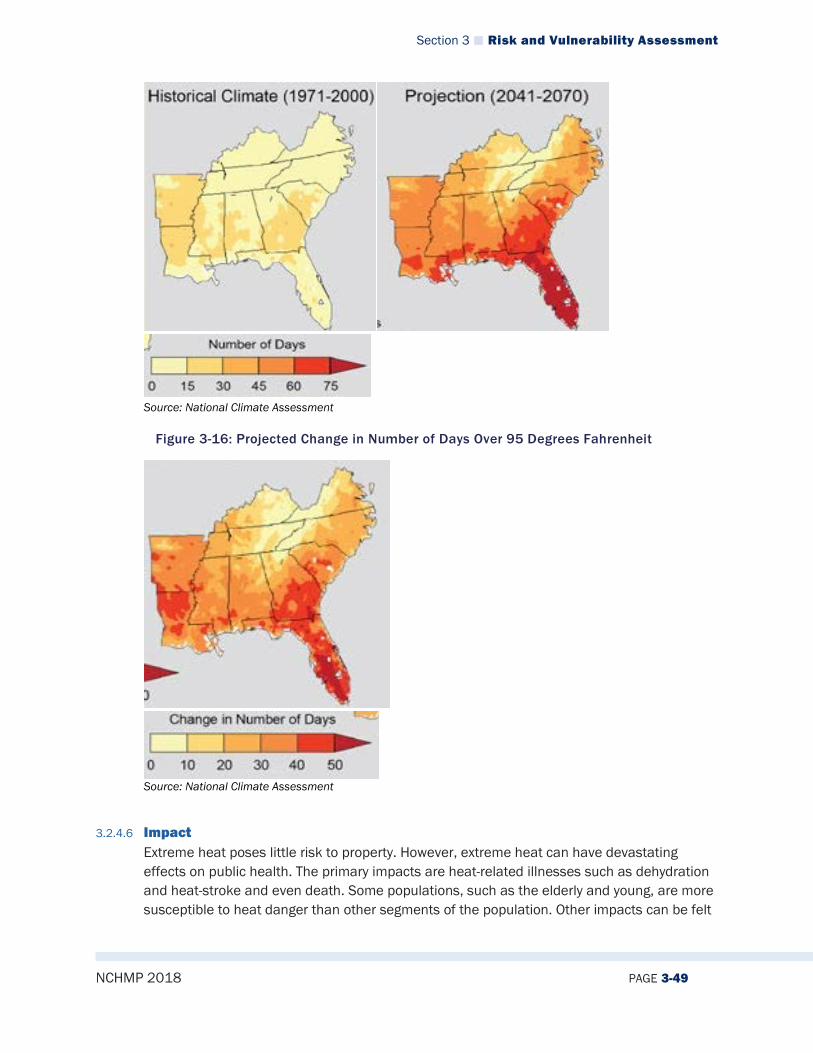
Section 3 Risk and Vulnerability Assessment
NCHMP 2018 PAGE 3-49
Source: National Climate Assessment
Figure 3-16: Projected Change in Number of Days Over 95 Degrees Fahrenheit
Source: National Climate Assessment
3.2.4.6 Impact Extreme heat poses little risk to property. However, extreme heat can have devastating effects on public health. The primary impacts are heat-related illnesses such as dehydration and heat-stroke and even death. Some populations, such as the elderly and young, are more susceptible to heat danger than other segments of the population. Other impacts can be felt
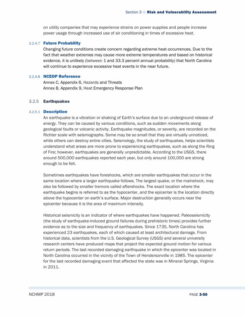
Section 3 Risk and Vulnerability Assessment
NCHMP 2018 PAGE 3-50
on utility companies that may experience strains on power supplies and people increase power usage through increased use of air conditioning in times of excessive heat.
3.2.4.7 Future Probability Changing future conditions create concern regarding extreme heat occurrences. Due to the fact that weather extremes may cause more extreme temperatures and based on historical evidence, it is unlikely (between 1 and 33.3 percent annual probability) that North Carolina will continue to experience excessive heat events in the near future.
3.2.4.8 NCEOP Reference Annex C, Appendix 6, Hazards and Threats Annex B, Appendix 9, Heat Emergency Response Plan
3.2.5 Earthquakes
3.2.5.1 Description An earthquake is a vibration or shaking of Earth’s surface due to an underground release of energy. They can be caused by various conditions, such as sudden movements along geological faults or volcanic activity. Earthquake magnitudes, or severity, are recorded on the Richter scale with seismographs. Some may be so small that they are virtually unnoticed, while others can destroy entire cities. Seismology, the study of earthquakes, helps scientists understand what areas are more prone to experiencing earthquakes, such as along the Ring of Fire; however, earthquakes are generally unpredictable. According to the USGS, there around 500,000 earthquakes reported each year, but only around 100,000 are strong enough to be felt. Sometimes earthquakes have foreshocks, which are smaller earthquakes that occur in the same location where a larger earthquake follows. The largest quake, or the mainshock, may also be followed by smaller tremors called aftershocks. The exact location where the earthquake begins is referred to as the hypocenter, and the epicenter is the location directly above the hypocenter on earth’s surface. Major destruction generally occurs near the epicenter because it is the area of maximum intensity. Historical seismicity is an indicator of where earthquakes have happened. Paleoseismicity (the study of earthquake-induced ground failures during prehistoric times) provides further evidence as to the size and frequency of earthquakes. Since 1735, North Carolina has experienced 23 earthquakes, each of which caused at least architectural damage. From historical data, scientists from the U.S. Geological Survey (USGS) and several university research centers have produced maps that project the expected ground motion for various return periods. The last recorded damaging earthquake in which the epicenter was located in North Carolina occurred in the vicinity of the Town of Hendersonville in 1985. The epicenter for the last recorded damaging event that affected the state was in Mineral Springs, Virginia in 2011.
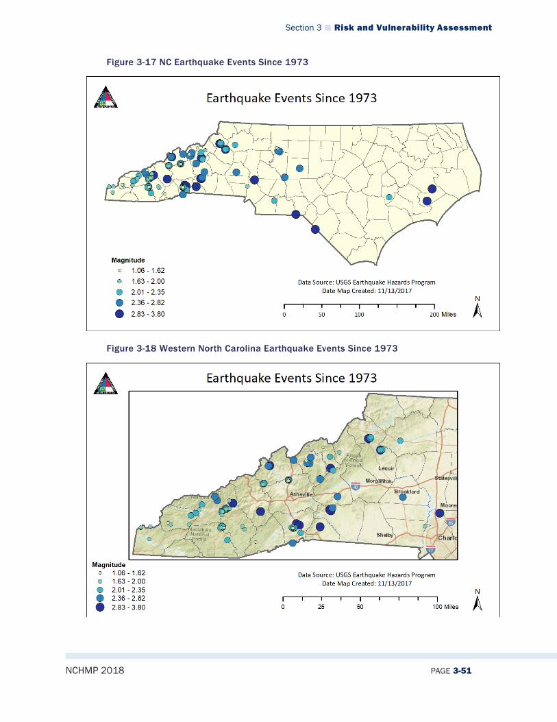
Section 3 Risk and Vulnerability Assessment
NCHMP 2018 PAGE 3-51
Figure 3-17 NC Earthquake Events Since 1973
Figure 3-18 Western North Carolina Earthquake Events Since 1973
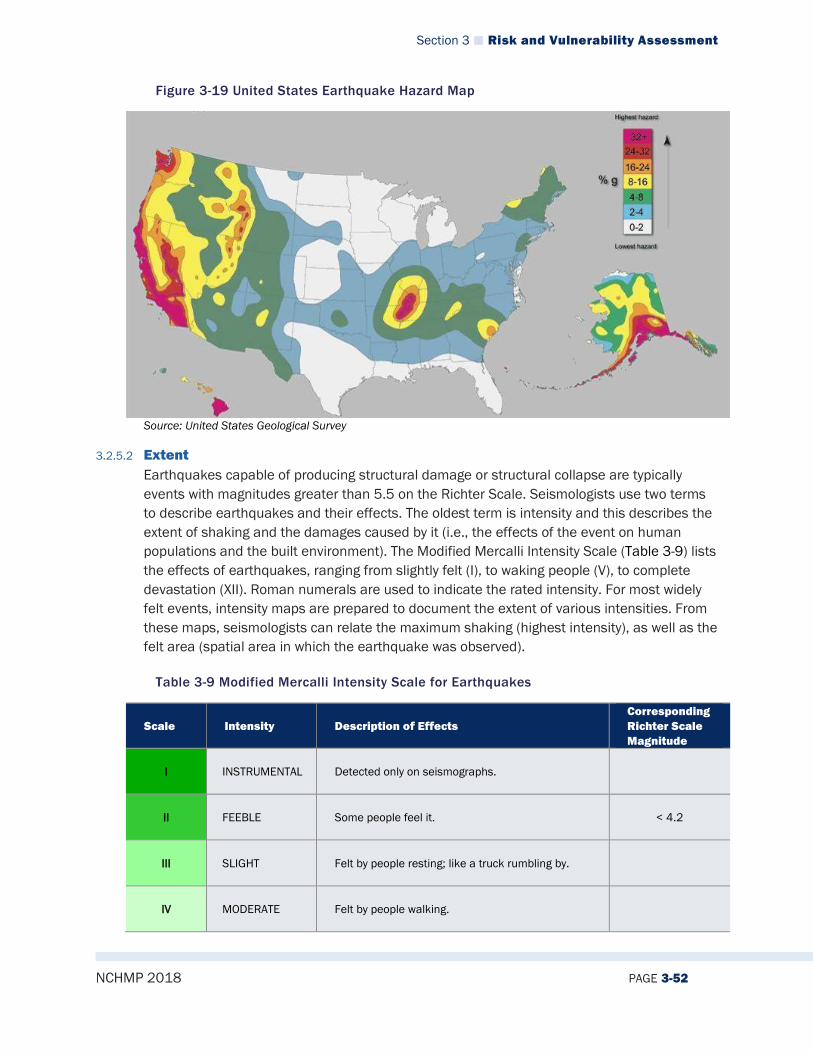
Section 3 Risk and Vulnerability Assessment
NCHMP 2018 PAGE 3-52
Figure 3-19 United States Earthquake Hazard Map
Source: United States Geological Survey
3.2.5.2 Extent Earthquakes capable of producing structural damage or structural collapse are typically events with magnitudes greater than 5.5 on the Richter Scale. Seismologists use two terms to describe earthquakes and their effects. The oldest term is intensity and this describes the extent of shaking and the damages caused by it (i.e., the effects of the event on human populations and the built environment). The Modified Mercalli Intensity Scale (Table 3-9) lists the effects of earthquakes, ranging from slightly felt (I), to waking people (V), to complete devastation (XII). Roman numerals are used to indicate the rated intensity. For most widely felt events, intensity maps are prepared to document the extent of various intensities. From these maps, seismologists can relate the maximum shaking (highest intensity), as well as the felt area (spatial area in which the earthquake was observed).
Table 3-9 Modified Mercalli Intensity Scale for Earthquakes
Scale Intensity Description of Effects Corresponding Richter Scale Magnitude
I INSTRUMENTAL Detected only on seismographs.
II FEEBLE Some people feel it. < 4.2
III SLIGHT Felt by people resting; like a truck rumbling by.
IV MODERATE Felt by people walking.
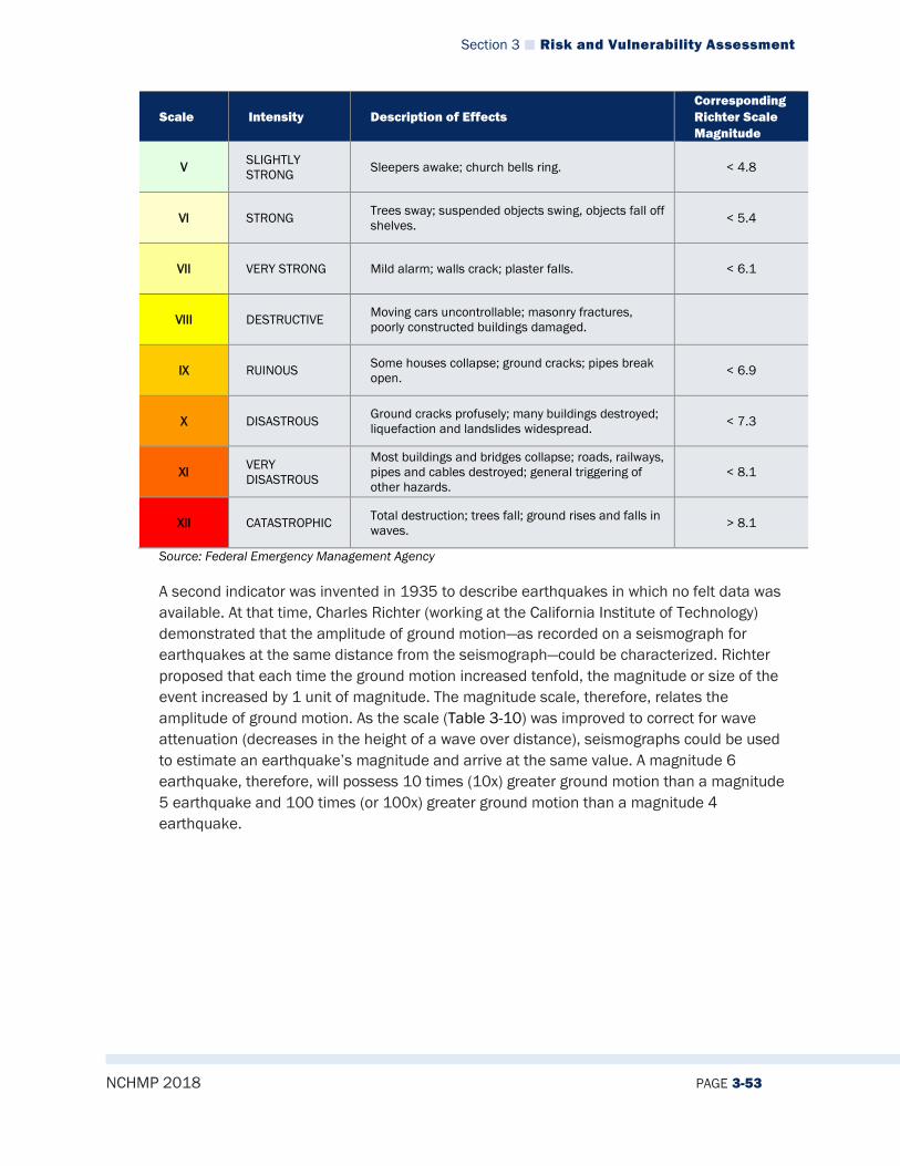
Section 3 Risk and Vulnerability Assessment
NCHMP 2018 PAGE 3-53
Scale Intensity Description of Effects Corresponding Richter Scale Magnitude
V SLIGHTLY STRONG Sleepers awake; church bells ring. < 4.8
VI STRONG Trees sway; suspended objects swing, objects fall off shelves. < 5.4
VII VERY STRONG Mild alarm; walls crack; plaster falls. < 6.1
VIII DESTRUCTIVE Moving cars uncontrollable; masonry fractures, poorly constructed buildings damaged.
IX RUINOUS Some houses collapse; ground cracks; pipes break open. < 6.9
X DISASTROUS Ground cracks profusely; many buildings destroyed; liquefaction and landslides widespread. < 7.3
XI VERY DISASTROUS
Most buildings and bridges collapse; roads, railways, pipes and cables destroyed; general triggering of other hazards.
< 8.1
XII CATASTROPHIC Total destruction; trees fall; ground rises and falls in waves. > 8.1
Source: Federal Emergency Management Agency
A second indicator was invented in 1935 to describe earthquakes in which no felt data was available. At that time, Charles Richter (working at the California Institute of Technology) demonstrated that the amplitude of ground motion—as recorded on a seismograph for earthquakes at the same distance from the seismograph—could be characterized. Richter proposed that each time the ground motion increased tenfold, the magnitude or size of the event increased by 1 unit of magnitude. The magnitude scale, therefore, relates the amplitude of ground motion. As the scale (Table 3-10) was improved to correct for wave attenuation (decreases in the height of a wave over distance), seismographs could be used to estimate an earthquake’s magnitude and arrive at the same value. A magnitude 6 earthquake, therefore, will possess 10 times (10x) greater ground motion than a magnitude 5 earthquake and 100 times (or 100x) greater ground motion than a magnitude 4 earthquake.

Section 3 Risk and Vulnerability Assessment
NCHMP 2018 PAGE 3-54
Table 3-10 Richter Scale for Earthquakes
Richter Magnitudes Earthquake Effects
< 3.5 Generally not felt, but recorded.
3.5 - 5.4 Often felt, but rarely causes damage.
5.4 - 6.0 At most slight damage to well-designed buildings. Can cause major damage to poorly constructed buildings over small regions.
6.1 - 6.9 Can be destructive in areas up to about 100 kilometers across where people live.
7.0 - 7.9 Major earthquake. Can cause serious damage over larger areas.
8 or > Great earthquake. Can cause serious damage in areas several hundred kilometers across.
Decades later, seismologists found that an earthquake’s magnitude could be related directly to the energy released in ground motion. For each tenfold increase in ground motion, there is a 30-fold increase in energy. Therefore, a magnitude 5 earthquake releases 30 times more energy than a magnitude 4 event. A magnitude 7 earthquake is 900 times larger (30 multiplied by itself) than a magnitude 5 earthquake, and 27,000 times (30 multiplied by 30 multiplied by 30) larger than a magnitude 4 earthquake. By using observations related to magnitude, ground motion amplitude and duration (as well as wave attenuation), seismologists have been able to estimate earthquake magnitudes for historical earthquakes. In addition, by using the relationships developed through the study of large recent events, prehistoric earthquakes have also been characterized. Although it is possible that the state could experience an earthquake rated as high as a 10 on the Richter scale, the most likely high-level event is a 6 or 7. Likewise, Modified Mercalli intensity for a high-level event is likely to be around 8 or 9.
3.2.5.3 Location/Spatial Extent Earthquakes could potentially affect any geographic location in North Carolina, however they are far more likely in the western and southern parts of the state. The northeastern part of the state very infrequently experiences significant earthquakes. This is apparent in Figure 3-20, which shows that the probability of significant, damaging earthquake events affecting North Carolina is generally medium. The forecasted frequency of an earthquake that would result in shaking capable of causing damage is fairly low in the northeast and gets higher moving west and south from there. It is possible that future earthquakes resulting in moderate to strong perceived shaking and damages that are substantial will affect the state, especially in the western and southern parts of the state.

Section 3 Risk and Vulnerability Assessment
NCHMP 2018 PAGE 3-55
Figure 3-20: Forecasted Frequency of Earthquake Shaking Capable of Causing Damage within the United States
Source: National Geophysical Data Center
3.2.5.4 Hazard History North Carolina is located in “earthquake country.” Since 1735, when the state’s first reported earthquake was felt in Bath, seismologists have compiled catalogs of felt events. Later, when seismographs became available, earthquake magnitude and hypocenter (earthquake location within the earth) parameters were compiled on a regional basis. The Southeastern United States Earthquake Catalog (SEUSEC) is one such compilation and represents the combination of the U.S. Geological Survey “United States Earthquake Data File,” compiled by C.W. Stover, B.G. Reager, and S.T. Algermissen in 1984 (USGS Open File report 84-225) with more than 25 years of instrument-measured activity. Since 1977, earthquake magnitudes and hypocenters have been compiled by seismic network operators based in the southeastern United States and documented in a series of publications titled, “Southeastern United States Seismic Network Bulletin”—July 1977 to December 2002 (SEUSEC). The combination of these two datasets provides the best and most complete catalog of seismicity for the region.
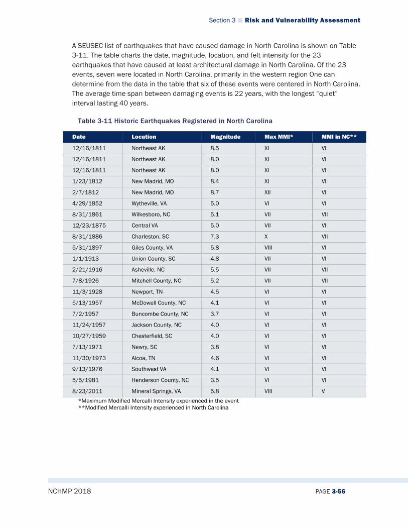
Section 3 Risk and Vulnerability Assessment
NCHMP 2018 PAGE 3-56
A SEUSEC list of earthquakes that have caused damage in North Carolina is shown on Table 3-11. The table charts the date, magnitude, location, and felt intensity for the 23 earthquakes that have caused at least architectural damage in North Carolina. Of the 23 events, seven were located in North Carolina, primarily in the western region One can determine from the data in the table that six of these events were centered in North Carolina. The average time span between damaging events is 22 years, with the longest “quiet” interval lasting 40 years.
Table 3-11 Historic Earthquakes Registered in North Carolina
Date Location Magnitude Max MMI* MMI in NC**
12/16/1811 Northeast AK 8.5 XI VI
12/16/1811 Northeast AK 8.0 XI VI
12/16/1811 Northeast AK 8.0 XI VI
1/23/1812 New Madrid, MO 8.4 XI VI
2/7/1812 New Madrid, MO 8.7 XII VI
4/29/1852 Wytheville, VA 5.0 VI VI
8/31/1861 Wilkesboro, NC 5.1 VII VII
12/23/1875 Central VA 5.0 VII VI
8/31/1886 Charleston, SC 7.3 X VII
5/31/1897 Giles County, VA 5.8 VIII VI
1/1/1913 Union County, SC 4.8 VII VI
2/21/1916 Asheville, NC 5.5 VII VII
7/8/1926 Mitchell County, NC 5.2 VII VII
11/3/1928 Newport, TN 4.5 VI VI
5/13/1957 McDowell County, NC 4.1 VI VI
7/2/1957 Buncombe County, NC 3.7 VI VI
11/24/1957 Jackson County, NC 4.0 VI VI
10/27/1959 Chesterfield, SC 4.0 VI VI
7/13/1971 Newry, SC 3.8 VI VI
11/30/1973 Alcoa, TN 4.6 VI VI
9/13/1976 Southwest VA 4.1 VI VI
5/5/1981 Henderson County, NC 3.5 VI VI
8/23/2011 Mineral Springs, VA 5.8 VIII V
*Maximum Modified Mercalli Intensity experienced in the event **Modified Mercalli Intensity experienced in North Carolina
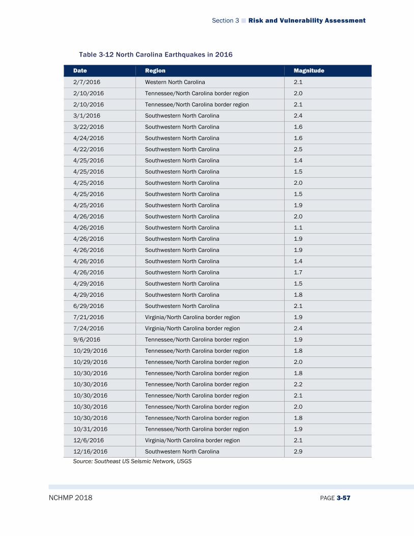
Section 3 Risk and Vulnerability Assessment
NCHMP 2018 PAGE 3-57
Table 3-12 North Carolina Earthquakes in 2016
Date Region Magnitude
2/7/2016 Western North Carolina 2.1
2/10/2016 Tennessee/North Carolina border region 2.0
2/10/2016 Tennessee/North Carolina border region 2.1
3/1/2016 Southwestern North Carolina 2.4
3/22/2016 Southwestern North Carolina 1.6
4/24/2016 Southwestern North Carolina 1.6
4/22/2016 Southwestern North Carolina 2.5
4/25/2016 Southwestern North Carolina 1.4
4/25/2016 Southwestern North Carolina 1.5
4/25/2016 Southwestern North Carolina 2.0
4/25/2016 Southwestern North Carolina 1.5
4/25/2016 Southwestern North Carolina 1.9
4/26/2016 Southwestern North Carolina 2.0
4/26/2016 Southwestern North Carolina 1.1
4/26/2016 Southwestern North Carolina 1.9
4/26/2016 Southwestern North Carolina 1.9
4/26/2016 Southwestern North Carolina 1.4
4/26/2016 Southwestern North Carolina 1.7
4/29/2016 Southwestern North Carolina 1.5
4/29/2016 Southwestern North Carolina 1.8
6/29/2016 Southwestern North Carolina 2.1
7/21/2016 Virginia/North Carolina border region 1.9
7/24/2016 Virginia/North Carolina border region 2.4
9/6/2016 Tennessee/North Carolina border region 1.9
10/29/2016 Tennessee/North Carolina border region 1.8
10/29/2016 Tennessee/North Carolina border region 2.0
10/30/2016 Tennessee/North Carolina border region 1.8
10/30/2016 Tennessee/North Carolina border region 2.2
10/30/2016 Tennessee/North Carolina border region 2.1
10/30/2016 Tennessee/North Carolina border region 2.0
10/30/2016 Tennessee/North Carolina border region 1.8
10/31/2016 Tennessee/North Carolina border region 1.9
12/6/2016 Virginia/North Carolina border region 2.1
12/16/2016 Southwestern North Carolina 2.9 Source: Southeast US Seismic Network, USGS
Section 3 Risk and Vulnerability Assessment
NCHMP 2018 PAGE 3-58
3.2.5.5 Changing Future Conditions Although North Carolina does not fall on any major fault lines, it is still susceptible to earthquakes, particularly in the western region.
3.2.5.6 Impact Earthquakes capable of causing structural damage or failure (Mercalli Intensity VII or greater) are usually magnitude 5.5 or greater. This means that most of the historical catalog (large events) has great importance, since much of the accurate characterization of the earthquake hazard depends upon those events. By studying the relationship that exists between the number of earthquakes of various magnitudes, it has been shown that the number of small events (magnitude 3 or less) is directly related to the number of large events. This relationship is called the Gutenberg/Richter law. Put simply, a location in which numerous earthquakes occur is called a seismic source zone. Inside these zones, there are 100 magnitude 3 events for every 10 magnitude 4 events and for every one magnitude 5 event during a particular length of time. This allows seismologists to use current observations to predict or estimate the largest possible earthquake in a seismic source zone. High-activity source zones, such as those found in California, experience many more earthquakes over a given period of time, so it stands to reason that damaging earthquakes occur more often, as well. Other seismic source zones experience fewer earthquakes and will experience damaging earthquakes less often. The size of the source zone gives a direct indication of the largest possible earthquake that could occur within that zone.
For example, the great earthquakes that struck California in 1857 and 1906 broke the entire San Andreas fault from Mexico to the offshore areas around San Francisco. These events were estimated to register more than 8.3 on the Richter Scale. The seismic source zone for the San Andreas fault system runs for hundreds of miles and experiences approximately 3,000 earthquakes per quarter (12,000 per year). Based on the maximum possible earthquake that could occur inside a source zone and observed activity (based on a combination of historical data and current observations), seismologists have produced ground motion maps, which relate the expected level of ground shaking to occur during a given period of time. In 1977, the National Earthquake Hazards Reduction Program (NEHRP) was established in order to coordinate the production of ground motion maps and to provide guidance on the interpretation and use of these maps to the emergency management, risk assessment, design, and governmental communities. The NEHRP maps show an expected level of ground shaking in terms of acceleration (as a percent of “g” or gravity, which exerts a downward force of 9.8 meters/second/second or 32 feet/second/second), which would not be exceeded at the 90-percent and 98-percent confidence levels. Mathematically, the 90-percent and 98-percent levels of non-exceedance relate to the 425-year and 2,500-year return period earthquake. For a given location, the level of ground shaking in “g” (3 percent, 5 percent, or 10 percent), which has a 90-percent chance of not being exceeded in 50 years, is plotted on the map. A higher level of ground shaking (which has a 98-percent probability of not being exceeded in 50 years) is also plotted to demonstrate the upper bounds of potential impact. Taken together, these two maps provide two measures of the expected ground motion. For example, seismologists estimate that within the next 50 years in North Carolina, there is a 98 percent chance that

Section 3 Risk and Vulnerability Assessment
NCHMP 2018 PAGE 3-59
ground shaking could equal a level of shaking in which structural failure would occur. By knowing the level of shaking, engineers can design structures and infrastructure to withstand that level of shaking, or at least reduce significantly the level of resulting damage.
HAZUS Applications in North Carolina The North Carolina Division of Emergency Management, including its Hazard Mitigation Section, has been using HAZUS (FEMA’s loss estimation software) since 1997. During the last several years, many analyses have been conducted with this software in order to estimate losses. An example of this application is documented in the report “Earthquake Planning Scenarios for Henderson County, North Carolina—Using HAZUS, the FEMA Software Tool for Estimating Earthquake Losses,” which was prepared for the Henderson County Local Emergency Planning Committee (LEPC) and dated July 10, 1997. This early analysis used HAZUS97 and was the first study undertaken by any state outside of California. Later applications included three regional analyses: one for the 35 jurisdictions that compose the Western NCEM Branch (34 counties and the Eastern Band of the Cherokee); a second analysis for the 33 counties in the Central NCEM Branch; and a third analysis of the 33 counties in the Eastern NCEM Branch. Those analyses were completed in Aug. 1998 and are the first statewide HAZUS analyses performed outside the state of California. The earthquake analysis completed by State Hazard Mitigation Officer Kenneth B. Taylor (now State Geologist, NC Department of Environment and Natural Resources) was applicable to the more academic planning side of the house as an upper bound estimate of expected damages for earthquake in North Carolina, and on the practical, project development and management side of the mitigation house. The study aggregated anticipated damages from an earthquake event rating approximately VI on the Mercalli Intensity Scale (or <5.4 on the Richter Scale) for three geographic regions of NC. The analysis was run on a regional basis as the vagaries of strength and associated damages across the scale of earthquake intensities NC is likely to experience, coupled with the random nature of any particular assigned earth quake epicenter could result in vastly differing estimated damages. Placing the epicenter a few miles closer to or farther from, say the international banking center of Charlotte, NC, could result in millions of dollars of difference in estimated damages. Therefore, a broader brush stroke was employed to give a reasonable, if softly focused, idea of loss potential. This study was aggregated by building type (residential, commercial, government) and represented the first known attempt in NC to complete an aggregate look at all buildings in the state. Because earth quake activity seems to be fairly stable over geologic timeframes, and thus certainly over the periodic life of a hazard mitigation plan, the risk is deemed to be fairly stable in NC and no further updates to the analysis have been completed. The analysis suggested that non-structural earth quake retrofits for critical public facilities including schools, emergency operations centers, hospitals and other critical, high value targets would be selected for mitigation projects. As of the 2013 update of the 322 plan, a dozen or more individual Earth Quake mitigation projects have been completed in western NC including: application of ballistic window films to plate glass windows in schools; anchoring of tall/heavy shelving and light fixtures; provision of segregated chemical storage in science labs; anchoring of expensive/delicate equipment in hospitals; and delivery of earth
Section 3 Risk and Vulnerability Assessment
NCHMP 2018 PAGE 3-60
quake education, outreach and training of local emergency managers in assessment of non-structural earthquake mitigation opportunities. These projects have been funded through the HMGP and the NEHRP Earth Quake Consortia Grant program. HAZUS and updates of previous HAZUS runs have not been given much attention since 1998 for a variety of reasons, including staffing, occupation with implementation of massive HMGP and non-disaster appropriations, and due to the limited utility of HAZUS given its gross scale. The tool is well-suited for county level general assessments but doesn’t provide the level of detail necessary to address specific issues or individual projects. The benefit and advantage of HAZUS is that it replaced guesswork with modeling based on aggregate data, the downside, as referenced above, is a lack of focus. NCEM is currently directing it hazard assessment efforts toward collection of building-specific data through the IHRM so that county-level and local level assessments can be done at the individual building level. As these assessments will be done on the same basis across the state, we anticipate being able to collect and utilize a much finer risk analysis than we have been able to use in the past.
3.2.5.7 Future Probability Using the SEUSEC, two seismologists from the Virginia Tech Seismological Observatory proposed a map of the 10 seismic source zones which have affected the southeastern United States. These are:
1. Giles County, Virginia; 2. Central Virginia; 3. Eastern Tennessee; 4. Southern Appalachians; 5. Northern Virginia and Maryland; 6. Central Appalachians; 7. Piedmont-Coastal Plain; 8. Charleston, South Carolina; 9. Appalachian Foreland; and, 10. The New Madrid Seismic Zone.
Using SEUSEC data, a formula was developed to express the relationship that exists between the expected earthquake magnitude in each seismic source zone and the return period (i.e., how long a time interval exists between events) for that magnitude. Only one earthquake with a magnitude greater than 6 has been located in the southeast: the 7.3 magnitude earthquake that struck Charleston, S.C., on Aug. 31, 1886. That quake caused damage that can still be seen at the Old Cotton Exchange in Wilmington, N.C. Earthquake bolts were placed across the front side of the building to shore up the un-reinforced masonry building. The two other most active zones that affect North Carolina are the Eastern Tennessee Seismic Zone (ETSZ) and the Southern Appalachian Seismic Zone (SASZ). Recurrence rates for the two zones are very similar. For the ETSZ, a magnitude 2 earthquake occurs about every 1.4 months with a similar size event occurring within the SASZ about every two months. Larger events (such as magnitude 5 quakes) typically occur in the ETSZ once every 60 years

Section 3 Risk and Vulnerability Assessment
NCHMP 2018 PAGE 3-61
and once every 59 years in the SASZ. For magnitude 6 events, the return period is 476 years (for ETSZ) and 417 years (SASZ). The ETSZ is the second most-active seismic zone east of the Rocky Mountains. One troubling finding presented by seismologists in 1994 argues that the ETSZ’s seismicity clusters along a 185-mile line that exists in the middle of the zone. Should that entire line break at once, the estimated magnitude of such an event would register at least 7 on the Richter Scale.
The largest earthquake to be centered in North Carolina occurred in 1916 in western North Carolina. That event was felt in seven states. Based on historical events, the state could experience an earthquake as large as a magnitude 8 or 9; however, the likelihood of such an event is relatively low. That being said, an earthquake of magnitude 6 is a highly likely event over the next 50 years and would cause significant damage in the state. An earthquake could affect any part of the state, though it is much more likely in the west and in the southeast. Using historical catalogs such as SEUSEC, the USGS has compiled two NEHRP maps that display 90 percent probability of non-exceedance and 98 percent probability of non-exceedance, as recorded during a 50-year time interval. There is a 90-percent chance that ground accelerations would equal or exceed 6 percent to 9 percent g. This level of shaking is above the threshold of architectural damage that would occur in the western third of the state. Considering the greatest possible level of shaking (98 percent non-exceedance), ground accelerations could equal or exceed 12 percent to nearly 30 percent g. Those levels of shaking would lead to structural damage or structural failure in western North Carolina. Figure 3-21 shows the earthquake acceleration percentages for the state. In interpreting the NEHRP maps, ground accelerations of 3 percent to 6 percent g can cause architectural damage (non-load-bearing building ornaments). Ground accelerations of 6 percent to 12 percent g can cause architectural failure. Even greater accelerations (12 percent to 24 percent g) can result in structural damage (cracks in load-bearing walls), and accelerations of 25 percent to 48 percent g can result in structural collapse. The expected level of damage for these levels of shaking is based on a comparison of observed ground motion and the performance of un-reinforced masonry buildings, which are the structurally weakest and most damage-prone type of building.
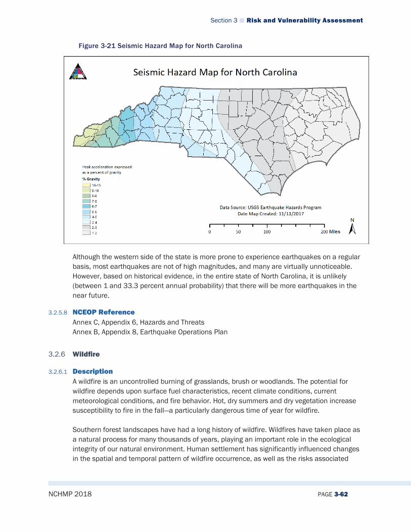
Section 3 Risk and Vulnerability Assessment
NCHMP 2018 PAGE 3-62
Figure 3-21 Seismic Hazard Map for North Carolina
Although the western side of the state is more prone to experience earthquakes on a regular basis, most earthquakes are not of high magnitudes, and many are virtually unnoticeable. However, based on historical evidence, in the entire state of North Carolina, it is unlikely (between 1 and 33.3 percent annual probability) that there will be more earthquakes in the near future.
3.2.5.8 NCEOP Reference Annex C, Appendix 6, Hazards and Threats Annex B, Appendix 8, Earthquake Operations Plan
3.2.6 Wildfire
3.2.6.1 Description A wildfire is an uncontrolled burning of grasslands, brush or woodlands. The potential for wildfire depends upon surface fuel characteristics, recent climate conditions, current meteorological conditions, and fire behavior. Hot, dry summers and dry vegetation increase susceptibility to fire in the fall—a particularly dangerous time of year for wildfire. Southern forest landscapes have had a long history of wildfire. Wildfires have taken place as a natural process for many thousands of years, playing an important role in the ecological integrity of our natural environment. Human settlement has significantly influenced changes in the spatial and temporal pattern of wildfire occurrence, as well as the risks associated
Section 3 Risk and Vulnerability Assessment
NCHMP 2018 PAGE 3-63
with them for human life and property. The fire regimes of the Southeast can be categorized into five time periods, as described in Table 3-13.9
Table 3-13 Southeast Fire Regime Time Periods
Time Period Fire Description
14,000 to 500 years ago American Indians used fire for swidden agriculture, better hunting visibility, reduction of wildfire fuel, and maintenance of trails.
500 to 100 years ago European settlers used fire to maintain large amounts of permanent agricultural fields at a much greater scale than previously done.
Late 1800s to early 1900s Forests were extensively logged, creating conditions that exacerbate the common occurrence of wildfires.
1900 to 1950s Response to wildfires was widespread fire suppression.
1950 to Present Active management; the natural role of fire is incorporated through prescribed burning.
14,000 to 500 years ago American Indians used fire for swidden agriculture, better hunting visibility, reduction of wildfire fuel, and maintenance of trails.
Natural wildfires still take place on a regular basis in the Southeast. They can be caused by human carelessness, arson, or from lightning strikes that occur on the ridge tops of the Appalachian Mountains. Other natural disturbances (such as tornadoes and hurricanes) can influence the structure and fuel distribution of forests, leading to a change in wildfire intensity and risk. The occurrence and frequency of wildfires also depends greatly upon the type of forests, of which there are several in North Carolina, ranging from longleaf pine forest along the coast to oak-hickory forests in the mountains.10 The current scale of wildfire risk conditions is measured with the Keetch-Byram Drought Index (KBDI). The KBDI estimates the potential risk for wildfire conditions based on daily temperatures, daily precipitation, and annual precipitation levels on an index of 0 (no drought) to 800 (extreme drought).11 The daily KBDI for the state of North Carolina can be found on the North Carolina Forest Service Division of Forest Resource Web site.12
9 Stanturf, John A., Wade, Dale D., Waltrop, Thomas A., Kennard, Deborah K., and Achtemeier, Gary L. 2002. Southern Forest Resource Assessment: Background Paper Chapter 25: Fire in Southern Forest Landscapes. Southern Research Station, United States Department of Agriculture Forest Service, pp 607-630. Retrieved on December 14, 2017 from: http://www.srs.fs.usda.gov/sustain/report/pdf/chapter_25e.pdf 10 Stanturf, John A., Wade, Dale D., Waltrop, Thomas A., Kennard, Deborah K., and Achtemeier, Gary L. 2002. Southern Forest Resource Assessment: Background Paper Chapter 25: Fire in Southern Forest Landscapes. Southern Research Station, United States Department of Agriculture Forest Service, pp 607-630. Retrieved on December 14, 2017 from: http://www.srs.fs.usda.gov/sustain/report/pdf/chapter_25e.pdf 11 Keetch-Byram Drought Index. United States Forest Services: Wildland Fire Assessment System. Retrieved on December 14, 2017 from: https://www.wfas.net/index.php/keetch-byram-index-moisture--drought-49 12 Fire Weather Intelligence Portal. State Climate Office of North Carolina. Retrieved on December 14, 2017 from: http://climate.ncsu.edu/fwip/?tab=curr&state=NC&map_bg=ter&point_curr=kbdi
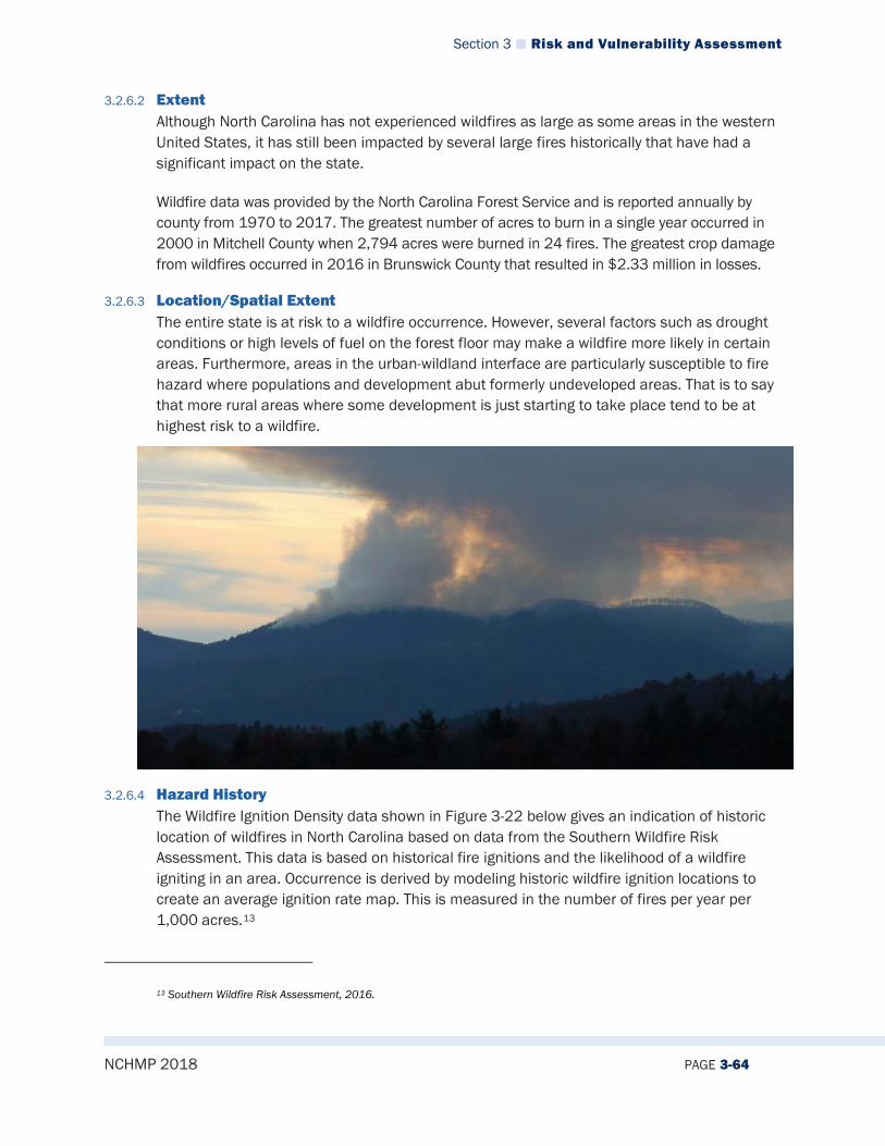
Section 3 Risk and Vulnerability Assessment
NCHMP 2018 PAGE 3-64
3.2.6.2 Extent Although North Carolina has not experienced wildfires as large as some areas in the western United States, it has still been impacted by several large fires historically that have had a significant impact on the state.
Wildfire data was provided by the North Carolina Forest Service and is reported annually by county from 1970 to 2017. The greatest number of acres to burn in a single year occurred in 2000 in Mitchell County when 2,794 acres were burned in 24 fires. The greatest crop damage from wildfires occurred in 2016 in Brunswick County that resulted in $2.33 million in losses.
3.2.6.3 Location/Spatial Extent The entire state is at risk to a wildfire occurrence. However, several factors such as drought conditions or high levels of fuel on the forest floor may make a wildfire more likely in certain areas. Furthermore, areas in the urban-wildland interface are particularly susceptible to fire hazard where populations and development abut formerly undeveloped areas. That is to say that more rural areas where some development is just starting to take place tend to be at highest risk to a wildfire.
3.2.6.4 Hazard History The Wildfire Ignition Density data shown in Figure 3-22 below gives an indication of historic location of wildfires in North Carolina based on data from the Southern Wildfire Risk Assessment. This data is based on historical fire ignitions and the likelihood of a wildfire igniting in an area. Occurrence is derived by modeling historic wildfire ignition locations to create an average ignition rate map. This is measured in the number of fires per year per 1,000 acres.13
13 Southern Wildfire Risk Assessment, 2016.
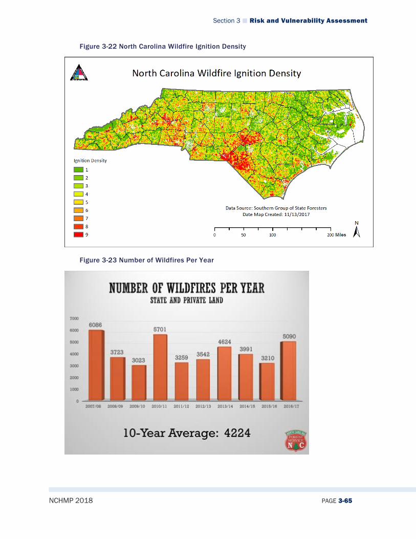
Section 3 Risk and Vulnerability Assessment
NCHMP 2018 PAGE 3-65
Figure 3-22 North Carolina Wildfire Ignition Density
Figure 3-23 Number of Wildfires Per Year

Section 3 Risk and Vulnerability Assessment
NCHMP 2018 PAGE 3-66
Table 3-14 describes wildfire events that occurred in North Carolina between 1998 and 2017, as listed in the NCEI’s Storm Events Database. Detailed information for selected events follows the table. Figure 3-24 provides a visual representation of these events.
Table 3-14 Detailed Wildfire History
North Carolina Wildfire Events
# Event Duration Location (County) Severity Extent of Damages
1 Wild/Forest Fire 06/03/1998– 06/05/1998
Pender (12 miles NE of Rocky Point)
Fatalities: 0 Injuries: 0
Property: $0 Crops: $0
2 Wild/Forest Fire 10/28/2000– 10/31/2000
McDowell (4 miles N of Ashford)
Fatalities: 0 Injuries: 0
Property: $0 Crops: $0
3 Wild/Forest Fire 11/01/2000– 11/02/2000
McDowell (4 miles N of Ashford)
Fatalities: 0 Injuries: 0
Property: $0 Crops: $0
4 Wild/Forest Fire 11/01/2000– 11/02/2000
Yancey (8 Miles SW of Burnsville, Celo)
Fatalities: 0 Injuries: 0
Property: $0 Crops: $0
5 Wild/Forest Fire 11/01/2000-11/02/2000
Mitchell (5 miles SE of Spruce Pine)
Fatalities: 0 Injuries: 0
Property: $0 Crops: $0
6 Wild/Forest Fire 11/01/2000– 11/02/2000
Haywood (Waterville) Fatalities: 0 Injuries: 0
Property: $0 Crops: $0
7 Wild/Forest Fire 03/11– 12/2007 Swain County --Grassy Ridge community
Fatalities: 0 Injuries: 0
Property: $1,190,395 Crops: $0
8 Wild/Forest Fire 9/25– 28/2007 Brunswick County -Hale Swamp Road
Fatalities: 0 Injuries: 0
Property: $0 Crops: $0
9 Wild/Forest Fire 11/05/2007 Robeson County --Jackson Swamp area
Fatalities: 0 Injuries: 0
Property: $0 Crops: $0
10 Wild/Forest Fire 12/01/2007 Robeson County Fatalities: 0 Injuries: 0
Property: $0 Crops: $0
11 Wild/Forest Fire 3/26-27/2008 New Hanover east of I-40 between Sidbury and Holly Shelter Road
Fatalities: 0 Injuries: 0
Property: $0 Crops: $0
12 Wild/Forest Fire 3/28-28/2008 Brunswick County --Highway 133 and Funston Road
Fatalities: 0 Injuries: 0
Property: $0 Crops: $0
13 Wild/Forest Fire 4/19-21/2008 Pender Shiloh Road west of Highway 421 near Atkinson
Fatalities: 0 Injuries: 0
Property: $0 Crops: $0
14 Evans Road Fire 3/23/2010 Wake County – Highland Creek Community
Fatalities 0 Injuries 4
Property: $1,131,906 Crops: $0
15 Wild/Forest Fire 04/7/2010 Northern Jackson County --Bradley Branch Rd
Fatalities: 0 Injuries: 0
Property: $113,190 Crops: $0
16 Wild/Forest Fire 2/12– 20/2011 Rutherford County -Chimney Rock State
Fatalities: 0 Injuries: 0
Property: $0 Crops: $0
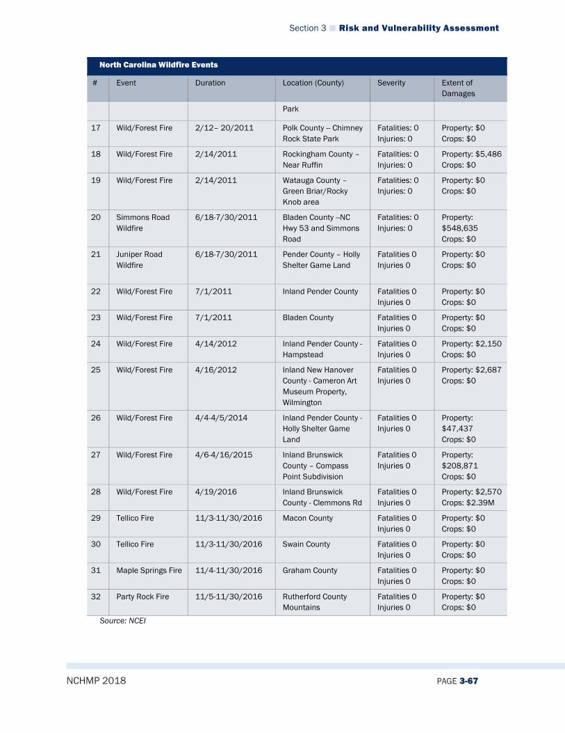
Section 3 Risk and Vulnerability Assessment
NCHMP 2018 PAGE 3-67
North Carolina Wildfire Events
# Event Duration Location (County) Severity Extent of Damages
Park
17 Wild/Forest Fire 2/12– 20/2011 Polk County -- Chimney Rock State Park
Fatalities: 0 Injuries: 0
Property: $0 Crops: $0
18 Wild/Forest Fire 2/14/2011 Rockingham County – Near Ruffin
Fatalities: 0 Injuries: 0
Property: $5,486 Crops: $0
19 Wild/Forest Fire 2/14/2011 Watauga County – Green Briar/Rocky Knob area
Fatalities: 0 Injuries: 0
Property: $0 Crops: $0
20 Simmons Road Wildfire
6/18-7/30/2011 Bladen County --NC Hwy 53 and Simmons Road
Fatalities: 0 Injuries: 0
Property: $548,635 Crops: $0
21 Juniper Road Wildfire
6/18-7/30/2011 Pender County – Holly Shelter Game Land
Fatalities 0 Injuries 0
Property: $0 Crops: $0
22 Wild/Forest Fire 7/1/2011 Inland Pender County Fatalities 0 Injuries 0
Property: $0 Crops: $0
23 Wild/Forest Fire 7/1/2011 Bladen County Fatalities 0 Injuries 0
Property: $0 Crops: $0
24 Wild/Forest Fire 4/14/2012 Inland Pender County - Hampstead
Fatalities 0 Injuries 0
Property: $2,150 Crops: $0
25 Wild/Forest Fire 4/16/2012 Inland New Hanover County - Cameron Art Museum Property, Wilmington
Fatalities 0 Injuries 0
Property: $2,687 Crops: $0
26 Wild/Forest Fire 4/4-4/5/2014 Inland Pender County - Holly Shelter Game Land
Fatalities 0 Injuries 0
Property: $47,437 Crops: $0
27 Wild/Forest Fire 4/6-4/16/2015 Inland Brunswick County – Compass Point Subdivision
Fatalities 0 Injuries 0
Property: $208,871 Crops: $0
28 Wild/Forest Fire 4/19/2016 Inland Brunswick County - Clemmons Rd
Fatalities 0 Injuries 0
Property: $2,570 Crops: $2.39M
29 Tellico Fire 11/3-11/30/2016 Macon County Fatalities 0 Injuries 0
Property: $0 Crops: $0
30 Tellico Fire 11/3-11/30/2016 Swain County Fatalities 0 Injuries 0
Property: $0 Crops: $0
31 Maple Springs Fire 11/4-11/30/2016 Graham County Fatalities 0 Injuries 0
Property: $0 Crops: $0
32 Party Rock Fire 11/5-11/30/2016 Rutherford County Mountains
Fatalities 0 Injuries 0
Property: $0 Crops: $0
Source: NCEI
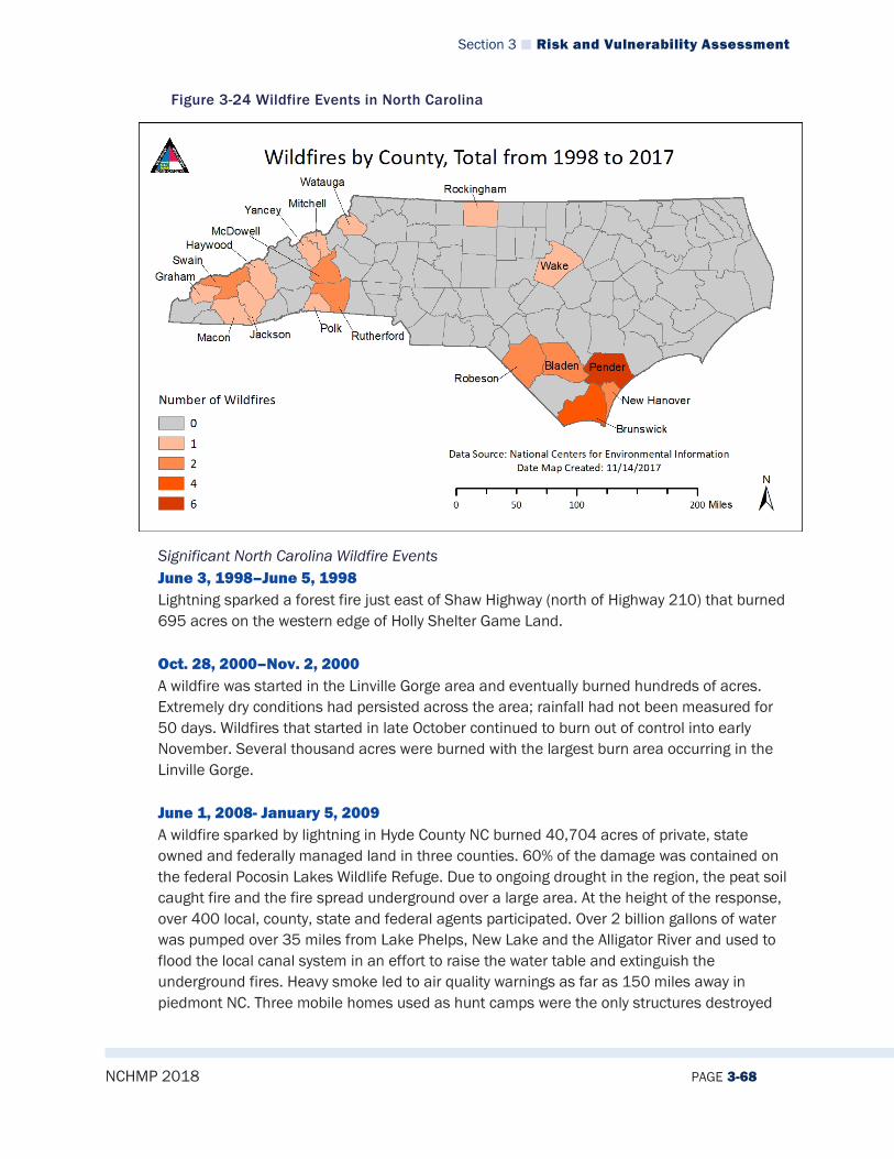
Section 3 Risk and Vulnerability Assessment
NCHMP 2018 PAGE 3-68
Figure 3-24 Wildfire Events in North Carolina
Significant North Carolina Wildfire Events June 3, 1998–June 5, 1998 Lightning sparked a forest fire just east of Shaw Highway (north of Highway 210) that burned 695 acres on the western edge of Holly Shelter Game Land. Oct. 28, 2000–Nov. 2, 2000 A wildfire was started in the Linville Gorge area and eventually burned hundreds of acres. Extremely dry conditions had persisted across the area; rainfall had not been measured for 50 days. Wildfires that started in late October continued to burn out of control into early November. Several thousand acres were burned with the largest burn area occurring in the Linville Gorge. June 1, 2008- January 5, 2009 A wildfire sparked by lightning in Hyde County NC burned 40,704 acres of private, state owned and federally managed land in three counties. 60% of the damage was contained on the federal Pocosin Lakes Wildlife Refuge. Due to ongoing drought in the region, the peat soil caught fire and the fire spread underground over a large area. At the height of the response, over 400 local, county, state and federal agents participated. Over 2 billion gallons of water was pumped over 35 miles from Lake Phelps, New Lake and the Alligator River and used to flood the local canal system in an effort to raise the water table and extinguish the underground fires. Heavy smoke led to air quality warnings as far as 150 miles away in piedmont NC. Three mobile homes used as hunt camps were the only structures destroyed
Section 3 Risk and Vulnerability Assessment
NCHMP 2018 PAGE 3-69
by the blaze. The last hot spots from the fire were identified and extinguished on January 5, 2009. Suppression of the blaze cost just under $20 million. March 23, 2010 Dry conditions in Wake county along with above normal temperatures during the week preceding the fire likely contributed to a decrease in fuel moisture and an increased potential for fires. Strong gusty westerly winds developed during the afternoon and in advance of a surface|trough. these gusty winds and the close proximity of the homes were factors in the rapid spread of the fire. Three homes were destroyed and 4 homes were damaged in the Highland Creek Home Community in north Raleigh when a fire spread from a grass, pine straw area directly behind one of the homes June 18, 2011-July 30, 2011 Lightning sparked a wildfire near the intersection of NC Hwy 53 and Simmons Road, in the Live Oak community in Bladen County. Against the backdrop of an ongoing severe drought and 100-degree heat, strong and erratic winds caused the fire to cross containment lines on June 20-21. The fire destroyed three homes and eleven outbuildings. The fire spread to all or parts of several bays containing dense vegetation and organic soil. Evacuations were ordered on two occasions, but all residents were able to return home. The fire grew to 5600 acres and continued to burn into July. Party Rock Fire, Rutherford County, November 5 – November 30, 2016 An extended period of abnormally dry weather and drought conditions that began in late winter of 2016, and continued through the year resulted in very dry vegetation across western North Carolina by mid-autumn. This was exacerbated by an unusually warm late summer and fall, when temperatures averaged as much as 5 degrees above normal. In these conditions, multiple wildfires ignited and spread during the first week of November, culminating in one of the worst wildfire episodes in recent western North Carolina history. Multiple large fires burned, mainly across the southern mountains, and most of these fires were not completely contained until a cold front brought much-needed rain to the area at the end of the month. The Party Rock fire burned more than 7,000 acres in the Lake Lure/Chimney Rock/Bat Cave area. Chimney Rock State Park was closed throughout much of the month, while Chimney Rock village was evacuated multiple times during adverse fire weather conditions. The Maple Springs Fire burned around 8000 acres in an area just north and northwest of Lake Santeetlah. The Tellico fire burned more than 13,000 acres in the Nantahala area along the Macon/Swain County line. A historical record of the number of wildfires and acreage burned in North Carolina from 1928 to 2015 can be found at the North Carolina Forest Service Web site. Also available on
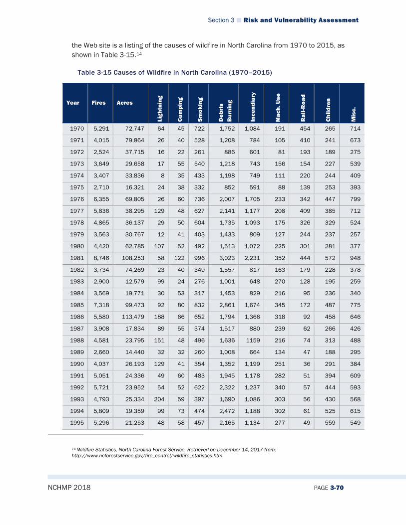
Section 3 Risk and Vulnerability Assessment
NCHMP 2018 PAGE 3-70
the Web site is a listing of the causes of wildfire in North Carolina from 1970 to 2015, as shown in Table 3-15.14
Table 3-15 Causes of Wildfire in North Carolina (1970–2015)
Year Fires Acres
Ligh
tnin
g
Cam
ping
Smok
ing
Deb
ris
Bur
ning
Ince
ndia
ry
Mac
h. U
se
Rai
l-Roa
d
Chi
ldre
n
Mis
c.
1970 5,291 72,747 64 45 722 1,752 1,084 191 454 265 714
1971 4,015 79,864 26 40 528 1,208 784 105 410 241 673
1972 2,524 37,715 16 22 261 886 601 81 193 189 275
1973 3,649 29,658 17 55 540 1,218 743 156 154 227 539
1974 3,407 33,836 8 35 433 1,198 749 111 220 244 409
1975 2,710 16,321 24 38 332 852 591 88 139 253 393
1976 6,355 69,805 26 60 736 2,007 1,705 233 342 447 799
1977 5,836 38,295 129 48 627 2,141 1,177 208 409 385 712
1978 4,865 36,137 29 50 604 1,735 1,093 175 326 329 524
1979 3,563 30,767 12 41 403 1,433 809 127 244 237 257
1980 4,420 62,785 107 52 492 1,513 1,072 225 301 281 377
1981 8,746 108,253 58 122 996 3,023 2,231 352 444 572 948
1982 3,734 74,269 23 40 349 1,557 817 163 179 228 378
1983 2,900 12,579 99 24 276 1,001 648 270 128 195 259
1984 3,569 19,771 30 53 317 1,453 829 216 95 236 340
1985 7,318 99,473 92 80 832 2,861 1,674 345 172 487 775
1986 5,580 113,479 188 66 652 1,794 1,366 318 92 458 646
1987 3,908 17,834 89 55 374 1,517 880 239 62 266 426
1988 4,581 23,795 151 48 496 1,636 1159 216 74 313 488
1989 2,660 14,440 32 32 260 1,008 664 134 47 188 295
1990 4,037 26,193 129 41 354 1,352 1,199 251 36 291 384
1991 5,051 24,336 49 60 483 1,945 1,178 282 51 394 609
1992 5,721 23,952 54 52 622 2,322 1,237 340 57 444 593
1993 4,793 25,334 204 59 397 1,690 1,086 303 56 430 568
1994 5,809 19,359 99 73 474 2,472 1,188 302 61 525 615
1995 5,296 21,253 48 58 457 2,165 1,134 277 49 559 549
14 Wildfire Statistics. North Carolina Forest Service. Retrieved on December 14, 2017 from: http://www.ncforestservice.gov/fire_control/wildfire_statistics.htm

Section 3 Risk and Vulnerability Assessment
NCHMP 2018 PAGE 3-71
Year Fires Acres
Ligh
tnin
g
Cam
ping
Smok
ing
Deb
ris
Bur
ning
Ince
ndia
ry
Mac
h. U
se
Rai
l-Roa
d
Chi
ldre
n
Mis
c.
1996 4,272 15,963 49 35 300 1,838 807 222 81 428 512
1997 4,539 16,274 127 50 273 1,890 929 226 86 477 481
1998 4,317 15,699 80 40 297 1,755 944 258 63 387 493
1999 6,244 28,298 110 75 439 2,629 1,195 325 107 598 776
2000 4,949 25,146 57 60 358 2,049 955 282 119 443 626
2001 8,129 28,733 82 110 708 3,226 1593 524 121 749 1,015
2002 5,618 28,216 261 73 370 2,250 975 360 65 501 764
2003 1,994 5,841.4 10 21 121 864 355 140 15 154 314
2004 4,364 14,722.8 29 49 255 2,046 693 295 36 335 626
2005 4,057 15,235.8 49 47 278 1,697 764 325 45 311 541
2006 5,096 21,924.0 97 52 333 2,111 943 430 49 393 690
2007 7,260 38,065 215 105 503 2,461 1,476 614 98 614 1,174
2008 4,381 50,646 197 36 246 1,567 758 384 58 332 802
2009 3,291 12,322 56 38 186 1,309 618 283 26 246 469
2010 4,053 14,703 71 36 166 1,642 801 435 24 268 602
2011 5,265 63,547 200 28 216 2102 1012 522 40 298 803
2012 3,550 11,992 129 46 91 1,221 715 384 36 228 668
2013 3,374 9,451 20 37 102 1,492 580 344 14 200 583
2014 4,593 13,327 53 41 90 2,237 706 460 30 210 766
2015 3,886 10,558 77 32 82 1,671 444 416 0 223 941
Source: North Carolina Forest Service
3.2.6.5 Changing Future Conditions A United States Government Accountability Office report dated September 2017 states that the Presidential budget proposal for 2017 references that the United States government has incurred direct costs of more than $350 billion because of extreme weather and fire events including: $205 billion for domestic disaster response and relief $90 billion for crop and flood insurance $34 billion for wildland fire management and $28 billion for maintenance and repairs to federal facilities and federally managed
lands, infrastructure and waterways.
These costs are only expected to increase according to the U.S. Global Change Research Program that finds “impacts and costs of extreme events – such as floods, drought, and

Section 3 Risk and Vulnerability Assessment
NCHMP 2018 PAGE 3-72
other events – will increase in significance as what are considered rare events become more common and intense because of weather extremes.
3.2.6.6 Impact Wildfires are a key part of nature’s cycle that renews many ecosystems; however, they can also be dangerous and deadly when uncontrolled. Smoke from wildfires can cause health risks, and carbon dioxide is also released into the atmosphere during burns. There have been several notable incidents that caused significant damage in North Carolina’s recorded history of wildfires that can be used as a basis for the impacts that a wildfire might have in the stat. For example, Fayetteville experienced a devastating fire on May 29, 1831. The fire was considered to be more destructive than the Great Fire of Chicago in 1871. Fayetteville lost 600 homes, 100 businesses, and several churches, among other structures.15 In recent years, North Carolina has also experienced significant wildfires, including on June 3, 1998, when lightning sparked a forest fire just east of Shaw Highway (north of Highway 210 in Pender County) that burned 695 acres on the western edge of Holly Shelter Game Land. The event lasted 45 hours. On October 28, 200, a wildfire was started in the Linville Gorge area and eventually burned hundreds of acres in McDowell County. Extremely dry conditions had persisted across the area and rain had not been measured for 50 days, so the event lasted around 60 hours. The last major wildfire in the state occurred in Brunswick County in April 2016 when burning debris caught fire. The wildfire covered 1,578 acres and destroyed a travel trailer and mobile home. Over $2 million was lost in property and crop damages.
3.2.6.7 Future Probability There is a high probability of future wildfire events in the State of North Carolina. The likelihood of wildfires increases during drought cycles and abnormally dry conditions. In addition, increased development throughout the State leads to increased vulnerability. Figure 3-25 shows areas of the state that have a high probability of experiencing a wildfire according to the Southern Wildfire Risk Assessment’s Burn Probability Index.
15 Citywide Fire in Fayetteville, 1831. North Carolina Department of Natural and Cultural Resources. Retrieved on December 14, 2017 from: https://www.ncdcr.gov/blog/2015/05/29/citywide-fire-in-fayetteville-1831
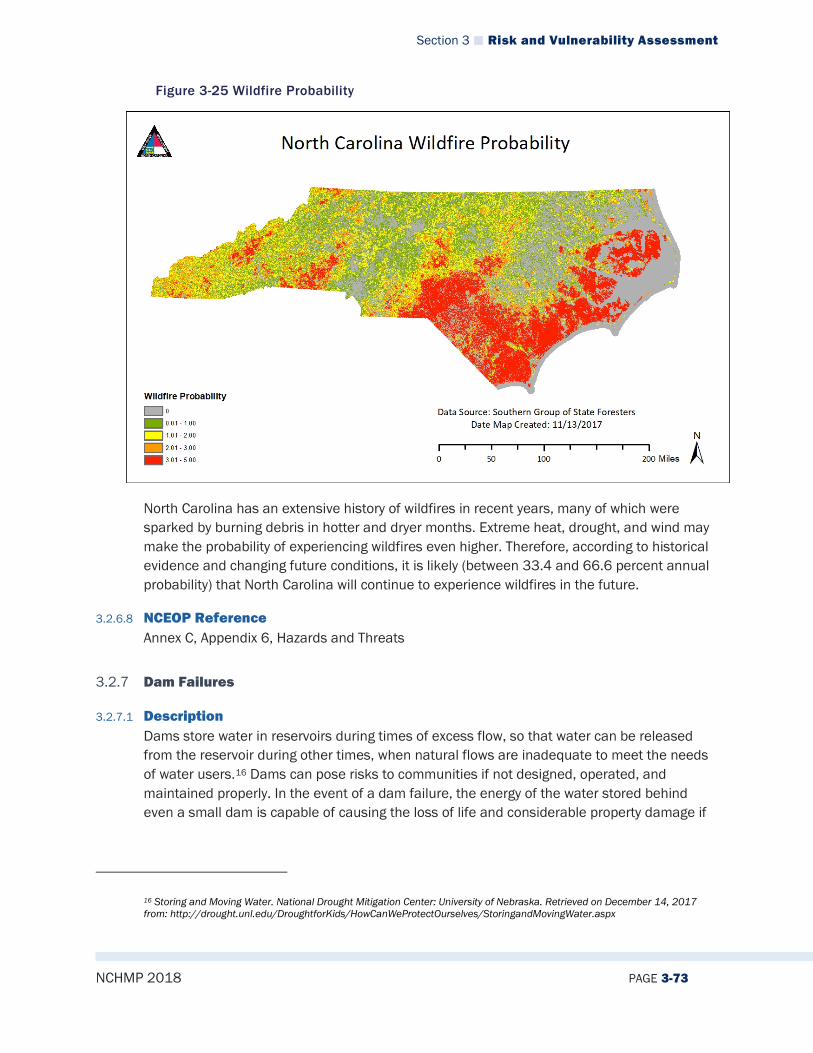
Section 3 Risk and Vulnerability Assessment
NCHMP 2018 PAGE 3-73
Figure 3-25 Wildfire Probability
North Carolina has an extensive history of wildfires in recent years, many of which were sparked by burning debris in hotter and dryer months. Extreme heat, drought, and wind may make the probability of experiencing wildfires even higher. Therefore, according to historical evidence and changing future conditions, it is likely (between 33.4 and 66.6 percent annual probability) that North Carolina will continue to experience wildfires in the future.
3.2.6.8 NCEOP Reference Annex C, Appendix 6, Hazards and Threats
3.2.7 Dam Failures
3.2.7.1 Description Dams store water in reservoirs during times of excess flow, so that water can be released from the reservoir during other times, when natural flows are inadequate to meet the needs of water users.16 Dams can pose risks to communities if not designed, operated, and maintained properly. In the event of a dam failure, the energy of the water stored behind even a small dam is capable of causing the loss of life and considerable property damage if
16 Storing and Moving Water. National Drought Mitigation Center: University of Nebraska. Retrieved on December 14, 2017 from: http://drought.unl.edu/DroughtforKids/HowCanWeProtectOurselves/StoringandMovingWater.aspx
Section 3 Risk and Vulnerability Assessment
NCHMP 2018 PAGE 3-74
there are people located downstream from the dam.17 Many dam failures have resulted because of an inability to safely pass flood flows. Failures caused by hydrologic conditions can range from sudden (with complete breaching or collapse), to gradual (with progressive erosion and partial breaching). The most common modes of failure associated with hydrologic conditions include overtopping, the erosion of earth spillways, and overstressing the dam or its structural components.18 Like all built structures, dams deteriorate. Lack of maintenance causes dams to be more susceptible to failure. Often, the corrugated piping used in dam construction has a shorter life span than the dam itself, involving expensive replacement to avoid potential dam weakening. In the United States since 2000, more than 600 dam incidents, (including 70 dam failures) were reported to the National Performance of Dams Program, which collects and archives information on dam performance as reported by state and federal regulatory agencies and dam owners. Dam incidents are events (such as large floods, earthquakes or inspections) that alert dam safety engineers to deficiencies that threaten the safety of a dam. Due to limited state staff, many incidents are not reported, and therefore the actual number of incidents is likely to be much higher. Communities continue to develop along the state’s rivers, many in potential dam-failure inundation zones. Further exacerbating the potential risk to citizens is the disrepair of many dams and the lack of sound plans to help guide necessary repairs and warning systems to alert the public in the event of a dam failure.
3.2.7.2 Extent The hazard potential is the possible adverse incremental consequences that result from the release of water or stored contents, due to the failure of the dam or disoperation of the dam or appurtenances. Dam failures can be grouped into three categories: low-, significant-, and high-hazard potential situations. Hazard potential does not indicate the structural integrity of the dam itself, but rather the effects if a failure should occur. The hazard potential assigned to a dam is based on consideration of the effects of a failure during both normal and flood-flow conditions.19 Table 3-16 (below) provides a description and guidelines of the three classes of dam hazards defined using the North Carolina Division of Land Resources criteria.
17 Dams Sector: Crisis Management Overview Course. Federal Emergency Management Agency. Retrieved on December 14, 2017 from: https://emilms.fema.gov/IS0870a/DCM01summary.htm 18 Federal Guidelines for Dam Safety: Selecting and Accommodating Inflow Design Floods for Dams. April 2004. Retrieved on December 14, 2017 from: https://www.ferc.gov/industries/hydropower/safety/guidelines/fema-94.pdf 19 Federal Guidelines for Dam Safety: Selecting and Accommodating Inflow Design Floods for Dams. April 2004. Retrieved on December 14, 2017 from: https://www.ferc.gov/industries/hydropower/safety/guidelines/fema-94.pdf
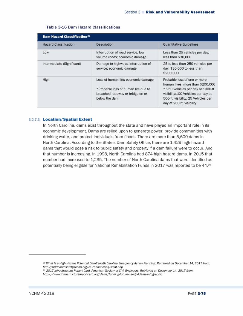
Section 3 Risk and Vulnerability Assessment
NCHMP 2018 PAGE 3-75
Table 3-16 Dam Hazard Classifications
Dam Hazard Classification20
Hazard Classification Description Quantitative Guidelines
Low Interruption of road service, low volume roads; economic damage
Less than 25 vehicles per day; less than $30,000
Intermediate (Significant) Damage to highways, interruption of service; economic damage
25 to less than 250 vehicles per day; $30,000 to less than $200,000
High Loss of human life; economic damage *Probable loss of human life due to breached roadway or bridge on or below the dam
Probable loss of one or more human lives; more than $200,000 * 250 Vehicles per day at 1000-ft. visibility;100 Vehicles per day at 500-ft. visibility; 25 Vehicles per day at 200-ft. visibility
3.2.7.3 Location/Spatial Extent In North Carolina, dams exist throughout the state and have played an important role in its economic development. Dams are relied upon to generate power, provide communities with drinking water, and protect individuals from floods. There are more than 5,600 dams in North Carolina. According to the State’s Dam Safety Office, there are 1,429 high hazard dams that would pose a risk to public safety and property if a dam failure were to occur. And that number is increasing. In 1998, North Carolina had 874 high hazard dams. In 2015 that number had increased to 1,235. The number of North Carolina dams that were identified as potentially being eligible for National Rehabilitation Funds in 2017 was reported to be 44.21
20 What is a High-Hazard Potential Dam? North Carolina Emergency Action Planning. Retrieved on December 14, 2017 from: http://www.damsafetyaction.org/NC/about-eaps/what.php 21 2017 Infrastructure Report Card. American Society of Civil Engineers. Retrieved on December 14, 2017 from: https://www.infrastructurereportcard.org/dams/funding-future-need/#dams-infographic

Section 3 Risk and Vulnerability Assessment
NCHMP 2018 PAGE 3-76
Figure 3-26 NC Potential High Hazard Dams by County
3.2.7.4 Hazard History Table 3-17 lists the historical occurrences of dam failure that have impacted North Carolina.
Table 3-17 Detailed Dam Failure History
North Carolina Dam Break Events
# Event Year Location Severity Extent of Damages
1 Bearwallow Lake Dam Break
1976 Bearwallow Lake, N.C. Sliding Unknown
2 Potato Hill Lake Dam Break
1977 Potato Hill Lake, N.C. Overtopping Unknown
3 Winston Dam Break 1912 Winston, N.C. Overtopping Unknown
5 Hurricane Fran 1996 Eastern N.C. 3 major and 12 minor breaks
Private facilities
6 Hurricane Floyd 1999 44 Counties of N.C. 36 failures 100 dams damaged; hog lagoon overflow
7 Hope Mills 2003 Hoke and Cumberland Counties, N.C.
5 failures and 11 damaged dams
No injuries
8 Hurricane Matthew 2016 Cumberland, Duplin, Harnett, Hoke, Lenoir, Sampson, Wayne and Wilson Counties
12 state-regulated dams breached, 8 other, non-regulated dams breached
400 inspections conducted after the event
Section 3 Risk and Vulnerability Assessment
NCHMP 2018 PAGE 3-77
3.2.7.5 Changing Future Conditions Climate and weather pattern changes may not affect dams as much as other hazards. However, there are growing concerns on whether or not dams positively or negatively contribute to weather extremes. Supporters believe dams may keep stored water cooler than undammed rivers, while critics argue dams only add to increasing global temperatures. Dam failures, however, present dangers of flooding, which could be problematic in the flat, low lying areas of North Carolina.
3.2.7.6 Impact Dam failures have to potential to cause critical impacts in some parts of the state. This means that multiple deaths/injuries are possible and that more than 25% of property in affected area damaged or destroyed. In some parts of the state, a major dam failure has the potential to cause complete shutdown of critical facilities for more than one week.
3.2.7.7 Future Probability Although construction of dams in North Carolina is increasing, historical occurrences of dam failures have been infrequent historically. It is relatively unlikely (between 1 and 33.3 percent annual probability) that dam failures will occur in North Carolina without a precipitating event such as a hurricane or flood; however, since dam failures often create widespread impacts beyond their surrounding location, they should still be properly monitored and maintained to prevent this hazard from happening.
3.2.7.8 NCEOP Reference Annex C, Appendix 6, Hazards and Threats
3.2.8 Drought
3.2.8.1 Description Drought refers to an extended period of deficient rainfall relative to the statistical mean established for a region. Drought can be defined according to meteorological, hydrological, and agricultural criteria. Meteorological drought uses long-term precipitation data to measure present precipitation levels against departures from normal precipitation levels. Hydrological drought is defined by surface and subsurface water supply deficiencies based on stream flow, lake, reservoir, and ground water levels. Agricultural drought occurs when there is insufficient soil moisture to satisfy the water budget of a specific crop, leading to destroyed or underdeveloped crops with greatly depleted yields.

Section 3 Risk and Vulnerability Assessment
NCHMP 2018 PAGE 3-78
Table 3-18 Drought Classification Definitions
Meteorological Drought The degree of dryness or departure of actual precipitation from an expected average or normal amount based on monthly, seasonal, or annual time scales.
Hydrologic Drought The effects of precipitation shortfalls on stream flows and reservoir, lake, and groundwater levels.
Agricultural Drought Soil moisture deficiencies relative to water demands of plant life, usually crops.
Socioeconomic Drought The effect of demands for water exceeding the supply as a result of a weather-related supply shortfall.
Source: Multi-Hazard Identification and Risk Assessment: A Cornerstone of the National Mitigation Strategy, FEMA
A drought is a prolonged period of less than normal precipitation such that the lack of water causes a serious hydrologic imbalance. Common effects of drought include crop failure, water supply shortages, and fish and wildlife mortality. High temperatures, high winds, and low humidity can worsen drought conditions and make areas more susceptible to wildfire. Human demands and actions have the ability to hasten or mitigate drought-related impacts on local communities. Drought is a normal, recurrent feature of climate, although many erroneously consider it a rare and random event. Because drought is progressive in nature and develops slowly, it is often not recognized until it reaches a severe level. The underlying cause of most droughts can be related to variations in large-scale atmospheric circulation patterns and the locations of anticyclones, or high-pressure systems. Sometimes, whirling masses of air separate from the main westerly airflow (analogous to whirlpools that form in rapidly flowing rivers) and effectively prevent the usual west-to-east progression of weather systems. When these “blocking systems” persist for extended periods of time, weather extremes (such as drought, floods, heat waves, and cold snaps) can occur. Extent One way of measuring drought extent is defined by the drought classifications provided by the U.S. Drought Monitor, an example of which can be found in Figure 3-27.
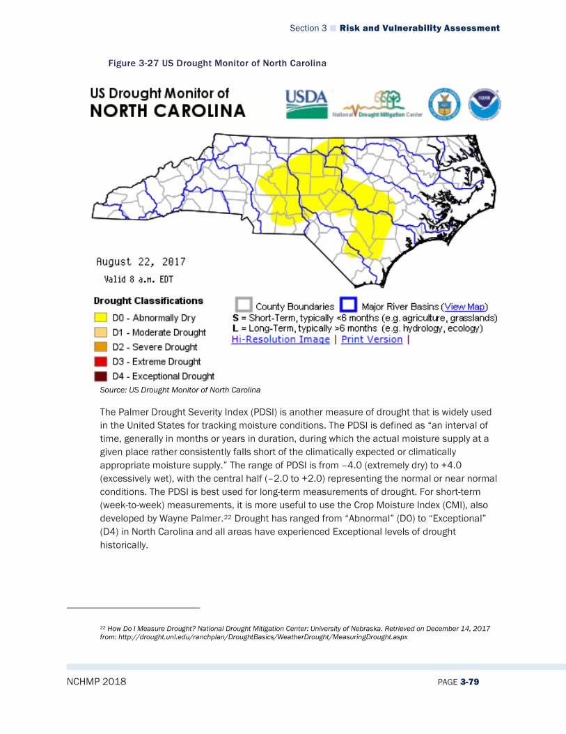
Section 3 Risk and Vulnerability Assessment
NCHMP 2018 PAGE 3-79
Figure 3-27 US Drought Monitor of North Carolina
Source: US Drought Monitor of North Carolina
The Palmer Drought Severity Index (PDSI) is another measure of drought that is widely used in the United States for tracking moisture conditions. The PDSI is defined as “an interval of time, generally in months or years in duration, during which the actual moisture supply at a given place rather consistently falls short of the climatically expected or climatically appropriate moisture supply.” The range of PDSI is from –4.0 (extremely dry) to +4.0 (excessively wet), with the central half (–2.0 to +2.0) representing the normal or near normal conditions. The PDSI is best used for long-term measurements of drought. For short-term (week-to-week) measurements, it is more useful to use the Crop Moisture Index (CMI), also developed by Wayne Palmer.22 Drought has ranged from “Abnormal” (D0) to “Exceptional” (D4) in North Carolina and all areas have experienced Exceptional levels of drought historically.
22 How Do I Measure Drought? National Drought Mitigation Center: University of Nebraska. Retrieved on December 14, 2017 from: http://drought.unl.edu/ranchplan/DroughtBasics/WeatherDrought/MeasuringDrought.aspx

Section 3 Risk and Vulnerability Assessment
NCHMP 2018 PAGE 3-80
Figure 3-28 Palmer Drought Severity Index Summary Map for the United States
Source: National Drought Mitigation Center
Table 3-19 Drought Severity Classification
Ranges
Cate
gory
Des
crip
tion
Poss
ible
Impa
cts
Palm
er D
roug
ht S
ever
ity
Inde
x (P
DSI
)
CPC
Soil
M
oist
ure
Mod
el
(Per
cent
iles)
USG
S W
eekl
y St
ream
flow
(P
erce
ntile
s)
Stan
dard
ized
Pr
ecip
itatio
n In
dex
(SPI
)
Obje
ctiv
e D
roug
ht
Indi
cato
r Ble
nds
(Per
cent
iles)
D0 Abnormally Dry
Going into drought: short-term dryness slowing planting, growth of crops or pastures Coming out of drought: some lingering water deficits pastures or crops not fully recovered
-1.0 to -1.9
21 to 30 21 to 30 -0.5 to -0.7
21 to 30
D1 Moderate Drought
Some damage to crops, pastures Streams, reservoirs, or wells low, some water shortages
-2.0 to -2.9
11 to 20 11 to 20 -0.8 to -1.2
11 to 20

Section 3 Risk and Vulnerability Assessment
NCHMP 2018 PAGE 3-81
developing or imminent Voluntary water-use restrictions requested
D2 Severe Drought
Crop or pasture losses likely Water shortages common Water restrictions imposed
-3.0 to -3.9
6 to 10 6 to 10 -1.3 to -1.5
6 to 10
D3 Extreme Drought
Major crop/pasture losses Widespread water shortages or restrictions
-4.0 to -4.9
3 to 5 3 to 5 -1.6 to -1.9
3 to 5
D4 Exceptional Drought
Exceptional and widespread crop/pasture losses Shortages of water in reservoirs, streams, and wells creating water emergencies
-5.0 or less
0 to 2 0 to 2 -2.0 or less
0 to 2
Source: http://droughtmonitor.unl.edu/AboutUs/ClassificationScheme.aspx
3.2.8.2 Location/Spatial Extent Drought is a common hazard across the entire state. “Severe” drought is a good indicator of the areas of the state that may experience more drought than others. As Figure 3-29 illustrates, the southeastern and western parts of the state have spent the most months in severe drought since 1895.
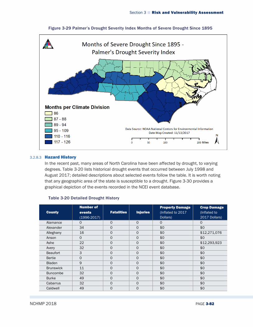
Section 3 Risk and Vulnerability Assessment
NCHMP 2018 PAGE 3-82
Figure 3-29 Palmer’s Drought Severity Index Months of Severe Drought Since 1895
3.2.8.3 Hazard History In the recent past, many areas of North Carolina have been affected by drought, to varying degrees. Table 3-20 lists historical drought events that occurred between July 1998 and August 2017; detailed descriptions about selected events follow the table. It is worth noting that any geographic area of the state is susceptible to a drought. Figure 3-30 provides a graphical depiction of the events recorded in the NCEI event database.
Table 3-20 Detailed Drought History
County Number of events (1996-2017)
Fatalities Injuries Property Damage (Inflated to 2017 Dollars)
Crop Damage (Inflated to 2017 Dollars)
Alamance 0 0 0 0 0 Alexander 34 0 0 $0 $0 Alleghany 16 0 0 $0 $12,271,076 Anson 0 0 0 $0 $0 Ashe 22 0 0 $0 $12,293,923 Avery 32 0 0 $0 $0 Beaufort 3 0 0 $0 $0 Bertie 0 0 0 $0 $0 Bladen 9 0 0 $0 $0 Brunswick 11 0 0 $0 $0 Buncombe 32 0 0 $0 $0 Burke 49 0 0 $0 $0 Cabarrus 32 0 0 $0 $0 Caldwell 49 0 0 $0 $0

Section 3 Risk and Vulnerability Assessment
NCHMP 2018 PAGE 3-83
County Number of events (1996-2017)
Fatalities Injuries Property Damage (Inflated to 2017 Dollars)
Crop Damage (Inflated to 2017 Dollars)
Camden 0 0 0 $0 $0 Carteret 3 0 0 $0 $0 Caswell 17 0 0 $0 $15,995,005 Catawba 34 0 0 $0 $0 Chatham 0 0 0 $0 $0 Cherokee 0 0 0 $0 $0 Chowan 0 0 0 $0 $0 Clay 0 0 0 $0 $0 Cleveland 34 0 0 $0 $0 Columbus 10 0 0 $0 $0 Craven 3 0 0 $0 $0 Cumberland 0 0 0 $0 $0 Currituck 0 0 0 $0 $0 Dare 6 0 0 $0 $0 Davidson 0 0 0 $0 $0 Davie 32 0 0 $0 $0 Duplin 3 0 0 $0 $0 Durham 0 0 0 $0 $0 Edgecombe 0 0 0 $0 $0 Forsyth 0 0 0 $0 $0 Franklin 0 0 0 $0 $0 Gaston 32 0 0 $0 $0 Gates 0 0 0 $0 $0 Graham 33 0 0 $0 $0 Granville 0 0 0 $0 $0 Greene 3 0 0 $0 $0 Guilford 0 0 0 $0 $0 Halifax 0 0 0 $0 $0 Harnett 0 0 0 $0 $0 Haywood 34 0 0 $0 $0 Henderson 34 0 0 $0 $0 Hertford 0 0 0 $0 $0 Hoke 0 0 0 $0 $0 Hyde 6 0 0 $0 $0 Iredell 32 0 0 $0 $0 Jackson 70 0 0 $0 $0 Johnston 0 0 0 $0 $0 Jones 3 0 0 $0 $0 Lee 0 0 0 $0 $0 Lenoir 3 0 0 $0 $0 Lincoln 34 0 0 $0 $0 Macon 34 0 0 $0 $0 Madison 31 0 0 $0 $0 Martin 2 0 0 $0 $0 McDowell 48 0 0 $0 $0 Mecklenburg 32 0 0 $0 $0 Mitchell 33 0 0 $0 $0 Montgomery 0 0 0 $0 $0 Moore 0 0 0 $0 $0 Nash 0 0 0 $0 $0
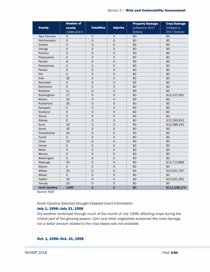
Section 3 Risk and Vulnerability Assessment
NCHMP 2018 PAGE 3-84
County Number of events (1996-2017)
Fatalities Injuries Property Damage (Inflated to 2017 Dollars)
Crop Damage (Inflated to 2017 Dollars)
New Hanover 9 0 0 $0 $0 Northampton 0 0 0 $0 $0 Onslow 3 0 0 $0 $0 Orange 0 0 0 $0 $0 Pamlico 3 0 0 $0 $0 Pasquotank 0 0 0 $0 $0 Pender 8 0 0 $0 $0 Perquimans 0 0 0 $0 $0 Person 0 0 0 $0 $0 Pitt 3 0 0 $0 $0 Polk 35 0 0 $0 $0 Randolph 0 0 0 $0 $0 Richmond 0 0 0 $0 $0 Robeson 11 0 0 $0 $0 Rockingham 17 0 0 $0 $13,157,091 Rowan 33 0 0 $0 $0 Rutherford 35 0 0 $0 $0 Sampson 0 0 0 $0 $0 Scotland 0 0 0 $0 $0 Stanly 0 0 0 $0 $0 Stokes 6 0 0 $0 $12,395,810 Surry 18 0 0 $0 $12,388,243 Swain 35 0 0 $0 $0 Transylvania 34 0 0 $0 $0 Tyrrell 3 0 0 $0 $0 Union 33 0 0 $0 $0 Vance 0 0 0 $0 $0 Wake 0 0 0 $0 $0 Warren 0 0 0 $0 $0 Washington 3 0 0 $0 $0 Watauga 24 0 0 $0 $12,713,868 Wayne 0 0 0 $0 $0 Wilkes 20 0 0 $0 $10,021,767 Wilson 0 0 0 $0 $0 Yadkin 19 0 0 $0 $10,001,391 Yancey 33 0 0 $0 $0 North Carolina 1496 0 0 $0 $111,238,174
Source: NCEI
North Carolina Selected Drought Detailed Event Information July 1, 1998–July 31, 1998 Dry weather continued through much of the month of July 1998, affecting crops during the critical part of the growing season. Corn and other vegetables sustained the most damage, but a dollar amount related to the crop losses was not available. Oct. 1, 1998–Oct. 31, 1998
Section 3 Risk and Vulnerability Assessment
NCHMP 2018 PAGE 3-85
The drought which began during the summer of 1998 continued through October. The only significant rainfall during the month occurred on Oct. 7 and Oct. 8. Cities and counties began to restrict water usage, and stream flows for several mountain locations were reduced to the lowest amounts seen in 50 years. Aug. 25, 1999–Sept. 5, 1999 In 1999, Brunswick, Columbus, and Robeson Counties were declared Federal Disaster Areas due to hot and dry conditions which continued since July. Dry conditions that began in July 1998, subsided for several months during the latter part of 1998 and the first part of 1999, then returned in June 1999 and continued in many areas through early September. In many areas, crops were either damaged or destroyed. Water levels in creeks, streams, and rivers remained very low. The drought ended in most areas with the arrival of heavy rain from the remnants of Hurricane Dennis, which occurred on Sept. 4 and Sept. 5. Feb. 1, 2001–May 31, 2001 Effects of the 2001 drought intensified as many areas received absolutely no rain during the month, setting records in several locations for the longest stretch endured without any measurable rainfall. Wells and mountain streams continued to dry up and lake levels continued to drop. Despite beneficial rain during March, the drought continued to grip most of the area. Severe water restrictions were implemented in parts of the North Carolina piedmont, where reservoirs dropped to all-time low levels. In Concord, food establishments were asked to use paper and plastic products, in order to conserve water. Some rivers and lakes reached record-low levels. Well-drilling companies in the North Carolina piedmont recorded twice as much business as usual. Nov. 1, 2001–Nov. 30, 2001 The National Weather Service declared North Carolina to be in a moderate drought in Nov. 2001. Between Jan. 2001 and Nov. 2001, the weather office in Wilmington NC recorded only 35.84 inches of precipitation, an amount approximately 14 inches below normal. Similar rainfall deficits were experienced around the state. Many areas in North Carolina participating in either voluntary or mandatory water-conservation measures. The Charlotte area recorded an all-time record dry calendar year with just 26.23 inches of rainfall occurring during 2001. (Records have been kept in the area since 1878.) Many communities initiated either mandatory or voluntary water restrictions. At Kings Mountain, a new pump was required at Lake Moss because the water level dropped below two of the three existing pumps. Record low ground water supplies, lake levels, and stream flows were reported across all of western North Carolina. Aug. 1, 2002–Aug. 31, 2002 The 2002 water supply situation reached crisis levels in some communities, as the effects of a long-term drought continued to plague western North Carolina. Particularly hard hit were several Piedmont communities along the Interstate-77 corridor. The city of Shelby was forced to buy water from surrounding communities and even from private companies and citizens. In Statesville, emergency construction of wells and a dam was necessary to prevent the city from running out of water, as the nearby South Yadkin River reached historically low levels.

Section 3 Risk and Vulnerability Assessment
NCHMP 2018 PAGE 3-86
Water levels on area lakes fell as much as 10 feet below full pond levels. Most of the larger towns and cities along the I-77 corridor had imposed mandatory water restrictions by the end of the month, including the Charlotte metro area. Aug. 1, 2003–May 1, 2004 A period of dry weather that began in Aug. 2003 resulted in moderate drought conditions across portions of western North Carolina by late spring of 2004. Streamflow and lake levels began to run below normal, and a few communities instituted water restrictions. 2007-2008 The drought in 2007 was the worst for North Carolina since record keeping began in North Carolina in 1895. In 2007, conditions in the state went from no drought to record drought in less than one year. The year 2007 was recorded by the National Weather Service as the driest year in more than 100 years in North Carolina. Records were set in many areas for number of days of low humidity and number of days with temperatures above 90 F. Forest landowners and many residents in wildfire-prone areas were impacted by the drought. Soil moisture was not a grave problem during the planting season of 2008. However, the lack of rains throughout the spring and summer months stunted or prohibited crop growth in some areas. Some areas had record low yields while some other areas seemed to make it through the drought because of isolated showers which doused fields at the right times of the growing season. At one point, as many as 30 cities and towns were forced to confront the realization that they may run out of water or have to ration water. Many of those were within 100 days of running out of water. In Siler City, officials had to ship in water supplies by truck. Rocky Mount sought and received the state’s permission to extend a pipeline to Wilson to keep from running out of water. January 13, 2009–March 17, 2009 Extreme drought (D3) began impacting Western North Carolina in January 2009, after several months of the region experiencing a severe drought (D2). The most severely impacted counties were the Southwestern counties, from Rutherford to Cherokee County (from East to West). July 05, 2011–August 23, 2011 Severe drought (D2) began impacting Eastern North Carolina in early June and worsened to extreme drought (D3) by early July for several Eastern North Carolina counties. Since the winter of 2010, the region received well below normal precipitation. Streamflows over Eastern North Carolina were well below normal with several sites showing less than ten percentile range of streamflow. Groundwater conditions were listed as much below to record low levels across the region. As of July 8th, Local Climatological Data Sites New Bern and Cape Hatteras observed fifty-four and seventy-six percent of normal precipitation, respectively. As a result of these conditions, the North Carolina Department of Environment and Natural Resources banned open burning in Eastern North Carolina. January 17, 2012–February 28, 2012 A severe drought (D2) started in January 2012 after several months of diminished precipitation. The conditions continued until the end of February. The affected counties are
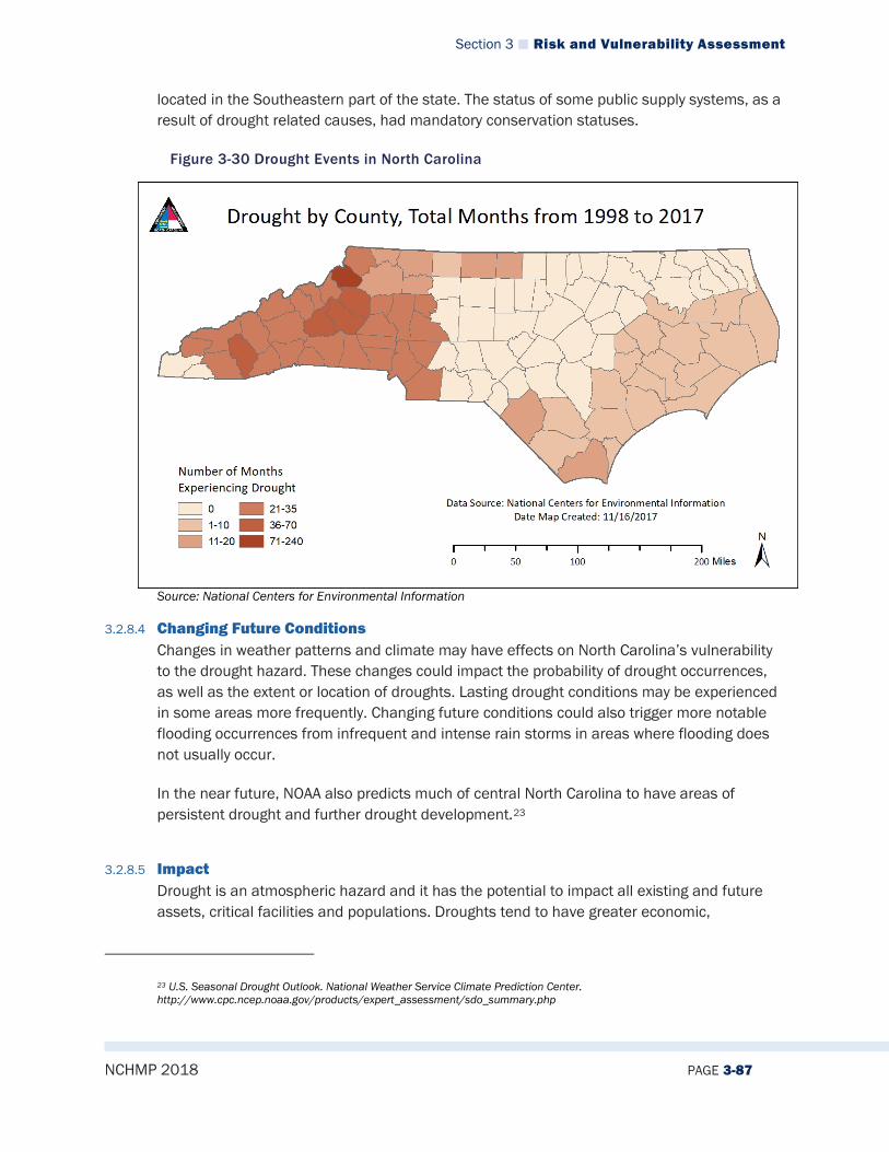
Section 3 Risk and Vulnerability Assessment
NCHMP 2018 PAGE 3-87
located in the Southeastern part of the state. The status of some public supply systems, as a result of drought related causes, had mandatory conservation statuses.
Figure 3-30 Drought Events in North Carolina
Source: National Centers for Environmental Information
3.2.8.4 Changing Future Conditions Changes in weather patterns and climate may have effects on North Carolina’s vulnerability to the drought hazard. These changes could impact the probability of drought occurrences, as well as the extent or location of droughts. Lasting drought conditions may be experienced in some areas more frequently. Changing future conditions could also trigger more notable flooding occurrences from infrequent and intense rain storms in areas where flooding does not usually occur.
In the near future, NOAA also predicts much of central North Carolina to have areas of persistent drought and further drought development.23
3.2.8.5 Impact Drought is an atmospheric hazard and it has the potential to impact all existing and future assets, critical facilities and populations. Droughts tend to have greater economic,
23 U.S. Seasonal Drought Outlook. National Weather Service Climate Prediction Center. http://www.cpc.ncep.noaa.gov/products/expert_assessment/sdo_summary.php
Section 3 Risk and Vulnerability Assessment
NCHMP 2018 PAGE 3-88
environmental and social impacts than they have on the built environment. Droughts may result in the following impacts: Economic Temporary closure of business and essential facilities (for example: restaurants
cannot operate safely without water) Increase in food prices Increased wildfires Loss of incomes Loss of hydroelectric power
Environmental Crop damage Stress on wildlife Increased wildfires Wind erosion Loss of wetlands Drying ponds/lakes
Social Water conservation requirements Reduced quality of life Food shortages Political conflicts over water rights Stress
3.2.8.6 Future Probability The future incidence of drought is highly unpredictable. Conditions may be localized or widespread, and not much historical data is available, making it difficult to determine the future probability of drought conditions with any accuracy. However, based on historical data, future occurrences are still unlikely (between 1 and 33.3 percent annual probability).
3.2.8.7 NCEOP Reference Annex C, Appendix 6, Hazards and Threats Annex B, Appendix 3, Drought Assessment and Response Plan
3.2.9 Tornadoes/Thunderstorms
3.2.9.1 Description Tornadoes A tornado is a violently rotating column of air in contact with the ground and extending from the base of a thunderstorm. A condensation funnel does not need to reach to the ground for a tornado to be present; a debris cloud beneath a thunderstorm is all that is needed to confirm the presence of a tornado, even in the total absence of a condensation funnel. It is spawned by a thunderstorm (or sometimes as a result of a hurricane) and produced when cool air overrides a layer of warm air, forcing the warm air to rise rapidly. The damage from a tornado is a result of the high wind velocity and wind-blown debris.
Section 3 Risk and Vulnerability Assessment
NCHMP 2018 PAGE 3-89
Thunderstorms Thunderstorms can produce a variety of accompanying hazards including wind, hail, and lightning. Although thunderstorms generally affect a small area, they are very dangerous and may cause substantial property damage. Three conditions need to occur for a thunderstorm to form. First, it needs moisture to form clouds and rain. Second, it needs unstable air, such as warm air that can rise rapidly (this is often referred to as the “engine” of the storm). Third, thunderstorms need lift, which comes in the form of cold or warm fronts, sea breezes, mountains, or the sun’s heat. When these conditions occur simultaneously, air masses of varying temperatures meet, and a thunderstorm is formed. These storm events can occur singularly, in lines, or in clusters. Furthermore, they can move through an area very quickly or linger for several hours. According to the National Weather Service, more than 100,000 thunderstorms occur each year though only about 10 percent of these storms are classified as “severe.” Thunderstorm events have the capability of producing straight-line winds that can cause severe destruction to communities and threaten the safety of a population. High winds can form due to pressure off the Northeast coast that combines with strong pressure moving through the Ohio Valley. This creates a tight pressure gradient across the region, resulting in high winds which increase with elevation. It is common for gusts of 30 to 60 miles per hour during the winter months. Downbursts are also possible with thunderstorm events. Such events are an excessive burst of wind in excess of 125 miles per hour. They are often confused with tornadoes. Downbursts are caused by down drafts from the base of a convective thunderstorm cloud. It occurs when rain-cooled air within the cloud becomes heavier than its surroundings. Thus, air rushes towards the ground in a destructive yet isolated manner. There are two types of downbursts. Downbursts less than 2.5 miles wide with a duration of less than 5 minutes and winds up to 168 miles per hour are called “microbursts.” Larger events greater than 2.5 miles at the surface and longer than 5 minutes with winds up to 130 miles per hour are referred to as “macrobursts.”
3.2.9.2 Extent Tornadoes The destruction caused by tornadoes ranges from light to inconceivable depending on the intensity, size, and duration of the storm. Typically, tornadoes cause the greatest damage to structures of light construction, including residential dwellings (particularly mobile homes). Tornadic magnitude is reported according to the Fujita and Enhanced Fujita Scales. Tornado magnitudes prior to 2005 were determined using the traditional version of the Fujita Scale (Table 3-19). Tornado magnitudes that were determined in 2005 and later were determined using the Enhanced Fujita Scale (Table 3-20). The greatest magnitude reported was an F2 (last reported on May 8, 2009).
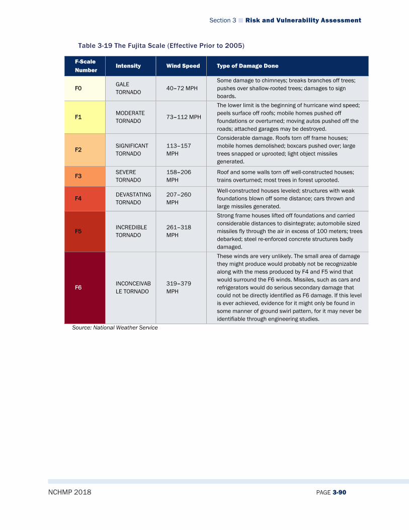
Section 3 Risk and Vulnerability Assessment
NCHMP 2018 PAGE 3-90
Table 3-19 The Fujita Scale (Effective Prior to 2005)
F-Scale Number
Intensity Wind Speed Type of Damage Done
F0 GALE TORNADO
40–72 MPH Some damage to chimneys; breaks branches off trees; pushes over shallow-rooted trees; damages to sign boards.
F1 MODERATE TORNADO
73–112 MPH
The lower limit is the beginning of hurricane wind speed; peels surface off roofs; mobile homes pushed off foundations or overturned; moving autos pushed off the roads; attached garages may be destroyed.
F2 SIGNIFICANT TORNADO
113–157 MPH
Considerable damage. Roofs torn off frame houses; mobile homes demolished; boxcars pushed over; large trees snapped or uprooted; light object missiles generated.
F3 SEVERE TORNADO
158–206 MPH
Roof and some walls torn off well-constructed houses; trains overturned; most trees in forest uprooted.
F4 DEVASTATING TORNADO
207–260 MPH
Well-constructed houses leveled; structures with weak foundations blown off some distance; cars thrown and large missiles generated.
F5 INCREDIBLE TORNADO
261–318 MPH
Strong frame houses lifted off foundations and carried considerable distances to disintegrate; automobile sized missiles fly through the air in excess of 100 meters; trees debarked; steel re-enforced concrete structures badly damaged.
F6 INCONCEIVABLE TORNADO
319–379 MPH
These winds are very unlikely. The small area of damage they might produce would probably not be recognizable along with the mess produced by F4 and F5 wind that would surround the F6 winds. Missiles, such as cars and refrigerators would do serious secondary damage that could not be directly identified as F6 damage. If this level is ever achieved, evidence for it might only be found in some manner of ground swirl pattern, for it may never be identifiable through engineering studies.
Source: National Weather Service

Section 3 Risk and Vulnerability Assessment
NCHMP 2018 PAGE 3-91
Table 3-20 The Enhanced Fujita Scale (Effective 2005 and Later)
Ef-Scale Number
Intensity Phrase
3 Second Gust (Mph)
Type Of Damage Done
EF0 GALE 65–85 Some damage to chimneys; breaks branches off trees; pushes over shallow-rooted trees; damages to sign boards.
EF1 MODERATE 86–110
The lower limit is the beginning of hurricane wind speed; peels surface off roofs; mobile homes pushed off foundations or overturned; moving autos pushed off the roads; attached garages may be destroyed.
EF2 SIGNIFICANT 111–135 Considerable damage. Roofs torn off frame houses; mobile homes demolished; boxcars pushed over; large trees snapped or uprooted; light object missiles generated.
EF3 SEVERE 136–165 Roof and some walls torn off well-constructed houses; trains overturned; most trees in forest uprooted.
EF4 DEVASTATING 166–200 Well-constructed houses leveled; structures with weak foundations blown off some distance; cars thrown and large missiles generated.
EF5 INCREDIBLE Over 200
Strong frame houses lifted off foundations and carried considerable distances to disintegrate; automobile sized missiles fly through the air in excess of 100 meters; trees debarked; steel re-enforced concrete structures badly damaged.
Source: National Weather Service
Thunderstorms Thunderstorm extent is defined by the wind speeds reported. According to a 60-year history from the NCEI, the strongest recorded wind event in North Carolina was reported in Robeson County on May 11, 2009 at 109 knots (approximately 125 mph). It should be noted that future events may exceed these historical occurrences.
3.2.9.3 Location/Spatial Extent Tornadoes Tornadoes occur throughout the State of North Carolina. Tornadoes typically impact a relatively small area, but damage may be extensive. Event locations are completely random and it is not possible to predict specific areas that are more susceptible to tornado strikes over time. It is assumed that the entire State of North Carolina is uniformly exposed to this hazard; however, based on historical data, many of the eastern counties have experienced tornadoes more frequently. Historically, tornadoes are also more common in the Spring and Fall months North Carolina. As Figure 3-31 illustrates, North Carolina is in an area of the United States that experiences moderate tornadic activity compared to the rest of the country.
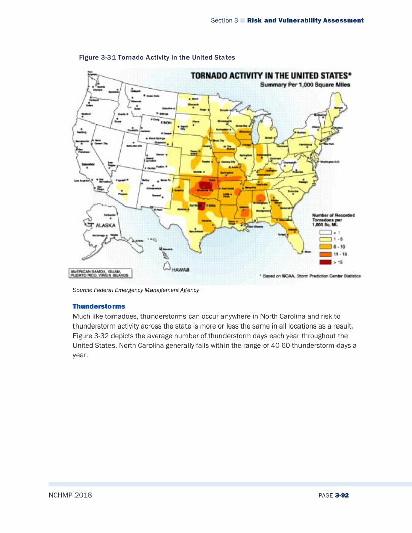
Section 3 Risk and Vulnerability Assessment
NCHMP 2018 PAGE 3-92
Figure 3-31 Tornado Activity in the United States
Source: Federal Emergency Management Agency
Thunderstorms Much like tornadoes, thunderstorms can occur anywhere in North Carolina and risk to thunderstorm activity across the state is more or less the same in all locations as a result. Figure 3-32 depicts the average number of thunderstorm days each year throughout the United States. North Carolina generally falls within the range of 40-60 thunderstorm days a year.
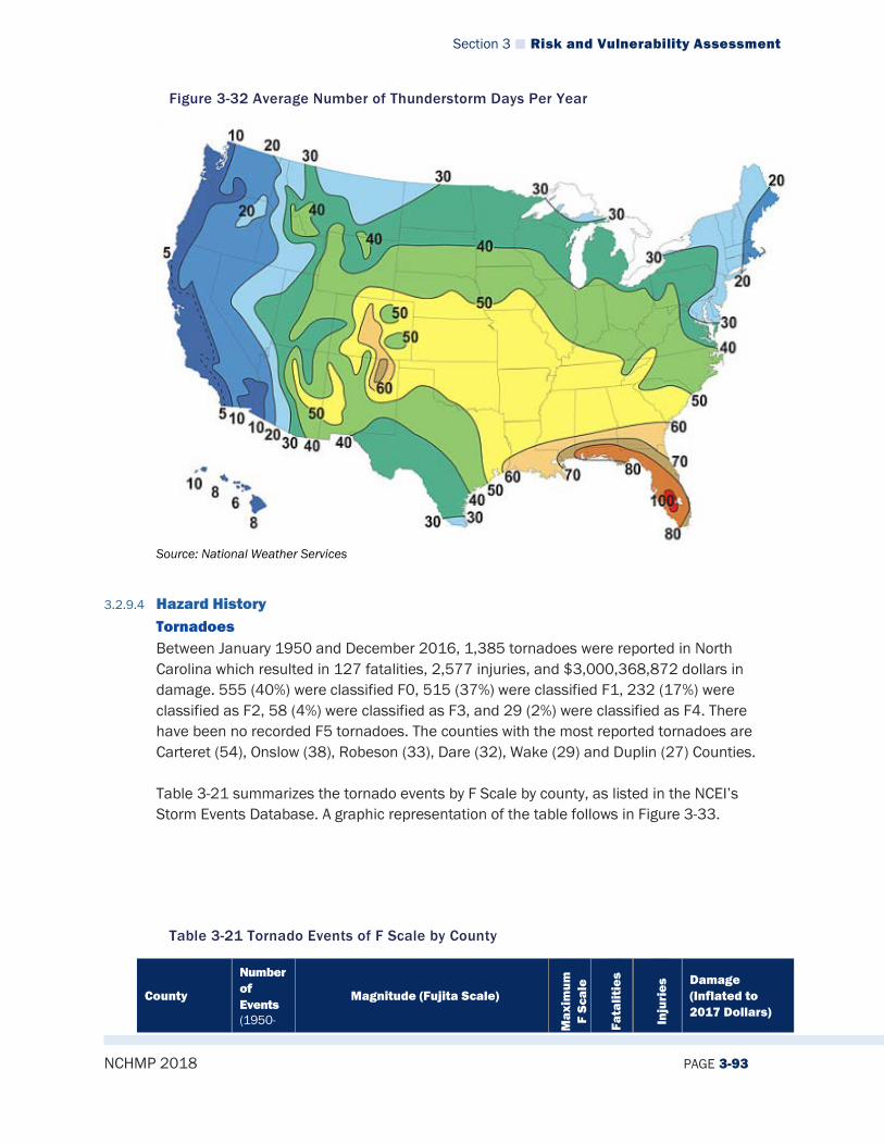
Section 3 Risk and Vulnerability Assessment
NCHMP 2018 PAGE 3-93
Figure 3-32 Average Number of Thunderstorm Days Per Year
Source: National Weather Services
3.2.9.4 Hazard History Tornadoes Between January 1950 and December 2016, 1,385 tornadoes were reported in North Carolina which resulted in 127 fatalities, 2,577 injuries, and $3,000,368,872 dollars in damage. 555 (40%) were classified F0, 515 (37%) were classified F1, 232 (17%) were classified as F2, 58 (4%) were classified as F3, and 29 (2%) were classified as F4. There have been no recorded F5 tornadoes. The counties with the most reported tornadoes are Carteret (54), Onslow (38), Robeson (33), Dare (32), Wake (29) and Duplin (27) Counties. Table 3-21 summarizes the tornado events by F Scale by county, as listed in the NCEI’s Storm Events Database. A graphic representation of the table follows in Figure 3-33.
Table 3-21 Tornado Events of F Scale by County
County
Number of Events (1950-
Magnitude (Fujita Scale)
Max
imum
F
Scal
e
Fata
litie
s
Inju
ries
Damage (Inflated to 2017 Dollars)

Section 3 Risk and Vulnerability Assessment
NCHMP 2018 PAGE 3-94
2017) 0 1 2 3 4 5
Alamance 5 1 4 1 1 $2,003,247
Alexander 6 3 2 1 2 0 $1,814,402
Alleghany 3 2 1 2 7 $1,625,592
Anson 4 1 2 1 2 1 $5,084,633
Ashe
Avery 1 1 2 1 $195,888
Beaufort 32 12 10 9 1 3 1 45 $38,485,798
Bertie 29 9 8 7 5 3 18 94 $78,117,775
Bladen 21 8 6 6 1 3 5 8 $485,523
Brunswick 25 16 8 1 2 0 0 $2,114,000
Buncombe 6 1 5 1 0 0 $3,599,723
Burke 7 3 2 2 2 0 8 $15,904,836
Cabarrus 12 4 7 1 2 0 3 $8,598,189
Caldwell 8 3 2 2 1 4 0 3 $3,738,956
Camden 4 3 1 2 0 0 $119,259
Carteret 66 37 23 6 2 0 11 $24,968,233
Caswell 6 3 2 1 2 0 3 $5,122,403
Catawba 16 5 6 4 1 4 0 6 $60,643,322
Chatham 10 5 3 2 2 0 0 $927,213
Cherokee 8 3 3 1 1 4 4 26 $127,919,567
Chowan 13 4 5 3 1 3 1 1 $1,589,672
Clay 5 1 4 1 0 0 $293,299
Cleveland 19 8 8 1 1 1 4 0 36 $52,945,693
Columbus 25 10 9 4 2 3 8 40 $15,999,620
Craven 32 21 7 3 1 2 0 48 $28,933,635
Cumberland 23 7 7 4 3 2 4 5 168 $99,079,510
Currituck 9 6 3 1 0 2 $620,510
Dare 39 23 11 4 1 3 1 22 $11,017,654
Davidson 16 6 8 2 2 2 22 $27,078,966
Davie 7 6 1 2 0 1 $386,202
Duplin 37 9 12 13 2 1 4 0 86 $90,248,666
Durham 8 2 3 3 2 0 5 $57,023,685
Edgecombe 7 1 3 3 3 0 8 $2,844,846
Forsyth 16 4 4 4 4 3 0 58 $146,274,409
Franklin 10 2 5 2 1 4 0 24 $57,068,796
Gaston 13 3 9 1 2 4 1 11 $16,492,804
Gates 5 3 1 1 3 2 10 $6,053,905
Graham 1 1 2 2 11 $1,251,617
Granville 9 1 4 4 2 0 2 $9,131,161
Greene 17 7 5 2 2 1 4 7 33 $97,860,532
Guilford 13 1 9 2 1 3 1 5 $20,647,956
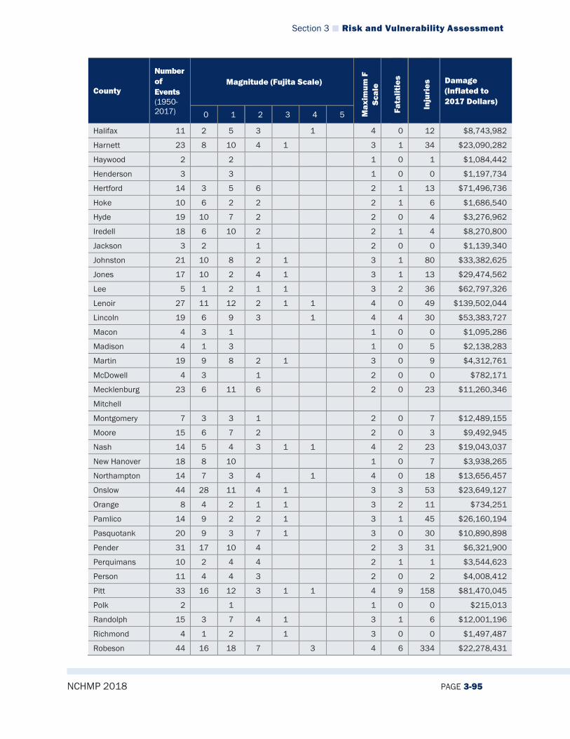
Section 3 Risk and Vulnerability Assessment
NCHMP 2018 PAGE 3-95
County
Number of Events (1950-2017)
Magnitude (Fujita Scale)
Max
imum
F
Scal
e
Fata
litie
s
Inju
ries
Damage (Inflated to 2017 Dollars)
0 1 2 3 4 5
Halifax 11 2 5 3 1 4 0 12 $8,743,982
Harnett 23 8 10 4 1 3 1 34 $23,090,282
Haywood 2 2 1 0 1 $1,084,442
Henderson 3 3 1 0 0 $1,197,734
Hertford 14 3 5 6 2 1 13 $71,496,736
Hoke 10 6 2 2 2 1 6 $1,686,540
Hyde 19 10 7 2 2 0 4 $3,276,962
Iredell 18 6 10 2 2 1 4 $8,270,800
Jackson 3 2 1 2 0 0 $1,139,340
Johnston 21 10 8 2 1 3 1 80 $33,382,625
Jones 17 10 2 4 1 3 1 13 $29,474,562
Lee 5 1 2 1 1 3 2 36 $62,797,326
Lenoir 27 11 12 2 1 1 4 0 49 $139,502,044
Lincoln 19 6 9 3 1 4 4 30 $53,383,727
Macon 4 3 1 1 0 0 $1,095,286
Madison 4 1 3 1 0 5 $2,138,283
Martin 19 9 8 2 1 3 0 9 $4,312,761
McDowell 4 3 1 2 0 0 $782,171
Mecklenburg 23 6 11 6 2 0 23 $11,260,346
Mitchell
Montgomery 7 3 3 1 2 0 7 $12,489,155
Moore 15 6 7 2 2 0 3 $9,492,945
Nash 14 5 4 3 1 1 4 2 23 $19,043,037
New Hanover 18 8 10 1 0 7 $3,938,265
Northampton 14 7 3 4 1 4 0 18 $13,656,457
Onslow 44 28 11 4 1 3 3 53 $23,649,127
Orange 8 4 2 1 1 3 2 11 $734,251
Pamlico 14 9 2 2 1 3 1 45 $26,160,194
Pasquotank 20 9 3 7 1 3 0 30 $10,890,898
Pender 31 17 10 4 2 3 31 $6,321,900
Perquimans 10 2 4 4 2 1 1 $3,544,623
Person 11 4 4 3 2 0 2 $4,008,412
Pitt 33 16 12 3 1 1 4 9 158 $81,470,045
Polk 2 1 1 0 0 $215,013
Randolph 15 3 7 4 1 3 1 6 $12,001,196
Richmond 4 1 2 1 3 0 0 $1,497,487
Robeson 44 16 18 7 3 4 6 334 $22,278,431

Section 3 Risk and Vulnerability Assessment
NCHMP 2018 PAGE 3-96
County
Number of Events (1950-2017)
Magnitude (Fujita Scale)
Max
imum
F
Scal
e
Fata
litie
s
Inju
ries
Damage (Inflated to 2017 Dollars)
0 1 2 3 4 5
Rockingham 9 2 6 1 3 2 31 $57,462,502
Rowan 10 1 8 1 2 0 3 $4,679,254
Rutherford 8 3 2 3 1 4 0 10 $705,149
Sampson 18 5 5 3 3 2 4 14 203 $137,647,034
Scotland 11 2 3 1 2 3 4 0 24 $19,342,737
Stanly 11 2 5 4 2 0 1 $14,913,950
Stokes 9 1 7 1 2 0 15 $21,870,452
Surry 7 1 6 1 0 3 $4,226,014
Swain 3 1 1 1 2 0 0 $1,096,958
Transylvania 3 1 1 1 2 0 0 $833,740
Tyrrell 14 5 6 3 2 0 2 $2,560,877
Union 20 5 8 5 1 1 4 1 26 $62,068,232
Vance 6 4 2 2 0 0 $17,722,875
Wake 35 18 9 6 1 1 4 7 213 $658,346,550
Warren 5 3 2 2 0 0 $3,601,991
Washington 11 6 2 3 2 0 6 $3,745,769
Watauga 2 1 1 1 0 2 $108,939
Wayne 26 13 8 3 1 1 4 4 159 $125,913,490
Wilkes 6 1 5 1 0 0 $3,575,938
Wilson 17 7 2 4 4 3 1 20 $14,373,493
Yadkin 9 8 1 2 0 1 $10,735,616
Yancey 2 2 1 0 0 $1,018,230
North Carolina 1,385 555 515 232 58 29 127 2,577 $3,000,368,872 Source: NCEI

Section 3 Risk and Vulnerability Assessment
NCHMP 2018 PAGE 3-97
Figure 3-33 NC Tornadoes by County from 1950 to 2017
Historical Tornado Events in North Carolina March 28, 1984: The tornado outbreak on March 28, 1984 was one of the deadliest and most destructive outbreaks in history for North Carolina. There were eleven confirmed tornado touchdowns in North Carolina. There were 799 people injured and 42 people were killed. Impacted counties included Bertie, Bladen, Chowan, Columbus, Cumberland, Duplin, Gates, Greene, Hertford, Lenoir, Nash, Perquimans, Pitt, Robeson, Sampson, Scotland, Union, and Wayne. August 13, 2004: The remnants of Tropical Storm Bonnie produced a tornado that touched down just south of Rocky Point and moved northeast, causing F0-F2 damage in the amount of $1.3 million, three deaths and 29 injuries. Damage (F0) was first observed near West Strawberry Lane, with roof damage to a couple of structures. The tornado crossed I-40, just southeast of Rocky Point. It then tracked across Martin Marietta Access Road, causing f0-f1 tree damage. The tornado intensified to f1-f2 as it moved into a small community along Hwy 210. Significant damage occurred on Clayton Lane, Nixon Avenue, and Pickett Road. The tornado reached peak intensity as it moved across Cart Wheel Road, where several homes were completely leveled. It continued to track northeast, with F1 tree damage. The tornado crossed the Northeast Cape Fear River and finally dissipated near Shaw Highway, approximately one mile north of Hwy 210. The following is a summary of damage from Pender County Emergency Management. 17 homes destroyed 25 other homes suffered major damage 34 other homes suffered minor damage two businesses suffered major damage one business suffered minor damage. Also, in Bath, an emergency manager
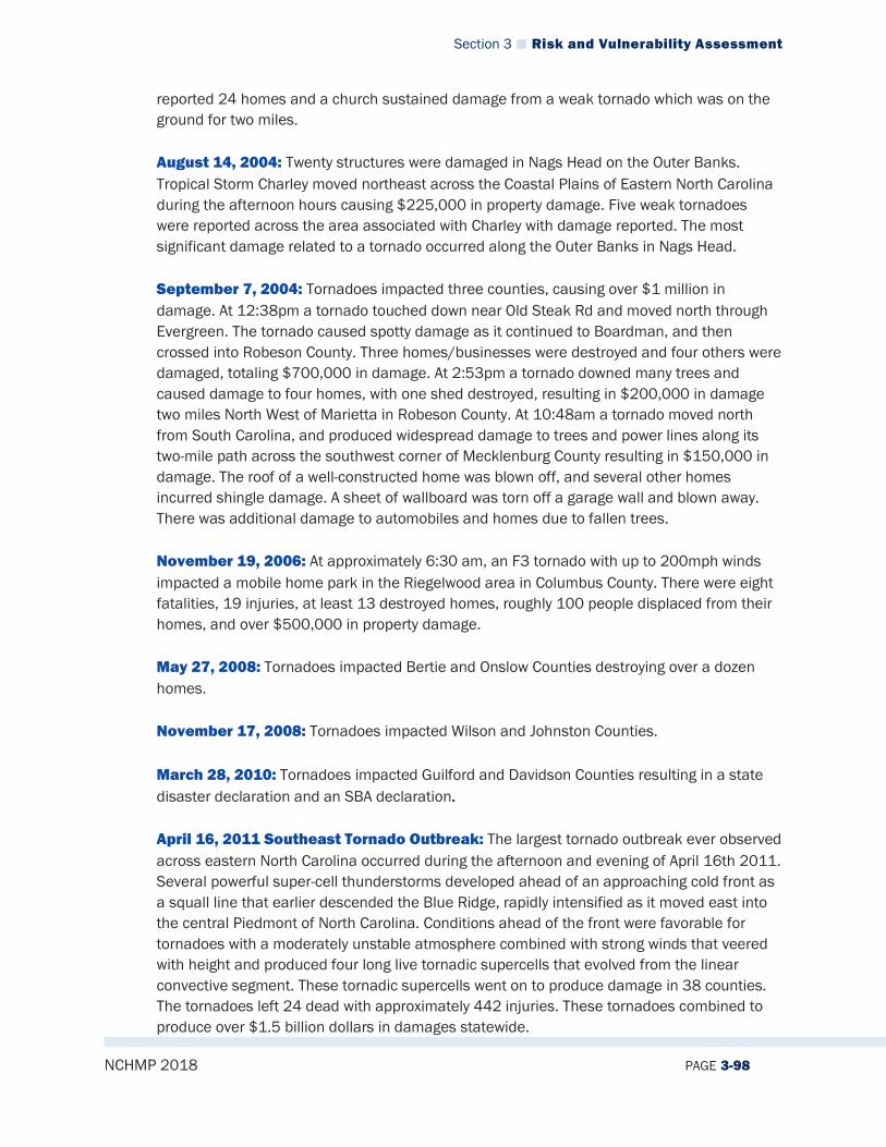
Section 3 Risk and Vulnerability Assessment
NCHMP 2018 PAGE 3-98
reported 24 homes and a church sustained damage from a weak tornado which was on the ground for two miles. August 14, 2004: Twenty structures were damaged in Nags Head on the Outer Banks. Tropical Storm Charley moved northeast across the Coastal Plains of Eastern North Carolina during the afternoon hours causing $225,000 in property damage. Five weak tornadoes were reported across the area associated with Charley with damage reported. The most significant damage related to a tornado occurred along the Outer Banks in Nags Head. September 7, 2004: Tornadoes impacted three counties, causing over $1 million in damage. At 12:38pm a tornado touched down near Old Steak Rd and moved north through Evergreen. The tornado caused spotty damage as it continued to Boardman, and then crossed into Robeson County. Three homes/businesses were destroyed and four others were damaged, totaling $700,000 in damage. At 2:53pm a tornado downed many trees and caused damage to four homes, with one shed destroyed, resulting in $200,000 in damage two miles North West of Marietta in Robeson County. At 10:48am a tornado moved north from South Carolina, and produced widespread damage to trees and power lines along its two-mile path across the southwest corner of Mecklenburg County resulting in $150,000 in damage. The roof of a well-constructed home was blown off, and several other homes incurred shingle damage. A sheet of wallboard was torn off a garage wall and blown away. There was additional damage to automobiles and homes due to fallen trees. November 19, 2006: At approximately 6:30 am, an F3 tornado with up to 200mph winds impacted a mobile home park in the Riegelwood area in Columbus County. There were eight fatalities, 19 injuries, at least 13 destroyed homes, roughly 100 people displaced from their homes, and over $500,000 in property damage. May 27, 2008: Tornadoes impacted Bertie and Onslow Counties destroying over a dozen homes. November 17, 2008: Tornadoes impacted Wilson and Johnston Counties. March 28, 2010: Tornadoes impacted Guilford and Davidson Counties resulting in a state disaster declaration and an SBA declaration. April 16, 2011 Southeast Tornado Outbreak: The largest tornado outbreak ever observed across eastern North Carolina occurred during the afternoon and evening of April 16th 2011. Several powerful super-cell thunderstorms developed ahead of an approaching cold front as a squall line that earlier descended the Blue Ridge, rapidly intensified as it moved east into the central Piedmont of North Carolina. Conditions ahead of the front were favorable for tornadoes with a moderately unstable atmosphere combined with strong winds that veered with height and produced four long live tornadic supercells that evolved from the linear convective segment. These tornadic supercells went on to produce damage in 38 counties. The tornadoes left 24 dead with approximately 442 injuries. These tornadoes combined to produce over $1.5 billion dollars in damages statewide.
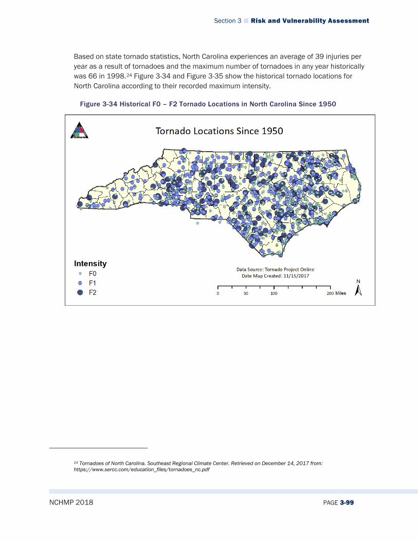
Section 3 Risk and Vulnerability Assessment
NCHMP 2018 PAGE 3-99
Based on state tornado statistics, North Carolina experiences an average of 39 injuries per year as a result of tornadoes and the maximum number of tornadoes in any year historically was 66 in 1998.24 Figure 3-34 and Figure 3-35 show the historical tornado locations for North Carolina according to their recorded maximum intensity.
Figure 3-34 Historical F0 – F2 Tornado Locations in North Carolina Since 1950
24 Tornadoes of North Carolina. Southeast Regional Climate Center. Retrieved on December 14, 2017 from: https://www.sercc.com/education_files/tornadoes_nc.pdf

Section 3 Risk and Vulnerability Assessment
NCHMP 2018 PAGE 3-100
Figure 3-35 Historical F3 – F4 Tornado Locations in North Carolina Since 1950
Table 3-22 summarizes thunderstorms that have impacted North Carolina from 1996 to 2017, as listed in the NCEI’s Storm Events Database. A graphic representation of the table follows in Figure 3-36.
Table 3-22 North Carolina Thunderstorm Summary of Events by County
County Number of events (1996-2017)
Fatalities Injuries Property Damage (Inflated to 2017 Dollars)
Crop Damage (Inflated to 2017 Dollars)
Alamance 163 0 3 $1,070,943 $199,853 Alexander 103 0 2 $1,338,000 $0 Alleghany 33 0 0 $143,080 $2,194 Anson 139 1 2 $182,499 $46,067 Ashe 54 0 0 $267,872 $0 Avery 43 0 0 $22,759 $0 Beaufort 123 2 41 $357,617 $0 Bertie 77 0 2 $428,462 $0 Bladen 234 0 6 $2,682,417 $2,263 Brunswick 130 0 1 $793,684 $16,195 Buncombe 158 1 9 $553,040 $0 Burke 193 0 2 $664,979 $10,425 Cabarrus 182 0 0 $782,460 $10,425 Caldwell 121 0 0 $505293 $0 Camden 31 0 0 $75958 $0 Carteret 139 0 1 $ 2141410 $0 Caswell 186 0 0 $ 1631940 $32,390 Catawba 239 0 2 $ 2956742 $10,425

Section 3 Risk and Vulnerability Assessment
NCHMP 2018 PAGE 3-101
County Number of events (1996-2017)
Fatalities Injuries Property Damage (Inflated to 2017 Dollars)
Crop Damage (Inflated to 2017 Dollars)
Chatham 176 0 3 $680,888 $0 Cherokee 136 0 0 $919,180 $212,400 Chowan 52 1 0 $755,931 $0 Clay 64 0 0 $535,350 $69,942 Cleveland 223 0 6 $923,021 $1,042 Columbus 214 0 7 $9,601,817 $7,571 Craven 179 0 2 $363,632 $3,395 Cumberland 229 0 8 $1,749,515 $0 Currituck 45 0 0 $117,530 $0 Dare 114 0 12 $1,008,964 $0 Davidson 192 1 3 $1,959,505 $1,028 Davie 117 0 0 $207,019 $0 Duplin 198 0 6 $1,410,170 $39,327 Durham 174 2 3 $1,103,896 $0 Edgecombe 118 0 1 $1,494,863 $0 Forsyth 229 1 3 $993,204 $1,631 Franklin 168 0 4 $6,405,303 $3,085 Gaston 211 2 4 $773,856 $0 Gates 56 1 2 $108,792 $0 Graham 75 0 3 $55,752 $0 Granville 113 0 0 $306,017 $0 Greene 86 0 1 $381,572 $1,131 Guilford 282 2 2 $1,204,004 $1,131 Halifax 158 0 1 $711,218 $1,028 Harnett 183 1 6 $1,314,125 $13,433 Haywood 59 0 0 $205,551 $0 Henderson 128 0 4 $234,456 $0 Hertford 59 0 1 $214,938 $0 Hoke 101 0 4 $504,494 $0 Hyde 69 0 1 $95,459 $0 Iredell 241 2 0 $1,073,976 $0 Jackson 86 0 2 $662,214 $0 Johnston 308 0 1 $1,175,790 $5,141 Jones 65 0 3 $145,531 $0 Lee 103 0 1 $425,038 $0 Lenoir 136 0 0 $905,017 $809 Lincoln 136 1 1 $551,959 $0 Macon 70 0 1 $539,158 $0 Madison 88 0 0 $52,800 $0 Martin 78 0 0 $521,848 $0 McDowell 150 0 0 $795,800 $0 Mecklenburg 348 0 0 $1,950,903 $0 Mitchell 320 0 0 $2,682 $0 Montgomery 98 0 0 $2,475,520 $0 Moore 205 0 4 $1,490,149 $4,113 Nash 180 0 1 $732,560 $99,527 New Hanover 133 0 5 $2,430,684 $0 Northampton 91 0 0 $614,478 $0 Onslow 169 0 0 $398,613 $0 Orange 174 1 3 $337,536 $2,000

Section 3 Risk and Vulnerability Assessment
NCHMP 2018 PAGE 3-102
County Number of events (1996-2017)
Fatalities Injuries Property Damage (Inflated to 2017 Dollars)
Crop Damage (Inflated to 2017 Dollars)
Pamlico 35 0 0 $95,863 $0 Pasquotank 75 0 0 $790,776 $0 Pender 125 0 7 $3,567,920 $16,195 Perquimans 45 1 0 $171,881 $0 Person 138 0 0 $313,608 $3,028 Pitt 197 1 9 $1,106,637 $0 Polk 87 0 2 $40,168 $0 Randolph 258 0 3 $777,880 $7,698 Richmond 114 0 0 $685,543 $2,528 Robeson 309 0 8 $5,469,324 $14,244 Rockingham 341 0 0 $3,576,485 $0 Rowan 261 0 11 $2,075,756 $0 Rutherford 195 4 3 $1,577,437 $0 Sampson 222 0 17 $4,224,936 $49,098 Scotland 96 0 4 $851,930 $0 Stanly 153 0 3 $2,838,029 $10,000 Stokes 253 0 0 $1,178,810 $0 Surry 319 0 11 $2,879,310 $0 Swain 62 1 1 $69,630 $0 Transylvania 67 0 0 $121,119 $0 Tyrrell 34 4 0 $108,953 $0 Union 215 0 1 $1,813,030 $0 Vance 90 0 0 $255,185 $514 Wake 434 1 19 $3,809,146 $4,206 Warren 101 0 0 $397,478 $2,082 Washington 61 0 0 $125,764 $0 Watauga 46 0 1 $246,555 $0 Wayne 207 1 9 $4,710,463 $477,136 Wilkes 255 1 1 $1,350,531 $68,041 Wilson 136 0 6 $263,383 $2,056 Yadkin 143 0 0 $1,555,294 $153,781 Yancey 33 0 0 $59,956 $37,037 North Carolina 14,845 31 226 $101,524,742 $1,645,615

Section 3 Risk and Vulnerability Assessment
NCHMP 2018 PAGE 3-103
Figure 3-36 NC Thunderstorms by County from 1955 to 2017
3.2.9.5 Changing Future Conditions Climate is more than a measure of average conditions; it also is the range of weather variability, which can include the frequency and severity of extreme events like tornadoes and storms. Changing weather patterns may result in more frequent and more severe tornadoes in North Carolina. A US Government Accountability Report in 2017 states that $350 billion has been incurred by the US Government from extreme weather, and these costs are expected to increase as rare events become more common. Additionally, according to the National Aeronautics and Space Administration (NASA), tornado and thunderstorm events in the future are likely to become more frequent in the southeast as a result of weather extremes. Thunderstorm/tornado potential is measured by an index that NASA created that is called the Convective Available Potential Energy (CAPE) index. This measures how warm and moist the air is, which is a major contributing factor in thunderstorm/tornado formation. NASA projects that by the period of 2072-2099, the CAPE in the southeastern United States will increase dramatically. Indeed, as Figure 3-37 shows, parts of North Carolina are in an area that will likely experience the greatest increase in CAPE in the United States and all of the state is likely to experience at least some increase. This indicates that there will potentially be even more frequent thunderstorms/tornadoes in the state going forward.

Section 3 Risk and Vulnerability Assessment
NCHMP 2018 PAGE 3-104
Figure 3-37: Convective Available Potential Energy Projected Increase by 2072-2099
Source: National Aeronautics and Space Administration
3.2.9.6 Impact Both tornadoes and severe thunderstorms have the potential to cause critical impacts in parts of North Carolina. That means that multiple deaths/injuries are possible and more than 25% of property in affected area could be damaged or destroyed. Also, complete shutdown of critical facilities for more than one week could occur.
3.2.9.7 Future Probability Tornadoes According to historical information, tornado events are becoming annual occurrences for the region. The probability of future tornado occurrences affecting the State is likely (between 36 and 75 percent annual probability). Based on previous data showing that tornadoes often occur in the central and eastern parts of North Carolina, it may be expected they are more probable in these zones as well.
Thunderstorms Thunderstorms are also common occurrences throughout the state, especially in summer months. Historical data shows that these types of hazards tend to be more common in the central and eastern part of the state as well, so it is possible that they will continue to take places more frequently in these areas. Based on evidence, it is highly likely (66.7 to 100 percent annual probability) that North Carolina will continue to experience thunderstorms in the future.

Section 3 Risk and Vulnerability Assessment
NCHMP 2018 PAGE 3-105
3.2.9.8 NCEOP Reference Annex C, Appendix 6, Hazards and Threats
3.2.10 Geological
3.2.10.1 Description For the purposes of this plan, geological hazards refer to landslides, sinkholes and coastal erosion because they are the primary geological hazards that have the ability to cause damage to property and potential loss of life. Other geological hazards are not included in this plan include: ground collapse caused by old mines and prospects, rippable vs. non-rippable earth material, expansive soils (shrink swell clays), acid-producing rock, radon in air and groundwater (linked to geology), arsenic in groundwater (linked to geology).
Landslides A landslide is a downward movement of earth or rock from, driven by gravity. Landslides can be triggered by natural or man-made circumstances, such as heavy rains, earthquakes, rapid snow melt, erosion, or construction. Every landslide, or slope movement, is different and unpredictable. However, they are typically associated with periods of heavy rainfall and can worsen storm or flood events. Some move slowly, while others are quick moving. Some geological areas are more prone to landslides, such as bases of steep slopes or hillsides. Flatter areas away from slope changes tend to be safer from landslides.
Sinkholes According to the United States Geological Survey, a sinkhole is an area of ground that has no natural external surface drainage--when it rains, all of the water stays inside the sinkhole and typically drains into the subsurface. Sinkholes can vary from a few feet to hundreds of acres and from less than 1 to more than 100 feet deep. Some are shaped like shallow bowls or saucers whereas others have vertical walls. Sinkholes are common where the rock below the land surface is limestone, carbonate rock, salt beds, or rocks that can naturally be dissolved by groundwater circulating through them. As the rock dissolves, spaces and caverns develop underground. Sinkholes are dramatic because the land usually stays intact for a while until the underground spaces just get too big. If there is not enough support for the land above the spaces then a sudden collapse of the land surface can occur. These collapses can be small, or, as the picture below shows, they can be huge and can occur where a house or road is on top.25
25 Sinkholes. United States Geological Survey. Retrieved on December 14, 2017 from: https://water.usgs.gov/edu/sinkholes.html
Section 3 Risk and Vulnerability Assessment
NCHMP 2018 PAGE 3-106
Coastal Erosion Coastal or beach erosion is the wearing away of the beach and dune sediments due to winds, tidal currents, or wave action. Erosion is typically event-driven and tends to happen during periods of strong winds, high tides and waves, such as a storm; however, continued erosion wears away the coastal profile and can create imbalance on shorelines. An eroding beach may lose feet of sand per year. Erosion clearly affects the environment, but it also is problematic for homes and businesses that are constructed on or near beaches. Severe erosion can cause extreme property loss or damages. Many beaches rely on sandbags to be placed in front of homes and dunes to protect them from falling into the ocean.

Section 3 Risk and Vulnerability Assessment
NCHMP 2018 PAGE 3-107
3.2.10.2 Extent Landslides Landslide extent can be measured using the size/volume of the debris that was moved during the landslide event. In the western areas of the state where landslides are most prevalent and largest, some landslides have displaced boulders as large as 60 feet in length and 900 tons in weight. Many times, the outflow from these landslide events has moved at upwards of 50 miles per hour, damaging homes and other structures along the way.26 Sinkholes Figure 3-38 below shows areas of the United States where certain rock types that are susceptible to dissolution in water occur. In these areas, the formation of underground cavities can form and catastrophic sinkholes can happen. These rock types are evaporites (salt, gypsum, and anhydrite) and carbonates (limestone and dolomite). Evaporite rocks underlie about 35 to 40 percent of the United States, though in many areas they are buried at great depths. In some cases, sinkholes in North Carolina have been measured at up to 20 to 25 feet in depth, with similar widths.
Figure 3-38: United States Geological Survey of Karst Modified from Davies and Legrand, 197227
Coastal Erosion
26 Historical NC Landslide Events. North Carolina Department of Environmental Quality. Retrieved on December 14, 2017 from: https://deq.nc.gov/about/divisions/energy-mineral-land-resources/north-carolina-geological-survey/geologic-hazards/historical-nc-landslide-events 27 Sinkholes. United States Geological Survey. Retrieved on December 14, 2017 from: https://water.usgs.gov/edu/sinkholes.html

Section 3 Risk and Vulnerability Assessment
NCHMP 2018 PAGE 3-108
In North Carolina, the NC Division of Coastal Management and the NC Geological Survey study and calculate shoreline change rates. These vary throughout the state in different locations, but it is notable that, on average, the state is experiencing 1.6 feet per year of erosion based on a study at multiple locations by the NC Department of Environmental Quality. More details on specific locations can be found in that study, which is located at the following URL: https://files.nc.gov/ncdeq/Coastal%20Management/documents/PDF/erosion%20rates/Erosion_Rate_Data_Summary_2011.pdf28.
Figure 3-39 Severe Beach Erosion on North Carolina Outer Banks
Source: FEMA
3.2.10.3 Location/Spatial Extent Landslides Three common types of landslides that affect North Carolina are: debris flows, debris and earth slides, and rockslides. Most recorded landslides in the state have been recorded in the western region, due to changing slopes. Figure 3-40 below shows areas of landslide risk according to the United States Geological Survey.
28 More details on specific locations can be found in that study, which is located at the following url: https://files.nc.gov/ncdeq/Coastal%20Management/documents/PDF/erosion%20rates/Erosion_Rate_Data_Summary_2011.pdf
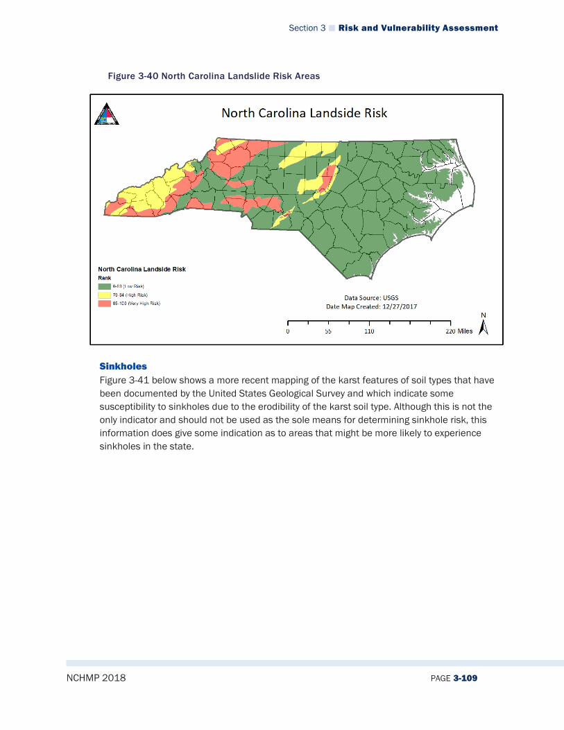
Section 3 Risk and Vulnerability Assessment
NCHMP 2018 PAGE 3-109
Figure 3-40 North Carolina Landslide Risk Areas
Sinkholes Figure 3-41 below shows a more recent mapping of the karst features of soil types that have been documented by the United States Geological Survey and which indicate some susceptibility to sinkholes due to the erodibility of the karst soil type. Although this is not the only indicator and should not be used as the sole means for determining sinkhole risk, this information does give some indication as to areas that might be more likely to experience sinkholes in the state.
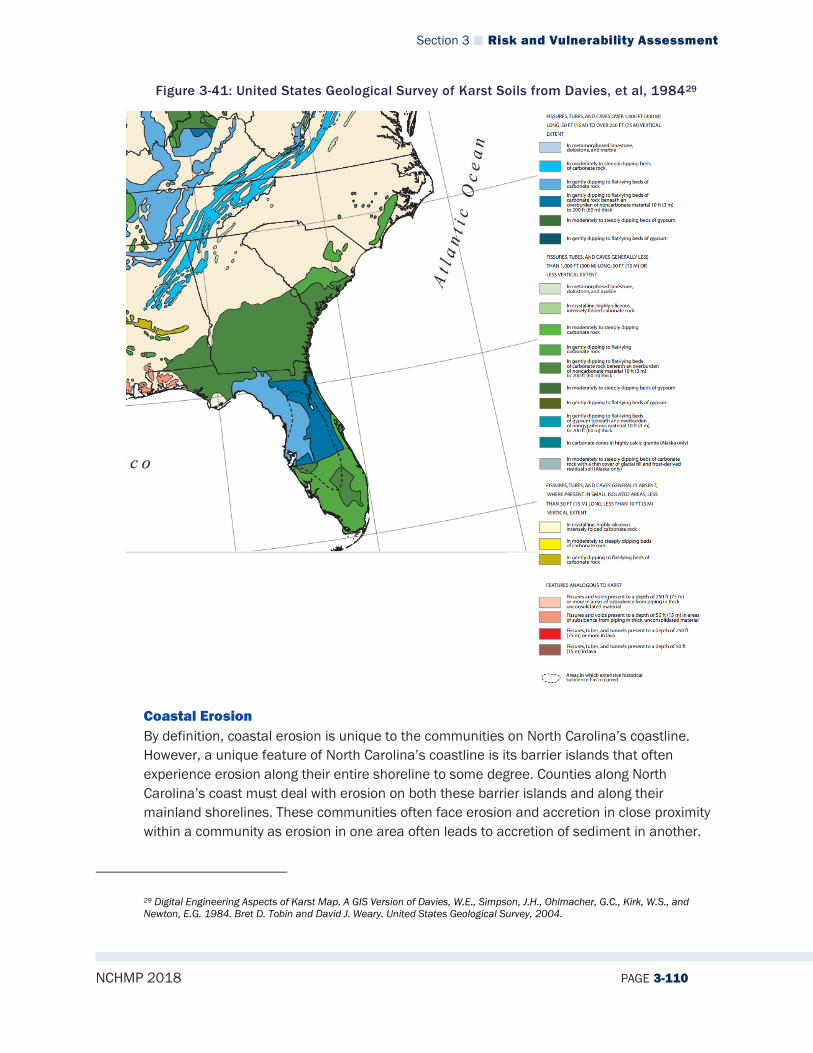
Section 3 Risk and Vulnerability Assessment
NCHMP 2018 PAGE 3-110
Figure 3-41: United States Geological Survey of Karst Soils from Davies, et al, 198429
Coastal Erosion By definition, coastal erosion is unique to the communities on North Carolina’s coastline. However, a unique feature of North Carolina’s coastline is its barrier islands that often experience erosion along their entire shoreline to some degree. Counties along North Carolina’s coast must deal with erosion on both these barrier islands and along their mainland shorelines. These communities often face erosion and accretion in close proximity within a community as erosion in one area often leads to accretion of sediment in another.
29 Digital Engineering Aspects of Karst Map. A GIS Version of Davies, W.E., Simpson, J.H., Ohlmacher, G.C., Kirk, W.S., and Newton, E.G. 1984. Bret D. Tobin and David J. Weary. United States Geological Survey, 2004.
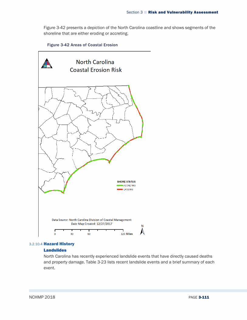
Section 3 Risk and Vulnerability Assessment
NCHMP 2018 PAGE 3-111
Figure 3-42 presents a depiction of the North Carolina coastline and shows segments of the shoreline that are either eroding or accreting.
Figure 3-42 Areas of Coastal Erosion
3.2.10.4 Hazard History Landslides North Carolina has recently experienced landslide events that have directly caused deaths and property damage. Table 3-23 lists recent landslide events and a brief summary of each event.
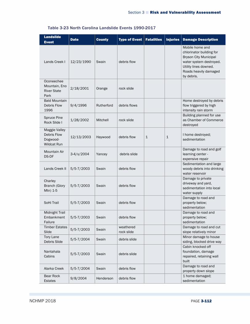
Section 3 Risk and Vulnerability Assessment
NCHMP 2018 PAGE 3-112
Table 3-23 North Carolina Landslide Events 1990-2017
Landslide Event
Date County Type of Event Fatalities Injuries Damage Description
Lands Creek I 12/23/1990 Swain debris flow
Mobile home and chlorinator building for Bryson City Municipal water system destroyed. Utility lines downed. Roads heavily damaged by debris.
Oconeechee Mountain, Eno River State Park
2/18/2001 Orange rock slide
Bald Mountain Debris Flow 1996
9/4/1996 Rutherford debris flows Home destroyed by debris flow triggered by high intensity rain storm
Spruce Pine Rock Slide I
1/28/2002 Mitchell rock slide Building planned for use as Chamber of Commerce destroyed
Maggie Valley Debris Flow Dogwood-Wildcat Run
12/13/2003 Haywood debris flow 1 1 I home destroyed; sedimentation
Mountain Air DS-DF
3-4/x/2004 Yancey debris slide Damage to road and golf learning center - expensive repair
Lands Creek II 5/5-7/2003 Swain debris flow Sedimentation and large woody debris into drinking water reservoir
Charley Branch (Glory Mtn) 1-5
5/5-7/2003 Swain debris flow
Damage to private driveway and yard, sedimentation into local water supply
SoHi Trail 5/5-7/2003 Swain debris flow Damage to road and property below; sedimentation
Midnight Trail Embankment Failure
5/5-7/2003 Swain debris flow Damage to road and property below; sedimentation
Timber Estates Slide
5/5-7/2003 Swain weathered rock slide
Damage to road and cut slope relatively minor
Tory Lane Debris Slide
5/5-7/2004 Swain debris slide Minor damage to house siding, blocked drive way
Nantahala Cabins 5/5-7/2003 Swain debris slide
Cabin knocked off foundation, damage repaired, retaining wall built
Alarka Creek 5/5-7/2004 Swain debris flow Damage to road and property down slope
Bear Rock Estates
9/8/2004 Henderson debris flow 1 home damaged; sedimentation

Section 3 Risk and Vulnerability Assessment
NCHMP 2018 PAGE 3-113
Landslide Event
Date County Type of Event Fatalities Injuries Damage Description
White Laurel 9/8/2004 Watauga debris flows 1 home destroyed; 6 condemned until site stabilized; sedimentation
Old CCC Road 9/6-8/2004 Henderson debris slide-flow
Elijay Creek 9/16-17/2004
Macon rock fall, debris flow
Minor damage to house from rockfall; property damage from embankment failure-debris flow
Little Pine 9/16-17/2004
Madison debris flow Barn destroyed
Peeks Creek 9/17/2004 Macon debris flow 5 2
15 homes destroyed; 2 homes damaged; bridge destroyed; road damaged; sedimentation
Fishhawk Mtn Rd PC EF1, EF2
9/16-17/2004
Macon debris flows
Damage to outer road embankments, sedimentation into Peeks Creek
Wayah I 9/17/2004 Macon debris flow Barn destroyed; temporarily blocked Wayah Road
Wayah 2 9/17/2004 Macon debris flow Wayah Road temporarily blocked
Nickajack Creek Blowout
2004/09/16-17
Macon debris blowout Minor vegetation removal and sedimentation
Starns Cove 9/16-17/2004 Buncombe debris flows
Arrowood home destroyed; damage to home further down the track.
Bat Cave 1 9/4/1996 Henderson debris flow Old cabin destroyed
Hebo Mountain 1, 2
9/6-17/2004 Haywood debris flow; debris slide
Failed retaining wall, cracks in ground near home
Jonas Ridge 9/6-8/2004 Burke debris flow Home destroyed
Honeycutt Mtn. - McNutt
9/6-8/2004 McDowell debris flow
Home threatened by further movement; scrap and ground cracks near home.
Bear Lake - Setzer
9/16-17/2004
Jackson debris flow
Glenville Quad 9/6-17/2004 Jackson debris flow Workshop destroyed, road damaged; Two debris flow tracks
Glenville Business Park
9/6-17/2004 Jackson debris flow
Glenville DFs 9/6-17/2004 Jackson debris flow Destroyed workshop, road heavily damaged.
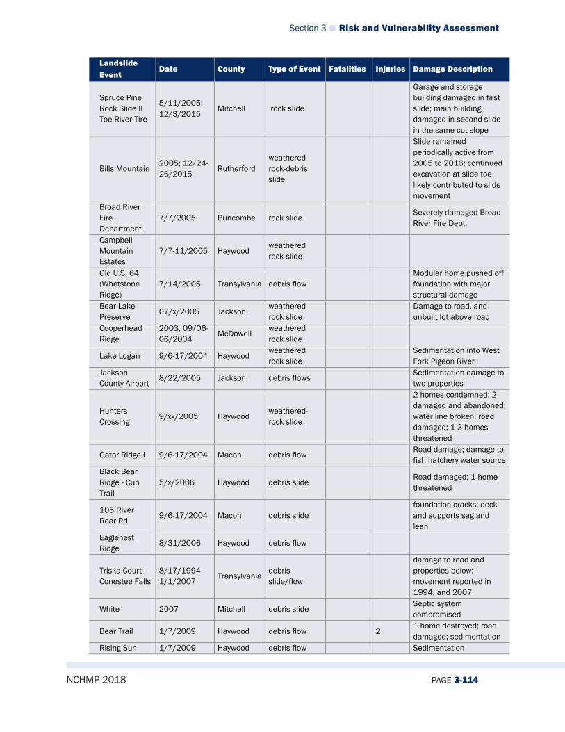
Section 3 Risk and Vulnerability Assessment
NCHMP 2018 PAGE 3-114
Landslide Event
Date County Type of Event Fatalities Injuries Damage Description
Spruce Pine Rock Slide II Toe River Tire
5/11/2005; 12/3/2015
Mitchell rock slide
Garage and storage building damaged in first slide; main building damaged in second slide in the same cut slope
Bills Mountain 2005; 12/24-26/2015
Rutherford weathered rock-debris slide
Slide remained periodically active from 2005 to 2016; continued excavation at slide toe likely contributed to slide movement
Broad River Fire Department
7/7/2005 Buncombe rock slide Severely damaged Broad River Fire Dept.
Campbell Mountain Estates
7/7-11/2005 Haywood weathered rock slide
Old U.S. 64 (Whetstone Ridge)
7/14/2005 Transylvania debris flow Modular home pushed off foundation with major structural damage
Bear Lake Preserve 07/x/2005 Jackson
weathered rock slide
Damage to road, and unbuilt lot above road
Cooperhead Ridge
2003, 09/06-06/2004
McDowell weathered rock slide
Lake Logan 9/6-17/2004 Haywood weathered rock slide
Sedimentation into West Fork Pigeon River
Jackson County Airport
8/22/2005 Jackson debris flows Sedimentation damage to two properties
Hunters Crossing
9/xx/2005 Haywood weathered-rock slide
2 homes condemned; 2 damaged and abandoned; water line broken; road damaged; 1-3 homes threatened
Gator Ridge I 9/6-17/2004 Macon debris flow Road damage; damage to fish hatchery water source
Black Bear Ridge - Cub Trail
5/x/2006 Haywood debris slide Road damaged; 1 home threatened
105 River Roar Rd
9/6-17/2004 Macon debris slide foundation cracks; deck and supports sag and lean
Eaglenest Ridge
8/31/2006 Haywood debris flow
Triska Court - Conestee Falls
8/17/1994 1/1/2007
Transylvania debris slide/flow
damage to road and properties below; movement reported in 1994, and 2007
White 2007 Mitchell debris slide Septic system compromised
Bear Trail 1/7/2009 Haywood debris flow 2 1 home destroyed; road damaged; sedimentation
Rising Sun 1/7/2009 Haywood debris flow Sedimentation
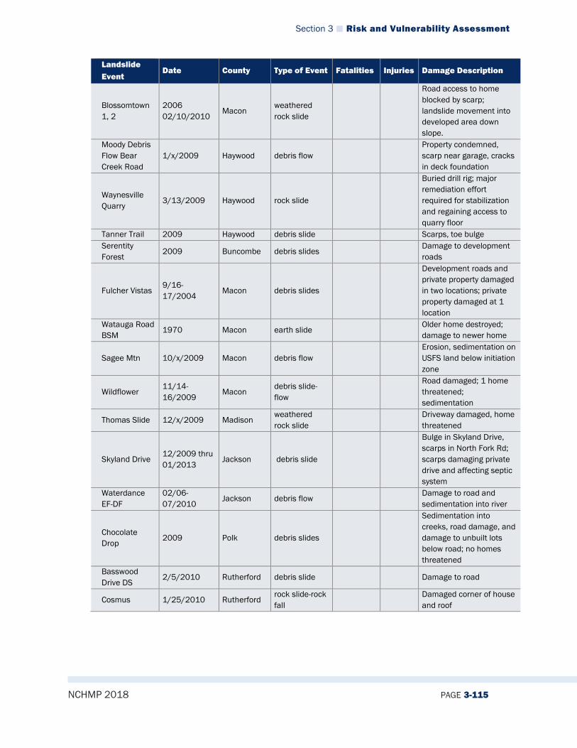
Section 3 Risk and Vulnerability Assessment
NCHMP 2018 PAGE 3-115
Landslide Event
Date County Type of Event Fatalities Injuries Damage Description
Blossomtown 1, 2
2006 02/10/2010
Macon weathered rock slide
Road access to home blocked by scarp; landslide movement into developed area down slope.
Moody Debris Flow Bear Creek Road
1/x/2009 Haywood debris flow Property condemned, scarp near garage, cracks in deck foundation
Waynesville Quarry
3/13/2009 Haywood rock slide
Buried drill rig; major remediation effort required for stabilization and regaining access to quarry floor
Tanner Trail 2009 Haywood debris slide Scarps, toe bulge Serentity Forest
2009 Buncombe debris slides Damage to development roads
Fulcher Vistas 9/16-17/2004
Macon debris slides
Development roads and private property damaged in two locations; private property damaged at 1 location
Watauga Road BSM 1970 Macon earth slide
Older home destroyed; damage to newer home
Sagee Mtn 10/x/2009 Macon debris flow Erosion, sedimentation on USFS land below initiation zone
Wildflower 11/14-16/2009
Macon debris slide-flow
Road damaged; 1 home threatened; sedimentation
Thomas Slide 12/x/2009 Madison weathered rock slide
Driveway damaged, home threatened
Skyland Drive 12/2009 thru 01/2013
Jackson debris slide
Bulge in Skyland Drive, scarps in North Fork Rd; scarps damaging private drive and affecting septic system
Waterdance EF-DF
02/06-07/2010
Jackson debris flow Damage to road and sedimentation into river
Chocolate Drop 2009 Polk debris slides
Sedimentation into creeks, road damage, and damage to unbuilt lots below road; no homes threatened
Basswood Drive DS
2/5/2010 Rutherford debris slide Damage to road
Cosmus 1/25/2010 Rutherford rock slide-rock fall
Damaged corner of house and roof

Section 3 Risk and Vulnerability Assessment
NCHMP 2018 PAGE 3-116
Landslide Event
Date County Type of Event Fatalities Injuries Damage Description
Ghost Town - Rich Cove 2/5/2010 Haywood
debris slide-flow
3 homes damaged; 18 homes threatened; sedimentation; reactivated on 1/17/2013 with minor damage
Ghost Town Cracks
06/x/2011 Haywood subsidence
Extensive asphalt cracking, MV Sheriff’s Dept. noted expanded cracking in 5/2011; cracking in concrete in foundation area of amusement ride
Logan Slide 08/x/2009 Jackson debris slide Damage to outbuilding Taylor - 2730 Silvermine Rd.
2/5/2010 Swain debris slide Relatively minor damage to home
Dove Landing Echoing Ridge Road
12/25/2009 Buncombe debris flow Damage to development roads
Holiday Drive 12/1/2010 Henderson debris flow
Barnes 12/x/2009 Jackson weathered rock slide
Property damage, utility pole damage. Potential for damage to mobile home from slide.
Reinold 3/6/2011 Swain debris slide
Damage to porch, driveway; slope behind house needed stabilization
Sneed-EBCI 10/xx/2008 Jackson weathered rock slide
Minor damage to yard and outbuilding
Wadsworth/Zerelli Glenville
9/16-17/2004
Jackson debris flow Corner of house severely damaged
Bear Lake - 281
pre-2011 Jackson debris slide
Gunter Fork 7/14-15/2011 Haywood debris flows
Damage to Gunter Fork Trail
Saluda RR 9/6-17/2004 Polk debris flow; debris slide
Damage to inactive Railroad line; embankment gone beneath tracks; sedimentation into Pacolet River
Balsam Corner 7/14-15/2011
Swain debris flows
Debris flows probably triggered flood damage to Cherokee Hatchery 13 km downstream
Indian Creek 7/19/2012 Haywood debris flow Damage to roads and slope below house; sedimentation

Section 3 Risk and Vulnerability Assessment
NCHMP 2018 PAGE 3-117
Landslide Event
Date County Type of Event Fatalities Injuries Damage Description
Chimney Rock State Park Rockfall, Debris Slide
11/14/2012 Rutherford rock fall - debris slide
Segment of trail severely damaged; segment of timber and steel beam walkway destroyed
Cornerstone Drive
2010 Haywood debris slide Scarps on adjacent field. Property damage, slide probably still active
Mountain Heritage
1/14-17/2103 Jackson debris flow
Damage to development road, and community property; unstable slope remained
Watauga Vista Stacy
1/14-17-/2013
Macon debris flow
Damage to garage, driveway and slopes above; unstable slope remained
Hinton 01/14-17/2013
Madison debris slide Damage to outer edge of driveway; driveway threatened
Hopkins 1/17/2013 Watauga debris flow Property damage, and damaged outbuilding
343 Skyline Drive
1/14-17-2013 Haywood debris flow Severe damage to home
Gator Ridge 2 1/14-17/2013
Macon debris flow Road damage; damage to fish hatchery water source
Moore Little Choga
1/14-17/2013
Macon debris flow Property damage; unstable slope remained
Villages of Plott Creek - Hertwig
1/14-17/2013
Haywood debris flow Damage to development roads; damage to vacant lot
Wren Way Waynesville
2/4/2013 Haywood debris slide -flow
Damage to home; Litigation over Waynesville water line leak
Spring Valley (Weaver Bethel)
5/6/2013 Haywood debris slide Property damage and damage to development roads
Evergreen Farm Trail 5/8/2013 Haywood debris slide
Property damage; cut slope in debris deposit
Dandelion Drive
5/23/2013 Jackson earth-debris slide
Community access road threatened
Baker Wilderness Trail
2004, 2013 Buncombe earth-debris slide residuum
Property damage; back yard subsiding; unstable slope remained
Herron Branch 7/4-6/2013 Jackson debris flow
Development road damaged; property damage; debris dams remained in stream channel
Jump Cove 4/1/2013 Buncombe debris slide Severe damage to home Roberts Hill Road
4/27-28/2013
Madison debris slide Mobile home destroyed and property damage
Norfolk Southern RR
5/6/2013 McDowell debris slide-flow
1 1 fatality after reports of landslide in area

Section 3 Risk and Vulnerability Assessment
NCHMP 2018 PAGE 3-118
Landslide Event
Date County Type of Event Fatalities Injuries Damage Description
Blue Ridge Parkway Tanbark
2013 Buncombe debris slide Business temporarily closed
Shadow Lane 7/18/2013 Haywood debris slide residuum
Driveway damaged; community road inaccessible
Bills Mountain II
2006, 2013(?)
Rutherford debris flow
Road, lots damaged in Bills Mtn.; failed onto existing weathered rock slide downslope
Bills Mountain III
05/04-06/2013
Rutherford debris flow
Road, lot damaged in Bills Mtn. Damage to drinking water source of downstream owner
Bills Mountain IV
201? Rutherford debris flow Road, lots damaged in Bills Mtn.
Bills Mountain V
2013 Rutherford debris flow Road, lots damaged in Bills Mtn.
Bills Mountain VI
05/04-06/2103
Rutherford debris flow
Road, lots damaged in Bills Mtn. ; Cut failure in toe of active weathered rock slide
Hawks Ridge 1, 2, 3
1/14-17-2013 Jackson debris flow
Property damage; development road damaged; unstable slope remained
145 Black Oak Drive 7/5/2013 Buncombe
debris slide-flow
Condemned home demolished; road blocked and unstable slope remained
194 Embankment Failure
7/4-6/2013 Avery debris slide-flow
Major damage to U.S. 194, home reported destroyed, other properties damaged
Kelley - Esmeralda Inn
5/5/2013 Rutherford debris flow
Road embankment failure in Cliffside development; paved area not damaged; sedimentation into creek and property of the Esmeralda Inn
Hidden Meadows Helton
xx/xx/2013 Henderson debris slide
embankment failure resulted I 110-foot long crack in pavement with approx. 2 inches of vertical displacement
Blue Ridge Parkway, NC Segment
09/06-08/2004
McDowell debris flow
Parkway closed for extended period for major repairs of embankment and cut slope failures

Section 3 Risk and Vulnerability Assessment
NCHMP 2018 PAGE 3-119
Landslide Event
Date County Type of Event Fatalities Injuries Damage Description
Blue Ridge Parkway, NC Segment
09/06-08/2004
Transylvania, McDowell
weathered rock slide, debris slide
Parkway closed for extended period for major repairs of embankment and cut slope failures
Blue Ridge Parkway, NC Segment DMR-007
x/x/2006 x/x/2009
weathered rock slide
Slide movement in 2002, and noted again in 2004. 2009 -Bulge in pavement, unstable slopes above BRP at tunnel portal
Bateman xx/xx/2013 Buncombe subsidence-debris slide
Subsidence and scarps in embankment; some affecting deck supports; homeowner reported previous failure in 2004 below current area of subsidence
Dry Falls various Macon rockfall
numerous small rockfall boulders in area of overhang, no known damage to trail, no known injuries
Bridal Veil Falls
12/xx/2003 Macon rockfall
2003 rockfall blocked and damage to road beneath Bridal Veil Falls; later rockfall did not hit road, fell on inside shoulder beneath overhang
187 Settacoo 01/14-17/2013
Swain debris slide Foundation and porch damage
John Bull 01/14-17/2013
Jackson debris slide Slope damage below driveway
Long View 01/14-17/2013
Jackson debris slide Retaining wall to repair initial embankment failure was cracked
Parrot Cut Slope
x/x/2014 Macon rockfall Minor rockfall and ravel behind retaining wall
High Cliffs - Old Fort Road
01/14-17/2013
Buncombe debris flow
debris flow deposited material onto property; previous property owner reported damaged RV camper; damage to High Cliffs road, and material deposited onto Old Fort Road.
Spruce Pine - Toe River Tire 2
12/3/2015 Mitchell rockslide
Damage to west side of main building, wall collapse; Owner reported to have decided to relocate business
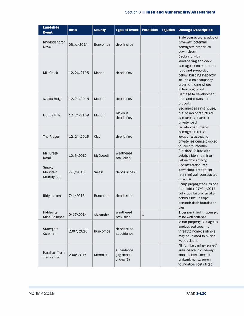
Section 3 Risk and Vulnerability Assessment
NCHMP 2018 PAGE 3-120
Landslide Event
Date County Type of Event Fatalities Injuries Damage Description
Rhododendron Drive
08/xx/2014 Buncombe debris slide
Slide scarps along edge of driveway; potential damage to properties down slope
Mill Creek 12/24/2105 Macon debris flow
Backyard with landscaping and deck damaged; sediment onto road and properties below; building inspector issued a no-occupancy order for home where failure originated.
Azalea Ridge 12/24/2015 Macon debris flow Damage to development road and downslope property
Florida Hills 12/24/2108 Macon blowout - debris flow
Sediment against house, but no major structural damage; damage to private road
The Ridges 12/24/2015 Clay debris flow
Development roads damaged in three locations; access to private residence blocked for several months
Mill Creek Road 10/3/2015 McDowell
weathered rock slide
Cut slope failure with debris slide and minor debris flow activity;
Smoky Mountain Country Club
7/5/2013 Swain debris slides
Sedimentation into downslope properties; retaining wall constructed at site 4
Ridgehaven 7/4/2013 Buncombe debris slide
Scarp propagated upslope from initial 07/04/2016 cut slope failure: smaller debris slide upslope beneath deck foundation pier
Hiddenite Mine Collapse
9/17/2014 Alexander weathered rock slide
1 1 person killed in open pit mine wall collapse
Stonegate Coleman
2007, 2016 Buncombe debris slide subsidence
Minor property damage to landscaped area; no threat to home; sinkhole may be related to buried woody debris
Harahan Train Tracks Trail
2006-2016 Cherokee subsidence (1); debris slides (3)
Fill (unlikely mine-related) subsidence in driveway; small debris slides in embankments; porch foundation posts tilted
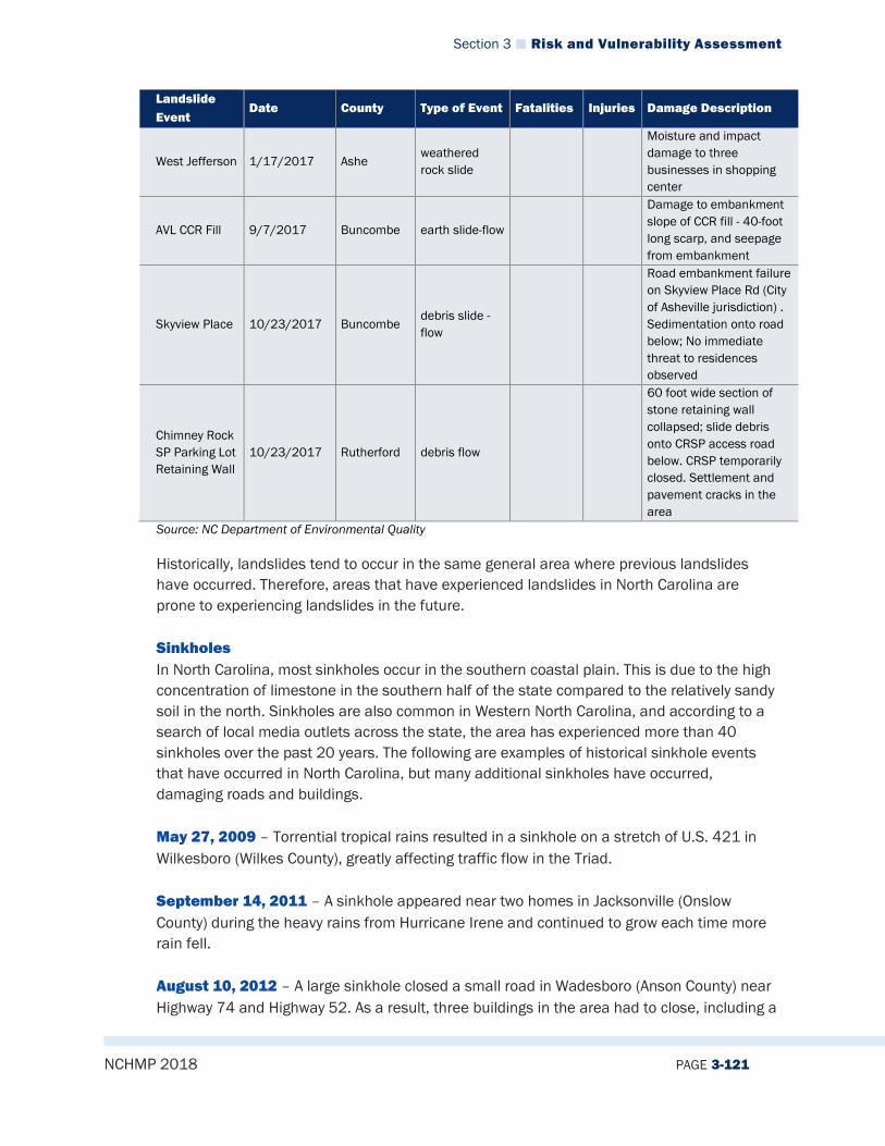
Section 3 Risk and Vulnerability Assessment
NCHMP 2018 PAGE 3-121
Landslide Event
Date County Type of Event Fatalities Injuries Damage Description
West Jefferson 1/17/2017 Ashe weathered rock slide
Moisture and impact damage to three businesses in shopping center
AVL CCR Fill 9/7/2017 Buncombe earth slide-flow
Damage to embankment slope of CCR fill - 40-foot long scarp, and seepage from embankment
Skyview Place 10/23/2017 Buncombe debris slide - flow
Road embankment failure on Skyview Place Rd (City of Asheville jurisdiction) . Sedimentation onto road below; No immediate threat to residences observed
Chimney Rock SP Parking Lot Retaining Wall
10/23/2017 Rutherford debris flow
60 foot wide section of stone retaining wall collapsed; slide debris onto CRSP access road below. CRSP temporarily closed. Settlement and pavement cracks in the area
Source: NC Department of Environmental Quality
Historically, landslides tend to occur in the same general area where previous landslides have occurred. Therefore, areas that have experienced landslides in North Carolina are prone to experiencing landslides in the future. Sinkholes In North Carolina, most sinkholes occur in the southern coastal plain. This is due to the high concentration of limestone in the southern half of the state compared to the relatively sandy soil in the north. Sinkholes are also common in Western North Carolina, and according to a search of local media outlets across the state, the area has experienced more than 40 sinkholes over the past 20 years. The following are examples of historical sinkhole events that have occurred in North Carolina, but many additional sinkholes have occurred, damaging roads and buildings. May 27, 2009 – Torrential tropical rains resulted in a sinkhole on a stretch of U.S. 421 in Wilkesboro (Wilkes County), greatly affecting traffic flow in the Triad. September 14, 2011 – A sinkhole appeared near two homes in Jacksonville (Onslow County) during the heavy rains from Hurricane Irene and continued to grow each time more rain fell. August 10, 2012 – A large sinkhole closed a small road in Wadesboro (Anson County) near Highway 74 and Highway 52. As a result, three buildings in the area had to close, including a

Section 3 Risk and Vulnerability Assessment
NCHMP 2018 PAGE 3-122
local homeless shelter which required finding temporary housing for the people staying at the shelter. August 9, 2014 – Heavy rains produced a sinkhole in Hampstead (Pender County) near Azalea and Country Club Road. August 1, 2016 – A man drove into a weather-related sinkhole on Glenn Road between Club Boulevard and Bundy Avenue in Durham (Durham County). The man was rescued but sustained injuries. The sinkhole stretched from one side of the road to the other and was estimated to be 10 to 15 feet deep. October 11, 2016 – Rain from Hurricane Matthew created a sinkhole at least one quarter of a mile wide across Bingham Drive in Fayetteville (Cumberland County). November 27, 2016 – A man was rescued after being stranded in a 12-foot sinkhole in Durham (Durham County). The victim sustained undisclosed injuries after being suck for hours. October 27, 2017 – A sinkhole formed in a restaurant parking lot in Woodfin (Buncombe County), swallowing part of a small tanker truck. By the next day, the hole had grown to about 20 feet deep, making a large part of the parking lot unusable. Coastal Erosion In recent history, North Carolina has experienced many events that have led to beach erosion. In 1996, more than $2 billion worth of property damage was caused by Hurricane Fran, and most of the dunes were wiped out on Topsail Island. Later in September 2003, Hurricane Isabel eroded the beach and caused a 1,700-foot gap in Hatteras Island. The new inlet that was formed cut NC Highway 12 in half and was 24 feet deep in some spots. In 2005, Hurricane Ophelia eroded the beach in the Outer Banks, and parts of Surf City lost 25 feet of beach. A damage assessment reported that 90 percent of beach access stairs in Topsail beach were damaged and destroyed. The same storm caused a new inlet to be formed near Cape Lookout.
3.2.10.5 Changing Future Conditions Landslides An increase in the number and intensity of severe storms will result in more frequent heavy rains and flooding. Since heavy rains and flooding can trigger landslides, landslides may occur more often in the future. Sinkholes Similar to landslides, sinkholes can be triggered by heavy rains and flooding. An increase in the number and intensity of severe storms, and resulting heavy rains and flooding, may also result in sinkholes developing more frequently.
Section 3 Risk and Vulnerability Assessment
NCHMP 2018 PAGE 3-123
Coastal Erosion Weather extremes may negatively affect coastal erosion rates. If continuing extreme storms occur as predicted, shoreline imbalances may happen more frequently. Changing sea levels also affect erosion rates, and these levels are expected to rise globally and locally. Furthermore, as population increases and more people move to coasts, erosion rates are likely to quicken.
3.2.10.6 Impact Landslides Landslides may affect large areas at one time, and they can be slow or quick moving. In North Carolina, they have tended to impact the western side of the state more often and have caused 5 injuries and even 8 fatalities in the recent past. The biggest impact from caused by landslides is property damage and loss. In severe cases, landslides have caused damages to roads, impacting transportation between large groups of people. Although they are not easily predictable, landslides have harsher impacts after periods of severe rainfall. Sinkholes Sinkholes are relatively unpredictable, which causes greater impacts when they do occur. Historical evidence shows that sinkholes tend to occur in the southeastern part of the state, making impacts much more extreme to homeowners in that area. Coastal Erosion While erosion can happen anywhere in North Carolina, greater impacts are generally seen in the eastern part of the state. Many coastal communities are affected by erosion every year, especially after severe storms and during hurricane season. Homeowners of beach front properties may be impacted more than others; in extreme circumstances, some homes have been completely moved to prevent toppling into the ocean. As population continues to increase in coastal areas, the impacts of erosion may become even greater. Although coastal communities try to solve erosion issues by dredging and sandbagging, these are often only temporary solutions to a much more long-term issue.
3.2.10.7 Future Probability Landslides Although North Carolina has experienced landslides, most occurrences were not extremely damaging. Most of these events have occurred in the western part of the state, where there is more area with drastic slope changes. Historical data shows that it is unlikely (between 1 and 33.3 percent annual probability) that more landslides will affect North Carolina in the future. Sinkholes Sinkholes have also affected parts of North Carolina in recent history, but most of those impacts have been in the southeastern region of the state. While many sinkholes have been relatively small, it is still unlikely (between 1 and 33.3 percent annual probability) that they will continue to affect North Carolina in the future.
Section 3 Risk and Vulnerability Assessment
NCHMP 2018 PAGE 3-124
Coastal Erosion The state has shown to be more likely to experience erosion, especially in coastal areas. In areas with faster moving water, such as inlets or coves, erosion is even more probable. Based on historical occurrences, it is unlikely (between 1 and 33.3 percent annual probability) that North Carolina will continue to experience this type of geological hazard.
3.2.10.8 NCEOP Reference Landslides, Sinkholes, Coastal Erosion Annex C, Appendix 6, Hazards and Threats
3.2.11 Infectious Disease
3.2.11.1 Description Communicable, or infectious, diseases are conditions that result in clinically evident illness which are transmissible directly from one person to another or indirectly through vectors such as insects, air, water, blood, or other objects. The impact of communicable disease can range from the mild effects of the common cold to the extreme lethality of pneumonic plague or anthrax. The public health system in the United States was developed in large part as a response to the often urgent need to respond to or prevent outbreaks of communicable diseases. Through public health methods of disease reporting, vaccinations, vector control, and effective treatments, most communicable diseases are well controlled in the United States and across North Carolina. However, control systems can fail and when people come together from locations outside of the state, outbreaks can occur, even in the most modern of communities. In this section, some of the more significant potential communicable disease concerns are described. The threats discussed in this section usually do not occur on a regular basis, though some are more frequent. The diseases described herein do not originate from intentional exposure (such as through terrorist actions) but do present significant issues and concerns for the public health community. There are numerous infectious diseases that rarely, if ever, occur in the State of North Carolina, such as botulism or bubonic plague. Some highly dangerous diseases which could potentially be used as biological weapons, such as anthrax, pneumonic plague, and smallpox, are safely housed and controlled in laboratory settings such as at the Center for Disease Control and Prevention (CDC). Other diseases have not (yet) mutated into a form that can infect humans, or otherwise lie dormant in nature.
There have been several significant viral outbreaks from emerging diseases in recent years of both national and international importance. The Zika virus and West Nile virus are viruses that are typically passed to humans or animals by mosquitoes and made major news as emergent disease threats. Meanwhile, diseases that are spread directly between human beings such as Severe Acute Respiratory Syndrome (SARS) and Ebola have also been identified as serious threats. While each of these conditions caused a great deal of public health concern when they were first identified, SARS has virtually disappeared, West Nile virus occurs with low frequency and causes serious disease in only a very small percentage
Section 3 Risk and Vulnerability Assessment
NCHMP 2018 PAGE 3-125
of cases, Ebola has been more or less contained and a vaccine is in development, and many people infected with Zika will not experience symptoms from the disease. Other communicable diseases pose a much more frequent threat to the citizens of North Carolina. Some of the infectious diseases of greatest concern include influenza, particularly in a pandemic form, as well as norovirus, and multiple antibiotic-resistant tuberculosis. Even in one of its normal year-to-year variants, influenza (commonly referred to as “flu”) can result in serious illness and even death in young children, the elderly and immune-compromised persons. But there is always the potential risk of the emergence of influenza in one of the pandemic H1N1 forms, such as in the “Spanish Flu” outbreak of 1918-19, which killed over 50 million people worldwide. Every year, North Carolina sees hundreds of cases of influenza, leading to hundreds of hours of lost productivity in businesses due to sick employees. Of note, a vaccine for influenza is produced every year and, according to the CDC, is highly effective in preventing the disease. Norovirus is recognized as the leading cause of foodborne-disease outbreaks in the United States. The virus can cause diarrhea, vomiting, and stomach pain, and is easily spread from person to person through contaminated food or water and by surface to surface contact. Especially vulnerable populations to this virus include those living or staying in nursing homes and assisted living facilities and other healthcare facilities such as hospitals. Norovirus could also be a threat in the event of large public gatherings such as sporting events, concerts, festivals, and so forth. North Carolina often experiences norovirus outbreaks on an annual basis. No vaccine or treatment exists for the Norovirus, making it especially dangerous for the public in the event of an outbreak. Public health threats can occur at any time and can have varying impacts. Discussions between public health professionals, planning officials, and first response agencies are essential in order to facilitate safe, effective, and collaborative efforts toward outbreaks.
3.2.11.2 Extent Extent is difficult to measure for an infectious disease event as the extent is largely dependent on the type of disease and on the effect that it has on the population (discussed above). Extent can be somewhat defined by the number of people impacted, which depending on the type of disease could number in the tens of thousands within the state.
3.2.11.3 Location/Spatial Extent Infectious diseases can occur in any location and are not easily predictable in terms of where they will occur. Dense concentrations of population may be more susceptible to a widespread outbreak due to the proximity of people to one another, the disease itself could originate anywhere. Due to the nature of the infectious disease threat, it is difficult to identify a precise location where this type of event would occur. Moreover, a large-scale event would have impacts that spread throughout the State. Therefore, all areas in North Carolina are considered equally susceptible to infectious diseases.
Section 3 Risk and Vulnerability Assessment
NCHMP 2018 PAGE 3-126
3.2.11.4 Hazard History In 2003, the SARS outbreak that began in Southeast Asia began showing up in the United States. There were three confirmed case of SARS in Georgia in 2003. Since that time there have not been any reported cases of SARS.30 No cases of Ebola were reported in the State of North Carolina, though several locations in the United States did experience cases. Vector-Borne Diseases Bacterial, viral and parasitic diseases that are transmitted by mosquitoes, ticks and fleas are collectively called "vector-borne diseases" (the insects and arthropods are the "vectors" that carry the diseases). Although the term "vector" can also apply to other carriers of disease — such as mammals that can transmit rabies or rodents that can transmit hantavirus — those diseases are generally called zoonotic (animal-borne) diseases. The most common vector-borne diseases found in North Carolina are carried by ticks and mosquitoes. The tick-borne illnesses most often seen in the state are Rocky Mountain Spotted Fever, ehrlichiosis, Lyme disease and Southern Tick-Associated Rash Illness (STARI). The most frequent mosquito-borne illnesses, or "arboviruses," in North Carolina include La Crosse encephalitis, West Nile virus and Eastern equine encephalitis. An outbreak of the West Nile Virus began showing up in the United States in 1999, with North Carolina reporting 63 cases from that time through the end of 2016. A map showing the number of Zika cases reported in each state in 2016 can be found in Figure 3-43. According to the Centers for Disease Control, there were 97 cases of Zika in the State of North Carolina in 2016, and only five reported cases in 2017.
30 Severe Acute Respiratory Syndrome (SARS) Report of Cases in the United States. Centers for Disease Control and Prevention. Retrieved on December 14, 2017 from: https://www.cdc.gov/media/presskits/sars/cases.htm
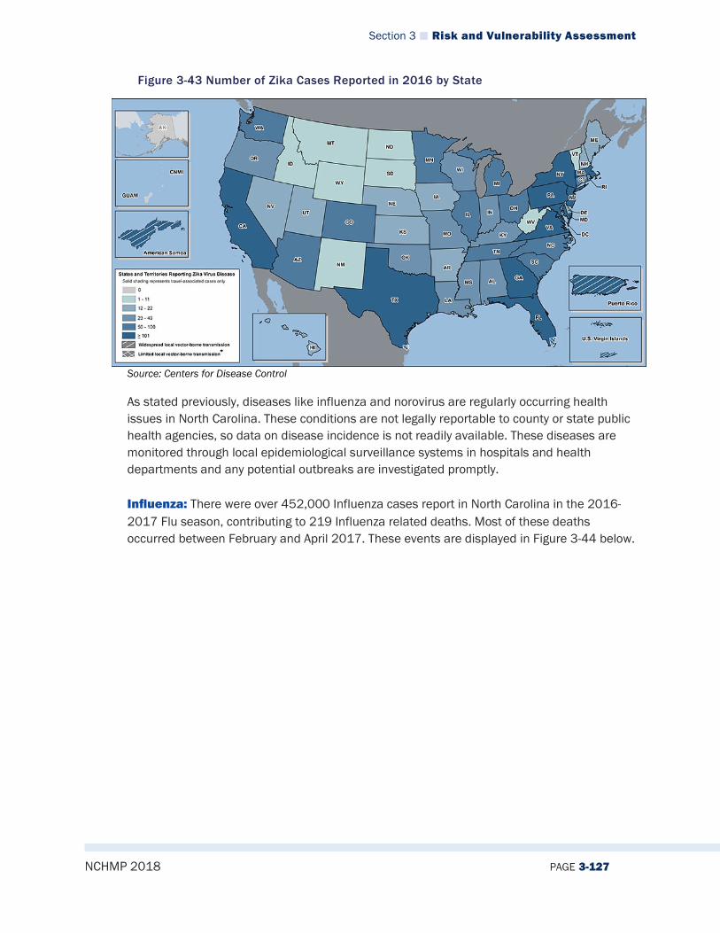
Section 3 Risk and Vulnerability Assessment
NCHMP 2018 PAGE 3-127
Figure 3-43 Number of Zika Cases Reported in 2016 by State
Source: Centers for Disease Control
As stated previously, diseases like influenza and norovirus are regularly occurring health issues in North Carolina. These conditions are not legally reportable to county or state public health agencies, so data on disease incidence is not readily available. These diseases are monitored through local epidemiological surveillance systems in hospitals and health departments and any potential outbreaks are investigated promptly. Influenza: There were over 452,000 Influenza cases report in North Carolina in the 2016-2017 Flu season, contributing to 219 Influenza related deaths. Most of these deaths occurred between February and April 2017. These events are displayed in Figure 3-44 below.

Section 3 Risk and Vulnerability Assessment
NCHMP 2018 PAGE 3-128
Figure 3-44 Influenza Surveillance, NC 2014-2017
Source: http://www.flu.nc.gov/
3.2.11.5 Changing Future Conditions There have been many studies conducted between climatic conditions and infectious diseases, and trends show there is a link. Many diseases, such as malaria, dengue fever, and yellow fever are spread through mosquitoes that reproduce and thrive in warm, wet conditions. According to the World Health Organization, Malaria epidemic risk has shown to increase nearly five-fold after El Niño events; therefore, if warming surface temperatures and increased precipitation trends continue, North Carolina may be more susceptible to disease occurrence.
3.2.11.6 Impact There have already been two reported deaths for the 2017-2018 Flu season. Economic Impact: Influenza also has negative effects on the North Carolina economy. It accounts for 7-10 lost work days per case, and there were over 3 million combined lost work days during the 2016-2017 Flu season.
3.2.11.7 Future Probability It is difficult to predict the future probability of infectious diseases due to the difficulty with obtaining information on this type of hazard. The most common and probable disease in the state has shown to be influenza; however, based on historical data, it is relatively unlikely (between 1 and 33.3 percent annual probability) that North Carolina will experience an outbreak of infectious diseases in the future.
3.2.11.8 NCEOP Reference Annex B, Appendix 6, Communicable Disease and Biohazard Response Plan Annex C, Appendix 6, Hazards and Threats
Section 3 Risk and Vulnerability Assessment
NCHMP 2018 PAGE 3-129
3.3 TECHNOLOGICAL HAZARD IDENTIFICATION
3.3.1 Hazardous Substances
3.3.1.1 Description Hazardous Materials For the purposes of this plan, NCEM defines a hazardous substance as any element, chemical, substance, compound, mixture, agent, solution or substance that an accidental or deliberate release of may cause disease or harm to human health and the environment. Hazardous substances may have one or more of the following intrinsic properties: explosiveness, flammability, ability to oxidize (or accelerate a fire), human toxicity, or corrosiveness. Hazardous materials are found in many different forms and quantities that can potentially cause property damage, injuries, long-lasting health effects, and death. Many of these materials are used and stored on a daily basis in homes and businesses, and transported through major highways, waterways, pipelines, and railways. Each hazard has a different threshold level and can be naturally occurring, which creates many risks in the event of an emergency. Hazardous material (HAZMAT) incidents consist of solid, liquid and/or gaseous contaminants that can occur at fixed facilities or mobile sources. Many HAZMAT emergencies result from accidents or negligent behavior, but some may be purposefully designed, such as a terror attack. These incidents can be acute or long-lasting and can cause fires or explosions, potentially affecting vast populations of people and wildlife. HAZMAT incidents may also be a result of natural hazard events, such as hurricanes, earthquakes, or floods. In these circumstances, response efforts may be hindered, which can intensify the disaster. An example of this occurred after Hurricane Floyd hit North Carolina in 1999; many communities were left with flooded junkyards, deceased livestock, disturbed cemeteries, along with environmental pollutants such as uncontrolled fertilizer spills and floating propane tanks. In 1984, a chemical plant leak in Bhopal, India resulted in the death of thousands of people. Approximately six months later, a similar incident occurred in West Virginia. These two events raised concerns about community preparedness in the event of a chemical emergency, which led to the establishment of the Emergency Planning and Community Right-To-Know Act (EPCRA) in 1986. This act has created requirements for local, state, and federal governments in the event of toxic chemical emergencies, which include planning and response efforts. The information is available to the public to increase awareness and protect public and environmental health. Furthermore, emergency notification requirements call for the release of specific information, including the name of the released chemical, quantity released, method of release (air, water, and/or land), anticipated health risk involved, proper precautions, and emergency contact information. More information about EPCRA can be found here: https://www.epa.gov/epcra/what-epcra

Section 3 Risk and Vulnerability Assessment
NCHMP 2018 PAGE 3-130
3.3.1.2 Extent The extent of hazardous materials incidents can be defined in terms of the amount of material releases. The United States Department of Transportation’s Pipeline and Hazardous Materials Safety Administration (PHMSA) maintains a database of reported mobile hazardous materials incidents. According to that database, the largest release of a hazardous substance in North Carolina occurred in Hertford County in 1978 when 187,000 LGA units of gasoline was released during a highway HAZMAT incident. Measuring extent of hazardous substance accidents is difficult because there are so many different types of hazardous substances. EPCRA reporting requirements have led to the publication of a consolidated list of chemicals subject to EPCRA, Comprehensive Environmental Response, Compensation and Liability Act (CERCLA) and the Clean Air Act that can be accessed by anyone online at: https://www.epa.gov/sites/production/files/2015-03/documents/list_of_lists.pdf The EPA’s List of Lists also provides the threshold for the quantities of materials that must be reported by facilities if those materials are stored on-site. These thresholds, by hazardous material, can also be considered hazard extents for hazardous materials.
3.3.1.3 Location/Spatial Extent Most fixed HAZMAT operations in North Carolina are in rural areas, away from large cities. However, many mobile HAZMAT emergencies occur from transportation accidents on major highways and railways in metropolitan areas. “Hot spots” have been identified and tend to happen in heavily populated areas. Some of these locations are recorded by the Department of Transportation and can be accessed at: https://www.phmsa.dot.gov/ As a result of the 1986 accidents and establishment of EPCRA, the Environmental Protection Agency publishes some hazardous material information for the public. The EPA collects information from industrial facilities when toxic agents are released and/or transferred, and this data is reported to the Toxic Release Inventory (TRI). According to the EPA, in October 2017 there are 776 TRI facilities in North Carolina. These facilities are mapped in Figure 3-45.

Section 3 Risk and Vulnerability Assessment
NCHMP 2018 PAGE 3-131
Figure 3-45 TRI Facilities in North Carolina
Another source of location data for hazardous materials facilities includes SARA Tier II facilities reported to the EPA as part of the agency’s Risk Management Plan rules (not available to the public).
3.3.1.4 Hazard History For mobile HAZMAT incidences, the PHMSA database of hazardous materials incidents indicates that for North Carolina, there have been 20,312 reported incidents dating back to 1971. This accounts for reported previous occurrences of mobile HAZMAT events than for any other hazard event types combined. There is no known database of fixed facility HAZMAT incidents.
3.3.1.5 Changing Future Conditions Some HAZMAT emergencies may be triggered by natural disasters and changing climatic conditions may cause more extreme weather events. Furthermore, as North Carolina’s population continues to grow, more people become increasingly vulnerable to incidents involving hazardous substances. Therefore, it is important to critically monitor all hazardous fixed facilities and transportation routes and continue to attempt to prevent future incidents from occurring through continued preparedness, monitoring and training.
3.3.1.6 Impact HAZMAT accidents can potentially affect large populations of people and wildlife. Impacts may go unnoticed for several hours, days, or weeks depending on the substance released, which can cause long-term effects. Although impacts can be widespread, the most vulnerable populations tend to be localized near the following: railroads, pipelines, highways, and/or fixed facilities.
Section 3 Risk and Vulnerability Assessment
NCHMP 2018 PAGE 3-132
3.3.1.7 Future Probability Unfortunately, there isn’t a “typical” type of HAZMAT emergency. While most incidents are the result of negligent behavior, transportation accidents or criminal acts, it is difficult to predict the probability or type of a future occurrence. However, due to historical occurrences, people living along major highways or near HAZMAT operations may be most at risk. North Carolina is known to have one of the best HAZMAT response teams in the country, but it is still highly likely (between 66.7 and 100 percent annual probability) that a hazardous materials incident may occur in any given year.
3.3.1.8 NCEOP Reference Annex B, Appendix 5, Oil-Petroleum Products Spill Response Plan Annex C, Appendix 6, Hazards and Threats
3.3.2 Radiological Emergencies – Fixed Nuclear Facilities
3.3.2.1 Description A nuclear and radiation accident is defined by the International Atomic Energy Agency as “an event that has led to significant consequences to people, the environment or the facility. Often, this type of incident results from damage to the reactor core of a nuclear power plant, which can release radioactivity into the environment. The degree of exposure from nuclear accidents has varied from serious to catastrophic. The Radiation Emergency Preparedness (REP) program, which was established in 1979 after a nuclear accident at Three Mile Island Nuclear Generating Center, coordinates the national effort to state and local governments with mitigation strategies involving nuclear power plants. The program deals with fixed nuclear facilities (FNF) within or having a portion of the 10-mile Emergency Planning Zone (EPZ) within the country, including North Carolina. More information about the REP Program can be found here: https://www.fema.gov/radiological-emergency-preparedness-program Globally, there are around 430 operational reactors, and 200 of them are expected to retire by the year 2040 (Source: IEA). However, in North Carolina, nuclear energy contributed the largest share of the state’s electricity generation in 2016 with 32.5%. The state also produced 5.3% of the nation’s total electricity from nuclear power in 2016, ranking fourth in the nation. (Source: https://www.eia.gov/state/?sid=NC). Harris Nuclear Plant The Harris Nuclear Plant is located in New Hill, North Carolina, about 20 miles south west of Raleigh. It commenced operation on May 2, 1987 and its current license of operation expires in 2046. The plant staffs approximately 800 people and generates electricity for more than 550,000 homes in the surrounding areas31.
31 https://www.duke-energy.com/our-company/about-us/power-plants
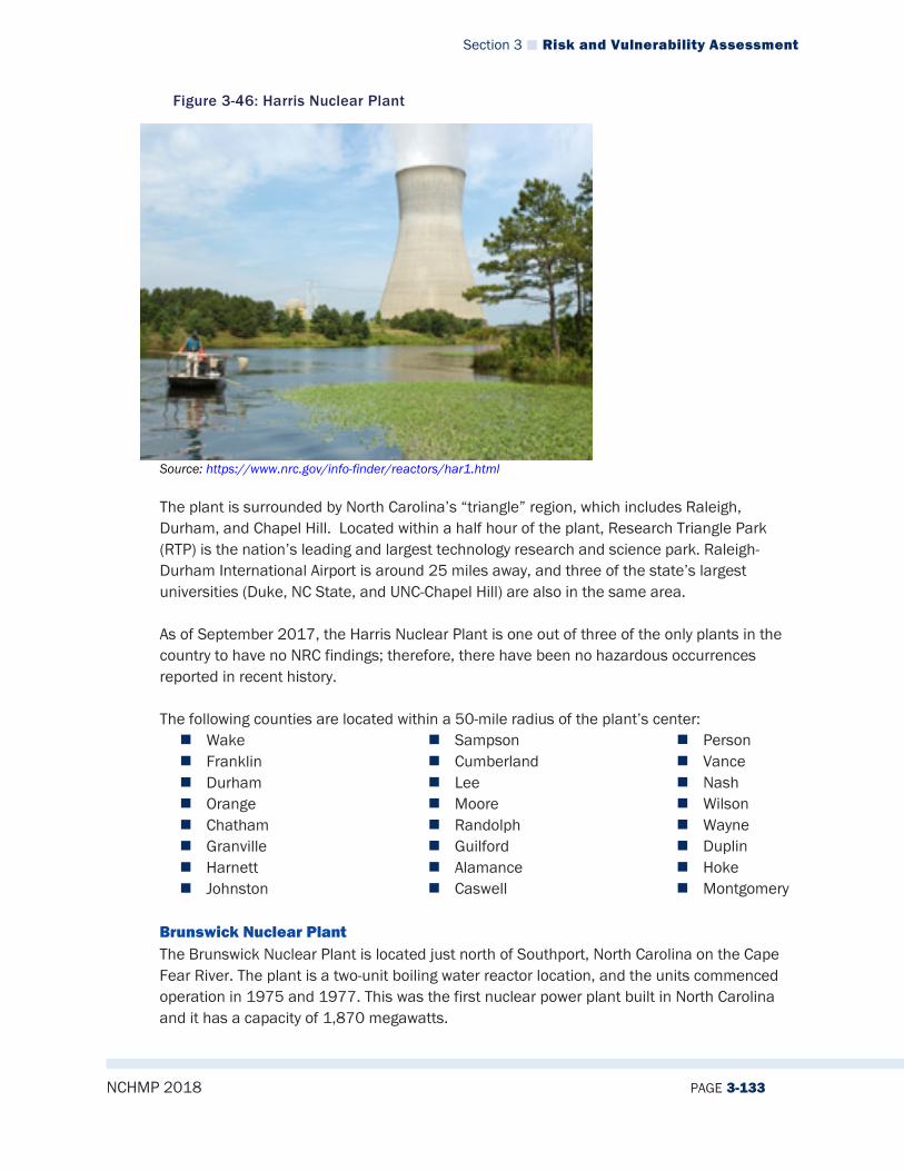
Section 3 Risk and Vulnerability Assessment
NCHMP 2018 PAGE 3-133
Figure 3-46: Harris Nuclear Plant
Source: https://www.nrc.gov/info-finder/reactors/har1.html The plant is surrounded by North Carolina’s “triangle” region, which includes Raleigh, Durham, and Chapel Hill. Located within a half hour of the plant, Research Triangle Park (RTP) is the nation’s leading and largest technology research and science park. Raleigh-Durham International Airport is around 25 miles away, and three of the state’s largest universities (Duke, NC State, and UNC-Chapel Hill) are also in the same area. As of September 2017, the Harris Nuclear Plant is one out of three of the only plants in the country to have no NRC findings; therefore, there have been no hazardous occurrences reported in recent history. The following counties are located within a 50-mile radius of the plant’s center: Wake Franklin Durham Orange Chatham Granville Harnett Johnston
Sampson Cumberland Lee Moore Randolph Guilford Alamance Caswell
Person Vance Nash Wilson Wayne Duplin Hoke Montgomery
Brunswick Nuclear Plant The Brunswick Nuclear Plant is located just north of Southport, North Carolina on the Cape Fear River. The plant is a two-unit boiling water reactor location, and the units commenced operation in 1975 and 1977. This was the first nuclear power plant built in North Carolina and it has a capacity of 1,870 megawatts.
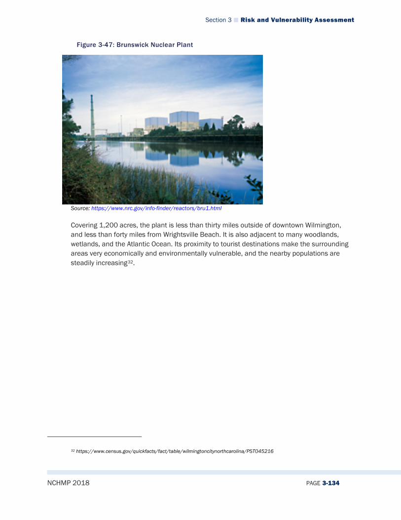
Section 3 Risk and Vulnerability Assessment
NCHMP 2018 PAGE 3-134
Figure 3-47: Brunswick Nuclear Plant
Source: https://www.nrc.gov/info-finder/reactors/bru1.html Covering 1,200 acres, the plant is less than thirty miles outside of downtown Wilmington, and less than forty miles from Wrightsville Beach. It is also adjacent to many woodlands, wetlands, and the Atlantic Ocean. Its proximity to tourist destinations make the surrounding areas very economically and environmentally vulnerable, and the nearby populations are steadily increasing32.
32 https://www.census.gov/quickfacts/fact/table/wilmingtoncitynorthcarolina/PST045216

Section 3 Risk and Vulnerability Assessment
NCHMP 2018 PAGE 3-135
The following counties are located within a 50-mile radius of the plant’s center: Pender New Hanover Brunswick
Onslow Columbus Bladen
Sampson
McGuire Nuclear Station The McGuire Nuclear Station is located on Lake Norman in Mecklenburg County, about 17 miles north of Charlotte. Lake Norman was built by Duke Energy in 1963 and is the state’s largest man-made lake. The first unit of the station commenced operation in 1981, and the second in 1984. It has a capacity to produce 2,316 megawatts of power and employs more than 1,200 employees33.
Figure 3-48: McGuire Nuclear Station
Source: https://www.nrc.gov/info-finder/reactors/mcg1.html
The plant lies in between North Carolina’s largest city, Charlotte, and the Hickory/Statesville area. These highly populated nearby cities are home to many universities, big industries, and airports. In Charlotte alone, the population rose by 1.8% from 2015-2016, and population and employment are continuing to increase34. As more people move to the surrounding area, the population is therefore more vulnerable to potential emergencies at the McGuire Nuclear Station.
33 https://nuclear.duke-energy.com/2013/06/25/mcguire-nuclear-station-focuses-on-operational-excellence-and-community-outreach 34 https://datausa.io/profile/geo/charlotte-nc/
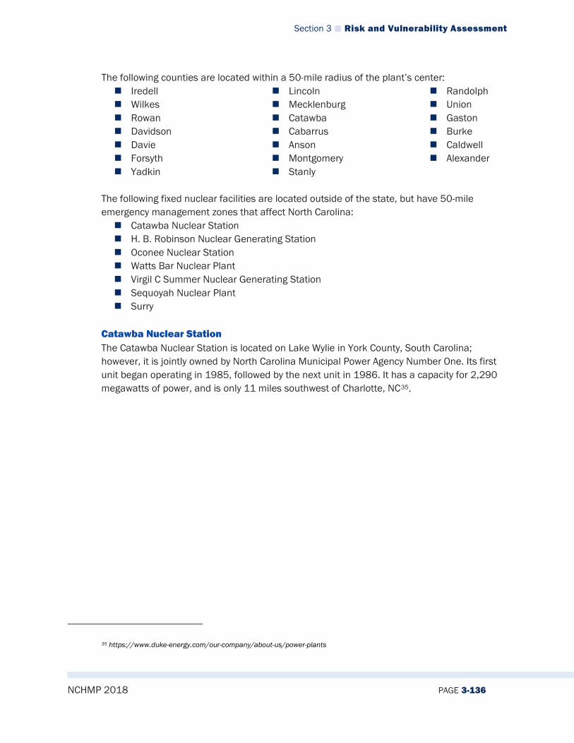
Section 3 Risk and Vulnerability Assessment
NCHMP 2018 PAGE 3-136
The following counties are located within a 50-mile radius of the plant’s center: Iredell Wilkes Rowan Davidson Davie Forsyth Yadkin
Lincoln Mecklenburg Catawba Cabarrus Anson Montgomery Stanly
Randolph Union Gaston Burke Caldwell Alexander
The following fixed nuclear facilities are located outside of the state, but have 50-mile emergency management zones that affect North Carolina: Catawba Nuclear Station H. B. Robinson Nuclear Generating Station Oconee Nuclear Station Watts Bar Nuclear Plant Virgil C Summer Nuclear Generating Station Sequoyah Nuclear Plant Surry
Catawba Nuclear Station The Catawba Nuclear Station is located on Lake Wylie in York County, South Carolina; however, it is jointly owned by North Carolina Municipal Power Agency Number One. Its first unit began operating in 1985, followed by the next unit in 1986. It has a capacity for 2,290 megawatts of power, and is only 11 miles southwest of Charlotte, NC35.
35 https://www.duke-energy.com/our-company/about-us/power-plants

Section 3 Risk and Vulnerability Assessment
NCHMP 2018 PAGE 3-137
Figure 3-49: Catawba Nuclear Station
Source: https://www.nrc.gov/info-finder/reactors/cat1.html The following North Carolina counties are located within a 50-mile radius of the plant’s center: Mecklenburg Gaston Lincoln Cabarrus Iredell
Stanly Rowan Union Rutherford Cleveland
Burke Anson Catawba
H.B. Robinson Nuclear Generating Station
The H.B. Robinson Nuclear Generating Station is located in Hartsville, South Carolina. It began operation in 1970, and renewed its contract in 2004.
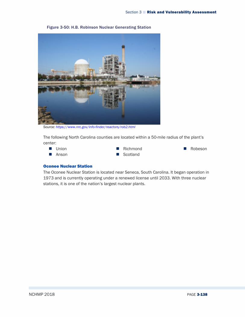
Section 3 Risk and Vulnerability Assessment
NCHMP 2018 PAGE 3-138
Figure 3-50: H.B. Robinson Nuclear Generating Station
Source: https://www.nrc.gov/info-finder/reactors/rob2.html The following North Carolina counties are located within a 50-mile radius of the plant’s center: Union Anson
Richmond Scotland
Robeson
Oconee Nuclear Station The Oconee Nuclear Station is located near Seneca, South Carolina. It began operation in 1973 and is currently operating under a renewed license until 2033. With three nuclear stations, it is one of the nation’s largest nuclear plants.
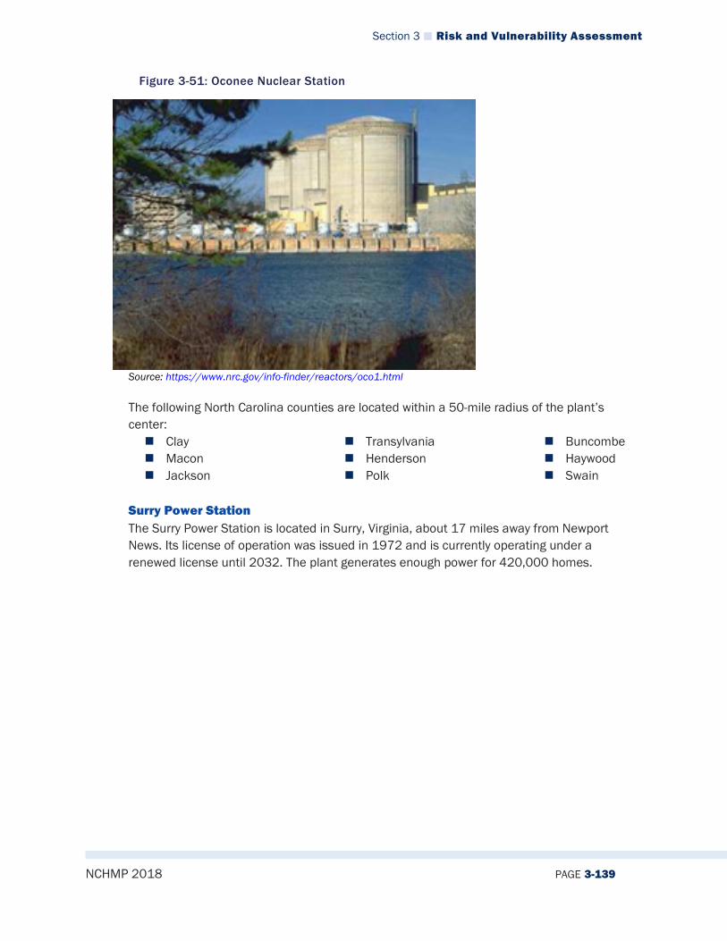
Section 3 Risk and Vulnerability Assessment
NCHMP 2018 PAGE 3-139
Figure 3-51: Oconee Nuclear Station
Source: https://www.nrc.gov/info-finder/reactors/oco1.html The following North Carolina counties are located within a 50-mile radius of the plant’s center: Clay Macon Jackson
Transylvania Henderson Polk
Buncombe Haywood Swain
Surry Power Station The Surry Power Station is located in Surry, Virginia, about 17 miles away from Newport News. Its license of operation was issued in 1972 and is currently operating under a renewed license until 2032. The plant generates enough power for 420,000 homes.
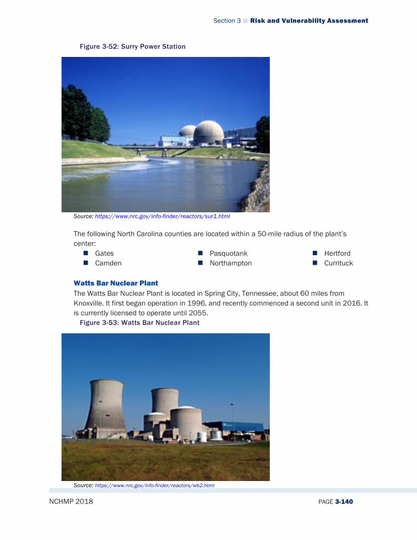
Section 3 Risk and Vulnerability Assessment
NCHMP 2018 PAGE 3-140
Figure 3-52: Surry Power Station
Source: https://www.nrc.gov/info-finder/reactors/sur1.html The following North Carolina counties are located within a 50-mile radius of the plant’s center: Gates Camden
Pasquotank Northampton
Hertford Currituck
Watts Bar Nuclear Plant The Watts Bar Nuclear Plant is located in Spring City, Tennessee, about 60 miles from Knoxville. It first began operation in 1996, and recently commenced a second unit in 2016. It is currently licensed to operate until 2055.
Figure 3-53: Watts Bar Nuclear Plant
Source: https://www.nrc.gov/info-finder/reactors/wb2.html
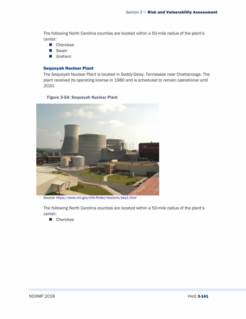
Section 3 Risk and Vulnerability Assessment
NCHMP 2018 PAGE 3-141
The following North Carolina counties are located within a 50-mile radius of the plant’s center: Cherokee Swain Graham
Sequoyah Nuclear Plant The Sequoyah Nuclear Plant is located in Soddy-Daisy, Tennessee near Chattanooga. The plant received its operating license in 1980 and is scheduled to remain operational until 2020.
Figure 3-54: Sequoyah Nuclear Plant
Source: https://www.nrc.gov/info-finder/reactors/seq1.html The following North Carolina counties are located within a 50-mile radius of the plant’s center: Cherokee
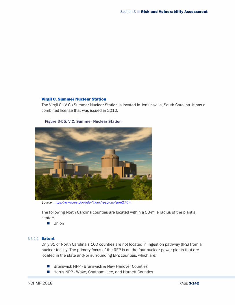
Section 3 Risk and Vulnerability Assessment
NCHMP 2018 PAGE 3-142
Virgil C. Summer Nuclear Station The Virgil C. (V.C.) Summer Nuclear Station is located in Jenkinsville, South Carolina. It has a combined license that was issued in 2012.
Figure 3-55: V.C. Summer Nuclear Station
Source: https://www.nrc.gov/info-finder/reactors/sum2.html The following North Carolina counties are located within a 50-mile radius of the plant’s center: Union
3.3.2.2 Extent Only 31 of North Carolina’s 100 counties are not located in ingestion pathway (IPZ) from a nuclear facility. The primary focus of the REP is on the four nuclear power plants that are located in the state and/or surrounding EPZ counties, which are: Brunswick NPP - Brunswick & New Hanover Counties Harris NPP - Wake, Chatham, Lee, and Harnett Counties

Section 3 Risk and Vulnerability Assessment
NCHMP 2018 PAGE 3-143
McGuire NS - Mecklenburg, Gaston, Lincoln, Catawba, and Iredell Counties Catawba NS - Mecklenburg, and Gaston Counties
The program also supports the EPZ planning for Sequoyah, Watts Bar, Oconee, Summer, Robinson, and Surry facilities located in adjacent states and monitor the research reactor, NCSU PULSTAR in Wake county and Fuel Rod Fabrication Facility at Global Nuclear in New Hanover County. The following figure displays all nuclear power plants in North Carolina and those within 50 miles of the border. (See Figure 3-56)
Figure 3-56 North Carolina Radiological Emergency Preparedness
Source: NC Emergency Management
The EPZ represents the time critical decision area where concern for safety of the general public and emergency workers drives emergency management decision making. The goal is to protect the health and safety of the public living in the vicinity of the nuclear power facility by providing reasonable assurance that appropriate protective measures can be taken offsite in the event of a radiological emergency. In North Carolina, each nuclear facility has two planning zones. A ten-mile radius around each plant would be expected to evacuate in the event of an emergency (Figure 3-56). Secondly, the Ingestion Pathway Zone (IPZ) is a 50-mile radius zone. The IPZ has been designed to mitigate contamination of the human food chain by a radiological accident at a nuclear power plant. The ingestion pathway is characterized by

Section 3 Risk and Vulnerability Assessment
NCHMP 2018 PAGE 3-144
radionuclides being deposited on surfaces, potentially contaminating foods such as milk, fresh vegetables, and water supplies. Historically, there have been no major release events at North Carolina REP facilities and one reported situation where the nuclear material was being monitored for criticality that occurred within the in 2008 at the fuel rod fabrication facility. The probability is considered very unlikely due to the extensive accident prevention and emergency preparedness programs that these facilities support. The consequence of the worst-case scenario is considered catastrophic. Concerns that an event at a REP facility may impact the continuity of response operations has led to planning changes over the past few years where these facilities have moved response equipment storage areas and other facilities outside the 10-mile EPZ. While it would be likely that a major event could impact local Emergency Operations Centers (EOCs) in some jurisdictions, these could be relocated or transferred to the State EOC if needed, given the long time-scales for these events. With these improvements, an event at a REP facility would be expected to have a minor impact on continuity of operations. Due to the nature of the hazard and the general over estimation of the radioactive hazards by the public a significant event at a nuclear facility would present a challenge to public confidence. To increase mitigation, State and local governments are also required to conduct off-site radiological emergency preparedness activities within the EPZs of all nuclear power facilities every two years. An updated schedule of activities for 2018 can be found here: https://www.fema.gov/radiological-emergency-preparedness-program-exercise-evaluation-calendar Existing REP plans are believed to have adequate measures in place to address these concerns. In summary: The REP program has primary responsibility for preparedness for four fixed nuclear
facilities that are in or may significantly impact the state. An additional 6 facilities have portions of the 50-mile IPZ within the state. A test reactor and fuel rod assembly facility are monitored by the program.
The NRC The US Nuclear Regulatory Commission (NRC) is an agency that was formed by Congress in 1974 to ensure the safe use of radioactive materials. The NRC regulates commercial nuclear power plants and other uses of nuclear materials. The agency is headed by commissioners that formulate policy, issue orders, and enforce regulations.
The IAEA The International Atomic Energy Agency (IAEA) is an agency that was established in 1957 in response to fears and expectations associated with nuclear technology. Its statute was unanimously approved by 81 nations in 1956 as the world’s “Atoms for Peace” organization to promote safe, secure, and peaceful nuclear technologies.

Section 3 Risk and Vulnerability Assessment
NCHMP 2018 PAGE 3-145
The IAEA has developed a scale called the International Nuclear and Radiological Event Scale (INES) which provides a quantifiable means of assessing the extent of a nuclear event. This scale uses a logarithmic which means that each increasing level on the scale represents an event 10 times more severe than the previous level.
Figure 3-57 International Nuclear and Radiological Event Scale
Source: International Atomic Energy Association
3.3.2.3 Location/Spatial Extent
There are 4 nuclear power plants in North Carolina, which are displayed in Figure 3-46. In the event of an emergency, areas surrounding these plants would be the most affected areas; however, farther areas could potentially be harmed as well, depending on natural factors such as wind direction. Figure 3-46 Nuclear Power Plants within a 10-mile EPZ in North Carolina
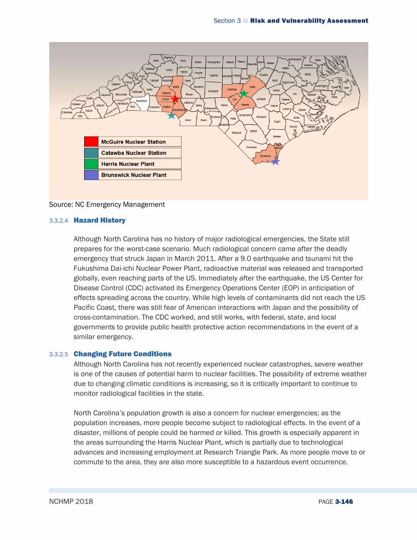
Section 3 Risk and Vulnerability Assessment
NCHMP 2018 PAGE 3-146
Source: NC Emergency Management
3.3.2.4 Hazard History
Although North Carolina has no history of major radiological emergencies, the State still prepares for the worst-case scenario. Much radiological concern came after the deadly emergency that struck Japan in March 2011. After a 9.0 earthquake and tsunami hit the Fukushima Dai-ichi Nuclear Power Plant, radioactive material was released and transported globally, even reaching parts of the US. Immediately after the earthquake, the US Center for Disease Control (CDC) activated its Emergency Operations Center (EOP) in anticipation of effects spreading across the country. While high levels of contaminants did not reach the US Pacific Coast, there was still fear of American interactions with Japan and the possibility of cross-contamination. The CDC worked, and still works, with federal, state, and local governments to provide public health protective action recommendations in the event of a similar emergency.
3.3.2.5 Changing Future Conditions Although North Carolina has not recently experienced nuclear catastrophes, severe weather is one of the causes of potential harm to nuclear facilities. The possibility of extreme weather due to changing climatic conditions is increasing, so it is critically important to continue to monitor radiological facilities in the state. North Carolina’s population growth is also a concern for nuclear emergencies; as the population increases, more people become subject to radiological effects. In the event of a disaster, millions of people could be harmed or killed. This growth is especially apparent in the areas surrounding the Harris Nuclear Plant, which is partially due to technological advances and increasing employment at Research Triangle Park. As more people move to or commute to the area, they are also more susceptible to a hazardous event occurrence.
Section 3 Risk and Vulnerability Assessment
NCHMP 2018 PAGE 3-147
The NRC and local governments study and develop evacuation time estimates (ETEs), which are part of the planning basis for each nuclear power plant. They are required to be performed to estimate the time needed to evacuate the public in the event of a disaster, and they are updated based on population growth near nuclear facilities. In North Carolina, the most recent ETE update took place in 2017 because of population booms. The number of Wake County residents in a 10-mile zone of a nuclear facility rose from 84,654 in 2008 to 118,967 in 2017. As the state’s population continues to grow, it will be important to advance mitigation strategies as well.
3.3.2.6 Impact The impacts of a nuclear emergency could potentially be catastrophic. Radioactive contamination can spread quickly, or immediately by explosion, putting millions of people at risk. However, it is also important to consider the agricultural and economic impacts of an emergency. One of North Carolina’s main economic resources is agriculture, and many people’s jobs are dependent upon the land. North Carolina’s agricultural economy would clearly be acutely impacted after an emergency, but the effects would be long-lasting; land would continue to be unusable for years and possibly even decades. The Price-Anderson Nuclear Industries Indemnity Act (commonly known as the Price-Anderson Act) is a Federal law that was passed in 1957 to address this type of issue. The Act’s purpose is to provide compensation for nuclear radiological emergencies and can offer $12.6 billion to a state in need. This money is financed through reactor companies themselves, and any emergencies that require more monetary compensation would require Congressional approval. While nearly $13 billion may seem like a huge compensation, it would not be enough to keep the state’s economy afloat. Furthermore, initial funding is not available until 3-5 days after the event. Contaminated land could completely ruin the industry for North Carolina, the nation’s leading producer of tobacco and sweet potatoes. Therefore, it is crucial to consider how a radiological emergency could impact the state’s agriculture and economy and to do everything necessary to prevent one from occurring. Guidance should also be developed to cover funding gaps for the public.
3.3.2.7 Future Probability The future incidence of radiological hazards is highly unpredictable. Conditions may be localized or widespread, and no historical data is available, making it difficult to determine the future probability of emergency conditions with any accuracy. However, based on historical evidence, the likelihood that North Carolina will experience a radiological emergency in the near future is unlikely (between 1 and 33.3 percent annual probability).

Section 3 Risk and Vulnerability Assessment
NCHMP 2018 PAGE 3-148
3.3.2.8 NCEOP Reference
3.3.3 Terrorism
3.3.3.1 Description Terrorism is defined in the United States by the Code of Federal Regulations is “the unlawful use of force or violence against persons or property to intimidate or coerce a government, civilian population, or any segment thereof, in furtherance of political or social objectives.” Terrorist acts may include assassinations, kidnappings, hijackings, bombings, small arms attacks, vehicle ramming attacks, edged weapon attacks, incendiary attacks, cyber-attacks (computer based), and the use of chemical, biological, nuclear and radiological weapons. For the purposes of this plan, cyber-attacks are included as a separate hazard. Historically the main categories of weapons of mass destruction (WMDs) used in terror attacks are Chemical, Biological, Radiological, Nuclear, and Explosive (collectively referred to as CBRNE). As we rank these categories, considering immediate danger posed, impact, probability, technical feasibility, frequency, and historical success, they are typically ranked in the following way. Explosive – Explosive attacks lead all others due to their immediate danger to life and health, immediate and measureable impact, high probability, low cost/easy degree of technical feasibility, and a long history of successful attacks. Chemical - Chemical attacks can pose immediate danger to life and health depending upon the materials used. Chemicals are easy to access, low cost, and easy to deploy. Chemical terrorism can have high and persistent impacts to people and places. These types of attacks are probable and have enjoyed historical success. Radiological – Radiological attacks can pose significant threats to life and health depending upon the specific materials used. Radiological materials while restricted and regulated are accessible to people with some knowledge in this discipline. While radiological incidents have occurred, they occur less frequently than explosive and chemical attacks. Biological – Biological attacks can pose significant threats to life and health. They are typically deployed as diseases and bio-toxins. They require some degree of technical expertise in order to be deployed successfully. While biological incidents have occurred, they occur less frequently than explosive and chemical attacks. Nuclear - While yielding a very high impact, the Nuclear attack is extremely rare due to the fact that it is cost prohibitive and very technically difficult to achieve. This type of attack, however, could be state sponsored which makes it viable. OTHER - Terrorism Hazard Assessment must also account for modern trends and changes. An additional “OTHER” category should be considered that includes small arms attacks, vehicle ramming attacks, edged weapon attacks, and incendiary attacks.
3.3.3.2 Extent A terror threat could potentially occur at any location in the State. However, the very definition of a terrorist event indicates that it is most likely to target people as well as critical
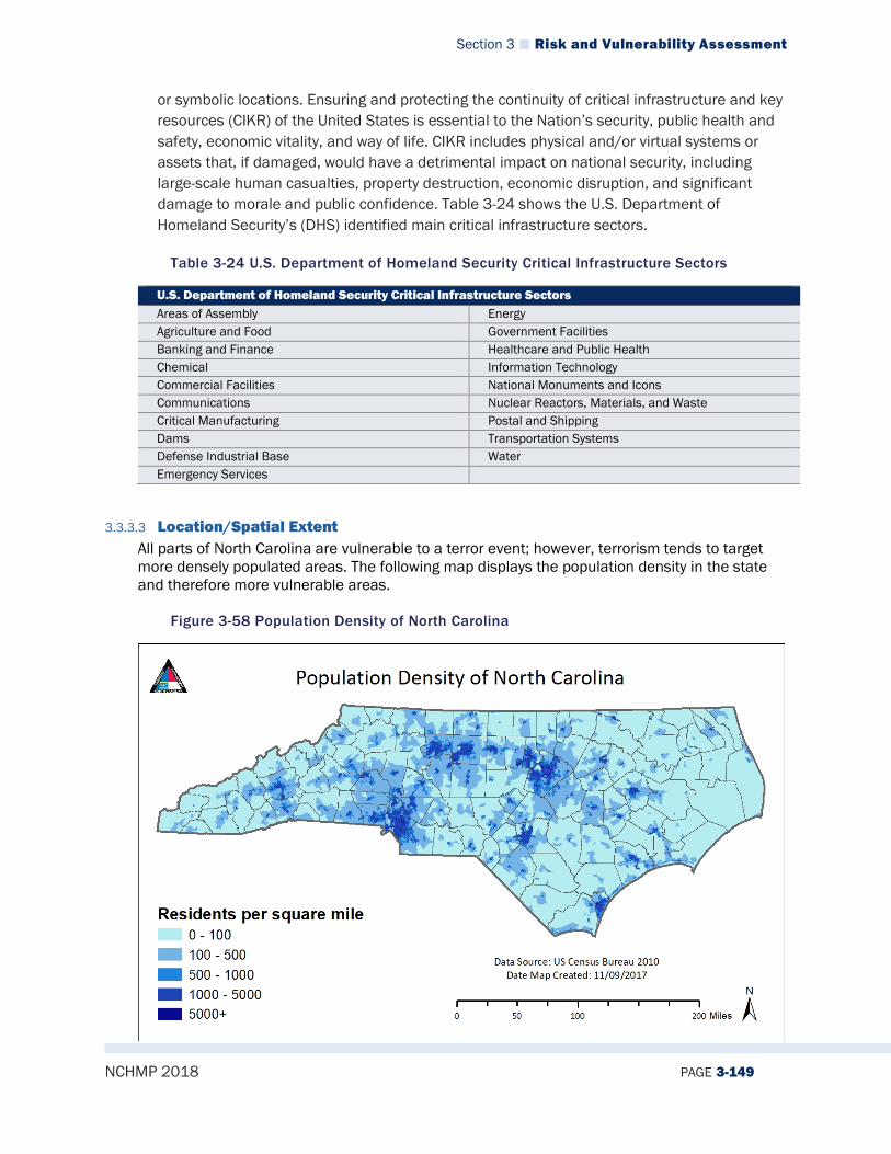
Section 3 Risk and Vulnerability Assessment
NCHMP 2018 PAGE 3-149
or symbolic locations. Ensuring and protecting the continuity of critical infrastructure and key resources (CIKR) of the United States is essential to the Nation’s security, public health and safety, economic vitality, and way of life. CIKR includes physical and/or virtual systems or assets that, if damaged, would have a detrimental impact on national security, including large-scale human casualties, property destruction, economic disruption, and significant damage to morale and public confidence. Table 3-24 shows the U.S. Department of Homeland Security’s (DHS) identified main critical infrastructure sectors.
Table 3-24 U.S. Department of Homeland Security Critical Infrastructure Sectors
U.S. Department of Homeland Security Critical Infrastructure Sectors Areas of Assembly Energy Agriculture and Food Government Facilities Banking and Finance Healthcare and Public Health Chemical Information Technology Commercial Facilities National Monuments and Icons Communications Nuclear Reactors, Materials, and Waste Critical Manufacturing Postal and Shipping Dams Transportation Systems Defense Industrial Base Water Emergency Services
3.3.3.3 Location/Spatial Extent All parts of North Carolina are vulnerable to a terror event; however, terrorism tends to target more densely populated areas. The following map displays the population density in the state and therefore more vulnerable areas.
Figure 3-58 Population Density of North Carolina

Section 3 Risk and Vulnerability Assessment
NCHMP 2018 PAGE 3-150
3.3.3.4 Hazard History Although there have been no major terror attacks in North Carolina, there have been several terror related incidents including: the arrest of terrorism suspects, the disruption of terrorism planning and training activities, and the response to lone suspect attacks. North Carolina has for decades dealt with homegrown extremists with a propensity for terror and violence. Examples of these extremists include militia groups, white supremacy groups, sovereign citizens, and left wing/right wing extremist groups.
3.3.3.5 Changing Future Conditions Population growth continues to change the face of North Carolina. North Carolina is now the ninth most populated state in the Nation. Population growth necessarily raises the odds of incidents involving terror within the state. Terrorism is also driven by trends, technology, and information exchange. Terrorist propaganda and literature continues to play a role in educating terrorists in attack trends, tactics, technology, and procedures.
3.3.3.6 Impact Terrorism can impact people, property, government, the economy, and the environment. Impact can be minimal or severe depending on the type of attack and how successful it is. Attacks against people can result in a small number of injuries or may result in a large number of deaths and injuries. Effects to property can be negligible or may require entire city blocks to be rebuilt. Terrorism can impact government services by exhausting personnel and equipment. Terrorism also has the capability of disrupting the economy with the impact being measured in US dollars. Environmental impacts can be insignificant or may be measureable and persistent requiring remediation. It is incumbent that Federal, State, and Local government work together to minimize the impacts of terrorism through planning, training, and effective law enforcement/emergency response.
3.3.3.7 Future Probability North Carolina has experienced no major terrorist attacks but has had a number of terror related incidents. Thus, the probability of future occurrences of a terrorist attack, while unlikely (between 1 and 33.3 percent annual probability) is a real possibility that the state must be prepared for.
3.3.3.8 NCEOP Reference Annex C, Appendix 6, Hazards and Threats
3.3.4 Cyber
3.3.4.1 Description Cyberattacks are deliberate attacks on information technology systems in an attempt to gain illegal access to a computer, or purposely cause damage. As the world becomes more technologically advanced and dependent upon computer systems, the threat of cyberattacks is becoming increasingly prevalent. Also known as computer network attacks, cyberattacks

Section 3 Risk and Vulnerability Assessment
NCHMP 2018 PAGE 3-151
are difficult to recognize and typically use malicious code to alter computer data or steal information. Mitigating and preparing for cyberattacks is challenging because of how diverse and complex attacks can be. However, the FBI is the lead federal agency for investigating cyberattacks by criminals, overseas adversaries, and terrorists. In North Carolina, the Department of Information Technology is the lead agency that maintains Cybersecurity and Risk Management resources. Cyberattacks can happen in both the public and private sector. They may be carried out by a specific individual, or by groups from afar. Many attacks attempt to steal money or to disturb normal operations. According to the 2017 Verizon Report of Data Breaching, 93% of all data breaches had a financial or espionage motive, and espionage cases are rising.
Figure 3-59 Threat Actor Motives Over Time
Source: 2017 Verizon Data Breach Investigations Report There are many types of cyberattack incident patterns, which include:
• Web App Attacks: Incidents in which web applications were attacked, which can include exploiting code-level vulnerabilities in the application.
• Point-of-Sale Intrusions: Remote attacks against environments where card-present retail transactions are conducted.
• Insider and Privilege Misuse: Unapproved or malicious use of organizational resources.
• Miscellaneous Errors: Incidents in which unintentional actions directly compromise an attribute of a security asset.
• Physical Theft and Loss: Incidents where an information asset went missing. • Crimeware: Instances involving malware that do not fit into a more specific pattern.
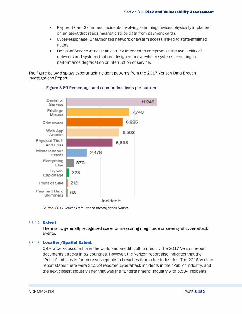
Section 3 Risk and Vulnerability Assessment
NCHMP 2018 PAGE 3-152
• Payment Card Skimmers: Incidents involving skimming devices physically implanted on an asset that reads magnetic stripe data from payment cards.
• Cyber-espionage: Unauthorized network or system access linked to state-affiliated actors.
• Denial-of-Service Attacks: Any attack intended to compromise the availability of networks and systems that are designed to overwhelm systems, resulting in performance degradation or interruption of service.
The figure below displays cyberattack incident patterns from the 2017 Verizon Data Breach Investigations Report.
Figure 3-60 Percentage and count of incidents per pattern
Source: 2017 Verizon Data Breach Investigations Report
3.3.4.2 Extent There is no generally recognized scale for measuring magnitude or severity of cyber-attack events.
3.3.4.3 Location/Spatial Extent Cyberattacks occur all over the world and are difficult to predict. The 2017 Verizon report documents attacks in 82 countries. However, the Verizon report also indicates that the “Public” industry is far more susceptible to breaches than other industries. The 2016 Verizon report states there were 21,239 reported cyberattack incidents in the “Public” industry, and the next closest industry after that was the “Entertainment” industry with 5,534 incidents.
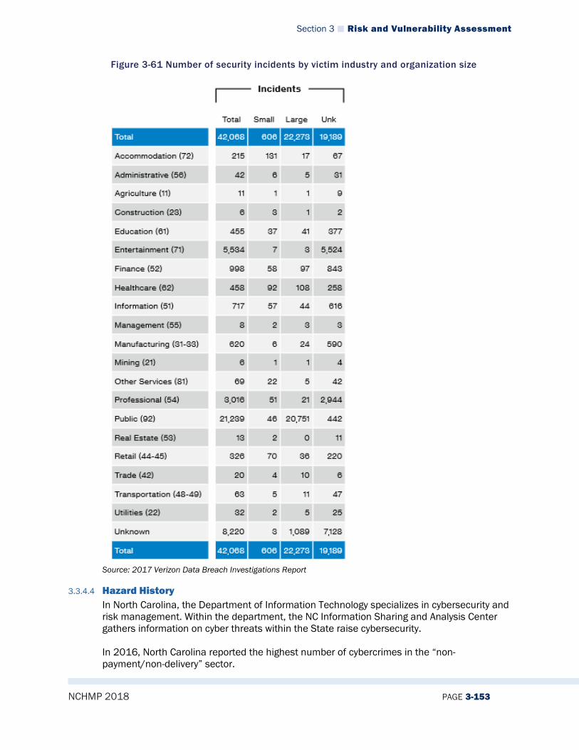
Section 3 Risk and Vulnerability Assessment
NCHMP 2018 PAGE 3-153
Figure 3-61 Number of security incidents by victim industry and organization size
Source: 2017 Verizon Data Breach Investigations Report
3.3.4.4 Hazard History In North Carolina, the Department of Information Technology specializes in cybersecurity and risk management. Within the department, the NC Information Sharing and Analysis Center gathers information on cyber threats within the State raise cybersecurity. In 2016, North Carolina reported the highest number of cybercrimes in the “non-payment/non-delivery” sector.
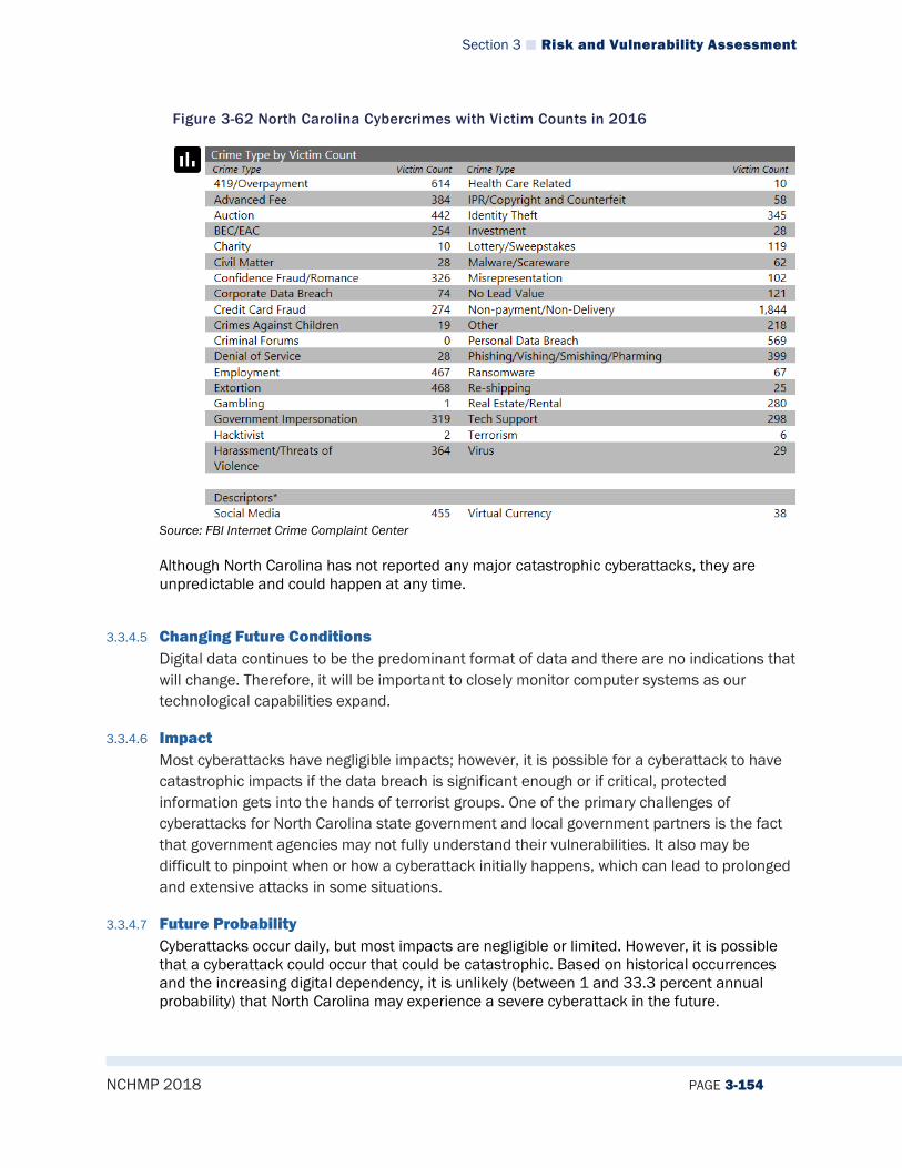
Section 3 Risk and Vulnerability Assessment
NCHMP 2018 PAGE 3-154
Figure 3-62 North Carolina Cybercrimes with Victim Counts in 2016
Source: FBI Internet Crime Complaint Center
Although North Carolina has not reported any major catastrophic cyberattacks, they are unpredictable and could happen at any time.
3.3.4.5 Changing Future Conditions Digital data continues to be the predominant format of data and there are no indications that will change. Therefore, it will be important to closely monitor computer systems as our technological capabilities expand.
3.3.4.6 Impact Most cyberattacks have negligible impacts; however, it is possible for a cyberattack to have catastrophic impacts if the data breach is significant enough or if critical, protected information gets into the hands of terrorist groups. One of the primary challenges of cyberattacks for North Carolina state government and local government partners is the fact that government agencies may not fully understand their vulnerabilities. It also may be difficult to pinpoint when or how a cyberattack initially happens, which can lead to prolonged and extensive attacks in some situations.
3.3.4.7 Future Probability Cyberattacks occur daily, but most impacts are negligible or limited. However, it is possible that a cyberattack could occur that could be catastrophic. Based on historical occurrences and the increasing digital dependency, it is unlikely (between 1 and 33.3 percent annual probability) that North Carolina may experience a severe cyberattack in the future.
Section 3 Risk and Vulnerability Assessment
NCHMP 2018 PAGE 3-155
3.3.4.8 NCEOP Reference Annex C, Appendix 6, Hazards and Threats
3.3.5 Electromagnetic Pulse
3.3.5.1 Description The United States Department of Energy defines electromagnetic pulses (EMPs) as “intense pulses of electromagnetic energy resulting from solar-caused effects or man-made nuclear and pulse power devices.” EMPs can be naturally occurring or human-caused hazards. Examples of natural EMP events include:
• Lightning electromagnetic pulse • Electrostatic discharge • Meteoric electromagnetic pulse, and • Coronal mass ejection, also known as a solar electromagnetic pulse.
A human-caused EMP (such as a nuclear EMP) is a technological hazard that can cause severe damage to electrical components attached to power lines or communication systems. One of the most complex aspects of EMPs is the fact they are invisible, unpredictable, and rapid. They can also overload electronic devices that people heavily rely on every day. EMPs are harmless to people biologically; however, an EMP attack could damage electronic systems such as planes or cars. This could cause destruction of property and life and potentially generate disease or societal collapse. In 2015, Congress amended the Homeland Security Act of 2002 by passing the Critical Infrastructure Protection Act (CIPA), which protects Americans from an EMP. It also required reporting of EMP threats, research and development, and a campaign to educate planners and emergency responders about EMP events.
3.3.5.2 Extent The strength and area impacted by an EMP depends on the type. For example, a nuclear device detonated at high altitudes can generate a pulse with tens of kilovolts per meter and impact a radius from hundreds to thousands of kilometers. This type of event can disable very large electrical and electronic systems such as power and long-haul communications.
3.3.5.3 Location/Spatial Extent An EMP can happen in any location and are relatively unpredictable. However, due to the technological advances in the United States, the country may be more susceptible to an EMP attack. Highly populated areas may be more prone to damages from an EMP; cities such as Charlotte or Raleigh in North Carolina may be more at risk.
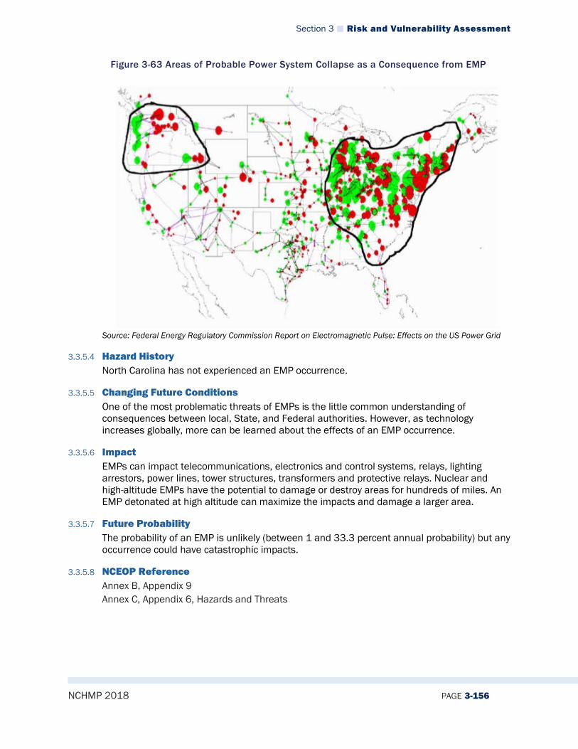
Section 3 Risk and Vulnerability Assessment
NCHMP 2018 PAGE 3-156
Figure 3-63 Areas of Probable Power System Collapse as a Consequence from EMP
Source: Federal Energy Regulatory Commission Report on Electromagnetic Pulse: Effects on the US Power Grid
3.3.5.4 Hazard History North Carolina has not experienced an EMP occurrence.
3.3.5.5 Changing Future Conditions One of the most problematic threats of EMPs is the little common understanding of consequences between local, State, and Federal authorities. However, as technology increases globally, more can be learned about the effects of an EMP occurrence.
3.3.5.6 Impact EMPs can impact telecommunications, electronics and control systems, relays, lighting arrestors, power lines, tower structures, transformers and protective relays. Nuclear and high-altitude EMPs have the potential to damage or destroy areas for hundreds of miles. An EMP detonated at high altitude can maximize the impacts and damage a larger area.
3.3.5.7 Future Probability The probability of an EMP is unlikely (between 1 and 33.3 percent annual probability) but any occurrence could have catastrophic impacts.
3.3.5.8 NCEOP Reference Annex B, Appendix 9 Annex C, Appendix 6, Hazards and Threats

Section 3 Risk and Vulnerability Assessment
NCHMP 2018 PAGE 3-157
3.4 VULNERABILITY ASSESSMENT
3.4.1 Demographics
3.4.1.1 Census 2010 The 2010 Census represents the last official federal comprehensive population count. The 2010 Census was overseen by the U.S. Census Bureau. In North Carolina, the State Demographics branch of the Office of State Budget and Management is responsible for producing population estimates and projections. Table 3-25 provides population counts for each county in the State per the 2010 Census and the North Carolina State Demographics Office. The table also lists the percent growth rate in each county from 2010-2017 according to NC State Demographics 2017 estimates. Overall, the population in the State is up by about 0.5% since 2010.
Table 3-25 North Carolina 2017 Populations and Growth Changes by County
Rank (2017 Population)
County Population (2010 Census)
Population (2017 NC State Demographics Estimate)
Percent Growth 2010-2017
1 Mecklenburg County 919,628 1,054,835 14.70% 2 Wake County 900,993 1,046,791 16.18% 3 Guilford County 488,406 521,330 6.74% 4 Forsyth County 350,670 371,511 5.94% 5 Cumberland County 319,431 327,127 2.41% 6 Durham County 267,587 306,212 14.43% 7 Buncombe County 238,318 256,088 7.46% 8 Union County 201,292 226,606 12.58% 9 New Hanover County 202,667 223,483 10.27%
10 Gaston County 206,086 216,965 5.28% 11 Cabarrus County 178,011 201,590 13.25% 12 Johnston County 168,878 191,450 13.37% 13 Onslow County 177,772 187,136 5.27% 14 Pitt County 168,148 177,220 5.40% 15 Iredell County 159,437 172,916 8.45% 16 Davidson County 162,878 164,926 1.26% 17 Alamance County 151,131 159,688 5.66% 18 Catawba County 154,358 156,459 1.36% 19 Randolph County 141,752 143,416 1.17% 20 Orange County 133,801 141,796 5.98% 21 Rowan County 138,428 139,933 1.09% 22 Robeson County 134,168 133,235 -0.70% 23 Harnett County 114,678 130,881 14.13% 24 Brunswick County 107,431 126,953 18.17% 25 Wayne County 122,623 124,150 1.25% 26 Henderson County 106,740 114,209 7.00% 27 Craven County 103,505 103,445 -0.06% 28 Cleveland County 98,078 97,144 -0.95% 29 Moore County 88,247 95,776 8.53% 30 Nash County 95,840 94,005 -1.91%
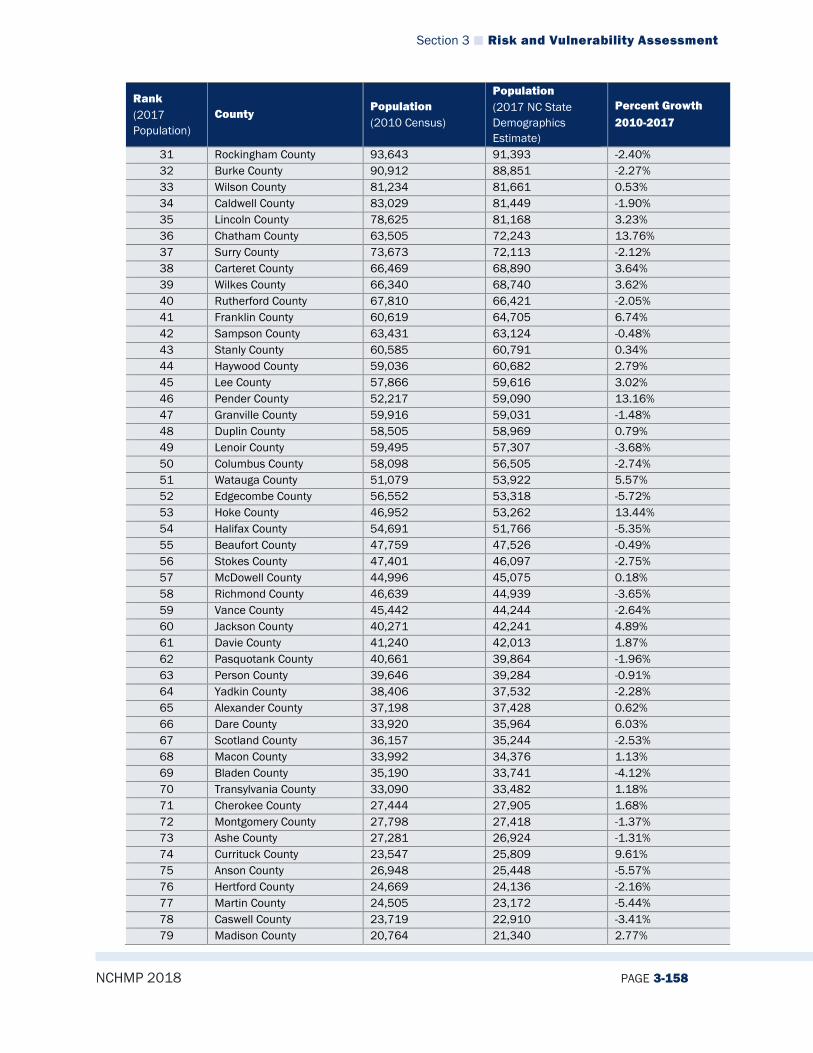
Section 3 Risk and Vulnerability Assessment
NCHMP 2018 PAGE 3-158
Rank (2017 Population)
County Population (2010 Census)
Population (2017 NC State Demographics Estimate)
Percent Growth 2010-2017
31 Rockingham County 93,643 91,393 -2.40% 32 Burke County 90,912 88,851 -2.27% 33 Wilson County 81,234 81,661 0.53% 34 Caldwell County 83,029 81,449 -1.90% 35 Lincoln County 78,625 81,168 3.23% 36 Chatham County 63,505 72,243 13.76% 37 Surry County 73,673 72,113 -2.12% 38 Carteret County 66,469 68,890 3.64% 39 Wilkes County 66,340 68,740 3.62% 40 Rutherford County 67,810 66,421 -2.05% 41 Franklin County 60,619 64,705 6.74% 42 Sampson County 63,431 63,124 -0.48% 43 Stanly County 60,585 60,791 0.34% 44 Haywood County 59,036 60,682 2.79% 45 Lee County 57,866 59,616 3.02% 46 Pender County 52,217 59,090 13.16% 47 Granville County 59,916 59,031 -1.48% 48 Duplin County 58,505 58,969 0.79% 49 Lenoir County 59,495 57,307 -3.68% 50 Columbus County 58,098 56,505 -2.74% 51 Watauga County 51,079 53,922 5.57% 52 Edgecombe County 56,552 53,318 -5.72% 53 Hoke County 46,952 53,262 13.44% 54 Halifax County 54,691 51,766 -5.35% 55 Beaufort County 47,759 47,526 -0.49% 56 Stokes County 47,401 46,097 -2.75% 57 McDowell County 44,996 45,075 0.18% 58 Richmond County 46,639 44,939 -3.65% 59 Vance County 45,442 44,244 -2.64% 60 Jackson County 40,271 42,241 4.89% 61 Davie County 41,240 42,013 1.87% 62 Pasquotank County 40,661 39,864 -1.96% 63 Person County 39,646 39,284 -0.91% 64 Yadkin County 38,406 37,532 -2.28% 65 Alexander County 37,198 37,428 0.62% 66 Dare County 33,920 35,964 6.03% 67 Scotland County 36,157 35,244 -2.53% 68 Macon County 33,992 34,376 1.13% 69 Bladen County 35,190 33,741 -4.12% 70 Transylvania County 33,090 33,482 1.18% 71 Cherokee County 27,444 27,905 1.68% 72 Montgomery County 27,798 27,418 -1.37% 73 Ashe County 27,281 26,924 -1.31% 74 Currituck County 23,547 25,809 9.61% 75 Anson County 26,948 25,448 -5.57% 76 Hertford County 24,669 24,136 -2.16% 77 Martin County 24,505 23,172 -5.44% 78 Caswell County 23,719 22,910 -3.41% 79 Madison County 20,764 21,340 2.77%
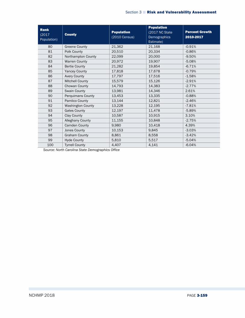
Section 3 Risk and Vulnerability Assessment
NCHMP 2018 PAGE 3-159
Rank (2017 Population)
County Population (2010 Census)
Population (2017 NC State Demographics Estimate)
Percent Growth 2010-2017
80 Greene County 21,362 21,168 -0.91% 81 Polk County 20,510 20,334 -0.86% 82 Northampton County 22,099 20,000 -9.50% 83 Warren County 20,972 19,907 -5.08% 84 Bertie County 21,282 19,854 -6.71% 85 Yancey County 17,818 17,678 -0.79% 86 Avery County 17,797 17,516 -1.58% 87 Mitchell County 15,579 15,126 -2.91% 88 Chowan County 14,793 14,383 -2.77% 89 Swain County 13,981 14,346 2.61% 90 Perquimans County 13,453 13,335 -0.88% 91 Pamlico County 13,144 12,821 -2.46% 92 Washington County 13,228 12,195 -7.81% 93 Gates County 12,197 11,478 -5.89% 94 Clay County 10,587 10,915 3.10% 95 Alleghany County 11,155 10,848 -2.75% 96 Camden County 9,980 10,418 4.39% 97 Jones County 10,153 9,845 -3.03% 98 Graham County 8,861 8,558 -3.42% 99 Hyde County 5,810 5,517 -5.04%
100 Tyrrell County 4,407 4,141 -6.04% Source: North Carolina State Demographics Office

Section 3 Risk and Vulnerability Assessment
NCHMP 2018 PAGE 3-160
3.4.1.2 Projected Population Growth The State Demographics Office also produces population growth estimates for each county. Table 3-26 provides a summary of projected population growth rates through 2036.
Table 3-26 North Carolina Population Growth Estimates Through 2036
Population
County July 2010 July 2015 July 2020 July 2025 July 2030 July 2035 July 2036
Alamance 151,582 157,522 167,375 177,741 188,157 198,573 200,656
Alexander 37,255 37,952 38,405 38,745 38,999 39,189 39,219
Alleghany 11,146 11,190 11,517 11,844 12,173 12,499 12,566
Anson 26,868 26,155 26,156 26,157 26,157 26,157 26,156
Ashe 27,250 27,332 27,086 26,876 26,728 26,625 26,608
Avery 17,745 17,816 17,912 18,007 18,102 18,199 18,216
Beaufort 47,781 47,829 47,827 47,826 47,827 47,827 47,828
Bertie 21,217 20,533 20,010 19,502 18,996 18,490 18,388
Bladen 35,159 35,011 35,009 35,013 35,010 35,011 35,012
Brunswick 108,181 123,535 138,430 154,332 170,230 186,128 189,307
Buncombe 238,801 254,836 270,328 285,823 301,321 316,816 319,915
Burke 90,688 89,114 89,727 90,003 90,124 90,179 90,185
Cabarrus 178,652 195,714 217,101 238,084 258,895 279,779 283,952
Caldwell 82,955 82,577 83,109 83,411 83,577 83,666 83,680
Camden 9,983 10,224 10,223 10,223 10,224 10,223 10,222
Carteret 66,693 69,826 71,265 72,706 74,146 75,584 75,874
Caswell 23,683 23,606 23,612 23,613 23,614 23,612 23,612
Catawba 154,315 155,828 157,209 158,588 159,969 161,349 161,626
Chatham 63,783 71,815 78,625 85,438 92,249 99,058 100,421
Cherokee 27,428 27,770 28,094 28,316 28,502 28,654 28,681
Chowan 14,745 14,541 13,932 13,321 12,711 12,102 11,979
Clay 10,583 11,036 11,294 11,543 11,778 12,003 12,049
Cleveland 97,987 97,871 98,334 98,544 98,637 98,681 98,687
Columbus 57,918 57,206 57,089 57,090 57,088 57,090 57,089
Craven 104,184 103,691 101,893 101,074 100,714 100,556 100,539
Cumberland 327,331 328,860 325,775 325,216 325,117 325,101 325,102
Currituck 23,663 25,627 28,473 31,319 34,164 37,012 37,581
Dare 33,987 36,001 37,798 39,083 40,005 40,664 40,772
Davidson 162,886 165,193 169,118 173,068 177,018 180,969 181,759
Davie 41,281 41,743 42,975 44,208 45,441 46,674 46,920
Duplin 58,678 59,868 59,866 59,866 59,866 59,866 59,867
Durham 271,382 297,219 322,728 348,110 373,364 398,490 403,500
Edgecombe 56,637 54,367 53,777 53,188 52,596 52,006 51,887
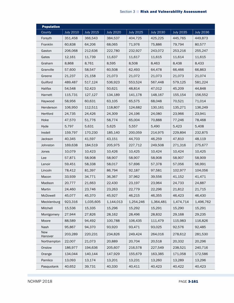
Section 3 Risk and Vulnerability Assessment
NCHMP 2018 PAGE 3-161
Population
County July 2010 July 2015 July 2020 July 2025 July 2030 July 2035 July 2036
Forsyth 351,458 366,543 384,537 404,725 425,225 445,765 449,873
Franklin 60,838 64,206 68,065 71,976 75,886 79,794 80,577
Gaston 206,068 212,636 222,780 232,927 243,072 253,216 255,247
Gates 12,161 11,739 11,637 11,617 11,615 11,614 11,615
Graham 8,868 8,761 8,595 8,508 8,463 8,438 8,433
Granville 57,600 58,547 60,508 62,493 64,478 66,466 66,863
Greene 21,237 21,158 21,073 21,072 21,073 21,073 21,074
Guilford 489,487 517,124 536,923 553,524 567,448 579,125 581,224
Halifax 54,548 52,423 50,621 48,814 47,012 45,209 44,848
Harnett 115,731 127,127 134,189 141,178 148,167 155,154 156,552
Haywood 58,956 60,631 63,105 65,575 68,048 70,521 71,014
Henderson 106,950 112,511 118,807 124,682 130,161 135,271 136,249
Hertford 24,735 24,426 24,309 24,196 24,080 23,966 23,941
Hoke 47,570 51,776 58,774 65,004 70,888 77,246 78,468
Hyde 5,797 5,631 5,625 5,557 5,490 5,423 5,408
Iredell 159,797 170,230 185,140 200,059 214,975 229,894 232,875
Jackson 40,345 41,597 43,151 44,703 46,259 47,810 48,119
Johnston 169,638 184,519 205,975 227,712 249,508 271,316 275,677
Jones 10,079 10,423 10,426 10,425 10,424 10,424 10,425
Lee 57,871 58,908 58,907 58,907 58,908 58,907 58,909
Lenoir 59,451 58,338 58,017 57,696 57,378 57,056 56,991
Lincoln 78,412 81,397 86,794 92,187 97,581 102,977 104,056
Macon 33,939 34,771 36,367 37,962 39,556 41,152 41,471
Madison 20,777 21,663 22,430 23,197 23,964 24,733 24,887
Martin 24,460 23,746 23,263 22,779 22,296 21,812 21,715
McDowell 45,077 45,370 45,927 46,215 46,355 46,423 46,430
Mecklenburg 923,316 1,035,605 1,144,013 1,254,246 1,364,481 1,474,714 1,496,762
Mitchell 15,536 15,335 15,296 15,292 15,291 15,290 15,291
Montgomery 27,944 27,826 28,162 28,496 28,832 29,168 29,235
Moore 88,589 94,492 100,788 106,435 111,479 115,983 116,826
Nash 95,867 94,370 93,920 93,471 93,025 92,576 92,485 New Hanover 203,289 220,231 234,826 249,424 264,016 278,612 281,530
Northampton 22,007 21,073 20,889 20,704 20,518 20,332 20,296
Onslow 186,977 194,636 205,607 216,578 227,549 238,521 240,716
Orange 134,044 140,144 147,929 155,679 163,385 171,058 172,586
Pamlico 13,093 13,174 13,201 13,231 13,260 13,289 13,296
Pasquotank 40,652 39,731 40,330 40,411 40,423 40,422 40,423
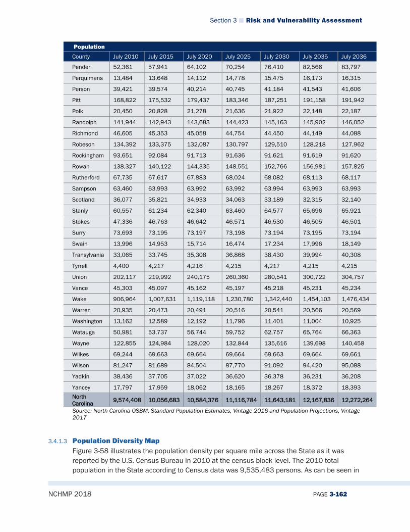
Section 3 Risk and Vulnerability Assessment
NCHMP 2018 PAGE 3-162
Population
County July 2010 July 2015 July 2020 July 2025 July 2030 July 2035 July 2036
Pender 52,361 57,941 64,102 70,254 76,410 82,566 83,797
Perquimans 13,484 13,648 14,112 14,778 15,475 16,173 16,315
Person 39,421 39,574 40,214 40,745 41,184 41,543 41,606
Pitt 168,822 175,532 179,437 183,346 187,251 191,158 191,942
Polk 20,450 20,828 21,278 21,636 21,922 22,148 22,187
Randolph 141,944 142,943 143,683 144,423 145,163 145,902 146,052
Richmond 46,605 45,353 45,058 44,754 44,450 44,149 44,088
Robeson 134,392 133,375 132,087 130,797 129,510 128,218 127,962
Rockingham 93,651 92,084 91,713 91,636 91,621 91,619 91,620
Rowan 138,327 140,122 144,335 148,551 152,766 156,981 157,825
Rutherford 67,735 67,617 67,883 68,024 68,082 68,113 68,117
Sampson 63,460 63,993 63,992 63,992 63,994 63,993 63,993
Scotland 36,077 35,821 34,933 34,063 33,189 32,315 32,140
Stanly 60,557 61,234 62,340 63,460 64,577 65,696 65,921
Stokes 47,336 46,763 46,642 46,571 46,530 46,505 46,501
Surry 73,693 73,195 73,197 73,198 73,194 73,195 73,194
Swain 13,996 14,953 15,714 16,474 17,234 17,996 18,149
Transylvania 33,065 33,745 35,308 36,868 38,430 39,994 40,308
Tyrrell 4,400 4,217 4,216 4,215 4,217 4,215 4,215
Union 202,117 219,992 240,175 260,360 280,541 300,722 304,757
Vance 45,303 45,097 45,162 45,197 45,218 45,231 45,234
Wake 906,964 1,007,631 1,119,118 1,230,780 1,342,440 1,454,103 1,476,434
Warren 20,935 20,473 20,491 20,516 20,541 20,566 20,569
Washington 13,162 12,589 12,192 11,796 11,401 11,004 10,925
Watauga 50,981 53,737 56,744 59,752 62,757 65,764 66,363
Wayne 122,855 124,984 128,020 132,844 135,616 139,698 140,458
Wilkes 69,244 69,663 69,664 69,664 69,663 69,664 69,661
Wilson 81,247 81,689 84,504 87,770 91,092 94,420 95,088
Yadkin 38,436 37,705 37,022 36,620 36,378 36,231 36,208
Yancey 17,797 17,959 18,062 18,165 18,267 18,372 18,393 North Carolina 9,574,408 10,056,683 10,584,376 11,116,784 11,643,181 12,167,836 12,272,264
Source: North Carolina OSBM, Standard Population Estimates, Vintage 2016 and Population Projections, Vintage 2017
3.4.1.3 Population Diversity Map Figure 3-58 illustrates the population density per square mile across the State as it was reported by the U.S. Census Bureau in 2010 at the census block level. The 2010 total population in the State according to Census data was 9,535,483 persons. As can be seen in

Section 3 Risk and Vulnerability Assessment
NCHMP 2018 PAGE 3-163
the figure, a majority of the State has less than 100 people per square mile, and Mecklenburg and Wake Counties have the highest population concentrations in the state. More specific information on the estimated number of people living within identified hazard areas is provided throughout this section.
Figure 3-64 Population Density in North Carolina
3.4.1.4 State Collected Synthetic Census Data NCEM’s Risk Management department purchased RTI International’s U.S. Synthetic Household Population™ dataset. This data provides an accurate representation of the complete household and person population throughout the United States. The database includes locations and descriptive sociodemographic attributes derived from completely public data sources. It statistically matches the real household population and contains no personally identifiable information. One of the primary goals of the data is to create a dot for every person and every home. NCEM-RM has worked to associate those dots with specific buildings in the statewide building inventory developed by NCEM-RM. For this version of the State Plan update, the synthetic populations data was used to evaluate how vulnerability changes for the fixed nuclear radiological hazard. For future updates of this plan, Risk Mitigation staff will work to conduct analyses that will provide summaries of risk associated with changes in day and night-time populations and differences in seasonal populations.

Section 3 Risk and Vulnerability Assessment
NCHMP 2018 PAGE 3-164
3.4.1.5 Social Vulnerability In addition to identifying those assets potentially at risk to identified hazards, it is important to identify and assess those particular segments of the resident population in the State that are potentially at risk to these hazards. Figure 3-59 provides social vulnerability results for the State as developed by the University of South Carolina’s Hazards and Vulnerability Research Institute. Their method of evaluating 29 socioeconomic variables was used to indicate where there is potential social vulnerability when comparing counties to other counties nationally and against other counties in North Carolina. On the national level, most of the counties in the State fall within the “low” and “medium-low” social vulnerability category when compared with other counties in the country. In comparing North Carolina counties against themselves, counties in the mountains and in the coastal plain are more socially vulnerable than those in the piedmont.

Section 3 Risk and Vulnerability Assessment
NCHMP 2018 PAGE 3-165
Figure 3-65 Social Vulnerability of the State of North Carolina

Section 3 Risk and Vulnerability Assessment
NCHMP 2018 PAGE 3-166
3.4.2 Land Use and Development
3.4.2.1 Changes in the Past Ten Years With changes in population come changes in land use and development patterns. As a result, land use and development patterns in North Carolina continue to change. In some places this growth is more rapid than others. This section explores changes in land uses in general terms for three different regions, which include the mountains, piedmont and coastal plain. From 2007 to 2017, most of the mountain and coastal plain counties remained rural. Agriculture and forestry are important economic activities in both parts of the state. Tourism is especially important to the economy of the mountains and the coast. The fishing industry is important along the coast. There are few urban counties in either area. Only Buncombe (Asheville) in the mountains, and Cumberland (Fayetteville) and New Hanover (Wilmington) on the coastal plain are predominantly urban. The piedmont region is in the central part of the state and includes 32 counties. North Carolina’s biggest cities are in the piedmont. Ten piedmont counties are largely urban—Alamance, Cabarrus, Catawba, Durham, Forsyth, Gaston, Guilford, Mecklenburg, Orange, and Wake. The remaining piedmont counties are largely rural. Farming is a more important part of the economy in the eastern piedmont counties than in the western piedmont. Manufacturing (especially of textiles, clothing and furniture) is particularly important in the western piedmont counties, where even many rural counties have a considerable amount of industry. New Residents, New Jobs Three kinds of development contributed most to population growth in North Carolina counties during the second half of the twentieth century. New and rapidly expanding businesses created jobs and led to increased population in some counties. Much of this kind of growth occurred in the piedmont, with Mecklenburg and Wake counties having the greatest population increase. Military base development contributed much to the population growth in some coastal plain counties, especially Cumberland (Fort Bragg) and Onslow (Camp LeJeune). Resort and retirement community developments also contributed to major population growth in several counties, particularly in the mountains (Henderson, Watauga) and at the beach (Brunswick, Currituck, Dare). In each case, additional jobs were also created as people moved into these developing counties. Whether they came to take jobs created by expanding businesses, to serve on military bases, or to retire, new residents needed housing, food, clothing, banking and other goods and services. This need led to the expansion of other businesses and to the creation of additional jobs. As a result of the development of new jobs, people in counties with population growth generally have higher incomes than those who live in counties with little or no population growth. Population growth creates the need for additional government services. Not only are there more people to be served, but the kinds of services needed may also change as the population increases. For example, housing developments are springing up along the North

Section 3 Risk and Vulnerability Assessment
NCHMP 2018 PAGE 3-167
Carolina countryside, creating some of the same problems that cities experience. Many counties have begun providing water, sewers, and other services to housing developments in unincorporated areas. New school buildings and other public facilities are also needed as the population increases. County governments must pay for these new facilities and hire new employees to serve their larger population. Needs of Counties That Have Not Grown In North Carolina, many counties that are primarily agricultural had little population growth or even experienced a decrease in population in the second half of the 20th century. Machines replaced people for many farming operations, including tobacco and cotton during this period. In 1947, 42 percent of North Carolinians worked in agriculture. A 2016 report produced by North Carolina State University indicates that the number of number is now at 17 percent36. In some rural counties, manufacturing or tourist jobs replaced agricultural jobs. In other counties, however, there were few new jobs to replace those lost on the farms. These are the counties that lost population or had little population growth. These are also the counties where per capita income is lowest. Counties with constant or declining population often have special problems. High unemployment and low wages mean that a larger proportion of the population needs financial assistance and health care from the county government. At the same time, poorer people pay less in taxes. A county with a low per capita income may have trouble raising funds to assist its needy residents. (Excerpted in part from Local Government in North Carolina by Gordon P. Whitaker. 2003. North Carolina City and County Management Association.) Growth pressures and rapid expansion can affect how willing or able a local government is to respond to changes in vulnerability as populations increase. Pressure to build in remaining open space may lead some counties to allow development to encroach on floodplains and other hazardous areas. Counties and municipalities must be careful to provide services, such as water and sewer, to support new development only in areas that are not hazardous. Counties with declining populations must not be so eager to grow that they, too, encourage new development in inappropriate areas.
3.4.2.2 Current Conditions Statewide there are areas that have been experiencing steady growth and development and some areas that have experienced population loss between 2010 and 2017. Brunswick, Wake, Mecklenburg, Durham, Harnett, Chatham, Hoke, Johnston, Cabarrus, Pender, Union and New Hanover Counties have all experienced greater than 10% population increases and can be expected to have higher rates of development when compared to the rest of the State, resulting in an increased number of structures that are vulnerable to the potential
36 2016 State Agribusiness Values – Michael L. Walden. PhD.

Section 3 Risk and Vulnerability Assessment
NCHMP 2018 PAGE 3-168
impacts of the identified hazards. Therefore, development and population growth have impacted the State’s vulnerability since the previous State hazard mitigation plan was approved and there has been an increase in the overall vulnerability.
3.4.2.3 Projected Future Changes It is also important to note that as development increases in the future, greater populations and more structures and infrastructure will be exposed to potential hazards if development occurs in hazard areas. According to the Office of State Budget and Management, North Carolina counties where growth rates are anticipated to be greater than 10% between 2010 and 2020 include the following: Alamance (10.9%), Brunswick (31.7%), Buncombe (13.7%), Cabarrus (22.1%), Chatham (25.2%), Cherokee (12.8%), Clay (13.1%), Currituck (19.4%), Dare (11.6%), Durham (18.6%), Franklin (15.2%), Harnett (19.9%), Henderson (13.6%), Hoke (23.7%), Iredell (16.7%), Jackson (11.1%), Johnston (24.9%), Lincoln (11.9%), Madison (10.9%), Mecklenburg (24.3%), Moore (15.6%), New Hanover (17.5%), Onslow (13.5%), Pender (24.4%), Swain (10.4%), Union (19.7%), Wake (24.0%), Watauga (16.9%). Statewide, the growth rate is expected to be 11.4% with the majority of counties expected to experience some form of growth. Twenty-seven (27) counties are expected to lose population during this same time period.
3.4.3 Economic Vulnerability As has been experienced in recent events such as Hurricane Matthew and the 2016 wildfires, economic impacts as a result of natural hazards can be significant. Economic losses following a disaster can be very detrimental to the vitality of a community and to the State as a whole. One methodology for determining economic vulnerability is to identify the major employers in the State, evaluate the types of businesses and the locations of those major employers, and take into consideration factors that may already be contributing to distressing a local economy and consider how a hazard event might exacerbate those conditions.
3.4.3.1 Major Employers The top 25 employers in North Carolina, as of first quarter 2017 employment size are included in the table below.
Table 3-27 Top 25 NC Employers as of Q1 2017 by Employment Size
Name Industry 1. Walmart Associates Inc Retail Trade 2. Duke University Educational Services 3. Food Lion Retail Trade 4. Wells Fargo Bank NA Finance and Insurance 5. Lowes Home Centers Inc Retail Trade 6. Bank of America Finance and Insurance 7. Harris Teeter LLC Retail Trade 8. Branch Banking and Trust Co Finance and Insurance 9. American Airlines Inc Transportation and Warehousing 10. Smithfield Foods Manufacturing 11. Ingles Markets, Inc Retail Trade 12. United Parcel Service Inc Transportation and Warehousing 13. Charter Communications Inc Information

Section 3 Risk and Vulnerability Assessment
NCHMP 2018 PAGE 3-169
Name Industry 14. Wakemed Health and Hospitals Health Care and Social Assistance 15. Wake Forest University Baptist Medical Center Health Care and Social Assistance 16. Compass Group USA Inc Accommodation and Food Service 17. Memorial Mission Hospital Inc Health Care and Social Assistance 18. Cone Health Health Care and Social Assistance 19. Target Corporation Retail Trade 20. Laboratory Corporation of America Health Care and Social Assistance 21. Belk Inc Retail Trade 22. AT&T Services Inc Information 23. International Business Machines Corp Manufacturing 24. Lowes Foods LLC Retail Trade 25. Home Depot USA Inc Retail Trade
3.4.3.2 Locations Most of the top employers in the State are located in multiple places of business across the State. For example, Wal Marts, Food Lions and many of the banks listed above can be found in most urban area and even in some more rural locations. Therefore, it is difficult to get a clear picture on the number of these specific locations that are vulnerable to hazards.
3.4.3.3 Type of Employers The major types of employers in North Carolina fall into one of the following categories: Retail Trade (9) Health Care and Social Assistance (5) Finance and Insurance (3) Transportation and Warehousing (2) Manufacturing (2) Information (2) Accommodation and Food Service (1) Educational Services (1)
The number listed in parenthesis by the employment sector represents the number of Top 25 businesses in North Carolina that are in that sector.
3.4.3.4 Development Since 2007, the North Carolina Department of Commerce has used a three-level system for designating development tiers and determining county economic distress rankings. These state-mandated designations help determine state funding opportunities to aid economic development and assigns each county a designation of Tier One (most distressed), Tier Two, or Tier Three (least distressed). To determine a county’s ranking, four factors are assessed: Average unemployment rate for the most recent twelve months Median household income for the most recent twelve months Percentage growth in population for the most recent 36 months Adjusted property tax base per capita for the most recent taxable year
Each county is ranked from 1 (most distressed) to 100 (least distressed) based on the above variable assessments. Tier 1 consists of the lowest ranking 40 counties, Tier 2 contains the

Section 3 Risk and Vulnerability Assessment
NCHMP 2018 PAGE 3-170
middle 40 counties, and Tier 3 is designated to the remaining 20 counties. A county may be automatically qualified as Tier 1 if the county: Is a Tier 1 county for at least 2 consecutive years Has a population of less than 12,000 people Has a population of less than 50,000 and a poverty rate of 19% or higher.
Figure 3-60 below displays county tier designations for 2018.
Figure 3-66 2018 County Tier Designations
Source: NC Department of Commerce Table 3-28 displays a list of each county’s economic distress ranking and tier designations.
Table 3-28 2018 County Development Tier Rankings
County Economic Distress Rank (#1 = most distressed) 2018 Tiers Alamance 64 2 Alexander 60 2 Alleghany 47 1 Anson 11 1 Ashe 56 1 Avery 68 2 Beaufort 43 2 Bertie 4 1 Bladen 11 1

Section 3 Risk and Vulnerability Assessment
NCHMP 2018 PAGE 3-171
County Economic Distress Rank (#1 = most distressed) 2018 Tiers Brunswick 80 3 Buncombe 90 3 Burke 52 2 Cabarrus 94 3 Caldwell 41 2 Camden 77 1 Carteret 78 3 Caswell 22 1 Catawba 62 2 Chatham 100 3 Cherokee 54 1 Chowan 27 1 Clay 66 1 Cleveland 38 2 Columbus 10 1 Craven 49 2 Cumberland 20 2 Currituck 98 2 Dare 76 2 Davidson 68 2 Davie 79 2 Duplin 23 2 Durham 92 3 Edgecombe 1 1 Forsyth 72 2 Franklin 70 2 Gaston 58 2 Gates 42 1 Graham 25 1 Granville 74 3 Greene 15 1 Guilford 70 2 Halifax 2 1 Harnett 50 2 Haywood 81 3 Henderson 91 3 Hertford 9 1 Hoke 34 2 Hyde 21 1 Iredell 95 3 Jackson 75 1 Johnston 86 3 Jones 31 1 Lee 44 2 Lenoir 14 1 Lincoln 85 3 Macon 73 1 Madison 61 2 Martin 15 1 McDowell 51 1 Mecklenburg 92 3 Mitchell 32 1
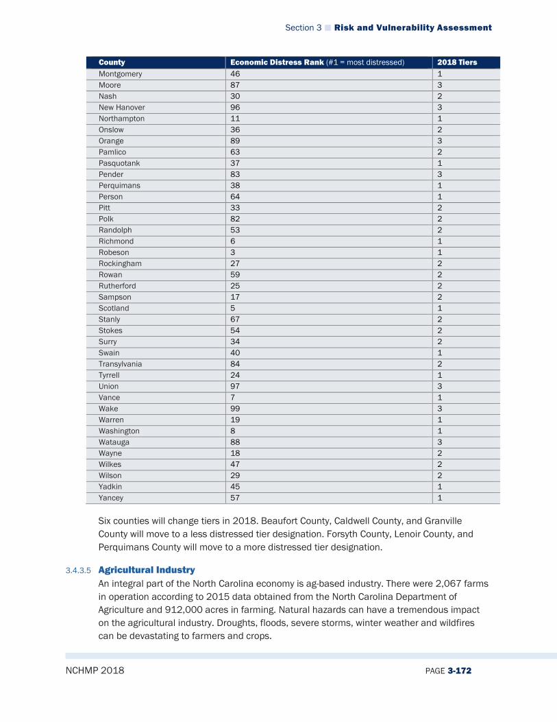
Section 3 Risk and Vulnerability Assessment
NCHMP 2018 PAGE 3-172
County Economic Distress Rank (#1 = most distressed) 2018 Tiers Montgomery 46 1 Moore 87 3 Nash 30 2 New Hanover 96 3 Northampton 11 1 Onslow 36 2 Orange 89 3 Pamlico 63 2 Pasquotank 37 1 Pender 83 3 Perquimans 38 1 Person 64 1 Pitt 33 2 Polk 82 2 Randolph 53 2 Richmond 6 1 Robeson 3 1 Rockingham 27 2 Rowan 59 2 Rutherford 25 2 Sampson 17 2 Scotland 5 1 Stanly 67 2 Stokes 54 2 Surry 34 2 Swain 40 1 Transylvania 84 2 Tyrrell 24 1 Union 97 3 Vance 7 1 Wake 99 3 Warren 19 1 Washington 8 1 Watauga 88 3 Wayne 18 2 Wilkes 47 2 Wilson 29 2 Yadkin 45 1 Yancey 57 1
Six counties will change tiers in 2018. Beaufort County, Caldwell County, and Granville County will move to a less distressed tier designation. Forsyth County, Lenoir County, and Perquimans County will move to a more distressed tier designation.
3.4.3.5 Agricultural Industry An integral part of the North Carolina economy is ag-based industry. There were 2,067 farms in operation according to 2015 data obtained from the North Carolina Department of Agriculture and 912,000 acres in farming. Natural hazards can have a tremendous impact on the agricultural industry. Droughts, floods, severe storms, winter weather and wildfires can be devastating to farmers and crops.
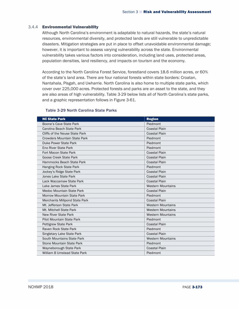
Section 3 Risk and Vulnerability Assessment
NCHMP 2018 PAGE 3-173
3.4.4 Environmental Vulnerability Although North Carolina’s environment is adaptable to natural hazards, the state’s natural resources, environmental diversity, and protected lands are still vulnerable to unpredictable disasters. Mitigation strategies are put in place to offset unavoidable environmental damage; however, it is important to assess varying vulnerability across the state. Environmental vulnerability takes various factors into consideration, including land uses, protected areas, population densities, land resiliency, and impacts on tourism and the economy. According to the North Carolina Forest Service, forestland covers 18.6 million acres, or 60% of the state’s land area. There are four national forests within state borders: Croatan, Nantahala, Pisgah, and Uwharrie. North Carolina is also home to multiple state parks, which cover over 225,000 acres. Protected forests and parks are an asset to the state, and they are also areas of high vulnerability. Table 3-29 below lists all of North Carolina’s state parks, and a graphic representation follows in Figure 3-61.
Table 3-29 North Carolina State Parks
NC State Park Region Boone’s Cave State Park Piedmont Carolina Beach State Park Coastal Plain Cliffs of the Neuse State Park Coastal Plain Crowders Mountain State Park Piedmont Duke Power State Park Piedmont Eno River State Park Piedmont Fort Macon State Park Coastal Plain Goose Creek State Park Coastal Plain Hammocks Beach State Park Coastal Plain Hanging Rock State Park Piedmont Jockey’s Ridge State Park Coastal Plain Jones Lake State Park Coastal Plain Lack Waccamaw State Park Coastal Plain Lake James State Park Western Mountains Medoc Mountain State Park Coastal Plain Morrow Mountain State Park Piedmont Merchants Millpond State Park Coastal Plain Mt. Jefferson State Park Western Mountains Mt. Mitchell State Park Western Mountains New River State Park Western Mountains Pilot Mountain State Park Piedmont Pettigrew State Park Coastal Plain Raven Rock State Park Piedmont Singletary Lake State Park Coastal Plain South Mountains State Park Western Mountains Stone Mountain State Park Piedmont Wayneborough State Park Coastal Plain William B Umstead State Park Piedmont
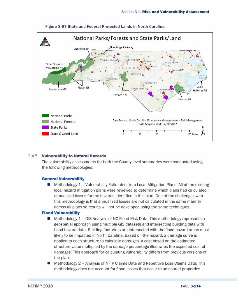
Section 3 Risk and Vulnerability Assessment
NCHMP 2018 PAGE 3-174
Figure 3-67 State and Federal Protected Lands in North Carolina
3.4.5 Vulnerability to Natural Hazards The vulnerability assessments for both the County-level summaries were conducted using the following methodologies: General Vulnerability Methodology 1 – Vulnerability Estimates from Local Mitigation Plans: All of the existing
local hazard mitigation plans were reviewed to determine which plans had calculated annualized losses for the hazards identified in this plan. One of the challenges with this methodology is that annualized losses are not calculated in the same manner across all plans so results will not be developed using the same techniques.
Flood Vulnerability Methodology 1 – GIS Analysis of NC Flood Risk Data: This methodology represents a
geospatial approach using multiple GIS datasets and intersecting building data with flood hazard data. Building footprints are intersected with the flood hazard areas most likely to be impacted in North Carolina. Based on the hazard, a damage curve is applied to each structure to calculate damages. A cost based on the estimated structure value multiplied by the damage percentage illustrates the expected cost of damages. This approach for calculating vulnerability differs from previous versions of the plan.
Methodology 2 – Analysis of NFIP Claims Data and Repetitive Loss Claims Data: This methodology does not account for flood losses that occur to uninsured properties

Section 3 Risk and Vulnerability Assessment
NCHMP 2018 PAGE 3-175
which are most often those properties located outside of the special flood hazard area.
Other Hazards Vulnerability Methodology 1 – GIS Analysis of NC Risk Data: This methodology was used for the
hurricane, earthquake, and tornado hazards and represents a geospatial approach using multiple GIS datasets and intersecting building data with hazard data. Building footprints are intersected with the hazard areas most likely to be impacted in North Carolina. Based on the hazard, a damage curve is applied to each structure to calculate damages. A cost based on the estimated structure value multiplied by the damage percentage illustrates the expected cost of damages. This approach for calculating vulnerability differs from previous versions of the plan.
Methodology 2 – GIS Hazard Area Overlay Analysis of NCEM-RM Building Data to Determine Exposure: This methodology was used for the coastal surge (as part of hurricanes), wildfire and geological hazards (landslide, sinkhole and coastal erosion).
Methodology 3 – Analysis of NCEI Data: This methodology was used for the severe winter weather, drought, tornado/severe thunderstorm hazards. Previous occurrence records from the NCEI database were evaluated and any reported dollar losses were inflated to 2017 dollars and calculations were made to determine how much damage (dollar losses) could be expected to occur during any given year.
3.4.5.1 General Vulnerability
The table on the following page provides annualized loss data as calculated and presented in the local hazard mitigation plans.
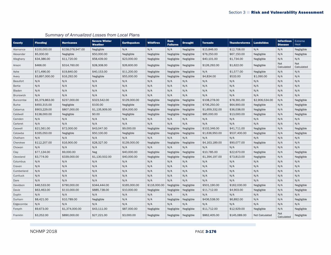
Section 3 Risk and Vulnerability Assessment
NCHMP 2018 PAGE 3-176
Summary of Annualized Losses from Local Plans County Flooding Hurricanes
Severe Winter Weather
Earthquakes Wildfires Dam Failures
Drought Tornado Thunderstorms Landslides Infectious Disease
Extreme Heat
Alamance $100,000.00 $158,078,947.00 Negligible N/A N/A N/A Negligible $15,846.00 $12,708.00 N/A N/A Negligible
Alexander $5,000.00 Negligible $50,000.00 Negligible Negligible Negligible Negligible $76,250.00 $67,150.00 Negligible N/A Negligible
Alleghany $34,386.00 $11,720.00 $58,439.00 $23,000.00 Negligible Negligible Negligible $40,101.00 $1,734.00 Negligible N/A N/A
Anson $466.00 $314,760.00 $28,308.00 $26,600.00 Negligible Negligible Negligible $126,292.00 $1,622.00 Negligible Not Calculated
Not Calculated
Ashe $71,496.00 $19,840.00 $40,153.00 $11,200.00 Negligible Negligible Negligible N/A $1,577.00 Negligible N/A N/A
Avery $3,897,000.00 $16,292.00 Negligible $55,000.00 Negligible Negligible Negligible $4,834.00 $533.00 $1,090.00 N/A N/A
Beaufort N/A N/A N/A N/A N/A N/A N/A N/A N/A N/A N/A N/A
Bertie N/A N/A N/A N/A N/A N/A N/A N/A N/A N/A N/A N/A
Bladen N/A N/A N/A N/A N/A N/A N/A N/A N/A N/A N/A N/A
Brunswick N/A N/A N/A N/A N/A N/A N/A N/A N/A N/A N/A N/A
Buncombe $5,379,863.00 $237,000.00 $323,542.00 $129,000.00 Negligible Negligible Negligible $108,278.00 $78,391.00 $2,906,534.00 N/A Negligible
Burke $450,315.00 Negligible $100.00 Negligible Negligible Negligible Negligible $706,250.00 $64,900.00 Negligible N/A Negligible
Cabarrus $903,229.00 $807,000.00 $1,135,909.00 $54,000.00 Negligible Negligible Negligible $1,659,332.00 $36,038.00 Negligible N/A Negligible
Caldwell $138,000.00 Negligible $0.00 Negligible Negligible Negligible Negligible $85,000.00 $13,000.00 Negligible N/A Negligible
Camden N/A N/A N/A N/A N/A N/A N/A N/A N/A N/A N/A N/A
Carteret N/A N/A N/A N/A N/A N/A N/A N/A N/A N/A N/A N/A
Caswell $21,561.00 $72,000.00 $43,047.00 $9,000.00 Negligible Negligible Negligible $102,346.00 $41,711.00 Negligible N/A Negligible
Catawba $165,050.00 Negligible $50,100.00 Negligible Negligible Negligible Negligible $1,636,950.00 $537,400.00 Negligible N/A Negligible
Chatham N/A N/A N/A N/A N/A N/A N/A N/A N/A N/A N/A N/A
Cherokee $112,207.00 $16,900.00 $28,327.00 $139,000.00 Negligible Negligible Negligible $4,163,189.00 $90,077.00 Negligible N/A N/A
Chowan N/A N/A N/A N/A N/A N/A N/A N/A N/A N/A N/A N/A
Clay $77,134.00 $9,000.00 Neg $40,000.00 Negligible Negligible Negligible $10,785.00 $22,670.00 Negligible N/A Negligible
Cleveland $3,774.00 $339,000.00 $1,130,502.00 $40,000.00 Negligible Negligible Negligible $1,394,197.00 $73,813.00 Negligible N/A Negligible
Columbus N/A N/A N/A N/A N/A N/A N/A N/A N/A N/A N/A N/A
Craven N/A N/A N/A N/A N/A N/A N/A N/A N/A N/A N/A N/A
Cumberland N/A N/A N/A N/A N/A N/A N/A N/A N/A N/A N/A N/A
Currituck N/A N/A N/A N/A N/A N/A N/A N/A N/A N/A N/A N/A
Dare N/A N/A N/A N/A N/A N/A N/A N/A N/A N/A N/A N/A
Davidson $46,533.00 $790,000.00 $344,444.00 $165,000.00 $116,000.00 Negligible Negligible $501,190.00 $162,030.00 Negligible N/A Negligible
Davie $63,463.00 $110,000.00 $885,738.00 $10,000.00 Negligible Negligible Negligible $11,712.00 $4,903.00 Negligible N/A Negligible
Duplin N/A N/A N/A N/A N/A N/A N/A N/A N/A N/A N/A N/A
Durham $8,421.00 $10,789.00 Negligible N/A N/A Negligible Negligible $436,538.00 $6,892.00 N/A N/A Negligible
Edgecombe N/A N/A N/A N/A N/A N/A N/A N/A N/A N/A N/A N/A
Forsyth $9,673.00 $1,374,000.00 $43,111.00 $87,000.00 Negligible Negligible Negligible $11,712.00 $12,929.00 Negligible N/A Negligible
Franklin $3,252.00 $890,000.00 $27,221.00 $3,000.00 Negligible Negligible Negligible $862,405.00 $145,089.00 Not Calculated Not Calculated Negligible

Section 3 Risk and Vulnerability Assessment
NCHMP 2018 PAGE 3-177
County Flooding Hurricanes Severe Winter Weather
Earthquakes Wildfires Dam Failures
Drought Tornado Thunderstorms Landslides Infectious Disease
Extreme Heat
Gaston $161,132.00 $805,000.00 $1,141,609.00 $79,000.00 Negligible $197.00 Negligible $1,442,814.00 $35,104.00 Negligible N/A Negligible
Gates N/A N/A N/A N/A N/A N/A N/A N/A N/A N/A N/A N/A
Graham $320,524.00 $5,500.00 $33,150.00 $47,300.00 Negligible Negligible Negligible $1,243,824.00 $95,638.00 Negligible N/A N/A
Granville $4,207.00 $517,000.00 $41,868.00 $3,000.00 Negligible Negligible Negligible $130,271.00 $12,129.00 Not Calculated Not Calculated Negligible
Greene N/A N/A N/A N/A N/A N/A N/A N/A N/A N/A N/A N/A
Guilford $147,647.00 $2,278,000.00 $454,297.00 $121,000.00 Negligible Negligible Negligible $2,871,725.00 $267,321.00 N/A Negligible Negligible
Halifax N/A N/A N/A N/A N/A N/A N/A N/A N/A N/A N/A N/A
Harnett N/A N/A N/A N/A N/A N/A N/A N/A N/A N/A N/A N/A
Haywood $464,639.00 $50,000.00 $206,620.00 $284,500.00 Negligible Negligible Negligible $1,078,897.00 $109,822.00 Negligible N/A N/A
Henderson $428,371.00 $151,000.00 $60,481.00 $51,000.00 Negligible Negligible Negligible $1,308.00 $59,712.00 $178,243.00 N/A Negligible
Hertford N/A N/A N/A N/A N/A N/A N/A N/A N/A N/A N/A N/A
Hoke N/A N/A N/A N/A N/A N/A N/A N/A N/A N/A N/A N/A
Hyde N/A N/A N/A N/A N/A N/A N/A N/A N/A N/A N/A N/A
Iredell $367,126.00 $522,000.00 $964,143.00 $47,000.00 Negligible Negligible Negligible $367,126.00 $51,348.00 Negligible N/A Negligible
Jackson $70,878.00 $26,300.00 $666,710.00 $189,800.00 Negligible Negligible Negligible $1,078,897.00 $107,691.00 Negligible N/A N/A
Johnston N/A N/A N/A N/A N/A N/A N/A N/A N/A N/A N/A N/A
Jones N/A N/A N/A N/A N/A N/A N/A N/A N/A N/A N/A N/A
Lee N/A N/A N/A N/A N/A N/A N/A N/A N/A N/A N/A N/A
Lenoir N/A N/A N/A N/A N/A N/A N/A N/A N/A N/A N/A N/A
Lincoln $46,246.00 $233,000.00 $796,460.00 $25,000.00 Negligible Negligible Negligible $1,216,069.00 $23,393.00 Negligible N/A Negligible
Macon $290,279.00 $40,000.00 Neg $177,000.00 Negligible Negligible Negligible $27,797.00 $49,911.00 $202,636.00 N/A Negligible
Madison $1,160,697.00 $13,000.00 $319,567.00 $10,000.00 Negligible Negligible Negligible $60,793.00 $51,740.00 Negligible N/A Negligible
Martin N/A N/A N/A N/A N/A N/A N/A N/A N/A N/A N/A N/A
McDowell $6,882,000.00 $42,728.00 Negligible $105,000.00 Negligible Negligible Negligible $7,953.00 $12,131.00 $5,856.00 N/A N/A
Mecklenburg $4,864,000.00 $6,921,500.00 $1,178,000.00 $1,235,000.00 $168,000.00 Negligible $792,000.00 $170,000.00 $286,000.00 Negligible N/A N/A
Mitchell $3,992,000.00 $13,491.00 Negligible $46,000.00 Negligible Negligible Negligible Negligible $66.00 $1,209.00 N/A N/A
Montgomery Not Calculated $378,300.00 Not Calculated $24,800.00 Negligible Negligible Negligible $207,046.00 $6,693.00 Negligible Not Calculated
Not Calculated
Moore N/A N/A N/A N/A N/A N/A N/A N/A N/A N/A N/A N/A
Nash N/A N/A N/A N/A N/A N/A N/A N/A N/A N/A N/A N/A
New Hanover N/A N/A N/A N/A N/A N/A N/A N/A N/A N/A N/A N/A
Northampton Not Calculated N/A N/A N/A N/A N/A N/A N/A N/A N/A N/A N/A
Onslow $485,000.00 $51,000,000.00 $8,529.00 Negligible Negligible Negligible Negligible $249,939.00 $4,645.00 Negligible Not Calculated Negligible
Orange $561,053.00 Negligible Negligible N/A N/A N/A Negligible Negligible $37,931.00 N/A N/A N/A
Pamlico N/A N/A N/A N/A N/A N/A N/A N/A N/A N/A N/A N/A
Pasquotank N/A N/A N/A N/A N/A N/A N/A N/A N/A N/A N/A N/A
Pender N/A N/A N/A N/A N/A N/A N/A N/A N/A N/A N/A N/A
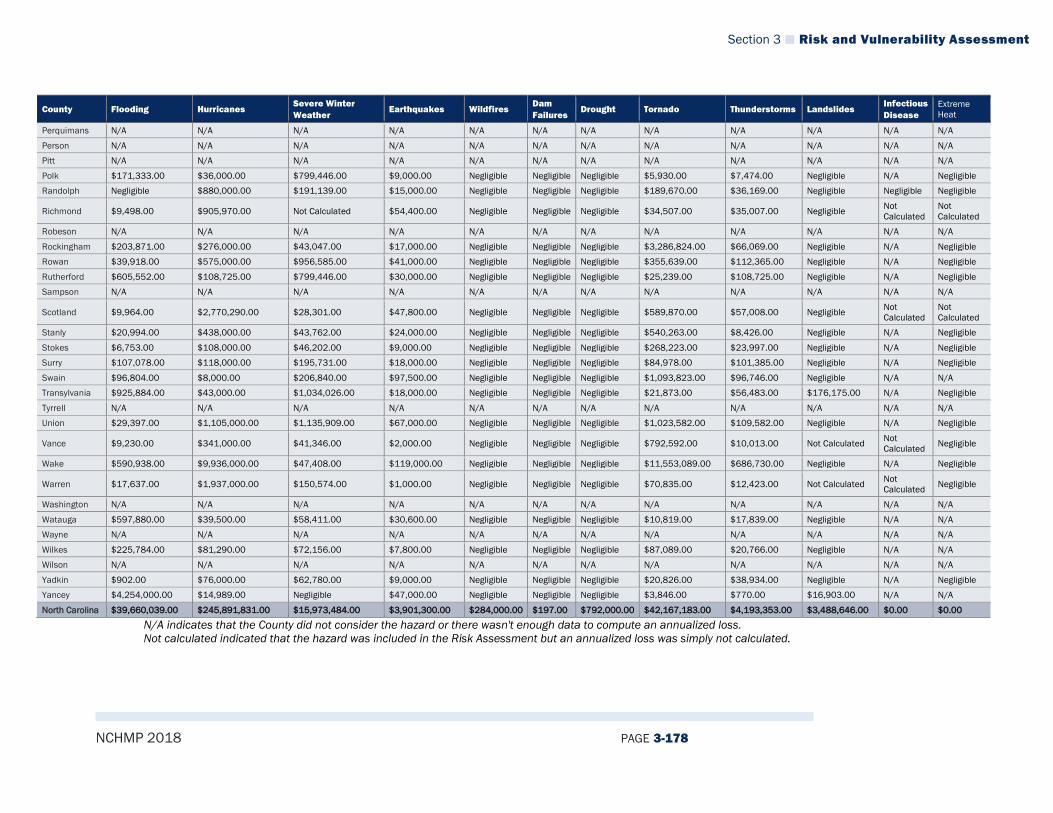
Section 3 Risk and Vulnerability Assessment
NCHMP 2018 PAGE 3-178
County Flooding Hurricanes Severe Winter Weather
Earthquakes Wildfires Dam Failures
Drought Tornado Thunderstorms Landslides Infectious Disease
Extreme Heat
Perquimans N/A N/A N/A N/A N/A N/A N/A N/A N/A N/A N/A N/A
Person N/A N/A N/A N/A N/A N/A N/A N/A N/A N/A N/A N/A
Pitt N/A N/A N/A N/A N/A N/A N/A N/A N/A N/A N/A N/A
Polk $171,333.00 $36,000.00 $799,446.00 $9,000.00 Negligible Negligible Negligible $5,930.00 $7,474.00 Negligible N/A Negligible
Randolph Negligible $880,000.00 $191,139.00 $15,000.00 Negligible Negligible Negligible $189,670.00 $36,169.00 Negligible Negligible Negligible
Richmond $9,498.00 $905,970.00 Not Calculated $54,400.00 Negligible Negligible Negligible $34,507.00 $35,007.00 Negligible Not Calculated
Not Calculated
Robeson N/A N/A N/A N/A N/A N/A N/A N/A N/A N/A N/A N/A
Rockingham $203,871.00 $276,000.00 $43,047.00 $17,000.00 Negligible Negligible Negligible $3,286,824.00 $66,069.00 Negligible N/A Negligible
Rowan $39,918.00 $575,000.00 $956,585.00 $41,000.00 Negligible Negligible Negligible $355,639.00 $112,365.00 Negligible N/A Negligible
Rutherford $605,552.00 $108,725.00 $799,446.00 $30,000.00 Negligible Negligible Negligible $25,239.00 $108,725.00 Negligible N/A Negligible
Sampson N/A N/A N/A N/A N/A N/A N/A N/A N/A N/A N/A N/A
Scotland $9,964.00 $2,770,290.00 $28,301.00 $47,800.00 Negligible Negligible Negligible $589,870.00 $57,008.00 Negligible Not Calculated
Not Calculated
Stanly $20,994.00 $438,000.00 $43,762.00 $24,000.00 Negligible Negligible Negligible $540,263.00 $8,426.00 Negligible N/A Negligible
Stokes $6,753.00 $108,000.00 $46,202.00 $9,000.00 Negligible Negligible Negligible $268,223.00 $23,997.00 Negligible N/A Negligible
Surry $107,078.00 $118,000.00 $195,731.00 $18,000.00 Negligible Negligible Negligible $84,978.00 $101,385.00 Negligible N/A Negligible
Swain $96,804.00 $8,000.00 $206,840.00 $97,500.00 Negligible Negligible Negligible $1,093,823.00 $96,746.00 Negligible N/A N/A
Transylvania $925,884.00 $43,000.00 $1,034,026.00 $18,000.00 Negligible Negligible Negligible $21,873.00 $56,483.00 $176,175.00 N/A Negligible
Tyrrell N/A N/A N/A N/A N/A N/A N/A N/A N/A N/A N/A N/A
Union $29,397.00 $1,105,000.00 $1,135,909.00 $67,000.00 Negligible Negligible Negligible $1,023,582.00 $109,582.00 Negligible N/A Negligible
Vance $9,230.00 $341,000.00 $41,346.00 $2,000.00 Negligible Negligible Negligible $792,592.00 $10,013.00 Not Calculated Not Calculated Negligible
Wake $590,938.00 $9,936,000.00 $47,408.00 $119,000.00 Negligible Negligible Negligible $11,553,089.00 $686,730.00 Negligible N/A Negligible
Warren $17,637.00 $1,937,000.00 $150,574.00 $1,000.00 Negligible Negligible Negligible $70,835.00 $12,423.00 Not Calculated Not Calculated Negligible
Washington N/A N/A N/A N/A N/A N/A N/A N/A N/A N/A N/A N/A
Watauga $597,880.00 $39,500.00 $58,411.00 $30,600.00 Negligible Negligible Negligible $10,819.00 $17,839.00 Negligible N/A N/A
Wayne N/A N/A N/A N/A N/A N/A N/A N/A N/A N/A N/A N/A
Wilkes $225,784.00 $81,290.00 $72,156.00 $7,800.00 Negligible Negligible Negligible $87,089.00 $20,766.00 Negligible N/A N/A
Wilson N/A N/A N/A N/A N/A N/A N/A N/A N/A N/A N/A N/A
Yadkin $902.00 $76,000.00 $62,780.00 $9,000.00 Negligible Negligible Negligible $20,826.00 $38,934.00 Negligible N/A Negligible
Yancey $4,254,000.00 $14,989.00 Negligible $47,000.00 Negligible Negligible Negligible $3,846.00 $770.00 $16,903.00 N/A N/A
North Carolina $39,660,039.00 $245,891,831.00 $15,973,484.00 $3,901,300.00 $284,000.00 $197.00 $792,000.00 $42,167,183.00 $4,193,353.00 $3,488,646.00 $0.00 $0.00
N/A indicates that the County did not consider the hazard or there wasn't enough data to compute an annualized loss. Not calculated indicated that the hazard was included in the Risk Assessment but an annualized loss was simply not calculated.

Section 3 Risk and Vulnerability Assessment
NCHMP 2018 PAGE 3-179
3.4.5.2 Vulnerability for State-Owned Facilities According to the North Carolina Department of Insurance, Office of State Fire Marshall’s Office, the North Carolina State-Owned Properties insures the State’s universities and colleges, government business services – transportation, parks, legislative, offices, etc., correctional facilities, ports authority, medical facilities, stadiums and arenas and college housing. The account has 14,310 locations with Total Insurable Values (TIV) of $38,038,303,059 as of 2017. The coastal, Tier 1 county value exposure is $2,464,303,095 or 6.48% of the TIV.” The North Carolina Department of Insurance reports that, according to two modeling programs (2016 AIR Worldwide Touchstone v3.1 and RMS’s RiskBrowser v15.0 models) State-Owned Property Losses based on worst case scenarios modeling, for 1,000-year hurricane event the cost would be $783,623,225; for a 20-year hurricane event the property loss would be $88,752,422; and annual average loss (AAL) is $16,910,600. These figures are based on total insured value of about $40 billion. UNC Campuses, Universities, UNC Hospitals represent about 73 % of the overall values or about $28 billion. The modeling programs used to determine those losses are proprietary and therefore, the details of the methodology used to develop those estimates cannot be provided in this document. Other vulnerability analyses were conducted by NCEM-RM and their contractors to determine vulnerability for state-owned facilities. Those methodologies are described in the hazard-specific vulnerability discussions found below.
3.4.5.3 Flood Hazard Vulnerability The State of North Carolina has developed advanced technology and continues to acquire tremendous amounts of data for the purposes of determining flood hazard vulnerability. This includes creating building footprints for every building in the State (for buildings greater than 500 square feet) and collecting first floor elevations for every building in the State. Having this data, and combining it with the digital flood data that has been developed, allows NCEM-RM to conduct detailed flood risk assessments that take into account the first-floor elevation of structures and associated depth of flooding (and associated damages). The 2018 plan update represents the first attempt at beginning to integrate the findings from that technology and data to determine county-level summaries of vulnerability. At this time, this plan will include county level vulnerability as calculated by annualized loss. Future updates of the plan will attempt to expand on this analysis by incorporating results from other return period flood events.
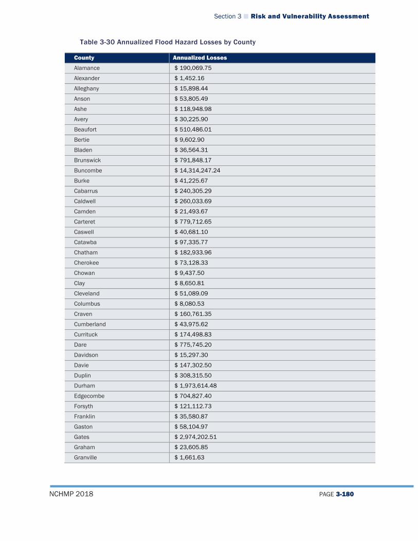
Section 3 Risk and Vulnerability Assessment
NCHMP 2018 PAGE 3-180
Table 3-30 Annualized Flood Hazard Losses by County
County Annualized Losses
Alamance $ 190,069.75
Alexander $ 1,452.16
Alleghany $ 15,898.44
Anson $ 53,805.49
Ashe $ 118,948.98
Avery $ 30,225.90
Beaufort $ 510,486.01
Bertie $ 9,602.90
Bladen $ 36,564.31
Brunswick $ 791,848.17
Buncombe $ 14,314,247.24
Burke $ 41,225.67
Cabarrus $ 240,305.29
Caldwell $ 260,033.69
Camden $ 21,493.67
Carteret $ 779,712.65
Caswell $ 40,681.10
Catawba $ 97,335.77
Chatham $ 182,933.96
Cherokee $ 73,128.33
Chowan $ 9,437.50
Clay $ 8,650.81
Cleveland $ 51,089.09
Columbus $ 8,080.53
Craven $ 160,761.35
Cumberland $ 43,975.62
Currituck $ 174,498.83
Dare $ 775,745.20
Davidson $ 15,297.30
Davie $ 147,302.50
Duplin $ 308,315.50
Durham $ 1,973,614.48
Edgecombe $ 704,827.40
Forsyth $ 121,112.73
Franklin $ 35,580.87
Gaston $ 58,104.97
Gates $ 2,974,202.51
Graham $ 23,605.85
Granville $ 1,661.63
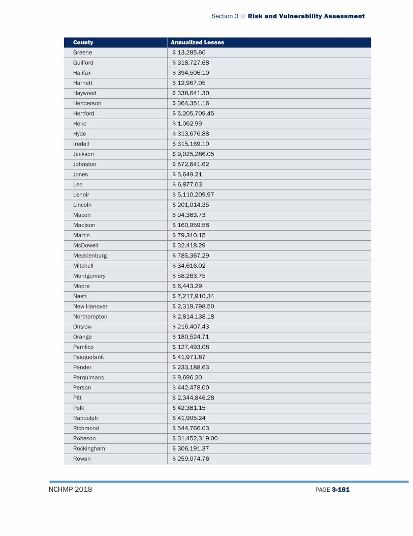
Section 3 Risk and Vulnerability Assessment
NCHMP 2018 PAGE 3-181
County Annualized Losses
Greene $ 13,285.60
Guilford $ 318,727.68
Halifax $ 394,506.10
Harnett $ 12,967.05
Haywood $ 338,641.30
Henderson $ 364,351.16
Hertford $ 5,205,709.45
Hoke $ 1,062.99
Hyde $ 313,676.88
Iredell $ 315,169.10
Jackson $ 9,025,286.05
Johnston $ 572,641.62
Jones $ 5,649.21
Lee $ 6,877.03
Lenoir $ 5,110,209.97
Lincoln $ 201,014.35
Macon $ 94,363.73
Madison $ 160,959.58
Martin $ 79,310.15
McDowell $ 32,418.29
Mecklenburg $ 785,367.29
Mitchell $ 34,616.02
Montgomery $ 58,263.75
Moore $ 6,443.29
Nash $ 7,217,910.34
New Hanover $ 2,319,798.50
Northampton $ 2,814,138.18
Onslow $ 216,407.43
Orange $ 180,524.71
Pamlico $ 127,493.08
Pasquotank $ 41,971.87
Pender $ 233,188.63
Perquimans $ 9,696.20
Person $ 442,478.00
Pitt $ 2,344,846.28
Polk $ 42,361.15
Randolph $ 41,905.24
Richmond $ 544,766.03
Robeson $ 31,452,319.00
Rockingham $ 306,191.37
Rowan $ 259,074.76

Section 3 Risk and Vulnerability Assessment
NCHMP 2018 PAGE 3-182
County Annualized Losses
Rutherford $ 176,093.67
Sampson $ 226,564.56
Scotland $ 131,796.69
Stanly $ 88,864.85
Stokes $ 999.47
Surry $ 385,351.30
Swain $ 18,272,384.76
Transylvania
Tyrrell $ 37,649.69
Union $ 16,835.26
Vance $ 5,576.70
Wake $ 921,373.19
Warren $ 770.91
Washington $ 5,580.94
Watauga $ 158,827.40
Wayne $ 676,092.57
Wilkes $ 511,849.81
Wilson $ 1,478,961.63
Yadkin $ 3,244.77
Yancey $ 67,057.72
North Carolina $ 120,618,328.43 Source: NCEM-RM
National Flood Insurance Program (NFIP) and Repetitive Loss Data According to FEMA records compiled as of September 30, 2017, there are 130,282 flood insurance policies in force in the state of North Carolina, with more than $32 billion in coverage and almost $ 108 million of annual premiums in force. There have been 83,390 claims under the NFIP totaling over $1.2 billion. 27,461 of those claims were closed without payment. Table 3-31 provides a summary of the NFIP policies and claims that have been made in North Carolina.
Table 3-31 North Carolina NFIP Policy and Claims Data
County Name Community Name
Policies in Force Insurance in Force
Total Losses Total Payments
Alamance Alamance County 50 $15,377,900.00 35 $824,801.65
Burlington 147 $31,209,900.00 44 $378,054.58
Elon 23 $5,880,100.00 2 $12,790.23
Gibsonville 29 $6,756,100.00 2 $0.00
Graham 45 $9,683,100.00 10 $63,752.71
Haw River 6 $899,200.00 1 $60,000.00
Mebane 41 $9,975,600.00 2 $4,622.05
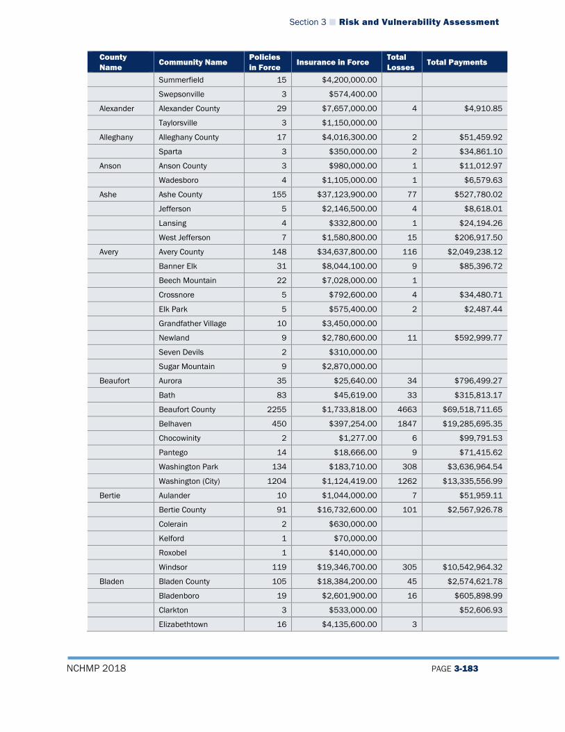
Section 3 Risk and Vulnerability Assessment
NCHMP 2018 PAGE 3-183
County Name
Community Name Policies in Force
Insurance in Force Total Losses
Total Payments
Summerfield 15 $4,200,000.00
Swepsonville 3 $574,400.00
Alexander Alexander County 29 $7,657,000.00 4 $4,910.85
Taylorsville 3 $1,150,000.00
Alleghany Alleghany County 17 $4,016,300.00 2 $51,459.92
Sparta 3 $350,000.00 2 $34,861.10
Anson Anson County 3 $980,000.00 1 $11,012.97
Wadesboro 4 $1,105,000.00 1 $6,579.63
Ashe Ashe County 155 $37,123,900.00 77 $527,780.02
Jefferson 5 $2,146,500.00 4 $8,618.01
Lansing 4 $332,800.00 1 $24,194.26
West Jefferson 7 $1,580,800.00 15 $206,917.50
Avery Avery County 148 $34,637,800.00 116 $2,049,238.12
Banner Elk 31 $8,044,100.00 9 $85,396.72
Beech Mountain 22 $7,028,000.00 1
Crossnore 5 $792,600.00 4 $34,480.71
Elk Park 5 $575,400.00 2 $2,487.44
Grandfather Village 10 $3,450,000.00
Newland 9 $2,780,600.00 11 $592,999.77
Seven Devils 2 $310,000.00
Sugar Mountain 9 $2,870,000.00
Beaufort Aurora 35 $25,640.00 34 $796,499.27
Bath 83 $45,619.00 33 $315,813.17
Beaufort County 2255 $1,733,818.00 4663 $69,518,711.65
Belhaven 450 $397,254.00 1847 $19,285,695.35
Chocowinity 2 $1,277.00 6 $99,791.53
Pantego 14 $18,666.00 9 $71,415.62
Washington Park 134 $183,710.00 308 $3,636,964.54
Washington (City) 1204 $1,124,419.00 1262 $13,335,556.99
Bertie Aulander 10 $1,044,000.00 7 $51,959.11
Bertie County 91 $16,732,600.00 101 $2,567,926.78
Colerain 2 $630,000.00
Kelford 1 $70,000.00
Roxobel 1 $140,000.00
Windsor 119 $19,346,700.00 305 $10,542,964.32
Bladen Bladen County 105 $18,384,200.00 45 $2,574,621.78
Bladenboro 19 $2,601,900.00 16 $605,898.99
Clarkton 3 $533,000.00 $52,606.93
Elizabethtown 16 $4,135,600.00 3
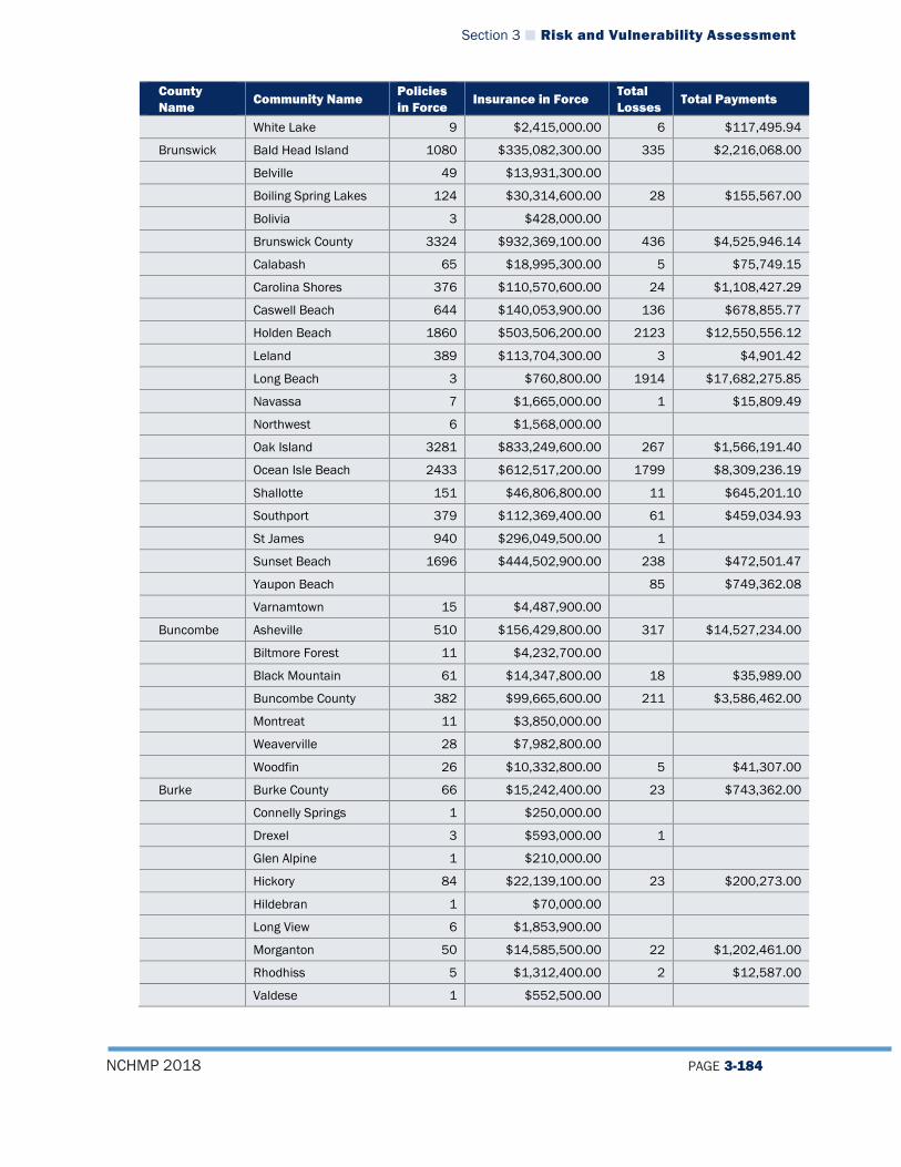
Section 3 Risk and Vulnerability Assessment
NCHMP 2018 PAGE 3-184
County Name
Community Name Policies in Force
Insurance in Force Total Losses
Total Payments
White Lake 9 $2,415,000.00 6 $117,495.94
Brunswick Bald Head Island 1080 $335,082,300.00 335 $2,216,068.00
Belville 49 $13,931,300.00
Boiling Spring Lakes 124 $30,314,600.00 28 $155,567.00
Bolivia 3 $428,000.00
Brunswick County 3324 $932,369,100.00 436 $4,525,946.14
Calabash 65 $18,995,300.00 5 $75,749.15
Carolina Shores 376 $110,570,600.00 24 $1,108,427.29
Caswell Beach 644 $140,053,900.00 136 $678,855.77
Holden Beach 1860 $503,506,200.00 2123 $12,550,556.12
Leland 389 $113,704,300.00 3 $4,901.42
Long Beach 3 $760,800.00 1914 $17,682,275.85
Navassa 7 $1,665,000.00 1 $15,809.49
Northwest 6 $1,568,000.00
Oak Island 3281 $833,249,600.00 267 $1,566,191.40
Ocean Isle Beach 2433 $612,517,200.00 1799 $8,309,236.19
Shallotte 151 $46,806,800.00 11 $645,201.10
Southport 379 $112,369,400.00 61 $459,034.93
St James 940 $296,049,500.00 1
Sunset Beach 1696 $444,502,900.00 238 $472,501.47
Yaupon Beach 85 $749,362.08
Varnamtown 15 $4,487,900.00
Buncombe Asheville 510 $156,429,800.00 317 $14,527,234.00
Biltmore Forest 11 $4,232,700.00
Black Mountain 61 $14,347,800.00 18 $35,989.00
Buncombe County 382 $99,665,600.00 211 $3,586,462.00
Montreat 11 $3,850,000.00
Weaverville 28 $7,982,800.00
Woodfin 26 $10,332,800.00 5 $41,307.00
Burke Burke County 66 $15,242,400.00 23 $743,362.00
Connelly Springs 1 $250,000.00
Drexel 3 $593,000.00 1
Glen Alpine 1 $210,000.00
Hickory 84 $22,139,100.00 23 $200,273.00
Hildebran 1 $70,000.00
Long View 6 $1,853,900.00
Morganton 50 $14,585,500.00 22 $1,202,461.00
Rhodhiss 5 $1,312,400.00 2 $12,587.00
Valdese 1 $552,500.00
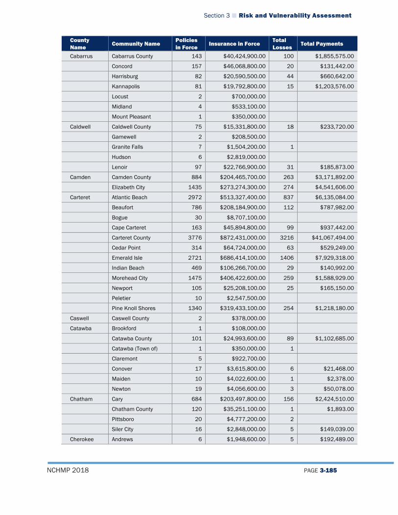
Section 3 Risk and Vulnerability Assessment
NCHMP 2018 PAGE 3-185
County Name
Community Name Policies in Force
Insurance in Force Total Losses
Total Payments
Cabarrus Cabarrus County 143 $40,424,900.00 100 $1,855,575.00
Concord 157 $46,068,800.00 20 $131,442.00
Harrisburg 82 $20,590,500.00 44 $660,642.00
Kannapolis 81 $19,792,800.00 15 $1,203,576.00
Locust 2 $700,000.00
Midland 4 $533,100.00
Mount Pleasant 1 $350,000.00
Caldwell Caldwell County 75 $15,331,800.00 18 $233,720.00
Gamewell 2 $208,500.00
Granite Falls 7 $1,504,200.00 1
Hudson 6 $2,819,000.00
Lenoir 97 $22,766,900.00 31 $185,873.00
Camden Camden County 884 $204,465,700.00 263 $3,171,892.00
Elizabeth City 1435 $273,274,300.00 274 $4,541,606.00
Carteret Atlantic Beach 2972 $513,327,400.00 837 $6,135,084.00
Beaufort 786 $208,184,900.00 112 $787,982.00
Bogue 30 $8,707,100.00
Cape Carteret 163 $45,894,800.00 99 $937,442.00
Carteret County 3776 $872,431,000.00 3216 $41,067,494.00
Cedar Point 314 $64,724,000.00 63 $529,249.00
Emerald Isle 2721 $686,414,100.00 1406 $7,929,318.00
Indian Beach 469 $106,266,700.00 29 $140,992.00
Morehead City 1475 $406,422,600.00 259 $1,588,929.00
Newport 105 $25,208,100.00 25 $165,150.00
Peletier 10 $2,547,500.00
Pine Knoll Shores 1340 $319,433,100.00 254 $1,218,180.00
Caswell Caswell County 2 $378,000.00
Catawba Brookford 1 $108,000.00
Catawba County 101 $24,993,600.00 89 $1,102,685.00
Catawba (Town of) 1 $350,000.00 1
Claremont 5 $922,700.00
Conover 17 $3,615,800.00 6 $21,468.00
Maiden 10 $4,022,600.00 1 $2,378.00
Newton 19 $4,056,600.00 3 $50,078.00
Chatham Cary 684 $203,497,800.00 156 $2,424,510.00
Chatham County 120 $35,251,100.00 1 $1,893.00
Pittsboro 20 $4,777,200.00 2
Siler City 16 $2,848,000.00 5 $149,039.00
Cherokee Andrews 6 $1,948,600.00 5 $192,489.00
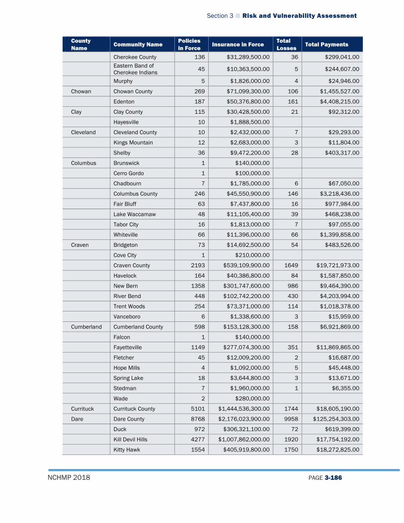
Section 3 Risk and Vulnerability Assessment
NCHMP 2018 PAGE 3-186
County Name
Community Name Policies in Force
Insurance in Force Total Losses
Total Payments
Cherokee County 136 $31,289,500.00 36 $299,041.00
Eastern Band of Cherokee Indians 45 $10,363,500.00 5 $244,607.00
Murphy 5 $1,826,000.00 4 $24,946.00
Chowan Chowan County 269 $71,099,300.00 106 $1,455,527.00
Edenton 187 $50,376,800.00 161 $4,408,215.00
Clay Clay County 115 $30,428,500.00 21 $92,312.00
Hayesville 10 $1,888,500.00
Cleveland Cleveland County 10 $2,432,000.00 7 $29,293.00
Kings Mountain 12 $2,683,000.00 3 $11,804.00
Shelby 36 $9,472,200.00 28 $403,317.00
Columbus Brunswick 1 $140,000.00
Cerro Gordo 1 $100,000.00
Chadbourn 7 $1,785,000.00 6 $67,050.00
Columbus County 246 $45,550,900.00 146 $3,218,436.00
Fair Bluff 63 $7,437,800.00 16 $977,984.00
Lake Waccamaw 48 $11,105,400.00 39 $468,238.00
Tabor City 16 $1,813,000.00 7 $97,055.00
Whiteville 66 $11,396,000.00 66 $1,399,858.00
Craven Bridgeton 73 $14,692,500.00 54 $483,526.00
Cove City 1 $210,000.00
Craven County 2193 $539,109,900.00 1649 $19,721,973.00
Havelock 164 $40,386,800.00 84 $1,587,850.00
New Bern 1358 $301,747,600.00 986 $9,464,390.00
River Bend 448 $102,742,200.00 430 $4,203,994.00
Trent Woods 254 $73,371,000.00 114 $1,018,378.00
Vanceboro 6 $1,338,600.00 3 $15,959.00
Cumberland Cumberland County 598 $153,128,300.00 158 $6,921,869.00
Falcon 1 $140,000.00
Fayetteville 1149 $277,074,300.00 351 $11,869,865.00
Fletcher 45 $12,009,200.00 2 $16,687.00
Hope Mills 4 $1,092,000.00 5 $45,448.00
Spring Lake 18 $3,644,800.00 3 $13,671.00
Stedman 7 $1,960,000.00 1 $6,355.00
Wade 2 $280,000.00
Currituck Currituck County 5101 $1,444,536,300.00 1744 $18,605,190.00
Dare Dare County 8768 $2,176,023,900.00 9958 $125,254,303.00
Duck 972 $306,321,100.00 72 $619,399.00
Kill Devil Hills 4277 $1,007,862,000.00 1920 $17,754,192.00
Kitty Hawk 1554 $405,919,800.00 1750 $18,272,825.00

Section 3 Risk and Vulnerability Assessment
NCHMP 2018 PAGE 3-187
County Name
Community Name Policies in Force
Insurance in Force Total Losses
Total Payments
Manteo 899 $208,738,900.00 226 $3,602,714.00
Nags Head 3477 $958,194,600.00 3120 $33,012,207.00
Southern Shores 1147 $339,838,700.00 320 $1,650,037.00
Davidson Davidson County 180 $42,019,100.00 32 $229,407.00
Denton 1 $280,000.00
High Point 265 $58,312,300.00 92 $288,904.00
Lexington 27 $7,801,900.00 11 $25,648.00
Thomasville 57 $16,011,400.00 12 $108,134.00
Wallburg 2 $630,000.00
Davie Bermuda Run 30 $8,662,600.00 1 $84,532.00
Cooleemee 1 $350,000.00
Davie County 37 $10,277,600.00 6 $27,596.00
Matthews 75 $22,053,000.00 10 $126,312.00
Mocksville 3 $760,000.00
Duplin Beulaville 3 $595,000.00 1 $14,554.00
Calypso 3 $595,000.00 1 $12,858.00
Duplin County 325 $90,793,000.00 160 $4,051,519.00
Faison 2 $350,000.00 1
Greenevers 1 $350,000.00
Kenansville 3 $1,410,000.00
Magnolia 2 $490,000.00
Mount Olive 13 $2,918,000.00 20 $257,180.00
Rose Hill 1 $70,000.00
Wallace 20 $5,035,000.00 25 $462,176.00
Warsaw 9 $2,345,000.00 1 $10,148.00
Durham Butner 6 $1,372,000.00 1
Chapel Hill 669 $131,158,400.00 263 $10,242,770.00
Durham County 207 $54,268,900.00 68 $583,957.00
Durham (City of) 1141 $282,912,200.00 199 $2,555,190.00
Edgecombe Conetoe 9 $1,804,700.00 2 $99,803.00
Edgecombe County 131 $25,598,300.00 104 $3,152,177.00
Leggett 6 $458,800.00 1 $518.00
Pinetops 41 $2,640,100.00 25 $889,299.00
Princeville 158 $34,253,200.00 124 $7,694,597.00
Rocky Mount 917 $214,698,400.00 889 $38,985,164.00
Sharpsburg 20 $4,223,000.00 12 $169,452.00
Speed 15 $2,388,100.00 9 $83,695.00
Tarboro 253 $52,307,200.00 104 $2,669,231.00
Whitakers 3 $509,800.00
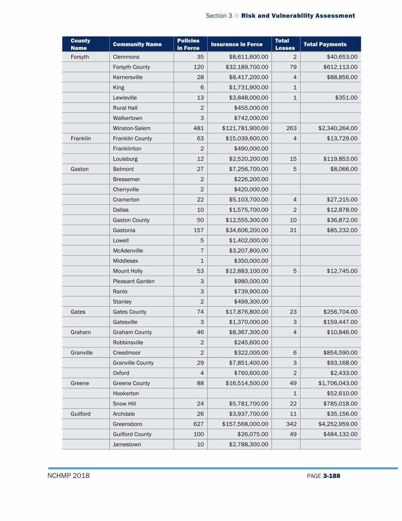
Section 3 Risk and Vulnerability Assessment
NCHMP 2018 PAGE 3-188
County Name
Community Name Policies in Force
Insurance in Force Total Losses
Total Payments
Forsyth Clemmons 35 $8,611,600.00 2 $40,653.00
Forsyth County 120 $32,189,700.00 79 $612,113.00
Kernersville 28 $8,417,200.00 4 $88,856.00
King 6 $1,731,900.00 1
Lewisville 13 $3,848,000.00 1 $351.00
Rural Hall 2 $455,000.00
Walkertown 3 $742,000.00
Winston-Salem 481 $121,781,900.00 263 $2,340,264.00
Franklin Franklin County 63 $15,039,600.00 4 $13,729.00
Franklinton 2 $490,000.00
Louisburg 12 $2,520,200.00 15 $119,853.00
Gaston Belmont 27 $7,256,700.00 5 $8,066.00
Bressemer 2 $226,200.00
Cherryville 2 $420,000.00
Cramerton 22 $5,103,700.00 4 $27,215.00
Dallas 10 $1,575,700.00 2 $12,878.00
Gaston County 50 $12,555,300.00 10 $36,872.00
Gastonia 157 $34,606,200.00 31 $85,232.00
Lowell 5 $1,402,000.00
McAdenville 7 $3,207,800.00
Middlesex 1 $350,000.00
Mount Holly 53 $12,883,100.00 5 $12,745.00
Pleasant Garden 3 $980,000.00
Ranlo 3 $739,900.00
Stanley 2 $499,300.00
Gates Gates County 74 $17,876,800.00 23 $256,704.00
Gatesville 3 $1,370,000.00 3 $159,447.00
Graham Graham County 46 $8,367,300.00 4 $10,846.00
Robbinsville 2 $245,600.00
Granville Creedmoor 2 $322,000.00 6 $854,590.00
Granville County 29 $7,851,400.00 3 $93,168.00
Oxford 4 $760,600.00 2 $2,433.00
Greene Greene County 88 $16,514,500.00 49 $1,706,043.00
Hookerton 1 $52,610.00
Snow Hill 24 $5,781,700.00 22 $785,018.00
Guilford Archdale 26 $3,937,700.00 11 $35,156.00
Greensboro 627 $157,568,000.00 342 $4,252,959.00
Guilford County 100 $26,075.00 49 $484,132.00
Jamestown 10 $2,788,300.00

Section 3 Risk and Vulnerability Assessment
NCHMP 2018 PAGE 3-189
County Name
Community Name Policies in Force
Insurance in Force Total Losses
Total Payments
Oak Ridge 2 $378,000.00 1 $17,950.00
Sedalia 1 $280,000.00
Stokesdale 2 $443,200.00
Halifax Enfield 4 $1,480,000.00 4 $139,888.00
Halifax County 35 $8,186,600.00 3 $3,753.00
Hobgood 3 $658,000.00 1 $2,349.00
Littleton 1 $105,000.00
Roanoke Rapids 76 $18,786,100.00 34 $451,605.00
Scotland Neck 3 $770,000.00 1 $85,318.00
Weldon 9 $2,674,900.00 2 $70,364.00
Harnett Angier 8 $2,463,000.00 1
Broadway 3 $770,000.00 1 $20,239.00
Dunn 61 $10,330,200.00 13 $178,579.00
Erwin 12 $2,834,700.00 2 $202,472.00
Harnett County 302 $74,468,400.00 39 $649,378.00
Lillington 6 $1,410,300.00
Haywood Canton 39 $10,205,700.00 59 $3,045,873.00
Clyde 61 $10,586,600.00 148 $3,874,582.00
Haywood County 231 $50,360,900.00 65 $991,475.00
Maggie Valley 44 $14,354,100.00 6 $23,642.00
Waynesville 305 $52,150,700.00 31 $117,734.00
Henderson Flat Rock 28 $7,146,400.00
Henderson County 196 $52,395,200.00 18 $292,472.00
Hendersonville 130 $35,320,600.00 141 $1,479,665.00
Laurel Park 7 $1,918,000.00 1 $2,979.00
Saluda 1 $280,000.00
Hertford Ahoskie 21 $6,160,100.00 67 $1,444,592.00
Cofield 1 $175,000.00
Hertford County 68 $14,319,900.00 70 $1,459,247.00
Murfreesboro 2 $560,000.00 3
Winton 3 $875,000.00 3 $31,122.00
Hoke Hoke County 132 $31,725,500.00 18 $333,089.00
Raeford 7 $1,995,000.00 2
Hyde Hyde County 1268 $244,255,200.00 1172 $15,809,967.00
Iredell Davidson 47 $15,139,500.00 1
Iredell County 84 $25,364,200.00 12 $71,478.00
Mooresville 29 $7,353,700.00
Statesville 35 $9,368,900.00 19 $880,368.00
Troutman 1 $1,000,000.00

Section 3 Risk and Vulnerability Assessment
NCHMP 2018 PAGE 3-190
County Name
Community Name Policies in Force
Insurance in Force Total Losses
Total Payments
Jackson Dillsboro 7 $2,321,600.00 6 $307,078.00
Forest Hills 2 $308,500.00
Highlands 24 $7,010,900.00
Jackson County 236 $56,591,500.00 29 $274,697.00
Sylva 35 $9,572,700.00 8 $121,212.00
Webster 6 $976,000.00 1
Johnston Benson 10 $2,380,000.00 1 $68,721.00
Clayton 52 $16,341,600.00 5 $7,831.00
Four Oaks 9 $2,150,700.00 2 $56,264.00
Johnston County 287 $67,024,900.00 98 $3,287,100.00
Kenly 5 $1,640,000.00 2 $77,454.00
Micro 1 $80,000.00
Pine Level 2 $630,000.00
Princeton 6 $985,000.00
Selma 10 $2,800,000.00
Smithfield 126 $30,489,900.00 126 $6,070,550.00
Jones Jones County 11 $29,519,300.00 66 $2,384,083.00
Maysville 5 $963,000.00 1 $33,809.00
Pollocksville 13 $3,423,800.00 17 $560,778.00
Trenton 10 $1,817,800.00 18 $185,912.00
Lee Lee County 63 $16,280.00 17 $181,592.00
Sanford 53 $14,057.00 12 $95,509.00
Lenoir Grifton 82 $15,831,500.00 58 $2,556,609.00
Kinston 345 $77,204,100.00 480 $28,498,419.00
La Grange 9 $1,983,000.00 1 $13,422.00
Lenoir County 188 $32,837,200.00 161 $5,739,675.00
Lincoln Lincoln County 92 $26,152,500.00 7 $130,380.00
Lincolnton 13 $1,769,700.00 1 $3,933.00
Macon Macon County 156 $40,005,100.00 48 $1,011,968.00
Madison Hot Springs 4 $888,000.00 1 $2,361.00
Madison County 51 $13,130,000.00 20 $416,269.00
Mars Hill 6 $1,149,500.00 1
Marshall 28 $6,967,700.00 46 $517,815.00
Martin Hamilton 1 $26,019.00
Martin County 38 $7,445,900.00 22 $282,478.00
Robersonville 4 $1,190,000.00 5 $39,838.00
Williamston 45 $8,832,300.00 13 $216,949.00
McDowell Marion 12 $15,910.00 3 $56,414.00
McDowell County 70 $51,693.00 48 $673,511.00

Section 3 Risk and Vulnerability Assessment
NCHMP 2018 PAGE 3-191
County Name
Community Name Policies in Force
Insurance in Force Total Losses
Total Payments
Old Fort 10 $9,014.00 2 $2,941.00
Mecklenburg Charlotte 2810 $700,798,700.00 2173 $38,085,752.00
Cornelius 131 $38,658,000.00 7 $81,233.00
Huntersville 126 $38,066,100.00
Mecklenburg 262 $67,569,400.00 188 $2,823,433.00
Mint Hill 47 $12,850,400.00 2 $18,104.00
Pineville 58 $18,781,300.00 3 $18,000.00
Mitchell Bakersville 11 $3,421,700.00 12 $196,023.00
Mitchell County 18 $4,126,000.00 13 $316,563.00
Spruceville 9 $291,600.00
Montgomery Montgomery County 21 $5,128,800.00 4 $44,138.00
Troy 2 $630,000.00
Moore Aberdeen 23 $6,088,500.00 2 $912.00
Foxfire 1 $350,000.00
Moore County 273 $65,970,200.00 57 $826,940.00
Pinebluff 1 $300,000.00
Pinehurst 109 $26,647,400.00 12 $261,118.00
Southern Pines 64 $17,679,000.00 7 $41,724.00
Whispering Pines 38 $10,235,600.00 3 $590.00
Nash Dortches 2 $700,000.00
Nash County 107 $28,138,500.00 65 $2,661,903.00
Nashville 40 $9,446,700.00 38 $1,594,830.00
Red Oak 14 $4,602,600.00 2 $3,693.00
Spring Hope 1 $100,000.00
New Hanover Carolina Beach 3576 $703,841,400.00 2554 $31,536,729.00
Kure Beach 954 $256,636,000.00 504 $161,197,465.00
New Hanover County 4606 $1,361,888,400.00 2498 $37,881,368.00
Wilmington 2601 $729,840,700.00 288 $3,429,962.00
Wrightsville 2685 $671,964,900.00 3134 $45,554,787.00
Northampton Conway 1 $350,000.00
Garysburg 3 $980,000.00 1 $13,363.00
Jackson 4 $294,600.00 2 $76,282.00
Northampton County 45 $7,835,600.00 16 $93,953.00
Seven 5 $733,300.00 6 $44,261.00
Woodland 3 $575,000.00 2 $11,588.00
Onslow Holly Ridge 30 $7,760,200.00 1 $7,231.00
Jacksonville 602 $167,993,000.00 153 $2,004,182.00
North Topsail Beach 1310 $259,314,100.00 1265 $15,300,722.00
Onslow County 1743 $459,311,900.00 1819 $22,403,567.00

Section 3 Risk and Vulnerability Assessment
NCHMP 2018 PAGE 3-192
County Name
Community Name Policies in Force
Insurance in Force Total Losses
Total Payments
Richlands 18 $5,560,400.00 1 $6,685.00
Surf City 2196 $528,118,500.00 1779 $15,528,657.00
Swansboro 163 $42,155,800.00 103 $2,206,725.00
Orange Carrboro 91 $24,603,800.00 10 $94,288.00
Hillsborough 14 $4,894,500.00 6 $9,032.00
Orange County 91 $27,899,300.00 13 $185,944.00
Pamlico Alliance 8 $1,318,200.00 3 $15,591.00
Bayboro 40 $8,371,600.00 46 $882,957.00
Mesic 36 $4,865,900.00 11 $452,884.00
Minnessott Beach 18 $5,653,800.00 8 $51,733.00
Oriental 696 $179,293,800.00 963 $18,493,074.00
Pamlico County 1138 $264,819,300.00 1833 $39,216,340.00
Stonewall 21 $3,720,300.00 21 $382,493.00
Vandemere 61 $11,965,100.00 149 $4,692,028.00
Pasquotank Pasquotank County 1229 $281,755,400.00 208 $1,346,462.00
Pender Atkinson 2 $385,000.00
Burgaw 61 $13,471,600.00 18 $189,761.00
Pender County 1615 $421,380,700.00 789 $15,800,634.00
Saint Helena 2 $460,000.00
Topsail Beach 1101 $290,618,200.00 2174 $21,663,527.00
Watha 2 $233,400.00
Perquimans Hertford 43 $11,616,300.00 27 $315,015.00
Perquimans County 668 $165,235,000.00 125 $567,547.00
Winfall 19 $4,657,300.00 2 $55,030.00
Person Person County 17 $3,874,400.00 1
Roxboro 10 $3,412,700.00 2 $24,521.00
Pitt Ayden 24 $5,010,100.00 17 $266,042.00
Bethel 1 $105,000.00 4 $12,469.00
Falkland 2 $512,500.00 1 $21,317.00
Farmville 80 $22,017,800.00 29 $179,622.00
Greenville 1144 $258,679,500.00 571 $21,324,523.00
Grimesland 4 $1,330,000.00 1 $40,880.00
Pitt County 402 $88,005,500.00 395 $10,437,400.00
Simpson 7 $2,100,000.00
Winterville 102 $28,016,900.00 37 $250,257.00
Polk Columbus 1 $350,000.00
Polk County 50 $13,215,700.00 16 $190,534.00
Tryon 18 $3,997,500.00 1 $20,405.00
Randolph Asheboro 52 $8,990,300.00 14 $59,055.00

Section 3 Risk and Vulnerability Assessment
NCHMP 2018 PAGE 3-193
County Name
Community Name Policies in Force
Insurance in Force Total Losses
Total Payments
Liberty 3 $910,000.00
Ramseur 2 $310,000.00 1 $5,527.00
Randleman 6 $660,000.00
Randolph County 29 $6,865,100.00 8 $67,132.00
Trinity 8 $2,029,400.00 1
Richmond Hamlet 3 $643,900.00 2 $34,995.00
Richmond County 38 $3,680,000.00 5 $79,559.00
Rockingham 25 $4,790,300.00 9 $132,054.00
Robeson Rennert 3 $266,600.00
Fairmont 15 $2,009,300.00 2 $4,842.00
Lumberton 738 $131,516,700.00 370 $16,549,203.00
Orrum 1 $252.00
Parkton 1 $210,000.00
Pembroke 6 $882,200.00
Proctorville 1 $42,000.00
Red Springs 9 $2,100,000.00 1 $44,432.00
Robeson County 484 $55,949,900.00 203 $4,736,758.00
Saint Pauls 5 $1,120,000.00
Rockingham Eden 28 $4,011,400.00 50 $311,614.00
Madison County 8 $2,715,800.00 18 $104,050.00
Mayodan 3 $961,100.00 12 $295,062.00
Reidsville 28 $5,071,500.00 6 $10,804.00
Rockingham County 17 $4,474,100.00 12 $73,433.00
Rowan Faith 1 $108,000.00
Granite Quarry 17 $3,770,800.00 5 $63,935.00
Landis 1 $67,900.00
Rockwell 7 $1,471,300.00 1 $700.00
Rowan County 79 $20,509,500.00 11 $184,795.00
Salisbury 102 $27,463,200.00 20 $130,091.00
Spencer 4 $690,400.00 1
Rutherford Bostic 1 $350,000.00
Chimney Rock 18 $4,741,700.00
Forest City 5 $1,056,100.00
Lake Lure 50 $12,690,100.00
Rutherford County 43 $11,436,100.00 45 $817,814.00
Rutherfordton 6 $1,357,600.00 1 $780.00
Spindale 2 $3,400.00
Sampson Autryville 1 $7,236.00
Clinton 25 $6,937,000.00 23 $250,741.00
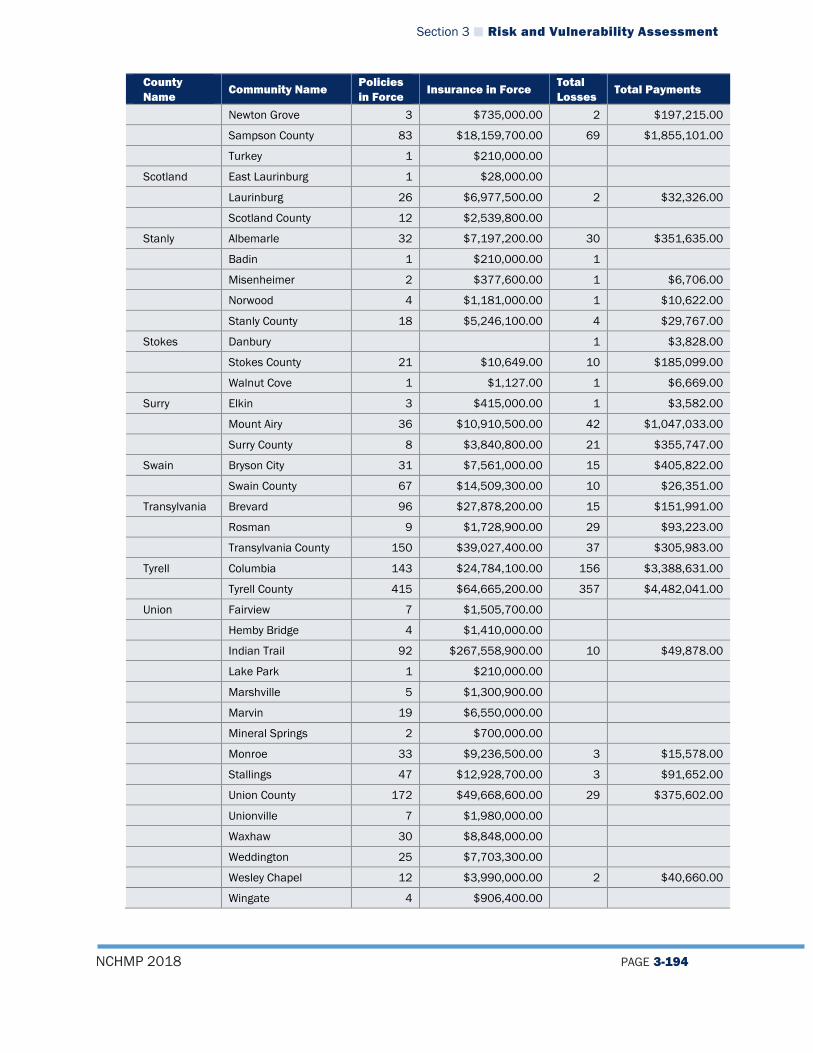
Section 3 Risk and Vulnerability Assessment
NCHMP 2018 PAGE 3-194
County Name
Community Name Policies in Force
Insurance in Force Total Losses
Total Payments
Newton Grove 3 $735,000.00 2 $197,215.00
Sampson County 83 $18,159,700.00 69 $1,855,101.00
Turkey 1 $210,000.00
Scotland East Laurinburg 1 $28,000.00
Laurinburg 26 $6,977,500.00 2 $32,326.00
Scotland County 12 $2,539,800.00
Stanly Albemarle 32 $7,197,200.00 30 $351,635.00
Badin 1 $210,000.00 1
Misenheimer 2 $377,600.00 1 $6,706.00
Norwood 4 $1,181,000.00 1 $10,622.00
Stanly County 18 $5,246,100.00 4 $29,767.00
Stokes Danbury 1 $3,828.00
Stokes County 21 $10,649.00 10 $185,099.00
Walnut Cove 1 $1,127.00 1 $6,669.00
Surry Elkin 3 $415,000.00 1 $3,582.00
Mount Airy 36 $10,910,500.00 42 $1,047,033.00
Surry County 8 $3,840,800.00 21 $355,747.00
Swain Bryson City 31 $7,561,000.00 15 $405,822.00
Swain County 67 $14,509,300.00 10 $26,351.00
Transylvania Brevard 96 $27,878,200.00 15 $151,991.00
Rosman 9 $1,728,900.00 29 $93,223.00
Transylvania County 150 $39,027,400.00 37 $305,983.00
Tyrell Columbia 143 $24,784,100.00 156 $3,388,631.00
Tyrell County 415 $64,665,200.00 357 $4,482,041.00
Union Fairview 7 $1,505,700.00
Hemby Bridge 4 $1,410,000.00
Indian Trail 92 $267,558,900.00 10 $49,878.00
Lake Park 1 $210,000.00
Marshville 5 $1,300,900.00
Marvin 19 $6,550,000.00
Mineral Springs 2 $700,000.00
Monroe 33 $9,236,500.00 3 $15,578.00
Stallings 47 $12,928,700.00 3 $91,652.00
Union County 172 $49,668,600.00 29 $375,602.00
Unionville 7 $1,980,000.00
Waxhaw 30 $8,848,000.00
Weddington 25 $7,703,300.00
Wesley Chapel 12 $3,990,000.00 2 $40,660.00
Wingate 4 $906,400.00

Section 3 Risk and Vulnerability Assessment
NCHMP 2018 PAGE 3-195
County Name
Community Name Policies in Force
Insurance in Force Total Losses
Total Payments
Vance Henderson 12 $2,935,100.00 6 $72,940.00
Vance County 16 $4,244,000.00 3 $102,268.00
Wake Apex 102 $30,549,400.00 1 $1,299.00
Fuquay-Varina 91 $23,813,100.00 5 $107,051.00
Garner 118 $90,125,400.00 32 $1,677,144.00
Holly Springs 70 $21,925,300.00 12 $187,594.00
Knightdale 34 $9,824,300.00 3 $31,363.00
Morrisville 80 $24,338,800.00 6 $92,752.00
Raleigh 1795 $503,161,000.00 1075 $23,441,316.00
Rolesville 11 $3,227,000.00
Wake County 370 $100,032,400.00 95 $996,017.00
Wake Forest 117 $33,584,700.00 5
Wendell 21 $5,363,000.00 9 $144,907.00
Zebulon 21 $3,368,000.00 11 $187,065.00
Warren Warren County 31 $9,373,000.00 4
Washington Creswell 9 $1,359,700.00 6 $25,575.00
Plymouth 75 $19,526,400.00 42 $1,189,169.00
Roper 11 $2,068,500.00 5 $100,477.00
Washington County 161 $33,463,100.00 95 $1,306,085.00
Watauga Blowing Rock 28 $9,377,600.00 9 $79,459.00
Boone 249 $52,559,400.00 69 $940,935.00
Watauga County 287 $74,604,800.00 148 $1,325,825.00
Wayne Fremont 3 $595,000.00
Goldsboro 735 $144,234,600.00 642 $24,392,926.00
Pikeville 8 $1,287,300.00 3 $57,621.00
Seven Springs 12 $1,031,400.00 34 $2,316,346.00
Walnut Creek 34 $9,934,800.00 18 $1,046,316.00
Wayne County 351 $72,287,200.00 274 $12,884,552.00
Wilkes North Wilkesboro 16 $32,796.00
Ronda 1 $1,609.00
Wilkes County 31 $16,385.00 3 $4,188.00
Wilkesboro 21 $31,500.00 14 $452,467.00
Wilson Black Creek 3 $1,636.00
Elm City 5 $3,483.00
Lucama 5 $2,360.00 1 $20,038.00
Stantonsburg 2 $693.00 1 $35,444.00
Wilson County 71 $40,827.00 79 $2,477,553.00
Wilson 476 $417,567.00 359 $7,626,273.00
Yadkin Jonesville 3 $916,000.00
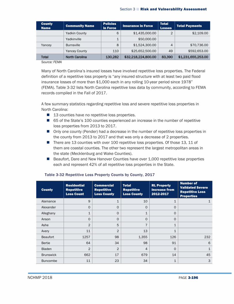
Section 3 Risk and Vulnerability Assessment
NCHMP 2018 PAGE 3-196
County Name
Community Name Policies in Force
Insurance in Force Total Losses
Total Payments
Yadkin County 6 $1,435,000.00 2 $2,109.00
Yadkinville 1 $50,000.00
Yancey Burnsville 8 $1,524,300.00 4 $70,736.00
Yancey County 110 $25,652,500.00 49 $592,653.00
Total North Carolina 130,282 $32,218,224,800.00 83,390 $1,231,655,253.00 Source: FEMA
Many of North Carolina’s insured losses have involved repetitive loss properties. The Federal definition of a repetitive loss property is “any insured structure with at least two paid flood insurance losses of more than $1,000 each in any rolling 10-year period since 1978” (FEMA). Table 3-32 lists North Carolina repetitive loss data by community, according to FEMA records compiled in the Fall of 2017. A few summary statistics regarding repetitive loss and severe repetitive loss properties in North Carolina: 13 counties have no repetitive loss properties. 65 of the State’s 100 counties experienced an increase in the number of repetitive
loss properties from 2013 to 2017. Only one county (Pender) had a decrease in the number of repetitive loss properties in
the county from 2013 to 2017 and that was only a decrease of 2 properties. There are 13 counties with over 100 repetitive loss properties. Of those 13, 11 of
them are coastal counties. The other two represent the largest metropolitan areas in the state (Mecklenburg and Wake Counties).
Beaufort, Dare and New Hanover Counties have over 1,000 repetitive lose properties each and represent 42% of all repetitive loss properties in the State.
Table 3-32 Repetitive Loss Property Counts by County, 2017
County Residential Repetitive Loss Count
Commercial Repetitive Loss County
Total Repetitive Loss County
RL Property Increase from 2012-2017
Number of Validated Severe Repetitive Loss Properties
Alamance 9 1 10 1 1
Alexander 0 0 0 0 Alleghany 1 0 1 0 Anson 0 0 0 0 Ashe 2 5 7 1 Avery 11 2 13 1 Beaufort 1257 98 1,355 126 232
Bertie 64 34 98 91 6
Bladen 2 2 4 0 1
Brunswick 662 17 679 14 45
Buncombe 11 23 34 1 3

Section 3 Risk and Vulnerability Assessment
NCHMP 2018 PAGE 3-197
County Residential Repetitive Loss Count
Commercial Repetitive Loss County
Total Repetitive Loss County
RL Property Increase from 2012-2017
Number of Validated Severe Repetitive Loss Properties
Burke 1 1 2 0 Cabarrus 20 1 21 5 2
Caldwell 5 2 7 2 Camden 43 11 54 9 1
Carteret 764 32 796 171 49
Caswell 0 0 0 0 Catawba 11 0 11 6 Chatham 18 1 19 7 Cherokee 7 2 9 3 1
Chowan 34 2 36 24 1
Clay 1 0 1 1 Cleveland 3 0 3 2 Columbus 17 8 25 13 1
Craven 382 6 388 115 37
Cumberland 30 1 31 23 3
Currituck 159 2 161 87 10
Dare 1,197 109 1,306 403 152
Davidson 8 3 11 0 Davie 1 0 1 1 Duplin 14 5 19 4 1
Durham 41 6 47 5 8
Edgecombe 41 10 51 8 1
Forsyth 30 5 35 2 13
Franklin 5 0 5 0 Gaston 2 0 2 2 Gates 3 0 3 2 Graham 0 0 0 0 Granville 1 0 1 0 Greene 5 0 5 4 Guilford 44 6 50 4 11
Halifax 1 1 2 0 Harnett 2 0 2 1 Haywood 14 3 17 1 Henderson 4 12 16 2 Hertford 16 6 22 5 2
Hoke 0 0 0 0 Hyde 104 27 131 35 8
Iredell 1 0 1 0
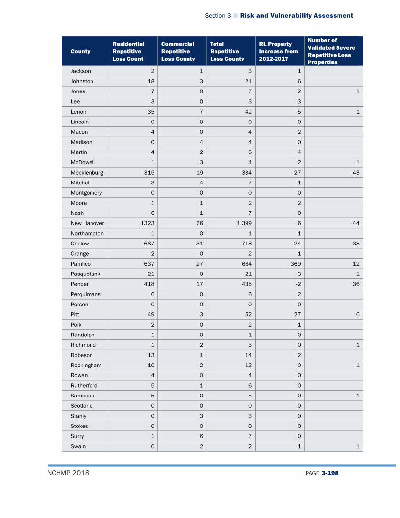
Section 3 Risk and Vulnerability Assessment
NCHMP 2018 PAGE 3-198
County Residential Repetitive Loss Count
Commercial Repetitive Loss County
Total Repetitive Loss County
RL Property Increase from 2012-2017
Number of Validated Severe Repetitive Loss Properties
Jackson 2 1 3 1 Johnston 18 3 21 6 Jones 7 0 7 2 1
Lee 3 0 3 3 Lenoir 35 7 42 5 1
Lincoln 0 0 0 0 Macon 4 0 4 2 Madison 0 4 4 0 Martin 4 2 6 4 McDowell 1 3 4 2 1
Mecklenburg 315 19 334 27 43
Mitchell 3 4 7 1 Montgomery 0 0 0 0 Moore 1 1 2 2 Nash 6 1 7 0 New Hanover 1323 76 1,399 6 44
Northampton 1 0 1 1 Onslow 687 31 718 24 38
Orange 2 0 2 1 Pamlico 637 27 664 369 12
Pasquotank 21 0 21 3 1
Pender 418 17 435 -2 36
Perquimans 6 0 6 2 Person 0 0 0 0 Pitt 49 3 52 27 6
Polk 2 0 2 1 Randolph 1 0 1 0 Richmond 1 2 3 0 1
Robeson 13 1 14 2 Rockingham 10 2 12 0 1
Rowan 4 0 4 0 Rutherford 5 1 6 0 Sampson 5 0 5 0 1
Scotland 0 0 0 0 Stanly 0 3 3 0 Stokes 0 0 0 0 Surry 1 6 7 0 Swain 0 2 2 1 1

Section 3 Risk and Vulnerability Assessment
NCHMP 2018 PAGE 3-199
County Residential Repetitive Loss Count
Commercial Repetitive Loss County
Total Repetitive Loss County
RL Property Increase from 2012-2017
Number of Validated Severe Repetitive Loss Properties
Transylvania 5 0 5 0 Tyrrell 75 4 79 64 1
Union 4 0 4 1 Vance 1 0 1 0 Wake 100 35 135 15 23
Warren 0 0 0 0 Washington 7 1 8 7 Watauga 10 7 17 5 Wayne 44 7 51 4 1
Wilkes 0 1 1 0 1
Wilson 29 5 34 19 1
Yadkin 0 0 0 0 Yancey 2 0 2 0 Totals 8,943
(1,650 increase) 723
(138 increase) 9,666 1,787 803
Source: FEMA
Figure 3-68 Summary of North Carolina Repetitive Loss Properties by County
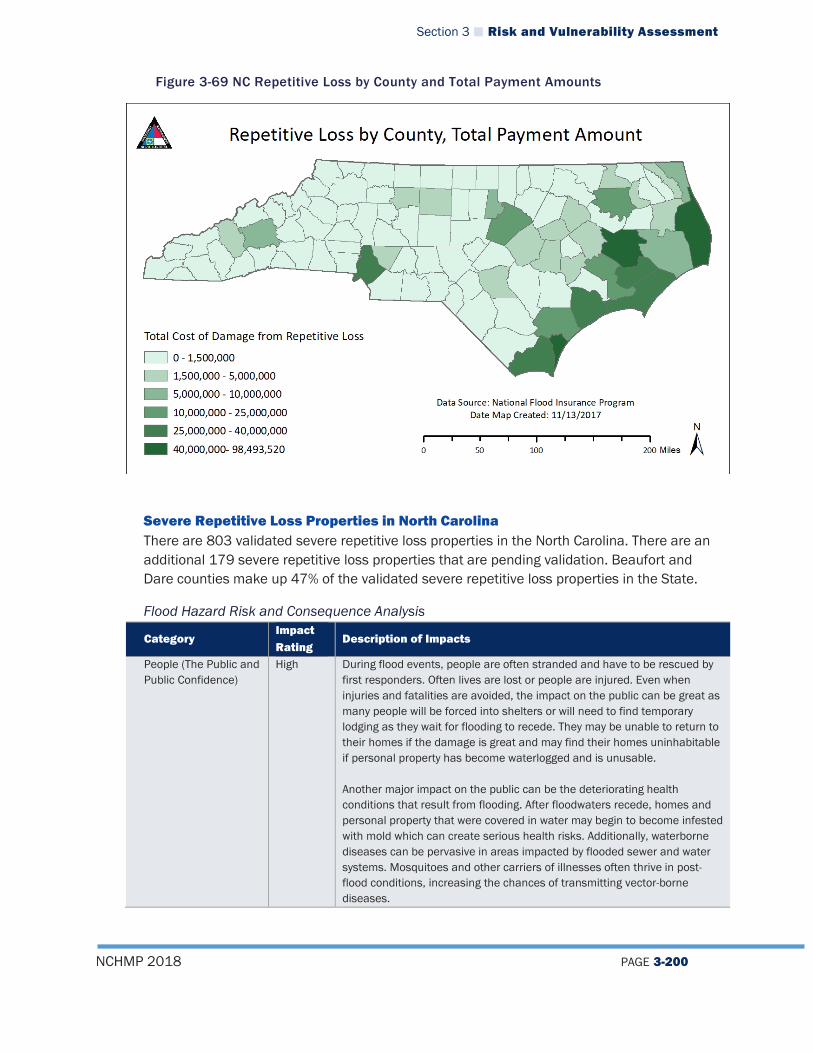
Section 3 Risk and Vulnerability Assessment
NCHMP 2018 PAGE 3-200
Figure 3-69 NC Repetitive Loss by County and Total Payment Amounts
Severe Repetitive Loss Properties in North Carolina There are 803 validated severe repetitive loss properties in the North Carolina. There are an additional 179 severe repetitive loss properties that are pending validation. Beaufort and Dare counties make up 47% of the validated severe repetitive loss properties in the State.
Flood Hazard Risk and Consequence Analysis
Category Impact Rating
Description of Impacts
People (The Public and Public Confidence)
High During flood events, people are often stranded and have to be rescued by first responders. Often lives are lost or people are injured. Even when injuries and fatalities are avoided, the impact on the public can be great as many people will be forced into shelters or will need to find temporary lodging as they wait for flooding to recede. They may be unable to return to their homes if the damage is great and may find their homes uninhabitable if personal property has become waterlogged and is unusable. Another major impact on the public can be the deteriorating health conditions that result from flooding. After floodwaters recede, homes and personal property that were covered in water may begin to become infested with mold which can create serious health risks. Additionally, waterborne diseases can be pervasive in areas impacted by flooded sewer and water systems. Mosquitoes and other carriers of illnesses often thrive in post-flood conditions, increasing the chances of transmitting vector-borne diseases.
Section 3 Risk and Vulnerability Assessment
NCHMP 2018 PAGE 3-201
Category Impact Rating
Description of Impacts
Public confidence is often impacted by flood events, especially when impacted people do not have flood insurance and are not covered by their home insurance policy. This can create public relations issues for the government and a loss of public confidence.
Responders High Responders are often affected by flooding because floods can trap people in their homes or in other locations, forcing responders to put their lives at risk to return members of the public to safety. Often responders in flood situations face blocked roads and have difficulty safely protecting citizens. Water rescues can be some of the most dangerous as rapidly moving flood waters are difficult to navigate. Rescuers are typically at high risk to loss of life or personal injury during flood events, especially compared to other types of natural hazards.
Operations/Continuity of Operations
High Flooding can impact continuity of operations by knocking out power sources and preventing emergency management personnel from being able to do their jobs properly. Floods typically have some impact on continuity of operations as they can cause severe disruption to normal operations and have done so in the past in North Carolina in nearly every county. Operations would be most impacted at a localized level as areas that are flooded would experience the most disruption to normal operations.
Built Environment (Property, Facilities, Infrastructure)
High Many buildings and structures could be impacted by a flood event, but critical infrastructure and key resources (CIKR) within the state are especially important to identify. When these facilities are located in flood-prone areas, there is a substantial risk to important functions of government such as law enforcement and medical care. This also includes any assets, systems, and networks that are vital to the continued operation of government services such as power generation facilities, transmission infrastructure, and road networks, among others. The incapacitation or destruction of these resources would have a debilitating and costly effect on many aspects of the state’s normal functionality. Often, in the case of flooding, water and wastewater infrastructure are some of the most prominently impacted. Since these types of infrastructure deal directly with water, often they are located in the most flood prone areas and are severely impacted during flood events. When these facilities or infrastructure are flooded, it complicates recovery and impacts people who are unable to utilize normal water sources for drinking, sanitation, and other everyday uses. In addition, personal property such as homes and businesses have been impacted to a large degree by past flooding events and are a major concern in future flooding events. Although a great deal of effort has been undertaken to reduce the number of properties at risk through the use of progressively improved risk assessment and mitigation techniques, there are still a significant number of structures throughout the state that are located in flood zones or which have not been properly mitigated to reduce risk. These properties may sustain billions of dollars of damage during future flood events and are often a major focus of post-disaster recovery efforts.
Economy High There are a variety of economic impacts that could result from a large-scale flood event. One major impact is on soil that is covered by flood waters,

Section 3 Risk and Vulnerability Assessment
NCHMP 2018 PAGE 3-202
Category Impact Rating
Description of Impacts
causing the rapid depletion of oxygen, which is essential for plant growth and development. This can hurt agricultural production in areas of the state were that is a key economic driver. Secondly, flooding often causes the shutdown of businesses, many of which never re-open after a flood event. Indeed, FEMA reports that almost 40 percent of small businesses never reopen their doors after a disaster because only small amounts of flood waters can cause thousands of dollars of damage.37 The shutdown of these small businesses in many communities can be devastating as many small, rural communities in the state rely heavily on these small businesses as economic drivers and the base of the local economy. After Hurricane Floyd, which was primarily considered to be a flood event, the North Carolina Floodplain Mapping Program reported the following statistics which serve as a sort of benchmark for potential future flooding events:
Hurricane Floyd Impacts (1999)38
Businesses Affected 60,000 Estimated Jobs Lost 31,000 Physical Damage to Businesses $1,000,000,000 Business Revenue Lost $4,000,000,000
Environment Low The fluctuation of water levels in a wetland, especially flood waters, supports the biological diversity of low-lying areas by releasing nutrients into the soil and germinating wetland flora. Flooding also offers some control of invasive water weeds. Most features of the environment have come to adapt to the effects of a flood event and respond quickly, although it is possible that some species may not be resilient enough to survive and will experience population loss. However, areas that have been modified by human activity tend to suffer more negative consequences from flooding which can result from modifying stream banks or removing vegetation from riverside. When these modifications are present, flooding can cause unnatural erosion of sediment into the waterway and create an imbalance of nutrients in the water which may harm ecosystems and have a negative impact on downstream water quality.39
Flood Hazard Vulnerability for State-Owned Facilities NCEM-RM has calculated the number of state-owned facilities in the special flood hazard areas. Table 3-33 below provides a summary of those findings.
37 FEMA. (2017). Protecting Your Businesses. Retrieved August 21, 2017, from https://www.fema.gov/protecting-your-businesses 38 North Carolina Floodplain Mapping Program. Retrieved August 21, 2017, from: http://www.ncfloodmaps.com/flood_data.htm 39 Office of the Queensland Australia Chief Scientist (2017). What are the consequences of floods? Retrieved August 21, 2017, from: http://www.chiefscientist.qld.gov.au/publications/understanding-floods/flood-consequences
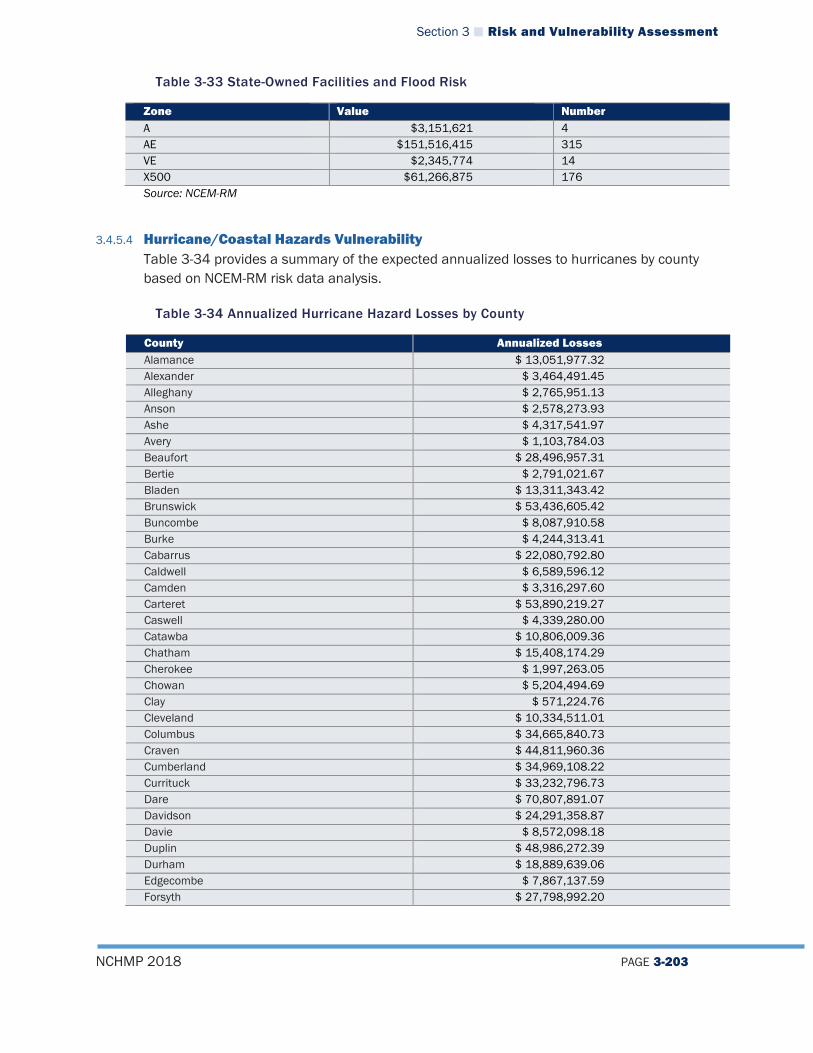
Section 3 Risk and Vulnerability Assessment
NCHMP 2018 PAGE 3-203
Table 3-33 State-Owned Facilities and Flood Risk
Zone Value Number A $3,151,621 4 AE $151,516,415 315 VE $2,345,774 14 X500 $61,266,875 176 Source: NCEM-RM
3.4.5.4 Hurricane/Coastal Hazards Vulnerability Table 3-34 provides a summary of the expected annualized losses to hurricanes by county based on NCEM-RM risk data analysis.
Table 3-34 Annualized Hurricane Hazard Losses by County
County Annualized Losses Alamance $ 13,051,977.32 Alexander $ 3,464,491.45 Alleghany $ 2,765,951.13 Anson $ 2,578,273.93 Ashe $ 4,317,541.97 Avery $ 1,103,784.03 Beaufort $ 28,496,957.31 Bertie $ 2,791,021.67 Bladen $ 13,311,343.42 Brunswick $ 53,436,605.42 Buncombe $ 8,087,910.58 Burke $ 4,244,313.41 Cabarrus $ 22,080,792.80 Caldwell $ 6,589,596.12 Camden $ 3,316,297.60 Carteret $ 53,890,219.27 Caswell $ 4,339,280.00 Catawba $ 10,806,009.36 Chatham $ 15,408,174.29 Cherokee $ 1,997,263.05 Chowan $ 5,204,494.69 Clay $ 571,224.76 Cleveland $ 10,334,511.01 Columbus $ 34,665,840.73 Craven $ 44,811,960.36 Cumberland $ 34,969,108.22 Currituck $ 33,232,796.73 Dare $ 70,807,891.07 Davidson $ 24,291,358.87 Davie $ 8,572,098.18 Duplin $ 48,986,272.39 Durham $ 18,889,639.06 Edgecombe $ 7,867,137.59 Forsyth $ 27,798,992.20

Section 3 Risk and Vulnerability Assessment
NCHMP 2018 PAGE 3-204
County Annualized Losses Franklin $ 5,645,638.85 Gaston $ 7,455,572.40 Gates $ 5,487,742.44 Graham $ 612,033.90 Granville $ 3,767,592.52 Greene $ 5,775,677.30 Guilford $ 36,997,531.96 Halifax $ 16,331,005.37 Harnett $ 12,731,765.74 Haywood $ 3,351,227.57 Henderson $ 5,579,274.81 Hertford $ 5,039,509.65 Hoke $ 7,189,893.60 Hyde $ 3,939,637.57 Iredell $ 10,056,703.45 Jackson $ 1,461,167.64 Johnston $ 25,285,893.51 Jones $ 4,565,754.76 Lee $ 6,442,896.04 Lenoir $ 17,155,818.53 Lincoln $ 6,426,516.38 Macon $ 1,435,935.43 Madison $ 1,432,114.55 Martin $ 15,709,847.42 McDowell $ 1,692,227.20 Mecklenburg $ 60,486,369.27 Mitchell $ 1,125,175.60 Montgomery $ 3,187,295.34 Moore $ 12,955,854.18 Nash $ 12,935,995.57 New Hanover $ 167,594,284.67 Northampton $ 5,697,304.28 Onslow $ 90,454,924.79 Orange $ 14,461,907.79 Pamlico $ 5,619,501.20 Pasquotank $ 19,096,536.58 Pender $ 19,447,689.32 Perquimans $ 9,069,429.58 Person $ 5,275,846.59 Pitt $ 31,099,665.75 Polk $ 1,438,203.83 Randolph $ 19,508,757.63 Richmond $ 7,884,699.69 Robeson $ 55,448,728.09 Rockingham $ 17,624,340.56 Rowan $ 22,167,408.18 Rutherford $ 5,446,860.73 Sampson $ 46,194,954.62 Scotland $ 8,670,720.49 Stanly $ 9,303,827.27
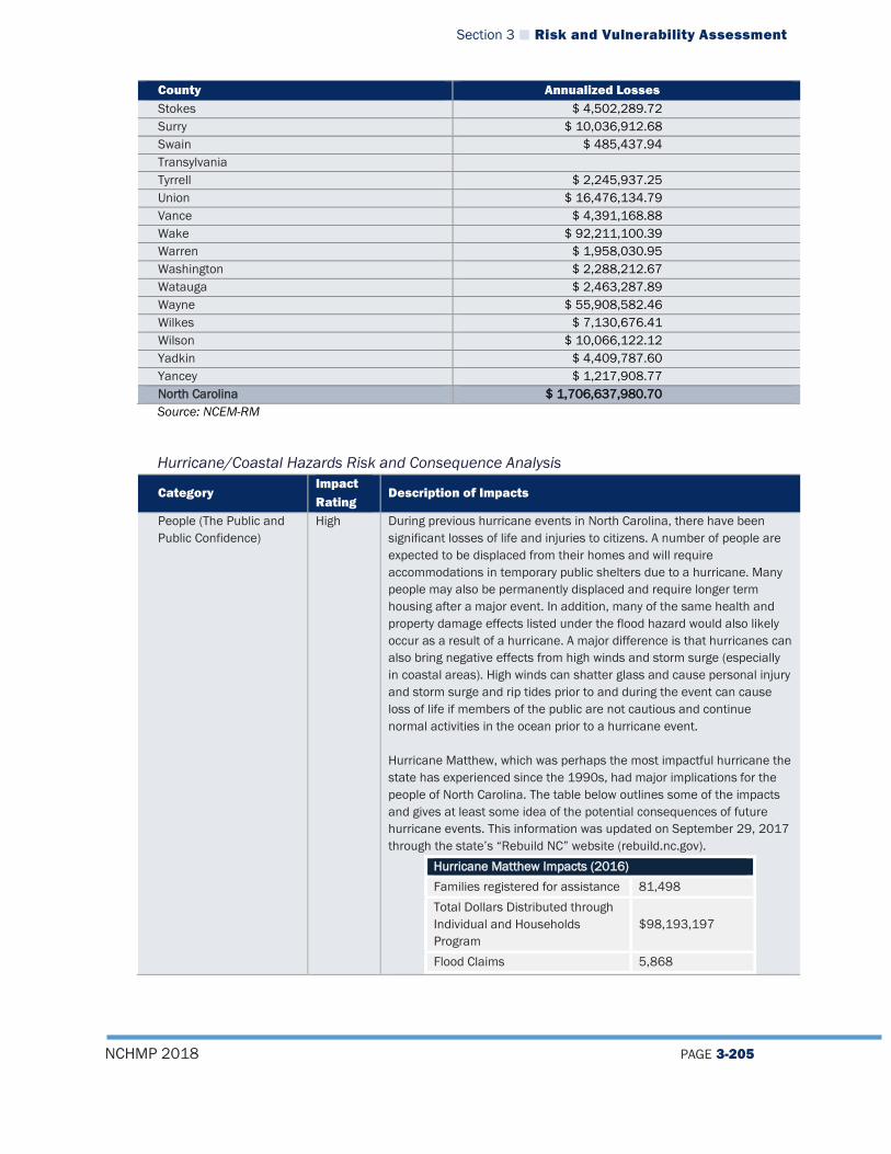
Section 3 Risk and Vulnerability Assessment
NCHMP 2018 PAGE 3-205
County Annualized Losses Stokes $ 4,502,289.72 Surry $ 10,036,912.68 Swain $ 485,437.94 Transylvania Tyrrell $ 2,245,937.25 Union $ 16,476,134.79 Vance $ 4,391,168.88 Wake $ 92,211,100.39 Warren $ 1,958,030.95 Washington $ 2,288,212.67 Watauga $ 2,463,287.89 Wayne $ 55,908,582.46 Wilkes $ 7,130,676.41 Wilson $ 10,066,122.12 Yadkin $ 4,409,787.60 Yancey $ 1,217,908.77 North Carolina $ 1,706,637,980.70 Source: NCEM-RM
Hurricane/Coastal Hazards Risk and Consequence Analysis
Category Impact Rating
Description of Impacts
People (The Public and Public Confidence)
High During previous hurricane events in North Carolina, there have been significant losses of life and injuries to citizens. A number of people are expected to be displaced from their homes and will require accommodations in temporary public shelters due to a hurricane. Many people may also be permanently displaced and require longer term housing after a major event. In addition, many of the same health and property damage effects listed under the flood hazard would also likely occur as a result of a hurricane. A major difference is that hurricanes can also bring negative effects from high winds and storm surge (especially in coastal areas). High winds can shatter glass and cause personal injury and storm surge and rip tides prior to and during the event can cause loss of life if members of the public are not cautious and continue normal activities in the ocean prior to a hurricane event. Hurricane Matthew, which was perhaps the most impactful hurricane the state has experienced since the 1990s, had major implications for the people of North Carolina. The table below outlines some of the impacts and gives at least some idea of the potential consequences of future hurricane events. This information was updated on September 29, 2017 through the state’s “Rebuild NC” website (rebuild.nc.gov).
Hurricane Matthew Impacts (2016) Families registered for assistance 81,498 Total Dollars Distributed through Individual and Households Program
$98,193,197
Flood Claims 5,868

Section 3 Risk and Vulnerability Assessment
NCHMP 2018 PAGE 3-206
Category Impact Rating
Description of Impacts
Total Dollars Distributed Through National Flood Insurance Program $195,493,901
This hazard could potentially have a large negative effect on public confidence due to the possibility of a high magnitude event and the difficulties that might arise for local governments in terms of response and recovery. As has been the case with several previous events, members of the public who are displaced or whose homes/property are damaged may be frustrated causing a failure of confidence in the government’s ability to respond to disasters.
Responders High The impacts on responders from this type of storm could potentially be very high as responders may be physically injured or killed during a storm event by flooding or high winds. In addition, their homes and personal effects could also be impacted, which would limit their response capability. In terms of their actual response capacity, downed trees in the wake of a hurricane often block roads and make ingress and egress difficult, thereby causing issues with response time. This is also often true of the resulting floodwaters. Moreover, due to the large-scale spatial impact of hurricanes and the number of citizens affected by the storm, response time will be reduced because of the number of incidents that require emergency responders.
Operations/Continuity of Operations
High Continuity of operations in a hurricane event can be severely affected if power is lost or if critical facilities or infrastructure are damaged during an event. Although North Carolina has a plan in place to maintain continuity of operations in the event of a storm, a hurricane with a high magnitude would likely disrupt operations to some degree due to the impacts it would have on personnel. Some may experience damage from the storm themselves and be unable to work putting a strain on staff who are working as they will be forced to take on additional responsibilities during and after an event. In major events, all staff will likely be called on to work additional hours to maintain continuity of operations, which may result in fatigue and a reduced capability of employees in the long run.
Built Environment (Property, Facilities, Infrastructure)
High Many buildings and structures could be impacted by a hurricane or tropical storm event including many local and state critical facilities such as police stations, fire stations, medical facilities, and other key buildings. There are also a number of important historic locations located along the coast such as Large-scale damage to infrastructure such as bridges and roads could occur from flood waters and storm surge especially in coastal areas such as the Outer Banks where roadways such as Highway 12 have been damaged severely during past events. Stormwater infrastructure such as culverts could also be damaged if they are clogged with debris from the storm or their design capacity is overrun. Many utilities including water/wastewater may be affected as a result of their location near rivers and other water sources. Power lines may be downed by falling trees or limbs and, due to high demand across the state, utility companies may face challenges in restoring power in a timely manner.

Section 3 Risk and Vulnerability Assessment
NCHMP 2018 PAGE 3-207
Category Impact Rating
Description of Impacts
Hurricane Matthew also offers some insight on impacts to public infrastructure based on funding distributed through FEMA’s Public Assistance (PA) program, though these numbers fall far below total damage to the built environment. According to Rebuild NC, as of September 29, 2017:
Hurricane Matthew Impacts (2016) Public Assistance (PA) Projects Submitted
81,498
Total Federal Dollars Distributed through PA Program
$62,663,672
Economy High In general, the economy would be severely impacted by a hurricane or tropical storm event. Due to the massive scale of these events and multiple types of impacts from flooding and high winds, commerce would definitively slow down as efforts to rebuild are undertaken. Businesses may be shut down for long periods as owners try to rebuild after damage from flood waters, downed trees, or wind. Even business owners without direct physical damage to their workplaces may be shut down temporarily by loss of power or because employees are unable to come in to work as a result of roads that are shut down or personal property damage. As mentioned in the flooding analysis, many businesses that shut down after a major disaster never re-open their doors, which can have a major negative impact on local economies, especially in smaller communities. Some data on impacted businesses during Hurricane Matthew is available via loans distributed through the Small Business Administration (SBA). This certainly does not encompass all the businesses impacted by the storm, but provides an estimate that can be used as a floor. This information was also retrieved from rebuild.nc.gov and is updated through September 29, 2017.
Hurricane Matthew Impacts (2016) SBA Loans Approved 81,498 Total Dollars Distributed through SBA Program
$102,424,200
Environment Moderate Flooding and wind damage are the main impacts that would be felt by a hurricane in North Carolina. Hurricane winds can down trees and cause disruptions to local ecosystems, particularly if damage is heavy in areas where endangered or protected species are present. As mentioned in the flood analysis, flood waters may cause some losses in species population. In coastal areas, sensitive habitats could be drastically impacted by hurricane events if the storm damages dune systems via storm surge. This may also cause local communities to become more vulnerable to future events as dunes provide a natural barrier against storm surge. Additionally, estuarine habitats may be impacted if floodwaters inundate these complex ecosystems with additional freshwater or saltwater, thereby causing an abnormality in a system that relies on a particular balance of salinity. Hurricane events can also sometimes cause spills of hazardous materials which would have damaging effects on the environment (as detailed further in the hazardous substances analysis below).

Section 3 Risk and Vulnerability Assessment
NCHMP 2018 PAGE 3-208
Hurricane/Coastal Hazards Vulnerability for State-Owned Facilities Table 3-35 provides a summary of the number and value of state-owned facilities in storm surge zones.
Table 3-35 State-Owned Facilities and Storm Surge Zones
Storm Surge Zone Number of State-Owned Facilities in Zone
Value of State-Owned Facilities in Zone
Category 1 37 $15,924,163 Category 2 181 $125,205,270 Category 3 274 $306,009,149 Category 4 321 $356,303,291 Category 5 391 $380,878,794
Source: NOAA, NCEM-RM
3.4.5.5 Severe Winter Weather Hazard Vulnerability Because winter weather is an atmospheric hazard and can occur anywhere throughout the state, all populations, buildings and infrastructure are vulnerable. NCEI data indicates that occurrences of severe winter weather are more frequent in the mountains of North Carolina, thereby increasing the risk to the hazard in those counties. However, vulnerability to winter weather is difficult to qualify and quantify because of the unique impacts the hazard has on people, structures and infrastructure. Snow alone does not pose a significant threat to structures unless it falls in extremely heavy amounts. Ice events occur less frequently, but can have significant impacts on people and particularly on infrastructure.
Table 3-36 provides a summary of the expected annualized losses by county based on NCEI data.
Table 3-36 Annualized Losses for Severe Winter Weather
County Total Damages for All Recorded Events (2017 Dollars)
Annualized Losses
Alamance $544,484.00 $25,927.81 Alexander $12,197,820.00 $580,848.57 Alleghany $187,278.00 $8,918.00 Anson $0.00 $0.00 Ashe $358,685.00 $17,080.24 Avery $79,878,496.00 $3,803,737.90 Beaufort $70,789.00 $3,370.90 Bertie $35,833.00 $1,706.33 Bladen $4,604,380.00 $219,256.19 Brunswick $201,211.00 $9,581.48 Buncombe $11,999,065.00 $571,384.05 Burke $169,609,440.00 $8,076,640.00 Cabarrus $17,719,471.00 $843,784.33
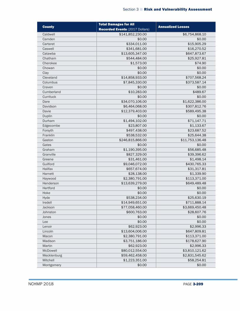
Section 3 Risk and Vulnerability Assessment
NCHMP 2018 PAGE 3-209
County Total Damages for All Recorded Events (2017 Dollars)
Annualized Losses
Caldwell $141,852,230.00 $6,754,868.10 Camden $0.00 $0.00 Carteret $334,011.00 $15,905.29 Caswell $341,681.00 $16,270.52 Catawba $13,605,347.00 $647,873.67 Chatham $544,484.00 $25,927.81 Cherokee $1,573.00 $74.90 Chowan $0.00 $0.00 Clay $0.00 $0.00 Cleveland $14,858,933.00 $707,568.24 Columbus $7,845,330.00 $373,587.14 Craven $0.00 $0.00 Cumberland $10,283.00 $489.67 Currituck $0.00 $0.00 Dare $34,070,106.00 $1,622,386.00 Davidson $6,464,068.00 $307,812.76 Davie $12,379,403.00 $589,495.38 Duplin $0.00 $0.00 Durham $1,494,102.00 $71,147.71 Edgecombe $23,807.00 $1,133.67 Forsyth $497,438.00 $23,687.52 Franklin $538,532.00 $25,644.38 Gaston $246,815,866.00 $11,753,136.48 Gates $0.00 $0.00 Graham $1,190,395.00 $56,685.48 Granville $827,329.00 $39,396.62 Greene $31,461.00 $1,498.14 Guilford $9,046,072.00 $430,765.33 Halifax $657,674.00 $31,317.81 Harnett $28,138.00 $1,339.90 Haywood $2,380,791.00 $113,371.00 Henderson $13,639,279.00 $649,489.48 Hertford $0.00 $0.00 Hoke $0.00 $0.00 Hyde $538,234.00 $25,630.19 Iredell $14,949,651.00 $711,888.14 Jackson $77,058,460.00 $3,669,450.48 Johnston $600,763.00 $28,607.76 Jones $0.00 $0.00 Lee $0.00 $0.00 Lenoir $62,923.00 $2,996.33 Lincoln $13,604,006.00 $647,809.81 Macon $2,380,791.00 $113,371.00 Madison $3,751,186.00 $178,627.90 Martin $62,923.00 $2,996.33 McDowell $80,012,554.00 $3,810,121.62 Mecklenburg $59,462,458.00 $2,831,545.62 Mitchell $1,223,351.00 $58,254.81 Montgomery $0.00 $0.00
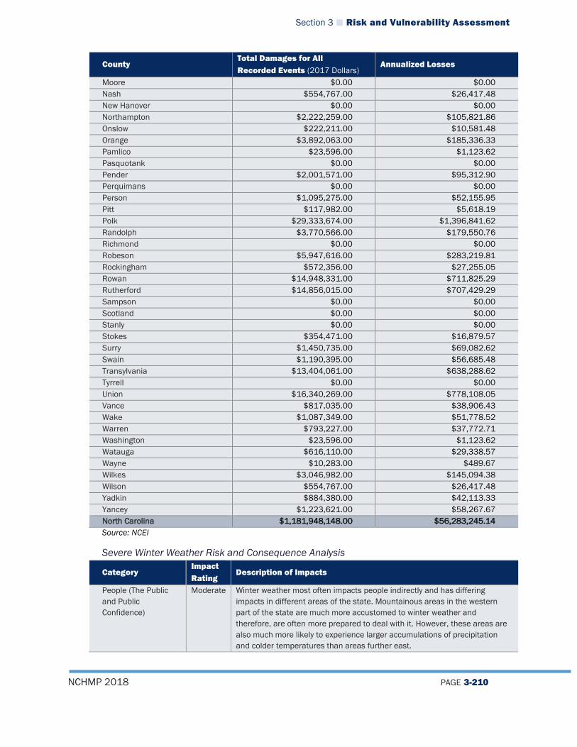
Section 3 Risk and Vulnerability Assessment
NCHMP 2018 PAGE 3-210
County Total Damages for All Recorded Events (2017 Dollars)
Annualized Losses
Moore $0.00 $0.00 Nash $554,767.00 $26,417.48 New Hanover $0.00 $0.00 Northampton $2,222,259.00 $105,821.86 Onslow $222,211.00 $10,581.48 Orange $3,892,063.00 $185,336.33 Pamlico $23,596.00 $1,123.62 Pasquotank $0.00 $0.00 Pender $2,001,571.00 $95,312.90 Perquimans $0.00 $0.00 Person $1,095,275.00 $52,155.95 Pitt $117,982.00 $5,618.19 Polk $29,333,674.00 $1,396,841.62 Randolph $3,770,566.00 $179,550.76 Richmond $0.00 $0.00 Robeson $5,947,616.00 $283,219.81 Rockingham $572,356.00 $27,255.05 Rowan $14,948,331.00 $711,825.29 Rutherford $14,856,015.00 $707,429.29 Sampson $0.00 $0.00 Scotland $0.00 $0.00 Stanly $0.00 $0.00 Stokes $354,471.00 $16,879.57 Surry $1,450,735.00 $69,082.62 Swain $1,190,395.00 $56,685.48 Transylvania $13,404,061.00 $638,288.62 Tyrrell $0.00 $0.00 Union $16,340,269.00 $778,108.05 Vance $817,035.00 $38,906.43 Wake $1,087,349.00 $51,778.52 Warren $793,227.00 $37,772.71 Washington $23,596.00 $1,123.62 Watauga $616,110.00 $29,338.57 Wayne $10,283.00 $489.67 Wilkes $3,046,982.00 $145,094.38 Wilson $554,767.00 $26,417.48 Yadkin $884,380.00 $42,113.33 Yancey $1,223,621.00 $58,267.67 North Carolina $1,181,948,148.00 $56,283,245.14 Source: NCEI
Severe Winter Weather Risk and Consequence Analysis
Category Impact Rating
Description of Impacts
People (The Public and Public Confidence)
Moderate Winter weather most often impacts people indirectly and has differing impacts in different areas of the state. Mountainous areas in the western part of the state are much more accustomed to winter weather and therefore, are often more prepared to deal with it. However, these areas are also much more likely to experience larger accumulations of precipitation and colder temperatures than areas further east.
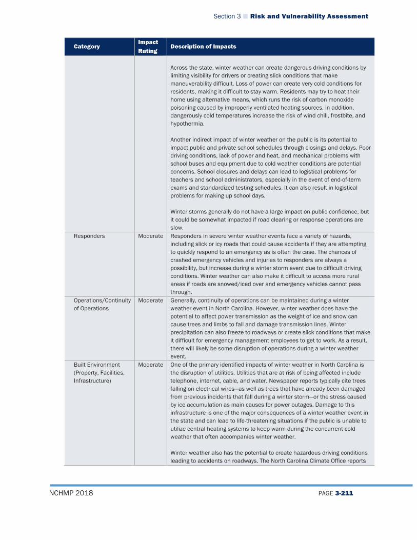
Section 3 Risk and Vulnerability Assessment
NCHMP 2018 PAGE 3-211
Category Impact Rating
Description of Impacts
Across the state, winter weather can create dangerous driving conditions by limiting visibility for drivers or creating slick conditions that make maneuverability difficult. Loss of power can create very cold conditions for residents, making it difficult to stay warm. Residents may try to heat their home using alternative means, which runs the risk of carbon monoxide poisoning caused by improperly ventilated heating sources. In addition, dangerously cold temperatures increase the risk of wind chill, frostbite, and hypothermia. Another indirect impact of winter weather on the public is its potential to impact public and private school schedules through closings and delays. Poor driving conditions, lack of power and heat, and mechanical problems with school buses and equipment due to cold weather conditions are potential concerns. School closures and delays can lead to logistical problems for teachers and school administrators, especially in the event of end-of-term exams and standardized testing schedules. It can also result in logistical problems for making up school days. Winter storms generally do not have a large impact on public confidence, but it could be somewhat impacted if road clearing or response operations are slow.
Responders Moderate Responders in severe winter weather events face a variety of hazards, including slick or icy roads that could cause accidents if they are attempting to quickly respond to an emergency as is often the case. The chances of crashed emergency vehicles and injuries to responders are always a possibility, but increase during a winter storm event due to difficult driving conditions. Winter weather can also make it difficult to access more rural areas if roads are snowed/iced over and emergency vehicles cannot pass through.
Operations/Continuity of Operations
Moderate Generally, continuity of operations can be maintained during a winter weather event in North Carolina. However, winter weather does have the potential to affect power transmission as the weight of ice and snow can cause trees and limbs to fall and damage transmission lines. Winter precipitation can also freeze to roadways or create slick conditions that make it difficult for emergency management employees to get to work. As a result, there will likely be some disruption of operations during a winter weather event.
Built Environment (Property, Facilities, Infrastructure)
Moderate One of the primary identified impacts of winter weather in North Carolina is the disruption of utilities. Utilities that are at risk of being affected include telephone, internet, cable, and water. Newspaper reports typically cite trees falling on electrical wires—as well as trees that have already been damaged from previous incidents that fall during a winter storm—or the stress caused by ice accumulation as main causes for power outages. Damage to this infrastructure is one of the major consequences of a winter weather event in the state and can lead to life-threatening situations if the public is unable to utilize central heating systems to keep warm during the concurrent cold weather that often accompanies winter weather. Winter weather also has the potential to create hazardous driving conditions leading to accidents on roadways. The North Carolina Climate Office reports
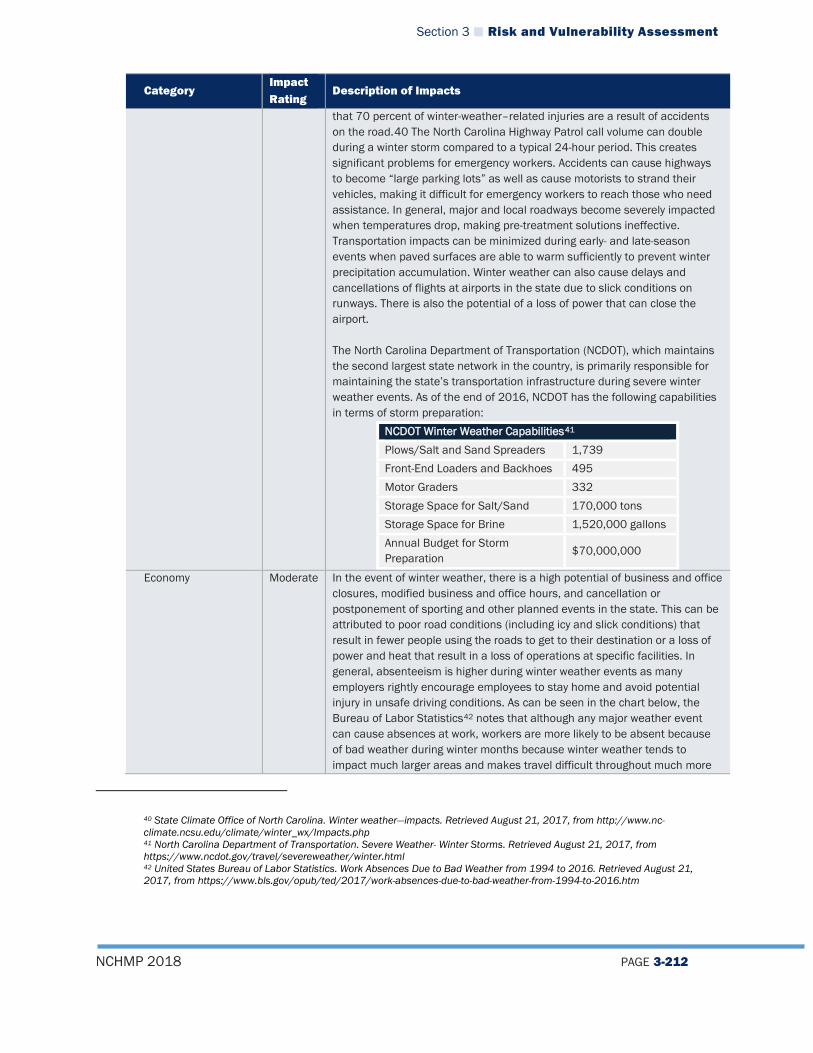
Section 3 Risk and Vulnerability Assessment
NCHMP 2018 PAGE 3-212
Category Impact Rating
Description of Impacts
that 70 percent of winter-weather–related injuries are a result of accidents on the road.40 The North Carolina Highway Patrol call volume can double during a winter storm compared to a typical 24-hour period. This creates significant problems for emergency workers. Accidents can cause highways to become “large parking lots” as well as cause motorists to strand their vehicles, making it difficult for emergency workers to reach those who need assistance. In general, major and local roadways become severely impacted when temperatures drop, making pre-treatment solutions ineffective. Transportation impacts can be minimized during early- and late-season events when paved surfaces are able to warm sufficiently to prevent winter precipitation accumulation. Winter weather can also cause delays and cancellations of flights at airports in the state due to slick conditions on runways. There is also the potential of a loss of power that can close the airport. The North Carolina Department of Transportation (NCDOT), which maintains the second largest state network in the country, is primarily responsible for maintaining the state’s transportation infrastructure during severe winter weather events. As of the end of 2016, NCDOT has the following capabilities in terms of storm preparation:
NCDOT Winter Weather Capabilities41 Plows/Salt and Sand Spreaders 1,739 Front-End Loaders and Backhoes 495 Motor Graders 332 Storage Space for Salt/Sand 170,000 tons Storage Space for Brine 1,520,000 gallons Annual Budget for Storm Preparation $70,000,000
Economy Moderate In the event of winter weather, there is a high potential of business and office closures, modified business and office hours, and cancellation or postponement of sporting and other planned events in the state. This can be attributed to poor road conditions (including icy and slick conditions) that result in fewer people using the roads to get to their destination or a loss of power and heat that result in a loss of operations at specific facilities. In general, absenteeism is higher during winter weather events as many employers rightly encourage employees to stay home and avoid potential injury in unsafe driving conditions. As can be seen in the chart below, the Bureau of Labor Statistics42 notes that although any major weather event can cause absences at work, workers are more likely to be absent because of bad weather during winter months because winter weather tends to impact much larger areas and makes travel difficult throughout much more
40 State Climate Office of North Carolina. Winter weather—impacts. Retrieved August 21, 2017, from http://www.nc-climate.ncsu.edu/climate/winter_wx/Impacts.php 41 North Carolina Department of Transportation. Severe Weather- Winter Storms. Retrieved August 21, 2017, from https://www.ncdot.gov/travel/severeweather/winter.html 42 United States Bureau of Labor Statistics. Work Absences Due to Bad Weather from 1994 to 2016. Retrieved August 21, 2017, from https://www.bls.gov/opub/ted/2017/work-absences-due-to-bad-weather-from-1994-to-2016.htm
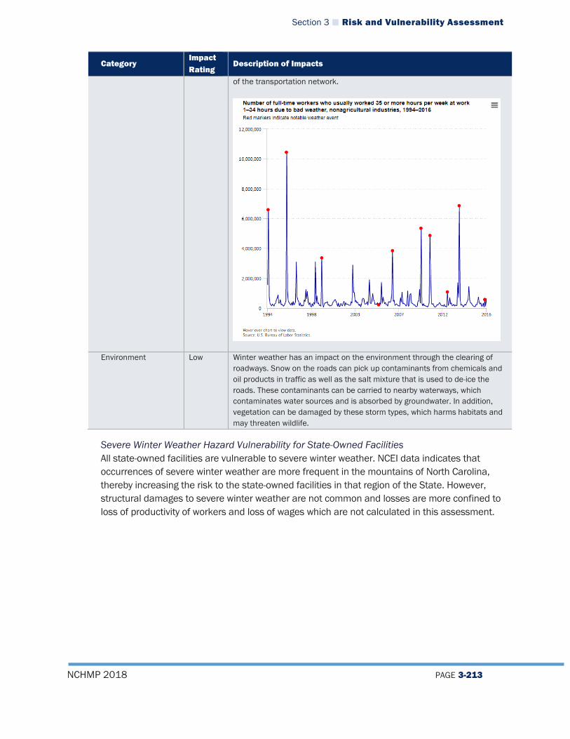
Section 3 Risk and Vulnerability Assessment
NCHMP 2018 PAGE 3-213
Category Impact Rating
Description of Impacts
of the transportation network.
Environment Low Winter weather has an impact on the environment through the clearing of roadways. Snow on the roads can pick up contaminants from chemicals and oil products in traffic as well as the salt mixture that is used to de-ice the roads. These contaminants can be carried to nearby waterways, which contaminates water sources and is absorbed by groundwater. In addition, vegetation can be damaged by these storm types, which harms habitats and may threaten wildlife.
Severe Winter Weather Hazard Vulnerability for State-Owned Facilities All state-owned facilities are vulnerable to severe winter weather. NCEI data indicates that occurrences of severe winter weather are more frequent in the mountains of North Carolina, thereby increasing the risk to the state-owned facilities in that region of the State. However, structural damages to severe winter weather are not common and losses are more confined to loss of productivity of workers and loss of wages which are not calculated in this assessment.

Section 3 Risk and Vulnerability Assessment
NCHMP 2018 PAGE 3-214
3.4.5.6 Excessive Heat Vulnerability All buildings in the state should be considered vulnerable to excessive heat, but excessive heat does not cause significant structural or monetary damage. The most significant impacts from excessive heat are loss of life.
Excessive Heat Hazard Risk, Vulnerability, and Consequence Analysis
Category Impact Rating
Description of Impacts
People (The Public and Public Confidence)
Moderate Extreme heat can affect many people and to varying degrees. Often the elderly and very young are susceptible to the most detrimental impacts, but heat stroke and exhaustion can plague anyone. People who are overweight, who overexert during work or exercise, and who are ill or are on certain medications are also at greater risk of suffering from heat-related illness. Risks from exposure to extreme heat include heat cramps, heat exhaustion, heat stroke, and death. Many of the impacts of extreme heat on people are the result of heat exhaustion or improperly functioning air conditioning units. A heat wave or extreme heat event would have minimal effects on public confidence as these events are frequent and the public likely understands the potential impacts. However, if an extreme heat event results in a large number of illnesses and fatalities, government organizations may be accused of failing to properly prepare for or respond to the threat, and public confidence could suffer.
Responders Moderate Extreme heat can also affect responders who are often more susceptible to heat stroke and exhaustion due to the nature of their work. This work forces police and emergency medical providers to be exposed to the elements, physically exert themselves, or wear heavy personal protective equipment. In these cases, responders could be negatively impacted by extreme heat and will need to protect themselves and prepare accordingly.
Operations/Continuity of Operations
Low Extreme heat would likely have few impacts on continuity of operations as the warning time for these events is usually long and direct impacts to large numbers of personnel or other resources necessary to maintain operations are unlikely. If air conditioning systems in operations centers break down due to overuse, operations could be interrupted or forced to move to secondary facilities.
Built Environment (Property, Facilities, Infrastructure)
Low Extreme heat would likely have a minor effect on the built environment, although high temperatures could potentially put a strain on infrastructure such as power generation and water systems due to higher demand. During times of extreme heat, air conditioning units work harder and require more electricity, making brownouts and blackouts possible if electricity demands exceed generation. Extreme heat can also cause transportation infrastructure such as roads, bridges, railways, and runways to buckle, crack, or shatter.
Economy Low An extreme heat event could potentially have a negative impact on the economy in the short term as the public may be advised to stay indoors, causing them to reduce overall spending and negatively impact businesses in the community. Additionally, extreme heat events can also result in decreased worker productivity as high temperatures can result in decreased energy, loss of concentration, and heat-related illness in workers. This can cause disruptions to the regular working of
Section 3 Risk and Vulnerability Assessment
NCHMP 2018 PAGE 3-215
Category Impact Rating
Description of Impacts
the local economy. Extended periods of extreme heat may also disrupt the local economy if agricultural, dairy, and livestock production declines, resulting in income loss for farmers and other related industries as well as increased prices for consumers.
Environment Moderate The environment would be impacted by extreme heat as many plants and animals that are not able to withstand the heat may die off and crops and livestock may be impacted by unusually high temperatures, resulting in death or illness. Heat waves can also contribute to higher levels of air pollution since air becomes stagnant and traps emitted pollutants, often causing increased levels of surface ozone.
Excessive Heat Hazard Vulnerability for State-Owned Facilities All state-owned facilities buildings in the state should be considered vulnerable to excessive heat, but excessive heat does not cause significant structural or monetary damage. The most significant impacts from excessive heat are loss of life.
3.4.5.7 Earthquake Hazard Vulnerability Table 3-37 provides a summary of the expected annualized losses to earthquakes by county based on NCEM-RM risk data analysis.
Table 3-37 Annualized Earthquake Hazard Losses by County
County Annual Losses
Alamance $ 319,787.66
Alexander $ 167,955.41
Alleghany $ 97,486.32
Anson $ 168,253.58
Ashe $ 279,673.60
Avery $ 146,001.01
Beaufort $ 42,392.29
Bertie $ 9,697.89
Bladen $ 178,791.51
Brunswick $ 409,577.54
Buncombe $ 1,264,155.87
Burke $ 461,660.02
Cabarrus $ 1,097,106.10
Caldwell $ 543,123.67
Camden $ 1,825.24
Carteret $ 70,583.50
Caswell $ 66,240.07
Catawba $ 806,784.96
Chatham $ 288,272.15
Section 3 Risk and Vulnerability Assessment
NCHMP 2018 PAGE 3-216
County Annual Losses
Cherokee $ 503,852.64
Chowan $ 7,997.75
Clay $ 108,904.37
Cleveland $ 763,509.54
Columbus $ 411,352.64
Craven $ 93,614.62
Cumberland $ 1,409,514.67
Currituck $ 7,820.52
Dare $ 9,689.50
Davidson $ 552,246.82
Davie $ 225,696.42
Duplin $ 257,214.17
Durham $ 480,734.82
Edgecombe $ 61,166.18
Forsyth $ 832,815.82
Franklin $ 82,439.88
Gaston $ 800,913.37
Gates $ 9,094.92
Graham $ 178,421.07
Granville $ 83,008.14
Greene $ 25,811.29
Guilford $ 1,234,939.99
Halifax $ 145,739.17
Harnett $ 187,749.30
Haywood $ 620,125.86
Henderson $ 764,597.22
Hertford $ 22,727.45
Hoke $ 134,708.26
Hyde $ 2,394.19
Iredell $ 632,179.02
Jackson $ 324,709.03
Johnston $ 310,796.50
Jones $ 12,803.18
Lee $ 189,627.29
Lenoir $ 108,764.40
Lincoln $ 442,674.21
Macon $ 379,476.30
Madison $ 249,098.27
Martin $ 44,071.90
McDowell $ 241,940.43

Section 3 Risk and Vulnerability Assessment
NCHMP 2018 PAGE 3-217
County Annual Losses
Mecklenburg $ 4,748,906.80
Mitchell $ 164,451.75
Montgomery $ 179,616.22
Moore $ 445,012.07
Nash $ 143,063.61
New Hanover $ 831,870.81
Northampton $ 25,023.10
Onslow $ 231,483.91
Orange $ 300,455.11
Pamlico $ 8,172.45
Pasquotank $ 13,936.49
Pender $ 98,801.65
Perquimans $ 6,234.17
Person $ 99,583.00
Pitt $ 145,331.97
Polk $ 213,557.91
Randolph $ 550,488.75
Richmond $ 458,407.83
Robeson $ 1,153,622.09
Rockingham $ 357,653.24
Rowan $ 773,176.03
Rutherford $ 665,773.15
Sampson $ 358,501.91
Scotland $ 295,102.94
Stanly $ 389,664.75
Stokes $ 114,985.98
Surry $ 318,876.46
Swain $ 148,718.86
Transylvania
Tyrrell $ 1,521.62
Union $ 855,554.82
Vance $ 74,313.71
Wake $ 1,612,877.44
Warren $ 20,544.78
Washington $ 4,098.27
Watauga $ 255,762.35
Wayne $ 374,681.96
Wilkes $ 387,461.95
Wilson $ 100,334.65
Yadkin $ 111,729.84
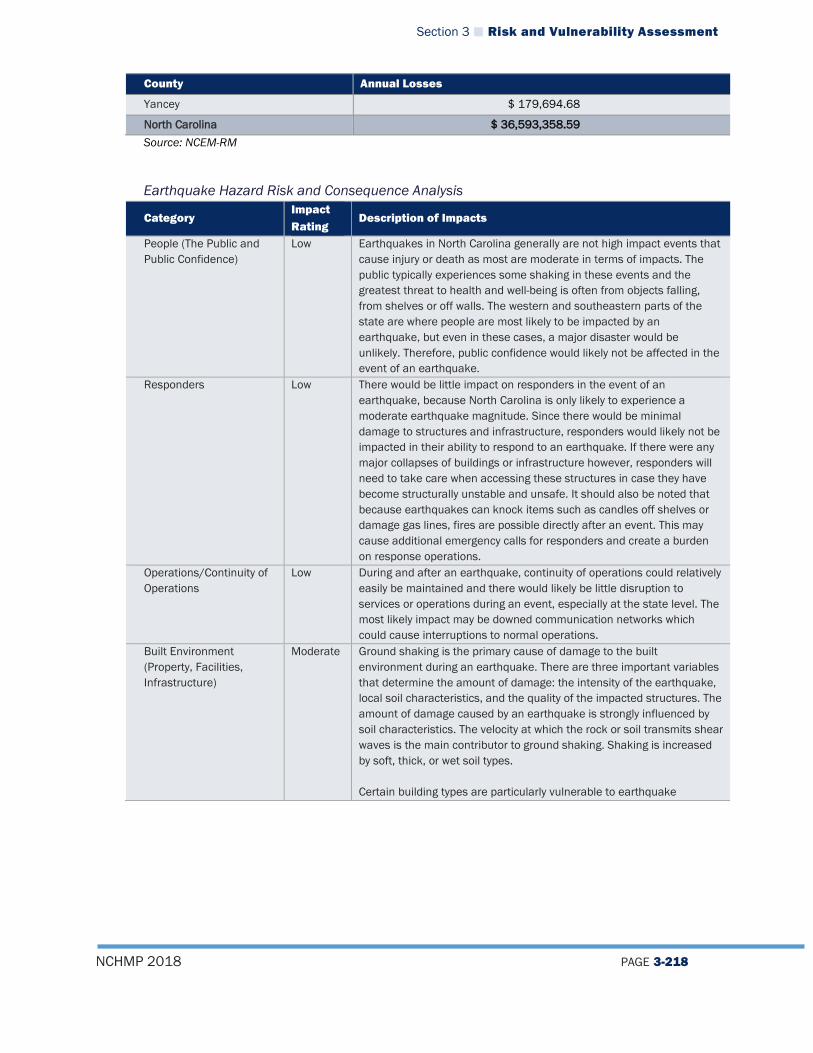
Section 3 Risk and Vulnerability Assessment
NCHMP 2018 PAGE 3-218
County Annual Losses
Yancey $ 179,694.68
North Carolina $ 36,593,358.59 Source: NCEM-RM
Earthquake Hazard Risk and Consequence Analysis
Category Impact Rating
Description of Impacts
People (The Public and Public Confidence)
Low Earthquakes in North Carolina generally are not high impact events that cause injury or death as most are moderate in terms of impacts. The public typically experiences some shaking in these events and the greatest threat to health and well-being is often from objects falling, from shelves or off walls. The western and southeastern parts of the state are where people are most likely to be impacted by an earthquake, but even in these cases, a major disaster would be unlikely. Therefore, public confidence would likely not be affected in the event of an earthquake.
Responders Low There would be little impact on responders in the event of an earthquake, because North Carolina is only likely to experience a moderate earthquake magnitude. Since there would be minimal damage to structures and infrastructure, responders would likely not be impacted in their ability to respond to an earthquake. If there were any major collapses of buildings or infrastructure however, responders will need to take care when accessing these structures in case they have become structurally unstable and unsafe. It should also be noted that because earthquakes can knock items such as candles off shelves or damage gas lines, fires are possible directly after an event. This may cause additional emergency calls for responders and create a burden on response operations.
Operations/Continuity of Operations
Low During and after an earthquake, continuity of operations could relatively easily be maintained and there would likely be little disruption to services or operations during an event, especially at the state level. The most likely impact may be downed communication networks which could cause interruptions to normal operations.
Built Environment (Property, Facilities, Infrastructure)
Moderate Ground shaking is the primary cause of damage to the built environment during an earthquake. There are three important variables that determine the amount of damage: the intensity of the earthquake, local soil characteristics, and the quality of the impacted structures. The amount of damage caused by an earthquake is strongly influenced by soil characteristics. The velocity at which the rock or soil transmits shear waves is the main contributor to ground shaking. Shaking is increased by soft, thick, or wet soil types. Certain building types are particularly vulnerable to earthquake

Section 3 Risk and Vulnerability Assessment
NCHMP 2018 PAGE 3-219
Category Impact Rating
Description of Impacts
damage: wood-frame multi-unit buildings, single-family homes, mobile homes, and unreinforced masonry buildings.43 The most susceptible structures are wood-frame, multi-story, mixed-use buildings that have large openings on the first floor for garages or commercial space and housing on the upper floors. During an earthquake, these types of structures could sway or even collapse. Single-family homes built prior to the 1970s are often not bolted to their foundations, and walls surrounding crawl spaces are not braced (i.e., cripple walls). Typical earthquake damage to these structures include cracked foundations, chimneys breaking at the roof line, wood frames coming off their foundations, and racking of cripple walls. Mobile homes that are built of light-weight metal or a combination of steel frame and wood are easily damaged by a quake. Mobile homes installed prior to 1995 were often not attached to their foundations and could shift off their supports. The last type of susceptible building material is unreinforced masonry—masonry walls that have not been reinforced with steel. These buildings were often built before 1960 in an era when reinforcing was not generally used, anchorage to floors and roofs was missing, and use of low-strength lime mortar was common. Earthquake damage to these buildings can be severe. A lack of reinforcement and tie-downs can result in substantial damage in the form of cracked or leaning walls. Damage may also occur between the walls, and separation between the framing and walls could lead to full collapse due to a lack of vertical support. Critical Infrastructure There are a handful of key resource categories that could be impacted by an earthquake including transportation systems, communication systems, and utility systems. Historically, the state has not been impacted by an earthquake with more than a moderate intensity so damage to these resources would be very minor; however, an inspection of certain features after a strongly felt earthquake may be necessary.
Economy Low There are several sources of economic loss typically associated with an earthquake including property damage and business interruption costs; cost to repair public transportation, communication, or utility systems; and debris removal costs. Historically, there have been relatively minor economic losses from earthquakes in the state that have not already been described under the impacts to the built environment above.
Environment Low There would be very minor impacts to the environment following a significant earthquake that is felt in North Carolina with a moderate intensity. Secondary effects from the damage of key resources mentioned above (e.g. utility systems) could impact the environment,
43 Association of Bay Area Governments. (2017). Guide to housing vulnerable resources. Retrieved August 21, 2017, from http://quake.abag.ca.gov/housing/
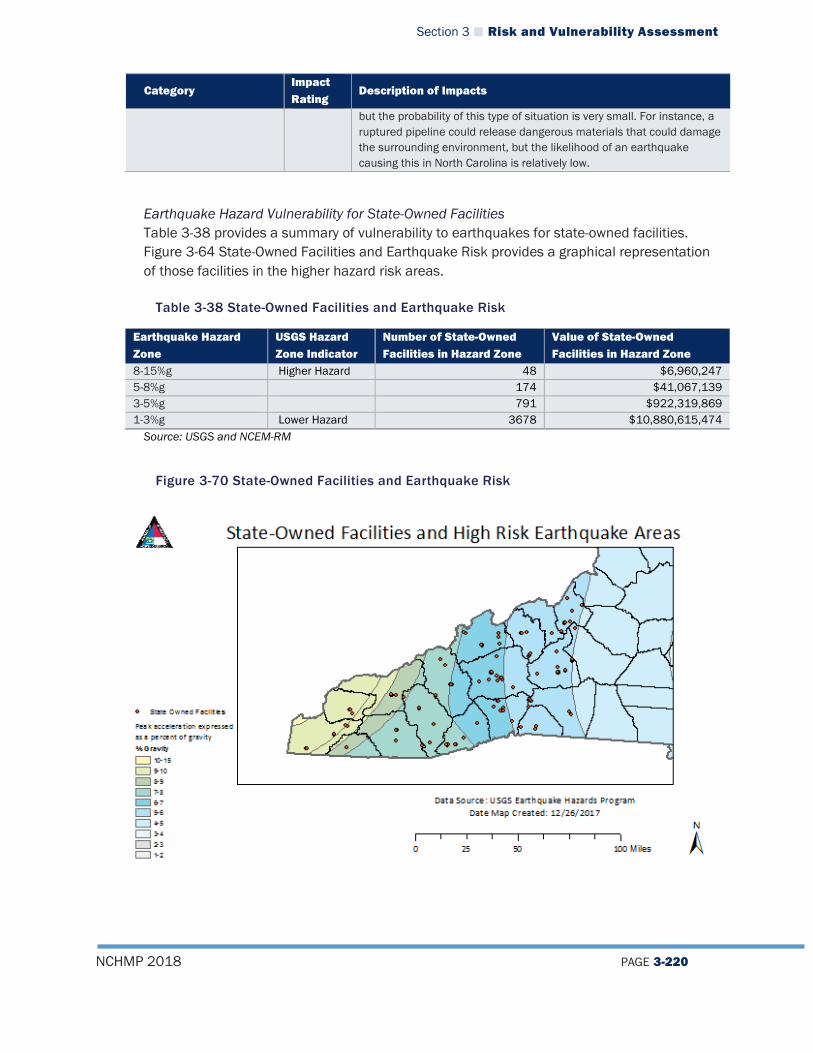
Section 3 Risk and Vulnerability Assessment
NCHMP 2018 PAGE 3-220
Category Impact Rating
Description of Impacts
but the probability of this type of situation is very small. For instance, a ruptured pipeline could release dangerous materials that could damage the surrounding environment, but the likelihood of an earthquake causing this in North Carolina is relatively low.
Earthquake Hazard Vulnerability for State-Owned Facilities Table 3-38 provides a summary of vulnerability to earthquakes for state-owned facilities. Figure 3-64 State-Owned Facilities and Earthquake Risk provides a graphical representation of those facilities in the higher hazard risk areas.
Table 3-38 State-Owned Facilities and Earthquake Risk
Earthquake Hazard Zone
USGS Hazard Zone Indicator
Number of State-Owned Facilities in Hazard Zone
Value of State-Owned Facilities in Hazard Zone
8-15%g Higher Hazard 48 $6,960,247 5-8%g 174 $41,067,139 3-5%g 791 $922,319,869 1-3%g Lower Hazard 3678 $10,880,615,474 Source: USGS and NCEM-RM
Figure 3-70 State-Owned Facilities and Earthquake Risk

Section 3 Risk and Vulnerability Assessment
NCHMP 2018 PAGE 3-221
3.4.5.8 Wildfire Hazard Vulnerability To determine vulnerability to the wildfire hazard, a GIS analysis was run to determine, by County, the number and value of structures in high risk wildland urban interface areas (areas 7 through 9 as depicted on Figure 3-65 below). Results of the analysis can be found in Table 3-39.
Figure 3-71 Value of Buildings in High WUI Risk Areas
Table 3-39 Wildfire Vulnerability
County Name Number of Buildings in High WUI Zones (7-9)
Value of Buildings in High WUI Zones (7-9)
Alamance 5125 $828,881,703 Alexander 2636 $370,810,950 Alleghany 923 $67,989,360 Anson 2044 $400,362,936 Ashe 1124 $133,559,919 Avery 815 $141,538,464 Beaufort 6521 $548,034,579 Bertie 1598 $92,062,199 Bladen 7220 $1,303,157,726 Brunswick 31976 $3,400,679,826 Buncombe 9442 $2,507,948,026 Burke 4382 $454,043,702 Cabarrus 7531 $824,656,472 Caldwell 4488 $436,118,688 Camden 670 $76,459,248
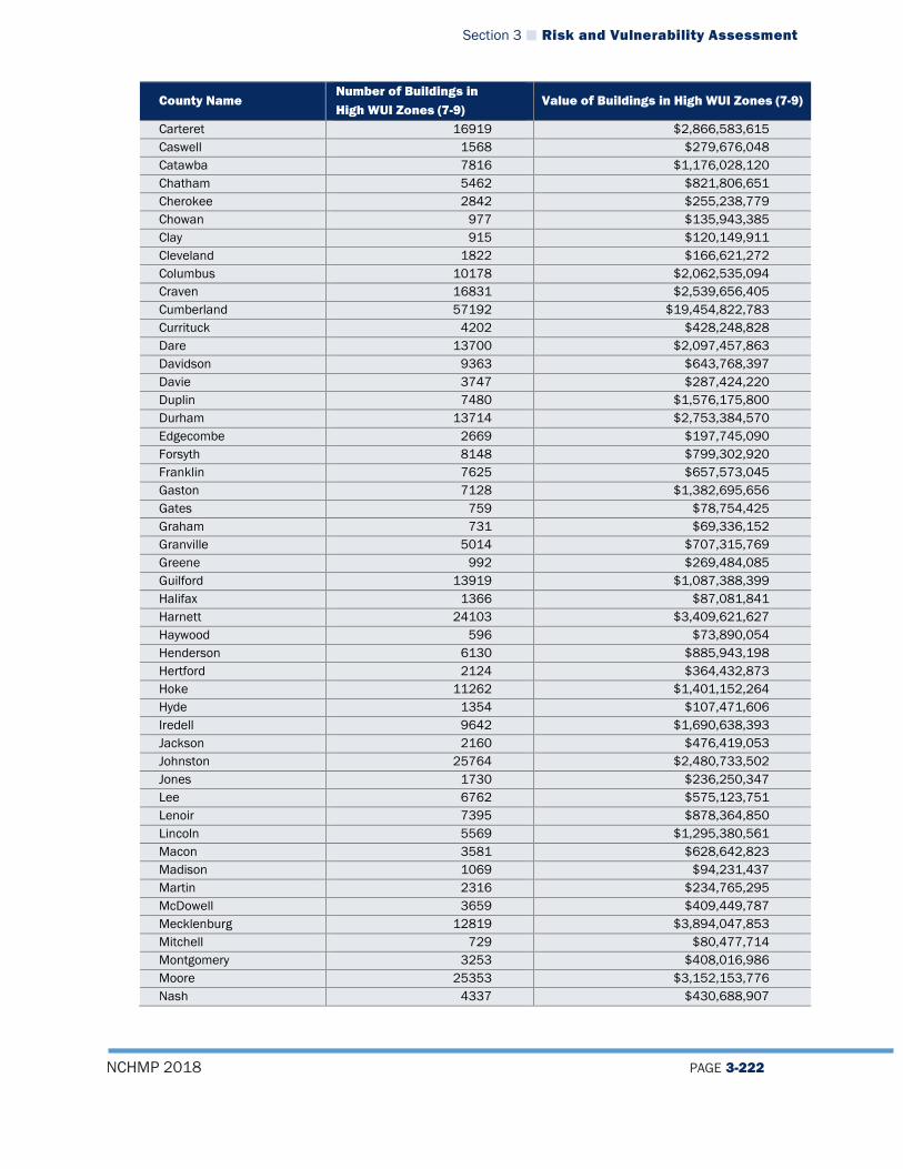
Section 3 Risk and Vulnerability Assessment
NCHMP 2018 PAGE 3-222
County Name Number of Buildings in High WUI Zones (7-9)
Value of Buildings in High WUI Zones (7-9)
Carteret 16919 $2,866,583,615 Caswell 1568 $279,676,048 Catawba 7816 $1,176,028,120 Chatham 5462 $821,806,651 Cherokee 2842 $255,238,779 Chowan 977 $135,943,385 Clay 915 $120,149,911 Cleveland 1822 $166,621,272 Columbus 10178 $2,062,535,094 Craven 16831 $2,539,656,405 Cumberland 57192 $19,454,822,783 Currituck 4202 $428,248,828 Dare 13700 $2,097,457,863 Davidson 9363 $643,768,397 Davie 3747 $287,424,220 Duplin 7480 $1,576,175,800 Durham 13714 $2,753,384,570 Edgecombe 2669 $197,745,090 Forsyth 8148 $799,302,920 Franklin 7625 $657,573,045 Gaston 7128 $1,382,695,656 Gates 759 $78,754,425 Graham 731 $69,336,152 Granville 5014 $707,315,769 Greene 992 $269,484,085 Guilford 13919 $1,087,388,399 Halifax 1366 $87,081,841 Harnett 24103 $3,409,621,627 Haywood 596 $73,890,054 Henderson 6130 $885,943,198 Hertford 2124 $364,432,873 Hoke 11262 $1,401,152,264 Hyde 1354 $107,471,606 Iredell 9642 $1,690,638,393 Jackson 2160 $476,419,053 Johnston 25764 $2,480,733,502 Jones 1730 $236,250,347 Lee 6762 $575,123,751 Lenoir 7395 $878,364,850 Lincoln 5569 $1,295,380,561 Macon 3581 $628,642,823 Madison 1069 $94,231,437 Martin 2316 $234,765,295 McDowell 3659 $409,449,787 Mecklenburg 12819 $3,894,047,853 Mitchell 729 $80,477,714 Montgomery 3253 $408,016,986 Moore 25353 $3,152,153,776 Nash 4337 $430,688,907
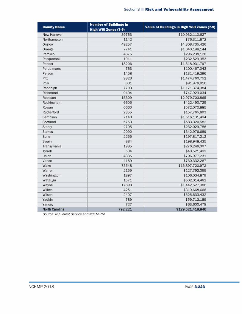
Section 3 Risk and Vulnerability Assessment
NCHMP 2018 PAGE 3-223
County Name Number of Buildings in High WUI Zones (7-9)
Value of Buildings in High WUI Zones (7-9)
New Hanover 39753 $10,932,110,627 Northampton 1142 $76,311,872 Onslow 49257 $4,308,735,426 Orange 7741 $1,640,198,144 Pamlico 4875 $296,238,128 Pasquotank 1911 $232,529,353 Pender 18206 $1,518,931,797 Perquimans 763 $100,467,043 Person 1458 $131,419,296 Pitt 9823 $1,474,760,752 Polk 801 $91,978,016 Randolph 7703 $1,171,374,384 Richmond 9404 $747,923,034 Robeson 15309 $2,979,703,865 Rockingham 6605 $422,490,729 Rowan 6660 $572,070,885 Rutherford 2355 $157,765,893 Sampson 7140 $1,516,131,494 Scotland 5753 $583,320,582 Stanly 2795 $232,029,786 Stokes 2092 $342,976,689 Surry 2255 $197,817,212 Swain 884 $198,948,435 Transylvania 1985 $276,248,397 Tyrrell 504 $40,521,492 Union 4335 $706,977,231 Vance 4189 $730,332,267 Wake 73548 $16,897,720,972 Warren 2159 $127,792,355 Washington 1897 $106,034,879 Watauga 1571 $502,014,482 Wayne 17893 $1,442,527,986 Wilkes 4251 $319,668,666 Wilson 2407 $525,633,432 Yadkin 789 $59,713,189 Yancey 727 $63,600,478 North Carolina 792,221 $129,521,418,846 Source: NC Forest Service and NCEM-RM
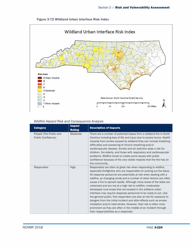
Section 3 Risk and Vulnerability Assessment
NCHMP 2018 PAGE 3-224
Figure 3-72 Wildland Urban Interface Risk Index
Wildfire Hazard Risk and Consequence Analysis
Category Impact Rating
Description of Impacts
People (The Public and Public Confidence)
Moderate There are a number of potential losses from a wildland fire in North Carolina including loss of life and injury due to severe burns. Health hazards from smoke caused by wildland fires can include breathing difficulties and worsening of chronic breathing and/or cardiovascular disease. Smoke and air pollution pose a risk for children, the elderly, and those with respiratory and cardiovascular problems. Wildfire tends to create some issues with public confidence because of the very visible impacts that the fire has on the community.
Responders High Responders are often at great risk when responding to wildfire, especially firefighters who are responsible for putting out the blaze. All response personnel are potentially at risk when dealing with a wildfire, as changing winds and a number of other factors can often cause a fire to spread rapidly. Although many areas of the state are urbanized and are not at a high risk to wildfire, moderately-developed rural areas that are located in the wildland urban interface may require response personnel to be ready to act. Like the general public, first responders are also at risk for exposure to dangers from the initial incident and after-effects such as smoke inhalation and/or heat stroke. However, their risk is often more prominent as they are often in the middle of an incident through their responsibilities as a responder.

Section 3 Risk and Vulnerability Assessment
NCHMP 2018 PAGE 3-225
Category Impact Rating
Description of Impacts
Operations/Continuity of Operations
Moderate Since wildfire often moves quickly and can affect infrastructure that is important to maintaining continuity of operations, there is some level of concern for maintaining continuity. However, operations at the state level, which are generally run from urbanized areas, will probably not be impacted in a major way. Local continuity of operations in rural areas is much more susceptible to the impacts of a wildfire.
Built Environment (Property, Facilities, Infrastructure)
Moderate Wildland fires have the potential to substantially burn forested areas as well as private residences. Damage and destruction to state, county, private, and municipal structures and facilities are major losses that are attributed to wildland fires. Private residences and communities that are located within the Wildland Urban Interface (WUI) are particularly susceptible to the threat. Population increases in North Carolina’s WUI areas, for example, can create significant challenges for firefighters and residents. This is especially notable considering a study in 2000 showed that North Carolina ranked number one in terms of the amount of land area located within the WUI zones and fifth in number of homes located within the WUI.44 Many new homes are constructed without considering community wildland fire planning. This creates neighborhoods with limited accessibility, flammable building construction, and landscaping. A lack of firewise planning can also greatly increase the probability of a wildland fire occurrence with more homes and emergency personnel being threatened. All types of private property may suffer losses from wildfires. This includes business properties, homes, vehicles, and livestock. Damage to capital goods and equipment as well as evacuation expenses and other losses are directly related to fire and smoke damage. Additional potential losses include building and landscape maintenance expenses, firefighting equipment purchases, and fire-related business closures. Additional post-fire losses include cleanup, rehabilitation and repair expenses, equipment and capital goods replacement, drinking water pollution, smoke damage, deflated real estate values, and an increase in fire insurance premiums.
Economy Moderate Given the fact that a number of homes, businesses, and infrastructure are located in areas that could be impacted by wildfire, there could be some significant economic impacts of a wildfire in the state. If homes or businesses are burned, the cost of rebuilding could be substantial. Impacts to agricultural crops are another economic loss that the state could face in the event of a wildland fire. Wildfires can be particularly damaging to the lumber and Christmas tree farming industries which are important to the
44 North Carolina Firewise (2000). North Carolina Firewise. Retrieved August 21, 2017, from http://www.ncfirewise.org/index.htm

Section 3 Risk and Vulnerability Assessment
NCHMP 2018 PAGE 3-226
Category Impact Rating
Description of Impacts
state. Environment Low Wildland fires have the potential to damage or destroy forage on
grazing lands, secondary forest products destruction, and/or degradation and loss of wildlife habitat on public lands. On private lands, vegetation losses could include agricultural crops that are either burned or impacted by wildland fire smoke. Indirect losses could include loss of growing stock as well as irrigation systems. Another potential loss includes damage and destruction to a wide variety of common or protected habitats in the state. Finally, the release of smoke from wildfires can pollute the air and reduce air quality. It should also be noted, however, that wildfires are a naturally occurring element of the environment and have played an important part in the development of many ecosystems in that they are regenerative and provide vital nutrients for the soil which can help sustain a forest habitat and all of the organisms living within it. Therefore, although there are some negative impacts of wildfire, there are also some positive impacts on the environment.
Wildfire Hazard Vulnerability for State-Owned Facilities There are 566 State-owned facilities with a value of $1,133,718,049 located in high risk WUI areas (WUI categories 7, 8, 9). Figure 3-67 provides a graphical representation of where those facilities are located.
Figure 3-73 State Facilities in Wildland Urban Interface Risk Areas
Section 3 Risk and Vulnerability Assessment
NCHMP 2018 PAGE 3-227
3.4.5.9 Dam Failure Hazard Vulnerability Inventories of statewide dam inundation data is an area that NCEM-RM is currently working hard to improve. At this time, there is geospatial data in final quality control review for 19 dams in North Carolina and that number is expected to increase significantly over the next several years. Additionally, NCEM is currently working with the USACE to acquire inundation data for 9 dams under the Corps’ control. As this data becomes available, detailed assessments can be run to better determine statewide vulnerability to dam failures. The 2023 update of the NCEHMP will include a much more robust analysis of statewide dam failure vulnerability at the County level and for State-owned facilities.
Dam Failure Hazard Risk and Consequence Analysis
Category Impact Rating
Description of Impacts
People (The Public and Public Confidence)
Many of the impacts associated with a dam/levee failure are the same as those that would be associated with a flood event. However, the primary difference for members of the public in the case of a dam/levee failure is that often citizens who might be impacted by a dam/levee failure may believe themselves to be protected from flood events as a result of the dam/levee and therefore, may not be anticipating the event. This may have a severe impact on public confidence in the long run as citizens may view this as a failure of government institutions to properly regulate and control the dam/levee. That is to say, they may ultimately view the incident as preventable, unlike a flood that occurs purely from natural causes.
Responders Similar to the issues associated with the flood hazard, responders would be impacted by a dam/levee failure as they may be forced to attempt to assist citizens who have become trapped in their homes or in flood waters. Responders may have difficulty accessing homes or other structures where they need to provide support and their lives and well-being will likely be put at risk if they are forced to assist in a flooded area.
Operations/Continuity of Operations
A dam/levee failure would be unlikely to impact continuity of operations as the event would likely be confined to a specific area directly surrounding the dam/levee and most operations-related facilities in the state are not at risk of being impacted by a dam/levee failure.
Built Environment (Property, Facilities, Infrastructure)
A dam/levee failure may impact any properties located downstream of a dam/levee, especially any that are within identified inundation zones. The effects of a dam/levee failure on property, facilities, and infrastructure would be similar to those that have been outlined in the flood analysis although it is possible that the damage may be more severe, as high volumes of water are released all at once rather than over time. For example, during Hurricane Matthew a number of homes were damaged by dam breaks that were caused by massive rainfall in the state. Many of these dam breaks were at private dams and were the result of uncoordinated releases among operators along the river systems. In this scenario, when one dam failed, it caused a rush of water that impacted the downstream dams and resulted in similar
Section 3 Risk and Vulnerability Assessment
NCHMP 2018 PAGE 3-228
Category Impact Rating
Description of Impacts
failures and flooding of buildings. Economy The economic costs of a dam/levee failure could be significant as
there will likely be a high economic cost for the owner of the structure (whether it be a privately or publicly-owned) to rebuild or reconstruct the dam/levee. If a dam/levee fails, the owner may also need to rebuild the new structure to a higher standard to prevent future failures. If the dam was involved in electricity production as is the case for many dams in the state (Lake Jocassee Dam, Fontana Dam, High Rock Lake Dam), the failure will result in a loss of revenue for the owner, which could impact local utilities and may also result in temporary power outages (although most communities do not rely solely on hydroelectric power, so this is less likely). Many of these dams/levees are also used to create recreational lakes (Kerr Lake, Lake Gaston, Lake Norman) and when this type of dam fails, that recreational resource will be lost, which in turn may reduce tourism and visitors to the area and reduce property values in and around the lake.
Environment The impacts on the environment from a dam/levee failure might be that ecosystems and habitats that existed while a dam was in place on a stream/river could be destroyed as floodwaters destabilize areas by inundating places that had not previously been under water or causing higher flow rates downstream. Similar to flood events, if a facility that houses hazardous materials is impacted by flooding from a dam/levee failure, there may be contamination of the stream/river and ultimately the water supply. Although the dam failure itself would likely disrupt habitats in the short term, in some sense, a dam failure may restore the environment to a more natural state by allowing the river to return to its natural course and flow. That is to say, the absence of a dam/levee may be a long-term boon to the local environment.
Dam Failure Hazard Vulnerability for State-Owned Facilities There is currently inadequate data available to conduct analysis to determine vulnerability of State-owned facilities to the dam failure hazard. This analysis will be updated as more data becomes available.
3.4.5.10 Drought Hazard Vulnerability Table 3-40 provides a summary of the expected annualized losses for the drought hazard by county based on NCEI data.
Table 3-40 Annualized Losses for Drought
County Total Damages for All Recorded Events (2017 Dollars) Annualized Losses
Alamance $0.00 $0.00 Alexander $0.00 $0.00 Alleghany $12,271,076.00 $584,336.95 Anson $0.00 $0.00 Ashe $12,293,923.00 $585,424.90 Avery $0.00 $0.00
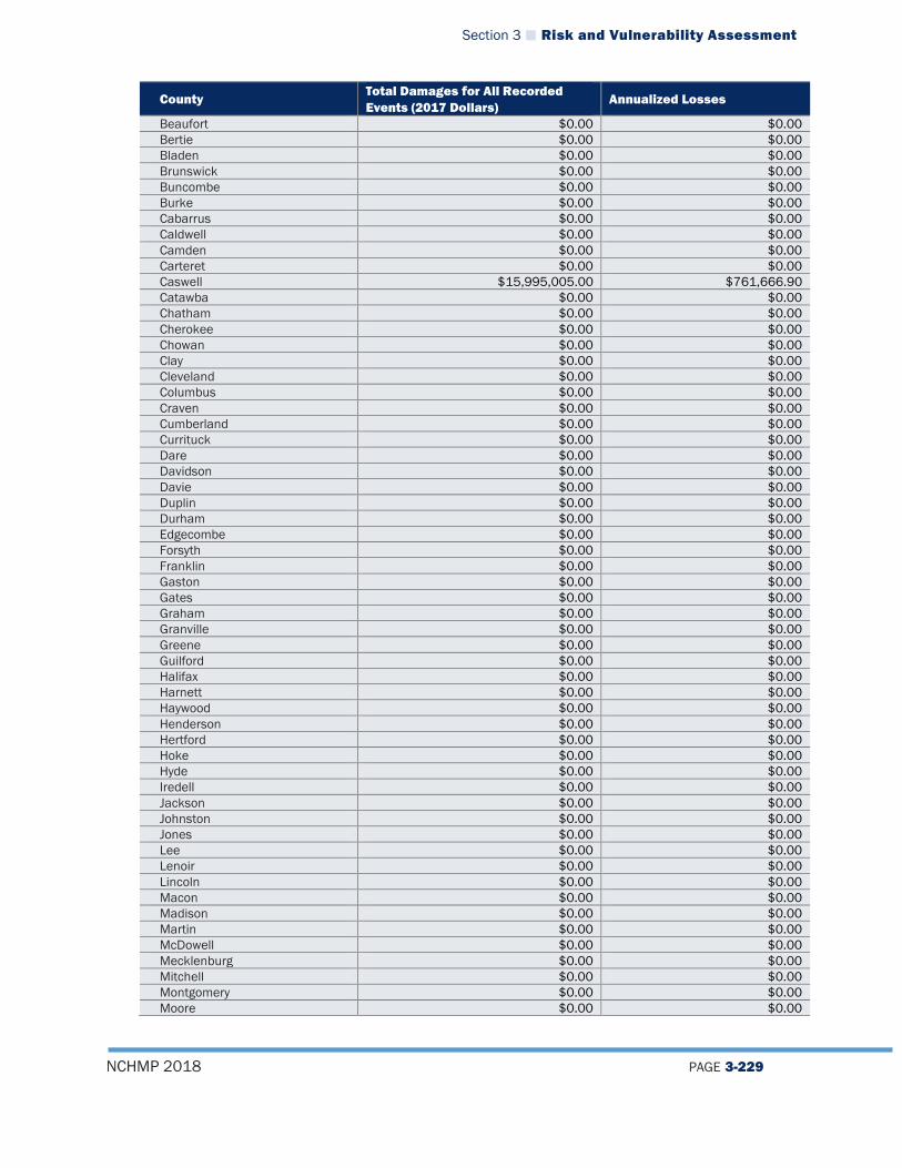
Section 3 Risk and Vulnerability Assessment
NCHMP 2018 PAGE 3-229
County Total Damages for All Recorded Events (2017 Dollars)
Annualized Losses
Beaufort $0.00 $0.00 Bertie $0.00 $0.00 Bladen $0.00 $0.00 Brunswick $0.00 $0.00 Buncombe $0.00 $0.00 Burke $0.00 $0.00 Cabarrus $0.00 $0.00 Caldwell $0.00 $0.00 Camden $0.00 $0.00 Carteret $0.00 $0.00 Caswell $15,995,005.00 $761,666.90 Catawba $0.00 $0.00 Chatham $0.00 $0.00 Cherokee $0.00 $0.00 Chowan $0.00 $0.00 Clay $0.00 $0.00 Cleveland $0.00 $0.00 Columbus $0.00 $0.00 Craven $0.00 $0.00 Cumberland $0.00 $0.00 Currituck $0.00 $0.00 Dare $0.00 $0.00 Davidson $0.00 $0.00 Davie $0.00 $0.00 Duplin $0.00 $0.00 Durham $0.00 $0.00 Edgecombe $0.00 $0.00 Forsyth $0.00 $0.00 Franklin $0.00 $0.00 Gaston $0.00 $0.00 Gates $0.00 $0.00 Graham $0.00 $0.00 Granville $0.00 $0.00 Greene $0.00 $0.00 Guilford $0.00 $0.00 Halifax $0.00 $0.00 Harnett $0.00 $0.00 Haywood $0.00 $0.00 Henderson $0.00 $0.00 Hertford $0.00 $0.00 Hoke $0.00 $0.00 Hyde $0.00 $0.00 Iredell $0.00 $0.00 Jackson $0.00 $0.00 Johnston $0.00 $0.00 Jones $0.00 $0.00 Lee $0.00 $0.00 Lenoir $0.00 $0.00 Lincoln $0.00 $0.00 Macon $0.00 $0.00 Madison $0.00 $0.00 Martin $0.00 $0.00 McDowell $0.00 $0.00 Mecklenburg $0.00 $0.00 Mitchell $0.00 $0.00 Montgomery $0.00 $0.00 Moore $0.00 $0.00
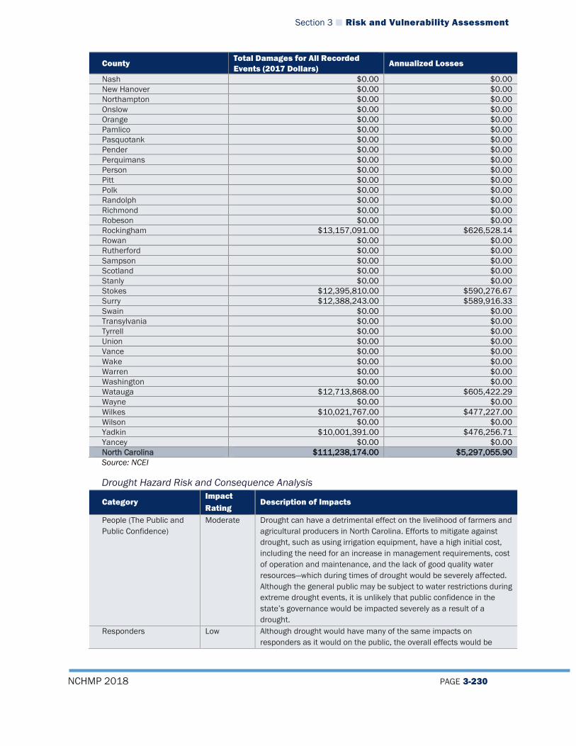
Section 3 Risk and Vulnerability Assessment
NCHMP 2018 PAGE 3-230
County Total Damages for All Recorded Events (2017 Dollars)
Annualized Losses
Nash $0.00 $0.00 New Hanover $0.00 $0.00 Northampton $0.00 $0.00 Onslow $0.00 $0.00 Orange $0.00 $0.00 Pamlico $0.00 $0.00 Pasquotank $0.00 $0.00 Pender $0.00 $0.00 Perquimans $0.00 $0.00 Person $0.00 $0.00 Pitt $0.00 $0.00 Polk $0.00 $0.00 Randolph $0.00 $0.00 Richmond $0.00 $0.00 Robeson $0.00 $0.00 Rockingham $13,157,091.00 $626,528.14 Rowan $0.00 $0.00 Rutherford $0.00 $0.00 Sampson $0.00 $0.00 Scotland $0.00 $0.00 Stanly $0.00 $0.00 Stokes $12,395,810.00 $590,276.67 Surry $12,388,243.00 $589,916.33 Swain $0.00 $0.00 Transylvania $0.00 $0.00 Tyrrell $0.00 $0.00 Union $0.00 $0.00 Vance $0.00 $0.00 Wake $0.00 $0.00 Warren $0.00 $0.00 Washington $0.00 $0.00 Watauga $12,713,868.00 $605,422.29 Wayne $0.00 $0.00 Wilkes $10,021,767.00 $477,227.00 Wilson $0.00 $0.00 Yadkin $10,001,391.00 $476,256.71 Yancey $0.00 $0.00 North Carolina $111,238,174.00 $5,297,055.90 Source: NCEI
Drought Hazard Risk and Consequence Analysis
Category Impact Rating
Description of Impacts
People (The Public and Public Confidence)
Moderate Drought can have a detrimental effect on the livelihood of farmers and agricultural producers in North Carolina. Efforts to mitigate against drought, such as using irrigation equipment, have a high initial cost, including the need for an increase in management requirements, cost of operation and maintenance, and the lack of good quality water resources—which during times of drought would be severely affected. Although the general public may be subject to water restrictions during extreme drought events, it is unlikely that public confidence in the state’s governance would be impacted severely as a result of a drought.
Responders Low Although drought would have many of the same impacts on responders as it would on the public, the overall effects would be
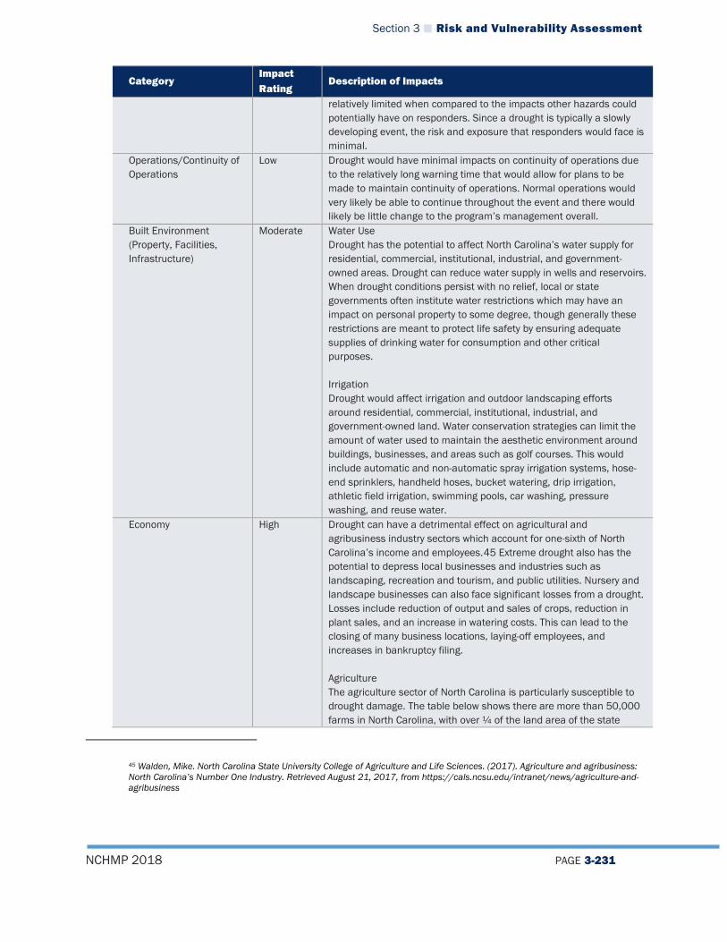
Section 3 Risk and Vulnerability Assessment
NCHMP 2018 PAGE 3-231
Category Impact Rating
Description of Impacts
relatively limited when compared to the impacts other hazards could potentially have on responders. Since a drought is typically a slowly developing event, the risk and exposure that responders would face is minimal.
Operations/Continuity of Operations
Low Drought would have minimal impacts on continuity of operations due to the relatively long warning time that would allow for plans to be made to maintain continuity of operations. Normal operations would very likely be able to continue throughout the event and there would likely be little change to the program’s management overall.
Built Environment (Property, Facilities, Infrastructure)
Moderate Water Use Drought has the potential to affect North Carolina’s water supply for residential, commercial, institutional, industrial, and government-owned areas. Drought can reduce water supply in wells and reservoirs. When drought conditions persist with no relief, local or state governments often institute water restrictions which may have an impact on personal property to some degree, though generally these restrictions are meant to protect life safety by ensuring adequate supplies of drinking water for consumption and other critical purposes. Irrigation Drought would affect irrigation and outdoor landscaping efforts around residential, commercial, institutional, industrial, and government-owned land. Water conservation strategies can limit the amount of water used to maintain the aesthetic environment around buildings, businesses, and areas such as golf courses. This would include automatic and non-automatic spray irrigation systems, hose-end sprinklers, handheld hoses, bucket watering, drip irrigation, athletic field irrigation, swimming pools, car washing, pressure washing, and reuse water.
Economy High Drought can have a detrimental effect on agricultural and agribusiness industry sectors which account for one-sixth of North Carolina’s income and employees.45 Extreme drought also has the potential to depress local businesses and industries such as landscaping, recreation and tourism, and public utilities. Nursery and landscape businesses can also face significant losses from a drought. Losses include reduction of output and sales of crops, reduction in plant sales, and an increase in watering costs. This can lead to the closing of many business locations, laying-off employees, and increases in bankruptcy filing. Agriculture The agriculture sector of North Carolina is particularly susceptible to drought damage. The table below shows there are more than 50,000 farms in North Carolina, with over ¼ of the land area of the state
45 Walden, Mike. North Carolina State University College of Agriculture and Life Sciences. (2017). Agriculture and agribusiness: North Carolina’s Number One Industry. Retrieved August 21, 2017, from https://cals.ncsu.edu/intranet/news/agriculture-and-agribusiness

Section 3 Risk and Vulnerability Assessment
NCHMP 2018 PAGE 3-232
Category Impact Rating
Description of Impacts
being farmland.46 Agricultural drought has the potential to directly affect much of the land in North Carolina. Agricultural areas at particular risk are cropland and pastures.
Census of Agriculture (2012) Total Acres in State 31,115,462 Number of Farms 50,218 Total Land in Farms, Acres 8,414,756 Average Farm Size, Acres 168
Crops Prolonged periods of dry weather are the most difficult and damaging problem faced by crop growers and agricultural suppliers. North Carolina has 4,378,097 acres of harvested cropland, which is 14.1 percent of total land area of state. Short- or long-term moisture deficits—even with the use of irrigation methods—during critical stages of crop development can severely reduce yields, with the amount of yield lost depending on when the drought occurs (see table below for a list of North Carolina crop specific information), the growth stage of the crop, the severity of dry conditions, and the amount of available water that the soil can hold.
Crops Value of Sales U.S. Rank47 Tobacco $732,772,000 1 Cut Christmas trees and short rotation woody crops
$67,097,000 2
Cotton and cottonseed $403,366,00 5 Nursery, greenhouse, floriculture, and sod
$580,230,000 7
Vegetables, melons, potatoes, and sweet potatoes
$434,974,000 10
Livestock Table 5.1 shows the type of livestock in North Carolina, including the quantity of livestock and the state’s rank compared to other states in the United States. These are at risk for being affected by drought conditions in the state. Livestock losses from drought will most likely be confined to forage-based production systems. Losses in beef and dairy systems will
46 North Carolina: Census of agriculture—2012. Retrieved August 21, 2017, from https://www.agcensus.usda.gov/Publications/2012/Full_Report/Census_by_State/North_Carolina/index.asp 47 Rank in production among all states
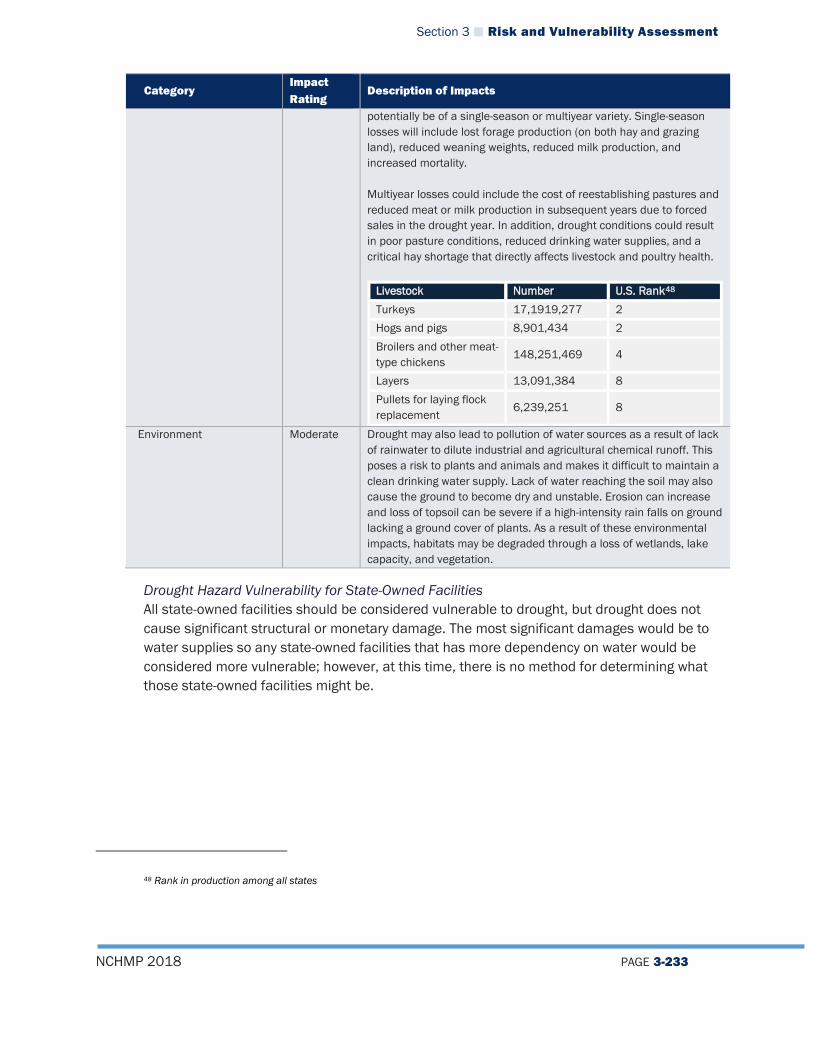
Section 3 Risk and Vulnerability Assessment
NCHMP 2018 PAGE 3-233
Category Impact Rating
Description of Impacts
potentially be of a single-season or multiyear variety. Single-season losses will include lost forage production (on both hay and grazing land), reduced weaning weights, reduced milk production, and increased mortality. Multiyear losses could include the cost of reestablishing pastures and reduced meat or milk production in subsequent years due to forced sales in the drought year. In addition, drought conditions could result in poor pasture conditions, reduced drinking water supplies, and a critical hay shortage that directly affects livestock and poultry health.
Livestock Number U.S. Rank48 Turkeys 17,1919,277 2 Hogs and pigs 8,901,434 2 Broilers and other meat-type chickens
148,251,469 4
Layers 13,091,384 8 Pullets for laying flock replacement
6,239,251 8
Environment Moderate Drought may also lead to pollution of water sources as a result of lack of rainwater to dilute industrial and agricultural chemical runoff. This poses a risk to plants and animals and makes it difficult to maintain a clean drinking water supply. Lack of water reaching the soil may also cause the ground to become dry and unstable. Erosion can increase and loss of topsoil can be severe if a high-intensity rain falls on ground lacking a ground cover of plants. As a result of these environmental impacts, habitats may be degraded through a loss of wetlands, lake capacity, and vegetation.
Drought Hazard Vulnerability for State-Owned Facilities All state-owned facilities should be considered vulnerable to drought, but drought does not cause significant structural or monetary damage. The most significant damages would be to water supplies so any state-owned facilities that has more dependency on water would be considered more vulnerable; however, at this time, there is no method for determining what those state-owned facilities might be.
48 Rank in production among all states
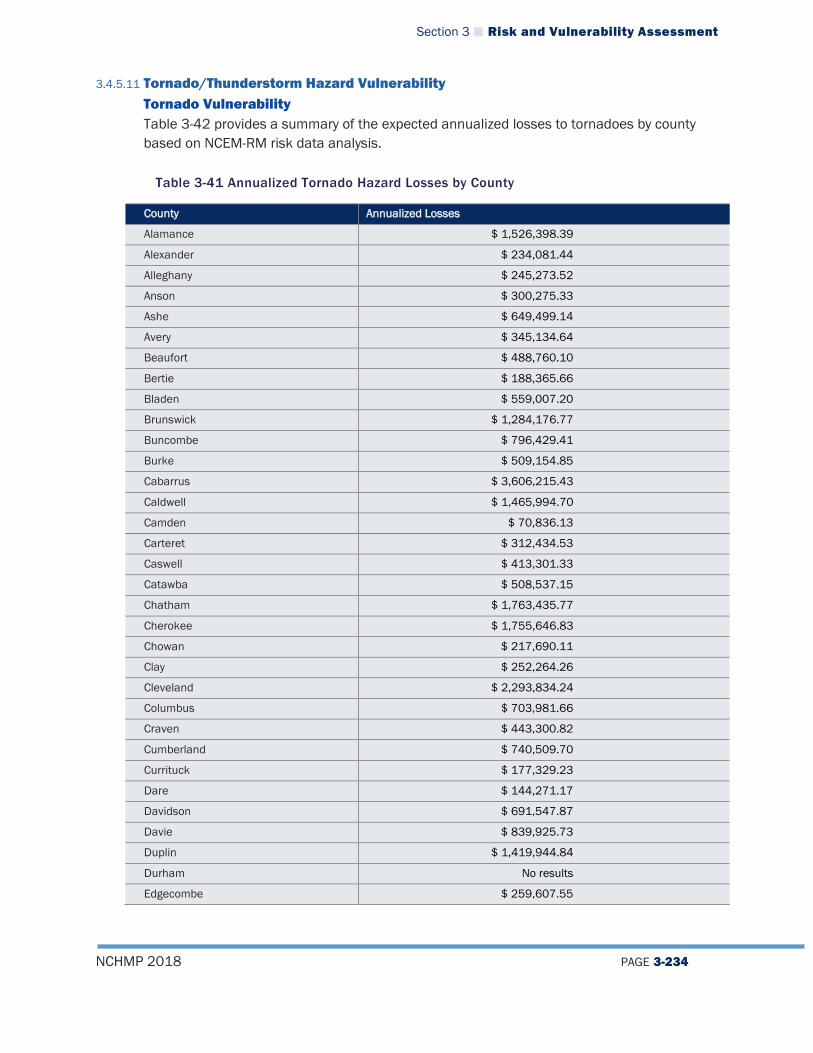
Section 3 Risk and Vulnerability Assessment
NCHMP 2018 PAGE 3-234
3.4.5.11 Tornado/Thunderstorm Hazard Vulnerability Tornado Vulnerability Table 3-42 provides a summary of the expected annualized losses to tornadoes by county based on NCEM-RM risk data analysis.
Table 3-41 Annualized Tornado Hazard Losses by County
County Annualized Losses
Alamance $ 1,526,398.39
Alexander $ 234,081.44
Alleghany $ 245,273.52
Anson $ 300,275.33
Ashe $ 649,499.14
Avery $ 345,134.64
Beaufort $ 488,760.10
Bertie $ 188,365.66
Bladen $ 559,007.20
Brunswick $ 1,284,176.77
Buncombe $ 796,429.41
Burke $ 509,154.85
Cabarrus $ 3,606,215.43
Caldwell $ 1,465,994.70
Camden $ 70,836.13
Carteret $ 312,434.53
Caswell $ 413,301.33
Catawba $ 508,537.15
Chatham $ 1,763,435.77
Cherokee $ 1,755,646.83
Chowan $ 217,690.11
Clay $ 252,264.26
Cleveland $ 2,293,834.24
Columbus $ 703,981.66
Craven $ 443,300.82
Cumberland $ 740,509.70
Currituck $ 177,329.23
Dare $ 144,271.17
Davidson $ 691,547.87
Davie $ 839,925.73
Duplin $ 1,419,944.84
Durham No results
Edgecombe $ 259,607.55

Section 3 Risk and Vulnerability Assessment
NCHMP 2018 PAGE 3-235
County Annualized Losses
Forsyth $ 578,327.30
Franklin $ 382,957.27
Gaston $ 344,320.30
Gates $ 179,796.42
Graham $ 595,608.32
Granville $ 351,346.14
Greene $ 156,256.78
Guilford $ 960,238.92
Halifax $ 1,353,010.07
Harnett $ 659,461.81
Haywood $ 1,693,481.79
Henderson $ 2,286,765.74
Hertford $ 322,033.62
Hoke $ 220,290.25
Hyde $ 31,969.82
Iredell $ 713,927.01
Jackson $ 1,022,316.14
Johnston $ 2,132,896.82
Jones $ 124,223.22
Lee $ 400,360.58
Lenoir $ 329,120.11
Lincoln $ 430,001.28
Macon $ 1,713,629.36
Madison $ 582,168.19
Martin $ 556,018.27
McDowell $ 365,848.63
Mecklenburg $ 13,611,075.94
Mitchell $ 367,382.64
Montgomery $ 371,863.38
Moore $ 980,996.59
Nash $ 460,175.46
New Hanover No results
Northampton $ 366,777.74
Onslow $ 488,536.63
Orange $ 2,012,151.22
Pamlico $ 162,049.43
Pasquotank $ 148,158.75
Pender $ 416,457.44
Perquimans $ 195,775.72
Person $ 659,560.18
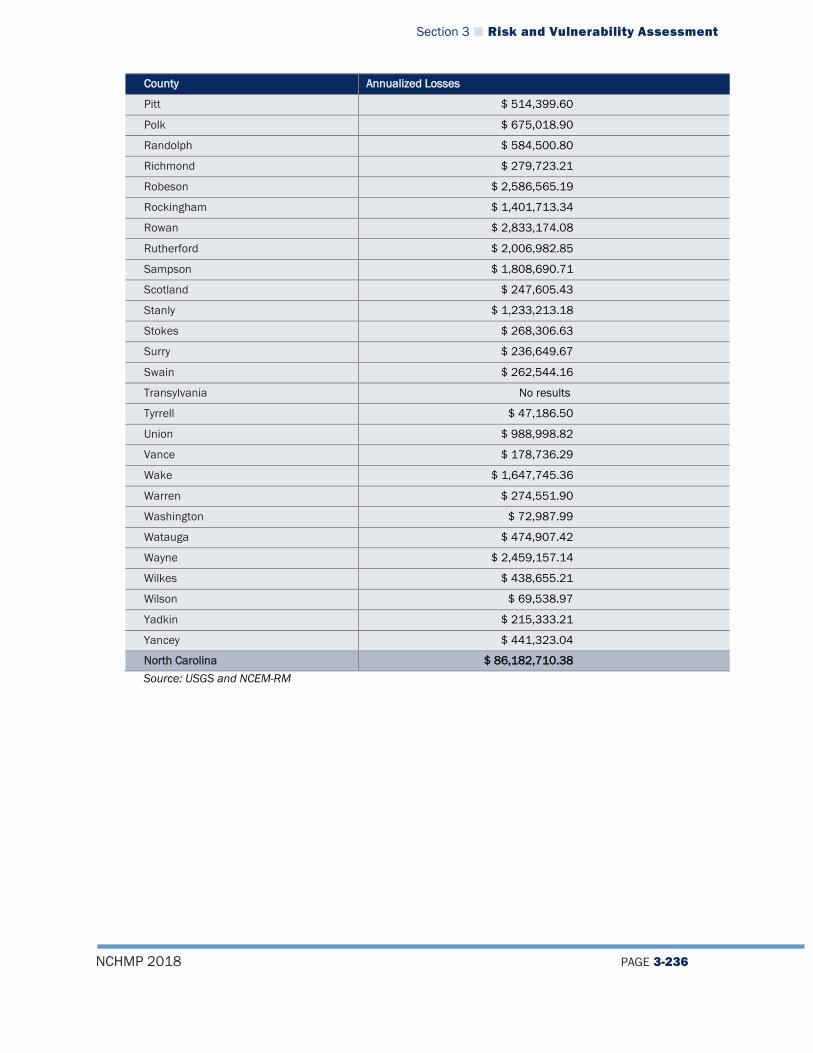
Section 3 Risk and Vulnerability Assessment
NCHMP 2018 PAGE 3-236
County Annualized Losses
Pitt $ 514,399.60
Polk $ 675,018.90
Randolph $ 584,500.80
Richmond $ 279,723.21
Robeson $ 2,586,565.19
Rockingham $ 1,401,713.34
Rowan $ 2,833,174.08
Rutherford $ 2,006,982.85
Sampson $ 1,808,690.71
Scotland $ 247,605.43
Stanly $ 1,233,213.18
Stokes $ 268,306.63
Surry $ 236,649.67
Swain $ 262,544.16
Transylvania No results
Tyrrell $ 47,186.50
Union $ 988,998.82
Vance $ 178,736.29
Wake $ 1,647,745.36
Warren $ 274,551.90
Washington $ 72,987.99
Watauga $ 474,907.42
Wayne $ 2,459,157.14
Wilkes $ 438,655.21
Wilson $ 69,538.97
Yadkin $ 215,333.21
Yancey $ 441,323.04
North Carolina $ 86,182,710.38 Source: USGS and NCEM-RM

Section 3 Risk and Vulnerability Assessment
NCHMP 2018 PAGE 3-237
Thunderstorm Vulnerability Table 3-42 provides a summary of the expected annualized losses to thunderstorms by county based on NCEI data.
Table 3-42 Annualized Losses for Thunderstorms
County Total Damages for All Recorded Events (2017 Dollars)
Annualized Losses
Alamance $1,270,796.00 $60,514.10 Alexander $1,338,000.00 $63,714.29 Alleghany $145,274.00 $6,917.81 Anson $228,566.00 $10,884.10 Ashe $267,872.00 $12,755.81 Avery $22,759.00 $1,083.76 Beaufort $357,617.00 $17,029.38 Bertie $428,462.00 $20,402.95 Bladen $2,684,680.00 $127,841.90 Brunswick $809,879.00 $38,565.67 Buncombe $553,040.00 $26,335.24 Burke $675,404.00 $32,162.10 Cabarrus $792,885.00 $37,756.43 Caldwell $505,293.00 $24,061.57 Camden $75,958.00 $3,617.05 Carteret $2,141,410.00 $101,971.90 Caswell $1,664,330.00 $79,253.81 Catawba $2,967,167.00 $141,293.67 Chatham $680,888.00 $32,423.24 Cherokee $1,131,580.00 $53,884.76 Chowan $755,931.00 $35,996.71 Clay $605,292.00 $28,823.43 Cleveland $924,063.00 $44,003.00 Columbus $9,609,388.00 $457,589.90 Craven $367,027.00 $17,477.48 Cumberland $1,749,515.00 $83,310.24 Currituck $117,530.00 $5,596.67 Dare $1,008,964.00 $48,045.90 Davidson $1,960,533.00 $93,358.71 Davie $207,019.00 $9,858.05 Duplin $1,449,497.00 $69,023.67 Durham $1,103,896.00 $52,566.48 Edgecombe $1,494,863.00 $71,183.95 Forsyth $994,835.00 $47,373.10 Franklin $6,408,388.00 $305,161.33 Gaston $773,856.00 $36,850.29 Gates $108,792.00 $5,180.57 Graham $55,752.00 $2,654.86 Granville $306,017.00 $14,572.24 Greene $382,703.00 $18,223.95 Guilford $1,205,135.00 $57,387.38 Halifax $712,246.00 $33,916.48 Harnett $1,327,558.00 $63,217.05
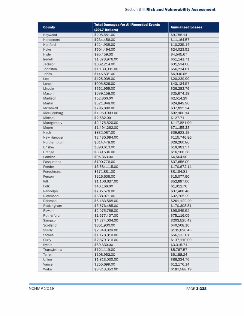
Section 3 Risk and Vulnerability Assessment
NCHMP 2018 PAGE 3-238
County Total Damages for All Recorded Events (2017 Dollars)
Annualized Losses
Haywood $205,551.00 $9,788.14 Henderson $234,456.00 $11,164.57 Hertford $214,938.00 $10,235.14 Hoke $504,494.00 $24,023.52 Hyde $95,459.00 $4,545.67 Iredell $1,073,976.00 $51,141.71 Jackson $662,214.00 $31,534.00 Johnston $1,180,931.00 $56,234.81 Jones $145,531.00 $6,930.05 Lee $425,038.00 $20,239.90 Lenoir $905,826.00 $43,134.57 Lincoln $551,959.00 $26,283.76 Macon $539,158.00 $25,674.19 Madison $52,800.00 $2,514.29 Martin $521,848.00 $24,849.90 McDowell $795,800.00 $37,895.24 Mecklenburg $1,950,903.00 $92,900.14 Mitchell $2,682.00 $127.71 Montgomery $2,475,520.00 $117,881.90 Moore $1,494,262.00 $71,155.33 Nash $832,087.00 $39,623.19 New Hanover $2,430,684.00 $115,746.86 Northampton $614,478.00 $29,260.86 Onslow $398,613.00 $18,981.57 Orange $339,536.00 $16,168.38 Pamlico $95,863.00 $4,564.90 Pasquotank $790,776.00 $37,656.00 Pender $3,584,115.00 $170,672.14 Perquimans $171,881.00 $8,184.81 Person $316,636.00 $15,077.90 Pitt $1,106,637.00 $52,697.00 Polk $40,168.00 $1,912.76 Randolph $785,578.00 $37,408.48 Richmond $688,071.00 $32,765.29 Robeson $5,483,568.00 $261,122.29 Rockingham $3,576,485.00 $170,308.81 Rowan $2,075,756.00 $98,845.52 Rutherford $1,577,437.00 $75,116.05 Sampson $4,274,034.00 $203,525.43 Scotland $851,930.00 $40,568.10 Stanly $2,848,029.00 $135,620.43 Stokes $1,178,810.00 $56,133.81 Surry $2,879,310.00 $137,110.00 Swain $69,630.00 $3,315.71 Transylvania $121,119.00 $5,767.57 Tyrrell $108,953.00 $5,188.24 Union $1,813,030.00 $86,334.76 Vance $255,699.00 $12,176.14 Wake $3,813,352.00 $181,588.19
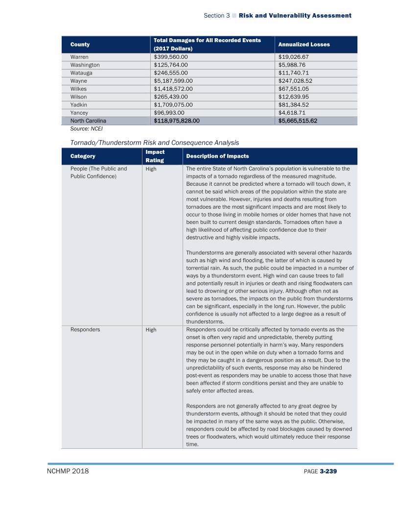
Section 3 Risk and Vulnerability Assessment
NCHMP 2018 PAGE 3-239
County Total Damages for All Recorded Events (2017 Dollars)
Annualized Losses
Warren $399,560.00 $19,026.67 Washington $125,764.00 $5,988.76 Watauga $246,555.00 $11,740.71 Wayne $5,187,599.00 $247,028.52 Wilkes $1,418,572.00 $67,551.05 Wilson $265,439.00 $12,639.95 Yadkin $1,709,075.00 $81,384.52 Yancey $96,993.00 $4,618.71 North Carolina $118,975,828.00 $5,665,515.62 Source: NCEI
Tornado/Thunderstorm Risk and Consequence Analysis
Category Impact Rating
Description of Impacts
People (The Public and Public Confidence)
High The entire State of North Carolina’s population is vulnerable to the impacts of a tornado regardless of the measured magnitude. Because it cannot be predicted where a tornado will touch down, it cannot be said which areas of the population within the state are most vulnerable. However, injuries and deaths resulting from tornadoes are the most significant impacts and are most likely to occur to those living in mobile homes or older homes that have not been built to current design standards. Tornadoes often have a high likelihood of affecting public confidence due to their destructive and highly visible impacts. Thunderstorms are generally associated with several other hazards such as high wind and flooding, the latter of which is caused by torrential rain. As such, the public could be impacted in a number of ways by a thunderstorm event. High wind can cause trees to fall and potentially result in injuries or death and rising floodwaters can lead to drowning or other serious injury. Although often not as severe as tornadoes, the impacts on the public from thunderstorms can be significant, especially in the long run. However, the public confidence is usually not affected to a large degree as a result of thunderstorms.
Responders High Responders could be critically affected by tornado events as the onset is often very rapid and unpredictable, thereby putting response personnel potentially in harm’s way. Many responders may be out in the open while on duty when a tornado forms and they may be caught in a dangerous position as a result. Due to the unpredictability of such events, response may also be hindered post-event as responders may be unable to access those that have been affected if storm conditions persist and they are unable to safely enter affected areas. Responders are not generally affected to any great degree by thunderstorm events, although it should be noted that they could be impacted in many of the same ways as the public. Otherwise, responders could be affected by road blockages caused by downed trees or floodwaters, which would ultimately reduce their response time.
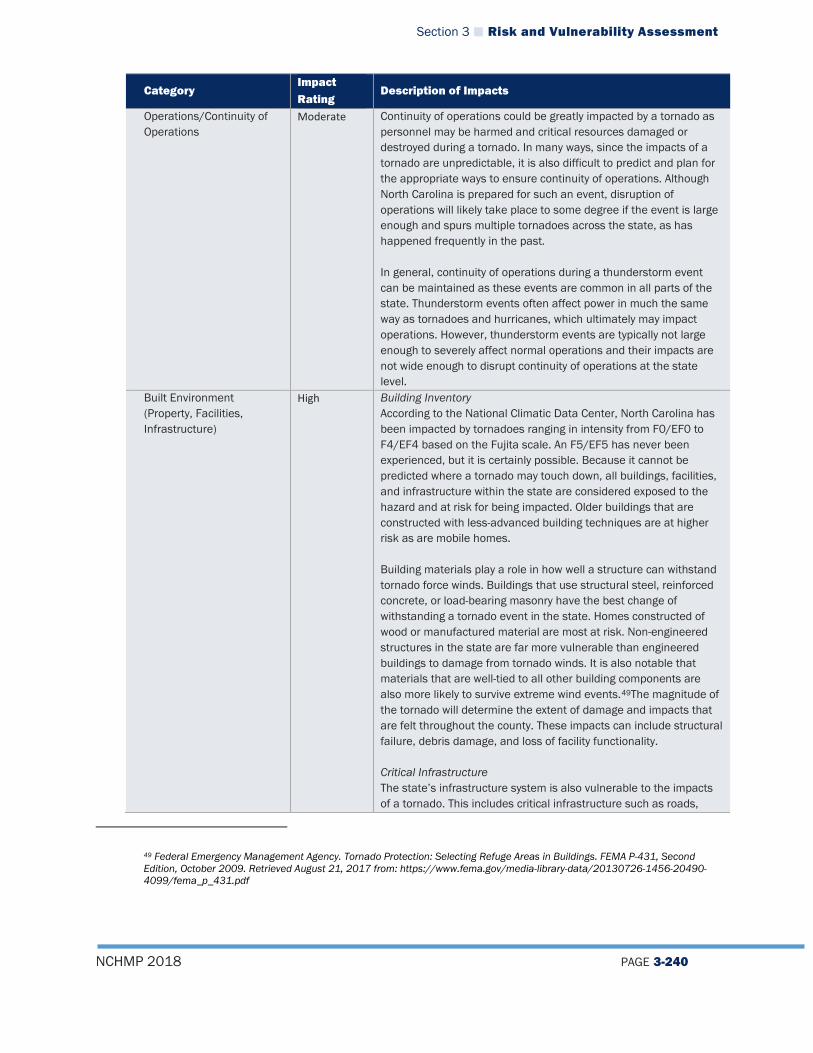
Section 3 Risk and Vulnerability Assessment
NCHMP 2018 PAGE 3-240
Category Impact Rating
Description of Impacts
Operations/Continuity of Operations
Moderate Continuity of operations could be greatly impacted by a tornado as personnel may be harmed and critical resources damaged or destroyed during a tornado. In many ways, since the impacts of a tornado are unpredictable, it is also difficult to predict and plan for the appropriate ways to ensure continuity of operations. Although North Carolina is prepared for such an event, disruption of operations will likely take place to some degree if the event is large enough and spurs multiple tornadoes across the state, as has happened frequently in the past. In general, continuity of operations during a thunderstorm event can be maintained as these events are common in all parts of the state. Thunderstorm events often affect power in much the same way as tornadoes and hurricanes, which ultimately may impact operations. However, thunderstorm events are typically not large enough to severely affect normal operations and their impacts are not wide enough to disrupt continuity of operations at the state level.
Built Environment (Property, Facilities, Infrastructure)
High Building Inventory According to the National Climatic Data Center, North Carolina has been impacted by tornadoes ranging in intensity from F0/EF0 to F4/EF4 based on the Fujita scale. An F5/EF5 has never been experienced, but it is certainly possible. Because it cannot be predicted where a tornado may touch down, all buildings, facilities, and infrastructure within the state are considered exposed to the hazard and at risk for being impacted. Older buildings that are constructed with less-advanced building techniques are at higher risk as are mobile homes. Building materials play a role in how well a structure can withstand tornado force winds. Buildings that use structural steel, reinforced concrete, or load-bearing masonry have the best change of withstanding a tornado event in the state. Homes constructed of wood or manufactured material are most at risk. Non-engineered structures in the state are far more vulnerable than engineered buildings to damage from tornado winds. It is also notable that materials that are well-tied to all other building components are also more likely to survive extreme wind events.49The magnitude of the tornado will determine the extent of damage and impacts that are felt throughout the county. These impacts can include structural failure, debris damage, and loss of facility functionality. Critical Infrastructure The state’s infrastructure system is also vulnerable to the impacts of a tornado. This includes critical infrastructure such as roads,
49 Federal Emergency Management Agency. Tornado Protection: Selecting Refuge Areas in Buildings. FEMA P-431, Second Edition, October 2009. Retrieved August 21, 2017 from: https://www.fema.gov/media-library-data/20130726-1456-20490-4099/fema_p_431.pdf

Section 3 Risk and Vulnerability Assessment
NCHMP 2018 PAGE 3-241
Category Impact Rating
Description of Impacts
railroads, bridges, utilities (power and gas), and pipelines. Any number of these infrastructure systems could be damaged in the event of a tornado, although often power lines are the most common assets that are affected during a tornado. Impacts could include structural damage, impassable or blocked roadways, failed utility lines, railway failure, and impassable bridges. Thunderstorms often have their greatest impact on the built environment as they can cause damage to homes via strong winds or flooding and will often impact facilities and infrastructure in the same way. Power losses often occur due to damage to power lines and roads can flood and cause damage as well. In fact, thunderstorms are often considered one of the greater hazards of concern for local communities, even though any given event will cause relatively little damage, because damaging events occur so frequently.
Economy High A tornado can impact any area of North Carolina at any time and bring with it significant property damage costs to individual citizens and the disrupt the regular functioning of the local economy. After past events, there has been a substantial halt to many economic activities and losses to businesses have often been high. The loss of power can also interrupt local economies and have a strong negative impact on daily functioning of business activities. Similarly, economic impacts from thunderstorm events can often be far reaching as the damage from these events are often widespread, affecting both homes and businesses. This damage can result in business and economic disruption through the recovery process.
Environment Moderate Downed trees and other forms of vegeta�on are o�en one of the mo� visible impa�s to the environment from a tornado. Addi�onally, building material or other debris can be carried or thrown great di�ances by the force of wind and end up spread out in unexpe�ed places su� as natural areas. Coordinated �atewide cleanup efforts a�er a tornado can include removal of debris, but mu� debris ends up remaining in local habitats. Finally, if hazardous materials facili�es are impa�ed by the tornado, these may release dangerous �emicals into the environment that can cause long-term harm. Thunder�orms can impa� crops via high wind and flooding and can also impa� the natural environment through these elements. Flooding can kill plants and animals as well as contaminate drinking water supplies for human popula�ons. High wind can harm fore�s by bringing down trees and cause fires from downed power lines that impa� the environment.

Section 3 Risk and Vulnerability Assessment
NCHMP 2018 PAGE 3-242
Tornado/Thunderstorm Hazard Vulnerability for State-Owned Facilities
Tornado Vulnerability for State-Owned Facilities Based on the atmospheric nature of tornadoes and previous occurrences having been reported in all regions of the state, all state-owned facilities should be considered vulnerable to tornadoes. Thunderstorm Vulnerability for State-Owned Facilities Based on the atmospheric nature of thunderstorms and previous occurrences having been reported in all regions of the state, all state-owned facilities should be considered vulnerable to thunderstorms.
3.4.5.12 Geological Hazard Vulnerability
Landslide Vulnerability To evaluate County-level vulnerability to the landslide hazard, a GIS analysis was run to identify buildings that intersect with USGS “Very High” and “High” landslide risk zones. Table 3-43 provides a summary of the findings from that analysis.
Table 3-43 Building Exposure to Landslide Hazard Areas
County Name Number of Buildings in Very High Risk Zone
Value of Buildings in Very High Risk Zone
Number of Buildings in High Risk Zone
Value of Buildings in High Risk Zone
Alexander 3 $4,484,894 0 0 Alleghany 25 $4,191,545 23 $2,728,838 Anson 0 0 77 $39,815,520 Ashe 0 0 64 $20,215,409 Avery 8 $92,483,269 0 0 Buncombe 39 $13,497,117 5 $110,266 Cabarrus 19 $6,523,031 0 0 Caldwell 15 $1,976,681 0 0 Caswell 0 0 14 $1,639,192 Catawba 17 $9,422,773 0 0 Chatham 103 $22,135,858 23 $8,361,935 Cherokee 0 0 17 $3,236,964 Clay 0 0 6 385593 Durham 35 $7,254,084 1 $47,335 Gaston 14 $4,858,989 0 Graham 0 0 8 $811,461 Guilford 0 0 11 $2,848,329 Haywood 0 0 23 $4,058,503 Henderson 5 $1,525,168 0 0 Jackson 2 $169,709 30 $4,927,778 Lee 0 0 1 $840,118 Macon 3 $593,067 18 $1,965,963 Madison 0 0 18 $3,345,449 McDowell 3 $1,493,765 0 0
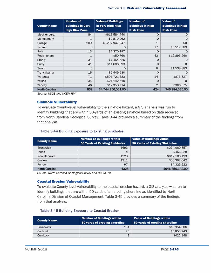
Section 3 Risk and Vulnerability Assessment
NCHMP 2018 PAGE 3-243
County Name Number of Buildings in Very High Risk Zone
Value of Buildings in Very High Risk Zone
Number of Buildings in High Risk Zone
Value of Buildings in High Risk Zone
Mecklenburg 84 $613,584,440 0 0 Montgomery 1 $2,879,262 0 0 Orange 209 $3,297,947,247 1 $0 Person 0 0 17 $5,512,389 Polk 13 $2,370,197 0 0 Rockingham 1 $50,760 43 $19,895,260 Stanly 31 $7,454,625 0 0 Surry 41 $11,686,693 0 0 Swain 0 0 8 $1,538,883 Transylvania 15 $6,449,980 0 0 Watauga 71 $597,721,683 14 $873,827 Wilkes 34 $21,142,510 0 0 Yancey 46 $12,358,714 2 $366,575 North Carolina 837 $4,744,256,061.00 424 $46,984,535.00 Source: USGS and NCEM-RM
Sinkhole Vulnerability To evaluate County-level vulnerability to the sinkhole hazard, a GIS analysis was run to identify buildings that are within 50-yards of an existing sinkhole based on data received from North Carolina Geological Survey. Table 3-44 provides a summary of the findings from that analysis.
Table 3-44 Building Exposure to Existing Sinkholes
County Name Number of Buildings within 50 Yards of Existing Sinkholes
Value of Buildings within 50 Yards of Existing Sinkholes
Brunswick 1693 $274,060,857 Jones 4 $466,228 New Hanover 1223 $617,106,193 Onslow 1311 $50,397,642 Pender 97 $4,325,222 North Carolina 4328 $946,356,142.00 Source: North Carolina Geological Survey and NCEM-RM
Coastal Erosion Vulnerability To evaluate County-level vulnerability to the coastal erosion hazard, a GIS analysis was run to identify buildings that are within 50-yards of an eroding shoreline as identified by North Carolina Division of Coastal Management. Table 3-45 provides a summary of the findings from that analysis.
Table 3-45 Building Exposure to Coastal Erosion
County Name Number of Buildings within 50 yards of eroding shoreline
Value of Buildings within 50 yards of eroding shoreline
Brunswick 101 $16,954,506 Carteret 23 $5,855,243 Currituck 3 $422,148
Section 3 Risk and Vulnerability Assessment
NCHMP 2018 PAGE 3-244
Dare 279 $44,564,918 New Hanover 39 $30,862,658 Onslow 130 $21,965,739 Pender 52 $4,569,816 North Carolina 627 $125,195,028.00 Source: North Carolina Division of Coastal Management and NCEM-RM
Geological Hazards Risk and Consequence Analysis
Category Impact Rating
Description of Impacts
People (The Public and Public Confidence)
Moderate Geological hazards such as landslides/rock falls and sinkholes can pose a threat to human life and safety, as these events often occur with very little warning time due to a lack of available data on risk. Landslides/rock falls are especially a risk in the more mountainous western part of the state where several fatalities have been caused by in this region historically. The quick and unexpected slide of rocks, dirt, and other debris is extremely dangerous and can cover and destroy homes, thereby causing injuries and death. Sinkholes are a much larger risk in the eastern part of the state where soils are more conducive to this type of activity. Similar to landslides/rock falls, these events are often unexpected as they can develop from underneath the ground and suddenly cause a collapse of soil at the surface level, causing loss of life or injury. Any event that can cause loss of life could potentially have an impact on public confidence, however, since these events are often geographically confined to a small area and do not have wide-ranging impacts on large segments of the population, public confidence is typically not affected to a great degree.
Responders Low In most cases, responders are not directly impacted by geological events to any greater degree than the public. However, it should be noted that responders should generally be wary when responding to a geological event because of the risk of secondary events (additional landslides/rock falls or sinkholes). When the ground has been disrupted by one of these events, it could set the stage for additional events and any disruption to the soil by responders during their response may further exacerbate those conditions. Additionally, responders working on site of a geological event may find that the uneven terrain provides an extra challenge in terms of operating normally and carrying out life-saving tactics.
Operations/Continuity of Operations
Low Continuity of operations during a geological event is unlikely to be interrupted in any major way. As mentioned previously, geological events tend to be confined to small areas and so it is unlikely that operations centers would be impacted. If they are, it should not prove too much of a challenge to move operations to a backup facility and continue normal operations from there.
Built Environment (Property, Facilities, Infrastructure)
Moderate Impacts on the built environment are probably the greatest effect of geological events. During both landslide/rock fall and sinkhole events, people’s homes and/or businesses may be impacted and most typical insurance policies in the state do not cover these kinds of events so homeowners may suffer total losses to their homes. Even when these events do not cause complete destruction
Section 3 Risk and Vulnerability Assessment
NCHMP 2018 PAGE 3-245
Category Impact Rating
Description of Impacts
of homes, they can frequently damage foundations of structures and make them unsafe for dwelling. Similarly, landslides/rock falls and sinkholes that occur around major infrastructure such as roadways and other utilities can cause severe damage to key facilities. In western North Carolina, landslides/rock falls have occurred a number of times along major highways such as I-40 and caused local and state officials to have to shut down these roadways until equipment can be brought in to remove the large boulders and return the road to normal conditions. Similarly, sinkholes in the eastern part of the state have caused breaks in roadways, making them unsafe for driving. In many locations across the state, sinkholes have shut down primary roadways for weeks while the issues were addressed and roads were rebuilt. At times the cause of these sinkholes are man-made as leaking or faulty water/wastewater infrastructure can create the same conditions that cause sinkholes to form naturally.
Economy Low Although geological events could impact local businesses and therefore affect the economy, this would likely have very minor effects overall. The greatest impact to the economy from an economic standpoint would be related to the impacts on infrastructure such as roadways. When these are shut down for long periods of time, local economies can be dramatically affected, especially in more rural areas. If traffic has to be re-routed around these areas due to road closures for weeks or even just days, losses in revenue could be significant and have a negative impact on business owners. Both landslides/rock falls and sinkholes have the capacity to cause this level of shutdown as has been the case during a number of past events in the state.
Environment Low In general, the environment would be unaffected by a geological event. Some of the minor impacts that might be expected are damage to trees and habitats from falling rocks/debris or from other types of damage to the soil/ground. In past events, large swaths of mountainside have been torn away creating large dead areas where plant life is ripped away. These impacts would be generally confined to a small area and therefore would not have sweeping implications for the ecosystems overall. It is also possible that debris or structural materials could end up in streams or rivers as a result of the event and cause damage to localized populations in these habitats.

Section 3 Risk and Vulnerability Assessment
NCHMP 2018 PAGE 3-246
Geological Hazards Vulnerability for State-Owned Facilities Landslide Vulnerability for State-Owned Facilities Table 3-46 provides information about the number and value of state-owned facilities located in the very high and high-risk landslide hazard zones as indicated by USGS. More detailed site assessments would have to be conducted to determine more exact estimates of vulnerability for these facilities.
Table 3-46 State-Owned Facilities in Landslide Hazard Zones
Landslide Hazard Zone Number of State-Owned Facilities in Zone
Value of State-Owned Facilities in Zone
Very High Risk 843 $4,744,658,492 High Risk 418 $123,139,994 Source: USGS and NCEM-RM Sinkhole Vulnerability for State-Owned Facilities There are 67 State-owned facilities with a value of $1,933,889 located within a half mile of an existing sinkhole.
Figure 3-74 Sinkholes and State-Owned Facilities

Section 3 Risk and Vulnerability Assessment
NCHMP 2018 PAGE 3-247
Coastal Erosion Vulnerability for State-Owned Facilities GIS analysis indicated just one state-owned facility within 50 yards of an eroding shoreline.
3.4.5.13 Infectious Disease Hazard Vulnerability At this time, there is no available method for determining dollar losses for infectious disease vulnerability. Future updates of this plan may attempt to better capture these losses if better data becomes available.
Infectious Disease Hazard Risk, Vulnerability, and Consequence Analysis
Category Impact Rating
Description of Impacts
People (The Public and Public Confidence)
Moderate The general public can be exposed to infectious diseases through different means based on the particular threat and its potential transmission routes. Vaccinations, when available, are the best means of preventing transmission and infection. Public health information messages will be disseminated via the media in order to provide preventative measures to limit or avoid exposure. According to the North Carolina Public Health Department, in terms of vaccine-preventable diseases, in 2016 there was a slightly higher occurrence rate of Hepatitis A and Mumps in 2016 compared to the five-year average from 2011-2015.50 There were also increased rates of non-vaccine-preventable diseases like Zika which have become more prominent across the United States in recent years. Public confidence in government organizations may be impacted by public health outbreaks. The level of confidence the public possesses is based upon societal expectations, media influence, and past experience following other outbreaks. An effective response to the outbreak can help to guide public confidence toward a favorable level. Collaboration with media outlets can also assist in keeping the public informed and helping to protect them from exposure.
Responders Low During a disease outbreak, responders can expect an increase in workload and should practice a higher level of precaution toward exposure than they would normally. Plans exist for first response and health care to address the needs of such situations. Communication between these agencies regarding plans and procedures maximizes the efficiency and effectiveness of these combined efforts. Responders are much more likely on the whole to be impacted by an infectious disease since they will be working directly with those affected to help treat the disease (especially EMS personnel). This will make them more susceptible to becoming infected and, as such, it is critical that they wear the appropriate personal protective equipment to minimize their risk and ensure they can continue providing the care and assistance that is needed
50 North Carolina Department of Public Health (2016). Vaccine-Preventable Diseases Reported in North Carolina, 2016. Retrieved August 21, 2017 from: http://epi.publichealth.nc.gov/cd/figures.html
Section 3 Risk and Vulnerability Assessment
NCHMP 2018 PAGE 3-248
Category Impact Rating
Description of Impacts
to help the public. Operations/Continuity of Operations
Low Continuity of operations may be impacted if those in governmental or other key roles are impacted by the disease or public health threat and cannot perform their normal duties. Although plans are in place to ensure continuity of operations, a large-scale event or one that has significant impacts on operational-level staff could negatively affect continuity of operations. Since many diseases are spread through some form of contact with others who have already been infected, a disease event could rapidly disable many of those who are working together to carry out normal operations. Due to their close proximity to one another and need to communicate and coordinate on a daily basis, it is incredibly important to try to reduce the spread of the disease among key personnel once an outbreak has been identified.
Built Environment (Property, Facilities, Infrastructure)
Low An infectious disease would likely have little direct impact on the built environment itself as the disease would not affect the structural stability of any buildings or infrastructure. However, an infectious disease would have a major impact on the functioning of many structures that would be operating at a high capacity during an infectious disease event, especially medical care facilities. Hospitals and Medical Care Facilities The primary impacts for hospitals/medical facilities during disease outbreaks are an increase in patients and the spread of disease within hospitals. It is highly likely that those affected by the disease will make their way to a medical care facility and it may be necessary to implement quarantines or other measures to reduce the risk of disease spreading. Hospitals and other medical care facilities should have plans in place to deal with such a scenario and also reduce risk of spreading the disease to medical care providers whose workload may be increased as individuals infected with disease may require treatment.
Economy Low One of the more significant economic impacts that could be seen in North Carolina involves absenteeism at local businesses which could have a significant impact as the absence of several employees at a small business could force temporary shutdowns or reduced hours of availability. There would also likely be an impact on the local government budget as officials try to respond to the disease and assist those impacted. City centers and downtown areas tend to be where large masses of people congregate and thus may be where the likelihood of disease spread is more prominent. Many people may realize this and avoid these key economic hubs which would result in reduced revenue and a negative impact on the economy overall. Additionally, large events in communities across the state may have to be cancelled if the outbreak is large enough or has the potential to be spread easily and quickly. This would also reduce revenue for many local economies.
Environment Low The environmental impact is dependent on the particular biological substance or disease being transmittable to animal or plant life or if
Section 3 Risk and Vulnerability Assessment
NCHMP 2018 PAGE 3-249
Category Impact Rating
Description of Impacts
it can be distributed through the water supply. If the infectious disease in question can be transmitted to other species, there could be an extremely negative impact on species populations. Since animal life does not have the same capacity has humanity to understand the spread of disease and reduce transmission rates, the disease may spread more quickly through animal populations and cause larger-scale loss of life.
Infectious Disease Hazard Vulnerability for State-Owned Facilities At this time, there is no available method for determining dollar losses relevant to state-owned facilities for infectious disease vulnerability. Future updates of this plan may attempt to better capture these losses if better data becomes available.
3.4.6 Vulnerability to Technological Hazards
3.4.6.1 Hazardous Substances Hazard Vulnerability
Hazardous Substances Risk, Vulnerability, and Consequence Analysis
Category Impact Rating
Description of Impacts
People (The Public and Public Confidence)
High The accidental or intentional release of a hazardous substance could have both immediate and long-lasting effects on the health of the public. Any release needs to be quickly identified and the proper response guidelines followed to reduce the possible impact on the public. Evacuation is always a consideration when dealing with harmful substances. The public should be aware that hazards exist from the presence of hazardous substances and should take preparedness actions at home and in the workplace to act should a release of substances occur. Hazardous substances can have a significant effect on public confidence in government as incidents often cause serious harm to people via long-term health impacts, contamination of soil or drinking water, and even death. Because of the dangers associated with many hazardous substances and the level of control that humans have over hazardous substance incidents compared to natural hazards, public confidence could be damaged severely in the event of an incident.
Responders Moderate First responders must be vigilant when hazardous substances are suspected to be involved. The proper protective apparel must be worn and protocols must be followed to ensure that contaminated individuals and objects go through appropriate decontamination procedures prior to being moved away from the incident, regardless of the situation. Contamination of other responders or citizens must be avoided. The appropriate personnel, such as Hazardous Materials teams, must be notified to ensure that the proper measures are taken to prevent further harm.
Operations/Continuity of Operations
Moderate During a hazardous substance incident, normal operations are likely to be maintained with only moderate stress on daily

Section 3 Risk and Vulnerability Assessment
NCHMP 2018 PAGE 3-250
Category Impact Rating
Description of Impacts
operations. In the event of a larger scale hazardous substance spill, there could be some loss of continuity of operations as a result of strain on personnel and equipment, but typically this will not be the case.
Built Environment (Property, Facilities, Infrastructure)
Moderate Hazardous Materials Facilities A hazardous substance event is most likely to take place where the substance is created or stored. Hazardous materials facilities have their own highly-trained personnel for handling and cleaning up the particular substances stored onsite. The facility’s plans are highly specific to the substances stored there, thus providing for effective responses to incidents that involve these substances. Some facilities contain hazardous substances that can spread or leak quickly, or are held in extremely dangerous concentrations. There can still be significant effects on workers and others in close proximity despite having good planning in place. These facilities are inventoried in the state through Tier II reporting and there have been some major incidents in the state historically. Utilities Natural gas distribution lines can be problematic with some hazardous substances if contact is made with the natural gas supply. Most of the natural gas infrastructure is located underground, making exposure highly unlikely. However, natural gas itself can be the hazardous substance involved in the incident. One example of how this may occur is if a utility, work crew, or citizen strikes a gas line causing a leak. Degradation of the line may also be the cause of a release. A gas leak would cause an immediate threat and explosions and fires would be significant concerns for the immediate vicinity. Transportation Systems Hazardous substances can have an impact on interstate transportation if a release occurs on or in the vicinity of the roadway which may be the case if a truck or other vehicle carrying hazardous materials is involved in a traffic accident. Significant traffic disruptions may occur, slowing commerce or forcing alternative routing and further congestion of other areas. Similarly, rail lines are one of the more prominent places that hazardous substances are transported. A hazardous substance event on the rail system can impact rail traffic and the overall system. Cleanup efforts wherever the event occurred could be costly and go on for extended periods, shutting down that part of the rail system for that time. Critical Facilities Hospitals utilize and store some hazardous substances on site. Biological materials and radioactive wastes are the primary concerns in a hospital setting. Plans are in place to manage these concerns in both routine and emergency situations. An external hazardous substance event that occurs near the hospital or directly impacts a hospital could create service disruptions such as patient care. A large event may also create a high demand on hospital

Section 3 Risk and Vulnerability Assessment
NCHMP 2018 PAGE 3-251
Category Impact Rating
Description of Impacts
services and cause an overload on resources. Similarly, some emergency services facilities such as emergency shelters may be opened if homes have been exposed to hazardous substances and evacuations occur. Other Structures Commercial, industrial, and residential buildings all may have hazardous substances contained within them that are not reported through the Tier II reporting system but which could still present a smaller scale hazard. Proper containers and labeling can prevent inappropriate use, but accidents can still cause workers to be exposed. Cleaning products, fertilizers, and pesticides are common examples of supplies that are considered hazardous substances and which could cause a smaller incident.
Economy Moderate The economic impact of a hazardous substance related incident can be significant locally. Affected commerce is the greatest concern, as spills and releases can force businesses such as shopping centers, markets, and financial centers to be shut down for indeterminate periods of time. Contaminated water can be especially problematic as it can cause extensive shutdowns and put many people in danger. The overall costs depend on the substance(s) involved, how much is released, the processes and time used to manage the spill or release, who or what is contaminated, whether a fire takes place, etc. Cleanup can be a less significant cost and is typically handled by the party responsible for the spill or release. A hazardous substance incident could occur at any large gathering if it was the target of a terrorism event (see Terrorism below). Also, a large event arena could be forced to deal with a hazardous substance incident if it is located in close proximity to them. Arenas and other major event venues may be at significant threat as they are often situated along transportation routes where vehicles transporting such substances could become involved in an accident.
Environment High The environmental impact is highly dependent on the location and the severity of the event. Some of the substances involved in these incidents can be cleaned up or do not have lasting impacts on the areas affected. Others may cause crops and other vegetation to be destroyed, sometimes beyond the ability to grow back and animal populations may become displaced or killed. Some areas may be deemed uninhabitable or not fit for development. Water sources may also be impacted by hazardous substance releases or spills, which can affect fish, animal, and plant populations as well as humans that come in contact with contaminated water. The threat to water sources is perhaps the greatest potential threat of a hazardous substance spill on the environment. Water can rapidly transport the substance great distances and expand the scope of the incident. This can make it difficult to respond to the incident and cause serious health impacts.
Section 3 Risk and Vulnerability Assessment
NCHMP 2018 PAGE 3-252
3.4.6.2 Radiological Emergency – Fixed Nuclear Facility Hazard Vulnerability
Radiological Emergency – Fixed Nuclear Facility Risk, Vulnerability and Consequence Analysis
Category Impact Rating
Description of Impacts
People (The Public and Public Confidence)
High Although many areas of the state are well outside of the defined risk zones for a radiological emergency, there are also a number of areas that are located within the emergency planning risk zones, including several of the major metropolitan areas of the state. Areas located within 10 miles of a nuclear station are considered to be within the zone of highest risk to a nuclear incident and this radius is the designated evacuation radius recommended by the Nuclear Regulatory Commission. Within the 10-mile zone, the primary concern is exposure to and inhalation of radioactive contamination. In the 50-mile zone, the public would be most impacted from ingesting radiological materials through home grown crops, milk produced from livestock which have fed on contaminated grasses, and consuming contaminated surface water. Ingestion of radiological materials may result in internal contamination if ionizing radiation is released in the body. This can cause serious health risks, especially if critical organs are affected. Some organs such as the thyroid take in certain isotopes. It is extremely difficult to purge the material from the body. The public will be extremely concerned about their health and safety during and after a nuclear incident. Confidence will be dependent upon the availability of information and perceived quality of response by government and non-government service providers, but it is likely that confidence in the state’s governance will be a significant concern.
Responders High First responders are vulnerable to the same impacts as the general public but will also be at greater risk due to their need to function outdoors and operate in contaminated environments. These responders will likely need to operate in personal protective equipment to limit their outdoor exposure. Proper decontamination is likely to be necessary to reduce the spread of contamination. Since responders will be first on the scene and directly dealing with the issues of a radiological incident, their risk will potentially be very high.
Operations/Continuity of Operations
Moderate In the wake of a nuclear accident, continuity of operations could be impacted. It is very likely that many key employees could be a part of the evacuation if their homes are located within the 10-mile evacuation zone. This could cause many issues with maintaining continuity of operations and, depending on the severity of the event, there may be significant disruption to normal operations. Generally, it is likely that operations would proceed from outside their normal location, as there are plans at all stations for setting up command posts outside of high risk areas when incidents occur. This will likely impact continuity of operations to some degree,

Section 3 Risk and Vulnerability Assessment
NCHMP 2018 PAGE 3-253
Category Impact Rating
Description of Impacts
though exercises on radiological incidents are carried out frequently.
Built Environment (Property, Facilities, Infrastructure)
Moderate It is unlikely that a radiological incident would cause the kind of damage that is typical of many other hazards identified in this plan as there would be minimal destruction of buildings and other infrastructure as a result of this type of incident. However, many structures and facilities could potentially be contaminated with radioactivity rendering it extremely dangerous for humans to be near them or live/work there. In this sense, a major radiological event may cause significant damage to the built environment and result in large areas that must be quarantined or considered off-limits to the public after an incident. Further, checkpoints and decontamination stations may need to be set up along routes that leave the evacuation zones, resulting in increased travel times along major roadways and necessitating traffic re-routes.
Economy Moderate Economies within the risk zones are likely to see decreased spending as evacuation takes place. Travel and tourism across the state may be limited for an extended period of time due to travelers associating the entire state with the incident. Interstate commerce may be impacted as decontamination stations may need to be established and some drivers may elect to attempt to circumnavigate the state altogether extending travel times and increasing the time to market for products on a regional and statewide level. Employers in the surrounding areas may see increased absenteeism and requests for leaves of absence to deal with the aftermath of the event and some employees may self-evacuate, resulting in a loss of productivity.
Environment High Environmental impacts as a result of a radiological incident may be very serious. Contaminants may impact the land and water for many years and wildlife may experience increased likelihood of cancer and other health problems. In general, habitats and ecosystems will suffer long-term from a radiological incident as the organisms within these areas will face similar impacts to those that humans experience, but since they are unable to evacuate or permanently migrate to new locations, they will be exposed for longer periods and be impacted to a greater degree.
Radiological Emergency – Fixed Nuclear Facility Hazard Vulnerability
The following map displays the population changes during the day and night (as modeled in RTI International’s U.S. Synthetic Household Population™ dataset) for the entire state of North Carolina, which demonstrates how vulnerability changes at different time periods. These changes were analyzed using pre-existing data of the population’s residences, schools, workplaces, and commuting patterns. It also includes 50-mile buffer zones around each nuclear facility that touches part of the state.

Section 3 Risk and Vulnerability Assessment
NCHMP 2018 PAGE 3-254
Figure 3-75: Day Time Population Density within 50 Miles of Nuclear Power Plants in NC
Figure 3-76: Night Time Population Density within 50 Miles of Nuclear Power Plants in NC
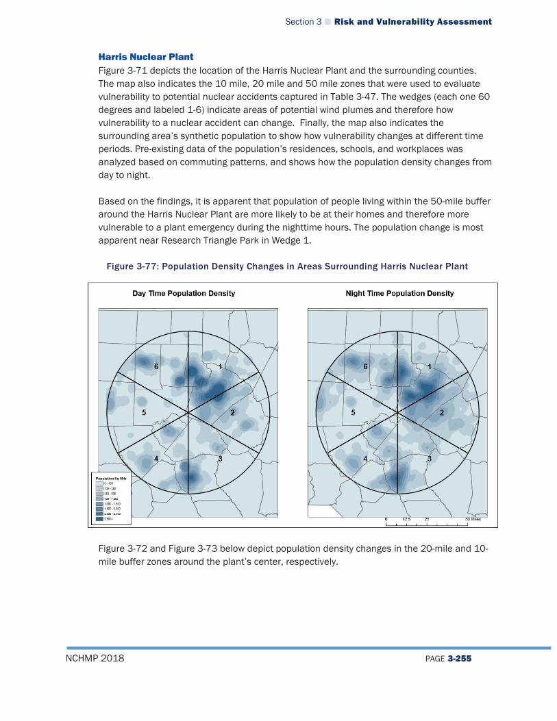
Section 3 Risk and Vulnerability Assessment
NCHMP 2018 PAGE 3-255
Harris Nuclear Plant Figure 3-71 depicts the location of the Harris Nuclear Plant and the surrounding counties. The map also indicates the 10 mile, 20 mile and 50 mile zones that were used to evaluate vulnerability to potential nuclear accidents captured in Table 3-47. The wedges (each one 60 degrees and labeled 1-6) indicate areas of potential wind plumes and therefore how vulnerability to a nuclear accident can change. Finally, the map also indicates the surrounding area’s synthetic population to show how vulnerability changes at different time periods. Pre-existing data of the population’s residences, schools, and workplaces was analyzed based on commuting patterns, and shows how the population density changes from day to night. Based on the findings, it is apparent that population of people living within the 50-mile buffer around the Harris Nuclear Plant are more likely to be at their homes and therefore more vulnerable to a plant emergency during the nighttime hours. The population change is most apparent near Research Triangle Park in Wedge 1.
Figure 3-77: Population Density Changes in Areas Surrounding Harris Nuclear Plant
Figure 3-72 and Figure 3-73 below depict population density changes in the 20-mile and 10-mile buffer zones around the plant’s center, respectively.

Section 3 Risk and Vulnerability Assessment
NCHMP 2018 PAGE 3-256
Figure 3-78: Population Density Changes 20 Miles Surrounding Harris Nuclear Plant
Figure 3-79: Population Density Changes 10 Miles Surrounding Harris Nuclear Plant

Section 3 Risk and Vulnerability Assessment
NCHMP 2018 PAGE 3-257
The following tables list all municipalities located within each 60-degree wedge. Wedge 1 Counties Cities Towns Villages Wake Franklin Durham Orange Granville Vance Person
Durham Raleigh Creedmoor Oxford
Cary Morrisville Wake Forest Youngsville Butner Stem Apex Holly Springs Rolesville Bunn Franklinton Louisburg Kittrell
n/a
Wedge 2 Counties Cities Towns Villages Wake Franklin Harnett Johnston Wayne Wilson Nash
Raleigh Archer Lodge Clayton Four Oaks Pine Level Selma Smithfield Wilson’s Mills Angier Apex Cary Fuquay-Varina Garner Holly Springs Knightdale Wendell Bunn Kenly Micro Princeton Wilson’s Mills Bailey Middlesex
n/a
Section 3 Risk and Vulnerability Assessment
NCHMP 2018 PAGE 3-258
Wedge 3 Counties Cities Towns Villages Wake Chatham Harnett Johnston Sampson Cumberland Wayne Robeson
Fayetteville Dunn
Eastover Falcon Godwin Linden Wade Angier Benson Coats Hope Mills Stedman Dunn Erwin Lillington Autryville Newton Grove Salemburg Spring Lake
n/a
Wedge 4 Counties Cities Towns Villages Wake Chatham Harnett Moore Cumberland Lee Robeson Hoke Richmond Montgomery
Fayetteville Sanford
Broadway Cameron Carthage Southern Pines Vass Spring Lake Hope Mills Raeford Aberdeen Foxfire Taylortown Parkton
Pinehurst Whispering Pines
Wedge 5 Counties Cities Towns Villages Wake Chatham Alamance Moore Lee Randolph Guilford
Sanford Asheboro Randleman
Goldston Pittsboro Siler City Robbins Liberty Ramseur Staley Pleasant Garden Biscoe Candor Star Franklinville Seagrove
n/a

Section 3 Risk and Vulnerability Assessment
NCHMP 2018 PAGE 3-259
Wedge 6 Counties Cities Towns Villages Wake Durham Orange Chatham Alamance Guilford Person Caswell
Burlington Graham Mebane Durham Greensboro Roxboro
Green Level Haw River Swepsonville Pittsboro Chapel Hill Carrboro Hillsborough Elon Gibsonville Ossipee Gibsonville Sedalia Whitsett
Alamance
The following table lists the number of buildings and the value of those buildings located within each 60-degree wedge in the 50-mile, 20-mile, and 10-mile radius around the plant’s center.
Table 3-47: Number and Value of Building Vulnerable to Nuclear Accident at Harris Nuclear Plant
Wedge
# of Buildings w/in 50 Miles
Value of Buildings ($)
# of Buildings w/in 20 Miles
Value of Buildings ($)
# of Buildings w/in 10 Miles
Value of Buildings ($)
1 338,332 $82,848,227,625 94,419 $30,826,291,852 12,897 $3,212,949,868 2 216,809 $33,379,154,883 68,133 $12,897,383,269 17,899 $4,024,396,295 3 146,610 $33,803,877,585 19,681 $3,103,774,864 4,308 $733,461,820 4 176,124 $29,878,067,919 26,177 $2,873,365,076 678 $282,050,522 5 109,898 $10,925,541,857 10,212 $1,491,725,021 1,829 $504,511,088 6 189,285 $33,088,624,270 21,385 $6,157,949,855 1,596 $413,361,617
Totals 1,176,451 $222,766,353,802 239,829 $56,484,919,279 39,170 $8,355,219,836 Source: NCEM
North Carolina’s agricultural industry is extremely important to the state’s economy, and it is important to consider how a nuclear emergency would impact agricultural areas surrounding nuclear plants. Since 2012, North Carolina has been the top ranked state from the value of sales from poultry, and number 2 from hogs and pigs51. It is also a top ranking state in milk and dairy production. In the event of an emergency, processing plants would need to shut down and be evacuated, which could cause many negative effects on the economy. The following table displays the number of permitted animal facilities and milk processing plants located within each wedge of the Harris Nuclear Plant, based on data from the NC Department of Environmental Quality (DEQ). This data shows which wedges would be more
51 https://www.nass.usda.gov/Quick_Stats/Ag_Overview/stateOverview.php?state=NORTH%20CAROLINA

Section 3 Risk and Vulnerability Assessment
NCHMP 2018 PAGE 3-260
agriculturally vulnerable to negative impacts from a disaster. Beneath the table is a graphic representation of these facilities. Based on the data, it is clearly evident that the highest concentration of facilities are located within Wedge 3.
Table 3-48: Number of Permitted Animal Facilities Vulnerable to Nuclear Accident at Harris Nuclear Plant
Wedge Type of Permitted Facility Number of Permitted Facilities
1 Beef Cattle 1 Swine 2 Milk Processing Plant 3
2 Dairy 1 Swine 65 Poultry 1
3 Dairy 1 Swine 193 Milk Processing Plant 1
4 Swine 12
5 Beef Cattle 4 Dairy 14 Swine 19
6
Beef Cattle 1 Dairy 17 Swine 17 Poultry 1 Milk Processing Plant 3
Sources: https://www.dairyfoods.com/search?commit=Submit&datatype=directory&exclude_datatypes%5B%5D=video&exclude_datatypes%5B%5D=file&ip=168.215.136.42&page=2&q=%22North+Carolina%22&taxonomy=Dairy+Plants+USA&utf8=%E2%9C%93 https://deq.nc.gov/about/divisions/water-resources/water-resources-permits/wastewater-branch/animal-feeding-operation-permits/animal-facility-map
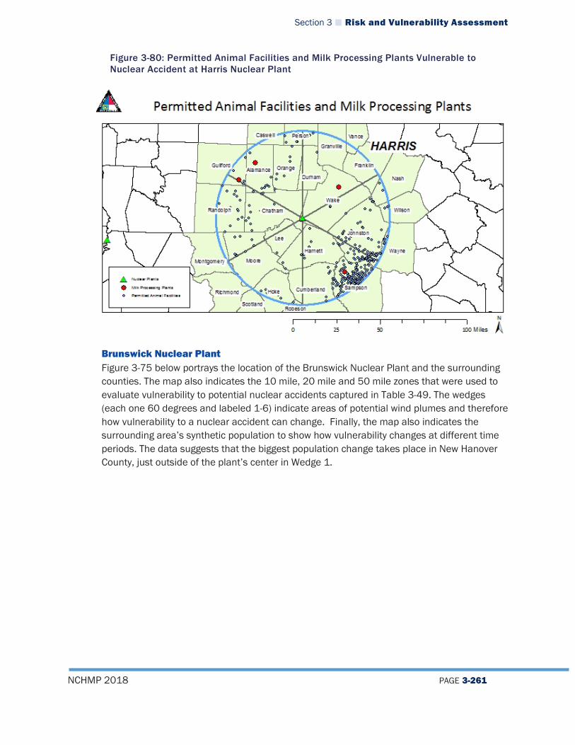
Section 3 Risk and Vulnerability Assessment
NCHMP 2018 PAGE 3-261
Figure 3-80: Permitted Animal Facilities and Milk Processing Plants Vulnerable to Nuclear Accident at Harris Nuclear Plant
Brunswick Nuclear Plant Figure 3-75 below portrays the location of the Brunswick Nuclear Plant and the surrounding counties. The map also indicates the 10 mile, 20 mile and 50 mile zones that were used to evaluate vulnerability to potential nuclear accidents captured in Table 3-49. The wedges (each one 60 degrees and labeled 1-6) indicate areas of potential wind plumes and therefore how vulnerability to a nuclear accident can change. Finally, the map also indicates the surrounding area’s synthetic population to show how vulnerability changes at different time periods. The data suggests that the biggest population change takes place in New Hanover County, just outside of the plant’s center in Wedge 1.
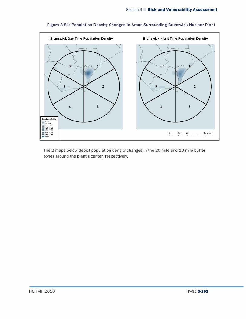
Section 3 Risk and Vulnerability Assessment
NCHMP 2018 PAGE 3-262
Figure 3-81: Population Density Changes In Areas Surrounding Brunswick Nuclear Plant
The 2 maps below depict population density changes in the 20-mile and 10-mile buffer zones around the plant’s center, respectively.
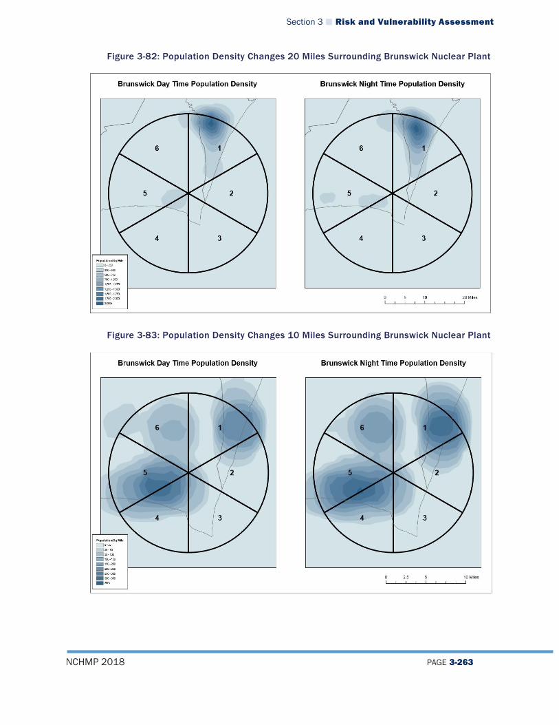
Section 3 Risk and Vulnerability Assessment
NCHMP 2018 PAGE 3-263
Figure 3-82: Population Density Changes 20 Miles Surrounding Brunswick Nuclear Plant
Figure 3-83: Population Density Changes 10 Miles Surrounding Brunswick Nuclear Plant
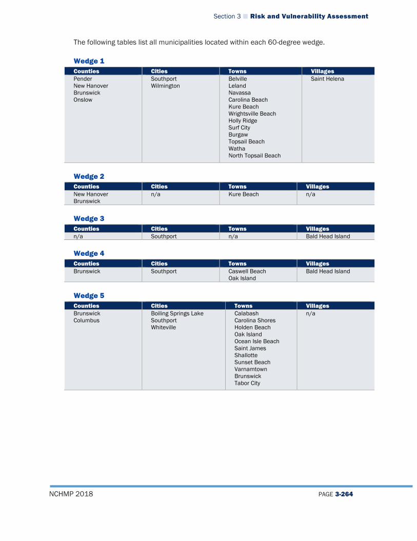
Section 3 Risk and Vulnerability Assessment
NCHMP 2018 PAGE 3-264
The following tables list all municipalities located within each 60-degree wedge.
Wedge 1 Counties Cities Towns Villages Pender New Hanover Brunswick Onslow
Southport Wilmington
Belville Leland Navassa Carolina Beach Kure Beach Wrightsville Beach Holly Ridge Surf City Burgaw Topsail Beach Watha North Topsail Beach
Saint Helena
Wedge 2 Counties Cities Towns Villages New Hanover Brunswick
n/a Kure Beach n/a
Wedge 3 Counties Cities Towns Villages n/a Southport n/a Bald Head Island
Wedge 4 Counties Cities Towns Villages Brunswick Southport Caswell Beach
Oak Island Bald Head Island
Wedge 5 Counties Cities Towns Villages Brunswick Columbus
Boiling Springs Lake Southport Whiteville
Calabash Carolina Shores Holden Beach Oak Island Ocean Isle Beach Saint James Shallotte Sunset Beach Varnamtown Brunswick Tabor City
n/a
Section 3 Risk and Vulnerability Assessment
NCHMP 2018 PAGE 3-265
Wedge 6 Counties Cities Towns Villages Pender New Hanover Brunswick Columbus Bladen Sampson
Boiling Springs Lake Northwest Southport Whiteville
East Arcadia Belville Bolivia Leland Navassa Sandy Creek Bolton Brunswick Lake Waccamaw Sandy Field Atkinson
The following table lists the number of buildings and the value of those buildings located within each 60-degree wedge in the 50-mile, 20-mile, and 10-mile radius around the plant’s center.
Table 3-49: Number and Value of Building Vulnerable to Nuclear Accident at Brunswick Nuclear Plant
Wedge
# of Buildings w/in 50 Miles
Value of Buildings ($)
# of Buildings w/in 20 Miles
Value of Buildings ($)
# of Buildings w/in 10 Miles
Value of Buildings ($)
1 127,995 $31,022,961,898 51,049 $13,672,332,444 6,223 $2,105,186,314 2 1,406 $747,960,939 1,406 $747,960,939 1,406 $747,960,939 3 1,483 $638,703,925 1,483 $638,703,925 1,483 $638,703,925 4 4,414 $767,464,188 4,414 $767,464,188 4,414 $767,464,188 5 59,174 $7,474,035,322 24,901 $2,547,170,032 7,807 $1,104,578,034 6 37,235 $5,585,945,847 9,405 $901,696,007 2,635 $258,253,601 Totals 231,608 $46,178,214,033 92,577 $19,225,604,363 23,899 $5,573,043,696
Source: NCEM
The following table displays the number of permitted animal facilities and milk processing plants located within each wedge of the Brunswick Nuclear Plant, based on data from the NC Department of Environmental Quality (DEQ). This data shows which wedges would be more agriculturally vulnerable to negative impacts from a disaster. Beneath the table is a graphic representation of these facilities. Based on the data, it is clearly evident that the highest concentration of facilities are located within Wedge 6.
Table 3-50: Number of Permitted Animal Facilities Vulnerable to Nuclear Accident at Brunswick Nuclear Plant
Wedge Type of Permitted Facility Number of Permitted Facilities 1 Swine 24 5 Swine 21 6 Swine 91
Sources: https://www.dairyfoods.com/search?commit=Submit&datatype=directory&exclude_datatypes%5B%5D=video&e
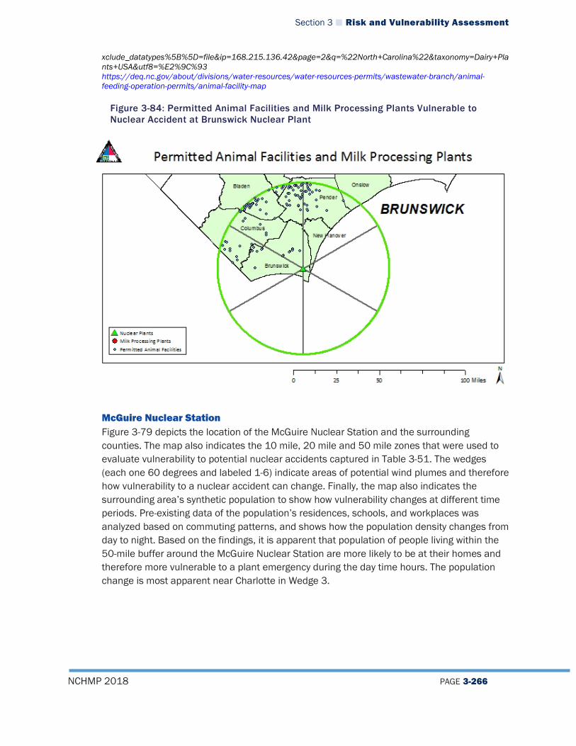
Section 3 Risk and Vulnerability Assessment
NCHMP 2018 PAGE 3-266
xclude_datatypes%5B%5D=file&ip=168.215.136.42&page=2&q=%22North+Carolina%22&taxonomy=Dairy+Plants+USA&utf8=%E2%9C%93 https://deq.nc.gov/about/divisions/water-resources/water-resources-permits/wastewater-branch/animal-feeding-operation-permits/animal-facility-map
Figure 3-84: Permitted Animal Facilities and Milk Processing Plants Vulnerable to Nuclear Accident at Brunswick Nuclear Plant
McGuire Nuclear Station Figure 3-79 depicts the location of the McGuire Nuclear Station and the surrounding counties. The map also indicates the 10 mile, 20 mile and 50 mile zones that were used to evaluate vulnerability to potential nuclear accidents captured in Table 3-51. The wedges (each one 60 degrees and labeled 1-6) indicate areas of potential wind plumes and therefore how vulnerability to a nuclear accident can change. Finally, the map also indicates the surrounding area’s synthetic population to show how vulnerability changes at different time periods. Pre-existing data of the population’s residences, schools, and workplaces was analyzed based on commuting patterns, and shows how the population density changes from day to night. Based on the findings, it is apparent that population of people living within the 50-mile buffer around the McGuire Nuclear Station are more likely to be at their homes and therefore more vulnerable to a plant emergency during the day time hours. The population change is most apparent near Charlotte in Wedge 3.
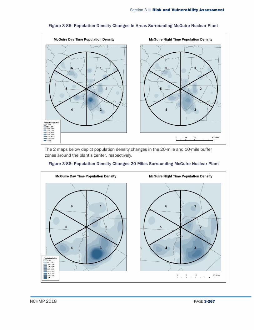
Section 3 Risk and Vulnerability Assessment
NCHMP 2018 PAGE 3-267
Figure 3-85: Population Density Changes In Areas Surrounding McGuire Nuclear Plant
The 2 maps below depict population density changes in the 20-mile and 10-mile buffer zones around the plant’s center, respectively.
Figure 3-86: Population Density Changes 20 Miles Surrounding McGuire Nuclear Plant

Section 3 Risk and Vulnerability Assessment
NCHMP 2018 PAGE 3-268
Figure 3-87: Population Density Changes 10 Miles Surrounding McGuire Nuclear Plant
The following tables list all municipalities located within each 60-degree wedge. Wedge 1
Counties Cities Towns Villages Iredell Wilkes Rowan Davidson Davie Forsyth Yadkin Lincoln Mecklenburg Catawba
Lexington Statesville Salisbury
Bermuda Run Cooleemee Mocksville Harmony Cleveland Yadkinville Davidson Mooresville Troutman Davidson Landis
Clemmons

Section 3 Risk and Vulnerability Assessment
NCHMP 2018 PAGE 3-269
Wedge 2 Counties Cities Towns Villages Cabarrus Anson Montgomery Stanly Rowan Davidson Randolph Union Iredell Mecklenburg
Lexington Salisbury Albemarle Locust Charlotte Concord Kannapolis
Denton East Spencer Faith Granite Quarry Rockwell Spencer Badin New London Richfield Midland Mount Pleasant Stanfield Oakboro Red Cross Harrisburg Cornelius Davidson Huntersville China Grove
Misenheimer
Wedge 3
Counties Cities Towns Villages Anson Union Cabarrus Mecklenburg Stanly Gaston
Charlotte Monroe Mount Holly Monroe
Waxhaw Fairview Midland Mint Hill Pineville Fairview Hemby Bridge Indian Trail Stallings Unionville Weddington Matthews Harrisburg Huntersville Peachland Marshville Mineral Springs Wingate
Lake Park Marvin Wesley Chapel
Section 3 Risk and Vulnerability Assessment
NCHMP 2018 PAGE 3-270
Wedge 4 Counties Cities Towns Villages Mecklenburg Gaston Cleveland Lincoln
Charlotte Kings Mountain Bessemer City Gastonia Lowell Belmont Mount Holly
Cramerton Dallas McAdenville Ranlo Spencer Mountain Stanley Grover Huntersville
n/a
Wedge 5
Counties Cities Towns Villages Cleveland Rutherford Burke Gaston Lincoln Catawba Burke Mecklenburg
Morganton Kings Mountain Shelby Bessemer City Cherryville Gastonia High Shoals Lincolnton
Belwood Casar Fallston Kingstown Lattimore Lawndale Polkville Waco Dallas Dellview Stanley Boiling Springs Earl Grover Mooresboro Patterson Springs Bostic Ellenboro Forest City
n/a
Wedge 5
Counties Cities Towns Villages Iredell Wilkes Catawba Burke Caldwell Alexander Lincoln Mecklenburg
Morganton Hickory Lenoir Statesville Claremont Conover Newton
Taylorsville Connelly Springs Drexel Rhodhiss Rutherford College Valdese Cajah’s Mountain Gamewell Granite Falls Hudson Sawmills Long View Love Valley North Wilkesboro Wilkesboro Hildebran Brookford Catawba Maiden
Cedar Rock
Section 3 Risk and Vulnerability Assessment
NCHMP 2018 PAGE 3-271
The following table lists the number of buildings and the value of those buildings located within each 60-degree wedge in the 50-mile, 20-mile, and 10-mile radius around the plant’s center.
Table 3-51: Number and Value of Building Vulnerable to Nuclear Accident at McGuire Nuclear Plant
Wedge
# of Buildings w/in 50 Miles
Value of Buildings ($)
# of Buildings w/in 20 Miles
Value of Buildings ($)
# of Buildings w/in 10 Miles
Value of Buildings ($)
1 222,548 $25,912,608,925 55,780 $11,789,238,724 16,756 $5,502,454,626 2 216,139 $30,250,605,052 79,264 $17,790,277,638 22,437 $6,884,027,575 3 357,743 $96,023,235,395 143,205 $48,044,104,739 21,768 $5,037,453,322 4 156,111 $19,950,179,881 116,855 $14,245,462,969 18,698 $3,539,609,251 5 177,920 $20,199,280,078 57,046 $9,438,365,834 11,206 $3,026,259,723 6 240,180 $27,530,012,006 42,602 $6,433,551,384 11,908 $3,345,729,662 Totals 1,369,949 $216,413,623,573 494,380 $104,607,776,283 102,594 $24,739,981,985
Source: NCEM
The following table displays the number of permitted animal facilities and milk processing plants located within each wedge of the McGuire Nuclear Station, based on data from the NC Department of Environmental Quality (DEQ). This data shows which wedges would be more agriculturally vulnerable to negative impacts from a disaster. Beneath the table is a graphic representation of these facilities. Based on the data, it is clearly evident that the highest concentration of facilities are located within Wedge 1.
Table 3-52: Number of Permitted Animal Facilities Vulnerable to Nuclear Accident at McGuire Nuclear Plant
Wedge Type of Permitted Facility Number of Permitted Facilities 1 Beef Cattle 2
Dairy 249 2 Dairy 7
Swine 4 Poultry 3
3 Dairy 1 Swine 3 Poultry 1 Milk Processing Plant 1
5 Beef Cattle 2 Dairy 20
6 Beef Cattle 3 Dairy 25 Swine 1 Milk Processing Plant 1
Sources: https://www.dairyfoods.com/search?commit=Submit&datatype=directory&exclude_datatypes%5B%5D=video&exclude_datatypes%5B%5D=file&ip=168.215.136.42&page=2&q=%22North+Carolina%22&taxonomy=Dairy+Plants+USA&utf8=%E2%9C%93 https://deq.nc.gov/about/divisions/water-resources/water-resources-permits/wastewater-branch/animal-feeding-operation-permits/animal-facility-map
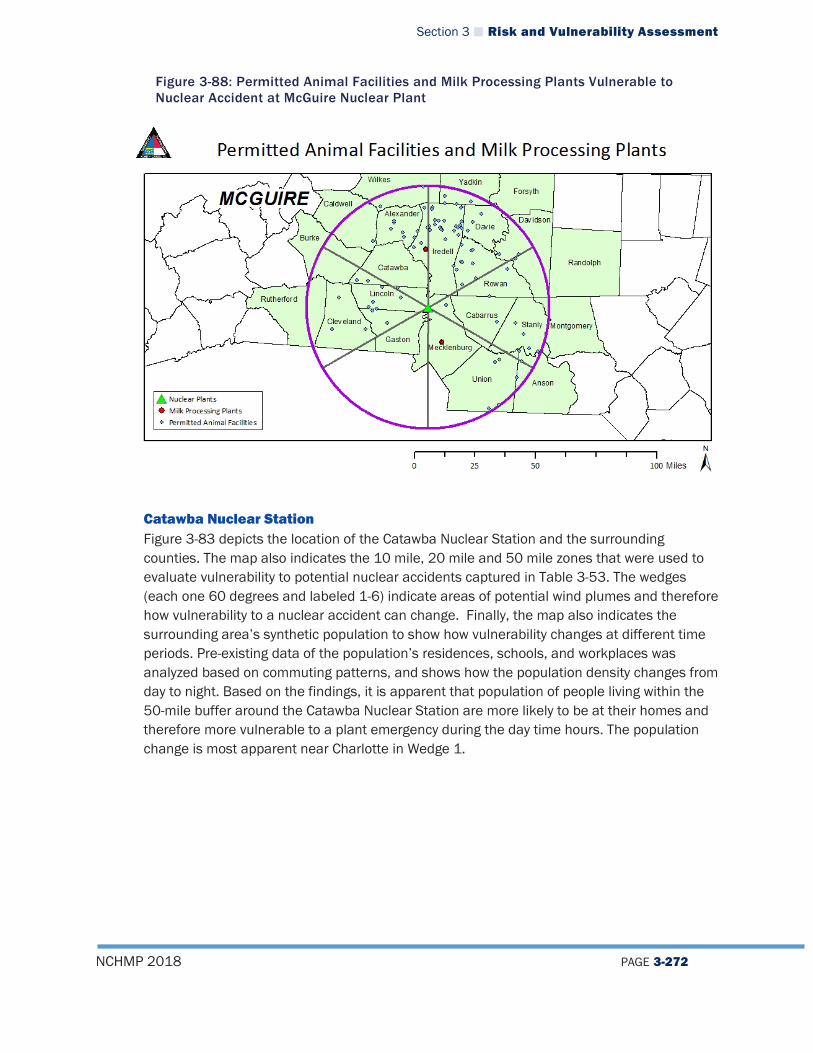
Section 3 Risk and Vulnerability Assessment
NCHMP 2018 PAGE 3-272
Figure 3-88: Permitted Animal Facilities and Milk Processing Plants Vulnerable to Nuclear Accident at McGuire Nuclear Plant
Catawba Nuclear Station Figure 3-83 depicts the location of the Catawba Nuclear Station and the surrounding counties. The map also indicates the 10 mile, 20 mile and 50 mile zones that were used to evaluate vulnerability to potential nuclear accidents captured in Table 3-53. The wedges (each one 60 degrees and labeled 1-6) indicate areas of potential wind plumes and therefore how vulnerability to a nuclear accident can change. Finally, the map also indicates the surrounding area’s synthetic population to show how vulnerability changes at different time periods. Pre-existing data of the population’s residences, schools, and workplaces was analyzed based on commuting patterns, and shows how the population density changes from day to night. Based on the findings, it is apparent that population of people living within the 50-mile buffer around the Catawba Nuclear Station are more likely to be at their homes and therefore more vulnerable to a plant emergency during the day time hours. The population change is most apparent near Charlotte in Wedge 1.
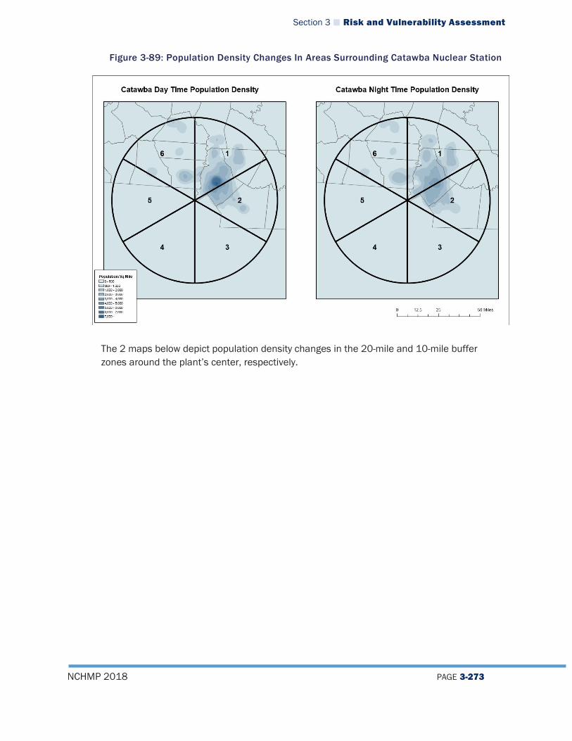
Section 3 Risk and Vulnerability Assessment
NCHMP 2018 PAGE 3-273
Figure 3-89: Population Density Changes In Areas Surrounding Catawba Nuclear Station
The 2 maps below depict population density changes in the 20-mile and 10-mile buffer zones around the plant’s center, respectively.
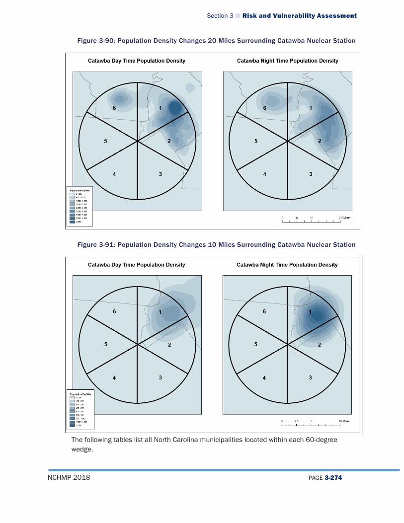
Section 3 Risk and Vulnerability Assessment
NCHMP 2018 PAGE 3-274
Figure 3-90: Population Density Changes 20 Miles Surrounding Catawba Nuclear Station
Figure 3-91: Population Density Changes 10 Miles Surrounding Catawba Nuclear Station
The following tables list all North Carolina municipalities located within each 60-degree wedge.
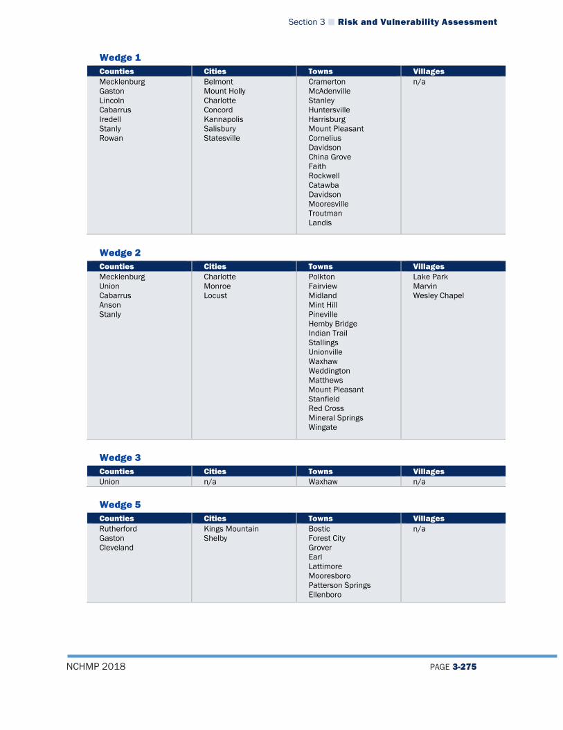
Section 3 Risk and Vulnerability Assessment
NCHMP 2018 PAGE 3-275
Wedge 1 Counties Cities Towns Villages Mecklenburg Gaston Lincoln Cabarrus Iredell Stanly Rowan
Belmont Mount Holly Charlotte Concord Kannapolis Salisbury Statesville
Cramerton McAdenville Stanley Huntersville Harrisburg Mount Pleasant Cornelius Davidson China Grove Faith Rockwell Catawba Davidson Mooresville Troutman Landis
n/a
Wedge 2 Counties Cities Towns Villages Mecklenburg Union Cabarrus Anson Stanly
Charlotte Monroe Locust
Polkton Fairview Midland Mint Hill Pineville Hemby Bridge Indian Trail Stallings Unionville Waxhaw Weddington Matthews Mount Pleasant Stanfield Red Cross Mineral Springs Wingate
Lake Park Marvin Wesley Chapel
Wedge 3 Counties Cities Towns Villages Union n/a Waxhaw n/a
Wedge 5 Counties Cities Towns Villages Rutherford Gaston Cleveland
Kings Mountain Shelby
Bostic Forest City Grover Earl Lattimore Mooresboro Patterson Springs Ellenboro
n/a

Section 3 Risk and Vulnerability Assessment
NCHMP 2018 PAGE 3-276
Wedge 6 Counties Cities Towns Villages Rutherford Gaston Cleveland Lincoln Catawba Burke Iredell
Kings Mountain Bessemer City Gastonia Lowell Shelby High Shoals Lincolnton Claremont Conover Newton Hickory
Cramerton Dallas McAdenville Ranlo Spencer Mountain Stanley Belwood Casar Fallston Kingstown Lattimore Lawndale Polkville Waco Dellview Brookford Catawba Long View Maiden Hildebran
n/a
The following table lists the number of buildings and value of those buildings located within each 60-degree wedge in the 50-mile, 20-mile, and 10-mile radius around the plant’s center.
Table 3-53: Number and Value of Building Vulnerable to Nuclear Accident at Catawba Nuclear Station
Wedge
# of Buildings w/in 50 Miles
Value of Buildings ($)
# of Buildings w/in 20 Miles
Value of Buildings ($)
# of Buildings w/in 10 Miles
Value of Buildings ($)
1 424,709 $98,271,121,086 120,634 $37,398,697,819 17,316 $5,501,323,272 2 244,544 $51,748,608,344 93,909 $30,605,071,527 4,315 $1,586,462,022 3 3,290 $318,709,390 196 $14,070,714 - - 4 - - - - - - 5 29,674 $2,883,319,615 272 $29,287,977 - - 6 300,182 $28,325,710,580 90,221 $7,029,078,318 3,196 $160,710,507 Totals 1,001,986 $181,242,672,516 305,008 $74,824,871,840 24,763 $7,134,706,496
Source: NCEM
The following table displays the number of permitted animal facilities and milk processing plants located within each wedge of the Catawba Nuclear Station, based on data from the NC Department of Environmental Quality (DEQ). This data shows which wedges would be more agriculturally vulnerable to negative impacts from a disaster. Beneath the table is a graphic representation of these facilities. Based on the data, it is clearly evident that the highest concentration of facilities are located within Wedge 6.
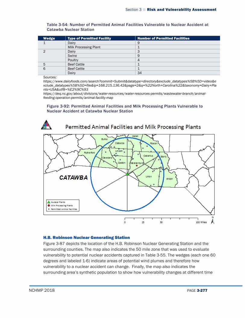
Section 3 Risk and Vulnerability Assessment
NCHMP 2018 PAGE 3-277
Table 3-54: Number of Permitted Animal Facilities Vulnerable to Nuclear Accident at Catawba Nuclear Station
Wedge Type of Permitted Facility Number of Permitted Facilities 1 Dairy 9
Milk Processing Plant 1 2 Dairy 3
Swine 9 Poultry 4
5 Beef Cattle 1 6 Beef Cattle 1
Dairy 34 Sources: https://www.dairyfoods.com/search?commit=Submit&datatype=directory&exclude_datatypes%5B%5D=video&exclude_datatypes%5B%5D=file&ip=168.215.136.42&page=2&q=%22North+Carolina%22&taxonomy=Dairy+Plants+USA&utf8=%E2%9C%93 https://deq.nc.gov/about/divisions/water-resources/water-resources-permits/wastewater-branch/animal-feeding-operation-permits/animal-facility-map
Figure 3-92: Permitted Animal Facilities and Milk Processing Plants Vulnerable to Nuclear Accident at Catawba Nuclear Station
H.B. Robinson Nuclear Generating Station Figure 3-87 depicts the location of the H.B. Robinson Nuclear Generating Station and the surrounding counties. The map also indicates the 50 mile zone that was used to evaluate vulnerability to potential nuclear accidents captured in Table 3-55. The wedges (each one 60 degrees and labeled 1-6) indicate areas of potential wind plumes and therefore how vulnerability to a nuclear accident can change. Finally, the map also indicates the surrounding area’s synthetic population to show how vulnerability changes at different time
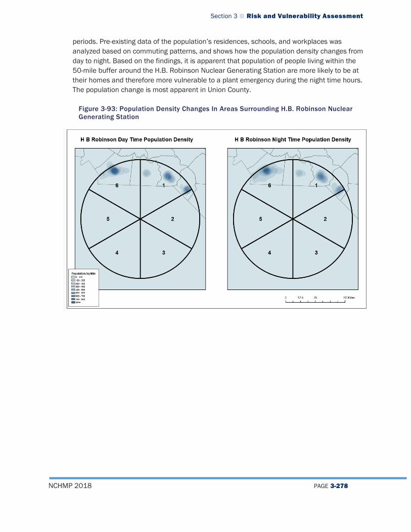
Section 3 Risk and Vulnerability Assessment
NCHMP 2018 PAGE 3-278
periods. Pre-existing data of the population’s residences, schools, and workplaces was analyzed based on commuting patterns, and shows how the population density changes from day to night. Based on the findings, it is apparent that population of people living within the 50-mile buffer around the H.B. Robinson Nuclear Generating Station are more likely to be at their homes and therefore more vulnerable to a plant emergency during the night time hours. The population change is most apparent in Union County.
Figure 3-93: Population Density Changes In Areas Surrounding H.B. Robinson Nuclear Generating Station

Section 3 Risk and Vulnerability Assessment
NCHMP 2018 PAGE 3-279
The following tables list all North Carolina municipalities located within each 60-degree wedge. Wedge 1 Counties Cities Towns Villages Anson Scotland Richmond
Hamlet Laurinburg
Ansonville Lilesville McFarlan Morven Wadesboro Dobbins Heights East Laurinburg Gibson
n/a
Wedge 2 Counties Cities Towns Villages Robeson Scotland
Laurinburg Rowland n/a
Wedge 6 Counties Cities Towns Villages Anson Union
Monroe Polkton Waxhaw Marshville Mineral Springs Unionville Wingate
Wesley Chapel
The following table lists the number of buildings and the value of those buildings located within each 60-degree wedge in the 50-mile radius around the plant’s center.
Table 3-55: Number and Value of Building Vulnerable to Nuclear Accident at H.B. Robinson Nuclear Generating Station
Wedge # of Buildings within 50 Miles Value of Buildings ($) 1 48,041 $8,388,703,177 2 3,820 $448,177,927 3 - - 4 - - 5 - - 6 53,017 $5,288,671,922 Totals 104,868 $14,123,090,840 Source: NCEM
The following table displays the number of permitted animal facilities and milk processing plants located within each wedge of the H.B. Robinson Nuclear Generating Station, based on data from the NC Department of Environmental Quality (DEQ). This data shows which wedges would be more agriculturally vulnerable to negative impacts from a disaster. Beneath the table is a graphic representation of these facilities. Based on the data, it is clearly evident that the highest concentration of facilities are located within Wedge 1.

Section 3 Risk and Vulnerability Assessment
NCHMP 2018 PAGE 3-280
Table 3-56: Number of Permitted Animal Facilities Vulnerable to Nuclear Accident at H.B. Robinson Nuclear Plant
Wedge Type of Permitted Facility Number of Permitted Facilities 1 Swine 18 2 Swine 14
6 Dairy 2 Swine 5 Poultry 1
Sources: https://www.dairyfoods.com/search?commit=Submit&datatype=directory&exclude_datatypes%5B%5D=video&exclude_datatypes%5B%5D=file&ip=168.215.136.42&page=2&q=%22North+Carolina%22&taxonomy=Dairy+Plants+USA&utf8=%E2%9C%93 https://deq.nc.gov/about/divisions/water-resources/water-resources-permits/wastewater-branch/animal-feeding-operation-permits/animal-facility-map
Figure 3-94: Permitted Animal Facilities and Milk Processing Plants Vulnerable to Nuclear Accident at H.B. Robinson Nuclear Generating Station
Oconee Nuclear Station Figure 3-89 depicts the location of the Oconee Nuclear Station and the surrounding counties. The map also indicates the 10 mile, 20 mile and 50 mile zones that were used to evaluate vulnerability to potential nuclear accidents captured in Table 3-57. The wedges (each one 60 degrees and labeled 1-6) indicate areas of potential wind plumes and therefore how vulnerability to a nuclear accident can change. Finally, the map also indicates the surrounding area’s synthetic population to show how vulnerability changes at different time periods. Pre-existing data of the population’s residences, schools, and workplaces was analyzed based on commuting patterns, and shows how the population density changes from day to night. Based on the findings, it is apparent that population of people living within the
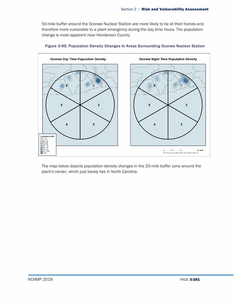
Section 3 Risk and Vulnerability Assessment
NCHMP 2018 PAGE 3-281
50-mile buffer around the Oconee Nuclear Station are more likely to be at their homes and therefore more vulnerable to a plant emergency during the day time hours. The population change is most apparent near Henderson County.
Figure 3-95: Population Density Changes In Areas Surrounding Oconee Nuclear Station
The map below depicts population density changes in the 20-mile buffer zone around the plant’s center, which just barely lies in North Carolina.
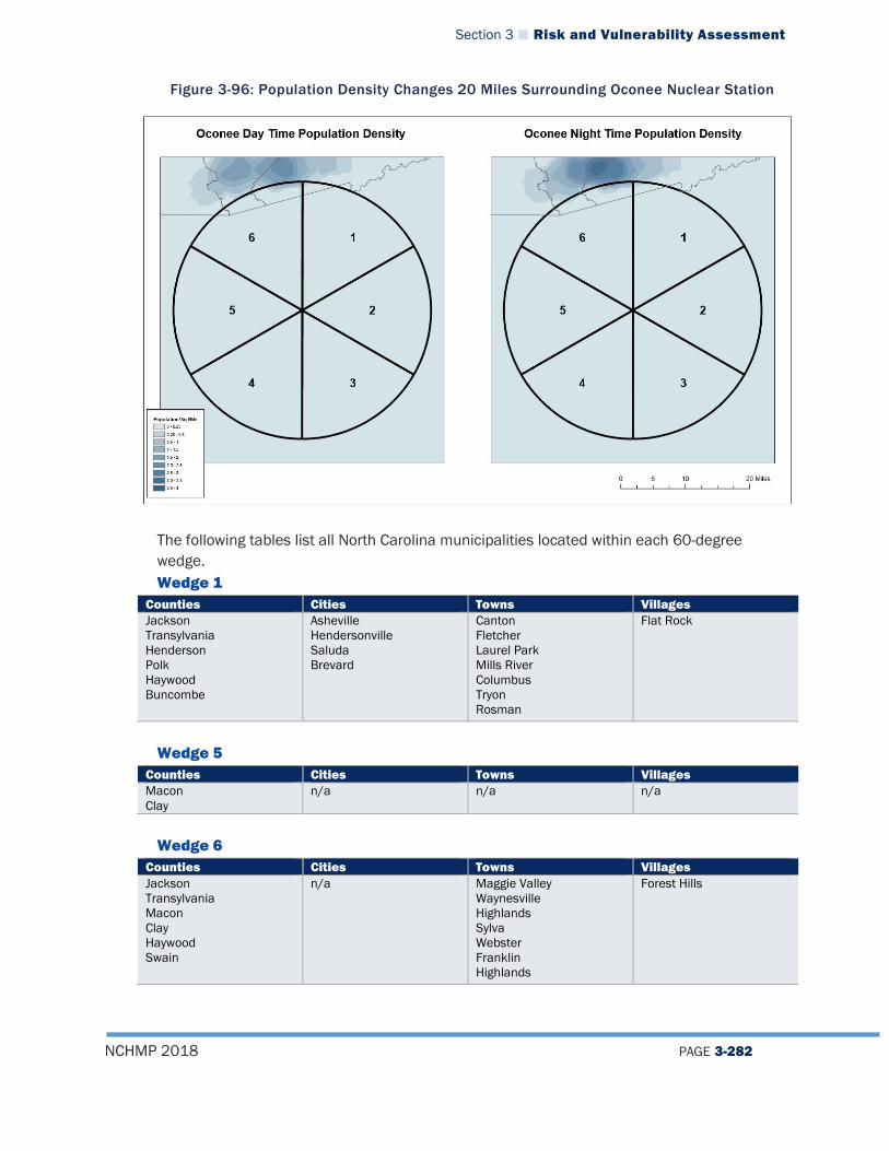
Section 3 Risk and Vulnerability Assessment
NCHMP 2018 PAGE 3-282
Figure 3-96: Population Density Changes 20 Miles Surrounding Oconee Nuclear Station
The following tables list all North Carolina municipalities located within each 60-degree wedge. Wedge 1
Counties Cities Towns Villages Jackson Transylvania Henderson Polk Haywood Buncombe
Asheville Hendersonville Saluda Brevard
Canton Fletcher Laurel Park Mills River Columbus Tryon Rosman
Flat Rock
Wedge 5
Counties Cities Towns Villages Macon Clay
n/a n/a n/a
Wedge 6
Counties Cities Towns Villages Jackson Transylvania Macon Clay Haywood Swain
n/a Maggie Valley Waynesville Highlands Sylva Webster Franklin Highlands
Forest Hills

Section 3 Risk and Vulnerability Assessment
NCHMP 2018 PAGE 3-283
The following table lists the number of buildings and the value of those buildings located within each 60-degree wedge in the 50-mile and 20-mile radius around the plant’s center.
Table 3-57: Number and Value of Building Vulnerable to Nuclear Accident at Oconee Nuclear Station
Wedge # of Buildings within 50 Miles
Value of Buildings ($) # of Buildings within 20 Miles
Value of Buildings ($)
1 80,031 $12,522,796,981 68 $9,930,992 2 - - - - 3 - - - - 4 - - - - 5 2,183 $264,738,559 - - 6 61,367 $11,732,606,952 157 $17,732,793 Totals 143,570 $24,518,653,332 225 $27,663,785 Source: NCEM
The following table displays the number of permitted animal facilities and milk processing plants located within each wedge of the Oconee Nuclear Station, based on data from the NC Department of Environmental Quality (DEQ). This data shows which wedges would be more agriculturally vulnerable to negative impacts from a disaster. Beneath the table is a graphic representation of these facilities. Based on the data, the only facilities are located in Wedge 1 and mostly lie within Henderson County.
Table 3-58: Number of Permitted Animal Facilities Vulnerable to Nuclear Accident at Oconee Nuclear Station
Wedge Type of Permitted Facility Number of Permitted Facilities
1 Dairy 5 Sources: https://www.dairyfoods.com/search?commit=Submit&datatype=directory&exclude_datatypes%5B%5D=video&exclude_datatypes%5B%5D=file&ip=168.215.136.42&page=2&q=%22North+Carolina%22&taxonomy=Dairy+Plants+USA&utf8=%E2%9C%93 https://deq.nc.gov/about/divisions/water-resources/water-resources-permits/wastewater-branch/animal-feeding-operation-permits/animal-facility-map
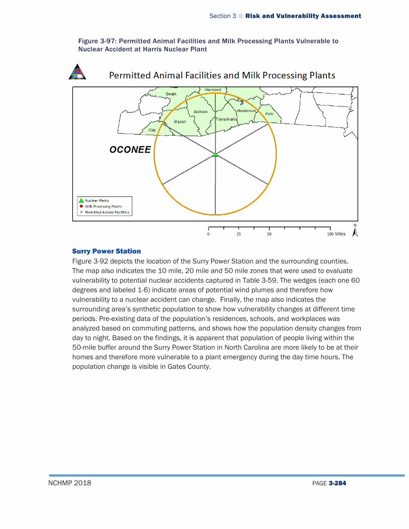
Section 3 Risk and Vulnerability Assessment
NCHMP 2018 PAGE 3-284
Figure 3-97: Permitted Animal Facilities and Milk Processing Plants Vulnerable to Nuclear Accident at Harris Nuclear Plant
Surry Power Station Figure 3-92 depicts the location of the Surry Power Station and the surrounding counties. The map also indicates the 10 mile, 20 mile and 50 mile zones that were used to evaluate vulnerability to potential nuclear accidents captured in Table 3-59. The wedges (each one 60 degrees and labeled 1-6) indicate areas of potential wind plumes and therefore how vulnerability to a nuclear accident can change. Finally, the map also indicates the surrounding area’s synthetic population to show how vulnerability changes at different time periods. Pre-existing data of the population’s residences, schools, and workplaces was analyzed based on commuting patterns, and shows how the population density changes from day to night. Based on the findings, it is apparent that population of people living within the 50-mile buffer around the Surry Power Station in North Carolina are more likely to be at their homes and therefore more vulnerable to a plant emergency during the day time hours. The population change is visible in Gates County.
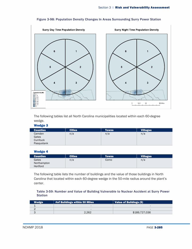
Section 3 Risk and Vulnerability Assessment
NCHMP 2018 PAGE 3-285
Figure 3-98: Population Density Changes In Areas Surrounding Surry Power Station
The following tables list all North Carolina municipalities located within each 60-degree wedge. Wedge 3 Counties Cities Towns Villages Camden Gates Currituck Pasquotank
n/a n/a n/a
Wedge 4 Counties Cities Towns Villages Gates Northampton Hertford
n/a Como n/a
The following table lists the number of buildings and the value of those buildings in North Carolina that located within each 60-degree wedge in the 50-mile radius around the plant’s center.
Table 3-59: Number and Value of Building Vulnerable to Nuclear Accident at Surry Power Station
Wedge #of Buildings within 50 Miles Value of Buildings ($) 1 - - 2 - - 3 2,262 $189,727,036
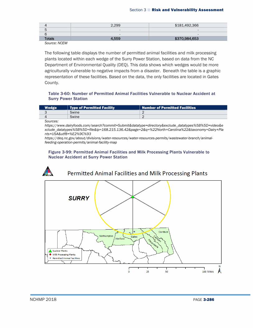
Section 3 Risk and Vulnerability Assessment
NCHMP 2018 PAGE 3-286
4 2,299 $181,492,366 5 - - 6 - - Totals 4,559 $370,984,653 Source: NCEM
The following table displays the number of permitted animal facilities and milk processing plants located within each wedge of the Surry Power Station, based on data from the NC Department of Environmental Quality (DEQ). This data shows which wedges would be more agriculturally vulnerable to negative impacts from a disaster. Beneath the table is a graphic representation of these facilities. Based on the data, the only facilities are located in Gates County.
Table 3-60: Number of Permitted Animal Facilities Vulnerable to Nuclear Accident at Surry Power Station
Wedge Type of Permitted Facility Number of Permitted Facilities 3 Swine 2 4 Swine 2 Sources: https://www.dairyfoods.com/search?commit=Submit&datatype=directory&exclude_datatypes%5B%5D=video&exclude_datatypes%5B%5D=file&ip=168.215.136.42&page=2&q=%22North+Carolina%22&taxonomy=Dairy+Plants+USA&utf8=%E2%9C%93 https://deq.nc.gov/about/divisions/water-resources/water-resources-permits/wastewater-branch/animal-feeding-operation-permits/animal-facility-map
Figure 3-99: Permitted Animal Facilities and Milk Processing Plants Vulnerable to Nuclear Accident at Surry Power Station
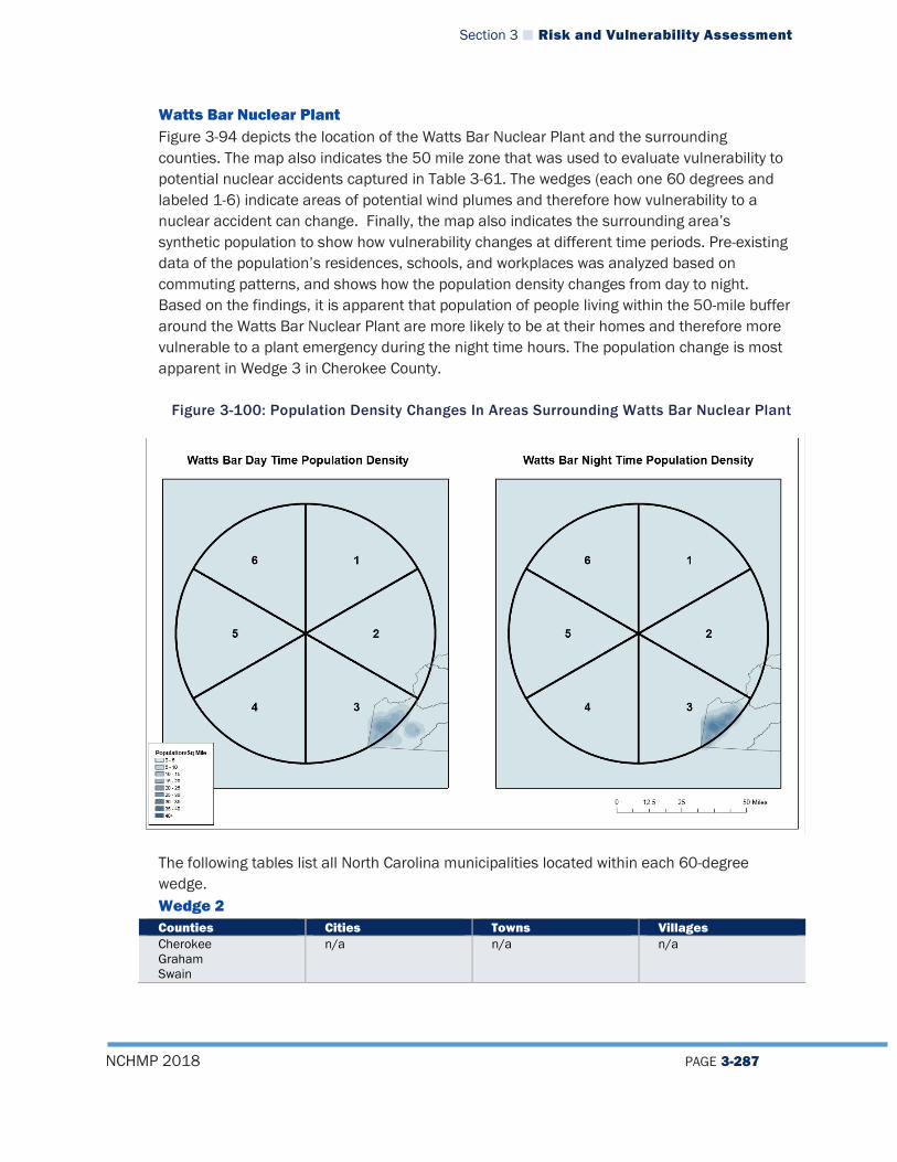
Section 3 Risk and Vulnerability Assessment
NCHMP 2018 PAGE 3-287
Watts Bar Nuclear Plant Figure 3-94 depicts the location of the Watts Bar Nuclear Plant and the surrounding counties. The map also indicates the 50 mile zone that was used to evaluate vulnerability to potential nuclear accidents captured in Table 3-61. The wedges (each one 60 degrees and labeled 1-6) indicate areas of potential wind plumes and therefore how vulnerability to a nuclear accident can change. Finally, the map also indicates the surrounding area’s synthetic population to show how vulnerability changes at different time periods. Pre-existing data of the population’s residences, schools, and workplaces was analyzed based on commuting patterns, and shows how the population density changes from day to night. Based on the findings, it is apparent that population of people living within the 50-mile buffer around the Watts Bar Nuclear Plant are more likely to be at their homes and therefore more vulnerable to a plant emergency during the night time hours. The population change is most apparent in Wedge 3 in Cherokee County.
Figure 3-100: Population Density Changes In Areas Surrounding Watts Bar Nuclear Plant
The following tables list all North Carolina municipalities located within each 60-degree wedge. Wedge 2 Counties Cities Towns Villages Cherokee Graham Swain
n/a n/a n/a

Section 3 Risk and Vulnerability Assessment
NCHMP 2018 PAGE 3-288
Wedge 3 Counties Cities Towns Villages Cherokee Graham
n/a n/a n/a
Source: NCEM
The following table lists the number of buildings and the value of those buildings in North Carolina that located within each 60-degree wedge in the 50-mile radius around the plant’s center.
Table 3-61: Number and Value of Building Vulnerable to Nuclear Accident at Watts Bar Nuclear Plant
Wedge Number of Buildings within 50 Miles Value of Buildings ($) 1 - - 2 39 $504,062,668 3 3,227 $269,120,119 4 - - 5 - - 6 - -
Totals 3,280 $774,028,847 Source: NCEM
Based on data from the NC Department of Environmental Quality (DEQ), there are no agricultural facilities in North Carolina that fall within a 50-mile radius of the plant’s center and therefore vulnerable to a potential emergency. Sources: https://www.dairyfoods.com/search?commit=Submit&datatype=directory&exclude_datatypes%5B%5D=video&exclude_datatypes%5B%5D=file&ip=168.215.136.42&page=2&q=%22North+Carolina%22&taxonomy=Dairy+Plants+USA&utf8=%E2%9C%93 https://deq.nc.gov/about/divisions/water-resources/water-resources-permits/wastewater-branch/animal-feeding-operation-permits/animal-facility-map
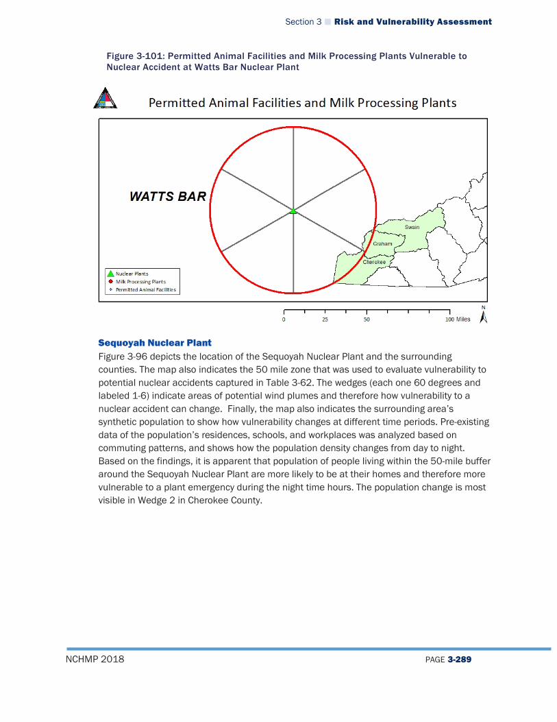
Section 3 Risk and Vulnerability Assessment
NCHMP 2018 PAGE 3-289
Figure 3-101: Permitted Animal Facilities and Milk Processing Plants Vulnerable to Nuclear Accident at Watts Bar Nuclear Plant
Sequoyah Nuclear Plant Figure 3-96 depicts the location of the Sequoyah Nuclear Plant and the surrounding counties. The map also indicates the 50 mile zone that was used to evaluate vulnerability to potential nuclear accidents captured in Table 3-62. The wedges (each one 60 degrees and labeled 1-6) indicate areas of potential wind plumes and therefore how vulnerability to a nuclear accident can change. Finally, the map also indicates the surrounding area’s synthetic population to show how vulnerability changes at different time periods. Pre-existing data of the population’s residences, schools, and workplaces was analyzed based on commuting patterns, and shows how the population density changes from day to night. Based on the findings, it is apparent that population of people living within the 50-mile buffer around the Sequoyah Nuclear Plant are more likely to be at their homes and therefore more vulnerable to a plant emergency during the night time hours. The population change is most visible in Wedge 2 in Cherokee County.
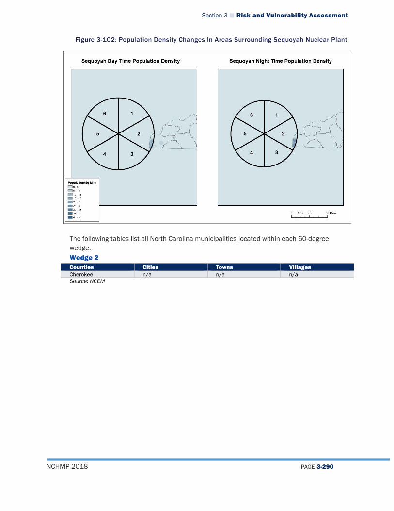
Section 3 Risk and Vulnerability Assessment
NCHMP 2018 PAGE 3-290
Figure 3-102: Population Density Changes In Areas Surrounding Sequoyah Nuclear Plant
The following tables list all North Carolina municipalities located within each 60-degree wedge. Wedge 2 Counties Cities Towns Villages Cherokee n/a n/a n/a Source: NCEM

Section 3 Risk and Vulnerability Assessment
NCHMP 2018 PAGE 3-291
The following table lists the number of buildings and the value of those buildings in North Carolina that located within each 60-degree wedge in the 50-mile radius around the plant’s center.
Table 3-62: Number and Value of Building Vulnerable to Nuclear Accident at Sequoyah Nuclear Plant
Wedge Number of Buildings within 50 Miles Value of Buildings ($) 1 - - 2 1,756 $135,743,112 3 - - 4 - - 5 - - 6 - - Totals 1,756 $135,743,112 Source: NCEM
Based on data from the NC Department of Environmental Quality (DEQ), there are no agricultural facilities in North Carolina that fall within a 50-mile radius of the plant’s center and therefore vulnerable to a potential emergency. Sources: https://www.dairyfoods.com/search?commit=Submit&datatype=directory&exclude_datatypes%5B%5D=video&exclude_datatypes%5B%5D=file&ip=168.215.136.42&page=2&q=%22North+Carolina%22&taxonomy=Dairy+Plants+USA&utf8=%E2%9C%93 https://deq.nc.gov/about/divisions/water-resources/water-resources-permits/wastewater-branch/animal-feeding-operation-permits/animal-facility-map
Table 3-63: Permitted Animal Facilities and Milk Processing Plants Vulnerable to Nuclear Accident at Watts Bar Nuclear Plant
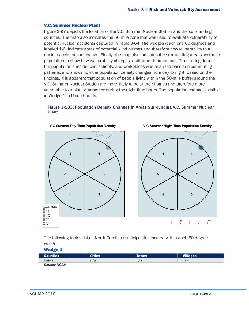
Section 3 Risk and Vulnerability Assessment
NCHMP 2018 PAGE 3-292
V.C. Summer Nuclear Plant Figure 3-97 depicts the location of the V.C. Summer Nuclear Station and the surrounding counties. The map also indicates the 50 mile zone that was used to evaluate vulnerability to potential nuclear accidents captured in Table 3-64. The wedges (each one 60 degrees and labeled 1-6) indicate areas of potential wind plumes and therefore how vulnerability to a nuclear accident can change. Finally, the map also indicates the surrounding area’s synthetic population to show how vulnerability changes at different time periods. Pre-existing data of the population’s residences, schools, and workplaces was analyzed based on commuting patterns, and shows how the population density changes from day to night. Based on the findings, it is apparent that population of people living within the 50-mile buffer around the V.C. Summer Nuclear Station are more likely to be at their homes and therefore more vulnerable to a plant emergency during the night time hours. The population change is visible in Wedge 1 in Union County.
Figure 3-103: Population Density Changes In Areas Surrounding V.C. Summer Nuclear Plant
The following tables list all North Carolina municipalities located within each 60-degree wedge. Wedge 1 Counties Cities Towns Villages Union n/a n/a n/a Source: NCEM

Section 3 Risk and Vulnerability Assessment
NCHMP 2018 PAGE 3-293
The following table lists the number of buildings and the value of those buildings in North Carolina that located within each 60-degree wedge in the 50-mile radius around the plant’s center.
Table 3-64: Number and Value of Building Vulnerable to Nuclear Accident at V.C. Summer Nuclear Plant
Wedge Number of Buildings within 50 Miles Value of Buildings ($) 1 718 $63,354,482 2 - - 3 - - 4 - - 5 - - 6 - - Totals 718 $63,354,482 Source: NCEM
Based on data from the NC Department of Environmental Quality (DEQ), there are no agricultural facilities in North Carolina that fall within a 50-mile radius of the plant’s center and therefore vulnerable to a potential emergency. Sources: https://www.dairyfoods.com/search?commit=Submit&datatype=directory&exclude_datatypes%5B%5D=video&exclude_datatypes%5B%5D=file&ip=168.215.136.42&page=2&q=%22North+Carolina%22&taxonomy=Dairy+Plants+USA&utf8=%E2%9C%93 https://deq.nc.gov/about/divisions/water-resources/water-resources-permits/wastewater-branch/animal-feeding-operation-permits/animal-facility-map
Figure 3-104: Permitted Animal Facilities and Milk Processing Plants Vulnerable to Nuclear Accident at Watts Bar Nuclear Plant

Section 3 Risk and Vulnerability Assessment
NCHMP 2018 PAGE 3-294
3.4.6.3 Terrorism Hazard Vulnerability
Terrorism Hazard Risk, Vulnerability, and Consequence Analysis
Category Impact Rating
Description of Impacts
People (The Public and Public Confidence)
High In addition to the clear impacts that terrorism can have on human life and safety, there are a number impacts on the public that will be more widespread if major events take place. As seen after the attacks on September 1, 2001 in New York City and Washington, D.C., there can be significant impacts far away from the site of the incident. Fear and worry about additional attacks or for loved ones in areas affected are just a couple examples of impacts that could occur. Other impacts include discrimination or changed interactions between people of differing nationalities depending on the nature and intent of the attack(s) and who perpetrated the attack(s). During and after a terrorism event, the public will be expecting services to be provided despite the uncertainty of any existing hazards or further impacts. The partnership and involvement of the media is crucial not just for providing public guidance, but also for keeping the public informed of the efforts underway or of any obstacles or concerns hindering response efforts. Although public confidence will almost certainly be shaken, agencies and organizations in the government working together in an efficient and effective way will provide for the best chance of positive public perception of the government.
Responders High The danger to human life in a terrorist event is dependent on the form of attack utilized as well as its location, severity, and scope (see Section 3). In any terror incident, responders must conduct a scene size-up to determine hazards to themselves and others. Decisions must be made about how to handle victims and those in close proximity that may have been victimized or exposed. If hazardous materials are present, it could change the strategy as well. Fear and panic will be significant in the case of a terrorist act, whether it occurs in North Carolina or elsewhere in the nation. As front-line government officials, responders will be at a significant risk during an attack and may even be the object of the attack in some cases. Depending on the location, the scope, and the nature of the event(s), response efforts could last hours, days, or potentially longer. Collaboration at all levels can provide for the most stable, effective, and efficient effort in returning to normal activities and operations. Identification of further threats and open communication lines can prevent further harm or detriment to response operations.
Operations/Continuity of Operations
High A terrorist event would likely have a high impact on continuity of operations, especially due to the disorder that would result and the unpredictability of this kind of event. Emergency personnel may be directly affected or targeted, which would cause definitive harm to maintaining continuity of operations. Furthermore, continuity of operations can be impacted by personnel. Equipment, and/or consumables being exhausted or depleted.

Section 3 Risk and Vulnerability Assessment
NCHMP 2018 PAGE 3-295
Category Impact Rating
Description of Impacts
Built Environment (Property, Facilities, Infrastructure)
Moderate Major Events/Centers Often terrorist events are targeted at major events or at large event centers in an attempt to create widespread loss on a large number of people. Therefore, large arenas, convention centers, and event spaces may be at higher risk of a terrorist attack than most other buildings. Likewise, churches and schools are soft targets and are often targeted as such. Similarly, prominent or symbolic structures may also be at an elevated risk for targeting. Critical Facilities At hospitals, the primary concern with a terrorism event is the influx of patients requiring care. Terrorism may pose a specific hazard to a hospital structure itself, but it is more likely to be impacted when in close proximity to a target. Many patients could be injured or their medical condition worsened by the impacts of a terrorism event. In general, emergency services buildings are not considered high probability targets for terrorists to strike. In other countries, ambulance services and 9-1-1 centers have been targets; however, that pattern has not been seen here in the United States. Alternate locations should be set up so that emergency operations can continue if an emergency services facility was affected or targeted by a terrorism event. Shelters may need to be activated in a terrorism event to house and care for displaced individuals. Transportation Systems Bridges found throughout the interstate system may be targeted by terrorism. Not only would the actual structural failure affect those on, under, or near the bridge, but the loss of its functionality would also significantly hinder travel and commerce. Past experiences with terrorists using airplanes for terrorist activity suggest a need for planning and collaboration with all parties of interest at airports including local, state, and federal agencies. In terms of railway transportation, the most likely means of disrupting these lines would be the derailing of a train, primarily by sabotage of the rail or the switching control system. Using explosives would be more likely because hacking into systems to cause collisions and other undesired actions to moving rail cars would be more complex operations. In addition to disrupting rail traffic, a derailing can impact other means of travel such as a nearby road or airport. The rail cars involved in an incident could contain hazardous materials, which would add an element of complexity to the situation. Utilities Damage to high voltage lines or power plants structures could disrupt power distribution for a large area, affecting emergency response and other facets of government and business. The economic impacts may also be significant as extended outages can be costly. Natural gas lines are also a concern as a target for terrorists. Major pipelines run through the state, but natural gas itself must be exposed to oxygen before it could cause an
Section 3 Risk and Vulnerability Assessment
NCHMP 2018 PAGE 3-296
Category Impact Rating
Description of Impacts
explosion. Most natural gas explosions are small and rarely deadly. The real concern is in shutting off natural gas to end consumers. Sabotage of a pipeline could disconnect a significant number of homes and businesses for considerable periods of time. Other Structures Single-family dwellings and small businesses or industries are not likely to be targets for terrorism. However, areas that have high concentrations of people could be vulnerable to an attack. These areas of assembly tend to be soft targets and are easily accessible. Buildings in close proximity to a targeted event center may also be more likely to experience indirect impacts. Depending on the method of attack, impacts could include stray bullets or debris from explosions. These could affect people, electrical systems, water systems, cause structural collapse, or fires. Also, the presence of chemical agents can create health hazards through dangerous reactions with water sources or building materials.
Economy Moderate The economic impact of a terrorist attack can vary from minimal to severe. If the incident occurs in North Carolina, it could hinder the state’s economy but may not have an impact at the national level. Tourism and some commerce could decline significantly if people, events, or businesses are hesitant to come to the area following an incident. An incident in a major city or a financial hub could affect the entire country. For example, the events of September 11, 2001 had an immediate impact on local, state, and national economies. This event and other large-scale attacks like it can drastically alter the economy in both the short- and long-term. Note: Charlotte, North Carolina is the second largest financial hub in the nation. Major Events/Centers Terrorism can occur in city centers during large public gatherings or during business hours to cause the most harm and promote the most fear. Political gatherings would be high priority targets as well. Arenas can be targeted by terrorism, particularly during events that may have some form of political, cultural, or historical value, or simply any event with a large number of people in attendance. These could all have a negative impact economically on the state.
Environment Moderate Impacts on the environment depend on the type of attack utilized by terrorists. A biological, chemical, radiological or other hazardous material can have impacts on human, animal, and plant populations alike. The impacts can vary depending on the particular hazard(s) at play, but there will certainly be at least some negative impacts from a terrorist attack including potentially the release of smoke, chemicals, or debris into the environment.

Section 3 Risk and Vulnerability Assessment
NCHMP 2018 PAGE 3-297
3.4.6.5 Cyber Attack Hazard Vulnerability
Cyber Attack Hazard Risk, Vulnerability, and Consequence Analysis
Category Impact Rating
Description of Impacts
People (The Public and Public Confidence)
Moderate The aim of a cyber attack is typically to corrupt or exploit protected information. Depending on the target of the ploy, a significant number of people can be victims of identity theft, fraud, or other forms of technology-based crime. Anyone with an account, membership, or other relationship with an entity that requires storage of information is vulnerable. An individual/user must rely on the entity of affiliation to create and maintain safeguards against the intrusion of computerized systems. However, even the strongest of safeguards can be corrupted or evaded. Continual monitoring of attempted or successful attempts at cyber attacks is warranted to lessen the potential impacts. Public confidence in the response of government organizations may be impacted by a cyber attack based upon societal expectations and media influence with respect to cyber attacks. There may be an expectation that government entities should do a better job of patrolling cyber crime and hold those responsible accountable. Public confidence may be impacted by media interpretation and reporting of the event, positive or negative.
Responders Low Cyber attacks may be used to try to intrude into electronic safety equipment or systems. This may increase call volume, block systems, or otherwise hinder emergency operations. Although responders are not likely to be at risk to a cyber attack in a physical sense, they may be impacted financially or through identity theft, much like members of the public.
Operations/Continuity of Operations
Moderate In the event of a cyber attack, continuity of operations could be impacted if many of the services (such as internet or other IT programs) that are required to maintain daily operations are shut down by the attack. This could cause considerable disruption to normal operations in the state and could make the state potentially vulnerable to other events that may be occurring simultaneously.
Built Environment (Property, Facilities, Infrastructure)
Low Cyber attacks may have the effect of disrupting life sustaining equipment or systems in hospitals or medical facilities by causing technological disruptions. These attacks may also sabotage information networks and communications equipment that could disrupt services within medical facilities. Normal operations in communications equipment such as telephones, cell phones, and internet could all be severely impacted by a cyber attack which would impact large numbers of people including critical facilities operators.
Economy High Freezing, redirecting, or stealing financial assets can have drastic impacts on a business. Banking and credit institutions are commonly affected or targeted by fraudulent activities and often store a great deal of information on businesses, so large-scale intrusions can have significant impacts on the local economy. Large employers are more likely to be targeted by cyber attacks than individuals or small businesses. Larger businesses generally have greater assets to exploit and store more personal information on
Section 3 Risk and Vulnerability Assessment
NCHMP 2018 PAGE 3-298
Category Impact Rating
Description of Impacts
private individuals or employees. Environment Low Because cyber attacks occur in cyberspace and would not truly
have any impacts outside of the physical sphere, there are no expected environmental impacts from this type of event.
3.4.6.6 Electromagnetic Pulse (EMP) Hazard Vulnerability
Electromagnetic Pulse (EMP) Risk, Vulnerability, and Consequence Analysis
Category Impact Rating
Description of Impacts
People (The Public and Public Confidence)
Moderate The entire State of North Carolina’s population is vulnerable to the impacts of an EMP/geomagnetic storm, regardless of the measured magnitude, although most low-classification events will not have any noticeable impact on the daily lives of people. If a large event were to occur and cause widespread power outages or communications systems disruptions, there may be a panic and people may temporarily be unable to undertake normal activities such as cooking or using mobile devices. Consumer electronics may also be damaged, including HVAC systems, newer model appliances, radios, and televisions. EMP/geomagnetic storms have some likelihood of affecting public confidence due to their highly visible impacts and the fact that most members of the public are unaware of the hazard and may be confused about the cause of loss of power/communications systems.
Responders High Responders could be critically affected by an EMP/geomagnetic storm event as response personnel rely heavily on communications equipment to carry out their normal operations. If a large event were to occur that knocked out communications equipment for several hours or possibly more than a day, this would significantly hinder responders’ abilities to perform their duties. Additionally, other electronic equipment or devices used by responders may be damaged by an EMP/geomagnetic storm further impacting their ability to respond to emergencies following an event.
Operations/Continuity of Operations
High Continuity of operations would potentially be impacted in many ways by a major EMP/geomagnetic storm. As mentioned above, if communications equipment is disrupted, it would be challenging for government officials to coordinate with one another and respond to citizen needs such as emergency medical care. It is also possible that some satellites will be damaged, affecting satellite-based communications. Additionally, if power is lost, there would be a disruption to normal operations, though there are generally plans in place to maintain continuity of operations in this case as several operations centers have backup power systems.
Built Environment (Property, Facilities, Infrastructure)
Moderate Critical Infrastructure The primary impact on the built environment from an EMP/geomagnetic storm would be on communications and power infrastructure. Most of the built environment (e.g. homes,
Section 3 Risk and Vulnerability Assessment
NCHMP 2018 PAGE 3-299
Category Impact Rating
Description of Impacts
buildings, roadways) would not be impacted in any way by this type of event. However, if power or communications systems are damaged or temporarily shut down, some aspects of the built environment will be impacted such as traffic lights, street lights, and cell phone towers. Additionally, electronic equipment and control systems could also be damaged and water and wastewater systems, gas stations, and pipelines may be shut down throughout the state.
Economy Moderate An EMP/geomagnetic storm can impact any area of the State of North Carolina at any time and may bring with it an interruption of service for local businesses as well as governments that lose power or cannot utilize communications systems. As a result, there will be significant disruption of the local economy as long as the effects (such as power or communications loss) of the EMP/geomagnetic storm remain in place. ATMs, credit card processing, and other electronic financial transactions may also be disrupted, further impacting the economy.
Environment Low There will likely be relatively minimal impacts on the environment from an EMP/geomagnetic storm. These types of events do not directly impact plants or animals and typically do not have any effect on water systems or other natural areas. There may be indirect impacts if, for example, power systems are damaged at facilities that house hazardous materials, causing releases into the environment. However, the likelihood of this occurring is relatively low.
3.4.7 Critical Asset Vulnerability
3.4.7.1 State and Local Critical Assets For the purposes of this plan, NCEM Risk Mitigation Branch staff identified the following as critical assets:
1. Emergency Operations Centers 2. State Police (Trooper) Stations 3. Local Police stations 4. Local Fire Stations 5. Hospitals 6. Shelters
The following table and associated maps present a summary of the critical assets located in North Carolina and a graphical representation of whether or not those facilities are vulnerable to natural hazards. The critical assets that intersect with the most hazard zones are depicted with the largest symbols and are colored red. The critical assets that are exposed to no hazards are depicted with the smallest symbols and are colored green.

Section 3 Risk and Vulnerability Assessment
NCHMP 2018 PAGE 3-300
Table 3-65 Critical Assets and Hazard Zones
Hazard Zones
Critical Assets Total Assets Statewide
Flood Surge Wildfire Landslide Winter Storm
Earthquake
1% ACH
.2% ACH
Cat 1 Cat 2 Cat 3 Cat 4 Cat 5 High WUI (7-9)
Very High Risk
Western Branch
High Risk (8-15% g)
Fire Stations 3463 167 87 45 101 166 217 271 374 488 963 49
Hospitals 125 0 1 0 0 2 4 6 6 27 50 2
Sheriff's Office 101 10 9 2 6 7 10 13 7 15 34 4
Public Schools 2107 49 34 10 33 54 81 107 175 378 729 19
Police Stations State 91 2 2 0 0 2 6 6 7 17 30 1
Police Stations Local 584 39 26 10 32 45 53 64 31 104 192 8
EOCs 111 9 8 2 9 11 15 16 5 16 37 4
Shelters 1156 43 16 2 9 14 24 39 82 272 569 25
Source: NCEM-RM Note: There were no critical assets within 50 yards of either existing sinkholes or eroding shorelines.

Section 3 Risk and Vulnerability Assessment
NCHMP 2018 PAGE 3-301
Note: This map includes the State Emergency Operation Center in Raleigh and the NCEM Branch Offices located in Conover (Western Branch), Butner (Central Branch) and Kinston (Eastern Branch). The Eastern Branch Office also serves as the State’s backup EOC.

Section 3 Risk and Vulnerability Assessment
NCHMP 2018 PAGE 3-302
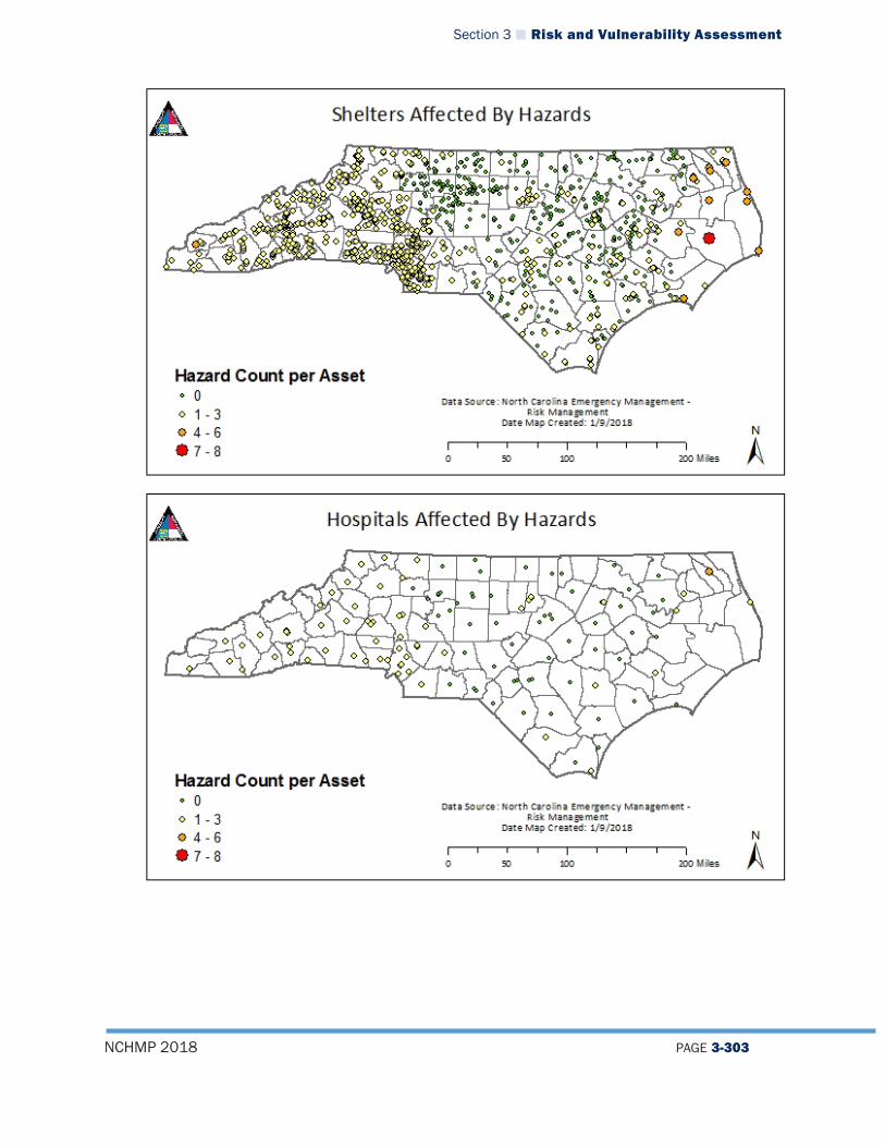
Section 3 Risk and Vulnerability Assessment
NCHMP 2018 PAGE 3-303
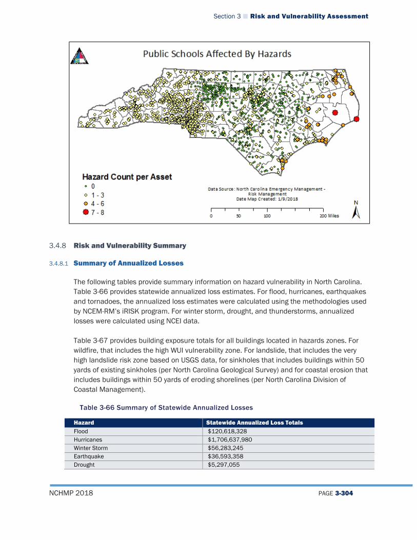
Section 3 Risk and Vulnerability Assessment
NCHMP 2018 PAGE 3-304
3.4.8 Risk and Vulnerability Summary
3.4.8.1 Summary of Annualized Losses
The following tables provide summary information on hazard vulnerability in North Carolina. Table 3-66 provides statewide annualized loss estimates. For flood, hurricanes, earthquakes and tornadoes, the annualized loss estimates were calculated using the methodologies used by NCEM-RM’s iRISK program. For winter storm, drought, and thunderstorms, annualized losses were calculated using NCEI data. Table 3-67 provides building exposure totals for all buildings located in hazards zones. For wildfire, that includes the high WUI vulnerability zone. For landslide, that includes the very high landslide risk zone based on USGS data, for sinkholes that includes buildings within 50 yards of existing sinkholes (per North Carolina Geological Survey) and for coastal erosion that includes buildings within 50 yards of eroding shorelines (per North Carolina Division of Coastal Management).
Table 3-66 Summary of Statewide Annualized Losses
Hazard Statewide Annualized Loss Totals Flood $120,618,328 Hurricanes $1,706,637,980 Winter Storm $56,283,245 Earthquake $36,593,358 Drought $5,297,055
Section 3 Risk and Vulnerability Assessment
NCHMP 2018 PAGE 3-305
Tornado $86,182,710 Thunderstorm $5,665,515 Source: NCEM-RM and NCEI
Table 3-67 Summary of Statewide Building Exposure
Hazard Building Exposure to Hazard Zones
Notes
Wildfire $129,521,418,846 Value of All Buildings in High WUI Zones (Zones 7-9)
Landslide $4,791,240,596 Value of All Buildings in USGS High and Very High Landslide Zones
Sinkholes $946,356,142 Value of All Buildings within 50 yards of existing sinkhole Coastal Erosion $125,195,028 Value of All Buildings within 50 yards of eroding shoreline Source: NCEM-RM
3.4.8.2 Most Vulnerable Jurisdictions According to the annualized loss estimates and exposure data for all of the natural hazards presented in this section, the following counties demonstrate a higher vulnerability to hazards when compared to other counties in the State:
Table 3-68 Counties with Highest Annualized Loss Estimates and Building Exposure to Hazards
County High Annualized Losses for the Following Hazards
High Exposure to the Following Hazards
Mecklenburg Hurricane, Earthquake, Tornado
Wildfire, Landslide
Wake Hurricane, Earthquake Wildfire New Hanover Hurricane Wildfire, Sinkhole, Coastal Erosion Onslow Hurricane Wildfire, Sinkhole, Coastal Erosion Buncombe Flood, Earthquake Dare Hurricane Coastal Erosion Brunswick Sinkhole, Coastal Erosion Cumberland Earthquake Wildfire
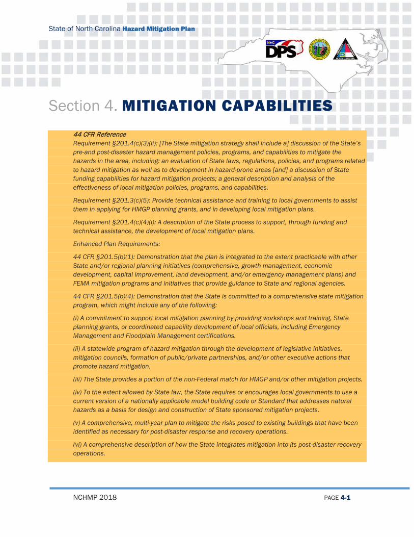
State of North Carolina Hazard Mitigation Plan
NCHMP 2018 PAGE 4-1
Section 4. MITIGATION CAPABILITIES
44 CFR Reference Requirement §201.4(c)(3)(ii): [The State mitigation strategy shall include a] discussion of the State’s
pre-and post-disaster hazard management policies, programs, and capabilities to mitigate the hazards in the area, including: an evaluation of State laws, regulations, policies, and programs related to hazard mitigation as well as to development in hazard-prone areas [and] a discussion of State funding capabilities for hazard mitigation projects; a general description and analysis of the effectiveness of local mitigation policies, programs, and capabilities.
Requirement §201.3(c)(5): Provide technical assistance and training to local governments to assist them in applying for HMGP planning grants, and in developing local mitigation plans.
Requirement §201.4(c)(4)(i): A description of the State process to support, through funding and technical assistance, the development of local mitigation plans.
Enhanced Plan Requirements:
44 CFR §201.5(b)(1): Demonstration that the plan is integrated to the extent practicable with other State and/or regional planning initiatives (comprehensive, growth management, economic development, capital improvement, land development, and/or emergency management plans) and FEMA mitigation programs and initiatives that provide guidance to State and regional agencies.
44 CFR §201.5(b)(4): Demonstration that the State is committed to a comprehensive state mitigation program, which might include any of the following:
(i) A commitment to support local mitigation planning by providing workshops and training, State planning grants, or coordinated capability development of local officials, including Emergency Management and Floodplain Management certifications.
(ii) A statewide program of hazard mitigation through the development of legislative initiatives, mitigation councils, formation of public/private partnerships, and/or other executive actions that promote hazard mitigation.
(iii) The State provides a portion of the non-Federal match for HMGP and/or other mitigation projects.
(iv) To the extent allowed by State law, the State requires or encourages local governments to use a current version of a nationally applicable model building code or Standard that addresses natural hazards as a basis for design and construction of State sponsored mitigation projects.
(v) A comprehensive, multi-year plan to mitigate the risks posed to existing buildings that have been identified as necessary for post-disaster response and recovery operations.
(vi) A comprehensive description of how the State integrates mitigation into its post-disaster recovery operations.

Section 4 Mitigation Capabilities
NCHMP 2018 PAGE 4-2
44 CFR §201.5(b)(2)(i): Documentation of the State’s project implementation capability, identifying and demonstrating the ability to implement the plan, including: Established eligibility criteria for multi-hazard mitigation measures.
44 CFR §201.5(b)(2)(ii): A system “to rank the measures according to the State’s eligibility criteria. A system to determine the cost effectiveness of mitigation measures, consistent with OMB Circular–94, Guidelines and Discount Rates for Benefit-Cost Analysis of Federal Programs.”
44 CFR §201.5(b)(2)(iv): A system and strategy by which the State will conduct an assessment of the completed mitigation actions and include a record of the effectiveness (actual cost avoidance) of each mitigation action.
44 CFR §201.5(b)(3): Demonstration that the State effectively uses existing mitigation programs to achieve its mitigation goals.
This section provides an overview of the State’s capabilities to integrate other planning functions into mitigation and to implement the Mitigation Strategy. It includes: an overview of NCEM planning integration, an identification, review, and analysis of the current resources for reducing hazard impacts including an evaluation of State laws, regulations, policies, and programs related to hazard mitigation and development in hazard-prone areas; a discussion of State funding capabilities for hazard mitigation projects; and a general description and analysis of the effectiveness of local mitigation policies, programs, and capabilities. This section consists of the following subsections: State Planning Functions and Integration Mitigation Programs Evaluation Mitigation Funding Local and Tribal Mitigation Capabilities Mitigation Planning Summary
4.1 STATE PLANNING FUNCTIONS AND INTEGRATION
This subsection provides an overview of other planning functions within NCEM and how they are integrated either into the NCEHMP or how the NCEHMP is integrated into them. This is a key component of ensuring the planning function across NCEM are aligned and do not contradict each other in any way. This also promotes effective use of funding streams across the board to ensure there are not multiple projects, data collection, or studies of a similar nature being performed within NCEM. NCEM Risk Mitigation staff have worked hard during this update to ensure that the State Hazard Mitigation Plan is integrated to the extent practicable with other State and/or regional planning initiatives This has been done through the following activities:

Section 4 Mitigation Capabilities
NCHMP 2018 PAGE 4-3
4.1.1 North Carolina Emergency Operations Plan The North Carolina Emergency Operations Plan (NCEOP) is a vital document in guiding the state’s pre- and post-disaster capabilities1. The NCEOP is built on all hazards principal while still having some specific hazard annexes. The NCEOP may contain additional annexes that identify operating procedures for other identified hazards. These annexes have been developed in regards to frequency of regional occurrence, the potential impact of a hazard, and the need for abnormal response procedures. The North Carolina Enhanced Hazard Mitigation Plan is responsible for the hazard identification and risk assessment (HIRA) for all hazards and developing mitigation policies, programs, and strategies that will lessen both current and future vulnerability. All hazards identified in the NCEOP are also identified in the NCEHMP and assessed for risk. When hazards are added to either of the two documents there is coordination between the Planning and Homeland Security and Risk Management Sections to ensure plan integration is maintained throughout the different planning functions.
4.1.2 Emergency Management Accreditation Program (EMAP) In 2008, NCEM initiated the EMAP assessment process that includes an analysis of all its policies, programs, and capabilities. The accreditation is good for a period of five years and then the agency must be re-accredited. EMAP provides NCEM with a baseline for continuing assessments that will be considered in future Plan reviews and updates. NCEM underwent the re-accreditation process again in 2013 and is currently preparing for the 2018 re-accreditation process. The 2018 EMAP re-accreditation process has been a driving force for the early update of this plan.
4.1.3 Threats Hazards Identification and Risk Assessment/State Preparedness Report The THIRA is an all-hazards capability-based assessment tool suited for use by all jurisdictions. The THIRA allows a jurisdiction to understand its threats and hazards and how their impacts may vary according to time of occurrence, seasons, locations, and community factors. Results are capture by way of the Uniform Reporting Tool (URT) housed on Max.gov portal. The captured knowledge allows a jurisdiction to establish informed and defensible capability targets and commit appropriate resources drawn from the whole community to closing the gap between a target and a current capability or for sustaining existing capabilities. The hazards addressed in the THIRA are all hazards identified in the HIRA section of this plan. The Risk Mitigation Branch has been coordinating closely with the Plans and Homeland Security Section for this update of the Enhanced State Hazard Mitigation Plan to ensure that the hazards in the THIRA are included in the North Carolina Enhanced Hazard Mitigation Plan.
11 The current NCEOP is based upon guidelines contained in the National Response Plan (NRP) and the Comprehensive
Preparedness Guide (CPG) 101 version 2.

Section 4 Mitigation Capabilities
NCHMP 2018 PAGE 4-4
4.1.4 North Carolina State Homeland Security Strategy (NCSHSS) The State Homeland Security Strategy outlines North Carolina’s strategy and goals for enhancing the State’s overall preparedness and resiliency against identified natural, human and technological threats and hazards. North Carolina is dedicated to ensuring the public safety of all its residents through collaborative efforts with private, local, State and Federal partners to prevent, protect, mitigate, respond to and recover from those aforementioned elements by aligning state efforts with the National Preparedness System (NPS) and National Preparedness Goal (NPG).
The North Carolina Homeland Security Strategy (NCHSS) is based on a shared responsibility to preparedness by which working together, everyone contributes to keeping the State safe from harm and resilient when impacted by any hazard. The NCHSS consists of a five-phase approach: Analyze, Develop, Design, Implement and Evaluate. The approach is dependent upon active communication and collaboration between stakeholders from the public and private sector and all levels of government. The NCHSS establishes five goals and sixteen objectives.
4.1.5 CAMA Land Use Plans The SHMO provides courtesy reviews of Coastal Area Management Act (CAMA) Land Use Plan updates for the 20 coastal counties upon request from DEQ. The review is designed to ensure that CAMA plans are consistent with local hazard mitigation plans and the State Hazard Mitigation Plan. Also, the State Hazard Mitigation Branch coordinates with the Division of Coastal Management (DCM) when it comes to working in designated CAMA counties. For mitigation projects planned in these counties, NCEM staff coordinates with DCM to ensure that work will not conflict with an area of Environmental Concern according to CAMA regulations.
4.1.6 Housing In response to damage from Hurricane Matthew and Tropical Storms Julia and Hermine the Essential Single-Family Rehabilitation Loan Pool – Disaster Recovery was created and is being administered by the North Carolina Housing Finance Agency (NCHFA). The source of funds includes specially-appropriated loan funds from the NC General Assembly. The NCHFA is working closely with NCEM and NC Department of Commerce as recovery efforts continue.
4.1.7 Continuity of Operation Plan The Continuity of Operations Plan (COOP) establishes procedures for Continuity for North Carolina Emergency Management and the State Emergency Response Team (when activated). It describes essential functions—those that must continue in every circumstance, and cannot be put off even for periods of 14 to 30 days. The concept of operations for this plan involves mainly relocation from the primary emergency operations center to an alternate or Continuity facility.

Section 4 Mitigation Capabilities
NCHMP 2018 PAGE 4-5
4.2 MITIGATION PROGRAMS EVALUATION
This subsection provides an overview of the State’s pre- and post-hazard management policies, programs, and capabilities to mitigate the hazards in the area, including an evaluation of State laws, regulations, policies, and programs related to hazard mitigation as well as to development in hazard-prone areas. This section also provides an overview of how North Carolina administers federal mitigation funding.
4.2.1 North Carolina’s Administration of Federal Government Pre- and Post-Hazard Management Policies, Programs, Funding, and Capabilities
4.2.1.1 The Stafford Act/Disaster Mitigation Act of 2000 The Robert T. Stafford Disaster Relief and Emergency Assistance Act, (Public Law 93-288, as amended by Public Law 100-707) is intended by Congress “… to provide an orderly and continuing means of assistance by the federal government to state and local governments in carrying out their responsibilities to alleviate … suffering and damage which result from … disasters.” Section 401(f) of the Act sets up the procedures for Disaster Declaration and the assistance that follows. Title 44, Chapter I, Part 206 (44 CFR 206) contains relevant regulations implementing the Stafford Act. In the event of a major disaster declaration by the President, the NC Director of Emergency Management assumes the role of the Governor’s Authorized Representative and the State Coordinating Officer. On October 30, 2000, the President of the United States signed into law the Disaster Mitigation Act of 2000 (DMA 2000) (Public Law 106-390) to amend the Stafford Act. This legislation reinforces the importance of pre-disaster mitigation planning to reduce the Nation’s disaster losses, and it is aimed primarily to control and streamline the administration of federal disaster relief and mitigation programs. The federal assistance programs established by the Stafford Act and the DMA 2000 are designed to assist disaster victims to begin personal recovery through disaster housing grants and individual assistance in the form of grants and loans and to assist government agencies recoup disaster expenses and losses. The financial programs are traditionally a cost share between the federal and state government. Many of the disaster programs involve a hazard mitigation component that has proved invaluable in North Carolina for reducing losses and increasing resiliency to natural hazards in many communities. Among the mitigation programs administered by NCEM is the Hazard Mitigation Grant Program (HMGP), established in Section 404 of the Stafford Act. HMGP provides a federal cost-share for mitigation measures that are available to states and local governments following a declared disaster. Because the State of North Carolina recognizes the importance of these funds for local mitigation efforts, and because many communities, especially those located in rural areas, do not have sufficient resources to provide matching funds, the State

Section 4 Mitigation Capabilities
NCHMP 2018 PAGE 4-6
has a long-standing tradition of providing the required match for local communities that apply for HMGP planning and project funds. Section 406 of the Stafford Act establishes the Public Assistance (PA) Program, also administered by NCEM. The Public Assistance Program provides supplemental aid for disaster recovery to state and local governments and certain private non-profit organizations. PA grants are available for the repair, restoration, and replacement of facilities damaged by a declared major disaster, and may include some hazard mitigation measures. Section 203 of the Disaster Mitigation Act of 2000 establishes the Pre-Disaster Mitigation (PDM) program that provides technical and financial assistance to states and local governments. Unlike the HMGP and Public Assistance Programs, the PDM is not triggered by a disaster declaration. PDM funds are available for implementation of pre-disaster hazard mitigation measures designed to reduce injuries, loss of life, and damage and destruction of property, including damage to critical services and facilities. The Flood Mitigation Assistance (FMA) program is a pre-disaster federal grant program that provides annual funding assistance to communities for flood mitigation activities such as acquisition or relocation of structures, the purchase of real property, and the creation of flood mitigation plans. Its principle goal is reduction of claims against the NFIP. As implemented by the NC Division of Emergency Management, the main objectives of these various federal mitigation grant programs include: To prevent future losses of lives and property due to disasters To implement state or local mitigation plans To enable implementation of mitigation measures during a state’s or community’s
immediate recovery from a disaster To provide funding for mitigation measures identified in local and regional Hazard Mitigation Plans that benefit the disaster area
Of the programs administered by FEMA, the most useful funding source for mitigation projects in North Carolina communities that have experienced a recent declared disaster has been the HMGP. Communities that have not received disaster-related funds have made use of PDM and FMA funding. PDM and FMA grants awards have been more limited in this plan update period due to limited funding amounts and FEMA funding priorities. More details about various funding programs are available later in this section. Mitigation Planning Under DMA 2000 and SB 300 In addition to providing funds for mitigation projects, Section 322 of the Disaster Mitigation Act provides a new and revitalized approach to mitigation planning for which the Division of Emergency Management is responsible at both the state and federal levels. Section 322 specifically calls for the following:
Section 4 Mitigation Capabilities
NCHMP 2018 PAGE 4-7
Establishes a new requirement for local and tribal mitigation plans Authorizes up to 7 percent of the Hazard Mitigation Grant Program (HMGP) funds
available to a state to be used for development of state, local, and tribal mitigation plans
Provides for states to receive an increased percentage of HMGP funds (from 15 percent to 20 percent) if, at the time of the declaration of a major disaster, they have in effect an approved Enhanced State Mitigation Plan that meets the criteria in the law
In June of 2001, the North Carolina General Assembly passed Senate Bill 300: An Act to Amend the Laws Regarding Emergency Management as Recommended by the Legislative Disaster Response and Recovery Commission. Among other provisions, this bill requires that local governments have an approved hazard mitigation plan in order to receive state public assistance funds (effective for state-declared disasters after November 1, 2004). The Bill also requires that communities be participants in good standing in the National Flood Insurance Program (NFIP) to receive public assistance for flood-related damage. Both Senate Bill 300 and the Disaster Mitigation Act of 2000 set forth certain requirements for local governments to have an approved hazard mitigation plan. It is clear that North Carolina takes the need for comprehensive all-hazard mitigation plans very seriously, both at the state and local levels. Now, with planning requirements tied to mitigation and public assistance funding, the sense of urgency is growing throughout the State to complete the task of developing plans that not only meet minimum criteria, but will work toward reducing vulnerability to natural hazards. In 2005, NCEM began prioritizing use of mitigation planning funds toward communities that expressed interest in joining neighboring municipalities and counties in a regional approach to Hazard Mitigation Planning. As of this update, approximately 180 single-jurisdiction plans have been replaced by 25 regional plans and 8 single county multi-jurisdictional plans. (For more details on local hazard mitigation planning in North Carolina, see discussion of the Hazard Mitigation Planning Initiative below as well as the Local and Tribal Mitigation Capabilities Section of this Capability Assessment.)
4.2.1.2 Unified Hazard Mitigation Assistance FEMA is the lead federal agency responsible for providing technical and financial assistance to both state and local governments for disaster mitigation planning and the implementation of mitigation projects. There are several different mitigation grant programs available from FEMA to the State and to communities in North Carolina, including UHMA program which includes the Hazard Mitigation Grant Program (HMGP), the Pre-Disaster Mitigation (PDM) program, and the Flood Mitigation Assistance (FMA) program. These are described in detail here. The main objectives of FEMA’s various mitigation grant programs are as follows: To prevent future losses of lives and property due to disasters To implement state or local mitigation plans
Section 4 Mitigation Capabilities
NCHMP 2018 PAGE 4-8
To enable mitigation measures to be implemented during a state’s or community’s immediate recovery from a disaster
To provide funding for previously identified mitigation measures that benefit the disaster area
The programs under the Unified Hazard Mitigation Assistance program offer a source of funding for local governments that have experienced a recent declared disaster and also, provide communities that have not received disaster-related funds to make use of UHMA non-disaster program funding. A significant number of jurisdictions in North Carolina have benefited from the implementation of mitigation activities utilizing Declared Disaster and Non-Disaster Funding. To summarize, current sources of FEMA Funding utilized by NCEM are: Flood Mitigation Assistance Program (FMA) Pre-Disaster Mitigation Assistance Program (PDM) Hazard Mitigation Grant Program (HMGP) Public Assistance Program (PA) Earthquake Consortium Grant (Current)
4.2.1.3 National Flood Insurance Program/Community Rating System The National Flood Insurance Program (NFIP) The Federal Insurance Administration (FIA) administers the National Flood Insurance Program, a self-supporting program requiring no taxpayer funds to pay claims or operating expenses. The National Flood Insurance Program (NFIP) was enacted in 1968 by the National Flood Insurance Act. This act made federally subsidized flood insurance available to property owners in municipalities and counties that agree to participate in the NFIP. Floodplain Management Under the NFIP There is no cost to participate in the NFIP. However, if a community wishes to participate in the program, it must make application to join with FEMA, adopt a resolution of intent to abide by the program regulations, and adopt and administer a floodplain ordinance that meets criteria established in 44 CFR 60.3. These criteria include: Require and maintain permits for development within designated floodplains Review development plans and subdivision proposals to determine whether
proposed sites will be reasonably safe from flooding Require protection of water supply and sewage systems to minimize infiltration of
floodwater Obtain, review, and utilize all base flood elevation data Assure the maintenance of flood carrying capacities within all watercourses
Model documents and specific instructions to assist local communities to enroll in the program are available from NCEM.

Section 4 Mitigation Capabilities
NCHMP 2018 PAGE 4-9
The North Carolina Floodplain Mapping Program maintains a process for continuously updating all the FIRMs in North Carolina. These maps are the central regulatory tool of the NFIP. The maps become effective six months after the preliminary maps are issued. Preliminary flood hazard maps contain valuable information that can be used for floodplain management before they become effective. In addition to federal flood insurance, other types of federal financial assistance, such as mortgage loans and mitigation planning and project grants, are also only available in those communities with identified flood hazards that adopt and enforce a floodplain management ordinance that meets or exceeds the minimum NFIP standards. If a community agrees to join the NFIP, they may apply for mitigation planning grant funds. A non-participating community must provide a letter stating their intent to join the NFIP with their mitigation planning grant application. If the State determines that the jurisdiction has not made a good-faith effort to join the program as promised, mitigation planning funds must be returned to NCEM. As previously described above, North Carolina’s Senate Bill 300 also includes provisions related to participation in the NFIP. The Link Between NFIP Compliance and Federal Assistance While participation in the NFIP is voluntary, federal and state restrictions apply to non-participating communities. Some of these restrictions include: Flood insurance may not be purchased by anyone living within the community’s
jurisdiction. A homeowner’s policy does not cover damages resulting from rising waters or floods.
No federal disaster assistance, including SBA, FMHA, VA, etc., may be provided in areas which have been identified as floodprone within the community if the damage was caused by flooding.
No FDIC or FSLEC guaranteed lender may make a loan with property as collateral to anyone living in the floodplain unless insurance is purchased and maintained for the life of the loan. Lenders do have the option of making a conventional loan.
Public assistance to recover from flood damage is not available to local governments for state-declared disasters. FEMA PA funds are limited in cases where flood-damaged public buildings in the special flood hazard area did not carry NFIP coverage.
The community is not eligible to apply for hazard mitigation grants for flood-related mitigation projects.
Floodplain Manager Training and Education Following Hurricane Fran, FEMA developed a self-contained home-study course designed to educate local floodplain managers in North Carolina about the regulatory permitting process of the NFIP, requirements for compliance, and other aspects of the Program. The study course is modeled on FEMA’s Emergency Management Institute (EMI) course for local floodplain managers, with the addition of elements relevant to floodplain management in North Carolina. Introductory workshops are also held to help local communities get started in the NFIP process as well as more technical workshops for enrolled communities. The NCEM Risk Management Section works with the North Carolina Association of Floodplain Managers

Section 4 Mitigation Capabilities
NCHMP 2018 PAGE 4-10
in the administration of the home-study course and for certifying completion by floodplain managers in order for them to earn Certified Floodplain Manager status. NCEM also regularly administers the FEMA L 273 Course—Managing Floodplain Development through the NFIP. NCEM keeps a current database of local floodplain managers who have earned the designation. Floodplain management training and education programs are an ongoing process; it is the goal of the NC NFIP that all local floodplain managers receive the technical training necessary to build local administrative capacity for comprehensive floodplain management. Lender and Insurance Agent Training and Education Flood insurance is required whenever financial assistance from a federally regulated institution is used to purchase or construct a building in a SFHA. As many insurance companies are issuing NFIP policies, their agents require knowledge and skill in writing these policies. The NFIP has contracted with H2O Partners to offer agent training. Insurance agent workshops given by H2O provide training regarding the Flood Insurance Program, rates, regulations, and basic underwriting guidelines. In the workshop, Coastal Barrier Resource System units (CoBRA Zones) established by the Coastal Barrier Resources Act (CBRA) of 1982 and their related regulations are covered, including the ban on selling federally-backed flood insurance for structures built or substantially improved after October 1, 1983. For those CBRS units added in 1990 by the Coastal Barrier Improvement Act (CBIA), the ban applies to those structures built after November 1, 1990. It should be noted that no NFIP flood insurance claims can be paid if a policy was issued in error. Increased Cost of Compliance Increased Cost of Compliance (ICC) is an endorsement to NFIP policyholders’ standard flood insurance policy. It applies to all new and renewed flood insurance policies effective on and after June 1, 1997. ICC is available to help owners whose homes or businesses are damaged by flood to meet building requirements imposed by the local floodplain management ordinances to reduce future flood damage. Flood insurance policyholders in high-risk areas (Special Flood Hazard Areas) can get up to $30,000 to help pay the costs to bring their home or business into compliance. The damage must be that caused by flood, not wind and flood. There are four options offered through ICC to help policyholders comply with the local floodplain management ordinance and help them reduce future flood damage: elevation, relocation, demolition, or flood proofing (available primarily for non-residential buildings). Claims may be filed for Increased Cost of Compliance coverage in two instances. 1) If the community determines that the home or business is damaged by flood to the point that repairs will cost 50 percent or more of the building’s pre-damage market value (“substantial damage”); or 2) If the community has a repetitive loss provision in its floodplain management ordinance and determines that the home or business was damaged by a flood two times in the past ten years, where the cost of repairing the flood damage, on the average, equaled or exceeded 25 percent of its market value at the time of each flood (“cumulative damage”).

Section 4 Mitigation Capabilities
NCHMP 2018 PAGE 4-11
Additionally, there must have been flood insurance claim payments for each of the two flood losses. Note that, since no North Carolina communities have cumulative damage provisions in their floodplain management ordinances (due to the difficulty in administering such provisions), this second opportunity for ICC coverage is not available for policyholders in North Carolina. Community Rating System (CRS) The Community Rating System (CRS) is a program administered under the National Flood Insurance Program (NFIP) that allows local governments to earn points resulting in a reduction in flood insurance premiums for residents of the community. The CRS issues credit points for various activities conducted by the local jurisdiction. The number of credit points earned determines the amount of premium discount offered to property insurance holders in that community. Preparing a flood mitigation plan is one of the activities credited under the CRS. North Carolina has one of the best participation rates in the CRS, with 86 communities enrolled. The state boasts nine Class 9 communities, thirty-nine Class 8 communities, twenty-three Class 7 communities, ten Class 6 communities, four Class 5 communities and one Class 4 community. Class 5 above receive at least a 25% discount on NFIP premiums for property owners. Many of the local hazard mitigation plans that are being developed by North Carolina communities through the Hazard Mitigation Planning Initiative can also qualify as Floodplain Management Plans to meet CRS requirements. Technical assistance materials that are made available to HMPI communities include guidance on incorporating CRS planning elements into local all-hazards mitigation plans. This strategy reflects Federal Emergency Management Agency (FEMA) policy to integrate all the planning requirements for various federal assistance programs into one comprehensive set of criteria. A study conducted by FEMA evaluated the effectiveness of flood mitigation activities in North Carolina following Hurricane Floyd. In the report, entitled “Evaluation of CRS Credited Activities During Hurricane Floyd” eight credited CRS activities were evaluated to determine their impact on flood losses. Among the findings were: Residents of CRS communities had a higher awareness of their local flood hazard,
held more flood insurance, and implemented more flood protection measures. Preserving flood-prone areas as open space saved between $47,500 and $111,000
in losses per acre. Acquisition and relocation of flood-prone buildings is more effective in reducing
flood losses than any other approach. Cost of relocation was paid back in damages foregone within three years.
Raising structures above the required base flood elevation paid off, and the higher the building, the less flood damage it experienced.
Homeowners who installed flood protection measures prevented, on average, $9,900 in damage.
Section 4 Mitigation Capabilities
NCHMP 2018 PAGE 4-12
4.2.1.4 Risk MAP and Cooperating Technical Partner Risk MAP is one of the primary programs that provides communities with flood risk data, driving action by helping inform hazard mitigation plans developed at the state and local level in North Carolina. The State of North Carolina, through FEMA's Cooperating Technical Partnership (CTP) initiative, was designated as the first Cooperating Technical State (CTS) on September 15, 2000 and continues to be a valued partner. As a CTP, the State assumes primary ownership and responsibility of the FIRMs for all North Carolina communities as part of the National Flood Insurance Program (NFIP), including flood hazard analyses and producing updated, digital FIRMs (DFIRMs). The State of North Carolina believes that accurate, up-to-date flood hazard information is crucial to protect the lives and property of its residents. FEMA's limited mapping budget had not permitted an adequate response to the mapping update needs, and many counties and communities nationwide lack the necessary resources to take on this responsibility themselves. As a CTP, the State of North Carolina appropriates funding and leverages technology advancements to enhance the quality and quantity of data collection for use in accurate risk assessment and mapping. NCEM manages the implementation of FEMA’s Risk MAP (Mapping, Assessment & Planning) program in North Carolina through the North Carolina Floodplain Mapping Program (NCFMP). According to FEMA, “Risk MAP provides high quality flood maps and information, tools to better assess the risk from flooding, and planning and outreach support to communities to help them take action to reduce (or mitigate) flood risk. Each Risk MAP flood risk project is tailored to the needs of each community and may involve different products and services.” Ideally, Risk MAP data and products will better inform communities of their risk so that they may take action to mitigate the risk they face and reduce future flood losses. The Risk MAP program also tracks national statistics for how many mitigation actions are identified or advanced as a result of Risk MAP involvement through meetings, data, or other touch points. The goals of the NCFMP include: compiling current, accurate flood hazard data for sound development and design
decisions. minimizing long-term flood losses through better floodplain management. making FIRMs cheaper, more accurate, and faster to update and providing them in
digital format to more easily and efficiently alert property owners of the need for flood insurance.
using digital data to make more precise flood risk determinations. providing 24-hour online access to GIS analysis and planning tools. making Digital Elevation Models (DEMs) available for almost any engineering or
planning application. Base data for the entire state, including all 100 counties, is updated annually. The State has a Memorandum of Agreement with each county so that the State serves as a data backup source for the geospatial data that is used, providing redundancy in the event of a disaster.
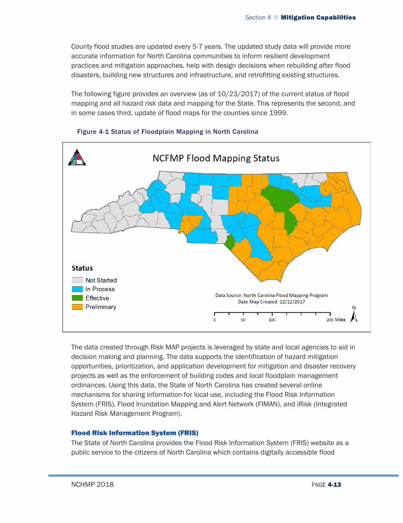
Section 4 Mitigation Capabilities
NCHMP 2018 PAGE 4-13
County flood studies are updated every 5-7 years. The updated study data will provide more accurate information for North Carolina communities to inform resilient development practices and mitigation approaches, help with design decisions when rebuilding after flood disasters, building new structures and infrastructure, and retrofitting existing structures. The following figure provides an overview (as of 10/23/2017) of the current status of flood mapping and all hazard risk data and mapping for the State. This represents the second, and in some cases third, update of flood maps for the counties since 1999.
Figure 4-1 Status of Floodplain Mapping in North Carolina
The data created through Risk MAP projects is leveraged by state and local agencies to aid in decision making and planning. The data supports the identification of hazard mitigation opportunities, prioritization, and application development for mitigation and disaster recovery projects as well as the enforcement of building codes and local floodplain management ordinances. Using this data, the State of North Carolina has created several online mechanisms for sharing information for local use, including the Flood Risk Information System (FRIS), Flood Inundation Mapping and Alert Network (FIMAN), and iRisk (Integrated Hazard Risk Management Program). Flood Risk Information System (FRIS) The State of North Carolina provides the Flood Risk Information System (FRIS) website as a public service to the citizens of North Carolina which contains digitally accessible flood

Section 4 Mitigation Capabilities
NCHMP 2018 PAGE 4-14
hazard data, models, maps, risk assessments, and reports that are database driven. This site also provides geospatial base map data, imagery, LiDAR data, along with hydraulic and hydrologic models that is available for download and use. More flood risk information can be found at http://fris.nc.gov/fris/ Managed through NCEM’s Risk Management Section, the FRIS website presents information targeted to two audiences: the general public and advanced users. The general public can identify the level of flood risk and estimated damage losses associated with their property. By typing in their address, users can locate their property and view the flood hazard and risk information associated with it such as the flooding source, the flood event water surface elevation, and the flood zone if applicable. Advanced users, such as floodplain managers and government officials, will have the opportunity to download flood hazard data while also being able to identify levels of flood risk for buildings in the community.
Figure 4-2 North Carolina Flood Risk Information System
Flood Inundation Mapping and Alert Network (FIMAN) The North Carolina Flood Inundation Mapping and Alert Network (FIMAN), managed through NCEM’s Risk Management Office, provides actual storm-specific rainfall and stream/flood
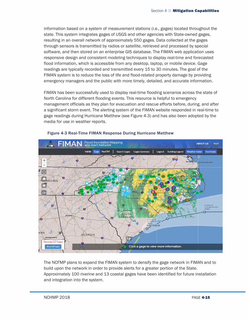
Section 4 Mitigation Capabilities
NCHMP 2018 PAGE 4-15
information based on a system of measurement stations (i.e., gages) located throughout the state. This system integrates gages of USGS and other agencies with State-owned gages, resulting in an overall network of approximately 550 gages. Data collected at the gages through sensors is transmitted by radios or satellite, retrieved and processed by special software, and then stored on an enterprise GIS database. The FIMAN web application uses responsive design and consistent modeling techniques to display real-time and forecasted flood information, which is accessible from any desktop, laptop, or mobile device. Gage readings are typically recorded and transmitted every 15 to 30 minutes. The goal of the FIMAN system is to reduce the loss of life and flood-related property damage by providing emergency managers and the public with more timely, detailed, and accurate information. FIMAN has been successfully used to display real-time flooding scenarios across the state of North Carolina for different flooding events. This resource is helpful to emergency management officials as they plan for evacuation and rescue efforts before, during, and after a significant storm event. The alerting system of the FIMAN website responded in real-time to gage readings during Hurricane Matthew (see Figure 4-3) and has also been adopted by the media for use in weather reports.
Figure 4-3 Real-Time FIMAN Response During Hurricane Matthew
The NCFMP plans to expand the FIMAN system to densify the gage network in FIMAN and to build upon the network in order to provide alerts for a greater portion of the State. Approximately 100 riverine and 13 coastal gages have been identified for future installation and integration into the system.
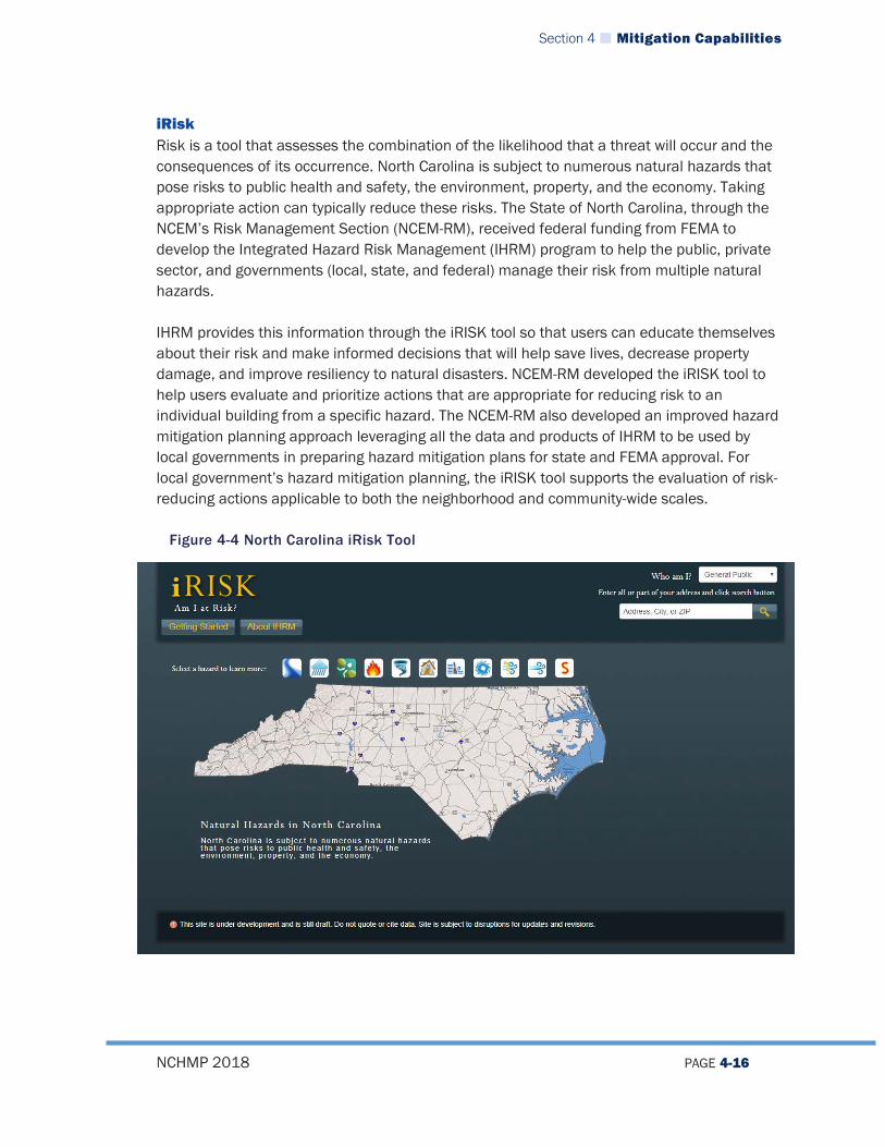
Section 4 Mitigation Capabilities
NCHMP 2018 PAGE 4-16
iRisk Risk is a tool that assesses the combination of the likelihood that a threat will occur and the consequences of its occurrence. North Carolina is subject to numerous natural hazards that pose risks to public health and safety, the environment, property, and the economy. Taking appropriate action can typically reduce these risks. The State of North Carolina, through the NCEM’s Risk Management Section (NCEM-RM), received federal funding from FEMA to develop the Integrated Hazard Risk Management (IHRM) program to help the public, private sector, and governments (local, state, and federal) manage their risk from multiple natural hazards. IHRM provides this information through the iRISK tool so that users can educate themselves about their risk and make informed decisions that will help save lives, decrease property damage, and improve resiliency to natural disasters. NCEM-RM developed the iRISK tool to help users evaluate and prioritize actions that are appropriate for reducing risk to an individual building from a specific hazard. The NCEM-RM also developed an improved hazard mitigation planning approach leveraging all the data and products of IHRM to be used by local governments in preparing hazard mitigation plans for state and FEMA approval. For local government’s hazard mitigation planning, the iRISK tool supports the evaluation of risk-reducing actions applicable to both the neighborhood and community-wide scales.
Figure 4-4 North Carolina iRisk Tool

Section 4 Mitigation Capabilities
NCHMP 2018 PAGE 4-17
The results displayed in iRISK come from models and methods commonly used by government risk assessors. One of these methods is FEMA’s Hazus-MH, a nationally applicable standardized set of models for estimating potential losses from earthquakes, floods, and hurricanes. Hazus uses GIS technology to estimate physical, economic, and social impacts of disasters. Another method used is FEMA’s Benefit-Cost Analysis software that calculates how much benefit comes from reducing a risk in a particular way. IHRM focused on collecting information on specific buildings and other critical infrastructure such as public utilities so that losses from damages could be calculated for each building or piece of infrastructure. The results factor in overall risk and its components of probability, consequence, and vulnerability.
4.2.1.5 Emergency Management Program Grant (EMPG) The EMPG Program provides states with federal funds to sustain and enhance all-hazards emergency management capabilities. North Carolina uses EMPG to enhance its ability and to help counties support emergency management activities while simultaneously addressing issues of national concern as identified in the National Priorities of the National Preparedness Guidelines. A statewide comprehensive emergency management program begins at the local level; that is why NCEM coordinates EMPG activities through its 100 counties and the Eastern Band of Cherokee Indians. EMPG Program funding is dependent upon the federal availability of funds and the total funding varies from year to year. EMPG has a 50 percent federal and 50 percent state cost-share cash or in-kind match requirement. The in-kind match is also a requirement of the state’s EMPG sub-grants to its counties and the Eastern Band of Cherokee Indians. North Carolina's EMPG program provides its counties and the Eastern Band of Cherokee Indians an opportunity to apply for baseline and supplemental funding. To align efforts between the State and local emergency management, specific programmatic deliverables are identified and agreed to by both parties. To be eligible for baseline funding, applicants must agree to complete certain universal programmatic deliverables during a specified period of performance. To be eligible for EMPG supplemental funding, applicants must have applied for baseline funding and agreed to complete at least one optional program activity during the specified period of performance.
4.2.1.6 Public Assistance For a description of how the Public Assistance Program is administered by the State of North Carolina, please see the Mitigation Funding Section of this Capability Assessment. Section 406 of the Stafford Act authorizes the Public Assistance (PA) Program, which is administered by FEMA. This post-disaster program provides aid to help communities save lives and property in the immediate aftermath of a disaster and help a community rebuild damaged facilities. Grants cover eligible costs associated with the repair, replacement, and restoration of facilities owned by state or local governments and non-profit organizations.

Section 4 Mitigation Capabilities
NCHMP 2018 PAGE 4-18
Four categories of assistance are available after a major disaster declaration: Debris removal provides 75 percent of funds to state or local governments or private
non-profit organizations to eliminate threats to life, public health, or property. Debris may be removed from private property when in the public interest.
Emergency work or protective measures to eliminate threats to life, public safety, or property. This includes ensuring emergency access, removal of public health and safety hazards, demolition of structures, establishment of emergency communication links, and emergency public transportation.
Repair, restoration, relocation, or replacement of damaged facilities to return public and non-profit facilities to their pre-disaster condition. Grantees must comply with certain insurance purchase requirements.
Community disaster loans to units of local government that lose a substantial part of their tax base because of a disaster.
Minimum standards for all repairs and reconstruction done under the PA program may include hazard mitigation standards and can be in place at the time of the disaster or can be adopted prior to the approval of a particular reconstruction project. Thus, improved standards that are adopted by a state or local government prior to FEMA’s approval of the repair or replacement of the damaged portion of a facility may become eligible for Federal funding under the PA program. Under the PA program, the cost of bringing a facility up to current codes, specifications, and standards is an eligible cost. The Public Assistance program also authorizes funding for appropriate cost-effective hazard mitigation measures related to damaged public facilities. The Regional Director may authorize hazard mitigation measures that are not required by codes, specifications, and standards if the measures are in the public interest, fulfilling the following criteria: The mitigation measures must substantially alleviate or eliminate recurrence of the
damage done to the facility by the disaster. The measures are feasible from the standpoint of sound engineering and
construction practices. The measures are cost-effective in terms of the life of the structure, anticipated
future damages, and other mitigation alternatives. Floodplain management and applicable environmental regulations are met.
Communities can use the hazard mitigation planning process to identify potential mitigation measures for funding under the Public Assistance Program. The Hazard Mitigation Survey Team or Interagency Hazard Mitigation Team can be particularly useful in this regard. In addition, the Damage Survey Reports used by inspectors to make site-specific recommendations for repairs following a disaster can also serve to identify mitigation opportunities.
4.2.1.7 Integration of the Plan with Federal Mitigation Programs and Initiatives NCEM Risk Mitigation staff have worked during this update to ensure that the State Hazard Mitigation Plan is integrated to the extent practicable with Federal Mitigation programs and
Section 4 Mitigation Capabilities
NCHMP 2018 PAGE 4-19
initiatives that provide guidance to State and regional agencies. This has been done through the following activities: NCEM administers all FEMA Hazard Mitigation grant programs and coordinates with
local governments and other State agencies to promote and implement FEMA programs.
Other agencies clearly support mitigation programs, including Department of Insurance (NFIP) and State Fire Marshall (Building Codes)
NCEM maintains a program of comprehensive coordination and outreach to State and Federal partners through the RMCC. This ongoing committee and permanent working group is designated to evaluate, monitor and update the State Hazard Mitigation Plan on a regular basis.
4.2.2 Other Pre- and Post-Hazard Management Policies, Programs, Funding, and Capabilities In addition to the programs described in Section 4.1.1, there are also additional key programs outside NCEM that are closely associated with advancing mitigation throughout the State which are discussed below.
4.2.2.1 CDBG-DR The United States Department of Housing and Urban Development makes funding available for disaster recovery through a program called the Community Development Block Grant – Disaster Recovery program (CDBG-DR). The funding is intended to be used to address unmet needs for disaster relief in a post disaster environment and support long-term recovery, restoration of infrastructure, housing, and economic development. In recent events, the funding has been required to be spent in the counties most impacted by the event. Most recently, North Carolina received $236.5 million dollars in CDBG-DR funding for Hurricane Matthew. CDBG-DR funding is being managed at the State level by North Carolina Emergency Management in close coordination with the North Carolina Department of Commerce.
4.2.2.2 Dam Safety The Dam Safety Program is housed in the NC Department of Environmental Quality’s Energy, Mineral and Land Resources Division, its mission is to prevent property damage, personal injury, and loss of life from the failure of dams by providing oversight of more than 3,000 dams statewide. A staff member of the Dam Safety Program serves on the Risk Management Coordinating Council (RMCC). The Dam Safety Program administers the NC Dam Safety Law of 1967 as amended (N.C.G.S. 143-215.23 et seq.). The purpose of the Dam Safety Law is to provide for the certification and inspection of dams in the interest of public health, safety, and welfare in order to reduce the risk of failure of dams; to prevent injuries to persons, damage to downstream property, and loss of reservoir storage; and to ensure maintenance of minimum stream flows of adequate
Section 4 Mitigation Capabilities
NCHMP 2018 PAGE 4-20
quantity and quality below dams. The Dam Safety program has the authority to levy fines against dam owners who violate permit conditions or who construct an unauthorized dam. The Dam Safety Program makes use of state-of-the-art web-based and wireless inventory tools, which are increasing its mitigation capability and efficiency. While the Program receives some federal money to carry out permitting and inspections duties, funding from FEMA has been reduced over the past several years, impacting the frequency of dam inspections throughout the state. There are more than 3,000 dams in North Carolina that are regulated through the inspection and certification requirements of the Dam Safety Program. Eighty to eighty-five percent of the regulated dams are privately owned and maintained. Under the administrative rules carried out by the Dam Safety Program, all dams are classified as High, Intermediate, or Low in terms of their hazard potential. A dam failure involving dams classified as “Low Hazard” would entail minimal interruption of road service on low volume roads and less than $30,000 in economic damage. A dam failure involving dams classified as “Intermediate Hazard” would entail damage to highways, interruption of service, and economic damage of $30,000 to $200,000. A “High Hazard” dam failure would involve the loss of one or more human lives or economic damage totaling more than $200,000. If the dam is a publicly-owned utility, such as a municipal water supply dam, the cost of dam repair and loss of services is included in the economic loss estimate. About one in five of all dams in North Carolina is classified as high-hazard. Coal Ash Management Action of 2014 (Session Law 2014-122) requires that all owners of high and intermediate hazard dams in North Carolina submit a proposed Emergency Action Plan. These plans greatly facilitate response procedures for these dams. One goal of the Dam Safety Program is to assess dam failure vulnerability and inundation areas for high hazard dams in North Carolina. Increased levels of coordination with the NC Floodplain Mapping Program would likely augment the accuracy and efficiency of this effort. Questions still remain as to the best methods to assess dam failure vulnerability and possible inundation areas. At this time, earthquake risk is not a component in the dam failure risk assessment, nor are earthquake design standards incorporated into the permitting process. The majority of dams in North Carolina are privately owned. Many dam owners are farmers or other rural residents, some of whom have limited incomes. Others are owned by homeowners’ associations with limited assets. Neither state nor federal funding is available to assist private property owners, and some dams in the state are neglected because of the expense involved. To a limited degree, the NC Dam Safety Program coordinates with local emergency management officials to communicate EM response protocols and flood warnings to local communities. However, local emergency management officials are often not trained in
Section 4 Mitigation Capabilities
NCHMP 2018 PAGE 4-21
response to dam failure, and many local emergency offices lack the hardware and software needed to use the dam hazard data that is available from the State. Furthermore, local emergency action plans are not required for existing dams, and many community members and local officials are unaware of the damage potential that exists from local dams. The Dam Safety Program has recently embarked on a cooperative venture with the National Weather Service (NWS). By integrating data received from the Dam Safety Program into the forecast system, the NWS has the capacity to overlay dam locations in ArcView with weather radar, precipitation, river gauge information, and other relevant data. This project holds great potential for predicting weather systems that could impact dams in specific locations around North Carolina. Other new ventures for the Dam Safety office include the development and distribution of a “Dam Safety Manual” as well as a mitigation report, or “Dam Failure Manual,” for the 100 counties in North Carolina, containing data specific for each county (pending funding). The Land Quality Section also proposes to send copies to the respective local government and County Emergency Manager of any “Notice of Deficiencies” sent to property owners of high hazard and intermediate dams.
4.2.2.3 North Carolina Forest Service The North Carolina Forest Service (NCFS), a Division of the N.C. Department of Agriculture and Consumer Services (NCDA&CS), operates under a mandate to protect, manage, and develop the millions of acres of forestland throughout the state. The Division is directly involved with forest management assistance, reforestation services, forest fire prevention and suppression, insect and disease control, and emergency response along with a host of other services and programs. The programs under the Forest Protection section of the NCFS are aimed at private forest landowners, homeowners, volunteer fire departments, communities, and the public to increase their awareness of fire risk, to educate them about fire safety and preventative measures, and to suppress wildfires quickly and safely. The Division also encourages the involvement of the private sector including builders and developers as well as the insurance and forestry industries to engage in widespread wildfire mitigation efforts and information dissemination. The NCFS also coordinates with the National Weather Service to forecast fire weather around the state, but more refined collaboration would enhance the real-time risk assessment capabilities of the NCFS. Although the Division is a leader of wildfire response in the United States, increased funding would allow the Division to engage in more aggressive outreach and public education campaigns to communities at risk from wildfire.
4.2.2.4 Organizations Providing Local Government Support In addition to support given to local governments for mitigation planning and project implementation from state and federal agencies, a wide variety of organizations provide local government support for all sorts of mitigation activities. Some of these organizations are non-profit or non-government organizations. Others are associations of professionals or officials
Section 4 Mitigation Capabilities
NCHMP 2018 PAGE 4-22
that exist to assist their clients or to promote a specific agenda. Although not comprehensive, a sample of some of these organizations is listed below. Association of County Commissioners League of Municipalities North Carolina Emergency Management Agency North Carolina American Planning Association Councils of Government American Red Cross Americorps National Preparedness and Response Corps Habitat for Humanity North Carolina Association of Floodplain Managers North Carolina Smart Growth Alliance North Carolina Voluntary Organizations Active in Disaster Institute for Business and Home Safety North Carolina Rural Economic Development Center
4.3 MITIGATION FUNDING
4.3.1 State Funding for Mitigation North Carolina General Statute 166A-19.42 established the State Emergency Response and Disaster Relief Fund as a reserve in the State’s general fund. General Statute 166A-19.41 defines some of the ways that funding can be used and includes mitigation as an option. The General Assembly also provides post-event appropriations as well. Most recently, this took the form of the Disaster Recovery Act of 2016 following Hurricane Matthew. This Act provided over $200,928,370 in state dollars for recovery efforts which included implementing mitigation projects. An additional $100 million in state funding was allocated for disaster relief through the Disaster Recovery Act of 2017. Additionally, the State has traditionally provided funding to help local governments meet the 25% match for HMGP grants.
4.3.2 The State’s Use of FEMA Funding Sources The State integrates FEMA programs into its mitigation strategy and actions whenever possible and wherever practicable. NCEM is responsible for administering FEMA mitigation programs and initiatives as well as serving as the lead agency for the State in disaster mitigation efforts, affording the State the opportunity to better coordinate the mitigation grant application process for the programs listed in this section. NCEM has primary responsibility for FEMA grant programs, including those listed here: Hazard Mitigation Grant Program (HMGP) Flood Mitigation Assistance Program (FMA) Pre-Disaster Mitigation Grant Program (PDM)

Section 4 Mitigation Capabilities
NCHMP 2018 PAGE 4-23
Public Assistance (PA) Program Public Assistance (“406”) Mitigation Program
The main objectives of FEMA’s various mitigation grant programs are: to prevent future losses of lives and property due to disasters. to implement state or local mitigation plans. to enable mitigation measures to be implemented during a state’s or community’s
immediate recovery from a disaster. to provide funding for previously identified mitigation measures that benefit the
disaster area.
4.3.2.1 UHMA During FY2009, FEMA developed the Hazard Mitigation Assistance Unified Guidance Program (HMA) to consolidate all FEMA mitigation activity grant programs (formerly FMA, SRL, RFC, PDM, and HMGP) into one streamlined portfolio. The PDM and FMA programs now share guidance and application periods. The SRL and RFC programs were rolled under the FMA program. HMGP also falls under HMA, but it is activated post-disaster and application periods are dependent upon disaster declarations. Flood Mitigation Assistance Program (FMA) FEMA’s Flood Mitigation Assistance Program (FMA) provides funding to assist states and communities in implementing measures to reduce or eliminate the long-term risk of flood damage to structures insurable under the National Flood Insurance Program (NFIP). FMA was created as part of the National Flood Insurance Reform Act of 1994 (42 U.S.C. 4101) with the goal of reducing or eliminating claims under the NFIP. FMA is a pre-disaster grant program. The goals of FMA are to: reduce the number of repetitively damaged structures and the associated claims on
the National Flood Insurance Program. encourage long-term, comprehensive mitigation planning. respond to the needs of communities participating in the NFIP to expand their
mitigation activities beyond floodplain development review and permitting. complement other federal and state mitigation programs with similar long-term
mitigation goals. FMA is generally made available to states on an annual basis. This funding is only available for planning, projects, and other assistance related specifically to flooding. NCEM administers the FMA program and serves as the grantee, in turn providing the funds to local communities. NCEM sets mitigation priorities, provides technical assistance to communities applying for FMA funds, and evaluates grant applications based on minimum eligibility criteria. NCEM is responsible for selecting projects for funding from the applications submitted by all communities within the State and then forwards selected applications to FEMA for an eligibility and selection determination. NCEM enters into grant agreements with

Section 4 Mitigation Capabilities
NCHMP 2018 PAGE 4-24
the local community after FEMA approval and ensures that all community recipients are aware of their grant management responsibilities. FMA is a cost-share program in which FEMA may contribute from 75 to 100 percent of the total eligible costs. Any required match must be provided by a non-federal source. If a match is required, no more than one half of the match may be provided as an in-kind contribution from a third party. Project grants are available for projects that reduce the risk of flood damage to structures insurable under the NFIP. Such activities include: elevation of insured structures. acquisition of insured structures and real property. relocation or demolition of insured structures. dry floodproofing of insured structures. minor, localized structural projects that are not fundable by state or federal
programs.
Before a community or county can be considered for FMA Project Grant, it must meet the threshold criteria as determined by FEMA and the State of North Carolina. To be eligible, a project must, at a minimum, meet the following: Be cost effective. Be cost beneficial to the National Flood Insurance Fund. Be technically feasible. Be physically located in a participating NFIP community or must reduce future flood
damages in an NFIP community. Conform with the State’s Flood Mitigation Plan. Does not encourage development in Special Flood Hazard Areas. Communities with mapped flood hazard areas that wish to submit a project for
review must participate in good standing with the National Flood Insurance Program. Address a property currently covered by an in-force NFIP Policy The proposed project must conform to the community’s comprehensive plan, Flood
Mitigation Plan, or Community Rating System Plan where such plans exist. The project must conform to all Federal, State, and local regulations, including
National Flood Insurance Program regulations, NC Coastal Area Management Act (CAMA) regulations, building codes, and local plans and ordinances. In addition, the community must enforce applicable regulations.
This funding stream remains valid as of this plan update, December 2017. The Pre-Disaster Mitigation (PDM) Program DMA 2000 established a national program for pre-disaster hazard mitigation (PDM) to reduce disaster losses through pre-disaster mitigation planning and pre-identified cost-effective mitigation. The PDM program, part of the HMA portfolio of mitigation grant

Section 4 Mitigation Capabilities
NCHMP 2018 PAGE 4-25
programs, makes funding available to state, local, and Indian Tribal governments to implement cost-effective hazard mitigation activities (e.g., mitigation projects or planning) that complement a comprehensive mitigation program. NCEM Mitigation staff work with local jurisdictions to identify and develop eligible projects. NCEM will continue to work directly with local governments and FEMA Region IV to submit projects for future PDM funding. Like FMA, applicants for flood-related mitigation projects must be participating in the NFIP in good standing (if they have been identified as having special flood hazard area) and all participants must have a FEMA-approved hazard mitigation plan that recognizes the proposed mitigation measure. Successful grantees receive 75 percent federal funding toward total estimated project costs, with a 25 percent non-federal share. The non-federal share may be in cash or in the form of in-kind services. Small impoverished communities may receive federal funding of 90 percent. The PDM applications determined to be eligible are evaluated by a National Evaluation Panel in accordance with PDM Grant Guidance and Notice of Funds Availability. The Hazard Mitigation Grant Program (HMGP) The Section 404-Hazard Mitigation Grant Program (HMGP) is a critical component of the state’s mitigation efforts. The program was created in November 1988 through the Robert T. Stafford Disaster Relief and Emergency Assistance Act that amended the Federal Disaster Relief Act of 1974. The Hazard Mitigation and Relocation Assistance Act that amended Section 404 of the Stafford Act on December 3, 1993 to set the proportion of federal funds allotted to the HMGP at 15 percent of the federal funds spent on the Individual and Public Assistance Programs for each disaster. The Disaster Mitigation Act of 2000 (DMA 2000), which amended the Stafford Act, was enacted in 2000 to establish a national pre-disaster mitigation program as well as better control federal costs of disaster assistance through streamlining the disaster relief administration. DMA 2000 also increased HMGP funding on a sliding scale (ranging from 7.5 percent to 15 percent) based on the overall disaster assistance funding for states with a standard plan and up to 20 percent for those states with an approved State Enhanced Hazard Mitigation Plan. The HMGP is administered by NCEM, which makes grants available to state agencies, tribal governments, and local governments and to eligible private, non-profit organizations for the implementation of long-term mitigation measures following major disaster declarations. Eligible projects must independently mitigate risks and be environmentally sound as well as cost-effective. Eligible project costs are limited to 75 percent provided in federal funds through FEMA with a 25 percent non-federal match (which may be provided by the state or local government or some share of each). In order to receive HMGP funds, a community must be participating and in good standing with the NFIP for flood-related projects and also must have a FEMA-approved hazard mitigation plan. NCEM mitigation staff solicits, reviews, evaluates, and ranks HMGP applications when they are submitted after an eligible disaster event. Based on these evaluations and funding
Section 4 Mitigation Capabilities
NCHMP 2018 PAGE 4-26
recommendations, NCEM coordinates with FEMA for approval. Projects typically consist of acquisition/demolition, flood retrofit, wind retrofit, education and outreach, localized flood reduction measures such as stormwater management, utility protection, NOAA weather radios, and planning. HMGP is a major funding component for implementing mitigation actions identified in State and local hazard mitigation plans.
4.3.2.2 Public Assistance Categories C-G and Individual Assistance Public Assistance provides grants to eligible State and local governments, and certain private non-profits (PNPs), to assist with the cost of responding to and recovering from disasters. There are four building blocks of eligibility of public assistance, COST as reasonable and necessary; WORK and FACILITY which is the legal responsibility of an applicant in the damaged area as a direct result of a declared disaster whether state or federal; and APPLICANT which includes State and local government, federally recognized Indian Tribes, and certain PNPs. There are two categories of work: Emergency Work to include debris removal and emergency protective work and Permanent Work to include repair/replacement projects for roads and bridges, water control facilities, buildings and equipment, utilities, parks, and recreation. Both of these types of work have different eligibility established start times from the onset of the declaration. All requests for public assistance should be submitted within 30 days of the declaration date and must have all required documentation.
4.3.2.3 Cooperating Technical Partner The CTP Program is an innovative approach to creating partnerships between the Federal Emergency Management Agency (FEMA) and participating NFIP communities, regional agencies, state agencies, tribes and universities that have the interest and capability to become more active participants in the FEMA flood hazard mapping program.2 North Carolina works through this program as a Cooperating Technical State with FEMA. As a Cooperating Technical State, NCEM receives funding from FEMA to develop and update floodplain maps. These flood maps are integral for advancing hazard mitigation in North Carolina as they provide the basis for regulating areas of high hazard risk to flooding and can help local floodplain administrators make informed decisions about future growth and development. As a Cooperating Technical State, North Carolina’s responsibilities regarding flood map development are a key capability as state staff are well-integrated into the process of floodplain mapping, which gives them a greater base of knowledge and insight on the implications for local governments and citizens in the state.
4.3.2.4 EMPG The State of North Carolina has used EMPG funding to support advancing the mitigation strategy in a number of ways. One of the primary ways has been the provision of funds to support staff positions in hazard mitigation. These positions at the state level have been integral at assisting local governments in project implementation, grant management, mitigation planning, and many other tasks that are critical to promoting mitigation in the state. In terms of tangible projects, EMPG funds have been used to purchase and install
2 Cooperating Technical Partners Program. FEMA. Retrieved on December 20, 2017 from: https://www.fema.gov/cooperating-
technical-partners-program

Section 4 Mitigation Capabilities
NCHMP 2018 PAGE 4-27
stream gauges in various locations throughout the state that support the State’s flood warning system (FIMAN). This system is crucial to providing advance warning of impending flood events and inundation maps for local emergency managers and planners to use to try to reduce future risk.
4.3.2.5 CAP SSSE Funding The State of North Carolina has used Community Assistance Program – State Supportive Services Element (CAP SSSE) funding to support advancing the mitigation strategy. This program provides funding to states to provide technical assistance to communities in the National Flood Insurance Program (NFIP) and to evaluate community performance in implementing NFIP floodplain management activities. In this way, CAP-SSSE helps to: ensure that the flood loss reduction goals of the NFIP are met. build state and community floodplain management expertise and capability. leverage state knowledge and expertise in working with their communities.
4.3.2.6 Wildfire Mitigation Grants The State of North Carolina has used Wildfire Mitigation Grants to support advancing the mitigation strategy in a number of ways. A primary example of this is from the United States Department of Agriculture’s Forest Service Community Grant Program. Through this program, the North Carolina Forest Service received funding to develop Community Protection Plans for each of the national forests in the state. This program is carried out in conjunction with local communities and other cooperators at the local and federal level and the plans list prevention, mitigation and community projects that can be carried out to reduce risk.
4.3.2.7 Earthquake Consortia Grant The State of North Carolina has used Earthquake Consortia Grants to support advancing the mitigation strategy. Examples include: Developing and demonstrating a non-structural EQ hazard and mitigation
assessment Working in concert with the State Geologist to develop and deliver an earthquake
awareness and earthquake science continuing education seminar offering continuing education credits for NC Science Teachers
4.3.2.8 Summary of Successes and Documented Losses Avoided With over 20 years of implementing large-scale hazard mitigation projects, North Carolina has a rich history of mitigation success stories. As part of the 2018 plan update, the Hazard Mitigation Planning Branch within the North Carolina Division of Emergency Management worked to collect and establish a master list of mitigated properties in North Carolina. These properties are stored in an excel spreadsheet and have been uploaded into ArcGIS as a point layer. This point layer was then used to generate the map below. It is important to note that the properties included in the map were funded under grants that are now closed. Any projects that are funded under grants that have not been closed are not included in this map. Please find this map below which illustrates the number of mitigated properties by county.

Section 4 Mitigation Capabilities
NCHMP 2018 PAGE 4-28
Figure 4-5 Summary Map of Mitigated Properties in North Carolina
In order to analyze the effectiveness of the Hazard Mitigation Program, NCEM conducted a “losses avoided” study and ran it against the Hurricane Matthew inundation area. In order to facilitate this process, NCEM ran an intersect in ArcGIS to see which of the properties from the previously mentioned mitigated properties layer fell within the inundation zone from the storm. Please find the map below illustrating the number of structures in which losses were avoided during Hurricane Matthew totaled by county. In addition, NCEM HM Planning conducted a number of losses avoided assessments on individual properties as subsequent hazard impacts on the area have presented opportunities. These individual property assessments generally show a return (loss avoided) in excess of the 4:1 ratio frequently expressed in academic studies of the nationwide cost effectiveness of hazard mitigation projects.

Section 4 Mitigation Capabilities
NCHMP 2018 PAGE 4-29
Figure 4-6 Documented Losses Avoided from Hurricane Matthew
4.3.3 Prioritization of Mitigation Funds Prioritizing Local Assistance for Planning Grants As NC’s local plans became due for update in 2005 and 2006, it was recognized that Federal and State grant funding for mitigation planning could be limited and, in some instances, may not be available. Therefore, it was determined at that time that approval of funds for mitigation plan updates would be based on the availability of funds and the determination as to whether the requesting jurisdiction has demonstrated the desire and ability to complete the plan update. NCEM (in conjunction with local governments) then successfully explored and implemented the option of consolidating some of the more than 120 approved and adopted local plans into regional plans based on similarities of hazard exposure, capability, and other factors. This section provides a description of the criteria by which the State prioritizes local jurisdictions to receive planning grants under the Hazard Mitigation Grant Program (HMGP), Flood Mitigation Assistance (FMA) program, Pre-Disaster Mitigation (PDM) program, and other available funding programs. In an effort to allow some flexibility in the distribution of mitigation planning funds, the following general guidelines have been developed. Unlike hazard mitigation project grants, planning grants do not require a formal Benefit-Cost Analysis prior to approval. These 11 guidelines are not all-inclusive and compliance with all of the issues listed below may not be required for approval of a planning update grant. These guidelines are not prioritized but instead will be viewed comprehensively when evaluating distribution of funding.

Section 4 Mitigation Capabilities
NCHMP 2018 PAGE 4-30
NCEM/Risk Mitigation Branch will consider whether or not the community participates in the National Flood Insurance Program (NFIP).
NCEM/Risk Mitigation Branch will consider the number of insured repetitive loss structures in the community (and actions taken to reduce the number of RL claims).
The jurisdiction is experiencing significant growth, and development pressures may cause increases in vulnerability in undeveloped hazard areas.
Results of the State and local risk assessment will be reviewed to determine if the level of susceptibility to natural hazards has increased in that jurisdiction.
The jurisdiction must satisfy the criteria for the specific source of the funds. NCEM/Risk Mitigation Branch will consider its past experience with the community
on other grants (such as disaster grants, mitigation projects, etc.). NCEM/Risk Mitigation Branch may contact the other State agencies/departments
and/or the local regional Councils of Government (COG) to check on their past experiences with the requesting jurisdiction.
NCEM/Risk Mitigation Branch will review previous presidential and State-declared disasters to determine the number of times the requesting jurisdiction has been impacted by declared disasters and the magnitude of damages resulting from those disasters. This review will consider impact on community infrastructure as well as families and businesses.
NCEM/Risk Mitigation Branch will consider the community’s status as a small-impoverished community and communities with special developmental pressures if applicable.
NCEM will consider whether or not the jurisdiction has demonstrated the ability to form effective public-private natural disaster hazard mitigation partnerships.
Jurisdictions willing to serve as the nexus for creation/consolidation of regional plans will receive priority for award of 7% planning funds set aside in the HMGP program.
Prioritizing Local Assistance for Project Grants At the time of the 2018 update, nearly 100 percent of jurisdictions in the state have approved and adopted mitigation plans. As a result, nearly every jurisdiction is eligible to apply for and, ultimately, receive federal/state dollars to implement mitigation projects. Therefore, the state has had to implement a process for the prioritization of these dollars and it has been an extremely successful process that will continue to be implemented in the future as disasters affect the state. NCEM’s Hazard Mitigation Branch currently participates in all UHMA programs—the disaster-based HMGP as well as the non-disaster based PDM and FMA programs. From Hurricanes Fran through Ophelia (2005), the majority of UHMA funding was made up of the HMGP. As the Branch completed projects in these disasters in the years that followed, the large majority of funding between FY08 and FY11 switched to non-disaster grant funding streams as well as small disasters including Tropical Storm Hanna, the 2008 Winter Storm, and Tropical Storm Nicole. This included the start of the RFC and SRL FEMA funding streams in FY08. In 2011, North Carolina received two major disaster declarations—the April 2011

Section 4 Mitigation Capabilities
NCHMP 2018 PAGE 4-31
tornadoes and Hurricane Irene. With these funding streams, NCEM’s funding emphasis has once again started coming primarily through the HMGP program. This has more or less continued with several other federally declared disasters in the last 5 years including severe storms and flooding in 2013, severe winter weather in 2014, and perhaps most notably, Hurricane Matthew in 2016. Table 4-1 shows the UHMA funding sources that have been used since the last plan update was approved in 2013,
Table 4-1 Summary Table of UHMA Funding in North Carolina Since 2013
Program Year Number of Projects
Amount Obligated ($)
Amount Expended to Date ($)
PDM 2013 4 $190,633.32 $178,144.72 PDM 2014 9 $656,522.91 $506,900.15 PDM 2015 7 $824,679.05 $313,975.93 PDM 2016 Not reported Not Reported Not reported FMA 2013 6 $4,344,696.40 $2,757,710.09 FMA 2014 9 $10,187,670.56 $5,219,283.16 FMA 2015 14 $5,151,830.47 $0 FMA 2016 14 $4,237,686.42 $0 HMGP 4146 2013 3 $1,150,774.00 $125,000.00 HMGP 4153 2013 4 $579,806.00 $500,483.91 HMGP 4167 2014 13 $6,457,245.00 $1,122,995.06
To begin the process of prioritization, outreach is conducted through a Letter of Interest process with local governments. The Letter of Interest is essentially a Request for Proposals from local governments citing requested project types and identifying the properties or projects requesting mitigation. The LOI process is supported through field visits, Mitigation Opportunities Assessments, and public outreach meetings. The LOI, an official document signed by the local government, is the basis for conducting Benefit Cost Analysis, prioritization and other activities related to project development. From 2007-2017 (project development for non-disaster funding streams and small disasters), the HM Branch also used a Letter of Interest process. For the SRL and RFC programs, NCEM aggressively targeted Repetitive Loss and Severe Repetitive Loss properties based upon the Rep Loss (RL) and Greatest Savings to the Fund (GSTF) lists provided by FEMA. During the 2010-2013 period, the Mitigation Branch pursued intensive outreach to communities through the SRL and RFC programs. This included field visits, face-to-face meetings, public meetings, letters, and phone calls to discuss properties on the RL and GSTF lists. Despite a concentrated effort to address over 200 SRL properties statewide, only a small fraction of these projects ended up being cost effective—even with the GSTF methodology. During this time Benefit Cost Ratio was the ultimate driver of project development, rather than number of repetitive flood claims. While Repetitive Loss factored into project prioritization and dictated NCEM’s participation in the FMA, RFC, and SRL

Section 4 Mitigation Capabilities
NCHMP 2018 PAGE 4-32
programs, it was the benefit cost ratio of all structures which was the biggest driver, not the end number of claims. This made it extremely difficult for the state to implement these programs. Therefore, during the 2010-2013 period (DR-1969, DR-4019, and non-disaster programs), the balance of the work flow shifted back to the HMGP, with non-disaster grant programs “filling in the gaps” of other program types (i.e., NC will only pursue tornado safe rooms under the PDM program) or “overflows” of cost effective properties, should the HMGP funding streams run out of funding. For the HMGP, please note that, per the 404 Admin Plan for Hurricane Irene, priority for mitigation is framed in terms of repetitive loss among the six cascading priorities for residential acquisition and elevation (Hurricane Irene 404 Admin Plan, p. 13, “Priorities.”) In the 2013-2017 period, there has been a continual use of Benefit-Cost Analysis when evaluating projects at the state level. However, in August of 2013, FEMA issued guidance allowing for projects to forego the standard BCA rules for project eligibility if they met certain criteria. Namely, that if a structure could be acquired for less than $275,000 or elevated for less than $175,000, the BCA requirement on that property would be waived. That is to say, the structure would not have to exceed a BCR of 1.0 in order to be eligible. This has had a major impact in that meeting BCA is no longer the greatest hurdle to implementing projects. This has opened up many more properties to eligibility under the UHMA programs, which has caused a different sort of challenge. Because so many more structures are eligible under these new rules, there have been more properties than funding available to carry out these buyouts and elevations. As such, the greatest challenge changed from meeting BCA to lack of funding availability. One additional factor that has recently played a part in project prioritization is based on the state’s recent experiences in Hurricane Irene and Hurricane Matthew. In the aftermath of these events, many homeowners whose homes were destroyed by these hurricanes were forced into temporary housing after the storms. After Irene, many took up residence in FEMA’s Temporary Housing Units (THUs) located on their own property, while after Matthew many had to relocate to other forms of temporary or transitional housing. Staff at NCEM recognized that if properties owned by these affected homeowners were eventually going to be bought out through the voluntary acquisition program, it would make sense to implement this buyout as quickly as possible to reduce the time citizens would have to spend in temporary housing and the cost the federal government would incur from paying for temporary living space. Since acquisition of high risk properties is one of the Mitigation Branch’s highest priorities, the strategy of acquiring these properties was given additional emphasis and a high prioritization in the wake of these events. Another notable addition to the prioritization criteria came from the federal level where FEMA’s evaluation criteria during the FY17 cycle was, among other changes, much less focused on acquisition, elevation, and reconstruction projects than in past years. FEMA’s criteria in this funding cycle tended to emphasize prioritizing stormwater projects under FMA

Section 4 Mitigation Capabilities
NCHMP 2018 PAGE 4-33
and non-flood related projects under PDM. These changes caused NCEM to evaluate projects that were submitted through its Letter of Interest process in a new light and adjust its submission package to these competitive programs accordingly.
4.3.3.1 Repetitive Loss and Severe Repetitive Loss Properties Prioritization Analysis of the repetitive loss communities and properties with the greatest financial losses will be utilized to identify and prioritize areas for mitigation projects. Eighty-eight (88) counties in the state have repetitive loss properties and are regularly identified during funding cycles to assist with the prioritization of areas for mitigation projects. Project Managers on the Grants team will work closely with these communities to determine the potential for project development. SRL program and individual project development criteria will adhere to the SRL guidance released by FEMA on October 1, 2017, or as amended. Areas identified as high priority are selected based in part on whether there are repetitive or severe repetitive loss properties in the area. The Repetitive Loss Mitigation Strategy for North Carolina is geared to encourage local communities to prioritize mitigation of Repetitive Loss and Severe Repetitive Loss properties and remove the financial strain imposed upon the National Flood Insurance Program (NFIP) for claims that compensate homeowners who have suffered repeatedly from flood losses. The North Carolina Repetitive Loss and Severe Repetitive Loss strategy meets the directives of the US Congress as outlined in the Federal Register and reflects FEMA’s guidelines for the RL and SRL programs. The RL/SRL strategy for the state is as follows: The state will include the presence of severe repetitive loss structures and repetitive
loss structures and the extent to which they are mitigated as an evaluation criterion in the review process for applications for disaster and other hazard related assistance. Localities will be encouraged to include these properties in their proposals and applications.
The state will require that local mitigation plan update identify severe repetitive loss properties and repetitive loss properties and include appropriate mitigation actions.
The state will require that local mitigation plan updates identify undeveloped areas in the floodplain and appropriate mitigation actions to help avoid repetitive losses in the future.
The state will require that each local mitigation plan update consider mitigation actions such as prevention, property protection, and natural resource protection to address existing repetitive loss properties. These actions will assist with avoiding recurring losses from natural hazards in the future.
Project Eligibility NCEM will review any eligible project proposal that demonstrates cost-effectiveness in the mitigation of RL or SRL properties with an emphasis on the following: RL or SRL identified properties with the greatest dollar value of claims. RL or SRL identified properties with the greatest number of claims.

Section 4 Mitigation Capabilities
NCHMP 2018 PAGE 4-34
All properties evaluated for a proposed project will be ranked from highest to lowest based on the FEMA Benefit-Cost Analysis (BCA) module. Cost effective properties with the highest Benefit Cost Ratio (BCR) will become priority projects.
Acquisition (includes the worst of the worst residential properties) (requires a high benefit to cost ratio).
Relocation (residential properties) (requires a high benefit to cost ratio). Elevation (residential properties) (requires a high benefit to cost ratio). Mitigation reconstruction (if traditional elevation cannot be implemented). Minor physical localized flood reduction projects (requires a high benefit to cost
ratio). Dry Flood proofing (commercial or historic properties only) (requires a high benefit to
cost ratio).
Project Selection Criteria The State’s priorities are a major consideration in the selection of projects for funding. Projects will be selected according to how well they satisfy all FEMA eligibility criteria and their support of the NCHMP RL and SRL mitigation strategy. Upon receipt of Notice of Funds Availability, NCEM will forward the notice to local
governments with an overview of funding criteria and priorities and will also offer to provide, upon receipt of written request from the jurisdiction, a copy of the most recent NFIP RL and SRL information. NCEM has access to RL and SRL information via Bureau Net, and generally twice per year requests a spreadsheet containing all RL and SRL data for NC from FEMA.
The Hazard Mitigation Branch, which is responsible for project development, will work closely with the community to develop a RL and SRL Plan of Action to prioritize and mitigate the most vulnerable structures.
The selection of a priority RL or SRL property will be determined by ranking the houses/structures in the state based on the greatest losses and claims to the NFIP. Cost effective properties with the highest Benefit Cost Ratio (BCR) will become priority projects. Mitigation action type (Acquisition, Elevation, etc.) will also play a role in the ranking process.
The RL and SRL program will include eligible priority projects for Elevation, Acquisition, and Relocation and Retrofitting of facilities.
RL and SRL properties identified in the priority ranking may be identified for funding from several NCEM-administered disaster and non-disaster programs. The HMGP, PDM, and FMA programs are potential funding sources to mitigate flood hazard properties. In general, NCEM will determine which project requests get submitted to which funding stream based on programmatic and state priorities.
Other programs that provide funding for mitigation activities include: 406 mitigation under FEMA’s Public Assistance program. HUD Disaster Assistance grants, including CDBG-DR. SBA Loans following disaster declarations. local government incentives.
Section 4 Mitigation Capabilities
NCHMP 2018 PAGE 4-35
homeowner insurance-based products to include ICC funds that are administered at the local level.
NCEM provides technical assistance to ensure the structures that are substantially damaged and are in the Special Flood Hazard Area are repaired in accordance with current NFIP regulations.
4.4 LOCAL AND TRIBAL MITIGATION CAPABILITIES
4.4.1 Summary and Evaluation of Local and Tribal Mitigation Capabilities Governments In North Carolina: Building Capacity Building the capacity of local governments to mitigate the impacts of natural hazards is a major focus of North Carolina’s goal to reduce vulnerability. This is critical in the state given the fact that there is no statewide land use, growth management, or development planning, nor is planning mandated at the local level (with the notable exception of local governments in the coastal zone where County-level CAMA Plans including a Land Use Plan are required). Decisions of where to locate infrastructure, when and where to allow subdivisions to occur, and even whether or not to enact zoning and other land use regulations are largely left to the discretion of local government in North Carolina. These are fundamental decisions that can profoundly impact a community’s level of risk. For purposes of the State Hazard Mitigation Plan, the term “local government” refers to those legal subdivisions of the state that are defined by political boundaries. There are 100 counties and approximately 640 incorporated jurisdictions in North Carolina. North Carolina is home to eight Native American tribes located throughout the State, although only one—the Eastern Band of the Cherokee Indians—is federally recognized as a Sovereign Indian Nation at this time. North Carolina also has 18 active Councils of Government (COGs) that were established by the NC General Assembly in 1972 as voluntary organizations of county and municipal governments within a region. Although the COGs have no regulatory powers, they provide many valuable services to the communities in their region. While North Carolina remains committed to maintaining the independence of local governments to manage their own affairs, North Carolina is not a “Home Rule” state. Instead, North Carolina follows “Dillon’s Rule,” whereby local governments are only allowed to exercise powers that have been expressly granted to them in the state constitution or by other state laws. This means that in order to enact any type of regulation that is not among the usual panoply of powers granted by the State, a local government must petition for special dispensation from the General Assembly. Many local governments in North Carolina are exceedingly proactive when it comes to planning to mitigate the impacts of natural hazards. Largely through the Hazard Mitigation Planning Initiative (HMPI) conducted by NCEM, local communities throughout the State have embraced the principles of mitigation to reduce losses and increase resiliency to natural hazards.
Section 4 Mitigation Capabilities
NCHMP 2018 PAGE 4-36
While the State provides ample guidance and technical assistance to prepare hazard mitigation plans, each community is encouraged to write and implement a plan that is locally tailored and meets the specific hazard conditions and mitigation needs and capabilities of that locality. NCEM recognizes that there is no one-size-fits-all solution to every community’s hazard exposure. The state has a wide variety of communities in terms of demographics, topography, climate, economics, natural resources, hazard exposure, and political and cultural milieu. North Carolina has large affluent metropolitan areas that are experiencing growing pains and unchecked sprawl. There are also isolated rural communities whose agricultural or manufacturing economic base is declining and whose populations are shrinking. There are mountain communities that must deal with the constraints of a steep terrain and coastal communities that experience frequent violent storms. Some communities are progressive and promote a liberal agenda, while others are more conservative and espouse traditional values related to zoning and land use planning. Some local governments aggressively regulate land uses within their jurisdiction, and others vehemently oppose government interference with private property rights. While this diversity contributes to the richness of the State’s social fabric, it also means that HMPI coordinators must tailor their approach to help all communities meet their individual mitigation needs. Fiscal Capability Because each community is so unique, it is impossible to make accurate generalizations about the fiscal capability of local governments in North Carolina to carry out mitigation objectives. Financial resources and technical resources are critical for planning and implementing most mitigation projects. Large metropolitan areas such as Charlotte-Mecklenburg (the largest urban area in the State), the Raleigh-Durham-Chapel Hill Triangle area, and the Winston Salem-Greensboro-High Point Triad have sizable resources and a vast array of technical and financial opportunities. These areas also have a larger and typically more affluent tax base. Many of the larger coastal communities also demonstrate highly functional planning, funding and implementation capabilities. At the other extreme, many smaller rural communities in North Carolina have very limited fiscal and personnel resources that reduce the ability to engage in complex hazard mitigation activities without significant assistance from the State and Federal government. The North Carolina Department of Commerce classifies all 100 counties in the state into one of three tiers, with Tier 1 representing the most economically disadvantaged and Tier 3 the most prosperous. Tiers 1, 2, and 3 may be deemed “distressed” based on various economic and demographic characteristics. Counties that are designated as distressed gain easier access to certain funds from the federal and State governments and waivers of some of the local matching fund requirements that accompany many federal and State grants. For counties that fall outside the lower tiers, but which nonetheless are struggling to meet service needs, fiscal capability is often quite limited. Local elected officials must balance many competing interests when allocating limited local resources. Highly visible problems, such as roads, schools, housing, and health services,

Section 4 Mitigation Capabilities
NCHMP 2018 PAGE 4-37
often grab the immediate attention of constituents. Many communities in North Carolina, like the rest of the nation, are currently experiencing an economic downturn and relatively high unemployment, factors which strain local government coffers as the need for government services increases. However, many local governing boards throughout North Carolina have come to realize that money invested in hazard mitigation activities can save millions of dollars in property damage by reducing losses from inevitable natural hazards. Keeping businesses open, residents in their homes, and basic services operating following an emergency results in economic security and social stability for local communities. Residents in many North Carolina localities have seen the devastation that can occur from hurricanes and hurricane-related flooding first hand as well as from other natural hazards, including severe winter storms, drought, forest fires, flash flooding, and other recurring hazards. Because of their experiences, many North Carolinians have learned that mitigation efforts can help prevent future devastation. State and Federal aid is a large part of many local governments’ revenue stream, especially at the county level. Grants and other aid programs help local governments meet specific needs, including disaster recovery and hazard mitigation. Usually, conditions are attached to grants. For example, North Carolina requires that all local governments with identified flood hazards must participate in the National Flood Insurance Program (NFIP) in order to receive Hazard Mitigation Grant Program (HMGP) funds for flood related projects. Many government grant programs require a nonfederal match in order to receive the funds. This is true of many hazard mitigation grants. Local, state or any non-federal funds can be used to meet the match. Community Development Block Grant (CDBG) funds can also be applied as a match (CDBG funds, although they are issued by the U.S. Department of Commerce, lose their federal status when allocated to the state level). Local government applicants can also meet the nonfederal match with in-kind contributions instead of cash outlays. In-kind resources can be labor or salaries paid to staff to carry out the approved mitigation activities of the grant recipient (including project managers, attorneys, appraisers, planners, engineers, public works crews, etc). In-kind contributions from third parties can constitute some of the nonfederal share and may include donated services, supplies, equipment, and space in buildings. Communities have quite a bit of leeway in developing sources of in-kind matches. The State Hazard Mitigation Branch encourages local governments to incorporate specific mitigation actions into their Hazard Mitigation Plans. While outside sources of funding pay for the bulk of many current local mitigation programs and projects in North Carolina—especially expensive large-scale projects such as massive buy-outs of flood-prone properties—many creative local governments are becoming more self-reliant when it comes to financing mitigation activities. As described more fully later in this section, some of the powers and authorities that enhance the fiscal capability of many North Carolina jurisdictions include:
Section 4 Mitigation Capabilities
NCHMP 2018 PAGE 4-38
capital improvement funding (including withholding spending in hazard-prone areas).
authority to levy taxes and special assessments. fees for utilities (water, sewer, gas, electricity). stormwater management fees impact fees for homebuyers or developers of new housing subdivisions. incurring debt through general obligation bonds or other bonds. regulatory fees.
Some of the most effective mitigation strategies may require no additional money at all, just a shift in thinking. There are many practical activities that can improve community resilience to natural hazards, including mitigation policies and retrofitting programs that local governments can initiate without the benefit of state or federal aid. There are also many useful budgeting practices for leveraging local mitigation funding to avoid losses attributable to non-action. A large part of creating and updating a plan is process-oriented. When the state has been advising local governments on updating their plans, there has been a focus on process improvement. If there are many stakeholders from different departments involved in the plan update (the process of updating the plan), hazard mitigation strategies can be better integrated into other planning and regulatory mechanisms, such as Capital Improvement Plans and Land Use Plans. Technical Capability In order to develop mitigation plans and to carry out mitigation activities, local governments must have adequate technical capability, including competent personnel and administrative support. As with other types of capability, there is a wide range of technical ability throughout North Carolina. Some urban areas have very large planning departments and have the staff, budget, and equipment to engage in sophisticated growth management, floodplain regulation, stormwater management, and comprehensive planning. Other communities have less experience with land use regulation and development management and take a more laissez faire approach to land use. Coastal counties have been required by the North Carolina Coastal Area Management Act to engage in planning for over forty years, and most coastal counties have institutionalized the concept of land use planning to a degree that otherwise might not have occurred. Most local communities in North Carolina, except the very smallest of villages or unincorporated areas, do have a planning department, with staffs educated in land development and land management practices. There is a wide range in the level of expertise of professionals trained in engineering and construction practices related to buildings and infrastructure. In some rural areas, several jurisdictions may share personnel to fulfill roles of building inspectors, engineers, and planners; these positions are often filled at the county level. Regional Councils of Government often assist local governments with planning issues and grants writing and management (see discussion on COGs below). All counties in North

Section 4 Mitigation Capabilities
NCHMP 2018 PAGE 4-39
Carolina are required to have an Emergency Management Office, which have been the point of central contact for the State’s Hazard Mitigation Planning Initiative. Technological Capability The technological capability of local governments in North Carolina to predict, analyze, map, and mitigate against natural hazards also varies widely throughout the state. The majority of local communities have digital systems, primary and secondary phone systems, and access to the Internet, although this is by no means universal. In many areas of rural North Carolina there is less computer use and internet connectivity than in some of the more urban areas. The kind of infrastructure necessary for widespread technological growth and development has been lacking in rural areas. As with other utilities and services, rural areas are often the last to be served because of the higher price of doing business. However, great efforts have been made to increase access, and this increase throughout North Carolina is beginning to greatly enhance the technological capacity of local governments to engage in more sophisticated hazard analysis and mitigation planning. Among local governments that have computerized systems, many also make use of geographic information systems (GIS), although these systems may not always be devoted to planning or regulatory purposes. For instance, many 911 emergency contact services and county tax information may be contained in a GIS system, but other local departments and services within that same jurisdiction may not have access to the data or a means of using it for other applications. While some rural communities are still coming up to speed and lack comprehensive GIS capability, many other jurisdictions in North Carolina are using GIS as a tool for managing natural hazards. This is important because the more information concerning hazard analysis that becomes available, the greater the capability of local governments to guide development in a way that minimizes the threats to people and property. NCEM will continue to update and promote tools available through the Risk Management section such as the Integrated Hazard Risk Management and Communications tool. This tool will provide risk assessments for local and state governments and will help to identify potentially cost-effective mitigation measures. The communications tool will be an invaluable asset for plan updates because it will provide a number of ways to analyze and display information on hazard risks. State Support for Local Plan Development and Implementation This section details a few of the support programs that the State of North Carolina has made available to local governments to assist them in preparing a local Hazard Mitigation Plan that will meet the planning criteria set by FEMA and NCEM. Many of the same support mechanisms are available for plan implementation. Local governments are highly encouraged to seek out additional resources (monetary and otherwise) to augment the support made available by the State. The State also encourages local governments to look to existing sources of revenue, including annual budget reviews, to identify surpluses that can be directed to either one-time or ongoing mitigation activities.
Section 4 Mitigation Capabilities
NCHMP 2018 PAGE 4-40
Prioritizing Local Assistance It is the policy of the State of North Carolina to assist as many local governments as possible to prepare and implement high quality mitigation plans. NCEM has advertised the planning requirements, plan criteria, funding availability, and the State deadline for plan completion through a variety of means, including posting the information on the NCEM website; by direct mailings to local government planners, managers, emergency management personnel, and local government elected officials; professional associations, and during HMPI workshops. The League of Municipalities, the North Carolina Association of County Commissioners, the North Carolina Association of Emergency Managers, and the North Carolina Chapter of the American Planning Association have also disseminated information on behalf of the Division to their respective members and clientele. Division leaders are confident that that all eligible local governments have been made aware of the availability of funding and other assistance for plan development.
4.4.2 Effectiveness of Local Mitigation Capabilities North Carolina demonstrates a wide disparity in local capabilities across the State. Typically, jurisdictions with the largest populations and revenues have the most capabilities. In contrast to the larger cities and counties, some county and municipal jurisdictions in North Carolina have rural populations and very limited revenue resources. Consequently, capabilities in rural counties are typically very low, but there are some notable exceptions. Many rural North Carolina towns have little or declining growth and might have a staff of two or three housed in a small town hall, with no plans, building codes, zoning, or other regulatory means to implement mitigation measures. These small communities depend on support from their county governments, which generally have greater means to lend support to local government in pursuit of hazard mitigation. The overall state of local capabilities in North Carolina points to the need for a strong State program to support and increase the capabilities of rural communities and sustain and strengthen the capabilities of larger jurisdictions. NCEM fully recognizes these needs for continuing mitigation planning support and has been actively taking steps to expand its technical support and work with local governments to identify funding opportunities. The State intends to increase support for localities to receive professional planning and engineering services for hazard mitigation. This can be accomplished through continuing coordination with county EMAs and working to obtain planning funds (e.g., PDM, CDBG, HMGP, etc) available to improve and expand local mitigation activities. As part of the State’s Enhanced Plan initiatives, technical and funding support programs will be examined and new programs will be developed to improve local capabilities among all levels and types of jurisdictions throughout the State. Table 4-2 provides a summary of the various capabilities that local governments can utilize to implement mitigation techniques. The table provides descriptions of capabilities in the categories of regulatory powers, land use regulations, taxation, spending, and services and
Section 4 Mitigation Capabilities
NCHMP 2018 PAGE 4-41
planning. Following each capability description is a brief discussion on the effectiveness of the capability for local governments in North Carolina. Finally, there is an indication of whether or not the capability is helpful in facilitating reduction of repetitive loss and severe repetitive loss properties.
Table 4-2 Summary Table of Local Capabilities including Descriptions and Evaluation of Effectiveness
Category: Regulatory Powers Local Capability General Police Power
Description
Because local governments have broad regulatory powers, statutes allow police power to enact and enforce ordinances to structure public health, safety, and welfare. Ordinances are adopted and regulated to ensure that counties are creatures of Legislature. This legislation must be up to par with State rules.
Effectiveness In North Carolina, the ultimate authority in all regulation is the NC General Assembly, which has the power to strip zoning and other local regulatory powers from local governments if necessary.
Helps Facilitate Reduction of RL and SRL Properties? Local Capability Building Code Enforcement and Building Inspection
Description Building codes ensure that buildings and facilities are resilient to impacts from natural hazards. Strict adherence to these codes, along with proper and regular inspections, creates safer buildings that save lives and properties during disasters.
Effectiveness
North Carolina generally adheres to state building codes; however, some counties are known to be less rigorous in carrying out routine inspections. Until recently, a partnership in NC called Project Blue Sky created one of the first model homes to research hurricane-resilient construction practices and promoted voluntary standards that exceeded code specifications in Southern Shores. In some towns, such as Nags Head on the Outer Banks, have building moratoria that are activated following a disaster.
Helps Facilitate Reduction of RL and SRL Properties?
Category: Land Use Regulations Local Capability Land Use Regulations
Description
The State grants local governments regulatory powers, which serve as the most basic manner in controlling land use. Local governments regulate the use of property to protect the physical environment, to encourage economic development, and to protect the public’s health and safety.
Effectiveness While land controls are not required by the State, two-third of all counties have some sort of policy in motion.
Helps Facilitate Reduction of RL and SRL Properties? Local Capability Zoning
Description
Zoning is the traditional method of controlling land use that includes type of use, as well as minimum specifications for use. Zoning can be used to keep inappropriate building out of hazard-prone areas, to control construction, and to designate certain areas for low-intensity use.
Effectiveness All of North Carolina’s larger cities and towns have zoning regulations that the city council has adopted by ordinance, and 80 counties have implemented at least partial zoning, making zoning an effective hazard mitigation strategy in the state.
Helps Facilitate Reduction of RL and SRL Properties? Local Capability Flood Hazard Regulation
Description The Flood Hazard Prevention Act authorizes local governments to prohibit landfills, hazardous waste and chemical storage facilities, and junkyards in the 100-year floodplain.
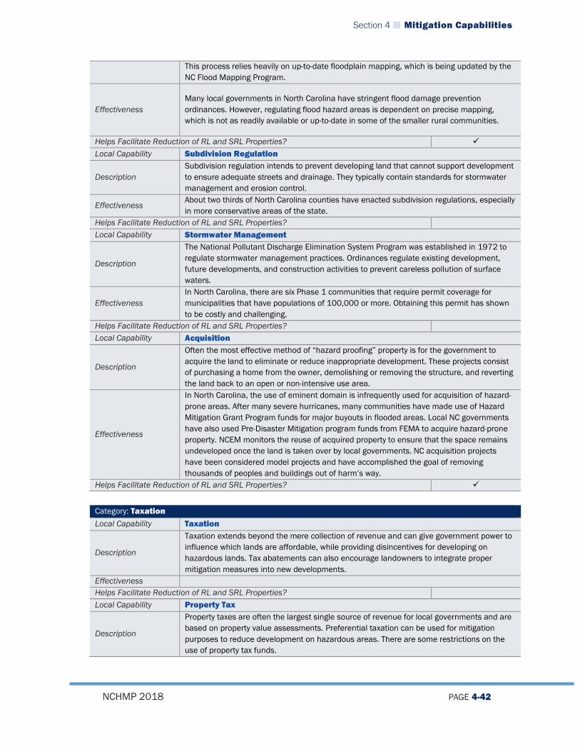
Section 4 Mitigation Capabilities
NCHMP 2018 PAGE 4-42
This process relies heavily on up-to-date floodplain mapping, which is being updated by the NC Flood Mapping Program.
Effectiveness Many local governments in North Carolina have stringent flood damage prevention ordinances. However, regulating flood hazard areas is dependent on precise mapping, which is not as readily available or up-to-date in some of the smaller rural communities.
Helps Facilitate Reduction of RL and SRL Properties? Local Capability Subdivision Regulation
Description Subdivision regulation intends to prevent developing land that cannot support development to ensure adequate streets and drainage. They typically contain standards for stormwater management and erosion control.
Effectiveness About two thirds of North Carolina counties have enacted subdivision regulations, especially in more conservative areas of the state.
Helps Facilitate Reduction of RL and SRL Properties? Local Capability Stormwater Management
Description
The National Pollutant Discharge Elimination System Program was established in 1972 to regulate stormwater management practices. Ordinances regulate existing development, future developments, and construction activities to prevent careless pollution of surface waters.
Effectiveness In North Carolina, there are six Phase 1 communities that require permit coverage for municipalities that have populations of 100,000 or more. Obtaining this permit has shown to be costly and challenging.
Helps Facilitate Reduction of RL and SRL Properties? Local Capability Acquisition
Description
Often the most effective method of “hazard proofing” property is for the government to acquire the land to eliminate or reduce inappropriate development. These projects consist of purchasing a home from the owner, demolishing or removing the structure, and reverting the land back to an open or non-intensive use area.
Effectiveness
In North Carolina, the use of eminent domain is infrequently used for acquisition of hazard-prone areas. After many severe hurricanes, many communities have made use of Hazard Mitigation Grant Program funds for major buyouts in flooded areas. Local NC governments have also used Pre-Disaster Mitigation program funds from FEMA to acquire hazard-prone property. NCEM monitors the reuse of acquired property to ensure that the space remains undeveloped once the land is taken over by local governments. NC acquisition projects have been considered model projects and have accomplished the goal of removing thousands of peoples and buildings out of harm’s way.
Helps Facilitate Reduction of RL and SRL Properties?
Category: Taxation Local Capability Taxation
Description
Taxation extends beyond the mere collection of revenue and can give government power to influence which lands are affordable, while providing disincentives for developing on hazardous lands. Tax abatements can also encourage landowners to integrate proper mitigation measures into new developments.
Effectiveness Helps Facilitate Reduction of RL and SRL Properties? Local Capability Property Tax
Description
Property taxes are often the largest single source of revenue for local governments and are based on property value assessments. Preferential taxation can be used for mitigation purposes to reduce development on hazardous areas. There are some restrictions on the use of property tax funds.
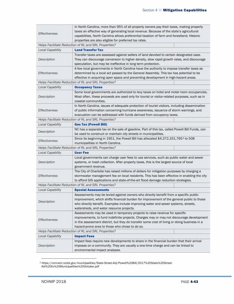
Section 4 Mitigation Capabilities
NCHMP 2018 PAGE 4-43
Effectiveness
In North Carolina, more than 95% of all property owners pay their taxes, making property taxes an effective way of generating local revenue. Because of the state’s agricultural capabilities, North Carolina allows preferential taxation of farm and forestland. Historic properties are also eligible for preferred tax rates.
Helps Facilitate Reduction of RL and SRL Properties? Local Capability Land Transfer Tax
Description Transfer taxes are assessed against sellers of land devoted to certain designated uses. They can discourage conversion to higher density, slow rapid growth rates, and discourage speculation, but may be ineffective in long term protection.
Effectiveness A few local governments in North Carolina have the authority to impose transfer taxes as determined by a local act passed by the General Assembly. This tax has potential to be effective in acquiring open space and preventing development in high-hazard areas.
Helps Facilitate Reduction of RL and SRL Properties? Local Capability Occupancy Taxes
Description Some local governments are authorized to levy taxes on hotel and motel room occupancies. Most often, these proceeds are used only for tourist or visitor-related purposes, such as in coastal communities.
Effectiveness In North Carolina, issues of adequate protection of tourist visitors, including dissemination of public information concerning hurricane awareness, issuance of storm warnings, and evacuation can be addressed with funds derived from occupancy taxes.
Helps Facilitate Reduction of RL and SRL Properties? Local Capability Gas Tax (Powell Bill)
Description NC has a separate tax on the sale of gasoline. Part of this tax, called Powell Bill Funds, can be used to construct or maintain city streets in municipalities.
Effectiveness Since its beginning in 1951, the Powell Bill has allocated $4,372,331,7653 to 508 municipalities in North Carolina.
Helps Facilitate Reduction of RL and SRL Properties? Local Capability User Fee
Description Local governments can charge user fees to use services, such as public water and sewer systems, or trash collection. After property taxes, this is the largest source of local government revenue.
Effectiveness The City of Charlotte has raised millions of dollars for mitigation purposes by charging a stormwater management fee on local residents. This has been effective in enabling the city to afford GIS applications and state-of-the-art flood damage reduction strategies.
Helps Facilitate Reduction of RL and SRL Properties? Local Capability Special Assessments
Description
Assessments may be levied against owners who directly benefit from a specific public improvement, which shifts financial burden for improvement of the general public to those who directly benefit. Examples include improving water and sewer systems, streets, watersheds, and water resource projects.
Effectiveness
Assessments may be used in temporary projects to raise revenue for specific improvements, to fund indefinite projects. Charges may or may not discourage development in the assessment district, but they do transfer some cost of living or doing business in a hazard-prone area to those who chose to do so.
Helps Facilitate Reduction of RL and SRL Properties? Local Capability Impact Fees
Description Impact fees require new developments to share in the financial burden that their arrival imposes on a community. They are usually a one-time charge and can be linked to environmental impact analyses.
3 https://connect.ncdot.gov/municipalities/State-Street-Aid/Powell%20Bill/2017%20State%20Street-
Aid%20to%20Municipalities%20October.pdf

Section 4 Mitigation Capabilities
NCHMP 2018 PAGE 4-44
Effectiveness Studies have shown that communities prefer to insure against losses than to assess hazard-prone impact fees and pass cost of service along to developers.
Helps Facilitate Reduction of RL and SRL Properties?
Category: Spending and Service Local Capability Local Government Services
Description
All local governments have power to make expenditures in the public interest. County governments are responsible for providing social, public health, mental health, and emergency services. In addition to the mandated services they must provide, counties are also responsible for improving their services.
Effectiveness As of 2017, almost all cities and towns in North Carolina have public water and sewer systems, paved streets, and police and fire protection. In North Carolina, most services are available to all county residents, whether they live inside or outside a city or town.
Helps Facilitate Reduction of RL and SRL Properties? Local Capability Public Schools
Description
Public schools are both a state and local responsibility, but local entities are responsible for adopting budgets and capital costs. Major decisions regarding location and construction of schools are made at the county level, and schools often serve as shelters in the event of emergencies.
Effectiveness There are 114 school systems within North Carolina. Careful site selection and construction of public schools are important; after Hurricane Floyd, many schools in eastern North Carolina were closed for months due to severe flooding.
Helps Facilitate Reduction of RL and SRL Properties? Local Capability Emergency Management Services
Description
Each county is mandated to form a local emergency management office that is responsible for providing emergency management planning, administration, coordination, training and support for local governments. Personnel cooperate with other governmental agencies, volunteer organizations, and private sector organizations to maintain emergency management capabilities at the local level.
Effectiveness Local emergency management personnel attend NCEM planning workshops to increase local knowledge and coordination.
Helps Facilitate Reduction of RL and SRL Properties? Local Capability Emergency Shelters
Description Local governments must make facilities available to protect or reduce exposure to hazards that must be designed to withstand impacts of most types of hazards in that area. Most shelters serve another purpose during non-disaster times.
Effectiveness
Presently, each county in North Carolina has the capacity to provide some type of mass care support and shelter 23,000 citizens. The Information and Planning branch of NCEM is conducting a three-year shelter retrofit project to develop new shelters and retrofit existing shelters.
Helps Facilitate Reduction of RL and SRL Properties? Local Capability Mutual Aid Agreement
Description
The NC General Assembly allows cities and towns to enter inter-local agreements. This allows one local government to offer and another receive assistance cooperatively in times of disaster. The idea behind the agreement is to efficiently provide assistance by having conditions worked out in advance.
Effectiveness
Mutual Aid Agreement has been effective in local government coordination since Hurricane Fran struck North Carolina in September 1996. Approximately 40% of towns, cities, and counties in the state have executed the agreement, and NCEM maintains a current listing of all participating local governments.
Helps Facilitate Reduction of RL and SRL Properties? Local Capability Capital Improvement Programming

Section 4 Mitigation Capabilities
NCHMP 2018 PAGE 4-45
Description
Hazard mitigation principles can be a routine part of local government spending decisions when programmed into a time table of providing municipal services. Capital improvement plans have been used to secure hazard-prone areas for low risk uses and can effectively direct growth away from hazardous areas.
Effectiveness North Carolina does not prohibit local governments from providing capital improvements in hazardous areas, nor from withholding spending for infrastructure in hazardous areas.
Helps Facilitate Reduction of RL and SRL Properties? Local Capability Economic Development
Description Many counties have formed economic development commissions to improve local economies by keeping businesses in their communities. Continuing development is especially important in touristic areas.
Effectiveness
There are more than 60 counties in North Carolina with economic development commissions. Since tourism is a big economic draw in the mountains and the coast, economic development allows local decision-makers to consider efforts to make their communities more attractive to tourists in the safest way.
Helps Facilitate Reduction of RL and SRL Properties?
Category: Planning Local Capability Land Use/Comprehensive Plans
Description
Land use plans serve as the basis for much of the regulation of property use. Plans prepare maps that show how various areas may be developed or used in the future, and approved plans become part of the community’s Comprehensive Plan. Plans do not set regulation, but local officials can use the plans to guide decisions of future construction.
Effectiveness
Comprehensive plans are effective as a hazard planning tool because they guide other local measures, including capital improvement plans, and zoning or subdivision ordinances. In North Carolina, all but the smallest cities and towns have land use plans and 80 Counties enforce at least partial land use restrictions.
Helps Facilitate Reduction of RL and SRL Properties? Local Capability Hazard Mitigation Plans
Description Local governments can create their own plans strictly regarding hazard mitigation as part of the Hazard Mitigation Planning Initiative (HMPI).
Effectiveness Since 1996, North Carolina has been one of the leading states of promoting and strengthening hazard mitigation planning at the local level. HMPI has provided funding, outreach, education, and training that have greatly enhanced local government capabilities.
Helps Facilitate Reduction of RL and SRL Properties?
4.4.3 Tribal Capabilities The Eastern Band of Cherokee Indians (EBCI) is the only federally-recognized Native American tribal government in North Carolina. The EBCI participates in a regional local hazard mitigation plan called the Smoky Mountain Regional Hazard Mitigation Plan which was last updated in 2017. The EBCI’s portion of that plan meets FEMA requirements for Tribal plans and includes an assessment of Tribal capabilities. Detailed information on the EBCI’s capabilities can be found in that plan, but in general, the plan indicates that the EBCI has fairly extensive administrative, technical, and fiscal capabilities in place for implementing hazard mitigation. The EBCI is the only Tribal Nation to have received a direct-to-tribe Disaster Declaration (DR 4013 in March of 2013).

Section 4 Mitigation Capabilities
NCHMP 2018 PAGE 4-46
4.5 MITIGATION PLANNING
4.5.1 Description Much of the impetus for the strong local hazard mitigation movement in North Carolina can be attributed to the combination of State and Federal requirements pertaining to mitigation planning. In June 2001, the North Carolina General Assembly passed Senate Bill 300 (SB 300): An Act to Amend the Laws Regarding Emergency Management as Recommended by the Legislative Disaster Response and Recovery Commission. Among other provisions, Senate Bill 300 requires that local governments have an approved hazard mitigation plan in place in order to receive State Public Assistance funding. In order to be eligible for federal mitigation assistance, local governments must have a completed, approved, and adopted hazard mitigation plan that meets the requirements of the federal Disaster Mitigation Act of 2000 (DMA 2000). The Hazard Mitigation Planning Initiative (HMPI) started by the North Carolina Division of Emergency Management in 1996 placed North Carolina squarely on the leading edge of promoting and strengthening hazard mitigation planning at the local level. Since its inception following Hurricane Fran, and the subsequent expansion of HMPI after other declared disasters, the outreach, education, training, and funding provided through HMPI has greatly enhanced the capability of local governments throughout the state to engage in hazard mitigation planning. Since 2005, it has been recognized by state and local personnel that the original goal of pushing plans and planning activities as far down to the community level resulted in certain inefficiencies and placed undue burdens on certain communities with smaller EM or Planning staffs or other reduced capabilities. In addition, NCEM noted that only a small percentage of the communities with mitigation plans were applying for mitigation funding through the various programs. As a result of these observations, NCEM began a concerted effort to assist with the process of rolling up many single-jurisdictional plans into county-level plans and started to explore the possibility of combining several contiguous county-level plans into regional hazard mitigation plans. From 2005 until 2013, intense efforts have been made to begin to roll up municipal-level plans in to county-level plans and to subsequently (or simultaneously) roll up those county-level plans into regional plans that consist of multiple counties working together to develop a plan. The intent of this effort has been to allow local governments to pool their resources and develop higher quality plans that are more effective. Through the end of 2017, this effort has been very successful as 23 regional plans have been approved and adopted by local governments. There are no municipal/single jurisdiction plans remaining and only 8 county-level multi-jurisdictional plans remaining. It is likely that during the 2018-2021 update period that at least two of these county-level plans will join a contiguous regional plan during update. This effort will allow NCEM staff to focus more of its technical assistance efforts on fewer plans, thereby enhancing the quality of hazard mitigation plans.

Section 4 Mitigation Capabilities
NCHMP 2018 PAGE 4-47
The SHMO recognizes both the authority of local governments to create and maintain individual plans and some benefits of specialization but suggests the benefits in efficiency and uniformity in a more regional approach should not be overlooked. In all cases, the state has provided technical assistance to local governments throughout the state in a number of ways that are outlined below: NCEM provides mitigation planning guidebooks/publications/research information,
risk assessment data, links to other mitigation partners websites, etc. on the NCEM Hazard Mitigation website. Local governments, sister State agencies, and other mitigation partners can view relevant legislation, learn about new funding options, develop Unified Hazard Mitigation Grant Program project and planning grant applications, learn how to join the National Flood Insurance Program, link to model ordinances and regulations, and much more through the mitigation pages of North Carolina Emergency Management’s website.
NCEM assists with identifying risk assessment planners and grants project managers from NCEM staff to act as the primary points of contact and providers of technical assistance for each county. Examples of technical assistance include attending local mitigation planning meetings, consultations with local staff responsible for developing the local plans, reviewing sections of plans during development and project grant applications and providing feedback, relaying information from FEMA on current interpretations and policies, identifying information sources at State and national levels, interpreting State and Federal guidelines, and distributing model ordinances and approved plans.
NCEM provides planning grants through the Hazard Mitigation Grant Program (HMGP), Pre-Disaster Mitigation (PDM) program, and Flood Mitigation Assistance (FMA) program. The money that had, in the past, been targeted towards individual planning grants is now being targeted to encourage local governments to develop regional plans. HMGP Planning funding has now been prioritized as an incentive for counties and their municipalities to work together to develop regional plans. In 2016, NCEM began to pursue a strategy of serving as grantee/subgrantee on all mitigation planning grants and as such entered into a prime contract with three consulting firms that provide planning services across the state. Participants in Mitigation Planning Grants are offered a choice of which particular firm serves as their consultant, and if a firm they wish to us is not among the prime contractors, they may choose to have their consultant of record or choice enter into a sub-contractor agreement with one of the Prime firms to complete a plan update. The advantage of this approach is that it gives the state a supervisory relationship with contractors working on updates and allows the state to provide guidance and instruction directly to contractors when required.
The Risk Mitigation Branch has a well-established working relationship with the North Carolina Division of Coastal Management, the agency that oversees development and implementation of local land use plans for the 20 coastal counties as mandated by the North Carolina Coastal Area Management Act (CAMA). These two agencies continue to work together to integrate requirements imposed by CAMA for hazard mitigation elements of the coastal land use plans with the requirements for hazard

Section 4 Mitigation Capabilities
NCHMP 2018 PAGE 4-48
mitigation plans imposed by the State and FEMA. Although greater integration needs to occur, these two agencies strive to ensure consistency and avoid redundancy for local hazard mitigation planning.
The Hazard Mitigation Branch of NCEM serves as a technical advisor to the development of an Integrated Hazard Risk Management and Communications tool and the Risk Management Tool that have been previously discussed.
4.5.2 Training Since the last plan update, NCEM has been providing outreach to communities and conducting seminars and presentations on local plan development based on the current guidance released by FEMA in October 2011. NCEM has also been conducting stand-alone seminars, providing local training sessions on request, and also participating in twice-annual meetings of the North Carolina Emergency Management Association to provide plan update seminars. All of these trainings and outreach have led to very successful local plan updates over the past five years in which most communities had few major challenges as they went through the plan update process.
4.5.3 Technical Assistance NCEM continues to provide guidance and leadership in the quest to improve the quality and utility of state and local hazard mitigation plans and projects through participation in conferences and seminars and on FEMA workgroups and discussion panels. While many communities in NC are capable of developing, maintaining, and implementing high quality plans and projects, a number of communities are experiencing difficulties due to constraints on time and public resources. The Risk Mitigation Branch provides technical assistance to local governments with Hazard Analysis, Mitigation Opportunities Assessment, Mitigation Plan Development, Project Development, Benefit Cost Analysis, and Project Implementation as well as outreach and technical assistance for completion of local hazard mitigation plans and projects. It is an NCEM goal to continue to be an active participant in the national dialogue concerning hazard mitigation plans and projects.
4.5.4 Review of Local Plans NCEM Risk Mitigation Planning Branch uses a database to track the status of all hazard mitigation plans in the state down to the municipal level. The Risk Mitigation Planning Branch reviews upcoming funding needs at every funding opportunity including all programs under Unified Hazard Mitigation Assistance. Due to the unpredictability of the annual UHMA programs local governments are encouraged to begin applying for funding to update their plan in years two and three of their approval status. Therefore, when plans cross the one-year mark of plan approval Risk Mitigation Planning staff begin to reach out to the local governments about funding opportunities. Risk Mitigation Planning staff work with the local government to inform them of the preferred timeline for updating hazard mitigation plans. This is generally accomplished during training classes, EM forums, through regular emails and is also pushed down through the field staff.

Section 4 Mitigation Capabilities
NCHMP 2018 PAGE 4-49
The timeline used is as follows: apply for plan update funding in years two and three, six to eight months from close of the application period to receive award letters from FEMA, three to four months for the local procurement process to hire a contractor to assist in the update, twelve months to update the plan through the planning process and six months for NCEM and FEMA review period. The process is generally thirty months from the time the funding application is submitted to FEMA. The review process for NCEM is accomplished by electronic submittal of the plan to NCEM. The plan is assigned to a planner to review against the FEMA Local Plan Review Tool. This process generally takes two to three weeks to accomplish. If the plan has met all of the requirements it is then mailed to FEMA on a Compact Disc (CD). However, if it does not meet the requirements the deficiencies are clearly and concisely identified in the plan review tool. The planner will also clearly and concisely identify how to correct the deficiencies to meet the requirements. Usually the contractor will have the corrections made within a couple of days and sometimes even within a couple of hours. The key to keeping the NCEM review process to a minimal time is how the planners identify the deficiencies in the plan review tool and clearly explaining what needs to be changed or added to meet the requirement. The FEMA review process is usually the longer of the two reviews. As per the 44 CFR §201.6, FEMA has 45 days when possible to review the plan. When they have reviewed the plan the review tool is sent back to NCEM with either an “Approval Letter”, “Approvable Pending Adoption Letter”, or “Needs Revisions Letter”. If the plan needs revisions NCEM will review all FEMA comments and the plan. If NCEM concurs with the comments the planners will work with the contractor to identify how to meet the requirement. If NCEM finds the comments to be in error the planners will work with FEMA to resolve the issue. The FEMA review timeframe is very fluid in nature and has taken up to 90 days. Risk Mitigation Planning Branch also tracks the time the plan is mailed to FEMA to receipt of a letter back. If plans have been at FEMA for review for longer than thirty days the Risk Mitigation Supervisor makes contact with the state planning lead about the status of the plan. Upon either “Approval or Approvable Pending Adoption” the plan review tool and letter is sent back to the contractor for distribution to the local governments and the local adoption process is initiated. This process can take several months due to the meeting schedule and priorities of the local governments. This is particularly the case between the months of April through August when local governments are focused on budgets for the new fiscal year (1 July through 30 June of the following year) and in NC some local elected officials do not meet during the months of July and August. Once the resolution is approved and signed by the local government it is then forwarded to the Risk Mitigation Planning Branch. Risk Mitigation Planning staff will hold resolutions until several are collected unless the community is at risk of expiring. They are then sent to FEMA for processing. FEMA will in turn send an “Approval Letter” to NCEM who distributes it accordingly.
Section 4 Mitigation Capabilities
NCHMP 2018 PAGE 4-50
4.6 MITIGATION GRANTS MANAGEMENT
The goal of the Grants Management Team is: To provide extensive assistance to local governments in all phases of the grants management cycle across all FEMA-funded UHMA programs and to conduct outstanding grants management and fiscal stewardship operations to support the mission of the Branch, Section, and Division. Services which the Grants Management Team provides include technical assistance for: 1. Project Development Eligibility determinations Data collection Benefit cost analysis Project site visits Environmental review Public meetings Town/city council meetings Grant writing and editing
2. Project Implementation Coordinating of multiple/complimentary funding source Public meetings Grants management Compliance with all federal reporting requirements Grant closeout
3. Project Closeout Effective administration closeout within FEMA periods of performance and post-
implementation liquidation periods Sound fiscal stewardship
4.7 SUMMARY
The capability of North Carolina’s State Government to implement mitigation project, policies, and procedures has long been one of the strongest in the country. This capability has continued to improve over the years as stronger ties are made between hazard mitigation and the day-to-day activities of multiple State agencies as described in this section. Areas to Target Improvements The capability of local governments in North Carolina varies. Some communities and counties have high capabilities and some have very low capabilities. NCEM will continue to promote increasing local capabilities to the extent practicable through training, funding, and technical assistance.

Section 4 Mitigation Capabilities
NCHMP 2018 PAGE 4-51
Through continued implementation of the State’s Mitigation Strategy, both state and local capabilities should improve as more mitigation projects, policies, and procedures are implemented.
State of North Carolina Hazard Mitigation Plan
NCHMP 2018 PAGE 5-1
Section 5. MITIGATION STRATEGY
44 CFR Reference (3) A Mitigation Strategy that provides the State's blueprint for reducing the losses identified in the
risk assessment. This section shall include:
(i) A description of State goals to guide the selection of activities to mitigate and reduce potential losses.
(ii) A discussion of the State's pre- and post-disaster hazard management policies, programs, and capabilities to mitigate the hazards in the area, including: an evaluation of State laws, regulations, policies, and programs related to hazard mitigation as well as to development in hazard-prone areas; a discussion of State funding capabilities for hazard mitigation projects; and a general description and analysis of the effectiveness of local mitigation policies, programs, and capabilities.
(iii) An identification, evaluation, and prioritization of cost-effective, environmentally sound, and technically feasible mitigation actions and activities the State is considering and an explanation of how each activity contributes to the overall mitigation strategy. This section should be linked to local plans, where specific local actions and projects are identified.
(iv) Identification of current and potential sources of Federal, State, local, or private funding to implement mitigation activities.
(v) A State may request the reduced cost share authorized under § 79.4(c)(2) of this chapter for the FMA and SRL programs, if it has an approved State Mitigation Plan meeting the requirements of this section that also identifies specific actions the State has taken to reduce the number of repetitive loss properties (which must include severe repetitive loss properties), and specifies how the State intends to reduce the number of such repetitive loss properties. In addition, the plan must describe the strategy the State has to ensure that local jurisdictions with severe repetitive loss properties take actions to reduce the number of these properties, including the development of local mitigation plans.
5.1 MITIGATION STRATEGY OVERVIEW
The Mitigation Strategy Section is made up of goals, objectives, and actions/activities that the State of North Carolina’s agencies will strive to achieve in order to make North Carolina the most resilient state in the United States and reduce risk to both natural and technological/man-made hazards. Overall these goals, objectives, and actions make up the state’s Mitigation Strategy. When viewed holistically, this structure can be viewed as a combination of broad and specific aims of the state, which in turn form both interim- (less than 5 years to completion) and long-term (more than 5 years to completion) strategies that are meant to achieve the state’s vision for mitigation.

Section 5 Mitigation Strategy
NCHMP 2018 PAGE 5-2
During the 2018 update of the North Plan Carolina Enhanced Hazard Mitigation Plan, NCEM Risk Mitigation staff determine the need to revise the format of the Mitigation Strategy. Revisions included:
• Changing the section number of the Mitigation Strategy Section of the plan to Section 5, • Adding additional goals to the plan, • Changing the objectives of the plan to be the milestones of the goals, • Reviewing actions for cost effectiveness, overall feasibility, availability of potential
funding, political will, and to meet the SMART action criteria. SMART is an acronym for Specific, Measurable, Achievable, Relevant, and Time-Bound. This is a new concept to the North Carolina Enhanced Hazard Mitigation Plan for this update. Each action must meet all of the aforementioned criteria, either as it is or through revision, otherwise it was identified for deletion.
Risk Mitigation Planning staff reviewed the mitigation actions and made recommendations for revisions to the primary responsible agency through the RMCC members, various subject matter experts, and other stakeholders. After discussion with the responsible agencies, some actions have been identified for deletion and some new actions have been added. The deleted actions have been removed from the “Active” actions and put below in a new sub-section specifically for deleted actions.
5.2 MITIGATION GOALS
5.2.1 Aligning State Goals and Changes Since Last Update In an effort to integrate other planning functions and bring the North Carolina Enhanced State Hazard Mitigation Plan into alignment with the overall goals and strategies of the North Carolina Department of Public Safety and the Division of Emergency Management, some of the goals of the NCHMP have changed. The updated goals will directly coincide with the overarching goals of the Department of Public Safety, the North Carolina Emergency Management Division, and the North Carolina State Homeland Security Strategy. The goals are based on six of the seven core capabilities in the mitigation mission area of the National Preparedness Goals. These core capabilities have been identified as the priorities of the Secretary of North Carolina Department of Public Safety, the State Emergency Response Commission, and the Director of North Carolina Emergency Management. The overarching goals of the North Carolina Department of Public Safety, the North Carolina Emergency Management Division, and the North Carolina State Homeland Security Strategy are as follows:
1. Prevent - We are the model for preventing and reducing crime. 2. Protect - North Carolina is safe for living, working and visiting. 3. Prepare - We are leaders in public safety readiness, communication and
coordination.

Section 5 Mitigation Strategy
NCHMP 2018 PAGE 5-3
4. Perform - We excel in every facet of our work – Law Enforcement, Emergency Management, National Guard, Adult Correction and Juvenile Justice and Administrative Services.
5. People - We will value each other like family. 6. Vision - To provide the finest safety and security services for all North Carolinians
The six priority core capabilities in the mitigation mission area of the National Preparedness Goals are:
1. Mitigation Planning 2. Public Information and Warning 3. Community Resilience 4. Long-Term Vulnerability Reduction 5. Threats and Hazard Identification 6. Risk and Disaster Resilience Assessment
During the review process of the latest state planning guidance, dated March 2016, and the current NCEHMP it was determined that the current single goal would not meet the requirements of the guide. Therefore, additional goals have been added to meet the requirement of having more than one goal. Another key component of developing this strategy is the Risk Mitigation Branch’s outreach to local communities. Through this outreach, the state describes our various grant funding programs and asks that communities send in “Letters of Interest” which describe mitigation activities that they would like to pursue within specific funding streams. Each year, once FEMA Hazard Mitigation Assistance Guidance has been published for that year, the Hazard Mitigation Branch, in coordination with the Risk Mitigation Branch, sends out a mass mailing to all local Emergency Management, Planning, and Storm Water services staff across the state describing programmatic goals and priorities and announcing the beginning of that year’s non-disaster assistance grant cycle. State staff may travel to communities to meet in person with public officials and municipal or county staff to explain grant guidance and eligibility requirements and discuss potential mitigation projects for that grant cycle. Communities typically have ideas as to what specific mitigation actions they would like to pursue, so the Hazard Mitigation Branch requests communities provide “Letters of Interest” and offers them technical assistance in areas such as cost-benefit analysis, interpretation of FEMA guidance, and Environmental Review, as they develop their projects. The Hazard Mitigation Branch and the Risk Mitigation Branch use the Letters of Interest and feedback from technical assistance provided to ensure the goals and objectives in the local plans align with the goals and objectives in the state’s plan. When they do not, appropriate steps are taken to evaluate both plans and make amendments where necessary as part of the plan maintenance process. This process also helps state officials understand local needs and shapes the overall statewide mitigation strategy.
Section 5 Mitigation Strategy
NCHMP 2018 PAGE 5-4
Finally, the goals, objectives, and actions that make up this mitigation strategy are also based on the findings of the statewide risk assessment which is laid out in Section 3. During the 2018 update, after completing the risk assessment portion of the plan, the planning team evaluated what areas of concern (e.g. hazards, geographic areas, etc.) were most pertinent to mitigate in the state. Encompassed within this review, major changes in development that occurred between the 2013 and 2018 were identified and analyzed. The mitigation strategy was then updated according to these areas of concern and changes in development, and was therefore influenced heavily by the risk assessment.
5.2.2 Goals Through a process of aligning the NCDPS goals and core capabilities, the NCHMP goals have been established as follows:
1. Support mitigation planning at all levels of government, including all Tribal Nations, in North Carolina to ensure every community has the opportunity to participate in a systematic mitigation planning process and has an approved and adopted hazard mitigation plan.
2. Provide the public with proper risk information and availability of early warning systems for events to the extent possible.
3. Ensure community level resilience through empowering individuals and communities to make informed decisions to facilitate actions as necessary to adapt to, withstand, and quickly recover from future incidents.
4. Achieve a measurable decrease in the long-term vulnerability of North Carolina against all hazards.
5. Identify all threats and hazards most likely to impact North Carolina based on sound science and through coordination and collaboration with local, state, and federal agencies.
6. Complete risk and disaster resilience assessments at the local level, defining localized vulnerabilities and consequences associated with potential hazards.
Overall, when viewed jointly, these new goals continue to address the intent of the single, original goal of the original North Carolina State Hazard Mitigation Plan: “To reduce the State’s vulnerability and increase resilience to natural hazards, in order to protect people, property and natural resources.” However, the new goals provide a more distinct vision for the state to follow as it attempts to further reduce risk for the public.
5.2.2.1 Repetitive Loss and Severe Repetitive Loss Specific Goals Although many of the goals above apply to repetitive loss and severe repetitive loss properties, the planning team felt that it was also important to identify some goals that were specifically aimed at addressing repetitive and severe repetitive loss properties. In short, the state will adhere to two primary goals when addressing repetitive loss properties:
1. Reduce the overall number of repetitive loss and severe repetitive loss properties by utilizing available mitigation funding and prioritizing funds to address repetitive loss properties when appropriate.
2. Minimize the number of additional properties that may become repetitive loss properties through the implementation of proactive mitigation action.
Section 5 Mitigation Strategy
NCHMP 2018 PAGE 5-5
5.3 MITIGATION OBJECTIVES
While the FEMA Guidance does not contain a requirement to have objectives, it is a requirement of the Emergency Management Accreditation Program. The updated goals and objectives have been designed to align with other plans maintained by NCEM as well as the overarching goals of NCDPS and NCEM. The plan’s goals will be pursued through the identification of more specific, but still necessarily broad Objectives that apply collectively to the identified hazards. These objectives outline in greater detail how the state will achieve its goals and also provide some organization for the state’s mitigation actions (see below). These objectives are focused on creating measurable outcomes and milestones for the state as it attempts to address the goals laid out in the plan. The following objectives have been identified: Hazards: Continuously identify new hazards and address each of the hazards
identified in this plan through at least two actions. Data: Collect spatial data on each of the hazards outlined in this plan and collect
exposure data concerning people, property, and other features likely to be impacted by all identified hazards.
Applications: Develop new, and maintain/enhance existing applications and software to assist local officials, state officials, and other stakeholders in reducing risk.
Risk Assessments: Carry out risk assessments for each of the hazards identified in this plan and help local governments use this information to mitigate these hazards.
Training/Outreach: Provide technical assistance and training to local governments and other state agencies to help utilize state tools and information and conduct outreach to receive feedback from these stakeholders.
Technology: Emphasize the use of technology to identify risk, advance mitigation goals, and improve the implementation of mitigation actions.
5.4 MITIGATION ACTIONS
5.4.1 Identification of Potential Mitigation Actions The plan’s objectives will be achieved through the implementation of individual Actions that will describe specific and measurable activities to be undertaken in pursuit of the overall Objectives and Goals. The Mitigation Action Tables are the primary tool that will be used by the state to implement and monitor the actions that have been identified to reduce the impact of hazards across the state. In these tables, the planning team has identified a number of actions that it intends to take or support in the coming years. Progress toward actions is noted in each table and any action items that have been completed are marked “completed” and will be removed in the next plan update. Similarly, actions that are no longer applicable or were combined with other actions have been marked “deleted” and will be removed in the next plan update. All other existing actions have been updated with an explanation of progress towards completion.

Section 5 Mitigation Strategy
NCHMP 2018 PAGE 5-6
5.4.1.1 Identification Process As alluded to above, many of the existing actions from previous plan updates have not been fully completed. To identify which actions would remain in place during the 2018 update, the planning team carried out a thorough review of each of the existing actions from the 2013 update. Each action was marked as completed, deleted, or incomplete/deferred. Any actions that fell into the latter designation were identified as actions that would remain in the 2018 update of the plan. In addition to completing a thorough review of existing actions, the planning team also worked in conjunction with the RMCC to identify new actions. This process was made up of two parts. First, the planning team worked within the Risk Mitigation Branch and the NCEM organization overall to identify actions that were important priorities for mitigation in the state that were not already included in the plan. A number of these were connected to actions being undertaken by other groups within NCEM, but many were also new ideas for projects that had been developed within the Risk Mitigation Branch over the past five years. The second part of the process of identifying new actions involved getting feedback from members of the RMCC on any priorities that they wanted to include in the plan. Feedback from these stakeholders was received through the RMCC meetings that were held during the process and by directly contacting designated representatives from other stakeholder groups who may not have been able to attend RMCC meetings. Through this process of evaluating existing actions and identifying new actions, a comprehensive set of mitigation actions was developed to support risk reduction statewide.
5.4.1.2 Assessment of Effectiveness of Actions During the 2018 plan update, it became clear that many of the existing actions in the plan had remained in the plan over the course of several updates. A number of these actions had either been completed during this time or were never carried out due to various challenges that impeded implementation. Therefore, during the 2018 update, the planning team determined that it was critical to carry out an in-depth evaluation of the effectiveness of existing actions. Encompassed in this evaluation, the team drastically reduced the number of existing actions that had been carried over from past plan updates by marking actions completed or deleted. In addition, the actions that were kept in place were systematically evaluated in terms of their effectiveness as well. Through this process, the planning team was able to get a sense of what actions were working to reduce risk and mitigate hazards most effectively and use that knowledge as a guide to develop additional actions and to prioritize actions. While all of the existing actions that were kept in the plan have the effect of mitigating risk to hazards, some of these actions do so more effectively than others. This evaluation of effectiveness was critically important because it helped the planning team determine where to focus future funding and effort to maximize risk reduction across the state.

Section 5 Mitigation Strategy
NCHMP 2018 PAGE 5-7
5.4.2 Prioritization, Changes in Priorities, and Funding of Actions
5.4.2.1 Prioritization of Actions Prioritization of actions in the plan can be challenging, as various interests may have differing views on what criteria should be given the most weight and which actions should be prioritized. For instance, cost may be a major concern for some stakeholders, while ease of implementation may be the primary concern for others. The planning team took into account a number of different factors when prioritizing and based prioritization of the proposed mitigation actions on the following six factors: Effect on overall risk to life and property Ease of implementation Political and community support A general economic cost/benefit review1 Funding availability Continued compliance with the NFIP
The planning team coordinated the prioritization process by reviewing each action and working with the lead agency/organization responsible to determine a priority for each action using the six factors listed above. Using these criteria, actions were classified as high, moderate, or low priority.
5.4.2.2 Changes in Priorities Overall, the general intent of the plan and its priorities remains the same as during the last plan update, which in short is to protect the life, safety, and welfare of the citizens of North Carolina, their property, and the state’s natural resources by reducing vulnerability to hazards. However, given the major overhaul of the mitigation strategy, including reshaping goals and objectives and efforts to re-focus actions on areas that can have the greatest positive impact, it is clear that priorities have changed to some degree. Although there are a number of priorities for the state, the planning team elected to emphasize several that seemed to be major priorities going forward. One of the major areas of focus going forward is on maximizing technology and producing high quality data in the area of risk and vulnerability assessments. The state has identified this as a primary priority since it is critical to have accurate and useful information before real mitigation efforts can be implemented. The most substantive mitigation actions take place at the local level, but most local governments do not have the resources available to produce high quality data that can inform them of their risk. Therefore, the state views itself as a key resource for local governments in this regard and plans to emphasize its
1 Only a general economic cost/benefit review was considered through the process of selecting and prioritizing mitigation actions. Mitigation actions with “high” priority were determined to be the most cost effective and most compatible with the state’s unique needs. Actions with a “moderate” priority were determined to be cost-effective and compatible with state needs, but may be more challenging to complete administratively or fiscally than “high” priority actions. Actions with a “low” priority were determined to be important needs, but several potential challenges were identified in terms of implementation (e.g. lack of funding, technical obstacles). A more detailed cost/benefit analysis may be applied to particular projects prior to the application for or obligation of funding, as appropriate.

Section 5 Mitigation Strategy
NCHMP 2018 PAGE 5-8
development of new data and technology to provide local governments with the best available information and to support their use of that information to implement actions that reduce risk. Another major area of focus for the state going forward will be in training and outreach to local governments. As mentioned, the state views local governments as the most effective conduit for the implementation of mitigation actions, so open communication and outreach to the local level is key. Although training and outreach has always been identified as a component of the state’s mitigation strategy, the 2018 update of the plan has brought into focus the prominent role the state needs to play in ensuring local governments are well-supported in their efforts to implement mitigation action.
5.4.2.3 Potential Funding Sources of Actions Funding of mitigation actions is often a challenge due to the limited resources that are available broadly. However, there are a number of sources of funding that are aimed specifically towards mitigation actions and projects, primarily through the federal government. These are described below and represent the most commonly used sources of funding for mitigation projects in the state. Hazard Mitigation Grant Program (HMGP): The HMGP can be used to fund projects to protect either public or private property, so long as the projects in question fit within the state and local government's overall mitigation strategy and comply with program guidelines. Eligibility for funding under HMGP is limited to state and local governments, certain private nonprofit organizations, institutions that serve a public function, and authorized tribal organizations. These organizations must apply for HMGP project funding on behalf of their citizens. In turn, applicants must work through their state, since the state is responsible for setting priorities for funding, administering the program, and assuring that local projects are consistent with the state’s mitigation plan. After a presidential disaster declaration, local governments conduct community outreach meetings. At these meetings, federal and state officials provide information and answer questions about state and federal assistance. Property owners interested in acquisition, elevation, or reconstruction projects must submit a completed owner interest form to the local government. Local governments may also request guidance and information on submission of proposals for other mitigation project types such as protection of critical public facilities. Based on the outcome of these meetings and proposals, the Risk Mitigation Branch establishes priorities for the allocation of disaster-related mitigation funds. The outcome of this process is reported in the State Administrative Plan. Once this process is complete, NCEM solicits or completes project applications for selected projects. NCEM reviews applications for congruence with local mitigation plans, examines any environmental issues that may be encountered in association with NEPA, and also conducts a benefit-cost analysis for each submitted project, if applicable.
Section 5 Mitigation Strategy
NCHMP 2018 PAGE 5-9
Non-Disaster Mitigation Programs As per FEMA’s 2015 unified hazard mitigation assistance guidance, NCEM also annually solicits letters of interest from local governments for two non-disaster HMA programs: Pre-Disaster Mitigation (PDM) and Flood Mitigation Assistance (FMA). Local governments have responded in a positive manner to this approach. Since they now know when to expect solicitations, they can do a better job of planning for participation and a better job of providing NCEM with accurate and appropriate documentation for application development. For purposes of selecting and prioritizing proposals for non-disaster related projects, NCEM uses either program-specific guidance (which may change somewhat from year to year) and/or relies on a traditional prioritization of cost effective projects. Availability of funds is made known to NCEM’s local mitigation partners including local emergency management coordinators, local elected officials, and local planning community development staff upon receipt of FEMA guidance. Project proposals are solicited and technical assistance is provided in development of applications for funding of eligible projects. Generally, emphasis is also placed on identifying and addressing properties that meet the repetitive loss and severe repetitive loss designations of FEMA’s non-disaster funding sources. Special outreach is usually conducted when each funding opportunity is made available to encourage participation in projects by property owners and local governments. Outreach may include direct contact, special mailings, public meetings and public service announcements published by the North Carolina Division of Emergency Management, the Department of Public Safety, and other partners in North Carolina’s mitigation effort. Other Factors Pertaining to Mitigation Funding It should be noted that for prioritization of cost effective projects across all UHMA funding streams, the State integrates specific criteria into its analysis. This includes, but is not limited to, an assessment of the impacts of development pressures (i.e. geographic areas experiencing significant growth) and the increased potential beneficial impact the mitigation project may have on its community. Furthermore, all of our grant programs require an environmental review as mandated by the National Environmental Policy Act (NEPA). This environmental assessment is conducted during the application process for any grant application and includes NCEM coordination with other state and federal agencies to notify them of potential projects. Other agencies have the opportunity to comment on these projects and notify NCEM if there is an area of concern which might require further action in order to make it an environmentally sound project. Repetitive Loss and Severe Repetitive Loss Funding All of the aforementioned funding sources (HMGP, PDM, FMA) have been used by the state to address repetitive loss properties. Historically, FMA has been targeted most directly at addressing repetitive loss and severe repetitive loss properties since federal priorities have often emphasized that purpose. However, the state also utilizes both HMGP and PDM to address these types of properties. These programs will continue to serve as the primary
Section 5 Mitigation Strategy
NCHMP 2018 PAGE 5-10
funding source for addressing repetitive loss and severe repetitive loss properties in the future.
5.4.2.4 Repetitive and Severe Repetitive Loss Specific Priorities The repetitive loss and severe repetitive loss strategy for North Carolina is geared towards encouraging local communities to prioritize mitigation of repetitive loss and severe repetitive loss properties and removing the financial strain imposed upon the National Flood Insurance Program (NFIP) for claims that compensate homeowners who have suffered repeatedly from flood losses. The North Carolina strategy meets the directives of the United States Congress as outlined in the Federal Register and reflects FEMA’s guidelines for the program. To this end: In the review process for applications for disaster assistance, the state will review the
number of repetitive loss and severe repetitive loss structures in a community and the extent to which they are mitigated. Local governments will be encouraged to include these properties in their proposals and applications for mitigation projects.
The state will require that local mitigation plan updates identify the number of severe repetitive loss properties and repetitive loss properties in each community covered by the plan.
The state will require that each local mitigation plan update consider mitigation actions to address existing repetitive loss properties. These actions will assist with avoiding recurring losses from natural hazards in the future.
The state will require that local mitigation plan updates identify undeveloped areas in the flood plain and appropriate mitigation actions to help avoid building structures that will become repetitive loss properties in the future.
Project Eligibility NCEM will review any eligible project proposal that demonstrates cost-effectiveness in the mitigation of repetitive loss and severe repetitive loss properties, with an emphasis on the following: Severe repetitive loss and repetitive loss properties with the greatest dollar value of
claims Severe repetitive loss and repetitive loss properties with the greatest number of
claims Properties will be evaluated for a proposed project based on the FEMA Benefit-Cost
Analysis (BCA) module. Cost effective properties with the highest Benefit Cost Ratio (BCR) will become priority projects.
These properties may be mitigated through a number of techniques including, but not limited to:
Acquisition Elevation Mitigation Reconstruction Minor physical localized flood reduction projects Dry Floodproofing (historic/commercial properties only)
Section 5 Mitigation Strategy
NCHMP 2018 PAGE 5-11
Project Selection Criteria The State’s priorities are a major consideration in the selection of projects for funding. Projects will be selected according to how well they satisfy FEMA eligibility criteria and their support of the state’s overall mitigation strategy. The Grants Section which is responsible for project development will work closely with the community to develop a severe repetitive loss and repetitive loss plan of action to prioritize and mitigate the most vulnerable structures. The selection of properties will be determined by ranking the structures in the state based on the greatest losses and claims to the NFIP. As mentioned above, properties with the highest Benefit Cost Ratio (BCR) will also be prioritized. Projects will be examined and the state will work with local governments to determine the most appropriate type of mitigation action to implement (elevation, acquisition, etc.). After this, applications will be submitted in the program that is determined to give the project the best chance of funding success.
5.4.3 Mitigation Actions As explained previously, the state’s mitigation actions provide a functional plan that is designed to achieve the mitigation goals and objectives outlined above. Each proposed mitigation action has been identified as an effective means of reducing hazard risk, and these actions will be reviewed on a regular basis according to the plan’s maintenance procedures. Each action is listed in conjunction with information detailing the action such as hazard(s) addressed, relative priority, and potential funding sources to implement the action. Most importantly, implementation mechanisms are provided for each action, including the designation of a lead agency or department responsible for carrying the action out, as well as a timeframe for its completion. These implementation mechanisms ensure that the plan remains a functional document that can be monitored for progress over time. These mitigation actions are laid out on the following pages.
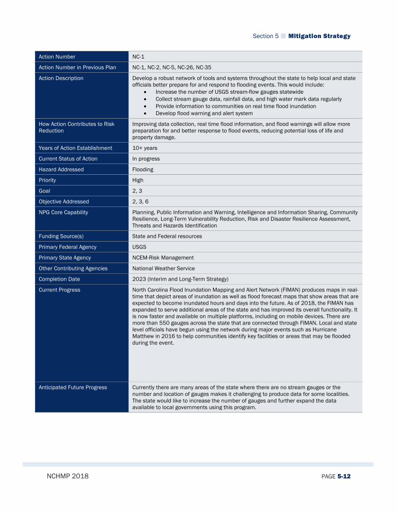
Section 5 Mitigation Strategy
NCHMP 2018 PAGE 5-12
Action Number NC-1
Action Number in Previous Plan NC-1, NC-2, NC-5, NC-26, NC-35
Action Description Develop a robust network of tools and systems throughout the state to help local and state officials better prepare for and respond to flooding events. This would include:
• Increase the number of USGS stream-flow gauges statewide • Collect stream gauge data, rainfall data, and high water mark data regularly • Provide information to communities on real time flood inundation • Develop flood warning and alert system
How Action Contributes to Risk Reduction
Improving data collection, real time flood information, and flood warnings will allow more preparation for and better response to flood events, reducing potential loss of life and property damage.
Years of Action Establishment 10+ years
Current Status of Action In progress
Hazard Addressed Flooding
Priority High
Goal 2, 3
Objective Addressed 2, 3, 6
NPG Core Capability Planning, Public Information and Warning, Intelligence and Information Sharing, Community Resilience, Long-Term Vulnerability Reduction, Risk and Disaster Resilience Assessment, Threats and Hazards Identification
Funding Source(s) State and Federal resources
Primary Federal Agency USGS
Primary State Agency NCEM-Risk Management
Other Contributing Agencies National Weather Service
Completion Date 2023 (Interim and Long-Term Strategy)
Current Progress North Carolina Flood Inundation Mapping and Alert Network (FIMAN) produces maps in real-time that depict areas of inundation as well as flood forecast maps that show areas that are expected to become inundated hours and days into the future. As of 2018, the FIMAN has expanded to serve additional areas of the state and has improved its overall functionality. It is now faster and available on multiple platforms, including on mobile devices. There are more than 550 gauges across the state that are connected through FIMAN. Local and state level officials have begun using the network during major events such as Hurricane Matthew in 2016 to help communities identify key facilities or areas that may be flooded during the event.
Anticipated Future Progress Currently there are many areas of the state where there are no stream gauges or the number and location of gauges makes it challenging to produce data for some localities. The state would like to increase the number of gauges and further expand the data available to local governments using this program.
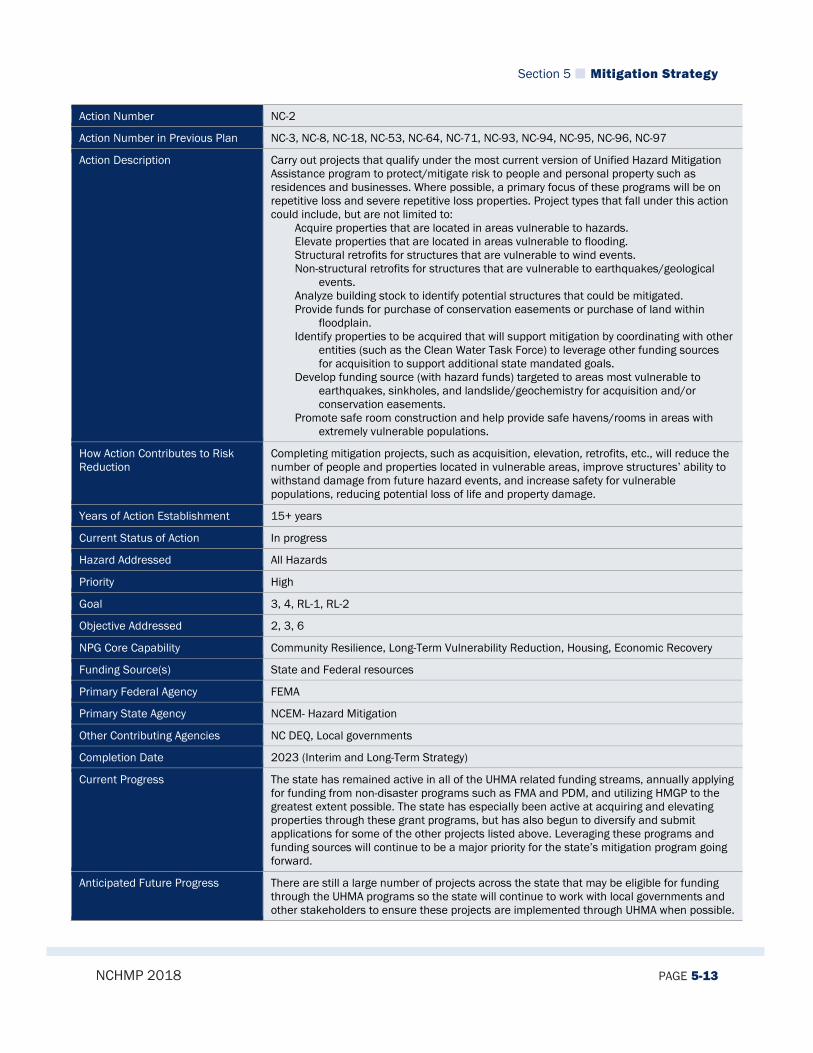
Section 5 Mitigation Strategy
NCHMP 2018 PAGE 5-13
Action Number NC-2
Action Number in Previous Plan NC-3, NC-8, NC-18, NC-53, NC-64, NC-71, NC-93, NC-94, NC-95, NC-96, NC-97
Action Description Carry out projects that qualify under the most current version of Unified Hazard Mitigation Assistance program to protect/mitigate risk to people and personal property such as residences and businesses. Where possible, a primary focus of these programs will be on repetitive loss and severe repetitive loss properties. Project types that fall under this action could include, but are not limited to:
Acquire properties that are located in areas vulnerable to hazards. Elevate properties that are located in areas vulnerable to flooding. Structural retrofits for structures that are vulnerable to wind events. Non-structural retrofits for structures that are vulnerable to earthquakes/geological
events. Analyze building stock to identify potential structures that could be mitigated. Provide funds for purchase of conservation easements or purchase of land within
floodplain. Identify properties to be acquired that will support mitigation by coordinating with other
entities (such as the Clean Water Task Force) to leverage other funding sources for acquisition to support additional state mandated goals.
Develop funding source (with hazard funds) targeted to areas most vulnerable to earthquakes, sinkholes, and landslide/geochemistry for acquisition and/or conservation easements.
Promote safe room construction and help provide safe havens/rooms in areas with extremely vulnerable populations.
How Action Contributes to Risk Reduction
Completing mitigation projects, such as acquisition, elevation, retrofits, etc., will reduce the number of people and properties located in vulnerable areas, improve structures’ ability to withstand damage from future hazard events, and increase safety for vulnerable populations, reducing potential loss of life and property damage.
Years of Action Establishment 15+ years
Current Status of Action In progress
Hazard Addressed All Hazards
Priority High
Goal 3, 4, RL-1, RL-2
Objective Addressed 2, 3, 6
NPG Core Capability Community Resilience, Long-Term Vulnerability Reduction, Housing, Economic Recovery
Funding Source(s) State and Federal resources
Primary Federal Agency FEMA
Primary State Agency NCEM- Hazard Mitigation
Other Contributing Agencies NC DEQ, Local governments
Completion Date 2023 (Interim and Long-Term Strategy)
Current Progress The state has remained active in all of the UHMA related funding streams, annually applying for funding from non-disaster programs such as FMA and PDM, and utilizing HMGP to the greatest extent possible. The state has especially been active at acquiring and elevating properties through these grant programs, but has also begun to diversify and submit applications for some of the other projects listed above. Leveraging these programs and funding sources will continue to be a major priority for the state’s mitigation program going forward.
Anticipated Future Progress There are still a large number of projects across the state that may be eligible for funding through the UHMA programs so the state will continue to work with local governments and other stakeholders to ensure these projects are implemented through UHMA when possible.

Section 5 Mitigation Strategy
NCHMP 2018 PAGE 5-14
Action Number NC-3
Action Number in Previous Plan NC-9, NC-19, NC-28, NC-32, NC-33, NC-34, NC-46, NC-56, NC-63, NC-65, NC-67, NC-68, NC-74, NC-85, NC-87, NC-88, NC-89, NC-90, NC-92
Action Description The state will provide training and publications to local governments, state agencies, and other organizations on emergency management and mitigation. Encompassed in this, the state will develop and implement an outreach program to receive feedback on mitigation programs and policies. These efforts may include:
• Train local emergency managers on various mitigation activities and funding opportunities.
• Educate public and private organizations on the theory and practice of hazard mitigation, and help them to identify how mitigation can become incorporated into their own routine functions or activities.
• Conduct interactive "Mitigation Planning Workshops” to local governments including use of GIS in Hazard Mitigation Planning. Potentially partner with Institute of Government to develop.
• Develop and conduct county-wide educational programs for local officials on wildfire programs such as Firewise Communities, Ready, Set, Go!, and Fire Adapted Communities, and on flood risk including flood mapping, new DFIRMs, flood insurance, etc.
• Develop and maintain a variety of widely-adaptable mitigation PowerPoints, brochures, publications, newsletters, and other information.
• Promote Wildfire Risk Reduction through the National Fire Plan and other funding sources to create landscape-level change across North Carolina (prescribed fire and hazard fuel reduction projects).
• Gain insights from local public officials on what additional products or services could assist them in developing local mitigation plans.
• Develop, publicize, and provide a wide variety of risk assessment products and planning services to assist local officials in their planning and risk reduction activities.
• Promote 406 mitigation through discussion and presentations with various state and federal partners.
• Participate in expositions and symposiums such as the North Carolina Aquariums Earth Day Expo, host booth(s) at county and state fairs, coordinate with county Cooperative Extension Services on events.
• Develop Bi-lingual mitigation messages. • Conduct direct outreach on non-structural mitigation measures at Local, Tribal, and
State agencies as well as with citizens.
How Action Contributes to Risk Reduction
Improving training, education, and outreach on emergency management and mitigation for local governments, state agencies, and other organizations will increase the implementation of mitigation activities, resulting in overall risk reduction.
Years of Action Establishment 15+ years
Current Status of Action In progress
Hazard Addressed All Hazards
Priority High
Goal 1, 2, 3, RL-1, RL-2
Objective Addressed 1, 2, 3, 4, 5, 6

Section 5 Mitigation Strategy
NCHMP 2018 PAGE 5-15
NPG Core Capability Public Information and Warning, Community Resilience
Funding Source(s) Federal and State resources
Primary Federal Agency FEMA
Primary State Agency NCEM- Risk Management
Other Contributing Agencies NC DEQ, NC FS
Completion Date 2023 (Interim and Long-Term Strategy)
Current Progress NCEM has provided a number of workshops and opportunities for local governments related to mitigation and has maintained a wide array of outreach materials on mitigation. Additionally, other state agencies have also been active in mitigation outreach over the past several years. For example, the NC Forest Service is currently conducting 300+ presentations/programs per year on these various programs. There is a statewide Firewise exhibit at the state fairgrounds that engages thousands of visitors throughout the 10-day event. NCFS receives federal pass through USFS funding for Fire Adapted Communities work to be completed in 4 NC Resource Conservation and Development Districts, the Appalachian RC&D FAC Coalition. These support funds will allow the RC&D’s to assist in expanding the FAC Concept across multiple States along the Appalachian Mountain range initially from Georgia into North Carolina and Virginia. Each of the North Carolina RC&Ds (4) received $32,000 of funding to encourage a grassroots effort for Fire Adapted Communities. This effort began in January 2017 in Western NC. There are 24 Nationally-recognized Firewise Communities in NC that are scattered throughout the state (see map of current communities in good standing: http://nfpa.maps.arcgis.com/apps/Viewer/index.html?appid=c4a788340df748f18d98d8363145bb67).
Anticipated Future Progress Training and outreach will continue to be a critical task for the state to carry out in terms of mitigation. NCEM will lead efforts to help local governments with grant funding opportunities and planning, as well as maintaining a public face to help inform citizens about the benefits of mitigation.

Section 5 Mitigation Strategy
NCHMP 2018 PAGE 5-16
Action Number NC-4
Action Number in Previous Plan NC-11
Action Description Evaluate emerging technologies and upgrade through hardware/software acquisition and training where appropriate and feasible.
How Action Contributes to Risk Reduction
Developing new technologies and software will improve the ability to evaluate risk and make better risk reduction decisions, minimizing potential loss of life and property damage.
Years of Action Establishment 15+ years
Current Status of Action In progress
Hazard Addressed All Hazards
Priority Moderate
Goal 1, 5, 6
Objective Addressed 3, 6
NPG Core Capability Planning, Intelligence and Information Sharing, Community Resilience, Long-Term Vulnerability Reduction, Risk and Disaster Resilience Assessment, Threats and Hazards Identification
Funding Source(s) State and Federal resources
Primary Federal Agency National Weather Service
Primary State Agency NCEM- Risk Management
Other Contributing Agencies NCGS, Forest Resources, NC Dam Safety, Local Governments, State Climate Office
Completion Date 2023 (Interim and Long-Term Strategy)
Current Progress NCEM is one of the leading developers of new technology and software in the country in terms of risk and vulnerability assessment. NCEM- Risk Management holds bi-annual meetings on the risk management plan which are often focused on new technologies. Indeed, one of the primary objectives of the RMCC is to focus on leveraging new technology to evaluate risk in the state. As new technologies have been developed within the state, staff have been trained to integrate these technologies into existing programs to ensure the most advanced and up to date information and data is being used. In addition, state staff keep up to date on using other technologies that have been developed outside of the state.
Anticipated Future Progress The state will continue to leverage technology going forward in an attempt to make the best possible decisions on risk reduction and minimizing damage to people and property across the state. As new technologies are constantly emerging, this is an area where there will often be quick developments and a need for constant vigilance to ensure the best available information is being used.
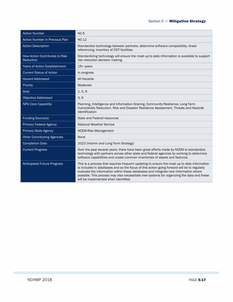
Section 5 Mitigation Strategy
NCHMP 2018 PAGE 5-17
Action Number NC-5
Action Number in Previous Plan NC-12
Action Description Standardize technology between partners, determine software compatibility, linear referencing, inventory of DOT facilities.
How Action Contributes to Risk Reduction
Standardizing technology will ensure the most up to date information is available to support risk reduction decision making.
Years of Action Establishment 15+ years
Current Status of Action In progress
Hazard Addressed All Hazards
Priority Moderate
Goal 1, 5, 6
Objective Addressed 3, 6
NPG Core Capability Planning, Intelligence and Information Sharing, Community Resilience, Long-Term Vulnerability Reduction, Risk and Disaster Resilience Assessment, Threats and Hazards Identification
Funding Source(s) State and Federal resources
Primary Federal Agency National Weather Service
Primary State Agency NCEM-Risk Management
Other Contributing Agencies None
Completion Date 2023 (Interim and Long-Term Strategy)
Current Progress Over the past several years, there have been great efforts made by NCEM to standardize technology with partners across other state and federal agencies by working to determine software capabilities and create common inventories of assets and features.
Anticipated Future Progress This is a process that requires frequent updating to ensure the most up to date information is included in databases and so the focus of this action going forward will be to regularly evaluate the information within these databases and integrate new information where possible. This process may also necessitate new systems for organizing the data and these will be implemented when identified.

Section 5 Mitigation Strategy
NCHMP 2018 PAGE 5-18
Action Number NC-6
Action Number in Previous Plan NC-13, NC-14, NC-37, NC-39, NC-40, NC-41, NC-42, NC-54, NC-55
Action Description Work with local communities to promote changes in local policies, regulations, and activities such as:
• Re-assess tree trimming policies of municipalities and power companies • Ensure that tree trimming policies of local governments have been reassessed to
comply with industry standards • Promote updating Building Codes in hazard-prone areas • Update Building Code to reflect hazard mitigation building techniques. • Encourage local governments to use their risk and historical hazard data for
purposes of modifying regulations, standards, ordinance to minimize their vulnerability.
• Promote river basin wide planning of flood hazard • Promote consideration of future build-out conditions when establishing land use
and floodplain management regulations. • Promote and support recognition programs, such as the Community Rating System • Promote improvement of storm drainage systems.
How Action Contributes to Risk Reduction
Promoting change and improvements in local policies, regulations, and activities, such as tree trimming policies, building codes, land use and floodplain management regulations, etc., will protect infrastructure, critical facilities, and other buildings, reducing potential vulnerability and property damage.
Years of Action Establishment 15+ years
Current Status of Action In progress
Hazard Addressed All Hazards
Priority High
Goal 1, 3, 4, 6
Objective Addressed 1, 2, 3, 4, 5
NPG Core Capability Planning, Public Information and Warning, Intelligence and Information Sharing, Community Resilience, Long-Term Vulnerability Reduction, Risk and Disaster Resilience Assessment, Threats and Hazards Identification, Housing, Natural and Cultural Resources
Funding Source(s) State and Local resources
Primary Federal Agency FEMA
Primary State Agency NCEM-Risk Management
Other Contributing Agencies Local Governments
Completion Date 2023 (Interim and Long-Term Strategy)
Current Progress Since the last update of the plan, the state has taken a fairly proactive approach and has even implemented stronger language related to freeboard standards into the state building code. Many local governments have likewise implemented stricter standards, regulations, and policies aimed at mitigating risk over the past several years and state officials have worked to help craft these policies and regulations when asked.
Anticipated Future Progress Where feasible, the state will continue to work with local governments going forward on improving these regulations and policies at the local level as new ideas are implemented and successful policies are identified.
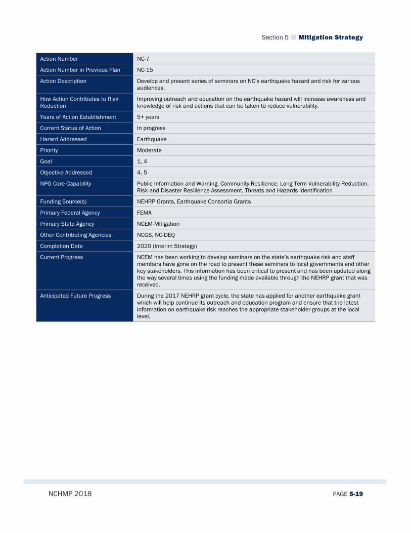
Section 5 Mitigation Strategy
NCHMP 2018 PAGE 5-19
Action Number NC-7
Action Number in Previous Plan NC-15
Action Description Develop and present series of seminars on NC’s earthquake hazard and risk for various audiences.
How Action Contributes to Risk Reduction
Improving outreach and education on the earthquake hazard will increase awareness and knowledge of risk and actions that can be taken to reduce vulnerability.
Years of Action Establishment 5+ years
Current Status of Action In progress
Hazard Addressed Earthquake
Priority Moderate
Goal 1, 4
Objective Addressed 4, 5
NPG Core Capability Public Information and Warning, Community Resilience, Long-Term Vulnerability Reduction, Risk and Disaster Resilience Assessment, Threats and Hazards Identification
Funding Source(s) NEHRP Grants, Earthquake Consortia Grants
Primary Federal Agency FEMA
Primary State Agency NCEM-Mitigation
Other Contributing Agencies NCGS, NC-DEQ
Completion Date 2020 (Interim Strategy)
Current Progress NCEM has been working to develop seminars on the state’s earthquake risk and staff members have gone on the road to present these seminars to local governments and other key stakeholders. This information has been critical to present and has been updated along the way several times using the funding made available through the NEHRP grant that was received.
Anticipated Future Progress During the 2017 NEHRP grant cycle, the state has applied for another earthquake grant which will help continue its outreach and education program and ensure that the latest information on earthquake risk reaches the appropriate stakeholder groups at the local level.

Section 5 Mitigation Strategy
NCHMP 2018 PAGE 5-20
Action Number NC-8
Action Number in Previous Plan NC-16, NC-36
Action Description Look into new USGS mapping of geologic indicators and use this information to inform local and state level risk assessments
How Action Contributes to Risk Reduction
Utilizing new and updated information and data on geologic hazards will improve risk assessments and understanding of existing geologic risks.
Years of Action Establishment 15+ years
Current Status of Action In progress
Hazard Addressed Earthquake, Geological
Priority Low
Goal 1, 3, 5, 6
Objective Addressed 1, 4, 5, 6
NPG Core Capability Planning, Community Resilience, Long-Term Vulnerability Reduction, Risk and Disaster Resilience Assessment, Threats and Hazards Identification
Funding Source(s) State and Federal resources
Primary Federal Agency USGS
Primary State Agency NC-DEQ
Other Contributing Agencies NCEM- Risk Management
Completion Date 2020 (Interim Strategy)
Current Progress USGS and NC DEQ are frequently gathering and analyzing additional data and producing maps that contain risk-related information. As of 2018, there are a number of new or updated sources of information that can be integrated into state and local level risk assessments. The state has integrated this data to some degree, but further evaluation of this data needs to take place.
Anticipated Future Progress State officials will analyze the many sources of information that the USGS provides through its mapping to determine the most effective means of mitigating geologic hazards. As new data becomes available over the coming years, this data will also be used when possible to improve risk management.

Section 5 Mitigation Strategy
NCHMP 2018 PAGE 5-21
Action Number NC-9
Action Number in Previous Plan NC-21
Action Description Provide wildfire mitigation funds to identified communities at risk to implement wildfire mitigation projects after they have been identified by the Southern Wildfire Risk Assessment Portal (SouthWRAP), Community Wildfire Risk Assessments, and Community Wildfire Protection Plans.
How Action Contributes to Risk Reduction
Increasing wildfire mitigation funding for at risk communities will allow those communities to develop CWPPs and identify areas of concern and mitigation measures to reduce vulnerability to wildfire.
Years of Action Establishment 10+ years
Current Status of Action In progress
Hazard Addressed Wildfire
Priority Low
Goal 3, 4, 6
Objective Addressed 2, 4, 5
NPG Core Capability Planning, Community Resilience, Long-Term Vulnerability Reduction, Risk and Disaster Resilience Assessment, Threats and Hazards Identification
Funding Source(s) State and Federal resources
Primary Federal Agency US Forest Service
Primary State Agency NC Forest Service
Other Contributing Agencies NCEM
Completion Date 2020 (Interim Strategy)
Current Progress Over 760 CWPPs have been completed and more are in some stage of development (CWPPs are completed at the fire district level). County Emergency Management, Fire Departments, and (where applicable) Federal partners have been part of the team that has worked on these CWPPs. The CWPP identifies areas of concerns and mitigation measures are recommended to improve communities understanding of the risk of wildfire and to reduce hazardous fuels conditions. Over 70,000 acres of prescribed fire was applied to state and private lands in the last year
Anticipated Future Progress As noted, CWPPs have been completed in many fire districts across the state, but since there are still many districts that are in the process of developing plans, this action will remain in place.
Section 5 Mitigation Strategy
NCHMP 2018 PAGE 5-22
Action Number NC-10
Action Number in Previous Plan NC-22, NC-31
Action Description Develop and distribute custom Dam Safety Manual for the 100 counties in North Carolina, with data specific for each county and enhance the “Workbook” for local planning officials to include more information on dam failure mitigation activities and recommendations from local planners.
How Action Contributes to Risk Reduction
Distributing county-specific Dam Safety Manuals will improve awareness of local dam failure risk and mitigation activities that can be implemented to reduce vulnerability.
Years of Action Establishment 5+ years
Current Status of Action In progress
Hazard Addressed Dam Failure
Priority Low
Goal 1, 2, 3, 5
Objective Addressed 1, 2, 4, 5, 6
NPG Core Capability Planning, Public Information and Warning, Intelligence and Information Sharing, Community Resilience, Long-Term Vulnerability Reduction, Risk and Disaster Resilience Assessment, Threats and Hazards Identification
Funding Source(s) State resources
Primary Federal Agency US ACE
Primary State Agency NC DEQ
Other Contributing Agencies NCEM
Completion Date 2020 (Interim Strategy)
Current Progress Dam Safety officials have been working on updating Dam Safety Manuals and given the issues caused by dam failures during Hurricane Matthew in 2016, there is an increased awareness among state officials that it is critical to work with local officials and dam owners to ensure they are well-educated about dam safety and measures that can be implemented to mitigate future risk of failures.
Anticipated Future Progress Dam Safety plans to continue to work on developing educational materials that increase awareness of the risks of dam failure throughout the state. Although a manual is certainly one of those tools and will continue to be going forward, the state also plans to work on developing other outreach and education techniques in the future.

Section 5 Mitigation Strategy
NCHMP 2018 PAGE 5-23
Action Number NC-11
Action Number in Previous Plan NC-23, NC-38, NC-49, NC-50
Action Description As part of its role in mitigation, the state would like to emphasize advocating for additional funding for important mitigation-related programming including:
• Find a source of funds targeted for repairs to high hazard dams. • Promote full funding of NC Flood Mapping Program to complete new Flood
Insurance Studies for entire state. • Provide state funding to the State Climate Office; funding not currently coming from
Legislative Sources. (MH) (-60% from UNC System and remainder from grants) • Present the American Society of Dam Safety Officials (ASDSO) report on reductions
in FEMA funding, and ask for assistance/supplemental funding into The Dam Safety Fund to keep Dam Safety Program viable.
How Action Contributes to Risk Reduction
Increasing funding for mitigation-related programming will advance mitigation efforts and implementation, reducing overall risk and vulnerability.
Years of Action Establishment 15+ years
Current Status of Action In progress
Hazard Addressed All Hazards
Priority Moderate
Goal 1, 2, 3, 4, 5, 6
Objective Addressed 1, 2, 3, 4, 6
NPG Core Capability Planning, Community Resilience, Long-Term Vulnerability Reduction, Risk and Disaster Resilience Assessment, Threats and Hazards Identification, Housing, Natural and Cultural Resources
Funding Source(s) State and Federal resources
Primary Federal Agency FEMA
Primary State Agency NCEM
Other Contributing Agencies NC-DEQ
Completion Date 2023 (Interim and Long-Term Strategy)
Current Progress One of the state’s primary roles in mitigation has been as an advocate for programs across the state that advance mitigation efforts. The state has been a strong advocate for the allocation of funding to a number of programs that are related to mitigation and, in many cases, has been a major contributor to those programs.
Anticipated Future Progress In the future, the state will continue to act as an advocate for mitigation-related programs from the state legislature, federal government, and numerous other agencies and organizations. The need for funding to implement mitigation projects and programs will likely continue to exist and so this action will continue to be a priority for the state.

Section 5 Mitigation Strategy
NCHMP 2018 PAGE 5-24
Action Number NC-12
Action Number in Previous Plan NC-24
Action Description Calculate dam failure flood inundation areas for all high hazard dams.
How Action Contributes to Risk Reduction
Determining dam failure flood inundation areas will improve dam failure risk assessments and understanding of existing risk.
Years of Action Establishment 15+ years
Current Status of Action In progress
Hazard Addressed Dam Failure
Priority High
Goal 1, 3, 4, 5
Objective Addressed 1, 2, 4, 6
NPG Core Capability Planning, Community Resilience, Long-Term Vulnerability Reduction, Risk and Disaster Resilience Assessment, Threats and Hazards Identification, Housing, Natural and Cultural Resources
Funding Source(s) State and Federal resources
Primary Federal Agency FEMA, US ACE
Primary State Agency NCEM-Risk Management
Other Contributing Agencies NC DEQ
Completion Date 2023 (Interim and Long-Term Strategy)
Current Progress Dam inundation areas have not been completed for all high hazard dams in the state. Some counties have all high hazard dam inundation areas mapped while others have few or none. This is a priority for the state going forward, especially in the wake of Hurricane Matthew where dam failures were a significant issue for many communities.
Anticipated Future Progress As noted above, dam failure inundation mapping is a major priority for the state going forward and funding and effort will be targeted at implementing this mapping and analysis for as many dams as possible in the coming years.
Section 5 Mitigation Strategy
NCHMP 2018 PAGE 5-25
Action Number NC-13
Action Number in Previous Plan NC-25, NC-27, NC-51, NC-81
Action Description The state and localities need to improve the existing system for assessing drought risk and understanding drought impacts. There are a number of ways to advance this system overall including:
• Conduct a study on developing drought frequency data to provide to local governments.
• Increase monitoring of precipitation and ground/surface water supplies. • Perform a drought economic impact study analyzing drought through surveys to
local communities, state agencies, and industry farmers and other affected parties. • Coordinate all drought mitigation activities with the Drought Management Advisory
Council.
How Action Contributes to Risk Reduction
Improving the ability to assess drought risk will increase understanding of impacts and vulnerability, making it possible to identify necessary mitigation and reduce future loss.
Years of Action Establishment 15+ years
Current Status of Action In progress
Hazard Addressed Drought
Priority High
Goal 1, 2, 3, 4, 5, 6
Objective Addressed 1, 2, 4, 6
NPG Core Capability Planning, Public Information and Warning, Intelligence and Information Sharing, Community Resilience, Long-Term Vulnerability Reduction, Risk and Disaster Resilience Assessment, Threats and Hazards Identification, Health and Social Services, Natural and Cultural Resources
Funding Source(s) State and Federal resources
Primary Federal Agency US Department of Agriculture
Primary State Agency NCEM
Other Contributing Agencies State Climate Office
Completion Date 2023 (Interim and Long-Term Strategy)
Current Progress Dam inundation areas have not been completed for all high hazard dams in the state. Some counties have all high hazard dam inundation areas mapped while others have few or none. This is a priority for the state going forward, especially in the wake of Hurricane Matthew where dam failures were a significant issue for many communities.
Anticipated Future Progress As noted above, dam failure inundation mapping is a major priority for the state going forward and funding and effort will be targeted at implementing this mapping and analysis for as many dams as possible in the coming years.
Section 5 Mitigation Strategy
NCHMP 2018 PAGE 5-26
Action Number NC-14
Action Number in Previous Plan NC-30, NC-98
Action Description One of the state’s primary goals in mitigation is to provide useful data, studies and other products that can help local communities better understand their risks. To achieve this, the state will:
• Continually upgrade statewide spatial data maintained in-house through multiple data sources.
• Develop studies, collect, and analyze data on areas of risk to various hazards.
How Action Contributes to Risk Reduction
Enhancing available data and products will enable local communities to conduct better risk assessments and improve understanding of hazards and risk.
Years of Action Establishment 15+ years
Current Status of Action In progress
Hazard Addressed All Hazards
Priority High
Goal 1, 2, 5
Objective Addressed 1, 2, 3, 4, 6
NPG Core Capability Planning, Intelligence and Information Sharing, Community Resilience, Long-Term Vulnerability Reduction, Risk and Disaster Resilience Assessment, Threats and Hazards Identification
Funding Source(s) State and Federal resources
Primary Federal Agency FEMA
Primary State Agency NCEM-Risk Management
Other Contributing Agencies CGIA, NCGS
Completion Date 2023 (Interim and Long-Term Strategy)
Current Progress NCEM’s Risk Management has worked with a number of other state agencies to ensure the widespread availability of spatial data, especially in terms of data that can help assess and analyze risk. North Carolina has been one of the leading state’s when it comes to spatial risk data production and this is still the case in 2018.
Anticipated Future Progress In the coming years, the state hopes to further expand its warehouse of spatial data and to produce more user-friendly tools for visualization of this data both to government officials and the public. In this way, the data will be used to better inform users of areas of high risk and allow them to make the best possible decisions regarding mitigation action to reduce those risks.
Section 5 Mitigation Strategy
NCHMP 2018 PAGE 5-27
Action Number NC-15
Action Number in Previous Plan NC-47
Action Description Engage Federal, State, and Local fire service resources to collaborate on Wildfire Risk and proposed mitigation solutions.
How Action Contributes to Risk Reduction
Collaborating on wildfire risk and mitigation efforts will increase implementation success and goal achievement, minimizing existing wildfire vulnerability.
Years of Action Establishment 15+ years
Current Status of Action In progress
Hazard Addressed Wildfire
Priority Low
Goal 1, 5, 6
Objective Addressed 1, 4, 5
NPG Core Capability Planning, Intelligence and Information Sharing, Community Resilience, Long-Term Vulnerability Reduction, Risk and Disaster Resilience Assessment, Threats and Hazards Identification, Fire Management and Suppression
Funding Source(s) State and Local resources
Primary Federal Agency US Forest Service
Primary State Agency NC Forest Service
Other Contributing Agencies NCEM
Completion Date 2023 (Interim and Long-Term Strategy)
Current Progress A Community Mitigation Assistance Team was brought in by the Pisgah Ranger district in September 2017 to encourage the formation of a McDowell County Partnership among community members and cooperators. An active partnership (Fire Safe Cherokee County) has been in place since 2010 among Federal, State, and County personnel, and local stakeholders in Cherokee County. Wildland Fire Suppression for Fire Departments and Ready, Set, Go! Train-the-Trainer courses are planned throughout the year, as well as other interagency training for risk reduction. Biennially, there is a cooperators meeting between state and federal agencies about wildland fire. The NCFS will host 3 Assessing Structure Ignition Potential from Wildfire (NFPA) in early 2018.
Anticipated Future Progress The state will continue to work with officials at both the local and federal level to ensure the best possible outcomes in terms of wildfire mitigation. The state intends to leverage existing relationships with local, federal, and other state agencies to collaborate and achieve common goals going forward in mitigation.

Section 5 Mitigation Strategy
NCHMP 2018 PAGE 5-28
Action Number NC-16
Action Number in Previous Plan NC-66
Action Description Produce future volumes of NC measuring success publications documenting losses avoided – quantitatively and qualitatively.
How Action Contributes to Risk Reduction
Documenting losses avoided will improve the public’s perception of mitigation, increasing support for future mitigation projects to further reduce vulnerability.
Years of Action Establishment 10+ years
Current Status of Action In progress
Hazard Addressed All Hazards
Priority Low
Goal 4, 6
Objective Addressed 2, 5
NPG Core Capability Planning, Public Information and Warning, Community Resilience, Long-Term Vulnerability Reduction, Risk and Disaster Resilience Assessment, Threats and Hazards Identification, Housing
Funding Source(s) State resources
Primary Federal Agency FEMA
Primary State Agency NCEM-Hazard Mitigation
Other Contributing Agencies None
Completion Date 2023 (Interim and Long-Term Strategy)
Current Progress During a number of past disaster events, the state has worked in conjunction with FEMA to develop losses avoided studies. This has been carried out both through quantitative and qualitative means. As the state continues to recover from Hurricane Matthew and the damages associated with that storm, it is likely that future analysis of losses avoided will take place.
Anticipated Future Progress Losses avoided studies are one of the primary means of producing evidence of the effectiveness of past mitigation projects. As a result, these studies are critical to both the public’s perception of mitigation projects as well as the basis for demonstrating that similar future projects should be implemented. The state will continue to carry out these analyses whenever possible to ensure that projects that are being implemented have merit and are a worthwhile investment.
Section 5 Mitigation Strategy
NCHMP 2018 PAGE 5-29
Action Number NC-17
Action Number in Previous Plan NC-73
Action Description Work with the NC DEQ Division of Coastal Management in developing the hazard mitigation portion of the revised planning guidelines under the Coastal Area Management Act (CAMA).
How Action Contributes to Risk Reduction
Integrating land use planning and hazard mitigation planning efforts will result in better coordination and consistency and improve overall resilience through regulation.
Years of Action Establishment 15+ years
Current Status of Action In progress
Hazard Addressed Hurricanes and Coastal Hazards, Flooding
Priority Low
Goal 1, 3, 4, 6, RL-2
Objective Addressed 2, 4, 5
NPG Core Capability Planning, Community Resilience, Long-Term Vulnerability Reduction, Risk and Disaster Resilience Assessment, Threats and Hazards Identification
Funding Source(s) State resources
Primary Federal Agency FEMA
Primary State Agency NCEM-Risk Management
Other Contributing Agencies NC DEQ-Coastal Management
Completion Date 2020 (Interim Strategy)
Current Progress NC DEQ did update of the planning guidelines for CAMA and unfortunately there was no coordination with NCEM. But based on conversations during this update cycle, NC DEQ and NCEM are going to try to work together on additional projects in the future, such as integrating CAMA planning with the mitigation planning cycle to promote consistencies across planning documents.
Anticipated Future Progress As mentioned above, one of the biggest areas of focus going forward on this action is to try to improve coordination between NCEM and NC DEQ so that CAMA land use planning and hazard mitigation planning are not developed in separate silos, but instead are integrated processes that coordinate together. The main goal will be to try to line up the timing of these processes at the local level to facilitate integration and reduce inconsistencies across plans.

Section 5 Mitigation Strategy
NCHMP 2018 PAGE 5-30
Action Number NC-18
Action Number in Previous Plan NC-76
Action Description Assist all counties and stakeholders in developing their fuel plans for back-up fuel statewide.
How Action Contributes to Risk Reduction
Developing and maintaining up to date fuel plans will ensure back-up fuel is available when necessary, increasing resilience during disaster events.
Years of Action Establishment 10+ years
Current Status of Action In progress
Hazard Addressed All Hazards
Priority Moderate
Goal 1, 3
Objective Addressed 5
NPG Core Capability Planning, Community Resilience, Long-Term Vulnerability Reduction, Risk and Disaster Resilience Assessment, Threats and Hazards Identification, Logistics and Supply Chain Management, Economic Recovery
Funding Source(s) State resources
Primary Federal Agency FEMA
Primary State Agency NCEM-Logistics
Other Contributing Agencies NC DEQ- State Energy Program
Completion Date 2023 (Interim and Long-Term Strategy)
Current Progress The state has worked with local counties on a continual basis to help them prepare their fuel plans and these have been completed for many of the communities in the state.
Anticipated Future Progress These fuel plans require consistent updating, so the state will need to keep this action in place and continue to communicate with the counties to ensure fuel plans are up to date and accurate.

Section 5 Mitigation Strategy
NCHMP 2018 PAGE 5-31
Action Number NC-19
Action Number in Previous Plan NC-77, NC-84
Action Description Hold annual meetings with locals and utility entities on ice buildup, measurements, and related issues.
How Action Contributes to Risk Reduction
Holding annual meetings on issues related to severe winter weather will improve coordination and response during such events.
Years of Action Establishment 15+ years
Current Status of Action In progress
Hazard Addressed Severe Winter Weather
Priority Moderate
Goal 1, 3
Objective Addressed 1, 2, 5
NPG Core Capability Planning, Public Information and Warning, Intelligence and Information Sharing, Community Resilience, Long-Term Vulnerability Reduction, Risk and Disaster Resilience Assessment, Threats and Hazards Identification
Funding Source(s) State resources
Primary Federal Agency National Weather Service
Primary State Agency NCEM-Public Assistance
Other Contributing Agencies NC Utilities Commission, Utility Companies, Local Governments
Completion Date 2023 (Interim and Long-Term Strategy)
Current Progress As of 2018, the state has had some meetings with utility entities and local governments on addressing issues related to severe winter weather. These meetings often take place at the local level and state officials attend when possible.
Anticipated Future Progress The state would like to improve its attendance at these meetings going forward as there are often many coordination meetings at the local level that the state does not attend. These are critical opportunities for coordination on issues such as maintaining power during major events, so the state will re-focus on attending these meetings in the future when possible.

Section 5 Mitigation Strategy
NCHMP 2018 PAGE 5-32
Action Number NC-20
Action Number in Previous Plan NC-79
Action Description Enhance the NC ECO-Net through the State Climate Office to provide comprehensive weather and environmental monitoring in each of NC's 100 counties.
How Action Contributes to Risk Reduction
Improving comprehensive weather and environmental monitoring will allow more preparation for and better response to hazard events, reducing potential loss of life and property damage.
Years of Action Establishment 15+ years
Current Status of Action In progress
Hazard Addressed All Hazards
Priority Moderate
Goal 1, 2, 5, 6
Objective Addressed 1, 2, 3, 6
NPG Core Capability Planning, Public Information and Warning, Intelligence and Information Sharing, Community Resilience, Long-Term Vulnerability Reduction, Risk and Disaster Resilience Assessment, Threats and Hazards Identification,
Funding Source(s) State resources
Primary Federal Agency National Oceanic and Atmospheric Administration
Primary State Agency State Climate Office
Other Contributing Agencies NCEM
Completion Date 2023 (Interim and Long-Term Strategy)
Current Progress There is infrastructure for ECO-Net in place and it is all functioning correctly and at full capacity. However, the one shortfall is that there are not 100 stations up and functioning yet for all of the counties.
Anticipated Future Progress As mentioned above, the ECO-Net system is fully in place and functioning, but the remaining work that needs to be done entails setting up and integrating a station in each of North Carolina’s 100 counties. The plan is to try to get all of the 100 planned stations set up and integrated by 2023.
Section 5 Mitigation Strategy
NCHMP 2018 PAGE 5-33
Action Number NC-21
Action Number in Previous Plan NC-99
Action Description Implement projects that help provide early warning, data, and/or reduce functional downtime to the emergency management community and public.
How Action Contributes to Risk Reduction
Improving early warnings and reducing functional downtime will allow better and faster response to hazard events, reducing potential loss of life and property damage.
Years of Action Establishment 15+ years
Current Status of Action In progress
Hazard Addressed All Hazards
Priority Moderate
Goal 2
Objective Addressed 1, 3, 6
NPG Core Capability Planning, Public Information and Warning, Intelligence and Information Sharing, Community Resilience, Long-Term Vulnerability Reduction, Risk and Disaster Resilience Assessment, Threats and Hazards Identification
Funding Source(s) State resources
Primary Federal Agency FEMA
Primary State Agency NCEM-Hazard Mitigation
Other Contributing Agencies Local Governments
Completion Date 2023 (Interim and Long-Term Strategy)
Current Progress The state has a number of mechanisms in place to provide early warning information for local governments including the FIMAN and the Emergency Alert System (EAS). The state has also worked with local governments to provide early warning sirens and other alert systems to help reduce functional downtime for the public and local governments.
Anticipated Future Progress In the future, the state will continually aim to improve the implementation of its early warning systems such as the EAS, so that citizens and local governments can respond to emergencies as quickly and effectively as possible. This may include integrating new technologies where possible and/or expanding systems in ways that help early warning messages reach additional people.
Section 5 Mitigation Strategy
NCHMP 2018 PAGE 5-34
Action Number NC-22
Action Number in Previous Plan NC-101
Action Description Develop and maintain an Enhanced State Hazard Mitigation Plan to increase HMGP funding subsequent to a flood disaster.
How Action Contributes to Risk Reduction
Developing and maintain an Enhanced State Hazard Mitigation Plan will increase funding and implementation of the plan, reducing vulnerability and minimizing risk.
Years of Action Establishment 5+ years
Current Status of Action In progress
Hazard Addressed All Hazards
Priority High
Goal 1, 2, 3, 4, 5, 6, RL-1, RL-2
Objective Addressed 1, 2, 3, 4, 5, 6
NPG Core Capability Planning, Public Information and Warning, Intelligence and Information Sharing, Community Resilience, Long-Term Vulnerability Reduction, Risk and Disaster Resilience Assessment, Threats and Hazards Identification, Economic Recovery, Health and Social Services, Housing, Natural and Cultural Resources
Funding Source(s) State resources
Primary Federal Agency FEMA
Primary State Agency NCEM-Risk Management
Other Contributing Agencies All State Agencies
Completion Date 2023 (Interim and Long-Term Strategy)
Current Progress The state has worked to maintain all aspects of its Enhanced Plan over the past five years and, during the 2018 update, has attempted to improve on several of the gaps that existed during previous versions of the plan with regard to Enhanced Plan status. This update includes a major overhaul of the plan structure and content and one of the primary intents of this overhaul was to more explicitly address many weaknesses in past versions.
Anticipated Future Progress In future updates, the state will continue to maintain the Enhanced Plan status that it has achieved and will ensure that the components of the mitigation plan are integrated into the state’s overall mitigation program to achieve implementation of the plan whenever possible.
Section 5 Mitigation Strategy
NCHMP 2018 PAGE 5-35
Action Number NC-23
Action Number in Previous Plan NC-102
Action Description Develop and conduct exercise models/exercises to continually update prevention measures, biosecurity recommendations and early response strategies to ensure that disease mitigation and response remain effective and efficient.
How Action Contributes to Risk Reduction
Developing and conducting exercise models/exercises will ensure disease transmission prevention and response are implemented effectively and new strategies are developed to reduce the spread of disease.
Years of Action Establishment 5+ years
Current Status of Action In progress
Hazard Addressed Infectious Disease
Priority Low
Goal 1, 5
Objective Addressed 1, 2, 5, 6
NPG Core Capability Planning, Intelligence and Information Sharing, Community Resilience, Long-Term Vulnerability Reduction, Risk and Disaster Resilience Assessment, Threats and Hazards Identification, Health and Social Services
Funding Source(s) State resources
Primary Federal Agency Centers for Disease Control and Prevention
Primary State Agency NC Department of Health and Human Services
Other Contributing Agencies NC Department of Agriculture, NCEM
Completion Date 2023 (Interim and Long-Term Strategy)
Current Progress The NC Department of Health and Human Services has conducted a number of exercises over the past several years which have been integral in helping the department identify prevention measures that could be implemented to reduce risk to infectious diseases and also to develop new strategies for early response. These exercises have included representatives from multiple partner state agencies, but were primarily led by NC DHHS.
Anticipated Future Progress Going forward, NC DHHS plans to continue to conduct exercises and models to ensure ongoing vigilance regarding disease transmission prevention activities. Continuing to carry out these activities will allow state officials to interact and coordinate in scenarios that can help them understand potential real-world conditions and develop strategies to improve prevention practices. NC DHHS will work to include more stakeholders from other state agencies in future activities and generally broaden the number of officials who are trained in these activities.

Section 5 Mitigation Strategy
NCHMP 2018 PAGE 5-36
Action Number NC-24
Action Number in Previous Plan NC-105
Action Description Increase State Lab capabilities to include ability to test for Foreign Animal Diseases (FADs) and Infectious Diseases (IDs) that most threaten North Carolina’s citizens and animals.
How Action Contributes to Risk Reduction
Increasing capabilities to test for diseases will improve awareness of new threats and enable preventative measures to be implemented as necessary.
Years of Action Establishment 5+ years
Current Status of Action In progress
Hazard Addressed Infectious Disease
Priority Low
Goal 1, 3, 5
Objective Addressed 1, 5, 6
NPG Core Capability Planning, Community Resilience, Long-Term Vulnerability Reduction, Risk and Disaster Resilience Assessment, Threats and Hazards Identification, Health and Social Services
Funding Source(s) State resources
Primary Federal Agency Centers for Disease Control and Prevention
Primary State Agency NC Department of Health and Human Services
Other Contributing Agencies NC Department of Agriculture, NCEM
Completion Date 2023 (Interim and Long-Term Strategy)
Current Progress As new technology and systems have been developed, they have been integrated into the State Lab’s capabilities to test for diseases with a focus on those diseases that are most likely to affect citizens in North Carolina. Many improvements have been made over the past 5 years, especially as new threats have emerged in the state.
Anticipated Future Progress In the constantly evolving environment of disease transmission, testing for diseases is a critical activity that the State Lab will continue to carry out on a regular basis. A major focus of this action is to stay aware of new threats as they emerge over the coming years and to ensure that these new threats are identified quickly and that preventative action can be taken by health officials at all levels. The State Lab will continue to be a key player in this activity and will continue to integrate new testing technologies and strategies when available.

Section 5 Mitigation Strategy
NCHMP 2018 PAGE 5-37
Action Number NC-25
Action Number in Previous Plan New Action
Action Description Meet annually with NC Housing Finance Agency to identify available funding that could be used for mitigation and discuss opportunities to collaborate.
How Action Contributes to Risk Reduction
Identifying available funding and opportunities for collaboration annually will increase implementation of mitigation activities, reducing vulnerability and minimizing risk.
Years of Action Establishment New Action
Current Status of Action In progress
Hazard Addressed All Hazards
Priority Moderate
Goal 1, 4, RL-1, RL-2
Objective Addressed 1, 2, 4
NPG Core Capability Planning, Community Resilience, Long-Term Vulnerability Reduction, Risk and Disaster Resilience Assessment,
Funding Source(s) State resources
Primary Federal Agency N/A
Primary State Agency NCEM
Other Contributing Agencies NC Housing Finance Agency
Completion Date 2023 (Interim and Long-Term Strategy)
Current Progress New Action
Anticipated Future Progress The NC Housing Finance Agency may be a source of funding for many project types that overlap with mitigation, including elevation of residential structures. NCEM hopes to meet with the agency on an annual basis to discuss joint ventures that may be undertaken to reduce risk and improve the lives of citizens through these funding sources.

Section 5 Mitigation Strategy
NCHMP 2018 PAGE 5-38
Action Number NC-26
Action Number in Previous Plan New Action
Action Description Directly integrate mitigation actions from state hazard mitigation plan into RiskMAP program to ensure progress is being tracked and recognized.
How Action Contributes to Risk Reduction
Ensuring that mitigation progress is tracked and recognized will help identify obstacles for implementation and increase the likelihood of successfully completion of mitigation efforts.
Years of Action Establishment New Action
Current Status of Action In progress
Hazard Addressed All Hazards
Priority Moderate
Goal 1, 4, 5
Objective Addressed 2, 4, 6
NPG Core Capability Planning, Community Resilience, Long-Term Vulnerability Reduction, Risk and Disaster Resilience Assessment, Threats and Hazards Identification
Funding Source(s) State resources
Primary Federal Agency FEMA
Primary State Agency NCEM
Other Contributing Agencies All State Agencies
Completion Date 2023 (Interim and Long-Term Strategy)
Current Progress New Action
Anticipated Future Progress In the past NCEM has tracked progress of action via RiskMAP, but this has not been consistent or coordinated with the mitigation plan’s actions, so going forward the state would like to develop a more formalized process for tracking progress in RiskMap that coincides with the annual review of the state hazard mitigation plan.

Section 5 Mitigation Strategy
NCHMP 2018 PAGE 5-39
Action Number NC-27
Action Number in Previous Plan New Action
Action Description Encourage use of PA 406 Mitigation program after disasters to rebuild public infrastructure by identifying potential projects prior to storm events so they are ready to implement when structures/facilities are damaged.
How Action Contributes to Risk Reduction
Identifying potential projects for PA 406 Mitigation funding prior to storm events will ensure that infrastructure can be rebuilt with less risk following a disaster event.
Years of Action Establishment New Action
Current Status of Action In progress
Hazard Addressed All Hazards
Priority Moderate
Goal 3, 4, 5, 6
Objective Addressed 1, 2, 4
NPG Core Capability Planning, Community Resilience, Long-Term Vulnerability Reduction, Risk and Disaster Resilience Assessment, Threats and Hazards Identification, Critical Transportation, Infrastructure Systems, Economic Recovery
Funding Source(s) State resources
Primary Federal Agency FEMA
Primary State Agency NCEM
Other Contributing Agencies NC DOT, All State Agencies
Completion Date 2023 (Interim and Long-Term Strategy)
Current Progress New Action
Anticipated Future Progress NCEM and other state agencies have only infrequently used 406 Mitigation funding to help rebuild after disaster events because there is often pressure to rebuild quickly and identified measures to integrate mitigation techniques into the rebuilding process have not been defined ahead of time. As a result, the state would like to continue to work on improving the number of projects that use this funding so that infrastructure is not built back after a disaster with the same level of risk that it had prior to the disaster.
Section 5 Mitigation Strategy
NCHMP 2018 PAGE 5-40
5.4.4 Actions that were identified as combined, deleted, or completed during 2018 plan update

Section 5 Mitigation Strategy
NCHMP 2018 PAGE 5-41
Action Number NC-28
Action Number in Previous Plan NC-2
Action Description Collect stream gauge data, rainfall data, and high-water mark data regularly
How Action Contributes to Risk Reduction
Years of Action Establishment
Current Status of Action Combined into NC-1
Hazard Addressed Flooding
Priority
Goal
Objective Addressed 1
NPG Core Capability
Funding Source(s) State resources
Primary Federal Agency USGS
Primary State Agency NCEM-Risk Management
Other Contributing Agencies National Weather Service
Completion Date Combined into NC-1
Current Progress Combined into NC-1
Anticipated Future Progress

Section 5 Mitigation Strategy
NCHMP 2018 PAGE 5-42
Action Number NC-29
Action Number in Previous Plan NC-4
Action Description Identify source of funds to assist owners of agricultural business/low-income households/small business owners to purchase flood insurance.
How Action Contributes to Risk Reduction
Years of Action Establishment
Current Status of Action Deleted
Hazard Addressed Flooding
Priority
Goal
Objective Addressed 1
NPG Core Capability
Funding Source(s) Resources to be determined
Primary Federal Agency
Primary State Agency NCEM
Other Contributing Agencies Dept. of Commerce, Dept. of Agriculture
Completion Date Deleted
Current Progress Since no progress has been made on this action and it seems somewhat unrealistic that it will be achieved going forward, the planning team determined that it should be deleted.
Anticipated Future Progress

Section 5 Mitigation Strategy
NCHMP 2018 PAGE 5-43
Action Number NC-30
Action Number in Previous Plan NC-5
Action Description Develop flood warning and alert system (NCFPM)
How Action Contributes to Risk Reduction
Years of Action Establishment
Current Status of Action Combined into NC-1
Hazard Addressed Flooding
Priority
Goal
Objective Addressed 1
NPG Core Capability
Funding Source(s) State and Federal resources
Primary Federal Agency National Weather Service
Primary State Agency NCEM-Risk Management
Other Contributing Agencies
Completion Date Combined into NC-1
Current Progress Combined into NC-1
Anticipated Future Progress
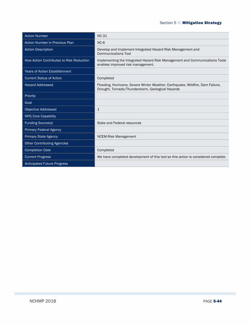
Section 5 Mitigation Strategy
NCHMP 2018 PAGE 5-44
Action Number NC-31
Action Number in Previous Plan NC-6
Action Description Develop and Implement Integrated Hazard Risk Management and Communications Tool
How Action Contributes to Risk Reduction Implementing the Integrated Hazard Risk Management and Communications Tools enables improved risk management.
Years of Action Establishment
Current Status of Action Completed
Hazard Addressed Flooding, Hurricane, Severe Winter Weather, Earthquake, Wildfire, Dam Failure, Drought, Tornado/Thunderstorm, Geological Hazards
Priority
Goal
Objective Addressed 1
NPG Core Capability
Funding Source(s) State and Federal resources
Primary Federal Agency
Primary State Agency NCEM-Risk Management
Other Contributing Agencies
Completion Date Completed
Current Progress We have completed development of this tool so this action is considered complete.
Anticipated Future Progress

Section 5 Mitigation Strategy
NCHMP 2018 PAGE 5-45
Action Number NC-32
Action Number in Previous Plan NC-7
Action Description Develop working relationship with state and federal agencies with interests related to emergency management and hazard mitigation, with technologies from which we can benefit.
How Action Contributes to Risk Reduction
Years of Action Establishment
Current Status of Action Deleted
Hazard Addressed Hurricanes, Severe Winter Weather, Earthquake, Wildfire, Dam Failure, Drought, Tornado/Thunderstorm, Geological Hazards,
Priority
Goal
Objective Addressed 1
NPG Core Capability
Funding Source(s) State and Federal resources
Primary Federal Agency
Primary State Agency NCEM-Risk Management
Other Contributing Agencies State Climate Office,USGS/NCGS, NC DEQ/Coastal Management, US Corps of Engineers, FEMA, NWS
Completion Date Deleted
Current Progress This action was evaluated and considered to be an inherent part of our programming as we are always working to build relationships with other agencies and interests related to emergency management and hazard mitigation. Therefore, it will be deleted.
Anticipated Future Progress

Section 5 Mitigation Strategy
NCHMP 2018 PAGE 5-46
Action Number NC-33
Action Number in Previous Plan NC-8
Action Description Identify properties to be acquired that will support mitigation. Coordinate with other entities to leverage other fund sources for acquisition to support addition state mandated goals.
How Action Contributes to Risk Reduction
Years of Action Establishment
Current Status of Action Combined into NC-2
Hazard Addressed Hurricanes, Flooding, Tornado/Thunderstorm
Priority
Goal
Objective Addressed 1
NPG Core Capability
Funding Source(s) State and Federal resources
Primary Federal Agency
Primary State Agency NCEM-Hazard Mitigation
Other Contributing Agencies Clean Water Trust Fund, NC DEQ/Coastal Management, FEMA, Disaster Housing
Completion Date Combined into NC-2
Current Progress Combined into NC-2
Anticipated Future Progress

Section 5 Mitigation Strategy
NCHMP 2018 PAGE 5-47
Action Number NC-34
Action Number in Previous Plan NC-10
Action Description Utilize the National Weather Service Forecast and Warning (FWF, RFW) with support from State and Federal sources.
How Action Contributes to Risk Reduction Utilizing the National Weather Service Forecast and Warning allows more and better preparation for hazard events.
Years of Action Establishment
Current Status of Action Completed
Hazard Addressed Severe Winter Weather, Dam Failure, Tornado/Thunderstorm
Priority
Goal
Objective Addressed 1
NPG Core Capability
Funding Source(s) State and Federal resources
Primary Federal Agency
Primary State Agency
Other Contributing Agencies NCEM/National Weather Service, NCGS Land Quality, NC Dam Safety, State Climate Office
Completion Date Completed
Current Progress This action was evaluated and determined to be so integrated into our programs and operations that it no longer needs to be defined as an action and has been marked complete.
Anticipated Future Progress

Section 5 Mitigation Strategy
NCHMP 2018 PAGE 5-48
Action Number NC-35
Action Number in Previous Plan NC-14
Action Description Promote updating Building Codes in hazard-prone areas.
How Action Contributes to Risk Reduction
Years of Action Establishment
Current Status of Action Combined into NC-6
Hazard Addressed Earthquake
Priority
Goal
Objective Addressed 1
NPG Core Capability
Funding Source(s) State and Local resources
Primary Federal Agency
Primary State Agency NC-DOI
Other Contributing Agencies NCEM, IBC (find out who regulates)
Completion Date Combined into NC-6
Current Progress Combined into NC-6
Anticipated Future Progress
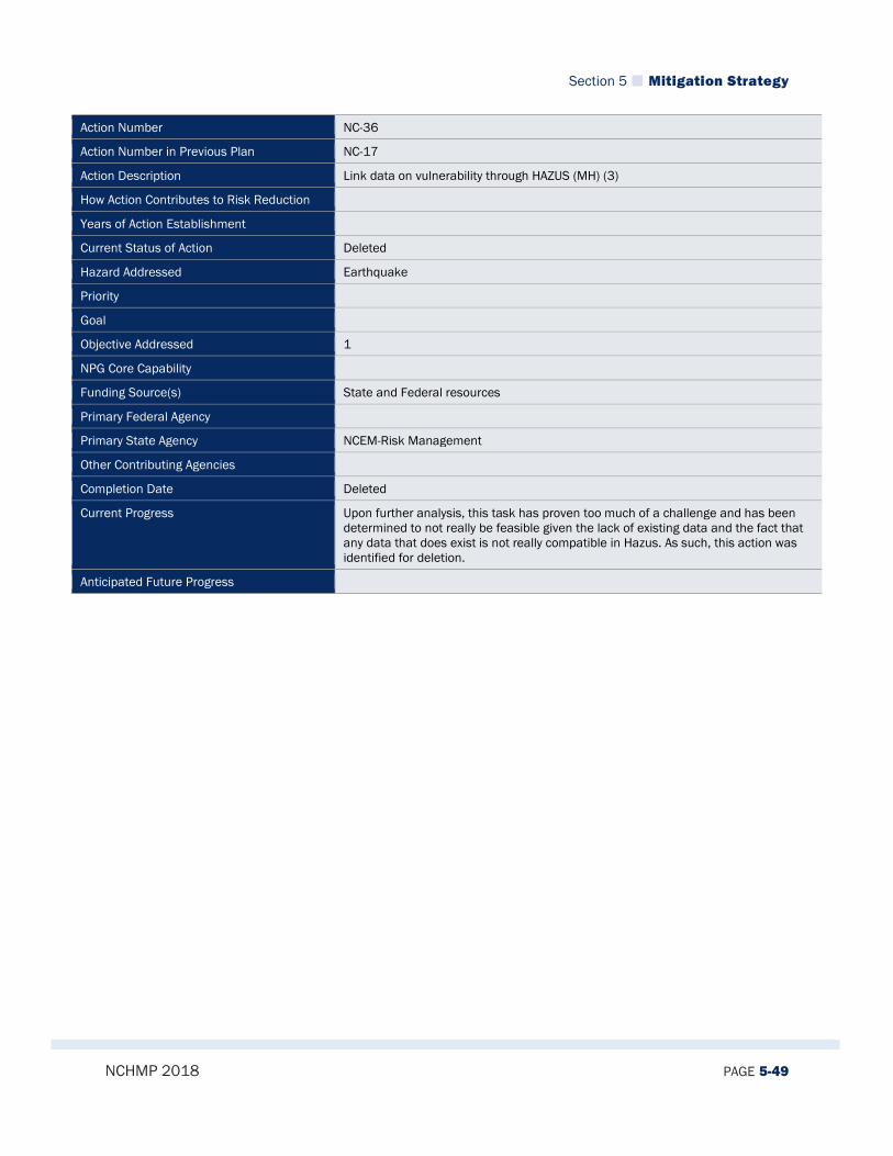
Section 5 Mitigation Strategy
NCHMP 2018 PAGE 5-49
Action Number NC-36
Action Number in Previous Plan NC-17
Action Description Link data on vulnerability through HAZUS (MH) (3)
How Action Contributes to Risk Reduction
Years of Action Establishment
Current Status of Action Deleted
Hazard Addressed Earthquake
Priority
Goal
Objective Addressed 1
NPG Core Capability
Funding Source(s) State and Federal resources
Primary Federal Agency
Primary State Agency NCEM-Risk Management
Other Contributing Agencies
Completion Date Deleted
Current Progress Upon further analysis, this task has proven too much of a challenge and has been determined to not really be feasible given the lack of existing data and the fact that any data that does exist is not really compatible in Hazus. As such, this action was identified for deletion.
Anticipated Future Progress
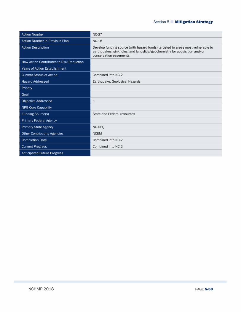
Section 5 Mitigation Strategy
NCHMP 2018 PAGE 5-50
Action Number NC-37
Action Number in Previous Plan NC-18
Action Description Develop funding source (with hazard funds) targeted to areas most vulnerable to earthquakes, sinkholes, and landslide/geochemistry for acquisition and/or conservation easements.
How Action Contributes to Risk Reduction
Years of Action Establishment
Current Status of Action Combined into NC-2
Hazard Addressed Earthquake, Geological Hazards
Priority
Goal
Objective Addressed 1
NPG Core Capability
Funding Source(s) State and Federal resources
Primary Federal Agency
Primary State Agency NC-DEQ
Other Contributing Agencies NCEM
Completion Date Combined into NC-2
Current Progress Combined into NC-2
Anticipated Future Progress

Section 5 Mitigation Strategy
NCHMP 2018 PAGE 5-51
Action Number NC-38
Action Number in Previous Plan NC-19
Action Description Develop and conduct county-wide educational programs for county and municipal officials on general aspects of Firewise Communities.
How Action Contributes to Risk Reduction
Years of Action Establishment
Current Status of Action Combined into NC-3
Hazard Addressed Wildfire
Priority
Goal
Objective Addressed 1
NPG Core Capability
Funding Source(s) State resources, possibly mitigation grant funds
Primary Federal Agency
Primary State Agency NC-DEQ-Forest Resources
Other Contributing Agencies NCEM
Completion Date Combined into NC-3
Current Progress Combined into NC-3
Anticipated Future Progress
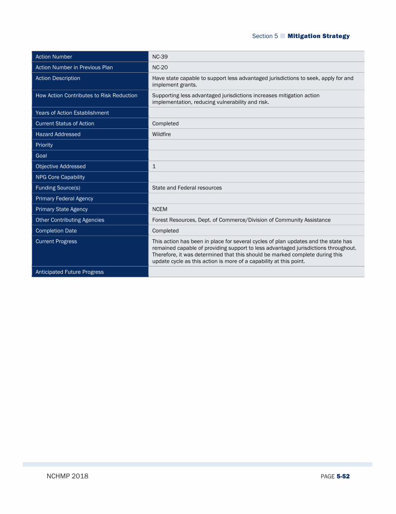
Section 5 Mitigation Strategy
NCHMP 2018 PAGE 5-52
Action Number NC-39
Action Number in Previous Plan NC-20
Action Description Have state capable to support less advantaged jurisdictions to seek, apply for and implement grants.
How Action Contributes to Risk Reduction Supporting less advantaged jurisdictions increases mitigation action implementation, reducing vulnerability and risk.
Years of Action Establishment
Current Status of Action Completed
Hazard Addressed Wildfire
Priority
Goal
Objective Addressed 1
NPG Core Capability
Funding Source(s) State and Federal resources
Primary Federal Agency
Primary State Agency NCEM
Other Contributing Agencies Forest Resources, Dept. of Commerce/Division of Community Assistance
Completion Date Completed
Current Progress This action has been in place for several cycles of plan updates and the state has remained capable of providing support to less advantaged jurisdictions throughout. Therefore, it was determined that this should be marked complete during this update cycle as this action is more of a capability at this point.
Anticipated Future Progress
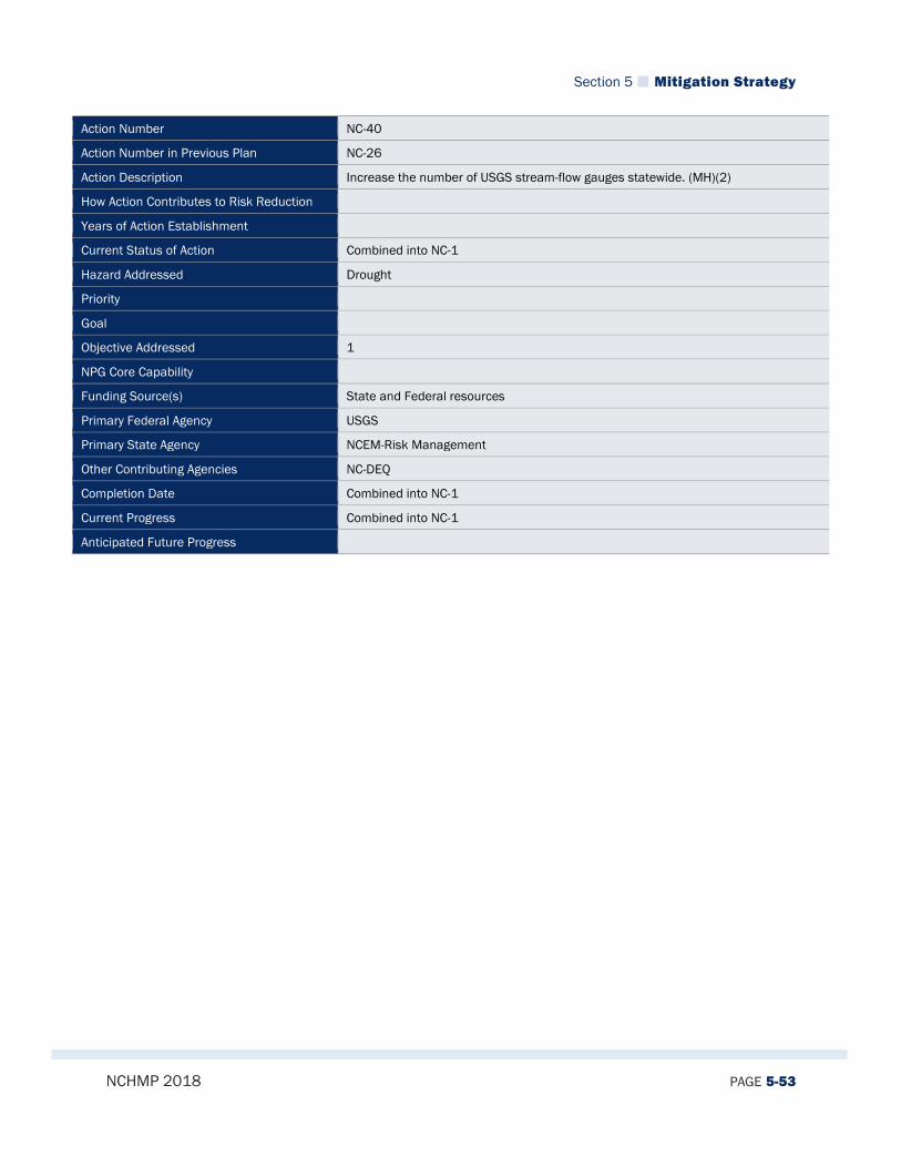
Section 5 Mitigation Strategy
NCHMP 2018 PAGE 5-53
Action Number NC-40
Action Number in Previous Plan NC-26
Action Description Increase the number of USGS stream-flow gauges statewide. (MH)(2)
How Action Contributes to Risk Reduction
Years of Action Establishment
Current Status of Action Combined into NC-1
Hazard Addressed Drought
Priority
Goal
Objective Addressed 1
NPG Core Capability
Funding Source(s) State and Federal resources
Primary Federal Agency USGS
Primary State Agency NCEM-Risk Management
Other Contributing Agencies NC-DEQ
Completion Date Combined into NC-1
Current Progress Combined into NC-1
Anticipated Future Progress
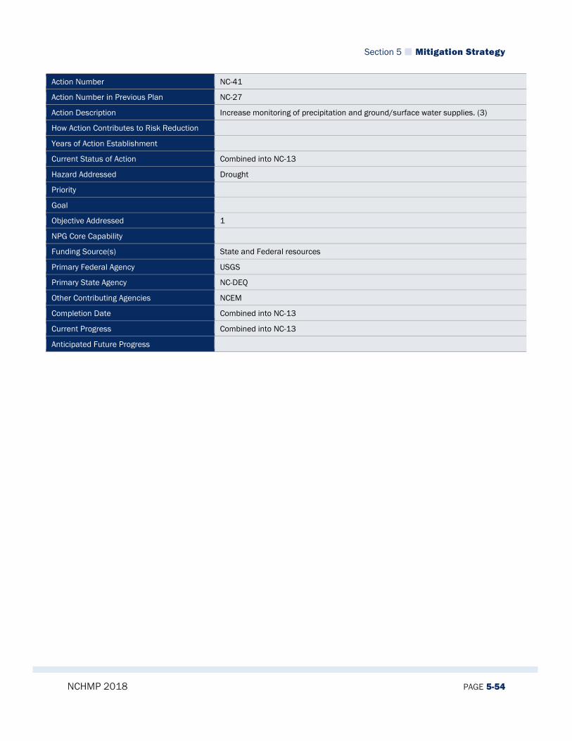
Section 5 Mitigation Strategy
NCHMP 2018 PAGE 5-54
Action Number NC-41
Action Number in Previous Plan NC-27
Action Description Increase monitoring of precipitation and ground/surface water supplies. (3)
How Action Contributes to Risk Reduction
Years of Action Establishment
Current Status of Action Combined into NC-13
Hazard Addressed Drought
Priority
Goal
Objective Addressed 1
NPG Core Capability
Funding Source(s) State and Federal resources
Primary Federal Agency USGS
Primary State Agency NC-DEQ
Other Contributing Agencies NCEM
Completion Date Combined into NC-13
Current Progress Combined into NC-13
Anticipated Future Progress

Section 5 Mitigation Strategy
NCHMP 2018 PAGE 5-55
Action Number NC-42
Action Number in Previous Plan NC-28
Action Description Develop and maintain a variety of widely-adaptable mitigation PowerPoints.
How Action Contributes to Risk Reduction
Years of Action Establishment
Current Status of Action Combined into NC-3
Hazard Addressed Drought
Priority
Goal
Objective Addressed 1
NPG Core Capability
Funding Source(s) State resources
Primary Federal Agency
Primary State Agency NCEM-Risk Management
Other Contributing Agencies
Completion Date Combined into NC-3
Current Progress Combined into NC-3
Anticipated Future Progress
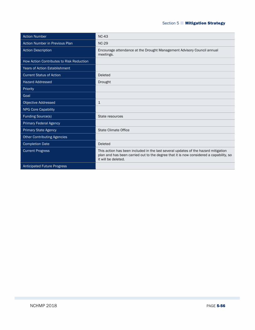
Section 5 Mitigation Strategy
NCHMP 2018 PAGE 5-56
Action Number NC-43
Action Number in Previous Plan NC-29
Action Description Encourage attendance at the Drought Management Advisory Council annual meetings.
How Action Contributes to Risk Reduction
Years of Action Establishment
Current Status of Action Deleted
Hazard Addressed Drought
Priority
Goal
Objective Addressed 1
NPG Core Capability
Funding Source(s) State resources
Primary Federal Agency
Primary State Agency State Climate Office
Other Contributing Agencies
Completion Date Deleted
Current Progress This action has been included in the last several updates of the hazard mitigation plan and has been carried out to the degree that it is now considered a capability, so it will be deleted.
Anticipated Future Progress
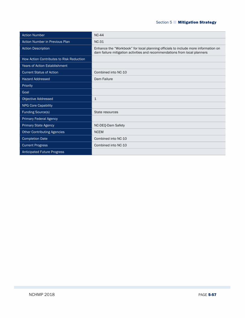
Section 5 Mitigation Strategy
NCHMP 2018 PAGE 5-57
Action Number NC-44
Action Number in Previous Plan NC-31
Action Description Enhance the “Workbook” for local planning officials to include more information on dam failure mitigation activities and recommendations from local planners
How Action Contributes to Risk Reduction
Years of Action Establishment
Current Status of Action Combined into NC-10
Hazard Addressed Dam Failure
Priority
Goal
Objective Addressed 1
NPG Core Capability
Funding Source(s) State resources
Primary Federal Agency
Primary State Agency NC-DEQ-Dam Safety
Other Contributing Agencies NCEM
Completion Date Combined into NC-10
Current Progress Combined into NC-10
Anticipated Future Progress

Section 5 Mitigation Strategy
NCHMP 2018 PAGE 5-58
Action Number NC-45
Action Number in Previous Plan NC-32
Action Description Gain insights from local public officials (through survey instruments and other means) on what additional products or services could assist them in developing local mitigation plans.
How Action Contributes to Risk Reduction
Years of Action Establishment
Current Status of Action Combined into NC-3
Hazard Addressed Flooding, Hurricane, Severe Winter Weather, Earthquake, Wildfire, Dam Failure, Drought, Tornado/Thunderstorm, Geological Hazards
Priority
Goal
Objective Addressed 1
NPG Core Capability
Funding Source(s) State and Local resources
Primary Federal Agency
Primary State Agency NCEM-Risk Management
Other Contributing Agencies
Completion Date Combined into NC-3
Current Progress Combined into NC-3
Anticipated Future Progress

Section 5 Mitigation Strategy
NCHMP 2018 PAGE 5-59
Action Number NC-46
Action Number in Previous Plan NC-33
Action Description Develop, publicize and provide a wide variety of risk assessment products and planning services to assist local officials throughout the local mitigation planning process
How Action Contributes to Risk Reduction
Years of Action Establishment
Current Status of Action Combined into NC-3
Hazard Addressed Flooding, Hurricane, Severe Winter Weather, Earthquake, Wildfire, Dam Failure, Drought, Tornado/Thunderstorm, Geological Hazards
Priority
Goal
Objective Addressed 1
NPG Core Capability
Funding Source(s) State resources
Primary Federal Agency
Primary State Agency NCEM-Risk Management
Other Contributing Agencies
Completion Date Combined into NC-3
Current Progress Combined into NC-3
Anticipated Future Progress

Section 5 Mitigation Strategy
NCHMP 2018 PAGE 5-60
Action Number NC-47
Action Number in Previous Plan NC-34
Action Description Design a two-day workshop for local officials on “Utilizing GIS for Hazard Mitigation Planning”
How Action Contributes to Risk Reduction
Years of Action Establishment
Current Status of Action Combined into NC-3
Hazard Addressed Flooding
Priority
Goal
Objective Addressed 1
NPG Core Capability
Funding Source(s) State resources
Primary Federal Agency
Primary State Agency NCEM-Risk Management
Other Contributing Agencies
Completion Date Combined into NC-3
Current Progress Combined into NC-3
Anticipated Future Progress
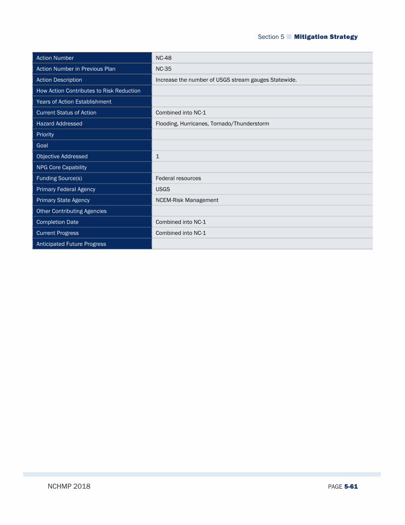
Section 5 Mitigation Strategy
NCHMP 2018 PAGE 5-61
Action Number NC-48
Action Number in Previous Plan NC-35
Action Description Increase the number of USGS stream gauges Statewide.
How Action Contributes to Risk Reduction
Years of Action Establishment
Current Status of Action Combined into NC-1
Hazard Addressed Flooding, Hurricanes, Tornado/Thunderstorm
Priority
Goal
Objective Addressed 1
NPG Core Capability
Funding Source(s) Federal resources
Primary Federal Agency USGS
Primary State Agency NCEM-Risk Management
Other Contributing Agencies
Completion Date Combined into NC-1
Current Progress Combined into NC-1
Anticipated Future Progress
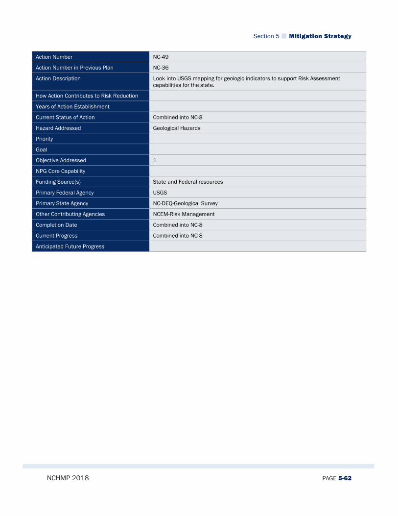
Section 5 Mitigation Strategy
NCHMP 2018 PAGE 5-62
Action Number NC-49
Action Number in Previous Plan NC-36
Action Description Look into USGS mapping for geologic indicators to support Risk Assessment capabilities for the state.
How Action Contributes to Risk Reduction
Years of Action Establishment
Current Status of Action Combined into NC-8
Hazard Addressed Geological Hazards
Priority
Goal
Objective Addressed 1
NPG Core Capability
Funding Source(s) State and Federal resources
Primary Federal Agency USGS
Primary State Agency NC-DEQ-Geological Survey
Other Contributing Agencies NCEM-Risk Management
Completion Date Combined into NC-8
Current Progress Combined into NC-8
Anticipated Future Progress
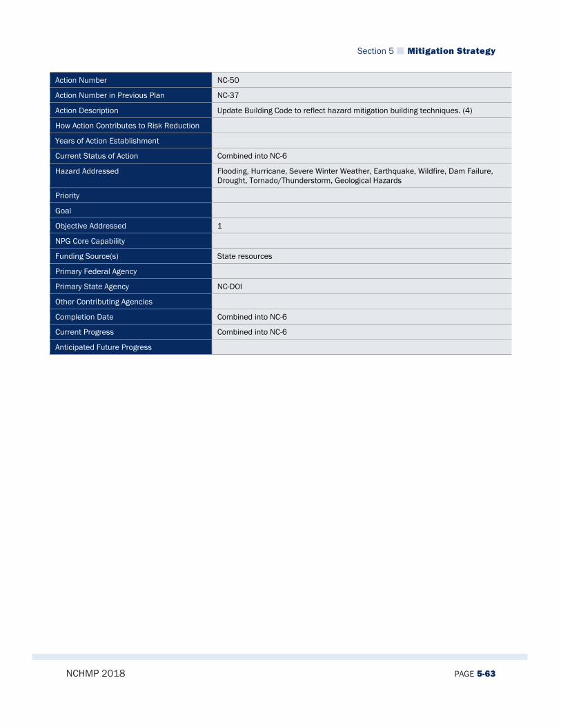
Section 5 Mitigation Strategy
NCHMP 2018 PAGE 5-63
Action Number NC-50
Action Number in Previous Plan NC-37
Action Description Update Building Code to reflect hazard mitigation building techniques. (4)
How Action Contributes to Risk Reduction
Years of Action Establishment
Current Status of Action Combined into NC-6
Hazard Addressed Flooding, Hurricane, Severe Winter Weather, Earthquake, Wildfire, Dam Failure, Drought, Tornado/Thunderstorm, Geological Hazards
Priority
Goal
Objective Addressed 1
NPG Core Capability
Funding Source(s) State resources
Primary Federal Agency
Primary State Agency NC-DOI
Other Contributing Agencies
Completion Date Combined into NC-6
Current Progress Combined into NC-6
Anticipated Future Progress

Section 5 Mitigation Strategy
NCHMP 2018 PAGE 5-64
Action Number NC-51
Action Number in Previous Plan NC-38
Action Description Promote full funding of NC Flood Mapping Program to complete new Flood Insurance Studies for entire state.
How Action Contributes to Risk Reduction
Years of Action Establishment
Current Status of Action Combined into NC-11
Hazard Addressed Flooding
Priority
Goal
Objective Addressed 2
NPG Core Capability
Funding Source(s) State and Federal resources
Primary Federal Agency FEMA
Primary State Agency NC-General Assembly
Other Contributing Agencies NCEM-Risk Management
Completion Date Combined into NC-11
Current Progress Combined into NC-11
Anticipated Future Progress

Section 5 Mitigation Strategy
NCHMP 2018 PAGE 5-65
Action Number NC-52
Action Number in Previous Plan NC-39
Action Description Promote river basin wide planning of flood hazard Promote consideration of future build-out conditions when establishing land use and floodplain management regulations.
How Action Contributes to Risk Reduction
Years of Action Establishment
Current Status of Action Combined into NC-6
Hazard Addressed Flooding
Priority
Goal
Objective Addressed 2
NPG Core Capability
Funding Source(s) State and Federal resources
Primary Federal Agency
Primary State Agency NCEM-Risk Management
Other Contributing Agencies NC-DEQ-Water Quality
Completion Date Combined into NC-6
Current Progress Combined into NC-6
Anticipated Future Progress

Section 5 Mitigation Strategy
NCHMP 2018 PAGE 5-66
Action Number NC-53
Action Number in Previous Plan NC-40
Action Description Promote consideration of future build-out conditions when establishing land use and floodplain management regulations.
How Action Contributes to Risk Reduction
Years of Action Establishment
Current Status of Action Combined into NC-6
Hazard Addressed Flooding
Priority
Goal
Objective Addressed 2
NPG Core Capability
Funding Source(s) State and Local resources
Primary Federal Agency
Primary State Agency NCEM-Risk Management
Other Contributing Agencies Dept. of Commerce/Division of Community Assistance, NC League of Municipalities, NC Home Builders Association
Completion Date Combined into NC-6
Current Progress Combined into NC-6
Anticipated Future Progress
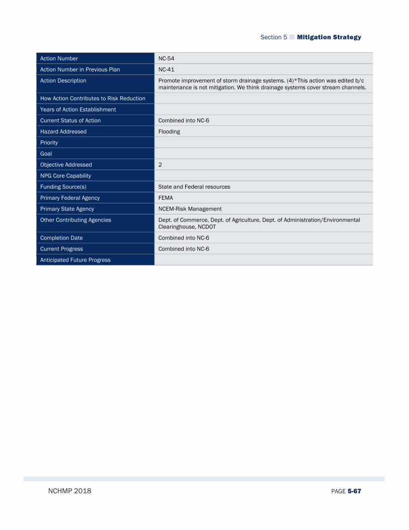
Section 5 Mitigation Strategy
NCHMP 2018 PAGE 5-67
Action Number NC-54
Action Number in Previous Plan NC-41
Action Description Promote improvement of storm drainage systems. (4)*This action was edited b/c maintenance is not mitigation. We think drainage systems cover stream channels.
How Action Contributes to Risk Reduction
Years of Action Establishment
Current Status of Action Combined into NC-6
Hazard Addressed Flooding
Priority
Goal
Objective Addressed 2
NPG Core Capability
Funding Source(s) State and Federal resources
Primary Federal Agency FEMA
Primary State Agency NCEM-Risk Management
Other Contributing Agencies Dept. of Commerce, Dept. of Agriculture, Dept. of Administration/Environmental Clearinghouse, NCDOT
Completion Date Combined into NC-6
Current Progress Combined into NC-6
Anticipated Future Progress

Section 5 Mitigation Strategy
NCHMP 2018 PAGE 5-68
Action Number NC-55
Action Number in Previous Plan NC-42
Action Description Ensure that tree trimming policies of local governments have been reassessed to comply with industry standards (MH) (4)
How Action Contributes to Risk Reduction
Years of Action Establishment
Current Status of Action Combined into NC-6
Hazard Addressed Severe Winter Weather
Priority
Goal
Objective Addressed 2
NPG Core Capability
Funding Source(s) State and Local resources
Primary Federal Agency
Primary State Agency NCEM-Public Assistance
Other Contributing Agencies NC League of Municipalities, County Commissioners Association, NC Utilities Commission
Completion Date Combined into NC-6
Current Progress Combined into NC-6
Anticipated Future Progress
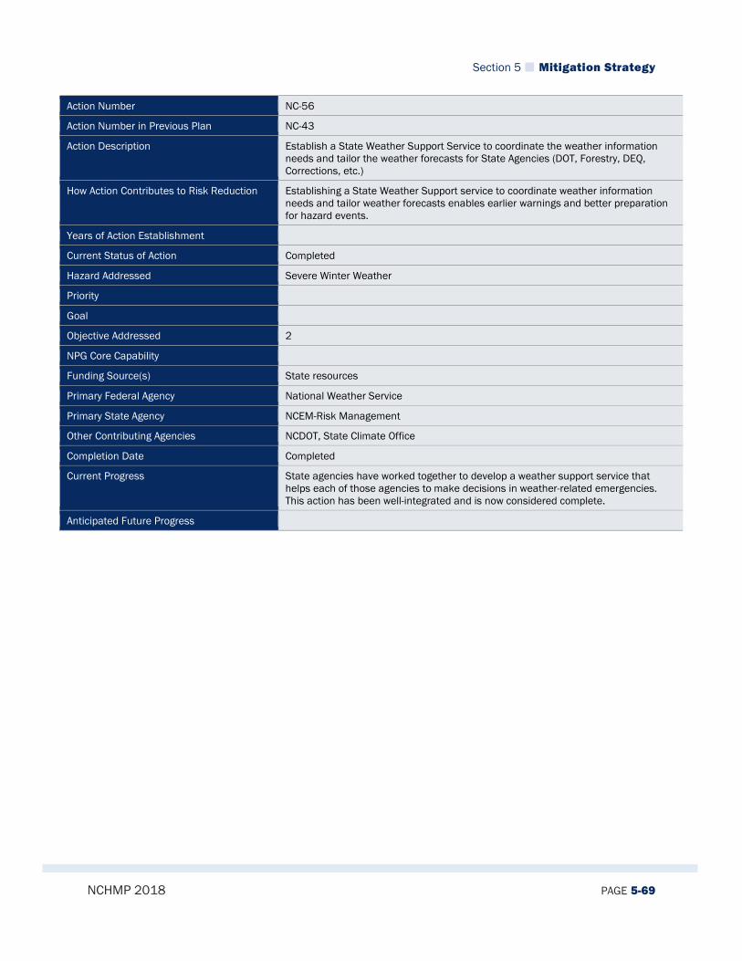
Section 5 Mitigation Strategy
NCHMP 2018 PAGE 5-69
Action Number NC-56
Action Number in Previous Plan NC-43
Action Description Establish a State Weather Support Service to coordinate the weather information needs and tailor the weather forecasts for State Agencies (DOT, Forestry, DEQ, Corrections, etc.)
How Action Contributes to Risk Reduction Establishing a State Weather Support service to coordinate weather information needs and tailor weather forecasts enables earlier warnings and better preparation for hazard events.
Years of Action Establishment
Current Status of Action Completed
Hazard Addressed Severe Winter Weather
Priority
Goal
Objective Addressed 2
NPG Core Capability
Funding Source(s) State resources
Primary Federal Agency National Weather Service
Primary State Agency NCEM-Risk Management
Other Contributing Agencies NCDOT, State Climate Office
Completion Date Completed
Current Progress State agencies have worked together to develop a weather support service that helps each of those agencies to make decisions in weather-related emergencies. This action has been well-integrated and is now considered complete.
Anticipated Future Progress

Section 5 Mitigation Strategy
NCHMP 2018 PAGE 5-70
Action Number NC-57
Action Number in Previous Plan NC-44
Action Description Provide corporate incentives to businesses that encourage employees to not come in during severe winter weather. (MH) (5)
How Action Contributes to Risk Reduction
Years of Action Establishment
Current Status of Action Deleted
Hazard Addressed Severe Winter Weather
Priority
Goal
Objective Addressed 2
NPG Core Capability
Funding Source(s) State resources
Primary Federal Agency
Primary State Agency NC-DOC
Other Contributing Agencies NC-General Assembly
Completion Date Deleted
Current Progress This action was re-assessed and determined to be overly ambitious and likely not something that is readily achievable so it was deleted from this update.
Anticipated Future Progress
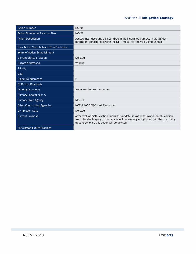
Section 5 Mitigation Strategy
NCHMP 2018 PAGE 5-71
Action Number NC-58
Action Number in Previous Plan NC-45
Action Description Assess incentives and disincentives in the insurance framework that affect mitigation; consider following the NFIP model for Firewise Communities.
How Action Contributes to Risk Reduction
Years of Action Establishment
Current Status of Action Deleted
Hazard Addressed Wildfire
Priority
Goal
Objective Addressed 2
NPG Core Capability
Funding Source(s) State and Federal resources
Primary Federal Agency
Primary State Agency NC-DOI
Other Contributing Agencies NCEM, NC-DEQ-Forest Resources
Completion Date Deleted
Current Progress After evaluating this action during this update, it was determined that this action would be challenging to fund and is not necessarily a high priority in the upcoming update cycle, so this action will be deleted.
Anticipated Future Progress

Section 5 Mitigation Strategy
NCHMP 2018 PAGE 5-72
Action Number NC-59
Action Number in Previous Plan NC-46
Action Description Promote the National Fire Plan as a source for Wildfire Mitigation Funding.
How Action Contributes to Risk Reduction
Years of Action Establishment
Current Status of Action Combined into NC-3
Hazard Addressed Wildfire
Priority
Goal
Objective Addressed 2
NPG Core Capability
Funding Source(s) State and Federal resources
Primary Federal Agency
Primary State Agency NC-DEQ-Forest Resources
Other Contributing Agencies NCEM
Completion Date Combined into NC-3
Current Progress Combined into NC-3
Anticipated Future Progress

Section 5 Mitigation Strategy
NCHMP 2018 PAGE 5-73
Action Number NC-60
Action Number in Previous Plan NC-48
Action Description Advocate inclusion of mitigation strategies in relevant public policy. (MH) (1)
How Action Contributes to Risk Reduction
Years of Action Establishment
Current Status of Action Deleted
Hazard Addressed Wildfire
Priority
Goal
Objective Addressed 2
NPG Core Capability
Funding Source(s) State resources
Primary Federal Agency
Primary State Agency Governor's Office
Other Contributing Agencies NCEM, NC-DEQ-Forest Resources
Completion Date Deleted
Current Progress This action was evaluated during this update and it was determined that this action was generic and was considered an inherent part of the state’s mitigation program. Therefore, this action was deleted.
Anticipated Future Progress
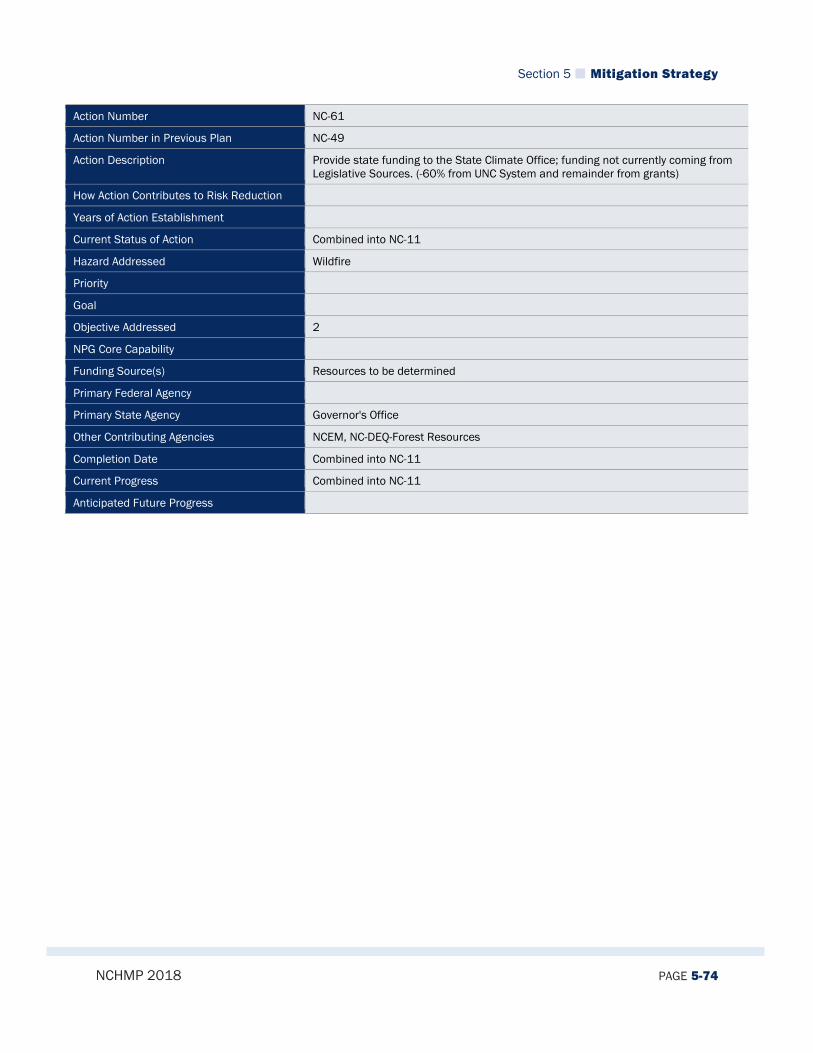
Section 5 Mitigation Strategy
NCHMP 2018 PAGE 5-74
Action Number NC-61
Action Number in Previous Plan NC-49
Action Description Provide state funding to the State Climate Office; funding not currently coming from Legislative Sources. (-60% from UNC System and remainder from grants)
How Action Contributes to Risk Reduction
Years of Action Establishment
Current Status of Action Combined into NC-11
Hazard Addressed Wildfire
Priority
Goal
Objective Addressed 2
NPG Core Capability
Funding Source(s) Resources to be determined
Primary Federal Agency
Primary State Agency Governor's Office
Other Contributing Agencies NCEM, NC-DEQ-Forest Resources
Completion Date Combined into NC-11
Current Progress Combined into NC-11
Anticipated Future Progress
Section 5 Mitigation Strategy
NCHMP 2018 PAGE 5-75
Action Number NC-62
Action Number in Previous Plan NC-50
Action Description Present the American Society of Dam Safety Officials (ASDSO) report on reductions in FEMA funding, and ask for assistance/supplemental funding into The Dam Safety Fund to keep Dam Safety Program viable.
How Action Contributes to Risk Reduction
Years of Action Establishment
Current Status of Action Combined into NC-11
Hazard Addressed Dam Failure
Priority
Goal
Objective Addressed 2
NPG Core Capability
Funding Source(s) State and Federal resources
Primary Federal Agency
Primary State Agency NC-DEQ-Geological Survey
Other Contributing Agencies NC-DEQ-Dam Safety
Completion Date Combined into NC-11
Current Progress Combined into NC-11
Anticipated Future Progress

Section 5 Mitigation Strategy
NCHMP 2018 PAGE 5-76
Action Number NC-63
Action Number in Previous Plan NC-51
Action Description Fund the NC Department of Commerce to conduct a drought economic impact study analyzing the 2002 drought that surveys local communities, state agencies, business and industry farmers and other affected parties. (5)
How Action Contributes to Risk Reduction
Years of Action Establishment
Current Status of Action Combined into NC-13
Hazard Addressed Drought
Priority
Goal
Objective Addressed 2
NPG Core Capability
Funding Source(s) State resources
Primary Federal Agency
Primary State Agency NC-DOC
Other Contributing Agencies
Completion Date Combined into NC-13
Current Progress Combined into NC-13
Anticipated Future Progress

Section 5 Mitigation Strategy
NCHMP 2018 PAGE 5-77
Action Number NC-64
Action Number in Previous Plan NC-52
Action Description Develop proposal to allow market forces to have rate differentials for Wind/lightning mitigation features safe rooms fortified homes. (MH)(2)
How Action Contributes to Risk Reduction
Years of Action Establishment
Current Status of Action Deleted
Hazard Addressed Tornado/Thunderstorm
Priority
Goal
Objective Addressed 2
NPG Core Capability
Funding Source(s) State and Federal resources
Primary Federal Agency
Primary State Agency NCEM-Risk Management
Other Contributing Agencies IBHS, NCDOI
Completion Date Deleted
Current Progress This action was evaluated during this update and it was determined that this was not feasible economically, so it was deleted.
Anticipated Future Progress
Section 5 Mitigation Strategy
NCHMP 2018 PAGE 5-78
Action Number NC-65
Action Number in Previous Plan NC-53
Action Description Provide safe havens/rooms for Mobile Home Parks.
How Action Contributes to Risk Reduction
Years of Action Establishment
Current Status of Action Combined into NC-2
Hazard Addressed Tornado/Thunderstorm
Priority
Goal
Objective Addressed 2
NPG Core Capability
Funding Source(s) State and Local resources
Primary Federal Agency
Primary State Agency NCEM-Risk Management
Other Contributing Agencies NCDOI, Manufactured Housing Institute
Completion Date Combined into NC-2
Current Progress Combined into NC-2
Anticipated Future Progress
Section 5 Mitigation Strategy
NCHMP 2018 PAGE 5-79
Action Number NC-66
Action Number in Previous Plan NC-54
Action Description Encourage local governments to use their risk and historical hazard data for purposes of modifying regulations, standards, ordinance to minimize their vulnerability.
How Action Contributes to Risk Reduction
Years of Action Establishment
Current Status of Action Combined into NC-6
Hazard Addressed Geological Hazards
Priority
Goal
Objective Addressed 2
NPG Core Capability
Funding Source(s) State and Local resources
Primary Federal Agency
Primary State Agency NCEM-Risk Management
Other Contributing Agencies NCGS, League of Municipalities, County Commissioners Association
Completion Date Combined into NC-6
Current Progress Combined into NC-6
Anticipated Future Progress
Section 5 Mitigation Strategy
NCHMP 2018 PAGE 5-80
Action Number NC-67
Action Number in Previous Plan NC-55
Action Description Promote and support recognition programs, such as the Community Rating System (CRS)
How Action Contributes to Risk Reduction
Years of Action Establishment
Current Status of Action Combined into NC-6
Hazard Addressed Flooding, Hurricane, Severe Winter Weather, Earthquake, Wildfire, Dam Failure, Drought, Tornado/Thunderstorm, Geological Hazards
Priority
Goal
Objective Addressed 2
NPG Core Capability
Funding Source(s) State resources
Primary Federal Agency
Primary State Agency NCEM-Risk Management
Other Contributing Agencies Local Governments
Completion Date Combined into NC-6
Current Progress Combined into NC-6
Anticipated Future Progress
Section 5 Mitigation Strategy
NCHMP 2018 PAGE 5-81
Action Number NC-68
Action Number in Previous Plan NC-56
Action Description Promote 406 mitigation through discussion and presentations with various state and federal partners.
How Action Contributes to Risk Reduction
Years of Action Establishment
Current Status of Action Combined into NC-3
Hazard Addressed Flooding, Hurricane, Severe Winter Weather, Earthquake, Wildfire, Dam Failure, Drought, Tornado/Thunderstorm, Geological Hazards
Priority
Goal
Objective Addressed 2
NPG Core Capability
Funding Source(s) State and Federal resources
Primary Federal Agency FEMA
Primary State Agency NCEM-Hazard Mitigation
Other Contributing Agencies
Completion Date Combined into NC-3
Current Progress Combined into NC-3
Anticipated Future Progress

Section 5 Mitigation Strategy
NCHMP 2018 PAGE 5-82
Action Number NC-69
Action Number in Previous Plan NC-57
Action Description Discuss with the Insurance Industry the ability of applying market force incentives to insurance premiums.
How Action Contributes to Risk Reduction
Years of Action Establishment
Current Status of Action Deleted
Hazard Addressed Flooding, Hurricane, Severe Winter Weather, Earthquake, Wildfire, Dam Failure, Drought, Tornado/Thunderstorm, Geological Hazards
Priority
Goal
Objective Addressed 2
NPG Core Capability
Funding Source(s) State and Federal resources
Primary Federal Agency
Primary State Agency NC-DOI
Other Contributing Agencies NCEM-Risk Management
Completion Date Deleted
Current Progress This action was evaluated during this update and it was determined that this was not feasible economically, so it was deleted.
Anticipated Future Progress
Section 5 Mitigation Strategy
NCHMP 2018 PAGE 5-83
Action Number NC-70
Action Number in Previous Plan NC-58
Action Description Identify planning activities of state agencies, select those most relevant to natural hazard mitigation, and work with the responsible agency to integrate mitigation into those activities.
How Action Contributes to Risk Reduction
Years of Action Establishment
Current Status of Action Deleted
Hazard Addressed Flooding, Hurricane, Severe Winter Weather, Earthquake, Wildfire, Dam Failure, Drought, Tornado/Thunderstorm, Geological Hazards
Priority
Goal
Objective Addressed 2
NPG Core Capability
Funding Source(s) State resources
Primary Federal Agency
Primary State Agency NCEM
Other Contributing Agencies
Completion Date Deleted
Current Progress This action was evaluated during this update and it was determined that this action was generic and was considered an inherent part of the state’s mitigation program. Therefore, this action was deleted.
Anticipated Future Progress
Section 5 Mitigation Strategy
NCHMP 2018 PAGE 5-84
Action Number NC-71
Action Number in Previous Plan NC-59
Action Description Formulate a proposal to the General Assembly that will require all major development projects to develop a natural hazard vulnerability impact assessment during the project planning process, to disclose the extent to which the proposed development will affect the vulnerability of the area to the impact of natural hazards.
How Action Contributes to Risk Reduction
Years of Action Establishment
Current Status of Action Deleted
Hazard Addressed Flooding, Hurricane, Severe Winter Weather, Earthquake, Wildfire, Dam Failure, Drought, Tornado/Thunderstorm, Geological Hazards
Priority
Goal
Objective Addressed 2
NPG Core Capability
Funding Source(s) State resources
Primary Federal Agency
Primary State Agency NCEM-Risk Management
Other Contributing Agencies
Completion Date Deleted
Current Progress This action was evaluated during this update and it was determined that this action was too ambitious and would likely not be accomplished as it would take a great deal of political support. Therefore, this action was deleted.
Anticipated Future Progress

Section 5 Mitigation Strategy
NCHMP 2018 PAGE 5-85
Action Number NC-72
Action Number in Previous Plan NC-62
Action Description Incorporate hazards risk maps and hazard mitigation strategies into local land use plans.
How Action Contributes to Risk Reduction
Years of Action Establishment
Current Status of Action Deleted
Hazard Addressed Flooding, Hurricane, Severe Winter Weather, Earthquake, Wildfire, Dam Failure, Drought, Tornado/Thunderstorm, Geological Hazards
Priority
Goal
Objective Addressed 2
NPG Core Capability
Funding Source(s) State resources
Primary Federal Agency
Primary State Agency NCEM-Risk Management
Other Contributing Agencies Local Governments
Completion Date Deleted
Current Progress This action was evaluated during this update and it was determined that this is a local level action that the state has no control over. Therefore, it was deleted.
Anticipated Future Progress

Section 5 Mitigation Strategy
NCHMP 2018 PAGE 5-86
Action Number NC-73
Action Number in Previous Plan NC-63
Action Description Develop with the Institute of Government a training module for training county and municipal administration course on Hazard Mitigation.
How Action Contributes to Risk Reduction
Years of Action Establishment
Current Status of Action Combined into NC-3
Hazard Addressed Flooding, Hurricane, Severe Winter Weather, Earthquake, Wildfire, Dam Failure, Drought, Tornado/Thunderstorm, Geological Hazards
Priority
Goal
Objective Addressed 2
NPG Core Capability
Funding Source(s) State resources
Primary Federal Agency
Primary State Agency NCEM
Other Contributing Agencies NCLM, FEMA
Completion Date Combined into NC-3
Current Progress Combined into NC-3
Anticipated Future Progress

Section 5 Mitigation Strategy
NCHMP 2018 PAGE 5-87
Action Number NC-74
Action Number in Previous Plan NC-64
Action Description Promote safe room construction.
How Action Contributes to Risk Reduction
Years of Action Establishment
Current Status of Action Combined into NC-2
Hazard Addressed Hurricane, Severe Winter Weather, Tornado/Thunderstorm
Priority
Goal
Objective Addressed 2
NPG Core Capability
Funding Source(s) State and Federal resources
Primary Federal Agency FEMA
Primary State Agency NCEM-Risk Management
Other Contributing Agencies
Completion Date Combined into NC-2
Current Progress Combined into NC-2
Anticipated Future Progress

Section 5 Mitigation Strategy
NCHMP 2018 PAGE 5-88
Action Number NC-75
Action Number in Previous Plan NC-65
Action Description Train local emergency managers on various mitigation activities and funding opportunities.
How Action Contributes to Risk Reduction
Years of Action Establishment
Current Status of Action Combined into NC-3
Hazard Addressed Flooding, Hurricane, Severe Winter Weather, Earthquake, Wildfire, Dam Failure, Drought, Tornado/Thunderstorm, Geological Hazards
Priority
Goal
Objective Addressed 2
NPG Core Capability
Funding Source(s) State and Federal resources
Primary Federal Agency FEMA
Primary State Agency NCEM-Risk Management
Other Contributing Agencies
Completion Date Combined into NC-3
Current Progress Combined into NC-3
Anticipated Future Progress

Section 5 Mitigation Strategy
NCHMP 2018 PAGE 5-89
Action Number NC-76
Action Number in Previous Plan NC-67
Action Description Develop and distribute Hazard Mitigation brochures.
How Action Contributes to Risk Reduction
Years of Action Establishment
Current Status of Action Combined into NC-3
Hazard Addressed Flooding, Hurricane, Severe Winter Weather, Earthquake, Wildfire, Dam Failure, Drought, Tornado/Thunderstorm, Geological Hazards
Priority
Goal
Objective Addressed 2
NPG Core Capability
Funding Source(s) State resources
Primary Federal Agency
Primary State Agency NCEM-Hazard Mitigation
Other Contributing Agencies
Completion Date Combined into NC-3
Current Progress Combined into NC-3
Anticipated Future Progress

Section 5 Mitigation Strategy
NCHMP 2018 PAGE 5-90
Action Number NC-77
Action Number in Previous Plan NC-68
Action Description Distribute publications, information, and newsletters/updates electronically via the Internet, and removable data mediums (CDs, USB flash drives, etc.).
How Action Contributes to Risk Reduction
Years of Action Establishment
Current Status of Action Combined into NC-3
Hazard Addressed Flooding, Hurricane, Severe Winter Weather, Earthquake, Wildfire, Dam Failure, Drought, Tornado/Thunderstorm, Geological Hazards
Priority
Goal
Objective Addressed 2
NPG Core Capability
Funding Source(s) State and Federal resources
Primary Federal Agency FEMA
Primary State Agency NCEM-Hazard Mitigation
Other Contributing Agencies
Completion Date Combined into NC-3
Current Progress Combined into NC-3
Anticipated Future Progress

Section 5 Mitigation Strategy
NCHMP 2018 PAGE 5-91
Action Number NC-78
Action Number in Previous Plan NC-69
Action Description Research, analyze and document missed opportunities for mitigation measures. (4)
How Action Contributes to Risk Reduction Determining missed opportunities for mitigation improves future mitigation measure evaluation and implementation.
Years of Action Establishment
Current Status of Action Completed
Hazard Addressed Flooding, Hurricane, Severe Winter Weather, Earthquake, Wildfire, Dam Failure, Drought, Tornado/Thunderstorm, Geological Hazards
Priority
Goal
Objective Addressed 2
NPG Core Capability
Funding Source(s) State resources
Primary Federal Agency FEMA
Primary State Agency NCEM-Hazard Mitigation
Other Contributing Agencies
Completion Date Completed
Current Progress This has been carried out continually as part of all pre- and post-disaster programming and is now considered an inherent part of the state’s mitigation program overall. Therefore, this action is considered a capability and is completed.
Anticipated Future Progress
Section 5 Mitigation Strategy
NCHMP 2018 PAGE 5-92
Action Number NC-79
Action Number in Previous Plan NC-70
Action Description Establish key contacts in various departments to facilitate exchange of information post-disaster.
How Action Contributes to Risk Reduction Facilitating exchange of information post-disaster increases awareness and knowledge, promoting future mitigation efforts to reduce vulnerability.
Years of Action Establishment
Current Status of Action Completed
Hazard Addressed Flooding
Priority
Goal
Objective Addressed 3
NPG Core Capability
Funding Source(s) State resources
Primary Federal Agency
Primary State Agency
Other Contributing Agencies NCEM, NCDOT, NCDOI, NC Public Health, NC Dept. of Agriculture, NC Dept. of Corrections, SERT agencies, Office of Governor, FEMA
Completion Date Completed
Current Progress This has been carried out continually and is now considered an inherent part of the state’s mitigation program overall. Therefore this action is considered a capability and is completed.
Anticipated Future Progress
Section 5 Mitigation Strategy
NCHMP 2018 PAGE 5-93
Action Number NC-80
Action Number in Previous Plan NC-71
Action Description Coordinate with Clean Water Task Force and other entities to leverage other fund sources for acquisition to support additional state mandated goals such as clean water.
How Action Contributes to Risk Reduction
Years of Action Establishment
Current Status of Action Combined into NC-2
Hazard Addressed Flooding
Priority
Goal
Objective Addressed 3
NPG Core Capability
Funding Source(s) State resources
Primary Federal Agency
Primary State Agency NCEM-Hazard Mitigation
Other Contributing Agencies NCEM, Clean Water Trust Fund, DEQ/Water Quality, DEQ/Coastal Management, Million Acre Initiative
Completion Date Combined into NC-2
Current Progress Combined into NC-2
Anticipated Future Progress

Section 5 Mitigation Strategy
NCHMP 2018 PAGE 5-94
Action Number NC-81
Action Number in Previous Plan NC-72
Action Description Identify public, private, non-profit and special interest agencies or organizations with which collaboration would be beneficial for furthering flood hazard mitigation.
How Action Contributes to Risk Reduction Improving collaboration supports the implementation of flood hazard mitigation efforts.
Years of Action Establishment
Current Status of Action Completed
Hazard Addressed Flooding
Priority
Goal
Objective Addressed 3
NPG Core Capability
Funding Source(s) State resources
Primary Federal Agency
Primary State Agency
Other Contributing Agencies NCEM, Governor’s Office, Dept. of Commerce, Red Cross, Americorps
Completion Date Completed
Current Progress This has been carried out continually and is now considered an inherent part of the state’s mitigation program overall. Therefore, this action is considered a capability and is completed.
Anticipated Future Progress
Section 5 Mitigation Strategy
NCHMP 2018 PAGE 5-95
Action Number NC-82
Action Number in Previous Plan NC-74
Action Description Educate organizations on the theory and practice of hazard mitigation, and help them to identify how mitigation can become incorporated into their own routine functions or activities.
How Action Contributes to Risk Reduction
Years of Action Establishment
Current Status of Action Combined into NC-3
Hazard Addressed Hurricanes, Severe Winter Weather
Priority
Goal
Objective Addressed 3
NPG Core Capability
Funding Source(s) State resources
Primary Federal Agency
Primary State Agency NCEM-Risk Management
Other Contributing Agencies DOC-Community Assistance, US Corps of Engineers
Completion Date Combined into NC-3
Current Progress Combined into NC-3
Anticipated Future Progress

Section 5 Mitigation Strategy
NCHMP 2018 PAGE 5-96
Action Number NC-83
Action Number in Previous Plan NC-75
Action Description Inventory all agencies involved in Hazard Mitigation Planning and coordinate to avoid duplication.
How Action Contributes to Risk Reduction Coordinating all agencies involved in Hazard Mitigation Planning will ensure efficiency and promote successful mitigation.
Years of Action Establishment
Current Status of Action Completed
Hazard Addressed Hurricanes
Priority
Goal
Objective Addressed 3
NPG Core Capability
Funding Source(s) State resources
Primary Federal Agency
Primary State Agency NCEM-Risk Management
Other Contributing Agencies
Completion Date Completed
Current Progress This has been completed as an inventory of all agencies involved in hazard mitigation planning exists and is used regularly for coordination. Therefore, this action is considered completed.
Anticipated Future Progress

Section 5 Mitigation Strategy
NCHMP 2018 PAGE 5-97
Action Number NC-84
Action Number in Previous Plan NC-78
Action Description Develop a way for DOT’s TIMS to not only be in text, but in graphics also.
How Action Contributes to Risk Reduction Converting NC DOT TIMS to map format makes the information more accessible and improves awareness.
Years of Action Establishment
Current Status of Action Completed
Hazard Addressed Severe Winter Weather
Priority
Goal
Objective Addressed 3
NPG Core Capability
Funding Source(s) State and Federal resources
Primary Federal Agency
Primary State Agency NC-DOT
Other Contributing Agencies
Completion Date Completed
Current Progress The NC DOT TIMS system has been converted to map format, so this action is now complete.
Anticipated Future Progress
Section 5 Mitigation Strategy
NCHMP 2018 PAGE 5-98
Action Number NC-85
Action Number in Previous Plan NC-80
Action Description Make CGIA services free to state agencies.
How Action Contributes to Risk Reduction Making CGIA services available to all agencies increases awareness.
Years of Action Establishment
Current Status of Action Completed
Hazard Addressed Wildfire
Priority
Goal
Objective Addressed 3
NPG Core Capability
Funding Source(s) State resources
Primary Federal Agency
Primary State Agency Governor's Office
Other Contributing Agencies NCEM, NC-DEQ, NC-DOC
Completion Date Completed
Current Progress CGIA services are available to all agencies and have been for some time so this action is considered complete and is a capability now.
Anticipated Future Progress

Section 5 Mitigation Strategy
NCHMP 2018 PAGE 5-99
Action Number NC-86
Action Number in Previous Plan NC-81
Action Description Coordinate all drought mitigation activities through the Drought Management Advisory Council.
How Action Contributes to Risk Reduction
Years of Action Establishment
Current Status of Action Combined into NC-13
Hazard Addressed Drought
Priority
Goal
Objective Addressed 3
NPG Core Capability
Funding Source(s) State and Local resources
Primary Federal Agency
Primary State Agency NC-DEQ
Other Contributing Agencies
Completion Date Combined into NC-13
Current Progress Combined into NC-13
Anticipated Future Progress
Section 5 Mitigation Strategy
NCHMP 2018 PAGE 5-100
Action Number NC-87
Action Number in Previous Plan NC-83
Action Description Develop relationship between DOI and NCGS to uncover potential linkages of geological risk data into the Building Code, and Market Based Insurance Rates.
How Action Contributes to Risk Reduction
Years of Action Establishment
Current Status of Action Deleted
Hazard Addressed Geological Hazards
Priority
Goal
Objective Addressed 3
NPG Core Capability
Funding Source(s) State resources
Primary Federal Agency
Primary State Agency NC-DEQ-Geological Survey
Other Contributing Agencies NC-DOI
Completion Date Deleted
Current Progress During the last several update cycles, this funding has not been available and it does not appear that it will be in the future so this action will be deleted.
Anticipated Future Progress

Section 5 Mitigation Strategy
NCHMP 2018 PAGE 5-101
Action Number NC-88
Action Number in Previous Plan NC-84
Action Description Have utilities share the ice buildup measurement data from their data stations with National Weather Service and Climate Office.
How Action Contributes to Risk Reduction
Years of Action Establishment
Current Status of Action Combined into NC-19
Hazard Addressed Severe Winter Weather
Priority
Goal
Objective Addressed 3
NPG Core Capability
Funding Source(s) NWS, utility companies
Primary Federal Agency
Primary State Agency State Climate Office
Other Contributing Agencies
Completion Date Combined into NC-19
Current Progress Combined into NC-19
Anticipated Future Progress
Section 5 Mitigation Strategy
NCHMP 2018 PAGE 5-102
Action Number NC-89
Action Number in Previous Plan NC-85
Action Description Develop and conduct county-wide educational programs for the general public on general aspects of the North Carolina DFIRMs highlighting the benefits of flood mapping, feature of new DFIRMs, flood insurance implications, etc.
How Action Contributes to Risk Reduction
Years of Action Establishment
Current Status of Action Combined into NC-3
Hazard Addressed Flooding
Priority
Goal
Objective Addressed 4
NPG Core Capability
Funding Source(s)
Primary Federal Agency
Primary State Agency NCEM-Risk Management
Other Contributing Agencies
Completion Date Combined into NC-3
Current Progress Combined into NC-3
Anticipated Future Progress
Section 5 Mitigation Strategy
NCHMP 2018 PAGE 5-103
Action Number NC-90
Action Number in Previous Plan NC-87
Action Description Participate in the North Carolina Aquariums Earth Day Expo.
How Action Contributes to Risk Reduction
Years of Action Establishment
Current Status of Action Combined into NC-3
Hazard Addressed Flooding, Hurricane, Severe Winter Weather, Earthquake, Wildfire, Dam Failure, Drought, Tornado/Thunderstorm, Geological Hazards
Priority
Goal
Objective Addressed 4
NPG Core Capability
Funding Source(s)
Primary Federal Agency
Primary State Agency NCEM
Other Contributing Agencies
Completion Date Combined into NC-3
Current Progress Combined into NC-3
Anticipated Future Progress

Section 5 Mitigation Strategy
NCHMP 2018 PAGE 5-104
Action Number NC-91
Action Number in Previous Plan NC-88
Action Description Host booth(s) at county and state fairs. (4)
How Action Contributes to Risk Reduction
Years of Action Establishment
Current Status of Action Combined into NC-3
Hazard Addressed Flooding, Hurricane, Severe Winter Weather, Earthquake, Wildfire, Dam Failure, Drought, Tornado/Thunderstorm, Geological Hazards
Priority
Goal
Objective Addressed 4
NPG Core Capability
Funding Source(s)
Primary Federal Agency
Primary State Agency NCEM
Other Contributing Agencies
Completion Date Combined into NC-3
Current Progress Combined into NC-3
Anticipated Future Progress
Section 5 Mitigation Strategy
NCHMP 2018 PAGE 5-105
Action Number NC-92
Action Number in Previous Plan NC-89
Action Description Coordinate with County Cooperative Extension Services for Symposiums/events to include information on natural hazard risks and mitigation.
How Action Contributes to Risk Reduction
Years of Action Establishment
Current Status of Action Combined into NC-3
Hazard Addressed Flooding, Hurricane, Severe Winter Weather, Earthquake, Wildfire, Dam Failure, Drought, Tornado/Thunderstorm, Geological Hazards
Priority
Goal
Objective Addressed 4
NPG Core Capability
Funding Source(s)
Primary Federal Agency
Primary State Agency NCEM
Other Contributing Agencies
Completion Date Combined into NC-3
Current Progress Combined into NC-3
Anticipated Future Progress
Section 5 Mitigation Strategy
NCHMP 2018 PAGE 5-106
Action Number NC-93
Action Number in Previous Plan NC-90
Action Description Develop Bi-lingual mitigation messages.
How Action Contributes to Risk Reduction
Years of Action Establishment
Current Status of Action Combined into NC-3
Hazard Addressed Flooding, Hurricane, Severe Winter Weather, Earthquake, Wildfire, Dam Failure, Drought, Tornado/Thunderstorm, Geological Hazards
Priority
Goal
Objective Addressed 4
NPG Core Capability
Funding Source(s)
Primary Federal Agency FEMA
Primary State Agency NCEM-Risk Management
Other Contributing Agencies
Completion Date Combined into NC-3
Current Progress Combined into NC-3
Anticipated Future Progress
Section 5 Mitigation Strategy
NCHMP 2018 PAGE 5-107
Action Number NC-94
Action Number in Previous Plan NC-92
Action Description Conduct direct outreach on non-structural mitigation measures at Local, Tribal, and State agencies as well as citizens.
How Action Contributes to Risk Reduction
Years of Action Establishment
Current Status of Action Combined into NC-3
Hazard Addressed Flooding, Hurricane, Severe Winter Weather, Earthquake, Wildfire, Dam Failure, Drought, Tornado/Thunderstorm, Geological Hazards
Priority
Goal
Objective Addressed 4
NPG Core Capability
Funding Source(s)
Primary Federal Agency
Primary State Agency NCEM-Hazard Mitigation
Other Contributing Agencies
Completion Date Combined into NC-3
Current Progress Combined into NC-3
Anticipated Future Progress
Section 5 Mitigation Strategy
NCHMP 2018 PAGE 5-108
Action Number NC-95
Action Number in Previous Plan NC-93
Action Description Acquire properties that are located in areas vulnerable to hazards.
How Action Contributes to Risk Reduction
Years of Action Establishment
Current Status of Action Combined into NC-2
Hazard Addressed Flooding, Hurricane, Severe Winter Weather, Earthquake, Wildfire, Dam Failure, Drought, Tornado/Thunderstorm, Geological Hazards
Priority
Goal
Objective Addressed 5
NPG Core Capability
Funding Source(s) UHMA, State resources
Primary Federal Agency FEMA
Primary State Agency NCEM-Hazard Mitigation
Other Contributing Agencies Local Governments
Completion Date Combined into NC-2
Current Progress Combined into NC-2
Anticipated Future Progress
Section 5 Mitigation Strategy
NCHMP 2018 PAGE 5-109
Action Number NC-96
Action Number in Previous Plan NC-94
Action Description Elevate properties that are located in areas vulnerable to flooding.
How Action Contributes to Risk Reduction
Years of Action Establishment
Current Status of Action Combined into NC-2
Hazard Addressed Flooding
Priority
Goal
Objective Addressed 5
NPG Core Capability
Funding Source(s) UHMA, State resources
Primary Federal Agency FEMA
Primary State Agency NCEM-Hazard Mitigation
Other Contributing Agencies Local Governments
Completion Date Combined into NC-2
Current Progress Combined into NC-2
Anticipated Future Progress
Section 5 Mitigation Strategy
NCHMP 2018 PAGE 5-110
Action Number NC-97
Action Number in Previous Plan NC-95
Action Description Action Item: Structural retrofits for structures that are vulnerable to wind events.
How Action Contributes to Risk Reduction
Years of Action Establishment
Current Status of Action Combined into NC-2
Hazard Addressed Hurricane, Severe Winter Weather, Tornado/Thunderstorm
Priority
Goal
Objective Addressed 5
NPG Core Capability
Funding Source(s) UHMA, State resources
Primary Federal Agency FEMA
Primary State Agency NCEM-Hazard Mitigation
Other Contributing Agencies Local Governments
Completion Date Combined into NC-2
Current Progress Combined into NC-2
Anticipated Future Progress
Section 5 Mitigation Strategy
NCHMP 2018 PAGE 5-111
Action Number NC-98
Action Number in Previous Plan NC-96
Action Description Action Item: Non-structural retrofits for structures that are vulnerable to earthquakes/geological events.
How Action Contributes to Risk Reduction
Years of Action Establishment
Current Status of Action Combined into NC-2
Hazard Addressed Earthquake, Geological Hazards
Priority
Goal
Objective Addressed 5
NPG Core Capability
Funding Source(s) UHMA, State resources
Primary Federal Agency FEMA
Primary State Agency NCEM-Hazard Mitigation
Other Contributing Agencies Local Governments
Completion Date Combined into NC-2
Current Progress Combined into NC-2
Anticipated Future Progress

Section 5 Mitigation Strategy
NCHMP 2018 PAGE 5-112
Action Number NC-99
Action Number in Previous Plan NC-97
Action Description Analyze building stock to identify potential structures that could be mitigated.
How Action Contributes to Risk Reduction
Years of Action Establishment
Current Status of Action Combined into NC-2
Hazard Addressed Flooding, Hurricane, Severe Winter Weather, Earthquake, Wildfire, Dam Failure, Drought, Tornado/Thunderstorm, Geological Hazards
Priority
Goal
Objective Addressed 5
NPG Core Capability
Funding Source(s) UHMA, State resources
Primary Federal Agency
Primary State Agency NCEM-Risk Management
Other Contributing Agencies
Completion Date Combined into NC-2
Current Progress Combined into NC-2
Anticipated Future Progress

Section 5 Mitigation Strategy
NCHMP 2018 PAGE 5-113
Action Number NC-100
Action Number in Previous Plan NC-98
Action Description Develop studies, collect and analyze data on areas of risk to various hazards.
How Action Contributes to Risk Reduction
Years of Action Establishment
Current Status of Action Combined into NC-14
Hazard Addressed Flooding, Hurricane, Severe Winter Weather, Earthquake, Wildfire, Dam Failure, Drought, Tornado/Thunderstorm, Geological Hazards
Priority
Goal
Objective Addressed 5
NPG Core Capability
Funding Source(s) UHMA, State resources, EMPG
Primary Federal Agency
Primary State Agency NCEM-Risk Management
Other Contributing Agencies NC-DEQ, NC-DHHS
Completion Date Combined into NC-14
Current Progress Combined into NC-14
Anticipated Future Progress
Section 5 Mitigation Strategy
NCHMP 2018 PAGE 5-114
Action Number NC-101
Action Number in Previous Plan NC-100
Action Description Implement projects that help local governments develop and maintain their local mitigation plans.
How Action Contributes to Risk Reduction
Years of Action Establishment
Current Status of Action Deleted
Hazard Addressed Flooding, Hurricane, Severe Winter Weather, Earthquake, Wildfire, Dam Failure, Drought, Tornado/Thunderstorm, Geological Hazards
Priority
Goal
Objective Addressed 5
NPG Core Capability
Funding Source(s) State resources HMGP (7% projects), PDM
Primary Federal Agency FEMA
Primary State Agency NCEM-Risk Management
Other Contributing Agencies Local Governments
Completion Date Deleted
Current Progress Upon further evaluation, this action is considered too generic as it is an inherent component of the mitigation program. Therefore, this action will be deleted.
Anticipated Future Progress
Section 5 Mitigation Strategy
NCHMP 2018 PAGE 5-115
Action Number NC-102
Action Number in Previous Plan NC-103
Action Description Develop system to upgrade statewide spatial and surveillance data maintained in-house through multiple data sources.
How Action Contributes to Risk Reduction Upgrading spatial and surveillance data improves risk assessment and management.
Years of Action Establishment
Current Status of Action Completed
Hazard Addressed Infectious Disease
Priority
Goal
Objective Addressed
NPG Core Capability
Funding Source(s) State or Federal resources
Primary Federal Agency Centers for Disease Control and Prevention
Primary State Agency NC Department of Health and Human Services
Other Contributing Agencies NC Department of Agriculture, NCEM
Completion Date Completed
Current Progress In 2016, NC DHHS established the NC Electronic Disease Surveillance System (NC EDSS), so this action is considered complete.
Anticipated Future Progress
Section 5 Mitigation Strategy
NCHMP 2018 PAGE 5-116
Action Number NC-103
Action Number in Previous Plan NC-104
Action Description Develop system to upgrade statewide ID data maintained in-house through multiple data sources.
How Action Contributes to Risk Reduction
Years of Action Establishment
Current Status of Action Deleted
Hazard Addressed Infectious Disease
Priority
Goal
Objective Addressed
NPG Core Capability
Funding Source(s) State or Federal resources
Primary Federal Agency Centers for Disease Control and Prevention
Primary State Agency NC Department of Health and Human Services
Other Contributing Agencies NC Department of Agriculture, NCEM
Completion Date Deleted
Current Progress During the 2018 update of this plan, this action was evaluated and it was determined that it is no longer a top priority and should be removed from the plan.
Anticipated Future Progress

Section 5 Mitigation Strategy
NCHMP 2018 PAGE 5-117
Action Number NC-104
Action Number in Previous Plan NC-106
Action Description Develop and implement a syndrome based surveillance system that incorporates human and animal health.
How Action Contributes to Risk Reduction Implementing a syndrome based surveillance system improves the ability to identify disease, implement preventative actions, and manage risk.
Years of Action Establishment
Current Status of Action Completed
Hazard Addressed Infectious Disease
Priority
Goal
Objective Addressed
NPG Core Capability
Funding Source(s) State resources
Primary Federal Agency Centers for Disease Control and Prevention
Primary State Agency NC Department of Health and Human Services
Other Contributing Agencies NC Department of Agriculture, NCEM
Completion Date Completed
Current Progress A new syndrome-based system, called NC Detect, that incorporates both animal and human health has been developed and implemented so this action is considered complete.
Anticipated Future Progress
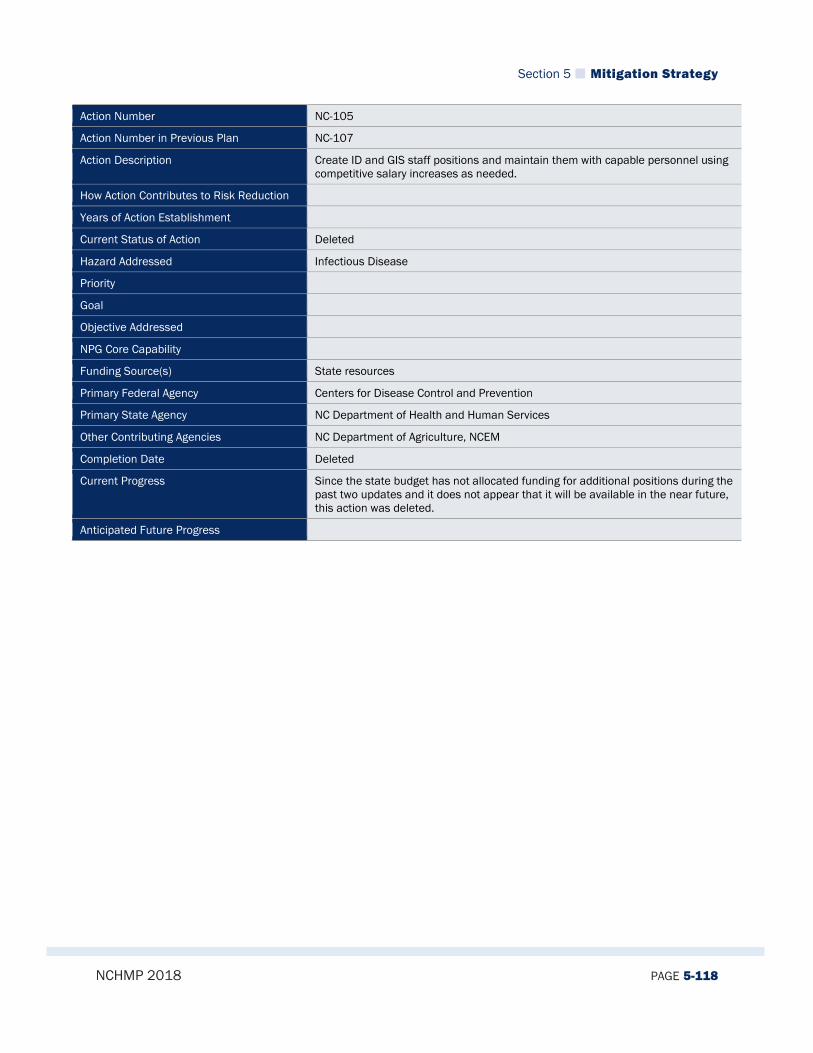
Section 5 Mitigation Strategy
NCHMP 2018 PAGE 5-118
Action Number NC-105
Action Number in Previous Plan NC-107
Action Description Create ID and GIS staff positions and maintain them with capable personnel using competitive salary increases as needed.
How Action Contributes to Risk Reduction
Years of Action Establishment
Current Status of Action Deleted
Hazard Addressed Infectious Disease
Priority
Goal
Objective Addressed
NPG Core Capability
Funding Source(s) State resources
Primary Federal Agency Centers for Disease Control and Prevention
Primary State Agency NC Department of Health and Human Services
Other Contributing Agencies NC Department of Agriculture, NCEM
Completion Date Deleted
Current Progress Since the state budget has not allocated funding for additional positions during the past two updates and it does not appear that it will be available in the near future, this action was deleted.
Anticipated Future Progress

Section 5 Mitigation Strategy
NCHMP 2018 PAGE 5-119
Action Number NC-106
Action Number in Previous Plan NC-108
Action Description Build and maintain a real-time ID webpage that communicates prevention measures, biosecurity practices, warnings, disease recognition, reporting information and actual incidents.
How Action Contributes to Risk Reduction Maintaining a real-time ID webpage increases awareness and improves risk management of infectious diseases.
Years of Action Establishment
Current Status of Action Completed
Hazard Addressed Infectious Disease
Priority
Goal
Objective Addressed
NPG Core Capability
Funding Source(s) State and Federal resources
Primary Federal Agency Centers for Disease Control and Prevention
Primary State Agency NC Department of Health and Human Services
Other Contributing Agencies NC Department of Agriculture, NCEM
Completion Date Completed
Current Progress A real-time infectious disease webpage has been developed and achieves all of the activities outlined above. This is the epi.publichealth.nc.gov website. As such, this action is considered complete.
Anticipated Future Progress
State of North Carolina Hazard Mitigation Plan
NCHMP 2018 PAGE 6-1
Section 6. PLAN MAINTENANCE, MONITORING AND IMPLEMENTATION
44 CFR Requirement Requirement §201.4(c)(5) [The Standard State Plan Maintenance Process must include]
(i) An established method and schedule for monitoring, evaluating, and updating the plan.
(ii) A system for monitoring implementation of mitigation measures and project closeouts.
(iii) A system for reviewing progress on achieving goals as well as activities and projects identified in the Mitigation Strategy
This section of the plan provides an overview of the procedures that define how the State of North Carolina will monitor, evaluate and update this plan over time. This includes defining implementation procedures to be followed and ways that the plan can be enhanced in the future. This sections also provides an overview of the system used to monitor implementation of mitigation measures and project closeouts. And finally, this section provides a summary of the system for reviewing progress made towards achieving goals, activities and projects identified in the Mitigation Strategy.
6.1 MONITORING, EVALUATING, AND UPDATING THE PLAN
6.1.1 Effectiveness of the Past Process As part of the 2018 plan update process, NCEM Risk Mitigation staff reviewed the defined method for monitoring, evaluating, and updating the plan and decided that a completely new format for presenting those procedures was needed for the 2018 plan. This decision was made for a multitude of reasons but the major factors were the organizational structure changes that have been made in the last five years, the integration of the Floodplain Mapping Discovery process and the State Mitigation Advisory Group into the Risk Management Coordinating Council and the need for a better defined process based off of realistic expectation and needs. This revised section represents the revised layout for plan maintenance, monitoring and implementation procedures.
Section 6 Plan Maintenance, Monitoring and Implementation
NCHMP 2018 PAGE 6-2
6.1.2 Agency and Section Responsible As provided for in the North Carolina Emergency Management Act of 1977 (NCGS 166A-5 (3) (b)), the responsibility for preparation and maintenance of State Plans for technological or natural disasters resides within the North Carolina Division of Emergency Management (NCEM). The Risk Mitigation Branch of NCEM will be responsible for developing and maintaining the State Hazard Mitigation Plan. The State Hazard Mitigation Officer is the individual responsible for overseeing this work.
6.1.3 Schedule Monitoring the Plan Regular monitoring of this Plan is essential for the document to be a true working document and is primarily accomplished through NCEM’s efforts to track the implementation and relevance of the plan. NCEM’s method for monitoring includes tracking implementation of actions found in the Mitigation Strategy. This helps ensure that the plan is being implemented over time. The mitigation actions listed within the Mitigation Strategy are measurable and time-bounded, and tracking implementation and progress is built-in to each action. Other ways that NCEM monitors the relevance of the plan is through meetings with the RMCC and other stakeholders to ensure that the data and methodologies that go toward developing the capability and risk assessments remain current. This helps ensure that the plan itself contributes to remain current and reflects changes to the statewide mitigation program. The Risk Mitigation Branch is responsible for conducting an ongoing monitoring progress made toward implementing the Plan. Evaluating the Plan In addition to monitoring of the plan, routine evaluation of the Plan helps provide information and data to measure progress and success in carrying out objectives identified within the Plan. Continued scrutiny of the document will help determine its overall effectiveness and ensure its ongoing relevance to the State’s mitigation needs. The end result of evaluating the Plan will be to make necessary revisions and enhancements, keeping the Plan up-to-date with current information, and maintaining the Plan’s functionality for the State. NOTE: The evaluation criteria presented below represent all new methods for evaluating the plan than were used in previous versions of the plan. NCEM will conduct an annual evaluation of the plan, generally in the month of April. The evaluation will consider several basic factors including: 1. Changes in the level of risk to the State and its citizens. 2. Changes in laws, policies, or regulations at the State or local levels. 3. Changes in State agencies or their procedures that will affect how mitigation programs or
funds are administered. 4. Significant changes in funding sources or capabilities.
Section 6 Plan Maintenance, Monitoring and Implementation
NCHMP 2018 PAGE 6-3
5. Changes in the composition of the RMCC 6. Progress on implementing mitigation actions (including project closeouts) and
identification of new mitigation actions that the State is considering. 7. Major changes to local or multi-jurisdictional hazard mitigation plans. In regard to tracking mitigation actions, NCEM will email RMCC members each year, at a minimum, to determine if there are any changes in status for the mitigation actions. The RMCC will also be encouraged to submit new mitigation actions. If an agency reports changes or submits a new action, NCEM will be responsible for incorporating those changes into the Plan. Additionally, NCEM will contact the County Emergency Management Agency Directors (or other individuals and organizations as appropriate) to determine if updates have been made to certain elements of the local plans as part of the annual review process. The purpose of this effort is to ensure that local information about risk, goals, projects, and mitigation strategies included in the State Plan remains current. If any party indicates that an update is warranted, outside of the required, five-year update schedule, then NCEM, in conjunction with the RMCC, will initiate the plan update process. To further involve the RMCC in the ongoing mitigation planning process, the RMCC will be invited to attend NCEM’s applicant briefing following a disaster. The RMCC will also be informed about disaster events via email. NCEM continues to advise agencies on how to incorporate mitigation into their planning efforts. Further, NCEM maintains regular contact with several members of the RMCC. This ongoing communication and relationship facilitates information sharing between agencies regarding mitigation activities. Updating the Plan NOTE: The update criteria presented below represent all new methods for updating the plan than were used in previous versions of the plan. The plan will be updated and re-submitted to FEMA for re-approval every five years, as required by law. The plan may also be subject to interim updates if any of the following conditions apply: 1. At the request of the Governor; 2. When significant new risks or vulnerabilities are identified; or 3. If the findings of the annual / post-disaster review and evaluation warrant. The two sub-paragraphs below describe the procedures for interim and five-year updates, respectively. Updates Resulting from Interim Evaluations The nature of plan updates will be determined by the evaluation process described above. In general, NCEM will notify the RMCC that the Agency is initiating an interim plan update, and describe the circumstances that created the need for the update. NCEM will determine if the
Section 6 Plan Maintenance, Monitoring and Implementation
NCHMP 2018 PAGE 6-4
full RMCC should be consulted regarding the potential changes. If it is determined that the RMCC should be involved, the nature of the involvement will be at the discretion of NCEM. When interim updates are completed, NCEM will advise all RMCC members that the plan has been updated, and describe the nature of the update. Updates Related to the Required Five-year Plan Review (by FEMA) As required by law, every five years the plan will be updated for re-submission and re-approval by FEMA. In those years, the evaluation process will be substantially more rigorous, and will examine all aspects of the plan in detail. It is anticipated that several meetings of the RMCC will be required to conduct a full update of the plan, and that the plan will be formally readopted by the State. Between 6 and 12 months prior to the update deadline, NCEM will initiate the plan update process by contacting RMCC members and other appropriate agencies and organizations to determine a schedule and process for updating the plan. The update process will entail a detailed and structured re-examination of all aspects of the original plan, followed by recommended updates. The recommendations will be presented to the RMCC for consideration and approval. It is expected that the Director of NCEM will re-approve the plan and adopt as the Governor’s Authorized Representative.
6.2 MONITORING IMPLEMENTATION OF MITIGATION MEASURES AND PROJECT CLOSEOUTS
6.2.1 System of Tracking Implementation The implementation of mitigation grant funding programs including Hazard Mitigation Grant Program (HMGP), Flood Mitigation Assistance (FMA) program, and Pre-Disaster Mitigation (PDM) program, is managed and monitored by the Hazard Mitigation Branch, Resiliency Section of the NCEM. When grant funding is approved by FEMA, the implementation phase begins with the signing of a grant agreement between the State of North Carolina (grantee) and the local government (subgrantee). The State of North Carolina’s current system for monitoring implementation of mitigation measures and project closeouts and emphasizes the development and implementation of projects that can be tracked to demonstrate progress in reducing our vulnerability to disasters. The State typically receives more qualified grant applications than it can fund after each disaster. Through continuous implementation of the measures identified in all previous editions of the state plan, the impact of natural hazards on people and property in the state is measurably being reduced. NCEM is currently using a software program specifically developed to manage all grant projects called EM Grants Pro. The Hazard Mitigation Section uses EM Grants Pro to manage all aspects of project grants including monitoring mitigation measures and closeouts. In
Section 6 Plan Maintenance, Monitoring and Implementation
NCHMP 2018 PAGE 6-5
addition, as NCEM transitions to EM Grants Pro, NCEM simultaneously maintains a legacy Hazard Mitigation Project Tracker for all grants that have been awarded. Project Implementation The NCEM Hazard Mitigation Branch and the Risk Mitigation Branch is committed to providing technical assistance, monitoring, and tracking of implementation project activities identified in the state and local plans. Prior to project commencement, NCEM conducts an implementation meeting with all subgrantees to ensure that policies and procedures for implementing the grant are explained within the context of program and administrative requirements. The following documents are provided to the subgrantee at this meeting: Copy of approved application Copy of grant agreement or draft grant agreement NCEM Mitigation Standard Operating Procedures Getting to Open Space guide Citizenship verification forms Guide to cost and progress reports with project manager’s contact information Computer disk including the following:
Project Cost Tracking Spreadsheet Progress report form Spreadsheet for determining budget info for cost report
For state or federally funded projects, subgrantees are required to submit progress reports on a monthly basis. Periodic site visits and telephone and email correspondences between the subgrantee and the state reinforces the technical assistance the state provides, and supplements the information stream to verify that projects are on track. In addition, grant managers track requests for reimbursement which provide information on project progress. Hazard Mitigation grant programs are generally operated on a reimbursement basis. At the local level, the subgrantee manages the various phases of the project as outlined in the scope of work. As communities implement projects, they can be reimbursed for project expenditures by submitting invoices and receipts to the state. This entire process must be accomplished within the bounds of the Federal Code of Regulations (CFR Part 44). Project Closeout The State uses the same process for all state and federally funded hazard mitigation grant programs when monitoring the implementation of mitigation measures and closing out projects: Mitigation staff of the NCEM use periodic site visits, the monthly reports provided by
the project grant recipient, and the requests for cost reimbursement to monitor progress and ensure the project is on track.
Additional site visits are scheduled for projects requiring special assistance. Final inspections are conducted by mitigation staff to ensure the project is completed
to specification. For example, a project to acquire homes will be inspected to ensure all structures that have been acquired are demolished to specifications.

Section 6 Plan Maintenance, Monitoring and Implementation
NCHMP 2018 PAGE 6-6
Post-completion inspections are conducted regularly by State mitigation staff to ensure the community has complied with the terms of the grant agreement related to the maintenance of the mitigation project. For example, such an inspection will make sure that a park developed from a site of property acquisitions remains a park. The community is also legally required by the grant agreement to bi-annually submit a statement that the property is still being maintained in accordance with open space requirements.
Project managers conduct a site visit with the community to ensure that files contain all completed forms, reports, and documents pertaining to the grant. Project managers use the attached checklist to guarantee that all necessary information is in the project files.
Before projects are submitted for close out, financial reconciliation is conducted to validate all reimbursement requests before final payment is made. Requests are validated against the approved Scope of Work to ensure only allowable costs are reimbursed.
Prior to sending a closeout request letter to FEMA, a NCEM/Hazard Mitigation Supervisor reviews the project closeout checklist and the financial reconciliation performed by the project manager to ensure all work has been completed and the financial portion of the project is correct, as well as ensuring the permanent project files are complete.
A single NCEM/Hazard Mitigation Supervisor or delegated staff member creates all closeout letters to ensure accuracy. This staff member is responsible for following up to ensure project folders and electronic files are complete and accurate. Financial information is checked to certify that the final costs are correct.
When the State submits letters for close out, a spreadsheet is provided with information that FEMA has requested for NEMIS data input. This spreadsheet provides property site information for every building acquired, elevated, or retrofitted in a project.
Since North Carolina maintains status as a Managing State, NCEM is required to submit the Property Site Inventory information via NEMIS for all disasters after DR#1312 and all subsequent disasters. Each time NEMIS is updated, the State is required to revise the PSI spreadsheet to include the additional information for each structure. FEMA may request that the State update the NEMIS PSI information in a timely manner.
A spreadsheet is also maintained to document when the State’s Closeout Request Letter was submitted to FEMA, when the State received the FEMA Final Claims Letter, and when the State submitted a Concurrence Letter back to FEMA. A copy of this spreadsheet is attached.
As part of the closeout process, NCEM Hazard Mitigation Staff began drafting detailed project closeout letters which include Project Closeout Certification Statements and Property Site Inventories. These additional documents have enhanced accountability for all deliverables and financial reconciliation across all properties identified in the Scope of Work. This has
Section 6 Plan Maintenance, Monitoring and Implementation
NCHMP 2018 PAGE 6-7
produced an “end-to-end” approach, where project development, implementation, and closeout are geared to produce these final closeout deliverables along the path of the life cycle of grants management (and not just as a final step). The Hazard Mitigation Branch also developed an effective process to track all grants during the implementation and closeout phases of grants management, built around an internal tracking tool. This e-tool uses a built-in “countdown clock” to allow Branch staff to track grant deadlines against federal and state periods of performance. The Hazard Mitigation Branch also closely collaborates with FEMA Region IV to compare their list of pending closeouts against the Region’s list of closeouts, and continues this comparison as a quality control measure. Going forward, the foundation of closing the 115 projects has led to a foundation which includes a process for collecting deliverables, monitoring periods of performance, and ensuring sound fiscal reconciliation by timely reimbursement of programmatically eligible expenses. Monitoring Mitigation Activities Hazard Mitigation Section staff have improved the existing system of Quarterly Reporting procedures which includes more comprehensive descriptions of projects, e.g., number of appraisals, number of elevations in progress, acquisitions, project site visits, monitoring and close-outs anticipated, and improved information regarding financial management. Hazard Mitigation Project Management staff are responsible for collecting and monitoring mitigation information during the implementation of each project
6.2.2 System for Reviewing Progress on Achieving Goals In order to track progress on achieving the goals identified in this plan, NCEM Risk Mitigation Staff will ensure that both the annual and five-year plan evaluations include a review and analysis of the plan goals, and the various actions that are intended to achieve them. This process will be substantially more rigorous and detailed during the formal plan update process. The Mitigation Strategy describes the hazard mitigation goals, and includes a detailed table that lists various strategies and actions that the State is undertaking or considering to address the goals. The system for reviewing progress on achieving goals will remain the same as it has proved successful over the last five years.
6.2.3 System for Reviewing Progress on Activities and Projects in the Mitigation Strategy As part of the annual evaluation, NCEM will email the RMCC to determine if there are any changes to the mitigation actions listed in the mitigation strategy section. In addition, members of the RMCC will be encouraged submit new actions at this time. As part of the five-year update to the plan, NCEM initiated a more detailed review and evaluation of all activities and projects noted in the mitigation strategy. NCEM reported its findings to the RMCC at meetings held as part of the plan update process. The results of these findings have been included in the table of mitigation goals and actions included in the Mitigation Strategy.
Section 6 Plan Maintenance, Monitoring and Implementation
NCHMP 2018 PAGE 6-8
6.3 EVALUATION OF IMPLEMENTATION PROGRESS
Due to the previous plan’s mitigation effectiveness, many of the same procedures were used in the 2018 update. Progress was reviewed and monitored using different measures, which included: Progress Report for Mitigation Planning Projects HMGP Cost Report Information Cost Tracking Spreadsheet
These procedures have been successful in reviewing progress and were modified and streamlined as needed for the 2018 update. Additionally, meetings were held by members of NCEM’s Risk Mitigation Branch and Hazard Mitigation Branch staff to discuss progress made since the last update. Many issues were addressed, such as: Establishing realistic objectives and goals Results of completed mitigation projects Determining how existing state goals can complement anticipated objectives
North Carolina’s strong team of federal, state, local, public and private entities have worked together to enhance the state’s mitigation abilities. Through coordination, the State has effectively collected data to improve risk assessments and determine which areas need more focus. Noteworthy achievements include: The NC Floodplain Mapping Program, which has created, maintained, and
strengthened maps for all 100 counties and has helped modify International Building Codes
Implementation of Integrated Hazard Risk Management and Communications Tool to address flooding, hurricane, severe winter weather, earthquake, wildfire, dam failure, drought, tornado/thunderstorm, and geological hazards.
Vulnerability Assessment Tools which use GIS data to identify hazard-prone counties and Special Flood Hazard Areas
Continued working relationships between the NCEM, National Weather Service, NCDENR, NCDOT, Forest Resources and other stakeholders
Swift and appropriate use of individual and public assistance to aid disaster recovery Creation of the NC Resilient Redevelopment Planning program to empower and
rebuild communities after disasters Formation of the Risk Management Tool that simplifies data to design specific and
obtainable mitigation actions Progress will continue to be evaluated in order to enhance the plan’s efficiency in the future and reflect changes throughout the state.

Appendix A State Mitigation Plan Review Tool
NCHMP 2018 PAGE A-1
Appendix A. State Mitigation Plan Review Tool
Will include final State Mitigation Plan Review Tool after FEMA approval.

Appendix B Emergency Management Accreditation Program (EMAP)
NCHMP 2018 PAGE B-1
Appendix B. Emergency Management Accreditation Program (EMAP)
B.1 STANDARD 4.1 In addition to meeting the standard requirements of the risk and vulnerability section outlined by FEMA, the State of North Carolina addressed the more comprehensive standards set forth by the Emergency Management Accreditation Program (EMAP) for assessing risk and vulnerability. EMAP standards describe the need for a consequence analysis to be performed when analyzing risk and vulnerability. Specifically, EMAP Standard 4.1.1 requires an evaluation of the risk and vulnerability of hazards on the following: People Property The environment The jurisdiction’s own operations
Furthermore, EMAP Standard 4.1.2 requires that the state consider the impact of identified hazards on: The public Responders Continuity of operations, including continued delivery of services Property, facilities, and infrastructure The environment Economic condition of the jurisdiction Public confidence in the jurisdiction’s governance
Finally, in Standard 4.1.3, EMAP requires that the Emergency Management Program have a method and schedule for evaluation, maintenance, and revision of its Hazard Identification and Risk Assessment (HIRA) and Consequence Analysis. This is described in Section 6 of this plan. In order to simplify EMAP review, the state determined that it would be best to address these standards in a separate appendix of the plan, which is laid out in detail below by hazard. However, it should also be noted that the many other sections of the State Hazard Mitigation Plan also contain important information regarding EMAP requirements and should not be overlooked during an EMAP review. For example, Section 3 contains a great deal of risk and vulnerability data that should be reviewed when considering EMAP Standard 4.1. Although the tables below are primarily provided as a means of addressing EMAP criteria, the analyses they provide are valuable for understanding the state’s specific risks and what

Appendix B Emergency Management Accreditation Program (EMAP)
NCHMP 2018 PAGE B-2
actions might be best to implement to reduce that risk. Therefore, they are an important component of the state’s mitigation plan. List of Tables
Table B-1 EMAP Flooding Risk, Vulnerability, and Consequence Analysis .................................................................. B-3
Table B-2 EMAP Hurricanes/Coastal Hazards Risk, Vulnerability, and Consequence Analysis ................................. B-6
Table B-3 EMAP Severe Winter Weather Risk, Vulnerability, and Consequence Analysis ......................................... B-9
Table B-4 EMAP Earthquake Risk, Vulnerability, and Consequence Analysis .......................................................... B-13
Table B-5 EMAP Wildfires Risk, Vulnerability, and Consequence Analysis ............................................................... B-15
Table B-6 EMAP Dam Failures Risk, Vulnerability, and Consequence Analysis ........................................................ B-17
Table B-7 EMAP Drought Risk, Vulnerability, and Consequence Analysis ................................................................ B-19
Table B-8 EMAP Tornado/Thunderstorms Risk, Vulnerability, and Consequence Analysis ..................................... B-23
Table B-9 EMAP Geological Risk, Vulnerability, and Consequence Analysis ............................................................ B-26
Table B-10 EMAP Infectious Disease Risk, Vulnerability, and Consequence Analysis ............................................. B-28
Table B-11 EMAP Hazardous Substances Risk, Vulnerability, and Consequence Analysis ..................................... B-30
Table B-12 EMAP Radiological Emergency- Fixed Nuclear Facility Risk, Vulnerability, and Consequence AnalysisB-33
Table B-13 EMAP Terrorism (CBRNE) Risk, Vulnerability, and Consequence Analysis ............................................ B-35
Table B-14 EMAP Cyber Attack Risk, Vulnerability, and Consequence Analysis....................................................... B-38
Table B-15 EMAP Extreme Heat Risk, Vulnerability, and Consequence Analysis ..................................................... B-39
Table B-16 EMAP Electromagnetic Pulse (EMP)/Geomagnetic Storms Risk, Vulnerability, and Consequence Analysis ...................................................................................................................................................................................... B-41
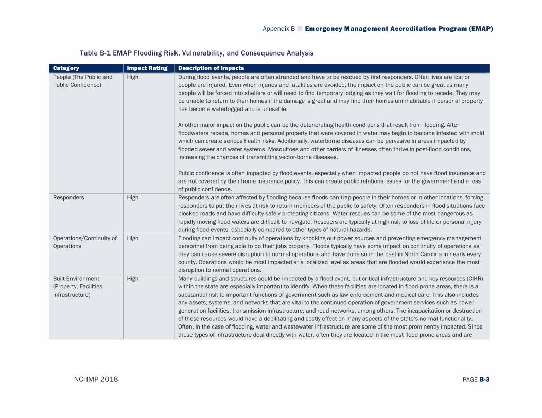
Appendix B Emergency Management Accreditation Program (EMAP)
NCHMP 2018 PAGE B-3
Table B-1 EMAP Flooding Risk, Vulnerability, and Consequence Analysis
Category Impact Rating Description of Impacts People (The Public and Public Confidence)
High During flood events, people are often stranded and have to be rescued by first responders. Often lives are lost or people are injured. Even when injuries and fatalities are avoided, the impact on the public can be great as many people will be forced into shelters or will need to find temporary lodging as they wait for flooding to recede. They may be unable to return to their homes if the damage is great and may find their homes uninhabitable if personal property has become waterlogged and is unusable. Another major impact on the public can be the deteriorating health conditions that result from flooding. After floodwaters recede, homes and personal property that were covered in water may begin to become infested with mold which can create serious health risks. Additionally, waterborne diseases can be pervasive in areas impacted by flooded sewer and water systems. Mosquitoes and other carriers of illnesses often thrive in post-flood conditions, increasing the chances of transmitting vector-borne diseases. Public confidence is often impacted by flood events, especially when impacted people do not have flood insurance and are not covered by their home insurance policy. This can create public relations issues for the government and a loss of public confidence.
Responders High Responders are often affected by flooding because floods can trap people in their homes or in other locations, forcing responders to put their lives at risk to return members of the public to safety. Often responders in flood situations face blocked roads and have difficulty safely protecting citizens. Water rescues can be some of the most dangerous as rapidly moving flood waters are difficult to navigate. Rescuers are typically at high risk to loss of life or personal injury during flood events, especially compared to other types of natural hazards.
Operations/Continuity of Operations
High Flooding can impact continuity of operations by knocking out power sources and preventing emergency management personnel from being able to do their jobs properly. Floods typically have some impact on continuity of operations as they can cause severe disruption to normal operations and have done so in the past in North Carolina in nearly every county. Operations would be most impacted at a localized level as areas that are flooded would experience the most disruption to normal operations.
Built Environment (Property, Facilities, Infrastructure)
High Many buildings and structures could be impacted by a flood event, but critical infrastructure and key resources (CIKR) within the state are especially important to identify. When these facilities are located in flood-prone areas, there is a substantial risk to important functions of government such as law enforcement and medical care. This also includes any assets, systems, and networks that are vital to the continued operation of government services such as power generation facilities, transmission infrastructure, and road networks, among others. The incapacitation or destruction of these resources would have a debilitating and costly effect on many aspects of the state’s normal functionality. Often, in the case of flooding, water and wastewater infrastructure are some of the most prominently impacted. Since these types of infrastructure deal directly with water, often they are located in the most flood prone areas and are

Appendix B Emergency Management Accreditation Program (EMAP)
NCHMP 2018 PAGE B-4
Category Impact Rating Description of Impacts severely impacted during flood events. When these facilities or infrastructure are flooded, it complicates recovery and impacts people who are unable to utilize normal water sources for drinking, sanitation, and other everyday uses. In addition, personal property such as homes and businesses have been impacted to a large degree by past flooding events and are a major concern in future flooding events. Although a great deal of effort has been undertaken to reduce the number of properties at risk through the use of progressively improved risk assessment and mitigation techniques, there are still a significant number of structures throughout the state that are located in flood zones or which have not been properly mitigated to reduce risk. These properties may sustain billions of dollars of damage during future flood events and are often a major focus of post-disaster recovery efforts.
Economy High There are a variety of economic impacts that could result from a large-scale flood event. One major impact is on soil that is covered by flood waters, causing the rapid depletion of oxygen, which is essential for plant growth and development. This can hurt agricultural production in areas of the state were that is a key economic driver. Secondly, flooding often causes the shutdown of businesses, many of which never re-open after a flood event. Indeed, FEMA reports that almost 40 percent of small businesses never reopen their doors after a disaster because only small amounts of flood waters can cause thousands of dollars of damage.1 The shutdown of these small businesses in many communities can be devastating as many small, rural communities in the state rely heavily on these small businesses as economic drivers and the base of the local economy. After Hurricane Floyd, which was primarily considered to be a flood event, the North Carolina Floodplain Mapping Program reported the following statistics which serve as a sort of benchmark for potential future flooding events:
Hurricane Floyd Impacts (1999)2
Businesses Affected 60,000 Estimated Jobs Lost 31,000 Physical Damage to Businesses $1,000,000,000 Business Revenue Lost $4,000,000,000
Environment Low The fluctuation of water levels in a wetland, especially flood waters, supports the biological diversity of low-lying areas by releasing nutrients into the soil and germinating wetland flora. Flooding also offers some control of invasive water weeds. Most features of the environment have come to adapt to the effects of a flood event and respond quickly, although it is possible that some species may not be resilient enough to survive and will experience population loss.
1 FEMA. (2017). Protecting Your Businesses. Retrieved August 21, 2017, from https://www.fema.gov/protecting-your-businesses 2 North Carolina Floodplain Mapping Program. Retrieved August 21, 2017, from: http://www.ncfloodmaps.com/flood_data.htm
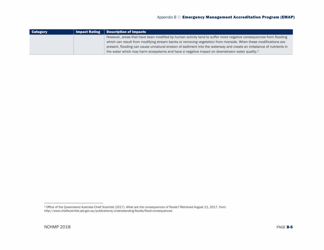
Appendix B Emergency Management Accreditation Program (EMAP)
NCHMP 2018 PAGE B-5
Category Impact Rating Description of Impacts However, areas that have been modified by human activity tend to suffer more negative consequences from flooding which can result from modifying stream banks or removing vegetation from riverside. When these modifications are present, flooding can cause unnatural erosion of sediment into the waterway and create an imbalance of nutrients in the water which may harm ecosystems and have a negative impact on downstream water quality.3
3 Office of the Queensland Australia Chief Scientist (2017). What are the consequences of floods? Retrieved August 21, 2017, from: http://www.chiefscientist.qld.gov.au/publications/understanding-floods/flood-consequences
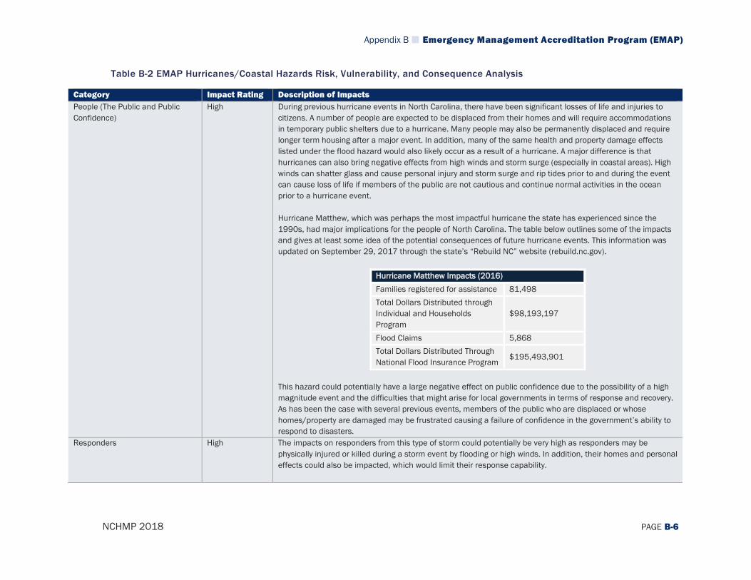
Appendix B Emergency Management Accreditation Program (EMAP)
NCHMP 2018 PAGE B-6
Table B-2 EMAP Hurricanes/Coastal Hazards Risk, Vulnerability, and Consequence Analysis
Category Impact Rating Description of Impacts People (The Public and Public Confidence)
High During previous hurricane events in North Carolina, there have been significant losses of life and injuries to citizens. A number of people are expected to be displaced from their homes and will require accommodations in temporary public shelters due to a hurricane. Many people may also be permanently displaced and require longer term housing after a major event. In addition, many of the same health and property damage effects listed under the flood hazard would also likely occur as a result of a hurricane. A major difference is that hurricanes can also bring negative effects from high winds and storm surge (especially in coastal areas). High winds can shatter glass and cause personal injury and storm surge and rip tides prior to and during the event can cause loss of life if members of the public are not cautious and continue normal activities in the ocean prior to a hurricane event. Hurricane Matthew, which was perhaps the most impactful hurricane the state has experienced since the 1990s, had major implications for the people of North Carolina. The table below outlines some of the impacts and gives at least some idea of the potential consequences of future hurricane events. This information was updated on September 29, 2017 through the state’s “Rebuild NC” website (rebuild.nc.gov).
Hurricane Matthew Impacts (2016) Families registered for assistance 81,498 Total Dollars Distributed through Individual and Households Program
$98,193,197
Flood Claims 5,868 Total Dollars Distributed Through National Flood Insurance Program
$195,493,901
This hazard could potentially have a large negative effect on public confidence due to the possibility of a high magnitude event and the difficulties that might arise for local governments in terms of response and recovery. As has been the case with several previous events, members of the public who are displaced or whose homes/property are damaged may be frustrated causing a failure of confidence in the government’s ability to respond to disasters.
Responders High The impacts on responders from this type of storm could potentially be very high as responders may be physically injured or killed during a storm event by flooding or high winds. In addition, their homes and personal effects could also be impacted, which would limit their response capability.
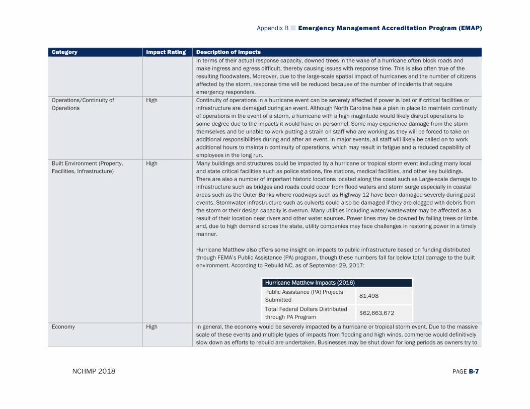
Appendix B Emergency Management Accreditation Program (EMAP)
NCHMP 2018 PAGE B-7
Category Impact Rating Description of Impacts In terms of their actual response capacity, downed trees in the wake of a hurricane often block roads and make ingress and egress difficult, thereby causing issues with response time. This is also often true of the resulting floodwaters. Moreover, due to the large-scale spatial impact of hurricanes and the number of citizens affected by the storm, response time will be reduced because of the number of incidents that require emergency responders.
Operations/Continuity of Operations
High Continuity of operations in a hurricane event can be severely affected if power is lost or if critical facilities or infrastructure are damaged during an event. Although North Carolina has a plan in place to maintain continuity of operations in the event of a storm, a hurricane with a high magnitude would likely disrupt operations to some degree due to the impacts it would have on personnel. Some may experience damage from the storm themselves and be unable to work putting a strain on staff who are working as they will be forced to take on additional responsibilities during and after an event. In major events, all staff will likely be called on to work additional hours to maintain continuity of operations, which may result in fatigue and a reduced capability of employees in the long run.
Built Environment (Property, Facilities, Infrastructure)
High Many buildings and structures could be impacted by a hurricane or tropical storm event including many local and state critical facilities such as police stations, fire stations, medical facilities, and other key buildings. There are also a number of important historic locations located along the coast such as Large-scale damage to infrastructure such as bridges and roads could occur from flood waters and storm surge especially in coastal areas such as the Outer Banks where roadways such as Highway 12 have been damaged severely during past events. Stormwater infrastructure such as culverts could also be damaged if they are clogged with debris from the storm or their design capacity is overrun. Many utilities including water/wastewater may be affected as a result of their location near rivers and other water sources. Power lines may be downed by falling trees or limbs and, due to high demand across the state, utility companies may face challenges in restoring power in a timely manner. Hurricane Matthew also offers some insight on impacts to public infrastructure based on funding distributed through FEMA’s Public Assistance (PA) program, though these numbers fall far below total damage to the built environment. According to Rebuild NC, as of September 29, 2017:
Hurricane Matthew Impacts (2016) Public Assistance (PA) Projects Submitted
81,498
Total Federal Dollars Distributed through PA Program
$62,663,672
Economy High In general, the economy would be severely impacted by a hurricane or tropical storm event. Due to the massive scale of these events and multiple types of impacts from flooding and high winds, commerce would definitively slow down as efforts to rebuild are undertaken. Businesses may be shut down for long periods as owners try to
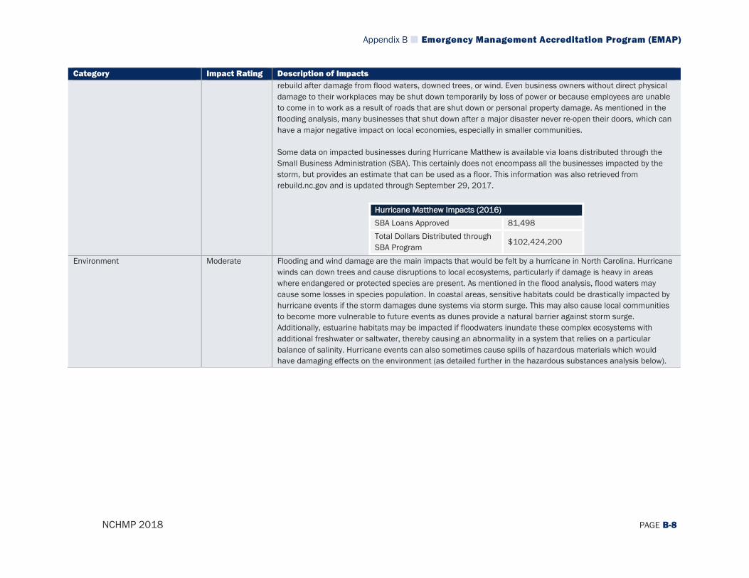
Appendix B Emergency Management Accreditation Program (EMAP)
NCHMP 2018 PAGE B-8
Category Impact Rating Description of Impacts rebuild after damage from flood waters, downed trees, or wind. Even business owners without direct physical damage to their workplaces may be shut down temporarily by loss of power or because employees are unable to come in to work as a result of roads that are shut down or personal property damage. As mentioned in the flooding analysis, many businesses that shut down after a major disaster never re-open their doors, which can have a major negative impact on local economies, especially in smaller communities. Some data on impacted businesses during Hurricane Matthew is available via loans distributed through the Small Business Administration (SBA). This certainly does not encompass all the businesses impacted by the storm, but provides an estimate that can be used as a floor. This information was also retrieved from rebuild.nc.gov and is updated through September 29, 2017.
Hurricane Matthew Impacts (2016) SBA Loans Approved 81,498 Total Dollars Distributed through SBA Program
$102,424,200
Environment Moderate Flooding and wind damage are the main impacts that would be felt by a hurricane in North Carolina. Hurricane winds can down trees and cause disruptions to local ecosystems, particularly if damage is heavy in areas where endangered or protected species are present. As mentioned in the flood analysis, flood waters may cause some losses in species population. In coastal areas, sensitive habitats could be drastically impacted by hurricane events if the storm damages dune systems via storm surge. This may also cause local communities to become more vulnerable to future events as dunes provide a natural barrier against storm surge. Additionally, estuarine habitats may be impacted if floodwaters inundate these complex ecosystems with additional freshwater or saltwater, thereby causing an abnormality in a system that relies on a particular balance of salinity. Hurricane events can also sometimes cause spills of hazardous materials which would have damaging effects on the environment (as detailed further in the hazardous substances analysis below).
Appendix B Emergency Management Accreditation Program (EMAP)
NCHMP 2018 PAGE B-9
Table B-3 EMAP Severe Winter Weather Risk, Vulnerability, and Consequence Analysis
Category Impact Rating Description of Impacts People (The Public and Public Confidence)
Moderate Winter weather most often impacts people indirectly and has differing impacts in different areas of the state. Mountainous areas in the western part of the state are much more accustomed to winter weather and therefore, are often more prepared to deal with it. However, these areas are also much more likely to experience larger accumulations of precipitation and colder temperatures than areas further east. Across the state, winter weather can create dangerous driving conditions by limiting visibility for drivers or creating slick conditions that make maneuverability difficult. Loss of power can create very cold conditions for residents, making it difficult to stay warm. Residents may try to heat their home using alternative means, which runs the risk of carbon monoxide poisoning caused by improperly ventilated heating sources. In addition, dangerously cold temperatures increase the risk of wind chill, frostbite, and hypothermia. Another indirect impact of winter weather on the public is its potential to impact public and private school schedules through closings and delays. Poor driving conditions, lack of power and heat, and mechanical problems with school buses and equipment due to cold weather conditions are potential concerns. School closures and delays can lead to logistical problems for teachers and school administrators, especially in the event of end-of-term exams and standardized testing schedules. It can also result in logistical problems for making up school days. Winter storms generally do not have a large impact on public confidence, but it could be somewhat impacted if road clearing or response operations are slow.
Responders Moderate Responders in severe winter weather events face a variety of hazards, including slick or icy roads that could cause accidents if they are attempting to quickly respond to an emergency as is often the case. The chances of crashed emergency vehicles and injuries to responders are always a possibility, but increase during a winter storm event due to difficult driving conditions. Winter weather can also make it difficult to access more rural areas if roads are snowed/iced over and emergency vehicles cannot pass through.
Operations/Continuity of Operations
Moderate Generally, continuity of operations can be maintained during a winter weather event in North Carolina. However, winter weather does have the potential to affect power transmission as the weight of ice and snow can cause trees and limbs to fall and damage transmission lines. Winter precipitation can also freeze to roadways or create slick conditions that make it difficult for emergency management employees to get to work. As a result, there will likely be some disruption of operations during a winter weather event.
Built Environment (Property, Facilities, Infrastructure)
Moderate One of the primary identified impacts of winter weather in North Carolina is the disruption of utilities. Utilities that are at risk of being affected include telephone, internet, cable, and water. Newspaper reports typically cite trees falling on electrical wires—as well as trees that have already been damaged from previous incidents that fall during a winter storm—or the stress caused by ice accumulation as main causes for power outages. Damage
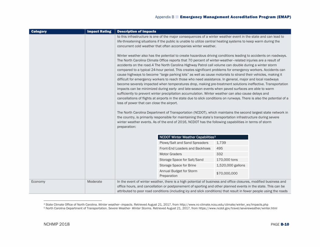
Appendix B Emergency Management Accreditation Program (EMAP)
NCHMP 2018 PAGE B-10
Category Impact Rating Description of Impacts to this infrastructure is one of the major consequences of a winter weather event in the state and can lead to life-threatening situations if the public is unable to utilize central heating systems to keep warm during the concurrent cold weather that often accompanies winter weather. Winter weather also has the potential to create hazardous driving conditions leading to accidents on roadways. The North Carolina Climate Office reports that 70 percent of winter-weather–related injuries are a result of accidents on the road.4 The North Carolina Highway Patrol call volume can double during a winter storm compared to a typical 24-hour period. This creates significant problems for emergency workers. Accidents can cause highways to become “large parking lots” as well as cause motorists to strand their vehicles, making it difficult for emergency workers to reach those who need assistance. In general, major and local roadways become severely impacted when temperatures drop, making pre-treatment solutions ineffective. Transportation impacts can be minimized during early- and late-season events when paved surfaces are able to warm sufficiently to prevent winter precipitation accumulation. Winter weather can also cause delays and cancellations of flights at airports in the state due to slick conditions on runways. There is also the potential of a loss of power that can close the airport. The North Carolina Department of Transportation (NCDOT), which maintains the second largest state network in the country, is primarily responsible for maintaining the state’s transportation infrastructure during severe winter weather events. As of the end of 2016, NCDOT has the following capabilities in terms of storm preparation:
NCDOT Winter Weather Capabilities5 Plows/Salt and Sand Spreaders 1,739 Front-End Loaders and Backhoes 495 Motor Graders 332 Storage Space for Salt/Sand 170,000 tons Storage Space for Brine 1,520,000 gallons Annual Budget for Storm Preparation
$70,000,000
Economy Moderate In the event of winter weather, there is a high potential of business and office closures, modified business and office hours, and cancellation or postponement of sporting and other planned events in the state. This can be attributed to poor road conditions (including icy and slick conditions) that result in fewer people using the roads
4 State Climate Office of North Carolina. Winter weather—impacts. Retrieved August 21, 2017, from http://www.nc-climate.ncsu.edu/climate/winter_wx/Impacts.php 5 North Carolina Department of Transportation. Severe Weather- Winter Storms. Retrieved August 21, 2017, from https://www.ncdot.gov/travel/severeweather/winter.html
Appendix B Emergency Management Accreditation Program (EMAP)
NCHMP 2018 PAGE B-11
Category Impact Rating Description of Impacts to get to their destination or a loss of power and heat that result in a loss of operations at specific facilities. In general, absenteeism is higher during winter weather events as many employers rightly encourage employees to stay home and avoid potential injury in unsafe driving conditions. As can be seen in the chart below, the Bureau of Labor Statistics6 notes that although any major weather event can cause absences at work, workers are more likely to be absent because of bad weather during winter months because winter weather tends to impact much larger areas and makes travel difficult throughout much more of the transportation network.
6 United States Bureau of Labor Statistics. Work Absences Due to Bad Weather from 1994 to 2016. Retrieved August 21, 2017, from https://www.bls.gov/opub/ted/2017/work-absences-due-to-bad-weather-from-1994-to-2016.htm
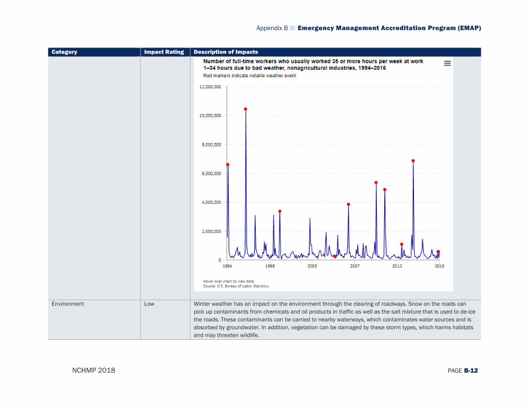
Appendix B Emergency Management Accreditation Program (EMAP)
NCHMP 2018 PAGE B-12
Category Impact Rating Description of Impacts
Environment Low Winter weather has an impact on the environment through the clearing of roadways. Snow on the roads can pick up contaminants from chemicals and oil products in traffic as well as the salt mixture that is used to de-ice the roads. These contaminants can be carried to nearby waterways, which contaminates water sources and is absorbed by groundwater. In addition, vegetation can be damaged by these storm types, which harms habitats and may threaten wildlife.
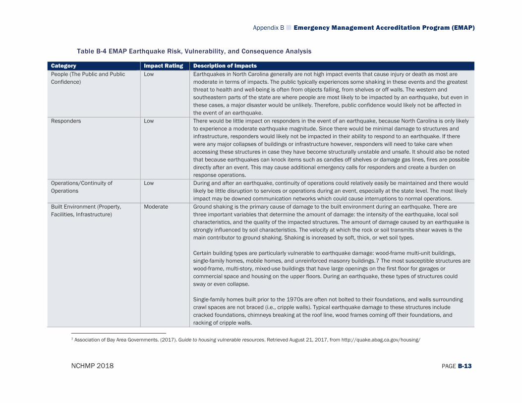
Appendix B Emergency Management Accreditation Program (EMAP)
NCHMP 2018 PAGE B-13
Table B-4 EMAP Earthquake Risk, Vulnerability, and Consequence Analysis
Category Impact Rating Description of Impacts People (The Public and Public Confidence)
Low Earthquakes in North Carolina generally are not high impact events that cause injury or death as most are moderate in terms of impacts. The public typically experiences some shaking in these events and the greatest threat to health and well-being is often from objects falling, from shelves or off walls. The western and southeastern parts of the state are where people are most likely to be impacted by an earthquake, but even in these cases, a major disaster would be unlikely. Therefore, public confidence would likely not be affected in the event of an earthquake.
Responders Low There would be little impact on responders in the event of an earthquake, because North Carolina is only likely to experience a moderate earthquake magnitude. Since there would be minimal damage to structures and infrastructure, responders would likely not be impacted in their ability to respond to an earthquake. If there were any major collapses of buildings or infrastructure however, responders will need to take care when accessing these structures in case they have become structurally unstable and unsafe. It should also be noted that because earthquakes can knock items such as candles off shelves or damage gas lines, fires are possible directly after an event. This may cause additional emergency calls for responders and create a burden on response operations.
Operations/Continuity of Operations
Low During and after an earthquake, continuity of operations could relatively easily be maintained and there would likely be little disruption to services or operations during an event, especially at the state level. The most likely impact may be downed communication networks which could cause interruptions to normal operations.
Built Environment (Property, Facilities, Infrastructure)
Moderate Ground shaking is the primary cause of damage to the built environment during an earthquake. There are three important variables that determine the amount of damage: the intensity of the earthquake, local soil characteristics, and the quality of the impacted structures. The amount of damage caused by an earthquake is strongly influenced by soil characteristics. The velocity at which the rock or soil transmits shear waves is the main contributor to ground shaking. Shaking is increased by soft, thick, or wet soil types. Certain building types are particularly vulnerable to earthquake damage: wood-frame multi-unit buildings, single-family homes, mobile homes, and unreinforced masonry buildings.7 The most susceptible structures are wood-frame, multi-story, mixed-use buildings that have large openings on the first floor for garages or commercial space and housing on the upper floors. During an earthquake, these types of structures could sway or even collapse. Single-family homes built prior to the 1970s are often not bolted to their foundations, and walls surrounding crawl spaces are not braced (i.e., cripple walls). Typical earthquake damage to these structures include cracked foundations, chimneys breaking at the roof line, wood frames coming off their foundations, and racking of cripple walls.
7 Association of Bay Area Governments. (2017). Guide to housing vulnerable resources. Retrieved August 21, 2017, from http://quake.abag.ca.gov/housing/
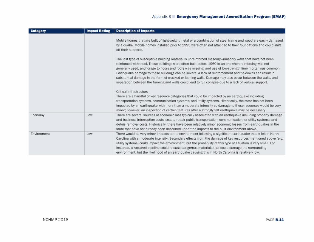
Appendix B Emergency Management Accreditation Program (EMAP)
NCHMP 2018 PAGE B-14
Category Impact Rating Description of Impacts Mobile homes that are built of light-weight metal or a combination of steel frame and wood are easily damaged by a quake. Mobile homes installed prior to 1995 were often not attached to their foundations and could shift off their supports. The last type of susceptible building material is unreinforced masonry—masonry walls that have not been reinforced with steel. These buildings were often built before 1960 in an era when reinforcing was not generally used, anchorage to floors and roofs was missing, and use of low-strength lime mortar was common. Earthquake damage to these buildings can be severe. A lack of reinforcement and tie-downs can result in substantial damage in the form of cracked or leaning walls. Damage may also occur between the walls, and separation between the framing and walls could lead to full collapse due to a lack of vertical support. Critical Infrastructure There are a handful of key resource categories that could be impacted by an earthquake including transportation systems, communication systems, and utility systems. Historically, the state has not been impacted by an earthquake with more than a moderate intensity so damage to these resources would be very minor; however, an inspection of certain features after a strongly felt earthquake may be necessary.
Economy Low There are several sources of economic loss typically associated with an earthquake including property damage and business interruption costs; cost to repair public transportation, communication, or utility systems; and debris removal costs. Historically, there have been relatively minor economic losses from earthquakes in the state that have not already been described under the impacts to the built environment above.
Environment Low There would be very minor impacts to the environment following a significant earthquake that is felt in North Carolina with a moderate intensity. Secondary effects from the damage of key resources mentioned above (e.g. utility systems) could impact the environment, but the probability of this type of situation is very small. For instance, a ruptured pipeline could release dangerous materials that could damage the surrounding environment, but the likelihood of an earthquake causing this in North Carolina is relatively low.
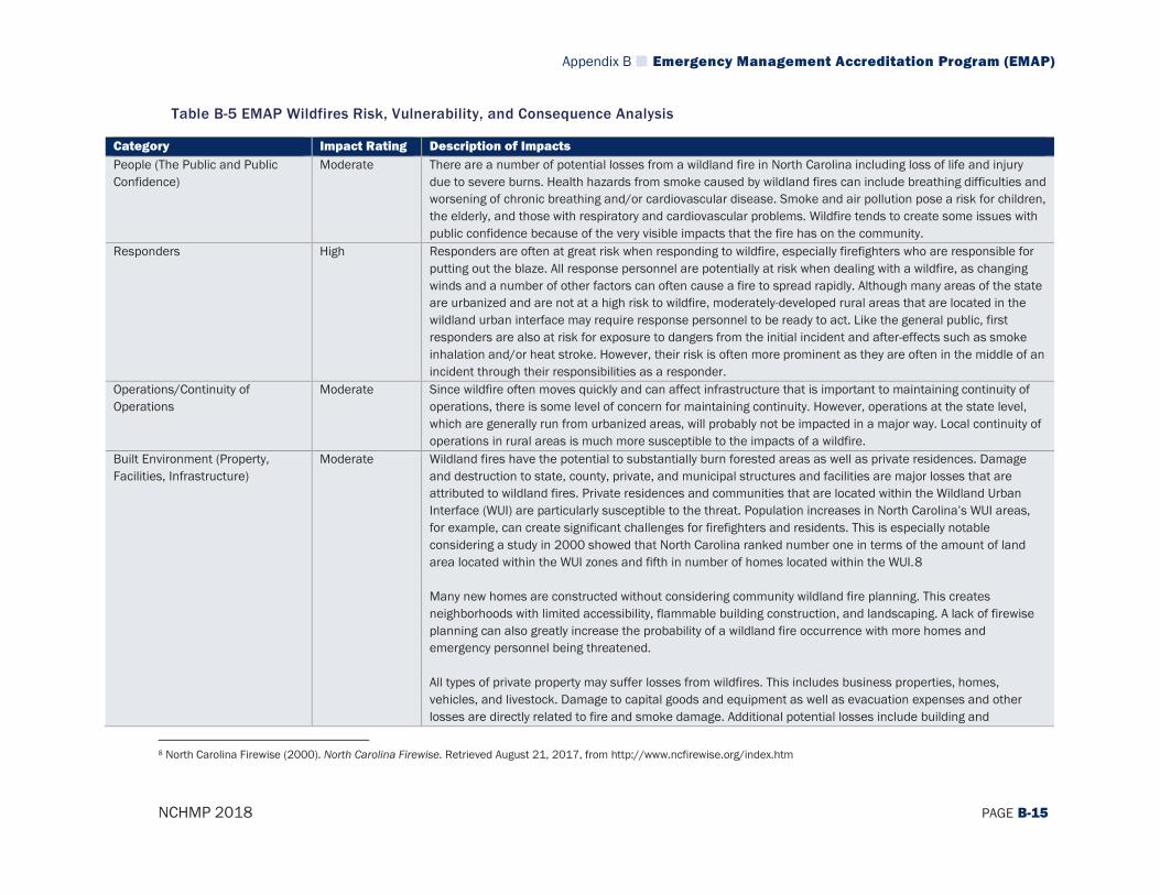
Appendix B Emergency Management Accreditation Program (EMAP)
NCHMP 2018 PAGE B-15
Table B-5 EMAP Wildfires Risk, Vulnerability, and Consequence Analysis
Category Impact Rating Description of Impacts People (The Public and Public Confidence)
Moderate There are a number of potential losses from a wildland fire in North Carolina including loss of life and injury due to severe burns. Health hazards from smoke caused by wildland fires can include breathing difficulties and worsening of chronic breathing and/or cardiovascular disease. Smoke and air pollution pose a risk for children, the elderly, and those with respiratory and cardiovascular problems. Wildfire tends to create some issues with public confidence because of the very visible impacts that the fire has on the community.
Responders High Responders are often at great risk when responding to wildfire, especially firefighters who are responsible for putting out the blaze. All response personnel are potentially at risk when dealing with a wildfire, as changing winds and a number of other factors can often cause a fire to spread rapidly. Although many areas of the state are urbanized and are not at a high risk to wildfire, moderately-developed rural areas that are located in the wildland urban interface may require response personnel to be ready to act. Like the general public, first responders are also at risk for exposure to dangers from the initial incident and after-effects such as smoke inhalation and/or heat stroke. However, their risk is often more prominent as they are often in the middle of an incident through their responsibilities as a responder.
Operations/Continuity of Operations
Moderate Since wildfire often moves quickly and can affect infrastructure that is important to maintaining continuity of operations, there is some level of concern for maintaining continuity. However, operations at the state level, which are generally run from urbanized areas, will probably not be impacted in a major way. Local continuity of operations in rural areas is much more susceptible to the impacts of a wildfire.
Built Environment (Property, Facilities, Infrastructure)
Moderate Wildland fires have the potential to substantially burn forested areas as well as private residences. Damage and destruction to state, county, private, and municipal structures and facilities are major losses that are attributed to wildland fires. Private residences and communities that are located within the Wildland Urban Interface (WUI) are particularly susceptible to the threat. Population increases in North Carolina’s WUI areas, for example, can create significant challenges for firefighters and residents. This is especially notable considering a study in 2000 showed that North Carolina ranked number one in terms of the amount of land area located within the WUI zones and fifth in number of homes located within the WUI.8 Many new homes are constructed without considering community wildland fire planning. This creates neighborhoods with limited accessibility, flammable building construction, and landscaping. A lack of firewise planning can also greatly increase the probability of a wildland fire occurrence with more homes and emergency personnel being threatened. All types of private property may suffer losses from wildfires. This includes business properties, homes, vehicles, and livestock. Damage to capital goods and equipment as well as evacuation expenses and other losses are directly related to fire and smoke damage. Additional potential losses include building and
8 North Carolina Firewise (2000). North Carolina Firewise. Retrieved August 21, 2017, from http://www.ncfirewise.org/index.htm
Appendix B Emergency Management Accreditation Program (EMAP)
NCHMP 2018 PAGE B-16
Category Impact Rating Description of Impacts landscape maintenance expenses, firefighting equipment purchases, and fire-related business closures. Additional post-fire losses include cleanup, rehabilitation and repair expenses, equipment and capital goods replacement, drinking water pollution, smoke damage, deflated real estate values, and an increase in fire insurance premiums.
Economy Moderate Given the fact that a number of homes, businesses, and infrastructure are located in areas that could be impacted by wildfire, there could be some significant economic impacts of a wildfire in the state. If homes or businesses are burned, the cost of rebuilding could be substantial. Impacts to agricultural crops are another economic loss that the state could face in the event of a wildland fire. Wildfires can be particularly damaging to the lumber and Christmas tree farming industries which are important to the state.
Environment Low Wildland fires have the potential to damage or destroy forage on grazing lands, secondary forest products destruction, and/or degradation and loss of wildlife habitat on public lands. On private lands, vegetation losses could include agricultural crops that are either burned or impacted by wildland fire smoke. Indirect losses could include loss of growing stock as well as irrigation systems. Another potential loss includes damage and destruction to a wide variety of common or protected habitats in the state. Finally, the release of smoke from wildfires can pollute the air and reduce air quality. It should also be noted, however, that wildfires are a naturally occurring element of the environment and have played an important part in the development of many ecosystems in that they are regenerative and provide vital nutrients for the soil which can help sustain a forest habitat and all of the organisms living within it. Therefore, although there are some negative impacts of wildfire, there are also some positive impacts on the environment.
Appendix B Emergency Management Accreditation Program (EMAP)
NCHMP 2018 PAGE B-17
Table B-6 EMAP Dam Failures Risk, Vulnerability, and Consequence Analysis
Category Impact Rating Description of Impacts People (The Public and Public Confidence)
Many of the impacts associated with a dam/levee failure are the same as those that would be associated with a flood event. However, the primary difference for members of the public in the case of a dam/levee failure is that often citizens who might be impacted by a dam/levee failure may believe themselves to be protected from flood events as a result of the dam/levee and therefore, may not be anticipating the event. This may have a severe impact on public confidence in the long run as citizens may view this as a failure of government institutions to properly regulate and control the dam/levee. That is to say, they may ultimately view the incident as preventable, unlike a flood that occurs purely from natural causes.
Responders Similar to the issues associated with the flood hazard, responders would be impacted by a dam/levee failure as they may be forced to attempt to assist citizens who have become trapped in their homes or in flood waters. Responders may have difficulty accessing homes or other structures where they need to provide support and their lives and well-being will likely be put at risk if they are forced to assist in a flooded area.
Operations/Continuity of Operations
A dam/levee failure would be unlikely to impact continuity of operations as the event would likely be confined to a specific area directly surrounding the dam/levee and most operations-related facilities in the state are not at risk of being impacted by a dam/levee failure.
Built Environment (Property, Facilities, Infrastructure)
A dam/levee failure may impact any properties located downstream of a dam/levee, especially any that are within identified inundation zones. The effects of a dam/levee failure on property, facilities, and infrastructure would be similar to those that have been outlined in the flood analysis although it is possible that the damage may be more severe, as high volumes of water are released all at once rather than over time. For example, during Hurricane Matthew a number of homes were damaged by dam breaks that were caused by massive rainfall in the state. Many of these dam breaks were at private dams and were the result of uncoordinated releases among operators along the river systems. In this scenario, when one dam failed, it caused a rush of water that impacted the downstream dams and resulted in similar failures and flooding of buildings.
Economy The economic costs of a dam/levee failure could be significant as there will likely be a high economic cost for the owner of the structure (whether it be a privately or publicly-owned) to rebuild or reconstruct the dam/levee. If a dam/levee fails, the owner may also need to rebuild the new structure to a higher standard to prevent future failures. If the dam was involved in electricity production as is the case for many dams in the state (Lake Jocassee Dam, Fontana Dam, High Rock Lake Dam), the failure will result in a loss of revenue for the owner, which could impact local utilities and may also result in temporary power outages (although most communities do not rely solely on hydroelectric power, so this is less likely). Many of these dams/levees are also used to create recreational lakes (Kerr Lake, Lake Gaston, Lake Norman) and when this type of dam fails, that recreational resource will be lost, which in turn may reduce tourism and visitors to the area and reduce property values in and around the lake.

Appendix B Emergency Management Accreditation Program (EMAP)
NCHMP 2018 PAGE B-18
Category Impact Rating Description of Impacts Environment The impacts on the environment from a dam/levee failure might be that ecosystems and habitats that existed
while a dam was in place on a stream/river could be destroyed as floodwaters destabilize areas by inundating places that had not previously been under water or causing higher flow rates downstream. Similar to flood events, if a facility that houses hazardous materials is impacted by flooding from a dam/levee failure, there may be contamination of the stream/river and ultimately the water supply. Although the dam failure itself would likely disrupt habitats in the short term, in some sense, a dam failure may restore the environment to a more natural state by allowing the river to return to its natural course and flow. That is to say, the absence of a dam/levee may be a long-term boon to the local environment.

Appendix B Emergency Management Accreditation Program (EMAP)
NCHMP 2018 PAGE B-19
Table B-7 EMAP Drought Risk, Vulnerability, and Consequence Analysis
Category Impact Rating Description of Impacts People (The Public and Public Confidence)
Moderate Drought can have a detrimental effect on the livelihood of farmers and agricultural producers in North Carolina. Efforts to mitigate against drought, such as using irrigation equipment, have a high initial cost, including the need for an increase in management requirements, cost of operation and maintenance, and the lack of good quality water resources—which during times of drought would be severely affected. Although the general public may be subject to water restrictions during extreme drought events, it is unlikely that public confidence in the state’s governance would be impacted severely as a result of a drought.
Responders Low Although drought would have many of the same impacts on responders as it would on the public, the overall effects would be relatively limited when compared to the impacts other hazards could potentially have on responders. Since a drought is typically a slowly developing event, the risk and exposure that responders would face is minimal.
Operations/Continuity of Operations
Low Drought would have minimal impacts on continuity of operations due to the relatively long warning time that would allow for plans to be made to maintain continuity of operations. Normal operations would very likely be able to continue throughout the event and there would likely be little change to the program’s management overall.
Built Environment (Property, Facilities, Infrastructure)
Moderate Water Use Drought has the potential to affect North Carolina’s water supply for residential, commercial, institutional, industrial, and government-owned areas. Drought can reduce water supply in wells and reservoirs. When drought conditions persist with no relief, local or state governments often institute water restrictions which may have an impact on personal property to some degree, though generally these restrictions are meant to protect life safety by ensuring adequate supplies of drinking water for consumption and other critical purposes. Irrigation Drought would affect irrigation and outdoor landscaping efforts around residential, commercial, institutional, industrial, and government-owned land. Water conservation strategies can limit the amount of water used to maintain the aesthetic environment around buildings, businesses, and areas such as golf courses. This would include automatic and non-automatic spray irrigation systems, hose-end sprinklers, handheld hoses, bucket watering, drip irrigation, athletic field irrigation, swimming pools, car washing, pressure washing, and reuse water.
Economy High Drought can have a detrimental effect on agricultural and agribusiness industry sectors which account for one-sixth of North Carolina’s income and employees.9 Extreme drought also has the potential to depress local businesses and industries such as landscaping, recreation and tourism, and public utilities. Nursery and
9 Walden, Mike. North Carolina State University College of Agriculture and Life Sciences. (2017). Agriculture and agribusiness: North Carolina’s Number One Industry. Retrieved August 21, 2017, from https://cals.ncsu.edu/intranet/news/agriculture-and-agribusiness

Appendix B Emergency Management Accreditation Program (EMAP)
NCHMP 2018 PAGE B-20
Category Impact Rating Description of Impacts landscape businesses can also face significant losses from a drought. Losses include reduction of output and sales of crops, reduction in plant sales, and an increase in watering costs. This can lead to the closing of many business locations, laying-off employees, and increases in bankruptcy filing. Agriculture The agriculture sector of North Carolina is particularly susceptible to drought damage. The table below shows there are more than 50,000 farms in North Carolina, with over ¼ of the land area of the state being farmland.10 Agricultural drought has the potential to directly affect much of the land in North Carolina. Agricultural areas at particular risk are cropland and pastures.
Census of Agriculture (2012) Total Acres in State 31,115,462 Number of Farms 50,218 Total Land in Farms, Acres 8,414,756 Average Farm Size, Acres 168
Crops Prolonged periods of dry weather are the most difficult and damaging problem faced by crop growers and agricultural suppliers. North Carolina has 4,378,097 acres of harvested cropland, which is 14.1 percent of total land area of state. Short- or long-term moisture deficits—even with the use of irrigation methods—during critical stages of crop development can severely reduce yields, with the amount of yield lost depending on when the drought occurs (see table below for a list of North Carolina crop specific information), the growth stage of the crop, the severity of dry conditions, and the amount of available water that the soil can hold.
Crops Value of Sales U.S. Rank11 Tobacco $732,772,000 1 Cut Christmas trees and short rotation woody crops
$67,097,000 2
Cotton and cottonseed $403,366,00 5
10 North Carolina: Census of agriculture—2012. Retrieved August 21, 2017, from https://www.agcensus.usda.gov/Publications/2012/Full_Report/Census_by_State/North_Carolina/index.asp 11 Rank in production among all states
Appendix B Emergency Management Accreditation Program (EMAP)
NCHMP 2018 PAGE B-21
Category Impact Rating Description of Impacts
Nursery, greenhouse, floriculture, and sod
$580,230,000 7
Vegetables, melons, potatoes, and sweet potatoes
$434,974,000 10
Livestock Table 5.1 shows the type of livestock in North Carolina, including the quantity of livestock and the state’s rank compared to other states in the United States. These are at risk for being affected by drought conditions in the state. Livestock losses from drought will most likely be confined to forage-based production systems. Losses in beef and dairy systems will potentially be of a single-season or multiyear variety. Single-season losses will include lost forage production (on both hay and grazing land), reduced weaning weights, reduced milk production, and increased mortality. Multiyear losses could include the cost of reestablishing pastures and reduced meat or milk production in subsequent years due to forced sales in the drought year. In addition, drought conditions could result in poor pasture conditions, reduced drinking water supplies, and a critical hay shortage that directly affects livestock and poultry health.
Livestock Number U.S. Rank12 Turkeys 17,1919,277 2 Hogs and pigs 8,901,434 2 Broilers and other meat-type chickens
148,251,469 4
Layers 13,091,384 8 Pullets for laying flock replacement 6,239,251 8
Environment Moderate Drought may also lead to pollution of water sources as a result of lack of rainwater to dilute industrial and agricultural chemical runoff. This poses a risk to plants and animals and makes it difficult to maintain a clean drinking water supply. Lack of water reaching the soil may also cause the ground to become dry and unstable. Erosion can increase and loss of topsoil can be severe if a high-intensity rain falls on ground lacking a ground
12 Rank in production among all states
Appendix B Emergency Management Accreditation Program (EMAP)
NCHMP 2018 PAGE B-22
Category Impact Rating Description of Impacts cover of plants. As a result of these environmental impacts, habitats may be degraded through a loss of wetlands, lake capacity, and vegetation.

Appendix B Emergency Management Accreditation Program (EMAP)
NCHMP 2018 PAGE B-23
Table B-8 EMAP Tornado/Thunderstorms Risk, Vulnerability, and Consequence Analysis
Category Impact Rating Description of Impacts People (The Public and Public Confidence)
High The entire State of North Carolina’s population is vulnerable to the impacts of a tornado regardless of the measured magnitude. Because it cannot be predicted where a tornado will touch down, it cannot be said which areas of the population within the state are most vulnerable. However, injuries and deaths resulting from tornadoes are the most significant impacts and are most likely to occur to those living in mobile homes or older homes that have not been built to current design standards. Tornadoes often have a high likelihood of affecting public confidence due to their destructive and highly visible impacts. Thunderstorms are generally associated with several other hazards such as high wind and flooding, the latter of which is caused by torrential rain. As such, the public could be impacted in a number of ways by a thunderstorm event. High wind can cause trees to fall and potentially result in injuries or death and rising floodwaters can lead to drowning or other serious injury. Although often not as severe as tornadoes, the impacts on the public from thunderstorms can be significant, especially in the long run. However, the public confidence is usually not affected to a large degree as a result of thunderstorms.
Responders High Responders could be critically affected by tornado events as the onset is often very rapid and unpredictable, thereby putting response personnel potentially in harm’s way. Many responders may be out in the open while on duty when a tornado forms and they may be caught in a dangerous position as a result. Due to the unpredictability of such events, response may also be hindered post-event as responders may be unable to access those that have been affected if storm conditions persist and they are unable to safely enter affected areas. Responders are not generally affected to any great degree by thunderstorm events, although it should be noted that they could be impacted in many of the same ways as the public. Otherwise, responders could be affected by road blockages caused by downed trees or floodwaters, which would ultimately reduce their response time.
Operations/Continuity of Operations
Moderate Continuity of operations could be greatly impacted by a tornado as personnel may be harmed and critical resources damaged or destroyed during a tornado. In many ways, since the impacts of a tornado are unpredictable, it is also difficult to predict and plan for the appropriate ways to ensure continuity of operations. Although North Carolina is prepared for such an event, disruption of operations will likely take place to some degree if the event is large enough and spurs multiple tornadoes across the state, as has happened frequently in the past. In general, continuity of operations during a thunderstorm event can be maintained as these events are common in all parts of the state. Thunderstorm events often affect power in much the same way as tornadoes and hurricanes, which ultimately may impact operations. However, thunderstorm events are typically not large
Appendix B Emergency Management Accreditation Program (EMAP)
NCHMP 2018 PAGE B-24
Category Impact Rating Description of Impacts enough to severely affect normal operations and their impacts are not wide enough to disrupt continuity of operations at the state level.
Built Environment (Property, Facilities, Infrastructure)
High Building Inventory According to the National Climatic Data Center, North Carolina has been impacted by tornadoes ranging in intensity from F0/EF0 to F4/EF4 based on the Fujita scale. An F5/EF5 has never been experienced, but it is certainly possible. Because it cannot be predicted where a tornado may touch down, all buildings, facilities, and infrastructure within the state are considered exposed to the hazard and at risk for being impacted. Older buildings that are constructed with less-advanced building techniques are at higher risk as are mobile homes. Building materials play a role in how well a structure can withstand tornado force winds. Buildings that use structural steel, reinforced concrete, or load-bearing masonry have the best change of withstanding a tornado event in the state. Homes constructed of wood or manufactured material are most at risk. Non-engineered structures in the state are far more vulnerable than engineered buildings to damage from tornado winds. It is also notable that materials that are well-tied to all other building components are also more likely to survive extreme wind events.13The magnitude of the tornado will determine the extent of damage and impacts that are felt throughout the county. These impacts can include structural failure, debris damage, and loss of facility functionality. Critical Infrastructure The state’s infrastructure system is also vulnerable to the impacts of a tornado. This includes critical infrastructure such as roads, railroads, bridges, utilities (power and gas), and pipelines. Any number of these infrastructure systems could be damaged in the event of a tornado, although often power lines are the most common assets that are affected during a tornado. Impacts could include structural damage, impassable or blocked roadways, failed utility lines, railway failure, and impassable bridges. Thunderstorms often have their greatest impact on the built environment as they can cause damage to homes via strong winds or flooding and will often impact facilities and infrastructure in the same way. Power losses often occur due to damage to power lines and roads can flood and cause damage as well. In fact, thunderstorms are often considered one of the greater hazards of concern for local communities, even though any given event will cause relatively little damage, because damaging events occur so frequently.
Economy High A tornado can impact any area of North Carolina at any time and bring with it significant property damage costs to individual citizens and the disrupt the regular functioning of the local economy. After past events, there has been a substantial halt to many economic activities and losses to businesses have often been high. The loss of
13 Federal Emergency Management Agency. Tornado Protection: Selecting Refuge Areas in Buildings. FEMA P-431, Second Edition, October 2009. Retrieved August 21, 2017 from: https://www.fema.gov/media-library-data/20130726-1456-20490-4099/fema_p_431.pdf

Appendix B Emergency Management Accreditation Program (EMAP)
NCHMP 2018 PAGE B-25
Category Impact Rating Description of Impacts power can also interrupt local economies and have a strong negative impact on daily functioning of business activities. Similarly, economic impacts from thunderstorm events can often be far reaching as the damage from these events are often widespread, affecting both homes and businesses. This damage can result in business and economic disruption through the recovery process.
Environment Moderate Downed trees and other forms of vegeta�on are o�en one of the mo� visible impa�s to the environment from a tornado. Addi�onally, building material or other debris can be carried or thrown great di�ances by the force of wind and end up spread out in unexpe�ed places su� as natural areas. Coordinated �atewide cleanup efforts a�er a tornado can include removal of debris, but mu� debris ends up remaining in local habitats. Finally, if hazardous materials facili�es are impa�ed by the tornado, these may release dangerous �emicals into the environment that can cause long-term harm. Thunder�orms can impa� crops via high wind and flooding and can also impa� the natural environment through these elements. Flooding can kill plants and animals as well as contaminate drinking water supplies for human popula�ons. High wind can harm fore�s by bringing down trees and cause fires from downed power lines that impa� the environment.
Appendix B Emergency Management Accreditation Program (EMAP)
NCHMP 2018 PAGE B-26
Table B-9 EMAP Geological Risk, Vulnerability, and Consequence Analysis
Category Impact Rating Description of Impacts People (The Public and Public Confidence)
Moderate Geological hazards such as landslides/rock falls and sinkholes can pose a threat to human life and safety, as these events often occur with very little warning time due to a lack of available data on risk. Landslides/rock falls are especially a risk in the more mountainous western part of the state where several fatalities have been caused by in this region historically. The quick and unexpected slide of rocks, dirt, and other debris is extremely dangerous and can cover and destroy homes, thereby causing injuries and death. Sinkholes are a much larger risk in the eastern part of the state where soils are more conducive to this type of activity. Similar to landslides/rock falls, these events are often unexpected as they can develop from underneath the ground and suddenly cause a collapse of soil at the surface level, causing loss of life or injury. Any event that can cause loss of life could potentially have an impact on public confidence, however, since these events are often geographically confined to a small area and do not have wide-ranging impacts on large segments of the population, public confidence is typically not affected to a great degree.
Responders Low In most cases, responders are not directly impacted by geological events to any greater degree than the public. However, it should be noted that responders should generally be wary when responding to a geological event because of the risk of secondary events (additional landslides/rock falls or sinkholes). When the ground has been disrupted by one of these events, it could set the stage for additional events and any disruption to the soil by responders during their response may further exacerbate those conditions. Additionally, responders working on site of a geological event may find that the uneven terrain provides an extra challenge in terms of operating normally and carrying out life-saving tactics.
Operations/Continuity of Operations
Low Continuity of operations during a geological event is unlikely to be interrupted in any major way. As mentioned previously, geological events tend to be confined to small areas and so it is unlikely that operations centers would be impacted. If they are, it should not prove too much of a challenge to move operations to a backup facility and continue normal operations from there.
Built Environment (Property, Facilities, Infrastructure)
Moderate Impacts on the built environment are probably the greatest effect of geological events. During both landslide/rock fall and sinkhole events, people’s homes and/or businesses may be impacted and most typical insurance policies in the state do not cover these kinds of events so homeowners may suffer total losses to their homes. Even when these events do not cause complete destruction of homes, they can frequently damage foundations of structures and make them unsafe for dwelling. Similarly, landslides/rock falls and sinkholes that occur around major infrastructure such as roadways and other utilities can cause severe damage to key facilities. In western North Carolina, landslides/rock falls have occurred a number of times along major highways such as I-40 and caused local and state officials to have to shut down these roadways until equipment can be brought in to remove the large boulders and return the road to normal conditions.

Appendix B Emergency Management Accreditation Program (EMAP)
NCHMP 2018 PAGE B-27
Category Impact Rating Description of Impacts Similarly, sinkholes in the eastern part of the state have caused breaks in roadways, making them unsafe for driving. In many locations across the state, sinkholes have shut down primary roadways for weeks while the issues were addressed and roads were rebuilt. At times the cause of these sinkholes are man-made as leaking or faulty water/wastewater infrastructure can create the same conditions that cause sinkholes to form naturally.
Economy Low Although geological events could impact local businesses and therefore affect the economy, this would likely have very minor effects overall. The greatest impact to the economy from an economic standpoint would be related to the impacts on infrastructure such as roadways. When these are shut down for long periods of time, local economies can be dramatically affected, especially in more rural areas. If traffic has to be re-routed around these areas due to road closures for weeks or even just days, losses in revenue could be significant and have a negative impact on business owners. Both landslides/rock falls and sinkholes have the capacity to cause this level of shutdown as has been the case during a number of past events in the state.
Environment Low In general, the environment would be unaffected by a geological event. Some of the minor impacts that might be expected are damage to trees and habitats from falling rocks/debris or from other types of damage to the soil/ground. In past events, large swaths of mountainside have been torn away creating large dead areas where plant life is ripped away. These impacts would be generally confined to a small area and therefore would not have sweeping implications for the ecosystems overall. It is also possible that debris or structural materials could end up in streams or rivers as a result of the event and cause damage to localized populations in these habitats.
Appendix B Emergency Management Accreditation Program (EMAP)
NCHMP 2018 PAGE B-28
Table B-10 EMAP Infectious Disease Risk, Vulnerability, and Consequence Analysis
Category Impact Rating Description of Impacts People (The Public and Public Confidence)
Moderate The general public can be exposed to infectious diseases through different means based on the particular threat and its potential transmission routes. Vaccinations, when available, are the best means of preventing transmission and infection. Public health information messages will be disseminated via the media in order to provide preventative measures to limit or avoid exposure. According to the North Carolina Public Health Department, in terms of vaccine-preventable diseases, in 2016 there was a slightly higher occurrence rate of Hepatitis A and Mumps in 2016 compared to the five-year average from 2011-2015.14 There were also increased rates of non-vaccine-preventable diseases like Zika which have become more prominent across the United States in recent years. Public confidence in government organizations may be impacted by public health outbreaks. The level of confidence the public possesses is based upon societal expectations, media influence, and past experience following other outbreaks. An effective response to the outbreak can help to guide public confidence toward a favorable level. Collaboration with media outlets can also assist in keeping the public informed and helping to protect them from exposure.
Responders Low During a disease outbreak, responders can expect an increase in workload and should practice a higher level of precaution toward exposure than they would normally. Plans exist for first response and health care to address the needs of such situations. Communication between these agencies regarding plans and procedures maximizes the efficiency and effectiveness of these combined efforts. Responders are much more likely on the whole to be impacted by an infectious disease since they will be working directly with those affected to help treat the disease (especially EMS personnel). This will make them more susceptible to becoming infected and, as such, it is critical that they wear the appropriate personal protective equipment to minimize their risk and ensure they can continue providing the care and assistance that is needed to help the public.
Operations/Continuity of Operations
Low Continuity of operations may be impacted if those in governmental or other key roles are impacted by the disease or public health threat and cannot perform their normal duties. Although plans are in place to ensure continuity of operations, a large-scale event or one that has significant impacts on operational-level staff could negatively affect continuity of operations. Since many diseases are spread through some form of contact with others who have already been infected, a disease event could rapidly disable many of those who are working together to carry out normal operations. Due to their close proximity to one another and need to communicate and coordinate on a daily basis, it is incredibly important to try to reduce the spread of the disease among key personnel once an outbreak has been identified.
14 North Carolina Department of Public Health (2016). Vaccine-Preventable Diseases Reported in North Carolina, 2016. Retrieved August 21, 2017 from: http://epi.publichealth.nc.gov/cd/figures.html
Appendix B Emergency Management Accreditation Program (EMAP)
NCHMP 2018 PAGE B-29
Category Impact Rating Description of Impacts Built Environment (Property, Facilities, Infrastructure)
Low An infectious disease would likely have little direct impact on the built environment itself as the disease would not affect the structural stability of any buildings or infrastructure. However, an infectious disease would have a major impact on the functioning of many structures that would be operating at a high capacity during an infectious disease event, especially medical care facilities. Hospitals and Medical Care Facilities The primary impacts for hospitals/medical facilities during disease outbreaks are an increase in patients and the spread of disease within hospitals. It is highly likely that those affected by the disease will make their way to a medical care facility and it may be necessary to implement quarantines or other measures to reduce the risk of disease spreading. Hospitals and other medical care facilities should have plans in place to deal with such a scenario and also reduce risk of spreading the disease to medical care providers whose workload may be increased as individuals infected with disease may require treatment.
Economy Low One of the more significant economic impacts that could be seen in North Carolina involves absenteeism at local businesses which could have a significant impact as the absence of several employees at a small business could force temporary shutdowns or reduced hours of availability. There would also likely be an impact on the local government budget as officials try to respond to the disease and assist those impacted. City centers and downtown areas tend to be where large masses of people congregate and thus may be where the likelihood of disease spread is more prominent. Many people may realize this and avoid these key economic hubs which would result in reduced revenue and a negative impact on the economy overall. Additionally, large events in communities across the state may have to be cancelled if the outbreak is large enough or has the potential to be spread easily and quickly. This would also reduce revenue for many local economies.
Environment Low The environmental impact is dependent on the particular biological substance or disease being transmittable to animal or plant life or if it can be distributed through the water supply. If the infectious disease in question can be transmitted to other species, there could be an extremely negative impact on species populations. Since animal life does not have the same capacity has humanity to understand the spread of disease and reduce transmission rates, the disease may spread more quickly through animal populations and cause larger-scale loss of life.
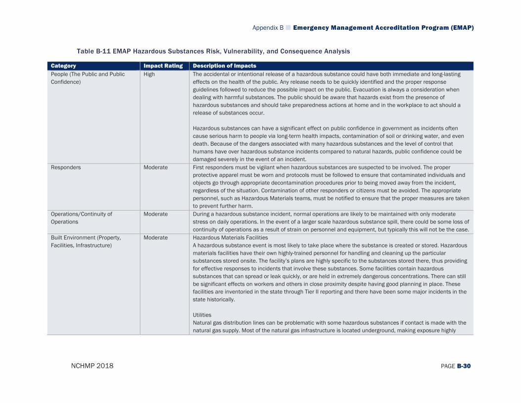
Appendix B Emergency Management Accreditation Program (EMAP)
NCHMP 2018 PAGE B-30
Table B-11 EMAP Hazardous Substances Risk, Vulnerability, and Consequence Analysis
Category Impact Rating Description of Impacts People (The Public and Public Confidence)
High The accidental or intentional release of a hazardous substance could have both immediate and long-lasting effects on the health of the public. Any release needs to be quickly identified and the proper response guidelines followed to reduce the possible impact on the public. Evacuation is always a consideration when dealing with harmful substances. The public should be aware that hazards exist from the presence of hazardous substances and should take preparedness actions at home and in the workplace to act should a release of substances occur. Hazardous substances can have a significant effect on public confidence in government as incidents often cause serious harm to people via long-term health impacts, contamination of soil or drinking water, and even death. Because of the dangers associated with many hazardous substances and the level of control that humans have over hazardous substance incidents compared to natural hazards, public confidence could be damaged severely in the event of an incident.
Responders Moderate First responders must be vigilant when hazardous substances are suspected to be involved. The proper protective apparel must be worn and protocols must be followed to ensure that contaminated individuals and objects go through appropriate decontamination procedures prior to being moved away from the incident, regardless of the situation. Contamination of other responders or citizens must be avoided. The appropriate personnel, such as Hazardous Materials teams, must be notified to ensure that the proper measures are taken to prevent further harm.
Operations/Continuity of Operations
Moderate During a hazardous substance incident, normal operations are likely to be maintained with only moderate stress on daily operations. In the event of a larger scale hazardous substance spill, there could be some loss of continuity of operations as a result of strain on personnel and equipment, but typically this will not be the case.
Built Environment (Property, Facilities, Infrastructure)
Moderate Hazardous Materials Facilities A hazardous substance event is most likely to take place where the substance is created or stored. Hazardous materials facilities have their own highly-trained personnel for handling and cleaning up the particular substances stored onsite. The facility’s plans are highly specific to the substances stored there, thus providing for effective responses to incidents that involve these substances. Some facilities contain hazardous substances that can spread or leak quickly, or are held in extremely dangerous concentrations. There can still be significant effects on workers and others in close proximity despite having good planning in place. These facilities are inventoried in the state through Tier II reporting and there have been some major incidents in the state historically. Utilities Natural gas distribution lines can be problematic with some hazardous substances if contact is made with the natural gas supply. Most of the natural gas infrastructure is located underground, making exposure highly

Appendix B Emergency Management Accreditation Program (EMAP)
NCHMP 2018 PAGE B-31
Category Impact Rating Description of Impacts unlikely. However, natural gas itself can be the hazardous substance involved in the incident. One example of how this may occur is if a utility, work crew, or citizen strikes a gas line causing a leak. Degradation of the line may also be the cause of a release. A gas leak would cause an immediate threat and explosions and fires would be significant concerns for the immediate vicinity. Transportation Systems Hazardous substances can have an impact on interstate transportation if a release occurs on or in the vicinity of the roadway which may be the case if a truck or other vehicle carrying hazardous materials is involved in a traffic accident. Significant traffic disruptions may occur, slowing commerce or forcing alternative routing and further congestion of other areas. Similarly, rail lines are one of the more prominent places that hazardous substances are transported. A hazardous substance event on the rail system can impact rail traffic and the overall system. Cleanup efforts wherever the event occurred could be costly and go on for extended periods, shutting down that part of the rail system for that time. Critical Facilities Hospitals utilize and store some hazardous substances on site. Biological materials and radioactive wastes are the primary concerns in a hospital setting. Plans are in place to manage these concerns in both routine and emergency situations. An external hazardous substance event that occurs near the hospital or directly impacts a hospital could create service disruptions such as patient care. A large event may also create a high demand on hospital services and cause an overload on resources. Similarly, some emergency services facilities such as emergency shelters may be opened if homes have been exposed to hazardous substances and evacuations occur. Other Structures Commercial, industrial, and residential buildings all may have hazardous substances contained within them that are not reported through the Tier II reporting system but which could still present a smaller scale hazard. Proper containers and labeling can prevent inappropriate use, but accidents can still cause workers to be exposed. Cleaning products, fertilizers, and pesticides are common examples of supplies that are considered hazardous substances and which could cause a smaller incident.
Economy Moderate The economic impact of a hazardous substance related incident can be significant locally. Affected commerce is the greatest concern, as spills and releases can force businesses such as shopping centers, markets, and financial centers to be shut down for indeterminate periods of time. Contaminated water can be especially problematic as it can cause extensive shutdowns and put many people in danger. The overall costs depend on the substance(s) involved, how much is released, the processes and time used to manage the spill or release, who or what is contaminated, whether a fire takes place, etc. Cleanup can be a less significant cost and is typically handled by the party responsible for the spill or release.
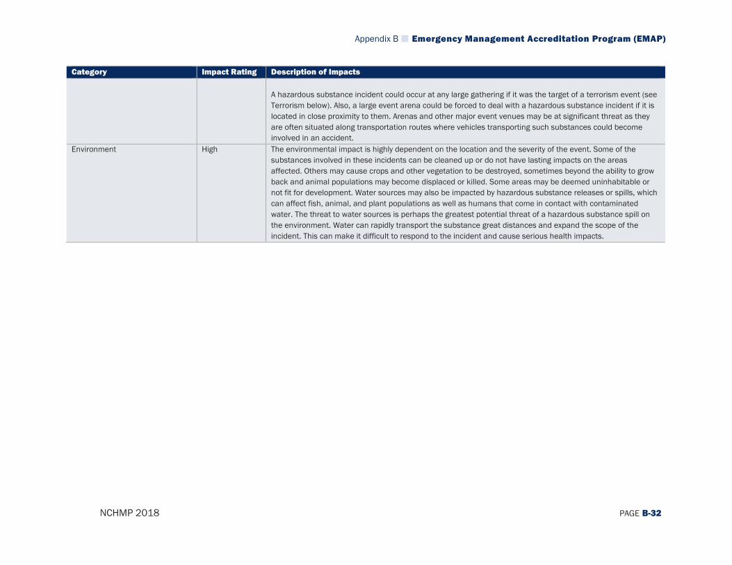
Appendix B Emergency Management Accreditation Program (EMAP)
NCHMP 2018 PAGE B-32
Category Impact Rating Description of Impacts A hazardous substance incident could occur at any large gathering if it was the target of a terrorism event (see Terrorism below). Also, a large event arena could be forced to deal with a hazardous substance incident if it is located in close proximity to them. Arenas and other major event venues may be at significant threat as they are often situated along transportation routes where vehicles transporting such substances could become involved in an accident.
Environment High The environmental impact is highly dependent on the location and the severity of the event. Some of the substances involved in these incidents can be cleaned up or do not have lasting impacts on the areas affected. Others may cause crops and other vegetation to be destroyed, sometimes beyond the ability to grow back and animal populations may become displaced or killed. Some areas may be deemed uninhabitable or not fit for development. Water sources may also be impacted by hazardous substance releases or spills, which can affect fish, animal, and plant populations as well as humans that come in contact with contaminated water. The threat to water sources is perhaps the greatest potential threat of a hazardous substance spill on the environment. Water can rapidly transport the substance great distances and expand the scope of the incident. This can make it difficult to respond to the incident and cause serious health impacts.
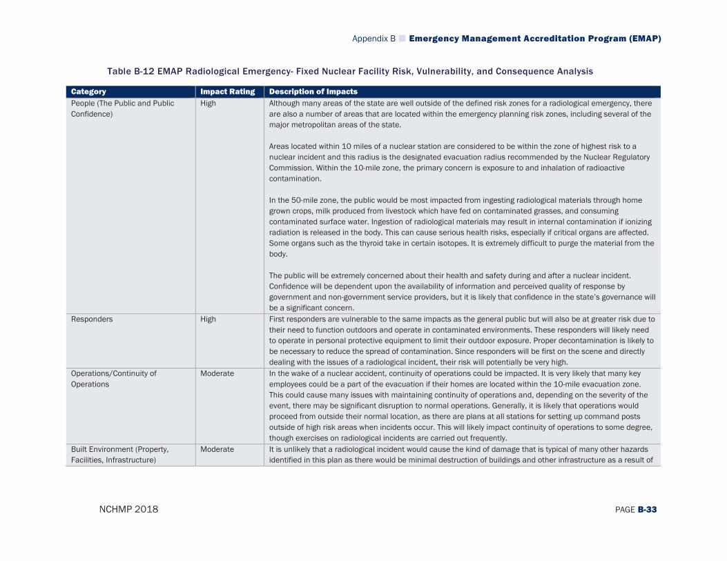
Appendix B Emergency Management Accreditation Program (EMAP)
NCHMP 2018 PAGE B-33
Table B-12 EMAP Radiological Emergency- Fixed Nuclear Facility Risk, Vulnerability, and Consequence Analysis
Category Impact Rating Description of Impacts People (The Public and Public Confidence)
High Although many areas of the state are well outside of the defined risk zones for a radiological emergency, there are also a number of areas that are located within the emergency planning risk zones, including several of the major metropolitan areas of the state. Areas located within 10 miles of a nuclear station are considered to be within the zone of highest risk to a nuclear incident and this radius is the designated evacuation radius recommended by the Nuclear Regulatory Commission. Within the 10-mile zone, the primary concern is exposure to and inhalation of radioactive contamination. In the 50-mile zone, the public would be most impacted from ingesting radiological materials through home grown crops, milk produced from livestock which have fed on contaminated grasses, and consuming contaminated surface water. Ingestion of radiological materials may result in internal contamination if ionizing radiation is released in the body. This can cause serious health risks, especially if critical organs are affected. Some organs such as the thyroid take in certain isotopes. It is extremely difficult to purge the material from the body. The public will be extremely concerned about their health and safety during and after a nuclear incident. Confidence will be dependent upon the availability of information and perceived quality of response by government and non-government service providers, but it is likely that confidence in the state’s governance will be a significant concern.
Responders High First responders are vulnerable to the same impacts as the general public but will also be at greater risk due to their need to function outdoors and operate in contaminated environments. These responders will likely need to operate in personal protective equipment to limit their outdoor exposure. Proper decontamination is likely to be necessary to reduce the spread of contamination. Since responders will be first on the scene and directly dealing with the issues of a radiological incident, their risk will potentially be very high.
Operations/Continuity of Operations
Moderate In the wake of a nuclear accident, continuity of operations could be impacted. It is very likely that many key employees could be a part of the evacuation if their homes are located within the 10-mile evacuation zone. This could cause many issues with maintaining continuity of operations and, depending on the severity of the event, there may be significant disruption to normal operations. Generally, it is likely that operations would proceed from outside their normal location, as there are plans at all stations for setting up command posts outside of high risk areas when incidents occur. This will likely impact continuity of operations to some degree, though exercises on radiological incidents are carried out frequently.
Built Environment (Property, Facilities, Infrastructure)
Moderate It is unlikely that a radiological incident would cause the kind of damage that is typical of many other hazards identified in this plan as there would be minimal destruction of buildings and other infrastructure as a result of

Appendix B Emergency Management Accreditation Program (EMAP)
NCHMP 2018 PAGE B-34
Category Impact Rating Description of Impacts this type of incident. However, many structures and facilities could potentially be contaminated with radioactivity rendering it extremely dangerous for humans to be near them or live/work there. In this sense, a major radiological event may cause significant damage to the built environment and result in large areas that must be quarantined or considered off-limits to the public after an incident. Further, checkpoints and decontamination stations may need to be set up along routes that leave the evacuation zones, resulting in increased travel times along major roadways and necessitating traffic re-routes.
Economy Moderate Economies within the risk zones are likely to see decreased spending as evacuation takes place. Travel and tourism across the state may be limited for an extended period of time due to travelers associating the entire state with the incident. Interstate commerce may be impacted as decontamination stations may need to be established and some drivers may elect to attempt to circumnavigate the state altogether extending travel times and increasing the time to market for products on a regional and statewide level. Employers in the surrounding areas may see increased absenteeism and requests for leaves of absence to deal with the aftermath of the event and some employees may self-evacuate, resulting in a loss of productivity.
Environment High Environmental impacts as a result of a radiological incident may be very serious. Contaminants may impact the land and water for many years and wildlife may experience increased likelihood of cancer and other health problems. In general, habitats and ecosystems will suffer long-term from a radiological incident as the organisms within these areas will face similar impacts to those that humans experience, but since they are unable to evacuate or permanently migrate to new locations, they will be exposed for longer periods and be impacted to a greater degree.
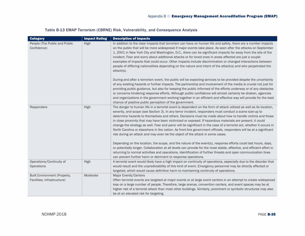
Appendix B Emergency Management Accreditation Program (EMAP)
NCHMP 2018 PAGE B-35
Table B-13 EMAP Terrorism (CBRNE) Risk, Vulnerability, and Consequence Analysis
Category Impact Rating Description of Impacts People (The Public and Public Confidence)
High In addition to the clear impacts that terrorism can have on human life and safety, there are a number impacts on the public that will be more widespread if major events take place. As seen after the attacks on September 1, 2001 in New York City and Washington, D.C., there can be significant impacts far away from the site of the incident. Fear and worry about additional attacks or for loved ones in areas affected are just a couple examples of impacts that could occur. Other impacts include discrimination or changed interactions between people of differing nationalities depending on the nature and intent of the attack(s) and who perpetrated the attack(s). During and after a terrorism event, the public will be expecting services to be provided despite the uncertainty of any existing hazards or further impacts. The partnership and involvement of the media is crucial not just for providing public guidance, but also for keeping the public informed of the efforts underway or of any obstacles or concerns hindering response efforts. Although public confidence will almost certainly be shaken, agencies and organizations in the government working together in an efficient and effective way will provide for the best chance of positive public perception of the government.
Responders High The danger to human life in a terrorist event is dependent on the form of attack utilized as well as its location, severity, and scope (see Section 3). In any terror incident, responders must conduct a scene size-up to determine hazards to themselves and others. Decisions must be made about how to handle victims and those in close proximity that may have been victimized or exposed. If hazardous materials are present, it could change the strategy as well. Fear and panic will be significant in the case of a terrorist act, whether it occurs in North Carolina or elsewhere in the nation. As front-line government officials, responders will be at a significant risk during an attack and may even be the object of the attack in some cases. Depending on the location, the scope, and the nature of the event(s), response efforts could last hours, days, or potentially longer. Collaboration at all levels can provide for the most stable, effective, and efficient effort in returning to normal activities and operations. Identification of further threats and open communication lines can prevent further harm or detriment to response operations.
Operations/Continuity of Operations
High A terrorist event would likely have a high impact on continuity of operations, especially due to the disorder that would result and the unpredictability of this kind of event. Emergency personnel may be directly affected or targeted, which would cause definitive harm to maintaining continuity of operations.
Built Environment (Property, Facilities, Infrastructure)
Moderate Major Events/Centers Often terrorist events are targeted at major events or at large event centers in an attempt to create widespread loss on a large number of people. Therefore, large arenas, convention centers, and event spaces may be at higher risk of a terrorist attack than most other buildings. Similarly, prominent or symbolic structures may also be at an elevated risk for targeting.
Appendix B Emergency Management Accreditation Program (EMAP)
NCHMP 2018 PAGE B-36
Category Impact Rating Description of Impacts Critical Facilities At hospitals, the primary concern with a terrorism event is the influx of patients requiring care. Terrorism may pose a specific hazard to a hospital structure itself, but it is more likely to be impacted when in close proximity to a target. Many patients could be injured or their medical condition worsened by the impacts of a terrorism event. In general, emergency services buildings are not considered high probability targets for terrorists to strike. In other countries, ambulance services and 9-1-1 centers have been targets; however, that pattern has not been seen here in the United States. Alternate locations should be set up so that emergency operations can continue if an emergency services facility was affected or targeted by a terrorism event. Shelters may need to be activated in a terrorism event to house and care for displaced individuals. Transportation Systems Bridges found throughout the interstate system may be targeted by terrorism. Not only would the actual structural failure affect those on, under, or near the bridge, but the loss of its functionality would also significantly hinder travel and commerce. Past experiences with terrorists using airplanes for terrorist activity suggest a need for planning and collaboration with all parties of interest at airports including local, state, and federal agencies. In terms of railway transportation, the most likely means of disrupting these lines would be the derailing of a train, primarily by sabotage of the rail or the switching control system. Using explosives would be more likely because hacking into systems to cause collisions and other undesired actions to moving rail cars would be more complex operations. In addition to disrupting rail traffic, a derailing can impact other means of travel such as a nearby road or airport. The rail cars involved in an incident could contain hazardous materials, which would add an element of complexity to the situation. Utilities Damage to high voltage lines or power plants structures could disrupt power distribution for a large area, affecting emergency response and other facets of government and business. The economic impacts may also be significant as extended outages can be costly. Natural gas lines are also a concern as a target for terrorists. Major pipelines run through the state, but natural gas itself must be exposed to oxygen before it could cause an explosion. Most natural gas explosions are small and rarely deadly. The real concern is in shutting off natural gas to end consumers. Sabotage of a pipeline could disconnect a significant number of homes and businesses for considerable periods of time. Other Structures Single-family dwellings and small businesses or industries are not likely to be targets for terrorism. However, areas that have high concentrations of certain targeted populations could be vulnerable to an attack. These populations may relate to a person or group’s ethnicity, religion, and socioeconomic status. Dwellings in close

Appendix B Emergency Management Accreditation Program (EMAP)
NCHMP 2018 PAGE B-37
Category Impact Rating Description of Impacts proximity to a targeted event center may also be more likely to experience indirect impacts. Depending on the method of attack, impacts could include stray bullets or debris from explosions. These could affect people, electrical systems, water systems, cause structural collapse, or fires. Also, the presence of chemical agents can create health hazards through dangerous reactions with water sources or building materials.
Economy Moderate The economic impact of a terrorist attack can vary from minimal to severe. If the incident occurs in North Carolina, it could hinder the state’s economy but may not have an impact at the national level. Tourism and some commerce could decline significantly if people, events, or businesses are hesitant to come to the area following an incident. An incident in a major city or a financial hub could affect the entire country. For example, the events of September 11, 2001 had an immediate impact on local, state, and national economies. This event and other large-scale attacks like it can drastically alter the economy in both the short- and long-term. Major Events/Centers Terrorism would mostly likely occur in city centers during large public gatherings or during business hours to cause the most harm and promote the most fear. Political gatherings would be high priority targets as well. Arenas can be targeted by terrorism, particularly during events that may have some form of political, cultural, or historical value, or simply any event with a large number of people in attendance. These could all have a negative impact economically on the state.
Environment Moderate Impacts on the environment depend on the type of attack utilized by terrorists. A biological, chemical, or other hazardous material can have impacts on human, animal, and plant populations alike. The impacts can vary depending on the particular hazard(s) at play, but there will certainly be at least some negative impacts from a terrorist attack including potentially the release of smoke, chemicals, or debris into the environment.
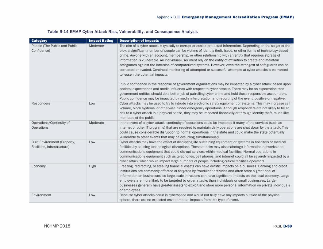
Appendix B Emergency Management Accreditation Program (EMAP)
NCHMP 2018 PAGE B-38
Table B-14 EMAP Cyber Attack Risk, Vulnerability, and Consequence Analysis
Category Impact Rating Description of Impacts People (The Public and Public Confidence)
Moderate The aim of a cyber attack is typically to corrupt or exploit protected information. Depending on the target of the ploy, a significant number of people can be victims of identity theft, fraud, or other forms of technology-based crime. Anyone with an account, membership, or other relationship with an entity that requires storage of information is vulnerable. An individual/user must rely on the entity of affiliation to create and maintain safeguards against the intrusion of computerized systems. However, even the strongest of safeguards can be corrupted or evaded. Continual monitoring of attempted or successful attempts at cyber attacks is warranted to lessen the potential impacts. Public confidence in the response of government organizations may be impacted by a cyber attack based upon societal expectations and media influence with respect to cyber attacks. There may be an expectation that government entities should do a better job of patrolling cyber crime and hold those responsible accountable. Public confidence may be impacted by media interpretation and reporting of the event, positive or negative.
Responders Low Cyber attacks may be used to try to intrude into electronic safety equipment or systems. This may increase call volume, block systems, or otherwise hinder emergency operations. Although responders are not likely to be at risk to a cyber attack in a physical sense, they may be impacted financially or through identity theft, much like members of the public.
Operations/Continuity of Operations
Moderate In the event of a cyber attack, continuity of operations could be impacted if many of the services (such as internet or other IT programs) that are required to maintain daily operations are shut down by the attack. This could cause considerable disruption to normal operations in the state and could make the state potentially vulnerable to other events that may be occurring simultaneously.
Built Environment (Property, Facilities, Infrastructure)
Low Cyber attacks may have the effect of disrupting life sustaining equipment or systems in hospitals or medical facilities by causing technological disruptions. These attacks may also sabotage information networks and communications equipment that could disrupt services within medical facilities. Normal operations in communications equipment such as telephones, cell phones, and internet could all be severely impacted by a cyber attack which would impact large numbers of people including critical facilities operators.
Economy High Freezing, redirecting, or stealing financial assets can have drastic impacts on a business. Banking and credit institutions are commonly affected or targeted by fraudulent activities and often store a great deal of information on businesses, so large-scale intrusions can have significant impacts on the local economy. Large employers are more likely to be targeted by cyber attacks than individuals or small businesses. Larger businesses generally have greater assets to exploit and store more personal information on private individuals or employees.
Environment Low Because cyber attacks occur in cyberspace and would not truly have any impacts outside of the physical sphere, there are no expected environmental impacts from this type of event.
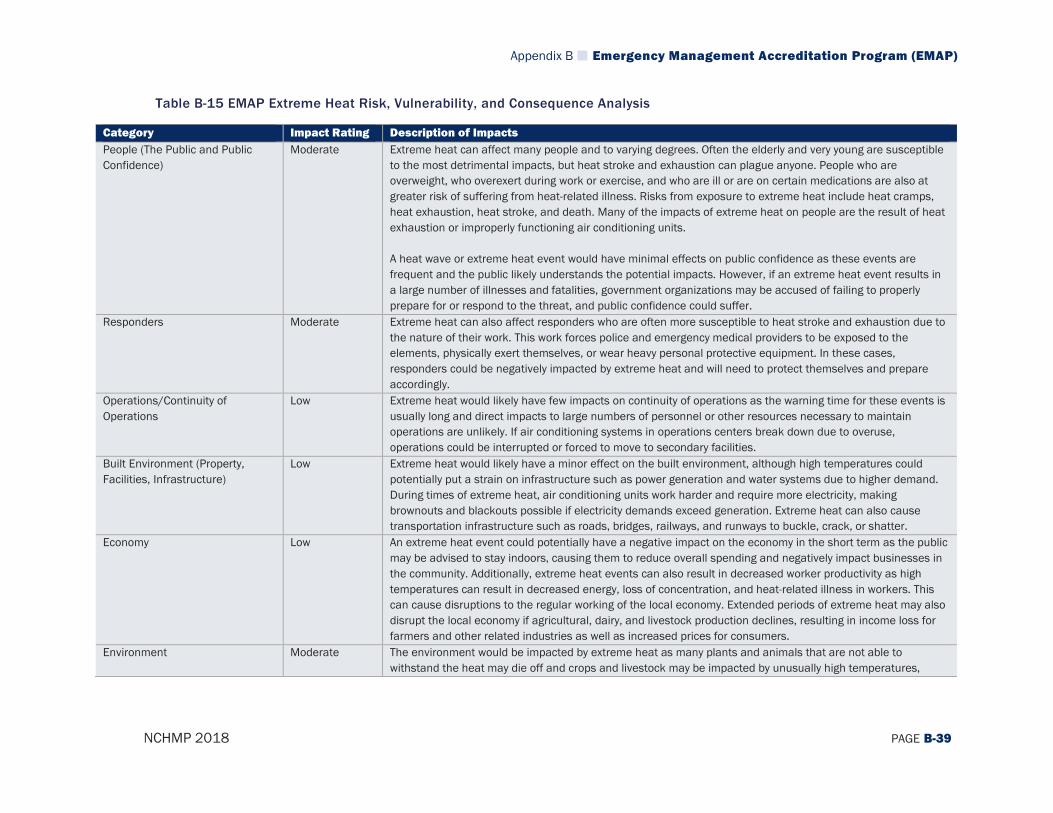
Appendix B Emergency Management Accreditation Program (EMAP)
NCHMP 2018 PAGE B-39
Table B-15 EMAP Extreme Heat Risk, Vulnerability, and Consequence Analysis
Category Impact Rating Description of Impacts People (The Public and Public Confidence)
Moderate Extreme heat can affect many people and to varying degrees. Often the elderly and very young are susceptible to the most detrimental impacts, but heat stroke and exhaustion can plague anyone. People who are overweight, who overexert during work or exercise, and who are ill or are on certain medications are also at greater risk of suffering from heat-related illness. Risks from exposure to extreme heat include heat cramps, heat exhaustion, heat stroke, and death. Many of the impacts of extreme heat on people are the result of heat exhaustion or improperly functioning air conditioning units. A heat wave or extreme heat event would have minimal effects on public confidence as these events are frequent and the public likely understands the potential impacts. However, if an extreme heat event results in a large number of illnesses and fatalities, government organizations may be accused of failing to properly prepare for or respond to the threat, and public confidence could suffer.
Responders Moderate Extreme heat can also affect responders who are often more susceptible to heat stroke and exhaustion due to the nature of their work. This work forces police and emergency medical providers to be exposed to the elements, physically exert themselves, or wear heavy personal protective equipment. In these cases, responders could be negatively impacted by extreme heat and will need to protect themselves and prepare accordingly.
Operations/Continuity of Operations
Low Extreme heat would likely have few impacts on continuity of operations as the warning time for these events is usually long and direct impacts to large numbers of personnel or other resources necessary to maintain operations are unlikely. If air conditioning systems in operations centers break down due to overuse, operations could be interrupted or forced to move to secondary facilities.
Built Environment (Property, Facilities, Infrastructure)
Low Extreme heat would likely have a minor effect on the built environment, although high temperatures could potentially put a strain on infrastructure such as power generation and water systems due to higher demand. During times of extreme heat, air conditioning units work harder and require more electricity, making brownouts and blackouts possible if electricity demands exceed generation. Extreme heat can also cause transportation infrastructure such as roads, bridges, railways, and runways to buckle, crack, or shatter.
Economy Low An extreme heat event could potentially have a negative impact on the economy in the short term as the public may be advised to stay indoors, causing them to reduce overall spending and negatively impact businesses in the community. Additionally, extreme heat events can also result in decreased worker productivity as high temperatures can result in decreased energy, loss of concentration, and heat-related illness in workers. This can cause disruptions to the regular working of the local economy. Extended periods of extreme heat may also disrupt the local economy if agricultural, dairy, and livestock production declines, resulting in income loss for farmers and other related industries as well as increased prices for consumers.
Environment Moderate The environment would be impacted by extreme heat as many plants and animals that are not able to withstand the heat may die off and crops and livestock may be impacted by unusually high temperatures,

Appendix B Emergency Management Accreditation Program (EMAP)
NCHMP 2018 PAGE B-40
Category Impact Rating Description of Impacts resulting in death or illness. Heat waves can also contribute to higher levels of air pollution since air becomes stagnant and traps emitted pollutants, often causing increased levels of surface ozone.

Appendix B Emergency Management Accreditation Program (EMAP)
NCHMP 2018 PAGE B-41
Table B-16 EMAP Electromagnetic Pulse (EMP)/Geomagnetic Storms Risk, Vulnerability, and Consequence Analysis
Category Impact Rating Description of Impacts People (The Public and Public Confidence)
Moderate The entire State of North Carolina’s population is vulnerable to the impacts of an EMP/geomagnetic storm, regardless of the measured magnitude, although most low-classification events will not have any noticeable impact on the daily lives of people. If a large event were to occur and cause widespread power outages or communications systems disruptions, there may be a panic and people may temporarily be unable to undertake normal activities such as cooking or using mobile devices. Consumer electronics may also be damaged, including HVAC systems, newer model appliances, radios, and televisions. EMP/geomagnetic storms have some likelihood of affecting public confidence due to their highly visible impacts and the fact that most members of the public are unaware of the hazard and may be confused about the cause of loss of power/communications systems.
Responders High Responders could be critically affected by an EMP/geomagnetic storm event as response personnel rely heavily on communications equipment to carry out their normal operations. If a large event were to occur that knocked out communications equipment for several hours or possibly more than a day, this would significantly hinder responders’ abilities to perform their duties. Additionally, other electronic equipment or devices used by responders may be damaged by an EMP/geomagnetic storm further impacting their ability to respond to emergencies following an event.
Operations/Continuity of Operations
High Continuity of operations would potentially be impacted in many ways by a major EMP/geomagnetic storm. As mentioned above, if communications equipment is disrupted, it would be challenging for government officials to coordinate with one another and respond to citizen needs such as emergency medical care. It is also possible that some satellites will be damaged, affecting satellite-based communications. Additionally, if power is lost, there would be a disruption to normal operations, though there are generally plans in place to maintain continuity of operations in this case as several operations centers have backup power systems.
Built Environment (Property, Facilities, Infrastructure)
Moderate Critical Infrastructure The primary impact on the built environment from an EMP/geomagnetic storm would be on communications and power infrastructure. Most of the built environment (e.g. homes, buildings, roadways) would not be impacted in any way by this type of event. However, if power or communications systems are damaged or temporarily shut down, some aspects of the built environment will be impacted such as traffic lights, street lights, and cell phone towers. Additionally, electronic equipment and control systems could also be damaged and water and wastewater systems, gas stations, and pipelines may be shut down throughout the state.
Economy Moderate An EMP/geomagnetic storm can impact any area of the State of North Carolina at any time and may bring with it an interruption of service for local businesses as well as governments that lose power or cannot utilize communications systems. As a result, there will be significant disruption of the local economy as long as the effects (such as power or communications loss) of the EMP/geomagnetic storm remain in place. ATMs,
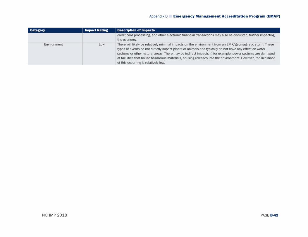
Appendix B Emergency Management Accreditation Program (EMAP)
NCHMP 2018 PAGE B-42
Category Impact Rating Description of Impacts credit card processing, and other electronic financial transactions may also be disrupted, further impacting the economy.
Environment Low There will likely be relatively minimal impacts on the environment from an EMP/geomagnetic storm. These types of events do not directly impact plants or animals and typically do not have any effect on water systems or other natural areas. There may be indirect impacts if, for example, power systems are damaged at facilities that house hazardous materials, causing releases into the environment. However, the likelihood of this occurring is relatively low.

Appendix B Emergency Management Accreditation Program (EMAP)
NCHMP 2018 PAGE B-43
B.2 STANDARD 4.2 Another important component of hazard mitigation that goes beyond developing a plan is implementation of that plan through hazard mitigation programs and projects. This is directly connected to the development of a successful plan and requires the state’s mitigation program to use its resources systematically to mitigate the effects of the hazards/disasters identified in the risk assessment. In Standard 4.2.1, EMAP requires that the state’s program have a plan in place to implement mitigation projects and set priorities based on loss reduction. This plan should: Be based on the natural and human-caused hazards identified in Standard 4.1.1 and
the risk and consequences of those hazards Be developed through formal planning processes involving Emergency Management
Program stakeholders Establish interim and long-term strategies, actions, goals, and objectives
In addition, the program must carry out the following as outlined in EMAP Standards 4.2.2 and 4.2.3: Document project ranking based upon the greatest opportunity for loss reduction and
documents how specific mitigation actions contribute to overall risk reduction Have a process to monitor overall progress of the mitigation activities and document
completed initiatives and their resulting reduction or limitation of hazard impact on the state
In Standard 4.2.4, EMAP requires that the state do the following: Provide technical assistance in implementing applicable mitigation codes and
ordinances Identify ongoing opportunities and track repetitive losses Participate in applicable jurisdictional, inter-jurisdictional and multi-jurisdictional
mitigation efforts Finally, in Standard 4.2.5, the program must have a method and schedule for evaluation, maintenance, and revision of the plan as identified in Standard 4.2.1. Documentation of how the state’s program has addressed all of these standards is extensive and would be much too large to include within the pages of this plan. It is currently stored on the state’s servers and can be retrieved as needed to ensure these EMAP Standards are met. However, in order to ensure continuity between the plan itself and the implementation of the mitigation program (which is meant to achieve the goals/objectives of the plan), the planning team felt that it would be useful to address Standard 4.2 to some degree within the plan document itself. As such, below is an overview of how the state’s program has addressed this EMAP Standard, which includes references to locations on the state’s server where additional information can be located.

Appendix B Emergency Management Accreditation Program (EMAP)
NCHMP 2018 PAGE B-44
B.2.1 Standard 4.2.1 The State of North Carolina’s Emergency Management Program has a definitive plan to implement mitigation projects and sets priorities based on loss reduction. In large part, the State Hazard Mitigation Plan lays out these priorities through the risk assessment (Section 3) and mitigation actions (Section 5) that are discussed in previous sections of this plan. However, there are also many other active components of the implementation process that are carried out by the Hazard Mitigation Branch through their grant programs. Especially key to these programs is the Benefit-Cost Analysis (BCA) that is a critical component of large-scale risk reduction projects such as acquisition/elevation/reconstruction of structures. NCEM is always focused on prioritizing projects that provide the greatest benefits and loss reduction potential to the state, its local governments, and citizens. Documentation of the grant process for prioritizing projects and emphasizing loss reduction as well as a number of other documents that address this standard can be found in the following folder on NCEM’s server: \\ncemjfhqfs01\common\Administrative\Emergency Management Accreditation Program (EMAP)\2018 Re-Accreditation\Candidate Documents\4.2 Hazard Mitigation\4.2.1 The plan discussed above for implementing mitigation projects and setting priorities is
based largely on the risk assessment that was carried out during the planning process and is intended to focus on those hazards (natural or human-caused) that are considered to be the greatest threat to the state. It is notable, for example, that flood was identified as one of the highest risk hazards that poses the greatest threat to the state in terms of future damage potential.
As such, many of the actions identified in the State Hazard Mitigation Plan deal with flooding and are attempts to mitigate losses from future flood events. Similarly, many of the projects that the state has implemented in recent years through its UHMA programs and other funding sources have been focused on reducing flood risk. Additionally, the state often implements and funds actions that are aimed at addressing multiple or all hazards identified in the risk assessment section of this plan. Examples of these projects include generators, early warning systems, and safe rooms.
Overall, through its actions, projects, and funding distribution to local governments, the state tries to remain focused on the hazards that pose the greatest threat as identified in the risk assessment of the plan. Documentation of the local grant application process and examples of projects that demonstrate that they are aimed at addressing the risks and consequences identified in Standard 4.1.1 can be found in the following documents in the folder location listed above: Local Grant Application Process: SOP- NCEM UHMA Development SOP HM 2017-12-1 Generator Project Example (Addresses All Hazards): Presentation- NCEM NTB Generator Closeout-FINAL v1 HM 2017-8-24
Appendix B Emergency Management Accreditation Program (EMAP)
NCHMP 2018 PAGE B-45
Early Warning System Project Example (Addresses All Hazards): Presentation- NCEM WILSON’S CREEK POWER SIREN POSITION_PP HM 2015-4-29
The implementation plan for mitigation projects has been developed through a formal
process involving stakeholders from the state’s Emergency Management Program, including numerous state agencies outside of Emergency Management, as well as in conjunction with local and federal officials. Documentation of how the plan was developed through a formal planning process involving many different stakeholders can be found in Section 2 of the State Hazard Mitigation Plan.
Interim- and long-term strategies, actions, goals, and objectives for the state mitigation
plan are outlined in Section 5 of this plan and are comprehensively known as the state’s mitigation strategy. This strategy is coordinated with the implementation plan for mitigation projects that are funded by the state via Planning-Project Dependency worksheets that are written for every project that the state funds. The purpose of these worksheets is to ensure that the projects that are actually implemented within the state address the risks that were identified in both state and local hazard mitigation plans. Documentation of example Planning-Project Dependency worksheets can be found in the following documents in the folder location listed above: Planning-Project Dependency Worksheets: Plan – NCEM Bladen Reconstruction PPD Checklist 2015-7-14; Plan – NCEM Mitchell Acquisitions PPD Checklist 2016-3-7; Plan – NCEM Sampson Acquisitions PPD Checklist 2016-4-12; Plan – NCEM Tarboro Elevations PPD Checklist 2015-8-13; Plan – NCEM Windsor Reconstruction PPD Checklist 2017-7-7
B.2.2 Standard 4.2.2 The State of North Carolina’s Emergency Management Program has a detailed process in place for documenting project ranking based on the greatest opportunity for loss reduction and has documented how specific mitigation actions contribute to overall risk reduction. This is mainly achieved through previous sections of the State Hazard Mitigation Plan, namely in Section 5, which identifies all state-level hazard mitigation actions and describes how each of those actions contributes to overall risk reduction. This section of the plan also outlines the relative priority of each action, which corresponds directly to the level of opportunity that the action provides for loss reduction. In short, the actions that provide the greatest opportunity are ranked highest in terms of priority. However, it should also be noted that the state-level actions found within Section 5 of the State Hazard Mitigation Plan are focused at a broad scale because of the size of the state and the scale at which state agencies typically operate. Often the state serves more of a facilitator role within the Emergency Management field, leaving more specific and tangible projects to be Hazard Mitigation Branch has also developed a process for ranking local projects in terms of the opportunity they present for reducing overall risk. This process is
Appendix B Emergency Management Accreditation Program (EMAP)
NCHMP 2018 PAGE B-46
primarily focused on performing Benefit-Cost Analysis to determine which projects present the greatest opportunity for risk reduction. The entire grant application process is documented through Standard Operating Procedures and numerous other supporting documents that can be found in the following folder on NCEM’s server: \\ncemjfhqfs01\common\Administrative\Emergency Management Accreditation Program (EMAP)\2018 Re-Accreditation\Candidate Documents\4.2 Hazard Mitigation\4.2.2
B.2.3 Standard 4.2.3 The State of North Carolina’s Emergency Management Program has a process in place to monitor the overall progress of its mitigation activities and document completed initiatives and their resulting reduction or limitation of hazard impact on the state. This process is documented in two primary ways. The first is through the State Hazard Mitigation Plan which identifies all of the state-level mitigation activities that are being carried out by state agencies and officials in Section 5. These activities are closely monitored and evaluated through the process laid out in Section 6 of the State Hazard Mitigation Plan. In addition to the process that is described in the State Hazard Mitigation Plan for activities at the state level, the Hazard Mitigation Branch has also laid out a process for monitoring the overall implementation of mitigation activities at the local level. These local activities are also closely monitored and evaluated by state officials to ensure that they are having the intended effect of reducing overall risk. In many cases, the state has been active at documenting the resulting risk reduction through losses avoided studies and other technical evaluation techniques. Examples of losses avoided studies, the process for documenting post-mitigated property uses, and numerous other supporting documents can be found in the following folder on NCEM’s server: \\ncemjfhqfs01\common\Administrative\Emergency Management Accreditation Program (EMAP)\2018 Re-Accreditation\Candidate Documents\4.2 Hazard Mitigation\4.2.3 A recent example of the Emergency Management Program documenting successful risk reduction was in the wake of Hurricane Matthew in which North Carolina Emergency Management developed map products overlaying the inundation areas from the storm with previously mitigated properties and demonstrating the losses that were avoided due to these mitigation actions taken prior to the storm (e.g. buyouts, elevations). This study can be located at the following website: https://rebuild.nc.gov/resiliency/hazard-mitigation-grant-program All of these post-mitigation monitoring activities are an integral part of the mitigation process, especially when it comes to ensuring that other properties that are at high risk to hazards are being appropriately targeted by effective mitigation action.

Appendix B Emergency Management Accreditation Program (EMAP)
NCHMP 2018 PAGE B-47
B.2.4 Standard 4.2.4 As part of the State of North Carolina’s Emergency Management Program, state officials carry out a number of functions to ensure that efforts among all levels of government and across all organizations are coordinated and effective in implementing mitigation activities. Specifically, state officials: Provide technical assistance to local governments in implementing applicable
mitigation codes and ordinances. For example, the state’s Building Code Council frequently updates the state building code and assists local governments with implementation and interpretation of these codes. The North Carolina Division of Emergency Management is not directly involved in developing these codes in most cases, but plays a critical role in the development and implementation of certain areas of the code, namely the sections related to floodplain management and local flood damage prevention ordinances (FDPOs). The program is very involved in code development and implementation and acts as the primary liaison for local governments in addressing questions concerning the code and in providing technical assistance. State officials have also been proactive in providing training to local governments, such as the frequently offered L-273 course on floodplain management which has led to the certification of many additional local floodplain managers in the state, giving them the knowledge and expertise to appropriately manage floodplain areas in their communities. There are also many workshops offered throughout the state at conferences and on a regional basis to ensure that local floodplain managers stay up to date on the latest code changes and understand how to support risk reduction through the implementation of their codes. In addition, the state is available for consultation on including higher standards in local codes where desired by local governments. Technical assistance documentation such as presentations that have been used for local technical assistance and other supporting documents can be found in the following folder on NCEM’s server: \\ncemjfhqfs01\common\Administrative\Emergency Management Accreditation Program (EMAP)\2018 Re-Accreditation\Candidate Documents\4.2 Hazard Mitigation\4.2.4
Identify ongoing opportunities and track repetitive loss. As part of its mitigation
program, the state keeps an ongoing list of opportunities that local governments have submitted and makes inquiries on a regular basis to local governments requesting ideas for projects intended to reduce risk. Given that there are many project ideas and limited funding, there is nearly always a backlog of project ideas. Examples of where the state keeps project ideas that have been submitted by locals through its Letter of Interest process can be found in the following folders on NCEM’s server:
Appendix B Emergency Management Accreditation Program (EMAP)
NCHMP 2018 PAGE B-48
2015: \\ncemjfhqfs01\Archived Disaster Files\PDM\UHMA 2015\Coordinator\LOI and NOFA 2016: \\ncemjfhqfs01\Archived Disaster Files\PDM\UHMA 2016\Coordinator\LOI and NOFA 2017: \\ncemjfhqfs01\Archived Disaster Files\PDM\UHMA 2017\Coordinator (PDM)\LOI and NOFA In addition, the state is constantly tracking repetitive loss properties and properties on the Greatest Savings to the Fund List. NCEM maintains an up to date list of these properties on its server and copies of the lists from recent years are located in the above folder location. A primary goal of the state, as outlined in the State Hazard Mitigation Plan, is to reduce the number of repetitive loss properties in the state and to prevent future properties from becoming repetitive loss properties through proactive mitigation activities.
Participate in applicable jurisdictional, inter-jurisdictional, and multi-jurisdictional
mitigation efforts. The state is very active in coordinating within its own organization at the jurisdictional level to implement mitigation activities as outlined above and in Section 2 and Section 5 of the State Hazard Mitigation Plan.
The state is also a critical driver of inter-jurisdictional mitigation activities, especially in conjunction with local level officials where the state frequently acts as the intermediary for managing federal mitigation funding with local governments as the ultimate recipients to carry out projects at the local level. These inter-jurisdictional efforts are largely documented through the mitigation grant and project development process that is outlined along with other supporting documents in the following folder on NCEM’s server: \\ncemjfhqfs01\common\Administrative\Emergency Management Accreditation Program (EMAP)\2018 Re-Accreditation\Candidate Documents\4.2 Hazard Mitigation\4.2.4
Finally, the state works to be a critical partner on inter-state and regional level efforts to conduct mitigation, often working through federal agencies like FEMA and its Regional offices to perform larger-scale efforts at reducing risk. These efforts are often coordinated through the State Hazard Mitigation Officer at conferences such as the Partners in Mitigation Conference. One major example of this is that the State of North Carolina hosts flood data for two partner states in the southeast (Alabama and Florida) on its Flood Risk Information System website (fris.nc.gov/fris).
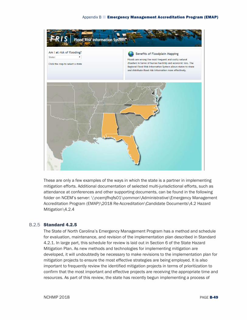
Appendix B Emergency Management Accreditation Program (EMAP)
NCHMP 2018 PAGE B-49
These are only a few examples of the ways in which the state is a partner in implementing mitigation efforts. Additional documentation of selected multi-jurisdictional efforts, such as attendance at conferences and other supporting documents, can be found in the following folder on NCEM’s server: \\ncemjfhqfs01\common\Administrative\Emergency Management Accreditation Program (EMAP)\2018 Re-Accreditation\Candidate Documents\4.2 Hazard Mitigation\4.2.4
B.2.5 Standard 4.2.5 The State of North Carolina’s Emergency Management Program has a method and schedule for evaluation, maintenance, and revision of the implementation plan described in Standard 4.2.1. In large part, this schedule for review is laid out in Section 6 of the State Hazard Mitigation Plan. As new methods and technologies for implementing mitigation are developed, it will undoubtedly be necessary to make revisions to the implementation plan for mitigation projects to ensure the most effective strategies are being employed. It is also important to frequently review the identified mitigation projects in terms of prioritization to confirm that the most important and effective projects are receiving the appropriate time and resources. As part of this review, the state has recently begun implementing a process of

Appendix B Emergency Management Accreditation Program (EMAP)
NCHMP 2018 PAGE B-50
carrying out After Action Reports (AARs) in the wake of declared disasters and major grant funding submittals to identify any ways that these processes can be improved to ensure future processes maximize risk reduction. Examples of AARs from recent application packages and other supporting documents can be found in the following folder on NCEM’s server: \\ncemjfhqfs01\common\Administrative\Emergency Management Accreditation Program (EMAP)\2018 Re-Accreditation\Candidate Documents\4.2 Hazard Mitigation\4.2.5

Appendix C Plan Maintenance Records
NCHMP 2018 PAGE C-1
Appendix C. Plan Maintenance Records
Version Date Summary of Changes 6/6/18 Risk Management Coordinating Council Conference Call


![North Carolina register [serial] - NC.gov](https://static.fdokumen.com/doc/165x107/6327f539e491bcb36c0b8a23/north-carolina-register-serial-ncgov.jpg)