Air Permit Review Including Preliminary Determination - NC.gov
Upload
khangminh22Category
view
1download
0
-
' •'
~C, ths\Z:>Rl c_ s liES
L t'f) ,~(\-Po-'<
RECORDING PLANTATION COMMUNITIES:
REPORT ON THE ARCHITECTURAL AND HISTORICAL RESOURCES AT STAGVILLE
by
Carl Lounsbury George W. McDanLel
July, 198Q
TABLE OF CONTENTS
ACKNOWLEDGEMENTS • • .
LIST OF ILLUSTRATIONS
INTRODUCTION •
METHODS
RECONNAISSANCE . . • • • • FIELD WORK AND ORAL INTERVIEWS •
RESULTS
SITES RECORDED • EVIDENCE FOR SITE INTERPRETATION AND ARCHAEOLOGICAL
ii
iv
1
3
3 4
6
6
INVESTIGATION • . • • • 7 ARCHITECTURE • • . • . • • • . • . • 7 SOCIAL HISTORY • • • • • • • 9
Perceptions of Community 9 Stagville as A Bi-racial Community • . 10
PARTICIPATION OF FORMER RESIDENTS 11
RECOMMENDATIONS . . . . . . . . . . . ACQUISITION OF PROPERTY AND EASEMENTS
Options . • • • Rationale • • . . . . • • . Important Sites • • • • • • • . • • • .
IMMEDIATE PREVENTIVE MAINTENANCE • ARCHITECTURAL SURVEY OF DURHAM COUNTY RESEARCH FOR SITE INTERPRETATION • . • . FURTHER HISTORICAL RESEARCH . . • • . • • • • . • IMPROVE LIAISON WITH NEARBY INSTITUTIONS FOR RESEARCH
PURPOSES • • . . . . . . • . . • • . . . . • DEVELOP MORE ACTIVE ROLE IN LOCAL PRESERVATION ARCHIVES AND DISPLAYS AT STAGVILLE CENTER
APPENDIX A: LIST OF SITES .
APPENDIX B: ORAL INFORMANTS
i
12
12 12 12 13 14 15 15 16
18 18 20
21
24
ACKNOWLEDGEMENTS
This project is the result of the cooperation of the staff of the North
Carolina Division of Archives and History and of the many people whose
personal history is associated with Stagville. Our survey was initiated by
the concern of Brent Glass, former Administrator, Archaeology and Historic
Preservation Section, and was assisted throughout by Jacqueline Fehon, Chief
Archaeologist. Especially valuable assistance was provided by Vicki Smith,
intern with the Archaeology and Historic Preservation Section. She contri-
buted to the investigation and recording of the houses and landscape, served
as liaison with the Division of Archives and History, transferred our
descriptions of sites to computerized forms for quick retrieval, and was a
pleasure to work with. We also appreciate the efficient photography services
furnished by Kim Walton and Randall Page. Steve Cruse and Kathleen Needham
of the Stagville Preservation Center were also of special assistance in our
fieldwork. Sandra Perry kindly typed this report.
To all the people related to Stagville, we owe a special thanks. They
have contributed substantially towards preserving important elements of
Stagville's rich heritage, elements that without their help would probably
have not been recorded. Among those who contributed to this survey are:
Mr. Louis Alston Mrs. Mason Boyd Mrs. Mae Carrington Mr. Willie Duke Mr. Joe Ellis Mrs. Maggie Veasey Ellis Mrs. Bertha Mae Hart Mr. and Mrs. Ephraim Hart
ii
Mr. Garland Haskins Mrs. Betty Holman Hayes Mrs. Naomi Veasey Hutchins Mr. Johnny Jones Mr. and Mrs. William McFarland Mr. Allen Needham Mr. Norman Pendergraft Mrs. Janie Riley

Dr. Richard Sanders Mr. Dee Southerland Mr. and Mrs. John Suitt
iii
Miss Margaret Umstead Mr. Wallace Wade Mrs. Ellen Yancey
LI'ST OF ILLUSTRATIONS
FIGURE
1 Map of Cameron Plantations
2 Fairntosh Site Plan
3 Shop Hill Site Plan
4 Heavy timber and balloon framing methods
5 Recording the landscape at Fairntosh
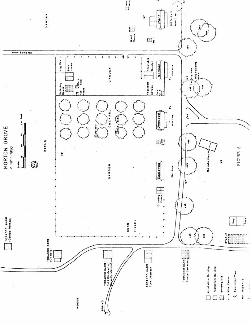
6 Horton Grove Site Plan
7 Horton Cottage
8 King Byrd House and Brinkley House - Plans
9 Slave house at Eno Quarter
10 Latta-Taylor (slave) Rouse and Shop Hill slave house - Plans
11 Peaks-Hart Rouse
12 Former residents at Horton Grove
13 Dock Edwards House
iv
INTRODUCTION
The broad range of people who have lived at Stagville reflect the different
social classes and races of North Carolina's history. Now that the core of
the plantation is ownecl hy the state, how should it preserve, interpret, and
convey their history? Indeed, what was their history at Stagville? Where
did they live and work? What kinds of homesteads did they have? How did
they use the land? What physical evidence remains visible today of their
presence, and what is the condition of that evidence? Will it soon be
destroyed? Where are the sites of buildings that are already gone, but
which archaeologists might investigate?
This research project is part of the process of answering these questions.
Our major purpose was twofold: (1) to provide information and recommendations
that will assist in the development and interpretation of the Stagville
Preservation Center; (2) to enhance our understauping of the architectural
and social history of the people of Stagville. To achieve these goals, we
have photographed, mapped, and written descriptions of all the historical
buildings still standing on the Cameron plantation properties as well as of
many archaeological sites. Moreover, we have drawn detailed site plans of
the historical landscape of the most important plantation communities, as
recollected by former residents and as made evident by buildings still stand
ing. Twenty or more oral informants closely related to the Cameron plantation
were interviewed.
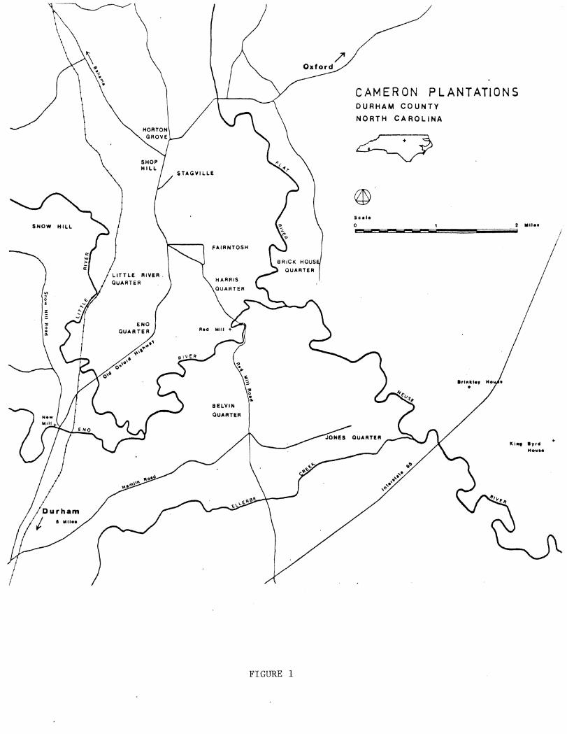
Because this was only a two month project, the extensive Cameron
properties were divided into two research areas (Figure 1). The primary area
l
SNOW HILL
': 0 • :z:
FAIRNTOSH
HARRIS
FIGURE 1
CAMERON PLANTATIONS DURHAM COUNTY
NORTH CAROLINA
I /
2
included the most important communities: Stagville, Fairntosh, Horton Grove,
Eno, Little River, and Harris's Quarters. The secondary area was less
critical: Fish Dam, Brick House, Peeksville, Belvin Quarters, Jones Quarters,
Snow Hill. We also surveyed historical houses on the periphery of the
plantation to record at least a portion of the historical context of
Stagville, especially since many of these homes are related in some way to
Stagville. Structures recorded previously by the Division of Archives and
History were excluded from the survey, except those for which further
research was obviously necessary.
Since our time was limited, we concentrated on locating and recording
sites through field work and oral interviews. Cameron documents in Archives
can be studied with the safe knowledge that their life has been preserved
through archival maintenance, while the many buildings and oral informants
are fragile sources and demand immediate attention.

METHODS
RECONNAISSANCE
The first phase of the research was to conduct a general field survey to
determine the scope of field investigation and the types of buildings. Many
of the sites had previously been examined by George McDaniel several years
ago, but remained unrecorded. Based on his research, we had a basic under
standing of the topography and architecture of the survey area.
To ensure from the outset that our methods of mapping would be suitable
for archaeologists in the future, we consulted with archaeologists from the
Archaeology and Historic Preservation Section. They demonstrated in the
field the appropriate recording techniques and advised us about the types of
archaeological sites to look for and record.
Preliminary archival research consisted of reviewing state studies such
as Jean Anderson's studies of Stagville, Fairntosh, and the Cameron families,
as well as George McDaniel's research on social history and kinship patterns.
We also contacted the oral informants related to Stagville to set up future
interviews.
Maps of Stagville and the surrounding area in the state archives were
inadequate for our research purposes. Historical maps were also lacking for
specific sites, so we realized that we would have to devise our own maps for
site plans of the plantation communities.
3
4
FIELD WORK AND ORAL INTERVIEWS
We began by surveying communities in the primary area. We measured and
mapped them for site plans, identifying such features as houses, outbuildings,
wells, yards, trees, and roads. The oldest to the most recent structures
were included in the site plans to record a complete picture of the site and
convey a sense of its continued use. By giving an overview of the communities,
the site plans help us see the composition of individual tenant homesteads,
the relationships of one house to another, and show how the residents used
the land around them. The site plan of Fairntosh (Figure 2) illustrates
the social stratification of a plantation through the location and size of
the main house, overseer's house and tenants' dwellings. Including the
domestic dependencies, it shows the composition of the nucleus of a planta
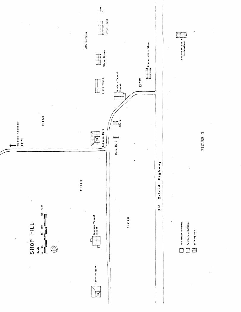
tion. The site plan of Shop Hill (Figure 3) reveals how it was indeed a
busy center of the Stagville economy, with many important farm buildings, a
blacksmith shop, stores, as well as houses.
In both the primary and secondary survey areas, we located, mapped, and
wrote descriptions of buildings and sites, and photographed those that were
still visible. We investigated the fabric of surviving buildings, made
floor plans, and recorded structural, technological, and architectural
details. Measured drawings were made of twelve notable houses in the primary
research area, including slave houses at Eno and Shop Hill and tenant houses
at Fairntosh, Eno, and west Stagville. To illustrate the changes in building
technology from the mid-nineteenth century to the turn of the century, sections
were drawn of the heavy timber frame of the slave house at Eno and of the
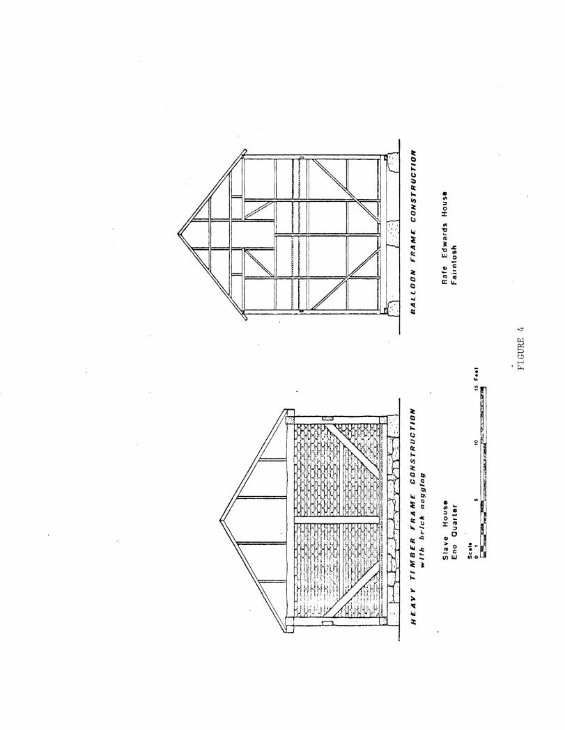
balloon frame of Dock Edwards' tenant house at Fairntosh (Yigure 4). Three
houses in the secondary survey area were also measured and drawn: the log
[ill
8 II n
r=-~~§
---------
Sla
ble
FA
IRN
TO
SH
S
cale
0 2
5
~0
75
'tO
O
15
0
Feet
~..,._
:s
®
PA
ST
UR
E
Barn
F--
I
0 D
r-.~
:,
,:::
:1
"'"'a
Sto
rag
e
Sh
ed
An
teb
ell
um
B
uil
din
g
tto
atb
oH
um
Bu
ild
ing
•uH
cU
ng
S
ite
~~
Wo
od
en
fe
nce
=F
lock
Wa
ll
Sto
rag
e
Sh
ed
I I
rn kil
ch
on
mo
alr
y
[I] S
mo
ke
ho
use
[]] C
om
mto
sa
ry
CID Se,
.an
t's
Dw
ell
on
g
c . I
GA
RD
EN
Sh
ed
Otr
lce
B
Ou
tbu
ild
ing
f t
f L
0
~
Teach
et'
s
Dw
ell
ing
~
Ow
er•
e•r
'a
0 w
elltn
v
'""1
. :=========o=-~
""' """
•;.,,
--'~-=·
ill];
F1
c-~~
F:T
I:]: T
en
an
t H
ou
se
&;.;~-
!Jew
el
Hesk
inal
FIG
UR
E
2
Ten
•nl
Ho
use
!R
are
Ed
ward
ll CJ
Prl
vy
[}~ T
e n
an
r H
ou
se
L
J fG
ut:
H
as.
kin
al
~ T
ob
acco
B
arn
SHO
P H
ILL
$
C•I
•
@ ~Modern T
en
an
t
~House
FIE
l
D
0 Anh~·b•Hum 9
ulld
tne
0 P
oc.t
be
llu
m B
uH
dln
o
.. ,,~
LJ
Bu
ild
ing
S
ite
Fe•t
FIE
lD
Old
O
xfo
rd
Hig
hw
ay
\\ Mo
de
rn
To
ba
cco
·
B•r
ne
FCZ:
7'I
L181
J
Co
rn C
rib
II]
FIG
UR
E 3
FIE
lD
:JO
ulb
ulld
lng
8~
[}Juu±J
b:
J3
S!s
vo
H
ou
se
S
tave
1
-to
use
S
llv
e H
ou
s•
Te
na
nt
ow
en r.~~~~~!;~
[JJ1
~jh]
Bfa
ck~m
ith'
a S
ho
p
L -------------
-----
-----
r~n
t ::
::t
t ·:
·:•
B•n
nl!
he
n
Sto
rer"
·· •
le
nte
bell
um
l ~
J L
-i::
r
:su
• ...
HC
AV
Y
TIM
BC
R
FR
AM
E:
CO
NS
TR
UC
TIO
N
wlf
h
bric
k
na
gg
ing
Sla
ve
H
ou
se
E
no
Q
ua
rte
r
Scale
0
1 5
10
1 s
feel
=J<a
;:r;:w
.... ~;;,;,;
/·«.
;;;_
~ -s
;;m
; '* ~
FIG
UR
E 4
BA
LL
OO
N
FR
AM
C
CO
NS
TR
l.JC
nO
N
Ra
fe
Ed
wa
rds
Ho
use
F
air
nto
sh
5
tenant house at Jones Quarter and two possibly late eighteenth century
houses near Northside on land once owned by the Cameron family. Architectural
descriptions of all buildings and sites were written and these were converted
to computerized site forms by Vicki Smith, research assistant.
Oral interviews with at least fifteen former residents furnished details
regarding the appearance of the earlier landscape and the location, construc
tion, and use of dwellings and buildings no longer standing (Figure 5). The
sites that informants located were marked with survey stakes and later
measured and mapped on the site plans. In addition to describing the land
scape, informants enlivened the interviews with anecdotes about the "old-time
people" they knew. Of special significance to the site interpretation of
Stagville are their accounts of education, traditional foodways, agricultural
practices, and other customs.

FIGURE 5. Recording the landscape at Fairntosh with oral informant. Left to right, Vicki Smith, Garland Haskins, and Carl Lounsbury.
RESULTS
SITES RECORDED
More than 112 buildings, structures, and sites were recorded in the
primary, secondary, and peripheral areas. Among the most significant new
sites that were found in the primary area were the following:
1. Shop Hill a. Sites of one and possibly two slave houses along with sites of
outbuildings b. Location and description of three stores
2. Eno Quarter a. Site of slave house immediately west of the surviving one-story
slave house b. Location and description of Eno Barn site c. Description of overseer's house at site of present-day frame
tenant house d. Location about a quarter mile northwest of Eno Quarter of a one
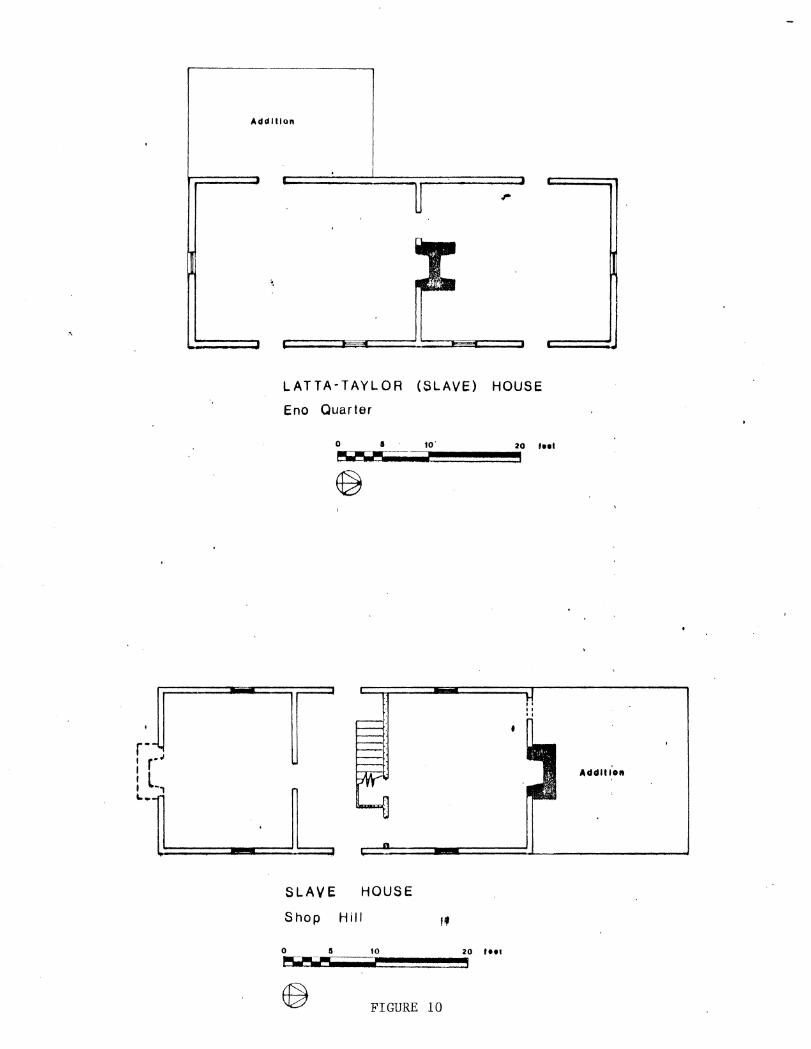
story slave house similar in construction to the one at Eno Quarter (Figure 10)
3. Fairntosh a. Location and description of six slave or tenant dwellings:
Dock Edwards' House (Figure 13), Rafe Edwards' House (site), Zet Revis House (site), Jewel Haskins' House (ruins), Step Morgan House (site), Jerry Webb House (site)
b. Historical route of Red Mill Road, which passed directly by Fairntosh
4. Horton Grove a. Location of earlier roads and outbuildings b. Site of stable and hog pens of tenants
5. S tagville a. Location of foundations of Bennehan store, identified as having
been a school for whites in the 1880's and 1890's, and converted into a tenant house later
b. Identification of the three-story building as a "loom house" before being used as a pack house
c. More detailed descriptions of Stagville outbuildings and residents
6
7
EVIDENCE FOR SITE INTERPRETATION AND ARCHAEOLOGICAL INVESTIGATION
Exhibiting a house without interpreting the grounds around it conveys
an inaccurate picture of life, especially with rural homes since essential
domestic activities occurred outdoors, and the outbuildings and yards took
on the functions of "rooms." At Horton Grove, for example, the houses stand
as empty structures, and little evidence of the life of the "extended house"
can be seen. But through oral interviews with former residents, a number
of these places have been mapped in the site plans (Figure 6), providing
site interpreters with a layout of the historical community. The site plans
also furnish archaeologists with specific locations of identified buildings,
the excavations of which should provide historical artifacts which could be
used in exhibits and in studies of material culture. Moreover, the oral
interviews have identified specific residents at given periods of time, and
artifacts of that period can then be correlated to these families, creating
the basis for comparisons of the material status of different families
within the quarter.
ARCHITECTURE
A variety of houses were surveyed: slave houses, overseer's houses,
main plantation houses, tenant houses of blacks and whites, and yeoman farm
houses on the plantation and its periphery. These buildings illustrate the
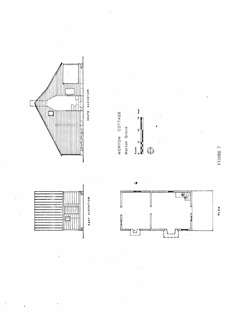
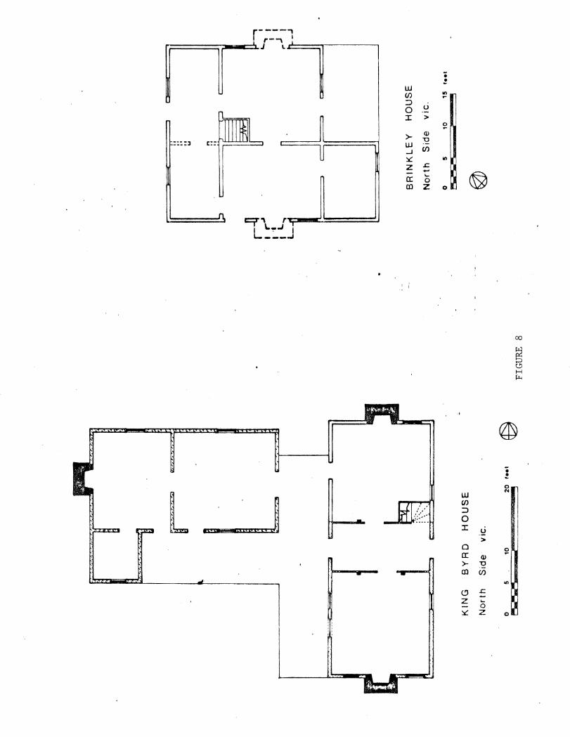
demographic evolution of Stagville. Early sites -- such as Horton Cottage
(Figure 7), the King Byrd House, the Brinkley House (Figure 8) -- exemplify
the pre-plantation era of white yeoman farmers. Slave quarters at Horton
Grove, Shop Hill, and Eno represent the antebellum era of the plantation
with its planned slave communities. The continued presence of farm tenant
families in the postbellum era is represented by the dispersed log and frame
n T
OII
I.C
CO
II
AR
N
Q
(G•o
rge
H
ofm
•11
)
TO
BA
CC
O
IAR
N
(Cy H
art
)
WO
OD
S
SP
RIN
G
TO
BA
CC
O B
AR
N[[]]
(Le
e U
mst•
ad
o
r :
· a
n H
en
de
r1o
n}
TO
BA
CC
O
BA
RN
OJ]
(l
ee
Um
olu
dl
: ·
TO
BA
CC
O BARN~::")
CH
oro
ce C
•mo
ron
l(';
Ju:J
J
D l
.nte
bel
lum
B
uild
ing
D l
'oat
b•!
lum
Bu
ild
ing
~=]
!wlf
dln
; S
ite
----
.. W
lr•
f•n
ce
(!')
Pe
alm
m0
1"'
-T
r••
W P
W
oo-d
~'!•
if:.!
ST
I.B
lE
CT
JJ
::<)
L<
J
r:
f
CO
RN
FIE
LD
? B
Pe
tta
1
Ord
eri
ng
H
ou
se
HO
RT
ON
G
ROV
E c.
191
'"'-
19
30
Sca
le
o 2
5
50
7
5
10
0 F
-
@
FIE
LD
-.._
....
__. --
.._ -----------~-----"
~
GA
RD
E I
f
f;;;::
P O
trt
Y•r
tl
00
0
00
0
lJO
O
OR
CH
AR
D
C)0
0
00
0
r~
q~ms
iead
lp
"''"
Co
nt
Cri
b
OU
t Y~rd
~L
H••••m
{/ -~
FIG
UR
E 6
I
Ord
eri
ng
:H
og
P
an
H
ow
e•
(\s~]
rr··
. !"•c
k ~::
::::::
l :
. H
ou
ae
t;;;
;o".
iJ
;;':J
ilco
r•
H..
. C
rill
,H
o•M
G I
. R
DE
It
Ve
ge
tab
le rn V
e-g
eta
ble
Gsrd
en
G
ard
en
Co
r"
~~~b ~
~~Ho
lm~;
y
Fl
Dir
t Y
ett
f
•••
...
T
"' • "' . 3 •
Me
at
Ho
use
@]
-II
GA
RD
EN
r~~
~~~:
J
WP
t -j
K .
. A
10.~ '
"'O
ilt
~
I "-
-
c;t
rt Y
ar6
J~~~il!,
'>.,
G••
..
~ ~
·, IO
....
~
S:1
~
&
ii w !. <.9 <{ ~ 1-1-0 QJ
(.) > 0 ....
z <.9
0 c 1- 0
r--
~ @)
a: ~ .... 0 0 r r
0 H ~
,,
2: <( ..J A.
... U)
• LV w
l t .. J ! L ..•... J
r----, r-• I J I.
• ! w C/)
..., ... ::)
u 0 :r: >
0 ... >- (\)
"0 ::::l c·- w _.J C/)
~ Ill
z .s:: -a: ... 0
Ol z 0
t:.::;T\ r L_::J
co
@
: 0
l N
IU'I'I II j w C/)
::> 0
I II'S :r: -~ >
0 5:1 a: (\)
>- "0
Ol C/)
"' ~ .s:: z ....
0 ~ z 0

8
tenant houses on the plantation. The slow demise of the Cameron plantation
in this period is shown by the intrusion of homes of nearby white families,
who purchased land sold by the Camerons along the edge of their plantation.
In the twentieth century the gradual migration of tenants away from the
farm, in keeping with the trend in the South, is illustrated by the
comparatively few houses constructed within the last sixty years, and the
almost total exodus of tenants from the farm in mid-twentieth century is
shown by the scores of abandoned houses.
Buildings on the Cameron plantation provide an excellent field laboratory
for the study of plantation housing for workers, overseers, and landowners.
However, one must be careful in evaluating the results based solely on field
work. For example, most slave houses have disappeared. In 1857 there were
188 slaves listed at Stagville, yet only ten sites of slave houses have been
documented there. As a result, conclusions about slave houses based on the
few surviving examples would be misleading (see Figures 9 and 10), and
comparisons of the quality of housing for slaves and postbellum tenants should
be weighed carefully. Based upon the recollections of former residents of
the old houses they knew, it appears that the small one-story log or frame
house was by far the more common type of slave house than the brick nogged
examples.
Log houses definitely comprised a majority of the postbellum tenant
dwellings, and their construction represents the last phases of traditional
log building, an aspect of vernacular architecture that has received little
attention in North Carolina. The houses displayed a simplification of corner
notching and incorporated modern framing techniques and commercially made
materials. The size of tenant houses remained small, scarcely more than

"' . u • ii ~
>-
"'
... > w ..J
2 w UJ
1- • <C a •
... II) ... ..
w C/)
::J 0 I
w > c( ..J (/)
'-QJ -.... "' ::l
0
0 c:
UJ
• !
I!
J
J : r-~ : L.,
--~
Addition
LATTA-TAYLOR (SLAVE) HOUSE
Eno Quarter
r L SLAVE HOUSE
Shop Hill '' 0 5 10 20 , ... ....-..- I
® FIGURE 10
Addition
9
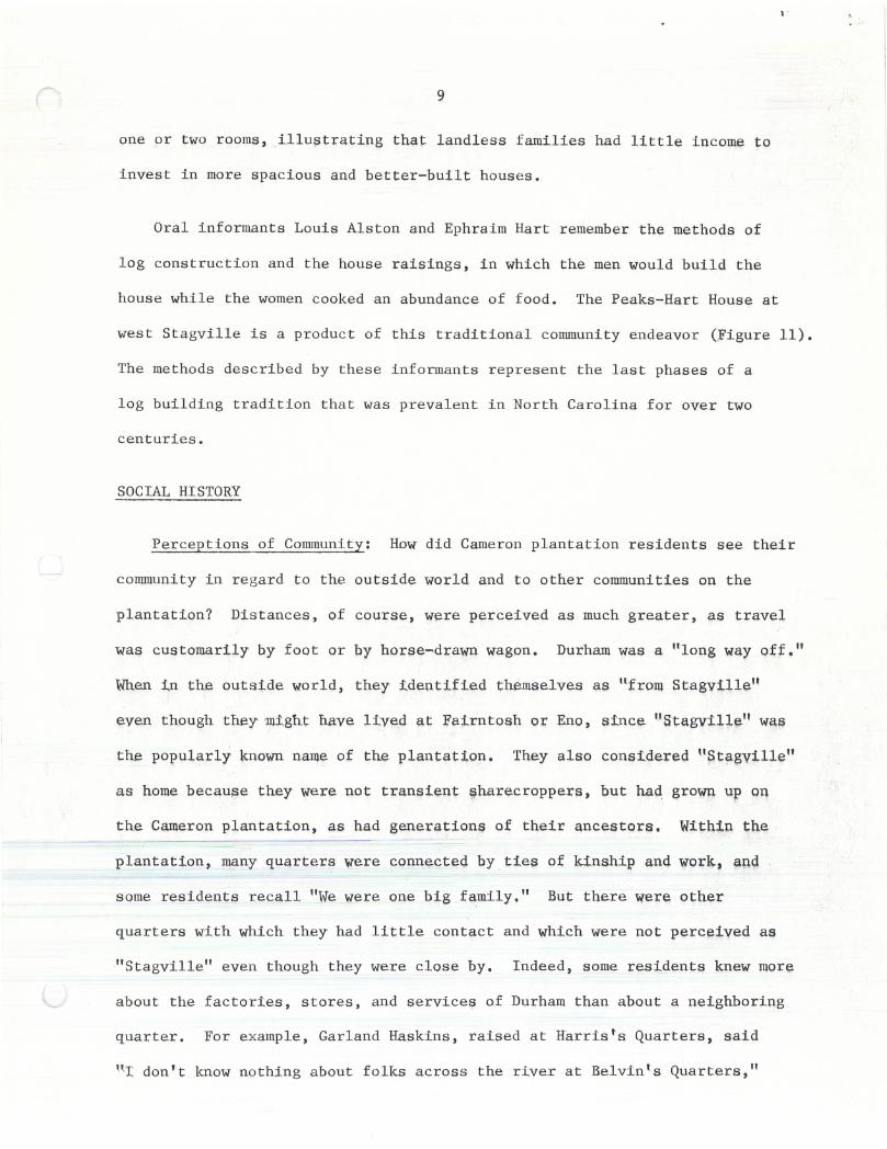
one or two rooms, illu9trating that landless families had little income to
invest in more spacious and better-built houses.
Oral informants Louis Alston and Ephraim Hart remember the methods of
log construction and the house raisings, in which the men would build the
house while the women cooked an abundance of food. The Peaks-Hart House at
west Stagville is a produc t of this traditional community endeavor (Figure 11).
The methods described by these informants represent the last phases of a
log building tradition that was prevalent in North Carolina for over two
centuries.
SOCIAL HI STORY
Perceptions of Community: How did Cameron plantation residents see their
community in regard to the outside world and to other communities on the
plantation? Distances, of course, w~re perceived as much greater, as travel
waf? customarily by foot or by horse-drawn wagon. Durham was a 111ong way off."
When ~n the outside world, they identified themselves ;;~.s tlfrol!l StagyUl~"
even though they 111ight: have lived at Fairntosh or Eno, since ''St:agville'' wa.s.
the popularly known. name of the plantation. They also considered 11Stagyillen
as home because they wer~ not transient ~harecroppers, but had growq up on
th.e Cameron plantation, as had generations of their ancestors. Withip the
plantation, IllC;lny qua,rters were connected by ties of ldnship an4 work, ap.q
some residents recall 11We were one big family." But there were oth.er
quarters with which they had little contact and which were not perceived as
" Stagville" even though they were close by. Indeed, some residents knew more
about the facto r ies, stores, and services of Durham than about a neighboring
quarter. For example, Garland Haskins, raised at Harris's Quarters, said
nr: don't know nothing about folks across the river at Belvin 1 s Quarters,"
.. ·"'I ... ~ ............. ~--~-·~·
t:AST ELt:VATION NOHTH tLIJYATION
PEAKS ·HART HOUSt;
We~t StagvliiQ
I Gilt 0 0 10 11 , .. ,
~~~-~-~-~-~·--~~~~3
., I
PLAH
FIGURE 11
10
even though it adjoined Harris's. Ephraim Hart, who has in fact lived on
Cameron property his entire life, characterizes his six years residency at
the Brick House quarter as having been "away from Stagville." Further
research should decipher more clearly the mental images and boundaries of
"Stagville" according to the residents.
Stagville as a Bi-racial Community: The social history of Stagville
is a mixture of segregation and integration at different levels. Landowning
whites were segregated at the top in terms of power and prestige, but in
regard to work force in the postbellum period, there were. both black and
white tenant farmers from the 1880's onward. How the terms of work of one
race compared with those of the other requires further study. An inter
mediate group of whites in the work force during this era held supervisory
positions. Examples are Sid Lashley who operated the saw mill, Barl
Southerland who managed the dairy at the Stagville Barn, and Dan Turrentine,
the overseer. In regard to residency, there were some quarters which were
racially mixed, while others were not. Horton Grove in the 1880's and early
1890's, Stagville, En~, and of course Fairntosh had both blacks and whites in
the community. Shop Hill was more or less exclusively white, whi.le Little
River, Harris's, and west Stagville were black.
Tenant houses of the postbellum era contain no characteristics that
distinguish them as having been the homes of white or black families
exclusively. Indeed, it appears to have been a fairly common practice for
the same houses to have been inhabited by families of each race. The King
Byrd House near Northside, the General Harris House on Snow Hill Road, the
Alvis Umstead House on Jock Road, and the Hamlin Log Tenant House, for
example, were occupied at different periods by white and black families.
11
PARTICIPATION OF FORMER RESIDENTS
As former residents of Stagville participate in this research, they
become more interested in their common Stagville heritage (Figure 12). Many
of them are elderly, and by contributing to projects such as this they seem
to have strengthened their sense of self esteem. Their participation has
literally brought history home to their families, as they answer questions
from their children about their work with us and as a result, relate the ways
of life they knew at Stagville. Work such as this, we hope, will provide a
fertile and receptive climate for future research and may bring forth
artifacts, old photographs, and more oral recollections in the future.
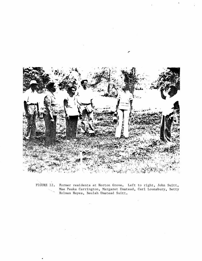
FIGURE 12. Former residents at Horton Grove. Left to right, John Suitt, Mae Peaks Carrington, Margaret Umstead, Carl Lounsbury, Betty Holman Hayes, Beulah Umstead Suitt.

RECOMMENDATIONS
ACQUISITION OF PROPERTY AND EASEMENTS
Options:
1. Extend land owned by the Stagville Preservation Center to the
boundaries recommended by the Preservation Resource Group, Inc. in May, 1979.
In general, this area encompasses the land on either side of the Old Oxford
Highway from the boundary with Fairntosh to Horton Grove. See the map
produced by the Preservation Resource Group, Inc. for further details.
2. If it is not possible to purchase all of this land, we recommend that
the state purchase a continuous corridor extending from the entrance to
Stagville through Shop Hill to Horton Grove, including the land in front of
Horton Grove down to Jock Road and Bahama Road. Easements should be acquired
over the remainder.
3. Acquire easements on land at Fairntosh along the Old Oxford Highway,
beginning with Eno Quarter and continuing to Stagville, or on as much of the
road frontage as possible.
Rationale: The Stagville Preservation Center and the land around it
possess an invaluable potential for research and the interpretation of the
history of North Carolina. Since the late 18th century, Stagville plantation
developed as a complex of interrelated places and people, and a clear
relationship between the residential, agricultural, artisanal, and mercantile
elements needs to be conveyed in a logical manner in an undisturbed landscape.
12
13
The destruction of one part diminishes the integrity of the whole. Without
control over land use, the area could be developed in a number of ways that
would destroy historical buildings and archaeological sites, as well as the
rural identity of Stagville 1 s surroundings.
Now is the time for long-range protection. The recent purchase of the
Liggett Group, Inc. by an outside party with no connections to Stagville
could lead to the development of nstagville Estatesn or other such sub-
divisions along the Old Oxford Highway opposite the Stagville Preservation
Center or in front of Horton Grove. Similar developments could be built at
Fairntosh. The loss would be irreplaceable and would be detrimental to
plans for the development and interpretation of the Stagville Preservation
Center for generations to come.
Important Sites: Among the important sites and their components to be
included in this extension of the Stagville Center are:
1. Shop Hill a. Two antebellum air-curing tobacco barns, important testimonies
to early No~th Carolina economy and tobacco production b. Two slave houses and the site of another, all of identical
construction to the Horton Grove slave houses. Inhabited by 20th century white farm.families and, there£ore, evidence of the bi-racial nature of the Stagville community
c, Site of blacksmith shop operated by black artisans from the early nineteenth century to the 1920ts
d, Antebellum log and frame house, later the home of a Confederate veteran and the sawyer at the Cameron saw mill
e. Three wells for archaeological excavations, including the well for the blacksmith shop
f. Sites of two possibly antebellum log houses and two postbellum tenant houses
g. Three postbellum store sites h. Plowed fields with evidence of Indian occupation
2. Horton Grove a. Row of tobacco barns, important agricultural buildings which are
integral to the interpretation of Horton Grove b. Site of stable c. Spring
14
3. Stagville a. Loom house, mid-nineteenth century manufacturing building b. Site of two-story frame house c. Site of late nineteenth century or early twentieth century log
school house
IMMEDIATE PREVENTIVE MAINTENANCE
Many important historical structures around the Stagville Center are
deteriorating through neglect, For example, the loom house by the drive to
the Stagville Center is decaying: the roof has gaping holes, the weather-
boards are falling off, rubbish within the house retains moisture and rots
the floorboards and framing members, making the structure generally unsafe.
The slave houses at Shop Hill, among the most unusual in the nation, are
overgrown and have suffered serious damage. Their timbers and brick nagging
are disintegrating.
Measures that should be taken immediately are: Cl1 clear out the under-
growth around the buildings, (2) repair roofs, (J} board openings, (_4} under-
take other general, temporary stabilizing measures.
Specific buildings to be repaired:
1. Shop Hill a. Slave houses b. Air-curing tobacco barns
2. Eno Quarter a. Slave house near the Old Ox:l;ord Highway, the only dated slave
house (1850) on the Cameron plantation
3. Stagville a. Loom house
This preventive maintenance should be done with the cooperation of the
owner.

15
ARCHITECTURAL SURVEY OF DURHAM COUNTY
An architectural survey of Durham County would help place Stagville's
buildings in an appropriate architectural context. It would be especially
helpful to compare methods of log and frame construction, the general level
of architectural competence and design, and the types of slave, tenant, and
landowrters' houses with those outside the plantation.
RESEARCH FOR SITE INTERPRETATION
Houses are usually interpreted according to their earliest period of
residency or to the period with the most complete sources of documentation.
The slave houses at Horton Grove pose a serious problem in this regard,
since no documents have been found as of yet that describe their antebellum
furnishings, their use, or even the construction of the houses, In light
of this, the interpretation of the homes would have to be based upon
descriptions of furnishings in slave houses elsewhere in North Carolina,
but since the ones at Horton Grove are unusually large and well-built
dwellings, the risk ·is considerable that they may be interpreted in an
inappropriate high style. Furthermore, no documents establish even the
number of families in these two-story, four room houses, so how should the
buildings be interpreted1
We therefore recommend that the houses be interpreted according to the
most detailed and reliable sources specifically related to the houses. In
the absence of written records, these sources are the people who actually
lived in them near the turn of the century. We realize that this may seem
too recent to some, but this period is historically important as it reflects
the transformation from the pre-industrial world to the modern, from a
16
slave to a tenant economy, from hand labor to ma,chip.e.s, from home-made
objects to the store-bought. Rural homes of this period contain artifacts
of both types.
More importantly for exhibit purposes is the fact that the residents
themselves can answer the questions of the site interpreters, and they can
identify the types of furnishings used in the entire range of domestic
activities: cooking, eating, housekeeping, child rearing, bathing, sleeping,
taking care of the sick, relaxing, and socializing. They can remember
where objects were placed and how they were used. Furthermore, informants
can distinguish between the households of different families, and personalized
exhibits could result, showing the individual character of the families (not
all sharecroppers were alike} as well as thei.r,shared culture.
Towards this end, we recommend that a series of oral interviews be
conducted now. Even if a decision is made later to ip.terpret the houses in
another fashion, the interviews could be used by historians of social life
and material culture. If one waits too long, the former residents will have
passed on.
FURTHER HISTORICAL RESEARCH
Due to the absence of written evidence, a curtain is drawn over much of
the daily life and thoughts of the majority of Stagville residents in the
antebellum era, but for the postbellum period, especially with the early
twentieth century, we have the opportunity to record more clearly from the
participants themselves the patterns of their social history. We can explore
race relations on the plantation and the role of religion in their lives,
comparing the perceptions of blacks and whites. Other topics for case
studies include:
17
1. Antebellum agricultural practices. This would include identification
of work routines, location of arable and pastoral fields, types of farm tools
and equipment and methods of clearing, fencing, cultivating, and tending
fields,
2. Tenant farming. How did the tenant system develop from slavery?
How did this system affect the location and construction of houses (i;ee
Figure 13). ~1at were the terms of the tenancy, and what were the incomes
of tenant families? In what ways was their livelihood supplemented?
3, Family life. ~at was the composition of families of the different
plantation groups? ~at patterns of kinship emerged, and what was the role
of kinship in community life? How did kinship patterns among white tenant
families compare to those of black tenants? For example, former white
sharecropper Willie Duke recalls that among white tenants, "almost everybody
was kin, 11 a characterization also given by former black residents.
4. Migration from the farm. What were the reasons of dif£eJ;ent groups
of blacks and whites for leaving the farm? ~at were their routes of
migration? What types of jobs did they take?
Studies such as these could be linked to other hi,storical studies of the
South so that the experience of Stagville people may be seen in comparison
with regional, or even national trends. For example, historian Dolores
Janieweski has written her dissertation at Duke on the role of women in the
industrialization of the South, focusing on the tobacco industry, and used
women from Stagville as part of her study.

.. 0 f.-
"' ;.. LIJ -1 w
1-(/)
"' :s
w (/)
:::> 0 ::c (/)
0 a: <:(
s: 0 w ::.::: 0 0 Cl
r• ... :. • •• ,. ... J J J
'-·····----
.J-
• : .... ..
0 ...
.c (/)
0 Ill
c .:::: • ·~ ~
.. I)
Ill 0
18
IMPROVE LIAISON WrTH NEARBY INSTITUTIONS FOR RESEARCH ~URPOSES
The rich sources at Stagville in social, cultural, and architectural
history, the voluminous archival materials, and substantial number of oral
informants presents an excellent opportunity for the study of North Carolina
and Southern history. To explore these resources and to inform the inter-
pretation and development of Stagville, the Center should expand its
relationships with nearby universities-- Duke, U.N.C., N. C. State, and
N.C.C.U. There are a wealth of topics for students to explore from a
variety of disciplines, Oral history programs at Duke and U.N.C. could
i.nterview Stagville informants in conjunction with the Center; and the folk-
lore program at U.N.C, and the Office of Folklife ~rograrus of the Department
of Cultural Resources could record folkways. Research grants from Stagville
could be given for specific topics. The results of all these endeavors
could enrich the historical archives of Sta.gyille and help create ll),ore
accurate interpretations of life there.
Evidence of university interest in Sta.gville was demons:tra.te.d tfiis •
summer when anthropology professor Carol Stack from Duke asked us for a
le.cture on our research :for her course "The Industrialization of the South, 11
in the Institute for Southern Studies at Duke. As part of our presentation,
we invited Johnny Jones, a former Stagville resident and an ~ploye.e of Duke,
to participate. He answered students' questions with first-hand experiences
of life at Stagville and explained why tenants left and the jobs they took.
DEVELOP MORE ACTIVE ROLE IN LOCAL PRESERVATION
Since Stagville is a preservation center, it has a major obligation to
encourage historical preservation in its local community. Unfortunately, the
19
Center has not been as active as it could be in this regard, and a number of
local buildings important to the context of Stagville have been lost or are
threatened by demolition through neglect. For example, the log home of Lee
Umstead on the Bahama Road a short distance from Stagville was recently
pulled down; Umstead's wife was the daughter of the overseer of Stagville.
The store of Lee Belvin on the corner of th.e Old Oxford Highway and Roxboro
Road was destroyed without having been recorded; it was one of the stores
where black and white tenants from Stagville traded. The home of Phillip
Southerland, antebellum overseer of Stagville, is now abandoned and may soon
be pulled down.
We recommend that the Stagville Preservation Center inform local residents
about the important historical connections between Stagville and the:;l.r
houses and try to encourage them to maintain th.e houses. This could be done
through informal meetings with community residents in which the purposes~
methods, and benefi.ts of Ustorical preservation could be explained, and
ongoing relationships established.
Technical assistance could be. provided by local organizations, such as
the Durham Technical Institute, an endeavor whi~cfL would give on ... site experience
to students as well as benefiting local residents.
Of critical importance is th.e establishment of a friendly working
relationship with Mr. and Mrs. William McFarland, owners of Fairntosh
Plantation, which also includes the valuable h.istori.cal sites of Eno and
Little River Quarters. At Fairntosh itself the domestic dependencies, such
as the antebellum commissary and servants' quarters, are neglected, their
roofs rotted, and the buildings are in perilous condi,tion. It would be a
tragedy if this unusually complete set of plantation dependencies were lost.
20
The McFarlands, who have cooperated in this research, 11:1ay be receptive to the
proper encouragement and advice as to the maintenance of these dependencies.
They should be informed especially about the financial assistance provided
through preservation legislation, such as matching funds for structures on
the National Register and tax write-.offs for their maintenance.
ARCHIVES AND DISPLAYS AT STAGVILLE CENTER
If the Stagville Preservation Center is to become a center for research
activities, we recommend that certain archival materials be located at the
Bennehan House and made more accessible to the public. Many visitors who
have connections with the Cameron plantations come to the Center in search
of information about their ancestors and "old home places, 1·1 while others
call or write to offer information, photographs, or artifacts. Much of this
information they submit has no repository except upon scraps o£ paper that
are filed in many places.
We recommend that a filing system be organized with descriptions~ photo~
graphs, and information about people and buildings. Materials received from
donors could be incorporated into the files to ensure that valuable 11 informal 11
information is not lost, Furthermore, this filing system could be used for
providing information to inquisitive visitors and as a nucleus for setting
up photographic exhibits.
we suggest that photographs and site descriptions produce.d by this
research project and others be reproduced in a form readily available to
Stagville visitors so that participants in this research_ can see that their
contribution to Stagville~s history has been appreciated, and so that others
can be encouraged to cooperate too.
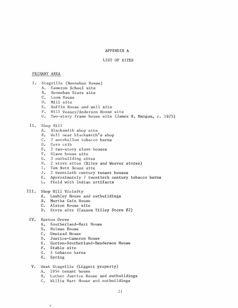
APPENDIX A
LIST OF SITES
PRIMARY AREA
I. Stagville (Bennehan House) A. Cameron School site B. Bennehan Store site C. Loom House D. Mill site E. Ruffin House and well site F. Will Veasey/Anderson House site G. Two-story frame house site (James H. Mangum, c. 1925)
II. Shop Hill A. Blacksmith shop site B. Well near blacksmith's shop C. 2 antebellum tobacco barns D. Corn crib E. 2 two-story slave houses F. Slave house site G. 3 outbuilding sites H. 2 store sites (Riley and Weaver stores} I. Tom Nutt House site J. 2 twentieth century tenant houses K. Approximately 7 twentieth century tobacco barns L. Field with Indian artifacts
ITT. Shop Hill Vicini~y A. Lashley House and outbuildings B. Martha Cain House C. Alston House site D. Store site (Cassem Tilley Store #2)
IV. Horton Grove A. Southerland-Hart House B. Holman House C. Umstead House D. Justice-Cameron House E. Horton-Southerland-Henderson House F. Stable site G. 5 tobacco barns H. Spring
V. West Stagville (Liggett property) A. 1954 tenant house B. Luther Justice House and outbuildings C. Willis Hart House and outbuildings
21

22
D. Peaks-Hart log house E. Sowell House site
VI. Fairntosh A. Dock Edwards House B. Rafe Edwards House site c. Jewel Haskins House site D. Zet Revis House site E. Step Morgan (slave) House site F. Jerry Webb House site
VII. Eno Quarter A. Slave house B. Slave house site c. Overseer's house site and tenant house D. Well E. Eno barn site F. Roosevelt Peaks log house
VIII. Eno Quarter vicinity A. (Latta-Taylor) slave house B. Dock Justice House c. Gene Laws House site
IX. Little River Quarter A. Johnny Parker House site B. Arney House site C. Woods log house site and Ephraim Hart House D. Little River cemetery E. Cameron Grove Baptist Church site F. Brandon House site G. 2 wells near Ephraim Hart House
X. Harris Quarter A. Harris' barn B. Red Mill C. Harris' cemetery D. Garland Haskins (birthplace) House site E. Kinchen Haskins House site F. Ned Ruffin House site G. 3 unidentified house sites •
SECONDARY AREA
I. Belvin Quarters A. Hamlin Road log house B. 3 slave house sites
II. Jones Quarter A. Jones Quarter cemetery B. Jones Quarter tenant house
III. Fish Dam A. Cemetery B. Latta log house (historical photograph)

23
IV. Snow Hill A. Frame tenant house B. Log tenant house C. Snow Hill slave t:ernetery D. Cluster of twentLeth century farm buildings
V. Snow Hill Vicinity A. Chappell log house B. General Harris log house
VI. Brick House Quarter A. Brick house site B. Mint Brooks House site C. Alfred Evans Hout>e site D. Ephraim and Minnje Hart House site
VII. North Side A. King Byrd House B. Brinkley House
PERIPHERAL AREAS
I. Northern Fringe of Stagville A. Alvis Umstead House B. Phillip Southerland House c. Thomas Southerland Kouse site D. Lee Umstead, Sr. House site E. Lee Umstead, Jr. House F. A:rned Road yeoman farmer house G. Cassem Tilley House H. Cassem Tilley Store Ill
II. Southern Fringe of Stagville A. New Mill site

N ~
APP
END
IX
B
ORAL
IN
FORM
AN
TS
PRIM
ARY
A
REA
S
___ Q
u~!!~! __
____
____
____
__ !~
!~~~
~E--
----
----
----
----
---~
~~~!
!~~~
~!E_
!~-9
~~!!
~!--
----
---~
~!!~
~-~!
-~~~
~~~~
~!!~
~~-
I.
Ho
rto
n G
rove
A
. B
eula
h U
mst
ead
Su
itt
B.
Bet
ty H
olm
an H
ayes
C
. M
ae
Pea
ks
Car
rin
gto
n
D.
Lo
uis
Als
ton
E
. M
arg
aret
Um
stea
d F
. G
arla
nd
Has
kin
s
G.
Eph
raim
Har
t
H.
Dee
S
ou
ther
lan
d
II •
Sho
p R
ill
A.
Lo
uis
A
lsto
n
B.
Gar
lan
d H
ask
ins
C.
Eph
raim
Har
t D
. M
aggi
e V
ease
y E
llis
E.
Joe
Ell
is
F.
Nao
mi
Vea
sey
Hu
tch
ins
G.
Dee
So
uth
erla
nd
H
. N
orm
an P
en
derg
raft
III.
F
air
nto
sh
A.
Gar
lan
d H
ask
ins
resi
den
t re
sid
en
t re
sid
en
t at
Rev
is R
ill,
n
earb
y
resi
den
t re
sid
en
t re
sid
en
t o
f H
arr
is'
Qu
art
ers
, v
isit
ed
Ho
rto
n G
rove
re
sid
en
t o
f B
oo
Roo
Q
uart
er,
B
rick
Hou
se,
Lit
tle R
iver
, an
d W
est
Sta
gv
ille
(l
ife·l
on
g
resi
den
t o
f S
tag
vil
leJ
resi
den
t o
f W
illa
rdsv
ille
nea
r O
rang
e F
acto
ry,
vis
ited
Un
cle
Bar
l S
ou
ther
lan
d a
t H
ort
on
G
rove
an
d U
ncl
e D
an
Tu
rren
tin
e
at
Eno
Q
uar
ter
and
Fair
nto
sh
see
abov
e " II
resi
den
t,
als
o re
sid
en
t at
Harr
is,
Eno
, an
d B
elv
in
Qu
arte
rs
'" v
isit
or,
re
are
d n
ear
Bah
ama
see a
oev
e li
ved
wit
h g
ran
dp
aren
ts at
Ben
neha
n H
ouse
see
abo
ve,
h
is a
un
t li
ved
at
Fair
nto
sh
19
14
-19
20
's
19
09
-19
20
1s
19
10
's-1
92
0's
1
91
0's
-19
20
's
19
10
's-1
92
0's
19
101 s-
19
20
'·s
1914
to
p
rese
nt
late
1880~s
-c.
19
00
see a
bove
II
" 1
92
0's
-19
40
's
19
30
's-1
94
0's
1920~s-1940~s
see
abo
ve
1939
-194
1
see a
bo
ve

B.
Ep
hra
im H
art
C.
Dee
S
ou
therl
an
d
D.
Mag
gie
Ell
is
E.
Nao
mi
Hu
tch
ins
IV.
Sta
gv
ille
A
. L
ou
is
Als
ton
(B
enn
ehan
Ho
use
) B
. D
ee
So
uth
erl
an
d
C.
Nor
man
P
en
derg
raft
D
. G
arla
nd
Has
kin
s E
. W
illi
e D
uke
.
V.
Wes
t S
tag
vil
le
A.
Ep
hra
im H
art
B.
Min
nie
Har
t
C.
All
en
Nee
dham
VI.
E
no
A.
Dee
S
ou
therl
an
d
B.
Gar
lan
d H
ask
ins
C.
Lo
uis
Als
ton
D
. E
ph
raim
Har
t
VII
. L
ittl
e R
iver
A.
Ep
hra
im H
art
B.
Min
nie
Har
t C
. B
ert
ha M
ae
Hart
VII
I.
Harr
is
A.
Gar
lan
d H
ask
ins
B.
Ep
hra
im H
art
C
. M
aggi
e E
llis
SECO
NDAR
Y A
REA
S
I.
Belv
in Q
uart
ers
A
. M
aggi
e E
llis
B
. N
aom
i H
utc
hin
s C
. M
rs.
Mas
on
Boy
d
see
abo
ve,
au
nts
an
d
un
cle
s li
ved
at
Fair
nto
sh
see
abo
ve
If
II
see
abo
ve,
au
nt
and
un
cle
li
ved
beh
ind
B
enne
han
Hou
se
see
abo
ve
" II
ten
an
t,
liv
ed
in
B
enne
han
Hou
se
and
at
Sho
p H
ill
see
abo
ve
resi
den
t,
wif
e
of
Ep
hra
im
Har
t
see
abo
ve
see
abo
ve
II "
see
abo
ve
II
II
II
earl
y-m
id 1
93
0's
see
abo
ve
19
30
's
resi
den
t n
ear
Ho
rto
n
Gro
ve,
lg
SO
's
to p
rese
nt
ov
ers
eer
for
Lig
gett
p
rop
ert
ies
see
abo
ve,
v
isit
ed
his
Un
cle
Dan
T
urr
en
tin
e,
a re
sid
en
t at
Eno
se
e
abo
ve
II "
pre
sen
t re
sid
en
t se
e
abo
ve
resi
den
t
resi
den
t v
isit
or,
se
e
abo
ve
resi
den
t
see a
bo
ve,
p
rese
nt
resi
den
t II
nea
rby
re
sid
en
t on
Ham
lin
road
, p
are
nts
wer
e re
sid
en
ts
18
80
's
see
abo
ve
" II
see
abo
ve
" 1
95
0's
-19
60
's
19
10
's-1
92
0's
se
e a
bo
ve
1920
1s-
19
40
see
abo
ve
II
19
10
's to
p
rese
nt
N
V1

II.
Jon
es
Qu
art
ers
III.
B
rick
Hou
se
A.
Son
o
f M
rs.
Vir
gin
ia
Joh
nso
n
(nam
e n
ot
reco
rded
)
A.
Min
nie
H
art
B.
Ell
en
Yan
cey
C.
Ric
har
d
San
der
s
IV.
Snow
H
ill
Vic
init
y
A.
Wal
lace
Wad
e
pre
sen
t d
ay re
sid
en
t
see
abo
ve,
fo
rmer
re
sid
en
t
pre
sen
t da
y re
sid
en
t h
isto
rical
inte
rest
and
vis
ito
r
resi
den
t
heard
ac
cou
nts
fr
om
o
lder
com
mun
ity
resi
den
ts
fro
m 1
91
0's
-1
94
0's
late
1
95
0's
-earl
y
19
60
's
19
20
's
to p
rese
nt
19
60
's
and
1
97
0's
19
50
's
to
pre
sen
t
N
0\
Copyright © 2022 FDOKUMEN