Post-disaster assessment of hazard mitigation for small and medium-magnitude debris flow disasters...
17
ORIGINAL PAPER Post-disaster assessment of hazard mitigation for small and medium-magnitude debris flow disasters in Bali, Indonesia and Jimani, Dominican Republic Brent Doberstein Received: 30 May 2007 / Accepted: 2 January 2009 / Published online: 3 February 2009 Ó Springer Science+Business Media B.V. 2009 Abstract This article explores whether past exposure to debris flow disasters with a human dimension (e.g. caused in part by deforestation) results in adaptive hazard miti- gation and improved environmental and resource management practices in affected areas. When guiding hazard mitigation practice, the ‘adaptive hazard mitigation’ approach views mitigation as a multi-dimensional experiment, with the associated need for post-experi- ment monitoring, evaluation, learning and adjustment, and attention paid to multiple scales (Bogardi 2004). This article explores how the concept of ‘adaptive hazard mitigation’ has emerged, linking this ‘adaptive management’ used increasingly in resource and environ- mental management. Two case studies of disasters linked to human-induced environmental change are examined, and the mitigation responses of local communities, NGOs and Government agencies are documented. Data sources include secondary data (journal articles, web-based disaster reports and grey literature) on each disaster, key informant interviews (n = 8) and direct observation over the 2005–2006 period of post-disaster mitigation actions implemented after each disaster. The research indicates that in both case studies, a limited range of hazard mitigation actions was employed, including both structural and non-structural approaches. However, the research also found that causal factors involving human-induced environmental change (e.g. deforestation) were not addressed, and overall, the hazard mitigation strategies adopted lacked monitoring, learning and adjustment. In both case studies, responses to disaster were judged to be examples of ‘trial and error’ adaptation, rather than either ‘passive’ or ‘active’ adaptation. Keywords Bali Á Dominican Republic Á Adaptive hazard mitigation Á Adaptive management Á Debris flow Á Disaster B. Doberstein (&) Faculty of Environmental Studies, Department of Geography, University of Waterloo, 200 University Ave. W, Waterloo, ON N2L 3G1, Canada e-mail: [email protected] 123 Nat Hazards (2009) 50:361–377 DOI 10.1007/s11069-009-9345-8
Transcript of Post-disaster assessment of hazard mitigation for small and medium-magnitude debris flow disasters...

ORI GIN AL PA PER
Post-disaster assessment of hazard mitigation for smalland medium-magnitude debris flow disasters in Bali,Indonesia and Jimani, Dominican Republic
Brent Doberstein
Received: 30 May 2007 / Accepted: 2 January 2009 / Published online: 3 February 2009� Springer Science+Business Media B.V. 2009
Abstract This article explores whether past exposure to debris flow disasters with a
human dimension (e.g. caused in part by deforestation) results in adaptive hazard miti-
gation and improved environmental and resource management practices in affected areas.
When guiding hazard mitigation practice, the ‘adaptive hazard mitigation’ approach views
mitigation as a multi-dimensional experiment, with the associated need for post-experi-
ment monitoring, evaluation, learning and adjustment, and attention paid to multiple scales
(Bogardi 2004). This article explores how the concept of ‘adaptive hazard mitigation’ has
emerged, linking this ‘adaptive management’ used increasingly in resource and environ-
mental management. Two case studies of disasters linked to human-induced environmental
change are examined, and the mitigation responses of local communities, NGOs and
Government agencies are documented. Data sources include secondary data (journal
articles, web-based disaster reports and grey literature) on each disaster, key informant
interviews (n = 8) and direct observation over the 2005–2006 period of post-disaster
mitigation actions implemented after each disaster. The research indicates that in both case
studies, a limited range of hazard mitigation actions was employed, including both
structural and non-structural approaches. However, the research also found that causal
factors involving human-induced environmental change (e.g. deforestation) were not
addressed, and overall, the hazard mitigation strategies adopted lacked monitoring,
learning and adjustment. In both case studies, responses to disaster were judged to be
examples of ‘trial and error’ adaptation, rather than either ‘passive’ or ‘active’ adaptation.
Keywords Bali � Dominican Republic � Adaptive hazard mitigation �Adaptive management � Debris flow � Disaster
B. Doberstein (&)Faculty of Environmental Studies, Department of Geography, University of Waterloo,200 University Ave. W, Waterloo, ON N2L 3G1, Canadae-mail: [email protected]
123
Nat Hazards (2009) 50:361–377DOI 10.1007/s11069-009-9345-8
1 Introduction
Hazard mitigation and disaster reduction have been the primary motivations for natural
hazards research since the earliest 1940s’ writings of Gilbert F. White (White 1994; Smith
2004). From an early preoccupation with structural and technocratic mitigation approaches
(Haque and Etkin 2007) have emerged more recent complementary mitigation approaches
based on integrated resource management, ecosystem approaches to environmental man-
agement, human vulnerability reduction and adaptive management. Such themes intersect
with hazard mitigation through an increasing realization in the literature that the so-called
‘natural’ hazards often have human dimensions, or what White et al. (2001) refer to as
‘…human acts of commission and omission’.
This article explores whether past exposure to disasters with a human dimension (e.g.
deforestation-related debris flows) results in adaptive hazard mitigation and improved
environmental and resource management practices in affected areas. The article first traces
the concept of ‘adaptive hazard mitigation’, linking this to the adaptive management
approach used increasingly in resource and environmental management. Two case studies
of debris flow disasters, and the post-disaster mitigation actions taken by local commu-
nities, NGOs and Government agencies, are used to explore the link between disaster and
adaptive hazard mitigation. Case studies were selected on the basis of academic and
anecdotal evidence which suggested that human causes (e.g. deforestation, forest con-
version, landscape modification), rather than strictly natural causes, contributed to the
occurrence and severity of each debris flow disaster. The causal agents for each disaster are
traced, and an attempt is made to distinguish between primary and secondary causes of
each disaster. The research indicates that in both case studies, a limited range of hazard
mitigation actions was employed, including both structural and non-structural approaches.
However, the research also found that causal factors involving changes to local ecosystems
(e.g. deforestation) were not addressed and overall, the hazard mitigation strategies
adopted could not be called ‘adaptive’ due primarily to a lack of coordinated monitoring,
learning and adjustment. The research concludes that unless additional mitigation actions
are taken, including the adoption of adaptive hazard mitigation as a long-term strategy,
both case study communities will continue to face the real threat of future, similar disaster
events.
2 Adaptive hazard mitigation: Links to ‘Adaptive Management’
Although the study of adaptation to changing environments has been around for at least
100 years (Janssen and Ostrom 2006), interest in this topic has increased dramatically in
the last 20 years. Adaptation, or the adjustment of the ‘social–ecological systems in
response to actual, perceived, or expected environmental changes and their impacts’
(Janssen and Ostrom 2006, p. 237) can be viewed as an umbrella term within which more
specific and modified uses are beginning to emerge.
‘Adaptive management’ is but one of these offshoots, and is commonly understood to be
the iterative process of planning, implementing, monitoring, learning and adjusting man-
agement interventions (see Fig. 1) for desired management ends. Adaptive management
has become appealing, in part, due to its emphasis on management as a source of ongoing
learning (Stankey et al. 2005). At the heart of the concept is a management process which
links knowledge to action (Friedmann 1987 in Stankey et al. 2005) and action to knowl-
edge (Lee 1993 in Stankey et al. 2005) in an iterative cycle. Adaptive approaches are often
362 Nat Hazards (2009) 50:361–377
123

linked to the need to build resilience into human-ecological interactions through, for
example, the development of institutions and governance systems that facilitate learning
and adaptive capacity (Folke et al. 2002).
The ‘adaptive management’ concept, which emerged out of ecology and resource
management literature (see for example Holling 1986; Walters and Holling 1990; Stankey
et al. 2005), is now being applied in a number of new areas, including risk management,
hazard management and hazard mitigation (see for example White et al. 2001; Busenberg
2004; Tompkins and Adger 2004; Haque and Burton 2005; Haque and Etkin 2007). At the
heart of the adaptive management concept, and its hazards-related offshoot ‘adaptive
hazard mitigation’ (Doberstein 2006), is the perspective that human management actions
should be viewed as multi-dimensional experiments, with an associated need for post-
experiment monitoring, evaluation, learning and adjustment. Adaptive hazard mitigation
recognizes that ecosystems are changeable and often unpredictable, and when disturbed or
degraded by humans, may respond with surprising and even disastrous outcomes.
There is now a burgeoning literature which guides efforts at institutionalizing adaptive
management. Adaptive management actions have been recognized to span a number of
possibilities, ranging from simple ‘trial and error’ experiments, to ‘passive adaptations’
(i.e. a single ‘best choice’ is implemented) and ‘active adaptations’ (defined as intentional
multi-action programmes where active monitoring and adjustment of actions is carried
out—derived from Walters and Holling 1990). Trial and error adaptation, ‘in which early
choices are essentially haphazard, while later choices are made from a subset that gives
better results’ (Walters and Holling 1990, p. 2060) is less than ideal in the hazard miti-
gation domain since ‘errors’ in hazard mitigation may lead to unacceptably high death tolls
in future disaster events, and may even lead to accentuated vulnerability in the short term
(i.e. a short term error in mitigation leads to increased vulnerability, but after repeated
disasters this vulnerability is gradually reduced by successful ‘trials’). The most obvious
hallmark of trial and error adaptation is the lack of ongoing monitoring, learning and
adjustment in the period of time before the next disaster reveals whether mitigation
approaches have been successful or not. The highest level of adaptive approaches,
according to Walters and Hollings (1990), is active adaptation: a range of management
experiments (e.g. mitigation actions) are attempted and the outcomes are monitored and
adjusted to trigger desired outcomes over the long term. Norton and Steinemann (2001,
p. 477) echo this, suggesting ‘experimentalism’ as a core principle for adaptive manage-
ment, but also adding that adaptive management must also adopt a multi-scalar approach
which starts from a sensitive local perspective while addressing changeable multiple scales
PlanImplementaction(s)
Monitor
Evaluate & Learn
Adjust
AdaptiveManagement
Fig. 1 Adaptive management.Source: NOAA Coastal ServicesCenter 2006
Nat Hazards (2009) 50:361–377 363
123

of place (e.g. changing local, regional/watershed and even national conditions) and time
(e.g. one, ten and one hundred years in the future).
According to Grumbine (1997), two of the key challenges in carrying out adaptive
management are to institutionalize new learning in often rigid institutions, and to make
management professionals and practitioners responsive to change. He identifies six related
practices that should be carried out when introducing adaptive management, and his
description points clearly to ‘active’ rather than trial and error or passive adaptive
approaches:
1. Eschew single-response management actions in favour of multiple responses
2. Avoid quick fix solutions
3. Match the timing of actions with periods in which (socio-ecological) systems are
amenable to change (this reflects understanding that ‘‘there are certain periods when
systems are susceptible to influence’’) (Grumbine 1997, p. 45)
4. Monitor, and learn from monitoring
5. View management efforts as experiments, and aim for modest experiments until
responses indicate success
6. Practice decentralized, participatory management rather than centralized.
These observations are especially important for the sub-field of hazard mitigation and
disaster response where pressures to act are often intense, timelines to deliver responses are
short, and the institutions responsible for hazard mitigation and disaster response
(e.g. military, civil defence, public works) are often rigid, top-down and hierarchical
(Haque and Burton 2005).
Walters and Hollings’ (1990) recommendation about ‘active adaptation’, Norton and
Steinemann’s (2001) principle of ‘multi-scalar’ approaches, and the six recommended
practices identified by Grumbine (1997) were combined to form an eight-part evaluation
framework (see Table 1). This framework was used to critically evaluate the nature of
hazard mitigation actions undertaken in the two communities after their respective
disasters. When applied to a particular case study, ‘active’ adaptive hazard mitigation
would be judged to have occurred if all answers in the evaluation framework are answered
‘Yes’.
Table 1 Evaluation criteria: adaptive hazard mitigation
Criterion Explanation
1. ‘Active’ adaptation? A range of mitigation actions attempted, with active monitoringand adjustment?
2. Multi-scalar approach? Mitigation actions designed to address risks and conditions atlocal, regional or watershed scales?
3. Multiple responses? Multiple mitigation actions attempted?
4. Long-term solutions? Mitigation actions designed with a long-term perspective?
5. Time actions to match with (socio-ecological) system timing?
Mitigation timed to coincide with periods in whichsocioecological systems are amenable to change?
6. Monitoring and learning? Ongoing monitoring of and learning from mitigation?
7. Mitigation actions viewed asexperiments?
Mitigation viewed as an experiment, and ongoing monitoring ofsuccesses and failures?
8. Decentralized, participatorymanagement?
Mitigation coordinated and implemented by decentralizedagencies and involving citizen participation?
Derived from Walters and Holling (1990), Grumbine (1997), and Norton and Steinemann (2001)
364 Nat Hazards (2009) 50:361–377
123
3 Hazard mitigation case studies
3.1 Case selection criteria and research methods
Cases were selected on the basis of academic and anecdotal evidence which suggested that
human causes (e.g. deforestation, landscape modification), in addition to natural causes,
contributed to the occurrence and severity of a disaster. The researcher hypothesized that
post-disaster hazard mitigation would not adequately recognize or address such human
causal links, and that mitigation actions would not be classified as fully ‘adaptive’ under
the guidelines established by Walters and Holling (1990), Norton and Steinemann (2001),
and Grumbine (1997). As well, recognizing that scale issues are of major importance in
vulnerability and responses to natural hazards (Bogardi 2004) (i.e. the size/magnitude of
the disaster is critical in guiding the nature of responses, the institutions involved and the
scale of the mitigation actions used), case studies of disasters of differing areal extent and a
number of people affected were selected. Finally, disasters caused by one specific category
of natural hazards, debris flows, were examined due to hypothesized connections between
human changes to formerly natural areas and resulting debris flows. The term ‘debris flow’,
defined as ‘fast-moving slurries of sand, gravel, and boulders’ (Hyndman and Hyndman
2006, p. 212), is used intentionally throughout this article as this term most accurately
describes the nature of mass movements seen in each disaster site when compared to
alternatives such as ‘landslide’, ‘mudflow’, ‘debris avalanche’ or ‘flash flood’. Data were
derived from secondary data sources on each disaster (e.g. mission reports from disaster
relief agencies, published news articles, disaster database reports and other ‘grey litera-
ture’), key informant interviews (n = 8) and direct observations of hazard mitigation
efforts in each disaster zone in 2005 and 2006.
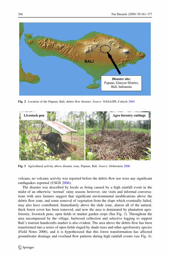
3.2 Case study #1: 1999 Pupuan, Bali debris flow
The first case study explored the causes of and subsequent adaptive responses to the Jan. 7,
1999 debris flow which killed 40 people in the village of Pupuan, Bali (IFRCRCS
(International Federation of Red Cross and Red Crescent Societies) 1999), also known
locally as Timbul (IFRCRCS (International Federation of Red Cross and Red Crescent
Societies) 1999). This ‘small-magnitude’ 20 m 9 200 m debris flow occurred as local
residents were engaged in gotong royong (a voluntary community work detail) to clean out
debris from a small previous slide which blocked an irrigation canal. The irrigation canal
was located at the base of a steep slope, and the debris flow buried at least half of the
workers in many metres of mud, sand, gravel and organic debris.
3.2.1 Primary and secondary causes of the Pupuan disaster
The disaster occurred on the steep side slopes of one of the many deeply incised valleys
found on the upper areas of Bali’s active Mt. Bratan volcano (see Fig. 2). Land stability in
the area is generally inversely correlated with slope angle, although in many steep areas
stability has been enhanced through terracing for rice production. However, in the
immediate vicinity of the 1999 debris flow there is evidence of previous smaller slides,
debris flows and soil creep, and the slope was not terraced for rice production, so this area
could be classed as ‘locally unstable’. Although Mt. Bratan is considered to be an active
Nat Hazards (2009) 50:361–377 365
123
volcano, no volcanic activity was reported before the debris flow nor were any significant
earthquakes reported (USGS 2006).
The disaster was described by locals as being caused by a high rainfall event in the
midst of an otherwise ‘normal’ rainy season; however, site visits and informal conversa-
tions with area farmers suggest that significant environmental modifications above the
debris flow zone, and some removal of vegetation from the slope which eventually failed,
may also have contributed. Immediately above the slide zone, almost all of the natural,
thick forest cover has been removed, and now the area is dominated by plantation agro-
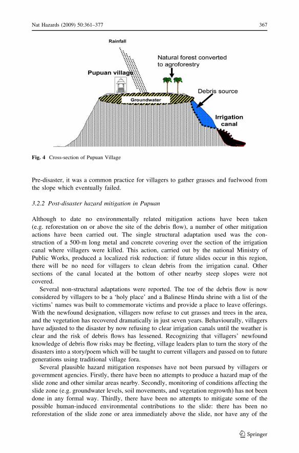
forestry, livestock pens, open fields or market garden crops (See Fig. 3). Throughout the
area encompassed by the village, fuelwood collection and selective logging to support
Bali’s tourism handicrafts market is also evident. The area above the debris flow has been
transformed into a series of open fields ringed by shade trees and other agroforestry species
(Field Notes 2006), and it is hypothesized that this forest transformation has affected
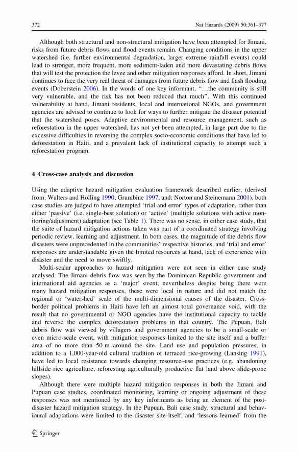
groundwater drainage and overland flow patterns during high rainfall events (see Fig. 4).
Fig. 2 Location of the Pupuan, Bali, debris flow disaster. Source: NASA/JPL-Caltech 2004
Fig. 3 Agricultural activity above disaster zone, Pupuan, Bali. Source: Doberstein 2006
366 Nat Hazards (2009) 50:361–377
123
Pre-disaster, it was a common practice for villagers to gather grasses and fuelwood from
the slope which eventually failed.
3.2.2 Post-disaster hazard mitigation in Pupuan
Although to date no environmentally related mitigation actions have been taken
(e.g. reforestation on or above the site of the debris flow), a number of other mitigation
actions have been carried out. The single structural adaptation used was the con-
struction of a 500-m long metal and concrete covering over the section of the irrigation
canal where villagers were killed. This action, carried out by the national Ministry of
Public Works, produced a localized risk reduction: if future slides occur in this region,
there will be no need for villagers to clean debris from the irrigation canal. Other
sections of the canal located at the bottom of other nearby steep slopes were not
covered.
Several non-structural adaptations were reported. The toe of the debris flow is now
considered by villagers to be a ‘holy place’ and a Balinese Hindu shrine with a list of the
victims’ names was built to commemorate victims and provide a place to leave offerings.
With the newfound designation, villagers now refuse to cut grasses and trees in the area,
and the vegetation has recovered dramatically in just seven years. Behaviourally, villagers
have adjusted to the disaster by now refusing to clear irrigation canals until the weather is
clear and the risk of debris flows has lessened. Recognizing that villagers’ newfound
knowledge of debris flow risks may be fleeting, village leaders plan to turn the story of the
disasters into a story/poem which will be taught to current villagers and passed on to future
generations using traditional village fora.
Several plausible hazard mitigation responses have not been pursued by villagers or
government agencies. Firstly, there have been no attempts to produce a hazard map of the
slide zone and other similar areas nearby. Secondly, monitoring of conditions affecting the
slide zone (e.g. groundwater levels, soil movements, and vegetation regrowth) has not been
done in any formal way. Thirdly, there have been no attempts to mitigate some of the
possible human-induced environmental contributions to the slide: there has been no
reforestation of the slide zone or area immediately above the slide, nor have any of the
Fig. 4 Cross-section of Pupuan Village
Nat Hazards (2009) 50:361–377 367
123

remaining irrigated rice terraces adjacent to the base of the slide runout zone been retired.
Following a presentation of details of the second case study, the implications of these
‘missed opportunities’ will be discussed.
3.3 Case study #2: 2004 Jimani, Dominican Republic debris flow
The May 25th 2004 debris flow in Jimani, Dominican Republic (see Fig. 5) killed over 400
of 11,000 Jimani residents (INDRHI 2004), displaced as many as 3,000 individuals, and
destroyed at least 300 homes (INDRHI 2004).1 Primary causes of the Jimani disaster
included an intense rainfall event, the location of the town on an alluvial fan and defor-
estation in the upper catchment. Secondary causes include the geomorphology of the area,
the hydrology of the watershed, and poor local capacities for weather forecasting, river
monitoring, communications and evacuation.2 Although the disaster attracted global media
coverage (e.g. CNN, BBC, ABC), this event is classified as a ‘medium-magnitude’ event
when placed in the context of other recorded debris flow disasters. Such disasters have
ranged from small-magnitude events (e.g. case study #1) to large-magnitude events such as
the 1999 Venezuela debris flows which killed an estimated 20–30,000 people (Shige 2005).
3.3.1 Primary and secondary causes of the Jimani disaster
The three most important factors driving the debris flow event were: (1) extreme rainfall;
(2) human settlement location and; (3) deforestation in the upper catchment. Prior to the
debris flow, a slow moving low-pressure system delivered over 500 mm (19.7 inches) of
rainfall to the Haitian/Dominican Republic border regions, with over 250 mm received in
Fig. 5 Location of the Jimani, Dominican Republic debris flow disaster. Source: NASA Earth Observatory2004
1 For fuller details of the disaster see the following summary: NASA Earth Observatory. 2004. Flooddisaster hitsHispaniola, http://earthobservatory.nasa.gov/Study/Haiti2004/ 20042 The causes of this disaster, and associated mitigation responses, have been described in greater detail inDoberstein 2006
368 Nat Hazards (2009) 50:361–377
123

the upper catchment of the Soliette River/Rio Blanco basin in the 24 h preceding the
disaster (NASA Earth Observatory 2004), an event with an estimated return time of
400 years (INDRHI 2004). Jimani townsite is located on an alluvial fan (see Fig. 6) built
from thousands of years of flood and debris flow events (Crist 1952, p. 105), posing
variable levels of debris flow and flood risk to every one of the town’s inhabitants.
Deforestation in the upper catchment also proved to be a significant contributory cause of
the disaster: over 85% of the Soliette River/Rio Blanco catchment is within Haiti’s borders,
and the Haitian portion of the catchment is ‘virtually treeless’ (Aide and Grau 2004, p.
1915). One Dominican government scientist commented on the role of such deforestation
in the May 2004 disaster: ‘If the forest had been intact, we (still) would have had some
flooding, but it would have been much less damaging’. The US Army Corps of Engineers
(1999, p. 14), in a 1998 assessment of Haitian watersheds, commented that ‘with each
passing year, the (Haitian) rivers and streams flow more like torrents and less like stable
permanent rivers’.
A number of secondary sources of the disaster have been identified, including (1)
regional geology/geomorphology, (2) basin hydrology, (3) poor pre-disaster communi-
cation, monitoring and hazard awareness. One component of the flood hazard posed by
the Soliette River drainage system is the high levels of sediment transported by the river
during flood events, so much so that the author has chosen to use the term ‘debris flow’
rather than flash flood. In the May 24, 2004 debris flow, the sediment that was trans-
ported ranged from mud to boulders weighing an estimated 5–8 tons (INDHRI 2004).
This sediment came from small local landslides in the Haitian portions of the watershed,
soil erosion in the upper basin (US Army Corps of Engineers 1999), the river bed itself
and from the easily eroded regional ‘Jimani formation’. This formation, located several
kilometers upstream from Jimani, is an outcropping of poorly consolidated sediments,
gravels and boulders.
The Soliette River/Rio Blanco watershed is semi-circular or ‘C’ shaped (see Fig. 7),
with poor overall drainage and a tendency towards temporary ‘pooling or ponding’
several kilometers upstream from Jimani. As ponded waters are released, rapid riverside
Fig. 6 NASA remote sensing images, Jimani pre- and post-disaster. Source: NASA Earth Observatory2004
Nat Hazards (2009) 50:361–377 369
123

scouring occurs and large amounts of river sediment are entrained during flood events.
When these sediment-laden waters flow onto the relatively flat alluvial fan where
Jimani is located, sediment is deposited, leading to frequent and sudden river channel
changes. At the height of the May 2004 debris flow, a large cluster of houses located
just metres from the edge of the river was inundated when the river suddenly changed
course.
Poor communication, watershed and weather monitoring, and community awareness
of debris flow hazard have also been identified as secondary factors in the disaster.
Although weather forecasts issued in the capital Santo Domingo the day before the
debris flow suggested the potential for heavy rainfall in the Dominican Republic/Haiti
border regions, this was not communicated to Jimani residents. Direct communication
between Haitian and Dominican meteorologists, hydrologists or civil defense agencies
was effectively impossible due to Haiti’s security and political problems, language
barriers, and the Dominican government’s preoccupation with the control of illegal
Haitian migrants. Like most other watersheds in Haiti (US Army Corps of Engineers
1999), no river monitoring systems were in place anywhere in the watershed, so
accurate and timely notification about river levels rising was not possible. Since no
living Jimani villagers had prior experience with debris flow events, the awareness of
potential risk was low and thus, rising rivers and the heavy overnight rainfall did not
trigger local warnings or evacuation. Lastly, there was no system in place to quickly
warn villagers (e.g. sirens, lights or pre-prepared door-to-door warning system) about
rising river levels.
3.3.2 Post-disaster hazard mitigation in Jimani
A number of structural and non-structural hazard mitigation actions were implemented
following the debris flow disaster. Structural approaches included the construction of a
levee system out of old river channel materials (Field Notes 2005), a bridge spanning the
newly channelized river and flood-resistant housing. When complete, the levee project will
Fig. 7 Soliette River/Rio Blanco Basin Morphology. Source: INDRHI 2004
370 Nat Hazards (2009) 50:361–377
123

create a wide flood channel and the 5–15-m high protective levees will also serve as a
physical barrier against future informal settlements encroaching on the river channel. The
levee, while reducing Jimani’s risk, also passes the debris flow risk further downstream,
potentially creating heightened risks to downstream villages. A blend of structural and non-
structural approaches were used in creating new permanent housing for debris flow sur-
vivors: over 150 flood-resistant houses featuring a second-story ‘safe zone’ have been built
on a lower-hazard part of the alluvial fan (Field Notes 2005), approximately 2 km west of
the disaster zone. As well, the highest hazard zone, land immediately adjacent to the
current river channel, has been rezoned as ‘no development allowed’. However, it should
be noted that 15 months after the disaster struck, residents living in relatively undamaged
houses in the ‘no development’ zone had not been resettled, and it was unclear whether
they would be required to leave these houses.
Non-structural adaptations included many areas of communications improvement, and
new, albeit limited, initiatives at cross-border cooperation. The communications structure
and organizational capabilities of the Dominican Civil Defense system were significantly
strengthened in the year following the Jimani debris flow. As one informant noted, the
disaster ‘‘improved our organizational capacity… it was a major test. Now, we coordi-
nate more on a regular basis within our organization and across other agencies’’. Radio
retransmission stations, which forward weather transmissions from the capital of Santo
Domingo to the Haiti border regions, were made more powerful, and weather forecast
monitoring by both NGOs and Civil Defense personnel is now much more regular.
However, such improvements are limited to the Dominican Republic side of the island of
Hispaniola: cross-border cooperation, watershed monitoring, and communications
between Haiti and the Dominican Republic were judged to be still almost non-existent
15 months post-disaster due to Haiti’s ongoing political and governance crisis. Two
exceptions to this have been strengthened: cross-border collaboration between Haitian
and Dominican NGOs, and a recent capacity-building initiative by the Government of
Italy and University of Bologna to train Haitian and Dominican engineers in trans-
boundary water resources management (Brandimarte et al. 2007, Di Baldassarre et al.
2008).
A variety of potentially useful hazard mitigation actions have not yet been pursued in
Jimani. Firstly, at the time of the research there had been no effort made to work with
the Haitian government to attempt environmentally related mitigation actions such as
reforestation of the denuded upper Soliette River watershed. In the face of challenging
security and political concerns in Haiti, Haitian NGOs and government agencies have
nowhere near the required capacity to attempt to halt deforestation or carry out refor-
estation. Secondly, an integrated river monitoring and early warning system, although
rumoured to be in the early design and proposal phase in mid-2005, has not yet been
implemented, nor has any form of interim low-technology/low-cost warning system been
created. This leaves riverside communities in both the upper and lower reaches of the
watershed facing the ongoing risk of future debris flows. Thirdly, one drastic action, the
complete resettlement of Jimani villagers, has not been explored seriously even though
such a recommendation was made in 1988 in an OAS/Dominican Government study
(OAS/DCR/CRD (Organization of American States Regional development department/
DCR/CRD) 1988). Jimani is the site of a Dominican military base which is engaged in
efforts to control illegal Haitian cross-border migration and is thus considered to be
strategically important. Nonetheless, from a risk-reduction perspective, resettlement of all
non-military residents is warranted in light of the constant threat posed by settlement on
an active alluvial fan.
Nat Hazards (2009) 50:361–377 371
123
Although both structural and non-structural mitigation have been attempted for Jimani,
risks from future debris flows and flood events remain. Changing conditions in the upper
watershed (i.e. further environmental degradation, larger extreme rainfall events) could
lead to stronger, more frequent, more sediment-laden and more devastating debris flows
that will test the protection the levee and other mitigation responses afford. In short, Jimani
continues to face the very real threat of damages from future debris flow and flash flooding
events (Doberstein 2006). In the words of one key informant, ‘‘…the community is still
very vulnerable, and the risk has not been reduced that much’’. With this continued
vulnerability at hand, Jimani residents, local and international NGOs, and government
agencies are advised to continue to look for ways to further mitigate the disaster potential
that the watershed poses. Adaptive environmental and resource management, such as
reforestation in the upper watershed, has not yet been attempted, in large part due to the
excessive difficulties in reversing the complex socio-economic conditions that have led to
deforestation in Haiti, and a prevalent lack of institutional capacity to attempt such a
reforestation program.
4 Cross-case analysis and discussion
Using the adaptive hazard mitigation evaluation framework described earlier, (derived
from: Walters and Holling 1990; Grumbine 1997, and; Norton and Steinemann 2001), both
case studies are judged to have attempted ‘trial and error’ types of adaptation, rather than
either ‘passive’ (i.e. single-best solution) or ‘active’ (multiple solutions with active mon-
itoring/adjustment) adaptation (see Table 1). There was no sense, in either case study, that
the suite of hazard mitigation actions taken was part of a coordinated strategy involving
periodic review, learning and adjustment. In both cases, the magnitude of the debris flow
disasters were unprecedented in the communities’ respective histories, and ‘trial and error’
responses are understandable given the limited resources at hand, lack of experience with
disaster and the need to move swiftly.
Multi-scalar approaches to hazard mitigation were not seen in either case study
analysed. The Jimani debris flow was seen by the Dominican Republic government and
international aid agencies as a ‘major’ event, nevertheless despite being there were
many hazard mitigation responses, these were local in nature and did not match the
regional or ‘watershed’ scale of the multi-dimensional causes of the disaster. Cross-
border political problems in Haiti have left an almost total governance void, with the
result that no governmental or NGO agencies have the institutional capacity to tackle
and reverse the complex deforestation problems in that country. The Pupuan, Bali
debris flow was viewed by villagers and government agencies to be a small-scale or
even micro-scale event, with mitigation responses limited to the site itself and a buffer
area of no more than 50 m around the site. Land use and population pressures, in
addition to a 1,000-year-old cultural tradition of terraced rice-growing (Lansing 1991),
have led to local resistance towards changing resource–use practices (e.g. abandoning
hillside rice agriculture, reforesting agriculturally productive flat land above slide-prone
slopes).
Although there were multiple hazard mitigation responses in both the Jimani and
Pupuan case studies, coordinated monitoring, learning or ongoing adjustment of these
responses was not mentioned by any key informants as being an element of the post-
disaster hazard mitigation strategy. In the Pupuan, Bali case study, structural and behav-
ioural adaptations were limited to the disaster site itself, and ‘lessons learned’ from the
372 Nat Hazards (2009) 50:361–377
123
disaster (e.g. do not harvest trees or grasses on steep slopes) did not affect practices beyond
the immediate disaster zone. In both cases, the research suggested that the disaster pre-
sented a localized ‘problem’ to be managed, and that once a range of mitigation responses
were implemented the problem was assumed to have been ‘fixed’.
The hazard mitigation solutions chosen in both case studies were relatively short term
solutions designed to deliver local protection quickly and affordably (e.g. levee con-
struction, behavioural changes in the disaster zone). Limited longer-term solutions were
found in both case studies, such as the covering of an irrigation canal to eliminate future
human exposure to debris flows (Case study #1: Pupuan, Bali) or the resettlement of
residents to lower-risk zones (Case Study #2: Jimani, Dominican Republic). However,
neither case study demonstrated long-term hazard mitigation approaches, such as the
resettlement of Jimani’s population or permanent retiring of all ‘at risk’ agricultural lands
in Pupuan, Bali.
Grumbine’s (1997) suggestion to time management actions to coincide with points in
time when systems are amenable to change was observed in both cases, but only for socialaspects of the socio-ecological systems involved. Post-disaster relief and reconstruction
periods are periods in which changes in social systems and community structures are
relatively well tolerated by survivors, as long as individual vulnerabilities are seen to be
reduced and overall post-disaster well-being improved (Blaikie et al. 2000). This was
confirmed in both cases where ‘usable’ (but risky) land was rezoned, where survivors were
relocated to new parts of the community and where new physical structures were built, all
with community support. However, the same cannot be said for the ecological aspects of
the respective socio-ecological systems: there was no indication that ecosystem manage-
ment change was considered in the selection of mitigation responses. The one
environmentally related change that was found (e.g. allowing vegetation to regrow on the
Pupuan debris flow scar) was described as a product of villager’s spiritual beliefs that the
disaster zone was now ‘sacred’, rather than as a conscious ecosystem management change,
and was introduced immediately after the disaster without consideration of the ‘best’
timing.
The literature on adaptive management frequently counsels that interventions into
complex socio-ecological systems should be viewed as ‘experiments’, with an associated
need to monitor, learn from and adjust such experiments (see for example Walters and
Holling 1990). However, in both case studies examined, a lack of connected, formal
monitoring, learning and ongoing adjustment was found, leading the author to conclude
that hazard mitigation interventions were not viewed as experiments inasmuch as they
were seen as one-shot ‘solutions’. In Jimani, Dominican Republic, no formal monitoring
system was in place even 15 months after the disaster, although the need for this was
recognized by several key informants. Informal monitoring (e.g. community members
watching river levels during rainfall events) and informal learning (e.g. not clearing
blocked irrigation canals until rainfall events are finished) was reported by key infor-
mants in both case studies, however, it is unclear how these practices might connect to
the more formal system of hazard mitigation decision-making or lead to adjustments in
the mitigation strategy over time. Following the Pupuan, Bali disaster, community
members learned about the debris flow hazard in one part of the village, but failed to
connect this learning to practices carried out in other equally hazardous locations. Per-
haps the most obvious example of this were actively tended irrigated rice fields located
at the base of a steep slope just 100 m downstream from the slope that failed in 1999
(Field Notes 2006).
Nat Hazards (2009) 50:361–377 373
123
The final component of the evaluation framework, the use of decentralized, partic-
ipatory management approaches, was judged to be present in both case studies, but
more strongly developed for the small-magnitude Pupuan, Bali event. The Jimani
disaster triggered local, provincial, national and international responses, and involved
numerous highly centralized organizations such as the Dominican military and Civil
Defence agency (Doberstein 2006), making purely decentralized and participatory
management difficult. Nonetheless, local involvement has been a hallmark of Jimani’s
post-disaster mitigation efforts, and a permanent commission has been formed with
stakeholders ranging from the local (e.g. NGO representatives, firefighters) to national
(e.g. military) and even international levels (Red cross, Catholic Church). By contrast,
only three organizations have been involved in the post-disaster response in Pupuan,
Bali: the village-level government (e.g. head of village and banjar representatives), the
national Ministry of Public Works, and one Balinese NGO, with the latter two orga-
nizations withdrawing after the immediate relief and canal reconstruction phases. Thus,
most of the post-disaster response has been coordinated at the village level using
traditional community decision-making fora, communal labour and awareness-building
processes.
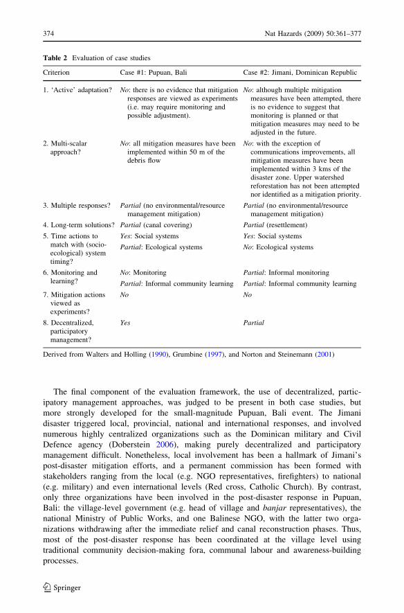
Table 2 Evaluation of case studies
Criterion Case #1: Pupuan, Bali Case #2: Jimani, Dominican Republic
1. ‘Active’ adaptation? No: there is no evidence that mitigationresponses are viewed as experiments(i.e. may require monitoring andpossible adjustment).
No: although multiple mitigationmeasures have been attempted, thereis no evidence to suggest thatmonitoring is planned or thatmitigation measures may need to beadjusted in the future.
2. Multi-scalarapproach?
No: all mitigation measures have beenimplemented within 50 m of thedebris flow
No: with the exception ofcommunications improvements, allmitigation measures have beenimplemented within 3 kms of thedisaster zone. Upper watershedreforestation has not been attemptednor identified as a mitigation priority.
3. Multiple responses? Partial (no environmental/resourcemanagement mitigation)
Partial (no environmental/resourcemanagement mitigation)
4. Long-term solutions? Partial (canal covering) Partial (resettlement)
5. Time actions tomatch with (socio-ecological) systemtiming?
Yes: Social systems Yes: Social systems
Partial: Ecological systems No: Ecological systems
6. Monitoring andlearning?
No: Monitoring Partial: Informal monitoring
Partial: Informal community learning Partial: Informal community learning
7. Mitigation actionsviewed asexperiments?
No No
8. Decentralized,participatorymanagement?
Yes Partial
Derived from Walters and Holling (1990), Grumbine (1997), and Norton and Steinemann (2001)
374 Nat Hazards (2009) 50:361–377
123

5 Conclusion
Research on the two case studies revealed that, in each case, exposure to the disaster
triggered several hazard mitigation actions, that environmental or resource management
mitigation was not attempted, and that, taken together, the hazard mitigation strategies
pursued in each case study cannot be labeled ‘adaptive hazard mitigation’. Hazard miti-
gation actions that were taken spanned a range of structural (e.g. levee construction,
hazard-resistant housing, canal covering) and non-structural approaches (e.g. strengthening
communications networks, human settlement and land-use rezoning, strengthened coop-
eration between NGOs and government agencies, behavioural changes). However, what
was missing in both cases was the ‘monitoring ? learning ? adjustment’ portions of the
adaptive hazard mitigation cycle (see Fig. 1).
Ultimately, there are several reasons which explain the lack of a comprehensive
adaptive hazard mitigation response in these cases. Firstly, each disaster resulted from a
number of causes acting synergistically, and the research revealed that the multi-dimen-
sional nature of each debris flow was poorly understood by those who implemented hazard
mitigation actions. Secondly, the research also revealed a lack of institutional and man-
agement capacity to implement adaptive hazard mitigation, especially in the monitoring,
learning and adjustment phases of the iterative cycle. Thirdly, the research also revealed
the challenges of addressing and mitigating the resource and environmental mismanage-
ment trends which contributed to each disaster, especially in the Jimani case where
reversing such mismanagement must occur largely beyond Dominican jurisdictional
control.
Although both case study communities have attempted to mitigate hazard risks, the lack
of actions taken to address environmental or resource mismanagement means that both
communities continue to face the real threat of future, similar disaster events. Structural
and non-structural hazard mitigation actions have been taken, yet these are of a limited
nature and can only be viewed as reducing the immediate danger or severity of similar
future disaster events. From a longer-term both communities remain vulnerable to debris
flow disasters, particularly if resource perspective, mismanagement in the vicinity of each
community continues, or if climate variability or change induces larger, more frequent, or
more extreme rainfall events. These communities, currently operating under trial and error
hazard mitigation, could take the next steps towards active adaptation by adding ‘monitor’
and ‘evaluate’ components, and by viewing their respective disasters as indicators to the
needs of additional resource and environmental management adaptations. Table 2.
Acknowledgements This research would not have been possible without funding provided by theUniversity of Waterloo Research Incentives Fund, and the research assistance provided by Mr. RobertoVargas Escarraman (Dominican Republic), and Mr. Gede Sugiartha (IDEP Foundation, Bali). For both case-study sites, the authors extend their special thanks to all those who agreed to be interviewed and who mustremain anonymous. A preliminary and shorter version of the Bali case study portion of this article waspresented in Doberstein 2006.
References
Aide TM, Grau HR (2004) Globalization, migration and Latin American ecosystems. Science 305:1915–1916. doi:10.1126/science.1103179
Blaikie P, Cannon T, Davis I, Wisner B (2000) At risk: natural hazards, people’s vulnerability, and disasters.Routledge, New York
Bogardi JJ (2004) Hazards, risks and vulnerabilities in a changing environment: the unexpected onslaughton human security? Glob Environ Change 14:361–365
Nat Hazards (2009) 50:361–377 375
123
Brandimarte L, Brath A, Castellarin A, Di Baldassarre G, Arizaga E, Fedeli E (2007) Institutional capacity-building (ICB): an international cooperation initiative for the water resources management in Haiti andthe Dominican Republic. Geophys Res Abstr 9:09490
Busenberg GJ (2004) Adaptive policy design for the management of wildfire hazards. Am Behav Sci48(3):314–326. doi:10.1177/0002764204268988
Crist RE (1952) Cultural dichotomy in the Island of Hispaniola. Econ Geogr 28(2):105–121. doi:10.2307/141020
Di Baldassarre G, Brandimarte L, Brath A, Castellarin A, Jeune KJ, Perez R (2008) Trans-boundary riverbasin management: an experience in Haiti and Dominican Republic. Geophys Res Abstr10:10:EGU2008-A-10031
Doberstein B (2006). Human-dimensions of natural hazards: adaptive management of debris flows inPupuan, Bali and Jimani, Dominican Republic. In: proceedings institutional dimensions of globalenvironmental change synthesis conference, Nusa Dua, Bali, Indonesia, 6–9 December 2006. http://www2.bren.ucsb.edu/*idgec/papers/Brent_Doberstein.doc
Folke C, Carpenter S, Elmqvist T, Gunderson L, Holling CS, Walker B, Bengtsson J, Berkes F, Colding J,Danell K, Falkenmark M, Gordon L, Kasperson R, Kautsky N, Kinzig A, Levin S, Maler K-G, MobergF, Ohlsson L, Olsson P, Ostrom E, Reid W, Rockstrom J, Savenije H, Svedin U (2002) Resilience andsustainable development: building adaptive capacity in a world of transformations. Report for theSwedish Environmental Advisory Council 2002:1. Ministry of the Environment, Stockholm. Earlierversion ICSU Series on Science for Sustainable Development No. 3, 2002. International Council forScience, Paris
Grumbine RE (1997) Reflections on ‘‘What is Ecosystem Management’’? Conserv Biol 11(1):41–47.doi:10.1046/j.1523-1739.1997.95479.x
Haque CE, Burton I (2005) Adaptation options strategies for hazards and vulnerability mitigation: aninternational perspective. In: Haque CE (ed) Mitigation of natural hazards and disasters: internationalperspectives. Springer, Dordrecht, The Netherlands, pp 3–29
Haque CE, Etkin D (2007) People and community as constituent parts of hazards: the significance of societaldimensions in hazards analysis. Nat Hazards 41:271–282. doi:10.1007/s11069-006-9035-8
Holling CS (1986) The resilience of terrestrial ecosystems: local surprise and global change. In: Clark WC,Munn RE (eds) Sustainable development of the biosphere. Cambridge University Press, Cambridge,pp 292–317
Hyndman D, Hyndman D (2006) Natural hazards and disasters. Thomson Brooks/Cole Publishers, TorontoJanssen MA, Ostrom E (2006) Editorial: resilience, vulnerability and adaptation: a cross-cutting theme of
the international human dimensions programme on global environmental change. Glob EnvironChange 16:237–239. doi:10.1016/j.gloenvcha.2006.04.003
IFRCRCS (International Federation of Red Cross and Red Crescent Societies) (1999) Indonesia landslide.Information Bulletin No.1. http://www.ifrc.org/cgi/pdf_appeals.pl?rpts99/id002.pdf. Accessed 14 Aug2006
INDRHI (Instituto Nacional de Recursos Hidraulicos) (2004) Jimani’s flooding, Soliette river problemdiagnosis. Unpublished report, INDRHI, Santo Domingo, Dominican Republic
Lansing JS (1991) Priests and programmers: technologies of power in the engineered landscape of Bali.Princeton University Press, Princeton, NJ
NASA/JPL-Caltech (2004) Photojournal: Bali, shaded relief and colored height. http://photojournal.jpl.nasa.gov/feature/bali. Accessed 16 Nov 2007
NASA Earth Observatory (2004) Flood disaster hits Hispaniola. http://earthobservatory.nasa.gov/Study/Haiti2004/. Accessed 31 Jan 2006
NOAA Coastal Services Center (2006) Coastal Ecosystem Restoration. http://www.csc.noaa.gov/coastal/management/management.htm. Accessed 28 March 2006
Norton BG, Steinemann AC (2001) Environmental values and adaptive management. Environ Values10(4):473–506. doi:10.3197/096327101129340921
OAS/DCR/CRD (Organization of American States Regional development department/DCR/CRD) (1988)Estudio Inicial y de Identificacion de la Vulnerabilidad Ante las Amenazas Naturales de Las Capitalesde las Provincias Fronterizas. Unpublished report, INGEOSA, Costa Rica
Shige W (2005) Characteristics of large low-frequency debris flow hazards and mitigation strategies. J MtSci 2(1):50–58. doi:10.1007/s11629-005-0050-0
Smith K (2004) Environmental hazards: reducing risk and reducing disaster. Routledge, New YorkStankey GH, Clark RN, Bormann BT (2005). Adaptive management of natural resources: theory, concepts,
and management institutions. General Technical Report PNW-GTR-654. U.S. Department of Agri-culture, Forest Service, Pacific Northwest Research Station, Portland, OR
376 Nat Hazards (2009) 50:361–377
123

Tompkins EL, Adger WN (2004) Does adaptive management of natural resources enhance resilience toclimate change? Ecol Soc 9(2):10
US Army Corps of Engineers (1999) Water resources assessment of Haiti. US Army Corps of EngineersMobile District and Topographic Engineering Center
USGS (2006) Earthquake search. http://neic.usgs.gov/neis/epic/epic_rect.html. Accessed 27 Sept 2006Walters C, Holling CS (1990) Large-scale management experiments and learning by doing. Ecology
71(6):2060–2068. doi:10.2307/1938620White GF (1994) Natural hazards research. In: Cutter SL (ed) Environmental risks and hazards. Prentice
Hall, New JerseyWhite GF, Kates RW, Burton I (2001) Knowing better and losing even more: the use of knowledge in
hazards management. Environ Hazards 3:81–92. doi:10.1016/S1464-2867(01)00021-3
Nat Hazards (2009) 50:361–377 377
123