Mono County Hazard Mitigation Plan - Sheriff - Coroner
985
-
Upload
khangminh22 -
Category
Documents
-
view
0 -
download
0
Transcript of Mono County Hazard Mitigation Plan - Sheriff - Coroner


Mono County and the Town of Mammoth Lakes
MULTI-JURISDICTIONAL HAZARD MITIGATION PLAN
(including the Mono County Community Wildfire Protection Plan)
Final
PREPARED BY:
1 KAISER PLAZA, SUITE 1150
OAKLAND, CA 94612
May 2019

This page intentionally left blank.

Mono County and the Town of Mammoth Lakes Multi-Jurisdictional Hazard Mitigation Plan May 2019 Final
i
TABLE OF CONTENTS 1. Introduction ............................................................................................... 1-1
1.1 Plan Purpose ............................................................................................................................................................... 1-1
1.2 Authority ...................................................................................................................................................................... 1-2
1.2.1 Federal .............................................................................................................................................................. 1-2
1.2.2 State .................................................................................................................................................................. 1-2
1.3 Plan Adoption ............................................................................................................................................................ 1-3
1.4 Plan Use and Organization .................................................................................................................................... 1-3
1.5 Mitigation Goals ........................................................................................................................................................ 1-4
1.6 Hazard Mitigation Planning Process .................................................................................................................. 1-5
1.6.1 Regional Planning Advisory Committee (RPAC) Meetings............................................................ 1-8
1.6.2 Public Survey .................................................................................................................................................. 1-9
1.6.3 Public Review Draft ................................................................................................................................... 1-10
1.6.4 Planning Commissions ............................................................................................................................ 1-10
1.6.5 Governing Bodies ...................................................................................................................................... 1-10
1.6.6 Integration into other Plans and Regulatory Documents .......................................................... 1-10
1.6.7 Plans, Studies, and Technical Reports Used to Develop the Plan ............................................ 1-11
2. Community Profile .................................................................................... 2-1
2.1 Physical Setting .......................................................................................................................................................... 2-1
2.1.1 Mono County ................................................................................................................................................. 2-5
2.1.2 Mammoth Lakes ........................................................................................................................................... 2-5
2.2 History ........................................................................................................................................................................... 2-6
2.2.1 Mono County ................................................................................................................................................. 2-6
2.2.2 Mammoth Lakes ........................................................................................................................................... 2-6
2.3 Community Demographics ................................................................................................................................... 2-7
2.3.1 Mono County ................................................................................................................................................. 2-8
2.3.2 Mammoth Lakes ........................................................................................................................................ 2-11
2.4 Land Uses .................................................................................................................................................................. 2-11
2.4.1 Ownership .................................................................................................................................................... 2-11
2.4.2 Land Use Designations ............................................................................................................................ 2-15

Mono County and the Town of Mammoth Lakes Multi-Jurisdictional Hazard Mitigation Plan May 2019 Final
ii
2.4.3 Agricultural Lands ..................................................................................................................................... 2-33
2.5 Development Trends and Future Development ........................................................................................ 2-33
2.5.1 Mono County .............................................................................................................................................. 2-33
2.5.2 Mammoth Lakes ........................................................................................................................................ 2-34
2.6 Infrastructure Systems and Critical Facilities ................................................................................................ 2-36
2.6.1 Communications ....................................................................................................................................... 2-37
2.6.2 Transportation ............................................................................................................................................ 2-43
2.6.3 Water .............................................................................................................................................................. 2-49
2.6.4 Energy ............................................................................................................................................................ 2-49
3. Hazards Assessment ................................................................................. 3-1
3.1 Hazard Analysis .......................................................................................................................................................... 3-1
3.1.1 Hazard Identification ................................................................................................................................... 3-1
3.1.2 Hazard Prioritization .................................................................................................................................... 3-5
3.1.3 Climate Change Considerations ............................................................................................................. 3-6
3.2 Hazard Profiles ........................................................................................................................................................... 3-6
3.2.1 Avalanche ........................................................................................................................................................ 3-7
3.2.2 Dam Failure ................................................................................................................................................. 3-15
3.2.3 Disease/Pest Management .................................................................................................................... 3-25
3.2.4 Drought ......................................................................................................................................................... 3-27
3.2.5 Earthquake and Seismic Hazards ......................................................................................................... 3-33
3.2.6 Extreme Heat............................................................................................................................................... 3-53
3.2.7 Flood .............................................................................................................................................................. 3-55
3.2.8 Landslides .................................................................................................................................................... 3-65
3.2.9 Hazardous Materials ................................................................................................................................. 3-73
3.2.10 Severe Wind ............................................................................................................................................... 3-79
3.2.11 Severe Winter Weather and Snow ..................................................................................................... 3-84
3.2.12 Volcanoes .................................................................................................................................................... 3-89
3.2.13 Wildlife Collisions ...................................................................................................................................... 3-97
4. Risk Assessment ........................................................................................ 4-1
4.1 Risk Assessment Method ........................................................................................................................................ 4-1
4.2 Hazard Risk Assessments ........................................................................................................................................ 4-3
Mono County and the Town of Mammoth Lakes Multi-Jurisdictional Hazard Mitigation Plan May 2019 Final
iii
4.2.1 Avalanche ........................................................................................................................................................ 4-3
4.2.2 Dam Failure .................................................................................................................................................... 4-5
4.2.3 Disease/Pest Management ....................................................................................................................... 4-7
4.2.4 Drought ............................................................................................................................................................ 4-8
4.2.5 Earthquake and Seismic Hazards ............................................................................................................ 4-8
4.2.6 Extreme Heat............................................................................................................................................... 4-11
4.2.7 Flood .............................................................................................................................................................. 4-11
4.2.8 Landslides (Geologic Hazards) .............................................................................................................. 4-14
4.2.9 Hazardous Materials ................................................................................................................................. 4-15
4.2.10 Severe Winter Storm and Snow ........................................................................................................... 4-15
4.2.11 Severe Wind ............................................................................................................................................... 4-15
4.2.12 Wildlife Collisions ...................................................................................................................................... 4-16
5. Mitigation Measures ................................................................................. 5-1
5.1 Hazard Mitigation Overview ................................................................................................................................. 5-1
5.1.1 Hazard Mitigation Goals ............................................................................................................................. 5-1
5.1.2 Hazard Mitigation Prioritization .............................................................................................................. 5-1
5.2 Hazard Mitigation Strategy ................................................................................................................................... 5-2
5.2.1 Secondary Access Assessment ............................................................................................................. 5-17
5.2.2 Shelter in Place ........................................................................................................................................... 5-49
5.3 Capabilities Assessment ...................................................................................................................................... 5-50
5.3.1 Spending and Budget .............................................................................................................................. 5-57
5.3.2 Financial ........................................................................................................................................................ 5-58
5.4 Fire Protection Districts ........................................................................................................................................ 5-59
6. Plan Maintenance and Capabilities ......................................................... 6-1
6.1 Plan Adoption ............................................................................................................................................................ 6-1
6.2 Plan Update and Coordinating Body ................................................................................................................. 6-1
6.3 Evaluation and Monitoring .................................................................................................................................... 6-3
6.4 Incorporation into Existing Planning Mechanisms ....................................................................................... 6-4
7. Community Wildfire Protection Plan ....................................................... 7-1
7.1 Method ......................................................................................................................................................................... 7-1
7.2 Background ................................................................................................................................................................. 7-2

Mono County and the Town of Mammoth Lakes Multi-Jurisdictional Hazard Mitigation Plan May 2019 Final
iv
7.2.1 National Fire Plan (NFP) and the HFRA ................................................................................................. 7-2
7.2.2 Outcomes ........................................................................................................................................................ 7-3
7.3 Hazard and Risk Assessment ................................................................................................................................. 7-4
7.3.1 Hazard Description ...................................................................................................................................... 7-4
7.3.2 Location and Magnitude ........................................................................................................................... 7-5
7.3.3 Hazard History ............................................................................................................................................ 7-11
7.3.4 Risk and Vulnerability .............................................................................................................................. 7-17
7.4 Potential Fire Behavior and Fuel Conditions in the Wildland Urban Interface ................................ 7-19
7.4.1 Fire Regime Condition Class (FRCC) ................................................................................................... 7-20
7.4.2 Fire Behavior Potential ............................................................................................................................ 7-29
7.4.3 Community Risk Assessment ................................................................................................................ 7-45
7.5 Changes in Conditions Over the Last Decade ............................................................................................. 7-49
7.5.1 Single-Route Access ................................................................................................................................. 7-49
7.5.2 Steep, Narrow, and Blocked-Access Roads ...................................................................................... 7-49
7.5.3 Water Supply and Pressure .................................................................................................................... 7-49
7.5.4 Addressing ................................................................................................................................................... 7-50
7.5.5 Additional Developments Identified .................................................................................................. 7-50
7.5.6 Fuels and Vegetation ............................................................................................................................... 7-53
7.5.7 Drought ......................................................................................................................................................... 7-69
7.5.8 Future Probability ...................................................................................................................................... 7-69
7.6 Wildfire Risk Reduction Actions ........................................................................................................................ 7-69
7.7 Website Resources ................................................................................................................................................. 7-73
8. References .................................................................................................. 8-1
Tables
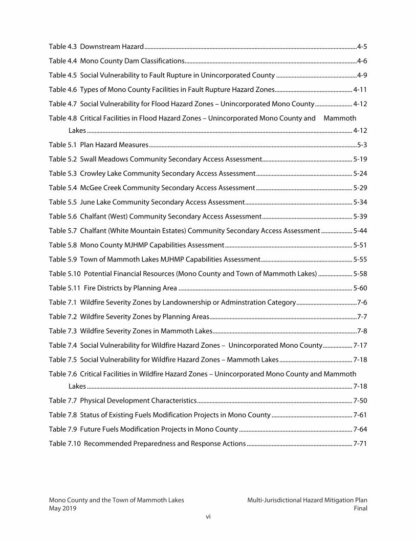
Table 1.1 Key Resources Used to Develop the MJHMP ........................................................................................ 1-11
Table 2.1 Basic Demographics (2015) ............................................................................................................................ 2-7
Table 2.2 Mono County Land Ownership ................................................................................................................. 2-12
Table 2.3 Mammoth Lakes Land Ownership within Municipal Boundary .................................................... 2-15
Table 2.4 Unincorporated Mono County Land Use Designations ................................................................... 2-15
Table 2.5 Community Planning Areas Summary .................................................................................................... 2-21

Mono County and the Town of Mammoth Lakes Multi-Jurisdictional Hazard Mitigation Plan May 2019 Final
v
Table 2.6 Mammoth Lakes Land Use Designations ............................................................................................... 2-28
Table 2.7 2016 Major Development Plans ................................................................................................................ 2-35
Table 2.8 Critical Facilities by Type .............................................................................................................................. 2-36
Table 3.1 Mono County and Town of Mammoth Lakes Hazard Identification ............................................... 3-1
Table 3.2 Mono County Hazard Ranking Worksheet Outcomes ......................................................................... 3-6
Table 3.3 Avalanche Size and Impact Scale ................................................................................................................. 3-8
Table 3.4 Avalanche Hazards by Community Planning Area ............................................................................. 3-10
Table 3.5 Mono County Dams ....................................................................................................................................... 3-16
Table 3.6 Dam System Condition Assessment Rating System .......................................................................... 3-21
Table 3.7 Dam Condition Assessment........................................................................................................................ 3-22
Table 3.8 Area of Dam Inundation in Mono County by Land Administration or Ownership ................. 3-23
Table 3.9 Dam Inundation in Unincorporated Mono County by Community Planning Area................ 3-24
Table 3.10 US Drought Monitor Classification Scheme ....................................................................................... 3-28
Table 3.11 Comparison of MMS and Modified Mercalli Intensity Scale ......................................................... 3-35
Table 3.12 Areas at Risk of Fault Rupture in Unincorporated Mono County by Ownership .................. 3-47
Table 3.13 Areas at Risk of Fault Rupture in Mono County Planning Areas ................................................. 3-48
Table 3.14 Areas at Risk of Fault Rupture in Mammoth Lakes ........................................................................... 3-49
Table 3.15 UCERF3 30-Year Earthquake Probabilities by Fault ......................................................................... 3-51
Table 3.16 Heat Index Rating Scale ............................................................................................................................. 3-53
Table 3.17 Areas at Risk of Flooding in Mono County by Ownership ............................................................. 3-56
Table 3.18 Areas at Risk of Flooding in Mono County Planning Areas ........................................................... 3-57
Table 3.19 Areas at Risk of Flooding in Town of Mammoth Lakes .................................................................... 3-59
Table 3.20 Mono County Flood History, 2000–2017 ............................................................................................. 3-63
Table 3.21 SWRCB Cleanup Sites by Status in Mono County ............................................................................. 3-78
Table 3.22 Significant Wind Events in Mono County, 1996–2017 .................................................................... 3-83
Table 3.23 Hail Severity .................................................................................................................................................... 3-87
Table 3.24 Severe Winter Storm Events in Mono County, 1995–2017 ........................................................... 3-87
Table 3.25 Hazards Associated with California Volcanoes .................................................................................. 3-89
Table 3.26 Mono County Region Volcano NEWS Scores ..................................................................................... 3-92
Table 4.1 HAZUS Total Building Exposure Estimate ................................................................................................. 4-2
Table 4.2 2017 Road Segments at Risk of Avalanche Identified for Monitoring ............................................ 4-4
Mono County and the Town of Mammoth Lakes Multi-Jurisdictional Hazard Mitigation Plan May 2019 Final
vi
Table 4.3 Downstream Hazard ......................................................................................................................................... 4-5
Table 4.4 Mono County Dam Classifications ............................................................................................................... 4-6
Table 4.5 Social Vulnerability to Fault Rupture in Unincorporated County .................................................... 4-9
Table 4.6 Types of Mono County Facilities in Fault Rupture Hazard Zones .................................................. 4-11
Table 4.7 Social Vulnerability for Flood Hazard Zones – Unincorporated Mono County ........................ 4-12
Table 4.8 Critical Facilities in Flood Hazard Zones – Unincorporated Mono County and Mammoth
Lakes ........................................................................................................................................................................... 4-12
Table 5.1 Plan Hazard Measures ...................................................................................................................................... 5-3
Table 5.2 Swall Meadows Community Secondary Access Assessment .......................................................... 5-19
Table 5.3 Crowley Lake Community Secondary Access Assessment .............................................................. 5-24
Table 5.4 McGee Creek Community Secondary Access Assessment .............................................................. 5-29
Table 5.5 June Lake Community Secondary Access Assessment ..................................................................... 5-34
Table 5.6 Chalfant (West) Community Secondary Access Assessment .......................................................... 5-39
Table 5.7 Chalfant (White Mountain Estates) Community Secondary Access Assessment .................... 5-44
Table 5.8 Mono County MJHMP Capabilities Assessment .................................................................................. 5-51
Table 5.9 Town of Mammoth Lakes MJHMP Capabilities Assessment ........................................................... 5-55
Table 5.10 Potential Financial Resources (Mono County and Town of Mammoth Lakes) ...................... 5-58
Table 5.11 Fire Districts by Planning Area ................................................................................................................ 5-60
Table 7.1 Wildfire Severity Zones by Landownership or Adminstration Category ....................................... 7-6
Table 7.2 Wildfire Severity Zones by Planning Areas ............................................................................................... 7-7
Table 7.3 Wildfire Severity Zones in Mammoth Lakes ............................................................................................. 7-8
Table 7.4 Social Vulnerability for Wildfire Hazard Zones – Unincorporated Mono County ................... 7-17
Table 7.5 Social Vulnerability for Wildfire Hazard Zones – Mammoth Lakes ............................................... 7-18
Table 7.6 Critical Facilities in Wildfire Hazard Zones – Unincorporated Mono County and Mammoth
Lakes ........................................................................................................................................................................... 7-18
Table 7.7 Physical Development Characteristics .................................................................................................... 7-50
Table 7.8 Status of Existing Fuels Modification Projects in Mono County .................................................... 7-61
Table 7.9 Future Fuels Modification Projects in Mono County ......................................................................... 7-64
Table 7.10 Recommended Preparedness and Response Actions .................................................................... 7-71

Mono County and the Town of Mammoth Lakes Multi-Jurisdictional Hazard Mitigation Plan May 2019 Final
vii
Figures
Figure 1.1: Disaster Response Cycle ................................................................................................................................ 1-1
Figure 2.1: Mono County Vicinity Map ........................................................................................................................... 2-3
Figure 2.2: Land Ownership in Mono County ........................................................................................................... 2-13
Figure 2.3: Mono County Land Use Map .................................................................................................................... 2-17
Figure 2.4: Community Planning Areas ...................................................................................................................... 2-25
Figure 2.5: Town of Mammoth Lakes Districts and Portals .................................................................................. 2-29
Figure 2.6: Town of Mammoth Lakes Land Use Map ............................................................................................. 2-31
Figure 2.7: Critical Facilities ............................................................................................................................................. 2-41
Figure 2.8: Transportation and Access for Mono County and Mammoth Lakes .......................................... 2-47
Figure 3.1: Priority Hazards................................................................................................................................................. 3-5
Figure 3.2: Dam Inundation Hazard Areas in Unincorporated Mono County .............................................. 3-19
Figure 3.3: State Drought Conditions, 2016 .............................................................................................................. 3-29
Figure 3.4: Mono County in the 2013–2016 Drought ............................................................................................ 3-31
Figure 3.5: Mono County Alquist-Priolo Earthquake Faults and Historic Epicenters ................................. 3-39
Figure 3.6: Antelope Valley Fault Shake Scenario ................................................................................................... 3-41
Figure 3.7: Hilton Creek Fault Shake Scenario .......................................................................................................... 3-43
Figure 3.8: Fish Lake Valley Fault Shake Scenario ................................................................................................... 3-45
Figure 3.9: Mono County Flood Hazard Areas .......................................................................................................... 3-61
Figure 3.10: Landslide Susceptibility ........................................................................................................................... 3-69
Figure 3.11: Annual Average Wind Power ................................................................................................................. 3-81
Figure 3.12: Volcano Hazard Zones .............................................................................................................................. 3-95
Figure 3.13: Mono County Deer Mortality 2002–2015 .......................................................................................... 3-97
Figure 3.14: Deer Collision Hot Spots .......................................................................................................................... 3-98
Figure 4.1: HAZUS Flood Scenario in the Tri-Valley ................................................................................................ 4-13
Figure 5.1: Swall Meadows Community Secondary Access Analysis – Slopes and Land Ownership.. 5-
20
Figure 5.2: Swall Meadows Community Secondary Access Analysis – Fault and Fire Zones .................. 5-22
Figure 5.3: Crowley Lake Community Secondary Access Analysis – Slopes and Land Ownership . 5-
25
Figure 5.4: Crowley Lake Community Secondary Access Analysis – Fire and Flood Zones ..................... 5-27

Mono County and the Town of Mammoth Lakes Multi-Jurisdictional Hazard Mitigation Plan May 2019 Final
viii
Figure 5.5: McGee Creek Community Secondary Access Analysis – Slopes and Land Ownership . 5-
30
Figure 5.6: McGee Creek Community Secondary Access Analysis – Fire and Flood Zones ..................... 5-32
Figure 5.7: June Lake Community Secondary Access Analysis – Slopes and Land Ownership .............. 5-35
Figure 5.8: June Lake Community Secondary Access Analysis – Fault, Fire and Flood Zones ................ 5-37
Figure 5.9: Chalfant (West) Community Secondary Access Analysis – Slopes and Land Ownership . 5-
40
Figure 5.10: Chalfant (West) Community Secondary Access Analysis – Fault, Fire and Flood Zones . 5-
42
Figure 5.11: Chalfant (White Mountain Estates) Community Secondary Access Analysis – Slopes
and Land Ownership ............................................................................................................................................. 5-45
Figure 5.12: Chalfant (White Mountain Estates) Community Secondary Access Analysis – Fault,
Fire and Flood Zones ............................................................................................................................................ 5-47
Figure 7.1: Mono County Wildfire Hazard Severity Zones ...................................................................................... 7-9
Figure 7.2: Historic Fires ................................................................................................................................................... 7-15
Figure 7.3: Mono County Wildland Urban Interface .............................................................................................. 7-23
Figure 7.4: Town of Mammoth Lakes Approved Wildland Urban Interface .................................................. 7-25
Figure 7.5: Fire Regimes Condition Class ................................................................................................................... 7-27
Figure 7.6: Rate of Spread, Moderate Weather Conditions ................................................................................. 7-31
Figure 7.7: Rate of Spread, Extreme Weather Conditions .................................................................................... 7-33
Figure 7.8: Flame Length, Moderate Fire Weather Conditions .......................................................................... 7-37
Figure 7.9: Flame Length, Extreme Fire Weather Conditions ............................................................................. 7-39
Figure 7.10: Crown Fire Activity, Moderate Fire Weather Conditions .............................................................. 7-41
Figure 7.11: Crown Fire Activity, Extreme Fire Weather Conditions................................................................. 7-43
Figure 7.12: Community Area Specific Wildfire Hazard Ranking ....................................................................... 7-47
Figure 7.13: Mono County Surface Fuels from Cal Fire ......................................................................................... 7-57
Figure 7.14: Major Fuel Reduction Projects in Mono County, 2009–2018 ..................................................... 7-59
Figure 7.15: Drought-Related Tree Mortality and Hazard Zones ....................................................................... 7-67

Mono County and the Town of Mammoth Lakes Multi-Jurisdictional Hazard Mitigation Plan May 2019 Final
ix
Appendices Appendix A: Adoption Resolutions
Appendix B: Meeting & Outreach Materials
Appendix C: Critical Facilities
Appendix D: Mono County Hazus Faults Reports
Appendix E: Mono County Hazus Flood Reports
Appendix F: CWPP Appendices
Appendix G: FHSZ Model Primer
Appendix H: Historic Fire List
Appendix I: Wheeler Crest CWPP
Mono County and the Town of Mammoth Lakes Multi-Jurisdictional Hazard Mitigation Plan May 2019 Final
x
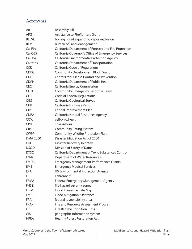
Acronyms
AB Assembly Bill AFG Assistance to Firefighters Grant BLEVE boiling liquid expanding vapor explosion BLM Bureau of Land Management Cal Fire California Department of Forestry and Fire Protection Cal OES California Governor’s Office of Emergency Services CalEPA California Environmental Protection Agency Caltrans California Department of Transportation CCR California Code of Regulations CDBG Community Development Block Grant CDC Centers for Disease Control and Prevention CDPH California Department of Public Health CEC California Energy Commission CERT Community Emergency Response Team CFR Code of Federal Regulations CGS California Geological Survey CHP California Highway Patrol CIP Capital Improvement Plan CNRA California Natural Resources Agency COW cell-on-wheels CPH chains/hour CRS Community Rating System CWPP Community Wildfire Protection Plan DMA 2000 Disaster Mitigation Act of 2000 DRI Disaster Recovery Initiative DSOD Division of Safety of Dams DTSC California Department of Toxic Substances Control DWR Department of Water Resources EMPG Emergency Management Performance Grants EMS Emergency Medical Services EPA US Environmental Protection Agency F Fahrenheit FEMA Federal Emergency Management Agency FHSZ fire hazard severity zones FIRM Flood Insurance Rate Map FMA Flood Mitigation Assistance FRA federal responsibility area FRAP Fire and Resource Assessment Program FRCC Fire Regime Condition Class GIS geographic information system HFRA Healthy Forest Restoration Act

Mono County and the Town of Mammoth Lakes Multi-Jurisdictional Hazard Mitigation Plan May 2019 Final
xi
Acronyms
HMGP Hazard Mitigation Grant Program HSGP Homeland Security Grant Program IRWM Integrated Regional Water Management IT Information Technology kts knots LADWP Los Angeles Department of Water and Power LHMP Local Hazard Mitigation Plan MCWD Mammoth Community Water District MEA Master Environmental Assessment MJHMP Multi-Jurisdictional Hazard Mitigation Plan MMS, Mw, M moment magnitude scale mph miles per hour MREs meals ready to eat NFIP National Flood Insurance Program NFP National Fire Plan NOAA National Oceanic and Atmospheric Administration NRCS National Resource Conservation Service NSIDC National Snow and Ice Data Center NVEWS National Volcano Early Warning System PACE Property Assessed Clean Energy pCi/L picocuries per liter PDM Pre-Disaster Mitigation PDT Pacific Daylight Time PIO Public Information Officer psf per square foot REMSA Regional Emergency Medical Services Authority RPAC Regional Planning Advisory Committee SCE Southern California Edison SDD Snow Deposition Design Overlay Zone SFHA Special Flood Hazard Area SR State Route SRA state responsibility area SRL Severe Repetitive Loss SWGP Storm Water Grant Program SWRCB State Water Resources Control Board UCERF3 Third Uniform California Earthquake Rupture Forecast USFS United States Forest Service USGS US Geological Survey W/m2 watts per square meter WRID Walker River Irrigation District WUI Wildland-Urban Interface

Mono County and the Town of Mammoth Lakes Multi-Jurisdictional Hazard Mitigation Plan May 2019 Final
xii
This page intentionally left blank.

Mono County and the Town of Mammoth Lakes Multi-Jurisdictional Hazard Mitigation Plan May 2019 Final
1-1
1. INTRODUCTION This document is the Multi-Jurisdictional Hazard Mitigation Plan (MJHMP or Plan) for Mono County
(County) and the Town of Mammoth Lakes (Town), California, and includes the Community Wildfire
Protection Plan (CWPP) for Mono County. The MJHMP is an update from the 2006 adopted MJHMP. The
MJHMP establishes strategies to reduce multiple hazard impacts affecting the County and the Town.
The Mono County CWPP, presented in Chapter 7, provides a comprehensive analysis specific to wildfire-
related hazards and risks in the Wildland-Urban Interface (WUI) areas of the County.
This chapter provides an overview of each plan’s purpose
and authority, and describes how the MJHMP and Mono
County CWPP were adopted and how they are to be
used, as well as hazard mitigation plan goals, the
planning process, a description of how the public was
involved, and the plans, studies, and other resources
used for analysis.
1.1 Plan Purpose Different types of hazards cause different impacts, occur
in different locations, and happen with varying degrees
of severity. However, all have the potential to severely
harm human health and safety, private and public
property, ecosystems, and services. Like many other
communities, Mono County and Mammoth Lakes could face substantial damage, injury or loss of life,
interruptions to critical services, and other major challenges due to natural hazard impacts.
There are four phases of emergency management, as illustrated in Figure 1.1.
1. Response: Taking action to save lives, limit injury, and prevent further damage of infrastructure
in a disaster.
2. Recovery: Returning actions to normal conditions directly following a disaster.
3. Mitigation: Establishing strategies to prevent future disasters and/or to minimize their impacts.
4. Preparedness: Preparing to save lives and critical infrastructure and to help response and
rescue operations in and directly following a disaster.
Figure 1.1: Disaster Response Cycle

Mono County and the Town of Mammoth Lakes Multi-Jurisdictional Hazard Mitigation Plan May 2019 Final
1-2
This Plan focuses on the mitigation component of the cycle shown in Figure 1.1. Hazard mitigation
plays an important role in reducing the impacts of disasters by identifying effective and feasible actions
to reduce the risks posed by potential hazards. This Plan develops mitigation actions to strengthen
community resilience, which helps ensure coordinated and consistent hazard mitigation activities
across Mono County and Mammoth Lakes. The benefit of this process (and the Plan) is the development
of a more unified strategy and increased coordination with federal, state, and local land-owning
agencies. The County and the Town have developed this Plan to be consistent with current standards
and regulations, ensuring that the understanding of hazards facing its communities reflects best
available science and current conditions. This Plan is also consistent with Federal Emergency
Management Agency (FEMA) requirements, and the mitigation measures included in the Plan are
grounded in best practices and available resources.
1.2 Authority
1.2.1 Federal
The federal Robert T. Stafford Disaster Relief and Emergency Act (the Stafford Act), as amended by the
Disaster Mitigation Act of 2000 (DMA 2000) and supported by various pieces of regulation, directs
hazard mitigation planning activities such as this Plan. The Stafford Act requires state, local, and tribal
governments that wish to be eligible for federal hazard mitigation grant funds to submit a hazard
mitigation plan that outlines the processes for identifying the natural and man-made hazards, risks, and
vulnerabilities of the jurisdiction (United States Code [USC] Title 42, Section 5156[a]). FEMA has
promulgated Code of Federal Regulations (CFR) Title 44, Part 201 to carry out the hazard mitigation
planning requirements in the Stafford Act. These regulations direct the planning process, plan content,
and FEMA approval for hazard mitigation plans.
This MJHMP complies with the Stafford Act and DMA 2000, along with the appropriate sections of Title
44 of the CFR, including Parts 201, 206, and 322.
1.2.2 State
The state of California passed Assembly Bill (AB) 2140 in 2006, enacting California Government Code
Sections 8685.9 and 65302.6. These sections concern federal requirements mandating that jurisdictions
have a valid hazard mitigation plan to be eligible for certain grants. Specifically, Section 8685.9 limits
the state of California to paying no more than 75 percent of disaster relief funds not covered by FEMA
to a local community, unless the affected community (1) has a valid hazard mitigation plan that is
consistent with DMA 2000 and (2) has adopted the hazard mitigation plan as part of its general plan. If
this is the case, the state may pay for more than 75 percent of the disaster relief funds not covered by

Mono County and the Town of Mammoth Lakes Multi-Jurisdictional Hazard Mitigation Plan May 2019 Final
1-3
FEMA. Section 65302.6 authorizes local communities to adopt hazard mitigation plans as part of their
safety element or a comparable section of their general plan.
This MJHMP includes information required by relevant sections of the California Government Code.
1.3 Plan Adoption Both the County and the Town will adopt this updated MJHMP following Plan approval by FEMA. The
County will adopt the MJHMP through a resolution of the Board of Supervisors, while the Town will
adopt the MJHMP through a resolution of the Town Council. This Plan will go into effect for each
individual community upon adoption by the respective organization. Appendix A contains the
adoption resolutions for this Plan.
1.4 Plan Use and Organization The MJHMP objectives include the following:
Establish and foster a basis for coordination and collaboration among County and Town
agencies, other public organizations, private organizations and companies, and other key
stakeholders.
Work in conjunction with other planning efforts, including the County’s and the Town’s General
Plans.
Increase community awareness and empowerment.
Meet the requirements of federal assistance grant programs, including FEMA’s Hazard
Mitigation Grant Program (HMGP) and Pre-Disaster Mitigation (PDM) funding.
Reduce the risk of loss and damage from hazard events, especially repetitive loss and damage.
Coordinate hazard mitigation planning activities between Mono County and the Town of
Mammoth Lakes and in concert with resource management, land use planning, and emergency
operation activities.
The MJHMP is made up of the following chapters:
Chapter 1 – Introduction: Describes the background and purpose of this Plan, its goals and
priorities, and the planning process used to develop it.
Chapter 2 – Community Profile: Provides the history, physical setting, land use, and
demographics of Mono County and Mammoth Lakes.

Mono County and the Town of Mammoth Lakes Multi-Jurisdictional Hazard Mitigation Plan May 2019 Final
1-4
Chapter 3 – Hazards Assessment: Identifies, describes, and prioritizes the hazards that threaten
Mono County and Mammoth Lakes. This chapter discusses past events, risks of future events,
and the effects of climate change for each type of hazard.
Chapter 4 – Risk Assessment: Describes the risks posed by each hazard type to County and
Town residents, particularly those who are more likely to be socially vulnerable, and to critical
facilities.
Chapter 5 – Mitigation Actions: Lists mitigation measures to reduce the risks from hazards
facing Mono County and Mammoth Lakes. This chapter also provides an overview of the
County’s and the Town’s existing capabilities to reduce vulnerability to hazard events.
Chapter 6 – Plan Maintenance and Capabilities: Describes the process for implementing,
monitoring, and evaluating the MJHMP, and opportunities for continued public involvement.
Chapter 7 – Community Wildfire Protection Plan: Includes how the plan meets the
requirements of the Healthy Forest Restoration Act; analysis of wildfire-related hazards and risks
in the WUI; identifying ongoing and planned fuel management projects; and mitigation
measures designed to prevent and/or reduce the damage associated with wildfire to WUI
assets, also known as values.
Chapter 8 – References: Reference documents used to develop the plan.
The MJHMP allows the County and the Town to “show their work” and illustrate compliance with FEMA
guidelines. The Plan is supplemented by a Hazard Mitigation Implementation Handbook, which
provides clear direction to the agency staff and elected leaders who are responsible for implementing
this Plan.
1.5 Mitigation Goals The County and the Town created goals as part of the Plan development process. There are 15 general
goals for this Plan:
GOAL 1. Avoid exposure of people and improvements to unreasonable risks of damage or injury
from earthquakes and other geologic hazards.
GOAL 2. Avoid exposure of people and improvements to unreasonable risks of damage or injury
from flood hazards.
GOAL 3. Avoid exposure of people and improvements to unreasonable risks of damage or injury
from fire hazards.

Mono County and the Town of Mammoth Lakes Multi-Jurisdictional Hazard Mitigation Plan May 2019 Final
1-5
GOAL 4. Avoid exposure of people and improvements to unreasonable risks of damage or injury
from avalanche hazards.
GOAL 5. Avoid exposure of people and improvements to unreasonable risks of damage or injury
from dam failure hazards.
GOAL 6. Avoid exposure of people and improvements to unreasonable risks of damage or injury
from disease and pest hazards.
GOAL 7. Avoid exposure of people and improvements to unreasonable risks of damage or injury
from drought hazards.
GOAL 8. Avoid exposure of people and improvements to unreasonable risks of damage or injury
from volcano hazards.
GOAL 9. Avoid exposure of people and improvements to unreasonable risks of damage or injury
from hazardous materials.
GOAL 10. Avoid exposure of people and improvements to unreasonable risks of damage or
injury from severe weather, heat, cold, and snow hazards.
GOAL 11. Avoid exposure of people and improvements to unreasonable risks of damage or
injury from wind hazards.
GOAL 12. Reduce the risks from natural hazards by planning for safe development, increasing
public awareness of the natural hazards in Mono County, and providing an integrated
multiagency approach to emergency response.
GOAL 13. Prepare for changing climate conditions in Mono County.
GOAL 14. Keep Mono County and the Town of Mammoth Lakes a safe place to live, work, and
play.
GOAL 15. Maintain adequate emergency response capabilities.
1.6 Hazard Mitigation Planning Process This Plan is the result of a process involving County departments, Town departments, stakeholder
agencies, residents, businesses, and the general public. FEMA guidance suggests that the planning
process meet the following objectives:
Determine the planning area or areas, and the resources they contain.
Establish the planning team.
Create an outreach time.
Mono County and the Town of Mammoth Lakes Multi-Jurisdictional Hazard Mitigation Plan May 2019 Final
1-6
Review the communities’ capabilities.
Prepare a risk assessment.
Develop a mitigation strategy.
Keep the plan current.
Review and adopt the plan.
Create a safe and resilient community.
In keeping with FEMA recommendations, the County and the Town created a Multi-Jurisdictional
Hazard Mitigation Planning Team (the Planning Team) composed of representatives from both
jurisdictions and other key stakeholders (including special districts, neighboring communities, and
regional and state agencies/departments), although not all representatives were able to attend every
meeting. Stakeholders were invited, through email and follow-up phone calls to join Planning Team
meetings and, when appropriate, participate in stakeholder interviews. Participants included
representatives from the following agencies, departments, and local organizations:
Mono County
Wendy Sugimura, Interim Director – Mono County Community Development Department
Michael Draper, Planning Analyst – Mono County Community Development Department
Tony Dublino, Assistant County Administrative Officer – Mono County
Ingrid Braun, Sheriff-Coroner – Mono County Sheriff Office
Bob Rooks, Chief – Mono County Emergency Medical Services (EMS)
Louis Molina, Environmental Health Director – Mono County Health Department
Gerry Le Francois, Principal Planner – Mono County Community Development Department
Fred Stump, Mono County Supervisor
Town of Mammoth Lakes
Al Davis, Chief of Police – Mammoth Lakes Police Department
Grady Dutton, Public Works Director – Town of Mammoth Lakes
Haislip Hayes, Engineering Manager – Town of Mammoth Lakes
Daniel Holler, Town Manager – Town of Mammoth Lakes
Pam Kobylarz, Assistant to the Town Manager – Town of Mammoth Lakes

Mono County and the Town of Mammoth Lakes Multi-Jurisdictional Hazard Mitigation Plan May 2019 Final
1-7
Other Organizations
Thom Heller, Fire Marshal – Mammoth Lakes Fire Protection District
Frank Frievalt, Fire Chief – Mammoth Lakes Fire Protection District
Mike Curti, Fire Chief – Antelope Valley Fire District
Taro Pusina, Interagency Fire Management Officer – Inyo National Forest Supervisor's Office
Matt Edmiston – California Department of Forestry and Fire Protection (Cal Fire)
Sagar Fowler – Cal Fire, San Bernardino Unit, Battalion 4
Temple Fletcher, Director – Regional Emergency Medical Services Authority (REMSA) Care Flight
Shannon Anderson, Chief of Fire and Emergency Services – Marine Corps Mountain Warfare Fire
Department
Rodney Allen, S-7 Mission Assurance Director – Marine Corps Mountain Warfare Fire
Department
Brett D. Hawn, Chief of Police – Marine Corps Police Department, Marine Corps Mountain
Warfare Training Center
Doug Toskin, S-7 Emergency Manager – Marine Corps Mountain Warfare Fire Department
Karen Farrel-Ingram – Wheeler Crest Fire Safe Council
Bruce Woodworth – Antelope Valley Community Emergency Response Team (CERT)
Chris Weibert, HR/Risk Analyst – Mammoth Community Water District
Austin West, Transportation Planner – California Department of Transportation (Caltrans)
District 9
Greg Miller, Maintenance Manager – Caltrans District 9
Lieutenant William “Bill” Boyes – Bridgeport California Highway Patrol (CHP)
Karla Benedicto – California Governor’s Office of Emergency Services (Cal OES)
Andy Selters, President – Pine Glade Association, Inc.
Steven Butler, Construction Manager – Los Angeles Department of Water and Power (LADWP)
Ben Butler, Operations – LADWP
Greg Loveland, Electrical/Waterworks Engineer – LADWP
Bob Stiens, Public Affairs Liaison – Southern California Edison (SCE)

Mono County and the Town of Mammoth Lakes Multi-Jurisdictional Hazard Mitigation Plan May 2019 Final
1-8
The Planning Team held five meetings during the plan development process. At these meetings, team
members talked about the MJHMP objectives, identified hazards that threaten Mono County and
Mammoth Lakes, and prepared and reviewed the mitigation measures to improve community resiliency
to hazards. The following meetings were held:
Kickoff meeting – June 15, 2017. Planning Team members discussed the goals and objectives
of the project, outlined the Plan development process and requirements, determined the public
outreach approach, and identified relevant hazards.
Meeting #2 – September 29, 2017. The Planning Team discussed an overview of the project and
sought input on the goals, past and current efforts, current limitations, and information sources
for the content of the MJHMP.
Meeting #3 – December 13, 2017. Planning Team members discussed the draft hazard profiles
and the results of the hazard risk assessment and vulnerabilities, including impacts to critical
facilities and social vulnerability.
Meeting #4 – January 25, 2018. Planning Team members discussed and revised the draft hazard
mitigation measures.
Meeting #5 – April 5, 2018. Planning Team members reviewed and discussed the completed
draft Plan.
At these meetings, the Planning Team and stakeholders were given presentations on the purpose,
process, risk and vulnerability analysis results, and draft measures. The Planning Team and stakeholders
reviewed the accuracy of community capacity and characteristics data, which were corrected as
necessary; raised specific issues of concern, which were addressed in various chapters of the MJHMP;
and identified a list of twenty priorities for the next 5 years as well as many additional lower priority
measures. Appendix B shows copies of meeting materials and notes with details on comments from
these meetings.
1.6.1 Regional Planning Advisory Committee (RPAC) Meetings
As part of the planning process, advisory meetings were conducted with the Mono County RPACs, listed
below, for input and feedback throughout Plan development. Members of the plan development team
presented to seven of the RPACs over the course of the planning process, shown in bold1. Mono County
RPACs are:
Antelope Valley
1 Since Wheeler Crest RPACs are not held regularly, residents of this area were invited to join the presentation to the Long Valley RPAC.

Mono County and the Town of Mammoth Lakes Multi-Jurisdictional Hazard Mitigation Plan May 2019 Final
1-9
Benton/Hammil and Chalfant Valley
Bridgeport Valley
June Lake Citizens Advisory Committee
Long Valley/Paradise/Wheeler Crest
Mono Basin
RPAC meetings occur on a regular monthly schedule, or as needed, are open to the public, and post
both agendas and meeting notes on their respective websites. These meetings were conducted
alongside the four Planning Team meetings listed above.
RPAC members and any members of the public at these meetings were given short presentations on
the process, and risk and vulnerability assessment results and comments were incorporated into the
MJHMP.
1.6.2 Public Survey
The County and the Town prepared a public outreach and engagement process to give community
members the opportunity to learn about the Plan and contribute to its development. This process
included a web page hosted on the County website and survey, distributed through listservs as a PDF
and available online through SurveyMonkey, for community members to offer input about hazard-
related outcomes and actions to improve preparations for hazard events. Approximately 130 people
responded to the survey. The key outcomes of the survey are discussed below, and a more detailed
summary of the survey and its findings are included in Appendix B.
Approximately 40 percent of respondents had been affected by a disaster in their current
residence. Severe weather, fire, drought, and flooding were the most common disaster events.
Earthquakes, severe weather, and flooding were the hazards of greatest concern to survey
respondents.
Nearly all respondents felt the County and Town should provide emergency notifications. A
smaller number felt the jurisdictions should provide multiple other services such as training and
education on how to reduce future damage and community outreach regarding emergency
preparedness.
Most respondents felt their homeowner’s insurance was adequate for potential hazards.

Mono County and the Town of Mammoth Lakes Multi-Jurisdictional Hazard Mitigation Plan May 2019 Final
1-10
1.6.3 Public Review Draft
The Public Review Draft Plan was published for public review on June 11, 2018 and remained open to
public comment through July 30, 2018. The document was posted on the County’s webpage.
Community members were encouraged to comment using an online town hall application or via email
to the staff leads. Over the course of this period, staff received four sets of comments from people and
organizations who had not previously been part of the planning process. Most of the changes resulting
from these comments involved additions to hazard histories and other minor corrections and
clarifications; however, there were extensive technical revisions made to the avalanche and volcanic
hazard profiles and CWPP based on input from the County’s avalanche hazard consultant, USGS
scientists, and Interagency Vegetation Management Team for Inyo National Forest and the Bureau of
Land Management (BLM) Bishop Field Office. In addition, several stakeholders who had been involved
with the Planning Team suggested additional edits to the document during this phase. A major change
to the proposed secondary access route for Swall Meadows was raised in comments from the Wheeler
Crest Fire Protection District and subsequently incorporated into the Plan with approval from County
staff and the Board of Supervisors.
1.6.4 Planning Commissions
The Planning Team presented the Public Review Draft Plan to the Mammoth Lakes Town Planning and
Economic Development Commission and the Mono County Planning Commission on June 13 and June
14, 2018, respectively. As a result of comments from commissioners, staff revised several mitigation
measures and added additional hazards analysis for potential extreme heat events in Chalfant Valley.
1.6.5 Governing Bodies
The plan was presented to the County Board of Supervisors and Town Council on July 17 and July 18,
2018, respectively. In response to comments from supervisors and councilors, revisions were made to
the Mitigation Strategy, including changes to the preferred secondary access routes for two
communities and the addition of two hazard measures.
1.6.6 Integration into other Plans and Regulatory Documents
Integration of the 2006 Local Hazard Mitigation Plan (LHMP) into other planning mechanisms did not
occur. However, upon completion of the draft of the updated 2018 MJHMP and CWPP, and as part of
the same project and process, the Planning Team assessed and reviewed the County’s Safety Element
as well as the Town’s Public Health and Safety Element for consistency and integrated new measures
specific to those documents. Red-line changes were made to these documents, with a future action of
being adopted by the County Board of Supervisors and Town Council. Other regulatory changes to the
County and Town Municipal Code and other operational plans will be made as studies are completed

Mono County and the Town of Mammoth Lakes Multi-Jurisdictional Hazard Mitigation Plan May 2019 Final
1-11
and updates to those documents are triggered by other updates and requirements. Future
incorporation of the MJHMP into existing planning mechanisms is further discussed in Section 6.4.
1.6.7 Plans, Studies, and Technical Reports Used to Develop the Plan
The Planning Team relied on numerous plans, studies, technical reports, databases, and other resources
to develop hazard discussions and mapping. Table 1.1 shows the key resources used for different
sections of the Plan; Chapter 8, References, contains a more extensive list.
Table 1.1 Key Resources Used to Develop the MJHMP
Section Key Resource
Multiple hazards
Cal-Adapt
California Climate Adaptation Planning Guide
California Multi-Hazard Mitigation Plan
Dam failure California Department of Water Resources (DWR) dam database
US Army Corps of Engineers National Inventory of Dams
Disease/pest management Owens Valley Mosquito Abatement Program
Drought US Drought Monitor
Tri-Valley Groundwater Management District
Flood FEMA flood maps
Geologic hazards US Geological Survey (USGS) volcano database
Hazardous materials
California Department of Toxic Substances Control (DTSC) EnviroStor database
State Water Resources Control Board (SWRCB) cleanup sites database
SWRCB underground storage tanks database
Seismic hazards California Geological Survey (CGS) Fault Activity Map of California
USGS ShakeMaps
Severe weather
California Environmental Protection Agency (CalEPA) and California Department of Public Health (CDPH) extreme heat preparation materials
California Contingency Plan for Extreme Cold/Freeze
National Oceanic and Atmospheric Administration (NOAA) severe weather database files
National Weather Service watch/warning/advisory records
Western Regional Climate Center

Mono County and the Town of Mammoth Lakes Multi-Jurisdictional Hazard Mitigation Plan May 2019 Final
1-12
Table 1.1 Key Resources Used to Develop the MJHMP
Section Key Resource
Wildfire Cal Fire Fire and Resource Assessment Program (FRAP) Mapping and
Fire Hazard Severity Zones (FHSZ)
2009 FlamMap Assessment

Mono County and the Town of Mammoth Lakes Multi-Jurisdictional Hazard Mitigation Plan May 2019 Final
2-1
2. COMMUNITY PROFILE The Community Profile chapter provides an overview of Mono County and Mammoth Lakes, including
the physical setting, history, land use, and demographics. This information describes the conditions in
the planning area and helps inform the hazard mitigation actions presented in Chapter 7.
2.1 Physical Setting Mono County is located on the eastern slope of the Sierra Nevada, south of Lake Tahoe. Mono County
is part of the Basin and Range province of North America, characterized by an alternating parallel series
of mountain ranges and flat arid valleys. The County is a long, narrow strip of land—108 miles at its
greatest length and 38 miles in average width—bounded to the west by the Sierra crest and to the east
by the Nevada state line. In total, the County comprises 3,132 square miles of land area. Several
mountain ranges, most notably the Sierra Nevada, as well as Mono Lake, the largest and oldest natural
lake entirely within California, are located in the County. The ranges generally run north–south along
the western side of the County and drop sharply off into the Long Valley Caldera and arid flatter
stretches known as the Great Basin. Although dominated by a largely arid landscape, Mono County has
numerous water sources, including hundreds of streams that drain into Mono Lake, the Walker River, or
the Owens River. Figure 2.1 identifies the location of Mono County and prominent geographic features.

Mono County and the Town of Mammoth Lakes Multi-Jurisdictional Hazard Mitigation Plan May 2019 Final
2-2
This page intentionally left blank.

Mono County and the Town of Mammoth Lakes Multi-Jurisdictional Hazard Mitigation Plan May 2019 Final
2-3
Figure 2.1: Mono County Vicinity Map

Mono County and the Town of Mammoth Lakes Multi-Jurisdictional Hazard Mitigation Plan May 2019 Final
2-4
This page intentionally left blank.

Mono County and the Town of Mammoth Lakes Multi-Jurisdictional Hazard Mitigation Plan May 2019 Final
2-5
2.1.1 Mono County
The geography and climate of the County make life in the County challenging and isolated. Mono
County is rural and sparsely settled. According to the 2010 Census, the population of Mono County was
14,202 people. Despite its isolation, the County also attracts over 1.5 million visitors annually to places
such as Mammoth Lakes and Mammoth Mountain and June Lake resorts, generating an estimated $451
million. Access remains limited to one main transportation route, US 395, which runs through the
County along the foot of the Sierra for approximately 120 miles. US 6 also serves as main access to the
Tri-Valley region of the County, which includes the communities of Chalfant Valley and Benton. Most of
the resident population, as well as visitor housing and services, are located in small communities of 300
or less along this main roadway corridor.
By car, Los Angeles is six to seven hours south on US 395; Reno is three hours north on US 395; and the
San Francisco Bay Area is six to seven hours west on various routes connecting to US 395. Two additional
highways, open seasonally, run through the County connecting to Yosemite National Park and Nevada.
The County also has three small public airports.
Approximately 94 percent of the land in the County is publicly owned; much of it is managed by the
U.S. Forest Service (USFS) and the BLM. Publicly owned land includes two national forests, the Inyo
National Forest and the Humboldt-Toiyabe National Forest, as well as three wilderness areas, the Hoover
Wilderness, Ansel Adams Wilderness, and John Muir Wilderness. The LADWP also owns large parcels of
land in the southern portion of the County. Mono County is adjacent to other mountainous counties
with low and dispersed populations including Alpine, Tuolumne, Mariposa, Madera, Fresno, and Inyo
Counties in California and Douglas, Lyon, Mineral, and Esmeralda Counties in Nevada.
2.1.2 Mammoth Lakes
Over half of the County's population lives in the Town of Mammoth Lakes, the only incorporated
community in the County. The other half lives in a number of small communities scattered throughout
the County. Mammoth Lakes is on the southwest side of the County, accessed by State Route (SR) 203
from US 395. The municipal boundary of the Town is roughly 25 square miles, with approximately 4
square miles in the urban growth boundary that makes up the developed area. It lies along the edge of
the Long Valley Caldera, which is geologically active and contains numerous hot springs. SR 203
continues west to provide access to Mammoth Mountain Ski Area and the Devils Postpile National
Monument. Lake Mary Road, Old Mammoth Road, Minaret Road, and Meridian Road are primary
corridors that loop around the Town. The Mammoth Yosemite Airport is located approximately 8 miles
southeast of Mammoth Lakes along US 395. The airport is owned and operated by the Town. Mammoth
Lakes is bordered by the Ansel Adams and John Muir Wilderness Areas. The eastern entrance
of Yosemite National Park, visited by nearly 4 million people each year, is located 32 miles north of town.

Mono County and the Town of Mammoth Lakes Multi-Jurisdictional Hazard Mitigation Plan May 2019 Final
2-6
The Town’s resident population is roughly 8,000, based on 2016 Census American Community Survey
population estimates; however, the number of people in the Town can more than double during peak
days of tourist seasons in the winter skiing months and summer recreation months, and reach nearly
40,000 during a holiday weekend.
2.2 History
2.2.1 Mono County
The region of Mono County was settled as early as 12,000 years ago, according to archaeological
evidence. Early residents are believed to have initially been mobile hunter-gatherers. Starting around
4,000 to 8,000 years ago, the people of this region settled into more permanent sites. As with modern-
day county residents, most native peoples lived in the Great Basin from north of Mono Lake to Owens
Lake in Inyo County. The native residents included four tribes: the Owens Valley Paiute (also called the
Eastern Mono), the Western Shoshone (also called the Panamint or Koso), the Southern Paiute, and the
Kawaiisu (also called the Nuwa). The native peoples of the Inyo County region first came into contact
with Europeans in the early 1800s, when fur trappers began to operate in the area.
Mono County was formed in 1861 from parts of Calaveras, Fresno, and Mariposa Counties. Mining was
an extensive activity in early Mono County. Bodie—now a protected ghost town—became a boom
town in 1876 after the discovery of gold, which attracted thousands of new residents to the town as
well as to Mammoth Lakes, Bridgeport, Lee Vining, and other communities that remain populated
today. Ranching followed mining as an important draw for residents and outlasted mining as a major
economic driver into the early 1900s. The early 1900s also saw the exploitation of other natural
resources in Mono County, when the City of Los Angeles controversially purchased large tracts of land
in Mono County and neighboring Inyo County in order to divert water from Mono Lake and the Owens
River into the Los Angeles Aqueduct, which was completed in 1913.
US 395, which is still the major route into and out of the County along with the limited access provided
by US 6, was completed in the early 1930s. Tourism became an increasingly strong economic force in
the following decades. Today, the County’s economy is driven heavily by tourism, government, and land
management activities. Natural resource obtainment (including renewables) and ranching continue to
play important supporting roles.
2.2.2 Mammoth Lakes
Mammoth Lakes was initially founded by those interested in mining projects, like most other
communities in the County. However, Mammoth's life as a mining town was short-lived and relatively
unprofitable, and by the end of the first quarter of the twentieth century, tourism became the region's
Mono County and the Town of Mammoth Lakes Multi-Jurisdictional Hazard Mitigation Plan May 2019 Final
2-7
number one industry. The Town has grown steadily due to its popularity as a center for outdoor
recreation, and as a stop-off on the way to Yosemite National Park.
2.3 Community Demographics Demographic information and community members’ daily activities, travel habits, and level of
knowledge about the area can help inform mitigation planners about potential vulnerabilities as well
as about which public education-related mitigation actions will be most effective.
Demographic conditions in Mono County and Mammoth Lakes are provided below. Most data is
provided for 2015; in cases where such recent data is not available, the year is included for reference.
Information is drawn primarily from the 2011–2015 American Community Survey 5-Year Estimates and
California Department of Finance 2010–2017 population estimates. It should be noted that modern-day
Mono County and Mammoth Lakes remain tourism destinations with much of the economy and
infrastructure shaped around this industry. Consequently, many residences and services are only used
part of the year, and visitors may alter the population and jobs counts drastically over the course of the
year; part-time residents are typically not captured in census or other common demographic survey
data.
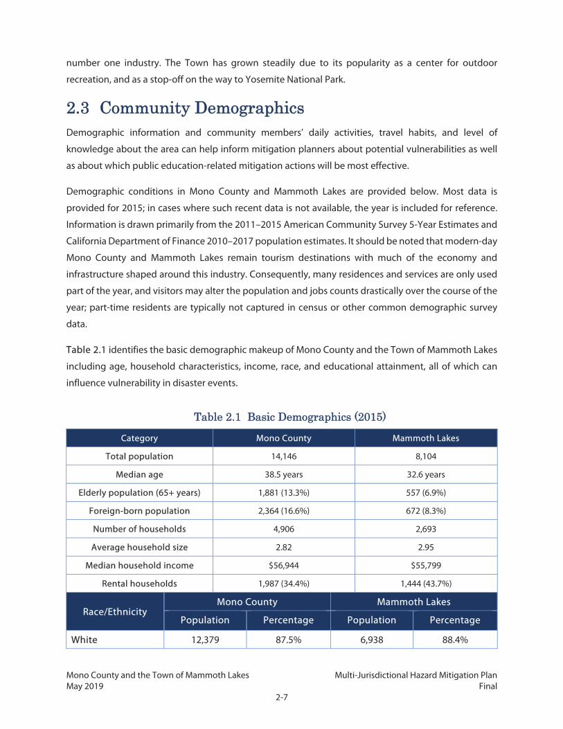
Table 2.1 identifies the basic demographic makeup of Mono County and the Town of Mammoth Lakes
including age, household characteristics, income, race, and educational attainment, all of which can
influence vulnerability in disaster events.
Table 2.1 Basic Demographics (2015)
Category Mono County Mammoth Lakes
Total population 14,146 8,104
Median age 38.5 years 32.6 years
Elderly population (65+ years) 1,881 (13.3%) 557 (6.9%)
Foreign-born population 2,364 (16.6%) 672 (8.3%)
Number of households 4,906 2,693
Average household size 2.82 2.95
Median household income $56,944 $55,799
Rental households 1,987 (34.4%) 1,444 (43.7%)
Race/Ethnicity Mono County Mammoth Lakes
Population Percentage Population Percentage
White 12,379 87.5% 6,938 88.4%

Mono County and the Town of Mammoth Lakes Multi-Jurisdictional Hazard Mitigation Plan May 2019 Final
2-8
Table 2.1 Basic Demographics (2015)
Black or African American
140 1.0% 44 0.5%
American Indian and Alaska Native
485 3.4% 59 0.7%
Asian 345 2.4% 267 3.3%
Native Hawaiian and Other Pacific Islander
28 0.2% 0 0.0%
Some other or multiple race
1,291 9.1% 799 9.9%
Hispanic or Latino (of any race) * 3,862 27.3% 2,972 36.7%
* The US Census does not count Hispanic or Latino persons as a separate racial or ethnic category. Therefore, the Hispanic or Latino population reported here is also included in the other racial or ethnic categories.
Educational Attainment (25+ years)
Mono County Mammoth Lakes
Population Percentage Population Percentage
Less than 9th grade 890 6.2% 650 8.0%
9th grade to 12th grade (no diploma) 575 4.1% 275 3.4%
High school graduate or equivalent 1,626 11.5% 963 11.9%
Some college (no degree) 2,690 19.0% 1,230 15.2%
Associate degree 777 5.5% 433 5.3%
Bachelor’s degree 2,243 15.9% 1,238 15.3%
Graduate or professional degree 889 6.3% 444 5.5%
Note: Due to rounding, the totals presented in this table may not equal the sum of all rows. Sources: US Census Bureau, American Community Survey (2011–2015)
2.3.1 Mono County
As shown in the table above, over half of Mono County’s population resides in Mammoth Lakes. Most
of the remaining residents live within unincorporated communities of fewer than 300 full-time
residents. Although the approximate number of permanent residents is listed below for each
community, communities with a strong recreational attraction may have double or more the listed
population from visitors on peak summer and winter tourist days. Unincorporated communities in the
County include:

Mono County and the Town of Mammoth Lakes Multi-Jurisdictional Hazard Mitigation Plan May 2019 Final
2-9
Topaz: The northernmost town in Mono County, Topaz has a residential population of 50 but is
a popular recreational destination for casinos, fishing, and water sports. The town abuts Topaz
Lake and has moderate hillsides directly to the east along US 395. Topaz is part of Antelope
Valley.
Coleville and Walker: Also part of Antelope Valley, and running alongside the Walker River and
US 395, the neighboring communities of Coleville and Walker have their history in ranching,
with populations of 495 and 721, respectively. Ranching and farming remain an important
activity today along with tourist attractions such as water sports and horseback riding. The areas
near the river and adjacent to these towns include riparian vegetation, irrigated farmland, and
grasses, while the hills to the west have rocky slopes, dry chaparral, and dispersed coniferous
trees.
Bridgeport: The county seat, Bridgeport, has a population of 575. It is located in the relatively
lush and green Bridgeport Valley surrounded by grasses and farmland.
Mono City: This is a small community of 172 residents located just north of Mono Lake. It is in a
relatively flat landscape and is adjacent to Mill Creek, which runs into Mono Lake.
Lee Vining: Located on the southwest side of Mono Lake and near the intersection of US 395
with SR 120, Lee Vining is a frequent shopping point for visitors headed to Yosemite in summer
months. The community at the mouth of Lee Vining Creek sits at the foot of several steeply
sloped mountains.
June Lake: This community of 629 residents is spread alongside the tall Carson Peak and SR 158.
SR 158, also known as the June Lake Loop, provides access to the scenic lakes including June
Lake, as well as June Mountain Ski Area and numerous hiking trailheads.
Chalfant (or Chalfant Valley), Hammil Valley, and Benton: These three communities, often
referred to as the Tri-Valley area, are home to over 900 residents. US 6 runs north–south through
the three communities and into Nevada, while SR 120 connects Benton to US 395. Located in a
series of flat valleys, this area forms the largest agricultural basins in the County. While primarily
an agricultural community, dramatic landscapes and several hot springs bring many
recreational visitors to the area.
Crowley Lake/Aspen Springs/Hilton Creek and McGee Creek: The communities of Crowley
Lake/Hilton Creek and the much smaller McGee Creek are located adjacent to each other. On
the south side of US 395, Aspen Springs can only be accessed via Crowley Lake Drive. Crowley
Lake is a popular recreational destination for fishing and other water sports. With 45 miles of
shoreline, Crowley Lake offers a marina, RV sites, boat rentals, and shops. Together the
communities have a resident population of just over 1,000, making up the largest urbanized

Mono County and the Town of Mammoth Lakes Multi-Jurisdictional Hazard Mitigation Plan May 2019 Final
2-10
population in the unincorporated county. Immediately south of the communities are prominent
mountain peaks, including Mount Baldwin and Mount Morgan.
Tom’s Place and Sunny Slopes: Continuing south along Crowley Lake Drive from Aspen
Springs are the small communities of Tom’s Place and Sunny Slopes, located on USFS-owned
land. Tom’s Place is surrounded by dense coniferous forest and primarily made up of cabins,
stores, and other facilities that make up Tom’s Place Resort. Although the bulk of development
is directly adjacent to US 395, several residences in Sunny Slopes are located on the other side
of US 395 along Rock Creek Road, which follows Rock Creek for close to 10 miles before dead-
ending at the Mosquito Flat trailhead in Inyo County.
Swall Meadows and Paradise: Swall Meadows, and its smaller southern neighbor Paradise,
have roughly 220 and 150 residents, respectively. They are residential communities partway up
the sloping Sherwin Grade with no commercial development, and surrounded by Great Basin
Sagebrush Scrub, Pinyon/Juniper, and Jeffry Pine plant communities. These communities can
only be accessed via a single roadway, Lower Rock Creek Road to Swall Meadows Road.
Oasis: The County’s southernmost community, and located within 3 miles of the Nevada border
along SR 168 where it intersects NV 266, Oasis is isolated from other Mono County communities.
With a permanent population of approximately 20, it is also one of the County’s smallest
communities. Oasis is located in Fish Lake Valley and is surrounded by flat land with dry and
bushy vegetation.
Many county residents do not work in the community in which they live. Many residents in the Antelope
Valley commute to work in Bridgeport and in Gardnerville, Minden, and Carson City in Nevada; residents
of the Tri-Valley area commute to work in Bishop, in Inyo County; and residents of Long Valley, June
Lake, and Benton commute to work in Mammoth Lakes. Bridgeport is the only unincorporated
community with a large portion of its residents working in the community. Development and rising
housing prices in Mammoth Lakes are forcing many residents of Mammoth Lakes to move elsewhere
(Crowley Lake, June Lake, Bishop, Chalfant) and commute to jobs in Mammoth Lakes.
Mono County also has many second homes and seasonal use homes. The County had a vacancy rate of
nearly 65 percent in 2015 according to 5-year American Community Survey census data (source 2011–
2015 DP04). This unusually high rate reflects the large number of vacation homes and seasonal use units
in the area, many of which remain vacant for the majority of the year.
Development in most unincorporated Mono County communities is primarily residential, supported by
small-scale commercial uses serving local and tourist/recreational needs. Limited light industrial uses,
such as heavy equipment storage and road yards, occur in some communities. Most communities also

Mono County and the Town of Mammoth Lakes Multi-Jurisdictional Hazard Mitigation Plan May 2019 Final
2-11
have some public facilities such as schools, libraries, community centers, and parks and ballfields, and
some support government offices (i.e., Bridgeport).
2.3.2 Mammoth Lakes
The Town is a four-season resort community with a small permanent population and many seasonal or
one-time visitors. Vacation residences and lodging facilities accommodate a substantially larger
population of second homeowners and visitors than the Town’s 8,000 permanent residents. The local
economy is based primarily on tourism, especially during summer and winter months when visitation
rates are highest. Winter conditions support skiing, snowboarding, and other outdoor recreational uses.
In the summer, hiking, fishing, camping, bicycling (mountain and road), golfing, and sightseeing are
popular resident and visitor activities. Since the Town’s economy is tourist-driven, much of the resident
population works in the service industry; other large employers include government and Mammoth
Hospital.
Mammoth Lakes is located close to US 395, but can only be accessed via SR 203, seasonally by Sherwin
Creek Road, and, except in heavy snowstorms, via Mammoth Scenic Loop. Southern portions of the city,
notably Old Mammoth, the Bluffs, Valentine Reserve, and Lake Mary area, can only be accessed via Old
Mammoth Road and Lake Mary Road. The Town is located on the lower slopes of Mammoth Mountain
with dense coniferous forest.
2.4 Land Uses
2.4.1 Ownership
For the purposes of this Plan, understanding land ownership is important for developing mitigation
actions and policies that are both appropriate and within the jurisdictional control of the County and
Town. These are the areas the Plan will most directly be able to impact. Lands owned by the state or
federal government have separate governing bodies that are responsible for ensuring appropriate
mitigation of both natural and human-caused hazards. Figure 2.2 identifies broad categories of
ownership for the County and Town. Table 2.2 shows the acreage distribution of these categories of
ownership. While the entire County was analyzed regarding hazard and risk, lands identified as local
and private are the focus of the mitigation actions in this Plan. Table 2.3 shows similar ownership
patterns within the Town of Mammoth Lakes’ municipal boundary alone, also divided between public
and private lands.

Mono County and the Town of Mammoth Lakes Multi-Jurisdictional Hazard Mitigation Plan May 2019 Final
2-12
Table 2.2 Mono County Land Ownership
Owner Acres Percentage
Federal 1,720,939 85.54%
State 83,966 4.17%
Private 128,385 6.38%
Utilities 67,081 3.33%
County 2,266 0.11%
Town of Mammoth Lakes 215 0.01%
Right of Way 8,960 0.45%
Unknown 109 0.01%
Total 2,011,921 100
Mono County
Land uses in Mono County are dominated by open space and natural resource areas owned by various
federal agencies. The state of California and the City of Los Angeles (as the LADWP) also own
considerable amounts of land, which is generally used for open space, or water conveyance. Federal
agencies, including the Humboldt-Toiyabe National Forest, Inyo National Forest, and BLM Bishop Field
Office, own much of the remaining land, and parts of the County are also under the jurisdiction of tribal
governments, which is calculated under the federal land category. SCE and other utilities own lands for
dams, power conveyance, water storage, and similar uses. Private entities and individuals make up the
remainder of land ownership in the County for agriculture and ranching, residential, industrial, and
commercial uses. Most privately-owned land is contained within unincorporated community areas.
Mammoth Lakes
In Mammoth Lakes, most land is dedicated to residential uses, leisure and recreation facilities
(particularly ski-related facilities), public and semipublic institutional uses, open space, industrial uses,
Mammoth Yosemite Airport, and other commercial uses. The Town’s 25-mile municipal boundary
includes large swaths of land within National Forest and BLM, while most land within the Town’s urban
growth boundary is owned by private entities or individuals.

Mono County and the Town of Mammoth Lakes Multi-Jurisdictional Hazard Mitigation Plan May 2019 Final
2-13
Figure 2.2: Land Ownership in Mono County

Mono County and the Town of Mammoth Lakes Multi-Jurisdictional Hazard Mitigation Plan May 2019 Final
2-14
This page intentionally left blank.

Mono County and the Town of Mammoth Lakes Multi-Jurisdictional Hazard Mitigation Plan May 2019 Final
2-15
Table 2.3 Mammoth Lakes Land Ownership within Municipal Boundary
Owner Acres Percentage
Federal 12,832 80.06%
State 2 0.01%
Private 2,387 14.89%
Utilities 37 0.23%
County 44 0.27%
Local 189 1.18%
Right of Way 537 3.35%
Total 16,027 100.00
Note: Due to rounding, the totals presented in this table may not equal the sum of all rows. Source: Mono County 2017
2.4.2 Land Use Designations
Figure 2.3 identifies locations of various types of planned land uses in Mono County and the Town of
Mammoth Lakes.
Mono County
The Mono County General Plan assigns a land use designation to all land located in the unincorporated
areas of the County, including land that is not under the County’s jurisdiction. No land may be
developed or used in the County except in the manner permitted by its assigned designation. The
General Plan also requires that potential development of land be evaluated in terms of potential natural
hazards and available infrastructure, access, and public services and response, as described in the Land
Use Designation Criteria section of the General Plan Land Use Element. Relevant portions of the
County’s Zoning Code, which provides more specific development requirements, are incorporated into
the General Plan. Table 2.4 shows land uses in the unincorporated areas and examples of uses
permitted within those designations.
Table 2.4 Unincorporated Mono County Land Use Designations
Land Use Category Example Land Uses
Agriculture Cattle rangeland, croplands
Commercial Retail, banks, offices
Commercial Lodging Hotels, motels
Estate Residential Single-family dwelling on large lot

Mono County and the Town of Mammoth Lakes Multi-Jurisdictional Hazard Mitigation Plan May 2019 Final
2-16
Table 2.4 Unincorporated Mono County Land Use Designations
Land Use Category Example Land Uses
Industrial Manufacturing plant, heavy vehicle storage
Industrial Park Office park, laboratory
Mixed Use Book store + townhome, dental office + restaurant
Multi-family Residential Condos, 4+ unit apartment building
Natural Habit Protection Wildlife habitat, wetland
Open Space Equestrian trail, cross-country ski touring
Public and Quasi-Public Facilities Public utility building, airport
Resource Extraction Mine, solar power plant
Resource Management Avalanche-prone area, water conservation area
Rural Mobile Home Mobile home on large lot
Rural Residential Single-family dwelling unit w/ancillary rural uses
Rural Resort Single-family dwelling unit, limited outdoor recreation and visitor-oriented facilities
Scenic Area Agriculture Agricultural use consistent with the Mono Basin National Forest Scenic Act
Service Commercial Car sales lot, plumbing services shop
Single-Family Residential Single-family dwelling unit
Specific Plan Planned development in areas outside existing communities complying with a specific plan
Source: Mono County General Plan

Mono County and the Town of Mammoth Lakes Multi-Jurisdictional Hazard Mitigation Plan May 2019 Final
2-17
Figure 2.3: Mono County Land Use Map

Mono County and the Town of Mammoth Lakes Multi-Jurisdictional Hazard Mitigation Plan May 2019 Final
2-18
This page intentionally left blank.

Mono County and the Town of Mammoth Lakes Multi-Jurisdictional Hazard Mitigation Plan May 2019 Final
2-19
Community Planning Areas
In addition to the countywide Land Use Element and land use designations, land use in unincorporated
communities is further guided by area plans. Area plans possess the same regulatory authority as
countywide land use policies, serving to further refine those policies to address the needs of a
community or area. Each community area also has identified opportunities and constraints, many of
which relate to access, infrastructure, and vulnerability to hazards. While the entire County was analyzed
regarding hazard and risk, the focus of many mitigation actions in this Plan will be upon needs and
actions for specific community areas defined by the sixteen area plans. Large portions of the County are
not located within any planning area; most of these portions are federal land with little or no population
or development.
Regional Planning Advisory Committees
RPACs cover one or more planning areas and were established by the Board of Supervisors to assist the
Planning Department in developing and updating planning policies and regulations. RPACs were
established for Antelope Valley, Bridgeport, June Lake, Mono Basin (including Mono City and Lee
Vining), and Long Valley. Residents of the Upper Owens area met to develop land use policies for that
area; similarly, landowners in the Benton Hot Springs area met to develop land use policies for their
valley. Table 2.5 identifies key summary information about the planning areas. The planning areas with
area plans are identified in Figure 2.4.

Mono County and the Town of Mammoth Lakes Multi-Jurisdictional Hazard Mitigation Plan May 2019 Final
2-20
This page intentionally left blank.
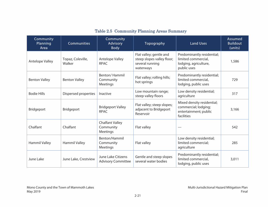
Mono County and the Town of Mammoth Lakes Multi-Jurisdictional Hazard Mitigation Plan May 2019 Final
2-21
Table 2.5 Community Planning Areas Summary
Community Planning
Area Communities
Community Advisory
Body Topography Land Uses
Assumed Buildout
(units)
Antelope Valley Topaz, Coleville, Walker
Antelope Valley RPAC
Flat valley; gentle and steep slopes valley floor; several running waterways
Predominantly residential; limited commercial, lodging, agriculture, public uses
1,586
Benton Valley Benton Valley Benton/ Hammil Community Meetings
Flat valley; rolling hills; hot springs
Predominantly residential; limited commercial, lodging, public uses
729
Bodie Hills Dispersed properties Inactive Low mountain range; steep valley floors
Low density residential; agriculture 317
Bridgeport Bridgeport Bridgeport Valley RPAC
Flat valley; steep slopes; adjacent to Bridgeport Reservoir
Mixed density residential; commercial; lodging; entertainment; public facilities
3,166
Chalfant Chalfant Chalfant Valley Community Meetings
Flat valley --- 542
Hammil Valley Hammil Valley Benton/Hammil Community Meetings
Flat valley Low density residential; limited commercial; agriculture
285
June Lake June Lake, Crestview June Lake Citizens Advisory Committee
Gentle and steep slopes several water bodies
Predominantly residential; limited commercial, lodging, public uses
3,011

Mono County and the Town of Mammoth Lakes Multi-Jurisdictional Hazard Mitigation Plan May 2019 Final
2-22
Table 2.5 Community Planning Areas Summary
Community Planning
Area Communities
Community Advisory
Body Topography Land Uses
Assumed Buildout
(units)
Crowley
Crowley Lake/Hilton Creek, Aspen Springs, Sunny Slopes, Tom’s Place, McGee Creek
Long Valley RPAC Gentle and steep slopes, valley floor; several water bodies
Predominantly residential; limited commercial, lodging, public uses
1,839
Mammoth Vicinity Dispersed properties None Flat valley; gentle slopes Low density residential; agriculture
17
Mono Basin/Mono Basin North
Mono City, Lee Vining Mono Basin RPAC
Low slopes, adjacent to Mono Lake
Predominantly residential; limited commercial, lodging, public uses
880
Oasis Oasis Direct property owner contact Flat valley
Limited residential; agriculture 102
Paradise Paradise Paradise Community Meetings
Flat valley adjacent to running water bodies and steep slopes
Limited residential; agriculture
199
Sonora Junction Marine Corps Mountain Warfare Training Center
None Gentle and steep slopes; high peaks; several small waterways
Low density residential; military; public facilities 138
Swauger Creek Dispersed properties Inactive Gentle and steep slopes; high peaks; several small waterways
Wildlands 8
Upper Owens Dispersed properties Direct property owner contact
Flat valley; gentle and steep slopes
Low density residential; agriculture 52

Mono County and the Town of Mammoth Lakes Multi-Jurisdictional Hazard Mitigation Plan May 2019 Final
2-23
Table 2.5 Community Planning Areas Summary
Community Planning
Area Communities
Community Advisory
Body Topography Land Uses
Assumed Buildout
(units)
Wheeler Crest Swall Meadows Wheeler Crest Community Meetings
Gentle and steep slopes Low density residential; limited commercial; agriculture
389
Outside Planning Area
Virginia Lakes; Dispersed properties
None
Flat valley; gentle and steep slopes; high peaks; valley floor; several running waterways
Low density residential; limited commercial; agriculture; wildlands
670
Mono County and the Town of Mammoth Lakes Multi-Jurisdictional Hazard Mitigation Plan May 2019 Final
2-24
This page intentionally left blank.

Mono County and the Town of Mammoth Lakes Multi-Jurisdictional Hazard Mitigation Plan May 2019 Final
2-25
Figure 2.4: Community Planning Areas

Mono County and the Town of Mammoth Lakes Multi-Jurisdictional Hazard Mitigation Plan May 2019 Final
2-26
This page intentionally left blank.

Mono County and the Town of Mammoth Lakes Multi-Jurisdictional Hazard Mitigation Plan May 2019 Final
2-27
Mammoth Lakes
The Town includes areas within the town’s current 25-square-mile municipal boundary, which includes
both developed areas that make up the urban growth boundary and areas that are primarily federally
owned open spaces with highly dispersed development and limited or no services provided. The Town’s
planning area extends beyond its municipal boundaries and encompasses some land in the Mammoth
Vicinity Community Planning Area in unincorporated Mono County, extending from the Whitmore
Recreation area on the east to the Mammoth Scenic Loop on the north, in which the Town does not
have jurisdiction but provides some municipal services. The planning area also includes Inyo National
Forest lands (located in Madera County) that have their sole vehicular access through the Town of
Mammoth Lakes.
The Mammoth Lakes General Plan assigns a land use category to all land located within existing Town
boundaries. The planning area outside the Town boundary that is within the Town’s sphere of influence
is directly guided by County land use designations.
In support of the land use categories, all property in the Town also has a zoning designation established
by the Town’s Zoning Code. The zoning designations specify allowable uses for real property and size
restrictions for buildings constructed in these areas; the zoning ordinance helps implement the land
use policies established in the General Plan. The Town’s Zoning Code was originally adopted in 1984,
but a comprehensive Zoning Code update was undertaken in 2014.
The Town’s General Plan organizes land development and design and growth standards through
specific districts within the Town. Mammoth Lakes is composed of approximately twelve districts and
four mountain portals, which are further defined by specific, master, and district plans. District
boundaries are defined by existing development, patterns of vegetation, topographic features,
circulation patterns, and the pattern and relationships of land uses. Consequently, certain mitigation
actions in this Plan may focus on or refer to specific districts or mountain portals, shown in Figure 2.5
below.
The mix and composition of land uses, housing, employment, lodging, and amenities are subject to the
character and objectives for the underlying district or portal. The Town’s plan incorporates 14 distinct
land use designations that guide development. Table 2.6 shows land use designations and examples
of uses permitted within those designations, and Figure 2.6 identifies land use distribution in the Town.

Mono County and the Town of Mammoth Lakes Multi-Jurisdictional Hazard Mitigation Plan May 2019 Final
2-28
Table 2.6 Mammoth Lakes Land Use Designations
Land Use Category Example Land Uses
Low Density Residential 1 (LDR-1)
Single family detached residential development at a maximum density of two (2) dwelling units per acre.
Low Density Residential 2 (LDR-2)
Single-family detached residential development of up to four (4) units per acre.
High Density Residential 1 (HDR-1)
Residential multi-unit townhouses, condominiums, and apartments with density ranging from 6-12 units per acre.
High Density Residential 2 (HDR-2)
Transient visitor lodging and residential multi-unit style developments including townhouses, apartments, and condominiums.
Commercial 1 (C-1) Medium scale commercial mixed uses.
Commercial 2 (C-2) Medium and large scale commercial mixed uses.
Resort (R) Commercial mixed uses including visitor lodging, amenities and services, and workforce housing.
Institutional Public (IP) School, hospital, government offices and facilities, museums, and related uses.
North Village Specific Plan (NVSP)
Hotels and similar visitor accommodations along with supporting restaurants, retail, and services.
Industrial (I) Light manufacturing and service uses such as heavy equipment storage and maintenance, batch plants, auto repair and service.
Airport (A) Aviation, fueling, and fixed-base operator services at the Mammoth Yosemite Airport.
Open Space (OS) Parks, athletic fields, golf courses, community gathering spaces and supporting facilities.
National Forest (NF) National Forest lands administered by the Inyo National Forest.
Clearwater Specific Plan (CSP) Hotel, condominium-hotel, workforce housing, street front retail along Old Mammoth Road and a large public plaza intended for use as an event venue.

Mono County and the Town of Mammoth Lakes Multi-Jurisdictional Hazard Mitigation Plan May 2019 Final
2-29
Figure 2.5: Town of Mammoth Lakes Districts and Portals

Mono County and the Town of Mammoth Lakes Multi-Jurisdictional Hazard Mitigation Plan May 2019 Final
2-30
This page intentionally left blank.

Mono County and the Town of Mammoth Lakes Multi-Jurisdictional Hazard Mitigation Plan May 2019 Final
2-31
Figure 2.6: Town of Mammoth Lakes Land Use Map

Mono County and the Town of Mammoth Lakes Multi-Jurisdictional Hazard Mitigation Plan May 2019 Final
2-32
This page intentionally left blank.
Mono County and the Town of Mammoth Lakes Multi-Jurisdictional Hazard Mitigation Plan May 2019 Final
2-33
2.4.3 Agricultural Lands
Loss of agriculture and farmland to urban development can exacerbate natural hazards and
vulnerabilities as well as impact other aspects of the County’s economic, cultural, and environmental
well-being. Consequentially, agricultural land uses are evaluated in this Plan and may be specifically
addressed in mitigation actions. The 2012 Census of Agriculture reported that there were 72 farms in
the County, a slight increase from the total of 63 farms reported in the 1997 Census of Agriculture. Total
farmland acreage, however, decreased by more 12,427 acres in 1997 to 56,386. The value of Mono
County agricultural production also fell from $18.3 million in 1997 to $17.9 million in 2012. This is
consistent with statewide trends of loss of agricultural and farmland acreage and productivity.
Prime Farmland is defined as "land that has the best combination of physical and chemical
characteristics for the production of crops." Numerous specific criteria relating to water availability,
water table, soil chemistry, flooding, erodibility, and physical soil characteristics must be met for land
to be considered Prime Farmland. The Soil Conservation Service (now the National Resource
Conservation Service, NRCS) has mapped most of these characteristics for Mono County, but Mono
County has not yet been included in the Farmland Mapping and Monitoring Program (NRCS 2017).
Mono County has included a number of these attributes in an online geodatabase
(https://www.bistatesagegrouse.com/general/page/geodatabase).
2.5 Development Trends and Future Development
2.5.1 Mono County
As previously discussed, nearly 94 percent of the County's 3,132 square miles are publicly owned and
used mostly for resource conservation or open space due to a high percentage of lands under public
ownership. Most developed property in the unincorporated county is located within 16 community
areas, and roughly half of the population and economic activity occurs within the incorporated Town
of Mammoth Lakes. The countywide growth rate over the next 20 years as projected by the California
Department of Finance is between 0.55 percent and 0.80 percent annually. The unincorporated area
will probably continue to house slightly less than half of the total County population (42 percent in
2010), although the population distribution among the unincorporated areas may shift over that time
frame. A County staff report prepared for the Mono County Housing Authority in 2016 indicates that the
County issued between 15 and 20 permits each month between 2010 and 2015, which included new
development, replacement structures, and remodels or alterations. The County issued a total of 303
permits in the calendar year of 2015, representing the first time that total permits issued reached above
the 300 mark since the housing boom years of 2006–2008. Staff attributed some of this increase to
replacement and rebuilding efforts after the 2015 Round Fire. Most permits were for individual or small
Mono County and the Town of Mammoth Lakes Multi-Jurisdictional Hazard Mitigation Plan May 2019 Final
2-34
batch residential units, with a small number of additional permits for commercial or restaurant uses.
This development pattern is not anticipated to change, due to the small scale of communities in Mono
County and the lack of employment opportunities in most communities. The County has had a decline
in permits recently, with 206 permits issued in 2017 and 163 issued in 2016.
The County's General Plan Land Use Element contains policies that focus future growth in and adjacent
to existing communities. Substantial additional development outside of existing communities is limited
by environmental constraints, the lack of large parcels of private land, and the cost of providing
infrastructure and services in isolated areas. Land use policies for unincorporated community areas
focus on sustaining the livability and economic vitality of existing community areas. The General Plan
also specifically allows for expansion and development at the Bryant Field and Lee Vining Airports and
in the area surrounding each airport.
Since growth that has occurred since the last MJHMP update in 2006 has been limited and largely only
occurred within existing communities, the only major changes in risk and vulnerability relate to density
of development. This Plan identifies vulnerabilities of the few new areas that have been developed since
2006, and reemphasizes areas in currently developed areas where development should be discouraged
or prohibited. Additionally, since the 2006 MJHMP, the County and Town have taken multiple actions
to better enforce floodplain management (described in Section 5.3).
2.5.2 Mammoth Lakes
The Town of Mammoth Lakes maintains an urban growth boundary, as established in its General Plan.
An overarching principle of the community is to maintain the Town’s compact urban form, protect
natural and outdoor recreation resources, and prevent sprawl. The Town’s urban growth boundary
limits the area available for future development to achieve these principles. Because of this, as well as
the fact that the area outside the urban growth boundary is predominantly federal land, all new
development will likely occur only within those boundaries.
Vacation residences and lodging facilities in town accommodate a substantially large population of
second homeowners and visitors. Overall, the Town is prone to large fluctuations in the total non-
resident population because of the seasonal nature of its tourism-dependent economy. During the
winter tourist season, the community and ski area require a large number of seasonal employees (more
than can be filled by the full-time resident community) to meet peak service demands. As a result, the
resident population increases by approximately 3,000 during the peak tourism season in addition to the
influx of tourists.
Accordingly, the Town considers the development needs of nonresident and visitor populations at peak
tourist season as well as resident populations when planning for future growth. The Town’s General

Mono County and the Town of Mammoth Lakes Multi-Jurisdictional Hazard Mitigation Plan May 2019 Final
2-35
Plan anticipates that, at buildout, the projected number of residents, visitors, and workers on a winter
weekend will grow to over 53,000; it thus establishes a policy of a total peak population of residents,
visitors, and employees of 53,091 people. The General Plan anticipates that the permanent population
will grow at a rate of between 1.4 percent and 2.4 percent per year.
To accommodate growth, the Town anticipates the development of a number of planned
developments within the urban growth boundary. The bulk of this development will be a mix of resort-
style development and new housing. The General Plan also anticipates that most new commercial
development will take place in the Resort, North Village, and Commercial 1 and 2 land use designations.
Industrial development will be limited primarily to the Industrial designation, although there will be a
small amount of industrial development in other designations. The total amount of industrial
development at buildout is anticipated to be approximately 500,000 square feet.
Between 2009 and 2014, very little new development occurred. In 2015, several new multifamily
structures and a handful of new single-family homes were built in the Snowcreek neighborhood. The
Town has a number of specific plans and large development master plan projects under review or
entitled as of 2016. Most of these potential development areas are infill. Major projects approved or
planned as of 2016 are described in Table 2.7.
Table 2.7 2016 Major Development Plans
Development Name Description
Snowcreek VIII Master Plan 790 dwelling units, 400 hotel rooms, 20,000 sq. ft. commercial
Juniper Ridge Master Plan 106 dwelling units, 80,000 sq. ft. commercial (day lodge and other)
Lodestar at Mammoth Master Plan 500 hotel rooms, 82 dwellings units, 80,000 sq. ft. of commercial
Mammoth Crossings 742 hotel rooms total, 40,500 sq. ft. of commercial
Canyon Lodge Redevelopment Reconfiguration of lodge and new skier service facility
Ritz Carlton Site 93 condominium units with lock-offs totaling 225 keys, 5,000 sq. ft. restaurant
Inn at the Village 67 hotel rooms, a spa, pool terrace
Sierra Star Area 2 210 dwelling units
Old Mammoth Place 487 resort hotel rooms, 40,000 sq. ft. of commercial, 9,500 sq. ft. of conference center use
Shady Rest Parcel 55 single family residential units, 117 multifamily apartment units, dedication of 6 acres for open space
DSES Wounded Warrior Center Two-story mountain lodge with up to 38 full-time residents, flexible shared common space

Mono County and the Town of Mammoth Lakes Multi-Jurisdictional Hazard Mitigation Plan May 2019 Final
2-36
The development that has already occurred and the development that is in progress does increase the
Town of Mammoth Lake’s overall vulnerability. However, this MJHMP update recognizes specific areas
and neighborhoods that have expanded in the Town of Mammoth Lakes and identifies key
infrastructure improvements and development requirements that are necessary in these areas. The
identified infrastructure improvements and development requirements will help mitigate the increase
in vulnerability that typically comes with development.
2.6 Infrastructure Systems and Critical Facilities Much of the County and Town’s ability to mitigate for, as well as prepare for and respond to, disaster
relies on critical facilities. Most critical facilities in the County are provided either by the County, by the
Town, or by special districts such as those for fire protection or public utilities. Critical facilities are
typically focused on properties that are of specific value to the community. They include many key
infrastructure systems: the transportation network including roads, airports, and helipads;
communications including telephone, radio, and internet; lifeline utilities including electricity service,
gas and propane service, water and sewer service facilities, and snow removal equipment; and
hazardous materials disposal sites such as landfills. These systems are described in greater detail below.
They also include emergency services facilities directly used by emergency responders such as police
stations, fire stations, and paramedics stations. Additionally, critical facilities encompass public facilities
that can act as emergency operations centers, such as community centers; county or town offices; and
facilities that meet community needs, provide community gathering places and staging areas, and
support vulnerable populations, such as medical facilities (e.g., hospitals, clinics), schools, and senior
living centers.
Infrastructure systems, most notably roads and electricity lines, stretch across the entire County and are
not itemized below, although overpasses, power stations, and substations are included. Table 2.8
shows the number and values of different types of critical facilities for the County and Town. A full list
of critical facilities by planning area is provided in Appendix C.
Table 2.8 Critical Facilities by Type
Facility Type Unincorporated Mono
County Mammoth Lakes
Communications Facilities 9 10
Emergency Operations Center 8 4
Emergency Services 21 5
Hazardous Materials 10 0
Lifeline Utility Systems 46 9
Medical Services 2 2

Mono County and the Town of Mammoth Lakes Multi-Jurisdictional Hazard Mitigation Plan May 2019 Final
2-37
Table 2.8 Critical Facilities by Type
Facility Type Unincorporated Mono
County Mammoth Lakes
Schools 6 5
Transportation Systems 9 1
Vulnerable Populations (senior living facilities)
5 0
Total 116 36
Most of these facilities are located along or very near US 395 or SR 6. The largest concentrations of
facilities are in the County seat, Bridgeport (27 facilities), or Mammoth Lakes (36 facilities). Figure 2.7
identifies the locations of critical facilities by category in the County and Town.
2.6.1 Communications
Telecommunications infrastructure and services are critical components of emergency response, as well
as long-term growth and sustainability for the County, as they provide the basic resources necessary for
businesses to operate and add to the quality of life for its residents. Communications services cross
several major technologies and infrastructure components and include basic telephone, wireless
telephone, radio, and broadband internet. Due to the isolated locality of the County, inadequate
infrastructure and service across all these communication technologies are major challenges.
An Information Technological Strategic Plan, completed in 2015 and adopted by both Mono County
and the Town of Mammoth Lakes, provides goals for improving communications operations and
infrastructure.
General Response Protocol
Any call to 911 placed from a landline phone from within the County is routed directly to Mono County
Dispatch in Bridgeport. Any 911 call placed via a cell phone is routed to the CHP in Bishop or to Mono
County Dispatch, depending on the caller’s location and device capabilities. If the call is routed to CHP,
it is then transferred to Mono County Dispatch. If Mono County Dispatch is down for any reason, all calls
are routed to Inyo County Dispatch. There is solid coordination between the agencies to ensure that all
911 calls are answered and properly routed.
Internet and Mobile Broadband
Historically, Mono County has suffered from a lack of quality broadband due to its rural nature and low
population with dispersed community areas. Landline phone, internet, and TV service was, and still is
for many communities, provided by only a few providers, including Frontier Communications and

Mono County and the Town of Mammoth Lakes Multi-Jurisdictional Hazard Mitigation Plan May 2019 Final
2-38
Verizon. Internet speeds with these services are typically very slow, and in some cases landline phone
services are unreliable.
However, in 2013, a $120 million fiber optic project was completed which opened a new era of
opportunity for the Eastern Sierra region. Known as Digital 395, the project completed an open-access
network capable of delivering petabytes of data to Mono, Inyo, and eastern Kern Counties. The project
encompassed 36 communities, six Native American reservations, two military bases, over 25,000
households, and 2,500 businesses. As of 2016, 85 percent of the households in Mono County have
access to gigabit internet service at 50 percent of the cost per megabit (on a per capita basis), and
installations are still ongoing. However, smaller communities located away from US 395, and which have
so far not gone through the process to tap into the main line as part of the project, may still have limited
to no internet access. To facilitate delivery of last-mile internet service off the Digital 395 backbone, Race
Communications will install strand and fiber on existing utility poles and install fiber in existing
underground conduit and newly proposed underground conduit, along with associated infrastructure
(power vaults and distribution panels) in various Mono County communities. For these communities,
final line connections may require long waits and the expense of several hundred to several thousand
dollars. Some very small communities are not included in this project and may still not have broadband
access after the project’s completion.
Additionally, according to the Mono County General Plan, remaining issues include the data caps that
are placed on customers, the overall cost of the service, and the typical requirement of a long-term
contract to receive the service.
Cellular Service
Cellular coverage in the County is incomplete. Service in Mammoth Lakes and its mountain portals is
generally reliable. For the most part, some form of cellular coverage also exists in almost every
unincorporated community area; however, it is carrier-dependent. AT&T and Verizon are the two main
carriers. Their coverage models overlap, but each carrier does not provide the same level of coverage in
the same areas. Service in large portions of the County’s primary highway corridors is spotty, and away
from the main road and urbanized communities it is often unreliable or nonexistent.
Since the number of cell phone towers is limited and they are spread far apart, network capacity is also
limited. Even in more developed areas with generally good service, network capacity may be quickly
overloaded during an emergency event.
Cellular service is increasingly important as more and more households do away with landline
connections, and with the increasing use of reverse 911 technology to reach community members
during hazard events.

Mono County and the Town of Mammoth Lakes Multi-Jurisdictional Hazard Mitigation Plan May 2019 Final
2-39

Mono County and the Town of Mammoth Lakes Multi-Jurisdictional Hazard Mitigation Plan May 2019 Final
2-40
This page intentionally left blank.

Mono County and the Town of Mammoth Lakes Multi-Jurisdictional Hazard Mitigation Plan May 2019 Final
2-41
Figure 2.7: Critical Facilities

Mono County and the Town of Mammoth Lakes Multi-Jurisdictional Hazard Mitigation Plan May 2019 Final
2-42
This page intentionally left blank.

Mono County and the Town of Mammoth Lakes Multi-Jurisdictional Hazard Mitigation Plan May 2019 Final
2-43
Radio
Interoperable communications is one of the most critical components to emergency operations today.
Responders rely heavily on the Mono County Public Safety Radio System (MCPSRS) to communicate
with each another in the field, as well as with Dispatch while handling events. Though generally
functional, this system is dated and in need of an upgrade, as there are a number of technical challenges
at present, and ongoing concerns about reliability. Though the system was built with layers of
redundancy to ensure that communications can take place even with certain failures, it is also
complicated and has been built incrementally over time making it difficult to use, manage, and
troubleshoot - especially during periods of crisis. Town, County, and State emergency response staff
have indicated in the past that radio communications have been especially challenging due to a variety
of technical reasons, and this has been identified as a priority area for both the County and Town for the
coming years.
In 2015 the Mono County Information Technology Department took over the system and are now
responsible for the maintenance, management, and long-term planning for radio communications for
the County, Town, and other allied agencies. The current MCPSRS is comprised of 12 different County-
owned repeater sites, 10 of which are on mountaintop locations above 7,500'. In 2016, Mono County IT
contracted with Delta Wireless to perform a pier-to-pier assessment of the system and produce a Radio
System Evaluation Report which would serve as a work plan and road map for the coming years. The
report indicated nearly $600k worth of deferred maintenance work across all of these sites, and a
number of issues which ranged from broken antennas to improperly tuned radios to lack of grounding
and lighting protection. Since that time, the IT Department has been working diligently with Delta
Wireless and other contractors to address a myriad of issues across the entire network and establish a
programmatic approach to maintenance, management, and operations.
In addition to the work necessary to keep the current system operational, IT is spearheading a planning
effort focused on a Next Generation system. This is a complex process which consists of both highly
technical detailed planning, and careful, coordinated governance and policy conversations. The
ultimate goal of these efforts is to arrive at a new radio system sometime in the next five years which is
founded on current day industry best practices, and rooted in an Joint Powers Authority organizational
structure that allows for clarity around responsibility, decision making, funding, and long-term
maintenance.
2.6.2 Transportation
There are a limited number of major access roads in the County and these are critical for community
mobility and emergency responders. Major access roads include the following:

Mono County and the Town of Mammoth Lakes Multi-Jurisdictional Hazard Mitigation Plan May 2019 Final
2-44
US 395 is the major transportation route connecting the Eastern Sierra with Southern California
and with the Reno/Tahoe region in northern Nevada. US 395 is also Main Street in Lee Vining,
Bridgeport, Walker, Coleville, and Topaz. US 395 is, and will remain in the long term, the major
access to and through Mono County. Most of the County’s population resides in small
communities of 300 or less along this main roadway corridor. By car, Los Angeles is five to six
hours south on US 395, Reno is three hours north on US 395, and the San Francisco Bay Area is
five to six hours west on various routes connecting to US 395. It is maintained and kept open
throughout the year. Hazards—including winter storms, avalanches, landslides, and wildfire—
may close portions of US 395 from time to time, as described in the risk and vulnerability
sections of this Plan.
US 6, from the Inyo County line north of Bishop to the Nevada state line, provides
regional/interregional transportation connections. This route serves both local traffic and
interregional trucking between Southern California, Reno, and the western mountain states
(Washington, Idaho, and Montana). US 6 is also Main Street in the Tri-Valley communities. The
route is kept open year-round and is subject to limited exposure to hazards.
SR 89 provides access from US 395 to Monitor Pass and is closed in the winter.
SR 108 provides access from US 395 west to Sonora Pass and is closed in the winter.
SR 120 provides access from US 395 west to Tioga Pass and east to Benton. The western
segment is closed in the winter and the eastern segment may also be closed depending on
snow conditions.
SR 158, the June Lake Loop, provides access from US 395 to the community of June Lake and is
Main Street through part of the June Lake Loop. A portion of SR 158 is closed in the winter.
SR 167 provides access from US 395 to the Nevada state line, north of Mono Lake, and access to
the community of Mono City.
SR 168 provides access from US 395 at Big Pine in Inyo County north to Oasis in the southeast
corner of Mono County.
SR 182 provides access from its junction with US 395 in Bridgeport northeast to the Nevada
state line as well as main street access to a portion of the community of Bridgeport.
SR 203 provides access west from US 395 to Mammoth Lakes, becoming Main Street through
town before turning up to the Mammoth Mountain Ski Area and continues on to the USFS Road
to Reds Meadow and Devils Postpile National Monument. The potion of the road beyond
Mammoth Mountain Ski Area is closed in the winter.
SR 266 provides access through Oasis in the southeast corner of the County.

Mono County and the Town of Mammoth Lakes Multi-Jurisdictional Hazard Mitigation Plan May 2019 Final
2-45
SR 270 provides access east from US 395 to Bodie State Historic Park and is closed for a portion
of the winter.
Mono County also has three small public airports. Two, Bryant Field and Lee Vining Airport, are operated
by the County. The third, Mammoth Yosemite Airport, is operated by the Town of Mammoth Lakes.
Several heliports, including the Marine Corps Mountain Warfare Training Center Airport, are also
present. Transportation and access routes are shown in Figure 2.8, below.
Evacuation and Emergency Access Routes
For most of Mono County, US 395 is the primary evacuation and emergency access route. The
communities of Paradise, Swall Meadows, Lundy Lake, Virginia Lakes, and Twin Lakes, as well as portions
of June Lake, Crowley Lake, McGee Creek, and Chalfant Valley, all only have one access route. During
evacuation and emergency response procedures, the lack of alternative routes could inhibit
transportation in and out of most areas. For the Town of Mammoth Lakes, SR 203 is the primary access
in and out of the community, and connects to US 395. The Mammoth Scenic Loop provides a secondary
access route to US 395 when not closed during heavy storms in winter months. Figure 2.8 identifies
communities and neighborhoods without secondary access to major access roads identified above.
Many of these communities are threatened by one or more hazards, as will be detailed in Chapter 3 and
Chapter 4, and thus secondary access for emergency situations is critical.
Developing secondary access routes is typically constrained by the presence of hazard zones and steep
slopes, as well as procedural onus associated with establishing right-of-way on land owned by multiple
private and public entities. Chapter 5 includes more detailed information, as well as specific
opportunities and constraints, regarding secondary access routes in six neighborhoods or communities
which have single access identified as the highest priority to address.
Additionally, Mono County has identified development of an evacuation plan for animals and pets as a
future project when time and funding allow. Such a project falls outside this plan’s focus on mitigation,
but an item was added to the list of recommended preparedness and response actions in Table 7.10 as
part of the Mono County CWPP.

Mono County and the Town of Mammoth Lakes Multi-Jurisdictional Hazard Mitigation Plan May 2019 Final
2-46
This page intentionally left blank.

Mono County and the Town of Mammoth Lakes Multi-Jurisdictional Hazard Mitigation Plan May 2019 Final
2-47
Figure 2.8: Transportation and Access for Mono County and Mammoth Lakes

Mono County and the Town of Mammoth Lakes Multi-Jurisdictional Hazard Mitigation Plan May 2019 Final
2-48
This page intentionally left blank.

Mono County and the Town of Mammoth Lakes Multi-Jurisdictional Hazard Mitigation Plan May 2019 Final
2-49
2.6.3 Water
Water and sewer services for unincorporated Mono County are provided by a variety of special districts
and mutual water companies. Special districts for water distribution include June Lake Public Utility
District, Lee Vining Public Utility District, and Bridgeport Public Utility District. Most of these districts
depend primarily on groundwater wells or a mix of surface and groundwater wells for water supply.
According to the Mono County General Plan, a number of these districts struggle to maintain aging
piping and sewer treatment facilities, thereby threatening the quality and supply of water to their
service areas.
Areas not served by these districts rely on private groundwater well systems and small septic systems.
The LADWP has significant rights to surface water in the Mono Basin. The LADWP operates an extensive
aqueduct system over thousands of acres of land; it diverts water that previously flowed into Mono Lake
to the City of Los Angeles. All water coming out of the Mono Basin is heavily regulated by the state
through the 1994 SWRCB Decision 1631. In recent drought years, the lake’s water levels have dropped
precipitously, threatening the County’s scenic value and the ecosystem of the basin.
The Mammoth Community Water District (MCWD) supplies water to the Town of Mammoth Lakes from
two sources: diversions from Mammoth Creek, which spills from Lake Mary (in the Lakes Basin), and from
various wells around the Town. The MCWD’s 5.7-square-mile service area lies entirely within the Town
of Mammoth Lakes’ incorporated boundary; most of the service area is within the much smaller urban
growth boundary, which spans approximately 4 square miles. There are approximately 2,500 acres of
private land within the service area. Most of the lands outside of the Town urban growth boundary are
publicly owned federal lands managed by the USFS’s Inyo National Forest.
The MCWD’s existing sources of water include surface water, groundwater, recycled water, and savings
from water conservation (demand management) measures. The MCWD stores and diverts Mammoth
Creek surface water at Lake Mary. Groundwater supply comes from nine production wells within the
Mammoth Groundwater Basin. Delivery of recycled water meeting Title 22 water standards for
unrestricted irrigation use began in 2010. The MCWD operates three treatment plants and one
wastewater/recycled water treatment plant (MCWD 2017).
2.6.4 Energy
Electricity infrastructure in Mono County is available in all community areas. The electricity network is
critical for public health and safety, and the availability of electrical service is crucial after a disaster has
occurred. This infrastructure may itself pose a hazard, such as the risk of downed power lines sparking
a wildfire.

Mono County and the Town of Mammoth Lakes Multi-Jurisdictional Hazard Mitigation Plan May 2019 Final
2-50
Electricity in Mono County is provided by three different agencies: SCE, a privately-owned utility
company, serves most of Mono County, including all of Mammoth Lakes, and all unincorporated
community areas with the exception of Coleville and Walker. Coleville and Walker are provided
electricity as well as other utility services by Liberty Utilities, which operates within a service area that
includes a region surrounding Lake Tahoe, including portions of El Dorado, Alpine, and northern Mono
Counties. The southeastern tip of Mono County is served by Valley Electric Transmission, a member-
owned electric utility that primarily operates in Nevada.
All three electricity providers receive their power from a variety of sources, including renewable energy,
fossil fuels, and hydroelectric facilities. Mono County has nine power plants as identified by the
California Energy Commission’s (CEC) 2017 Annual Generation list. These include five hydroelectric
facilities and three geothermal power plants. All of the hydroelectric facilities are fairly small, producing
just over 21 megawatts of power, and are owned by SCE and LADWP. The geothermal operation, which
includes three plant units near Mammoth Lakes in the unincorporated county, is owned by Mammoth
Pacific LP.
Power is delivered through a network of power lines and facilities called substations. Mono County has
three major power transmission lines, owned by SCE. One line runs parallel to US 395 in the southern
half of the County. A second line connects from Nevada in mid-county and rounds south to meet the
first. A third, smaller transmission line runs between and connects the two. There are 13 substations in
Mono County, which convert high-voltage electricity carried by transmission lines to lower-voltage
electricity that can be used by homes and businesses. Because of their remote location, Mono County
and Mammoth Lakes rely on a limited electricity network. Any disruption to the two major power
transmission lines or to the substations could cause a large and potentially countywide blackout. The
loss of electric power due to failure of overhead power lines, as a result of natural hazards such as
wildfire, wind, and avalanche, is one of the most frequent impacts on Mono County and Mammoth
Lakes communities.
There is no natural gas service in the County and many households and businesses utilize propane for
heat, cooking, and backup power generators. While propane is an adaptable and easily transportable
power source, it may create new hazards in the County as accidents in transport, construction activities,
heavy snow, or fires can cause propane leaks and related hazardous incidents such as intense fires near
structures. A large number of residents also utilize wood stoves and pellet stoves for heating, which can
also pose fire hazards.

Mono County and the Town of Mammoth Lakes Multi-Jurisdictional Hazard Mitigation Plan May 2019 Final
3-1
3. HAZARDS ASSESSMENT This chapter provides an overview of the types of hazard events in Mono County and Mammoth Lakes,
including past hazard events and how these hazards may change in the future. This chapter also
discusses the process used by Planning Team members to identify and prioritize hazards.
3.1 Hazard Analysis
3.1.1 Hazard Identification
FEMA’s Hazard Summary Worksheet is a resource provided for communities in the agency’s Local
Mitigation Planning Handbook guidance document (FEMA 2013). The worksheet identifies 21 different
hazards that local governments may wish to consider when conducting hazard mitigation planning
efforts. Some of these events will not occur in Mono County or Mammoth Lakes because the necessary
attributes for these events to occur are not present in the community (sea level rise, for example). The
Planning Team reviewed a comprehensive list of hazards during its September 29, 2017, meeting,
including the hazards in FEMA’s guidance and additional hazards suggested by Planning Team
members. This discussion resulted in identification of the hazards that pose a potential risk to Mono
County and Mammoth Lakes. Table 3.1 summarizes the Planning Team’s discussion of each hazard and
shows which hazards were identified for inclusion in this MJHMP. Wildfire is discussed in Chapter 7 as
part of the CWPP.
Table 3.1 Mono County and Town of Mammoth Lakes Hazard Identification
List of Hazards
In Hazard Area?
Discussion Summary Mono County
Town of Mammoth
Lakes
Agricultural Pests No No The 2014 Crop and Livestock Report does not mention any specific agricultural pests of note.
Avalanche Yes Yes
Avalanches occur in the mountainous areas of the County, affecting portions of Mammoth Lakes, several unincorporated communities, and several important access roads.
Coastal Erosion/Bluff Failure No No
Not applicable. Mono County and Mammoth Lakes are not coastal communities.
Coastal Storm No No Not applicable. Mono County and Mammoth Lakes are not coastal communities.

Mono County and the Town of Mammoth Lakes Multi-Jurisdictional Hazard Mitigation Plan May 2019 Final
3-2
Table 3.1 Mono County and Town of Mammoth Lakes Hazard Identification
List of Hazards
In Hazard Area?
Discussion Summary Mono County
Town of Mammoth
Lakes
Dam Failure Yes No
The County is susceptible to inundation caused by failure of dams owned by SCE, LADWP, and other private entities, and have experienced warnings of potential dam failure in the recent past.
Disease and Pest Management
Yes Yes Invasive pests have the potential to damage trees; mosquitoes have the potential to spread disease.
Drought Yes Yes Mono County and Mammoth Lakes both depend on groundwater and surface water, which are susceptible to drought.
Earthquake and Seismic Hazards Yes Yes
Mono County and Mammoth Lakes are susceptible to earthquake ground shaking, and certain areas may also experience liquefaction, fault rupture, and tectonic subsidence.
Expansive Soils No No Not applicable. Expansive soil issues are not prevalent in the County.
Extreme Heat Yes No Extreme heat that could be life endangering is an issue in the Tri-Valley portion of the County.
Flood Yes Yes The Town and the County have 100- and 500-year flood zones, as mapped by FEMA.
Hailstorm No No Although hailstorms have occurred within the area, they are rare. The Planning Team did not identify any local hailstorms of note.
Hazardous Materials Yes Yes
The County and the Town contain properties and transportation corridors with the potential for hazardous materials spills. This hazard will be discussed in association with propane explosions, a related human-caused hazard.
Human-Caused Hazards No No
With the exception of human-caused hazards related to hazardous materials, this Plan focuses on natural hazards.

Mono County and the Town of Mammoth Lakes Multi-Jurisdictional Hazard Mitigation Plan May 2019 Final
3-3
Table 3.1 Mono County and Town of Mammoth Lakes Hazard Identification
List of Hazards
In Hazard Area?
Discussion Summary Mono County
Town of Mammoth
Lakes
Hurricane No No Not applicable. Mono County and Mammoth Lakes are not coastal communities.
Landslides (Geologic Hazards)
Yes No The conditions for landslides are present near the hills and mountains of the unincorporated county, but not near Mammoth Lakes.
Land Subsidence No No
Not applicable. There are no historical or expected occurrences of non-tectonic subsidence in the County. Tectonic subsidence is addressed in the Earthquake section.
Sea Level Rise No No Not applicable. Mono County and Mammoth Lakes are not coastal communities.
Severe Winter Weather and Snow Yes Yes
Severe winter storms and heavy snow frequently block roads, lead to dangerously low temperatures, and can affect utility services. These are frequent impacts for both Mono County and Mammoth Lakes. This hazard will be discussed with other winter weather effects including extreme cold.
Tornado No No There are no recorded tornado hazards in Mono County or Mammoth Lakes.
Tsunami No No Not applicable. Mono County and Mammoth Lakes are not coastal communities.
Volcano Yes Yes The County and the Town are located in volcano hazard areas.
Wildfire Yes Yes Wildfire hazards are a significant issue in this part of California.
Wildlife Collisions Yes Yes Wildlife vehicle collisions are a common road hazard in the County, especially along US 395.
Wind Yes Yes
The County and Town are subject to high wind events, especially on exposed and high-altitude roadways, making travel hazardous, as well as downing power lines and causing electricity outages.
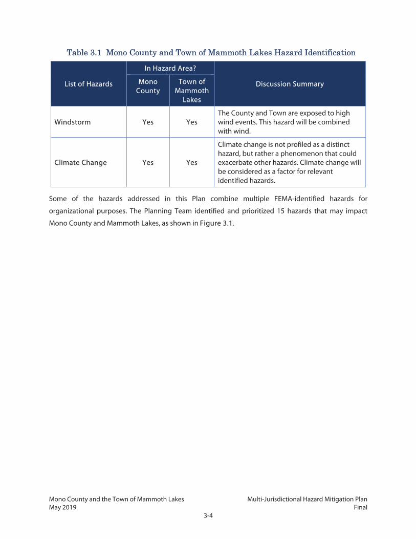
Mono County and the Town of Mammoth Lakes Multi-Jurisdictional Hazard Mitigation Plan May 2019 Final
3-4
Table 3.1 Mono County and Town of Mammoth Lakes Hazard Identification
List of Hazards
In Hazard Area?
Discussion Summary Mono County
Town of Mammoth
Lakes
Windstorm Yes Yes The County and Town are exposed to high wind events. This hazard will be combined with wind.
Climate Change Yes Yes
Climate change is not profiled as a distinct hazard, but rather a phenomenon that could exacerbate other hazards. Climate change will be considered as a factor for relevant identified hazards.
Some of the hazards addressed in this Plan combine multiple FEMA-identified hazards for
organizational purposes. The Planning Team identified and prioritized 15 hazards that may impact
Mono County and Mammoth Lakes, as shown in Figure 3.1.

Mono County and the Town of Mammoth Lakes Multi-Jurisdictional Hazard Mitigation Plan May 2019 Final
3-5
Figure 3.1: Priority Hazards
3.1.2 Hazard Prioritization
The Planning Team used a Microsoft Excel–based tool to prioritize the identified hazards by assigning
each hazard a ranking based on probability of occurrence and potential impact. These rankings were
assigned based on group discussion, knowledge of past occurrences, and familiarity with the County’s
and Town’s infrastructure vulnerabilities. Four criteria were used to establish priority:
Probability (likelihood of occurrence)
Location (size of potentially affected area)
Magnitude (intensity of damage)
Secondary Impacts (severity of impacts to community)
A value of 1 (low) to 4 (high) was assigned by each team member for each hazard/criterion pairing. The
four criteria were then weighted based on the Planning Team’s opinion of each criterion’s importance.
Table 3.2 presents the results of this exercise, and shows the average ranking for each hazard among
the Planning Team members and reflects the team’s rating of the relative importance of the identified
hazards in order to focus mitigation efforts. The table sorts rankings from highest to lowest. As shown,
wildfire, winter-weather related hazards, and earthquake-related hazards were highest rated, followed

Mono County and the Town of Mammoth Lakes Multi-Jurisdictional Hazard Mitigation Plan May 2019 Final
3-6
by volcano, climate change effects, and drought. The hazards in Table 3.2 are consistent with the
hazards identified as having potential to occur in the County and Town, as shown in Table 3.1.
Table 3.2 Mono County Hazard Ranking Worksheet Outcomes
Hazard Type1 Probability
Impact Overall
Rank Location Primary Impact
Secondary Impacts
Wildfire 3.7 3.1 3.1 3.4 3.4
Severe Winter Weather & Snow 3.9 3.6 2.6 2.7 3.2
Earthquake & Seismic Hazards 2.6 3.0 2.9 3.0 2.9
Volcano 1.1 2.7 3.7 3.6 2.8
Climate Change 2.3 3.3 2.3 3.0 2.8
Drought 2.7 3.3 2.0 2.3 2.6
Severe Wind 2.9 2.6 2.3 1.9 2.4
Flood 2.6 2.4 2.1 1.9 2.3
Landslide 2.6 2.6 1.9 1.9 2.2
Avalanche 2.6 1.7 2.0 2.1 2.1
Dam Failure 1.1 1.7 2.4 2.9 2.0
Hazardous Materials 2.1 2.3 1.4 1.8 1.9
Disease/ Pest Management 1.0 2.0 1.7 1.7 1.6 1 Wildlife collisions and extreme heat were added as a priority hazard after the Planning Team completed the hazard ranking worksheet and are therefore not included in this table.
3.1.3 Climate Change Considerations
Climate change is expected to exacerbate existing hazards in the County and Town. As such, the
Planning Team determined that it would be best to discuss climate change considerations throughout
all applicable hazard profiles.
3.2 Hazard Profiles For each hazard, a hazard profile is established to provide a general description of the hazard. The profile
will also describe what locations the hazard is likely to affect as well as the potential magnitude of
hazard events. Location will be discussed in terms of the following:

Mono County and the Town of Mammoth Lakes Multi-Jurisdictional Hazard Mitigation Plan May 2019 Final
3-7
Land Ownership: The ownership of land and development affected by a hazard is an important
consideration for the County and Town in order to develop effective policies and mitigation measures.
Measures for County-owned properties and facilities will be quite different than for those on private
property or those under the jurisdiction of federal agencies with their own policies and procedures. A
countywide snapshot of land ownership and locations is found in Chapter 2.
Planning Areas and Urban Communities: The specific urban communities and their unique
geographic, economic, and political characteristics are important considerations for the County and
Town in order to develop effective policies and mitigation measures. Planning areas and their urbanized
communities will be identified and considered in the risk assessment. The locations and economic and
political settings of the planning areas and urban communities are discussed in Chapter 2.
History: Historic events lead into understanding what locations are at risk and the magnitude of impacts
likely to occur. Each profile thus includes a description of major hazard events in recent history, and, to
the extent possible, a complete listing of hazard events by date and location.
Future Conditions: Changes to hazard area or magnitude may occur as the result of new development,
new infrastructure, and, most significantly, climate change. How these changes could affect hazards is
discussed briefly. A fuller analysis of potential changes in risk and vulnerability due to climate change
can be found in the Risk Assessment, in Chapter 4.
Hazard profile information for wildfire is contained in Chapter 7 as part of the CWPP. For hazard
description and climate change considerations, no meaningful difference exists between Mono County
and Mammoth Lakes. For the remaining topics (location and magnitude, hazard history/past
occurrences, and risk of future hazard), specific information is provided for both the County and the
Town.
3.2.1 Avalanche
Hazard Description
An avalanche is a mass of snow moving rapidly and sliding down a slope. Although avalanches can
entrain rocks, soil, vegetation, and ice, they are typically less destructive and more frequent than other
natural mountain-slope hazards such as landslide and debris flows. Avalanche risk is influenced by a
variety of factors, including terrain, slope steepness, weather, temperature, and snowpack conditions.
Avalanches are a concern from November through April in Mono County. Avalanches may be triggered
by human activity or environmental factors such as wind, precipitation, or warming. Human-caused
avalanches in the County generally occur far outside of development areas, and most incidents involve
skiers or hikers that travel into undeveloped mountainous areas. Because these human-caused events

Mono County and the Town of Mammoth Lakes Multi-Jurisdictional Hazard Mitigation Plan May 2019 Final
3-8
are generally far from developed areas, they typically cause less damage and loss of life than a naturally
caused avalanche near a development area would.
Snow avalanches can release as loose or slab avalanche, and can be further classified as wet or dry,
depending on the moisture content of the snow. Loose avalanches involve snow near the surface and
release when cohesion is lost between snow grains. Slab avalanches extend into deeper snow and
release as a cohesive plate when a weaker layer within the snow fails. Slab avalanches can be wet or dry
and can be extremely large and destructive. Both wet and dry slab avalanches can flow for long
distances on gentle terrain and often damage or destroy buildings, transmission poles, and heavy
equipment.
Avalanche terrain is characterized by steep slope angles ranging from 30 to 45 degrees. Avalanche paths
consist of a starting zone where avalanches begin, a track where maximum velocity is reached, and a
runout zone. Runout zones are lower gradient slopes where avalanches decelerate and debris deposits
form. Numerous paths are found on the steep slopes of the eastern Sierra Nevada in Mono County.
Many facilities, mountain communities, and county and state highways are located in the lower angle
terrain of avalanche runout zones.
Location and Magnitude
The historical record of large and destructive avalanche occurrences in Mono County began in 1948,
when a long-time resident, Pete Maron, documented a large avalanche that released on McGee
Mountain and deposited 6 feet of debris on Crowley Lake Drive and State Highway 395. Avalanches are
very frequent in the backcountry as well as popular ski areas with recreational infrastructure and
frequent visitors. There are two triggers for avalanches: natural triggers and artificial (human-initiated)
triggers.
The size of an avalanche may be described in terms of its width, the length it travels, or the depth of
debris. One commonly used scale rates avalanches based on their destructive force, as shown in Table
3.3.
Table 3.3 Avalanche Size and Impact Scale
Avalanche Size
Avalanche Destructive Potential
Typical Mass (tons)
Typical Path Length (feet)
Typical Impact Pressure
(pounds per square foot)
D1 Relatively harmless to people Less than 10 33 21
D2 Could bury, injure, or kill a person 100 330 209

Mono County and the Town of Mammoth Lakes Multi-Jurisdictional Hazard Mitigation Plan May 2019 Final
3-9
Table 3.3 Avalanche Size and Impact Scale
Avalanche Size
Avalanche Destructive Potential
Typical Mass (tons)
Typical Path Length (feet)
Typical Impact Pressure
(pounds per square foot)
D3 Could bury and destroy a car, damage a truck, destroy a wood-frame house, or break a few trees
1,000 3,280 2,089
D4 Could destroy a railway car, large truck, several buildings, or a substantial amount of forest
10,000 6,562 10,443
D5 Could gouge the landscape; largest snow avalanche known
100,000 9,843 20,885
Sources: Snow Survey Associates 2018; American Avalanche Association. 2016
Despite wide acceptance of the D-scale as a scientific scale for avalanche severity, avalanche records
often do not include a D-scale rating. For example, of the 189 observed avalanches that have been
logged by the Eastern Sierra Avalanche Center—which monitors areas that include the mountainous
regions of Mono County—since December 2013, only 10 include a D-scale rating; eight were classified
as D1 and two were classified as D2. (It should also be noted that the center’s records primarily cover
human-triggered events in unpopulated areas.)
Mono County
The first avalanche study in Mono County was conducted by Norm Wilson in 1973. Wilson identified
potential avalanche areas in the June Lake Loop. After an avalanche fatality occurred in the Twin Lakes,
Bridgeport area in February 1986, Mono County hired well-known avalanche consultant Art Mears, PE,
to identify avalanche-prone areas on a map. Mears provided Mono County with maps delineating two
zones: the “Red” or “High” avalanche zones, which have either avalanches on average every three to 30
years, or impact pressures of approximately 600 pounds per square foot (psf) or greater; and the “Blue”
or “Moderate” zone, where avalanches occur every 10 to 100 years and have impact pressures of less
than 600 psf. These impact pressure classifications do not precisely align with the D-scale shown in
Table 3.3, but a typical Blue Zone avalanche could conceivably be rated D2, for example. Mears mapped
avalanche hazard zones at eight locations in Mono County: Swall Meadows, Lee Vining, Lundy, Virginia
Lakes, Twin Lakes, below Carson Peak, Long Valley, and Aspen Springs. In certain cases, Red Zones
crossed roads and came up developed areas and campgrounds. For example, at McGee Creek the Red
Zone extended across portions of US 395, Crowley Lake Drive, and McGee Creek Road near a trailer park.

Mono County and the Town of Mammoth Lakes Multi-Jurisdictional Hazard Mitigation Plan May 2019 Final
3-10
The Mears report was submitted in 1987 but the report was not adopted by Mono County. Instead, the
Mono County Board of Supervisors appointed local avalanche committees to compile “historical runout
maps” based on committee members’ recollections of runout distances of historic avalanches in Swall
Meadows, McGee Mountain, and Twin Lakes, Bridgeport. Two avalanche areas were established: the
“Avalanche Influence Area” was defined as a community area in which privately owned property had
experienced avalanche activity and where residents and visitors would be notified of avalanche hazards;
and the “Conditional Development Areas” were defined as privately owned areas that had previously
experienced avalanches that should be subject to development restrictions and conditions.
Significant advances in avalanche motion, impact pressures, and runout distances have been made
since these studies, so these studies may not be considered current or accurate. Nonetheless, the 1986
Mears study, along with compilations of historic avalanche activity made by longtime residents, Snow
Survey Associates, NOAA’s Storm Center data, and the Eastern Sierra Avalanche Center data, can provide
a strong indicator of areas that are likely to be affected by avalanches.
As identified in Table 3.1 above, avalanche hazards are anticipated to affect both unincorporated Mono
County and the Town of Mammoth Lakes. Table 3.4 identifies the communities most affected by
avalanche hazards. Mono County has many roads that cross under significant avalanche paths. Roadway
sections historically threatened by avalanches include portions of Lower Rock Creek Road; US 395 at the
community of Long Valley northwest of McGee Creek, Wilson Butte, and north of Lee Vining; SR 158
entering June Lake; and several county roads entering eastern slope community areas. County
equipment operators, residents, and tourists utilize these roads year-round. During winter months,
significant snowstorms can create serious avalanche conditions which pose risks to communities in
avalanche runout zones, anyone traveling on sections of certain roads, and recreational users in ski areas
or mountainous backcountry areas. No deaths from avalanches have been recorded in Mono County
since 2006, according to Avalanche.org, an online database which consolidates data from professional
forecast centers to provide real-time avalanche information. However, avalanches have caused
numerous road closures, power outages, and damage to property.
Table 3.4 Avalanche Hazards by Community Planning Area
Community Planning Area Avalanche Hazard
Antelope Valley None identified
Benton Valley None identified
Bodie Hills None identified
Bridgeport Valley Yes; Twin Lakes Area
Chalfant Valley None identified

Mono County and the Town of Mammoth Lakes Multi-Jurisdictional Hazard Mitigation Plan May 2019 Final
3-11
Table 3.4 Avalanche Hazards by Community Planning Area
Community Planning Area Avalanche Hazard
Hammil Valley None identified
June Lake Yes; several areas
Lee Vining Yes; Poole Power Plant Road
Long Valley Yes; several areas
Mammoth Vicinity Yes; several areas
Mono Basin Yes; several areas
Oasis None identified
Sonora Junction None identified
Swauger Creek None identified
Upper Owens None identified
Wheeler Crest Yes; Swall Meadows
Development Outside Community Planning Areas Yes; Virginia Lakes, Lundy Canyon
Sources: Mono County LHMP 2006; NOAA 2017; Eastern Sierra Avalanche Center 2017
Avalanches threatening developed community areas in Mono County originate on public lands
managed by the USFS. Mammoth Mountain Ski Area and June Mountain Ski Area use explosives and
other means to control avalanches within ski area boundaries; however, these active mitigation
measures are not possible on public lands above communities and roads. Mono County uses passive
mitigation, mostly road closures, to manage the avalanche hazard. Although ski and backcountry
avalanches are common, they are not the focus of this assessment, due to minimal mitigation measures
that are possible. Consequently, assessment focuses on urbanized areas.
Town of Mammoth Lakes
Portions of Mammoth Lakes are within avalanche runout areas. In 1997, the Town adopted a Snow
Deposition Design Zone where avalanche potential hazards have been found to exist. A survey of this
area was conducted in 1995, triggered by a proposed development referred to as “The Bluffs,” which
indicated that the area is subject to naturally triggering avalanche. The southwest area of town, situated
east and down slope of Mammoth Pass, was identified as being at high risk of avalanche due to the
steepness, geologic shape, and orientation of the mountain as well as prevailing winds that create
conditions that result in avalanches. Although no other specific avalanche studies have been conducted
for outside of The Bluffs, avalanche hazards likely extend to much of the southwestern side of the town
in proximity to Mammoth Pass and other similarly facing slopes.

Mono County and the Town of Mammoth Lakes Multi-Jurisdictional Hazard Mitigation Plan May 2019 Final
3-12
Other areas known to be at risk from avalanche runout from Mammoth Mountain and Mammoth Pass
include the Knolls and Sherwin areas, and along much of the entire extent of Lake Mary Road. Much of
the Mammoth Mountain Ski Area is also within the hazard area.
Hazard History
Information on previous avalanche occurrences in Mono County can be found in Mono County Planning
Department archives dating back to 1986 compiled by Snow Survey Associates, the Mammoth Ranger
District Visitor Center, and Mammoth and June Mountain Ski Areas. Since 2015, Mono County has
contracted with an avalanche consultant to provide weekly avalanche forecasts for roadways and
avalanche zones in the County. Human-triggered avalanches, as well as the less common naturally
occurring avalanches, are recorded online at the Eastern Sierra Avalanche Center website,
www.esavalanche.org. The Eastern Sierra Avalanche Center is a nonprofit organization staffed by
backcountry skiers who work under contract and provide avalanche information for recreationists in
the John Muir and Ansel Adams wilderness areas.
The information below addresses avalanches that occurred in or adjacent to developed areas. The
information available is often limited and usually does not include details of the hazard event or
monetary estimations of the economic damages. Notable avalanches on McGee Mountain occurred in
1952, 1969, 1978, and 1981 through 1983. In 2017, a large avalanche released and crossed Crowley Lake
Drive, damaging an occupied home.
Mono County
Mammoth Lakes: An avalanche on March 3, 2018, occurred at the Mammoth Mountain Ski
Resort. There were no missing persons or injuries, and the resort was reopened the next day.
Bridgeport Valley: There have been at least 15 incidents of damage to buildings and other
structures during the last 40 years, including 4 fatalities in the Twin Lakes Area. Destructive
avalanches occurred in 1969, 1978, 1982, and 1986. In 1998, the Mono County Sheriff’s Office
reported that avalanches occurred in several places along US 395 near Bridgeport, resulting in
highway closures. In 2005, a Sheriff’s Department snow cat was destroyed in an avalanche. In
2006, three skiers were caught in a slab avalanche while crossing an open area on their way to
Mt. Walt west of Twin Lakes; one of the skiers was killed in the accident.
June Lake: Until North Shore Drive was constructed into June Lake as a secondary access route,
SR 158, the main access into June Lake, was periodically closed due to avalanches, avalanche
danger, or avalanche control; recent events occurred in 2014, 2016, and 2017. The community
has also had to evacuate some parts of town following several big storms. According to the

Mono County and the Town of Mammoth Lakes Multi-Jurisdictional Hazard Mitigation Plan May 2019 Final
3-13
Eastern Sierra Avalanche Center, an avalanche was reported on Carson Peak in 2016 and on the
slope between Hourglass and Negatives Bowls in 2017.
Long Valley and Crowley Lake: Avalanches originating from McGee Mountain have extended
across US 395. In 1992, an avalanche hit a barn, destroying the barn and killing two horses. An
avalanche in heavy snow storms of January 2017 resulted in closure of US 395, damaged a
house, and took out electrical power in Crowley Lake and the surrounding communities of Long
Valley. On January 22, 2017, the Sheriff’s Office reported an avalanche in Long Valley with a
runout 0.75 miles west of Crowley Lake Drive and north of McGee Creek.
Wheeler Crest: A major dry-snow avalanche occurred in 1969 in Swall Meadows. Avalanche risk
also exists on the Lower Rock Creek access road from a number of small east-facing paths that
descend directly onto the road.
Sherwin Range: A number of avalanches have occurred in the Sherwin Range, near Swall
Meadows, including in 1986 and 2005. The 2005 avalanche was in the Sherwin Range and set
off by a backcountry snowboarder; there was one injury.
Mono Basin: Several large avalanche paths are known to extend east of US 395 approximately
1 to 2 miles north of Lee Vining. In 2001, 2005, and 2006, the highway was closed due to
avalanches; there were no injuries or fatalities. Discussion with local residents indicates that
seven buildings were destroyed there during two separate avalanches in the 1960s and 1970s
near Lundy Lake. According to the Eastern Sierra Avalanche Center, an avalanche was triggered
by a skier in 2017 on the eastern slope of Mt. Olsen.
Outside of the Community Planning Areas: Virginia Lakes is primarily a seasonal residential
area and is not regularly used during winter when the access road is not plowed. Seven
buildings on the north side of the Virginia Lakes access road were destroyed by a large
avalanche in 1982. In 1986, a large avalanche extended its path through a forest on the flat
bottom of the valley before stopping on the south edge of Virginia Lakes Road. Lundy Canyon,
west of Mono City, is also prone to avalanches.
Town of Mammoth Lakes
The Town of Mammoth Lakes also has a history of multiple avalanches occurring nearby. During the
winter of 1983, avalanches destroyed many cabins at Lake Mary, Mammoth Knolls, and in the Mammoth
Lakes Basin. That same year, a mud and snow slide damaged two homes on Forest Trail near Canyon
Lodge, forcing residents to evacuate. A large avalanche in 1986 involved the whole bluff area south of
Tamarack Street. Although there was no documented damage, the slide was observed to stop just short
of several residences. In 1992, an avalanche in Old Mammoth killed a snowboarder and a dog. According

Mono County and the Town of Mammoth Lakes Multi-Jurisdictional Hazard Mitigation Plan May 2019 Final
3-14
to the Eastern Sierra Avalanche Center, avalanches were reported in Mammoth Bowl in 2013; in 2017,
an avalanche was triggered by a skier above Lake Mary Road.
Avalanches are also a major concern for the Mammoth Mountain Ski Area. The resort is extremely
important for the Town’s economy and employs many of its residents. The last recorded death in the
ski area due to an avalanche occurred in 1980, but several other major avalanches since then have
resulted in injuries and near fatalities. For example, in 2008, the Mammoth Times newspaper reported
that an avalanche occurred at the Mammoth Mountain Ski Area during the early afternoon on Tuesday,
December 16. The newspaper reported that the avalanche, in the Dragon's Tail area above Chair 9, was
triggered by ski patrol performing avalanche control duties. According to the newspaper, a small, 2-foot
crown broke above the ski patroller. As a result of the avalanche carrying him down the mountain and
into a tree, the patroller suffered cracked or broken ribs. An avalanche triggered in March 2018 on
Mammoth Mountain resulted in several rescue efforts and the closure of both ski resorts, although there
was no damage to property and only minor injuries sustained. While no major incidents have occurred
in the Sherwin area yet, with runout to Snowcreek V this could be a problem for future development
identified as part of the Snowcreek Master Plan.
Risk of Future Hazards
Backcountry avalanches triggered by human activity are an annual occurrence in Mono County, but
they typically do not threaten residents or property. Potentially destructive avalanches triggered by
environmental conditions are less common but can occur as often as once every 10 years in the highest
hazard areas near steep slopes.
Given the past avalanche events in Mono County and the Town of Mammoth Lakes and the expected
continuation of winter storms, it is very likely that avalanches will continue to occur in the high
mountain areas. Wet-snow avalanches that result from rain falling on high-elevation, recent storm snow
present a real and unpredictable hazard to communities and roads. The risk is higher in unincorporated
county areas and mountainous areas than the incorporated Town; however, vulnerable highways in all
areas of Mono County will continue to be of primary concern. Caltrans utilizes Avalanche Control
Systems (i.e., Gazex) at several locations on US 395 in Mono Basin and SR 158 to trigger manageable
snow slides and then clear snow from the highways. This technique helps to mitigate the number of
occurrences and intensity of future natural avalanches. However, the factors that contribute to
avalanches are unlikely to decrease to any substantial degree.
In addition to property damage and road closures, avalanches can cause damage to and disruptions in
electric grids and telecommunication networks which are vitally important to modern living conditions.

Mono County and the Town of Mammoth Lakes Multi-Jurisdictional Hazard Mitigation Plan May 2019 Final
3-15
While infrastructure damage from an avalanche is not as common, infrastructure damage can expand
the impact of a very localized incident beyond its immediate surroundings.
Climate Change Considerations
According to the National Snow and Ice Data Center (NSIDC 2016), several factors may affect the
likelihood of an avalanche, including weather, temperature, slope steepness, slope orientation (whether
the slope is facing north or south), wind direction, terrain, vegetation, and general snowpack conditions.
Although research on the topic is sparse, some have suggested that warmer temperatures and increases
in early calendar year rainfall can increase the conditions under which avalanches are likely to occur
(Bellaire, Jamieson, and Statham 2013).
3.2.2 Dam Failure
Hazard Description
Dam failure occurs when a dam structure or its foundation is damaged to such a degree that the dam
partially or completely loses its ability to hold back water. When this happens, some or all of the water
impounded by the dam is suddenly released, causing a very fast-moving flood downstream of the dam.
Like other flash floods, dam failures can cause widespread injury or loss of life, extensive property
damage, and displacement of large numbers of people in the flood’s path. If the failed dam is part of a
water supply network, a dam failure may also cause local and regional disruption to water service if
there is no sufficient alternative supply.
Dams can fail for a variety of reasons. Seismic or geologic hazards, such as earthquake shaking or a
landslide, may damage the dam or its foundations, causing it to weaken to the point of failure. During
intense rainfalls, the dam itself or the surrounding rock can erode sufficiently to cause a failure.
Additionally, the dam itself may be poorly sited, designed, or maintained, and so may collapse
independent of any other hazard event. At times, these factors can work together, such as if a design
flaw in a dam causes the floodwaters from an intense rainfall to erode parts of the dam and lead to a
failure.
Location and Magnitude
Dam failure hazards are anticipated to affect unincorporated Mono County, but not the Town of
Mammoth Lakes. The Town is not located within the inundation zone of any dam, as shown in Figure
3.2.

Mono County and the Town of Mammoth Lakes Multi-Jurisdictional Hazard Mitigation Plan May 2019 Final
3-16
Mono County
There are 22 dams in unincorporated Mono County. In addition, Rock Creek Lake Dam, in Inyo County,
is located upstream of properties located in Mono County. Table 3.5 lists these dams. None of the dams
in the County is sizable enough to be considered a major dam.
Table 3.5 Mono County Dams
Name Owner Purpose(s) Capacity
(acre-feet) Year Built
Agnew Lake SCE Hydroelectric 810 1916
Black Reservoir Bently Family, LP Water Supply 185 1905
Bridgeport Walker River Irrigation District Water Supply 44,100 1924
Gem Lake SCE Hydroelectric 17,228 1917
Grant Lake LADWP Water Supply 47,525 1940
Lake Mamie United States Forest Service (USFS), Inyo National Forest -- 125 --
Lake Mary USFS, Inyo National Forest -- 125 --
Lobdel Lake Private Entity Water Supply 640 1948
Long Valley LADWP Water Supply 183,465 1941
Lower Twin Lake Centennial Livestock Water Supply 4,011 1941
Lundy Lake SCE Hydroelectric 4,113 1911
Poore Lake Reservoir Park Livestock Company Water Supply 1,200 1900
Rhinedollar SCE Hydroelectric 490 1927
Rock Creek** USFS, Inyo National Forest -- -- --
Rush Creek Meadows SCE Hydroelectric 5,277 1925
Saddlebag SCE Hydroelectric 9,765 1921
Sardine LADWP Water Supply 385 --
Tioga Lake SCE Hydroelectric 1,254 1928
Topaz Lake Walker River Irrigation District Flood Control 59,600 1937
Twin Lakes USFS, Inyo National Forest -- 150 --
Upper Gorge LADWP Other 26 1953
Upper Twin Lake Centennial Livestock Water Supply 2,070 1905
Walker Lake LADWP Water Supply 540 --
** Rock Creek Lake and Dam are located in Inyo County but would impact Mono County.

Mono County and the Town of Mammoth Lakes Multi-Jurisdictional Hazard Mitigation Plan May 2019 Final
3-17
Table 3.5 Mono County Dams
Name Owner Purpose(s) Capacity
(acre-feet) Year Built
-- Information not available Source: California Department of Water Resource’s Division of Safety of Dams, September 2017
The majority of dams in Mono County are owned by public utility companies. Of the 22 dams in Mono
County, five are owned by private entities. Based on the available records, dams in the County were
built between 1900 and 1953 and have a capacity ranging from 26 to 183,465 acre-feet.
There are eight dam inundation areas in Mono County: Agnew Lake, Bridgeport Lake, Gem Lake, Grant
Lake, Rhinedollar, Rush Creek Meadows, Saddlebag Lake, and Twin Lakes. Dam inundation hazard areas
cover the following locations:
Agnew Lake: The dam inundation hazard area runs northeast from the Agnew Lake Dam,
covers Silver Lake and Grant Lake, and ends near Mono Lake.
Bridgeport Lake: The dam inundation hazard area runs north along SR 182 to the edge of Mono
County.
Gem Lake: The dam inundation hazard area runs northeast from the Gem Lake Dam to Agnew
Lake Dam, continues to cover Silver Lake and Grant Lake, and ends near Mono Lake.
Grant Lake: The dam inundation hazard area runs north from Grant Lake Dam to Mono Lake.
Rhinedollar: The dam inundation hazard area runs south of SR 120 through Lee Vining to Mono
Lake.
Rush Creek Meadows: The dam inundation hazard area covers Gem Lake and the stream
between Rush Creek Meadows Dam and Gem Lake Dam.
Saddlebag Lake: The dam inundation hazard area runs south from Saddlebag Dam to
Rhinedollar Dam, then travels south of SR 120 through Lee Vining to Mono Lake.
Twin Lakes: The dam inundation hazard area runs north from Lower Twin Lake Dam toward
Bridgeport.
Figure 3.2 shows the dam inundation hazard areas in unincorporated Mono County.
Mammoth Lakes
There are no dam inundation hazard areas identified by existing inundation mapping in Mammoth
Lakes. However, three dams, at Twin Lakes, Lake Mary, and Lake Mamie, all located in Inyo National
Forest, do not have mapping of inundation modeling and analysis available from the Department of

Mono County and the Town of Mammoth Lakes Multi-Jurisdictional Hazard Mitigation Plan May 2019 Final
3-18
Water Resources. Mammoth Creek drains the Mammoth Lakes Basin, which contains more than a dozen
lakes, including the three dammed lakes. Upon collecting water from the Sierra crest, the Mammoth
Creek watercourse flows downstream through Lake Mary, Lake Mamie, and subsequently into Twin
Lakes. Mammoth Creek exits the Mammoth Lakes Basin at the outlet of Twin Lakes and flows along the
southern edge of the Town of Mammoth Lakes. Failure of any dam could result in significant flood
inundation within the Town of Mammoth Lakes urban area, affecting many structures along the
creekside.
Hazard History Mono County
There have been no previous dam failures in Mono County. The significant snowpack over the 2016–
2017 winter caused stress to the dams at Gem and Agnew Lakes. SCE installed a pump system at Agnew
Lake to accommodate higher levels of water moving through the system to ensure that dams were
maintained at safe levels.
According to the Mono County Emergency Operations Plan, seven dams—Lower and Upper Twin Lakes,
Lundy Lake, Long Valley, Crowley Lake, Rush Creek Meadows, and Saddlebag—present some risk to
downstream developed areas, anglers and recreation visitors, and people in campgrounds if dam failure
were to occur. Overall, however, the dams in Mono County are not major threats.
Mammoth Lakes
There have been no previous dam failures affecting the Town of Mammoth Lakes.
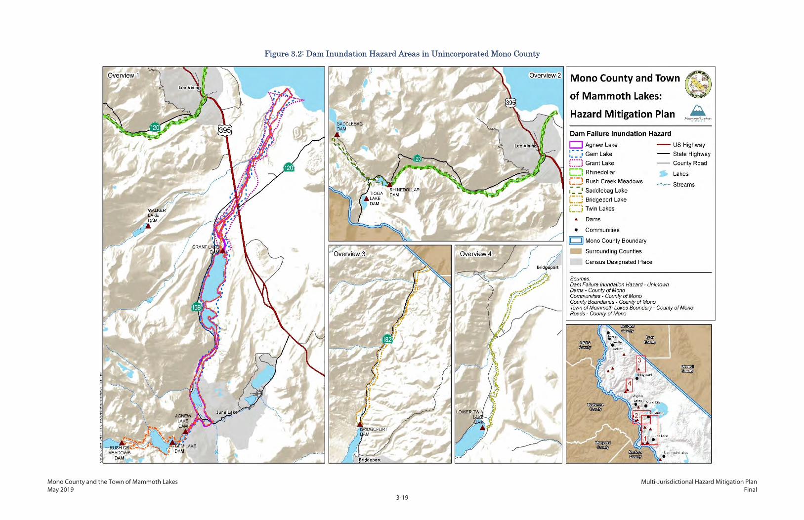
Mono County and the Town of Mammoth Lakes Multi-Jurisdictional Hazard Mitigation Plan May 2019 Final
3-19
Figure 3.2: Dam Inundation Hazard Areas in Unincorporated Mono County

Mono County and the Town of Mammoth Lakes Multi-Jurisdictional Hazard Mitigation Plan May 2019 Final
3-20
This page intentionally left blank.

Mono County and the Town of Mammoth Lakes Multi-Jurisdictional Hazard Mitigation Plan May 2019 Final
3-21
Risk of Future Hazards
The California DWR Division of Safety of Dams (DSOD) maintains a database of dams in the state; critical
dam safety status information includes certification, downstream hazard, and condition assessment.
The condition assessment is based on definitions established by the National Inventory of Dams, as well
as additional criteria identified by the DSOD. The condition assessment has five possible ratings based
on the described criteria, as shown in Table 3.6.
Table 3.6 Dam System Condition Assessment Rating System
Rating National Inventory of Dams
Definitions California DSOD
Additional Criteria
Satisfactory
No existing or potential dam safety deficiencies are recognized. Acceptable performance is expected under all loading conditions (static, hydrologic, seismic) in accordance with the applicable regulatory criteria or tolerable risk guidelines.
None
Fair
No existing dam safety deficiencies are recognized for normal loading conditions. Rare or extreme hydrologic and/or seismic events may result in a dam safety deficiency. Risk may be in the range to take further action.
Dam has a long-standing deficiency that is not being addressed in a timely manner Dam is not certified and its safety is under evaluation Dam is restricted and operation of the reservoir at the lower level does not mitigate the deficiency
Poor
A dam safety deficiency is recognized for loading conditions that may realistically occur. Remedial action is necessary. A poor rating may also be used when uncertainties exist as to critical analysis parameters that identify a potential dam safety deficiency. Further investigations and studies are necessary.
Dam has multiple deficiencies or a significant deficiency that requires extensive remedial work
Unsatisfactory A dam safety deficiency is recognized that requires immediate or emergency remedial action for problem resolution
None
Source: DSOS 2017
Table 3.7 shows the condition assessment result for dams evaluated in Mono County as established by
the September 2017 DSOS report, “Dams Within Jurisdiction of the State of California.” All rated dams
were determined to be in fair or satisfactory condition, with the exception of Agnew Lake Dam, which

Mono County and the Town of Mammoth Lakes Multi-Jurisdictional Hazard Mitigation Plan May 2019 Final
3-22
was determined to be in poor condition, although SCE is currently working on improvements to bring
this dam up to a satisfactory level. The dam inundation area for Agnew Lake Dam runs northeast from
the Agnew Lake Dam, covers Silver Lake and Grant Lake, and ends near Mono Lake. Dam failure may
result in impacts to Grant Lake Dam downstream.
Table 3.7 Dam Condition Assessment
Dam Name Condition Assessment
Agnew Lake Poor*
Black Reservoir Satisfactory
Bridgeport Satisfactory
Gem Lake Fair
Grant Lake Satisfactory
Lake Mamie --
Lake Mary --
Lobdel Lake Satisfactory
Long Valley Satisfactory
Lower Twin Lake Fair
Lundy Lake Satisfactory
Poore Lake Reservoir Satisfactory
Rhinedollar Satisfactory
Rush Creek Meadows Fair
Saddlebag Satisfactory
Sardine --
Tioga Lake Satisfactory
Topaz Lake Satisfactory
Twin Lakes Satisfactory
Upper Gorge Satisfactory
Upper Twin Lake Fair
Walker Lake Satisfactory
Source: DSOS 2017 http://www.water.ca.gov/damsafety/docs/Dams%20by%20County_Sept%202017.pdf -- Information not available *Modifications to Agnew Dam completed in 2017 will result in the reservoir retaining less water. A new condition assessment completed at that time showed the dam could meet

Mono County and the Town of Mammoth Lakes Multi-Jurisdictional Hazard Mitigation Plan May 2019 Final
3-23
Table 3.7 Dam Condition Assessment
Dam Name Condition Assessment the criteria for a Satisfactory rating. As of December 2017, this information had been submitted to DSOD for re-classification.
The lack of any previous dam failure events in Mono County renders it difficult to make a precise
prediction about future probability. An independent forensic report on the 2017 Oroville Dam incident
in Butte County identified systemic failures in dam safety regulations and industry practices, and
suggested that dam owners may be overconfident in their assessments. Still, with only two actual
failures among California’s 1,500 dams in the last 90 years and none since 1963, future occurrences can
still be regarded as extremely unlikely.
Mono County
Cal OES maps dam inundation zones to identify the projected areas that would be subject to inundation
if a dam were to fail. According to best available information, 7,025 acres are located in a dam
inundation zone. Table 3.8 shows the dam inundation area in the unincorporated county by land
administration or ownership. Approximately 3,333 acres are federal lands, 2,547 acres are owned by a
public utility, 523 acres are state-owned, 380 acres are privately owned, and 241 acres are unknown.
While these estimates are based on the best available data, local conditions may alter the specific flood
path of water from a ruptured dam. Lands in the private category are of greatest concern, as the County
has land use authority over these areas. The Agnew Lake Dam Inundation Area includes approximately
105 acres of private land that could be affected by dam failure.
Table 3.8 Area of Dam Inundation in Mono County by Land Administration or Ownership
Land Administration or Ownership
Acres Percentage of Total
Mono County
Federal 3,333 47%
Private 380 5%
State 523 7%
Unknown 241 3%
Utility 2,547 36%
Total 7,024 100%
Mammoth Lakes
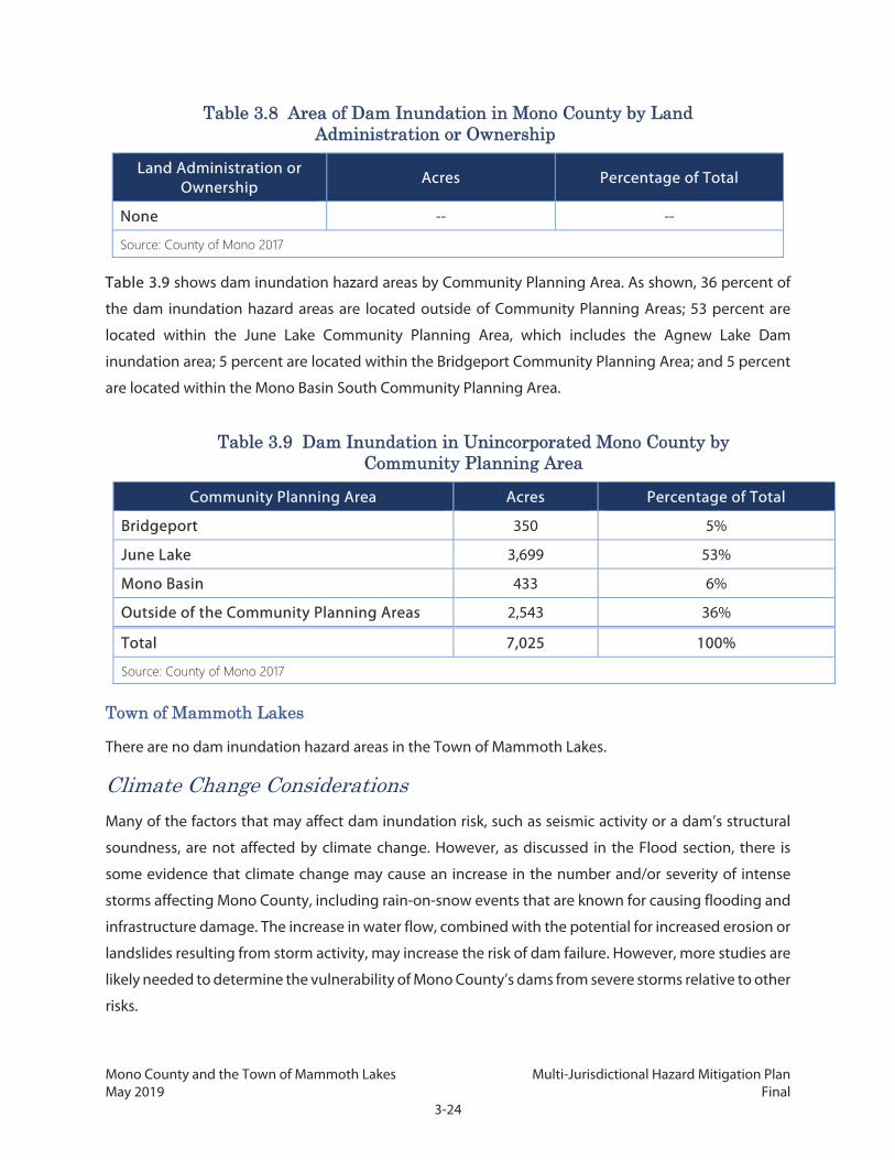
Mono County and the Town of Mammoth Lakes Multi-Jurisdictional Hazard Mitigation Plan May 2019 Final
3-24
Table 3.8 Area of Dam Inundation in Mono County by Land Administration or Ownership
Land Administration or Ownership
Acres Percentage of Total
None -- --
Source: County of Mono 2017
Table 3.9 shows dam inundation hazard areas by Community Planning Area. As shown, 36 percent of
the dam inundation hazard areas are located outside of Community Planning Areas; 53 percent are
located within the June Lake Community Planning Area, which includes the Agnew Lake Dam
inundation area; 5 percent are located within the Bridgeport Community Planning Area; and 5 percent
are located within the Mono Basin South Community Planning Area.
Table 3.9 Dam Inundation in Unincorporated Mono County by Community Planning Area
Community Planning Area Acres Percentage of Total
Bridgeport 350 5%
June Lake 3,699 53%
Mono Basin 433 6%
Outside of the Community Planning Areas 2,543 36%
Total 7,025 100%
Source: County of Mono 2017
Town of Mammoth Lakes
There are no dam inundation hazard areas in the Town of Mammoth Lakes.
Climate Change Considerations
Many of the factors that may affect dam inundation risk, such as seismic activity or a dam’s structural
soundness, are not affected by climate change. However, as discussed in the Flood section, there is
some evidence that climate change may cause an increase in the number and/or severity of intense
storms affecting Mono County, including rain-on-snow events that are known for causing flooding and
infrastructure damage. The increase in water flow, combined with the potential for increased erosion or
landslides resulting from storm activity, may increase the risk of dam failure. However, more studies are
likely needed to determine the vulnerability of Mono County’s dams from severe storms relative to other
risks.

Mono County and the Town of Mammoth Lakes Multi-Jurisdictional Hazard Mitigation Plan May 2019 Final
3-25
3.2.3 Disease/Pest Management
Because there is no distinguishable difference in magnitude of disease and pest hazards within the
County, the following discussion applies to both Mono County and the Town of Mammoth Lakes.
Hazard Description
Disease and pest management hazards are caused by undesirable organisms such as insects, bacteria,
and viruses that cause serious harm to plants, animals, or humans. These organisms can threaten human
health by infecting people, flora, and fauna with a number of diseases, some of which are potentially
fatal. Pathogenic or disease-carrying organisms may also cause widespread devastation to forests,
creating safety hazards and causing both environmental damage and economic impacts. Many
communicable diseases are regularly monitored by Mono County Public Health and the Centers for
Disease Control and Prevention, but many are not well understood or tracked in California.
Due to the rural nature of Mono County, diseases that impact forests and those that are carried by
wildlife are of particular concern, in addition to those affecting human health. Several insects and
rodents can be considered hazardous in Mono County:
Mosquitoes are one of the most prevalent carriers of harmful pathogens known as arboviruses,
such as West Nile virus, Western equine encephalomyelitis, St. Louis encephalitis, and Zika virus.
The rate of infection is extremely low in California, but the symptoms can be severe and deadly.
Rodents such as squirrels and mice can be carriers of hantavirus and plague. Hantavirus is
transmitted through deer mouse urine, saliva, or feces, while plague is hosted within some
rodents and transmitted to humans by fleas.
Pandemic influenza is caused by an outbreak of a new type of influenza virus that is different
from the more common ones that can be vaccinated against. When variations in the virus occur,
such as in previous avian and swine flu outbreaks, infection can spread quickly with widespread
effects.
Fir Engraver Beetles and Jeffrey Pine Beetles, while not a threat to human health, have
infested forests throughout the Sierra Nevada. Pests of this variety inhabit trees, weakening and
often killing them. Massive outbreaks of beetles can kill vast swaths of forests, which in turn can
exacerbate fire hazards by increasing potential fuel sources.
Other species of insects such as ticks may also carry disease, but have not caused substantial outbreaks
in Mono County.

Mono County and the Town of Mammoth Lakes Multi-Jurisdictional Hazard Mitigation Plan May 2019 Final
3-26
Location and Magnitude
Disease and pest management hazards are anticipated to affect both unincorporated Mono County and
the Town of Mammoth Lakes, although there are no meaningful distinctions in distribution of the
hazard between the two geographies. Thus, the two areas are discussed together below.
As many diseases are transmitted by mosquitoes, areas with high mosquito populations, such as bodies
of water and humid environments, will be significantly more at risk. Mosquitoes are seasonal pests,
typically appearing during warm months and disappearing during the winter. Invasive tree pests
typically occur in the forested area, but can also affect street and private trees in the developed areas of
the County. Rodent-borne diseases are more likely to be prevalent in rural areas and areas near the
wildland-urban interface.
Hazard History
Cases of disease outbreak in Mono County have mostly been limited to small numbers of infections. In
2015, there was a single case of plague, with no additional infected humans or rodents found. Two cases
of hantavirus also occurred in 2015, and infections in a single person occurred in 2006 and another
single person in 2010.
Beetle infestations have been prevalent in the Sierra Nevada due to drought conditions, killing tens of
millions of trees since 2010. These infestations are not uncommon during drought conditions, but have
been significantly worse in the last several years. The magnitude and location of tree mortality as a result
of beetles in combination with other factors is covered in greater depth in the CWPP (Chapter 7).
Risk of Future Hazards
Despite ongoing abatement efforts, mosquitoes are expected to be prevalent in the warm and hot
months through the foreseeable future. The County’s trees and forests are also expected to be
vulnerable to invasive beetles and other pests through the foreseeable future, especially as tree
defenses are weakened by ongoing drought conditions.
Climate Change Considerations
Climate change is expected to substantially alter insect and disease vector habitat. Unusual climatic
conditions are partly to blame for the boxelder bug infestation in 2015. Similarly, drought-stricken trees
are less able to defend themselves against invasive and damaging beetles. Warmer weather and slightly
milder winters may result in fewer insects dying during cold weather stints. With declining snowpack,
there may be greater amounts of stagnant surface water. The combination of stagnant water and
expected warmer temperatures could cause certain types of mosquitoes and other pests to become
more abundant.

Mono County and the Town of Mammoth Lakes Multi-Jurisdictional Hazard Mitigation Plan May 2019 Final
3-27
3.2.4 Drought
Hazard Description
A drought is a long-term water shortage caused by an extended period with below normal precipitation
that can lead to a decline in available water supplies. Droughts may lead to increases in domestic water
rates or the implementation of additional restrictions on water use. In severe cases, communities may
not have enough available water to meet basic needs. Drought conditions can significantly harm
agricultural operations, particularly in areas that grow water-intensive crops. Planted landscapes may
become drought-stressed, causing them to weaken or die from lack of water. If drought conditions are
severe enough, the lack of water may pose a human health risk.
Droughts also have many indirect impacts. The lack of precipitation can cause soil to harden and
become less permeable so that when precipitation does eventually occur, the soil cannot absorb water
as easily, potentially leading to increased flooding. Drier soil may become decompressed, increasing its
susceptibility to sliding and eroding. Droughts may dry out wildland vegetation, potentially increasing
the risk of fire. Water-stressed plants may also be more vulnerable to disease or pests.
Unlike most other hazards, droughts develop over a long period of time. It often takes multiple dry years
to cause drought conditions, and these conditions may persist for years. Droughts are usually a region-
wide hazard, and at times may extend statewide or cover multiple states. However, the location-specific
impacts of a drought can depend on local conditions, including water supply systems, soil types, and
land uses. As a result, two communities under similar drought conditions may experience different
impacts. Droughts may also have a significant impact on communities not directly in the affected area.
For example, if a community relies on imported water that travels a great distance, the community may
be substantially impacted if a drought occurs at the source of the imported water, even if precipitation
levels in the community itself are normal. Similarly, communities may face local drought conditions, but
impacts may be minor if the community’s water comes from a distant unaffected area.
Drought may also have significant impacts on groundwater supplies and quality. As droughts persist,
groundwater levels may drop as recharge slows and communities withdraw more to counter the lack
of surface supplies. Over time, this can result in serious impacts on the groundwater, including overdraft,
subsidence, saline intrusion, and other water quality degradation.
Location and Magnitude
Drought hazards are anticipated to affect both unincorporated Mono County and the Town of
Mammoth Lakes. Droughts are regional in nature, although a large area such as Mono County with a
wide variety of climates may experience significantly different drought conditions in different locations.

Mono County and the Town of Mammoth Lakes Multi-Jurisdictional Hazard Mitigation Plan May 2019 Final
3-28
No single part of Mono County, including Mammoth Lakes, is substantially more or less at risk of
conditions that result in drought, although some areas may be more impacted by droughts than others.
There are multiple ways to measure the severity of different drought conditions. The US Drought
Monitor Classification Scheme, shown in Table 3.10, combines many of these systems into a single
index.
Table 3.10 US Drought Monitor Classification Scheme
Category Description Possible Impacts
D0 Abnormally dry Slower growth of crops and pastures compared to normal activities.
D1 Moderate drought Some damage to crops and pastures. Streams, reservoirs, or wells low. Some water shortages may be developing or imminent.
D2 Severe drought Likely crop and pasture losses. Water shortages are common, leading to restrictions.
D3 Extreme drought Major crop and pasture losses. Widespread water shortages.
D4 Exceptional drought Exceptional and widespread crop and pasture losses. Emergency shortages develop.
Source: US Drought Monitor 2016a
The DWR identifies 10 groundwater basins in the County: Adobe Lake Valley, Antelope Valley,
Bridgeport Valley, Fish Lake Valley, Little Antelope Valley, Long Valley, Mono Valley, Owens Valley,
Slinkard Valley, and Sweetwater Flat. The Long Valley basin underlies portions of Mammoth Lakes. Over
the last decade (2007–2017), overall water levels in the basins have not changed significantly, although
drops of 2 to 3 feet were shown for the shorter period of time between 2012 and 2016.
Hazard History
Droughts are a common feature of the climate in much of California, and many of the state’s native
plants and animals have evolved strategies to survive during drought conditions. The state also has an
extensive water supply network that helps to reduce the impacts of droughts with the assistance of
large storage reservoirs and pipes that can move water from regions with available supplies to drought-
affected areas, although this system primarily benefits the urban areas of California.
Historic droughts in California occurred from 1976 to 1977, 1986 to 1992, and 2007 to 2009. The most
recent drought in California lasted from December 2011 to March 2017 and was declared a state of
emergency by Governor Jerry Brown on January 17, 2014. Near the end of the drought in 2016, nearly
all of Mono County was in extreme (D3) drought, with parts in the western portion of the County,
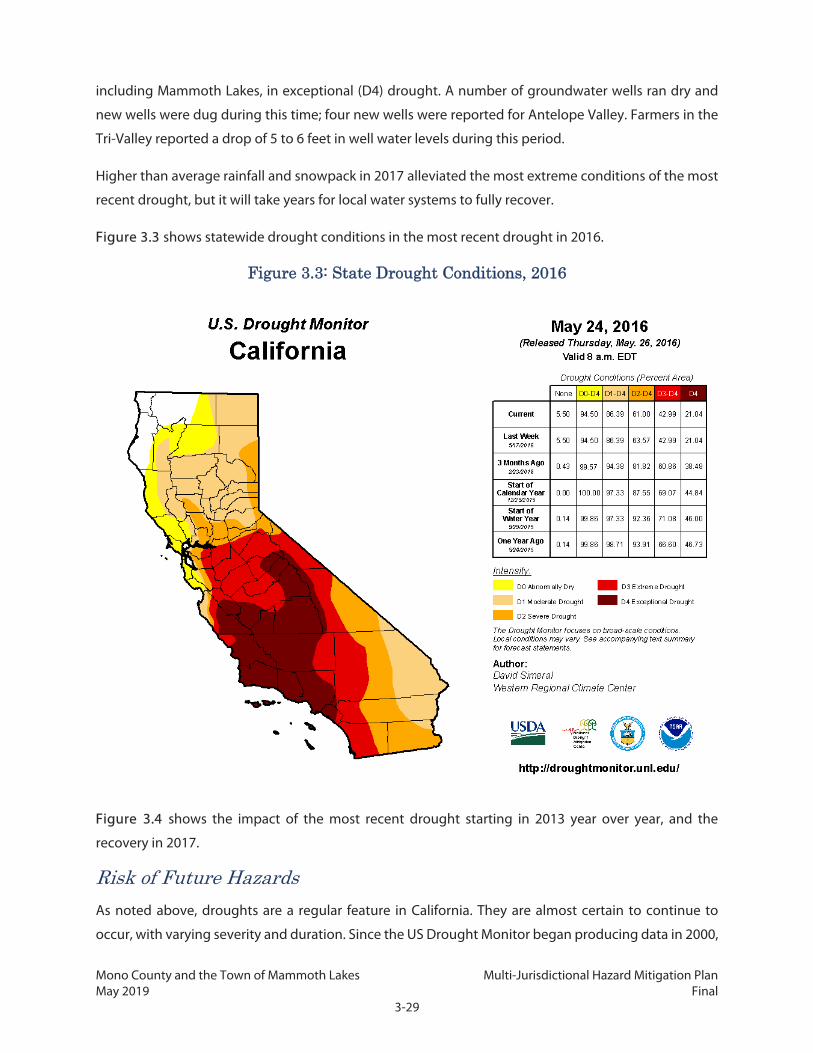
Mono County and the Town of Mammoth Lakes Multi-Jurisdictional Hazard Mitigation Plan May 2019 Final
3-29
including Mammoth Lakes, in exceptional (D4) drought. A number of groundwater wells ran dry and
new wells were dug during this time; four new wells were reported for Antelope Valley. Farmers in the
Tri-Valley reported a drop of 5 to 6 feet in well water levels during this period.
Higher than average rainfall and snowpack in 2017 alleviated the most extreme conditions of the most
recent drought, but it will take years for local water systems to fully recover.
Figure 3.3 shows statewide drought conditions in the most recent drought in 2016.
Figure 3.3: State Drought Conditions, 2016
Figure 3.4 shows the impact of the most recent drought starting in 2013 year over year, and the
recovery in 2017.
Risk of Future Hazards
As noted above, droughts are a regular feature in California. They are almost certain to continue to
occur, with varying severity and duration. Since the US Drought Monitor began producing data in 2000,
Mono County and the Town of Mammoth Lakes Multi-Jurisdictional Hazard Mitigation Plan May 2019 Final
3-30
there have been 302 weeks when at least half of Mono County was classified as experiencing severe to
exceptional drought based on US Drought Monitor categories, or about 30 percent of the time. Such
frequencies are likely to increase in the future, as discussed below.
Mono County’s numerous water systems, including community water systems and individual wells, rely
on a combination of groundwater and local surface water. As a result, any local drought conditions may
impact the water supply systems in Mono County and the Town of Mammoth Lakes, as there is no
infrastructure to import water from elsewhere in California and, due to the location of the County in the
upper portion of the watershed, there is little possibility to divert water from other areas without the
cost of pipelines and pumping.
LADWP exports large amounts of water from the Mono Lake Basin and the Owens River. The Los Angeles
Aqueduct supplies approximately one-third of the water for the City of Los Angeles, with the amount
supplied being dependent on the amount of accumulated snow (snowpack) in the Eastern Sierra
Nevada each year. In years of little snowpack, less water is delivered through the aqueduct and the City
of Los Angeles must purchase additional water from the Metropolitan Water District. The LADWP 2015
Urban Water Management Plan projects 7 percent of the district’s water to be obtained from Los
Angeles Aqueduct deliveries in dry years, or 42 percent in average years, although exact amounts may
vary depending on water conditions each year.
The California Water Code (Sections 10933 and 12924) requires the DWR to prioritize the overall
importance of California’s groundwater basins and sub-basins based on eight criteria, and to conduct
groundwater basin assessments. The prioritization levels are very low, low, medium, high, or very high.
The eight criteria are overlying population; projected growth of overlying population; public supply
wells; total wells; overlying irrigated acreage; reliance on groundwater as the primary source of water;
impacts on the groundwater, including overdraft, subsidence, saline intrusion, and other water quality
degradation; and any other information determined to be relevant by the DWR. The DWR has
determined that one groundwater basin underlying the County, the Owens Valley watershed, has a
rating of medium. This basin runs alongside the White Mountains and underlies portions of the Tri-
Valley communities. The other nine watersheds were ranked low or very low; this does not indicate that
these basins are not at risk or that the communities they support are not vulnerable in drought
conditions, only that they are not of highest priority to the state using the eight identified criteria.

Mono County and the Town of Mammoth Lakes Multi-Jurisdictional Hazard Mitigation Plan May 2019 Final
3-31
Figure 3.4: Mono County in the 2013–2016 Drought

Mono County and the Town of Mammoth Lakes Multi-Jurisdictional Hazard Mitigation Plan May 2019 Final
3-32
This page intentionally left blank.

Mono County and the Town of Mammoth Lakes Multi-Jurisdictional Hazard Mitigation Plan May 2019 Final
3-33
Climate Change Considerations
Scientific evidence suggests that precipitation levels in California will generally decline as a result of
climate change. In Mono County and the surrounding area, precipitation levels are expected to remain
relatively steady, although with warming temperatures there may be more rain and less snow. Climate
change is expected to impact the snowpack in the mountains, which normally melts slowly and
provides a consistent supply of water during the summer and early autumn months before the rainy
season returns. Decreases in precipitation are expected to reduce the size of the snowpack, which then
also may melt faster as a result of warmer temperatures due to climate change. Overall, studies suggest
that the snowpack in Mono County and surrounding areas may be reduced by more than 50 percent in
some locations. Some recent studies found that the 2011–2017 drought was made worse by climate
change and that climate change is likely to increase the risk of future extreme drought.
3.2.5 Earthquake and Seismic Hazards
Hazard Description
The category of seismic hazards includes four different but related hazard types—fault rupture, ground
shaking, liquefaction, and tectonic subsidence—all of which are consequences of earthquakes.
Earthquakes themselves are caused by the movement of large pieces of the earth’s crust, called tectonic
plates. As the tectonic plates move against each other, they can become stuck together, causing stress
between the plates to build up until it eventually overcomes the friction holding them together. When
this happens, the stress is released and the plates suddenly slip past each other, creating the shaking
that is called an earthquake.
Earthquakes occur along boundaries called fault lines. These fault lines may be the actual border
between plates, but they may also be borders between two sections of a single plate, created by the
repeated process of accumulated and released stress. California sits on the boundary between the
Pacific and North American tectonic plates. The motion between these plates occurs primarily on the
faults of the San Andreas fault system and the Eastern California shear zone, a fault system that extends
along the Eastern Sierra from Mono County south through Inyo County. About 10 millimeters per year
of slip occurs on faults east of the Sierra Nevada. The eastern border of California from Mammoth Lakes
heading north includes faults with poorly constrained or unknown slip rates with multiple fault strands
distributed over a wide area.
Fault Rupture
Fault rupture is the actual movement of the ground’s surface along a fault line when an earthquake
occurs. This movement may be vertical, horizontal, or both, depending on the type of fault. Damage
from fault rupture is limited to the area of the fault boundary itself, although depending on the amount

Mono County and the Town of Mammoth Lakes Multi-Jurisdictional Hazard Mitigation Plan May 2019 Final
3-34
of movement along the fault, the damage may be severe. Some earthquakes, known as blind thrust
earthquakes, occur without causing visible surface rupture, although they may still cause substantial
damage. The 1994 Northridge earthquake, one of the most damaging in California history, was a blind
thrust earthquake.
Ground Shaking
Ground shaking is generally the most damaging of seismic-related hazards and is the specific hazard
most commonly associated with earthquakes. The severity of ground shaking is affected by local
geology, but in general it will be most severe closest to the site of the earthquake, and decrease with
distance. Ground shaking may occur in an up-and-down, side-to-side, or rolling motion, depending on
the type of seismic waves produced by the earthquake.
Liquefaction
Liquefaction occurs when loosely packed sand or silt is saturated with water and then shaken hard
enough for it to temporarily behave like a fluid. This causes the soil to lose its strength, which may in
turn damage structures built on or in it. Liquefaction risk depends primarily on the height of the
groundwater table and the composition of the soil.
Tectonic Subsidence
Subsidence is when the earth’s surface sinks. Fault movement is one possible cause of subsidence. As
noted in the Mono County Master Environmental Assessment (MEA 2001), “The most dramatic tectonic
subsidence occurs during earthquakes, when areas can drop suddenly.” This type of subsidence has
been observed in Mono County.
Mono County covers an area that is relatively young by geologic standards. It is located at a stress point
where the earth's crustal plates are exerting opposite pressures against each other. This combination
creates both "tectonic" earthquakes (e.g., land mass movement) and volcanic activity that can trigger
earth shaking (e.g., magma chamber movement and lava dyke formations). Up-to-date information
concerning earthquake activity in the County is available from USGS (www.usgs.gov). The primary
seismic hazard in the County is strong to severe ground shaking generated by movement along active
faults (MEA 2001).
Location and Magnitude
Ground shaking is measured using either the moment magnitude scale (MMS, denoted as Mw or simply
M) or the Modified Mercalli Intensity Scale. The MMS is a replacement for the Richter scale, which is still
often referred to but is no longer actively used, as the Richter scale is not reliable when measuring large
earthquakes (USGS 2014a). The weakest earthquakes measured by the MMS start at 1.0, with the
numbers increasing with the strength of the earthquake. The strongest recorded earthquake, which

Mono County and the Town of Mammoth Lakes Multi-Jurisdictional Hazard Mitigation Plan May 2019 Final
3-35
struck Chile in 1960, measured 9.5 on the MMS (USGS 2015a). Like the Richter scale, the MMS is a
logarithmic scale, meaning the difference in strength between two earthquakes is much larger than the
difference in their measurements. For example, a 6.0 Mw earthquake is 1,000 times stronger than a 4.0
Mw earthquake and about 1.4 times as strong as a 5.9 Mw event.
The Modified Mercalli Intensity Scale is based on the damage caused by the earthquake and how it is
perceived, rather than an actual measurement. When comparing multiple earthquakes, one event may
have a higher Mercalli rating than another even if it released less energy, and thus was measured lower
on the MMS. The Mercalli scale ranges from I (instrumental, rarely felt by people) to XII (catastrophic,
total damage and lines of sight are distorted). Table 3.11 shows a general comparison between the
MMS and the Modified Mercalli Intensity Scale. Note that there is some overlap toward the higher end
of the Mercalli ratings, with certain intensities produced by multiple ranges of magnitude
measurements.
Table 3.11 Comparison of MMS and Modified Mercalli Intensity Scale
Magnitude (MMS)
Modified Mercalli Intensity Scale
Intensity Description
1.0 to 3.0 I Not felt except by very few persons under especially favorable conditions.
3.0 to 3.9
II Weak: Felt only by a few persons at rest, especially on upper floors of buildings.
III
Weak: Felt quite noticeably by persons indoors, especially on upper floors of buildings. Many people do not recognize it as an earthquake. Standing motor cars may rock slightly. Vibrations similar to the passing of a truck. Duration estimated.
4.0 to 4.9
IV
Light: Felt indoors by many, outdoors by few during the day. At night, some awakened. Dishes, windows, doors disturbed; walls make cracking sound. Sensation like heavy truck striking building. Standing motor cars rocked noticeably.
V Moderate: Felt by nearly everyone; many awakened. Some dishes, windows broken. Unstable objects overturned. Pendulum clocks may stop.
5.0 to 5.9
VI Strong: Felt by all, many frightened. Some heavy furniture moved; a few instances of fallen plaster. Damage slight.
6.0 to 6.9
VII
Very Strong: Damage negligible in buildings of good design and construction; slight to moderate in well-built ordinary structures; considerable damage in poorly built or badly designed structures; some chimneys broken.
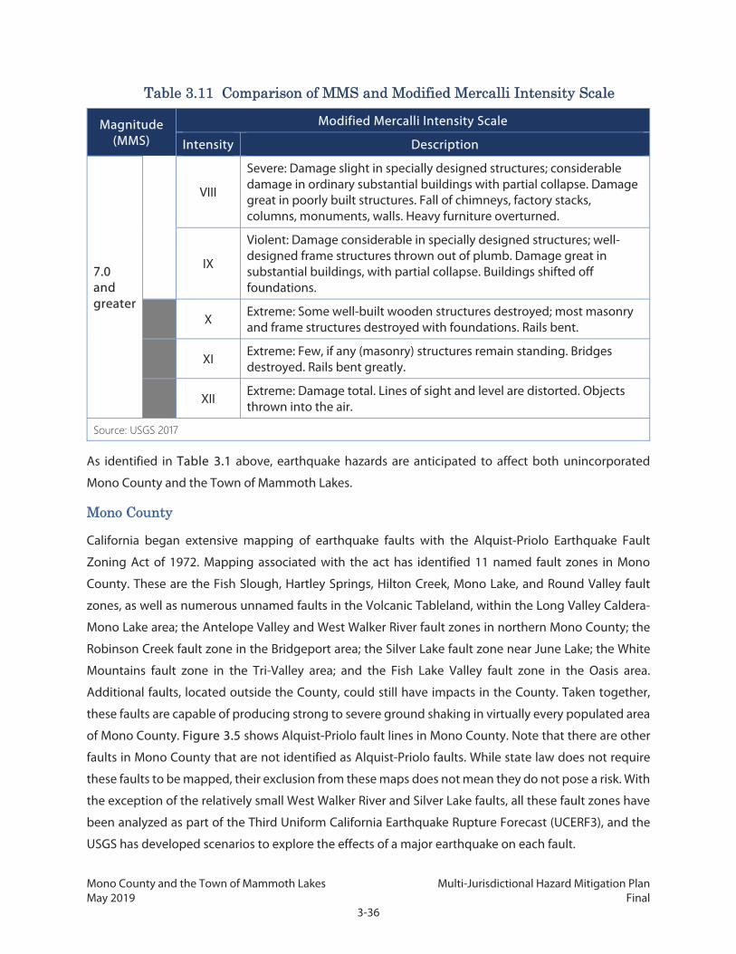
Mono County and the Town of Mammoth Lakes Multi-Jurisdictional Hazard Mitigation Plan May 2019 Final
3-36
Table 3.11 Comparison of MMS and Modified Mercalli Intensity Scale
Magnitude (MMS)
Modified Mercalli Intensity Scale
Intensity Description
7.0 and greater
VIII
Severe: Damage slight in specially designed structures; considerable damage in ordinary substantial buildings with partial collapse. Damage great in poorly built structures. Fall of chimneys, factory stacks, columns, monuments, walls. Heavy furniture overturned.
IX
Violent: Damage considerable in specially designed structures; well-designed frame structures thrown out of plumb. Damage great in substantial buildings, with partial collapse. Buildings shifted off foundations.
X Extreme: Some well-built wooden structures destroyed; most masonry and frame structures destroyed with foundations. Rails bent.
XI Extreme: Few, if any (masonry) structures remain standing. Bridges destroyed. Rails bent greatly.
XII Extreme: Damage total. Lines of sight and level are distorted. Objects thrown into the air.
Source: USGS 2017
As identified in Table 3.1 above, earthquake hazards are anticipated to affect both unincorporated
Mono County and the Town of Mammoth Lakes.
Mono County
California began extensive mapping of earthquake faults with the Alquist-Priolo Earthquake Fault
Zoning Act of 1972. Mapping associated with the act has identified 11 named fault zones in Mono
County. These are the Fish Slough, Hartley Springs, Hilton Creek, Mono Lake, and Round Valley fault
zones, as well as numerous unnamed faults in the Volcanic Tableland, within the Long Valley Caldera-
Mono Lake area; the Antelope Valley and West Walker River fault zones in northern Mono County; the
Robinson Creek fault zone in the Bridgeport area; the Silver Lake fault zone near June Lake; the White
Mountains fault zone in the Tri-Valley area; and the Fish Lake Valley fault zone in the Oasis area.
Additional faults, located outside the County, could still have impacts in the County. Taken together,
these faults are capable of producing strong to severe ground shaking in virtually every populated area
of Mono County. Figure 3.5 shows Alquist-Priolo fault lines in Mono County. Note that there are other
faults in Mono County that are not identified as Alquist-Priolo faults. While state law does not require
these faults to be mapped, their exclusion from these maps does not mean they do not pose a risk. With
the exception of the relatively small West Walker River and Silver Lake faults, all these fault zones have
been analyzed as part of the Third Uniform California Earthquake Rupture Forecast (UCERF3), and the
USGS has developed scenarios to explore the effects of a major earthquake on each fault.

Mono County and the Town of Mammoth Lakes Multi-Jurisdictional Hazard Mitigation Plan May 2019 Final
3-37
The entire County, except for a small portion of the Sierra crest, is in an area where intense ground
shaking is possible. Figure 3.6, Figure 3.7, and Figure 3.8 shows the likely affected area and intensity
of shaking that would occur in the event of three different USGS earthquake scenarios. These three
scenarios represent earthquakes on the faults within the County that have the greatest likelihood of
causing a major earthquake in the next 30 years, according to UCERF3. Additional USGS earthquake
scenarios and UCERF3 probability projections for Mono County are discussed in greater detail below.

Mono County and the Town of Mammoth Lakes Multi-Jurisdictional Hazard Mitigation Plan May 2019 Final
3-38
This page intentionally left blank.

Mono County and the Town of Mammoth Lakes Multi-Jurisdictional Hazard Mitigation Plan May 2019 Final
3-39
Figure 3.5: Mono County Alquist-Priolo Earthquake Faults and Historic Epicenters

Mono County and the Town of Mammoth Lakes Multi-Jurisdictional Hazard Mitigation Plan May 2019 Final
3-40
This page intentionally left blank.

Mono County and the Town of Mammoth Lakes Multi-Jurisdictional Hazard Mitigation Plan May 2019 Final
3-41
Figure 3.6: Antelope Valley Fault Shake Scenario

Mono County and the Town of Mammoth Lakes Multi-Jurisdictional Hazard Mitigation Plan May 2019 Final
3-42
This page intentionally left blank.

Mono County and the Town of Mammoth Lakes Multi-Jurisdictional Hazard Mitigation Plan May 2019 Final
3-43
Figure 3.7: Hilton Creek Fault Shake Scenario

Mono County and the Town of Mammoth Lakes Multi-Jurisdictional Hazard Mitigation Plan May 2019 Final
3-44
This page intentionally left blank.

Mono County and the Town of Mammoth Lakes Multi-Jurisdictional Hazard Mitigation Plan May 2019 Final
3-45
Figure 3.8: Fish Lake Valley Fault Shake Scenario

Mono County and the Town of Mammoth Lakes Multi-Jurisdictional Hazard Mitigation Plan May 2019 Final
3-46
This page intentionally left blank.

Mono County and the Town of Mammoth Lakes Multi-Jurisdictional Hazard Mitigation Plan May 2019 Final
3-47
The Mono County MEA includes the following details about where seismic hazards have been observed
within the County:
Groundshaking: “In addition to tectonic movement, the Long Valley-Mammoth Lakes region
has experienced numerous earthquakes caused by the movement of magma below the earth's
surface.”
Ground failure: “Ground failure induced by groundshaking includes liquefaction, lateral
spreading, lurching, and differential settlement, all of which usually occur in soft, fine-grained,
water-saturated sediments, typically found in valleys. During the 1980 Mammoth Lakes
earthquake sequence, ground failure was prevalent at Little Antelope Valley, along margins of
the Owens River in upper Long Valley, along the northwest margins of Lake Crowley, and along
Hot Creek Meadow.”
Tectonic subsidence: “During the May 1980 sequence of earthquakes near Mammoth Lakes,
there were several locations near the Hilton Creek Fault where the ground surface dropped
about four inches on the northeast side of fractures. Along the ‘Mammoth Airport fault zone,’
up to 12 inches of vertical offset on the east side of ruptures was observed.”
The area at risk of fault rupture is limited to areas in the immediate vicinity of a fault. Table 3.12 shows
the ownership and administration of lands affected by Alquist-Priolo fault zones in unincorporated
areas of Mono County. In all, while the entire County is at risk from ground shaking, only about 56,846
acres are at direct risk of fault rupture from an Alquist-Priolo fault, or 2.8 percent of the entire County
area.
Table 3.12 Areas at Risk of Fault Rupture in Unincorporated Mono County by Ownership
Land Ownership or Administration Category
Acres in Hazard Zone
Percentage of Total Ownership
Percentage of Total Mono
County Area
County 13 0.6% <0.1%
Federal 47,125 2.7% 2.3%
Private 4,993 3.9% 0.2%
State 618 0.7% <0.1%
Utilities 3,538 5.3% 0.2%
Right of way, unknown ownership/ administration
559 6.2% <0.1%
Total 56,846 2.8% 2.8%

Mono County and the Town of Mammoth Lakes Multi-Jurisdictional Hazard Mitigation Plan May 2019 Final
3-48
Table 3.13 shows how much of the land within Alquist-Priolo fault zones lies within each of the planning
areas defined by the Mono County General Plan.
Table 3.13 Areas at Risk of Fault Rupture in Mono County Planning Areas
Planning Area Acres in Hazard Zone
Percentage of Total Planning
Area
Percentage of Total Mono
County Area
Antelope Valley 2,256 7.5% 0.1%
Benton Valley 1,235 3.1% 0.1%
Bodie Hills 0 0.0% 0.0%
Bridgeport 2,774 5.4% 0.1%
Chalfant Valley 20,525 34.1% 1.0%
Hammil Valley 1,745 2.6% 0.1%
June Lake 3,477 6.6% 0.2%
Long Valley 940 5.2% <0.1%
Mammoth Vicinity 11,325 10.3% 0.6%
Mono Basin 1,070 0.5% <0.1%
Oasis 1,591 9.8% 0.1%
Sonora Junction 371 0.3% <0.1%
Swauger Creek 0 0.0% 0.0%
Upper Owens 207 1.3% <0.1%
Wheeler Crest 772 13.4% <0.1%
Mammoth Lakes
Parts of the Hartley Springs fault zone extend into the Town of Mammoth Lakes. In addition, the USGS
earthquake scenarios discussed below show that a major earthquake on the Hilton Creek, Round Valley,
or White Mountains faults could produce ground shaking in the Town that results in slight to
considerable damage.
Table 3.14 shows how much of the land within Alquist-Priolo fault zones lies within the Mammoth Lakes
planning area.

Mono County and the Town of Mammoth Lakes Multi-Jurisdictional Hazard Mitigation Plan May 2019 Final
3-49
Table 3.14 Areas at Risk of Fault Rupture in Mammoth Lakes
Planning Area Acres in Hazard Zone
Percentage of Total Planning Area
Percentage of Total Mono County Area
Town Municipal Boundary 332 2.07% 0.02%
Town Urban Limit 6 0.24% 0.00%
The California Department of Conservation Seismic Hazard Program delineates areas prone to
earthquake-related hazards, including liquefaction. Liquefaction zones identify where the stability of
foundation soils must be investigated, and countermeasures undertaken in the design and construction
of buildings for human occupancy. Statutes require that counties and cities use these zones as part of
their construction permitting process. While no complete mapping is available for liquefaction risk in
the County or Town, past events suggest that the valley areas within the County face an elevated risk of
liquefaction, particularly areas around dry lake beds. Potential areas occur in the area of June Lake near
Boulder Drive, Dream Mountain, and Bridgeport Valley and up through Lakeside Drive). Within the
Town, areas potentially subject to liquefaction are in the lower parts of the community including
Sherwin Meadows and areas in Old Mammoth.
Hazard History
Earthquakes occur frequently in the Eastern Sierra, in Mono County, and particularly in the Long Valley
area. The USGS Earthquake Catalog shows that earthquakes happen in the general vicinity weekly and
almost daily, but most are under magnitude 3 and are not felt by people. There have been 145
earthquakes of at least magnitude 4.5 within 25 miles of Mono County since 1980, of which 94 had
epicenters within the County borders. Of these, the largest measured magnitude 6.3 on May 25, 1980,
during a sequence of earthquakes near Mammoth Lakes. Among the 46 earthquakes that measured at
least magnitude 5.0, more than a third were related to the 1980 earthquake swarm and the 1986
Chalfant Valley earthquake, both of which are discussed below.
May 1980 Mammoth Lakes Earthquakes
McJunkin and Bedrossian (1980) noted the following in California Geology magazine concerning the
1980 earthquakes in Long Valley:
“On May 25, 1980 at 0933 Pacific Daylight Time (PDT) a magnitude 6.0 earthquake (all magnitudes are
from Caltech Seismological Laboratory) occurred approximately 10.5 km east-southeast of Mammoth
Lakes, California (figure 1). During the next 16 minutes, four magnitude 4.1 - 5.0 shocks and one 5.5
shock occurred. This seismic activity was the beginning of an earthquake sequence that produced 72
magnitude 4.0 - 4.9 events, six magnitude 5.0 - 5.5 events and three events of magnitude 6.0 - 6.3 during
Mono County and the Town of Mammoth Lakes Multi-Jurisdictional Hazard Mitigation Plan May 2019 Final
3-50
the next 48 hours; thousands of magnitude < 3.9 earthquakes were generated during this same time
period. The largest earthquake in the sequence was magnitude 6.3 and occurred at 1245 (PDT) on May
25. Seismic activity after this event was fairly continuous for the next three days; however, most events
were less than magnitude 5.0.
“Damage from earthquake shaking was most pronounced in the Mammoth Lakes community and
surrounding local areas. After the first event on May 25, Mammoth Lakes was without power until noon;
during this period vital community services operated from auxiliary power supplies. Most damage to
buildings was nonstructural and included broken windows and water mains, cracked plaster, and fallen
chimneys. Damage to shelf stock and fixtures was moderate to severe in many stores, restaurants, and
motels; in addition, extensive destruction to breakable contents in homes was commonly reported. Hot
Creek Fish Hatchery and Mammoth Elementary School, east of U. S. 395, also received considerable
nonstructural damage from earthquake shaking. Initial damage losses to schools, other public
buildings, and roads in the Mammoth Lakes region was estimated to be $2 million.”
1986 Chalfant Valley Earthquake
In an interview for the previous Hazard Mitigation Plan update, Dave Hill of the USGS Long Valley
Observatory noted the following concerning the Chalfant Valley earthquake in 1986:
“The Chalfant Valley earthquake (M=6.4) occurred on July 21, 1986. It was preceded by a month-long
foreshock sequence that began M=2.6 earthquake on July 3 and built up to a M~5.8 (as I recall)
earthquake just 24 hours before the mainshock. The area had shown virtually no previous earthquake
activity (since the mid-1970s anyway). The aftershock sequence was also rather energetic including
three M>5.5 earthquake (the largest was close to M~6). I think the associated damage was minimal aside
from rock falls in the mountains and a number of mobile homes in the Chalfant area that were toppled
from their (unstable) foundations.” (Dave Hill, pers. comm.)
There has not been a significant earthquake centered in Mono County since September 18, 2004, when
three 5.4 events were recorded about 15 miles east of Mono Lake within a 40-minute period. Since the
last Hazard Mitigation Plan update, there have been two significant events with epicenters nearby in
Nevada: February 13, 2013, in Esmeralda County, and December 28, 2016, in Mineral County.
Risk of Future Hazards
Seismologists do not know when a large earthquake will hit the Eastern Sierra again but do know that
one will occur. The County’s location on and near numerous faults, including several capable of causing
significant earthquakes, means that the County will continue to face threats from earthquakes and
related hazards.

Mono County and the Town of Mammoth Lakes Multi-Jurisdictional Hazard Mitigation Plan May 2019 Final
3-51
The UCERF3 forecast, developed in 2014 by the Working Group on California Earthquake Probabilities
and led by the USGS, provides estimates of the magnitude, location, and likelihood of fault rupture for
more than 350 fault segments throughout the state. Table 3.15 lists faults in the region included in
UCERF3, showing the probability for earthquakes of a particular magnitude within the next 30 years.
Because the faults have multiple segments in Mono County, with different probabilities for each section,
the full range of probabilities is shown. Depending on the magnitude and location of the earthquake,
all of Mono County, including Mammoth Lakes, may be within the substantially affected area. Three
faults—Antelope Valley, Fish Lake Valley, and Hilton Creek—have a greater than 1 percent chance of
causing a magnitude 6.7 or greater earthquake within the next 30 years. Faults not identified in the
forecast are still capable of causing significant earthquakes.
Table 3.15 UCERF3 30-Year Earthquake Probabilities by Fault
Fault 30-Year Earthquake Probability
6.7+ Mw 7.0+ Mw 7.5+ Mw
Antelope Valley 1.9 to 2.4% 0.4% -
Fish Lake Valley 2.3 to 2.7% 1.9 to 2.0% 1.7 to 1.8%
Fish Slough 0.3% 0.1 to 0.2% < 0.1%
Hartley Springs 0.5 to 0.7% 0.2% -
Hilton Creek 1.0 to 1.3% 0.4 to 0.6% -
Round Valley 0.5 to 0.8% 0.6% -
White Mountains 0.4 to 0.5% 0.2 to 0.4% 0.0 to 0.1%
Scientists have analyzed numerous earthquake scenarios for the Long Valley Caldera-Mono Lake area,
which includes portions of Mono County and all of Mammoth Lakes. A significant earthquake in this
area would likely be widely felt throughout Mono County, and incur potentially serious impacts. A joint
study by CGS and the USGS (USGS and CGS 2014) examined the potential consequences of significant
earthquakes for the five faults in the area plus the nearby White Mountains fault, detailed below. Note
that while this discusses potential impacts to Mono County through ground shaking, several faults are
located in surrounding California counties or in Nevada:
Fish Slough Fault, magnitude 6.7: Strong ground shaking in an area centered on Fish Slough
but including parts of the Chalfant Valley (along U.S. 6) and northern Owens Valleys (along US
395 south of Bishop), extending up to 23 km from the fault trace (where the fault meets the
ground surface). Severe perceived shaking and moderate to heavy potential damage limited to
southern part of fault near Bishop and along U.S. Route 6 in Chalfant Valley. Maximum shaking
in the Bishop area, where loose near-surface soil amplifies the shaking.

Mono County and the Town of Mammoth Lakes Multi-Jurisdictional Hazard Mitigation Plan May 2019 Final
3-52
Hartley Springs Fault, magnitude 6.7: Strong ground shaking in the Long Valley Caldera and
the highlands between Long Valley and Mono Lake, extending up to 28 km from fault trace.
Severe perceived shaking and moderate to heavy potential damage limited to small area
northeast of June Lake Junction and smaller area near Mammoth Lakes.
Hilton Creek Fault, magnitude 6.5: Strong ground shaking in the southern Long Valley Caldera
and upper Rock Creek areas, extending up to 22 km from fault trace. Severe perceived shaking
and moderate to heavy potential damage about 12 km from the fault in the hanging wall
regions and 4 km in the footwall regions. Maximum shaking east of the fault and around
Crowley Lake.
Mono Lake Fault, magnitude 6.7: Strong ground shaking in the Mono Basin and Conway
Summit areas, extending up to 32 km from the fault trace. Severe perceived shaking and
moderate to heavy potential damage about 17 km from the fault in the hanging wall regions
and 6 km in the footwall regions.
Round Valley Fault, magnitude 7.0: Strong ground shaking in the southern Long Valley, Round
Valley, and Bishop Creek areas, extending up to 35 km from the fault trace into the foothills of
the White Mountains. Severe perceived shaking and moderate to heavy potential damage
about 23 km from the fault in the hanging wall regions and 8 km in the footwall regions.
Maximum shaking near the fault, particularly to the east.
White Mountains Fault, magnitude 7.35: Strong ground shaking throughout the Chalfant and
northern Owens River Valleys, extending up to 40 km from fault trace into the Long Valley
Caldera and Mammoth Lakes. Severe perceived shaking and moderate to heavy potential
damage about 15 km on either side of the fault. Maximum shaking extends farther on the
western, valley side.
Full details for each of these scenarios are available in the joint report document.
In addition to the potential earthquake scenarios related to the Long Valley Caldera-Mono Lake area,
scientists have analyzed the following scenarios for faults elsewhere in Mono County, as depicted on
USGS Shakemaps:
Antelope Valley Fault, magnitude 7.0: This rupture would produce severe perceived shaking
(Mercalli intensity VIII) in Topaz, Coleville, and Walker, with strong shaking (Mercalli intensity VI)
as far away as Bridgeport.
Fish Lake Valley Fault, magnitude 7.2: This rupture would produce severe perceived shaking
in Oasis, with strong shaking as far away as Chalfant Valley and Crowley Lake.

Mono County and the Town of Mammoth Lakes Multi-Jurisdictional Hazard Mitigation Plan May 2019 Final
3-53
Robinson Creek Fault, magnitude 7.1: This rupture would produce severe perceived shaking
in Bridgeport, with strong shaking as far away as Mono Lake, Walker, and Coleville.
Liquefaction/ground failure is likely to occur in the future, especially in the event of an earthquake that
produces strong ground shaking in areas of soft, fine-grained, water-saturated sediments, typically
found in valleys. Liquefaction/ground failure can damage structures overlaying these soils or structures
within the path of the failure. Infrastructure within the soils, such as water conveyance, can also be
damaged resulting in loss of service within the area.
Climate Change Considerations
The likelihood, size, and severity of seismic events are not expected to be directly impacted by climate
change. It is possible that anticipated changes to precipitation levels and storm intensity may affect
groundwater aquifer levels, which could expand or contract areas of potential liquefaction in the
planning area. Since the field of climate change science is dynamic, the Planning Team will review and
summarize new research that occurs on this topic during the next update cycle.
3.2.6 Extreme Heat
Hazard Description
While there is no universally agreed-upon definition for extreme heat, it generally refers to a period of
time in which the high temperature significantly exceeds normal conditions. A commonly used
definition in California declares that an extreme heat day is any day in which the maximum temperature
is higher than all but 2 percent of historical high temperatures (CalEPA and CDPH 2013).2 Extreme heat
is a factor not just of temperature but also of humidity, as high humidity can make already hot
conditions feel even hotter; however, since humidity rarely exceeds 50 percent throughout Mono
County, it is not considered a factor in the risk of extreme heat in this Plan. Multiple consecutive extreme
heat days are known as heat waves. Table 3.16 shows the National Weather Service’s rating scale for
the heat index at low humidity levels.
Table 3.16 Heat Index Rating Scale
Heat Index Category Description
80°F to 90°F Caution Fatigue is possible with prolonged exposure or physical activity.
90°F to 105°F Extreme caution Sunstroke, heat cramps, and heat exhaustion are possible with prolonged exposure or physical activity.
2 More specifically, an extreme heat day is one where the maximum temperature exceeds all but 2 percent of the historic high temperatures between May and October from 1961 to 1990 (Cal EPA and CDPH 2013).

Mono County and the Town of Mammoth Lakes Multi-Jurisdictional Hazard Mitigation Plan May 2019 Final
3-54
Table 3.16 Heat Index Rating Scale
Heat Index Category Description
105°F to 129°F Danger Sunstroke, heat cramps, and heat exhaustion are likely. Heatstroke is possible with prolonged exposure or physical activity.
130°F or higher
Extreme danger Heatstroke risk is extremely high with continued exposure.
Source: Cal OES 2013a
Extreme heat poses substantial health risks, including heat cramps, heat exhaustion, and heatstroke.
Elderly persons and individuals who work outside are often most vulnerable to extreme heat. While
extreme heat events generally do not damage property, they can damage or destroy agricultural crops
and landscapes. Very high temperatures may also reduce the effectiveness of power infrastructure,
leading to an increased risk of blackouts.
Location and Magnitude
Extreme heat affects small portions of Mono County, generally in areas of altitudes below 5,000 feet,
such as in the Tri-Valley.
Mono County
In the Tri-Valley, the extreme heat threshold is approximately 97°F (CEC 2016). No other developed areas
of the County experience annual extreme heat thresholds over 90°F.
Mammoth Lakes
Temperatures in the Town of Mammoth Lakes rarely exceed 80°F (CEC 2016). The extreme heat
threshold for the Town is approximately 81°F (CEC 2016), which is generally not a risk to human health
or infrastructure. Consequently, extreme heat is not considered a priority hazard for the Town.
Hazard History
A weather station in Benton, at the north end of the Tri-Valley, has been reporting daily temperature
data since 1994. This station has recorded 434 days when the maximum temperature exceeded 97°F, or
an average of 17.9 days per year. In the last five years, there have been seven occasions where the
temperature exceeded 97°F for at least five consecutive days. The most severe of these heat waves
lasted 14 days, with temperatures peaking at 104°F on July 28, 2016.

Mono County and the Town of Mammoth Lakes Multi-Jurisdictional Hazard Mitigation Plan May 2019 Final
3-55
Risk of Future Hazards
Extreme heat events are likely to occur in the future, and potentially increase in temperature, longevity,
and expand in area. According to Cal-Adapt, the number of extreme heat days that exceed the threshold
of 97°F are likely to increase to over 40 days a year on average from 2070 to 2099 (CEC 2018).
3.2.7 Flood
Hazard Description
Flooding is a temporary condition in which dry land is partially or completely inundated. Flooding can
happen in a variety of ways. The water levels in bodies such as streams, rivers, lakes, and reservoirs can
exceed the water body’s banks, causing water to overflow into nearby areas. Heavy precipitation can
overwhelm the ability of soil to absorb water or of local storm drains to carry it away, causing water to
build up on the surface. Flooding may also occur from infrastructure failure, such as a burst water tank
or pipe. Dam inundation, a specific type of infrastructure failure flooding that occurs when a dam
partially or completely collapses, is discussed separately under the Dam Failure hazard profile.
In Mono County, flooding is mainly the result of snowmelt and short, intense rainstorms when the
ground is already saturated. Localized torrential rain during summer thunderstorms can produce
sudden flash flooding, particularly in the Tri-Valley Area. This part of the south county is also subject to
alluvial fan flooding, which occurs when runoff flows out of canyons and onto the adjacent, cone-
shaped deposits of sediment. The rapidly moving water can pick up large boulders and other debris and
then deposit them in runoff channels, blocking the flow of water. Flooding in alluvial fans often causes
greater damage than clear-water flooding. A less common type of flooding that could potentially occur
due to seiches, earthquake-generated waves within lakes and reservoirs; however, there is no evidence
that seiches have occurred in Mono County in the past.
Regardless of the type of flood, a flood event can damage buildings and infrastructure both by debris
carried along in the water or by the pressure of the water itself. Debris flows, which are a hazard of
substantial concern in Mono County, are discussed under the Landslides profile. Floods can weaken
foundations and wash away soils, increasing the risk of damage or destruction. According to California’s
Multi-Hazard Mitigation Plan, floods are the second most common disaster type in California, second
only to fires (CNRA and Cal OES 2012). Flood severity is generally described in years, such as a 100-year
event. This does not mean that such an event only occurs once every 100 years, but that the risk of such
an event is 1 percent in any given year. Similarly, a 500-year flood event is one where the risk of such an
event is 0.2 percent in any given year.

Mono County and the Town of Mammoth Lakes Multi-Jurisdictional Hazard Mitigation Plan May 2019 Final
3-56
Location and Magnitude
Flooding is anticipated to affect both unincorporated Mono County and the Town of Mammoth Lakes.
Mono County
Mono County has three watersheds: the Owens River drainage, the Mono Lake drainage, and the Walker
River drainage. Flooding can occur in all three drainages.
FEMA maps areas that are subject to a 100-year flood event as part of the National Flood Insurance
Program. Mapping data for Mono County is incomplete, but does show that areas within these flood
hazard zones include:
Antelope Valley along the West Walker River—including the communities of Topaz, Coleville,
and Walker—as well as the East Slough and much of the valley floor in between.
Pickel Meadow along the West Walker River.
Bridgeport Valley, along the East Walker River and creeks flowing into Bridgeport Reservoir,
including the communities of Bridgeport and Twin Lakes.
The June Lake Loop area, along Grant Lake and June Lake and the creeks that connect them.
Throughout the center of the Tri-Valley Area on the valleys’ flat floor, including stretches of U.S.
6 in Hammil Valley and Chalfant Valley.
Much of the development in the Tri-Valley along US 6 is subject to alluvial fan flooding and flash
flooding from the surrounding mountains. Flows tend to be wide and shallow once they reach the valley
floor due to the topography.
Table 3.17 shows the ownership and administration of lands within the 100-year and 500-year
floodplains in Mono County. In all, about 75,327 acres have a 1 percent chance of flooding in any given
year, while 86,616 acres have a 0.2 percent chance of flooding in any given year. In both cases, just over
half of this land is owned or administered by the state of California.
Table 3.17 Areas at Risk of Flooding in Mono County by Ownership
Land Ownership or
Administration Category
100-Year Flood Zone 100- Plus 500-Year Flood Zones
Acres in Hazard Zone
Percentage of Total in Ownership Category
Percentage of Total Mono
County Area
Acres in Hazard Zone
Percentage of Total in Category
Percentage of Total Mono
County Area
County 105 4.6% < 0.1% 151 6.7% < 0.1%

Mono County and the Town of Mammoth Lakes Multi-Jurisdictional Hazard Mitigation Plan May 2019 Final
3-57
Table 3.17 Areas at Risk of Flooding in Mono County by Ownership
Land Ownership or
Administration Category
100-Year Flood Zone 100- Plus 500-Year Flood Zones
Acres in Hazard Zone
Percentage of Total in Ownership Category
Percentage of Total Mono
County Area
Acres in Hazard Zone
Percentage of Total in Category
Percentage of Total Mono
County Area
Federal 7,683 0.4% 0.4% 16,192 0.9% 0.8%
Local 7 3.1% < 0.1% 9 4.4% < 0.1%
Private 14,169 11.0% 0.7% 16,446 12.8% 0.8%
State1 45,725 54.5% 2.3% 45,730 54.5% 2.3%
Utilities 7,129 10.6% 0.4% 7,397 11.0% 0.4%
Right of way, unknown ownership/ administration
442 4.9% < 0.1% 623 7.0% < 0.1%
Unknown (other) 67 4.4% < 0.1% 68 4.4% < 0.1%
Total 75,327 3.7% 3.7% 86,616 4.3% 4.3%
1: A large portion of the state-owned acreage in the Hazard Zone is part of Mono Lake.
Table 3.18 shows how much of the land in the 100- and 500-year flood zones is within each of the
planning areas defined by the Mono County General Plan.
Table 3.18 Areas at Risk of Flooding in Mono County Planning Areas
Planning Area
100-Year Flood Zone 100- Plus 500-Year Flood Zones
Acres in Hazard Zone
Percentage of Total
Planning Area
Percentage of Total Mono
County Area
Acres in Hazard Zone
Percentage of Total
Planning Area
Percentage of Total Mono
County Area
Antelope Valley 5,460 18.1% 0.3% 320 1.1% < 0.1%
Benton Valley 1,983 5.02% 0.1% 8,001 20.3% 0.4%
Benton Hot Springs 260 3.9% <0.1% 55 0.8% 0.0%
Bodie Hills - - - - - -
Bridgeport 5,892 11.4% 0.3% - - -

Mono County and the Town of Mammoth Lakes Multi-Jurisdictional Hazard Mitigation Plan May 2019 Final
3-58
Table 3.18 Areas at Risk of Flooding in Mono County Planning Areas
Planning Area
100-Year Flood Zone 100- Plus 500-Year Flood Zones
Acres in Hazard Zone
Percentage of Total
Planning Area
Percentage of Total Mono
County Area
Acres in Hazard Zone
Percentage of Total
Planning Area
Percentage of Total Mono
County Area
Chalfant Valley 5,900 9.8% 0.3% 994 1.7% < 0.1%
Hammil Valley 2,836 4.2% 0.1% 1,890 2.8% 0.1%
June Lake 2,039 3.9% 0.1% - - -
Long Valley 152 0.8% < 0.1% - - -
Mammoth Vicinity
444 0.4% < 0.1% - - -
Mono Basin 451 19.2% 2.3% - - -
Oasis - - - - - -
Sonora Junction 356 0.3% <0.1% - - -
Swauger Creek - - - - - -
Wheeler Crest - - - - - -
1: A large portion of the Mono Basin acreage in the Hazard Zone is part of Mono Lake.
Mammoth Lakes
Flooding issues in Mammoth Lakes have been the result of shallow, overbank flooding. The Town’s
General Plan notes the Town “has generally low flood hazards with the exception of Mammoth Creek
which can carry significant volumes during peak 100-year flood conditions.” FEMA flood maps likewise
show areas adjacent to Mammoth Creek in the Old Mammoth area as within the 100-year flood zone.
The floodplain includes portions of the Snowcreek Resort, which have been assigned a land use
designation of “Resort” in the General Plan, allowing commercial mixed uses including visitor lodging,
amenities, and services, as well as workforce lodging. The floodplain also passes through some areas
that the General Plan designates as Low-Density Residential and High-Density Residential.
The most significant flooding tends to occur with rain-on-snow events, when snowmelt is compounded
by rain. Rain runoff gets channelized through the snow instead of being directed into the proper runoff
infrastructure. As drains are blocked by snow, roads become the primary pathway of water.
Table 3.19 shows the acreage and percentage of land in the 100- and 500-Year Flood Zones for the
Mammoth Lakes Planning Area.
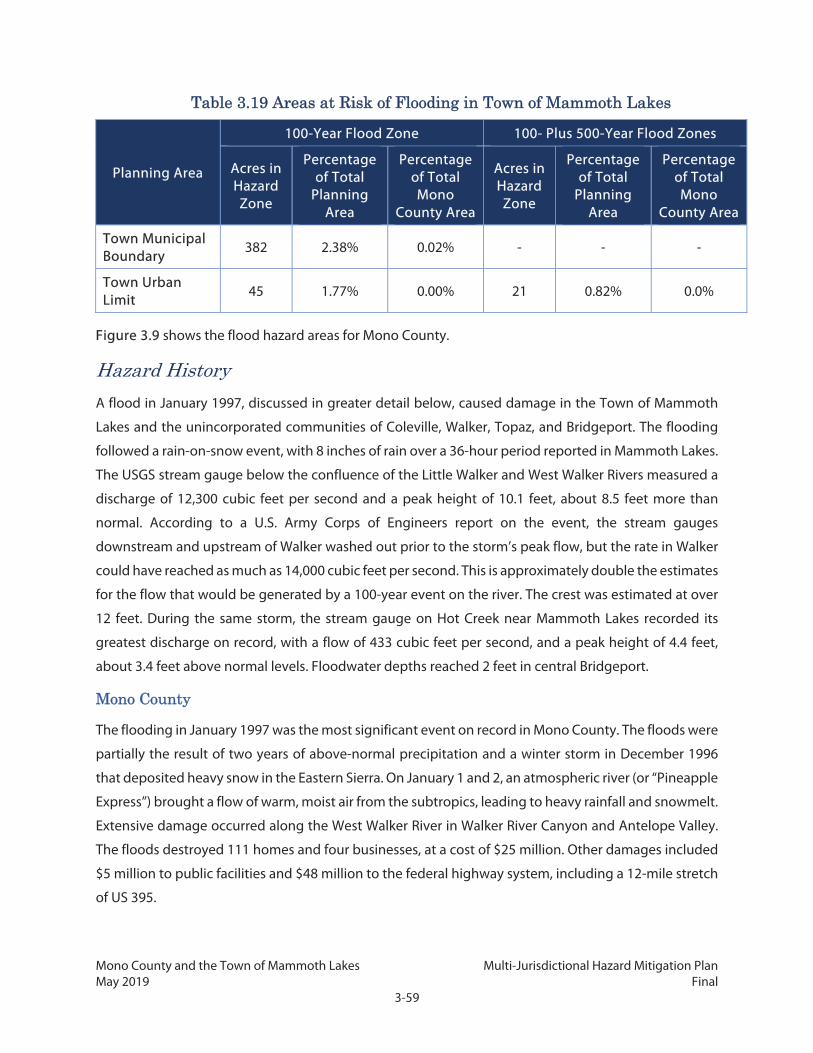
Mono County and the Town of Mammoth Lakes Multi-Jurisdictional Hazard Mitigation Plan May 2019 Final
3-59
Table 3.19 Areas at Risk of Flooding in Town of Mammoth Lakes
Planning Area
100-Year Flood Zone 100- Plus 500-Year Flood Zones
Acres in Hazard Zone
Percentage of Total
Planning Area
Percentage of Total Mono
County Area
Acres in Hazard Zone
Percentage of Total
Planning Area
Percentage of Total Mono
County Area
Town Municipal Boundary
382 2.38% 0.02% - - -
Town Urban Limit
45 1.77% 0.00% 21 0.82% 0.0%
Figure 3.9 shows the flood hazard areas for Mono County.
Hazard History
A flood in January 1997, discussed in greater detail below, caused damage in the Town of Mammoth
Lakes and the unincorporated communities of Coleville, Walker, Topaz, and Bridgeport. The flooding
followed a rain-on-snow event, with 8 inches of rain over a 36-hour period reported in Mammoth Lakes.
The USGS stream gauge below the confluence of the Little Walker and West Walker Rivers measured a
discharge of 12,300 cubic feet per second and a peak height of 10.1 feet, about 8.5 feet more than
normal. According to a U.S. Army Corps of Engineers report on the event, the stream gauges
downstream and upstream of Walker washed out prior to the storm’s peak flow, but the rate in Walker
could have reached as much as 14,000 cubic feet per second. This is approximately double the estimates
for the flow that would be generated by a 100-year event on the river. The crest was estimated at over
12 feet. During the same storm, the stream gauge on Hot Creek near Mammoth Lakes recorded its
greatest discharge on record, with a flow of 433 cubic feet per second, and a peak height of 4.4 feet,
about 3.4 feet above normal levels. Floodwater depths reached 2 feet in central Bridgeport.
Mono County
The flooding in January 1997 was the most significant event on record in Mono County. The floods were
partially the result of two years of above-normal precipitation and a winter storm in December 1996
that deposited heavy snow in the Eastern Sierra. On January 1 and 2, an atmospheric river (or “Pineapple
Express”) brought a flow of warm, moist air from the subtropics, leading to heavy rainfall and snowmelt.
Extensive damage occurred along the West Walker River in Walker River Canyon and Antelope Valley.
The floods destroyed 111 homes and four businesses, at a cost of $25 million. Other damages included
$5 million to public facilities and $48 million to the federal highway system, including a 12-mile stretch
of US 395.

Mono County and the Town of Mammoth Lakes Multi-Jurisdictional Hazard Mitigation Plan May 2019 Final
3-60
FEMA’s 2012 Flood Insurance Study for Mono County reports that flash flooding occurred along US 6 in
the Tri-Valley Area in 1978, 1984, 1986, and 1989. The worst of these events occurred on August 9 and
10, 1989, following a combined total of 3.15 inches of rain. Water coming down the alluvial fan slopes
of the White Mountains created a mudflow that crossed Spring Canyon Creek, sending a wall of water
down US 6 at 20 miles per hour. The flood caused $1.5 million in damage to crops and more than
$400,000 in damage to federal, state, and county roads. As many as 50 homes and 20 mobile homes
were damaged at a cost of $700,000, although none were destroyed. The Los Angeles Times reported
that most residents of Chalfant Valley had to be evacuated.
A 1996 report to Congress on the Sierra Nevada Ecosystem Project notes that “particularly large
snowmelt floods in the Sierra Nevada have been documented in 1906, 1938, 1952, 1969, 1983, and
1995” with volumes two to four times larger than average.

Mono County and the Town of Mammoth Lakes Multi-Jurisdictional Hazard Mitigation Plan May 2019 Final
3-61
Figure 3.9: Mono County Flood Hazard Areas

Mono County and the Town of Mammoth Lakes Multi-Jurisdictional Hazard Mitigation Plan May 2019 Final
3-62
This page intentionally left blank.

Mono County and the Town of Mammoth Lakes Multi-Jurisdictional Hazard Mitigation Plan May 2019 Final
3-63
Other notable events include floods in February 1986 that closed roads and caused damage throughout
the County, and in March 1995 that destroyed two homes and damaged roads and utilities. A series of
subtropical storms in December 1996 and into early 1997 caused significant flooding that affected the
entire state, including Mono County. Forty-eight counties were declared disaster areas due to the
flooding.
Since the 1997 event, smaller floods and flash floods have damaged or closed roadways, trails, and
campgrounds throughout Mono County on numerous occasions. At least two flash floods have resulted
in damage to homes. In July 2013, a slow-moving thunderstorm with heavy rain caused water damage
to eight homes along SR 182 in Bridgeport; one home ended up with several inches of water on the
main floor. In October 2015, thunderstorms over the White Mountains flooded Chalfant Valley, closing
US 6 and damaging 20 homes, at least 4 of them severely.
Heavy storms of both rain and snow in January 2017 ultimately led to a federal disaster declaration for
storms and flooding. Mammoth Lakes received more than 12 inches of rain that combined with recent
snow, clogging up drainage systems with debris and ice. US 395 was temporarily closed due to flooding
in both directions.
In June 2017, following heavy snows of the previous winter, residences in portions of the June Lake
Loop, including several properties on Dream Mountain Drive, experienced flooding, in some cases
resulting in property damage. The flooding events coincided with very high water levels in dams of the
area and a warning by the dam owner, SCE, that month that some risk of dam inundation or overflow
was possible. Dam failures ultimately did not occur; SCE utilized emergency pumps to regulate inflow
of water to several of the dams during this time. Table 3.20 summarizes recent flood history in Mono
County.
Table 3.20 Mono County Flood History, 2000–2017
Incident Date Location
Flood 8/30/2000 Oasis
Flash Flood 7/18/2002 Lee Vining
Flash Flood 7/30/2003 Southwest Mono County
Flood 5/19/2006 to
5/31/2006 West Walker River
Flash Flood 7/18/2006 Walker
Flash Flood 7/25/2007 Mammoth Lakes
Flash Flood 7/15/2010 Bodie State Historic Park
Flash Flood 7/16/2010 Walker
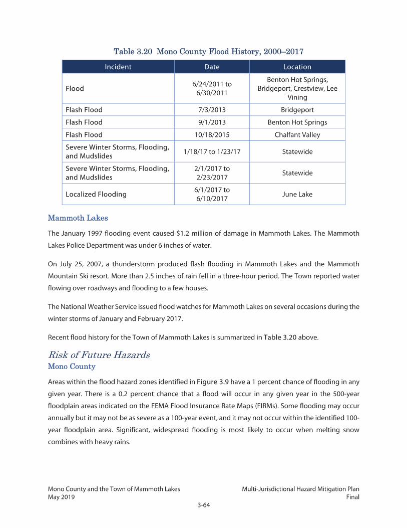
Mono County and the Town of Mammoth Lakes Multi-Jurisdictional Hazard Mitigation Plan May 2019 Final
3-64
Table 3.20 Mono County Flood History, 2000–2017
Incident Date Location
Flood 6/24/2011 to
6/30/2011
Benton Hot Springs, Bridgeport, Crestview, Lee
Vining
Flash Flood 7/3/2013 Bridgeport
Flash Flood 9/1/2013 Benton Hot Springs
Flash Flood 10/18/2015 Chalfant Valley
Severe Winter Storms, Flooding, and Mudslides 1/18/17 to 1/23/17 Statewide
Severe Winter Storms, Flooding, and Mudslides
2/1/2017 to 2/23/2017
Statewide
Localized Flooding 6/1/2017 to 6/10/2017 June Lake
Mammoth Lakes
The January 1997 flooding event caused $1.2 million of damage in Mammoth Lakes. The Mammoth
Lakes Police Department was under 6 inches of water.
On July 25, 2007, a thunderstorm produced flash flooding in Mammoth Lakes and the Mammoth
Mountain Ski resort. More than 2.5 inches of rain fell in a three-hour period. The Town reported water
flowing over roadways and flooding to a few houses.
The National Weather Service issued flood watches for Mammoth Lakes on several occasions during the
winter storms of January and February 2017.
Recent flood history for the Town of Mammoth Lakes is summarized in Table 3.20 above.
Risk of Future Hazards Mono County
Areas within the flood hazard zones identified in Figure 3.9 have a 1 percent chance of flooding in any
given year. There is a 0.2 percent chance that a flood will occur in any given year in the 500-year
floodplain areas indicated on the FEMA Flood Insurance Rate Maps (FIRMs). Some flooding may occur
annually but it may not be as severe as a 100-year event, and it may not occur within the identified 100-
year floodplain area. Significant, widespread flooding is most likely to occur when melting snow
combines with heavy rains.

Mono County and the Town of Mammoth Lakes Multi-Jurisdictional Hazard Mitigation Plan May 2019 Final
3-65
The risk of flooding can increase significantly in areas that have been burned by wildfire. Fires alter
terrain and ground conditions, eliminating vegetation that can absorb rainfall. Flooding is also often
more severe, as ash and debris left from the fire can contribute to mudflows. It can take more than five
years before an adequate layer of vegetation is restored, due to the harsh climate of the area. See the
Wildfire section (Chapter 7) for locations in Mono County that have burned recently and are at
increased flood risk.
Mammoth Lakes
In the Town of Mammoth Lakes, locations with a 1 percent chance of flooding in any given year are
generally those parts of Old Mammoth along Mammoth Creek.
Climate Change Considerations
There is some evidence that climate change may result in more frequent intense storms, known as
atmospheric river events. Some studies suggest that, statewide, more years will have an increased
number of atmospheric river events and that the largest of these atmospheric river events will be more
intense than they have been historically (Dettinger 2011). In general, Northern California is expected to
see more frequent atmospheric river events, potentially up to twice as many by year 2100 as the region
currently does, while Southern California is expected to see the same number of atmospheric river
events but with each individual storm an average of 10 to 20 percent more intense. However, the
specific impacts on Mono County and the Eastern Sierra/Basin and Range region are not yet known
(Oskin 2014).
As noted in the Drought section, dry conditions cause soil to harden, making it less absorbent to
precipitation and increasing the risk of flooding, particularly at the beginning of the rainy season. Since
drought conditions are expected to increase as a result of climate change, there is also a greater risk of
flooding from these drought-induced changes in soil characteristics. These impacts may already be felt;
in July 2015, Lieutenant Governor Gavin Newsom, acting temporarily as governor, issued a disaster
proclamation for large parts of Southern California due to flooding and related hazards due to severe
storms. In the proclamation, Lieutenant Governor Newsom noted the drought’s impact of drying out
soil and increasing the risk of flash floods (Office of the Governor 2015).
3.2.8 Landslides
Hazard Description
For the purposes of this Plan, landslides include landslides, rockfalls, mudflows, slope failures, and
shallow debris flows. Other seismic hazards are discussed in the Earthquake and Seismic Hazards
subsection.
Mono County and the Town of Mammoth Lakes Multi-Jurisdictional Hazard Mitigation Plan May 2019 Final
3-66
Landslides occur when the soils of a slope, such as a hillside or mountain, become unstable. When this
happens, the soils slide down toward the base of the slope, damaging or destroying structures built on
the moving soil or in its path. While landslides are often thought of as fast-moving events, some
landslides may happen slowly over a long period of time.
The types of materials that compose a slope and the steepness of the slope help determine the overall
risk of a landslide occurring. Soil stability and time also contribute to the risk of rockfall, which is a
particular risk along roadways and trails where a path or highway has been cut into a hillside,
exaggerating the angle of repose and increasing the likelihood of rockfalls.
Landslides may be triggered by other hazard events. The shaking from an earthquake or the loss of soil
stability as a result of earthquake-induced liquefaction can cause the soil to slide. Alternatively,
precipitation can result in saturated soil and a loss of stability, or flowing water may erode the base of a
slope. The risk of a landslide is often exacerbated in areas recently burned by wildfire, as the fire burns
vegetation that can absorb water and hold back soil. Without the vegetation to stabilize a slope and
prevent runoff, sediment and debris are more susceptible to sliding.
Landslide hazards in Mono County are primarily associated with seismic activity and heavy rainfall.
Landslides in areas of hilly and mountainous terrain can be triggered by ground shaking, heavy rains, or
human activities such as road cuts, grading, construction removal of vegetation, and changes in
drainage. Mudflows involve very rapid downslope movement of saturated soil, sub-soil, and weathered
bedrock. The movement of soil and debris by mudflow and other landslides over time is evident in the
large alluvial fans at the edges of valley areas.
Throughout the western United States’ vast Basin and Range Province, which includes the White
Mountains, slopes are susceptible to the specific type of moisture-induced debris flows that form
alluvial fans. These flows usually occur as a result of flash floods, which create torrents of water flowing
down a steep mountain canyon. Flash floods often carry sediments and other debris, including boulders
and trees. When the water is free of the confined canyon, it spreads out across a wide area, depositing
debris in a broad, shallow slope called an alluvial fan. The alluvial fans themselves may be susceptible
to further landslides due to their loose composition (CGS 2015a). A type of landslide called lateral
spreading can occur on alluvial fans and other liquefaction-prone soils when liquefied soils become
sufficiently fluid to spread across fairly shallow slopes. Flooding associated with alluvial fans is described
in the Flood profile.
Location and Magnitude
As identified in Table 3.1, landslide hazards are anticipated to affect unincorporated Mono County, but
not the Town of Mammoth Lakes.

Mono County and the Town of Mammoth Lakes Multi-Jurisdictional Hazard Mitigation Plan May 2019 Final
3-67
Areas at risk for landslides are found throughout the County but mostly outside of populated
community areas. The CGS has mapped areas at risk of deep-seated landslide. The map combines three
classes of rock strength and eight classes of slope to create a matrix of susceptibility scores. Figure 3.10
shows susceptibility scores for areas in Mono County. Areas with high levels of susceptibility include:
Northeast boundary of the Long Valley Caldera, from Bald Mountain to Glass Mountain
Many of the canyons along the eastern escarpment of the Sierra Nevada, from the county’s
southern border to the peaks north of Pickel Meadow
Steep slopes north of Lee Vining
Western slope of Slinkard Valley to the county border
Slopes along Coyote Creek at the Nevada border
Throughout the Bodie Hills area

Mono County and the Town of Mammoth Lakes Multi-Jurisdictional Hazard Mitigation Plan May 2019 Final
3-68
This page intentionally left blank.

Mono County and the Town of Mammoth Lakes Multi-Jurisdictional Hazard Mitigation Plan May 2019 Final
3-69
Figure 3.10: Landslide Susceptibility

Mono County and the Town of Mammoth Lakes Multi-Jurisdictional Hazard Mitigation Plan May 2019 Final
3-70
This page intentionally left blank.

Mono County and the Town of Mammoth Lakes Multi-Jurisdictional Hazard Mitigation Plan May 2019 Final
3-71
Certain sections of key access roads are at high risk of rockfall and have historically experienced
numerous rockfalls. These areas include:
US 395 north of Lee Vining near Mono Lake
US 395 north of Mono City near Conway Summit
CA 120 from Lee Vining to Tioga Pass
Walker Canyon Road in Walker Canyon
Lower Rock Creek Road, from Swall Meadows Road northbound to Highway 395
Rockfalls and landslides are particularly common along the very steep slopes of the eastern scarp of the
Sierra Nevada, where talus slopes provide evidence of abundant past rockfalls. During the winter and
spring months, rockfalls can be lubricated with snow and ice and can become extremely fast-moving
and destructive. The May 1980 earthquakes triggered numerous rockfalls, especially at Convict Lake and
in McGee Canyon (Bryant 1980) and “spectacular rockfalls” were observed in Chidago Canyon and the
White Mountains during the July 21, 1986, earthquake in Chalfant Valley, according to the Mono County
MEA (Mono County 2001).
Fire has similarly caused rockfall hazards at burn scar locations on slopes, due to the destruction of
vegetation that formerly acted as anchors for rock and soil. The June 2016 Marina Fire burned steep
slopes along the western side of US 395 north of Lee Vining, leaving the slopes destabilized and
requiring the construction of extensive rockfall protection system alongside the roadway.
Landslides can generate large amounts of debris. A CGS report on the 1980 earthquakes noted that
several backcountry roads and trails were buried by debris that locally was more than 30 meters thick.
Near Mammoth Lakes, a boulder the size of a one-car garage was dislodged and rolled 500 meters.
Large, destructive mud and debris flows associated with alluvial fans are a risk in the Tri-Valley Area.
Locations near the bottom of confined canyons are at risk of these flows, which can cover multiple
square miles and contain millions of cubic yards of debris.
CGS’s Landslide Inventory database does not include any data on landslides in Mono County, but it does
offer a report on a 2008 event in neighboring Inyo County. Heavy rainfall on parts of the Oak Creek
drainage that had previously been burned by wildfire caused large debris flows that deposited 2 million
cubic yards of sediment over a 1.2-square-mile area. Surges moved at estimated speeds of 4.5 to 11
miles per hour (mph) and were 3 to 10 feet tall.

Mono County and the Town of Mammoth Lakes Multi-Jurisdictional Hazard Mitigation Plan May 2019 Final
3-72
Hazard History
The most significant geological event in Mono County was the widespread landslides and rockfalls
during the May 1980 earthquakes near Mammoth Lakes. The report on the earthquakes noted that
rockfalls were common in the epicentral region in Convict and McGee Canyons, with debris partially or
completely covering snowfields. Dust plumes were observed over the Sierra Nevada immediately
following many quakes with magnitudes greater than 4.5. Outside of Mono County in Yosemite Valley,
two hikers were severely injured by a rockfall during one quake (McJunkin et. al., 1980).
A flash flood on August 9 and 10, 1989, resulted in one of the County’s largest mudflows. Water coming
down the alluvial fan slopes of the White Mountains in the Tri-Valley Area picked up debris. The resulting
mudflow crossed US 6, reached as far as Spring Canyon Creek, and caused further flooding in Chalfant
Valley.
Heavy rains often result in debris flows that can shut down major roads. In March of 1995, rockfall and
mudslides closed US 395 from the Nevada state line to Bridgeport.
The region immediately west of Mono Lake has seen several road closures in recent years due to
mudslides, including Lundy Lake Road on July 17, 2014, and July 20, 2018, and parts of Tioga Pass Road
(SR 120) on July 6, 2015, October 16, 2016, and July 20, 2018.
Risk of Future Hazards
Rockfalls and mudflows are an annual occurrence in the Eastern Sierra. The probability of a geologic
hazard occurring in any given area is unknown, although landslide risks are likely to remain highest in
the areas identified as having a high susceptibility, and the risk of alluvial fan flows will persist along the
base of the mountain ranges in the County. The geologic conditions in the County that have been
responsible for past landslide events are not expected to change.
Climate Change Considerations
Climate change may cause an increase in the frequency and/or intensity of storms that affect California,
which in turn could make moisture-related landslides more common, particularly alluvial fan related
events. Warmer temperatures and periods of drought resulting from climate change may cause soil to
become less cohesive, making the material more unstable and potentially increasing landslide risk.
More frequent and extensive fires may leave more area of burn scars which are subsequently more
prone to landslides.

Mono County and the Town of Mammoth Lakes Multi-Jurisdictional Hazard Mitigation Plan May 2019 Final
3-73
3.2.9 Hazardous Materials
Hazard Description
Under California law, a hazardous material is a substance that either causes “an increase in mortality or
an increase in serious, irreversible, or incapacitating illness” or poses “a substantial present or potential
hazard to human health or environment when improperly treated, stored, transported, or disposed of,
or otherwise managed” (DTSC 2010). Hazardous materials cover a wide range of substances and include
flammable or explosive materials, corrosive substances such as acids, poisons, and infectious materials
such as dangerous germs. Some materials are always hazardous, while others may only pose a danger
under certain conditions (e.g., flammable materials can be inert and harmless until exposed to a spark
or heat source). Hazardous materials are often thought of as human-made compounds, but they may
also include naturally occurring substances, such as radon gas found naturally in some rock formations.
A hazardous material emergency usually occurs when the material leaks or escapes from its
containment vessel, exposing people and objects in the vicinity to the material’s harmful effects. This
may occur because of another emergency, such as an earthquake or flood that breaks a hazardous
material storage container. It may also happen because of human error or an equipment malfunction,
or more rarely as a deliberate act. Hazardous materials may be released from a building such as a factory
or storage facility, or from a vehicle such as a truck or train. US 395 is a major thoroughfare and carries
hazardous and potentially hazardous materials through the communities of Mono County. Residents
and visitors also frequently transport combustible fuel such as propane for personal use; when
improperly stored or secured, leaks or explosions can occur. Hazardous materials in soils, either naturally
occurring or accidental, may be washed into water bodies or groundwater basins during flood events,
creating a potential risk of exposure. Other naturally occurring substances (e.g., radon) can filter up
through the soil and into the air, and over long exposure cause health issues. Soils containing hazardous
materials may also dry out and be blown by the wind, spreading the material over a potentially large
area.
This section focuses on four forms of hazardous materials of particular concern to the County and Town:
1) transport of hazardous material such as fuel; 2) stationary propane in tanks and underground lines;
3) naturally occurring gases (specifically, radon and carbon monoxide); and 4) large hazardous sites
resulting from old industrial or mining waste filtering up through the soil and into the air. The location
and magnitude and historical occurrences are discussed for each of these four categories.

Mono County and the Town of Mammoth Lakes Multi-Jurisdictional Hazard Mitigation Plan May 2019 Final
3-74
Hazardous Material Transport Location and Magnitude Mono County
US 395, US 6, and SR 120 are designated for the transport of hazardous materials in and through Mono
County. These routes can transport a variety of hazardous materials for personal and business use, and
materials from one of Mono County’s waste transfer stations to a permanent location outside of Mono
County. This creates the potential for hazards during transport and in the event of a vehicle accident. It
is difficult to identify exactly which materials, how much, and when hazardous materials move through
the County, but likely frequently these include propane, gasoline, household chemicals, and waste. The
exact nature of materials or timing of their transport is not tracked by any agency, although the US
Hazardous Materials Transportation Act does regulate procedures and packaging for transport of
certain materials. Additionally, the Mono County Integrated Waste Management Plan contains a
Hazardous Waste Management Element, which provides policies for the siting and transportation of
hazardous materials. Inspection points along US 395, including in Victorville and Big Pine, help ensure
these materials are being carried properly, mainly performed by Caltrans staff because the state
highways are at highest risk. However, these regulations are often not adequate to ensure safe transport
on road and weather conditions that occur frequently in Mono County, such as high winds, ice, and
snow. The location of hazardous materials release is most likely to occur in relation to these other
hazards.
Mammoth Lakes
Because the Town does not have any interstate corridors running through its boundaries, the likelihood
of an incident involving these materials is somewhat lower than in other areas of Mono County.
However, a hazardous material release along US 395 could affect the Town if gases or odors were carried
by the wind, or if the release triggered other hazards such as fire, or resulted in blockage of key access
into the Town. Additionally, a smaller number of vehicles carry hazardous materials for use in the Town,
posing some risk.
Hazard History
There are records of two recent hazardous material incidents in Mono County, both of which occurred
during transportation. In May 2013 and October 2014, accidents involving the transportation of
freightliners occurred on US Highway 395. The May 2013 accident resulted in the death of the driver as
the truck exploded. Both accidents required extensive hazardous material cleanup.
Mono County and the Town of Mammoth Lakes Multi-Jurisdictional Hazard Mitigation Plan May 2019 Final
3-75
Propane Location and Magnitude Mono County
Propane is a colorless, odorless (although odor is often added for easier detection) liquified compressed
gas frequently used for fuel by residents and visitors to Mono County. Propane is distributed by truck
and sold at locations such as gas stations, hardware stores, and camping supply stores, and is often
transported by personal vehicle and stored at the home or business. Hazards associated with propane
use and transport include:
Inhalation: Inhalation of propane in a closed environment can result in chronic health effects
or, in extreme cases, suffocation.
Contact: Direct contact with some liquefied propane can cause frostbite.
Explosion: While propane tanks are typically stable and difficult to rupture, in the case of
extreme concussions (e.g., major vehicle collision or earthquake) or extreme heat (e.g., wildfire),
a boiling liquid expanding vapor explosion (BLEVE) can occur. A BLEVE occurs when the
pressure in the tank exceeds that at which the safety relief valve can safely vent the excess
pressure into the outside atmosphere. Relief valves are designed to vent tank pressure at a
certain flow rate to the outside atmosphere once the pressure inside the propane tank reaches
a certain level; they will close once the pressure in the tank falls below that level. Old or buried
propane tanks can pose a special hazard, since the tank’s systems degrade with age and
because current landowners may not be aware of their location.
The dangers from propane leaks are aggravated in the County by winter weather, which freeze lines
and valves, and heavy snow, which can disguise evidence of leaks for long periods of time as well as
prevent access to tanks and lines by emergency responders. Although County and Town codes require
residents to regularly check their tanks and to keep access clear during winter, these requirements can
be difficult to enforce.
As propane is a commonly used fuel, proper storage and transport of propane cylinders is critical to
prevent frequent hazards. While the tank types, maintenance, placement and storage of household or
small business tanks are regulated by local and state codes, the location of all tanks is not currently
tracked. Therefore, specific hazard zones from propane are not currently known. It is reasonable to
assume that most parcels with habitable structures will have one or more propane tanks on-site.
Mammoth Lakes
In addition to small propane tanks on individual properties, Mammoth Lakes has an underground
system of pipes that distribute propane to individual and group storage tanks in various parts of the

Mono County and the Town of Mammoth Lakes Multi-Jurisdictional Hazard Mitigation Plan May 2019 Final
3-76
community. The lines are owned and operated by AmeriGas. The lines are supplied by several large
propane tanks both inside the town and near its perimeter. The Town does not have data on the exact
locations or status of these underground pipelines, which can pose hazards in the event of construction
or maintenance activities as well as in the case of natural disaster, such as an earthquake or fire.
Hazard History
There were two fatalities in 1992 due to a propane leak in Mammoth Lakes, which resulted in several
modifications of requirements for use of propane within the town. In February 2012, such a leak resulted
in a deadly explosion in a family housing complex in Coleville that serves marines assigned to the
Mountain Warfare Training Center in Bridgeport. The explosion killed one person, injured several others,
and forced the evacuation of 38 families. Close calls also occurred in Mammoth Lakes when Digital 395
workers severed a main propane line operated by AmeriGas in July 2013 because AmeriGas had made
an improper determination on the gas line location. In addition to freightliners, propane and fuel trucks
have been involved in transportation/delivery incidents.
Radon and Carbon Monoxide Location and Magnitude
Radon is a commonly occurring radioactive gas that is derived from the natural decay of uranium
located in most soils. Radon filters up through the soil and into the air, which can then be trapped in
buildings or distributed by well water usage. Exposure to radon is the second largest cause of lung
cancer, and the number one cause in nonsmokers. Radon should be tested for and prevented or
mitigated in buildings through design features such as proper ventilation, soil barriers, or soil
depressurization.
The Radon Act 51 was passed by Congress to set the natural outdoor level of radon gas (0.4 picocuries
per liter [pCi/L]) as the target radon level for indoor radon levels. The US Environmental Protection
Agency (EPA) has set an “action level” of 4 pCi/L, at which point the EPA recommends that people
take corrective measures to reduce exposure to radon gas. There is no safe level of radon exposure,
however (EPA 2016).
The EPA classifies radon levels by three zones:
Zone 1: Counties with predicted average indoor radon screening levels greater than 4pCi/L.
Zone 2: Counties with predicted average indoor radon screening levels from 2 to 4 pCI/L.
Zone 3: Counties with predicted average indoor radon screening levels less than 2pCi/L.
All of Mono County, including Mammoth Lakes, is designated as Zone 2 for radon levels. Radon testing
is recommended by Mono County for all homes.

Mono County and the Town of Mammoth Lakes Multi-Jurisdictional Hazard Mitigation Plan May 2019 Final
3-77
Similar to radon, carbon monoxide is a naturally occurring compound formed during combustion
(usually wood, goal, or other fuels) but can also be present as the result of volcanic activity. Exposure to
carbon monoxide can cause headaches, nausea, and with especially high concentrations, death.
Hazard History
It is difficult to directly link any given mortality to radon, but the EPA estimates that, nationally, 21,000
lung cancer deaths are caused by radon each year. Since average indoor radon levels are higher in Mono
County than in the US as a whole, the rate of health incident and mortality is likely higher. Consequently,
Mono County pursued and received a grant which allows the County’s Public Health Department to
provide free radon test kits to property owners. According to CDPH’s most recent published data
available, in 2010, a year after beginning the free testing, 32 radon tests had been done in the 93546 zip
code (Mammoth Lakes and Crowley Lake); 10 of them (31%) resulted in radon levels above 4 pCi/L. In
the nearby town of Bishop in Inyo County, 39 out of 111 tests (35%) had come back above 4pCi/L.
Volcanic vents in emitting carbon monoxide are present in small pockets throughout the Long Valley
Caldera; while some areas are known, others may not yet be identified, and new output locations may
occasionally form. At least one death in the County has been confirmed as a result of natural carbon
monoxide inhalation, in 1998, when a man was found dead near Horseshoe Lake.
Hazardous Materials Cleanup Sites Location and Magnitude
According to the California Department of Toxic Substances Control, the Marine Corps Mountain
Warfare Training Center in Bridgeport is the only location in Mono County designated as a hazardous
materials release site. Mono County Department of Public Works is the only registered hazardous waste
transporter in the County.
The SWRCB maintains a separate list of sites with hazardous materials that may contaminate
groundwater supplies. Mono County Welfare is the only facility in Mono County that currently has an
open SWRCB case due to diesel ground contamination. The Mountain Warfare Training Center and the
Mono County Senior Center were previously listed, but cleanup has been completed at both locations
and the cases have been closed.
Table 3.21 shows the number of these facilities in Mono County and their status.

Mono County and the Town of Mammoth Lakes Multi-Jurisdictional Hazard Mitigation Plan May 2019 Final
3-78
Table 3.21 SWRCB Cleanup Sites by Status in Mono County
Status Description Number of Facilities
Mammoth Lakes
Mono County
Completed – Case Closed
Cleanup activities have finished and formal case closure decision has been issued.
0 2
Open Unspecified evaluation and/or cleanup activities are ongoing.
0 0
Open – Eligible for Closure
Cleanup activities have finished, although the case closure decision has not yet been issued.
0 0
Open – Inactive There are no regulatory activities at the site. 0 0
Open – Proposed Unspecified evaluation and/or cleanup activities are ongoing. 0 0
Open – Site Assessment Evaluation activities are ongoing at the site. 1 0
Open – Verification Monitoring
Cleanup has finished, and monitoring activities are ongoing to ensure cleanup has been successful. 0 0
Total 1 2
Source: SWRCB 2016a
Risk of Future Hazards
The risk of hazardous material releases in the future is difficult to quantify. There is always some chance
that another natural disaster, such as an earthquake or flood, may damage buildings or storage tanks
and cause a release of hazardous materials. However, the occurrence of a natural disaster does not
automatically result in a hazardous material release, and a hazardous material release may occur
independently of any other natural disaster.
Considering the history of hazardous material incidents occurring during transport and that the number
of transport trucks is increasing, another incident in the future is likely. In addition, propane is a
significant portion of energy generation, and although strides are being made state- and countywide
to increase renewable energy (a 2014 feasibility study examined the use of biomass as an alternative
fuel), propane will remain a significant portion of fuel usage due to housing design, existing generators
and equipment, and familiarity. Therefore, it is likely that incidents will continue to occur because of
such personal use of propane.
Given the size and sparsely populated nature of Mono County, a hazardous material release may not
necessarily pose a significant risk to human health if it occurs in an unpopulated area, although such

Mono County and the Town of Mammoth Lakes Multi-Jurisdictional Hazard Mitigation Plan May 2019 Final
3-79
events may result in environmental damage. Mammoth Lakes has a comparatively higher population
density than the rest of Mono County, and any hazardous material release in or near Mammoth Lakes
would likely pose a greater threat to human health and safety than elsewhere in the County.
Climate Change Considerations
Climate change is not directly linked to the frequency or severity of hazardous material releases.
However, climate change may increase the frequency or severity of other hazards, such as severe storms
or wildfires, which may in turn result in hazardous material releases.
3.2.10 Severe Wind
Hazard Description
Severe winds can occur as a consequence of an intense storm system or may happen independently of
storms. Severe winds are generally winds above 47 mph, as this wind speed is usually the threshold for
structural damage, although some property damage or minor injuries may occur at lower wind speeds.
High winds may directly damage structures, can blow down trees or branches, and can create airborne
debris which may cause further damage. Severe winds may also increase the risk of other hazards,
particularly wildfires.
Location and Magnitude
As identified in Table 3.1 above, severe winds are anticipated to affect both unincorporated Mono
County and the Town of Mammoth Lakes.
Wind speed can indicate the severity of a wind event, and records may include measurements for
sustained winds, maximum gusts, or both. For the damaging wind events listed below in Table 3.22,
top wind speeds ranged from 33 to 100 knots (kts), or 38 to 115 mph
Mono County
Severe wind events may occur virtually anywhere in Mono County, but they can be of particular concern
near Crowley Lake, Coleville, Lee Vining, Swall Meadows, US 395, and US 6. Caltrans and CHP implement
preemptive highway closures and high-profile vehicle closures to lessen the risk of impacts from severe
wind conditions on vehicles and traveler safety.
In addition to road closures, severe winds can result in downed powerlines. One such event happened
on February 6, 2015, when severe winds caused downed powerlines and igniting the Round fire. A state
of emergency was declared for Mono County due to fires burning thousands of acres, destroying over
40 structures, including residences. Another severe wind event in Reds Meadow just over the Madera

Mono County and the Town of Mammoth Lakes Multi-Jurisdictional Hazard Mitigation Plan May 2019 Final
3-80
County border resulted in thousands of downed trees. Road closures along US 395 and US 6 due to high
winds can severely limit mobility in the County.
Mammoth Lakes
Severe wind events in the town can result in road closures and downed powerlines and trees.
Figure 3.11 shows annual average wind power in the County and highlights locations where high winds
are likely, based on wind resource assessments provided by the National Renewable Energy Laboratory.
This national data estimates the annual average wind resource. The assigned wind power class
represents the range of wind power densities, described as watts per square meter (W/m2), likely to
occur at exposed sites, such as hilltops, ridge crests, mountain summits, large clearings, and other
locations free of local obstructions. The wind resource assessment was based on surface wind data,
coastal marine area data, and upper-air data, or, where data was not available, based on qualitative
indicators such as topographic/meteorological indicators and state of existing vegetation.

Mono County and the Town of Mammoth Lakes Multi-Jurisdictional Hazard Mitigation Plan May 2019 Final
3-81
Figure 3.11: Annual Average Wind Power

Mono County and the Town of Mammoth Lakes Multi-Jurisdictional Hazard Mitigation Plan May 2019 Final
3-82
This page intentionally left blank.

Mono County and the Town of Mammoth Lakes Multi-Jurisdictional Hazard Mitigation Plan May 2019 Final
3-83
Hazard History
Mono County has experienced 96 days of significant wind events since 1996. Twenty-four of these
events caused substantial reported damage or injuries, as shown in Table 3.22 (NOAA 2017c). Among
the more significant events:
On December 14, 2002, a strong cold front resulted in a day of winds gusting to 60 to 80 mph
throughout northeast California and western Nevada, with stronger gusts along the crest of the
Sierra. Across the region, the winds downed hundreds of trees and created power outages,
resulting in nearly $10 million of damages.
A gust of more than 60 mph on December 19, 2008, damaged some of the historic buildings in
the ghost town at Bodie State Park.
On November 30, 2011 to December 1, 2011, an unusually strong wind storm damaged
thousands of trees in the Eastern Sierra, including Reds Meadow and the Mammoth Lakes Basin.
In anticipation of the high wind event Tioga Road in Yosemite was temporarily closed.
On February 5, 2015, high winds exacerbated the Round Fire, which destroyed 65 structures;
this is addressed in Chapter 7. The windstorm also downed trees, broke windows, and damaged
roofs in Mono City and caused widespread power outages north of Mammoth Lakes. Gusts as
strong as 91 mph were measured near Bridgeport.
Table 3.22 Significant Wind Events in Mono County, 1996–2017
Date Top Wind Speed (kts) Affected Area(s)
11/18/1996 n/a Crowley Lake
01/21/1999 61 kts. Highway 395 near Crowley Lake
12/19/1999 n/a Highway 395 in Lee Vining
01/11/2000 60 kts. Near Mammoth Yosemite Airport
11/29/2000 73 kts. Bridgeport Valley
02/06/2001 54 kts. Crowley Lake
01/26/2002 52 kts. Walker and Coleville
04/14/2002 60 kts. June Lakes area
12/14/2002 100 kts. Across the region
12/01/2005 87 kts. Sherwin Grade near Tom’s Place
12/26/2006 56 kts. Across the region
02/25/2007 70 kts. Crowley Lake
12/19/2008 49 kts. Bodie State Park

Mono County and the Town of Mammoth Lakes Multi-Jurisdictional Hazard Mitigation Plan May 2019 Final
3-84
Table 3.22 Significant Wind Events in Mono County, 1996–2017
Date Top Wind Speed (kts) Affected Area(s)
03/29/2010 53 kts. Across the region
05/31/2011 70 kts. Across the region
11/18/2011 75 kts. Bridgeport
11/30/2011 45 kts. Mammoth Lakes area
04/26/2012 48 kts. Mammoth Lakes area
02/15/2014 66 kts. Across the region
12/11/2014 92 kts. Lee Vining
02/05/2015 79 kts. Across the region
12/03/2015 33 kts. Mammoth Yosemite Airport
02/18/2016 35 kts. Mammoth Lakes
10/15/2016 35 kts June Lakes
Source: NOAA 2017
Risk of Future Hazards
Since 1996, on average there have been four significant wind events per year in Mono County, one of
which typically results in damage or injuries. Given the history of past significant wind events in Mono
County and the expected continuation of winter storms, it is very likely that severe winds will continue
to occur throughout the County. The factors that contribute to severe winds are unlikely to decrease to
any substantial degree.
Climate Change Considerations
Climate change may cause an increase in the frequency and/or intensity of storms that affect California,
which in turn could make severe wind events more common. The effects of climate change on winds
not related to storms are as yet unknown.
3.2.11 Severe Winter Weather and Snow
Hazard Description
This section covers several issues relating to severe winter weather including extreme cold and snow.
Intense rainfall is discussed in the Flood profile; severe wind is discussed in the Severe Wind profile; and
avalanches are discussed in the Avalanche profile.

Mono County and the Town of Mammoth Lakes Multi-Jurisdictional Hazard Mitigation Plan May 2019 Final
3-85
Extreme Cold
Extreme cold events occur when the temperature drops well below historical averages. No specific
definition exists for extreme cold, but an extreme cold even can generally be defined as temperatures
at or below freezing for an extended period of time. However, in Mono County, freezing temperatures
are a relatively normal event and residents are often prepared for these temperatures, making it less
likely to result in risk until much lower temperatures occur. These events may occur as part of another
severe weather event, such as a blizzard or ice storm, but can also happen during sunny days. The
primary health risks of extreme cold are frostbite (a freezing of body tissue) and hypothermia (an
abnormally low body temperature) (Cal OES 2013b). Extreme cold may also damage or destroy crops,
and damage water and gas pipelines.
Snow
Snow is precipitation in the form of ice crystals. It originates in clouds when temperatures are below the
freezing point (32°F), when water vapor in the atmosphere condenses directly into ice without going
through the liquid stage. Once an ice crystal has formed, it absorbs and freezes additional water vapor
from the surrounding air, growing into a snow crystal or snow pellet, which then falls to the ground.
Excessive amounts of snow can cause roofs to collapse and people being stranded in their cars due to
road closures.
Hail is a form of precipitation of rough spheres or lumps of ice. It occurs when water droplets are forced
upward in a thundercloud by strong winds called updrafts. The water droplets are blown into areas
where the air temperature drops below freezing, causing the drops to freeze and stick together, forming
hailstones. Eventually the hailstones become too heavy for the updraft and they fall to the surface. The
falling balls of ice can damage roofs, windows, and plants, including crops. In rare instances, large hail
can cause more severe damage, and particularly massive hailstones can cause severe injury. Hail is
distinct from sleet, which is much smaller balls of ice that form when snow melts and then refreezes, or
from freezing rain, which is raindrops that have been cooled to temperatures below the freezing point
but have not turned into ice. While hail may occur during winter storms, large, damaging hail in Mono
County is typically associated with summer thunderstorms.
Location and Magnitude
As identified in Table 3.1 above, severe winter storms and snow are anticipated to affect both
unincorporated Mono County and the Town of Mammoth Lakes. These conditions are regional in
nature, although a large community such as Mono County with a wide variety of climates may
experience significantly different conditions in different locations. No single part of Mono County,
including Mammoth Lakes, is substantially more or less at risk of these conditions, although some areas
may be more impacted by their occurrence than others.

Mono County and the Town of Mammoth Lakes Multi-Jurisdictional Hazard Mitigation Plan May 2019 Final
3-86
Severe winter storms occur throughout Mono County but particularly along the eastern slope of the
Sierra Nevada, in the western part of the County, and at higher elevations. Severe winter storms are
classified as those that cause road closures, power outages, school closures, and associated avalanche
hazards. They may include heavy snow, whiteout conditions, or ice storms. Developed areas may be
subject to snow and ice shedding. When snow slides toward pedestrian areas, parking lots, or other
structures, it poses a significant hazard. Excessive snowfalls and significant accumulations of snow can
also block access to, and stress, propane lines and vents on roofs, which can result in dangerous carbon
monoxide accumulations in structures.
Severe winter storms are a particular concern in Mammoth Lakes when large numbers of visitors are
present. Visitors are often unfamiliar with driving in snow, using woodstoves, and other potentially
hazardous winter weather situations. In addition, if large numbers of visitors become stranded in
Mammoth Lakes, the town’s resources may become stressed.
Just as extreme heat is a factor of air temperature and humidity, extreme cold can be measured as a
factor of air temperature and wind, known as wind chill. A temperature of 10 degrees Fahrenheit (°F)
may have a wind chill of 1°F in 5 mph winds, but may feel close to -20°F in wind speeds of 50 mph or
more. According to the National Weather Service, frostbite can occur within 30 minutes when the wind
chill falls below -18°F, which can occur with air temperatures as high as 10°F when coupled with 55 mph
winds or conditions as calm as 5 mph winds with temperatures of -10°F.
The severity of a snowstorm depends on how much snow falls in a given time. Accumulations are
greater at higher elevations, with significantly more snowfall often recorded at higher elevations. The
high Sierra may get several feet of snow, while the same storm may leave only a few inches throughout
most of the County. Maximum snowfall during winter storms in Mono County has generally ranged
from about 1 foot to 3.5 feet, although three days of heavy snow starting on December 17, 2010,
deposited almost 10 feet of snow at the Mammoth Ski Area.
Hail is measured in terms of its diameter. As shown in Table 3.23, hail greater than 1 inch in diameter,
or the size of a quarter, is generally considered severe and capable of causing damage.
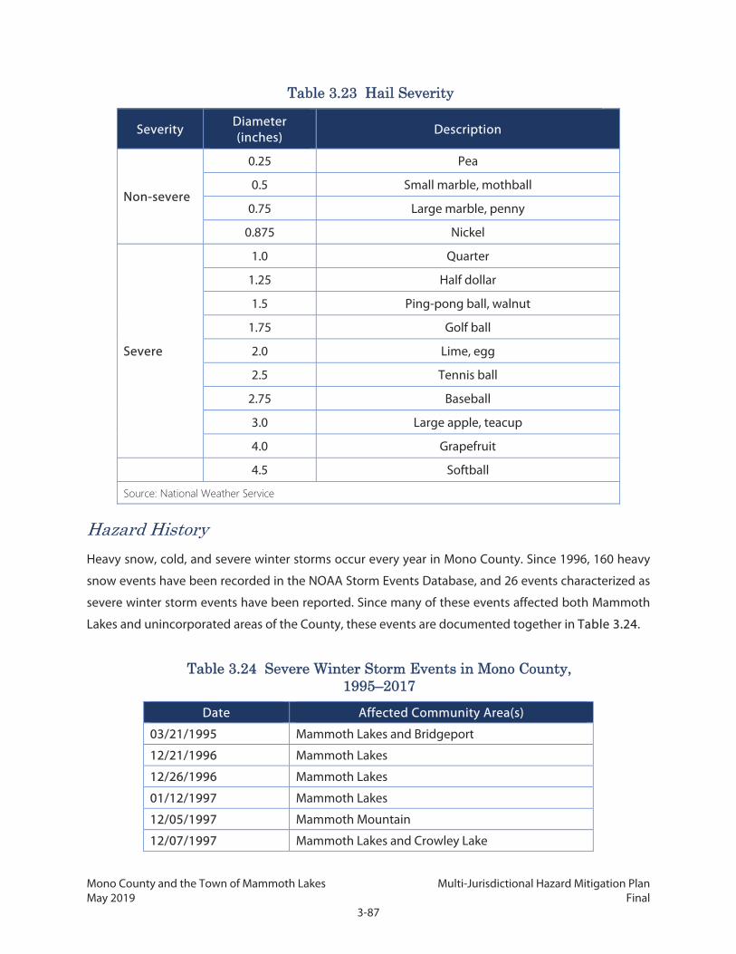
Mono County and the Town of Mammoth Lakes Multi-Jurisdictional Hazard Mitigation Plan May 2019 Final
3-87
Table 3.23 Hail Severity
Severity Diameter (inches)
Description
Non-severe
0.25 Pea
0.5 Small marble, mothball
0.75 Large marble, penny
0.875 Nickel
Severe
1.0 Quarter
1.25 Half dollar
1.5 Ping-pong ball, walnut
1.75 Golf ball
2.0 Lime, egg
2.5 Tennis ball
2.75 Baseball
3.0 Large apple, teacup
4.0 Grapefruit
4.5 Softball
Source: National Weather Service
Hazard History
Heavy snow, cold, and severe winter storms occur every year in Mono County. Since 1996, 160 heavy
snow events have been recorded in the NOAA Storm Events Database, and 26 events characterized as
severe winter storm events have been reported. Since many of these events affected both Mammoth
Lakes and unincorporated areas of the County, these events are documented together in Table 3.24.
Table 3.24 Severe Winter Storm Events in Mono County, 1995–2017
Date Affected Community Area(s)
03/21/1995 Mammoth Lakes and Bridgeport
12/21/1996 Mammoth Lakes
12/26/1996 Mammoth Lakes
01/12/1997 Mammoth Lakes
12/05/1997 Mammoth Mountain
12/07/1997 Mammoth Lakes and Crowley Lake
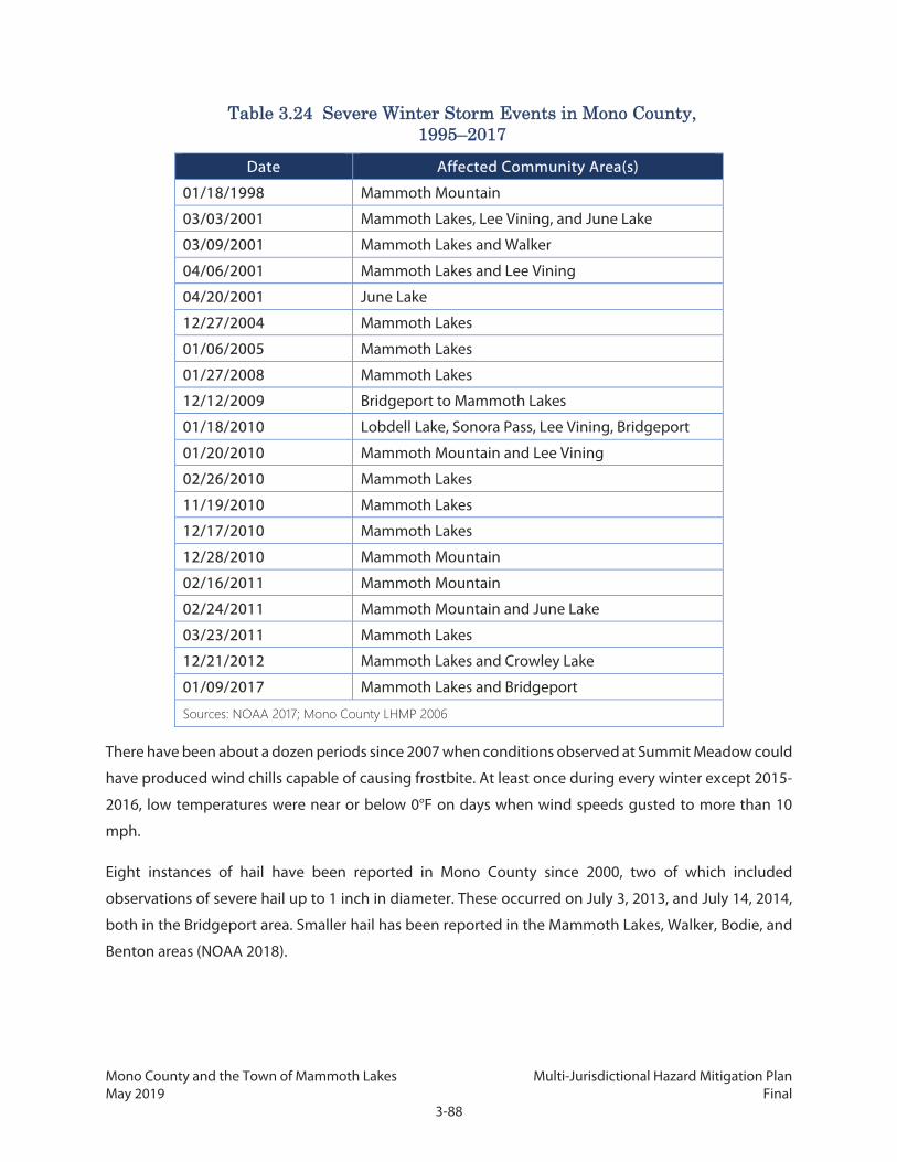
Mono County and the Town of Mammoth Lakes Multi-Jurisdictional Hazard Mitigation Plan May 2019 Final
3-88
Table 3.24 Severe Winter Storm Events in Mono County, 1995–2017
Date Affected Community Area(s)
01/18/1998 Mammoth Mountain
03/03/2001 Mammoth Lakes, Lee Vining, and June Lake
03/09/2001 Mammoth Lakes and Walker
04/06/2001 Mammoth Lakes and Lee Vining
04/20/2001 June Lake
12/27/2004 Mammoth Lakes
01/06/2005 Mammoth Lakes
01/27/2008 Mammoth Lakes
12/12/2009 Bridgeport to Mammoth Lakes
01/18/2010 Lobdell Lake, Sonora Pass, Lee Vining, Bridgeport
01/20/2010 Mammoth Mountain and Lee Vining
02/26/2010 Mammoth Lakes
11/19/2010 Mammoth Lakes
12/17/2010 Mammoth Lakes
12/28/2010 Mammoth Mountain
02/16/2011 Mammoth Mountain
02/24/2011 Mammoth Mountain and June Lake
03/23/2011 Mammoth Lakes
12/21/2012 Mammoth Lakes and Crowley Lake
01/09/2017 Mammoth Lakes and Bridgeport
Sources: NOAA 2017; Mono County LHMP 2006
There have been about a dozen periods since 2007 when conditions observed at Summit Meadow could
have produced wind chills capable of causing frostbite. At least once during every winter except 2015-
2016, low temperatures were near or below 0°F on days when wind speeds gusted to more than 10
mph.
Eight instances of hail have been reported in Mono County since 2000, two of which included
observations of severe hail up to 1 inch in diameter. These occurred on July 3, 2013, and July 14, 2014,
both in the Bridgeport area. Smaller hail has been reported in the Mammoth Lakes, Walker, Bodie, and
Benton areas (NOAA 2018).

Mono County and the Town of Mammoth Lakes Multi-Jurisdictional Hazard Mitigation Plan May 2019 Final
3-89
Risk of Future Hazards
Storms with heavy snowfall and extreme cold events are an annual occurrence in Mono County. Nearly
every winter in the last decade has included at least one of these events, and often there are multiple
events per season. Severe hail events are far more rare, with damaging hail occurring only once or twice
every 10 years. At least in the short term, these hazard events are almost certain to continue occurring
at similar frequencies.
Climate Change Considerations
As temperature increases as a result of climate change, the frequency of extreme cold events is likely to
decline as annual average minimum temperatures increase. Between 1950 and 2005 the average annual
temperature was 49.6°F, and the projected minimum temperature by 2075 is 54.2°F (Cal-Adapt 2017).
Climate change is expected to cause an increase in the number and/or severity of intense storms that
affect California, which may in turn increase the frequency and/or intensity of thunderstorms, hail, and
storm-related severe wind events that affect Mono County.
3.2.12 Volcanoes
Hazard Description
A volcano is an opening (or vent) in the earth’s surface that erupts lava, ash, and gas stored deep
within the planet. Volcanoes come in many sizes and shapes, from large mountains built up by layers of
lava, to conical mounds of loose cinder, or low, crack-like fissures in the ground. Depending on the type
of volcano and the nature of the materials it ejects, a number of potential hazards may occur. These are
described in detail in the USGS California Volcano Observatory website (USGS 2017c) and are summarized in
the California State Multi-Hazard Mitigation Plan. The information in Table 3.25 describes the hazards
that have typified past eruptions of California volcanoes.
Table 3.25 Hazards Associated with California Volcanoes
Name Description
Pyroclastic flow
A sudden, fast-moving eruption of lava, ash, and gases. Pyroclastic flows can move down the sides of the volcano at speeds greater than 50 mph, faster than people can run. Damage occurs from the high temperatures of the material (400–1,300°F) and the fast-moving debris itself. Poisonous gases may also suffocate people or animals.
Slow-speed lava flow
A slow-moving lava eruption, usually less than 30 mph. The lava itself may be fluid or thick. People are usually able to move out of the way, but the lava may bury structures and the high temperatures often ignite fires.

Mono County and the Town of Mammoth Lakes Multi-Jurisdictional Hazard Mitigation Plan May 2019 Final
3-90
Table 3.25 Hazards Associated with California Volcanoes
Name Description
Lahar
A volcanic debris flow, usually a slurry-like mixture of ash, rock, and water, traveling at speeds of 20 to 40 mph. They can be hot, though not as hot as a lava eruption, and may carry large debris such as boulders for great distances. The speed and temperature of a lahar may cause injury or death, and the debris itself may bury people or structures.
Volcanic flood
A type of flash flood that occurs when snow or ice on the surface of the volcano is melted by intense heat from the volcano, or when debris deposited from a volcano causes a river or stream to overtop its banks. The effects are generally similar to other types of flash floods.
Fine ash fall
A “rain” of small ash particles ejected from a volcano during an eruption, sometimes reaching hundreds of miles from the volcano itself. The ash can cause short-term respiratory problems, although it is generally nonlethal. Buildings may be damaged by the weight of the ash, and accidents can occur if ash sufficiently reduces visibility. Ash particles may also clog wastewater systems, damage electronics, and harm crops and livestock. Air traffic can be disrupted by ash fall.
Coarse air fall
An ejection of large, hot pieces of lava or rock. The force of the ejecta may cause damage or injury, and the high temperatures may ignite fires. These are generally the size of a softball or smaller, although some volcanoes may eject boulder-size pieces.
Phreatic eruption
An eruption of steam, caused when volcanic heat causes water underground or on the surface to flash-boil. The steam may erupt violently, carrying ash and pieces of rock. Damage may be caused by the intense heat, the materials ejected by the steam, or poisonous gases that can accompany the eruption.
Sources: Cal OES 2013a; USGS 2016
Table 3.25 does not include an exhaustive list of all possible hazards resulting from volcanoes; it is
possible that an event not shown here may occur during an eruption of a California volcano.
Mono County contains the most significant volcanic center in California outside of the Cascade Range.
The Long Valley-Mono Basin Region is dominated by two distinct but interrelated systems that have
produced volcanic and seismic activity for millions of years. The region includes the Long Valley
Caldera, a 20-mile-by-10-mile, oval-shaped depression formed about 760,000 years ago. This was one
of the largest eruptions in the earth’s history, ejecting more than 70 times as much material as the
famous Krakatoa explosion in 1883. A younger system, the Mono-Inyo Craters, runs from Mono Lake to

Mono County and the Town of Mammoth Lakes Multi-Jurisdictional Hazard Mitigation Plan May 2019 Final
3-91
Mammoth Mountain near the rim of the caldera. The chain has seen small to moderate eruptions, as
recently as 250 to 350 years ago.
The impact of an eruption in the Long Valley area would depend on its location, size, and type as well
as the wind direction. An eruption during the winter months could melt heavy snow packs, generating
mudflows and locally destructive flooding. Smaller eruptions, similar to previous activity along the
Mono-Inyo chain during the past 5,000 years, would typically begin with a series of steam blast
explosions that can throw large blocks of rock and smaller fragments hundreds of feet in the air.
If magma reaches the surface, gases in it can escape explosively, hurling volcanic ash as high as 6 miles
or more. Airborne volcanic ash would be carried downwind and the amount and size of the ash would
diminish with distance from the eruption site. Accumulations of ash pose little threat to life but may
collapse building roofs, close roads, and seriously disrupt utilities and communications. The ash
produced by explosive volcanic eruptions poses a special hazard to aircraft. A small to moderate
explosive eruption can send ash to elevations exceeding 30,000 feet, posing a serious hazard to
commercial aircraft on transcontinental routes that pass over Mono County.
The center is also capable of producing effusive (nonexplosive) basaltic eruptions (the type common in
Hawaii). The resulting hot, relatively fluid lava flows, while not a direct threat to life, can pose serious
problems for built infrastructure.
The release of hot volcanic gases can create deep cavities in the snow containing lethal concentrations
of carbon dioxide. Such conditions have been blamed in the deaths of a cross-country skier in 1998 and
three ski patrol members in 2006 at Mammoth Mountain Ski Area.
The Long Valley Volcanic Center is one of 18 “very high threat” volcanoes listed in a ranking developed
in 2005 as part of the National Volcano Early Warning System (NVEWS). The USGS conducted a
systematic assessment of volcanic threat for all U.S. volcanoes. Volcanoes were evaluated using 25
threat factors: 15 for hazard type (e.g., explosivity index, pyroclastic flows, lahars) and 10 for societal
exposure to hazards (e.g., nearby populations, infrastructure, transportation corridors). The composite
NVEWS score (sum of the hazard factors multiplied by the sum of the exposure factors) translates into a
specific threat-level grouping that ranges from “very high threat” to “very low threat.” The rankings are
periodically reevaluated by the USGS as new scientific data becomes available and/or nearby
infrastructure and populations change. An update to the 2005 ranking is currently under way.
It is important to note that the NVEWS threat rankings do not express the probability of an eruption
occurring, only the level of threat posed should an eruption occur. Table 3.26 shows the threat levels
of Mono County volcanoes.

Mono County and the Town of Mammoth Lakes Multi-Jurisdictional Hazard Mitigation Plan May 2019 Final
3-92
Table 3.26 Mono County Region Volcano NEWS Scores
Volcano NVEWS Score Last Eruption
Long Valley Volcanic Center
Hazard score: 9/20 Overall threat ranking: 128
(Very High Threat) 16,000 to 17,000 years ago
Inyo Craters Hazard score: 8/20
Overall threat ranking: 106 (High Threat)
600 years ago
Mono Craters Hazard score: 8/20
Overall threat ranking: 89 (High Threat)
650 years ago
Mono Lake Volcanic Field Hazard score: 5/20
Overall threat ranking: 55 (Moderate Threat)
250 years ago
Source: USGS 2005
Location and Magnitude
As identified in Table 3.1 above, volcanic-related hazards are anticipated to affect both unincorporated
Mono County and the Town of Mammoth Lakes.
Mono County
Volcanic eruptions could occur in the Long Valley Caldera and along the Mono-Inyo Craters chain. Over
the past 2,000 years, volcanic eruptions have occurred at an average rate of one per 100 years. Vents
located along these chains are known to have produced explosive eruptions, resulting in pyroclastic
flows or surges (violent eruptions of lava fragments) and tephra fall (solid material ejected during a
volcanic eruption and transported through the air). USGS scientists estimate that pyroclastic flows and
surges could travel as far as 10 miles from vents in the Long Valley Caldera’s south moat area, which is
located south of SR 203 between Mammoth Lakes and US 395. An explosion from the vents along the
Mono-Inyo Craters chain could result in pyroclastic flows or surges traveling 7 to 8 miles to the east. To
the west, those flows would be blocked by the high Sierra Nevada. Downwind deposits of ash produced
by an explosive eruption could reach thicknesses of at least 8 inches at a distance of 22 miles from the
eruption, 2 inches at 53 miles, and 0.5 inches at 185 miles. Significant ash fall could affect large portions
of Mono County and surrounding areas, depending on the wind direction and size of the eruption.
Movement in the caldera has caused numerous earthquakes. Since 1974, the USGS has conducted
ongoing monitoring of the caldera for volcano surveillance (earthquakes often serve as an early sign of
volcanic unrest). Earthquake swarms occurred at Long Valley from 1978–1983, 1990–1995, 1996, and

Mono County and the Town of Mammoth Lakes Multi-Jurisdictional Hazard Mitigation Plan May 2019 Final
3-93
1997–1998. The USGS indicates that the rate of earthquakes in recent years has been relatively low
compared with the history since seismic monitoring started.
Figure 3.12 identifies the location of volcanoes, potential vent locations, and potential flow areas in the
County.
Mammoth Lakes
The Town of Mammoth Lakes is near the southwest edge of the Long Valley Caldera. Mammoth
Mountain and basaltic volcanic vents have been historically active within the town boundaries. In
addition, an area of potential future volcanic vents, inferred based on seismic activity, extends into the
town’s east side. The entire town is within hazard areas for pyroclastic flows and tephra fall, as shown in
Figure 3.12.
Hazard History
Since the Long Valley Caldera’s formation 760,000 years ago, clusters of smaller volcanic eruptions have
occurred in the caldera at roughly 200,000-year intervals. About 100,000 years ago, one of these
eruptions along the caldera’s ring fault resulted in the formation of the Mammoth Knolls, low hills just
north of the Town of Mammoth Lakes. The most recent eruption within the topographic basin occurred
16,000 to 17,000 years ago on the mafic chain along the west rim.
The Mono-Inyo chain has erupted at intervals of 700 to 250 years over the last 3,000 years. Mammoth
Mountain was formed by numerous eruptions 100,000 to 50,000 years ago, during which it erupted
approximately 25 times. Basaltic vents around the mountain erupted approximately 35 times between
235,000 and 8,000 years ago, which contributed to the formation of the Red Cones. Mono and Inyo
Craters were created between 400,000 and 5,000 years ago, and the latest eruptions took place about
8,000 years ago. The most recent activity in the chain occurred with the formation of Mono Lake’s Paoha
Island about 350 years ago.
Risk of Future Hazards
Volcanoes have been active in the area for millions of years and future eruptions are certain to occur.
The pattern of volcanic activity suggests that future eruptions are more likely to occur along the Mono-
Inyo volcanic chain than within the caldera. In general, the probability of such an eruption occurring in
any given year is less than 1 percent, comparable to the odds for a great (magnitude 8) earthquake
along the San Andreas fault in coastal California. The odds of a small eruption having a significant impact
on any specified place along the chain in any given year is one in 1,000, or 0.1 percent. Future eruptions
are likely to be explosive in style but small to moderate in size. Larger eruptions are possible but less

Mono County and the Town of Mammoth Lakes Multi-Jurisdictional Hazard Mitigation Plan May 2019 Final
3-94
likely. Scientists see no evidence pointing toward the possibility of a massive eruption along the lines
of the one that formed the caldera 760,000 years ago.
Geologic unrest—including earthquake swarms, ground deformation, gas emissions, and fumarole
activity—can signal a change in the likelihood of an eruption, depending on the nature, intensity, and
location of the unrest. A period of ongoing geologic unrest in the Long Valley area began in 1978 with
a magnitude 5.4 earthquake centered 6 miles southeast of the caldera. Since then, earthquake activity
has increased. The most intense swarms occurred in May 1980 and included four strong magnitude 6
earthquakes. Between 1979 and 1980, the center of the caldera rose almost a foot, after decades of
stability. The swelling continues, and to date totals more than 2.7 feet, suggesting magmatic activity
beneath the caldera. During the early 1990s, trees began dying at several places on Mammoth Mountain
at the southwest edge of Long Valley Caldera. Studies showed that the trees were being killed by large
volumes of carbon dioxide gas seeping up through the soil from the magma below. Such tree mortality
could have implications for other hazards such as wildfire and landslides.
Climate Change Considerations
There is no known or suspected connection between climate change and volcanic activity. Eruptions
can trigger other hazards, such as landslides, that are affected by climate change.

Mono County and the Town of Mammoth Lakes Multi-Jurisdictional Hazard Mitigation Plan May 2019 Final
3-95
Figure 3.12: Volcano Hazard Zones

Mono County and the Town of Mammoth Lakes Multi-Jurisdictional Hazard Mitigation Plan May 2019 Final
3-96
This page intentionally left blank.

Mono County and the Town of Mammoth Lakes Multi-Jurisdictional Hazard Mitigation Plan May 2019 Final
3-97
3.2.13 Wildlife Collisions
Hazard Description
Wildlife collisions are frequent in rural areas and where the rural areas met and interact with developed
areas. Collisions can cause vehicle damage, driver injuries, and loss of vehicular control; they are
generally most common during early morning and evening hours, when animals are active yet road
visibility is low. Deer are the most common animal to be involved in a notable wildlife collision in Mono
County (notable referring to a collision that is worth reporting and/or causes damage).
Location and Magnitude
In Mono County, wildlife collisions are most common on US 395. Figure 3.13 shows the rate of deer
mortality due to vehicular collisions on each of the County’s major highways between 2002 and 2015.
Figure 3.13: Mono County Deer Mortality 2002–2015
Figure 3.14 is a heat map of the wildlife collision hot spots along US 395 near Mammoth Yosemite
Airport, where a study was conducted to assess problem areas and potential solutions for high-collision
areas. Most collisions occur south of Benton Crossing Road and the area directly in front of the airport
operated by the Town of Mammoth Lakes (Caltrans 2015).

Mono County and the Town of Mammoth Lakes Multi-Jurisdictional Hazard Mitigation Plan May 2019 Final
3-98
Figure 3.14: Deer Collision Hot Spots
Mono County
Most Mono County highways with high collision risk are in unincorporated areas, but are under the
jurisdiction of Caltrans. Unincorporated Mono County has higher risk of wildlife collisions due to the
rural nature of the County.
Mammoth Lakes
The risk of wildlife collisions for Mammoth Lakes is significantly less than the unincorporated area due
to its more developed nature and lower speed limits. SR 203 has shown the highest risk for collisions,
with 49 deer mortalities between 2002 and 2015.
Hazard History
Wildlife vehicle collisions are common occurrence in the County. According to a Feasibility Study Report
prepared by Caltrans assessing the number and location of wildlife vehicle collision reduction options
on US-395 near Mammoth Lakes, between 2002 and 2015 there were over 1,845 collisions with deer
and 33 collisions with bear in the County on US-395. The rates were nearly 10 times higher than on the
similar roadways in surrounding counties. While such incidents occurred throughout the County, higher
incidence of collisions occurred near intersections with SR-203, at McGee Creek Road, at Hot Creek
Hatchery Road, and near Benton Crossing Road.

Mono County and the Town of Mammoth Lakes Multi-Jurisdictional Hazard Mitigation Plan May 2019 Final
3-99
Risk of Future Hazards
Because vehicle traffic on risk likely to remain an inherent component of residential and commercial
development and vehicle traffic are likely to remain a major part of the way of life in Mono County and
potentially expand in areas, conflict between wildlife and vehicle traffic will continue to occur.
Climate Change Considerations
Climate change will not directly affect wildlife collision hazards. However, changing weather patterns
will most likely affect animal propagation rates, migration patterns, and foraging range.

Mono County and the Town of Mammoth Lakes Multi-Jurisdictional Hazard Mitigation Plan May 2019 Final
3-100
This page intentionally left blank.
Mono County and the Town of Mammoth Lakes Multi-Jurisdictional Hazard Mitigation Plan May 2019 Final
4-1
4. RISK ASSESSMENT The hazards described in Chapter 3 vary in terms of past severity and in the likelihood and intensity of
future events. However, the frequency and severity of future hazard events is, by itself, insufficient to
describe Mono County’s and Town of Mammoth Lakes’ vulnerabilities to these hazards. A risk
assessment is necessary to prepare a more accurate view of the threats that the County and the Town
face due to the hazard events which may occur in the area. Risk was evaluated for all hazards, although
more detailed assessments were possible for seismic-related hazard, dam failure, flood, and wildfire, as
these have established geographic zones identified as being at risk. Wildfire risks are discussed in the
CWPP in Chapter 7.
4.1 Risk Assessment Method The risk assessment focuses on the vulnerability of specific community assets for the areas that each
hazard could impact. They include the following:
Social Vulnerability: A single hazard event can cause substantially different impacts for different
individuals, even if the intensity of the hazard was the same for the entire community. Certain groups
of people may be more vulnerable to natural hazards due to physical condition, socioeconomic status,
or other factors. For example, elderly residents may have less physical capacity to maintain a safe
internal body temperature in very hot weather, which may make them more vulnerable to heat waves.
In other instances, individuals with lower incomes may be less able to renovate their homes to be more
resilient to hazards, meaning that they can face a higher likelihood of their home being damaged or
destroyed if a hazard event occurs. A countywide snapshot of demographics that indicate social
vulnerability is provided in Chapter 2. The social vulnerability assessment looks at the following metrics
for different hazard zones:
Topic Indicators
Median HH Income Median household income
Poverty Households at or below 2x federal poverty level
Linguistic Isolation Households where no one over age 14 speaks English well
Elderly Households with member over 65
Disability Households with a disabled member
Total Population Total population
Social vulnerability data was drawn from the US Census American Community Survey, and was available
at the block group level of geographical unit size.

Mono County and the Town of Mammoth Lakes Multi-Jurisdictional Hazard Mitigation Plan May 2019 Final
4-2
The risk assessment includes a social vulnerability analysis for flooding, fault rupture, dam inundation,
and fire. Other hazards, such as ground shaking, drought, and extreme weather, are not analyzed
because these hazards can affect the entire community, and hazard zones are generally not limited to
specific locations or for which location-specific data is not available.
The social vulnerability assessment compares the areas in the hazard risk zones to the entire community
to determine if social vulnerability is higher within the hazard risk zone. However, even if residents in
the hazard risk zone are no more or less vulnerable than the entire community, this does not mean that
there are no social vulnerability concerns for the hazard. The absence of a difference in social
vulnerability between the hazard risk zone and the entire community does not mean social
vulnerabilities are completely absent. It is possible that the entire community faces a high degree of
social vulnerability from the hazard (for example, if there is a high proportion of households under the
poverty limit in the community). Additionally, even if only a small number of residents are considered
socially vulnerable, it does not mean that local governments do not need to work on reducing social
vulnerability; neither can governments ignore any special needs or considerations that are applicable
to these residents.
Critical Facilities: As discussed in Chapter 2, critical facilities in the County are essential for emergency
response and recovery and include a wide range of facilities and infrastructure. Appendix C contains
the full list of critical facilities. To the extent possible, such facilities should be located outside hazard
zones. This is frequently not feasible, since the functioning and effectiveness of facilities are often
location-dependent. Consequently, facilities should be defended or hardened against the impacts of
hazards that may occur in those locations.
Property and Building Exposure: The exposure of property and structures, primarily in the urbanized
communities, are a primary focus of mitigation planning efforts. For two key hazards, flood and
earthquake, HAZUS-MH, a software program and standardized methodology for estimating potential
monetary losses from these hazards, was used to model an estimate of the worth of buildings in the
County, broken down by occupancy type. Table 4.1 shows the County (including the Town of
Mammoth Lakes) building exposure estimate.
Table 4.1 HAZUS Total Building Exposure Estimate
Occupancy Exposure ($1,000) % of Total
Residential $2,459,157 89.2%
Commercial $190,438 6.9%
Industrial $29,199 1.1%

Mono County and the Town of Mammoth Lakes Multi-Jurisdictional Hazard Mitigation Plan May 2019 Final
4-3
Table 4.1 HAZUS Total Building Exposure Estimate
Occupancy Exposure ($1,000) % of Total
Agricultural $4,271 0.2%
Religion $27,839 1.0%
Government $23,498 0.9%
Education $21,330 0.8%
Total $2,755,732 100.0%
This was then used to evaluate potential losses as a result of particular flood or earthquake scenario that
might occur in various parts of the County.
4.2 Hazard Risk Assessments
4.2.1 Avalanche
Although the avalanche risk area is generally limited to the national forests in the Sierra Nevada, there
are communities and roadway sections at risk of property damage and loss of life due to avalanches.
Mono County
Communities at risk are:
Bridgeport Valley: Twin Lakes has an area of concentrated residential development that is open
for year-round use. The area experiences frequent, large avalanches. This area contains few
permanently occupied homes but a number of seasonally occupied cabins, as well as
recreational facilities such as boat docks, restrooms, stores, campground sites, parking lots, and
trails. Few of these facilities are retrofitted in any way to help withstand or protect visitors in an
avalanche event.
June Lake: Portions of SR 158 are in the runout zone for avalanches, which would block the
primary access route to neighborhoods and facilities along the June Lake loop, including more
than 200 residential units and 500 permanent residents. Several dozen homes in the residential
community are in the direct path of runout zones as well.
Long Valley: Residential development in Long Valley is exposed to large avalanches originating
from the northeast face of McGee Mountain and from slopes below Castle Rock, located directly
above existing development. A portion of US 395 and residential, lodging, and commercial
facilities in several small communities of the Crowley Lake area are directly in the runout area of
frequent avalanches from McGee Mountain.

Mono County and the Town of Mammoth Lakes Multi-Jurisdictional Hazard Mitigation Plan May 2019 Final
4-4
Wheeler Crest: A major dry-snow avalanche occurred in 1969 in Swall Meadows. Avalanche risk
also exists on the Lower Rock Creek access road from a number of small east-facing paths that
descend directly onto the road.
Mono Basin: Several large avalanche paths are known to extend east of US 395 approximately
1 to 2 miles north of Lee Vining. While few structures are in the runout zone, an avalanche could
shut down and damage US 395 as well as major power lines.
An area at the west end of Lundy Lake, which includes some private homes, is threatened by a
large, steep avalanche path. At present, Lundy Lake is not occupied continuously during the
avalanche season.
Outside of the Community Planning Areas: Much of the development in Virginia Lakes is in a
runout zone, as are several portions of the single access route to it—Virginia Lakes Road. This
area is primarily a seasonal residential area, although a number of dispersed housing units are
present. It is also frequented by recreational snowmobiles and backcountry skiers. It includes
several dozen seasonal residence structures, as well as recreational infrastructure such as
bathrooms, trailheads, and parking lots.
Critical facilities in these areas, including single-access routes, primary access routes, roads, and sub-
stations and power lines, have an elevated risk of damage due to avalanches. There is insufficient data
on the exact avalanche zone areas to accurately identify all critical facilities that could be at risk. A
comprehensive on-site terrain analysis and avalanche flow modeling using the AVALANCHE module of
the internationally accepted Rapid Mass Movements (RAMMS) would provide more accurate and
detailed data on avalanche risk areas and what critical facilities are at greatest risk.
Specific road segments of concern identified by the County for avalanche monitoring in 2017 are shown
in Table 4.2.
Table 4.2 2017 Road Segments at Risk of Avalanche Identified for Monitoring
Planning Area Road General Location
Bridgeport Twin Lakes Road South of Bridgeport
Long Valley
Crowley Lake Drive At McGee Mountain
Crowley Lake Drive At Ojai Ridge
Rock Creek Road Narrows Near Tom's Place
June Lake Lakeview Drive Near June Lake
Mammoth Vicinity Benton Crossing Road Near Wildrose Summit

Mono County and the Town of Mammoth Lakes Multi-Jurisdictional Hazard Mitigation Plan May 2019 Final
4-5
Table 4.2 2017 Road Segments at Risk of Avalanche Identified for Monitoring
Planning Area Road General Location
Mono Basin Picnic Grounds Road Near Lee Vining
Wheeler Crest
Mountain View Road, Foothill Road, and Swall Meadows Road
Swall Meadows
Lower Rock Creek Road Narrows North of Swall Meadows
Outside planning area Virginia Lakes Road Northwest of Mono City
Lundy Lakes Road Northwest of Lee Vining
Town of Mammoth Lakes
Avalanche damage to property is a risk in several areas of town, including homes in the Sherwin Range
and Knolls neighborhoods. The Mammoth Mountain Ski resort contains no residential structures but
does contain structures such as ski lifts and lodges; it is also at risk from runout paths off Mammoth
Mountain. Thousands of visitors may be on the slope at any given time, even when avalanche risk has
been determined to be high.
The Town’s Zoning Code contains a Snow Deposition Design Overlay Zone (SDD), which identifies areas
of avalanche risk. It includes areas immediately above, adjacent to, or within 150 feet of the 30-degree
point of an avalanche starting zone. All development within the SDD requires a use permit, as well as
certification from an expert in the occurrence, force, and behavior of avalanches. The SDD does not
guarantee the safety of homes within the zone, nor is the zone intended to be fully comprehensive
regarding all areas that are at potential risk from avalanche.
4.2.2 Dam Failure
There are 22 dams in Mono County. The California DWR rates each dam based on the potential
downstream impacts to life and property in the event of dam failure while operating with a full reservoir.
These ratings do not reflect how likely the dam is to fail, only how severe the results will be if it does.
The ratings are described in Table 4.3, and each dam in Mono County with their respective downstream
hazard classification is listed in Table 4.4. As noted in Chapter 3, only eight dams have possible
inundation zones that have been identified by the state; these dams are shown in bold.
Table 4.3 Downstream Hazard
Downstream Hazard Classification Loss of Human Life Economic, Environmental, and Lifeline
Losses
Low None expected Low and generally limited to owner’s
property

Mono County and the Town of Mammoth Lakes Multi-Jurisdictional Hazard Mitigation Plan May 2019 Final
4-6
Significant None expected Yes
High Probable (one or more expected) Yes, but not necessary for this
classification
Extremely High Considerable Yes, major impacts to critical
infrastructure or property
Source: California DWR 2017
Table 4.4 Mono County Dam Classifications
Dam No. National ID No. Dam Name Downstream Hazard
104.038 CA00454 Agnew Lake High
538.000 CA00646 Black Reservoir Low
70.002 CA00284 Bridgeport Significant
104.037 CA00453 Gem Lake High
6.033 CA00089 Grant Lake High
539.000 CA00647 Lobdell Lake Low
6.034 CA00090 Long Valley Extremely High
531.002 CA00644 Lower Twin Lake High
104.035 CA00451 Lundy Lake High
540.000 CA00648 Poore Lake Reservoir Low
104.041 CA00457 Rhinedollar High
104.034 CA00450 Rush Creek Meadows High
104.039 CA00455 Saddlebag High
104.040 CA00456 Tioga Lake High
70.003 CA01473 Topaz Lake Significant
6.042 CA00095 Upper Gorge Low
531.000 CA00643 Upper Twin Lake High
6.035 CA0091 Walker Lake Low
Source: California DWR 2017
There are two dams under the jurisdiction of U.S. Army Corps of Engineers. These dams are under federal
jurisdiction, and information on downstream hazard ratings is not available. These dams are Lake Mamie
and Lake Mary.
Because these two dams are in the same watershed as the Upper and Lower Twin Lakes Dam, the
downstream hazard may be assumed to be the same risk level, i.e., high.

Mono County and the Town of Mammoth Lakes Multi-Jurisdictional Hazard Mitigation Plan May 2019 Final
4-7
Mono County
While there are close to two dozen dams in the County with varying conditions, no single dam failure
would result in risk to residences or commercial structures. However, two critical facilities are located in
dam failure inundation areas, both of which are lifeline utility systems, in the June Lakes Area. Critical
roadway infrastructure is at greatest risk of closure as well as extensive damage. Dam failure inundation
zones cross two sections of US 395, several sections of CA 120, large portions of CA 168, and much of
CA 102.
Town of Mammoth Lakes
The Town of Mammoth Lakes, located downstream of the Twin Lakes, Lake Mamie, and Lake Mary Dams,
has a number of residential and nonresidential structures at risk. Homes on Mammoth Creek often
experience flooding problems during major precipitation events and would likely experience flooding
damage in the event of dam failures.
4.2.3 Disease/Pest Management
Mono County
Disease and pest management hazards are present throughout Mono County and in Mammoth Lakes.
Because disease often travels through animal or insect vectors, as well as human contact, the risk is
similar anywhere in the County. Areas of increased contact with wildlife may be somewhat more
susceptible, as well as areas with high populations of mosquitoes. In Mono County, cases of bubonic
plague, hantavirus, and tick-borne relapsing fever have been reported, and there is a possibility,
although remote, of West Nile virus occurring in the region. Common carriers for these diseases include
rodents such as mice and squirrels, ticks, fleas, and mosquitoes.
Occurrences of these diseases are rare in Mono County and generally identified quickly, which reduces
the risk of a significant outbreak. Loss of life is therefore minimal, and the chances of an epidemic are
remote. Critical facilities are not impacted by diseases and are generally unaffected by pests, although
wooden buildings may be damaged by wood-eating insects.
Town of Mammoth Lakes
Disease and pest management hazards in the Town of Mammoth Lakes are similar to that of the rest of
the County, with such hazards present throughout its area. As a tourist destination, the Town may be at
higher risk from contagious diseases spread through human contact.

Mono County and the Town of Mammoth Lakes Multi-Jurisdictional Hazard Mitigation Plan May 2019 Final
4-8
4.2.4 Drought
Mono County
The regional nature of drought hazards means that all of Mono County and Mammoth Lakes face an
equal risk of drought, although the characteristics of a drought can vary widely across the region. While
droughts typically do not pose a health or safety impact, in extreme cases normal water supplies may
dry up and individuals may have to procure water from other sources, which may be difficult for lower-
income residents. In addition, water is critical for activities that indirectly apply to human health, such
as agriculture, livestock watering, and sanitation. There are also economic concerns, as skiing and the
lakes in Mono County are a primary tourist attraction, and a decline in tourist activity can cause a sharp
decline in revenue for local businesses and jurisdictions.
Much of the water used in Mono County comes from groundwater wells, which makes the water prone
to both natural contamination such as metals and arsenic, and man-made contamination from pesticide
and fertilizer runoff, and septic systems. In times of drought, the groundwater may not be recharged as
quickly as water is extracted, potentially causing depletion of the groundwater. This results in lowering
of the water table that can cause land subsidence, increased water costs, further reduced surface water
supplies, and an increase in water quality concerns as contaminations become more concentrated.
The Owens Valley Groundwater Basin is considered a basin of medium importance by the DWR. The
basin underlies the entire Owens Valley in neighboring Inyo County as well as the Tri-Valley area and
communities of Benton, Hammil, and Chalfant. Like much of the rest of the County, these communities
depend on groundwater as well as surface water supplies. These areas include agricultural activities,
primarily alfalfa fields, which depend on groundwater. Per state law, the County is currently
coordinating with neighboring jurisdictions to develop a Groundwater Sustainability Plan, which will
identify needs for facilities, investigations, and management activities that should be undertaken to
maintain and enhance sustainable groundwater management in the future.
Critical facilities are not physically affected by drought conditions, although droughts may have impacts
for facility operations, such as water recreation facilities.
Town of Mammoth Lakes
As stated above, drought risks in Mammoth Lakes are consistent with risk throughout the County.
4.2.5 Earthquake and Seismic Hazards
As discussed in Chapter 3, seismic hazards include four related hazards: fault rupture, shaking,
liquification, and tectonic subsidence. Faults are the only hazard where location-specific information is

Mono County and the Town of Mammoth Lakes Multi-Jurisdictional Hazard Mitigation Plan May 2019 Final
4-9
available. An earthquake centered at any one of these faults could result in strong shaking in much of
the entire County, and potentially pose major risks to life and property throughout.
Consequently, this risk analysis focuses on fault locations, while acknowledging that seismic hazards are
present throughout Mono County and the Town of Mammoth Lakes.
Mono County
Faults exist throughout Mono County. The parts of the unincorporated county at risk of fault rupture
generally do not face a higher social vulnerability to this hazard than the rest of the unincorporated
area.
Town of Mammoth Lakes
There is no calculated population within the fault rupture hazard zone for Mammoth Lakes. Table 4.5
shows the social vulnerability of unincorporated Mono County to fault rupture.
Table 4.5 Social Vulnerability to Fault Rupture in Unincorporated County
Social Vulnerability Metric Fault Rupture Hazard Zone Entire Community
Population 413 6,042
Number of households 142 2,213
Median household income $56,608 $59,386
Percentage of households under poverty limit 2.8% 5.1%
Percentage of elderly households 27.5% 35.2%
Percentage of adults with high school degree or higher Unknown 87.9%
Percentage of adults with English competency 99.7% 95.5%
Percentage of households with a disabled member 12.7% 15.3%
HAZUS-MH, a software program and standardized methodology for estimating potential monetary
losses from earthquake and select other hazards, was used to assess potential losses in Mono County.
Three different earthquake scenarios, identifying several potential magnitude faults along specific faults
in various locations in the county, were evaluated using the program’s generalized estimates for the
number and value of these structures in the County. One scenario evaluated an earthquake along the
Hilton Creek fault, located in Long Valley west of Crowley Lake. The Temblor Seismic Hazard Rank along
the Hilton Creek Fault, 32, is significant. The Mammoth Lakes area experienced four M≥6 shocks in the

Mono County and the Town of Mammoth Lakes Multi-Jurisdictional Hazard Mitigation Plan May 2019 Final
4-10
1980s, which ruptured parts of the Hilton Creek fault (Bryant 1980). The scenario assumes a magnitude
of 6.9 along the fault. HAZUS estimates that in such a scenario, about 922 buildings will be at least
moderately damaged, 124 would be extremely damaged, and 15 damaged beyond repair. The quake
would also damage more than 40 segments of highway and more than 40 bridges. The total economic
loss estimated for this earthquake would be more than $159.2 million, which includes building and
lifeline-related losses based on the region's available inventory. Full reports provided by HAZUS are
located in Appendix D.
Faults like Hilton Creek exist throughout Mono County, with many faults and historic earthquake
epicenters located near US 395, especially in the southern third of the County. Various faults also cross
portions of SR 120 and SR 158. Because these corridors are primary evacuation routes for the County,
earthquakes near them could considerably hinder evacuation efforts and leave the County isolated
from outside assistance.
Primary earthquake hazards are ground shaking, landslides, surface rupture or displacement, and
liquefaction. While no complete mapping is available for liquefaction risk, past events suggest that the
valley areas face an elevated risk of liquefaction, particularly areas around dry lake beds. Other
secondary hazards associated with ground shaking and liquefaction include:
Flooding from broken dams
Fire from broken gas lines and power lines
Damage to buildings and infrastructure
Avalanches
Seiches in large lakes and reservoirs
Injury and death from falling debris or secondary hazards
Much of the damage and risk to life from an earthquake is a result of these secondary hazards.
Vulnerability to these events depends on the location and population of nearby settlements, the
concentration and structural integrity of buildings, and public warning systems and preparedness.
Population density and building intensity is generally low in Mono County; however, the lack of
comprehensive transportation networks and the rural nature of the County means response times could
be high and access to necessary services could be heavily impacted.
Ground shaking from earthquakes has the potential to affect all areas of Mono County and Mammoth
Lakes; no critical facility is considered completely safe from this hazard. There are eight critical facilities
located within the fault zone, as shown in Table 4.6.

Mono County and the Town of Mammoth Lakes Multi-Jurisdictional Hazard Mitigation Plan May 2019 Final
4-11
Table 4.6 Types of Mono County Facilities in Fault Rupture Hazard Zones
Facility Type Number of Facilities Not at Risk
At Risk – Mammoth Lakes
At Risk – Unincorporated Mono
County
Communication 18 0 1
Emergency Operations Center 11 0 1
Emergency Services 25 0 1
Hazardous Materials 10 0 0
Lifeline Utility Systems
52 1 2
Medical Services 4 0 0
Schools 10 0 1
Transportation Systems 9 0 1
Vulnerable Populations 5 0 0
Total 144 1 7
4.2.6 Extreme Heat
Extreme heat is a possible hazard in the Tri-Valley area, which includes the communities of Benton,
Hammil, and Chalfant. The Tri-Valley has many older residents living in older homes with poor insulation
and limited or no air conditioning. Senior individuals are more adversely affected by extreme
temperatures and could experience health risks during one or more days at or above the extreme
threshold. Other residents who typically have a greater social vulnerability (persons with disabilities,
lower-income individuals, persons with limited English competency, etc.) are also likely to be at greater
risk of health impacts resulting from extreme heat events.
Critical facilities, including pavement, asphalt, and the power grid, can be negatively affected by
extreme heat and thus require more maintenance. A heat wave resulting in much higher than normal
electricity draws to power air conditioning units could tax the electricity grid in the Tri-Valley and result
in brownouts or blackouts; heat can also cause power lines to sag, causing additional hazards and risk
of power disruption.
4.2.7 Flood
Flooding is especially prevalent in the Tri-Valley area, which includes the communities of Benton,
Hammil, and Chalfant. June Lake, Antelope Valley, and Bridgeport Valley also have areas of flood risk,
with 18 percent of Antelope Valley and just over 11 percent of Bridgeport Valley located in the 100-year

Mono County and the Town of Mammoth Lakes Multi-Jurisdictional Hazard Mitigation Plan May 2019 Final
4-12
flood zone. Overall, more than 50 percent of state land and 11 percent of privately owned land is
vulnerable to flood risk. No households are located in the Mammoth Lakes’ 100-year flood zone, while
7 percent of County residents live in the 100-year flood zone and 2 percent live in the 500-year flood
zone. Table 4.7 shows the social vulnerability of unincorporated Mono County for flood hazard zones/
Table 4.7 Social Vulnerability for Flood Hazard Zones – Unincorporated Mono County
Social Vulnerability Metric 100-Year Flood Zone 500-Year Flood Zone Entire Community
Population 431 143 6,042
Number of households 182 70 2,213
Median household income $44,817 $43,306 $59,386
Percentage of households under poverty limit
5.5% 5.7% 5.1%
Percentage of elderly households
28.6% 41.4% 35.2%
Percentage of adults with high school degree or
higher Unknown Unknown 87.9%
Percentage of adults with English competency
98.8% 98.3% 95.5%
Percentage of households with a disabled member 22.5% 25.7% 15.3%
There is only one critical facility in a flood zones in Mammoth Lakes (the 500-year flood zone). Mono
County has six critical facilities in the 100-year flood zone and eight critical facilities in the 500-year flood
zone, including three senior living facilities and one school, see Table 4.8.
Table 4.8 Critical Facilities in Flood Hazard Zones – Unincorporated Mono County and Mammoth Lakes
Facility Type Number of Facilities Not at Risk
At Risk – Mammoth Lakes
At Risk – Unincorporated
Mono County
100-Year
500- Year
100-Year
500- Year
Communications Facilities 17 0 0 2 0
Emergency Operations Center 11 0 0 1 0
Emergency Services 23 0 0 1 2
Hazardous Materials 8 0 0 1 1
Lifeline Utility Systems 52 0 1 1 1

Mono County and the Town of Mammoth Lakes Multi-Jurisdictional Hazard Mitigation Plan May 2019 Final
4-13
Table 4.8 Critical Facilities in Flood Hazard Zones – Unincorporated Mono County and Mammoth Lakes
Facility Type Number of Facilities Not at Risk
At Risk – Mammoth Lakes
At Risk – Unincorporated
Mono County
100-Year
500- Year
100-Year
500- Year
Medical Services 4 0 0 0 0
Schools 10 0 0 0 1
Transportation Systems 10 0 0 0 0
Vulnerable Populations 2 0 0 0 3
Total 137 0 1 6 8
HAZUS-MH modeling was used to assess potential losses due to flood in Mono County. Twelve different
flood scenarios, identifying possible storms from a 100-year flood event in various locations in the
County, were evaluated using the program’s generalized estimates for the number and value of these
structures in the County. One scenario evaluated a flood event along US 6 in Hammil and Chalfant
Valleys, an area that historically floods most frequently in the County, as shown in Figure 4.1.
Figure 4.1: HAZUS Flood Scenario in the Tri-Valley

Mono County and the Town of Mammoth Lakes Multi-Jurisdictional Hazard Mitigation Plan May 2019 Final
4-14
Under such a scenario, HAZUS estimates that about 62 buildings would be affected; twenty buildings
would be moderately damaged and 48 buildings would be destroyed. The total building estimated
losses in this case would total more $15.6 million. HAZUS also estimates that 123 households would be
displaced due to the flood. Full reports provided by HAZUS are located in Appendix C.
FEMA’s National Flood Insurance Program
In 1968, the US Congress created the National Flood Insurance Program (NFIP). Participation in the NFIP
by a community is voluntary; however, in order to receive flood hazard funding from FEMA, a
community is required to participate in the program. Mono County has participated in the NFIP since
1985, and Mammoth Lakes has participated since 1994
The Community Rating System (CRS) is a voluntary part of the NFIP that seeks to coordinate all flood-
related activities, reduce flood losses, facilitate accurate insurance rating, and promote public
awareness of flood insurance by creating incentives for a community to go beyond minimum discounts.
CRS ratings are on a 10-point scale (from 10 to 1, with 1 being the best rating), with community residents
who live in FEMA’s Special Flood Hazard Areas (SFHAs) receiving a 5 percent reduction in flood
insurance rates for every class improvement in the community’s CRS rating. Neither Mono County nor
the Town of Mammoth Lakes participates in the CRS (FEMA 2016).
Because eligibility for the NFIP is based on flood hazard mapping, statistics on participation in NFIP can
indicate the flood risk in Mono County and the Town of Mammoth Lakes in addition to the social
vulnerability and critical facilities assessment.
FEMA also operates a Severe Repetitive Loss (SRL) program. The primary objective of the SRL properties
strategy is to eliminate or reduce the damage to residential property and the disruption to life caused
by repeated flooding. Only one property has been identified as having multiple floods, a commercial
property. FEMA identified no repetitive loss properties in the Town of Mammoth Lakes.
4.2.8 Landslides (Geologic Hazards)
There are no clearly defined landslide hazard zones in Mono County, and therefore precise figures on
social vulnerability and impacts to critical facilities are not available. Any critical facilities located in areas
near steep slopes or alluvial fans may be damaged by landslides, and individuals living in these areas
face a higher social vulnerability to landslides than residents elsewhere in Mono County. The primary
area of concern for landslide risk is along US 395 in the northern portion of the County and in the Lee
Vining area, which are adjacent to steep slopes that are more susceptible to landslides that could block
evacuation routes. The Town of Mammoth Lakes does not have any significant risk of landslide.

Mono County and the Town of Mammoth Lakes Multi-Jurisdictional Hazard Mitigation Plan May 2019 Final
4-15
As indicated in the hazards assessment, volcano-related hazards that may affect Mono County for which
there are clearly defined areas of elevated threats are pyroclastic flows and hazards from existing
volcanic vents. Areas of Mono County, including the Town of Mammoth Lakes, within about 7 miles of
the Mono-Inyo chain vents are at risk of pyroclastic flows. Critical facilities in these areas may be
damaged if ash is not cleared off roofs (particularly during wet weather), and the ash may harm a
facility’s mechanical or electrical systems. Similarly, residents in the hazard zone may face respiratory
health risks or have their homes damaged by volcanic ash. Volcanic vents have the potential to release
volcanic gases, and there have been deaths in Mono County caused by falls into a snow cavern around
the vent.
4.2.9 Hazardous Materials
The primary risk from hazardous materials in Mammoth Lakes and Mono County are from radon, carbon
monoxide, propane, and hazardous material transportation. Because radon and propane are
widespread throughout the County, there are no clearly defined hazard zones and therefore no
identified critical facilities. In addition, no social vulnerability analyses can be performed. For hazardous
material transportation, the main highways will be at higher risk for accidents that have the potential to
cause spills and explosions.
4.2.10 Severe Winter Storm and Snow
Most types of severe weather have a roughly equal chance of occurring anywhere in Mono County, so
all critical facilities and residents are considered potentially vulnerable to severe weather hazards. As a
result, there are no critical facilities with a greater chance of being affected and no social vulnerability
analyses for severe weather. However, residents who typically have a greater social vulnerability to
other natural hazards (elderly residents and persons with disabilities, lower-income individuals, persons
with limited English competency, etc.) are likely to face higher social vulnerability to severe weather.
4.2.11 Severe Wind
Severe wind is possible almost anywhere in Mono County, although tops of slopes and open areas with
few trees experience the greatest wind speeds. All critical facilities and residents are considered
potentially vulnerable to severe wind. Since most newer structures are built to withstand 90 mile-per-
hour gusts, old structures and vehicles on the open road are typically at the greatest risk. No critical
facilities are at risk except the historic County Courthouse building, built in 1880. The building has been
structurally retrofitted to better withstand severe wind and weather events.
Residents who typically have a greater social vulnerability to other natural hazards (elderly residents
and persons with disabilities, lower-income individuals, persons with limited English competency, etc.)
are also likely to face higher social vulnerability to severe wind if caught outside or in vehicles.
Mono County and the Town of Mammoth Lakes Multi-Jurisdictional Hazard Mitigation Plan May 2019 Final
4-16
4.2.12 Wildlife Collisions
Wildlife collisions are a hazard in most places of the County, and along major highways in particular.
Because collisions will generally only affect the animal and vehicle involved, critical facilities are not at
risk, although property damage and injury may occur, and wildlife movement patterns may be
negatively affected. Vulnerable populations are not more or less affected by this than any other
demographic in the County.
Mono County and the Town of Mammoth Lakes Multi-Jurisdictional Hazard Mitigation Plan May 2019 Final
5-1
5. MITIGATION MEASURES Outlining clear strategies to reduce the impacts of these identified hazards on community members
and critical infrastructure provides a clear path forward for Mono County and the Town of Mammoth
Lakes to achieve the goals set forth in this Plan. This section of the Plan provides recommendations for
action, including responsible agencies and departments, potential funding sources, and related policy
documents. The findings from the vulnerability and risk assessments in Chapters 3 and 4 of this Plan
were used to develop measures that reduce or possibly eliminate potential losses of life or property
from the region’s most pressing hazards.
5.1 Hazard Mitigation Overview
5.1.1 Hazard Mitigation Goals
As presented in Chapter 1, Section 1.5, goals for Mono County and the Town of Mammoth Lakes cover
the various priority hazards.
These goals outline and guide the development of policy choices that protect community members,
critical facilities, infrastructure, property, and regional natural resources from hazards. These goals
shape future actions to be taken by Mono County and the Town of Mammoth Lakes to reduce risk and
minimize losses from disaster. These goals will continue to ensure that implementation of the MJHMP
is aligned with the original intent, and can serve as checkpoints for responsible departments to monitor
the progress of measures. The mitigation measures either fall under multiple hazards, and thus
generally provide improvements that can reduce long-term risk for multiple or all hazards, or are
categorized under a specific hazard.
5.1.2 Hazard Mitigation Prioritization
At the January 25, 2018, meeting of the Planning Team, draft hazard mitigation measures were revised
and prioritized. An initial list of high priority measures was established using data analysis of risk from
each hazard as well as local knowledge about community members’ priorities. Then as a group the
Planning Team reviewed each “high priority” measure to determine if this measure should stay a priority
measure and if additional priority measures should be included for each hazards. During the review
process the Planning Team took into consideration the impact of each measures, community support
for each measure and the cost benefit of each measure. By the end of the prioritization exercise, the
Planning Team had identified a list of 14 High Priority measures that deserve the greatest focus over the
five-year life of the plan (these measures are shown in bold in Table 5.1 below). The 2006 adopted
MJHMP had far more measures identified as short-term and high priority, making it difficult for staff to

Mono County and the Town of Mammoth Lakes Multi-Jurisdictional Hazard Mitigation Plan May 2019 Final
5-2
truly prioritize action with limited funding. Limiting the total number of Highest Priority measures in
this update will assist in addressing this issue. Notes from this discussion are located in Appendix B. The
status of the 2006 measures, including measures that were completed since the last update in 2006, are
also documented in Appendix B.
5.2 Hazard Mitigation Strategy The Planning Team used data from the hazard vulnerability assessment in Chapter 3, the risk
assessment in Chapter 4, and the capabilities assessment in Section 5.3 of this chapter to inform the
development of the following measures. Measures reflect the actions that the County and Town plan
to take for preparedness, response, recovery, and mitigation. Mitigation measures that can provide for
long-term reduction in risk to life and property are rows highlighted in blue; the intent of highlighting
these measures is to assist staff in determining which measures to apply for FEMA mitigation grant
funding when it becomes available. Measures that are the High Priority for this MJHMP period are shown
in bold.
Table 5.1 identifies the hazards, proposed mitigation measures, the responsible party for
implementation, and the priority ranking as determined by the Planning Team.
Recognizing the federal regulatory requirement to prioritize by benefit-cost, and the need for any
publicly funded project to be cost-effective, the Planning Team was asked to consider cost-effectiveness
in selecting highest priority measures. The County and Town will pursue implementation according to
when and where damage occurs, available funding, political will, jurisdictional priority, and priorities
identified in Table 5.1. Cost-effectiveness will be considered in additional detail when seeking FEMA
mitigation grant funding for eligible projects identified in this plan. In general, the County and Town
have limited existing funds to implement measures. Education and ongoing maintenance measures are
part of existing emergency response personnel duties and also heavily depend on collaboration with
federal and state agencies. Measures relating to infrastructure and roadway improvements may draw
upon CIP (Community Improvement Plan) and Community Service Infrastructure allocated funds and
may also be funded through Caltrans grants. For all other measures, the County and Town must depend
on other funding sources including but not limited to FEMA Hazard Mitigation Assistance Grants and
other federal monies.

Mono County and the Town of Mammoth Lakes Multi-Jurisdictional Hazard Mitigation Plan May 2019 Final
5-3
Table 5.1 Plan Hazard Measures
Measure Number
Measure Applicability Responsible Department
Timeline*
(Measures that are the High Priority for this MJHMP period are shown in bold. Mitigation measures that can provide for long-term reduction in risk to life and property are rows highlighted in blue; the intent of highlighting these measures is to assist staff in determining which measures to apply for FEMA mitigation grant funding when it becomes available.)
Multiple Hazards
1.1
When known, notify SCE of vulnerabilities and malfunctions in the local power grid, and support efforts to make the power grid more resilient to hazard events and reduce fire risk. Such efforts could include undergrounding line segments, prioritized by feasibility, community vulnerability to power loss, and locational risk of fire.
Mono County Public Works, Community Development
Short-term
1.2 Study available alternative emergency communications technologies that may provide more reliable service than existing radio communications technology in use.
Mono County Radio Governance Committee
Short-term
1.3 Require individuals, as well as companies, that provide home or accommodation rentals to clearly post available emergency evacuation routes for guests.
Mono County, Town of Mammoth Lakes
Community Development Short-term
1.4
Collect parcel-specific information necessary to complete a more accurate “estimate losses” for inclusion in the next LHMP update. The County and Town should inventory existing development to obtain the following data: types of structures, construction type, building size, building footprints, structure value, and replacement value. Incorporate data into a geographic information system (GIS) and related databases.
Mono County, Town of Mammoth Lakes
Community Development, Information Technology, Assessor’s Office
Short-term

Mono County and the Town of Mammoth Lakes Multi-Jurisdictional Hazard Mitigation Plan May 2019 Final
5-4
Table 5.1 Plan Hazard Measures
Measure Number
Measure Applicability Responsible Department
Timeline*
(Measures that are the High Priority for this MJHMP period are shown in bold. Mitigation measures that can provide for long-term reduction in risk to life and property are rows highlighted in blue; the intent of highlighting these measures is to assist staff in determining which measures to apply for FEMA mitigation grant funding when it becomes available.)
1.5
Continue to work with state and federal agencies and wireless providers to expand and improve coverage and interoperability of cell and radio service throughout the County.
Mono County, Town of Mammoth Lakes
Sheriff’s Office, Police, Fire, and EMS
Short-term
1.6
For communities with only one access route, evaluate options to provide an emergency access route, prioritized based on multi-hazard risk to existing access. Design and create the alternative access route(s) if an option is chosen, and if funding and resources are available.
Mono County, Town of Mammoth Lakes
Public Works, Community Development
Short-term
1.7
Provide information to community members during emergencies through the following media: 1) coordinated through Public Information Officer (PIO); 2) local radio in English and Spanish; 3) reverse 911; 4) internet; and 5) local phone trees.
Mono County, Town of Mammoth Lakes
Sheriff’s Office, Police, Fire, and EMS, PIO
Ongoing
1.8 Each department should have emergency supplies, including, at a minimum, drinking water and MREs (meals ready to eat) to support their personnel for 24-48 hours.
Mono County, Town of Mammoth Lakes
Sheriff’s Office, Administration Short-term
1.9
Require applicants for major development projects to conduct hazard assessment studies and to design new or significantly retrofitted structures to be resilient to identified priority hazards in this plan.
Mono County, Town of Mammoth Lakes
Community Development
Mid-term
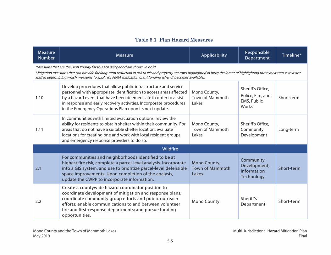
Mono County and the Town of Mammoth Lakes Multi-Jurisdictional Hazard Mitigation Plan May 2019 Final
5-5
Table 5.1 Plan Hazard Measures
Measure Number
Measure Applicability Responsible Department
Timeline*
(Measures that are the High Priority for this MJHMP period are shown in bold. Mitigation measures that can provide for long-term reduction in risk to life and property are rows highlighted in blue; the intent of highlighting these measures is to assist staff in determining which measures to apply for FEMA mitigation grant funding when it becomes available.)
1.10
Develop procedures that allow public infrastructure and service personnel with appropriate identification to access areas affected by a hazard event that have been deemed safe in order to assist in response and early recovery activities. Incorporate procedures in the Emergency Operations Plan upon its next update.
Mono County, Town of Mammoth Lakes
Sheriff’s Office, Police, Fire, and EMS, Public Works
Short-term
1.11
In communities with limited evacuation options, review the ability for residents to obtain shelter within their community. For areas that do not have a suitable shelter location, evaluate locations for creating one and work with local resident groups and emergency response providers to do so.
Mono County, Town of Mammoth Lakes
Sheriff’s Office, Community Development
Long-term
Wildfire
2.1
For communities and neighborhoods identified to be at highest fire risk, complete a parcel-level analysis. Incorporate into a GIS system, and use to prioritize parcel-level defensible space improvements. Upon completion of the analysis, update the CWPP to incorporate information.
Mono County, Town of Mammoth Lakes
Community Development, Information Technology
Short-term
2.2
Create a countywide hazard coordinator position to coordinate development of mitigation and response plans; coordinate community group efforts and public outreach efforts; enable communications to and between volunteer fire and first-response departments; and pursue funding opportunities.
Mono County Sheriff’s Department
Short-term

Mono County and the Town of Mammoth Lakes Multi-Jurisdictional Hazard Mitigation Plan May 2019 Final
5-6
Table 5.1 Plan Hazard Measures
Measure Number
Measure Applicability Responsible Department
Timeline*
(Measures that are the High Priority for this MJHMP period are shown in bold. Mitigation measures that can provide for long-term reduction in risk to life and property are rows highlighted in blue; the intent of highlighting these measures is to assist staff in determining which measures to apply for FEMA mitigation grant funding when it becomes available.)
2.3
Request Caltrans to install more and higher visibility “fire awareness” signs for use along major highways to inform the public of the current fire danger and to promote fire prevention.
Mono County, Town of Mammoth Lakes
Public Works, Community Development
Short-term
2.4
In communities with outdated or inadequate water storage and pressure for firefighting, work with local fire departments to fund, site, permit, and install new tanks and related facilities.
Mono County Community Development Short-term
2.5
Support efforts by Fire Safe Councils and community groups to promote fire prevention, fuels treatments, invasive species control, and defensible space in the WUI and assist in identifying and pursuing funding opportunities to complete these activities.
Mono County, Town of Mammoth Lakes
Community Development
Ongoing
2.6 Develop community-level fire plans for all communities with the highest fire risk, utilizing resources and assistance from the California Fire Alliance.
Mono County, Town of Mammoth Lakes
Fire, Police, and EMS
Long-term
2.7 Educate homeowners about forest health, fire prevention, and home defense and distribute information on fire prevention resources.
Mono County, Town of Mammoth Lakes
Fire, Police, and EMS, Community Development
Ongoing
2.8 Ensure that wildland fire hazards are disclosed during the building permit process, with emphasis on properties located in the WUI zone.
Mono County, Town of Mammoth Lakes
Community Development
Short-term
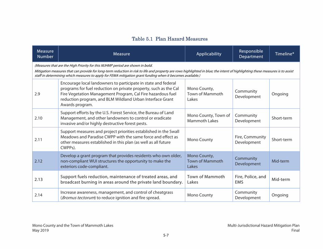
Mono County and the Town of Mammoth Lakes Multi-Jurisdictional Hazard Mitigation Plan May 2019 Final
5-7
Table 5.1 Plan Hazard Measures
Measure Number
Measure Applicability Responsible Department
Timeline*
(Measures that are the High Priority for this MJHMP period are shown in bold. Mitigation measures that can provide for long-term reduction in risk to life and property are rows highlighted in blue; the intent of highlighting these measures is to assist staff in determining which measures to apply for FEMA mitigation grant funding when it becomes available.)
2.9
Encourage local landowners to participate in state and federal programs for fuel reduction on private property, such as the Cal Fire Vegetation Management Program, Cal Fire hazardous fuel reduction program, and BLM Wildland Urban Interface Grant Awards program.
Mono County, Town of Mammoth Lakes
Community Development Ongoing
2.10 Support efforts by the U.S. Forest Service, the Bureau of Land Management, and other landowners to control or eradicate invasive and/or highly destructive forest pests.
Mono County, Town of Mammoth Lakes
Community Development
Short-term
2.11
Support measures and project priorities established in the Swall Meadows and Paradise CWPP with the same force and effect as other measures established in this plan (as well as all future CWPPs).
Mono County Fire, Community Development Short-term
2.12 Develop a grant program that provides residents who own older, non-compliant WUI structures the opportunity to make the exteriors code-compliant.
Mono County, Town of Mammoth Lakes
Community Development
Mid-term
2.13 Support fuels reduction, maintenance of treated areas, and broadcast burning in areas around the private land boundary.
Town of Mammoth Lakes
Fire, Police, and EMS Mid-term
2.14 Increase awareness, management, and control of cheatgrass (Bromus tectorum) to reduce ignition and fire spread. Mono County
Community Development Ongoing

Mono County and the Town of Mammoth Lakes Multi-Jurisdictional Hazard Mitigation Plan May 2019 Final
5-8
Table 5.1 Plan Hazard Measures
Measure Number
Measure Applicability Responsible Department
Timeline*
(Measures that are the High Priority for this MJHMP period are shown in bold. Mitigation measures that can provide for long-term reduction in risk to life and property are rows highlighted in blue; the intent of highlighting these measures is to assist staff in determining which measures to apply for FEMA mitigation grant funding when it becomes available.)
2.15 Prepare for health impacts of smoke from wildfire, including designating clean air shelters in additional communities as needed and notifying residents of their locations.
Mono County, Town of Mammoth Lakes
Public Works, Public Health
Mid-term
Severe Winter Weather and Snow
3.1
Maintain a list of the residences and needs of vulnerable persons, including elderly residents, socially isolated persons, and immuno-compromised individuals, that could require special emergency response resources during hazard events. Develop a response plan for vulnerable persons for use by emergency operators during hazard events.
Mono County, Town of Mammoth Lakes
Public Health, Sheriff’s Office, Fire, Police, and EMS
Short-term
3.2 Coordinate and work with Caltrans and local snow removal resources to maintain key roadway operations.
Mono County, Town of Mammoth Lakes Public Works Mid-term
3.3 Educate community members about severe storm preparedness, including about home and vehicle supplies and public refuge locations.
Mono County, Town of Mammoth Lakes
Sheriff’s Department, Fire, Police, and EMS
Mid-term
3.4
Operate and make accessible public refuge locations during severe storm events within 10 miles of all urbanized communities. Each location should be heated and have on-site backup generators, adequate parking, and supplies of food and water sufficient to serve vulnerable nearby residents and visitors.
Mono County, Town of Mammoth Lakes
Sheriff’s Department, Social Services
Ongoing

Mono County and the Town of Mammoth Lakes Multi-Jurisdictional Hazard Mitigation Plan May 2019 Final
5-9
Table 5.1 Plan Hazard Measures
Measure Number
Measure Applicability Responsible Department
Timeline*
(Measures that are the High Priority for this MJHMP period are shown in bold. Mitigation measures that can provide for long-term reduction in risk to life and property are rows highlighted in blue; the intent of highlighting these measures is to assist staff in determining which measures to apply for FEMA mitigation grant funding when it becomes available.)
Seismic
4.1
Conduct a comprehensive survey of the structural condition of all public buildings and critical facilities, including identification of unreinforced masonry and soft-story structures. Prioritize surveying buildings and facilities in earthquake fault zones. Retrofit or replace structures, as funding allows, identified as being at high risk of collapse in a seismic event.
Mono County, Town of Mammoth Lakes
Public Works, Community Development
Mid-term
4.2 Continue to require new and retrofitted structures to meet minimum state seismic safety standards, and encourage property owners to exceed these standards.
Mono County, Town of Mammoth Lakes
Public Works, Community Development
Ongoing
4.3 Require property owners to locate new developments outside of known fault rupture hazard zones, or design to appropriate standards.
Mono County, Town of Mammoth Lakes
Community Development
Mid-term
4.4
Design Town- and County-owned infrastructure in fault rupture zones to resist damage from fault rupture, and encourage other agencies to use similar strategies. Use similar strategies outside of fault rupture zones to the extent feasible.
Mono County, Town of Mammoth Lakes
Public Works Mid-term
4.5
Require new development in areas susceptible to liquefaction to conduct a geotechnical evaluation and implement actions to mitigate liquefaction risk. Avoid development in areas where liquefaction risk cannot be adequately mitigated.
Mono County, Town of Mammoth Lakes
Public Works, Community Development
Ongoing

Mono County and the Town of Mammoth Lakes Multi-Jurisdictional Hazard Mitigation Plan May 2019 Final
5-10
Table 5.1 Plan Hazard Measures
Measure Number
Measure Applicability Responsible Department
Timeline*
(Measures that are the High Priority for this MJHMP period are shown in bold. Mitigation measures that can provide for long-term reduction in risk to life and property are rows highlighted in blue; the intent of highlighting these measures is to assist staff in determining which measures to apply for FEMA mitigation grant funding when it becomes available.)
Volcano
5.1 Distribute information regarding evacuation procedures in the event of potential volcanic lava, pyroclastic, or debris flow and ash distribution.
Mono County, Town of Mammoth Lakes
Sheriff’s Department, Fire, Police, and EMS
Mid-term
5.2 Support efforts to improve volcanic forecasting strategies. Mono County, Town of Mammoth Lakes
Information Technology Long-term
Drought
6.1
Encourage retrofits of private homes and businesses for increased water conservation. Continue to educate about and promote the Property Assessed Clean Energy (PACE) programs in funding retrofits.
Mono County, Town of Mammoth Lakes
Community Development
Short-term
6.2 Support the Tri-Valley Groundwater Management District’s efforts to improve groundwater management through education and program implementation.
Mono County Community Development Mid-term
6.3
Provide resources to landowners about irrigation efficiency and crops with reduced water requirements. Encourage landowners to use plants that require little or no irrigation in new or retrofitted landscapes.
Mono County, Town of Mammoth Lakes
Community Development
Mid-term

Mono County and the Town of Mammoth Lakes Multi-Jurisdictional Hazard Mitigation Plan May 2019 Final
5-11
Table 5.1 Plan Hazard Measures
Measure Number
Measure Applicability Responsible Department
Timeline*
(Measures that are the High Priority for this MJHMP period are shown in bold. Mitigation measures that can provide for long-term reduction in risk to life and property are rows highlighted in blue; the intent of highlighting these measures is to assist staff in determining which measures to apply for FEMA mitigation grant funding when it becomes available.)
6.4 Provide resources to local farmers about crop varieties that require little or no irrigation.
Mono County
Community Development, Inyo and Mono Counties Agriculture Department
Mid-term
Extreme Heat
7.1 Identify ways to provide free or low-cost weatherization and energy-efficient heating and cooling appliances to lower-income residents without access to these devices.
Mono County, Town of Mammoth Lakes
Community Development
Mid-term
7.2
Identify public buildings that can serve as cooling centers in the event of extreme heat events, particularly in the Tri-Valley area. Perform any upgrades necessary to ensure the facilities meet standards necessary for a cooling center, and inform residents about where these centers are located and any procedures for usage.
Mono County Public Works, Public Health Department
Mid-term
Severe Wind
8.1
Work with Caltrans to install a real-time wind and visibility tracking system for key access road segments, and incorporate warnings into online notifications and the emergency notification system.
Mono County, Town of Mammoth Lakes
Community Development Mid-term

Mono County and the Town of Mammoth Lakes Multi-Jurisdictional Hazard Mitigation Plan May 2019 Final
5-12
Table 5.1 Plan Hazard Measures
Measure Number
Measure Applicability Responsible Department
Timeline*
(Measures that are the High Priority for this MJHMP period are shown in bold. Mitigation measures that can provide for long-term reduction in risk to life and property are rows highlighted in blue; the intent of highlighting these measures is to assist staff in determining which measures to apply for FEMA mitigation grant funding when it becomes available.)
8.2 Encourage project applicants to incorporate wind-resistant design features into new or significantly renovated buildings.
Mono County, Town of Mammoth Lakes
Community Development
Mid-term
Flood
9.1 Develop and implement a program to provide funding for residents with homes in the 100-year floodplain to retrofit structures and raise them out of the floodplain.
Mono County Public Works Short-term
9.2
Request FEMA to update the FIRM maps for the Walker River watershed communities, the June Lake Loop, and the Tri-Valley area. As maps are updated, conduct public outreach to affected communities regarding NFIP outcomes.
Mono County Public Works Mid-term
9.3
Document past flood events in the GIS system to identify historic flooding patterns that can be used to better understand where repetitive flooding hazards occur and enable the County and Town to minimize risks to existing development in those areas.
Mono County, Town of Mammoth Lakes
Community Development, Public Works, Information Technology
Ongoing
9.4
Through an ongoing public education program, ensure that property owners are aware of flood hazards and practices necessary to diminish the impacts of those hazards. This program should include information on participation in the NFIP.
Mono County, Town of Mammoth Lakes
Community Development, Public Works
Ongoing
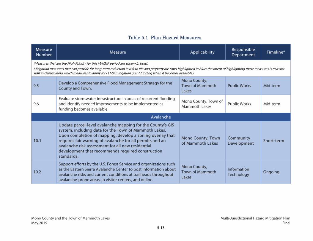
Mono County and the Town of Mammoth Lakes Multi-Jurisdictional Hazard Mitigation Plan May 2019 Final
5-13
Table 5.1 Plan Hazard Measures
Measure Number
Measure Applicability Responsible Department
Timeline*
(Measures that are the High Priority for this MJHMP period are shown in bold. Mitigation measures that can provide for long-term reduction in risk to life and property are rows highlighted in blue; the intent of highlighting these measures is to assist staff in determining which measures to apply for FEMA mitigation grant funding when it becomes available.)
9.5 Develop a Comprehensive Flood Management Strategy for the County and Town.
Mono County, Town of Mammoth Lakes
Public Works Mid-term
9.6 Evaluate stormwater infrastructure in areas of recurrent flooding and identify needed improvements to be implemented as funding becomes available.
Mono County, Town of Mammoth Lakes Public Works Mid-term
Avalanche
10.1
Update parcel-level avalanche mapping for the County’s GIS system, including data for the Town of Mammoth Lakes. Upon completion of mapping, develop a zoning overlay that requires fair warning of avalanche for all permits and an avalanche risk assessment for all new residential development that recommends required construction standards.
Mono County, Town of Mammoth Lakes
Community Development
Short-term
10.2
Support efforts by the U.S. Forest Service and organizations such as the Eastern Sierra Avalanche Center to post information about avalanche risks and current conditions at trailheads throughout avalanche-prone areas, in visitor centers, and online.
Mono County, Town of Mammoth Lakes
Information Technology
Ongoing

Mono County and the Town of Mammoth Lakes Multi-Jurisdictional Hazard Mitigation Plan May 2019 Final
5-14
Table 5.1 Plan Hazard Measures
Measure Number
Measure Applicability Responsible Department
Timeline*
(Measures that are the High Priority for this MJHMP period are shown in bold. Mitigation measures that can provide for long-term reduction in risk to life and property are rows highlighted in blue; the intent of highlighting these measures is to assist staff in determining which measures to apply for FEMA mitigation grant funding when it becomes available.)
10.3
Develop a map for the County website that identifies roadway segments at avalanche risk and educates communities about the risks, forecasting methods, and roadway operations within areas at avalanche hazard areas. As part of the countywide notification system, provide real-time avalanche conditions along the identified roadway segments.
Mono County, Town of Mammoth Lakes
Public Works, Information Technology
Mid-term
10.4
Work with federal agencies to transfer privately owned properties in avalanche hazard zones that are adjacent to or on public lands into federal ownership or into the ownership of land conservation organizations, and restrict their use to permanent open space use.
Mono County, Town of Mammoth Lakes
Community Development
Long-term
Dam Inundation
11.1 Be aware of the dams in the County with condition assessment of fair or lower, and be prepared to respond to public health and safety needs in the event of an emergency.
Mono County Public Works Short-term
11.2
Work with owners of dams in the County to update information on the potential impacts and inundation areas in the case of dam failure. Develop land use standards and emergency response standards based on that information.
Mono County Community Development, Sheriff’s Office
Mid-term
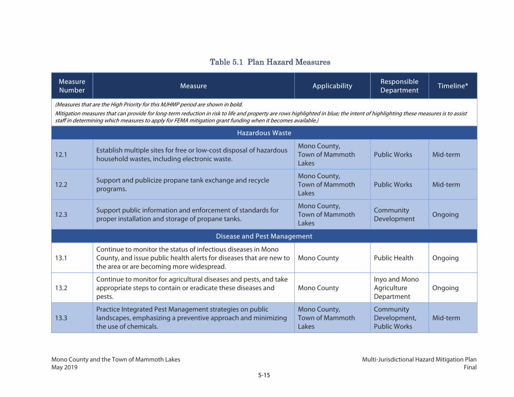
Mono County and the Town of Mammoth Lakes Multi-Jurisdictional Hazard Mitigation Plan May 2019 Final
5-15
Table 5.1 Plan Hazard Measures
Measure Number
Measure Applicability Responsible Department
Timeline*
(Measures that are the High Priority for this MJHMP period are shown in bold. Mitigation measures that can provide for long-term reduction in risk to life and property are rows highlighted in blue; the intent of highlighting these measures is to assist staff in determining which measures to apply for FEMA mitigation grant funding when it becomes available.)
Hazardous Waste
12.1 Establish multiple sites for free or low-cost disposal of hazardous household wastes, including electronic waste.
Mono County, Town of Mammoth Lakes
Public Works Mid-term
12.2 Support and publicize propane tank exchange and recycle programs.
Mono County, Town of Mammoth Lakes
Public Works Mid-term
12.3 Support public information and enforcement of standards for proper installation and storage of propane tanks.
Mono County, Town of Mammoth Lakes
Community Development
Ongoing
Disease and Pest Management
13.1 Continue to monitor the status of infectious diseases in Mono County, and issue public health alerts for diseases that are new to the area or are becoming more widespread.
Mono County Public Health Ongoing
13.2 Continue to monitor for agricultural diseases and pests, and take appropriate steps to contain or eradicate these diseases and pests.
Mono County Inyo and Mono Agriculture Department
Ongoing
13.3 Practice Integrated Pest Management strategies on public landscapes, emphasizing a preventive approach and minimizing the use of chemicals.
Mono County, Town of Mammoth Lakes
Community Development, Public Works
Mid-term

Mono County and the Town of Mammoth Lakes Multi-Jurisdictional Hazard Mitigation Plan May 2019 Final
5-16
Table 5.1 Plan Hazard Measures
Measure Number
Measure Applicability Responsible Department
Timeline*
(Measures that are the High Priority for this MJHMP period are shown in bold. Mitigation measures that can provide for long-term reduction in risk to life and property are rows highlighted in blue; the intent of highlighting these measures is to assist staff in determining which measures to apply for FEMA mitigation grant funding when it becomes available.)
13.4
Conduct periodic educational campaigns through in-person events and various types of media to encourage community members to remove standing water and practice other mosquito prevention strategies.
Mono County, Town of Mammoth Lakes
Public Health, Police, Fire, and EMS
Mid-term
13.5 Support efforts by the U.S. Forest Service, the Bureau of Land Management, and other landowners to control or eradicate invasive and/or abnormally active forest pests.
Mono County, Town of Mammoth Lakes
Community Development Ongoing
Wildlife Collisions
14.1
Work with Caltrans to conduct an analysis of frequent collision areas to determine type and placement of appropriate wildlife crossings. Seek funding to implement proposed wildlife crossing projects.
Mono County Community Development, Public Works
Mid-term
Climate Change
15.1
Reevaluate changes to hazards and risks as a result of climate change every five years based on more current available information, and revise the LHMP to account for new information.
Mono County, Town of Mammoth Lakes
Community Development, Public Health
Short-term
*For Timeline: Short-term = 1-2 years Mid-term = 3 years Long-term – 4-5 years Ongoing = 1-2 years and ongoing thereafter
Mono County and the Town of Mammoth Lakes Multi-Jurisdictional Hazard Mitigation Plan May 2019 Final
5-17
5.2.1 Secondary Access Assessment
As discussed in Chapters 2 and 7 of this Plan, both the unincorporated County and the Town of
Mammoth Lakes have a number of neighborhoods and entire communities that have only one access
route connecting them to community amenities, emergency services, and primary roadways. Figure
2.8 in Chapter 2 identifies all communities and neighborhoods without secondary access to major
access roads. Many of these communities are threatened by one or more hazards. Developing
secondary access routes is typically constrained by the presence of hazard zones and steep slopes, as
well as procedural onus associated with establishing right-of-way on land owned by multiple private
and public entities.
Based on input from the Mono County Board of Supervisors, Department of Public Works, and the
community planning process, the Planning Team identified six communities for which to conduct more
detailed analyses of opportunities and constraints in providing secondary access routes or other
measures to reduce risk during a hazard event. These six communities and neighborhoods are:
Swall Meadows; accessed by Swall Meadows Road
Crowley Lake; neighborhoods accessed by Pearson Road (Lakeridge Ranch Estates)
McGee Creek; neighborhoods accessed by Gregory Lane
June Lake; neighborhoods accessed by Rainbow Street (Petersen Tract)
Chalfant; neighborhoods accessed by Chalfant Road
Chalfant; neighborhoods accessed by Tungsten Road (White Mountain Estates)
The following analyses in Tables 5.2 through 5.7 are intended to support implementation efforts of
Mitigation Measure 1.6.

Mono County and the Town of Mammoth Lakes Multi-Jurisdictional Hazard Mitigation Plan May 2019 Final
5-18
This page intentionally left blank.

Mono County and the Town of Mammoth Lakes Multi-Jurisdictional Hazard Mitigation Plan May 2019 Final
5-19
Table 5.2 Swall Meadows Community Secondary Access Assessment
Single Access Road: Swall Meadows Road
Existing Conditions
Swall Meadows is a residential community which includes second homes and a volunteer fire department, but no commercial development. Located in the Wheeler Crest Community Planning Area, it sits partway up the Sherwin Grade below the Wheeler Crest of the eastern Sierra Nevada. The community’s single-access road is Swall Meadows Road, which in turn can only be accessed via Lower Rock Creek Road (aka Old Sherwin Grade Road). Lower Rock Creek Road connects to CA 395 to the north and to another small community, Tom’s Place, and CA 395 to the south. The area contains approximately 106 homes and 146 structures. The population was reported as 194 in the 2016 American Community Survey 5-year estimates. As of mid-2018, a local CWPP for the Swall Meadows community is under development. This plan may provide additional analysis of potential access and secondary road siting options.
Land Ownership and Slope Conditions
Swall Meadows contains privately owned lots, most less than a quarter acre with single-family homes off of small cul-de-sacs. Land surrounding the community is owned by U.S. Forest Service, Bureau of Land Management, and LADWP. Slopes surrounding the community vary from 5 percent to over 20 percent with the steepest grades to the west toward Wheeler Crest Peak and along Rock Creek, running northwest of the community and south of CA 395. See details in Figure 5.1 below.

Mono County and the Town of Mammoth Lakes Multi-Jurisdictional Hazard Mitigation Plan May 2019 Final
5-20
Table 5.2 Swall Meadows Community Secondary Access Assessment
Single Access Road: Swall Meadows Road
Figure 5.1: Swall Meadows Community Secondary Access Analysis – Slopes and Land Ownership

Mono County and the Town of Mammoth Lakes Multi-Jurisdictional Hazard Mitigation Plan May 2019 Final
5-21
Table 5.2 Swall Meadows Community Secondary Access Assessment
Single Access Road: Swall Meadows Road
Hazard Conditions
The priority hazard posing greatest risk to the community is wildfire. The community itself is located in a Moderate Fire Hazard Severity Zone but is adjacent to High Fire Hazard Severity Zones. The community has also been threatened by a number of fires in the past and was directly in the path of the 2015 Round Fire, which burned 7,000 acres and many of the structures in the community.
Portions of the community are also located within an Alquist-Priolo fault zone. Structures and infrastructure in the fault zone are at high risk of significant damage in the case of an earthquake.
See details in Figure 5.2 below.

Mono County and the Town of Mammoth Lakes Multi-Jurisdictional Hazard Mitigation Plan May 2019 Final
5-22
Table 5.2 Swall Meadows Community Secondary Access Assessment
Single Access Road: Swall Meadows Road
Figure 5.2: Swall Meadows Community Secondary Access Analysis – Fault and Fire Zones

Mono County and the Town of Mammoth Lakes Multi-Jurisdictional Hazard Mitigation Plan May 2019 Final
5-23
Table 5.2 Swall Meadows Community Secondary Access Assessment
Single Access Road: Swall Meadows Road
Secondary Access and Risk Reduction Options
Local topography and hazard conditions offer few options, none of which are ideal. The preferred secondary access route—which was identified with community input, has been reviewed by the Mono County Public Works Department, and has the support of the Wheeler Crest Fire Safe Council and Fire Department—would extend from Quail Circle to Swall Meadows Drive, just before it connects to Lower Rock Creek Road. Because this final 1,300-foot stretch doubles up with the existing access route, it is possible for a hazard event right at Swall Meadows Drive and Lower Rock Creek Road to block both routes. For this reason, the Planning Team added Mitigation Measure 1.11 to the Plan to identify or create sheltering locations within communities with limited options for access routes. See below for additional strengths and constraints of this route. Other access routes to serve Swall Meadows were considered and rejected during the planning process. One such route would have improved an existing dirt road that connects to a section of Lower Rock Creek Road farther south at Paradise. The access route would extend roughly 2.5 miles through a steep gully. Had evacuees used this route during the Round Fire in 2015, they could have been trapped in the canyon. Steep grades make additional roadway connections directly to CA 395 potentially difficult and costly. Another unnamed dirt road extends from Sky Meadow Road to US 395 near Tuff Campground, but this 4.5-mile route is extremely long and winding.
Strengths Constraints
By utilizing an existing dirt road, development of the secondary access route may be more cost effective and reduce impacts on the visual and natural resources of the immediate area.
The proposed route avoids steeper slopes that surround the area. The proposed route has undergone a preliminary feasibility study
by Mono County Department of Public Works. The route has strong support from local leaders and community
members.
The plan doubles the existing access route for the final 1,300 feet of Swall Meadows Drive.
The route would require an easement through Lot 5 and/or Lot 6 on Quail Circle.
The 10–15-foot elevation difference at Swall Meadows Drive would likely require an engineered earthwork ramp.
An 8.6 percent grade would require switchbacks to meet Cal Fire requirements for fire trucks. A topographic survey is needed to create road design.

Mono County and the Town of Mammoth Lakes Multi-Jurisdictional Hazard Mitigation Plan May 2019 Final
5-24
Table 5.3 Crowley Lake Community Secondary Access Assessment
Single Access Road: Pearson Road (Lakeridge Ranch Estates)
Existing Conditions
The Crowley Lake community is located 12 miles south of the Town of Mammoth Lakes and encompasses both a residential community and the Crowley Lake ballfields. Pearson Road is the sole access point to the easternmost neighborhood, located north of Crowley Lake Drive, south of CA 395, and east of Whisky Creek. There are 32 homes and 35 additional structures in the neighborhood with single roadway access.
Land Ownership and Slope Conditions
The single access neighborhood includes residences, accessory buildings, and the Crowley Lake ballfields. Land surrounding the community is federally owned. Slopes surrounding the community vary from 5 percent to over 20 percent with the steepest grades to the north, west, and south. See details in Figure 5.3 below.

Mono County and the Town of Mammoth Lakes Multi-Jurisdictional Hazard Mitigation Plan May 2019 Final
5-25
Table 5.3 Crowley Lake Community Secondary Access Assessment
Single Access Road: Pearson Road (Lakeridge Ranch Estates)
Figure 5.3: Crowley Lake Community Secondary Access Analysis – Slopes and Land Ownership
Mono County and the Town of Mammoth Lakes Multi-Jurisdictional Hazard Mitigation Plan May 2019 Final
5-26
Table 5.3 Crowley Lake Community Secondary Access Assessment
Single Access Road: Pearson Road (Lakeridge Ranch Estates)
Hazard Conditions
The priority hazards posing greatest risk to the community are wildfire and local flooding. The community itself is located in a High Fire Hazard Severity Zone and is adjacent to Moderate Fire Hazard Severity Zones. Severe wind is also of concern in Crowley Lake, which can increase the magnitude of fires when they do occur. Portions of the community are located in a DWR Awareness Floodplain. Structures and infrastructure in the Awareness Floodplain have not been officially mapped under the FEMA NFIP, but could be at high risk of significant damage in the case of flooding. Localized flooding, which is not identified through FEMA’s mapping program, is also known to affect portions of Pearson Road and inhibit access to South Landing Road. See details in Figure 5.4 below.

Mono County and the Town of Mammoth Lakes Multi-Jurisdictional Hazard Mitigation Plan May 2019 Final
5-27
Table 5.3 Crowley Lake Community Secondary Access Assessment
Single Access Road: Pearson Road (Lakeridge Ranch Estates)
Figure 5.4: Crowley Lake Community Secondary Access Analysis – Fire and Flood Zones

Mono County and the Town of Mammoth Lakes Multi-Jurisdictional Hazard Mitigation Plan May 2019 Final
5-28
Table 5.3 Crowley Lake Community Secondary Access Assessment
Single Access Road: Pearson Road (Lakeridge Ranch Estates)
Secondary Access and Risk Reduction Options
A secondary access route could be developed by improving an existing dirt road utilized by the Bureau of Land Management, located north of Crowley Lake ballfields and connecting to Crowley Lake Drive to the east.
Strengths Constraints
By utilizing an existing dirt road, development of the secondary access route may be more cost effective and reduce impacts on the visual and natural resources of the immediate area.
The proposed route avoids steeper slopes that surround the area. The proposed route does not require an easement or eminent
domain process of private property.
The proposed secondary access route, which follows an existing dirt road connecting south Pearson Road to Crowley Lake Road, would require crossing federal land.
Although the proposed secondary access route avoids the steepest slopes in the area, it still must cross small sections with slope greater than 20 percent.
Although the proposed route provides secondary access leading out from a separate area of the community, it does not connect back to CA 395, a primary access road.

Mono County and the Town of Mammoth Lakes Multi-Jurisdictional Hazard Mitigation Plan May 2019 Final
5-29
Table 5.4 McGee Creek Community Secondary Access Assessment
Single Access Road: Gregory Lane
Existing Conditions
The McGee Creek community is located on the southwestern side of Lake Crowley, south of CA 395. The community’s single-access road is Gregory Lane, which in turn can only be accessed via Crowley Lake Drive. Crowley Lake Drive connects to CA 395 via McGee Creek Road north of the Crowley Lake community. The neighborhood with sole roadway access contains 15 homes, which are all privately owned, as well as 15-plus structures.
Land Ownership and Slope Conditions
The Gregory Lane area contains privately owned lots, most less than a quarter acre with single-family homes off of small cul-de-sacs. Land surrounding the community is owned by the Bureau of Land Management. Slopes on the side of the community connected back to the primary access route of CA 395 are generally moderate and vary from 5 percent to 15 percent. Steeper grades are located at the southern portion of the community and northwest of McGee Creek. See details in Figure 5.5 below.

Mono County and the Town of Mammoth Lakes Multi-Jurisdictional Hazard Mitigation Plan May 2019 Final
5-30
Table 5.4 McGee Creek Community Secondary Access Assessment
Single Access Road: Gregory Lane
Figure 5.5: McGee Creek Community Secondary Access Analysis – Slopes and Land Ownership

Mono County and the Town of Mammoth Lakes Multi-Jurisdictional Hazard Mitigation Plan May 2019 Final
5-31
Table 5.4 McGee Creek Community Secondary Access Assessment
Single Access Road: Gregory Lane
Hazard Conditions
The priority hazards posing greatest risk to the community are flood and wildfire.
The community itself is located in a High Fire Hazard Severity Zone and is surrounded by Moderate Fire Hazard Severity Zones. Portions of the community are also located in a DWR Awareness Floodplain as well as the 100-year flood zone, including sections of Gregory Lane, which frequently floods and occasionally washes out, cutting off a number of residential properties from access to Crowley Lake Drive and CA 395. In severe flooding, Crowley Lake Drive could be entirely cut off from CA 395. Structures and infrastructure in the Awareness Floodplain have not been officially mapped under the FEMA NFIP, but could be at high risk of significant damage in the case of flooding.
See details in Figure 5.6 below.

Mono County and the Town of Mammoth Lakes Multi-Jurisdictional Hazard Mitigation Plan May 2019 Final
5-32
Table 5.4 McGee Creek Community Secondary Access Assessment
Single Access Road: Gregory Lane
Figure 5.6: McGee Creek Community Secondary Access Analysis – Fire and Flood Zones

Mono County and the Town of Mammoth Lakes Multi-Jurisdictional Hazard Mitigation Plan May 2019 Final
5-33
Table 5.4 McGee Creek Community Secondary Access Assessment
Single Access Road: Gregory Lane
Secondary Access and Risk Reduction Options
A secondary access route could be developed on BLM land by improving an existing dirt road that connects Crowley Lake Drive to CA 395 southeast of Gregory Lane. Additionally, the portion of Gregory Lane connecting to American Way, the section most frequently affected by flooding, could be hardened by installing flood walls or by raising the entire section out of the flood awareness zone.
Strengths Constraints
By utilizing an existing dirt road, development of the secondary access route may be more cost effective and reduce impacts on the visual and natural resources of the immediate area.
The proposed secondary route avoids steeper slopes. The proposed secondary route does not require an easement or
eminent domain process of private property. The proposed secondary route provides access to CA 395 to the
south even if Gregory Lane, American Way, and Crowley Lake Drive are all affected by flooding on the creek.
The proposed hardening of Gregory Lane does not require any easements or eminent domain process.
The proposed secondary access route, which follows an existing dirt road connecting south to Crowley Lake Drive, would require crossing federal land.

Mono County and the Town of Mammoth Lakes Multi-Jurisdictional Hazard Mitigation Plan May 2019 Final
5-34
Table 5.5 June Lake Community Secondary Access Assessment
Single Access Road: Rainbow Street/Petersen Tract
Existing Conditions
The Petersen tract area is located south of CA 158 and west of the June Mountain Ski Area. There are 140 homes in this neighborhood, as well as a few commercial uses and an overnight lodge. The community’s single access road is Rainbow Street, which in turn can only be accessed by CA 158.
In 2005, the County authorized a Capital Facilities Plan by Service Category study for the June Lake Village area to be performed by Stantec. As a portion of this study, Stantec identified possible improvements to the roadway network to improve traffic flow and access, including in the Petersen tract. The study was evaluated as part of this assessment. The study produced similar but not identical proposed access route options based on a different set of evaluator parameters. Both this assessment and the Stantec study should be considered in making ultimate project decisions.
Land Ownership and Slope Conditions
The single-access neighborhood is predominantly privately owned residential lots, with select commercial uses organized in a modified grid layout with some streets leading to dead-ends rather than connecting through. Land surrounding the community is federally owned.
Slopes surrounding the community vary from 5 percent to over 20 percent with the steepest grades in the southwest corner of the neighborhood to the west of Jessie Street.
See details in Figure 5.7 below.

Mono County and the Town of Mammoth Lakes Multi-Jurisdictional Hazard Mitigation Plan May 2019 Final
5-35
Table 5.5 June Lake Community Secondary Access Assessment
Single Access Road: Rainbow Street/Petersen Tract
Figure 5.7: June Lake Community Secondary Access Analysis – Slopes and Land Ownership

Mono County and the Town of Mammoth Lakes Multi-Jurisdictional Hazard Mitigation Plan May 2019 Final
5-36
Table 5.5 June Lake Community Secondary Access Assessment
Single Access Road: Rainbow Street/Petersen Tract
Hazard Conditions
The priority hazard posing the greatest risk to the community is wildfire. The community itself is located in a Very High Fire Hazard Severity Zone and is adjacent to Moderate Fire Hazard Severity Zones. Severe wind is also of concern in June Lake, which can increase the magnitude of fires when they do occur.
The community also has several creeks running through that are within the 100-year flood zone. A 100-year flood event could cut off much of the subdivision from CA 158.
The community is not located within an Alquist-Priolo fault zone, but is within the vacinity of a few Alquist-Priolo fault zones. Structures and infrastructure near fault zones are at risk of damage in the case of an earthquake.
See details in Figure 5.8 below.

Mono County and the Town of Mammoth Lakes Multi-Jurisdictional Hazard Mitigation Plan May 2019 Final
5-37
Table 5.5 June Lake Community Secondary Access Assessment
Single Access Road: Rainbow Street/Petersen Tract
Figure 5.8: June Lake Community Secondary Access Analysis – Fault, Fire and Flood Zones

Mono County and the Town of Mammoth Lakes Multi-Jurisdictional Hazard Mitigation Plan May 2019 Final
5-38
Table 5.5 June Lake Community Secondary Access Assessment
Single Access Road: Rainbow Street/Petersen Tract
Secondary Access and Risk Reduction Options
Two secondary access routes could be developed for this neighborhood. The first could extend Mono Drive to connect with Aspen Road to the west, and the second could extend Palisades Drive to CA 158 near the June Lake Ski Area to the northeast. The Mono Drive connection would occur on County-owned land, and the Palisades Drive extension would occur on federally owned land. Both routes would need to be designed to be elevated above the 100-year floodplain at Reversed Creek.
Strengths Constraints
The proposed routes run alongside, but generally avoid, steeper slopes that surround the area.
The proposed routes would provide two additional access routes to the southern portion of the community.
The proposed routes connect to CA 158 near the connection with Northshore Drive, which provides more direct exit from High and Very High Hazard Severity Fire Zones.
The proposed secondary access routes do not follow any existing dirt routes and would require crossing federal land.
The proposed secondary access routes are not existing roads and therefore would require higher utilization of resources and have potential impacts to environmental and visual resources.
The proposed routes may require an easement or eminent domain process of private property.

Mono County and the Town of Mammoth Lakes Multi-Jurisdictional Hazard Mitigation Plan May 2019 Final
5-39
Table 5.6 Chalfant (West) Community Secondary Access Assessment
Single Access Road: West Chalfant Road
Existing Conditions
The West Chalfant community is located near Chalfant Valley on the western side of CA 6. It includes 67 homes, as well as some small-scale agricultural uses. Chalfant Road is the sole access point for the community, connecting at the northeastern corner and running south before terminating.
Land Ownership and Slope Conditions
West Chalfant contains privately owned lots with single-family homes arranged in cul-de-sacs. Land surrounding the community is owned by federal agencies to the west and south, and LADWP to the north and east.
Slopes surrounding the community are mild, with most being less than 5 percent. The southwestern corner has slopes of 5–10 percent.
See details in Figure 5.9 below.

Mono County and the Town of Mammoth Lakes Multi-Jurisdictional Hazard Mitigation Plan May 2019 Final
5-40
Table 5.6 Chalfant (West) Community Secondary Access Assessment
Single Access Road: West Chalfant Road
Figure 5.9: Chalfant (West) Community Secondary Access Analysis – Slopes and Land Ownership
Mono County and the Town of Mammoth Lakes Multi-Jurisdictional Hazard Mitigation Plan May 2019 Final
5-41
Table 5.6 Chalfant (West) Community Secondary Access Assessment
Single Access Road: West Chalfant Road
Hazard Conditions
The priority hazard posing greatest risk to the community is flooding. More than half of the community is located in the 100-year flood zone, and the rest is located in a DWR Awareness Floodplain. Small portions of the community are also located within the 500-year floodplain. Much of the primary emergency access road CA 6 is also located within the 100-year or 500-year floodplain within several miles of the community, and is subject to occasional closure from flooding and debris. In such events, access out of the community is entirely impractical and alternative methods of shelter in place options would be required. The community is not located within an Alquist-Priolo fault zone, but is within the vacinity of a Alquist-Priolo fault zone. Structures and infrastructure near a fault zone are at risk of damage in the case of an earthquake.
See details in Figure 5.10 below.

Mono County and the Town of Mammoth Lakes Multi-Jurisdictional Hazard Mitigation Plan May 2019 Final
5-42
Table 5.6 Chalfant (West) Community Secondary Access Assessment
Single Access Road: West Chalfant Road
Figure 5.10: Chalfant (West) Community Secondary Access Analysis – Fault, Fire and Flood Zones

Mono County and the Town of Mammoth Lakes Multi-Jurisdictional Hazard Mitigation Plan May 2019 Final
5-43
Table 5.6 Chalfant (West) Community Secondary Access Assessment
Single Access Road: West Chalfant Road
Secondary Access and Risk Reduction Options
A secondary access route could be developed by improving an existing dirt road that connects to the southeastern corner of the community. The access route would extend roughly 2.5 miles to the south and connect to Tungsten Road. Additionally, Chalfant Road could be improved to better withstand flooding and storm surges.
Strengths Constraints
By utilizing an existing dirt road, development of the secondary access route may be more cost effective and reduce impacts on the visual and natural resources of the immediate area.
The proposed route does not require an easement or eminent domain process of private property.
The proposed secondary access route would require crossing land owned by LADWP.
Although the proposed route provides secondary access leading out from a separate area of the community, it does not connect back to CA 6, the primary access road.
In the event that Chalfant Road is flooded, it is possible that the primary access road, CA 6, would also be flooded.

Mono County and the Town of Mammoth Lakes Multi-Jurisdictional Hazard Mitigation Plan May 2019 Final
5-44
Table 5.7 Chalfant (White Mountain Estates) Community Secondary Access Assessment
Single Access Road: Tungsten Road
Existing Conditions
White Mountain Estates is located east of CA 6, south of Chalfant Valley. It is composed predominantly of privately owned residential lots, with 42 homes.
Land Ownership and Slope Conditions
White Mountain Estates contains privately owned lots with single-family homes in the western one-third of the community. The eastern two-thirds of the community is state-owned land. Land surrounding the community is owned by federal agencies to the north, east, and south, and LADWP to the west. Slopes surrounding the community range from less than 5 percent to more than 20 percent, although slopes on the west side of the community connecting back to the primary access road, CA 6, are generally less than 5 percent. Steeper slopes exist in the eastern region near the mountain range. See details in Figure 5.11 below.

Mono County and the Town of Mammoth Lakes Multi-Jurisdictional Hazard Mitigation Plan May 2019 Final
5-45
Table 5.7 Chalfant (White Mountain Estates) Community Secondary Access Assessment
Single Access Road: Tungsten Road
Figure 5.11: Chalfant (White Mountain Estates) Community Secondary Access Analysis – Slopes and Land Ownership
Mono County and the Town of Mammoth Lakes Multi-Jurisdictional Hazard Mitigation Plan May 2019 Final
5-46
Table 5.7 Chalfant (White Mountain Estates) Community Secondary Access Assessment
Single Access Road: Tungsten Road
Hazard Conditions
The priority hazard posing the greatest risk to the community is flooding. The community is located outside of any flood zone, but Tungsten Road, its single access route (aka White Mountain Estates Road), is located within the 100-year flood zone. In a 100-year flood event, the community could therefore be cut off from the primary emergency access route, CA 6. Portions of the community are also located within an Alquist- Priolo fault zone. Structures and infrastructure in the fault zone are at high risk of significant damage in the case of an earthquake. See details in Figure 5.12 below.

Mono County and the Town of Mammoth Lakes Multi-Jurisdictional Hazard Mitigation Plan May 2019 Final
5-47
Table 5.7 Chalfant (White Mountain Estates) Community Secondary Access Assessment
Single Access Road: Tungsten Road
Figure 5.12: Chalfant (White Mountain Estates) Community Secondary Access Analysis – Fault, Fire and Flood Zones

Mono County and the Town of Mammoth Lakes Multi-Jurisdictional Hazard Mitigation Plan May 2019 Final
5-48
Table 5.7 Chalfant (White Mountain Estates) Community Secondary Access Assessment
Single Access Road: Tungsten Road
Secondary Access and Risk Reduction Options
A secondary access route could be developed on the south side of the community, connecting to CA 6 to the southwest. This route would pass through a DWR Awareness Floodplain but would be entirely outside the 100-year floodplain.
Strengths Constraints
The proposed route does not require an easement or eminent domain process of private property.
The proposed route connects directly to CA 6 primary evacuation route.
The proposed route would pass through areas of little to no slope. The proposed access route utilizes, in part, an existing dirt road.
The proposed secondary access route would require crossing both federal and utilities land.
The proposed route would pass through a DWR Awareness Floodplain.
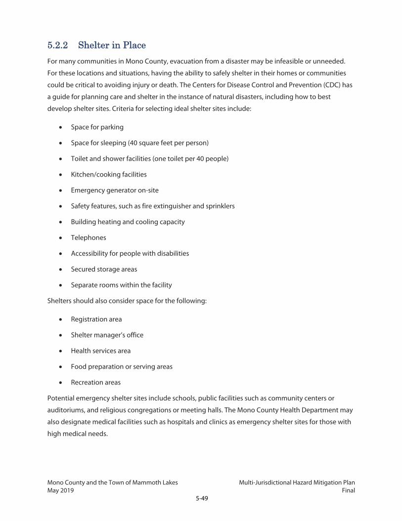
Mono County and the Town of Mammoth Lakes Multi-Jurisdictional Hazard Mitigation Plan May 2019 Final
5-49
5.2.2 Shelter in Place
For many communities in Mono County, evacuation from a disaster may be infeasible or unneeded.
For these locations and situations, having the ability to safely shelter in their homes or communities
could be critical to avoiding injury or death. The Centers for Disease Control and Prevention (CDC) has
a guide for planning care and shelter in the instance of natural disasters, including how to best
develop shelter sites. Criteria for selecting ideal shelter sites include:
Space for parking
Space for sleeping (40 square feet per person)
Toilet and shower facilities (one toilet per 40 people)
Kitchen/cooking facilities
Emergency generator on-site
Safety features, such as fire extinguisher and sprinklers
Building heating and cooling capacity
Telephones
Accessibility for people with disabilities
Secured storage areas
Separate rooms within the facility
Shelters should also consider space for the following:
Registration area
Shelter manager’s office
Health services area
Food preparation or serving areas
Recreation areas
Potential emergency shelter sites include schools, public facilities such as community centers or
auditoriums, and religious congregations or meeting halls. The Mono County Health Department may
also designate medical facilities such as hospitals and clinics as emergency shelter sites for those with
high medical needs.

Mono County and the Town of Mammoth Lakes Multi-Jurisdictional Hazard Mitigation Plan May 2019 Final
5-50
Resources for selecting a location and establishing an emergency shelter plan are provided by the
CDC3 and American Red Cross4.
5.3 Capabilities Assessment The capabilities assessment identifies existing resources the County and Town have that can support
the hazard mitigation measures in this Plan. Existing resources include personnel, plans, public policy,
and programs, as well as potential financial resources. This assessment helps determine the ability of
Mono County and the Town of Mammoth Lakes to reduce damage from hazard events, providing a
foundation to develop, consider, and prioritize future hazard mitigation measures. Tables 5.8 and 5.9
present both personnel that are able to execute various aspects of the plan, and regulation which
enable and enforce action. The potential financial resources are similar for the County and the Town
and are therefore presented in a single table, Table 5.10 (Section 5.3.2). The County has applicable
Building Codes, General Plan policies, Subdivision Regulations, Capital Improvement Plan, and other
regulatory development guidelines which enable it to provide specific support and expand upon and
improve hazard mitigation activities throughout the County and in each of the unincorporated
communities.
Mono County and the Town of Mammoth Lakes also participate in the NFIP. Additionally, the County
and Town General Plans, Multi-jurisdictional Emergency Response Plan, and Disaster Recovery Plans
provide additional authority. Since the publication of the previous plan, the County and Town have
enforced floodplain management with the following actions:
Incorporating into the Safety Element of the Mono County General Plan, and Public Health and
Safety Element of the Mammoth Lakes General Plan, including updated flood area mapping and
goals to reduce the potential for injury, property damage, and environmental damage from
flooding.
Providing a webpage and specific FEMA flood mapping information for the Tri-Valley area,
where flooding is most frequent and communities most vulnerable. As part of this effort,
community members have been encouraged to obtain a parcel-specific Floodplain
Determination or inquire about existing Floodplain Determinations by contacting the County’s
Engineering Division.
Upon receipt of updated digital FIRMs from FEMA, Mono County notified residents affected by
any changes to the designation of flood-prone areas or SFHAs.
3 https://www.cdc.gov/nceh/ehs/docs/guide_for_local_jurisdictions_care_and_shelter_planning.pdf 4 https://www.readyrating.org/Resource-Center/Training-and-Exercises/establishing-a-red-cross-shelter

Mono County and the Town of Mammoth Lakes Multi-Jurisdictional Hazard Mitigation Plan May 2019 Final
5-51
The County and Town will continue to work with appropriate local, state and federal agencies in
maintaining the most current flood hazard and flood plain information to ensure continuing
participation in the National Flood Insurance Program.
Table 5.8 Mono County MJHMP Capabilities Assessment
Supporting Resource Type
Supporting Resource Name Ability to Support Hazard Mitigation
Activities
Personnel
Mono County (Community Development Department-- Building, Planning, Code Enforcement)
Overall knowledge of planning process and planning documents in Mono County, Mono County GIS system.
Personnel Benton-Paiute Reservation Cooperative planning for Benton-Paiute Reservation lands.
Personnel Bridgeport Indian Colony Cooperative planning for Bridgeport Indian Colony lands.
Personnel Lahontan Regional Water Quality Control Board
Knowledge of water resource issues in the County.
Personnel U.S. Forest Service, Inyo National Forest, Humboldt-Toiyabe National Forest
Information on lands managed by National Forest in Mono County and on particular resource issues, e.g., wildland fires, avalanche control.
Personnel Mono County Assessor Information on property values and past property losses.
Personnel Mono County Department of Social Services
Information on emergency housing and Red Cross response in Mono County.
Personnel Mono County Emergency Services Department (Sheriff's Office)
Knowledge of emergency planning and preparedness and hazards mitigation.
Personnel Mono County Information Technology (IT)
Knowledge of Mono County's GIS system.
Personnel Mono County Office of Education Information on county schools and impacts of hazards on them.
Personnel Mono County Public Health Department
Information on provision of health care services and emergency preparedness, GIS system.
Personnel Mono County Public Works Department
Knowledge of hazards mitigation on county roadways, floodplain management in the County, County property including airports, Mono County GIS system.

Mono County and the Town of Mammoth Lakes Multi-Jurisdictional Hazard Mitigation Plan May 2019 Final
5-52
Table 5.8 Mono County MJHMP Capabilities Assessment
Supporting Resource Type
Supporting Resource Name Ability to Support Hazard Mitigation
Activities
Personnel Mono County Risk Manager Knowledge of risk assessment planning and procedures.
Personnel Inyo Mono Advocates for Community Action (IMACA)
Cooperative planning for emergency services for elderly and disabled citizens.
Personnel Eastern Sierra Transit Authority Cooperative planning for emergency transit services.
Personnel Local fire protection districts and Fire Safe Councils
Cooperative planning for fire protection and suppression throughout Mono County.
Personnel Local utility providers (water and sewer districts, etc.)
Cooperative planning for emergency preparedness and hazards planning for utilities.
Personnel SCE Electrical utility system in the County.
Personnel Walker River Irrigation District (WRID)
Cooperative planning for hazards mitigation on the facilities owned and operated by the WRID (Bridgeport Reservoir, E. Walker River, Topaz Lake)
Plan Mono County Emergency Operations Plan
Describes the responsibilities, roles, and resources of local agencies before, during, and directly after an emergency.
Regulation Mono County Land Development Regulations (Revised Land Use Element)
Development regulations are included in the Land Use Element of the General Plan to guide the form and design of development to ensure safety and resiliency.
Plan Mono County General Plan
Identifies overarching policies and programs that affect land use, public services, housing, natural resources, and safety, among other items. The General Plan can be updated to include information and mitigation measures identified in this Plan.
Regulation Floodplain Regulations (Chapter 21 of the Land Development Regulations)
The floodplain regulations establish special development regulations for those areas of the County subject to inundation.

Mono County and the Town of Mammoth Lakes Multi-Jurisdictional Hazard Mitigation Plan May 2019 Final
5-53
Table 5.8 Mono County MJHMP Capabilities Assessment
Supporting Resource Type
Supporting Resource Name Ability to Support Hazard Mitigation
Activities
Regulation Fire Safe Regulations (Chapter 22 of the Land Development Regulations)
The fire safe regulations establish basic wildland fire protection standards for Mono County.
Regulation Land Clearing, Earthwork and Drainage Facilities (Chapter 13.08 of the Mono County Code)
The grading ordinance establishes regulations for slopes (including driveways), cut and fill, and erosion control to minimize disturbances from geologic hazards.
Regulation Emergency Services (Chapter 2.60 of the Mono County Code)
The emergency services ordinance provides for the preparation and implementation of plans to protect people and property during an emergency in Mono County. It also requires the coordination of emergency services provided by the Town with those provided by all other public agencies, corporations, organizations, and private persons.
Program Mutual Aid Agreements
The County maintains mutual aid agreements with the Town of Mammoth Lakes, Mono County, the U.S. Forest Service, and the BLM to support each other in emergencies. In addition, all the fire protection organizations in the County (local fire protection districts, U.S. Forest Service, Bureau of Land Management, California Department of Forestry and Fire Protection, US Marine Corps Mountain Warfare Training Center) are trained and ready to cooperate with each under mutual aid agreements. A mutual aid agreement is currently under development between the County and the Fire Districts.

Mono County and the Town of Mammoth Lakes Multi-Jurisdictional Hazard Mitigation Plan May 2019 Final
5-54
Table 5.8 Mono County MJHMP Capabilities Assessment
Supporting Resource Type
Supporting Resource Name Ability to Support Hazard Mitigation
Activities
Regulation Avalanche Conditional Development Areas
Avalanche Conditional Development Areas are established in the Mono County General Plan. Conditional Development Areas are private properties that have previously experienced avalanche activity. Policies in the General Plan Safety Element limit development in Conditional Development Areas, promote seasonal rather than year-round use of those areas, and require the exploration of land trades or purchases for private property identified as being impacted by avalanches. General Plan policies also direct the County to work with the U.S. Forest Service and Caltrans to mitigate the effects of avalanches that start on public lands and that affect public highways.
Program Avalanche Awareness Programs
There are a variety of active avalanche mitigation and awareness programs in Mono County, many of them aimed at backcountry skiers. The Mammoth Mountain Ski Patrol maintains a website with avalanche information (patrol.mammothmountain.com) and has instituted a ski patrol avalanche dog program to train avalanche search and rescue dogs. An Eastern Sierra avalanche bulletin is available at www.esavalanche.org. Additional avalanche and weather information is available at https://avalanche.org/national-avalanche-center, and https://www.wrh.noaa.gov/rev/avalanche/

Mono County and the Town of Mammoth Lakes Multi-Jurisdictional Hazard Mitigation Plan May 2019 Final
5-55
Table 5.8 Mono County MJHMP Capabilities Assessment
Supporting Resource Type
Supporting Resource Name Ability to Support Hazard Mitigation
Activities
Program Mono County Public Health Department Special Needs Database
In order to prepare for emergencies, the Mono County Public Health Department maintains a database of special needs clients on a GIS file. The file contains the GPS coordinates of the participant’s daytime and nighttime driveways and front door, a building outline, and the assessor’s parcel number of the participant’s parcel. Once this data is entered in the database, the Public Health Officer sends the participant a letter thanking them for being proactive in planning for emergency preparedness and stressing the need to continue to plan for emergencies or disasters. The letter also includes brochures from FEMA, the Red Cross, and OES on how to prepare for an emergency or disaster. The database is reviewed annually and revised as necessary.
Opportunities to expand and improve upon the County's current capabilities are identified in the Mitigation Strategy, such as:
Obtaining parcel-specific information and incorporating this information into GIS related databases
Creating a countywide hazard coordinator position
Develop a Comprehensive Flood Management Strategy
Table 5.9 Town of Mammoth Lakes MJHMP Capabilities Assessment
Supporting Resource Type Supporting Resource Name Ability to Support Hazard
Mitigation Activities
Personnel
Town of Mammoth Lakes (Community Development Department-- Building, Planning, Code Enforcement)
Overall knowledge of Town's planning process and planning documents, Town GIS system.
Personnel Mammoth Lakes-Yosemite Airport
Knowledge of Mammoth Lakes-Yosemite Airport and hazard mitigation planning.
Personnel Mammoth Community Water District
Knowledge of Town’s water and sewer systems.

Mono County and the Town of Mammoth Lakes Multi-Jurisdictional Hazard Mitigation Plan May 2019 Final
5-56
Table 5.9 Town of Mammoth Lakes MJHMP Capabilities Assessment
Supporting Resource Type Supporting Resource Name Ability to Support Hazard
Mitigation Activities
Personnel Mammoth Hospital Information on provision of EMS in Mammoth Lakes.
Personnel Mammoth Lakes Fire Protection District
Information on provision of fire protection and suppression activities in and around Mammoth Lakes.
Personnel Mammoth Unified School District
Knowledge of school district facilities and emergency preparedness.
Personnel Town of Mammoth Lakes Police Department
Information on emergency preparedness in and around Mammoth Lakes.
Personnel Burak, dba Snow Survey Associates
Real-time information on snowpack stability and avalanche hazard for communities and roads in Mono County.
Plan Town of Mammoth Lakes General Plan
Identifies overarching policies and programs that affect land use, public services, housing, natural resources, and safety, among other items. The General Plan can be updated to include information and mitigation measures identified in this Plan.
Plan Town of Mammoth Lakes Emergency Operations Plan
Describes the responsibilities, roles, and resources of local agencies before, during, and directly after an emergency.
Regulation
Snow Deposition Design Zone (Chapter 17.32, Special Purpose Zoning Districts, of the Town of Mammoth Lakes Municipal Code)
The intent of this zone is to minimize hazards related to avalanches in areas where avalanche potential has been found to exist after investigation and study.

Mono County and the Town of Mammoth Lakes Multi-Jurisdictional Hazard Mitigation Plan May 2019 Final
5-57
Table 5.9 Town of Mammoth Lakes MJHMP Capabilities Assessment
Supporting Resource Type Supporting Resource Name Ability to Support Hazard
Mitigation Activities
Regulation
Land Clearing, Earthwork, and Drainage Facilities (Chapter 12.08 of the Town of Mammoth Lakes Municipal Code)
The grading chapter regulates grading and earthwork in order to minimize disturbances from geologic hazards, erosion, siltation and flooding.
Regulation
Floodplain Management (Chapter 12.10 of the Town of Mammoth Lakes Municipal Code
This chapter establishes regulations for development in floodplain areas to minimize public and private losses due to flood conditions.
Regulation Emergency Services (Chapter 2.48 of the Town of Mammoth Lakes Municipal Code)
The emergency services ordinance provides for the preparation and implementation of plans to protect persons and property during an emergency in Mammoth Lakes. It also requires the coordination of emergency services provided by the Town with those provided by all other public agencies, corporations, organizations and private persons.
Opportunities to expand and improve upon the Town’s current capabilities are identified in the Mitigation Strategy, such as:
Obtaining parcel-specific information and incorporating this information into GIS related databases
Develop community-level fire plans.
Create a program that provides funding to mitigate houses in the 100-year floodplain.
5.3.1 Spending and Budget
Local governments have the power to make expenditures in the public interest. Hazard mitigation
principles can be made a routine part of all spending decisions made by the local government, including
the adoption of budgets and a CIP. A CIP is a schedule for the provision of municipal or county services
over a specified period of time. The County maintains both a CIP and a Comprehensive Facilities Plan,
which will incorporate priority measures relating to select infrastructure needs.

Mono County and the Town of Mammoth Lakes Multi-Jurisdictional Hazard Mitigation Plan May 2019 Final
5-58
5.3.2 Financial
In order to achieve the goals and objectives of the Mitigation Strategy, one or more of the following
funding sources could be utilized: federal and state entitlements and grants, general fund, sales and
property taxes, infrastructure user fees, impact fees, and new development impact fees (additional
details provided in Table 5.10). All of the agencies studied have the necessary budgetary tools and
practices in place to facilitate handling appropriate funds; however, funding sources are currently very
limited.
Table 5.10 Potential Financial Resources (Mono County and Town of Mammoth Lakes)
Agency Potential Resources, Programs, and/or Grants
Local Resources General fund
Sales and property taxes
Infrastructure user fees
New development impact fees
General obligation bonds
Special tax bonds
Department of Homeland Security – FEMA
Homeland Security Grant Program (HSGP)
Emergency Management Performance Grants (EMPG) Program
Transit Security Grant Program
Assistance to Firefighters Grant (AFG) Program
HMGP (gain eligibility by having a FEMA-approved HMP)
PDM Grant Program (gain eligibility by having a FEMA-approved HMP)
Flood Mitigation Assistance (FMA) Program (gain eligibility by having a FEMA-approved HMP)
US Department of Housing and Urban Development
Community Development Block Grant (CDBG) Program
US Department of the Interior Coastal Impact Assistance Program
USGS Research and Data Collection
WaterSMART Grants
US Department of Defense – US Air Force
Training Requirements Funding

Mono County and the Town of Mammoth Lakes Multi-Jurisdictional Hazard Mitigation Plan May 2019 Final
5-59
Table 5.10 Potential Financial Resources (Mono County and Town of Mammoth Lakes)
Agency Potential Resources, Programs, and/or Grants
US Department of Health and Human Services
Grants for Public Health Emergency Preparedness
US Department of Commerce Coastal Resilience Networks
Cal OES Regional Catastrophic Preparedness Grant Program
Interoperable Emergency Communications Center Grant Program
Proposition 1B Grant
Citizens Corps Program
Metropolitan Medical Response System Program
Earthquake and Tsunami Grants Program
California Department of Housing and Community Development
Disaster Recovery Initiative (DRI)
California Department of Forestry and Fire Protection
Western States WUI Fire Assistance Grant
California DWR Integrated Regional Water Management (IRWM) Grant Programs
State Water Resources Control Board Storm Water Grant Program (SWGP)-Proposition 1
California Coastal Conservancy Proposition 1 Grants
California Department of Fish and Wildlife
Watershed Restoration Grant Program
5.4 Fire Protection Districts There are 12 fire protection districts in Mono County, which generally serve the communities, as shown
in Table 5.11. Each fire protection district generally has only one station, which is operated entirely by
volunteers. Mammoth Lakes Fire Protection District, however, has one engine that is staffed at all times
with a combination of full-time and part-time personnel.
All land in the County is ultimately divided into local, state, and federal responsibility areas (FRAs) for
providing fire protection. The majority of land in the County is federal land and is therefore a FRA,
provided fire protection by the USFS or BLM resources. Fires in structures/buildings located on National
Forest/BLM/National Park lands are suppressed by the nearest fire protection district with assistance as
needed.

Mono County and the Town of Mammoth Lakes Multi-Jurisdictional Hazard Mitigation Plan May 2019 Final
5-60
The Marine Corps Mountain Warfare Training Center, located several miles south of Walker, also
operates the Mountain Warfare Fire Department, which defends the military-owned facilities and will
respond in surrounding areas. State responsibility areas (SRA) are covered by the San
Bernardino/Inyo/Mono Cal Fire Unit. With the exception of the Antelope Valley, and incorporated Town
of Mammoth Lakes, all privately owned lands in Mono County are within the SRA. Mutual aid
agreements between fire departments in Mono County and with surrounding counties in California and
Nevada, as well as state and federal agencies involved in fire protection, allow for cooperation and
pooling of resources when major fires occur. Much of the privately owned land in Mono County is
outside of an existing fire district, and limited funding prevents expansion of service areas or the
formation of new districts; these areas are protected, to the extent possible, by Cal Fire. In some cases,
other agencies may assist or other resources may be available through mutual aid agreements.
Table 5.11 Fire Districts by Planning Area
Planning Area Communities Fire Districts
Antelope Valley Topaz, Coleville, Walker Antelope Valley Fire Protection District
Benton Valley Benton White Mountain Fire District
Bodie Hills Dispersed properties None - SRA
Bridgeport Bridgeport Bridgeport Fire Protection District
Chalfant Chalfant Chalfant Valley Fire Department
Hammil Hammil White Mountain Fire District
June Lake June Lake, Crestview June Lake Fire Department
Long Valley Crowley Lake, Aspen Springs, Sunny Slopes, McGee Creek, Tom's Place, Pine Glade
Long Valley Fire Protection District
Mammoth Lakes Mammoth Lakes Mammoth Lakes Fire Protection District
Mammoth Vicinity Dispersed properties Long Valley Fire Protection District
Mono Basin Mono City, Lee Vining Mono City Fire District; Lee Vining Volunteer Fire Department
Oasis Oasis Fish Lake Valley Fire Protection District (NV)
Paradise Paradise Paradise Fire District
Sonora Junction Marine Corps MWTC None - SRA
Swauger Creek Dispersed properties None - SRA
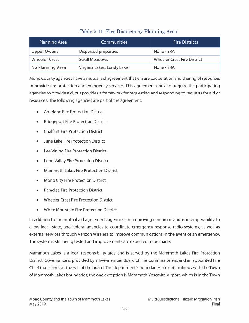
Mono County and the Town of Mammoth Lakes Multi-Jurisdictional Hazard Mitigation Plan May 2019 Final
5-61
Table 5.11 Fire Districts by Planning Area
Planning Area Communities Fire Districts
Upper Owens Dispersed properties None - SRA
Wheeler Crest Swall Meadows Wheeler Crest Fire District
No Planning Area Virginia Lakes, Lundy Lake None - SRA
Mono County agencies have a mutual aid agreement that ensure cooperation and sharing of resources
to provide fire protection and emergency services. This agreement does not require the participating
agencies to provide aid, but provides a framework for requesting and responding to requests for aid or
resources. The following agencies are part of the agreement:
Antelope Fire Protection District
Bridgeport Fire Protection District
Chalfant Fire Protection District
June Lake Fire Protection District
Lee Vining Fire Protection District
Long Valley Fire Protection District
Mammoth Lakes Fire Protection District
Mono City Fire Protection District
Paradise Fire Protection District
Wheeler Crest Fire Protection District
White Mountain Fire Protection District
In addition to the mutual aid agreement, agencies are improving communications interoperability to
allow local, state, and federal agencies to coordinate emergency response radio systems, as well as
external services through Verizon Wireless to improve communications in the event of an emergency.
The system is still being tested and improvements are expected to be made.
Mammoth Lakes is a local responsibility area and is served by the Mammoth Lakes Fire Protection
District. Governance is provided by a five-member Board of Fire Commissioners, and an appointed Fire
Chief that serves at the will of the board. The department’s boundaries are coterminous with the Town
of Mammoth Lakes boundaries; the one exception is Mammoth Yosemite Airport, which is in the Town

Mono County and the Town of Mammoth Lakes Multi-Jurisdictional Hazard Mitigation Plan May 2019 Final
5-62
but not the department’s boundaries and is serviced by Long Valley Protection District. The department
has two stations and eight full-time staff in addition to a larger part-time and volunteer force.
Mono County and the Town of Mammoth Lakes Multi-Jurisdictional Hazard Mitigation Plan May 2019 Final
6-1
6. PLAN MAINTENANCE AND CAPABILITIES
In order to support lasting mitigation and safety efforts, it is imperative that this MJHMP remain up to
date. Doing so ensures that Mono County and the Town of Mammoth Lakes are continually protected
against changing hazards and that the communities remain eligible for federal and state funding. To
keep the MJHMP living and active, this chapter describes the processes for updating this Plan to ensure
it is usable, relevant, locally appropriate, and compliant with applicable state and federal requirements.
The Plan’s structure allows the County and the Town to update individual sections as information
becomes available and needs arise, making it easier to keep the Plan current.
6.1 Plan Adoption To comply with DMA 2000, Mono County will officially adopt the Mono County and the Town of
Mammoth Lakes MJHMP within one year of receiving FEMA “approval pending adoption” status. The
adoption of the MJHMP recognizes the community’s commitment to reducing the impacts of natural
hazards throughout Mono County. The adoption resolution is presented in Appendix A.
6.2 Plan Update and Coordinating Body Maintaining and updating this Plan is the responsibility of the County Community Development
Department, and the Town Administration Department, which includes the Town Manager and
Assistant to the Town Manager. The primary department overseeing this process is the Mono County
Planning Department, under the direction of its appointed MJHMP project manager. This individual will
coordinate maintenance of this Plan, conduct the formal evaluation process, and prepare each five-year
update. Beginning in summer of 2022, the project manager will initiate the update process, establishing
a timeline, funding source for the update, informing decision-makers, and contacting key members of
both jurisdiction agencies to kick-off the process. The key County and Town departments to be on the
planning team are listed below.
Mono County
Mono County Public Health Department
Community Development Department
Public Works Department
Sheriff’s Office
Mono County and the Town of Mammoth Lakes Multi-Jurisdictional Hazard Mitigation Plan May 2019 Final
6-2
Antelope Valley Regional Planning Advisory Committee
Bridgeport Valley Regional Planning Advisory Committee
June Lake Citizens Advisory Committee
Long Valley Regional Planning Advisory Committee
Mono Basin Regional Planning Advisory Committee
Town of Mammoth Lakes
Town of Mammoth Lakes Planning Division
Town of Mammoth Lakes Police Department
Town of Mammoth Lakes Public Works Department
Town of Mammoth Lakes Risk Management Division
Other Organizations
Mammoth Lakes Fire Protection District
Other Fire Protection Districts
Inyo and Mono Counties Agricultural Commissioner’s Office
Cal Fire
Caltrans
CHP
Cal OES
Eastern Sierra Transit Authority
LADWP
Sierra Tactical Training and Active Response Resources
SCE
U.S. Forest Service
USGS

Mono County and the Town of Mammoth Lakes Multi-Jurisdictional Hazard Mitigation Plan May 2019 Final
6-3
The MJHMP project manager will facilitate the team meetings. This staff member will assign tasks, which
may include collecting data, developing new mitigation actions, updating sections of the Plan, and
presenting the Plan to other departments, stakeholders, and elected officials. Responsibility for
implementation and evaluation of the Plan will be shared among all team members as appropriate.
6.3 Evaluation and Monitoring Prior to the formal five-year update, the Planning Team will meet at least once annually, as initiated by
the County Community Development Department. During this period, the team will focus on timing of
Plan implementation, evaluating the implementation of the actions identified in this Plan, determining
whether they are successful, revising priorities, if necessary, and helping to incorporate the Plan’s
mitigation actions into other planning documents. These annual meetings will commence in 2019 and
should be timed with overall departmental planning and budgeting (fourth quarter of the fiscal year)
that occurs leading up to the Town and County’s annual budget development. As part of this evaluation
and monitoring process, members of the team should look at the following:
Any hazard events that occurred during the previous year and the impact of these hazards on
the community.
Mitigation actions in the Plan that have been successfully implemented.
Mitigation actions in the Plan that were scheduled for implementation but have not begun.
The schedule of future mitigation actions, and whether it is feasible or appropriate to adjust the
timeline.
Issues not covered by existing mitigation actions that could be addressed by new mitigation
actions.
Potential or actual changes in new funding opportunities, including grants, which may be used
on mitigation-related activities.
New scientific or mapping data that could inform updates to the Plan.
Any other planning programs or initiatives in the community that involve hazard mitigation.
The team will summarize the information from this review into an annual progress report, which will be
distributed to County and Town department heads for review as well as to the Town of Mammoth Lakes
Town Council and the Mono County Board of Supervisors. The progress report will also be used to track
and monitor progress on implementation of the measures contained in Chapter 5, and will include a
section that details efforts made on the Priority Measures.

Mono County and the Town of Mammoth Lakes Multi-Jurisdictional Hazard Mitigation Plan May 2019 Final
6-4
The progress report will also be posted on the County and Town’s websites, with the ability for members
of the public to provide comments, and will be distributed to local media, as appropriate.
6.4 Incorporation into Existing Planning Mechanisms Another important maintenance mechanism is to incorporate the recommendations and underlying
principles of the MJHMP into other community plans and mechanisms, such as comprehensive
planning, capital improvement budgeting, economic goals and incentives, and regional plans. Both the
County and the Town of Mammoth Lakes will be responsible for incorporating the 2018 MJHMP into
their jurisdiction-specific documents. Incorporation of the MJHMP will occur as plans and policies are
updated and when new plans and policies are developed. Key documents that have been identified for
incorporating elements of the MJHMP include:
Building/Development Codes and Ordinances
Emergency Operations Plans
General Plans
Capital Improvement Plans

Mono County and the Town of Mammoth Lakes Multi-Jurisdictional Hazard Mitigation Plan May 2019 Final
7-1
7. COMMUNITY WILDFIRE PROTECTION PLAN
The Mono County CWPP is a comprehensive, scientifically based analysis of wildfire-related hazards and
risks in the WUI areas of Mono County, California. Prepared for Mono County (County) and the Town of
Mammoth Lakes (Town) in concert with the MJHMP, it is an incisive update to the 2009 Community
Wildfire Protection Plan. The MJHMP and CWPP were prepared based on a countywide effort that
included extensive stakeholder engagement, the compilation of existing documents and GIS data,
scientifically based analyses of risk and vulnerability, confirmation of field data gathered in 2009, and
recommendations designed to reduce the threat of wildfire-related damages to assets, also known as
values, at risk.
This document incorporates new and existing information relating to wildfire which will be valuable to
citizens, policy makers, and public agencies in Mono County. Participants in this project include BLM,
USFS, Regional Planning Advisory Councils, Mammoth Lakes Fire Department, Cal Fire, the LADWP, the
County’s volunteer fire departments, Fire Safe Councils, and stakeholders. A more detailed description
of the planning and stakeholder process is included in Chapter 1 of the MJHMP. A detailed description
of the planning area is included in Chapter 2 of the MJHMP. This document meets the requirements of
the federal Healthy Forest Restoration Act (HFRA) of 2003 for community fire planning.
This document examines the wildfire hazard, vulnerabilities, and means of reducing risk for the County
and Town, meeting the hazard-specific requirements of a MJHMP for both jurisdictions. In addition, the
Mammoth Lakes Fire Protection District has elected to pursue developing its own, separate CWPP for
the Town of Mammoth Lakes in order to consider more specific fire modeling. When complete,
elements of this CWPPs may be incorporated into this document to further align the Town of Mammoth
Lakes’ efforts to reduce wildfire risk. The Wheeler Crest Fire Safe Council recently developed its own
parcel-specific CWPP for Swall Meadows and Paradise (January 2019), as discussed in Section 7.6. The
Wheeler Crest CWPP is attached as Appendix I.
7.1 Method The assessment portion of this document is an evaluation and update of identified hazards and risks
associated with wildland fire in proximity to communities; the assessment is based on stakeholder
expertise, available state-level fire data, and recent growth patterns and fuel reduction activities. This
information defines “areas of concern” for Mono County and allows for an updated prioritization of
mitigation efforts. From the analysis of this data, solutions and mitigation recommendations are offered
that will assist homeowners, land managers, and other interested parties in the process of developing
Mono County and the Town of Mammoth Lakes Multi-Jurisdictional Hazard Mitigation Plan May 2019 Final
7-2
short-term and long-term fuels and fire management plans. Wildfire hazard data is derived from Cal Fire
FRAP data and Wildfire Hazard Severity Zone maps, as well as fire behavior potential data developed in
2009 from Fire Family Plus, BEHAVE, and FlamMap fire behavior models.
The CWPP presents a two-fold evaluation of wildfire hazard, risk, and vulnerabilities. Section 7.3 presents
a general hazard profile based on historic wildfire activity and wildfire hazard severity zones, as
established by Cal Fire, and identifies vulnerable assets and populations located within high and very
high wildfire severity zones. A detailed description of methodologies for the general hazard profile and
vulnerabilities analysis is in Chapter 3 of the MJHMP. Section 7.4 provides an assessment of potential
fire behavior in the wildland urban interface, including flame length, rate of spread, and crown fire
based on fire behavior modeling. It also identifies risk to communities in the WUI based on locations in
hazard areas and potential fire behavior as well as infrastructure and development characteristics.
Section 7.5 identifies changes since 2009 that affect fire behavior and community vulnerability,
including updated development and infrastructure conditions, potential changes in fuel load that could
lead to inaccuracies in existing state and local wildfire hazard mapping such as previous fires and tree
mortality, completed and ongoing fuels reduction projects, as well as possible implications of climate
change. Section 7.6 presents priority projects and a set of actions the County and Town plan to take
that can increase preparedness, response, and education of the community in relation to wildfire
threats. These actions supplement mitigation and related measures provided in Chapter 5 of the
MJHMP.
7.2 Background
7.2.1 National Fire Plan (NFP) and the HFRA
In the year 2000, more than 8 million acres burned across the United States, marking one of the most
devastating wildfire seasons in American history. One high-profile incident, the Cerro Grande fire at Los
Alamos, New Mexico, destroyed more than 235 structures and threatened the Department of Energy’s
nuclear research facility.
Two reports addressing federal wildland fire management were initiated after the 2000 fire season. The
first report, prepared by a federal interagency group, was titled “Review and Update of the 1995 Federal
Wildland Fire Management Policy” (US Department of the Interior, et al. 2001). This report concluded,
among other points, that the condition of America’s forests were continuing to deteriorate.
The second report, titled “Managing the Impacts of Wildfire on Communities and the Environment: A
Report to the President in Response to the Wildfires of 2000,” was issued by the BLM and the USFS. It

Mono County and the Town of Mammoth Lakes Multi-Jurisdictional Hazard Mitigation Plan May 2019 Final
7-3
became known as the NFP. This report, and the ensuing congressional appropriations, ultimately
required actions to:
Respond to severe fires
Reduce the impacts of fire on rural communities and the environment
Ensure sufficient firefighting resources
Congress increased its specific appropriations to accomplish these goals. 2002 was another severe
season: more than 1,200 homes were destroyed and over 7 million acres burned. In response to public
pressure, Congress and the Bush administration continued to designate funds specifically for actionable
items such as preparedness and suppression. That same year, the Bush administration announced the
HFRA initiative, which enhanced measures to restore forest and rangeland health and reduce the risk of
catastrophic wildfires. In 2003, that act was signed into law.
Through these watershed pieces of legislation, Congress continues to appropriate specific funding to
address five main subcategories: preparedness, suppression, reduction of hazardous fuels, burned-area
rehabilitation, and state and local assistance to firefighters. The general concepts of the NFP blended
well with the established need for community wildfire protection in the study area, which encompasses
the entirety of the Town of Mammoth Lakes and Mono County. The spirit of the NFP is reflected in the
Mono County CWPP.
The requirements of the HFRA are met by:
1. Identifying and prioritizing fuels reduction opportunities across the landscape (see Fuels
Modification Projects, Section 7.5.5).
2. Addressing structural ignitability (see Home Mitigation, Section 7.6, and Appendix F).
3. Assessing community fire planning, response, and suppression capabilities (see MJHMP,
Chapter 5).
4. Collaborating with stakeholders (see MJHMP, Chapter 1, and Appendix B).
7.2.2 Outcomes
Intended outcomes from this project include the following:
1. Enhance life safety for residents and responders.
2. Mitigate undesirable fire outcomes to property and infrastructure.

Mono County and the Town of Mammoth Lakes Multi-Jurisdictional Hazard Mitigation Plan May 2019 Final
7-4
To accomplish these goals, the following objectives have been identified:
1. Establish an approximate level of risk (the likelihood of a significant wildfire event in the study
area).
2. Provide a scientific analysis of the fire behavior potential of the study area.
3. Group values at risk into “communities” that represent relatively similar hazard factors.
4. Identify and quantify factors that limit (mitigate) undesirable fire effects to the values at risk
(hazard levels).
5. Recommend specific actions that will reduce the vulnerability of the values at risk.
Other desired outcomes:
1. To promote community awareness: Quantifying the community's hazards and risk from
wildfire will facilitate public awareness and assist in creating public action to mitigate the
defined hazards.
2. To improve wildfire prevention through education: Community awareness, combined with
education, will help to reduce the risk of unplanned human ignitions.
To facilitate and prioritize appropriate hazardous fuel reductions:
1. The identification of areas of concern will improve the focus and accuracy of pre-planning, and
facilitate the implementation of cross-boundary, multi-jurisdictional projects.
7.3 Hazard and Risk Assessment
7.3.1 Hazard Description
The term wildfire refers to any fire that starts in a rural, sparsely populated or largely undeveloped area.
In many parts of the world, wildfires form part of the ecosystem and often burn at a safe distance from
areas of human settlement. Under dry conditions and when fanned by strong winds, however, fires can
spread into heavily populated districts, causing major damage to property. Buildings may be set alight
by radiant heat, contact with the flames, or flying embers. Smoke can also cause property damage, and
indirect losses can result from business interruption.
A complex interplay of natural and anthropogenic (human-caused) factors influences the extent and
magnitude of wildfires. Most significant factors include the type and dryness of vegetation, slope, and
wind, and other climactic components such as temperatures and precipitation. Conflagration can result
Mono County and the Town of Mammoth Lakes Multi-Jurisdictional Hazard Mitigation Plan May 2019 Final
7-5
in many circumstances as the result of lightning, downed or arcing power lines, or man-made fires
accidentally or deliberately spread. These changing anthropogenic and natural factors make wildfires a
risk that is extremely difficult to quantify. Even if hazard zones can be clearly identified, fires can cause
significant losses in unexpected locations under unique circumstances.
7.3.2 Location and Magnitude
Wildland fires in Mono County have ranged from fires that burned less than 1 acre in size to the Cannon
Fire in Walker in 2002, which burned 22,750 acres. With its sloped geography, vegetation, and climate,
Mono County has many fire-prone landscapes, on both public and private lands. Wildfire burns
indiscriminately across property boundaries, which means that the way potential fuels are managed on
one piece of property can affect wildfire risk on neighboring lands. Public lands surrounding
communities in the County contain highly flammable vegetation that in many cases has not been
thinned in years. The area experiences high temperatures and high winds over mountainous terrain
that makes firefighting difficult. Highway and air access to the area is limited, further increasing the
difficulty of fighting wildland fires. Continued population growth into WUI areas, but unchanging
relative isolation from resources, and an increasing frequency of elevated fire weather conditions
present major challenges to county residents.
Cal Fire is required by state law to map areas of significant fire hazards based on fuels, terrain, weather,
and other relevant factors. These zones, referred to as FHSZ, influence how people construct buildings
and protect property to reduce risk associated with wildland fires. As required by law, the model
evaluates hazard, but not risk. The model underlying FHSZ evaluates properties using characteristics
that affect the probability of the area burning and potential fire behavior in the area. Many factors are
considered such as fire history, existing and potential fuel, flame length, blowing embers, terrain,
weather and the likelihood of buildings igniting. Fire hazard severity has two key components:
probability of burning and expected fire behavior. The factors considered in determining hazard are: 1)
how often an area will burn; and 2) when it does burn, what characteristics might lead to buildings being
ignited?
Based on these factors, each area is assigned a zone, categorized as moderate, high, or very high. The
FHSZ is intended to provide a broad-stroke understanding of level of wildfire hazard across the state
and may not always reflect hazard from highly localized and fine-grained factors. A primer prepared by
Cal Fire, contained in Appendix G, describes in greater detail the method and granularity of the FHSZ.
The FHSZ maps are the primary tool used to establish state and local rules and regulations governing
building, infrastructure, and maintenance requirements. Consequently, Table 7.1 of this analysis
evaluates risk and vulnerability based on high and very high wildfire hazard zones of the FHSZ map. It

Mono County and the Town of Mammoth Lakes Multi-Jurisdictional Hazard Mitigation Plan May 2019 Final
7-6
is worth noting that current FHSZ maps were last prepared in 2003 or earlier. While Cal Fire is in the
process of developing new models and analysis to develop new maps, as of early 2018, these were not
yet available. Consequently, maps may not reflect recent changes to natural or developed conditions in
the County. Table 7.2 evaluates hazard and risk analysis more tailored to the County and, within the
WUI, recent changes to community conditions and their effects on risk and vulnerability.
As identified in Table 7.1, high and very high wildfire zones are present in both unincorporated Mono
County and the Town of Mammoth Lakes.
Mono County
Table 7.1 shows the ownership and administration of lands within the high and very high wildfire
severity zones in Mono County. In all, 183,755 acres are in the high severity zone, and 31,766 acres are
in the very high severity zone.
Table 7.1 Wildfire Severity Zones by Landownership or Adminstration Category
Land Ownership or
Administration Category
High Wildfire Severity Zone Very High Wildfire Severity Zone
Acres in Hazard Zone
Percentage of Total in Category
Percentage of Total Mono
County Area
Acres in Hazard Zone
Percentage of Total in Category
Percentage of Total Mono
County Area
County 191 8.4% <1% 138 6.1% <1%
Federal 158,865 9.2% 7.9% 27,671 1.6% 1.4%
Local1 115 53.3% <1% -- -- --
Private 8,874 6.9% <1% 902 <1% <1%
State 5,705 6.8% <1% 2,565 3.1% <1%
Utilities 8,434 12.6% 0.4% 126 <1% <1%
Right of way/ administration
1,566 17.5% <1% 361 4.0% <1%
Other 6 <1% <1% 2 <1% <1%
Total 183,755 9.1% 9.1% 31,766 1.6% 1.6% 1 Local includes; Mammoth Community Water District, Mammoth Lakes Fire Protection District; Mammoth Unified School District; Town of Mammoth Lakes
Table 7.2 shows the land within the high and very high wildfire severity zones in Mono County broken
down by the planning areas defined in the Mono County General Plan. As shown, large percentages of

Mono County and the Town of Mammoth Lakes Multi-Jurisdictional Hazard Mitigation Plan May 2019 Final
7-7
Mammoth Vicinity, Swauger Creek, Mono Basin, and June Lake are in high wildfire severity zones.
Significant portions of June Lake and Sonora Junction are also within very high fire severity zones.
Table 7.2 Wildfire Severity Zones by Planning Areas
Planning Area
High Wildfire Severity Zone Very High Wildfire Severity Zone
Acres in Hazard Zone
Percentage of Total
Planning Area
Percentage of Total Mono
County Area
Acres in Hazard Zone
Percentage of Total
Planning Area
Percentage of Total Mono
County Area
Antelope Valley 1,279 4.3% <1% - - -
Benton - - - - - -
Benton Hot Springs
- - - - - -
Bodie Hills - - - - - -
Bridgeport 2,667 5.2% <1% 333 <1% <1%
Chalfant Valley - - - - - -
Hammil Valley - - - - - -
June Lake 12,613 23.8% <1% 8,016 15.1% <1%
Long Valley 3,649 20.2% <1% - - -
Mammoth Vicinity 42,216 51% 2.6% 1,514 1.6% <1%
Mono Basin 4,428 2% <1% - - -
Oasis - - - - - -
Sonora Junction 7,419 6.5% <1% 11,253 9.8% <1%
Swauger Creek 663 35.0% <1% - - -
Upper Owens 4,304 28% <1% - - -
Wheeler Crest 244 4.2% <1% - - -
Mammoth Lakes
Wildfire is a concern for the entire Town; historically, wildfires have occurred on all sides of Town.
However, certain portions of Mammoth Lakes have higher hazard exposure, including areas close to the
Valentine Reserve Ecological Study Area and neighborhoods south of Old Mammoth Road (typically
referred to as Old Mammoth and Lake Mary). Figure 7.1 shows the FHSZs for Mono County and
Mammoth Lakes, as well as local, state, and FRAs. Overall, roughly 3 percent of the incorporated town
is in a very high fire severity zone and close to 34 percent is in a high fire severity zone, based on Cal Fire
Hazard Severity Zone Mapping. The Town has identified additional areas for which it enforces very high
severity zone regulations and requirements, as shown on the inset on Figure 7.1.

Mono County and the Town of Mammoth Lakes Multi-Jurisdictional Hazard Mitigation Plan May 2019 Final
7-8
Table 7.3 gives the acreage and percentage of total land area located within high and very high wildfire
severity zones, as well as the additional land area identified by the Town to be regulated as a very high
wildfire zone.
Table 7.3 Wildfire Severity Zones in Mammoth Lakes
Planning Area
Total Town Area
Acreage
High Wildfire Severity Zone
(Cal Fire)
Very High Wildfire Severity Zone
(Cal Fire)
Town Designated Very High Wildfire Severity
Zone
Acres in Hazard Zone
Percentage of Total
Town Area
Acres in Hazard Zone
Percentage of Total
Town Area
Acres in Hazard Zone
Percentage of Total
Town Area
Town Outside Urban Limit
13,299 4,186 31% 425 3.2% 16 0.1%
Town Inside Urban Limit 2,536 1,109 44% 51 2.0% 90 3.5%

Mono County and the Town of Mammoth Lakes Multi-Jurisdictional Hazard Mitigation Plan May 2019 Final
7-9
Figure 7.1: Mono County Wildfire Hazard Severity Zones

Mono County and the Town of Mammoth Lakes Multi-Jurisdictional Hazard Mitigation Plan May 2019 Final
7-10
This page intentionally left blank.

Mono County and the Town of Mammoth Lakes Multi-Jurisdictional Hazard Mitigation Plan May 2019 Final
7-11
7.3.3 Hazard History
Dozens of fires of various sizes typically burn in the County each year. Swall Meadows, June Lake, and
Antelope Valley are populated areas that have experienced one or more significant fires since 2000 and
have a pattern of fires from prior years. There have been 16 significant fires, described below, that have
affected the County since 2000, or more than one a year on average. Typically, these fires were wind-
driven and consumed several thousand acres before suppression efforts were successful.
1. Cannon Fire. June 2002. Walker.
The Cannon Fire burned 22,750 acres. Three fatalities occurred due to an air-tanker crash, and one
person was injured when a water truck was destroyed in a rollover accident. Economic damages from
the fire totaled $7.9 million. The fire is thought to be human-caused but was strongly influenced by high
winds (20–30 mph), dry fuel conditions, varied fuel types, and mountainous topography. Hundreds of
evacuations occurred east and west of US 395 and portions of US 395 were closed.
2. Gate Complex Fire (Slinkard, Gate, Buckeye, and Coleville Fires). July 2002. West side of
Antelope Valley.
The Complex Fire consisted of four fires that burned in the same region simultaneously. The Slinkard
fire, the largest of the four, burned north from Slinkard Valley near SR 89 to the Topaz Lodge along US
395. In total, the fires burned roughly 9,866 acres and incurred more than $1.6 million in damages.
Portions of US 395 (Bridgeport to Holbrook Junction) and SR 89 (Monitor Pass) closed. The fires are
believed to have been started by lightning in a wildland area and spread quickly due to wind and dry
ground conditions. Evacuations were required for all of Coleville and areas north to Nevada. All residents
from the Monitor Pass turnoff north to the Nevada state line and from the Monitor Pass turnoff south to
Topaz Lane were evacuated. Power and telephone outages occurred in Walker and Coleville. Just over
900 fire personnel were on scene, as well as helicopters and air tankers.
3. Birch Fire. July 2002. Birch Creek Canyon near Swall Meadows.
The Birch Fire was caused by a sparking power line, and resulted in 2,500 acres burned and $386,000 in
damages. The entire Rock Creek drainage area (including USFS campgrounds), local residents (including
the entire Swall Meadows community), and merchants were evacuated. Lower and Upper Rock Creek
Roads closed. No structures were destroyed.

Mono County and the Town of Mammoth Lakes Multi-Jurisdictional Hazard Mitigation Plan May 2019 Final
7-12
4. Larsen Fire. June 2007. West of Coleville in Antelope Valley.
The Larsen fire burned for close to 20 days, ultimately burning 1,080 acres. The blaze caused mandatory
evacuations in portions of Coleville and U.S. Marine housing, school closures, and the closure of US 395
from Bridgeport to Holbrook Junction. High winds caused quick spreading. Lightning is believed to
have started the blaze.
5. Indian Fire. August 2012. North of SA 120 and southwest of Mono Lake.
The Indian Fire burned for roughly a week but burned more than 12,576 acres in that time and required
571 personnel on-site. The fire was believed to be caused by a lightning strike. The fire did not threaten
life or property but it destroyed critical habitat for sage grouse.
6. Spring Peak Fire. August 2013. East of Bodie State Park.
The Spring Peak Fire started in Nevada from a lightning strike and crossed into California a few days
later. The fire came within miles of Bodie State Park. The roads to the park were closed, State Routes 267
and 170. The fire burned over 14,300.
7. June Lake Fire. September 2014. June Lake Mountain.
The June Fire, which started at the base of June Mountain, was caused by an employee of June Mountain
operating heavy equipment on June Mountain Ski Area. The fire threatened residential structures and
necessitated mandatory evacuations east of June Mountain and south of Highway 158. Highway 158
was closed at the south junction with Highway 395 and to the north to Rainbow Lane.
8. Van Dyke Fire. February 2015. Point Ranch, South of Bridgeport.
The Van Dyke Fire began west of Route 395 and north of Point Ranch, at one point it shut down Route
395 to thru traffic. The fire damaged a Southern California Edison power sub-station and residents of
Evans Track south of the Bridgeport Ranger Station were evacuated. A total of 509 acres burned.
9. Round Fire. February 2015. Swall Meadows and Paradise.
The most destructive fire in recent history, the Round Fire burned 36 homes, most of them in Swall
Meadows, and 7,000 acres. The communities of Paradise and Swall Meadows were placed under
mandatory evacuation orders. The blaze was started when strong winds caused a tree to fall over power
lines, which sparked.
10. Walker Fire. August 2015. Southwest of Lee Vining.
Mono County and the Town of Mammoth Lakes Multi-Jurisdictional Hazard Mitigation Plan May 2019 Final
7-13
The fire burned for roughly two weeks and consumed 3,676 acres. It resulted in the temporary closure
of SR 120 and Tioga Pass Road, and mandatory evacuations of several campgrounds and resorts near
Lee Vining and Walker Lake. The fire was human-caused.
11. Marina Fire. June 2016. Hwy 395 & Mono Lake.
The Marina Fire burned on the slopes above Old Marina on Hwy 395 about one mile north of the town
of Lee Vining. The fire caused parts of Hwy 395 to close. The Tioga Lodge and the Mono Inn were
evacuated. An evacuation warning was issued for Lee Vining and Mono City. The fire was determined
to be human-caused, but the exact cause and origin are still under investigation. A total of 650 acres
burned.
12. Clark Fire. August 2016. On Bald Mountain, northeast of Mammoth.
A lightning-sparked wildfire in the Inyo National Forest south of Mono Lake, the Clark Fire burned 2,819
acres. Clark Canyon was evacuated as a precaution. Due to elevated particulate pollution levels (from
the Clark Fire as well as a smaller fire, the Wilson Fire), the Mono County Health Department has issued
a Stage 1 Air Pollution Health Advisory for Northern Mono County.
13. Rock Creek Fire. August 2016. North of Swall Meadows.
The Rock Creek fire was caused by a mountain biker, and was primarily carried by dry cheatgrass. No
structures were burned, but an evacuation occurred in Swall Meadows.
14. Owens River Fire. November 2016. East of June Lake, Clark Canyon.
Burning for roughly a week, the fire covered 5,443 acres. The Big Springs Campground, Clark Canyon (a
popular climbing area), and nearby ranches and developments were evacuated. The Owens River Road
and Whitmore Springs Roads were closed and visitors were advised to avoid Bald Mountain Road, as
well.
15. Slinkard Fire. September 2017. West slope of Antelope Valley, south of Topaz.
The Slinkard fire burned for roughly two weeks, burning more than 8,925 acres. The blaze was started
by a lightning strike in Slinkard Valley. CA 395 was temporarily closed in both directions and voluntary
evacuation notices were issued to residents in and around Topaz.

Mono County and the Town of Mammoth Lakes Multi-Jurisdictional Hazard Mitigation Plan May 2019 Final
7-14
16. Boot Fire. September 2018. Southeast of Walker, north west of Bridgeport.
The Boot fire burned 6,974 acres, the cause of the fires is still under investigation (as of November 2018).
Certain areas and campgrounds within the Humboldt-Tioyabe National Forest were closed, as well as
portions of US 395 and CA 108.
Mammoth Lakes
The Town of Mammoth Lakes regularly experiences wildfires in proximity to Town boundaries. Most of
these fires are extinguished before growing over 100 acres. The major threats to the Town are fires that
start on adjacent public lands and spread communities. As a result, most fire mitigation and prevention
projects in the area focus on fuel breaks.
The most destructive fire that occurred within the vicinity of thein Town was the 1992 Rainbow Fire,
which began near the Devils Postpile National Monument. In addition to a variety of other conditions,
winds between 30 and 60 miles an hour fanned the fire, leading it to expand to more than 8,000 acres
within 24 hours. In total the fire burned 8,347 acres; the fire burned more than 85 percent of the
monument's acreage. The Rainbow Fire was ignited by lightning on August 20, 1992, in the Inyo
National Forest, south of Devils Postpile National Monument. Fortunately, ideal weather conditions
prevented the fire from reaching and spreading into the Town of Mammoth Lakes.
Figure 7.2 shows all fire perimeters from 1990 to 2017 as well as the general location (displayed as
single dot) of fires going to back to 1900 for the County and Town of Mammoth Lakes. A full list of
documented fires is contained in Appendix H.
.

Mono County and the Town of Mammoth Lakes Multi-Jurisdictional Hazard Mitigation Plan May 2019 Final
7-15
Figure 7.2: Historic Fires

Mono County and the Town of Mammoth Lakes Multi-Jurisdictional Hazard Mitigation Plan May 2019 Final
7-16
This page intentionally left blank.

Mono County and the Town of Mammoth Lakes Multi-Jurisdictional Hazard Mitigation Plan May 2019 Final
7-17
7.3.4 Risk and Vulnerability
The location, frequency, and severity of potential future wildfire hazard events is by itself insufficient to
describe Mono County and Town of Mammoth Lakes’ vulnerability to wildfire. A risk assessment is
necessary to prepare a more accurate view of the threat that the county and the city face as a result of
wildfire events likely to occur in their areas. Risk and vulnerability are assessed in terms of critical
facilities and vulnerable populations that are located in high or very high wildfire severity zones. The
approach and method for risk and vulnerability assessment are described in greater detail in Chapter 4
of the MJHMP.
Social Vulnerability
A number of community members considered to have higher vulnerability in a hazard event reside
within the high and very high hazard severity zones of both the county and town. Reflective of the
overall area, a large number of individuals in Mammoth Lakes, nearly 2,130, and 798 households are in
the high fire severity zone, and another 132 households are in the very high severity zone. However,
there is no significant difference in social vulnerability between residents in the high wildfire hazard
zones compared to residents in the entirety of the communities. A much lower percentage of total
households in the unincorporated county are located in either zone. Vulnerable populations also do not
seem to represent a much higher percentage than the overall population. Tables 7.4 and 7.5
summarize the social vulnerability for unincorporated Mono County and Mammoth Lakes residents,
respectively, in the high and very wildfire hazard zones.
Table 7.4 Social Vulnerability for Wildfire Hazard Zones – Unincorporated Mono County
Social Vulnerability Metric Wildfire Hazard Zone
High Very High Mono County Total
Population 1,225 227 6,042
Number of households 485 52 2,469
Median household income† $61,643 $40,533 $56,944†
Number of households under poverty limit 7.0% <1% 5.1%
Percent elderly households 42.7% <1% 35.2%
Percentage of adults with English competency 98.6% 99.4% 95.5%
Percentage of households with a disabled member 17.3% 15.4% 15.3%
† Median income for the unincorporated county was not available so the total county median is shown

Mono County and the Town of Mammoth Lakes Multi-Jurisdictional Hazard Mitigation Plan May 2019 Final
7-18
Table 7.5 Social Vulnerability for Wildfire Hazard Zones – Mammoth Lakes
Social Vulnerability Metric Wildfire Hazard Zone
High Very High Mammoth Lakes Total
Population 2,130 267 8,104
Number of households 798 132 3,299
Median household income $68,947 $69,438 $55,799
Number of households under poverty limit 4.0% 1.5% 4.3%
Percentage elderly households 19.3% 12.1% 6.9%
Percentage of adults with English competency 90.9% 91.0% 88.7%
Percentage of households with a disabled member 15.8% 7.6% 12.0%
Critical Facilities
In Mono County, 35 critical facilities are in the high hazard severity zone and 5 in the very high hazard
severity zones. Of these, 11 are in the Town of Mammoth Lakes. Facilities at risk include half the county’s
medical service centers and more than 40 percent of the emergency services and emergency operations
centers. Table 7.6 lists the number of facilities located in wildfire hazard zones for unincorporated Mono
County and the Town of Mammoth Lakes. Additionally, the Digital 395 cables run through areas of
moderate and high fire risk and major power lines run through all hazard severity zones.
Table 7.6 Critical Facilities in Wildfire Hazard Zones – Unincorporated Mono County and Mammoth Lakes
Facility Type Number of Facilities Not at Risk
At Risk – Mammoth Lakes
At Risk – Unincorporated
Mono County
High Very High
High Very High
Communications Facilities 15 1 0 3 0
Emergency Operations Center 7 1 0 4 0
Emergency Services 15 4 0 5 2
Hazardous Materials 9 0 0 0 1
Lifeline Utility Systems 42 3 0 8 2
Medical Services 2 1 0 1 0
Schools 11 0 0 0 0

Mono County and the Town of Mammoth Lakes Multi-Jurisdictional Hazard Mitigation Plan May 2019 Final
7-19
Table 7.6 Critical Facilities in Wildfire Hazard Zones – Unincorporated Mono County and Mammoth Lakes
Facility Type Number of Facilities Not at Risk
At Risk – Mammoth Lakes
At Risk – Unincorporated
Mono County
High Very High
High Very High
Transportation Systems 7 1 0 2 0
Vulnerable Populations 4 0 0 1 0
Total 112 11 0 24 5
There are three facilities that meet the Environmental Protection Agency’s standards for “cleaner air
shelter” in the county: Lee Vining Community Center, Twin Lakes Annex, and June Lake Community
Center. These shelters allow for residents to escape smoke and particulate pollutants that occur during
wildfires and pose a significant health hazard. To qualify as a cleaner air shelter, locations must meet the
following requirements:
Tight-sealing windows and doors
Public access
A ventilation system that can significantly reduce or eliminate intake of outdoor air
A central air filtration system of medium or high efficiency
The Crowley Lake Community Center meets three of the four requirements to be considered a cleaner
air shelter, but does not have outside air ventilation. Only the June Lake Community Center is officially
considered a critical facility in Mono County.
7.4 Potential Fire Behavior and Fuel Conditions in the Wildland Urban Interface
The WUI is defined as the area where structures and other human development meet or intermingle
with undeveloped wildland. The WUI creates an environment in which fire can move readily between
natural vegetation fuels to structures and from structures into the natural vegetation fuels.
All developed areas and communities in Mono County sit directly adjacent to huge swaths of forestland
and open space lacking in human infrastructure. People come to this region to live in rural areas and
direct proximity to natural ecosystem areas with attractive recreational and aesthetic amenities,

Mono County and the Town of Mammoth Lakes Multi-Jurisdictional Hazard Mitigation Plan May 2019 Final
7-20
especially forests. Consequently, all urbanized areas in the county are within the WUI, and face
significant risk and likelihood that wildfires will threaten structures and people. There are significant
implications for both the character and development of structures and behavior within those
communities and for the health and management of wildlands directly adjacent to those communities
and the thousands of acres beyond them.
For the purpose of this CWPP, the County applies WUI boundaries developed by Cal Fire. Additionally,
the entire Town of Mammoth Lakes is considered to be in the WUI, as approved by Town Council in
2007 and shown in Figure 7.3. Cal Fire considers three main components in the assessment of threat
from wildland fire to WUI areas:
1. Ranking fuel hazard.
2. Assessing the probability of wildland fire.
3. Defining areas of suitable housing density that lead to WUI fire protection strategy situations.
These three independent components were then combined using GIS capabilities to identify WUI areas
threatened by wildfire. In addition to mapping these areas, a list of communities was developed that
summarized a nonspatial assessment of key areas within the vicinity of significant threat from wildland
fire.
Figure 7.3 displays the WUI (shown in orange) for the county. The entire Town of Mammoth Lakes is in
the WUI; the Fire Commissioners approved and the Town Mayor ratified WUI boundaries in 2007, as
shown in Figure 7.4. The WUI is defined as a 1.5-mile buffer around developed areas with densities
greater than 1 unit per 40 acres. As is the case with most defined WUIs, some homesteads and ranches
may lie outside of the defined boundary, as they are too dispersed to be included. These are not
considered communities and are therefore not within the scope of this CWPP, although they may fall
within the defined WUI.
7.4.1 Fire Regime Condition Class (FRCC)
Historical fires can provide a great deal of information for understanding future fire risk. However, as
noted above, a complex interaction of natural and human conditions greatly impact both hazard and
risk. Wildfire is a natural component of many ecosystems, including high-altitude forest and grassland
that is predominant in Mono County. However, changes in those ecosystems—many driven by human
development and action, such as long-term fire suppression to protect homes and other structures—
have altered conditions in ways that change fire-related risk. Many of California’s largest fires in recent
decades resulted from changes to the ecosystem that drastically increased the fire risk and led to
extremely large conflagrations.

Mono County and the Town of Mammoth Lakes Multi-Jurisdictional Hazard Mitigation Plan May 2019 Final
7-21
The FRCC provides a landscape evaluation of expected fire behavior as it relates to the departure from
historical norms. The FRCC is derived by comparing current conditions to an estimate of the historical
range that existed prior to substantial settlement by Euro-Americans. The departure of the current
condition from the historical baseline serves as a proxy to likely ecosystem effects. The condition class
concept assumes that historical fire regimes accurately represent the conditions under which the
components within a fire-adapted ecosystem naturally evolved.
The data used for this study is from California’s FRAP vegetation data. Condition class measures are
assigned, comparing natural fire regime and current fire conditions. FRCCs are defined as the “relative
risk of losing key components that define an ecosystem.” The conceptual basis is that for fire-adapted
ecosystems, much of their ecological structure and processes are driven by fire. Departure from natural
fire regimes creates instability and increases the risk to key components of that ecosystem. The method
utilized follows that which is used at the national level, where lands are assigned one of three condition
class levels—low, mixed, and high—which qualitatively rank the potential effects to the ecosystem
based on the percentage of the dominant overstory vegetation that has been replaced. The five natural
(historical) fire regimes are classified based on average number of years between fires (fire frequency)
and divided into the categories of 0–35 years, 35–100 years, and over 100 years. Figure 7.5 shows the
FRCC for Mono County and the Town of Mammoth Lakes.

Mono County and the Town of Mammoth Lakes Multi-Jurisdictional Hazard Mitigation Plan May 2019 Final
7-22
This page intentionally left blank.

Mono County and the Town of Mammoth Lakes Multi-Jurisdictional Hazard Mitigation Plan May 2019 Final
7-23
Figure 7.3: Mono County Wildland Urban Interface

Mono County and the Town of Mammoth Lakes Multi-Jurisdictional Hazard Mitigation Plan May 2019 Final
7-24
This page intentionally left blank.

Mono County and the Town of Mammoth Lakes Multi-Jurisdictional Hazard Mitigation Plan May 2019 Final
7-25
Figure 7.4: Town of Mammoth Lakes Approved Wildland Urban Interface
Source: Town of Mammoth Lakes 2007

Mono County and the Town of Mammoth Lakes Multi-Jurisdictional Hazard Mitigation Plan May 2019 Final
7-26
This page intentionally left blank.

Mono County and the Town of Mammoth Lakes Multi-Jurisdictional Hazard Mitigation Plan May 2019 Final
7-27
Figure 7.5: Fire Regimes Condition Class

Mono County and the Town of Mammoth Lakes Multi-Jurisdictional Hazard Mitigation Plan May 2019 Final
7-28
This page intentionally left blank.

Mono County and the Town of Mammoth Lakes Multi-Jurisdictional Hazard Mitigation Plan May 2019 Final
7-29
7.4.2 Fire Behavior Potential
This section predicts likely fire behavior in Mono County and the Town of Mammoth Lakes using three
USFS software systems. The modeling evaluation was completed in 2009. The methodology used data
inputs representing the three factors that determine fire behavior: the amount and arrangement of fuel,
topography, and weather (Bennett et al. 2010). Weather observations, including measures of windspeed
and moisture, were collected for a 20-year period (1986–2006) and used to define two scenarios
(moderate and extreme) for modeling fire behavior potential. Other model inputs included the type and
coverage of surface fuels based on Cal Fire’s vegetation data and such topographical features as slope,
elevation, and aspect.
Of these variables, only weather inputs could potentially be updated following the methodology
described in the 2009 CWPP. Topographical inputs remain essentially unchanged. While there have
been a number of projects implemented since 2009 to reduce or modify fuels within Mono County, as
well as changes to the fire regime caused by wildfires, these are not reflected Cal Fire’s surface fuels
dataset; it remains the best vegetation data available, but it primarily dates to 2003. Given the data
limitations, the Planning Team decided to re-use the 2009 modeling data for this update and explore
any changes in conditions that could affect fire behavior, including fuels projects and dry conditions, in
narrative form within Section 7.5.
For the model, values for moderate and extreme weather scenarios were calculated using Fire Family
Plus software. These calculations were incorporated into the BEHAVE fire modeling system to calculate
surface fire predictions, i.e. rate of spread and flame length. Finally, the FlamMap 3.0 mapping and
analysis program combined the surface fire predictions with crown fire potential to generate a set of
maps that display potential rate of spread, flame length, and crown fire activity for both weather
scenarios. The model does not calculate the probability a wildfire will occur; it assumes an ignition
occurrence for every cell. However, it does predict how a wildfire would behave in each given area based
on the inputs mentioned above. Additional information on the assumptions and methodology used are
contained in Appendix F.
Rate of Spread
Figure 7.6 and Figure 7.7 show the predicted rates of spread for the moderate fire weather and extreme
fire weather scenarios, respectively. Rates of spread are expressed in chains/hour (CPH). A chain is a unit
of measure commonly used by foresters and firefighters. It is equal to 66 feet; therefore, 1 mile equals
80 chains. Rates of fire spread are influenced primarily by the wind, slope steepness, fuel
type/continuity, and fuel sheltering from the wind. Fire is the only force of nature which moves faster
uphill than downhill. In areas where high to extreme rates of spread are predicted (rates of spread of
>40 CPH or one-half mile per hour), it is possible fires could spread faster than humans can escape,

Mono County and the Town of Mammoth Lakes Multi-Jurisdictional Hazard Mitigation Plan May 2019 Final
7-30
creating extremely dangerous conditions for firefighters and evacuating residents. High rates of spread
also make suppression efforts less effective and increase the tactical complexity of the incident. Rates
of spread in the Eastern Sierra can follow a pattern of strong down-winds that can cause fast-moving
extreme fire behavior down drainages in the afternoons during summer days, especially associated with
frontal passages.
In the moderate fire weather scenario, moderate to extreme rates of spread are predicted throughout
the populated areas in the northern parts of the study area. High rates of spread (>40 CPH or one-half
mile per hour, shown in red) are predicted for portions of the southwestern part of the county where
desert grasses and shrubs with little sheltering from the wind are the dominant fuels, including parts of
Upper Owens, Mono Vicinity, Long Valley, Wheeler Crest, and Oasis. Rates of spread increase to extreme
levels (>60 CPH, shown in brown), where these conditions are combined with increasing slopes, most
notably in the lower slopes of the Eastern Sierra and the mountain ranges of the desert areas in the
eastern and southern portions of the county. These include smaller portions of Upper Owens and
Wheeler Crest in the southern part of the county, as well as swaths of the northern county along the US
395 corridor, including virtually all of Antelope Valley and Bridgeport Valley as well as portions of Sonora
Junction and the northern side of Mono Basin. These model results are consistent with recent historic
wildfires, which have been most frequent and burned the most acreage in these areas with rates of
spread predicted at greater than 60 CPH.
In the extreme fire weather scenario, extreme rates of spread are predicted for all of the urbanized
communities in the county with the exception of the higher elevations of the Sierra and White
Mountains and areas where combustible fuels are sparse or not present.

Mono County and the Town of Mammoth Lakes Multi-Jurisdictional Hazard Mitigation Plan May 2019 Final
7-31
Figure 7.6: Rate of Spread, Moderate Weather Conditions

Mono County and the Town of Mammoth Lakes Multi-Jurisdictional Hazard Mitigation Plan May 2019 Final
7-32
This page intentionally left blank.

Mono County and the Town of Mammoth Lakes Multi-Jurisdictional Hazard Mitigation Plan May 2019 Final
7-33
Figure 7.7: Rate of Spread, Extreme Weather Conditions

Mono County and the Town of Mammoth Lakes Multi-Jurisdictional Hazard Mitigation Plan May 2019 Final
7-34
This page intentionally left blank.

Mono County and the Town of Mammoth Lakes Multi-Jurisdictional Hazard Mitigation Plan May 2019 Final
7-35
Flame Length
Flame length is used as a proxy for fire intensity. It is important to note that flame length represents the
entire distance from the base of the flame to the tip, irrespective of angle—not simply the flame height
above the ground. In high wind conditions, it is possible to have very intense flames (high flame lengths)
which are relatively close to the fuel bed.
Figure 7.8 and Figure 7.9 display flame length in ranges that are meaningful and useful to firefighters.
Flame lengths of 4 feet or less (shown in yellow) are considered low-enough intensity to be suitable for
direct attack by hand crews, which represents the best chance of direct extinguishment and control.
Flame lengths of less than 8 feet (shown in orange and yellow) are suitable for direct attack by
equipment such as bulldozers and tractor plows. Flame lengths of 8 to 12 feet (shown in red) are usually
attacked by indirect methods and aircraft. In conditions where flame lengths exceed 12 feet (shown in
brown), the most effective tactic is fuel consumption ahead of the fire by burnouts or mechanical
methods. Although indirect fire line and aerial attack are also used for such fires, flame lengths increase
as the effectiveness of these tactics decrease. Their use in this case is generally intended to slow rates of
spread and reduce fire intensity, especially in areas where values at risk are concentrated.
Even in the moderate fire weather scenario, most urbanized communities are located in areas with likely
flame lengths of greater than 4 feet. Many areas—including the western side of Antelope Valley;
portions of Sonora Junction, Bridgeport Valley, Bodie Hills, and Upper Owens; and nearly all of
Mammoth Vicinity, Long Valley, and Swall Meadows—are predicted to have the potential for extreme
flame lengths of 12 feet or greater.
Under the extreme fire weather scenario, high to extreme flame lengths are predicted throughout the
areas covered by the WUI communities, with the exceptions of some small pockets, such as Tri-Valley
and Oasis, where elevations and/or fuel conditions moderate the large-scale conditions. Under extreme
weather and fuel moisture conditions, fire intensity is expected to be a genuine issue and control will
be difficult and complex to establish and maintain.
Crown Fire Activity
The crown fire activity maps, shown in Figure 7.10 and Figure 7.11, display the potential for fires to
move from the surface into the canopy of trees and shrubs. The likelihood of progression from the
surface into the aerial fuels is displayed in four categories. N/A (“not applicable”) refers to areas where
surface fires are unlikely to develop due to the lack of combustible fuels. These would include areas
lacking a combustible fuel bed, such as rock, ice, snow fields, water, sand, or some urban landscapes.
The surface fire category (shown in yellow) covers areas where fires are expected to be limited to the
surface fuels and lack the energy to initiate and sustain vertical development into the aerial fuels. Areas

Mono County and the Town of Mammoth Lakes Multi-Jurisdictional Hazard Mitigation Plan May 2019 Final
7-36
where grass fuels without overstory plants are dominant fall into this category, regardless of the energy
produced by the fire, due to the lack of an aerial fuel bed. Areas designated by the torching category
(shown in orange) are expected to experience isolated combustion of the tree crowns in individual trees
and groups of trees. The active crown fire category (shown in red) includes areas where sustained
horizontal movements through tree crowns are expected. Crown fires represent extreme fire behavior
conditions and are notoriously resistant to all methods of suppression and control.
Weather variables had trivial effects on the development of crown fire in the study area, as shown by
the limited differences displayed on the two figures. In general, there is a possibility of torching and/or
active crown fire development wherever timber fuels are present, which includes most of the WUI,
except for eastern Antelope Valley, Mono Basin, Tri-Valley, and Oasis.

Mono County and the Town of Mammoth Lakes Multi-Jurisdictional Hazard Mitigation Plan May 2019 Final
7-37
Figure 7.8: Flame Length, Moderate Fire Weather Conditions

Mono County and the Town of Mammoth Lakes Multi-Jurisdictional Hazard Mitigation Plan May 2019 Final
7-38
This page intentionally left blank.

Mono County and the Town of Mammoth Lakes Multi-Jurisdictional Hazard Mitigation Plan May 2019 Final
7-39
Figure 7.9: Flame Length, Extreme Fire Weather Conditions

Mono County and the Town of Mammoth Lakes Multi-Jurisdictional Hazard Mitigation Plan May 2019 Final
7-40
This page intentionally left blank.
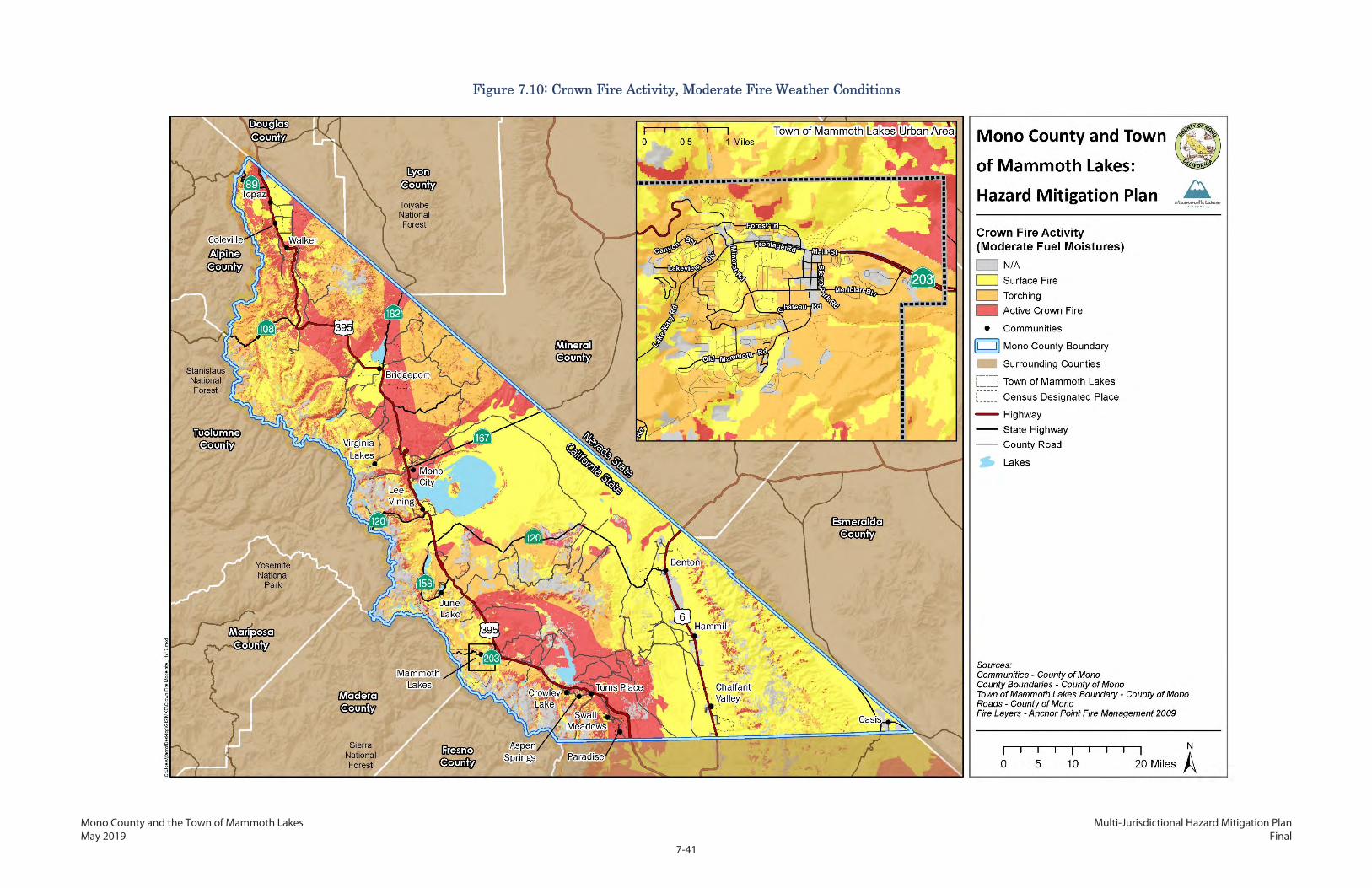
Mono County and the Town of Mammoth Lakes Multi-Jurisdictional Hazard Mitigation Plan May 2019 Final
7-41
Figure 7.10: Crown Fire Activity, Moderate Fire Weather Conditions

Mono County and the Town of Mammoth Lakes Multi-Jurisdictional Hazard Mitigation Plan May 2019 Final
7-42
This page intentionally left blank.

Mono County and the Town of Mammoth Lakes Multi-Jurisdictional Hazard Mitigation Plan May 2019 Final
7-43
Figure 7.11: Crown Fire Activity, Extreme Fire Weather Conditions

Mono County and the Town of Mammoth Lakes Multi-Jurisdictional Hazard Mitigation Plan May 2019 Final
7-44
This page intentionally left blank.

Mono County and the Town of Mammoth Lakes Multi-Jurisdictional Hazard Mitigation Plan May 2019 Final
7-45
7.4.3 Community Risk Assessment
In 2009, the County and Town, in coordination with BLM Bishop Field Office, conducted a community-
specific wildfire risk assessment for 36 urbanized areas. The area boundaries were selected through a
stakeholder process and took into account factors including physical development characteristics such
as housing density, lot size, dominant construction types, roadway access and navigational ease;
availability of water for fire suppression; and natural characteristics such as slope and vegetation types.
Each area was then assigned a hazard ranking of low, moderate, high, very high, or extreme, based on
these characteristics and the fire behavior potential components described in Section 7.4. The
identified communities and their hazard rankings are shown in Figure 7.12. The full methodology for
ranking the community areas and profile descriptions of each are available in Appendix F.

Mono County and the Town of Mammoth Lakes Multi-Jurisdictional Hazard Mitigation Plan May 2019 Final
7-46
This page intentionally left blank.

Mono County and the Town of Mammoth Lakes Multi-Jurisdictional Hazard Mitigation Plan May 2019 Final
7-47
Figure 7.12: Community Area Specific Wildfire Hazard Ranking

Mono County and the Town of Mammoth Lakes Multi-Jurisdictional Hazard Mitigation Plan May 2019 Final
7-48
This page intentionally left blank.

Mono County and the Town of Mammoth Lakes Multi-Jurisdictional Hazard Mitigation Plan May 2019 Final
7-49
7.5 Changes in Conditions Over the Last Decade As part of the 2018 CWPP update, physical development characteristics and development growth were
reevaluated and confirmed. Each of the key infrastructure components are described below.
7.5.1 Single-Route Access
The communities of Paradise, Swall Meadows, Lundy Lake, Virginia Lakes, and Twin Lakes all only have
one access route. Similarly, certain neighborhoods and subdivisions in Mammoth Lakes also have only
one access route. Additionally, Mono City and portions of Tom’s Place have secondary access routes
that are narrow, poorly maintained, dirt roads. Addressing this issue can pose an especially great
challenge in Mono County as the vast majority of land and roadways is owned by federal agencies,
which are often short-handed on personnel. Identifying land for road siting and ensuring proper
maintenance requires extensive coordination between the County, Town, and agencies.
During evacuation and emergency response procedures, the lack of alternative routes could inhibit
transportation in and out of most areas. SR 203 is the primary access in and out of the Town of Mammoth
Lakes, which connects to US 395. The Mammoth Scenic Loop provides a secondary access route to US
395 when not closed during winter months. Certain neighborhoods in the southern portion of the Town
do not have secondary access to either SR 203 or US 395.
7.5.2 Steep, Narrow, and Blocked-Access Roads
In most of the urbanized communities built in sloped environments, many of the roads are very narrow
with poor surfaces, are poorly maintained, or are dead ends. Many roads and driveways are dirt, and
rutting and washboarding are typical. These inadequacies can make access for emergency vehicles and
apparatus difficult or impossible. Fire engines typically require wide turning radius and pullouts for
turnarounds on dead-end roads.
Another common obstacle is the existence of locked gates blocking private, state, or federally owned
roads and driveways. While concerted multiagency efforts and education campaigns over the last
decades have resulted in fewer locked gates or gates with special codes or keys for emergency
personnel, the problem persists on some roadways.
7.5.3 Water Supply and Pressure
As with many of the mountainous and rural areas of California, water is a critical fire suppression issue
in Mono County. Only a few communities have a reliable source of water via hydrants. Most of the
communities are reliant on seasonal ponds and creeks. In areas with limited nearby surface water, large
cisterns are necessary but often not available and are difficult to site.

Mono County and the Town of Mammoth Lakes Multi-Jurisdictional Hazard Mitigation Plan May 2019 Final
7-50
7.5.4 Addressing
In most of the WUI communities in Mono County, missing or inadequate street signage and addressing
is an issue. Where applicable, this problem is also noted in the community descriptions in Appendix F.
Markers of all types, some homemade, are used throughout the study area with no particular order or
system. In some parts of Mono County, street signs are broken or worn out. Address numbers on
mailboxes, or on the post, are frequently the only indication of the address. In most cases, address
marker poles and mailbox poles are made of wood.
There are some community driveways where multiple homes are accessed from a single driveway off
the public road. Often these driveways use flagged addressing, a term describing the placement of
multiple addresses on a single sign. Flagged addressing can be confusing and difficult to interpret for
emergency responders.
Numerous properties throughout the county also have no address markers of any type, or have small,
nonreflective addressing that is hidden from view, difficult to see, or mounted onto a flammable
material.
The value of the time saved to the welfare of homes and evacuees, especially at night and in difficult
conditions, cannot be overestimated. Knowing at a glance the difference between a road and a
driveway (and which houses are on the driveway) cuts down on errors and time wasted interpreting
maps.
7.5.5 Additional Developments Identified
As part of the 2018 reevaluation, the presence of new or excluded development was assessed. Certain
smaller developments with clusters of structures were excluded from the original analysis; these
additional areas have been added in Table 7.7. These include the Marine Warfare Mountain Training
Center; several pockets of development along Sweetwater Road (CA 182) north of the identified Aurora
Canyon area; and Crestview, a small clustering of homes and recreational structures both at Crestview
directly alongside US 395 and farther west along Deadman Creek Road.
Table 7.7 Physical Development Characteristics
Planning Area
Community Area Single-Route Access
Steep/ Narrow Roads
Water Supply
Lacks Water Supply/ Pressure
Lacks Adequate
Addressing
Mammoth Lakes
Lake Mary Area x x Draft x x
Old Mammoth/ The Bluffs x x Hydrants x
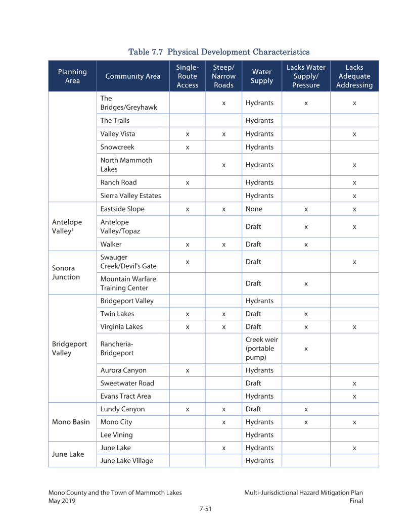
Mono County and the Town of Mammoth Lakes Multi-Jurisdictional Hazard Mitigation Plan May 2019 Final
7-51
Table 7.7 Physical Development Characteristics
Planning Area
Community Area Single-Route Access
Steep/ Narrow Roads
Water Supply
Lacks Water Supply/ Pressure
Lacks Adequate
Addressing
The Bridges/Greyhawk
x Hydrants x x
The Trails Hydrants
Valley Vista x x Hydrants x
Snowcreek x Hydrants
North Mammoth Lakes
x Hydrants x
Ranch Road x Hydrants x
Sierra Valley Estates Hydrants x
Antelope Valley1
Eastside Slope x x None x x
Antelope Valley/Topaz
Draft x x
Walker x x Draft x
Sonora Junction
Swauger Creek/Devil's Gate x Draft x
Mountain Warfare Training Center Draft x
Bridgeport Valley
Bridgeport Valley Hydrants
Twin Lakes x x Draft x
Virginia Lakes x x Draft x x
Rancheria-Bridgeport
Creek weir (portable pump)
x
Aurora Canyon x Hydrants
Sweetwater Road Draft x
Evans Tract Area Hydrants x
Mono Basin
Lundy Canyon x x Draft x
Mono City x Hydrants x x
Lee Vining Hydrants
June Lake June Lake x Hydrants x
June Lake Village Hydrants

Mono County and the Town of Mammoth Lakes Multi-Jurisdictional Hazard Mitigation Plan May 2019 Final
7-52
Table 7.7 Physical Development Characteristics
Planning Area
Community Area Single-Route Access
Steep/ Narrow Roads
Water Supply
Lacks Water Supply/ Pressure
Lacks Adequate
Addressing
Clark Tract x Hydrants x
Petersen Tract x Hydrants
Highlands Hydrants
Silver Lake & Dream Mountain
Hydrants x
Mammoth Vicinity
Crestview x Draft x
Convict Lake & SNARL x Hydrants x
Crowley Lake
McGee Creek/ Long Valley
Hydrants x
Juniper Loop x None x x
Sunny Slopes x x Hydrants x
Aspen Springs x Cistern x
Hilton Creek x Hydrants
Tri-Valley Chalfant Valley x None x x
Swall Meadows
Swall Meadows x x Tank/ Cisterns x x
Swall Meadows – Rimrock Ranch
Tank/ Cisterns
Paradise x Hydrants
1Water tanks may be required on properties in certain areas
In general, conditions in the developed areas have not changed significantly since the hazard rating
was first completed in 2009. However, certain areas have either seen additional growth which may
increase the number of community assets at risk, or were not included within an analyzed area despite
densities of structures existing. These include:
Old Mammoth/The Bluffs: As documented in Chapter 2, a number of new single-family and
multifamily homes were built between 2015 and 2018 on the southern edge of the Old
Mammoth neighborhood, such as the Snowcreek neighborhood and in The Bluffs subdivision.
Mono City: Additional low-density housing development on the southern side of Mono City
was built after 2009.

Mono County and the Town of Mammoth Lakes Multi-Jurisdictional Hazard Mitigation Plan May 2019 Final
7-53
Paradise: Additional residential units and complementary uses were approved on the site of a
former lodge. The development was approved in 2010.
Table 7.7 summarizes 2018 characteristics for 39 identified areas. Projects identified in the table that
address a lack of infrastructure are the highest priority for the County and Town.
7.5.6 Fuels and Vegetation
The amount and arrangement of fuels is one factor, along with weather and topography, that can alter
fire behavior. A greater fuel load, or the amount of fuel in an area, is associated with an increase in fire
intensity and the ability of surface flames to ignite a crown fire (Bennett et al. 2010).
Much of the available data for wildfire hazard location, intensity, and behavior potential in Mono
County, including what is shown in this CWPP, is based on inputs from Cal Fire’s vegetation and surface
fuel mapping. Cal Fire FRAP data, in cooperation with California Department of Fish and Wildlife
VegCamp program and extensive use of USFS Region 5 Remote Sensing Laboratory data, compiled the
"best available" land cover data for California into a single comprehensive statewide data set, with data
spanning a period from approximately 1990 to 2014. The Cal Fire surface fuels data is shown in Figure
7.13.
While Cal Fire’s vegetation data is the most comprehensive available, the age of the data means it does
not fully reflect 2018 conditions. Varied factors have changed the vegetation landscape of Mono
County, and consequently the fuel load that directly influences fire hazard and fire behavior. These
include:
Wildfire events
Of the more than 64 fires discussed above, more than 40 have occurred, burning more than 80,000 acres,
since vegetation mapping was last updated in 2003 and incorporated into the state’s wildfire hazard
mapping. While many of these high-intensity fires greatly reduce fuel loads in the short term, those that
reach highest intensities can completely change the fire regime, and ultimately the fire likelihood and
behavior potential.
Fuels modification projects
Since 2009, the USFS has completed more than 800 fuel modification actions, such as fuel breaks,
prescribed burns, and thinning in Inyo National Forest. Although these projects cannot noticeably alter
wildfire hazard severity areas, they can reduce risk to communities by promoting forest health,
minimizing the size of fires, and helping prevent them from reaching people and structures. Several
major fuel reduction projects to protect specific communities have been undertaken by the USFS from
2009 to 2018. These projects are described below.
Mono County and the Town of Mammoth Lakes Multi-Jurisdictional Hazard Mitigation Plan May 2019 Final
7-54
Crowley Communities Hazardous Fuels Reduction Project: Removal of hazardous fuels, by
fuel breaks, chipping, piling, and thinning around the communities of Aspen Springs, Crowley,
McGee Creek, Sunny Slopes, and Tom's Place.
Three Creeks Jeffrey Pine Forest Health and Restoration Project: Provides for healthy forest
conditions, promotes establishment of old growth, and reintroduces fire to the ecosystem
through pre-commercial and commercial thinning of trees, piling of fuels, burning of piles, and
forest disease control measures.
June Lake Loop Hazardous Fuels Reduction Project: Fuels reduction work on 4,578 acres
within WUI defense and threat zones in the June Lake Loop. Treatments include tree thinning,
shrub cutting or mowing, prescribed fire, conifer removal from aspen, and slash pile burn or
chip.
Lake Mary Treatment Plant Hazardous Fuels Reduction Project: Cooperative effort with
Mammoth Community Water District to reduce fuels on 8 acres around the district’s Lake Mary
Water Treatment Plant. Treatments include thinning, chipping, cutting, piling and removal of
fuels by carrying or dragging.
Lost Lane Fuels Reduction Project: Cooperative effort with Mammoth Lakes Fire Protection
District on a total of about 175 acres in the Old Mammoth area. Treatments include thinning,
chipping, and removal of fuels by carrying or dragging.
Mill City Fuels Reduction Project: Reduces the risk of catastrophic wildfire and protects
community, water quality, and recreation values through vegetation treatments, primarily
thinning, piling, burning, and chipping, on 55 acres of public land within and adjacent to the
community of Mammoth Lakes.
Sherwin Scenic Loop Hazardous Fuels Reduction Project: Treatment to reduce hazardous
fuels such as brush and trees in the Sherwin Creek, Mammoth Creek, and Mammoth Scenic Loop
areas surrounding the Mammoth Lakes community, including thinning, piling, and disease
control measures.
Rust II: Thinning to reduce fuels and improve forest health on approximately 500 acres of Jeffrey
pine forest located off of Bald Mountain Road.
During this period, there was also continued maintenance of a fuel break near Swall Meadows, including
burning of piled materials; environmental analysis was completed in 2017 for additional fuel treatments
on 108 acres adjacent to Swall Meadows, intended to lower flame length and severity while providing
defensible space and safe access for the public and firefighters. The maintenance and expansion of area
covered by the 2011 Mono City Hazardous Fuel Reduction Project and additional projects in Bridgeport
Mono County and the Town of Mammoth Lakes Multi-Jurisdictional Hazard Mitigation Plan May 2019 Final
7-55
Valley and Antelope Valley are also recommended. Both historic fire incidence and flame behavior
modeling shows these planning areas to have the most extreme hazard from wildfire. In addition, since
2009 the BLM Bishop Field Office has overseen fuel breaks in Antelope and Benton valleys and to protect
the Golden Gate Mill historic site, as well as multiple ecological restoration projects on BLM land with
fuel-reduction benefits. The areas addressed by these projects are shown in Figure 7.14.

Mono County and the Town of Mammoth Lakes Multi-Jurisdictional Hazard Mitigation Plan May 2019 Final
7-56
This page intentionally left blank.

Mono County and the Town of Mammoth Lakes Multi-Jurisdictional Hazard Mitigation Plan May 2019 Final
7-57
Figure 7.13: Mono County Surface Fuels from Cal Fire

Mono County and the Town of Mammoth Lakes Multi-Jurisdictional Hazard Mitigation Plan May 2019 Final
7-58
This page intentionally left blank.

Mono County and the Town of Mammoth Lakes Multi-Jurisdictional Hazard Mitigation Plan May 2019 Final
7-59
Figure 7.14: Major Fuel Reduction Projects in Mono County, 2009–2018

Mono County and the Town of Mammoth Lakes Multi-Jurisdictional Hazard Mitigation Plan May 2019 Final
7-60
This page intentionally left blank.

Mono County and the Town of Mammoth Lakes Multi-Jurisdictional Hazard Mitigation Plan May 2019 Final
7-61
The 2009 CWPP identified a total of 34 existing fuels modification projects within Mono County on
federal land, including Inyo and Humboldt-Toiyabe national forests and public lands managed by the
BLM’s Bishop Field Office. These projects date back to 1999. In addition, the plan identified 11 future
BLM projects. Table 7.8 provides an update on the status of these projects along with any additional
projects that were identified during the planning process. In some cases, work is currently in progress
to expand the number of treated acres within the total project area, while in others there is ongoing
maintenance. In still others, there is no current work being done. Maintenance of all projects in the
coming years is vital.
Table 7.8 Status of Existing Fuels Modification Projects in Mono County
Project Name General Location Year
Implemented Acres
Completed Status
BLM Bishop Field Office
Swall Meadows Fuelbreak Swall Meadows 2001 46 Complete
Golden Gate Mill Walker/Coleville/Topaz 2004 3 Complete
Mono City/Conway Ranch Mono
City/Conway Ranch
2004 15 Continuing
maintenance
Pinyon MX Virginia Creek Settlement 2004 1,000 Continuing
maintenance
Virginia Creek Lodgepole Pine Removal/Aspen Habitat Improvement
Virginia Creek Drainage 2004 30 Complete
Evaluation of Pinyon Removal Effects Typical of a Wildland-Urban Interface Fuels Reduction
Mono Basin 2005 105 Complete
Invasive Weed and Hazardous Fuels Reduction Project for Marine Housing, Slinkard, Aristo Ranch, and Dry Canyon Allotments
Walker/Coleville/Topaz 2006 800 (7,000
planned) In progress/
ongoing
Benton Fuelbreaks Benton/Benton Hot Springs 2007 55 Continuing
maintenance
Dog and Green Creek Aspen Drainages Habitat Improvement
Dog and Green Creek 2007 50 Complete
Fish Slough Prescribed Burn Fish Slough 2008 176 Continuing
maintenance
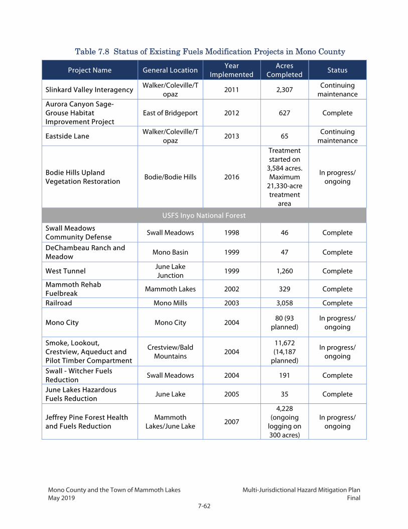
Mono County and the Town of Mammoth Lakes Multi-Jurisdictional Hazard Mitigation Plan May 2019 Final
7-62
Table 7.8 Status of Existing Fuels Modification Projects in Mono County
Project Name General Location Year
Implemented Acres
Completed Status
Slinkard Valley Interagency Walker/Coleville/T
opaz 2011 2,307
Continuing maintenance
Aurora Canyon Sage-Grouse Habitat Improvement Project
East of Bridgeport 2012 627 Complete
Eastside Lane Walker/Coleville/T
opaz 2013 65
Continuing maintenance
Bodie Hills Upland Vegetation Restoration
Bodie/Bodie Hills 2016
Treatment started on
3,584 acres. Maximum
21,330-acre treatment
area
In progress/ ongoing
USFS Inyo National Forest
Swall Meadows Community Defense Swall Meadows 1998 46 Complete
DeChambeau Ranch and Meadow Mono Basin 1999 47 Complete
West Tunnel June Lake Junction 1999 1,260 Complete
Mammoth Rehab Fuelbreak
Mammoth Lakes 2002 329 Complete
Railroad Mono Mills 2003 3,058 Complete
Mono City Mono City 2004 80 (93 planned)
In progress/ ongoing
Smoke, Lookout, Crestview, Aqueduct and Pilot Timber Compartment
Crestview/Bald Mountains 2004
11,672 (14,187
planned)
In progress/ ongoing
Swall - Witcher Fuels Reduction
Swall Meadows 2004 191 Complete
June Lakes Hazardous Fuels Reduction June Lake 2005 35 Complete
Jeffrey Pine Forest Health and Fuels Reduction
Mammoth Lakes/June Lake 2007
4,228 (ongoing
logging on 300 acres)
In progress/ ongoing

Mono County and the Town of Mammoth Lakes Multi-Jurisdictional Hazard Mitigation Plan May 2019 Final
7-63
Table 7.8 Status of Existing Fuels Modification Projects in Mono County
Project Name General Location Year
Implemented Acres
Completed Status
Windmill Amendment to Smoke Lookout, Crestview, Aqueduct, and Pilot Timber Compartment
Owens River Road 2007 320 Complete
June Fire Forest Restoration
June Lake Junction
2008 86 Complete
Mill City Mammoth Lakes 2008 130 Complete Rust II Forest Heath and Fuels Reduction
Bald Mountain 2009 461 Complete
June Loop Hazardous Fuels Reduction Project June Lake 2011
1,126 (4,578 planned)
In progress/ ongoing
Lake Mary Water Filtration Plant Hazardous Fuels Reduction Project
Mammoth Lakes 2011 9 Complete
Casa Diablo Understory Maintenance Burning Casa Diablo 2017
Ongoing maintenance burning on 10,823-acre
area
Continuing maintenance
USFS Humboldt-Toiyabe National Forest
Camp Antelope Piles Walker/Camp Antelope 2009 50 Complete
Mill Canyon Walker/Camp Antelope
2009 380* (2,900 planned)
In progress/ ongoing
MWTC Sonora Pass Sonora Pass 2009 180 Complete
Twin Lakes Twin Lakes Drainage 2011 210* (1,874
planned) In progress/
ongoing
* Work will occur during the 2018-2019 season.
Interagency Projects
Antelope Valley Interagency Hazardous Fuels Reduction (BLM, Humboldt Toiyabe National Forest)
Walker/Coleville/Topaz 2005 391 Complete
Doe Ridge Interagency Prescribed Fire (BLM, Inyo) Long Valley 2009 995 Complete

Mono County and the Town of Mammoth Lakes Multi-Jurisdictional Hazard Mitigation Plan May 2019 Final
7-64
Table 7.8 Status of Existing Fuels Modification Projects in Mono County
Project Name General Location Year
Implemented Acres
Completed Status
Crowley Communities Interagency (BLM, Inyo)
Crowley Lake 2011 341 (1,585 planned)
In progress/ ongoing
Table 7.9 identifies planned fuels modification projects within Mono County for both BLM and Inyo
National Forest. There are currently no fuels modification projects within Mono County planned for
Humboldt-Toiyabe National Forest other than ongoing work on existing projects. Previously proposed
projects for which there has been no work completed thus far and no work is currently planned are not
included in this CWPP update.
Table 7.9 Future Fuels Modification Projects in Mono County
Project Name Agency General Location Acres
Planned Walker Fuelbreaks BLM Walker/Coleville/Topaz 0.2 Coldwater Campground Fuelbreak Inyo NF Mammoth Lakes Basin 0.2 Lakes Basin Hazardous Fuels Reduction Project Inyo NF Mammoth Lakes Basin 700
Lee Vining Creek Watershed Restoration and Hazardous Fuels Reduction Project
Inyo NF Lee Vining 7,989
Reds Valley Hazardous Fuels Reduction Project Inyo NF Reds Meadow Valley 4,478
Swall Meadows Access Thinning Inyo NF Swall Meadows 108
Tree Mortality
Large numbers of trees have died in Mono County and across the state as the result of the record six-
year drought from 2011 to 2017. The drought weakened trees and left millions of acres of forestland
highly susceptible to bark beetle attacks. The drought stress was exacerbated in forests with too many
trees competing for limited resources, especially water.
In 2015, Cal Fire identified areas of greatest tree mortality in the state and the potential impacts in
relation to life and property, as shown in Figure 7.15. The figure shows the tree mortality that was
recorded from 2012 through 2016 within two tiers. Tier 1 zones are areas identified by Cal Fire where
tree mortality coincides with critical infrastructure such as roads, utilities, and public schools, which
represents a direct threat to public safety. Tier 2 zones are areas defined by watersheds that have
significant tree mortality as well as significant community and natural resource assets. Work at the Tier

Mono County and the Town of Mammoth Lakes Multi-Jurisdictional Hazard Mitigation Plan May 2019 Final
7-65
2 level addresses the immediate threat of falling trees and fire risk, and also supports broader forest
health and landscape-level fire prevention planning issues.

Mono County and the Town of Mammoth Lakes Multi-Jurisdictional Hazard Mitigation Plan May 2019 Final
7-66
This page intentionally left blank.

Mono County and the Town of Mammoth Lakes Multi-Jurisdictional Hazard Mitigation Plan May 2019 Final
7-67
Figure 7.15: Drought-Related Tree Mortality and Hazard Zones

Mono County and the Town of Mammoth Lakes Multi-Jurisdictional Hazard Mitigation Plan May 2019 Final
7-68
This page intentionally left blank.

Mono County and the Town of Mammoth Lakes Multi-Jurisdictional Hazard Mitigation Plan May 2019 Final
7-69
7.5.7 Drought
Extended drought conditions reduce the moisture levels in fuels, which can lead to more fires of greater
intensity (Bennett et al. 2010). Since the 2009 CWPP and associated fire modeling were completed,
California experienced a historic, six-year drought. Near the end of the drought in 2016, nearly all of
Mono County was in extreme drought conditions.
As discussed above, the drought resulted in an increase in tree mortality in the area. Additionally, given
the length and severity of this drought, it is possible that a fire behavior model that incorporated
weather observations since 2006 would show different results from the model presented in Section 7.4.
Data collected at weather stations would likely show lower average measures of fuel moisture. As a
result, the modeling for the moderate fire weather scenario, which represents an average day during
fire season, would more closely resemble the extreme scenario, with longer flame lengths, faster spread
rates, less torching, and more active crown fire activity in some locations.
7.5.8 Future Probability
Based on the recent frequency of major fires, in the next five years Mono County can expect about three
wildfires that burn at least 1,000 acres. In addition, the probability of these wildfires causing damage to
people or structures has increased within the past 20 years, as more people have built homes at the WUI
and have chosen to become permanent residents of the region.
The impacts of climate change suggest a continuing and accelerated risk from wildfire. Climate change
scenarios suggest more frequent droughts (Diffenbaugh et al. 2015) and higher fire severity in some
portions of the state (Fried et al. 2007. Increasing temperatures have implications for vegetation
distribution, which may further increase future fire extent and fire intensity (Lenihan et al. 2003). Some
ecosystems may not be able to adapt fast enough to increasing drought stress, resulting in large-scale
mortality from insects, fire, or disease). These future climate scenarios combined with continuing
projections of residential growth into the wildland (Mann et al. 2014) suggest that existing wildfire-
related problems are poised to become even larger in the near future.
Cal-Adapt estimates an increase of 1,500 to 2,600 hectares of burn area in the county by the year 2099.
The estimated burn area in Mammoth Lakes is approximately double that of the annual mean burn area
for the last several decades.
7.6 Wildfire Risk Reduction Actions The information in the previous sections of this CWPP identifies the need for an action plan to mitigate
the negative impacts from a wildland fire for the communities in Mono County. The entire intent of a
CWPP is to provide a means to make WUI communities less vulnerable to the destructive forces of an

Mono County and the Town of Mammoth Lakes Multi-Jurisdictional Hazard Mitigation Plan May 2019 Final
7-70
uncontrolled wildland fire. To best reduce risk and vulnerability, the County and Town prioritize the
following:
Fuel Treatment Projects: Fuel treatment projects within the WUI and adjacent to urbanized
communities, while recognizing that broader health and management of the larger wildland
environment is also important for long-term mitigation.
Infrastructure Lacks: Projects that address infrastructure and response needs of community areas
at greatest wildfire risk, as detailed in Figure 7.12 and Table 7.6.
Parcel-Specific CWPPs: Projects recommended by local CWPPs. The County encourages its
communities and Fire Safe Councils to prepare parcel-specific CWPPs, and, to the extent feasible,
supports recommended projects that emerge from these plans, such as activities that educate
community members about fire risk and how to prepare and protect their own properties against fire
risk. While safety and fire management personnel in the county work to reduce risk as much as possible,
community responsibility for self-protection from wildfire is essential. It is the priority of Mono County
and the Town of Mammoth Lakes to work with communities and citizens to educate, inform, and involve
them in all aspects of the wildfire issues facing its communities. Swall Meadows and Paradise recently
completed a combined Cal Fire-funded parcel-specific CWPP (completed in January 2019). The Wheeler
Crest Fire Safe Council obtained the grant and oversaw the project. The January 2019 Wheeler Crest
CWPP is attached as Appendix I.
Home Improvements: Ensuring safety of homes and private property. Construction type, condition,
age, the fuel loading of the structure/contents, and position are contributing factors in making homes
more susceptible to ignition under even moderate burning conditions. There is also a likelihood of rapid
fire growth and spread in these communities in general due to steep topography, fast-burning or flashy
fuel components, and other topographic features that contribute to channeling winds and promote
extreme fire behavior. Therefore, compliant, effective defensible space for every home in the study area
is the most important element for protecting life and property. Defensible space is especially important
for homes with wood roofs and homes located on steep slopes, in chimneys or saddles, or near any
topographic feature that contributes to fire intensity. Due to the nature of the vegetation and
topography, combined with the majority of homes situated on medium-sized parcels, an aggressive
program of evaluating and implementing defensible space for all homes will do more to limit fire-
related property damage than perhaps any other single recommendation in this report. Various high-
quality reports and manuals are available to guide homeowners in construction and defensible space
best practices, which supplement building codes from Cal Fire (California Code of Regulations (CCR),
Title 24, Part 2), Mono County (Municipal Code Chapter 22), and the Town of Mammoth Lakes (Municipal
Code Chapter 15.04).

Mono County and the Town of Mammoth Lakes Multi-Jurisdictional Hazard Mitigation Plan May 2019 Final
7-71
Fire Management Best Management Practices for Sage-Grouse Conservation: Support of
fire management best management practices for protection of sage-grouse habitat to minimize the risk
of catastrophic wildfire, as directed by the Bi-State Action Plan. The County and Town will support and
assist the USFS and BLM-Bishop in executing best management practices identified by those agencies.
This includes active collaboration with the Bi-State Local Area Working Group and Bishop Field Office
on cooperative habitat restoration projects. Recent projects have included conifer removal, improved
grazing management, and fence marking. All projects are intended to further conservation of the Bi-
State Distinct Population Segment of Greater Sage-Grouse, under the guidance of the Nevada
Governor's Sage Grouse Conservation Team. The fire management best practices utilized by both BLM-
Bishop and Inyo National Forest as they implement the Bi-State Action Plan’s wildfire strategy are
identified in Appendix C of BLM-Bishop’s Fire Management Plan.
Table 7.10 summarizes recommended actions for Mono County and the Town of Mammoth Lakes to
reduce wildfire risk. Measures directly linked to wildfire mitigation are located in Chapter 5 of the
MJHMP.
Table 7.10 Recommended Preparedness and Response Actions
Action Number
Action
C.1 Develop a regional training program to facilitate local training for structural and wildland firefighting.
C.2 Work with state and federal agencies to conduct basic wildfire suppression and multiagency Incident Command System (ICS) training.
C.3 Work with state and federal agencies to conduct the pack test and annual refresher courses to work with local fire department schedules.
C.4 Consider adopting “appropriate response” or indirect fire suppression tactics in remote areas, given the threat from heavy fuel loading and the lack of County resources.
C.5 Train local fire departments and fire safe councils on how to create defensible space around homes.
C.6 Provide minimum wildland personal protective equipment for all career and volunteer firefighters.
C.7 Maintain and distribute a list of frequencies for each fire department and list the associated channels.
C.8 Test hydrants annually to ensure they are operational, obstruction-free, and visible.
C.9 Operate a public information campaign for both residents and visitors to learn about and ensure their phone numbers are provided to the CodeRed Emergency Alert System database.
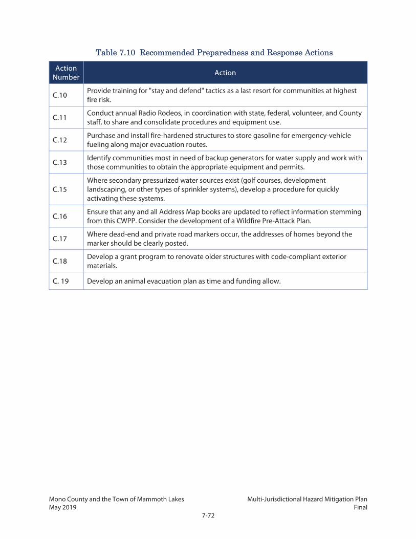
Mono County and the Town of Mammoth Lakes Multi-Jurisdictional Hazard Mitigation Plan May 2019 Final
7-72
Table 7.10 Recommended Preparedness and Response Actions
Action Number
Action
C.10 Provide training for "stay and defend" tactics as a last resort for communities at highest fire risk.
C.11 Conduct annual Radio Rodeos, in coordination with state, federal, volunteer, and County staff, to share and consolidate procedures and equipment use.
C.12 Purchase and install fire-hardened structures to store gasoline for emergency-vehicle fueling along major evacuation routes.
C.13 Identify communities most in need of backup generators for water supply and work with those communities to obtain the appropriate equipment and permits.
C.15 Where secondary pressurized water sources exist (golf courses, development landscaping, or other types of sprinkler systems), develop a procedure for quickly activating these systems.
C.16 Ensure that any and all Address Map books are updated to reflect information stemming from this CWPP. Consider the development of a Wildfire Pre-Attack Plan.
C.17 Where dead-end and private road markers occur, the addresses of homes beyond the marker should be clearly posted.
C.18 Develop a grant program to renovate older structures with code-compliant exterior materials.
C. 19 Develop an animal evacuation plan as time and funding allow.

Mono County and the Town of Mammoth Lakes Multi-Jurisdictional Hazard Mitigation Plan May 2019 Final
7-73
7.7 Website Resources American Red Cross, http://www.redcross.org/services/disaster
Bureau of Land Management, http://www.blm.gov
Cal Fire, http://www.fire.ca.gov
California Department of Fish and Wildlife, https://www.wildlife.ca.gov
California Governor’s Office of Emergency Services, http://www.oes.ca.gov
California Fire Alliance, http://www.cafirealliance.org
Coarsegold Resource Conservation District, http://www.crcd.org
Fire Effects Information System, http://www.fs.fed.us/database/feis
Fire Safe Council, http://www.firesafecoucil.org
Firewise, http://firewise.org
Madera County, http://www.Madera-County.com
National Fire Prevention Association, http://www.nfpa.org/codes
North Fork Chamber of Commerce, http://www.north-fork-chamber.com
Oakhurst Area Chamber of Commerce, http://www.oakhurstchamber.com
Office of State Fire Marshal, http://www.osfm.fire.ca.gov
Public Domain Software for the Wildland Fire Community, http://www.fire.org
Sierra Nevada Alliance, http://www.sierranevadaalliance.org
Threatened and endangered species,
http://imaps.dfg.ca.gov/CNDDB_QuickViewer/list_county_species.asp
United States Forest Service, http://www.fs.fed.us

Mono County and the Town of Mammoth Lakes Multi-Jurisdictional Hazard Mitigation Plan May 2019 Final
7-74
This page intentionally left blank.

Mono County and the Town of Mammoth Lakes Multi-Jurisdictional Hazard Mitigation Plan May 2019 Final
8-1
8. REFERENCES American Avalanche Association. 2016. Snow, Weather, and Avalanches: Observation Guidelines for
Avalanche Programs in the United States (3rd ed). https://www.americanavalancheassociation.org/swag/
Anchor Point Fire Management. 2009. “Fire Layers.” http://www.anchorpointgroup.com/fire-behavior.html#.
Bennett et al. 2010. “Reducing Fire Risk on Your Forest Property.” https://catalog.extension.oregonstate.edu/pnw618
Bellaire, Sascha, Bruce Jamieson, and Grant Statham. 2013. The Avalanche Climate of Glacier National Park, B.C., Canada during 1965–2011. http://schulich.ucalgary.ca/asarc/files/asarc/Issw2013_ClimateChangeAvalanches_Bellaire.pdf.
Bryant, E.A. 1980. Natural Hazards. Cambridge University Press.
Burak, Sue. 2018. Avalanche Hazard Study. https://www.monocounty.ca.gov/sites/default/files/fileattachments/planning_commission/meeting/29541/pc_packet_9.20.18.pdf (Attachment 2)
Cal/EPA (Environmental Protection Agency), and CDPH (California Department of Public Health). 2013. Preparing California for Extreme Heat: Guidance and Recommendations. https://www.climatechange.ca.gov/climate_action_team/reports/Preparing_California_for_Extreme_Heat.pdf
Cal Fire (California Department of Forestry and Fire Protection). 2012. Fire and Resource Assessment Program. http://frap.fire.ca.gov.
Cal OES (California Office of Emergency Services). 2013a. California Multi-Hazard Mitigation Plan. http://www.caloes.ca.gov/for-individuals-families/hazard-mitigation-planning/state-hazard-mitigation-plan.
---------. 2013b. Contingency Plan for Extreme Cold/Freeze Emergencies: A Supporting Document to the California State Emergency Plan. http://www.caloes.ca.gov/PlanningPreparednessSite/Documents/ExtremeCold-FreezeContingencyPlan2013.pdf.
CALTRANS (California Department of Transportation). 2015. Feasibility Study Report: Wildlife Vehicle Collision Reduction on US 395 Near Mammoth Lakes. https://www.monocounty.ca.gov/sites/default/files/fileattachments/local_transportation_commission_ltc/page/9002/feasibility_study_report_no_notes.pdf
CEC (California Energy Commission). Database of California Power Plants [data table]. http://www.energy.ca.gov/sitingcases/
----------. 2016. Cal-Adapt. http://www.cal-adapt.org.
Mono County and the Town of Mammoth Lakes Multi-Jurisdictional Hazard Mitigation Plan May 2019 Final
8-2
Census of Agriculture. 1997. Highlights of Agriculture: 1997 and 1992. http://usda.mannlib.cornell.edu/usda/AgCensusImages/1997/01/05/Highlights/Table-26.txt.
----------. 2012. Census of Agriculture – County Data. https://www.agcensus.usda.gov/Publications/2012/Full_Report/Volume_1,_Chapter_2_County_Level/California/st06_2_001_001.pdf.
CGS (California Geological Survey). 2015. Alluvial Fan Flooding Hazards: An Engineering Geologic Approach to Preliminary Assessment. ftp://ftp.consrv.ca.gov/pub/dmg/pubs/sr/SR_227/CGS_SR227_Alluvial_Fan_Engineering_Geologic_Approach_Final_July_2015.pdf.
CNRA and Cal OES (California Natural Resources Agency and California Office of Emergency Services). 2012. California Climate Adaptation Planning Guide: Understanding Regional Characteristics. http://resources.ca.gov/climate/safeguarding/local-action.
Corona, Marcella, and Kane, Jennifer. 2018. “UPDATE: Boot Fire partially contained, campgrounds still closed nearby” Reno Gazette Journal. https://www.rgj.com/story/news/2018/09/08/boot-fire-reaches-6-000-acres-crews-reopen-us-395-california-state-route-108/1240922002/
Dettinger, M. 2011. ‘‘Climate Change, Atmospheric Rivers, and Floods in California -- A Multimodal Analysis of Storm Frequency and Magnitude Changes.’’ Journal of the American Water Resources Association 47 (3).
Diffenbaugh, N., D. Swain, and D. Touma. 2015. “Anthropogenic warming has increased drought risk in California.” Proceedings of the National Academy of Sciences of the United States of America.
DOC (California Department of Conservation). 2001. Farmland Mapping and Monitoring Program. www.consrv.ca.gov/dlrp/FMMP.
DWR (California Department of Water Resources). 2014. ‘‘Dams Within the Jurisdiction of the State of California.’’ https://www.water.ca.gov/Programs/All-Programs/Division-of-Safety-of-Dams/Jurisdictional-Sized-Dams.
Eastern Sierra Avalanche Center. 2017. “Weather Resources.” http://www.esavalanche.org/weather.
EPA (Environmental Protection Agency). 2016. A Citizen’s Guide to Radon. https://www.epa.gov/sites/production/files/2016-12/documents/2016_a_citizens_guide_to_radon.pdf.
FEMA (Federal Emergency Management Agency). 2013. Local Mitigation Planning Workbook. https://www.fema.gov/media-library-data/20130726-1910-25045-9160/fema_local_mitigation_handbook.pdf.
Fried, J., J. Gilless, W. Riley, T. Moody, C. de Blas, K. Hayhoe, M. Mortiz, S. Stephens, and M. Tom. 2008. “Predicting the effect of climate change on wildfire behavior and initial attack success.” Climatic Change 87 (Suppl 1):S251–S264.
Geisel, Andy. 2012. “Somewhere after the Rainbow.” The Sheet. http://thesheetnews.com/2012/08/27/somewhere-after-the-rainbow/
Mono County and the Town of Mammoth Lakes Multi-Jurisdictional Hazard Mitigation Plan May 2019 Final
8-3
Grant, K., E. Rohling, C. Ramsey, H. Cheng, R. Edwards, F. Florindo, D. Heslop et al. 2013. “Sea-level variability over five glacial cycles.” Nature Communications. Article number: 5076.
InciWeb. 2018. “Incident Information System, Boot Fire.” https://inciweb.nwcg.gov/incident/6190/
Independent Forensic Team, California Department of Water Resources. January, 5, 2018. Independent Forensic Team Report, Oroville Dam Spillway Incident. https://damsafety.org/sites/default/files/files/Independent%20Forensic%20Team%20Report%20Final%2001-05-18.pdf
International Civil Defense Organization. 2018. Avalanches. http://www.icdo.org/en/disasters/natural-disasters/avalanches/
International Code Council. 2012. International Wildland-Urban Interface Code. http://shop.iccsafe.org/media/wysiwyg/material/3850X12-toc.pdf.
KTNV Channel 2. 2016. “Clark Fire Near Mono Lake Reaches 60% Containment.” http://www.ktvn.com/story/32695571/mono-county-issues-health-advisory-for-area-near-clark-fire
Lenihan, James M., Raymond Drapek, Dominique Bachelet, and Ronald Neilson. 2003. "Climate Change Effects on Vegetation Distribution, Carbon, and Fire in California." Ecological Applications 13 (6): 1667- 1681.
Mammoth Community Water District. 2017. 2015 Urban Water Management Plan. http://www.mcwd.dst.ca.us/assets/final-2015-uwmp.pdf.
Mann, Michael L., Peter Berck, Max Moritz, Enric Batllori, James Baldwin, Conor Gately, and D. Richard Cameron. 2014. "Modeling residential development in California from 2000 to 2050: Integrating Wildfire Risk, Wildland and Agricultural Encroachment." Land Use Policy 41 (11): 438-452.
McJunkin, Richard D. and Trinda L. Bedrossian. 1980. “Mammoth Lakes Earthquakes, May 25-27, 1980.” California Geology 33 (9). http://www.johnmartin.com/earthquakes/eqpapers/00000046.htm.
Mono County. 2001. Master Environmental Assessment. https://www.monosheriff.org/sites/default/files/fileattachments/planning_division/page/812/2001_mea_and_maps_color.pdf.
Mono County and Town of Mammoth Lakes. 2006. Multi-Jurisdictional Local Hazard Mitigation Plan. https://www.monocounty.ca.gov/sites/default/files/fileattachments/planning_division/page/10087/adopted_haz_plan.pdf.
Mono Lake Committee. 2016. Marina Fire. http://www.monolake.org/today/tag/marina-fire/
----------. 2016b. Wilson Fire, Clark Fire updates. http://www.monolake.org/today/2016/08/05/wilson-fire-clark-fire-updates/
National Centers for Environmental Information (NOAA). 2018. Daily Summaries Station Details. https://www.ncdc.noaa.gov/cdo-web/datasets/GHCND/stations/GHCND:USR0000CBEN/detail

Mono County and the Town of Mammoth Lakes Multi-Jurisdictional Hazard Mitigation Plan May 2019 Final
8-4
National Drought Mitigation Center. 2018. United States Drought Monitor. http://droughtmonitor.unl.edu/Data.aspx
National Fire Protection Association. 1997. NFPA 299: Standard for Protection of Life and Property from Wildfire.
----------. 2008. Wildfire! Preventing Home Ignitions! Firewise Communities. VHS video, 19 min.
National Park Service. 2016. State of the Park Report for Devils Postpile National Monument. https://irma.nps.gov/DataStore/DownloadFile/578609
National Wildland/Urban Interface Fire Protection Program. n.d. Wildland/Urban Interface Fire Hazard Assessment Methodology. http://www.emnrd.state.nm.us/SFD/FireMgt/docs/wham.pdf.
NOAA (National Oceanic and Atmospheric Administration). 2017. Storm Events Database. https://www.ncdc.noaa.gov/stormevents.
NSIDC (National Snow and Ice Data Center). 2014. Scientific Data for Research. https://nsidc.org.
Office of the Governor. 2014. ‘‘Governor Brown Declares Drought State of Emergency.’’ https://www.gov.ca.gov/2014/01/17/news18368.
----------. 2015. ‘‘Lieutenant Governor Newsom Declares State of Emergency in Six Counties Following Severe Storms.” https://www.gov.ca.gov/2015/07/22/news19049.
Oskin, M., D. Burbank, F. Phillips, S. Marrero, B. Bookhagen, and S. Selander. 2014. “Relationship of channel steepness to channel incision rate from a tilted and progressively exposed unconformity surface.” Journal of Geophysical Research 119 (2): 366-384.
Queen, Phillip L. 1993. Fighting Fire in the Wildland/Urban Interface. Bellflower, CA: Fire Publications, Inc.
Slaughter, R., ed. 1996. California’s I-ZONE – Urban/Wildland Fire Prevention & Mitigation.
Town of Mammoth Lakes. 2015. Housing Element 2014-2019. https://www.townofmammothlakes.ca.gov/636/2014-2019-Housing-Element
US Census Bureau. 2014a. American Community Survey, 2014 5-Year Estimates: Selected Social Characteristics in the United States [data table].
----------. 2014b. American Community Survey, 2014 5-Year Estimates: Age and Sex [data table].
----------. 2014c. American Community Survey, 2014 5-Year Estimates: Selected Economic Characteristics [data table].
US Drought Monitor. 2016a. ‘‘US Drought Monitor Classification Scheme.’’ http://droughtmonitor.unl.edu/AboutUSDM/DroughtClassification.aspx.
---------. 2016b. ‘‘US Drought Monitor: California.’’ http://droughtmonitor.unl.edu/CurrentMap/StateDroughtMonitor.aspx?CA

Mono County and the Town of Mammoth Lakes Multi-Jurisdictional Hazard Mitigation Plan May 2019 Final
8-5
USGS (US Geological Survey). 2005. Estimated use of water in the United States. https://pubs.usgs.gov/circ/1344/pdf/c1344.pdf.
---------. 2014. ‘‘Moment Magnitude, Richter Scale.’’ https://www.usgs.gov/faqs/moment-magnitude-richter-scale-what-are-different-magnitude-scales-and-why-are-there-so-many.
---------. 2015. ‘‘Earthquake Lists, Maps, and Statistics.’’ https://earthquake.usgs.gov/earthquakes/browse/.
---------. 2016. ‘‘Volcanic alert-levels characterizes conditions at US volcanoes.’’ http://volcanoes.usgs.gov/vhp/about_alerts.html.
---------. 2017a. “Magnitude/Intensity Comparison.” https://earthquake.usgs.gov/learn/topics/mag_vs_int.php.
---------. 2017b. “California Volcano Observatory (CalVO).” http://volcanoes.usgs.gov/observatories/calvo.
---------. 2017c. “ShakeMap.” https://earthquake.usgs.gov/data/shakemap.
USGS and CGS (US Geological Survey and California Geological Survey). 2014. Scenario Earthquake Hazards for the Long Valley Caldera-Mono Lake Area, East-Central California. http://www.conservation.ca.gov/cgs/rghm/loss/Documents/CGS_SR233_ofr2014_1045.pdf.
USDA Forest Service. 1993. Dry Hydrant Manual – A Guide for Developing Alternative Water Sources for Rural Fire Protection. http://www.dof.virginia.gov/print/dryhydrant/r8-tp-19-usfs-dry-hydrant-manual-sep-1993.pdf.
US Department of the Interior, US Department of Agriculture, Department of Energy, Department of Defense, Department of Commerce, US Environmental Protection Agency, Federal Emergency Management Agency, National Association of State Foresters. 2001. Review and Update of the 1995 Federal Wildland Fire Management Policy. https://www.nifc.gov/PIO_bb/Policy/FederalWildlandFireManagementPolicy_2001.pdf.
Vane, Katie. 2015. “Van Dyke fire damages SCE substation.” The Sheet. http://thesheetnews.com/2015/02/12/van-dyke-fire-damages-sce-substation/
Western Governors’ Association. 1996. Wildland/Urban Interface Fire Policy Action Report.

Mono County and the Town of Mammoth Lakes Multi-Jurisdictional Hazard Mitigation Plan May 2019 Final
8-6
This page intentionally left blank.

Mono County | Town of Mammoth Lakes
Multi-Jurisdictional Hazard Mitigation Plan (MJHMP)
APPENDIX A: ADOPTION RESOLUTIONS

This page intentionally left blank.

MJHMP - Appendix A Adoption Resolutions May 2019 Final
A-1

MJHMP - Appendix A Adoption Resolutions May 2019 Final
A-2

MJHMP - Appendix A Adoption Resolutions May 2019 Final
A-3

MJHMP - Appendix A Adoption Resolutions May 2019 Final
A-4

MJHMP - Appendix A Adoption Resolutions May 2019 Final
A-5

MJHMP - Appendix A Adoption Resolutions May 2019 Final
A-6

MJHMP - Appendix A Adoption Resolutions May 2019 Final
A-7

MJHMP - Appendix A Adoption Resolutions May 2019 Final
A-8

Mono County | Town of Mammoth Lakes
Multi-Jurisdictional Hazard Mitigation Plan (MJHMP)
APPENDIX B: MEETING & OUTREACH MATERIALS

This page intentionally left blank.

MJHMP - Appendix B Meeting & Outreach Materials May 2019 Final
B-i
B.1 Planning Team Meetings ....................................................................... B-1
B.1.1 Planning Team Meeting #1 - June 15, 2017 ...................................................................... B-2
B.1.2 Planning Team Meeting #2 – September 29, 2017 ......................................................... B-7
B.1.3 Planning Team Meeting #3 – December 13, 2017 ........................................................ B-16
B.1.4 Planning Team Meeting #4 – January 25, 2018 .............................................................. B-27
B.1.5 Planning Team Meeting #5 – April 5, 2018 ...................................................................... B-35
B.2 Status of Mitigation Actions from Previous Plan ............................... B-43
B.3 Public Survey ........................................................................................ B-51
B.3.1 Survey Questions ........................................................................................................................ B-51
B.3.2 Summary of Results................................................................................................................... B-58
B.3.3 Survey Responses ...................................................................................................................... B-65
B.4 Community/Stakeholder Meetings ...................................................... B-67
B.4.1 Stakeholder Meetings – September 28-29, 2017 .......................................................... B-68
B.4.2 RPAC Meetings – December 12-13, 2017 ......................................................................... B-84
B.4.3 Town of Mammoth Lakes Planning Commission Hearing – December 12, 2017 ................................................................................................................... B-89
B.4.4 Fire Chiefs Meeting – December 13, 2017 ........................................................................ B-94
B.4.5 Collaborative Planning Team Meeting – January 25, 2018 ..................................... B-103
B.4.6 Long Valley RPAC Meeting – January 24, 2018 ........................................................... B-110
B.4.7 CAC and RPAC Meetings – April 4-5, 2018 ................................................................... B-115

MJHMP - Appendix B Meeting & Outreach Materials May 2019 Final
B-ii
This page intentionally left blank.

MJHMP - Appendix B Meeting & Outreach Materials May 2019 Final
B-1
B.1 Planning Team Meetings The Planning Team held five meetings during the plan development process at which they helped guide the development of the plan, provided data, and reviewed draft pieces of the plan. Agendas, power point presentations and minutes from meetings are provided below (in chronological order).

MJHMP - Appendix B Meeting & Outreach Materials May 2019 Final
B-2
B.1.1 Planning Team Meeting #1 - June 15, 2017
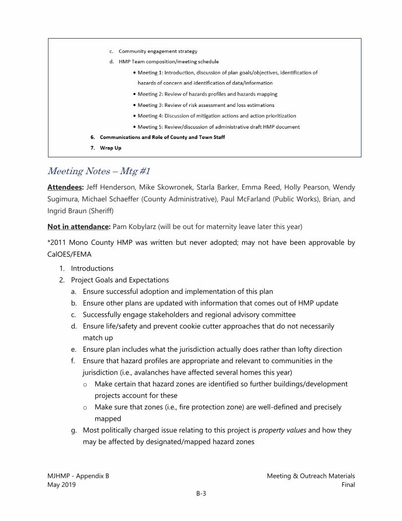
MJHMP - Appendix B Meeting & Outreach Materials May 2019 Final
B-3
Meeting Notes – Mtg #1 Attendees: Jeff Henderson, Mike Skowronek, Starla Barker, Emma Reed, Holly Pearson, Wendy Sugimura, Michael Schaeffer (County Administrative), Paul McFarland (Public Works), Brian, and Ingrid Braun (Sheriff)
Not in attendance: Pam Kobylarz (will be out for maternity leave later this year)
*2011 Mono County HMP was written but never adopted; may not have been approvable by CalOES/FEMA
1. Introductions 2. Project Goals and Expectations
a. Ensure successful adoption and implementation of this plan b. Ensure other plans are updated with information that comes out of HMP update c. Successfully engage stakeholders and regional advisory committee d. Ensure life/safety and prevent cookie cutter approaches that do not necessarily
match up e. Ensure plan includes what the jurisdiction actually does rather than lofty direction f. Ensure that hazard profiles are appropriate and relevant to communities in the
jurisdiction (i.e., avalanches have affected several homes this year) o Make certain that hazard zones are identified so further buildings/development
projects account for these o Make sure that zones (i.e., fire protection zone) are well-defined and precisely
mapped g. Most politically charged issue relating to this project is property values and how they
may be affected by designated/mapped hazard zones

MJHMP - Appendix B Meeting & Outreach Materials May 2019 Final
B-4
o Issues relating to secondary access when roads/routes are shut down due to rockslides, avalanches, etc.
o Backup/Evidence of need for secondary access will be useful when attempting to get funding for additional roads, etc.
o These issues and more will come up through the community engagement process for this plan
h. Another overarching goal is to ensure implementation will follow the completion of the HMP (i.e., importance of the long-term) o Identifying mitigation projects and issues in the plan will help with prioritization
and implementation of these projects and will make a good case to obtain funding for these
o What percentage of funding comes from local revenue for mitigation projects? o Need to consider who are the partners, not just in the County, but possibly
neighboring counties in the region, etc. o Need to associate grant resources with the actions/projects in the HMP to ensure
funding for these to get implemented 3. Work Program
a. Community Profiles o First step in the process
b. Community Outreach and Involvement o Community meetings (1 with each RPAC + 2 with stakeholders)
• See more detailed meeting schedule below in step 5 o HMP Team meetings
• The group on the phone today is the “core” group but there may be a few more for Team meetings (possible addition of three more staff)
• Local fire department reps and County Public Health staff should be involved also
• Stakeholders would include public agencies also • Planning Commission could be included in community meetings • Core Team will do outreach to let other potential attendees know when
meetings are being held c. Risk Assessment
o Capabilities assessment • Town’s draft EOP just got completed; Pam will put Jeff in touch with the
contractor who is working on that document -> Willdan o Hazard profiles o Vulnerability assessment

MJHMP - Appendix B Meeting & Outreach Materials May 2019 Final
B-5
o Critical facilities loss estimation o Land use and development trends
d. Mitigation Strategy o Goals and objectives o Strategies and actions
• Michael Baker will get input on these from Planning Team before finalizing them in the plan document
o Plan maintenance e. LHMP Draft and Adoption
o Draft plan and update REP o AB 2140/Safety Element o Submit draft plan to FEMA o Adoption
f. Additional optional tasks o Wendy will check if grant money can be used for actual mitigation
actions/projects resulting from this plan (need to check with FEMA on eligible expenses)
4. Timing for Project Check-Ins a. Grant funding expires in May 2019 b. Bi-weekly half-hour check-in calls with County reps for duration of project
5. Initial Work Program Steps a. We are meeting internally next week b. Will be taking first steps laid out in proposal c. One of the first things we have will be a data collection list (County will need to
confirm, provide additional, etc.) d. A proposed schedule for meetings, deliverables, etc. will be created and run by
everyone involved (ideally will have several meetings in same day or over a couple of days)
e. Wendy will complete a contact list for jurisdiction staff and Jeff will complete with Baker contact list for full project staff list
f. Schedule with deliverables o Grant funding expires in May 2019 o There is time between when the HMP schedule ends and the end of the grant
funding timeline o Extra funding for additional/optional projects (i.e., CWPP) can be approved fairly
easily g. Data needs/data collection

MJHMP - Appendix B Meeting & Outreach Materials May 2019 Final
B-6
o Initial item – County will need to provide input on data collection (confirmation and additional data/information needed)
h. Community engagement strategy o This will be an initial item also
i. HMP Team composition/meeting schedule o Meeting 1: Introduction, discussion of plan goals/objectives, identification of
hazards of concern and identification of data/information o Meeting 2: Review of hazards profiles and hazards mapping o Meeting 3: Review of risk assessment and loss estimations o Meeting 4: Discussion of mitigation actions and action prioritization o Meeting 5: Review/discussion of administrative draft HMP
6. Communications and Role of County and Town Staff a. Core Team of County staff plus some extended staff from various departments to be
involved in the planning process b. Primary people Wendy will be hearing from will be Jeff Henderson (Rancho Cordova)
and Emma Reed (Oakland) c. All County staff should feel free to reach out to Baker Team
7. Wrap Up

MJHMP - Appendix B Meeting & Outreach Materials May 2019 Final
B-7
B.1.2 Planning Team Meeting #2 – September 29, 2017
MJHMP - Appendix B Meeting & Outreach Materials May 2019 Final
B-8
Power Point Presentation – Mtg #2

MJHMP - Appendix B Meeting & Outreach Materials May 2019 Final
B-9

MJHMP - Appendix B Meeting & Outreach Materials May 2019 Final
B-10

MJHMP - Appendix B Meeting & Outreach Materials May 2019 Final
B-11

MJHMP - Appendix B Meeting & Outreach Materials May 2019 Final
B-12

MJHMP - Appendix B Meeting & Outreach Materials May 2019 Final
B-13
Meeting Notes – Mtg #2 Attendees
• Bob Rooks – Mono County EMS – created last CWPP for the county (2008)

MJHMP - Appendix B Meeting & Outreach Materials May 2019 Final
B-14
• Grady – PW Director for Town. Town’s EOP is nearly completed, just finished training related to plan.
• Al Davis – Mammoth Lakes Police Chief • Louis Molina – County EH Director • Jerry Le Francois – Mono County Planning, LTC. LTC wants staff to put together a
winter debrief from last winter. • Wendy Sugimura • Scott Burns • Tony Dublino – Assistant CAO. Some familiarity with these plans. Former solid waste
services director, was directly involved in cleanup efforts after recent fires. • Mike Garner – Michael Baker Int’l.
- Priority Hazards discussion – is it based on potential to occur, or potential to have a big impact?
- Man-made hazards – consider hazardous freight movement. Include as a hazard.
- “Severe Winter Storm” – needs to include “snow” in title
- For Wildfire hazards – consider ignition sources as part of the “wildfire” hazard.
- Dam Failure – is it a weather issue, or something else? This is relevant, keep for now.
- Potentially remove Liquefaction as a hazard.
- Town discussions of climate change are centered on Adaptation.
- Tony – there was interest in having risk factors established really high – due to funding possibilities. Caused some blow-back on insurance ratings? But this is public data in the end – insurance companies can get the information and use it. Our risk layers are already publicly available.
- Real issues with snow were snow removal and propane tank issues. These are mitigatable.
- Top results for each participant in hazards priority survey:
• Wildfire, Seismic Hazards, Landslide/Fault Rupture • Seismic, Severe Weather, Volcano • Wildfire,
- Smoke/PM issues – important health hazards. Consider secondary impacts of smoke/PM – originating from the Central Valley and controlled burns.
• Wildfire, Seismic/Earthquake/Landslide
- Seismic is a long-term impact – longer recovery period.
• Wildfire, Severe Winter Weather (snow), Flood
- With Severe Weather – be sure to consider secondary issues.

MJHMP - Appendix B Meeting & Outreach Materials May 2019 Final
B-15
- Ideal world Mitigation
• Undergrounding utilities • Enhanced Digital 395 project • Communications capabilities – Notifications (Reverse 911 system)
- Slinkert Fire – residents were unsure what was going on, or what to do.
• Eliminate cell dead zones on Highway 395. • Unlimited resources for fuel reduction? How can we provide additional resources for
fuel reduction. Policies and ordinances that are out there don’t allow us to manage resources.
• Investigate full access for brush clearance to all of the WUI. • Personnel is always going to be an issue here – don’t have a large corps of first
responders.
- Fire stations and medic stations throughout the County are in need of hardening. (Mammoth is in good shape.)
- Evacuation Routes – Need better secondary access to Mono City, Twin Lakes, other locations.
- Engage SCE, DWP, Liberty – also propane providers.
Other Staff Discussion:
- Assessor Data. Parcel Viewer – attribute table for assessor data. Gather a list of specific attributes they need from the assessor.
- Avalanche – “conditional development area.” Build here at your own risk. They sign a waiver. Avalanche expert mapped out areas 30 years ago.
• Identify Avalanche Influence areas.
- Highest risk outside Alaska. All communities are at the bottom of “runout zones.” Crosses state highways.
- Can Caltrans grant money apply Sustainable Transportation Grant – go after resiliency grant because of wet snow flow. Or could just look at where it impacts public assets.
- Walt has secondary access map
- Gases route outside June Lake.
- Planning areas from SP3. Demographics.
- Wendy – Will provide Housing Needs Assessment.
- 395, 203 & Creek Maintenance.
- Digital 395 – Nate Greenberg. Repeaters. 911 redundancy – all Nate

MJHMP - Appendix B Meeting & Outreach Materials May 2019 Final
B-16
- High tension areas are the big ones & can’t do anything about melt but power down, no water, no heat.
- Communications – no cell service during a big event.
- Notification – Code red system works best but depends on cell. What to do about notifications? What the public should do?
- Eliminate dead zones for cell service.
- Unlimited fuel reduction. Policies sometimes prevent.
- Clearance – since we don’t have access to forest land on back side of homes.
- We are on our own for snow. Yes for fire, equipment.
- Personnel is always an issue.
- Sections of County have old buildings that won’t. Rural area stations are old & not to standards. Same is true for medic facilities.
- Secondary evacuation routes. Twin Lakes, Swall, June Lake, Mono.
- Tribal Contact List
- Contact Propane companies in county.
B.1.3 Planning Team Meeting #3 – December 13, 2017

MJHMP - Appendix B Meeting & Outreach Materials May 2019 Final
B-17
Power Point Presentation – Mtg #3

MJHMP - Appendix B Meeting & Outreach Materials May 2019 Final
B-18

MJHMP - Appendix B Meeting & Outreach Materials May 2019 Final
B-19

MJHMP - Appendix B Meeting & Outreach Materials May 2019 Final
B-20

MJHMP - Appendix B Meeting & Outreach Materials May 2019 Final
B-21
MJHMP - Appendix B Meeting & Outreach Materials May 2019 Final
B-22

MJHMP - Appendix B Meeting & Outreach Materials May 2019 Final
B-23

MJHMP - Appendix B Meeting & Outreach Materials May 2019 Final
B-24

MJHMP - Appendix B Meeting & Outreach Materials May 2019 Final
B-25
Meeting Notes – Mtg #3 - Planning Areas Table: Paradise and Wheeler Crest – have a joint grant to complete the
CWPP. It’s under the auspices of Wheeler Crest Fire Safe Council. Add the FSC for both Wheeler Crest and Paradise.
- In the plan document, let’s use some additional break-out/inset maps to identify community areas in addition to TOML.
- Lifeline utility systems – Given Frontier’s lack of response in TriValley – may not want to consider all as lifeline. Also need to include tribal facilities. And, Camp Antelope. There is a clinic in Camp Antelope, and Benton tribe is pursuing resources for similar. Supervisor will provide our contact info to tribal chair.
- [email protected] would be good contact regarding lifeline utilities. Document these concerns in the plan.
- Should expand the socially vulnerable population areas to include designated DUCs by the state.
- Agnew Dam – confirm contact with SCE. (follow up with Wendy)
- Where did we determine that mosquitoes are most prevalent in Tri-Valley? There is a dedicated mosquito control function in the Town. It seems like this would be a bigger issue in west county, where its wetter and there are wetlands present. Talk to Ag Commissioner (Inyo Co) in Bishop – they did a count, got as many as 5k trapped, where only 10% of that is normal. Wendy will pass along contact info.
- Antelope Valley District – drilled about 20 new wells last year to replace domestic wells gone dry. Wendy to provide additional information from Louis. DWR can provide groundwater basin data related to overdraft. It’s the south part of the county, includes Tri-Valley and wraps around to Swall Meadows. Will be a GSP prepared.

MJHMP - Appendix B Meeting & Outreach Materials May 2019 Final
B-26
- Change “Coleville” to Antelope Valley – on severe wind. This is a hazard throughout the entire valley.
- Problems with severity zones – they fail to incorporate fire history. Fire history means fuel type conversion, means more frequent fires. Swall Meadows to Crowley Lake – has gone from 11 year interval to 8 year interval. Climate Change discussion has to do with invasive species, which has changed fuels. Major incidents around TOML have not been in the community, but rather in adjacent areas where fuel types have changed. Severity zone mapping doesn’t capture historic trends – if its burned before, it will burn again.
- FRAP – developed and geared for 4,000 ft elevations on the west slope, not geared for Great Basin, elevation, and fuel types. Fire history also needs to be considered. Confirm if the FRAP updates are including changes in vegetation.
- Historic Fires map – go farther back than 2007. There was a lot of fire activity in the 1990s. Bridgeport Fire isn’t on the map, but was only 3 years ago.
- Swall Meadows fire caused significant structural loss – that’s an indicator of risk. Consider prioritizing the areas with potential for structural loss.
- Reason there’s a second access road out of TOML is due to the 1980 earthquake. Need to capture accurate data to understand and prioritize the risks. In practice, its Antelope Valley and Swall Meadows into Tri-Valley.
- Try to synch all of the historic information to 1996+. (Swall Meadows Fires 1981, 1992, 2002, 2015, evac’d again in 2016)
- Fire intervals are potentially more important than structural damage information. Perhaps some tables of fire centers near communities going back a number of years. Our purpose is to protect the population – and we should be focusing on vulnerabilities.
- Can define the WUI as we want for CWPP. Should also consider approved subdivision applications. Will work with staff to refine the WUI mapping.
- 2009 WUI map may be a better representation. Should extend Very High all the way up to State line. Also, the Extreme area should be extended down to Walker.
- Caltrans did a big rockfall project near Lee Vining – temporary fencing, etc. Much of the work done in this location was due to the burn scar. Can be discussed in the plan narrative – build the relationship between the burn scars, flooding, and landslides.
- Did we also consider distance to outside resources to respond to incidents?
- Plan needs to clearly describe the isolation of Mono County. American Red Cross refused to call the Nevada Chapter for support in Mono County because Mono is in California.

MJHMP - Appendix B Meeting & Outreach Materials May 2019 Final
B-27
- Because of isolation, there’s a need to harden response capacity.
- Regarding water in Mammoth Lakes, should try and get in touch with Chris Weibert
- Regarding fire outcomes—Crowley shows no historic fire circles and fairly low risk but fires throughout the 1990’s, the Canyon Fire was extremely threatening.
- Frequently, in various parts of the County. Some fires have results in days without power OR phones for Crowley
• Both Verizon and Frontier refuse to utilize digital 395 have facilities that remain highly susceptible to fire
- Fred Stump notes that the county used to have access to an excursion vehicle which acted as a mobile, multiple frequency repeater and allowed great operability, but that vehicle was taken away for alternative uses.
- Access roads remain a major issue.
• Access not adequate for parts of Mono City. • Many 2ndary access routes are through BLM land and are not adequately
maintained. It’s a major difficulty coordinating across the all the agencies that a 2ndary access route may pass through to identify responsibly for/ensure full maintenance.
• NEPA exemptions may be critical to get better maintenance and additional access routes that must pass through federal lands
B.1.4 Planning Team Meeting #4 – January 25, 2018

MJHMP - Appendix B Meeting & Outreach Materials May 2019 Final
B-28
PowerPoint Presentation – Mtg #4

MJHMP - Appendix B Meeting & Outreach Materials May 2019 Final
B-29

MJHMP - Appendix B Meeting & Outreach Materials May 2019 Final
B-30

MJHMP - Appendix B Meeting & Outreach Materials May 2019 Final
B-31

MJHMP - Appendix B Meeting & Outreach Materials May 2019 Final
B-32

MJHMP - Appendix B Meeting & Outreach Materials May 2019 Final
B-33

MJHMP - Appendix B Meeting & Outreach Materials May 2019 Final
B-34
Meeting Notes – Mtg #4 - Fire history Q - Dave: any consideration in changes to vegetation in the last decade?
• Dana: last vegetation data I have is from 2009 in the last CWPP, so we don’t have truly up-to-date info.
• Dave: some areas are completely different, esp. in post-fire areas • Dana: CalFire said they’ll be coming out with data this year but that we shouldn’t wait
for that to come out. May be worth considering an on the ground inventory based on funding
• Fred: Just talk in narrative about the change due to fires and invasive species, etc. to leave space for future changes and updates.

MJHMP - Appendix B Meeting & Outreach Materials May 2019 Final
B-35
B.1.5 Planning Team Meeting #5 – April 5, 2018
MJHMP - Appendix B Meeting & Outreach Materials May 2019 Final
B-36
PowerPoint Presentation – Mtg #5

MJHMP - Appendix B Meeting & Outreach Materials May 2019 Final
B-37

MJHMP - Appendix B Meeting & Outreach Materials May 2019 Final
B-38

MJHMP - Appendix B Meeting & Outreach Materials May 2019 Final
B-39

MJHMP - Appendix B Meeting & Outreach Materials May 2019 Final
B-40

MJHMP - Appendix B Meeting & Outreach Materials May 2019 Final
B-41

MJHMP - Appendix B Meeting & Outreach Materials May 2019 Final
B-42
Meeting Notes – Mtg #5 County/Town Comments
- Propane incidents in Town of Mammoth Lakes: last year tank caught on fire under the snow, another where a house burned due to propane. Combination of issues with tanks and lines. Issues with ability to dig out tank. Description makes it sound more like issues that urban areas have with propane line systems exploding – Mono doesn’t have that problem, and only issues with some lines in the Town.
- Woodstoves and pellets – Ch 2. Heating sources description – a lot of homes are heated by cordwood and pellets.
- Prime farmland additional info – identified areas that could be considered prime farmland in a database, but they don’t officially designate it prime farmland.
- Double check “large scale solar” – County doesn’t think there is one.
- Extreme heat in tri-valley – wasn’t evaluated.
• Wendy: Leave it out. If the board or commission is aware they can bring it up.
- Clarify “Mammoth vicinity” versus “Town of Mammoth”
- Alquist-Priolo map – why not included?
• Dana: different sources show it differently so there’s not a consistent map. Could still include though.
• Wendy: it’d still be helpful because we have policies linked directly to that, and explain what is consistent or not across sources.
- Table of potential funding sources for studies?
• Yes, that’d be helpful
- Infrastructure table in Ch 7 – Town and Fire Dept review and confirm accuracy
- Access route priorities
• Lake Mary neighborhood – maybe call it Lakespace Inn because Lake Mary isn’t a neighborhood. It’s vacation homes and cabins.

MJHMP - Appendix B Meeting & Outreach Materials May 2019 Final
B-43
B.2 Status of Mitigation Actions from Previous Plan The following table illustrates the mitigation actions includes in the previous mitigation plan as well as the status of each action.
Status of 2006 Mitigation Actions
2006 Plan Numbering
Scheme 2006 Plan Project Description STATUS
Multiple Hazards
1
The county and the town do not have the detailed information necessary to complete the “Estimate Losses” section of this LHMP with any specificity. Completing a detailed inventory of existing assets would enable the county and town to understand more fully the areas and types of development most susceptible to identified hazards and to identify more specific mitigation for each hazard. The county and the town need to inventory existing development to obtaining the following data: • Type of Structures – The county and town do not have data on the types of existing structures on parcels. Building stock is currently classified only by land use designation, making it difficult to accurately divide building stock into the suggested categories (residential, commercial, industrial, agricultural, religious/non-profit, government, education, utilities). • Construction – The county and town do not have data on the construction of all existing structures (wood, steel, masonry) etc., making it difficult to determine susceptibility to hazards, value of structure, and replacement value. • Size of Buildings – The county and town do not store information at the building level. There are no databases that give building size by square foot. • Total Number of Buildings – The GIS system does not include building footprints; the total number of buildings would need to be estimated based on a rough calculation of all developed parcels in the town and county (parcels with a structural value > $10,000).
Revised and incorporated into mitigation measure 1.4

MJHMP - Appendix B Meeting & Outreach Materials May 2019 Final
B-44
Status of 2006 Mitigation Actions
2006 Plan Numbering
Scheme 2006 Plan Project Description STATUS
1 cont.
• Value of Structures – The only valuation tool available to the county and town is the most recent tax assessment of a structure; often it is terribly outdated and undervalues the structure. • Value of Contents – This would depend on the information gathered in Items 1-4 above. • Total Replacement Value – This is dependent on updating Items 1-6 above. • Calculate the Proportion of Assets Located in Hazard Areas – Currently, because it is difficult to accurately divide building stock into the suggested categories (See Item 1 above), it would be difficult to come up with an accurate proportion within a hazard area.
2
Once the county updates its GIS and databases as specified in Mitigation 1 above, it can then use the FEMA document Understanding Your Risks: Identifying Hazards and Estimating Losses (FEMA 386-2) to plot loss estimation values and develop corresponding GIS map products for all areas of the county including Mammoth Lakes.
Revised and incorporated into mitigation measure 1.4
3
Many areas in the county, including communities, do not have adequate cell phone or radio service and do not have a reliable method to call for help or to receive warnings in case of emergencies. Installing additional cell and radio towers to ensure adequate coverage throughout the county would help mitigate potential impacts from several hazards by providing a warning system.
Revised and incorporated into mitigation measure 1.5
Avalanche
A-1
Many of the parcels in avalanche hazard zones are adjacent to or on public lands managed by the US Forest Service. Placing those properties into federal ownership or into the ownership of land conservation organizations and restricting their use to permanent open space use would eliminate existing avalanche hazards to people and property.
Revised and incorporated into mitigation measure 10.4
MJHMP - Appendix B Meeting & Outreach Materials May 2019 Final
B-45
Status of 2006 Mitigation Actions
2006 Plan Numbering
Scheme 2006 Plan Project Description STATUS
A-2 Complete avalanche mapping for the County’s GIS system, including data for Mammoth Lakes.
Revised and incorporated into mitigation measure 10.1
Dam Failure
D-1 Work with the US Forest Service to study the potential impacts of the failure of Rock Creek Dam. Once the impacts have been assessed, develop and implement an emergency response plan.
Revised and incorporated into mitigation measure 11.2
Flood
F-1
Document past flood events on the GIS system in order to develop historic flooding patterns for the area that can be used to better understand where repetitive flooding hazards occur and enable the County and Town to minimize risks to existing development in those areas.
Continued as mitigation measure 9.3
F-2 Request FEMA to update the FIRM maps for the county, particularly for the Walker River watershed communities, the June Lake Loop, and the Tri-Valley area. As maps are updated, input that data on the county and town’s GIS system.
Mono County provided LiDAR data for cooperative mapping project with FEMA. Continued opportunities for improved mapping. Revised and incorporated into mitigation measure 9.2

MJHMP - Appendix B Meeting & Outreach Materials May 2019 Final
B-46
Status of 2006 Mitigation Actions
2006 Plan Numbering
Scheme 2006 Plan Project Description STATUS
F-3 Request DWR to complete the Awareness Floodplain Maps for the county, particularly for the Walker River watershed communities, the June Lake Loop, and the Tri-Valley area. As the maps are completed, input that data on the county and town’s GIS system.
(Wendy to check with Public Works)
F-4 Incorporate the DWR Awareness Floodplain Maps into the land use planning process for the county and the town and the GIS system as those maps become available. Request FEMA to include the DWR Awareness Floodplain Map data on the FIRM maps.
(Wendy to check with Public Works)
F-5 Ensure that ongoing stream restoration efforts throughout the county and town address flood management issues during the planning and implementation of those restoration efforts.
Deleted, not relevant. County and Town not directly involved with stream restoration efforts.
F-6 Ensure that property owners are aware of flood hazards and practices necessary to diminish the impacts of those hazards through an ongoing public education program. This should include information on participation in the NFIP.
Revised and incorporated into mitigation measure 9.4

MJHMP - Appendix B Meeting & Outreach Materials May 2019 Final
B-47
Status of 2006 Mitigation Actions
2006 Plan Numbering
Scheme 2006 Plan Project Description STATUS
F-7
The County and the Town shall develop a Comprehensive Flood Management Strategy for the county that includes the following elements: 1. Flood management strategies for each watershed in the County. Watersheds should be considered as single management units since upstream land management decisions affect downstream parcels. 2. Watershed-based flood management should include all agencies/entities whose decisions affect flood management. 3. Adequate floodplain management should stress: a. Avoiding risks in the floodplain. b. Minimizing the effects of those risks when they cannot be avoided. c. Mitigating the effects of damage when it occurs. d. Accomplishing the above in such a way that diminishes negative environmental impacts. e. Nonstructural mitigation (e.g. standards requiring elevation above the base flood level) should be given preference over structural mitigation (e.g. constructing diversion channels), when feasible. 4. Implementation programs.
Revised and incorporated into mitigation measure 9.5
Seismic
S-1
The County and the Town shall conduct a comprehensive survey of the structural condition of all buildings. Coordinate this survey with existing information from the Unreinforced Masonry Building survey and the Housing Conditions survey. Once the survey is completed, input the data on the GIS system.
Revised and incorporated into mitigation measure 4.1

MJHMP - Appendix B Meeting & Outreach Materials May 2019 Final
B-48
Status of 2006 Mitigation Actions
2006 Plan Numbering
Scheme 2006 Plan Project Description STATUS
S-2
Utilizing the structural survey required in Mitigation S-1, pinpoint structurally hazardous areas and buildings and develop a rehabilitation and replacement program to mitigate the impacts to unsafe structures from identified hazards in the area, including seismic hazards. Input data on structurally hazardous areas/buildings on the GIS system.
Revised and incorporated into mitigation measure 4.1
S-3 Seek funding to implement the rehabilitation and replacement program to mitigate impacts to unsafe structures. Unknown
Wildfire
W-1 Update the County’s General Plan Safety Element to ensure that it thoroughly addresses fire hazard planning. Utilize OPR’s Fire Hazard Planning during the update. Complete
W-2 Review the current update of the Town’s General Plan Safety Element to ensure it thoroughly addresses fire hazard planning. Complete
W-3 Review and, if necessary update, the County’s General Plan land use policies and regulations and building regulations to ensure that they address fire hazard planning as a component of the development process.
Complete
W-4 Ensure that wildland fire hazards are disclosed during real estate transactions as required. Ensure that wildland fire hazards are disclosed during the building permit process.
Continued as mitigation measure 2.8

MJHMP - Appendix B Meeting & Outreach Materials May 2019 Final
B-49
Status of 2006 Mitigation Actions
2006 Plan Numbering
Scheme 2006 Plan Project Description STATUS
W-5
Develop community-level fire plans for communities throughout the county, utilizing resources and assistance from the California Fire Alliance. These fire plans should address the following: • Developing an informed, educated public that takes responsibility for its own decisions relating to wildfire protection. • Developing an effective wildfire suppression program for local communities. • Developing an aggressive hazardous fuel management program. • Revising land use policies and standards to ensure that they protect life, property and local resource values. • Implementing construction and property standards that provide defensible space.
Continued as mitigation measure 2.6
W-6 Develop and implement an ongoing countywide program to increase public awareness of wildland fire hazards.
Replaced by mitigation measure 2.7
W-7 All communities and fire protection districts should participate in the Eastern Sierra Regional Firesafe Council.
No longer relevant. Eastern Sierra Fire Safe Council no longer exists. Replaced by mitigation measure 2.5
W-8
The county and the town should appoint a fire hazard coordinator with the responsibility for developing fire plans for the county, participating in the Eastern Sierra Regional Firesafe Council and the California Fire Alliance, coordinating with local, state, and federal fire protection and suppression entities, developing and implementing public education and awareness programs concerning fire safety including safe building materials and landscaping, and applying for funding for fire hazard mitigation such as fuel reduction programs.
Revised and incorporated into mitigation measure 2.2

MJHMP - Appendix B Meeting & Outreach Materials May 2019 Final
B-50
Status of 2006 Mitigation Actions
2006 Plan Numbering
Scheme 2006 Plan Project Description STATUS
W-9
Mono County’s Collaborative Planning Team should include representatives from the Eastern Sierra Regional Firesafe Council and local, state, and federal agencies concerned with fire protection. Fire hazard planning, pre-fire management programs, and public education should be a focus of the Collaborative Planning Team.
No longer relevant. Eastern Sierra Fire Safe Council no longer exists. Replaced by mitigation measure 2.5
W-10
Help local landowners participate in the state’s Vegetation Management Program (VMP), when applicable. The Vegetation Management Program (VMP) is a cost-sharing program that focuses on the use of prescribed fire and mechanical means to address wildland fire fuel hazards and other resource management issues on State Responsibility Area (SRA) lands.
Revised and incorporated into mitigation measure 2.9
W-11 Help local landowners participate in CDF’s hazardous fuel reduction program. Revised and incorporated into mitigation measure 2.9
W-12 Help local landowners participate in the BLM’s Wildland Urban Interface Grant Awards program for hazardous fuel reduction.
Revised and incorporated into mitigation measure 2.9
W-13 For communities with only one access route, develop and implement a plan to provide an emergency access route for the community.
Revised and incorporated into measure 1.6

MJHMP - Appendix B Meeting & Outreach Materials May 2019 Final
B-51
B.3 Public Survey Mono County and the Town of Mammoth Lakes prepared a survey for members of the public to assist with development of the Multi-Jurisdictional Hazard Mitigation Plan (MJHMP). The survey gauges respondents’ awareness and past experiences with hazard events, preparedness for future hazards, and views on effective hazard mitigation strategies. The survey received 26 responses, although not all respondents answered each question. This section presents the survey questions (Section B.1.1), a summary of the results of the public outreach survey (Section B.1.2), as well as a spreadsheet that compiled all responses received (Section B.1.3).
B.3.1 Survey Questions The survey included 24 questions to be completed and returned to staff by August 31, 2017. Questions focused on awareness of natural hazards in Mono County, and the perceived preparedness for such hazards.

MJHMP - Appendix B Meeting & Outreach Materials May 2019 Final
B-52
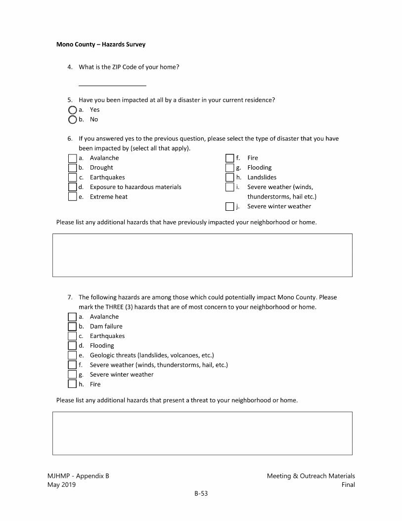
MJHMP - Appendix B Meeting & Outreach Materials May 2019 Final
B-53

MJHMP - Appendix B Meeting & Outreach Materials May 2019 Final
B-54

MJHMP - Appendix B Meeting & Outreach Materials May 2019 Final
B-55

MJHMP - Appendix B Meeting & Outreach Materials May 2019 Final
B-56

MJHMP - Appendix B Meeting & Outreach Materials May 2019 Final
B-57

MJHMP - Appendix B Meeting & Outreach Materials May 2019 Final
B-58
B.3.2 Summary of Results
Place of Residence (Questions 1-4) This section established residence and employment of the survey respondents. All survey respondents lived in unincorporated Mono County and owned their homes. No survey participants were Town of Mammoth Lakes residents. Figures 1 and 2 summarize the home community and zip code of respondents. Most respondents did not answer questions relating to employment, which may suggest that respondents are predominantly retired or work from home.
Hazard Awareness and Concern (Questions 5-7) The next set of questions related to the respondents’ awareness of and experience with natural hazards in Mono County. As shown in Figure 3, approximately 40 percent of respondents have
Antelope Valley, 4
Benton/Hammil, 2
Chalfant, 3
June Lake, 8
Long Valley/Tom's Place/Sunny
Slopes, 1
Mono Basin, 1
Paradise, 2
Wheeler Crest, 2
Other, 3
Figure 1: Home Community
93512, 2
93514, 8
93517, 193529, 8
93541, 1
93546, 1
96107, 4
No Answer, 1
Figure 2: Home Zip Code
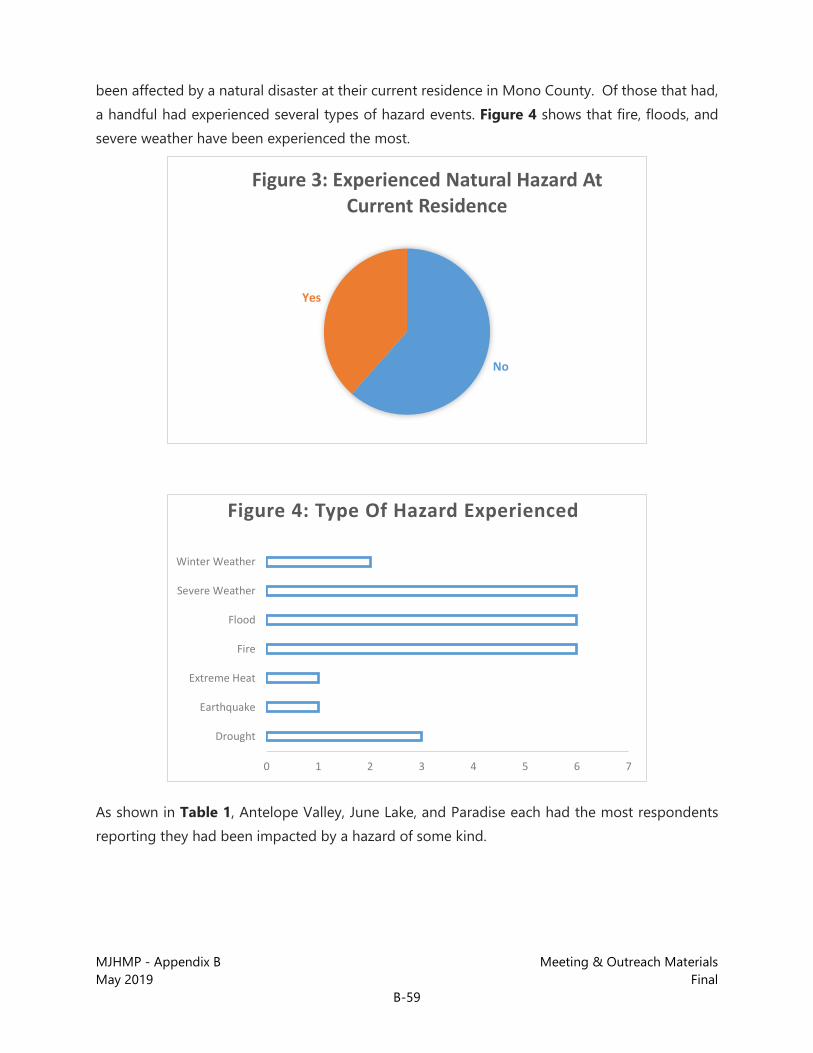
MJHMP - Appendix B Meeting & Outreach Materials May 2019 Final
B-59
been affected by a natural disaster at their current residence in Mono County. Of those that had, a handful had experienced several types of hazard events. Figure 4 shows that fire, floods, and severe weather have been experienced the most.
As shown in Table 1, Antelope Valley, June Lake, and Paradise each had the most respondents reporting they had been impacted by a hazard of some kind.
No
Yes
Figure 3: Experienced Natural Hazard At Current Residence
0 1 2 3 4 5 6 7
Drought
Earthquake
Extreme Heat
Fire
Flood
Severe Weather
Winter Weather
Figure 4: Type Of Hazard Experienced

MJHMP - Appendix B Meeting & Outreach Materials May 2019 Final
B-60
Table 1: Hazard Impact by Community Residence
Community Drought Earthquake Extreme Heat Fire Flood Severe
Weather Winter Storm Total
Antelope Valley 1 -- -- 1 1 1 -- 4
June Lake 1 -- -- -- 3 -- -- 4
Paradise -- 1 2 -- 1 -- 4
Wheeler Crest 1 -- -- 1 -- 1 -- 3
Chalfant -- -- -- 2 -- -- 2
Benton/ Hammil -- -- -- -- -- -- -- 0
Long Valley/ Tom's Place/ Sunny Slopes
-- -- -- -- -- -- -- 0
Mono Basin -- -- -- -- -- -- -- 0
Other -- 1 -- 2 -- -- -- 3
Total 3 1 1 6 6 3 0 20
Respondents were also asked which of the seven listed hazards that could potentially impact Mono County cause them the most concern regarding their home and neighborhood. Respondents were able to select up to three hazards. Figure 5 shows the hazards that most frequently selected as a concern to respondents. Fire, severe weather, and earthquakes were the top three concerns.
0 5 10 15 20 25
Fire
Severe Weather
Earthquake
Flood
Winter Weather
Geologic
Dam Failure
Figure 5: Hazards Of Most Concern
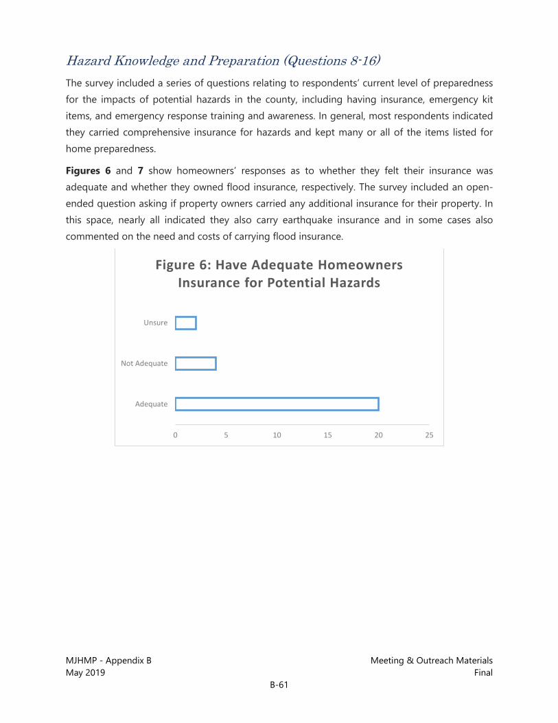
MJHMP - Appendix B Meeting & Outreach Materials May 2019 Final
B-61
Hazard Knowledge and Preparation (Questions 8-16) The survey included a series of questions relating to respondents’ current level of preparedness for the impacts of potential hazards in the county, including having insurance, emergency kit items, and emergency response training and awareness. In general, most respondents indicated they carried comprehensive insurance for hazards and kept many or all of the items listed for home preparedness.
Figures 6 and 7 show homeowners’ responses as to whether they felt their insurance was adequate and whether they owned flood insurance, respectively. The survey included an open-ended question asking if property owners carried any additional insurance for their property. In this space, nearly all indicated they also carry earthquake insurance and in some cases also commented on the need and costs of carrying flood insurance.
0 5 10 15 20 25
Adequate
Not Adequate
Unsure
Figure 6: Have Adequate Homeowners Insurance for Potential Hazards
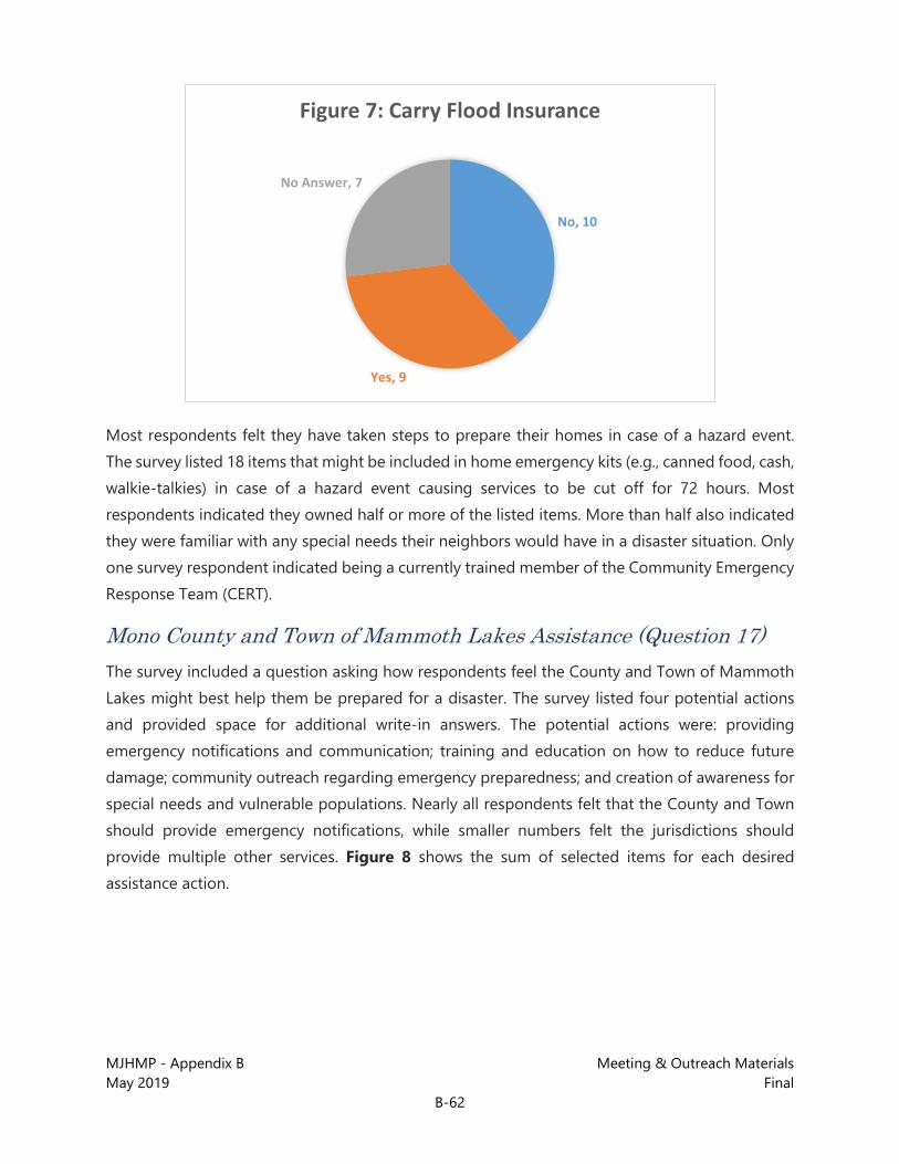
MJHMP - Appendix B Meeting & Outreach Materials May 2019 Final
B-62
Most respondents felt they have taken steps to prepare their homes in case of a hazard event. The survey listed 18 items that might be included in home emergency kits (e.g., canned food, cash, walkie-talkies) in case of a hazard event causing services to be cut off for 72 hours. Most respondents indicated they owned half or more of the listed items. More than half also indicated they were familiar with any special needs their neighbors would have in a disaster situation. Only one survey respondent indicated being a currently trained member of the Community Emergency Response Team (CERT).
Mono County and Town of Mammoth Lakes Assistance (Question 17) The survey included a question asking how respondents feel the County and Town of Mammoth Lakes might best help them be prepared for a disaster. The survey listed four potential actions and provided space for additional write-in answers. The potential actions were: providing emergency notifications and communication; training and education on how to reduce future damage; community outreach regarding emergency preparedness; and creation of awareness for special needs and vulnerable populations. Nearly all respondents felt that the County and Town should provide emergency notifications, while smaller numbers felt the jurisdictions should provide multiple other services. Figure 8 shows the sum of selected items for each desired assistance action.
No, 10
Yes, 9
No Answer, 7
Figure 7: Carry Flood Insurance
MJHMP - Appendix B Meeting & Outreach Materials May 2019 Final
B-63
Employer Actions (Questions 18-20) The survey included several questions about respondents’ employers and the actions the employers may be taking to reduce risk from hazards. Nearly all respondents left this section blank. A possible explanation is that respondents are primarily retired—which several respondents wrote they were—or self-employed. Consequently, very little data was collected on this topic.
Future Participation and Contact Information (Questions 21-24) The last section of the survey was devoted to collecting contact information for respondents to opt in regarding further involvement in the planning process. The majority provided contact information and indicated they would be willing to review and comment on the draft plan when it is ready.
0 5 10 15 20 25
Emergency Notifications
Training and Education
Outreach on Preparedness
Vulnerable Populations Needs
Other
Figure 8: Desired County/Town Hazard Assistance

MJHMP - Appendix B Meeting & Outreach Materials May 2019 Final
B-64
This page intentionally left blank.

MJHMP - Appendix B Meeting & Outreach Materials May 2019 Final
B-65
B.3.3 Survey Responses
Questions 1-12

MJHMP - Appendix B Meeting & Outreach Materials May 2019 Final
B-66
Questions 13-24

MJHMP - Appendix B Meeting & Outreach Materials May 2019 Final
B-67
B.4 Community/Stakeholder Meetings Throughout the planning process a variety of community meetings were held. Information gathering sessions occurred with key stakeholders at the beginning of the planning process; advisory meetings were conducted with the Mono County Regional Planning Advisory Committees (RPACs) for input and feedback throughout Plan development; and presentations about the MJHMP were given at standing community meetings. Agendas, presentations and minutes from meetings are provided below (in chronological order).

MJHMP - Appendix B Meeting & Outreach Materials May 2019 Final
B-68
B.4.1 Stakeholder Meetings – September 28-29, 2017

MJHMP - Appendix B Meeting & Outreach Materials May 2019 Final
B-69
PowerPoint Presentation – September Stakeholder Mtgs

MJHMP - Appendix B Meeting & Outreach Materials May 2019 Final
B-70

MJHMP - Appendix B Meeting & Outreach Materials May 2019 Final
B-71

MJHMP - Appendix B Meeting & Outreach Materials May 2019 Final
B-72
Meeting Notes – September Stakeholder Mtgs
September 28 – Bridgeport 11 am
• Bruce Woodworth – Mono County RCD – also Antelope Valley CERT. Prepares 20-page plans for emergency situations on occasion.
• Karla Benedicto – CalOES representative. • Sgt. West - CHP
- Expectation – Improve access to mitigation funding for rural areas – the cost-benefit isn’t usually favorable, but the damage potential is still high. Short answer is “money”.
- Traffic and amount of people are always a failure in plans for evacuation – easy to use the FEMA guidelines for evacuation, but its not practical. Let’s get a realistic plan for evacuation and how we’ll move people, and be sure that they are adapted to weather and seasonal conditions. CHP has a good operations plan with Nevada DOT – but all traffic outside of Mammoth is CHP
- Emergency Operations Plan – would use EOP. SCE has a plan for all seasons. This process needs to daylight the evacuation plans and ensure that stakeholders feel it is adequate. Focus potential mitigation resources on improving evacuation capacity.
- CHP and Caltrans have an outstanding relationship here – not much red tape.
- County Public Works are also very helpful – outstanding job with the resources available. So few people here, we have to work together as a team.
- Volunteer firefighters here are very effective, and strong volunteer network.
- Plan shouldn’t be limited to “natural” hazards – consider plane crashes, man-made hazards, terrorist attacks, etc. as well.
- Dams – should be considered critical infrastructure – but what’s critical may depend on the hazard in question. Inspection stations could be critical. Hwy 395 is likely the biggest critical facility. A dam failure would wash-out 395 which is the only way in and out. Edison also has plans and federal guidelines. (should engage SCE into conversations, perhaps also LADWP).
- 2015 fires – resulted from high wind events when telephone poles came down starting a series of fires.
- CHP’s biggest issue is Highway 395 and whether the main artery would be inaccessible. There are certain areas here that would be completely cut off. Weather could prevent flight access or allow for goods to be brought in only by air. Mammoth Airport is also a critical facility.

MJHMP - Appendix B Meeting & Outreach Materials May 2019 Final
B-73
- (Look at Edison’s EOP and hazards plans.)
- Communications Interoperability – Testing. Need exercises to test strength of the plans. Have done exercises (Dr. Johnson in Health Department has brought folks together.) Its table-top exercises at this point – but that doesn’t test communications in the field. Need to test and make sure communications work. There’s been a “radio rodeo” event – issues with towers, etc. But our communications equipment is challenging. This is a technology issue – hard to get facilities to where they need to be. Bridgeport did try mobile communications: radios, batteries, and back-up. This is also a process matter.
- Mitigation Capabilities – keeping culverts clear is an ongoing and conscientious effort. Maintaining riparian zones is also helpful to keep water flowing.
- Invest in exercises as part of mitigation – wholescale response exercise in the County would be educational and helpful. Look for grants and resources to support this. Someone who is actively testing exercises.
- Need to look at radio system – make it better. There are means for reverse 911.
- Bruce - Standard Operating Guidelines –
• Mass casualty/haz mat • Health/Pandemic • Flood Emergency • Fire Emergency • Earthquake • Power outage – power water habitability in rural environments
- Recent power outage – County didn’t see as a need for reverse 911 deployment. (Need both reverse 911 for hardlines, and reverse 911 for cell phones)
- Mono County has some partial coverage for cell phone reverse 911.
- CHP has all kinds of action plans – SOPs, which are statewide.
- Need – volcanic eruption action plan. Gathering dust on a state level.
September 28 – Bridgeport 1:00pm
• Dana, Jeff, Karla, Wendy, Mike Garner (M. Baker) • Doug Toskin – Marine Corps Mountain Warfare Training Center (MWTC) • Brett Hawn – Marine Corps MWTC • Ron Allen – Marine Corps MWTC – police, fire, safety, staff protection • Shannon Anderson – Marine Corps MWTC – 25 years DOD and lots of hazard
planning in the past. Involved with unified command in Mono County. Participant in recent fire effort.

MJHMP - Appendix B Meeting & Outreach Materials May 2019 Final
B-74
• Thom Heller – Mammoth Lakes FD (conference call-in) – been involved in Town and Forest Svc EM plans.
- 1997 100-year flood – hit North County pretty hard. Pickle Meadow was flooded out, lost Sonora Bridge on SR 108, had to evacuate the base. Had to evacuate 60 horses and mules – Walker River Canyon was flooded out. Most folks here live in Douglas County NV – Silver Creek fire.
- Also, Propane explosion at military housing – County responded very well. There were concerns about whether the homes then were safe. These affected the base and bled over into County services, etc. How can we help others, as well as they help us? Installation Commander can provide military resources for 3 days. Don’t have D9 Caterpillars, but do have some earthmoving equipment, a big water bowl (movable tank for potable water), limited amount of MREs. However, if we’re surging – mission priority remains taking care of the on-site Marines.
- Swift-water rescue – for Lyon County – had to stay mission-focused.
- Fire Chief Anderson: This year, lots of localized flooding from snowmelt – Base Fire Department is swift-water rescue certified and completes training each year. Add to plan – ready to provide that service. Able to assist.
- “Tyranny of distance” – is a big challenge to being responsive with assistance. We also have limited use of helicopters to assist with disasters. Some lift capability that can be authorized by the base commander. All depends on timing.
- DSCA – base would not be the place where people would be evacuated to, or would provide services. County already has those resources in place. However, supporting responders before USFS can get resources in place – can bed, feed, fuel resources until USFS gets setup. Best service we can provide is to support responders.
- Don’t have a portable fuel capability for stranded vehicles. FEMA Region IX report every six months regarding capabilities that the base has.
- Is a staging area a possibility – to pass through resources to the south? Yes, it’s a possibility. Base commander is all about mutual aid. Community plans liaison officers always attend. In the summertime, we used to have 500+ surge of Marines to attend training and would let County know. Definitely would support staging. Airfield has limitations and FEMA knows what they are – limited space and refilling capabilities.
- Have worked together with County and military base – dynamic relationship for 25+ years. Dynamic and wonderful support resource.

MJHMP - Appendix B Meeting & Outreach Materials May 2019 Final
B-75
- Re: Mitigation – Slinkert fire – when poles and wires were burned, Antelope Valley had no power. Some sort of backup power would be ideal. Perfect mitigation example. Pre-stage generator or generator on very short leash plugged into north part of the County. Backup generator was in Las Vegas – took 2-3 days to arrive. Liberty Energy is provider for Antelope Valley.
- Central California Threat Center – Can we engage Liberty Energy to deal with more than what they are doing now? Get redundant power supply options – or staged generators, etc.
- As a mitigation contribution, base commander could authorize siting/staging for major generator.
- 1997 flood – SR 108 is vulnerable because of the bridges. Scoured around the bridges, took days to blast earth from surrounding areas and resupport the bridge. Can’t get materials over the hill to us in the winter. SR 108 and US 395 are the most critical facilities. Can we ensure better routes? Or open facilities when we need to – it’s a Caltrans issue.
- Riparian zones – need to consider the inter-agency relationships and needs of riparian areas – how they are managed, how that contributes to flooding, how washed out bridges. Walker River Canyon is still vulnerable to high water and scouring. 4,000 cfs – but it never flooded. Some campgrounds affected. Road closure was a greater issue from the Slinkert Fire. Doing mitigation with controlled burns? Power in northern part of County gets knocked out all the time – South County ends up with similar problems with the biggest issue being loss of phone coverage and data disruption due to trunk lines getting cut.
- Geothermal plant is potentially a backfill. EMS in the County is very limited. Mammoth has good hospital – closest, other than Carson City and Reno. Almost an hour of flight from Bridgeport to get a victim to care – vulnerable with regard to emergency medical services. Particularly if air service gets limited. 5 ambulances in the County, 3 at base, 2 in Mammoth. Pilots won’t fly/not safe to fly in conditions. Another record year of snowfall coming. Vehicle accidents in Walker Canyon but fortunate not to have a high number of incidents. If have natural variation in cycles, you build up sediment, then flush it out.
- Money is a big constraint – not much investment here in these items. Paramedics approached base to see if they could coordinate all of the EMS calls in North County. Unfortunately, no. Redundant utilities, cell towers on wheels, these are all good improvements. Needed a “cow” – for fire fighting. Only 3-4 for the whole state and privately owned equipment. Cell towers are a big issue throughout the County – Verizon put one in at the base.

MJHMP - Appendix B Meeting & Outreach Materials May 2019 Final
B-76
- Need to recognize we’re a remote part of the state – need to come up with alternate means that we can afford, support and have control over. We’re going to be in a difficult time under an event, and need to work together. FEMA’s current push is for 72 hours of preparation which is not enough – threats are real, particularly when we’re this remote. Public education is a mitigation capacity and should be reinforced. Antelope Valley CERT has some efforts going, but kind of hit and miss in terms of having enough training. Down in Mammoth, CERT is doing better. Having trouble up here just getting volunteer firefighters. Supporting and investing in CERT in Antelope Valley would be a great mitigation action. Consider social vulnerability – identify folks who cannot self-evacuate, or are energy dependent, etc. Dr. Johnson and his staff are working on this issue – and doing a great job.
- Red Cross – consider reaching out to Red Cross as well.
- Shelters are in place – more than likely, people will go north to Douglas County, depending on connections and need.
- For evacuation, either North or South –
- Mutual Aid Agreements with multiple agencies (4+).
- Power should be #1 issue – redundant power. Potable water – most people are on wells, which are power dependent. Road networks are issues.
- Life support – how to provide the basic needs to maintain life. Need own resources available here – life support. Consider undergrounding the utilities – Edison/LADWP/Liberty Energy – how much would it cost to bury lines for Liberty Energy? Edison doesn’t want to bury anything greater than 33KV. Strong resistance to bury anything greater than 33KV. Digital 395 was a successful bury project and accomplished very quickly – look to this as a model. Marine Corps base is the absolute end of the line for SCE – backup generator on base capable of running a small city, but can’t put power on the grid. Trying to go solar – energy independent. Edison said no to pushing power back to the grid.
September 28 – Mammoth Lakes 3:30pm
• Thom Heller – Mammoth FD – Fire Marshall CWPP in 2008 with the County, lots of fuels reduction work. $400k grant for fuel reduction, fuel management plan submitted to state, applying for SNC grant for fuels reduction. Working with CWPP out of Colorado in hopes of putting together a CPAW endorsement. Active Firesafe Council in Town.
• Sagar Fowler – CalFIRE, new to the area, but never dealt with planning process • Mark Ingraham – Inyo NF and Bishop BLM – let’s update the Forest Service contracts • Ingrid Braun – Sheriff and Director of Emergency Services • Jeff, Dana, Wendy, Karla

MJHMP - Appendix B Meeting & Outreach Materials May 2019 Final
B-77
- Road system is a confining situation – we have limited number of roads, challenging weather events, not as much power issues as in the north part of county. But, major communication issues on south part of County. We work together as a community of responders – give and take, considering our isolated situation, we do a good job of piecing together solutions.
- Lack of redundancy of communication system is a huge issue. Verizon hasn’t fixed it. Perhaps 50% of people here no longer have land lines. US 395 and US 6 are really our only highway options. Major event strands people here.
- Living in a forest, the natural disasters are what get us. Avalanche, forest fires, homes in Twin Lakes area in avalanche zone, also Virginia Lakes, Mammoth, and June Lake Loop.
- Will be content if this plan gets finished, approved, so funds are available.
- Incident that will affect everyone here is wildfire – likely most devastating in the short term. Earthquake and volcanic activity could also be major events. 6.0 earthquake could stretch recovery resources to max, particularly with community growth.
- Weak systems – radio communication. We’re working on it, but requires more money. Operating at 1995 standards now. Under Digital 395, there’s so much more that we can do. Hired Delta Wireless to evaluate – we can provide their study. Checked out repeaters, looking at car-to-car communications. Its already better now, medics have noticed improvement, as has Town FD. Modernizing and digitizing this toward the future would make big improvements. Traditional systems don’t work in the mountain environment.
- The more we can work interagency in finding solutions, the better. USFS has developed a good system, which is available in spots, not uniform coverage. If we could work together on co-locating resources, that would be best.
- Topography makes communication systems challenging. Delta has a written assessment and upgrade recommendations.
- Wendy – Emphasis on implementable, fundable projects identified in the plan.
- 2008 CWPP is Countywide… need to reference. Includes update to project list and defensible space inspections.
- County EOP and other emergency plans also available.
- Secondary emergency access – Issue in Old Mammoth area? What’s on the books? Installed Waterford Bridge just for that purpose. From that point west, we’re working on one other location Snowcreek 1,2,3 to connect. Topography to the west is challenging. Becoming cost-prohibitive. Lakes Basin has one road in and out – in summertime, 3,000 people up there,

MJHMP - Appendix B Meeting & Outreach Materials May 2019 Final
B-78
plus campsites and resorts. Only one way in, one way out. Its in the fire avenue due to winds, etc.
- Heller: May have computerized list of troublesome secondary access spots.
- US 395 is becoming an increasingly busy route for hazardous materials such as fuel spill, gas and asphalt.
- Propane – probably from an incident standpoint, the greatest potential hazard.
- Walker River Canyon – big impacts in 1997. It’s pretty well armored – strong storm winters will push debris through. Walker River never flooded this year. Topaz Lake loses half its capacity but not sure what is left to be done for that.
- Infrastructure is relatively old – high potential for infrastructure to be impacted.
- Flooding events in Tri-Valley – last year, rain-runoff. DWP came out with graders and cleared it out. Storm system just sort of sat over Tri-Valley – BLM land, DWP lands, Caltrans roads ROW, floodplains. Big events, limitations to what could be done because of jurisdictional boundaries and where water could be diverted – cross-jurisdictional issues, who’s responsible to mitigate this? DWP? Landowners? Caltrans? Only one house significantly impacted – had a basement.
- Education as a mitigation strategy/along with volunteers-CERT. Town enabled people this winter with too much snow on roofs – but its private responsibility. Don’t set expectations that government is going to solve those problems.
- Radon – County Env. Health have Radon test kits. Radon mitigation system permits were on rise. Hard to find someone who does Radon mitigation – have to get someone down from Reno. Also expensive.
- Has County infrastructure been hardened enough to withstand risks? Potential shelters, etc. Community Centers are relatively new, mostly one-story. EAPs for Edison – Sheriff has their plans – we’re talking weekly. Agnew Dam – was a scary proposition, but resulted now in good coordination. Three Dams for Edison, also need to add DWP. Sheriff can provide contacts.
- County facilities are built to building codes – but not specifically hardened to hazards. Current jail was built in mid-1980s. New jail will be where old hospital site was. Will have dispatch and be built to critical facility standards. Should identify critical facilities for purpose, then develop programs to retrofit to critical facility standards. Look at in EOP.

MJHMP - Appendix B Meeting & Outreach Materials May 2019 Final
B-79
- Schools/higher education – participate in unified command meetings. Use their buildings as shelters, and generation. Sheriff meets regularly with school reps. Mammoth USD has recently held workshops on upgrading their facilities.
- Look at Red Spano Meadow area in Madera County. Only road in and out of there in summer months is a hazard. Got a FLAP grant for part of that. Look at moving County line to provide better emergency access. Madera does not pay… We have an MOU with Madera County to provide service – Madera gets the property tax revenue, but doesn’t pay.
- Cell phone coverage generally an issue in Walker River Canyon– needs to be improved. Disabled semi from bear strike, couldn’t call it in to dispatch. Benton has spotty coverage.
- Wildlife hazards – animal crossings – Wendy to send a few studies on optimal locations.
- Rockfall – Lower Rock Creek location. SR 158 between south junction and Oak Ridge. Public works may know more about rock fall locations. Also an avalanche zone. Lundy and Tioga Road. Caltrans can also provide input on this. Ask Caltrans about rockwall . GasX project near Lee Vining to trigger avalanche and open road.
- CalFIRE – information and help would come from foresters. Defensible space reviews as well.
- BLM – Commsite issue should be an easy fix – providing a spot for communications facilities. Communications is lacking and a big challenge. Two new repeaters installed this week at Piper. Should extend to Sagehen, Benton.
- What’s condition of OES system up here? Potato keeps coming up. Radio rodeo happens on occasion. OES has a radio shop in Bishop. Microwave and radio. OES communications backbone is aging. FirstNET – safety communications system integrated nationwide. CHP can now come up on County’s frequency and provide backup. Good levels of cooperation.
- Red Meadows - Do what we can toward fuel reduction. Still downed trees from wind events from 5 years ago. BLM is having a vegetation reduction meeting on Monday, including project list. Also seeking a list of firesafe councils. See if we have a solid list of fuel reduction projects. Sheriff sent a sharepoint link of local Firesafe Councils.
- BLM list of contacts needs to be updated/replaced.

MJHMP - Appendix B Meeting & Outreach Materials May 2019 Final
B-80
September 28 – Mammoth Lakes 4:30pm
• Andy Seltzer • Dana, Jeff
- From Tom’s Place … Sunnyslopes HOA – hoping to form a FireSafe Council
- Obvious fire hazard – CalFIRE has community in highest fire hazard severity zone. February 2015 fire created significant hazards. 49 homes taken out.
- Pine Glen: 48-home tract on Forest Service Recreational Residence tract. Adjacent to 70 private homes in Sunnyslopes. Forest service has done some work 3-4 years ago. Community organizing themselves to remove branches. Working to coordinate a fuels-reduction plan for our area. Substantial hazards, particularly with drought. 2 HOAs working together.
- Other concerns – water supply to support suppression. USFS has denied permitting to create any fire suppression. Sunnyslope does take care of this issue on their own. USFS didn’t want to create a precedent for other areas.
- Long Valley FD is supportive of creating fire suppression water supply.
- Fuels reduction efforts would be helpful.
- Crawley Lake – water for helicopters – end up borrowing water from water district.
- Combined hazards of wind, fire, and power line outages. Power lines are really vulnerable. What is Edison’s liability for homes lost due to power line-caused fires?
- Neighborhood has power lines attached to trees still. What’s the voltage of the lines in different locations? Is risk based on the voltage? Is it possible to underground the lines?
- No real flooding issues. The key hazard here is really fire. Perhaps also earthquakes.
- Fuel reduction, water suppression opportunities. Tom’s Place resort would also be interested in hearing what’s happening with this project.
- Probably a big range in terms of awareness of preparedness and evacuation strategies. Most residents have been around 15+ years.
- Folks are generally aware of evacuation routes, have annual meetings, and cover this information.
- Assuming we make a FireSafe Council – would likely include LowerRock Creek tract. 70-130 homes. Major fuels reduction concern.
- Provided email: Andy Selters – [email protected]. Send existing CWPP.

MJHMP - Appendix B Meeting & Outreach Materials May 2019 Final
B-81
September 29 – Mammoth Lakes 9am
• Karen, Wheeler Crest Firesafe Council (20 miles south near Swall Meadows. Swall community and Paradise community, 200 homes or so. Active, got going after the Round fire. Just got a grant from CalFire to do their own CWPP. Want to work together to make. *will share info on the consultants they are working with)
• Austin, Transportation planner with Caltrans district 9 • Greg, Caltrans, Maintenance manager (which includes Inyo, Mono, and E. Kern, 30
years here) • Chris, water district HR Risk Analyst. Keeps track of the districts plans • Wendy, county staff • Scott, county staff
- Karla: education comment, train for the types of things you’d do without
- Karen: 2nd home owners, full-time, tourists, Airbnb,. A lot of those people aren’t in the loop about how to be fire safe. Raising awareness to all those groups. And how to be realistic about what kind of help can get to them, and how personally prepared they need to be if a big one comes along.
- Caltrans: Does the district have documentation or mapping of hazards that effect the roads? Yes, but would have to look up where. Winter impacts.
- Biggest issue is no alternative routes, which CHP gives a lot of pressure on but we close even with high winds.
- Also District 9 is a really big district. Just hired a 2nd PIO to help do public information notices for this very big district.
- They use wind monitors and videos in certain locations. The cell/radio signal problem impacts the updates of that information
- 167, community summit.
- RW information system, working to get more of that in place
- Caltrans and CHP work together to make the call of when to shut down roads
- Wind socks are just used as indicators to drivers of which direction the wind is blowing. Flashers are useful. Need more in high issue areas
- Karen: would like to see a comprehensive look at all the hazards and identification of who is responsible for dealing with each of those hazards and who in government are the contact points to communities. Also clarity on what is the responsibilities of the community vs the government

MJHMP - Appendix B Meeting & Outreach Materials May 2019 Final
B-82
- Greg: agreements with local governments so we can take action without liability . Caltrans is not supposed to even go off their own roads to plow. They have also stepped in for a couple areas that they are not technically responsible to help. They have the resources, but end up waiting on a call to cross the line.
- Highway 6 flooded the Tri-Valley area. DWP and the District were involved and got through it. Hammel—had a lot of flooding.
- Swall, needs to coordinate closely between the council.
- In that fire, there was an issue because it started in Inyo and then jumped into Mono.
- Highway 6 also has wind issues too
- Blowing dust in the Tri-Valley because of the farming. Air pollution control district is the enforcing agency, conservation management plans are supposed to address those. It is unclear how much those have helped. Power lines, wind events and fire events.
- Caltrans has a generator but ultimately has issues having enough fuel. On February 6, 2015, countywide wind event took out power. Fuel from generators.
- Caltrans has its own radios. Also have dead spots. Actively working on that.
- Dale Schmidt fire chief for Wheeler Crest area has a lot to say about communications issues. Should follow up with him.
- Code Red system has been around for a couple years and is getting better. But that doesn’t help if the service is down.
- Digital 395 was a savior in a previous case. They are in last phase to complete that project. Additional improvements to it are needed in order to make it better. Local agencies haven’t actually connected into the Digital 395. For instance, Caltrans uses a really old system to connect to the new wires of Digital 395.
- Caltrans maintenance stations are all critical facilities. Facilities are supposed to have a go bag for 72 hours but none really have fuel for that amount of time. They run out of fuel more than anything else and don’t have the current capacity on site to store enough of it.
- Paradise and Swall Meadows are very dependent on Rock Creek Road which is vulnerable to a number of hazards. Frequently half of it gets closed due to flooding/run-off, storms, avalanche, etc. They have been building alternate routes (several of the “scenic loops”) since the 1980s and need more of those.
- And DON’T forget the passes like SR 108. Opening and closing becomes a big effort and there are still issues of people getting stuck. Swall Meadows itself doesn’t have secondary

MJHMP - Appendix B Meeting & Outreach Materials May 2019 Final
B-83
access and Swall Meadows road is the only way into a 200-home area. There are only a few 4-wheel dirt roads through forest service land.
- We haven’t talked much about tourist population, which is usually invisible to demographics data. The percentage of the Town at any given time is huge and many of them are not English speakers. There is usually a lot of freight and goods movement coming through. Caltrans is doing a study on dealing with additional goods movement.
- Karen: they have a really popular bike trail. Biker sparked a fire by cheat grass getting hit by a spark. It is super flammable. Should we be closing recreational trails use in very extreme fire danger times?
- Greg: Caltrans meets regularly with SCE, DWP to discuss. A lot of issues with dams. They kicked out the recreational users at the time the dam was an issue.
- Could the “red flag” fire day warnings be informational but also trigger a set of actions such as shutting down areas or certain activities?
- What about native plant restoration? Seed mix. Need to be careful about what seeds to use and is a long-term process. Serious invasive weeds are increasing fire danger. Information to local property owners on preferred plants is needed. Revegetation efforts any time the ground is being disturbed.
- BEAR reports. Forest service reports after a major fire to evaluate.
- Ideal capabilities: In a perfect world the Forest Service would exchange land for private properties in avalanche areas, and make that open space. In a perfect world, we have a way to control how much foreign vegetation comes in. Just to clean a culvert, Caltrans need to wait several weeks and get a conservation evaluation
- CalFire never comes back to check on its regulations/rules. Further enforcement is needed. Property owners that are away aren’t doing the frequent maintenance around their homes that needs to be done. What enforcement processes are in place?? Anything?
- Swall’s parcel based CWPP. Deer Creek consultant will be doing a parcel-by-parcel evaluation and rating system and will be using the same criteria that CalFire uses.
- SNC grant to June Lake to take out dead trees.
- There is an issue of getting insurance for property owners after the maps come out. Has been especially true for June Lake. There needs to be better awareness of what insurance options are. Raise awareness of what you should be looking for in home insurance.

MJHMP - Appendix B Meeting & Outreach Materials May 2019 Final
B-84
B.4.2 RPAC Meetings – December 12-13, 2017
MJHMP - Appendix B Meeting & Outreach Materials May 2019 Final
B-85
PowerPoint Presentation – December RPAC Mtgs

MJHMP - Appendix B Meeting & Outreach Materials May 2019 Final
B-86

MJHMP - Appendix B Meeting & Outreach Materials May 2019 Final
B-87

MJHMP - Appendix B Meeting & Outreach Materials May 2019 Final
B-88
Meeting Notes -December RPAC Mtgs
December 12 - Bridgeport RPAC
- HMP Overview presentation
- Question: Live near Bridgeport Reservoir – what would happen if the Dam for Twin Lakes were to breach? Is there enough capacity in Bridgeport Reservoir to accommodate?
• Modeling doesn’t account for multiple, secondary failures.
- How do we see the Hazard Mitigation Plan integrating with the EOP, and Continuation of Services plan?
• Types of plans have to do with where in the emergency management cycle they occur.
December 13 - Mono Basin RPAC
- Race Communication fiber optic cable. Work would be owner’s cost.
- Mono Basin fire safe council getting started again. Starting up monthly.
- Caltrans presentation: Lee Vining Rehab. 3R. will shut down road for a period of time. 40 year roadway improvement project visioning led by MIG
• Rock fall issue fixed along Lee Vining roadway.
- Question to SCE: undergrounding powerlines and prioritization. Continued interest in undergrounding. Avenue from town to visitor center. Been on wish list for a long time.
• SCE removing a distribution line. • Share the cost with TeleCom • Rural 20a funds
o Prioritization has not been established

MJHMP - Appendix B Meeting & Outreach Materials May 2019 Final
B-89
- HMP Overview presentation
• June lake dams • Rush creek drainage has had • Comment on wildfire. Just for mono basin they just put together historic fire
boundaries. They committee can share that data with us.
B.4.3 Town of Mammoth Lakes Planning Commission Hearing – December 12, 2017

MJHMP - Appendix B Meeting & Outreach Materials May 2019 Final
B-90
PowerPoint Presentation – Mammoth Lakes Planning Commission Hearing

MJHMP - Appendix B Meeting & Outreach Materials May 2019 Final
B-91
MJHMP - Appendix B Meeting & Outreach Materials May 2019 Final
B-92

MJHMP - Appendix B Meeting & Outreach Materials May 2019 Final
B-93

MJHMP - Appendix B Meeting & Outreach Materials May 2019 Final
B-94
B.4.4 Fire Chiefs Meeting – December 13, 2017
MJHMP - Appendix B Meeting & Outreach Materials May 2019 Final
B-95
PowerPoint Presentation – December Fire Chiefs Mtg

MJHMP - Appendix B Meeting & Outreach Materials May 2019 Final
B-96
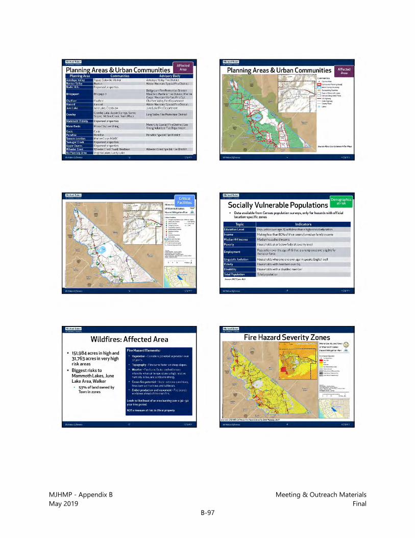
MJHMP - Appendix B Meeting & Outreach Materials May 2019 Final
B-97

MJHMP - Appendix B Meeting & Outreach Materials May 2019 Final
B-98

MJHMP - Appendix B Meeting & Outreach Materials May 2019 Final
B-99
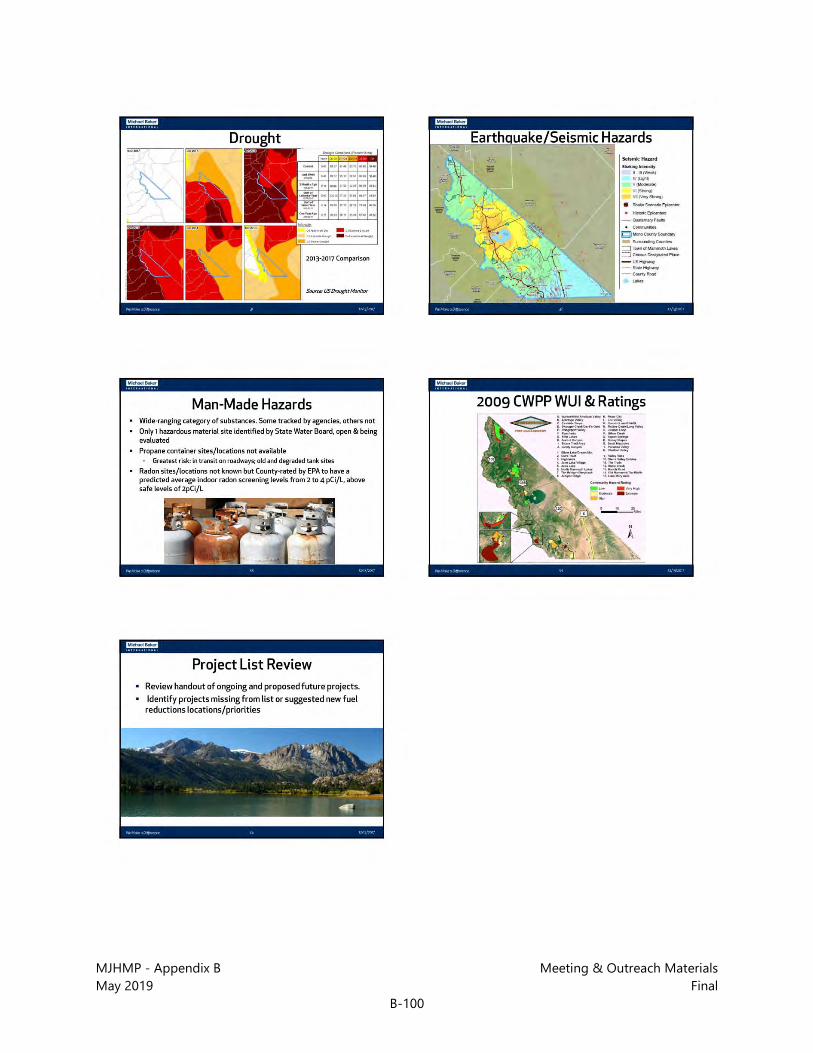
MJHMP - Appendix B Meeting & Outreach Materials May 2019 Final
B-100
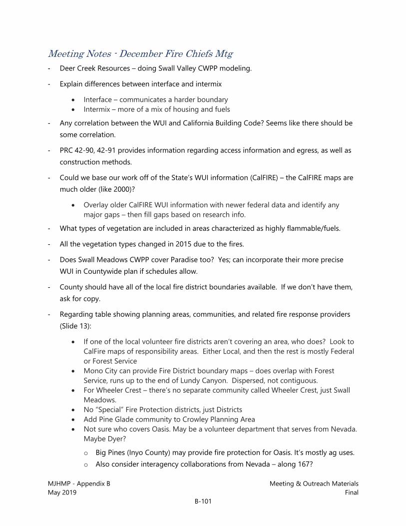
MJHMP - Appendix B Meeting & Outreach Materials May 2019 Final
B-101
Meeting Notes - December Fire Chiefs Mtg - Deer Creek Resources – doing Swall Valley CWPP modeling.
- Explain differences between interface and intermix
• Interface – communicates a harder boundary • Intermix – more of a mix of housing and fuels
- Any correlation between the WUI and California Building Code? Seems like there should be some correlation.
- PRC 42-90, 42-91 provides information regarding access information and egress, as well as construction methods.
- Could we base our work off of the State’s WUI information (CalFIRE) – the CalFIRE maps are much older (like 2000)?
• Overlay older CalFIRE WUI information with newer federal data and identify any major gaps – then fill gaps based on research info.
- What types of vegetation are included in areas characterized as highly flammable/fuels.
- All the vegetation types changed in 2015 due to the fires.
- Does Swall Meadows CWPP cover Paradise too? Yes; can incorporate their more precise WUI in Countywide plan if schedules allow.
- County should have all of the local fire district boundaries available. If we don’t have them, ask for copy.
- Regarding table showing planning areas, communities, and related fire response providers (Slide 13):
• If one of the local volunteer fire districts aren’t covering an area, who does? Look to CalFire maps of responsibility areas. Either Local, and then the rest is mostly Federal or Forest Service
• Mono City can provide Fire District boundary maps – does overlap with Forest Service, runs up to the end of Lundy Canyon. Dispersed, not contiguous.
• For Wheeler Crest – there’s no separate community called Wheeler Crest, just Swall Meadows.
• No “Special” Fire Protection districts, just Districts • Add Pine Glade community to Crowley Planning Area • Not sure who covers Oasis. May be a volunteer department that serves from Nevada.
Maybe Dyer?
o Big Pines (Inyo County) may provide fire protection for Oasis. It’s mostly ag uses. o Also consider interagency collaborations from Nevada – along 167?

MJHMP - Appendix B Meeting & Outreach Materials May 2019 Final
B-102
- Critical facilities map and Hazard Severity Map and Fire Threat Map (Slides 15, 18, 22)
• Clarify that roads and powerlines are critical facilities on the critical facilities map. • Send the critical facilities list to County staff (Michael and Wendy) to verify. • Areas N and E of Mono City are rated “moderate” but we question that – there’s very
high potential in this area. Mono City has all of the criteria for high fire potential except for topography.
• Swall Meadows is doing parcel-based assessments for fire modeling. • Reimbursement is easier for repairs/mitigation for High and Very High FHSZs. • Adjust colors between high, very high, extreme colors on Fire Threat map. And
differ from color for fire stations.
- Regarding table showing which communities have which infrastructure related problems for fire risk (Slide 25):
• Adequate water supply: “x” both Swall Meadows and Paradise • Addressing: “x” for Paradise • Walker: “x” for all four • “x” for all communities on overhead powerlines
- Regarding Draft CWPP measures (handout/attachment)
• In Measures – only LRA is Antelope Valley. Can remove WUI codes re: ignitability. A lot of these measures are already completed.
• Measures list – add items related to water tank installation. Add 50,000g water tanks to reduce ISO ratings. Some insurance companies are cancelling insurance in the WUI.
• 5-year plan for Topaz, Colville, Walker – get a 50,000g tank. Tank wouldn’t meet scenic byway standards, went instead for smaller in-ground tanks, but also denied due to groundwater quality concerns. Mapping of hydrants? There aren’t hydrants in many places.
• Where a 5-year plan exists – or where fire districts can provide working lists of projects, that’s really helpful.
• Antelope Valley wants to remain rural – don’t want urban infrastructure, but do need a water tank. Should facilitate need through the County. ~1,200 residents in Antelope Valley.
• Under “Organizational” – We already do ops plans… • Eastern Sierra Fire Safe Council – not around anymore. BLM should provide a list of
the firesafe councils in the County.
- Swall Meadows/Paradise – could attend Crowley RPAC for input/review of the LHMP/CWPP. There’s a Firesafe Council meeting on February 5 which would be good for presentation.
- Swall Meadows emergency access road – narrowed down to Quail Circle road alternative. May need to work with residents regarding need for easement across private property to provide for road.

MJHMP - Appendix B Meeting & Outreach Materials May 2019 Final
B-103
- Input from USFS Forester: There are opportunities for grants on anything we put into the Mono County CWPP – and grant openings are coming. Would like to see large fuel reduction projects in there, they have a better chance of being funded. House numbers, street signs, multiple ingress/egress (especially in Swall) – this needs to be setup and ready for when the Cap and Trade funding is coming.
B.4.5 Collaborative Planning Team Meeting – January 25, 2018

MJHMP - Appendix B Meeting & Outreach Materials May 2019 Final
B-104
PowerPoint Presentation – Collaborative Planning Team Mtg

MJHMP - Appendix B Meeting & Outreach Materials May 2019 Final
B-105
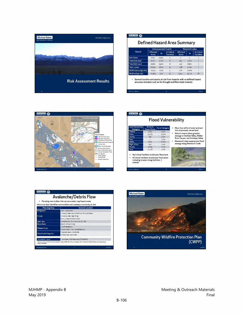
MJHMP - Appendix B Meeting & Outreach Materials May 2019 Final
B-106

MJHMP - Appendix B Meeting & Outreach Materials May 2019 Final
B-107

MJHMP - Appendix B Meeting & Outreach Materials May 2019 Final
B-108

MJHMP - Appendix B Meeting & Outreach Materials May 2019 Final
B-109
Meeting Notes - Collaborative Planning Team Mtg - Q: Consideration of Federal WUI?
• Yes, we looked at it. It seems for the plan that the CalFire WUI is the most preferred. Forest Service is broader, but the WUI is out for comment to the Fire people if they’d like to modify it.
- Q: Have you looked at scale and intensity of fire, and recent history versus long-term? Because there’s been a substantial change.
• I’ve heard that, unfortunately for this round we’re depending on CalFire mapping and modeling done in 2009. We’ve been told updated ones will come out in the next year, but that we should proceed without them.
- Q: Last year they didn’t consider heavy snow to be a condition to get money back; that it didn’t qualify.
MJHMP - Appendix B Meeting & Outreach Materials May 2019 Final
B-110
• Goals have to specify the hazards you want the mitigations to address to get funding back, and previously the goal didn’t specify heavy snow – that will be corrected in this Plan.
- Fire and Fuels Management Plan update
• Hoping to be done this year
B.4.6 Long Valley RPAC Meeting – January 24, 2018

MJHMP - Appendix B Meeting & Outreach Materials May 2019 Final
B-111
PowerPoint Presentation – Long Valley RPAC Mtg
MJHMP - Appendix B Meeting & Outreach Materials May 2019 Final
B-112

MJHMP - Appendix B Meeting & Outreach Materials May 2019 Final
B-113

MJHMP - Appendix B Meeting & Outreach Materials May 2019 Final
B-114
Meeting Notes - Long Valley RPAC Mtg - Members of Fire Safe Council of Swall Meadows/Paradise in attendance – interested in doing
their own fire safety plan and getting an additional evacuation route.
- Communications – getting broadband and fiber optic in County slowly to residents and businesses through (Company named Race? Raze?). Grant funded. Will not cover Hammill Valley and some other areas in the County.
- Hazards comment from attendee – Swall Meadows has high winds specifically
• Dana: It’s countywide assessment and there won’t be specific measures for any one area, so Swall Meadows will be covered.
- Question – when you add something to the plan, do you reiterate what we request you to say, or do you make a judgment call on whether something is needed in the Plan?
• Dana: We do rate levels of risk and create measures based on that risk. So the intent is to look at the communities at greatest risk, and implementation depends on funding as well.
- Do you do site visits, drones?
• Not for this one; mostly using State data and updating with current local information. • Staff: do have an avalanche consultant on staff and she analyzed risks last year and is
involved in warnings and evacuations, and that will fit into the measures that we’re already doing.
• Sheriff: there is an avalanche meeting coming up and anyone living in an avalanche zone should get a notice. Covering evacuations notices including code reds and IPAS(?) which notifies cell phone owners based on their current location when there’s an avalanche danger. First Net – first responder network for entire nation to give priority to first responder networks – AT&T will provide service for these networks

MJHMP - Appendix B Meeting & Outreach Materials May 2019 Final
B-115
B.4.7 CAC and RPAC Meetings – April 4-5, 2018

MJHMP - Appendix B Meeting & Outreach Materials May 2019 Final
B-116
Power Point Presentation – CAC and RPCA Mtgs

MJHMP - Appendix B Meeting & Outreach Materials May 2019 Final
B-117

MJHMP - Appendix B Meeting & Outreach Materials May 2019 Final
B-118

MJHMP - Appendix B Meeting & Outreach Materials May 2019 Final
B-119

MJHMP - Appendix B Meeting & Outreach Materials May 2019 Final
B-120
Meeting Notes - CAC and RPCA Mtgs
April 5 - Antelope Valley RPAC Mtg
- Power outages, energy issues are a key problem
- Most current hazard is wind – occurs more frequently and causes more problems than the others listed
- No fire hydrants in Antelope Valley area. Need water tanks, etc because of no hydrants and difficult to get to rivers to get water for fires.

Mono County | Town of Mammoth Lakes
Multi-Jurisdictional Hazard Mitigation Plan (MJHMP)
APPENDIX C: CRITICAL FACILITIES

This page intentionally left blank.

MJHMP – Appendix C Critical Facilities May 2019 Final
C-1
Critical Facility List – Mono County and the Town of Mammoth Lakes
Facility Name Community Critical Facility Type Address Hazard Zone?
Flood Fire
(High or Very High)
Dam Failure EQ Fault
Benton Fire Camp - BLM Benton Emergency Services 27485 HWY 6 500 yr --- --- --- White Mountain Fire Protection District - Benton Fire Department Benton Emergency Services 25474 HWY 6 500 yr --- --- ---
Benton Transfer Station / Landfill Benton Hazardous Materials 500 yr --- --- --- County District #2 Yard - Snow Removal Equipment Benton Lifeline Utility Systems 25574 HWY 6 500 yr --- --- ---
Edna Beaman Elementary School Benton Schools 25541 HWY 6 500 yr --- --- --- Benton Community Center Benton Vulnerable Populations 500 yr --- --- --- Benton Park Benton Vulnerable Populations 58869 HWY 120 500 yr --- --- --- Benton Senior Center Benton Vulnerable Populations 58869 HWY 120 500 yr --- --- --- California Interstate Telephone Co. Bridgeport Communications Facilities --- --- --- ---
Escape Broadband LLC Bridgeport Communications Facilities 45 S Buckeye Drive 100 yr --- --- ---
Mono County Memorial Hall Bridgeport Emergency Operations Center 73 N School Street --- --- --- --- Mono County Offices Bridgeport Emergency Operations Center 49 Bryant Street --- --- --- --- Bridgeport Fire Station Bridgeport Emergency Services 309 Main Street --- --- --- --- California Highway Patrol Bridgeport Emergency Services 125 Main Street --- --- --- --- Sheriff's Office Bridgeport Emergency Services 49 Bryant Street --- --- --- --- Bridgeport Transfer Station / Landfill Bridgeport Hazardous Materials --- --- --- --- Amerigas Bridgeport Lifeline Utility Systems Bridgeport --- --- --- ---
Bridgeport Public Utilities District Bridgeport Lifeline Utility Systems 233 Twin Lakes Road --- --- --- ---
Bridgeport Public Utilities District Bridgeport Lifeline Utility Systems Bridgeport --- --- --- --- Bridgeport Public Utilities District Bridgeport Lifeline Utility Systems Bridgeport --- --- --- --- Bridgeport Public Utilities District Bridgeport Lifeline Utility Systems 149 Stock Drive 100 yr --- --- --- Bridgeport Public Utilities District Bridgeport Lifeline Utility Systems Bridgeport --- --- --- ---

MJHMP – Appendix C Critical Facilities May 2019 Final
C-2
Critical Facility List – Mono County and the Town of Mammoth Lakes
Facility Name Community Critical Facility Type Address Hazard Zone?
Flood Fire
(High or Very High)
Dam Failure EQ Fault
Bridgeport Public Utilities District Bridgeport Lifeline Utility Systems 118 Twin Lakes Road --- --- --- ---
Bridgeport Public Utilities District Bridgeport Lifeline Utility Systems 1111 Aurora Canyon Road --- --- --- ---
Bridgeport Public Utilities District Bridgeport Lifeline Utility Systems 153 S Buckeye Drive --- --- --- ---
Bridgeport Public Utilities District - Sewer Ponds Bridgeport Lifeline Utility Systems Bridgeport --- --- --- ---
CalTrans - Snow Removal Equipment Bridgeport Lifeline Utility Systems 415 Jack Sawyer Road --- --- --- ---
County District #4 Yard - Snow Removal Equipment Bridgeport Lifeline Utility Systems 197 Jack Sawyer
Road --- --- --- ---
So. California Edison Company Bridgeport Lifeline Utility Systems Bridgeport --- --- --- --- So. California Edison Company Bridgeport Lifeline Utility Systems Bridgeport --- --- --- ---
Bridgeport Elementary School Bridgeport Schools 205 Kingsley Street --- --- --- ---
Bryant Field Airport Bridgeport Transportation Systems 76 Stock Drive --- --- --- ---
Helipad - Bridgeport Clinic Bridgeport Transportation Systems 193 Twin Lakes Road --- --- --- ---
Helipad - Bryant Field Bridgeport Transportation Systems 76 Stock Drive --- --- --- --- Bridgeport Senior Center Bridgeport Vulnerable Populations Bridgeport --- --- --- ---
Continental Telephone Co. Chalfant Valley Communications Facilities Chalfant Valley 100 yr --- --- ---
Chalfant Community Center Chalfant Valley Emergency Operations Center 215 Valley Road 100 yr --- --- ---
Chalfant Fire Station Chalfant Valley Emergency Services 215 Valley Road 100 yr --- --- ---

MJHMP – Appendix C Critical Facilities May 2019 Final
C-3
Critical Facility List – Mono County and the Town of Mammoth Lakes
Facility Name Community Critical Facility Type Address Hazard Zone?
Flood Fire
(High or Very High)
Dam Failure EQ Fault
Chalfant Transfer Station / Landfill Chalfant Valley Hazardous Materials --- --- --- ---
Chalfant Valley Mutual Water Co. Chalfant Valley Lifeline Utility Systems Chalfant Valley --- --- --- ---
Chalfant Valley Mutual Water Co. Chalfant Valley Lifeline Utility Systems Chalfant Valley --- --- --- ---
New Communications of the Southwest, Inc. Coleville Communications Facilities 111671 HWY 395 --- --- --- ---
Coleville Elementary School Coleville Schools 111527 HWY 395 --- --- --- --- Coleville High School Coleville Schools 111591 HWY 395 --- --- --- --- Continental Telephone Co. Crestview Communications Facilities --- High --- --- CalTrans - Snow Removal Equipment Crestview Lifeline Utility Systems 34084 HWY 395 --- High --- ---
Continental Telephone Co. Crowley Lake Communications Facilities 4035 Crowley Lake Drive --- High --- ---
Crowley Lake Community Center Crowley Lake Emergency Operations Center 58 Pearson Road --- High --- ---
Crowley Sub Station Crowley Lake Emergency Services 3605 Crowley Lake Drive --- High --- ---
Long Valley Fire Department Crowley Lake Emergency Services 3605 Crowley Lake Drive --- High --- ---
Crowley Mutual Water Company Crowley Lake Lifeline Utility Systems 80 South Landing Road --- High --- ---
DWP Hydroelectric Generating Station Crowley Lake Lifeline Utility Systems Crowley Lake --- --- --- ---
Hilton Creek Community Service District Crowley Lake Lifeline Utility Systems Crowley Lake --- High --- ---
McGee CalTrans Crowley Lake Lifeline Utility Systems 518 Crowley Lake Place --- --- --- ---

MJHMP – Appendix C Critical Facilities May 2019 Final
C-4
Critical Facility List – Mono County and the Town of Mammoth Lakes
Facility Name Community Critical Facility Type Address Hazard Zone?
Flood Fire
(High or Very High)
Dam Failure EQ Fault
Mountain Meadows Mutual Water Co. Crowley Lake Lifeline Utility Systems 93 Meadow View
Drive --- High --- ---
Water Tank Crowley Lake Lifeline Utility Systems Crowley Lake --- High --- --- South Landing Road/Crowley Overpass Crowley Lake Transportation Systems --- High --- ---
So. California Edison Company Hammil Valley Lifeline Utility Systems Hammil Valley --- --- --- --- California Interstate Telephone Co. June Lake Communications Facilities June Lake --- High --- ---
June Lake Community Center June Lake Emergency Operations Center 90 W Granite Avenue --- High --- ---
June Lake Fire Department June Lake Emergency Services --- Very High --- --- June Lake Fire Station #2 June Lake Emergency Services 5205 HWY 158 --- Very High --- --- June Mountain Ski Area (JMSA) June Lake Hazardous Materials 3819 HWY 158 --- Very High --- --- June Lake Public Utilitiy District June Lake Lifeline Utility Systems 45125 HWY 395 --- --- --- --- So. California Edison Company June Lake Lifeline Utility Systems June Lake --- Very High Yes ---
So. California Edison Company June Lake Lifeline Utility Systems June Lake --- Very High Yes Inside Fault
Rupture Zone
California Interstate Telephone Co. Lee Vining Communications Facilities 41 Third Street --- --- --- Inside Fault
Rupture Zone
Lee Vining Indian and Community Center Lee Vining Emergency Operations Center 296 Mattly
Avenue --- --- --- ---
Lee Vining Fire Department Lee Vining Emergency Services 51468 HWY 395 --- --- --- --- Cal Tans - Lee Vining Station Lee Vining Hazardous Materials 51548 HWY 395 --- --- --- --- County District #3 Yard - Snow Removal Equipment Lee Vining Lifeline Utility Systems 51596 HWY 395 --- --- --- ---
Lee Vining Public Utility District Lee Vining Lifeline Utility Systems Lee Vining --- --- --- ---

MJHMP – Appendix C Critical Facilities May 2019 Final
C-5
Critical Facility List – Mono County and the Town of Mammoth Lakes
Facility Name Community Critical Facility Type Address Hazard Zone?
Flood Fire
(High or Very High)
Dam Failure EQ Fault
Lee Vining Elementary School Lee Vining Schools 132 Lee Vining Avenue --- --- ---
Inside Fault Rupture
Zone Lee Vining High School Lee Vining Schools 51710 HWY 395 --- --- --- --- Lee Vining Airport Lee Vining Transportation Systems Lee Vining --- --- --- ---
MMSA Canyon Lodge Mammoth Lakes Area Emergency Operations Center --- High ---
Inside Fault Rupture
Zone
Mammoth Mountain Ski Area Mammoth Lakes Area Hazardous Materials 10400 Minaret
Road --- --- --- ---
Mammoth Overpass Mammoth Lakes Area Transportation Systems --- --- ---
Inside Fault Rupture
Zone
California Interstate Telephone Co. Mammoth Lakes City Communications Facilities 55 Pinecrest
Street --- --- --- ---
Continental Telephone Co. Mammoth Lakes City Communications Facilities 39 Pinecrest
Avenue --- --- --- ---
Frontier Communications Mammoth Lakes City Communications Facilities --- --- --- ---
MMSA Bottom Gondola Site Mammoth Lakes City Communications Facilities --- --- --- ---
MMSA Electronic Site Mammoth Lakes City Communications Facilities --- --- --- ---
MMSA Lincoln Peak Site Mammoth Lakes City Communications Facilities --- --- --- ---
MMSA McCoy Station Site Mammoth Lakes City Communications Facilities --- --- --- ---

MJHMP – Appendix C Critical Facilities May 2019 Final
C-6
Critical Facility List – Mono County and the Town of Mammoth Lakes
Facility Name Community Critical Facility Type Address Hazard Zone?
Flood Fire
(High or Very High)
Dam Failure EQ Fault
Mono County Office of Education Mammoth Lakes City Communications Facilities 451 Sierra Park
Road --- --- --- ---
Reflector Site Mammoth Lakes City Communications Facilities --- High --- ---
Westin Hotel Mammoth Lakes City Communications Facilities --- --- --- ---
Mammoth Community Center Mammoth Lakes City Emergency Operations Center 960 Forest Trail --- --- --- ---
Mammoth Lakes California Welcome Center
Mammoth Lakes City Emergency Operations Center 16 Banner Road,
Unit 16 --- High --- ---
Mono County Offices Mammoth Lakes City Emergency Operations Center 437 Old
Mammoth Road --- --- --- ---
Town of Mammoth Lakes Offices/Suite Z
Mammoth Lakes City Emergency Operations Center 437 Old
Mammoth Road --- --- --- ---
Mammoth Hospital Helicopter Landing Area
Mammoth Lakes City Emergency Services --- --- --- ---
Mammoth Lakes Fire Station #1 Mammoth Lakes City Emergency Services 3150 Main Street --- High --- ---
Mammoth Lakes Fire Station #2 Mammoth Lakes City Emergency Services 1574 Old
Mammoth Road --- High --- ---
Mammoth Lakes Police Department Mammoth Lakes City Emergency Services 58 Thompson
Way --- High --- ---
Mammoth Paramedics - 3 Mammoth Lakes City Emergency Services 3150 Main Street --- High --- ---
Amerigas - Propane Mammoth Lakes City Lifeline Utility Systems 464 Commerce
Circle --- --- --- ---
Mammoth Community Water District Mammoth Lakes City Lifeline Utility Systems 1315 Meridian
Blvd. --- High --- ---
MJHMP – Appendix C Critical Facilities May 2019 Final
C-7
Critical Facility List – Mono County and the Town of Mammoth Lakes
Facility Name Community Critical Facility Type Address Hazard Zone?
Flood Fire
(High or Very High)
Dam Failure EQ Fault
Mammoth Disposal Mammoth Lakes City Lifeline Utility Systems 59 Commerce
Drive --- High --- ---
Mammoth Pacific Geothermal Site Mammoth Lakes City Lifeline Utility Systems 94 Casa Diablo
Cutoff --- --- --- Inside Fault
Rupture Zone
Mammoth Water District Mammoth Lakes City Lifeline Utility Systems --- High --- ---
Rite Aid Parking Lot, Mammoth Lakes Mammoth Lakes City Lifeline Utility Systems 26 Old Mammoth
Road, Unit A --- --- --- ---
So. California Edison Company Mammoth Lakes City Lifeline Utility Systems 3001 Chateau
Road --- --- --- ---
So. California Edison Company Mammoth Lakes City Lifeline Utility Systems 58896 HWY 120 500 yr --- --- ---
Turner Gas - Propane Mammoth Lakes City Lifeline Utility Systems 3439 Main Street --- --- --- ---
Mammoth Hospital/Sierra Park Clinic Mammoth Lakes City Medical Services 185 Sierra Park
Road --- High --- ---
Mono County Public Health - Mammoth Lakes
Mammoth Lakes City Medical Services 437 Old
Mammoth Road --- --- --- ---
Cerro Coso Community College Mammoth Lakes City Schools 101 College
Parkway --- --- --- ---
Mammoth Elementary School Mammoth Lakes City Schools 1500 Meridian
Blvd. --- --- --- ---
Mammoth High School Mammoth Lakes City Schools 365 Sierra Park
Road --- --- --- ---
Mammoth Middle School Mammoth Lakes City Schools 1600 Meridian
Blvd. --- --- --- ---

MJHMP – Appendix C Critical Facilities May 2019 Final
C-8
Critical Facility List – Mono County and the Town of Mammoth Lakes
Facility Name Community Critical Facility Type Address Hazard Zone?
Flood Fire
(High or Very High)
Dam Failure EQ Fault
Sierra High School Mammoth Lakes City Schools 461 Sierra Park
Road --- --- --- ---
Helipad - Mammoth Hospital Mammoth Lakes City Transportation Systems 185 Sierra Park
Road --- High --- ---
Mono County Volunteer Fire Dept. Mono City Emergency Services Mono City --- --- --- --- California Electric Power Co. Mono City Lifeline Utility Systems Mono City --- High --- --- Lundy Mutual Water Company #1 Mono City Lifeline Utility Systems Mono City --- --- --- --- Lundy Mutual Water Company #2 Mono City Lifeline Utility Systems Mono City --- --- --- --- So. California Edison Company Mono City Lifeline Utility Systems Mono City --- --- --- --- So. California Edison Company Oasis Lifeline Utility Systems Oasis --- --- --- ---
Paradise Fire Department Paradise Estates Emergency Services 5300 Lower Rock
Creek Road --- --- --- ---
Paradise Transfer Station Paradise Estates Hazardous Materials 100 yr --- --- ---
Paradise Water Storage Tanks Paradise Estates Lifeline Utility Systems Paradise Estates --- --- --- ---
Paradise Water Supply Wells Paradise Estates Lifeline Utility Systems Paradise Estates --- --- --- ---
USMC Mtn. Warfare Training Center - Fire Station
Pickle Meadows Emergency Services Pickle Meadows --- High --- ---
MWTC Medical Clinic Pickle Meadows Medical Services Pickle Meadows --- High --- ---
Helipad - USMC Mountain Warfare Training Center
Pickle Meadows Transportation Systems Pickle Meadows --- High --- ---
Pumice Valley Landfill Pumice Valley Hazardous Materials 200 Dross Road --- --- --- ---
CalTrans - Snow Removal Equipment Sonora Junction Lifeline Utility Systems 93922 HWY 395 --- --- --- ---

MJHMP – Appendix C Critical Facilities May 2019 Final
C-9
Critical Facility List – Mono County and the Town of Mammoth Lakes
Facility Name Community Critical Facility Type Address Hazard Zone?
Flood Fire
(High or Very High)
Dam Failure EQ Fault
Wheeler Crest Volunteer Fire Dept. Swall Meadows Emergency Services Swall Meadows --- --- --- ---
DWP Hydroelectric Generating Station
Swall Meadows Lifeline Utility Systems Swall Meadows --- --- --- ---
Sherwin Sand Shed Swall Meadows Lifeline Utility Systems Swall Meadows --- --- --- ---
Wheeler Crest Community Service District
Swall Meadows Lifeline Utility Systems 334 Rimrock Drive --- --- --- ---
Long Valley Fire Protection District Tom's Place Emergency Services Tom's Place --- --- --- ---
Birchim Community Service District Tom's Place Lifeline Utility Systems 636 Owens Gorge Road --- --- --- ---
Antelope Valley Fire District; Topaz Station #2 Topaz Emergency Services Topaz --- --- --- ---
Topaz Interagency Fire Control Station Topaz Emergency Services 116999 HWY 395 --- --- ---
Inside Fault Rupture
Zone Continental Telephone Co. Virginia Lakes Communications Facilities Virginia Lakes --- --- --- --- Conway Summit Fire Station Virginia Lakes Emergency Services 63560 HWY 395 --- --- --- --- Caltrans - Snow Removal Equipment Virginia Lakes Lifeline Utility Systems 63560 HWY 395 --- --- --- ---
So. California Edison Company Virginia Lakes Lifeline Utility Systems Whitmore Hot Springs --- High ---
Inside Fault Rupture
Zone Helipad - Conway Summit Virginia Lakes Transportation Systems --- --- ---
Walker Community Center Walker Emergency Operations Center 442 Mule Deer Road --- High --- ---
Mono Rescue / Antelope Valley FD; Station #1 Walker Emergency Services 51 Shop Road --- High --- ---
Walker Paramedics - 1 Walker Emergency Services --- High --- ---

MJHMP – Appendix C Critical Facilities May 2019 Final
C-10
Critical Facility List – Mono County and the Town of Mammoth Lakes
Facility Name Community Critical Facility Type Address Hazard Zone?
Flood Fire
(High or Very High)
Dam Failure EQ Fault
Walker Transfer Station / Landfill Walker Hazardous Materials --- --- --- --- County District #5 Yard - Snow Removal Equipment Walker Lifeline Utility Systems 62 Shop Road --- High --- ---
Toibye Indian Health Project Walker Medical Services 259 Camp Antelope Road --- --- --- ---
Antelope Senior Center Walker Vulnerable Populations 399 Mule Deer Road --- High --- ---
White Mountain Mutual Water Co. White Mountain Estates
Lifeline Utility Systems 197 Sequoia Street --- --- --- ---
Benton Crossing Landfill Whitmore hot Springs Hazardous Materials 899 Pit Road --- --- --- ---
Mammoth Yosemite Airport Whitmore hot Springs Transportation Systems Mammoth Lakes
City --- --- --- ---

Mono County | Town of Mammoth Lakes
Multi-Jurisdictional Hazard Mitigation Plan (MJHMP)
APPENDIX D: MONO COUNTY HAZUS FAULTS
REPORTS

This page intentionally left blank.

MJHMP – Appendix D Mono County HAZUS Faults Reports May 2019 Final
D-1

MJHMP – Appendix D Mono County HAZUS Faults Reports May 2019 Final
D-2

MJHMP – Appendix D Mono County HAZUS Faults Reports May 2019 Final
D-3

MJHMP – Appendix D Mono County HAZUS Faults Reports May 2019 Final
D-4

MJHMP – Appendix D Mono County HAZUS Faults Reports May 2019 Final
D-5

MJHMP – Appendix D Mono County HAZUS Faults Reports May 2019 Final
D-6

MJHMP – Appendix D Mono County HAZUS Faults Reports May 2019 Final
D-7

MJHMP – Appendix D Mono County HAZUS Faults Reports May 2019 Final
D-8

MJHMP – Appendix D Mono County HAZUS Faults Reports May 2019 Final
D-9

MJHMP – Appendix D Mono County HAZUS Faults Reports May 2019 Final
D-10

MJHMP – Appendix D Mono County HAZUS Faults Reports May 2019 Final
D-11

MJHMP – Appendix D Mono County HAZUS Faults Reports May 2019 Final
D-12

MJHMP – Appendix D Mono County HAZUS Faults Reports May 2019 Final
D-13

MJHMP – Appendix D Mono County HAZUS Faults Reports May 2019 Final
D-14
MJHMP – Appendix D Mono County HAZUS Faults Reports May 2019 Final
D-15

MJHMP – Appendix D Mono County HAZUS Faults Reports May 2019 Final
D-16

MJHMP – Appendix D Mono County HAZUS Faults Reports May 2019 Final
D-17

MJHMP – Appendix D Mono County HAZUS Faults Reports May 2019 Final
D-18
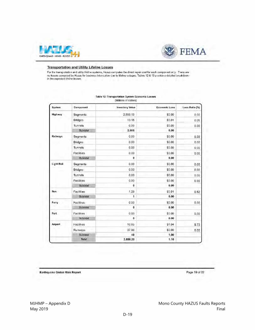
MJHMP – Appendix D Mono County HAZUS Faults Reports May 2019 Final
D-19

MJHMP – Appendix D Mono County HAZUS Faults Reports May 2019 Final
D-20

MJHMP – Appendix D Mono County HAZUS Faults Reports May 2019 Final
D-21
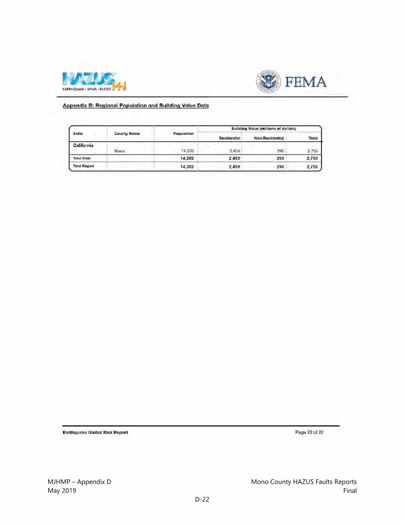
MJHMP – Appendix D Mono County HAZUS Faults Reports May 2019 Final
D-22

MJHMP – Appendix D Mono County HAZUS Faults Reports May 2019 Final
D-23

MJHMP – Appendix D Mono County HAZUS Faults Reports May 2019 Final
D-24

MJHMP – Appendix D Mono County HAZUS Faults Reports May 2019 Final
D-25

MJHMP – Appendix D Mono County HAZUS Faults Reports May 2019 Final
D-26

MJHMP – Appendix D Mono County HAZUS Faults Reports May 2019 Final
D-27

MJHMP – Appendix D Mono County HAZUS Faults Reports May 2019 Final
D-28

MJHMP – Appendix D Mono County HAZUS Faults Reports May 2019 Final
D-29
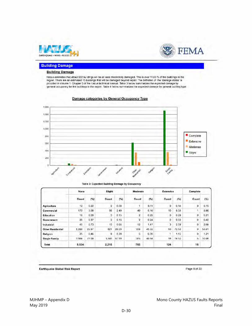
MJHMP – Appendix D Mono County HAZUS Faults Reports May 2019 Final
D-30
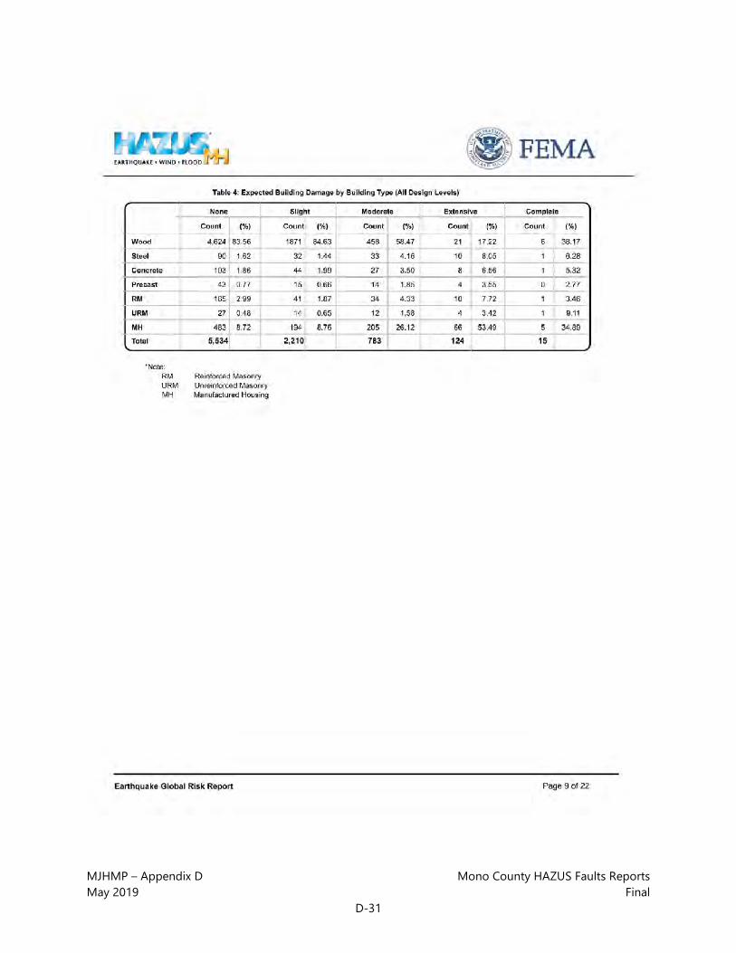
MJHMP – Appendix D Mono County HAZUS Faults Reports May 2019 Final
D-31

MJHMP – Appendix D Mono County HAZUS Faults Reports May 2019 Final
D-32
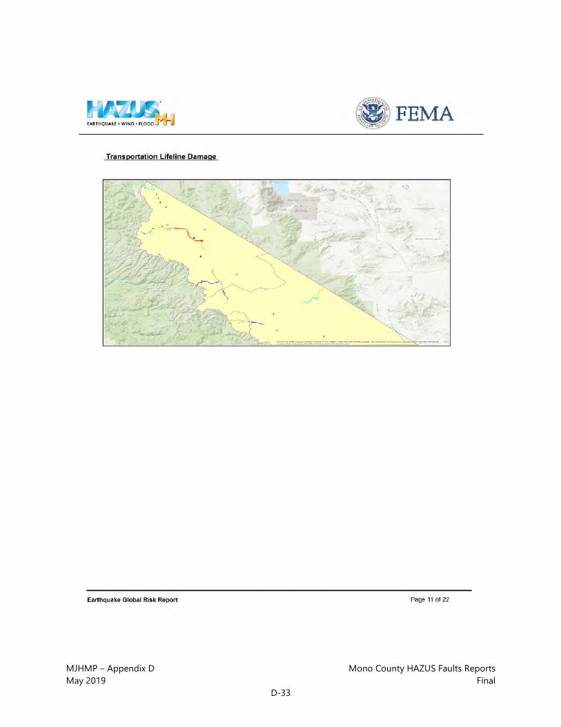
MJHMP – Appendix D Mono County HAZUS Faults Reports May 2019 Final
D-33
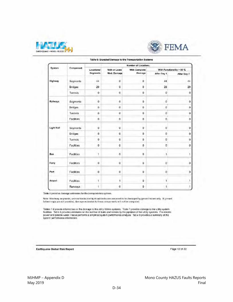
MJHMP – Appendix D Mono County HAZUS Faults Reports May 2019 Final
D-34

MJHMP – Appendix D Mono County HAZUS Faults Reports May 2019 Final
D-35

MJHMP – Appendix D Mono County HAZUS Faults Reports May 2019 Final
D-36

MJHMP – Appendix D Mono County HAZUS Faults Reports May 2019 Final
D-37

MJHMP – Appendix D Mono County HAZUS Faults Reports May 2019 Final
D-38

MJHMP – Appendix D Mono County HAZUS Faults Reports May 2019 Final
D-39

MJHMP – Appendix D Mono County HAZUS Faults Reports May 2019 Final
D-40

MJHMP – Appendix D Mono County HAZUS Faults Reports May 2019 Final
D-41

MJHMP – Appendix D Mono County HAZUS Faults Reports May 2019 Final
D-42

MJHMP – Appendix D Mono County HAZUS Faults Reports May 2019 Final
D-43

MJHMP – Appendix D Mono County HAZUS Faults Reports May 2019 Final
D-44

MJHMP – Appendix D Mono County HAZUS Faults Reports May 2019 Final
D-45
MJHMP – Appendix D Mono County HAZUS Faults Reports May 2019 Final
D-46

MJHMP – Appendix D Mono County HAZUS Faults Reports May 2019 Final
D-47

MJHMP – Appendix D Mono County HAZUS Faults Reports May 2019 Final
D-48

MJHMP – Appendix D Mono County HAZUS Faults Reports May 2019 Final
D-49

MJHMP – Appendix D Mono County HAZUS Faults Reports May 2019 Final
D-50
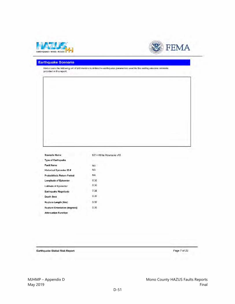
MJHMP – Appendix D Mono County HAZUS Faults Reports May 2019 Final
D-51

MJHMP – Appendix D Mono County HAZUS Faults Reports May 2019 Final
D-52

MJHMP – Appendix D Mono County HAZUS Faults Reports May 2019 Final
D-53

MJHMP – Appendix D Mono County HAZUS Faults Reports May 2019 Final
D-54

MJHMP – Appendix D Mono County HAZUS Faults Reports May 2019 Final
D-55

MJHMP – Appendix D Mono County HAZUS Faults Reports May 2019 Final
D-56

MJHMP – Appendix D Mono County HAZUS Faults Reports May 2019 Final
D-57

MJHMP – Appendix D Mono County HAZUS Faults Reports May 2019 Final
D-58

MJHMP – Appendix D Mono County HAZUS Faults Reports May 2019 Final
D-59
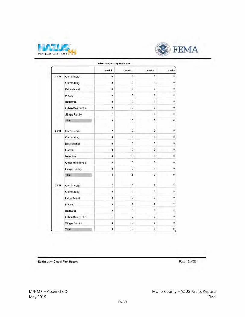
MJHMP – Appendix D Mono County HAZUS Faults Reports May 2019 Final
D-60

MJHMP – Appendix D Mono County HAZUS Faults Reports May 2019 Final
D-61

MJHMP – Appendix D Mono County HAZUS Faults Reports May 2019 Final
D-62

MJHMP – Appendix D Mono County HAZUS Faults Reports May 2019 Final
D-63

MJHMP – Appendix D Mono County HAZUS Faults Reports May 2019 Final
D-64

MJHMP – Appendix D Mono County HAZUS Faults Reports May 2019 Final
D-65

MJHMP – Appendix D Mono County HAZUS Faults Reports May 2019 Final
D-66

Mono County | Town of Mammoth Lakes
Multi-Jurisdictional Hazard Mitigation Plan (MJHMP)
APPENDIX E: MONO COUNTY HAZUS FLOOD
REPORTS

This page intentionally left blank.

MJHMP – Appendix E Mono County HAZUS Flood Reports May 2019 Final
E-1

MJHMP – Appendix E Mono County HAZUS Flood Reports May 2019 Final
E-2

MJHMP – Appendix E Mono County HAZUS Flood Reports May 2019 Final
E-3

MJHMP – Appendix E Mono County HAZUS Flood Reports May 2019 Final
E-4

MJHMP – Appendix E Mono County HAZUS Flood Reports May 2019 Final
E-5

MJHMP – Appendix E Mono County HAZUS Flood Reports May 2019 Final
E-6

MJHMP – Appendix E Mono County HAZUS Flood Reports May 2019 Final
E-7

MJHMP – Appendix E Mono County HAZUS Flood Reports May 2019 Final
E-8

MJHMP – Appendix E Mono County HAZUS Flood Reports May 2019 Final
E-9

MJHMP – Appendix E Mono County HAZUS Flood Reports May 2019 Final
E-10

MJHMP – Appendix E Mono County HAZUS Flood Reports May 2019 Final
E-11

MJHMP – Appendix E Mono County HAZUS Flood Reports May 2019 Final
E-12
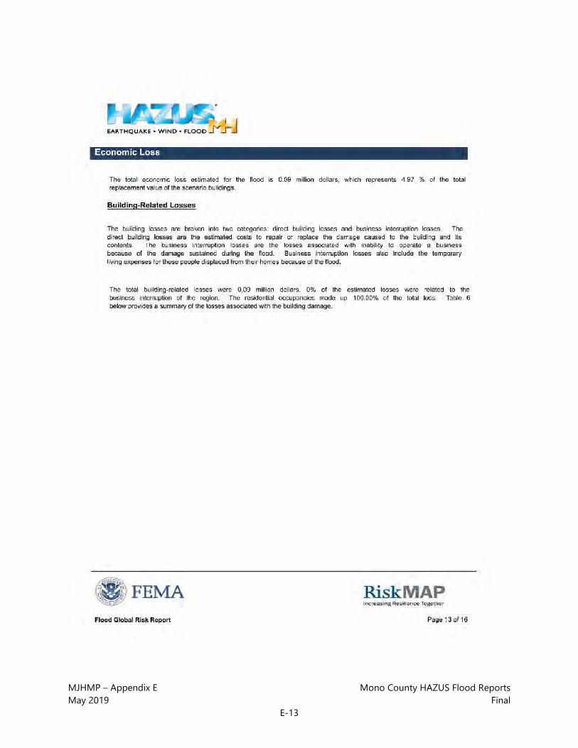
MJHMP – Appendix E Mono County HAZUS Flood Reports May 2019 Final
E-13

MJHMP – Appendix E Mono County HAZUS Flood Reports May 2019 Final
E-14

MJHMP – Appendix E Mono County HAZUS Flood Reports May 2019 Final
E-15

MJHMP – Appendix E Mono County HAZUS Flood Reports May 2019 Final
E-16
MJHMP – Appendix E Mono County HAZUS Flood Reports May 2019 Final
E-17

MJHMP – Appendix E Mono County HAZUS Flood Reports May 2019 Final
E-18

MJHMP – Appendix E Mono County HAZUS Flood Reports May 2019 Final
E-19

MJHMP – Appendix E Mono County HAZUS Flood Reports May 2019 Final
E-20

MJHMP – Appendix E Mono County HAZUS Flood Reports May 2019 Final
E-21

MJHMP – Appendix E Mono County HAZUS Flood Reports May 2019 Final
E-22

MJHMP – Appendix E Mono County HAZUS Flood Reports May 2019 Final
E-23

MJHMP – Appendix E Mono County HAZUS Flood Reports May 2019 Final
E-24

MJHMP – Appendix E Mono County HAZUS Flood Reports May 2019 Final
E-25

MJHMP – Appendix E Mono County HAZUS Flood Reports May 2019 Final
E-26

MJHMP – Appendix E Mono County HAZUS Flood Reports May 2019 Final
E-27

MJHMP – Appendix E Mono County HAZUS Flood Reports May 2019 Final
E-28

MJHMP – Appendix E Mono County HAZUS Flood Reports May 2019 Final
E-29

MJHMP – Appendix E Mono County HAZUS Flood Reports May 2019 Final
E-30

MJHMP – Appendix E Mono County HAZUS Flood Reports May 2019 Final
E-31

MJHMP – Appendix E Mono County HAZUS Flood Reports May 2019 Final
E-32

MJHMP – Appendix E Mono County HAZUS Flood Reports May 2019 Final
E-33

MJHMP – Appendix E Mono County HAZUS Flood Reports May 2019 Final
E-34

MJHMP – Appendix E Mono County HAZUS Flood Reports May 2019 Final
E-35

MJHMP – Appendix E Mono County HAZUS Flood Reports May 2019 Final
E-36

MJHMP – Appendix E Mono County HAZUS Flood Reports May 2019 Final
E-37

MJHMP – Appendix E Mono County HAZUS Flood Reports May 2019 Final
E-38

MJHMP – Appendix E Mono County HAZUS Flood Reports May 2019 Final
E-39

MJHMP – Appendix E Mono County HAZUS Flood Reports May 2019 Final
E-40

MJHMP – Appendix E Mono County HAZUS Flood Reports May 2019 Final
E-41

MJHMP – Appendix E Mono County HAZUS Flood Reports May 2019 Final
E-42

MJHMP – Appendix E Mono County HAZUS Flood Reports May 2019 Final
E-43
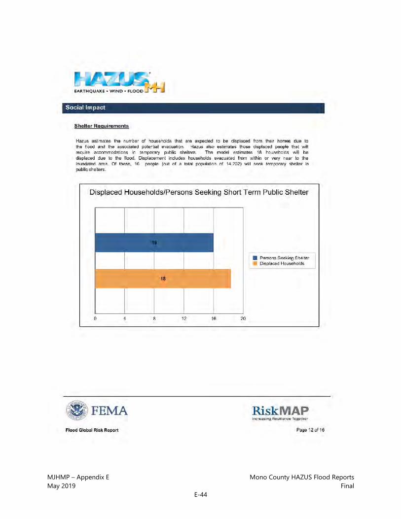
MJHMP – Appendix E Mono County HAZUS Flood Reports May 2019 Final
E-44

MJHMP – Appendix E Mono County HAZUS Flood Reports May 2019 Final
E-45

MJHMP – Appendix E Mono County HAZUS Flood Reports May 2019 Final
E-46
MJHMP – Appendix E Mono County HAZUS Flood Reports May 2019 Final
E-47
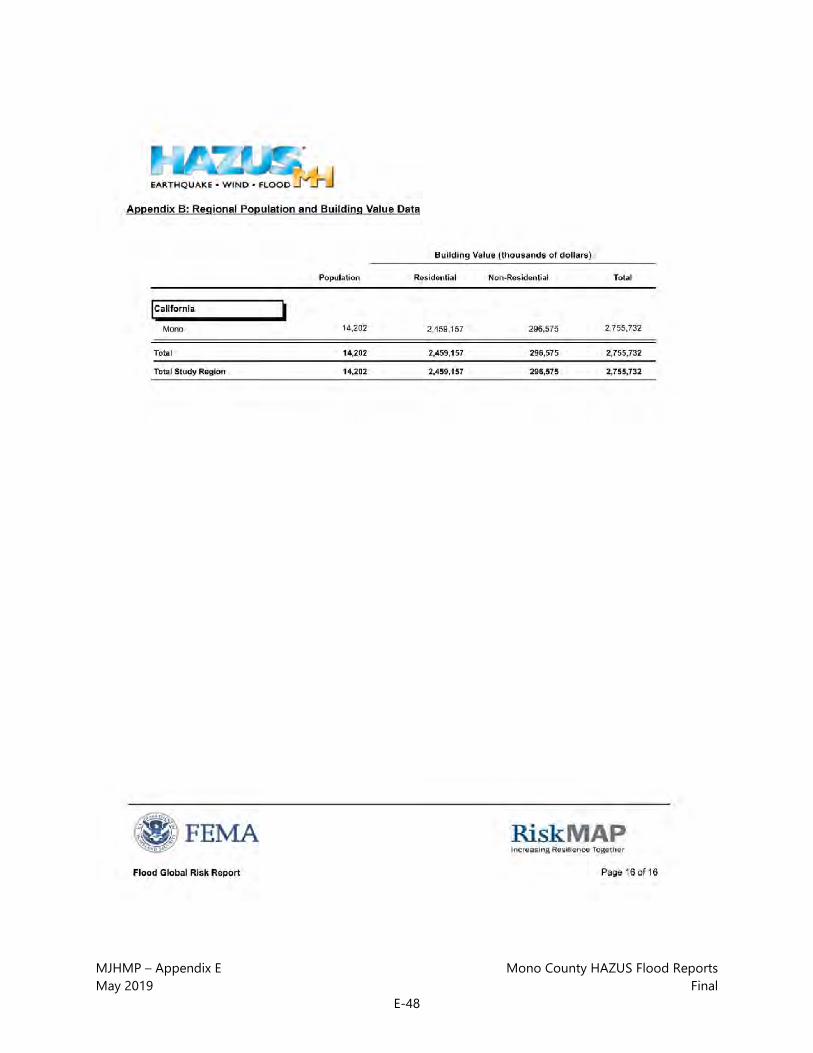
MJHMP – Appendix E Mono County HAZUS Flood Reports May 2019 Final
E-48

MJHMP – Appendix E Mono County HAZUS Flood Reports May 2019 Final
E-49

MJHMP – Appendix E Mono County HAZUS Flood Reports May 2019 Final
E-50

MJHMP – Appendix E Mono County HAZUS Flood Reports May 2019 Final
E-51

MJHMP – Appendix E Mono County HAZUS Flood Reports May 2019 Final
E-52

MJHMP – Appendix E Mono County HAZUS Flood Reports May 2019 Final
E-53

MJHMP – Appendix E Mono County HAZUS Flood Reports May 2019 Final
E-54
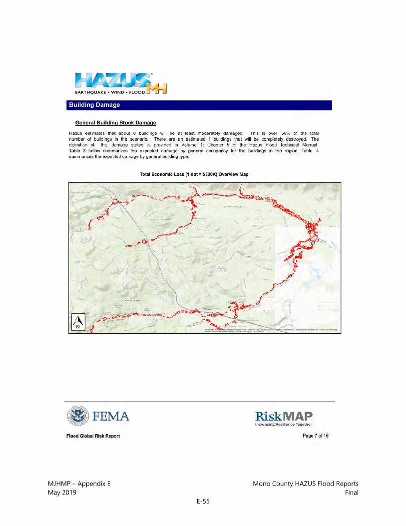
MJHMP – Appendix E Mono County HAZUS Flood Reports May 2019 Final
E-55

MJHMP – Appendix E Mono County HAZUS Flood Reports May 2019 Final
E-56
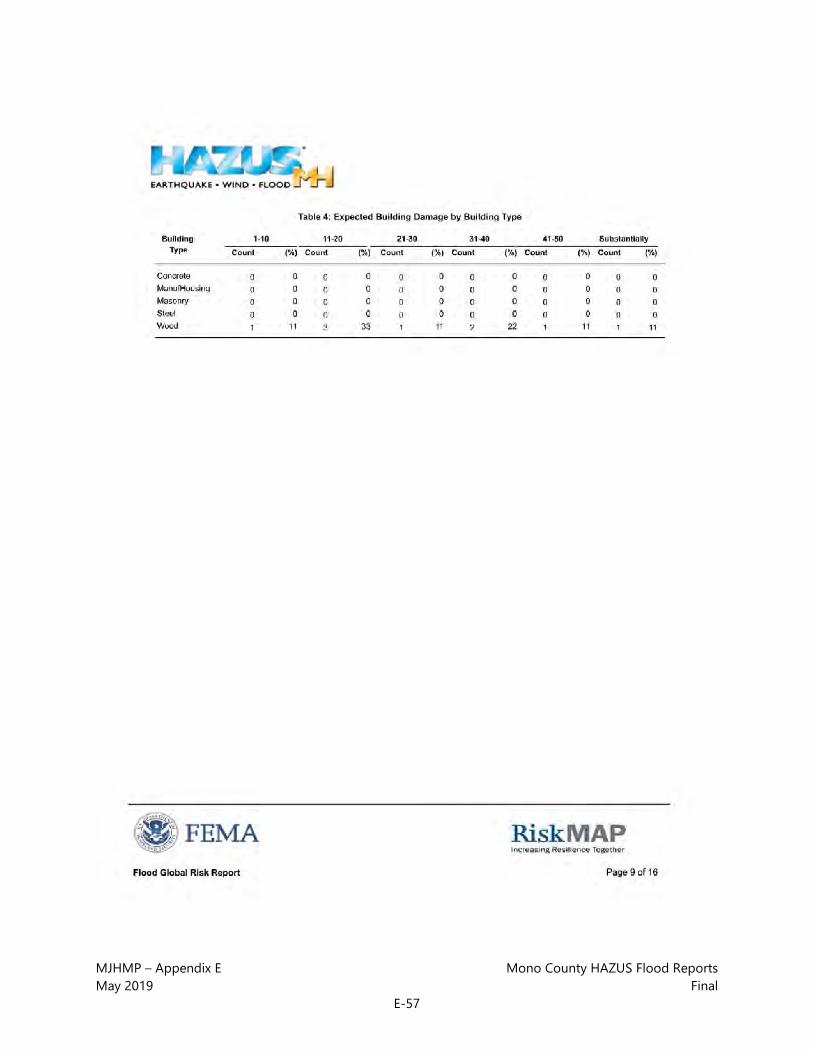
MJHMP – Appendix E Mono County HAZUS Flood Reports May 2019 Final
E-57

MJHMP – Appendix E Mono County HAZUS Flood Reports May 2019 Final
E-58

MJHMP – Appendix E Mono County HAZUS Flood Reports May 2019 Final
E-59

MJHMP – Appendix E Mono County HAZUS Flood Reports May 2019 Final
E-60

MJHMP – Appendix E Mono County HAZUS Flood Reports May 2019 Final
E-61

MJHMP – Appendix E Mono County HAZUS Flood Reports May 2019 Final
E-62

MJHMP – Appendix E Mono County HAZUS Flood Reports May 2019 Final
E-63

MJHMP – Appendix E Mono County HAZUS Flood Reports May 2019 Final
E-64

MJHMP – Appendix E Mono County HAZUS Flood Reports May 2019 Final
E-65

MJHMP – Appendix E Mono County HAZUS Flood Reports May 2019 Final
E-66

MJHMP – Appendix E Mono County HAZUS Flood Reports May 2019 Final
E-67

MJHMP – Appendix E Mono County HAZUS Flood Reports May 2019 Final
E-68

MJHMP – Appendix E Mono County HAZUS Flood Reports May 2019 Final
E-69

MJHMP – Appendix E Mono County HAZUS Flood Reports May 2019 Final
E-70

MJHMP – Appendix E Mono County HAZUS Flood Reports May 2019 Final
E-71

MJHMP – Appendix E Mono County HAZUS Flood Reports May 2019 Final
E-72

MJHMP – Appendix E Mono County HAZUS Flood Reports May 2019 Final
E-73

MJHMP – Appendix E Mono County HAZUS Flood Reports May 2019 Final
E-74

MJHMP – Appendix E Mono County HAZUS Flood Reports May 2019 Final
E-75

MJHMP – Appendix E Mono County HAZUS Flood Reports May 2019 Final
E-76

MJHMP – Appendix E Mono County HAZUS Flood Reports May 2019 Final
E-77

MJHMP – Appendix E Mono County HAZUS Flood Reports May 2019 Final
E-78

MJHMP – Appendix E Mono County HAZUS Flood Reports May 2019 Final
E-79

MJHMP – Appendix E Mono County HAZUS Flood Reports May 2019 Final
E-80

MJHMP – Appendix E Mono County HAZUS Flood Reports May 2019 Final
E-81

MJHMP – Appendix E Mono County HAZUS Flood Reports May 2019 Final
E-82
MJHMP – Appendix E Mono County HAZUS Flood Reports May 2019 Final
E-83

MJHMP – Appendix E Mono County HAZUS Flood Reports May 2019 Final
E-84

MJHMP – Appendix E Mono County HAZUS Flood Reports May 2019 Final
E-85

MJHMP – Appendix E Mono County HAZUS Flood Reports May 2019 Final
E-86

MJHMP – Appendix E Mono County HAZUS Flood Reports May 2019 Final
E-87

MJHMP – Appendix E Mono County HAZUS Flood Reports May 2019 Final
E-88

MJHMP – Appendix E Mono County HAZUS Flood Reports May 2019 Final
E-89

MJHMP – Appendix E Mono County HAZUS Flood Reports May 2019 Final
E-90

MJHMP – Appendix E Mono County HAZUS Flood Reports May 2019 Final
E-91

MJHMP – Appendix E Mono County HAZUS Flood Reports May 2019 Final
E-92

MJHMP – Appendix E Mono County HAZUS Flood Reports May 2019 Final
E-93
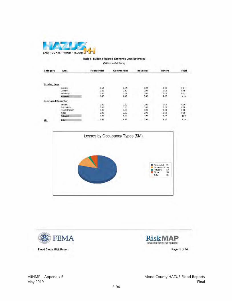
MJHMP – Appendix E Mono County HAZUS Flood Reports May 2019 Final
E-94

MJHMP – Appendix E Mono County HAZUS Flood Reports May 2019 Final
E-95

MJHMP – Appendix E Mono County HAZUS Flood Reports May 2019 Final
E-96

MJHMP – Appendix E Mono County HAZUS Flood Reports May 2019 Final
E-97

MJHMP – Appendix E Mono County HAZUS Flood Reports May 2019 Final
E-98

MJHMP – Appendix E Mono County HAZUS Flood Reports May 2019 Final
E-99

MJHMP – Appendix E Mono County HAZUS Flood Reports May 2019 Final
E-100
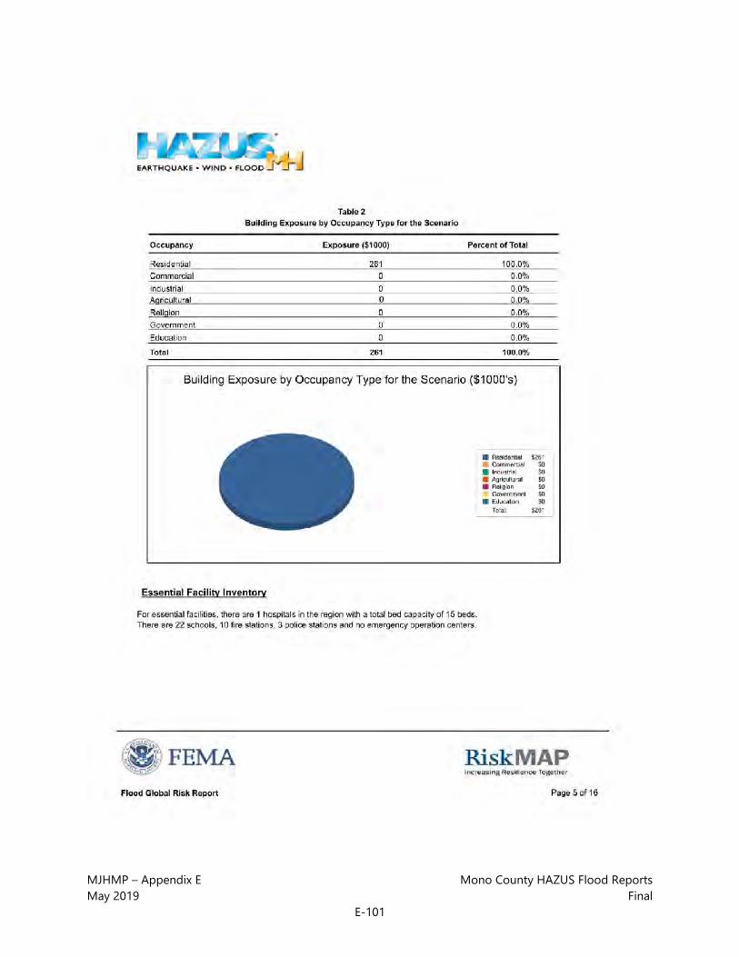
MJHMP – Appendix E Mono County HAZUS Flood Reports May 2019 Final
E-101

MJHMP – Appendix E Mono County HAZUS Flood Reports May 2019 Final
E-102

MJHMP – Appendix E Mono County HAZUS Flood Reports May 2019 Final
E-103

MJHMP – Appendix E Mono County HAZUS Flood Reports May 2019 Final
E-104

MJHMP – Appendix E Mono County HAZUS Flood Reports May 2019 Final
E-105

MJHMP – Appendix E Mono County HAZUS Flood Reports May 2019 Final
E-106

MJHMP – Appendix E Mono County HAZUS Flood Reports May 2019 Final
E-107

MJHMP – Appendix E Mono County HAZUS Flood Reports May 2019 Final
E-108

MJHMP – Appendix E Mono County HAZUS Flood Reports May 2019 Final
E-109

MJHMP – Appendix E Mono County HAZUS Flood Reports May 2019 Final
E-110

MJHMP – Appendix E Mono County HAZUS Flood Reports May 2019 Final
E-111

MJHMP – Appendix E Mono County HAZUS Flood Reports May 2019 Final
E-112

MJHMP – Appendix E Mono County HAZUS Flood Reports May 2019 Final
E-113

MJHMP – Appendix E Mono County HAZUS Flood Reports May 2019 Final
E-114

MJHMP – Appendix E Mono County HAZUS Flood Reports May 2019 Final
E-115
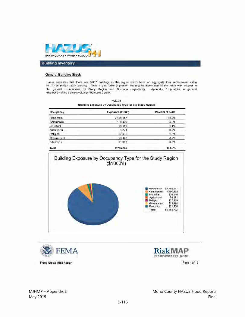
MJHMP – Appendix E Mono County HAZUS Flood Reports May 2019 Final
E-116

MJHMP – Appendix E Mono County HAZUS Flood Reports May 2019 Final
E-117

MJHMP – Appendix E Mono County HAZUS Flood Reports May 2019 Final
E-118
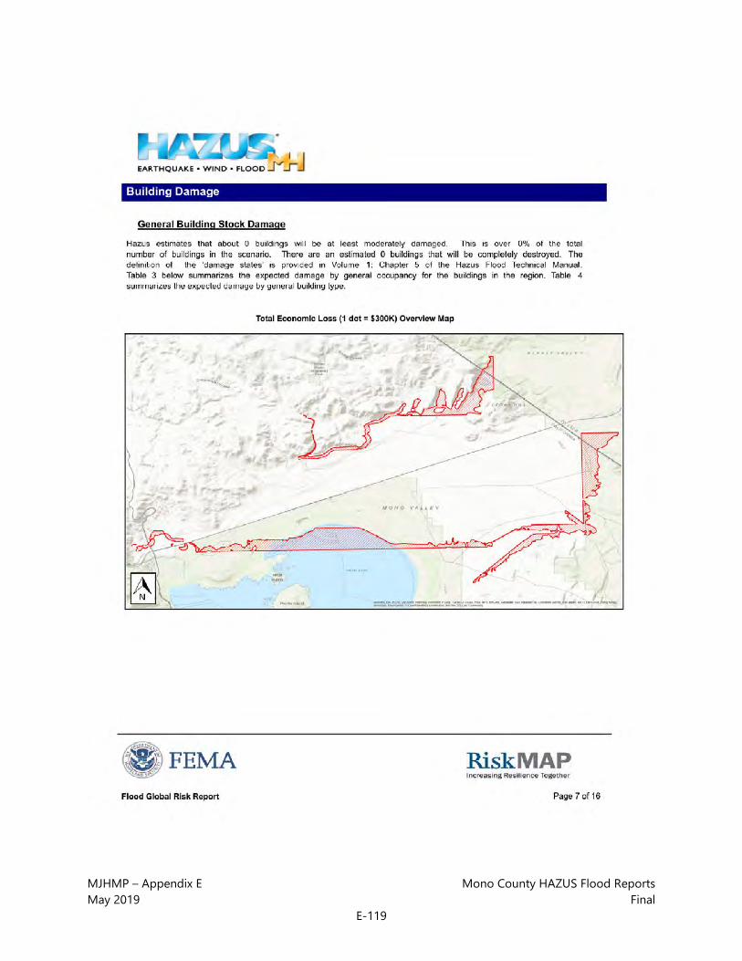
MJHMP – Appendix E Mono County HAZUS Flood Reports May 2019 Final
E-119

MJHMP – Appendix E Mono County HAZUS Flood Reports May 2019 Final
E-120

MJHMP – Appendix E Mono County HAZUS Flood Reports May 2019 Final
E-121

MJHMP – Appendix E Mono County HAZUS Flood Reports May 2019 Final
E-122

MJHMP – Appendix E Mono County HAZUS Flood Reports May 2019 Final
E-123

MJHMP – Appendix E Mono County HAZUS Flood Reports May 2019 Final
E-124

MJHMP – Appendix E Mono County HAZUS Flood Reports May 2019 Final
E-125

MJHMP – Appendix E Mono County HAZUS Flood Reports May 2019 Final
E-126

MJHMP – Appendix E Mono County HAZUS Flood Reports May 2019 Final
E-127

MJHMP – Appendix E Mono County HAZUS Flood Reports May 2019 Final
E-128

MJHMP – Appendix E Mono County HAZUS Flood Reports May 2019 Final
E-129

MJHMP – Appendix E Mono County HAZUS Flood Reports May 2019 Final
E-130

MJHMP – Appendix E Mono County HAZUS Flood Reports May 2019 Final
E-131

MJHMP – Appendix E Mono County HAZUS Flood Reports May 2019 Final
E-132

MJHMP – Appendix E Mono County HAZUS Flood Reports May 2019 Final
E-133

MJHMP – Appendix E Mono County HAZUS Flood Reports May 2019 Final
E-134

MJHMP – Appendix E Mono County HAZUS Flood Reports May 2019 Final
E-135

MJHMP – Appendix E Mono County HAZUS Flood Reports May 2019 Final
E-136

MJHMP – Appendix E Mono County HAZUS Flood Reports May 2019 Final
E-137

MJHMP – Appendix E Mono County HAZUS Flood Reports May 2019 Final
E-138

MJHMP – Appendix E Mono County HAZUS Flood Reports May 2019 Final
E-139

MJHMP – Appendix E Mono County HAZUS Flood Reports May 2019 Final
E-140

MJHMP – Appendix E Mono County HAZUS Flood Reports May 2019 Final
E-141

MJHMP – Appendix E Mono County HAZUS Flood Reports May 2019 Final
E-142

MJHMP – Appendix E Mono County HAZUS Flood Reports May 2019 Final
E-143

MJHMP – Appendix E Mono County HAZUS Flood Reports May 2019 Final
E-144

MJHMP – Appendix E Mono County HAZUS Flood Reports May 2019 Final
E-145

MJHMP – Appendix E Mono County HAZUS Flood Reports May 2019 Final
E-146

MJHMP – Appendix E Mono County HAZUS Flood Reports May 2019 Final
E-147

MJHMP – Appendix E Mono County HAZUS Flood Reports May 2019 Final
E-148

MJHMP – Appendix E Mono County HAZUS Flood Reports May 2019 Final
E-149

MJHMP – Appendix E Mono County HAZUS Flood Reports May 2019 Final
E-150

MJHMP – Appendix E Mono County HAZUS Flood Reports May 2019 Final
E-151

MJHMP – Appendix E Mono County HAZUS Flood Reports May 2019 Final
E-152

MJHMP – Appendix E Mono County HAZUS Flood Reports May 2019 Final
E-153

MJHMP – Appendix E Mono County HAZUS Flood Reports May 2019 Final
E-154

MJHMP – Appendix E Mono County HAZUS Flood Reports May 2019 Final
E-155

MJHMP – Appendix E Mono County HAZUS Flood Reports May 2019 Final
E-156

MJHMP – Appendix E Mono County HAZUS Flood Reports May 2019 Final
E-157
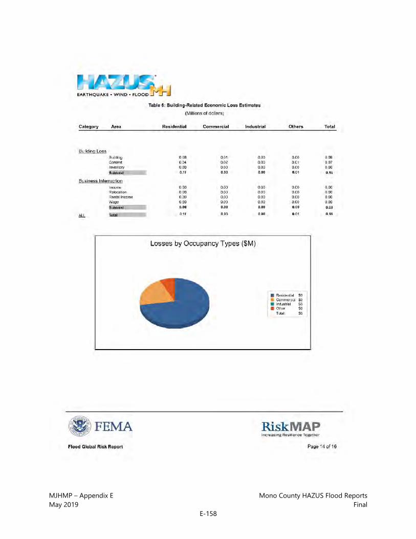
MJHMP – Appendix E Mono County HAZUS Flood Reports May 2019 Final
E-158

MJHMP – Appendix E Mono County HAZUS Flood Reports May 2019 Final
E-159

MJHMP – Appendix E Mono County HAZUS Flood Reports May 2019 Final
E-160

MJHMP – Appendix E Mono County HAZUS Flood Reports May 2019 Final
E-161

MJHMP – Appendix E Mono County HAZUS Flood Reports May 2019 Final
E-162

MJHMP – Appendix E Mono County HAZUS Flood Reports May 2019 Final
E-163

MJHMP – Appendix E Mono County HAZUS Flood Reports May 2019 Final
E-164

MJHMP – Appendix E Mono County HAZUS Flood Reports May 2019 Final
E-165

MJHMP – Appendix E Mono County HAZUS Flood Reports May 2019 Final
E-166
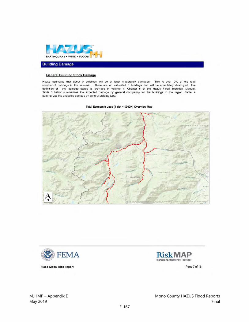
MJHMP – Appendix E Mono County HAZUS Flood Reports May 2019 Final
E-167

MJHMP – Appendix E Mono County HAZUS Flood Reports May 2019 Final
E-168

MJHMP – Appendix E Mono County HAZUS Flood Reports May 2019 Final
E-169

MJHMP – Appendix E Mono County HAZUS Flood Reports May 2019 Final
E-170

MJHMP – Appendix E Mono County HAZUS Flood Reports May 2019 Final
E-171

MJHMP – Appendix E Mono County HAZUS Flood Reports May 2019 Final
E-172

MJHMP – Appendix E Mono County HAZUS Flood Reports May 2019 Final
E-173

MJHMP – Appendix E Mono County HAZUS Flood Reports May 2019 Final
E-174

MJHMP – Appendix E Mono County HAZUS Flood Reports May 2019 Final
E-175

MJHMP – Appendix E Mono County HAZUS Flood Reports May 2019 Final
E-176

MJHMP – Appendix E Mono County HAZUS Flood Reports May 2019 Final
E-177

MJHMP – Appendix E Mono County HAZUS Flood Reports May 2019 Final
E-178

MJHMP – Appendix E Mono County HAZUS Flood Reports May 2019 Final
E-179

MJHMP – Appendix E Mono County HAZUS Flood Reports May 2019 Final
E-180

MJHMP – Appendix E Mono County HAZUS Flood Reports May 2019 Final
E-181

MJHMP – Appendix E Mono County HAZUS Flood Reports May 2019 Final
E-182
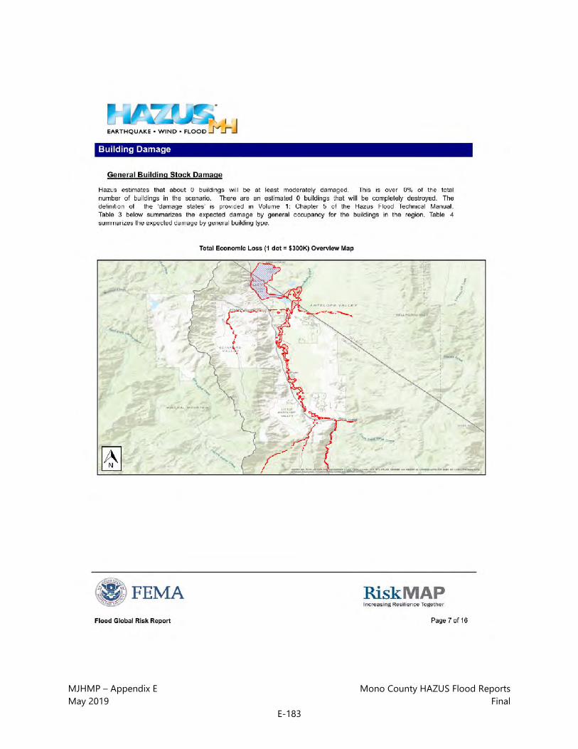
MJHMP – Appendix E Mono County HAZUS Flood Reports May 2019 Final
E-183

MJHMP – Appendix E Mono County HAZUS Flood Reports May 2019 Final
E-184

MJHMP – Appendix E Mono County HAZUS Flood Reports May 2019 Final
E-185

MJHMP – Appendix E Mono County HAZUS Flood Reports May 2019 Final
E-186

MJHMP – Appendix E Mono County HAZUS Flood Reports May 2019 Final
E-187

MJHMP – Appendix E Mono County HAZUS Flood Reports May 2019 Final
E-188

MJHMP – Appendix E Mono County HAZUS Flood Reports May 2019 Final
E-189

MJHMP – Appendix E Mono County HAZUS Flood Reports May 2019 Final
E-190

MJHMP – Appendix E Mono County HAZUS Flood Reports May 2019 Final
E-191

MJHMP – Appendix E Mono County HAZUS Flood Reports May 2019 Final
E-192

Mono County | Town of Mammoth Lakes
Multi-Jurisdictional Hazard Mitigation Plan (MJHMP)
APPENDIX F: CWPP APPENDICES

This page intentionally left blank.

MJHMP – Appendix F CWPP Appendices May 2019 Final
F-1
The Mono County Community Wildfire Protection Plan (CWPP) is Chapter 7 of this MJHMP. The following are the six appendices to the Mono County CWPP:
• CWPP Appendix 1: Fire Behavior Potential Analysis Methodology
• CWPP Appendix 2: Neighborhood Ignitability Analysis and Recommendations
• CWPP Appendix 3: Structural Triage and Preparation
• CWPP Appendix 4: Access and Water Supply Recommended Guidelines
• CWPP Appendix 5: Dry Hydrant Manual
• CWPP AppenType equation here.dix 6: Mono County CWPP Collaborative Effort

MJHMP – Appendix F CWPP Appendices May 2019 Final
F-2
This page intentionally left blank.

MJHMP – Appendix F CWPP Appendices May 2019 Final
F-3
CWPP Appendix 1: Fire Behavior Potential Analysis Methodology Purpose The purpose of this document is to describe the methodology used to evaluate the threat represented by physical hazards − such as fuels, weather and topography − to values-at-risk in the study area, by modeling their effects on fire behavior potential.
Figure 1. Flow Chart
The fire behavior potential analysis reports graphically the probable range of spread rate, flame length, and crown fire potential for the analysis area, based upon a set of inputs significant to fire behavior. The model inputs include aspect, slope, elevation, canopy cover, fuel type, canopy bulk density, canopy base height, stand height, and climate data. The model outputs are determined

MJHMP – Appendix F CWPP Appendices May 2019 Final
F-4
using FlamMap1, which combines surface fire predictions with the potential for crown fire development. Calculations for surface fire predictions (rate of spread and flame length) are based on the USDA Forest Service's BEHAVE2 model.
BEHAVE The BEHAVE fire behavior prediction and fuel modeling system was employed to determine surface fire behavior estimates for this study. BEHAVE is a nationally recognized set of calculations used to estimate a surface fire’s intensity and rate of spread given certain conditions of topography, fuels, and weather. The BEHAVE modeling system has been used for a variety of applications, including prediction of an ongoing fire, prescribed fire planning, fuel hazard assessment, initial attack dispatch, and fire prevention planning and training. Predictions of wildland fire behavior are made for a single point in time and space, given simple user- defined fuels, weather, and topography. Requested values depend on the modeling choices made by the user.
Assumptions of BEHAVE:
• Fire is predicted at the flaming front
• Fire is free burning
• Behavior is heavily weighted towards the fine fuels
• Continuous and uniform fuels
• Surface fires
FlamMap Anchor Point uses FlamMap to evaluate the potential fire conditions in the fire behavior study area. Mono County encompasses 2,004,344 acres (3,131.8 square miles). The study area for the fire behavior analysis covers approximately 2,213,067 acres (3,457.9 square miles). This area includes the entire county plus a one-mile buffer in all directions. The use of this buffer provides the county with an analysis of potential fire behavior on adjacent lands. The study area is broken down into grid cells of 10-meters per side (10M). Using existing vector and raster spatial data and field data, ArcGIS spatial analysis capabilities are used to calculate model inputs for each 10M cell.
1 Mark Finney, Stuart Brittain and Rob Seli., The Joint Fire Sciences Program of the Rocky Mountain Research Station (USDA Forest Service, Missoula, Montana), the Bureau of Land Management and Systems for Environmental Management (Missoula, Montana). 2 Patricia L. Andrews, producer and designer, Collin D. Bevins, programmer and designer, The Joint Fire Sciences Program of the Rocky Mountain Research Station (USDA Forest Service, Missoula, Montana) and Systems for Environmental Management (Missoula, Montana).

MJHMP – Appendix F CWPP Appendices May 2019 Final
F-5
These values are input into FlamMap, along with reference weather and fuel moisture (long-term weather observations statistically calculated from the Rifle Remote Automated Weather Station information). The outputs of FlamMap include the estimated Rate of Spread (ROS) (from BEHAVE), Flame Length (FL) (from BEHAVE) and Crown Fire Activity for a fire in that 10M cell. The model computes these values for each cell in the study area independently, so the data in each cell is unaffected by adjacent cells.
Fire Behavior Inputs The major factors influencing fire behavior are fuels (type and coverage), weather, and topography (aspect, slope and elevation). The following pages contain a brief explanation of each.
Figure 2. Percent Slope

MJHMP – Appendix F CWPP Appendices May 2019 Final
F-6
Slopes are shown here as percent (rise/run x100). Steeper slopes intensify fire behavior and thus will contribute to a higher wildfire hazard rating. Rates of spread for a slope of 30% are typically double those of flat terrain, when all other influences are equal.
Figure 3. Aspect
Aspects are shown as degrees from north ranging from 0 to 360 according to their orientation. Aspects are influential in the type and quantity of vegetative fuels. Fuels on south facing slopes tend to be drier and more lightly loaded than fuels on north facing slopes, when all other influences are equal. Aspect also has an influence on plant species dominance.
Classification North East South West
Range (degrees) 315-45 45-135 135-225 225-315
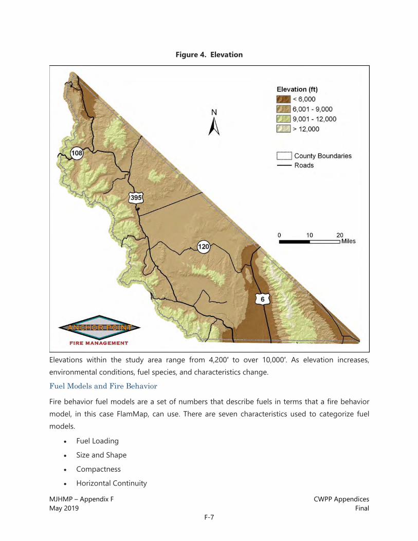
MJHMP – Appendix F CWPP Appendices May 2019 Final
F-7
Figure 4. Elevation
Elevations within the study area range from 4,200′ to over 10,000′. As elevation increases, environmental conditions, fuel species, and characteristics change.
Fuel Models and Fire Behavior
Fire behavior fuel models are a set of numbers that describe fuels in terms that a fire behavior model, in this case FlamMap, can use. There are seven characteristics used to categorize fuel models.
• Fuel Loading
• Size and Shape
• Compactness
• Horizontal Continuity

MJHMP – Appendix F CWPP Appendices May 2019 Final
F-8
• Vertical Arrangement
• Moisture Content
• Chemical Content
Each of the major fuel types present in the study area are described below in terms of the characteristics that coincide with that fuel model. Fuel model descriptions are taken from Anderson’s Aids to Determining Fuel Models for Estimating Fire Behavior3, a national standard guide to fuel modeling, unless otherwise noted. Vegetation for the project area may or may not be specifically listed in the description. Plant species are only an aid to help visualize the characteristics of the model. The photos are taken from the project area and show where the local vegetation fits in.
The study area is represented primarily by eight fuel models (FM): FM 1, 2, 5, 6, 8, 9, 10 and 15 (a CDF custom fuel model). Other fuel models may exist, but not in quantities sufficient to significantly influence fire behavior in the Wildland Urban Interface. Figure 5 displays the fuel types graphically for the study area.
3 Anderson, Hal E., Aids to Determining Fuel Models for Estimating Fire Behavior, National Wildfire Coordinating Group, NFES 1574, April 1982.

MJHMP – Appendix F CWPP Appendices May 2019 Final
F-9
Figure 5. Mono County Fuel Models
“Desert” is a custom CDF fuel model (FM 15). Fuel models 97, 98, and 99 in the map legend indicate areas of insignificant combustibility such as water, rock, sand, etc.

MJHMP – Appendix F CWPP Appendices May 2019 Final
F-10
Figure 6. Short Grass
FUEL MODEL 1
Characteristics
Grasslands and savanna are represented along with stubble, grass-tundra, and grass-shrub combinations.
Common Types/Species
Annual and perennial grasses are included in this fuel model.
Fire Behavior
Fire spread is governed by the fine, very porous, and continuous herbaceous fuels that have cured or are nearly cured. Fires in this fuel model are surface fires that move rapidly through the cured grass and associated material. Very little shrub or timber is presentgenerally less than one third of the area.

MJHMP – Appendix F CWPP Appendices May 2019 Final
F-11
Figure 7. Open canopy timber and shrubs with grass understory
FUEL MODEL 2
Characteristics
Fire spread is primarily through the fine herbaceous fuels, either curing or dead.
Common Types/Species
Open shrub lands and pine stands or scrub oak stands that cover one third to two thirds of the area may generally fit this model. Such stands may include clumps of fuels that generate higher intensities and that may produce firebrands. Some Pinyon-juniper may be in this model.
Fire Behavior
These are surface fires where the herbaceous materialin addition to litter and dead-down stemwood from the open shrub or timber overstorycontributes to the fire intensity.

MJHMP – Appendix F CWPP Appendices May 2019 Final
F-12
Figure 8. Young green stands of sage and chaparral
FUEL MODEL 5
Characteristics
This model consists of continuous stands of low brush. Generally, heights do not exceed six feet. The stands will have a grass or scattered grass understory. Usually shrubs are short and almost totally cover the area.
Common Types/Species
Young, green stands with no dead wood would qualify: laurel, vine maple, alder, or even chaparral, manzanita, or chamise. Mountain grasses are also associated with this type.
Fire Behavior
The fires are generally not very intense because surface fuel loads are light, the shrubs are young with little dead material, and the foliage contains little volatile material. Fire is generally carried in the surface fuels that are made up of litter cast by the shrubs and the grasses or forbs in the understory. Cured leaves retained on shrubs can cause greater intensities.

MJHMP – Appendix F CWPP Appendices May 2019 Final
F-13
Figure 9. Mixed stands of mesquite and big sage less than 6 feet high
FUEL MODEL 6
Characteristics
Shrubs in Fuel Model 6 are older than, but not as tall as, the shrub types of Fuel Model 4. They also do not contain as much fuel as FM 4.
Common Types/Species
A broad range of shrub conditions is covered by this model. Fuel situations to be considered include intermediate stands of chamise, chaparral, oak brush, low pocosin, Alaskan spruce taiga, and shrub tundra. Even hardwood slash that has cured can be considered. Pinyon-juniper shrub lands may be represented but may over-predict rate of spread except at high winds, such as 20 mi/h (32 km/h) at the 20-foot level.
Fire Behavior
Fires carry through the shrub layer where the foliage is more flammable than fuel model 5, but this requires moderate winds, greater than 8 mi/h (13 km/h), at mid-flame height. Fire will drop to the ground at low wind speeds or at openings in the stand.

MJHMP – Appendix F CWPP Appendices May 2019 Final
F-14
Figure 10. Aspen stands
FUEL MODEL 8
Characteristics
Hardwoods that have leafed out support fire in the compact litter layer. This layer is mainly needles, leaves, and occasionally twigs because little undergrowth is present in the stand. Amounts of needle and woody litter are also low.
Common Types/Species
Closed canopy stands of short-needle conifers or hardwoods. Representative conifer types are white pine, Lodgepole pine, spruce, fir and larch.
Fire Behavior
Fires in this fuel model are slow burning and low intensity, burning in surface fuels. Fuels are mainly needles and woody litter. Heavier fuel loadings from old dead and down trees or branches can cause flare-ups. Heavier fuel loads have the potential to develop crown fires in extreme burning conditions.

MJHMP – Appendix F CWPP Appendices May 2019 Final
F-15
Figure 11. Mixed conifer stands with moderate loads of dead and down
FUEL MODEL 9
Characteristics
This stand is represented by closed canopy stands of Ponderosa pine and mixed conifer. Understory may consist of small trees and shrubs, grasses, and moderate concentrations of down, dead woody litter. High amounts of needle litter may be present. This model can exist from foothills to sub-alpine.
Common Types/Species
This model can include Ponderosa pine, Lodgepole pine, and a mixture of Douglas-fir spruce and pine. Some mountain shrubs and grasses are present.
Fire Behavior
Fires run through surface litter, torching of individual trees is possible. Under high burning conditions, crown fires can be encountered.

MJHMP – Appendix F CWPP Appendices May 2019 Final
F-16
Figure 12. Mixed conifer stands with heavy dead and regeneration in the understory
FUEL MODEL 10
Characteristics
This model is represented by dense stands of over-mature ponderosa pine, Lodgepole pine, mixed-conifer, and continuous stands of Douglas-fir. In all stand types, heavy down material is present. There is also a large amount of dead, down woody fuels. Reproduction may be present, acting as ladder fuels. This model includes stands of budworm-killed Douglas-fir, closed stands of ponderosa pine with large amounts of ladder and surface fuels, and stands of Lodgepole pine with heavy loadings of downed trees. This model can occur from the foothills through the sub-alpine zone.
Common Types/Species
All types of vegetation can occur in this model, but primary species are Douglas-fir, ponderosa pine and Lodgepole pine.
Fire Behavior
Fire intensities can be moderate to extreme. Fire moves through dead, down woody material. Torching and spotting are more frequent. Crown fires are quite possible.

MJHMP – Appendix F CWPP Appendices May 2019 Final
F-17
Figure 13. Desert shrubs and grasses (custom fuel model from FRAP)
FUEL MODEL 15
FM 15 is a desert grass custom model. It most closely resembles the Scott and Burgan FM 121 (GS1).4 The following descriptions are from “Standard Fire Behavior Fuel Models: A Comprehensive Set for Use with Rothermel’s Surface Fire Spread Model” by Joe H. Scott and Robert E. Burgan.5
Characteristics
The primary carrier of fire in GS1 is grass and shrubs combined. Shrubs are about one foot high, grass load is low.
Common Types/Species
Dry-climate grasses and shrubs.
Fire Behavior
Spread rate is moderate: flame length is low. Moisture of extinction is low.
4 Source: email communication from David Sapsis, Wildland Fire Scientist, CDF Fire and Resource Assessment Program (FRAP), August 17, 2006. 5 Joe H. Scott and Robert E. Burgan, Standard Fire Behavior Fuel Models: A Comprehensive Set for Use with Rothermel’s Surface Fire Spread Model, USDA Forest Service Rocky Mountain Research Station, General Technical Report RMRS-GTR-153, June 2005, page 36.

MJHMP – Appendix F CWPP Appendices May 2019 Final
F-18
Reference Weather Used in the Fire Behavior Potential Evaluation
Inyo and Mono Counties cover an area of over 8,000,000 acres. The study area includes the highest (Mt. Whitney 14,495’) and the lowest (Badwater Flats 282’ below sea level) points in the continental United States. Mammoth Lakes averages 385 inches (32 feet) of snowfall per year6 and Death Valley (2.5 inches of precipitation annually, July average temperature of 115°F)7 is one of the hottest and driest places in the western hemisphere. No single set of weather inputs can capture the range of variability that exists in the study area and no single weather station is adequate to provide the weather inputs for the fire behavior analysis. Seasonal percentile weather reports were generated for all of the available Remote Automated Weather Stations (RAWS) and reviewed by our staff Fire Behavior Analyst (FBAN). Sites with poor data or significant errors were eliminated. Data from 10 RAWS were used to create fire weather zones for use in the fire behavior potential analysis. Site information for these stations is displayed in Table 1.
After evaluating the RAWS data, three fire weather zones were created for use in the fire behavior potential analysis. Percentile weather observations were calculated from each station using the Fire Family Plus software package to generate a moderate fire weather conditions class and an extreme fire weather conditions class. The moderate conditions class (16th to 89th percentile) was calculated for each variable (1 hour, 10 hour, and 100 hour fuel moisture, woody fuel moisture, herbaceous fuel moisture, and wind speed). This weather condition class most closely represents an average fire season day. Conditions class data from the stations within each zone were then averaged together to create an aggregate value for calculating the weather inputs for FlamMap for each fire weather zone.
The extreme conditions class was calculated using 97th percentile weather data. In other words, the weather conditions existing on the three to five most severe fire weather days (sorted by Spread Component) in each season were averaged together. It is reasonable to assume similar conditions may exist for at least five days of the fire season during an average year. During extreme years, such conditions may exist for significantly longer periods. These calculations may be conservative compared to observed fire behavior. Each weather zone is described below. Elevation ranges and vegetation descriptions are approximate.
Mountain Weather Zone (Fire Weather Zone 1) - Elevation 7,000’ to 14,495’, RAWS sites used: Crestview CA, Gaylor Meadow (Tuolumne) CA. The mountain fire weather zone contains the high elevations of the Sierra Nevada, Inyo, White and Sweetwater mountain ranges. Although high
6 http://www.sfgate.com/cgi-bin/document.cgi?file=/sports/skiing/pages/resorts/mammoth.DTL 7 http://www.nps.gov/archive/deva/weather.htm

MJHMP – Appendix F CWPP Appendices May 2019 Final
F-19
elevations exist in other portions of the study area, most notably in the Panamint and Amargosa mountain ranges in Death Valley National Park, the areas included in the mountain weather zone are typically substantially wetter and cooler than the high elevations of the desert areas. The presence of heavy to moderate coverage of timber makes surface fuels in the mountain zone the most shaded of the three weather zones. The values used in FlamMap for the mountain weather zone are shown in Table 2.
High Valleys Weather Zone (Fire Weather Zone 2) – Elevation 3,000’ to 7,000’, RAWS sites used: Walker CA, Bridgeport CA, Benton CA, Rock Creek CA, Owens Valley CA and Oak Creek CA. This fire weather zone contains the high valleys of the US 395 and US 6 corridors including Antelope Valley, Mono Valley, Chalfant Valley and the Owens Valley. The majority of WUI communities in the study area occur in this weather zone. Vegetative cover includes irrigated agricultural, Pinyon-juniper stands, sage and annual grasses. The values used in FlamMap for the high valleys weather zone are shown in Table 3.
Desert Weather Zone (Fire Weather Zone 3) – Elevation -282’ to 11,000’, RAWS sites used: Panamint CA, Oriental Wash NV. This fire weather zone includes Death Valley National Park, China Lake and portions of the Amargosa desert. Although elevations vary widely in this weather zone, the weather inputs used reflect the conditions below 7,000 feet. The high peaks have greater vegetation, usually Pinyon and other pine species, and more moisture but the vast majority of this zone is hot, dry and sparse in vegetation. That being said, however, wildland fires do occur in Death Valley (the Calico fire occurred just shortly before the data collection was done for this report) and WUI communities exist in this weather zone. The values used in FlamMap for the desert weather zone are shown in Table 4.
Table1: RAWS Site Information (listed north to south) Walker, CA (Station ID # 043707)
Latitude (dd mm ss) 38° 33' 55" N
Longitude (dd mm ss) 119° 27' 33" W
Elevation (ft.) 5,440
Bridgeport, CA (Station ID # 043702) Latitude (dd mm ss) 38° 16' 19" N
Longitude (dd mm ss) 119° 17' 21" W
Elevation (ft.) 6,650
Gaylor Meadow, CA (Station ID # 043611) Latitude (dd mm ss) 37° 52' 06" N

MJHMP – Appendix F CWPP Appendices May 2019 Final
F-20
Table1: RAWS Site Information (listed north to south) Longitude (dd mm ss) 119° 19' 06" W
Elevation (ft.) 9,270
Benton, CA (Station ID # 043708) Latitude (dd mm ss) 37° 50' 35" N
Longitude (dd mm ss) 118° 28' 40" W
Elevation (ft.) 5,450
Crestview, CA (Station ID # 043709) Latitude (dd mm ss) 37° 44' 42" N
Longitude (dd mm ss) 118° 59' 00" W
Elevation (ft.) 7,600
Rock Creek, CA (Station ID # 043710) Latitude (dd mm ss) 37° 33' 05" N
Longitude (dd mm ss) 118° 40' 02" W
Elevation (ft.) 7,040
Owens Valley, CA (Station ID # 044803) Latitude (dd mm ss) 37° 23' 24" N
Longitude (dd mm ss) 118° 33' 02" W
Elevation (ft.) 4,640
Oriental Wash, NV (Station ID # 261502) Latitude (dd mm ss) 37° 14' 07" N
Longitude (dd mm ss) 117° 29' 47" W
Elevation (ft.) 4,100
Oak Creek, CA (Station ID # 044804) Latitude (dd mm ss) 36° 50' 33" N
Longitude (dd mm ss) 118° 15' 34" W
Elevation (ft.) 4,100

MJHMP – Appendix F CWPP Appendices May 2019 Final
F-21
Table1: RAWS Site Information (listed north to south) Panamint, CA (Station ID # 044806)
Latitude (dd mm ss) 36° 07' 13" N
Longitude (dd mm ss) 117° 05' 16" W
Elevation (ft.) 6,880
Table 2: FlamMap Weather Inputs, Alpine Weather Zone
Moderate Weather Conditions Extreme Weather Conditions
Variable Value Variable Value 20 ft Wind speed
up slope 15 mph 20 ft Wind speed up slope 23 mph
Herbaceous fuel moisture 67%
Woody fuel moisture 98% Herbaceous fuel moisture 30%
100-hr fuel moisture 12% Woody fuel moisture 71%
10-hr fuel moisture 7% 100-hr fuel moisture 8%
1-hr fuel moisture 5% 10-hr fuel moisture 4%
Table 3: FlamMap Inputs High Valleys Weather Zone
Moderate Weather Conditions Extreme Weather Conditions
Variable Value Variable Value 20 ft Wind speed
up slope 18 mph 20 ft Wind speed up slope 36 mph
Herbaceous fuel moisture 31% Herbaceous fuel
moisture 31%
Woody fuel moisture 61% Woody fuel moisture 59%
100-hr fuel moisture 6% 100-hr fuel
moisture 6%
10-hr fuel moisture 4% 10-hr fuel moisture 3%
1-hr fuel moisture 3% 1-hr fuel
moisture 3%

MJHMP – Appendix F CWPP Appendices May 2019 Final
F-22
Table 4: FlamMap Inputs Desert Weather Zone
Moderate Weather Conditions Extreme Weather Conditions
Variable Value Variable Value 20 ft Wind speed
up slope 19 mph 20 ft Wind speed up slope 30 mph
Herbaceous fuel moisture 34% Herbaceous fuel
moisture 34%
Woody fuel moisture 60% Woody fuel moisture 57%
100-hr fuel moisture 5% 100-hr fuel
moisture 4%
10-hr fuel moisture 4% 10-hr fuel moisture 3%
1-hr fuel moisture 3% 1-hr fuel
moisture 2%
Note:
Winds at 20 ft will be significantly less noticeable at ground level. Therefore, a “gentle breeze” may actually constitute an 11 MPH 20-foot wind, adding one of the components necessary for extreme weather conditions.
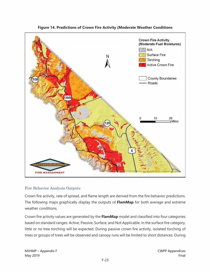
MJHMP – Appendix F CWPP Appendices May 2019 Final
F-23
Figure 14. Predictions of Crown Fire Activity (Moderate Weather Conditions
Fire Behavior Analysis Outputs
Crown fire activity, rate of spread, and flame length are derived from the fire behavior predictions. The following maps graphically display the outputs of FlamMap for both average and extreme weather conditions.
Crown fire activity values are generated by the FlamMap model and classified into four categories based on standard ranges: Active, Passive, Surface, and Not Applicable. In the surface fire category, little or no tree torching will be expected. During passive crown fire activity, isolated torching of trees or groups of trees will be observed and canopy runs will be limited to short distances. During

MJHMP – Appendix F CWPP Appendices May 2019 Final
F-24
active crown fire activity, sustained runs through the canopy will be observed that may be independent of surface fire activity.
Figure 15. Predictions of Crown Fire Activity (Extreme Weather Conditions)

MJHMP – Appendix F CWPP Appendices May 2019 Final
F-25
Figure 16. Rate of Spread Predictions (Moderate Weather Conditions)
Rate of spread in chains/hour
(1 chain=66 ft) (80 chains/HR = 1 MPH)
Spread rate values are generated by the FlamMap model and classified into four categories based on standard ranges: 0-20 ch/h (chains/hour), 20.1-40 ch/h, 40.1-60 ch/h, and greater than 60 ch/h. A chain is a logging measurement that is equal to 66 feet. One mile equals 80 chains. 1 ch/h equals approximately 1 foot/minute or 80 chains per hour equals 1 mile per hour.

MJHMP – Appendix F CWPP Appendices May 2019 Final
F-26
Figure 17. Rate of Spread Predictions (Extreme Weather Conditions)
Rate of spread in chains/hour
(1 chain=66 ft) (80 chains/HR = 1 MPH)
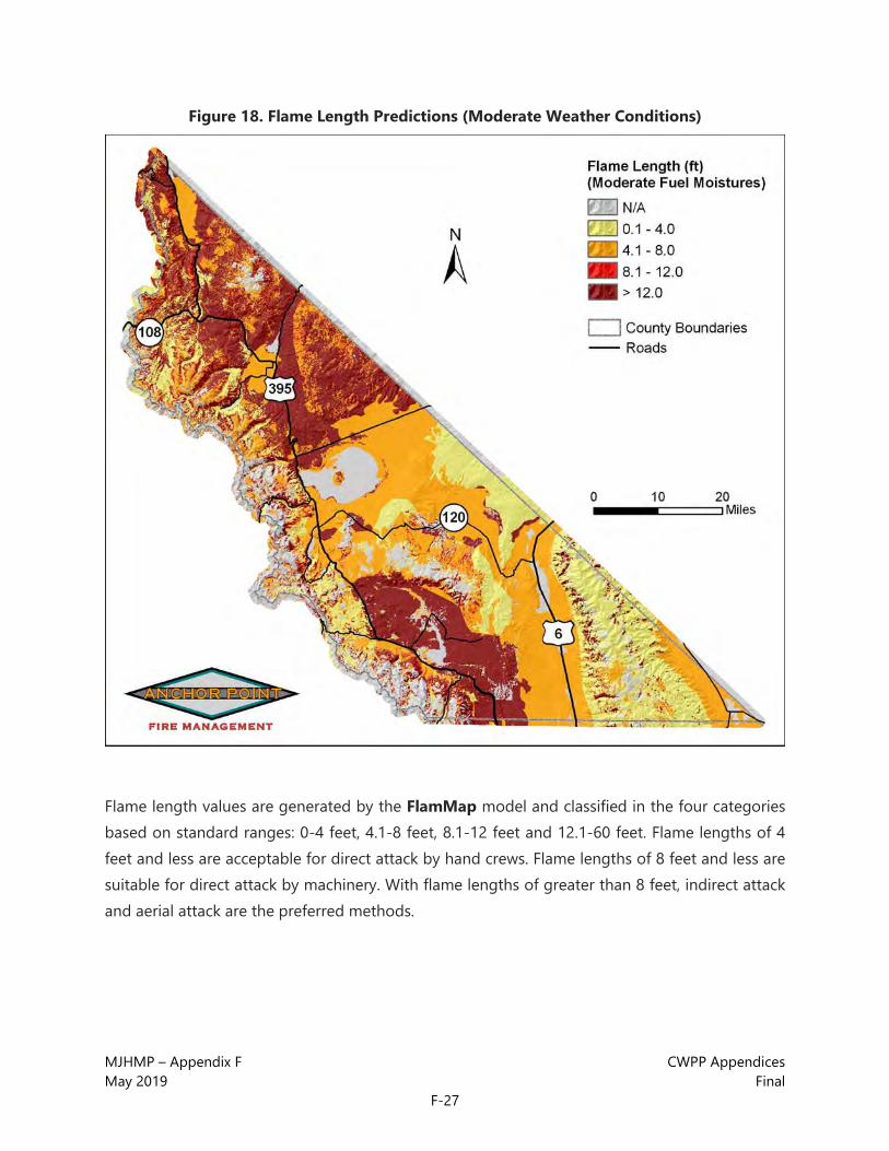
MJHMP – Appendix F CWPP Appendices May 2019 Final
F-27
Figure 18. Flame Length Predictions (Moderate Weather Conditions)
Flame length values are generated by the FlamMap model and classified in the four categories based on standard ranges: 0-4 feet, 4.1-8 feet, 8.1-12 feet and 12.1-60 feet. Flame lengths of 4 feet and less are acceptable for direct attack by hand crews. Flame lengths of 8 feet and less are suitable for direct attack by machinery. With flame lengths of greater than 8 feet, indirect attack and aerial attack are the preferred methods.
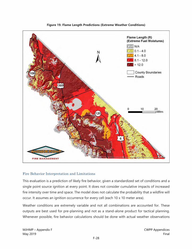
MJHMP – Appendix F CWPP Appendices May 2019 Final
F-28
Figure 19. Flame Length Predictions (Extreme Weather Conditions)
Fire Behavior Interpretation and Limitations
This evaluation is a prediction of likely fire behavior, given a standardized set of conditions and a single point source ignition at every point. It does not consider cumulative impacts of increased fire intensity over time and space. The model does not calculate the probability that a wildfire will occur. It assumes an ignition occurrence for every cell (each 10 x 10 meter area).
Weather conditions are extremely variable and not all combinations are accounted for. These outputs are best used for pre-planning and not as a stand-alone product for tactical planning. Whenever possible, fire behavior calculations should be done with actual weather observations

MJHMP – Appendix F CWPP Appendices May 2019 Final
F-29
during the fire. The most current ERC values should also be calculated and distributed during the fire season to be used as a guideline for fire behavior potential.

MJHMP – Appendix F CWPP Appendices May 2019 Final
F-30
This page intentionally left blank,

MJHMP – Appendix F CWPP Appendices May 2019 Final
F-31
CWPP Appendix 2: Neighborhood Ignitability Analysis and Recommendations

MJHMP – Appendix F CWPP Appendices May 2019 Final
F-32
This page intentionally left blank.

MJHMP – Appendix F CWPP Appendices May 2019 Final
F-33
Purpose
The purpose of this appendix is to examine in greater detail the communities in the study area. Of the 36 WUI communities in Mono County, nine were found to represent an extreme hazard; eight were rated as very high hazard; six as high hazard; eight as moderate hazard; and five as low hazard. Figure 1 below represents this in pie chart format for easy visual reference. On the following pages, maps, charts and tables using these same statistics can be found, and should be used for reference throughout this document.
Figure 1. Community Groupings by Hazard Class
Moderate

MJHMP – Appendix F CWPP Appendices May 2019 Final
F-34
Figure 2. Mono County Community Hazard Rating Map

MJHMP – Appendix F CWPP Appendices May 2019 Final
F-35
Figure 3. Mono County Communities by Hazard Rating

MJHMP – Appendix F CWPP Appendices May 2019 Final
F-36
Table 1. Mono County Communities by Hazard Rating 1. Lake Mary Area 19. Hilton Creek 2. Old Mammoth/The Bluffs 20. North Mammoth Lakes 3. Clark Tract 21. Sierra Valley Estates (Mammoth area) 4. Twin Lakes ( and Virginia Lakes) 22. McGee Creek/Long Valley 5. The Bridges/Greyhawk 23. Rancheria (Bridgeport area) 6. Juniper Loop (Crowley Lake area) 24. Snow Creek 7. Sunny Slopes 25. Mono City 8. Juniper Ridge ( Mammoth Lakes area) 26. Convict Lake/SNARL 9. East Side Slope (Antelope Valley) 27. Highlands 10. Aspen Springs 28. Aurora Creek 11. Walker/West Antelope Valley 29. Ranch Road (Mammoth Lakes area) 12. Valley Vista 30. Chalfant Valley 13. June Lake 31 Paradise Valley 14. Lundy Canyon 32. Antelope Valley 15. Evans Tract Area 33. The Trails 16. Silver Lake/Dream Mountain 34. June Lake Village 17. Swauger Creek/Devils Gate 35. Lee Vining 18. Swall Meadows 36. Bridgeport Valley
MJHMP – Appendix F CWPP Appendices May 2019 Final
F-37
GENERAL RECOMMENDATIONS A combination of adequate access, ignition resistant construction, and fuels reduction should create a safe environment for emergency service personnel and provide reasonable protection to structures from a wildfire. These techniques should also significantly reduce the chances of a structure fire becoming an ignition source to the surrounding wildlands.
In addition to the suggested mitigations listed for the individual communities, several general measures can be taken to improve fire safety. The following recommendations should be noted and practiced by anyone living in the Wildland-Urban Interface:
• Be aware of the current fire danger in the area.
• Clean your roof and gutters at least two times a year, especially during cure-up in autumn.
• Stack firewood uphill or on a side contour, at least 30 feet away from structures.
• Don't store combustibles or firewood under decks.
• Maintain and clean spark arresters on chimneys.
• When possible, maintain an irrigated greenbelt around the home.
• Connect, and have available, a minimum of 50 feet of garden hose.
• Post reflective lot and/or house numbers so that they are clearly visible from the main road. Reflective numbers should also be visible on the structure itself.
• Trees along driveways should be limbed and thinned as necessary to maintain a minimum 13’6” vertical clearance for emergency vehicle access.
• Maintain your defensible space constantly.
o Mow grass and weeds to a low height.
o Remove any branches overhanging the roof or chimney.
o Remove all trash, debris, and cuttings from the defensible space.
Note:
All communities rated as extreme to high hazard level were recommended for a parcel-level analysis. In the moderate level communities a parcel-level analysis was recommended only if the evaluator found that a significant number of homes had no, or ineffective, defensible space or a significant number of hazards near homes was detected. In short, the recommendation was made if the evaluator felt a parcel-level analysis would generate a noticeable improvement in the community’s defensibility.
MJHMP – Appendix F CWPP Appendices May 2019 Final
F-38
Technical Terms
The following definitions apply to terms used in the “Description” and “Comments and Mitigation” sections of this appendix.
Defensible Space: An area around a structure where fuels and vegetation are modified, cleared, or reduced to slow the spread of wildfire toward or from the structure. The design and extent of the defensible space is based on fuels, topography, and the design and materials of the structure.
Extended Defensible Space (also known as Zone 3): In this defensible space zone, treatment is continued beyond the recommended minimum boundary for defensible space. This zone focuses on forest management, with fuels reduction being a secondary function.
Shelter-in-Place Areas: There are several ways to protect the public from an advancing wildfire. One of these methods is evacuation, and involves relocation of the threatened population to a safer area. Another is to instruct people to remain inside their homes or public buildings until the danger passes. This concept is new to wildfire in the United States, but not to hazardous materials incident response, where time, hazards, and sheer logistics often make evacuation impossible. This concept is the dominant modality for public protection from wildfires in Australia, where fast moving, non-persistent fires in light fuels make evacuation impractical. The success of this tactic depends on a detailed pre-plan that takes into account the construction type and materials of the building used, topography, depth and type of the fuel profile, as well as current and expected weather and fire behavior.
Citizen Safety Zone: An area that can be used for protection by residents in the event that the main evacuation route is compromised. The area should be maintained, cleared of fuels, and large enough for all residents of the area to survive an advancing wildfire without special equipment or training.
Fuelbreak: A natural or constructed discontinuity in a fuel profile used to segregate, stop, or reduce the spread of fire. As a practical matter, fuelbreaks in the WUI are most effective against crown fires.
Community Assessment Methodology
The community level methodology for this assessment uses a Wildfire Hazard Rating (WHR) that was developed specifically to evaluate communities within the Wildland Urban Interface (WUI) for their relative wildfire hazard.1 The WHR model combines physical infrastructure such as structure
1 C. White, “Community Wildfire Hazard Rating Form” Wildfire Hazard Mitigation and Response Plan, Colorado State Forest Service, Ft. Collins, CO, 1986.

MJHMP – Appendix F CWPP Appendices May 2019 Final
F-39
density and roads, and fire behavior components like fuels and topography, with the field experience and knowledge of wildland fire experts. This methodology has been proven and refined by use in rating over 1,400 neighborhoods throughout the United States.
Many knowledgeable and experienced fire management professionals were queried about specific environmental and infrastructure factors, and wildfire behavior and hazards. Weightings within the model were established through these queries. The model was designed to be applicable throughout the western United States.
The model was developed from the perspective of performing structural triage on a threatened community in the path of an advancing wildfire with moderate fire behavior. The WHR survey and fuel model ground truthing are accomplished by field surveyors with WUI fire experience. The rating system assigns up to a maximum of 60 points based on seven categories: average lot size, slope, primary aspect, average fuel type, fuel continuity, dominant construction type and surface fuel loading. The higher the community scores, the lower its wildfire hazard. For example, a community with an average lot size of less than 1 acre and slopes of greater than 30% would receive 0 points for those factors, whereas a community with an average lot size of 5 acres and slopes of less than 15% would receive 16 points for the same factors. Additional hazards are then subtracted from the subtotal of points earned in the seven categories to give a final numeric value. The final value is then used to group communities into one of five hazard ratings: Extreme, Very High, High, Moderate, or Low.
It is important to note that not all groupings occur in every geographic region. There are some areas with no low hazard communities, just as there are some areas with no extreme communities. The rankings are also related to what is customary for the area. For example, a high hazard area on the plains of Kansas may not look like a high hazard area in the Sierra Nevada. The system creates a relative ranking of community hazards in relation to the other communities in the study area. It is designed to be used by experienced wildland firefighters who have a familiarity with structural triage operations and fire behavior in the interface.

MJHMP – Appendix F CWPP Appendices May 2019 Final
F-40
COMMUNITIES 1. Lake Mary Area
Hazard Rating Extreme
Does the neighborhood have dual access roads? No
Are there road grades > 8%? Yes
Are all access roads of adequate width? No
Average lot size: 1-5 Acres
Fuel models found in the neighborhood: 8, 10, 5
Water supply: Draft from lakes
Steep slopes, ravines, inadequate roads, propane tanks, power lines, wood roofs
Description: The Lake Mary Area community consists of forest service lease cabins and resort properties in heavy timber surrounding an alpine lake. Most structures are widely spaced. The dominant construction type is small cabins with flammable or log siding and asphalt or metal roofs; however, there are several wood roofs in this community. There are some narrow, steep roads and driveways. Addressing here is poor. Most homes are within two miles of the nearest fire station (Station 2, Mammoth Lakes Fire Department). There are no hydrants, but it is possible to draft from lakes in this community. Fuels are heavy loads of mixed conifer. There are few defensible spaces here. Topography is steep and complex.

MJHMP – Appendix F CWPP Appendices May 2019 Final
F-41
LAKE MARY AREA RECOMMENDATIONS
• A parcel-level analysis is recommended.
• Adequate defensible space is recommended for all homes (see the Home Mitigation
• section in the main report for details).
• Extended defensible space is recommended for most homes due to position, fuels and terrain.
• Discourage the use of combustible materials for decks, siding and roofs, especially where homes are upslope from heavy fuels. Replace all shake roofs with non- combustible types such as metal or composite shingle.
• Open areas below decks and projections should be enclosed or screened to prevent the ingress of embers and kept clean of flammable materials, especially where such openings are located on slopes above heavy fuels.
• Clean leaf and needle litter from roofs and gutters and away from foundations. Clear flammable vegetation away from power lines near homes. Clear weeds and flammable vegetation to at least 30 feet away from propane tanks.
• Discourage the planting of flammable ornamentals such as conifers within 30 feet of homes. Encourage the use of fire and drought tolerant plants for ornamental plantings especially within 30 feet of homes (see the Home Mitigation section in the main report).
• Thin vegetation along access roads and driveways. This is especially important for narrow driveways and road segments.
• Consider creating a shelter-in-place plan that includes preplanned escape routes from homes with flammable construction types to homes designated as last resort shelter-in- place areas. Concentrate thinning efforts on fuels below the access to these homes. Shelter-in-place tactics are only recommended for ignition-resistant homes with conforming extended defensible space, and even then only as a last resort, due to the dangerous fuels and topography in this community.
• Wherever possible, on driveways and private roads longer than 300 feet, add pullouts for emergency apparatus. Turnarounds should be constructed at the end of all driveways and dead-end roads.
• Add reflective addressing to all driveways and homes.
• Consider adding dry hydrant installations to the lakes in this community to improve the speed of water handling.

MJHMP – Appendix F CWPP Appendices May 2019 Final
F-42
2. Old Mammoth/The Bluffs
Hazard Rating Extreme
Does the neighborhood have dual access roads? No
Are there road grades > 8%? Yes
Are all access roads of adequate width? No
Average lot size: <1 Acre
Fuel models found in the neighborhood: 10, 9, 5
Water supply: Hydrants
Steep slopes, ravines, inadequate roads, natural chimneys, propane tanks, power lines, wood roofs
Description: This community contains moderate to large homes on small lots. Dominant construction is wood siding with a mix of asphalt and wood shake roofs. This is a high density community. Access is poor in some areas. There are several dead-end roads and some very narrow roads with poor surfaces. Poor address markers are common, many with missing or inconsistent placement and low visibility. Many homes have wood decks and projections. In Old Mammoth in particular, there are overhead power lines and propane tanks (many overgrown with vegetation). Very few homes have defensible space. Many yards have flammable clutter including wood stacked against the structure. There are hydrants every 300 feet throughout most of this area. Fuels are primarily heavy loads of mixed conifers (FM 10). The topography in this community is steep and complex.

MJHMP – Appendix F CWPP Appendices May 2019 Final
F-43
OLD MAMMOTH/THE BLUFFS RECOMMENDATIONS
• A parcel-level analysis is recommended.
• Adequate defensible space is recommended for all homes (see the Home Mitigation
• section in the main report for details).
• Extended defensible space is recommended for homes located in dangerous topography (saddles, above natural chimneys, mid-slope on steep slopes or summits) with heavy fuel loads near or below the home.
• Discourage the use of combustible materials for decks, siding and roofs, especially where homes are upslope from heavy fuels. Replace all shake roofs with non- combustible types such as metal or composite shingle.
• Open areas below decks and projections should be enclosed or screened to prevent the ingress of embers and kept clean of flammable materials, especially where such openings are located on slopes above heavy fuels.
• Clean leaf and needle litter from roofs and gutters and away from foundations. Clear flammable vegetation away from power lines near homes. Clear weeds and flammable vegetation to at least 30 feet away from propane tanks.
• Discourage the planting of flammable ornamentals such as conifers within 30 feet of homes. Encourage the use of fire and drought tolerant plants for ornamental plantings especially within 30 feet of homes (see the Home Mitigation section in the main report).
• Thin vegetation along access roads and driveways. This is especially important for narrow driveways and road segments.
• Consider creating a shelter-in-place plan that includes preplanned escape routes from homes with flammable construction types to homes designated as last resort shelter-in- place areas. Concentrate thinning efforts on fuels below the access to these homes. Shelter-in-place tactics are only recommended for ignition-resistant homes with conforming extended defensible space, and even then only as a last resort, due to the dangerous fuels and topography in this community.
• Wherever possible, on driveways and private roads longer than 300 feet, add pullouts for emergency apparatus. Turnarounds should be constructed at the end of all driveways and dead-end roads.
• Add reflective addressing to all driveways and homes.

MJHMP – Appendix F CWPP Appendices May 2019 Final
F-44
3. Clark Tract
Hazard Rating Extreme
Does the neighborhood have dual access roads? Yes
Are there road grades > 8%? Yes
Are all access roads of adequate width? No
Average lot size: <1 Acre
Fuel models found in the neighborhood: 5, 8, 10
Water supply: Hydrants
Steep slopes, ravines, inadequate roads, natural chimneys, power line, wood roofs
Description: The Clark Tract community is comprised of small homes on small lots. Homes are mostly wood siding construction with a mix of asphalt, metal and wood roof types. Construction is generally older in this community, and some homes have wood decks or projections. Most homes do not have visible address markers, and the few that do are not reflective. Access is generally poor. Roads are rough, steep and narrow. Most roads and driveways are dirt and rutting and washboarding is typical. Although there are two ways in and out of this community, there are also several dead-end roads. There are fire hydrants in this community. Very few homes have any defensible space. Overhead power lines may represent a hazard to fire apparatus. Fuels are heavy to moderate loads of mixed conifer and shrubs often with sage in the understory. Topography is steep and complex.

MJHMP – Appendix F CWPP Appendices May 2019 Final
F-45
CLARK TRACT RECOMMENDATIONS
• A parcel-level analysis is recommended.
• Adequate defensible space is recommended for all homes (see the Home Mitigation
• section in the main report for details).
• Extended defensible space is recommended for homes located in dangerous topography (saddles, above natural chimneys, mid-slope on steep slopes or summits) with heavy fuel loads near or below the home.
• Discourage the use of combustible materials for decks, siding and roofs, especially where homes are upslope from heavy fuels. Replace all shake roofs with non- combustible types such as metal or composite shingle.
• Open areas below decks and projections should be enclosed or screened to prevent the ingress of embers and kept clean of flammable materials, especially where such openings are located on slopes above heavy fuels.
• Clean leaf and needle litter from roofs and gutters and away from foundations. Clear flammable vegetation away from power lines near homes.
• Discourage the planting of flammable ornamentals such as conifers within 30 feet of homes. Encourage the use of fire and drought tolerant plants for ornamental plantings especially within 30 feet of homes (see the Home Mitigation section in the main report).
• Thin vegetation along access roads and driveways. This is especially important for narrow driveways and road segments.
• Wherever possible, on driveways and private roads longer than 300 feet, add pullouts for emergency apparatus. Turnarounds should be constructed at the end of all driveways and dead-end roads.
• Add reflective addressing to all driveways and homes.

MJHMP – Appendix F CWPP Appendices May 2019 Final
F-46
4. Twin Lakes (includes Virginia Lakes Area)
Hazard Rating Extreme
Does the neighborhood have dual access roads? No
Are there road grades > 8%? Yes
Are all access roads of adequate width? No
Average lot size: <1 Acre
Fuel models found in the neighborhood: 8, 2, 9
Water supply: Hydrants
Steep slopes, ravines, inadequate roads, inadequate water supply, power lines, wood roofs
Description: These two communities are very similar, even though they are separated by several miles. They each contain cabins built in the 1930s and 1940s with modern construction mixed in. Most homes are moderate size on small lots. Wood siding with an asphalt or metal roof is the most common construction type; however, there are almost as many wood shake roofs in this community as ignition resistant roofs. Street signs are non-reflective wooden markers and some are broken. Most would be hard to see in dark or smoky conditions. Most homes have address markers on the home and at the street, but they are generally not reflective and may be difficult to spot in dark or smoky conditions. There are some very poor roads in these communities and some long narrow driveways. There are a few homes with minimum defensible space, but most have vegetation growing right up to the structure. Fuels are moderate to heavy loads of mixed

MJHMP – Appendix F CWPP Appendices May 2019 Final
F-47
conifers and aspen stands with shrubs and grasses in the understory. There are also heavy loads of standing dead fuels present. These communities have overhead power lines which may be a hazard to fire apparatus. There are also areas of heavy recreational use throughout both communities. This increases both the likelihood of an ignition and the difficulty of evacuation and access. The topography in these areas is complex and steep.
TWIN LAKES / VIRGINIA LAKES RECOMMENDATIONS
• A parcel-level analysis is recommended.
• Adequate defensible space is recommended for all homes (see the Home Mitigation
• section in the main report for details).
• Extended defensible space is recommended for homes located in dangerous topography (saddles, above natural chimneys, mid-slope on steep slopes or summits) with heavy fuel loads near or below the home.
• Discourage the use of combustible materials for decks, siding and roofs, especially where homes are upslope from heavy fuels. Replace all shake roofs with non- combustible types such as metal or composite shingle.
• Open areas below decks and projections should be enclosed or screened to prevent the ingress of embers and kept clean of flammable materials, especially where such openings are located on slopes above heavy fuels.
• Clean leaf and needle litter from roofs and gutters and away from foundations. Clear flammable vegetation away from power lines near homes.
• Discourage the planting of flammable ornamentals such as conifers within 30 feet of homes. Encourage the use of fire and drought tolerant plants for ornamental plantings especially within 30 feet of homes (see the Home Mitigation section in the main report).
• Thin vegetation along access roads and driveways. This is especially important for narrow driveways and road segments.
• Wherever possible, on driveways and private roads longer than 300 feet, add pullouts for emergency apparatus. Turnarounds should be constructed at the end of all driveways and dead-end roads.
• Improving the water supply to increase hydrant pressure and flow should be a priority project.
• Replacing broken and non-reflective street signs should also be considered a priority project.

MJHMP – Appendix F CWPP Appendices May 2019 Final
F-48
• Add reflective addressing to all driveways and homes.
• A fuels reduction grant project (#09USFS-SFA0059) has been funded by the USFS. The project will begin during the summer of 2009, and substantial fuels reduction will occur within private residential and recreational properties of Upper Twin Lakes bordering the Humboldt-Toiyabe National Forest. The fuels reduction work includes a combination of understory thinning, trimming, and chipping of dead trees and brush along the south shore of Upper Twin Lakes, and along the western boundary of Mono Village Resort. All fuels reduction recommendations should be coordinated with private and federal agencies, regardless of jurisdictional ownership to ensure best value and functionality.

MJHMP – Appendix F CWPP Appendices May 2019 Final
F-49
5. The Bridges/Greyhawk
Hazard Rating Extreme
Does the neighborhood have dual access roads? No
Are there road grades > 8%? Yes
Are all access roads of adequate width? No
Average lot size: <1 Acre
Fuel models found in the neighborhood: 5, 8
Water supply: Hydrants
Steep slopes, ravines, inadequate roads, inadequate water supply, wood roofs
Description: This community consists primarily of newer construction, condo complexes and large to moderate size homes on small lots. This is a high density community surrounded by wildland fuels. The dominant construction type is wood siding with asphalt or metal roofs, but there are also some wood shake roofs in this community. The homes have address markers, but most are not reflective. Road surfaces are good, although there are some narrow streets and steep grades (>10%) which make both evacuation and firefighter access more difficult.
Most homes do not have adequate defensible space. Hydrants are good except for along John Muir Road, where the spacing is approximately ¼ mile and the hydrant flows are low. This community has heavy loads of mixed conifer and shrub fuels. The topography is steep and complex.
MJHMP – Appendix F CWPP Appendices May 2019 Final
F-50
THE BRIDGES/GREYHAWK RECOMMENDATIONS
• A parcel-level analysis is recommended.
• Adequate defensible space is recommended for all homes (see the Home Mitigation
• section in the main report for details).
• Extended defensible space is recommended for homes located in dangerous topography (saddles, above natural chimneys, mid-slope on steep slopes or summits) with heavy fuel loads near or below the home.
• Discourage the use of combustible materials for decks, siding and roofs, especially where homes are upslope from heavy fuels. Replace all shake roofs with non- combustible types such as metal or composite shingle.
• Open areas below decks and projections should be enclosed or screened to prevent the ingress of embers and kept clean of flammable materials, especially where such openings are located on slopes above heavy fuels.
• Clean leaf and needle litter from roofs and gutters and away from foundations.
• Discourage the planting of flammable ornamentals such as conifers within 30 feet of homes. Encourage the use of fire and drought tolerant plants for ornamental plantings especially within 30 feet of homes (see the Home Mitigation section in the main report).
• Thin vegetation along access roads and driveways. This is especially important for narrow driveways and road segments.
• Wherever possible, on driveways and private roads longer than 300 feet, add pullouts for emergency apparatus. Turnarounds should be constructed at the end of all driveways and dead-end roads.
• Investigate improving the water supply to increase pressure and flow of the hydrants along John Muir Road.
• Add reflective addressing to all driveways and homes.

MJHMP – Appendix F CWPP Appendices May 2019 Final
F-51
6. Juniper Loop
Hazard Rating Extreme
Does the neighborhood have dual access roads? Yes
Are there road grades > 8%? Yes
Are all access roads of adequate width? No
Average lot size: <1 Acre
Fuel models found in the neighborhood: 5, 8
Water supply: None
Steep slopes, ravines, inadequate roads, inadequate water supply, power lines, wood roofs
Description: This community is a mix of old and new construction. The dominant construction type consists of wood siding with asphalt or metal roofs; however, there are some wood shake roofs in this community. Addressing is poor in this community. Address markers are difficult to locate on many homes, and in some cases, they are missing entirely. Roads are steep and narrow with no pullouts or turnarounds for fire apparatus. Many driveways are rough and narrow with vegetation encroaching upon the drivable surface. There is no water supply for fire suppression and few homes have any defensible space. This community has overhead power lines which may be a hazard to fire apparatus. There are heavy loads of mixed timber and shrub fuels including Pinyon-juniper, Jeffrey pine, bitterbrush and sage. In the drainages, aspen with sage and other shrubs in the understory become dominant. Dead and down material loads are moderate to heavy

MJHMP – Appendix F CWPP Appendices May 2019 Final
F-52
in some parts of this community. The general topography is complex and moderate to steep.
JUNIPER LOOP RECOMMENDATIONS
• A parcel-level analysis is recommended.
• Adequate defensible space is recommended for all homes (see the Home Mitigation
• section in the main report for details).
• Extended defensible space is recommended for homes located in dangerous topography (saddles, above natural chimneys, mid-slope on steep slopes or summits) with heavy fuel loads near or below the home.
• Discourage the use of combustible materials for decks, siding and roofs, especially where homes are upslope from heavy fuels. Replace all shake roofs with non- combustible types such as metal or composite shingle.
• Open areas below decks and projections should be enclosed or screened to prevent the ingress of embers and kept clean of flammable materials, especially where such openings are located on slopes above heavy fuels.
• Clean leaf and needle litter from roofs and gutters and away from foundations. Clear flammable vegetation away from power lines near homes.
• Discourage the planting of flammable ornamentals such as conifers within 30 feet of homes. Encourage the use of fire and drought tolerant plants for ornamental plantings especially within 30 feet of homes (see the Home Mitigation section in the main report).
• Investigate the possibility of improving and widening the road surface of the primary access roads into this community. High density and poor roads will make this community difficult to evacuate quickly in the event of a rapidly moving fire.
• Thin vegetation along access roads and driveways. This is especially important for narrow driveways and road segments.
• Wherever possible, on driveways and private roads longer than 300 feet, add pullouts for emergency apparatus. Turnarounds should be constructed at the end of all driveways and dead-end roads.
• Investigate the possibility of adding at least two large (10,000 - 30,000 gallon) community cisterns for fire suppression use. Improving water supply is a critical need in Juniper Loop.
• Add reflective addressing to all driveways and homes.

MJHMP – Appendix F CWPP Appendices May 2019 Final
F-53
7. Sunny Slopes
Hazard Rating Extreme
Does the neighborhood have dual access roads? No
Are there road grades > 8%? Yes
Are all access roads of adequate width? No
Average lot size: <1 Acre
Fuel models found in the neighborhood: 5, 8
Water supply: Hydrants
Steep slopes, ravines, inadequate roads, inadequate water supply, power lines, wood roofs
Description: This community is a mix of year-round private cabins and USFS lease cabins, some dating back as far as 1916. Construction is generally wood siding or log with wood shake roofs, but approximately 40% of the structures have ignition-resistant (metal or asphalt) roofs. Cabins are small to moderate size on small lots making this a fairly dense community. Some residences in this community are more than five miles from the nearest fire station. There is a good hydrant network in some parts of Sunny Slopes, but the hydrant network and the Sunny Slopes water supply does not service any of the USFS lease properties. There are several steep, narrow roads and some are little more than rough dirt tracks. This community has overhead power lines which may be a hazard to fire apparatus. Few properties have any defensible space. Fuels are moderate loads of open canopy Jeffery pine with sage and other shrubs in the understory. Topography is

MJHMP – Appendix F CWPP Appendices May 2019 Final
F-54
complex and moderate to steep. There are many outcroppings of volcanic rock, which will be a hazard to firefighters, especially at night or in smoky conditions.
SUNNY SLOPES RECOMMENDATIONS
• A parcel-level analysis is recommended.
• Adequate defensible space is recommended for all homes (see the Home Mitigation
• section in the main report for details).
• Extended defensible space is recommended for homes located in dangerous topography (saddles, above natural chimneys, mid-slope on steep slopes or summits) with heavy fuel loads near or below the home.
• Discourage the use of combustible materials for decks, siding and roofs, especially where homes are upslope from heavy fuels. Replace all shake roofs with non- combustible types such as metal or composite shingle.
• Open areas below decks and projections should be enclosed or screened to prevent the ingress of embers and kept clean of flammable materials, especially where such openings are located on slopes above heavy fuels.
• Clean leaf and needle litter from roofs and gutters and away from foundations. Clear flammable vegetation away from power lines near homes.
• Discourage the planting of flammable ornamentals such as conifers within 30 feet of homes. Encourage the use of fire and drought tolerant plants for ornamental plantings especially within 30 feet of homes (see the Home Mitigation section in the main report).
• Investigate the possibility of improving and widening the road surface of the primary access roads accessing the forest service lease cabins on the north side of highway
• 395. This will improve evacuation for residents and access for firefighters.
• Thin vegetation along access roads and driveways. This is especially important for narrow driveways and road segments.
• Wherever possible, on driveways and private roads longer than 300 feet, add pullouts for emergency apparatus. Turnarounds should be constructed at the end of all driveways and dead-end roads.
• For fire suppression in areas not serviced by the hydrant network, investigate the possibility of adding cisterns (2,500 gallons or greater) at least every ¼ mile.
• Add reflective addressing to all driveways and homes.

MJHMP – Appendix F CWPP Appendices May 2019 Final
F-55
8. Juniper Ridge
Hazard Rating Extreme
Does the neighborhood have dual access roads? No
Are there road grades > 8%? Yes
Are all access roads of adequate width? No
Average lot size: <1 Acre
Fuel models found in the neighborhood: 5, 8, 10
Water supply: Hydrants
Steep slopes, ravines, natural chimneys, inadequate roads, wood roofs
Description: Not to be confused with Juniper Loop (community #6), Juniper Ridge is a subdivision in Mammoth Lakes. This is a dense community of moderate to large homes on small lots. All these homes are of newer wood siding construction, but approximately 50% have wood shake roofs. Addressing is present for all of the residences, but is not reflective. This community does have a good hydrant network. The road surfaces are all good, but there are some steep grades (>10%). There are no pullouts or turnarounds for fire apparatus and this community has only one way in and out. Most homes do not have adequate defensible space. Fuels are heavy loads of mixed conifer and shrubs with heavy ladder fuels and moderate loads of dead and down materials. The general topography is steep and complex.

MJHMP – Appendix F CWPP Appendices May 2019 Final
F-56
JUNIPER RIDGE RECOMMENDATIONS
• A parcel-level analysis is recommended.
• Adequate defensible space is recommended for all homes (see the Home Mitigation
• section in the main report for details).
• Extended defensible space is recommended for homes located in dangerous topography (saddles, above natural chimneys, mid-slope on steep slopes or summits) with heavy fuel loads near or below the home.
• Discourage the use of combustible materials for decks, siding and roofs, especially where homes are upslope from heavy fuels. Replace all shake roofs with non- combustible types such as metal or composite shingle.
• Open areas below decks and projections should be enclosed or screened to prevent the ingress of embers and kept clean of flammable materials, especially where such openings are located on slopes above heavy fuels.
• Clean leaf and needle litter from roofs and gutters and away from foundations.
• Discourage the planting of flammable ornamentals such as conifers within 30 feet of homes. Encourage the use of fire and drought tolerant plants for ornamental plantings especially within 30 feet of homes (see the Home Mitigation section in the main report).
• Thin vegetation along access roads and driveways. This is especially important for narrow driveways and road segment.
• Wherever possible, on driveways and private roads longer than 300 feet, add pullouts for emergency apparatus. Turnarounds should be constructed at the end of all driveways and dead-end roads.
• Add reflective addressing to all driveways and homes.

MJHMP – Appendix F CWPP Appendices May 2019 Final
F-57
9. East Side Slope – Antelope Valley Area (also known as East Side Lane)
Hazard Rating Extreme
Does the neighborhood have dual access roads? No
Are there road grades > 8%? Yes
Are all access roads of adequate width? No
Average lot size: <5 Acre
Fuel models found in the neighborhood: 6, 5, 1
Water supply: None
Steep slopes, ravines, no water supply, inadequate roads, power lines, propane tanks, wood roofs
Description: This is a community of approximately 50 homes on large lots. This area was threatened by the Jackass Flats Fire in 2006. Access could be challenging due to complex terrain. There is no water for fire suppression in this community and there are power lines and propane tanks which may be a hazard to firefighters. Fuels are primarily heavy loads of Pinyon- juniper, sage and grass. The general topography is steep and complex.

MJHMP – Appendix F CWPP Appendices May 2019 Final
F-58
EASTSIDE SLOPE RECOMMENDATIONS
• A parcel-level analysis is recommended.
• Adequate defensible space is recommended for all homes (see the Home Mitigation
• section in the main report for details).
• Extended defensible space is recommended for homes located in dangerous topography (saddles, above natural chimneys, mid-slope on steep slopes or summits) with heavy fuel loads near or below the home.
• Discourage the use of combustible materials for decks, siding and roofs, especially where homes are upslope from heavy fuels. Replace all shake roofs with non- combustible types such as metal or composite shingle.
• Open areas below decks and projections should be enclosed or screened to prevent the ingress of embers and kept clean of flammable materials, especially where such openings are located on slopes above heavy fuels.
• Clean leaf and needle litter from roofs and gutters and away from foundations. Clear flammable vegetation away from power lines near homes. Clear weeds and flammable vegetation to at least 30 feet away from propane tanks.
• Discourage the planting of flammable ornamentals such as conifers within 30 feet of homes. Encourage the use of fire and drought tolerant plants for ornamental plantings especially within 30 feet of homes (see the Home Mitigation section in the main report).
• Thin vegetation along access roads and driveways. This is especially important for narrow driveways and road segments.
• Wherever possible, on driveways and private roads longer than 300 feet, add pullouts for emergency apparatus. Turnarounds should be constructed at the end of all driveways and dead-end roads.
• Consider adding at least two large (10,000 - 30,000 gallon) cisterns for fire suppression use in this community. Water supply is a critical need in Eastside Slope.
• Add reflective addressing to all driveways and homes.

MJHMP – Appendix F CWPP Appendices May 2019 Final
F-59
10. Aspen Spring
Hazard Rating Very High
Does the neighborhood have dual access roads? Yes
Are there road grades > 8%? Yes
Are all access roads of adequate width? No
Average lot size: 1-5 Acres
Fuel models found in the neighborhood: 5, 8
Water supply: One cistern (60,000 gallons)
Steep slopes, ravines, inadequate roads, inadequate water supply, power lines, wood roofs
Description: This is a community of large homes on moderate to large lots. Homes are of mixed ages, but older wood siding construction is dominant. Approximately 50% of the homes in Aspen Spring have wood shake roofs. Addressing is poor in this community. Some homes have no address markers and others are not easily visible. None of the address markers that are present are reflective. Road surfaces are generally good, but most of the roads and driveways are steep and narrow (some up to 16% grade). There is only one large cistern for fire suppression and it is in need of repair. Few homes have adequate defensible space. Fuels are moderate to heavy loads of Pinyon-juniper, sage, bitterbrush and other shrubs. Topography is steep and complex.

MJHMP – Appendix F CWPP Appendices May 2019 Final
F-60
ASPEN SPRING RECOMMENDATIONS
• A parcel-level analysis is recommended.
• Adequate defensible space is recommended for all homes (see the Home Mitigation
• section in the main report for details).
• Extended defensible space is recommended for homes located in dangerous topography (saddles, above natural chimneys, mid-slope on steep slopes or summits) with heavy fuel loads near or below the home.
• Discourage the use of combustible materials for decks, siding and roofs, especially where homes are upslope from heavy fuels. Replace all shake roofs with non- combustible types such as metal or composite shingle.
• Open areas below decks and projections should be enclosed or screened to prevent the ingress of embers and kept clean of flammable materials, especially where such openings are located on slopes above heavy fuels.
• Clean leaf and needle litter from roofs and gutters and away from foundations. Clear flammable vegetation away from power lines near homes.
• Discourage the planting of flammable ornamentals such as conifers within 30 feet of homes. Encourage the use of fire and drought tolerant plants for ornamental plantings especially within 30 feet of homes (see the Home Mitigation section in the main report).
• Thin vegetation along access roads and driveways. This is especially important for narrow driveways and road segments.
• Wherever possible, on driveways and private roads longer than 300 feet, add pullouts for emergency apparatus. Turnarounds should be constructed at the end of all driveways and dead-end roads.
• Repairing the existing cistern should be considered a priority project for this community. Investigate the possibility of adding an additional cistern to further improve the water supply.
• Add reflective addressing to all driveways and homes.
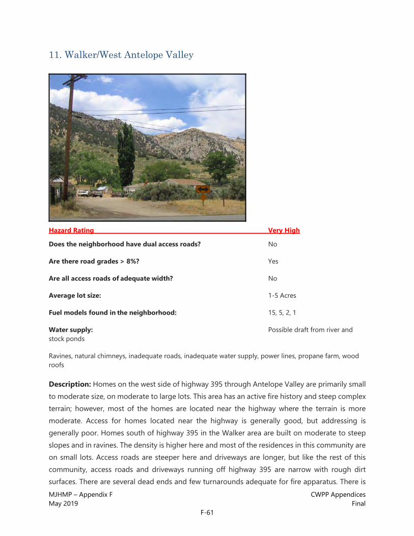
MJHMP – Appendix F CWPP Appendices May 2019 Final
F-61
11. Walker/West Antelope Valley
Hazard Rating Very High
Does the neighborhood have dual access roads? No
Are there road grades > 8%? Yes
Are all access roads of adequate width? No
Average lot size: 1-5 Acres
Fuel models found in the neighborhood: 15, 5, 2, 1
Water supply: Possible draft from river and stock ponds
Ravines, natural chimneys, inadequate roads, inadequate water supply, power lines, propane farm, wood roofs
Description: Homes on the west side of highway 395 through Antelope Valley are primarily small to moderate size, on moderate to large lots. This area has an active fire history and steep complex terrain; however, most of the homes are located near the highway where the terrain is more moderate. Access for homes located near the highway is generally good, but addressing is generally poor. Homes south of highway 395 in the Walker area are built on moderate to steep slopes and in ravines. The density is higher here and most of the residences in this community are on small lots. Access roads are steeper here and driveways are longer, but like the rest of this community, access roads and driveways running off highway 395 are narrow with rough dirt surfaces. There are several dead ends and few turnarounds adequate for fire apparatus. There is

MJHMP – Appendix F CWPP Appendices May 2019 Final
F-62
no apparent water supply for fire suppression, although it may be possible to draft from the Walker River at some points. There are overhead power lines and propane tanks which may be a hazard to fire apparatus. Few homes have adequate defensible space.
Fuels are much heavier here than on the east side of Antelope Valley (east of Hwy 395) and consist primarily of moderate to heavy loads of Pinyon-juniper, sage and other shrubs. The general topography is complex and moderate to steep.
WALKER/WEST ANTELOPE VALLEY RECOMMENDATIONS
• A parcel-level analysis is recommended.
• Adequate defensible space is recommended for all homes (see the Home Mitigation
• section in the main report for details).
• Extended defensible space is recommended for homes located in dangerous topography (saddles, above natural chimneys, mid-slope on steep slopes or summits) with heavy fuel loads near or below the home.
• Discourage the use of combustible materials for decks, siding and roofs, especially where homes are upslope from heavy fuels. Replace all shake roofs with non- combustible types such as metal or composite shingle.
• Open areas below decks and projections should be enclosed or screened to prevent the ingress of embers and kept clean of flammable materials, especially where such openings are located on slopes above heavy fuels.
• Clean leaf and needle litter from roofs and gutters and away from foundations. Clear flammable vegetation away from power lines near homes. Clear weeds and flammable vegetation to at least 30 feet away from propane tanks.
• Discourage the planting of flammable ornamentals such as conifers within 30 feet of homes. Encourage the use of fire and drought tolerant plants for ornamental plantings especially within 30 feet of homes (see the Home Mitigation section in the main report).
• Thin vegetation along access roads and driveways. This is especially important for narrow driveways and road segments.
• Wherever possible, on driveways and private roads longer than 300 feet, add pullouts for emergency apparatus. Turnarounds should be constructed at the end of all driveways and dead-end roads.
• Investigate the possibility of adding some large (20,000 - 30,000 gallon) cisterns especially in

MJHMP – Appendix F CWPP Appendices May 2019 Final
F-63
the Walker area. A reliable water supply for fire suppression is a critical need in this community.
• Add reflective addressing to all driveways and homes.

MJHMP – Appendix F CWPP Appendices May 2019 Final
F-64
12. Valley Vista
Hazard Rating Very High
Does the neighborhood have dual access roads? No
Are there road grades > 8%? No
Are all access roads of adequate width? Yes
Average lot size: <1 Acres
Fuel models found in the neighborhood: 5, 9
Water supply: Hydrants
Hazards: Ravines, steep slopes, power lines, wood roofs
Description: This community consists of condos and moderate size homes on small lots. Construction is primarily newer wood siding with asphalt or metal roofs, although many homes still have wood shake roofs. Many also have flammable projections and decks. Roads are generally wide enough with good surfaces, but there are some steep grades. Addressing is present on most homes, but not reflective and difficult to locate in many cases. There is a good hydrant network, but few homes have any defensible space and most have vegetation growing right up to the structure. There are overhead power lines which may be a hazard to fire apparatus. Fuels are heavy loads of mixed conifers with plentiful ladder fuels. Terrain is generally moderate to steep and complex.

MJHMP – Appendix F CWPP Appendices May 2019 Final
F-65
VALLEY VISTA RECOMMENDATIONS
• A parcel-level analysis is recommended.
• Adequate defensible space is recommended for all homes (see the Home Mitigation
• section in the main report for details).
• Extended defensible space is recommended for homes located in dangerous topography (saddles, above natural chimneys, mid-slope on steep slopes or summits) with heavy fuel loads near or below the home.
• Discourage the use of combustible materials for decks, siding and roofs, especially where homes are upslope from heavy fuels. Replace all shake roofs with non- combustible types such as metal or composite shingle.
• Open areas below decks and projections should be enclosed or screened to prevent the ingress of embers and kept clean of flammable materials, especially where such openings are located on slopes above heavy fuels.
• Clean leaf and needle litter from roofs and gutters and away from foundations. Clear flammable vegetation away from power lines near homes.
• Discourage the planting of flammable ornamentals such as conifers within 30 feet of homes. Encourage the use of fire and drought tolerant plants for ornamental plantings especially within 30 feet of homes (see the Home Mitigation section in the main report).
• Thin vegetation along access roads and driveways. This is especially important for narrow driveways and road segments.
• Wherever possible, on driveways and private roads longer than 300 feet, add pullouts for emergency apparatus. Turnarounds should be constructed at the end of all driveways and dead-end roads.
• Add reflective addressing to all driveways and homes.

MJHMP – Appendix F CWPP Appendices May 2019 Final
F-66
13. June Lake
Hazard Rating Very High
Does the neighborhood have dual access roads? No
Are there road grades > 8%? Yes
Are all access roads of adequate width? No
Average lot size: <1 Acres
Fuel models found in the neighborhood: 9, 5
Water supply: Hydrants
Steep slopes, inadequate roads, power lines, wood roofs
Description: Small houses and cabins on small to moderate size lots. Wood siding construction with metal and asphalt roofs is dominant, although there are still some homes with wood shake roofs in this community. Most of the construction is older and many of these properties were USFS lease cabins which have been converted to private ownership. Many homes do not have address markers. Markers are inconsistent and generally non-reflective on the homes where they are present. Many street signs are also missing in this community, but there is a program being considered to correct this problem. Roads are generally poor, consisting of rough, narrow dirt tracks, and they are steep in spots. There are several dead ends in this community and there are no pullouts and few turnarounds suitable for fire apparatus. This community does have a good hydrant network. Few homes have any defensible spaces and there are many properties with

MJHMP – Appendix F CWPP Appendices May 2019 Final
F-67
flammable yard clutter. There are overhead power lines which may be a hazard to fire apparatus. Fuels are predominately heavy loads of Jeffrey pine with grass and shrubs in the understory. Ladder fuels are plentiful. The general topography is steep.
JUNE LAKE RECOMMENDATIONS
• A parcel-level analysis is recommended.
• Adequate defensible space is recommended for all homes (see the Home Mitigation
• section in the main report for details).
• Extended defensible space is recommended for homes located in dangerous topography (in saddles, above natural chimneys, mid-slope on steep slopes or summits) with heavy fuel loads near or below the home.
• Discourage the use of combustible materials for decks, siding and roofs, especially where homes are upslope from heavy fuels. Replace all shake roofs with non- combustible types such as metal or composite shingle.
• Open areas below decks and projections should be enclosed or screened to prevent the ingress of embers and kept clean of flammable materials, especially where such openings are located on slopes above heavy fuels.
• Clean leaf and needle litter from roofs and gutters and away from foundations. Clear flammable vegetation away from power lines near homes.
• Discourage the planting of flammable ornamentals such as conifers within 30 feet of homes. Encourage the use of fire and drought tolerant plants for ornamental plantings especially within 30 feet of homes (see the Home Mitigation section in the main report).
• Thin vegetation along access roads and driveways. This is especially important for narrow driveways and road segments.
• Wherever possible, on driveways and private roads longer than 300 feet, add pullouts for emergency apparatus. Turnarounds should be constructed at the end of all driveways and dead-end roads.
• Add reflective addressing to all driveways and homes.

MJHMP – Appendix F CWPP Appendices May 2019 Final
F-68
14. Lundy Canyon
Hazard Rating Very High
Does the neighborhood have dual access roads? No
Are there road grades > 8%? No
Are all access roads of adequate width? Yes
Average lot size: <1 Acres
Fuel models found in the neighborhood: 5, 2, 8, 1
Drafting from streams may be possible, but not likely
Steep slopes, ravines, inadequate roads, inadequate water supply, no fire protection
Description: The Lundy Canyon community consists of moderate size homes on small lots. Most homes are wood siding with metal roofs and are newer construction. Addressing and roads are generally good. There is no water for fire suppression and this community is not covered by a fire protection district. There is a BLM fire station that may respond to this area, and Mono City FD may respond here as well. Heavy recreational use could result in a higher risk of ignition and potential evacuation difficulties in this community. Fuels are continuous beds of sage and other shrubs with ornamental plantings of conifer near homes. Fuels in the drainages consist of a mix of conifers and riparian hardwoods. Fuel loading is generally moderate, but flammable ornamental plantings and the lack of defensible space make these fuels more hazardous. Although the
MJHMP – Appendix F CWPP Appendices May 2019 Final
F-69
topography near the homes is generally low to moderate, the overall topography of the area is steep and complex.
LUNDY CANYON RECOMMENDATIONS
• A parcel-level analysis is recommended.
• Adequate defensible space is recommended for all homes (see the Home Mitigation
• section in the main report for details).
• Extended defensible space is recommended for homes located in dangerous topography (in saddles, above natural chimneys, mid-slope on steep slopes or summits) with heavy fuel loads near or below the home.
• Discourage the use of combustible materials for decks, siding and roofs, especially where homes are upslope from heavy fuels. Replace all shake roofs with non- combustible types such as metal or composite shingle.
• Open areas below decks and projections should be enclosed or screened to prevent the ingress of embers and kept clean of flammable materials, especially where such openings are located on slopes above heavy fuels.
• Clean leaf and needle litter from roofs and gutters and away from foundations.
• Discourage the planting of flammable ornamentals such as conifers within 30 feet of homes. Encourage the use of fire and drought tolerant plants for ornamental plantings especially within 30 feet of homes (see the Home Mitigation section in the main report).
• Thin vegetation along access roads and driveways. This is especially important for narrow driveways and road segments.
• If there is no agreement already in place, this community should contract with the nearest fire department (most likely Mono City FD) for structure protection in the event of a wildfire.
• Wherever possible, on driveways and private roads longer than 300 feet, add pullouts for emergency apparatus. Turnarounds should be constructed at the end of all driveways and dead-end roads.
• Investigate the possibility of adding one or two large (20,000 - 30,000 gallon) cisterns in this community. A reliable water supply for fire suppression is a critical need in Lundy Canyon.
• An evacuation plan for this community is highly recommended. Heavy recreation traffic during the summer could hamper evacuation efforts in this single-access community.
• Add reflective addressing to all driveways and homes.

MJHMP – Appendix F CWPP Appendices May 2019 Final
F-70
15. Evans Tract Area
Hazard Rating Very High
Does the neighborhood have dual access roads? Yes
Are there road grades > 8%? No
Are all access roads of adequate width? No
Average lot size: <1 Acres
Fuel models found in the neighborhood: 5, 2, 1
Water supply: Hydrants
Ravines, inadequate roads, power lines, propane tanks, wood roofs
Description: The Evans Tract Area community consists of small homes on small lots with a mix of old and new construction. The dominant construction type is wood siding with asphalt roofs, but there are some wood shake roofs in this community. Most homes have some type of address marker, but generally they are not reflective and hard to find on some properties. Most access roads have good surfaces, but are steep and narrow. Most of the driveways are short and offer good access to the structure, but there are no pullouts and few turnarounds adequate for fire apparatus. This community has an adequate hydrant network. Few homes have any defensible space and there are some properties with flammable yard clutter including firewood stacked against the home. There are overhead power lines and propane tanks surrounded by vegetation which may be a hazard to fire operations. Fuels are moderate to heavy loads of sage and Pinyon-

MJHMP – Appendix F CWPP Appendices May 2019 Final
F-71
juniper near the homes, transitioning to heavy Pinyon-juniper on the upper slopes. Topography is moderate to steep and complex.
EVANS TRACT AREA RECOMMENDATIONS
• A parcel-level analysis is recommended.
• Adequate defensible space is recommended for all homes (see the Home Mitigation
• section in the main report for details).
• Extended defensible space is recommended for homes located in dangerous topography (saddles, above natural chimneys, mid-slope on steep slopes or summits) with heavy fuel loads near or below the home.
• Discourage the use of combustible materials for decks, siding and roofs, especially where homes are upslope from heavy fuels. Replace all shake roofs with non- combustible types such as metal or composite shingle.
• Open areas below decks and projections should be enclosed or screened to prevent the ingress of embers and kept clean of flammable materials, especially where such openings are located on slopes above heavy fuels.
• Clean leaf and needle litter from roofs and gutters and away from foundations. Clear flammable vegetation away from power lines near homes. Clear weeds and flammable vegetation to at least 30 feet away from propane tanks.
• Discourage the planting of flammable ornamentals such as conifers within 30 feet of homes. Encourage the use of fire and drought tolerant plants for ornamental plantings especially within 30 feet of homes (see the Home Mitigation section in the main report).
• Thin vegetation along access roads and driveways. This is especially important for narrow driveways and road segments.
• Wherever possible, on driveways and private roads longer than 300 feet, add pullouts for emergency apparatus. Turnarounds should be constructed at the end of all driveways and dead-end roads.
• Add reflective addressing to all driveways and homes.

MJHMP – Appendix F CWPP Appendices May 2019 Final
F-72
16. Silver Lake & Dream Mountain
Hazard Rating Very High
Does the neighborhood have dual access roads? No
Are there road grades > 8%? No
Are all access roads of adequate width? No
Average lot size: <1 Acres
Fuel models found in the neighborhood: 5, 9, 8, 1
Water supply: Hydrants
Hazards: Inadequate roads, wood roofs
Description: Most of the residences in this community are small forest service lease cabins on small lots. Most construction is older; wood or log siding with metal or asphalt roofs is dominant. There are, however, several cabins with wood roofs in this community. Roads in this community are narrow with poor, rutted dirt surfaces. Addressing is also poor and many homes do not have any address marker. There is an adequate hydrant network in this community. Most homes do not have any defensible space. Fuels are heavy loads of decadent aspen and mixed conifer with heavy dead and down in the understory. Shrubs and other ladder fuels are also heavy throughout this community. Topography is generally moderate to low.

MJHMP – Appendix F CWPP Appendices May 2019 Final
F-73
SILVER LAKE & DREAM MOUNTAIN RECOMMENDATIONS
• A parcel-level analysis is recommended.
• Adequate defensible space is recommended for all homes (see the Home Mitigation
• section in the main report for details).
• Extended defensible space is recommended for homes located in dangerous topography (saddles, above natural chimneys, mid-slope on steep slopes or summits) with heavy fuel loads near or below the home.
• Discourage the use of combustible materials for decks, siding and roofs, especially where homes are upslope from heavy fuels. Replace all shake roofs with non- combustible types such as metal or composite shingle.
• Open areas below decks and projections should be enclosed or screened to prevent the ingress of embers and kept clean of flammable materials, especially where such openings are located on slopes above heavy fuels.
• Clean leaf and needle litter from roofs and gutters and away from foundations. Clear flammable vegetation away from power lines near homes. Clear weeds and flammable vegetation to at least 30 feet away from propane tanks.
• Discourage the planting of flammable ornamentals such as conifers within 30 feet of homes. Encourage the use of fire and drought tolerant plants for ornamental plantings especially within 30 feet of homes (see the Home Mitigation section in the main report).
• Wherever possible road surfaces should be improved and vegetation thinned along access roads and driveways. This is especially important for narrow driveways and road segments.
• Wherever possible, on driveways and private roads longer than 300 feet, add pullouts for emergency apparatus. Turnarounds should be constructed at the end of all driveways and dead-end roads.
• Add reflective addressing to all driveways and homes.

MJHMP – Appendix F CWPP Appendices May 2019 Final
F-74
17. Swauger Creek & Devil’s Gate
Hazard Rating Very High
Does the neighborhood have dual access roads? No
Are there road grades > 8%? No
Are all access roads of adequate width? No
Average lot size: >5 Acres
Fuel models found in the neighborhood: 2, 5
Water supply: Draft sites marked and mapped by USFS
Hazards: Inadequate roads, wood roofs
Description: This community contains moderate to large homes on large lots (minimum 40 acres). Dominant construction is wood siding with metal or asphalt roofs, but there are some wooden roofs and many homes have flammable projections and decks. Addressing is poor. Most homes do not have address markers at the driveway and if there are markers on the homes they are not visible from the road. Access roads are dirt and are narrow in spots. There are several long, narrow driveways with no pullouts or turnarounds suitable for apparatus. There are marked draft sites for fire suppression in this community. There has been some mitigation work in this area, but there are still several homes with vegetation growing right up to the structure. Fuels are primarily conifers with grasses and sage in the understory, becoming sage- dominant in the bottoms. There

MJHMP – Appendix F CWPP Appendices May 2019 Final
F-75
are also significant stands of aspen and mixed conifers in the riparian drainages. Topography varies widely from broad flat areas to steep slopes complicated by ravines and chimneys.
SWAUGER CREEK & DEVIL’S GATE RECOMMENDATIONS
• A parcel-level analysis is recommended.
• Adequate defensible space is recommended for all homes (see the Home Mitigation
• section in the main report for details).
• Extended defensible space is recommended for homes located in dangerous topography (saddles, above natural chimneys, mid-slope on steep slopes or summits) with heavy fuel loads near or below the home.
• Discourage the use of combustible materials for decks, siding and roofs, especially where homes are upslope from heavy fuels. Replace all shake roofs with non- combustible types such as metal or composite shingle.
• Open areas below decks and projections should be enclosed or screened to prevent the ingress of embers and kept clean of flammable materials, especially where such openings are located on slopes above heavy fuels.
• Clean leaf and needle litter from roofs and gutters and away from foundations.
• Discourage the planting of flammable ornamentals such as conifers within 30 feet of homes. Encourage the use of fire and drought tolerant plants for ornamental plantings especially within 30 feet of homes (see the Home Mitigation section in the main report).
• Thin vegetation along access roads and driveways. This is especially important for narrow driveways and road segments.
• Wherever possible, on driveways and private roads longer than 300 feet, add pullouts for emergency apparatus. Turnarounds should be constructed at the end of all driveways and dead-end roads.
• Add reflective addressing to all driveways and homes. The following recommendations have been taken from the Devil’s Gate Swauger Creek Fire Safe Council’s board report and has been included here at their request. The report lists fuels reduction projects to be completed in order to lessen the fire hazard and provide better access for Fire Equipment in the Devil’s Gate Swauger Creek Fire Safe Council’s area

MJHMP – Appendix F CWPP Appendices May 2019 Final
F-76
These projects, specifications and recommendations have not been evaluated or prioritized by Anchor Point. They are reprinted here verbatim.
• Create a fuel shaded fuel break interface between U. S. Forest Service, Bureau of Land Management Lands and private lands. 200 foot wide shaded fuelbreak between these boundaries. Approximately eight miles.
• Create a shaded fuelbreak along existing driveways, 100 feet each side, enlarging driveway width to allow for large fire trucks and apparatus to pass. On long driveways over 300 feet long, provide for turnouts every 300 feet for passing and at the ends create “Y” or “Hammerhead turnarounds” for driveways that do not have space to turnaround.
• Install reflective street sign numbers at the entrance of each driveway coming off the main roadway. This will create a north-south fire break in the area. Approximately 4 miles.
• Clear around existing homes and create shaded fuelbreaks, minimum 150 feet. This could be more depending on the terrain and slopes.
• Road maintenance making the road easier access with Fire Equipment and create shaded fuel break on existing fire road going west from Valdez property, to United States Forestry land. Approximately 1.5 miles.
• Aspen Grove restoration and shaded fuel break, South end of Valdez Property. Approximately 3 Acres.
• Create 200 foot wide, 100 feet each side of road, shaded fuel break along Highway 395 Corridor from Rattlesnake bend to 1 mile west of Devil’s gate rocks. Approximately 3.5 miles. Heavily traveled road and vulnerable for manmade fires, lighted cigarettes thrown from vehicles etc.
• Create signs and show place for shaded fuel break when completed on Highway 395 a major Highway with large volumes of traffic. Leave small section as it was to start with, showing major difference and potential fire hazard removal.
• Create shaded fuel break along Power Line Road 100 feet each side, widen areas to permit large Fire Equipment access. Approximately 2 miles long.
• Create a North South shaded fuel break on “Woods” Property, most winds come from the westerly direction. Approximately 1.5 miles long. Along his driveway to meet width and turn around requirements and West property line.
• Aspen Grove restoration and shaded fuel break, on “Woods” Property. Approximately 25 acres.
• Obtain water tender, storage facility and training of residents for operation of this unit for wildland fires initial attack until back up units arrive.
MJHMP – Appendix F CWPP Appendices May 2019 Final
F-77
• Install 25,000 gallon water storage tank along Highway 395, to provide a quick source of water to refill fire apparatus, areas not close to Swauger Creeks existing draft points.
• 300 acres ladder fuels reduction on private property, various locations within Devil’s Gate Swauger Creek Fire Safe Council’s area.
• Create shaded fuel break, on Quartz Mine Road 150 feet each side and improve road width for approximately 1.5 miles.
• Finish Swauger Creek Road widen shaded fuel break to existing dedicated road right-of- way.
• Review all created shaded fuel breaks for maintenance every 5 years.

MJHMP – Appendix F CWPP Appendices May 2019 Final
F-78
18. Swall Meadows
Hazard Rating High
Does the neighborhood have dual access roads? No
Are there road grades > 8%? Yes
Are all access roads of adequate width? No
Average lot size: <1 Acre
Fuel models found in the neighborhood: 5, 8
Water supply: Hydrants
Inadequate roads, steep slopes, ravines, power lines
Description: There have been two large fires in this community since 1982. Most homes are moderate to small size on moderate lots, with a mix of old and new construction. Wood siding with metal or asphalt roofs is the dominant construction type. There are a few homes with some defensible space, but there are also many homes with vegetation growing right up to the structure. There are also some properties with flammable yard clutter. There is one way in and out of this community and the access road is narrow, winding and constructed mid-slope for a considerable distance. There are some steep narrow driveways and some poor dirt roads in this community. Addressing is generally poor (missing and inconsistent markers, few reflective).
Overhead power lines exist which may be a hazard to fire apparatus. There are hydrants in this community and there is a fire station located on Willow Drive. Fuels are primarily sage and Jeffery

MJHMP – Appendix F CWPP Appendices May 2019 Final
F-79
pine, with sage in the understory (except in drainages where a mix of hardwood, shrubs and cedars is dominant). Topography is moderate to steep.
SWALL MEADOWS RECOMMENDATIONS
• A parcel-level analysis is recommended.
• Adequate defensible space is recommended for all homes (see the Home Mitigation
• section in the main report for details).
• Extended defensible space is recommended for homes located in dangerous topography (saddles, above natural chimneys, mid-slope on steep slopes or summits) with heavy fuel loads near or below the home.
• Discourage the use of combustible materials for decks, siding and roofs, especially where homes are upslope from heavy fuels.
• Open areas below decks and projections should be enclosed or screened to prevent the ingress of embers and kept clean of flammable materials, especially where such openings are located on slopes above heavy fuels.
• Clean leaf and needle litter from roofs and gutters and away from foundations. Clear flammable vegetation away from power lines near homes. Clear weeds and flammable vegetation to at least 30 feet away from propane tanks.
• Discourage the planting of flammable ornamentals such as conifers within 30 feet of homes. Encourage the use of fire and drought tolerant plants for ornamental plantings especially within 30 feet of homes (see the Home Mitigation section in the main report).
• Thin vegetation along access roads and driveways. This is especially important for narrow driveways and road segments.
• Investigate the possibility of improving and widening the road surface of the rougher dirt access roads.
• Wherever possible, on driveways and private roads longer than 300 feet, add pullouts for emergency apparatus. Turnarounds should be constructed at the end of all driveways and dead-end roads.
• Add reflective addressing to all driveways and homes.

MJHMP – Appendix F CWPP Appendices May 2019 Final
F-80
19. Hilton Creek
Hazard Rating High
Does the neighborhood have dual access roads? No
Are there road grades > 8%? Yes
Are all access roads of adequate width? No
Average lot size: <1 Acre
Fuel models found in the neighborhood: 5
Water supply: Hydrants
Inadequate roads, steep slopes, ravines, wood roofs
Description: Delta Drive serves as the dividing line between this community and the more hazardous Juniper Loop community. Most of the homes were built in the 1980s and the dominant construction type is wood siding with asphalt or metal roofs. There are some wood roofs in this community and few homes have adequate defensible spaces; however, the fuels are not as dense and the topography not as steep as in Juniper Loop. There are several dead- end roads in this community. Most, but not all, of the access roads are of adequate width, but some are steep. Addressing is generally present, but not reflective, and some markers are hard to locate. There is a good water supply in this community. Fuels are moderate loads of Pinyon- juniper and sage. Topography is moderate to steep.

MJHMP – Appendix F CWPP Appendices May 2019 Final
F-81
HILTON CREEK RECOMMENDATIONS
• A parcel-level analysis is recommended.
• Adequate defensible space is recommended for all homes (see the Home Mitigation
• section in the main report for details).
• Extended defensible space is recommended for homes located in dangerous topography (saddles, above natural chimneys, mid-slope on steep slopes or summits) with heavy fuel loads near or below the home.
• Discourage the use of combustible materials for decks, siding and roofs, especially where homes are upslope from heavy fuels. Replace all shake roofs with non- combustible types such as metal or composite shingle.
• Open areas below decks and projections should be enclosed or screened to prevent the ingress of embers and kept clean of flammable materials, especially where such openings are located on slopes above heavy fuels.
• Clean leaf and needle litter from roofs and gutters and away from foundations.
• Discourage the planting of flammable ornamentals such as conifers within 30 feet of homes. Encourage the use of fire and drought tolerant plants for ornamental plantings especially within 30 feet of homes (see the Home Mitigation section in the main report).
• Thin vegetation along access roads and driveways. This is especially important for narrow driveways and road segments.
• Wherever possible, on driveways and private roads longer than 300 feet, add pullouts for emergency apparatus. Turnarounds should be constructed at the end of all driveways and dead-end roads.
• Add reflective addressing to all driveways and homes.
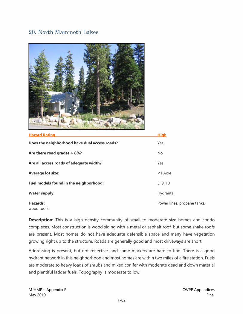
MJHMP – Appendix F CWPP Appendices May 2019 Final
F-82
20. North Mammoth Lakes
Hazard Rating High
Does the neighborhood have dual access roads? Yes
Are there road grades > 8%? No
Are all access roads of adequate width? Yes
Average lot size: <1 Acre
Fuel models found in the neighborhood: 5, 9, 10
Water supply: Hydrants
Hazards: Power lines, propane tanks, wood roofs
Description: This is a high density community of small to moderate size homes and condo complexes. Most construction is wood siding with a metal or asphalt roof, but some shake roofs are present. Most homes do not have adequate defensible space and many have vegetation growing right up to the structure. Roads are generally good and most driveways are short.
Addressing is present, but not reflective, and some markers are hard to find. There is a good hydrant network in this neighborhood and most homes are within two miles of a fire station. Fuels are moderate to heavy loads of shrubs and mixed conifer with moderate dead and down material and plentiful ladder fuels. Topography is moderate to low.

MJHMP – Appendix F CWPP Appendices May 2019 Final
F-83
NORTH MAMMOTH LAKES RECOMMENDATIONS
• A parcel-level analysis is recommended.
• Adequate defensible space is recommended for all homes (see the Home Mitigation
• section in the main report for details).
• Extended defensible space is recommended for homes located in dangerous topography (saddles, above natural chimneys, mid-slope on steep slopes or summits) with heavy fuel loads near or below the home.
• Discourage the use of combustible materials for decks, siding and roofs, especially where homes are upslope from heavy fuels. Replace all shake roofs with non- combustible types such as metal or composite shingle.
• Open areas below decks and projections should be enclosed or screened to prevent the ingress of embers and kept clean of flammable materials, especially where such openings are located on slopes above heavy fuels.
• Clean leaf and needle litter from roofs and gutters and away from foundations. Clear flammable vegetation away from power lines near homes. Clear weeds and flammable vegetation to at least 30 feet away from propane tanks.
• Discourage the planting of flammable ornamentals such as conifers within 30 feet of homes. Encourage the use of fire and drought tolerant plants for ornamental plantings especially within 30 feet of homes (see the Home Mitigation section in the main report).
• Thin vegetation along access roads and driveways. This is especially important for narrow driveways and road segments.
• Wherever possible, on driveways and private roads longer than 300 feet, add pullouts for emergency apparatus. Turnarounds should be constructed at the end of all driveways and dead-end roads.
• Add reflective addressing to all driveways and homes.

MJHMP – Appendix F CWPP Appendices May 2019 Final
F-84
21. Sierra Valley Estates (Mammoth Lakes area)
Hazard Rating High
Does the neighborhood have dual access roads? Yes
Are there road grades > 8%? No
Are all access roads of adequate width? Yes
Average lot size: <1 Acre
Fuel models found in the neighborhood: 5, 9, 10
Water supply: Hydrants
Hazards: Power lines, propane tanks, wood roofs
Description: This is a high density community of small homes and apartments on small lots. Most construction is older and quite a bit of it is very hazardous. Wood A-frames with cedar shake roofs that go almost all the way to the ground are common. Wood siding is dominant and roofs are a mix of asphalt and wood shake. There are no homes with adequate defensible spaces and many residences have flammable yard clutter. Addressing is poor and most homes do not have any address markers. There are power lines and propane tanks which can create a hazard for firefighters. There is a good hydrant network and most homes are within 2 miles of a fire station. Fuels are heavy to moderate loads of mixed conifer. Topography is low to flat.

MJHMP – Appendix F CWPP Appendices May 2019 Final
F-85
SIERRA VALLEY ESTATES RECOMMENDATIONS
• A parcel-level analysis is recommended.
• Adequate defensible space is recommended for all homes (see the Home Mitigation
• section in the main report for details).
• Extended defensible space is recommended for homes located in dangerous topography (saddles, above natural chimneys, mid-slope on steep slopes or summits) with heavy fuel loads near or below the home.
• Discourage the use of combustible materials for decks, siding and roofs, especially where homes are upslope from heavy fuels. Replace all shake roofs with non- combustible types such as metal or composite shingle.
• Open areas below decks and projections should be enclosed or screened to prevent the ingress of embers and kept clean of flammable materials, especially where such openings are located on slopes above heavy fuels.
• Clean leaf and needle litter from roofs and gutters and away from foundations. Clear flammable vegetation away from power lines near homes. Clear weeds and flammable vegetation to at least 30 feet away from propane tanks.
• Discourage the planting of flammable ornamentals such as conifers within 30 feet of homes. Encourage the use of fire and drought tolerant plants for ornamental plantings especially within 30 feet of homes (see the Home Mitigation section in the main report).
• Thin vegetation along access roads and driveways. This is especially important for narrow driveways and road segments.
• Wherever possible, on driveways and private roads longer than 300 feet, add pullouts for emergency apparatus. Turnarounds should be constructed at the end of all driveways and dead-end roads.
• Add reflective addressing to all driveways and homes.
\

MJHMP – Appendix F CWPP Appendices May 2019 Final
F-86
22. McGee Creek/Long Valley
Hazard Rating High
Does the neighborhood have dual access roads? Yes
Are there road grades > 8%? No
Are all access roads of adequate width? No
Average lot size: <1 Acre
Fuel models found in the neighborhood: 5, 6
Water supply: Hydrants, one creek-fed cistern
Hazards: Ravines, wood roofs
Description: This is a community of small to moderate sized homes on small lots. Homes are in clusters interspersed with LADWP and public lands. Construction is a mix of new and older types and some areas are still being built out. Wood siding is dominant and roofs are a mix of asphalt and metal with some wood shakes. There are a few homes with defensible spaces but many residences have vegetation growing right up to the structure and some have flammable yard clutter. Access roads are generally good, but there are some steep grades and long narrow driveways. Most homes do not have address markers that are visible from the street. The McGee Creek area has a good hydrant network and there is a creek-fed cistern with a standpipe connection in the Long Valley area that can supply adequate flows. Fuels are light to moderate
MJHMP – Appendix F CWPP Appendices May 2019 Final
F-87
loads of shrubs, predominately sage, and short grasses with ornamental plantings near homes. Topography is low to moderate with some ravines in the McGee Creek area.
MCGEE CREEK/LONG VALLEY RECOMMENDATIONS
• A parcel-level analysis is recommended.
• Adequate defensible space is recommended for all homes (see the Home Mitigation
• section in the main report for details).
• Extended defensible space is recommended for homes located in dangerous topography (saddles, above natural chimneys, mid-slope on steep slopes or summits) with heavy fuel loads near or below the home.
• Discourage the use of combustible materials for decks, siding and roofs, especially where homes are upslope from heavy fuels. Replace all shake roofs with non- combustible types such as metal or composite shingle.
• Open areas below decks and projections should be enclosed or screened to prevent the ingress of embers and kept clean of flammable materials, especially where such openings are located on slopes above heavy fuels.
• Clean leaf and needle litter from roofs and gutters and away from foundations.
• Discourage the planting of flammable ornamentals such as conifers within 30 feet of homes. Encourage the use of fire and drought tolerant plants for ornamental plantings especially within 30 feet of homes (see the Home Mitigation section in the main report).
• Thin vegetation along access roads and driveways. This is especially important for narrow driveways and road segments.
• Wherever possible, on driveways and private roads longer than 300 feet, add pullouts for emergency apparatus. Turnarounds should be constructed at the end of all driveways and dead-end roads.
• Add reflective addressing to all driveways and homes.

MJHMP – Appendix F CWPP Appendices May 2019 Final
F-88
23. Rancheria – Bridgeport Area
Hazard Rating High
Does the neighborhood have dual access roads? Yes
Are there road grades > 8%? No
Are all access roads of adequate width? No
Average lot size: 1-5 Acres
Fuel models found in the neighborhood: 10, 1, 5
Water supply: Creek weir (portable pump only)
Hazards: Inadequate roads, wood roofs
Description: This is a community of small to moderate size homes on moderate sized lots. Wood siding construction is dominant and roofs are approximately half wood shake and half ignition-resistant construction, primarily asphalt. A few homes have some defensible space, but most have vegetation growing right up to the structure. There are many homes with flammable decks and projections and some homes with flammable yard clutter. Most roads are paved and relatively flat but many are narrow and overgrown. There is a secondary access off of Hackmore, but this narrow dirt road is overgrown and would need fuels reduction and surface improvement to be a good escape route. Address markers are generally present, but not reflective and difficult to see on most homes. The only water for fire suppression in this community is from a six-foot concrete creek weir. Fuels are heavy mixed conifer with aspen and riparian shrubs in the creek bottoms.

MJHMP – Appendix F CWPP Appendices May 2019 Final
F-89
Topography is generally low, but some homes back up to steeper slopes and rolling materials could be a hazard.
RANCHERIA RECOMMENDATIONS
• A parcel-level analysis is recommended.
• Adequate defensible space is recommended for all homes (see the Home Mitigation
• section in the main report for details).
• Extended defensible space is recommended for homes located in dangerous topography (saddles, above natural chimneys, mid-slope on steep slopes or summits) with heavy fuel loads near or below the home.
• Extended defensible space is recommended for homes located at the bottom of steep slopes with heavy fuels above to prevent rolling burning materials from igniting structures.
• Discourage the use of combustible materials for decks, siding and roofs, especially where homes are upslope from heavy fuels. Replace all shake roofs with non- combustible types such as metal or composite shingle.
• Open areas below decks and projections should be enclosed or screened to prevent the ingress of embers and kept clean of flammable materials, especially where such openings are located on slopes above heavy fuels.
• Clean leaf and needle litter from roofs and gutters and away from foundations.
• Discourage the planting of flammable ornamentals such as conifers within 30 feet of homes. Encourage the use of fire and drought tolerant plants for ornamental plantings especially within 30 feet of homes (see the Home Mitigation section in the main report).
• Consider a shaded fuelbreak or linked defensible spaces for homes adjacent to the heavier conifer fuel beds.
• Thin vegetation along access roads and driveways. This is especially important for narrow driveways and road segments.
• The secondary access off Hackmore should be thinned to conform to shaded fuelbreak recommendations (see the main report for details) and the surface improved to provide a viable escape route.

MJHMP – Appendix F CWPP Appendices May 2019 Final
F-90
• Wherever possible, on driveways and private roads longer than 300 feet, add pullouts for emergency apparatus. Turnarounds should be constructed at the end of all driveways and dead-end roads.
• Add reflective addressing to all driveways and homes.

MJHMP – Appendix F CWPP Appendices May 2019 Final
F-91
24. Snow Creek
Hazard Rating Moderate
Does the neighborhood have dual access roads? No
Are there road grades > 8%? No
Are all access roads of adequate width? Yes
Average lot size: <1 Acres
Fuel models found in the neighborhood: 5, 9
Water supply: Hydrants
Hazards: Wood roofs
Description: This is a high density community of primarily town homes and condos. Single family homes are small on small lots. Wood siding with shake roofs is the dominant construction type. Some homes have wood piles and other flammable materials too close to the structure and/or under flammable projections and decks. Some homes have defensible space. Roads are good and most driveways are short and paved. Most homes have address markers but many are not visible (covered by vegetation). This area has a good hydrant network and is less than one mile from Mammoth Lakes FD Station 2. Fuels are conifers with grass and shrubs in the understory broken by irrigated lawns. Topography is low to flat.

MJHMP – Appendix F CWPP Appendices May 2019 Final
F-92
SNOW CREEK RECOMMENDATIONS
• Adequate defensible space is recommended for all homes (see the Home Mitigation
• section in the main report for details).
• Extended defensible space is recommended for homes with heavy fuel loads near or below the home.
• Discourage the use of combustible materials for decks, siding and roofs, especially where homes are upslope from heavy fuels. Replace all shake roofs with non- combustible types such as metal or composite shingle.
• Open areas below decks and projections should be enclosed or screened to prevent the ingress of embers and kept clean of flammable materials, especially where such openings are located on slopes above heavy fuels.
• Clean leaf and needle litter from roofs and gutters and away from foundations.
• Discourage the planting of flammable ornamentals such as conifers within 30 feet of homes. Encourage the use of fire and drought tolerant plants for ornamental plantings especially within 30 feet of homes (see the Home Mitigation section in the main report).
• Thin vegetation along access roads and driveways. This is especially important for narrow driveways and road segments.
• Wherever possible, on driveways and private roads longer than 300 feet, add pullouts for emergency apparatus. Turnarounds should be constructed at the end of all driveways and dead-end roads.
• Add reflective addressing to all driveways and homes. Clean all vegetation away from existing address markers.

MJHMP – Appendix F CWPP Appendices May 2019 Final
F-93
25. Mono City
Hazard Rating Moderate
Does the neighborhood have dual access roads? No
Are there road grades > 8%? No
Are all access roads of adequate width? Yes
Average lot size: <1 Acres
Fuel models found in the neighborhood: 2
Water supply: Hydrants (but poor flows)
Inadequate water supply, power lines, wood roofs
Description: This is a community of small homes on small lots. Most construction is older wood siding with metal or asphalt roofs, although there are several wood shake roofs in this community. Few homes have any defensible space. Roads and driveways are generally good. Some are dirt, but most have good surfaces and are of adequate width. Some homes are missing address markers and most others are present but not reflective and may be difficult to locate. Hydrants are present but flows are poor. Mono City has a volunteer fire department.
Overhead power lines are present which may be a hazard to firefighters. Fuels are primarily sage, mesquite and other shrubs and are continuous except for some irrigated lawns.
Topography is low to flat.

MJHMP – Appendix F CWPP Appendices May 2019 Final
F-94
MONO CITY RECOMMENDATIONS
• Adequate defensible space is recommended for all homes (see the Home Mitigation
• section in the main report for details).
• Extended defensible space is recommended for homes with heavy fuel loads near or below the home.
• Discourage the use of combustible materials for decks, siding and roofs, especially where homes are upslope from heavy fuels. Replace all shake roofs with non- combustible types such as metal or composite shingle.
• Open areas below decks and projections should be enclosed or screened to prevent the ingress of embers and kept clean of flammable materials, especially where such openings are located on slopes above heavy fuels.
• Clean leaf and needle litter from roofs and gutters and away from foundations.
• Discourage the planting of flammable ornamentals such as conifers within 30 feet of homes. Encourage the use of fire and drought tolerant plants for ornamental plantings especially within 30 feet of homes (see the Home Mitigation section in the main report).
• Thin vegetation along access roads and driveways. This is especially important for narrow driveways and road segments.
• Wherever possible, on driveways and private roads longer than 300 feet, add pullouts for emergency apparatus. Turnarounds should be constructed at the end of all driveways and dead-end roads.
• A second means of ingress/egress is needed for this community. A committee with the Mono Basin RPAC is currently working on this issue as of the writing of this report.
• Consider supplementing the poor hydrant network with a large (10,000 - 30,000) community cistern.
• Install a generator to keep the current water system operating during power outages.
• Add reflective addressing to all driveways and homes.

MJHMP – Appendix F CWPP Appendices May 2019 Final
F-95
26. Convict Lake/SNARL
Hazard Rating Moderate
Does the neighborhood have dual access roads? No
Are there road grades > 8%? No
Are all access roads of adequate width? No
Average lot size: <1 Acres
Fuel models found in the neighborhood: 5, 6
Water supply: Hydrants (Convict Lake only)
Inadequate water supply, inadequate access roads, ravines
Description: SNARL (Sierra Nevada Aquatic Lab) has residential housing for the research lab. The residences are wood and metal siding with metal roofs. This is an isolated area and address markers are not applicable, although the buildings are numbered. This area is a long distance from the nearest fire station. The only water for fire suppression is a pump system fed by a small reservoir, which is inadequate for this community. Fuels are a mixture of shrubs and short grasses. Topography is low to flat.
The residences at Convict Lake are predominately cabins and duplex units with one large summer resort property. There is a mix of old and new construction. Most residences are wood siding with metal or asphalt roofs. Addressing is poor and this area is a long distance from the nearest fire station. This community has a network of 2 ½” standpipe hydrants gravity fed by a 60,000 gallon

MJHMP – Appendix F CWPP Appendices May 2019 Final
F-96
cistern. Fuels are moderate loads of shrubs as much as four to six feet high in some areas. Near residences, aspen with sage and other shrubs in the understory is dominant. Topography is low to moderate with some ravines.
CONVICT LAKE/SNARL RECOMMENDATIONS
• Adequate defensible space is recommended for all homes (see the Home Mitigation
• section in the main report for details).
• Extended defensible space is recommended for homes with heavy fuel loads near or below the home.
• Discourage the use of combustible materials for decks, siding and roofs, especially where homes are upslope from heavy fuels.
• Open areas below decks and projections should be enclosed or screened to prevent the ingress of embers and kept clean of flammable materials, especially where such openings are located on slopes above heavy fuels.
• Clean leaf and needle litter from roofs and gutters and away from foundations.
• Discourage the planting of flammable ornamentals such as conifers within 30 feet of homes. Encourage the use of fire and drought tolerant plants for ornamental plantings especially within 30 feet of homes (see the Home Mitigation section in the main report).
• Thin vegetation along access roads and driveways. This is especially important for narrow driveways and road segments.
• Wherever possible, on driveways and private roads longer than 300 feet, add pullouts for emergency apparatus. Turnarounds should be constructed at the end of all driveways and dead-end roads.
• Consider supplementing the small reservoir at SNARL with a large (10,000 - 30,000) community cistern.
• Add reflective addressing to all driveways and homes in Convict Lake (not applicable to SNARL).

MJHMP – Appendix F CWPP Appendices May 2019 Final
F-97
27. Highlands
Hazard Rating Moderate
Does the neighborhood have dual access roads? No
Are there road grades > 8%? No
Are all access roads of adequate width? Yes
Average lot size: <1 Acres
Fuel models found in the neighborhood: 5, 6
Water supply: Hydrants
Hazards: Propane tanks
Description: This is a community of moderate size homes on small lots. This community is still being built out and is likely to become a high density area. Most construction is newer rock and wood siding with ignition resistant roofs. Some homes have defensible spaces, but most have shrubs and ornamental vegetation too close to the structure. Most roads are good and addressing is generally present, but not reflective, and may be difficult to locate at some residences. This community has a good hydrant network. Fuels are moderate loads of primarily sage and other short shrubs. Fuel beds are generally continuous throughout this community.
Topography is low to moderate.

MJHMP – Appendix F CWPP Appendices May 2019 Final
F-98
HIGHLANDS RECOMMENDATIONS
• Adequate defensible space is recommended for all homes (see the Home Mitigation
• section in the main report for details).
• Discourage the use of combustible materials for decks, siding and roofs, especially where homes are upslope from heavy fuels.
• Open areas below decks and projections should be enclosed or screened to prevent the ingress of embers and kept clean of flammable materials, especially where such openings are located on slopes above heavy fuels.
• Clean leaf and needle litter from roofs and gutters and away from foundations. Clear flammable vegetation away from power lines near homes. Clear weeds and flammable vegetation to at least 30 feet away from propane tanks.
• Discourage the planting of flammable ornamentals such as conifers within 30 feet of homes. Encourage the use of fire and drought tolerant plants for ornamental plantings especially within 30 feet of homes (see the Home Mitigation section in the main report).
• Thin vegetation along access roads and driveways. This is especially important for narrow driveways and road segments.
• Wherever possible, on driveways and private roads longer than 300 feet, add pullouts for emergency apparatus. Turnarounds should be constructed at the end of all driveways and dead-end roads.
• Add reflective addressing to all driveways and homes.

MJHMP – Appendix F CWPP Appendices May 2019 Final
F-99
28. Aurora Canyon
Hazard Rating Moderate
Does the neighborhood have dual access roads? No
Are there road grades > 8%? No
Are all access roads of adequate width? Yes
Average lot size: <1 Acres
Fuel models found in the neighborhood: 15, 2
Water supply: Hydrants
Hazards: Power lines, propane tanks
Description: This is a community of small homes on small lots. The dominant construction type is wood siding with asphalt roofs. Some homes have defensible spaces but most have ornamental plantings, grasses and/or sage too close to the structure. Roads are generally good and most homes have addressing present on the structure, but most markers are not reflective and some are difficult to locate. There are no address markers on the street, but most driveways are short. Power lines and propane tanks exist, which can be hazardous to firefighters. There is an adequate hydrant network in this community. Fuels are light loads of small sage and grasses (CDF desert fuel model, FM 15). Fuels change to Pinyon-juniper dominant further up canyon.
Topography is low to moderate.

MJHMP – Appendix F CWPP Appendices May 2019 Final
F-100
AURORA CANYON RECOMMENDATIONS
• Adequate defensible space is recommended for all homes (see the Home Mitigation
• section in the main report for details).
• Discourage the use of combustible materials for decks, siding and roofs.
• Open areas below decks and projections should be enclosed or screened to prevent the ingress of embers and kept clean of flammable materials.
• Clean leaf and needle litter from roofs and gutters and away from foundations. Clear flammable vegetation away from power lines near homes. Clear weeds and flammable vegetation to at least 30 feet away from propane tanks.
• Discourage the planting of flammable ornamentals such as conifers within 30 feet of homes. Encourage the use of fire and drought tolerant plants for ornamental plantings especially within 30 feet of homes (see the Home Mitigation section in the main report).
• Thin vegetation along access roads and driveways. This is especially important for narrow driveways and road segments.
• Wherever possible, on driveways and private roads longer than 300 feet, add pullouts for emergency apparatus. Turnarounds should be constructed at the end of all driveways and dead-end roads.
• Add reflective addressing to all driveways and homes.

MJHMP – Appendix F CWPP Appendices May 2019 Final
F-101
29. Ranch Road – Mammoth Lakes area
Hazard Rating Moderate
Does the neighborhood have dual access roads? No
Are there road grades > 8%? No
Are all access roads of adequate width? Yes
Average lot size: <1 Acres
Fuel models found in the neighborhood: 5, 1
Water supply: Hydrants
Hazards: Wood roofs, power lines, propane tanks
Description: This is a high density community of newer homes. Homes are small to moderate size on small lots. The dominant construction type is log, wood siding or wood siding with partial rock veneer. Roofs are predominately wood shake, although there are also many asphalt roofs. Many homes have flammable projections and decks. Most homes do not have any defensible space, and flammable ornamental plantings too close to the structure are common. All homes have address markers, but most are not reflective and there are no address markers at the street. There is a good hydrant network in this community (hydrants every 300 to 500 feet) and all of the homes are less than one mile from a fire station. Fuels are moderate to light loads of sage, riparian shrubs and grasses. Topography is flat to gently rolling.

MJHMP – Appendix F CWPP Appendices May 2019 Final
F-102
RANCH ROAD AREA RECOMMENDATIONS
• Adequate defensible space is recommended for all homes (see the Home Mitigation
• section in the main report for details).
• Discourage the use of combustible materials for decks, siding and roofs.
• Open areas below decks and projections should be enclosed or screened to prevent the ingress of embers and kept clean of flammable materials.
• Clean leaf and needle litter from roofs and gutters and away from foundations. Clear flammable vegetation away from power lines near homes. Clear weeds and flammable vegetation to at least 30 feet away from propane tanks.
• Discourage the planting of flammable ornamentals such as conifers within 30 feet of homes. Encourage the use of fire and drought tolerant plants for ornamental plantings especially within 30 feet of homes (see the Home Mitigation section in the main report).
• Thin vegetation along access roads and driveways. This is especially important for narrow driveways and road segments.
• Wherever possible, on driveways and private roads longer than 300 feet, add pullouts for emergency apparatus. Turnarounds should be constructed at the end of all driveways and dead-end roads.
• Add reflective addressing to all driveways and homes.

MJHMP – Appendix F CWPP Appendices May 2019 Final
F-103
30. Chalfant Valley
Hazard Rating Moderate
Does the neighborhood have dual access roads? Yes
Are there road grades > 8%? Yes
Are all access roads of adequate width? Yes
Average lot size: 1-5 Acres
Fuel models found in the neighborhood: 15
Water supply: None
No water supply, ravines, power lines, propane tanks
Description: Residences in this community are primarily ranch and farm properties with small to moderate size homes on moderate to large lots. There is a mix of old and new construction with wood siding and asphalt or metal roofs as the dominant type, although there are also many trailer homes in this community. Many properties have flammable outbuildings and several have cluttered yards. Although there are some homes with defensible space (mostly resulting from agricultural irrigation), there are many homes with native vegetation and ornamental plantings too close to the structure. Some access roads and long driveways are dirt, but most are flat and of adequate width. Addressing is poor. Many homes do not have markers, there are several long driveways with no marker at the street, and some homes only have a mailbox as a marker. Most of the markers that do exist are not reflective and some are difficult to locate. There is no water

MJHMP – Appendix F CWPP Appendices May 2019 Final
F-104
supply for fire suppression and many of the homes are a long way from the nearest fire station. Power lines and propane tanks exist which may be a hazard to firefighters. Fuels are light loads of small sage and grasses (CDF desert fuel model, FM 15). Fuels are discontinuous, broken by irrigated agricultural fields and lawns. The general topography is low to flat. However, topography does increase closer to the White Mountains, and there are some ravines in this area.
CHALFANT VALLEY RECOMMENDATIONS
• Adequate defensible space is recommended for all homes (see the Home Mitigation
• section in the main report for details).
• Extended defensible space is recommended for homes with heavy fuel loads near or below the home.
• Discourage the use of combustible materials for decks, siding and roofs.
• Open areas below decks and projections should be enclosed or screened to prevent the ingress of embers and kept clean of flammable materials.
• Clean leaf and needle litter from roofs and gutters and away from foundations. Clear flammable vegetation away from power lines near homes. Clear weeds and flammable vegetation to at least 30 feet away from propane tanks.
• Discourage the planting of flammable ornamentals such as conifers within 30 feet of homes. Encourage the use of fire and drought tolerant plants for ornamental plantings especially within 30 feet of homes (see the Home Mitigation section in the main report).
• Thin vegetation along access roads and driveways. This is especially important for narrow driveways and road segments.
• Wherever possible, on driveways and private roads longer than 300 feet, add pullouts for emergency apparatus. Turnarounds should be constructed at the end of all driveways and dead-end roads.
• Water supply is a critical need in Chalfant Valley. This community is very spread out along Highway 6. Consider adding at least one large (10,000 - 30,000 gallon) cistern in each of the most populated areas (Benton, Hammil and Chalfant Valley) for fire suppression use in this community.
• Add reflective addressing to all driveways and homes.

MJHMP – Appendix F CWPP Appendices May 2019 Final
F-105
31. Paradise Valley
Hazard Rating Moderate
Does the neighborhood have dual access roads? No
Are there road grades > 8%? No
Are all access roads of adequate width? No
Average lot size: <1 Acre
Fuel models found in the neighborhood: 5, 15
Water supply: Hydrants
Hazards: Ravines, wood roofs, propane tanks
Description: Approximately 175 people live in this community of small to moderate size homes on small lots. Most of the construction is newer with wood siding and asphalt roofs, but there are at least two wood shake roofs in this community. There are 83 homes currently built with plans to increase to 138 at maximum build out. Some homes have defensible space, but some have ornamental plantings and sage too close to the structure. Roads are good, paved and of adequate width. Most driveways are short. Address markers are present, but not reflective except for some reflective numbers on mailboxes. There is a good hydrant network in this community and all of the homes are within one mile of a fire station. Propane tanks exist which may be a hazard to firefighters, although most of the tanks are fairly new. Fuels are light loads of sage and desert

MJHMP – Appendix F CWPP Appendices May 2019 Final
F-106
grasses. Plants are generally widely spaced except for willow and aspen present in some drainages. Topography is low to moderate with some ravines.
PARADISE VALLEY RECOMMENDATIONS
• Adequate defensible space is recommended for all homes (see the Home Mitigation
• section in the main report for details).
• Extended defensible space is recommended for homes with heavy fuel loads near or below the home and for homes above ravines or other hazardous topographic features.
• Discourage the use of combustible materials for decks, siding and roofs.
• Open areas below decks and projections should be enclosed or screened to prevent the ingress of embers and kept clean of flammable materials.
• Clean leaf and needle litter from roofs and gutters and away from foundations. Clear flammable vegetation away from power lines near homes. Clear weeds and flammable vegetation to at least 30 feet away from propane tanks.
• Discourage the planting of flammable ornamentals such as conifers within 30 feet of homes. Encourage the use of fire and drought tolerant plants for ornamental plantings especially within 30 feet of homes (see the Home Mitigation section in the main report).
• Thin vegetation along access roads and driveways. This is especially important for narrow driveways and road segments.
• Turnarounds should be constructed at the end of all driveways and dead-end roads.
• Add reflective addressing to all driveways and homes.
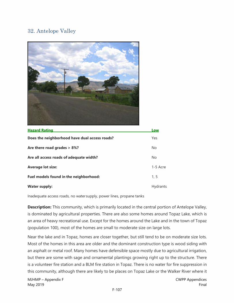
MJHMP – Appendix F CWPP Appendices May 2019 Final
F-107
32. Antelope Valley
Hazard Rating Low
Does the neighborhood have dual access roads? Yes
Are there road grades > 8%? No
Are all access roads of adequate width? No
Average lot size: 1-5 Acre
Fuel models found in the neighborhood: 1, 5
Water supply: Hydrants
Inadequate access roads, no water supply, power lines, propane tanks
Description: This community, which is primarily located in the central portion of Antelope Valley, is dominated by agricultural properties. There are also some homes around Topaz Lake, which is an area of heavy recreational use. Except for the homes around the Lake and in the town of Topaz (population 100), most of the homes are small to moderate size on large lots.
Near the lake and in Topaz, homes are closer together, but still tend to be on moderate size lots. Most of the homes in this area are older and the dominant construction type is wood siding with an asphalt or metal roof. Many homes have defensible space mostly due to agricultural irrigation, but there are some with sage and ornamental plantings growing right up to the structure. There is a volunteer fire station and a BLM fire station in Topaz. There is no water for fire suppression in this community, although there are likely to be places on Topaz Lake or the Walker River where it
MJHMP – Appendix F CWPP Appendices May 2019 Final
F-108
will be possible to draft depending on the water levels. Other than Highway 395, most of the roads are improved dirt. Widths are generally good, but there are some long narrow driveways. Addressing is poor, with many homes not marked at the driveway or the structure. Fuels are generally light loads of sage and short grasses except for scattered riparian shrubs and hardwoods in drainages and planted near some homes. Fuels are discontinuous due to large irrigated agricultural plots. Topography is generally low to flat.
ANTELOPE VALLEY RECOMMENDATIONS
• Adequate defensible space is recommended for all homes (see the Home Mitigation
• section in the main report for details).
• Discourage the use of combustible materials for decks, siding and roofs.
• Open areas below decks and projections should be enclosed or screened to prevent the ingress of embers and kept clean of flammable materials.
• Clean leaf and needle litter from roofs and gutters and away from foundations. Clear flammable vegetation away from power lines near homes. Clear weeds and flammable vegetation to at least 30 feet away from propane tanks.
• Discourage the planting of flammable ornamentals such as conifers within 30 feet of homes. Encourage the use of fire and drought tolerant plants for ornamental plantings especially within 30 feet of homes (see the Home Mitigation section in the main report).
• Thin vegetation along access roads and driveways. This is especially important for narrow driveways and road segments.
• Wherever possible, on driveways and private roads longer than 300 feet, add pullouts for emergency apparatus. Turnarounds should be constructed at the end of all driveways and dead-end roads.
• Inventory and preplan all draft sites and any stock tanks or other water sources which could be useful for fire suppression.
• Add reflective addressing to all driveways and homes.

MJHMP – Appendix F CWPP Appendices May 2019 Final
F-109
33. The Trails
Hazard Rating Low
Does the neighborhood have dual access roads? Yes
Are there road grades > 8%? No
Are all access roads of adequate width? Yes
Average lot size: <1 Acre
Fuel models found in the neighborhood: 5, 28
Water supply: Hydrants
Hazards: Heavy ornamental plantings
Description: This is a community of primarily moderate size homes on small lots. Most of the construction is newer and this community is still being built out. Wood siding with an asphalt or metal roof is dominant. Flammable decks and projections are common. Although the native fuels are light, most homes do not have any defensible space, because conifers and flammable ornamentals are planted too close to (in most cases right up to) the structure. Ornamental plantings are the biggest threat to the homes in this community. Roads are good and driveways are short. Address markers are present, but not reflective. The homes in this community are approximately two miles from the nearest fire station (Mammoth Lakes Station 1). Fuels are primarily light loads of short sage with occasional conifers, except for the heavy ornamental

MJHMP – Appendix F CWPP Appendices May 2019 Final
F-110
plantings near the homes noted above. This community backs up to a cleared industrial park which is a significant fuelbreak. Topography is low to flat.
THE TRAILS RECOMMENDATIONS
• Adequate defensible space is recommended for all homes (see the Home Mitigation
• section in the main report for details).
• Discourage the use of combustible materials for decks, siding and roofs.
• Open areas below decks and projections should be enclosed or screened to prevent the ingress of embers and kept clean of flammable materials.
• Clean leaf and needle litter from roofs and gutters and away from foundations.
• Discourage the planting of flammable ornamentals such as conifers within 30 feet of homes. Encourage the use of fire and drought tolerant plants for ornamental plantings especially within 30 feet of homes (see the Home Mitigation section in the main report).
• Thin vegetation along access roads and driveways. This is especially important for narrow driveways and road segments.
• Turnarounds should be constructed at the end of all driveways and dead-end roads.
• Add reflective addressing to all driveways and homes.

MJHMP – Appendix F CWPP Appendices May 2019 Final
F-111
34. June Lake Village
Hazard Rating Low
Does the neighborhood have dual access roads? Yes
Are there road grades > 8%? No
Are all access roads of adequate width? No
Average lot size: <1 Acre
Fuel models found in the neighborhood: 5
Water supply: Hydrants
Hazards: Power lines, wood roofs
Description: This is a community of small houses on small lots. Most of the construction is older and in various states of repair. Wood siding with an asphalt or metal roof is dominant, but there are some wooden roofs in this community. Flammable decks and projections are common. Roads are narrow but the surfaces are generally good and driveways are short.
Addressing is poor. Many homes do not have markers. Most of the markers that do exist are not reflective and some are difficult to locate. This area has a good hydrant network and is close to the June Lakes fire station. Power lines and propane tanks exist which may be a hazard to firefighters. Fuels are riparian shrubs and grasses broken by irrigated lawns. Topography is moderate to low.

MJHMP – Appendix F CWPP Appendices May 2019 Final
F-112
JUNE LAKE VILLAGE RECOMMENDATIONS
• Adequate defensible space is recommended for all homes (see the Home Mitigation
• section in the main report for details).
• Discourage the use of combustible materials for decks, siding and roofs.
• Open areas below decks and projections should be enclosed or screened to prevent the ingress of embers and kept clean of flammable materials.
• Clean leaf and needle litter from roofs and gutters and away from foundations. Clear flammable vegetation away from power lines near homes. Clear weeds and flammable vegetation to at least 30 feet away from propane tanks.
• Discourage the planting of flammable ornamentals such as conifers within 30 feet of homes. Encourage the use of fire and drought tolerant plants for ornamental plantings especially within 30 feet of homes (see the Home Mitigation section in the main report).
• Thin vegetation along access roads and driveways. This is especially important for narrow driveways and road segments.
• Turnarounds should be constructed at the end of all driveways and dead-end roads.
• Add reflective addressing to all driveways and homes.

MJHMP – Appendix F CWPP Appendices May 2019 Final
F-113
35. Lee Vining
Hazard Rating Low
Does the neighborhood have dual access roads? Yes
Are there road grades > 8%? No
Are all access roads of adequate width? Yes
Average lot size: <1 Acre
Fuel models found in the neighborhood: 15
Water supply: Hydrants
Hazards: Power lines, wood roofs
Description: This is a community of small houses on small lots. Most of the construction is older and in various states of repair. Wood siding with an asphalt or metal roof is dominant, although there are some wooden roofs in this community. Flammable decks and projections are common. Roads are generally good and driveways are short. Addressing is poor. Many homes do not have markers. Most of the markers that do exist are not reflective and some are difficult to locate. This area has a good hydrant network and there is a volunteer fire station in this community. There is also a USFS fire station in Lee Vining. Power lines and propane tanks exist which may be a hazard to firefighters. Fuels are light loads of small sage and grasses (CDF desert fuel model, FM 15). Fuels are discontinuous, broken by irrigated lawns. Topography is moderate to low.

MJHMP – Appendix F CWPP Appendices May 2019 Final
F-114
LEE VINING RECOMMENDATIONS
• Adequate defensible space is recommended for all homes (see the Home Mitigation
• section in the main report for details).
• Discourage the use of combustible materials for decks, siding and roofs.
• Open areas below decks and projections should be enclosed or screened to prevent the ingress of embers and kept clean of flammable materials.
• Clean leaf and needle litter from roofs and gutters and away from foundations. Clear flammable vegetation away from power lines near homes. Clear weeds and flammable vegetation to at least 30 feet away from propane tanks.
• Discourage the planting of flammable ornamentals such as conifers within 30 feet of homes. Encourage the use of fire and drought tolerant plants for ornamental plantings especially within 30 feet of homes (see the Home Mitigation section in the main report).
• Thin vegetation along access roads and driveways. This is especially important for narrow driveways and road segments.
• Turnarounds should be constructed at the end of all driveways and dead-end roads.
• Add reflective addressing to all driveways and homes.

MJHMP – Appendix F CWPP Appendices May 2019 Final
F-115
36. Bridgeport Valley
Hazard Rating Low
Does the neighborhood have dual access roads? Yes
Are there road grades > 8%? No
Are all access roads of adequate width? Yes
Average lot size: 1-5 Acre
Fuel models found in the neighborhood: 1, 5
Water supply: Hydrants
Hazards: Power lines, propane tanks
Description: This community is dominated by agricultural properties. Lot sizes vary from small lots in the town of Bridgeport to large agricultural properties. Homes in this area are a mix of new and old construction. The dominant construction type is wood siding with asphalt or metal roofs. Most homes have defensible space primarily due to agricultural irrigation and the lack of native fuels. Some roads are dirt, but most are flat and of adequate width. There are some long driveways with no pullout or turnaround for apparatus. Addressing outside of the town of Bridgeport is poor, with many homes not marked at the driveway or the structure. Homes in Bridgeport generally have address markers, but most are not reflective and some are difficult to locate. There is a good hydrant network in Bridgeport. There is also a volunteer fire station and a USFS fire station in

MJHMP – Appendix F CWPP Appendices May 2019 Final
F-116
Bridgeport. Fuels are generally light loads of short grasses and sage which are quite discontinuous due to large irrigated agricultural plots and irrigated lawns.
Although surrounded by hills, this community is in a flat valley bottom.
BRIDGEPORT VALLEY RECOMMENDATIONS
• Adequate defensible space is recommended for all homes (see the Home Mitigation
• section in the main report for details).
• Discourage the use of combustible materials for decks, siding and roofs.
• Open areas below decks and projections should be enclosed or screened to prevent the ingress of embers and kept clean of flammable materials.
• Clean leaf and needle litter from roofs and gutters and away from foundations. Clear flammable vegetation away from power lines near homes. Clear weeds and flammable vegetation to at least 30 feet away from propane tanks.
• Discourage the planting of flammable ornamentals such as conifers within 30 feet of homes. Encourage the use of fire and drought tolerant plants for ornamental plantings especially within 30 feet of homes (see the Home Mitigation section in the main report).
• Thin vegetation along access roads and driveways. This is especially important for narrow driveways and road segments.
• Wherever possible, on driveways and private roads longer than 300 feet, add pullouts for emergency apparatus. Turnarounds should be constructed at the end of all driveways and dead-end roads.
• Add reflective addressing to all driveways and homes.

MJHMP – Appendix F CWPP Appendices May 2019 Final
F-117
CWPP Appendix 3: STRUCTURAL TRIAGE AND PREPARATION SIZE UP CONSIDERATIONS
• What is the current and expected weather?
• Are fuels heavy, moderate, or light? What is the arrangement and continuity of fuels?
• Note any hazardous topography.
• What have fires in this area done before?
• What is the fire’s current and expected behavior?
o What is the rate and direction of spread?
o What is the potential for spotting and firebrands?
o Will topographical features or expected weather changes affect the rate of spread?
• What are the number and density of structures threatened?
• What are the available resources?
• Will you have to evacuate people or animals?
o Are there residents who will not evacuate?
• How hazardous is the structure?
o What is the roofing material?
o Are the gutters full of litter?
o Are there open eves and unscreened vents?
o Does the structure have wooden decking?
o Is there defensible space?
o Are there large windows with flammable drapes or curtains?
o What is the size and location of propane tanks and/or fuel storage tanks?
FIREFIGHTER SAFETY
• What are the routes of egress and ingress?
o What is the largest engine that can access the structure safely?

MJHMP – Appendix F CWPP Appendices May 2019 Final
F-118
o Are the roads two-way or one-way?
o Are there road grades steeper than 8%?
o Are the road surfaces all-weather?
o Are there load-limited bridges?
• Are there anchor points for line construction?
• Are there adequate safety zones?
• What are the escape routes?
• Are there special hazards such as hazardous materials, explosives, high-voltage lines, or above- ground fuel tanks?
• Are communications adequate?
STRUCTURAL TRIAGE CATEGORIES Sort structures into three categories:
1. Stand Alone or Not Threatened
2. Defendable
3. Not Defendable
• Factors that may make an attempt to save a structure too dangerous or hopeless:
o The fire is making sustained runs in live fuels and there is little or no defensible space
o Spot fires are too numerous to control with existing resources
o Water supply will be exhausted before the threat has passed
o The roof is more than ¼ involved in flames
o There is fire inside the structure
o Rapid egress from the area is dangerous or may be delayed APPARATUS PLACEMENT CONSIDERATIONS Common Ignition Points (remember, in windy conditions, firebrands can enter almost any opening)
• Flammable roof coverings and debris
• Unscreened vents, windows, or holes

MJHMP – Appendix F CWPP Appendices May 2019 Final
F-119
• Open doors, windows, or crawl spaces
• Wooden decks, lawn furniture, stacked wood, and trash piles
• Openings under porches or patio covers Note: See diagram for Engine Positioning and Setup
Teie,William C.,1995, Firefighter's Guide, Urban/Wildland Situations. Deer Valley Press

MJHMP – Appendix F CWPP Appendices May 2019 Final
F-120
This page intentionally left blank

MJHMP – Appendix F CWPP Appendices May 2019 Final
F-121
CWPP Appendix 4: ACCESS AND WATER SUPPLY RECOMMENDED GUIDELINES INTRODUCTION This appendix has been designed with public education in mind, and is intended to help familiarize homeowners, contractors, and developers with the general principles of the access and water supply needs of firefighters. The recommendations in this section are based on proven practices. However, they are not meant to be a substitute for locally adopted codes.
Emergency response personnel do their best to respond to calls in a timely manner, often while negotiating difficult terrain. Planning for access by emergency equipment allows for a more efficient response, improving safety for residents and their families, as well as that of the firefighters and emergency medical technicians that will arrive on scene. This is especially important in rural areas, where response times may be considerably longer than in cities.
ACCESS GUIDELINES Driveway Turnarounds
Turnarounds unobstructed by parked vehicles should be located at the end of every driveway. They should be designed to allow for the safe reversal of direction by emergency equipment. The “Y” and “Hammerhead” turnarounds shown below are preferred because they provide the necessary access, while minimizing disturbance to the site.
Driveway Width and Height
Driveways should have an unobstructed vertical clearance of 13 feet 6 inches. Trees may need to be limbed and utility lines relocated, to provide the necessary clearance. Driveways should have a 12 foot-wide drivable surface and 14 feet of horizontal clearance.
Note: Diagrams illustrating these guidelines can be seen on the next page.

MJHMP – Appendix F CWPP Appendices May 2019 Final
F-122
Driveway pullouts should be designed with sufficient length and width to allow emergency vehicles to pass one another during emergency operations. These features should be placed at 400-foot intervals along driveways and private access roads (community driveways). The location of pullouts may be modified slightly to accommodate physical barriers such as rock outcroppings, wetlands, and other natural or manmade features.

MJHMP – Appendix F CWPP Appendices May 2019 Final
F-123
Address Markers
Every building should have a permanently posted, reflective address marker mounted on a non-combustible pole. The sign should be placed and maintained at each driveway entrance. Care should be taken to ensure that the location will not become obscured by vegetation, snow, or other features, whether natural or manmade. It is critical that the location and markings be adequate for easy night-time viewing. It is preferable to locate markers in a consistent manner within each community. A good guideline for this practice is to place the markers five feet above ground level on the right side of every driveway. Where access to multiple homes is provided by a single driveway, all addresses accessed via that driveway should be clearly listed on the driveway marker. Where multi-access driveways split, each fork should indicate all residences accessed by that fork, and the proper direction of travel to arrive at a given address. It is not adequate simply to mark addresses on a common pole in the center of the fork. Further, residential homes should have an additional reflective address marker permanently attached to the home, in clear view of the driveway or access road. Homes that are marked by lot number while under construction should have the lot number removed and a permanent address marker posted before granting a certificate of occupancy.
Bridge Load Limits
Bridge load limits should be posted with a permanently mounted, reflective marker at both entrances to the bridge. Care should be taken to ensure that these markers will not become obscured by vegetation, snow, or other features, whether natural or manmade. It is critical that the location of the markings and the markings themselves be adequate for easy night- time viewing.
ALTERNATIVE WATER SOURCES In the study area, like in many WUI areas in the west, water is a critical fire suppression issue. Although some communities in Mono County have a good network of pressurized hydrants, the hazard assessment revealed several communities in the study area which are a considerable distance from reliable water sources for fire suppression. The following information on the use of cisterns and dry hydrant installations has been included to provide information regarding supplementing existing pressurized hydrants, cisterns and natural water sources. It is not intended to be a replacement for existing water supplies. For more detailed recommendations regarding enhancement of the existing water supply system, please see the Water Supply section of the main report.

MJHMP – Appendix F CWPP Appendices May 2019 Final
F-124
CISTERNS Once emergency vehicles have arrived on site, they will need a dependable supply of water to help control the fire. Although residential wells with outdoor taps can be used by fire crews to help fill engine tanks, they are not adequate for fire control. If the property is a significant distance from a reliable water supply or fire station, it may be advisable to employ one of the following water supply options:
• An on-site 1,800 - 2,500 gallon cistern for each residence. • A monetary contribution to a large community cistern fund.
For more information about local standards and regulations, please contact your local fire department.
DRY HYDRANTS Dry hydrant installations allow much faster and more reliable access to ponds and tanks than conventional drafting. Specific recommendations for dry hydrant locations may be found in the Water Supply section of the main report. Guidelines for the construction and maintenance of dry hydrants may be found in the Dry Hydrant Manual included as a supplement to this report.
It is always helpful to discuss any potential construction project with the fire department. Local fire department officials or the CDF can help determine what kind of access and water supply options will work best for your site. While the guidelines in this appendix have been assembled by querying firefighters with extensive Wildland-Urban Interface firefighting and fire code experience, local fire officials are in the best position to offer site-specific information.

MJHMP – Appendix F CWPP Appendices May 2019 Final
F-125
CWPP Appendix 5: DRY HYDRANT MANUAL A Guide for Developing Alternative Water Sources for Rural Fire Protection From code originally developed for Summit County, Colorado.
ALTERNATE WATER SUPPLY POLICY
SCOPE
This policy is intended to offer guidance and assistance to the property owner, contractor, or developer for meeting the requirements of the Uniform Fire Code and Chapter 14 (as amended) of the Uniform Building Code for the provision of adequate water supplies for rural firefighting. This policy does not necessarily meet ISO requirements for installation of a draft fire hydrant.
GOALS
1. To reduce ISO ratings
2. To design each installation with the capability of flowing 1,000 gpm
3. To obtain points for fire mitigation
4. To function to protect life and property
DEFINITION
A draft fire hydrant is a specially designed and constructed fire hydrant, which has been approved by the Fire Department having jurisdiction. A draft fire hydrant must be connected to a year-round draft water source of sufficient capacity to meet any fire- fighting needs for the property or properties involved. Fire hydrants which are connected to a pressurized municipal watercourse are not covered by this policy.
PERMITS
A. A review of the draft fire hydrant plans must be completed by the Fire Department having jurisdiction prior to issuing a grading permit to allow construction of a draft hydrant. A site plan review is used to determine site- specific requirements including, but not limited to, depth of pipe, required insulation materials, backfill requirements, and draft site requirement. Additionally, it may be necessary to submit information about drought conditions for the past 50 years.
B. A statement authorizing access to and use of the draft fire hydrant by the Fire Department and its agents must be signed by the owner of the property on which the draft hydrant will be located. The Fire Department having jurisdiction will be using water under the presumption of non-injury/non-consumption for fire emergency use.

MJHMP – Appendix F CWPP Appendices May 2019 Final
F-126
ACCEPTANCE TESTING
All draft hydrants are subject to acceptance testing approved by the Fire Department having jurisdiction, prior to being accepted as a water source. Acceptance testing must include GPM verification of the water source. Maintenance and testing will return water within 200 feet of its drainage.
MAINTENANCE
A. Draft fire hydrants require bi-annual testing and maintenance. The hydrants should be tested with a pumper. Back-flushing followed by a pumper test at a maximum designed flow rate is required, and records of each test need to be kept. Tests of this kind will not only verify that the hydrant is in proper condition, but will also ensure that the line and strainer are clear of silt, thus keeping water supply available for any fire emergency.
B. A homeowner using the draft hydrant who has obtained points for mitigation or an ISO classification is responsible at all times for maintaining the draft hydrant. This maintenance includes keeping the draft hydrant and its protective barriers free from obstruction by vehicles, materials, structures, snow, or other obstructions, and ensuring that the draft hydrant is in a serviceable condition at all times.
C. It is the responsibility of the property owners using the hydrant for mitigation of ISO classification purposes to immediately notify the Fire Department having jurisdiction of any draft hydrant which is obstructed, damaged, or out of service for any reason.
DESIGN REQUIREMENTS
A. All draft hydrants must be located within 8 feet of a road with year-round maintenance. Access to the system must conform to the road and bridge standards in Appendix D, Access and Water Supply.
B. All draft hydrants must have a single draft connection located no more than 30” from the fire apparatus, measured from the grade level of the roadway where the fire apparatus will be parked, to the top of the draft hydrant’s threaded connection. Additionally, life is determined by measuring from year-round low level of the water surface to the truck intake.
C. All draft hydrants must have a draft tube running horizontally from the water source to the base of the riser, constructed of PVC no smaller than six inches in diameter. PVC pipe meeting AWWA specification C9000 with a SDR of 18 or less may be required through or under foundations and under driveways (schedule 80 pipe or its equivalent may be deemed necessary in some instances). All joints must be sealed to ensure that they are watertight, airtight, and root proof.
D. The piping must be placed in bedding material of ¾-inch washed or screen rock, or in native soils, providing that the native soils contain no sharp materials or stones larger than 2½ inches that may damage the piping.

MJHMP – Appendix F CWPP Appendices May 2019 Final
F-127
E. The bedding material must be placed to a depth of 4 inches below the pipe and 6 inches above the top of the pipe.
F. The draft hydrant pipe extending from the water source to the rise pipe connection must have a minimum grade of .5% to a maximum of 2% toward the water source. (This excludes the riser section immediately preceding the fire department connection).
G. All draft fire hydrants must have a single draft connection consisting of an approved fitting and cap with 6-inch male NST threads. (Size of connection is determined by the Fire Department having jurisdiction.)
H. No more than two elbows are recommended. Elbows may be 90 or 45 degree bends. (See Figure 1.)
INSTALLATION REQUIREMENTS
A. Draft fire hydrants must be painted red (using oil base paint) with reflective tape, to protect PVC pipe from the adverse effects of sunlight and to assist in the rapid location and identification by the Fire Department.
B. All draft fire hydrants must be protected from damage by snowplows, motor vehicles, etc., by the installation of three steel pipes buried three feet into the ground with four feet extending above the grade level of the roadway. The entire pipe must be filled with concrete. The protective pipes must be located in a triangle configuration approximately three feet away from the draft hydrant. Steel pipes must also be painted with red oil base paint and reflective tape.
C. All draft hydrants must have a sign stating “draft hydrant” displayed in a location acceptable to the Fire Department having jurisdiction.
The above policy is subject to change or modification by the Fire Department having jurisdiction.
MAXIMUM LIFT CONSIDERATIONS
Definition: Lift is determined by measuring from the lowest level of the water surface to the truck intake, which is 36” above grade.
Maximum vertical lift recommendations:
Elevation Do Not Exceed 4,000 ft 13 ft 5,000 ft. 12 ft. 6,000 ft. 11 ft. 7,000 ft. 10 ft. 8,000 ft. 9 ft. 9,000 ft. 8 ft. 10,000 ft. 7 ft.

MJHMP – Appendix F CWPP Appendices May 2019 Final
F-128
This page intentionally left blank.

MJHMP – Appendix F CWPP Appendices May 2019 Final
F-129
CWPP Appendix 6: MONO COUNTY CWPP COLLABORATIVE EFFORT THE NEED FOR A CWPP
In response to the Healthy Forest Restoration Act (HFRA), and in an effort to create incentives, Congress directed interface communities to prepare a Community Wildfire Protection Plan (CWPP). Once completed, a CWPP provides statutory incentives for the federal agencies to consider the priorities of local communities as they develop, and implement forest management and hazardous fuel reduction projects.
CWPPs can take a variety of forms, based on the needs of the people involved in their development. CWPPs may address issues such as wildfire response, hazard mitigation, community preparedness, structure protection, or all of the above.
The minimum requirements for a CWPP are:
• Collaboration between local and state government representatives, in consultation with federal agencies and other interested parties.
• Addressed in this appendix
• Prioritized fuel reduction in identified areas, as well as recommendations for the type and methods of treatments
• Addressed in Main CWPP report (see recommendations sections)
• Recommendations and treatment measures for homeowners and communities to reduce the ignitability of those structures in the project area.
• Addressed in Appendix B of this CWPP
INTER-AGENCY COLLABORATION
Roles and Responsibilities
To be successful, wildfire mitigation in the interface must be a community-based, collaborative effort. Stakeholders and, primarily, Mono County and the local Fire Safe Councils, will have the greatest responsibility for implementing the recommended mitigation projects. Cal Fire and the USFS/BLM will be valuable participants in addressing cross-boundary projects throughout the area.

MJHMP – Appendix F CWPP Appendices May 2019 Final
F-130
Nearly all of the recommendations from this report affect private land or access roads to private land. There are also mitigation recommendations for individual structures, which are the responsibility of the homeowner. Homeowners will, however, need a point of contact to help them implement these recommendations. The best defensible space will be created with oversight and expert advice from the fire department and/or government forestry personnel. One-on-one dialog will continue to build the relationship with community members. This level of involvement will allow agencies to keep track of the progress and update this plan to reflect the latest modifications at the community level.
THE COLLABORATIVE PROCESS
“The initial step in developing a CWPP should be the formation of an operating group with representation from local government, local fire authorities, and the state agency responsible for forest management. (…) Once convened, members of the core team should engage local representatives… to begin sharing perspectives, priorities, and other information relevant to the planning process.”1
Numerous federal, State, local, and private agencies (stakeholders) participated in this CWPP. These stakeholders included:
• Mono County stakeholders:
o Debra Hein, BLM
o Bob Rooks, Mammoth Lakes, FD
o Dale Schmidt, LADWP/Wheeler VFD
• Mono County communities including:
o Lake Mary Area
o Twin Lakes
o June Lake
o Swauger Creek/Devils Gate
o North Mammoth Lakes
o Mono City
1 A handbook for Wildland-Urban Interface Communities March 2004, http://www.safnet.org/policyandpress/cwpphandbook.pdf

MJHMP – Appendix F CWPP Appendices May 2019 Final
F-131
o Lee Vining
• Mammoth Lakes Fire Protection District
• Mono County Supervisors
• California Department of Fire (CalFire)
• Bureau of Land Management
• United States Forest Service
• Anchor Point Group
The true collaborative process was initiated through a stakeholder meeting held in June, 2005. The purpose of the meetings was to bring all past, current, and future efforts and needs to the table. The primary focus was on the identification and delineation of communities, areas of concern, and values at risk. Best practices and anticipated “roadblocks” were identified.
A second round of stakeholder meetings was held in January of 2009 to present the results and discuss any issues or concerns with the draft report.
In addition, public meetings were held to get input and feedback from residents. There was support for the projects and interest in convening community meetings to start the process. Comments were incorporated into the final document.
FUNDING CWPP RECOMMENDATIONS
There are many sources of funds available for implementing the recommendations within the CWPP. Some available grants and websites where more information can be found are provided below.
• Agency: Homeland Security, Office for Domestic Preparedness
o Purpose: to assist local, state, regional, or national organizations in addressing fire prevention and safety. The emphasis for these grants is the prevention of fire-related injuries to children.
o More information: http://www.firegrantsupport.com/
• Agency: Federal Emergency Management Agency (FEMA)
o Purpose: to improve firefighting operations, purchase firefighting vehicles, equipment, and personal protective equipment, fund fire prevention programs, and establish wellness and fitness programs.

MJHMP – Appendix F CWPP Appendices May 2019 Final
F-132
o More information: http://usfa.fema.gov/dhtml/inside-usfa/grants.cfm
• Agency: National Volunteer Fire Council
o Purpose: to support volunteer fire departments
o More information: http://www.nvfc.org/federalfunding.html
• Agency: Community Facilities Grant Program
o Purpose: to help rural communities. Funding is provided for fire stations
o More information: www.rurdev.usda.gov/rhs/
• Agency: Firehouse.com
o Purpose: emergency services grants
o More information: www.firehouse.com/funding/grants.html
• Agency: Cooperative Forestry Assistance
o Purpose: to assist in the advancement of forest resources management, the control of insects and diseases affecting trees and forests, the improvement and maintenance of fish and wildlife habitat, and the planning and conduct of urban and community forestry programs
o More information: www.usfa.fema.gov/dhtml/inside-usfa/cfda10664.html
• Agency: Forest Service, Economic Action Programs
o Purpose: Economic Action Programs that work with local communities to identify, develop, and expand economic opportunities related to traditionally underutilized wood products and to expand the utilization of wood removed through hazardous fuel reduction treatments.
o More information: www.fireplan.gov/community_assist.cfm
• Agency: FEMA
o Purpose: Assistance to Firefighters Grant Program
o More information: www.usfa.fema.gov/dhtml/inside-usfa/apply.cfm and www.nvfc.org/federalfunding.html

Mono County | Town of Mammoth Lakes
Multi-Jurisdictional Hazard Mitigation Plan (MJHMP)
APPENDIX G: FHSZ MODEL PRIMER

This page intentionally left blank.

MJHMP – Appendix G FHSZ Model Primer May 2019 Final
G-1

MJHMP – Appendix G FHSZ Model Primer May 2019 Final
G-2

MJHMP – Appendix G FHSZ Model Primer May 2019 Final
G-3

MJHMP – Appendix G FHSZ Model Primer May 2019 Final
G-4

Mono County | Town of Mammoth Lakes
Multi-Jurisdictional Hazard Mitigation Plan (MJHMP)
APPENDIX H: HISTORIC FIRE LIST

This page intentionally left blank.

MJHMP – Appendix H Historic Fire List May 2019 Final
H-1
Historic Fires - Mono County and Town of Mammoth Lakes
Year Fire Name Cause Acres Burned Community Planning Area
1943 Unnamed Unknown/Unidentified 633 Antelope Valley
1946 Unnamed Unknown/Unidentified 227 Antelope Valley (Near)
1947 Unnamed Unknown/Unidentified 146 Antelope Valley (Near)
1947 Unnamed Unknown/Unidentified 537 Sonora Junction (Near)
1948 Unnamed Unknown/Unidentified 515 Bodie Hills
1951 Unnamed Unknown/Unidentified 165 Antelope Valley
1951 Unnamed Unknown/Unidentified 115 Antelope Valley (Near)
1953 Unnamed Unknown/Unidentified 122 Bodie Hills (Near)
1955 Unnamed Smoking 207 Antelope Valley
1955 Unnamed Lightning 71 Bodie Hills
1956 Unnamed Smoking 122 Antelope Valley
1956 Unnamed Lightning 243 Antelope Valley (Near)
1958 Paradise #2 Unknown/Unidentified 351 Wheeler Crest (Near)
1959 Unnamed Lightning 101 Bodie Hills (Near)
1960 Summit Unknown/Unidentified 611 Bodie Hills
1961 Unnamed Lightning 324 Bodie Hills
1961 Unnamed Lightning 44 Sonora Junction
1962 Unnamed Lightning 70 Antelope Valley (Near)
1964 Unnamed Smoking 368 Antelope Valley
1964 Unnamed Debris 682 Antelope Valley (Near)
1964 Unnamed Campfire 100 Bridgeport
1964 Unnamed Miscellaneous 362 Bridgeport (Near)
1964 Unnamed Smoking 27 Sonora Junction
1966 Unnamed Lightning 19 Bodie Hills (Near)

MJHMP – Appendix H Historic Fire List May 2019 Final
H-2
Historic Fires - Mono County and Town of Mammoth Lakes
Year Fire Name Cause Acres Burned Community Planning Area
1966 Unnamed Miscellaneous 327 Mammoth Vicinity
1970 Unnamed Lightning 63 Antelope Valley (Near)
1970 Unnamed Debris 4 Bodie Hills (Near)
1970 Unnamed Playing with Fire 36 Mono Basin
1972 Unnamed Miscellaneous 156 Antelope Valley
1972 Unnamed Lightning 150 June Lake (Near)
1972 Unnamed Playing with Fire 1,458 June Lake (Near)
1972 Unnamed Miscellaneous 36 Long Valley
1972 Unnamed Miscellaneous 120 Long Valley
1972 Unnamed Lightning 698 Long Valley
1972 Unnamed Equipment Use 153 Mammoth Vicinity
1972 Unnamed Campfire 16 Oasis (Near)
1973 Unnamed Lightning 213 Antelope Valley
1973 Unnamed Unknown/Unidentified 376 Antelope Valley (Near)
1973 Unnamed Miscellaneous 189 Bridgeport
1974 Swall Miscellaneous 667 Wheeler Crest
1974 Unnamed Smoking 2,112 Antelope Valley
1974 Unnamed Lightning 9 Antelope Valley (Near)
1974 Unnamed Lightning 662 Antelope Valley (Near)
1974 Unnamed Equipment Use 22 Sonora Junction
1974 Unnamed Lightning 108 Sonora Junction
1977 Unnamed Lightning 74 Benton Hot Springs (Near)
1977 Unnamed Lightning 102 Benton Hot Springs (Near)
1977 Unnamed Lightning 352 Bridgeport (Near)
1977 Unnamed Debris 277 Sonora Junction
1978 Unnamed Lightning 349 Mono Basin
1979 Unnamed Arson 25 Sonora Junction
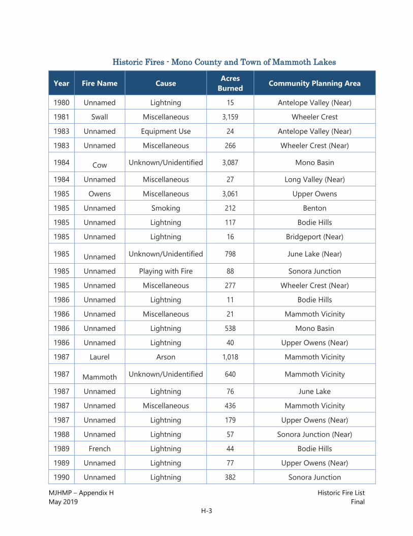
MJHMP – Appendix H Historic Fire List May 2019 Final
H-3
Historic Fires - Mono County and Town of Mammoth Lakes
Year Fire Name Cause Acres Burned Community Planning Area
1980 Unnamed Lightning 15 Antelope Valley (Near)
1981 Swall Miscellaneous 3,159 Wheeler Crest
1983 Unnamed Equipment Use 24 Antelope Valley (Near)
1983 Unnamed Miscellaneous 266 Wheeler Crest (Near)
1984 Cow Unknown/Unidentified 3,087 Mono Basin
1984 Unnamed Miscellaneous 27 Long Valley (Near)
1985 Owens Miscellaneous 3,061 Upper Owens
1985 Unnamed Smoking 212 Benton
1985 Unnamed Lightning 117 Bodie Hills
1985 Unnamed Lightning 16 Bridgeport (Near)
1985 Unnamed Unknown/Unidentified 798 June Lake (Near)
1985 Unnamed Playing with Fire 88 Sonora Junction
1985 Unnamed Miscellaneous 277 Wheeler Crest (Near)
1986 Unnamed Lightning 11 Bodie Hills
1986 Unnamed Miscellaneous 21 Mammoth Vicinity
1986 Unnamed Lightning 538 Mono Basin
1986 Unnamed Lightning 40 Upper Owens (Near)
1987 Laurel Arson 1,018 Mammoth Vicinity
1987 Mammoth Unknown/Unidentified 640 Mammoth Vicinity
1987 Unnamed Lightning 76 June Lake
1987 Unnamed Miscellaneous 436 Mammoth Vicinity
1987 Unnamed Lightning 179 Upper Owens (Near)
1988 Unnamed Lightning 57 Sonora Junction (Near)
1989 French Lightning 44 Bodie Hills
1989 Unnamed Lightning 77 Upper Owens (Near)
1990 Unnamed Lightning 382 Sonora Junction
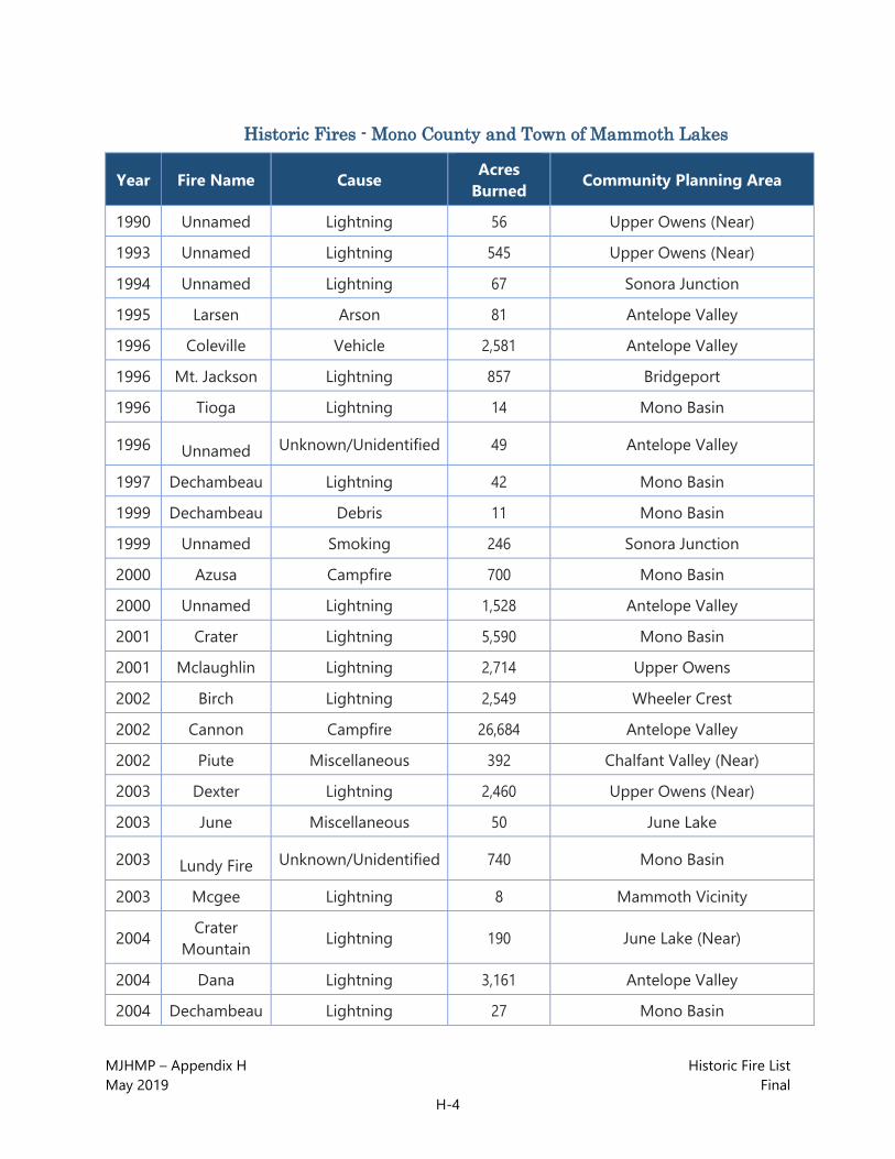
MJHMP – Appendix H Historic Fire List May 2019 Final
H-4
Historic Fires - Mono County and Town of Mammoth Lakes
Year Fire Name Cause Acres Burned Community Planning Area
1990 Unnamed Lightning 56 Upper Owens (Near)
1993 Unnamed Lightning 545 Upper Owens (Near)
1994 Unnamed Lightning 67 Sonora Junction
1995 Larsen Arson 81 Antelope Valley
1996 Coleville Vehicle 2,581 Antelope Valley
1996 Mt. Jackson Lightning 857 Bridgeport
1996 Tioga Lightning 14 Mono Basin
1996 Unnamed Unknown/Unidentified 49 Antelope Valley
1997 Dechambeau Lightning 42 Mono Basin
1999 Dechambeau Debris 11 Mono Basin
1999 Unnamed Smoking 246 Sonora Junction
2000 Azusa Campfire 700 Mono Basin
2000 Unnamed Lightning 1,528 Antelope Valley
2001 Crater Lightning 5,590 Mono Basin
2001 Mclaughlin Lightning 2,714 Upper Owens
2002 Birch Lightning 2,549 Wheeler Crest
2002 Cannon Campfire 26,684 Antelope Valley
2002 Piute Miscellaneous 392 Chalfant Valley (Near)
2003 Dexter Lightning 2,460 Upper Owens (Near)
2003 June Miscellaneous 50 June Lake
2003 Lundy Fire Unknown/Unidentified 740 Mono Basin
2003 Mcgee Lightning 8 Mammoth Vicinity
2004 Crater Mountain Lightning 190 June Lake (Near)
2004 Dana Lightning 3,161 Antelope Valley
2004 Dechambeau Lightning 27 Mono Basin

MJHMP – Appendix H Historic Fire List May 2019 Final
H-5
Historic Fires - Mono County and Town of Mammoth Lakes
Year Fire Name Cause Acres Burned Community Planning Area
2004 Gates Complex Vehicle 8,905 Antelope Valley
2005 Beach Lightning 45 Mono Basin
2005 Glass Arson 19 June Lake
2005 Mcgee Arson 34 Upper Owens (Near)
2005 Rock Miscellaneous 12 Long Valley (Near)
2006 Ghost Lightning 83 Benton Hot Springs (Near)
2006 Sawmill Debris 7,437 Benton Hot Springs (Near)
2006 Shooting Miscellaneous 18 Mammoth Vicinity
2007 Conway Lightning 89 Bodie Hills (Near)
2007 June Lightning 680 June Lake
2007 Larson Lightning 1,076 Antelope Valley
2007 Oharel Lightning 597 Upper Owens (Near)
2007 Sentinel Lightning 12 Upper Owens (Near)
2008 Sherwin Lightning 355 Mammoth Vicinity
2008 Tioga Miscellaneous 22 Mono Basin
2009 N. Glass Lightning 91 Benton Hot Springs (Near)
2010 Bramlette Lightning 98 Benton Hot Springs
2010 Mono Lightning 1,205 Mono Basin
2010 Potato Lightning 632 Bodie Hills
2011 Buckeye Lightning 1,046 Bridgeport
2012 Adobe Lightning 31 Mono Basin
2012 Biederman Lightning 20 Bodie Hills
2012 Indian Lightning 12,575 Mono Basin
2012 Sage Hen Lightning 12 Upper Owens (Near)
2013 Spring Peak Lightning 14,267 Bodie Hills
2014 Bodie Lightning 93 Bodie Hills

MJHMP – Appendix H Historic Fire List May 2019 Final
H-6
Historic Fires - Mono County and Town of Mammoth Lakes
Year Fire Name Cause Acres Burned Community Planning Area
2014 Conway Vehicle 46 Mono Basin
2014 June Equipment Use 45 June Lake
2015 Round Miscellaneous 6,538 Wheeler Crest
2015 Unnamed Vehicle 27 Bridgeport (Near)
2015 Van Dyke Unknown/Unidentified 512 Bridgeport
2015 Walker Miscellaneous 3,816 Mono Basin/June Lake
2016 Clark Lightning 2,822 Upper Owens (Near)
2016 Marina Miscellaneous 641 Mono Basin
2016 Owens River Miscellaneous 5,461 Upper Owens
2016 Rock Creek Equipment Use 123 Wheeler Crest
2016 Wilson Miscellaneous 16 Mono Basin
2017 Slinkard Lightning 8,925 Antelope Valley

Mono County | Town of Mammoth Lakes
Multi-Jurisdictional Hazard Mitigation Plan (MJHMP)
APPENDIX I: WHEELER CREST CWPP

This page intentionally left blank.
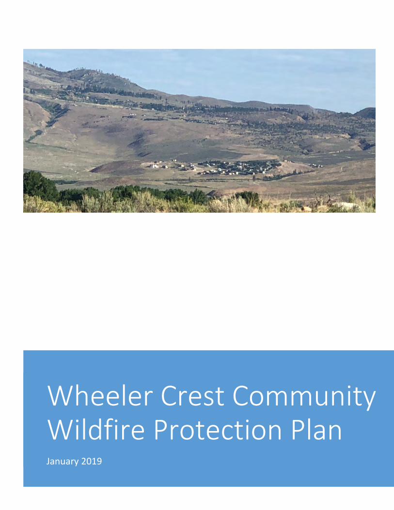
Wheeler Crest Community Wildfire Protection Plan January 2019
Barry Callenberger 1/1/19 CWPP

Wheeler Crest CWPP 1 January 1, 2019
DISCLAIMER:
This document analyzes wildfire hazard for the Wheeler Crest CWPP area and makes recommendations on ways that residents in the area can reduce their collective exposure to wildfire-caused losses.
Under typical wildfire burning conditions, all the project area has the potential to support very rapid rates of wildfire spread. There are NO low-priority areas for fire hazard mitigation in the project area.
Wildfire behavior is the product of numerous factors, some of which are weather-dependent and difficult or impossible to quantify. The suggestions in this assessment are based upon field surveys, technical analysis, and the professional experience of the authors. Errors may exist in this analysis and could include improper recording of field data due to GPS accuracy or surveyor error, computational errors, data entry mistakes and any other conceivable cause.
This data comprises a simplification of the physical environment intended to allow the authors to make general recommendations about reducing potential fire behavior at the community scale. Site-specific changes in fuel hazard and wildfire risk (such as annual mowing, grazing, and weed clearance, the growth of flammable ornamental plants and native vegetation, and other changes in the physical environment) will quickly render this data inaccurate.
THIS DATA DESCRIBES VEGETATION AND WILDFIRE HAZARD CONDITIONS IN THE PROJECT AREA AT A SINGLE POINT OF TIME, FALL 2017. ANY FUTURE USE OF THIS DATA FOR OTHER PLANNING, CODE ENFORCEMENT, OR HAZARD MITIGATION WORK IS NOT RECOMMENDED WITHOUT FIRST CHECKING PHYSICAL CONDITIONS ON THE GROUND.

Wheeler Crest CWPP 2 January 1, 2019
Table of Contents Wheeler Crest Community Wildfire Protection Plan Mutual Agreement Page ............................. 5
Executive Summary ........................................................................................................................ 6
1. Requirements of a Community Wildfire Protection Plan (CWPP) .......................................... 7
Federal ......................................................................................................................................... 7
State of California ....................................................................................................................... 7
Local Jurisdictions and Private Entities ...................................................................................... 8
2. Planning Process ..................................................................................................................... 10
Primary Stakeholders ................................................................................................................ 10
Public Education Effort ............................................................................................................. 11
Process and Plan Development ................................................................................................. 12
Community and Agency Involvement ...................................................................................... 14
3. Community Description .......................................................................................................... 16
Weather ..................................................................................................................................... 16
Demographics............................................................................................................................ 16
Vegetation ................................................................................................................................. 16
2017 Wildfire Hazard Assessment ............................................................................................ 16
Wildland Urban Interface .......................................................................................................... 19
Inyo National Forest Draft Land Management Plan ................................................................. 21
Role of Community Wildfire Protection Plans ......................................................................... 21
4. Community Hazard and Risk Assessment .............................................................................. 23
Wildland Fire Behavior ............................................................................................................. 23
Winds ........................................................................................................................................ 25
Current Risk Analysis/Resistance to Control ............................................................................ 26
Resistance to Control vs. Structure Losses During the 2015 Round Fire ................................. 27
Large Fire History ..................................................................................................................... 30
5. Community Preparedness for a Wildfire Emergency and Action Plan to Improve Preparedness ................................................................................................................................. 32
Wildfire is Coming! Are You Prepared?................................................................................... 32
Preventing Home Ignitions During Wildfires ........................................................................... 32
Summary of High-Priority Firesafe Building Improvements ................................................... 34
Compliance with California Defensible Space Regulations ..................................................... 35
Wildfire Evacuation .................................................................................................................. 35
Emergency Communications and Evacuation Warnings .......................................................... 36
Alerting and Warning People with Access and Functional Needs (PAFN) .............................. 37

Wheeler Crest CWPP 3 January 1, 2019
Water Sources or Availability of Water for Fire Suppression. ................................................. 37
Road Issues that could Prevent Easy Evacuation. ..................................................................... 37
6. Fuel Treatments Completed and Recommended Projects ...................................................... 39
USFS/BLM Projects in the CWPP Area ................................................................................... 40
CAL FIRE Projects ................................................................................................................... 43
Wheeler Crest Community Projects .......................................................................................... 43
Southern California Edison ....................................................................................................... 49
7. Monitoring and Evaluating the CWPP Recommendations and Accomplishments ................ 50
Monitoring and Evaluation........................................................................................................ 50
8. Local Agencies’ Wildfire Response Capabilities ................................................................... 54
Wheeler Crest Fire Department................................................................................................. 54
Paradise Fire Department .......................................................................................................... 56
Appendix A – Community Questionnaire Results........................................................................ 59
Appendix B - Fire Behavior Modeling ......................................................................................... 65
Vegetation and Fuel Model ....................................................................................................... 68
Appendix C - Wheeler Crest Community Service District Information....................................... 74
Appendix D - Quail Circle Emergency Evacuation Route ........................................................... 80
References/Links........................................................................................................................... 86
Wheeler Crest CWPP 4 January 1, 2019
Figure 1- Map of CWPP Area, (Base Map) .................................................................................. 13 Figure 2 - CWPP defined Wildland Urban Interface .................................................................... 20
Figure 3 - Map of Inyo National Forest Fire Management Zone for Alt B Modified .................. 22 Figure 4 - Fire Behavior Inputs and Outputs. ............................................................................... 23 Figure 5 - ERC Pocket Card for Wheeler Crest ............................................................................ 25 Figure 6 - Swall Meadows Resistance to Control Map and Destroyed Structures ....................... 28 Figure 7 - Paradise Resistance to Control and Destroyed Structures ........................................... 29
Figure 8 - Large Fire History Map ................................................................................................ 31 Figure 9 - BLM Fuels Projects...................................................................................................... 41 Figure 10 - USFS Fuels Projects ................................................................................................... 42 Figure 11 - Fire Safe Council Fuel Reduction Projects ................................................................ 48
Figure 12 - FireFamily Weather for FLAMMAP ......................................................................... 67 Figure 13 - Sample Vegetation Photo 1 ........................................................................................ 68 Figure 14 - Sample Vegetation Photo 2 ........................................................................................ 69 Figure 15 - Sample Vegetation Photo 3 ........................................................................................ 70
Figure 16 - Sample Vegetation Photo 4 ........................................................................................ 71
Figure 17 - Flame Length Map ..................................................................................................... 72 Figure 18 - Rate of Spread ............................................................................................................ 73
Table 1 - Core Planning Team ...................................................................................................... 14
Table 2 - Public Meeting Attendance ........................................................................................... 14
Table 3 - Stakeholders .................................................................................................................. 15 Table 4 - Hazard Assessment Results ........................................................................................... 17
Table 5 - Hazard Assessment Summary of Recommendations .................................................... 17 Table 6 - Resistance to control matrix .......................................................................................... 26 Table 7 - Effective Fire Suppression efforts ................................................................................. 27
Table 8 - Resistance to Control vs. Structure Losses During the 2015 Round Fire ..................... 27 Table 9 - Large fire history in the CWPP Area ............................................................................ 30
Table 10 - CWPP Project Data sheet ............................................................................................ 39 Table 11 - Ownership Acreage by WUI Zone .............................................................................. 40
Table 12 – Paradise Community Projects ..................................................................................... 44 Table 13 – Swall Meadows Community Projects ......................................................................... 46 Table 14 - Monitoring and Evaluating a CWPP ........................................................................... 53 Table 15 - Wheeler Crest Fire Department Response Capabilities .............................................. 55 Table 16 - Paradise Fire Department Response Capabilities ........................................................ 57
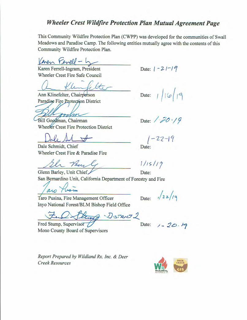

Wheeler Crest CWPP 6 January 1, 2019
Executive Summary This report provides a comprehensive, science-based assessment of wildfire hazards and risks within the communities of Swall Meadows and Paradise Camp (for the purposes of this report, these communities are referred to as "Wheeler Crest."). It establishes short-term and long-term strategies for creating more ‘wildfire-permeable’ conditions within the two communities. ‘Wildfire-permeable’ describes a condition where wildfires can burn through a community without destroying major infrastructure, homes, or other assets. No matter what hazard mitigation efforts are undertaken around the communities, weather conditions in the area guarantee uncontrollable wildfires will burn through the area in the future - mitigation efforts should focus on ‘hardening’ assets at risk in anticipation of these future fires. This document:
• Identifies existing hazardous fuel treatment projects and priorities for future projects. • Describes community wildfire safety education opportunities. • Estimates the hazards associated with wildland fire in proximity to communities. • Provides communities with cost-effective opportunities to reduce future wildfire losses.

Wheeler Crest CWPP 7 January 1, 2019
1. Requirements of a Community Wildfire Protection Plan (CWPP) CWPP documents have evolved over the past decade due to changes in Federal and State policies. The following is a list of how those requirements have evolved within the different agencies: Federal CWPPs are required to be consistent with and tiered to the 2010 Federal Land Assistance Management and Enhancement (FLAME) Act and The Healthy Forest Restoration Act (HFRA) of 2003. The Federal policies that implement these acts are the 10 Year Implementation Plan for HFRA and the ‘National Cohesive Wildland Fire Management Strategy (Cohesive Strategy)’ for the FLAME Act – The Cohesive Strategy is a national collaborative effort to make meaningful progress towards three goals:
• Resilient Landscapes • Fire Adapted Communities • Safe and Effective Wildfire Response
The Healthy Forest Restoration Act (HFRA) gives funding priority to projects identified in a CWPP (HFRA sec 103 [d1]) and directs Federal agencies to consider recommendations identified in CWPPs (HFRA sec. 103[b]) and implement those projects on federal lands (HFRA sec. 102[a]). State of California This analysis is consistent and supported by the findings in the 2010 Forest and Range Assessment of California. (California Department of Forestry and Fire Protection, Fire and Resource Assessment Program, 2010) http://frap.fire.ca.gov/data/assessment2010/pdfs/california_forest_assessment_nov22.pdf The 2010 Strategic Fire Plan for California (State Board of Forestry and California Department of Forestry and Fire Protection, November 2010) is the State’s road map for reducing the risk of wildfire. By placing the emphasis on what needs to be done long before a fire starts, the plan looks to reduce firefighting costs and property losses, increase firefighter safety, and contribute to ecosystem health. The plan was a cooperative effort between the State Board of Forestry and the California Department of Forestry and Fire Protection (CAL FIRE). The basic principles of the fire plan are as follows:
• Encourage community involvement to ensure that fire protection solutions meet local needs.
• Identify public and private community assets (natural and manmade) at risk to wildfire damage.
• Develop solutions and implement cooperative projects to reduce a community’s potential wildfire losses.

Wheeler Crest CWPP 8 January 1, 2019
Links: California Fire Plan http://cdfdata.fire.ca.gov/pub/fireplan/fpupload/fpppdf668.pdf CAL FIRE San Bernardino Unit Fire Plan http://cdfdata.fire.ca.gov/pub/fireplan/fpupload/fpppdf1603.pdf Swall Meadows and Paradise are a part of CAL FIRE, San Bernardino Unit, Battalion 4. Local Jurisdictions and Private Entities Local authorities such as fire departments, fire protection associations, county planning departments and other authorities can determine local needs for fuel treatments, equipment, personnel, training, mitigation needs, local ordinances or code adoption and enforcement. Local assessments can also identify which mitigation programs are best for a given community, such as NFPA’s “Firewise” and the International Association of Fire Chief’s (IAFC) “Ready, Set, Go!”
Regulation through codes and ordinances and subsequent enforcement is a major challenge for communities-at-risk since most of those communities are small. Even if they have authority to adopt codes, many communities do not have the resources to enforce them.
Mono County Planning for Wildfire Mitigation Mono County has done a considerable amount of wildfire mitigation planning:
• Mono County General Plan - https://monocounty.ca.gov/planning/page/general-plan • Mono County Hazardous Mitigation Plan (draft format):
https://monocounty.ca.gov/sites/default/files/fileattachments/planning_division/page/10087/mono_co._town_of_mammoth_lakes_hmp_public_review_draft_june_2018_sm.pdf
• The Mono County CWPP https://monocounty.ca.gov/sites/default/files/fileattachments/community_development/page/5697/monocountycwpp.pdf
Southern California Edison (SCE) Electric utilities throughout California fall under the direction of the California Public Utilities Commission (CPUC), which updated their fire safety rules after the wildfires of 2017. This new rulemaking process mapped high fire-hazard areas in the State and requires utilities to develop mitigations to reduce fire ignition hazards posed by their electrical transmission infrastructure. The CWPP area falls into an area mapped as Tier 2 or ‘elevated wildfire risk’. It is the responsibility of SCE to develop and submit a plan to reduce the risk of fire ignitions by overhead facilities in high fire-threat areas during extreme fire-weather events. This planning effort reached out to SCE for specific information on the status of their planning work to comply with these new CPUC rules. Due to the litigation regarding damages incurred in the Round Fire, SCE was not able to provide information for this CWPP. Information on the new CPUC rules can be found at http://www.cpuc.ca.gov/firethreatmaps.

Wheeler Crest CWPP 9 January 1, 2019
The Los Angeles Department of Water and Power (LADWP) LADWP owns land near the communities identified in the CWPP and should become a part of solving the wildfire problems associated with the hazards posed by their operations within the community base map area. Eastern Sierra Land Trust (ESLT) ESLT has participated in planning meetings for this CWPP and their involvement is required for the implementation of several of the proposed projects. They can also help with wildfire safety education for visitors to lands under their management. http://www.eslt.org/
California Department of Fish and Wildlife (CDFW) CDFW is a landowner within the area and has participated in the stakeholder meetings. Their involvement is important regarding advice on protection of important natural resources and implementation of fire safe maintenance of their properties within the Wildland Urban Interface (WUI) boundary.

Wheeler Crest CWPP
10 January 1, 2019
2. Planning Process
Primary Stakeholders Government Agencies
• United State Forest Service, Inyo National Forest • Bureau of Land Management • CAL FIRE, San Bernardino Unit • Mono County • California Department of Fish and Wildlife
Non-Government Agency Involvement • Wheeler Crest Fire Safe Council • Eastern Sierra Land Trust
Fire Department Involvement • Wheeler Crest Fire • Paradise Fire • CAL FIRE (limited protection responsibility) • US Forest Service (direct protection responsibility)
Invited Parties that Did Not Participate • Southern California Edison • Los Angeles Department of Water and Power
Primary CWPP Development Team Members and Responsibilities
The Wheeler Crest CWPP Project Team and consultants Deer Creek Resources and WildlandRx, were responsible for the following:
• Facilitating and coordinating the over-all CWPP process with, federal agencies, and other key stakeholders.
• Conducting landscape-scale hazard, values, and risk assessments for all lands within the designated CWPP area.
• Assisting fire departments in providing general discussions and assessments of their departments.
• Providing technical expertise in developing prescriptions for wildfire mitigation treatments.
• Assembling and maintaining the final CWPP document. • Assisting in public education efforts for the CWPP. • Writing a general assessment of fire suppression resources in the project area.
CAL FIRE • Provided funding for the CWPP. • Provided oversight of the CWPP process. • Provided guidance and technical expertise for CWPP development. • Provided information on past, current, and future mitigation efforts around the county.

Wheeler Crest CWPP
11 January 1, 2019
United States Forest Service (USFS)/Bureau of Land Management (BLM) Interagency Fire Management Organization
• Provided information to past, current, and future mitigation work being conducted on Forest Service properties within or adjacent to the CWPP area.
• Provided a general discussion on Forest Service wildfire programs (suppression, mitigation, training, prevention, etc.).
Mono County • The County completed a county wide CWPP in 2009 that provides a base for
communities in the county. • The County currently has created a draft Multi-Jurisdictional Hazard Mitigation plan
and wants input from Wheeler Crest. • The Mono County Department of Public Works has provided road development
assistance. • Provides local fire safe regulations.
Joint Tasks • Identifying appropriate landscape-scale hazard reduction areas throughout the CWPP
area. • Identifying WUI boundaries throughout CWPP area. • Developing an implementation plan for this project. • Facilitating and/or participating in community meetings that allow the public and other
stakeholders to provide input and stay informed about this process. • Outreach and work to create bottom-up interest in WUI communities to develop smaller-
scale CWPPs and project-specific implementation plans. • Assisting interested WUI communities in developing smaller scale CWPPs and executing
project-specific implementation plans.
Public Education Effort Public education is a key component to the successful implementation of any CWPP. The Wheeler Crest Fire Safe Council, local fire prevention officers, law enforcement officers, CAL FIRE and federal agencies should continue to use the CWPP development team to implement required residential clearance standards and evacuation planning.
It is important to remind the communities that residential clearance and roadside clearance are the responsibilities of the community not the fire department. Communities may have to conduct their own work days to clear the roadsides so fire equipment and civilians can safely travel the roads during fire events. Mono County Public Works Department may need to widen the roads and put in turn arounds to allow fire equipment space to turn around. These are only a few of the responsibilities of the communities to keep them safe from a wildfire. The job of the fire departments and the Fire Safe Council is to educate the community about what needs to be done to provide for safe ingress and egress for residents and fire equipment.
One of the primary purposes of the Fire Safe Council is to educate the public about wildfire safety. It is also the responsibility of the Fire Safe Council to keep the community informed of projects and to prepare grant proposals.

Wheeler Crest CWPP
12 January 1, 2019
Process and Plan Development Planning Area Boundaries The Planning area boundary was established within the volunteer fire department boundaries and additional areas were added based on the analysis of the WUI, urban core, defense zone and the threat zones. The draft planning area boundary was presented to the stakeholders at the first and second stakeholders meeting and a final area was then identified for the CWPP. See Figure 1. Stakeholder Meetings Meetings were held in Swall Meadows and were attended by the USFS/BLM Interagency Fire Management Organization, CAL FIRE, California Department of Fish and Wildlife, Eastern Sierra Land Trust, Wheeler Crest Community Water District, Wheeler Crest Fire Protection District, Paradise Fire Protection District and Wheeler Crest Fire Safe Council. Community Meetings Meetings were held in Swall Meadows and Paradise to discuss community concerns and the CWPP process as well to promote input to the CWPP. In addition, an online questionnaire was developed by the Fire Safe Council in order to gather additional input from the community. The results of the questionnaire can be found in Appendix A. Funding This project was funded by a grant from CAL FIRE’s 2016-2017 State Responsibility Area Fire Prevention Fund (SRAFPF) and Tree Mortality (TM) Grant Program.

H
H
H
H
H
HH
H
H
H
H
H
H
HH
H
H
H
H
H
H
HH
H
H
H
H
H
H
H
H
HH
H
H
H
H
H
H
H
H
H
H
H
H
H
H
H
H
H
H
H
H
H
H
H
H
H
H
H
H
H
H
H
H
H
H H
H
HH
H
H
H
H
H H
H
HH
H
H
H
H
HH
H
HH
H
H
H
H
H
HH
HH H
H H H
H
H
H
H
H
H
H
HH
H H H
H
H
H
HH
H
HH H H H
H
H
H
H
HH
H
H
H
H
H
HH
H
H
H
H
HH
H
H
H
H
H
HH
H
H
H
H
H
H
H
H
H
H
H
HH
HH
H
H
H
H
H
H
H
H
H
H
H
H
H
H
HH
H
H
H
H
H
H
H
H
H
H
H
HH
H
H
H
H
H
H
H
H
H
H
HH
H
H
H
H
H
H
H
H
H
H
H
H
H
H
H
HHH
H H HH HHH HH
HH
H
HH
H
HH
HH HH HH H
H
H
H
H H
H
H
H
H
H H
H
H
H
HH H
H
H
H
H
H
H
H
H
HH
H
H
HH
H
H
H
H
H
H
H
HH
H
H
HH
H
H
H
H
H
H
H
HH
H
H
H
H
H
H
H
HH
H HH
H
H
H
H
H
H
H
H
H
H
H
H
H
H
H
H
HH
H HH
H
H
H
H
H
H
H
H
H
HH
H
H
H
H
H
H
H H H
H
H
H
H
H
H
H
H
H
HH
H
H
H
H
H
H
HH
H
H
H
H
HH
H
H
H
H
HH
H H
HH
HH
HH
HH H H
HH
HH
HH
HH H
H
H
H
HH
H H
H
H
H
H
H
H
H
H
H
H
H
H
HH H
H HH
H
H
H
H
H
H
H
H
H
HH
H
HH
H HH
H
H
H
H
H
H
H
H
H
H
H
HH
H HH
H
H
H
H
H
H
H
H
H
H
H
H H
H
H
H H
H
H
H H
H
H
H
H
H
H
H
H
H
H
H
H
H
H
H
H
H
H
H
H
H
H
H
H
H
H
H
H
H
H
HH
H
H
H
H
H
H
H
H
H
H
H
H
H
H
H
H
H
H
H
H
H
H
H
H
H
H
H
H
H
HH
H
H
H
H
HH
H
H
H
H
HH
HH
H
HHH
H
HH
H
H
H
H
HH
H
H
H
H
HH
HH
H
HHH
H
H
H
H
H
H
H
HH
H
H
H
H
HH
HH
H
H
H
H
HH
H
H
H
H
H
HH
H
H
H
H
H
HH
H
H
H
H
H
HH
H
H
H
H
H
HH
HH
HH
H
HH
H
H
H
H
H
H
H
H
H
H
H
HHH
H
H
H
H
H
H
H
HH
H
H
H
H
H
H
H
H
H
H
H
H
H
H
H
H
H
HH
H
H
H
H
H
H
H
H
H
H
H
H
H
H
H
H
H
H
H
H
H
H
H
H
H
H
H
H
H
H
H
H
HH
H
H
H
HH
H
H
H
H
HHH
H
H
H
H
H
H
HH
HH
H
H
H
H
H
HH
H
H
H
H
H
HH
HH
HH
H
H
H
HH
HH
H
H
H
H
HH
HH
H
H
H H H
H
H
H
H
H
H
H
H
H
H
H
H
H
H
H
H
H
H
H
H
H
H
H
H
H
H H
H
H
H
H
H
H
H
H
H
H
H
H
H H
H
H
H
H
H
H
H
H
H
H
H
H
H H
H
H
H
H
H
H
H
H
H
H
H
H
H
H
H
H
H
H
H
H
H
H
H
HH H
H
H
H
H
H
H
H
H
HH H
H
H
H
H
H
H
H
H
H H H
H
H
H
H
HH
H
HH
HH
H
H
HH
H
H H
HH
H
H
H H
H
H H
HH
H
HH
HH
H
H
H
H
H
H
HH
H
H
H
H
H
H
H
HH
H
H
H
H
H
H
H
H
H
H H
H
H
H
H
HH
H
H
H
H
H
H
H H
H
H
H
H
HH
H
H
H
H
H
H
HH
H
H
H
H
H H
H
H
H
H
H
H
H
H
H
H
H
H
H
HH
H
H
H
H
H
H
H
H
H
H
H
H
H
H
H
H
H
H
H
H
H
H
H
H
H
H
H
H
H
H
H
H
H
H
H
H
H
H
H
H
H
H
H
H
H
H
H
H
H
H
H
H
H
H
H
H
H
H
H
H
H
H
H
H
H
H
H
H
H
H
H
H
H
H
H
H
H
H HH H
H
H
H
H
H
H
H
H
H
H
H
H
H
H
H HH H
H
H
H
H
H
H
H
H
H
H
H
H
H
H
H HH H
H
H
H
H
H
H
H
H
H
H
H
H
H
H
H
H
H
H
H
H
H
H
H
H
H
H
HH
HH
H
H
H
H
H
H
H
H
H
H
H
H
H
H
H
H
H
H
H
HH
HH
H
H
H
H
H
H
H
H
H
H
H
H
H
H
H
H
H
H
H
HH
HH
H
H
H
H
H
H
H
H
H
H
H
HH
H
H
H
H
H
H
H
H
H
H
H
H
H
HH
H
H
H
H
H
H
H
H
H
H
H
H HH H
H
H
H
H
H
H
H
H
H
H
H
H
H
H
H
H
H
H HH H
H
H
H
H
H
H
H
H
H
H
H
H
H
H
H
H
H
H HH H
H
H
H
H
H
H
H
HH
H
H
H
H
H
H
HH
H
H
H
H
H
H
H
H H
H
H
H
H
H
H
H
H
H
H
H
H
H
H
H
H H
H
H
H
H
H
H
H
H
H
H
H
H
H
H
H
H
H
H
H
H
H
HH
H
H
H
H
HH
H
H
HH
H
H
H
H
HH
H
H
H
H
H
H
H
H
H
H
H
H
H
H
H
H
H
H
HH
H
H
H
H
H
H
H
HH
H
H
H
H
H
H
H
H
H
H
H
H
H
H
H
H
H
H
HH
H
H
H
H
H
H
H
H
H
H
H
H
H
H
H
H
H
HH
H
H
H
H
H
H
H
H
H
H
H
H
H
H
H
H
H
HH
H
H
H
H
H
H
H
HH
HH
H
H
H
H
H
H
H
HH
H
H
H
H
H
H
H
H
HH
H
H
H
H
H
H
H
H
H
H
H
H
H
H
H
H
H
H
H
H
H
H
H
H
HH
H
H
H
H
H
H
H
H
H
H
HH
H
H
H
H
H
HH
H
H
H
H
H
H
H
H
H
H
HH
AA
AA
AA
AA
AA
AA
AA
AA
AA
AA
AA
AA
AA
AA
AA
AA
AA
AA
AA
AA
AA
AA
AA
AA
AA
AA
AA
AAAA
AAAA
AAAA
AAAA
AAAA
AAAA
AAAA
AA AAAA
AAAA
AA AAAA AA
AA
AA AAAA
AA
AA
AA
AA
AA
AA
AA
AA
AA
AA
AA
AA
AA
AA
AA
AA
AA
AA
AA
AA
AA
AA
AA
AA
AA
AA
AA
AA
AA
AA
AA
AA
AA
AA
AA
AA
AA
"
"
"
"
"
"
"
"
"N
N
N
N
N
N
N
N
O
O
O
O
O
Spring
29
LOWER
LOWER
ROAD
35
4WD
19
Ainslee
7
Creek
1317
20
ROCK CREEK
ROAD
18
11
Rock
31
4WD
S h e r w i n
26
ROAD
Spring
4WD
LOWER
Meadow
25
14
4WD
Spring
30
ROAD
36
Low er Rock
NATIO NAL
ROCK CREEK
Witcher
Creek
Spring
Spring
ParadiseCamp
FO RE STBO UND ARY
Springs
N A T I O N A L
FO RE ST
Spring
H i l l
Creek
Prospects
12
SherwinHill
R 3
1 E
2423
Sk y MeadowRanch
SwallMeadows
R 3
0 E
FORE
ST
ROCK CREEK
Creek
BOUN
DARY
F O R E S T
NATI
ONAL
Scenic Point
I N Y O
Creek
4WD
R 3
1 E
R 3
0 E
4WD
4WD
M U I R
W I L D E R N E S S
£¤395
Deer
Peak
Trl
Rimrock Dr
Sky Meadow Rd
Lower Rock Creek RdValle
yVi
ew Rd
P ine
Dr
RidgeView
Westridge
Rd
Will
ow R
d
Mt View Dr
6400
8200
80007800
7600
7400
7200
7000
6800
90008800
8600 8400
9400 9200
9000
4800
5000
5200
5400
9200
9000
7600
6600
6000
6200
5600
5800
9000
6800
6600
9800
9600
7800
78007600
8600
7400
7200
9000
66007000
Wheeler Crest CWPP - 2018
Ü0 10.5
Miles
Figure 1: Base Map
Fire DistrictParadise FPD
Wheeler Crest FPD
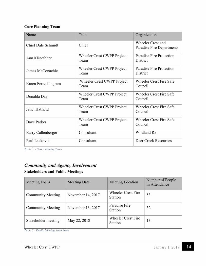
Wheeler Crest CWPP
14 January 1, 2019
Core Planning Team
Name Title Organization
Chief Dale Schmidt Chief Wheeler Crest and Paradise Fire Departments
Ann Klinefelter Wheeler Crest CWPP Project Team
Paradise Fire Protection District
James McConachie Wheeler Crest CWPP Project Team
Paradise Fire Protection District
Karen Ferrell-Ingram Wheeler Crest CWPP Project Team
Wheeler Crest Fire Safe Council
Donalda Day Wheeler Crest CWPP Project Team
Wheeler Crest Fire Safe Council
Janet Hatfield Wheeler Crest CWPP Project Team
Wheeler Crest Fire Safe Council
Dave Parker Wheeler Crest CWPP Project Team
Wheeler Crest Fire Safe Council
Barry Callenberger Consultant Wildland Rx
Paul Lackovic Consultant Deer Creek Resources
Table 1 - Core Planning Team
Community and Agency Involvement Stakeholders and Public Meetings
Meeting Focus Meeting Date Meeting Location Number of People in Attendance
Community Meeting November 14, 2017 Wheeler Crest Fire Station 53
Community Meeting November 13, 2017 Paradise Fire Station 52
Stakeholder meeting May 22, 2018 Wheeler Crest Fire Station 13
Table 2 - Public Meeting Attendance

Wheeler Crest CWPP
15 January 1, 2019
Stakeholders
Name Title Organization
Heather Stone Veg/Fuels Planner USFS/BLM
Daniel O’Conner Veg/Fuels Leader USFS/BLM
Alisa Ellsworth Senior Environmental Scientist CA Dept Fish and Wildlife
Michael Draper Community Development Mono County
Chief Dale Schmidt, Mike Day, Glenn Inouye Wheeler Crest Fire
Department
Chief Dale Schmidt, Ann Klinefelter, James McConachie
Paradise Fire Department
Randy Keller Board Member Eastern Sierra Land Trust
Karen Ferrell-Ingram Wheeler Crest CWPP Project Team
Fire Safe Council
Donalda Day Wheeler Crest CWPP Project Team
Fire Safe Council
Henry Herrera Unit Forester CAL FIRE
Paul Melendez Division Chief CAL FIRE
Sagar Fowler Battalion Chief CAL FIRE
Matt Edmiston Battalion Chief CAL FIRE
Ian McBride Forestry Assistant CAL FIRE
Table 3 - Stakeholders

Wheeler Crest CWPP
16 January 1, 2019
3. Community Description Weather The eastern side of the Sierra Nevada Range has average summer temperatures from the 60s to the low 80s with winter temperatures in the low 20s to upper 40s. Precipitation averages less than 12 inches per year, coming mainly between November and April. Humidity varies throughout the year and is often extremely low during winter months. Summer humidity is often the below 20 percent and can drop below 10 percent for long periods of time
Demographics Swall Meadows is located in southern Mono County, California. The community is residential, including second homes and a volunteer fire department; it has no commercial development. Geographically, it sits partway up the Sherwin Grade below the Wheeler Crest of the eastern Sierra Nevada mountains, at an elevation range of approximately 6,000 to 7,000 feet (1,800 to 2,100 m). It is accessed from "old HWY 395", or Lower Rock Creek Rd. Swall Meadows is located approximately 20 miles (32 km) north of Bishop and 25 miles (40 km) south of Mammoth Lakes. The 2010 United States Census reported that Swall Meadows had a population of 220 with 128 housing units at an average density of 28.7 per square mile (11.1/km).1
Paradise Paradise Camp is a residential community that is also in southern Mono County, located approximately five miles south of Swall Meadows along Lower Rock Creek Road and approximately 15 miles north of Bishop, California. It is accessed from "old HWY 395", or Lower Rock Creek Rd. It has a volunteer fire department and no commercial development. The 2010 United States Census reported that Paradise had a population of 153 with 87 housing units at an average density of 20.0 per square mile (7.7/km).2
Vegetation The predominate vegetation is grass, blackbrush, big sagebrush, antelope bitterbrush and rabbitbrush at the low elevations with some single-leaf pinyon pine, Sierra juniper and Jeffrey pine stands at the higher elevations. All the forested areas have continuous grass in the understory, with scattered sagebrush. Much of the vegetation in the CWPP area was burned over during the Round Fire in February 2015.
2017 Wildfire Hazard Assessment In November 2017, the CWPP consultants conducted surveys of fuel loading, structure clearance, construction, and proximity to undeveloped lots for 225 developed parcels in the Wheeler Crest CWPP area. Parcels were scored based on 5 criteria, defensible space, fire resistant construction, fuel loading, proximity to undeveloped lots and mean slope >20% which was determined using a digital elevation model (DEM). These individual scores were added together, generating an overall hazard score on a scale of 0-5, 5 being the highest hazard. 1 Wkipedia, September 28, 2018 2 Wikipedia

Wheeler Crest CWPP
17 January 1, 2019
Surveyors also provided vegetation management recommendations for reducing the overall hazard level as well as additional comments regarding the fire safe condition of the lots. The full hazard assessment document is available for download at, https://sites.google.com/view/wheelercrestcwpp/documents#h.p_Y0zXignGTba1.
Results
Most of the parcels in Wheeler Crest, 66%, were given a rating of two or three and 20% of the parcels received a rating of four. Only 4% of parcels were given a rating of 5 while 2% of parcels received a rating of 0. Table 4 below summarizes the results of the hazard assessment survey.
Hazard Rating
0 Low 1 2 3 4
5 Extreme Total
Total 5 18 61 88 44 9 225 Table 4 - Hazard Assessment Results
Surveyors also made hazard reduction recommendations based upon their knowledge of fire behavior and professional firefighting experience. The most recommended treatment in the survey is “Remove flammable vegetation near structures,” used 62% of the time. The next most frequently suggested treatment option was; “Good-maintain in existing condition,” used 16% of the time. Table 5, below, summarizes the recommended treatments.
Discussion
The survey results indicate that many of the lots within the Wheeler Crest CWPP area are currently in a relatively fire safe condition. However, this should not be taken as grounds for complacency - things can always be improved. To maintain low hazard levels, the community must be vigilant in maintaining good existing conditions as well as treating problem areas. Landowners must take on the responsibility for creating a fire safe environment, for themselves and their neighbors.
The reference photos found in the Hazard Assessment, show the wide variety of conditions across the survey area and suggest strategies for reducing the hazard.
Recommendation Total
Good - maintain in existing condition 37
Major thinning or brushing work needed 3
Prune low branches/remove ladder fuels 9
Remove dead trees 8
Remove fine grassy fuels 7
Remove flammable vegetation near structures 140
Remove surface fuels 13
Thin small trees 8
Table 5 - Hazard Assessment Summary of Recommendations

Wheeler Crest CWPP
18 January 1, 2019
Managing fuels can be very expensive and energy intensive. However, it is not as costly or energy intensive as losing a home and everything in it. Fires will continue to burn in the area, winds will continue to push them out of our control, sagebrush and cheat grass will continue to sprout from the ground.
We suggest maintaining the community in a condition that is ‘permeable to wildfire’. This requires landowners to create defensible space around their homes, retrofit them with fire resistant building materials, and get to know how fire works on this landscape.

Wheeler Crest CWPP
19 January 1, 2019
Wildland Urban Interface "…the Wildland-Urban Interface (WUI) is the area where houses meet or intermingle with undeveloped wildland vegetation (USDA and USDI 2001)3." This national definition came from the Federal Register 66 of 2001. Many changes have occurred to the terminology that surrounds the definition of a WUI area, but the basic definition is unchanged. The WUI today is broken into two distinct areas, the defense zone is the area within .5 mile of the urban core and the threat zone is the area within 1.25 miles of the defense zone. Figure 2 shows the WUI areas developed for the CWPP.
Defense Zone. The Defense Zone is the area surrounding the communities up to .5 miles outside the community. This area should have priority when it comes to fuels reduction: specifically fuels reduction projects and California Public Resources Code (CPRC) 4291 (CAL FIRE Defensible Space Requirements) enforcement. The intent of treatment of the fuels in the defense zone is reduce the fire behavior under extreme weather conditions so that suppression resources can adequately engage the fire before it reaches homes and other important community infrastructure. This means that the fire behavior should be such that the flame lengths are less than 4 feet and the rates of spread are slow enough for ground resources to suppress the fire.
Threat Zone. The Threat Zone is an extension of the Defense Zone. It is a lower priority for treatments except for those areas where fires are known to start, or a fire start could spread rapidly into the community. Evacuation routes within the threat zone are another exception to treatment priorities, in the case of evacuation routes they are considered part of the defense zone and treated with high priority.
3 USDA and USDI. 2001. Urban wildland interface communities within vicinity of Federal lands that are at high risk from wildfire. Federal Register 66:75 1-777.
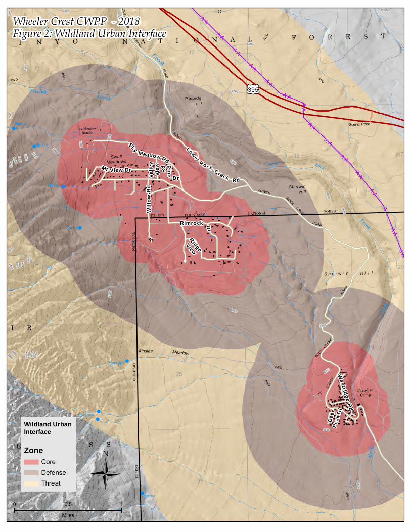
H
H
H
H
H
HH
H
H
H
H
H
H
HH
H
H
H
H
H
H
HH
H
H
H
H
H
H
H
H
HH
H
H
H
H
H
H
H
H
H
H
H
H
H
H
H
H
H
H
H
H
H
H
H
H
H
H
H
H
H
H
H
H
H
H H
H
HH
H
H
H
H
H H
H
HH
H
H
H
H
HH
H
HH
H
H
H
H
H
HH
HH H
H H H
H
H
H
H
H
H
H
HH
H H H
H
H
H
HH
H
HH H H H
H
H
H
H
HH
H
H
H
H
H
HH
H
H
H
H
HH
H
H
H
H
H
HH
H
H
H
H
H
H
H
H
H
H
H
HH
HH
H
H
H
H
H
H
H
H
H
H
H
H
H
H
HH
H
H
H
H
H
H
H
H
H
H
H
HH
H
H
H
H
H
H
H
H
H
H
HH
H
H
H
H
H
H
H
H
H
H
H
H
H
H
H
HHH
H H HH HHH HH
HH
H
HH
H
HH
HH HH HH H
H
H
H
H H
H
H
H
H
H H
H
H
H
HH H
H
H
H
H
H
H
H
H
HH
H
H
HH
H
H
H
H
H
H
H
HH
H
H
HH
H
H
H
H
H
H
H
HH
H
H
H
H
H
H
H
HH
H HH
H
H
H
H
H
H
H
H
H
H
H
H
H
H
H
H
HH
H HH
H
H
H
H
H
H
H
H
H
HH
H
H
H
H
H
H
H H H
H
H
H
H
H
H
H
H
H
HH
H
H
H
H
H
H
HH
H
H
H
H
HH
H
H
H
H
HH
H H
HH
HH
HH
HH H H
HH
HH
HH
HH H
H
H
H
HH
H H
H
H
H
H
H
H
H
H
H
H
H
H
HH H
H HH
H
H
H
H
H
H
H
H
H
HH
H
HH
H HH
H
H
H
H
H
H
H
H
H
H
H
HH
H HH
H
H
H
H
H
H
H
H
H
H
H
H H
H
H
H H
H
H
H H
H
H
H
H
H
H
H
H
H
H
H
H
H
H
H
H
H
H
H
H
H
H
H
H
H
H
H
H
H
H
HH
H
H
H
H
H
H
H
H
H
H
H
H
H
H
H
H
H
H
H
H
H
H
H
H
H
H
H
H
H
HH
H
H
H
H
HH
H
H
H
H
HH
HH
H
HHH
H
HH
H
H
H
H
HH
H
H
H
H
HH
HH
H
HHH
H
H
H
H
H
H
H
HH
H
H
H
H
HH
HH
H
H
H
H
HH
H
H
H
H
H
HH
H
H
H
H
H
HH
H
H
H
H
H
HH
H
H
H
H
H
HH
HH
HH
H
HH
H
H
H
H
H
H
H
H
H
H
H
HHH
H
H
H
H
H
H
H
HH
H
H
H
H
H
H
H
H
H
H
H
H
H
H
H
H
H
HH
H
H
H
H
H
H
H
H
H
H
H
H
H
H
H
H
H
H
H
H
H
H
H
H
H
H
H
H
H
H
H
H
HH
H
H
H
HH
H
H
H
H
HHH
H
H
H
H
H
H
HH
HH
H
H
H
H
H
HH
H
H
H
H
H
HH
HH
HH
H
H
H
HH
HH
H
H
H
H
HH
HH
H
H
H H H
H
H
H
H
H
H
H
H
H
H
H
H
H
H
H
H
H
H
H
H
H
H
H
H
H
H H
H
H
H
H
H
H
H
H
H
H
H
H
H H
H
H
H
H
H
H
H
H
H
H
H
H
H H
H
H
H
H
H
H
H
H
H
H
H
H
H
H
H
H
H
H
H
H
H
H
H
HH H
H
H
H
H
H
H
H
H
HH H
H
H
H
H
H
H
H
H
H H H
H
H
H
H
HH
H
HH
HH
H
H
HH
H
H H
HH
H
H
H H
H
H H
HH
H
HH
HH
H
H
H
H
H
H
HH
H
H
H
H
H
H
H
HH
H
H
H
H
H
H
H
H
H
H H
H
H
H
H
HH
H
H
H
H
H
H
H H
H
H
H
H
HH
H
H
H
H
H
H
HH
H
H
H
H
H H
H
H
H
H
H
H
H
H
H
H
H
H
H
HH
H
H
H
H
H
H
H
H
H
H
H
H
H
H
H
H
H
H
H
H
H
H
H
H
H
H
H
H
H
H
H
H
H
H
H
H
H
H
H
H
H
H
H
H
H
H
H
H
H
H
H
H
H
H
H
H
H
H
H
H
H
H
H
H
H
H
H
H
H
H
H
H
H
H
H
H
H
H HH H
H
H
H
H
H
H
H
H
H
H
H
H
H
H
H HH H
H
H
H
H
H
H
H
H
H
H
H
H
H
H
H HH H
H
H
H
H
H
H
H
H
H
H
H
H
H
H
H
H
H
H
H
H
H
H
H
H
H
H
HH
HH
H
H
H
H
H
H
H
H
H
H
H
H
H
H
H
H
H
H
H
HH
HH
H
H
H
H
H
H
H
H
H
H
H
H
H
H
H
H
H
H
H
HH
HH
H
H
H
H
H
H
H
H
H
H
H
HH
H
H
H
H
H
H
H
H
H
H
H
H
H
HH
H
H
H
H
H
H
H
H
H
H
H
H HH H
H
H
H
H
H
H
H
H
H
H
H
H
H
H
H
H
H
H HH H
H
H
H
H
H
H
H
H
H
H
H
H
H
H
H
H
H
H HH H
H
H
H
H
H
H
H
HH
H
H
H
H
H
H
HH
H
H
H
H
H
H
H
H H
H
H
H
H
H
H
H
H
H
H
H
H
H
H
H
H H
H
H
H
H
H
H
H
H
H
H
H
H
H
H
H
H
H
H
H
H
H
HH
H
H
H
H
HH
H
H
HH
H
H
H
H
HH
H
H
H
H
H
H
H
H
H
H
H
H
H
H
H
H
H
H
HH
H
H
H
H
H
H
H
HH
H
H
H
H
H
H
H
H
H
H
H
H
H
H
H
H
H
H
HH
H
H
H
H
H
H
H
H
H
H
H
H
H
H
H
H
H
HH
H
H
H
H
H
H
H
H
H
H
H
H
H
H
H
H
H
HH
H
H
H
H
H
H
H
HH
HH
H
H
H
H
H
H
H
HH
H
H
H
H
H
H
H
H
HH
H
H
H
H
H
H
H
H
H
H
H
H
H
H
H
H
H
H
H
H
H
H
H
H
HH
H
H
H
H
H
H
H
H
H
H
HH
H
H
H
H
H
HH
H
H
H
H
H
H
H
H
H
H
HH
AA
AA
AA
AA
AA
AA
AA
AA
AA
AA
AA
AA
AA
AA
AA
AA
AA
AA
AA
AA
AA
AA
AA
AA
AA
AA
AA
AAAA
AAAA
AAAA
AAAA
AAAA
AAAA
AAAA
AA AAAA
AAAA
AA AAAA AA
AA
AA AAAA
AA
AA
AA
AA
AA
AA
AA
AA
AA
AA
AA
AA
AA
AA
AA
AA
AA
AA
AA
AA
AA
AA
AA
AA
AA
AA
AA
AA
AA
AA
AA
AA
AA
AA
AA
AA
AA
"
"
"
"
"
"
"
"
"N
N
N
N
N
N
N
N
O
O
O
O
O
Spring
29
LOWER
LOWER
ROAD
35
4WD
19
Ainslee
7
Creek
1317
20
ROCK CREEK
ROAD
18
11
Rock
31
4WD
S h e r w i n
26
ROAD
Spring
4WD
LOWER
Meadow
25
14
4WD
Spring
30
ROAD
36
Low er Rock
NATIO NAL
ROCK CREEK
Witcher
Creek
Spring
Spring
ParadiseCamp
FO RE STBO UND ARY
Springs
N A T I O N A L
FO RE ST
Spring
H i l l
Creek
Prospects
12
SherwinHill
R 3
1 E
2423
Sk y MeadowRanch
SwallMeadows
R 3
0 E
FORE
ST
ROCK CREEK
Creek
BOUN
DARY
F O R E S T
NATI
ONAL
Scenic Point
I N Y O
Creek
4WD
R 3
1 E
R 3
0 E
4WD
4WD
M U I R
W I L D E R N E S S
£¤395
Deer
Peak
Trl
Rimrock Dr
Sky Meadow Rd
Lower Rock Creek RdValle
yVi
ew Rd
P ine
Dr
RidgeView
Westridge
Rd
Will
ow R
d
Mt View Dr
6400
8200
80007800
7600
7400
7200
7000
6800
90008800
8600 8400
9400 9200
9000
4800
5000
5200
5400
9200
9000
7600
6600
6000
6200
5600
5800
9000
6800
6600
9800
9600
7800
78007600
8600
7400
7200
9000
66007000
Wheeler Crest CWPP - 2018
Wildland UrbanInterface
ZoneCoreDefenseThreat Ü
0 10.5
Miles
Figure 2: Wildland Urban Interface

Wheeler Crest CWPP
21 January 1, 2019
Inyo National Forest Draft Land Management Plan The Inyo National Forest Draft Land Management Plan (LMP) ‘Alternative B Modified’ takes a different approach to defining the WUI – replacing the distance-based Defense, and Threat Zones with strategic fire management zones. The USFS WUI defined in the Draft Land Management Plan (Figure 3) is different from the WUI created for this project. That difference is due to several reasons within the draft Inyo plan. The Forest only has its boundary on the north and northwest side of Swall Meadows. The forest has identified that part of the community in its fire management zone for communities. The community needs to stay engaged with the Land Management Plan process to be sure any concerns that the community may have are addressed. The following is a quote from the Draft Decision Notice for the LMP
“The approach to fire management meets the needs for public safety, given that communities are located immediately next to the national forest, and supports increasing the pace and scale of restoration. Components of the final plan (alternative B-modified) related to fire management strive to achieve both. The plan establishes four zones (as management areas) with plan components associated with them. The zones represent a range of different objectives (protection and resource) and conditions (social, ecological, and environmental) in which fires can be managed to achieve multiple objectives.”4
The Healthy Forest Restoration Act of 2003 specifically states how the community WUI should be defined by federal agencies without a CWPP. The intent of any CWPP is to define the WUI for the community. This document has defined it along with input from the community and local fire departments. The CWPP bases the WUI on population density and wildfire threats to the community.
Role of Community Wildfire Protection Plans The HFRA provides communities with a tremendous opportunity to influence where and how federal agencies implement fuel reduction projects on federal lands and how additional federal funds may be distributed for projects on nonfederal lands. A CWPP is the most effective way to take advantage of this opportunity.5
Although there are differences in Defense and Threat Zone distances within USFS documents, the key is that land managers, fire experts and the community work together on a project by project basis to collaborate and decide on appropriate application of Defense and Threat Zone distances based on all the factors influencing fire including topography, fuels, climate and fire history. This allows the community to influence Forest Service projects as they may impact the communities in and around the Forest Service managed lands.
4 Draft Record of Decision for the Inyo National Forest Land Management Plan, U. S. Forest Service August 2018 page 8 5 Preparing a Community Wildfire Protection Plan, Handbook for Wildland Urban Interface Communities, March 2004

#
È
4
È
4
È
4
È
4
È
4
È
4
È
4
È
4
È
4
H
H
H
H
H
HH
H
H
H
H
H
H
HH
H
H
H
H
H
HH
HH
H
H
H
H
H
H
H
HH
H
H
H
H
H
H
H
H
H
H
H
H
H
H
H
H
H
H
H
H
H
H
H
H
H
H
H
H
H
H
H
H
H
H H
H
HH
H
H
H
H
H H
H
HH
HH
H
H
HH
H
HH
H
H
H
H
H
HH
HH H H H H
H
H
H
H
HH
H
HH H H H
H
H
H
HH
HH
H H H H
H
H
H
H
HH
H
H
H
H
H
HH
HH
H
H
HH
H
H
H
H
H
HH
HH
H
H
HH
H
H
H
H
H
HH
HH
H
H
H
H
H
H
H
H
H
H
H
H
H
H
H
H
HH
H
H
H
H
H
H
H
H
H
HH
H
H
H
H
H
H
H
H
H
H H
H
H
H
H
H
H
HH
HH
H
H
H
H
H
H
H HH H
H
H
H
H
H
H HH H
H
H
H
H
H
H
HH
H
H
H
H
H
H
H
H
H
H
H
HH
H
H
H
H
H
H
H
H
H
H
HH
H
H
H
H
H
H
H
H
H
H
HHH
H
H
H
H
HH
H
H
H
H
H
HHH
H
H
H
H
HH
H
H
H
H
H
HH
HH
H
H
H
HH
H
H
H
H
H
H
H
H
H
H
H
H
H
H
H
H
H
H
H
H
H
H
HHHH H HH H HH H
H
HH
H
H
H
H
H
H
HH
H
HH
HH
H
HH
H
H
H
H
HH
HH
H
HH
H
H
H
H
H
H
H
H
H
H
H
H
H
H
H
H
H
H
H
H
H
H
H
H
H
H
H
H
H
H
H
H
H
H
H H
H
HH
H
HH
HH HH HH H
H
H
H
H H
H
H
H
H
H H
H
H
H
HH H
H
H
HH
H
H
H
H
HH
H
H
HH
H
H
H
H
H
H
H
HH
H
H
HH
H
H
H
H
H
H
H
HH
H
HH
H
H
HH
H
H
H
H
H
H
H
H
H
H
H
H
H
H
H
H
H
H
H
H
H
H
H
H
H
H
H
H
H
H
H
H
H
H
H
H
H
H
H
H
H
H
H
H
H
H
H
H
H
H
HH H H
HH
H
H
H
H
H
H
HH H
H
H HH
H
H
H
H
H
HH H
HH
HH
H
H
H
H
H
H
HH
H
H
H
H
HHH
HH
H
H
H
H
H HHH
H
HH
H
H
H H
H
H
H
H
HH
H HH
H
HH
H
HH
H
H
H
HH
H
H
H
H
H
HH
H HH
H
HH
HH
H
H
H
H
HH
H
H
H
H HH
H HH
H
HH
HH
H
H
H
H
H H
HHH
HHH
HHH
H
H
H
H
H
H
H
H
HH
HH
HH
H
H
H
HH
H
HH
H
H
HH
H
H
H
H
H
H
H
H
H
HH
HH
HH
H
H
H
HH
HH
HH
H
HH
H
H
H
H
H
H
H
H
H
HH
HH
HH
H
H
H
HH
HH
HH
H
HH
H
H
H
H
H
H
H
HH
H
H
H
H
H
H
H
H
H
H
H
H
HH
H
H
H
H
H
H
H
H
H
H
H
H
HH
H
H
H
H
H
H
H
H
H
H
H
H
H
H
H
H
H
H
H
H
H
H
H
H
H
H
H
H
H
H
H
H
H
H
H
H
H
H
H
H
H
H
H
H
H
H
H
H
H
H
H
H
H
H
H
H
H
H
H
H
H
H
H
H
H
H
H
H
H
H
H
H
H
H
H
H
H
H
H
H
H
H
H
H
H
H
H
H
H
H
H
H
H
HH
H
H
H
H
HH
H
H
H
H
H
H HH
H
HH
HH H
H
H HH
H
HH
H H H
H
H HH
H
HH
H HH H
H
H
H
H
H
H
H
H
H
H
H
H
H
H
H
H
H
H
H
H
HH
H
H
H
H
H
HH
H
H
H
H
H
H
H
H
HH
H
HH
H
H
H
H
H
HH
H
H
H
H
HH
H
H
HH
HH
H
H
H
H
H
HH
H
H
H
H
HH
H
H
HH
H
H
H
H
H
H
H
H
HH
H
H
H
H
H
H
H
H
H
HH
H
H
H
H
H
H
H
H
H
HH
H
H H
HH
HH
H
H
H
HH
H H
HH H
H
H
H
H
HH
H H
HH H
H
H
H
H
HH
H HH H
H H
HH
HH
HH H H
HH
HH
HH
HH H
HH
H
HH
H H
H
H
H
H
H
H
H
H
H
H
H
H
H
HH H
H
H
H
H
H
H
HH
H H
H HH
H H
H
H
H
H
H
H
HH
H H
H HH
H H
H
H
H
H
H
H
H
H
H H
H
HH H
H H H
H
H
H
H
H
H
H
H
H
HH
HH H
H HH
H
H
H
H
H
H
H
H
H
H
HH H
H HH
H
H
H
H
H
H
HH
HH
HH
H
H
H
H
H
HH
H
H
H
H
H
HH
H
H
H
H
H
H
HH
H
H H
H
H
H H
H
H
H H
H
H
H
H
H
H
H
H
H
H H
H
H
H
H
H
H
H
H
H H
H
H
H
H
H
H
H
H
H
H
H
H
H
H
H
H
H
H
H
H
H
H
H
H
H
H
H
H
H
HH
H
H
H
H
H
H
H
H
H
H
H
H
H
H
H
H
H
H
H
H
H
H
H
H
H
H
H
H
H
H
H
H
H
H
H
H
H
H
H
H
H
H
H
H
H
H
H
H
H
H
H
H
H
H
H
HH
H
H
H
H
H
H
H
H
H
H
H
H
H
H
H
H
H
H
H
H
H
H
H
H
H
H
H
H
H
H
H
H
H
H
H
H
H
H
H
H
H
H
H
H
H
H
H
H
H
H
H
H
H
H
H
H
H
H
H
H
H
H
HH
H
H
H
H
H
HH
H
H
H
H
H
HH
H
H
H
H
HH
HH
H
HH
HH
H
H
H
H
H
HH
HH
H
H
H
HH
H
H
H
H
HH
H
H
H
H
H
HH
H
H
H
H
H
H
H
H
H
H
H
H
HH
H
H
H
H
HH
HH
H
H
H
H
H
H
H
H
HH
H
H
H
H
HH
HH
H
H
H
H
H
H
H
H
HH
H
H
H
H
HH
HH
H
H
H
H
H
HH
HH
H
H
HHH
H
H
H
HH
HH
H
HHH
H
HH
HH
H
H
HH
H
H
H
H
HH
HH
H
HHH
H
HH
H
H
H
H
HHH
HH
H
HH
HH
H
H
HH
H
H
HH
HH
HH
HH
H
HH
H
H
H
H
H
HH
HH
HH
H
HH
H
H
H
H
H
HH
HH
HH
H
HH
H
HH
HH
H
HH
H
HH
HH
HH
HH
H
HH
HH
HH
HH
H
H
H
H
H
H
H
H
H
H
H
H
HHH
H HH
H
H
H
H
H HH
H
H
H
H H
H
H
H
H
H
H
H
H
H
H
H
HH
H
H
H
HH
H
H
H
H
H
H
H
H
H
H
H
H
HH
H
H
H
H
H
H
H
H
H
H
H
H
H
H
H
H
H
HH
H
H
H
H
H
H
H
H
H
H
H
H
H
HH
H
H
H
HH
H
H
H
H
H
H
H
H
H
H
H
H
H
H
HH
HH
HH
H
HH
H
H
H
H
H
H
H
H
H
H
H
H
H
H
H
HH
HH
H
H
HH
H
H
HH
H
H
H
H
H
H
H
H
H
H
HH
HH
H
H
HH
H
H
HHH
H
H
H
H
H
H
HH
HH
H
H
H
H
H
HH
H
H
H
H
H
HH
HH
HH
H
H
H
HH
HH
H
H
H
H
HH
HH
H
H
H
H
H
H
H
H
H
H
H
H
H
H
H
H
H
HH
H
HH
H
HH
H
HH
H
HH
H
HH
H
H H H
H
H
H
H
H
H
H
H
H
H
H
H
H
H
H
H H
H
HH
H
H
H
H
H
H
H
H
H H
H
HH
H
H
H
H
H
H
H
H
H H
H
H
HH
H
H
H
H
H
H
H
H
H
H
H
H
H
HH
H
HH
H
H
H
H
HH
HH
HH
H
H
H
H
H
HH
HH
HH
H
H
H
H
H
H
H
H
H
H
H
H H
H
H
H
H
H
H
H
H
H
H
H
H
H H
H
H
H
H
H
H
H
H
HH
H
H
H H
H
H
H
H
H
H
H
H
H
H
HH
H
HH
H
HH
H
H
H
H
H
H
H
H
H
H
H
HH
H
HH
H
HH
H
H
H
H
H
H
H
H
HH
HH
HH
HH
H
HH
H
H
H
H
H
H
H
H
H
H
H
H
H
H
H
H
H
H
H
H
H
H
H
H
H
H
H
H
H
H
H
H
H
H
H
H
H
H
H
H
H
H
H
H
H
H
H
H
HH
HH
H
H
H
H
H
H
H
H
H
HH
HH
H
H
H
H
H
H
H
H
H
HH
HH
H
H
HHH
H
H
HHH
H
H
HHH
H
H
H HH
H H
H
H
H
H HH
H HH
H
H
H HH
H
H
H
H
H
H
H
H
H
H
HH
H
H
H
H
H
H
H
HH
H
H
H
H
H
H
H
H
HH
HH
HH
H
H
H
HH
HH
HH
H
HH
HH
H
HH
H
HH
H
HH
HH
H
H
H
H
H
HH
H
HH
HH
H
H
HH
H
HH
H
HH
H
H
H
H
H
H
H
H
HH
HH
HH
H
H
HH
H
H
H
H
H
H
H
H
H
H
H
H
H
HH H
H
H
H
H
H
H
HH H
H
H
H
H
H
H
HH H
H
H
H
H
H
H
H
H
H
H
HH H
H
H
H
H
H
H
H
H
H H H
H
H
H
H
H
H
H
H
H H H
H
H
H
H
HH
H
HH
H H
H
H
H HH
H H
HH
H
H
H H
H
H H
HH
H
H
H
H
H
H
H
H
H
H
HH
HH
H
H
H
H
H
HH
H H
H
H
H
H
H
HH
H H
H
H
H
H
H
H
H
H
H
H
HH
H
H
H
H
H
H
H
H
HH
H
H
H
H
H
H
H
H
H H
H
HH H
H
HH
H H
HH H
H
HH
H H
HH H
HH
H
H H
H
H
H
H
H H
H
HH
H
HH
H
H
H
H
H
H
H H
H
H
H
H
H H
H
H
H
H
H
H
H H
H
H
H
HH H
H
HH
H
H
H
HH
H
H
H
H
HH
H
H
H
H
HH
H
H
H
H
H
H
H
H
H
HH
H
H
H
H
H
H
H
H
H
H
H
H
H
H
H
HH
H
HH
H
H
H
H
H
H
H
H
H
H
H
H
HH
H
HH
H
H
H
HH
H
H
HH
H
H
HH
HH
H H H HH
H
H
H
H
H
H
H
H
H
H
H
H
H
H
HH H H H
H
H
H
H
H
H
H
H
H
H
H
H
H
H
HH
HH
H
H
H
H
H
H
H
H
H
H
H
H
HH
H
H
H
H
H
H
H
HH
HH
HH
HH
H
H
H
H
H
H
H
H
H
H
H
H
H
H
H
H
H
H
H
H
H
H
H
H
H H H
H
H
H
H H H
H
H
HH H H
H
H
H
H
H
H
H
H
H
H
H
HH
H
H
H
H
H
H
H
H
H
H
H
H
H
HH
H
H
H
H
H
H
H
H
H
H
H
H
H
HH
H
H
H
H
H
H
H
H
H
H
H
H
H
H
H
H
H
H
H
H
H
H
H
H
H
H
H
H
H
H
H
H
H
H
H
H
H
H
H
H
H
H
H
H
H
H
H
H
HH
HH
H
H
H
H
HH
HH
H
H
H
H
H
HH
HH
H
H
HH
H
H
H
H
H
HH
H
H
H
H
H
HH
H
H
H
H
H
H
H
H
H
H
H
H
H
H
H
H
H
H
H
H
H
H
H
H
H
H
HH
H
H
H
H
H
H
H
H
H
H
H
H
H
H
H
H
H
H
H
H
H
H
H
H
H
H
H
H
H
H
H
H
H
H
HH
H
HH
HH
H
HHH
H
H
H
H
H
H
H
H
H
H
H
H
H
H
H
H
H
H
H
H
H
H
H
H
H
H
H
H
H
H
H
H
H
H
H
HH
H
H
H
H
H
H
H
HHH
H
H
H
H
H
H
H
H
H
H
H
H
H
H
H
H
H
H
H
H
H
H
H
H
H
H
H
H
H
H
H
H
H
HHH
H
H
H
H
H
H
HHH
H H H H
H
H
H
H
H
H
H
H
H
H
H
H
H
H
H HH H
H
H
H
H
H
H
H
H
H
H
H
H
H
H
H HH H
H
H
H
H
H
H
H
H
H
H
H
H
H
H
H
H
H
H
H
H
H
H
H
H
H
H
HH
HH
H
H
H
H
H
H
H
H
H
H
H
H
H
H
H
H
H
H
H
HH
HH
H
H
H
H
H
H
H
H
H
H
H
H
H
H
H
H
H
H
H
HH
HH
H
H
H
H
H
H
H
HHHHHH
H
H
H
HHHHHH
H
HH
HHHHHH
H
HH
H
H
H
H
H
H
H
H
H
H
H
H
H
H
H
H
H
HH
H
H
H
H
H
H
HH
H
H
H
H
H
H
HH
H
H
HH
H
HH
H
H
H
H
HH
H
H
H
H
HHH
H
H
HH
H
H
H
H
HH
H
H
H
H
HHH
H
H
HH
H
H
H
H
HH
H
H
H
H
HHH
H
H
HH
H
H
H
H
H
H
H
H
H
H
H
H
H
H
H
H
H
H
H
H
H
H
H
H
H
H
HH
H
H
H
HH
H
H
H
HH
H
H
H
H
H
H
H
H
H
H
H
H
H
H
H
H
H
H
H
H
H
H
H
H
H
H
H
H
H
H
H
H
H
H
H
H
H
H
H
H
H
H
H
H
H
H
H
H
H
H
H
H
H
H
H
H
H
H
H
H
H
H H
H
H
H
H H
H
H
H
H
H
H
H
H
H
H
HH
H
H
H
H
H
H
H
H
H
HH
H
H
H
H
H
H
H
H
H
H H
H
H
H
H
HH
HH
HH
H
H
H
HH H
H
H
H
H
HH
H
H
H
H
H
HH
HH
H
H
H
H
H
H
H
H
H
H
H
H H H H
H
H
H
H
H
H
H
H
H
H
H
H
H
H
H
H
H
H H H H
H
H
H
H
H
H
H
H
H
H
H
H
H
H
H
H
H
H HH H
H
H
H
H
H
H
H
H H
H
H
H
H
H
H
H
H
H
H
H
H
H
H
H
H HH
H
H
H
H
H
H
H
H
H
H
H
H
H
H
H HH
H
H
H
H
H
H
H
H
H
H
H
H
H
H
HH
HH
H
H
HH
H
H
H
H
HH
H
H
HH
H
H
H
H
H H
H
H
HH
H
H
H
H
H
HH
H
H
H
H
H
H
HH
H
H
H
H
H
H
H
HH
H
H
HH
H
H
H
H
H
H
H
H
H
H
H
H
H
H
H
HH
H
H
H
H
H
H
H
H
H
H
H
H
H
H
H
H
H
HH
H
H
H
H
H
H
H
H
H
H
H
H
H
H
H
H
H
HH
H
H
H
H
H
H
H
HH
HH
H
H
H
H
H
H
HH
HH
H
H
H
H
H
H
H
HH
H
H
H
H
HH
H
H
H
H
H
H
H
H
H
H
H
H
H
H
H
H
H
HH
H
H
H
H
H
H
H
H
H
H
H
HH
H
HH
H
H
HH
H
H
H
H
H
H
H
H
H
H
HH
AA
AA
AA
AA
AA
AA
AA
AA
AA
AA
AA
AA
AA
AA
AA
AA
AA
AA
AA
AA
AA
AA
AA
AA
AA
AA
AA
AA
AA
AA
AA
AA
AA
AA
AA
AA
AA
AA
AA
AA
AA
AA
AA
AA
AA
AA
AA
AA
AA
AA
AA
AA
AA
AA
AA
AA
AA
AA
AA
AA
AA
AA
AA
AA
AA
AA
AA
AA
AA
AA
AA
AAAA
AAAA
AAAA
AAAA
AAAA
AAAA
AAAA
AAAA
AAAA
AAAA AA
AA AA
AA
AA AAAA
AA
AA
AA
AA
AA
AA
AA
AA
AA
AA
AA
AA
AA
AA
AA
AA
AA
AAA
A
AA
AA
AA
AA
AA
AA
AA
AA
AA
AA
AA
AA
AA
AA
AA
AA
AA
AA
AA
AAA A
AA
AA
AA
AA
AA
AA
AA
AA
AA
AA
AA
AA
AA
ff
W
WW
W
W
W
W
"
"
"
"
´́
w
w
w
w
w
"
"
"
"
"
""
"
"
"
"
"
"
N
N
N
N
N
N
N
N
N
N
8
8
O
O
O
O
O
O
O
o
oo
H
H
H
H
H
H
H
H
H
H
H
H
H
H
H
H
HH
H
H
H
H
H
H
H
H
H
H
HH
H
H
H
HH
H
H
H H
H
H
H
H
HH
H
HH
H
H
H
H
H
H
H
H
H
ã
ã
ã
ã
ã
ã ã
ãã
ã
ã
ã
ã
ã
ãã
ã
ã
ã
ã
ã
ã ã
ã
ã ãã
ã
ã
ã
ã
ã
ã
ã
ã
ã ã ã
ã
ã
ã
ã
ã
ã
ã
ã
ã
ã
ã
ã
ã
ã
ã
ã
ã
ã
ã ã
ãã
ã
ã
ã
ã
ã
ã
ã
ã
ã ãã
ã ã
ã ã
ã
ã
ã
ã
ã
ããã
ã
ã
ã
ã
ã
ã
ã
ã
ã
ã
ã
ã
ã
ã
ã
ãã
ã
ã
ã
ãã
ã
ã
ã
ã
ã
ã
ã
ã
ã
ã
ã
ã
ãã
ã
ã ã
ã
ã
ã
ã
ã
ãã
ã
ã
ã
ã
ã
ãã
ãã
ã
ã
ã
ã
ã
ã
ã
ãã
ãã
ã
ã
ã
ã
ã
ã
ã
ã
ã
ã
ã
ã
ã
ã
ã
ã
ã
ã
ã
ã
ã
ã
ã
ã
ã
ã
ã
ã
ã
ã
ã
ã
ã
ã
ã
ã
ã
ã
ã
ã
ã
ã
ã
ã
ã
ã
ã
ã
ãã
ã
ãã
ã
ã
ã
ã
ã
ã
ã
ã
ã
ã
ã
ãã
ã
28
Spring
NORT
H
ROAD
B i r c h i m
2829
8
LOW ER
4
LOWER
ROAD
9
35
4WD
4WD
19
Ainslee
7
16
10
16
Creek
21
9
13
4WD
4WD
17
C a n y o n
4WD
20
6
C a n y o n
VALL
EY
ROCK CREEK
11
27
RANGER
ROAD
18
C r e s t
Low er
34
4
11
4WD
5
RESTRICTED
4WD
Rock
12
9
31
7STATION
34
4WD
Cre ek
S h e r w i n
33
4
12
2
26
31
9
ROAD
WitcherMeadow
15
Spring
4WD
4WD4WD
4WD
Gate
32
4WD
ROAD
LOWER
BIRCHIM LANE
4WD
SpringSprings
Meadow
3
25
M a y f i e l d
3
14
4WD
4WD
C a n y o n
Spring
30
32
5 4
10
I
N
Y
O
T U N N E L
PENSTOCK
6
T 5 S
ROAD
BOUNDARYM O NO CO
Wells
T 5 S
21
36
N O 2
R 3
0 E
R 3
0 E
River
L ow e r R oc k
NA TIO NA L
Tailings
ROCK CREEK
AQUEDUCT
Witcher
BirchCreek
NAT
FOR
4WD
T 5 S
Spring
Rock Creek
H OL I D AY
Spring
ROAD
ROAD
Parad is eCamp
NATI
ONALProspects
1
O W E N S
R 3
1 E
R 3
1 E
FOR E ST
Tailings
BO U N DA R Y
Sewage DispPonds
10810
INYO C O
Round ValleyPeak
Springs
INYO
STATION
INYO C O
Corral
Corral
GravelPit
12
River
FIR ST STA N D A R D
N A T I O N A L
FOR E ST
F R E N C H T 5 S
Spring
G O R G E
T U N N E L
RANGER
CREEK
H i l l
Meadow
Creek
Prospects
Toms Place
3335
12
T U N N E L
PENSTOCKOwens
Tailings
GagingStation
SherwinHil l
Rock
T 4 S
ROUN
D
ROCK
LOWER
GORGE
R 3
1 E
T 6 SM O NO CO
2423
Spring
Sky M ead owRa nch
CommFacility
Swal lMeadows
R 3
0 E
Rock
RD
FORE
ST
R I V E R
ROCK CREEK
N O 3
C re ek
BO U N DA R Y
Powerhouse
Scenic Point
BOUN
DARY
T 6 S
SurgeTank
36
T 4 S
F O R E S T
NATI
ONAL
SOU TH
R O U N D
Corral
33
22
Springs
N O 1
Scenic Point
Powerhouse
SurgeTank
8I N Y O
Creek
PA R A LL E L
4WD
4WD
R 3
1 E
R 3
0 E
4WD
4WD
4WD
4WD
4WD
J O H N
M U I R
W I L D E R N E S S
£¤395
£¤395
RoundRoundValleyValley
Round Valley P ea k11943'
SierraWave
Sky Meadow Rd
Birchim Ln
Mt View Dr
11400
6200
8200
8000
7600
7400
7200 700
0
11800
1140
0
1120
0
1100
0
8000
7800
11400
11200
11800
11600
5000
5200
5400
5600
5800
8200
11200
8200
9400
9200
9000
11600
6800
6600
6400
7600
11400
11200
11000
7200
7000
6800
11200
7200
7200
9600
52005400
8400
11200
5200
6800
6600
6400
8800
8600
740076007800
5000
6000
10200
8200
8000
10800
9800
11000
11600
10400
7000
7200
7000
7000
11600
10000
11400
7200
7000
1180
0
10600
4600
4800
11400
1140
0
7000Wheeler Crest CWPP - 2018
Inyo NF Alt B ModCommunityWildfireProtectionGeneral WildfireProtection
WildfireMaintenanceWildfireRestorationÜ
0 1 2 30.5
Miles
Figure 3: Inyo National Forest Fire Management Zones - Alternative B Modified
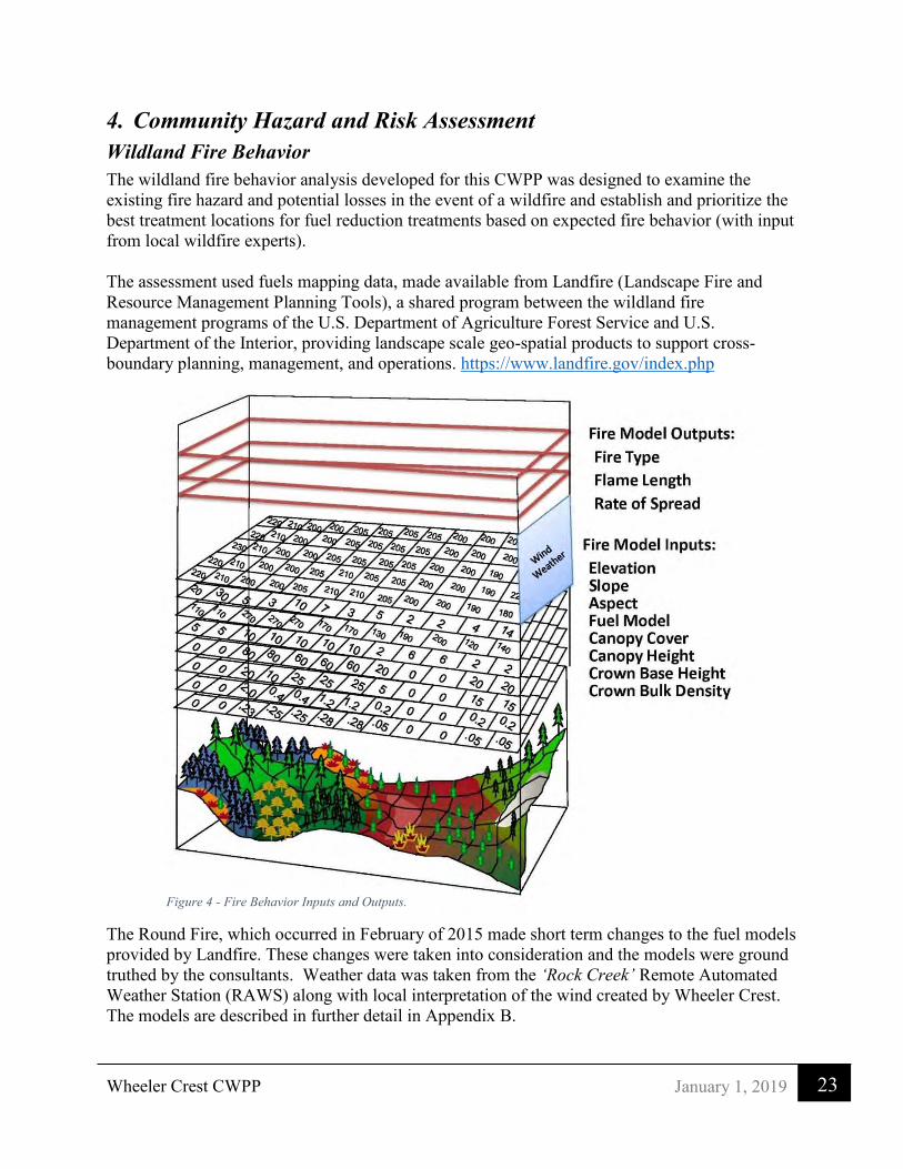
Wheeler Crest CWPP
23 January 1, 2019
4. Community Hazard and Risk Assessment Wildland Fire Behavior The wildland fire behavior analysis developed for this CWPP was designed to examine the existing fire hazard and potential losses in the event of a wildfire and establish and prioritize the best treatment locations for fuel reduction treatments based on expected fire behavior (with input from local wildfire experts).
The assessment used fuels mapping data, made available from Landfire (Landscape Fire and Resource Management Planning Tools), a shared program between the wildland fire management programs of the U.S. Department of Agriculture Forest Service and U.S. Department of the Interior, providing landscape scale geo-spatial products to support cross-boundary planning, management, and operations. https://www.landfire.gov/index.php
The Round Fire, which occurred in February of 2015 made short term changes to the fuel models provided by Landfire. These changes were taken into consideration and the models were ground truthed by the consultants. Weather data was taken from the ‘Rock Creek’ Remote Automated Weather Station (RAWS) along with local interpretation of the wind created by Wheeler Crest. The models are described in further detail in Appendix B.
Figure 4 - Fire Behavior Inputs and Outputs.
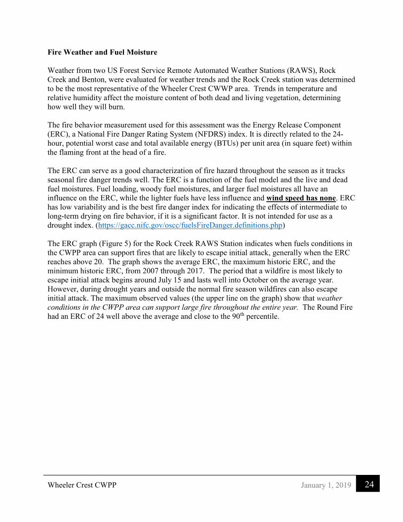
Wheeler Crest CWPP
24 January 1, 2019
Fire Weather and Fuel Moisture Weather from two US Forest Service Remote Automated Weather Stations (RAWS), Rock Creek and Benton, were evaluated for weather trends and the Rock Creek station was determined to be the most representative of the Wheeler Crest CWWP area. Trends in temperature and relative humidity affect the moisture content of both dead and living vegetation, determining how well they will burn. The fire behavior measurement used for this assessment was the Energy Release Component (ERC), a National Fire Danger Rating System (NFDRS) index. It is directly related to the 24-hour, potential worst case and total available energy (BTUs) per unit area (in square feet) within the flaming front at the head of a fire.
The ERC can serve as a good characterization of fire hazard throughout the season as it tracks seasonal fire danger trends well. The ERC is a function of the fuel model and the live and dead fuel moistures. Fuel loading, woody fuel moistures, and larger fuel moistures all have an influence on the ERC, while the lighter fuels have less influence and wind speed has none. ERC has low variability and is the best fire danger index for indicating the effects of intermediate to long-term drying on fire behavior, if it is a significant factor. It is not intended for use as a drought index. (https://gacc.nifc.gov/oscc/fuelsFireDanger.definitions.php)
The ERC graph (Figure 5) for the Rock Creek RAWS Station indicates when fuels conditions in the CWPP area can support fires that are likely to escape initial attack, generally when the ERC reaches above 20. The graph shows the average ERC, the maximum historic ERC, and the minimum historic ERC, from 2007 through 2017. The period that a wildfire is most likely to escape initial attack begins around July 15 and lasts well into October on the average year. However, during drought years and outside the normal fire season wildfires can also escape initial attack. The maximum observed values (the upper line on the graph) show that weather conditions in the CWPP area can support large fire throughout the entire year. The Round Fire had an ERC of 24 well above the average and close to the 90th percentile.

Wheeler Crest CWPP
25 January 1, 2019
Figure 5 - ERC Pocket Card for Wheeler Crest
“The Fire Danger Pocket Card provides a format for interpreting and communicating key index values provided by the National Fire Danger Rating System. The objective is to lead to greater awareness of fire danger and subsequently increased firefighter safety. The Pocket Card provides a description of seasonal changes in fire danger in a local area. It is useful to both local and out-of-area firefighters.”6
Winds Another important factor in rapid fire spread is wind speed and direction. Winds in the area are strongly influenced by Wheeler Crest, an 8-mile-long north to south ridge sitting directly west of the communities, and the desert landscape of the Great Basin to the east. In the months of September and October, winds often become erratic during the passage of cold fronts. The winds during those months are predominately from the east and northeast and are very dry, increasing the difficulty in controlling wildfires. Wind speed and direction is also influenced by vegetation type and terrain (slope and aspect). The local and diurnal winds can be greatly increased by topographic features. There is no RAWS station located in the community. The
6 https://famit.nwcg.gov/applications/WIMS/PocketCards

Wheeler Crest CWPP
26 January 1, 2019
nearest RAWS is the Rock Creek Station which does not completely represent the winds in the community but is the only source of weather that resembles those conditions.
Current Risk Analysis/Resistance to Control Resistance to Control (RTC) is used to help fire managers articulate several factors in order to determine the difficulty of controlling an ongoing wildfire. Three important fire behavior outputs from the FlamMap fire behavior model were compiled to calculate Resistance to Control: Flame Length (intensity), Rate of Spread (speed), and Fire Type (surface, torching, or actively crowning wildfire). The resistance to control formula is as follows:
Flame length + Rate of Spread + Fire Type = Analysis Score = RTC Formula example:
3.4 + 4.8 + 10 = 18.2 = 1 (Low) Flame Length
(feet)
Rate of Spread
(Chains / hour) *
Fire Type
X 10
Analysis Score Resistance to Control
0 to 3.9 0 to 4.9 1x10=10 Less than 18.8 Low (1)
3.9 to 7.9 4.9 to 9.9 10 18.9 to 27.8 Moderate (2)
7.9 to 10.9 9.9 to 19.9 2x10=20 27.9 to 50.8 High (3)
10.9 to 19.9 19.9 to 39.9 20 50.9 to 79.8 Very High (4)
20 + 40 + 3x10=30 79.9 and greater Extreme (5)
Table 6 - Resistance to control matrix
*One Chain equals 66 feet, 40 chains per hour equals ½ mile per hour rate of spread
Table 7 illustrates the range of flame lengths and the type of effective suppression efforts required. Much of the CWPP area modeling has flame lengths greater than 4 feet and requires a combination of direct and indirect suppression tactics during much of the fire season. Dozers and aircraft are often part of the initial attack suppression effort and generally can go direct on flame lengths up to 8 feet.

Wheeler Crest CWPP
27 January 1, 2019
Resistance to Control
Interpretation
Low
1
• Fire can generally be attacked at the head or flanks by persons with hand tools and or engines
• Handlines should hold the fire
Moderate
2
• Fire is too intense for direct attack on the head by persons using hand tools
• Handlines cannot be relied on to hold the fire • Equipment such as dozers, fire engines, and retardant
aircraft can be effective
High
3
• Fire may present serious control problems --torching out, crowning, and spotting
• Control efforts at the fire head will probably be ineffective
Very High
4
• Crowning spotting and major fire runs are probable • Control efforts at the head of the fire are ineffective
Extreme
5
Table 7 - Effective Fire Suppression efforts
A Resistance to Control rating above moderate means suppression efforts are unlikely to succeed unless there is a break in the vegetation or a change in the weather. The RTC maps (Figures 6 and 7 below) show places in the CWPP area where ignitions are likely to escape initial attack, where asset loss could be the greatest, and where investment in treatments might have the greatest impact on fire spread and suppression effectiveness. Table 8 compares the results of our RTC modeling effort against observed damages during the 2015 Round Fire.
Resistance to Control vs. Structure Losses During the 2015 Round Fire
Table 8 - Resistance to Control vs. Structure Losses During the 2015 Round Fire
Resistance to Control
% of Structure Loss
Number of Structures lost
Low 14% 5 Moderate 6% 2 High 14% 5 Very High 3% 1 Extreme 64% 23

H
H
H
H
H
H
HH
HH
H
H
H
H
H
H
HH
HH
H
H
H
H
H
HH
HH
H
H
H
H
H
H
H
H
H
H
H
H
H
H
H
H
H
H
H
H
H
H
H
HH
H
H
H
HH
H H
H
H
HH
H
H
H
H
H
H H
H
H
HH
H
H
H
H
H
H H
H
H
HH
H
H
H
H
H
H
H H H HH
HH H H H
H
HH
H
HH H H
HH H H H H
H
H
H
HH
H HH
H H H HH
H
H
H
H
H
H
H
H
H
H
H
H
H
H
H
H
H
H
H
H
H
H
H
HHH
H HHH HHH HH
H HH
H
HH
H
HH
H
HHH HH H
H
H
H
H
H HH
HH
HH
H
HH
H
HH
H
H
H
H
HH
H
H
H
H
H
HH
H
H HH
H
H
HH
H
HH
H
H
H
H
H
H
H
H
H
H
H
H
H
H
H HH
H
HH
H
H
HH
H
H
H
H
H
H
H
H HH H H
HH
HH
H
H
H HH H
HH
H
HH
H
H
H H
HH
HH
H
HH
H
H
HH H
HH H
H
H
H
H
H
H
H
H
H
H
H
HH
HH H
HH H
H
H
H
H
H
H
H
H
H
H
H
HH
HH H
H H HH
H
H
H
H
H
H
H
H
H
H
H H
H
H
H
H
H
H
H
H
H
H
H
HH
H
H
H
H
H
H
H
H
H
H
H
HH
H
H
H
H
H
H
H
H
H
H
H
H
H
H
H
H
H
H
H
H
HH
H
H
H
H
H
H
H
HH
H
H
H
H
H
H
H
HH
H
H
H
HH
H
HH
H
H
H
H
H
HHH
H
H
H
H
HH
H
H
H
H
HH
HH
H
HH
HH
H
H
H
HHH
H
H
H
H
HH
H
H
H
H
HH
HH
H
HH
HH
H
H
H
HH
H
H
H
H
H
HH
H
H
H
H
H
H
H
H
H
H
H
H
H
H
H
H
H
H
H
H
H
H
H
HH
H
H
H
H
H
H
H
H
H
H
H
H
H
H
H
H
H
H
H
H
H
HH
H
H
H
H
H
H
H
H
H
H
H
H
H
H
H
H
H
H
H
H
H
HH
H
H
H
H
H
H
H
H
H
H
H
H
H
H
H
HH
H
H
H
HHH
H
H
HHH
HH
H
H
H
H
H
H
H
H
HHH
H
H
H
H
H
H
H
HHH
H
H
H
H
H
H
H
HH
H
H
H
H
H
H
H
H
H
H
H
H
H H
H
H
H
H
H
H
H
H
H
H
H
H
H
H
H
H
H
H H
H
H
H
H
H
H
H
H
H
H
H
H
H
H
H
H H
H
H
H
H
H
H
H
H
H
H
H
H
H
H
H H
H
H
H
H H H
H
H
H
H
HH
H
H
H
H
H
H
H
H
H
H
H
H
H
H H
H
H H
H
HH H
H
H
H
H
H
H
H
H
HH
H
H H
H
HH H
H
H
H
H
H
H
H
H
HH
H
HH
H
HH H
H
H
H
H
H
H
H
HH
H
H
H
H
H
H
HH
H
H
H
H
H
H
HH
HH
H
H
H
H
H
H
H
H
H
H
H
H
H
H H HH
H
H
H
H
H
H
H
H
H
H
H
H
H
H
H
H
H
H
H
H
H
H H HH
H
H
H
H
H
H
H
H
H
H
H
H
H
H
H
H
H
H
H
H
H
H H H HH
H
H
H
H
H
H
H
H
HH
HH
H
H
H
H
H
H
H
H
H
H
H
H
H
H
H
H
HH
H
H
H
H
H
H
H
H
H
H
H
H
H
H
H
H
H
H
HH
H H
H
H
H
H
H
H
H
H
H
H
H
H
H
H
H
H
H
H
H
H H
H
H
HH
H
H
H
H
H
H
H H
H
H
HH
H
H
H
H
H
H
H H
H
H
H H
H
H
H
H
H
HH
HH
H
H
HH
H
H
H
H
H
HH
H
H
HH
H
H
H
H
H
HH
H
H
HH
H
H
H
H
HH
H
H
H
H
H
H
H
H
H
H
H
H
HH
H
H
H
H
H
H
H
H
H
H
H
H
H
HH
H
H
H
H
H
HH
H
H
H
H
H
H
H
H
H
H
H
H
H
HH
H
H
H
H
H
HH
H
H
H
H
H
H
H
H
H
HH
HH
H
H
H
H
H
H
H
HH
HH
H
H
H
H
H
H
H
HH
HH
H
H
H
H
H
HH
H
H
H
H
H
H
H
H
H
H
H
H
H
H
H
H
H
H
HH
H
HH
H
H
H
H
H
H
H
HH
H
H
H
HH
H
H
H
H
H
H
HH
H
H
H
H
H
H
H
HH
H
H
H
HH
AA
AA
AA
AA
AA
AA
AA
AA
AA
AA
AA
AA
AA
AA
AA
AA
AA
AA
AA
AA
AA
AA
AA
AA
AA
AA
AA
AA
AA
AA
AA
AAAA
AAAA
AAAA
AAAA
AAAA
AAAA
AAAA
AAAA
AAAA AA
AAAA
AAAA
AA AAAA AA AA
AA AA AAAA
AA
AA
AA
AA
AA
AA
AA
AA
AA
AA
AA
AA
AA
AA
AA
AA
AA
AA
AA
AA
AA
AA
AA
AA
AA
AA
AA
AA
AA
AA
AA
AA
AA
"
"
"
"
"
"
N
N
N
N
N
N
N
N
OO
LOWER
Ainslee
13
11
4WD
26
ROAD
Spring
4WD
Meadow
25
14
4WD
SpringROAD
Low er
NATIONAL
ROCK CREEK
Witcher
Creek
Spring
Spring
BOUNDARY
N A T I O N A L
FOREST
Spring
Creek
Prospects
12
R 3
1 E
2423
Sky M eadowRanch
SwallMeadows
R 3
0 E
BOUN
DARY
NATI
ONAL
I N Y O
Creek
4WD
R 3
1 E
R 3
0 E
4WD
J O H N
M U I R
ÑØ
ÑØÑØÑØ
ÑØ
ÑØ
ÑØ
ÑØ ÑØ
ÑØÑØ ÑØ ÑØ
ÑØÑØÑØ
ÑØÑØ ÑØ
ÑØ
ÑØ
!
!
!
!!!
!! !
!!
!
!!
!!!!!!!
!! !
!
!
!! !
!!
!!
!
!
£¤395
Rimrock
Dr
Sky Meadow Rd
Swall Meadows Rd
LowerR ockCreek Rd
Will
ow Rd
Mt View Dr
Wheeler Crest CWPP - 2018
ÑØ Hydrants
!Structure lost in2015 RoundFireBuildingFootprints
Resistance toControl
1, Low2, Moderate
3, High4, Very High5, Extreme Ü
0 10.5
Miles
Figure 6: Structure Loss & Resistance to Control - Swall Meadows

H
H
H
HH
H
H
H
H
HH
HH
HH
HH
HH
HH
HH
H
H
H
H
H
H
HH
H
H
H
HH
H
H
H
H
HH
HH
HH
HH
HH
HH
HH
H
H
H
H
H
HH
H
H
H
H
HH
H
H
H
H
HH
HH
HH
HH
HH
HH
H
H
H
H
H
H
H
HH
H
H
H
H
H
H
H
H
H
H
H
H
H
H
H
H
H
H
H
H
H
H
H
H
H
H
H
H
HH
H
HH
HH
H
H
H
H
H
H
H
H
HH
HH
H
H
H
H
H
H
H
H
H
H
HH
H
H
H
H
H
H
H
H
H
HH
H
H
H
HH
HH
H
H
H
HH
H
H
HH
H
H
H
H
H
H
H
H
H
H
H
HH
HH
HH
H
H
H
H
HH
HH
HH
HH
H
HH
HH
H
H
H
H
H
H
H
H
HH
HH
H
H
H
H
H
H
H
H
H
H
HH
H
H
H
H
H
H
H
H
H
HH
H
H
H
HH
HH
H
H
H
HH
H
H
HH
H
H
H
H
H
H
H
H
H
H
H
HH
HH
HH
H
H
H
H
HH
H
H
H
H
H
H
H
HH H
H
H
H
H
H
H
H
H
H
HH
HH
H
H
H
H
H
H
H
H
H
H
HH
H
H
H
H
H
H
H
H
H
HH
H
H
H
HH
HH
H
H
H
HH
H
H
HH
H
H
H
H
H
H
H
H
H
H
H
HH
HH
HH
H
H
H
H
HH
H
H
H
H
O
ROCK CREEK
Rock
LOWER
ParadiseCam p
!
ÑØ
ÑØ
ÑØ
ÑØ
ÑØÑØ
ÑØÑØ
ÑØ
ÑØ
ÑØ
ÑØ
ÑØ
ÑØ
ÑØ
ÑØÑØ
ÑØ
Glen Ct
Scott Rd
Wilke
sCrst
Sher
win
Trl
Summit Rd
Aliso
n Ln
Deer
Peak
Trl
Westridge Rd
Lower Rock Creek Rd
Wheeler Crest CWPP - 2018
ÑØ Hydrants
!Structure lost in2015 RoundFireBuildingFootprints
Resistance toControl
1, Low2, Moderate
3, High4, Very High5, Extreme Ü
0 500 1,000250
Feet
Figure 7: Structure Loss & Resistance to Control - Paradise

Wheeler Crest CWPP
30 January 1, 2019
Large Fire History
YEAR AGENCY FIRE NAME DATE CAUSE ACRES
1958 San Bernardino CAL FIRE PARADISE #2 7/28/1958 14 - Unknown 351
1974 San Bernardino CAL FIRE SWALL 2/28/1974 9 - Miscellaneous 666
1981 San Bernardino CAL FIRE SWALL 8/9/1981 9 - Fireworks 3159
1983 Inyo National Forest
9 - Miscellaneous 265
1985 Inyo National Forest 8/8/1985 9 - Miscellaneous 277
2002 Inyo National Forest BIRCH 7/1/2002 1 – Downed power line
2549
2015 San Bernardino CAL FIRE ROUND 2/6/2015 9 – Downed power line
6537
2016 Inyo National Forest ROCK CREEK 8/5/2016 2 – Bike pedal strike to a rock
123
Table 9 - Large fire history in the CWPP Area
Fire History Summary
The Wheeler Crest CWPP area has had eight large fires that were a threat to the communities from 1958 until 2016 (Figure 8). Four of these fires had a significant impact on the communities: the 1958 Paradise Fire, 1974 Swall Fire, 1981 Swall fire, and most recently the 2015 Round Fire. The 2015 Round Fire was the most significant fire for several reasons.
➢ Structure loss was high with 46 structures lost. ➢ It was caused by a downed powerline due to high winds. ➢ It occurred outside the "normal" fire season on February 6, 2015 when fire suppression
resources are low. ➢ It occurred during a major California drought. ➢ Frontal erratic wind speeds were clocked at more than 60 MPH, prohibiting the use of
aerial firefighting resources. ➢ The vegetation was made up of several types that contribute to rapid growth and make
suppression efforts difficult.

#
È
4
È
4
È
4
È
4
È
4
È
4
È
4
È
4
CCCC
H
H
H
H
H
HH
H
H
H
H
H
H
HH
H
H
H
H
H
HH
HH
H
H
H
H
H
H
H
HH
H
H
H
H
H
H
H
H
H
H
H
H
H
H
H
H
H
H
H
H
H
HH
H
H
H
H
H
H
H
H
H
H
H H
H
HH
H
H
H
H
H H
H
HH
H
H
H
H
HH
H
HH
H
H
H
H
H
HH
HH H H H H
H
HH
H
HH
HH
H H H H
H
H
H
HH
HH
H H H H
H
H
H
H
HH
H
H
H
H
H
HH
HH
H
H
HH
H
H
H
H
H
HH
HH
H
H
HH
H
H
H
H
H
HH
HH
H
H
H
H
H
H
H
H
H
H
H
H
H
H
H
H
HH
H
H
H
H
H
H
H
H
H
H
H
H
H
H
H
H
H
H
H
H
H H
H
H
H
H
H
H
HH
HH
H
H
H
H
H
H
H HH H
H
H
H
H
H
H HH H
H
H
H
H
H
H
HH
H
H
H
H
H
H
H
H
H
H
H
HH
H
H
H
H
H
H
H
H
H
H
HH
H
H
H
H
H
H
H
H
H
H
HHH
H
H
H
H
HH
H
H
H
H
H
HHH
H
H
H
H
HH
H
H
H
H
H
HH
HH
H
H
H
HH
H
H
H
H
H
H
H
H
H
H
H
H
H
H
H
H
H
H
H
H
HH
HHHH H HH H
HH HH
HH
H
H
H
H
H
H
HH
H
HH
HH
H
HH
H
H
H
H
HH
HH
H
HH
H
H
H
H
H
H
H
H
H
H
H
H
H
H
H
H
H
H
H
H
H
H
H
H
H
H
H
H
H
H
H
H
H
H
HH
H
HH
H
HH
HH HH HH H
H
H
H
H H
H
H
H
H
H H
H
H
H
HH
H
H
H
H
H
H
H
H
H
HH
H
H
HH
H
H
H
H
H
H
H
HH
H
H
HH
H
H
H
H
H
H
H
HH
H
HH
H
H
HH
H
H
H
H
HH
H
H
H
H
H
H
H
H
H
H
H
H
H
H
H
H
H
H
H
H
H
H
H
H
H
H
H
H
H
H
H
H
H
H
H
H
H
H
H
H
H
H
H
H
HH H H
HH
H
H
H
H
H
H
HH H
H
H HH
H
H
H
H
H
HH H
HH
HH
H
H
H
H
H
H
HH
H
H
H
H
HHH
HH
H
H
H
H
H HHH
H
HH
H
H
H H
H
H
HH
H
H
H
H
H
HH
H
H
H
H
H
HH
H
H
HH
HH
H
H
H
H
H
H
HH
H
H
H
H
H
HH
H
HH
HH
H
H
H
HH
H
H
H
H
H
HH
H HH
H
HH
H
HH
H
H
H
HH
H
H
H
H
H
HH
H HH
H
HH
H
H
H
H
H
H
HH
H
H
H
H HH
H H H
H
HH
HH
H
H
H
H
H H
HHH
HHH HHH
H
H
H
H
H
H
H
H
HH
HH
HH
H
H
H
HH
H
HH
H
H
HH
H
H
H
HH
H
H
H
H
HH
HH
HH
H
H
H
HH
HH
HH
H
HH
H
H
H
H
H
H
H
H
H
HH
HH
HH
H
H
H
H
H
HH
HH
H
HH
H
H
H
H
H
H
H
HH
H
H
H
H
H
H
H
H
H
H
H
H
HH
H
H
H
H
H
H
H
H
H
H
H
H
HH
H
H
H
H
H
H
H
H
H
H
H
H
H
H
H
H
H
H
H
H
H
H
H
H
H
H
H
H
H
H
H
H
H
H
H
H
H
H
H
H
H
H
H
H
H
H
H
H
H
H
H
H
H
H
H
H
H
H
H
H
H
H
H
H
H
H
H
H
H
H
H
H
H
H
H
H
H
H
H
H
H
H
H
H
H
H
H
H
H
H
H
H
H
HH
H
H
H
H
HH
H
H
H
H
H
H HH
H
HH
HH H
H
H HH
H
HH
H H H
H
H HH
H
HH
H HH H
H
H
H
H
H
H
H
H
H
H
H
H
H
H
H
H
H
H
H
H
HH
H
H
H
H
H
HHH
H
H
H
H
H
H
H
HH
H
HH
H
H
H
H
H
HHH
H
H
H
HH
H
H
HH
HH
H
H
H
H
H
HH
H
H
H
H
HH
H
H
HH
H
H
H
H
H
H
H
H
HH
H
H
H
H
H
H
H
H
H
HH
H
H
H
H
H
H
H
H
H
HH
H
H
H
H
H
H
H
H
H
H
H
H
H
H
H
H
H
H
H
H
H
H
H H
HH
HH
H
H
H
HH
H H
HH H
H
H
H
H
HH
HH
HH H
H
H
H
H
H H
H HH H
H H
H HH
H
HH H H
HH
H H
H H
HH H H
H
H
H H
H H
H
H
H
H
H
H
H
H
H
H
H
H
HH H
H H H
H
H
H
H
H
H
H
H
H
HH
HH H
H HH
H
H
H
H
H
H
HH
H
H
HH H
H HH
H
H
H
H
H
H
HH
HH
HH
H
HH
H
H
H
H
H
H
H
HH
H
HH
H
H
H
H
H
H
H
HH
H
HH
H
H
H
H
H
H
H
HHH
H
H H
H
H
H H
H
H
H H
H
H
H
H
H
H
H
H
H
H H
H
H
H
H
H
H
H
H
H H
H
H
H
H
H
H
H
H
H
H
H
H
H
H
H
H
H
H
H
H
H
H
H
H
H
H
H
H
H
H
H
H
H
H
H
H
H
H
H
H
H
H
H
H
H
H
H
H
H
H
H
H
H
HHH
H
H
H
H H
H
H
H
H
H
H H
H
H
H
H
H
HH
H
H
H
H
H
H
H
H
H
H
H
H
H
H
H
H
H
H
H
H
H
H
H
H
H
H
H
H
H
H
H
H
H
H
H
HH
H
H
H
H
H
H
H
H
H
H
H
H
H
H
H
H
H
H
H
H
H
H
H
H
H
H
H
H
H
H
H
H
H
H
H
H
H
H
H
H
H
H
H
H
H
H
H
H
H
H
H
H
H
H
H
H
H
H
H
H
H
H
HH
H
H
H
H
H
HH
H
H
H
H
H
HH
H
H
H
H
H
H
H
H
H
HH
HH
H
H
HHH
H
H
H
HH
HH
H
HHH
H
HH
H
H
H
H
HH
H
H
H
H
HH
HH
H
HHH
H
HH
H
H
H
H
HHH
H
H
H
HH
HH
HH
H
HH
HH
H
H
HH
H
H
HH
HH
HH
H
H
HH
HH
H
HH
HH
H
H
HH
H
H
HH
HH
HH
HH
H
HH
H
H
H
HH
HH
HH
HH
H
HH
H
H
H
HH
HH
HH
HH
H
HH
H
H
H
H
H
H
H
H
H
H
H
H
H
H
H
H
H
H
H
HH
H
H
HH
H
H
HH
H
H
HH
HH
H
HH
H
HH
HH
HH
HH
H
HH
HH
HH
HH
H
H
H
H
H
H
H
H
H
H
H
H
HHH
H HH
H
H
H
H
H HH
H
H
H
H H
H
H
H
H
H
H
H
H
H
H
H
HH
H
H
H
HH
H
H
H
H
H
H
H
H
H
H
H
H
HH
H
H
H
H
H
H
H
H
H
H
H
H
H
H
H
H
H
H
H
H
H
H
H
H
H
H
H
H
H
H
H
H
HH
H
H
H
HH
H
H
H
H
HHH
H
H
H
H
H
H
HH
HH
H
H
H
H
H
HH
H
H
H
H
H
HH
HH
HH
H
H
H
HH
HH
H
H
H
H
HH
HH
H
H
H
H
H
H
H
H
H
H
H
H
H
H
H
H
H
HH
H
HH
H
HH
H
HH
H
H H
H
HH
H
H H H
H
H
H
H
H
H
H
H
H
HH
H
H
H
H
H
H
H
H
H
H
HH
H
HH
H
H
H
H
HH
HH
HH
H
H
H
H
H
HH
HH
HH
H
H
H
H
H
H
H
H
H
H
H
H H
H
H
H
H
H
H
H
H
H
H
H
H
H H
H
H
H
H
H
H
H
H
HH
H
H
H H
H
H
H
H
H
H
H
H
H
H
HH
H
HH
H
HH
H
H
H
H
H
H
H
H
H
H
HH
HH
HH
H
HH
H
H
H
H
H
H
H
H
HH
H
HH
H
HH
H
HH
H
H
H
H
H
H
H
H
H
H
H
H
H
H
H
H
H
H
H
H
H
H
H
H
H
H
H
H
H
H
H
H
H
H
H
H
H
H
H
H
H
H
H
H
H
H
H
H
H
H
H
H
H
H
H
H
H
H
H
H
H
H
H
H
H
H
H
HHH
H
H
HHH
H
H
HHH
H
H
H H H
H H
H
H
H
H HH
H H
H
H
H
H HH
H
H
H
H
H
H
H
H
H
H
HH
H
H
H
H
H
H
H
HH
H
H
H
H
H
H
H
H
H
H
H
H
H
H
H
H
H
H
H
H
HH H
H
H
H
H
H
H
HH H
H
H
H
H
H
H
HH H
H
H
H
H
H
H
H
H
H
H
HH H
H
H
H
H
H
H
H
H
H H H
H
H
H
H
H
H
H
H
H H H
H
H
H
H
HH
H
HH
H H
H
H
HH
H
H H
H H
H
H
H H
H
H H
HH
H
H
H
H
H
H
H
H
H
H
HH
HH
H
H
H
H
H
HH
H H
H
H
H
H
H
HH H H
H
H
H
H
H
HH
H
H
H
HH
H
H
H
HH
H
H
H
H H
H
H
H
HH
H
H
H
H H
H
HH H
H
HH
H H
HH H
H
HH
H H
HH H
HH
H
H H
H
H
H
H
H H
H
HH
H
H H
H
H
H
H
H
H
H H
H
H
H
H
H H
H
H
H
H
H
H
H H
H
H
H
HH H
H
HH
H
H
H
HH
H
H
H
H
HH
H
H
H
H
HH
H
H
H
H
H
H
H
H
H
HH
H
HH
H
H
H
H
H
H
H
H
H
H
H
H
HH
H
HH
H
H
H
H
H
H
H
H
H
H
H
H
HH
H
HH
H
H
H
HH
H
H
HH
H
H
HH
HH
HH H H H
H
H
H
H
H
H
H
H
H
H
H
H
H
H
HH H H H
H
H
H
H
H
H
H
H
H
H
H
H
H
H
HH
HH
H
H
H
H
H
H
H
H
H
H
H
H
H
H
H
H
H
H
H
H
H
H
H
H
H
H
HH
H
H
H
H
H
H
H
H
H
H H
H
H
H
H
H
H
H
H
H
H H
H
HH
H
HH
HH
HH
HH
H
H
H
H
H
H
H
H
H
H
H
H
H
H
H
H
H
H
H
H
H
H
H
H
HH H
H
H
HH H H
H
H
HH H H
H
H
H
H
H
H
H
H
HH
H
HH
H
H
H
H
H
H
H
H
H
H
H
H
H
HH
H
H
H
H
H
H
H
H
H
H
HH
H
HH
H
H
H
H
H
H
H
H
H
H
H
H
H
H
H
H
H
H
H
H
H
H
H
H
H
H
H
H
H
H
H
H
H
H
H
H
H
H
H
H
H
H
H
H
H
H
H
H
HH
HH
H
H
H
H
HH
HH
H
H
H
H
H
HH
HH
H
H
HH
H
H
H
H
H
HH
H
H
H
H
H
HH
H
H
H
H
H
H
H
H
H
H
H
H
H
H
H
H
H
H
H
H
H
H
H
H
H
H
HH
H
H
H
H
H
H
H
H
H
H
H
H
H
H
H
H
H
H
H
H
H
H
H
H
H
H
H
H
H
H
H
H
H
H
HH
H
HH
HH
H
H
HHH
H
H
H
H
H
H
H
H
H
H
H
H
H
H
H
H
H
H
H
H
H
H
H
H
H
H
H
H
H
H
H
H
H
H
HH
H
H
H
H
H
H
HHH
H
H
H
H
H
H
H
H
H
H
H
H
H
H
H
H
H
H
H
H
H
H
H
H
H
H
H
H
H
H
H
H
H
H
HH
H
H
H
H
H
H
H
HHH
H H H H
H
H
H
H
H
H
H
H
H
H
H
H
H
H
H HH H
H
H
H
H
H
H
H
H
H
H
H
H
H
H
H HH H
H
H
H
H
H
H
H
H
H
H
H
H
H
H
H
H
H
H
H
H
H
H
H
H
H
H
HH
HH
H
H
H
H
H
H
H
H
H
H
H
H
H
H
H
H
H
H
H
HH
HH
H
H
H
H
H
H
H
H
H
H
H
H
H
H
H
H
H
H
H
HH
HH
H
H
H
H
H
H
H
HHHHHH
H
H
H
HHHHHH
H
HH
HHHHHH
H
HH
H
H
H
H
H
H
H
H
H
H
H
H
H
H
H
H
H
HH
HH
H
H
H
H
HH
H
H
H
H
H
H
HH
H
H
HH
H
HH
H
H
H
H
HH
H
H
H
H
HHH
H
H
HH
H
H
H
H
HH
H
H
H
H
HHH
H
H
HH
H
H
H
H
HH
H
H
H
H
HHH
H
H
HH
H
H
H
H
H
H
HH
H
H
H
H
H
H
H
H
H
H
H
H
H
H
H
H
H
H
HH
H
H
H
HH
H
H
H
HH
H
H
H
H
H
H
H
H
H
H
H
H
H
H
H
H
H
H
H
H
H
H
H
H
H
H
H
H
H
H
H
H
H
H
H
H
H
H
H
H
H
H
H
H
H
H
H
H
H
H
H
H
H
H
H
H
H
H
H
H
H
H H
H
H
H
H H
H
H
H
H
H
H
H
H
H
H
HH
H
H
H
H
H
H
H
H
H
HH
H
H
H
H
H
H
H
H
H
H H
H
H
H
H
HH
HH
HH
H
H
H
HH H
H
H
H
H
HH
H
H
H
H
H
HH
HH
H
H
H
H
H
H
H
H
H
H
H
H H H HH
H
H
H
H
H
H
H
H
H
H
H
H
H
H
H
H
H H H H
H
H
H
H
H
H
H
H
H
H
H
H
H
H
H
H
H
H HH H
H
H
H
H
H
H
H
H H
H
H
H
H
H
H
H
H
H
H
H
H
H
H
H
H HH
H
H
H
H
H
H
H
H
H
H
H
H
H
H
H HH
H
H
H
H
H
H
H
H
H
H
H
H
H
H
H
H
HH
H
H
HH
H
H
H
H
HH
H
H
HH
H
H
H
H
H H
H
H
HH
H
H
H
H
HH
H
H
H
H
H
H
H
H
HH
H
H
H
H
H
H
HH
H
H
HH
H H
H
H
H
H
H
H
H
H H
H
H
H
H
H
H
H
H H
H
H
H
H
H
H
H
H
H
H
H
H
H
H
H
H
H
H
H
H
H
H
HH
H
H
H
H
H
H
H
H
H
H
H
H
H
H
H
H
H
HH
H
H
H
H
H
H
H
H
H
H
H
H
H
H
H
H
H
HH
H
H
H
H
H
H
H
HH
HH
H
H
H
H
H
H
HH
HH
H
H
H
H
H
H
H
HH
H
H
H
H
HH
H
H
H
H
H
H
H
H
H
H
H
H
H
H
H
H
H
HH
H
H
H
H
H
H
H
H
H
H
H
HH
H
H
H
H
H
HH
H
H
H
H
H
H
H
H
H
H
HH
AA
AA
AA
AA
AA
AA
AA
AA
AA
AA
AA
AA
AA
AA
AA
AA
AA
AA
AA
AA
AA
AA
AA
AA
AA
AA
AA
AA
AA
AA
AA
AA
AA
AA
AA
AA
AA
AA
AA
AA
AA
AA
AA
AA
AA
AA
AA
AA
AA
AA
AA
AA
AA
AA
AA
AA
AA
AA
AA
AA
AA
AA
AA
AA
AA
AA
AA
AA
AA
AA
AA
AAAA
AAAA
AAAA
AAAA
AAAA
AAAA
AAAA
AAAA
AAAA
AAAA AA
AA AA
AA
AAAA
AA
AA
AA
AA
AA
AA
AA
AA
AA
AA
AA
AA
AA
AA
AA
AA
AA
AA
AA
AA
AA
AA
AA
AA
AA
AA
AA
AA
AA
AA
AA
AA
AA
AA
AA
AA
AA
AA
AA
AAA A
AA
AA
AA
AA
AA
AA
AA
AA
AA
AA
AA
AA
AA
ff
W
WW
W
W
W
W
"
"
"
"
´́
ww
"
"
"
"
"
""
"
"
"
"
"
"
"
N
N
N
N
N
N
N
N
N
N
"" 8
8
8
O
O
O
O
O
O
O
oo
H
H
H
H
H
H
H
H
H
H
H
H
H
H
H
H
H
H
H
H
H
H
H
H
H
H
H
H
H
H
H
H
H
H
H
H
H
H
HH
H
HH
H
H
H
H
H
HH
H
H
H
HH
H
H
H H
H
H
H
H
HH
H
HH
H
ã
ã
ã
ã
ã
ã
ã
ã
ã
ãã
ã
ã
ã
ã
ã
ã
ã
ã
ã
ã ã ã
ã
ã
ã
ã
ã
ã
ã
ã
ã
ã
ã
ã
ã
ã
ã
ã
ã
ã
ã
ã
ã
ã
ã
ã
ã
ã
ã
ã
ã
ã
ã
ããã
ã
ã
ã
ã
ã
ã
ã
ã
ã
ãã
ã
ã
ã
ã
ã
ã
ã
ãã
ã ã
ã ã
ã
ã
ãã
ã
ã
ã
ã
ã
ã
ã
ã
ã
ã
ã
ã
ã
ã
ã
ãã
ã
ã
ã
ã
ã
ã
ã
ã
ã
ã
ã
ã
ã
ã
ã
ãã
ã
ã
ã
ã
ã
ãã
ãã
ã
ã
ã
ã
ã
ã
ã
ã
ãã
ãã
ã
ãã
ã
ã
ã
ã
ã
ã
ã
ã
ã
ã
ã
ã
ã
ã
ã
ã
ã
ã
ã
ãã
ã
ã
ã
ã
ã
ã
ã
ãã
ã ã
ã ã
ã
ã
ã
ã
ã
ã
ã
ã
ã
ã
ã
ã
ã
ã
ã
ã
ã
ã
ã
ã
ã
ã
ã
ã
ã
ã
ã
ã
ã
ã
ã
ã
ã
ã
ã
ã
ã
ããã
ã
ã
ã
ã
ãã
ã
ã
ãã
ãã
ã
ã
ã
ã
ã
ã
ã
ã
ã
ã
ã
ã
ã
ã
ã
ã
ã
ãã
ã
ãã
ã
ã
ã
ãã
ã
ã
ã
ã
ã
ã
ã
ã
ã
ã
ã
ã
ã
ã
ã
ã
ã
ã
ã
ã
ã
ã
ã
ã
ã
ãã
ã
ã
ã
ã
ãã
ã
ã
ã
ã
ã
ã
ã
28
Sp ring
NORT
H
ROAD
2829
LOWER
4
LOWER
4WD
ROAD
I N Y O
35
4WD
4WD
19
Ainslee
7
16
10
16
Cree k
21
9
13
4WD
17
C a n y o n
4WD
20
6
C a n y o n
VALL
EY
ROCK CREEK
27
RANGER
ROAD
Sp ring
18
C r e s t
Lower
34
4
11
5
W h e e l e r
4WD
Rock
12
9
31
7STATION
34
4WD
S h e r w i n
33
4 2
26
31
9
ROAD
WitcherMeadow
32
15
Sp ring
4WD
4WD4WD
Gate
32
W h i s k y
4WD
ROAD
LOWER
4WD
Sp ringSp rings
Meadow
3
25
M a y f i e l d
3
14
4WD
C a n y o nS a n d
Sp ring
30
32
5 4
I
N
Y
O
PENSTOCK
6
T 5 S
ROAD
Creek
BOUNDARYMO N O CO
Wells
T 5 S
21
36
N O 2
R 3
0 E
R 3
0 E
River
L ow er R oc k
NA TION A L
Tailings
ROCK CREEK
AQUEDUCT
Witcher
BirchCreek
NAT
FOR
4WD
T 5 S
Sp ring
Rock Creek
H OL I D AY
Sp ring
ROAD
Parad iseCamp
NATI
ONAL
Prospects1
O W E N S
R 3
1 E
R 3
1 E
FOR E ST
Tailings
BO U ND A RY
Sewage DispPonds
108 10
INYO CO
Round ValleyPeak
Sp rings
STATION
INYO CO
GravelPit
N
A
T
I
O
N
A
L
FIR ST
N A T I O N A L
FOR E ST
F R EN C H T 5 S
Sp ring
T U N N E L
RANGER
CREEK
H i l l
Meadow
Creek
Prospects
Toms Pla ce
3335
12
T U N N E L
PENSTOCKOwens
Guzzler
Tailings
GagingStation
SherwinHill
Rock
WT
T U F F
T 4 S
ROUN
D
ROCK
LOWER
R 3
1 E
T 6 SMO N O CO
2423
Sp ring
Sk y M eadowRa nc h
CommFacility
SwallMeadows
R 3
0 E
Rock
RD
FORE
ST
R I V E R
ROCK CREEK
C re ek
BO U ND A RY
Powerhouse
Scenic Point
BOUN
DARY
T 6 S
SurgeTank
36
T 4 S
F O R E S T
NATI
ONAL
SO U TH
Corral
33
W H
E E
L E
RR
I D
G E
22
Sp rings
N O 1
Scenic PointSurgeTank
8I N Y O
Creek
PA R A LLE L
4WD
4WD
4WD
R 3
1 E
R 3
0 E
4WD
4WD
4WD
4WD
4WD
J O H N
M U I R
W I L D E R N E S S
Round Valley Peak11943'
8000
7200
11400
1140
0
720 0
11200
11400
11 80 0
5800
6400
66006800
7000
10000
760 0
11 40 0
11 20 0
11 00 0
108 00106 00
11400
11 00 0
104 00
11 40 0
11200
102 00
5200
5400560 0
5800
1180
0
1160
0
1180
011
600
1120
0
11600
4800
5000
9000
8600
8400
820 08000
1020
0
10200
1040
0
1060
0
720 0
7000
6800
6600
1120
0
11600
4600
5800
10600
880 0
860 0
760 0
740 0
5800
60006200
5000
7200
980 0
700 0
9200
1080
0
960 0
7200
7200
7200
7000
7000
8000
820 0
780 0
9400
720 0
700 0
7200
7200
7000
7200
7200
7200
7000
720 0
700 0
6000
7200
10000
720 0
720 0
7200
7200
SWALL1974
1983
1985
SWALL1981
BIRCH2002
ROUND2015
Wheeler Crest CWPP - 2018
Fire History1958, PARADISE #21974, SWALL1981, SWALL
1983, 1985, 2002, BIRCH
2005, ROCK2015, ROUND2016, ROCK CREEK
Ü0 10.5
Miles
Figure 8: Fire History

Wheeler Crest CWPP
32 January 1, 2019
5. Community Preparedness for a Wildfire Emergency and Action Plan to Improve Preparedness
Wildfire is Coming! Are You Prepared? There are many resources available to communities to increase fire preparedness. CAL FIRE has developed many free educational materials and a website devoted to up-to-date guidance about safe evacuation and protecting lives and property from wildfire – http://readyforwildfire.org/.
The National Fire Protection Association has a public education effort that offers dozens of fact sheets designed to help keep homeowners, homes, and communities safe from fire and related hazards. Check out https://www.nfpa.org/Public-Education.
The Wheeler Crest Fire Safe Council is an active community education organization focused on fire safety and awareness in Swall Meadows. Holding quarterly meetings, this group brings in wildfire experts to speak to the community on various subjects, as well as organizing volunteers for grant-funded community wildfire mitigation projects such as brush pick-ups and fuelbreak maintenance. Paradise has an active Fire Protection District Commission but unfortunately, does not currently have a Fire Safe Council. There are many resources available to a Fire Safe Council, such as grant funding for projects, and Paradise residents should consider acting to start such a community group.
Preventing Home Ignitions During Wildfires To reduce ember ignitions and fire spread, homeowners should be sure they're addressing these three areas:
• Limit the amount of flammable vegetation within the 100' defensible space zone around the house.
• Choose fire-resistant building materials. • Perform regular maintenance as needed within the three vegetation zones around the
house. Defensible Space/Vegetation Management Vegetation management is important for protecting homes in Paradise and Swall Meadows from wildfire. The most damaging fires in the area will be driven by high winds, with grass being the primary agent of fire spread. Under windy conditions, fuelbreaks will not stop the spread of fire, and should only be cut and maintained directly adjacent to roads and homes, where reducing brush and conifer fuel loading can reduce fire intensities, improving public and emergency responder safety during wildfire events.
The CWPP area is in the middle of an important deer migration route and brush provides important browse for the deer, especially in the winter (Scheinost, P.L., J. Scianna, D.G. Ogle. 2010). Where possible, outside of the 100’ defensible space buffer, fuels management should focus on pruning dead material out of the brush. Avoid removing entire shrubs. Removing brush also creates openings for invasive grasses such as cheatgrass, which increase fire spread rates

Wheeler Crest CWPP
33 January 1, 2019
and have no browse value for wildlife. Soil disturbance causes the spread of weeds - no mastication or mowing of brush is recommended.
Defensible Space – The first 5 feet. The area within five feet of the home is the most critical zone to keep clear of flammable materials. It must meet or exceed PRC 4291 requirements. This zone should be covered with rock, cement, pavers, bare earth, or green grass. No dead grass, dead trees, weeds, landscape mulch, firewood, lumber, tarps, or anything else, which can burn should be in this zone. Wooden fences should never touch a building – leave a 12-18” gap and fill it with wire fencing, chain-link, or another material which cannot spread fire from a burning fence to your house. Remove anything stored underneath decks or porches.
Remove flammable shrubs and trees. This includes native plants, such as: big sagebrush, antelope bitterbrush, rubber rabbitbrush, curly leaf rabbitbrush, bunch grasses, and pine. Ornamental plants that should be removed or not planted in this area include evergreens (juniper, lavender, spruce, mugo pine, arborvitae, etc.), Scotch broom and large exotic grasses. When removing shrubs, leave the root systems in place.
Defensible Space – Five to 30 feet. This is the area 5-30’ from the house and must meet or exceed PRC 4291 requirements:
• Clear vegetation from under or within 10 feet of propane tanks. • Remove most brush. If you wish to retain a few specimen plants, make sure they are free
of dead wood and leaves, pruned to reduce the amount of fuel, and separated from adjacent brush.
• Shorter plants, less than 2 feet tall, are better choices than taller plants. • Deciduous shrubs and trees are better choices than evergreen types. Avoid planting
juniper, mugo pine, spruce, Jeffery pine, or arborvitae. • Keep your firewood out of this zone. • Create fuelbreaks with driveways, walkways/paths, patios, rock. • Keep lawns and native grasses mowed to a height of two inches or less. • Remove ladder fuels (vegetation under trees) so a surface fire cannot reach the tree
crowns. • Prune trees up six to ten feet from the ground; for shorter trees do not exceed 1/3 of the
overall tree height. • Space trees to have a minimum of eighteen feet between crowns with this distance
increasing along with the percentage of slope. • Tree placement should be planned to ensure the mature canopy is no closer than ten feet
to the edge of the structure. • Tree and shrubs in this zone should be limited to small clusters of a few each to break up
the continuity of the vegetation across the landscape. Defensible Space – The Extended Zone 30-100 feet, and out as far as 200 feet if you are on a steep slope. This zone should also meet or exceed PRC 4291 requirements. The goal here is not to eliminate fire but to interrupt fire’s path and keep flames smaller and on the ground.

Wheeler Crest CWPP
34 January 1, 2019
• Weed eat all grasses down to 4” or less. • Dispose of heavy accumulations of ground litter/debris. • Remove dead plant and tree material. • Remove small conifers growing between mature trees. • Remove vegetation adjacent to storage sheds or other outbuildings within this area. • Trees 30 to 60 feet from the home should have at least 12 feet between canopy tops. • Trees 60 to 100 feet from the home should have at least 6 feet between the canopy tops.
Summary of High-Priority Firesafe Building Improvements From University of California Cooperative Extension, 2010, Home Survival in Wildfire Prone Areas Building Materials and Design Considerations.
Roofing Use materials with a Class A fire rating. Follow installation instructions to insure performance as designed and tested. Keep in mind that roof edge openings in the eaves and gabled ends need to be properly installed and meet current firesafe standards or they will increase structure ignitability. Simply having a Class A roof rating is not the only thing needed to improve a home’s survivability. A good reference is, https://ucanr.edu/sites/Wildfire/Roof/Roof_Covering/ Gutters If debris accumulates in the gutter—and if it is ignited by embers—the flames will impinge on components at the edge of the roof. Clean vegetative debris from gutter on a regular basis. Some gutter cover devices result in the accumulation of debris behind the device. Plug gaps that occur between roof covering and roof sheathing, which can occur at the roof edge (for example, with a barrel-style roof) or at the ridge.
Make sure to clear needles and other combustible debris from areas where the roof intersects with walls (such as at a dormer) or other roof sections (such as at a valley) Vents Attic and crawl space vents are susceptible to the entry of small embers. These embers can ignite fine fuels that have accumulated in these areas. At a minimum, replace ¼” mesh screen with ⅛” mesh. Consider making vent covers that can be installed prior to the approach of a wildfire (and removed after the wildfire threat has passed). https://ucanr.edu/sites/Wildfire/Vents/ Decks Decks are vulnerable to an under-deck surface fire or direct ember exposure from above. If ignited, the deck will provide a longer flaming exposure to the side of your house and potentially your eaves. Avoid storing combustible materials under your deck. At a minimum, use deck boards that comply with the provisions of the California Building Code. Noncombustible and ignition-resistant materials are available for use. It is also a good idea to seal deck bottoms with metal screens to prevent ember entry.

Wheeler Crest CWPP
35 January 1, 2019
Windows An open window is the most vulnerable window during a wildfire. Window shutters or other pre-made window covers provide additional protection for the window. The glass is the most vulnerable part of your window. Multi-pane tempered glass windows will provide the most protection for a reasonable cost. Special fire-rated glass is also available, but it is much more expensive than tempered glass. Maintaining adequate defensible space and using shutters or covers, will provide similar protection at lower cost. Window screens can also help protect the glass from radiant heat exposure. Eaves Depending on the siting of the home on the parcel, as well as the combustibility of siding and decking, the eave can be vulnerable to ember and flame exposure. If you have open-eave construction, inspect blocking-rafter tail joints for openings. Seal or box in openings with noncombustible or ignition-resistant material. Depending on the siting of the home on your parcel, a wide overhang could result in a greater wildfire exposure (e.g., if your home is located midslope, a wildfire burning up the slope might cause more severe ember and flame exposure to the underside of the eave). We still recommend having a wide overhang, which adds protection from rain and sun. Siding The type of siding is less important than other factors in your home construction when it comes to wildfire. The key is to reduce the likelihood for prolonged exposure of the siding to flames, regardless of source (i.e., nearby vegetation or another burning building). Reduce the amount of combustible materials near your home. If ignited, combustible siding can result in flaming exposure to other components, such as windows and eave and vents. When using combustible siding, the more complicated lap joint designs (such as tongue-and-groove and ship lap) provide more protection against flame penetration at lap joints. Although joints are normally viewed as being vulnerable, in this case you are looking for a joint that decreases the ability of fire to move from the outside to the inside of your home—so “complicated” is good. Underlying sheathing will also improve the resistance of a siding product to penetration from flames. Adding a layer of 5/8” sheetrock under the siding material can provide an extra level of protection. Compliance with California Defensible Space Regulations None of the information above is intended to contradict any of the requirements of California Public Resource Code 4291 – Defensible Space. All properties should be kept in a condition which meets or exceeds the current requirements of PRC 4291. (Link to full text of PRC 4291 can be found in the References section).
Wildfire Evacuation Historically, fires in the CWPP area have been driven by high winds, spreading incredibly quickly. It is always best to evacuate as soon as possible when the order is given by the Mono

Wheeler Crest CWPP
36 January 1, 2019
County Sheriff's Office. CAL FIRE has critical information on what to do if you inadvertently become trapped near a wildfire: http://www.readyforwildfire.org/What-To-Do-If-Trapped/
WHAT TO DO IF YOU BECOME TRAPPED NEAR A WILDFIRE
While in your vehicle: • Stay calm. • Park your vehicle in an area clear of vegetation. • Close all vehicle windows and vents. • Cover yourself with wool blanket or jacket. • Lie on vehicle floor. • Use your cell phone to advise officials—call 911.
While on foot: • Stay calm. • Go to an area clear of vegetation, a ditch or depression on level ground if possible. • Lie face down, cover up your body. • Use your cell phone to advise officials—call 911.
While in your home: • Stay calm, keep your family together. • Call 911 and inform authorities of your location. • Fill sinks and tubs with cold water. • Keep doors and windows closed but unlocked. • Stay inside your house. • Stay away from outside walls and windows.
Emergency Communications and Evacuation Warnings Mono County utilizes what is known as the CodeRed Emergency Alert System when a critical incident or emergency situation takes place within the county. Alerts are sent by phone or text to notify the entire county or specific areas within the county of important information. All residents should register for CodeRed alerts ASAP by going to the Mono County Sheriff's Office website: https://monosheriff.org/sheriff/page/codered-emergency-alert-system.
The Mono County Emergency Operations Plan (2012) warns: “No one system exists that can quickly alert and warn every citizen of an evacuation emergency. Effective public alert and warning will be accomplished only using multiple systems…" “(Emergency) vehicle loudspeakers are the best way to give instant directions to the public that may not be near a radio or TV during late night hours when most people are sleeping and wouldn’t see EAS alerts, or away from their phones (for CodeRed alerts), or during power outages." The fire districts could install distinctive evacuation sirens, which could be used to signal evacuation to residents.

Wheeler Crest CWPP
37 January 1, 2019
During development of this document several people suggested the idea of developing a ‘Phone-Tree’ for notifying each other of wildfire events. Power outages may make many cordless or internet-based/VOIP phones unusable during a wildfire, but this idea bears further discussion. More information on Mono County Emergency Communications is available at these links:
https://monosheriff.org/sheriff/page/emergency-services https://monosheriff.org/sheriff/page/codered-emergency-alert-system https://monosheriff.org/sites/default/files/fileattachments/sheriff_-_coroner/page/8077/mono_county_oa_eop_2012.pdf
Alerting and Warning People with Access and Functional Needs (PAFN) Mono County maintains a registry for residents who may need special assistance during an evacuation event. Residents with access and functional needs should register with emergency response agencies so those agencies can better serve them in a disaster or other emergency. Information shared with the registry will remain private and only shared with emergency response agencies. To sign up for the registry or request more information, visit https://monosheriff.org/sheriff/page/codered-emergency-alert-system or call Mono County Health Department at (760) 924-1830.
General information on preparing for wildfire evacuations: http://www.readyforwildfire.org/ Emergency information may be available local radio stations: KIBS 100.7 FM, KBOV 1230 AM, and local TV Stations: https://www.sierrawave.net/
Water Sources or Availability of Water for Fire Suppression. Existing water tanks need to be augmented with tanks that are larger and better able to supply the needs of the two communities, as described by the recommendations of the respective water districts. The upper two-thirds of the community of Swall Meadows does not have water-district hydrants. Installing fire hydrants will be expensive and it may make more sense to install several water tanks to provide an adequate water source. New homes are required by code to have a 2500-gallon water storage tank for firefighting purposes. There are at least 19 parcels in Swall Meadows that meet this requirement.
Most major wildfires in the project area occur during periods of high winds where power outages are likely. The two water districts that service portions of the communities have stated a need for backup diesel generators to operate their pumps when grid-power is unavailable.
Road Issues that could Prevent Easy Evacuation. Swall Meadows has only one access in and out via Swall Meadows Road. Both Swall Meadows and Paradise have only Lower Rock Creek Road to get in or out of their communities. The Wheeler Crest Fire Department and Fire Safe Council have recommended construction of a gated emergency access road that would extend north from Quail Circle, connecting with Swall

Wheeler Crest CWPP
38 January 1, 2019
Meadows Road. See maps and Mono County Public Works analysis in Appendix D.
The CWPP consulting team also recommends spending time and energy on roadside clearance projects which reduce fire intensity along the established roads in Swall Meadows. The US Forest Service has an obligation to work with communities to provide safe roadside clearances to allow for safe evacuations. The community needs to work with the private and public land agencies to reduce the fire hazards that exist along the roads and come to an agreement on what is necessary.

Wheeler Crest CWPP
39 January 1, 2019
6. Fuel Treatments Completed and Recommended Projects
This section is devoted to fuel treatments that have been done in the past 10 years and treatments that are recommended through evaluation of the fire behavior and local fire experience.
Table 10 below is a worksheet for use to better understand the needs when applying for a grant to treat an area. The worksheet is made up of items that are typically asked when applying for a grant. Once a priority is set the project manager should gather the information requested in the worksheet.
Table 10 - CWPP Project Data sheet
CWPP PROJECT DEFINITION DATA SHEET Grantee: Project Title: Project Coordinates: Project Number: Priority: CEQA Status: Project Status: Project Type: Number of Acres: Fuel Type: Treatment: Parcels requiring right of entry: Habitable Structures protected by project: Estimated Cost per Acre: Total estimated cost: Funding Source: Insert Project Map (Standard GIS format) And a “Current” photo

Wheeler Crest CWPP
40 January 1, 2019
USFS/BLM Projects in the CWPP Area The USFS has been proactive with treatments on their land in and near the communities. The communities have had concerns about the treatments and has been involved with communicating to and influencing the USFS in implementing treatments that will provide the best possible protection. Table 11 below is a breakdown of the acreages of the Wildland Urban Interface (WUI) Zones by owner.
Acreage per WUI Zone (both communities) by Owner
Owner Core Defense Threat Total % of WUI
USFS 357.80 1544.52 5461.14 7363.46 46.45%
BLM 192.76 1428.26 3138.72 4759.74 30.02%
LAWPD 195.91 568.05 1672.86 2436.82 15.37%
CADFW 86.86 63.07 0.00 149.93 0.95%
Private 743.94 148.30 14.55 906.79 5.72%
ESLT (Easement & fee owned)
143.25 93.48 0.00 236.73 1.49%
TOTAL 1720.52 3845.68 10287.27 15853.47 100.00% Table 11 - Ownership Acreage by WUI Zone
The USFS has a responsibility to work with the communities when developing treatments to reduce the fire hazards within these zones. The identified WUI zones also help the communities establish priorities for projects adjacent to where the USFS has determined the need for treatment. This kind of synergy between the community and the USFS will improve protection and increase the effectiveness of hazardous fuel reduction. The Fire Safe Council has been proactive in its participation with the USFS and will continue to do so in the future. It is important for the community the USFS and BLM to continue to work together to create fire-resilient conditions in the CWPP area.
It is important for the community to work with the various land ownerships to be sure the treatments that were implemented get maintained on a regular schedule to prevent their useful life from expiring. The agencies should be able to recommend a treatment schedule.
The Bureau of Land Management (BLM) completed a fuel reduction project on the south and east sides of lower Swall Meadows (Figure 9). The United States Forest Service (USFS) completed a fuel reduction project on the east and north sides of Swall Meadows (Figure 10).

Sier
ra W
ave
Quail
Cir
CougerRun
Wilson Rd
Pine Dr
Rimr
ock D
r
Ridge View
Pinon Dr
Sky Meadow Rd
Rimrock Dr
Swall Meadows Rd
Lower Rock Creek Rd4S39
4S80
4S39
5400
5600
5800
6400
6200
6200
6000
5800
6000
6000
Wheeler Crest CWPP - 2018
BLM CompletedProjectsÜ
0 0.50.25
Miles
Figure 9: BLM Completed Project

£¤395
Sier
ra W
ave
Qua
il C
i r
Me
adow
Rd
Coug er Run
Orc
hard
Rd
Foo t
h ill
Rd
Valle
y V
iew
Rd
Pine
Dr
Wil son Rd
Ridg
e Vi ew
Pi non D r
Will
ow
Rd
Mt V iew Dr
Rim
rock
Dr
Sky M ead ow Rd
Sw all Me adow s R d
Low
er R
ock
Cre
ek R
d
4S39
4S80
4S39
395
395
11400
8000
11400
78008000
8400
8600
8800
8200
1120
0
9800
9600
9400 9200
9000
10400
10200
5400
5600
5800
6000
1140
0
11200
11000
10800
10600
7600
7400
7200
7000
6800
8000
7800
7600
7600
6000
6200
6400
6600
7200
5800
7200
7000
6800
7000
7000
8000
7800
7000
10000
10800
9800
FuelBreak
Pil ing ofFuels, Handor Machin e
Yarding - Removal ofFuels by Carry ing
or Dragging
Thinning forHa zardous Fuels
Re duct ion
Burningof Pil edMateri al
Wheeler Crest CWPP - 2018
USFS Completed ProjectsÜ0 0.5 10.25
Miles
Figure 10: USFS Completed Project

Wheeler Crest CWPP
43 January 1, 2019
CAL FIRE Projects The communities and the local fire departments have used the local CAL FIRE fire crew from Owens Valley Conservation Camp (CC) in Bishop. The 2018 San Bernardino Unit Fire Plan identifies Swall Meadows roadside thinning and removal of roadside dead trees from the Round Fire on USFS land as project tasks for Owens Valley CC crews. The Unit Fire Plan also says the crews will do maintenance and clean-up around the fire stations in Paradise and Swall Meadows.7
Wheeler Crest Community Projects From 2009 to 2017, the Wheeler Crest FPD and FSC successfully completed three fuel-reduction grants (two funded by the CA Fire Safe Council, one by CAL FIRE). All three facilitated the removal of several hundred tons of vegetation from ~100 homeowners’ lots, as well as the creation and maintenance of nine fuelbreaks that provide critical buffers for helping slow fire movement into and within the residential community (Figure 11). These projects, which the community views as ongoing, also had contained a significant outreach and education component, comprised of community meetings, informational letters to homeowners, and one-on-one consultations about affected properties. The following table is a list of projects and their priorities developed by the Swall Meadows and Paradise communities. They were created in conjunction with Deer Creek Resources, Wildland Rx, local Fire Chief Dale Schmidt, water districts and core team members.
7 Unit Strategic Fire Plan San Bernardino Unit, CAL FIRE, May 2017. http://cdfdata.fire.ca.gov/pub/fireplan/fpupload/fpppdf1632.pdf

Wheeler Crest CWPP
44 January 1, 2019
Table 12 – Paradise Community Projects Project ID Type Description Lead Agency Priority
1 Community Preparedness Establish and maintain a Paradise Fire Safe Council PFPD 1
2 Community Preparedness Conduct education outreach program for high/moderate hazard parcel owners PFPD 1
3 Community Preparedness Establish and maintain a fire safe education program to cover topics including, defensible space, structure hardening, fire behavior, invasive weed control, evacuation planning and preparation, include planning for people with special needs
PFPD 1
4 Community Preparedness Work with Mono County to improve cell phone coverage PFPD 2
5 Community Preparedness Create Wildfire Safety notebooks for residents, including the CWPP, tips for evacuation of people and small and large animals, home preparation, and emergency information
PFPD 2
6 Fuel Reduction Facilitate defensible space maintenance for residents through street pick-up, chipping, dump vouchers PFPD 1
7 Fuel Reduction Identify and construct fuelbreaks in strategic locations around community PFPD 1
8 Fuel Reduction Work with owners of undeveloped lots to clear high hazard flammable vegetation PFPD 1
9 Fuel Reduction Work collaboratively with BLM and LADWP to identify priority fuel reduction projects on abutting public lands, and to assist with funding via grants
PFPD 2
10 Fuel Reduction Work with Mono County on annual road easement maintenance PFPD 2
11 Fuel Reduction Work with Mono County to create a comprehensive weed abatement program PFPD 2
12 Structure Survivability Work with Mono County on developing a grant program that provides residents who own older, non-compliant WUI structures the opportunity to make the exteriors code-compliant
PFPD 1
13 Emergency Water Supply Replace 9 older Dresser hydrants PFPD 2

Wheeler Crest CWPP
45 January 1, 2019
14 Emergency Water Supply Add 70,000 gallons water storage (existing storage, 110,000 gallons, to service 107 homes + 38 unimproved lots is insufficient based on daily draw down)
PFPD 2
15 Emergency Water Supply Add back up power (80kw generator) for community wells PFPD 3
16 Access and Egress Work with Mono County to install reflective, fire resistant street signs PFPD 1
17 Access and Egress Work with residents to install reflective, fire resistant home address signs PFPD 1
18 Access and Egress Work with the LADWP and BLM to repair road to Ainsley Meadow to the west of Paradise to facilitate access by emergency vehicles
PFPD 2
19 Fire Department Readiness Create pre-fire notebooks and geo-referenced PDF map app for local fire departments and out of area emergency personnel
PFPD 1
20 Fire Department Readiness Work with Mono County to enhance radio communication capabilities for FD PFPD 1
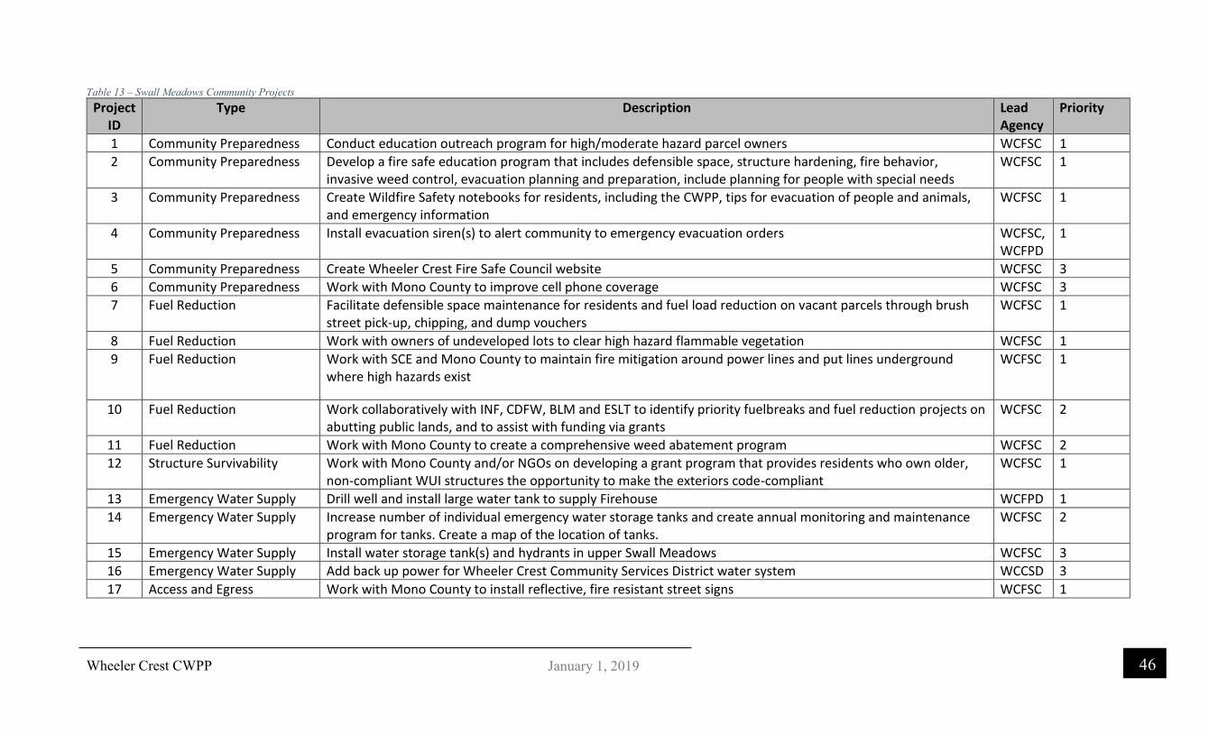
Wheeler Crest CWPP
46 January 1, 2019
Table 13 – Swall Meadows Community Projects Project
ID Type Description Lead
Agency Priority
1 Community Preparedness Conduct education outreach program for high/moderate hazard parcel owners WCFSC 1
2 Community Preparedness Develop a fire safe education program that includes defensible space, structure hardening, fire behavior, invasive weed control, evacuation planning and preparation, include planning for people with special needs
WCFSC 1
3 Community Preparedness Create Wildfire Safety notebooks for residents, including the CWPP, tips for evacuation of people and animals, and emergency information
WCFSC 1
4 Community Preparedness Install evacuation siren(s) to alert community to emergency evacuation orders WCFSC, WCFPD
1
5 Community Preparedness Create Wheeler Crest Fire Safe Council website WCFSC 3
6 Community Preparedness Work with Mono County to improve cell phone coverage WCFSC 3
7 Fuel Reduction Facilitate defensible space maintenance for residents and fuel load reduction on vacant parcels through brush street pick-up, chipping, and dump vouchers
WCFSC 1
8 Fuel Reduction Work with owners of undeveloped lots to clear high hazard flammable vegetation WCFSC 1
9 Fuel Reduction Work with SCE and Mono County to maintain fire mitigation around power lines and put lines underground where high hazards exist
WCFSC 1
10 Fuel Reduction Work collaboratively with INF, CDFW, BLM and ESLT to identify priority fuelbreaks and fuel reduction projects on abutting public lands, and to assist with funding via grants
WCFSC 2
11 Fuel Reduction Work with Mono County to create a comprehensive weed abatement program WCFSC 2
12 Structure Survivability Work with Mono County and/or NGOs on developing a grant program that provides residents who own older, non-compliant WUI structures the opportunity to make the exteriors code-compliant
WCFSC 1
13 Emergency Water Supply Drill well and install large water tank to supply Firehouse WCFPD 1
14 Emergency Water Supply Increase number of individual emergency water storage tanks and create annual monitoring and maintenance program for tanks. Create a map of the location of tanks.
WCFSC 2
15 Emergency Water Supply Install water storage tank(s) and hydrants in upper Swall Meadows WCFSC 3
16 Emergency Water Supply Add back up power for Wheeler Crest Community Services District water system WCCSD 3
17 Access and Egress Work with Mono County to install reflective, fire resistant street signs WCFSC 1

Wheeler Crest CWPP
47 January 1, 2019
18 Access and Egress Work with Mono County and Inyo National Forest to build emergency access route from Quail Circle to Swall Meadows Road
WCFSC 1
19 Fire Department Readiness Create pre-fire notebooks and geo-referenced PDF map app for local fire departments and out of area emergency personnel
WCFSC 1
20 Fire Department Readiness Work with Mono County to enhance radio communication capabilities for FD WCFPD 2

Wheeler Crest CWPP
48 January 1, 2019
Figure 11 - Fire Safe Council Fuel Reduction Projects

Wheeler Crest CWPP
49 January 1, 2019
Southern California Edison The California Public Utilities Commission has designated the Swall Meadows and Paradise communities as a Tier 2. This means that the Utility has a responsibility to make certain changes to its infrastructure.
More information needs to be provided to the Fire Safe Council about how Southern California Edison plans to harden their electrical transmission infrastructure in the CWPP project area but due to a court case related to the Round Fire, they could not provide information at the time of the development of this document and did not participate.
More information on utility fire hazard mitigation requirements can be found at:
http://www.cpuc.ca.gov/firethreatmaps/

Wheeler Crest CWPP
50 January 1, 2019
7. Monitoring and Evaluating the CWPP Recommendations and Accomplishments
Monitoring and Evaluation A CWPP does not end when it is adopted; a thorough process should involve a continuous cycle of collaborative planning, implementation, monitoring and adapting strategies based on lessons learned. As communities learn from successes and challenges during the development and implementation of their CWPP, stakeholders may identify new actions, propose a shift in how decisions are made, or actions are accomplished, and evaluate the resources necessary for successful CWPP implementation.
• Track accomplishments and identify the extent to which CWPP goals have been met. • Examine collaborative relationships and their contributions to CWPP implementation,
including existing participants and potential new partners. • Identify actions and priority fuels reduction projects that have not been implemented, and
why; set a course for future actions and update the plan.
The following table is a framework that can help a community in monitoring and evaluating its CWPP. The table lists six CWPP goals and a series of questions to help communities monitor and evaluate accomplishments, challenges, and how well goals have been met. Communities and agencies may want to work together to ensure that, at a minimum, data are collected to evaluate the plan measures to gain consistency. The community must recognize that fire safety is rapidly changing. It is likely that new developments and new sources of funding for fire safety will become available from year to year. It is recommended that this plan be reviewed on an annual basis by the fire districts with updates every 5 years or sooner if necessary.
Responsibility for monitoring evaluating and updating the CWPP falls on the Wheeler Crest Fire Safe Council and the Wheeler Crest Fire Protection District as well as the Paradise Fire Safe Council (when formed) and the Paradise Fire Protection District.

Wheeler Crest CWPP
51 January 1, 2019
CWPP Monitoring and Evaluation Table
1. Partnerships and Collaboration 1.1 Who has been involved with CWPP development and implementation? How have relationships grown or changed through implementation? What resources did they bring to the table?
1.2 Have partners involved in the planning process remained engaged in implementation? Have new partners become involved? How have the relationships established through the CWPP enhanced opportunities to address CWPP goals?
1.3 How has the collaborative process assisted in implementing the CWPP and building capacity for the community to reduce wildfire risk?
1.4 Has CWPP collaboration made a difference or had a positive impact on local organizations, neighborhoods and/or actions?
2. Risk Assessment 2.1 How has population growth/change and development in your community affected wildfire risk?
2.2 Are there new or updated data sources that may change the risk assessment and influence fuels priorities?
2.3 Has the community enacted a wildfire-related ordinance? If so, county, state, or local?
2.4 Has the community enforced local or CPR 4291 ordinances
3. Reducing Hazardous Fuels 3.1 How many acres have been treated for hazardous fuels reduction on public and private land that were identified as high-priority projects in the CWPP? What percentage of total acres treated does this constitute? Have fuels reduction projects been maintained?
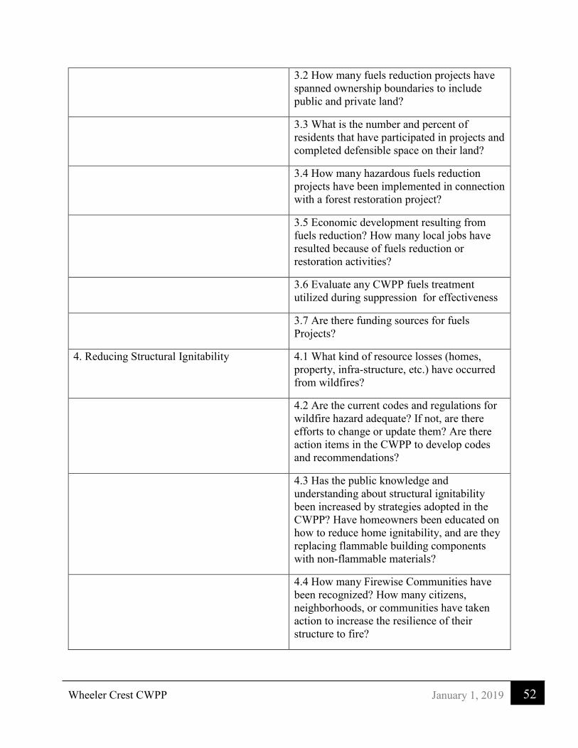
Wheeler Crest CWPP
52 January 1, 2019
3.2 How many fuels reduction projects have spanned ownership boundaries to include public and private land?
3.3 What is the number and percent of residents that have participated in projects and completed defensible space on their land?
3.4 How many hazardous fuels reduction projects have been implemented in connection with a forest restoration project?
3.5 Economic development resulting from fuels reduction? How many local jobs have resulted because of fuels reduction or restoration activities?
3.6 Evaluate any CWPP fuels treatment utilized during suppression for effectiveness
3.7 Are there funding sources for fuels Projects?
4. Reducing Structural Ignitability 4.1 What kind of resource losses (homes, property, infra-structure, etc.) have occurred from wildfires?
4.2 Are the current codes and regulations for wildfire hazard adequate? If not, are there efforts to change or update them? Are there action items in the CWPP to develop codes and recommendations?
4.3 Has the public knowledge and understanding about structural ignitability been increased by strategies adopted in the CWPP? Have homeowners been educated on how to reduce home ignitability, and are they replacing flammable building components with non-flammable materials?
4.4 How many Firewise Communities have been recognized? How many citizens, neighborhoods, or communities have taken action to increase the resilience of their structure to fire?

Wheeler Crest CWPP
53 January 1, 2019
4.5 How has the availability and capacity of local fire agencies to respond to wildland and structural fires improved or changed since the CWPP was developed?
4.6 Are the PRC 4291 defensible space requirements being met?
5. Education and Outreach 5.1 What kind of public involvement has the CWPP fostered? Examples include public education, household visits, demonstration projects, etc.
5.2 Has a change in public awareness about wildfire resulted from the plan?
5.3 What kinds of activities have citizens taken to reduce wildfire risk?
6. Emergency Management 6.1 Is the CWPP integrated within the county or municipal Emergency Operations Plan?
6.2 Does the CWPP include an evacuation plan? If yes, has it been tested or implemented since the CWPP adoption?
6.3 Is the CWPP aligned with other hazard mitigation plans or efforts?
6.4 Create an Evacuation Website and be sure it is operational and has been updated with new information
Table 14 - Monitoring and Evaluating a CWPP
* Include goals that can be evaluated with measures as part of a local CWPP evaluation process. This table identifies specific measures that relate to outcomes that can be evaluated at a national level and are associated with HFRA or identified within the 10-Year Implementation Plan.

Wheeler Crest CWPP
54 January 1, 2019
8. Local Agencies’ Wildfire Response Capabilities
Wheeler Crest Fire Department Administrative Address:
129 Willow Road, Swall Meadows, CA 93514
Primary Service Area: Swall Meadows
Primary Service Population:
Approximately 220 (per 2018 Mono Co. draft Hazard Mitigation Plan)
FY2018 Adopted Budget:
Budgeted Revenue: $72,141
Emergency Medical Service:
EMTs
SERVICES PROVIDED:
Who
Specific Services Self Contract
1. Dispatch Mono County CAD 911 Dispatch
2. Fire Suppression Yes
3. Basic Rescue Yes
4. Advanced Rescue No
5. Vegetation Mgmt. WCFSC
6. Fire Code Permit/Enforcement
Yes/no
7. Haz Mat Response No
8. Construction Plan Check
Yes
9. Fire Investigation No
10. Community Info/
Education WCFSC

Wheeler Crest CWPP
55 January 1, 2019
Fire Stations:
1
Equipment ICS Type
No.
Location
Type 1 engine 2
Type 3 engine 1
Type 1 water tender 1
Personnel: Number Position
Paid Staff: 0
Reserve-Volunteers: 18 volunteers
Support Vehicles 0
SERVICE PROFILE:
Service Calls (CY 2017)*
Count Average Response Time
Structure Fire 0
Wildland Fire 17
15-30 minutes
EMS/Rescue 3
10 minutes
Hazardous Conditions Vehicle Fires: 2
15 minutes
Service Call 0
Good Intent Non-medical: 2
5 minutes
All Others
Totals 24
Notes on Service calls Wildland Fires: were out of district calls EMS/Rescue: Were in district and out of district Non-medical: were in district Vehicle Fires: were on Sherwin Grade
ISO Class Rating 3/3Y
Hydrant/No hydrant
Table 15 - Wheeler Crest Fire Department Response Capabilities

Wheeler Crest CWPP
56 January 1, 2019
Paradise Fire Department Administrative Address:
5300 Old Sherwin Grade Road, Bishop, CA 93514
Primary Service Area: Paradise Camp
Primary Service Population:
Approximately 150 (per 2018 Mono Co. draft Hazard Mitigation Plan)
FY2018 Adopted Budget:
$25,300
Emergency Medical Service:
EMT
SERVICES PROVIDED:
Who
Specific Services Self Contract
1. Dispatch Mono County CAD 911 Dispatch
2. Fire Suppression Yes
3. Basic Rescue Yes
4. Advanced Rescue No
5. Vegetation Mgmt. No
6. Fire Code Permit/Enforcement
No
7. Haz Mat Response No
8. Construction Plan Check
Yes
9. Fire Investigation No
10. Community Info/Education: Paradise Fire Protection District
Type 1 engine 1
Type 6 engine 1
Personnel: Number Position
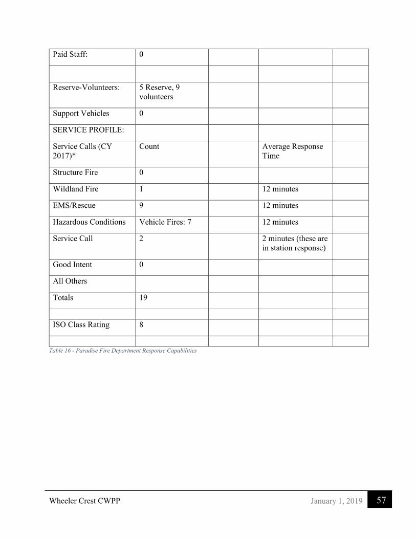
Wheeler Crest CWPP
57 January 1, 2019
Paid Staff: 0
Reserve-Volunteers: 5 Reserve, 9 volunteers
Support Vehicles 0
SERVICE PROFILE:
Service Calls (CY 2017)*
Count Average Response Time
Structure Fire 0
Wildland Fire 1
12 minutes
EMS/Rescue 9
12 minutes
Hazardous Conditions Vehicle Fires: 7
12 minutes
Service Call 2
2 minutes (these are in station response)
Good Intent 0
All Others
Totals 19
ISO Class Rating 8
Table 16 - Paradise Fire Department Response Capabilities

Wheeler Crest CWPP
58 January 1, 2019
The Inyo National Forest fire organization is combined with the Bureau of Land Management (BLM) Bishop Field Office fire organization into one Interagency Fire Management Organization. The management area combines the public land of the Inyo National Forest and BLM Bishop Field Office in Inyo and Mono Counties in California and part of Mineral and Esmeralda Counties in Nevada, covering over 2 million acres. The Interagency Fire Management Organization maintains 8 fire stations with 9 engines, 7 fire prevention patrol units, 2 water tenders, a 10-person fire use management hand crew, a 20-person hotshot crew, an air tanker reload base and a helitack base.
In Mono County the State Responsibility Area (SRA) for wildland fire inside the Inyo National Forest is in the direct protection area (DPA) of the Inyo National Forest. This is provided under contract and the state pays the USFS for this service. The SRA outside the National Forest boundaries in Mono County is in the DPA of the BLM. In exchange the BLM land in Inyo County is in the DPA of CAL FIRE's San Bernardino Unit, Eastern Sierra Division. The DPAs are evaluated periodically by the agencies to determine payments and responsibilities. That evaluation is usually at the request of one of the agencies and can change yearly.
This document is not meant to make recommendations for fire suppression resources. It should be pointed out, however, that determining DPAs is the responsibility of the fire agencies, whether they be local, state, or federal. Local fire departments can do the review through its Insurance Service Office (ISO) rating or can independently determine suppression needs by a third-party analysis. It is not the responsibility of the CWPP to recommend changes unless the local fire departments have concerns and want those concerns identified.
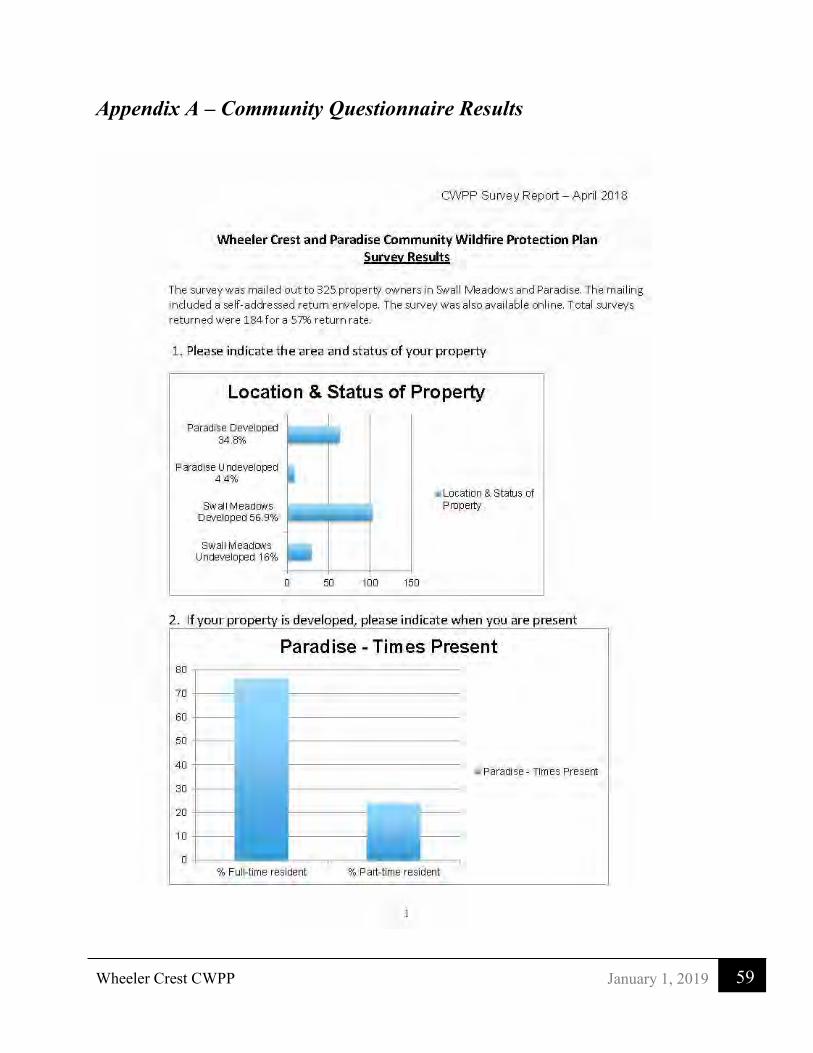
Wheeler Crest CWPP
59 January 1, 2019
Appendix A – Community Questionnaire Results

Wheeler Crest CWPP
60 January 1, 2019

Wheeler Crest CWPP
61 January 1, 2019

Wheeler Crest CWPP
62 January 1, 2019

Wheeler Crest CWPP
63 January 1, 2019

Wheeler Crest CWPP
64 January 1, 2019

Wheeler Crest CWPP
65 January 1, 2019
Appendix B - Fire Behavior Modeling
Fire Behavior Modeling Descriptions (from http://www.fire.org/)
FlamMap is a fire behavior mapping and analysis program that computes potential fire behavior characteristics (spread rate, flame length, fire line intensity, etc.) over an entire FARSITE landscape for constant weather and fuel moisture conditions.
• FlamMap software creates raster maps of potential fire behavior characteristics (spread rate, flame length, crown fire activity, etc.) and environmental conditions (dead fuel moistures, mid-flame wind speeds, and solar irradiance) over an entire FARSITE landscape. These raster maps can be viewed in FlamMap or exported for use in a GIS, image, or word processor.
• FlamMap is not a replacement for FARSITE or a complete fire growth simulation model. There is no temporal component in FlamMap. It uses spatial information on topography and fuels to calculate fire behavior characteristics at one instant.
• It uses the same spatial and tabular data as FARSITE: - a Landscape (.LCP) File, - Initial Fuel Moistures (.FMS) File, - optional Custom Fuel Model (.FMD), - optional Conversion (.CNV), - optional Weather (.WTR), and - optional Wind (.WND) Files.
• It incorporates the following fire behavior models: - Rothermel’s 1972 surface fire model - Van Wagner's 1977 crown fire initiation model - Rothermel's 1991 crown fire spread model - Nelson's 2000 dead fuel moisture model
• FlamMap runs under Microsoft Windows operating systems (Windows 95, 98, me, NT, 2000, and XP) and features a graphical user interface.
• Users may need the support of a geographic information system (GIS) analyst to use FlamMap because it requires spatial coincident landscape raster information to run.
FlamMap is widely used by the National Park Service, Forest Service, and other federal and state land management agencies in support of fire management activities. It is designed for use by those familiar with fuels, weather, topography, wildfire situations, and the associated terminology. Because of its complexity, only users with the proper fire behavior training and experience should use FlamMap where the outputs are to be used for making fire and land management decisions.
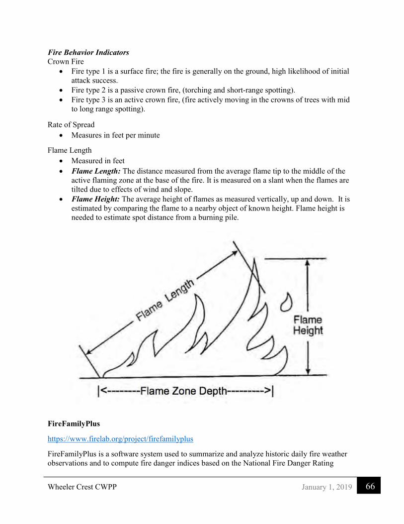
Wheeler Crest CWPP
66 January 1, 2019
Fire Behavior Indicators Crown Fire
• Fire type 1 is a surface fire; the fire is generally on the ground, high likelihood of initial attack success.
• Fire type 2 is a passive crown fire, (torching and short-range spotting). • Fire type 3 is an active crown fire, (fire actively moving in the crowns of trees with mid
to long range spotting).
Rate of Spread • Measures in feet per minute
Flame Length • Measured in feet • Flame Length: The distance measured from the average flame tip to the middle of the
active flaming zone at the base of the fire. It is measured on a slant when the flames are tilted due to effects of wind and slope.
• Flame Height: The average height of flames as measured vertically, up and down. It is estimated by comparing the flame to a nearby object of known height. Flame height is needed to estimate spot distance from a burning pile.
FireFamilyPlus
https://www.firelab.org/project/firefamilyplus
FireFamilyPlus is a software system used to summarize and analyze historic daily fire weather observations and to compute fire danger indices based on the National Fire Danger Rating

Wheeler Crest CWPP
67 January 1, 2019
System (NFDRS) or the Canadian Fire Danger Rating System (CAN). Fire occurrence data can also be analyzed and cross-referenced with weather data to help determine critical levels for staffing and to establish fire danger for an area. This program was used to develop the weather parameters to run FLAMMAP those parameters are listed below. The 90th percentile weather was used for this analysis. This is indicative of high fire danger days during the fire season when humidity is less than 15%, temperatures are greater than 70º, and wind speeds are greater than 6
miles per hour.
Figure 12 - FireFamily Weather for FLAMMAP

Wheeler Crest CWPP
68 January 1, 2019
Vegetation and Fuel Model
Figure 13 - Sample Vegetation Photo 1
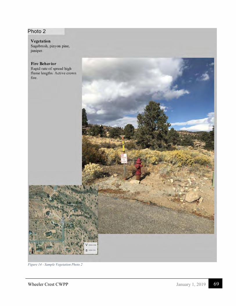
Wheeler Crest CWPP
69 January 1, 2019
Figure 14 - Sample Vegetation Photo 2

Wheeler Crest CWPP
70 January 1, 2019
Figure 15 - Sample Vegetation Photo 3

Wheeler Crest CWPP
71 January 1, 2019
Figure 16 - Sample Vegetation Photo 4

H
H
H
H
HH
H
H
H
H
H
HH
H
H
H
H
HH
HH
H
H
H
H
H
H
H
H
H
HH
H
H
H
H
H
H
H
H
H
H
H
HH
H
H
H
HH
H
H
H
HH
HH
H
H
H
H
H
H
H
H
H
H
H
H
H
H
H
H
HH
H
H
H
H
H H H H H H H
HH
H
H H H H HH
H
H
H
H H H H H H
H
H
H
HH
H
H
H
H
H
HH
H
H
HH
H
H
H
H
H
HH
H
H
HH
H
H
H
H
HH
H
H
H
H
H
H
H
H
H
H
H
H
H
H
H
HH
H
H
H
H
H
H
H
H
HH
H
H
H
H
H
H
H
HH
H
H
H
H
H
H
H
H
HHH HHHH HH HH H
HH
H
HH
H
H
HHH
H
H
H
H
H
HH
HH
H
HH
H
H
H
HH
H
H
H
H
H
H
H
H
H
HH
HH
H
H
H
H
H
H
HH
H
H
H
HH
H
H
H
H
H
H
H
H
H
H
H
H
H
H
H
H
H
H
H
H
H
H
H
H
H
H
H
H
H
H
H
H
H
H
H
H
H
H HH
HH
HH
H
H
H
H H
H
H
H
HH
HH
H
HH
HH
H
H
HH
H
H
H
H
HH
HH
H
HH
HH
H
H
HH
H
HH
H
H
H
HH
H
H
H
HH
H
H
H
HH H
H H
HH
H
HH H
HH
HH
H
HH H
HH
HH
H
H
H
H
H
H
H
H
H
H
HH
HH H
H
H
H
H
H
H
H
H H
HH
H HH
H
H
H
H
H
H
H
H
HH
H HH
H
H
H
H
H
H
H
H
H
H
H
H
H
H
H
H
H
H
H
H
H
H
H
H
HH
H
H
H
H
H
H
H
HH
H
H
H
H
H
H
H
H
H
H
H
H
H
H
H
H
HH
H
HH
H
HH
H
H
H
HH
H
H
H
HH
H
H
HH
H
HH
H
H
H
HH
H
H
H
HH
H
H
HH
H
H
H
H
H
H
HH
H
H
H
HH
H
H
H
HHH
HH
H
H
HH
H H
HHHH
HH
H
H
HH
H
H
HHHH
HHH
H
H
H
H
H
H
H
H
H
H
H
H HH
H
H
H
H
H
H
H
H
H
H
H
H
H
H
H
H
H
H
H
H
H
H
H
H
H
H
H
H
H
H
H
H
H
H
H
H
H
H
H
H
H
H
H
H
H
H
H
H
H
HHH
H
HHH
H
HHH
HH
H
H
H
H
H
HH
H
H
H
H
H
HH
H
H
H
H
H
HH
HH
H
H
H
HH
H
H
H
H
HH
H
H
H
H
H
H
H
H
H
H
H
H
H
H
H
H
H
H
H
H
H
H
H H
H
H H
H
H
H
H
H
H
H
H H
H
H H
H
H
H
H
H
H
H
HH
H
H H
H
H
H H
H
H
H H
H
H
HH H
H
H
H
H
H
H HH
H
H
H
H
H
H
H H
H
H
H
H
H
H
H
H H
H
H
H
H
H H
HH
HH
H
H
H H
H H
H H
H
HH
H
H HH H
H
HH
HH
H
H
H
H HH
H
H
H
H
HH
H
H
H
H
H
H
H
HH
H
H
H
H H
H
H
H
H
H
H H
H
H
H
H H
H
H
H
H
H
H H
HH
H
H H
H
H
H
H
H
H
H
H
HH
H
H
H
H
H
H
H
H
H
H
H
H
H
H
H
H
H
H
H
H
H
H
H
HH
H
H
H
H
H
H
H
H
H
H
H
H
H
H
H
H
H
H
H
H
H
H
H
HH
H
H
H
H
H
H
H
H
H
H
H
H
H
H
H
H
H
HH
H
H
H
H
H
H
H
H
H
H
H
H
H
HH
H
H
H
H
H
H
H
H
H
H
H
H
H
H HH
H
H
H
H
H
H
H
H
H
H
H
H
H
H
H
H
H
H
H
H
H
H
H
H
H
H
H
H
H
H
H
H
H
H
H
H
H
H
H
H
H
H
H
H
H
H
H
H
H
H
H
H
H
H
H
H
H
H
H
H
H
HH
H
H
H
H
H
H
H
H
H
H H
H
H
H
H
HH
H
H
H
H
H
HH
H
H
H
H
H
H
H
H
H
H HH
H
H
H
H
H
H
H
H
H
H
H
H
H
H
H
H HH
H
H
H
H
H
H
H
H
H
H
H
H
H
H
H H H
H
H
H
H
H
H
H H
H
H
H
H
H
HH
H
H
H
H
H
H H
H
H
H
H
H
HH
H
H
H
H
H
H
H
H
H
H
H
H
HH
H
H
H
H
H
H
H
H
H
H
H
H
H
H
H
H
H
HH
H
H
H
H
H
H
HH
H
H
H
H
HH
H
HH
H
H
H
HH
H
HH
H
H
H
HH
H
HH
H
H
H
H
H
H
H
H
H
H
H
H
HH
H
H
H
H
H
H
H
H
H
H
H
H
H
HH
H
H
H
H
H
H
H
H
H
H
HH
H
HH
H
H
H
H
H
H
HH
H
H
H
H
H
H
HH
H
H
H
H
H
H
HH
H
H
H
H
H
H
H
H
H
H
H
H
H
H
H
H
H
H
H
H
H
HH
H
H
H
H
H
H
H
H
H
H
H
H
H
HH
H
H
H
H
H
H
H
H
H
"
"
"
"
"
"
"
"
"
N
N
N
N
N
N
N
N
O
O
O
O
O
Spring
ROAD
29
LOWER
ROAD
35
4WD
19
Ainslee
7
Creek
1317
20
ROCK CREEK
ROAD
18
11
Rock
31
4WD
S h e r w i n
26
ROAD
Spring
4WD
LOWER
Meadow
25
144WD
Spring
30
32
ROAD
BOUNDARYM O NO COT 5 S
36
Lower Rock
NATIONA L
ROCK CREEK
Witcher
Creek
T 5 S
Spring
Spring
ROAD
ParadiseCam p
FORE STBOUNDARY
INYO CO
Springs
INYO CO
N A T I O N A L
FORE ST
Spring
H i l l
Creek
Prospects
12
SherwinHill
R 3
1 E
T 6 SM O NO CO
2423
Sky MeadowRanch
SwallMeadows
R 3
0 E
FORE
ST
ROCK CREEK
Creek
BOUNDARY
BOUN
DARY
T 6 S
F O R E S T
NATI
ONAL
Scenic Point
I N Y O
Creek
4WD
R 3
1 E
R 3
0 E
4WD
4WD
J O H N
M U I R
W I L D E R N E S S
£¤395
Quail
Cir
CougerRun
DeerPeak
Trl
Sum mitRd
Wilson Rd
Westr idgeR d
Lower RockC reek Rd
Pi n e
Dr
SierraWave
Mt View Dr
Wheeler Crest CWPP - 2018
Flame LengthFeet
0 - 44 - 88- 1111 - 20
Ü0 10.5
Miles
Figure 17: Flame Length

H
H
H
H
HH
H
H
H
H
H
HH
H
H
H
H
HH
HH
H
H
H
H
H
H
H
H
H
HH
H
H
H
H
H
H
H
H
H
H
H
HH
H
H
H
HH
H
H
H
HH
HH
H
H
H
H
H
H
H
H
H
H
H
H
H
H
H
H
HH
H
H
H
H
H H H H H H H
HH
H
H H H H HH
H
H
H
H H H H H H
H
H
H
HH
H
H
H
H
H
HH
H
H
HH
H
H
H
H
H
HH
H
H
HH
H
H
H
H
HH
H
H
H
H
H
H
H
H
H
H
H
H
H
H
H
HH
H
H
H
H
H
H
H
H
HH
H
H
H
H
H
H
H
HH
H
H
H
H
H
H
H
H
HHH HHHH HH HH H
HH
H
HH
H
H
HHH
H
H
H
H
H
HH
HH
H
HH
H
H
H
HH
H
H
H
H
H
H
H
H
H
HH
HH
H
H
H
H
H
H
HH
H
H
H
HH
H
H
H
H
H
H
H
H
H
H
H
H
H
H
H
H
H
H
H
H
H
H
H
H
H
H
H
H
H
H
H
H
H
H
H
H
H
H HH
HH
HH
H
H
H
H H
H
H
H
HH
HH
H
HH
HH
H
H
HH
H
H
H
H
HH
HH
H
HH
HH
H
H
HH
H
HH
H
H
H
HH
H
H
H
HH
H
H
H
HH H
H H
HH
H
HH H
HH
HH
H
HH H
HH
HH
H
H
H
H
H
H
H
H
H
H
HH
HH H
H
H
H
H
H
H
H
H H
HH
H HH
H
H
H
H
H
H
H
H
HH
H HH
H
H
H
H
H
H
H
H
H
H
H
H
H
H
H
H
H
H
H
H
H
H
H
H
HH
H
H
H
H
H
H
H
HH
H
H
H
H
H
H
H
H
H
H
H
H
H
H
H
H
HH
H
HH
H
HH
H
H
H
HH
H
H
H
HH
H
H
HH
H
HH
H
H
H
HH
H
H
H
HH
H
H
HH
H
H
H
H
H
H
HH
H
H
H
HH
H
H
H
HHH
HH
H
H
HH
H H
HHHH
HH
H
H
HH
H
H
HHHH
HHH
H
H
H
H
H
H
H
H
H
H
H
H HH
H
H
H
H
H
H
H
H
H
H
H
H
H
H
H
H
H
H
H
H
H
H
H
H
H
H
H
H
H
H
H
H
H
H
H
H
H
H
H
H
H
H
H
H
H
H
H
H
H
HHH
H
HHH
H
HHH
HH
H
H
H
H
H
HH
H
H
H
H
H
HH
H
H
H
H
H
HH
HH
H
H
H
HH
H
H
H
H
HH
H
H
H
H
H
H
H
H
H
H
H
H
H
H
H
H
H
H
H
H
H
H
H H
H
H H
H
H
H
H
H
H
H
H H
H
H H
H
H
H
H
H
H
H
HH
H
H H
H
H
H H
H
H
H H
H
H
HH H
H
H
H
H
H
H HH
H
H
H
H
H
H
H H
H
H
H
H
H
H
H
H H
H
H
H
H
H H
HH
HH
H
H
H H
H H
H H
H
HH
H
H HH H
H
HH
HH
H
H
H
H HH
H
H
H
H
HH
H
H
H
H
H
H
H
HH
H
H
H
H H
H
H
H
H
H
H H
H
H
H
H H
H
H
H
H
H
H H
HH
H
H H
H
H
H
H
H
H
H
H
HH
H
H
H
H
H
H
H
H
H
H
H
H
H
H
H
H
H
H
H
H
H
H
H
HH
H
H
H
H
H
H
H
H
H
H
H
H
H
H
H
H
H
H
H
H
H
H
H
HH
H
H
H
H
H
H
H
H
H
H
H
H
H
H
H
H
H
HH
H
H
H
H
H
H
H
H
H
H
H
H
H
HH
H
H
H
H
H
H
H
H
H
H
H
H
H
H HH
H
H
H
H
H
H
H
H
H
H
H
H
H
H
H
H
H
H
H
H
H
H
H
H
H
H
H
H
H
H
H
H
H
H
H
H
H
H
H
H
H
H
H
H
H
H
H
H
H
H
H
H
H
H
H
H
H
H
H
H
H
HH
H
H
H
H
H
H
H
H
H
H H
H
H
H
H
HH
H
H
H
H
H
HH
H
H
H
H
H
H
H
H
H
H HH
H
H
H
H
H
H
H
H
H
H
H
H
H
H
H
H HH
H
H
H
H
H
H
H
H
H
H
H
H
H
H
H H H
H
H
H
H
H
H
H H
H
H
H
H
H
HH
H
H
H
H
H
H H
H
H
H
H
H
HH
H
H
H
H
H
H
H
H
H
H
H
H
HH
H
H
H
H
H
H
H
H
H
H
H
H
H
H
H
H
H
HH
H
H
H
H
H
H
HH
H
H
H
H
HH
H
HH
H
H
H
HH
H
HH
H
H
H
HH
H
HH
H
H
H
H
H
H
H
H
H
H
H
H
HH
H
H
H
H
H
H
H
H
H
H
H
H
H
HH
H
H
H
H
H
H
H
H
H
H
HH
H
HH
H
H
H
H
H
H
HH
H
H
H
H
H
H
HH
H
H
H
H
H
H
HH
H
H
H
H
H
H
H
H
H
H
H
H
H
H
H
H
H
H
H
H
H
HH
H
H
H
H
H
H
H
H
H
H
H
H
H
HH
H
H
H
H
H
H
H
H
H
"
"
"
"
"
"
"
"
"
N
N
N
N
N
N
N
N
O
O
O
O
O
Spring
ROAD
29
LOWER
ROAD
35
4WD
19
Ainslee
7
Creek
1317
20
ROCK CREEK
ROAD
18
11
Rock
31
4WD
S h e r w i n
26
ROAD
Spring
4WD
LOWER
Meadow
25
144WD
Spring
30
32
ROAD
BOUNDARYM O NO COT 5 S
36
Lower Rock
NATIONA L
ROCK CREEK
Witcher
Creek
T 5 S
Spring
Spring
ROAD
ParadiseCam p
FORE STBOUNDARY
INYO CO
Springs
INYO CO
N A T I O N A L
FORE ST
Spring
H i l l
Creek
Prospects
12
SherwinHill
R 3
1 E
T 6 SM O NO CO
2423
Sky MeadowRanch
SwallMeadows
R 3
0 E
FORE
ST
ROCK CREEK
Creek
BOUNDARY
BOUN
DARY
T 6 S
F O R E S T
NATI
ONAL
Scenic Point
I N Y O
Creek
4WD
R 3
1 E
R 3
0 E
4WD
4WD
J O H N
M U I R
W I L D E R N E S S
£¤395
Deer
Peak
Trl
Rimrock Dr
Swall Meadows Rd
ValleyView
Rd Pine
Dr
RidgeView
Westridge
Rd
Mt View Dr
Wheeler Crest CWPP - 2018
Rate of SpreadFeet/Min
0 - 11 - 66 - 1111 - 2222 - 4444 - 88
Ü0 10.5
Miles
Figure 18: Rate of Spread

Wheeler Crest CWPP
74 January 1, 2019
Appendix C - Wheeler Crest Community Service District Information
From an August 2018 letter from the Chairman to CWPP Consultant Barry Callenberger.
There are two water systems under the Wheeler Crest Community Service District WCCSD. The Hilltop system consists of 14 active laterals, gravity fed from an artesian well (no electricity is required), a 7500-gallon reservoir with limited pressure and almost no firefighting capability. Homes on that water system that were lost in the fire have had to put in individual water tanks for fire suppression and egress to satisfy current water pressure requirements. Although there is a conventional well as a back-up, we do not have any plans for any kind of generator. E.g. a backup to the backup.
The Lower Swall Meadows Water System (LSMWS) is more robust and currently has the capacity to support 86 laterals or households although only 43 are currently active. All wells fill Reservoir 2. Reservoir 2 fills Reservoir 1. Seems backwards but Reservoir 2 was built higher in elevation. Reservoir 1 can be filled manually with no electricity (from Reservoir 2). Since our Well 4 is our highest producing well, that would be the most likely candidate for generator backup. Once again, it flows into and fills Reservoir 2.
You will see mention of our Sierra Controls that normally control the pumping of our wells based on the need to fill the reservoirs. We recently lost this box due to a lightning strike in addition to 2 wells. The wells were brought back online almost immediately. The reservoirs were simply monitored manually, and the wells were turned on manually until the Sierra Controls box was restored. E.g. we not currently have plans for emergency power backup to the Sierra Controls cluster.
In pressure station 2, it is a vault that monitors pressures where if hydrants are suddenly pulling water from the system, it opens a pressure reduction valve to normalize the pressure in the lower portion of the system until the hydrants are no longer pulling water.
The following is an excerpt from out standards and procedures manual.
Zone of Benefit
unconnected laterals 43 connected laterals 43
Pinon Ranch – 41 lots 14 Unconnected 27 connected Rimrock Ranch - 46 lots 30 Unconnected 16 connected
Fire hydrants 23
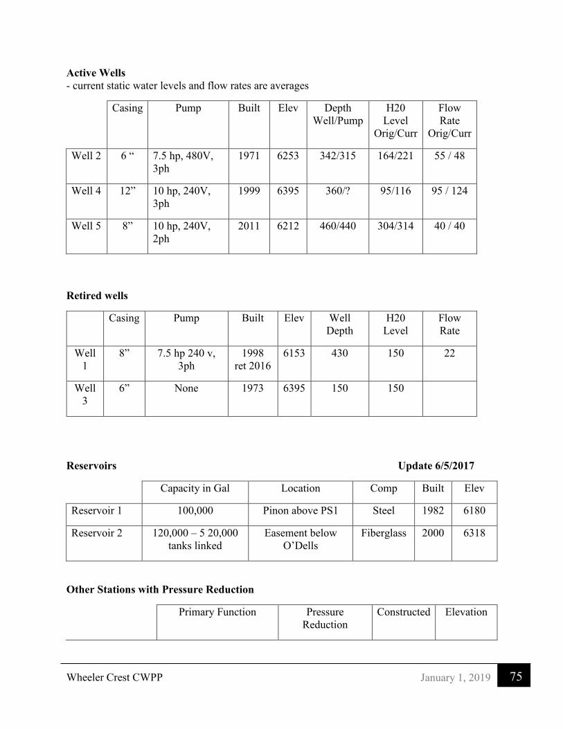
Wheeler Crest CWPP
75 January 1, 2019
Active Wells - current static water levels and flow rates are averages
Casing Pump Built Elev Depth Well/Pump
H20 Level
Orig/Curr
Flow Rate
Orig/Curr
Well 2 6 “ 7.5 hp, 480V, 3ph
1971 6253 342/315 164/221 55 / 48
Well 4 12” 10 hp, 240V, 3ph
1999 6395 360/? 95/116 95 / 124
Well 5 8” 10 hp, 240V, 2ph
2011 6212 460/440 304/314 40 / 40
Retired wells
Casing Pump Built Elev Well Depth
H20 Level
Flow Rate
Well 1
8” 7.5 hp 240 v, 3ph
1998 ret 2016
6153 430 150 22
Well 3
6” None 1973 6395 150 150
Reservoirs Update 6/5/2017
Capacity in Gal Location Comp Built Elev
Reservoir 1 100,000 Pinon above PS1 Steel 1982 6180
Reservoir 2 120,000 – 5 20,000 tanks linked
Easement below O’Dells
Fiberglass 2000 6318
Other Stations with Pressure Reduction
Primary Function Pressure Reduction
Constructed Elevation

Wheeler Crest CWPP
76 January 1, 2019
PS1 – Pressure Station 1
Controls filling of Reservoir 1 from
Reservoir 2
75 / 45 2015 6153
PR2 – Pressure Reduction Vault 2
Pressure Reduction Only 104 / 45 2002 6084
WELL AUTOMATED CONTROL SYSTEM (Sierra Controls) - Automatically turns on pumps and opens valves depending on levels of the reservoirs - Telemetry communications between - control panels in PS1 and WH2 - Reservoirs 1 & 2 (monitors levels) - well pumps (2,4,5) turns them on and off - fill valve from Res 2 to fill Res 1 (located in PS1) - *All alarm triggers turns on light outside of WH2 Pressure Station 1 (PS1) Control House - Opens valve to fill Reservoir 1 from Reservoir 2
Scheduled hours of Operation 23:00 – 6:00 Daily
R1 fill level start 8.5 feet
R1 fill level stop 9.5 feet
R1 high alarm* 10 feet
R1 low alarm* 7 feet
Well House 2 (WH2) Controls - Turns on pumps in Wells 2,4,5 to fill Reservoir 2 (R2) Alternates lead, lag and stand-by between each well pump daily
Scheduled hours of Operation 23:00 – 6:00 Daily
R2 Lead Pump start 8.5 feet
R2 Lead Pump stop 9.5 feet
R2 Lag Pump start 8 feet
R2 Lag Pump stop 9.5 feet
R2 Standby Pump start 7 feet
R2 Standby Pump stop 9 feet
R2 High alarm* 9.7 feet
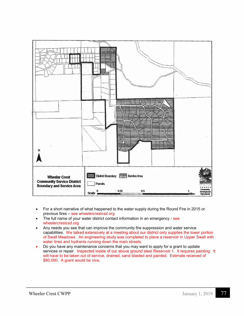
Wheeler Crest CWPP
77 January 1, 2019
• For a short narrative of what happened to the water supply during the Round Fire in 2015 or previous fires – see wheelercrestcsd.org
• The full name of your water district contact information in an emergency - see wheelercrestcsd.org
• Any needs you see that can improve the community fire suppression and water service capabilities. We talked extensively at a meeting about our district only supplies the lower portion of Swall Meadows. An engineering study was completed to place a reservoir in Upper Swall with water lines and hydrants running down the main streets.
• Do you have any maintenance concerns that you may want to apply for a grant to update services or repair. Inspected inside of our above ground steel Reservoir 1. It requires painting. It will have to be taken out of service, drained, sand blasted and painted. Estimate received of $80,000. A grant would be nice.

Wheeler Crest CWPP
78 January 1, 2019
I hope this answers all your immediate questions. Let me know if there’s anything else.
Thanks, Glenn Inouye Wheeler Crest Community Service District – Chairman [email protected] 760 914-0405 The Following is a letter to the Wheeler Crest CWPP outlining the needs of the water district that services the Paradise Community
LOWER ROCK CREEK MUTUAL WATER COMPANY 245 UPPER CANYON ROAD
BISHOP, CA 93514 December 18, 2017 To whom it may concern Re: Community Wildfire Protection Plan

Wheeler Crest CWPP
79 January 1, 2019
The Lower Rock Creek Mutual Water Company (LRCMWC) serves the residents of the Sierra Paradise Estates and the Rock Creek Canyon Development. The goal of the company is to supply residents with an adequate supply of potable water for domestic use and fire protection. To that end, I submit that additional water storage and a standby generator for the LRCMWC would considerably increase fire suppression capabilities to support not only the Paradise Fire Department but any and all fire departments responding for area fires. National Storage Tank, Inc. has provided cost estimates for a few options:
1. Corrugated Bolted Steel Tank with interior lining, 20-year warranty, rough cost $0.60/gallon 2. Coated Carbon Bolted Steel Tank, 1-year warranty, rough cost $0.70/gallon 3. Underground Fiberglass 35,000gall tanks, 30-year warranty, rough cost $2.00/gal
Though the LRCMWC water storage tanks always maintain in reserve the required minimum of 60,000 gallons of water for fire protection, the numerous fire trucks drawing from our hydrants during the Round Fire drained the entire water system within a few hours - leaving the hydrants empty and open. Water is the number one agent for fire suppression. The combined capacity of our two existing water storage tanks when full is 110,000 gallons. Our “Business Plan” includes an additional 100,000 gallons of storage by build out (100,000gal tank X $0.60 = $60,000 plus site prep, controls, permits, etc.).
The Round Fire burned numerous power poles cutting off the necessary electrical power to run our water well. A standby generator would have kept the well in operation providing an additional 130 gallons per minute (7,800 gallons/hour) of available water for fire suppression. The water company has installed the necessary panel to switch from commercial to emergency power. A Generac Commercial 70kW (Alum-EPA/CA Emissions) to supply emergency power for our well can be purchased today from NORWALL POWER SYSTEMS for $19,299 - includes free shipping.
Additionally, nine of the twenty-two fire hydrants in Paradise Estates are nearly fifty years old, repair parts are no longer available from the manufacturer, and aftermarket parts are increasingly difficult to locate. The price quote from Western Nevada Supply for a new hydrant is $2,464.63 - not including tax or installation. Removing brush/fuel for a minimum of 100 feet from the perimeter of the development would considerably reduce the risk of structure losses.
James Moyer (760-387-0070) President, Board of Directors Lower Rock Creek Mutual Water Company
Swall Meadows Water District

Wheeler Crest CWPP
80 January 1, 2019
Appendix D - Quail Circle Emergency Evacuation Route

Wheeler Crest CWPP
81 January 1, 2019

Wheeler Crest CWPP
82 January 1, 2019

Wheeler Crest CWPP
83 January 1, 2019

Wheeler Crest CWPP
84 January 1, 2019
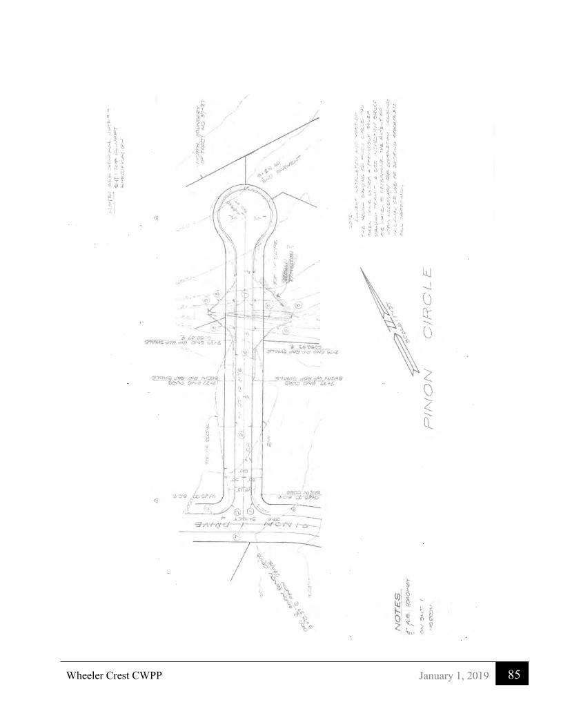
Wheeler Crest CWPP
85 January 1, 2019

Wheeler Crest CWPP
86 January 1, 2019
References/Links
Preparing your home and Family for a wildfire, Wildfire is Coming are you prepared,
http://www.readyforwildfire.org/
California Public Resources Code 4291 – Defensible Space: https://leginfo.legislature.ca.gov/faces/codes_displaySection.xhtml?sectionNum=4291.&lawCode=PRC Unit Strategic Fire Plan San Bernardino Unit, CAL FIRE, May 2017 http://cdfdata.fire.ca.gov/pub/fireplan/fpupload/fpppdf1632.pdf Mono County Emergency Operations Plan (2012): https://monosheriff.org/sites/default/files/fileattachments/sheriff_-_coroner/page/8077/mono_county_oa_eop_2012.pdf
WUI Research Bibliography for Resource Managers: http://www.cafiresci.org/s/CFSC_WUI_Bibliography_Sept2012.pdf
University of Nevada Cooperative Extension, 2004, The Combustibility of Landscape Mulches https://www.unce.unr.edu/publications/files/nr/2011/sp1104.pdf Firewise – How to Prepare Your Home for Wildfires https://www.nfpa.org/-/media/Files/Firewise/Fact-sheets/FirewiseHowToPrepareYourHomeForWildfires.pdf University of Nevada Cooperative Extension, 2006, Living with Fire in the Tahoe Basin https://www.unce.unr.edu/publications/files/nr/2006/SP0611.pdf
University of California Cooperative Extension, 2010, Home Survival In Wildfire Prone Areas Building Materials and Design Considerations https://ucanr.edu/sites/postfire/files/247816.pdf Scheinost, P.L., J. Scianna, D.G. Ogle. 2010. Plant guide for rubber rabbitbrush (Ericameria nauseosa). USDA Natural Resources Conservation Service, Pullman Plant Materials Center, Pullman, WA. https://plants.usda.gov/plantguide/pdf/pg_erna10.pdf
Fire Adaptive Communities: The National Wildfire Coordinating Group defines a fire adapted community as “A human community consisting of informed and prepared citizens collaboratively planning and taking action to safely coexist with wildland fire.” https://fireadapted.org/