Santa Cruz County Multi-Jurisdictional Hazard Mitigation Plan ...
220
Santa Cruz County Santa Cruz County Santa Cruz County Multi Multi Multi-Jurisdictional Jurisdictional Jurisdictional Hazard Mitigation Plan Hazard Mitigation Plan Hazard Mitigation Plan 2011 2011 2011
-
Upload
khangminh22 -
Category
Documents
-
view
0 -
download
0
Transcript of Santa Cruz County Multi-Jurisdictional Hazard Mitigation Plan ...

Santa Cruz County Santa Cruz County Santa Cruz County MultiMultiMulti---Jurisdictional Jurisdictional Jurisdictional
Hazard Mitigation Plan Hazard Mitigation Plan Hazard Mitigation Plan 201120112011

SANTA CRUZ COUNTY MULTI-JURISDICTIONAL HAZARD MITIGATION PLAN 2011
FOR OFFICIAL USE ONLY ES 1
EXECUTIVE SUMMARY
Across the United States, natural and human-caused disasters have led to increasing levels of death, injury, property damage, and interruption of business and government services. The toll on families and individuals can be immense and damaged businesses cannot contribute to the economy. The time, money and effort to respond to and recover from these emergencies or disasters divert public resources and attention from other important programs and problems. With 36 federal or state declarations, 98 other significant events, and a combined total of 134 disaster events recorded, the three jurisdictions within Santa Cruz County, Arizona participating in this planning effort, recognize the consequences of disasters and the need to reduce the impacts of natural and human-caused hazards. The county and jurisdictions also know that with careful selection, mitigation actions in the form of projects and programs can become long-term, cost effective means for reducing the impact of natural and human-caused hazards.
The elected and appointed officials of Santa Cruz County, Nogales, and Patagonia demonstrated their commitment to hazard mitigation in 2005-2006 by preparing the first Santa Cruz County Multi-Jurisdictional Hazard Mitigation Plan (2006 Plan). The 2006 Plan was approved by FEMA on March 23, 2006 and now requires a full, FEMA approved, update due to its five year expiration.
In response, the Arizona Division of Emergency Management (ADEM) secured a federal planning grant and hired JE Fuller/ Hydrology & Geomorphology, Inc. to assist the county and participating jurisdictions with the update process. Santa Cruz County reconvened a multi-jurisdictional planning team comprised of veteran and first-time representatives from each participating jurisdiction, various county and local departments and organizations, and ADEM. The Planning Team met four times during the period of October 2010 to April 2011 in a collaborative effort to review, evaluate, and update the 2006 Plan. The resulting Santa Cruz County Multi-Jurisdictional Hazard Mitigation Plan (Plan) will continue to guide the county and participating jurisdictions toward greater disaster resistance in full harmony with the character and needs of the community and region.
The Plan has been prepared in compliance with Section 322 of the Robert T. Stafford Disaster Relief and Emergency Assistance Act (Stafford Act or the Act), 42 U.S. C. 5165, enacted under Sec. 104 the Disaster Mitigation Act of 2000, (DMA 2000) Public Law 106-390 of October 30, 2000, as implemented at CFR 201.6 and 201.7 dated October, 2007. The Plan identifies hazard mitigation measures intended to eliminate or reduce the effects of future disasters throughout the county, and was developed in a joint and cooperative venture by members of the Santa Cruz County Planning Team.

SANTA CRUZ COUNTY MULTI-JURISDICTIONAL HAZARD MITIGATION PLAN 2011
FOR OFFICIAL USE ONLY Page i
TABLE OF CONTENTS
SECTION 1: JURISDICTIONAL ADOPTION AND FEMA APPROVAL .................................................... 1 1.1 DMA 2000 Requirements ............................................................................................................... 1
1.1.1 General Requirements ................................................................................................................ 1 1.1.2 Update Requirements ................................................................................................................. 1
1.2 Official Record of Adoption ........................................................................................................... 2 1.3 FEMA Approval Letter .................................................................................................................. 2
SECTION 2: INTRODUCTION ................................................................................................................. 5 2.1 Plan History ..................................................................................................................................... 5 2.2 Plan Purpose and Authority ........................................................................................................... 5 2.3 General Plan Description ............................................................................................................... 5 2.4 Overall Plan Update Process .......................................................................................................... 5
SECTION 3: PLANNING PROCESS ......................................................................................................... 9 3.1 Planning Process Description ......................................................................................................... 9 3.2 Previous Planning Process Assessment ......................................................................................... 9 3.3 Primary Point of Contact ............................................................................................................... 9 3.4 Planning Teams ............................................................................................................................. 10
3.4.1 Planning Team Assembly ........................................................................................................ 10 3.4.2 Planning Team Activities ......................................................................................................... 11 3.4.3 Agency/Organizational Participation ....................................................................................... 13
3.5 Public Involvement ....................................................................................................................... 14 3.5.1 Previous Plan Assessment ........................................................................................................ 14 3.5.2 Plan Update .............................................................................................................................. 15
3.6 Reference Documents and Technical Resources ........................................................................ 15
SECTION 4: COMMUNITY DESCRIPTIONS ......................................................................................... 19 4.1 General ........................................................................................................................................... 19 4.2 County Overview .......................................................................................................................... 19
4.2.1 Geography ................................................................................................................................ 19 4.2.2 Climate ..................................................................................................................................... 23 4.2.3 Population ................................................................................................................................ 25 4.2.4 Economy .................................................................................................................................. 26
4.3 Jurisdictional Overviews .............................................................................................................. 29 4.3.1 Nogales .................................................................................................................................... 29 4.3.2 Patagonia .................................................................................................................................. 31
SECTION 5: RISK ASSESSMENT .......................................................................................................... 33 5.1 Hazard Identification and Screening........................................................................................... 33 5.2 Vulnerability Analysis Methodology ........................................................................................... 36
5.2.1 General ..................................................................................................................................... 36 5.2.2 Calculated Priority Risk Index (CPRI) Evaluation .................................................................. 36 5.2.3 Asset Inventory ........................................................................................................................ 37 5.2.4 Loss Estimations ...................................................................................................................... 40 5.2.5 Development Trend Analysis................................................................................................... 41
5.3 Hazard Risk Profiles ..................................................................................................................... 41 5.3.1 Dam Failure ............................................................................................................................. 43 5.3.2 Drought .................................................................................................................................... 51 5.3.3 Extreme Temperature............................................................................................................... 59 5.3.4 Flood / Flash Flood .................................................................................................................. 63 5.3.5 Hazardous Materials Incidents ................................................................................................. 71 5.3.6 Severe Wind ............................................................................................................................. 77 5.3.7 Wildfire .................................................................................................................................... 81
5.4 Risk Assessment Summary ........................................................................................................... 88
SANTA CRUZ COUNTY MULTI-JURISDICTIONAL HAZARD MITIGATION PLAN 2011
FOR OFFICIAL USE ONLY Page ii
SECTION 6: MITIGATION STRATEGY ................................................................................................. 89 6.1 Hazard Mitigation Goals and Objectives ................................................................................... 89 6.2 Capability Assessment ................................................................................................................. 92
6.2.1 Jurisdictional Capabilities ....................................................................................................... 93 6.2.2 Previous Mitigation Activities ...............................................................................................101 6.2.3 National Flood Insurance Program Participation ...................................................................103
6.3 Mitigation Actions/Projects and Implementation Strategy .....................................................104 6.3.1 Previous Mitigation Actions/Projects Assessment .................................................................104 6.3.2 New Mitigation Actions / Projects and Implementation Strategy ..........................................116
SECTION 7: PLAN MAINTENANCE PROCEDURES ........................................................................... 121 7.1 Monitoring and Evaluation ........................................................................................................121 7.2 Plan Update .................................................................................................................................122 7.3 Incorporation into Existing Planning Mechanisms ..................................................................122 7.4 Continued Public Involvement ...................................................................................................123
SECTION 8: PLAN TOOLS .................................................................................................................. 125 8.1 Acronyms .....................................................................................................................................125 8.2 Definitions ....................................................................................................................................126
LIST OF MAPS
Maps 1A and 1B – Dam Failure Hazard Map(s) – County Wide
Maps 1C – Dam Failure Hazard Maps – Nogales
Map 2A – Flood Hazard Map – County Wide
Maps 2B and 2C – Flood Hazard Maps – Nogales and Patagonia
Maps 3A – HAZMAT Hazard Map – County Wide
Maps 3B and 3C – HAZMAT Hazard Maps – Nogales and Patagonia
Maps 4A – Wildfire Hazard Map – County Wide
Maps 4B and 4C – Wildfire Hazard Maps – Nogales and Patagonia
LIST OF FIGURES
Figure 4-1: Vicinity Map ................................................................................................................................... 20
Figure 4-2: Transportation Routes Map ......................................................................................................... 21
Figure 4-3: Terrestrial Ecoregions Map .......................................................................................................... 22
Figure 4-4: Daily Temperatures and Extremes for Nogales 6N, Arizona ..................................................... 24
Figure 4-5: Daily Temperatures and Extremes for Canelo 1 NW, Arizona ................................................. 24
Figure 4-6: Monthly Climate Summary for Nogales 6N, Arizona ................................................................. 25
Figure 4-7: Monthly Climate Summary for Canelo 1 NW, Arizona ............................................................. 25
Figure 4-8: 2010 Land Ownership Map for Santa Cruz County ................................................................... 28
Figure 4-9: City of Nogales Land Ownership and Location Map ................................................................. 30
Figure 4-10: Town of Patagonia Land Ownership and Location Map ......................................................... 32
Figure 5-1: Nogales, Sonora dam locations ..................................................................................................... 46

SANTA CRUZ COUNTY MULTI-JURISDICTIONAL HAZARD MITIGATION PLAN 2011
FOR OFFICIAL USE ONLY Page iii
Figure 5-2: Average statewide precipitation variances from a normal based on 1971-2000 period ...................................................................................................................... 52
Figure 5-3: Average statewide precipitation variances from a normal based on 1998 - 2009 period ...................................................................................................................... 52
Figure 5-4: U.S. Drought Monitor Map for July 26, 2011 ............................................................................. 53
Figure 5-5: U.S. Seasonal Outlook, July to October, 2011 ............................................................................. 54
Figure 5-6: Arizona short term drought status map as of July 26, 2011 ...................................................... 55
Figure 5-7: Arizona long term drought status map for April 2011 ............................................................... 56
Figure 5-8: National Weather Service Heat Index Chart .............................................................................. 61
Figure 5-9: Murphy Complex Fire Burn Severity Map ................................................................................. 82
Figure 6-1: Past Mitigation Projects in Arizona ........................................................................................... 101
LIST OF TABLES
Table 2-1: 2006 Plan review and 2011 Plan correlation ................................................................................... 6
Table 3-1: List of jurisdictional primary points of contact ............................................................................ 10
Table 3-2: Multi-jurisdictional planning team participants .......................................................................... 11
Table 3-3: Planning meetings convened as part of the plan update process ................................................ 12
Table 3-4: Comparative summary of agency/organization participation in the plan update process ................................................................................................................. 14
Table 3-5: List of resource documents and references reviewed and incorporated in the plan update process ........................................................................................................ 16
Table 4-1: Jurisdictional population estimates for Santa Cruz County ....................................................... 26
Table 5-1: Initial hazard identification lists .................................................................................................... 34
Table 5-2: State and Federally Declared Natural Hazard Events That Included Santa Cruz County – January 1966 to August 2010 ............................................................... 35
Table 5-3: State and Federally Declared Natural Hazard Events That Included Santa Cruz County – January 1966 to August 2010 ............................................................... 35
Table 5-4: Santa Cruz County Undeclared Historic Hazard Events – September 1960 to January 2011 ................................................................................................................... 35
Table 5-5: Calculated Priority Risk Index (CPRI) categories and risk levels .............................................. 38
Table 5-6: Asset inventory structure counts by category and jurisdiction as of April 2011 .................................................................................................................................. 40
Table 5-7: ADWR safety categories ................................................................................................................. 44
Table 5-8: Downstream hazard potential classes for state regulated dams .................................................. 45
Table 5-9: NID and ADWR dams by hazard classification ........................................................................... 45
Table 5-10: CPRI results by jurisdiction for dam failure .............................................................................. 47
Table 5-11: Asset inventory losses due to dam failure flooding ..................................................................... 48
Table 5-12: Population sectors exposed to dam failure flooding ................................................................... 48
Table 5-13: Santa Cruz County HAZUS building exposure to dam failure ................................................. 49

SANTA CRUZ COUNTY MULTI-JURISDICTIONAL HAZARD MITIGATION PLAN 2011
FOR OFFICIAL USE ONLY Page iv
Table 5-14: City of Nogales HAZUS building exposure to dam failure ........................................................ 49
Table 5-15: Town of Patagonia HAZUS building exposure to dam failure .................................................. 50
Table 5-16: Unincorporated Santa Cruz County HAZUS building exposure to dam failure ............................................................................................................................... 50
Table 5-17: CPRI results by jurisdiction for drought .................................................................................... 55
Table 5-18: CPRI results by jurisdiction for extreme temperature .............................................................. 60
Table 5-19: CPRI results by jurisdiction for flooding .................................................................................... 65
Table 5-27: Repetitive Loss property statistics for Santa Cruz County jurisdictions ................................. 66
Table 5-20: Asset inventory exposure to high and medium hazard flooding and corresponding loss estimates .......................................................................................... 67
Table 5-21: Population sectors exposed to high and medium hazard flooding ............................................ 67
Table 5-22: Santa Cruz County HAZUS building exposure flooding ........................................................... 68
Table 5-23: City of Nogales HAZUS building exposure flooding .................................................................. 68
Table 5-24: Town of Patagonia HAZUS building exposure flooding ............................................................ 69
Table 5-25: Unincorporated Santa Cruz County HAZUS building exposure flooding ............................... 69
Table 5-28: CPRI results by jurisdiction for flooding .................................................................................... 72
Table 5-29: Asset inventory exposure to high and medium hazard HAZMAT and corresponding loss estimates .......................................................................................... 74
Table 5-30: Population sectors exposed to high and medium hazard HAZMAT ........................................ 74
Table 5-31: Santa Cruz County HAZUS building exposure to HAZMAT ................................................... 75
Table 5-32: City of Nogales HAZUS building exposure to HAZMAT .......................................................... 75
Table 5-33: Town of Patagonia HAZUS building exposure to HAZMAT .................................................... 76
Table 5-34: Unincorporated Santa Cruz County HAZUS building exposure to HAZMAT ........................................................................................................................ 76
Table 5-36: Fujita Tornado Scale ..................................................................................................................... 78
Table 5-37: CPRI results by jurisdiction for severe wind .............................................................................. 79
Table 5-38: CPRI results by jurisdiction for wildfire ..................................................................................... 84
Table 5-39: Asset inventory exposure to high and medium hazard wildfire and corresponding loss estimates .......................................................................................... 85
Table 5-40: Population sectors exposed to high and medium hazard wildfire ............................................. 85
Table 5-41: Santa Cruz County HAZUS building exposure wildfire ............................................................ 86
Table 5-42: City of Nogales HAZUS building exposure wildfire ................................................................... 86
Table 5-43: Town of Patagonia HAZUS building exposure wildfire ............................................................ 87
Table 5-44: Unincorporated Santa Cruz County HAZUS building exposure wildfire................................ 87
Table 5-45: Hazards to be mitigated by each participating jurisdiction ...................................................... 88
Table 6-1-1: Legal and regulatory capabilities for Santa Cruz County ........................................................ 93
Table 6-2-1: Technical staff and personnel capabilities for Santa Cruz County ......................................... 94
Table 6-3-1: Fiscal capabilities for Santa Cruz County ................................................................................. 95
SANTA CRUZ COUNTY MULTI-JURISDICTIONAL HAZARD MITIGATION PLAN 2011
FOR OFFICIAL USE ONLY Page v
Table 6-1-2: Legal and regulatory capabilities for Nogales ........................................................................... 96
Table 6-2-2: Technical staff and personnel capabilities for Nogales ............................................................. 98
Table 6-3-2: Fiscal capabilities for Nogales ..................................................................................................... 98
Table 6-1-3: Legal and regulatory capabilities for Patagonia ....................................................................... 99
Table 6-2-3: Technical staff and personnel capabilities for Patagonia ....................................................... 100
Table 6-3-3: Fiscal capabilities for Patagonia ............................................................................................... 100
Table 6-4: Previous mitigation activities for Santa Cruz County jurisdictions ......................................... 102
Table 6-5: Previous projects in Santa Cruz County jurisdictions receiving federal mitigation grant funding .............................................................................................. 103
Table 6-6: NFIP status and statistics for Santa Cruz County and participating jurisdictions as of March 22, 2011 ............................................................................... 103
Table 6-7-1: Santa Cruz County assessment of previous plan cycle mitigation actions/projects ............................................................................................................. 105
Table 6-7-2: Nogales assessment of previous plan cycle mitigation actions/projects ................................. 111
Table 6-7-3: Patagonia assessment of previous plan cycle mitigation actions/projects ............................. 114
Table 6-8-1: Mitigation actions and projects and implementation strategy for Santa Cruz County .................................................................................................................. 117
Table 6-8-2: Mitigation actions and projects and implementation strategy for Nogales .......................... 119
Table 6-8-3: Mitigation actions and projects and implementation strategy for Patagonia ....................... 119
Table 7-1: Past and proposed continued public involvement activities or opportunities identified by Santa Cruz County jurisdictions ........................................................... 124
LIST OF APPENDICES
Appendix A: Official Resolution of Adoption
Appendix B: Planning Process Documentation
Appendix C: Public Involvement Records
Appendix D: Detailed Historic Hazard Records
Appendix E: Plan Maintenance Review Memorandums


SANTA CRUZ COUNTY MULTI-JURISDICTIONAL HAZARD MITIGATION PLAN 2011
FOR OFFICIAL USE ONLY Page 1
SECTION 1: JURISDICTIONAL ADOPTION AND FEMA APPROVAL
1.1 DMA 2000 Requirements
1.1.1 General Requirements
The Santa Cruz County Multi-Jurisdictional Hazard Mitigation Plan (the Plan) has been prepared in compliance with Section 322 of the Robert T. Stafford Disaster Relief and Emergency Assistance Act of 1988 (Stafford Act), 42 U.S.C. 5165, as amended by Section 104 of the Disaster Mitigation Act of 2000 (DMA 2000) Public Law 106-390 enacted October 30, 2000. The regulations governing the mitigation planning requirements for local mitigation plans are published under the Code of Federal Regulations (CFR) Title 44, Section 201.6 (44 CFR §201.6). Additionally, a DMA 2000 compliant plan that addresses flooding will also meet the minimum planning requirements for the Flood Mitigation Assistance program as provided for under 44 CFR §78.
DMA 2000 provides requirements for States, Tribes, and local governments to undertake a risk-based approach to reducing risks to natural hazards through mitigation planning1. The local mitigation plan is the representation of the jurisdiction's commitment to reduce risks from natural hazards, serving as a guide for decision makers as they commit resources to reducing the effects of natural hazards. Local plans will also serve as the basis for the State to provide technical assistance and to prioritize project funding.
Under 44 CFR §201.6, local governments must have a Federal Emergency Management Agency (FEMA)-approved local mitigation plan in order to apply for and/or receive project grants under the following hazard mitigation assistance programs:
• Hazard Mitigation Grant Program (HMGP) • Pre-Disaster Mitigation (PDM) • Flood Mitigation Assistance (FMA) • Severe Repetitive Loss (SRL)
FEMA, at its discretion, may also require a local mitigation plan under the Repetitive Flood Claims (RFC) program as well.
1.1.2 Update Requirements
DMA 2000 requires that existing plans be updated every five years, with each plan cycle requiring a complete review, revision, and re-approval of the plan at both the state and FEMA level.. Santa Cruz County and the incorporated communities of Nogales and Patagonia are all included in a FEMA approved multi-jurisdictional hazard mitigation plan. The Plan is the result of an update process performed by the Santa Cruz County jurisdictions to update the multi-jurisdictional plan developed in late 2005 and early 2006.
1 FEMA, 2008, Local Multi-Hazard Mitigation Planning Guidance
Requirement §201.6(c)(5): [The local hazard mitigation plan shall include…] Documentation that the plan has been formally adopted by the governing body of the jurisdiction requesting approval of the plan (e.g., City Council, County Commissioner, Tribal Council). For multi-jurisdictional plans, each jurisdiction requesting approval of the plan must document that it has been formally adopted. Requirement §201.6(d)(3): A local jurisdiction must review and revise its plan to reflect changes in development ,progress in local mitigation efforts, and changes in priorities, and resubmit it for approval within five (5) years in order to continue to be eligible for mitigation project grant funding.

SANTA CRUZ COUNTY MULTI-JURISDICTIONAL HAZARD MITIGATION PLAN 2011
FOR OFFICIAL USE ONLY Page 2
1.2 Official Record of Adoption Adoption of the Plan is accomplished by the governing body for each participating jurisdiction in accordance with the authority and powers granted to those jurisdictions by the State of Arizona. The officially participating jurisdictions in the Plan include:
County Cities Towns • Santa Cruz (none) • Town of Patagonia
The City of Nogales also participated in the planning effort, but did not complete several of the required planning elements. In the following Plan sections, tables for the City of Nogales have been retained as appropriate, to serve as placeholders should the City choose to participate in future planning efforts. At this time, however, the City of Nogales is not considered to be an official participant in this Plan.
Each jurisdiction will keep a copy of their official resolution of adoption located in Appendix A of their copy of the Plan.
1.3 FEMA Approval Letter The Plan was submitted to the Arizona Division of Emergency Management (ADEM), the authorized state agency, and FEMA for review and approval. FEMA’s approval letter is provided on the following page.

SANTA CRUZ COUNTY MULTI-JURISDICTIONAL HAZARD MITIGATION PLAN 2011
FOR OFFICIAL USE ONLY Page 3
[Insert FEMA Approval Letter Here]

SANTA CRUZ COUNTY MULTI-JURISDICTIONAL HAZARD MITIGATION PLAN 2011
FOR OFFICIAL USE ONLY Page 4
THIS PAGE INTENTIONALLY LEFT BLANK

SANTA CRUZ COUNTY MULTI-JURISDICTIONAL HAZARD MITIGATION PLAN 2011
FOR OFFICIAL USE ONLY Page 5
SECTION 2: INTRODUCTION
2.1 Plan History In 2005 and 2006, Santa Cruz County and the incorporated communities of Patagonia and Nogales participated in a mitigation planning process that resulted in the development of the Santa Cruz County Multi-Jurisdictional Hazard Mitigation Plan, which will be referred to herein as the 2006 Plan. The 2006 Plan received official FEMA approval on March 23, 2006, and is currently expired, having reached the end of the 5-year planning cycle.
2.2 Plan Purpose and Authority The purpose of the Plan is to identify natural hazards and certain human-caused hazards that impact the various jurisdictions located within Santa Cruz County, assess the vulnerability and risk posed by those hazards to community-wide human and structural assets, develop strategies for mitigation of those identified hazards, present future maintenance procedures for the plan, and document the planning process. The Plan is prepared in compliance with DMA 2000 requirements and represents a multi-jurisdictional update of the 2006 Plan listed in Section 2.1.
Santa Cruz County, Nogales, and Patagonia are all political subdivisions of the State of Arizona and are organized under Title 9 (cities/towns) and Title 11 of the Arizona Revised Statutes (ARS). As such, each of these entities are empowered to formally plan and adopt the Plan on behalf of their respective jurisdictions.
Funding for the development of the Plan was provided through a PDM planning grant obtained by the State of Arizona from FEMA. JE Fuller/ Hydrology & Geomorphology (JE Fuller) was retained by Arizona Division of Emergency Management (ADEM) to provide consulting services in guiding the planning process and Plan development.
2.3 General Plan Description The Plan is generally arranged and formatted to be consistent with the 2010 State of Arizona Multi-Hazard Mitigation Plan (State Plan) and is comprised of the following major sections:
Planning Process – this section summarizes the planning process used to update the Plan, describes the assembly of the planning team and meetings conducted, and summarizes the public involvement efforts.
Community Description – this section provides an overall description of the participating jurisdictions and the County as a whole.
Risk Assessment – this section summarizes the identification and profiling of natural and human-caused hazards that impact the County and the vulnerability assessment for each hazard that considers exposure/loss estimations and development trend analyses.
Mitigation Strategy – this section presents a capability assessment for each participating jurisdiction and summarizes the Plan mitigation goals, objectives, actions/projects, and strategy for implementation of those actions/projects.
Plan Maintenance Strategy – this section outlines the proposed strategy for evaluating and monitoring the Plan, updating the Plan in the next 5 years, incorporating plan elements into existing planning mechanisms, and continued public involvement.
Plan Tools – this section includes a list Plan acronyms and a glossary of definitions.
2.4 Overall Plan Update Process The Plan is the result of a thorough update process that included a section by section review and evaluation of the 2006 Plan by the planning participants.

SANTA CRUZ COUNTY MULTI-JURISDICTIONAL HAZARD MITIGATION PLAN 2011
FOR OFFICIAL USE ONLY Page 6
At the onset of the planning process, ADEM printed a copy of the 2006 Plan and provided a copy to each respective jurisdiction as a working document for their review and use during the planning process. This way the jurisdictions could keep their original 2006 Plan intact and unmarked. Digital versions of the Santa Cruz County 2006 Plan were made available to planning team members not directly associated with a specific jurisdiction. The Planning Team performed a cursory overview each section of the 2006 Plan during the first meeting, wherein the plan purpose was explained, sections were discussed, and the plans’ relation to the DMA 2000 requirements were summarized. The existing Plan was used as a basis for discussions on how to update and improve the Plan. Planning participants were requested bring their working copy to every meeting as the team stepped through each stage of the update process. Table 2.1 summarizes the review and analysis of each section of the 2006 Plans and generally describes what changes were or were not made and why. Additional details of that process are also discussed in the Plan sections as well.
Table 2-1: 2006 Plan review and 2011 Plan correlation 2006 Plan
Section
2011 Plan
Section Review and Changes Description (2006 Plan to the 2011 Plan)
1 1, 2, and 4
• Plan format changes were made to make the Plan more compatible with the 2010 State Plan format.
• General plan descriptions were changed to reflect the update process, the new plan format, and authorizations
• Community descriptions were compiled to provide both a county-wide and jurisdiction specific depiction. Much of the original text was kept. Time sensitive data such as demographics, climate statistics, and incorporated community boundaries were updated with the latest information available.
• Descriptions of development history were updated to reflect the last five years.
2 3 • The 2006 Plan contacts were updated as necessary and recompiled into Section 3 of
the 2011 Plan. The review concluded that the original Section 2 data did not warrant a separate section and it could be added to Section 3.
3 3
• Section 3 was expanded to include evaluation summaries and to better describe the planning team development.
• Added a column to the table listing the planning team participants to describe their roles
• Decided to keep the table format summarizing the planning team meetings and agendas, but provide supplemental meeting minutes in an Appendix
• Provided a new section to address agency/organization participation and changes between the 2006 Plan and 2011 Plan participation
4 5
• Risk Assessment changed from Section 4 to Section 5 • The whole structure of the risk assessment was revised to provide a hazard based
approach to the subsections. The planning team felt this would make the plan easier to understand and follow.
• Each hazard profile and vulnerability analysis was carefully updated to reflect either more current or totally new data.
• Asset inventories were updated and refined to make them more complete and current.

SANTA CRUZ COUNTY MULTI-JURISDICTIONAL HAZARD MITIGATION PLAN 2011
FOR OFFICIAL USE ONLY Page 7
Table 2-1: 2006 Plan review and 2011 Plan correlation 2006 Plan
Section
2011 Plan
Section Review and Changes Description (2006 Plan to the 2011 Plan)
5 6
• Mitigation Strategy changed from Section 5 to Section 6 • A review of the goals and objectives subsection resulted in a significant change to
much simpler goals and objectives. Reasoning for the changes are summarized in Section 6.1
• Tables 5.1 and 5.4 of the capability assessment were compiled into one table to provide an “at-a-glance” summary of these elements. The details of the old Table 5.4 were relegated to the reference lists provided at the end of each hazard subsection of the new Plan Section 5.3 and at other locations throughout the Plan where the documents are referenced.
• Tables summarizing previous mitigation activities for each jurisdiction were provided to document past mitigation activities
• Section addressing the NFIP program was added in compliance to requirement changes from the 2006 Plan to the 2011 Plan
• Each mitigation action/project in the 2006 Plan were reviewed and assessed by the respective jurisdiction. Tables summarizing the results are provided
• Planning team chose to combine the old tables 5.5 and 5.6 into one table to have all the details of the new mitigation actions/projects in one table.
6 7
• Plan Maintenance Procedures changed from Section 6 to Section 7. • In general, the review of this section highlighted the lack of plan maintenance
actually performed and forced a better definition of future efforts. It is anticipated that a multi-jurisdictional plan will provide the platform for a more regular review.
• Added text to discuss review past plan maintenance activities and reasons for successes/failures.
• Identified the need to expand Section 7.3 to provide a better explanation of plan incorporation by each of the jurisdictions.
• Identified a need to provide more definition and specificity to the approach in Section 7.4. Revised to be more specific in the types and schedules of future public involvement opportunities.

SANTA CRUZ COUNTY MULTI-JURISDICTIONAL HAZARD MITIGATION PLAN 2011
FOR OFFICIAL USE ONLY Page 8
THIS PAGE INTENTIONALLY LEFT BLANK

SANTA CRUZ COUNTY MULTI-JURISDICTIONAL HAZARD MITIGATION PLAN 2011
FOR OFFICIAL USE ONLY Page 9
SECTION 3: PLANNING PROCESS
This section includes the delineation of various DMA 2000 regulatory requirements, as well as the identification of key stakeholders and planning team members within Santa Cruz County. In addition, the necessary public involvement meetings and actions that were applied to this process are also detailed.
3.1 Planning Process Description ADEM applied for and received a PDM planning grant to fund a multi-jurisdictional effort to review, update and consolidate the 2006 Plan. Once the grant was received, ADEM then selected JE Fuller to work with the participating jurisdictions and guide the planning process. An initial project kick-off meeting between JE Fuller and ADEM was convened in September 2010 to begin the planning process, outline the plan objectives, outline the anticipating meeting agendas for the planning efforts, and to discuss the new plan format and other administrative tasks. Initial points of contact were also established between ADEM, JE Fuller, and Santa Cruz County. A total of four Planning Team meetings were conducted over the period of October 2010 through April 2011. The first Planning Team meeting was convened on October 19, 2010. Subsequent to that meeting, changes in personnel caused a delay in the planning process. A new primary point of contact was established for the Planning Team and the process was restarted with a repeat of the first meeting on February 23, 2011. Throughout that period of time, all the work required to collect, process, and document updated data and make changes to the plan was performed, culminating in a draft of the Plan. Details regarding key contact information and promulgation authorities, the planning team selection, participation, and activities, and public involvement are discussed in the following sections.
3.2 Previous Planning Process Assessment The first task of preparation for this Plan, was to evaluate the process used to develop the 2006 Plan. This was initially discussed by ADEM and JE Fuller prior to the county planning team kickoff meeting. The previous planning approach included a blended use of multi-jurisdictional planning team meetings and individual local planning team meetings within each jurisdiction, all facilitated by JE Fuller. The culmination of the effort was the production of a multi-jurisdictional plan. The process worked well, but required a tremendous amount of time and budget that is not available for this planning process. A conclusion of the 2006 Plans process assessment was that the new planning process would substantially mimic the prior process, except that no individual jurisdictional meetings would be convened, and that the effort would again result in a true multi-jurisdictional plan.
The planning process was presented and discussed at the first multi-jurisdictional planning team meeting and was contrasted to the 2006 Plan approach. Only a few of the planning team members were involved with the development of the 2006 Plan, so there was some institutional knowledge of the prior process.
3.3 Primary Point of Contact Table 3-1 summarizes the primary points of contact identified for each participating jurisdiction.
§201.6 (b): Planning process. An open public involvement process is essential to the development of an effective plan. In order to develop a more comprehensive approach to reducing the effects of natural disasters, the planning process shall include: (1) An opportunity for the public to comment on the plan during the drafting stage and prior to plan approval; (2) An opportunity for neighboring communities, local and regional agencies involved in hazard mitigation activities, and agencies that have the authority to regulate development, as well as businesses, academia and other private and non-profit interests to be involved in the planning process; and (3) Review and incorporation, if appropriate, of existing plans, studies, reports, and technical information. §201.6(c)(1): [The plan shall include…] (1) Documentation of the planning process used to develop the plan, including how it was prepared, who was involved in the process, and how the public was involved.

SANTA CRUZ COUNTY MULTI-JURISDICTIONAL HAZARD MITIGATION PLAN 2011
FOR OFFICIAL USE ONLY Page 10
Table 3-1: List of jurisdictional primary points of contact Jurisdiction Name Department / Position Address Phone Email Santa Cruz County Mary Dahl Community Development /
Director
2150 N. Congress Dr. Suite 117 Nogales, AZ 85621
520-375-7930 [email protected]
Santa Cruz County John Hays Public Works / Manager &
Safety Officer
2150 N. Congress Dr. Suite 117 Nogales, AZ 85621
520-375-7830 [email protected]
City of Nogales Jesus Gomez
Fire Department / Division Chief – Terrorism Liaison Officer
777 North Grand Ave. Nogales, AZ 85621 520-285-5692 [email protected]
Town of Patagonia David Teel Administration / Town
Manager 310 McKeown Avenue Patagonia, AZ 85624 520-723-5361 [email protected]
3.4 Planning Teams Two levels of planning teams were organized for the development of this Plan. The first was a Multi-Jurisdictional Planning Team (Planning Team) that was comprised of one or more representatives from each participating jurisdiction. The second level planning team was the Local Planning Team.
The role of the Planning Team was to work with the planning consultant to perform the coordination, research, and planning element activities required to update the 2006 Plan. Attendance by each participating jurisdiction was required for every Planning Team meeting as the meetings were structured to progress through the planning process. Steps and procedures for updating the 2006 Plan were presented and discussed at each Planning Team meeting, and assignments were normally given. Each meeting built on information discussed and assignments given at the previous meeting. The Planning Team also had the responsibility of liaison to the Local Planning Team, and were tasked with:
• Conveying information and assignments received at the Planning Team meetings to the Local Planning Team
• Ensuring that all requested assignments were completed fully and returned on a timely basis. • Arranging for review and official adoption of the Plan.
The function and role of the Local Planning Team was to:
• Provide support and data • Assist the Planning Team representative in completing each assignment • Make planning decisions regarding Plan components • Review the Plan draft documents
3.4.1 Planning Team Assembly
At the beginning of this planning process, Santa Cruz County organized and identified members for the Planning Team by initiating contact with, and extending invitations to all incorporated communities within the county limits, as well as the Arizona Division of Emergency Management and JE Fuller. Other entities that were subsequently invited to participate are discussed in Section 3.4.3. The participating members of the Planning Team are summarized in Table 3-2. Returning planning team members are highlighted.

SANTA CRUZ COUNTY MULTI-JURISDICTIONAL HAZARD MITIGATION PLAN 2011
FOR OFFICIAL USE ONLY Page 11
Table 3-2: Multi-jurisdictional planning team participants
Name Jurisdiction / Organization Department / Position Planning Team Role
John Ashcroft Town of Patagonia Fire Department / Fire Chief Secondary Community Point of Contact Planning Team participant
Mike Burns Rio Rico Fire District
Fire Department / Battalion Chief Planning Team participant
Les Caid Rio Rico Fire District Fire Department / Fire Chief Interim Primary Point of Contact
Planning Team participant
Louis Chaboya Tubac Fire District Fire Department / Project Manager Planning Team participant
Patty Conger Tubac Fire District Fire Department Planning Team participant
Mary Dahl Santa Cruz County Community Development Department / Director
Co-Jurisdictional Point of Contact Lead coordinator for LPT Planning Team participant
Gilbert Escobar City of Nogales Fire Department / Captain Planning Team participant
Alfonso Flores City of Nogales Police Department / Detective Planning Team participant
Jesus M. Gomez City of Nogales Fire Department / Division Chief
Jurisdictional Point of Contact Lead coordinator for LPT Planning Team participant
Frank Granadis Tubac Fire District / Santa Cruz County
Fire Department / Emergency Planner Planning Team participant
John Hays Santa Cruz County Public Works Department – Flood Control District / Floodplain Coordinator
Co-Jurisdictional Point of Contact Planning Team participant
George X. Lineiro City of Nogales Planning and Zoning Department / Director Planning Team participant
Carlos Mendoza Nogales Suburban Fire District
Fire Department / Battalion Chief Planning Team participant
W. Scott Ogden
JE Fuller/ Hydrology & Geomorphology, Inc.
Project Manager / Sr Civil Engineer
Planning Team Lead Consultant Preparation and presentation of plan update elements
Carlos Parra Nogales Suburban Fire District Fire Department / Fire Chief Planning Team participant
Shelly Patton Santa Cruz County Health and Human Services Department - Health Services / Program Coordinator
Planning Team participant
Genaro Rivera Tubac Fire District Fire Department / Battalion Chief Planning Team participant
David Teel Town of Patagonia Administration / Town Manager Jurisdictional Point of Contact Lead coordinator for LPT Planning Team participant
Sue Wood Arizona Division of Emergency Management
Program Manager Planning Team participant Project/Grant Manager State reviewer
Jose Yanez City of Nogales Public Works Department - Utilities / Pretreatment Officer Planning Team participant
Lists of Local Planning Team members and their respective roles, for each jurisdiction, are provided in Appendix B.
3.4.2 Planning Team Activities
The Planning Team met for the first time on October 19, 2010 to begin the planning process. Subsequent to that meeting, changes in personnel caused a delay and a new primary point of contact was established for the Planning Team. The process was restarted with a repeat of the first meeting on February 23, 2011. Two more meetings were convened on about a monthly basis to step through the

SANTA CRUZ COUNTY MULTI-JURISDICTIONAL HAZARD MITIGATION PLAN 2011
FOR OFFICIAL USE ONLY Page 12
plan review and update process. Planning Team members used copies of the 2006 Plan for review and reference. Following each Planning Team meeting, the Point of Contact for each jurisdiction would convene meetings with the Local Planning Team as needed to work through the assignments. Table 3-3 summarizes the Planning Team meetings along with a brief list of the agenda items discussed. Detailed meeting notes for all of the Planning Team meetings are provided in Appendix B. There are no details of the Local Planning Team meetings.
Table 3-3: Planning meetings convened as part of the plan update process
Meeting Type, Date, and Location Meeting Agenda
Planning Team Meeting No. 1 October 19, 2010 Santa Cruz County Emergency Operations Center Nogales, AZ
• INTRODUCTIONS / GREETING • MITIGATION PLANNING OVERVIEW • CURRENT MITIGATION PLAN REVIEW • PLANNING PROCESS
o MJ Planning Team Roles o Public Involvement Strategy
• RISK ASSESSMENT o Hazard Identification / Profiling o Asset Inventory
• PREVIOUS MITIGATION PROJECTS • OTHER DATA NEEDS • NEXT MEETING DATES • ACTION ITEM SUMMARY
Planning Team Meeting No. 2 (Repeat of First Meeting) February 23, 2011 Nogales Fire Station No. 2 Nogales, AZ
• INTRODUCTIONS / GREETING • MITIGATION PLANNING OVERVIEW • CURRENT MITIGATION PLAN REVIEW • PLANNING PROCESS
o MJ Planning Team Roles o Public Involvement Strategy
• RISK ASSESSMENT o Hazard Identification / Profiling o Asset Inventory
• PREVIOUS MITIGATION PROJECTS • OTHER DATA NEEDS • NEXT MEETING DATES • ACTION ITEM SUMMARY

SANTA CRUZ COUNTY MULTI-JURISDICTIONAL HAZARD MITIGATION PLAN 2011
FOR OFFICIAL USE ONLY Page 13
Table 3-3: Planning meetings convened as part of the plan update process
Meeting Type, Date, and Location Meeting Agenda
Planning Team Meeting No. 3 March 22, 2011 Rio Rico Fire Station No. 3 Rio Rico, AZ
• ACTION ITEM STATUS REVIEW • CAPABILITY ASSESSMENT
o Jurisdictional Capabilities o Prior Mitigation Activities o NFIP Participation and Status o Repetitive Loss Properties
• GOALS & OBJECTIVES REVIEW/UPDATE • PLAN MAINTENANCE PROCEDURES
o Monitoring and Evaluation o Plan Update o Plan Incorporation o Continued Public Involvement
• MEETING ENDING o Review of action items o Next meeting reminder/verification
• ACTION ITEM SUMMARY Planning Team Meeting No. 4 April 27, 2011 Rio Rico Fire Station No. 3 Rio Rico, AZ
• ACTION ITEM REVIEW/STATUS • VULNERABILITY ANALYSIS REVIEW • MITIGATION ACTION/PROJECT FORMULATION AND
IMPLEMENTATION STRATEGY • END OF MEETING DISCUSSION
3.4.3 Agency/Organizational Participation
In addition to the adopting jurisdictions listed in Section 1.2, several agencies and organizations that operate within or have jurisdiction over small and large areas of Santa Cruz County were invited to participate in the planning process. As a part of organizing the first and second Planning Team meetings, invitations were extended to several entities via both email and letter, to provide an opportunity for participation in the planning process. Copies of the various email and letter invitations are provided in Appendix B. The following is a partial list of the various agencies/organizations invited:
• Arizona Department of Water Resources
• Arizona Division of Emergency Management
• Arizona Red Cross • City of Nogales • J.E. Fuller/ Hydrology &
Geomorphology, Inc.
• Nogales Chanber of Commerce • Nogales Suburban Fire District • Nogales Unified School District • Rio Rico Fire District • Santa Cruz County Chamber of
Commerce
• State Climatologist Office – Arizona State Universtity
• Town of Patagonia • Tubac Fire District • U.S. Border Patrol • Unisource Energy

SANTA CRUZ COUNTY MULTI-JURISDICTIONAL HAZARD MITIGATION PLAN 2011
FOR OFFICIAL USE ONLY Page 14
Table 3-4 summarizes the organizations and agencies that participated in the 2006 Plan and those that participated in the 2010-2011 Plan update process. An explanation of the differences between the two lists is also provided where appropriate.
Table 3-4: Comparative summary of agency/organization participation in the plan update process
Agency / Organization
Participation
Explanation 2006 Plan
2011 Plan
Arizona Division of Emergency Management yes yes
City of Nogales – Police Department yes yes
City of Nogales – Public Works Department yes yes
City of Nogales – Fire Department yes yes International Boundary and Water Commission yes no No invitation extended. Local position for IBWC was not filled at the
time and nearest rep was in El Paso, TX Nogales Suburban Fire District yes yes Rio Rico Fire District yes yes Santa Cruz County – Office of Emergency Management yes yes
Santa Cruz County – Public Works Department – Flood Control Division
yes yes
Santa Cruz County Sheriff’s Office yes no Did not respond to invitation Santa Cruz County – Community Development Department yes yes
Santa Cruz County – Public Health Services yes yes
Town of Patagonia – Water Department yes no Town was represented by Town Manager and Fire Chief
Town of Patagonia – Fire Department yes yes
Town of Patagonia yes yes Tubac Fire District yes yes U.S. Department of Homeland Security – U.S. Customs and Border Protection
yes no Did not respond to invitation
An integral part of the planning process included coordination with agencies and organizations outside of the participating jurisdiction’s governance to obtain information and data for inclusion into the Plan or to provide more public exposure to the planning process. Much of the information and data that is used in the risk assessment is developed by agencies or organizations other than the participating jurisdictions. In some cases, the jurisdictions may be members of a larger organization that has jointly conducted a study or planning effort like the development of a community wildfire protection plan or participation in an area association of governments. Examples of those data sets include the FEMA floodplain mapping, the community wildfire protection plans, USFS wildfire data, severe weather statistics and incidents, and the South Eastern Arizona Governments Association. A summary of the resources obtained, reviewed and compiled into the risk assessment are summarized at the end of each subsection of Section 5.3 and in Section 3.6. Jurisdictions needing these data sets obtained them by either requesting them directly from the host agency or organization, downloading information posted to website locations, or engaging consultants.
3.5 Public Involvement
3.5.1 Previous Plan Assessment
The pre-draft public involvement strategy for the 2006 Plan development used:

SANTA CRUZ COUNTY MULTI-JURISDICTIONAL HAZARD MITIGATION PLAN 2011
FOR OFFICIAL USE ONLY Page 15
• Posting of an informational brochure on the Santa Cruz County website.
• Distribution of an informational brochure as an insert with utility bills and newsletters.
• Press releases that were picked up and run in several local newspapers and radio stations
• Standing agenda and discussion items in the publicly announced and attended LEPC meetings.
No pre-draft comments were received during the 2006 Plan process.
The post-draft strategy included the formal council and board of supervisors meeting processes wherein the 2006 Plans were presented and promulgated. The details of the meeting process varied from jurisdiction to jurisdiction, but typically included some form of advertisement of the meeting agenda two to four weeks in advance of the council/board meeting. In most cases, an informal, pre-adoption presentation of the 2006 Plan was made during a working session of the council/board. The final adoption of the resolutions were almost unanimously done as part of a consent agenda at a formal council/board meeting. There were no records of any public comment on the 2006 Plan adoption process.
The Planning Team discussed the prior public involvement actions and concluded that it provided adequate public exposure to the mitigation planning process. The Planning Team also concluded that more web-based technology should be used for the update. Also, since any formal council/board action has a built-in public notification and comment opportunity, the Planning Team chose to continue using this process as one of the post-draft mechanisms for getting the Plan before the public.
3.5.2 Plan Update
Public involvement and input to the planning process was encouraged cooperatively among all of the participating jurisdictions using several venues throughout the course of the pre-draft planning. The planning team discussed various options for pre-draft public involvement including a repeat of using the press releases/public service announcements, newspaper articles, general public announcements or meetings, council/board briefings at a working session, and web page postings. The following strategy was formulated and implemented:
• A public notice will be posted on all three jurisdictions’ websites
• Include an agenda item on the next LEPC meeting announcing the mitigation planning and update process and extending an invitation for participation.
• Develop and issue a press release and monitor the media sources to see who runs an article.
• Once the draft plan is ready, the website notices will be revised accordingly and a second press release will be issued. The draft plan itself, will be posted to the Santa Cruz County website for public review and comment prior to final adoption.
All of the notices, postings, and articles encouraged review and comment of the draft Plan by the public. Interested citizens were also encouraged to participate in the local community adoption process which, depending upon the jurisdiction, may have included a public meeting and a formal public hearing. Copies of the pre- and post-draft public notices, web pages, and newspaper notices are provided in Appendix C.
3.6 Reference Documents and Technical Resources Over the course of the update planning process, numerous other plans, studies, reports, and technical information were obtained and reviewed for incorporation or reference purposes. The majority of sources referenced and researched pertain to the risk assessment and the capabilities assessment. To a lesser extent, the community descriptions and mitigation strategy also included some document or technical information research. Table 3-5 provides a reference listing of the primary documents and technical resources reviewed and used in

SANTA CRUZ COUNTY MULTI-JURISDICTIONAL HAZARD MITIGATION PLAN 2011
FOR OFFICIAL USE ONLY Page 16
the Plan. Detailed bibliographic references for the risk assessment are provided at the end of each hazard risk profile in Section 5.3. Other bibliographic references are provided as footnotes.
Table 3-5: List of resource documents and references reviewed and incorporated in the plan update process
Referenced Document or Technical Source
Resource Type Description of Reference and Its Use
Arizona Department of Commerce
Website Data and Community
Profiles
Reference for demographic and economic data for the county. Used for community descriptions
Arizona Department of Emergency Management
Data and Planning Resource
Resource for state and federal disaster declaration information for Arizona. Also a resource for hazard mitigation planning guidance and documents.
Arizona Department of Water Resources
Technical Resource
Resource for data on drought conditions and statewide drought management (AzGDTF), and dam safety data. Used in risk assessment.
Arizona Geological Survey Technical Resource
Resource for earthquake, fissure, landslide/mudslide, subsidence, and other geological hazards. Used in the risk assessment.
Arizona Model Local Hazard Mitigation Plan
Hazard Mitigation Plan
Guidance document for preparing and formatting hazard mitigation plans for Arizona.
Arizona State Land Department Data Source Source for statewide GIS coverages (ALRIS) and statewide wildfire hazard profile
information (Division of Forestry). Used in the risk assessment. Arizona Wildland Urban Interface Assessment (2004) Report Source of wildfire hazard profile data and urban interface at risk communities. Used
in the risk assessment. Arizona Workforce Informer Website Source for employment statistics in Arizona.
Bureau Net (2010) Website Database Source for NFIP statistics for Arizona.
City of Nogales General Plan General Plan Source for history, demographic and development trend data for the city. Earth Fissure Risk Zone Investigation Report (AMEC, 2006)
Hazard Data Source of fissure risk data and historic fissure and subsidence events. Used in the risk assessment. Used in the risk assessment.
Environmental Working Group’s Farm Subsidy Database (2011)
Website Database Source of disaster related agricultural subsidies. Used in the risk assessment.
Federal Emergency Management Agency
Technical and Planning Resource
Resource for HMP guidance (How-To series), floodplain and flooding related NFIP data (mapping, repetitive loss, NFIP statistics), and historic hazard incidents. Used in the risk assessment and mitigation strategy.
HAZUS-MH Technical Resource Based data sets within the program were used in the vulnerability analysis.
National Climatic Data Center Technical Resource
Online resource for weather related data and historic hazard event data. Used in the risk assessment.
National Integrated Drought Information System (2011)
Technical Resource Source for drought related projections and conditions. Used in the risk assessment.
National Inventory of Dams (2009)
Technical Resource Database used in the dam failure hazard profiling. Used in the risk assessment.
National Response Center Technical Resource
Source of traffic related HAZMAT incidents and rail accidents. Used in the risk assessment.
National Weather Service Technical Resource
Source for hazard information, data sets, and historic event records. Used in the risk assessment.
National Wildfire Coordination Group (2011)
Technical Resource Source for historic wildfire hazard information. Used in the risk assessment.
Office of the State Climatologist for Arizona
Website Reference
Reference for weather characteristics for the county. Used for community description.
Santa Cruz County Comprehensive Plan (2005)
Comprehensive Plan
Source for history, demographic and development trend data for the unincorporated county.
Santa Cruz County Flood Control District
Technical Resource Resource for floodplain, levee, and dam failure data. Used in the risk assessment.
South-Eastern Arizona Governments Association (2011)
GIS and Demographic
Data Source for GIS data and countywide demographic projections and development data.
Standard on Disaster/Emergency Management and Business Continuity Programs (2000)
Standards Document
Used to establish the classification and definitions for the asset inventory. Used in the risk assessment.

SANTA CRUZ COUNTY MULTI-JURISDICTIONAL HAZARD MITIGATION PLAN 2011
FOR OFFICIAL USE ONLY Page 17
Table 3-5: List of resource documents and references reviewed and incorporated in the plan update process Referenced Document or Technical Source
Resource Type Description of Reference and Its Use
State of Arizona MHMP (2007 - 2010)
Hazard Mitigation Plan
The state plan was used a source of hazard information and the state identified hazards were used as a starting point in the development of the risk assessment.
Town of Patagonia General Plan (2009) General Plan Source for history, demographic and development trend data for the city.
USACE Flood Damage Report (1978) Technical Data Source of historic flood damages for 1978 flood. Used in the risk assessment.
USACE Flood Damage Report (1994) Technical Data Source of historic flood damages for 1993 flood. Used in the risk assessment.
U.S. Forest Service Technical Data Source for local wildfire data. Used in the risk assessment. U.S. Geological Survey Technical Data Source for geological hazard data and incident data. Used in the risk assessment. Western Regional Climate Center Website Data Online resource for climate data used in climate discussion of Section 4
World Wildlife Fund (2010) GIS Data Terrestrial ecoregions database used in the general county description.

SANTA CRUZ COUNTY MULTI-JURISDICTIONAL HAZARD MITIGATION PLAN 2011
FOR OFFICIAL USE ONLY Page 18
THIS PAGE INTENTIONALLY LEFT BLANK
SANTA CRUZ COUNTY MULTI-JURISDICTIONAL HAZARD MITIGATION PLAN 2011
FOR OFFICIAL USE ONLY Page 19
SECTION 4: COMMUNITY DESCRIPTIONS
4.1 General The purpose of this section is to provide updated basic background information on Santa Cruz County as a whole and includes information on geography, climate, population and economy. Abbreviated details and descriptions are also provided for each participating jurisdiction.
4.2 County Overview
4.2.1 Geography
Santa Cruz County is located in south central Arizona, as illustrated by Figure 4-1. It is bordered by Pima County on the north and west, Cochise County on the east and the State of Sonora, Mexico on the south. Two incorporated communities, Nogales and Patagonia, and 15 unincorporated communities are located within the County. The City of Nogales serves as the county seat.
The county encompasses approximately 1,236 square miles and is generally bounded on the east and west by longitudes 110.46 and 111.37 degrees west, and on the south and north between latitudes 31.33 to 31.73 degrees north. Major transportation routes through the area are shown on Figure 4-2 and include Interstate 19, State Highways 82, 83 and 289. A branch line of the Union Pacific Railroad runs parallel to Interstate 19 from Tucson into Mexico. The Nogales International Airport, operated by the County, is located approximately 7 miles northeast of Nogales along State Highway 82.
The topographic characteristics of Santa Cruz County are quite diverse, ranging from the gradually sloping riparian corridor of the Santa Cruz River Valley with its adjoining agricultural areas, to the steeply inclined pine-oak forests located on Mount Wrightson and other parts of the Santa Rita, Tumacácori, and Patagonia mountains, plus numerous other mountain ranges throughout the county. The highest point in the county is Mount Wrightson in the Santa Rita Mountains at 9,453 feet above sea level. The lowest point is Santa Cruz River channel at the Pima County/Santa Cruz County boundary at 3,022. The majority of the County is comprised of high desert plains and foothills that are typical to the Chihuahuan desert.
The primary watercourse within Santa Cruz County is the Santa Cruz River. Other major watercourses within the County include, but are not limited to, the Nogales Wash/Potrero Creek, Peck Canyon, Josephine Canyon and Sonoita Creek. There are also numerous other ephemeral washes and watercourses that primarily convey flood waters. Groundwater extraction is the primary source for both domestic and commercial water consumption.
The geographical characteristics of Santa Cruz County have been mapped into two terrestrial ecoregions2, which are depicted in Figure 4-3 and described below:
• Chihuahuan Desert – this ecoregion is typical of the high altitude deserts and foothills and is found in much of the southeastern portion of Arizona. Elevations in this zone varies between 3,000 to 4,500 feet. The average temperatures for the Chihuahuan Desert tends to be cooler than the Sonoran Desert (see below) due to the elevation differences. However, like its lower elevation cousin, the summers are hot and dry with mild to cool winters.
• Sierra Madre Occidental Pine-Oak Forest – this ecoregion is predominant to mountainous regions in southeast Arizona with elevations generally above 5,000 feet. The average temperatures tend to be cool during the summer and cold in winter.
2 URS, 2004, State of Arizona All Hazard Mitigation Plan, GIS shapefiles used to generate Figure 5-2.

SANTA CRUZ COUNTY MULTI-JURISDICTIONAL HAZARD MITIGATION PLAN 2011
FOR OFFICIAL USE ONLY Page 20
Figure 4-1 Vicinity Map

SANTA CRUZ COUNTY MULTI-JURISDICTIONAL HAZARD MITIGATION PLAN 2011
FOR OFFICIAL USE ONLY Page 21
Figure 4-2
Transportation Routes Map

SANTA CRUZ COUNTY MULTI-JURISDICTIONAL HAZARD MITIGATION PLAN 2011
FOR OFFICIAL USE ONLY Page 22
Figure 4-3 Terrestrial Ecoregions Map

SANTA CRUZ COUNTY MULTI-JURISDICTIONAL HAZARD MITIGATION PLAN 2011
FOR OFFICIAL USE ONLY Page 23
4.2.2 Climate
For the majority of Santa Cruz County, the climate, when compared to other regions in the State of Arizona is relatively moderate. The region is considered to have mild winters and wet summers, with variation within these regions due to the fluctuation in elevation associated with the forests. Climate statistics for weather stations within Santa Cruz County are produced by the Western Region Climate Center3 and span records dating back to the early 1900’s. Locations of reporting stations within or near Santa Cruz County are shown on Figure 4-2.
Average temperatures within Santa Cruz County range from below freezing during the winter months to over 100 degrees Fahrenheit during the hot summer months. The severity of temperatures is highly dependent upon the location, and more importantly the altitude, within the County. For instance, temperature extremes at the top of Mount Wrightson are significantly different from those for the Santa Cruz River Valley. Figure 4-4 presents a graphical depiction of temperature variability and extremes throughout the year for the Nogales 6 N Station, which is situated at an elevation of 3,560 feet in the heart of the Santa Cruz River Valley. Figure 4-5 presents the same temperature variability and extremes throughout the year for the Canelo 1 NW Station, which is situated at an elevation of 5,010 feet in the eastern grassland plain areas of Santa Cruz County.
The Nogales 6 N and Canelo 1 NW Station data are fairly representative of the regions within the County below 5,000 feet in elevation. It is plausible to expect a ten (10) to 20 degree reduction in temperature for areas above 8,000 feet.
Precipitation throughout Santa Cruz County is governed to a great extent by elevation and season of the year. From November through March, storm systems from the Pacific Ocean cross the state as broad winter storms producing mild precipitation events and snowstorms at the higher elevations. Summer rainfall begins early in July and usually lasts until mid-September. Moisture-bearing winds move into Arizona at the surface from the southwest (Gulf of California) and aloft from the southeast (Gulf of Mexico). The shift in wind direction, termed the North American Monsoon, produces summer rains in the form of thunderstorms that result largely from excessive heating of the land surface and the subsequent lifting of moisture-laden air, especially along the primary mountain ranges. Thus, the strongest thunderstorms are usually found in the mountainous regions of the central southeastern portions of Arizona. These thunderstorms are often accompanied by strong winds, blowing dust, and infrequent hail storms.
Figures 4-6 and 4-7 present tabular temperature and precipitation statistics for the Nogales 6 N and Canelo 1 NW Stations.
3 Most of the data provided and summarized in this plan are taken from the WRCC website beginning at the following URL:
http://www.wrcc.dri.edu/CLIMATEDATA.html

SANTA CRUZ COUNTY MULTI-JURISDICTIONAL HAZARD MITIGATION PLAN 2011
FOR OFFICIAL USE ONLY Page 24
Figure 4-4
Daily Temperatures and Extremes for Nogales 6N, Arizona
Figure 4-5
Daily Temperatures and Extremes for Canelo 1 NW, Arizona

SANTA CRUZ COUNTY MULTI-JURISDICTIONAL HAZARD MITIGATION PLAN 2011
FOR OFFICIAL USE ONLY Page 25
Figure 4-6
Monthly Climate Summary for Window Rock 4 SW, Arizona
Figure 4-7
Monthly Climate Summary for Canelo 1 NW, Arizona
4.2.3 Population
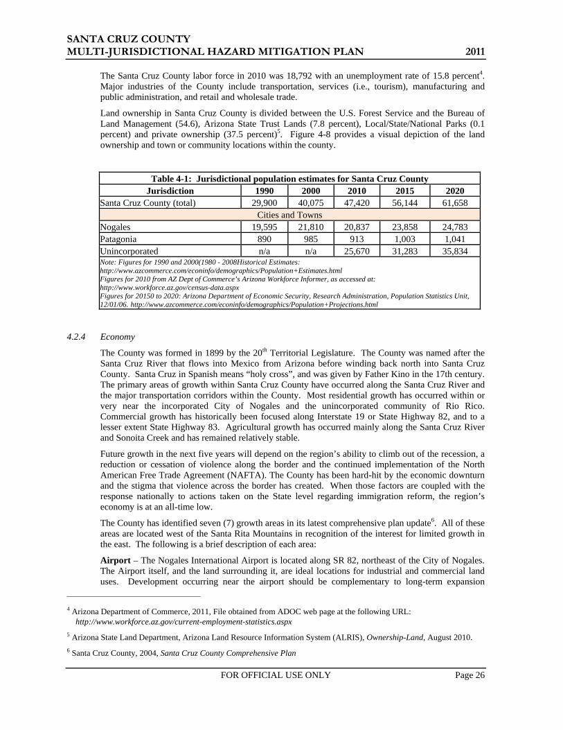
Santa Cruz County is home to 47,420 residents according to 2010 Census, with the international border City of Nogales being the largest community. All of the communities are located within the Santa Cruz River Valley and are located relatively close to each other. There are 13 other towns and communities located throughout the County, with most situated along Interstate 19 and Highway 82 and many being comprised of only one structure or landmark. The largest of these two communities are Tubac and Rio Rico. Table 4-1 summarizes jurisdictional population estimates for Santa Cruz County, the City of Nogales, and the Town of Patagonia, for 10 year cycles beginning in 1990 and projecting through 2020.
SANTA CRUZ COUNTY MULTI-JURISDICTIONAL HAZARD MITIGATION PLAN 2011
FOR OFFICIAL USE ONLY Page 26
The Santa Cruz County labor force in 2010 was 18,792 with an unemployment rate of 15.8 percent4. Major industries of the County include transportation, services (i.e., tourism), manufacturing and public administration, and retail and wholesale trade.
Land ownership in Santa Cruz County is divided between the U.S. Forest Service and the Bureau of Land Management (54.6), Arizona State Trust Lands (7.8 percent), Local/State/National Parks (0.1 percent) and private ownership (37.5 percent)5. Figure 4-8 provides a visual depiction of the land ownership and town or community locations within the county.
Table 4-1: Jurisdictional population estimates for Santa Cruz County Jurisdiction 1990 2000 2010 2015 2020
Santa Cruz County (total) 29,900 40,075 47,420 56,144 61,658 Cities and Towns
Nogales 19,595 21,810 20,837 23,858 24,783 Patagonia 890 985 913 1,003 1,041 Unincorporated n/a n/a 25,670 31,283 35,834 Note: Figures for 1990 and 2000(1980 - 2008Historical Estimates: http://www.azcommerce.com/econinfo/demographics/Population+Estimates.html Figures for 2010 from AZ Dept of Commerce’s Arizona Workforce Informer, as accessed at: http://www.workforce.az.gov/census-data.aspx Figures for 20150 to 2020: Arizona Department of Economic Security, Research Administration, Population Statistics Unit, 12/01/06. http://www.azcommerce.com/econinfo/demographics/Population+Projections.html
4.2.4 Economy
The County was formed in 1899 by the 20th Territorial Legislature. The County was named after the Santa Cruz River that flows into Mexico from Arizona before winding back north into Santa Cruz County. Santa Cruz in Spanish means “holy cross”, and was given by Father Kino in the 17th century. The primary areas of growth within Santa Cruz County have occurred along the Santa Cruz River and the major transportation corridors within the County. Most residential growth has occurred within or very near the incorporated City of Nogales and the unincorporated community of Rio Rico. Commercial growth has historically been focused along Interstate 19 or State Highway 82, and to a lesser extent State Highway 83. Agricultural growth has occurred mainly along the Santa Cruz River and Sonoita Creek and has remained relatively stable.
Future growth in the next five years will depend on the region’s ability to climb out of the recession, a reduction or cessation of violence along the border and the continued implementation of the North American Free Trade Agreement (NAFTA). The County has been hard-hit by the economic downturn and the stigma that violence across the border has created. When those factors are coupled with the response nationally to actions taken on the State level regarding immigration reform, the region’s economy is at an all-time low.
The County has identified seven (7) growth areas in its latest comprehensive plan update6. All of these areas are located west of the Santa Rita Mountains in recognition of the interest for limited growth in the east. The following is a brief description of each area:
Airport – The Nogales International Airport is located along SR 82, northeast of the City of Nogales. The Airport itself, and the land surrounding it, are ideal locations for industrial and commercial land uses. Development occurring near the airport should be complementary to long-term expansion
4 Arizona Department of Commerce, 2011, File obtained from ADOC web page at the following URL:
http://www.workforce.az.gov/current-employment-statistics.aspx 5 Arizona State Land Department, Arizona Land Resource Information System (ALRIS), Ownership-Land, August 2010. 6 Santa Cruz County, 2004, Santa Cruz County Comprehensive Plan
SANTA CRUZ COUNTY MULTI-JURISDICTIONAL HAZARD MITIGATION PLAN 2011
FOR OFFICIAL USE ONLY Page 27
opportunities at the Airport, including restricting noise-sensitive developments. Industrial growth will continue to be limited by the lack of a major road linking SR 82 and I-19.
Amado – Amado serves as a gateway to the County along the I-19 corridor. The current zoning intensity should remain in the area. Appropriate development activities are neighborhood retail and services and campus commercial.
I-19 Corridor (Rio Rico Drive to Nogales) – The I-19 corridor is a significant residential and commercial area for the County. Warehousing and other industrial and commercial activities occur along both sides of the highway with residential development beyond that. This growth area recognizes the desire of many businesses to be located along a highway to improve their accessibility and visibility.
Kino Springs Village Center – The Kino Springs Village Center is a 2,000 acre master planned development area. It will serve the growing residential and tourism activities there with commercial uses.
Rio Rico Drive East – The growing residential and tourism market in the Rio Rico area will continue to support an increasing amount of commercial development. Grocery stores, large retail and other smaller development are envisioned to be located along Rio Rico Drive, east of I-19.
Ruby Road – Ruby Road is relatively a mid-point between the populations of Nogales and Rio Rico. As growth continues to occur in Rio Rico at a faster rate than in Nogales, the geographic center of the population in the west County will continue to move northward. The area south of Ruby Road is situated to serve both of these population centers. Retail and other commercial activities, including a regional mall or large retail development, would be appropriate uses in this area.
Tubac – The Tubac core area is a tourist destination and also provides services for local residents. This area, located along the east side of I-19, is home to a resort and various retail and commercial businesses. Maintaining the identity of this area is critical, so any new development should respect the current activities. There should be no intensification of existing zoning, and new development should support the tourism core that already exists.

SANTA CRUZ COUNTY MULTI-JURISDICTIONAL HAZARD MITIGATION PLAN 2011
FOR OFFICIAL USE ONLY Page 28
Figure 4-8: 2010 Land Ownership Map for Santa Cruz County

SANTA CRUZ COUNTY MULTI-JURISDICTIONAL HAZARD MITIGATION PLAN 2011
FOR OFFICIAL USE ONLY Page 29
4.3 Jurisdictional Overviews The following are brief overviews for each of the participating jurisdictions in the Plan.
4.3.1 Nogales
The City of Nogales is on the international border separating the United States and Mexico as shown in Figure 4-1. The City of Nogales serves as the economic capital and the County seat of Santa Cruz County, the smallest and southernmost of Arizona's counties. Situated at the junction of Interstate 19 and State Road 82(Patagonia Highway) approximately 67 miles south of Tucson and 179 miles from downtown Phoenix. The city lies within a mountainous setting at an elevation of 3,865 feet.
The centroid of the City is generally located at longitude 110.934 degrees west and latitude 31.340 degrees north and the average elevation is 3,865 feet. The Union Pacific Railroad parallels Interstate 19 and passes through the City. Figure 4-9 shows the land ownership and major transportation routes within the vicinity of Nogales.
Thousands of years ago, before European explorers ever dreamed of sailing across the Atlantic, Nogales was part of a migratory path and trade route much later called El Camino Real (The King's Highway). Much later, regiments of armor-clad Conquistadors forayed north along this very valley in quest of precious metals and gems. Today missions built by the Spanish colonists still dot the valley's landscape.
The Santa Cruz River Valley narrows to its narrowest point in Nogales. In the 1700s and 1800s, settlers in the area were besieged by Apaches raiding herds of well-fed cattle. One local rancher, Pete Kitchen, used to say, "Tucson, Tubac, Tumacácori, to hell," when returning to Nogales from a cattle drive from Tucson.
Nogales a far more hospitable place today. Where Pete's ranch once was, is now Soto’s PK Outpost, a restaurant. It's actually one of the original 1853 structures of the old Kitchen homestead. Life on the border would not be complete without the influence of Pancho Villa, whose army occupied Nogales, Mexico in 1914 during the Mexican Revolution. The U.S. military's garrison in Nogales swelled to over 10,000 mostly black soldiers of the highly decorated 25th Regiment mostly detached from Washington, D.C. The military buildup and related business growth attracted many businesses to Nogales, some of which remain today.7
Nogales was established in 1880 by Jacob and Isaac Isaacson, who built a trading post along the border. Two years later, Nogales was the site of the first rail connection between Mexico and the United States.
The Census 2010 population for Nogales was 20,837. The civilian labor force in June 2011 was 9,609 with an unemployment rate of 18.9 percent. The major industries significant to the economy of Nogales include: Trade, Transportation, Utilities, Government and Goods Producing.
7 http://cityofnogales.net/visitors

SANTA CRUZ COUNTY MULTI-JURISDICTIONAL HAZARD MITIGATION PLAN 2011
FOR OFFICIAL USE ONLY Page 30
Figure 4-9: City of Nogales Land Ownership and Location Map

SANTA CRUZ COUNTY MULTI-JURISDICTIONAL HAZARD MITIGATION PLAN 2011
FOR OFFICIAL USE ONLY Page 31
4.3.2 Patagonia
Patagonia is approximately 14 miles north of the international border separating the United States and Mexico as shown in Figure 4-2. The Town of Patagonia lies in a narrow valley surrounded by the Santa Rita Mountains to the north and the Patagonia Mountains to the south. Both the town and the mountains take their name from the Patagonia Mine. This Town is on State Road 82 (Patagonia Highway) approximately 61 miles south of Tucson and 174 miles from downtown Phoenix.
The centroid of the Town is generally located at longitude 110.756 degrees west and latitude 31.539 degrees north and the average elevation is 4,044 feet. Figure 4-10 shows the land ownership and major transportation routes within the vicinity of Patagonia.
The founder of Patagonia, Rollin Rice Richardson, was a Pennsylvanian who made his money in oil investments. Richardson purchased the San Rafael de la Zanja land grant in 1880 and three years later went into business with the San Rafael Cattle Company. Rollin founded Patagonia in 1896, and named it after himself. Not much later in 1899 the residents petitioned the postmaster general for a post office, and at that time decided to change the Town's name to Patagonia, after the mountain range that towers over the valley.
Mining was the primary industry of Patagonia residents, since rich ore and other minerals were discovered in the Patagonia Mountains and other surrounding mountain ranges. As Patagonia became a busy hub, other mining towns sprung up around its outskirts: Harshaw, Duquesne, Mowry, and Washington Camp were successful settlements located to the east and southeast. Patagonia eventually became connected through the New Mexico and Arizona Railroad that was built through the center of town. But when the mining industry dropped off, so did the Town's boom days. The last ore was shipped in 1960, and in 1962 the rail line was closed down. The rails were removed and railroad right-of-way was dedicated as a park. The old depot became Town Hall.
The Census 2010 population for Nogales was 913. The civilian labor force in June 2011 was 474 with an unemployment rate of 11.6 percent. The major industries significant to the economy of Patagonia include: Trade, Transportation, Tourism, Utilities, Government and other Private Service-Providing.
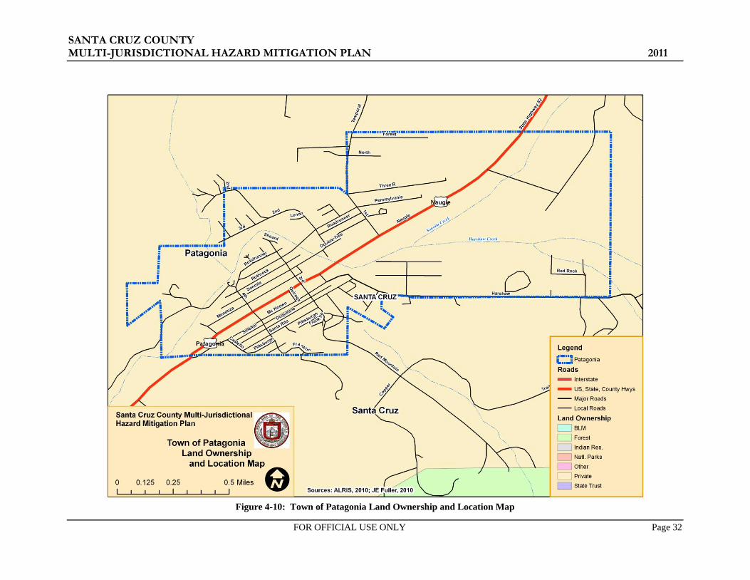
SANTA CRUZ COUNTY MULTI-JURISDICTIONAL HAZARD MITIGATION PLAN 2011
FOR OFFICIAL USE ONLY Page 32
Figure 4-10: Town of Patagonia Land Ownership and Location Map
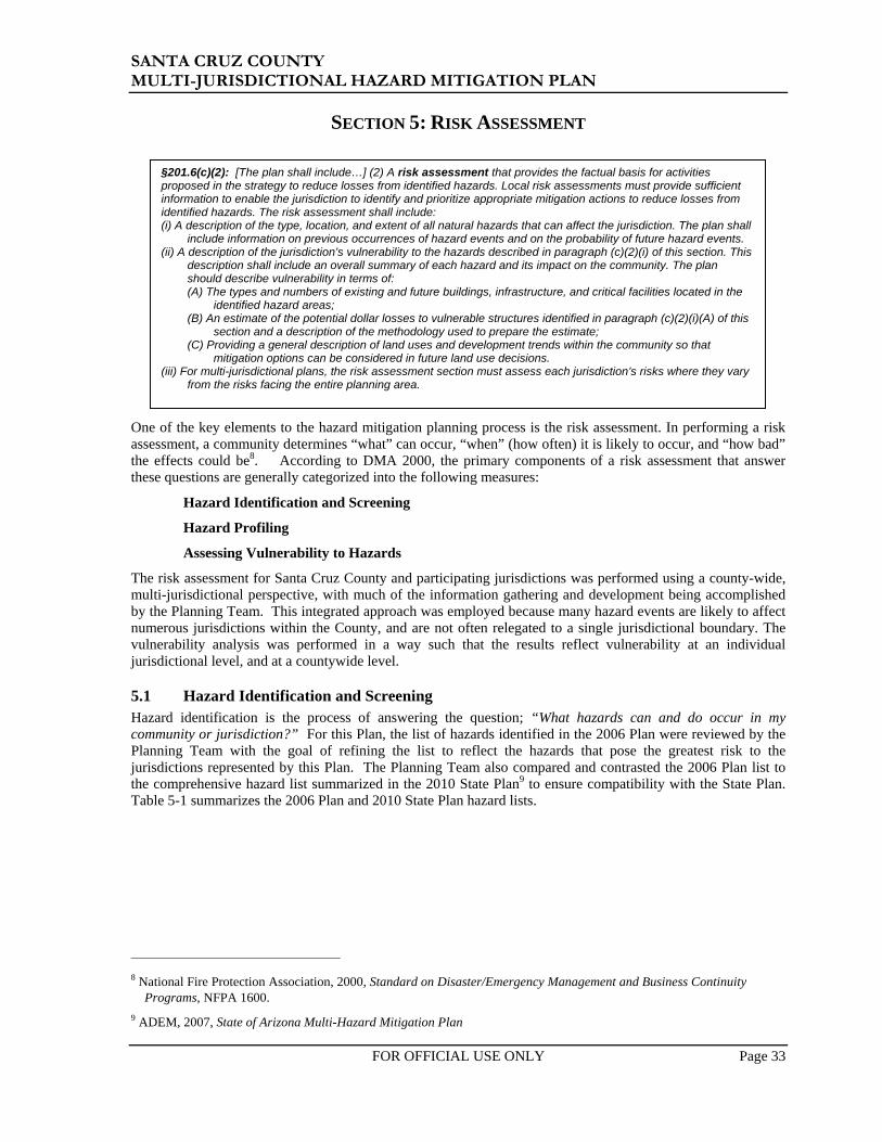
SANTA CRUZ COUNTY MULTI-JURISDICTIONAL HAZARD MITIGATION PLAN 2011
FOR OFFICIAL USE ONLY Page 33
SECTION 5: RISK ASSESSMENT
One of the key elements to the hazard mitigation planning process is the risk assessment. In performing a risk assessment, a community determines “what” can occur, “when” (how often) it is likely to occur, and “how bad” the effects could be8. According to DMA 2000, the primary components of a risk assessment that answer these questions are generally categorized into the following measures:
Hazard Identification and Screening
Hazard Profiling
Assessing Vulnerability to Hazards
The risk assessment for Santa Cruz County and participating jurisdictions was performed using a county-wide, multi-jurisdictional perspective, with much of the information gathering and development being accomplished by the Planning Team. This integrated approach was employed because many hazard events are likely to affect numerous jurisdictions within the County, and are not often relegated to a single jurisdictional boundary. The vulnerability analysis was performed in a way such that the results reflect vulnerability at an individual jurisdictional level, and at a countywide level.
5.1 Hazard Identification and Screening Hazard identification is the process of answering the question; “What hazards can and do occur in my community or jurisdiction?” For this Plan, the list of hazards identified in the 2006 Plan were reviewed by the Planning Team with the goal of refining the list to reflect the hazards that pose the greatest risk to the jurisdictions represented by this Plan. The Planning Team also compared and contrasted the 2006 Plan list to the comprehensive hazard list summarized in the 2010 State Plan9 to ensure compatibility with the State Plan. Table 5-1 summarizes the 2006 Plan and 2010 State Plan hazard lists.
8 National Fire Protection Association, 2000, Standard on Disaster/Emergency Management and Business Continuity
Programs, NFPA 1600. 9 ADEM, 2007, State of Arizona Multi-Hazard Mitigation Plan
§201.6(c)(2): [The plan shall include…] (2) A risk assessment that provides the factual basis for activities proposed in the strategy to reduce losses from identified hazards. Local risk assessments must provide sufficient information to enable the jurisdiction to identify and prioritize appropriate mitigation actions to reduce losses from identified hazards. The risk assessment shall include: (i) A description of the type, location, and extent of all natural hazards that can affect the jurisdiction. The plan shall
include information on previous occurrences of hazard events and on the probability of future hazard events. (ii) A description of the jurisdiction’s vulnerability to the hazards described in paragraph (c)(2)(i) of this section. This
description shall include an overall summary of each hazard and its impact on the community. The plan should describe vulnerability in terms of: (A) The types and numbers of existing and future buildings, infrastructure, and critical facilities located in the
identified hazard areas; (B) An estimate of the potential dollar losses to vulnerable structures identified in paragraph (c)(2)(i)(A) of this
section and a description of the methodology used to prepare the estimate; (C) Providing a general description of land uses and development trends within the community so that
mitigation options can be considered in future land use decisions. (iii) For multi-jurisdictional plans, the risk assessment section must assess each jurisdiction’s risks where they vary
from the risks facing the entire planning area.

SANTA CRUZ COUNTY MULTI-JURISDICTIONAL HAZARD MITIGATION PLAN 2011
FOR OFFICIAL USE ONLY Page 34
Table 5-1: Initial hazard identification lists 2006 Santa Cruz County Plan Hazard List 2010 State Plan Hazard List
• Building/Structure Collapse • Drought • Flooding/Flash Flooding • Tropical Storms/Hurricane • Hazardous Material Incidents • Wildfire
• Dam Failure • Drought • Earthquake • Extreme Heat • Fissure • Flooding/Flash Flooding • Landslides/Mudslides • Levee Failure • Severe Wind • Subsidence • Wildfires • Winter Storms
The review included an initial screening process to evaluate each of the listed hazards based on the following considerations:
• Experiential knowledge on behalf of the Planning Team with regard to the relative risk associated with the hazard
• Documented historic context for damages and losses associated with past events (especially events that have occurred during the last plan cycle)
• The ability/desire of Planning Team to develop effective mitigation for the hazard under current DMA 2000 criteria
• Compatibility with the state hazard mitigation plan hazards • Duplication of effects attributed to each hazard
One tool used in the initial screening process was the historic hazard database referenced in 2006 Plan. With this update, the 2006 Plan database was reviewed and revised to separately summarize declared disaster events versus non-declared events. Declared event sources included Santa Cruz County Department of Emergency Management (SCCDEM), Arizona Division of Emergency Management (ADEM), Federal Emergency Management Agency (FEMA), and United States Department of Agriculture (USDA). Non-declared sources included Arizona State Land Department (ASLD), National Weather Service (NWS), National Oceanic and Atmospheric Administration (NOAA), National Climatic Data Center (NCDC), United States Geological Survey (USGS), and United States Forest Service (USFS). Both data sets were updated with additional hazard events that have occurred over the last plan cycle. The declared events represent the period of January 1966 to August 2010. The undeclared events are as of January 2011. Three tables are used in this update to summarize the historic hazard events. Table 5-2 summarizes the federal and state disaster declarations that included Greenlee County with data provided solely from ADEM, Recovery Section. Table 5-3 summarizes federal and state declarations with data provided by many sources that included fatalities, injuries, and property damages. Table 5-4 summarizes all non-declared hazard events that were considered to be a significant event to the jurisdiction(s). These events may have included:
• 1 or more fatalities • 1 or more injuries • Any dollar amount in property or crop damages • Significant event, as expressed in historical records or according to defined criteria above
Only hazards with a reported event or events are shown in each of the three tables.

SANTA CRUZ COUNTY MULTI-JURISDICTIONAL HAZARD MITIGATION PLAN 2011
FOR OFFICIAL USE ONLY Page 35
Table 5-2: State and Federally Declared Natural Hazard Events That Included Santa Cruz County – January 1966 to August 2010
2010 State Plan Hazard Categories
Arizona Declared Events That Included Santa Cruz County January 1966 to August 2010
No. of Events
Total Expenditures State Federal
Drought 5A $211,499 $0 Flooding / Flash Flooding 15 $39,484,704 $303,670,820 Wildfire 16 $5,685,834 $0 ITEM A - 3 of these events are USDA declarations for 1999, 2001, and 2002 GENERAL NOTES: - Damage Costs are reported as is and no attempt has been made to adjust costs to current dollar values. - Only a portion of the reported expenditures were spent in the subject county. Source: ADEM - Recovery Section, October 2010
Table 5-3: State and Federally Declared Events That Included Santa CruzCounty January 1966 to August 2010
No. of Recorded Losses
Hazard Declarations Fatalities Injuries Damage Costs ($) Drought 5 0 0 $300,000,000 Flooding / Flash Flooding 15 39 1087 $1,291,955,000 Wildfire 18 0 0 $0 Notes: - Damage Costs are reported as is and no attempt has been made to adjust costs to current dollar values. Sources: ADEM, FEMA, USDA, NCDC, NWS,
Table 5-4: Santa Cruz County Undeclared Historic Hazard Events – September 1960 to January 2011
No. of Recorded Losses Hazard Records Fatalities Injuries Damage Costs ($)
Extreme Temperature 2 21 0 $0 Flooding 24 8 6 $499,000 Hazardous Materials Incident 31 0 28 $256,877 Severe Wind 16 0 0 $10,207,300 Transportation Accident 4 2 3 $0 Wildfire 22 0 30 $650,000 NOTES: Damage Costs include property and crop/livestock losses and are reported as is with no attempt to adjust costs to current dollar values. Furthermore, wildfire damage cost do not include the cost of suppression which can be quite substantial. Sources: ADEM, NCDC, NWCG, NWS, USFS
SANTA CRUZ COUNTY MULTI-JURISDICTIONAL HAZARD MITIGATION PLAN 2011
FOR OFFICIAL USE ONLY Page 36
Detailed historic hazard records are provided in Appendix D.
The culmination of the review and screening process by the Planning Team resulted in a revised list of hazards that will be carried forward in this Plan. The 2006 Plan hazards selected for removal are listed below and include a brief explanation of the reason for removal:
Building/Structure Collapse – After much discussion, the Planning Team concluded that the true hazard is really tied to a potential failure of the Nogales Wash tunnels, which will only be precipitated by flooding of those tunnels as they convey runoff underground from Mexico through downtown Nogales. Instead, this special condition of the flooding hazard will be added to the Flooding/Flash Flooding vulnerability analysis.
Several of the hazards in the 2006 Plan list may be better described as storm events wherein the effects of the storm may pose exposure to multiple hazards. For instance, hazards associated with a Thunderstorm may include flooding, microburst winds, tornados, and/or hail in a single event. Tropical Storms/Hurricane is another storm event that may include damaging winds and heavy precipitation resulting in flooding. In both of these examples, the true resulting hazards are generally flooding and damaging severe winds. Accordingly, the Planning Team chose to consolidate or eliminate the following 2006 Plan hazard:
Tropical Storms/Hurricane – the damaging elements associated with tropical cyclones are the heavy precipitation that results in flooding and severe winds.
The Planning Team has selected the following list of hazards for profiling and updating based on the above explanations and screening process. Revised and updated definitions for each hazard are provided in Section 5.3 and in Section 8.2:
• Dam Failure • Drought
• Extreme Temperature • Flooding
• HAZMAT • Severe Wind
• Wildfire
5.2 Vulnerability Analysis Methodology
5.2.1 General
The following sections summarize the methodologies used to perform the vulnerability analysis portion of the risk assessment. For this Plan, the entire vulnerability analysis was either revised or updated to reflect the new hazard categories, the availability of new data, or differing loss estimation methodology. Specific changes are noted below and/or in Section 5.3. A comparison was made between the new vulnerability analysis and the 2006 Plan for Flooding/Flash Flooding, HAZMAT and Wildfire, as noted in Section 5.3.
For the purposes of this vulnerability analysis, hazard profile maps were developed for Dam Failure, Flooding/Flash Flooding, HAZMAT and Wildfire to map the geographic variability of the probability and magnitude risk of the hazards as estimated by the Planning Team. Hazard profile categories of HIGH, MEDIUM, and/or LOW were used and were subjectively assigned based on the factors discussed in the Probability and Magnitude sections below. Within the context of the county limits, the other hazards do not exhibit significant geographic variability and will not be categorized as such.
Unless otherwise specified in this Plan, the general cutoff date for new hazard profile data and jurisdictional corporate limits is the end of April 2010.
5.2.2 Calculated Priority Risk Index (CPRI) Evaluation
The first step in the vulnerability analysis (VA) is to assess the perceived overall risk for each of the plan hazards using a tool developed by the State of Arizona called the Calculated Priority Risk Index10 (CPRI). The CPRI value is obtained by assigning varying degrees of risk to four (4) categories for each hazard, and then calculating an index value based on a weighting scheme. Table 5-4 summarizes
10 ADEM, 2003, Arizona Model Local Hazard Mitigation Plan, prepared by JE Fuller/ Hydrology & Geomorphology, Inc.

SANTA CRUZ COUNTY MULTI-JURISDICTIONAL HAZARD MITIGATION PLAN 2011
FOR OFFICIAL USE ONLY Page 37
the CPRI risk categories and provides guidance regarding the assignment of values and weighting factors for each category.
As an example, assume that the project team is assessing the hazard of flooding, and has decided that the following assignments best describe the flooding hazard for their community:
• Probability = Likely
• Magnitude/Severity = Critical
• Warning Time = 12 to 24 hours
• Duration = Less than 6 hours
The CPRI for the flooding hazard would then be:
CPRI = [ (3*0.45) + (3*0.30) + (2*0.15) + (1*0.10)]
CPRI = 2.65
5.2.3 Asset Inventory
A detailed asset inventory was performed for the 2006 Plan to establish a fairly accurate baseline data-set for assessing the vulnerability of each jurisdiction’s assets to the hazards previously identified. The asset inventory from the 2006 Plan was updated to reflect the current critical and non-critical facilities potentially exposed to hazards. Details of the update are discussed later in this section. The 2010 State Plan defines assets as:
Any natural or human-caused feature that has value, including, but not limited to people; buildings; infrastructure like bridges, roads, and sewer and water systems; lifelines like electricity and communication resources; or environmental, cultural, or recreational features like parks, dunes, wetlands, or landmarks.
The 2006 Plan asset inventory database was generally categorized into critical and non-critical categories. The working definition for Critical facilities and infrastructure, adopted for the 2006 Plan and continuing with this Plan is as follows:
Systems, structures and infrastructure within a community whose incapacity or destruction would:
• Have a debilitating impact on the defense or economic security of that community. • Significantly hinder a community’s ability to recover following a disaster.

SANTA CRUZ COUNTY MULTI-JURISDICTIONAL HAZARD MITIGATION PLAN 2011
FOR OFFICIAL USE ONLY Page 38
Table 5-5: Calculated Priority Risk Index (CPRI) categories and risk levels
CPRI Category
Degree of Risk Assigned Weighting Factor Level ID Description Index
Value
Probability
Unlikely Extremely rare with no documented history of occurrences or events.
Annual probability of less than 0.001. 1
45%
Possible Rare occurrences with at least one documented or anecdotal historic event.
Annual probability that is between 0.01 and 0.001. 2
Likely Occasional occurrences with at least two or more documented historic events.
Annual probability that is between 0.1 and 0.01. 3
Highly Likely Frequent events with a well documented history of occurrence.
Annual probability that is greater than 0.1. 4
Magnitude/ Severity
Negligible Negligible property damages (less than 5% of critical and non-critical facilities and infrastructure).
Injuries or illnesses are treatable with first aid and there are no deaths.
Negligible quality of life lost. Shut down of critical facilities for less than 24 hours.
1
30%
Limited Slight property damages (greater than 5% and less than 25% of critical and non-critical facilities and infrastructure).
Injuries or illnesses do not result in permanent disability and there are no deaths.
Moderate quality of life lost. Shut down of critical facilities for more than 1 day and
less than 1 week.
2
Critical Moderate property damages (greater than 25% and less than 50% of critical and non-critical facilities and infrastructure).
Injuries or illnesses result in permanent disability and at least one death.
Shut down of critical facilities for more than 1 week and less than 1 month.
3
Catastrophic Severe property damages (greater than 50% of critical and non-critical facilities and infrastructure).
Injuries or illnesses result in permanent disability and multiple deaths.
Shut down of critical facilities for more than 1 month.
4
Warning Time
Less than 6 hours Self explanatory. 4
15% 6 to 12 hours Self explanatory. 3 12 to 24 hours Self explanatory. 2 More than 24 hours Self explanatory. 1
Duration
Less than 6 hours Self explanatory. 1
10% Less than 24 hours Self explanatory. 2 Less than one week Self explanatory. 3 More than one week Self explanatory. 4

SANTA CRUZ COUNTY MULTI-JURISDICTIONAL HAZARD MITIGATION PLAN 2011
FOR OFFICIAL USE ONLY Page 39
Following the criteria set forth by the Critical Infrastructure Assurance Office (CIAO), the State of Arizona has adopted eight general categories11 that define critical facilities and infrastructure:
1. Communications Infrastructure: Telephone, cell phone, data services, radio towers, and internet communications, which have become essential to continuity of business, industry, government, and military operations.
2. Electrical Power Systems: Generation stations and transmission and distribution networks that create and supply electricity to end-users.
3. Gas and Oil Facilities: Production and holding facilities for natural gas, crude and refined petroleum, and petroleum-derived fuels, as well as the refining and processing facilities for these fuels.
4. Banking and Finance Institutions: Banks, financial service companies, payment systems, investment companies, and securities/commodities exchanges.
5. Transportation Networks: Highways, railroads, ports and inland waterways, pipelines, and airports and airways that facilitate the efficient movement of goods and people.
6. Water Supply Systems: Sources of water; reservoirs and holding facilities; aqueducts and other transport systems; filtration, cleaning, and treatment systems; pipelines; cooling systems; and other delivery mechanisms that provide for domestic and industrial applications, including systems for dealing with water runoff, wastewater, and firefighting.
7. Government Services: Capabilities at the federal, state, and local levels of government required to meet the needs for essential services to the public.
8. Emergency Services: Medical, police, fire, and rescue systems.
Other assets such as public libraries, schools, businesses, museums, parks, recreational facilities, historic buildings or sites, churches, residential and/or commercial subdivisions, apartment complexes, and so forth, are typically not classified as critical facilities and infrastructure unless they serve a secondary function to the community during a disaster emergency (e.g. - emergency housing or evacuation centers). As a part of the update process, each community was tasked with determining which of the previously identified “non-critical” assets, if any, were deemed critical by the community. The remaining “non-critical” assets were deleted from the database. New facilities were also added as appropriate and available. Each community was also tasked with making any needed changes to the geographic position, revision of asset names, updating replacement costs, etc. to bring the dataset into a current condition. The updated asset inventory is attributed with a descriptive name, physical address, geospatial position, and an estimated building/structure and contents replacement cost for each entry to the greatest extent possible and entered into a GIS geodatabase.
The 2006 Plan used a combination of the Asset Inventory and HAZUS®-MH12 data to represent the critical facilities and general building stock and population for Santa Cruz County jurisdictions. Tools used by the Local Planning Team for the update included GIS data sets, on-line mapping utilities, insurance pool information, county assessors data, and manual data acquisition. Table 5-6 summarizes the facility counts provided by each of the participating jurisdictions in this Plan.
It should be noted that the facility counts summarized in Table 5-6 do not represent a comprehensive inventory of all the category facilities that exist within the county. They do represent the facilities inventoried to-date by each jurisdiction and are considered to be a work-in-progress that is to be expanded and augmented with each Plan cycle.
11 Instituted via Executive Order 13010, which was signed by President Clinton in 1996. 12 U.S. Department of Homeland Security, Federal Emergency Management Agency, HAZUS®-MH.

SANTA CRUZ COUNTY MULTI-JURISDICTIONAL HAZARD MITIGATION PLAN 2011
FOR OFFICIAL USE ONLY Page 40
Table 5-6: Asset inventory structure counts by category and jurisdiction as of April 2011
C
omm
unic
atio
ns
Infr
astr
uctu
re
Elec
tric
al P
ower
Sy
stem
s
Gas
and
Oil
Faci
litie
s
Bank
ing
and
Fina
nce
Inst
itutio
ns
Tran
spor
tatio
n N
etw
orks
Wat
er S
uppl
y Sy
stem
s
Gov
ernm
ent S
ervi
ces
Emer
genc
y Se
rvic
es
Educ
atio
nal a
Cul
tura
l a
Busin
ess a
Floo
d C
ontr
ol a
Res
iden
tial a
Rec
reat
iona
l a
County-Wide Totals 11 4 6 10 81 60 36 22 10 0 2 2 0 0
Nogales 2 1 0 7 1 5 14 8 0 0 1 0 0 0
Patagonia 2 0 1 0 0 4 5 2 1 0 1 0 0 0
Unincorporated Santa Cruz County 7 3 5 3 80 51 17 12 9 0 0 2 0 0
NOTES: a – Assets listed under these categories have been determined to be critical per the definition of this Plan by the corresponding jurisdiction .
5.2.4 Loss Estimations
In the original 2006 Plan, losses were estimated by either quantitative or qualitative methods. Quantitative methods consisted of intersecting hazard map layers with the asset inventory map layer and the HAZUS®-MH map layer. Other quantitative methods included statistical methods based on historic data. The loss estimates for this Plan represent the current hazard map layers and asset databases using the procedures discussed below.
Economic loss and human exposure estimates for each of the final hazards identified in Section 5.1 begins with an assessment of the potential exposure of asset inventory structures and human populations to those hazards. Exposure estimates of asset inventory structures identified by each jurisdiction is accomplished by intersecting the asset inventory with the hazard profiles in Section 5.3. Human or population exposures are estimated by intersecting the same hazards with the 2000 Census Data population statistics that have been re-organized into GIS compatible databases and distributed with HAZUS®-MH (HAZUS).
Additional exposure estimates for general residential, commercial, and industrial building stock not specifically identified with the asset inventory, are also accomplished using the HAZUS database, wherein the developers of the HAZUS database have made attempts to correlate building/structure counts to census block data. It is duly noted that the HAZUS data population statistics may not exactly equate to the current population statistics provided in Section 4.2 due to actual changes in population counts associated with a particular census block, GIS positioning anomalies and the way HAZUS depicts certain census block data. It is also noted that the residential, commercial and industrial building stock estimates for each census block may severely under-predict the actual buildings present due to the substantial growth in the last decade, the general lack of commercial and industrial data for some of the more rural communities and counties, and the disparity of the HAZUS replacement cost estimates for these categories when compared to current market rates. However, without a detailed, site specific structure inventory of these types of buildings, the HAZUS database is still the best available and the results are representative of a general magnitude of population and residential, commercial and industrial facility exposures to the various hazards discussed. Combining the exposure results from the asset inventory and the HAZUS database provides a fairly comprehensive

SANTA CRUZ COUNTY MULTI-JURISDICTIONAL HAZARD MITIGATION PLAN 2011
FOR OFFICIAL USE ONLY Page 41
depiction of the overall exposure of building stock and the two datasets are considered complimentary and not redundant.
Economic losses to structures and facilities are estimated by multiplying the exposed facility replacement cost estimates by an assumed loss to exposure ratio for the hazard. The loss to exposure ratios used in this plan update are summarized by hazard in Section 5.3. It is important to note that the loss to exposure ratios are subjective and the estimates are solely intended to provide an understanding of relative risk from the hazards and potential losses. Real uncertainties are inherent in any loss estimation methodology due to:
• Incomplete scientific knowledge concerning hazards and our ability to predict their effects on the built environment;
• Approximations and simplifications that are necessary for a comprehensive analysis; and,
• Lack of detailed data necessary to implement a viable statistical approach to loss estimations.
Several of the hazards profiled in this Plan will not include quantitative exposure and loss estimates. The vulnerability of people and assets associated with some hazards are nearly impossible to evaluate given the uncertainty associated with where these hazards will occur as well as the relatively limited focus and extent of damage. Instead, a qualitative review of vulnerability will be discussed to provide insight to the nature of losses that are associated with the hazard. For subsequent updates of this Plan, the data needed to evaluate these unpredictable hazards may become refined such that comprehensive vulnerability statements and thorough loss estimates can be made.
5.2.5 Development Trend Analysis
The 2006 Plan development trend analysis will require updating to reflect growth and changes in Santa Cruz County and jurisdiction boundaries over the last planning cycle. The updated analysis will focus on the potential risk associated with projected growth patterns and their intersection with the Plan identified hazards.
5.3 Hazard Risk Profiles The following sections summarize the risk profiles for each of the Plan hazards identified in Section 5.1. For each hazard, the following elements are addressed to present the overall risk profile:
• Description • History • Probability and Magnitude • Vulnerability • Sources • Profile Maps (if applicable)
Much of the 2006 Plan data has been updated, incorporated and/or revised to reflect current conditions and Planning Team changes, as well as an overall plan format change. County-wide and jurisdiction specific profile maps are provided at the end of the section (if applicable). Also, the maps are not included in the page count.

SANTA CRUZ COUNTY MULTI-JURISDICTIONAL HAZARD MITIGATION PLAN 2011
FOR OFFICIAL USE ONLY Page 42
THIS PAGE INTENTIONALLY LEFT BLANK

SANTA CRUZ COUNTY MULTI-JURISDICTIONAL HAZARD MITIGATION PLAN 2011
FOR OFFICIAL USE ONLY Page 43
5.3.1 Dam Failure
Description
The primary risk associated with dam failure in Santa Cruz County is the inundation of downstream facilities and population by the resulting flood wave. Dams within or impacting Santa Cruz County can generally be divided into two groups: (1) storage reservoirs designed to permanently impound water, provide flood protection, and possibly generate power, and (2) single purpose flood retarding structures (FRS) designed to attenuate or reduce flooding by impounding stormwater for relatively short durations of time during flood events. All dams within the county are equipped with an emergency spillway, which provides a designed and protected outlet to convey runoff volumes exceeding the dam’s storage capacity during extreme or back-to-back storm events. Dam failures may be caused by a variety of reasons including: seismic events, extreme wave action, leakage and piping, overtopping, material fatigue and spillway erosion.
History
Santa Cruz County has no history of dam failure.
Probability and Magnitude
The probability and magnitude of dam failure discharges vary greatly with each dam and are directly influenced by the type and age of the dam, its operational purpose, storage capacity and height, downstream conditions, and many other factors. There are two sources of data that publish hazard ratings for dams impacting Santa Cruz County. The first is the Arizona Department of Water Resources (ADWR) and the second is the National Inventory of Dams (NID). Hazard ratings from each source are based on either an assessment of the consequence of failure and/or dam safety considerations, and they are not tied to probability of occurrence.
ADWR has regulatory jurisdiction over the non-federal dams impacting the County and is responsible for regulating the safety of these dams, conducting field investigations, and participating in flood mitigation programs with the goal of minimizing the risk for loss of life and property to the citizens of Arizona. ADWR jurisdictional dams are inspected regularly according to downstream hazard potential classification, which follows the NID classification system. High hazard dams are inspected annually, significant hazard dams every three years, and low hazard dams every five years. Via these inspections, ADWR identifies safety deficiencies requiring correction and assigns each dam one of six safety ratings. Examples of safety deficiencies include: lack of an adequate emergency action plan, inability to safely pass the required Inflow Design Flood (IDF), embankment erosion, dam stability, etc. Further descriptions of each safety classification are summarized in Table 5-7.
The NID database contains information on approximately 77,000 dams in the 50 states and Puerto Rico, with approximately 30 characteristics reported for each dam, such as: name, owner, river, nearest community, length, height, average storage, max storage, hazard rating, Emergency Action Plan (EAP), latitude, and longitude.
The NID and ADWR databases provide useful information on the potential hazard posed by dams. Each dam in the NID is assigned one of the following three hazard potential classes based on the potential for loss of life and damage to property should the dam fail (listed in increasing severity): low, significant, or high. The hazard potential classification is based on an evaluation of the probable present and future incremental adverse consequences that would result from the release of water or stored contents due to failure or improper operation of the dam or appurtenances, regardless of the condition of the dam. The ADWR evaluation includes land-use zoning and development projected for the affected area over the 10-year period following the classification of the dam. It is important to note that the hazard potential classification is an assessment of the consequences of failure, but not an evaluation of the probability of failure or improper operation. Table 5-8 summarizes the hazard potential classifications and criteria for dams regulated by the State of Arizona.

SANTA CRUZ COUNTY MULTI-JURISDICTIONAL HAZARD MITIGATION PLAN 2011
FOR OFFICIAL USE ONLY Page 44
Table 5-7: ADWR safety categories ADWR Safety Rating Definition No Deficiency Not Applicable
Safety Deficiency One or more conditions at the dam that impair or adversely affects the safe operation of the dam.
Unsafe Categories Category 1: Unsafe Dams with Elevated Risk of Failure
These dams have confirmed safety deficiencies for which there is concern they could fail during a 100-year or smaller flood event. There is an urgent need to repair or remove these dams.
Category 2: Unsafe Dams Requiring Rehabilitation or Removal
These dams have confirmed safety deficiencies and require either repair or removal. These dams are prioritized for repair or removal behind the Category 1 dams.
Category 3: Unsafe Dams with Uncertain Stability during Extreme Events (Requiring Study)
Concrete or masonry dams that have been reclassified to high hazard potential because of downstream development (i.e. hazard creep”). The necessary documentation demonstrating that the dams meet or exceed standard stability criteria for high hazard dams during extreme overtopping and seismic events is lacking. The dams are classified as unsafe pending the results of required studies. Upon completion of these studies, the dams are either removed from the list of unsafe dams or moved to Category 2 and prioritized for repair or removal.
Category 4: Unsafe Dams Pending Evaluation of Flood-Passing Capacity (Requiring Study)
In 1979, the U.S. Army Corps of Engineers established Federal Guidelines for assessing the safe-flood passing capacity of high hazard potential dams (CFR Vol. 44 No. 188). These guidelines established one-half of the “probable maximum flood” (PMF) as the minimum storm which must be safely passed without overtopping and subsequent failure of the dam. Dams unable to safely pass a storm of this size were classified as being in an “unsafe, non-emergency” condition. Prior studies for these earthen dams (mostly performed in the 1980’s) predicted they could not safely pass one-half of the PMF. They were predicted to overtop and fail for flood events ranging from 30 to 46 percent of the PMF. Recent studies both statewide and nationwide have indicated that the science of PMF hydrology as practiced in the 1990’s commonly overestimates the PMF for a given watershed. The ADWR is leading efforts on a statewide update of probably maximum precipitation (PMP) study scheduled for completion in 2011. These dams should be re-evaluated using updated methods to confirm their safety status. Upon completion of these evaluations, they are either removed from the list of unsafe dams or moved to Category 2 and prioritized for repair or removal.
Source: ADWR, 2009.

SANTA CRUZ COUNTY MULTI-JURISDICTIONAL HAZARD MITIGATION PLAN 2011
FOR OFFICIAL USE ONLY Page 45
Table 5-8: Downstream hazard potential classes for state regulated dams Hazard Potential
Classification Loss of Human Life Economic, Environmental, Lifeline
Losses Low None expected Low and generally limited to owner Significant None expected Yes
High Probable. One or more expected Yes (but not necessary for this classification)
Note: The hazard potential classification is an assessment of the consequences of failure, but not an evaluation of the probability of failure.
Source: ADWR and NID 2009
The NID database includes dams that are either:
• High or Significant hazard potential class dams, or,
• Low hazard potential class dams that exceed 25 feet in height and 15 acre-feet storage, or,
• Low hazard potential class dams that exceed 50 acre-feet storage and 6 feet height.
There are 4 dams in Santa Cruz County based on the two databases. 2 of the dams, Oro Blanco and Kino Springs, are low hazard dams. The other two dams, Pena Blanca and Lake Patagonia are identified as high hazard dams. All four are under ADWR jurisdiction. Table 5-9 provides a summary of the high hazard dams in both the ADWR and NID databases.
Table 5-9: NID and ADWR dams by hazard classification
Hazard Class SID NID Dam
Name ADWR
Safety Types EAP Inundation Mapping
Nearest Downstream Development
Distance in Miles
High 12.05 AZ00028 Pena
Blanca No
Deficiency Yes Yes 1-19 8.3
12.06 AZ00029 Lake Patagoni
a
No Deficiency Yes Yes Rio Rico, I-40 &
Railroad 8.2
Sources: NID, ADWR Dam Safety Database (October 2009)
The magnitude of impacts due to dam failure are usually depicted by mapping the estimated downstream inundation limits based on an assessment of a combination of flow depth and velocity. These limits are typically a critical part of the emergency action plan. Of the 2 dams considered, both have emergency action plans showing downstream dam failure inundation limits were readily available. For inundation resulting from dam failure, the following two classes of hazard risk are depicted:
HIGH Hazard = Inundation limits due to dam failure
LOW Hazard = All other areas outside the inundation limits
Maps 1A is a county-wide map and 1B is more detailed map of the inundation area showing the location and hazard classifications for each dam and the corresponding dam failure inundation limits (if available).
The most populated areas of Santa Cruz county are situated downstream of Nogales, Sonora, Mexico. There are several flood control and water storage dams situated within the Sonoran watershed for Nogales Wash, which if they were to fail, could cause significant flooding at the international border and into Nogales, Arizona. In 2010, the USGS released a report (Norma, L.M., et al, 2010) documenting the impacts of Sonoran detention basins. An excerpt from the report showing a map of the analyzed detention basins is shown in Figure 5-1. No dam safety level evaluations or analyses
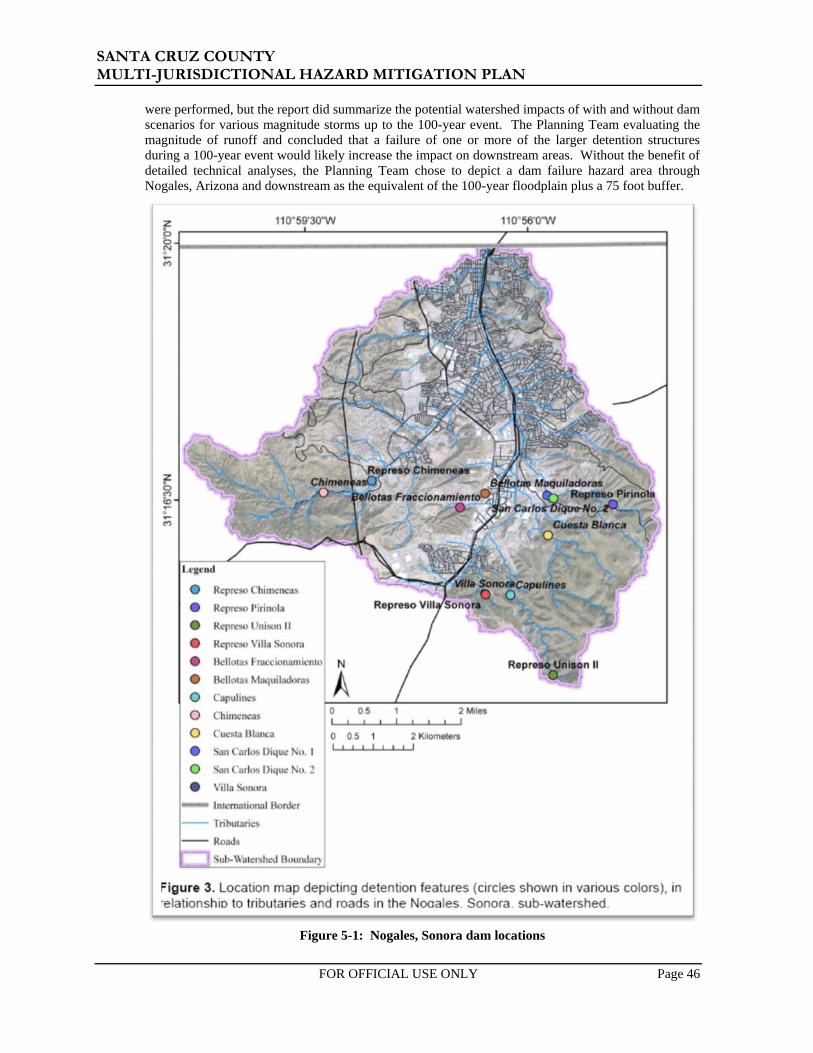
SANTA CRUZ COUNTY MULTI-JURISDICTIONAL HAZARD MITIGATION PLAN 2011
FOR OFFICIAL USE ONLY Page 46
were performed, but the report did summarize the potential watershed impacts of with and without dam scenarios for various magnitude storms up to the 100-year event. The Planning Team evaluating the magnitude of runoff and concluded that a failure of one or more of the larger detention structures during a 100-year event would likely increase the impact on downstream areas. Without the benefit of detailed technical analyses, the Planning Team chose to depict a dam failure hazard area through Nogales, Arizona and downstream as the equivalent of the 100-year floodplain plus a 75 foot buffer.
Figure 5-1: Nogales, Sonora dam locations

SANTA CRUZ COUNTY MULTI-JURISDICTIONAL HAZARD MITIGATION PLAN 2011
FOR OFFICIAL USE ONLY Page 47
Vulnerability – CPRI Results Dam failure CPRI results for each jurisdiction are summarized in Table 5-10.
Table 5-10: CPRI results by jurisdiction for dam failure
Participating Jurisdiction Probability Magnitude/
Severity Warning
Time Duration CPRI Score
Nogales Likely Catastrophic < 6 hours < 6 hours 3.10 Patagonia Highly Likely Critical < 6 hours < 6 hours 3.40
Unincorporated Santa Cruz County Unlikely Catastrophic < 6 hours < 24 hours 2.45 County-wide average CPRI = 2.98
Vulnerability – Loss Estimations
The estimation of potential losses due to inundation from a dam failure was accomplished by intersecting the human and facility assets with the inundation limits depicted on Maps 1A and 1B. As stated previously, delineated dam failure inundation limits were readily available for both dams. Therefore, the results of this analysis are expected to underestimate the exposure of people and infrastructure within Santa Cruz County.
Since no common methodology is available for obtaining losses from the exposure values, estimates of the loss-to-exposure ratios were assumed based on the perceived potential for damage. Any storm event, or series of storm events of sufficient magnitude to cause a dam failure scenario, would have potentially catastrophic consequences in the inundation area. Floodwaves from these types of events travel very fast and possess tremendous destructive energy. Accordingly, an average event based loss-to-exposure ratio for the inundation areas with a high hazard rating are estimated to be 0.25. Low rated areas are zero.
It should be noted that the Planning Team recognizes that the probability of a dam failure occurring at multiple (or all) locations at the same time is essentially zero. Accordingly, the loss estimates presented below are intended to serve as a collective evaluation of the potential exposure to dam failure inundation events.
Table 5-11 summarizes estimations of losses to Planning Team identified assets for the dam failure inundation hazard. Table 5-12 summarizes the estimated population exposed to the dam failure inundation hazard. Tables 5-13 through 5-16 summarize exposure and loss estimates to the HAZUS residential, commercial, and industrial building stock for the dam failure inundation hazard. Table 5-13 summarizes the HAZUS based exposure and losses for the entirety of Santa Cruz County. Tables 5-14 through 5-16 summarize jurisdiction specific HAZUS data exposure and loss estimates.
In summary, $38 million in asset related losses are estimated for dam failure inundation for all the participating jurisdictions in Santa Cruz County. An additional $132 million in losses to HAZUS defined residential, commercial, and industrial facilities is estimated for all participating Santa Cruz County jurisdictions. Regarding human vulnerability, a total population of 5,048 people, or 13.16% of the total Santa Cruz County population, is potentially exposed to a dam failure inundation event. The potential for deaths and injuries are directly related to the warning time and type of event. Given the magnitude of such an event(s), it is realistic to anticipate at least one death and several injuries. There is also a high probability of population displacement for most of the inhabitants within the inundation limits downstream of the dam(s).
Vulnerability – Development Trend Analysis
Of the two high hazard dams within the county, a failure of Patagonia Lake would have the greatest impact on new development and potential growth areas within Rio Rico. Recent improvements to the Patagonia Lake Dam and spillway have are also not reflected in the current inundation mapping available through ADWR. Update of these limits should be evaluated to determine the potential dam failure risk for the populated and expanding areas of Rio Rico.
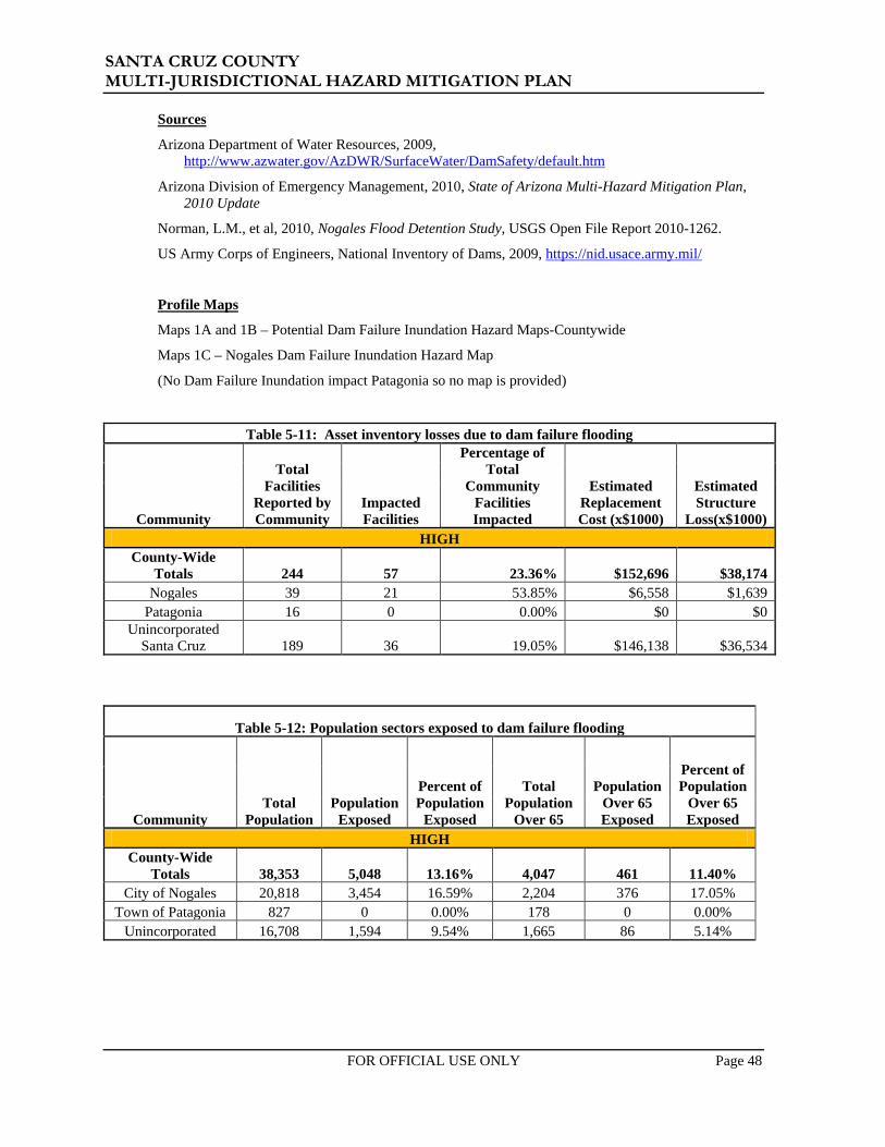
SANTA CRUZ COUNTY MULTI-JURISDICTIONAL HAZARD MITIGATION PLAN 2011
FOR OFFICIAL USE ONLY Page 48
Sources
Arizona Department of Water Resources, 2009, http://www.azwater.gov/AzDWR/SurfaceWater/DamSafety/default.htm
Arizona Division of Emergency Management, 2010, State of Arizona Multi-Hazard Mitigation Plan, 2010 Update
Norman, L.M., et al, 2010, Nogales Flood Detention Study, USGS Open File Report 2010-1262.
US Army Corps of Engineers, National Inventory of Dams, 2009, https://nid.usace.army.mil/
Profile Maps
Maps 1A and 1B – Potential Dam Failure Inundation Hazard Maps-Countywide
Maps 1C – Nogales Dam Failure Inundation Hazard Map
(No Dam Failure Inundation impact Patagonia so no map is provided)
Table 5-11: Asset inventory losses due to dam failure flooding
Community
Total Facilities
Reported by Community
Impacted Facilities
Percentage of Total
Community Facilities Impacted
Estimated Replacement Cost (x$1000)
Estimated Structure
Loss(x$1000) HIGH
County-Wide Totals 244 57 23.36% $152,696 $38,174
Nogales 39 21 53.85% $6,558 $1,639 Patagonia 16 0 0.00% $0 $0
Unincorporated Santa Cruz 189 36 19.05% $146,138 $36,534
Table 5-12: Population sectors exposed to dam failure flooding
Community Total
Population Population
Exposed
Percent of Population
Exposed
Total Population
Over 65
Population Over 65 Exposed
Percent of Population
Over 65 Exposed
HIGH County-Wide
Totals 38,353 5,048 13.16% 4,047 461 11.40% City of Nogales 20,818 3,454 16.59% 2,204 376 17.05%
Town of Patagonia 827 0 0.00% 178 0 0.00% Unincorporated 16,708 1,594 9.54% 1,665 86 5.14%

SANTA CRUZ COUNTY MULTI-JURISDICTIONAL HAZARD MITIGATION PLAN 2011
FOR OFFICIAL USE ONLY Page 49
Table 5-13: Santa Cruz County HAZUS building exposure to dam failure RESIDENTIAL COMMERCIAL INDUSTRIAL SUMMARY
Santa Cruz County HAZUS Summary
Building Count
Potential Economic
Impact (x$1000)
Building Count
Potential Economic
Impact (x$1000)
Building Count
Potential Economic
Impact (x$1000)
Total of All Economic
Impact (x$1000)
Loss-to-Exposure
Ratio
Total Estimated
Loss (x$1000)
County-Wide Totals 13,318 $2,022,210 693 $896,552 206 $179,733 $3,098,495 High Hazard Exposure 1,653 $207,553 195 $291,168 31 $31,443 $530,164 25% $132,541
Santa Cruz County HAZUS Summary
% Building
Count
% Potential Economic
Impact
% Building
Count
% Potential Economic
Impact
% Building
Count
% Potential Economic
Impact High Hazard Exposure 12.41% 10.26% 28.14% 32.48% 15.21% 17.49%
Table 5-14: City of Nogales HAZUS building exposure to dam failure
RESIDENTIAL COMMERCIAL INDUSTRIAL SUMMARY
City of Nogales HAZUS Summary
Building Count
Potential Economic
Impact (x$1000)
Building Count
Potential Economic
Impact (x$1000)
Building Count
Potential Economic
Impact (x$1000)
Total of All Economic
Impact (x$1000)
Loss-to-Exposure
Ratio
Total Estimated
Loss (x$1000)
Community-Wide Totals 5,922 $856,827 372 $594,349 96 $114,768 $1,565,944
High Hazard Exposure 1,110 $139,205 148 $201,644 24 $22,035 $362,884 25% $90,721
City of Nogales HAZUS Summary
% Building
Count
% Potential Economic
Impact
% Building
Count
% Potential Economic
Impact
% Building
Count
% Potential Economic
Impact High Hazard Exposure 18.75% 16.25% 39.78% 33.93% 24.68% 19.20%

SANTA CRUZ COUNTY MULTI-JURISDICTIONAL HAZARD MITIGATION PLAN 2011
FOR OFFICIAL USE ONLY Page 50
Table 5-15: Town of Patagonia HAZUS building exposure to dam failure RESIDENTIAL COMMERCIAL INDUSTRIAL SUMMARY
Town of Patagonia HAZUS Summary
Building Count
Potential Economic
Impact (x$1000)
Building Count
Potential Economic
Impact (x$1000)
Building Count
Potential Economic
Impact (x$1000)
Total of All Economic
Impact (x$1000)
Loss-to-Exposure
Ratio
Total Estimated
Loss (x$1000)
Community-Wide Totals 539 $51,820 11 $7,168 5 $1,397 $60,385
High Hazard Exposure 0 $0 0 $0 0 $0 $0 25% $0
Town of Patagonia HAZUS Summary
% Building
Count
% Potential Economic
Impact
% Building
Count
% Potential Economic
Impact
% Building
Count
% Potential Economic
Impact High Hazard Exposure 0.0% 0.0% 0.0% 0.0% 0.0% 0.0%
Table 5-16: Unincorporated Santa Cruz County HAZUS building exposure to dam failure
RESIDENTIAL COMMERCIAL INDUSTRIAL SUMMARY
Unincorporated Santa Cruz County HAZUS Summary
Building Count
Potential Economic
Impact (x$1000)
Building Count
Potential Economic
Impact (x$1000)
Building Count
Potential Economic
Impact (x$1000)
Total of All Economic
Impact (x$1000)
Loss-to-Exposure
Ratio
Total Estimated
Loss (x$1000)
Community-Wide Totals 6,856 $1,113,563 310 $295,035 105 $63,568 $1,472,166
High Hazard Exposure 542 $68,348 47 $89,524 8 $9,408 $167,280 25% $41,820 Unincorporated
Santa Cruz County HAZUS Summary
% Building
Count
% Potential Economic
Impact
% Building
Count
% Potential Economic
Impact
% Building
Count
% Potential Economic
Impact High Hazard Exposure 07.91% 06.14% 15.20% 30.34% 07.34% 14.80%

$
$
$
$
$
$
$
$
$
$
$
$
$
$
$
$
$
$
$
$
$
$
$$
$
$
$
$
$
$
$
$
$
$
$
$
$
$
$
$
")
")
")
")
")
")")
")
#V
#V
#V §̈¦19
rx82
rx83Sopori Wash
Cieneg
a Cree
k
Turke
y Cree
k
Josephine Can
yon
Babocomari River
Potrero Creek
Gardner Canyon Stream
Sonoita Creek
Sa nta Cruz River
Harshaw Creek
Cave Creek
Batamote Wash
Diab lo Wash
Cedar Creek
Old Junction WashSyca
more C
anyon
Tubac Creek
Blackt
ail Wash
Oro B
lanco Wash
Toros
Was
h
Fraquita Wash
Tres Bellotas Canyon
Mud Spring Canyon Stream
Cantina Wash
PIMA
SANTA CRUZ
COCHISE
I- 19
State Hwy 83
State Hwy 82
E Ruby Rd E Patag
onia H
wy
Pendle ton Dr
Fr 799
Ver Patria
Elgin Rd
S River RdFr 766
Cam Olympia
Forest Service 143 Rd
Ruby-Nogales Rd
N Grand Ave
U
X Rd
Flux Canyon Rd
Elgin
Canelo R
d
Cam Mar
Ruby Rd
Duquesne RdFr 81
3
Cam Agua Fria
Lyle Canyon Rd
Alegria Rd
S Sun
nyside
Rd
S Lake Rd
Apache Rd
Adobe Canyon Rd
Papago Springs Rd
Canyon Rd
Mt Hopkins Rd
Bridge Rd
Forest Service 184 Rd
Califo
rnia
Gulch
Rd
FS Rd 636
Forest Rd 58Pso Mexico
Cimarron Rd
Peck Canyon Dr
Squaw Gulch RdN M
aripo
sa Rd
Red Rock Rd
Cll B
ento
W Mine Rd
el Camino Real
Canelo Rd
I- 19
Duquesne Rd
Ruby
AltoTubac
Elgin
Amado
Otero
Carmen
Canelo
Sonoita
Nogales Lochiel
Harshaw
Arivaca
Rio Rico
Helvetia
Duquesne
Patagonia
Sunnyside
Old Glory
Tumacacori
Oro Blanco
Beyerville
Agua Linda
Trench Camp
Continental
Casa Piedra
Green Valley
Kino Springs
Greaterville
Rosemont Camp
Madera Canyon
Washington Camp
Arivaca Junction
Rosemont Junction
Hacienda Los Encino
Partridge (historical)
Sotos Crossing (historical)
Guevavi Mission (historical)
Oro Blanco
Pena Blanca
Kino Springs
Parker Canyon
Lake Patagonia
Leach Flood #1
Arivaca
Map 1ASanta Cruz County
Dam Failure Hazard Mapas of May 2011
Santa Cruz County Multi-JurisdictionalHazard Mitigation Plan
0 5 102.5 MilesI
Legend# Federally Regulated Dams
ADWR Safety Rating#V Safety Deficiency#V Unsafe Dams
Hazard Classification") High") Significant") Low") Very Low
Dam Failure Hazard RatingHigh Hazard
PIMA
YUMA PINAL
MARICOPA
COCHISE
GRAHAM
GILALA PAZGREENLEE
SANTA CRUZ
APACHE
LegendCommunities
NOGALESPATAGONIACounty Boundary
$ Cities, Towns, PlacesWatercoursesLakes
RoadsInterstateUS, State, County HwysMajor RoadsLocal Roads
MexicoThe data is derived from the ADWR Dam Safety Database, as of 2010
Source: FEMA, 2010; ADWR, 2009; NID, 2009JEF 2011; SCC, 2011; ALRIS, 2010
Example: Dam is represented as "High" Hazard Classification and identified with a "Safety Deficiency" based on ADWR Safety Rating.")#V

$
$
$
$
$
$
")
")
")
#V
§̈¦19
§̈¦19
Cedar Creek
SANTA CRUZ
PIMA
I- 19Pendleton Dr
S River Rd
E Patago
nia
Hwy
E Ruby Rd Ruby
-Nogales R
d
N Grand Ave
Ruby Rd
Cam Agua Fria
N River Rd
Un Rd
E Frontage Rd Pso Guebabi
Summit Mtwy
Old Tucson Rd
Cam Caralampi
Via
Puebla
Old Ruby R d
Pso Mexico
Julie Ann Rd
Peck Canyon Dr
Cll Che
rok
ee
W Frontage Rd
C ír M
ontana
N Mari
posa
Rd
Cam Soza
Amura Ln
Cll Co
yote
Cll B
ento
Ps
o Mas cota
Cam Arviso
Cll Tubutana
N Morley A
ve
Ave Gandara
Cam Kans
as
Cír Silva
Cam ApolenaCam Mirador
Kino Springs Dr
Duquesne Rd
Cll A
rikara
Cam la Pasida
Via Cacto
E Baffert Dr
Baca
Rd
Cll Carmelita
Cam Providencia
N Royal Rd
Cír J
acon a
Cam Aruza
W Mariposa Rd
E Cam Vista del CieloCa
m Agosto
Debra Ct
W 1st St
Cam Cumbre
W Potrero Dr
Rio Rico Dr
Kents Ave
Ave Lirio
Pso Ardilla
E Roper Rd
Rosata
Spa C
ir
Via Savalza
E Ruby Rd
I- 19
N River Rd
Santa Cruz River
Potrero Creek
Sonoita Creek
Sycamore Canyon
Nogales
Rio Rico
Calabasas
Beyerville
Guevavi Mission (historical)Pena Blanca
Kino Springs
Lake Patagonia
Map 1BSanta Cruz County
Dam Failure Hazard Mapas of May 2011
Santa Cruz County Multi-JurisdictionalHazard Mitigation Plan
0 1 2 MilesI
Legend# Federally Regulated Dams
ADWR Safety Rating#V Safety Deficiency#V Unsafe Dams
Hazard Classification") High") Significant") Low") Very Low
Dam Failure Hazard RatingHigh Hazard
PIMA
YUMA PINAL
MARICOPA
COCHISE
GRAHAM
GILALA PAZGREENLEE
SANTA CRUZ
APACHE
LegendCommunities
NOGALESPATAGONIACounty Boundary
$ Cities, Towns, PlacesWatercoursesLakes
RoadsInterstateUS, State, County HwysMajor RoadsLocal Roads Source: ADWR, December 2009; NID, 2009
JE FULLER 2010; ALRIS, 2010
Example: Dam is represented as "High" Hazard Classification and identified with a "Safety Deficiency" based on ADWR Safety Rating.")#VThe data is derived from the ADWR Dam Safety Database, as of 2010

!(
§̈¦19
§̈¦19
Potrero Creek
I- 19 N Grand Ave
E Patagonia HwyN M
ariposa Rd
N Morley Ave
N Target Range Rd
E Baffert Dr
N Royal R d
Fran
k R
eed Rd
N David Dr
W Mariposa Rd
E Cam Vista del CieloW Gold Hill Rd
Amura Ln
N McNab Dr
W 1st St
W Elm St
N Cam Vista del CieloW Potrero
Dr
Lobo L
ane Dr
W Kino St
N West
ern Ave
W Fairway Dr
N Hohokam Dr
W Artley Dr
E Cll Sonora
W Frontage Rd
W Ellis St
E Roper Rd
W la Quinta Rd
E Beck St
W Western Ave
W Walnut St
N Cinc
o Milla
s Rd
N Si
lver H
ill Dr
N Industrial Park Dr
W Pajarito St
N Silver Lode Trl
E Live Oak Dr
Un Rd
W Cimarron St
E International St
W Mesquite Ln
E East StN P
erkins
Ave
N Congress Dr
Target Range Rd
N Valle Verde DrW Manilla Dr
E Montparnasse Way
E Cll Nacozari
W International St
N Donna Ave
N Mastick Way
W Western Pl
N Cam Bajo
E Maya St
E Skyline Dr
N Aloha Loop
E Mayra Dr
E Thelma St
E Spa
Dr
E Price Hill Rd
N C
anon del Oro Dr
N Freeport Dr
N Cll la Paz
E Cll Colima
I- 19
N Ma
riposa
Rd
Nogales
Map 1CCity of Nogales
Dam FailureHazard Map
as of May 2011
Santa Cruz County Multi-JurisdictionalHazard Mitigation Plan
0 0.5 1 MilesI
Legend# Federally Regulated DamsADWR Safety Rating#V Safety Deficiency#V Unsafe Dams
Hazard Classification") High") Significant") Low") Very Low
Dam Failure Hazard RatingHigh Hazard
SANTA CRUZ
PIMA
COCHISE
LegendCommunities
NOGALESPATAGONIACounty Boundary
!( Cities, Towns, PlacesWatercoursesLakes
RoadsInterstateUS, State, County HwysMajor RoadsLocal Roads MexicoSources: FEMA, 2010; ALRIS, 2010;
JEF, 2011; SCC, 2011; ASLD, 2010^̀
Nogales
Example: Dam is represented as "High" Hazard Classification and identified with a "Safety Deficiency" based on ADWR Safety Rating.")#V

SANTA CRUZ COUNTY MULTI-JURISDICTIONAL HAZARD MITIGATION PLAN 2011
FOR OFFICIAL USE ONLY Page 51
5.3.2 Drought
Description
Drought is a normal part of virtually every climate on the planet, including areas of high and low rainfall. It is different from normal aridity, which is a permanent characteristic of the climate in areas of low rainfall. Drought is the result of a natural decline in the expected precipitation over an extended period of time, typically one or more seasons in length. The severity of drought can be aggravated by other climatic factors, such as prolonged high winds and low relative humidity (FEMA, 1997).
Drought is a complex natural hazard which is reflected in the following four definitions commonly used to describe it:
• Meteorological – drought is defined solely on the degree of dryness, expressed as a departure of actual precipitation from an expected average or normal amount based on monthly, seasonal, or annual time scales.
• Hydrological – drought is related to the effects of precipitation shortfalls on streamflows and reservoir, lake, and groundwater levels.
• Agricultural – drought is defined principally in terms of naturally occurring soil moisture deficiencies relative to water demands of plant life, usually arid crops.
• Socioeconomic – drought associates the supply and demand of economic goods or services with elements of meteorological, hydrologic, and agricultural drought. Socioeconomic drought occurs when the demand for water exceeds the supply as a result of weather-related supply shortfall. It may also be called a water management drought.
A drought’s severity depends on numerous factors, including duration, intensity, and geographic extent as well as regional water supply demands by humans and vegetation. Due to its multi-dimensional nature, drought is difficult to define in exact terms and also poses difficulties in terms of comprehensive risk assessments.
Drought differs from other natural hazards in three ways. First, the onset and end of a drought are difficult to determine due to the slow accumulation and lingering effects of an event after its apparent end. Second, the lack of an exact and universally accepted definition adds to the confusion of its existence and severity. Third, in contrast with other natural hazards, the impact of drought is less obvious and may be spread over a larger geographic area. These characteristics have hindered the preparation of drought contingency or mitigation plans by many governments.
Droughts may cause a shortage of water for human and industrial consumption, hydroelectric power, recreation, and navigation. Water quality may also decline and the number and severity of wildfires may increase. Severe droughts may result in the loss of agricultural crops and forest products, undernourished wildlife and livestock, lower land values, and higher unemployment.
History
Arizona has experienced 17 droughts declared as drought disasters/emergencies and 93 drought events (droughts affecting multiple years are recorded as a distinct event for each year affected) since records have been kept. Figures 5-2 and 5-3 depict recent precipitation data from NCDC regarding average statewide precipitation variances from normal. Between 1849 and 1905, the most prolonged period of drought conditions in 300 years occurred in Arizona (Jacobs, 2003). Another prolonged drought occurred during the period of 1941 to 1965. The period from 1979-1983 appears to have been anomalously wet, while the rest of the historical records shows that dry conditions are most likely the normal condition for Arizona. Between 1998 and 2007, there have been more months with below normal precipitation than months with above normal precipitation.

SANTA CRUZ COUNTY MULTI-JURISDICTIONAL HAZARD MITIGATION PLAN 2011
FOR OFFICIAL USE ONLY Page 52
Figure 5-2: Average statewide precipitation variances from a normal based on 1971-2000 period.
Figure 5-3: Average statewide precipitation variances from a normal based on 1998-2009 period
Arizona Statewide PrecipitationAnnual Departure from 1971-2000 Normal (1895-2008)
-8
-6
-4
-2
0
2
4
6
8
10
1218
9518
9819
0119
0419
0719
1019
1319
1619
1919
2219
2519
2819
3119
3419
3719
4019
4319
4619
4919
5219
5519
5819
6119
6419
6719
7019
7319
7619
7919
8219
8519
8819
9119
9419
9720
0020
0320
06
YearData from National Climatic Data Center / NESDIS / NOAA
Prec
ipita
tion
(in)

SANTA CRUZ COUNTY MULTI-JURISDICTIONAL HAZARD MITIGATION PLAN 2011
FOR OFFICIAL USE ONLY Page 53
Probability and Magnitude
There is no commonly accepted return period or non-exceedance probability for defining the risk from drought (such as the 100-year or 1% annual chance of flood). The magnitude of drought is usually measured in time and the severity of the hydrologic deficit. There are several resources available to evaluate drought status and even project expected conditions for the very near future.
The National Integrated Drought Information System (NIDIS) Act of 2006 (Public Law 109-430) prescribes an interagency approach for drought monitoring, forecasting, and early warning (NIDIS, 2007). The NIDIS maintains the U.S. Drought Portal13 which is a centralized, web-based access point to several drought related resources including the U.S. Drought Monitor (USDM) and the U.S. Seasonal Drought Outlook (USSDO). The USDM, shown in Figure 5-4, is a weekly map depicting the current status of drought and is developed and maintained by the National Drought Mitigation Center. The USSDO, shown in Figure 5-4, is a six month projection of potential drought conditions developed by the National Weather Service’s Climate Prediction Center. The primary indicators for these maps for the Western U.S. are the Palmer Hydrologic Drought Index and the 60-month Palmer Z-index. The Palmer Drought Severity Index (PSDI) is a commonly used index that measures the severity of drought for agriculture and water resource management. It is calculated from observed temperature and precipitation values and estimates soil moisture. However, the Palmer Index is not considered to be consistent enough to characterize the risk of drought on a nationwide basis (FEMA, 1997) and neither of the Palmer indices are well suited to the dry, mountainous western United States.
Source: http://drought.unl.edu/dm/monitor.html
Figure 5-4: U.S. Drought Monitor Map for July 26, 2011
13 NIDIS U.S. Drought Portal website is located at: http://www.drought.gov/portal/server.pt/community/drought.gov/202

SANTA CRUZ COUNTY MULTI-JURISDICTIONAL HAZARD MITIGATION PLAN 2011
FOR OFFICIAL USE ONLY Page 54
In 2003, Governor Janet Napolitano created the Arizona Drought Task Force (ADTF), led by ADWR, which developed a statewide drought plan. The plan includes criteria for determining both short and long-term drought status for each of the 15 major watersheds in the state using assessments that are based on precipitation and stream flow. The plan also provides the framework for an interagency group which reports to the governor on drought status, in addition to local drought impact groups in each county and the State Drought Monitoring Technical Committee. Twice a year this interagency group reports to the governor on the drought status and the potential need for drought declarations. The counties use the monthly drought status reports to implement drought actions within their drought plans. The State Drought Monitoring Technical Committee defers to the USDM for the short-term drought status and uses a combination of the Standardized Precipitation Index (SPI), evaporation and streamflow for the long-term drought status. Figures 5-6 and 5-7, present the most current short and long term maps available for Arizona as of the writing of this plan.
The current drought maps are in general agreement that Santa Cruz County is currently experiencing a moderate to severe drought condition for the short term and in a moderate drought condition for the long term. Figure 5-5 indicates that the drought conditions are likely to improve and ease the impact for Santa Cruz County over the next few months.
Source: http://www.cpc.ncep.noaa.gov/products/expert_assessment/seasonal_drought.html
Figure 5-5: U.S. Seasonal Drought Outlook, July to October, 2011

SANTA CRUZ COUNTY MULTI-JURISDICTIONAL HAZARD MITIGATION PLAN 2011
FOR OFFICIAL USE ONLY Page 55
Source: http://www.adwr.state.az.us/AzDWR/StatewidePlanning/Drought/DroughtStatusMonitorPU.htm
Figure 5-6: Arizona short term drought status map as of July 26, 2011
Vulnerability – CPRI Results
Drought CPRI results for each community are summarized in Table 5-17 below.
Table 5-17: CPRI results by jurisdiction for drought
Participating Jurisdiction Probability Magnitude/
Severity Warning
Time Duration CPRI Score
Nogales Likely Critical < 6 hours > 1 week 3.25 Patagonia Possible Limited > 24 hours > 1 week 2.05
Unincorporated Santa Cruz County Highly Likely Negligible < 6 hours > 1 week 2.65 County-wide average CPRI = 2.65

SANTA CRUZ COUNTY MULTI-JURISDICTIONAL HAZARD MITIGATION PLAN 2011
FOR OFFICIAL USE ONLY Page 56
Source: ADWR, 2011 as accessed at: http://www.azwater.gov/azdwr/StatewidePlanning/Drought/DroughtStatus2.htm
Figure 5-7: Arizona long term drought status map for April 2011

SANTA CRUZ COUNTY MULTI-JURISDICTIONAL HAZARD MITIGATION PLAN 2011
FOR OFFICIAL USE ONLY Page 57
Vulnerability – Loss Estimations
No standardized methodology exists for estimating losses due to drought and drought does not generally have a direct impact on critical facilities and building stock. A direct correlation to loss of human life due to drought is improbable for Santa Cruz County. Instead, drought vulnerability is primarily measured by its potential impact to certain sectors of the County economy and natural resources including:
• Crop and livestock agriculture • Municipal and industrial water supply • Recreation/tourism • Wildlife and wildlife habitat
The Santa Cruz County farming and ranching industries are directly affected by extended drought conditions. The primary sources of water for irrigated farming are the Santa Cruz River, including groundwater that is sustained by this watercourse along the valley floor. Rangeland ranching is dependent upon groundwater and captured rainfall runoff via stock tanks and rain catchments. Extended drought conditions reduce rangeland grasses and other fodder. Stock tank water levels and replenishment are also significantly reduced. This forces ranchers to feed more hay and to truck in water to sustain their rangeland herds. The expense of these activities forces ranchers to drastically reduce herd sizes, flooding the markets with excess animals and tumbling livestock prices. Then supplies in following years are drastically reduced due to lack of rangeland and water and prices soar. These expenses are translated into the Santa Cruz County economy as a two-fold hardship. First, as an economic hardship for merchants and retailers that provide goods and services to the ranching community. Second, as increased costs due to a reduced supply in ranching commodities.
From 1995 to 2010, Santa Cruz County farmers and ranchers received $666,094 in disaster related assistance funding from the U.S Department of Agriculture (USDA) (EWG, 2011). The majority of those funds were received during the time period of 2000 to 2005 and are associated with livestock assistance and aid. The 2000-2005 time period also corresponds to the most severe period of the recent drought cycle for Santa Cruz County.
Other drought impacts include:
• Increased pumping costs due to lowering of groundwater levels • Costs to expand water infrastructure to compensate for reduced yields or to develop
alternative water sources • Intangible costs associated with lost tourism revenues, and impacts to wildlife habitat and
animals.
Typically, these impacts are translated into the general economy in the form of higher food and agricultural goods prices and increased utility costs.
Sustained drought conditions will also have secondary impacts by increasing risks associated with hazards such as fissures, flooding, subsidence and wildfire. Extended drought may weaken and dry the grasses, shrubs, and trees of wildfire areas, making them more susceptible to ignition. Drought also tends to reduce the vegetative cover in watersheds, and hence decrease the interception of rainfall and increase the flooding hazard. Subsidence and fissure conditions are aggravated when lean surface water supplies force the pumping of more groundwater to supply the demand without the benefit of recharge from normal rainfall.
Vulnerability – Development Trends
Growth in Santa Cruz County over the past five years has been very small and is not anticipated to increase significantly over the next five years. Requirements for additional surface and ground water supplies is therefore expected to be minimal. It is also unlikely that significant growth will occur in the ranching and farming sectors given the current constraints on water rights, grazing rights, and

SANTA CRUZ COUNTY MULTI-JURISDICTIONAL HAZARD MITIGATION PLAN 2011
FOR OFFICIAL USE ONLY Page 58
available range land. However, drought planning should be a critical component of any domestic water system expansions or land development planning. The ADTF is also working cooperatively with water providers within the State to develop System Water Plans that are comprised of three components:
• Water Supply Plan – describes the service area, transmission facilities, monthly system production data, historic demand for the past five years, and projected demands for the next five, 10 and 20 years.
• Drought Preparedness Plan – includes drought and emergency response strategies, a plan of action to respond to water shortage conditions, and provisions to educate and inform the public.
• Water Conservation Plan – addresses measures to control lost and unaccounted for water, considers water rate structures that encourage efficient use of water, and plans for public information and education programs on water conservation.
The combination of these requirements will work to ensure that future development in Santa Cruz County will recognize drought as a potential constraint.
Sources
Arizona Department of Water Resources, 2011, Drought Program website http://www.azwater.gov/azdwr/StatewidePlanning/Drought/default.htm
Arizona Division of Emergency Management, 2010, State of Arizona Multi-Hazard Mitigation Plan
Environmental Working Group’s Farm Subsidy Database, 2010, http://farm.ewg.org/progdetail.php?fips=04011&progcode=total_dis
Federal Emergency Management Agency,1997, Multi-Hazard Identification and Risk Assessment – A Cornerstone of the National Mitigation Strategy.
Jacobs, Katharine and Morehouse, Barbara. June 11-13, 2003. “Improved Drought Planning for Arizona,” from Conference on Water, Climate, and Uncertainty: Implications for Western Water Law, Policy and Management http://www.water.az.gov/gdtf/content/files/06262003/Improved_Drought_Planning_for_AZ_6-17.pdf
National Integrated Drought Information System, 2007, National Integrated Drought Information System Implementation Plan, NOAA.
NIDIS U.S. Drought Portal website is located at: http://www.drought.gov/portal/server.pt/community/drought.gov/202
NOAA, NWS, Climate Prediction Center, 2010, website located at: http://www.cpc.ncep.noaa.gov/products/expert_assessment/seasonal_drought.html
Profile Maps - No profile maps are provided.

SANTA CRUZ COUNTY MULTI-JURISDICTIONAL HAZARD MITIGATION PLAN 2011
FOR OFFICIAL USE ONLY Page 59
5.3.3 Extreme Temperature
Description
Extreme temperatures on either the cold or hot side of the thermometer can occur within any area and can often have adverse impacts on the health and welfare of a community or region. These extreme temperatures can impact people, pets, plants and infrastructure such as power lines and above and below-ground pipes throughout the area.
Extreme heat is defined as temperatures that hover ten degrees or more above the average high temperature for the region and last for several weeks. Humid conditions may also add to the discomfort of high temperatures. Health risks from extreme heat include heat cramps, heat fainting, heat exhaustion and heat stroke. However, most deaths are attributed to prolonged heat waves in large cities that rarely experience hot weather. The elderly, ill, and poor are most at-risk, along with those who exercise outdoors in hot, humid weather. In Arizona, excessively dry and hot conditions can also induce dust storms and low visibility.
Extreme Heat is the combination of very high temperatures and exceptionally humid conditions that exceed regionally based indices for perceived risk. According to the National Weather Service, heat is the leading weather-related killer in the United States and has killed more people than lightning, tornadoes, floods and hurricanes combined in the last 10 years. The major human risks associated with extreme heat are as follows:
• Heat Cramps: May occur in people unaccustomed to exercising in the heat and generally ceases to be a problem after acclimatization.
• Heat Syncope: This refers to sudden loss of consciousness and is typically associated with people exercising who are not acclimated to warm temperatures. Causes little or no harm to the individual.
• Heat Exhaustion: While much less serious than heatstroke, heat exhaustion victims may complain of dizziness, weakness, or fatigue. Body temperatures may be normal or slightly to moderately elevated. The prognosis is usually good with fluid treatment.
• Heatstroke: Considered a medical emergency, heatstroke is often fatal. It occurs when the body’s responses to heat stress are insufficient to prevent a substantial rise in the body’s core temperature. While no standard diagnosis exists, a medical heatstroke condition is usually diagnosed when the body’s temperature exceeds 105°F due to environmental temperatures. Rapid cooling is necessary to prevent death, with an average fatality rate of 15% even with treatment.
Extreme cold is normally associated with northern climates and regions, but in reality is much like extreme heat in that it is relative to what is considered normal cold temperatures for a region. In Arizona, sustained, below normal temperatures can prove to be dangerous and damaging. For example, economic losses due to frozen crops, downed power lines, or burst pipes can be significant. Frigid, below normal temperatures that continue for lengthy periods can be very dangerous and risk the health and well being of people and their animals.
History
Extreme temperature events impacting Santa Cruz County regularly experiences extreme temperature events that effected the southern bordering counties adjacent to Mexico. The following are examples of documented past events:
• According to a report prepared by the Arizona Dept of Health Services (ADHS, 2010), a total of 51 heat related deaths have occurred in Santa Cruz County over the period of 1992-2009, with the majority occurring between 2003 and 2009.
• Deaths of illegal immigrants in the desert areas along the Arizona-Mexico border are also attributed to extreme heat. In 2005, roughly 80 migrants died in the Tucson sector alone from heat exposure, while more than 180 total deaths occurred from heat exposure along the border (Guido, 2008).

SANTA CRUZ COUNTY MULTI-JURISDICTIONAL HAZARD MITIGATION PLAN 2011
FOR OFFICIAL USE ONLY Page 60
• In February 2011, record breaking cold blanketed the southern portion of Arizona. Temperatures in Santa Cruz County ranged from 5 to 15 degrees and with the wind chill factor, the estimates went as low as -10 degrees. Across the county, individual water pipes were either frozen or burst, closing businesses, schools, and government buildings. One elderly resident in Patagonia had to be evacuated to her sister’s house after the pipes in her ceiling burst causing drywall to fall in her home. The City of Nogales reported two water main ruptures including a 16-inch pipeline that feeds the city water system from the Santa Cruz River (Nogales International, 2011).
Probability and Magnitude
There are no recurrence or non-exceedance probabilities developed for extreme temperature events in Arizona or Santa Cruz County. Figures 4-4 through 4-7 in Section 4 of this Plan, provide example normal and extreme temperature ranges for two weather stations within the county. In general, extreme temperatures vary from normal by 10 to over 30 degrees, with highs that exceed 110 degrees and lows extending into the -10 degrees Fahrenheit. One indicator of the degree of danger associated with extreme heat is the Heat Index (HI) or the "Apparent Temperature". According the NWS, the HI is an accurate measure of how hot it really feels when the Relative Humidity (RH) is added to the actual air temperature. Figure 5-8 is a quick reference chart published by the NWS that shows the HI based on current temperature and relative humidity, and levels of danger for HI values. It should be noted that the HI values were devised for shady, light wind conditions and that exposure to full sunshine can increase HI values by up to 15°F. Also, strong winds, particularly with very hot, dry air, can be extremely hazardous.
Vulnerability – CPRI Results
Extreme Temperature CPRI results for each community are summarized in Table 5-18 below.
Table 5-18: CPRI results by jurisdiction for extreme temperature
Participating Jurisdiction Probability Magnitude/
Severity Warning
Time Duration CPRI Score
Nogales Highly Likely Critical 12 - 24 hours < 1 week 3.30 Patagonia Possible Limited > 24 hours < 1 week 1.95
Unincorporated Santa Cruz County Possible Negligible > 24 hours < 24 hours 1.55 County-wide average CPRI = 2.27
Vulnerability – Loss Estimations
Losses due to extreme heat or cold primarily occur in the form of death and illness for people and animals, and damaged infrastructure. There are currently no statistical analyses for projecting heat or cold related deaths in the State, however, ADHS does track data and monitor trends and other factors to determine if a statistical significance exists. Past history would indicate that multiple deaths due to extreme heat are highly likely, and especially for illegal immigrants that attempt to cross the Arizona deserts during the summer months. The homeless and low income populations are particularly vulnerable to extreme temperatures due to the increased exposure to the natural elements and decreased ability to compensate. Vulnerability – Development Trends
Growth in Santa Cruz County over the past five years has been very small and is not anticipated to increase significantly over the next five years. The primary intersect of extreme temperature hazards and future development of the county is in the general increase in population that would be exposed. Advanced building codes requiring adequate burial depth of water lines are generally being used and enforced.
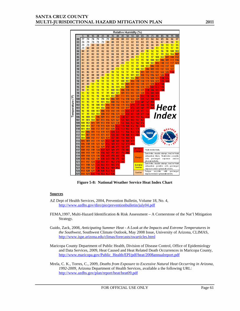
SANTA CRUZ COUNTY MULTI-JURISDICTIONAL HAZARD MITIGATION PLAN 2011
FOR OFFICIAL USE ONLY Page 61
Figure 5-8: National Weather Service Heat Index Chart
Sources
AZ Dept of Health Services, 2004, Prevention Bulletin, Volume 18, No. 4, http://www.azdhs.gov/diro/pio/preventionbulletin/july04.pdf
FEMA,1997, Multi-Hazard Identification & Risk Assessment – A Cornerstone of the Nat’l Mitigation
Strategy. Guido, Zack, 2008, Anticipating Summer Heat - A Look at the Impacts and Extreme Temperatures in
the Southwest, Southwest Climate Outlook, May 2008 Issue, University of Arizona, CLIMAS, http://www.ispe.arizona.edu/climas/forecasts/swarticles.html
Maricopa County Department of Public Health, Division of Disease Control, Office of Epidemiology
and Data Services, 2009, Heat Caused and Heat Related Death Occurrences in Maricopa County, http://www.maricopa.gov/Public_Health/EPI/pdf/heat/2008annualreport.pdf
Mrela, C. K., Torres, C., 2009, Deaths from Exposure to Excessive Natural Heat Occurring in Arizona,
1992-2009, Arizona Department of Health Services, available a the following URL: http://www.azdhs.gov/plan/report/heat/heat09.pdf

SANTA CRUZ COUNTY MULTI-JURISDICTIONAL HAZARD MITIGATION PLAN 2011
FOR OFFICIAL USE ONLY Page 62
NASA, 2010, NASA Assets Provide Orbital View to Study Phoenix Heat Waves, http://www.nasa.gov/centers/johnson/home/phoenix_heatwaves_feature_prt.htm
National Weather Service, Warning and Forecast Office – Phoenix, 2009, http://www.wrh.noaa.gov/psr/general/safety/heat/
University of Arizona Library, Books of the Southwest website portal is located at: http://southwest.library.arizona.edu/azso/body.1_div.3.html
Profile Maps - No profile maps are provided.

SANTA CRUZ COUNTY MULTI-JURISDICTIONAL HAZARD MITIGATION PLAN 2011
FOR OFFICIAL USE ONLY Page 63
5.3.4 Flood / Flash Flood
Description
For the purpose of this Plan, the hazard of flooding addressed in this section will pertain to floods that result from precipitation/runoff related events. Other flooding due to dam or levee failures will not be addressed in this plan. The three seasonal atmospheric events that tend to trigger floods in Santa Cruz County are:
• Tropical Storm Remnants: Some of the worst flooding tends to occur when the remnants of a hurricane that has been downgraded to a tropical storm or tropical depression enter the State. These events occur infrequently and mostly in the early autumn, and usually bring heavy and intense precipitation over large regions causing severe flooding.
• Winter Rains: Winter brings the threat of low intensity; but long duration rains covering large areas that cause extensive flooding and erosion, particularly when combined with snowmelt.
• Summer Monsoons: A third atmospheric condition that brings flooding to Arizona is the annual summer monsoon. In mid to late summer the monsoon winds bring humid subtropical air into the State. Solar heating triggers afternoon and evening thunderstorms that can produce extremely intense, short duration bursts of rainfall. The thunderstorm rains are mostly translated into runoff and in some instances, the accumulation of runoff occurs very quickly resulting in a rapidly moving flood wave referred to as a flash flood. Flash floods tend to be very localized and cause significant flooding of local watercourses.
Damaging floods in the County include riverine, sheet, alluvial fan, and local area flooding. Riverine flooding occurs along established watercourses when the bankfull capacity of a watercourse is exceeded by storm runoff or snowmelt and the overbank areas become inundated. Sheet flooding occurs in regionally low areas with little topographic relief that generate floodplains over a mile wide, Alluvial fan flooding is generally located on piedmont areas near the base of the local mountains and are characterized by multiple, highly unstable flowpaths that can rapidly change during flooding events. Local area flooding is often the result of poorly designed or planned development wherein natural flowpaths are altered, blocked or obliterated, and localized ponding and conveyance problems result. Erosion is also often associated with damages due to flooding.
Another major flood hazard comes as a secondary impact of wildfires in the form of dramatically increased runoff from ordinary rainfall events that occur on newly burned watersheds. Denuding of the vegetative canopy and forest floor vegetation, and development of hydrophobic soils are the primary factors that contribute to the increased runoff. Canopy and floor level brushes and grasses intercept and store a significant volume of rainfall during a storm event. They also add to the overall watershed roughness which generally attenuates the ultimate peak discharges. Soils in a wildfire burn area can be rendered hydrophobic, which according the NRCS is the development of a thin layer of nearly impervious soil at or below the mineral soil surface that is the result of a waxy substance derived from plant material burned during a hot fire. The waxy substance penetrates into the soil as a gas and solidifies after it cools, forming a waxy coating around soil particles. Hydrophobic soils, in combination with a denuded watershed, will significantly increase the runoff potential, turning a routine annual rainfall event into a raging flood with drastically increased potential for soil erosion and mud and debris flows.
History
Flooding is clearly a major hazard in Santa Cruz County as shown in Tables 5-2 through 5-4. Santa Cruz County has been part of 15 disaster declarations for flooding, with three of those declarations occurring in the past five years. There have been at least twenty-two other non-declared events of reported flooding incidents that met the thresholds outlined in Section 5.1, two of which occurred in the last five years. The following incidents represent examples of major flooding that has impacted the County:

SANTA CRUZ COUNTY MULTI-JURISDICTIONAL HAZARD MITIGATION PLAN 2011
FOR OFFICIAL USE ONLY Page 64
During January and February 1993, winter rain flooding damage occurred from winter storms associated with the El Nino phenomenon. These storms flooded watersheds throughout Arizona by dumping excessive rainfall amounts that saturated soils and increased runoff. Warm temperature snowmelt exacerbated the situation over large areas. Erosion caused tremendous damage and some communities along normally dry washes were devastated. Stream flow velocities and runoff volumes exceeded historic highs. Many flood prevention channels and retention reservoirs were filled to capacity and so water was diverted to the emergency spillways or the reservoirs were breached, causing extensive damage in some cases (e.g., Painted Rock Reservoir spillway). Ultimately, the President declared a major federal disaster that freed federal funds for both public and private property losses for all of Arizona’s fifteen counties. Damages were widespread and significant, impacting over 100 communities. Statewide total public and private damages exceeded $400 million and eight deaths and 112 injuries were reported to the Red Cross (FEMA, April 1, 1993; ADEM, March, 1998) Santa Cruz County damages were primarily associated with flows and erosion in the Santa Cruz River, Nogales Wash, Peck Canyon Creek, Western Wash and other minor tributaries. Public damages reported through FEMA, FHWA and SBA amounted to approximately $1.4 million. The Tubac Country Club sustained over $100,000 in damages from the Santa Cruz River flooding.
In August 1994, a devastating severe thunderstorm caused wind damage and flash flooding in both eastern Pima and Santa Cruz counties. Considerable flooding occurred in Santa Cruz County with thunderstorms around Nogales causing extensive flooding and heavy runoff. In some places, at least three inches of rain fell in the afternoon and early evening hours. The Santa Cruz river was reported flowing, and the Nogales Wash was nearly bankfull. A Mexican woman and her two children were drowned when their pickup truck was caught in flood waters on Cinco de Febrero Street in Nogales, Sonora. The bodies were swept downstream, two miles north of the border, where they were found near the Chula Vista subdivision. Many homes and businesses were flooded, but no estimates of damage were made and no evacuations were necessary (Green Valley News and Sun, circ:7,500).
In August 2007, the Nogales Wash Emergency was declared when portions of downtown Nogales experienced flash flooding. Extensive damage occurred to the concrete lining of Nogales Wash in the City of Nogales. City officials estimated damage at $10 million on the U.S. side of the border. Scattered thunderstorms across Southeast Arizona caused hail and wind damage in Tucson and flash flooding in Nogales. (ADEM, 2008)
In July 2008, Nogales Wash 2008 Emergency was declared - Heavy rainfall on the Mexican side of the border caused flash flooding in the city of Nogales, Arizona. This was caused by a damaged portion of the underground Nogales Wash. Local emergency management reported that water burst through the underground wash onto the surface just across the International Border. The border wall acted as a dam, keeping most of the flooding on the Mexican side. However, some water did flow through the port of entry into downtown Nogales, Arizona. Several businesses in the downtown business district experienced flooding and two illegal immigrants found two days later in the underground wash are also believed to have drowned due to this flooding. In addition, three illegal immigrants in an underground flood channel beneath the international border were rescued. Slow moving thunderstorms developed in a very moist environment across Southeast Arizona resulting in areas of flash flooding.(ADEM, 2008; NCDC,2010)
In August 2010, the Monsoon 2010 Flooding Emergency was declared: On July 19, 2010, through July 29, 2010, a series of potent monsoon thunderstorms causing high winds and flash floods damaged many locations in southeastern Arizona. The heavy rains resulted in unusually strong flooding events and caused extreme peril to public health and safety in two primary areas: Wards Canyon in Greenlee County and the Nogales Wash in Santa Cruz County. On July 29, 2010 both the Town of Clifton and Greenlee County declared a state of emergency for this event, followed on July 30, 2010 by Santa Cruz County, stating that this monsoon event has created a situation above and beyond their capabilities and they are

SANTA CRUZ COUNTY MULTI-JURISDICTIONAL HAZARD MITIGATION PLAN 2011
FOR OFFICIAL USE ONLY Page 65
requesting assistance from the State. These water flows caused extensive $500,000 in damages to public infrastructure and threatened resources that provide essential life services to Greenlee and Santa Cruz residents, primarily roads and sewer lines.(ADEM, 2010)
Numerous other flood related incidents are summarized in the historic hazard database provided in Appendix D and on the enclosed CD.
Probability and Magnitude
For the purposes of this Plan, the probability and magnitude of flood hazards in Greenlee County jurisdictions are primarily based on the 1% (100-year) and 0.2% (500-year) probability floodplains delineated on FEMA Flood Insurance Rate Maps (FIRMs), plus any provisional floodplain delineations used for in-house purposes by participating jurisdictions or Planning Team delineated areas. FEMA has recently completed a map modification program to update the FIRMs for the County into a digital FIRM (DFIRM) format. The tentative effective date for the new DFIRM maps is December 2011. DFIRM floodplain GIS base files were obtained from FEMA and are the basis for the flood hazard depictions in this Plan. Therefore, the vulnerability analysis results in this plan are likely conservative.
Two designations of flood hazard are used. Any “A” zone is designated as a high hazard area. Medium flood hazard areas are all “Shaded X” zones. All “A” zones (e.g. – A, A1-99, AE, AH, AO, etc.) represent areas with a 1% probability of being flooded at a depth of one-foot or greater in any given year. All “Shaded X” zones represent areas with a 0.2% probability of being flooded at a depth of one-foot or greater in any given year. These two storms are often referred to as the 100-year and 500-year storm, respectively. High and medium hazard designations were also assigned to the non-FEMA areas by the Planning Team based on the anticipated level of flood hazard posed.
Maps 2A show the flood hazard areas for the entire county. Maps 2B and 2C show the flood hazard areas for Nogales and Patagonia, respectively.
Vulnerability – CPRI Results
Flooding CPRI results for each community are summarized in Table 5-19 below.
Table 5-19: CPRI results by jurisdiction for flooding
Participating Jurisdiction Probability Magnitude/
Severity Warning
Time Duration CPRI Score
Nogales Highly Likely Critical 6 - 12 hours < 24 hours 3.65 Patagonia Highly Likely Critical < 6 hours < 24 hours 3.50
Unincorporated Santa Cruz County Highly Likely Critical < 6 hours > 1 week 3.70 County-wide average CPRI = 3.62
Vulnerability – Loss Estimations
The estimation of potential exposure to high and medium flood hazards was accomplished by intersecting the human and critical facility assets with the flood hazard limits depicted on Map 2A. Loss estimates to all facilities located within the high and medium flood hazard areas were made based on loss estimation tables published by FEMA (FEMA, 2001). Most of the assets located within high hazard flood areas will be subject to three feet or less of flooding. Using the FEMA tables, it is assumed that all structural assets located within the high hazard areas will have a loss-to-exposure ratio of 0.20 (or 20%). A loss to exposure ratio of 0.05 (5%) is assumed for assets located in the medium hazard areas. Table 5-20 summarizes the Planning Team identified critical facilities potentially exposed to high and medium flood hazards, and the corresponding estimates of losses. Table 5-21 summarizes population sectors exposed to the high and medium flood hazards. HAZUS residential, commercial and industrial exposures and loss estimates to high and medium flood hazards are summarized in Tables 5-22 through 5-25.
In summary, $73 million and $2.4 million in asset related losses are estimated for high and medium flood hazards, for all the participating jurisdictions in Santa Cruz County. An additional $215 and $1.8 million in high and medium flood losses to HAZUS defined residential, commercial, and industrial

SANTA CRUZ COUNTY MULTI-JURISDICTIONAL HAZARD MITIGATION PLAN 2011
FOR OFFICIAL USE ONLY Page 66
facilities is estimated for all participating Santa Cruz County jurisdictions. Regarding human vulnerability, a total population of 11,587 people, or 30.21% of the total population, is potentially exposed to a high hazard flood event. A total population of 246 people, or .64% of the total population, is potentially exposed to a medium hazard flood event. Based on the historic record, multiple deaths and injuries are plausible and a substantial portion of the exposed population is subject to displacement depending on the event magnitude.
It is duly noted that the loss and exposure numbers presented above represent a comprehensive evaluation of the County as a whole. It is unlikely that a storm event would occur that would flood all of the delineated high and medium flood hazard areas at the same time. Accordingly, actual event based losses and exposure are likely to be only a fraction of those summarized above. Furthermore, it should be noted that any flood event that exposes assets or population to a medium hazard will also expose assets and populations to the high hazard flood zone. That is, the 100-year floodplain would be entirely inundated during a 500-year flood.
Vulnerability – Repetitive Loss Properties
Repetitive Loss (RL) properties are those NFIP-insured properties that since 1978, have experienced multiple flood losses. FEMA tracks RL property statistics, and in particular to identify Severe RL (SRL) properties. RL properties demonstrate a track record of repeated flooding for a certain location and are one element of the vulnerability analysis. RL properties are also important to the NFIP, since structures that flood frequently put a strain on the National Flood Insurance Fund. FEMA records dated January 2010 (provided by ADEM) indicate that there are 7 identified RL properties in Santa Cruz County, with a total of over $124,148 in associated building and contents value payments. None of the payments have occurred within the last five years. Table 5-27 summarizes the RL property characteristics by jurisdiction.
Table 5-27: Repetitive Loss property statistics for Santa Cruz County jurisdictions
Jurisdiction No. of
Properties
No. of Properties Mitigated
Total Payments
Nogales 4 0 $92,978 Patagonia 0 0 $0
Unincorporated Santa Cruz County 3 3 $31,169 Source: FEMA Region IX, 2010 (data as of January 31, 2010)
It is duly noted that all three of the RL properties listed for Unincorporated Santa Cruz County are disputed by the Santa Cruz County Flood Control District, as the FEMA data cannot be verified. The same is true for a couple of the properties listed for Nogales.
Vulnerability – Development Trends
Most floodprone properties in Santa Cruz County pre-date the planning jurisdictions’ entry into the NFIP and were constructed prior to current floodplain management practices. The development of new properties or substantial re-development of existing structures is now subject to regulatory review procedures implemented by each jurisdiction. New development, adequate planning and regulatory tools are in place to regulate future development. For many areas within the county, challenges for the management of new growth include the need for master drainage planning and additional floodplain delineations to identify and map the flood hazards within the growth areas where no mapping currently exists.

SANTA CRUZ COUNTY MULTI-JURISDICTIONAL HAZARD MITIGATION PLAN 2011
FOR OFFICIAL USE ONLY Page 67
Table 5-20: Asset inventory exposure to high and medium hazard flooding and corresponding loss
estimates
Community
Total Facilities Reported by Community
Impacted Facilities
Percentage of Total
Community Facilities Impacted
Estimated Replacement
Cost (x$1000)
Estimated Structure
Loss (x$1000)
HIGH County-Wide
Totals 244 132 54.10% $369,623 $73,925 Nogales 39 21 53.85% $1,939 $388
Patagonia 16 12 75.00% $2,573 $515 Unincorporated
Santa Cruz 189 99 52.38% $365,110 $73,022 MEDIUM
County-Wide Totals 244 8 3.28% $48,165 $2,408
Nogales 39 3 7.69% $6,665 $333 Patagonia 16 1 6.25% $6,500 $325
Unincorporated Santa Cruz 189 4 2.12% $35,000 $1,750
Table 5-21: Population sectors exposed to high and medium hazard flooding
Community Total
Population Population
Exposed
Percent of Population
Exposed
Total Population
Over 65
Population Over 65 Exposed
Percent of Population
Over 65 Exposed
HIGH County-Wide Totals 38,353 11,587 30.21% 4,047 1,340 33.10%
City of Nogales 20,818 6,101 29.30% 2,204 653 29.61% Town of Patagonia 827 748 90.46% 178 161 90.60%
Unincorporated 16,708 4,738 28.36% 1,665 526 31.57% MEDIUM
County-Wide Totals 38,353 246 0.64% 4,047 31 0.75% City of Nogales 20,818 166 0.80% 2,204 19 0.88%
Town of Patagonia 827 1 0.10% 178 0 0.10% Unincorporated 16,708 79 0.47% 1,665 11 0.66%

SANTA CRUZ COUNTY MULTI-JURISDICTIONAL HAZARD MITIGATION PLAN 2011
FOR OFFICIAL USE ONLY Page 68
Table 5-22: Santa Cruz County HAZUS building exposure to flooding
RESIDENTIAL COMMERCIAL INDUSTRIAL SUMMARY
Santa Cruz County HAZUS Summary
Building Count
Potential Economic
Impact (x$1000)
Building Count
Potential Economic
Impact (x$1000)
Building Count
Potential Economic
Impact (x$1000)
Total of All Economic
Impact (x$1000)
Loss-to-Exposure
Ratio
Total Estimated
Loss (x$1000)
County-Wide Totals 13,318 $2,022,210 693 $896,552 206 $179,733 $3,098,495 High Hazard Exposure 4,208 $594,073 308 $422,175 70 $61,184 $1,077,432 20% $215,486
Medium Hazard Exposure 93 $13,610 11 $19,719 2 $2,463 $35,792 5% $1,790
Santa Cruz County HAZUS Summary
% Building
Count
% Potential Economic
Impact
% Building
Count
% Potential Economic
Impact
% Building
Count
% Potential Economic
Impact High Hazard Exposure 31.60% 29.38% 44.44% 47.09% 34.08% 34.04% Medium Hazard Exposure 0.70% 0.67% 01.57% 02.20% 01.04% 01.37%
Table 5-23: City of Nogales HAZUS building exposure to flooding
RESIDENTIAL COMMERCIAL INDUSTRIAL SUMMARY
City of Nogales HAZUS Summary
Building Count
Potential Economic
Impact (x$1000)
Building Count
Potential Economic
Impact (x$1000)
Building Count
Potential Economic
Impact (x$1000)
Total of All Economic
Impact (x$1000)
Loss-to-Exposure
Ratio
Total Estimated
Loss (x$1000)
Community-Wide Totals 5,922 $856,827 372 $594,349 96 $114,768 $1,565,944
High Hazard Exposure 1,821 $253,588 188 $287,022 36 $42,464 $583,074 20% $116,615 Medium Hazard Exposure 49 $6,766 4 $6,330 1 $669 $13,764 5% $688
City of Nogales HAZUS Summary
% Building
Count
% Potential Economic
Impact
% Building
Count
% Potential Economic
Impact
% Building
Count
% Potential Economic
Impact High Hazard Exposure 30.74% 29.60% 50.57% 48.29% 37.20% 37.0% Medium Hazard Exposure 0.82% 0.79% 0.96% 01.07% 0.68% 0.58%

SANTA CRUZ COUNTY MULTI-JURISDICTIONAL HAZARD MITIGATION PLAN 2011
FOR OFFICIAL USE ONLY Page 69
Table 5-24: Town of Patagonia HAZUS building exposure to flooding RESIDENTIAL COMMERCIAL INDUSTRIAL SUMMARY
Town of Patagonia HAZUS Summary
Building Count
Potential Economic
Impact (x$1000)
Building Count
Potential Economic
Impact (x$1000)
Building Count
Potential Economic
Impact (x$1000)
Total of All Economic
Impact (x$1000)
Loss-to-Exposure
Ratio
Total Estimated
Loss (x$1000)
Community-Wide Totals 539 $51,820 11 $7,168 5 $1,397 $60,385
High Hazard Exposure 485 $47,482 12 $7,432 5 $1,397 $56,311 20% $11,262 Medium Hazard Exposure 0 $42 0 $0 0 $0 $42 5% $2
Town of Patagonia HAZUS Summary
% Building
Count
% Potential Economic
Impact
% Building
Count
% Potential Economic
Impact
% Building
Count
% Potential Economic
Impact High Hazard Exposure 90.04% 91.63% 108.20% 103.68% 100.0% 100.0% Medium Hazard Exposure 0.08% 0.08% 0.0% 0.0% 0.0% 0.0%
Table 5-25: Unincorporated Santa Cruz County HAZUS building exposure to flooding
RESIDENTIAL COMMERCIAL INDUSTRIAL SUMMARY
Unincorporated Santa Cruz County HAZUS Summary
Building Count
Potential Economic
Impact (x$1000)
Building Count
Potential Economic
Impact (x$1000)
Building Count
Potential Economic
Impact (x$1000)
Total of All Economic
Impact (x$1000)
Loss-to-Exposure
Ratio
Total Estimated
Loss (x$1000)
Community-Wide Totals 6,856 $1,113,563 310 $295,035 105 $63,568 $1,472,166
High Hazard Exposure 1,902 $293,003 108 $127,721 30 $17,323 $438,047 20% $87,609 Medium Hazard Exposure 44 $6,802 7 $13,389 1 $1,794 $21,985 5% $1,099
Unincorporated Santa Cruz County HAZUS Summary
% Building
Count
% Potential Economic
Impact
% Building
Count
% Potential Economic
Impact
% Building
Count
% Potential Economic
Impact High Hazard Exposure 27.74% 26.31% 34.83% 43.29% 28.13% 27.25% Medium Hazard Exposure 0.65% 0.61% 02.35% 04.54% 01.42% 02.82%

SANTA CRUZ COUNTY MULTI-JURISDICTIONAL HAZARD MITIGATION PLAN 2011
FOR OFFICIAL USE ONLY Page 70
Sources
Arizona Division of Emergency Management, 2010, State of Arizona Multi-Hazard Mitigation Plan.
FEMA, 2001, Understanding Your Risks; Identifying Hazards and Estimating Losses, FEMA Document No. 386-2.
JE Fuller/ Hydrology & Geomorphology, 2006, Greenlee County Multi-Hazard Mitigation Plan
JE Fuller/ Hydrology & Geomorphology, 2006, Town of Clifton County Multi-Hazard Mitigation Plan
JE Fuller/ Hydrology & Geomorphology, 2006, Town of Duncan Multi-Hazard Mitigation Plan
NOAA, National Weather Service Forecast Office – Tucson, 2011, website data accessed via the following URL: http://www.wrh.noaa.gov/twc/hydro/floodhis.php
U.S. Dept of Commerce, National Climatic Data Center, 2010, Storm Events Database, accessed via the following URL: http://www4.ncdc.noaa.gov/cgi-win/wwcgi.dll?wwevent~storms
U.S. Army Corps of Engineers, Los Angeles District, 1994, Flood Damage Report, State of Arizona, Floods of 1993.
Profile Maps
Maps 2A– County-Wide Flood Hazard Map
Maps 2B and 2C – Nogales and Patagonia Flood Hazard Maps

!(
!(
!(
!(
!(
!(
!(
!(
!(
!(
!(
!(
!(
!(
!(
!(
!(
!(
!(
!(
!(
!(
!(!(
!(
!(
!(
!(
!(
!(
!(
!(
!(
!(
!(
!(
!(
!(
!(
!(
§̈¦19
rx82
rx83
Santa Cruz River Sonoita Creek
Santa Cruz River
I- 19
State Hwy 83
State Hwy 82
E Ruby Rd E Patag
onia H
wy
Fr
799
Ruby-Nogales Rd
N Grand Ave
Elgin C
anelo
Rd
Ruby Rd
W Arivaca Rd Upper Elgin Rd
Cimarron Rd
N Mari
posa
Rd
Lyle Canyon Rd
I- 19
PIMA
SANTA CRUZ
COCHISE
Ciene
ga Cr
eek
Sopo
ri Wash
Penitas Wash
Josephine Can
yo
n
Babocomari River
Santa
Cru
z Rive
r
Arivaca Creek
Sycam
ore Canyon
Altar Wash
Tres Bellotas Canyon
Ruby
AltoTubac
Amado
Carmen
Sonoita
Nogales Lochiel
Harshaw
Arivaca
Helvetia
Duquesne
Patagonia
SunnysideOld Glory
Calabasas
Oro Blanco
Beyerville
Agua Linda
Trench Camp
Continental
Casa Piedra
Kino Springs
Greaterville
Rosemont Camp
Madera CanyonArivaca Junction
Hacienda Los Encino
Partridge (historical)
Sotos Crossing (historical)
Map 2ASanta Cruz County
FloodHazard Map
as of May 2011
Santa Cruz County Multi-JurisdictionalHazard Mitigation Plan
0 5 102.5 MilesI
LegendFlood Hazard Rating
100 Year Flood - High Hazard500 Year Flood - Medium Hazard
PIMA
YUMA PINAL
MARICOPA
COCHISE
GRAHAM
GILALA PAZGREENLEE
SANTA CRUZ
APACHE
LegendCommunities
NOGALESPATAGONIACounty Boundary
!( Cities, Towns, PlacesWatercoursesLakes
RoadsInterstateUS, State, County HwysMajor Roads
Mexico
Sources: FEMA, 2010; ALRIS, 2010; JEF, 2010; SCC, 2011

!(
§̈¦19
§̈¦19
Potre
ro Cr
eek
I- 19
N Grand A
ve
E Patagonia Hwy
N Mari
posa
Rd
N Morley Ave
N Target Range Rd
E Baffert Dr
N Ro yal Rd
Fran
k R
eed Rd
N David DrW Mariposa Rd
E Cam Vista del CieloW Gold Hill Rd
Amura Ln
N McNab Dr
W 1st St
W Elm St
N Cam Vista del CieloW Potrero
Dr
Lobo L
ane Dr
W Kino St
N Western Ave
W Meadow Hills Dr
W Fairway Dr
N Hohokam Dr
W Artley Dr
W Frontage Rd
W Ellis St
E Roper Rd
W la Quinta Rd
E Beck St
W Western Ave
W Walnut St
N Cinc
o Milla
s Rd
N Silv
er H
ill Dr
N Industrial Park Dr
W Pajarito St
E Live Oak Dr
W Cimarron St
E East StN P
erkins
Ave
N B ankerd Ave
N Valle Verde Dr
N Cherokee Ave
N Cl
l Cor
onad
oW Manilla Dr
E Cll Nacozari
W Mariposa Ranch Rd
N Donna Ave
N Mastick Way
N Cam Bajo
E Maya St
E Skyline Dr
N Aloha Loop
E Thelma St
N Bayze Ave
E International St
N C
anon del Oro Dr
N Freeport Dr
Victory Ln
E Cll Colima
I- 19
N Mari
posa
Rd
N Grand Ave
Nogales
Map 2BCity of Nogales
FloodHazard Map
as of December 2010
Santa Cruz County Multi-JurisdictionalHazard Mitigation Plan
0 0.5 1 MilesI
LegendFlood Hazard Rating
100 Year Flood - High Hazard500 Year Flood - Medium Hazard
SANTA CRUZ
PIMA
COCHISE
LegendCommunities
NOGALESPATAGONIACounty Boundary
!( Cities, Towns, PlacesWatercoursesLakes
RoadsInterstatesHighwaysArterialsStreets
MexicoSources: FEMA, 2010; ALRIS, 2010; JEF, 2010; SCC, 2010; ASLD, 2010
^̀
Nogales

£¤82
rx82
Naugle Ave
Harshaw Rd
3rd Ave
Trailwood Ct
Mc Keown Ave
Sonoita Ave
Emily
Ln
4th Ave
Duquesne Ave
San Antonio Rd
Mendoza Aly
1st Ave
Rothrock Aly
N 3rd Ave
Red Mountain Ct
2nd Ave
Three R
Santa Rita Ave
Franklin
Copper Ct
Costel lo Dr
E Patagonia Hwy
Pennsylvania Ave
Roadrunner Ln
School St
Sonoita Ave N
Sierra
Ln
Red Rock Ave
Gray Hawk Trl
North Ave
Pittsburgh Ave
Sheard Dr
Taylor
Bla bon Way
Forrest Dr
2nd Ave
2nd Ave
Sonoita Creek
Harshaw Creek
Patagonia
Map 2CTown of Patagonia
FloodHazard Map
as of December 2010
Santa Cruz County Multi-JurisdictionalHazard Mitigation Plan
0 760 1,520380 FeetI
LegendFlood Hazard Rating
100 Year Flood - High Hazard500 Year Flood - Medium Hazard
SANTA CRUZ
PIMA
COCHISE
LegendCommunities
NOGALESPATAGONIACounty Boundary
!( Cities, Towns, PlacesWatercoursesLakes
RoadsInterstatesHighwaysArterialsStreets MexicoSources: FEMA, 2010; ALRIS, 2010;
JEF, 2010; SCC, 2010; ASLD, 2005
Patagonia
^̀
SANTA CRUZ COUNTY MULTI-JURISDICTIONAL HAZARD MITIGATION PLAN 2011
FOR OFFICIAL USE ONLY Page 71
5.3.5 Hazardous Materials Incidents
Description
The threat of exposure to Hazardous Materials (HAZMAT) in our modern society is prevalent nationwide and throughout Santa Cruz County. HAZMAT incidents can occur from either point source spills or from transportation related accidents. In Santa Cruz County, the primary areas of risk associated with HAZMAT incidents are located near or along Tier II facilities, major roads and rail lines, and pipelines that transport hazardous substances. These substances may be highly toxic, reactive, corrosive, flammable, explosive, radioactive or infectious, with potential to contaminate air, soil, and water resources and pose a serious risk to life, health, environment and property. HAZMAT incidents can result in the evacuation of a few people, a specific facility, or an entire neighborhood(s) depending on the size and magnitude of the release and environmental conditions.
The Arizona State Emergency Response Commission (AZSERC), established by Arizona Law (Arizona Revised Statutes-Title 26, Chapter 2, Article 3) is tasked with the implementation of the Emergency Planning and Community Right to Know Act (EPCRA) in Arizona. Local Emergency Planning Committees (LEPC) are appointed by AZSERC, as required by EPCRA, first to design, then to regularly review and update a comprehensive emergency plan for an emergency planning district. There are 15 LEPC's in Arizona - one in each county.
State statutes and Sections 311 and 312 of EPCRA set forth hazardous chemical storage reporting requirements and thresholds for facilities possessing hazardous materials. The legislation requires that facilities storing or producing hazardous materials in quantities that exceed a defined Threshold Planning Quantity (TPQ), submit an annual chemical inventory report (Tier II Hazardous Chemical Inventory Form) to AZSERC, the appropriate LEPC, and local fire department, by March 1 of each year. Facilities holding an Extremely Hazardous Substance (EHS) at quantities exceeding the Threshold Planning Quantities (TPQ) must provide the notifications as well as a representative to participate in the county emergency planning process.
For the purposes of this Plan, the Planning Team chose to focus only on those HAZMAT facilities and chemicals that are classified by the Environmental Protection Agency (EPA) as extremely hazardous substances (EHS) Typical EHS materials transported and stored routinely in the county include chlorine gas, sulphuric acid, and hydrogen flouride.
History
According the Good Neighbor Environmental Board (GNEB, 2007), the Nogales port of entry receives the most significant number of hazardous waste shipments in Arizona, with many of the loads originating in Baja California. Truckers and shippers choose to route the hazardous waste to the Nogales port of entry to avoid the more stringent requirements at the California ports of entry.
The National Response Center (NRC) maintains a database of transportation related HAZMAT incidents that are reported or called into the system. A query of the that database for the period of January 1990 through July 2010 revealed a total of 42 HAZMAT incidents that involved an EPA identified extremely hazardous substance (EHS) that were located in the Santa Cruz County-Sonora Mexico border area. The following are a few select incidents reported in or near Santa Cruz County:
• Date unknown, rail cars carrying sulfuric acid at San Lazaro, Sonora, by the Santa Cruz River, derailed spilling approximately 25,000 to 30,000 gallons of sulfuric acid into river waters (GNEB, 2007).
• On January 9, 1993, a tank car that had been in Mexico for over a year was relocated to the Nogales Rail Yard and was believed to be empty. A valve on the tank car was found open and releasing anhydrous ammonia (NRC, 2010).
• On February 11, 1993, over 30 fifty gallon barrels of sulfuric acid, caustic soda, and other unknown materials were dumped onto the Jehovah’s Witness’ church property (NRC, 2010).
• On November 3 and 4, 1993, a tank car filled with ammonium sulfide started leaking due to a faulty manway gasket. The tank car was located in the Nogales Rail Yard near the border.
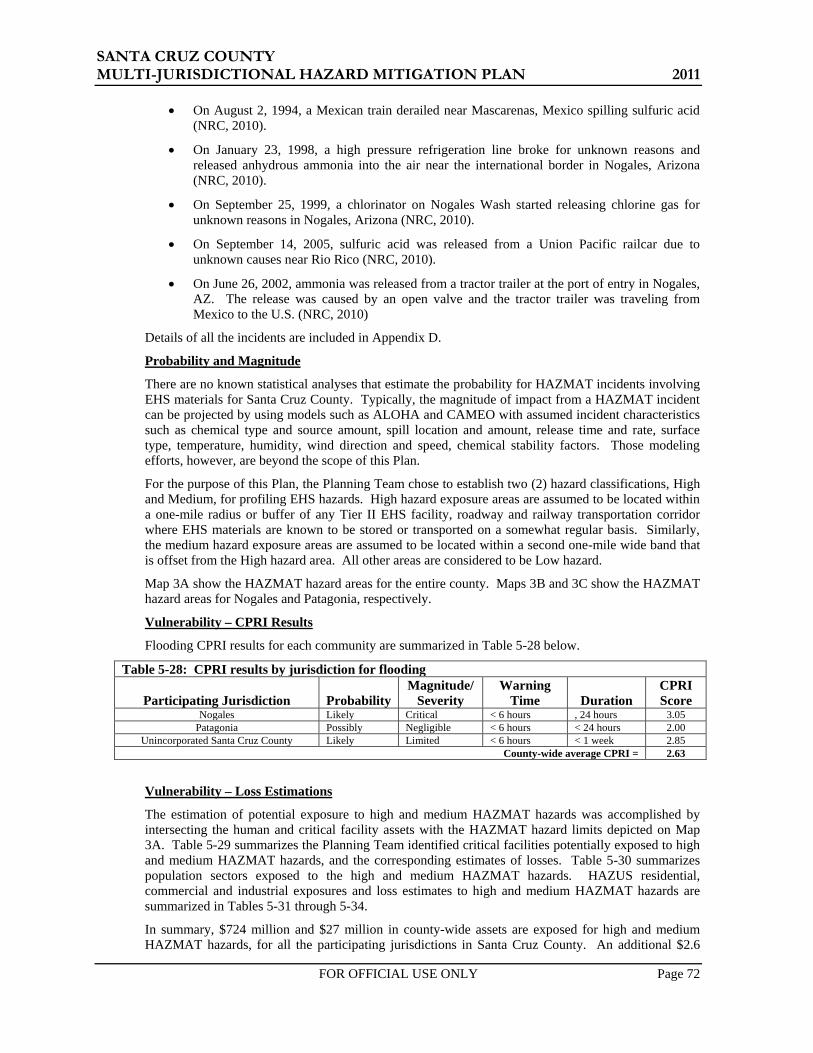
SANTA CRUZ COUNTY MULTI-JURISDICTIONAL HAZARD MITIGATION PLAN 2011
FOR OFFICIAL USE ONLY Page 72
• On August 2, 1994, a Mexican train derailed near Mascarenas, Mexico spilling sulfuric acid (NRC, 2010).
• On January 23, 1998, a high pressure refrigeration line broke for unknown reasons and released anhydrous ammonia into the air near the international border in Nogales, Arizona (NRC, 2010).
• On September 25, 1999, a chlorinator on Nogales Wash started releasing chlorine gas for unknown reasons in Nogales, Arizona (NRC, 2010).
• On September 14, 2005, sulfuric acid was released from a Union Pacific railcar due to unknown causes near Rio Rico (NRC, 2010).
• On June 26, 2002, ammonia was released from a tractor trailer at the port of entry in Nogales, AZ. The release was caused by an open valve and the tractor trailer was traveling from Mexico to the U.S. (NRC, 2010)
Details of all the incidents are included in Appendix D.
Probability and Magnitude
There are no known statistical analyses that estimate the probability for HAZMAT incidents involving EHS materials for Santa Cruz County. Typically, the magnitude of impact from a HAZMAT incident can be projected by using models such as ALOHA and CAMEO with assumed incident characteristics such as chemical type and source amount, spill location and amount, release time and rate, surface type, temperature, humidity, wind direction and speed, chemical stability factors. Those modeling efforts, however, are beyond the scope of this Plan.
For the purpose of this Plan, the Planning Team chose to establish two (2) hazard classifications, High and Medium, for profiling EHS hazards. High hazard exposure areas are assumed to be located within a one-mile radius or buffer of any Tier II EHS facility, roadway and railway transportation corridor where EHS materials are known to be stored or transported on a somewhat regular basis. Similarly, the medium hazard exposure areas are assumed to be located within a second one-mile wide band that is offset from the High hazard area. All other areas are considered to be Low hazard.
Map 3A show the HAZMAT hazard areas for the entire county. Maps 3B and 3C show the HAZMAT hazard areas for Nogales and Patagonia, respectively.
Vulnerability – CPRI Results
Flooding CPRI results for each community are summarized in Table 5-28 below.
Table 5-28: CPRI results by jurisdiction for flooding
Participating Jurisdiction Probability Magnitude/
Severity Warning
Time Duration CPRI Score
Nogales Likely Critical < 6 hours , 24 hours 3.05 Patagonia Possibly Negligible < 6 hours < 24 hours 2.00
Unincorporated Santa Cruz County Likely Limited < 6 hours < 1 week 2.85 County-wide average CPRI = 2.63
Vulnerability – Loss Estimations
The estimation of potential exposure to high and medium HAZMAT hazards was accomplished by intersecting the human and critical facility assets with the HAZMAT hazard limits depicted on Map 3A. Table 5-29 summarizes the Planning Team identified critical facilities potentially exposed to high and medium HAZMAT hazards, and the corresponding estimates of losses. Table 5-30 summarizes population sectors exposed to the high and medium HAZMAT hazards. HAZUS residential, commercial and industrial exposures and loss estimates to high and medium HAZMAT hazards are summarized in Tables 5-31 through 5-34.
In summary, $724 million and $27 million in county-wide assets are exposed for high and medium HAZMAT hazards, for all the participating jurisdictions in Santa Cruz County. An additional $2.6

SANTA CRUZ COUNTY MULTI-JURISDICTIONAL HAZARD MITIGATION PLAN 2011
FOR OFFICIAL USE ONLY Page 73
billion and $293 million in high and medium flood hazard exposure of HAZUS defined residential, commercial, and industrial facilities is estimated for all participating Santa Cruz County jurisdictions. Regarding human vulnerability, a total population of 32,220 people, or 84% of the total population, is potentially exposed to a high hazard HAZMAT event. A total population of 4,197 people, or 10.94% of the total population, is potentially exposed to a medium hazard HAZMAT event. It is recognized that EHS incidents typically occur in a single localized area and do not impact an entire county or community at one time. These numbers are intended to represent the collective community or county-wide exposure. Actual losses for an individual incident are likely to be only a fraction of the numbers presented here. Because of the nature of this hazard, structural damage is highly unlikely and decontamination costs related to replacements cost would only be a small fraction.
Vulnerability – Development Trends
As the vulnerability analysis indicates, much of Gila County is exposed to some level of EHS threat. That exposure will only worsen as development increases. It may be advantageous to pursue designating certain roadways as EHS corridors to limit the exposure, and establishing buffer zones along corridors known to be frequent EHS transport routes. Development of high-density population land uses such as schools, nursing homes, apartment complexes, etc., should be discouraged within these zones.
EHS facilities that have potential for critical or catastrophic HAZMAT releases should be located on flat topography and take advantage of positive and protect against negative climate and microclimate conditions; utilize shading from excessive sun in warm climate and/or other best management practices.
Sources
Arizona Division of Emergency Management, 2010, State of Arizona Multi-Hazard Mitigation Plan.
Good Neighbor Environmental Board, 2007, Environmental Protection and Border Security on the U.S.-Mexico Border.
JE Fuller/ Hydrology & Geomorphology, 2006, Santa Cruz County Multi-Jurisdictional Hazard Mitigation Plan.
U.S. Department of Transportation, 1996, North American Emergency Response Guidebook
Profile Maps
Maps 3A – County-Wide Hazardous Materials Hazard Map
Maps 3B and 3C– Community Wide Hazardous Materials Hazard Maps

SANTA CRUZ COUNTY MULTI-JURISDICTIONAL HAZARD MITIGATION PLAN 2011
FOR OFFICIAL USE ONLY Page 74
Table 5-29: Asset inventory exposure to high and medium hazard HAZMAT and corresponding loss estimates
Community
Total Facilities Reported by Community
Impacted Facilities
Percentage of Total
Community Facilities Impacted
Estimated Replacement
Cost
Estimated Structure
Loss HIGH
County-Wide Totals 244 204 83.61% $724,660 $0
Nogales 39 37 94.87% $8,916 $0 Patagonia 16 16 100.00% $9,498 $0
Unincorporated Santa Cruz 189 151 79.89% $706,246 $0
MEDIUM County-Wide
Totals 244 20 8.20% $27,180 $0 Nogales 39 2 5.13% $0 $0
Patagonia 16 0 0.00% $0 $0 Unincorporated
Santa Cruz 189 18 9.52% $27,180 $0 Table 5-30: Population sectors exposed to high and medium hazard HAZMAT
Community Total
Population Population
Exposed
Percent of Population
Exposed
Total Population
Over 65
Population Over 65 Exposed
Percent of Population
Over 65 Exposed
HIGH County-Wide
Totals 38,353 32,220 84.01% 4,047 3,510 86.73% City of Nogales 20,818 20,181 96.94% 2,204 2,155 97.75%
Town of Patagonia 827 827 100.00% 178 178 100.00% Unincorporated 16,708 11,212 67.11% 1,665 1,178 70.73%
MEDIUM County-Wide
Totals 38,353 4,197 10.94% 4,047 333 8.23% City of Nogales 20,818 606 2.91% 2,204 45 2.02%
Town of Patagonia 827 31 3.79% 178 5 2.78% Unincorporated 16,708 3,560 21.31% 1,665 283 17.02%

SANTA CRUZ COUNTY MULTI-JURISDICTIONAL HAZARD MITIGATION PLAN 2011
FOR OFFICIAL USE ONLY Page 75
Table 5-31: Santa Cruz County HAZUS building exposure to HAZMAT
RESIDENTIAL COMMERCIAL INDUSTRIAL SUMMARY
Santa Cruz County HAZUS Summary
Building Count
Potential Economic
Impact (x$1000)
Building Count
Potential Economic
Impact (x$1000)
Building Count
Potential Economic
Impact (x$1000)
Total of All Economic
Impact (x$1000)
Loss-to-Exposure
Ratio
Total Estimated
Loss (x$1000)
County-Wide Totals 13,318 $2,022,210 693 $896,552 206 $179,733 $3,098,495 High Hazard Exposure 10,590 $1,605,444 601 $834,730 166 $161,454 $2,601,628 % $0
Medium Hazard Exposure 1,597 $254,430 46 $31,152 22 $7,727 $293,308 % $0
Santa Cruz County HAZUS Summary
% Building
Count
% Potential Economic
Impact
% Building
Count
% Potential Economic
Impact
% Building
Count
% Potential Economic
Impact High Hazard Exposure 79.52% 79.39% 86.69% 93.10% 80.52% 89.83% Medium Hazard Exposure 11.99% 12.58% 06.67% 03.47% 10.56% 04.30%
Table 5-32: City of Nogales HAZUS building exposure to HAZMAT RESIDENTIAL COMMERCIAL INDUSTRIAL SUMMARY
City of Nogales HAZUS Summary
Building Count
Potential Economic
Impact (x$1000)
Building Count
Potential Economic
Impact (x$1000)
Building Count
Potential Economic
Impact (x$1000)
Total of All Economic
Impact (x$1000)
Loss-to-Exposure
Ratio
Total Estimated
Loss (x$1000)
Community-Wide Totals 5,922 $856,827 372 $594,349 96 $114,768 $1,565,944 High Hazard Exposure 5,755 $826,644 365 $580,259 93 $112,551 $1,519,454 % $0
Medium Hazard Exposure 159 $28,817 6 $14,090 3 $2,217 $45,123 % $0
City of Nogales HAZUS Summary
% Building
Count
% Potential Economic
Impact
% Building
Count
% Potential Economic
Impact
% Building
Count
% Potential Economic
Impact High Hazard Exposure 97.17% 96.48% 98.31% 97.63% 96.95% 98.07% Medium Hazard Exposure 02.68% 03.36% 01.69% 02.37% 03.05% 01.93%

SANTA CRUZ COUNTY MULTI-JURISDICTIONAL HAZARD MITIGATION PLAN 2011
FOR OFFICIAL USE ONLY Page 76
Table 5-33: Town of Patagonia HAZUS building exposure to HAZMAT RESIDENTIAL COMMERCIAL INDUSTRIAL SUMMARY
Town of Patagonia HAZUS Summary
Building Count
Potential Economic
Impact (x$1000)
Building Count
Potential Economic
Impact (x$1000)
Building Count
Potential Economic
Impact (x$1000)
Total of All Economic
Impact (x$1000)
Loss-to-Exposure
Ratio
Total Estimated
Loss (x$1000)
Community-Wide Totals 539 $51,820 11 $7,168 5 $1,397 $60,385 High Hazard Exposure 539 $51,820 11 $7,168 5 $1,397 $60,385 % $0
Medium Hazard Exposure 9 $1,367 0 $0 0 $0 $1,367 % $0
Town of Patagonia HAZUS Summary
% Building
Count
% Potential Economic
Impact
% Building
Count
% Potential Economic
Impact
% Building
Count
% Potential Economic
Impact High Hazard Exposure 100.0% 100.0% 100.0% 100.0% 100.0% 100.0% Medium Hazard Exposure 01.71% 02.64% 0.0% 0.0% 0.0% 0.0%
Table 5-34: Unincorporated Santa Cruz County HAZUS building exposure to HAZMAT
RESIDENTIAL COMMERCIAL INDUSTRIAL SUMMARY
Unincorporated Santa Cruz County HAZUS Summary
Building Count
Potential Economic
Impact (x$1000)
Building Count
Potential Economic
Impact (x$1000)
Building Count
Potential Economic
Impact (x$1000)
Total of All Economic
Impact (x$1000)
Loss-to-Exposure
Ratio
Total Estimated
Loss (x$1000)
Community-Wide Totals 6,856 $1,113,563 310 $295,035 105 $63,568 $1,472,166 High Hazard Exposure 4,296 $726,980 224 $247,303 68 $47,506 $1,021,789 % $0
Medium Hazard Exposure 1,429 $224,246 40 $17,062 19 $5,510 $246,818 % $0 Unincorporated
Santa Cruz County HAZUS Summary
% Building
Count
% Potential Economic
Impact
% Building
Count
% Potential Economic
Impact
% Building
Count
% Potential Economic
Impact High Hazard Exposure 62.66% 65.28% 72.31% 83.82% 64.69% 74.73% Medium Hazard Exposure 20.85% 20.14% 12.86% 05.78% 17.88% 08.67%
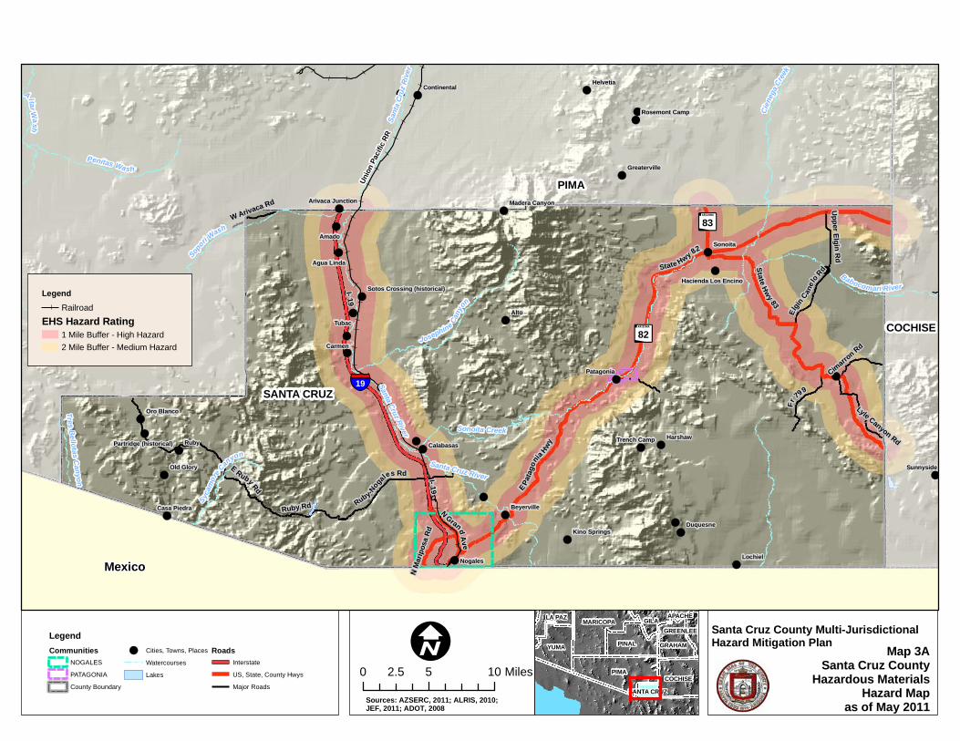
!(
!(
!(
!(
!(
!(
!(
!(
!(
!(
!(
!(
!(
!(
!(
!(
!(
!(
!(
!(
!(
!(
!(!(
!(
!(
!(
!(
!(
!(
!(
!(
!(
!(
!(
!(
!(
!(
!(
!(
§̈¦19
rx82
rx83
Santa Cruz River Sonoita Creek
Santa Cruz River
Union
Pacif
ic RR
I- 19
State Hwy 83
State Hwy 82
E Ruby Rd E Patag
onia H
wy
Fr
799
Ruby-Nogales Rd
N Grand Ave
Elgin C
anelo
Rd
Ruby Rd
W Arivaca Rd Upper Elgin Rd
Cimarron Rd
N Mari
posa
Rd
Lyle Canyon Rd
I- 19
PIMA
SANTA CRUZ
COCHISE
Ciene
ga Cr
eek
Sopo
ri Wash
Penitas Wash
Josephine Can
yo
n
Babocomari River
Santa
Cru
z Rive
r
Arivaca Creek
Sycam
ore Canyon
Altar Wash
Tres Bellotas Canyon
Ruby
AltoTubac
Amado
Carmen
Sonoita
Nogales Lochiel
Harshaw
Arivaca
Helvetia
Duquesne
Patagonia
SunnysideOld Glory
Calabasas
Oro Blanco
Beyerville
Agua Linda
Trench Camp
Continental
Casa Piedra
Kino Springs
Greaterville
Rosemont Camp
Madera CanyonArivaca Junction
Hacienda Los Encino
Partridge (historical)
Sotos Crossing (historical)
Map 3ASanta Cruz County
Hazardous MaterialsHazard Map
as of May 2011
Santa Cruz County Multi-JurisdictionalHazard Mitigation Plan
0 5 102.5 MilesI
LegendRailroad
EHS Hazard Rating1 Mile Buffer - High Hazard2 Mile Buffer - Medium Hazard
PIMA
YUMA PINAL
MARICOPA
COCHISE
GRAHAM
GILALA PAZGREENLEE
SANTA CRUZ
APACHE
LegendCommunities
NOGALESPATAGONIACounty Boundary
!( Cities, Towns, PlacesWatercoursesLakes
RoadsInterstateUS, State, County HwysMajor Roads
Mexico
Sources: AZSERC, 2011; ALRIS, 2010; JEF, 2011; ADOT, 2008

!(
§̈¦19
§̈¦19Union Pacific RR
Potre
ro Cr
eek
I- 19
N Grand A
ve
E Patagonia Hwy
N Mari
posa
Rd
N Morley Ave
N Target Range Rd
E Baffert Dr
N Ro yal Rd
Fran
k R
eed Rd
N David DrW Mariposa Rd
E Cam Vista del CieloW Gold Hill Rd
Amura Ln
N McNab Dr
W 1st St
W Elm St
N Cam Vista del CieloW Potrero
Dr
Lobo L
ane Dr
W Kino St
N Western Ave
W Meadow Hills Dr
W Fairway Dr
N Hohokam Dr
W Artley Dr
W Frontage Rd
W Ellis St
E Roper Rd
W la Quinta Rd
E Beck St
W Western Ave
W Walnut St
N Cinc
o Milla
s Rd
N Industrial Park Dr
W Pajarito St
E Live Oak Dr
W Cimarron St
E East StN P
erkins
Ave
N B ankerd Ave
N Valle Verde Dr
N Cherokee Ave
N Cl
l Cor
onad
oW Manilla Dr
E Cll Nacozari
W Mariposa Ranch Rd
N Donna Ave
N Mastick Way
N Cam Bajo
E Maya St
E Skyline Dr
N Aloha Loop
E Thelma St
N Bayze Ave
E International St
N C
anon del Oro Dr
N Freeport Dr
Victory Ln
E Cll Colima
I- 19
N Mari
posa
Rd
N Grand Ave
Union Pacific
RR
Nogales
Map 3BCity of Nogales
EHS/Hazardous MaterialsHazard Map
as of May 2011
Santa Cruz County Multi-JurisdictionalHazard Mitigation Plan
0 0.5 1 MilesI
LegendRailroad
EHS Hazard Rating1 Mile Buffer - High Hazard2 Mile Buffer - Medium Hazard
SANTA CRUZ
PIMA
COCHISE
LegendCommunities
NOGALESPATAGONIACounty Boundary
!( Cities, Towns, PlacesWatercoursesLakes
RoadsInterstatesHighwaysArterialsStreets
Mexico ^̀
Nogales
Sources: AZSERC, 2011; ALRIS, 2010; JEF, 2011; ASLD, 2009; ADOT, 2008

£¤82
rx82
Naugle Ave
Harshaw Rd
3rd Ave
Trailwood Ct
Mc Keown Ave
Sonoita Ave
Emily
Ln
4th Ave
Duquesne Ave
San Antonio Rd
Mendoza Aly
1st Ave
Rothrock Aly
N 3rd Ave
Red Mountain Ct
2nd Ave
Three R
Santa Rita Ave
Franklin
Copper Ct
Costel lo Dr
E Patagonia Hwy
Pennsylvania Ave
Roadrunner Ln
School St
Sonoita Ave N
Sierra
Ln
Red Rock Ave
Gray Hawk Trl
North Ave
Pittsburgh Ave
Sheard Dr
Taylor
Bla bon Way
Forrest Dr
2nd Ave
2nd Ave
Sonoita Creek
Harshaw Creek
Patagonia
Map 3CTown of Patagonia
EHS/Hazardous MaterialsHazard Map
as of May 2011
Santa Cruz County Multi-JurisdictionalHazard Mitigation Plan
0 770 1,540385 FeetI
LegendRailroad
EHS Hazard Rating1 Mile Buffer - High Hazard2 Mile Buffer - Medium Hazard
SANTA CRUZ
PIMA
COCHISE
LegendCommunities
NOGALESPATAGONIACounty Boundary
!( Cities, Towns, PlacesWatercoursesLakes
RoadsInterstatesHighwaysArterialsStreets Mexico
Patagonia
^̀
Sources: AZSERC, 2011; ALRIS, 2010; JEF, 2011; ADOT, 2008

SANTA CRUZ COUNTY MULTI-JURISDICTIONAL HAZARD MITIGATION PLAN 2011
FOR OFFICIAL USE ONLY Page 77
5.3.6 Severe Wind
Description
The hazard of severe wind encompasses all climatic events that produce damaging winds. For Santa Cruz County, severe winds usually result from either extreme pressure gradients that usually occur in the spring and early summer months, or from thunderstorms. Thunderstorms can occur year-round and are usually associated with cold fronts in the winter, monsoon activity in the summer, and tropical storms in the late summer or early fall.
Three types of damaging wind related features typically accompany a thunderstorm; 1) downbursts, 2) straight line winds, and infrequently, 3) tornadoes.
Downbursts are columns of air moving rapidly downward through a thunderstorm. When the air reaches the ground, it spreads out in all directions, creating horizontal wind gusts of 80 mph or higher. Downburst winds have been measured as high as 140 mph. Some of the air curls back upward with the potential to generate a new thunderstorm cell. Downbursts are called macrobursts when the diameter is greater than 2.5 miles, and microbursts when the diameter is 2.5 miles or less. They can be either dry or wet downbursts, where the wet downburst contains precipitation that continues all the way down to the ground, while the precipitation in a dry downburst evaporates on the way to the ground, decreasing the air temperature and increasing the air speed. In a microburst the wind speeds are highest near the location where the downdraft reached the surface, and are reduced as they move outward due to the friction of objects at the surface. Typical damage from downbursts includes uprooted trees, downed power lines, mobile homes knocked off their foundations, block walls and fences blown down, and porches and awnings blown off homes.
Straight line winds are developed similar to downbursts, but are usually sustained for greater periods as a thunderstorms reaches the mature stage, traveling parallel to the ground surface at speeds of 75 mph or higher. These winds are frequently responsible for generating dust storms and sand storms, reducing visibility and creating hazardous driving conditions.
A tornado is a rapidly rotating funnel (or vortex) of air that extends toward the ground from a cumulonimbus cloud. Most funnel clouds do not touch the ground, but when the lower tip of the funnel cloud touches the earth, it becomes a tornado and can cause extensive damage. For Santa Cruz County, tornadoes are the least common severe wind to accompany a thunderstorm.
History
According to Table 5-4, Santa Cruz County had over 15 events involving severe wind. There are also combined losses of approximately $10 million to structures, roofs and power poles, and 2 injuries. The following are examples of documented past events:
• On August 5, 2001, damaging winds from a severe thunderstorm ripped roofs off of 12 homes in the Rio Rico area. Damages were estimated at $120,000 (NCDC, 2010).
• On July 20, 2005, strong thunderstorm winds near the Town of Patagonia caused a several hundred pound storage shed to be damaged when blown across a yard. Shingles were also torn off several roofs in a neighborhood. Damages were estimated at $6,000 (NCDC, 2010).
• On June 30, 2009, severe thunderstorm outflow winds estimated at 60 mph blew down a large tree near downtown Nogales. High pressure aloft remained near the Four Corners region, resulting in a continued east to northeast flow aloft over southeast Arizona. Plentiful moisture again led to scattered afternoon and evening thunderstorms. With boundary layer moisture still somewhat drier, thunderstorms were again able to produce strong to severe downburst or microburst winds. Damages were estimated at $5,000 (NCDC, 2010).
• On July 19, 2010, a severe thunderstorm microburst produced damaging winds in Rio Rico. A portion of a home's roof was blown off, and brought down a power line as it landed in Rio Rico Drive. Thunderstorm winds also blew down several dying trees between the Santa Cruz River bridge and the railroad tracks, and blew down a cyprus tree onto the roof of a home on East Rio
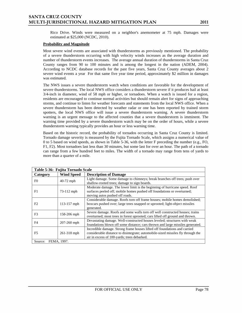
SANTA CRUZ COUNTY MULTI-JURISDICTIONAL HAZARD MITIGATION PLAN 2011
FOR OFFICIAL USE ONLY Page 78
Rico Drive. Winds were measured on a neighbor's anemometer at 75 mph. Damages were estimated at $25,000 (NCDC, 2010).
Probability and Magnitude
Most severe wind events are associated with thunderstorms as previously mentioned. The probability of a severe thunderstorm occurring with high velocity winds increases as the average duration and number of thunderstorm events increases. The average annual duration of thunderstorms in Santa Cruz County ranges from 90 to 100 minutes and is among the longest in the nation (ADEM, 2004). According to NCDC database records for the past five years, Santa Cruz County averages about 2 severe wind events a year For that same five year time period, approximately $2 million in damages was estimated.
The NWS issues a severe thunderstorm watch when conditions are favorable for the development of severe thunderstorms. The local NWS office considers a thunderstorm severe if it produces hail at least 3/4-inch in diameter, wind of 58 mph or higher, or tornadoes. When a watch is issued for a region, residents are encouraged to continue normal activities but should remain alert for signs of approaching storms, and continue to listen for weather forecasts and statements from the local NWS office. When a severe thunderstorm has been detected by weather radar or one has been reported by trained storm spotters, the local NWS office will issue a severe thunderstorm warning. A severe thunderstorm warning is an urgent message to the affected counties that a severe thunderstorm is imminent. The warning time provided by a severe thunderstorm watch may be on the order of hours, while a severe thunderstorm warning typically provides an hour or less warning time.
Based on the historic record, the probability of tornados occurring in Santa Cruz County is limited. Tornado damage severity is measured by the Fujita Tornado Scale, which assigns a numerical value of 0 to 5 based on wind speeds, as shown in Table 5-36, with the letter F preceding the number (e.g., FO, F1, F2). Most tornadoes last less than 30 minutes, but some last for over an hour. The path of a tornado can range from a few hundred feet to miles. The width of a tornado may range from tens of yards to more than a quarter of a mile.
Table 5-36: Fujita Tornado Scale Category Wind Speed Description of Damage F0 40-72 mph Light damage. Some damage to chimneys; break branches off trees; push over
shallow-rooted trees; damage to sign boards.
F1 73-112 mph Moderate damage. The lower limit is the beginning of hurricane speed. Roof surfaces peeled off; mobile homes pushed off foundations or overturned; moving autos pushed off roads.
F2 113-157 mph Considerable damage. Roofs torn off frame houses; mobile homes demolished; boxcars pushed over; large trees snapped or uprooted; light-object missiles generated.
F3 158-206 mph Severe damage. Roofs and some walls torn off well constructed houses; trains overturned; most trees in forest uprooted; cars lifted off ground and thrown.
F4 207-260 mph Devastating damage. Well-constructed houses leveled; structures with weak foundations blown off some distance; cars thrown and large missiles generated.
F5 261-318 mph Incredible damage. Strong frame houses lifted off foundations and carried considerable distance to disintegrate; automobile-sized missiles fly through the air in excess of 100-yards; trees debarked.
Source: FEMA, 1997.

SANTA CRUZ COUNTY MULTI-JURISDICTIONAL HAZARD MITIGATION PLAN 2011
FOR OFFICIAL USE ONLY Page 79
Vulnerability – CPRI Results
Severe Wind CPRI results for each community are summarized in Table 5-37 below.
Table 5-37: CPRI results by jurisdiction for severe wind
Participating Jurisdiction Probability Magnitude/
Severity Warning
Time Duration CPRI Score
Nogales Likely Critical 6 - 12 hours < 1 week 3.00 Patagonia Possibly Limited > 24 hours < 24 hours 1.85
Unincorporated Santa Cruz County Likely Negligible > 24 hours < 24 hours 2.00 County-wide average CPRI = 2.28
Vulnerability – Loss Estimations
The entire County is assumed to be equally exposed to the damage risks associated with severe winds. Typically, incidents are fairly localized and damages associated with individual events are relatively small. Based on the historic record over the last five years, it is feasible to expect average annual losses of $10,000 to $100,000 (county-wide). It is difficult to estimate losses for individual jurisdictions within the County due to the lack of discrete data.
Vulnerability – Development Trend Analysis
Future development will expand the exposure of life and property to the damaging effects of severe wind events. Enforcement and/or implementation of modern building codes to regulate new developments in conjunction with public education on how to respond to severe wind conditions are arguably the best way to mitigate against losses.
Sources
Arizona Division of Emergency Management, 2004, State of Arizona All Hazard Mitigation Plan.
Arizona Division of Emergency Management, 2010, State of Arizona Multi-Hazard Mitigation Plan, 2010 Update,
Changnon, Jr. S.,1988, Climatology of Thunder Events in the Conterminous U.S., Part I: Temporal Aspects and Part II: Spatial Aspects, Journal of Climate, Vol. 1, No. 4, pp. 389-405.
U.S. Dept of Commerce, National Climatic Data Center, 2010, Storm Events Database, accessed via the following URL: http://www4.ncdc.noaa.gov/cgi-win/wwcgi.dll?wwevent~storms
Profile Maps
No profile maps provided.

SANTA CRUZ COUNTY MULTI-JURISDICTIONAL HAZARD MITIGATION PLAN 2011
FOR OFFICIAL USE ONLY Page 80
THIS PAGE INTENTIONALLY LEFT BLANK

SANTA CRUZ COUNTY MULTI-JURISDICTIONAL HAZARD MITIGATION PLAN 2011
FOR OFFICIAL USE ONLY Page 81
5.3.7 Wildfire
Description
A wildfire is an uncontrolled fire spreading through wildland vegetative fuels and/or urban interface areas where fuels may include structures. They often begin unnoticed, spread quickly, and are usually signaled by dense smoke that may fill the area for miles around. Wildfires can be human-caused through acts such as arson or campfires, or can be caused by natural events such as lightning. If not promptly controlled, wildfires may grow into an emergency or disaster. Even small fires can threaten lives, resources, and destroy improved properties.
The indirect effects of wildfires can also be catastrophic. In addition to stripping the land of vegetation and destroying forest resources and personal property, large, intense fires can harm the soil, waterways and the land itself. Soil exposed to intense heat may temporarily lose its capability to absorb moisture and support life. Exposed soils in denuded watersheds erode quickly and are easily transported to rivers and streams thereby enhancing flood potential, harming aquatic life and degrading water quality. Lands stripped of vegetation are also subject to increased landslide hazards.
History
For the period of 1980 to 2008, data compiled by the Arizona State Forestry Division for the 2010 State Plan update indicates that at least 80 wildfires greater than 100 acres in size, have occurred in all of Santa Cruz County. According to the National Wildfire Coordination Group (NWCG, 2010), there have been two fires larger than 20,000 acres, that have burned within Santa Cruz County during the period of 2002 to 2009, as described below in chronological order:
• In April of 2002, the Ryan fire was started by a campfire in Coronado National Forest at Canelo Hill on April 29th and continued through May 4th. The fire burned 38,800 acres with estimated total fire fighting cost of 1.2 million dollars. The fire burned one house and several outbuildings (NCDC, 2004).
• In July of 2005, the Florida Fire was a lightning caused fire that started on July 7, 2005 in the Santa Rita Mountains about 25 miles south of the City of Tucson. The fire burned a total of 23,183 acres, injured 13 firefighters and was contained on July 21, 2005 at 6 pm MST. At the peak of the fire there were 986 personnel , and the total cost to suppress the fire was 8.1 million dollars. Below is a few of the dates when main events occurred with this fire. July 9, 2005 - Some trails leading to the fire area are closed. July 11, 2005 - All public access to Madera Canyon Recreation area was restricted. July 13, 2005 - At 10 am MST Madera Canyon residents were evacuated. July 17, 2005 - Portions of the fire received a half inch of rainfall from thunderstorms. After the monsoon season got underway, rainfall helped aide the firefighters in putting the Florida fire out (NCDC, 2010).
• In June of 2007, the Frontera Fire - the cause of the fire is under investigation that burned an area half mile north of the Mexico border, south of Arivaca, Arizona. The fire started June 23, 2007 and was controlled June 25, 2007, and burned 350 acres with over $125,000 in fire suppression costs (GACC, 2010).
• In April of 2008, the Alamo Fire - a human caused fire that burned an area 13 miles west of Nogales, Arizona. The fire started April 18, 2008 and was controlled April 28, 2008, and burned a total of 5,070 acres with over $1,478,000 in fire suppression costs (GACC, 2010).
• In April of 2008, the Beehive Fire - a human caused fire that burned an area 18 miles northwest of Nogales, Arizona. The fire started April 23, 2008 and was controlled April 30, 2008, and burned 325 acres with over $867,500 in fire suppression costs (GACC, 2010).
• In June of 2008, the Nuevo Fire - a human caused fire that burned an area 17 miles northwest of Nogales, Arizona. The fire started June 23, 2008 and was controlled June 29, 2008, and burned 1,533 acres with over $416,434 in fire suppression costs (GACC, 2010).

SANTA CRUZ COUNTY MULTI-JURISDICTIONAL HAZARD MITIGATION PLAN 2011
FOR OFFICIAL USE ONLY Page 82
• In March of 2009, the Montana Fire - a human caused fire that burned an area 10 miles southeast of Arivaca, Arizona, north of Bear Valley Ranch and Sycamore Canyon. The fire started March 25, 2009 and was controlled April 6, 2009, and burned 2,400 acres with over $400,000 in fire suppression costs (GACC, 2010).
• In May of 2009, the Elgin Fire - the cause of the fire is under investigation that burned an area 1 mile northeast of Elgin, Arizona. The fire started May 2, 2009 and was controlled May 7, 2009, and burned 1,420 acres with over $335,000 in fire suppression costs. Three out building were destroyed (GACC, 2010).
• In May of 2009, the Canelo Fire - a human caused fire that burned an area 10 miles south of Sonoita, Arizona. The fire started May 5, 2009 and was controlled May 16, 2009, and burned 4,025 acres with over $1,730,976 in fire suppression costs. The fire destroyed 3 homes and 5 other buildings (GACC, 2010).
• In June of 2009, the Lochiel Fire - a human caused fire that burned an area in San Rafael Valley, 15 miles south of Patagonia, Arizona. The fire started June 11, 2009 and was controlled June 16, 2009, and burned 2,800 acres with over $200,000 in fire suppression costs (GACC, 2010).
There have been 32 wildfires in excess of 100 acres for the period of 2002 to 2010. Map 4A provides a graphical depiction of the 100 acre plus wildfires.
Murphy Complex Fire - In May of 2011, the Murphy Fire Complex (Murphy, Bull and Pena Fires) was ignited by human causes and burned approximately 85,847 acres, with the Murphy Fire accounting for 68,078 acres. The burned area is generally located 5 miles east of Arivaca and 4 miles west of Tubac. The fire started on May 30, 2011 and was controlled on June 15, 2011, with suppression costs estimated at over $5.7 million. Figure 5-9 is a map prepared by the BAER Team indicating the burn severity and overall limits of the fires. The only damage reported was the complete destruction of the Atascosa Lookout House which is the primary feature of a site listed with the National Register of Historic Places. Areas identified by the BAER Team and SCCFCD to be at post-fire flooding risk include the Calabasas School, an El Paso Natural Gas line, several local ranches in the area, Pena Blanca Lake, the Atascosa Lookout and Trail (InciWeb, 2011).
Source: USFS BAER Team as posted on InciWeb at: http://www.inciweb.org/incident/map/2268/0/
Figure 5-9: Murphy Complex Fire Burn Severity Map

SANTA CRUZ COUNTY MULTI-JURISDICTIONAL HAZARD MITIGATION PLAN 2011
FOR OFFICIAL USE ONLY Page 83
The Planning Team recognized that the declared disaster and historic hazard data collected and summarized in Section 5.1 does not adequately reflect the true cost of a wildfire. Particularly, the cost of wildfire suppression efforts to prevent structure and human loss. For example, the 2008 Alamo Fire did not result in any structure losses, however, the suppression costs exceeded $1.4 million. Furthermore, the County, State, Forest Service, and other agencies spend millions of dollars every year in wildfire mitigation in fuel treatment projects.
Probability and Magnitude
The probability and magnitude of wildfire incidents for Santa Cruz County are influenced by numerous factors including vegetation densities, previous burn history, hydrologic conditions, climatic conditions such as temperature, humidity, and wind, ignition source (human or natural), topographic aspect and slope, and remoteness of area. Two sources were used to map the wildfire risk for Santa Cruz County. The primary coverage for wildfire risk is a statewide coverage developed by the State of Arizona as a part of the 2003/04 Arizona Wildland Urban Interface Assessment (AWUIA) project (Fisher, 2004). The AWUIA was then augmented along the Santa Cruz River from the US-Mexico border to the Pima County-Santa Cruz County line, using a riparian vegetation map (SCRVegMap) prepared by the county for the Upper Santa Cruz River (Sonoran Institute, et.al, 2008). The Sonoita Elgin Community Wildfire Protection Plan (LSD, 2007) was also obtained and reviewed late in the wildfire hazard profile development, but is not reflected in the hazard mapping shown in this Plan, due to the late discovery of the relevant data. The Planning Team will re-evaluate the incorporation of the Sonoita Elgin Community Wildfire Protection Plan at the next 5-year update.
In 2004, the State of Arizona prepared the AWUIA to analyze wildfire risk at a statewide basis, using a common spatial model. The model results were used for validation of those communities listed in the federal register as WUI, and for further identification other communities possibly at risk. The AWUIA approach used four main data layers:
• TOPO – aspect and slope derived from 30 meter Digital Elevation Model data from USGS.
• RISK – historical fire density using point data from fire record years 1986–1996 from all wildland agencies.
• HAZARD – fuels, natural fire regimes and condition class.
• HOUSE – houses and/or structures
A value rating in the range of 1-15 was assigned for all layers to represent the level of risk.
Two separate results were developed. The first coverage used an applied weighting scheme that combined each of the four data layers to develop a ranking model for identifying WUI communities at greatest risk. The second coverage, referred to as the “Land Hazard”, also applied a weighting scheme that combined only the TOPO, RISK, and HAZARD layers, as follows:
LAND HAZARD = (HAZARD*70%)+(RISK*20%)+(TOPO*10%)
Weighing percentages were determined through discussion with the Arizona Interagency Coordinating Group. The “Land Hazard” layer produced from this model is based on a 250-meter raster grid (some data originated at 1,000-meter). The resultant raster values range from 1-15 and were classified into three groups to depict wildfire hazard without the influence of structures: High (values of 10-15), Medium (values of 7-9), and Low (values of 1-6).
The vegetation groups of the SCRVegMap were subjectively assigned wildfire hazard classifications based on the perceived fuel load and wildfire risk, and then “cut-in” to the AWUIA layer. The final wildfire hazard profile map for this Plan depicts a mosaic of the High, Medium and Low risk areas identified by the AWUIA and augmented by the SCRVegMap data. Map 4A indicates the various wildfire hazard areas for Santa Cruz County. Maps 4B and 4C cover the incorporated boundaries of Nogales and Patagonia.

SANTA CRUZ COUNTY MULTI-JURISDICTIONAL HAZARD MITIGATION PLAN 2011
FOR OFFICIAL USE ONLY Page 84
Vulnerability – CPRI Results
Wildfire CPRI results for each community are summarized in Table 5-38 below.
Table 5-38: CPRI results by jurisdiction for wildfire
Participating Jurisdiction Probability Magnitude/
Severity Warning
Time Duration CPRI Score
Nogales Highly Likely Critical < 6 hours > 1 week 3.70 Patagonia Highly Likely Limited < 6 hours > 1 week 3.40
Unincorporated Santa Cruz County Highly Likely Limited < 6 hours > 1 week 3.40 County-wide average CPRI = 3.50
Vulnerability – Loss Estimations
The estimation of potential exposure to high and medium wildfire hazards was accomplished by intersecting the human and facility assets with the wildfire hazard limits depicted on Map 4A. Loss to exposure ratios of 0.20 (20%) and 0.05 (5%) were assumed to estimate losses for all facilities located within the high and medium wildfire hazard areas, respectively. Table 5-39 summarizes the Planning Team identified critical and non-critical facilities potentially exposed to high and medium wildfire hazards, and the corresponding estimates of losses. Table 5-40 summarizes population sectors exposed to the high and medium wildfire hazards. HAZUS residential, commercial and industrial exposures and loss estimates to high and medium wildfire hazards are summarized in Tables 5-41 through 5-44.
In summary, $1.4 million and $371,000 in asset related losses are estimated for high and medium wildfire hazards, for all the participating jurisdictions in Santa Cruz County. An additional $16 million and $3.8 million in high and medium hazard wildfire losses to HAZUS defined residential, commercial, and industrial facilities, is estimated for all participating Greenlee County jurisdictions. It should be noted that these exposure dollar amounts do not include the cost of wildfire suppression which can be substantial. For example, a Type 1 wildfire fighter crew costs about $1 million per day.
Regarding human vulnerability, a county-wide population of 580 and 582 people, or 1.51% and 1.52% of the total, is potentially exposed to a high and medium hazard wildfire event, respectively. Typically, deaths and injuries not related to firefighting activities are rare. However, it is feasible to assume that at least one death and/or injury may be plausible. There is also a high probability of population displacement during a wildfire event, and especially in the urban wildland interface areas.
It is duly noted that the loss and exposure numbers presented above represent a comprehensive evaluation of the County as a whole. It is unlikely that a wildfire would occur that would impact all of the high and medium wildfire hazard areas at the same time. Accordingly, actual event based losses and exposure are likely to be only a fraction of those summarized above.
Vulnerability – Development Trend Analysis
By its very definition, the wildland urban interface, or WUI, represents the fringe of urban development as it intersects with the natural environment. As previously discussed, wildfire risks are significant for a sizeable portion of the county. Any future development will only increase the WUI areas and expand the potential exposure of structures to wildfire hazards. The Sonoita Elgin Community Wildfire Protection Plan addresses mitigation opportunities for existing and future WUI areas within the boundaries of that plan, and provides recommended guidelines for safe building and land-use practices in wildfire hazard areas. Identification of WUI boundaries for other populated places within the county would provide more strategic targeting of mitigation needs and efforts.

SANTA CRUZ COUNTY MULTI-JURISDICTIONAL HAZARD MITIGATION PLAN 2011
FOR OFFICIAL USE ONLY Page 85
Table 5-39: Asset inventory exposure to high and medium hazard wildfire and corresponding loss estimates
Community
Total Facilities Reported by Community
Impacted Facilities
Percentage of Total
Community Facilities Impacted
Estimated Replacement
Cost (x$1000)
Estimated Structure
Loss (x$1000)
HIGH County-Wide Totals 244 5 2.05% $7,100 $1,420
Nogales 39 0 0.00% $0 $0 Patagonia 16 0 0.00% $0 $0
Unincorporated Santa Cruz County 189 5 2.65% $7,100 $1,420
MEDIUM County-Wide Totals 244 5 2.05% $7,425 $371
Nogales 39 0 0.00% $0 $0 Patagonia 16 2 12.50% $425 $21
Unincorporated Santa Cruz County 189 3 1.59% $7,000 $350
Table 5-40: Population sectors exposed to high and medium hazard wildfire
Community Total
Population Population
Exposed
Percent of Population
Exposed
Total Population
Over 65
Population Over 65 Exposed
Percent of Population
Over 65 Exposed
HIGH County-Wide Totals 38,353 580 1.51% 4,047 106 2.61%
City of Nogales 20,818 0 0.00% 2,204 0 0.00% Town of Patagonia 827 0 0.00% 178 0 0.00%
Unincorporated Santa Cruz County 16,708 580 3.47% 1,665 106 6.34%
MEDIUM County-Wide Totals 38,353 582 1.52% 4,047 106 2.63%
City of Nogales 20,818 0 0.00% 2,204 0 0.00% Town of Patagonia 827 0 0.00% 178 0 0.00%
Unincorporated Santa Cruz County 16,708 582 3.48% 1,665 106 6.39%

SANTA CRUZ COUNTY MULTI-JURISDICTIONAL HAZARD MITIGATION PLAN 2011
FOR OFFICIAL USE ONLY Page 86
Table 5-41: Santa Cruz County HAZUS building exposure to wildfire
RESIDENTIAL COMMERCIAL INDUSTRIAL SUMMARY
Santa Cruz County HAZUS Summary
Building Count
Potential Economic
Impact (x$1000)
Building Count
Potential Economic
Impact (x$1000)
Building Count
Potential Economic
Impact (x$1000)
Total of All Economic
Impact (x$1000)
Loss-to-Exposure
Ratio
Total Estimated
Loss (x$1000)
County-Wide Totals 13,318 $2,022,210 693 $896,552 206 $179,733 $3,098,495 High Hazard Exposure 371 $62,290 17 $18,616 4 $872 $81,778 20% $16,356
Medium Hazard Exposure 337 $59,490 14 $15,098 4 $2,544 $77,132 5% $3,857
Santa Cruz County HAZUS Summary
% Building
Count
% Potential Economic
Impact
% Building
Count
% Potential Economic
Impact
% Building Count
% Potential Economic
Impact High Hazard Exposure 02.79% 03.08% 02.47% 02.08% 02.13% 0.49% Medium Hazard Exposure 02.53% 02.94% 02.0% 01.68% 01.88% 01.42%
Table 5-42: City of Nogales HAZUS building exposure to wildfire
RESIDENTIAL COMMERCIAL INDUSTRIAL SUMMARY
City of Nogales HAZUS Summary
Building Count
Potential Economic
Impact (x$1000)
Building Count
Potential Economic
Impact (x$1000)
Building Count
Potential Economic
Impact (x$1000)
Total of All Economic
Impact (x$1000)
Loss-to-Exposure
Ratio
Total Estimated
Loss (x$1000)
Community-Wide Totals 5,922 $856,827 372 $594,349 96 $114,768 $1,565,944 High Hazard Exposure 0 $0 0 $0 0 $0 $0 20% $0
Medium Hazard Exposure 0 $0 0 $0 0 $0 $0 5% $0
City of Nogales HAZUS Summary
% Building
Count
% Potential Economic
Impact
% Building
Count
% Potential Economic
Impact
% Building Count
% Potential Economic
Impact High Hazard Exposure 0.0% 0.0% 0.0% 0.0% 0.0% 0.0% Medium Hazard Exposure 0.0% 0.0% 0.0% 0.0% 0.0% 0.0%

SANTA CRUZ COUNTY MULTI-JURISDICTIONAL HAZARD MITIGATION PLAN 2011
FOR OFFICIAL USE ONLY Page 87
Table 5-43: Town of Patagonia HAZUS building exposure to wildfire RESIDENTIAL COMMERCIAL INDUSTRIAL SUMMARY
Town of Patagonia HAZUS Summary
Building Count
Potential Economic
Impact (x$1000)
Building Count
Potential Economic
Impact (x$1000)
Building Count
Potential Economic
Impact (x$1000)
Total of All Economic
Impact (x$1000)
Loss-to-Exposure
Ratio
Total Estimated
Loss (x$1000)
Community-Wide Totals 539 $51,820 11 $7,168 5 $1,397 $60,385 High Hazard Exposure 0 $0 0 $0 0 $0 $0 20% $0
Medium Hazard Exposure 0 $0 0 $0 0 $0 $0 5% $0
Town of Patagonia HAZUS Summary
% Building
Count
% Potential Economic
Impact
% Building
Count
% Potential Economic
Impact
% Building
Count
% Potential Economic
Impact High Hazard Exposure 0.0% 0.0% 0.0% 0.0% 0.0% 0.0% Medium Hazard Exposure 0.0% 0.0% 0.0% 0.0% 0.0% 0.0%
Table 5-44: Unincorporated Santa Cruz County HAZUS building exposure to wildfire
RESIDENTIAL COMMERCIAL INDUSTRIAL SUMMARY
Unincorporated HAZUS Summary
Building Count
Potential Economic
Impact (x$1000)
Building Count
Potential Economic
Impact (x$1000)
Building Count
Potential Economic
Impact (x$1000)
Total of All Economic
Impact (x$1000)
Loss-to-Exposure
Ratio
Total Estimated
Loss (x$1000)
Community-Wide Totals 6,856 $1,113,563 310 $295,035 105 $63,568 $1,472,166 High Hazard Exposure 371 $62,290 17 $18,616 4 $872 $81,778 20% $16,356
Medium Hazard Exposure 337 $59,490 14 $15,098 4 $2,544 $77,132 5% $3,857
Unincorporated HAZUS Summary
% Building
Count
% Potential Economic
Impact
% Building
Count
% Potential Economic
Impact
% Building
Count
% Potential Economic
Impact High Hazard Exposure 05.42% 05.59% 05.52% 06.31% 04.16% 01.37% Medium Hazard Exposure 04.91% 05.34% 04.47% 05.12% 03.68% 04.0%

SANTA CRUZ COUNTY MULTI-JURISDICTIONAL HAZARD MITIGATION PLAN 2011
FOR OFFICIAL USE ONLY Page 88
Sources
Arizona Division of Emergency Management, 2010, State of Arizona Multi-Hazard Mitigation Plan, 2010 Update.
Fisher, M., 2004, Arizona Wildland Urban Interface Assessment, 2003, prepared for the Arizona Interagency Coordination Group. http://www.azsf.az.gov/UserFiles/PDF/Arizona%20Wildland%20Urban%20Interface%20Assessment%2005MAR04.pdf
Logan Simpson Design, Inc., 2007, Sonoita Elgin Community Wildfire Protection Plan
National Wildfire Coordination Group, 2010, Historical ICS 209 reports at: http://fam.nwcg.gov/fam-web/hist_209/report_list_209
Sonoran Institute, University of Arizona Remote Sensing Center, 2008, Santa Cruz River Riparian Vegetation Mapping Project Santa Cruz County, Arizona.
White, Seth, 2004, Bridging the Worlds of Fire Managers and Researchers: Lessons and Opportunities From the Wildland Fire Workshops, USDA Forest Service, General Technical Report PNW-GTR-599, March 2004
Profile Maps
Maps 4A – County-Wide Wildfire Hazard Map
Maps 4B and 4C – Nogales and Patagonia Wildfire Hazard Maps
5.4 Risk Assessment Summary The jurisdictional variability of risk associated with each hazard assessed in Section 5.3 is demonstrated by the various CPRI and loss estimation results. Accordingly, each jurisdiction has varying levels of need regarding the hazards to be mitigated, and may not consider all of the hazards as posing a great risk to their individual communities. Table 5-45 summarizes the hazards selected for mitigation by each jurisdiction and will be the basis for each jurisdictions mitigation strategy.
Table 5-45: Hazards to be mitigated by each participating jurisdiction
Jurisdiction Dam
Fai
lure
Dro
ught
Ext
rem
e T
empe
ratu
re
Floo
ding
HA
ZM
AT
Seve
re W
ind
Wild
fire
Unincorporated Santa Cruz County x x x x x x x Patagonia x x x x Nogales No Data Provided by Jurisdiction

!(
!(
!(
!(
!(
!(
!(
!(
!(
!(
!(
!(
!(
!(
!(
!(
!(
!(
!(
!(
!(
!(
!(!(
!(
!(
!(
!(
!(
!(
!(
!(
!(
!(
!(
!(
!(
!(
!(
!(
§̈¦19
rx82
rx83
Babocomari River
Santa
Cruz
Rive
r
Cave Creek
Sycam
ore Canyon
PIMA
SANTA CRUZ
COCHISE
FISH
RUBY
TANK
RYAN
ELGIN
Nuevo
ALAMO
ELGIN
AZTEC
A Bar
Canelo
Fresno
WILLOW
SALERO
WALKER
MONTANA
LOCHIEL
MISSION
BEEHIVE
Saucito
FLORIDA
Frontera
RED ROCK
Cimarron
OLD GLORY
GARDNER 2
West Dome
SAN RAFAELSan Antonio
Curly Horse
LITTLE ALAMO
SIERRA COBRE
AltoTubac
Elgin
Amado
Otero
Carmen
Canelo
Sonoita
Nogales Lochiel
Harshaw
Arivaca
Rio Rico
Helvetia
Duquesne
Patagonia
SunnysideOld Glory
Calabasas
Tumacacori
Oro Blanco
Beyerville
Agua Linda
Trench Camp
Continental
Casa Piedra
Green Valley
Kino Springs
Greaterville
Rosemont Camp
Madera Canyon
Washington Camp
Arivaca Junction
Rosemont Junction
Hacienda Los Encino
Partridge (historical)
Sotos Crossing (historical)
Guevavi Mission (historical)
Map 4ASanta Cruz County
WildfireHazard Map
as of May 2011
Santa Cruz County Multi-JurisdictionalHazard Mitigation Plan
0 5 102.5 MilesI
LegendHistorical Wildfires (acres)!( 0 - 1,000!( 1,001 - 10,000!( 10,001 - 500,000
Wildfire Hazard RatingHigh HazardMedium Hazard
PIMA
YUMA PINAL
MARICOPA
COCHISE
GRAHAM
GILALA PAZGREENLEE
SANTA CRUZ
APACHE
LegendCommunities
NOGALESPATAGONIACounty Boundary
!( Cities, Towns, PlacesWatercoursesLakes
RoadsInterstateMajor HighwaysMajor RoadsLocal Roads
Mexico
Sources: ALRIS, 2010; JEF, 2011; GACC, 2010; Santa Cruz County, 2011; AZSF, 2004

!(
!(
§̈¦19
§̈¦19
Santa Cruz R iver
I- 19 N Grand Ave
E Patagonia Hwy
S River Rd
N Mari
posa Rd
Amura L n
N Morley Ave
W Frontage Rd
N Target Range Rd
Old Tucson Rd
E Baffert Dr
N River Rd
N Royal RdFr
ank R
eed Rd
N David DrW Mariposa Rd
E Cam Vista del CieloW Gold Hill Rd
N McNab Dr
W 1st St
W Elm St
E Frontage Rd
N Cam Vista del Cielo
W Potrero Dr
Lobo
Lane Dr
N Victorio Dr
W Kino St
W Meadow Hills Dr
W Fairway Dr
N Hohokam Dr
W Artley Dr
E Cll Sonora
W Ellis St
E Roper Rd
W la Quinta Rd
E Beck St
W Walnut St
N Ce
barel
Ln
N Cinc
o Milla
s Rd
N Industrial Park Dr
N Silver Lode Trl
E Live Oak Dr
Un Rd
W Cimarron St
E East StN P
erkins
Ave
N Congress Dr
N Valle Verde DrW Manilla Dr
W Kolver St
E Cll Nacozari
N Edit
h Pl
N Mastick Way
N West
St
W Western Pl
E Maya St
N Bitachi Dr
E Skyline Dr
N Cam Alto
N Aloha Loop
E International St
E Spa
Dr
N Can
on del Oro DrW Emma S
t
W Ma
ripos
a Rd
I- 19
W Mariposa Rd
N Ma
ripos
a Rd
LITTLE ALAMO
Nogales
Map 4BCity of Nogales
WildfireHazard Map
as of May 2011
Santa Cruz County Multi-JurisdictionalHazard Mitigation Plan
0 0.5 10.25 MilesI
LegendHistorical Wildfires (acres)!( 0 - 1,000
!( 1,001 - 10,000
!( 10,001 - 500,000Wildfire Hazard Rating
High HazardMedium Hazard
PIMA
SANTA CRUZCOCHISE
LegendCommunities
NOGALESPATAGONIACounty Boundary
!( Cities, Towns, PlacesWatercoursesLakes
RoadsInterstatesHighwaysArterialsStreets Mexico
MEXICO
Sources: ALRIS, 2010; JEF, 2011; GACC, 2010; Santa Cruz County, 2011; AZSF, 2004
Nogales

£¤82
rx82
Naugle
HarshawSonoita
4th
Mc Keown
Pennsylvania
1st2nd
Smelter
3rd
Duquesne
Three R
Mendoza
Forest
Trailwood
Rothrock
Santa Rita
Red Mountain
Franklin
North
Patagonia
School
Red Rock
Temp
oral
Roadrunner
Pittsburgh
State
Highw
ay 82
Copper
Castello
Lenon
SheardDouble Tree
Quiroga
Mape
sSanta Rita
2nd
3rd
Roadrunner
Pittsburgh
Patagonia
Map 4CTown of Patagonia
WildfireHazard Map
as of May 2011
Santa Cruz County Multi-JurisdictionalHazard Mitigation Plan
0 750 1,500375 FeetI
LegendHistorical Wildfires (acres)!( 0 - 1,000
!( 1,001 - 10,000
!( 10,001 - 500,000Wildfire Hazard Rating
High HazardMedium Hazard
PIMA
COCHISESANTA CRUZ
LegendCommunities
NOGALESPATAGONIACounty Boundary
!( Cities, Towns, PlacesWatercoursesLakes
RoadsInterstateMajor HighwaysMajor RoadsLocal Streets Mexico
Patagonia
Sources: ALRIS, 2010; JEF, 2011; GACC, 2010; Santa Cruz County, 2011; AZSF, 2004

SANTA CRUZ COUNTY MULTI-JURISDICTIONAL HAZARD MITIGATION PLAN 2011
FOR OFFICIAL USE ONLY Page 89
SECTION 6: MITIGATION STRATEGY
The mitigation strategy provides the “what, when, and how” of actions that will reduce or possibly remove the community’s exposure to hazard risks. According to DMA 2000, the primary components of the mitigation strategy are generally categorized into the following:
Goals and Objectives
Capability Assessment
Mitigation Actions/Projects and Implementation Strategy
The entire 2006 Plan mitigation strategy was reviewed and updated by the Planning Team, including a major re-organization of the mitigation strategy elements into this multi-jurisdictional plan format. Specifics of the changes and updates are discussed in the subsections below.
6.1 Hazard Mitigation Goals and Objectives The 2006 Plan goals and objectives were developed using the 2004 State Plan14 goals and objectives as a starting point. Each jurisdiction then edited and modified those goals and objectives to fit the mitigation planning vision for their community. An assessment of those goals and objectives by the Planning Team and the Local Planning Team for each jurisdiction was made with consideration of the following15:
• Do the goals and objectives identified in the 2006 Plan reflect the updated risk assessment? • Did the goals and objectives identified in the 2006 Plan lead to mitigation projects and/or changes
to policy that helped the jurisdiction(s) to reduce vulnerability? • Do the goals and objectives identified in the 2006 Plan support any changes in mitigation
priorities? • Are the goals and objectives identified in the 2006 Plan reflective of current State goals?
After much discussion and comparison of the 2006 Plan goals and objectives to the 2010 State Plan, the planning team felt the 2006 Plan goals and objectives adequately reflected the continuing mitigation goals of the Planning Team and chose to retain the goals and objectives list with a few modifications:
• Goal 7, which addressed Building/Structure Collapse will be revised to address Dam Failure. • Concerns regarding the Building/Structure Collapse are primarily tied to the possible failure of the
Nogales Wash stormwater tunnels currently located under the downtown border area of Nogales. The team agreed that the mechanism for failure of the tunnels would be primarily triggered by some other hazard like flooding or an earthquake.
• The team chose to include the words “buildings and structures” in Goal 5 instead of retaining G&Os that address Building/Structure Collapse.
• The team chose to add the phrase “and public safety officials to Objective 9.C.
14 State of Arizona, 2004, State of Arizona All Hazard Mitigation Plan, prepared by URS. 15 FEMA, 2008, Local Multi-Hazard Mitigation Planning Guidance
§201.6(c)(3): [The plan shall include…] (3) A mitigation strategy that provides the jurisdiction’s blueprint for reducing the potential losses identified in the risk assessment, based on existing authorities, policies, programs and resources, and its ability to expand on and improve these existing tools. This section shall include: (i) A description of mitigation goals to reduce or avoid long-term vulnerabilities to the identified hazards. (ii) A section that identifies and analyzes a comprehensive range of specific mitigation actions and projects being
considered to reduce the effects of each hazard, with particular emphasis on new and existing buildings and infrastructure.
(iii) An action plan describing how the actions identified in paragraph (c)(3)(ii) of this section will be prioritized, implemented, and administered by the local jurisdiction. Prioritization shall include a special emphasis on the extent to which benefits are maximized according to a cost benefit review of the proposed projects and their associated costs.
(iv) For multi-jurisdictional plans, there must be identifiable action items specific to the jurisdiction requesting FEMA approval or credit of the plan.

SANTA CRUZ COUNTY MULTI-JURISDICTIONAL HAZARD MITIGATION PLAN 2011
FOR OFFICIAL USE ONLY Page 90
• A new Goal 10 and 11 will be renumbered to 11 and 12 and a new Goal 10 will be included to address Severe Weather.
• The new Goal 10 will include 3 objectives similar to those used for Goal 7.
Accordingly, the following list of goals and objectives will be used by all participating jurisdictions, as follows:
Goal 1. Promote disaster-resistant future development.
Objective 1.A Update, develop, and support the community’s general plans, ordinances, and codes to limit development in hazard areas, or build to standards that will prevent or reduce damage.
Objective 1.B Adopt and support codes that protect assets and new development in hazard areas.
Goal 2. Promote public understanding, support, and demand for hazard mitigation.
Objective 2.A Educate the public to increase awareness of hazards and opportunities for mitigation actions.
Objective 2.B Promote partnerships between the state, counties, local and tribal governments to identify, prioritize, and implement mitigation actions.
Objective 2.C Promote hazard mitigation in the business, residential, and agricultural community.
Objective 2.D Monitor and publicize the effectiveness of mitigation actions implemented community wide.
Goal 3. Build and support local capacity and commitment to become less vulnerable to hazards.
Objective 3.A Improve existing capabilities to warn the public of emergency situations.
Objective 3.B Develop programs to enhance the safety of the residents of each community during an emergency.
Goal 4. Improve hazard mitigation coordination and communication with federal, state, local, and tribal governments.
Objective 4.A Establish and maintain a close working relationship with state agencies and local and tribal governments.
Goal 5. Reduce the potential level of damage and losses to people, existing and future critical facilities/infrastructure, buildings and structures, and other community assets due to floods.
Objective 5.A Implement policies, procedures and regulations which reduce the potential exposure to flood hazards.
Objective 5.B Decrease vulnerability of community assets, especially critical facilities located in the 100-year floodplain.
Objective 5.C Improve coordination with state and federal flood-related agencies.
Objective 5.D Maintain compliance with the National Flood Insurance Program (NFIP) requirements.
Objective 5.E Promote changes in current regulations to facilitate hazard mitigation.

SANTA CRUZ COUNTY MULTI-JURISDICTIONAL HAZARD MITIGATION PLAN 2011
FOR OFFICIAL USE ONLY Page 91
Goal 6. Reduce the potential level of damage and losses to people, existing and future critical facilities/infrastructure, and other community assets due to wildland fires.
Objective 6.A Develop a comprehensive approach to reducing the level of damage and losses due to wildland fires.
Objective 6.B Protect life, improved property, and natural resources with vulnerability to the effects of wildland fires.
Objective 6.C Improve coordination and support existing efforts to mitigate wildland fire hazards.
Objective 6.D Educate the public about wildland fire dangers and mitigation measures.
Objective 6.E Promote changes in current regulations to facilitate hazard mitigation.
Goal 7. Reduce the potential level of damage and losses to people, existing and future critical
facilities/infrastructure, and other community assets due to Dam Failure.
Objective 7.A Develop a comprehensive approach to reducing the level of damage and losses due to dam failure.
Objective 7.B Protect life, improved property, and natural resources with vulnerability to the effects of dam failure.
Objective 7.C Educate the public about dam failure dangers and mitigation measures.
Goal 8. Reduce the potential level of damage and losses to people, existing and future critical facilities/infrastructure, and other community assets due to drought.
Objective 8.A Develop a comprehensive approach to reducing the level of damage and losses due to drought.
Objective 8.B Protect existing assets with vulnerability to the effects of drought.
Objective 8.C. Coordinate with and support existing efforts to mitigate drought (e.g., Arizona Governor’s Arizona Drought Task Force).
Objective 8.D Promote water conservation and education.
Goal 9. Reduce the potential level of damage and losses to people, existing and future critical facilities/infrastructure, and other community assets due to hazardous materials incidents.
Objective 9.A Develop a comprehensive approach to reducing the level of damage and losses due to hazardous materials incidents.
Objective 9.B Protect existing assets with vulnerability to the effects of hazardous materials incidents.
Objective 9.C Educate the public and public safety officials about hazardous materials dangers and mitigation measures.
Goal 10. Reduce the potential level of damage and losses to people, existing and future critical
facilities/infrastructure, and other community assets due to Severe Weather.
Objective 10.A Develop a comprehensive approach to reducing the level of damage and losses due to severe weather.
Objective 10.B Protect life, improved property, and natural resources with vulnerability to the effects of severe weather.
SANTA CRUZ COUNTY MULTI-JURISDICTIONAL HAZARD MITIGATION PLAN 2011
FOR OFFICIAL USE ONLY Page 92
Objective 10.C Educate the public about severe weather dangers and mitigation measures.
Goal 11. Reduce the potential level of damage and losses to people, existing and future critical facilities/infrastructure, and other community assets due to other natural hazards.
Objective 11.A Develop a comprehensive approach to reducing the level of damage and losses due to other natural hazards.
Objective 11.B Protect life, improved property, and natural resources with vulnerability to the effects of other natural hazards.
Goal 12. Reduce the potential level of damage and losses to people, existing and future critical facilities/infrastructure, and other community assets due to other human caused hazards.
Objective 12.A Develop a comprehensive approach to reducing the level of damage and losses due to other human caused hazards.
Objective 12.B Protect life, improved property, and natural resources with vulnerability to the effects of other human caused hazards.
6.2 Capability Assessment While not required by DMA 2000, an important component of the Mitigation Strategy is a review of each participating jurisdiction’s resources in order to identify, evaluate, and enhance the capacity of local resources to mitigate the effects of hazards. The capability assessment is comprised of several components:
Legal and Regulatory Review – a review of the legal and regulatory capabilities, including ordinances, codes, plans, manuals, guidelines, and technical reports that address hazard mitigation activities.
Technical Staff and Personnel – this assessment evaluated and describes the administrative and technical capacity of the jurisdiction’s staff and personnel resources.
Fiscal Capability – this element summarizes each jurisdiction’s fiscal capability to provide the financial resources to implement the mitigation strategy.
National Flood Insurance Program (NFIP) Participation – the NFIP contains specific regulatory measures that enable government officials to determine where and how growth occurs relative to flood hazards. Participation in the NFIP is voluntary for local governments, but the program is promoted by FEMA as a basic first step for implementing and sustaining an effective flood hazard mitigation program, and is a key indicator for measuring local capability as part of this assessment.
Prior Mitigation Actions – the final part of the capability assessment is a summary review of prior mitigation actions and/or projects that have been completed over the last five or so years.
The Planning Team reviewed the information provided in Section 5 of the 2006 Plan, and specifically Tables 5-1 through 5-4. The Planning Team chose to keep the general format of Tables 5-2 and 5-3 for reporting the staff/personnel and fiscal resources, but break-out a table for each jurisdiction. Table 5-1 and 5-4 were combined into a new table to not only report on the regulatory capabilities, but also to summarize the codes, plans, and studies/reports used by a jurisdiction. Therefore, Table 5-4 was dropped from the Plan.

SANTA CRUZ COUNTY MULTI-JURISDICTIONAL HAZARD MITIGATION PLAN 2011
FOR OFFICIAL USE ONLY Page 93
6.2.1 Jurisdictional Capabilities
Tables 6-1-1 through 6-1-3 summarize the legal and regulatory mitigation capability for each participating jurisdiction. Information provided includes a brief listing of current codes, mitigation relevant ordinances, plans, and studies/reports. Tables 6-2-1 through 6-2-3 summarize the staff and personnel resources employed by each jurisdiction that serve as a resource for hazard mitigation. Tables 6-3-1 through 6-3-3 summarize the fiscal capability and budgetary tools available to each participating jurisdiction. Each of these three tables are listed below by jurisdiction.
Table 6-1-1: Legal and regulatory capabilities for Santa Cruz County
Regulatory Tools for Hazard Mitigation Description Responsible Department/Agency
CODES
• All adopted by Ordinance No. 2007-05 • International Building Code 2006
Edition • International Building Code Standards
2006 Edition • International Residential Code 2006
Edition • International Mechanical Code 2006
Edition • International Plumbing Code 2006
Edition • International Fire Code 2006 Edition • International Fuel and Gas Code 2006
Edition • National Electric Code 2005 Edition • Uniform Building Code 1997 Edition
Appendix Chapter 33 • Uniform Code for the Abatement of
Dangerous Buildings 1997 Edition • International Code Council Electrical
Code 2006 • Administrative Provisions
• Community Development • Fire Districts as applicable
ORDINANCES
• Santa Cruz County Ordinance No. 3A adopted in 1973 (with subsequent amendments) known as the Zoning and Development Code.
• Santa Cruz County Floodplain and Erosion Hazard Management Ordinance, No. 2001-03, adopted May 1, 2001, effective, June 1, 2001. In accordance with the requirements of ARS 48-3601 through 48-3627, and 44 CFR Parts 59, 60, 65, and 70.
• Community Development • Flood Control District

SANTA CRUZ COUNTY MULTI-JURISDICTIONAL HAZARD MITIGATION PLAN 2011
FOR OFFICIAL USE ONLY Page 94
Table 6-1-1: Legal and regulatory capabilities for Santa Cruz County
Regulatory Tools for Hazard Mitigation Description Responsible Department/Agency
PLANS, MANUALS, and/or GUIDELINES
• Santa Cruz County Plans: • Santa Cruz County 2004 Comprehensive
Plan (6/2004) - A plan to guide growth and development, and generally promote public health, safety, convenience and welfare. Pursuant to Title 11, Article 2
• Flood Control District Standards - Floodplain and erosion hazard management guidelines and requirements to manage development within these hazard areas within the unincorporated areas of the County.
• State Standards for Floodplain Management.
• Community Development • Flood Control District • Arizona Department of Water
Resources
• Multi-Jurisdictional or Regional Plans: • 2010 Unified Santa Cruz County/ Nogales
Transportation Plan (4/2010) • Santa Cruz County Emergency Response
and Recovery Plan (2004) - A plan that addresses the consequences of any emergency/disaster in which there is a need for County response and recovery assistance, and the methods the County will use to mobilize resources and conduct response and recovery activities.
• Bi-National Prevention and Emergency Response Plan (2004) - A mitigation and emergency response plan focused on addressing border related issues and bi-national disaster prevention and response.
• Santa Cruz County Multi-Jurisdictional Hazard Mitigation Plan (2011)
• Public Works • Emergency Management • City of Nogales • IBWC
Table 6-2-1: Technical staff and personnel capabilities for Santa Cruz County Staff/Personnel Resources Department/Agency – Position
Planner(s) or engineer(s) with knowledge of land development and land management practices
• Community Development – Planning Division • Public Works • Flood Control District
Engineer(s) or professional(s) trained in construction practices related to buildings and/or infrastructure
• Community Development – Building Division – Certified
Building Inspectors • Public Works
Planner(s) or engineer(s) with and understanding of natural and/or human-caused hazards
• Flood Control District • Emergency Services
Floodplain Manager • Flood Control District – Certified Floodplain Manager Surveyors • None Staff with education or expertise to assess the community’s vulnerability to hazards
• Flood Control District – Certified Floodplain Manager • Emergency Services

SANTA CRUZ COUNTY MULTI-JURISDICTIONAL HAZARD MITIGATION PLAN 2011
FOR OFFICIAL USE ONLY Page 95
Table 6-2-1: Technical staff and personnel capabilities for Santa Cruz County Staff/Personnel Resources Department/Agency – Position
Personnel skilled in GIS and/or HAZUS • Community Development – Planning Division – GIS
Analyst • Flood Control District – Certified Floodplain Manager
Scientists familiar with the hazards of the community • Flood Control District – Certified Floodplain Manager
Emergency Manager • Emergency Services
Grant writer(s)
• Community Development • Public Works • Flood Control District • Administrative Services Department • Emergency Services
Others • Community Development – Planning Division • Public Works • Flood Control District
Table 6-3-1: Fiscal capabilities for Santa Cruz County
Financial Resources
Accessible or Eligible to Use
(Yes, No, Don’t Know) Comments
Community Development Block Grants Yes In rotation with Nogales and Patagonia
Capital Improvements Project funding Yes As available
Authority to levee taxes for specific purposes Yes Either statutory or through vote of the taxpayers
Fees for water, sewer, gas, or electric service No Impact fees for homebuyers or new developments/homes Yes None at this time
Incur debt through general obligation bonds Yes Subject to County bond limit
Incur debt through special tax bonds Yes Special assessments through Flood Control District possible.

SANTA CRUZ COUNTY MULTI-JURISDICTIONAL HAZARD MITIGATION PLAN 2011
FOR OFFICIAL USE ONLY Page 96
Table 6-1-2: Legal and regulatory capabilities for Nogales Regulatory Tools for Hazard Mitigation Description Responsible
Department/Agency
CODES
• 1997 Uniform Building Code • 1997 Uniform Plumbing Code • 1997 Uniform Mechanical Code • 1997 Uniform Code for the Abatement of Dangerous
Buildings • 1997 Uniform Fire Code • 1999 National Electrical Code • American Disabilities Act • City of Nogales Development Standards Code
• (none provided)
ORDINANCES
• City of Nogales Flood Damage Prevention Ordinance No. 19-N (7/1987) - Floodplain hazard management guidelines and requirements to manage development within these hazard areas within the City of Nogales.
• City Zoning Ordinance • City Subdivision Ordinance • Under Santa Cruz County Floodplain and Erosion
Hazard Management Ordinance.
• (none provided)
PLANS, MANUALS, and/or GUIDELINES
• City of Nogales General Plan Update 2020 (1/2002) - A plan to guide growth and development , and generally promote public health, safety, convenience and welfare for the City of Nogales through the year 2020.
• City of Nogales Hazard Mitigation Plan (2000) - A multi-hazard mitigation plan developed to address the City’s vulnerability to primarily flood hazards and document mitigation alternatives and implementation strategies.
• City of Nogales, Water and Wastewater System Master Plan. (2/2002) - A plan to define master water and wastewater expansion and growth.
• Santa Cruz County Multi-Jurisdictional Hazard Mitigation Plan (2006)
• (none provided)
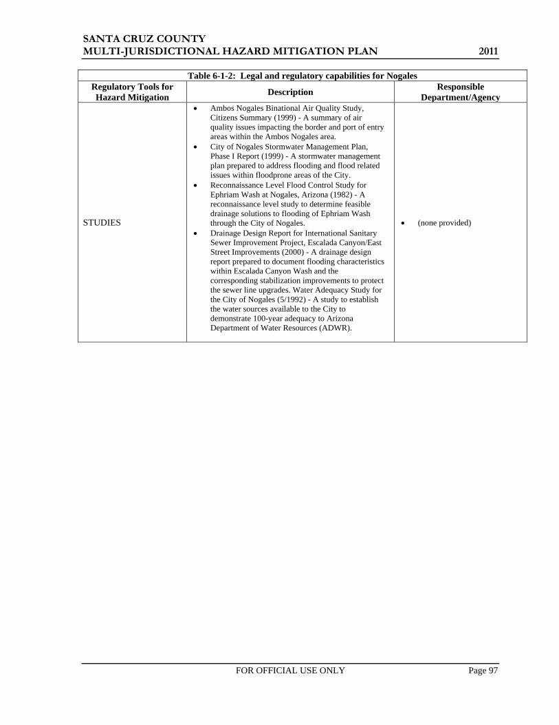
SANTA CRUZ COUNTY MULTI-JURISDICTIONAL HAZARD MITIGATION PLAN 2011
FOR OFFICIAL USE ONLY Page 97
Table 6-1-2: Legal and regulatory capabilities for Nogales Regulatory Tools for Hazard Mitigation Description Responsible
Department/Agency
STUDIES
• Ambos Nogales Binational Air Quality Study, Citizens Summary (1999) - A summary of air quality issues impacting the border and port of entry areas within the Ambos Nogales area.
• City of Nogales Stormwater Management Plan, Phase I Report (1999) - A stormwater management plan prepared to address flooding and flood related issues within floodprone areas of the City.
• Reconnaissance Level Flood Control Study for Ephriam Wash at Nogales, Arizona (1982) - A reconnaissance level study to determine feasible drainage solutions to flooding of Ephriam Wash through the City of Nogales.
• Drainage Design Report for International Sanitary Sewer Improvement Project, Escalada Canyon/East Street Improvements (2000) - A drainage design report prepared to document flooding characteristics within Escalada Canyon Wash and the corresponding stabilization improvements to protect the sewer line upgrades. Water Adequacy Study for the City of Nogales (5/1992) - A study to establish the water sources available to the City to demonstrate 100-year adequacy to Arizona Department of Water Resources (ADWR).
• (none provided)

SANTA CRUZ COUNTY MULTI-JURISDICTIONAL HAZARD MITIGATION PLAN 2011
FOR OFFICIAL USE ONLY Page 98
Table 6-2-2: Technical staff and personnel capabilities for Nogales Staff/Personnel Resources Department/Agency - Position
Planner(s) or engineer(s) with knowledge of land development and land management practices
• City Engineer and City Planner
Engineer(s) or professional(s) trained in construction practices related to buildings and/or infrastructure
• Planning & Zoning Director
Planner(s) or engineer(s) with and understanding of natural and/or human-caused hazards
Floodplain Manager • Administered by Santa Cruz County Surveyors Staff with education or expertise to assess the community’s vulnerability to hazards
• Defers to Santa Cruz County
Personnel skilled in GIS and/or HAZUS • Planning & Zoning Director (GIS), but City does not have
GIS system. Scientists familiar with the hazards of the community
Emergency Manager • City Emergency Manager Grant writer(s) • City Grant Writer (Barbara Johnson)
Table 6-3-2: Fiscal capabilities for Nogales
Financial Resources
Accessible or Eligible to Use
(Yes, No, Don’t Know) Comments Community Development Block Grants Yes Capital Improvements Project funding Yes Authority to levee taxes for specific purposes Yes Fees for water, sewer, gas, or electric service Yes Water and Sewer Impact fees for homebuyers or new developments/homes Yes Sewer Impact fees & Kino Springs
Incur debt through general obligation bonds Yes Incur debt through special tax bonds Don’t Know

SANTA CRUZ COUNTY MULTI-JURISDICTIONAL HAZARD MITIGATION PLAN 2011
FOR OFFICIAL USE ONLY Page 99
Table 6-1-3: Legal and regulatory capabilities for Patagonia Regulatory Tools for Hazard Mitigation Description Responsible
Department/Agency
CODES
• Because Santa Cruz County performs plan review and building inspection services in Patagonia under an IGA, the Town has adopted the same building codes that Santa Cruz County uses.
• 2006 IBC Codes,
• Administration/Town Manager
• Santa Cruz County
ORDINANCES • The Town is zoned for general use. No zoning
codes.There are restrictions on non-residential development. .
• Administration/Town Manager
PLANS, MANUALS, and/or GUIDELINES
• Town of Patagonia Solid Waste Facility Plan, Volumes 1 and 2. (12/2000) - Permitting document for the Town’s landfill.
• Town of Patagonia Landfill SWPPP (5/2003) - Stormwater pollution prevention plan for the landfill.
• Town of Patagonia General Plan (04/09) - A plan to guide growth and development , and generally promote public health, safety, convenience and welfare.
• Santa Cruz County Multi-Jurisdictional Hazard Mitigation Plan (2006)
• Administration/Town Manager
STUDIES • Preliminary Engineering report- Municipal Water System. 2007
• Administration/Town Manager
• Water and Sewer Department

SANTA CRUZ COUNTY MULTI-JURISDICTIONAL HAZARD MITIGATION PLAN 2011
FOR OFFICIAL USE ONLY Page 100
Table 6-2-3: Technical staff and personnel capabilities for Patagonia Staff/Personnel Resources Department/Agency - Position
Planner(s) or engineer(s) with knowledge of land development and land management practices
• Administration – Town Manager • Town Engineer
Engineer(s) or professional(s) trained in construction practices related to buildings and/or infrastructure
(IGA w/ Santa Cruz County)
Planner(s) or engineer(s) with and understanding of natural and/or human-caused hazards
• Administration – Town Manager
Floodplain Manager • Administration – Town Manager Surveyors Staff with education or expertise to assess the community’s vulnerability to hazards
• Administration – Town Manager • Marshal’s Office – Town Marshal • Fire Department – Fire Chief
Personnel skilled in GIS and/or HAZUS Scientists familiar with the hazards of the community
Emergency Manager • Administration – Town Manager Grant writer(s) • Administration – Town Manager
Table 6-3-3: Fiscal capabilities for Patagonia
Financial Resources
Accessible or Eligible to Use
(Yes, No, Don’t Know) Comments Community Development Block Grants Yes 5 year cycle Capital Improvements Project funding Yes CIP planning in process Authority to levee taxes for specific purposes Yes Fees for water, sewer, gas, or electric service Yes Monthly billing Impact fees for homebuyers or new developments/homes No
Incur debt through general obligation bonds Yes Incur debt through special tax bonds No

SANTA CRUZ COUNTY MULTI-JURISDICTIONAL HAZARD MITIGATION PLAN 2011
FOR OFFICIAL USE ONLY Page 101
6.2.2 Previous Mitigation Activities
During the last planning cycle many mitigation activities have been accomplished by the jurisdictions within Santa Cruz County. Table 6-4 provides an updated summary, by jurisdiction, of recent mitigation activities performed over the last planning cycle or generally within the last five to ten years. Table 6-5 identifies projects within Santa Cruz County and Nogales that used federal mitigation grant funding for past projects.
Figure 6-1 is a graphical depiction of past federally funded mitigation projects in the State tracked by ADEM.
Source: ADEM, 2010
Figure 6-1: Past Mitigation Projects in Arizona

SANTA CRUZ COUNTY MULTI-JURISDICTIONAL HAZARD MITIGATION PLAN 2011
FOR OFFICIAL USE ONLY Page 102
Table 6-4: Previous mitigation activities for Santa Cruz County jurisdictions
Jurisdiction Project Name Project Description Project Cost Funding Source
Responsible Department
Completion Date
Patagonia Firewise Clearing and removing flammable materials that might permit fires to travel into town. Not identified
Town Contract & local donations
Volunteer Fire Co. Ongoing
Santa Cruz County, City of Nogales, Town of Patagonia
Floodplain Map Modernization and DFIRM Project
Remapping of floodplains throughout Santa Cruz County to include Nogales and Patagonia $1,496,000
FEMA and Flood Control District
Flood Control District
December 2011
Santa Cruz County
Calle Azulejo Detention/Retention Basin
Construction of detention/retention facility to control 100-year flooding in Rio Rico Villas 13 $411,000 HMGP Flood Control
District June 2005
Santa Cruz County
Rio Rico Drive Drainage Improvements
Engineering and construction of roadside drainage improvements to control erosion, flooding and sedimentation along Rio Rico Drive from Pendleton Drive to Willow Drive – Phase 1 complete
$120,000 Flood Control District HURF
Flood Control District Public Works
2004
Santa Cruz County
Nogales Wash Erosion Protection Projects
Bank stabilization at four locations along Nogales Wash from city limits to Pickrell Bridge $2,185,000 FEMA, State,
Flood Control Flood Control District 2003
Santa Cruz County
2000 Flood Disaster Recovery
Embankment protection at multiple sites – Santa Cruz River along South River Road; Nogales Wash along Old Tucson Road; Harshaw Road along Harshaw Creek; Corrida de Torres along Agua Fria Wash; five road crossings along Peck Canyon Wash
$472,000 HMGP Disaster Recovery Funds
Flood Control District 2002
Santa Cruz County
Kilner Jacks, Santa Cruz River along South River Road
Construction of Kilner Jacks near washout area to direct channel flow in the Santa Cruz River $100,000
Water Protection Grant - State
Flood Control District 2005
Santa Cruz County
South River Road Recovery
Reconstruction of South River Road after 400 feet were washed out by the Santa Cruz River in October of 2001
$516,300 FHWA Flood Control District 2002
Tubac Fire District
Fire Station Nos. 3 and 4 Built new fire stations Bond Tubac Fire
District March and October 2010

SANTA CRUZ COUNTY MULTI-JURISDICTIONAL HAZARD MITIGATION PLAN 2011
FOR OFFICIAL USE ONLY Page 103
Table 6-5: Previous projects in Santa Cruz County jurisdictions receiving federal mitigation grant funding
Applicant Project Title Project Type Year
Begun Year
Ended
Total Cost
(x $1,000)
75% Fed Cost (x $1,000)
25% Non-Fed
Cost (x $1,000) Program
Santa Cruz County 977-31, Potero Creek Confluence Storm drain repairs & strengthen 2001 2002 $150.0 $112.5 $37.5 HMGP Santa Cruz County 977-32, Bravo Lane Site Storm drain repairs & strengthen 2001 2002 $361.5 $271.1 $90.4 HMGP Santa Cruz County 977-33, Firestone Gardens Storm drain repairs & strengthen 2001 2002 $145.0 $108.8 $36.2 HMGP Santa Cruz County 977-34, Pickerel Bridge #5 Storm drain repairs & strengthen 2001 2002 $41.8 $31.3 $10.4 HMGP
City of Nogales Monte Carlo Wash Flood control 2001 2005 $936.5 $312.0 $124.5 HMGP, FMA
Santa Cruz County 1477-6-4R, Calle Azulejo Drainage Control Project
Flood control and detention basin construction 2006 2008 $460.9 $345.7 $115.2 HMGP
6.2.3 National Flood Insurance Program Participation
Participation in the NFIP is a key element of any community’s local floodplain management and flood mitigation strategy. Santa Cruz County and the 2 other incorporated jurisdictions participate in the NFIP. Joining the NFIP requires the adoption of a floodplain management ordinance that requires jurisdictions to follow established minimum standards set forth by FEMA and the State of Arizona, when developing in the floodplain. These standards require that all new buildings and substantial improvements to existing buildings will be protected from damage by the 100-year flood, and that new floodplain development will not aggravate existing flood problems or increase damage to other properties. As a participant in the NFIP, communities also benefit from having Flood Insurance Rate Maps (FIRM) that map identified flood hazard areas and can be used to assess flood hazard risk, regulate construction practices and set flood insurance rates. FIRMs are also an important source of information to educate residents, government officials and the private sector about the likelihood of flooding in their community. Table 6-6 summarizes the NFIP status and statistics for each of the jurisdictions participating in this Plan.
Table 6-6: NFIP status and statistics for Santa Cruz County and participating jurisdictions as of March 22, 2011
Jurisdiction Community
ID NFIP Entry
Date
Current Effective Map Date
Number of
Policies
Amount of Coverage (x $1,000) Floodplain Management Role
Santa Cruz County 040090 8/1/1980 8/23/2000 * 238 $59,114 Managed through FCD Nogales 040091 4/15/1981 4/15/1981* 269 $50,981 county dependent
Patagonia 040092 3/18/1980 3/18/1980* 65 $11,861 manages own * - Tentative New Effective date of December 2011 Source: http://bsa.nfipstat.com/reports/1011.htm (12/31/2010); FEMA Community Status Report in NFIP (2/16/2011)

SANTA CRUZ COUNTY MULTI-JURISDICTIONAL HAZARD MITIGATION PLAN 2011
FOR OFFICIAL USE ONLY Page 104
6.3 Mitigation Actions/Projects and Implementation Strategy Mitigation actions/projects (A/P) are those activities identified by a jurisdiction, that when implemented, will have the effect of reducing the community’s exposure and risk to the particular hazard or hazards being mitigated. The implementation strategy addresses the “how, when, and by whom?” questions related to implementing an identified A/P.
The process for defining the list of mitigation A/Ps for the Plan was accomplished in three steps. First, an assessment of the actions and projects specified in Section 5 of the 2006 Plan was performed, wherein each jurisdiction reviewed and evaluated their jurisdiction specific list. Second, a new list of A/Ps for the Plan was developed by combining the carry forward results from the assessment with new A/Ps. Third, an implementation strategy for the combined list of A/Ps was formulated. Details of each step and the results of the process are summarized in the following sections.
6.3.1 Previous Mitigation Actions/Projects Assessment
The Planning Team and Local Planning Team for each jurisdiction reviewed and assessed the actions and projects listed in Tables 5-5 and 5-6 of their corresponding 2006 Plans. The assessment included evaluating and classifying each of the previously identified A/Ps based on the following criteria:
STATUS DISPOSITION Classification Explanation Requirement: Classification Explanation Requirement: “No Action” Reason for no progress “Keep” None required “In Progress” What progress has been made “Revise” Revised components
“Complete” Date of completion and final cost of project (if applicable)
“Delete” Reason(s) for exclusion.
Any A/P with a disposition classification of “Keep” or “Revise” was carried forward to become part of the A/P list for the Plan. All A/Ps identified for deletion were removed and are not included in this Plan. The results of the assessment for each of the 2006 Plan A/Ps is summarized by jurisdiction in Tables 6-7-1 through 6-7-3.

SANTA CRUZ COUNTY MULTI-JURISDICTIONAL HAZARD MITIGATION PLAN 2011
FOR OFFICIAL USE ONLY Page 105
Table 6-7-1
Santa Cruz County assessment of previous plan cycle mitigation actions/projects
ID Name Description
• Lead Agency • Proposed Cost • Proposed Comp
Date Status Disposition Explanation
5.B.05 Relocation of Sheriff's
Office/Communications Center
The Sheriff's Office/Communications Center (SOCC) is currently located within the floodplain of Nogales Wash and has sustained repeated damages and flooding in the past. The SOCC is also exposed to significant HAZMAT hazards due to the location of the railroad. This project will relocate the SOCC to the current County facility complex located on North Congress.
• Santa Cruz County Sheriff's Office
• $40,000,000 • December 2008
Complete Delete Completed in November 2010 at a cost of $45 million
9.B.01 Nogales Wash
Hazardous Materials Monitoring System
Monitoring equipment capable of real-time sampling and testing of water and air for hazardous materials with relay to base station.
• Santa Cruz County • $1,000,000 • Unknown
No Action Delete Technology not there yet
5.D.01 Flood Control District Records Data Base
Develop and implement a system of record keeping, both electronic and hard copy, to conform with all Federal and State requirements, with appropriate documents accessible to the GIS and Public.
• SCCFCD • $50,000 • On-going
In Progress Keep
Partial database and GIS capability – about 20% complete.
7.A.01 Nogales Wash Covered Tunnels Rehabilitation
Reconstruction and rehabilitation of covered tunnels dating from 1936 for the purpose of conveying floodwaters from Nogales, Sonora through Nogales, Arizona. Project to repair and reconstruct covered tunnels in a state of serious disrepair and distress.
• Unknown • $200,000,000 • Unknown
No Action Revise
County to take a supporting role as tunnels are a City responsibility per an agreement between the Corps of Engineers and City.
5.B.01 Santa Cruz County Drainage Master Plan
Study to identify areas of flood problems which require detailed analysis, design and projects to address.
• SCCFCD • $600,000 • 2017
No Action Keep No funding available yet
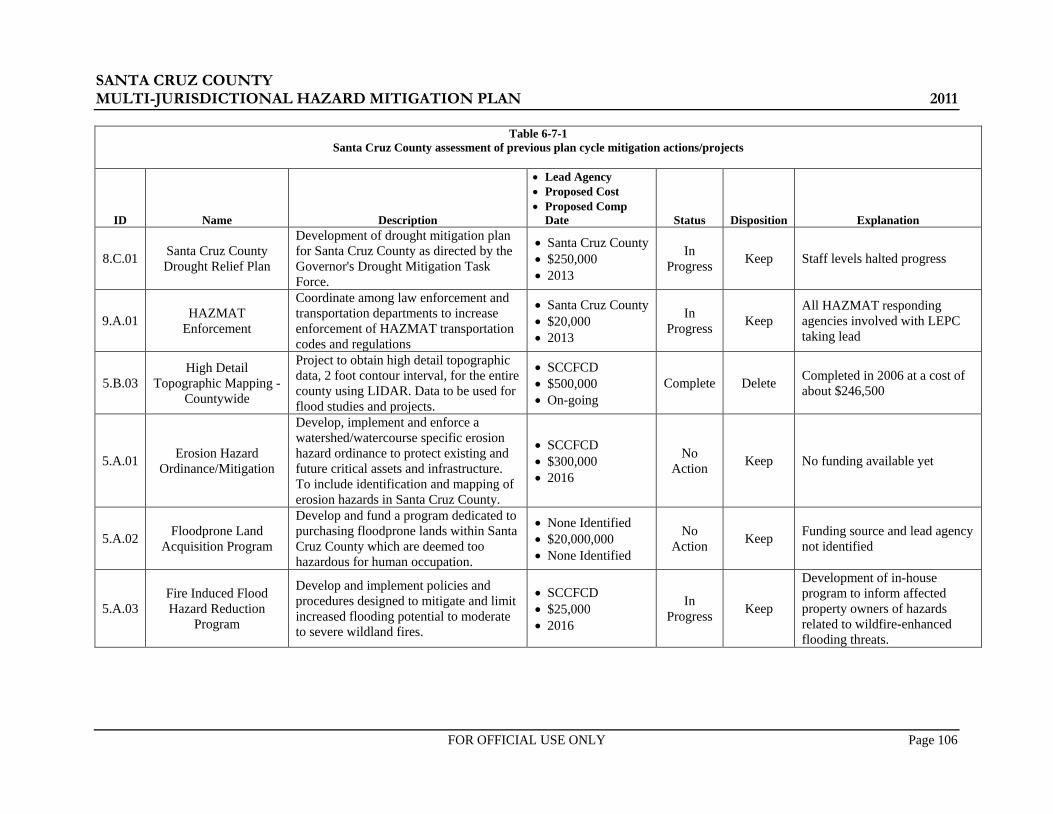
SANTA CRUZ COUNTY MULTI-JURISDICTIONAL HAZARD MITIGATION PLAN 2011
FOR OFFICIAL USE ONLY Page 106
Table 6-7-1 Santa Cruz County assessment of previous plan cycle mitigation actions/projects
ID Name Description
• Lead Agency • Proposed Cost • Proposed Comp
Date Status Disposition Explanation
8.C.01 Santa Cruz County Drought Relief Plan
Development of drought mitigation plan for Santa Cruz County as directed by the Governor's Drought Mitigation Task Force.
• Santa Cruz County • $250,000 • 2013
In Progress Keep Staff levels halted progress
9.A.01 HAZMAT Enforcement
Coordinate among law enforcement and transportation departments to increase enforcement of HAZMAT transportation codes and regulations
• Santa Cruz County • $20,000 • 2013
In Progress Keep
All HAZMAT responding agencies involved with LEPC taking lead
5.B.03 High Detail
Topographic Mapping - Countywide
Project to obtain high detail topographic data, 2 foot contour interval, for the entire county using LIDAR. Data to be used for flood studies and projects.
• SCCFCD • $500,000 • On-going
Complete Delete Completed in 2006 at a cost of about $246,500
5.A.01 Erosion Hazard Ordinance/Mitigation
Develop, implement and enforce a watershed/watercourse specific erosion hazard ordinance to protect existing and future critical assets and infrastructure. To include identification and mapping of erosion hazards in Santa Cruz County.
• SCCFCD • $300,000 • 2016
No Action Keep No funding available yet
5.A.02 Floodprone Land Acquisition Program
Develop and fund a program dedicated to purchasing floodprone lands within Santa Cruz County which are deemed too hazardous for human occupation.
• None Identified • $20,000,000 • None Identified
No Action Keep Funding source and lead agency
not identified
5.A.03 Fire Induced Flood Hazard Reduction
Program
Develop and implement policies and procedures designed to mitigate and limit increased flooding potential to moderate to severe wildland fires.
• SCCFCD • $25,000 • 2016
In Progress Keep
Development of in-house program to inform affected property owners of hazards related to wildfire-enhanced flooding threats.

SANTA CRUZ COUNTY MULTI-JURISDICTIONAL HAZARD MITIGATION PLAN 2011
FOR OFFICIAL USE ONLY Page 107
Table 6-7-1 Santa Cruz County assessment of previous plan cycle mitigation actions/projects
ID Name Description
• Lead Agency • Proposed Cost • Proposed Comp
Date Status Disposition Explanation
5.B.02 ALERT System
Install additional in stream, weather, and precipitation gauges in watersheds impacting Santa Cruz County. To include website development and remote access for public agencies.
• SCCFCD • $500,000 • On-going
In Progress Keep
Five ALERT Stations have been set up (5 precip., 3 Stream gauge (Pressure Transducers), and one repeater site) with a base station at the County Complex. District is working on an IGA with the State (ADWR) for the next four years for approximately $48,000 to up-grade the base station, add one Precip/stream site at Patagonia Lake Dam, and maintain the system.
5.E.01 Floodplain and Erosion
Hazard Management Ordinance Review
Outside contractor/professionals to review existing Santa Cruz County Floodplain and Erosion Hazard Management Ordinance to better address local hazards and needs, and protect existing and future critical assets. Project should not decrease level of protection current ordinance provides.
• SCCFCD • $25,000 • None Identified
In Progress Keep Working with stakeholder
group to complete
5.B.05 Relocation of Sheriff's
Office/Communications Center
The Sheriff's Office/Communications Center (SOCC) is currently located within the floodplain of Nogales Wash and has sustained repeated damages and flooding in the past. The SOCC is also exposed to significant HAZMAT hazards due to the location of the railroad. This project will relocate the SOCC to the current County facility complex located on North Congress.
• Santa Cruz County Sheriff's Office
• $40,000,000 • December 2008
Complete Delete Completed in November 2010 at a cost of $45 million

SANTA CRUZ COUNTY MULTI-JURISDICTIONAL HAZARD MITIGATION PLAN 2011
FOR OFFICIAL USE ONLY Page 108
Table 6-7-1 Santa Cruz County assessment of previous plan cycle mitigation actions/projects
ID Name Description
• Lead Agency • Proposed Cost • Proposed Comp
Date Status Disposition Explanation
9.B.01 Nogales Wash
Hazardous Materials Monitoring System
Monitoring equipment capable of real-time sampling and testing of water and air for hazardous materials with relay to base station.
• Santa Cruz County • $1,000,000 • Unknown
No Action Delete Technology not there yet
5.D.01 Flood Control District Records Data Base
Develop and implement a system of record keeping, both electronic and hard copy, to conform with all Federal and State requirements, with appropriate documents accessible to the GIS and Public.
• SCCFCD • $50,000 • On-going
In Progress Keep
Partial database and GIS capability – about 20% complete.
7.A.01 Nogales Wash Covered Tunnels Rehabilitation
Reconstruction and rehabilitation of covered tunnels dating from 1936 for the purpose of conveying floodwaters from Nogales, Sonora through Nogales, Arizona. Project to repair and reconstruct covered tunnels in a state of serious disrepair and distress.
• Unknown • $200,000,000 • Unknown
No Action Revise
County to take a supporting role as tunnels are a City responsibility per an agreement between the Corps of Engineers and City.
5.B.01 Santa Cruz County Drainage Master Plan
Study to identify areas of flood problems which require detailed analysis, design and projects to address.
• SCCFCD • $600,000 • 2017
No Action Keep No funding available yet
8.C.01 Santa Cruz County Drought Relief Plan
Development of drought mitigation plan for Santa Cruz County as directed by the Governor's Drought Mitigation Task Force.
• Santa Cruz County • $250,000 • 2013
In Progress Keep Staff levels halted progress
9.A.01 HAZMAT Enforcement
Coordinate among law enforcement and transportation departments to increase enforcement of HAZMAT transportation codes and regulations
• Santa Cruz County • $20,000 • 2013
In Progress Keep
All HAZMAT responding agencies involved with LEPC taking lead

SANTA CRUZ COUNTY MULTI-JURISDICTIONAL HAZARD MITIGATION PLAN 2011
FOR OFFICIAL USE ONLY Page 109
Table 6-7-1 Santa Cruz County assessment of previous plan cycle mitigation actions/projects
ID Name Description
• Lead Agency • Proposed Cost • Proposed Comp
Date Status Disposition Explanation
5.B.03 High Detail
Topographic Mapping - Countywide
Project to obtain high detail topographic data, 2 foot contour interval, for the entire county using LIDAR. Data to be used for flood studies and projects.
• SCCFCD • $500,000 • On-going
Complete Revise Completed in 2006 at a cost of about $246,500
5.A.01 Erosion Hazard Ordinance/Mitigation
Develop, implement and enforce a watershed/watercourse specific erosion hazard ordinance to protect existing and future critical assets and infrastructure. To include identification and mapping of erosion hazards in Santa Cruz County.
• SCCFCD • $300,000 • 2016
No Action Keep No funding available yet
5.A.02 Floodprone Land Acquisition Program
Develop and fund a program dedicated to purchasing floodprone lands within Santa Cruz County which are deemed too hazardous for human occupation.
• None Identified • $20,000,000 • None Identified
No Action Keep Funding source and lead agency
not identified
5.A.03 Fire Induced Flood Hazard Reduction
Program
Develop and implement policies and procedures designed to mitigate and limit increased flooding potential to moderate to severe wildland fires.
• SCCFCD • $25,000 • 2016
In Progress Keep
Development of in-house program to inform affected property owners of hazards related to wildfire-enhanced flooding threats.

SANTA CRUZ COUNTY MULTI-JURISDICTIONAL HAZARD MITIGATION PLAN 2011
FOR OFFICIAL USE ONLY Page 110
Table 6-7-1 Santa Cruz County assessment of previous plan cycle mitigation actions/projects
ID Name Description
• Lead Agency • Proposed Cost • Proposed Comp
Date Status Disposition Explanation
5.B.02 ALERT System
Install additional in stream, weather, and precipitation gauges in watersheds impacting Santa Cruz County. To include website development and remote access for public agencies.
• SCCFCD • $500,000 • On-going
In Progress Keep
Five ALERT Stations have been set up (5 precip., 3 Stream gauge (Pressure Transducers), and one repeater site) with a base station at the County Complex. District is working on an IGA with the State (ADWR) for the next four years for approximately $48,000 to up-grade the base station, add one Precip/stream site at Patagonia Lake Dam, and maintain the system.
5.E.01 Floodplain and Erosion
Hazard Management Ordinance Review
Outside contractor/professionals to review existing Santa Cruz County Floodplain and Erosion Hazard Management Ordinance to better address local hazards and needs, and protect existing and future critical assets. Project should not decrease level of protection current ordinance provides.
• SCCFCD • $25,000 • None Identified
In Progress Keep Working with stakeholder
group to complete
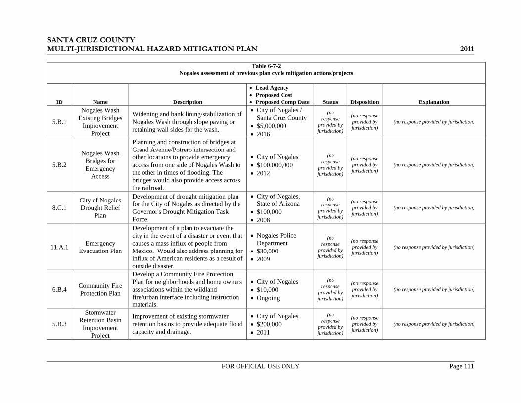
SANTA CRUZ COUNTY MULTI-JURISDICTIONAL HAZARD MITIGATION PLAN 2011
FOR OFFICIAL USE ONLY Page 111
Table 6-7-2 Nogales assessment of previous plan cycle mitigation actions/projects
ID Name Description
• Lead Agency • Proposed Cost • Proposed Comp Date Status Disposition Explanation
5.B.1
Nogales Wash Existing Bridges
Improvement Project
Widening and bank lining/stabilization of Nogales Wash through slope paving or retaining wall sides for the wash.
• City of Nogales / Santa Cruz County
• $5,000,000 • 2016
(no response
provided by jurisdiction)
(no response provided by jurisdiction)
(no response provided by jurisdiction)
5.B.2
Nogales Wash Bridges for Emergency
Access
Planning and construction of bridges at Grand Avenue/Potrero intersection and other locations to provide emergency access from one side of Nogales Wash to the other in times of flooding. The bridges would also provide access across the railroad.
• City of Nogales • $100,000,000 • 2012
(no response
provided by jurisdiction)
(no response provided by jurisdiction)
(no response provided by jurisdiction)
8.C.1 City of Nogales Drought Relief
Plan
Development of drought mitigation plan for the City of Nogales as directed by the Governor's Drought Mitigation Task Force.
• City of Nogales, State of Arizona
• $100,000 • 2008
(no response
provided by jurisdiction)
(no response provided by jurisdiction)
(no response provided by jurisdiction)
11.A.1 Emergency Evacuation Plan
Development of a plan to evacuate the city in the event of a disaster or event that causes a mass influx of people from Mexico. Would also address planning for influx of American residents as a result of outside disaster.
• Nogales Police Department
• $30,000 • 2009
(no response
provided by jurisdiction)
(no response provided by jurisdiction)
(no response provided by jurisdiction)
6.B.4 Community Fire Protection Plan
Develop a Community Fire Protection Plan for neighborhoods and home owners associations within the wildland fire/urban interface including instruction materials.
• City of Nogales • $10,000 • Ongoing
(no response
provided by jurisdiction)
(no response provided by jurisdiction)
(no response provided by jurisdiction)
5.B.3
Stormwater Retention Basin
Improvement Project
Improvement of existing stormwater retention basins to provide adequate flood capacity and drainage.
• City of Nogales • $200,000 • 2011
(no response
provided by jurisdiction)
(no response provided by jurisdiction)
(no response provided by jurisdiction)
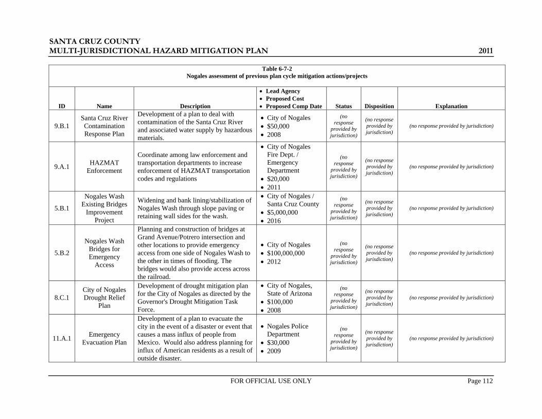
SANTA CRUZ COUNTY MULTI-JURISDICTIONAL HAZARD MITIGATION PLAN 2011
FOR OFFICIAL USE ONLY Page 112
Table 6-7-2 Nogales assessment of previous plan cycle mitigation actions/projects
ID Name Description
• Lead Agency • Proposed Cost • Proposed Comp Date Status Disposition Explanation
9.B.1 Santa Cruz River Contamination Response Plan
Development of a plan to deal with contamination of the Santa Cruz River and associated water supply by hazardous materials.
• City of Nogales • $50,000 • 2008
(no response
provided by jurisdiction)
(no response provided by jurisdiction)
(no response provided by jurisdiction)
9.A.1 HAZMAT Enforcement
Coordinate among law enforcement and transportation departments to increase enforcement of HAZMAT transportation codes and regulations
• City of Nogales Fire Dept. / Emergency Department
• $20,000 • 2011
(no response
provided by jurisdiction)
(no response provided by jurisdiction)
(no response provided by jurisdiction)
5.B.1
Nogales Wash Existing Bridges
Improvement Project
Widening and bank lining/stabilization of Nogales Wash through slope paving or retaining wall sides for the wash.
• City of Nogales / Santa Cruz County
• $5,000,000 • 2016
(no response
provided by jurisdiction)
(no response provided by jurisdiction)
(no response provided by jurisdiction)
5.B.2
Nogales Wash Bridges for Emergency
Access
Planning and construction of bridges at Grand Avenue/Potrero intersection and other locations to provide emergency access from one side of Nogales Wash to the other in times of flooding. The bridges would also provide access across the railroad.
• City of Nogales • $100,000,000 • 2012
(no response
provided by jurisdiction)
(no response provided by jurisdiction)
(no response provided by jurisdiction)
8.C.1 City of Nogales Drought Relief
Plan
Development of drought mitigation plan for the City of Nogales as directed by the Governor's Drought Mitigation Task Force.
• City of Nogales, State of Arizona
• $100,000 • 2008
(no response
provided by jurisdiction)
(no response provided by jurisdiction)
(no response provided by jurisdiction)
11.A.1 Emergency Evacuation Plan
Development of a plan to evacuate the city in the event of a disaster or event that causes a mass influx of people from Mexico. Would also address planning for influx of American residents as a result of outside disaster.
• Nogales Police Department
• $30,000 • 2009
(no response
provided by jurisdiction)
(no response provided by jurisdiction)
(no response provided by jurisdiction)

SANTA CRUZ COUNTY MULTI-JURISDICTIONAL HAZARD MITIGATION PLAN 2011
FOR OFFICIAL USE ONLY Page 113
Table 6-7-2 Nogales assessment of previous plan cycle mitigation actions/projects
ID Name Description
• Lead Agency • Proposed Cost • Proposed Comp Date Status Disposition Explanation
6.B.4 Community Fire Protection Plan
Develop a Community Fire Protection Plan for neighborhoods and home owners associations within the wildland fire/urban interface including instruction materials.
• City of Nogales • $10,000 • Ongoing
(no response
provided by jurisdiction)
(no response provided by jurisdiction)
(no response provided by jurisdiction)
5.B.3
Stormwater Retention Basin
Improvement Project
Improvement of existing stormwater retention basins to provide adequate flood capacity and drainage.
• City of Nogales • $200,000 • 2011
(no response
provided by jurisdiction)
(no response provided by jurisdiction)
(no response provided by jurisdiction)
9.B.1 Santa Cruz River Contamination Response Plan
Development of a plan to deal with contamination of the Santa Cruz River and associated water supply by hazardous materials.
• City of Nogales • $50,000 • 2008
(no response
provided by jurisdiction)
(no response provided by jurisdiction)
(no response provided by jurisdiction)
9.A.1 HAZMAT Enforcement
Coordinate among law enforcement and transportation departments to increase enforcement of HAZMAT transportation codes and regulations
• City of Nogales Fire Dept. / Emergency Department
• $20,000 • 2011
(no response
provided by jurisdiction)
(no response provided by jurisdiction)
(no response provided by jurisdiction)

SANTA CRUZ COUNTY MULTI-JURISDICTIONAL HAZARD MITIGATION PLAN 2011
FOR OFFICIAL USE ONLY Page 114
Table 6-7-3 Patagonia assessment of previous plan cycle mitigation actions/projects
ID Name Description
• Lead Agency • Proposed Cost • Proposed Comp Date Status Disposition Explanation
6.B.4 Community Fire Protection Plan
Develop a Community Fire Protection Plan for neighborhoods and home owners associations within the wildland fire/urban interface including instruction materials.
• Town of Patagonia • $10,000 • Ongoing
In Progress Ongoing
Keep Community fire protection plan is updated annually as part of our “Firewise” program
3.A.1 Emergency Operations Plan
Preparation of plan to identify key personnel and resources and prioritize operations activities to perform in the vent of natural or human caused disasters or emergencies.
• Town of Patagonia • $50,000 • 2010
In Progress Keep
Patagonia has experienced substantial changes in key personnel and a new update is currently in process, estimated completion 12/31/2011
9.A.1 HAZMAT Enforcement
Coordinate among law enforcement and transportation departments to increase enforcement of HAZMAT transportation codes and regulations on a quarterly basis. Include training for local law enforcement/fire personnel.
• Town of Patagonia • $20,000 • Ongoing
In Progress Keep
HAZMAT enforcement and training is a priority of Patagonia’s new marshal.
5.A.1 Town-wide Drainage Study
Evaluation of existing drainage and flooding conditions within the Town and identification of flood hazard mitigation needs/projects.
• Town of Patagonia • $60,000 • 2010
No Action Keep
Corps of Engineer revisions have provided to data, however a detailed drainage study is still needed and no funding is currently available.
8.C.1 Town of
Patagonia Drought Relief Plan
Development of drought mitigation plan for Santa Cruz County as directed by the Governor's Drought Mitigation Task Force.
• Town of Patagonia, State of Arizona
• $50,000 • 2008
In Progress Keep
Town has carried out ongoing conservation education and structured rates to encourage conservation.
5.D.1 Floodplain Ordinance Update
Update the Town's floodplain management ordinance to be in compliance with state standards and the state model ordinance.
• Town of Patagonia • $10,000 • 2008
Complete Delete Ordinance current, map being updated.
6.B.3 Town Fuels Crew Support part-time road crew to perform roadside hazard fuel reduction along county roads in the interface.
• Town of Patagonia • $15,000 • Ongoing
No Action Keep Need time and money

SANTA CRUZ COUNTY MULTI-JURISDICTIONAL HAZARD MITIGATION PLAN 2011
FOR OFFICIAL USE ONLY Page 115
Table 6-7-3 Patagonia assessment of previous plan cycle mitigation actions/projects
ID Name Description
• Lead Agency • Proposed Cost • Proposed Comp Date Status Disposition Explanation
11.B.1 Border Law Enforcement
Facilities
Purchase of equipment to meet international border and associated terrorism related law enforcement needs including; computers, in-car cameras, radios.
• Town of Patagonia • $200,000 • 2010
In Progress Keep Some equipment has been placed in
service, more is pending
5.B.1
Tributary A (Brisbois' Channel)
Emergency Access
Bridge/Culvert
Construction of an all-weather bridge or culvert crossing of Tributary A as shown on the Town's FIRM panel to provide emergency access to northern part of Town, which is located north of Sonoita Creek and Tributary A.
• Town of Patagonia • $500,000 • 2015
No Action Keep Highway funding problems
8.B.1 Town Water
Supply & Storage Improvements
Construction of back-up wells and storage reservoirs to improve capacity, reliability and redundancy of existing Town water system.
• Town of Patagonia • $2,000,000 • 2015
In Progress Keep Funding reserved, currently
securing ROW for connecting main.
5.B.2 Sonoita Creek Dredging at
Fairlawn Manor
Dredging of the Sonoita Creek main channel to improve flood conveyance capacity.
• None Provided • $20,000 • None Provided
In Progress Keep Some efforts by Town crews.
11.B.2 Critical Town
Facility Security Improvements
Increase security against sabotage/vandalism at critical town facilities including, but not limited to, water reservoirs, wastewater treatment facility, schools and other public facilities.
• None Provided • $250,000 • None Provided
In Progress Keep Some fencing in place, additional
security measures in process.

SANTA CRUZ COUNTY MULTI-JURISDICTIONAL HAZARD MITIGATION PLAN 2011
FOR OFFICIAL USE ONLY Page 116
6.3.2 New Mitigation Actions / Projects and Implementation Strategy
Upon completion of the assessment summarized in Section 6.3.1, each jurisdiction’s Local Planning Team developed new A/Ps using the goals and objectives, results of the vulnerability analysis and capability assessment, and the planning team’s institutional knowledge of hazard mitigation needs in the community. The A/Ps can be generally classified as either structural or non-structural. Structural A/Ps typify a traditional “bricks and mortar” approach where physical improvements are provided to effect the mitigation goals. Examples may include forest thinning, channels, culverts, bridges, detention basins, dams, emergency structures, and structural augmentations of existing facilities. Non-structural A/Ps deal more with policy, ordinance, regulation and administrative actions or changes, buy-out programs, and legislative actions. For each A/P, the following elements were identified:
• ID No. – a unique alpha-numeric identification number for the A/P.
• Description – a brief description of the A/P including a supporting statement that tells the “what” and “why” reason for the A/P.
• Hazard(s) Mitigated – a list of the hazard or hazards mitigated by the A/P.
• Community Assets Mitigated – a brief descriptor to qualify the type of assets (existing, new, or both) that the proposed mitigation A/P addresses.
• Estimated Costs – concept level cost estimates that may be a dollar amount or estimated as staff time.
Once the full list of A/Ps was completed to the satisfaction of the Local Planning Team, the team then developed the implementation strategy for those A/Ps. The implementation strategy addresses the “priority, how, when, and by whom?” questions related to the execution and completion of an identified A/P. Specific elements identified as a part of the implementation strategy included:
• Priority Ranking – each A/P was assigned a priority ranking of either “High”, “Medium”, or “Low”. The assignments were subjectively made using a simple process that assessed how well the A/P satisfied the following considerations:
o A favorable benefit versus cost evaluation, wherein the perceived direct and indirect benefits outweighed the project cost.
o A direct beneficial impact on the ability to protect life and/or property from natural hazards.
o A mitigation solution with a long-term effectiveness
• Planning Mechanism(s) for Implementation – where applicable, a list of current planning mechanisms or processes under which the A/P will be implemented. Examples could include CIPs, General Plans, Area Drainage Master Plans, etc.
• Anticipated Completion Date – a realistic and general timeframe for completing the A/P. Examples may include a specific target date, a timeframe contingent upon other processes, or recurring timeframes.
• Primary Agency and Job Title Responsible for Implementation –the agency, department, office, or other entity and corresponding job title that will have responsibility for the A/P and its implementation.
• Funding Source – the source or sources of anticipated funding for the A/P.
Tables 6-8-1 through 6-8-3 summarize the current mitigation A/P and implementation strategy for each participating Plan jurisdiction. Projects listed in italics font are recognized as being more response and recovery oriented, but are considered to be a significant part of the overall hazard management goals of the community.

SANTA CRUZ COUNTY MULTI-JURISDICTIONAL HAZARD MITIGATION PLAN 2011
FOR OFFICIAL USE ONLY Page 117
Table 6-8-1: Mitigation actions and projects and implementation strategy for Santa Cruz County Mitigation Action/Project Implementation Strategy
ID No. Description
Hazard(s) Mitigated
Community Assets
Mitigated (Ex/New)
Estimated Cost
Priority Ranking
Planning Mechanism(s)
for Implementation
Anticipated Completion
Date
Primary Agency / Job Title
Responsible for Implementation
Funding Source(s)
1
Develop and implement a Flood Control District Records Data Base using a system of record keeping, both electronic and hard copy, that will conform with all Federal and State requirements, with appropriate documents accessible to the GIS and Public.
Flood, Dam Failure Both $50,000 Low N/A FY 2016 FCD / General
Manager FCD
2
Support efforts by the City of Nogales and the USACE to reconstruct and rehabilitate the covered tunnels dating from 1936 for the purpose of conveying floodwaters from Nogales, Sonora through Nogales, Arizona. Currently the covered tunnels are in a state of serious disrepair and distress.
Flood Both $200 million High City CIP? FY 2020
FCD / General Manager City of Nogales/City Manager
TBD
3
Develop a drainage master plan for Santa Cruz County to identify areas of flood problems which require detailed analysis, design and projects to address.
Flood, Dam Failure Both $600,000 Medium N/A FY 2017 FCD / General
Manager FCD
4
Develop a drought mitigation plan for Santa Cruz County as directed by the Governor's Drought Mitigation Task Force.
Drought Both $250,000 Medium Drought Mitigation Task Force
FY 2013 Office of Emergency Mgmt. / Director
General Fund
5
Coordinate among law enforcement and transportation departments to increase enforcement of HAZMAT transportation codes and regulations
HAZMAT Both $20,000 Medium Commodity Flow Study / LEPC FY 2013 LEPC / Chairman LEPC /
SHSGP
6
Develop, implement and enforce a watershed/watercourse specific erosion hazard ordinance to protect existing and future critical assets and infrastructure. To include identification and mapping of erosion hazards in Santa Cruz County.
Flood Both $300,000 Medium N/A FY 2016 FCD / General Manager FCD
7
Develop and fund a program dedicated to purchasing floodprone lands within Santa Cruz County which are deemed too hazardous for human occupation.
Flood Both $20 million Low NFIP Compliance FY 2050 FCD / General
Manager FEMA / HMGP

SANTA CRUZ COUNTY MULTI-JURISDICTIONAL HAZARD MITIGATION PLAN 2011
FOR OFFICIAL USE ONLY Page 118
Table 6-8-1: Mitigation actions and projects and implementation strategy for Santa Cruz County Mitigation Action/Project Implementation Strategy
ID No. Description
Hazard(s) Mitigated
Community Assets
Mitigated (Ex/New)
Estimated Cost
Priority Ranking
Planning Mechanism(s)
for Implementation
Anticipated Completion
Date
Primary Agency / Job Title
Responsible for Implementation
Funding Source(s)
8
Develop and implement policies and procedures designed to mitigate and limit increased flooding potential that occur with moderate to severe wildland fires.
Flood Both $25,000 High County Plan FY 2016 FCD / General Manager
FCD / PDM
9
Install additional in-stream, weather, and precipitation gauges in watersheds impacting Santa Cruz County. To include website development and remote access for public agencies.
Flood Both $500,000 Medium N/A On-going FCD / General Manager
FCD / FEMA / USACE
10
Outside contractor/professionals to review existing Santa Cruz County Floodplain and Erosion Hazard Management Ordinance to better address local hazards and needs, and protect existing and future critical assets. Project should not decrease level of protection current ordinance provides.
Flood Both $25,000 Medium N/A FY 2013 FCD / General Manager FCD
11 Develop and implement Firewise program throughout the County. Wildfire Both $40,000 High County Plan On-going
Fire Districts / Emergency Management / Chiefs and Director
FD / GF / PDM
12 Develop a sheltering plan in the event of power outages
Extreme Temperatures Both $15,000 Low Emergency
Mgmt FY 2016 Emergency Management GF
13 Review and update building code anchoring and tie-down requirements Severe Wind Both $10,000 Low Building Codes FY 2016 Chief Building
Official GF

SANTA CRUZ COUNTY MULTI-JURISDICTIONAL HAZARD MITIGATION PLAN 2011
FOR OFFICIAL USE ONLY Page 119
Table 6-8-2: Mitigation actions and projects and implementation strategy for Nogales Mitigation Action/Project Implementation Strategy
ID No. Description Hazard(s) Mitigated
Community Assets
Mitigated (Ex/New)
Estimated Cost
Priority Ranking
Planning Mechanism(s)
for Implementation
Anticipated Completion
Date
Primary Agency / Job Title
Responsible for Implementation
Funding Source(s)
Table 6-8-3: Mitigation actions and projects and implementation strategy for Patagonia
Mitigation Action/Project Implementation Strategy
ID No. Description
Hazard(s) Mitigated
Community Assets
Mitigated (Ex/New)
Estimated Cost
Priority Ranking
Planning Mechanism(s)
for Implementation
Anticipated Completion
Date
Primary Agency / Job Title
Responsible for Implementation
Funding Source(s)
1
Develop a Community Fire Protection Plan for neighborhoods and home owner’s associations within the wildland fire/urban interface including instruction materials.
Wildfire Both
2
Prepare a plan to identify key personnel and resources, and prioritize operations activities to perform in the event of natural or human caused disasters or emergencies.
All Both
3
Coordinate among law enforcement and transportation departments to increase enforcement of HAZMAT transportation codes and regulations on a quarterly basis. Include training for local law enforcement/fire personnel.
HAZMAT Both
4 Evaluate existing drainage and flooding conditions within the Town and identify flood hazard mitigation needs/projects.
Flood Both
5 Develop a drought mitigation plan for the Town of Patagonia Drought Both
6 Support part-time road crew to perform roadside wildfire fuel reduction along county roads in the interface.
Wildfire Both
(no response provided by jurisdiction)

SANTA CRUZ COUNTY MULTI-JURISDICTIONAL HAZARD MITIGATION PLAN 2011
FOR OFFICIAL USE ONLY Page 120
Table 6-8-3: Mitigation actions and projects and implementation strategy for Patagonia Mitigation Action/Project Implementation Strategy
ID No. Description
Hazard(s) Mitigated
Community Assets
Mitigated (Ex/New)
Estimated Cost
Priority Ranking
Planning Mechanism(s)
for Implementation
Anticipated Completion
Date
Primary Agency / Job Title
Responsible for Implementation
Funding Source(s)
7
Purchase equipment to meet international border and associated terrorism related law enforcement needs including; computers, in-car cameras, radios.
All Both
8
Construct an all-weather bridge or culvert crossing of Tributary A as shown on the Town's FIRM panel, to provide emergency access to northern part of Town, which is located north of Sonoita Creek and Tributary A.
Flood Both
9
Construct back-up wells and storage reservoirs to improve capacity, reliability and redundancy of existing Town water system.
Drought Both
10 Dredge the Sonoita Creek main channel at Fairlawn Manor to improve flood conveyance capacity.
Flood Both

SANTA CRUZ COUNTY MULTI-JURISDICTIONAL HAZARD MITIGATION PLAN 2011
FOR OFFICIAL USE ONLY Page 121
SECTION 7: PLAN MAINTENANCE PROCEDURES
Santa Cruz County and the participating jurisdictions recognize that this hazard mitigation plan is intended to be a “living” document with regularly scheduled monitoring, evaluation, and updating.
Section 6 of the 2006 Plan outlined specific steps for plan maintenance. A poll of the Planning Team indicated that very few formal reviews or maintenance actions occurred over the past five years. Santa Cruz County did perform a brief review of the 2006 Plan in early 2007 as a part of an LEPC meeting review of the county’s emergency response plan. No formal documentation of the review was produced. Also, the mitigation actions/projects in the 2006 Plan were referred to by all of the jurisdictions on a periodic basis when considering grant opportunities. Reasons for the lack of review included:
• Staff turnover and a lack of continuity from the original planning team. • Reductions in staff numbers and a lack of personnel and financial resources and support. • Lack of a quorum
Recognizing the need for improvement, the Planning Team discussed ways to make sure that the Plan review and maintenance process will occur over the next five years. The results of those discussions are outlined in the following sections and the plan maintenance strategy.
7.1 Monitoring and Evaluation Switching to a true multi-jurisdictional plan will aide in the Plan monitoring and evaluation by the consolidation of information for all county jurisdictions into one document. The Planning Team has established the following monitoring and evaluation procedures:
• Schedule – The Plan shall be reviewed at least one time at the midterm point of the Plan cycle, or as needed, prior to the 5-year update, and following a major disaster. ADEM will take the lead for initiating/prompting the need for review on or around the anniversary of the Plan approval date and will contact the County Emergency Manager (EM) to communicate the reminder. At the mid-cycle point, or otherwise as need dictates, the County EM will contact each Planning Team member or their replacement, to set a date for a review meeting within 30 days.
• Review Content – The content and scope of the Plan review and evaluation will address the following questions:
o Hazard Identification: Have the risks and hazards changed? o Goals and objectives: Are the goals and objectives still able to address current and
expected conditions? o Mitigation Projects and Actions: Has the project been completed? If not complete but
started, what percent of the project has been completed? How much money has been expended on incomplete projects? Did the project require additional funds over the expected amount or were the costs less than expected?
Each jurisdiction will review the Plan as it relates to their community prior to the actual review meeting and document responses to the above questions in the form of an informal memorandum. During the mid-cycle meeting, each jurisdiction will have the opportunity to summarize their review findings to the group and discuss concerns or successes. Documentation of the mid-cycle meeting will include a compilation of the
§201.6(c)(4): [The plan shall include…] (4) A plan maintenance process that includes: (i) A section describing the method and schedule of monitoring, evaluating, and updating the mitigation plan within
a five-year cycle. (ii) A process by which local governments incorporate the requirements of the mitigation plan into other planning
mechanisms such as comprehensive or capital improvement plans, when appropriate. (iii) Discussion on how the community will continue public participation in the plan maintenance process. §201.6(d)(3): Plans must be reviewed, revised if appropriate, and resubmitted for approval within five years in order to continue to be eligible for HMGP project grant funding.
SANTA CRUZ COUNTY MULTI-JURISDICTIONAL HAZARD MITIGATION PLAN 2011
FOR OFFICIAL USE ONLY Page 122
memorandums generated by each jurisdiction plus any notes on the meeting discussions and conclusions. Copies of the annual review report will be included in Appendix E.
7.2 Plan Update According to DMA 2000, the Plan requires updating and approval from FEMA every five years. The plan updates will adhere to that set schedule using the following procedure:
One year prior to the plan expiration date, the County EM Director will reconvene the Planning Team to review and assess the materials accumulated in Appendix E.
The Planning Team will update and/or revise the appropriate or affected portions of the plan and produce a revised plan document.
The revised plan document will be presented before the respective councils and boards for an official concurrence/adoption of the changes.
The revised plan will be submitted to ADEM and FEMA for review, comment and approval.
7.3 Incorporation into Existing Planning Mechanisms Incorporation of the Plan into other planning mechanisms, either by content or reference, enhances a community’s ability to perform natural hazard mitigation by expanding the scope of the Plan’s influence. A poll of the participating jurisdictions revealed that success of incorporating the 2005 Plan elements over the past planning cycle into other planning programs, has varied. Ways in which the 2005 Plans have been successfully incorporated or referenced into other planning mechanisms for each jurisdiction are summarized below:
• During the update of the County’s Public Health Emergency Preparedness and Response All Hazard Plan, portions of the 2006 Plan were referenced and incorporated into the risk assessment (Santa Cruz County).
• The 2006 Plan was referenced during the update of the County’s 2004 Comprehensive Plan (Santa Cruz County).
• The 2006 Plan was referenced during the updates of the Nogales Wash Emergency Response Plan over the last couple of years (City of Nogales, Santa Cruz County).
• The 2006 Plan was referenced during the update of Patagonia’s General Plan during 2008-2009 (Town of Patagonia).
• Reviewed the mitigation action/projects in the 2006 Plan when considering grant opportunities (All Jurisdictions).
In all of the above instances, the 2006 Plan was found to be beneficial, and especially with regard to the critical facility inventories, vulnerability analysis results, and the mitigation strategy. Obstacles to further incorporation of the 2006 Plan for some of the communities were generally tied to a lack of awareness of the 2006 Plan by departments outside of the emergency management community, and the relative “newness” of the 2006 Plan with regard to other, more commonplace planning mechanisms such as comprehensive or general plans. It was also noted, that due to the small size of some participating jurisdictions, there is really not all that much “other” planning being done.
Typical ways to use and incorporate the Plan over the next five-year planning cycle, discussed by the Planning Team, included:
• Use of, or reference to, Plan elements in updates to general and comprehensive planning documents.
• Addition of defined mitigation A/Ps to capital improvement programming. • Inclusion of Plan elements into development planning and practices. • Resource for developing and/or updating emergency operations plans.
• Use as a reference during the development of the “Ready-Set-Go” Plan by the Arizona Fire Chiefs Association.

SANTA CRUZ COUNTY MULTI-JURISDICTIONAL HAZARD MITIGATION PLAN 2011
FOR OFFICIAL USE ONLY Page 123
The Plan will continue to function as a standalone document subject to its own review and revision schedule presented in Sections 7.1 and 7.2. The Plan will also serve as a reference for other mitigation and land planning needs of the participating jurisdictions. Whenever possible, each jurisdiction will endeavor to incorporate the risk assessment results and mitigation actions and projects identified in the Plan, into existing and future planning mechanisms. At a minimum, each of the responsible agencies/departments noted in Tables 6-1-1 through 6-1-3 will review and reference the Plan and revise and/or update the legal and regulatory planning documents, manuals, codes, and ordinances summarized in Tables 6-1-1 through 6-1-3, as appropriate. Specific incorporation of the Plan risk assessment elements into the natural resources and safety elements of each jurisdictions’ general plans (county comprehensive plan) and development review processes, adding or revising building codes, adding or changing zoning and subdivision ordinances, and incorporating mitigation goals and strategies into general and/or comprehensive plans, will help to ensure hazard mitigated future development. In addition, an implementation strategy outlining assignments of responsibility and completion schedules for specific actions/projects proposed in this plan are summarized in Tables 6-8-1 through 6-8-3.
7.4 Continued Public Involvement The Planning Team reviewed Section 6.4 of the 2006 Plan and discussed the challenges and successes regarding the identified continued public involvement strategy. The 2006 Plan identified the following elements for continued public involvement:
• Provide periodic summary updates of hazard mitigation A/P measures being implemented using local media.
• Conduct an annual presentation of hazard mitigation planning discoveries, progress, or proposed A/P measures at the Santa Cruz County Board of Supervisors, Nogales City Council and Patagonia Town Council Meetings.
• Participate in annual events such as the County fair and other public events. • Perform public outreach and mitigation training meetings for targeted populations known to be in
higher risk hazard areas (i.e. – floodplain residents).
All of the participating jurisdictions were successful to varying degrees, in their efforts to elevate hazard mitigation awareness in the general public and community on an ongoing basis. Santa Cruz County and the other participating jurisdictions remain committed to keeping the public informed about the hazard mitigation planning efforts, actions and projects. Table 7-1 summarizes successful public involvement efforts previously conducted by the participating jurisdictions, and proposed activities for public involvement and dissemination of information that shall be pursued whenever possible and appropriate.

SANTA CRUZ COUNTY MULTI-JURISDICTIONAL HAZARD MITIGATION PLAN 2011
FOR OFFICIAL USE ONLY Page 124
Table 7-1: Past and proposed continued public involvement activities or opportunities identified by Santa Cruz County jurisdictions
Jurisdiction
Public Involvement Activity or Opportunity
PAST PROPOSED
Santa Cruz County
• Flood safety and mitigation outreach by the Santa Cruz County Flood Control District included: o Page in the phone book
community pages. o Website o Booth at the County Fair (every
year for the past 10 years) o 28+ public meetings regarding
the new floodplain maps o Meetings at the request of
various organizations and clubs (Lions Club, Rotary Club, Tubac Valley Country Club HOA, Residents of Rio Rio, etc)
o Presentation at schools (San Cayetano Elementary Career Day, Desert Shadows Middle School 6th grade science classes)
o Yearly mailings of services provided, information and forms to lenders, real estate agents, insurance agents, and contractors in Santa Cruz County.
o Articles in the local newspaper. o Interviews with the local Fox
TV station out of Tucson on Floodplain Mapping project.
• Fire Prevention Presentations by various Fire Districts
• Participated in the Public Safety Day held annually in Rio Rico on the first week of October
• Flood safety and mitigation outreach by the Santa Cruz County Flood Control District to include: o Page in the phone book community pages. o Website o Booth at the County Fair o Public meetings held for the purpose of
disseminating floodplain information to residents, various organizations and clubs, and schools
o Yearly mailings of services provided, information and forms to lenders, real estate agents, insurance agents, and contractors in Santa Cruz County.
o Use of local media outlets. • Fire Prevention Presentations by various Fire
Districts throughout the year. • Continue participation in the Public Safety Day
held annually in Rio Rico on the first week of October
• Provide a copy of the monitoring and evaluation memorandum (see Section 7.1) to the County Board of Supervisors for their information.
Nogales • Conducted annual “Day of the
Children” presentations during the March-April timeframe.
• Continue to make annual “Day of the Children” presentations during the March-April timeframe.
• Provide a copy of the monitoring and evaluation memorandum (see Section 7.1) to the Town Council for their information.
Patagonia
• Presentation of Firewise program by the Patagonia Fire Department, at the Patagonia Fall Festival held annually the 2nd week of October.
• Continue to present Firewise program by the Patagonia Fire Department, at the Patagonia Fall Festival held annually the 2nd week of October.
• Provide a copy of the monitoring and evaluation memorandum (see Section 7.1) to the Town Council for their information.

SANTA CRUZ COUNTY MULTI-JURISDICTIONAL HAZARD MITIGATION PLAN 2011
FOR OFFICIAL USE ONLY Page 125
SECTION 8: PLAN TOOLS
8.1 Acronyms A/P ...................... Mitigation Action/Project ADEM ............... Arizona Division of Emergency Management ADEQ ................ Arizona Department of Environmental Quality ADWR ............... Arizona Department of Water Resources AGFD ................ Arizona Game and Fish Department ARS ................... Arizona Revised Statutes ASCE ................. American Society of Civil Engineers ASERC .............. Arizona State Emergency Response Commission ASLD ................ Arizona State Land Department ASU ................... Arizona State University AZGS ................ Arizona Geological Survey BLM .................. Bureau of Land Management CAP ................... Central Arizona Project CAP ................... Community Assistance Program CFR ................... Code of Federal Regulations CRS ................... Community Rating System CWPP ................ Community Wildfire Protection Plan DEMA ............... Arizona Department of Emergency and Military Affairs DFIRM .............. Digital Flood Insurance Rate DMA 2000 ......... Disaster Mitigation Act of 2000 DOT ................... Department of Transportation EHS ................... Extremely Hazardous Substance EPA ................... Environmental Protection Agency EPCRA .............. Emergency Planning and Community Right to Know Act FCDMC .............. Flood Control District of Santa Cruz County FEMA ................ Federal Emergency Management Agency FMA ................... Flood Mitigation Assistance Grant Program GIS .................... Geographic Information System HAZMAT .......... Hazardous Material HAZUS-99 ........ Hazards United States1999 HAZUS-MH ...... Hazards United States Multi-Hazard IFCI ................... International Fire Code Institute LEPC ................. Local Emergency Planning Committee MJHMP ............. Multi-Jurisdictional Hazard Mitigation Plan MMI .................. Modified Mercalli Intensity NCDC ................ National Climate Data Center NDMC ............... National Drought Mitigation Center NESDIS ............. National Environmental Satellite, Data and Information Service NFIP .................. National Flood Insurance Program NFPA ................. National Fire Protection Association NHC .................. National Hurricane Center NIBS .................. National Institute of Building Services NID .................... National Inventory of Dams NIST .................. National Institute of Standards and Technology NSF .................... National Science Foundation NOAA ............... National Oceanic and Atmospheric Administration NRC ................... National Response Center NWCG ................ National Wildfire Coordination Group NWS .................. National Weather Service PSDI .................. Palmer Drought Severity Index RL ...................... Repetitive Loss

SANTA CRUZ COUNTY MULTI-JURISDICTIONAL HAZARD MITIGATION PLAN 2011
FOR OFFICIAL USE ONLY Page 126
SARA ................ Superfund Amendments and Reauthorization Act SRLP ................. Severe Repetitive Loss Properties SRL .................... Severe Repetitive Loss SRP .................... Salt River Project UBC ................... Uniform Building Code USACE .............. United States Army Corps of Engineers USDA ................ United States Department of Agriculture USFS ................. United States Forest Service USGS ................. United States Geological Survey VA ...................... Vulnerability Analysis WUI ................... Wildland Urban Interface
8.2 Definitions The following terms and definitions are provided for reference and are taken from the 2010 State Plan with a few minor modifications.
ARIZONA HAZARDS
Dam Failure A dam failure is a catastrophic type of failure characterized by the sudden, rapid and uncontrolled release of impounded water. Dam failures are typically due to either overtopping or piping and can result from a variety of causes including natural events such as floods, landslides or earthquakes, deterioration of foundation or compositional materials, penetration by vegetative roots or animal burrows, fissures or improper design and construction. Such a failure presents a significant potential for a disaster as significant loss of life and property would be expected in addition to the possible loss of power and water resources.
Drought A drought is a deficiency of precipitation over on extended period of time, resulting in water shortage for some activity, group or environmental sector. "Severe" to "extreme" drought conditions endanger livestock and crops, significantly reduce surface and ground water supplies, increase the potential risk for wildland fires, increase the potential for dust storms, and cause significant economic loss. Humid areas are more vulnerable than arid areas. Drought may not be constant or predictable and does not begin or end on any schedule. Short term droughts are less impacting due to the reliance on irrigation and groundwater in arid environments.
Earthquake An earthquake is a naturally-induced shaking of the ground, caused by the fracture and sliding of rock within the Earth's crust. The magnitude is determined by the dimensions of the rupturing fracture (fault) and the amount of displacement that takes place. The larger the fault surface and displacement, the greater the energy. In addition to deforming the rock near the fault, this energy produces the shaking and a variety of seismic waves that radiate throughout the Earth. Earthquake magnitude is measured using the Richter Scale and earthquake intensity is measured using the Modified Mercalli Intensity Scale.
Fissure Earth fissures are tension cracks that open as the result of subsidence due to severe overdrafts (i.e., pumping) of groundwater, and occur about the margins of alluvial basins, near exposed or shallow buried bedrock, or over zones of differential land subsidence. As the ground slowly settles, cracks form at depth and propagate towards the surface, hundreds of feet above. Individual fissures range in length from hundreds of feet to several miles, and from less than an inch to several feet wide. Rainstorms can erode fissure walls rapidly causing them to widen and lengthen suddenly and dangerously, forming gullies five to 15- feet wide and tens of feet deep.
Flooding

SANTA CRUZ COUNTY MULTI-JURISDICTIONAL HAZARD MITIGATION PLAN 2011
FOR OFFICIAL USE ONLY Page 127
Flooding is an overflowing of water onto normally dry land and is one of the most significant and costly of natural disasters. Flooding tends to occur in Arizona during anomalous years of prolonged, regional rainfall (typical of an El Nino year), and is typified by increased humidity and high summer temperatures.
Flash flooding is caused excessive rain falling in a small area in a short time and is a critical hazard in Arizona. Flash floods are usually associated with summer monsoon thunderstorms or the remnants of a tropical storm. Several factors contribute to flash flooding: rainfall intensity and duration, topography, soil conditions, and ground cover. Most flash flooding is caused by slow-moving thunderstorms or thunderstorms repeatedly moving over the same area and can occur within a few minutes or hours of excessive rainfall, or a quick release from a dam or levee failure. Thunderstorms produce flash flooding, often far from the actual storm and at night when natural warnings may not be noticed.
Landslide / Mudslide Landslides like avalanches are massive downward and outward movements of slope-forming materials. The term landslide is restricted to movement of rock and soil and includes a broad range of velocities. Slow movements, although rarely a threat to life, can destroy buildings or break buried utility lines. A landslide occurs when a portion of a hill slope becomes too weak to support its own weight. The weakness is generally initiated when rainfall or some other source of water increases the water content of the slope, reducing the shear strength of the materials. A mud slide is a type of landslide referred to as a flow. Flows are landslides that behave like fluids: mud flows involve wet mud and debris.
Levee Failure / Breach Levee failures are typically due to either overtopping or erosive piping and can result from a variety of causes including natural events such as floods, hurricane/tropical storms, or earthquakes, deterioration of foundation or compositional materials, penetration by vegetative roots or animal burrows, fissures, or improper design, construction and maintenance. A levee breach is the opening formed by the erosion of levee material and can form suddenly or gradually depending on the hydraulic conditions at the time of failure and the type of material comprising the levee.
Severe Wind Thunderstorms are characterized as violent storms that typically are associated with high winds, dust storms, heavy rainfall, hail, lightning strikes, and/or tornadoes. The unpredictability of thunderstorms, particularly their formation and rapid movement to new locations heightens the possibility of floods. Thunderstorms, dust/sand storms and the like are most prevalent in Arizona during the monsoon season, which is a seasonal shift in the winds that causes an increase in humidity capable of fueling thunderstorms. The monsoon season in Arizona typically is from late-June or early-July through mid-September.
Tornadoes are violently rotating columns of air extending from a thunderstorm to the ground. The most violent tornadoes are capable of tremendous destruction with wind speeds in excess of 250 mph. Damage paths can exceed a mile wide and 50 miles long. The damage from tornadoes is due to high winds. The Fujita Scale of Tornado Intensity measures tornado / high wind intensity and damage.
Tropical Storms are storms in which the maximum sustained surface wind ranges from 39-73 mph. Tropical storms are associated with heavy rain and high winds. High intensity rainfall in short periods is typical. A tropical storm is classified as a hurricane when its sustained winds reach or exceed 74 mph. These storms are medium to large in size and are capable of producing dangerous winds, torrential rains, and flooding, all of which may result in tremendous property damage and loss of life, primarily in coastal populated areas. The effects are typically most dangerous before a hurricane makes landfall, when most damage occurs. However, Arizona has experienced a number of tropical storms that caused extensive flooding and wind damage.
Subsidence Land subsidence in Arizona is primarily attributed to substantial groundwater withdrawal from aquifers in sedimentary basins. As the water is removed, the sedimentary layers consolidate resulting in a general lowering of the corresponding ground surface. Subsidence frequently results in regional bowl-shaped depressions, with loss of elevation greatest in the center and decreasing towards the perimeter. Subsidence can measurably change or reverse basin gradients causing expensive localized flooding and adverse impacts or even rupture to long-baseline infrastructure such as canals, sewer systems, gas lines and roads. Earth fissures are the most spectacular and destructive manifestation of subsidence-related phenomena.

SANTA CRUZ COUNTY MULTI-JURISDICTIONAL HAZARD MITIGATION PLAN 2011
FOR OFFICIAL USE ONLY Page 128
Wildfire Wildfire is a rapid, persistent chemical reaction that releases heat and light, especially the exothermic combination of a combustible substance with oxygen. Wildfires present a significant potential for disaster in the southwest, a region of relatively high temperatures, low humidity, low precipitation, and during the spring moderately strong daytime winds. Combine these severe burning conditions with people or lightning and the stage is set for the occurrence of large, destructive wildfires.
Winter Storm Winter storms bring heavy snowfall and frequently have freezing rain and sleet. Sleet is defined as pellets of ice composed of frozen or mostly frozen raindrops or refrozen partially melted snowflakes. These pellets of ice usually bounce after hitting the ground or other hard surfaces. Freezing rain begins as snow at higher altitudes and melts completely on its way down while passing through a layer of air above freezing temperature, then encounters a layer below freezing at lower level to become supercooled, freezing upon impact of any object it then encounters. Because freeing rain hits the ground as a rain droplet, it conforms to the shape of the ground, making one thick layer of ice. Snow is generally formed directly from the freezing of airborne water vapor into ice crystals that often agglomerates into snowflakes. Average annual snowfall in Arizona varies with geographic location and elevation, and can range from trace amounts to hundreds of inches. Severe snow storms can affect transportation, emergency services, utilities, agriculture and basic subsistence supply to isolated communities. In extreme cases, snowloads can cause significant structural damage to under-designed buildings. GENERAL PLAN TERMS
Asset Any natural or human-caused feature that has value, including, but not limited to people; buildings; infrastructure like bridges, roads, and sewer and water systems; lifelines like electricity and communication resources; or environmental, cultural, or recreational features like parks, dunes, wetlands, or landmarks.
Building A structure that is walled and roofed, principally above ground and permanently affixed to a site. The term includes a manufactured home on a permanent foundation on which the wheels and axles carry no weight.
Critical Facilities and Infrastructure Systems or facilities whose incapacity or destruction would have a debilitating impact on the defense or economic security of the nation. The Critical Infrastructure Assurance Office (CIAO) defines eight categories of critical infrastructure, as follows:
Telecommunications infrastructure: Telephone, data services, and Internet communications, which have become essential to continuity of business, industry, government, and military operations.
Electrical power systems: Generation stations and transmission and distribution networks that create and supply electricity to end-users.
Gas and oil facilities: Production and holding facilities for natural gas, crude and refined petroleum, and petroleum-derived fuels, as well as the refining and processing facilities for these fuels.
Banking and finance institutions: Banks, financial service companies, payment systems, investment companies, and securities/commodities exchanges.
Transportation networks: Highways, railroads, ports and inland waterways, pipelines, and airports and airways that facilitate the efficient movement of goods and people.
Water supply systems: Sources of water; reservoirs and holding facilities; aqueducts and other transport systems; filtration, cleaning, and treatment systems; pipelines; cooling systems; and other delivery mechanisms that provide for domestic and industrial applications, including systems for dealing with water runoff, wastewater, and firefighting.
Government services: Capabilities at the federal, state, and local levels of government required to meet the needs for essential services to the public.
Emergency services: Medical, police, fire, and rescue systems.

SANTA CRUZ COUNTY MULTI-JURISDICTIONAL HAZARD MITIGATION PLAN 2011
FOR OFFICIAL USE ONLY Page 129
Disaster Mitigation Act of 2000 (DMA2K) A law signed by the President on October 30, 2000 that encourages and rewards local and state pre-disaster planning, promotes sustainability as a strategy for disaster resistance, and is intended to integrate state and local planning with the aim of strengthening statewide mitigation planning.
Emergency Preparedness and Response (EPR) Directorate One of five major Department of Homeland Security Directorates which builds upon the formerly independent Federal Emergency Management Agency (FEMA). EPR is responsible for preparing for natural and human-caused disasters through a comprehensive, risk-based emergency management program of preparedness, prevention, response, and recovery. This work incorporates the concept of disaster-resistant communities, including providing federal support for local governments that promote structures and communities that reduce the chances of being hit by disasters.
Emergency Response Plan A document that contains information on the actions that may be taken by a governmental jurisdiction to protect people and property before, during, and after a disaster.
Federal Emergency Management Agency (FEMA) Formerly independent agency created in 1978 to provide a single point of accountability for all Federal activities related to disaster mitigation and emergency preparedness, response and recovery. As of March 2003, FEMA is a part of the Department of Homeland Security’s Emergency Preparedness and Response (EPR) Directorate.
Flood Insurance Rate Map (FIRM) Map of a community, prepared by FEMA that shows the special flood hazard areas and the risk premium zones applicable to the community.
Frequency A measure of how often events of a particular magnitude are expected to occur. Frequency describes how often a hazard of a specific magnitude, duration, and/or extent typically occurs, on average. Statistically, a hazard with a 100-year recurrence interval is expected to occur once every 100 years on average, and would have a 1% chance – its probability – of happening in any given year. The reliability of this information varies depending on the kind of hazard being considered.
Geographic Information Systems (GIS) A computer software application that relates physical features on the earth to a database to be used for mapping and analysis.
Hazard A source of potential danger or adverse condition. Hazards include both natural and human-caused events. A natural event is a hazard when it has the potential to harm people or property and may include events such as floods, earthquakes, tornadoes, tsunami, coastal storms, landslides, and wildfires that strike populated areas. Human-caused hazard events originate from human activity and may include technological hazards and terrorism. Technological hazards arise from human activities and are assumed to be accidental and/or have unintended consequences (e.g., manufacture, storage and use of hazardous materials). While no single definition of terrorism exists, the Code of Federal Regulations defines terrorism as “…unlawful use of force and violence against persons or property to intimidate or coerce a government, the civilian population, or any segment thereof, in furtherance of political or social objectives.”
Hazard Event A specific occurrence of a particular type of hazard.
Hazard Identification The process of identifying hazards that threaten an area.
Hazard Mitigation Cost effective measures taken to reduce or eliminate long-term risk associated with hazards and their effects.
Hazard Profile
SANTA CRUZ COUNTY MULTI-JURISDICTIONAL HAZARD MITIGATION PLAN 2011
FOR OFFICIAL USE ONLY Page 130
A description of the physical characteristics of hazards and a determination of various descriptors including magnitude, duration, frequency, probability, and extent.
HAZUS A GIS-based nationally standardized earthquake, flood and high wind event loss estimation tool developed by FEMA.
Mitigate To cause to become less harsh or hostile; to make less severe or painful. Mitigation activities are actions taken to eliminate or reduce the probability of the event, or reduce its severity of consequences, either prior to or following a disaster/emergency.
Mitigation Plan A systematic evaluation of the nature and extent of vulnerability to the effects of natural hazards typically present in a defined geographic area, including a description of actions to minimize future vulnerability to hazards.
100-Hundred Year Floodplain Also referred to as the Base Flood Elevation (BFE) and Special Flood Hazard Area (SFHA). An area within a floodplain having a 1% or greater chance of flood occurrence in any given year.
Planning The act or process of making or carrying out plans; the establishment of goals, policies, and procedures for a social or economic unit.
Probability A statistical measure of the likelihood that a hazard event will occur.
Promulgation To make public and put into action the Hazard Mitigation Plan via formal adoption and/or approval by the governing body of the respective community or jurisdiction (i.e. – Town or City Council, County Board of Directors, etc.).
Q3 Data The Q3 Flood Data product is a digital representation of certain features of FEMA's Flood Insurance Rate Map (FIRM) product, intended for use with desktop mapping and Geographic Information Systems technology. The digital Q3 Flood Data are created by scanning the effective FIRM paper maps and digitizing selected features and lines. The digital Q3 Flood Data are designed to serve FEMA's needs for disaster response activities, National Flood Insurance Program activities, risk assessment, and floodplain management.
Repetitive Loss Property A property that is currently insured for which two or more National Flood Insurance Program losses (occurring more than ten days apart) of at least $1,000 each have been paid within any 10 year period since 1978.
Risk The estimated impact that a hazard would have on people, services, facilities, and structures in a community; the likelihood of a hazard event resulting in an adverse condition that causes injury or damage. Risk is often expressed in relative terms such as a high, moderate, or low likelihood of sustaining damage beyond a particular threshold due to a specific type of hazard event. It also can be expressed in terms of potential monetary losses associated with the intensity of the hazard.
Substantial Damage Damage of any origin sustained by a structure in a Special Flood Hazard Area whereby the cost of restoring the structure to its before-damaged condition would equal or exceeds 50% of the market value of the structure before the damage.
Vulnerability Describes how exposed or susceptible to damage an asset is. Vulnerability depends on an asset's construction, contents, and the economic value of its functions. Like indirect damages, the vulnerability of one element of the community is often related to the vulnerability of another. For example, many businesses depend on

SANTA CRUZ COUNTY MULTI-JURISDICTIONAL HAZARD MITIGATION PLAN 2011
FOR OFFICIAL USE ONLY Page 131
uninterrupted electrical power–if an electric substation is flooded, it will affect not only the substation itself, but a number of businesses as well. Often, indirect effects can be much more widespread and damaging than direct effects.
Vulnerability Analysis The extent of injury and damage that may result from a hazard event of a given intensity in a given area. The vulnerability analysis should address impacts of hazard events on the existing and future built environment.
Vulnerable Populations Any segment of the population that is more vulnerable to the effects of hazards because of things such as lack of mobility, sensitivity to environmental factors, or physical abilities. These populations can include, but are not limited to, senior citizens and school children.
Goals General guidelines that explain what you want to achieve. Goals are usually broad statements with long-term perspective.
Objectives Defined strategies or implementation steps intended to attain the identified goals. Objectives are specific, measurable, and have a defined time horizon.
Actions/Projects Specific actions or projects that help achieve goals and objectives.
Implementation Strategy A comprehensive strategy that describes how the mitigation actions will be implemented.
GENERAL HAZARD TERMS
Fujita Scale of Tornado Intensity Rates tornadoes with numeric values from F0 to F5 based on tornado winds peed and damage sustained. An F0 indicates minimal damage such as broken tree limbs or signs, while an F5 indicates severe damage sustained.
Liquefaction The phenomenon that occurs when ground shaking (earthquake) causes loose soils to lose strength and act like viscous fluid. Liquefaction causes two types of ground failure: lateral spread and loss of bearing strength.
Modified Mercalli Intensity Scale The Modified Mercalli Intensity Scale is commonly used in the United States by seismologists seeking information on the severity of earthquake effects. Intensity ratings are expressed as Roman numerals between I at the low end and XII at the high end. The Intensity Scale differs from the Richter Magnitude Scale in that the effects of any one earthquake vary greatly from place to place, so there may be many Intensity values (e.g.: IV, VII) measured from one earthquake. Each earthquake, on the other hand, should have just one Magnitude, although the several methods of estimating it will yield slightly different values (e.g.: 6.1, 6.3).
Monsoon A monsoon is any wind that reverses its direction seasonally. In the Southwestern U.S., for most of the year the winds blow from the west/northwest. Arizona is located on the fringe of the Mexican Monsoon which during the summer months turns the winds to a more south/southeast direction and brings moisture from the Pacific Ocean, Gulf of California, and Gulf of Mexico. This moisture often leads to thunderstorms in the higher mountains and Mogollon Rim, with air cooled from these storms often moving from the high country to the deserts, leading to further thunderstorm activity in the desert. A common misuse of the term monsoon is to refer to individual thunderstorms as monsoons.
Richter Magnitude Scale A logarithmic scale devised by seismologist C.F. Richter in 1935 to express the total amount of energy released by an earthquake. While the scale has no upper limit, values are typically between 1 and 9, and each increase of 1 represents a 32-fold increase in released energy.

SANTA CRUZ COUNTY MULTI-JURISDICTIONAL HAZARD MITIGATION PLAN 2011
Appendix A
Official Resolution of Adoption

SANTA CRUZ COUNTY MULTI-JURISDICTIONAL HAZARD MITIGATION PLAN 2011
Appendix B
Planning Process Documentation

Memorandum JE Fuller/ Hydrology & Geomorphology, Inc.
Santa Cruz County Multi-Jurisdictional Hazard Mitigation Plan
MEETING DATE: February 23, 2011
MEETING TIME: 1:00PM – 5:00PM
MEETING LOCATION: Nogales Fire Station No. 2 Nogales, AZ
DISTRIBUTION: Meeting Attendees
FROM: W. Scott Ogden - JEF
RE: Santa Cruz County Multi-Jurisdictional Hazard Mitigation Plan Planning Team Meeting No. 1 (REDO)
ATTENDEES: John Ashcroft – Patagonia Fire Chief Mike Burns – Rio Rico Fire District Battalion Chief Les Caid – Santa Cruz County Public Safety Planner Louis Chaboya – Tubac Fire District Project Manager Mary Dahl – Santa Cruz County Community Development Director Gilbert Escobar – Nogales Fire Captain Alfonso Flores – Nogales Police Detective Jesus Gomez – Nogales Fire Dept, Division Chief John Hays – SCC Flood Control, Floodplain Coordinator George Lineiro – Nogales Planning & Zoning Director Carlos Mendoza – Nogales Suburban Fire District Battalion Chief Scott Ogden – JE Fuller Genaro Rivera – Tubac Fire District Battalion Chief Susan Wood – ADEM
AGENDA
1. INTRODUCTIONS / GREETING 2. MITIGATION PLANNING OVERVIEW 3. CURRENT MITIGATION PLAN REVIEW 4. PLANNING PROCESS
a. MJ Planning Team Roles b. Public Involvement Strategy
5. RISK ASSESSMENT a. Hazard Identification / Profiling b. Asset Inventory
6. PREVIOUS MITIGATION PROJECTS 7. OTHER DATA NEEDS 8. NEXT MEETING DATES
ACTION ITEM SUMMARY

Meeting Notes – Santa Cruz County Mitigation Planning Team Meeting No. 1(REDO) p. 2 JEFuller, Inc. 2/23/2011
Santa Cruz County Multi-Jurisdictional Hazard Mitigation Plan
DISCUSSION Agenda Item 1: • Introductions were made for each member of the planning team. S. Ogden explained
the role of JEF and ADEM. • S. Ogden explained that this meeting is actually a redo of a meeting conducted in
October 2010 and subsequently there will be only two more meetings left to cover all the update material. It is therefore imperative that the planning team keep moving.
Agenda Item 2: • S. Wood distributed a mitigation planning folder with miscellaneous mitigation
related materials, brochures, fact sheets and meeting handouts to each team member. She then presented an overview/review of the DMA2K mitigation process and purpose for preparing a mitigation plan. The discussion included a review of impacted grant eligibility.
Agenda Item 3: • S. Wood provided several copies of the 2006 Santa Cruz County Multi-Jurisdictional
Hazard Mitigation Plan (2006 Plan) to participants and led a brief chapter by chapter overview of the 2006 Plan. Highlights of the discussion and comments included:
o Plan format will change slightly to reflect a version that is more compatible to the format of the current State of Arizona Mitigation Plan.
o The plan will remain in a multi-jurisdictional format. o Planning Team noted that many of the 2006 Plan planning team are no
longer employed or have changed positions. The returning 2006 plan team members are John Ashcroft, Louis Chaboya, Mary Dahl, Gilbert Escobar, John Hays, and Shelly Patton.
o Each jurisdiction was encouraged to update and customize the community descriptions section. JEF will post a draft of the new Plan’s community description section to their FTP site and provide login credentials for access by each jurisdiction.
o Details of Sections 4, 5, and 6 and their updates will be discussed later in the meeting today and in subsequent meetings.
Agenda Item 4a: • S. Ogden jointly led a discussion / presentation of the planning team roles and
responsibilities including: o The primary point of contact (PPOC) o The community representative o The local planning resources (other staff, outside agencies, business,
school, non-profit reps, etc. contacted or referred to). • S. Ogden presented the planning team with a list of possible local resources that could
be considered for invitation to future planning team meetings. The planning team discussed appropriate contacts and especially for the schools, non-profits, and business community.

Meeting Notes – Santa Cruz County Mitigation Planning Team Meeting No. 1(REDO) p. 3 JEFuller, Inc. 2/23/2011
Santa Cruz County Multi-Jurisdictional Hazard Mitigation Plan
• L. Caid will make sure an invitation is extended to the discussed target groups and will provide JEF with a list of those agencies/entities that were contacted and the invitation method used (email, letter, phone contact, etc.). S. Ogden will send a sample letter for use by the county.
• S. Ogden will provide a provided a template for each jurisdiction to use during the planning process for documenting the local resources involved in the plan update outside of the main planning team.
• L. Caid was identified as the PPOC. The community representatives were identified as follows:
o Unincorporated Santa Cruz County –John Hays o City of Nogales – Jesus Gomez o Town of Patagonia – John Ashcroft
Agenda Item 4b: • S. Ogden led a discussion/presentation of the public involvement requirements of
DMA2K. • The planning team discussed various options including newspaper notices, general
public announcements, and web page postings. The following public involvement strategy was decided:
o A public notice will be posted on all three jurisdictions’ websites o Include an agenda item on the next LEPC meeting announcing the
mitigation planning and update process and extending an invitation for participation.
o M. Dahl will develop and issue a press release and will monitor the media sources to see who runs an article.
o Once the draft plan is ready, the website notices will be revised accordingly and a second press release will be issued. The draft plan itself, will be posted to the Santa Cruz County website for public review and comment prior to final adoption.
• S. Ogden will email template language for the jurisdictions to use as a basis for the website notices and press release.
Agenda Item 5a: • S. Ogden presented an overview of what a risk assessment is and its purpose in the
overall scheme of mitigation planning. He discussed the approach that the planning team will ultimately step through.
• The planning team reviewed the list of hazards previously evaluated in 2006 Plan as well as a comprehensive list of hazards identified in the 2010 State Plan.
• S. Ogden presented the results of a historic hazard event search and database compilation performed by ADEM and JEF that looks at declared and undeclared hazard events. Discussion included:
o Some of the flooding event injury and fatality counts may need a closer look.
o JEF will provide copies of the Excel spreadsheets to the planning team for updating and closer review.

Meeting Notes – Santa Cruz County Mitigation Planning Team Meeting No. 1(REDO) p. 4 JEFuller, Inc. 2/23/2011
Santa Cruz County Multi-Jurisdictional Hazard Mitigation Plan
• The planning team reviewed the hazard lists and historic records and discussed which hazards could be eliminated off-hand and which should be evaluated further. The following is a brief summary of that discussion:
o Building/Structure Collapse in the 2006 Plan will be removed due to the fact that the true hazard is really tied to a potential failure precipitated by flooding of the Nogales tunnels that convey runoff underground from Mexico through downtown Nogales. Instead, this special condition of the flooding hazard will be added to the Flooding/Flash Flooding vulnerability analysis.
o HAZMAT in the 2006 Plan will be continued with the updated Plan since HAZMAT concerns are so prevalent.
o Following the State Plan lead, the 2006 Plan Tropical Storms/Hurricanes will be dropped as a hazard category as the effects are better addressed in the Flooding/Flash Flooding and Severe Wind categories.
o Drought, Flooding/Flash Flooding, and Wildfire will be retained in the updated plan.
o Dam Failure was added to the list as development has a potential to increase in the areas downstream of dams. J. Hays pointed out that the dam at Patagonia Lake has been raised significantly, but the dam’s EAP has not been updated, which may have an impact on a proposed development. J. Gomez also pointed out that there are two dams located in Nogales, Sonora that may have a significant impact on border flooding in Nogales Wash should they fail. J. Gomez will meet with his Nogales, Sonora counterpart to determine the location of the two dams and provide that to JEF.
o The planning team chose to add Severe Wind to address thunderstorm related micro-bursts and the recent tornado threats.
o The planning team chose to add a category called Extreme Heat/Cold based on recent experience with freezing temperatures.
o The resulting list of hazards to be carried forward to profiling and a vulnerability analysis are: Drought Dam Failure Extreme Heat/Cold Flooding / Flash Flooding HAZMAT Severe Wind Wildfire
o J. Hays has already provided the latest FEMA DFIRM data and SCC delineated floodplain layers to JEF.
o JEF distributed hazard profile maps for Drought, Dam Failure, Flooding / Flash Flooding, Severe Wind and Wildfire to the team for review and comment.
• S. Ogden presented information regarding application and development of the Calculated Priority Risk Index (CPRI). The planning team worked through an example using a preformatted spreadsheet and a handout with guidance on selecting

Meeting Notes – Santa Cruz County Mitigation Planning Team Meeting No. 1(REDO) p. 5 JEFuller, Inc. 2/23/2011
Santa Cruz County Multi-Jurisdictional Hazard Mitigation Plan
CPRI parameters. JEF will send the CPRI spreadsheet to the community representative for each jurisdiction for them to complete and get back to JEF.
Agenda Item 5b: • S. Ogden presented an overview of the asset inventory data that was developed for
the 2006 plan and how it was used in the 2006 Plan vulnerability analysis. Each jurisdiction will review and revise the list as necessary and return it to JEF.
• Classification of some items in the list regarding “critical” versus “non-critical” status (e.g. – schools that are also identified as evacuation shelters) was discussed and the planning team was encouraged to decide what was critical for their communities using the definitions of critical facilities spelled out in Section 4.3.1 of the 2006 Plans. JEF will eliminate any remaining non-critical facilities.
• S. Ogden will provide the 2006 Plan list of identified assets to each respective jurisdiction for review, editing, completing and updating.
• S. Ogden also pointed out that several of the assets currently listed do not have replacement costs and should be updated if possible.
• JEF will send existing data-sets to each community and request that they provide the updated inventory by the next meeting.
Agenda Item 6: • The planning team briefly reviewed the current list of mitigation actions/projects
(A/Ps) listed in the 2006 Plan. • S. Ogden explained that a part of the plan update process will include an evaluation of
the 2006 Plan’s mitigation actions/projects and that JEF has prepared worksheets to assist each jurisdiction to accomplish the task.
• S. Ogden presented an example evaluation worksheet and explained the evaluation parameters and illustrated a few appropriate responses. Each jurisdiction will complete the worksheet and provide to JEF prior to the next meeting.
Agenda Item 7: • The planning team verified that city boundaries have not changed since the 2006
Plan. • No other data collection has been identified at this time. Agenda Item 8: • The next planning team meeting is scheduled for: March 22nd from 1pm to 5pm, at
the Rio Rico Fire Station No. 3, 822 Pendleton Drive (Ruby Road), Rio Rico, AZ.
Meeting Notes – Santa Cruz County Mitigation Planning Team Meeting No. 1(REDO) p. 6 JEFuller, Inc. 2/23/2011
Santa Cruz County Multi-Jurisdictional Hazard Mitigation Plan
ACTION ITEM SUMMARY: ITEM NO. DESCRIPTION
RESPONSIBILITY [DUE DATE]
1-1 JEF will post the Community Description section (Section 4) of the new draft Plan to the JEF FTP site and provide login credentials to the planning team..
JE Fuller [3/4/11]
1-2
All jurisdictions are to review and update the Community Descriptions as appropriate and desired. Jurisdictions are to consider including Agriculture, Mining, Manufacturing, and Tourism to their descriptions
All Jurisdictions [4/29/11]
1-3 L. Caid will provide to JEF the list of organizations/entities that were invited to participate on the planning team.
L. Caid [3/18/11]
1-4 JEF will email electronic version of Local Resources List template to each jurisdiction to track contributors to the plan update.
JE Fuller [3/4/11]
1-5 Each jurisdiction shall record and document all people contacted or involved as a planning resource at the local level, using the template provided by JEF
All Jurisdictions [4/29/11]
1-6 S. Ogden to provide a sample public notice for use on the websites and the press release.
JE Fuller [3/4/11]
1-7 M. Dahl will prepare and disseminate a press release. M. Dahl [3/18/11]
1-8 Each jurisdiction will coordinate a posting of the public notice to their respective website with a link to the county’s webpage.
All Jurisdictions [3/18/11]
1-9 JEF will provide digital copies of the historic hazard database files to the planning team for review and update as needed.
JE Fuller [3/4/11]
1-10 All team members are to review and update the historic hazard database as appropriate and desired by the community.
All Jurisdictions [3/18/11]
1-11 J. Gomez will meet with his Nogales, Sonora counterpart to determine the location of the two dams and provide that information to JEF.
J. Gomez [3/18/11]
1-12 JEF to provide a CPRI worksheet to each jurisdiction for completion prior to the next meeting.
JE Fuller [3/4/11]
1-13 All jurisdictions shall complete the CPRI respective to their jurisdiction and return to JEF.
All Jurisdictions [3/18/11]
1-14 JEF to provide asset inventory data sets to each community for update, correction, or provision of missing data.
JE Fuller [3/4/11]
1-15 All jurisdictions shall review the 2006 asset inventory and make updates, corrections, and/or provide missing data such as replacement costs.
All Jurisdictions [3/18/11]
1-16 JEF will provide the Existing Mitigation Action/Project Evaluation worksheet to each respective jurisdiction for completion.
JE Fuller [3/4/11]

Meeting Notes – Santa Cruz County Mitigation Planning Team Meeting No. 1(REDO) p. 7 JEFuller, Inc. 2/23/2011
Santa Cruz County Multi-Jurisdictional Hazard Mitigation Plan
ITEM NO. DESCRIPTION
RESPONSIBILITY [DUE DATE]
1-17 All jurisdictions shall complete the Existing Mitigation A/P Evaluation worksheet and return to JEF.
All Jurisdictions [3/18/11]

Memorandum JE Fuller/ Hydrology & Geomorphology, Inc.
Santa Cruz County Multi-Jurisdictional Hazard Mitigation Plan
MEETING DATE: March 22, 2011
MEETING TIME: 1:00PM – 5:00PM
MEETING LOCATION: Rio Rico Fire Station No. 3 Rio Rico, AZ
DISTRIBUTION: Meeting Attendees
FROM: W. Scott Ogden - JEF
RE: Santa Cruz County Multi-Jurisdictional Hazard Mitigation Plan Planning Team Meeting No. 2
ATTENDEES: John Ashcroft – Patagonia Fire Chief Mike Burns – Rio Rico Fire District Battalion Chief Les Caid – Santa Cruz County Public Safety Planner Louis Chaboya – Tubac Fire District Project Manager Patty Conger – Tubac Fire District Mary Dahl – Santa Cruz County Community Development Director Jesus Gomez – Nogales Fire Dept, Division Chief John Hays – SCC Flood Control, Floodplain Coordinator Carlos Mendoza – Nogales Suburban Fire District Battalion Chief Scott Ogden – JE Fuller Carlos Parra - Nogales Suburban Fire District Fire Chief Genaro Rivera – Tubac Fire District Battalion Chief David Teel – Patagonia Town Manager Jose Yanez – Nogales Pretreatment Officer
AGENDA
1. ACTION ITEM STATUS REVIEW 2. CAPABILITY ASSESSMENT
a. Jurisdictional Capabilities b. Prior Mitigation Activities c. NFIP Participation and Status d. Repetitive Loss Properties
3. GOALS & OBJECTIVES REVIEW/UPDATE 4. PLAN MAINTENANCE PROCEDURES
a. Monitoring and Evaluation b. Plan Update c. Plan Incorporation d. Continued Public Involvement
5. MEETING ENDING a. Review of action items b. Next meeting reminder/verification
ACTION ITEM SUMMARY
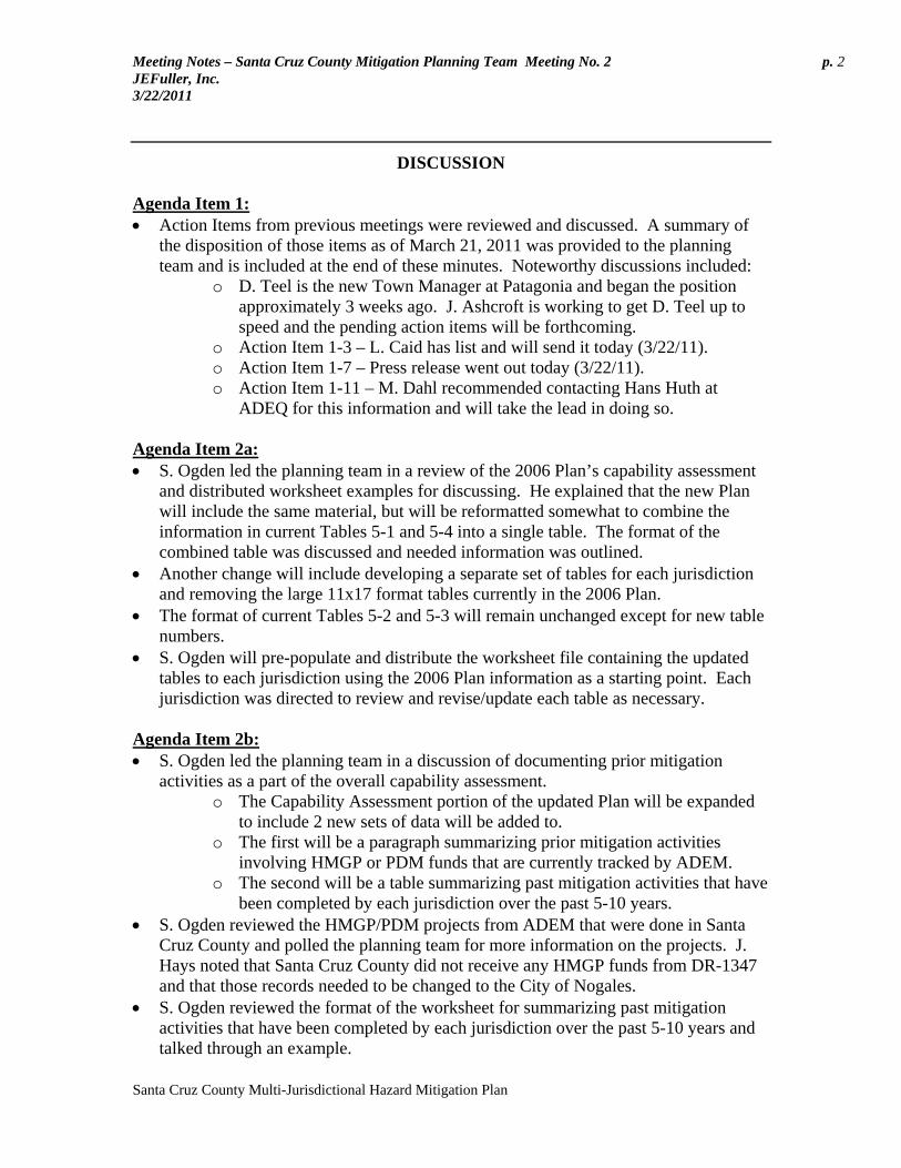
Meeting Notes – Santa Cruz County Mitigation Planning Team Meeting No. 2 p. 2 JEFuller, Inc. 3/22/2011
Santa Cruz County Multi-Jurisdictional Hazard Mitigation Plan
DISCUSSION Agenda Item 1: • Action Items from previous meetings were reviewed and discussed. A summary of
the disposition of those items as of March 21, 2011 was provided to the planning team and is included at the end of these minutes. Noteworthy discussions included:
o D. Teel is the new Town Manager at Patagonia and began the position approximately 3 weeks ago. J. Ashcroft is working to get D. Teel up to speed and the pending action items will be forthcoming.
o Action Item 1-3 – L. Caid has list and will send it today (3/22/11). o Action Item 1-7 – Press release went out today (3/22/11). o Action Item 1-11 – M. Dahl recommended contacting Hans Huth at
ADEQ for this information and will take the lead in doing so.
Agenda Item 2a: • S. Ogden led the planning team in a review of the 2006 Plan’s capability assessment
and distributed worksheet examples for discussing. He explained that the new Plan will include the same material, but will be reformatted somewhat to combine the information in current Tables 5-1 and 5-4 into a single table. The format of the combined table was discussed and needed information was outlined.
• Another change will include developing a separate set of tables for each jurisdiction and removing the large 11x17 format tables currently in the 2006 Plan.
• The format of current Tables 5-2 and 5-3 will remain unchanged except for new table numbers.
• S. Ogden will pre-populate and distribute the worksheet file containing the updated tables to each jurisdiction using the 2006 Plan information as a starting point. Each jurisdiction was directed to review and revise/update each table as necessary.
Agenda Item 2b: • S. Ogden led the planning team in a discussion of documenting prior mitigation
activities as a part of the overall capability assessment. o The Capability Assessment portion of the updated Plan will be expanded
to include 2 new sets of data will be added to. o The first will be a paragraph summarizing prior mitigation activities
involving HMGP or PDM funds that are currently tracked by ADEM. o The second will be a table summarizing past mitigation activities that have
been completed by each jurisdiction over the past 5-10 years. • S. Ogden reviewed the HMGP/PDM projects from ADEM that were done in Santa
Cruz County and polled the planning team for more information on the projects. J. Hays noted that Santa Cruz County did not receive any HMGP funds from DR-1347 and that those records needed to be changed to the City of Nogales.
• S. Ogden reviewed the format of the worksheet for summarizing past mitigation activities that have been completed by each jurisdiction over the past 5-10 years and talked through an example.

Meeting Notes – Santa Cruz County Mitigation Planning Team Meeting No. 2 p. 3 JEFuller, Inc. 3/22/2011
Santa Cruz County Multi-Jurisdictional Hazard Mitigation Plan
• JEF will provide a worksheet for each jurisdiction to document past mitigation activities. May include past projects, outreach, studies, etc., funded by any source (not just grants).
Agenda Item 2c: • S. Ogden presented a table showing NFIP participation statistics and insurance data
that was current as of August 2010. • Each jurisdiction was polled with regard to management roles and the data was
recorded in a table that will ultimately be included in the Plan. • J. Hays noted that the tentative delivery date for the new FEMA DFIRMS is
December 2011. S. Ogden will put a special footnote in the table acknowledging the impending date.
Agenda Item 2d: • S. Ogden presented a summary of NFIP repetitive loss property information that was
provided by FEMA through ADEM and was current as of January 2010. • J. Hays noted that according to his records, there are no known RL properties in the
Unincorporated County. He stated that the FEMA data shows some properties that are disputed by SCCFCD, as they cannot be verified.
• J. Hays also noted that there are partial disputes with some of the Nogales locations as well.
Agenda Item 3: • S. Ogden led the planning team in a review of the 2006 Plan’s goals & objectives
(G&Os). He also presented and reviewed a copy of the State Plan’s goals and objectives for the team to use in ensuring compatibility between the state and local Plans.
• The planning team discussed both sets of G&Os and the following are highlights of that discussion:
o During the review, the planning team felt the 2006 Plan’s G&Os were still appropriate and reflected the overall mitigation goals of the participating jurisdictions.
o Goal 7, which addressed Building/Structure Collapse will be revised to address Dam Failure. Concerns regarding the Building/Structure Collapse are primarily tied to the possible failure of the Nogales Wash stormwater tunnels currently located under the downtown border area of Nogales. The team agreed that the mechanism for failure of the tunnels would be primarily triggered by some other hazard like flooding or an earthquake. The team chose to include the words “buildings and structures” in Goal 5 instead of retaining G&Os that address Building/Structure Collapse.
o The team chose to add the phrase “and public safety officials to Objective 9.C.
o A new Goal 10 and 11 will be renumbered to 11 and 12 and a new Goal 10 will be included to address Severe Weather. The new Goal 10 will include 3 objectives similar to those used for Goal 7.

Meeting Notes – Santa Cruz County Mitigation Planning Team Meeting No. 2 p. 4 JEFuller, Inc. 3/22/2011
Santa Cruz County Multi-Jurisdictional Hazard Mitigation Plan
Agenda Item 4a: • S. Ogden led the planning team in a review of Section 6.1 in the 2006 Plans. This
information will be in Section 7.1 of the new Plan. • A poll of each jurisdiction was conducted regarding past plan monitoring and
evaluation. All reported that none was formally accomplished, although the 2006 Plan may have been looked at during LEPC meetings when the county’s emergency response plan was reviewed.
• Reasons for not doing the monitoring and evaluation were mostly due to: o Staffing issues - changes in personnel, turnover, insufficient numbers. o Lack of continuity to the 2006 planning team o The activity was not prioritized and that planning efforts in general have a
tendency to fall to the “bottom of the list.” o The Plan is not referred to all that much.
• A new monitoring and evaluation schedule and scope was discussed with an acute awareness of the lack of action over the past 4 years. The following was the result:
o ADEM will take the lead for initiating/prompting the need for review on or around the anniversary of the Plan approval date.
o The Plan will be reviewed at least once, or as needed, prior to commencement of the 5-year update and following a major disaster.
o The County EM will contact each Planning Team member listed in the Plan, or their equivalent, to set a date for a review meeting at or around the 2-year anniversary of the Plan. The meeting will be convened within 30 days.
o A brief memorandum will be used to document the reviews conducted over the next planning cycle and will be included in an appendix placeholder.
o The scope of the review will remain the same from the 2006 Plan. Agenda Item 4b: • The planning team reviewed the plan update strategy of Section 6 in the 2006 Plans
and found it acceptable with the following minor changes: o The time to initiate the update process will be changed from 6 months to
1-year in advance of the Plan expiration date. o Responsibility for initiating the update process will fall to the County EM.
• This information will be documented in Section 7 of the new Plan.
Agenda Item 4c: • A poll of the jurisdictions was conducted to identify ways in which the 2006 Plans
were incorporated into other planning mechanisms within each jurisdiction. The following were the responses:
o Referenced during the update of the County’s Public Health Emergency Preparedness & Response All Hazards Plan.
o Referenced during the update of the County’s 2004 Comprehensive Plan o Referenced with the updates of the Nogales Wash Emergency Response
Plan over the past couple of years.

Meeting Notes – Santa Cruz County Mitigation Planning Team Meeting No. 2 p. 5 JEFuller, Inc. 3/22/2011
Santa Cruz County Multi-Jurisdictional Hazard Mitigation Plan
o Referenced during the update of Patagonia’s General Plan in 2009. • Reasons for the lack of further incorporation success were discussed and were found
to be similar to the reasons for the lack of plan maintenance. The planning team concluded that a greater awareness of the plan was needed and that hopefully a more regular review of the plan would help in the awareness and implementation of the plan in other planning mechanisms. It was also noted, that due to the small size of the participating jurisdictions, there is really not all that much other planning being done.
• Specific Future opportunities included updates to the Nogales General Plan, an impending update to the County Comprehensive Plan, and reference for the development of the “Ready-Set-Go” Plan that will be prepared through the Arizona Fire Chiefs Association.
• This information will be documented in Section 7 of the new Plan. Agenda Item 4d: • A poll of the jurisdictions was conducted to identify ways in which past public
involvement opportunities were provided relative to the 2006 Plans. The following are opportunities that were offered on a regular basis over the last 4 years:
o Santa Cruz County: SCCFCD conducted the following:
• Maintained a page in the phone book community pages. • Website page with flood hazard mitigation information • Booth at the County Fair (every year for the past 10 years) • 28+ public meetings regarding the new FEMA DFIRM
floodplain maps • Meetings at the request of various organizations and clubs
(Lions Club, Rotary Club, Tubac Valley Country Club HOA, Residents of Rio Rio, etc)
• Presentation at schools (San Cayetano Elementary Career Day, Desert Shadows Middle School 6th grade science classes)
• Yearly mailings of services provided, information and forms to lenders, real estate agents, insurance agents, and contractors in Santa Cruz County.
• Articles in the local newspaper. • Interviews with the local Fox TV station out of Tucson on
Floodplain Mapping project. Presentations during Fire Prevention Week Participation in the Public Safety Day in Rio Rico during the first
week of October. o Nogales:
Participation in the Day Of The Children event in late March – early April.
o Patagonia:

Meeting Notes – Santa Cruz County Mitigation Planning Team Meeting No. 2 p. 6 JEFuller, Inc. 3/22/2011
Santa Cruz County Multi-Jurisdictional Hazard Mitigation Plan
Presentation of a Firewise Program by the Patagonia Fire Department during the Patagonia Fall Festival held annually the 2nd week of October.
o ALL Jurisdictions Presentation of all mitigation actions/projects being implemented
to board of supervisors or city/town councils. • Future public involvement opportunities were discussed and the following were
offered: o Santa Cruz County:
Maintain a hazard mitigation planning webpage with the Plan posted for review, comment and download.
Participate annually in the Fire Prevention Week and Public Safety Day in Rio Rico (October).
SCCFCD will: • Maintain a floodplain management and drainage related
webpage • Perform public meetings as needed during the final release
of the FEMA DFIRMS in December 2011. • Provide presentations to local organizations and schools
regarding flood hazards. • Provide a booth at the county fair (September) • Maintain a page in the phone book community pages. • Yearly mailings of services provided, information and
forms to lenders, real estate agents, insurance agents, and contractors in Santa Cruz County.
Provide a copy of the monitoring and evaluation memorandum to the board of supervisors for informational purposes.
o Nogales: Annual participation in the Day Of The Children event (spring). Provide a copy of the monitoring and evaluation memorandum to
the city council for informational purposes. o Patagonia:
Presentation of a Firewise Program by the Patagonia Fire Department during the Patagonia Fall Festival held annually the 2nd week of October.
Provide a copy of the monitoring and evaluation memorandum to the town council for informational purposes.
o ALL Jurisdictions Presentation of all mitigation actions/projects being implemented
to board of supervisors or city/town councils. • These items will be documented in Section 7.4 of the new Plan
Agenda Item 5: • The next planning team meeting is scheduled for: March 27th from 1pm to 5pm, at
the Rio Rico Fire Station No. 3, 822 Pendleton Drive (Ruby Road), Rio Rico, AZ.

Meeting Notes – Santa Cruz County Mitigation Planning Team Meeting No. 2 p. 7 JEFuller, Inc. 3/22/2011
Santa Cruz County Multi-Jurisdictional Hazard Mitigation Plan
ACTION ITEM SUMMARY:
ITEM NO. DESCRIPTION
RESPONSIBILITY [DUE DATE]
2-1 M. Dahl to contact Hans Huth at ADEQ for information relating to dams located within Nogales, Sonora.
M. Dahl [4/8/11]
2-2 S. Patton to research LEPC meeting minutes for early 2007 to see if the 2006 Plan was reviewed.
S. Patton [4/8/11]
2-3 S. Ogden to provide capability assessment worksheets to each jurisdiction for completion.
S. Ogden [3/29/11]
2-4 Each jurisdiction shall review, update/edit, and return the capability assessment worksheets to JE Fuller.
All Jurisdictions [4/15/11]
2-5 S. Ogden to provide a digital template file for each jurisdiction to use in documenting past mitigation activities
S. Ogden [3/29/11]
2-6 All jurisdictions are to fill in the table documenting past mitigation activities (5-10 years in the past).
All Jurisdictions [4/15/11]

Santa Cruz County Multi-Jurisdictional Hazard Mitigation Plan Update – Action Item Status Report as of March 21, 2011
STATUS
KEY Required for
Plan Approval (NC) Not Complete (IP) In Progress (C) Complete (NA) Not Assigned
ITEM NO. DESCRIPTION
RESPONSIBILITY [DUE DATE]
SAN
TA
CR
UZ
CO
UN
TY
CIT
Y O
F N
OG
AL
ES
TO
WN
OF
PAT
AG
ON
IA
EXPLANATION
1-1 JEF will post the Community Description section (Section 4) of the new draft Plan to the JEF FTP site and provide login credentials to the planning team..
JE Fuller [3/4/11] NA NA NA • 3/3/11 - FTP access to document sent by email
1-2
All jurisdictions are to review and update the Community Descriptions as appropriate and desired. Jurisdictions are to consider including Agriculture, Mining, Manufacturing, and Tourism to their descriptions
All Jurisdictions [4/29/11] NC NC NC •
1-3 L. Caid will provide to JEF the list of organizations/entities that were invited to participate on the planning team.
L. Caid [3/18/11] IP NA NA • 3/14/11 – Received email invite. Still need the list of
entities/agencies.
1-4 JEF will email electronic version of Local Resources List template to each jurisdiction to track contributors to the plan update.
JE Fuller [3/4/11] NA NA NA • 3/3/11 - sent by email
1-5 Each jurisdiction shall record and document all people contacted or involved as a planning resource at the local level, using the template provided by JEF
All Jurisdictions [4/29/11] C IP IP • 3/21/11 – SCC provided completed list.
1-6 S. Ogden to provide a sample public notice for use on the websites and the press release.
JE Fuller [3/4/11] NA NA NA • 3/3/11 - sent by email
1-7 M. Dahl will prepare and disseminate a press release. M. Dahl [3/18/11] IP NA NA • 3/21/11 – PR has been drafted and waiting final
approval for release.
1-8 Each jurisdiction will coordinate a posting of the public notice to their respective website with a link to the county’s webpage.
All Jurisdictions [3/18/11] NC NC NC •
1-9 JEF will provide digital copies of the historic hazard database files to the planning team for review and update as needed.
JE Fuller [3/4/11] NA NA NA • 3/3/11 - sent by email
1-10 All team members are to review and update the historic hazard database as appropriate and desired by the community.
All Jurisdictions [3/18/11] NC NC NC •
1-11 J. Gomez will meet with his Nogales, Sonora counterpart to determine the location of the two dams and provide that information to JEF.
J. Gomez [3/18/11] NA NC NA •
1-12 JEF to provide a CPRI worksheet to each jurisdiction for completion prior to the next meeting.
JE Fuller [3/4/11] NA NA NA • 3/3/11 - sent by email
1-13 All jurisdictions shall complete the CPRI respective to their jurisdiction and return to JEF.
All Jurisdictions [3/18/11] C NC NC • 3/21/11 – SCC provided completed CPRI.

Santa Cruz County Multi-Jurisdictional Hazard Mitigation Plan Update – Action Item Status Report as of March 21, 2011
STATUS
KEY Required for
Plan Approval (NC) Not Complete (IP) In Progress (C) Complete (NA) Not Assigned
ITEM NO. DESCRIPTION
RESPONSIBILITY [DUE DATE]
SAN
TA
CR
UZ
CO
UN
TY
CIT
Y O
F N
OG
AL
ES
TO
WN
OF
PAT
AG
ON
IA
EXPLANATION
1-14 JEF to provide asset inventory data sets to each community for update, correction, or provision of missing data.
JE Fuller [3/4/11] NA NA NA • 3/3/11 - sent by email
1-15 All jurisdictions shall review the 2006 asset inventory and make updates, corrections, and/or provide missing data such as replacement costs.
All Jurisdictions [3/18/11] NC NC NC •
1-16 JEF will provide the Existing Mitigation Action/Project Evaluation worksheet to each respective jurisdiction for completion.
JE Fuller [3/4/11] NA NA NA • 3/3/11 - sent by email
1-17 All jurisdictions shall complete the Existing Mitigation A/P Evaluation worksheet and return to JEF.
All Jurisdictions [3/18/11] NC NC NC •
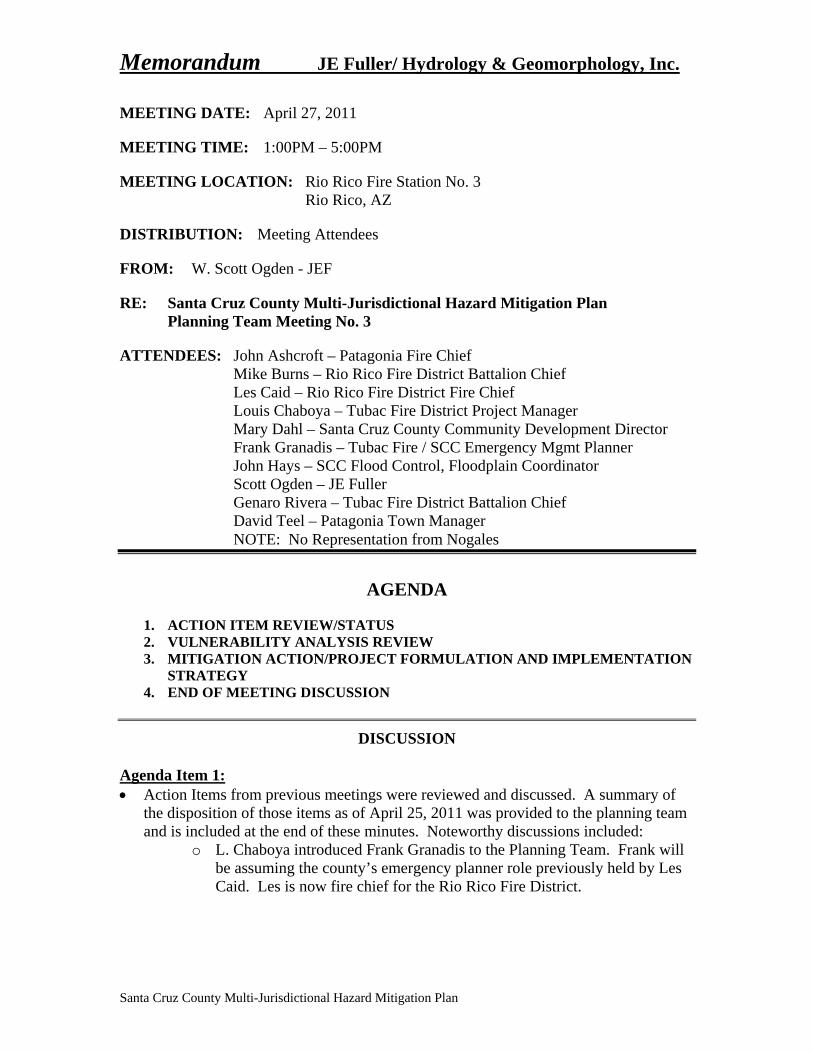
Memorandum JE Fuller/ Hydrology & Geomorphology, Inc.
Santa Cruz County Multi-Jurisdictional Hazard Mitigation Plan
MEETING DATE: April 27, 2011
MEETING TIME: 1:00PM – 5:00PM
MEETING LOCATION: Rio Rico Fire Station No. 3 Rio Rico, AZ
DISTRIBUTION: Meeting Attendees
FROM: W. Scott Ogden - JEF
RE: Santa Cruz County Multi-Jurisdictional Hazard Mitigation Plan Planning Team Meeting No. 3
ATTENDEES: John Ashcroft – Patagonia Fire Chief Mike Burns – Rio Rico Fire District Battalion Chief Les Caid – Rio Rico Fire District Fire Chief Louis Chaboya – Tubac Fire District Project Manager Mary Dahl – Santa Cruz County Community Development Director Frank Granadis – Tubac Fire / SCC Emergency Mgmt Planner John Hays – SCC Flood Control, Floodplain Coordinator Scott Ogden – JE Fuller Genaro Rivera – Tubac Fire District Battalion Chief David Teel – Patagonia Town Manager NOTE: No Representation from Nogales
AGENDA
1. ACTION ITEM REVIEW/STATUS 2. VULNERABILITY ANALYSIS REVIEW 3. MITIGATION ACTION/PROJECT FORMULATION AND IMPLEMENTATION
STRATEGY 4. END OF MEETING DISCUSSION
DISCUSSION
Agenda Item 1: • Action Items from previous meetings were reviewed and discussed. A summary of
the disposition of those items as of April 25, 2011 was provided to the planning team and is included at the end of these minutes. Noteworthy discussions included:
o L. Chaboya introduced Frank Granadis to the Planning Team. Frank will be assuming the county’s emergency planner role previously held by Les Caid. Les is now fire chief for the Rio Rico Fire District.

Meeting Notes – Santa Cruz County Mitigation Planning Team Meeting No. 3 p. 2 JEFuller, Inc. 4/27/2011
Santa Cruz County Multi-Jurisdictional Hazard Mitigation Plan
o Nogales is significantly behind in completing the task assignments and is in jeopardy of being excluded from the Plan. L. Chaboya and F. Granadis will visit with Nogales officials to offer assistance and encourage that they complete the task assignments.
Agenda Item 2: • S. Ogden presented maps depicting the dam failure, flood, HAZMAT, and wildfire
hazard areas and the assets provided by the planning team. County-wide and community specific maps were provided for review and reference when reviewing the results of the vulnerability analysis. Discussions included:
o Dam Failure: The Planning Team thought the Dam Failure inundation limits estimated for the reach of Nogales Wash upstream of the Santa Cruz River confluence, assuming dam failures in Nogales, Sonora, should be more conservative. J. Hays suggested a 75 foot buffer to the 100-year floodplain as a conservative estimate assuming a significant dam failure during a 100-year event. The Planning Team also suggested extending the inundation limits downstream along the Santa Cruz River to the Peck Canyon Road alignment using the SCR 100-year floodplain.
o HAZMAT: The Planning Team noted that the rail line indicated in the ALRIS database that is located east of Elgin is no longer in place and needs to be removed.
o Wildfire: The Planning Team wanted to capture the wildfire hazard posed by the heavy vegetation in the Santa Cruz River floodplain that is not represented by the 2004 WUI statewide coverage. M. Dahl will provide a vegetation mapping layer developed for the SCR to JEF for use in estimating the wildfire hazard.
o S. Ogden will make the requested changes to the hazard profiles and redo the vulnerability analysis as needed.
o S. Ogden will provide the digital versions of the maps to the planning team via the JEF ftp site.
• M. Dahl requested the base GIS data used to prepare the maps. S. Ogden informed her that the request must go through ADEM (Sue Wood).
• Several tables showing exposure/loss estimates to critical facilities, general HAZUS based residential, commercial, and industrial structures, and HAZUS based population estimates, were presented to the planning team for review. Tables detailing hazard exposure data for each critical asset were also provided and S. Ogden explained how the table data correlated to the workmaps.
• S. Ogden explained how HAZUS based population and residential, commercial and industrial building exposure counts were derived and summarized in the tables.
• Each planning team member was assigned the task of reviewing the data and maps and to provide comments/corrections as appropriate.
Agenda Item 3: • S. Ogden reviewed the process of updating the overall mitigation strategy and
specifically the mitigation action/project formulation and implementation strategy.

Meeting Notes – Santa Cruz County Mitigation Planning Team Meeting No. 3 p. 3 JEFuller, Inc. 4/27/2011
Santa Cruz County Multi-Jurisdictional Hazard Mitigation Plan
• S. Ogden led a review/explanation of the various categories of possible mitigation actions/projects and presented information from the 2010 State Plan summarizing various sources of grant funding that may be used for hazard mitigation.
• S. Ogden presented the table/worksheet that will be used to document the actions/projects and implementation strategy. JEF will provide a copy of the table with the actions/projects from the 2006 Plan that were designated as “Keep” or “Revise” already entered.
• Each jurisdiction was instructed to complete the worksheet per the guidelines discussed during the meeting and provide to S. Ogden.
• S. Ogden also explained the new requirement that each jurisdiction participating in the NFIP program, must include at least one mitigation action/project that addresses continued compliance with NFIP requirements. S. Ogden provided a sheet of example of NFIP compliance mitigation action/projects for reference and/or ideas.
Agenda Item 4: • Action Items for this meeting are summarized below. • This was the last meeting. The next steps will be to finish all outstanding
assignments, and get the draft of the Plan completed and in review with the State and Planning Team.
ACTION ITEM SUMMARY:
ITEM NO. DESCRIPTION
RESPONSIBILITY [DUE DATE]
3-1 Planning Team to review VA results and respond with any comments/corrections to S. Ogden
All Jurisdictions [5/13/11]
3-2 S. Ogden to upload the VA workmaps to the JEF ftp and send note to planning team informing of their availability.
S. Ogden [5/5/11]
3-3
JEF to pre-enter the “Keep” and “Revise” designated projects from the Existing Mitigation A/P Evaluation into the Mitigation Action/Project and Implementation Strategy worksheet and send the worksheet to each respective jurisdiction.
JEF [5/5/11]
3-4
Each jurisdiction shall complete the Mitigation Action/Project and Implementation Strategy worksheet, including the addition of any new Mitigation A/Ps and at least one A/P addressing NFIP compliance, and return it JEF
ALL Jurisdictions [5/27/11]

Santa Cruz County Multi-Jurisdictional Hazard Mitigation Plan Update – Action Item Status Report as of April 25, 2011
STATUS
KEY Required for
Plan Approval (NC) Not Complete (IP) In Progress (C) Complete (NA) Not Assigned
ITEM NO. DESCRIPTION
RESPONSIBILITY [DUE DATE]
SAN
TA
CR
UZ
CO
UN
TY
CIT
Y O
F N
OG
AL
ES
TO
WN
OF
PAT
AG
ON
IA
EXPLANATION
1-1 JEF will post the Community Description section (Section 4) of the new draft Plan to the JEF FTP site and provide login credentials to the planning team..
JE Fuller [3/4/11] NA NA NA • 3/3/11 - FTP access to document sent by email
1-2
All jurisdictions are to review and update the Community Descriptions as appropriate and desired. Jurisdictions are to consider including Agriculture, Mining, Manufacturing, and Tourism to their descriptions
All Jurisdictions [4/29/11] C NC C
• 3/29/11 – SCC provided edits and reference material for updating Section 4.
• 4/7/11 – Patagonia responded with no changes except the demographic data.
1-3 L. Caid will provide to JEF the list of organizations/entities that were invited to participate on the planning team.
L. Caid [3/18/11] C NA NA
• 3/14/11 – Received email invite. Still need the list of entities/agencies.
• 3/22/11 – Provided in a follow-up email
1-4 JEF will email electronic version of Local Resources List template to each jurisdiction to track contributors to the plan update.
JE Fuller [3/4/11] NA NA NA • 3/3/11 - sent by email
1-5 Each jurisdiction shall record and document all people contacted or involved as a planning resource at the local level, using the template provided by JEF
All Jurisdictions [4/29/11] C IP C • 3/21/11 – SCC provided completed list.
• 4/7/11 – Patagonia provided completed list.
1-6 S. Ogden to provide a sample public notice for use on the websites and the press release.
JE Fuller [3/4/11] NA NA NA • 3/3/11 - sent by email
1-7 M. Dahl will prepare and disseminate a press release. M. Dahl [3/18/11] C NA NA
• 3/21/11 – PR has been drafted and waiting final approval for release.
• 3/22/11 – PR has been issued
1-8 Each jurisdiction will coordinate a posting of the public notice to their respective website with a link to the county’s webpage.
All Jurisdictions [3/18/11] C NC C • 3/28/11 – SCC website posting is up.
• 4/13/11 – Patagonia website is up.
1-9 JEF will provide digital copies of the historic hazard database files to the planning team for review and update as needed.
JE Fuller [3/4/11] NA NA NA • 3/3/11 - sent by email
1-10 All team members are to review and update the historic hazard database as appropriate and desired by the community.
All Jurisdictions [3/18/11] C NC C • 3/30/11 – Patagonia has nothing to add.
• 4/18/11 – SCC has nothing to add until further notice.
1-11 J. Gomez will meet with his Nogales, Sonora counterpart to determine the location of the two dams and provide that information to JEF.
J. Gomez [3/18/11] NA C NA • 3/24/11 – SCC provided information obtained from
ADEQ.
1-12 JEF to provide a CPRI worksheet to each jurisdiction for completion prior to the next meeting.
JE Fuller [3/4/11] NA NA NA • 3/3/11 - sent by email

Santa Cruz County Multi-Jurisdictional Hazard Mitigation Plan Update – Action Item Status Report as of April 25, 2011
STATUS
KEY Required for
Plan Approval (NC) Not Complete (IP) In Progress (C) Complete (NA) Not Assigned
ITEM NO. DESCRIPTION
RESPONSIBILITY [DUE DATE]
SAN
TA
CR
UZ
CO
UN
TY
CIT
Y O
F N
OG
AL
ES
TO
WN
OF
PAT
AG
ON
IA
EXPLANATION
1-13 All jurisdictions shall complete the CPRI respective to their jurisdiction and return to JEF.
All Jurisdictions [3/18/11] C NC C
• 3/21/11 – SCC provided completed CPRI. • 3/31/11 – Patagonia provided completed CPRI via
email.
1-14 JEF to provide asset inventory data sets to each community for update, correction, or provision of missing data.
JE Fuller [3/4/11] NA NA NA • 3/3/11 - sent by email
1-15 All jurisdictions shall review the 2006 asset inventory and make updates, corrections, and/or provide missing data such as replacement costs.
All Jurisdictions [3/18/11] C NC C
• 3/28/11 – SCC (M. Dahl) provided an updated list of assets.
• 3/30/11 – Patagonia sent updated list.
1-16 JEF will provide the Existing Mitigation Action/Project Evaluation worksheet to each respective jurisdiction for completion.
JE Fuller [3/4/11] NA NA NA • 3/3/11 - sent by email
1-17 All jurisdictions shall complete the Existing Mitigation A/P Evaluation worksheet and return to JEF.
All Jurisdictions [3/18/11] C NC C • 3/28/11 – SCC provided completed document
• 4/7/11 – Patagonia provided completed document.
2-1 M. Dahl to contact Hans Huth at ADEQ for information relating to dams located within Nogales, Sonora.
M. Dahl [4/8/11] C NA NA
• 3/24/11 – M. Dahl provided information received from Hans Huth. Also received other follow-up emails from L. Chaboya and J. Gomez.
2-2 S. Patton to research LEPC meeting minutes for early 2007 to see if the 2006 Plan was reviewed.
S. Patton [4/8/11] C NA NA • 3/23/11 – S. Patton provided excerpts from LEPC
meetings – no review of the 2006 Plan is mentioned.
2-3 S. Ogden to provide capability assessment worksheets to each jurisdiction for completion.
S. Ogden [3/29/11] NA NA NA • 3/29/11 – Sent via email to planning team
2-4 Each jurisdiction shall review, update/edit, and return the capability assessment worksheets to JE Fuller.
All Jurisdictions [4/15/11] C NC C
• 3/30/11 – Patagonia sent updated worksheet via email • 4/19/11 – SCC provided completed worksheet via
email.
2-5 S. Ogden to provide a digital template file for each jurisdiction to use in documenting past mitigation activities
S. Ogden [3/29/11] NA NA NA • 3/29/11 – Sent via email to planning team
2-6 All jurisdictions are to fill in the table documenting past mitigation activities (5-10 years in the past).
All Jurisdictions [4/15/11] C NC C • 3/30/11 – Patagonia sent updated worksheet via email
• 4/18/11 – SCC provided list via email


1
W. Scott Ogden
From: Les Caid [[email protected]]Sent: Monday, March 14, 2011 10:00 AMTo: [email protected]; [email protected];
[email protected]; [email protected]; Cheryl Bender; [email protected]; Marcela Ceballos; [email protected]; Joseph Berring; [email protected]; Raul Mavis; [email protected]; John Ashcroft; NORIEGA, RENE C
Cc: W. Scott Ogden; 'Susan Wood'; [email protected]; Shelly Patton; Patrice Conger; Louie Chaboya; [email protected]; Ramon Romo; Genaro Rivera
Subject: multi-hazard mitigation planning
March 14, 2011
To Whom It May Concern;
In 2005-2006, Santa Cruz County, the City of Nogales, and the Town of Patagonia conducted a year-long, multi-hazard mitigation planning effort that resulted in a multi-jurisdictional hazard mitigation plan (2006 Plan). The 2006 Plan was prepared in compliance with federal regulations set forth by the Disaster Mitigation Act of 2000 (DMA2K), whichrequires local, county, tribal and state governments to develop a multi-hazard mitigation plan for their respective jurisdiction in order to be eligible to receive certain hazard mitigation and public assistance funds. The 2006 Plan was submitted to the Federal Emergency Management Agency (FEMA) and approved in March 2006. The 2006 Plan is set to expire in March 2011.
Santa Cruz County and the incorporated communities of Nogales and Patagonia have organized a planning team and havebegun an effort to review and update the 2006 Plan. Each participating jurisdiction is a stakeholder in the Plan and theupdated document will ultimately be resubmitted to the Arizona Division of Emergency Management (ADEM) andFEMA for review and approval, and formally adopted by each jurisdiction.
The goal of this mitigation planning effort is to reduce or eliminate long-term risk to life and property from natural hazard events. Mitigation is not how we respond to natural disasters like floods and wildfires, but rather how we as a communitycan lessen or prevent the impact of such things in the first place. The mitigation planning process involves identifying andprofiling the natural hazards most likely to occur in a community, assessing vulnerability to these hazards, andestablishing goals, actions, and projects that mitigate the associated risks. The development of this mitigation plan will also ensure continued eligibility on the part of the county and communities for non-emergency, federal hazard mitigation grants.
As a prominent organization in Santa Cruz County, you are invited to attend the upcoming planning team meetings as a representative of the community at large. Public input on the mitigation planning process is important and residents areencouraged to educate themselves about the existing plan and offer comments on the update. The planning team anticipates having a plan draft in mid 2011, at which time the public will be provided the opportunity to review the planand comment.
If you are interested in attending the planning team meetings as a participant or just as an observer, please contact thefollowing:
Les Caid
Santa Cruz County - Public Safety Planner
Lcaid@tubac
520-260-7285

2
Our next meeting is scheduled for March 22nd 1pm‐5pm at Rio Rico Fire Station # 3 (822 Pendleton Drive – Ruby Road)
Regards
Les Caid

1
W. Scott Ogden
From: Les Caid [[email protected]]Sent: Tuesday, March 22, 2011 1:32 PMTo: W. Scott OgdenCc: [email protected]; [email protected]: RE: Santa Cruz County
Scott, Please find below the list of the individual agencies that I contacted via email on 3/14/11 Nogales Unified School District Superintendent Alfredo Velesquez [email protected]‐cruz.az.us Santa Cruz County Chamber of Commerce President‐Olivia Ainza‐Kramer oainza‐[email protected] Santa Cruz County Floodplain Coordinator [email protected]‐cruz.az.us American Red Cross - Cheryl Bender ([email protected]) (www.sccredcross.org) ADWR - Brian Cosson ([email protected]) State Climatologist Office ASU - Nancy Selover ([email protected]) U.S Border Patrol Field Supervisor Agent Rene Noriega UniSource – Utility Provider – Carlos Parra ([email protected]) Town of Patagonia Town Manager – David Teel ([email protected]) Regards Les Caid
From: W. Scott Ogden [[email protected]] Sent: Monday, March 21, 2011 1:58 PM To: 'Mary Dahl' Cc: 'John Hays'; 'Jesus J. Valdez'; 'Kevin J. Irvine'; Les Caid Subject: RE: Santa Cruz County
Hi Mary, Got the files. There are a few more things, but we can discuss them tomorrow. See you then Thanks, Scott
From: Mary Dahl [mailto:[email protected]] Sent: Monday, March 21, 2011 1:03 PM To: W. Scott Ogden Cc: John Hays; Jesus J. Valdez; Kevin J. Irvine; [email protected] Subject: Santa Cruz County Scott – Attached is the unincorporated county CPRI and contact list. We are still working on the asset inventory, but should be close to having it done by tomorrow. Anything else we should have been doing? Mary Dahl, Director Santa Cruz County Department of Community Development 2150 North Congress Drive, Suite 117 Nogales, AZ 85621

2
520.375.7930 520.375.7836 fax
"Santa Cruz County Birthplace of Arizona's History"

In 2005-2006, Santa Cruz County, the City of Nogales, and the Town of Patagonia conducted a year-long, multi-hazard mitigation planning effort that resulted in a multi-jurisdictional hazard mitigation plan (2006 Plan). The 2006 Plan was prepared in compliance with federal regulations set forth by the Disaster Mitigation Act of 2000 (DMA2K), which requires local, county, tribal and state governments to develop a multi-hazard mitigation plan for their respective jurisdiction in order to be eligible to receive certain hazard mitigation and public assistance funds. The 2006 Plan was submitted to the Federal Emergency Management Agency (FEMA) and approved in March 2006. The 2006 Plan is set to expire in March 2011.
Santa Cruz County and the incorporated communities of Nogales and Patagonia have organized a planning team and have begun an effort to review and update the 2006 Plan. Each participating jurisdiction is a stakeholder in the Plan and the updated document will ultimately be resubmitted to the Arizona Division of Emergency Management (ADEM) and FEMA for review and approval, and formally adopted by each jurisdiction.
The goal of this mitigation planning effort is to reduce or eliminate long-term risk to life and property from natural hazard events. Mitigation is not how we respond to natural disasters like floods and wildfires, but rather how we as a community can lessen or prevent the impact of such things in the first place. The mitigation planning process involves identifying and profiling the natural hazards most likely to occur in a community, assessing vulnerability to these hazards, and establishing goals, actions, and projects that mitigate the associated risks. The development of this mitigation plan will also ensure continued eligibility on the part of the county and communities for non-emergency, federal hazard mitigation grants.
As a prominent organization in Santa Cruz County, you are invited to attend the upcoming planning team meetings as a representative of the community at large. Public input on the mitigation planning process is important and residents are encouraged to educate themselves about the existing plan and offer comments on the update. The planning team anticipates having a plan draft in mid 2011, at which time the public will be provided the opportunity to review the plan and comment.
If you are interested in attending the planning team meetings as a participant or just as an observer, please contact the following:
(Point of Contact Name, address & Email Address)

SANTA CRUZ COUNT MULTI-JURISDICTIONAL HAZARD MITIGATION PLAN
Name Jurisdiction/Agency/Organization Department/Division/Branch Title Contributions
John Hays Santa Cruz County Flood Control District Floodplain Coordinator
Kevin Irvine Santa Cruz County Health Department Director Health & Eemergency Management expertise
Mary Dahl Santa Cruz County Community Development Department Director General knowledge of area
Jesus Valdez Santa Cruz County Public Works Department Interim Director Transportation Facilities expertise
John Hays Santa Cruz County Flood Control District Floodplain Coordinator Flood Control and Drainage Structure expertise
Dara Mora Santa Cruz County Liberty Water Company Liberty Water System knowledge
Keith Dojaquez Santa Cruz County Southwestern Utility Management Chief Compliance Officer and VP Valle Verde Water System knowledge
Carlos Robles Santa Cruz County Santa Cruz Valley Unified School District #35 Facilities Manager School District Facilitles knowledge
Gilbert Escobar City of Nogales Fire Department - HAZMAT Coordination Captain Local resource for risk assessment and mitigation strategy information
Alfonso Flores City of Nogales Police Department Detective Local resource for risk assessment and mitigation strategy information
Jesus M. Gomez City of Nogales Fire Department - Fire Prevention & Special Operations Division Chief Primary Community Point of Contact, involved in all levels of Plan update
George X. Lineiro City of Nogales Planning & Zoning Director Local resource for capability assessment and mitigation strategy information
Jose Yanez City of Nogales Public Works Department - Utilities Pretreatment Officer Local resource for risk assessment and mitigation strategy information
SANTA CRUZ COUNTY
NOGALES
Local Planning Teams Page 1 of 2

SANTA CRUZ COUNT MULTI-JURISDICTIONAL HAZARD MITIGATION PLAN
Name Jurisdiction/Agency/Organization Department/Division/Branch Title Contributions
David Teel Town of Patagonia Patagonia - Administration Town Manager Community Point of Contact, Planning Team participant, involved in all aspects of the plan update
John Ashcroft Town of Patagonia Patagonia - Fire Department Fire Chief Secondary point of contact, Planning Team participant, assisting Town Manager in completing update assignments
Joseph A. Patterson Town of Patagonia Patagonia- Marshal's Office Marshal Internal review of Town and county plans
Arcenio De La Ossa Town of Patagonia Patagonia- Public Works Supt of Public Works Internal review of Town and county plans
George Deithorn Town of Patagonia Patagonia- Water Department Water Operation Internal review of Town and county plans
Juan Urias Town of Patagonia Patagonia- Sewer Deparltment Sewer Operation Internal review of Town and county plans
PATAGONIA
Local Planning Teams Page 2 of 2

SANTA CRUZ COUNTY MULTI-JURISDICTIONAL HAZARD MITIGATION PLAN 2011
Appendix C
Public Involvement Records

Santa Cruz County Begins Work on Hazard Mitigation Plan
A planning team comprised of representatives from Nogales, Patagonia and the County as well as emergency response agencies will be meeting regularly to participate in a hazard mitigation planning process. The team will develop a Multi-Jurisdictional Hazard Mitigation Plan for Santa Cruz County, according to The Disaster Mitigation Act of 2000 (DMA2K). The DMA2K requires all local, county, tribal and state governments to have a FEMA approved hazard mitigation plan in order to be eligible for federal hazard mitigation funds. The plan will focus on the area’s most threatening hazards to citizens and property and will provide a strategy to reduce or eliminate the risk from those hazards The planning team anticipates having a plan draft in mid 2011, at which time the public will be provided the opportunity to review the plan and comment. For more information regarding the hazard mitigation planning process/plan, please contact Kevin Irvine at 375-7900.

Home•Services Available•Curious?•Friends of Patagonia Library» •Library History•Legacy Garden» •Library People•Town Info» •KPUP Radio» •META» •
Search... Search
Photo Gallery•Book Sales•Friends’ News•Town Trail Map•
RSS Feed•
Contact•
Patagonia Public Library 346 Duquesne, PO Box 415 Patagonia, AZ 85624
Public Notice of Hazard Mitigation Planning EffortBy admin– April 9, 2011Posted in: Public Notice
Town of Patagonia Begins Work on Hazard Mitigation Plan
A planning team comprised of representatives from the Town of Patagonia and the Patagonia Volunteer Fire Company will be meeting regularly to participate in a hazard mitigation planning process. The team will develop a Multi-Jurisdictional Hazard Mitigation Plan for the Town of Patagonia in cooperation with Santa Cruz County and other local jurisdictions, according to The Disaster Mitigation Act of 2000 (DMA2K).
The DMA2K requires all local, county, tribal and state governments to have a FEMA approved hazard mitigation plan in order to be eligible for federal hazard mitigation funds. The plan will focus on the area’s most threatening hazards to citizens and property and will provide a strategy to reduce or eliminate the risk from those hazards
The planning team anticipates having a plan draft in mid 2011, at which time the public will be provided the opportunity to review the plan and comment.
For more information regarding the hazard mitigation planning process/plan, please contact Dave Teel, Town Manager at Patagonia Town Hall or by e-mail at [email protected]
Comments Closed
Comments are closed. You will not be able to post a comment in this post.
Friends of Patagonia Library•
Donate to Friends of Patagonia Library•
Curious?•
Whether you are just curious or need fast access to accurate information, click on the Curious ? tab on the top of the page. Here you will find a plethora of information ranging from auto repair manuals to legal and health information and scholarly articles from a wide range of journals.
Page 1 of 2Public Notice of Hazard Mitigation Planning Effort
4/13/2011http://www.patagoniapubliclibrary.org/?p=1391

Tel. 520.394.2010 Fax. 520.394.2113
Email:[email protected]
Click for Map
Hours•
Mon - Fri : 10.00 am. - 5.00 pm. Sat : 10.00 am. - 2.00 pm. Sun : Closed
•
Search: GO
About Arras WordPress Theme : admin login
Copyright Patagonia Public Library. All Rights Reserved.
What’s inside?•
Curious?◦Friends of Patagonia Library◦
Friends’ Events■Book Sales■
Friends’ News■KPUP Radio ◦
Listen to “Community Talk”
■
Legacy Garden ◦Dig in day : Oct 17, 2009■The garden in bloom: April 1, 2011
■
Library History◦Library People◦META ◦
META 2010 Meetings Schedule
■
Town Trail Map■Patagonia Museum◦
Bylaws■In The News■Minutes of Meeting■Photo Gallery■Up Coming Monthly Meeting
■
Services Available◦Town Info ◦
Patagonia General Plan 2009
■
Page 2 of 2Public Notice of Hazard Mitigation Planning Effort
4/13/2011http://www.patagoniapubliclibrary.org/?p=1391
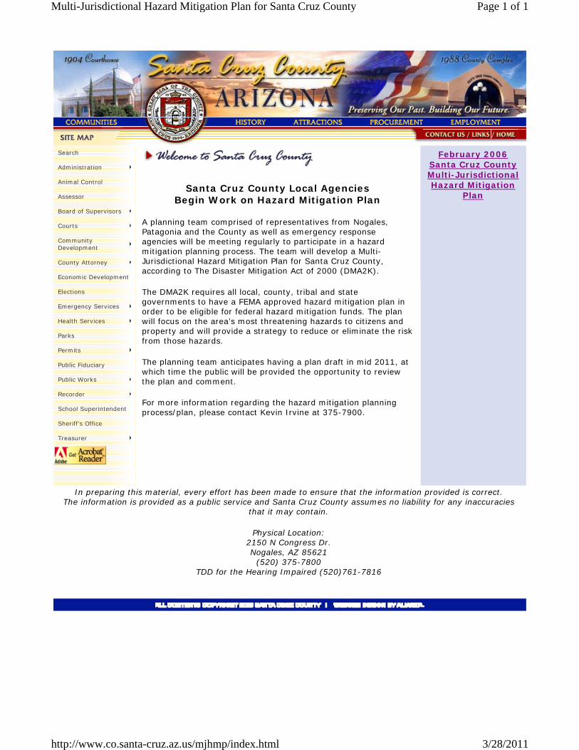
Santa Cruz County Local Agencies Begin Work on Hazard Mitigation Plan
A planning team comprised of representatives from Nogales, Patagonia and the County as well as emergency response agencies will be meeting regularly to participate in a hazard mitigation planning process. The team will develop a Multi-Jurisdictional Hazard Mitigation Plan for Santa Cruz County, according to The Disaster Mitigation Act of 2000 (DMA2K).
The DMA2K requires all local, county, tribal and state governments to have a FEMA approved hazard mitigation plan in order to be eligible for federal hazard mitigation funds. The plan will focus on the area’s most threatening hazards to citizens and property and will provide a strategy to reduce or eliminate the risk from those hazards.
The planning team anticipates having a plan draft in mid 2011, at which time the public will be provided the opportunity to review the plan and comment.
For more information regarding the hazard mitigation planning process/plan, please contact Kevin Irvine at 375-7900.
February 2006 Santa Cruz County Multi-Jurisdictional Hazard Mitigation
Plan
In preparing this material, every effort has been made to ensure that the information provided is correct. The information is provided as a public service and Santa Cruz County assumes no liability for any inaccuracies
that it may contain.
Physical Location: 2150 N Congress Dr. Nogales, AZ 85621
(520) 375-7800 TDD for the Hearing Impaired (520)761-7816
Search
Administration
Animal Control
Assessor
Board of Supervisors
Courts
Community Development
County Attorney
Economic Development
Elections
Emergency Services
Health Services
Parks
Permits
Public Fiduciary
Public Works
Recorder
School Superintendent
Sheriff's Office
Treasurer
Page 1 of 1Multi-Jurisdictional Hazard Mitigation Plan for Santa Cruz County
3/28/2011http://www.co.santa-cruz.az.us/mjhmp/index.html

February 2006 Santa Cruz County Multi-Jurisdictional Hazard Mitigation Plan
Main Report (30MB)
Appendix B - Profiles Santa Cruz County
Nogales
Patagonia
Rio Rico
Tubac
Appendix C Frequently Asked Questions
January 2006 Press Release (3MB)
Meeting Sign in sheet
Appendix E Interim Draft - Community profiles and hazard
identification/profiles (66MB)
Appendix F Summary of Historical Hazards
Appendix H Asset Inventory and Detailed Vulnerability Analysis
Results (65MB)
For more information regarding the hazard mitigation planning process/plan, please contact Kevin Irvine at 375-7900.
<< Back
In preparing this material, every effort has been made to ensure that the information provided is correct. The information is provided as a public service and Santa Cruz County assumes no liability for any inaccuracies
that it may contain.
Physical Location: 2150 N Congress Dr. Nogales, AZ 85621
(520) 375-7800 TDD for the Hearing Impaired (520)761-7816
Search
Administration
Animal Control
Assessor
Board of Supervisors
Courts
Community Development
County Attorney
Economic Development
Elections
Emergency Services
Health Services
Parks
Permits
Public Fiduciary
Public Works
Recorder
School Superintendent
Sheriff's Office
Treasurer
Page 1 of 1Multi-Jurisdictional Hazard Mitigation Plan for Santa Cruz County
3/28/2011http://www.co.santa-cruz.az.us/mjhmp/02-2006Plan.html

SANTA CRUZ COUNTY MULTI-JURISDICTIONAL HAZARD MITIGATION PLAN 2011
Appendix D
Detailed Historic Hazard Records

State FederalDrought 5A 211,499$ -$ Dam Failure 0 -$ -$ Earthquake 0 -$ -$ Extreme Heat 0 -$ -$ Fissure 0 -$ -$ Flooding / Flash Flooding 15 39,484,704$ 303,670,820$ Landslide / Mudslide 0 -$ -$ Levee Failure 0 -$ -$ Severe Wind 0 -$ -$ Subsidence 0 -$ -$ Wildfire 16 5,685,834$ -$ Winter Storm 0 -$ -$
Source: ADEM - Recovery Section, October 2010
2010 State Plan Hazard Categories
Arizona Declared Events ThatIncluded Santa Cruz CountyJanuary 1966 to August 2010
No. of Events
Total Expenditures
ITEM A - 3 of these events are USDA declarations for 1999, 2001, and 2002GENERAL NOTES:- Damage Costs are reported as is and no attempt has been made to adjust costs to current dollar values.- Only a portion of the reported expenditures were spent in the subject county.

No. ofHazard Declarations Fatalities Injuries Damage Costs ($)
Drought 5 0 0 $300,000,000Dam Failure 0 0 0 $0Earthquake 0 0 0 $0Extreme Heat 0 0 0 $0Fissure 0 0 0 $0Flooding / Flash Flooding 15 39 1087 $1,291,955,000Landslide / Mudslide 0 0 0 $0Levee Failure 0 0 0 $0Severe Wind 0 0 0 $0Subsidence 0 0 0 $0Wildfire 18 0 0 $0Winter Storm 0 0 0 $0
Recorded Losses
Notes:- Damage Costs are reported as is and no attempt has been made to adjust costs to current dollar values. Sources: ADEM, FEMA, USDA, NCDC, NWS,
State and Federally Declared Events That Included Santa Cruz CountyJanuary 1966 to August 2010

State of Arizona Declaration Federal Presidential DeclarationDate Hazard State PCA No. Expenditures Date ID Expenditures Counties Affected Description
4/28/1973 Wildfire $36,718 Statewide1/7/1974 Service Interruption $199,028 Statewide Energy Shortage
4/22/1975 Wildfire $8,923 Statewide
9/2/1977 Infestation Statewide
Cotton Crop Pesticide Application
10/9/1977 Tropical Storm / Hurricane $298,422 11/04/77 540-DR Pima, Pinal, Santa Cruz
DR-540: Tropical Storm Heather caused four days of heavy rains and severe flooding in the Santa Cruz and San Pedro Rivers. The greatest destruction was along the Santa Cruz between Nogales and Marana, where peak discharge occurred. Four-day rainfall amounts ranged from 4 to 14 inches, exceeding average annual precipitation amounts in some places. 700 people were evacuated from their homes, and severe damage occurred to crops, livestock, water supplies, and property. Property damage in Pima, Pinal, and Santa Cruz Counties was an estimated $15.2 million
3/2/1978 Flooding $485,718 03/04/78 550-DR $67,122,627 Statewide
Warm temeratures accompanied by heavy rain filled reservoirs behind all of the dams on the Salt and Verde Rivers and forced large volumes of runoff to be released. This was the largest flow of water down tSalt since 1891. The released water overflowed the channel and flooded residential areas and farmlands. During the same period storm fronts passing over the state caused flash flooding and destruction. 9.53 inches of rainfall occurred on Mt Lemmon. Overflows of the Gila River flooded Duncan and 1000-2000 acres of farmland in Safford Valley. The Rillito Creek, Pantano and Tanque Verde Creeks in Tucson were near bankfull. Total damage was approximately $65.9 million, of which $37 million was attributed to Maricopa County alone. Thousands of homes were damaged and 116 homes were destroyed. More than 7,000 people had to be sheltered and four people lost their lives.
For Maricopa County - the storm centered over the mountains north and east of Phoenix, 35 miles north at Rock Springs. Extrapolation of intensity-probability data: 5.73 in./ 24 hr. equates to a 400 yr. storm.
4/21/1978 Wildfire $11,528 Statewide
11/30/1978 Prison Problem $425 Statewide
Prison Break
12/16/1978 Flooding $1,909,498 12/21/78 570-DR $113,561,122 Statewide
Following the spring flooding, Arizona was hit hard again in December 16th-20th. Total precipitation ranged from less than 1 inch in the northeastern and far southwestern portions of Arizona to nearly 10 inches in the Mazatzal Mountains northeast of Phoenix. A large area of the central mountains received over 5 inches. The main stems of the Gila, Salt, Verde, Agua Fria, Bill Williams, and Little Colorado Rivers, as well as a number of major tributaries, experienced especially large discharges. The flooding areas with the most significant damages included the Little Hollywood District near Safford and major portions of Duncan, Clifton, Winslow, and Williams. Damages were estimated at $39,850,000. 10 people die and thousands are left homeless. Severe damage to roads and bridges. For Maricopa County, 4 deaths, $16.3 million-public and $5 million-agriculture losses estimated. ["Flood Damage Report, Phoenix Metropolitan Area, December 1978 Flood", November 1979, U.S. Army Corps of Engineers, FCDMC Library #802.027]
4/16/1979 Wildfire $204,207 Statewide
6/2/1980 Wildfire $298,845 Statewide
6/16/1980 Wildfire Statewide
AZ Executive Order 81-5: [Terminating the Declaration of a State of Emergency of June 16, 1980 (caused by a severe forest and grassland fire contingency) and returning all unexpended funds authorized by A.R.S. º 35-192 to the General Fund.
8/21/1980 Flooding 29454 $102,319 Santa Cruz
Very heavy rains in the area and upstream on the Santa Cruz River in Mexico caused considerable flood damage to mobile homes, houses, commercial buildings and streets in Santa Cruz County
6/26/1981 Wildfire Statewide Fire suppression assitance
6/30/1981 Wildfire $256,904 Statewide6/30/1982 Wildfire $492,635 Statewide
3/6/1983 Flooding $104,335 Santa Cruz
Declared Event Details Page 1

State of Arizona DeclarationDate Hazard
4/28/1973 Wildfire1/7/1974 Service Interruption
4/22/1975 Wildfire
9/2/1977 Infestation
10/9/1977 Tropical Storm / Hurricane
3/2/1978 Flooding
4/21/1978 Wildfire
11/30/1978 Prison Problem
12/16/1978 Flooding4/16/1979 Wildfire
6/2/1980 Wildfire
6/16/1980 Wildfire
8/21/1980 Flooding6/26/1981 Wildfire
6/30/1981 Wildfire6/30/1982 Wildfire
3/6/1983 Flooding
Damage EstimatesFatalities Injuries Property Crop/Livestock Total Sources
$0 ADEM, 2008$0 ADEM, 2008
$0 ADEM, 2008
$0 ADEM, 2008
$15,200,000 $15,200,000
ADEM, 2008; Tucson NWS, 2008 at http://www.wrh.noaa.gov/twc/hydro/floodhis.php
4 $65,900,000 $65,900,000
ADEM, 2008; Tucson NWS, 2008 at http://www.wrh.noaa.gov/twc/hydro/floodhis.php; AFMA Flood Happens, Fall 2003
$0 ADEM, 2008
$0 ADEM, 2008
10 $39,850,000 $39,850,000
ADEM, 2008; Tucson NWS, 2008 at http://www.wrh.noaa.gov/twc/hydro/floodhis.php; AFMA Flood Happens, Fall 2003
$0 ADEM, 2008
$0 ADEM, 2008
$0 ADEM, 2008
$0 ADEM, 2008; NCDC, 2010$0 ADEM, 2008
$0 ADEM, 2008$0 ADEM, 2008$0 ADEM, 2008
Declared Event Details Page 2
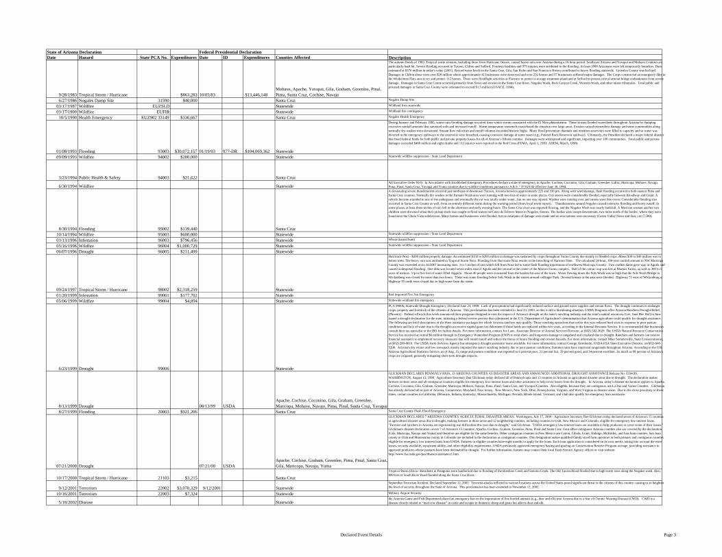
State of Arizona Declaration Federal Presidential DeclarationDate Hazard State PCA No. Expenditures Date ID Expenditures Counties Affected Description
9/28/1983 Tropical Storm / Hurricane $863,283 10/05/83 $13,446,148Mohave, Apache, Yavapai, Gila, Graham, Greenlee, Pinal, Pima, Santa Cruz, Cochise, Navajo
The autumn floods of 1983. Tropical storm remains, including those from Hurricane Octave, caused heavy rain over Arizona during a 10-hour period. Southeast Arizona and Yavapai and Mohave Counties are particularly hard hit. Severe flooding occurred in Tucson, Clifton and Safford. Fourteen fatalities and 975 injuries were attributed to the flooding. At least 1000 Arizonans were left temporarily homeless. Damaestimated at $370 million in today's value (2001). Record water levels in the Santa Cruz, Gila, San Pedro and San Francisco Rivers contributed to heavy flooding statewide. Greenlee County was hit hard. Damages in Clifton alone were over $20 million where approximately 41 businesses were destroyed and over 231 homes and 57 businesses suffered major damages. The Corps constructed an emergency dike in the Winkelman Flats area to try and protect 112 homes. There were floodfight activities at Florence to protect a sewage treatment pland and at Safford to protect critical arterial bridge embankment from severe damage. Damages in Santa Cruz Count occurred primarily from flows and erosion in the Santa Cruz River, Nogales Wash, Peck Canyon Creek, Western Wash, and other minor tributaries. Total public and privated damages in Santa Cruz County were estimated to exceed $1.5 million (USACE, 1994).
6/27/1986 Nogales Dump Site 31590 $40,000 Santa Cruz Nogales Dump Site.
03/17/1987 Wildfire EUZSLD Statewide Wildland fires statewide
03/17/1990 Wildfire EUFIR Statewide Wildland fire contingency
10/5/1990 Health Emergency EUZ902 33149 $336,667 Santa Cruz Nogales Health Emergency
01/08/1993 Flooding 93003 $30,072,157 01/19/93 977-DR $104,069,362 Statewide
During January and February 1993, winter rain flooding damage occurred from winter storms associated with the El Nino phenomenon. These storms flooded watersheds throughout Arizona by dumping excessive rainfall amounts that saturated soils and increased runoff. Warm temperature snowmelt exacerbated the situation over large areas. Erosion caused tremendous damage and some communities along normally dry washes were devastated. Stream flow velocities and runoff volumes exceeded historic highs. Many flood prevention channels and retention reservoirs were filled to capacity and so water was diverted to the emergency spillways or the reservoirs were breached, causing extensive damage in some cases (e.g., Painted Rock Reservoir spillway). Ultimately, the President declared a major federal disaster that freed federal funds for both public and private property losses for all of Arizona’s fifteen counties. Damages were widespread and significant, impacting over 100 communities. Total public and private damages exceeded $400 million and eight deaths and 112 injuries were reported to the Red Cross (FEMA, April 1, 1993; ADEM, March, 1998).
09/09/1993 Wildfire 94002 $200,000 Statewide Statewide wildfire suppression - State Land Department
3/23/1994 Public Health & Safety 94003 $21,622 Santa Cruz
6/30/1994 Wildfire StatewideAZ Executive Order 94-9: In Accordance with Established Emergency Procedures declare a state of emergency in Apache, Cochise, Coconino, Gila, Graham, Greenlee, LaPaz, Maricopa, Mohave, Navajo, Pima, Pinal, Santa Cruz, Yavapai and Yuma counties due to wildfire conditions pursuant to A.R.S. º 37-623.02 effective June 30, 1994.
8/30/1994 Flooding 95002 $139,440 Santa Cruz
A devastating severe thunderstorm occurred just northeast of downtown Tucson, Arizona between approximately 225 and 330 pm. Along with wind damage, flash flooding occurred in both eastern Pima and Santa Cruz counties. Normally dry washes in the Pantano Wash area were running with two feet of water in some places. City streets were considerably flooded, especially between Broadway and Grant. A vehicle became stranded in one of the underpases and eventually the car was totally under water...but no one was injured. Washes were running over and streets were like rivers. Considerable flooding also occurred in Santa Cruz County as well, from an entirely different storm during the warning period (from local storm report). Thunderstorms around Nogales caused extensive flooding and heavy runoff. In some places, at least three inches of rain fell in the afternoon and early evening hours. The Santa Cruz river was reported flowing, and the Nogales Wash was nearly bankfull. A Mexican woman and her two children were drowned when their pickup truck was caught in flood waters on Cinco de Febrero Street in Nogales, Sonora. The bodies were swept downstream, two miles north of the border, where they were found near the Chula Vista subdivision. Many homes and businesses were flooded, but no estimates of damage were made and no evacuations were necessary (Green Valley News and Sun, circ:7,500).
10/14/1994 Wildfire 95003 $600,000 Statewide Statewide wildfire suppression - State Land Department
03/13/1996 Infestation 96003 $796,456 Statewide Wheat (karnal bunt)
05/16/1996 Wildfire 96004 $1,000,729 Statewide Statewide wildfire suppression - State Land Department
06/07/1996 Drought 96005 $211,499 Statewide
09/24/1997 Tropical Storm / Hurricane 98002 $2,318,259 Statewide
Hurricane Nora - $200 million property damage. An estimated $150 to $200 million in damage was sustained by crops throughout Yuma County due mainly to flooded crops. About $30 to $40 million was to lemon trees. The heavy rain was attributed to Tropical Storm Nora. Flooding from Hurricane Nora results in the breaching of Narrows Dam. The calculated 24-hour, 100-year rainfall amount in NW Maricopa County was exceeded at six ALERT measuring sites. 3 to 5 inches of rain which fell from Nora led to some flash flooding inportinons of northwest Maricopa County. Two earthen dams gave way in Aguila and caused widespread flooding. One dike was located seven miles east of Aguila and the second in the center of the Martori Farms complex. Half of the cotton crop was lost at Martori Farms, as well as 300 to 5acres of melons. Up to five feet of water filled Aqguila. About 40 people were evacuated from the hardest hit area of the town. Water flowing down the Sols Wash was so high that the Sols Wash Bridge in Wickenburg was closed for more than two hours. There was some flooding below Sols Wash in the streets around coffinger Park. Several houses in the area were flooded. Highway 71 west of Wickenburg anHighway 95 north were closed due to high water form the storm.
01/20/1999 Infestation 99001 $177,702 Statewide Red Imported Fire Ant Emergency
05/06/1999 Wildfire 99004 $4,894 Statewide Statewide wildland fire emergency
6/23/1999 Drought 99006 Statewide
PCA 99006; Statewide Drought Emergency, Declared June 23, 1999: Lack of precipitation had significantly reduced surface and ground water supplies and stream flows. The drought continues to endanger crops, property and livestock of the citizens of Arizona. This proclamation has been extended to June 23, 2003, as this is still a threatening situation. USDA Programs offer Arizona Ranchers Drought Relief, (Phoenix) - Federal officials this week announced three programs designed to ease the impact of Arizona's drought on the state's ranching industry and the state's natural resources. Gov. Jane Dee Hull in June issued a drought declaration for the state, initiating a federal review process that culminated in the U.S. Department of Agriculture's determination that Arizona agriculture could qualify for drought assistance. The following are brief descriptions of the three assistance packages for which Arizona ranchers may qualify: Those ranching operations that earlier this year reduced herd sizes in response to poor pasture conditions and lack of water due to the drought can receive capital gains tax deferment if those herds are replaced within two years, according to the Internal Revenue Service. It is recommended that businesses consult their tax specialist or the IRS for further details. For more information, contact Joe Lane, Associate Director of Animal Services Division, at (602) 542-3629. The USDA Natural Resource Conservation Service has received an initial $6 million through its Emergency Watershed Program (EWP) to treat short- and long-term damage to rangeland and cropland due to drought. Ranchers and farmers can receive financial assistance to implement recovery measures that will retard runoff and reduce the threat of future flooding and erosion hazards. For more information, contact Mike Sommerville, State Conservationist, at (602) 280-8810. The USDA Farm Services Agency has emergency drought assistance loans available. For more information, contact George Arredondo, USDA/FSA State Executive Director, at (602) 640-5200. Arizona's dry winter and low snowpack mostly impacted the state's ranching industry due to poor pasture conditions. Summer rains have improved rangelands throughout Arizona. According to the USDArizona Agricultural Statistics Service, as of Aug. 15, range and pasture condition was reported as 6 percent poor, 21 percent fair, 39 percent good, and 34 percent excellent. As much as 99 percent of Arizona's crops are irrigated, generally mitigating short-term drought impacts.
8/13/1999 Drought 08/13/99 USDAApache, Cochise, Coconino, Gila, Graham, Greenlee, Maricopa, Mohave, Navajo, Pima, Pinal, Santa Cruz, Yavapai
GLICKMAN DECLARES PENNSYLVANIA, 13 ARIZONA COUNTIES AS DISASTER AREAS AND ANNOUNCES ADDITIONAL DROUGHT ASSISTANCE Release No. 0334.99, WASHINGTON, August 13, 1999 Agriculture Secretary Dan Glickman today declared all of Pennsylvania and 13 counties in Arizona as agricultural disaster areas due to drought. The declaration makes farmers in those areas and all contiguous counties eligible for emergency low-interest loans and other assistance to help cover losses from the drought. In Arizona, today's disaster declaration applies to Apache, Cochise, Coconino, Gila, Graham, Greenlee, Maricopa, Mohave, Navajo, Pima, Pinal, Santa Cruz, and Yuvapai Counties. Also eligible, because they are contiguous, are La Paz and Yuma Counties. Glickman has already declared all or part of Arizona, Connecticut, Maryland, New Jersey, New Mexico, New York, Ohio, Pennsylvania, Virginia, and West Virginia as disaster areas. Due to the close proximity to these states, certain counties in California, Delaware, Indiana, Kentucky, Massachusetts, Michigan, Nevada, Rhode Island, Vermont, and Utah also qualify for emergency loan assistance.
8/27/1999 Flooding 20003 $921,206 Santa Cruz Santa Cruz County Flash Flood Emergency
07/21/2000 Drought 07/21/00 USDAApache, Cochise, Graham, Greenlee, Pima, Pinal, Santa Cruz, Gila, Maricopa, Navajo, Yuma
GLICKMAN DECLARES 7 ARIZONA COUNTIES AGRICULTURAL DISASTER AREAS: Washington, July 17, 2000 - Agriculture Secretary Dan Glickman today declared seven of Arizona's 15 counties as agricultural disaster areas due to drought, making farmers in those areas and 12 neighboring counties, including counties in Utah, New Mexico and Colorado, eligible for emergency low-interest loans. "Farmers and ranchers in Arizona are experiencing real difficulties this year due to drought," said Glickman. "USDA emergency low-interest loans are available to help producers to cover some of their losses." Glickman's disaster declaration covers 7 of Arizona's 15 counties: Apache, Cochise, Graham, Greenlee, Pima, Pinal and Santa Cruz. Four other contiguous Arizona counties also are covered by the declaration (Gila, Maricopa, Navajo and Yuma) and therefore are eligible for the same benefits. Other contiguous counties in New Mexico are Catron, Cibola, Grant, Hidalgo, McKinley, and San Juan counties. San Juan county in Utah and Montezuma county in Colorado are included in the declaration as contiguous counties. This designation makes qualified family-sized farm operators in both primary and contiguous counties eligible for emergency low-interest loans from USDA. Farmers in eligible counties have eight months to apply for the loans. Each loan application is considered on its own merits, taking into account the extenlosses, security available, repayment ability, and other eligibility requirements. USDA previously approved emergency haying and grazing on Conservation Reserve Program acreage, providing assistance to approved producers whose pastures have been decimated by drought. For further information, farmers may contact their local Farm Service Agency offices or visit website: http://www.fsa.usda.gov/pas/disaster/assistance1.htm.
10/17/2000 Tropical Storm / Hurricane 21103 $3,215 Santa Cruz
Tropical Storm Olivia - Residents in Patagonia were landlocked due to flooding of the Harshaw Creek and Sonoita Creek. The Old Tucson Road flooded due to high water rises along the Nogales wash. Also, 800 feet of South River Road flooded along the Santa Cruz River.
9/12/2001 Terrorism 22002 $3,070,329 9/12/2001 StatewideSeptember Terrorism Incident, Declared September 12, 2001: Terrorist attacks inflicted in various locations across the United States posed significant threat to the citizens of this country causing us to heighten the level of security throughout the State of Arizona. This proclamation has been extended to November 12, 2002.
10/16/2001 Terrorism 22003 $7,324 Statewide Military Airport Security
5/18/2002 Disease Statewidethe Arizona Game and Fish Department placed an emergency ban on the importation of live hoofed animals (e.g., deer and elk) into Arizona due to a fear of Chronic Wasting Disease (CWD). CWD is a disease closely related to “mad cow disease” in cattle and scrapie in domestic sheep and goats but affects dear and elk.
Declared Event Details Page 3

State of Arizona DeclarationDate Hazard
9/28/1983 Tropical Storm / Hurricane6/27/1986 Nogales Dump Site
03/17/1987 Wildfire03/17/1990 Wildfire
10/5/1990 Health Emergency
01/08/1993 Flooding09/09/1993 Wildfire
3/23/1994 Public Health & Safety
6/30/1994 Wildfire
8/30/1994 Flooding10/14/1994 Wildfire03/13/1996 Infestation05/16/1996 Wildfire06/07/1996 Drought
09/24/1997 Tropical Storm / Hurricane01/20/1999 Infestation05/06/1999 Wildfire
6/23/1999 Drought
8/13/1999 Drought8/27/1999 Flooding
07/21/2000 Drought
10/17/2000 Tropical Storm / Hurricane
9/12/2001 Terrorism10/16/2001 Terrorism
5/18/2002 Disease
Damage EstimatesFatalities Injuries Property Crop/Livestock Total Sources
14 975 $370,000,000 $370,000,000 ADEM, 2008; NCDC, 2010$0 ADEM, 2008$0 ADEM, 2008$0 ADEM, 2008$0 ADEM, 2008
8 112 $330,000,000 $70,000,000 $400,000,000 ADEM, 2008; NCDC, 2010$0 ADEM, 2008
$0 ADEM, 2008
$0 ADEM, 2008
3 $0http://www.wrh.noaa.gov/twc/hydro/floodhis.php#AUG191994
$0 ADEM, 2008$0 ADEM, 2008$0 ADEM, 2008$0 ADEM, 2008
$200,000,000 $175,000,000 $375,000,000 ADEM, 2008; NCDC, 2010$0 ADEM, 2008$0 ADEM, 2008
$0 ADEM, 2008
$0 ADEM, 2008$0 ADEM, 2008
$0 ADEM, 2008
$5,000 $5,000 ADEM, 2008; NCDC, 2010
$0 ADEM, 2008$0 ADEM, 2008
$0 ADEM, 2008
Declared Event Details Page 4

State of Arizona Declaration Federal Presidential DeclarationDate Hazard State PCA No. Expenditures Date ID Expenditures Counties Affected Description
07/11/2002 Drought 07/11/02 USDA Statewide
VENEMAN ANNOUNCES EXPANSION OF CRP EMERGENCY HAYING AND GRAZING PROGRAM FOR WEATHER-STRICKEN STATES, WASHINGTON, July 11, 2002 - Agriculture Secretary Ann M. Veneman today approved 18 states for Conservation Reserve Program emergency haying and grazing statewide, making all CRP participants in these states basically eligible for this emergency measure. Veneman also said USDA will waive rental reduction fees to encourage donation of hay to farmers and ranchers in immediate need. "Drought and severe weather conditions have depleted hay stocks and grazing lands across the country," said Veneman. "This approval provides immediate relief to livestock producers and encourages donations of hay to producers who need immediate assistance." The 18 approved states are: Arizona, Colorado, Georgia, Idaho, Kansas, Minnesota, Montana, Nebraska, New Mexico, North Carolina, North Dakota, Oklahoma, South Carolina, South Dakota, Texas, Utah, Virginia and Wyoming.ARIZONA FARMERS FACING CATASTROPHE ... Arizona officials are saying that the losses from the livestock industry alone last year will be upward of $300 million. …
5/2/2003 Wildfire 23003 $2,378,020 StatewideForest Health Emergency - As a result of the on-going drought conditions the forests within our state have been infested with the Pine Bark Beetle. This proclamation will expedite the clearing of dead, dying and diseased trees and other vegetation that interfere with emergency response and evacuation needs.
9/23/2004 Infestation 25003 $197,421 La Paz, Pima, Santa Cruz, Yuma Mediterreanean Fruit Fly Emergency
8/15/2005 Border Security 26001 $1,492,758 Cochise, Pima, Santa Cruz, Yuma Border Security Emergency
2/22/2006 Wildfire 26006 $192,390 Statewide
On February 22, 2006, the Governor declared an emergency due to the driest winter in recorded history coupled with above average temperatures and the earliest recorded start to a wildfire season. The entire state was threatened by extreme wildfire hazards. The 2006 state wildfire presuppression resources strategy required additional financial support. The declaration provided $200,000 for pre-suppression resources to the Arizona State Land Department, Office of State Forester and the Arizona Division of Emergency Management.
6/23/2006 Infestation 26008 $567,257 Cochise, Maricopa, Pima, Pinal, Santa Cruz, Yuma
Glassy-winged sharpshooter infestation - The Glassy-Winged Sharpshooter is a known vector of Xyella fastidiosa, a bacteria that causes plant diseases such asPierce’s disease of grapes, almond leaf scorch, alfalfa dwarf, oleander leaf scorch, and citrus verigated chlorosis, that threaten the viability of wine, citrus and other agricultural and horticultural industries as well as public landscapes. The Glassy-Winged has been detected in Arizona in a small isolated location in the city of Sierra Vista, Cochise County.The Arizona Department of Agriculture has been placing detection traps, monitoring and eradicating the Sharpshooter.
8/28/2007 Flooding 28001 $131,052 Santa Cruz
Nogales Wash Emergency - Portions of downtown Nogales experienced flash flooding. Extensive damage occurred to the Nogales Wash, which is a concrete wash that flows through the city of Nogales. City officials estimated damage at $10 million on the U.S. side of the border. Scattered thunderstorms across Southeast Arizona caused hail and wind damage in Tucson and flash flooding in Nogales.
7/15/2008 Flooding 29001 $203,681 Santa Cruz
Nogales Wash 2008 Emergency - Heavy rainfall on the Mexican side of the border caused flash flooding in the city of Nogales, Arizona. This was caused by a damaged portion of the underground Nogales Wash. Local emergency management reported that water burst through the underground wash onto the surface just across the International Border. The border wall acted as a dam, keeping most of the flooding on the Mexican side. However, some water did flow through the port of entry into downtown Nogales, Arizona. Several businesses in the downtown business district experienced flooding and two illegal immigrants found two days later in the underground wash are also believed to have drowned due to this flooding. In addition, three illegal immigrants in an underground flood channel beneath the international border were rescued. Slow moving thunderstorms developed in a very moist environment across Southeast Arizona resulting in areas of flash flooding.
1/21/2010 Winter Storm 20102 $4,497,895 3/18/2010 1888-DR $14,210,904Apache, Coconino, Gila, Greenlee, La Paz, Maricopa, Mohave, Navajo, Yavapai, Hopi Tibe, Navajo Nation
About 10 inches of snow occurred in Northern Greenlee County around Rose Peak and Hannagan Meadow. A strong Pacific winter storm produced moderate valley rain and mountain snow to much of southeast Arizona. Heavy snow combined with strong winds to produce significant blowing and drifting at the higher elevations. Strong gusty winds also affected many valley locations during the evening hours of the 19th and the early morning hours of the 20th. Six inches of snow fell at 6700 feet 6 miles south of Prescott. A strong winter storm hit northern Arizona with widespread snow and rain. Heavy snow fell along the Eastern Mogollon Rim. Snowfall totals for this one storm include: Clints Well 16 inches, Heber 13 inches, Clay Springs 14 to 15 inches, and Forest Lakes 16 inches. The second in a series of strong Pacific storms moved across northern Arizona with widespread heavy precipitation. The snow level dropped down to between 5000 and 5500 feet elevation by the storm moved east. The Governor Jan Brewer signed a Declaration of Emergency and released $200,000 to pay for emergency responses and and recovery expenses from the weather events. Declared that a State of Emergency in Apache, Coconino, Gila, Greenlee, La Paz, Maricopa, Mohave, Navajo, and Yavapai Counties due to the 2010 Winter Storm beginning January 21, 2010. President Obama approved the Governor's request for Emergency Declaration in support of life and property-saving operations on Hopi Tribe and Navajo Nation lands within Apache, Coconino and Navajo counties. Isolation of some communities and rough terrain, compounded with snow accumulations, has complicated delivery of assistance like fuel, food and medical provisions. An additional $1 million was approved by Governor Brewer to cover state-share costs. Response efforts for the Hopi Tribe and Navajo Nation were named Operation Winter Storm and pooled the resources of federal, state and local agencies. Over nine days, 42,500 meals, 21,780 gallons of water, 279 cots, 5,475 blankets and over 800 wood bundles were delivered by air and ground transport.
8/4/2010 Flooding 11003 $500,000 10/4/2010 1940-DR Greenlee, Santa Cruz
Monsoon 2010 Flooding Emergency: On July 19, 2010, through July 29, 2010, a series of potent monsoon thunderstorms causing high winds and flash floods damaged many locations in southeastern Arizona. The heavy rains resulted in unusually strong flooding events and caused extreme peril to public health and safety in two primary areas: Wards Canyon in Greenlee County and the Nogales Wash in Santa Cruz County. On July 29, 2010 both the Town of Clifton and Greenlee County declared a state of emergency for this event, followed on July 30, 2010 by Santa Cruz County, stating that this monsoon event has created a situation above and beyond their capabilities and they are requesting assistance from the State. These water flows caused extensive damages to public infrastructure and threatened resources that provide essential life services to Greenlee and Santa Cruz residents, primarily roads and sewer lines.
Declared Event Details Page 5

State of Arizona DeclarationDate Hazard
07/11/2002 Drought
5/2/2003 Wildfire9/23/2004 Infestation8/15/2005 Border Security
2/22/2006 Wildfire
6/23/2006 Infestation
8/28/2007 Flooding
7/15/2008 Flooding
1/21/2010 Winter Storm
8/4/2010 Flooding
Damage EstimatesFatalities Injuries Property Crop/Livestock Total Sources
$300,000,000 $300,000,000 ADEM, 2008
$0 ADEM, 2008$0 ADEM, 2008$0 ADEM, 2008
$0 ADEM, 2008
$0 ADEM, 2008
$10,000,000 $10,000,000 ADEM, 2008
$600,000 $600,000 ADEM, 2008, NCDC, 2010
$14,900,000 $14,900,000ADEM, 2010FEMA, 2010
$500,000 $500,000ADEM, 2010
Declared Event Details Page 6

No. ofHazard Records Fatalities Injuries Damage Costs ($)
Dam Failure 0 0 0 $0Drought 0 0 0 $0Earthquake 0 0 0 $0Extreme Temperature 2 21 0 $0Fissure 0 0 0 $0Flooding 24 8 6 $499,000Hazardous Materials Incident 31 0 28 $256,877Landslide/Mudslide 0 0 0 $0Levee Failure 0 0 0 $0Severe Wind 14 0 0 $201,300Subsidence 0 0 0 $0Transportation Accident 4 2 3 $0Wildfire 23 0 30 $650,000Winter Storm 0 0 0 $0
Santa Cruz County Undeclared EventsSeptember 1960 to January 2011
Recorded Losses
NOTES: Damage Costs include property and crop/livestock losses and are reported as is with no attempt to adjust costs to current dollar values. Furthermore, wildfire damage cost do not include the cost of suppression which can be quite substantial. Sources: ADEM, NCDC, NWCG, NWS, USFS
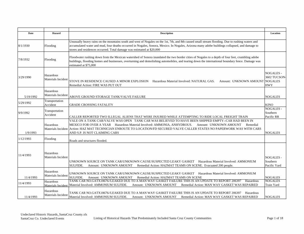
Date Hazard Description Location
8/1/1930 FloodingUnusually heavy rains on the mountains south and west of Nogales on the 1st, 7th, and 8th caused small stream flooding. Due to rushing waters and accumulated water and mud, four deaths occurred in Nogales, Sonora, Mexico. In Nogales, Arizona many adobe buildings collapsed, and damage to stores and residences occurred. Total damage was estimated at $20,000
7/8/1932 FloodingFloodwater rushing down from the Mexican watershed of Sonora inundated the two border cities of Nogales to a depth of four feet, crumbling adobe buildings, flooding homes and businesses, overturning and demolishing automobiles, and tearing down the international boundary fence. Damage was estimated at $75,000
3/29/1990 Hazardous Materials Incident STOVE IN RESIDENCE CAUSED A MINOR EXPLOSION Hazardous Material Involved: NATURAL GAS. Amount: UNKNOWN AMOUNT
Remedial Action: FIRE WAS PUT OUT
NOGALES - 3602 TUCSON-NOGALES HWY
5/19/1992
Hazardous Materials Incident ABOVE GROUND STORAGE TANK/VALVE FAILURE NOGALES
5/29/1992 Transportation Accident GRADE CROSSING FATALITY KINO
9/9/1992 Transportation Accident CALLER REPORTED TWO ILLEGAL ALIENS THAT WERE INJURED WHILE ATTEMPTING TO RIDE LOCAL FREIGHT TRAIN
NOGALES - Southern Pacific RR
1/9/1993
Hazardous Materials Incident
VALE ON A TANK CAR/VALVE WAS OPEN TANK CAR WAS BELIEVED TO HAVE BEEN SHIPPED EMPTY--CAR HAD BEEN IN MEXICO FOR OVER A YEAR Hazardous Material Involved: AMMONIA, ANHYDROUS. Amount: UNKNOWN AMOUNT Remedial Action: HAZ MAT TECHNICIAN ENROUTE TO LOCATION/FD SECURED VALVE CALLER STATES NO PAPERWORK WAS WITH CARS AND S.P. IS NOT CLAIMING CARS NOGALES
1/12/1993 Flooding Roads and structures flooded.
11/4/1993 Hazardous Materials Incident
UNKNOWN SOURCE ON TANK CAR/UNKNOWN CAUSE/SUSPECTED LEAKY GASKET Hazardous Material Involved: AMMONIUM SULFIDE. Amount: UNKNOWN AMOUNT Remedial Action: HAZMAT TEAMS ON SCENE. Evacuated 200 people.
NOGALES - Southern Pacific Yard
11/4/1993
Hazardous Materials Incident UNKNOWN SOURCE ON TANK CAR/UNKNOWN CAUSE/SUSPECTED LEAKY GASKET Hazardous Material Involved: AMMONIUM
SULFIDE. Amount: UNKNOWN AMOUNT Remedial Action: HAZMAT TEAMS ON SCENE NOGALES
11/4/1993 Hazardous Materials Incident
TANK CAR NO.GATX18676//LEAKED DUE TO A MAN WAY GASKET FAILURE THIS IS AN UPDATE TO REPORT 206397 Hazardous Material Involved: AMMONIUM SULFIDE. Amount: UNKNOWN AMOUNT Remedial Action: MAN WAY GASKET WAS REPAIRED
NOGALES Train Yard
11/4/1993
Hazardous Materials Incident TANK CAR NO.GATX18676//LEAKED DUE TO A MAN WAY GASKET FAILURE THIS IS AN UPDATE TO REPORT 206397 Hazardous
Material Involved: AMMONIUM SULFIDE. Amount: UNKNOWN AMOUNT Remedial Action: MAN WAY GASKET WAS REPAIRED NOGALES
Undeclared Historic Hazards_SantaCruz County.xlsSantaCruz Co. Undeclared Events Listing of Historical Hazards That Predominately Included Santa Cruz County Communities Page 1 of 18

Date Hazard
8/1/1930 Flooding
7/8/1932 Flooding
3/29/1990 Hazardous Materials Incident
5/19/1992
Hazardous Materials Incident
5/29/1992 Transportation Accident
9/9/1992 Transportation Accident
1/9/1993
Hazardous Materials Incident
1/12/1993 Flooding
11/4/1993 Hazardous Materials Incident
11/4/1993
Hazardous Materials Incident
11/4/1993 Hazardous Materials Incident
11/4/1993
Hazardous Materials Incident
Fatalities Injuries Property Crop/Livestock Total Data Source
4 $20,000 $20,000 NWS Tucson, 2005
$75,000 $75,000
1 $0 NRC, August 2004
AZ $0 URS, October 2003
1 $0 NRC, August 2004
2 $0 NRC, August 2004
AZ $0 NRC, August 2004
$50,000 $50,000 NCDC, August 2004
1 $0 NRC, August 2004
1 AZ $85,628 $85,628 NRC, August 2004
1 $0 NRC, August 2004
1 AZ $0 NRC, August 2004
Damage Estimates
Undeclared Historic Hazards_SantaCruz County.xlsSantaCruz Co. Undeclared Events Listing of Historical Hazards That Predominately Included Santa Cruz County Communities Page 2 of 18

Date Hazard Description Location
8/21/1994 Flooding
Thunderstorms around Nogales caused extensive flooding and heavy runoff. In some places, at least three inches of rain fell in the afternoon and early evening hours. The Santa Cruz river was reported flowing, and the Nogales Wash was nearly bankfull. A Mexican woman and her two children were drowned when their pickup truck was caught in flood waters on Cinco de Febrero Street in Nogales, Sonora. The bodies were swept downstream, two miles north of the border, where they were found near the Chula Vista subdivision. Many homes and businesses were flooded, but no estimates of damagewere made and no evacuations were necessary. The cost for the State to respond was $139,441.
7/18/1995 Hazardous Materials Incident 40 FT MOBILE REEFER UNIT/EMPLOYEE FRACTURED PIPE ON UNIT Hazardous Material Involved: AMMONIA, ANHYDROUS.
Amount: UNKNOWN AMOUNT Remedial Action: AREA WAS FOGGED/PIPE PLUGGED. Evacuated 50 people.
NOGALES - 123 Old Tucson Nogales
7/18/1995
Hazardous Materials Incident 40 FT MOBILE REEFER UNIT/EMPLOYEE FRACTURED PIPE ON UNIT Hazardous Material Involved: AMMONIA, ANHYDROUS.
Amount: UNKNOWN AMOUNT Remedial Action: AREA WAS FOGGED/PIPE PLUGGED NOGALES
6/26/1996 Lightning Two people struck by lightning 3 miles south of Tucson International Airport. Minor injuries, no deaths. 3 mi. S of TUCSON.
1/28/1997 Hazardous Materials Incident
2 CONTAINERS OF PESTICIDE IN A TRACTOR TRAILER / THE PESTICIDE WAS PUT IN THE TRAILER WITH A LOAD OF WOOD AND WAS SUPPOSED TO DISSIPATE Hazardous Material Involved: METHYL BROMIDE. Amount: UNKNOWN AMOUNT Remedial Action: THE CALLER STATES THAT TWO 10 OUNCE CANS WERE IN THE TRAILER / THE TRAILER WAS VENTILATED FOR 24 HOURS AND THEN OFFLOADED AS RECOMMENDED
NOGALES - US Customs Bldg.
1/28/1997
Hazardous Materials Incident
2 CONTAINERS OF PESTICIDE IN A TRACTOR TRAILER / THE PESTICIDE WAS PUT IN THE TRAILER WITH A LOAD OF WOOD AND WAS SUPPOSED TO DISSIPATE Hazardous Material Involved: METHYL BROMIDE. Amount: UNKNOWN AMOUNT Remedial Action: THE CALLER STATES THAT TWO 10 OUNCE CANS WERE IN THE TRAILER / THE TRAILER WAS VENTILATED FOR 24 HOURS AND THEN OFFLOADED AS RECOMMENDED NOGALES
5/18/1997 Severe Wind A tin roof was blown off a shed. TUBAC
7/17/1997 Flooding
Nogales wash overflowed its banks. Several vehicles had to be pulled out of the wash. Several minor injuries were reported NOGALES
7/23/1997 Hazardous Materials Incident
ILLEGAL DUMPING OF HAZARDOUS WASTE AT THE COUNTY LANDFILL. Hazardous Material Involved: NITRIC ACID. Amount: UNKNOWN AMOUNT Remedial Action: THE SCENE WAS SECURED/THE CHEMICALS WERE SECURED AND REPACKAGE/A CONTRACTOR WILL DO THE CLEANUP ON SEPT 08. Evacuated six people.
RIO RICO - Landfill
8/12/1997 Flooding The Mia Casa mobile home park in the west portion of Nogales was flooded with water 3-4 feet deep. Damage to a few cars and several homes. NOGALES
Undeclared Historic Hazards_SantaCruz County.xlsSantaCruz Co. Undeclared Events Listing of Historical Hazards That Predominately Included Santa Cruz County Communities Page 3 of 18
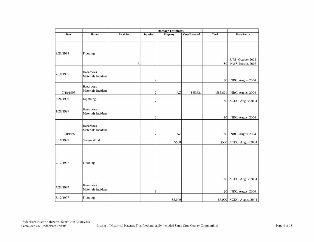
Date Hazard
8/21/1994 Flooding
7/18/1995 Hazardous Materials Incident
7/18/1995
Hazardous Materials Incident
6/26/1996 Lightning
1/28/1997 Hazardous Materials Incident
1/28/1997
Hazardous Materials Incident
5/18/1997 Severe Wind
7/17/1997 Flooding
7/23/1997 Hazardous Materials Incident
8/12/1997 Flooding
Fatalities Injuries Property Crop/Livestock Total Data SourceDamage Estimates
3 $0URS, October 2003NWS Tucson, 2005
2 $0 NRC, August 2004
2 AZ $85,621 $85,621 NRC, August 2004
2 $0 NCDC, August 2004
2 $0 NRC, August 2004
2 AZ $0 NRC, August 2004
$500 $500 NCDC, August 2004
3 $0 NCDC, August 2004
1 $0 NRC, August 2004
$5,000 $5,000 NCDC, August 2004
Undeclared Historic Hazards_SantaCruz County.xlsSantaCruz Co. Undeclared Events Listing of Historical Hazards That Predominately Included Santa Cruz County Communities Page 4 of 18

Date Hazard Description Location
10/1/1997 Flooding Thunderstorms dumped between 2-3 inches of rain over the western portion of Nogales causing flash flooding that damaged about 100 homes and 30 businesses. The flooding forced the evacuation of 150 residents from their homes. The floodwaters carried 5 vehicles down Western Avenue, the most heavily damaged street. 150 people were displaced. NOGALES
1/22/1998
Hazardous Materials Incident
HIGH PRESSURE REFRIGERATION LINE / UNKNOWN REASONS CALLER DIDN'T NOTIFY MEXICAN AUTHORITIES AS WIND DIRECTION WAS TO NORTH Hazardous Material Involved: AMMONIA, ANHYDROUS. Amount: UNKNOWN AMOUNT Remedial Action: LEAK LOCATED, AREA ISOLATED, ISOLATED LEAK WITH VALVING AT FACILITY FACTORY PERSONNEL EVACUATED FROM BUILDING FOR A PERIOD OF 2.5 HOURS NOGALES
3/19/1998 Transportation Accident
FREIGHT TRAIN TRAVELING SOUTH STRUCK A PEDESTRIAN AT A GRADE CROSSING WITH GATES AND LIGHTS (UNKNOWN IF OPERATIONAL) Nogales
7/21/1998 Flooding 2-3 feet of water flooded the Monta Carlo neighborhood damaging many houses. The Nogales sheriff also reported flooding of South River Road and along highway 82 in Nogales. NOGALES
8/28/1998 Severe Wind
Two distinct lines of severe thunderstorms swept through much of southeast Arizona from the northeast during the mid-afternoon to early evening hours. A high school student from Rincon High School in Tucson was injured from flying debris and taken to a local hospital. Numerous reports of trees blow down were received, some up to 2 feet in diameter. Eighteen power poles on the southwest side of Tucson were blown down leaving more than 20,000 customers without power and causing the evacuation of about 200 people from homes and businesses along West Ajo Way due to downed power lines. One of the downed power poles sparked a roof fire at Moreliana Fruit Bars causing an estimated $85000 of damage. A roof was blown off a trailer and a 20 foot tree blown onto a truck near Fort Thomas. Several reports of roof damage in Tucson were received. Winds blew a shed away and a 15 foot tree down in Benson. A wind gust to 64 mph was recorded at the University of Arizona. Power outages were reported in Rio Rico. Winds also measured at 61 knots. RIO RICO
5/21/1999 Transportation Accident
A NORTHBOUND LOCAL FREIGHT TRAIN STRUCK AND KILLED A TRESPASSER Nogales
9/25/1999 Hazardous Materials Incident
CHLORINATOR / CAUSE UNKNOWN Hazardous Material Involved: CHLORINE. Amount: 5 POUND(S) Remedial Action: TRYING TO REMOVE PRODUCT FROM CONTAINER. Necessary to evacuate 600 people.
NOGALES - 9N. Grand Ave.
10/11/2000 Flooding system was able to tap into moisture from the remnants of Tropical Storm Olivia which resulted in large amounts of rain and flooding. Early morning on the 11th, deep convection (with -65 to -70C cloud tops) developed. Isolated thunderstorms exploded across southeast Arizona. The low level center of HARSHAW
10/11/2000 Flooding
g , yout. Deep upper level trough over Nevada on the 10th moved over southeast Arizona through the 12th. The system was able to tap into moisture from thremnants of Tropical Storm Olivia which resulted in large amounts of rain and flooding. Early morning on the 11th, deep convection (with -65 to -70C cloud tops) developed. Isolated thunderstorms exploded across southeast Arizona. The low level center of Olivia passed through Cochise county NOGALES
10/22/2000 Flooding Residents in Patagonia were landlocked due to flooding of the Harshaw Creek and Sonoita Creek. The Old Tucson Road flooded due to high water rises along the Nogales wash. Also, 800 feet of South River Road flooded along the Santa Cruz River.
8/4/2001 HailSanta Cruz dispatch reported severe thunderstorm producing 1.75 inch diameter hail denting a police squadron car. 5 mi. N of RIO RICO.
8/5/2001 Severe Wind Damaging winds from a severe thunderstorm ripped roofs off of 12 homes in the Rio Rico area. RIO RICO
Undeclared Historic Hazards_SantaCruz County.xlsSantaCruz Co. Undeclared Events Listing of Historical Hazards That Predominately Included Santa Cruz County Communities Page 5 of 18

Date Hazard
10/1/1997 Flooding
1/22/1998
Hazardous Materials Incident
3/19/1998 Transportation Accident
7/21/1998 Flooding
8/28/1998 Severe Wind
5/21/1999 Transportation Accident
9/25/1999 Hazardous Materials Incident
10/11/2000 Flooding
10/11/2000 Flooding
10/22/2000 Flooding
8/4/2001 Hail
8/5/2001 Severe Wind
Fatalities Injuries Property Crop/Livestock Total Data SourceDamage Estimates
$30,000 $30,000 NCDC, August 2004
$85,628 $85,628 NRC, August 2004
1 $0 NRC, August 2004
$30,000 $30,000 NCDC, August 2004
$500 $500 NCDC, August 2004
1 $0 NRC, August 2004
12 $0 NRC, August 2004
$5,000 $5,000 NCDC, August 2004
$5,000 $5,000 NCDC, August 2004
$5,000 $5,000 NCDC, August 2004
$5,000 $5,000 NCDC, August 2004
$120,000 $120,000 NCDC, August 2004
Undeclared Historic Hazards_SantaCruz County.xlsSantaCruz Co. Undeclared Events Listing of Historical Hazards That Predominately Included Santa Cruz County Communities Page 6 of 18

Date Hazard Description Location
4/29/2002 Wildfire
The Ryan fire was started by a campfire in Coronado National Forest at Canelo Hill on April 29th and continued through May 4th. The fire burned 38,800 acres with estimated total fire fighting cost of 1.2 million dollars. The fire burned one house and several outbuildings. CANELO
6/14/2002 WildfireWest Dome Fire - the cause of the fire is under investigation that burned an area 5 miles northwest of Huachuca City, Arizona. The fire started June 14, 2002 and was controlled June 17, 2002, and burned a total of 930 acres with over $50,000 in fire suppression costs.
7/14/2002 Severe Wind A severe thunderstorm produced strong winds that knocked down a sign in the town of Patagonia. Most residents and spotters reported hail size of a half of an inch. The storm total precipitations for spotters ranged from .40 to 1.7 inches. PATAGONIA
7/26/2002 Flooding Thunderstorms produced heavy rainfall across the Nogales area. The Nogales wash rose 7 to 8 feet, with 3 to 4 feet out of its banks. Reports from officials stated some bank erosion occurred. Rushing water also washed cars into a fence along the Mexico border. NOGALES
5/11/2003 WildfireA Bar Fire - a human caused fire that burned an area 17 miles southeast of Sonoita, Arizona. The fire started May 11, 2003 and was controlled Maky 14, 2003, and burned a total of 487 acres with over $587,000 in fire suppression costs.
5/15/2003 WildfireRed Rock Fire - a human caused fire that burned an area 10 miles south of Sonoita, AZ; 5 miles east of Patagonia, AZ. The fire started May 15, 2003 and was controlled May 18, 2003, and burned a total of 2,763 acres with over $794,414 in fire suppression costs.
7/13/2003 Severe Wind A severe thunderstorm moved east across the town of Rio Rico. A spotter recorded 70 mph wind gust and several homes with roof damage due to the strong winds. RIO RICO
7/23/2003 Flooding
A severe thunderstorm developed over Tubac during the evening, which produced large hail and flash flooding. A spotter reported 1.75 inch diameter in size hail at 630 pm MST. This storm also produced 1.75 to 2.10 inches of precipitation in the Palo Parado Estates and Tubac Country Club respectively. Most washes experienced heavy flow rates based on high water marks. The Tubac was had 5 feet of water and the Puerto Canyon was over topped banks along East Frontier Road and Camino Esplendido. Camino Esplendido had 5.5-6.0 feet of water crossing the road with damage to three properties. One house had 2-3 inches of water in the garage, but had no substantial damage. Another home had considerable damage with the water inside the house. TUBAC
7/29/2003 Severe Wind A severe thunderstorm near the town of Elgin produced damaging winds during the afternoon. A spotter reported roof damage due to the strong winds. Winds reported at 51 knots. ELGIN
8/18/2003 Flooding
A strong thunderstorm produced heavy rain and moved northwest over the Sonoita area, mainly affecting areas on the east side of the Santa Rita Mountains. A car was trapped along Casa Blanca road between Highway 82 and Casa Blanca Wash due to flooded road.
Undeclared Historic Hazards_SantaCruz County.xlsSantaCruz Co. Undeclared Events Listing of Historical Hazards That Predominately Included Santa Cruz County Communities Page 7 of 18

Date Hazard
4/29/2002 Wildfire
6/14/2002 Wildfire
7/14/2002 Severe Wind
7/26/2002 Flooding
5/11/2003 Wildfire
5/15/2003 Wildfire
7/13/2003 Severe Wind
7/23/2003 Flooding
7/29/2003 Severe Wind
8/18/2003 Flooding
Fatalities Injuries Property Crop/Livestock Total Data SourceDamage Estimates
$90,000 $90,000 NCDC, August 2004
$0 GACC, 2010
$300 $300 NCDC, August 2004
$30,000 $30,000 NCDC, August 2004
$0 GACC, 2010
$0 GACC, 2010
$5,000 $5,000 NCDC, August 2004
$30,000 $30,000 NCDC, August 2004
$5,000 $5,000 NCDC, August 2004
$24,000 $24,000 NCDC, August 2004
Undeclared Historic Hazards_SantaCruz County.xlsSantaCruz Co. Undeclared Events Listing of Historical Hazards That Predominately Included Santa Cruz County Communities Page 8 of 18

Date Hazard Description Location
7/14/2004 Flooding A county official reported that the Vereda Nebline Road was washed out and was impassable. A weakening upper level disturbance over Northern Chihuahua, Mexico moved into Southeast Arizona where plenty of moisture was already in place due to tropical storm Blas. Precipitable water was almost double the normal level for mid-July thanks to these features. An upper air sounding from late morning showed an increase in the east wind shear causing the initial storms to train. This led to the flooding of areas in Santa Cruz county. RIO RICO
7/16/2004 Flooding
Law enforcement reported that a vehicle was stuck in the Nogales wash. The vehicle became stuck when the driver tried to cross a roadway that was flooded by the wash. NOGALES
7/26/2004 Flooding A wall of water swept a woman and two teenage girls off their feet and washed them downstream. The two girls where rescued by local officials, however the woman could not be saved. NOGALES
8/13/2004 FloodingSignificant rain fell in the town of Rio Rico causing significant street flooding as well as homes being flooded and property being ruined. High waterflowed down the streets, causing them to be impassable. 7 homes were flooded, some with damage. The force of the water also knocked a block wall down along one backyard. RIO RICO
9/7/2004Hazardous Materials Incident
REPORTING A MATERIAL RELEASE FROM A SCIENCE THERMOMETER THAT WAS DROPPED ON THE FLOOR. - - UNKNOWN AMOUNT OF MERCURY RELEASED WITH THIS FIXED INCIDENT.- - RIO RICO
11/15/2004Hazardous Materials Incident
CALLER STATED THAT A CAR RAN OVER A METER RISER AND BROKE THE METER SETUP AND RELEASED NATURAL GAS WHICH CAUSED THE CAR, TELEPHONE PEDAL STOOD,2 GAS METER SET UPS CATCH ON FIRE AND DAMAGE TO THE SKIRT OF A NEAR BYTRAILER. - - UNKNOWN AMOUNT OF NATURAL GAS RELEASED WITH THIS PIPELINE INCIDENT.- - NOGALES
5/14/2005
WildfireSalero Fire - a human caused fire that burned an area called San Luis Baca Land Grant. The fire started May 14, 2005 and was controlled May 20, 2005, and burned a total of 1,650 acres with over $100,000 in fire suppression costs.
5/20/2005 Extreme Temperature
A strong high pressure ridge across Arizona caused extreme heat across the desert Southwest. The heat was extreme from May 20, 2005 until May 26, 2005, with the hottest days being May 20th thru 23rd. Throughout this heat wave several bodies, some identified and some not, where found in the desert
AZZ032>035 Co
7/2/2005 Extreme Temperature
A strong ridge of high pressure across Arizona caused extreme heat in the desert Southwest with temperatures above seasonal normals. The extreme heat lasted for the first two weeks of July with some of the hottest days being over the Fourth of July weekend. Throughout this heat wave several bodies, some identified and some not here fo nd in the desert all ere belie ed to ha e died as a res lt of the e treme heat Belo is a table of the
AZZ032 - 034>0
7/7/2005 Wildfire
The Florida Fire was a lightning caused fire that started on July 7, 2005 in the Santa Rita Mountains about 25 miles south of the City of Tucson. The fireburned a total of 23,183 acres, injured 13 firefighters and was contained on July 21, 2005 at 6 pm MST. At the peak of the fire there were 986 personnel ,and the total cost to suppress the fire was 8.1 million dollars. Below is a few of the dates when main events occurred with this fire. July 9, 2005 - Some
Santa Cruz County
Undeclared Historic Hazards_SantaCruz County.xlsSantaCruz Co. Undeclared Events Listing of Historical Hazards That Predominately Included Santa Cruz County Communities Page 9 of 18

Date Hazard
7/14/2004 Flooding
7/16/2004 Flooding
7/26/2004 Flooding
8/13/2004 Flooding
9/7/2004Hazardous Materials Incident
11/15/2004Hazardous Materials Incident
5/14/2005
Wildfire
5/20/2005 Extreme Temperature
7/2/2005 Extreme Temperature
7/7/2005 Wildfire
Fatalities Injuries Property Crop/Livestock Total Data SourceDamage Estimates
$3,000 $3,000 NCDC, January 2006
$5,000 $5,000 NCDC, January 2006
1 2 $0 NCDC, January 2006
$20,000 $20,000 NCDC, January 2006
$0 NRC 2008, 734383
$0 NRC 2008, 741398
$0 GACC, 201012
$0NCDC, April 2010
9
$0
NCDC, April 2010
13 $0 NCDC, April 2010
Undeclared Historic Hazards_SantaCruz County.xlsSantaCruz Co. Undeclared Events Listing of Historical Hazards That Predominately Included Santa Cruz County Communities Page 10 of 18

Date Hazard Description Location
7/7/2005 Wildfire
The Florida Fire was a lightning caused fire that started on July 7, 2005 in the Santa Rita Mountains about 25 miles south of the City of Tucson. The fire burned a total of 23,183 acres, injured 13 firefighters and was contained on July 21, 2005 at 6 pm MST. At the peak of the fire there were 986 personnel ,and the total cost to suppress the fire was 8.1 million dollars. Below is a few of the dates when main events occurred with this fire. July 9, 2005 - Some trails leading to the fire area are closed July 11 2005 - All public access to Madera Canyon Recreation area was restricted July 13 2005 - At 10 am
AZZ034 Santa
7/20/2005 Severe Wind Strong thunderstorm winds near the Town of Patagonia caused a several hundred pound storage shed to be damaged when blown across a yard. Also shingles were torn off several roofs in a neighborhood.
Patagonia
8/8/2005 Flooding A mudslide and flooding event occurred in Madera Canyon after significant rainfall. This area is flood prone due to the fire that occurred only a month before. Large boulders and trees were moved with the mud and water down the mountain, doing damage to one residence. No one was injured. Madera Canyon
8/16/2005Hazardous Materials Incident
RAW SEWAGE RELEASED FROM BROKEN SEWER LINES DUE TO SEWER LINES BROKE FROM AGE. - - UNKNOWN AMOUNT OF RAW SEWAGE RELEASED WITH THIS PIPELINE INCIDENT.- - NOGALES
8/23/2005 FloodingTwo miles south of the Town of Amado a burm failed and caused two to three feet of water to run through a local farm, causing damage to crops and equipment in the field.
Amado - 2 miles south
9/14/2005Hazardous Materials Incident
THE MATERIAL RELEASED FROM A TANK CAR DUE TO UNKNOWN CAUSES AT THIS TIME. - - UNKNOWN AMOUNT OF SULFURIC ACID RELEASED WITH THIS RAILROAD INCIDENT.- - RIO RICO
3/14/2006Hazardous Materials Incident
, ,SANTA CRUZ RIVER. APPROX 90-100 GALLONS OF DIESEL RELEASED FROM THE TRACTOR'S SADDLE TANK AND A FUEL TANK FOR THE TRAILER'S GENERATOR INTO THE WATER. TRUCK WAS HAULING A LOAD OF VEGETABLES - - 100 GALLON(S) OF OIL, FUEL: NO. 2-D RELEASED WITH THIS MOBILE INCIDENT.- - RIO RICO
4/25/2006Hazardous Materials Incident
JET FUEL SPILLED ONTO A SOIL SURFACE FROM AN 40 FOOT LONG BY 60 FOOT WIDE UNMANNED AIRCRAFT IN A REMOTE DESERT AREA. - - 174 GALLON(S) OF JET FUEL: JP-5 (KEROSENE, HEAVY) RELEASED WITH THIS AIRCRAFT INCIDENT.- - RIO RICO
4/25/2006Hazardous Materials Incident
///////////WEB REPORT////////////DURING A ROUTINE PATROL, A PREDATOR B (MQ 9) UAV IMPACTED THE GROUND 30 MILES NORTHWEST OF NOGALES, AZ, OR APPROXIMATELY N31 34.137, W 110 56.484. - - UNKNOWN AMOUNT OF JET FUEL RELEASED WITH THIS AIRCRAFT INCIDENT.- - NOGALES
5/18/2006Hazardous Materials Incident
THE CALLER REPORTED FOUR EMPLOYEES THAT WORKED AT A WAREHOUSE WHICH STORES GRAPES GOT SICK DUE TO UNKNOWN REASONS. AS THE FIRE DEPARTMENT ENTERED THE WAREHOUSE, THEIR FIRST LEL READING WAS TWO, ON THEIR SECOND READING THE LEL READING WAS 35. THE FIRE DEPARTMENT WAS UNABLE TO IDENTIFY THE SOURCE OF THIS INCIDENT.
- - UNKNOWN AMOUNT OF UNKNOWN MATERIAL RELEASED WITH THIS FIXED INCIDENT.- - NOGALES
7/25/2006 Flooding
At 1600 MST a trained spotter in the Community of Tubac reported that the washes were running very high and that about 2 inches of rain had fallen in that area. Again around 1600 MST the Santa Cruz County Flood Control Official reported flooding in the Community of Tumacacori. The official reported that a box culvert had overtopped near the frontage road of Interstate 19. A private residence had one foot of water enter the home and the visitorcenter at the Tumacacori National Monument also had a foot of water flood their property. Additionally, at 1640 MST the Santa Cruz County Flood Control Official reported that 8 inches of water was flowing over Interstate 19 at the Chavez Siding Road exit. Two vehicles were reported to be stuck in the flood water at the underpass located near the same exit.
Rio Rico
Undeclared Historic Hazards_SantaCruz County.xlsSantaCruz Co. Undeclared Events Listing of Historical Hazards That Predominately Included Santa Cruz County Communities Page 11 of 18

Date Hazard
7/7/2005 Wildfire
7/20/2005 Severe Wind
8/8/2005 Flooding
8/16/2005Hazardous Materials Incident
8/23/2005 Flooding
9/14/2005Hazardous Materials Incident
3/14/2006Hazardous Materials Incident
4/25/2006Hazardous Materials Incident
4/25/2006Hazardous Materials Incident
5/18/2006Hazardous Materials Incident
7/25/2006 Flooding
Fatalities Injuries Property Crop/Livestock Total Data SourceDamage Estimates
a Cruz Co. 13
$0
NCDC, April 2010
$6,000 $6,000NCDC, April 2010
$30,000 $30,000 NCDC, January 2006
$0 NRC 2008, 769453
$5,000 $5,000 $10,000
NCDC, April 2010
$0 NRC 2008, 772513
$0 NRC 2008, 790909
$0 NRC 2008, 796253
$0 NRC 2008, 798267
$0 NRC 2008, 797659
$20,000 $20,000
NCDC, April 2010
Undeclared Historic Hazards_SantaCruz County.xlsSantaCruz Co. Undeclared Events Listing of Historical Hazards That Predominately Included Santa Cruz County Communities Page 12 of 18
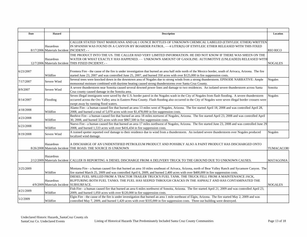
Date Hazard Description Location
8/17/2006Hazardous Materials Incident
CALLER STATED THAT MARIJUANA AND (4) 1 OUNCE BOTTLES OF UNKNOWN CHEMICAL LABELED (ETHYLEIC ETHER) WRITTEN IN SPANISH WAS FOUND IN A CANYON BY BOARDER PATROL. - - 4 LITER(S) OF ETHYLEIC ETHER RELEASED WITH THIS FIXED INCIDENT.- - RIO RICO
12/7/2006Hazardous Materials Incident
THE PRODUCT INTO THE US. THE CALLER HAD VERY LIMITED INFORMATION. HE DID NOT KNOW IF THERE WAS SHEEN ON THE WATER OR WHAT EXACTLY HAS HAPPENED. - - UNKNOWN AMOUNT OF GASOLINE: AUTOMOTIVE (UNLEADED) RELEASED WITHTHIS FIXED INCIDENT.- - NOGALES
6/23/2007Wildfire
Frontera Fire - the cause of the fire is under investigation that burned an area half mile north of the Mexico border, south of Arivaca, Arizona. The fire started June 23, 2007 and was controlled June 25, 2007, and burned 350 acres with over $125,000 in fire suppression costs.
7/17/2007 Severe Wind Several trees were knocked down in the downtown area of Nogales due to strong winds from a strong thunderstorm. EPISODE NARRATIVE: Ample monsoonal moisture combined with daytime heating caused strong thunderstorms over Santa Cruz County.
Nogales
8/9/2007 Severe Wind A severe thunderstorm near Sonoita caused several downed power lines and damage to two residences. An isolated severe thunderstorm across Santa Cruz county caused damage in the Sonoita area.
Sonoita
8/14/2007 FloodingSeven illegal immigrants were saved by the U.S. border patrol in the Nogales wash in the City of Nogales from flash flooding. A severe thunderstorm occurred across the Oro Valley area in Eastern Pima County. Flash flooding also occurred in the City of Nogales were seven illegal border crossers were swept away by running flood waters.
Nogales
4/18/2008 WildfireAlamo Fire - a human caused fire that burned an area 13 miles west of Nogales, Arizona. The fire started April 18, 2008 and was controlled April 28, 2008, and burned a total of 5,070 acres with over $1,478,000 in fire suppression costs.
4/23/2008 WildfireBeehive Fire - a human caused fire that burned an area 18 miles nortwest of Nogales, Arizona. The fire started April 23, 2008 and was controlled April 30, 2008, and burned 325 acres with over $867,500 in fire suppression costs.
6/23/2008 WildfireNuevo Fire - a human caused fire that burned an area 17 miles northwest of Nogales, Arizona. The fire started June 23, 2008 and was controlled June 29,2008, and burned 1,533 acres with over $416,434 in fire suppression costs.
8/19/2008 Severe Wind A trained spotter reported roof damage to their residence due to wind from a thunderstorm. An isolated severe thunderstorm over Nogales produced localized wind damage.
Nogales
8/26/2008Hazardous Materials Incident
A DISCHARGE OF AN UNIDENTIFIED PETROLEUM PRODUCT AND POSSIBLY ALSO A PAINT PRODUCT HAS DISCHARGED ONTO THE ROAD. THE SOURCE IS UNKNOWN TUMACACORI
2/12/2009Hazardous Materials Incident CALLER IS REPORTING A DIESEL DISCHARGE FROM A DELIVERY TRUCK TO THE GROUND DUE TO UNKNOWN CAUSES. MATAGONIA
3/25/2009Wildfire
Montana Fire - a human caused fire that burned an area 10 miles southeast of Arivaca, Arizona, north of Bear Valley Ranch and Sycamore Canyon. The fire started March 25, 2009 and was controlled April 6, 2009, and burned 2,400 acres with over $400,000 in fire suppression costs.
4/9/2009Hazardous Materials Incident
DIESEL FUEL SPILLED FROM A TRACTOR TRAILER TRUCK'S FUEL TANK. THE TRUCK FELL FROM A MAINTENANCE JACK, RUPTURING BOTH FUEL TANKS. THE FUEL HAS SEEPED THROUGH CRACKS IN THE ASPHALT AND HAS CONTAMINATED THE SUBSURFACE. NOGALES
4/21/2009 WildfireFish Fire - a human caused fire that burned an area 6 miles northwest of Sonoita, Arizona. The fire started April 21, 2009 and was controlled April 23, 2009, and burned 1,050 acres with over $120,000 in fire suppression costs.
5/2/2009 WildfireElgin Fire - the cause of the fire is under investigation that burned an area 1 mile northeast of Elgin, Arizona. The fire started May 2, 2009 and was controlled May 7, 2009, and burned 1,420 acres with over $335,000 in fire suppression costs. Three out building were destroyed.
Undeclared Historic Hazards_SantaCruz County.xlsSantaCruz Co. Undeclared Events Listing of Historical Hazards That Predominately Included Santa Cruz County Communities Page 13 of 18

Date Hazard
8/17/2006Hazardous Materials Incident
12/7/2006Hazardous Materials Incident
6/23/2007Wildfire
7/17/2007 Severe Wind
8/9/2007 Severe Wind
8/14/2007 Flooding
4/18/2008 Wildfire
4/23/2008 Wildfire
6/23/2008 Wildfire
8/19/2008 Severe Wind
8/26/2008Hazardous Materials Incident
2/12/2009Hazardous Materials Incident
3/25/2009Wildfire
4/9/2009Hazardous Materials Incident
4/21/2009 Wildfire
5/2/2009 Wildfire
Fatalities Injuries Property Crop/Livestock Total Data SourceDamage Estimates
$0 NRC 2008, 808178
$0 NRC 2008, 820324
$0 GACC, 2010
$3,000 $3,000NCDC, April 2010
$25,000 $25,000NCDC, April 2010
1
$0
NCDC, April 2010
$0 GACC, 2010
$0 GACC, 2010
1 $0 GACC, 2010
$3,000 $3,000NCDC, April 2010
I $0 NRC, 881974
$0 NRC, 2010; 897950
$0 GACC, 2010
$0 NRC, 2010;902353
$0 GACC, 2010
$0 GACC, 2010
Undeclared Historic Hazards_SantaCruz County.xlsSantaCruz Co. Undeclared Events Listing of Historical Hazards That Predominately Included Santa Cruz County Communities Page 14 of 18

Date Hazard Description Location
5/5/2009 Wildfire
Wildfire burned near 5,000 acres near Fort Huachuca in Santa Cruz County. The fire burned at least four homes and six private vehicles near the west gate entrance. One injury was reported due to burns from the fire. A brush fire burned more than 5,000 acres and at least four homes in a subdivision near Fort Huachuca's West Gate. One person suffered burn injuries related to the fire. Dry westerly flow brought dry conditions to Santa Cruz County, with winds gusting to near 25 mph.
AZZ034 Santa C
5/5/2009 WildfireCanelo Fire - a human caused fire that burned an area 10 miles south of Sonoita, Arizona. The fire started May 5, 2009 and was controlled May 16, 2009, and burned 4,025 acres with over $1,730,976 in fire suppression costs. The fire destroyed 3 homes and 5 other buildings.
6/11/2009 WildfireLochiel Fire - a human caused fire that burned an area in San Rafael Valley, 15 miles south of Patagonia, Arizona. The fire started June 11, 2009 and was controlled June 16, 2009, and burned 2,800 acres with over $200,000 in fire suppression costs.
6/23/2009 WildfireRuby Fire - the cause of the fire is under investigation that burned an area 7 miles southeast of Arivaca, Arizona. The fire started June 23, 2009 and was controlled July 1, 2009, and burned 130 acres with over $50,000 in fire suppression costs.
6/30/2009 Severe Wind
Severe thunderstorm outflow winds estimated at 60 mph blew down a large tree near downtown Nogales. High pressure aloft remained near the Four Corners region, resulting in a continued east to northeast flow aloft over southeast Arizona. Plentiful moisture again led to scattered afternoon and evening thunderstorms. With boundary layer moisture still somewhat drier, thunderstorms were again able to produce strong to severe downburst or microburst winds.
Nogales
11/12/2009Hazardous Materials Incident
CALLER IS REPORTING THAT THERE WAS A RELEASE OF DRILLING MUD INTO A STEAM THAT LEADS TO CALIFORNIA GULCH. THE CALLER BELIEVES IT IS DUE TO AN EXPLORATORY DRILLING IN THE AREA FOR SILVER OR COPPER DEPOSITS. NOGALES
1/11/2010 WildfireApache Fire - a human caused fire that burned an area 15 miles NW of Nogales. The fire started January 11, 2010 and was controlled January 15,2011, and burned 336 acres with over $25,000 in fire suppression costs.
1/11/2010 WildfireBlack Peak Fire - a human caused fire that burned an area 6 miles S. of Arivaca. The fire started January 11, 2010 and was controlled January 15,2011, and burned 898 acres with over $60,000 in fire suppression costs.
3/17/2010Hazardous Materials Incident
CALLER STATED THAT A FORK LIFT DRIVER DROVE INTO A GAP BETWEEN A LOADING DOCK AND A BOBTAIL. THE FORKLIFT FELL AND PINNED THE DRIVER. THE BATTERY UNIT ON THE FORKLIFT RELEASED SULFURIC ACID ONTO THE FORKLIFT DRIVER, BURNING HIM. HE WAS TAKEN TO THE HOSPITAL. RIO RICO
4/30/2010Hazardous Materials Incident
CALLER STATED THERE WAS A TANKER TRUCK ROLL OVER ACCIDENT WHICH RESULTED IN A SPILL OF DIESEL AND A SERIOUS INJURY TO THE DRIVER. CALLER STATED THE SPILL CAME FROM THE CARGO OF THE TANKER TRUCK AND THE SADDLE TANK. RIO RICA
5/16/2010 WildfireFraguita Fire - a fire of unknown cause that burned an area 5 miles south of Arivaca. The fire started May 16, 2010 and was controlled May 25, 2010, and burned 1,914 acres with over $165,000 in fire suppression costs.
5/26/2010Hazardous Materials Incident CALLER IS REPORTING A FREIGHT TRAIN STRIKING A TRESPASSER RESULTING IN A FATALITY. AMADO
7/17/2010 Severe Wind
Severe thunderstorm winds impacted much of Santa Cruz County. Law enforcement reported a tree was downed by the winds near the intersection of State Highway 82 and Duquesne Road. A trained spotter measured a wind gust of 60 mph near Rio Rico, and another trained spotter measured a wind gust of 58 mph at Nogales.
7/19/2010 Severe Wind
A severe thunderstorm microburst produced damaging winds in Rio Rico. A portion of a home's roof was blown off, and brought down a power line as it landed in Rio Rico Drive. Thunderstorm winds also blew down several dying trees between the Santa Cruz River bridge and the railroad tracks, and blew down a cyprus tree onto the roof of a home on East Rio Rico Drive. Winds were measured on a neighbor's anemometer at 75 mph.
Undeclared Historic Hazards_SantaCruz County.xlsSantaCruz Co. Undeclared Events Listing of Historical Hazards That Predominately Included Santa Cruz County Communities Page 15 of 18

Date Hazard
5/5/2009 Wildfire
5/5/2009 Wildfire
6/11/2009 Wildfire
6/23/2009 Wildfire
6/30/2009 Severe Wind
11/12/2009Hazardous Materials Incident
1/11/2010 Wildfire
1/11/2010 Wildfire
3/17/2010Hazardous Materials Incident
4/30/2010Hazardous Materials Incident
5/16/2010 Wildfire
5/26/2010Hazardous Materials Incident
7/17/2010 Severe Wind
7/19/2010 Severe Wind
Fatalities Injuries Property Crop/Livestock Total Data SourceDamage Estimates
Cruz County 1
$560,000 $560,000
NCDC, April 2010
2 $0 GACC, 2010
$0 GACC, 2010
$0 GACC, 2010
$5,000 $5,000
NCDC, April 2010
$0 NRC, 2010; 923327
$0 GACC, 2011
$0 GACC, 2011
1 $0 NRC, 2010; 934320
1 $0 NRC, 2010; 938632
$0 GACC, 2011
$0 NRC, 2010; 941772
$2,000 $0 $2,000 NCDC, 2011
$25,000 $0 $25,000 NCDC, 2011
Undeclared Historic Hazards_SantaCruz County.xlsSantaCruz Co. Undeclared Events Listing of Historical Hazards That Predominately Included Santa Cruz County Communities Page 16 of 18

Date Hazard Description Location
7/30/2010 FloodingFlash flooding from rainfall south of the International Border resulting in the Nogales Wash rising 7 feet in 15 minutes. This caused some damage to the bank protection including three concrete panels in the wash. Part of Old Tucson Road, which parallels the wash, was partially eroded. Nogales
8/15/2010 Hail
An owner of a grape vineyard in Elgin reported hail for 15 minutes with the largest being golf ball size (1.75). Damage to the vineyard was extensive, with nearly all the 2010 grape crop lost. Crop losses at this one vineyard were estimated at six tons which translated to between 10 and 15 thousand dollars, ultimately resulting in a loss of wine valued at 100 to 150 thousand dollars. Extensive damage was also sustained at other vineyards in area. Hail also dented vehicles and broke their windows. Elgin
8/15/2010 Severe WindJust before and during the storm, an owner of a grape vineyard in Elgin reported an estimate of at least 60 mph winds. Damage was limited to farm structures and not dwellings. Elgin
8/21/2010 FloodingVery heavy rain in Nogales, Sonora caused the Nogales Wash to rise 7 feet in less than one hour. The wash rose above flood stage, causing erosion to one roadway in Nogales, Arizona. Nogales
1/27/2011 WildfireJelks Fire - a human caused fire that burned an area Southeast of Sonoita. The fire started January 27, 2011 and was controlled January 28,2011, and burned 716 acres with over $5,000 in fire suppression costs.
5/30/2011 Wildfire
In May of 2011, the Murphy Fire Complex (Murphy, Bull and Pena Fires) was ignited by human causes and burned approximately 85,847 acres, with the Murphy Fire accounting for 68,078 acres. The burned area is generally located 5 miles east of Arivaca and 4 miles west of Tubac. The fire started on May 30, 2011 and was controlled on June 15, 2011, with suppression costs estimated at over $5.7 million. Figure 5-8 is a map prepared by the BAER Team indicating the burn severity and overall limits of the fires. The only damage reported was the complete destruction of the Atascosa Lookout House which is the primary feature of a site listed with the National Register of Historic Places. Areas identified by the BAER Team and SCCFCD to be at postfire flooding risk include the Calabasas School, an El Paso Natural Gas line, several local ranches in the area, Pena Blanca Lake, the Atascosa Lookout and Trail (InciWeb, 2011).
Undeclared Historic Hazards_SantaCruz County.xlsSantaCruz Co. Undeclared Events Listing of Historical Hazards That Predominately Included Santa Cruz County Communities Page 17 of 18

Date Hazard
7/30/2010 Flooding
8/15/2010 Hail
8/15/2010 Severe Wind
8/21/2010 Flooding
1/27/2011 Wildfire
5/30/2011 Wildfire
Fatalities Injuries Property Crop/Livestock Total Data SourceDamage Estimates
$100,000 $0 $100,000 NCDC, 2011
$10,000 $75,000 $85,000 NCDC, 2011
$1,000 $1,000 NCDC, 2011
$2,000 $2,000 NCDC, 2011
$0 GACC, 2011
$0 InciWeb, 2011
Undeclared Historic Hazards_SantaCruz County.xlsSantaCruz Co. Undeclared Events Listing of Historical Hazards That Predominately Included Santa Cruz County Communities Page 18 of 18

SANTA CRUZ COUNTY MULTI-JURISDICTIONAL HAZARD MITIGATION PLAN 2011
Appendix E
Plan Maintenance Review Memorandums