ulster county multi-jurisdictional natural hazard mitigation plan
271
ULSTER COUNTY MULTIJURISDICTIONAL NATURAL HAZARD MITIGATION PLAN DRAFT PLAN UPDATE 2015 Prepared by:
-
Upload
khangminh22 -
Category
Documents
-
view
0 -
download
0
Transcript of ulster county multi-jurisdictional natural hazard mitigation plan

ULSTER COUNTY
MULTI�JURISDICTIONAL NATURAL HAZARD MITIGATION PLAN
DRAFT PLAN UPDATE 2015
Prepared by:

anna_foley
Typewritten Text
THIS PAGE INTENTIONALLY LEFT BLANK

Multi�Jurisdictional
Natural Hazard Mitigation Plan Ulster County, New York
Prepared for
Prepared for
Ulster County Department of Emergency Communications/Emergency Management 238 Golden Hill Lane Kingston, NY 12401
Prepared
Prepared by
1255 Broad Street, Suite 201 Clifton, New Jersey 07013�3398
DRAFT PLAN UPDATE 2015

anna_foley
Typewritten Text
THIS PAGE INTENTIONALLY LEFT BLANK
Multi�Jurisdictional Natural Hazard Mitigation Plan – Ulster County, New York Draft � 2015 Plan Update i
PLAN ADOPTION RESOLUTIONS In accordance with Part 201.6 of the Disaster Mitigation Act of 2000 (DMA 2000), Ulster County, New York, has developed this Multi'Jurisdictional Hazard Mitigation Plan to identify hazards that threaten the County and ways to reduce future damages associated with these hazards. Following this page are the signed adoption resolutions of the County and all participating jurisdictions that have adopted this Plan Update, authorizing municipal government staff to carry out the actions detailed herein.
Signed resolutions of adoption by all participating jurisdictions shall be inserted following this page after
FEMA has reviewed and determined that the plan update is Approvable Pending Adoption.

anna_foley
Typewritten Text
THIS PAGE INTENTIONALLY LEFT BLANK

anna_foley
Typewritten Text
INSERT COPIES OF EACH ADOPTION RESOLUTION HERE

anna_foley
Typewritten Text
THIS PAGE INTENTIONALLY LEFT BLANK
EXECUTIVE SUMMARY
Multi�Jurisdictional Natural Hazard Mitigation Plan – Ulster County, New York Draft � 2015 Plan Update ii
EXECUTIVE SUMMARY Across the United States and around the world, natural disasters occur each day, as they have for thousands of years. As the world’s population and development have increased, so have the effects of these natural disasters. The time and money required to recover from these events often strain or exhaust local resources. The purpose of hazard mitigation planning is to identify policies, actions, and tools for implementation that will, over time, work to reduce risk and the potential for future losses. Hazard mitigation is best realized when community leaders, businesses, citizens, and other stakeholders join together an in effort to undertake a process of learning about hazards that can affect their area and use this knowledge to prioritize needs and develop a strategy for reducing damages. Section 322, Mitigation Planning, of the Robert T. Stafford Disaster Relief and Emergency Assistance Act (“the Stafford Act”), enacted by Section 104 of the Disaster Mitigation Act of 2000 (“DMA 2000”), provides new and revitalized approaches to mitigation planning. Section 322 continues the requirement for a State mitigation plan as a condition of disaster assistance, and established a new requirement for local mitigation plans. Except under extraordinary circumstances as determined by FEMA, an approved hazard mitigation plan is required to receive hazard mitigation assistance grants. While Ulster County has always sought ways to reduce their vulnerability to hazards, the passage of DMA 2000 helped County officials to recognize the benefits of pursuing a long'term, coordinated approach to hazard mitigation through hazard mitigation planning. The County has received grant funds from the Federal Emergency Management Agency (FEMA) for developing both this hazard mitigation plan update, and its initial version in 2009. This Ulster County Multi�Jurisdictional Natural Hazard
Mitigation Plan represents the collective efforts of Ulster County and each of its participating jurisdictions, the general public, and other stakeholders. Natural disasters cannot be prevented from occurring. However, over the long'term, the continued implementations of this Plan will gradually, but steadily, lessen the impacts associated with hazard events. The Ulster County Multi'Jurisdictional Hazard Mitigation Plan has been developed by the Ulster County Hazard Mitigation Planning Committee (the “Planning Committee”), with support from outside consultants. The efforts of the Planning Committee were headed by the Director of the Ulster County Department of Emergency Communications/Emergency Management (UCECEM). The overall Planning Committee was divided into a Core Planning Group (CPG) and Jurisdictional Assessment Teams (JATs), with one JAT for each of the County’s participating jurisdictions. The JATs consisted of a wide range of position titles for each community, from key individuals involved in emergency management, planning, engineering, floodplain management, and local administrators. Ulster County’s first hazard mitigation plan was approved by FEMA in February 2009; it was
subsequently adopted by each participating jurisdiction1. FEMA requires hazard mitigation plans
to be monitored and evaluated regularly, and updated at least once every five years. This document
represents the first Plan Update. The plan update process was initiated in 2013 with a Project Initiation Meeting between the County and its consultant held on August 16, 2013. A Kickoff Meeting of the full Core Planning Group was conducted on October 3, 2013. Thereafter, Core Planning Group members met on: November 21, 2014 (for a both morning progress meeting and an afternoon working session); July 21, 2015; and August 4, 2015. JATs in each municipality met individually throughout the plan development process as they deemed necessary.
1 With the County’s adoption on March 11, 2009.

EXECUTIVE SUMMARY
Multi�Jurisdictional Natural Hazard Mitigation Plan – Ulster County, New York Draft � 2015 Plan Update iii
Community support is vital to the success of any hazard mitigation plan. The County and each
participating community were responsible for conducting outreach within their respective
jurisdictions. Since the plan update process began in the fall of 2013, more than 140 outreach
activities have been undertaken by the planning team members, including more than one dozen
opportunities for public and stakeholder involvement from the County alone. These efforts provided the general public and other stakeholders with opportunities to take part in the decisions that will affect their future. County'Led Outreach Activities. The County'led outreach actions during the plan update were similar to those undertaken during the development of the initial plan. The County performed ongoing maintenance of its online hazard mitigation planning web presence at http://ulstercountyny.gov/emergency'services/hazard'mitigation/general'information with information on the planning process and where to go for additional information or comments. The initial press releases were issued on November 7, 2013. Press releases were posted on the County web site. Project fact sheets were widely distributed by UCECEM at various meetings throughout the process. They were also made available at the County Office Building and various libraries. Additionally, fact sheets were posted on the Ulster County Emergency Management webpage from September 13, 2013 through December 31, 2015. The County update to the Plan was reported in articles in The Daily Freeman on November 11, 2013 and September 14, 2015. Furthermore, the public and other stakeholders were invited to respond to a survey that
was posted on the UCECEM mitigation planning web site. The County’s JAT met throughout the plan update process to discuss progress and work on development of the County’s mitigation strategy. Meetings were held on April 24, 2015; August 6, 2015; August 17, 2015; and August 18, 2015. The County JAT included direct membership and participation from the following groups or individuals who attended various meetings throughout the process and provided input on action items being considered for the County’s mitigation strategy:
Art Snyder, Director, Ulster County Emergency Communications/Emergency Management2
Steve Peterson, Director, Ulster County Emergency Communications/Emergency Management3
Dennis Doyle, Director of Planning, Ulster County Planning Department
Brendan Masterson, Stormwater Management Specialist II, Ulster County Department of Public Works
Diane Beitl, Safety Officer, Ulster County Safety Office
Burton Gulnick, Jr., Commissioner of Finance, Ulster County Department of Finance
Robert Sudlow, Deputy County Executive, Ulster County
Dean Fabiano, Ulster County Legislator, Ulster County Public Safety Committee
T.J. Briggs, Ulster County Legislator, Chairman, Ulster County Public Safety Committee
Amanda Lavalle, Coordinator, Ulster County Department of Environment
Aaron Bennett, Environmental Planner, Ulster County Department of Environment
Thomas Hynes, GIS Technology Engineer, Ulster County Department of Information Services
Furthermore, at the outset of the plan update process, UCECEM sent a letter of invitation to 34 stakeholder entities to invite them to participate. Stakeholders were advised that they would have opportunities to contribute to the plan update in an advisory role by providing relevant hazard information, assessing potential mitigation actions, and reviewing draft updates of the document. Those interested in participating on the planning committee were asked to respond to UCECEM in writing. All letter recipients were also invited to the plan update Kickoff Meeting on October 3, 2013. Those not interested in participating directly on the committee were suggested to check back on the County’s web
2 Mr. Snyder retired on August 21, 2014 and did not participate in the process thereafter. 3 Prior to Mr. Snyder’s retirement, Mr. Peterson served as Deputy Director. For a short time after Mr. Snyder’s retirement, Mr. Peterson served as
Acting Director. He became Director on August 21, 2014]

EXECUTIVE SUMMARY
Multi�Jurisdictional Natural Hazard Mitigation Plan – Ulster County, New York Draft � 2015 Plan Update iv
site periodically for updates on how the planning process is progressing. Input, questions, and feedback were welcomed at any time. Four stakeholder groups returned a Statement of Authority to Participate:
American Red Cross
New York Thruway Authority
SUNY New Paltz
SUNY Ulster
The following stakeholder entities participated by attending one or more planning team meetings:
Central Hudson Gas & Electric
Health Alliance of the Hudson Valley
New York City DEP
New York State Police
New York State OEM – Region 2
Orange County OEM
SUNY New Paltz
Municipal JAT Outreach Activities. Participating communities supplemented the above range of County'led efforts with outreach targeted toward members of the general public and other stakeholders within their respective municipalities to get the word out even further and to supplement the County’s larger outreach activities. JATs employed a wide range of techniques for providing opportunities for feedback and participation from the public and other stakeholders. Many distributed copies of the project fact sheet, posted information on their web sites, discussed the plan update at open public meetings in their communities, reached out to key stakeholder groups, and collectively undertook more than 140 activities throughout the plan update process to ensure that the public and other stakeholders were made aware of the process and their opportunity to participate and provide feedback and input. The initial hazard mitigation planning process consisted of the following key steps:
• Researching a full range of natural hazards to identify which hazards could affect the County;
• Identifying the location and extent of hazard areas;
• Identifying assets located within these hazard areas;
• Characterizing existing and potential future assets at risk;
• Assessing vulnerabilities to the most prevalent hazards; and
• Formulation and prioritization of goals, objectives, and mitigation actions to reduce or avoid long'term vulnerabilities to the identified hazards.
For this Plan Update, the CPG:
• Assessed current development patterns and development pressures
• Evaluated new hazard or risk information
• Described progress in local plan maintenance and plan integration efforts
• Assessed previous goals and actions
• Summarized progress in implementing actions
• Adjusted actions to address current realities
• Explained changes in priorities
• Addressed changes in Federal/State requirements
• Reviewed the 2009 Natural Hazard Mitigation Plan to determine the changes that occurred since the Plan was prepared.

EXECUTIVE SUMMARY
Multi�Jurisdictional Natural Hazard Mitigation Plan – Ulster County, New York Draft � 2015 Plan Update v
Natural hazards that can affect Ulster County that are included in the Plan are as follows:
• Atmospheric hazards, including: extreme temperatures, extreme wind, hurricanes and tropical storms, lightning, nor’easters, tornadoes, and winter storms;
• Hydrologic hazards, including: dam failure, drought, flooding, ice jams, and storm surge;
• Geologic hazards, including: earthquakes and landslides; and
• Other hazards, including: wildfires. After evaluating these hazards and assets within the County to which they are vulnerable, each participating jurisdiction developed an updated hazard mitigation strategy to increase the disaster resistance of the County, along with procedures for monitoring, evaluating and updating the Plan to ensure that it remains a “living document.” Nearly 200 mitigation actions are included in this plan update to reduce the impacts of natural hazards throughout the County, including 35 projects totaling upwards of $31 million submitted by the County alone. Most jurisdictions intend to apply for various types of grant funding for at least some portion of their activities to offset the local cost burden. The robust mitigation strategies developed by each participating jurisdiction as part of this plan update are a significant expansion of many of the strategies that were proposed in the 2009 plan, and represent a substantial improvement in addressing each jurisdiction’s highest hazards and key risks. This 2015 Draft Plan Update is currently under review by NYSOEM, FEMA, and the public and other stakeholders. If you have any questions or comments on the Multi'Jurisdictional Natural Hazard Mitigation Plan for Ulster County, New York, please contact:
Steven Peterson, Director Ulster County Department of Emergency Communications/Emergency Management
238 Golden Hill Lane Kingston, New York 12401'6440
Phone: 845'331'7000 Fax: 845'331'1738
E'Mail: [email protected]
For jurisdiction specific information, individuals identified as representatives of the jurisdictions should be contacted (see Appendix 1.2 for membership lists and contact information).
After the review cycle is complete, comments will be evaluated and incorporated as needed, and the County and all participating jurisdictions will each formally adopt the Final 2015 Plan Update. The Final Plan Update will include copies of each jurisdiction’s adoption resolution following Page i.

TABLE OF CONTENTS
Multi�Jurisdictional Natural Hazard Mitigation Plan – Ulster County, New York Draft � 2015 Plan Update vi
ACKNOWLEDGEMENTS The following jurisdictions (Ulster County and 21+ of its constituent municipalities) participated in the development of this plan:
County of Ulster
Denning, Town of Lloyd, Town of Saugerties, Town of
Ellenville, Village of Marlborough, Town of Saugerties, Village of
Gardiner, Town of New Paltz, Town of Shandaken, Town of
Hardenburgh, Town of New Paltz, Village of Shawangunk, Town of
Hurley, Town of Olive, Town of Ulster, Town of
Kingston, City of Plattekill, Town of Wawarsing, Town of
Kingston, Town of Rosendale, Town of Woodstock, Town of
The records show that the following 10 stakeholder entities participated in meetings and provided valuable input for the plan update:
American Red Cross
Central Hudson Gas & Electric
Heath Alliance of the Hudson Valley
New York City Department of Environmental Protection
New York State Police
New York State Office of Emergency Management (Region 2)
New York Thruway Authority
Orange County Office of Emergency Management
SUNY New Paltz
SUNY Ulster
The following County Departments were instrumental in the plan update process and are hereby acknowledged for their dedication and contributions:
Ulster County Emergency Communications/Emergency Management
Ulster County Department of Environment
Ulster County Department of Information Services
Ulster County Planning Department
Ulster County Department of Public Works
Ulster County Executive’s Office
Ulster County Legislature
URS Corporation (Clifton, NJ) acted as the plan development consultant providing hazard mitigation plan update services.

anna_foley
Typewritten Text
THIS PAGE INTENTIONALLY LEFT BLANK

TABLE OF CONTENTS
Multi�Jurisdictional Natural Hazard Mitigation Plan – Ulster County, New York Draft � 2015 Plan Update vii
TABLE OF CONTENTS
Plan Adoption Resolutions i
Executive Summary ii
Acknowledgements vi
Table of Contents vii
Section 1 – Introduction 1�1
Purpose 1'1 Document Organization 1'2 Key Terms 1'2 About the Planning Area 1'3 Participating Jurisdictions 1'11 Hazard Mitigation Planning Team Organizational Structure 1'12 Planning Team Meetings 1'14 Roles and Responsibilities – County, Municipalities, Contractor 1'16 Outreach to the Public and Other Stakeholders 1'20 Feedback from the Public and Other Stakeholders 1'26 Review and Incorporation of Existing Plans Studies, Reports, and Technical Information 1'27 Regulatory Compliance 1'29 General Overview of Modifications to the 2009 Plan as part of the 2014 Plan Update 1'31
Section 2 – Identification of Potential Hazards 2�1
Section 3 – Risk Assessment 3a�1
3a – Hazard Profiles 3a�1
Overview 3a'1 Atmospheric Hazards 3a'2 Extreme Temperatures 3a'3 Extreme Wind 3a'7 Hurricane and Tropical Storm 3a'10 Lightning 3a'15 Nor’easter 3a'17 Tornado 3a'19 Winter Storm 3a'22 Hydrologic Hazards 3a'25 Dam Failure 3a'26 Drought 3a'33 Flood 3a'36 Ice Jams 3a'50 Geologic Hazards 3a'54 Earthquake 3a'55 Landslide 3a'64 Other Hazards 3a'67 Wildfire 3a'67
3b –Identification and Characterization of Assets in Hazard Areas 3b�1
Improved Property 3b'3 Emergency Facilities 3b'4 Critical Infrastructure and Utilities 3b'5 Other Key Facilities 3b'6 Historic and Cultural Resources 3b'7 Population 3b'14

TABLE OF CONTENTS
Multi�Jurisdictional Natural Hazard Mitigation Plan – Ulster County, New York Draft � 2015 Plan Update viii
3c – Damage Estimates 3c�1
Methodology 3c'1 Extreme Temperatures 3c'4 Extreme Wind 3c'5 Hurricane and Tropical Storm 3c'7 Lightning 3c'9 Nor’easter 3c'10 Tornado 3c'11 Winter Storm 3c'13 Dam Failure 3c'15 Drought 3c'17 Flood 3c'19 Ice Jams 3c'24 Earthquake 3c'25 Landslide 3c'27 Wildfire 3c'29 Conclusions on Hazard Risk 3c'30
3d – Land Uses and Development Trends 3d�1
Section Overview 3d'1 Historic Context 3d'1 Land Use 3d'2 Changes in Land Use 3d'5 Changes in Population 3d'5 Changes in Residential Construction 3d'7 Protected Open Space 3d'7 Land Use Planning in Ulster County 3d'9 Influences on Future Development in Ulster County 3d'10 Development Trends 3d'13 Impact of Recent Severe Storms – Irene, Lee, and Sandy 3d'13 Re'assessment of Local Land Uses and Development Trends 3d'14 Potential for Future Development to Impact Vulnerability for Non'Delineable Hazards 3d'24 Potential for Future Development to Impact Vulnerability for Delineable Hazards 3d'26 Conclusion 3d'33
3e – Conclusions on Hazard Risk 3e�1
Priority Risk Index 3e'1 PRI Results 3e'3 Final Determinations 3e'5 Key Risk Findings 3e'8
Section 4 – Capabilities and Resources 4�1 Capabilities and Resources – Ulster County and Participating Jurisdictions 4'1 Legal and Regulatory Capability 4'1 Administrative and Technical Capability 4'3 Fiscal Capability 4'5 Conclusion 4'6 Capabilities and Resources – State of New Jersey 4'11 Capabilities and Resources – Federal 4'11
Section 5 – Mitigation Goals 5�1 New York State Hazard Mitigation Plan – Vision and Goals 5'1 NYRCRP Ulster Communities – Vision and Goals 5'1 NYRCRP for the Towns of Shandaken and Hardenburgh – Vision and Goals 5'2 Ulster County Multi'jurisdictional Hazard Mitigation Plan Goals 5'3
TABLE OF CONTENTS
Multi�Jurisdictional Natural Hazard Mitigation Plan – Ulster County, New York Draft � 2015 Plan Update ix
Section 6 – Mitigation Strategies 6�1 Overview 6'1 Range of Actions and Projects 6'2 Mitigation Action Plans for Each Jurisdiction 6'9
Section 7 – Plan Maintenance and Integration 7�1 Monitoring the Plan 7'1 Evaluating the Plan 7'5 Updating the Plan 7'5 Public Participation in Plan Maintenance 7'7 Plan Integration 7'8
Section 8 – For More Information 8�1
List of Appendices **All Appendices are on CD** Appendix 1.1 – Statements of Authority Appendix 1.2 – Jurisdictional Annexes Appendix 1.3 – Meeting Materials Appendix 1.4 – County Press Releases and Articles in Local News Media Appendix 1.5 – Jurisdictional Website Coverage of the Plan Appendix 1.6 – Comments on the September 2015 Draft Plan Update Appendix 2.1 – Hazard Descriptions Appendix 3c.1 – Assets in Hazard Areas Appendix 3c.2 – Historic in Hazard Areas Appendix 3d.1 – Ulster County Demographics Appendix 3e.1 – Hazard Rankings and Key Risk Findings Appendix 4.1 – Legal and Regulatory Tool Descriptions Appendix 4.2 – State Resources Appendix 4.3 – Federal Resources
List of Tables Table 1.1 – Ulster County Population Changes and Projections 1'6Table 1.2 – Income and Employment in Ulster County 1'9Table 1.3 – New York State Major Disaster Declarations 1'9Table 1.4 – New York State Emergency Declarations 1'11Table 1.5 – New York State Fire Management Assistance Declarations 1'11Table 1.6 – Key Planning Team Meetings 1'14Table 1.7 – Ulster County Jurisdictions Plan Participation 1'19Table 1.8 – Other Stakeholders Invited by the County to Participate in the Plan Update 1'20Table 1.9 – Review and Incorporation of Data from Outside Sources 1'27Table 1.10 – FEMA Plan Review Criteria 1'30Table 1.11 – Overall Summary of Plan Transition – 2009 to 2015 1'31 Table 2.1 – Summary Results of the Hazard Identification and Evaluation Process 2'1Table 2.2 – Ulster County’s HAZNY Analysis Results (2014) 2'2Table 2.3 – Documentation of the Hazard Evaluation Process 2'3 Table 3a.1 – Summary of Profiled Hazards by Jurisdiction 3a'1Table 3a.2 – Severity and Typical Effects of Various Sustained Wind Speeds 3a'8Table 3a.3 – Severity and Typical Effects of Various Tornado Wind Speeds (3 second gust) 3a'8Table 3a.4 – Saffir'Simpson Scale for Hurricanes 3a'11Table 3a.5 – Historical Hurricane and Tropical Storm Tracks (75 Nautical Miles of Ulster County) 3a'12Table 3a.6 – Dolan'Davis Nor’easter Intensity Scale 3a'17

TABLE OF CONTENTS
Multi�Jurisdictional Natural Hazard Mitigation Plan – Ulster County, New York Draft � 2015 Plan Update x
Table 3a.7 – Enhanced Fujita Scale for Tornadoes 3a'20Table 3a.8 – Historical Tornadoes in Ulster County 3a'20Table 3a.9 – Comparison, Fujita Scale (F) versus Enhanced Fujita Scale (EF) 3a'21Table 3a.10 – Regional Snowfall Index Ranking Categories 3a'22Table 3a.11 – State'Regulated Dams with High or Significant Hazard Potential 3a'28Table 3a.12 – FEMA NFIP Policy and Claim Information for Ulster County Jurisdictions 3a'44Table 3a.13 – NFIP Repetitive Loss Property Statistics 3a'46Table 3a.14 – Repetitive Loss Properties by Municipality and Location in Mapped Flood Hazard Zones 3a'47Table 3a.15 – Rivers and Streams in Ulster County with Recorded Ice Jam Incidents 3a'50Table 3a.16 – Historical Occurrences of Ice Jams in Ulster County 3a'52Table 3a.17 – Magnitude/Intensity Comparison for Earthquakes 3a'57Table 3a.18 – Earthquake Magnitude/Intensity Comparison 3a'58Table 3a.19 – Ulster County Geological Soils Classification: Land Areas 3a'60Table 3a.20 – Earthquake History Throughout New York State (1737'2005) 3a'62Table 3a.21 – Landslide Events Recorded by NYSGS in Ulster County (1837'1989) 3a'67Table 3b.1 – Improved Property by Jurisdiction 3b'3Table 3b.2 – Emergency Facilities by Jurisdiction 3b'4Table 3b.3 – Critical Infrastructure and Utilities by Jurisdiction 3b'5Table 3b.4 – Other Key Facilities by Jurisdiction 3b'6Table 3b.5 – Historic and Cultural Resources by Jurisdiction 3b'8Table 3b.6 – Population and Households by Jurisdiction (2010 Census) 3b'14Table 3b.7 – Vulnerable Sectors of the Population by Jurisdiction (2010 Census) 3b'15Table 3c.1 – Potential Annualized Losses from Extreme Wind by Jurisdiction 3c'6Table 3c.2 – Hurricane Damage Classification 3c'7Table 3c.3 – Potential Annualized Losses from Lightning by Jurisdiction 3c'10Table 3c.4 – Potential Annualized Losses from Tornados by Jurisdiction 3c'12Table 3c.5 – Potential Annualized Losses from Winter Storms by Jurisdiction 3c'14Table 3c.6 – Estimated Potential Exposure of Improved Property to Dam Failure 3c'16Table 3c.7 – Acreage of Cultivated Cropland by Jurisdiction 3c'17Table 3c.8 – Potential Annualized Losses from Drought by Jurisdiction 3c'18Table 3c.9 – Acres of Land in Flood Hazard Areas by Municipality 3c'21Table 3c.10 – Improved Values in Flood Hazard Areas by Municipality 3c'22Table 3c.11 – Potential Annualized Losses from Flood by Jurisdiction 3c'23Table 3c.12 – Annual Loss Estimates – Ice Jams 3c'25Table 3c.13 – Annualized Earthquake Losses for Ulster County 3c'26Table 3c.3 – Potential Annualized Losses from Earthquakes by Jurisdiction 3c'27Table 3c.14 – Exposure to Landslide by Jurisdiction 3c'28Table 3c.23 – Exposure to Wildfire by Jurisdiction 3c'29Table 3c.24 – Annualized Building Losses by Hazard by Jurisdiction 3c'31Table 3d.1 – Ulster County Land Cover Estimates 3d'5Table 3d.2 – Change in Population Since the Last Version of the Plan was Prepared 3d'6Table 3d.3 – Annual New Privately'Owned Residential Building Permits 3d'7Table 3d.4 – Preserved Open Space in Ulster County 3d'8Table 3d.5 – Communities with Land Use Recognition 3d'12Table 3d.6 – Summary of Responses – Land Uses and Development Trends Worksheet 3d'15Table 3d.7 – Potential for Future Development to Impact Dam Failure Hazard Vulnerability 3d'26Table 3d.8 – Potential for Future Development to Impact Flood Hazard Vulnerability 3d'27Table 3d.9 – Potential for Future Development to Impact Ice Jam Hazard Vulnerability 3d'28Table 3d.10 – Potential for Future Development to Impact Surge Hazard Vulnerability 3d'29Table 3d.11 – Potential for Future Development to Impact Earthquake Hazard Vulnerability 3d'30Table 3d.12 – Potential for Future Development to Impact Landslide Hazard Vulnerability 3d'31Table 3d.13 – Potential for Future Development to Impact Wildfire Hazard Vulnerability 3d'32Table 3e.1 – Priority Risk Index for Ulster County 3e'2Table 3e.2 – Summary of PRI Results for Ulster County 3e'4Table 3e.3 – PRI Results for Each Jurisdiction 3e'5Table 3e.4 – Hazard Risk Rankings for Ulster County 3e'6
TABLE OF CONTENTS
Multi�Jurisdictional Natural Hazard Mitigation Plan – Ulster County, New York Draft � 2015 Plan Update xi
Table 3e.5 – Hazard Risk Rankings for Each Jurisdiction 3e'7Table 3e.6 – Key Risk Findings for Ulster County 3e'8Table 4.1 – Jurisdictional Legal and Regulatory Capabilities 4'2Table 4.2 – Jurisdictional Administrative and Technical Capabilities 4'4Table 4.3 – Jurisdictional Fiscal Capabilities 4'5Table 4.4 – Opportunities for Improving Local Capabilities 4'7Table 6.1 – Types of Actions Considered to Achieve Mitigation Goals 6'3Table 6.2 – Action Evaluation Criteria 6'9Table 6.3 – Overview of Local Mitigation Strategies 6'11
List of Figures
Figure 1.1 – Ulster County Base Map 1'4Figure 1.2 – Ulster County Population Density 1'8Figure 1.3 – Statement of Authority 1'12Figure 1.4 – Planning Committee Organizational Structure 1'13Figure 1.5 – Plan Update Web Content Screenshot 1 1'23Figure 1.6 – Plan Update Web Content Screenshot 2 1'23Figure 1.7 – Fact Sheet for the 2015 Plan Update 1'25Figure 3a.1 – NWS Wind Chill Index 3a'3Figure 3a.2 – NWS Heat Index 3a'4Figure 3a.3 – Wind Zones in the United States 3a'7Figure 3a.4 – Historical Hurricane and Tropical Storm Tracks (75 Nautical Miles of Ulster County) 3a'12Figure 3a.5 – Empirical Probability of a Named Storm 3a'14Figure 3a.6 – Lightning Flash Density in the United States 3a'15Figure 3a.7 – Tornado Activity in the United States 3a'19Figure 3a.8 – Ulster County Dams 3a'27Figure 3a.9 – Potential Area Affected by Failure of the Ashokan Reservoir Dam 3a'30Figure 3a.10 – Potential Area Affected by Failure of the Rondout Reservoir Dam 3a'31Figure 3a.11 – Potential Area Affected by Failure of the Sturgeon Pool Dam 3a'32Figure 3a.12 – Palmer Drought Severity Index Summary Map for the United States 3a'36Figure 3a.13 – Special Flood Hazard Areas in Ulster County 3a'37Figure 3a.14 – NFIP Repetitive Loss Property Clusters – Town of Shandaken 3a'48Figure 3a.15 – NFIP Repetitive Loss Property Clusters – Town of Ulster/City of Kingston 3a'49Figure 3a.16 – Ice Jam Incidents in New York State 3a'51Figure 3a.17 – United States Earthquake Hazard Map 3a'55Figure 3a.18 – Ulster County Earthquake Hazard Zones 3a'56Figure 3a.19 – Ulster County Geological Soil Classification 3a'59Figure 3a.20 – Significant Earthquake Epicenters in New York State (1973'2012) 3a'61Figure 3a.21 – Significant Earthquake Epicenters in New York State (1737'1986) 3a'62Figure 3a.22 – Peak Ground Acceleration with a 10 Percent Probability of Exceedance over 50 years 3a'64Figure 3a.23 – Landslide Susceptibility in the Conterminous United States 3a'65Figure 3a.24 – Landslide Susceptibility and Historical Incidents for Ulster County 3a'66Figure 3a.25 – Wildfire Hazard Areas in Ulster County 3a'68Figure 3b.1 – Ulster County Population Density 3b'16Figure 3c.1 – Conceptual Model of the Statistical Risk Assessment Methodology 3c'2 Figure 3c.2 – Graphical Representation of the Annualized Loss Methodology 3c'3Figure 3d.1 – Ulster County Land Use / Land Cover 3d'3Figure 3d.2 – Ulster County, New York Protected Open Space 3d'9

anna_foley
Typewritten Text
THIS PAGE INTENTIONALLY LEFT BLANK

SECTION 1 INTRODUCTION
Multi�Jurisdictional Natural Hazard Mitigation Plan – Ulster County, New York 2015 Plan Update � Draft 1�1
SECTION 1 INTRODUCTION
Purpose
Ulster County is susceptible to a number of different natural hazards. Each hazard event has the potential to cause property loss, loss of life, economic hardship, and threats to public health and safety. The time and money required to recover from these events often strain or exhaust local resources. While an important aspect of emergency management deals with disaster recovery (those actions that a community must take to repair damages and make itself whole in the wake of a disaster), an equally important aspect of emergency management involves hazard mitigation $ sustained actions taken to reduce long$term risk to life and property. They are things you do today to be more protected in the future. Hazard mitigation actions are essential to breaking the typical disaster cycle of damage, reconstruction, and repeated damage. With careful selection, they can be long$term, cost$effective means of reducing risk and helping to create a more sustainable and disaster$resilient community. Hazard mitigation actions are most effective when they are based on a comprehensive, long$term plan that is developed before a disaster occurs. When community leaders, businesses, citizens, and other stakeholders undertake a joint process of evaluating the hazards that can affect their area, and use this knowledge to develop a strategy for reducing risk and the potential for future losses, this process is known as hazard mitigation planning. A hazard
mitigation plan1 describes an area’s vulnerability to the various natural hazards that are typically present,
along with an array of actions and projects for reducing key risks. This list of actions and projects is known as a mitigation strategy. While natural disasters cannot be prevented from occurring, the continued implementation of mitigation strategies identified in the plan will gradually, but steadily, increase community sustainability and disaster$resilience.
The MultiJurisdictional Natural Hazard Mitigation Plan for Ulster County was initially prepared between 2007 and 2009 to meet the requirements of the Disaster Mitigation Act of 2000 (DMA 2000), which requires all states and local governments to have a hazard mitigation plan in place in order to be eligible to apply for certain types of federal hazard mitigation project grants. FEMA grant monies were received to cover the costs of the 2009 plan’s development. Ulster County used a ‘multi$jurisdictional’ approach, inviting all of the municipalities within the County to participate in the plan. At that time, 12 of the County’s 24 jurisdictions opted to participate. This opened the door for the County its 12 participating jurisdictions to apply to FEMA for hazard mitigation project funding, including monies that became available under the recent Federal disaster declarations for Hurricane Irene, the remnants of Tropical Storm Lee, and Superstorm Sandy. Participating jurisdictions have been working since the plan was initially approved by FEMA in 2009 to implement the actions listed in their mitigation strategies.
Hazard mitigation plans must be: (a) implemented on an ongoing basis, and (b) updated every five years to ensure that they remain applicable representations of local risk and locally$preferred risk reduction strategies. Ulster County and its jurisdictions initiated the first required plan update in 2013. This 2015
Plan Update is expected to be reapproved by FEMA and adopted by all participating communities. The County has once again obtained FEMA grant funding to cover cost associated with the update, and has continued its ‘multi$jurisdictional’ approach. This time, 21 municipalities in the County successfully participated. Each jurisdiction attended meetings, provided feedback in a wide range of topic areas, reached out to the public and other key stakeholders in their community, and developed an updated mitigation strategy. Successful participation of each jurisdiction in the update process and the plans ongoing maintenance and implementation is required to maintain eligibility to apply for mitigation project grants. The initial plan of 2009, and the 2015 Plan Update, are maintained on the County web site at: http://ulstercountyny.gov/emergency$services/hazard$mitigation.
1Hazard mitigation plans are not intended to serve as a reference for immediate disaster response. They focus on actions that can be implemented prior to disaster events in order to reduce potential loss of life and property damage; however, they are referred to in the recovery process.
SECTION 1 INTRODUCTION
Multi�Jurisdictional Natural Hazard Mitigation Plan – Ulster County, New York 2015 Plan Update � Draft 1�2
For questions or other feedback, or to find out how you can become involved, contact your community’s local elected officials or Emergency Management Coordinator. At the County level, please feel free to reach out to Mr. Steven Peterson, Director, Ulster County Emergency Communications and Emergency Management (UCECEM) at 845$331$7000 or via e$mail to [email protected]. More information about the plan is maintained on the County web site at: http://ulstercountyny.gov/emergency$services/hazard$mitigation.
Document Organization
This Multi$Jurisdictional Hazard Mitigation Plan is organized into the following major sections.
• Section 1 Introduction. Plan purpose, overview of the County, summary of plan development process, document organization, and key terms.
• Section 2 Identification of Potential Hazards. Documentation of the Planning Committee’s evaluation of a full range of natural hazards, and indication of which hazards were identified for inclusion in this plan (and why) versus those that were not identified (and why not).
• Section 3 Risk Assessment. Hazard profiles, identification and characterization of assets in hazard areas, damage estimates, summary of land uses and development trends in hazard areas, and key risk findings.
• Section 4 Capabilities and Resources. Overview of local, state, and federal resources for hazard mitigation.
• Section 5 Mitigation Goals. Summary of hazard mitigation goals for the State Hazard Mitigation Plan and also for this county$wide multi$jurisdictional hazard mitigation plan.
• Section 6 – Mitigation Strategies. Information about the hazard mitigation actions identified by each jurisdiction to address their key risk findings.
• Section 7 – Plan Maintenance and Integration. Procedures selected for monitoring, evaluating, and updating this mitigation plan; including participation of the public and other stakeholders in plan maintenance, and plan integration.
• Section 8 – For More Information. Contact information for questions, comments, or how to become involved in the plan’s ongoing maintenance and implementation, and future updates.
Key Terms For the purpose of clarity throughout this document, the following definitions are briefly outlined:
• A natural hazard is any hazard that occurs or results from acts of nature such as floods, earthquakes, hurricanes, tornadoes and coastal storms, to name a few. This plan addresses natural
hazards only. It does not assess man�made / technological hazards or terrorism, but may address
technological issues caused by a natural hazard.
• A disaster is any catastrophic event that causes loss of life, injuries and widespread destruction to property. For the purpose of this document, a disaster is the result of a natural hazard, whether anticipated (such as flash flood warnings) or fortuitous (such as earthquakes).
• Hazard mitigation is the method by which measures are taken to reduce, eliminate, avoid or redirect natural hazards in order to diminish or eradicate the long$term risks to human life and property.
• A hazard mitigation plan is a well$organized and well$documented evaluation of the natural hazards and the extent that the events will occur. In addition, the plan identifies the vulnerability to the effects of the natural hazards typically present in a certain area, as well as the goals, objectives and actions required for minimizing future loss of life and property damage as a result of natural hazards.

SECTION 1 INTRODUCTION
Multi�Jurisdictional Natural Hazard Mitigation Plan – Ulster County, New York 2015 Plan Update � Draft 1�3
• Hazard mitigation planning is the process of managing actions taken by individual citizens and professional organizations involved in mitigation activities. The process involves carrying out plans to reduce loss of life, injuries and damage to property, as well as reducing the costs associated with losses from natural hazards. It is a long$term process with benefits best realized over time.
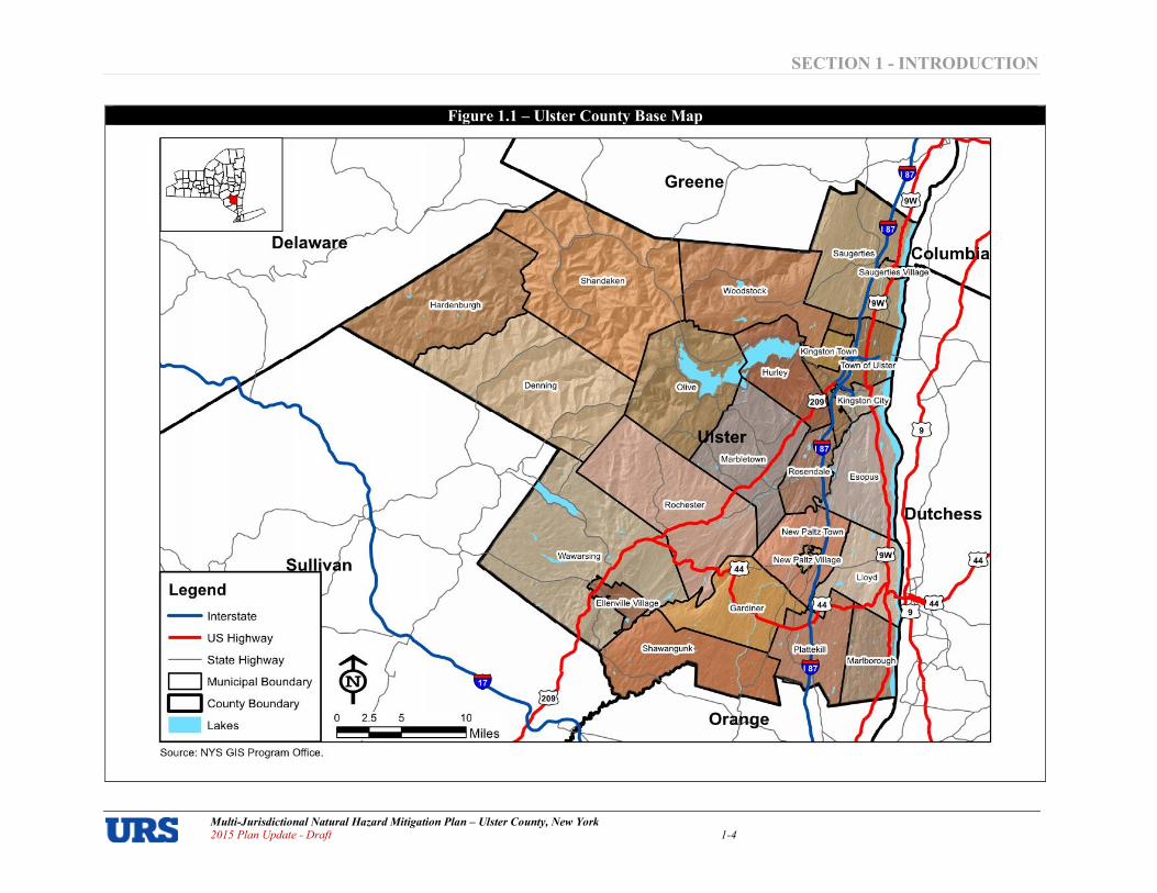
About the Planning Area The planning area for this plan encompasses the whole of Ulster County, New York. Ulster County is located in the southeast part of New York State in the Mid$Hudson Region of the Hudson Valley approximately 70 miles north of New York City and 45 miles south of Albany. Ulster County is the northernmost county and largest county (by land area) in the New York Metropolitan Area, with a total area of 1,161 square miles, of which roughly three percent is water. Ulster County is comparable in size to the State of Rhode Island. Ulster County is bounded by Orange, Sullivan, Delaware, Greene, Columbia, and Dutchess Counties (from Orange County in the south and moving in a clockwise direction). The Hudson River provides the boundary of eastern sections of Ulster County. The County is home to 20 towns, three villages and one city. The county seat and only city is Kingston – the first capital of New York State. Other communities include the Villages of Ellenville, New Paltz and Saugerties; and Towns of Denning, Esopus, Gardiner, Hardenburgh, Hurley, Kingston, Lloyd, Marbletown, Marlborough, New Paltz, Olive, Plattekill, Rochester, Rosendale, Saugerties, Shandaken, Shawangunk, Ulster, Wawarsing and Woodstock (Figure 1.1).The County and 12 municipalities successfully participated in the development of the initial 2009 Plan; the County and 21of the 24 municipalities successfully participated in the 2015 Plan Update.
Ulster County has a wide variety of natural resources and landscapes including mountains, valleys, rivers, lakes, streams, forests and farmlands. The county is known for its many mountains and parks, pick$your$own farms and farmers' markets, local wineries and breweries, spas and spiritual retreats, artisans, museums, performing arts centers, pottery shops, fairs and festivals, luxury resorts. Ulster County is truly a unique place to visit. It is a year$round vacation center alive with entertainment, adventure, culture and history. In warmer seasons residents and visitors enjoy boating or sailing on the majestic Hudson River; biking, hiking, camping, or rock climbing in the world famous Shawangunk and Catskill Mountains; fishing in the regions many trout streams and lakes; or golfing on some magnificent courses. The county’s rich agricultural market abounds farm stands and orchards. As the weather cools, the county’s abundance of open space provides glorious fall foliage. During the winter months, opportunities abound for outdoor sports such as snowboarding, ice skating, and ice climbing. Ulster County is also home to the oldest street in America: Historic Huguenot Street, a National Historic Landmark District which includes seven original stone houses dating to 1705, a burial ground, a reconstructed 1717 French church, and a museum shop. From its agrarian beginnings, to the dawn of the industrial revolution, and then on to its emergence as a regional economic powerhouse in Hudson Valley, Ulster County has been an integral part of the economy of upstate New York. During the 1990s, a dramatic change in economic climate was experienced with the closure of a major industrial plant and the dislocation of hundreds—if not thousands—of businesses. This had a long$lasting, adverse impact on local workers and families. In the period since, Ulster County has struggled to revitalize its manufacturing base, maintain its legacy in production agriculture, and encourage a vibrant tourism$visitor industry without compromising its unique natural resource endowment. Ulster County is currently implementing economic development strategies to better coordinate the collective activities of the system, and provide focus to the strategic economic development efforts across the County.
SECTION 1 INTRODUCTION
Multi�Jurisdictional Natural Hazard Mitigation Plan – Ulster County, New York 2015 Plan Update � Draft 1�4
Figure 1.1 – Ulster County Base Map
Legend - Interstate
- US Highway
-- Stale Highway
c:J Municipal Boundary
c::J County Boundary
lakes
Source: NYS GIS Program Office.
URS
Miles
SECTION 1 INTRODUCTION
Multi�Jurisdictional Natural Hazard Mitigation Plan – Ulster County, New York 2015 Plan Update � Draft 1�5
In Ulster County:
• The NYC Metropolitan Area connection offers Ulster County access to global markets, intellectual capital, and is relied on by tourism and arts and culture businesses.
• Ulster County has a higher percentage of small businesses than any other county in the region.
• Ulster County has adequate critical infrastructure (water/sewer/transportation) to support growth in many of its central places.
Ulster County’s unique location makes it a place that residents from New York City can go to escape the costs, pressures and densities of life in a major metropolis. It also makes the County a place where businesses want to be located that serve the State of New York’s two most important cities. At the same time, Ulster County’s location between the Hudson River and the Catskill Mountains ensures that development cannot get too intense, especially since the County, the State, the local jurisdictions and private organizations have done an excellent job of ensuring that much of the County will remain in pubic open space. Ulster County is balancing the objectives of preserving natural, cultural and historic resources; facing the reality of an economy which is undergoing a big change as the nation moves into the post$industrial era; and, seeing development that is driven by agricultural and natural resources as well as the occurrences of the nation’s largest urban area only 70 miles away. The County is involved in economic development, housing, open space and stormwater and transportation planning. Communities are working to ensure that they are safe, thriving and appealing places to live, work and play. The following recent development trends are expected to continue in the future:
• The County and its jurisdictions will continue to focus on preserving open space throughout the area.
• Most new development will continue to occur in the Hudson River Valley, especially along Interstate Highway 87 corridor.
• Additional development will take place along transportation corridors in the County, particularly in and around existing hamlets that have developed throughout the County.;
• Redevelopment will take place throughout the County, as sites that were vacated due to changes in the economy are reused, modified or replaced.
• Agriculture and natural resources will continue to be a focus of the Ulster County economy.
• Ulster County will continue to be both a recreational destination and driver of the commercial and industrial development in the region.
• Ulster County will continue to be a location where individuals that seek to leave the bustle of the New York City urban area choose to relocate.
Population. As of the year 2010 Census, the population of Ulster County was 182,493. According to the US Census, the population of Ulster County in 1990 was 165,304; whereas, in 2000 it increased to 177,749 – an increase of approximately 7.5 percent over ten years. Between 2000 and 2010, the County’s population increased by only 2.7 percent. County$wide, a general upward trend in population is expected to continue between now and the year 2020. Table 1.1 shows key County population changes and projections (county$wide and for each municipality) as reported in the Ulster County Transportation Plan.

SECTION 1 INTRODUCTION
Multi�Jurisdictional Natural Hazard Mitigation Plan – Ulster County, New York 2015 Plan Update � Draft 1�6
Table 1.1
Ulster County Population Changes and Projections
Municipality
Census
Population
1990
Census
Population
2000
Census
Population
2010
Population
Estimate 2013
Population
Projection
2020
Absolute
Change
Projected
20002020
Percent
Change
Projected
20002020
Ulster, County of 165,304 177,749 182,493 180,998 214,999 37,250 20.96%
Denning, Town of 524 516 551 Not reported 716 200 38.76%
Ellenville, Village of 4,243 4,130 4,135 4,118 Not reported Unknown Unknown
Esopus, Town of 8,860 9,331 9,041 Not reported 11,531 2,200 23.58%
Gardiner, Town of 4,278 5,238 5,713 Not reported 8,338 3,100 59.18%
Hardenburgh, Town of 204 208 238 Not reported 358 150 72.12%
Hurley, Town of 6,741 6,564 6,314 Not reported 7,764 1,200 18.28%
Kingston, City of 23,095 23,456 23,893 23,731 24,656 1,200 5.12%
Kingston, Town of 864 908 889 Not reported 1,308 400 44.05%
Lloyd, Town of 9,231 9,941 10,863 Not reported 12,841 2,900 29.17%
Marbletown, Town of 5,285 5,854 5,607 Not reported 7,654 1,800 30.75%
Marlborough, Town of 7,430 8,263 8,808 Not reported 10,863 2,600 31.47%
New Paltz, Town of 11,388 12,830 7,185 Not reported 15,930 3,100 24.16%
New Paltz, Village of 5,463 6,034 6,818 6,924 Not reported Unknown Unknown
Olive, Town of 4,086 4,579 4,419 Not reported 5,479 900 19.65%
Plattekill, Town of 8,891 9,892 10,499 Not reported 13,092 3,200 32.35%
Rochester, Town of 5,679 7,018 7,313 Not reported 9,418 2,400 34.20%
Rosendale, Town of 6,220 6,352 6,075 Not reported 7,452 1,100 17.32%
Saugerties, Town of 18,467 19,868 15,511 Not reported 22,768 2,900 14.60%
Saugerties, Village of 3,915 4,995 3,971 3,905 Not reported Unknown Unknown
Shandaken, Town of 3,013 3,235 3,085 Not reported 3,835 600 18.55%
Shawangunk, Town of 10,081 12,022 14,332 Not reported 15,322 3,300 27.45%
Ulster, Town of 12,329 12,544 12,327 Not reported 13,844 1,300 10.36%
Wawarsing, Town of 12,348 12,889 9,022 Not reported 14,589 1,700 13.19%
Woodstock, Town of 6,290 6,241 5,884 Not reported 7,241 1,000 16.02%

SECTION 1 INTRODUCTION
Multi�Jurisdictional Natural Hazard Mitigation Plan – Ulster County, New York 2015 Plan Update � Draft 1�7
The average percent change between 2000 and 2020 for Ulster County municipalities is roughly a 21 percent increase in population. However, this varies a great deal across municipalities, from a minimum of five percent to a maximum of 72 percent. The three highest projected percent increases are in Hardenburgh with a projected increase of 72 percent; Gardiner at 59 percent; and the Town of Kingston at 44 percent. The lowest projected percent increases are in the City of Kingston with a projected increase of five percent; the Town of Ulster at ten percent; and Wawarsing at 13 percent. Ulster County’s population is also aging. The population is aging faster than state and national averages, as population growth has slowed, with roughly 30 percent of the population potentially retiring by 2026. The overall median age in 2010 has been estimated by the U.S. Census Bureau to be 42.0, up from 38.2 in 2000. The percentage of the population over 65 years of age appears to be increasing (from 13.3 percent in 2000 to 14.8 percent in 2010). The U.S. Census Bureau reports that Ulster County has a total area of 1,161 square miles, of which 1,124 square miles is land and 37 square miles is water. The 1990 U.S. Census population density per square mile of land in Ulster County was 147 persons per square mile; whereas, in the 2000 U.S. Census, there were 158 persons per square mile – an increase of 7.5 percent in ten years. The 2010 Census estimated about 162 persons per square mile. By 2020, the population density is projected to be 191 persons per square mile – an increase of 17.3 percent over the year 2000 values. The population of Ulster County is concentrated in its eastern areas, and decreases significantly moving in a westward direction (see Figure
1.2). The City of Kingston and Town of Saugerties are the two largest population centers; both are located in the County’s northeast corner.

SECTION 1 INTRODUCTION
Multi�Jurisdictional Natural Hazard Mitigation Plan – Ulster County, New York 2015 Plan Update � Draft 1�8
Figure 1.2 – Ulster County Population Density
Legend
Pop Per Sq Mile (2010)
0-99
100 - 499
_ 500-999
_ "999
- Inlerslale
- US Highway
-- Slate Highway
D Municipal Boundary
D Counly Boundary
Lakes
Source: NYS GIS Program Office. US Census Bureau (Z010).
URS
SECTION 1 INTRODUCTION
Multi�Jurisdictional Natural Hazard Mitigation Plan – Ulster County, New York Draft � 2015 Plan Update
1�9
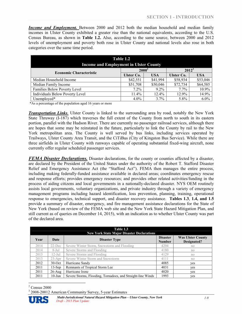
Income and Employment. Between 2000 and 2012 both the median household and median family incomes in Ulster County exhibited a greater rise than the national equivalents, according to the U.S. Census Bureau, as shown in Table 1.2. Also, according to the same source, between 2000 and 2012 levels of unemployment and poverty both rose in Ulster County and national levels also rose in both categories over the same time period.
Table 1.2
Income and Employment in Ulster County
Economic Characteristic 2000
2 2012
3
Ulster Co. USA Ulster Co. USA
Median Household Income $42,551 $41,994 $58,934 $53,046
Median Family Income $51,708 $50,046 $72,734 $64,585
Families Below Poverty Level 7.2% 9.2% 7.7% 10.9%
Individuals Below Poverty Level 11.4% 12.4% 12.9% 14.9%
Unemployed* 4.0% 3.7% 5.8% 6.0% *As a percentage of the population aged 16 years or more
Transportation Links. Ulster County is linked to the surrounding area by road, notably the New York State Thruway (I$187) which traverses the full extent of the County from north to south in its eastern portion, parallel with the Hudson River. There are currently no passenger railroad services, although there are hopes that some may be reinstated in the future, particularly to link the County by rail to the New York metropolitan area. The County is well served by bus links, including services operated by Trailways, Ulster County Area Transit, and the CiTiBus (City of Kingston Bus Service). While there are three airfields in Ulster County with runways capable of operating substantial fixed$wing aircraft, none currently offer regular scheduled passenger services.
FEMA Disaster Declarations. Disaster declarations, for the county or counties affected by a disaster, are declared by the President of the United States under the authority of the Robert T. Stafford Disaster Relief and Emergency Assistance Act (the “Stafford Act”). FEMA then manages the entire process, including making federally$funded assistance available in declared areas; coordinates emergency rescue and response efforts; provides emergency resources; and provides other related activities/funding in the process of aiding citizens and local governments in a nationally$declared disaster. NYS OEM routinely assists local governments, voluntary organizations, and private industry through a variety of emergency management programs including hazard identification, loss prevention, planning, training, operational response to emergencies, technical support, and disaster recovery assistance. Tables 1.3, 1.4, and 1.5 provide a summary of disaster, emergency, and fire management assistance declarations for the State of New York (based on review of the FEMA web site and the New York State Hazard Mitigation Plan, and still current as of queries on December 14, 2015), with an indication as to whether Ulster County was part of the declared area.
Table 1.3
New York State Major Disaster Declarations
Year Date Disaster Type Disaster
Number
Was Ulster County
Designated?
2014 22$Dec Severe Winter Storm, Snowstorm and Flooding 4204 no
2014 8$Jul Severe Storms and Flooding 4180 no
2013 12$Jul Severe Storms and Flooding 4129 no
2013 23$Apr Severe Winter Storm and Snowstorm 4111 no
2012 30$Oct Hurricane Sandy 4085 yes
2011 13$Sep Remnants of Tropical Storm Lee 4031 yes
2011 26$Aug Hurricane Irene 4020 yes
2011 10$Jun Severe Storms, Flooding, Tornadoes, and Straight$line Winds 1993 yes
2 Census 2000 3 2008$20012 American Community Survey, 5$year Estimates

SECTION 1 INTRODUCTION
Multi�Jurisdictional Natural Hazard Mitigation Plan – Ulster County, New York Draft � 2015 Plan Update
1�10
Table 1.3
New York State Major Disaster Declarations
Year Date Disaster Type Disaster
Number
Was Ulster County
Designated?
2011 18$Feb Winter Storm and Snowstorm 1957 no
2010 14$Oct Severe Storms, Tornadoes, and Straight$line Winds 1943 no
2010 16$Apr Severe Storms and Flooding 1899 no
2009 31$Dec Severe Storms and Flooding $ Ida and Nor'easter 1869 no
2009 1$Sep Severe Storms and Flooding 1857 no
2009 4$Mar Severe Winter Storms 1827 no
2007 31$Aug Severe Storms, Flooding, and Tornado 1724 no
2007 2$Jul Severe Storms and Flooding 1710 yes
2007 24$Apr Severe Storms and Inland and Coastal Flooding 1692 yes
2006 12$Dec Severe Storms and Flooding 1670 no
2006 24$Oct Severe Storms and Flooding 1665 no
2006 1$Jul Severe Storms and Flooding 1650 yes
2005 19$Apr Severe Storms and Flooding 1589 yes
2004 1$Oct Tropical Depression Ivan 1565 yes
2004 1$Oct Severe Storms and Flooding 1564 yes
2004 3$Aug Severe Storms and Flooding 1534 yes
2003 29$Aug Severe Storms, Tornadoes and Flooding 1486 no
2003 12$May Ice Storm 1467 no
2002 16$May Earthquake 1415 no
2002 1$Mar Snowstorm 1404 no
2001 11$Sep World Trade Center Terrorist Attack 1391 yes
2000 21$Jul Severe Storms 1335 yes
1999 19$Sep Hurricane Floyd 1296 yes
1998 11$Sep Severe Storms 1244 no
1998 7$Jul Severe Storms and Flooding 1233 no
1998 16$Jun New York Severe Thunderstorms and Tornadoes 1222 no
1998 10$Jan Severe Winter Storms 1196 no
1996 9$Dec Severe Storms/Flooding 1148 no
1996 19$Nov Severe Storms/Flooding 1146 no
1996 24$Jan Severe Storms/Flooding 1095 yes
1996 12$Jan Blizzard 1083 yes
1993 2$Apr World Trade Center Explosion 984 no
1992 21$Dec Coastal Storm, High Tides, Heavy Rain, Flooding 974 no
1991 16$Sep Hurricane Bob 918 no
1991 21$Mar Severe Storm, Winter Storm 898 no
1987 10$Nov Severe Winter Storms 801 no
1987 15$May Flooding 792 yes
1985 18$Oct Hurricane Gloria 750 no
1985 22$Mar Snow Melt, Ice Jams 734 no
1985 20$Mar Flooding 733 no
1984 25$Sep Severe Storms/Flooding 725 no
1984 17$Apr Coastal Storms/Flooding 702 yes
1977 5$Feb Snowstorms 527 no
1976 3$Sep Hurricane Belle 520 no
1976 21$Jul Severe Storms/Flooding 515 no
1976 29$Jun Flash Flooding 512 no
1976 19$Mar Ice Storm, Severe Storms, Flooding 494 no
1975 2$Oct Severe Storms, Heavy Rain, Landslides, Flooding 487 no
1974 23$Jul Severe Storms/Flooding 447 no
1973 20$Jul Severe Storms/Flooding 401 yes
1972 23$Jun Tropical Storm Agnes 338 yes
1971 13$Sep Severe Storms/Flooding 311 yes
1970 22$Jul Heavy Rains, Flooding 290 no
1969 26$Aug Heavy Rains, Flooding 275 no
1967 30$Oct Severe Storms/Flooding 233 no
1965 18$Aug Water Shortage 204 yes
1963 23$Aug Heavy Rains, Flooding 158 no
1962 16$Mar Severe Storm, High Tides, Flooding 129 no

SECTION 1 INTRODUCTION
Multi�Jurisdictional Natural Hazard Mitigation Plan – Ulster County, New York Draft � 2015 Plan Update
1�11
Table 1.3
New York State Major Disaster Declarations
Year Date Disaster Type Disaster
Number
Was Ulster County
Designated?
1956 29$Mar Flood 52 no
1955 22$Aug Hurricane, Flood 45 no
1954 7$Oct Hurricane 26 no
Table 1.4
New York State Emergency Declarations
Year Date Emergency Type Declaration
Number
Was Ulster County
Designated?
2012 28$Oct Hurricane Sandy 3351 yes
2011 8$Sep Remnants of Tropical Storm Lee 3341 no
2011 26$Aug Hurricane Irene 3328 yes
2008 18$Dec Severe Winter Storm 3299 no
2007 23$Feb Snow 3273 no
2006 15$Oct Snowstorm 3268 no
2005 30$Sep Hurricane Katrina Evacuation 3262 yes
2004 3$Mar Snow 3195 no
2003 23$Aug Power Outage 3186 yes
2003 27$Mar Snowstorm 3184 yes
2003 26$Feb Snowstorm 3173 yes
2002 1$Jan Snowstorm 3170 no
2000 4$Dec Snow Storm 3157 no
2000 11$Oct Virus Threat 3155 yes
1999 18$Sep Hurricane Floyd 3149 no
1999 10$Mar Winter Storm 3138 no
1999 15$Jan Winter Storm 3136 no
1993 17$Mar Severe Blizzard 3107 not available
1980 21$May Chemical Waste, Love Canal 3080 no
1978 7$Aug Chemical Waste, Love Canal 3066 no
1977 29$Jan Snowstorms 3027 no
1974 2$Nov Flooding (NYS Barge Canal) 3004 no
Table 1.5
New York State Fire Management Assistance Declarations
Year Date Disaster Type Disaster
Number
Was Ulster County
Designated?
1999 9$Aug West Point Fire Complex 2269 no
1995 21$Aug Sunrise Complex 2115 no
Participating Jurisdictions
Ulster County took a multi$jurisdictional approach to preparing its initial hazard mitigation plan and this 2015 Plan Update, inviting all 24 of its municipalities to participate. County and local levels of government bring unique resources to the table. The County has personnel, funding, data, and capabilities that many local jurisdictions lack, while municipalities have the legal authority to enforce compliance with land use planning and development issues. For the initial 2009 Plan, the County and 12 of its municipalities opted to participate in, and were covered by, the Plan: Ulster County, Gardiner, Hurley, Kingston City, Kingston Town, Lloyd, Marbletown, Marlborough, Rosendale, Saugerties Town, Shandaken, Shawangunk, and Ulster Town. The following

SECTION 1 INTRODUCTION
Multi�Jurisdictional Natural Hazard Mitigation Plan – Ulster County, New York Draft � 2015 Plan Update
1�12
municipalities did not participate in 2009: Denning, Ellenville, Esopus, Hardenburgh, New Paltz Town, New Paltz Village, Olive, Plattekill, Rochester, Saugerties Village, Wawarsing, and Woodstock. For the 2015 Plan Update, Ulster County and 21 of its constituent municipalities participated in, and are covered by, this plan update. They are:
County of Ulster
Denning, Town of Lloyd, Town of Saugerties, Town of
Ellenville, Village of Marlborough, Town of Saugerties, Village of
Gardiner, Town of New Paltz, Town of Shandaken, Town of
Hardenburgh, Town of New Paltz, Village of Shawangunk, Town of
Hurley, Town of Olive, Town of Ulster, Town of
Kingston, City of Plattekill, Town of Wawarsing, Town of
Kingston, Town of Rosendale, Town of Woodstock, Town of
At the outset of the plan update process, participation commitments were demonstrated through each jurisdiction submitting a fully executed Statement of Authority to Participate to UCECEM. Figure 1.2
shows a blank version of this letter of commitment. Completed statements are included in Appendix 1.1
– Statements of Authority to Participate.
The County’s remaining three municipalities (Esopus, Marbletown, and Rochester) initially provided a Statement of Authority to Participate, but later opted out of the process.
Figure 1.2 – Statement of Authority
SECTION 1 INTRODUCTION
Multi�Jurisdictional Natural Hazard Mitigation Plan – Ulster County, New York Draft � 2015 Plan Update
1�13
Hazard Mitigation Planning Team Organizational Structure
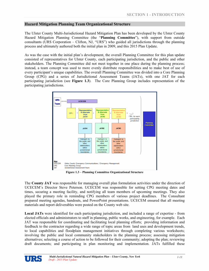
The Ulster County Multi$Jurisdictional Hazard Mitigation Plan has been developed by the Ulster County Hazard Mitigation Planning Committee (the “Planning Committee”), with support from outside consultants (URS Corporation – Clifton, NJ, “URS”) who guided all jurisdictions through the planning process and ultimately authored both the initial plan in 2009, and this 2015 Plan Update. As was the case with the initial plan’s development, the overall Planning Committee for this plan update consisted of representatives for Ulster County, each participating jurisdiction, and the public and other stakeholders. The Planning Committee did not meet together in one place during the planning process; instead, a team concept was used to more evenly distribute responsibilities and to make best of use of every participant’s unique capabilities. The overall Planning Committee was divided into a Core Planning Group (CPG) and a series of Jurisdictional Assessment Teams (JATs), with one JAT for each participating jurisdiction (see Figure 1.3). The Core Planning Group includes representation of the participating jurisdictions.
Figure 1.3 – Planning Committee Organizational Structure
The County JAT was responsible for managing overall plan formulation activities under the direction of UCECEM’s Director Steve Peterson. UCECEM was responsible for setting CPG meeting dates and times, securing a meeting facility, and notifying all team members of upcoming meetings. They also played the primary role in reminding CPG members of various project deadlines. The Consultant prepared meeting agendas, handouts, and PowerPoint presentations. UCECEM ensured that all meeting materials and report deliverables were posted on the County web site.
Local JATs were identified for each participating jurisdiction, and included a range of expertise $ from elected officials and administrators to staff in planning, public works, and engineering, for example. Each JAT was responsible for coordinating and facilitating local planning efforts; providing information and feedback to the contractor regarding a wide range of topic areas from land uses and development trends, to local capabilities and floodplain management initiatives through completing various worksheets; involving the public and local community stakeholders in the planning process; assessing mitigation alternatives; selecting a course of action to be followed for their community; adopting the plan; reviewing draft documents; and participating in plan monitoring and implementation. JATs fulfilled these

SECTION 1 INTRODUCTION
Multi�Jurisdictional Natural Hazard Mitigation Plan – Ulster County, New York Draft � 2015 Plan Update
1�14
responsibilities under the leadership of their CPG members (the “representative” and “alternate” designated on the Statement of Authority to Participate). The CPG as a whole $ made up of lead members of each JAT – was the day$to$day planning team for the overall multi$jurisdictional planning process. CPG members were the primary local points of contact for both the County JAT and the consultant and were the go$betweens between the local JATs and the larger CPG. CPG members were responsible for fulfilling their jurisdiction’s plan update process obligations, with assistance and direct support from the members of their JAT. CPG members attended planning meetings; conveyed meeting information back to their JAT members; solicited information and feedback needed from JAT members for incorporation into the plan (typically, on an as$needed basis depending upon the nature of the information request as compared to JAT member areas of specialty), and had primary responsibility for providing opportunities for the public and other stakeholders within their jurisdiction to be involved in the planning process. Readers are invited to review the jurisdictional annexes of Appendix 1.2 for a list of JAT members for each jurisdiction. CPG Representatives and Alternates are identified on the Statements of Authority of Appendix 1.1. At the end of the plan update process, each jurisdiction will formally adopt the Final Plan, documenting their commitment to strive to implement the actions and projects identified in the mitigation strategy to reduce or eliminate long$term risk from natural hazards and disasters in their community.
Planning Team Meetings The initial version of this plan was prepared between 2007 and 2008. It was approved by FEMA and adopted by local communities in 2009. Participating jurisdictions have been working since that time to implement the actions that were listed in their respective mitigation strategies. FEMA requires ongoing plan implementation, regular monitoring of progress, and formal updates every five years thereafter. The 2009 Plan provided the details of the initial plan development process, which will not be reiterated here. Instead, this subsection will focus strictly on the process undertaken during the first plan update. Ulster County and its jurisdictions initiated the process for this first required plan update by submitting a planning grant application to FEMA on May 1, 2012 under the HMGP program; notification of grant award was received on September 19, 2012 (HMGP$4020 Planning Grants). URS was selected to facilitate the update process. A contract was subsequently negotiated, with URS receipt of a notice to proceed on August 13, 2013. Key planning team meetings held during the plan update process are summarized in Table 1.5.
4 Meeting materials such as agendas, sign in sheets, and presentations are provided in Appendix 1.3.
Table 1.5
Key Planning Team Meetings
Date Title Details
December 11, 2012 County JAT
Meeting JAT meeting, which included the County executive’s office, to initially discuss Plan development, timeline, stakeholders, and hiring of a consultant to guide the County in this update process.
January 7, 2013 County JAT
Meeting County staff convened to further discuss a timeline for Plan development and prepare language for a resolution authorizing the contract with NYS OEM.
April 3, 2013 County JAT
Meeting JAT members, including Ulster County Department of Information Services met to discuss current hazard mitigation GIS data availability and how to best incorporate into the Plan update.
August 16, 2013
Project Initiation Meeting
(UCECEM, URS)
Project Initiation Meeting Teleconference – UCECEM met with URS on a conference call to refine the scope of work and project schedule. They discussed the overall readiness of the CPG to begin the update process; CPG activities/progress since 2009 in plan maintenance and integration; project schedule; scope of work; approach for future meetings (particularly the Kickoff Meeting); exchanged GIS staff points of contact, and outreach to the public and other stakeholders.
October 3, 2013 CPG
Kickoff Meeting
Topics discussed included: the importance of the plan update, overview of the 2009 plan, benefits of continued participation in the plan update, key steps of the plan update process, participation requirements for the update, project timeline, near term actions items for participating jurisdictions, outreach to the public and other stakeholders, long term action items for participating jurisdictions,
4 Local JAT meetings are not presented in this table. Individual JATs met on a fairly ad$hoc basis throughout the plan update process as they deemed necessary.
SECTION 1 INTRODUCTION
Multi�Jurisdictional Natural Hazard Mitigation Plan – Ulster County, New York Draft � 2015 Plan Update
1�15
Table 1.5
Key Planning Team Meetings
Date Title Details
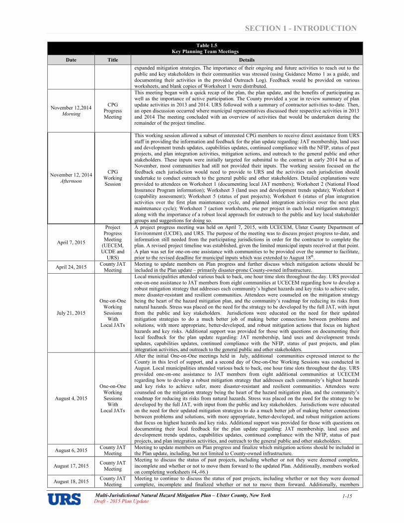
expanded mitigation strategies. The importance of their ongoing and future activities to reach out to the public and key stakeholders in their communities was stressed (using Guidance Memo 1 as a guide, and documenting their activities in the provided Outreach Log). Feedback would be provided on various worksheets, and blank copies of Worksheet 1 were distributed.
November 12,2014 Morning
CPG Progress Meeting
This meeting began with a quick recap of the plan, the plan update, and the benefits of participating as well as the importance of active participation. The County provided a year in review summary of plan update activities in 2013 and 2014. URS followed with a summary of contractor activities to$date. Then, an open discussion occurred where municipal representatives discussed their respective activities in 2013 and 2014 The meeting concluded with an overview of activities that would be undertaken during the remainder of the project timeline.
November 12, 2014 Afternoon
CPG Working Session
This working session allowed a subset of interested CPG members to receive direct assistance from URS staff in providing the information and feedback for the plan update regarding: JAT membership, land uses and development trends updates, capabilities updates, continued compliance with the NFIP, status of past projects, and plan integration activities, mitigation actions, and outreach to the general public and other stakeholders. These inputs were initially targeted for submittal to the contract in early 2014 but as of November, most communities had still not provided their inputs. The working session focused on the feedback each jurisdiction would need to provide to URS and the activities each jurisdiction should undertake to conduct outreach to the general public and other stakeholders. Detailed explanations were provided to attendees on Worksheet 1 (documenting local JAT members); Worksheet 2 (National Flood Insurance Program information); Worksheet 3 (land uses and development trends update); Worksheet 4 (capability assessment); Worksheet 5 (status of past projects); Worksheet 6 (status of plan integration activities over the first plan maintenance cycle, and planned integration activities over the next plan maintenance cycle); Worksheet 7 (action worksheets, one per project in each local mitigation strategy); along with the importance of a robust local approach for outreach to the public and key local stakeholder groups and suggestions for doing so.
April 7, 2015
Project Progress Meeting
(UECEM, UCDE and
URS)
A project progress meeting was held on April 7, 2015, with UCECEM, Ulster County Department of Environment (UCDE), and URS. The purpose of the meeting was to discuss project progress to$date, and information still needed from the participating jurisdictions in order for the contractor to complete the plan. A revised project timeline was established, given the limited municipal inputs received at that point. A plan was set for one$on$one assistance with communities to be provided over the summer to facilitate, prior to the revised deadline for municipal inputs which was extended to August 18th.
April 24, 2015 County JAT
Meeting Meeting to update members on Plan progress and further discuss which mitigation actions should be included in the Plan update – primarily disaster$prone County$owned infrastructure.
July 21, 2015
One$on$One Working Sessions
With Local JATs
Local municipalities attended various back to back, one hour time slots throughout the day. URS provided one$on$one assistance to JAT members from eight communities at UCECEM regarding how to develop a robust mitigation strategy that addresses each community’s highest hazards and key risks to achieve safer, more disaster$resistant and resilient communities. Attendees were counseled on the mitigation strategy being the heart of the hazard mitigation plan, and the community’s roadmap for reducing its risks from natural hazards. Stress was placed on the need for the strategy to be developed by the full JAT, with input from the public and key stakeholders. Jurisdictions were educated on the need for their updated mitigation strategies to do a much better job of making better connections between problems and solutions, with more appropriate, better$developed, and robust mitigation actions that focus on highest hazards and key risks. Additional support was provided for those with questions on documenting their local feedback for the plan update regarding: JAT membership, land uses and development trends updates, capabilities updates, continued compliance with the NFIP, status of past projects, and plan integration activities, and outreach to the general public and other stakeholders.
August 4, 2015
One$on$One Working Sessions
With Local JATs
After the initial One$on$One meetings held in July, additional communities expressed interest to the County in this level of support, and a second day of One$on$One Working Sessions was conducted in August. Local municipalities attended various back to back, one hour time slots throughout the day. URS provided one$on$one assistance to JAT members from eight additional communities at UCECEM regarding how to develop a robust mitigation strategy that addresses each community’s highest hazards and key risks to achieve safer, more disaster$resistant and resilient communities. Attendees were counseled on the mitigation strategy being the heart of the hazard mitigation plan, and the community’s roadmap for reducing its risks from natural hazards. Stress was placed on the need for the strategy to be developed by the full JAT, with input from the public and key stakeholders. Jurisdictions were educated on the need for their updated mitigation strategies to do a much better job of making better connections between problems and solutions, with more appropriate, better$developed, and robust mitigation actions that focus on highest hazards and key risks. Additional support was provided for those with questions on documenting their local feedback for the plan update regarding: JAT membership, land uses and development trends updates, capabilities updates, continued compliance with the NFIP, status of past projects, and plan integration activities, and outreach to the general public and other stakeholders.
August 6, 2015 County JAT
Meeting Meeting to update members on Plan progress and finalize which mitigation actions should be included in the Plan update, including, but not limited to County$owned infrastructure.
August 17, 2015 County JAT
Meeting
Meeting to discuss the status of past projects, including whether or not they were deemed complete, incomplete and whether or not to move them forward to the updated Plan. Additionally, members worked on completing worksheets #4,$#6.)
August 18, 2015 County JAT
Meeting Meeting to continue to discuss the status of past projects, including whether or not they were deemed complete, incomplete and finalized whether or not to move them forward. Additionally, members
SECTION 1 INTRODUCTION
Multi�Jurisdictional Natural Hazard Mitigation Plan – Ulster County, New York Draft � 2015 Plan Update
1�16
Table 1.5
Key Planning Team Meetings
Date Title Details
completed worksheets #4,$#6.)
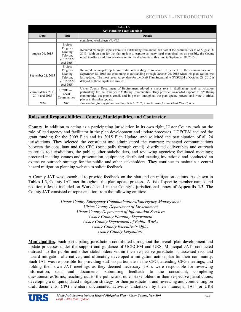
August 20, 2015
Project Progress Meeting Telecon,
(UCECEM
and URS)
Required municipal inputs were still outstanding from more than half of the communities as of August 18, 2015. With an aim for the plan update to capture as many local municipalities as possible, the County opted to offer an additional extension for local submittals; this time to September 18, 2015.
September 21, 2015
Project Progress Meeting Telecon,
(UCECEM
and URS)
Required municipal inputs were still outstanding from about 30 percent of the communities as of September 18, 2015 and continuing as outstanding through October 26, 2015 when this plan section was last updated. The most recent target date for the Draft Plan Submittal to NYSOEM of October 28, 2015 is delayed as these inputs are awaited.
Various dates, 2013, 2014 and 2015
UCDE and Local
Communities
Ulster County Department of Environment played a major role in facilitating local participation, particularly for the County’s NY Rising Communities. They provided as$needed support to NY Rising communities via phone, email, and in person throughout the plan update process and were a critical player in this plan update.
2016 TBD Placeholder for any future meetings held in 2016, to be inserted for the Final Plan Update.
Roles and Responsibilities – County, Municipalities, and Contractor County. In addition to acting as a participating jurisdiction in its own right, Ulster County took on the role of lead agency and facilitator in the plan development and update processes. UCECEM secured the grant funding for the 2009 Plan and its 2015 Plan Update, and solicited the participation of all 24 jurisdictions. They selected the consultant and administered the contract; managed communications between the consultant and the CPG (principally through email); distributed deliverables and outreach materials to jurisdictions, the public, other stakeholders, and reviewing agencies; facilitated meetings; procured meeting venues and presentation equipment; distributed meeting invitations; and conducted an extensive outreach strategy for the public and other stakeholders. They continue to maintain a central hazard mitigation planning website to solicit feedback. A County JAT was assembled to provide feedback on the plan and on mitigation actions. As shown in Tables 1.5, County JAT met throughout the plan update process. A list of specific member names and position titles is included on Worksheet 1 in the County’s jurisdictional annex of Appendix 1.2. The County JAT consisted of representation from the following entities:
Ulster County Emergency Communications/Emergency Management
Ulster County Department of Environment
Ulster County Department of Information Services
Ulster County Planning Department
Ulster County Department of Public Works
Ulster County Executive’s Office
Ulster County Legislature
Municipalities. Each participating jurisdiction contributed throughout the overall plan development and update processes under the support and guidance of UCECEM and URS. Municipal JATs conducted outreach to the public and other stakeholders within their respective jurisdictions, assessed risk and hazard mitigation alternatives, and ultimately developed a mitigation action plan for their community. Each JAT was responsible for providing staff to participate in the CPG, attending CPG meetings, and holding their own JAT meetings as they deemed necessary. JATs were responsible for reviewing information, data and documents; submitting feedback to the consultant; completing questionnaires/forms; reaching out to the public and other stakeholders in their respective jurisdictions; developing a unique updated mitigation strategy for their jurisdiction; and reviewing and commenting on draft documents. CPG members documented activities undertaken by their municipal JAT for URS

SECTION 1 INTRODUCTION
Multi�Jurisdictional Natural Hazard Mitigation Plan – Ulster County, New York Draft � 2015 Plan Update
1�17
incorporation into the document, and prepared the following written documentation at key junctures in the plan update process:
• Each municipality formally advised UCECEM of their desire to participate in the multi$jurisdictional hazard mitigation plan update process. Statements of “Authority to Participate” from participating jurisdictions are included in Appendix 1.1.
• Each CPG member was responsible for developing a local JAT for their community. “Worksheet 1 – JAT Membership” documents, for a range of position titles, who was approached by the CPG member and when, and whether or not that person agreed to participate in the plan update (along with their contact information). Copies of Worksheet 1 submittals are included in jurisdictional annexes of Appendix 1.2.
• At the project kickoff meeting on October 3, 2013, CPG members learned about the plan update process and their role in it. They also were asked to provide feedback on whether they felt any hazards should be added to – or omitted from – the list of hazards that were previously included in the 2009 plan. Meeting materials from this kickoff meeting and others throughout the plan update process are provided in Appendix 1.3.
• All of Ulster County’s municipalities participate in FEMA’s NFIP. Each CPG member coordinated with their local floodplain manager to describe their community’s participation in the NFIP and describe their floodplain management program for continued compliance with NFIP requirements. “Worksheet 2 – NFIP Participation” documents this information, and copies of each response are included in jurisdictional annexes of Appendix 1.2.
• Each CPG member coordinated with their JAT to document changes in land uses and development trends since the last plan was prepared. “Worksheet 3 $ Land Uses and Development Trends Worksheet” documents this step. Copies of each JAT’s response are included in jurisdictional annexes of Appendix 1.2.
• Each CPG member coordinated with their JAT to document changes in local capabilities since the last plan was prepared. “Worksheet 4 – Capability Assessment” documents this step, elaborating on each jurisdiction’s existing authorities, policies, programs and resources, and its ability to expand on and improve these existing policies and programs. Copies of each JAT’s response are included in jurisdictional annexes of Appendix 1.2.
• Each CPG member coordinated with their JAT to evaluate and demonstrate progress made in the past five years in achieving goals and implementing actions outlined in their 2009 mitigation strategy, including an explanation of if and how any priorities may have changed since the plan was previously approved. “Worksheet 5 – Status of Past Projects” documents this step, and copies of each JAT’s response are included in jurisdictional annexes of Appendix 1.2.
• Each CPG member coordinated with their JAT to document the status of plan integration activities over the first plan maintenance cycle, and jurisdiction$specific activities projected for the next plan maintenance cycle. “Worksheet 6 – Plan Integration” documents this step, and copies of each JAT’s response are included in jurisdictional annexes of Appendix 1.2.
• Each CPG member coordinated with their JAT to develop an updated mitigation strategy. “Worksheet 7 – Action Worksheets” document this step (with one worksheet for each action). Each JAT’s action plan describes how the actions identified will be prioritized (including cost benefit review), implemented, and administered by each jurisdiction. Copies of the action worksheets for projects comprising each jurisdiction’s local mitigation strategy are included in jurisdictional annexes of Appendix 1.2.
• Each JAT provided opportunities for the general public and other stakeholders to be made aware of the plan update process, and the opportunity for them to participate and provide feedback. Outreach Logs were completed by each JAT as activities were undertaken. Copies of each JAT’s Outreach Logs are included in jurisdictional annexes of Appendix 1.2.
A detailed summary of the participation demonstrated by each jurisdiction, including attendance at meetings and submission of requested deliverables, is presented in Table 1.6 on the next page.
SECTION 1 INTRODUCTION
Multi�Jurisdictional Natural Hazard Mitigation Plan – Ulster County, New York Draft � 2015 Plan Update
1�18
Contractor. URS was contracted by the County to guide participating jurisdictions through the process and author the plan in a manner consistent with applicable regulations, criteria, and guidance. URS was the lead firm for this assignment for both the 2009 Plan and the 2015 Plan Update. URS was the direct County point of contact, and assisted in all aspects of the plan update, guided local municipalities through their participation in key aspects of the update in a manner that would meet current requirements, led the hazard mitigation planning efforts, was the primary presenter at CPG meetings, authored the plan document, and provided overall contract administration. URS conducted the analyses necessary to provide team members with the information they needed to make sound decisions, and helped guide them through the necessary steps of the plan development and update processes. URS also prepared a project fact sheet; sample generic press release about the plan update for use by municipalities, at their option (in full or in part); and a sample generic PowerPoint presentation about the plan update process, also for use by municipalities, at their option (in full or in part) $ both to facilitate consistent messaging across participating municipalities and for the sake of efficiency by ensuring that different municipalities didn’t have to each spend time generating separate presentation materials. These were emailed to participating jurisdictions via UCECEM at various points in the project timeline between 2013 and 2014, and provided again en$masse to CPG members on CD at the project Progress Meeting on November 12, 2014 for their use throughout the project.

SECTION 1 INTRODUCTION
Multi�Jurisdictional Natural Hazard Mitigation Plan – Ulster County, New York
Draft � 2015 Plan Update 1�19
5 Worksheet 1 = JAT Membership; Worksheet 2 = NFIP; Worksheet 3 = Land Uses and Development Trends Update; Worksheet 4 = Capability Assessment Update; worksheet 5 = Status of Past Projects; Worksheet 6 = Plan Integration; Worksheet 7 = Action Worksheets. Worksheet 2 is not applicable for the County because the county level of
government is not eligible to participate in the NFIP. This table includes all documentation received by URS as of October 26, 2015.
Table 1.6
Ulster County Jurisdictions Plan Participation
Entity
Returned
Statement
of
Authority
to
Participate
Planning Team Meetings Attended
(listed in chronological order from left to right) Worksheets
Submitted5
Submitted
Documentation
County
JAT
Meeting
12/11/12
County
JAT
Meeting
01/07/13
County
JAT
Meeting
04/03/13
Project
Initiation
Meeting
08/16/13
CPG
Kickoff
Meeting
10/03/13
CPG
Progress
Meeting
11/12/14
CPG
Working
Session
11/12/14
Project
Progress
Meeting
04/07/15
County
JAT
Meeting
04/24/15
OneonOne
Working
Sessions with
Local JATs
07/21/15
OneonOne
Working
Sessions with
Local JATs
08/04/15
County
JAT
Meeting
08/06/15
County
JAT
Meeting
08/17/15
County
JAT
Meeting
08/18/15
1 2 3 4 5 6 7
of Outreach to
the Public and
Other Stake
holders
Ulster, County of ■ ■ ■ ■ ■ ■ ■ ■ ■ ■ ■ ■ ■ ■ ■ ■ ■ ■ ■ ■ ■ ■
Emergency Communications/Emergency Management
■ ■ ■ ■ ■ ■ ■ ■ ■ ■ ■ ■ ■ ■
County JAT members provided feedback for various worksheets and assisted with
outreach.
Department of Environment ■ ■ ■ ■ ■ ■ ■ ■ ■ ■
Planning ■ ■ ■ ■
Engineering/Public Works ■ ■ ■
Information Services ■
Manager/Administrator ■ ■ ■
Elected Officials ■ ■
Communities
Denning, Town of ■ ■ ■ ■ ■ ■ ■ ■ ■ ■ ■ ■
Ellenville, Village of ■ ■ ■ ■ ■ ■ ■ ■ ■ ■ ■
Esopus, Town of ■ ■
Gardiner, Town of ■ ■ ■ ■ ■ ■ ■ ■ ■ ■
Hardenburgh, Town of ■ ■ ■ ■ ■ ■ ■ ■ ■ ■
Hurley, Town of ■ ■ ■ ■ ■ ■ ■ ■ ■ ■ ■
Kingston, City of ■ ■ ■ ■ ■ ■ ■ ■ ■
Kingston, Town of ■ ■ ■ ■ ■ ■ ■ ■ ■ ■ ■ ■
Lloyd, Town of ■ ■ ■ ■ ■ ■ ■ ■
Marbletown, Town of ■ ■ ■
Marlborough, Town of ■ ■ ■ ■ ■ ■ ■ ■ ■ ■
New Paltz, Town of ■ ■ ■ ■ ■ ■ ■ ■ ■ ■ ■ ■ ■
New Paltz, Village of ■ ■ ■ ■ ■ ■ ■ ■ ■ ■
Olive, Town of ■ ■ ■ ■ ■ ■ ■ ■ ■ ■ ■ ■
Plattekill, Town of ■ ■ ■ ■ ■ ■ ■ ■ ■ ■ ■ ■
Rochester, Town of ■ ■ ■
Rosendale, Town of ■ ■ ■ ■ ■ ■ ■ ■ ■
Saugerties, Town of ■ ■ ■ ■ ■ ■ ■ ■ ■ ■
Saugerties, Village of ■ ■ ■ ■ ■ ■ ■ ■ ■ ■ ■ ■
Shandaken, Town of ■ ■ ■ ■ ■ ■ ■ ■ ■ ■ ■
Shawangunk, Town of ■ ■ ■ ■ ■ ■ ■ ■ ■
Ulster, Town of ■ ■ ■ ■ ■ ■ ■ ■ ■ ■ ■ ■ ■
Wawarsing, Town of ■ ■ ■ ■ ■ ■ ■ ■ ■ ■ ■ ■
Woodstock, Town of ■ ■ ■ ■ ■ ■ ■ ■ ■ ■
Stakeholders
American Red Cross ■
Central Hudson Gas & Electric ■
Health Alliance of the Hudson Valley ■
New York City DEP ■
New York State Police ■
New York State OEM – Region 2 ■
New York Thruway Authority ■
Orange County OEM ■
SUNY New Paltz ■ ■
SUNY Ulster ■
Consultant
URS ■ ■ ■ ■ ■ ■ ■
KEY: = Not invited/Not applicable ■ = Invited and attended/submitted
[blank cell] = Invited but did not attend/submit
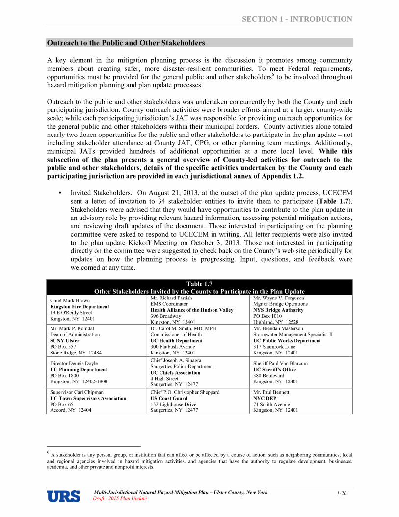
SECTION 1 INTRODUCTION
Multi�Jurisdictional Natural Hazard Mitigation Plan – Ulster County, New York
Draft � 2015 Plan Update 1�20
Outreach to the Public and Other Stakeholders
A key element in the mitigation planning process is the discussion it promotes among community members about creating safer, more disaster$resilient communities. To meet Federal requirements, opportunities must be provided for the general public and other stakeholders6 to be involved throughout hazard mitigation planning and plan update processes. Outreach to the public and other stakeholders was undertaken concurrently by both the County and each participating jurisdiction. County outreach activities were broader efforts aimed at a larger, county$wide scale; while each participating jurisdiction’s JAT was responsible for providing outreach opportunities for the general public and other stakeholders within their municipal borders. County activities alone totaled nearly two dozen opportunities for the public and other stakeholders to participate in the plan update – not including stakeholder attendance at County JAT, CPG, or other planning team meetings. Additionally, municipal JATs provided hundreds of additional opportunities at a more local level. While this
subsection of the plan presents a general overview of Countyled activities for outreach to the
public and other stakeholders, details of the specific activities undertaken by the County and each
participating jurisdiction are provided in each jurisdictional annex of Appendix 1.2.
• Invited Stakeholders. On August 21, 2013, at the outset of the plan update process, UCECEM sent a letter of invitation to 34 stakeholder entities to invite them to participate (Table 1.7). Stakeholders were advised that they would have opportunities to contribute to the plan update in an advisory role by providing relevant hazard information, assessing potential mitigation actions, and reviewing draft updates of the document. Those interested in participating on the planning committee were asked to respond to UCECEM in writing. All letter recipients were also invited to the plan update Kickoff Meeting on October 3, 2013. Those not interested in participating directly on the committee were suggested to check back on the County’s web site periodically for updates on how the planning process is progressing. Input, questions, and feedback were welcomed at any time.
Table 1.7
Other Stakeholders Invited by the County to Participate in the Plan Update
Chief Mark Brown Kingston Fire Department
19 E O'Reilly Street Kingston, NY 12401
Mr. Richard Parrish EMS Coordinator Health Alliance of the Hudson Valley
396 Broadway Kingston, NY 12401
Mr. Wayne V. Ferguson Mgr of Bridge Operations NYS Bridge Authority
PO Box 1010 Highland, NY 12528
Mr. Mark P. Komdat Dean of Administration SUNY Ulster
PO Box 557 Stone Ridge, NY 12484
Dr. Carol M. Smith, MD, MPH Commissioner of Health UC Health Department
300 Flatbush Avenue Kingston, NY 12401
Mr. Brendan Masterson Stormwater Management Specialist II UC Public Works Department
317 Shamrock Lane Kingston, NY 12401
Director Dennis Doyle UC Planning Department
PO Box 1800 Kingston, NY 12402$1800
Chief Joseph A. Sinagra Saugerties Police Department UC Chiefs Association
4 High Street Saugerties, NY 12477
Sheriff Paul Van Blarcum UC Sheriff's Office
380 Boulevard Kingston, NY 12401
Supervisor Carl Chipman UC Town Supervisors Association
PO Box 65 Accord, NY 12404
Chief P.O. Christopher Sheppard US Coast Guard
152 Lighthouse Drive Saugerties, NY 12477
Mr. Paul Bennett NYC DEP
71 Smith Avenue Kingston, NY 12401
6 A stakeholder is any person, group, or institution that can affect or be affected by a course of action, such as neighboring communities, local
and regional agencies involved in hazard mitigation activities, and agencies that have the authority to regulate development, businesses, academia, and other private and nonprofit interests.

SECTION 1 INTRODUCTION
Multi�Jurisdictional Natural Hazard Mitigation Plan – Ulster County, New York
Draft � 2015 Plan Update 1�21
Table 1.7
Other Stakeholders Invited by the County to Participate in the Plan Update
Mr. Robert Sudlow Deputy County Executive UC Executive's Office
PO Box 1800 Kingston, NY 12402$1800
Chief David Dugatkin University Police SUNY New Paltz
1 Hawk Drive New Paltz, NY 12561
Mr. Charles Mutz UC Fire Coordinator
24 Brooks Drive Kerhonkson, NY 12446
Mr. Richard Muellerleile EMS Council
61 Van Dale Road Woodstock, NY 12498
Captain Robert Nuzzo New York State Police
1971 Rt 209 Kingston, NY 12401
Mr. Paul LaForce NYS Thruway Authority
Albany Division 200 Southern Blvd Albany, NY 12201
Mr. Michael O'Rourke, PhD Ulster BOCES
175 Rt 32 North New Paltz, NY 12561
Ms. Kathie Cayton American Red Cross
103 Hooker Avenue Poughkeepsie, NY 12601
Mr. Bill Cotting Central Hudson Gas & Electric 284 South Avenue Poughkeepsie, NY 12601
Mr. Ken Davidson Duthess County Emergency Response
392 Creek Road Poughkeepsie, NY 12601
Mr. Gary Tuthill NYS Emergency Management Office
Region 2
10 Ross Circle, Suite 1 South Poughkeepsie, NY 12601
Mr. John Farrell Greene County Emergency Services
25 Volunteer Drive Cairo, NY 12413
Coordinator Amanda LaValle UC Department of Environment
PO Box 1800 Kingston, NY 12402$1800
Mr. Richard Bell Delaware County Emergency Services
280 Phoebe Lane, Suite 3 Delhi, NY 13753
Mr. Richard Martinkovic Sullivan County Emergency Services
PO Box 5012 Monticello, NY 12701
Mr. Seamus Leary Orange County Emergency Management
22 Wells Farm Road Goshen, NY 10924
Mr. Gene Lucchese NYS Emergency Management Office
Region 2
10 Ross Circle ,Suite 1 South Poughkeepsie, NY 12601
Mr. Gary Capella Ulster County Soil & Water Conservation
District
652 Route 299, Suite 103 Highland, NY 12528
Richard Parete, Chairman Law Enforcement and Public Safety Committee PO Box 1800 Kingston, NY 12402$1800
Dean Fabiano, Chairman Public Works & Capital Projects
Committee
PO Box 1800 Kingston, NY 12402$1800
Lieutenant Chris Flocatoulas New York State Police OEM
Sergeant Jeffrey Radliff New York State Police
• Stakeholders Expressing an Interest in Participating. In response to the County’s letter of invitation to stakeholders of August 21, 2013, responses were received from four stakeholder entities indicating a desire to participate in an advisory role in the process (see Table 1.6):
American Red Cross
NYS Thruway Authority
SUNY New Paltz
SUNY Ulster
• Other Stakeholders Attending Key Planning Team Meetings. In response to the County’s letter of invitation to stakeholders of August 21, 2013, the following additional stakeholders also participated by attending one or more planning team meetings (see Table 1.6):
Central Hudson Gas & Electric
Health Alliance of the Hudson Valley
New York City DEP
New York State Police
New York State OEM – Region 2
Orange County OEM
SUNY New Paltz

SECTION 1 INTRODUCTION
Multi�Jurisdictional Natural Hazard Mitigation Plan – Ulster County, New York
Draft � 2015 Plan Update 1�22
• Press. Information regarding the plan update appeared in various news outlets over the course of the project to provide opportunities for the public and other stakeholders to be informed and to participate in the process. An executive press release was issued by the County on November 7, 2013, discussing the plan update process. The County also used the mitigation plan web site to publicize information about the process. A sampling of local media7 articles is provided in Appendix 1.4.
• Public Meetings. The plan update was included as an agenda item at open public meetings of the Ulster County Legislature on January 22, 2013 when it passed Resolution #13 “Authorizing The Chairman Of The Ulster County Legislature To Execute An Agreement With The New York State Office Of Emergency Management To Develop A Multi$Jurisdictional Multi$Hazard Mitigation Plan That Complies With Federal Emergency Management Agency Requirements, And Amending The 2013Ulster County Budget – Emergency Communications / Emergency Management.” The plan update was also discussed by County staff at the following open public meetings: Town of Olive Flood Advisory meetings of October 30, 2014 and March 12, 2015; Claryville Local Flood Analysis meeting of November 3, 2014; Shandaken Area Flood Assessment and Remediation Initiative meetings of November 12, 2014 and February 25, 2015 and July 10, 2015; and the Ashokan Watershed Stream Management Program Stakeholder’s Council meeting of March 19, 2015.
• Website. A hazard mitigation planning page was initiated by UCECEM in 2007 at the onset of development of the initial plan. The County maintained this web presence (http://ulstercountyny.gov/emergency$services/hazard$mitigation), and updated its content to reflect the plan update on September 13, 2013. The purpose of the web content is to inform the public and other stakeholders about the purpose and need for the plan and the update and solicit their feedback and participation. Content includes general information about the process, participating jurisdictions, planning group and meeting information, contact information, a link for the plan, and more. Figure 1.4 shows a screen capture of the main page for the plan update. Figure 1.5 shows a screen capture of the General Information page. All participating jurisdictions have supplemented this by posting links on their jurisdiction web sites to the overall county mitigation planning pages. Screen captures for each jurisdiction are included in Appendix 1.5.
• Document Repository. A document repository was established at the Ulster County Emergency Management Offices at: 238 Golden Hill Lane Kingston, NY 12401. The repository is updated periodically with hard copies of meeting minutes, handouts, etc. as well as draft and final copies of the Plan. The repository is advertised on the County’s hazard mitigation planning web site at http://ulstercountyny.gov/emergency$services/hazard$mitigation/document$repository.
7 News articles in Appendix 1.4 do not represent comprehensive coverage of the plan update by local news media. Other articles may have been
published that do not appear in the appendix. The appendix is intended to give a flavor for the type of articles that appeared throughout the update.
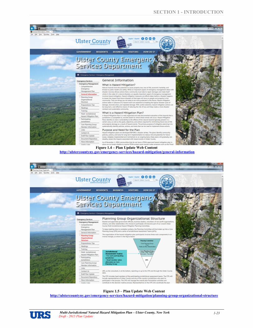
SECTION 1 INTRODUCTION
Multi�Jurisdictional Natural Hazard Mitigation Plan – Ulster County, New York
Draft � 2015 Plan Update 1�23
Figure 1.4 – Plan Update Web Content
http://ulstercountyny.gov/emergencyservices/hazardmitigation/generalinformation
Figure 1.5 – Plan Update Web Content
http://ulstercountyny.gov/emergencyservices/hazardmitigation/planninggrouporganizationalstructure

SECTION 1 INTRODUCTION
Multi�Jurisdictional Natural Hazard Mitigation Plan – Ulster County, New York
Draft � 2015 Plan Update 1�24
• Fact Sheet. Participating jurisdictions found the use of the plan update fact sheet to be of great use for getting the word out regarding the initial plan’s development, and the CPG opted to use this as one component of its outreach strategy for the plan update process as well. Figure 1.6 on the next page shows the fact sheet used for the plan update. In addition to describing the purpose and need for the plan, and information about the plan update, the fact sheet also gave UCECEM contact information for interested parties to reach out to for questions or other feedback, or to learn more about how they could become involved in the plan update process. CPG members distributed this fact sheet on notice boards and at various meetings with the public and other stakeholders. Some examples of ways the County, in particular, used the fact sheet for its outreach strategy include but are not limited to: distribution of the fact sheet to interested parties at its various outreach meetings; and placement of the fact sheet on the UCECEM notice board and notice board in the lobby of the County Office Building. The fact sheet was also distributed on a more ad$hoc basis throughout the process by County staff and participating jurisdictions, and was posted on the plan update web site at:
http://ulstercountyny.gov/sites/default/files/Ulster%20County%20Fact%20Sheet%20August%202013.pdf
• Municipal OEM Coordinators Meetings. On October 17, 2014, December 12, 2014, February 13, 2015, June 12, 2015, August 14, 2015; UCECEM hosted meetings of the Municipal OEM Coordinators. At each meeting, coordinators were made aware of the plan update and invited to participate in the process.
• Disaster Response and Recovery Committee Meetings. UCECEM discussed the hazard mitigation plan update with Emergency Response Team on December 16, 2014; January 20, 2015; February 17, 2015; and April 21, 2015; and encouraged participants to visit the mitigation planning web site at http://ulstercountyny.gov/emergency$services/hazard$mitigation/ for additional information.

SECTION 1 INTRODUCTION
Multi�Jurisdictional Natural Hazard Mitigation Plan – Ulster County, New York
Draft � 2015 Plan Update 1�25
Figure 1.6 – Fact Sheet for the 2015 Plan Update
Ulster County Multi-Jurisdictional Hazard Plan Update
Background NoIoJalhoz",ds (We <> port o f lie
,,,ovgt>¢<J' .... ' .. Cw" .... AI 0' "'" """",<I> """" tIIo """""<> I" c"",," p-operty lou. "'" 01 ' fe. OC"""""'"
r.cr"...", 00d ""'''!> to p.>l>ic ~ ... ""'" ",'e"_ M lrrpor1oot port of Offi@fIlN>CY ",,,no,,.,,,,,,"\ .... """', '.,,,ad ~_-
Purpose ond Need Il>e _·J""'dlclionGl ~"""o' Ho""d __ ",,0 to. uk ... County w",
OOoploO in 2ro9 I" mMt Ih<I rOQUireme"n
01 1M Di>a5'" Mitigcrtion k t of 2CW ('" -OWl 2(»)"1 . '" "," • ...",..".." wo> ~ ~y the Coun1y conde< <> FHM planning ~an' """ co ... "" the co," 01 II> «ep<>oliOn. 1ho:K>gtI H """,,', .. q..oI'." . .." .. C"""'y "Pled 10 use Vo'hat fl'M. cot. <> 'm..4Ii· jo.oi>oX""""",' O<VO<X~ - ....."....,.. """
",,10>0<10/ I. "'" ~ <> pion ,'" ",e
Coun .... \IO~nt, evef'/~
w<» " "'""" '0 ~e 0> 00""'" pat""" >Mth .... CO<>"I'Y. ,",opting Q fHM app-oved ""rood m tigcrtion pion ope<>ed
"'" <IO¢< 10< "" ~1Ing """"'O':;p¢I,;.,. to be., c~. ",lhDl.v. 200). and
For More Information
F", """"ion, '" 0''* '"""""k. '" '0 ,.., "'" 00w yoo con t.K00'I>e "',<lIvoO """"" c",,!Oc1 Y<>'" 10<0'" elected 0_ '" Emoo<~v ~'" Coo<"",,,'''': ItwI UMer CounIY Office of EmerQency
URS
""""h;,, e,~. oc!lon> and
",0;.0.:1> """"""".,., 10 !>'o'ee' ....... b<!IOfe tllev \IOt~. A tKI,,,,d ~_ pIo" cIe>Cribe, .... """co'" """ Coo oc","", <> c~, """ It-. pr.,~" "''''om ar.d project> 1M! "'" bO _ 10 ,.ox. '.y """"
~ to appy to' hazard ",t igcrtion
P<o;.ocl "'''''''_ 10 •• .,.,. ... c~. wi!I1 OMA 200), "'. pion .,.,It be updated eve<'( ' .... yecn. The update
"""".' tI'I<ll "'. pion ,_""""" c...-,..,' in il> d>cu,"on "I local ow 00d risk r..ooc);on ,"ot...,-.,. 1he C",",,'" hal
""". """"' 01>,,,,,.., FEMA (II"'" lun<tng '0 co_ the cos, of "'" In, pion '-'Pd<ot •• ""'" hal o<>'..:! 'Q 00<1''''''' I" '''''''-i-<l«XIIorIOI' ('PPfOOC~. Eoc~ ;..;w;c'ion '" !I>e C",""", I, oH""""" _.""11>. prowkling f.""""" • .., a _, of 'opk
eveo>. 'e<lC1W>g 001 to !toe I>UI>'c ""'" 0''* k.V ,toto_. ""'" '-'Pd<oling 1M< ",,<>I mi!igo!ion '~O!.IIY
Cor\TIUlicotiorn I EmerljeflCV
~".m '" ~\-J.31-1OOl:", """ our ""'" ~'6 '" www_oo .lA<' ",-"'I_'-"
~lannj"l1 Time~ne
• Fi'>t pion adopt..:!'" 2009
<.pOOle, <n ~ e very
tiv<l "''"''
• tlpdal~ proce" b<tgoo ..,
Augv>' 2(t '3 """,,, e<>going
• FfMA ,""",0'<" """
J<.<i<oX '''''''''" adop''''''' 0/ the LJpdoI..:! pion <Ylt
""r;c;poled " 2(t15
Na'ural dj,a,'en cannot
b. ",,,v,,n'.d hom occ<HI'jng but, it we
'oc~l •• ome 01 'he
bjgge,t ri.b with hazatd
mltlgollon pro~cl •. eventually, OIN hlU.nI.
won't b.com.
di ••• t .....

SECTION 1 INTRODUCTION
Multi�Jurisdictional Natural Hazard Mitigation Plan – Ulster County, New York
Draft � 2015 Plan Update 1�26
Feedback from the Public and Other Stakeholders As discussed in the preceding subsection and detailed in the Outreach Logs for each jurisdiction (as provided in municipal annexes of Appendix 1.2) the County and participating jurisdictions collectively undertook more than 140 actions to raise awareness of the plan update process and provide the public and other stakeholders with a forum for participating in $ and providing feedback throughout $ the plan update. These activities ranged from web site and social media postings to use of print media, public meetings, and targeted outreach to key stakeholder groups.
Overview of Stakeholder Feedback
Stakeholders provided feedback and input throughout the plan update process in informal settings. SUNY New Paltz, Orange County OEM, NYS Police, NYS OEM Region 2, NYC DEP, Health Alliance of the Hudson Valley, and Central Hudson Gas & Electric participated by attending at least one Core Planning Group meeting. One example of stakeholder input into the Plan was from the NYCDEP, which indicated a new protocol for reducing the risk of downstream flooding below the Ashokan and Rondout reservoirs in anticipation of an approaching storm. At the Ashokan, managers can utilize a release channel to quickly reduce water levels, thus creating a void for water storage, in the reservoir’s west basin. Watershed wide, including the Rondout reservoir, NYCDEP uses what is called the Operational Support Tool (OST), which allows managers to make operational decisions (such as drawdowns) based upon the most current data and long$range weather forecasts to predict future reservoir levels. Central Hudson Gas & Electric representatives discussed related storm impacts on their systems and the community. Additionally, they talked about their outage map information that is available to the public which consists of an interactive website which includes maps and a place where the public can report and view outages in their area. The County considered feedback from all stakeholders during the updating of the mitigation strategy. Overview of Feedback Provided by the General Public
The feedback provided by the general public during the course of the first plan update resulted from outreach sessions conducted at various meetings/events throughout the County. General comments and questions by the public regarding the plan included a basic description of the plan and its purpose. Some suggestions and comments from the public included: questions/discussions on home elevations and relocations, streambank stabilization improvements, generators for shelters and critical community facilities, improved communications during power outages, improved training for municipal code enforcement officials, and the consideration of the effects from climate change. Comments on the Draft 2015 Plan Update are included in Appendix 1.6. Considering the range of opportunities that were provided to the general public and other stakeholders, the feedback received is disproportionate to the volume of opportunities that were provided. CPG members will consider more targeted outreach to the public and other stakeholders during the next plan maintenance phase to elicit feedback. The purpose of these events would be to distribute literature and educate the public and other stakeholders on natural hazards and hazard mitigation, and to obtain comments and feedback regarding the mitigation action items that can be pursued. Types of activities could include: (1) increased use of social media, which is becoming more widely$used with each passing year; (2) more frequent outreach to local media outlets (television, radio, and print media partners) to prepare stories to help promote widespread public involvement and awareness, and to elicit feedback and comments; (3) more formal presentations to governing bodies regarding the hazard mitigation plan (in an open public forum setting); (4) targeted public/stakeholder events such as roundtables and public forums specifically regarding the plan, and natural hazard mitigation; and (5) small, area$specific meetings on a semi$annual basis at public libraries or other public venues.
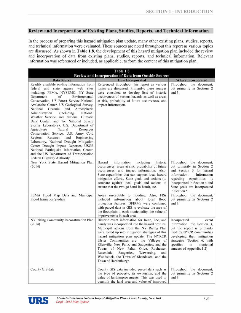
SECTION 1 INTRODUCTION
Multi�Jurisdictional Natural Hazard Mitigation Plan – Ulster County, New York
Draft � 2015 Plan Update 1�27
Review and Incorporation of Existing Plans, Studies, Reports, and Technical Information In the process of preparing this hazard mitigation plan update, many other existing plans, studies, reports, and technical information were evaluated. These sources are noted throughout this report as various topics are discussed. As shown in Table 1.8, the development of this hazard mitigation plan included the review and incorporation of data from existing plans, studies, reports, and technical information. Relevant information was referenced or included, as applicable, to form the content of this mitigation plan.
Table 1.8
Review and Incorporation of Data from Outside Sources
Data Source How Incorporated Where Incorporated
Readily available on$line information from federal and state agency web sites including: FEMA, NYSEMO, NY State Department of Environmental Conservation, US Forest Service National Avalanche Center, US Geological Survey, National Oceanic and Atmospheric Administration (including National Weather Service and National Climatic Data Center, and the National Severe Storms Laboratory), U.S. Department of Agriculture Natural Resources Conservation Service, U.S. Army Cold Regions Research and Engineering Laboratory, National Drought Mitigation Center Drought Impact Reporter, USGS National Earthquake Information Center, and the US Department of Transportation Federal Highway Authority.
Referenced throughout this report as various topics are discussed. Primarily, these sources were consulted to develop lists of historic occurrences of various hazards as well as areas at risk, probability of future occurrences, and impact information.
Throughout the document, but primarily in Sections 2 and 3.
New York State Hazard Mitigation Plan (2014)
Hazard information including historic occurrences, areas at risk, probability of future occurrences, and impact information. Also: State capabilities that can support local hazard mitigation efforts, State goals and actions (to compare against local goals and actions to ensure that the two go hand$in$hand), etc.
Throughout the document, but primarily in Section 2 and Section 3 for hazard information. Information regarding capabilities is incorporated in Section 4 and State goals are incorporated in Section 5.
FEMA Flood Map Data and Municipal Flood Insurance Studies
Areas susceptible to flooding. Also, FISs included information about local flood protection features. DFIRMs were combined with parcel data in GIS to evaluate the area of the floodplain in each municipality, the value of improvements in each area.
Throughout the document, but primarily in Sections 2 and 3.
NY Rising Community Reconstruction Plan (2014)
Historic event information for Irene, Lee, and Sandy was incorporated into the hazard profiles. Municipal actions from the NY Rising Plan were rolled up into mitigation strategies of this hazard mitigation plan update. The NYRCR Ulster Communities are: the Villages of Ellenville, New Paltz, and Saugerties; and the Towns of New Paltz, Olive, Rochester, Rosendale, Saugerties, Wawarsing, and Woodstock, the Town of Shandaken, and the Town of Hardenburgh.
Incorporated event information into Section 3, but the report is primarily used by NYCR communities developing their mitigation strategies (Section 6, with specifics in municipal annexes of Appendix 1.2)
County GIS data County GIS data included parcel data such as the type of property, its ownership, and the value of land/improvements. This was used to quantify the land area and value of improved
Throughout the document, but primarily in Sections 2 and 3.
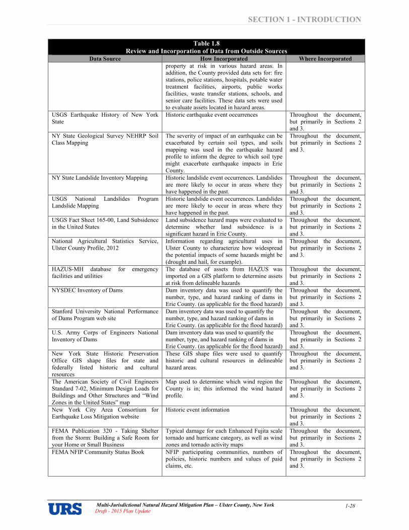
SECTION 1 INTRODUCTION
Multi�Jurisdictional Natural Hazard Mitigation Plan – Ulster County, New York
Draft � 2015 Plan Update 1�28
Table 1.8
Review and Incorporation of Data from Outside Sources
Data Source How Incorporated Where Incorporated
property at risk in various hazard areas. In addition, the County provided data sets for: fire stations, police stations, hospitals, potable water treatment facilities, airports, public works facilities, waste transfer stations, schools, and senior care facilities. These data sets were used to evaluate assets located in hazard areas.
USGS Earthquake History of New York State
Historic earthquake event occurrences Throughout the document, but primarily in Sections 2 and 3.
NY State Geological Survey NEHRP Soil Class Mapping
The severity of impact of an earthquake can be exacerbated by certain soil types, and soils mapping was used in the earthquake hazard profile to inform the degree to which soil type might exacerbate earthquake impacts in Erie County.
Throughout the document, but primarily in Sections 2 and 3.
NY State Landslide Inventory Mapping Historic landslide event occurrences. Landslides are more likely to occur in areas where they have happened in the past.
Throughout the document, but primarily in Sections 2 and 3.
USGS National Landslides Program Landslide Mapping
Historic landslide event occurrences. Landslides are more likely to occur in areas where they have happened in the past.
Throughout the document, but primarily in Sections 2 and 3.
USGS Fact Sheet 165$00, Land Subsidence in the United States
Land subsidence hazard maps were evaluated to determine whether land subsidence is a significant hazard in Erie County.
Throughout the document, but primarily in Sections 2 and 3.
National Agricultural Statistics Service, Ulster County Profile, 2012
Information regarding agricultural uses in Ulster County to characterize how widespread the potential impacts of some hazards might be (drought and hail, for example).
Throughout the document, but primarily in Sections 2 and 3.
HAZUS$MH database for emergency facilities and utilities
The database of assets from HAZUS was imported on a GIS platform to determine assets at risk from delineable hazards
Throughout the document, but primarily in Sections 2 and 3.
NYSDEC Inventory of Dams Dam inventory data was used to quantify the number, type, and hazard ranking of dams in Erie County. (as applicable for the flood hazard)
Throughout the document, but primarily in Sections 2 and 3.
Stanford University National Performance of Dams Program web site
Dam inventory data was used to quantify the number, type, and hazard ranking of dams in Erie County. (as applicable for the flood hazard)
Throughout the document, but primarily in Sections 2 and 3.
U.S. Army Corps of Engineers National Inventory of Dams
Dam inventory data was used to quantify the number, type, and hazard ranking of dams in Erie County. (as applicable for the flood hazard)
Throughout the document, but primarily in Sections 2 and 3.
New York State Historic Preservation Office GIS shape files for state and federally listed historic and cultural resources
These GIS shape files were used to quantify historic and cultural resources in delineable hazard areas.
Throughout the document, but primarily in Sections 2 and 3.
The American Society of Civil Engineers Standard 7$02, Minimum Design Loads for Buildings and Other Structures and “Wind Zones in the United States” map
Map used to determine which wind region the County is in; this informed the wind hazard profile.
Throughout the document, but primarily in Sections 2 and 3.
New York City Area Consortium for Earthquake Loss Mitigation website
Historic event information Throughout the document, but primarily in Sections 2 and 3.
FEMA Publication 320 $ Taking Shelter from the Storm: Building a Safe Room for your Home or Small Business
Typical damage for each Enhanced Fujita scale tornado and hurricane category, as well as wind zones and tornado activity maps
Throughout the document, but primarily in Sections 2 and 3.
FEMA NFIP Community Status Book NFIP participating communities, numbers of policies, historic numbers and values of paid claims, etc.
Throughout the document, but primarily in Sections 2 and 3.

SECTION 1 INTRODUCTION
Multi�Jurisdictional Natural Hazard Mitigation Plan – Ulster County, New York
Draft � 2015 Plan Update 1�29
Table 1.8
Review and Incorporation of Data from Outside Sources
Data Source How Incorporated Where Incorporated
FEMA data for NFIP Repetitive Loss Properties and Community Rating System communities
Repetitive Loss Data includes numbers of losses, value of paid claims, communities with repetitive loss properties, communities participating in the CRS (and CRS class), etc.
Throughout the document, but primarily in Sections 2 and 3.
FEMA’s “NFIP Floodplain Management Requirements: A Study Guide and Desk Reference for Local Officials (FEMA$480)”
Types of mitigation measures, definitions of the different categories of flooding for the hazard profile, and a table showing the odds of being flooded (for various time periods and flood events)
Throughout the document, but primarily in Sections 2 and 3.
USGS Landslide Overview Map of the Conterminous United States, prepared in hard copy format in 1982 by Dorothy H. Radbruch$Hall, Roger B. Colton, William E. Davies, Ivo Lucchitta, Betty A. Skipp, and David J. Varnes (Geologic Survey Professional Paper 1183), compiled digitally by Jonathan W. Godt (USGS Open File Report 97$289), as viewed on NationalAtlas.gov
Landslide incidence and susceptibility Throughout the document, but primarily in Sections 2 and 3.
American Society of Civil Engineers (ASCE) Standard 7$98: Minimum Design Loads for Buildings and Other Structures
Minimum design loads for wind Throughout the document, but primarily in Sections 2 and 3.
FEMA’s “Multi$Hazard Identification and Risk Assessment” (1997)
Several hazard definitions and information to support the hazard profile, as well as ideas for types of mitigation approaches
Throughout the document, but primarily in Sections 2 and 3.
American Meteorological Society “Glossary of Meteorology”
Definitions of meteorological hazards Throughout the document, but primarily in Sections 2 and 3.
In addition, to conduct their Capability Assessments, local jurisdictions considered relevant plans, codes, and ordinances currently in place such as building codes, zoning ordinances, subdivision ordinances, special purpose ordinances, site plan review requirements, growth management ordinances, comprehensive plans, capital improvements plans, economic development plans, emergency response plans, post$disaster recovery plans, post$disaster recovery ordinances, local waterfront revitalization plans (in seven of Erie County’s communities), and real estate disclosure ordinances. For additional information, please see the “Capabilities and Resources” section of this plan.
Responses were recorded in the Capability Assessment of Section 4. At the Mitigation Strategy Working Session, jurisdictions were asked to review local plans and ordinances and consider all local capabilities when developing their mitigation strategies as the enhancement of existing capabilities, or bridging identified gaps in capabilities, can further mitigation goals and objectives.
Throughout the document, but primarily in Sections 2 and 3.
Regulatory Compliance
This Hazard Mitigation Plan was prepared in a manner consistent with applicable regulations, criteria, and guidance. The Plan’s components address the local hazard mitigation planning requirements of the DMA 2000. The planning team used FEMA’s Local Mitigation Planning Handbook (March 2013) and its “Regulation Checklist” as a guide. Each element of the Regulation Checklist must be addressed satisfactorily for a plan to be approved by FEMA. Table 1.9 summarizes the FEMA regulations, and where the regulation is addressed in this plan.
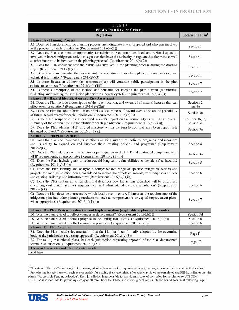
SECTION 1 INTRODUCTION
Multi�Jurisdictional Natural Hazard Mitigation Plan – Ulster County, New York
Draft � 2015 Plan Update 1�30
Table 1.9
FEMA Plan Review Criteria
Regulation Location in Plan8
Element A Planning Process
A1. Does the Plan document the planning process, including how it was prepared and who was involved in the process for each jurisdiction (Requirement 201.6(c)(1))
Section 1
A2. Does the Plan document an opportunity for neighboring communities, local and regional agencies involved in hazard mitigation activities, agencies that have the authority to regulate development as well as other interest to be involved in the planning process? (Requirement 201.6(b)(2))
Section 1
A3. Does the Plan document how the public was involved in the planning process during the drafting stage? (Requirement 201.6(b)(1))
Section 1
A4. Does the Plan describe the review and incorporation of existing plans, studies, reports, and technical information? (Requirement 201.6(b)(3)
Section 1
A5. Is there discussion of how the community(ies) will continue public participation in the plan maintenance process? (requirement 2016(c)(4)(iii))
Section 7
A6. Is there a description of the method and schedule for keeping the plan current (monitoring, evaluating and updating the mitigation plan within a 5$year cycle)? (Requirement 201.6(c)(4)(i))
Section 7
Element B – Hazard Identification and Risk Assessment
B1. Does the Plan include a description of the type, location, and extent of all natural hazards that can affect each jurisdiction? (Requirement 201.6 (c)(2)(i))
Sections 2 and 3a
B2. Does the Plan include information on previous occurrences of hazard events and on the probability of future hazard events for each jurisdiction? (Requirement 201.6(c)(2)(i))
Section 3a
B3. Is there a description of each identified hazard’s impact on the community as well as an overall summary of the community’s vulnerability for each jurisdiction? (Requirement 2016(c)(2)(ii))
Sections 3b,3c, 3d, and 3e
B4. Does the Plan address NFIP insured structure within the jurisdiction that have been repetitively damaged by floods? (Requirement 201.6(c)(2)(ii)
Section 3a
Element C – Mitigation Strategy
C1. Does the plan document each jurisdiction’s existing authorities, policies, programs, and resources and its ability to expand on and improve these existing policies and programs? (Requirement 201.6(c)(3))
Section 4
C2. Does the Plan address each jurisdiction’s participation in the NFIP and continued compliance with NFIP requirements, as appropriate? (Requirement 201.6(c)(3)(ii))
Section 3a
C3. Does the Plan include goals to reduce/avoid long$term vulnerabilities to the identified hazards? (Requirement 201.6(c)(3)(i))
Section 5
C4. Does the Plan identify and analyze a comprehensive range of specific mitigation actions and projects for each jurisdiction being considered to reduce the effects of hazards, with emphasis on new and existing buildings and infrastructure? (Requirement 201.6(c)(3)(ii))
Section 6
C5. Does the Plan contain an action plan that describes how the actions identified will be prioritized (including cost benefit review), implemented, and administered by each jurisdiction? (Requirement 201.6(c)(3)(iii))
Section 6
C6. Does the Plan describe a process by which local governments will integrate the requirements of the mitigation plan into other planning mechanisms, such as comprehensive or capital improvement plans, when appropriate? (Requirement 201.6(c)(4)(ii))
Section 7
Element D – Plan Review, Evaluation, and Implementation (applicable to plan updates only)
D1. Was the plan revised to reflect changes in development? (Requirement 201.6(d)(3)) Section 3d
D2. Was the plan revised to reflect progress in local mitigation efforts? (Requirement 201.6(d)(3)) Section 6
D3. Was the plan revised to reflect changes in priorities? (Requirement 201.6(d)(3)) Section 6
Element E – Plan Adoption
E1. Does the Plan include documentation that the Plan has been formally adopted by the governing body of the jurisdiction requesting approval? (Requirement 201.6(c)(5))
Page i9
E2. For multi$jurisdictional plans, has each jurisdiction requesting approval of the plan documented formal plan adoption? (Requirement 201.6(c)(5))
Page i20
Element F – Additional State Requirements
Add here
8 “Location in the Plan” is referring to the primary plan Section where the requirement is met, and any appendices referenced in that section. 9 Participating jurisdictions will each be responsible for passing their resolutions after agency reviews are completed and FEMA indicates that the
plan is “Approvable Pending Adoption”. Each jurisdiction is responsible for providing a copy of their adoption resolution to UCECEM. UCECEM is responsible for providing a copy of all resolutions to FEMA, and inserting hard copies into the bound document following Page i.

SECTION 1 INTRODUCTION
Multi�Jurisdictional Natural Hazard Mitigation Plan – Ulster County, New York
Draft � 2015 Plan Update 1�31
General Overview of Modifications to the 2009 Plan as part of the 2015 Plan Update This section documents how the planning team reviewed and analyzed each section of the prior version of the plan (2009) and whether each section was revised as part of the 2015 Plan Update. As part of this update, every section of the earlier plan has been reviewed and comprehensively updated as needed to achieve compliance with FEMA mitigation planning requirements outlined in the Local Mitigation Plan Review Guide in October 2011 and the Local Mitigation Planning Handbook in March 2013.
The document has been streamlined, with a good deal of supporting documentation moved into appendices reproduced only on CD but not in hard copy in order to make the hard copy version of the plan more portable and user$friendly for those benefiting from its contents. Printed hard copies of all data and appendices reproduced on CD will be kept on file by UCECEM for inspection upon request. Applicable and relevant information from the last version of the plan has been carried through to the updated text on a case by case basis. Highlights of some key additional information appearing in this updated document include:
• A description of the planning process and associated outreach activities (to the public and other stakeholders) that was undertaken as part of this update.
• A listing of historical occurrences of the identified hazards since the last version of the plan was prepared in 2009 (including but not limited to major disaster and emergency declarations).
• Current information regarding changes in development, progress on local mitigation efforts, and any changes in priorities.
• The status of past projects and plan maintenance activities, as well as identification of new mitigation strategies, for the County and each of the municipalities who opted to participate in the plan update.
• A full summary of updated local capabilities with local assessments of how their capabilities could be improved to foster mitigation goals.
• Incorporation of recently published information not available at the time of the 2009 Plan (such as the New York State Hazard Mitigation Plan of 2014).
Table 1.10 documents how each section of the plan was reviewed and analyzed, and whether each section was revised as part of the update process.
Table 1.10
Overall Summary of Plan Transition – 2009 to 2015
2009 Plan
Section (s)
2015 Plan Update
Section(s) Comments
Plan Adoption Resolutions Placeholder
Plan Adoption Resolutions Placeholder
Reviewed and updated to refer to the 2015 Plan Update, but presentation remains largely unchanged.
Acknowledgements Acknowledgements Reviewed and updated to present details for the 2015 Plan Update, but presentation remains largely unchanged.
Executive Summary Executive Summary Reviewed and updated to reflect current conditions. More specific discussions of outreach activities have been added. County agencies and stakeholder entities who participated on the Steering Committee are now highlighted specifically. A paragraph has been added regarding the improvements each JAT has made to its mitigation strategy, and some broad brush descriptions of types of projects in the mitigation strategies.
Section 1 – Introduction
Section 1 – Introduction
Reviewed and updated to present details of the 2015 Plan Update process. General information about the County has been updated to current conditions. Subsections regarding the planning process and planning team organizational structure have been reorganized and updated to streamline discussions and improve readability. Discussions of outreach have also been reorganized and streamlined to improve readability, and updated to present the substantially
more comprehensive and robust outreach activities undertaken during the
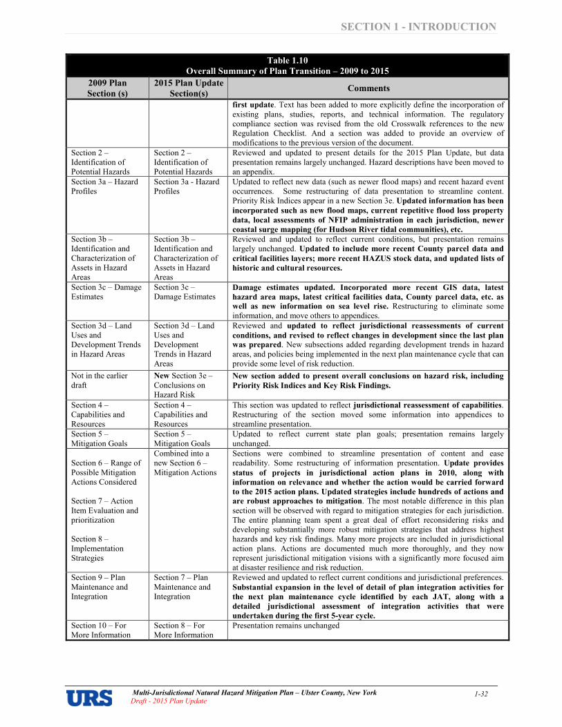
SECTION 1 INTRODUCTION
Multi�Jurisdictional Natural Hazard Mitigation Plan – Ulster County, New York
Draft � 2015 Plan Update 1�32
Table 1.10
Overall Summary of Plan Transition – 2009 to 2015
2009 Plan
Section (s)
2015 Plan Update
Section(s) Comments
first update. Text has been added to more explicitly define the incorporation of existing plans, studies, reports, and technical information. The regulatory compliance section was revised from the old Crosswalk references to the new Regulation Checklist. And a section was added to provide an overview of modifications to the previous version of the document.
Section 2 – Identification of Potential Hazards
Section 2 – Identification of Potential Hazards
Reviewed and updated to present details for the 2015 Plan Update, but data presentation remains largely unchanged. Hazard descriptions have been moved to an appendix.
Section 3a – Hazard Profiles
Section 3a $ Hazard Profiles
Updated to reflect new data (such as newer flood maps) and recent hazard event occurrences. Some restructuring of data presentation to streamline content. Priority Risk Indices appear in a new Section 3e. Updated information has been
incorporated such as new flood maps, current repetitive flood loss property
data, local assessments of NFIP administration in each jurisdiction, newer
coastal surge mapping (for Hudson River tidal communities), etc.
Section 3b – Identification and Characterization of Assets in Hazard Areas
Section 3b – Identification and Characterization of Assets in Hazard Areas
Reviewed and updated to reflect current conditions, but presentation remains largely unchanged. Updated to include more recent County parcel data and
critical facilities layers; more recent HAZUS stock data, and updated lists of
historic and cultural resources.
Section 3c – Damage Estimates
Section 3c – Damage Estimates
Damage estimates updated. Incorporated more recent GIS data, latest
hazard area maps, latest critical facilities data, County parcel data, etc. as
well as new information on sea level rise. Restructuring to eliminate some information, and move others to appendices.
Section 3d – Land Uses and Development Trends in Hazard Areas
Section 3d – Land Uses and Development Trends in Hazard Areas
Reviewed and updated to reflect jurisdictional reassessments of current
conditions, and revised to reflect changes in development since the last plan
was prepared. New subsections added regarding development trends in hazard areas, and policies being implemented in the next plan maintenance cycle that can provide some level of risk reduction.
Not in the earlier draft
New Section 3e – Conclusions on Hazard Risk
New section added to present overall conclusions on hazard risk, including
Priority Risk Indices and Key Risk Findings.
Section 4 – Capabilities and Resources
Section 4 – Capabilities and Resources
This section was updated to reflect jurisdictional reassessment of capabilities. Restructuring of the section moved some information into appendices to streamline presentation.
Section 5 – Mitigation Goals
Section 5 – Mitigation Goals
Updated to reflect current state plan goals; presentation remains largely unchanged.
Section 6 – Range of Possible Mitigation Actions Considered Section 7 – Action Item Evaluation and prioritization Section 8 – Implementation Strategies
Combined into a new Section 6 – Mitigation Actions
Sections were combined to streamline presentation of content and ease readability. Some restructuring of information presentation. Update provides
status of projects in jurisdictional action plans in 2010, along with
information on relevance and whether the action would be carried forward
to the 2015 action plans. Updated strategies include hundreds of actions and
are robust approaches to mitigation. The most notable difference in this plan section will be observed with regard to mitigation strategies for each jurisdiction. The entire planning team spent a great deal of effort reconsidering risks and developing substantially more robust mitigation strategies that address highest hazards and key risk findings. Many more projects are included in jurisdictional action plans. Actions are documented much more thoroughly, and they now represent jurisdictional mitigation visions with a significantly more focused aim at disaster resilience and risk reduction.
Section 9 – Plan Maintenance and Integration
Section 7 – Plan Maintenance and Integration
Reviewed and updated to reflect current conditions and jurisdictional preferences.
Substantial expansion in the level of detail of plan integration activities for
the next plan maintenance cycle identified by each JAT, along with a
detailed jurisdictional assessment of integration activities that were
undertaken during the first 5year cycle.
Section 10 – For More Information
Section 8 – For More Information
Presentation remains unchanged

SECTION 2 IDENTIFICATION OF POTENTIAL HAZARDS
Multi�Jurisdictional Hazard Mitigation Plan – Ulster County, New York 2015 Plan Update� Draft
2�1
SECTION 2 IDENTIFICATION OF POTENTIAL HAZARDS
Ulster County is vulnerable to a wide range of natural and human�caused hazards that threaten life and
property. FEMA’s current regulations and interim guidance under the Disaster Mitigation Act of 2000
(DMA 2000) require, at a minimum, an evaluation of a full range of natural hazards. An evaluation of
human�caused hazards (i.e., technological hazards, terrorism, etc.) is encouraged, though not required, for
plan approval. Ulster County has focused solely on natural hazards at this time. Incorporation of human�
caused hazards may be evaluated in future versions of the plan, as it is a “living document” which will be
monitored, evaluated and updated regularly. Upon a review of the full range of natural hazards, Ulster
County has identified a number of hazards that are to be addressed in its Multi�Jurisdictional Hazard
Mitigation Plan. These hazards were identified through an extensive process that utilized input from three
key sources: Planning Committee members, research of past disaster declarations in the County, and the
New York State Hazard Mitigation Plan. Readily available online information from reputable sources
(such as federal and state agencies) was also evaluated to supplement information from these key sources.
The most prominent online sources of data used in this assessment to identify the occurrence of various
hazards were records of declared disasters and emergencies maintained by FEMA and NYSOEM, the
National Oceanic and Atmospheric Administration’s (NOAA) National Climatic Data Center (NCDC)
Storm Event Database, and the Spatial Hazard Events and Losses Database for the United States
(SHELDUS) maintained by the Hazards and Vulnerability Research Institute (HVRI) at the University of
South Carolina.
The hazards of the 2009 Plan were reviewed, and the need for adding or removing hazards was
considered. All earlier assessments were determined to still be applicable for the plan update; however,
storm surge was added during the update process based on Hudson River surges observed during
Superstorm Sandy. CPG members in attendance indicated their concurrence with these findings by a
show of hands; all who were present at the meeting were in support of the updated assessment. Table 2.1
provides a summary of the hazard identification and evaluation process noting which of the 23 initially
identified hazards are considered significant enough for further evaluation through Ulster County’s multi�
jurisdictional hazard risk assessment (marked with a “�”).
Table 2.1 Summary Results of the Hazard Identification and Evaluation Process
ATMOSPHERIC
� Avalanche
� Extreme Temperatures
� Extreme Wind
� Hailstorm
� Hurricane and Tropical Storm
� Lightning
� Nor’easter
� Tornado
� Winter Storm
HYDROLOGIC
� Coastal Erosion
� Dam Failure
� Drought
� Flood
� Ice Jams
� Storm Surge
� Wave Action
GEOLOGIC
� Earthquake
� Expansive Soils
� Landslide
� Land Subsidence
� Tsunami
� Volcano
OTHER
� Wildfire
� = Hazard considered significant enough for further evaluation through Ulster County’s multi�jurisdictional hazard risk assessment.

SECTION 2 IDENTIFICATION OF POTENTIAL HAZARDS
Multi�Jurisdictional Hazard Mitigation Plan – Ulster County, New York 2015 Plan Update� Draft
2�2
Table 2.2 provides a summary of the County’s 2014 HAZNY analysis for reference and comparison. The
updated risk assessment includes all natural hazards ranked above “low” in the HAZNY.
Note: HAZNY Analysis Rating is out of a possible maximum of 400. Only natural hazards are included in the table.
Table 2.3
1 documents the evaluation process used for determining which of the initially identified
hazards are considered significant enough for further evaluation through Ulster County’s multi�
jurisdictional hazard risk assessment. For each hazard considered, the table indicates whether or not the
hazard was identified as a significant hazard to be further assessed, how this determination was made, and
why this determination was made. The table works to summarize not only those hazards that were
identified (and why) but also those that were not identified (and why not). Hazard events not identified
for inclusion at this time may be addressed during future evaluations and updates of the risk assessment if
deemed necessary by the Planning Committee during the plan update process. Table 2.3 also documents
the planning team’s reassessment of hazard significance during the first plan update as part of its ongoing
maintenance of the plan to ensure that it reflects current conditions.
Appendix 2.1 lists the full range of natural hazards initially identified for consideration for inclusion in
the plan and provides a brief description for each. This table includes 23 individual hazards. Some of
these hazards are considered to be interrelated or cascading (i.e., hurricanes can cause flooding, storm
surge and tornadoes), but for preliminary hazard identification purposes these individual hazards are
broken out separately. It should also be noted that some hazards, such as earthquakes or winter storms
may impact a large area yet cause little damage, while other hazards, such as a tornado, may impact a
small area yet cause extensive damage.
1 Table 2.3 was updated to include events captured by readily�available data sources (particularly NCDC records) as of Fall
2013. The sources themselves are not updated to the same end date across all hazards; hence, Table 2.3 will show event records
through different end dates and this variability is reflected in the table. Information gleaned from the New York State Hazard
Mitigation Plan is from the latest version available (2011) at the time this section was drafted.
Table 2.2 – Ulster County’s HAZNY Analysis Results (2014)
Natural Hazard Identified for Inclusion in
the Plan Update?
HAZNY Analysis
Rating Classification
Flood Yes 324 High
Severe Storms Yes 310 Moderately High
Ice Storm Yes 304 Moderately High
Wildfire Yes 286 Moderately High
Hurricane Yes 274 Moderately High
Extreme Temperatures Yes 262 Moderately High
Landslide Yes 246 Moderately High
Drought Yes 234 Moderately Low
Ice Jam Yes 232 Moderately Low
Dam Failure Yes 224 Moderately Low
Tornado Yes 222 Moderately Low
Earthquake Yes 212 Moderately Low
Climate Change Yes 196 Moderately Low
Avalanche No 107 Low
Tsunami No 107 Low

SECTION 2 IDENTIFICATION OF POTENTIAL HAZARDS
Multi�Jurisdictional Hazard Mitigation Plan – Ulster County, New York 2015 Plan Update � Draft 2�3
Table 2.3 Documentation of the Hazard Evaluation Process
Natural Hazards
Considered 2009 Plan Assessment First Update Assessment
How was this determination
made? Why was this determination made?
ATMOSPHERIC HAZARDS
Avalanche Not identified as a significant hazard to be addressed in the plan at that time.
Considered again and the earlier assessment was determined to still be applicable for the plan update.
• Review of US Forest Service National Avalanche Center web site
• Review of NY State Hazard Mitigation Plan
• Review of FEMA’s Multi%Hazard Identification and Risk Assessment
• Ulster County HAZNY
• Input from Planning Group
• Avalanches are not included in the NY State Hazard Mitigation Plan, and are not discussed for NY on the US Forest Service Avalanche Center web site.
• While avalanches are not unknown in northern New York State, the topography and climate in Ulster County do not typically support conditions that would be required for the occurrence of significant avalanches.
• Avalanches are listed as a low hazard in the Ulster County HAZNY; rare events where serious injury or death is unlikely, little or no damage is expected to private property, and little or no structural damage would be expected to public facilities.
Extreme
Temperatures
Identified as a significant hazard to be addressed in the plan at that time.
Considered again and the earlier assessment was determined to still be applicable for the plan update.
• Review of NY State Hazard Mitigation Plan
• Review of NOAA National Climatic Data Center (NCDC) Database
• Ulster County HAZNY
• Review of FEMA’s Multi%Hazard Identification and Risk Assessment
• Input from Planning Group
• Extreme temperature events are included in the NY State plan as a discrete hazard. The State plan records 108 extreme temperature events affecting New York State between 1993 and 2010 resulting in 99 deaths, 51 injuries, $533,000 in property damage. It also shows that the percentage of the population most susceptible to extreme temperatures (under 5 years and over 65 years) is 19 percent, which is somewhat lower than in most other counties in the state (the statewide percentages range from a low of 14.2 percent to a high of 25.8 percent).
• NCDC reports 46 significant extreme temperature events for areas including Ulster County between January 1996 and June 2013 (including 34 extreme summer heat events and 12 extreme winter cold events). For these events there are no recorded property damages, deaths or injuries; however, in $16.7 million in crop losses occurred (from a single extreme cold event in May 2008).
• Extreme temperatures were ranked 6th out of 15 (“Moderately High Hazard”) natural hazards included in the Ulster County HAZNY study.

SECTION 2 IDENTIFICATION OF POTENTIAL HAZARDS
Multi�Jurisdictional Hazard Mitigation Plan – Ulster County, New York 2015 Plan Update � Draft 2�4
Table 2.3 Documentation of the Hazard Evaluation Process
Natural Hazards
Considered 2009 Plan Assessment First Update Assessment
How was this determination
made? Why was this determination made?
Extreme Wind Identified as a significant hazard to be addressed in the plan at that time.
Considered again and the earlier assessment was determined to still be applicable for the plan update.
• Review of NY State Hazard Mitigation Plan
• Review of FEMA’s Multi%Hazard Identification and Risk Assessment
• Review of NOAA NCDC Storm Events Database
• Review of American Society of Civil Engineers (ASCE) Standard 7%02 (Minimum Design Loads for Buildings and Other Structures)
• Ulster County HAZNY
• Input from Planning Group
• Extreme wind events are included in the NY State plan and the Ulster County HAZNY in the context of hurricane and tornado events.
• The state plan ranks Ulster County as 13th out of 62 counties in the state for the threat of extreme wind and vulnerability to extreme wind loss.
• Ulster County is located in a climate region that is highly susceptible to numerous types of extreme wind events including severe thunderstorms, hurricanes, tropical storms, nor’easters and severe winter storms.
• According to FEMA, Ulster County is located in a wind zone where extreme wind speeds of 160mph are possible.
• NCDC reports 111 high wind events (wind speed > 50 knots/58 mph) in Ulster County between January 1996 and June 2013. These events have caused $2,987,000 in property damage and two deaths. The 3 second wind gust for Ulster County for building design purposes as per ASCE 7%02 is 90 mph. The standard also shows south eastern Ulster County is located in a Special Wind Region (i.e., an area where wind anomalies are known to occur and in which wind speeds may be substantially higher than specified).

SECTION 2 IDENTIFICATION OF POTENTIAL HAZARDS
Multi�Jurisdictional Hazard Mitigation Plan – Ulster County, New York 2015 Plan Update � Draft 2�5
Table 2.3 Documentation of the Hazard Evaluation Process
Natural Hazards
Considered 2009 Plan Assessment First Update Assessment
How was this determination
made? Why was this determination made?
Hailstorm Not identified as a significant hazard to be addressed in the plan at that time.
Considered again and the earlier assessment was determined to still be applicable for the plan update.
• Review of NY State Hazard Mitigation Plan
• Review of FEMA’s Multi%Hazard Identification and Risk Assessment
• Review of NOAA NCDC Storm Events Database and NOAA National Severe Storms Laboratory NSSL website
• Ulster County HAZNY
• Input from Planning Group
• The State plan includes hailstorms as a discrete hazard and estimates that hail storms in New York State have caused approximately $3.2 million in property damage and $60.1 million in crop damage since 1993; and roughly 89 injuries statewide since 1987; with annualized hail losses in Ulster County of just under $83,000 per year.
• NCDC reports 40 severe hailstorm events (3/4 inch diameter hail or greater) for Ulster County between January 1996 and June 2013, causing $33,500 in property damages and $17.1 million in crop damages, but no recorded deaths or injuries. Reported crop damages are associated with only two events (May 18, 2000 and June 16, 2008).
• NCDC reports only one event in which “damaging” hail (at least 2 inches in diameter) fell in Ulster County (Kingston – August 13, 2003). However, no deaths, injuries, property or crop damages were recorded for this event. According to NSSL data Ulster County is located in a part of the country with the lowest annual number of hail days (less than 3), and where the annual average number of damaging hail events is less than 0.25.
• Hailstorms are not included in the Ulster County HAZNY.
• There are minimal hazard mitigation techniques available to reduce hailstorm impacts outside of the emergency preparedness procedures and severe weather warning systems already in place (i.e. mass public notifications that recommend immediate protective actions). Agriculture is the most affected by hailstorms, but there are no measures that can be implemented to protect crops from hail. Therefore, hail – while a hazard in Ulster County – has not been identified as a hazard to be addressed in the plan at this time. The only municipality in Ulster County to report that it considers hailstorms to be a significant hazard is the Town of Marlborough, which has both the highest proportion and total acreage of agricultural land use in the County. In the absence of hail mitigation measures for crops, there is not sufficient overall concern to warrant further investigation in this hazard mitigation plan at this time, although future plan updates may revisit the hail hazard at a later date.

SECTION 2 IDENTIFICATION OF POTENTIAL HAZARDS
Multi�Jurisdictional Hazard Mitigation Plan – Ulster County, New York 2015 Plan Update � Draft 2�6
Table 2.3 Documentation of the Hazard Evaluation Process
Natural Hazards
Considered 2009 Plan Assessment First Update Assessment
How was this determination
made? Why was this determination made?
Hurricane and
Tropical Storm
Identified as a significant hazard to be addressed in the plan at that time.
Considered again and the earlier assessment was determined to still be applicable for the plan update.
• Review of NY State Hazard Mitigation Plan
• Analysis of NOAA historical tropical cyclone tracks
• Review of NOAA National Hurricane Center website
• Review of NOAA NCDC Storm Events Database
• Review of FEMA’s Multi%Hazard Identification and Risk Assessment
• Ulster County HAZNY
• Input from Planning Group
• Hurricane and tropical storms are discussed in the State plan, which includes FEMA mapping showing Ulster County located in a hurricane%prone area where extreme wind speeds of 160 mph are possible.
• Ulster County has been included in the area covered by major disaster declarations due to hurricanes or tropical storms on six occasions since 1985.
• NOAA historical records indicate 3 hurricanes (all Category 1), 8 tropical storms, and 4 tropical depressions passing within 50 miles of the Ulster County seat in Kingston since 1863.
• The most recent of these events was Irene which passed along the eastern border of the county in 2011 as a tropical storm.
• According to the NHC the estimated return period for a Category 1 hurricane in the New York City area is 17 years, rising to 370 years for a Category 5 event
• Hurricanes were ranked 5th out of 15 (“Moderately High Hazard”) natural hazards included in the Ulster County HAZNY study.
• Sandy was a Category 3 storm at its peak intensity when it made landfall in Cuba; however, on making landfall it New Jersey, it was classified as as a post%tropical cyclone with hurricane%force winds “Superstorm Sandy”. Whatever the name, Sandy’s impacts were those of a hurricane, and impacted Ulster County, primarily due to storm surge propagating up the Hudson River and flooding riverfront communities. Ulster County was declared a Federal Disaster Area as a result of Sandy.

SECTION 2 IDENTIFICATION OF POTENTIAL HAZARDS
Multi�Jurisdictional Hazard Mitigation Plan – Ulster County, New York 2015 Plan Update � Draft 2�7
Table 2.3 Documentation of the Hazard Evaluation Process
Natural Hazards
Considered 2009 Plan Assessment First Update Assessment
How was this determination
made? Why was this determination made?
Lightning Identified as a significant hazard to be addressed in the plan at that time.
Considered again and the earlier assessment was determined to still be applicable for the plan update.
• Review of NY State Hazard Mitigation Plan
• Review of NOAA NCDC Storm Events Database, NOAA lightning statistics, and NSSL web site
• Review of FEMA’s Multi%Hazard Identification and Risk Assessment
• Ulster County HAZNY
• Input from Planning Group
• Lightning is not considered as a discrete hazard in the NY State Hazard Mitigation Plan or the Ulster County HAZNY.
• According to NOAA and FEMA data, Ulster County is located in an area of the country that experiences an average of less than 40 thunder events and 1 % 4 lightning flashes per square kilometer per year. For comparison, large areas of the country experience more than 100 events per year and more than 10 flashes per square kilometer.
• NOAA records that New York State has experienced the fifth most deaths from lightning in the USA from 1959 to 1994.
• NCDC reports 18 lightning events for Ulster County between January 1996 and June 2013. These events have resulted in 1 death, 6 injuries, and $613,000 in property damage.
Nor’easter Identified as a significant hazard to be addressed in the plan at that time.
Considered again and the earlier assessment was determined to still be applicable for the plan update.
• Review of NY State Hazard Mitigation Plan
• Review of NOAA NCDC Storm Events Database
• Review of FEMA’s Multi%Hazard Identification and Risk Assessment
• Ulster County HAZNY
• Input from Planning Group
• Nor’easters are discussed in the state plan as a common cause of flooding and snowstorms, particularly in the south eastern part of the state.
• Although not specifically included in the Ulster County HAZNY, the county has been affected by numerous nor’easters, with the principal impacts being heavy snowfall and flooding, and the HAZNY ranks “Severe Storms” 2nd out of 15 (“Moderately High Hazard”) natural hazards included in the Ulster County HAZNY.

SECTION 2 IDENTIFICATION OF POTENTIAL HAZARDS
Multi�Jurisdictional Hazard Mitigation Plan – Ulster County, New York 2015 Plan Update � Draft 2�8
Table 2.3 Documentation of the Hazard Evaluation Process
Natural Hazards
Considered 2009 Plan Assessment First Update Assessment
How was this determination
made? Why was this determination made?
Tornado Identified as a significant hazard to be addressed in the plan at that time.
Considered again and the earlier assessment was determined to still be applicable for the plan update.
• Review of NY State Hazard Mitigation Plan
• Review of NOAA NCDC Storm Events Database and National Severe Storms Laboratory (NSSL)
• Review of FEMA’s Multi%Hazard Identification and Risk Assessment
• Ulster County HAZNY
• Input from Planning Group
• The state plan acknowledges that New York State has a definite vulnerability to tornadoes, with an average annual occurrence of about 6 tornadoes per year since 1950. NCDC reports 2 tornado events in Ulster County between January 1996 and June 2013. These events have resulted in no recorded deaths or injuries but have caused an estimated $200,000 in property damage. The most severe being an F2 tornado that struck the county in May 2000.
• NSSL tornado probability data indicate that while Ulster County is in an area that experiences less than 1 tornado event per year, life%threatening and damaging tornado events remain a possibility.
• Tornadoes were ranked 11th out of 15 (“Moderately Low Hazard”) natural hazards included in the Ulster County HAZNY.

SECTION 2 IDENTIFICATION OF POTENTIAL HAZARDS
Multi�Jurisdictional Hazard Mitigation Plan – Ulster County, New York 2015 Plan Update � Draft 2�9
Table 2.3 Documentation of the Hazard Evaluation Process
Natural Hazards
Considered 2009 Plan Assessment First Update Assessment
How was this determination
made? Why was this determination made?
Winter Storm Identified as a significant hazard to be addressed in the plan at that time.
Considered again and the earlier assessment was determined to still be applicable for the plan update.
• Review of NY State Hazard Mitigation Plan
• Review of FEMA’s Multi%Hazard Identification and Risk Assessment
• Review of NOAA NCDC Storm Events Database
• New York State Climate Office web site
• Ulster County HAZNY
• Input from Planning Group
• Winter storms including heavy snow and ice storms are discussed in the state plan, which notes that Ulster County averages approximately 60 inches of snowfall per year. The statewide average is 65 inches, with 60% of the state experiencing at least 70 inches annually. The website of the New York State Climate Office records that some areas of higher ground in western Ulster County experience annual average snowfalls of 100 inches and more.
• The NY State plan ranks Ulster County 26th out of 62 counties in the state for most threatened by snow and vulnerable to snow losses. The plan also ranks Ulster County 36th out of 62 counties in the state for most vulnerable to ice storms and ice storm losses.
• NCDC reports that Ulster County has been affected by 109 significant snow and ice related events between January 1996 and June 2013 resulting in $2.8 million in property damage
• FEMA records show that Ulster County has been included in one snow%related disaster declaration in the last 30 years and two snow%related emergency declarations.
• There has been one presidential disaster declaration due to ice storms in Ulster County since 1953.
• Ice Storms were ranked 9th out of 15 (“Moderately Low Hazard”) natural hazards included in the Ulster County HAZNY study.
HYDROLOGIC HAZARDS
Coastal Erosion Not identified as a significant hazard to be addressed in the plan at that time.
Considered again and the earlier assessment was determined to still be applicable for the plan update.
• Review of NY State Hazard Mitigation Plan
• Review of FEMA’s Multi%Hazard Identification and Risk Assessment
• Input from Planning Group
• While coastal erosion is identified as a hazard and discussed in the NY State plan, it does not apply to Ulster County. Coastal erosion is a coastal phenomenon, and since Ulster County is located more than 50 miles from the nearest coastline, it is not regarded as a hazard for the purposes of this plan.

SECTION 2 IDENTIFICATION OF POTENTIAL HAZARDS
Multi�Jurisdictional Hazard Mitigation Plan – Ulster County, New York 2015 Plan Update � Draft 2�10
Table 2.3 Documentation of the Hazard Evaluation Process
Natural Hazards
Considered 2009 Plan Assessment First Update Assessment
How was this determination
made? Why was this determination made?
Dam Failure Identified as a significant hazard to be addressed in the plan at that time.
Considered again and the earlier assessment was determined to still be applicable for the plan update.
• Review of NY State Hazard Mitigation Plan
• Review of New York State Department of Environmental Conservation (NYSDEC) Bureau of Flood Protection and Dam Safety web site
• Review of U.S. Army Corps of Engineers National Inventory of Dams database
• Review of Stanford University’s National Performance of Dams Program web site
• Review of FEMA’s Multi%Hazard Identification and Risk Assessment
• Ulster County HAZNY
• Input from Planning Group
• Dam Failure is briefly discussed in the state plan as a potential cause of flooding.
• The USACE NID lists 54 dams of all types in Ulster County. The NID consists of dams meeting at least one of the following criteria: (1) high hazard classification % loss of one human life is likely if the dam fails; (2) significant hazard classification % possible loss of human life and likely significant property or environmental destruction; (3) equal or exceed 25 feet in height and exceed 15 acre%feet in storage; and/or (4) equal or exceed 50 acre%feet storage and exceed 6 feet in height.
• The Stanford University NPDP also lists 54 dams in Ulster County; 10 are listed as high hazard; 26 are listed as significant hazard; 17 are listed as low hazard, and one is unclassified.
• Dam Failure was ranked 10th out of 15 (“Moderately Low Hazard”) natural hazards included in the Ulster County HAZNY study.
Drought Identified as a significant hazard to be addressed in the plan at that time.
Considered again and the earlier assessment was determined to still be applicable for the plan update.
• Review of NY State Hazard Mitigation Plan
• Review of FEMA’s Multi%Hazard Identification and Risk Assessment
• Review of NOAA NCDC Database
• Review of National Drought Mitigation Center /NOAA web sites
• Ulster County HAZNY
• Input from Planning Group
• Drought is discussed in the state plan, which records two significant local droughts and one statewide drought event that affected Ulster County since 1993.
• NCDC reports that Ulster County has been affected by four drought events of varying severity since 1996.
• According to the Palmer Drought Severity Index data released by NOAA, Ulster County experienced moderate drought during 41 weeks and severe drought in one week between January 1998 and December 2007.
• Drought was ranked 8th out of 15 (“Moderately Low Hazard”) natural hazards included in the Ulster County HAZNY study.

SECTION 2 IDENTIFICATION OF POTENTIAL HAZARDS
Multi�Jurisdictional Hazard Mitigation Plan – Ulster County, New York 2015 Plan Update � Draft 2�11
Table 2.3 Documentation of the Hazard Evaluation Process
Natural Hazards
Considered 2009 Plan Assessment First Update Assessment
How was this determination
made? Why was this determination made?
Flood Identified as a significant hazard to be addressed in the plan at that time.
Considered again and the earlier assessment was determined to still be applicable for the plan update.
• Review of NY State Hazard Mitigation Plan
• Review of NOAA NCDC Storm Events Database
• Review of FEMA’s Multi%Hazard Identification and Risk Assessment
• Review of FEMA’s NFIP Community Status Book and Community Rating System (CRS)
• Review of FEMA flood maps and Flood Insurance Study for Ulster County and the County Flood Insurance Study
• Ulster County HAZNY
• Input from Planning Group
• Flooding is described in the state plan as the primary natural hazard in the State of New York and is discussed in comprehensive detail.
• About 85 percent of all Federal disaster declarations covering Ulster County have involved flooding. Ulster County has been affected by 19 flood%related Presidential disaster declarations since 1953 (6 of which were related to hurricane or tropical storm events). Of these, 11 have occurred within the last ten years (2003%2013).
• NCDC records more than 100 flood events affecting Ulster County since March 1993. One fatality, one injury, and almost $25 million in property damage was attributed to these events.
• According to the New York State Plan 100%year Floodplain Property Exposure Analysis, 1,854 residential properties (valued at about $395 million) lie within the identified 100%year floodplain. Ulster County ranks as the 9th most threatened and vulnerable to flood loss out of the 62 counties in the state on this basis.
• All jurisdictions in Ulster County participate in the NFIP but none participate in the CRS. Ulster County ranks 13th out of 62 for the total number of NFIP policies and 12th for the total dollar amount of NFIP coverage. Ulster county ranks 15th in the state for the total number of NFIP claims since 1978, but 11th for the total dollar amount of claims paid.
• Flooding was ranked number 1 out of 15 (“High Hazard”) natural hazards included in the Ulster County HAZNY study.
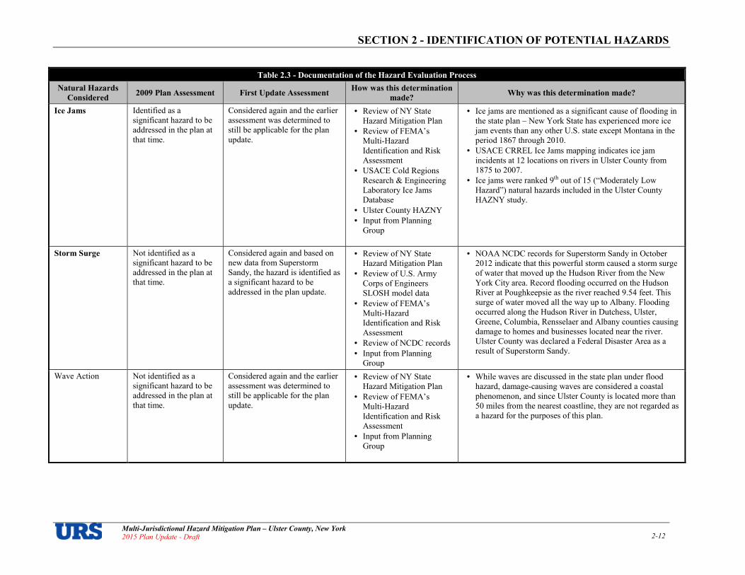
SECTION 2 IDENTIFICATION OF POTENTIAL HAZARDS
Multi�Jurisdictional Hazard Mitigation Plan – Ulster County, New York 2015 Plan Update � Draft 2�12
Table 2.3 Documentation of the Hazard Evaluation Process
Natural Hazards
Considered 2009 Plan Assessment First Update Assessment
How was this determination
made? Why was this determination made?
Ice Jams Identified as a significant hazard to be addressed in the plan at that time.
Considered again and the earlier assessment was determined to still be applicable for the plan update.
• Review of NY State Hazard Mitigation Plan
• Review of FEMA’s Multi%Hazard Identification and Risk Assessment
• USACE Cold Regions Research & Engineering Laboratory Ice Jams Database
• Ulster County HAZNY
• Input from Planning Group
• Ice jams are mentioned as a significant cause of flooding in the state plan – New York State has experienced more ice jam events than any other U.S. state except Montana in the period 1867 through 2010.
• USACE CRREL Ice Jams mapping indicates ice jam incidents at 12 locations on rivers in Ulster County from 1875 to 2007.
• Ice jams were ranked 9th out of 15 (“Moderately Low Hazard”) natural hazards included in the Ulster County HAZNY study.
Storm Surge Not identified as a significant hazard to be addressed in the plan at that time.
Considered again and based on new data from Superstorm Sandy, the hazard is identified as a significant hazard to be addressed in the plan update.
• Review of NY State Hazard Mitigation Plan
• Review of U.S. Army Corps of Engineers SLOSH model data
• Review of FEMA’s Multi%Hazard Identification and Risk Assessment
• Review of NCDC records
• Input from Planning Group
• NOAA NCDC records for Superstorm Sandy in October 2012 indicate that this powerful storm caused a storm surge of water that moved up the Hudson River from the New York City area. Record flooding occurred on the Hudson River at Poughkeepsie as the river reached 9.54 feet. This surge of water moved all the way up to Albany. Flooding occurred along the Hudson River in Dutchess, Ulster, Greene, Columbia, Rensselaer and Albany counties causing damage to homes and businesses located near the river. Ulster County was declared a Federal Disaster Area as a result of Superstorm Sandy.
Wave Action Not identified as a significant hazard to be addressed in the plan at that time.
Considered again and the earlier assessment was determined to still be applicable for the plan update.
• Review of NY State Hazard Mitigation Plan
• Review of FEMA’s Multi%Hazard Identification and Risk Assessment
• Input from Planning Group
• While waves are discussed in the state plan under flood hazard, damage%causing waves are considered a coastal phenomenon, and since Ulster County is located more than 50 miles from the nearest coastline, they are not regarded as a hazard for the purposes of this plan.
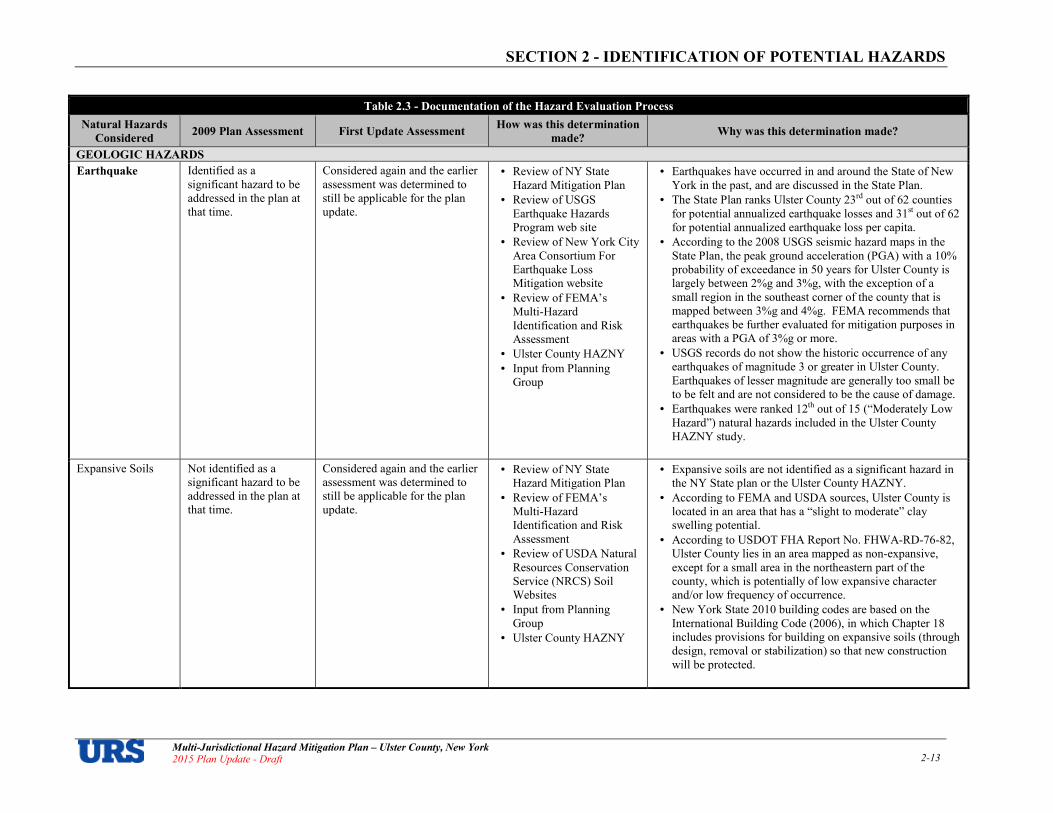
SECTION 2 IDENTIFICATION OF POTENTIAL HAZARDS
Multi�Jurisdictional Hazard Mitigation Plan – Ulster County, New York 2015 Plan Update � Draft 2�13
Table 2.3 Documentation of the Hazard Evaluation Process
Natural Hazards
Considered 2009 Plan Assessment First Update Assessment
How was this determination
made? Why was this determination made?
GEOLOGIC HAZARDS
Earthquake Identified as a significant hazard to be addressed in the plan at that time.
Considered again and the earlier assessment was determined to still be applicable for the plan update.
• Review of NY State Hazard Mitigation Plan
• Review of USGS Earthquake Hazards Program web site
• Review of New York City Area Consortium For Earthquake Loss Mitigation website
• Review of FEMA’s Multi%Hazard Identification and Risk Assessment
• Ulster County HAZNY
• Input from Planning Group
• Earthquakes have occurred in and around the State of New York in the past, and are discussed in the State Plan.
• The State Plan ranks Ulster County 23rd out of 62 counties for potential annualized earthquake losses and 31st out of 62 for potential annualized earthquake loss per capita.
• According to the 2008 USGS seismic hazard maps in the State Plan, the peak ground acceleration (PGA) with a 10% probability of exceedance in 50 years for Ulster County is largely between 2%g and 3%g, with the exception of a small region in the southeast corner of the county that is mapped between 3%g and 4%g. FEMA recommends that earthquakes be further evaluated for mitigation purposes in areas with a PGA of 3%g or more.
• USGS records do not show the historic occurrence of any earthquakes of magnitude 3 or greater in Ulster County. Earthquakes of lesser magnitude are generally too small be to be felt and are not considered to be the cause of damage.
• Earthquakes were ranked 12th out of 15 (“Moderately Low Hazard”) natural hazards included in the Ulster County HAZNY study.
Expansive Soils Not identified as a significant hazard to be addressed in the plan at that time.
Considered again and the earlier assessment was determined to still be applicable for the plan update.
• Review of NY State Hazard Mitigation Plan
• Review of FEMA’s Multi%Hazard Identification and Risk Assessment
• Review of USDA Natural Resources Conservation Service (NRCS) Soil Websites
• Input from Planning Group
• Ulster County HAZNY
• Expansive soils are not identified as a significant hazard in the NY State plan or the Ulster County HAZNY.
• According to FEMA and USDA sources, Ulster County is located in an area that has a “slight to moderate” clay swelling potential.
• According to USDOT FHA Report No. FHWA%RD%76%82, Ulster County lies in an area mapped as non%expansive, except for a small area in the northeastern part of the county, which is potentially of low expansive character and/or low frequency of occurrence.
• New York State 2010 building codes are based on the International Building Code (2006), in which Chapter 18 includes provisions for building on expansive soils (through design, removal or stabilization) so that new construction will be protected.
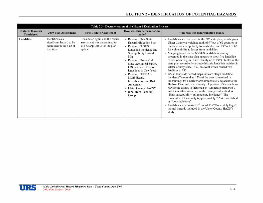
SECTION 2 IDENTIFICATION OF POTENTIAL HAZARDS
Multi�Jurisdictional Hazard Mitigation Plan – Ulster County, New York 2015 Plan Update � Draft 2�14
Table 2.3 Documentation of the Hazard Evaluation Process
Natural Hazards
Considered 2009 Plan Assessment First Update Assessment
How was this determination
made? Why was this determination made?
Landslide Identified as a significant hazard to be addressed in the plan at that time.
Considered again and the earlier assessment was determined to still be applicable for the plan update.
• Review of NY State Hazard Mitigation Plan
• Review of USGS Landslide Incidence and Susceptibility Hazard Map
• Review of New York State Geological Survey GIS database of historic landslides in New York
• Review of FEMA’s Multi%Hazard Identification and Risk Assessment
• Ulster County HAZNY
• Input from Planning Group
• Landslides are discussed in the NY state plan, which gives Ulster County a weighted rank of 9th out of 62 counties in the state for susceptibility to landslides, and 19th out of 62 for vulnerability to losses from landslides.
• Mapping based on the NYSGS landslide inventory presented in the state plan appears to show five landslide events occurring in Ulster County up to 1989. Tables in the state plan record only a single historic landslide incident in Ulster County since 1837, an event which caused two fatalities in 1921.
• USGS landslide hazard maps indicate “High landslide incidence” (more than 15% of the area is involved in landsliding) for a narrow area immediately adjacent to the Hudson River in Ulster County. A portion of the southern part of the county is identified as “Moderate incidence”, and the northwestern part of the county is identified as “High susceptibility but moderate incidence”. The remainder of the county (approximately 70%) is identified as “Low incidence”.
• Landslides were ranked 7th out of 15 (“Moderately High”) natural hazards included in the Ulster County HAZNY study.

SECTION 2 IDENTIFICATION OF POTENTIAL HAZARDS
Multi�Jurisdictional Hazard Mitigation Plan – Ulster County, New York 2015 Plan Update � Draft 2�15
Table 2.3 Documentation of the Hazard Evaluation Process
Natural Hazards
Considered 2009 Plan Assessment First Update Assessment
How was this determination
made? Why was this determination made?
Land Subsidence Not identified as a significant hazard to be addressed in the plan at that time.
Considered again and the earlier assessment was determined to still be applicable for the plan update.
• Review of NY State Hazard Mitigation Plan
• Review of FEMA’s Multi%Hazard Identification and Risk Assessment
• Review of USGS Fact Sheet 165%00 Land Subsidence in the U.S.
• Ulster County HAZNY
• Input from Planning Group
• The state plan delineates certain areas that are susceptible to land subsidence hazards in New York. While mapping in the plan depicts a narrow band of carbonate karst rock (in which there can be the potential for subsidence caused by sinkholes) crossing the southern portion of Ulster County, collapses that have resulted in structural damage are not reported.
• While there is a history of mining in Ulster County (principally to extract lime for the production of cement), due to the robust nature of the geological strata in which these activities were carried out, it is assumed that there is no significant risk of land subsidence due to mine collapse.
• According to the NYSGS (regarding the likelihood of subsidence): “…new sinkhole formation in the karst areas is rare, the last being 1989 … in a farmer's field…., and ―…subsidence occurring in areas that are already subsiding (expanding existing sink holes) are relatively common, occurring every few years….”
• Although our research indicates a certain possibility of land subsidence hazard in Ulster County, it also indicates very low risk to population and property. Additionally, the extremely localized and virtually unpredictable nature of land subsidence makes it nearly impossible to estimate potential loss. This said, with the exception of continuing to document land subsidence occurrence, this Plan will not include the land subsidence hazard in further analysis or mitigation strategy development.
• Land subsidence is not included in the Ulster County HAZNY. Mine collapse, however, is included but was determined to be a Low hazard. Mine collapse was estimated to be a rare event, causing little to no damage to private property or public facilities, though serious injury/death was possible depending on location (though not in large numbers).

SECTION 2 IDENTIFICATION OF POTENTIAL HAZARDS
Multi�Jurisdictional Hazard Mitigation Plan – Ulster County, New York 2015 Plan Update � Draft 2�16
Table 2.3 Documentation of the Hazard Evaluation Process
Natural Hazards
Considered 2009 Plan Assessment First Update Assessment
How was this determination
made? Why was this determination made?
Tsunami Not identified as a significant hazard to be addressed in the plan at that time.
Considered again and the earlier assessment was determined to still be applicable for the plan update.
• Review of NY State Hazard Mitigation Plan
• Review of FEMA’s Multi%Hazard Identification and Risk Assessment
• Ulster County HAZNY
• Input from Planning Group
• Tsunamis were ranked 15th out of 15 (“Low”) natural hazards included in the Ulster County HAZNY study. They were estimated to be rare events where serious injury or death is unlikely and little or no damage to private property or public facilities would be expected.
• Tsunamis appear in the 2014 State Draft Mitigation Plan Update, for coastal areas.
• Since the southernmost border of Ulster County is located approximately 70 miles from open ocean, and no record exists of a catastrophic Atlantic basin tsunami impacting the mid%Atlantic coast of the United States, FEMA mitigation planning guidance suggests that locations on the U.S. East Coast have a relatively low tsunami risk and need not conduct a tsunami risk assessment. If tsunami inundation maps should one day become available for Ulster County, this hazard will be revisited in future plan updates.
Volcano Not identified as a significant hazard to be addressed in the plan at that time.
Considered again and the earlier assessment was determined to still be applicable for the plan update.
• Review of NY State Hazard Mitigation Plan
• Review of USGS Volcano Hazards Program web site
• Ulster County HAZNY
• Input from Planning Group
• No volcanoes are located within approximately 2,000 miles of Ulster County.
• Volcanos are not included in the State Plan or County HAZNY.
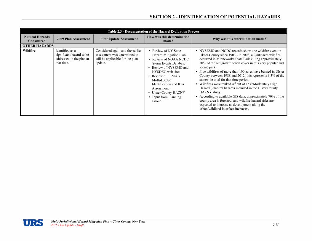
SECTION 2 IDENTIFICATION OF POTENTIAL HAZARDS
Multi�Jurisdictional Hazard Mitigation Plan – Ulster County, New York 2015 Plan Update � Draft 2�17
Table 2.3 Documentation of the Hazard Evaluation Process
Natural Hazards
Considered 2009 Plan Assessment First Update Assessment
How was this determination
made? Why was this determination made?
OTHER HAZARDS
Wildfire Identified as a significant hazard to be addressed in the plan at that time.
Considered again and the earlier assessment was determined to still be applicable for the plan update.
• Review of NY State Hazard Mitigation Plan
• Review of NOAA NCDC Storm Events Database
• Review of NYSEMO and NYSDEC web sites
• Review of FEMA’s Multi%Hazard Identification and Risk Assessment
• Ulster County HAZNY
• Input from Planning Group
• NYSEMO and NCDC records show one wildfire event in Ulster County since 1903 % in 2008, a 2,800 acre wildfire occurred in Minnewaska State Park killing approximately 50% of the old growth forest cover in this very popular and scenic park.
• Five wildfires of more than 100 acres have burned in Ulster County between 1988 and 2012; this represents 6.3% of the statewide total for that time period.
• Wildfires were ranked 4th out of 15 (“Moderately High Hazard”) natural hazards included in the Ulster County HAZNY study.
• According to available GIS data, approximately 70% of the county area is forested, and wildfire hazard risks are expected to increase as development along the urban/wildland interface increases.

anna_foley
Typewritten Text
THIS PAGE INTENTIONALLY LEFT BLANK

SECTION 3A � RISK ASSESSMENT: HAZARD PROFILES
Multi�Jurisdictional Hazard Mitigation Plan – Ulster County, New York Draft – 2015 Plan Update 3a�1
SECTION 3a� RISK ASSESSMENT: HAZARD PROFILES
Overview This section includes detailed profiles for each of the hazards identified in the previous section and described in Appendix 2.1. Each hazard profile includes a general description of the location of each hazard, its extent (magnitude or severity), notable historical occurrences and the probability of future occurrences. Profiles also include specific items noted by members of the Planning Committee as it relates to unique historical or anecdotal hazard information for Ulster County or a particular municipal jurisdiction. Please note that information is included for the Towns of Esopus, Marbletown and Rochester which opted not to participate. Table 3a.1 lists each significant hazard for Ulster County and identifies whether or not it has been determined to be a specific hazard of concern for each of the County’s 24 municipal jurisdictions based on best available data and local information provided by the Planning Committee (� = hazard of concern).
Table 3a.1
Summary of Profiled Hazards by Jurisdiction
Jurisdiction
Atmospheric Hydrologic Geologic Other
Ex
trem
e
Tem
per
atu
res
Ex
trem
e W
ind
Hu
rric
an
e /
Tro
pic
al
Sto
rm
Lig
htn
ing
No
r’ea
ster
To
rna
do
Win
ter
Sto
rm
Da
m F
ail
ure
Dro
ug
ht
Flo
od
Ice
Ja
m
Sto
rm S
urg
e
Ea
rth
qu
ak
e
La
nd
slid
e
Wil
dfi
re
Ulster, County of � � � � � � � � � � � � � �
Denning, Town of � � � � � � � � � � � � � �
Ellenville, Village of 1 � � � � � � � � � � � � � �
Esopus, Town of � � � � � � � � � � � � � � �
Gardiner, Town of � � � � � � � � � � � � � �
Hardenburgh, Town of � � � � � � � � � � � � � �
Hurley, Town of � � � � � � � � � � � � �
Kingston, City of � � � � � � � � � � � � �
Kingston, Town of � � � � � � � � � � � � �
Lloyd, Town of � � � � � � � � � � � � � � �
Marbletown, Town of � � � � � � � � � � � � �
Marlborough, Town of � � � � � � � � � � � � � � �
New Paltz, Town of � � � � � � � � � � � � �
New Paltz, Village of � � � � � � � � � � � �
Olive, Town of
� � � � � � � � � � � � � �
Plattekill, Town of � � � � � � � � � � � � �
Rochester, Town of � � � � � � � � � � � � � �
Rosendale, Town of � � � � � � � � � � � � � �
Saugerties, Town of � � � � � � � � � � � � � �
Saugerties, Village of � � � � � � � � � � � � � �
Shandaken, Town of � � � � � � � � � � � � � �
Shawangunk, Town of � � � � � � � � � � � � � �
Ulster, Town of � � � � � � � � � � � � � � �
Wawarsing, Town of � � � � � � � � � � � � � �
Woodstock, Town of � � � � � � � � � � � � � �
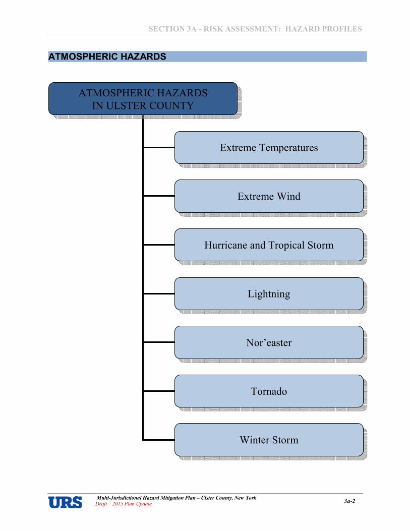
SECTION 3A � RISK ASSESSMENT: HAZARD PROFILES
Multi�Jurisdictional Hazard Mitigation Plan – Ulster County, New York Draft – 2015 Plan Update 3a�2
ATMOSPHERIC HAZARDS
ATMOSPHERIC HAZARDS
IN ULSTER COUNTY
Extreme Temperatures
Extreme Wind
Hurricane and Tropical Storm
Lightning
Nor’easter
Tornado
Winter Storm

SECTION 3A � RISK ASSESSMENT: HAZARD PROFILES
Multi�Jurisdictional Hazard Mitigation Plan – Ulster County, New York Draft – 2015 Plan Update 3a�3
Extreme Temperatures Extreme temperatures principally affect the health and safety of the human population, although they can also impact livestock, agricultural crops, and may also cause damage to infrastructure and property. This section provides detailed profiles of both extreme high and extreme low temperatures.
Location – Extreme Temperatures Ulster County is located in a region of the country that is susceptible to both extreme heat and extreme cold. During periods of extreme temperature conditions, the effects are felt over a widespread geographic area, and it is generally assumed that the entire planning area (Ulster County and all of its municipalities) is uniformly exposed to extreme heat and extreme cold.
Extent – Extreme Temperatures
The speed of onset of extreme temperature events typically offers 24 hours of warning time. The duration of historic events in Ulster County is typically less than one week. The extent of extremely cold temperatures is typically measured through the Wind Chill Temperature (WCT) Index. The WCT Index provides a formula for calculating the dangers from winter winds and freezing temperatures. It is, essentially, a calculation of the temperature that is felt when the effects of wind speed are added to the base air temperature. Figure 3a.1 shows the NOAA NWS Wind Chill Chart.
Figure 3a.1
NWS Wind Chill Index

SECTION 3A � RISK ASSESSMENT: HAZARD PROFILES
Multi�Jurisdictional Hazard Mitigation Plan – Ulster County, New York Draft – 2015 Plan Update 3a�4
The extent of the extremely hot temperatures is typically measured through the Heat Index, which calculates the dangers from high relative humidity and extremely hot temperatures. It is, essentially, a calculation of the temperature that is felt when the effects of relative humidity are added to the base air temperature. Figure 3a.2shows the NOAA NWS Heat Index.
Figure 3a.2
NWS Heat Index
Historical Occurrence – Extreme Temperatures Extreme Cold According to NOAA’s National Climatic Data Center (NCDC), there were a total of 45 extreme cold1 events in Ulster County between January 1996 and July 20152 (or an average of about two extreme cold event days per year). No deaths, injuries, or property damage was recorded for these events. However, $16.7 million in crop damage was recorded. TwentyAthree events occurred since the last version of the plan was finalized in February 2009. All but two of these events occurred between the months of October and May, the time of year when extreme cold events are most common in the area. New York State has received no Federal Disaster or Emergency Declarations due solely to extreme temperatures. Some recent notable extreme cold events as reported by the NCDC include:
April 27, 2002. A cold high pressure system settled into the MidAHudson Valley during the overnight hours of April 26A27. Under a mostly clear sky, and light wind, temperatures fell to or below 32 degrees across
1 NCDC search results for the event types of cold/windchill, extreme cold/windchill, and frost/freeze. 2 NCDC records were queried on October 27, 2015, and are current for event dates through July 31, 2015.
SECTION 3A � RISK ASSESSMENT: HAZARD PROFILES
Multi�Jurisdictional Hazard Mitigation Plan – Ulster County, New York Draft – 2015 Plan Update 3a�5
portions of Ulster and Dutchess Counties where the growing season had already started. No damage was reported to the National Weather Service with this freeze.
January 25�26, 2007. An arctic air mass moved into east central New York State late Thursday night on January 25th, and remained in place into Friday, January 26th. Early morning low temperatures on Friday ranged between zero and ten degrees below zero, with some temperatures as low as 15 degrees below zero across higher elevations of the Adirondacks. In addition, northwest winds of 10 to 15 miles per hour produced wind chills as low as 25 to 30 degrees below zero early Friday morning, especially across higher elevations. May 1, 2008. Widespread freezing temperatures, along with frost, affected areas across the midAHudson Valley, Capital District, the Lake George and Saratoga region, and Mohawk Valley of eastern New York during the early morning hours of Thursday May 1st. The freeze and frost was particularly damaging to fruit trees, as a previous warm spell in mid to late April led to unusually advanced stages of bloom. Crop damages were most extensive in Ulster County, where $16.7 million in crop losses were estimated, mainly for apple and peach orchards.
January 16, 2009. A bitterly cold air mass spread across much of east central New York and adjacent western New England during Friday January 16th. Widespread subzero temperatures were recorded across the region. Across portions of the southern Adirondacks and eastern Catskills, wind chills of 20 to 25 degrees below zero were recorded. Property and crop damages are not reported in the NCDC database for this event.
February 13, 2015. Behind an Arctic cold front, a frigid air mass moved into upstate New York, accompanied by gusty northwest winds of up to 35 miles per hour. Temperatures dropped as low as 18 degrees below zero, with wind chill values as low 35 degrees below zero at times. Some schools were delayed on the morning of Friday, February 13th. Several communities opened warming shelters. There were also some reports of frozen pipes and burst water mains, especially in the areas that contained older infrastructure. Property and crop damages are not reported in the NCDC database for this event record.
Extreme Heat
According to NOAA’s National Climatic Data Center (NCDC), there were a total of 18 extreme heat3 event days in Ulster County between March 1998 and July 20154 A or an average of about one extreme heat event day per year. No deaths, injuries, property, or crop damages are recorded in the database for these events. Eleven events occurred since the last version of this plan was approved in 2009, the most recent of which was in September 2013. Some more notable extreme heat events as reported by the NCDC include:
June 7, 1999. On June 7th, the season's second Bermuda High brought the first 90 degree temperature of 1999 to much of eastern New York. At the Albany International Airport it was the first official 90 degree temperature since August 16, 1997. The temperature did not stop there, but soared all the way to 95 degrees. This value tied the daily record for the date last set in 1925. The combination of heat and humidity produced a heat index between 100 and 105 degrees during the hottest portion of the day. There were no unusual problems or power outages reported due to the excessive heat. July 4�6, 1999. Temperatures soared to 90 or higher most everywhere while dewpoints climbed well into the 70s. At the Albany International airport, the temperature peaked at 94 on July 5th and 95 on July 6th. However, after combining humidity values, the heat index reached as high as 105 on both days. At the Dutchess County airport near Poughkeepsie, the temperature crested at 99 degrees both days. On July 5th, the dewpoint reached 79 to produce a heat index of 119 degrees. The heat index peaked around 110 degrees on July 6th. The sultry air mass set the stage for a large severe thunderstorm outbreak during the afternoon of July 6th across eastern New York.
3 NCDC search results for the event types of excessive heat and heat. 4 NCDC records were queried on October 27, 2015, and are current for event dates through July 31, 2015.

SECTION 3A � RISK ASSESSMENT: HAZARD PROFILES
Multi�Jurisdictional Hazard Mitigation Plan – Ulster County, New York Draft – 2015 Plan Update 3a�6
August 8�9, 2001. Officially, at the Albany International Airport, there were four consecutive days of 90 degrees or higher, the longest such stretch in over 6 years. The heat wave reached its peak on August 8th and 9th. During those days, the high reached 100 and 102 at Poughkeepsie respectively. On those same days the Albany International Airport reached 93 and 96. The 96 was a new daily maximum record for August 9th, eclipsing the old record of 94 set in 1949. Humidity levels were also high, which produced heat indices between 105 and 110 near Albany, and 110 to 115 closer to Poughkeepsie. The high heat indices did cause some heat related health problems in Schenectady. While no other heat related problems were reported to the National Weather Service, the heat led to record state electricity consumption, three days in a row. Governor Pataki closed down the State government at 2:00 PM on August 9th to conserve power. Hot weather also caused a railroad bridge to malfunction between the cities of Albany and Rensselaer, resulting in delays for four of Amtrak’s passenger trains on August 9th. June 9, 2008. Unseasonably hot and humid conditions persisted from June 9th until June 10th. Temperatures reached the mid to upper 90s across much of the midAHudson Valley and Capital Region during each afternoon. The combination of high temperatures and humidity levels produced heat indices of 100 to 104 degrees. Many schools across the region either cancelled classes, or had early dismissals due to the extreme heat. July 21�22, 2011. Temperatures across much of east central New York warmed well into the 90s with some locations reaching the century mark in the midAHudson Valley. The most oppressive day was Thursday, July 21st, due to very high dew points in the 70s. The high humidity, combined with temperatures in the 90s, resulted in heat indices of 105 to 110 degrees up the Hudson River Valley. The New York Independent System Operator (NYISO) reported that New York State's peak power consumption on the 21st was the third highest peak on record. On Saturday July 23rd, heat indices of 100 to 104 degrees were recorded across the Capital District, midAHudson Valley, southern Taconics and southeastern Catskills. July 15�19, 2013. High temperatures each day exceeded 90 degrees. When combined with the humidity, heat index values exceeded 100 degrees at times, mainly for the midAHudson Valley. The hottest days were July 18th and 19th, when high temperatures reached the mid to upper 90s in many locations. On the 19th, heat index values were between 105 and 110 degrees across portions of Ulster and Dutchess Counties, with heat index values over 100 degrees across much of eastern New York. The New York State Independent System Operator (NYSISO) reported that power consumption reached a record high on Friday, July 19th, exceeding a record set in 2006. September 11, 2013. Temperatures warmed into the lower to middle 90s throughout the entire Hudson Valley, along with dewpoint values in the lower to middle 70s. This allowed heat index values to reach between 100 and 105 degrees.
Probability of Occurrence – Extreme Temperatures Extreme temperature events will continue to have a high probability of occurrence in Ulster County, and the probability of future occurrences in Ulster County is certain (higher for extreme cold than extreme heat). While the impact of such occurrences on people and property is typically minimal, it is anticipated that the threat to human lives and safety is increasing due to growing elderly populations in many of Ulster County’s municipal jurisdictions. Furthermore, temperatures in the Northeast United States have risen by about 1.5 degrees Fahrenheit (°F) on average since 1900. With climate change, it is anticipated that extreme temperature events will be more common occurrences in the years ahead.

SECTION 3A � RISK ASSESSMENT: HAZARD PROFILES
Multi�Jurisdictional Hazard Mitigation Plan – Ulster County, New York Draft – 2015 Plan Update 3a�7
Extreme Wind
Location – Extreme Wind
Extreme wind events are experienced in every region of the United States. The extreme wind hazard area covers the whole of Ulster County and the entire planning area is uniformly susceptible to the extreme wind hazard. Figure 3a.3 illustrates various wind zones throughout the country based on design wind speeds established by the American Society of Civil Engineers. It divides the country into four wind zones, geographically representing the frequency and magnitude of potential extreme wind events including severe thunderstorms, tornadoes and hurricanes. The figure shows that all areas of Ulster County are located within Zone II and are susceptible to hurricanes, with a design wind speed for shelters of 160 mph (3Asecond gust).
Extent – Extreme Wind Extreme wind can occur alone, such as during straightAline wind events and derechos, or it can accompany other natural hazards, including hurricanes and severe thunderstorms. Severe wind poses a threat to lives, property, and vital utilities primarily due to the effects of flying debris or downed trees and power lines. Severe wind will typically cause the greatest damage to structures of light construction, particularly manufactured homes. Table 3a.2 illustrates the severity and typical effects of various sustained wind speeds. These would be reflective of high winds associated with thunderstorms, hurricanes, tropical storms and nor’easters. Typical effects of wind are very different for tornados. Table 3a.3 illustrates the severity and typical effects of wind during tornados, as measured by various 3 second gusts. Note that tornados are addressed separately later in this plan section.
Figure 3a.3
Wind Zones in the United States
Source: Federal Emergency Management Agency

SECTION 3A � RISK ASSESSMENT: HAZARD PROFILES
Multi�Jurisdictional Hazard Mitigation Plan – Ulster County, New York Draft – 2015 Plan Update 3a�8
Table 3a.2
Severity and Typical Effects of Various Sustained Wind Speeds
Sustained Wind
Speed*
(mph)
Equivalent
Saffir�
Simpson
Scale**
(Hurricanes)
Severity of
Damage Typical Effects
0A73 (V3S=0 to 88)
N/A Isolated Isolated damage for winds below 50 mph. Above 50 mph, expect some minor damage to buildings of light material. Small branches blown from trees.
74A95 (V3S =89 to 115)
1 Minor
Very dangerous winds will produce some damage: WellAconstructed frame homes could have damage to roof, shingles, and vinyl siding and gutters. Large branches of trees will snap and shallowly rooted trees may be toppled. Extensive damage to power lines and poles likely will result in power outages that could last a few to several days.
96A110 (V3S=116 to 130)
2 Extensive
Extremely dangerous winds will cause extensive damage: WellAconstructed frame homes could sustain major roof and siding damage. Many shallowly rooted trees will be snapped or uprooted and block numerous roads. NearAtotal power loss is expected with outages that could last from several days to weeks.
111A129 (V3S=131 to 149)
3 Devastating
Devastating damage will occur: WellAbuilt framed homes may incur major damage or removal of roof decking and gable ends. Many trees will be snapped or uprooted, blocking numerous roads. Electricity and water will be unavailable for several days to weeks after the storm passes.
130A156 (V3S=150 to 176
4 Catastrophic
Catastrophic damage will occur: WellAbuilt framed homes can sustain severe damage with loss of most of the roof structure and/or some exterior walls. Most trees will be snapped or uprooted and power poles downed. Fallen trees and power poles will isolate residential areas. Power outages will last weeks to possibly months. Most of the area will be uninhabitable for weeks or months.
157 or higher (V3S>177)
5 Catastrophic
Catastrophic damage will occur: A high percentage of framed homes will be destroyed, with total roof failure and wall collapse. Fallen trees and power poles will isolate residential areas. Power outages will last for weeks to possibly months. Most of the area will be uninhabitable for weeks or months.
Source: National Oceanic and Atmospheric Administration * The 2003 International Building Code Table 1609.3.1 was used to convert Saffir8Simpson sustained wind speeds to 38 second gusts (V3S) for the
purposes of comparison between hurricane and tornado winds.
** The Saffir8Simpson Scale is described further in this section under Hurricanes.
Table 3a.3
Severity and Typical Effects of Various Tornado Wind Speeds (3 second gust)
Maximum
Wind Speeds
3 Second Gust
(mph)
Equivalent
Enhanced
Fujita
Scale*
(Tornadoes)
Severity Typical Effects
65A85 EF0 Light Some damage to chimneys; branches broken off trees; shallowArooted trees pushed over; sign boards damaged.
86A110 EF1 Moderate Peels surface off roofs; mobile homes pushed off foundations or overturned; moving autos pushed off the roads; attached garages may be destroyed.
111A135 EF2 Significant Roofs torn off frame houses; mobile homes demolished; boxcars overturned; large trees snapped or uprooted; highArise windows broken and blown in; lightAobject missiles generated.

SECTION 3A � RISK ASSESSMENT: HAZARD PROFILES
Multi�Jurisdictional Hazard Mitigation Plan – Ulster County, New York Draft – 2015 Plan Update 3a�9
Historical Occurrences – Extreme Wind Ulster County has experienced numerous types of damaging extreme wind events in the past including severe thunderstorms, tornadoes, hurricanes, tropical storms and nor’easters. According to the NCDC5, 199 extreme wind6 event days have affected Ulster County from July 1963 to July 2015 (data excludes tornado events which are addressed separately within this section). These incidents resulted in a reported total of three deaths, one injury, and roughly $3.1 million in property damages. FortyAtwo high wind days have been recorded since the last version of this plan was approved in February 2009, for which one death and $19,000 in damages were recorded. Extreme wind events occur regularly in Ulster County. Most events are associated with thunderstorms occurring during the summer months, with relatively low reported property damages per event (in the thousands of dollars). However, stronger weather systems have produced much more extreme and widespread windArelated impacts. A sampling of more notable extreme, damage8causing events includes the following:
November 6, 1994. High winds downed trees and power lines. Especially hard hit was Kingston, where trees fell on homes and vehicles. One death and $0.5 million in property damages were reported during this event.
December 24, 1994. A coastal storm which moved over extreme southeast New York on the morning of December 24th brought high winds to parts of eastern New York, downing trees, tree limbs and power lines. Especially hard hit were Olive, Woodstock and Hurley where large trees were uprooted and several homes sustained significant damage as trees fell on them (with an estimated $0.5 million in property damage). March 19, 1996. A strong low pressure system produced damaging winds. In Ulster County trees were blown down in Kingston, Woodstock and Wawarsing resulting in an estimated $89,000 in property damages. May 29, 1998. Thunderstorm winds downed trees and power lines. An elderly man was instantly killed at Ellenville in Ulster County, when a large tree limb fell on him.
July 1, 2001. In Ulster County, microbrust damage was surveyed by National Weather Service personnel on the east side of Gardiner. Winds were estimated to be around 100 mph and the damage was generally contained within a semiAcircle to the west of Ireland Corners. Large trees were snapped or taken down in an area bounded by Route 44A55, Route 208 and Marabac Road. One tree fell on an automobile, crushing it. Meanwhile to the south of the Route 208 intersection, another tree fell onto the roof of a house. At the same location, a chimney toppled onto another vehicle. At the same time, thunderstorm winds blew down numerous trees in the City of New Paltz. Total estimated property damages in Ulster County totaled $65,000.
5 NCDC records were queried on October 27, 2015, and are current for event dates through July 31, 2015. 6 NCDC query for events categorized as high wind, strong wind, and thunderstorm wind.
136A165 EF3 Severe Roofs and some walls torn off wellAconstructed houses; trains overturned; most trees in forest uprooted; heavy cars lifted off the ground and thrown.
166A200 EF4 Devastating WellAconstructed houses leveled; structures with weak foundations blown away some distance; cars thrown and large missiles generated.
Over 200 EF5 Incredible
Strong frame houses lifted off foundations and carried considerable distances to disintegrate; automobile sized missiles fly through the air in excess of 100 meters (109 yards); trees debarked; steel reinforced concrete structures badly damaged.
Source: National Oceanic and Atmospheric Administration
* The Enhanced Fujita Scale is described further in this section under Tornados.

SECTION 3A � RISK ASSESSMENT: HAZARD PROFILES
Multi�Jurisdictional Hazard Mitigation Plan – Ulster County, New York Draft – 2015 Plan Update 3a�10
November 13�14, 2003. A steep pressure gradient between a low pressure area in the east and a high pressure system building across the Ohio Valley, brought the second major wind event of the fall season to eastern New York. Since the storm was slow moving, this turned out to be a two day high wind event. A roof over gas pumps at a Stewarts in Rosendale in Ulster County was badly damaged. A large tree fell onto a house near Kingston, damaging the roof. Downed live power lines caused a brush fire outside of New Paltz. One injury and $275,000 in property damages were attributed to this storm in Ulster County. July 22, 2006. A thunderstorm over the lower Catskills shortly before daybreak became severe. It produced a wetAmicroburst wind gust estimated at 70 to 80 miles an hour in Ellenville. The strong wind blew down about 30 trees, destroyed a car, and damaged 2 homes. The estimated cost of the damage was 35 thousand dollars. December 1, 2006. A tree was blown onto an apartment building, crashing through the roof and killing an individual inside in Wawarsing. This occurred from strong winds, well ahead of any thunderstorms. October 29�30, 2012. Superstorm Sandy. As the storm made landfall in southern New Jersey during the evening of October 29th, bands of rain moved across eastern New York. Strong and gusty winds in association with the storm caused damage to trees and power lines across the region. Although not quite as widespread as areas across southeastern New York and New Jersey, power outages occurred throughout the region, mainly across the higher terrain. Local media reported that up to 63,000 customers lost power in Dutchess and Ulster Counties. It was also reported that utility National Grid had 8,000 customers without power in eastern New York at the height of the storm. Wind gusts of 40 to 60 mph were common, and reached 60 mph at Stone Ridge in Ulster County. One direct death was caused by these winds as flying debris was thrown through a windshield and killed a 69 year old woman driving in Kerhonkson in Ulster County.
Probability of Occurrence – Extreme Wind Extreme wind events will continue to have a high probability of occurrence in Ulster County, and the probability of future occurrences in Ulster County is certain. The entire planning area is susceptible to a wide variety of recurring events that cause extreme wind conditions including severe thunderstorms (most frequent), tornadoes, hurricanes, tropical storms and nor’easters. Based on historic occurrence data, Ulster County can expect about four and six extreme wind days per year7.
Hurricanes and Tropical Storms
Location– Hurricane and Tropical Storm
Hurricanes and tropical storms threaten the entire Atlantic and Gulf seaboard of the United States, and while coastal areas are most directly exposed to the brunt of landfalling storms their impact is often felt hundreds of miles inland. Ulster County is located in a region of the country that is susceptible to all of the hazards wrought by hurricanes and tropical storms. In the strictest sense, hurricanes and tropical storms are not hazards in their own right but, rather, events where the primary damaging hazards are highAlevel sustained winds, heavy precipitation that causes inland flooding and tornadoes (coastal areas are also susceptible to the additional forces of storm surge, windAdriven waves and tidal flooding, which can be more destructive than cyclonic wind). The entire planning area is located within a geographic area that is affected by hurricanes and tropical storms. The hazard areas for the accompanying extreme wind, storm surge, coastal erosion, riverine flooding, tornadoes, and wave action hazards do, however, vary across the county. While mentioned
7 About four extreme wind days per year is based on NOAA NCDC period of record of 52 years and 199 event days. However, the database is not particularly robust for its initial years of coverage between 1956 and 1986 during which only 15 event days are recorded. When the same calculation of extreme wind days per year is done using only the 29 years of robust record keeping and 184 event days during that period, the estimate of extreme wind days per year goes up to 6.3.
SECTION 3A � RISK ASSESSMENT: HAZARD PROFILES
Multi�Jurisdictional Hazard Mitigation Plan – Ulster County, New York Draft – 2015 Plan Update 3a�11
here, each of these individual forces are more thoroughly addressed as separate hazards within this section (i.e., extreme wind, coastal erosion, flood, tornado, storm surge, and wave action).
Extent – Hurricane and Tropical Storm
As a hurricane develops, barometric pressure (measured in millibars or inches) at its center falls and winds increase. If the atmospheric and oceanic conditions are favorable, it can intensify into a tropical depression. When maximum sustained winds reach or exceed 39 mph, the system is designated a tropical storm, given a name and is closely monitored by the National Hurricane Center in Miami, Florida. When sustained winds reach 74 mph the storm is deemed a hurricane. Hurricane intensity is further classified by the SaffirASimpson Scale (Table 3a.4), which rates hurricane intensity in categories on a scale of 1 to 5, with Category 5 being the most intense. The SaffirASimpson Scale categorizes hurricane intensity linearly based upon maximum sustained winds, barometric pressure and storm surge potential, which are combined to estimate potential damage. Categories 3, 4 and 5 are classified as “major” hurricanes, and while hurricanes within this range comprise only 20 percent of total tropical cyclone landfalls, they account for over 70 percent of the damage in the United States. Even tropical storms and hurricanes that parallel the New York and New Jersey coastline many dozens of miles away from Ulster County without ever making direct landfall can still cause significant damage.
Historical Occurrences – Hurricane and Tropical Storm
Hurricanes and tropical storms have impacted Ulster County and its participating jurisdictions in the past, and will continue to do so in the future. Ulster County has an active history of hurricanes and tropical storms. According to NOAA historical records, ten hurricane or tropical storm tracks8 have passed within 75 nautical miles of Ulster County since 1863. This includes two Category 1 hurricanes; and eight tropical storms. Of these ten events, two tracks traversed directly through Ulster County (a Category 1 hurricane in 1878 and a tropical storm in 1893). Figure 3a.4 shows the track of each recorded historical storm in relation to the Ulster County search area. As can be seen in the figure, almost all hurricane and tropical storm tracks traverse in a northeasterly direction through the area. For each event, Table 3a.5 provides the date of occurrence, storm name (if applicable), maximum wind speed and category of the storm based on the SaffirASimpson Scale (as recorded within 75 miles of Ulster County).
8 Not including tropical depressions or extratropical systems.
Table 3a.4
Saffir�Simpson Scale for Hurricanes
Category Maximum Sustained
Wind Speed (mph)
Minimum Surface
Pressure (Millibars)
Storm Surge
(Feet)
1 74–95 Greater than 980 3–5
2 96–110 979–965 6–8
3 111–129 964–945 9–12
4 130–156 944–920 13–18
5 157 + Less than 920 19+
Source: National Oceanic and Atmospheric Administration

SECTION 3A � RISK ASSESSMENT: HAZARD PROFILES
Multi�Jurisdictional Hazard Mitigation Plan – Ulster County, New York Draft – 2015 Plan Update 3a�12
Table 3a.5
Historical Hurricane and Tropical Storm Tracks within 75 Nautical Miles of Ulster County (1856�2014)
Date of Occurrence Storm Name Maximum Wind Speed
(knots) Storm Category
September 19, 1863 Unnamed 40 Tropical Storm
October 23, 1878 Unnamed 70 Category 1
August 22, 1888 Unnamed 40 Tropical Storm
August 24, 1893 Unnamed 75 Category 1
August 29, 1893 Unnamed 55 Tropical Storm
August 29, 1949 Unnamed 50 Tropical Storm
August 28, 1971 Doria 45 Tropical Storm
June 23, 1972 Agnes 45 Tropical Storm
September 6, 1979 David 40 Tropical Storm
August 28, 2011 Irene 55 Tropical Storm
9 Out of five recent key damaging events for Ulster County (Ivan, Floyd, Irene, Lee, and Sandy), it is notable that only Irene meets the query
criteria of hurricane or tropical storm strength within 75 nautical miles of Ulster County. The remnants of Hurricane Floyd and Hurricane Ivan were both tropical depressions by the time they reached Ulster County. Tropical Storm Lee made landfall in Louisiana and was no longer a tropical system when its remnants reached New York, and Superstorm Sandy was extratropical when its center passed several hundred miles to the south of Ulster County.
Figure 3a.4
Historical Hurricane and Tropical Storm Tracks within 75 Nautical Miles of Ulster County9, 1863�2014*
* NOAA 2014 (latest date available from data source, http://coast.noaa.gov/hurricanes/). Note that Irene’s track is highlighted in white.

SECTION 3A � RISK ASSESSMENT: HAZARD PROFILES
Multi�Jurisdictional Hazard Mitigation Plan – Ulster County, New York Draft – 2015 Plan Update 3a�13
Ulster County has, most recently, been impacted by the remnants of both Hurricane Floyd in September 1999 and Hurricane Ivan in September 2004, both of which were Tropical Depressions by the time they reached Ulster County. Since the last version of the plan was prepared, Hurricane Irene (August 2011), the remnants of Tropical Storm Lee (September 2011), and Superstorm Sandy (October 2012) all hit Ulster County with full force. Brief descriptions of these most notable, recent tropical events include the following: September 1999 – Floyd. Remnants of Hurricane Floyd impacted the western portions of Ulster County with high winds, heavy rains, and some flooding. Information received from local sources reports that this event caused significant property damage in the Town of Saugerties and left some residents without power for almost a week.
September 2004 � Ivan. Remnants of Hurricane Ivan impacted the County with high winds, heavy rains, and some flooding.
Hurricane Irene (August 28, 2011), Tropical
Storm Lee (September 7, 2011), and Superstorm Sandy
(October 29, 2012) hit Ulster County with full force. The torrential downpour caused water levels in the Rondout Creek, Wallkill River, and Lower and Upper Esopus Creek to reach record heights causing widespread flash flooding. Homes, businesses and infrastructure were destroyed, particularly in lowAlying areas. Countless roads were closed due to flood waters overtopping culverts; bridges were closed isolating residents; and the force of the stormwater caused substantial infrastructure damage to water mains, sewage treatment facilities, and water delivery systems throughout the region. Stream banks were overtopped and severely eroded, flooding dozens of homes and depositing natural and manAmade debris throughout the stream corridors. Businesses were severely flooded, leaving residents without access to basic necessities for weeks. Residents were forced to evacuate their homes, moving to shelters established in local emergency service buildings, schools, and community centers. CountyAwide shelters were set up at the Belleayre Mountain Ski Center and the SUNY New Paltz Health and Wellness Center, which, given their remote locations were difficult to access. The physical damage to roads, bridges, homes, and other essential infrastructure resulted in short and long term economic impacts that rippled throughout the County and the region. Irreparable losses to commodity farms, power failures, and, in some cases, isolation from economic centers complicated and delayed recovery efforts. Tourism, a major industry in this region, suffered greatly through both an overall loss of revenue and lost wages due to postponed business activity. A sampling of key critical issues facing the Ulster County10 include:
10 Source: Ulster NY Rising Community Reconstruction Plan
Town of Olive 8 Watson Hollow Rd. Bushkill Creek (Photo courtesy of Ed Kahill, NYRCR Ulster Plan)
Emergency Service Providers, Rosendale
(Photo courtesy of Jeanne Walsh, NYRCR Ulster Plan)
Flooded Residence, Lawrenceville
(Photo courtesy of Dr. David Rosenbaum, NYRCR Ulster Plan)
Debris and Road Collapse in the Village of Ellenville
(Photo courtesy of NYCRCR Ulster Plan)

SECTION 3A � RISK ASSESSMENT: HAZARD PROFILES
Multi�Jurisdictional Hazard Mitigation Plan – Ulster County, New York Draft – 2015 Plan Update 3a�14
widespread flooding of the Rondout, Wallkill and Esopus; natural and manAmade debris blocking culverts, lodging against bridge abutments, and inhibiting the flow of water, and compromising infrastructure; direct economic impact to agricultural operations from commodity loss and secondary economic impacts to the region from loss of tourism revenue; massive stream bank erosion throughout the watershed areas, and on the Hudson River shoreline; lack of emergency preparedness, regional command centers and effective interAmunicipal communication among emergency service providers; damage to residential neighborhoods built in flood prone areas, exacerbated by the lack of resilient design and construction; lack of regional sheltering, with protected access routes; vulnerability of and damage to critical assets including key municipal and emergency service buildings, commercial and healthcare facilities; vulnerability of and damage to bridges, culverts, roadways, water supply, wastewater treatment plans and system infrastructure; widespread and prolonged roadway closures isolating neighborhoods, healthcare facilities and senior centers, regional shelters, businesses, regional economic generators, and preventing access by emergency service providers; lack of designated route detours and signage; prolonged and widespread electrical power interruption including to communication towers.
Probability of Occurrence – Hurricane and Tropical Storm
The probability of future hurricane and tropical storm events for Ulster County is high. According to NOAA statistical data, Ulster County is located in an area with an annual probability of a named storm between 6 and 12 percent (Figure 3a.5). This empirical probability is fairly consistent with other scientific studies and observed historical data made available through various federal, state and local sources. Occurrences are most likely during the official Atlantic hurricane season (the months of June through November). The peak of the Atlantic hurricane season is in early to midASeptember and the average number of storms that reach hurricane intensity per year in this basin is six. The probability of storm occurrences will vary significantly based on the return interval for different categories of magnitude. The probability of less intense storms (lower return periods) is higher than more intense storms (higher return periods).
Figure 3a.5
Empirical Probability of a Named Storm*
*Source: NOAA
SECTION 3A � RISK ASSESSMENT: HAZARD PROFILES
Multi�Jurisdictional Hazard Mitigation Plan – Ulster County, New York Draft – 2015 Plan Update 3a�15
The frequency and intensity of coastal storms and severe weather events is expected to increase in the future due to climate change. In the years to come, it is anticipated that Ulster County will observe fairly drastic changes in storm character, intensity, frequency, and storm tracking. Hurricanes are likely to become more intense with rising sea water temperatures. Storm effects are expected to be more extensive in the future. The following types of impacts could be anticipated in Ulster County’s future as a result of climate change: inundation of lowAlying areas; increased frequency and extent of stormArelated flooding; impacts to human populations (property losses, more frequent flood damage, more frequent flooding of roadways and urban centers, risks to people as the population of floodAprone areas increases); more buildings and infrastructure exposed; currently exposed buildings and infrastructure could be subject to potentially greater losses as water levels increase; impacts on gravity flow stormwater systems; impacts on nonAcoastal areas. Impacts of climate change can affect all parts of a community, including: transportation infrastructure (ports, marinas, airports, roads, bridges, railways); public infrastructure (stormwater and wastewater management systems, drinking water supply and distribution systems, power utility systems, communications systems); public facilities (i.e., police, fire, ambulance, hospitals, schools, daycare centers, adult living facilities, historic landmarks, government buildings, libraries, parks, etc.); economic viability of a community – particularly for communities where tourism tends to drive local economies, as is the case in some of Ulster County’s communities. Climate change also could lead to a potential loss of assets that support tourism.
Lightning
Location and Extent – Lightning Ulster County is located in a region of the country that is susceptible to lightning strikes, though not as susceptible as southeastern states. Figure 3a.6 shows a lightning flash density map for the years 1997 to 2010 based upon data provided by Vaisala’s National Lightning Detection Network® (NLDN®)11.
11 Source: http://www.vaisala.com/Vaisala%20Documents/Scientific%20papers/2014%20ILDC%20ILMC/ILMCAThursday/Roeder%20et%20alAMapping%20Lightning%20Fatality%20RiskA2014AILDCAILMC.pdf
Figure 3a.6
Lightning Flash Density in the United States

SECTION 3A � RISK ASSESSMENT: HAZARD PROFILES
Multi�Jurisdictional Hazard Mitigation Plan – Ulster County, New York Draft – 2015 Plan Update 3a�16
All areas of Ulster County are equally susceptible to lightning strike. While lightning occurs randomly anywhere and anytime, the most common location for lightning fatalities and injuries to people is in open areas such as parks, beaches, golf courses and other recreational areas. Ulster County remains susceptible to lightning deaths and injuries due to the large number of people who engage in outdoor activities.
Historical Occurrences – Lightning According to NCDC12, 16 lightning event days were recorded in Ulster County between July 1996 and July 2015. These incidents resulted in a reported total of one death, six injuries, and caused approximately $654,000 in property damages (representing an average of about 0.85 event days per year). Three events (with an associated $6,000 in property damages and one death) were added to the database since the last version of this plan was finalized in February 2009. Some more notable events include the following:
July 15, 1997. At Highland in the Town of Lloyd, a 180 foot by 120 foot storage facility was burned to the ground following a lightning strike causing an estimated $250,000 in damages.
July 4, 1999. Lightning resulted in as many as 3,500 residents without power in the MidAHudson Valley.
In addition, the lightning from the thunderstorm struck two different houses, one in Kingston and another in Ulster.. The first strike, at 119 Dewitt Street in Kingston ignited a fire that was contained to a storage room. The second lightning strike hit a tree, destroying it. The flames from the tree damaged a roof at 98 Katrine Lane, in the Town of Ulster. August 10, 2003. Lightning from a thunderstorm struck a pole next to a house on Hardenburg Road in Rifton, in the Town of Esopus. The lightning was conducted through electrical wires and traveled into a nearby home striking a man in his basement. The man was not seriously injured. Another lightning strike from the same storm struck a house on Glasco Turnpike in Saugerties. The house was set ablaze, destroying the home and killing two dogs. Approximately $100,000 in damages and one injury were associated with this event.
June 14, 2008. Three hikers and a baby were slightly injured by a nearby lightning strike while sitting on a bench at the Mohonk Mountain House near New Paltz during a thunderstorm. The group was walking on a trail when the thunderstorm started. They then took cover and sat on a bench when lightning struck nearby. Their feet were in water, exacerbating the impact of the nearby lightning strike. July 27, 2008. Lightning struck a home near the Hamlet of Accord (Town of Rochester) during a thunderstorm. Significant damage was limited to the den and study areas, with smoke damage throughout the house. Approximately $50,000 in property damage was recorded. July 3, 2009. Thunderstorms developed across the region in the afternoon and evening hours. One death was reported of a 35 year old male in the Hamlet of Highland (Town of Lloyd), who was in the backyard of his home wrapping up an extension cord when lightning either struck the ground near him or the cord. July 29, 2009. Numerous showers and thunderstorms developed across eastern New York and western New England during Wednesday afternoon and evening on July 29th. Some of the thunderstorms were severe, producing isolated damaging winds. In addition, several clusters of thunderstorms moved slowly, across the same areas for several hours, producing torrential rainfall and resulting in significant flash flooding. Trees and wires were reported down approximately one mile north of Woodstock due to lightning, and approximately $5,000 in property damage was recorded.
June 3, 2014. Slow moving showers and thunderstorms produced very heavy rain in a short period of time. This led to some flash flooding, especially in urban and poor drainage areas. In addition, a few of the thunderstorms also produced strong wind gusts, which caused damage to trees and power lines. By the late evening, the threat for thunderstorms ended, as the frontal boundary pushed through and less humid air moved into the region. Lightning downed wires on Fishcreek Road and Highwoods Road in Saugerties. Approximately $1,000 in property damage was reported for this event.
12 NCDC records were queried on October 27, 2015, and are current for event dates through July 31, 2015.
SECTION 3A � RISK ASSESSMENT: HAZARD PROFILES
Multi�Jurisdictional Hazard Mitigation Plan – Ulster County, New York Draft – 2015 Plan Update 3a�17
Probability of Future Occurrences – Lightning
The probability of occurrence for future lightning events in Ulster County is certain. Using the NLDN®
data from Figure 3a.6, Ulster County is located in an area of the country that experiences two to three lightning flashes per square kilometer per year. Given this regular frequency of occurrence, it can be expected that future lightning events will continue to threaten life and cause minor property damages throughout the County.
Nor’easters
Location – Nor’easter Nor’easters threaten the entire Atlantic Coast of the United States, and while coastal areas are most directly exposed to the damaging forces of such storm systems their impact is often felt far inland. Ulster County is located in an area that is extremely susceptible to nor’easters. All areas throughout the County are susceptible to the hazards that can be associated with nor’easters: extreme wind, flooding and heavy snowfall. Ulster County’s Hudson River shoreline jurisdictions are also susceptible to the added effects of storm surge.13
Extent – Nor’easter While there are a variety of indicators for nor’easter intensity, Table 3a.6 describes the DolanADavis Nor’easter Intensity Scale which is based on coastal storm erosion, degradation and property damage.
Table 3a.6
Dolan�Davis Nor’easter Intensity Scale
Storm Class Beach Erosion Dune Erosion Overwash Property Damage
1 WEAK
Minor changes None No No
2 MODERATE
Modest; mostly to lower beach
Minor No Modest
3 SIGNIFICANT
Erosion extends across beach
Can be significant No Loss of many structures at local level
4 SEVERE
Severe beach erosion and recession
Severe dune erosion or destruction
On low beaches Loss of structures at communityAscale
5 EXTREME
Extreme beach erosion
Dunes destroyed over extensive areas
Massive in sheets and channels
Extensive at regionalAscale; millions of dollars
Historical Occurrences – Nor’easter Ulster County has a lengthy history of devastating impacts wrought by nor’easters. This includes damages caused by the effects of extreme wind, heavy snowfall and flooding. Some more notable examples include:
Blizzard of 1993. The Storm of the Century, also known as the ’93 Superstorm, NoAName Hurricane, the White Hurricane, or the (Great) Blizzard of 1993, was a large cyclonic storm that occurred on March 12–March 15, 1993, on the East Coast of North America. It is unique for its intensity, massive size and wideAreaching effect. At its height the storm stretched from Canada to Central America, but its main impact was on the Eastern United States and Cuba. States of emergency were declared by local towns in Ulster County.
13 Distinct hazard area locations for surge are discussed elsewhere in this section.

SECTION 3A � RISK ASSESSMENT: HAZARD PROFILES
Multi�Jurisdictional Hazard Mitigation Plan – Ulster County, New York Draft – 2015 Plan Update 3a�18
February 23�25, 1998. This nor’easter resulted in heavy snowfall across Ulster County, including a recorded 25 inches at Slide Mountain in western Ulster County.
December 30, 2000. Many areas received the most snow to fall in a single storm since January 1996, and one local death was blamed on the weather when a man blowing snow had a heart attack. Area police, utilities and public works crews reported few stormArelated problems. During the midAafternoon, snow was piling up at a rate of two inches per hour in Kingston, where a snow emergency was declared.
December 26�27, 2010. A major nor'easter brought significant snows and blizzard conditions to much of the northeastern United States Sunday, December 26th into Monday, December 27th. Bands of heavy snow with snowfall rates of one to three inches an hour occurred across the region. Snowfall totals of one to two feet occurred mainly east of the Hudson River and across adjacent western New England. Snowfall amounts dropped off dramatically to the northwest of the Capital District. Strong and gusty winds caused significant blowing and drifting of the snow. Winds gusts across the local area were 35 to 45 mph with gusts of 50 to 70 mph reported across southeastern New York, Connecticut and eastern Massachusetts.
October 29�30, 2011. An early season Nor'easter dumped heavy wet snow mainly to the south and east of the Capital District with snowfall amounts dropping off rapidly to the north and west. Snowfall rates were as high as two to four inches an hour. Snowfall amounts ranged from as little one to four inches across the northern portion of the Capital District, to five to 10 inches in the Hudson Valley including the southern portion of the Capital District, with 10 to 16 inches in the eastern Catskills, and 12 inches to almost two feet across the Taconics. Power outages occurred as trees and wires came down due to the heavy snow. The outages were the most widespread and prolonged in areas where leaves were still on the trees. Governor Andrew Cuomo declared a state of emergency for 13 New York counties including Albany, Columbia, Dutchess, Greene, Rensselaer and Ulster. Central Hudson Gas and Electric reported more than 115,000 homes and business lost power in Dutchess and Ulster counties. They reported 13 transmission lines, 31 distribution circuits and four subAstations were out of service due to damage. Utility workers from outside the area were brought in to help with the restoration of power. Warming centers and overnight shelters were opened.
November 26, 2014. An early season winter storm impacted all of eastern New York during the busy Thanksgiving travel period on November 26thA27th, 2014. The storm began during the morning of Wednesday, November 26th. Snow began shortly after sunrise across southern areas and gradually began further north by the late morning or early afternoon hours. Once snow began, it increased in intensity, falling at rates at or greater than one inch per hour. This snowfall caused slow and difficult travel, which was particularly noteworthy as this was the day before Thanksgiving. By the early morning on Thanksgiving, most of eastern upstate New York saw snowfall of six to 12 inches, with locally up to 15 inches in the southeastern Adirondacks. Most of Ulster County received six to 10 inches of snow during this event. The snow was rather wet across southern areas, which allowed it to easily coat trees and power lines. Due to the weight of the snow, some tree limbs fell and caused power outages, especially across the midAHudson Valley. Up to 32,000 power customers in Dutchess and Ulster Counties were without power at one point during the storm. With power outages lasting up to several days, the Red Cross opened shelters and the local power company distributed dry ice and bottled water to area residents.
Probability of Occurrence – Nor’easters Nor’easters will continue to have a high frequency of occurrence for Ulster County, and the probability of future occurrences affecting all of Ulster County’s jurisdictions is certain. The frequency and intensity of coastal storms and severe weather events is expected to increase in the future due to climate change. In the years to come, it is anticipated that Ulster County will observe drastic changes in storm character, intensity, frequency, and storm tracking. Nor’easters are likely to become more intense with rising sea water temperatures. Storm effects are expected to be more extensive in the future.

SECTION 3A � RISK ASSESSMENT: HAZARD PROFILES
Multi�Jurisdictional Hazard Mitigation Plan – Ulster County, New York Draft – 2015 Plan Update 3a�19
Tornado
Location – Tornado Ulster County is located in an area that is susceptible to tornados, though their occurrence is not nearly as frequent or intense as it is in other regions of the country. Of the roughly four tornadoes that touch down in New York State each year, approximately 80 percent tend to be of low magnitude (from EF0 to EF2) and typically impact only relatively small areas. Figure 3a.7 shows tornado activity in the United States based on the number of recorded tornadoes per 1,000 square miles. Tornadoes are completely random and it is not possible to predict specific tornado hazard areas. Tornadoes can occur anywhere, and no one location is more susceptible than another. All of Ulster County is uniformly exposed.
Extent – Tornado Table 3a.7 shows the Enhanced Fujita Scale for Tornadoes which was developed to measure tornado strength and associated damages. The tornadoes associated with tropical cyclones are most frequent in September and October when the incidence of tropical storm systems is greatest. This type of tornado usually occurs around the perimeter of the storm, and most often to the right and ahead of the storm path or the storm center as it comes ashore. These tornadoes commonly occur as part of large outbreaks and generally move in an easterly direction.
Figure 3a.7
Tornado Activity in the United States
Source: Federal Emergency Management Agency

SECTION 3A � RISK ASSESSMENT: HAZARD PROFILES
Multi�Jurisdictional Hazard Mitigation Plan – Ulster County, New York Draft – 2015 Plan Update 3a�20
Historical Occurrences – Tornado According to NCDC14, there have been eleven recorded tornado days in Ulster County between September 1975 and July 2015. Intensities ranged from F0 to F2, as shown in Table 3a.8. These events resulted in three injuries and $3.13 million in reported property damages. No new tornados have been recorded since the last event occurred in May 2000.
Table 3a.8
Historical Tornadoes in Ulster County
Location Date
NCDC
Reported
Magnitude
Deaths Injuries Property Damage
Ulster (Town) 09/20/75 F1 0 1 $25,000
Warwarsing 03/21/76 F2 0 0 $0
Warwarsing 03/21/76 F1 0 0 $25,000
Marbletown 06/30/76 F1 0 0 $25,000
Denning 07/21/83 F0 0 0 $25,000
Rochester 5/12/84 F0 0 0 $25,000
Ulster (Town) 10/5/85 F1 0 0 $250,000
Warwarsing/Shawangunk 7/26/86 F2 0 2 $2,500,000*
Saugerties (Town) 9/10/93 F1 0 0 $50,000
Hardenburgh 6/26/98 F1 0 0 $150,000
Esopus 5/18/00 F2 0 0 $50,000
Total 0 3 $3,125,000
* May include damages outside of Ulster County
14 NCDC records were queried on October 27, 2015, and are current for event dates through July 31, 2015.
Table 3a.7
Enhanced Fujita Scale for Tornadoes
Storm
Category
Damage
Level
3 Second
Gust (mph) Description of Damages
Photo
Example
EF0 LIGHT 65–85 Some damage to chimneys; branches broken off trees; shallowArooted trees pushed over; sign boards damaged.
EF1 MODERATE 86–110 Peels surface off roofs; mobile homes pushed off foundations or overturned; moving autos pushed off the roads; attached garages may be destroyed.
EF2 SIGNIFICANT 111–135 Roofs torn off frame houses; mobile homes demolished; boxcars overturned; large trees snapped or uprooted; highrise windows broken and blown in; lightAobject missiles generated.
EF3 SEVERE 136–165 Roofs and some walls torn off wellAconstructed houses; trains overturned; most trees in forest uprooted; heavy cars lifted off the ground and thrown.
EF4 DEVASTATING 166–200 WellAconstructed houses leveled; structures with weak foundations blown away some distance; cars thrown and large missiles generated.
EF5 INCREDIBLE 200+
Strong frame houses lifted off foundations and carried considerable distances to disintegrate; automobile sized missiles fly through the air in excess of 100 m (109 yd); trees debarked; steel reinforced concrete structures badly damaged.
Source: National Oceanic and Atmospheric Administration; Federal Emergency Management Agency

SECTION 3A � RISK ASSESSMENT: HAZARD PROFILES
Multi�Jurisdictional Hazard Mitigation Plan – Ulster County, New York Draft – 2015 Plan Update 3a�21
Since the initial version of the plan was prepared in 2009, it is now customary to categorize tornados using an Enhanced Fujita Scale (EFAscale). The Enhanced FAscale is still a set of wind estimates (no measurements) based on damage. NCDC database records for historic occurrences, however – such as those shown for historic events in Ulster County in Table 3a.8 – are still provided in the old Fujita Scale (FAscale). Table 3a.9 shows how the two scales compare to one another15.
Table 3a.9
Comparison, Fujita Scale (F) versus Enhanced Fujita Scale (EF)
Fujita Scale Enhanced Fujita Scale
F�Number 3 Second Gust (mph) EF�Number 3 Second Gust (mph)
0 45A78 0 65A85
1 79A117 1 86A110
2 118A161 2 111A135
3 162A209 3 136A165
4 210A261 4 166A200
5 262A317 5 Over 200
Descriptions of the most recent events in Ulster County include the following:
September 9, 1993. A small F1 tornado touched down in Saugerties tearing half the roof off a house and uprooting some trees.
June 26, 1998. One thunderstorm in Ulster County spawned an F1 tornado in the vicinity of Mongaup Mountain, in the Town of Hardenburgh. This tornado had a nonAcontinuous damage path that included massive tree damage.
May 18, 2000. A strong cold front crossed eastern New York late on May 18. At the same time, very strong winds aloft moved over the area. The combination of the instability, and lift ahead of the front, spawned a line of thunderstorms. A series of microbursts began in Ulster County about a mile northwest of the center of Esopus. They knocked down several clusters of trees as they neared State Highway Route 9W, while moving in an easterly direction. Embedded within the microburst, an F1 tornado, touched down briefly to the east of Black Creek and 9W, less than a tenth of a mile south of the center of Esopus. The track of the tornado was about a quarter mile long and 25 to 50 yards wide with numerous trees pushed about 70 degrees to the left of the storm track. There was little property damage due to the tornado, but it was sighted by nearby residents.
Probability of Occurrence – Tornado It is likely that Ulster County will continue to experience weak to moderate tornado events, though their frequency of occurrence will be fairly low. Probability data made available through NOAA’s National Severe Storms Laboratory (NSSL) indicate that Ulster County is in an area that experiences less than one tornado event per year. Historical storm data made available through NCDC confirm this data (eleven confirmed events in 40 years, resulting in an estimated annual number of 0.275 events per year). In New York, tornadoes are more likely to occur during the months of March through August and tend to form in the late afternoon and early evening.
15 As per www.spc.noaa.gov/faq/tornado/efAscale.html

SECTION 3A � RISK ASSESSMENT: HAZARD PROFILES
Multi�Jurisdictional Hazard Mitigation Plan – Ulster County, New York Draft – 2015 Plan Update 3a�22
Winter Storm
Location – Winter Storm Nearly the entire continental United States is susceptible to winter storms, but the degree of exposure typically depends on the normal expected severity of local winter weather. Ulster County is accustomed to severe winter weather conditions and is prepared for the potential disruptions they might cause, though intense winter storms might still overwhelm local capabilities. The State Plan reports that, on average, New York State receives more snowfall than other states in the US, with average annual snowfall of about 65 inches. For the years 1960 to 2012, Ulster County’s average annual snowfall ranged from as high as 60 to 95 inches per year in northwestern areas, to less than 60 inches in southeastern areas. All areas throughout the County are susceptible to the hazard effects of snow and/or ice accumulations during winter storms.16
Extent – Winter Storm The magnitude or severity of a severe winter storm depends on several factors including a region’s climatological susceptibility to snowstorms, snowfall amounts, snowfall rates, wind speeds, temperatures, visibility, storm duration, topography, and time of occurrence during the day (i.e., weekday versus weekend), and time of season. The extent of a severe winter storm can be classified by meteorological measurements and by evaluating its societal impacts. NOAA’s National Climatic Data Center (NCDC) is currently producing the Regional Snowfall Index (RSI) for significant snowstorms that impact the eastern twoAthirds of the United States. The RSI ranks snowstorm impacts on a scale from one to five. It is based on the spatial extent of the storm, the amount of snowfall, and the interaction of the extent and snowfall totals with population (based on the 2000 Census). The NCDC has analyzed and assigned RSI values to over 500 storms that have occurred since 1900 (NOAAANCDC 2011). Table 3a.10 presents the five RSI ranking categories.
Table 3a.10
Regional Snowfall Index Ranking Categories
Category Description RSI Value
1 Notable 1A3
2 Significant 3A6
3 Major 6A10
4 Crippling 10A18
5 Extreme 18.0+
Historical Occurrences – Winter Storm In Ulster County, severe winter snow and ice storms are normal and expected. According to the NCDC17, 122 recorded winter storms18 have affected Ulster County between January 1996 and July 2015 with approximately $1.4 million in property damages19. ThirtyAeight of the 122 recorded events have occurred
16 Nor’easters and their hazard effects are discussed separately within this section. 17 NCDC records were queried on October 27, 2015, and are current for event dates through July 31, 2015. 18 NCDC query for event types classified as blizzard, heavy snow, ice storm, winter storm, winter weather. 19 It is likely that there are limitations in the database for this event type with regard to property/crop damages resulting in a significant underestimation of winter storm related damages incurred from historic events. Of the $1.4 million in property damage for all events from 1996 to 2015, approximately $1 million is tied to the storm of March 31, 1997. By far, the majority of events recorded in the database have $0 damages; and no damages at all are identified for any events after the year 2002.

SECTION 3A � RISK ASSESSMENT: HAZARD PROFILES
Multi�Jurisdictional Hazard Mitigation Plan – Ulster County, New York Draft – 2015 Plan Update 3a�23
since the last version of this plan was finalized in February 2009. A sampling of some of the more notable recent events includes the following:
January 28, 2009. A low pressure system developed over the lower Mississippi Valley during Tuesday January 27th. The low then strengthened, and tracked northeast from the lower Ohio Valley Wednesday morning on January 28th, into Pennsylvania during Wednesday afternoon, and into northern New England by Thursday morning January 29th. This storm spread a significant wintry mix of precipitation across eastern New York State, with heavy snow and sleet across much of the southern Adirondacks into the Lake George Saratoga region, with a significant mix of snow, sleet and freezing rain occurring elsewhere. Snow and sleet amounts ranged from eight to 12 inches across the southern Adirondacks and the Lake George Saratoga region, with four to eight inches occurring further south across the Mohawk River Valley, the Greater Capital District, the eastern Catskills, the Schoharie Valley, the midAHudson Valley and into the central and southern Taconics. In addition, ice accretion from freezing rain of between one and three tenths of an inch occurred across areas near and south of the Mohawk River Valley, with locally higher amounts of up to one half of an inch occurring across portions of the midAHudson Valley. This wintry mix resulted in the closure of numerous schools and businesses across east central New York for both Wednesday and Thursday mornings, and also created treacherous travel conditions. December 9, 2009. A low pressure system originating over Texas moved northeast and across the central and eastern Great Lakes Wednesday, December 9th. A secondary low formed over the midAAtlantic region early Wednesday morning and strengthened as it moved northeast across Long Island and southern New England during the day. Snow overspread east central New York between 3 AM and 5 AM LST Wednesday morning. The snow was heavy at times with snowfall rates of one to two inches an hour in some locations. Some warmer air worked in aloft causing sleet to mix with the snow during the day Wednesday. The precipitation became light and tapered off by early Wednesday afternoon as it changed to rain below 1000 feet, and freezing rain above 1000 feet in elevation. Snowfall totals ranged from around five inches up to 12 inches.
February 23�27, 2010. Two significant snow events occurred within just days of each other in late February 2010. The first system brought heavy, wet snow to the area beginning on February 23rd, resulting in treacherous travel conditions, widespread power outages and even some building collapses. Generally, one to two feet of snow accumulated across much of east central New York with the highest amounts above 1500 feet. The heavy wet snow resulted in widespread power outages across east central New York including impacts to six of Central Hudson Gas and Electric major transmission lines. Numerous trains were delayed and or canceled on Amtrak between AlbanyARensselaer and Poughkeepsie due to power outages. At times crossing gates had to be manually activated due to the power outages. In addition, eight of Amtrak's 26 weekday trains between AlbanyARensselaer and New York City's Penn Station had to be canceled Thursday, February 25th, to conduct repair work to tracks and systems that were damaged from the storm. There were a number of flights canceled at the Albany International Airport. Many cities declared snow emergencies. Days later, a second powerful storm brought additional heavy rainfall and a heavy wet snow to the area. The heavy wet snow resulted in additional and continued widespread power outages across east central New York, downed trees and power lines, treacherous travel, road closures, train delays, building collapses and snow emergencies. In addition to the heavy precipitation, strong and gusty winds developed along the eastAfacing slopes of the Taconics, with gusts up to 50 miles per hour. The rain snow line set up just to the west of the Hudson River Valley with heavy wet snow occurring across the eastern Catskills, Mohawk Valley and portions of the southern Adirondacks with snowfall rates of two to three inches an hour. By the time the snow came to an end, snowfall totals of one to four feet were reported across the eastern Catskills, Mohawk Valley and portions of the southern Adirondacks on top of the one to two feet from February 23rd and 24th. The greatest totals occurred across the higher terrain, generally above 1000 feet. Lighter snow accumulations with as little as two to four inches occurred across portions of Washington County into the Capital District. The liquid equivalent totals from the storm where generally one to two inches, with higher values of four to six inches in portions of the eastern Catskills.
December 26�29, 2012. Snow fell across much of eastern New York from the late afternoon and evening of the 26th into the day on the 27th. Warmer air moving in aloft allowed for the precipitation to mix with or change over to sleet and freezing rain across the midAHudson Valley and Taconic Region, with up to a quarter of an inch of ice occurring in Hyde Park. Total storm snowfall amounts ranged for just a few inches in the

SECTION 3A � RISK ASSESSMENT: HAZARD PROFILES
Multi�Jurisdictional Hazard Mitigation Plan – Ulster County, New York Draft – 2015 Plan Update 3a�24
Greater Poughkeepsie area to around 17 inches across the Helderbergs. Most areas in the Capital District reported between six inches and 11 inches of snow. This storm resulted in very slow travel during the holiday season, especially on the evening of the 26th and morning on the 27th. On the heels of this bigger snowstorm, a light to moderate snowfall occurred across the region on Saturday, December 29, 2012. An area of low pressure developed along the coast of North Carolina and moved northeastward off the Eastern Seaboard. Although the storm passed well to the south, an upper level disturbance associated with the storm allowed for light snow to occur throughout the day. With temperatures cold across the entire area, the precipitation remained entirely in the form of snow. Most areas across east central New York reported between three and six inches of snow. However, portions of the Schoharie and Mohawk Valleys reported between four and eight inches with the southeastern Adirondacks reporting between six and 10 inches. This snow resulted in slow travel, especially considering it was during the holiday season. January 1, 2014. A long lasting snowstorm occurred across all of eastern upstate New York between the evening of New Year’s Day and the morning of January 3rd, 2014. A slow moving frontal boundary situated over the midAAtlantic Region was in place on Wednesday, January 1st. An area of high pressure situated over southern Quebec allowed Arctic air to move down into the region. As a weak wave of low pressure developed along the front, moisture moved up and over the frontal boundary into the region. As a result, light snow broke out and gradually spread from south to north between the evening on Wednesday, January 1st and the early morning hours on Thursday, January 2nd. The snow evolved into a moderate snow over portions of the Mohawk Valley, Schoharie Valley and Capital Region during the morning hours on January 2nd and continued through much of the day. Further south, there was a brief break in the steady snowfall during the daytime on January 2nd, but it remained quite cold, with temperatures only in the single digits over much of the region. On the evening of Thursday, January 2nd, a new area of low pressure began to form of the midAAtlantic coast. This brought some moisture from the Atlantic Ocean into the region, and a moderate snowfall developed over the entire area. The snow gradually tapered off to light snow and snow showers from west to east overnight as the low pressure area tracked east northeast away from the region. By the morning hours of Friday, January 3rd, a general six to 12 inches of snow fell over much of the region, with lighter amounts across the far western Adirondacks and the midAHudson valley region. A few spots in the high terrain of the northern Catskills and Helderbergs saw close to 15 inches. In addition, temperatures remained very cold and with a cold northwest wind, wind chill values were zero to minus 20 degrees.
January 18, 2015. A storm system moved up the eastern seaboard on Sunday, January 18th. Although the precipitation fell in the form of rain, the ground remained very cold due to recent bitter cold, Arctic air. With surface air temperatures around the freezing mark, the rain froze on contact with the ground, producing a thin layer of slippery, black ice. Most areas only see a tenth of an inch of ice accretion, but this ice was very hazardous to travelers. According to local newspapers, at least 80 auto accidents were reported in the midAHudson Valley, 16 of which caused injuries. Local media also reported around 100 accidents in the Lake GeorgeASaratoga Region, seven of which caused injuries. With the ground extremely cold, freezing rain was even occurring when surface air temperatures were above freezing. It took most of the day for the cold air at the surface to finally warm up enough. Precipitation also was tapering off by late in the day, ending the threat of freezing rain.
Probability of Occurrence – Winter Storm Winter storm events will continue to have a high probability of occurrence in Ulster County, and the probability of future occurrences in Ulster County is certain. While the impact of snow and ice storms will cause major disruptions to transportation, commerce and electrical power as well as significant overtime work for government employees, large scale property damages and/or threats to human life and safety are not expected. Nor’easters occur less frequently but represent a much greater hazard of concern as it relates to the impacts of winter storm events (addressed separately within this section). Winter storms typically occur in New York from late November through midAApril, with peak months being December through March. Nor’easters are one type of severe winter storm that typically bring high winds, coastal surge (up the Hudson River) and flooding along with heavy precipitation, which are addressed separately within this section.

SECTION 3A � RISK ASSESSMENT: HAZARD PROFILES
Multi�Jurisdictional Hazard Mitigation Plan – Ulster County, New York Draft – 2015 Plan Update 3a�25
HYDROLOGIC HAZARDS
HYDROLOGIC HAZARDS IN ULSTER COUNTY
Dam Failure
Drought
Flood
Ice Jams
Storm Surge

SECTION 3A � RISK ASSESSMENT: HAZARD PROFILES
Multi�Jurisdictional Hazard Mitigation Plan – Ulster County, New York Draft – 2015 Plan Update 3a�26
Dam Failure
Location and Extent � Dam Failure State and Federal dam inventories exist to plot the location of dams in Ulster County. The extent or magnitude of a dam failure event can be measured in terms of the classification of the dam, based on the
probable loss of human life and the impacts on economic, environmental, and lifeline interests that would result from failure or misoperation of the dam. It is important to note that dam hazard classifications are
based on the consequences of dam failure—not the condition, probability or risk of failure itself. More information about the location and extent of the dam failure hazard in Ulster County is provided below.
The National Inventory of Dams (NID) maintained by the U.S. Army Corps of Engineers (USACE) records 54 dams in Ulster County20. The NID consists of dams meeting at least one of the following criteria:
1) High hazard classification A loss of one human life is likely if the dam fails, 2) Significant hazard classification A possible loss of human life and likely significant property
or environmental destruction, 3) Equal or exceed 25 feet in height and exceed 15 acreAfeet in storage, 4) Equal or exceed 50 acreAfeet storage and exceed six feet in height.
The New York State Department of Environmental Conservation maintains an inventory of 17621 dams in Ulster County. New York State uses a dam downstream hazard classification system similar to that of many states and federal agencies. The following classification levels are used in New York. They are listed in order of increasingly adverse consequences from a dam failure. These classification levels build on each other, with the higher levels adding to the consequences of the lower levels.
1) Class "A" or "Low Hazard" dam: A dam failure is unlikely to result in damage to anything more than isolated or unoccupied buildings, undeveloped lands, minor roads such as town or county roads; is unlikely to result in the interruption of important utilities, including water supply, sewage treatment, fuel, power, cable or telephone infrastructure; and/or is otherwise unlikely to pose the threat of personal injury, substantial economic loss or substantial environmental damage.
2) Class "B" or "Intermediate Hazard" dam: A dam failure may result in damage to isolated homes, main highways, and minor railroads; may result in the interruption of important utilities, including water supply, sewage treatment, fuel, power, cable or telephone infrastructure; and/or is otherwise likely to pose the threat of personal injury and/or substantial economic loss or substantial environmental damage. Loss of human life is not expected.
3) Class "C" or "High Hazard" dam: A dam failure may result in widespread or serious damage to home(s); damage to main highways, industrial or commercial buildings, railroads, and/or important utilities, including water supply, sewage treatment, fuel, power, cable or telephone infrastructure; or substantial environmental damage; such that the loss of human life or widespread substantial economic loss is likely.
4) Class "D" or "Negligible or No Hazard" dam: A dam that has been breached or removed, or has failed or otherwise no longer materially impounds waters, or a dam that was planned but never constructed. Class "D" dams are considered to be defunct dams posing negligible or no hazard. The department may retain pertinent records regarding such dams.
For this plan update, the two databases were merged to ensure all dams were captured, for a total of 176 dams in Ulster County. Specific locations for all dams that have been geoAreferenced for mapping
20 http://nid.usace.army.mil/cm_apex/f?p=838:12:14026652215444, as queried in May 2015. 21 http://www.dec.ny.gov/pubs/42978.html with, last updated in 2009.
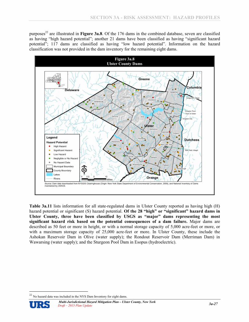
SECTION 3A � RISK ASSESSMENT: HAZARD PROFILES
Multi�Jurisdictional Hazard Mitigation Plan – Ulster County, New York Draft – 2015 Plan Update 3a�27
purposes22 are illustrated in Figure 3a.8. Of the 176 dams in the combined database, seven are classified as having “high hazard potential”; another 21 dams have been classified as having “significant hazard potential”; 117 dams are classified as having “low hazard potential”. Information on the hazard classification was not provided in the dam inventory for the remaining eight dams.
Table 3a.11 lists information for all stateAregulated dams in Ulster County reported as having high (H) hazard potential or significant (S) hazard potential. Of the 28 “high” or “significant” hazard dams in
Ulster County, three have been classified by USGS as “major” dams representing the most
significant hazard risk based on the potential consequences of a dam failure. Major dams are described as 50 feet or more in height, or with a normal storage capacity of 5,000 acreAfeet or more, or with a maximum storage capacity of 25,000 acreAfeet or more. In Ulster County, these include the Ashokan Reservoir Dam in Olive (water supply); the Rondout Reservoir Dam (Merriman Dam) in Wawarsing (water supply); and the Sturgeon Pool Dam in Esopus (hydroelectric).
22 No hazard data was included in the NYS Dam Inventory for eight dams.
Figure 3a.8
Ulster County Dams

SECTION 3A � RISK ASSESSMENT: HAZARD PROFILES
Multi�Jurisdictional Hazard Mitigation Plan – Ulster County, New York Draft – 2015 Plan Update 3a�28
Table 3a.11
State�Regulated Dams with High or Significant Hazard Potential
Dam Name Jurisdiction River/Stream Owner(s)
Storage
(acre�
feet)
Hazard
Potential
Ashokan Dam * Town of Olive Esopus Creek NYSDEP Dams West Of The Hudson River 512,500 High
Binnewater Reservoir Dam & Dike Town of Ulster TrAEsopus Creek City Of Kingston 50 Significant
Binnewater Road Dam Town of Rosendale TrARondout Creek Town Of Rosendale 8 Significant
Bridgeview Plaza Dam Town of Lloyd None Bridgeview Sp Corp 75 Significant
Cape Pond Dam Town of Wawarsing Beer Kill Cape Pond Inc. 3,605 Significant
Chichester Dam Town of Shandaken TrAStony Clove Paul & Heidi Nute 0 Significant
Cooper Lake Dam And West Dike Town of Woodstock Saw Kill City Of Kingston 3,683 High
Diamond Mills Paper Company Dam Village of Saugerties Esopus Creek Leading Edge Developers, LLC 830 High
Highland Lower Reservoir Dam Town of Lloyd TrAHudson River Town Of Lloyd Highland Water District 27 Significant
Highland Water Dist Res Dam & Dike Town of Lloyd TrAHudson River Town Of Lloyd Highland Water District 92 Significant
Honk Falls Dam Town of Wawarsing Rondout Creek Karen And Robert Berger, David Cook 1,504 High
Horsenden Lake Dam Town of New Paltz TrAWallkill River James E Rappa 22 Significant
Kingston Reservoir #2 Dam Town of Woodstock Saw Kill City Of Kingston 125 Significant
Lake Maratanza Dam Town of Wawarsing TrAVerkeerder Kill Open Space Institute 323 Significant
Lyon Lodge Dam Town of Wawarsing Lyon Creek Lyons Lodge, LLC 224 Significant
Marlborough Water District Dam & Dike Town of Marlborough TrAHudson River Marlborough Water District 53 Significant
Merriman Dam (Rondout Reservoir Dam)* Town of Wawarsing Roundout Creek NYCDEP Dams West Of The Hudson River 202,800 High
New Paltz Lower Reservoir Dam Village of New Paltz TrAKleine Kill Village Of New Paltz 2 Significant
New Paltz Middle Reservoir Dam Town of New Paltz TrAKleine Kill Village Of New Paltz 2 Significant
New Paltz Reservoir Dam Village of New Paltz TrAKleine Kill Village Of New Paltz 3 Significant
New Paltz Upper Reservoir Dam Village of New Paltz TrAKleine Kill Village Of New Paltz 8 Significant
Pecks Dam Town of Gardiner TrAMara Kill Bruce Consiglio 96 Significant
Pine Hill Lake Dam Town of Shandaken Birch Creek NYS Olympic Development Agency 116 Significant
Pinebush Lake Dam Town of Shawangunk Tomy Kill Jennifer Ferraro, Mark Glusak 38 Significant
Sturgeon Pool Dam* Town of Esopus Wallkill River CH Energy Group, Inc. 10,894 High
Tillson Lake Dam Town of Gardiner Palmaghatt Kill NYSOPRHP A Palisades Interstate Park Commission 394 High
Vincent Dunn Pond Dam Town of Rochester TrARondout Creek Valerie Friedlander 15 Significant
Vrasidas Dam Town of Rochester Mombaccus Creek MPV Lazy Acres Inc. 4 Significant
* Dam also listed as a “major” dam in the USGS National Inventory of Dams (NID). Major dams are described as 50 feet or more in height, or with a normal storage capacity of 5,000 acreAfeet or more, or with a maximum storage capacity of 25,000 acreAfeet or more.
Tr = Tributary

SECTION 3A � RISK ASSESSMENT: HAZARD PROFILES
Multi�Jurisdictional Hazard Mitigation Plan – Ulster County, New York Draft – 2015 Plan Update 3a�29
Dam failure inundation studies are often prepared by the owners of dam facilities as part of their own emergency action plans to show areas potentially vulnerable to inundation if the dam were to fail. Emergency action plans with dam failure inundation studies have previously been completed for the three major high hazard dams in Ulster County (Ashokan Reservoir Dam, Rondout Reservoir Dam, and Sturgeon Pool Dam), and the corresponding inundation mapping is presented in Figures 3a.9 though
3a.11. These maps were developed by digitizing the inundation envelope resulting from dam failures under wet weather conditions from scanned hard copies of the original mapping, supplied by New York State Department of Environmental Conservation, who were unable to provide the original source GIS files. The areas shown as vulnerable to inundation in Figures 3a.0 through 3a.11 should be regarded as approximate areas subject to a great deal of hydrologic uncertainty.
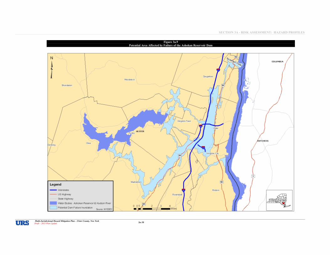
SECTION 3A � RISK ASSESSMENT: HAZARD PROFILES
Multi�Jurisdictional Hazard Mitigation Plan – Ulster County, New York Draft – 2015 Plan Update 3a�30
Figure 3a.9
Potential Area Affected by Failure of the Ashokan Reservoir Dam
URS
I .........
- ........ , __ co_ --- "-'--, - -_ ."-- ...... "« __ 0'."_ ...... _
_.
. .. , ....

SECTION 3A � RISK ASSESSMENT: HAZARD PROFILES
Multi�Jurisdictional Hazard Mitigation Plan – Ulster County, New York Draft – 2015 Plan Update 3a�31
Figure 3a.10
Potential Area Affected by Failure of the Rondout Reservoir Dam
,
I
--\IRS

SECTION 3A � RISK ASSESSMENT: HAZARD PROFILES
Multi�Jurisdictional Hazard Mitigation Plan – Ulster County, New York Draft – 2015 Plan Update 3a�32
Figure 3a.11
Potential Area Affected by Failure of the Sturgeon Pool Dam
N
1 il
, ,
Hurley
Legend
- Interstates
-- us Highway
State Highway
Town of Ulster
_ \/\later Bodies sturgeon Pool & Hudson River
D Potential Dam Failure I
URS
kjngston City
Esopus

SECTION 3A � RISK ASSESSMENT: HAZARD PROFILES
Multi�Jurisdictional Hazard Mitigation Plan – Ulster County, New York Draft – 2015 Plan Update 3a�33
Historical Occurrences – Dam Failure According to the Stanford National Performance of Dams Program (NPDP) records23, there have been 74 dam incidents24 in New York State since 1868. No new incidents have occurred since the last version of this plan was prepared; the date of the most recent record in the database is January 1, 2003. Only 17 of the 74 historic stateAwide incidents are recorded as events involving an uncontrolled release of the reservoir. Only one incident is recorded in Ulster County. The NPDP records indicate that the Diamond Mills Paper Company Dam in the Village of Saugerties experienced a failure in 1978. Although detailed information related to the consequences of the recorded failure was not readily available, the NPDP event report mentions deterioration of spillways, inoperable outlets, and a general lack of maintenance as contributory causes. In the early 2000’s, concerns were raised by both the NYSDEC and the USACE regarding issues including lack of maintenance and lack of an emergency action plan. However, since the last version of this plan was prepared, current NYSDEC records show an EAP on file as of July 1, 2013, with the most recent inspection in February 2012. Local sources also report that the Tillson Lake Dam in the Town of Gardiner suffered a failure in the 1930s, although there are no definitive records regarding subsequent injuries or loss of life. Despite reports that the dam was drained for repairs in the 1990s, the safety of this dam remains a concern to the local community.
Probability of Occurrence – Dam Failure The probability of a dam failure occurrence in Ulster County is relatively low due to routine inspection, repair and maintenance programs, though the possibility of a future failure event is likely increasing due to aging dam structures that may be in need of repair or reconstruction. The NYSDEC’s Dam Safety program serves to ensure the safety and integrity of dams in New York State and, thereby, protect people and property from the consequences of dam failures.
Drought
Location – Drought Droughts occur in all parts of the country and at any time of year, depending on temperature and precipitation over time. Similarly, droughts can occur in all parts of Ulster County at any time of year, depending on temperature and precipitation over time. While arid regions of the United States are more susceptible to longAterm or extreme drought conditions, other areas such as Ulster County tend to be more susceptible to shortAterm, less severe droughts. It is impossible to delineate a drought hazard area for the County, per se, but it is generally assumed that drought is a countyAwide hazard, with drought conditions being possible in all geographic areas.
23 http://npdp.stanford.edu/dam_incidents 24 The NPDP defines dam “incidents” as “events of engineering and safety interest that provide insight into the structural and functional integrity
of dam systems and their operation. Included in this definition are events associated with a dam system that are anticipated or unanticipated, and satisfactory as well as unsatisfactory. Collecting information on success stories is as important as events involving failures or other episodes of unsatisfactory performance. Examples of dam incidents that are “successes” include: a group of dams located near a fault, experience and survive without ground motion associated with a magnitude 8.2 earthquake; a dam successfully passes a flood equivalent to 90 percent of the estimated PMF; an emergency action plan is successfully implemented with the populationAatArisk evacuated in a timely manner; dam operators are able to successfully open dam gates and lowAlevel outlets to lower the reservoir after a dam has been damaged as a result of an earthquake. Use of the term 'incident' is traditional, but is somewhat unfortunate because the word generally has a negative connotation. The implication is that something “bad or unsatisfactory” has occurred. In fact, incidents in the NPDP database also include positive events that allow for a better understanding of the performance and operation of dam systems.

SECTION 3A � RISK ASSESSMENT: HAZARD PROFILES
Multi�Jurisdictional Hazard Mitigation Plan – Ulster County, New York Draft – 2015 Plan Update 3a�34
Extent – Drought The extent (i.e., magnitude or severity) of drought can depend on the duration, intensity, geographic extent, and the regional water supply demands made by human activities and vegetation. The intensity of the impact from drought could be minor to extreme damage in a localized area or regional damage affecting human health and the economy. Generally, impacts of drought evolve gradually, and regions of maximum intensity change with time. The severity of a drought is determined by areal extent as well as intensity and duration. The frequency of a drought is determined by analyzing the intensity for a given duration, which allows determination of the probability or percent chance of a more severe event occurring in a given mean return period. The Palmer Drought Severity Index (PDSI) is one of many available drought indices used to assess the extent of a drought event. It was developed by Wayne Palmer in 1965 and indicates prolonged and abnormal moisture deficiency or excess. The PDSI tends to be used more commonly than other available indices, and is an important tool for evaluating the scope, severity, and frequency of prolonged periods of abnormally dry or wet weather. PDSI drought classifications are based on observed drought conditions and will range from A0.5 (incipient dry spell) to A4.0 (extreme drought). The PDSI also reflects excess precipitation using positive numbers. The PDSI is the most effective in determining longAterm droughts; but has limitations in terms of use for shortAterm forecasts. Historical Occurrences – Drought
According to NCDC25, two recorded instances of drought conditions have affected Ulster County between April 1999 and July 2015. They occurred in April 1999 and August 1999. No deaths, injuries, property, or crop damages are recorded in the NCDC database. Neither of these events occurred since the last version of the plan was prepared in 2009. The 2014 NYSHMP includes an overview of drought occurrences in New York State between August 1993 and October 2007; four events are noted impacting Ulster County. The 2014 NYSHMP also reports a SHELDUS total of three drought events in Ulster County from 1960 to 2012 (recurrence interval of 17 years), and a total of $16,667 in property damage and $2,685,185 in crop damage. A sampling of more notable historical events as per these sources includes:
1960’s and 1980’s. In the 1960s and then again in the 1980s New York State was impacted by two major drought occurrences. During the 1960s, an extended period of droughts affected the entire state. The worst stint lasted from 1964 to 1965 placing a severe impact on agriculture, water quality, and forest and human health. As a result, there were widespread impacts, including forest fires, crop failure, fish kills, water shortages, harmful algal blooms, and heat related deaths. A Federal disaster declaration was issued for areas including Ulster County on August 18, 1965 (DRA204). The drought of the 1960s ended in 1967 only for the State to experience another drought in 1980 that has had a continuing affect into the present. August to December 1993. A prolonged period of drought during the summer of 1993 decimated much of the agriculture in southeast New York. A drought alert advisory was issued on August 5, 1993 by the New York State Drought Management Task Force for Delaware, Dutchess, Sullivan and Ulster Counties. Other counties hit hard by drought included Albany, Rensselaer, Columbia and Greene. The August 1993 drought alert advisory was upgraded to a drought warning by the New York State Drought Management Task Force for Delaware, Dutchess, Greene, Otsego, Schoharie, Sullivan, and Ulster Counties. Further, the Delaware River Basin Commission continued the drought warning for the basin which includes small sections of Broome, Chenango, Greene, Schoharie and Ulster Counties and much of Delaware and Sullivan Counties. The damage primarily affected the agriculture sector’s feed grain. Estimates of feed grain losses in these counties were well over 40 percent and in some cases nearly 100 percent. There were significant losses in hay, corn, and other fruit and vegetable crops. The NYSHMP reports total dollar damages for all impacted counties as approximately $50 million.
25 Data current as of October 2015.
SECTION 3A � RISK ASSESSMENT: HAZARD PROFILES
Multi�Jurisdictional Hazard Mitigation Plan – Ulster County, New York Draft – 2015 Plan Update 3a�35
June to September 1995. The New York State Drought Management Task Force declared a "Drought Watch" for the Catskills (Delaware, Greene, Otsego, Schoharie, Sullivan and Ulster counties), and the HudsonAMohawk Region (Albany, Columbia, Dutchess, Fulton, Oneida, Herkimer, Montgomery, Rensselaer, Saratoga, Schenectady, and Washington Counties). The Hudson and Mohawk Valleys including the Catskills experienced extreme drought conditions while areas north of the Mohawk Valley and north of Saratoga County in the Hudson Valley saw severe drought conditions. At the end of August precipitation deficits of six to 12 inches were common in the extreme drought area. The drought produced a reduction in corn yield due to the shorter and slender ears. Hay yields were also down as many areas saw a very small second cutting or none at all. Wells ran dry in many communities and a Water Emergency was declared in Herkimer County and the Town of Deerfield in Oneida County.
April 1999. April 1999 was officially the second driest April on record in Albany and the driest of this century. Only 0.60 inches of rain fell at the Albany International Airport and only 0.56 inches at the N.W.S. office located on the University at Albany (SUNY) Campus. Rainfall amounts were a little bit higher to the south of Albany, but still fell well short of normal. The combination of low rainfall, along with frequent gusty winds, turned the underbrush into very dry tinder. This scenario led to numerous brush fires during the month across the Berkshires.
August 1999. August 1999 was the peak of the long term drought across Eastern New York that began in July of 1998. The fourteen month stretch, ending in August, saw rainfall and melted snowfall throughout the region only tallying up to about 80 percent of normal. At the Albany International Airport 35.41 inches of water equivalent was recorded from July 1998 through August 1999, compared to the thirty year normal of 42.82 inches. The long term drought combined with the heat of the summer, resulted in a drought warning across much of the region as well as a declaration of agricultural disaster. The Mohawk Valley and Western Adirondacks were especially hard hit. The drought resulted in record low levels of the Mohawk River, numerous forest fires across the Adirondacks, and many wells going completely dry. Most communities implemented voluntary or mandatory water restrictions.
Probability of Occurrence – Drought According to the USGS Division of Water Resources, Ulster County and its jurisdictions fall within what is described as a “humid region” and is more likely to experience a shortAterm drought. Ulster County faces a low to moderate probability of severe drought conditions, though shortAterm instances of drought will be a more frequent occurrence. Figure 3a.12 shows the PDSI Summary Map for the United States from 1895 to 1995. According to the map, Ulster County is in a zone that experienced severe drought conditions between five and ten percent of the time between 1895 and 1995, but shortAterm, less severe drought conditions are more common and may occur several times in a decade. The 2014 NYSHMP reports that typical variations in weather patterns can lead to dry periods and, based on historical occurrences, New York State’s overall annual future drought probability is three percent. From data gathered by the SHELDUS database, Delaware, Oneida, and Otsego Counties are most probable to experience a drought event with Ulster County noted as having a six percent annual future drought probability. While it is unknown how climate change will impact regional water supplies, the State Plan reports that water resources are stressed and any added stress from climate change will only increase the competition for water resources. Warmer climates increase potential drought frequency, severity, and create longerAlasting events. The State projects at least one shortAterm drought occurrence to happen every summer if greenhouse emission levels continue to increase, specifically in the Catskill and Adirondack Mountains.

SECTION 3A � RISK ASSESSMENT: HAZARD PROFILES
Multi�Jurisdictional Hazard Mitigation Plan – Ulster County, New York Draft – 2015 Plan Update 3a�36
Flood
Location – Flood
Despite being located many miles inland with no Atlantic Ocean coastal frontage, Ulster County is subject to both riverine and coastal flooding. Riverine flooding occurs along inland channels such as rivers, creeks, streams. When a channel receives too much water, the excess water flows over its banks and inundates lowAlying areas. Coastal flooding, on the other hand, is a result of storm surge where sea levels rise to inundate areas along not only the coasts of oceans, bays, and estuaries; but also, tidal rivers and lakes. Hurricanes and tropical storms, severe storms, and nor’easters cause most of the coastal flooding in New York State overall. Ulster County has recently been impacted by coastal flooding due to storm surge26 traveling up the Hudson River during Superstorm Sandy. Many areas of Ulster County are also susceptible to urban (stormwater) flooding. It is estimated that approximately five percent of lands within Ulster County are located in the 100Ayear floodplain. Figure 3a.13 illustrates the location and extent of currently mapped special flood hazard areas for Ulster County based on FEMA’s 2013 Preliminary Digital Flood Insurance Rate Maps (DFIRMs). This includes Zones A/AE/AO (100Ayear floodplain), Zone X500 (500Ayear floodplain), and Zone X (areas higher than the elevation of the 500Ayear flood). There are no mapped areas of Zone V (100Ayear floodplain with wave action). It is important to note that while FEMA digital flood data is recognized as best available data for planning purposes, it does not always reflect the most accurate and upAtoAdate flood
26 Storm surge is addressed as a separate hazard within this section.
Figure 3a.12
Palmer Drought Severity Index Summary Map for the United States
Source: National Drought Mitigation Center, 189581995
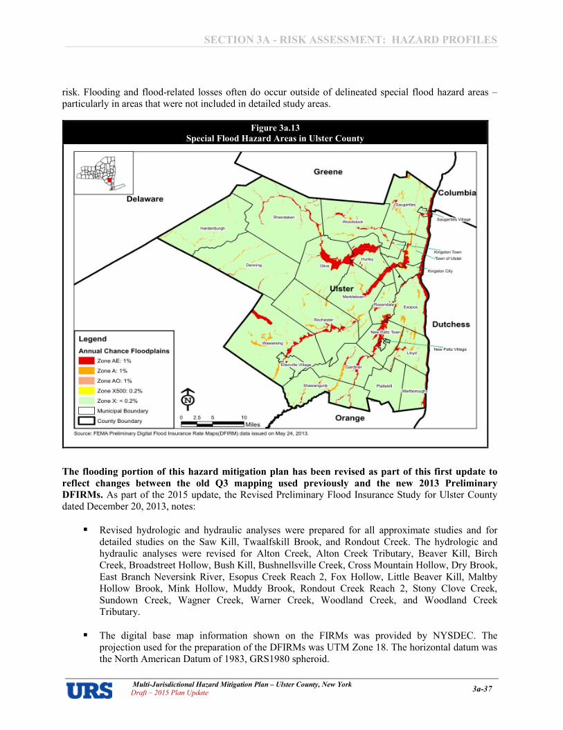
SECTION 3A � RISK ASSESSMENT: HAZARD PROFILES
Multi�Jurisdictional Hazard Mitigation Plan – Ulster County, New York Draft – 2015 Plan Update 3a�37
risk. Flooding and floodArelated losses often do occur outside of delineated special flood hazard areas – particularly in areas that were not included in detailed study areas.
The flooding portion of this hazard mitigation plan has been revised as part of this first update to
reflect changes between the old Q3 mapping used previously and the new 2013 Preliminary
DFIRMs. As part of the 2015 update, the Revised Preliminary Flood Insurance Study for Ulster County dated December 20, 2013, notes:
� Revised hydrologic and hydraulic analyses were prepared for all approximate studies and for detailed studies on the Saw Kill, Twaalfskill Brook, and Rondout Creek. The hydrologic and hydraulic analyses were revised for Alton Creek, Alton Creek Tributary, Beaver Kill, Birch Creek, Broadstreet Hollow, Bush Kill, Bushnellsville Creek, Cross Mountain Hollow, Dry Brook, East Branch Neversink River, Esopus Creek Reach 2, Fox Hollow, Little Beaver Kill, Maltby Hollow Brook, Mink Hollow, Muddy Brook, Rondout Creek Reach 2, Stony Clove Creek, Sundown Creek, Wagner Creek, Warner Creek, Woodland Creek, and Woodland Creek Tributary.
� The digital base map information shown on the FIRMs was provided by NYSDEC. The projection used for the preparation of the DFIRMs was UTM Zone 18. The horizontal datum was the North American Datum of 1983, GRS1980 spheroid.
Figure 3a.13
Special Flood Hazard Areas in Ulster County

SECTION 3A � RISK ASSESSMENT: HAZARD PROFILES
Multi�Jurisdictional Hazard Mitigation Plan – Ulster County, New York Draft – 2015 Plan Update 3a�38
Extent – Flooding
In the case of riverine flood hazard, once a river reaches flood stage, the flood extent or severity categories used by the NWS include minor flooding, moderate flooding, and major flooding. Each category has a definition based on property damage and public threat:
• Minor Flooding A minimal or no property damage, but possibly some public threat or inconvenience.
• Moderate Flooding A some inundation of structures and roads near streams. Some evacuations of people and/or transfer of property to higher elevations are necessary.
• Major Flooding A extensive inundation of structures and roads. Significant evacuations of people and/or transfer of property to higher elevations. (NWS 2011)
The extent of flooding associated with a one percent annual probability of occurrence (the base flood or 100Ayear flood, Figure 3a.13 for Ulster County) is used as the regulatory boundary by many agencies. Also referred to as the SFHA, this boundary is a convenient tool for assessing vulnerability and risk in floodAprone communities. Many communities have maps that show the extent and likely depth of flooding for the base flood. Corresponding waterAsurface elevations describe the water elevation resulting from a given discharge level, which is one of the most important factors used in estimating flood damage. Historical Occurrences – Floods
Flooding is the most common major natural hazard in New York State. Floods have occurred in Ulster County’s communities in the past, and will continue to do so in the future. Ulster County and its component municipalities have generally been impacted by riverine flooding and shallow flooding, as well as some coastal flooding along its Hudson River shoreline during extreme events such as Superstorm Sandy. The Ulster County FIS notes that flooding can occur in Ulster County during any season of the year, but is most likely to occur in the late winterAearly spring months when severe or longAduration precipitation events combine with melting snow. Late summer flooding is also a possibility due to thunderstorms and tropical storms/hurricanes carrying abundant amounts of rain as they travel up the eastern seaboard. According to the NCDC, 81 recorded flood27 days have occurred in Ulster County between January 1996 and July 201528. These events have resulted in more than $24 million in property damages. A sampling of more recent, notable events includes the following:
January 19�27, 1996. An intense area of low pressure which was located over the MidAAtlantic region on Friday morning January 19th produced unseasonably warm temperatures, high dewpoints and strong winds. This resulted in rapid melting of one to three feet of snow. In addition to the rapid snowmelt one to three inches of rain fell as the system moved northeast along the coast. This resulted in widespread flooding across Ulster County. Federal Disaster Assistance was made available by presidential declaration. Small streams flooded across the entire county which resulted in many roads being washed out. Extensive flooding also occurred along the Hudson River and Esopus Creek. In the mountainous terrain of Ulster County road washouts were more numerous. In the Town of Shandaken five town roads were destroyed and several homes were damaged. In the Town of Hardenburgh three quarters of the roads were washed out. In New Paltz homes were flooded near the wetlands along route 299 due to the Wallkill Creek.
27 NCDC was queried for the event types of Coastal Flood, Flash Flood, Flood, Lakeshore Flood, Storm Surge/Tide. No event days were recorded as coastal flood or lakeshore flood events. 28 NCDC records were queried on October 27, 2015, and are current for event dates through July 31, 2015.

SECTION 3A � RISK ASSESSMENT: HAZARD PROFILES
Multi�Jurisdictional Hazard Mitigation Plan – Ulster County, New York Draft – 2015 Plan Update 3a�39
Flooding also occurred in the Towns of Denning, Olive, Woodstock, Saugerties and Kingston. Evacuations occurred in the PhoeniciaAShandaken area and in the Town of Kingston. Ten million dollars in property damage was recorded in Ulster County for this event. On January 24th, a low pressure system tracked across the northern Great Lakes and produced additional rain across the already groundAsoaked region. Additional runoff along with high tides along the Hudson River created flooding over two days (January 24A25) along the Rondout Creek between Eddyville and the Hudson River and along the Hudson River in Kingston, with an additional $60,000 in property damage. Days later, on January 27th, a low pressure system over the upper Great Lakes produced a general rainfall of one to two inches across eastern New York with up to three inches of rain across parts of the Catskills. This amount of rainfall on already saturated soil brought many small streams out of their banks across Ulster County. The Wallkill River, Rondout Creek and Esopus Creek also flooded in Ulster County. Evacuations occurred along the Esopus Creek and Route 28 was closed between Phoenicia and Mount Tremper. Along the Rondout Creek at Eddyville flooding was widespread and severe. Numerous roads were washed out across the county and the Towns of Shandaken and Hardenburgh declared a local state of emergency. An additional $400,000 in property damage occurred, bringing the total property damage for this multiAday event up to nearly $10.5 million in Ulster County.
September 16, 1999� Floyd. The remnants of Hurricane Floyd moved up the eastern seaboard on
September 16th and during the early hours on September 17th. The storm brought both high winds and exceptionally heavy rainfall to eastern New York, which included a large swath of three to six inch amounts. The heaviest rain fell just to the west of the Hudson Valley in the eastern Catskills and Helderbergs, with locally higher amounts in excess of one foot in some areas. Specific rainfall amounts included 6.12 inches at Albany International Airport, the highest ever officially recorded at that site from any given storm. Even higher amounts of rainfall occurred at Delmar and Knox including 8.15 inches in Delmar and 9.00 inches at Knox, both located in Albany County. The storm’s peak rainfall of 12.21 inches was recorded in Cairo, Greene County. The rain produced widespread flooding across the region. Significant flooding was noted on many smaller tributaries, including the Esopus, Catskill and Schoharie Creeks. Many communities and counties declared a State of Emergency. The rains, combined with leftAover rain from Tropical Storm Dennis one week earlier, alleviated the fourteen month drought across most of the region. The combination of high winds and very saturated ground produced widespread downing of trees and power lines across much of eastern New York. The rain and wind produced massive power outages across the region. As many as 80,000 people lost power in the MidAHudson Valley region; 54,000 in the Greater Capital District; and another 25,000 in the Lake George Saratoga region. Some individuals had to wait over a week for power to be restored. The storm resulted in lost wages, closed schools throughout the region, and cancelled flights. Floyd resulted in the counties of Albany, Dutchess, Greene and Rensselaer being declared "major disaster areas". Nearly $1.1 million in property damage was recorded in Ulster County.
July 14�15, 2000. On the afternoon of July 14th, a very moist air mass moved over the Mohawk Valley and Southern Catskills. A cold front stalled to the west of the region. This scenario allowed for a cluster of thunderstorms to develop. The thunderstorms produced torrential rains as they became stationary over the area. Five to seven inches of rain fell at West Shokan in Olive. A mudslide occurred on High Point Mountain Road, with debris blocking nearby roads. Denning was especially hard hit. Doppler radar estimated between eight and 10 inches of rain fell in a few hours during the late afternoon and evening hours as thunderstorms became virtually stationary over the area. Massive flooding caused almost every road in Denning to be washed out, including County Route 46 (Greenville Road). Five families were evacuated. Small bridges were also washed out. The Hamlet of Sundown suffered the most damage with all but one road devastated. A trailer was destroyed while other houses had damage to their foundations. Other portions of homes were torn away. The next day, on July 15th, a slowAmoving low pressure area pumped a deep layer of tropical air into the region and resulted in widespread heavy rain. The heaviest rain fell across the Mohawk Valley and Catskills. Exceptional 24Ahour rainfall totals included 9.85 inches at Boiceville and 11.97 inches at West Shokan, both located in Ulster County. However, these totals included the heavy rain which fell the previous night. The excessive rains resulted in flooding and flash flooding across Albany, Ulster, Rensselaer and, especially, Columbia Counties. Areas of Ulster County, not fully recovered from

SECTION 3A � RISK ASSESSMENT: HAZARD PROFILES
Multi�Jurisdictional Hazard Mitigation Plan – Ulster County, New York Draft – 2015 Plan Update 3a�40
Friday's flood, had additional flooding Saturday. County Route 101 was made impassable due to water in Olivebridge. Recorded property damages for these totaled $6,056,000. March 28 to April 3, 2005. Severe storms and flooding resulted in a Federal Disaster Declaration for Ulster County and 11 other New York Counties. Many roads were closed throughout the County. The Esopus Creek exceeded the 20.0Afoot flood stage at the Mount Marion gage in the Town of Saugerties, cresting at 20.54 feet at 8:00AM on the 29th. Springtown Road flooded. In the Hamlet of High Falls (portions of which are located in both Marbletown and Rosendale), the intersection of Stone Ridge Road and Route 213 was under water. Springtown Road was closed between Kleinkill Road and Dug Road in New Paltz due to flooding. Heavy rainfall pushed water over roads near Blue Mountain Reservoir in Saugerties. Bushnellsville Creek flowed out of its banks and Route 42 was flooded in the Town of Shandaken. Pancake Hollow Road to South Chodikee Lake Road closed due to flooding in New Paltz. Plains Road from Main Street to Locust Lane flooded in New Paltz. A tractor trailer tanker floated into a bridge on Rondout Creek in Kerhonkson (a Hamlet in the Town of Rochester). For all declared counties, more than $8 million was approved under FEMA’s Individual Assistance Program, and more than $51 million was obligated under the Public Assistance Program. NOAA’s NCDC records $2.2 million in property damages in Ulster County during this event.
Various events – Flooding in the Town of Ulster 2005, 2006,
2007. Local sources on the CPG when the 2009 Plan was prepared provided further information about significant flooding experienced by the Town of Ulster in 2005, 2006, and 2007. Together, these events damaged approximately 150 residential structures in the town, most of which were mobile homes in parks adjacent to Rondout and Esopus Creeks, and caused several significant sewer breaks. In total, the Town reported that they received more than $870,000 in Public
Assistance funds from FEMA for these events. The areas in the Town of Ulster most affected by these events were in the vicinity of Orlando Street, Buckley Street, Sandy Road, Brabant Road, Creek Locks Road, Farm to Market Road, Parish Lane, and County Route 28. Local sources report that flooding along the Twaalfskill Creek near Highland in the Town of Lloyd in April 2007 and March 2008 caused serious damage to local roads, and estimate that flooding has caused nearly $2 million in damages that threeAyear period alone.
January 25, 2010. The combination of strong low pressure, a slow moving cold front, warm temperatures and deep moisture produced a period of heavy rainfall Monday, January 25th across east central New York. In addition, the warm temperatures caused some melting of the snow pack, adding to the runoff. Widespread flash flooding and river flooding occurred as the heavy rain fell on frozen ground. In addition, some ice jam flooding was reported as well as some mud and rock slides. The rain was heaviest in the Catskill Mountains where three to five inches fell. Elsewhere, across east central New York, one to around two inches of rainfall was reported. Widespread flooding was reported and significant runoff continued across Ulster County. The river gauge at Allaben on the Esopus Creek exceeded its seven foot flood stage. Plank Road from Phoenicia to Route 212 and Route 212 from Plank Road to Route 28 were reported closed due to flooding. Sawkill Road was reported closed due to flooding between Hill Road and Melissa Road in Kingston. Springtown Road in New Paltz was reported reduced to one lane between Kleinekill Drive and Dug Road due to flooding in the southbound lane. October 1, 2010. Remnants of Tropical Storm Nicole moved across the region, bringing abundant tropical moisture and very heavy rains. Storm total rainfall of three to nine inches occurred, resulting in widespread river and small stream and urban flooding, including water in basements. Major flooding occurred on the Esopus Creek at Cold Brook. Cold Brook crested at 18.86 feet at 0600 LST on October 1st. Flood stage is 11 feet. State Route 214, Main Street, High Street, Station Road and Plank Road, all near the Esopus Creek,
Flood Damage in Boice’s Mobile Home Park, Farm to
Market Road, Town of Ulster, April 2005.
Flooding on Orlando Street, Town of Ulster, April 2007.

SECTION 3A � RISK ASSESSMENT: HAZARD PROFILES
Multi�Jurisdictional Hazard Mitigation Plan – Ulster County, New York Draft – 2015 Plan Update 3a�41
were reported closed due flooding in Phoenicia (a Hamlet in the Town of Shandaken). The Bridge Street bridge in Phoenicia suffered structural damage and was closed. Fifteen to 20 homes were evacuated in Phoenicia due to the flooding. In addition, Onteora School District canceled classes for the day. States of Emergency were declared in the Towns of Shandaken and Hardenburgh due to the flooding. Route 32 was reported closed in both directions due to flooding just north of Creek Locks Road in Rosendale. A few homes were evacuated along Riseley Road in Mount Tremper (a Hamlet in the Town of Shandaken) due to the heavy rains. Part of Route 209 along the Rondout Creek in Accord (a Hamlet in the Town of Rochester) was closed due to flooding. August 28, 2011�Tropical Storm Irene. Irene tracked northAnortheast across eastern New York and western New England during Sunday, August 28th, producing widespread flooding, and damaging winds. The greatest impact was heavy to extreme rainfall, which resulted in catastrophic flooding. Rainfall amounts generally averaged four to eight inches across the region, although amounts of eight to 12 inches were common across higher elevations within the
eastern Catskills and Schoharie Valley, with isolated amounts as high as 18 inches reported. This heavy to extreme rainfall resulted in widespread flash flooding and river flooding. In Ulster County, extensive damage to roads, bridges, and electrical infrastructure was reported, with the majority of roads impassable across the Catskills. Five rescues were performed by the Ulster County Sheriff’s Department swift water team for people driving into the water, with numerous mandatory evacuations also occurring. Record flooding occurred on the Esopus Creek at Cold Brook, the Rondout Creek
at Rosendale, and the Hudson River at Poughkeepsie, with major flooding occurring on the Esopus Creek at Mount Marion. Record flooding occurred on the Esopus Creek upstream of the Ashokan Reservoir. The Mount Temper/Cold Brook river gage exceeded its 11 foot flood stage at 4:07 am EST August 28th; its 15 foot moderate flood stage at 6:53 am; its 18 foot major flood stage at 8:17 am; and crested at a record 23.34 feet at 12 pm; then dropped below flood stage at 12:26 am August 29th. At a level of 18 feet, roads and bridges are flooded in Phoenica; at 21 feet, water reaches Route 28; and at 22 feet, the Boiceville business district is underwater. Water flowed over Zena Road in Woodstock. Record flooding occurred on the Rondout Creek. The Rosendale river gage exceeded its 18 foot flood stage at 7:11 am EST August 28th; its 21 foot moderate stage at 8:33 am; its 23 foot major flood stage at 9:52 am; crested at a record 29.96 feet at 5 pm; and dropped below flood stage at 1:32 am August 29th. At a level of 26 feet, severe flooding occurs in the Rondout Valley. Major flooding occurred on the Espous downstream from the Ashokan Reservoir. The Mount Marion river gage exceeded its 20 foot flood stage at 7:36 am EST August 28th; its 22 foot moderate flood stage at 9:30 am; its 24 foot major flood stage at 12:17 pm; crested at 25.39 feet at 4:15 pm August 28th; and dropped below flood stage at 8 pm on August 31st. At a level of 24 feet, flooding occurs to homes in the Towns of Hurley and Saugerties. The Ashokan Reservoir East gage exceeded its 589 foot flood stage at 5:22 am August 28th, its 590 foot moderate flood stage at 8:49 pm, it crested at 590.58 feet at 11:10 pm, and dropped below flood stage at 11:57 pm August 29th. The Twaalfskill Creek overflowed its banks into the town of Highland, with water washing over Vineyard Avenue. Route 214 was reported closed due to flooding from the UlsterAGreene County border, near Moggre Road, to Route 23A in Greene County. The Stony Clove Creek runs along much of the Route 214. The New York State Thruway was closed due to numerous reports of flooding from Exit 24 (Milepost 145) to Exit 8 (Milepost 11). Route 42 was closed due to flooding between Route 23A in the Town of Lexington and Route 28 in Shandaken.
Satellite image of Tropical Storm Irene.

SECTION 3A � RISK ASSESSMENT: HAZARD PROFILES
Multi�Jurisdictional Hazard Mitigation Plan – Ulster County, New York Draft – 2015 Plan Update 3a�42
September 7, 2011�Tropical Storm Lee. A slow moving frontal boundary moved eastward across New York State between Monday September 5th, and Tuesday September 6th. The front then moved south and east of the state by late Tuesday, as waves of low pressure continued to travel northeast along the boundary. In addition, copious amounts of moisture from the remnants of Tropical Storm Lee, which made landfall along the Gulf coast, interacted with the frontal system from Wednesday into Thursday September 8th, producing additional heavy rainfall. Total rainfall amounts across eastern New York for the period from Monday into Thursday ranged from four to eight inches, with the greatest amounts occurring across portions of the eastern Catskills. This heavy rainfall, combined with saturated soil from the excessive rains which fell in late August associated with the passage of Irene in late August, led to widespread minor to moderate flooding on rivers, as well as small streams and creeks across eastern New York. Minor flooding occurred on the Esopus Creek upstream of the Ashokan Reservoir. Moderate flooding occurred on the Espous downstream from the Ashokan Reservoir. Numerous roads were reported closed countyAwide due to flooding as small streams overflowed their banks. The Pine Bush schools were closed due to the flooding. Moderate flooding occurred on the Wallkill River at Gardiner. October 29, 2012�Superstorm Sandy. Hurricane Sandy moved northward off the eastern seaboard of the United States during the last week of October 2012. Due to a very strong blocking ridge of high pressure situated over the Atlantic Ocean, the storm turned back to the northwest and rapidly strengthened as it moved toward the midAAtlantic coast. Although the storm began transitioning into nonAtropical nor'easter storm, it remained an extremely powerful cyclone. As the storm made landfall in southern New Jersey during the evening of October 29th, bands of rain moved across eastern New York. The rainfall was not excessively heavy and did not cause any flooding, thanks to dry antecedent conditions. While less than an inch of rain fell in valley areas, higher terrain areas of the northern and eastern Catskills received over an inch of rain. Strong and gusty winds in association with the storm caused damage to trees and power lines across the region. Although not quite as widespread as areas across southeastern New York and New Jersey, power outages occurred throughout the region, mainly across the higher terrain. Local media reported that up to 63,000 customers lost power in Dutchess and Ulster Counties. It was also reported that utility National Grid had 8,000 customers without power in eastern New York at the height of the storm. One direct death was caused by these winds as flying debris was thrown through a windshield and killed a 69 year old woman driving in Kerhonkson in Ulster County. Two indirect deaths also occurred due to carbon monoxide poisoning from using a generator in the wake of the storm in the Town of Olive. In addition, the powerful storm caused a storm surge of water that moved up the Hudson River from the New York City area. Record flooding occurred on the Hudson River at Poughkeepsie as the river reached 9.54 feet. This surge of water moved all the way up to Albany. Flooding occurred along the Hudson River in Dutchess, Ulster, Greene, Columbia, Rensselaer and Albany counties causing damage to homes and businesses located near the river. Route 213 was reportedly closed between the Kingston City line and Creeks Lock Road due to tidal flooding along the Roundout Creek. Tidal flooding along the Esopus Creek and Hudson River caused an estimated six foot storm surge at Lighthouse Drive in Saugerties. About a dozen homes were stranded as water from a bay on the Hudson River met water from the Esopus Creek. Also, flooding also occurred on Maple Street in Smith Landing. Tidal flooding along the Rondout Creek in Kingston flooded East Strand Road and much of the Kingston Waterfront on the Hudson River. Two city employees working at a waste water treatment plant were stranded. An NWS PostAStorm Hydrologic Survey found water marks on The New Central Baptist Church of three to four feet high. Water also flooded rest rooms near Mariners Harbor Restaurant. The T.R. Gallo Park had significant flooding. Rosita's Cantina was flooded with three to four feet of water. Also, the Steelhouse Restaurant and Bar was flooded as well.
NY 416 flooded by Wallkill River after Lee. (Photo courtesy of Daniel Case)

SECTION 3A � RISK ASSESSMENT: HAZARD PROFILES
Multi�Jurisdictional Hazard Mitigation Plan – Ulster County, New York Draft – 2015 Plan Update 3a�43
July 1, 2013. Showers and thunderstorms developed along a very slow moving surface boundary, and a persistent southerly flow caused a lot of these showers and thunderstorms to develop and pass over the same areas. Due to heavy rainfall over the last month, the ground was rather saturated and it didn’t take much additional rain to cause issues. As a result, flash flooding occurred throughout the day on Monday, July 1st and again during the evening on Tuesday, July 2nd. Roads were damaged and closed and some evacuations took place as homes were impacted by the flood waters. The hardest hit areas were across part of the Mohawk Valley, where significant flash flooding had occurred just a few days prior. Springtown Road near New Paltz was closed due to flash flooding from heavy rainfall. The intersection of Route 32 and Washington Avenue in Rosendale was closed as a result of flash flooding.
July 2, 2014. Thunderstorms developed during the afternoon hours of July 2nd. Many of these storms became severe, producing wind damage to trees and power lines. A few storms also contained large hail. In addition, the very humid air mass in place gave the storms the capability of producing very heavy rainfall in a short period of time which led to flash flooding in some urban areas. In addition, these storms produced a significant amount of cloud to ground lightning. Heavy rainfall from thunderstorms led to flash flooding in Rosendale. A portion of State Route 32 was closed between Kallop Road and Washington Avenue in Rosendale due to high water. Flash flooding also occurred in Marlboro. A vehicle became stuck at the intersection of Route 9W and Old Post Road due to high water.
July 1, 2015. An area of showers and thunderstorms moved slowly across the region. Heavy bursts of rainfall repeated over the same portions of the eastern Catskills, with radar estimating up to three inches of rain falling in a short period of time. As a result, flash flooding occurred and several small streams overflowed their banks, which caused several roadways to be temporarily closed. Flash flooding in Ellenville led to the closure of Route 209 between Oak Ridge Road and Hang Glider Road. Heavy rainfall led to flash flooding in the Town of Rochester along the Kripplebush Creek, a tributary of the Roundout Creek. Kyserike Road was closed between Old Kings Highway and Lucas Turnpike as a result of the flooding.
Historical Summary of Insured Flood Losses
Floods have occurred in Ulster County’s communities in the past, and will continue to do so in the future Ulster County and its component municipalities have generally been impacted by riverine flooding and shallow flooding. A picture of the flooding history of Ulster County in terms of damage to private property over the last three decades or so can be derived from the recorded flood losses and payments data from the NFIP. According to the latest FEMA flood insurance records29, there are a total of 1,345 active flood insurance policies in Ulster County and there have been 1,279 flood losses reported in Ulster County through the National Flood Insurance Program (NFIP) since 197230, totaling $29,100,559 in claims payments. Every municipal jurisdiction in Ulster County is listed by FEMA as being an active participant in the NFIP31. The name of the Floodplain Administrator (the person responsible for ensuring that development activities comply with floodplain management ordinances and NFIP regulations) for each jurisdiction is included on Worksheet 2 in jurisdictional annexes of Appendix 1.2. No Ulster County communities are listed by FEMA as Community Rating System (CRS) eligible communities32. Under the CRS, communities which implement floodplain management actions that go beyond the minimum requirements of the NFIP are eligible for discounts on flood insurance premiums for properties within that community. This data is presented in Table 3a.12, along with the total number of current policies, the total coverage
29 Policy data current as of August 31, 2015 (still representing the latest information online as of November 3, 2015). 30
Loss data current as of August 31, 2015 (still representing the latest information online as of November 3, 2015) 31 As per FEMA’s Community Status Book of participating communities (October 12, 2015). 32 As per the FEMA’s list of Community Rating System Eligible Communities effective October 1, 2015.

SECTION 3A � RISK ASSESSMENT: HAZARD PROFILES
Multi�Jurisdictional Hazard Mitigation Plan – Ulster County, New York Draft – 2015 Plan Update 3a�44
values, and key dates associated with the municipalities’ participation in the NFIP. All data in Table
3a.12 is current as of November 3, 2015. The table shows that Ulster County NFIP insured flood losses have totaled more than $29 million since 1978, or more than $786,500 per year. Actual flood losses are likely to be higher, since this value only includes NFIP payouts and does not include losses incurred by nonApolicy holders, losses for which a claim was not submitted, or losses for which payment on a claim was denied.
Table 3a.12
FEMA NFIP Policy and Claim Information for Ulster County Jurisdictions
Source: www.fema.gov / www.bsa.nfipstat.com NFIP Participating
Communities in
Ulster County, NY
Community
Number
Date Entered
NFIP
Current
Effective FIRM
Date
NFIP
Policies
In Force
Insurance in
Force
($)
Total
Number of
Losses
Total Payments
($)
Denning 361439 5/25/1984 5/25/1984 23 $4,623,600 16 $235,717
Ellenville 360975 7/5/1983 9/25/2009 35 $8,110,000 34 $752,086
Esopus 360855 7/5/1984 9/25/2009 33 $7,767,200 13 $86,548
Gardiner 360856 9/30/1982 9/25/2009 41 $11,630,900 27 $878,975
Hardenburgh 361578 7/20/1984 3/16/1989 6 $1,825,000 1 $36,550
Hurley 360857 7/3/1985 8/18/1992 37 $7,246,400 34 $1,010,673
Kingston City 360858 5/1/1985 9/25/2009 76 $19,886,900 89 $1,477,683
Kingston Town 361218 8/27/1982 9/25/2009 34 $5,675,300 24 $598,995
Lloyd 361012 9/17/1982 9/25/2009 47 $10,903,900 43 $1,592,196
Marbletown 361219 10/22/1982 9/25/2009 32 $ 9,718,100 18 $343,450
Marlborough 361220 12/5/1984 9/25/2009 8 $1,854,200 14 $244,058
New Paltz Town 360859 9/30/1982 9/25/2009 52 $11,105,400 59 $1,100,363
New Paltz Village 361544 4/15/1982 9/25/2009 45 $7,575,000 13 $1,042,096
Olive 360860 11/1/1984 11/1/1984 53 $14,202,900 39 $1,836,938
Plattekill 361221 9/29/1978 NSFHA* 8 $ 1,520,600 5 $132,798
Rochester 360861 3/16/1983 9/25/2009 45 $12,239,300 51 $623,401
Rosendale 360862 11/1/1985 9/25/2009 62 $13,980,000 41 $771,124
Saugerties Town 360863 8/19/1985 9/25/2009 102 $21,695,700 49 $1,263,982
Saugerties Village 361504 9/10/1982 9/25/2009 33 $6,860,300 48 $1,564,434
Shandaken 360864 1/17/1985 2/17/1989 205 $47,831,200 273 $5,765,444
Shawangunk 360865 9/30/1982 9/25/2009 35 $9,098,500 7 $42,815
Ulster Town 360866 5/1/1985 9/25/2009 124 $29,771,500 219 $4,961,802
Wawarsing 360867 9/15/1983 9/15/1983 56 $12,174,700 89 $2,331,980
Woodstock 360868 9/27/1991 9/27/1991 154 $39,878,300 73 $406,452
Ulster County Totals 1,346 $317,174,900 1279 $29,100,559
*NSFHA: No Special Flood Hazard Area – all Zone C (determined to be outside the 500Ayear floodplain) The average NFIP payment for the County overall was approximately $22,750 per individual loss – ranging from a maximum of $80,161 per loss in the Village of New Paltz to a minimum of $5,568 in Woodstock. Almost 50 percent of all NFIP paid losses in Ulster County have occurred in just four municipalities – the Olive, Shandaken, Ulster, and Wawarsing.

SECTION 3A � RISK ASSESSMENT: HAZARD PROFILES
Multi�Jurisdictional Hazard Mitigation Plan – Ulster County, New York Draft – 2015 Plan Update 3a�45
Repetitive Losses
FEMA defines a repetitive loss property as any insurable building for which two or more claims of more than $1,000 were paid by the NFIP within any rolling 10Ayear period, since 1978. A repetitive loss property may or may not be currently insured by the NFIP. The 2014 NYSHMP reports that there are more than 18,000 Repetitive Flood Loss properties and 1,126 Severe Repetitive Flood Loss properties in New York State.
According to FEMA repetitive loss property records33, there are 187 repetitive loss properties located in Ulster County. These properties are associated with a total of 488 individual losses and $16,080,432 in claims payments under the NFIP, as shown in Table 3a.13, while Table 3a.14 identifies the number and type of repetitive loss properties that are located in each identified flood hazard zone for each municipality. The approximate areas where RL properties are clustered are plotted in Figures 3a.14 and
3a.15 in comparison with the extent of the mapped A/AE Zones (the Base/100Ayear floodplain). These figures do not show areas of the County where occasional RL properties are located in isolation or widely spaced and they show only the approximate areas covering clusters of RL properties, since the component data is subject to the 1974 Privacy Act. This legislation prohibits the public release of any information regarding individual NFIP claims or information which may lead to the identification of associated individual addresses and property owners. However, while this information is not available to the general public, the County may subsequently obtain comprehensive RL property data from FEMA for the purposes of targeted mitigation of RL areas or individual RL structures. Two thirds (16 out of 24) of the municipalities in Ulster County are identified as having at least one Repetitive Loss (RL) property, with 28 (almost 40 percent) of these properties located in just one municipality, the Town of Ulster. The two municipalities with the next highest number of RL properties are the City of Kingston and the Town of Shandaken, with 12 each. Slightly more than three quarters of all RL properties are singleAfamily residential buildings, while only 8 percent are nonAresidential. Data to permit a further breakdown of the nonAresidential structures into commercial, institutional, and so on was not readily available at the time of writing. The average repetitive loss property in Ulster County has experienced 2.6 loss events: 69 percent have experienced two losses, 20 percent have experienced three, and 11 percent have experienced more than three, including two properties in the City of Kingston and the Town of Lloyd that are recorded as having experienced 8 losses each. Table 3a.14 and Figures 3a.14 and 3a.15 indicate that the majority of RL properties (62 percent) are located in the 100Ayear floodplain, and the remainder are approximately equally distributed across the 500Ayear floodplain and areas of minimal or no identified flood risk. Of the RL properties which are single family residential structures, 70 percent are located in the 100Ayear floodplain. To summarize, almost one third of all NFIP payments in Ulster County may be attributable to just 6 percent of insured properties in the County (depending on how many of these properties remain insured by the NFIP).
33 July 2013

SECTION 3A � RISK ASSESSMENT: HAZARD PROFILES
Multi�Jurisdictional Hazard Mitigation Plan – Ulster County, New York Draft – 2015 Plan Update 3a�46
Table 3a.13
NFIP Repetitive Loss Property Statistics
(Source: FEMA Region 2)
Jurisdiction Single Family Other Residential Non�Residential Total
Properties Losses Payments Properties Losses Payments Properties Losses Payments Properties Losses Payments
Denning, Town of 0 0 $0
Ellenville, Town of 1 2 $40,864 1 2 $40,864
Esopus, Town of 0 0 $0
Gardiner, Town of 1 2 $14,444 1 2 $14,444
Hardenburgh, Town of 0 0 $0
Hurley, Town of 1 2 26,289.48 1 2 $26,289
Kingston, City of 10 27 $380,666 1 2 $55,584 1 2 $39,950 12 31 $476,199
Kingston, Town of 0 0 $0
Lloyd, Town of 1 2 $13,357 1 8 $421,966 2 10 $435,322
Marbletown, Town of 0 0 $0
Marlborough, Town of 0 0 $0
New Paltz, Town of 1 2 $31,034 1 2 $31,034
New Paltz, Village of 1 3 $329,603 1 3 $329,603
Olive, Town of 0 0 $0
Plattekill, Town of 1 3 $55,594 1 3 $55,594
Rochester, Town of 1 2 $2,211 1 2 $2,211
Rosendale, Town of 1 2 $62,281 1 2 $62,281
Saugerties, Town of 2 4 $127,490 2 4 $127,490
Saugerties, Village of 1 2 $3,968 1 2 $3,968
Shandaken, Town of 10 24 $480,591 1 2 $7,369 1 2 $5,135 12 28 $493,095
Shawangunk, Town of 0 0 $0
Ulster, Town of 22 65 $1,961,274 3 7 $193,150 3 6 $127,779 28 78 $2,282,204
Wawarsing, Town of 4 8 $127,746 1 2 $7,936 5 10 $135,682
Woodstock, Town of 1 2 $6,110 1 2 $6,110
Totals 55 143 $3,300,010 8 18 $613,506 8 22 $608,874 71 183 $4,522,390

SECTION 3A � RISK ASSESSMENT: HAZARD PROFILES
Multi�Jurisdictional Hazard Mitigation Plan – Ulster County, New York Draft – 2015 Plan Update 3a�47
Table 3a.14
Repetitive Loss Properties by Municipality and Location in Mapped Flood Hazard Zones
(Source: FEMA Region 2)
Jurisdiction
A Zone (100�Year Floodplain) X500 Zone (500�Year Floodplain) Other Zone (>500�Year Floodplain)
SingleAFamily
Other Residential
NonAResidential
SingleAFamily
Other Residential
NonAResidential
SingleAFamily
Other Residential
NonAResidential
Denning, Town of 1
Ellenville, Town of 1
Esopus, Town of
Gardiner, Town of
Hardenburgh, Town of
Hurley, Town of 1
Kingston, City of 8 1 1 1
Kingston, Town of 1
Lloyd, Town of 1 1
Marbletown, Town of
Marlborough, Town of
New Paltz, Town of 1
New Paltz, Village of 1
Olive, Town of
Plattekill, Town of 1
Rochester, Town of 1
Rosendale, Town of 1
Saugerties, Town of 2
Saugerties, Village of 1
Shandaken, Town of 5 4 1 1 1
Shawangunk, Town of
Ulster, Town of 19 3 1 3 2
Wawarsing, Town of* 1 1 2 1
Woodstock, Town of
Totals 37 4 3 10 2 2 7 2 3 *Totals do not exactly match those in Table 3a.13 since address details were incomplete

SECTION 3A � RISK ASSESSMENT: HAZARD PROFILES
Multi�Jurisdictional Hazard Mitigation Plan – Ulster County, New York Draft – 2015 Plan Update 3a�48
Figure 3a.14
NFIP Repetitive Loss Property Clusters – Town of Shandaken
L'"9~nd .-0
... -,""' ..... --FEMA flOOD ZONE
• • = Miles

SECTION 3a � RISK ASSESSMENT: HAZARD PROFILES
Multi�Jurisdictional Hazard Mitigation Plan – Ulster County, New York Draft – 2015 Plan Update 3a�49
Figure 3a.15
NFIP Repetitive Loss Property Clusters – Town of Ulster/City of Kingston
"..-w ........... 0 -"F'EIo\o\FlOODZOtlE • •
,~ ,
URS
• o 0.5 2
SECTION 3a � RISK ASSESSMENT: HAZARD PROFILES
Multi�Jurisdictional Hazard Mitigation Plan – Ulster County, New York Draft – 2015 Plan Update 3a�50
Probability of Occurrence – Flood Flooding will continue to have a high probability of occurrence in Ulster County, and the probability of future occurrences in Ulster County is certain. The probability of future flood events based on magnitude and according to best available data is illustrated in Figure 3a.13, which indicates those areas susceptible to the 1 percent annual chance flood (100Ayear floodplain); the 1 percent annual chance flood with wave action (100Ayear coastal floodplain); and the 0.2 percent annual chance flood (500Ayear floodplain). The frequency of intense precipitation events in Ulster County is expected to increase in the future with climate change; this is likely to result in more riverine and flash flooding events. Flooding can occur in Ulster County during any time of the year, but is most likely in the late winter and early spring months when severe or longAduration precipitation events combine with melting snow. LateAsummer flooding is also common, due to thunderstorms and tropical systems.
Ice Jams
Location � Ice Jams The identification of particular areas prone to ice jam flooding is difficult since the hazard can be extremely localized. Because of the sometimes unpredictable nature of ice jam floods, FEMA’s Flood Insurance Rate Maps often do not reflect ice jam flood threats. However, available research and historic data suggests that ice jam flood hazard is most common in areas of flat terrain where the climate included extended periods of temperature below zero. Ice jams are very common in the northeastern United States, and the USACE Cold Region Research and Engineering Laboratory (USACE CRREL) reports that 1,667 ice jam events have been recorded in New York State between 1867 and 201534, a number exceeded only by the State of Montana. Figure 3a.16 shows the locations of ice jam incidents that have been recorded by the CRREL in New York State from 1875 to 2007. Multiple instances of ice jams may be associated with a single point location. Rivers and streams flowing through Ulster County on which more than one ice jam incident has been recorded by CRREL are presented in Table 3a.15
35.
Table 3a.15
Rivers and Streams in Ulster County with Recorded Ice Jam Incidents
(Source: USACE; CRREL)
River/Stream Name Number of Recorded Ice Jam Incidents
Wallkill River 52
Rondout Creek 13
Mill Brook 11
Platte Kill 7
Shawangunk Kill 4
Esopus Creek 2
34 CRREL Ice Jam Database last updated September 21, 2015. 35 As noted by NYSEMO on Figure 3a.16.

SE
CT
ION
3a �
RIS
K A
SS
ES
SM
EN
T:
HA
ZA
RD
PR
OF
ILE
S
Mu
lti�
Ju
risd
icti
on
al
Ha
zard
Mit
iga
tio
n P
lan
– U
lste
r C
ou
nty
, N
ew Y
ork
D
raft
– 2
015
Pla
n U
pda
te
3
a�5
1
Fig
ure
3a.1
6
Ice
Jam
In
cid
ents
in
New
York
Sta
te
t il!!!! ! ~ n ;:, 't :l!~ i E~ ':';:: Iil :; ':
i 1111'
. ~~_~~~ ' h_~~~~~~~~_~~~' __ ' ! /II/!
! ! IJ ! . ! JIIII! I! , llll!liill!,!I,!!I!ll!!ll!!"1 ,....... 111111111
, C®J ~,;~\ .... y\ ~
,V \ '
.~ j "
~~~ , ~ t
'>~ '\ ~,
~ \: ~ i
0:: 5 • c
~ j ~ I
f ,
I.
'\ ' '~, ~t 'r , "
~ ~ := i:' . '---R~~··"- -. . , ! h_~._ ' _~_ \-z,' .. . c V
~ . 0 . . ~ o
]i f ~ l . __ h •• _ t: ! ~ ~_"~ham."~h_ ••
E ' • I ~ .
d - . .... ; , """. o 0 ! .. ~"~"~" . '" ~ " .. ~-~ I ~ ,
E ~ l
" "" .· 0 -·" " " ' ·
i
• • """"~"_ ' he"""' ~""h"~ ' ""_ "
"0 '- • • •• ,, :"""'."~ • • - . ... " .• •
!
( L,! ' ," :1 'id ' , j· .. 1
"I'!, .1 • " 0
J
'~' : i o
~
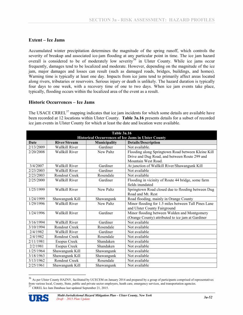
SECTION 3a � RISK ASSESSMENT: HAZARD PROFILES
Multi�Jurisdictional Hazard Mitigation Plan – Ulster County, New York Draft – 2015 Plan Update 3a�52
Extent – Ice Jams
Accumulated winter precipitation determines the magnitude of the spring runoff, which controls the severity of breakup and associated iceAjam flooding at any particular point in time. The ice jam hazard
overall is considered to be of moderately low severity36
in Ulster County. While ice jams occur
frequently, damages tend to be localized and moderate. However, depending on the magnitude of the ice jam, major damages and losses can result (such as damaged roads, bridges, buildings, and homes). Warning time is typically at least one day. Impacts from ice jams tend to primarily affect areas located along rivers, tributaries or reservoirs. Serious injury or death is unlikely. The hazard duration is typically four days to one week, with a recovery time of one to two days. When ice jam events take place, typically, flooding occurs within the localized area of the event as a result.
Historic Occurrences – Ice Jams
The USACE CRREL37 mapping indicates that ice jam incidents for which some details are available have been recorded at 12 locations within Ulster County. Table 3a.16 presents details for a subset of recorded ice jam events in Ulster County for which at least the date and location were available.
Table 3a.16
Historical Occurrences of Ice Jams in Ulster County
Date River/Stream Municipality Details/Description
2/13/2009 Wallkill River Gardiner Not available.
2/20/2008 Wallkill River New Paltz Flooding along Springtown Road between Kleine Kill Drive and Dug Road, and between Route 299 and Mountain West Road.
3/4/2007 Wallkill River Gardiner At junction of Wallkill River/Shawangunk Kill
2/23/2003 Wallkill River Gardiner Not available
2/23/2003 Rondout Creek Rosendale Not available
2/25/2000 Wallkill River Gardiner Flooding in vicinity of Route 44 bridge, some farm fields inundated
1/25/1999 Wallkill River New Paltz Springtown Road closed due to flooding between Dug Road and Mt. Rest
1/24/1999 Shawangunk Kill Shawangunk Road flooding, mainly in Orange County
1/29/1996 Wallkill River New Paltz Minor flooding for 1.5 miles between Tall Pines Lane and Ulster County Fairground
1/24/1996 Wallkill River Gardiner Minor flooding between Walden and Montgomery (Orange County) attributed to ice jam at Gardiner
3/16/1994 Wallkill River Gardiner Not available
3/10/1994 Rondout Creek Rosendale Not available
2/4/1982 Wallkill River Gardiner Not available
2/4/1982 Rondout Creek Rosendale Not available
2/11/1981 Esopus Creek Shandaken Not available
2/2/1981 Esopus Creek Shandaken Not available
1/25/1964 Shawangunk Kill Shawangunk Not available
3/18/1963 Shawangunk Kill Shawangunk Not available
3/13/1962 Rondout Creek Rosendale Not available
2/25/1961 Shawangunk Kill Shawangunk Not available
36 As per Ulster County HAZNY, facilitated by UCECEM on January 2014 and prepared by a group of participants comprised of representatives
from various local, County, State, public and private sector employers, heath care, emergency services, and transportation agencies. 37 CRREL Ice Jam Database last updated September 21, 2015.

SECTION 3a � RISK ASSESSMENT: HAZARD PROFILES
Multi�Jurisdictional Hazard Mitigation Plan – Ulster County, New York Draft – 2015 Plan Update 3a�53
Table 3a.16
Historical Occurrences of Ice Jams in Ulster County
1/22/1959 Rondout Creek Rosendale Not available
3/16/1948 Rondout Creek Rosendale Not available
3/4/1945 Rondout Creek Rosendale Not available
2/8/1941 Rondout Creek Rosendale Not available
3/15/1940 Rondout Creek Rosendale Not available
3/12/1936 Rondout Creek Kingston "Portions of … Kingston, in New York state, was inundated, and a score of barges, tugs and other craft were swept down Rondout Creek until they were halted by an ice jam and remoored. Three watermen were rescued. Nine Ulster county hamlets were abandoned due to rising waters on the Wallkill river. . . . Fog hitting from the Hudson River today disclosed a fleet of tugs and barges jammed in a huge ice pack where they were swept by raging Rondout Creek yesterday. No one was believed to be aboard. Watchers said they counted 20 or 30 vessels. In the group was a 100Afoot steam yacht. This and others were torn away from dry docks a mile and a half up Rondout Creek when an ice jam broke*
3/4/1934 Rondout Creek Rosendale Not available
3/3/1926 Wallkill River Gardiner Not available
*As reported by The Caledonian8Record, March 13, 1936
In addition to data sourced from USACE CRREL, local sources have indicated stormwater discharges are occasionally impeded by ice jams in the Town of Lloyd in March 2008. A superseded version of the New York State Hazard Mitigation Plan (approved by FEMA in January 2005) mentions that an ice jam flooding event took place in Ulster County in January 1976, but gives no further details or description.
Probability of Occurrence – Ice Jams
Due to the nature of the terrain and the climate in Ulster County, ice jam events are essentially certain to occur, although whether or not such events will cause significant damage is less easy to predict, since records of actual damage caused by ice jams are scarce. The available data in the CRREL Ice Jam Database indicates an average annual number of 0.67 events per year within the County. An associated number of damageAcausing occurrences per year has not been computed, since dollar damages per event are largely lacking. The probability of future ice jams in Ulster County is, however, certain. And based on historic occurrences, they are most likely to occur on the Wallkill River and Rondout Creek. Gardiner and Rosendale are the two municipalities most likely to be impacted by ice jams, based on the available data regarding historic occurrences.

SECTION 3a � RISK ASSESSMENT: HAZARD PROFILES
Multi�Jurisdictional Hazard Mitigation Plan – Ulster County, New York Draft – 2015 Plan Update 3a�54
GEOLOGIC HAZARDS
GEOLOGIC HAZARDS
IN ULSTER COUNTY
Earthquake
Landslide

SECTION 3a � RISK ASSESSMENT: HAZARD PROFILES
Multi�Jurisdictional Hazard Mitigation Plan – Ulster County, New York Draft – 2015 Plan Update 3a�55
Earthquake
Location – Earthquake The greatest earthquake threat in the United States is along tectonic plate boundaries and seismic fault lines located in the central and western states; however, the East Coast does face moderate risk to less frequent, less intense earthquake events. Figure 3a.17 shows relative seismic risk for the United States.
Figure 3a.18 shows the probability that ground motion will reach a certain level during an earthquake in Ulster County and the surrounding region. The data shows peak horizontal ground acceleration (the fastest measured change in speed for a particle at ground level that is moving horizontally due to an earthquake) with a 10 percent probability of exceedance in 50 years. Ulster County is located in an area with peak ground acceleration (PGA) values between 2%g and 3%g, which represents is a relatively low seismic risk (in fact, FEMA only requires that the earthquake hazard be profiled when PGA values are 3%g or higher, which is only the case in a small, southern region of the County), but still enough to suggest that Ulster County is potentially susceptible to moderate, damaging earthquakes over time.
Figure 3a.17
United States Earthquake Hazard Map
Source: United States Geological Survey, 2014, http://earthquake.usgs.gov/hazards/products/conterminous/2014/HazardMap2014_lg.jpg

SECTION 3a � RISK ASSESSMENT: HAZARD PROFILES
Multi�Jurisdictional Hazard Mitigation Plan – Ulster County, New York Draft – 2015 Plan Update 3a�56
Extent – Earthquake Earthquakes are measured in terms of their magnitude and intensity. Magnitude is measured using the Richter Scale, an openAended logarithmic scale that describes the energy release of an earthquake through a measure of shock wave amplitude. Each unit increase in magnitude on the Richter Scale corresponds to a 10Afold increase in wave amplitude, or a 32Afold increase in energy. Intensity is most commonly measured using the Modified Mercalli Intensity (MMI) Scale based on direct and indirect measurements of seismic effects. The scale levels are typically described using roman numerals, with a I corresponding to imperceptible (instrumental) events, IV corresponding to moderate (felt by people awake), to XII for catastrophic (total destruction). A detailed description of the Modified Mercalli Intensity Scale of earthquake intensity and its correspondence to the Richter Scale is given in Table 3a.17.
38 USGS 2014 data online at http://earthquake.usgs.gov/hazards/products/conterminous/ only contained GIS files for PGA with a 2% probability of exceedance in 50 years. The FEMA requirement for evaluation of the need to perform an earthquake risk assessment, however, is tied to an evaluation of PGAs with a 10% probability of exceedance in 50 years; these were obtained in September 2014 from http://nationalatlas.gov/atlasftp.html?openChapters=chpgeol#chpgeol with metadata noting a year 2012 date.
Figure 3a.18
Ulster County Earthquake Hazard Zones38

SECTION 3a � RISK ASSESSMENT: HAZARD PROFILES
Multi�Jurisdictional Hazard Mitigation Plan – Ulster County, New York Draft – 2015 Plan Update 3a�57
Table 3a.17
Magnitude/Intensity Comparison for Earthquakes
Magnitude Typical Maximum
Modified Mercalli
Intensity
Abbreviated Modified Mercalli Intensity Scale
1.0 � 3.0 I I. Not felt except by a very few under especially favorable conditions.
3.0 � 3.9
II � III
II. Felt only by a few persons at rest, especially on upper floors of buildings.
III. Felt quite noticeably by persons indoors, especially on upper floors of buildings. Many people do not recognize it as an earthquake. Standing motor cars may rock slightly. Vibrations similar to the passing of a truck. Duration estimated.
4.0 � 4.9
IV � V
IV. Felt indoors by many, outdoors by few during the day. At night, some awakened. Dishes, windows, doors disturbed; walls make cracking sound. Sensation like heavy truck striking building. Standing motor cars rocked noticeably.
V. Felt by nearly everyone; many awakened. Some dishes, windows broken. Unstable objects overturned. Pendulum clocks may stop.
5.0 � 5.9
VI � VII
VI. Felt by all, many frightened. Some heavy furniture moved; a few instances of fallen plaster. Damage slight.
VII. Damage negligible in buildings of good design and construction; slight to moderate in wellAbuilt ordinary structures; considerable damage in poorly built or badly designed structures; some chimneys broken.
6.0 � 6.9
VII � IX
VII. Damage negligible in buildings of good design and construction; slight to moderate in wellAbuilt ordinary structures; considerable damage in poorly built or badly designed structures; some chimneys broken.
VIII. Damage slight in specially designed structures; considerable damage in ordinary substantial buildings with partial collapse. Damage great in poorly built structures. Fall of chimneys, factory stacks, columns, monuments, walls. Heavy furniture overturned.
IX. Damage considerable in specially designed structures; wellAdesigned frame structures thrown out of plumb. Damage great in substantial buildings, with partial collapse. Buildings shifted off foundations.
7.0 and higher
VIII or higher
VIII. Damage slight in specially designed structures; considerable damage in ordinary substantial buildings with partial collapse. Damage great in poorly built structures. Fall of chimneys, factory stacks, columns, monuments, walls. Heavy furniture overturned.
IX. Damage considerable in specially designed structures; wellAdesigned frame structures thrown out of plumb. Damage great in substantial buildings, with partial collapse. Buildings shifted off foundations.
X. Some wellAbuilt wooden structures destroyed; most masonry and frame structures destroyed with foundations. Rails bent.
XI. Few, if any (masonry) structures remain standing. Bridges destroyed. Rails bent greatly.
XII. Damage total. Lines of sight and level are distorted. Objects thrown into the air.
Source: US Geological Survey (http://earthquake.usgs.gov/learn/topics/mag_vs_int.php, page last modified September 29, 2014)

SECTION 3a � RISK ASSESSMENT: HAZARD PROFILES
Multi�Jurisdictional Hazard Mitigation Plan – Ulster County, New York Draft – 2015 Plan Update 3a�58
An approximate relationship between PGA, magnitude, and intensity is shown in Table 3a.18. The table shows that, for an earthquake of expected severity for Ulster County and its participating jurisdictions (PGA values of 2%g to 3%g), perceived shaking would be light to moderate (depending upon the distance from the epicenter) and potential damage could range from none to very light (also depending upon the distance from the epicenter).
Table 3a.18
Earthquake Magnitude/Intensity Comparison PGA Magnitude Intensity Perceived Shaking Potential Damage < 0.17 1.0 A 3.0 I Not Felt None
0.17 – 1.4 3.0 – 3.9 II A III Weak None
1.4 – 9.2 4.0 – 4.9 IV – V IV. Light
V. Moderate
IV. None
V. Very Light
9.2 A 34 5.0 – 5.9 VI – VII VI. Strong VII. Very Strong
VI. Light VII. Moderate
34 A 124 6.0 – 6.9 VIII A IX VIII. Severe IX. Violent
VIII. Moderate/Heavy IX. Heavy
> 124 7.0 and higher X and higher Extreme Very Heavy
Sources: (1) FEMA Mitigation Planning “How8To” Guide 38682 (as reported in the New York State Hazard Mitigation Plan
2005; (2) Wald, D., et al., 1999, Relationship between Peak Ground Acceleration, Peak Ground Motion, and Modified Mercalli
Intensity in California”, Earthquake Spectra, V. 15, p. 5578564; (3) Community Internet Intensity, USGS Modified Mercalli
Intensity, and Instrumental Intensity. 1999. http://www8socal.wr.usgs.gov/ciim/pubs/ciim/node5.html (July 27, 2003).
An earthquake with a 10 percent chance of exceedance over 50 years in Ulster County would have a PGA of 2%g to 3%g and an intensity ranging from only IV to V, which would result in light to moderate perceived shaking, and damages ranging from none to very light. For comparison purposes, an earthquake of intensity IV on the Modified Mercalli Scale would most likely cause vibrations similar to heavy trucks driving over roads, or the sensation of a jolt. Hanging objects would swing; standing cars would rock; windows, dishes and doors would rattle; and, in the upper ranges of intensity IV, wooden walls and frames would creak. An earthquake of intensity V on the Modified Mercalli Scale would be felt outdoors, awaken sleepers, disturb or spill liquids, displace small unstable objects, swing doors, and cause shutters and pictures to move. As noted in the New York State Hazard Mitigation Plan, soil type can have an impact on the severity of an earthquake at a given location. For example, soft soils (i.e., fill, sand) are more likely to amplify ground motion during an earthquake. Liquefaction is also more likely to occur in areas of soft soils. In contrast, harder soils (i.e., granite) tend to reduce ground motion during an earthquake. Figure 3a.19 shows soil types in five basic categories with varying degrees in likelihood of amplifying the affects of an earthquake, with Category A being far less likely to amplify the seismic motion than Category E. Table
3a.19 presents the area of each soil type quantified for each municipality. Over the County as a whole, the most prevalent soil type is Category B (approximately 50 percent of the County) and approximately 83 percent of the County is comprised of soil Categories A, B, or C indicating a generally low overall risk that the effects of earthquakes may be amplified by the soil type. The municipalities with the highest prevalence of soil types most likely to amplify the effects of seismic activity (Categories D and E) are Saugerties (both Town and Village), Ulster, Shawangunk, and the City of Kingston, all at over 25 percent.

SECTION 3a � RISK ASSESSMENT: HAZARD PROFILES
Multi�Jurisdictional Hazard Mitigation Plan – Ulster County, New York Draft – 2015 Plan Update 3a�59
Figure 3a.19
Ulster County Geological Soil Classification
,~ .... GooI"""", Soil Cl.aos . "'-_.-c ....... __ _
o_~
_ f _$oII$oI -0 __ 0--
URS

SECTION 3a � RISK ASSESSMENT: HAZARD PROFILES
Multi�Jurisdictional Hazard Mitigation Plan – Ulster County, New York Draft – 2015 Plan Update 3a�60
Table 3a.19
Ulster County Geological Soils Classification: Land Areas
Municipality Total
Acres
A B C D E Unclassified
Acres % Acres % Acres % Acres % Acres % Acres %
Denning, Town of 67,627 40,139 59.4% 21,719 32.1% 0.0% 2,530 3.7% 164 0.2% 0.0%
Ellenville, Village of 5,584 3,081 55.2% 2,033 36.4% 140 2.5% 172 3.1% 231 4.1% 0.0%
Esopus, Town of 23,880 5,937 24.9% 12,845 53.8% 0.0% 1,041 4.4% 2,919 12.2% 372 1.6%
Gardiner, Town of 27,798 2,453 8.8% 18,789 67.6% 0.0% 706 2.5% 5,397 19.4% 0.0%
Hardenburgh, Town of 51,704 21,882 42.3% 28,261 54.7% 0.0% 399 0.8% 225 0.4% 53 0.1%
Hurley, Town of 19,143 8,695 45.4% 7,485 39.1% 0.0% 102 0.5% 1,817 9.5% 60 0.3%
Kingston, City of 4,791 959 20.0% 1,040 21.7% 640 13.4% 502 10.5% 866 18.1% 133 2.8%
Kingston, Town of 4,929 1,485 30.1% 2,750 55.8% 0.0% 370 7.5% 41 0.8% 0.0%
Lloyd, Town of 20,010 4,978 24.9% 12,548 62.7% 0.0% 700 3.5% 997 5.0% 73 0.4%
Marbletown, Town of 34,862 6,657 19.1% 19,345 55.5% 1,091 3.1% 1,970 5.7% 5,283 15.2% 0.0%
Marlborough, Town of 15,661 1,822 11.6% 11,653 74.4% 531 3.4% 906 5.8% 127 0.8% 179 1.1%
New Paltz, Town of 21,680 1,119 5.2% 13,423 61.9% 0.0% 597 2.8% 4,323 19.9% 0.0%
New Paltz, Village of 1,098 65 6.0% 865 78.8% 0.0% 63 5.7% 23 2.1% 0.0%
Olive, Town of 37,408 14,629 39.1% 19,333 51.7% 0.0% 3,002 8.0% 4 0.0% 83 0.2%
Plattekill, Town of 22,471 1,347 6.0% 17,979 80.0% 0.0% 2,025 9.0% 284 1.3% 0.0%
Rochester, Town of 57,154 13,790 24.1% 30,436 53.3% 1,308 2.3% 2,171 3.8% 8,046 14.1% 0.0%
Rosendale, Town of 12,786 3,322 26.0% 3,119 24.4% 1,997 15.6% 160 1.3% 2,995 23.4% 0.0%
Saugerties, Town of 41,328 7,199 17.4% 13,965 33.8% 1,638 4.0% 2,095 5.1% 13,068 31.6% 505 1.2%
Saugerties, Village of 1,141 0.0% 147 12.9% 0.0% 0.0% 783 68.6% 65 5.7%
Shandaken, Town of 76,662 59,226 77.3% 15,056 19.6% 0.0% 2,733 3.6% 1,878 2.4% 0.0%
Shawangunk, Town of 35,876 489 1.4% 24,144 67.3% 0.0% 3,292 9.2% 7,139 19.9% 11 0.0%
Ulster, Town of 17,154 4,815 28.1% 4,364 25.4% 442 2.6% 1,059 6.2% 4,854 28.3% 341 2.0%
Wawarsing, Town of 83,523 15,336 18.4% 54,238 64.9% 1,471 1.8% 982 1.2% 4,538 5.4% 118 0.1%
Woodstock, Town of 43,065 15,799 36.7% 21,221 49.3% 1,027 2.4% 4,660 10.8% 0.0% 0.0%
Ulster, County of 727,333 235,223 32.3% 356,761 49.1% 10,285 1.4% 32,236 4.4% 66,002 9.1% 1,993 0.3%
Source: NEHRP Soil Class data from NYS Geological Survey. 2010 Census Geographic Identifiers (G001).

RISK ASSESSMENT: HAZARD PROFILES
Multi�Jurisdictional Hazard Mitigation Plan – Ulster County, New York Draft – 2015 Plan Update 3a�61
Historical Occurrences � Earthquakes
As noted in the New York State Mitigation Plan, although the probability of damaging earthquakes in New York State is low, earthquakes do occur on a regular basis in New York. Most often, they are not felt by people and are not capable of causing property damage. Figure 3a.20 illustrates the location of historical earthquakes in New York for the period 1973 to 2012, as per the NYSHMP 2014. Figure 3a.21 illustrates the location of significant (magnitude 5.0 or greater) earthquake epicenters in New York, as obtained from a prior version of the New York State Hazard Mitigation Plan, for earthquakes that occurred between 1737 and May 1986. Table 3a.20 presents details for earthquakes recorded in New York State since 1737 that were recorded in the NYS statistical yearbook. The only recorded event which specifically mentions Ulster County was the February 1855 incident, which is listed as a cryoseismic event. Cryoseisms (also known as “frost quakes”) are generally caused by a sudden cracking action in frozen soil or rock saturated with water or ice. As water seeps down into the rock, it freezes and expands, putting stress on surrounding rock. This builds up until it is relieved explosively in a cryoseism.
Figure 3a.20
Significant Earthquake Epicenters in New York State (1973�2012)
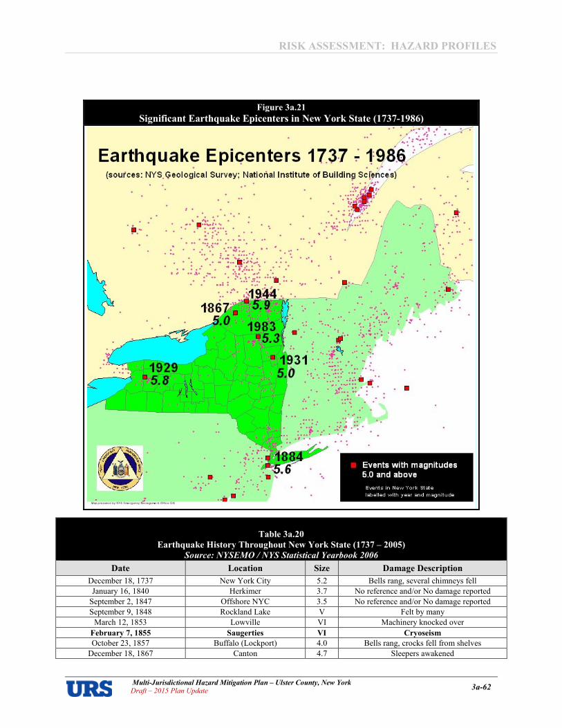
RISK ASSESSMENT: HAZARD PROFILES
Multi�Jurisdictional Hazard Mitigation Plan – Ulster County, New York Draft – 2015 Plan Update 3a�62
Table 3a.20
Earthquake History Throughout New York State (1737 – 2005)
Source: NYSEMO / NYS Statistical Yearbook 2006
Date Location Size Damage Description
December 18, 1737 New York City 5.2 Bells rang, several chimneys fell
January 16, 1840 Herkimer 3.7 No reference and/or No damage reported
September 2, 1847 Offshore NYC 3.5 No reference and/or No damage reported
September 9, 1848 Rockland Lake V Felt by many
March 12, 1853 Lowville VI Machinery knocked over
February 7, 1855 Saugerties VI Cryoseism
October 23, 1857 Buffalo (Lockport) 4.0 Bells rang, crocks fell from shelves
December 18, 1867 Canton 4.7 Sleepers awakened
Figure 3a.21
Significant Earthquake Epicenters in New York State (1737�1986)

RISK ASSESSMENT: HAZARD PROFILES
Multi�Jurisdictional Hazard Mitigation Plan – Ulster County, New York Draft – 2015 Plan Update 3a�63
Table 3a.20
Earthquake History Throughout New York State (1737 – 2005)
Source: NYSEMO / NYS Statistical Yearbook 2006
Date Location Size Damage Description
December 11, 1874 Tarrytown 3.4 No reference and/or No damage reported
November 4, 1877 Lyon Mountain1 VII Chimneys down, walls cracked, window
damaged, crocks overturned
August 10, 1884 New York Bight (NYC) 5.2 Chimneys and bricks fell, walls cracked
May 28, 1897 Dannemora 4.5 No reference and/or No damage reported
February 3, 1916 Schenectady 3.8 Broke windows, people thrown out of bed
March 18, 1928 Saranac Lake 4.0 No reference and/or No damage reported
August 12, 1929 Attica 5.2 250 chimneys fell, brick buildings damaged,
Attica prison walls, wells went dry
April 20, 1931 Warrensburg 4.8 Chimneys fell, church spire twisted
April 15, 1934 Dannemora 3.9 House shifted
July 9, 1937 Brooklyn 3.5 No reference and/or No damage reported
September 5, 1944 Corwall, Ontario/Massena, NY 5.8 Nearly all chimneys fell, buildings damaged,
$2 million damage
September 5, 1944 Corwall, Ontario/Massena, NY 4.5 Chimneys destroyed, houses damaged
September 3, 1951 Rockland County 3.6 No reference and/or No damage reported
January 1, 1966 Attica 4.7 Chimneys and walls damaged
June 13, 1967 Attica 3.9 Chimneys and walls damaged
May 23, 1971 Blue Mountain Lake 4.1 No reference and/or No damage reported
May 23, 1971 Blue Mountain Lake 3.5 No reference and/or No damage reported
June 7, 1974 Wappingers Falls 3.0 Windows broken
June 9, 1975 Plattsburgh (Altona) 3.5 Chimneys and fireplaces cracked
November 3, 1975 Raquette Lake 4.0 No reference and/or No damage reported
February 2, 1983 ScarsdaleALagrangeville 3.0 Chimneys cracked
October 7, 1983 Goodnow, Adirondack
Mountains 5.1
Tombstones rotated, some cracked chimneys, windows broken, walls damaged
October 19, 1985 Ardsley 4.0 Windows broken, walls damaged
June 17, 1991 Richmondville 4.0 No reference and/or No damage reported
March 10, 1992 East Hampton, Suffolk County 4.1 No reference and/or No damage reported2
April 20, 2000 Newcomb 3.8 Aftershock of the 1983 event. No damage
reported
April 20, 2002 Au Sable Forks 5.1 Cracked walls, chimneys fell, road collapsed,
power outages
May 24, 2002 Au Sable Forks 3.1 Aftershock of the April 20, 2002 event, no
damage reported
Probability of Occurrence – Earthquake The probability of significant, damaging earthquake events affecting Ulster County is low. According to the United States Geological Survey (USGS), an earthquake with a 10 percent probability of exceedance over 50 years would have PGA values between 2%g and 3%g, which would result in light to moderate perceived shaking and damages ranging from none to very light. More destructive earthquakes are very rare, low probability events for Ulster County with highly infrequent recurrence periods. Figure 3a.22 shows the peak ground acceleration with a 10 percent probability of exceedance over 50 years for New York State.

RISK ASSESSMENT: HAZARD PROFILES
Multi�Jurisdictional Hazard Mitigation Plan – Ulster County, New York Draft – 2015 Plan Update 3a�64
Landslide
Location – Landslide The potential for landslides exists across the whole of New York State, although according to USGS and NYGS the vast majority of the state (80 percent) has a low susceptibility to the landslide hazard. Landslide hazard mapping has been completed for New York State. In general the highest potential for landslides can be found along major river and lake valleys that were formerly occupied by glacial lakes resulting in glacial lake deposits (glacial lake clays) and usually associated with steeper slopes, such as the Hudson River valley. USGS landslide susceptibility mapping uses three basic classifications to communicate the risk, in conjunction with three further classifications to communicate the combinations of susceptibility and incidence:
� High incidence (Greater than 15 percent of the area involved) � Moderate incidence (1.5 to 15 percent of the area involved)
Figure 3a.22
Peak Ground Acceleration with a 10 Percent Probability of Exceedance over 50 years

RISK ASSESSMENT: HAZARD PROFILES
Multi�Jurisdictional Hazard Mitigation Plan – Ulster County, New York Draft – 2015 Plan Update 3a�65
� Low incidence (Less than 1.5 percent of the area involved) � High susceptibility/moderate incidence � High susceptibility/low incidence � Moderate susceptibility/low incidence
The USGS provides the following supporting narrative for the landslide hazard classifications:
“Susceptibility not indicated where same or lower than incidence. Susceptibility to land sliding
was defined as the probably degree of response of [the areal] rocks and soils to natural or
artificial cutting or loading of slopes, or to anomalously high precipitation. High, moderate, and
low susceptibility are delimited by the same percentages used in classifying the incidence of land
sliding. Some generalization was necessary at this scale, and several small areas of high
incidence and susceptibility were slightly exaggerated.”
Mapped areas of susceptibility in the conterminous United States are illustrated in Figure 3a.23.
Mapped areas of susceptibility in Ulster County are illustrated in Figure 3a.24, along with the locations of historic landslide occurrences as recorded by the NYS DHSESAOEM and described further under “Historical Occurrences.” Areas with the highest susceptibility to landslides are located in a narrow band adjacent to the Hudson River (high susceptibility), and in the northern part of the County (high susceptibility/moderate incidence). Of the six categories of incidence and susceptibility listed above, only four have been identified in Ulster County. Two events occurred outside of mapped areas of high susceptibility in the Towns of Olive and New Paltz and, therefore, landslides are considered to be a
Figure 3a.23
Landslide Susceptibility in the Conterminous United States

RISK ASSESSMENT: HAZARD PROFILES
Multi�Jurisdictional Hazard Mitigation Plan – Ulster County, New York Draft – 2015 Plan Update 3a�66
hazard for these communities as well. The Towns of Lloyd, Rosendale and Ulster have included mapping of potential landslide areas as part of their comprehensive plans.
Extent – Landslide
Areas that are generally prone to landslide hazards include previous landslide areas, the bases of steep slopes, the bases of drainage channels and developed hillsides where leachAfield septic systems are used. Slopes greater than 10 degrees are more likely to slide, as are slopes where the height from the top of the slope to its toe is greater than 40 feet. Slopes are also more likely to fail if vegetative cover is low and/or soil water content is high. Landslides occur when the slope or soil stability changes from stable to unstable, which may be caused by earthquakes, storms, volcanic eruptions, erosion, fire, or additional humanAinduced activities. Although in New York landslides are not as common as in some other parts of the country, they are a geologic hazard in areas with steep to moderate slopes or geologic units prone to failure.
Historic Occurrences � Landslides The “Landslide Inventory Map of New York” produced by the New York State Geological Survey (NYSGS) in cooperation with the United States Geological Survey, plots the location of six landslides in
Figure 3a.24
Landslide Susceptibility and Historical Incidents for Ulster County

RISK ASSESSMENT: HAZARD PROFILES
Multi�Jurisdictional Hazard Mitigation Plan – Ulster County, New York Draft – 2015 Plan Update 3a�67
Ulster County between 1837 and 198939. The available details for these events are presented in Table
3a.21.
Table 3a. 21
Landslide Events Recorded by NYSGS in Ulster County (1837 – 1989) Cause Town Latitude Longitude Description * Damage Estimate
Natural Olive 41.990486 A74.259887 Earth Slump, primary
transport A rotation Not identified
Natural Shandaken 42.044966 A74.267080 Earth Slump, primary
transport A rotation Not identified
Natural Shandaken 42.102458 A74.289912 Earth Slump, primary
transport A rotation Not identified
ManAInduced New Paltz, 41.766308 A74.045638 Bedrock Fall, Topple,
Slump or Slope Not identified
ManAInduced Shawangunk 41.643183 A74.376621 Bedrock Fall, Topple,
Slump or Slope Not identified
ManAInduced Saugerties 42.036446 A73.947581 Earth Slump, transport
mech. rotation Not identified
The NYSHMP 2008 included one record of a landslide in Ulster County on December 16, 1921. Two workers were killed when a wall in a clay bank failed in the village of Glasco, within the Town of Saugerties. The NYSHMP 2014 reports one historic event in Ulster County for the period 1960 to 2012, which caused $50,000 in property damage and $500 in crop damage. In addition to stateAlevel information, local sources report a number of floodArelated landslide incidents in the Town of Lloyd involving embankment failures adjacent to roads and streams between 2001 and 2007.
Probability of Occurrence – Landslides Given the history of landslide occurrences in Ulster County, it is certain that future landslides will occur and the probability of future landslides in the County can be expressed as high. The NYSHMP 2014 estimates that the future probability of landslides in Ulster County is about a two percent chance in any given year (based on historic occurrences documented in SHELDUS for the period of 1960 to 2012, and dividing the documented number of occurrences (one) by the years of record (52). Applying this same methodology to the six events in the NYSGS database for the years 1837 to 1989 yields a future probability estimate of about a four percent chance in any given year.
Wildfires
Location � Wildfires Areas that are typically considered to be safe from wildfires include highly urbanized, developed areas that are not contiguous with vast areas of wild lands. Areas typically considered to be prone to wildfires include large tracts of wild lands containing heavier fuels with high continuity, at steeper slopes – particularly those that are far away from firefighting apparatus that would suppress the spread of wildfires once reported. Figure 3a.25 shows the areas of Ulster County that are considered to be susceptible to
39 As per email coordination with NYSDHSESAOEM on May 15, 2015, the NYSGS data set has not been updated to include more recent events.

RISK ASSESSMENT: HAZARD PROFILES
Multi�Jurisdictional Hazard Mitigation Plan – Ulster County, New York Draft – 2015 Plan Update 3a�68
wildfires (including the following land cover types: deciduous, evergreen, and mixed forest, shrub land, and grassland)40. In the figure, atArisk parcels with improved property present upon them are colored red; atArisk parcels with no improved property present are colored orange; cultivated agricultural land and pastureland areas that are not generally considered to be at significant risk from wildfire are colored light gray; and urban/developed parcels are colored dark gray. This allows a general determination to be made regarding those areas at risk from wildfire in which there is a higher likelihood that such fires could also pose a threat to lives and structures, in addition to susceptible areas where improved property is present (colored red) which have a direct interface with the wildfire hazard.
Wildfires are generally considered to be a moderately high hazard in Ulster County41, particularly in the forested areas in the south and west of the County, where past wildfires have destroyed thousands of acres of forest with property loss running into the thousands of dollars. Many of the areas at risk from wildfires are also popular with hikers and campers. Several major transportation routes such as the New York State
40 It should be noted that the vast majority of the wildfire risk areas consist of deciduous woodland (approximately 50 percent of the County land area and 70 percent of the wildfire risk area) while shrub and grassland areas are not present in significant quantities (together they make up less than one percent of the wildfire risk area). 41 As per Ulster County HAZNY of January 8, 2014.
Figure 3a.25
Wildfire Hazard Areas in Ulster County

RISK ASSESSMENT: HAZARD PROFILES
Multi�Jurisdictional Hazard Mitigation Plan – Ulster County, New York Draft – 2015 Plan Update 3a�69
Thruway and Routes 44 and 28, leaving them vulnerable to closure during forest fire due to smoke conditions. Areas in Ulster County that are typically considered to be prone to wildfires generally tend to exhibit the lowest population densities in the County; and, as a result, exposure of people living and working in the highest hazard areas is often relatively low.
Extent – Wildfires
The extent (that is, magnitude or severity) of wildfires depends on weather and human activity. Two indices are commonly used to measure and monitor dryness of forest fuels and the possibility of fire ignitions becoming wildfires: the National Fire Danger Rating System’s Buildup Index, and the KeetchAByram Drought Index. Both can be used for fire preparedness planning, which includes the following: campfire and burning restrictions, fire patrol assignments, staffing of fire lookout towers, and readiness status for both observation and firefighting aircraft.
• The Buildup Index (BUI) is a number that reflects the combined cumulative effects of daily drying and precipitation in fuels with a 10Aday time lag constant. The BUI can represent three to four inches of compacted litter or can represent up to six inches or more of loose litter (North Carolina Forest Service 2009).
• The Keetch�Byram Drought Index (KBDI) is a drought index designed for fire potential assessment as defined by the United States Department of Agriculture Forest Service. It is a number representing the net effect of evapotranspiration and precipitation in producing cumulative moisture deficiency in deep duff and upper soil layers. The index increases each day without rain and decreases when it rains. The scale ranges from zero (no moisture deficit) to 800 (maximum drought possible). The Florida Forest Service states that the range of the index is determined by assuming that eight inches of moisture in a saturated soil is readily available to the vegetation. For different soil types, the depth of soil required to hold eight inches of moisture varies. A prolonged drought influences fire intensity, largely because more fuel is available for combustion. The drying of organic material in the soil can lead to increased difficulty in fire suppression.
There are also many other scales and fire weather indices that evaluate wildfire potential on any given day taking into account factors such as daily weather and vegetation condition information, fuel moisture, fuel hazard, moisture content in the lower atmosphere, etc.
Previous Occurrences – Wildfires The Ulster County HAZNY of January 8, 2014 reports that wildfires occur frequently in the area. A sampling of more notable, historic occurrences in Ulster County includes:
April 2006. A fire in the Cherrytown area outside of the Town of Rochester in Ulster County which started on April 30, 2006 destroyed more than 900 acres of forest in the Catskill Park. The 2014 NYSHMP described it as the largest wildfire in the state since 2002. The fire was fought by a dozen Ulster County fire teams led by the Accord Fire Department firefighters. Firefighters from Orange County and three volunteer departments from Sullivan County also assisted in the fire effort. Two inmate crews, State Department of Environmental Conservation forest rangers, and fire teams from two local nature preserves also offered their assistance. The fire was officially extinguished on May 12, 2006.
April 2008. On April 17, 2008 a fire began off Route 44/55 in the Town of Rochester on lands managed by NYS Parks & Recreation. Before the fire was officially declared out on April 26th, it had consumed 3,100

RISK ASSESSMENT: HAZARD PROFILES
Multi�Jurisdictional Hazard Mitigation Plan – Ulster County, New York Draft – 2015 Plan Update 3a�70
acres of land in both Rochester and Wawarsing. To extinguish this fire it took the combined resources of the NYS Department of Environmental Conservation, NYS Emergency Management Office, NYS Office of Fire Prevention & Control, NYS Parks & Recreation, NYS Division of Military & Naval Affairs, New York State Police, fire departments from Ulster, Sullivan, Orange, Dutchess, Putnam and Westchester counties and other entities too numerous to mention. In addition to ground crews, helicopters and bulldozers were instrumental in building the fireline and extinguishing the full canopy fire. An urban area interface in a portion of Wawarsing required extensive resources to protect. Homes were protected by literally placing a fire truck in every driveway. Ultimately, there was only one serious injury to a first responder, and no homes were damaged. New York State officials consider it to be the largest forest fire in the State since 1995. Spring 2015. Every year, on March 16th, the State Department of Environmental Conservation issues a residential brush burning ban that stays in effect through May 14th. Residential brush burning in towns with less than 20,000 residents is prohibited in the state through May 15th. In more populous towns, burning brush is banned yearAround. A total of 47 brush fires were reported in Ulster County between March 16th and April 24th.
May 2015. More than 2,000 acres burned over several days in the Shawangunk Ridge State Forest. The fire began off Shawanga Lodge Road and Fire Tower Road in Mamakating, in nearby Sullivan County. It then spread to Ulster County’s Cragsmoor and Walker Valley areas (Cragsmoor, in the Town of Wawarsing; and Walker Valley, in the Town of Shawngunk). Officials suspect it was started by a homeowner burning debris outdoors, in violation of a statewide burn ban. More than 250 volunteer firefighters and forest rangers worked to control the blaze. State Police and National Guard Blackhawk helicopters made hundreds of runs to scoop water from nearby ponds and lakes in attempt to extinguish the fire. About 50 homeowners evacuated as strong southerly winds pushed the fire toward developed areas. Thirty homes were saved. A shelter was opened at the Walker Valley Fire Department on Route 52 in Shawangunk.
Local sources also report that the area over and around Illinois Mountain in the Town of Lloyd is subject to periodic brush and forest fires.
Probability of Occurrence � Wildfires Wildfire probability depends on local weather conditions; outdoor activities such as camping, debris burning, and construction; and the degree of public cooperation with fire prevention measures. Wildfire events are expected to remain at least an occasional occurrence in Ulster County, and although there is insufficient readily available data that could be used to calculate actual probabilities, future occurrences of wildfires in the County is considered to be certain, particularly if drought conditions become more prevalent in the future with climate change. The likelihood of increased future development (particularly residential) could result in an increase in the length of the urbanAwildland interface, an increase in the improved value of property within wildfire hazard zones, and a greater risk of property damage and danger to the public in future years. However, most wildfires in the County are typically contained and extinguished rather quickly and those events causing major property damage or life/safety threats are much less likely to occur.
Shawangunk Ridge State Forest Fire, May 2015. (Photo courtesy of
Frank Becerra Jr./The Journal News.)

SECTION 3 RISK ASSESSMENT SECTION 3B – IDENTIFICATION AND CHARACTERIZATION OF ASSETS IN HAZARD AREAS
Multi�Jurisdictional Hazard Mitigation Plan – Ulster County, New York Page 3b�1 2015 Plan Update � Draft
Sections 3B and 3C � VULNERABILITY ASSESSMENT
Overview
As described in Section 2, as part of this first plan update, the planning team reassessed a full range of natural hazards and determined that no hazards should be added to or omitted from the 2009 list of identified hazards. Section 3A profiled each identified hazard. Sections 3B and 3C build upon the information provided in the Hazard Profiles (Section 3A) by identifying and characterizing an inventory of assets in Ulster County, and then assessing the potential impact and amount of damages that can be expected to be caused by each identified hazard event. The primary objective of the vulnerability assessment is to quantify exposure and the potential loss estimates for each hazard, by jurisdiction. In so doing, Ulster County and each of its municipalities may better understand their own unique risks to identified hazards and be better prepared to evaluate and prioritize unique hazard mitigation actions for their communities. This section begins with a summary description of the asset inventory as compiled for Ulster County through coordination with the Ulster County Office of GIS, as well as an explanation of the methodology applied to complete the multi-jurisdictional vulnerability assessment. The remainder of this section focuses on the results of the vulnerability assessment and is organized by hazard in similar format to the Hazard Profiles section, and as listed below.
• Atmospheric Hazards
o Extreme Temperatures o Extreme Wind o Hurricane and Tropical Storm o Lightning o Nor’easter o Tornado o Winter Storm
• Hydrologic Hazards
o Dam Failure o Drought o Flood o Ice Jam o Storm Surge
• Geologic Hazards
o Earthquake o Landslide
• Other Hazards
o Wildfire

SECTION 3 RISK ASSESSMENT SECTION 3B: IDENTIFICATION AND CHARACTERIZATION OF ASSETS IN HAZARD AREAS
Multi�Jurisdictional Hazard Mitigation Plan – Ulster County, New York Page 3b�2 2015 Plan Update � Draft
3B � Identification and Characterization of Assets in Hazard Areas
An inventory of geo-referenced assets1 in Ulster County was created in order to identify and characterize property and persons potentially at risk to the identified hazards. By understanding the type and number of assets that exist and where they are located in relation to known hazard areas, the relative risk and vulnerability for such assets can be assessed. Under this assessment, six categories of assets were created and then further assessed through geographic information systems (GIS) analysis. The six categories of assets include:
1. Improved property: This category includes all developed properties according to parcel data provided by Ulster County Department of Information Services (2014).
2. Emergency facilities: This category covers all facilities dedicated to the management and response of emergency or disaster situations, and includes emergency operations centers (EOCs2), fire stations, police stations, ambulance stations, and hospitals. Data sets for fire stations, police stations, ambulance stations, and hospitals were provided by Ulster County Office of GIS (2014); while EOCs were obtained from HAZUS.
3. Critical infrastructure and utilities: This category covers facilities and structures vital to the maintenance of basic living conditions in the county, and includes potable water treatment facilities, wastewater treatment facilities, public works facilities, airports, and waste transfer stations. Data on potable water treatment facilities and airports was provided by Ulster County Office of GIS (2015). Data on wastewater treatment facilities was obtained from HAZUS. Data on public works facilities and waste transfer stations was selected from parcel data provided by Ulster County Office of GIS (2014).
4. Other key facilities: This category covers facilities which may be capable of providing refuge and limited medical care and hence may be utilized as emergency shelters, and those which routinely house more vulnerable sectors of the county population, making them potentially especially vulnerable to identified hazards. Included in this category are schools and senior care facilities. Both data sets were provided by Ulster County Office of GIS (schools 2014; senior care facilities 2015).
5. Historic and cultural resources: This category includes those historic structures, landmarks and sites that are included in the New York State or National Register of Historic Places, as provided by the NYS Office of Information Technology Services (2015).
6. Population: This category covers the number of people residing in Ulster County as measured by the U.S. Census Bureau (Census 2010).
The remainder of this subsection provides a more detailed breakdown, by jurisdiction, of georeferenced assets that have been identified for inclusion in the multi-jurisdictional vulnerability assessment.
1 While potentially not all-inclusive for Ulster County, “georeferenced” assets include those assets for which specific location data is readily
available for connecting the asset to a specific geographic location for purposes of GIS analysis. 2 HAZUS-MH® was queried for EOCs in Ulster County. HAZUS defines EOCs as municipal government disaster operation and
communication centers deemed (for design) to be vital in emergencies; they are dedicated facilities used for emergency operations, separately and distinctly from hospitals, fire stations, police stations, etc. HAZUS data sets include no facilities meeting this definition in Ulster County’s municipalities. An EOC database is not maintained at the county-level by Ulster County Office of GIS.

SECTION 3 RISK ASSESSMENT SECTION 3B: IDENTIFICATION AND CHARACTERIZATION OF ASSETS IN HAZARD AREAS
Multi�Jurisdictional Hazard Mitigation Plan – Ulster County, New York Page 3b�3 2015 Plan Update � Draft
Improved Property
Improved property covers all development in the form of structures for residential, commercial, industrial, municipal, recreational, and utility uses. The total value of property improvements in the 24 Ulster County jurisdictions has been estimated at nearly $11.8 billion, based on parcel data as of 2014 supplied by Ulster County GIS. Table 3b.1 lists the total number and percentage of improved parcels as well the total value of their improvements by jurisdiction. The data may not include some public buildings and other tax-exempt structures. This information includes the Towns of Esopus, Marbletown, and Rochester which did not participate in the Mitigation Plan Update.
Table 3b.1
Improved Property by Jurisdiction
Jurisdiction Total Number of
Parcels
Number of
Improved
Parcels
Percentage of
Improved
Parcels
Total Value of
Improvements*
Denning, Town of 1,202 505 42.01% $9,833,691
Ellenville, Village of 1,493 1,305 87.41% $3,212,219
Esopus, Town of 4,298 3,218 74.87% $664,657,631
Gardiner, Town of 2,914 2,277 78.14% $496,051,960
Hardenburgh, Town of 776 327 42.14% $33,780,150
Hurley, Town of 3,548 2,890 81.45% $601,531,347
Kingston, City of 8,497 7,331 86.28% $1,356,698,046
Kingston, Town of 653 405 62.02% $52,412,700
Lloyd, Town of 4,261 3,508 82.33% $715,492,192
Marbletown, Town of 3,926 2,880 73.36% $820,874,962
Marlborough, Town of 3,849 3,039 78.96% $498,122,686
New Paltz, Town of 2,994 2,573 85.94% $546,080,883
New Paltz, Village of 930 831 89.35% $658,909,400
Olive, Town of 3,127 2,340 74.83% $830,987,819
Plattekill, Town of 3,499 2,734 78.14% $444,556,917
Rochester, Town of 4,813 3,295 68.46% $499,688,381
Rosendale, Town of 2,864 2,259 78.88% $343,409,911
Saugerties, Town of 8,100 6,108 75.41% $895,836,873
Saugerties, Village of 1,549 1,271 82.05% $215,364,249
Shandaken, Town of 3,533 2,332 66.01% $100,772,350
Shawangunk, Town of 4,618 3,869 83.78% $170,465,425
Ulster, Town of 5,346 4,271 79.89% $847,716,567
Wawarsing, Town of 4,782 3,281 68.61% $13,835,638
Woodstock, Town of 4,773 3,692 77.35% $971,926,625
Ulster County Total 86,345 66,541 77.06% $11,792,218,622
*Not including public buildings and other tax-exempt structures, and reservoirs.
Source: Ulster parcel data from Ulster County GIS, 2014.

SECTION 3 RISK ASSESSMENT SECTION 3B: IDENTIFICATION AND CHARACTERIZATION OF ASSETS IN HAZARD AREAS
Multi�Jurisdictional Hazard Mitigation Plan – Ulster County, New York Page 3b�4 2015 Plan Update � Draft
Emergency Facilities
There are 138 georeferenced emergency facilities in Ulster County, including 88 fire stations, 23 police stations, 24 ambulance stations, and 3 hospitals. Table 3b.2 tabulates these emergency facilities by jurisdiction. Geographic coordinates (latitude and longitude) were used to determine the location of each facility. Note that some facilities in Table 3b.2 may be located in shared structures. This information includes the Towns of Esopus, Marbletown and Rochester which did not participate in the Mitigation Plan Update.
Table 3b.2
Emergency Facilities by Jurisdiction
Jurisdiction Fire Stations Police Stations Ambulance
Stations Hospitals
Denning, Town of 1 0 0 0
Ellenville, Village of 3 1 1 0
Esopus, Town of 7 1 1 0
Gardiner, Town of 2 0 1 0
Hardenburgh, Town of 0 0 0 0
Hurley, Town of 4 0 3 0
Kingston, City of 9 2 1 2
Kingston, Town of 1 0 0 0
Lloyd, Town of 2 2 1 0
Marbletown, Town of 6 0 1 0
Marlborough, Town of 2 1 1 0
New Paltz, Town of 1 0 1 0
New Paltz, Village of 1 2 0 0
Olive, Town of 5 1 2 0
Plattekill, Town of 3 1 2 0
Rochester, Town of 3 1 1 0
Rosendale, Town of 5 1 1 0
Saugerties, Town of 8 0 0 0
Saugerties, Village of 2 2 1 0
Shandaken, Town of 5 2 2 0
Shawangunk, Town of 3 2 2 0
Ulster, Town of 6 2 1 0
Wawarsing, Town of 5 1 0 1
Woodstock, Town of 4 1 1 0
Total 88 23 24 3
Source: Data received from Ulster County GIS as of August 2014.
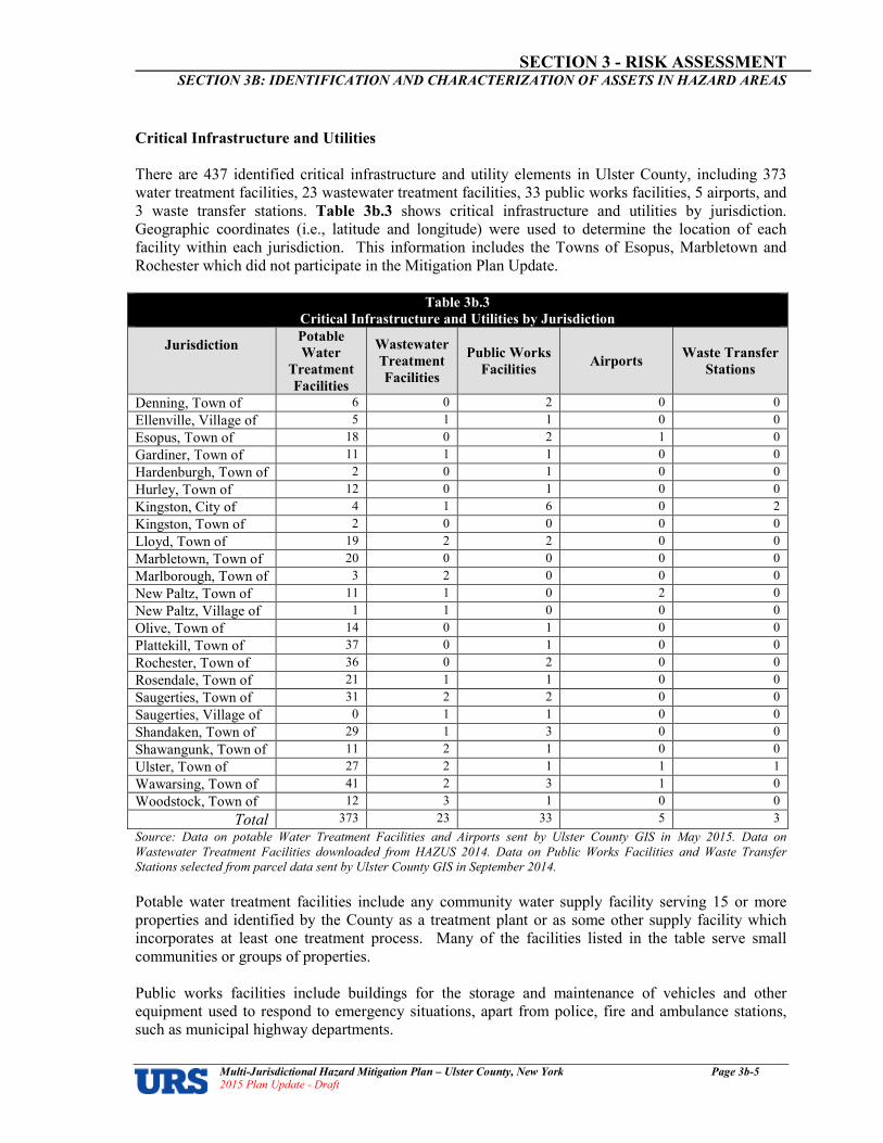
SECTION 3 RISK ASSESSMENT SECTION 3B: IDENTIFICATION AND CHARACTERIZATION OF ASSETS IN HAZARD AREAS
Multi�Jurisdictional Hazard Mitigation Plan – Ulster County, New York Page 3b�5 2015 Plan Update � Draft
Critical Infrastructure and Utilities
There are 437 identified critical infrastructure and utility elements in Ulster County, including 373 water treatment facilities, 23 wastewater treatment facilities, 33 public works facilities, 5 airports, and 3 waste transfer stations. Table 3b.3 shows critical infrastructure and utilities by jurisdiction. Geographic coordinates (i.e., latitude and longitude) were used to determine the location of each facility within each jurisdiction. This information includes the Towns of Esopus, Marbletown and Rochester which did not participate in the Mitigation Plan Update.
Table 3b.3
Critical Infrastructure and Utilities by Jurisdiction
Jurisdiction Potable
Water
Treatment
Facilities
Wastewater
Treatment
Facilities
Public Works
Facilities Airports
Waste Transfer
Stations
Denning, Town of 6 0 2 0 0
Ellenville, Village of 5 1 1 0 0
Esopus, Town of 18 0 2 1 0
Gardiner, Town of 11 1 1 0 0
Hardenburgh, Town of 2 0 1 0 0
Hurley, Town of 12 0 1 0 0
Kingston, City of 4 1 6 0 2
Kingston, Town of 2 0 0 0 0
Lloyd, Town of 19 2 2 0 0
Marbletown, Town of 20 0 0 0 0
Marlborough, Town of 3 2 0 0 0
New Paltz, Town of 11 1 0 2 0
New Paltz, Village of 1 1 0 0 0
Olive, Town of 14 0 1 0 0
Plattekill, Town of 37 0 1 0 0
Rochester, Town of 36 0 2 0 0
Rosendale, Town of 21 1 1 0 0
Saugerties, Town of 31 2 2 0 0
Saugerties, Village of 0 1 1 0 0
Shandaken, Town of 29 1 3 0 0
Shawangunk, Town of 11 2 1 0 0
Ulster, Town of 27 2 1 1 1
Wawarsing, Town of 41 2 3 1 0
Woodstock, Town of 12 3 1 0 0
Total 373 23 33 5 3
Source: Data on potable Water Treatment Facilities and Airports sent by Ulster County GIS in May 2015. Data on
Wastewater Treatment Facilities downloaded from HAZUS 2014. Data on Public Works Facilities and Waste Transfer
Stations selected from parcel data sent by Ulster County GIS in September 2014.
Potable water treatment facilities include any community water supply facility serving 15 or more properties and identified by the County as a treatment plant or as some other supply facility which incorporates at least one treatment process. Many of the facilities listed in the table serve small communities or groups of properties. Public works facilities include buildings for the storage and maintenance of vehicles and other equipment used to respond to emergency situations, apart from police, fire and ambulance stations, such as municipal highway departments.

SECTION 3 RISK ASSESSMENT SECTION 3B: IDENTIFICATION AND CHARACTERIZATION OF ASSETS IN HAZARD AREAS
Multi�Jurisdictional Hazard Mitigation Plan – Ulster County, New York Page 3b�6 2015 Plan Update � Draft
“Airports” has been taken to mean substantial airfields with paved runways operating scheduled services or suitable for the operation of fixed-wing aircraft for the transporting of emergency response personnel and equipment. The waste transfer stations listed in the table are the main facilities in Ulster County for the disposal of bulk (more than two cubic yards) solid waste by residents and commercial entities. In addition to these two principal facilities, there are 20 smaller municipal recycling centers in Ulster County. Other Key Facilities
Other key facilities were included in the asset identification and characterization to determine jurisdictions with particularly high numbers of such facilities located in hazard areas, which may guide the focus of individual mitigation activities in the mitigation goals and strategy stage of the plan. Schools and senior care facilities by jurisdiction are presented in Table 3b.4. This information includes the Towns of Esopus, Marbletown and Rochester which did not participate in the Mitigation Plan Update.
Table 3b.4
Other Key Facilities by Jurisdiction
Jurisdiction Schools Senior Care Facilities
Denning, Town of 0 0
Ellenville, Village of 4 0
Esopus, Town of 7 0
Gardiner, Town of 0 0
Hardenburgh, Town of 0 0
Hurley, Town of 1 0
Kingston, City of 11 3
Kingston, Town of 0 0
Lloyd, Town of 4 2
Marbletown, Town of 2 0
Marlborough, Town of 4 2
New Paltz, Town of 3 1
New Paltz, Village of 3 0
Olive, Town of 4 1
Plattekill, Town of 1 0
Rochester, Town of 4 0
Rosendale, Town of 1 0
Saugerties, Town of 7 2
Saugerties, Village of 1 2
Shandaken, Town of 1 0
Shawangunk, Town of 4 1
Ulster, Town of 6 1
Wawarsing, Town of 2 0
Woodstock, Town of 2 1
Total 72 16
Source: School data received from Ulster County GIS in August 2014, and Senior Care Facilities data in May 2015.

SECTION 3 RISK ASSESSMENT SECTION 3B: IDENTIFICATION AND CHARACTERIZATION OF ASSETS IN HAZARD AREAS
Multi�Jurisdictional Hazard Mitigation Plan – Ulster County, New York Page 3b�7 2015 Plan Update � Draft
Historical and Cultural Resources
Historical and cultural resources were included in the asset identification and characterization to determine jurisdictions with particularly high numbers of culturally or historically valuable assets located in hazard areas, which may influence the focus of individual mitigation activities in the mitigation goals and strategy stage of the plan. At the State and Federal levels, official listings of historic resources are established and maintained to foster the preservation of particular cultural resources. The State and National Registers of Historic Places are the official listings of buildings, structures, districts, objects, and sites significant in the history, architecture, archaeology, engineering, and culture of the State and the nation. Cultural and historic resources are defined as follows:
Cultural Resources:
As defined by the National Park Service in its "Cultural Resources Management Guidelines," cultural resources are: “Those tangible and intangible aspects of cultural systems,
both living and dead, that are valued by or representative of a
given culture or that contain information about a culture . . .
and [they] include but are not limited to sites, structures,
districts, objects and artifacts, and historic documents
associated with or representative of peoples, cultures, and
human activities and events, either in the present or in the
past. Cultural resources also can include the primary written
and verbal data for interpreting and understanding those
tangible resources.”
Historic Resources: Historic resources are any cultural resource dating from the period between the onset of written records (which on Long Island is typically placed around the time of first European contact in the sixteenth century) and 50 years ago.
In the State of New York, the State Historic Preservation Office (SHPO) – within the New York State Office of Parks, Recreation and Historic Preservation – helps communities identify, evaluate, preserve, and revitalize their historic and cultural resources. The New York SHPO maintains GIS databases of all historic and cultural assets listed on the State and National Registers. To identify the resources of this nature located in Ulster County, GIS files were downloaded from the New York
SHPO website (http://www.nysparks.state.ny.us/shpo/resources/index.htm). This data includes
only those cultural and historic properties and sites that are included in the New York State or National Registers of Historic Places, or that have been determined Eligible for inclusion through federal or state processes as administered by the New York SHPO. Inclusion in this data set does not preclude the existence of other historic properties or sites not within this category or as yet unidentified. Historical and cultural assets located in Ulster County are presented in Table 3b.5. According to New York SHPO and National Register of Historic Places data there are more than 160 such assets registered in Ulster County. According to the available records, State and Federally listed historical assets are located in all of the 23 municipalities covered by this hazard mitigation plan. This information includes the Towns of Esopus, Marbletown and Rochester which did not participate in the Mitigation Plan Update.

SECTION 3 RISK ASSESSMENT SECTION 3B: IDENTIFICATION AND CHARACTERIZATION OF ASSETS IN HAZARD AREAS
Multi�Jurisdictional Hazard Mitigation Plan – Ulster County, New York Page 3b�8 2015 Plan Update � Draft
Table 3b.5
Historic and Cultural Resources by Jurisdiction
Jurisdiction Asset Name/Description Location
Denning Red Hill Fire Observation Tower Red Hill
Ellenville Village US Post Office--Ellenville Liberty Pl.
Ellenville Village Hunt, George and John R., Memorial
2 Liberty Street
Ellenville Village Christ Lutheran Church 107 Center Street
Ellenville Village Ellenville Downtown Historic District
Multiple
Esopus Burroughs, John, Cabin W of West Park
Esopus Burroughs, John, Riverby Study Between NY 9W and the Hudson River
Esopus Esopus Meadows Lighthouse Spans Hudson River
Esopus Poppletown Farmhouse Jct. of Old Post Rd. and Swarte Kill Rd.
Esopus Klyne Esopus Reformed Dutch Church (former)
764 US 9W
Esopus Payne, Col. Oliver Hazard, Estate
US 9W
Esopus Cumming-Parker House 50 Appletree Road, Esopus
Esopus Payne, Colonel Oliver H., Estate ( Boundary Expansion)
Esopus, Ulster
Gardiner Tuthilltown Grist Mill Old Albany Post Road
Gardiner Brykill Bruynswick Rd.
Gardiner Locust Lawn Estate NY 32, SE of Gardiner
Gardiner Lafevre, John A., House and School
NY 208, S of New Paltz
Gardiner Aldrich, Peter, Homestead 168 Decker Rd.
Gardiner Bevier House Bevier Rd.
Gardiner Van Vleck House Bruynswick Rd.
Gardiner Guilford-Bower Farmhouse Albany Post Road
Gardiner DuBoris, Hendrikus, House 600 Albany Post Rd.
Gardiner Trapps Mountain Hamlet Histoiric District
Trapps Road off NY 44/55
Gardiner Gardiner Schoolhouse 2340 NY 44/55
Gardiner Jenkins-DuBois Farm and Mill Site Historic district
Jenkinstown Road
Gardiner LeFevre, Abraham and Maria, House
56 Forest Glen Road
Hardenburgh Beaverkill Valley Inn Beaverkill Rd.
Hardenburgh Grant Mills Covered Bridge Mill Brook Road; North side; over Mill Brook
Hardenburgh Balsam Lake Mountain Fire Observation Station
Balsam Lake Mountain
Hardenburgh Coykendall, Samuel, Lodge Alder Lake Road (CR 54)
Hurley Hurley Historic District Hurley St., Hurley Mountain Rd., and Schoonmaker Lane
Hurley Hurley Historic District Hurley St., Hurley Mountain Rd., and Schoonmaker Lane

SECTION 3 RISK ASSESSMENT SECTION 3B: IDENTIFICATION AND CHARACTERIZATION OF ASSETS IN HAZARD AREAS
Multi�Jurisdictional Hazard Mitigation Plan – Ulster County, New York Page 3b�9 2015 Plan Update � Draft
Table 3b.5
Historic and Cultural Resources by Jurisdiction
Jurisdiction Asset Name/Description Location
Hurley Hurley Historic District Hurley St., Hurley Mountain Rd., and Schoonmaker Lane
Hurley Maverick Concert Hall Concert Road
Kingston City Chestnut Street Historic District Roughly bounded by W. Chestnut St., Broadway, E. Chestnut, Livingston & Stuyvesant Sts.
Kingston City Kingston Stockade District Area bounded by both sides of Clinton Ave., Main, Green, and Front Sts.
Kingston City Rondout-West Strand Historic District
Roughly bounded by Broadway, Roundout Creek, Ravine, Hone and McEntee Sts.
Kingston City Kingston City Hall 408 Broadway
Kingston City Kingston-Port Ewen Suspension Bridge
U.S. 9W
Kingston City Senate House NW side of Clinton Ave. near jct. with N. Front St.
Kingston City West Strand Historic District West Strand and Broadway
Kingston City Community Theatre 601 Broadway
Kingston City Kingston/Rondout 2 Lighthouse Hudson River and Rondout Creek
Kingston City Ponckhockie Union Chapel 91 Abruyn St.
Kingston City Kingston City Library (Carnegie Library)
399 Broadway
Kingston City VanSteenburgh, Tobias, House 93-103 Wall Street
Kingston City CATAWISSA (Coastal Tugboat)
Hudson River
Kingston City Old Dutch Church Parsonage 109 Pearl Street
Kingston City Second Reformed Dutch Church of Kingston
213-223 Fair Street
Kingston City Kenyon House 104 Fair Street
Kingston City Boice House 110 Fair Street
Kingston City Chichester House 116 Fair Street
Kingston City Kirkland Hotel 2 Main Street
Kingston City Smith, John, House 103 Albany Avenue
Kingston City Albany Avenue, Building at 109
Kingston City Sharp Burial Ground Albany Avenue
Kingston City Ten Broeck, Jacob, Stone House 169 Albany Avenue
Kingston City Albany Avenue, House at 184 184 Albany Avenue
Kingston City Albany Avenue, House at 322 322 Albany Avenue
Kingston City Albany Avenue, House at 356 356 Albany Avenue
Kingston City Albany Avenue, House at 313 313 Albany Avenue
Kingston City K. WHITTELSEY (Tugboat) 3 North Street at Rondout Creek
Kingston City Forsyth, James and Mary, House 31 Albany Avenue
Kingston City Palen, Frank A., House 74-76 St. James Street
Kingston City First Reformed Protestant Dutch Church of Kingston
272 Wall Street
Kingston City Cordts Mansion 82-152 Lindsley Avenue
Kingston City Burger-Matthews House 105-107 Henry Street

SECTION 3 RISK ASSESSMENT SECTION 3B: IDENTIFICATION AND CHARACTERIZATION OF ASSETS IN HAZARD AREAS
Multi�Jurisdictional Hazard Mitigation Plan – Ulster County, New York Page 3b�10 2015 Plan Update � Draft
Table 3b.5
Historic and Cultural Resources by Jurisdiction
Jurisdiction Asset Name/Description Location
Kingston City Yoemans, Moses, House 252-278 Delaware Avenue
Kingston City Cornell Steamboat Company Machine Shop Building
108-110 East Strand Street
Kingston City United States Lace Curtain Mills 165 Cornell St., Kingston, NY 12401
Kingston City Brooklyn & Queens Transit Trolley No. 1000
89 E. Strand, Kingston, NY 12401
Lloyd Yelverton, Anthony, House 39 Maple Ave.
Marbletown Kripplebush Historic District Kripplebush Road at intersections of Cooper and Pine Streets
Marbletown Rest Plaus Historic District Lucas Turnpike, Old Kings Road, Rest Place Road
Marbletown Main Street Historic District US 209
Marbletown High Falls Historic District
Marbletown Wyncoop, Cornelius, Stone House
Main Street (US 209)
Marbletown Lock Tender's House and Canal Store Ruin
40 Canal Road
Marbletown Bevier Stone House 2687 US 209
Marlborough Dubois-Sarles Octagon 17 South Street
Marlborough Chapel Hill Bible Church 49 Bingham Road
Marlborough Milton Railroad Station 41 Dock Road
Marlborough Christ Episcopal Church 426 Old Post Road
Marlborough Lattington Baptist Church 425 Old Indian Road
Marlborough Elliot-Buckley House 204 Old Post Rd., Marlboro, NY 12542
Marlborough Shady Brook Farm 351 Old Post Rd.,Marlborough NY 12542-6229
New Paltz Town DuBois, Josiah, Farm Libertyville Road
New Paltz Town Lake Mohonk Mountain House Complex
NW of New Paltz, between Wallkill Valley on E and Roundout Valley on W
New Paltz Town Locusts, The (Peter Eltinge House)
160 Plains Road
New Paltz Village Huguenot Street Historic District Huguenot St.
New Paltz Village Hasbrouck, Jean, House Huguenot and N. Front Sts.
New Paltz Village Hasbrouck, Jean, House Huguenot and N. Front Sts.
New Paltz Village Hasbrouck, Major Jacob Jr., House
193 Huguenot Street
New Paltz Village Elting Memorial Library 93 Main Street
New Paltz Village New Paltz Downtown Historic District
USN 11143.000009
Olive Olive and Hurley Old School Baptist Church
NY 28 at Reservoir Road
Olive Bruneul, Emile, Studio and Sculpture Garden
4008 NY 28
Olive Ashokan-Turnwood Covered Bridge
Over Esopus Creek
Plattekill Hait, Thaddeus, Farm 75 Allhusen Rd.
Plattekill Shuart, Johannis, House 41 Alhusen Road
Plattekill Brown-Ellis House 382 Crescent Ave., Highland, NY 12528
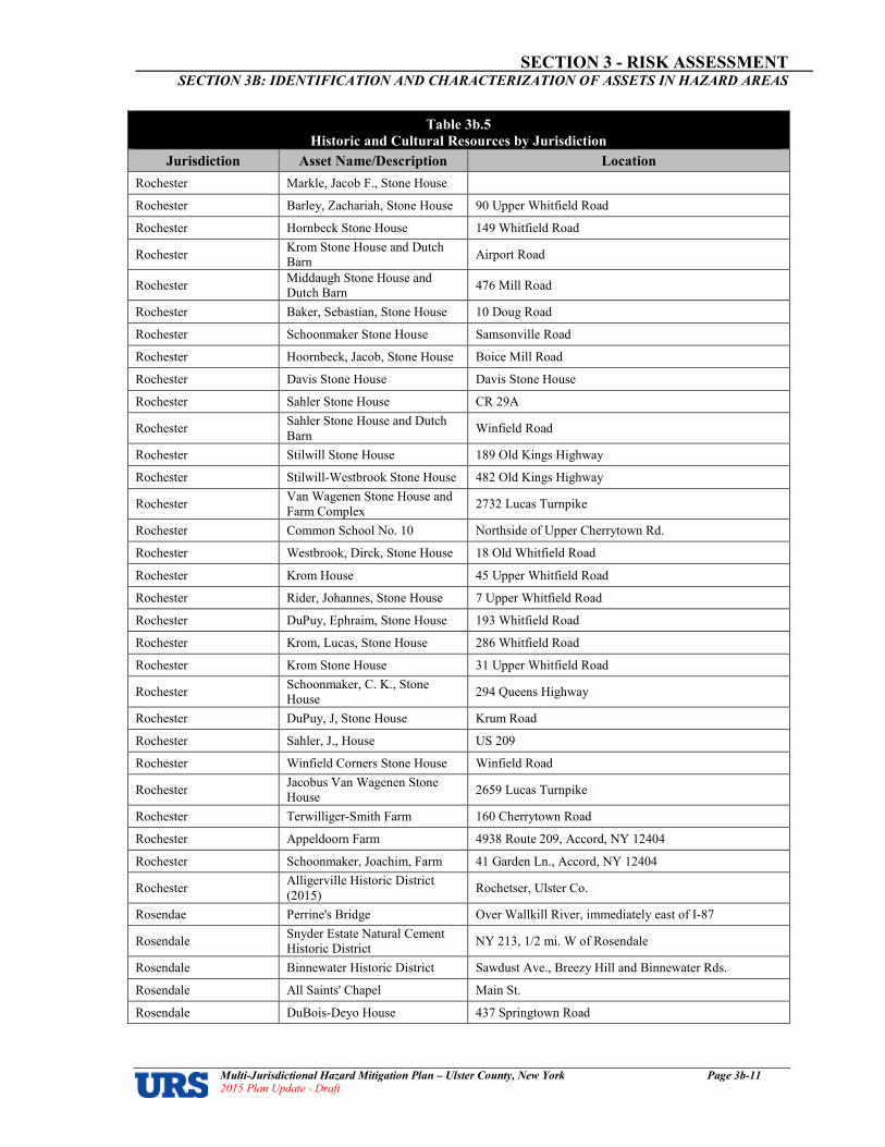
SECTION 3 RISK ASSESSMENT SECTION 3B: IDENTIFICATION AND CHARACTERIZATION OF ASSETS IN HAZARD AREAS
Multi�Jurisdictional Hazard Mitigation Plan – Ulster County, New York Page 3b�11 2015 Plan Update � Draft
Table 3b.5
Historic and Cultural Resources by Jurisdiction
Jurisdiction Asset Name/Description Location
Rochester Markle, Jacob F., Stone House
Rochester Barley, Zachariah, Stone House 90 Upper Whitfield Road
Rochester Hornbeck Stone House 149 Whitfield Road
Rochester Krom Stone House and Dutch Barn
Airport Road
Rochester Middaugh Stone House and Dutch Barn
476 Mill Road
Rochester Baker, Sebastian, Stone House 10 Doug Road
Rochester Schoonmaker Stone House Samsonville Road
Rochester Hoornbeck, Jacob, Stone House Boice Mill Road
Rochester Davis Stone House Davis Stone House
Rochester Sahler Stone House CR 29A
Rochester Sahler Stone House and Dutch Barn
Winfield Road
Rochester Stilwill Stone House 189 Old Kings Highway
Rochester Stilwill-Westbrook Stone House 482 Old Kings Highway
Rochester Van Wagenen Stone House and Farm Complex
2732 Lucas Turnpike
Rochester Common School No. 10 Northside of Upper Cherrytown Rd.
Rochester Westbrook, Dirck, Stone House 18 Old Whitfield Road
Rochester Krom House 45 Upper Whitfield Road
Rochester Rider, Johannes, Stone House 7 Upper Whitfield Road
Rochester DuPuy, Ephraim, Stone House 193 Whitfield Road
Rochester Krom, Lucas, Stone House 286 Whitfield Road
Rochester Krom Stone House 31 Upper Whitfield Road
Rochester Schoonmaker, C. K., Stone House
294 Queens Highway
Rochester DuPuy, J, Stone House Krum Road
Rochester Sahler, J., House US 209
Rochester Winfield Corners Stone House Winfield Road
Rochester Jacobus Van Wagenen Stone House
2659 Lucas Turnpike
Rochester Terwilliger-Smith Farm 160 Cherrytown Road
Rochester Appeldoorn Farm 4938 Route 209, Accord, NY 12404
Rochester Schoonmaker, Joachim, Farm 41 Garden Ln., Accord, NY 12404
Rochester Alligerville Historic District (2015)
Rochetser, Ulster Co.
Rosendae Perrine's Bridge Over Wallkill River, immediately east of I-87
Rosendale Snyder Estate Natural Cement Historic District
NY 213, 1/2 mi. W of Rosendale
Rosendale Binnewater Historic District Sawdust Ave., Breezy Hill and Binnewater Rds.
Rosendale All Saints' Chapel Main St.
Rosendale DuBois-Deyo House 437 Springtown Road
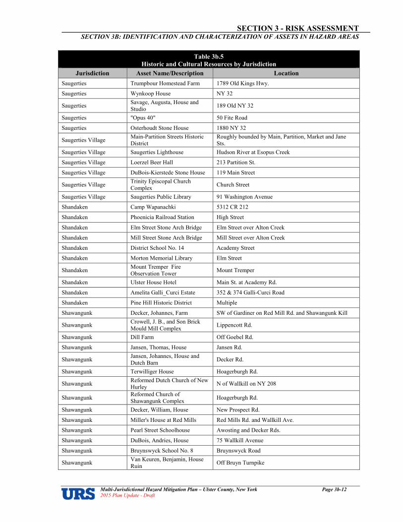
SECTION 3 RISK ASSESSMENT SECTION 3B: IDENTIFICATION AND CHARACTERIZATION OF ASSETS IN HAZARD AREAS
Multi�Jurisdictional Hazard Mitigation Plan – Ulster County, New York Page 3b�12 2015 Plan Update � Draft
Table 3b.5
Historic and Cultural Resources by Jurisdiction
Jurisdiction Asset Name/Description Location
Saugerties Trumpbour Homestead Farm 1789 Old Kings Hwy.
Saugerties Wynkoop House NY 32
Saugerties Savage, Augusta, House and Studio
189 Old NY 32
Saugerties "Opus 40" 50 Fite Road
Saugerties Osterhoudt Stone House 1880 NY 32
Saugerties Village Main-Partition Streets Historic District
Roughly bounded by Main, Partition, Market and Jane Sts.
Saugerties Village Saugerties Lighthouse Hudson River at Esopus Creek
Saugerties Village Loerzel Beer Hall 213 Partition St.
Saugerties Village DuBois-Kierstede Stone House 119 Main Street
Saugerties Village Trinity Episcopal Church Complex
Church Street
Saugerties Village Saugerties Public Library 91 Washington Avenue
Shandaken Camp Wapanachki 5312 CR 212
Shandaken Phoenicia Railroad Station High Street
Shandaken Elm Street Stone Arch Bridge Elm Street over Alton Creek
Shandaken Mill Street Stone Arch Bridge Mill Street over Alton Creek
Shandaken District School No. 14 Academy Street
Shandaken Morton Memorial Library Elm Street
Shandaken Mount Tremper Fire Observation Tower
Mount Tremper
Shandaken Ulster House Hotel Main St. at Academy Rd.
Shandaken Amelita Galli_Curci Estate 352 & 374 Galli-Curci Road
Shandaken Pine Hill Historic District Multiple
Shawangunk Decker, Johannes, Farm SW of Gardiner on Red Mill Rd. and Shawangunk Kill
Shawangunk Crowell, J. B., and Son Brick Mould Mill Complex
Lippencott Rd.
Shawangunk Dill Farm Off Goebel Rd.
Shawangunk Jansen, Thomas, House Jansen Rd.
Shawangunk Jansen, Johannes, House and Dutch Barn
Decker Rd.
Shawangunk Terwilliger House Hoagerburgh Rd.
Shawangunk Reformed Dutch Church of New Hurley
N of Wallkill on NY 208
Shawangunk Reformed Church of Shawangunk Complex
Hoagerburgh Rd.
Shawangunk Decker, William, House New Prospect Rd.
Shawangunk Miller's House at Red Mills Red Mills Rd. and Wallkill Ave.
Shawangunk Pearl Street Schoolhouse Awosting and Decker Rds.
Shawangunk DuBois, Andries, House 75 Wallkill Avenue
Shawangunk Bruynswyck School No. 8 Bruynswyck Road
Shawangunk Van Keuren, Benjamin, House Ruin
Off Bruyn Turnpike
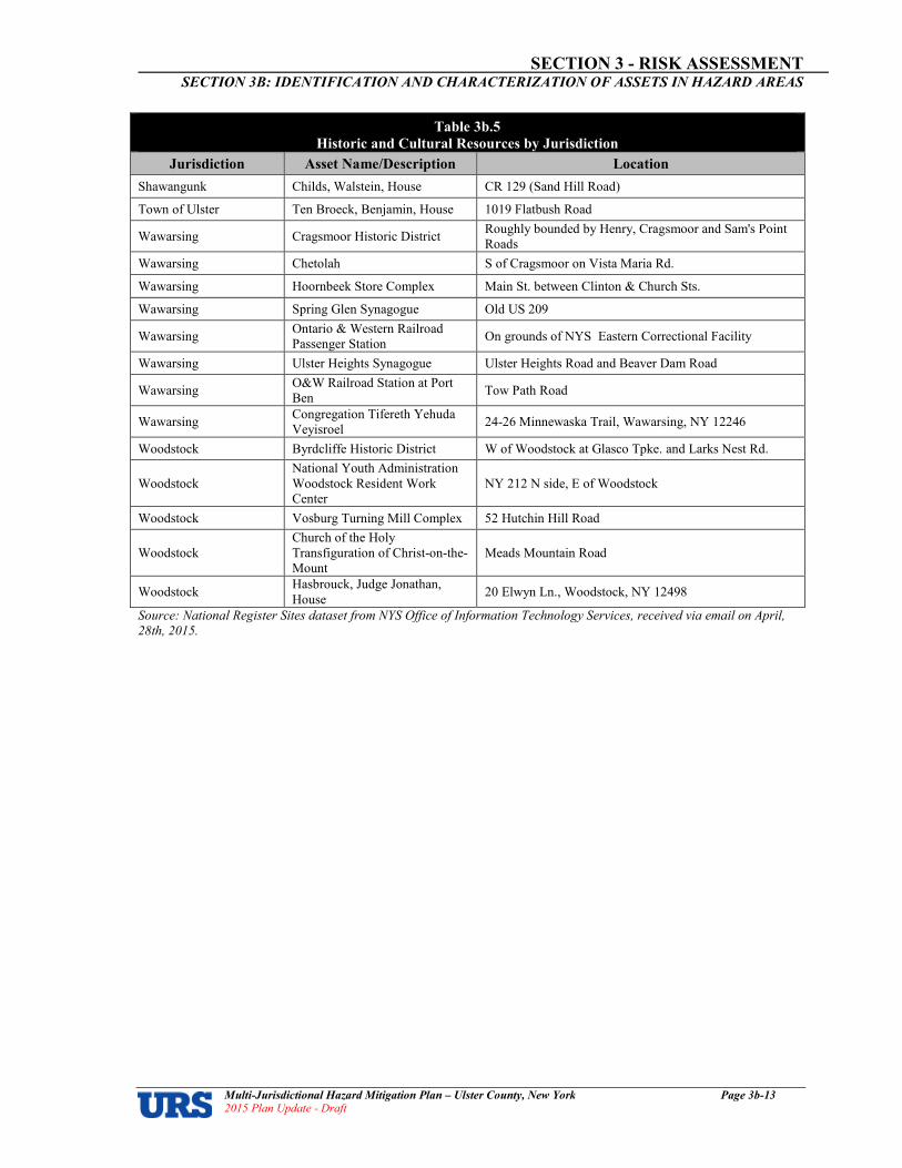
SECTION 3 RISK ASSESSMENT SECTION 3B: IDENTIFICATION AND CHARACTERIZATION OF ASSETS IN HAZARD AREAS
Multi�Jurisdictional Hazard Mitigation Plan – Ulster County, New York Page 3b�13 2015 Plan Update � Draft
Table 3b.5
Historic and Cultural Resources by Jurisdiction
Jurisdiction Asset Name/Description Location
Shawangunk Childs, Walstein, House CR 129 (Sand Hill Road)
Town of Ulster Ten Broeck, Benjamin, House 1019 Flatbush Road
Wawarsing Cragsmoor Historic District Roughly bounded by Henry, Cragsmoor and Sam's Point Roads
Wawarsing Chetolah S of Cragsmoor on Vista Maria Rd.
Wawarsing Hoornbeek Store Complex Main St. between Clinton & Church Sts.
Wawarsing Spring Glen Synagogue Old US 209
Wawarsing Ontario & Western Railroad Passenger Station
On grounds of NYS Eastern Correctional Facility
Wawarsing Ulster Heights Synagogue Ulster Heights Road and Beaver Dam Road
Wawarsing O&W Railroad Station at Port Ben
Tow Path Road
Wawarsing Congregation Tifereth Yehuda Veyisroel
24-26 Minnewaska Trail, Wawarsing, NY 12246
Woodstock Byrdcliffe Historic District W of Woodstock at Glasco Tpke. and Larks Nest Rd.
Woodstock National Youth Administration Woodstock Resident Work Center
NY 212 N side, E of Woodstock
Woodstock Vosburg Turning Mill Complex 52 Hutchin Hill Road
Woodstock Church of the Holy Transfiguration of Christ-on-the-Mount
Meads Mountain Road
Woodstock Hasbrouck, Judge Jonathan, House
20 Elwyn Ln., Woodstock, NY 12498
Source: National Register Sites dataset from NYS Office of Information Technology Services, received via email on April,
28th, 2015.

SECTION 3 RISK ASSESSMENT SECTION 3B: IDENTIFICATION AND CHARACTERIZATION OF ASSETS IN HAZARD AREAS
Multi�Jurisdictional Hazard Mitigation Plan – Ulster County, New York Page 3b�14 2015 Plan Update � Draft
Population
The U.S. Census Bureau3 estimates that the population of Ulster County in 2010 was 182,493 persons, comprising 71,049 households. Table 3b.6 shows population and household counts by jurisdiction. This information includes the Towns of Esopus, Marbletown and Rochester which did not participate in the Mitigation Plan Update.
Table 3b.6
Population and Households by Jurisdiction (2010 Census)
Jurisdiction Population Households
Total % of County Total % of County
Denning, Town of 551 0.30% 234 0.33%
Ellenville, Village of 4,135 2.27% 1,578 2.22%
Esopus, Town of 9,041 4.95% 3,492 4.91%
Gardiner, Town of 5,713 3.13% 2,229 3.14%
Hardenburgh, Town of 238 0.13% 112 0.16%
Hurley, Town of 6,314 3.46% 2,693 3.79%
Kingston, City of 23,893 13.09% 10,217 14.38%
Kingston, Town of 889 0.49% 380 0.53%
Lloyd, Town of 10,863 5.95% 4,112 5.79%
Marbletown, Town of 5,607 3.07% 2,400 3.38%
Marlborough, Town of 8,808 4.83% 3,335 4.69%
New Paltz, Town of 14,003 7.67% 4,515 6.35%
New Paltz, Village of 6,818 3.74% 1,808 2.54%
Olive, Town of 4,419 2.42% 1,960 2.76%
Plattekill, Town of 10,499 5.75% 3,861 5.43%
Rochester, Town of 7,313 4.01% 2,936 4.13%
Rosendale, Town of 6,075 3.33% 2,572 3.62%
Saugerties, Town of 19,482 10.68% 8,163 11.49%
Saugerties, Village of 3,971 2.18% 3,971 5.59%
Shandaken, Town of 3,085 1.69% 1,505 2.12%
Shawangunk, Town of 14,332 7.85% 3,887 5.47%
Ulster, Town of 12,327 6.75% 4,961 6.98%
Wawarsing, Town of 13,157 7.21% 4,509 6.35%
Woodstock, Town of 5,884 3.22% 2,976 4.19%
Ulster County Total 182,493 100% 71,049 100%
Census data indicates that the population is growing and skewing older, with a rise in median age and number of older persons and a decreasing number of young children. The median age in Ulster County in 2010 was estimated to be 42 years. The average household size is 2.40 persons, and the median household income is $57,584. In terms of population segments that may potentially be at higher risk in general in terms of their ability to prepare for, respond to, and recover from natural disasters:
• 4.93 percent of the total population is under the age of five;
• 14.82 percent is over the age of 65;
• 11.3 percent of the population is living below the poverty level; and
• 13.8 percent of civilian noninstitutionalized persons hold disability status4. This information includes the Towns of Esopus, Marbletown and Rochester which did not participate in the Mitigation Plan Update.
3 U.S. Census Bureau, Census 2010 4 U.S. Census Bureau, 2009-20133 5-Year American Community Survey

SECTION 3 RISK ASSESSMENT SECTION 3B: IDENTIFICATION AND CHARACTERIZATION OF ASSETS IN HAZARD AREAS
Multi�Jurisdictional Hazard Mitigation Plan – Ulster County, New York Page 3b�15 2015 Plan Update � Draft
Table 3b.7
Vulnerable Sectors of the Population by Jurisdiction (2010 Census)
Jurisdiction Total
Population
Under 5 Years 65 Years and over Vulnerable Population
Number of
Persons
% of
Total
Number
of
Persons
% of Total Number of
Persons
% of
Total
Denning, Town of 551 25 4.54% 92 16.70% 117 21.23%
Ellenville, Village of 4,135 314 7.59% 502 12.14% 816 19.73%
Esopus, Town of 9,041 478 5.29% 1,379 15.25% 1,857 20.54%
Gardiner, Town of 5,713 283 4.95% 703 12.31% 986 17.26%
Hardenburgh, Town of 238 9 3.78% 52 21.85% 61 25.63%
Hurley, Town of 6,314 271 4.29% 1,280 20.27% 1,551 24.56%
Kingston, City of 23,893 1,565 6.55% 3,639 15.23% 5,204 21.78%
Kingston, Town of 889 39 4.39% 136 15.30% 175 19.69%
Lloyd, Town of 10,863 639 5.88% 1,593 14.66% 2,232 20.55%
Marbletown, Town of 5,607 237 4.23% 906 16.16% 1,143 20.39%
Marlborough, Town of 8,808 489 5.55% 1,195 13.57% 1,684 19.12%
New Paltz, Town of 14,003 430 3.07% 1,501 10.72% 1,931 13.79%
New Paltz, Village of 6,818 112 1.64% 485 7.11% 597 8.76%
Olive, Town of 4,419 161 3.64% 800 18.10% 961 21.75%
Plattekill, Town of 10,499 603 5.74% 1,284 12.23% 1,887 17.97%
Rochester, Town of 7,313 412 5.63% 952 13.02% 1,364 18.65%
Rosendale, Town of 6,075 289 4.76% 873 14.37% 1,162 19.13%
Saugerties, Town of 19,482 935 4.80% 3,134 16.09% 4,069 20.89%
Saugerties, Village of 3,971 192 4.84% 690 17.38% 882 22.21%
Shandaken, Town of 3,085 110 3.57% 608 19.71% 718 23.27%
Shawangunk, Town of 14,332 578 4.03% 1,398 9.75% 1,976 13.79%
Ulster, Town of 12,327 556 4.51% 2,403 19.49% 2,959 24.00%
Wawarsing, Town of 13,157 699 5.31% 1,733 13.17% 2,432 18.48%
Woodstock, Town of 5,884 188 3.20% 1,383 23.50% 1,571 26.70%
Ulster County Total 182,493 8,996 4.93% 27,044 14.82% 36,040 19.75%
Figure 3b.1 illustrates the residential population density across Ulster County. Most of the county’s population is concentrated in eastern regions and generally in areas nearest to major thoroughfares. The City of Kingston and the Town of Saugerties are the two largest population centers; both are located in the County’s northeast corner.

SECTION 3 RISK ASSESSMENT SECTION 3B: IDENTIFICATION AND CHARACTERIZATION OF ASSETS IN HAZARD AREAS
Multi�Jurisdictional Hazard Mitigation Plan – Ulster County, New York Page 3b�16 2015 Plan Update � Draft
Figure 3b.1
Ulster County Population Density
Legend
Pop Per Sq Mile (2010)
0-99
100 - 499
_ 500-999
_ >999
- Interstate
-- US Highway
-- State Highway
D Municipal Boundary
D County Boundary
lakes
Source: NYS GIS Program Office. US Census Bureau (20 10).
URS
SECTION 3 RISK ASSESSMENT SECTION 3C – DAMAGE ESTIMATES
Multi�Jurisdictional Hazard Mitigation Plan – Ulster County, New York Page 3c�1 2015 Plan Update – Draft
SECTION 3C Damage Estimates
Methodology
This multijurisdictional vulnerability assessment was conducted with two distinct methodologies, utilizing GISbased analysis and a statistical risk assessment methodology. Each approach provides estimates for the potential impact of hazards by using a common, systematic framework for evaluation, including historical occurrence information provided in the Hazard Profiles section. The results of the multijurisdictional vulnerability assessment are provided for each hazard immediately following the summary of information provided through the hazard identification and analysis, as listed above.
A GISbased analysis was conducted for seven hazards: o dam failure; o flood; o storm surge; o wave action; o earthquake; o landslide; and o wildfire.
A statistical risk assessment approach was used to analyze eight hazards: o extreme temperatures; o extreme wind; o hurricane and tropical storm; o lightning; o nor’easter; o tornado; o winter storm; o drought; and o ice jams.
Below is a brief description of these approaches.
GISBased Analysis
For GISbased assessment, digital data was collected from local, state and national sources. ESRI®
ArcGIS™ 9.3 was used to assess risk utilizing digital data for individual tax parcels and georeferenced point locations for buildings and critical facilities. Using these data layers, risk was assessed by estimating the value of buildings determined to be located in identified hazard areas. For the plan update, population estimates were refined using most recent Census data (2010) where the population and value of improved property exposed were estimated to be proportional to the area exposed; and the value of exposed property was refined using updated (2014) improvement values. The objective of the GISbased analysis was to determine the estimated vulnerability of assets to the identified hazards for Ulster County using best available geospatial data. In so doing, local databases made available through the County such as local tax records, parcel boundaries, building footprints and critical facilities data, were used in combination with digital hazard data as included and described in the Hazard Profiles section. Where only a portion of a parcel was found to lie within a given hazard area, the ratio of area in to area out of the hazard area was applied to the value of improvements on the parcel to estimate the dollars exposed. A similar process was undertaken to estimate population exposed, where the percentage of Census block in the hazard area was applied to total census block population to estimate the population exposed to the hazard. The results of the analysis provided an estimated number of people, as well as the numbers and values of buildings and

SECTION 3 RISK ASSESSMENT SECTION 3C – DAMAGE ESTIMATES
Multi�Jurisdictional Hazard Mitigation Plan – Ulster County, New York Page 3c�2 2015 Plan Update – Draft
critical facilities determined to be potentially at risk to those hazards with delineable geographic hazard boundaries. These hazards included the dam failure, flood, storm surge, wave action, earthquake, landslide, and wildfire hazards. A more specific description of the GISbased analysis for each particular hazard is provided under the vulnerability assessment section of each respective hazard.
Statistical Risk Assessment Methodology
A statistical risk assessment methodology was applied to analyze hazards of concern that were outside the scope of the GISbased risk assessment. This methodology uses a statistical approach and mathematical modeling of risk to predict a hazard’s frequency of occurrence and estimated impacts based on recorded or historic damage information (presented in the Hazard Profiles section). This methodology was used to assess risk to the extreme temperatures, extreme wind, hurricane and tropical storms, lightning, nor’easter, tornado, winter storm, and drought hazards. Historical data for each hazard as described in the Hazard Profiles section was used and statistical evaluations were performed using manual calculations. The general steps used in the statistical risk assessment methodology are summarized below:
1. Compile data from local, state and national sources, as well as literature;
2. Clean up data, including removal of duplicate records and update losses to account for inflation;
3. Identify patterns in frequency, intensity, vulnerability and loss
4. Statistically and probabilistically extrapolate the patterns1; and
5. Produce meaningful results, including the development of annualized loss estimates.
Figure 3c.1 illustrates a conceptual model of the statistical risk assessment methodology as applied to Ulster County.
Figure 3c.1
Conceptual Model of the Statistical Risk Assessment Methodology
1 In cases where historical events/losses were recorded for the county as a whole, losses were averaged across all jurisdictions in order to estimate
losses by jurisdiction and calculate potential annualized losses by jurisdiction.

SECTION 3 RISK ASSESSMENT SECTION 3C – DAMAGE ESTIMATES
Multi�Jurisdictional Hazard Mitigation Plan – Ulster County, New York Page 3c�3 2015 Plan Update – Draft
Risk (vulnerability) is presented in terms of potential annualized losses, whenever possible. In general, presenting results in the annualized form is useful in three ways:
1. This approach accounts for the contribution of potential losses from all future disasters;
2. Annualized results for different hazards are readily comparable, thus easier to rank; and
3. The use of annualized losses is the most objective approach for evaluating mitigation alternatives.
Annualized losses for the hazards where the parametric approach was utilized were computed in a threestep process:
1. Compute/estimate losses for a number of scenario events with different return periods (i.e., 10year, 100year, 200year, 500year, etc.);
2. Approximate the Probability versus Loss Curve through curve fitting; and
3. Calculate the area under the fitted curve to obtain annualized losses.
This approach is illustrated graphically in Figure 3c.2. For other hazards where the statistical approach was used, the computations are based primarily on the observed historical losses.
Figure 3c.2
Graphical Representation of the Annualized Loss Methodology
The economic loss results are presented here using two interrelated risk indicators: Annualized Loss and Annualized Loss Ratio. The Annualized Loss is the estimated longterm weighted average value of losses to property in any single year in a specified geographic area (i.e., municipal jurisdiction). The Annualized Loss Ratio expresses estimated annualized loss normalized by assessed building value. The estimated Annualized Loss (AL) addresses the key idea of risk: the probability of the loss occurring in the study area (largely a function of building construction type and quality). By annualizing estimated losses, the AL factors in historic patterns of frequent smaller events with infrequent but larger events to provide a balanced
SECTION 3 RISK ASSESSMENT SECTION 3C – DAMAGE ESTIMATES
Multi�Jurisdictional Hazard Mitigation Plan – Ulster County, New York Page 3c�4 2015 Plan Update – Draft
presentation of the risk. The Annualized Loss Ratio (ALR) represents the AL as a fraction of the assessed value of the local inventory. This ratio is calculated using the following formula:
ALR = Annualized Losses / Total Exposure
The ALR gauges the relationship between average annualized loss and assessed values. This ratio can be used as a measure of vulnerability in the areas and, since it is normalized by assessed value, it can be directly compared across different geographic units such as metropolitan areas, counties or municipalities. Loss estimates provided in this vulnerability assessment are based on best available data, and the methodologies applied result in an approximation of risk. These estimates should be used to understand relative risk from hazards and potential losses. Uncertainties are inherent in any loss estimation methodology, arising in part from incomplete scientific knowledge concerning natural hazards and their effects on the built environment. Uncertainties also result from approximations and simplifications that are necessary for a comprehensive analysis (i.e., incomplete inventories, demographics or economic parameters). All conclusions are presented in “Conclusions on Hazard Risk” at the end of this section. Findings for each hazard are detailed in the hazardbyhazard vulnerability assessment that follows.
Extreme Temperatures
Impacts Extreme Temperatures
Extreme temperatures are primarily a threat to human life and health, though they are also hazardous to livestock and agricultural crops and occasionally might threaten property and infrastructure, and disrupt transportation systems. They can also exacerbate the impact of other hazards such as severe weather events that cause widespread power outages. Emergency responders are often called upon to work with public officials/nonprofit agencies for heating/cooling venues, and to transport vulnerable sectors of the population to such venues. Extreme temperatures are likely to result in relatively minor impacts in Ulster County, with very few injuries (if any), minor and sporadic property damage, and minimal disruption on quality of life. Temporary shutdown of critical facilities to reduce energy usage or due to the fact that employees may not be able to get to the facility is possible. Common impacts associated with extreme heat in Ulster County include: injuries associated with swimming to escape extreme heat, and individuals seeking medical treatment for heat related illness (i.e., for heat stress, exhaustion, heat stroke, etc.), and power outages from an associated strain on electrical networks. Cooling centers are typically opened, and schools alter class schedules and/or activities to ensure student safety. Extreme heat events typically impact the elderly and disadvantaged most heavily. Primary impacts of concern for extreme cold temperatures include the lifethreatening effects of overexposure hypothermia on people, particularly the elderly and disadvantaged. Other significant impacts include strains on livestock and agriculture.
Exposure and Damage Estimates – Extreme Temperatures While all of Ulster County is exposed to extreme temperatures, existing buildings, infrastructure, and critical facilities are not considered vulnerable to significant damage caused by extreme heat or cold events. Damages can occur when thermal tolerances of various systems are exceeded. Extreme cold can cause thermal cracking of paved surfaces, and freezing of pipes. Extreme heat can cause softening and trafficrelated rutting of paved surfaces; and buckling of railway tracks. Extreme temperatures can place greater demand on utility systems, with possible associated power outages. While losses could be high for particular events, and could result in increased maintenance costs over time with frequent occurrences, average annual
SECTION 3 RISK ASSESSMENT SECTION 3C – DAMAGE ESTIMATES
Multi�Jurisdictional Hazard Mitigation Plan – Ulster County, New York Page 3c�5 2015 Plan Update – Draft
property losses associated with extreme temperatures are anticipated to be minimal across the planning area. Extreme temperatures do however present a significant life and safety threat to Ulster County’s population. Heat casualties are usually caused by lack of adequate air conditioning or heat exhaustion. The most vulnerable population to heat casualties are the elderly or infirmed, who frequently live on low fixed incomes and cannot afford to run airconditioning on a regular basis. This population is sometimes isolated, with no immediate family or friends to look out for their wellbeing. Casualties resulting from extreme cold may result from a lack of adequate heat, carbon monoxide poisoning from unsafe heat sources and frostbite. The most vulnerable populations to cold casualties are the elderly or infirmed and low income households, as they may not be able to afford to operate a heat source on a regular basis and may not have immediate family or friends to look out for their wellbeing. Given the lack of historical data and limited likelihood for structural losses resulting from extreme heat or cold occurrences in Ulster County, annualizing potential structural losses over a long period of time would most likely yield a negligible annualized loss estimate for the entire county.
Extreme Wind
Impacts Extreme Wind
Impacts associated with extreme wind in Ulster County can be critical. Multiple deaths/injuries are possible, large portions of property in the affected area can be damaged or destroyed (depending on the nature of the event), and a complete shutdown of critical facilities for more than one week could all be possible, depending on the type of wind event and the nature of the event. Some extreme wind events can be forecasted; others are completely unpredictable. Emergency responders are called up for rescue, evacuations, road closures, and attending to the injured. Flying debris, in extreme wind events, can cause secondary impacts. Trees can be downed and buildings can be damaged. High winds can directly damage private property as well as roads and bridges, schools, hospitals, and other types of critical facilities along with utilities and communications facilities. In addition, impaired access to these facilities during extreme wind events can cause secondary, indirect damages. Extreme winds may stem from other hazards, including hurricanes and tropical storms, nor’easter, and tornadoes; however, only reported extreme wind events not related to other hazards are considered in this analysis. Vulnerability to winds from hurricanes and tropical storms, nor’easter, and tornadoes are addressed individually in other sections.
Exposure and Damage Estimates – Extreme Wind Because it cannot be predicted where extreme winds may occur, all existing and future buildings, facilities and populations are considered to be exposed to this hazard and could potentially be impacted. It is important to note that only reported extreme wind occurrences have been factored into this vulnerability assessment2. For the 2015 plan update, NCDC historical extreme wind loss data current as of July 2015 includes a total of 199 days with high wind, thunderstorm wind, and strong wind events in the 52 years between July 1963 and July 2015. All event records prior to the year 1993 include $0 in damages – presumably due to database limitations as opposed to decades of nondamaging wind events. Extreme wind events totaled approximately $3,115,000 in property damage. To estimate jurisdictional losses due to extreme wind, expected annualized losses were calculated for the 22 year period of record for which damages were recorded:
2 It is possible that additional extreme wind events may have occurred since 1950 that were not reported to NCDC and are not accounted for in
this analysis.
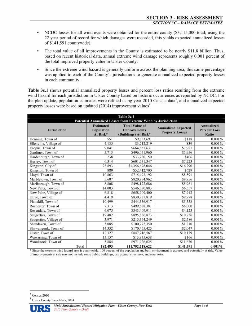
SECTION 3 RISK ASSESSMENT SECTION 3C – DAMAGE ESTIMATES
Multi�Jurisdictional Hazard Mitigation Plan – Ulster County, New York Page 3c�6 2015 Plan Update – Draft
• NCDC losses for all wind events were obtained for the entire county ($3,115,000 total; using the 22 year period of record for which damages were recorded, this yields expected annualized losses of $141,591 countywide).
• The total value of all improvements in the County is estimated to be nearly $11.8 billion. Thus, based on recent historical data, annual extreme wind damage represents roughly 0.001 percent of the total improved property value in Ulster County.
• Since the extreme wind hazard is generally uniform across the planning area, this same percentage was applied to each of the County’s jurisdictions to generate annualized expected property losses in each community.
Table 3c.1 shows potential annualized property losses and percent loss ratios resulting from the extreme wind hazard for each jurisdiction in Ulster County based on historic occurrences as reported by NCDC. For the plan update, population estimates were refined using year 2010 Census data3, and annualized expected property losses were based on updated (2014) improvement values4.
Table 3c.1
Potential Annualized Losses from Extreme Wind by Jurisdiction
Jurisdiction
Estimated
Population
At Risk*
Total Value of
Improvements
(Buildings) At Risk*
Annualized Expected
Property Losses
Annualized
Percent Loss
Ratio
Denning, Town of 551 $9,833,691 $118 0.001%
Ellenville, Village of 4,135 $3,212,219 $39 0.001%
Esopus, Town of 9,041 $664,657,631 $7,981 0.001%
Gardiner, Town of 5,713 $496,051,960 $5,956 0.001%
Hardenburgh, Town of 238 $33,780,150 $406 0.001%
Hurley, Town of 6,314 $601,531,347 $7,223 0.001%
Kingston, City of 23,893 $1,356,698,046 $16,290 0.001%
Kingston, Town of 889 $52,412,700 $629 0.001%
Lloyd, Town of 10,863 $715,492,192 $8,591 0.001%
Marbletown, Town of 5,607 $820,874,962 $9,856 0.001%
Marlborough, Town of 8,808 $498,122,686 $5,981 0.001%
New Paltz, Town of 14,003 $546,080,883 $6,557 0.001%
New Paltz, Village of 6,818 $658,909,400 $7,912 0.001%
Olive, Town of 4,419 $830,987,819 $9,978 0.001%
Plattekill, Town of 10,499 $444,556,917 $5,338 0.001%
Rochester, Town of 7,313 $499,688,381 $6,000 0.001%
Rosendale, Town of 6,075 $343,409,911 $4,123 0.001%
Saugerties, Town of 19,482 $895,836,873 $10,756 0.001%
Saugerties, Village of 3,971 $215,364,249 $2,586 0.001%
Shandaken, Town of 3,085 $100,772,350 $1,210 0.001%
Shawangunk, Town of 14,332 $170,465,425 $2,047 0.001%
Ulster, Town of 12,327 $847,716,567 $10,179 0.001%
Wawarsing, Town of 13,157 $13,835,638 $166 0.001%
Woodstock, Town of 5,884 $971,926,625 $11,670 0.001%
Total 182,493 $11,792,218,622 $141,591 0.001% * Since the extreme wind hazard area is countywide, 100 percent of the population and built environment is exposed and potentially at risk. Value of improvements at risk may not include some public buildings, tax exempt structures, and reservoirs.
3 Census 2010 4 Ulster County Parcel data, 2014
SECTION 3 RISK ASSESSMENT SECTION 3C – DAMAGE ESTIMATES
Multi�Jurisdictional Hazard Mitigation Plan – Ulster County, New York Page 3c�7 2015 Plan Update – Draft
Hurricanes and Tropical Storms
Impacts Hurricanes and Tropical Storms
Hurricanes and tropical storms are capable of producing catastrophic impacts. A high number of deaths and/or injuries are possible, a large percentage of property in the affected area could be damaged or destroyed, and a complete shutdown of critical facilities would be possible for 30 days or more, depending on the nature of the event. The Ulster County HAZNY (2014) characterizes hurricanes as a moderately high hazard, with potential impacts throughout a large region, cascade effects are highly likely, occurring at a regular frequency, with more than two weeks recovery time, serious injury or death likely (but not in large numbers), severe damage to private property, and severe structural damage to public facilities is all possible. Ulster County has an active history of hurricanes and tropical storms. According to NOAA historical records, ten hurricane or tropical storm tracks5 have passed within 75 nautical miles of Ulster County since 1863. This includes two Category 1 hurricanes; and eight tropical storms. Of these ten events, two tracks traversed directly through Ulster County (a Category 1 hurricane in 1878 and a tropical storm in 1893). Recent events such as Sandy, Irene, and Lee have caused significant wind, flood and surge damages in Ulster County. Impacts of hurricanes and tropical storms are associated with damages as a result of flooding (riverine and storm surge traversing up the Hudson River), and high winds. It is possible for the entire county to be impacted by hurricanes and tropical storms, though in different ways. For example, wind impacts may be widespread across the County. Riverine flooding would be expected in riverine flood zones, and would cause more severe types of structure damages in areas along the Hudson River susceptible to storm surge. Roads and bridges across the county would be susceptible to overtopping and damage from floodwaters. . Impacts to the general public include evacuation and sheltering needs, as well as emergency response for those who shelter in place or are injured during the event. All property types are potentially impacted. Roads, bridges, schools, hospitals and other types of critical facilities are susceptible to wind and water damage. Secondary impacts would be associated with flying debris. Transportation, communications, and governmental services may be severely impacted. Impacts would be exacerbated when coincident with high tides, or during prolonged types of events that extend across several tidal cycles. Sea level rise will increase impacts over time. Table 3c.2 describes the damage that could be expected for each category of hurricane. Damage during hurricanes might also result from spawned tornadoes, storm surge and inland flooding associated with heavy rainfall that usually accompanies these storms.
5 Not including tropical depressions or extratropical systems.

SECTION 3 RISK ASSESSMENT SECTION 3C – DAMAGE ESTIMATES
Multi�Jurisdictional Hazard Mitigation Plan – Ulster County, New York Page 3c�8 2015 Plan Update – Draft
Exposure and Damage Estimates – Hurricanes and Tropical Storms Hurricanes and tropical storms are complex combinations of discrete component hazards occurring simultaneously. The entirety of the County’s built environment and population is potentially exposed to this hazard. Damages during these events result from the cumulative impacts of a wide range of hazards including flooding, storm surge, and high winds. No two hurricanes or tropical storms are identical. Even hurricanes of the same category can bring with them wildly different impacts depending on whether they occur during a time of high tide or low tide. Variations in inland wind affects and precipitation amounts, for example, can vary widely. Thus, it is difficult to estimate total potential losses from these cumulative effects in a manner that would allow for the calculation of a meaningful annual ‘hurricane and tropical storm’ average annual loss estimate. Vulnerability to the component hazards of hurricane and tropical storm events such as flooding, storm surge, and high winds are addressed separately in this section. Vulnerability is being expressed as the number of people and value of property at risk. All of the county’s built environment and population ($11.8 billion in improved property, and 182,493 people) could potentially be impacted in some way by the hazards characteristically occurring during a hurricane or tropical storm.
Table 3c.2
Hurricane Damage Classifications
Storm
Category
Damage
Level Description of Damages
Photo
Example
1 MINIMAL No real damage to building structures. Damage primarily to unanchored mobile homes, shrubbery and trees. Also, some coastal flooding and minor pier damage.
2 MODERATE Some roofing material, door and window damage. Considerable damage to vegetation, mobile homes, etc. Flooding damages piers and small craft in unprotected moorings might break their moorings.
3 EXTENSIVE
Some structural damage to small residences and utility buildings, with a minor amount of curtainwall failures. Mobile homes are destroyed. Flooding near the coast destroys smaller structures, with larger structures damaged by floating debris. Terrain might be flooded well inland.
4 EXTREME More extensive curtainwall failures with some complete roof structure failure on small residences. Major erosion of beach areas. Terrain might be flooded well inland.
5 CATASTROPHIC
Complete roof failure on many residences and industrial buildings. Some complete building failures with small utility buildings blown over or away. Flooding causes major damage to lower floors of all structures near the shoreline. Massive evacuation of residential areas might be required.
Source: National Oceanic and Atmospheric Administration; Federal Emergency Management Agency

SECTION 3 RISK ASSESSMENT SECTION 3C – DAMAGE ESTIMATES
Multi�Jurisdictional Hazard Mitigation Plan – Ulster County, New York Page 3c�9 2015 Plan Update – Draft
Lightning
Impacts – Lightning On average, 55 people are killed and hundreds are injured each year by lightning strikes in the United States. Lightning can strike communications equipment (i.e., radio or cell towers, antennae, satellite dishes, electrical transformers, etc.) and hamper communication and emergency response. Lightning strikes can also cause significant damage to buildings, critical facilities, and infrastructure, largely by igniting a fire. In addition, lightning can ignite vegetation to cause a wildfire. Lightning’s impacts can typically be characterized as minor in Ulster County. Events are typically associated with very few injuries (if any), only minor property damage, and minimal disruption on quality of life. The shutdown of critical facilities, if at all, is typically only temporary in nature. Historical impacts in Ulster County have included direct health impacts to individuals struck by lightning, structure damages from fires caused by lightning, and impacts to emergency communications facilities when towers have been struck by lightning. Lightning occurs frequently in Ulster County but damaging events are relatively few in number and limited in scope when they do occur. Building codes requiring buildings to be grounded work to decrease damages. Members of the general public who are outdoors are particularly vulnerable during an event. Lightning most typically occurs within 10 miles of a thunderstorm.
Exposure and Damage Estimates – Lightning Because it cannot be predicted where lightning may strike, all existing and future buildings, facilities and populations are considered to be exposed to this hazard and could potentially be impacted. For the plan update, NCDC historical lightning data current as of July 2015 was queried. The data includes a total of 16 lightning events between July 1996 and July 2015, resulting in nearly $654,000 in damages, one death, and 6 injuries. The lack of event records prior to the year 1996 is due to database limitations as opposed to decades without lightning events. To estimate jurisdictional losses due to lightning, expected annualized losses were calculated as follows for the 19 year period of record between July 1996 and July 2015:
• NCDC losses were obtained for the entire county (event records included specific loss histories totaling $654,000; using a 19 year period of record, this yields expected annualized losses of $34,421 countywide).
• The total value of all improvements in the County is estimated to be nearly $11.8 billion. Thus, based on recent historical data, annual lightning damage represents roughly 0.0003 percent of the total improved property value in Ulster County.
• Since the lightning hazard is uniform across the planning area, this same percentage was applied to each of the County’s jurisdictions to generate annualized expected property losses in each community.
Table 3c.3 shows potential annualized property losses and percent loss ratios resulting from the lightning hazard for each jurisdiction in Ulster County based on historic occurrences as reported by NCDC. For the plan update, population estimates were refined using year 2013 Census block level data6, and annualized expected property losses were based on updated (2011) improvement values7.
6 U.S. Census 2010 7 Ulster County Parcel data, 2014.

SECTION 3 RISK ASSESSMENT SECTION 3C – DAMAGE ESTIMATES
Multi�Jurisdictional Hazard Mitigation Plan – Ulster County, New York Page 3c�10 2015 Plan Update – Draft
Table 3c.3
Potential Annualized Losses from Lightning by Jurisdiction
Jurisdiction
Estimated
Population
At Risk*
Total Value of
Improvements
(Buildings) At Risk*
Annualized Expected
Property Losses
Annualized
Percent Loss
Ratio
Denning, Town of 551 $9,833,691 $29 0.0003%
Ellenville, Village of 4,135 $3,212,219 $9 0.0003%
Esopus, Town of 9,041 $664,657,631 $1,940 0.0003%
Gardiner, Town of 5,713 $496,051,960 $1,448 0.0003%
Hardenburgh, Town of 238 $33,780,150 $99 0.0003%
Hurley, Town of 6,314 $601,531,347 $1,756 0.0003%
Kingston, City of 23,893 $1,356,698,046 $3,960 0.0003%
Kingston, Town of 889 $52,412,700 $153 0.0003%
Lloyd, Town of 10,863 $715,492,192 $2,088 0.0003%
Marbletown, Town of 5,607 $820,874,962 $2,396 0.0003%
Marlborough, Town of 8,808 $498,122,686 $1,454 0.0003%
New Paltz, Town of 14,003 $546,080,883 $1,594 0.0003%
New Paltz, Village of 6,818 $658,909,400 $1,923 0.0003%
Olive, Town of 4,419 $830,987,819 $2,426 0.0003%
Plattekill, Town of 10,499 $444,556,917 $1,298 0.0003%
Rochester, Town of 7,313 $499,688,381 $1,459 0.0003%
Rosendale, Town of 6,075 $343,409,911 $1,002 0.0003%
Saugerties, Town of 19,482 $895,836,873 $2,615 0.0003%
Saugerties, Village of 3,971 $215,364,249 $629 0.0003%
Shandaken, Town of 3,085 $100,772,350 $294 0.0003%
Shawangunk, Town of 14,332 $170,465,425 $498 0.0003%
Ulster, Town of 12,327 $847,716,567 $2,474 0.0003%
Wawarsing, Town of 13,157 $13,835,638 $40 0.0003%
Woodstock, Town of 5,884 $971,926,625 $2,837 0.0003%
Total 182,493 $11,792,218,622 $34,421 0.0003%
* Since the lightning hazard area is countywide, 100 percent of the population and built environment is exposed and potentially at risk. Value of improvements at risk may not include some public buildings, tax exempt structures, and reservoirs.
Nor’easters
Impacts Nor’easters
Nor’easters are known for dumping heavy amounts of rain and snow, producing hurricaneforce winds, and creating high surf that causes severe beach erosion and coastal flooding. There are two main components to a nor'easter: (1) a Gulf Stream lowpressure system (counterclockwise winds) generated off the southeastern U.S. coast, gathering warm air and moisture from the Atlantic, and pulled up the East Coast by strong northeasterly winds at the leading edge of the storm; and (2) an Arctic highpressure system (clockwise winds) which meets the lowpressure system with cold, arctic air blowing down from Canada. When the two systems collide, the moisture and cold air produce a mix of precipitation and have the potential for creating dangerously high winds and heavy seas. As the lowpressure system deepens, the intensity of the winds and waves will increase and cause serious damage to coastal areas as the storm moves northeast. Nor’easters can be extremely large (up to 1,000 miles in diameter) and their duration can last for days and multiple tidal cycles, often causing major coastal flooding, erosion and damages that might even exceed the impacts of shorterterm hurricane events. Impacts from nor’easters in Ulster County are primarily associated with high winds and flood hazards (riverine and storm surge) as well as heavy snowfall. Their impacts are often quite similar to winter storms

SECTION 3 RISK ASSESSMENT SECTION 3C – DAMAGE ESTIMATES
Multi�Jurisdictional Hazard Mitigation Plan – Ulster County, New York Page 3c�11 2015 Plan Update – Draft
with significant snow accumulations, creating hazardous driving conditions, business/government office closures, potential for damage from snow accumulations on structures, etc. The entire county has some exposure and past effects have been widespread. Similar to hurricanes and tropical storms, nor’easters are capable of producing widespread impacts, depending upon the nature of the storm, its intensity, and duration. Possible impacts can include possible deaths/injuries, property damages, and functional downtime of critical facilities. Historical records in the NYSHMP 2014 are not specific to nor’easters, but are rather a tally of all types of winter storms. Six nor’easters stand out from 1993 to the present with most notable impacts. Recent events have caused significant wind and flood related damages in Ulster County. They have also resulted in power outages and hazardous driving conditions. It is possible for the entire county to be impacted by nor’easters. Roads and bridges across the county would be susceptible to overtopping and damage from floodwaters. Impacts to the general public include evacuation and sheltering needs, as well as emergency response for those who shelter in place or are injured during the event. All property types are potentially impacted. Roads, bridges, schools, hospitals and other types of critical facilities are susceptible to wind and water damage. Secondary impacts would be associated with roof damage due to snow loads. Transportation, communications, and governmental services may be severely impacted.
Exposure and Damage Estimates – Nor’easters
Because nor’easters often impact large areas and cross jurisdictional boundaries, all existing and future buildings, facilities and populations are considered to be exposed to this hazard and could potentially be impacted. Similar to hurricanes and tropical storms, nor’easters are complex combinations of discrete component hazards occurring simultaneously. Damages during these events result from the cumulative impacts of component hazards such as flooding, surge traveling up the Hudson River, and high winds. No two nor’easters are identical. Even storms of the same magnitude and intensity can bring with them wildly different impacts depending on whether they occur during a time of high tide or low tide; and, since it is not uncommon for nor’easters to stall off of the coast, damages are typically affected by their duration. Variations in inland wind affects and precipitation amounts can also vary widely. Thus, it is difficult to estimate total potential losses from these cumulative effects in a manner that would allow for the calculation of a meaningful average annual loss estimate for nor’easters. Vulnerability is being expressed as the number of people and value of property at risk. All of the county’s built environment and population could potentially be impacted by the hazards characteristically occurring during a nor’easter.
Tornado
Impacts Tornado
Tornados are nature’s most violent storms. The most intense tornados can cause fatalities and catastrophic damage to both trees and the built environment in a matter of seconds. The number of deaths, injuries, and dollar amount of damages can fluctuate drastically depending on the severity of the tornado and the degree and type of development in the damage path. Emergency responders are called upon for search and rescue, to tend to the injured, assist in evacuations, and to close roads and direct traffic. Transportation, communications, and the general operation of government could be affected by an incident. Property damage can be significant within the tornado’s path. Trees can be damaged or destroyed. Power outages can occur. These impacts tend to be felt in rather limited areas, due to the nature of the tornado hazard itself (tornados with limited widths and path lengths after touchdown). The destruction caused by tornadoes ranges from light to catastrophic depending on the intensity, size, and duration of the storm. Typically,

SECTION 3 RISK ASSESSMENT SECTION 3C – DAMAGE ESTIMATES
Multi�Jurisdictional Hazard Mitigation Plan – Ulster County, New York Page 3c�12 2015 Plan Update – Draft
tornadoes cause the greatest damage to structures of light construction, including residential dwellings and particularly manufactured homes. Exposure and Damage Estimates – Tornado
Historical evidence shows that Ulster County is vulnerable to tornadic activity. This hazard can result from severe thunderstorm activity or may occur during a major tropical storm or hurricane. Because it cannot be predicted where a tornado may touch down, all existing and future buildings, facilities and populations are considered to be exposed to this hazard and could potentially be impacted. It is important to note that only reported tornadoes have been factored into this vulnerability assessment8. For the plan update, NCDC historical tornado data current as of October 2015 includes a total of 10 tornado events between September 1975 and July 2015, resulting in $3,125,000 in property damages. No events occurred since the last version of the plan was prepared. To estimate jurisdictional losses due to tornados, expected annualized losses were calculated as follows for the 45 year period of record:
• NCDC losses were obtained for the entire county ($3,125,000 total; using a 40 year period of record, this yields expected annualized losses of $78,125).
• The total value of all improvements in the County is estimated to be nearly $11.8 billion. Thus, based on recent historical data, annual tornado damage represents 0.0007 percent of the total improved property value in Ulster County.
• Since the tornado hazard is uniform across the planning area, this same percentage was applied to each of the County’s jurisdictions to generate annualized expected property losses in each community.
Table 3c.4 shows potential annualized property losses and percent loss ratios resulting from the tornado hazard for each jurisdiction in Ulster County based on historic occurrences as reported by NCDC. For the plan update, population estimates were refined using year 2010 Census data9, and annualized expected property losses were based on updated (2014) improvement values10.
Table 3c.4
Potential Annualized Losses from Tornados by Jurisdiction
Jurisdiction
Estimated
Population
At Risk*
Total Value of
Improvements
(Buildings) At Risk*
Annualized Expected
Property Losses
Annualized
Percent Loss
Ratio
Denning, Town of 551 $9,833,691 $65 0.0007%
Ellenville, Village of 4,135 $3,212,219 $21 0.0007% Esopus, Town of 9,041 $664,657,631 $4,403 0.0007% Gardiner, Town of 5,713 $496,051,960 $3,286 0.0007% Hardenburgh, Town of 238 $33,780,150 $224 0.0007% Hurley, Town of 6,314 $601,531,347 $3,985 0.0007% Kingston, City of 23,893 $1,356,698,046 $8,988 0.0007% Kingston, Town of 889 $52,412,700 $347 0.0007% Lloyd, Town of 10,863 $715,492,192 $4,740 0.0007% Marbletown, Town of 5,607 $820,874,962 $5,438 0.0007% Marlborough, Town of 8,808 $498,122,686 $3,300 0.0007% New Paltz, Town of 14,003 $546,080,883 $3,618 0.0007% New Paltz, Village of 6,818 $658,909,400 $4,365 0.0007%
8 It is possible that additional tornado events may have occurred since 1950 that were not reported to NCDC and are not accounted for in this
analysis. 9 U.S. Census Bureau, 2010. 10 Ulster County Parcel data, 2014.

SECTION 3 RISK ASSESSMENT SECTION 3C – DAMAGE ESTIMATES
Multi�Jurisdictional Hazard Mitigation Plan – Ulster County, New York Page 3c�13 2015 Plan Update – Draft
Table 3c.4
Potential Annualized Losses from Tornados by Jurisdiction
Jurisdiction
Estimated
Population
At Risk*
Total Value of
Improvements
(Buildings) At Risk*
Annualized Expected
Property Losses
Annualized
Percent Loss
Ratio
Olive, Town of 4,419 $830,987,819 $5,505 0.0007% Plattekill, Town of 10,499 $444,556,917 $2,945 0.0007% Rochester, Town of 7,313 $499,688,381 $3,311 0.0007% Rosendale, Town of 6,075 $343,409,911 $2,275 0.0007% Saugerties, Town of 19,482 $895,836,873 $5,935 0.0007% Saugerties, Village of 3,971 $215,364,249 $1,427 0.0007% Shandaken, Town of 3,085 $100,772,350 $668 0.0007% Shawangunk, Town of 14,332 $170,465,425 $1,129 0.0007% Ulster, Town of 12,327 $847,716,567 $5,616 0.0007% Wawarsing, Town of 13,157 $13,835,638 $92 0.0007% Woodstock, Town of 5,884 $971,926,625 $6,439 0.0007%
Total 182,493 $11,792,218,622 $78,125 0.0007% * Since the tornado hazard area is countywide, 100 percent of the population and built environment is exposed and potentially at risk. Value of improvements at risk may not include some public buildings, tax exempt structures, and reservoirs.
Winter Storms
Impacts – Winter Storms
Winter storms can have tremendous impacts on Ulster County. Though typically short in duration, winter storms can result in significant snow accumulations, with extensive impacts on local transportation via road, rail, and air. Impacts are exacerbated with storms having an ice component, as snow loads are increased and driving conditions substantially worsen. A severe winter storm can adversely affect roadways, utilities, business activities and can cause loss of life, frostbite, or freezing. The most common effect of winter storms and ice storms are traffic accidents, interruptions in power supply and communications. In addition, heavy snow loads can cause roof collapse in cases of inadequate design and/or maintenance, as the structural integrity of the structure is compromised. Power outages and temperatures below freezing for extended periods of time can cause pipes to freeze and burst. Heavily populated areas tend to be significantly impacted by losses of power and communications systems due to downed lines. Distribution lines can be downed by the weight of snow or ice, or heavy winds – particularly during periods of high winds – which can result in outages when limbs fall on power lines and communication lines. Secondary impacts from downed communication lines can hamper the response and recovery efforts due to lack of communication. When limbs and lines fall on roadways, transportation routes can be adversely affected and buildings and automobiles can be damaged. Secondary impacts from power outages can include frozen pipes, business losses, negative impacts on people associated with trying to heat their homes using portable heat sources (i.e., kerosene) or stoves including carbon monoxide poisoning and fire risks. Severe winter storms can also cause coastal flooding, coastal erosion, and wave action. If significant snowfall amounts melt quickly, inland flooding can occur as bankfull conditions are exceeded or in areas of poor roadway drainage. The impacts of snow and ice storms in the planning area are more likely to be major disruptions to transportation, commerce and electrical power as well as significant overtime work for government employees, rather than large scale property damages and/or threats to human life and safety. The severity of the effects of winter storms and ice storms increases as the amount and rate of precipitation increase. In addition, storms with a low forward velocity are in an area for a longer duration and become more severe in their affects. Storms that are in full force during the morning or evening rush hours tend to have their affects magnified because more people are out on the roadways and directly exposed. Ulster County’s more rural jurisdictions could be expected to be impacted more by heavy snow and freezing rain due to access transportation issues and distances from major population centers and additional emergency response

SECTION 3 RISK ASSESSMENT SECTION 3C – DAMAGE ESTIMATES
Multi�Jurisdictional Hazard Mitigation Plan – Ulster County, New York Page 3c�14 2015 Plan Update – Draft
resources. The human impact of winter storms tends to be exacerbated in areas of social vulnerability (for example, low income, and a high proportion of the very young and/or very old). Exposure and Damage Estimates – Winter Storms
Because winter storms often impact large areas and cross jurisdictional boundaries, all existing and future buildings, facilities and populations are considered to be exposed to this hazard and could potentially be impacted. For the plan update, NCDC historical winter storm data current as of October 2015 was queried for events categorized as: blizzards, heavy snow, ice storms, sleet, winter storms, and winter weather. The data includes a total of 122 winter weather days between January 1996 and July 2015, resulting in approximately $1.4 million in reported property damages. No event records are included prior to 1996. To estimate jurisdictional losses due to winter storms, expected annualized losses were calculated for the 19 year period of record to be $74,579 countywide. This result does not align with observed types of impacts in Ulster County during historic occurrences and does not appear to be including the order of magnitude of damages incurred. Research of the NYSHMP 2014 found that the State used SHELDUS data for the period of 1960 to 2012 to estimate losses ($49,207,868 million in property damages). The Ulster County plan update is hereby revised to incorporate the State’s approach, as follows:
• SHELDUS losses were obtained for the entire county ($49,207,868; using a 42 year period of record, this yields expected annualized losses of $1,171,616).
• The total value of all improvements in the County is estimated to be nearly $11.8 billion. Thus, based on recent historical data, annual winter storm damage represents 0.01 percent of the total improved property value in Ulster County.
• Since winter storm hazard is uniform across the planning area, this same percentage was applied to each of the County’s jurisdictions to generate annualized expected property losses in each community.
Table 3c.5 shows potential annualized property losses and percent loss ratios resulting from the winter storm hazard for each jurisdiction in Ulster County based on historic occurrences as reported by NCDC. For the plan update, population estimates were refined using year 2010 Census data11, and annualized expected property losses were based on updated (2014) improvement values12.
Table 3c.5
Potential Annualized Losses from Winter Storms by Jurisdiction
Jurisdiction
Estimated
Population
At Risk*
Total Value of
Improvements
(Buildings) At Risk*
Annualized Expected
Property Losses
Annualized
Percent Loss
Ratio
Denning, Town of 551 $9,833,691 $977 0.01%
Ellenville, Village of 4,135 $3,212,219 $319 0.01%
Esopus, Town of 9,041 $664,657,631 $66,037 0.01%
Gardiner, Town of 5,713 $496,051,960 $49,285 0.01%
Hardenburgh, Town of 238 $33,780,150 $3,356 0.01%
Hurley, Town of 6,314 $601,531,347 $59,765 0.01%
Kingston, City of 23,893 $1,356,698,046 $134,795 0.01%
Kingston, Town of 889 $52,412,700 $5,207 0.01%
Lloyd, Town of 10,863 $715,492,192 $71,088 0.01%
Marbletown, Town of 5,607 $820,874,962 $81,558 0.01%
Marlborough, Town of 8,808 $498,122,686 $49,491 0.01%
New Paltz, Town of 14,003 $546,080,883 $54,256 0.01%
New Paltz, Village of 6,818 $658,909,400 $65,466 0.01%
11 U.S. Census Bureau, 2010. 12 Ulster County Parcel data, 2014.

SECTION 3 RISK ASSESSMENT SECTION 3C – DAMAGE ESTIMATES
Multi�Jurisdictional Hazard Mitigation Plan – Ulster County, New York Page 3c�15 2015 Plan Update – Draft
Table 3c.5
Potential Annualized Losses from Winter Storms by Jurisdiction
Jurisdiction
Estimated
Population
At Risk*
Total Value of
Improvements
(Buildings) At Risk*
Annualized Expected
Property Losses
Annualized
Percent Loss
Ratio
Olive, Town of 4,419 $830,987,819 $82,563 0.01%
Plattekill, Town of 10,499 $444,556,917 $44,169 0.01%
Rochester, Town of 7,313 $499,688,381 $49,647 0.01%
Rosendale, Town of 6,075 $343,409,911 $34,119 0.01%
Saugerties, Town of 19,482 $895,836,873 $89,006 0.01%
Saugerties, Village of 3,971 $215,364,249 $21,398 0.01%
Shandaken, Town of 3,085 $100,772,350 $10,012 0.01%
Shawangunk, Town of 14,332 $170,465,425 $16,937 0.01%
Ulster, Town of 12,327 $847,716,567 $84,225 0.01%
Wawarsing, Town of 13,157 $13,835,638 $1,375 0.01%
Woodstock, Town of 5,884 $971,926,625 $96,566 0.01%
Total 182,493 $11,792,218,622 $1,171,616 0.01% * Since the winter storm hazard area is countywide, 100 percent of the population and built environment is exposed and potentially at risk. Value of improvements at risk may not include some public buildings, tax exempt structures, and reservoirs.
Dam Failure
Impacts – Dam Failure
Dam failure presents a significant potential for disaster, in that significant loss of life and property would be expected in addition to the possible loss of power and water resources. The most common cause of dam failure is prolonged rainfall that produces flooding. Failures due to other natural events such as hurricanes, earthquakes or landslides are significant because there is generally little or no advance warning. The best way to mitigate dam failure is through the proper construction, inspection, maintenance and operation of dams, as well as maintaining and updating Emergency Action Plans for use in the event of a dam failure.
Exposure and Damage Estimates – Dam Failure
Of the 28 “high” or “significant” hazard dams in Ulster County, three have been classified by the State as “major” dams and represent the most significant hazard risk based on the potential consequences of a dam failure. Major dams are described as 50 feet or more in height, or with a normal storage capacity of 5,000 acrefeet or more, or with a maximum storage capacity of 25,000 acrefeet or more. In Ulster County, these include the Ashokan Reservoir Dam in Olive (water supply); the Rondout Reservoir Dam (Merriman Dam) in Wawarsing (water supply); and the Sturgeon Pool Dam in Esopus (hydroelectric). The value of improvements at risk was estimated based on the proportion of parcel area within estimated inundation areas (for example, if 10 percent of the parcel area was within a mapped area of inundation during a breach of the dam, 10 percent of the value of improvements on that parcel were also assumed to be at risk). Table
3c.6 shows building value exposure to dam failure by jurisdiction for the County’s three major, high hazard dams.
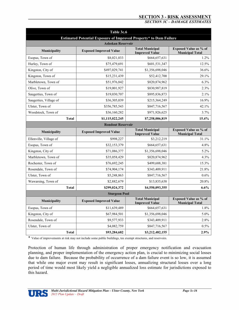
SECTION 3 RISK ASSESSMENT SECTION 3C – DAMAGE ESTIMATES
Multi�Jurisdictional Hazard Mitigation Plan – Ulster County, New York Page 3c�16 2015 Plan Update – Draft
Table 3c.6
Estimated Potential Exposure of Improved Property* to Dam Failure
Ashokan Reservoir
Municipality Exposed Improved Value Total Municipal
Improved Value
Exposed Value as % of
Municipal Total
Esopus, Town of $8,021,033 $664,657,631 1.2%
Hurley, Town of $75,479,691 $601,531,347 12.5%
Kingston, City of $497,029,741 $1,356,698,046 36.6%
Kingston, Town of $15,231,439 $52,412,700 29.1%
Marbletown, Town of $51,976,842 $820,874,962 6.3%
Olive, Town of $19,001,927 $830,987,819 2.3%
Saugerties, Town of $19,030,707 $895,836,873 2.1%
Saugerties, Village of $36,305,039 $215,364,249 16.9%
Ulster, Town of $356,785,543 $847,716,567 42.1%
Woodstock, Town of $36,160,282 $971,926,625 3.7%
Total $1,115,022,245 $7,258,006,819 15.4%
Rondout Reservoir
Municipality Exposed Improved Value Total Municipal
Improved Value
Exposed Value as % of
Municipal Total
Ellenville, Village of $998,227 $3,212,219 31.1%
Esopus, Town of $32,153,379 $664,657,631 4.8%
Kingston, City of $71,086,377 $1,356,698,046 5.2%
Marbletown, Town of $35,058,429 $820,874,962 4.3%
Rochester, Town of $76,692,245 $499,688,381 15.3%
Rosendale, Town of $74,904,174 $343,409,911 21.8%
Ulster, Town of $5,248,863 $847,716,567 0.6%
Wawarsing, Town of $2,882,679 $13,835,638 20.8%
Total $299,024,372 $4,550,093,355 6.6%
Sturgeon Pool
Municipality Exposed Improved Value Total Municipal
Improved Value
Exposed Value as % of
Municipal Total
Esopus, Town of $11,639,489 $664,657,631 1.8%
Kingston, City of $67,984,501 $1,356,698,046 5.0%
Rosendale, Town of $9,577,933 $343,409,911 2.8%
Ulster, Town of $4,082,759 $847,716,567 0.5%
Total $93,284,682 $3,212,482,155 2.9%
* Value of improvements at risk may not include some public buildings, tax exempt structures, and reservoirs. Protection of human life through administration of proper emergency notification and evacuation planning, and proper implementation of the emergency action plan, is crucial to minimizing social losses due to dam failure. Because the probability of occurrence of a dam failure event is so low, it is assumed that while one major event may result in significant losses, annualizing structural losses over a long period of time would most likely yield a negligible annualized loss estimate for jurisdictions exposed to this hazard.

SECTION 3 RISK ASSESSMENT SECTION 3C – DAMAGE ESTIMATES
Multi�Jurisdictional Hazard Mitigation Plan – Ulster County, New York Page 3c�17 2015 Plan Update – Draft
Drought
Impacts – Drought
Droughts are slow onset hazards, but, over time, they can severely affect crops, municipal water supplies, recreational resources, and wildlife. If drought conditions extend over a number of years, the direct and indirect economic impacts can be significant. High temperatures, high winds, and low humidity can worsen drought conditions and also make areas more susceptible to wildfire. In addition, human actions and demands for water resources can accelerate droughtrelated impacts.
Exposure and Damage Estimates – Drought Because drought impacts large areas and crosses jurisdictional boundaries, all existing and future buildings, facilities and populations are considered to be exposed to this hazard and could potentially be impacted. However, drought impacts are mostly experienced in water shortages and crop losses on agricultural lands and have no impact on buildings. To estimate land exposure to drought, cultivated cropland acreage was acquired from NLDC land cover classification data (2011 Edition, amended 2014). Table 3c.7 shows cultivated cropland acreage in Ulster County by jurisdiction. Approximately 3.4 percent of land in Ulster County is used for cultivated; located each of the County’s 24 communities.
Table 3c.7
Acreage of Cultivated Cropland by Jurisdiction
Jurisdiction
Land
Area
(Acres)
Area
of Cultivated
Cropland
(Acres)
Proportion of
Cultivated Cropland
(as percentage of
County total)
Denning, Town of 67,627 40 0.2%
Ellenville, Village of 5,584 24 0.1%
Esopus, Town of 23,880 306 1.2%
Gardiner, Town of 27,798 1,211 4.9%
Hardenburgh, Town of 51,704 61 0.2%
Hurley, Town of 19,143 896 3.6%
Kingston, City of 4,791 62 0.3%
Kingston, Town of 4,929 79 0.3%
Lloyd, Town of 20,010 901 3.7%
Marbletown, Town of 34,862 2,938 12.0%
Marlborough, Town of 15,661 3,560 14.5%
New Paltz, Town of 21,680 1,480 6.0%
New Paltz, Village of 1,098 43 0.2%
Olive, Town of 37,408 166 0.7%
Plattekill, Town of 22,471 1,557 6.3%
Rochester, Town of 57,154 3,675 15.0%
Rosendale, Town of 12,786 366 1.5%
Saugerties, Town of 41,328 1,601 6.5%
Saugerties, Village of 1,141 11 0.0%
Shandaken, Town of 76,662 63 0.3%
Shawangunk, Town of 35,876 2,875 11.7%
Ulster, Town of 17,154 1,010 4.1%
Wawarsing, Town of 83,523 1,445 5.9%
Woodstock, Town of 43,065 199 0.8%
Total 727,333 24,567 3.4% Source: NLCD 2011 Land Cover (2011 Edition, amended 2014), 2014. 2010 Census
Geographic Identifiers (G001).
The USDA 2012 Census of Agriculture County Profile for Ulster County was used to analyze the exposure of Ulster County crops to drought. It was assumed that the exposure of crops was equal to the total value of crops sold ($46.4 million). This represents roughly a substantial increase since the last version of the plan

SECTION 3 RISK ASSESSMENT SECTION 3C – DAMAGE ESTIMATES
Multi�Jurisdictional Hazard Mitigation Plan – Ulster County, New York Page 3c�18 2015 Plan Update – Draft
was prepared (when the value of crops sold as reported in the USDA 2002 County Profile was $28.8 million). Agricultural losses, specifically losses to crops, in Ulster County could be significant during a drought. When drought begins, the agricultural sector is usually the first to be impacted because of its heavy reliance on stored soil water, which can rapidly be depleted during extended dry periods. When precipitation returns to normal, impacts on the agricultural sector are quick to diminish again due to the reliance on stored soil moisture. For the 2009 Plan, to estimate losses due to drought, the NOAA NCDC database was evaluated for drought events in the ten years between 1998 and 2008. It was determined that these events caused approximately $50,000,000 in crop related damages (or $5,000,000 per year countywide). Using this historical data for estimated annual damages countywide, annual losses on a municipal level were estimated by distributed the annual countywide losses using a weighted percentage of crop land/pasture land. This methodology did not take into account the degree of variation in value of various crops/livestock, or the degree of drought resistance and should be used for mitigation planning purposes only. For this plan update, NCDC historical drought loss data was once again queried, this time for records current as of October 201513. The data includes a total of two periods of drought between January 199614 and July 2015, both of which occurred between April and August of 1999. The event records estimated $0 in both property and crop damages for these events. This was presumed to be a function of ongoing changes to the NCDC data set, as opposed to true zero dollar losses, because episode narratives did present descriptions of often significant losses for these same events, but not in a manner that would permit an accurate breakdown of losses by jurisdiction or even by County. The 2014 NYSHMP reports a SHELDUS total of three drought events in Ulster County from 1960 to 2012 and a total of $2,685,185 in crop damage ($895,062 per event; or $63,933 per year). Distributing across the 24 jurisdictions with land in agriculture based on the proportion of cultivated cropland in the community generates derived losses per jurisdiction, shown in Table 3c.8. Limitations in the data do seem to be resulting in the undercounting of actual damages and losses, and should be updated on a regular basis with each plan update as improved and more robust historic data becomes available.
Table 3c.8
Potential Annualized Losses from Drought by Jurisdiction
Jurisdiction
Estimated
Population
At Risk*
Area
of
Cultivated
Cropland15
(Acres)
Proportion of
Cultivated
Cropland
(as percentage of
Countywide total)
Annualized
Estimated
Crop
Losses
($)
Denning, Town of 551 40 0.2% $128
Ellenville, Village of 4,135 24 0.1% $64
Esopus, Town of 9,041 306 1.2% $767
Gardiner, Town of 5,713 1,211 4.9% $3,133
Hardenburgh, Town of 238 61 0.2% $128
Hurley, Town of 6,314 896 3.6% $2,302
Kingston, City of 23,893 62 0.3% $192
Kingston, Town of 889 79 0.3% $192
Lloyd, Town of 10,863 901 3.7% $2,366
Marbletown, Town of 5,607 2,938 12.0% $7,672
Marlborough, Town of 8,808 3,560 14.5% $9,270
New Paltz, Town of 14,003 1,480 6.0% $3,836
New Paltz, Village of 6,818 43 0.2% $128
13 Queried on and still current as of October 2015; with data through July 2015. 14 Events between 1950 and 1998 were not included in the NCDC database and, therefore, are not accounted for in this analysis. 15 Cropland, pastureland, orchards, vineyards, nurseries and horticultural areas.

SECTION 3 RISK ASSESSMENT SECTION 3C – DAMAGE ESTIMATES
Multi�Jurisdictional Hazard Mitigation Plan – Ulster County, New York Page 3c�19 2015 Plan Update – Draft
Table 3c.8
Potential Annualized Losses from Drought by Jurisdiction
Jurisdiction
Estimated
Population
At Risk*
Area
of
Cultivated
Cropland15
(Acres)
Proportion of
Cultivated
Cropland
(as percentage of
Countywide total)
Annualized
Estimated
Crop
Losses
($)
Olive, Town of 4,419 166 0.7% $448
Plattekill, Town of 10,499 1,557 6.3% $4,028
Rochester, Town of 7,313 3,675 15.0% $9,590
Rosendale, Town of 6,075 366 1.5% $959
Saugerties, Town of 19,482 1,601 6.5% $4,156
Saugerties, Village of 3,971 11 0.0% $0
Shandaken, Town of 3,085 63 0.3% $192
Shawangunk, Town of 14,332 2,875 11.7% $7,480
Ulster, Town of 12,327 1,010 4.1% $2,621
Wawarsing, Town of 13,157 1,445 5.9% $3,772
Woodstock, Town of 5,884 199 0.8% $511
Total 182,493 24,567 100% $63,933 * Since the drought hazard area is countywide, 100 percent of the population is exposed and potentially at risk.
Flooding
Impacts – Flooding
Flooding can cause widespread damage throughout rural and urban areas, causing loss of life, injury, and severe structural damage to buildings, damaged or destroyed building contents, loss of function for flooded facilities, flooded roadways causing lengthy detour times and increased emergency response times, deposition of debris in and out of channels; damages to utility and communication networks; and agriculture losses. Flooding can cause damages to property, infrastructure, agriculture, and the environment. Local communities often bear the brunt of costs for emergency responders to provide guidance during the response phase, and lead the community through what is often a long recovery process thereafter. Buildings, roads, and bridges can be damaged or destroyed. Crops can be lost when farm fields are flooded. Functional downtime of businesses and/or damage to merchandise and equipment can have staggering impacts. Flooding can also cause sewage to backup into houses through drainpipes where backflow valves are not present. Unanchored fuel tanks can be easily moved by floodwater, causing environmental damage. When government facilities or critical facilities such as police stations, fire stations, hospitals, etc. are flooded – or where access routes to these structures are impassable due to floodwaters – impacts are even greater, with the community’s ability to effectively and efficiently govern, provide emergency services and critical care for the injured. While recovery from these impacts can be quick for smallscale, shortduration events; larger events can cripple a community for weeks, months, and years to follow.
Exposure and Damage Estimates – Flooding FEMA’s 2013 Preliminary DFIRM flood mapping was overlaid upon the Ulster County Parcel data (2014) to identify the flood risk areas for all municipalities in the County, and the collated data is presented in Tables 3c.9 and 3c.10. All parcels that were intersected at any point by the DFIRM hazard area shape files were counted, and impacted improved property values were calculated by applying a percentage of the parcel area within the hazard area to the total improved value associated with that parcel to account for the uncertainty regarding the location of the structure(s) within each parcel, since without building footprint data it cannot be automatically assumed that all improvements lie exactly at the center of their associated parcels.

SECTION 3 RISK ASSESSMENT SECTION 3C – DAMAGE ESTIMATES
Multi�Jurisdictional Hazard Mitigation Plan – Ulster County, New York Page 3c�20 2015 Plan Update – Draft
In total, about 5.7 percent of the County’s land area lies within high or moderate flood risk zones16, according to the Preliminary DFIRM mapping data. The Village of Saugerties has the highest proportion of land area within a high flood risk zone at 17.9 percent, followed closely by the Town of New Paltz (15 percent), Town of Ulster (13.9 percent) and City of Kingston (10.9 percent). For comparison purposes, the average Ulster County community has 6.4 percent of its land area in high risk flood zones, ranging from a low of zero percent in the Town of Plattekill, to 17.9 percent in the Village of Saugerties. The GIS analysis indicates that the Towns of Shandaken, Denning, Kingston, and the Village of Ellenville have the greatest proportions of improved property values in high flood risk zones, with 22, 12, 11 and 10 percent in each municipality, respectively. For every other municipality in the County, the proportion of improved property within the mapped high flood risk zone is less than 9 percent. The average community value of improvements in high risk flood zones in Ulster County is $23.6 million; ranging from a minimum of zero dollars in the Town of Plattekill to a maximum of $84.8 million in the City of Kingston (followed by the Town of Woodstock with $60.9 million, Town of Olive with $60.1 million, and Town of Ulster with $52.3 million; every other community in the county has less than $45 million of improvements in high risk flood zones). The assessment for this plan update represents an improvement over the prior version of the plan through use of more recent improvement values (2014), in addition to more recent and more accurate flood data (2013 Preliminary DFIRMs as opposed to the earlier Q3 data, which had a much higher potential margin of error). For the purpose of generating an estimate of annual flood damages for the initial version of the plan in 2009, the NOAA NCDC database was queried to determine total flood damages for all recorded flood events in the County. At that time, the available period of recorded extended from 1998 to 2008, with total recorded property damages of $13,260,000 ($1,326,000 per year). Because the flood hazard is not uniform across the County, total annual damages were distributed across the County’s 24 municipalities based on each community’s proportional value of improved property in the flood hazard area to derive municipal average annual losses. This same approach was used for this plan update. For the available period of recorded extending from January 1996 to July 2015, the NOAA NCDC database records 81 flood events with total recorded property damages of $24,171,000 ($1,272,158 per year). Because the flood hazard is not uniform across the County, total annual damages have been distributed across the County’s 24 municipalities based on each community’s proportional value of improved property in the 100year flood hazard area to derive municipal average annual losses. The results are shown in Table 3c.11.
16 FEMA Flood Zones A, AE, AO, X500

SECTION 3 RISK ASSESSMENT SECTION 3C – DAMAGE ESTIMATES
Multi�Jurisdictional Hazard Mitigation Plan – Ulster County, New York Page 3c�21 2015 Plan Update – Draft
Table 3c.9
Acres of Land in Flood Hazard Areas by Municipality17
Municipality Total Land
Area (Acres)
High
Flood Risk
(Acres)
Moderate
Flood Risk
(Acres)
Low
Flood Risk
(Acres)
Land in
High Flood Risk
%
Land in Moderate
Flood Risk
%
A, AE, AO X500 X A, AE, AO X500
Denning, Town of 67,627 1,522 31 63,130 2.3% 0.0%
Ellenville, Village of 5,584 153 20 5,245 2.7% 0.4%
Esopus, Town of 23,880 1,571 79 22,221 6.6% 0.3%
Gardiner, Town of 27,798 2,100 206 25,780 7.6% 0.7%
Hardenburgh, Town of 51,704 1,003 50,027 1.9% 0.0%
Hurley, Town of 19,143 1,792 154 16,924 9.4% 0.8%
Kingston, City of 4,791 524 129 4,185 10.9% 2.7%
Kingston, Town of 4,929 87 44 4,610 1.8% 0.9%
Lloyd, Town of 20,010 1,989 85 17,987 9.9% 0.4%
Marbletown, Town of 34,862 2,768 6 32,445 7.9% 0.0%
Marlborough, Town of 15,661 88 20 15,630 0.6% 0.1%
New Paltz, Town of 21,680 3,247 254 16,953 15.0% 1.2%
New Paltz, Village of 1,098 90 14 962 8.2% 1.3%
Olive, Town of 37,408 1,047 305 36,279 2.8% 0.8%
Plattekill, Town of 22,471 22,268 0.0% 0.0%
Rochester, Town of 57,154 3,623 70 53,149 6.3% 0.1%
Rosendale, Town of 12,786 1,011 459 10,798 7.9% 3.6%
Saugerties, Town of 41,328 2,424 202 37,392 5.9% 0.5%
Saugerties, Village of 1,141 205 43 886 17.9% 3.8%
Shandaken, Town of 76,662 2,385 588 76,726 3.1% 0.8%
Shawangunk, Town of 35,876 2,056 202 33,510 5.7% 0.6%
Ulster, Town of 17,154 2,382 797 14,257 13.9% 4.6%
Wawarsing, Town of 83,523 3,551 189 74,537 4.3% 0.2%
Woodstock, Town of 43,065 1,518 328 41,429 3.5% 0.8%
Total 727,333 37,136 4,225 677,330 5.1% 0.6%
Source: FEMA: Preliminary DFIRM Data, 2013; Ulster County Parcel Data, 2014.
17
Zones A/AE/AO (100year floodplain), Zone X500 (500year floodplain), and Zone X (areas above the 500year floodplain)

SECTION 3 RISK ASSESSMENT SECTION 3C – DAMAGE ESTIMATES
Multi�Jurisdictional Hazard Mitigation Plan – Ulster County, New York Page 3c�22 2015 Plan Update – Draft
Table 3c.10
Improved Values in Flood Hazard Areas by Municipality*
Municipality Total Value of
Improvements
Improved Value in
High Flood Risk
Areas
Improved Value
in Moderate
Flood Risk Areas
Improved Value
in Low Flood Risk
Areas
Improved Value in
High Flood Risk
Areas
%
Improved Value
in Moderate
Flood Risk Areas
%
A, AE, AO X500 X A, AE, AO X500
Denning, Town of $9,833,691 $1,142,100 $109,125 $8,556,522 12% 1%
Ellenville, Village of $3,212,219 $316,352 $71,663 $2,824,203 10% 2%
Esopus, Town of $664,657,631 $19,121,774 $2,899,484 $642,530,727 3% 0%
Gardiner, Town of $496,051,960 $29,220,826 $4,018,828 $462,812,319 6% 1%
Hardenburgh, Town of $33,780,150 $1,954,326 $31,825,824 6% 0%
Hurley, Town of $601,531,347 $19,882,899 $7,916,865 $573,731,604 3% 1%
Kingston, City of $1,356,698,046 $84,778,461 $30,637,735 $1,241,281,899 6% 2%
Kingston, Town of $52,412,700 $5,720,460 $3,493,358 $43,198,886 11% 7%
Lloyd, Town of $715,492,192 $44,418,859 $7,187,797 $663,729,130 6% 1%
Marbletown, Town of $820,874,962 $31,154,381 $647,720 $789,072,863 4% 0%
Marlborough, Town of $498,122,686 $2,337,568 $1,470,972 $494,164,260 0% 0%
New Paltz, Town of $546,080,883 $25,297,709 $3,454,996 $517,328,182 5% 1%
New Paltz, Village of $658,909,400 $9,873,909 $1,540,749 $647,494,940 1% 0%
Olive, Town of $830,987,819 $60,129,895 $24,792,453 $746,065,362 7% 3%
Plattekill, Town of $444,556,917 $0 $439,281,460 0% 0%
Rochester, Town of $499,688,381 $22,570,844 $2,165,847 $474,951,692 5% 0%
Rosendale, Town of $343,409,911 $17,512,334 $26,000,718 $299,896,870 5% 8%
Saugerties, Town of $895,836,873 $35,671,933 $5,576,892 $854,570,694 4% 1%
Saugerties, Village of $215,364,249 $9,264,431 $4,393,298 $201,706,516 4% 2%
Shandaken, Town of $100,772,350 $22,032,958 $11,881,738 $66,825,977 22% 12%
Shawangunk, Town of $170,465,425 $8,636,448 $1,110,301 $159,646,684 5% 1%
Ulster, Town of $847,716,567 $52,300,166 $53,004,399 $742,411,951 6% 6%
Wawarsing, Town of $13,835,638 $1,047,980 $153,539 $12,280,275 8% 1%
Woodstock, Town of $971,926,625 $60,936,828 $16,613,201 $894,114,062 6% 2%
Total $11,792,218,622 $565,323,442 $209,141,678 $11,010,302,902 5% 2%
Source: FEMA: Prelim* Value of improvements at risk may not include some public buildings, tax exempt structures, and reservoirs. : Atlantic County Parcel data, 2011.

SECTION 3 RISK ASSESSMENT SECTION 3C – DAMAGE ESTIMATES
Multi�Jurisdictional Hazard Mitigation Plan – Ulster County, New York Page 3c�23 2015 Plan Update – Draft
Table 3c.11
Potential Annualized Losses from Flood by Jurisdiction
Jurisdiction Total Value of
Improvements*
Total Value of
Improvements in the
Flood Hazard Area
Proportion of
Municipal
Improvements in
the 100yr Flood
Hazard Area
Annual Loss
Estimates,
Flood
Denning, Town of $9,833,691 $1,142,100 0.20% $2,570
Ellenville, Village of $3,212,219 $316,352 0.06% $712
Esopus, Town of $664,657,631 $19,121,774 3.38% $43,030
Gardiner, Town of $496,051,960 $29,220,826 5.17% $65,756
Hardenburgh, Town of $33,780,150 $1,954,326 0.35% $4,398
Hurley, Town of $601,531,347 $19,882,899 3.52% $44,743
Kingston, City of $1,356,698,046 $84,778,461 15.00% $190,779
Kingston, Town of $52,412,700 $5,720,460 1.01% $12,873
Lloyd, Town of $715,492,192 $44,418,859 7.86% $99,957
Marbletown, Town of $820,874,962 $31,154,381 5.51% $70,107
Marlborough, Town of $498,122,686 $2,337,568 0.41% $5,260
New Paltz, Town of $546,080,883 $25,297,709 4.47% $56,928
New Paltz, Village of $658,909,400 $9,873,909 1.75% $22,219
Olive, Town of $830,987,819 $60,129,895 10.64% $135,311
Plattekill, Town of $444,556,917 $0 0.00% $0
Rochester, Town of $499,688,381 $22,570,844 3.99% $50,792
Rosendale, Town of $343,409,911 $17,512,334 3.10% $39,408
Saugerties, Town of $895,836,873 $35,671,933 6.31% $80,273
Saugerties, Village of $215,364,249 $9,264,431 1.64% $20,848
Shandaken, Town of $100,772,350 $22,032,958 3.90% $49,581
Shawangunk, Town of $170,465,425 $8,636,448 1.53% $19,435
Ulster, Town of $847,716,567 $52,300,166 9.25% $117,692
Wawarsing, Town of $13,835,638 $1,047,980 0.19% $2,358
Woodstock, Town of $971,926,625 $60,936,828 10.78% $137,127
Total: $11,792,218,622 $565,323,442 100.00% $1,272,158
* Value of improvements at risk may not include some public buildings, tax exempt structures, and reservoirs.
SECTION 3 RISK ASSESSMENT SECTION 3C – DAMAGE ESTIMATES
Multi�Jurisdictional Hazard Mitigation Plan – Ulster County, New York Page 3c�24 2015 Plan Update – Draft
Ice Jams
Impacts – Ice Jams
Flooding caused by ice jams is similar to flash flooding. Ice jam formation causes a rapid rise of water at the jam and extending upstream. Failure or release of the jam causes sudden flooding downstream. The suddenness of a jam’s formation and release can cause more widespread and more significant impacts. So, too, can the degree of impacts be increased for longer duration events. The impacts of ice jam related flooding are the same as other types of flood impacts; see previous description on Page 3c19.
Estimated Damages – Ice Jams
It is difficult to identify particular areas that are generally prone to ice jam flooding because the hazard can be very localized. The formation of ice jams depends on the weather and physical conditions in river channels. Unlike the typical violent flash flooding occurrences where steep terrain is present, ice jams are most likely to occur where the channel slope naturally decreases, where culverts freeze solid at headwaters of reservoirs, at natural channel restrictions such as bends and bridges, and along shallows where channels may freeze solid. The ice jam hazard and associated damages are assumed to be possible in eight of Ulster County’s 24 municipalities where past occurrences are documented, based on a review of historical records in the USACE CRREL database of events. The CRREL database notes 64 events for the 90 year period of record between 1925 and 2015. Dollar damages are listed as unknown for most of the event records. Due to the nature of the terrain and the climate in Ulster County, ice jam events are essentially certain to continue to occur in the future, although whether or not such events will cause significant damage is less easy to predict, since detailed records of actual damage caused by ice jams are scarce. Damage from ice jam flooding usually exceeds that caused by open water flooding. Flood elevations are usually higher than predicted for freeflow conditions and water levels may change rapidly. Additional physical damage is caused by the force of ice impacting buildings and other structures. Because of the sometimes unpredictable nature of ice jam floods, FEMA’s Flood Insurance Rate Maps often do not reflect ice jam flood threats. Loss estimation methodologies are not currently available for estimating ice jam damages. Sufficient historical data regarding events and associated losses was not available to quantify here. For the purpose of this analysis, some assumptions have been made for planning purposes. First, CRREL reports 64 events over a 90 year period, or an average of 0.71 events per year. Due to the limitations of the data, meaningful estimates of average annual damages are not quantifiable for the impacted communities. Based on the number of historic occurrences, estimates have been made as whether or not average annual damages in each impacted community could be potentially significant (more than $5,000). With this rudimentary methodology, estimated average annual damages for ice jams are presented in Table 3c.12. The margin of error is likely quite high, using this methodology and given the assumptions necessary and limitations of the dataset.

SECTION 3 RISK ASSESSMENT SECTION 3C – DAMAGE ESTIMATES
Multi�Jurisdictional Hazard Mitigation Plan – Ulster County, New York Page 3c�25 2015 Plan Update – Draft
Table 3c.12
Annual Loss Estimates – Ice Jams
Jurisdiction Total Value of
Improvements*
Total Value of
Improvements
in the 100year
Flood Hazard
Area
Number of
Recorded
Events
Annual Loss
Estimates,
Ice Jams*
Denning, Town of $9,833,691 $1,142,100 2 UN
Ellenville, Village of $3,212,219 $316,352 2 UN
Esopus, Town of $664,657,631 $19,121,774 0 $0
Gardiner, Town of $496,051,960 $29,220,826 38 US
Hardenburgh, Town of $33,780,150 $1,954,326 0 $0 Hurley, Town of $601,531,347 $19,882,899 0 $0 Kingston, City of $1,356,698,046 $84,778,461 1 UN
Kingston, Town of $52,412,700 $5,720,460 0 $0 Lloyd, Town of $715,492,192 $44,418,859 0 $0 Marbletown, Town of $820,874,962 $31,154,381 0 $0 Marlborough, Town of $498,122,686 $2,337,568 0 $0 New Paltz, Town of $546,080,883 $25,297,709 3 UN
New Paltz, Village of $658,909,400 $9,873,909 0 $0 Olive, Town of $830,987,819 $60,129,895 0 $0 Plattekill, Town of $444,556,917 $0 0 $0 Rochester, Town of $499,688,381 $22,570,844 0 $0 Rosendale, Town of $343,409,911 $17,512,334 12 US
Saugerties, Town of $895,836,873 $35,671,933 0 $0 Saugerties, Village of $215,364,249 $9,264,431 0 $0 Shandaken, Town of $100,772,350 $22,032,958 2 UN Shawangunk, Town of $170,465,425 $8,636,448 4 UN Ulster, Town of $847,716,567 $52,300,166 0 $0 Wawarsing, Town of $13,835,638 $1,047,980 0 $0 Woodstock, Town of $971,926,625 $60,936,828 0 $0
Total, Countywide: $11,792,218,622 $565,323,442 64 US * Value of improvements at risk may not include some public buildings, tax exempt structures, and reservoirs. ** US = Unquantifiable but likely to be significant UN = Unquantifiable but likely to be negligible
Earthquake
Impacts – Earthquake
Most earthquakerelated property damage and deaths are caused by the failure and collapse of structures due to ground shaking. The level of damage depends upon the extent and duration of the shaking. Other damaging earthquake effects include landslides, the downslope movement of soil and rock (in mountain regions and along hillsides), and liquefaction. According to USGS data, damage caused by an earthquake will begin at a level of ground shaking (peak ground acceleration, or PGA) of approximately ten percent of the force of gravity (0.1g, or 10%g). Below this level, damages are typically very slight except in unusually vulnerable facilities. Damages from ground shaking at 10%g to 20%g tend to be minor to moderate, with only unusually poor buildings being subject to potential collapse. Events in the range of 20%g to 50%g may cause significant damage in some modern buildings and very high levels of damage (include collapse) in poorly designed buildings. Events more than 50%g may cause higher levels of damage in many buildings, even those designed to resist seismic forces. The probability of significant, damaging earthquake events affecting Ulster County is low. According to the United States Geological Survey (USGS), an earthquake with a 10 percent probability of

SECTION 3 RISK ASSESSMENT SECTION 3C – DAMAGE ESTIMATES
Multi�Jurisdictional Hazard Mitigation Plan – Ulster County, New York Page 3c�26 2015 Plan Update – Draft
exceedance over 50 years would have PGA values between 2%g and 3%g, which would result in light to moderate perceived shaking and damages ranging from none to very light. More destructive earthquakes are very rare, low probability events for Ulster County with highly infrequent recurrence periods.
Exposure and Damage Estimates – Earthquake Because earthquakes often impact large areas and cross jurisdictional boundaries, all existing and future buildings, facilities and populations are considered to be exposed to this hazard and could potentially be impacted. Seismic hazard maps for New York show because of the low frequency of occurrence and the relatively low levels of ground shaking that would be experienced; the entire State of New York can be expected to have a lowtomoderate risk to earthquake damage as compared to other areas of the country. Historical records indicate the occurrence of approximately one earthquake per year in New Jersey. The most likely earthquake in New Jersey is not likely to be particularly intense, or particularly damaging. Earthquakes with higher PGAs cause more damage, but have a lower probability of occurrence. Conversely, earthquakes with low PGAs such as those that could potentially impact Ulster County, have a higher probability of occurrence but would only cause negligible to minor damage due to light shaking. In comparison to PGAs above 0.25g which can cause strong to violent shaking and major damage, expected PGAs for Ulster County will likely only cause negligible to light shaking and negligible to minor damage. Estimated losses for a 100year earthquake event in Ulster County are considered to be negligible. Table
3c.13 shows NYSHMP estimated annualized losses18, extracted from their HAZUS probabilistic earthquake run for return periods of 100, 250, 500, 750, 1000, 1500, 2000, and 2500year events.
Table 3c.13
Annualized Earthquake Losses for Ulster County*
Category Annualized Losses
Structural Damage $76,000
Nonstructural Damage $219,000
Contents Damage $70,000
Inventory Loss $2,000
Relocation Loss $47,000
Capital Related Loss $21,000
Wage Loss $28,000
Rental Income Loss $27,000
Total Annualized Loss $489,000
*Source: New York State Hazard Mitigation Plan, 2014
For the purpose of estimating annual earthquake damages at this time, we have compared the 2014 State Plan’s estimated annual earthquake losses for Ulster County ($489,000) to the total value of all improvements in Ulster County ($11,792,218,622) and have determined that based on this, annualized losses represent roughly 0.004 percent of Ulster County’s improved property value. Applying this same percentage to each of the County’s municipalities (since the earthquake hazard is nearly uniform across the county) yields the following estimated annual damages to improved property for earthquakes. Note that these estimates do not directly incorporate any magnification of damages due to soil type.
18 NYSHMP, 2014.

SECTION 3 RISK ASSESSMENT SECTION 3C – DAMAGE ESTIMATES
Multi�Jurisdictional Hazard Mitigation Plan – Ulster County, New York Page 3c�27 2015 Plan Update – Draft
Table 3c.3
Potential Annualized Losses from Earthquake by Jurisdiction
Jurisdiction
Estimated
Population At
Risk*
Total Value of
Improvements
Annual Loss
Estimate,
Earthquakes Denning, Town of 551 $9,833,691 $408
Ellenville, Village of 4,135 $3,212,219 $133
Esopus, Town of 9,041 $664,657,631 $27,562
Gardiner, Town of 5,713 $496,051,960 $20,570
Hardenburgh, Town of 238 $33,780,150 $1,401
Hurley, Town of 6,314 $601,531,347 $24,944
Kingston, City of 23,893 $1,356,698,046 $56,260
Kingston, Town of 889 $52,412,700 $2,173
Lloyd, Town of 10,863 $715,492,192 $29,670
Marbletown, Town of 5,607 $820,874,962 $34,040
Marlborough, Town of 8,808 $498,122,686 $20,656
New Paltz, Town of 14,003 $546,080,883 $22,645
New Paltz, Village of 6,818 $658,909,400 $27,324
Olive, Town of 4,419 $830,987,819 $34,459
Plattekill, Town of 10,499 $444,556,917 $18,435
Rochester, Town of 7,313 $499,688,381 $20,721
Rosendale, Town of 6,075 $343,409,911 $14,241
Saugerties, Town of 19,482 $895,836,873 $37,149
Saugerties, Village of 3,971 $215,364,249 $8,931
Shandaken, Town of 3,085 $100,772,350 $4,179
Shawangunk, Town of 14,332 $170,465,425 $7,069
Ulster, Town of 12,327 $847,716,567 $35,153
Wawarsing, Town of 13,157 $13,835,638 $574
Woodstock, Town of 5,884 $971,926,625 $40,304
Total: 182,493 $11,792,218,622 $489,000 * Since the earthquake hazard area is countywide, 100 percent of the population is exposed and potentially at risk. Value of improvements at risk may not include some public buildings, tax exempt structures, and reservoirs.
Landslide
Impacts – Landslide Potential impacts of landslides include environmental disturbance, property and infrastructure damage, and injuries or fatalities. Landslide impacts are typically limited to those areas immediately surrounding the slope failure. The structural integrity of buildings in the affected area can be compromised, or the entire building can be destroyed. Roadways and drainage systems in affected areas can be damaged or destroyed as well. Because landslides happen without warning, loss of life and injuries in affected areas are also possible.
Exposure and Damage Estimates Landslide To estimate exposure to landslide, the determination of value and population atrisk was calculated through GIS analysis by calculating the proportion of a parcel or census block lying within an area mapped as having high landslide incidence or susceptibility, and applying that same ratio to the parcel value to estimate value of improvements at risk. Table 3c.14 shows exposure to landslide by jurisdiction.

SECTION 3 RISK ASSESSMENT SECTION 3C – DAMAGE ESTIMATES
Multi�Jurisdictional Hazard Mitigation Plan – Ulster County, New York Page 3c�28 2015 Plan Update – Draft
Table 3c.14
Exposure to Landslide by Jurisdiction
Jurisdiction
Total Assessed Value
of Improvements*
(Buildings)
Total Assessed Value
of Buildings Located
in Areas Mapped as
Having High
Landslide
Susceptibility and/or
Incidence**
Percent of Total
Building Value
Exposed to
Landslide***
Denning, Town of $9,833,691 $3,632,011 36.9%
Ellenville, Village of $3,212,219 $0 0.0%
Esopus, Town of $664,657,631 $357,458,025 53.8%
Gardiner, Town of $496,051,960 $0 0.0%
Hardenburgh, Town of $33,780,150 $1,290,881 0.0%
Hurley, Town of $601,531,347 $0 0.0%
Kingston, City of $1,356,698,046 $112,373,244 8.3%
Kingston, Town of $52,412,700 $0 0.0%
Lloyd, Town of $715,492,192 $449,566,124 62.8%
Marbletown, Town of $820,874,962 $0 0.0%
Marlborough, Town of $498,122,686 $251,661,609 50.5%
New Paltz, Town of ** $546,080,883 Potential for > $0 Potential for > 0.0%
New Paltz, Village of $658,909,400 $0 0.0%
Olive, Town of $830,987,819 $74,098,386 8.9%
Plattekill, Town of $444,556,917 $0 0.0%
Rochester, Town of $499,688,381 $1,733,715 0.3%
Rosendale, Town of $343,409,911 $0 0.0%
Saugerties, Town of $895,836,873 $145,954,807 16.3%
Saugerties, Village of $215,364,249 $33,838,043 15.7%
Shandaken, Town of $100,772,350 $100,720,305 99.9%
Shawangunk, Town of $170,465,425 $0 0.0%
Ulster, Town of $847,716,567 $59,826,905 7.1%
Wawarsing, Town of $13,835,638 $2,226 0.02%
Woodstock, Town of $971,926,625 $433,178,552 44.6%
Total: $11,792,218,622 $2,025,334,832 17.2% * Value of improvements at risk may not include some public buildings, tax exempt structures, and reservoirs. **Exposure calculated by GIS analysis using local improved values in high landslide incidence/susceptibility areas. Due to limitations in the horizontal accuracy of the USGS GIS data used for mapping, actual exposure is likely to be very different from the estimates above (higher in some areas, and lower in others). Future updates of the plan should use any new USGS landslide hazard area mapping as it becomes available. *** Potential for >$0, Potential for > 0%, Town of New Paltz: The USGS does not include mapped areas of high landslide susceptibility/incidence in the Town of New Paltz; therefore, GIS analyses of exposure of people and property to the hazard yields zero results. However, because landslides are more likely to occur in locations where they have happened previously, the presence of historic occurrences in the Town would suggest some potential exposure of people and property that are not able to be captured or estimated using best available data and analysis methodologies.
Any damage resulting from a landslide would most likely be localized, and it is unlikely that all areas of high landslide susceptibility/incidence in the county would experience landslide impacts at the same time. Therefore, it is difficult to estimate potential losses in a landslide event. Given the lack of detailed historical loss data on significant landslide occurrences in Ulster County, it is assumed that while one major event may result in significant losses, annualizing structural losses over a long period of time would most likely yield a negligible annualized loss estimate for all jurisdictions exposed to this hazard.
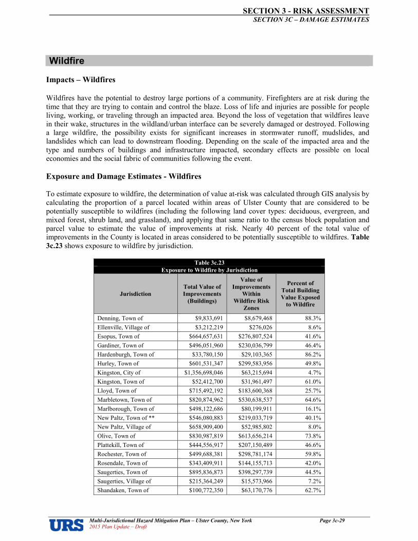
SECTION 3 RISK ASSESSMENT SECTION 3C – DAMAGE ESTIMATES
Multi�Jurisdictional Hazard Mitigation Plan – Ulster County, New York Page 3c�29 2015 Plan Update – Draft
Wildfire
Impacts – Wildfires
Wildfires have the potential to destroy large portions of a community. Firefighters are at risk during the time that they are trying to contain and control the blaze. Loss of life and injuries are possible for people living, working, or traveling through an impacted area. Beyond the loss of vegetation that wildfires leave in their wake, structures in the wildland/urban interface can be severely damaged or destroyed. Following a large wildfire, the possibility exists for significant increases in stormwater runoff, mudslides, and landslides which can lead to downstream flooding. Depending on the scale of the impacted area and the type and numbers of buildings and infrastructure impacted, secondary effects are possible on local economies and the social fabric of communities following the event.
Exposure and Damage Estimates Wildfires
To estimate exposure to wildfire, the determination of value atrisk was calculated through GIS analysis by calculating the proportion of a parcel located within areas of Ulster County that are considered to be potentially susceptible to wildfires (including the following land cover types: deciduous, evergreen, and mixed forest, shrub land, and grassland), and applying that same ratio to the census block population and parcel value to estimate the value of improvements at risk. Nearly 40 percent of the total value of improvements in the County is located in areas considered to be potentially susceptible to wildfires. Table
3c.23 shows exposure to wildfire by jurisdiction.
Table 3c.23
Exposure to Wildfire by Jurisdiction
Jurisdiction
Total Value of
Improvements
(Buildings)
Value of
Improvements
Within
Wildfire Risk
Zones
Percent of
Total Building
Value Exposed
to Wildfire
Denning, Town of $9,833,691 $8,679,468 88.3%
Ellenville, Village of $3,212,219 $276,026 8.6%
Esopus, Town of $664,657,631 $276,807,524 41.6%
Gardiner, Town of $496,051,960 $230,036,799 46.4%
Hardenburgh, Town of $33,780,150 $29,103,365 86.2%
Hurley, Town of $601,531,347 $299,583,956 49.8%
Kingston, City of $1,356,698,046 $63,215,694 4.7%
Kingston, Town of $52,412,700 $31,961,497 61.0%
Lloyd, Town of $715,492,192 $183,600,368 25.7%
Marbletown, Town of $820,874,962 $530,638,537 64.6%
Marlborough, Town of $498,122,686 $80,199,911 16.1%
New Paltz, Town of ** $546,080,883 $219,033,719 40.1%
New Paltz, Village of $658,909,400 $52,985,802 8.0%
Olive, Town of $830,987,819 $613,656,214 73.8%
Plattekill, Town of $444,556,917 $207,150,489 46.6%
Rochester, Town of $499,688,381 $298,781,174 59.8%
Rosendale, Town of $343,409,911 $144,155,713 42.0%
Saugerties, Town of $895,836,873 $398,297,739 44.5%
Saugerties, Village of $215,364,249 $15,573,966 7.2%
Shandaken, Town of $100,772,350 $63,170,776 62.7%

SECTION 3 RISK ASSESSMENT SECTION 3C – DAMAGE ESTIMATES
Multi�Jurisdictional Hazard Mitigation Plan – Ulster County, New York Page 3c�30 2015 Plan Update – Draft
Table 3c.23
Exposure to Wildfire by Jurisdiction
Jurisdiction
Total Value of
Improvements
(Buildings)
Value of
Improvements
Within
Wildfire Risk
Zones
Percent of
Total Building
Value Exposed
to Wildfire
Shawangunk, Town of $170,465,425 $63,856,816 37.5%
Ulster, Town of $847,716,567 $148,445,522 17.5%
Wawarsing, Town of $13,835,638 $9,593,001 69.3%
Woodstock, Town of $971,926,625 $676,607,139 69.6%
Total: $11,792,218,622 $4,645,411,214 39.4%
Given the lack of detailed historical loss data on significant wildfire occurrences resulting in largescale structural losses in Ulster County, it is assumed that while one major event may result in significant losses, annualizing structural losses over a long period of time would most likely yield a negligible annualized loss estimate in each jurisdiction exposed to this hazard.
Conclusions on Hazard Risk
The results of this vulnerability assessment are useful in at least three ways:
• Improving our understanding of the risk associated with the natural hazards in Ulster County through better understanding of the complexities and dynamics of risk, how levels of risk can be measured and compared, and the myriad of factors that influence risk. An understanding of these relationships is critical in making balanced and informed decisions on managing the risk.
• Providing a baseline for policy development and comparison of mitigation alternatives. The data used for this analysis presents a current picture of risk in Ulster County. Updating this risk “snapshot” with future data will enable comparison of the changes in risk with time. Baselines of this type can support the objective analysis of policy and program options for risk reduction in the region.
• Comparing the risk among the natural hazards addressed. The ability to quantify the risk to all these hazards relative to one another helps in a balanced, multihazard approach to risk management at each level of governing authority. This ranking provides a systematic framework to compare and prioritize the very disparate natural hazards that are present in Ulster County. This final step in the risk assessment provides the necessary information for local officials to craft a mitigation strategy to focus resources on only those hazards that pose the most threat to the county.
Using the previously described methodology, economic results were estimated for the different hazards profiled earlier in this section. The economic loss results are summarized in Table 3c.24 using Annualized Loss (AL), which is the estimated longterm value of losses to the general building stock in any single year in a specified geographic area (i.e., jurisdiction). The estimated AL addresses the two key components of risk: the probability of the hazard occurring in the jurisdiction and the consequences of the hazard, largely a function of building construction type and quality, and of the intensity of the hazard event. By annualizing estimated losses, the AL factors in historic patterns of frequent smaller events with infrequent but larger events to provide a balanced presentation of the risk.

SECTION 3 RISK ASSESSMENT SECTION 3C – DAMAGE ESTIMATES
Multi�Jurisdictional Hazard Mitigation Plan – Ulster County, New York Page 3c�31 2015 Plan Update – Draft
*Potential Crop Losses Only; Data allowed for estimate of a county5wide total but not a jurisdiction specific estimate. Communities with USDA reported 0 acres in agriculture were assigned $0 average annual crop losses for planning purposes. UN = Unquantifiable presumably negligible (< $5,000 annual average damage). US = Unquantifiable potentially significant (>$5,000 annual average damage
Table 3c.24
Annualized Building Losses by Hazard by Jurisdiction
Jurisdiction
Atmospheric Hydrologic Geologic Other
Ex
trem
e
Tem
pera
tures
Ex
trem
e
Win
d
Hu
rric
an
e &
Tro
pic
al
Sto
rm
Lig
htn
ing
No
r'e
ast
er
Torn
ad
o
Win
ter
Sto
rm
Da
m F
ail
ure
Dro
ug
ht*
(Cro
p L
oss
es O
nly
)
Flo
od
Ice J
am
Su
rg
e
Earth
qu
ak
e
La
nd
slid
e
Wil
dfi
re
Denning, Town of UN $118 US $29 US $65 $977 $0 $128 $2,570 UN $0 $408 UN UN
Ellenville, Village of UN $39 US $9 US $21 $319 UN $64 $712 UN $0 $133 $0 UN Esopus, Town of UN $7,981 US $1,940 US $4,403 $66,037 UN $767 $43,030 $0 $0 $27,562 UN UN Gardiner, Town of UN $5,956 US $1,448 US $3,286 $49,285 $0 $3,133 $65,756 US US $20,570 $0 UN Hardenburgh, Town of UN $406 US $99 US $224 $3,356 $0 $128 $4,398 $0 $0 $1,401 UN UN Hurley, Town of UN $7,223 US $1,756 US $3,985 $59,765 UN $2,302 $44,743 $0 $0 $24,944 $0 UN Kingston, City of UN $16,290 US $3,960 US $8,988 $134,795 UN $192 $190,779 UN $0 $56,260 UN UN Kingston, Town of UN $629 US $153 US $347 $5,207 UN $192 $12,873 $0 US $2,173 $0 UN Lloyd, Town of UN $8,591 US $2,088 US $4,740 $71,088 $0 $2,366 $99,957 $0 $0 $29,670 UN UN Marbletown, Town of UN $9,856 US $2,396 US $5,438 $81,558 UN $7,672 $70,107 $0 US $34,040 $0 UN Marlborough, Town of UN $5,981 US $1,454 US $3,300 $49,491 $0 $9,270 $5,260 $0 $0 $20,656 UN UN New Paltz, Town of ** UN $6,557 US $1,594 US $3,618 $54,256 $0 $3,836 $56,928 UN US $22,645 UN UN New Paltz, Village of UN $7,912 US $1,923 US $4,365 $65,466 $0 $128 $22,219 $0 $0 $27,324 $0 UN Olive, Town of UN $9,978 US $2,426 US $5,505 $82,563 UN $448 $135,311 $0 $0 $34,459 UN UN Plattekill, Town of UN $5,338 US $1,298 US $2,945 $44,169 $0 $4,028 $0 $0 $0 $18,435 $0 UN Rochester, Town of UN $6,000 US $1,459 US $3,311 $49,647 UN $9,590 $50,792 $0 $0 $20,721 UN UN Rosendale, Town of UN $4,123 US $1,002 US $2,275 $34,119 UN $959 $39,408 US $0 $14,241 $0 UN Saugerties, Town of UN $10,756 US $2,615 US $5,935 $89,006 UN $4,156 $80,273 $0 $0 $37,149 UN UN Saugerties, Village of UN $2,586 US $629 US $1,427 $21,398 UN $0 $20,848 $0 US $8,931 UN UN Shandaken, Town of UN $1,210 US $294 US $668 $10,012 $0 $192 $49,581 UN US $4,179 UN UN Shawangunk, Town of UN $2,047 US $498 US $1,129 $16,937 $0 $7,480 $19,435 UN $0 $7,069 $0 UN Ulster, Town of UN $10,179 US $2,474 US $5,616 $84,225 UN $2,621 $117,692 $0 $0 $35,153 UN UN Wawarsing, Town of UN $166 US $40 US $92 $1,375 UN $3,772 $2,358 $0 US $574 UN UN Woodstock, Town of UN $11,670 US $2,837 US $6,439 $96,566 UN $511 $137,127 $0 $0 $40,304 UN UN
Total US $141,591 US $34,421 US $78,125 $1,171,616 US $63,933 $1,272,158 US US $489,000 US US

SECTION 3d � RISK ASSESSMENT: LAND USES AND DEVELOPMENT TRENDS
Multi�Jurisdictional Natural Hazard Mitigation Plan – Ulster County, New York 2015 Plan Update � Draft
3d�1
SECTION 3d � RISK ASSESSMENT: EXISTING LAND USES AND
FUTURE DEVELOPMENT TRENDS IN HAZARD AREAS
Section Overview
Ulster County has a total land area of 1,124 square miles1, much of which has already been developed.
However, a large amount of land remains undeveloped. Future development may affect hazard
vulnerability. This section will provide information for communities to better understand the potential
implications of future growth and development with regard to hazard vulnerability, and how community
resiliency can be increased by integrating hazard mitigation practices and principles in local decision
making processes regulating land use and new development.
The Ulster County Planning Department is responsible for managing the County’s Comprehensive Plan
Document. The department has accomplished this task through the adoption of individual Housing,
Transportation, and Open Space Plans. The Ulster County Greenway Compact, currently in progress, will
be a unifying document to connect each of these individual planning efforts.
Per General Municipal Law and the Ulster County Compact, the Ulster County Planning Board (UCPB)
and its staff is responsible for reviewing municipal plans, law amendments, site plans and special permits,
and area and use variances as it relates to having a countywide impact. The UCPB offers constructive
criticism and technical advice to help communities achieve their long term planning goals as its response
to these referred actions. The Department offers a Land Use Referral Guide and maintains a local land use
library to aide communities in the referral process.
Historic Context
While much of Ulster County’s lands are mountainous, many of its river valleys were occupied by Native
American tribes (i.e., the Esopus tribe of Lenape Indians, the Wappingers, and the Mohawk) who used the
land for farming. The Esopus occupied what is present5day Kingston at the time that Henry Hudson first
explored the Hudson River in 1609. Five years later, a trading post was established by the Dutch at this
location. Conflicts with the Native American populations ensued until the late 1600’s, with settlements
being established and subsequently broken up several times at various locations. In September 1664, a
treaty was signed establishing the boundaries of Native lands and requiring that these lands could not be
taken without payment and mutual agreement. Over the next two decades, Esopus lands were bought up
by the settlers, who generally clustered in the County’s broad river valleys of the Rondout, Esopus and
Walkill which provided access and transportation of goods.
Ulster County was formally established in 1683. Thereafter, early settlers used the land for trading,
farming and agriculture. In 1777, the capital of New York State was established in Kingston. Before the
turn of the century, the County was largely an agrarian society.
Dairy farms and the growing of grain crops were the main types of farming of the 1800’s and early
1900’s. Over the course of the 1800’s, the County’s streams provided advantageous mill power. The
Delaware and Hudson Canal, which linked Pennsylvania with the Hudson River at Rondout near
Kingston, was completed in 1825. The first sawmill was built in 1827. Valuable minerals were mined and
transported. By the late 1800’s, commerce 5 carried on by means of river and canal 5 was large and
1 As per Census 2010.

SECTION 3d � RISK ASSESSMENT: LAND USES AND DEVELOPMENT TRENDS
Multi�Jurisdictional Natural Hazard Mitigation Plan – Ulster County, New York 2015 Plan Update � Draft
3d�2
increasing. The County had become known for its cement manufacture and stone quarrying, sawmills,
gristmills, and tanneries; manufacture of glass, earthenware, iron, sole leather, and axes; agriculture in the
form of lands adapted to grazing, dairying, growing of spring grain, and fruit growing; brick manufactures
and stone trade; cement and lime factories; breweries; paper mills; growth of hemlock and hardwood. The
rapid growth of railroads in the late 1800’s quickly replaced the Delaware and Hudson Canal as the
primary means of transporting goods and services to and from Ulster County. By 1910, the canal was no
longer used. Trolley cars had come into vogue and soon thereafter the automobile, truck and refrigeration
services rapidly increased as means of transporting merchandise. By the 1930’s, passenger service had
practically ceased in the county; and by the late 1950’s, it became evident that the use of the railroads for
transport of goods and services had also begun to decline. Throughout the 1900’s, apple orchards and
grape vineyards increased in number and replaced many acres once tilled for farm crops. Large
corporations, such as IBM, brought thousands of people to the area in the latter half of the 20th Century,
when much of the Hudson River Valley was known as “Tech Valley”, thereby creating new centers of
increased population, and need for more schools and housing. Over time, however, many of these large
corporations closed their doors and/or relocated to other areas, leaving lasting impacts on the local
economy to this day.
The influx of people, structures, and infrastructure over time has exposed more assets to the effects of
natural hazards. For example, early development in the County tended to be in floodplains, as those areas
provided access to fresh water, fertile land for farming, easy access to transportation (boat, and also rail
and canal systems which often paralleled major rivers), and flat land for construction. Over time, these
early settlements expanded into many of the communities that make up Ulster County today. We now
know, however, the tremendous cost and economic burden associated with buildings and infrastructure
located in the floodplain. Some of Ulster County’s worst natural disasters have been due to flooding, and
its impacts on the people and property in the region’s many floodplain areas. Today, all of Ulster
County’s communities participate in FEMA’s National Flood Insurance Program, and have adopted
floodplain management ordinances to regulate new construction and substantial improvements in
floodplain areas to offer protection during a 1005year event. Another example involves the County’s
many steep slopes. While historic development tended to steer away from Ulster County’s steep slopes in
favor of relatively easy construction on flat lands in the valleys, there is a certain demand today for
development on hillsides that offer views of the County’s scenic mountains and valleys. This increases
landslide risk as well as wildfire risk. Some communities have adopted steep slope ordinances, for
example, to regulate development and mitigate this risk. As Ulster County continues to grow, it will face
ongoing challenges of expanding in a manner that balances a need for fostering economic growth while
doing so in a manner that mitigates risk and strives toward community resiliency.
Land Use
Figure 3d.1 presents a graphical depiction of updated land use in Ulster County. More than half the
County land area is forested, with only a little under 7 percent of the County classified as developed.
While cultivated land and other farmland accounts for less than 10 percent of the County’s land area,
agriculture/farming is locally considered to be of paramount importance to the economy and the character
of the County.
Ulster County has a long history of open space protection. Our Shawangunk Ridge and “forever wild”
Catskill Forest Preserve are two of the most significant open spaces in the Hudson Valley. Each
community in the county has valuable open space resources. Abundant and critical water resources, rich
biodiversity, renowned recreational and historic sites, and valuable, productive agricultural lands are all
part of Ulster County’s open space landscape. These contribute to the well5being of the region’s

SECTION 3d � RISK ASSESSMENT: LAND USES AND DEVELOPMENT TRENDS
Multi�Jurisdictional Natural Hazard Mitigation Plan – Ulster County, New York 2015 Plan Update � Draft
3d�3
environment, economy and quality of life. The Ulster County Open Space Plan is the result of input from
stakeholder groups throughout the County. It is founded on an understanding of sound resource
management and planning policies that reflect the needs and values of the people, places, and existing
natural resources of the County. It was brought to fruition through the joint efforts of the Environmental
Management Council and the County Planning Board.
Notable areas of designated open space include:
• Catskill Forest Preserve with 160,000 acres
• Minnewaska State Park with 12,000 acres
• Mohonk Preserve with more than 6,500 acres
• Two County parks (one with over 3,000 feet of Hudson River Frontage and one with 150 acres)
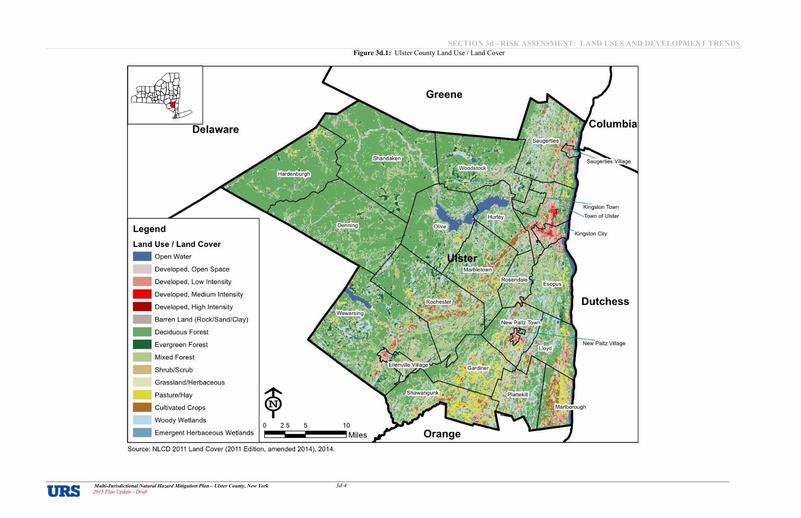
SECTION 3d � RISK ASSESSMENT: LAND USES AND DEVELOPMENT TRENDS
Multi�Jurisdictional Natural Hazard Mitigation Plan – Ulster County, New York 2015 Plan Update � Draft
3d�4
Figure 3d.1: Ulster County Land Use / Land Cover
URS
Legend
Land Use I Land Cover _ Open Water
Developed, Open Space
_ Developed, Low Intensity
_ Developed, Medium Intensity
_ Developed, High Intensity
_ Barren Land (Rock/Sand/Clay)
_ Deciduous Forest
_ Evergreen Forest
_ Mixed Forest
_ Shrub/Scrub
Grassland/Herbaceous
Pasture/Hay
_ Cultivated Crops
Woody Wetlands
_ Emergent Herbaceous Weltands o 2.5 5
Source: NLCD 2011 Land Cover (2011 Edition, amended 2014), 2014.
10
Miles
Greene
Orange
, ' :::: ':: Town ..... of Ulster
Dutchess

SECTION 3d � RISK ASSESSMENT: LAND USES AND DEVELOPMENT TRENDS
Multi�Jurisdictional Natural Hazard Mitigation Plan – Ulster County, New York 2015 Plan Update � Draft
3d�5
Changes in Land Use
The initial 2009 HMP was prepared using National Land Cover Databased (NLCD) 2001 land cover data.
Best available data at the time of the plan update was NLCD 2011 land cover data. Table 3d.1 shows
changes in land use since the last version of the plan was prepared. Some changes observed in this plan
update are due, in large part, to having better imagery available that enabled their delineators to refine
polygon classifications and line placements to more accurately map the landscape. Other refinements have
included additional water categories (from previous wetland classifications) that have increased the
reported water area. These improvements do affect the acreage values of many categories previously
reported in the 2009 HMP (which used NLCD 2001 Use/Land Cover data). Despite the impact of various
base data adjustments to actual acreages, the percentages shown in the following table seems to affirm
general, local observations regarding changes in land use where local agricultural and forested areas
continue to be developed.
Table 3d.1
Ulster County Land Cover Estimates
Description of Land Use Percent of Land Use,
2009 HMP*
Percent of Land Use,
2015 HMP Update
Change in Land Use ,
Acres, year to 2011
Open Water 2.7% 2.8% 480
Developed, Open Space 4.8% 4.7% 5445
Developed, Low Intensity 1.2% 1.4% 1,511
Developed, Medium Intensity 0.4% 0.6% 914
Developed, High Intensity 0.2% 0.2% 306
Barren Land (Rock/Sand/Clay) 0.2% 0.2% 227
Deciduous Forest 50.4% 53.9% 26,235
Evergreen Forest 5.2% 6.0% 6,115
Mixed Forest 15.9% 14.7% 59,269
Shrub/Scrub 0.2% 0.6% 2,887
Grassland/Herbaceous 0.4% 0.2% 51,292
Pasture/Hay 4.4% 4.5% 604
Cultivated Crops 4.1% 3.3% 55,976
Woody Wetlands 9.7% 6.6% 522,913
Emergent Herbaceous Wetlands 0.1% 0.3% 1,047
* NLCD 2001 Land Cover Data
** NLCD 2011 Land Cover Data
Changes in Population
As population increases, more residential and commercial buildings, infrastructure, public facilities and
other assets will be constructed to support such growth, likely increasing a jurisdiction’s overall exposure
to natural hazards. Therefore, population growth is considered a general indicator of potential future
hazard vulnerability.
Best readily available population data at the time the last version of this Plan was prepared was Census
2000. At that time the estimated County population was 177,749. For the plan update, Census 2010
estimated the population of the County at 182,493 – roughly a 2.7 percent increase over the year 2000 data
that was reported in the last version of this Plan. Population changes are documented in Table 3d.2. A

SECTION 3d � RISK ASSESSMENT: LAND USES AND DEVELOPMENT TRENDS
Multi�Jurisdictional Natural Hazard Mitigation Plan – Ulster County, New York 2015 Plan Update � Draft
3d�6
general trend of slightly increasing population in the near term is expected to continue, with the County’s
Transportation Plan projecting a population of 214,999 by the year 2020. Looking further out, the Cornell
Program on Applied Demographics estimates that Ulster County’s population will decrease, with a
population projection of 178,028 by the year 2030 and 170,141 by the year 2040. Population growth is
therefore not expected to have tremendous impacts on land use in Ulster County in the near future.
Table 3d.2
Change in Population Since the Last Version of the Plan was Prepared
Jurisdiction Population
2000*
Population
2010**
Change Since
Population Reported
in Last Version of Plan
(2000 to 2010)
Ulster, County of 177,749 182,493 4,744
Denning, Town of 516 551 35
Ellenville, Village of 4,130 4,135 5
Esopus, Town of 9,331 9,041 5290
Gardiner, Town of 5,238 5,713 475
Hardenburgh, Town of 208 238 30
Hurley, Town of 6,564 6,314 5250
Kingston, City of 23,456 23,893 437
Kingston, Town of 908 889 519
Lloyd, Town of 9,941 10,863 922
Marbletown, Town of 5,854 5,607 5247
Marlborough, Town of 8,263 8,808 545
New Paltz, Town of 12,830 7,185 55,645
New Paltz, Village of 6,034 6,818 784
Olive, Town of 4,579 4,419 5160
Plattekill, Town of 9,892 10,499 607
Rochester, Town of 7,018 7,313 295
Rosendale, Town of 6,352 6,075 5277
Saugerties, Town of 19,868 15,511 54,357
Saugerties, Village of 4,995 3,971 51,024
Shandaken, Town of 3,235 3,085 5150
Shawangunk, Town of 12,022 14,332 2,310
Ulster, Town of 12,544 12,327 5217
Wawarsing, Town of 12,889 9,022 53,867
Woodstock, Town of 6,241 5,884 5357
* Census 2000
** Census 2010
Based on historic population trends and projections, Ulster County’s overall population growth represents
an overall county5wide increase in exposure and potential vulnerability of people to natural hazards –
particularly during periods when the County’s population swells with visitors. While population declines
were observed in 13 jurisdictions (ranging from a low of 519 persons in the Town of Kingston to a high of
55,645 persons in the Town of New Paltz); population increases were observed in the balance of
jurisdictions (ranging from a low of 5 persons in the Village of Ellenville to a high of 2,310 persons in the
Town of Shawangunk).

SECTION 3d � RISK ASSESSMENT: LAND USES AND DEVELOPMENT TRENDS
Multi�Jurisdictional Natural Hazard Mitigation Plan – Ulster County, New York 2015 Plan Update � Draft
3d�7
Changes in Residential Construction
Another general indicator of development since the last version of this Plan was prepared is the quantity of
new, privately owned residential housing units that were authorized to be built in that time period. The US
Census Building Permits Survey was queried for Ulster County, with results shown in Table 3d.3. Given
the state of the economy, only 763 residential construction permits were approved from the years 2010
through 2014. Roughly 92 percent were single family units and about eight percent were multi5family
units. While overall exposure is increased with more units present, it is not likely that overall vulnerability
has increased to the same degree because development in hazard areas would have been built to codes and
standards that would offer better protection from hazard events.
Table 3d.3
Annual New Privately�Owned Residential Building Permits2
Jurisdiction 2000 2005 2010 2011 2012 2013 2014
Residential
Construction
in the Last
Five Years
(2010�2014)
Ulster County 474 790 168 143 152 136 164 763
single family 463 767 154 125 140 133 151 703
single family % of total 97.7% 97.1% 91.7% 87.4% 92.1% 97.8% 92.1
% 92.1%
multi5family 11 23 14 18 12 3 13 60
multi�family % of total 2.3% 2.9% 8.3% 12.6% 7.9% 2.2% 7.9% 7.9%
Protected Open Space
As stated in the Ulster County Open Space Plan (2007), Ulster County has a long history of open space
preservation. The environmental conservation movement has its roots here. With the “forever wild”
Catskill Forest Preserve and Minnewaska State Park, Ulster County has two of the most significant open
spaces in the region. In addition, each community in the county has valuable open space resources.
Abundant and critical water resources, rich biodiversity, renowned recreational and historic sites, and
valuable, productive agricultural lands are all part of Ulster County’s open space landscape. These
contribute to the well5being of the region’s environment, economy and quality of life. However, these
resources are still at risk. Much is already protected, but current development activity and existing
regulatory controls foster a pattern of intrusion into our open spaces. Limited availability of water and
sewer infrastructure is also a barrier in preventing a more compact land use pattern. These issues have
become increasingly important as development proposals continue to accelerate in Ulster County. The
County Open Space Plan proposes a pro5active regional approach – one that embraces scientific, legal,
financial, and participatory tools to determine where and how growth is undertaken. Overwhelming
evidence points to the benefits of preserving open space and growing “smart.” Communities that plan
ahead to protect open spaces, preserve their natural resources while creating a vision for accommodating
sustainable and compact development are likeliest to succeed economically.
Furthermore, the identification and acquisition of land to be maintained as protected open space presents a
significant opportunity for jurisdictions to minimize future hazard exposures and vulnerability.
2 Source: US Census Building Permits Survey, online at http://censtats.census.gov/cgi5bin/bldgprmt/bldgdisp.pl

SECTION 3d � RISK ASSESSMENT: LAND USES AND DEVELOPMENT TRENDS
Multi�Jurisdictional Natural Hazard Mitigation Plan – Ulster County, New York 2015 Plan Update � Draft
3d�8
In addition to County, State and Federal protected open spaces, municipal jurisdictions in Ulster County
also safeguard open space through their own local preservation measures (municipal land reserved for
open space plus preserved farmland). Though often done for conservation, recreation or other community
purposes, protecting lands located in identified natural hazard zones can help jurisdictions meet
complementary hazard mitigation objectives and can qualify the communities for additional points under
the Community Rating System (CRS). It is often found that those natural areas deemed targets for open
space protection are often also identified as potential hazard zones (i.e., environmentally5sensitive lands
such as wetlands, floodplains, etc.). Approximately 32 percent of the County is protected open space.
Significant areas of designated protected open space3are shown in Table 3d.4 and Figure 3d.2.
Table 3d.4
Preserved Open Space in Ulster County
Open Space Classification Approximate Acres Percent of Total
Land Area
Ulster, County of 236,499 32%
Denning, Town of 43,487 67%
Ellenville, Village of 147 12%
Esopus, Town of 1,444 5%
Gardiner, Town of 3,184 11%
Hardenburgh, Town of 27,918 55%
Hurley, Town of 6,837 30%
Kingston, City of 381 7%
Kingston, Town of 1,764 37%
Lloyd, Town of 851 4%
Marbletown, Town of 3163 9%
Marlborough, Town of 299 2%
New Paltz, Town of 2,299 11%
New Paltz, Village of 57 5%
Olive, Town of 17830 42%
Plattekill, Town of 348 2%
Rochester, Town of 16,296 29%
Rosendale, Town of 1,413 11%
Saugerties, Town of 2,307 6%
Saugerties, Village of 118 8%
Shandaken, Town of 55,739 70%
Shawangunk, Town of 1,544 4%
Ulster, Town of 504 3%
Wawarsing, Town of 26,558 31%
Woodstock, Town of 12,803 29%
SOURCE: Ulster County Open Space Plan, 2007
3 Ulster County Office of GIS, Preserved Open Space, 2008

SECTION 3d � RISK ASSESSMENT: LAND USES AND DEVELOPMENT TRENDS
Multi�Jurisdictional Natural Hazard Mitigation Plan – Ulster County, New York 2015 Plan Update � Draft
3d�9
Figure 3d.2 – Ulster County, New York Protected Open Space
Land Use Planning in Ulster County
Incorporated municipal governments in New York State have been granted broad “home rule” powers
enabling them to provide services to their residents and to regulate the quality of life within their
jurisdictions. The New York State Constitution establishes these rights and responsibilities under Articles
VIII (titled "Local Finances") and IX (titled "Local Government", but commonly referred to as the "Home
Rule" article). Democratically elected legislative bodies at the municipal level are granted the power to
enact local laws as needed in order to provide services to their citizens and fulfill their various obligations.
Under this home rule system, in New York State, traditional planning authority is granted to municipal
government, including the regulation of land use through zoning and land subdivision.
• The Ulster County Planning Department serves a coordination function for those elements that are
best served on a regional level, reviewing and commenting on many local land use decisions. The
authority to approve or disapprove proposals, however, rests in the hands of the local
municipalities. The Ulster County Planning Department is responsible for managing the County’s
Comprehensive Plan Document. The department has accomplished this task through the adoption
of individual Housing, Transportation, and Open Space Plans. The Ulster County Greenway
Compact, currently in progress, will be a unifying document to connect each of these individual

SECTION 3d � RISK ASSESSMENT: LAND USES AND DEVELOPMENT TRENDS
Multi�Jurisdictional Natural Hazard Mitigation Plan – Ulster County, New York 2015 Plan Update � Draft
3d�10
planning efforts. The County has completed or is working on an economic development strategy, a
housing strategy, an open space plan, a stormwater management program and a long range
transportation plan.
• The Ulster County Planning Board is responsible for the review of local site plans, special permits,
variances, comprehensive plans and zoning amendments (however, a local town planning board
may take action contrary to the recommendations made by the County Planning Board by a
majority plus one vote).
Influences on Future Development in Ulster County
Ulster County’s economy and population continue to grow. Future development in Ulster County is
influenced by:
• Ulster County Comprehensive Plan. The department has accomplished this task through the
adoption of individual documents, as follows:
o Ulster Tomorrow, A Sustainable Economic Development Plan for Ulster County (2007).
This plan is the collaborative effort of Ulster County, UCDC, and the Ulster County IDA.
This strategic planning effort is designed to help the County's delivery of economic
development services, coordinate the various activities of the system, and provide focus to
the economic development efforts across our large and geographically diverse county.
o Ulster County Open Space Plan (2007). The plan recommends a strategic approach to
open space resource management in Ulster County. It represents pro5active regional
approach – one that embraces scientific, legal, financial, and participatory tools to
determine where and how we grow. Overwhelming evidence points to the benefits of
preserving open space and growing “smart.” Communities that plan ahead to protect open
spaces, preserve their natural resources while creating a vision for accommodating
sustainable and compact development are likeliest to succeed economically.
o Long Range Transportation Plan (LTRP), Year 2035 (2010).The most recent update of
the Ulster County Long Range Transportation Plan was completed in August 2010. The
process entails a comprehensive evaluation of transportation needs across most modes of
travel and includes an extensive public outreach effort. The study effort involved an
update to the current status of the transportation system in Ulster County, identified future
needs and strategies, outlined financing options and incorporated the desires of the public.
Outcomes of the long range transportation planning process include the identification of
policy, project, financial and evaluation strategies and priorities. Emphasis of the Year
2035 LRTP Update included improved integration of multimodal transportation systems,
safety, congestion management, and maintenance of both the highway and public transit
systems. Quality5of5life issues and non5motorized modes of transportation were given
increased attention as a part of the update process.
o Housing Strategies Plan (2005). This study examines the trends in the County's housing
costs, its economy and the relationship between these factors and household income5wage
growth as it relates to affordability. The study found that despite signs of a turnaround in
the County's economic fortunes, the ability to afford housing in nearly all communities has
not kept pace with its rising costs. It also found that the gap between income and soaring
housing prices has gotten dramatically worse in the last seven to eight years. As a result,
SECTION 3d � RISK ASSESSMENT: LAND USES AND DEVELOPMENT TRENDS
Multi�Jurisdictional Natural Hazard Mitigation Plan – Ulster County, New York 2015 Plan Update � Draft
3d�11
many residents are finding it harder and harder to obtain decent housing without paying an
uncomfortably high and increasingly larger percentage of their earnings5income. This is
true whether the housing choice involves homeownership or rental.
o Greenway Compact (currently in progress).The Greenway planning approach is one of
thinking regionally as communities plan locally. It includes physical connections and
linkages between communities for local and regional benefit. Additionally, it extends
beyond physical linkages to encourage voluntary regional cooperation among the
communities and counties of the Hudson River Valley to address issues of collective
concern and promote mutually beneficial regional approaches. The Greenway Compact
program provides a process for voluntary regional cooperation to further the Greenway
criteria of natural and cultural resource protection, regional planning, economic
development, public access, and heritage and environmental education. For communities
that choose to participate, a variety of financial and procedural benefits are available. The
Greenway has designated the counties as the basic planning areas for the development of
the Greenway Compact, although sub5county associations of local governments may also
be able to prepare a regional planning compact.
Each Compact area will develop a regional planning compact that addresses the
Greenway's five criteria:
1. Natural and Cultural Resource Protection. Protect, preserve and enhance natural
resources including natural communities, open spaces and scenic areas as well as
cultural resources including historic places and scenic roads.
2. Economic Development. Encourage economic development that is compatible
with the preservation and enhancement of natural and cultural resources including
agriculture, tourism and the revitalization of established community centers and
waterfronts.
3. Public Access. Promote increased public access to the Hudson River through the
creation of riverside parks and the development of the Hudson River Valley
Greenway Trail System.
4. Regional Planning. Communities can work together to develop mutually
beneficial regional strategies for natural and cultural resource protection,
economic development (including necessary public facilities and infrastructure),
public access and heritage and environmental education
5. Heritage and Environmental Education. Promote awareness among residents and
visitors about the Valley's natural, cultural, scenic and historic resources
Each Compact area will also:
• Incorporate provisions to identify development of regional impact and areas of
regional concern and
• Identify necessary public facilities and infrastructure consistent with the
Greenway criteria.
The voluntary participation of municipalities in county Compacts preserves local decision5
making authority while providing expanded opportunities for regional cooperation. Public
and community participation in the development of county Greenway plans is critical to
their success. Greenway compacts reflect the concerns of local communities and provide a
regional context for local planning efforts.

SECTION 3d � RISK ASSESSMENT: LAND USES AND DEVELOPMENT TRENDS
Multi�Jurisdictional Natural Hazard Mitigation Plan – Ulster County, New York 2015 Plan Update � Draft
3d�12
• Municipal Regulatory Tools. Municipalities have various regulatory tools at their disposal to
influence land uses and development trends over time. As part of the initial hazard mitigation plan
development process, participating jurisdictions were asked to complete a questionnaire in order to
provide information regarding land use regulatory capabilities in each municipality. As part of the
2015 hazard mitigation plan update process, participating jurisdictions were asked to review and
provide updates to the land use regulatory capabilities they reported when the last version of the
plan was prepared. Based on information provided by the municipalities as part of the first plan
update, administration and enforcement of the New York State Uniform Fire Prevention and
Building Code (Uniform Code) occurs at the local level with all participating municipalities
reporting local administration. One hundred percent of participating municipalities reported having
local zoning statutes; 95 percent of participating municipalities reported having local subdivision
statutes; and 90 percent of participating municipalities reported having local comprehensive plans
in place. New York State is a Home Rule State and therefore the County does not have its own
building, zoning, or subdivision statues. Details are shown in Table 3d.5 (further information on
these and other regulatory tools are discussed in Section 4).
Table 3d.5
Communities with Land Use Regulations (Source: Capability Assessment Questionnaire responses)
Community Building Statutes Zoning Code Subdivision Statutes Comprehensive Plans
Ulster, County of Not applicable Not applicable Not applicable ■
Denning, Town of ■ ■ ■ ■
Ellenville, Village of ■ ■ ■ ■
Esopus, Town of Did not participate
Gardiner, Town of ■ ■ ■ ■
Hardenburgh, Town of ■ ■ ■ ■
Hurley, Town of ■ ■ ■ ■
Kingston, City of ■ ■ ■ ■
Kingston, Town of ■ ■ ■
Lloyd, Town of ■ ■ ■ ■
Marbletown, Town of Did not participate
Marlborough, Town of ■ ■ ■ ■
New Paltz, Town of ■ ■ ■ ■
New Paltz, Village of ■ ■ ■ ■
Olive, Town of ■ ■ ■
Plattekill, Town of ■ ■ ■ ■
Rochester, Town of Did not participate
Rosendale, Town of ■ ■ ■ ■
Saugerties, Town of ■ ■ ■
Saugerties, Village of ■ ■ ■ ■
Shandaken, Town of ■ ■ ■ ■
Shawangunk, Town of ■ ■ ■ ■
Ulster, Town of ■ ■ ■ ■
Wawarsing, Town of ■ ■ ■ ■
Woodstock, Town of ■ ■ ■ ■
At both the County and municipal levels, land use and development planners in departments, federations,
boards and councils are active in guiding Ulster County’s growth and work toward providing a unified
framework for development that coordinates activities between municipalities and the County overall.

SECTION 3d � RISK ASSESSMENT: LAND USES AND DEVELOPMENT TRENDS
Multi�Jurisdictional Natural Hazard Mitigation Plan – Ulster County, New York 2015 Plan Update � Draft
3d�13
Development Trends
Ulster County is located about 70 miles north of New York City and 45 miles south of Albany, making it a
unique area that residents from New York City can go to escape the costs, pressures and densities of life in
a major metropolitan area. It also makes the County an excellent place for businesses to be located that
serve the State of New York’s two most important cities.
It is likely that, in the future, Ulster County will continue to balance the pressures of supporting its
agricultural communities while fostering the development of new industries. Population is expected to
remain about the same through 2030. A sharp increase in the proportion of the populace aged 65 years and
older could spawn various types of age5restricted housing. The County’s location between the Hudson
River and the Catskill Mountains ensures that development cannot get too intense, especially since the
County, the State, the local jurisdictions and private organizations have done an excellent job of ensuring
that much of the County will remain in pubic open space. Ulster County continues to work with many
stakeholders in communities throughout the county beginning the process of planning, funding, and
implementing improvements on Main Streets, where funding is being leveraged with other investments in
our communities including transportation, housing, and infrastructure improvements.
Impact of Recent Severe Storms – Irene, Lee, and Sandy
Hurricane Irene (August 28, 2011), Tropical Storm Lee (September 7, 2011), and Superstorm Sandy
(October 29, 2012) hit Ulster County with full force. The torrential downpour caused water levels in the
Rondout Creek, Wallkill River, and Lower and Upper Esopus Creek to reach record heights causing
widespread flash flooding. Homes, businesses and infrastructure were destroyed, particularly in low5lying
areas. Countless roads were closed due to flood waters overtopping culverts; bridges were closed isolating
residents; and the force of the stormwater caused substantial infrastructure damage to water mains, sewage
treatment facilities, and water delivery systems throughout the region. Stream banks were overtopped and
severely eroded, flooding dozens of homes and depositing natural and man5made debris throughout the
stream corridors. Businesses were severely flooded, leaving residents without access to basic necessities
for weeks. Residents were forced to evacuate their homes, moving to shelters established in local
emergency service buildings, schools, and community centers. County5wide shelters were set up. The
physical damage to roads, bridges, homes, and other essential infrastructure resulted in short and long term
economic impacts that rippled throughout the County and the region. Irreparable losses to commodity
farms, power failures, and, in some cases, isolation from economic centers complicated and delayed
recovery efforts. Tourism, a major industry in this region, suffered greatly through both an overall loss of
revenue and lost wages due to postponed. Today, Ulster County municipalities are still recovering from the
damage caused by Superstorm Sandy, Hurricane Irene, and Tropical Storm Lee.
While some property acquisitions have occurred on a relatively small scale in certain locations, the
observed impact of this disaster on land uses and development trends is generally that communities have
tended toward building back damaged and destroyed structures in their previous locations to higher codes
and standards and in a manner that provides some level of hazard mitigation, as opposed to precluding new
development or substantial improvements in at5risk areas. This more disaster5resistant building stock,
along with the many hazard mitigation initiatives being undertaken (i.e., mitigation of roads, bridges,
culverts, drainage systems, etc.) has the effect of increasing the overall level of resilience, and decreasing
vulnerability for many such communities during future events of this nature.

SECTION 3d � RISK ASSESSMENT: LAND USES AND DEVELOPMENT TRENDS
Multi�Jurisdictional Natural Hazard Mitigation Plan – Ulster County, New York 2015 Plan Update � Draft
3d�14
Re�assessment of Local Land Uses and Development Trends
As part of the development of the initial plan in 2009, the Core Planning Group was asked to provide
responses to a Land Uses and Development Trends Worksheet for their individual jurisdictions. The
worksheet consisted of the following two questions:
1. Please describe development trends occurring within your jurisdiction, such as the predominant types
of development occurring, location, expected intensity, and pace by land use. While details are
preferred, it is ok if your feedback is qualitative and quite general, such as “high�occupancy, high�
density residential development is occurring near the waterfront”.
2. Does your jurisdiction enforce regulations/ordinances/codes to protect new development from the
effects of natural hazards? (Some examples might be floodplain management ordinances enforcing
FEMA’s NFIP for new development or substantial improvements in the floodplain; steep slope
ordinances for community’s which may have landslide hazards; earthquake resistant design criteria
and/or high wind design criteria; or buffer zones in wildfire hazard areas.) If so, please describe.
Responses were updated as part of the 2015 Plan Update, and are reported in Table 3d.6.4 Copies of each
jurisdiction’s response can be found in Jurisdictional Annexes of Appendix 1.1 (Worksheet 3).
4 As part of the 2015 Plan Update, municipalities were asked to review their prior responses (as submitted during the development of the initial
plan) and either (a) certify that they still hold true unchanged, or (b) identify any changes that have occurred since that time. Their responses have been incorporated into Table 3d.6.

SECTION 3d � RISK ASSESSMENT: LAND USES AND DEVELOPMENT TRENDS
Multi�Jurisdictional Natural Hazard Mitigation Plan – Ulster County, New York 2015 Plan Update � Draft
3d�15
Table 3d.6
Summary of Responses � Land Uses and Development Trends Worksheet (Source: Core Planning Group Members)
Community 1. Land Uses and Development Trends in Hazard Areas 2. Regulations/Codes/Ordinances To Protect New Development
From Natural Hazards
Ulster, County of
> Agriculture 5 Farming has a long, rich history in Ulster County
which is being threatened by residential development. Family farms
that have for generations been the predominant land use within
many communities are being replaced with housing developments.
Ulster County is working to preserve several agriculture districts in
the various fertile valleys of the County. Significant portions of the
floodplains of the Rondout and Esopus stream valleys are in
agriculture. Losses of both lands from erosion and crops occur
during heavy flooding.
> Industrial Development 5 Several areas of the County have been
identified as potential “shovel5ready” candidates. The areas that are
being touted as potential manufacturing/ industrial sites are the
Tech City complex in the Town of Ulster, the Saugerties Kings
Highway District and Kingston Business Park in the City of
Kingston. Other sites with water, sewer and roadways that can
support expanded business use including South Putt Corners Road
in New Paltz and Business Parks along Route 9w in Lloyd.
> Tourism Development – Several major resort developments are
moving toward approvals and likely to be constructed in the next
few years. These include Williams Lake Hotel in Rosendale, and
the Belleayre Resort in Shandaken. These resorts presents
challenges in design and implementation as they are located in
heavily wooded areas and some section of the resorts are on steep
slopes. Wildfires are of concern as are heavy thunderstorms that can
overload stormwater systems. These represent a trend to reach the
upscale market from New York Metro Area. Others, not located in
hazard areas are the Wine Village in Highland and Diamond Mills
in Saugerties and hotels in New Paltz and Ulster. Waterfront
development has occurred in Kingston however these use existing
historic buildings and recognize that flooding will occur.
> Housing5 The several large housing projects that are planned
(including those in Kingston and Gardiner) have avoided hazard
areas. The biggest trend that continues although abated is rural
housing development in wooded areas that increases the risk of
wildfires and access associated with flooded roads.
Most land use regulations/ ordinances are implemented at the local
level through local governing bodies and the planning and zoning
boards. Every municipality in the County participates in the
National Flood Insurance Protection Program. Flood mapping has
been updated in all municipalities with new topographic information
and detailed flood maps are available in the NYC Watershed towns.
Every municipality enforces the NYS Uniform Fire and Prevention
& Building Code. Communities are much more aware of risks
associated with flooding and have responded by restricting uses and
reducing density in flood prone areas. In addition, some
communities now restrict development in areas where access is
across a floodplain and cannot be elevated above it. Additionally,
seven towns have adopted steep slope ordinances for slopes greater
than 15 to 20 percent. Dangers associated with wildfires are
addressed during individual site reviews; however, few regulations
or guidelines are in place to assist local boards.
The Ulster County Planning Board is responsible for the review of
local site plans, special permits, variances, comprehensive plans and
zoning amendments. However, a local town planning board may
take action contrary to the recommendations made by the County
Planning Board by a majority plus one vote.

SECTION 3d � RISK ASSESSMENT: LAND USES AND DEVELOPMENT TRENDS
Multi�Jurisdictional Natural Hazard Mitigation Plan – Ulster County, New York 2015 Plan Update � Draft
3d�16
Table 3d.6
Summary of Responses � Land Uses and Development Trends Worksheet (Source: Core Planning Group Members)
Community 1. Land Uses and Development Trends in Hazard Areas 2. Regulations/Codes/Ordinances To Protect New Development
From Natural Hazards
Denning, Town of
The Town of Denning does not have any major construction going
on at the present time. The building that is being done is scattered
around the Town.
Denning enforces current regulations for development in the
floodplain. For other hazards such as wind and landslides, the Town
follows the New York State Building Code.
Ellenville, Village of
The Village of Ellenville upcoming development will experience a
strong growth when a proposed casino (The Nevele Resort, Casino,
and Spa) is built in the Town of Wawarsing but in close proximity
to the Village. The Village will be responsible for supplying water
and sewer services. With the casino creating new jobs and making
Ellenville a destination for many tourists and travelers, the Village
is also expecting growth within commercial and residential
developments.
The Village of Ellenville does enforce their codes pertaining to new
developments and discusses it in Chapter 109 – Flood Damage
Prevention. The code specifically states, “A floodplain development
permit is hereby established for all construction and other
development to be undertaken in areas of special flood hazard in this
community for the purpose of protecting its citizens from increased
flood hazards and insuring that new development is constructed in a
manner that minimizes its exposure to flooding. It shall be unlawful
to undertaken any development in an area of special flood hazard,
without a valid floodplain development permit. New construction
and substantial improvements to structures shall be construed with
materials and utility equipment resistant to flood damage. New
construction and substantial improvements to structures shall be
constructed using methods and practices that minimize flood
damage. New and replacement electrical equipment, heating,
ventilating, air conditioning, plumbing connections, and other
service equipment shall be located at least two feet above the base
flood elevation or be designed to prevent water from entering and
accumulating within the components during a flood and to resist
hydrostatic and hydrodynamic loads and stresses.” With this code,
the Village Building Inspector has the authority to approve or deny
any new floodplain development permits.
Esopus, Town of Did not participate
Gardiner, Town of
The predominant type of development occurring in the Town of
Gardiner is single family dwellings primarily located on individual
lots of two to five acres or in previously approved subdivisions with
lots of two to five acres. There has been very little new commercial
development, however several previously existing sites have been
improved upon. The Town has enacted Chapter 220 of the Town
Code as the Zoning Law and it contains several sections that pertain
to and limit development in fragile or sensitive areas. The Town
also has an active program to preserve open space and conserve
farm related properties.
Chapter 121 of the Gardiner Town Code, Flood Damage Protection,
addresses the issues of development in the floodplain, based on the
FEMA Flood Insurance Rate Map of 9/25/2009 and the “Flood
Insurance Study, Town of Gardiner, NY, Ulster County” dated
7/16/2007. The current Zoning Law, Chapter 220 of the Town Code,
contains the following sections that specifically address development
in potentially hazardous/fragile environments: 220513 creates a
Flood Plain Overlay District; 220516 creates the Shawangunk Ridge
Protection District; 220534 addresses Excavation, Grading and Clear
Cutting; 220535 regarding Wetlands and Water Course Protection;
and 220536 regarding Steep Slope Regulations.
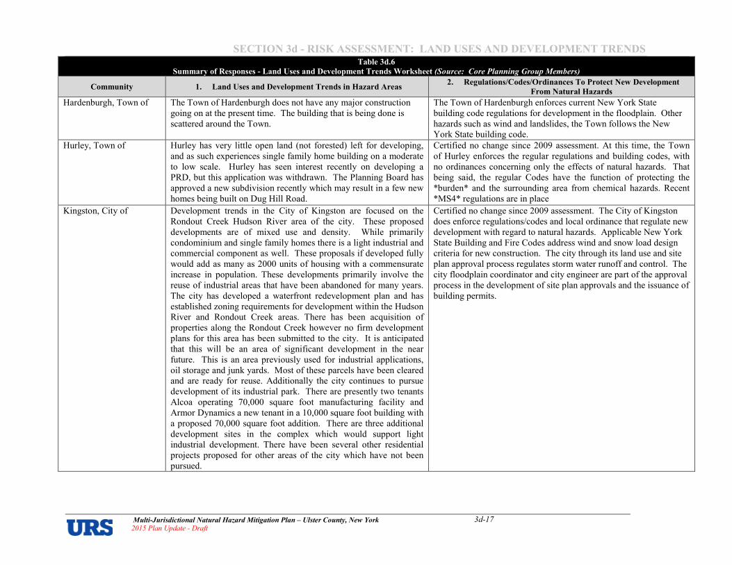
SECTION 3d � RISK ASSESSMENT: LAND USES AND DEVELOPMENT TRENDS
Multi�Jurisdictional Natural Hazard Mitigation Plan – Ulster County, New York 2015 Plan Update � Draft
3d�17
Table 3d.6
Summary of Responses � Land Uses and Development Trends Worksheet (Source: Core Planning Group Members)
Community 1. Land Uses and Development Trends in Hazard Areas 2. Regulations/Codes/Ordinances To Protect New Development
From Natural Hazards
Hardenburgh, Town of
The Town of Hardenburgh does not have any major construction
going on at the present time. The building that is being done is
scattered around the Town.
The Town of Hardenburgh enforces current New York State
building code regulations for development in the floodplain. Other
hazards such as wind and landslides, the Town follows the New
York State building code.
Hurley, Town of
Hurley has very little open land (not forested) left for developing,
and as such experiences single family home building on a moderate
to low scale. Hurley has seen interest recently on developing a
PRD, but this application was withdrawn. The Planning Board has
approved a new subdivision recently which may result in a few new
homes being built on Dug Hill Road.
Certified no change since 2009 assessment. At this time, the Town
of Hurley enforces the regular regulations and building codes, with
no ordinances concerning only the effects of natural hazards. That
being said, the regular Codes have the function of protecting the
*burden* and the surrounding area from chemical hazards. Recent
*MS4* regulations are in place
Kingston, City of
Development trends in the City of Kingston are focused on the
Rondout Creek Hudson River area of the city. These proposed
developments are of mixed use and density. While primarily
condominium and single family homes there is a light industrial and
commercial component as well. These proposals if developed fully
would add as many as 2000 units of housing with a commensurate
increase in population. These developments primarily involve the
reuse of industrial areas that have been abandoned for many years.
The city has developed a waterfront redevelopment plan and has
established zoning requirements for development within the Hudson
River and Rondout Creek areas. There has been acquisition of
properties along the Rondout Creek however no firm development
plans for this area has been submitted to the city. It is anticipated
that this will be an area of significant development in the near
future. This is an area previously used for industrial applications,
oil storage and junk yards. Most of these parcels have been cleared
and are ready for reuse. Additionally the city continues to pursue
development of its industrial park. There are presently two tenants
Alcoa operating 70,000 square foot manufacturing facility and
Armor Dynamics a new tenant in a 10,000 square foot building with
a proposed 70,000 square foot addition. There are three additional
development sites in the complex which would support light
industrial development. There have been several other residential
projects proposed for other areas of the city which have not been
pursued.
Certified no change since 2009 assessment. The City of Kingston
does enforce regulations/codes and local ordinance that regulate new
development with regard to natural hazards. Applicable New York
State Building and Fire Codes address wind and snow load design
criteria for new construction. The city through its land use and site
plan approval process regulates storm water runoff and control. The
city floodplain coordinator and city engineer are part of the approval
process in the development of site plan approvals and the issuance of
building permits.
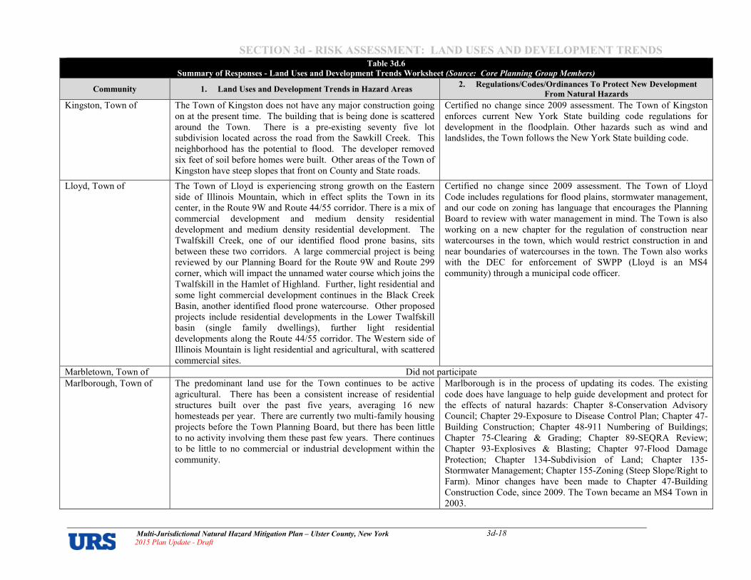
SECTION 3d � RISK ASSESSMENT: LAND USES AND DEVELOPMENT TRENDS
Multi�Jurisdictional Natural Hazard Mitigation Plan – Ulster County, New York 2015 Plan Update � Draft
3d�18
Table 3d.6
Summary of Responses � Land Uses and Development Trends Worksheet (Source: Core Planning Group Members)
Community 1. Land Uses and Development Trends in Hazard Areas 2. Regulations/Codes/Ordinances To Protect New Development
From Natural Hazards
Kingston, Town of
The Town of Kingston does not have any major construction going
on at the present time. The building that is being done is scattered
around the Town. There is a pre5existing seventy five lot
subdivision located across the road from the Sawkill Creek. This
neighborhood has the potential to flood. The developer removed
six feet of soil before homes were built. Other areas of the Town of
Kingston have steep slopes that front on County and State roads.
Certified no change since 2009 assessment. The Town of Kingston
enforces current New York State building code regulations for
development in the floodplain. Other hazards such as wind and
landslides, the Town follows the New York State building code.
Lloyd, Town of
The Town of Lloyd is experiencing strong growth on the Eastern
side of Illinois Mountain, which in effect splits the Town in its
center, in the Route 9W and Route 44/55 corridor. There is a mix of
commercial development and medium density residential
development and medium density residential development. The
Twalfskill Creek, one of our identified flood prone basins, sits
between these two corridors. A large commercial project is being
reviewed by our Planning Board for the Route 9W and Route 299
corner, which will impact the unnamed water course which joins the
Twalfskill in the Hamlet of Highland. Further, light residential and
some light commercial development continues in the Black Creek
Basin, another identified flood prone watercourse. Other proposed
projects include residential developments in the Lower Twalfskill
basin (single family dwellings), further light residential
developments along the Route 44/55 corridor. The Western side of
Illinois Mountain is light residential and agricultural, with scattered
commercial sites.
Certified no change since 2009 assessment. The Town of Lloyd
Code includes regulations for flood plains, stormwater management,
and our code on zoning has language that encourages the Planning
Board to review with water management in mind. The Town is also
working on a new chapter for the regulation of construction near
watercourses in the town, which would restrict construction in and
near boundaries of watercourses in the town. The Town also works
with the DEC for enforcement of SWPP (Lloyd is an MS4
community) through a municipal code officer.
Marbletown, Town of Did not participate
Marlborough, Town of
The predominant land use for the Town continues to be active
agricultural. There has been a consistent increase of residential
structures built over the past five years, averaging 16 new
homesteads per year. There are currently two multi5family housing
projects before the Town Planning Board, but there has been little
to no activity involving them these past few years. There continues
to be little to no commercial or industrial development within the
community.
Marlborough is in the process of updating its codes. The existing
code does have language to help guide development and protect for
the effects of natural hazards: Chapter 85Conservation Advisory
Council; Chapter 295Exposure to Disease Control Plan; Chapter 475
Building Construction; Chapter 485911 Numbering of Buildings;
Chapter 755Clearing & Grading; Chapter 895SEQRA Review;
Chapter 935Explosives & Blasting; Chapter 975Flood Damage
Protection; Chapter 1345Subdivision of Land; Chapter 1355
Stormwater Management; Chapter 1555Zoning (Steep Slope/Right to
Farm). Minor changes have been made to Chapter 475Building
Construction Code, since 2009. The Town became an MS4 Town in
2003.

SECTION 3d � RISK ASSESSMENT: LAND USES AND DEVELOPMENT TRENDS
Multi�Jurisdictional Natural Hazard Mitigation Plan – Ulster County, New York 2015 Plan Update � Draft
3d�19
Table 3d.6
Summary of Responses � Land Uses and Development Trends Worksheet (Source: Core Planning Group Members)
Community 1. Land Uses and Development Trends in Hazard Areas 2. Regulations/Codes/Ordinances To Protect New Development
From Natural Hazards
New Paltz, Town of
Development trends in the community over the past 40 years has
included robust commercial development in the 1970’s and 1980’s
along the edges of the Village of New Paltz with relatively small
scale residential development outward from the more densely
populated Village and into the primarily more rural portions of the
Town. Expansion of the SUNY New Paltz College has been the
focus of development of new dormitories and classroom facilities in
the past 10 years. Only a minor amount of new commercial or
residential development has taken place in the past five or more
years in response to the weak regional economy. Multi5family
housing has been limited primarily to the Village (although single
family conversions to student housing apartments has been common
place) with minimal apartment complexes or light industrial
developments occurring in the Town due to public water and sewer
service being offered only by Town water and sewer districts that
are located primarily near the perimeter of the Village. In the past
few years, a larger senior citizen community (Woodland Pond) was
developed at the edge of the Village boundaries and commercial
redevelopment has occurred in the Town’s commercial district.
Minor light industrial development has occurred and there are
present development plan applications for student housing, a hotel,
minor chain retail and a major hotel/waterpark near the developed
areas of the Town.
In response to concerns of safety of residents and emergency service
responders during the more frequent flooding events on the Walkill
River, the Town enacted new regulations following the new FEMA
mapping adoption in 2010. These regulations discourage new
development in Special Flood Hazard Areas by requiring proof of
safe access during the 1005year flood events for both residential and
commercial development. These areas encourage uses like
agriculture and recreation that are less prone to the effects of
floodwaters. Additionally, the Town enacted laws that regulate
clearing and grading and development on steep slopes. A wetland
and watercourse protection law was also enacted in 2005 and again
in 2001, which the validity of a court challenge is presently being
decided. In 2013, the Town was designated as an MS4 community
and a Stormwater Program has been developed to more closely
regulated stormwater management in the community.
New Paltz, Village of Response was not provided in 2009 or 2015.
Olive, Town of
The Town of Olive is comprised of 40,000 acres of which the State
of New York owns 8,172 acres and the City of New York owns
10,778. We have very little developable land as the City of New
York under the 1997 Memorandum of Agreement has implemented
their land acquisition program throughout the watershed – which
comprises approximately 75 percent of the Town of Olive. Recent
development has primarily been single family residences,
alterations of single family homes, and/or garages and wood stove
permits.
The Town of Olive adopted Subdivision Regulations in 1965,
Zoning Laws in 1975, and entered into the NFIP in November of
1984 with the most current flood law being adopted in 1987.
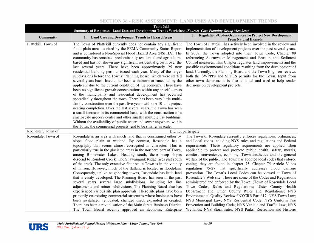
SECTION 3d � RISK ASSESSMENT: LAND USES AND DEVELOPMENT TRENDS
Multi�Jurisdictional Natural Hazard Mitigation Plan – Ulster County, New York 2015 Plan Update � Draft
3d�20
Table 3d.6
Summary of Responses � Land Uses and Development Trends Worksheet (Source: Core Planning Group Members)
Community 1. Land Uses and Development Trends in Hazard Areas 2. Regulations/Codes/Ordinances To Protect New Development
From Natural Hazards
Plattekill, Town of
The Town of Plattekill currently does not contain any significant
flood plain areas as cited by the FEMA Community Status Report
and is considered a Non5Special Flood Hazard Area (NSFHA). The
community has remained predominantly residential and agricultural
based and has not shown any significant residential growth over the
last several years. There have been approximately 25 new
residential building permits issued each year. Many of the larger
subdivisions before the Towns’ Planning Board, which were started
several years back, have either been withdrawn or cancelled by the
applicant due to the current condition of the economy. There have
been no significant growth concentrations within any specific areas
of the municipality and residential development has occurred
sporadically throughout the town. There has been very little multi5
family construction over the past five years with one 105unit project
nearing completion. Over the last several years, the Town has seen
a small increase in its commercial base, with the construction of a
small5scale grocery center and other smaller multiple use buildings.
Without the availability of public water and sewer anywhere within
the Town, the commercial projects tend to be smaller in scale.
The Town of Plattekill has actively been involved in the review and
implementation of development projects over the past several years.
In 2007, the Town adopted into their Town Code, Chapter 89
referencing Stormwater Management and Erosion and Sediment
Control measures. This Chapter regulates land improvements and the
possible environmental conditions resulting from the development of
land. Currently, the Planning Board and the Town Engineer reviews
both the SWPPPs and SPDES permits for the Town. Input from
other town departments is also solicited and used to help render
decisions on development projects.
Rochester, Town of Did not participate
Rosendale, Town of
Rosendale is an area with much land that is constrained either by
slope, flood plain or wetland. By contrast, Rosendale has a
topography that seems almost corrugated in character. This is
particularly true in the glaciated areas in the northern part of Town,
among Binnewater Lakes. Heading south, these steep slopes
descend to Rondout Creek. The Shawangunk Ridge rises just south
of the creek. The only extensive flat area in Town is in the vicinity
of Tillson. However, much of the flatland is located in floodplain.
Consequently, unlike neighboring towns, Rosendale has little land
that is easily developed. The Planning Board has seen in the past
several years several large subdivisions, including lot line
adjustments and minor subdivisions. The Planning Board also has
experienced various site plan approvals. These site plans have been
primarily on existing commercial structures where businesses have
been revitalized, renovated, changed used, expanded or created.
There has been a revitalization of the Main Street Business District.
The Town Board recently approved an Economic Enterprise
The Town of Rosendale currently enforces regulations, ordinances,
and Local codes including NYS rules and regulations and Federal
requirements. These regulatory requirements are applied when
applicable to protect and promote public health, safety, morals,
comfort, convenience, economy, Town aesthetics and the general
welfare of the public. The Town has adopted local codes that enforce
zoning, they are found in chapter 75. Chapter 75 Article V has
regulation 75527 that specifically addresses flood damage
prevention. The Town’s Local Codes can be viewed at Town of
Rosendale’s Web site. These are some of the Codes and Regulations
administered and enforced by the Town: (Town of Rosendale Local
Town Codes, Rules and Regulations; Ulster County Health
Department and Other County Rules and Regulations; NYS
Environmental Quality Review 6NYCRR Part 617; NYS Town Law;
NYS Municipal Law; NYS Residential Code; NYS Uniform Fire
Prevention and Building Code; NYS Vehicle and Traffic Law; NYS
Wetlands; NYS Stormwater; NYS Parks, Recreation and Historic
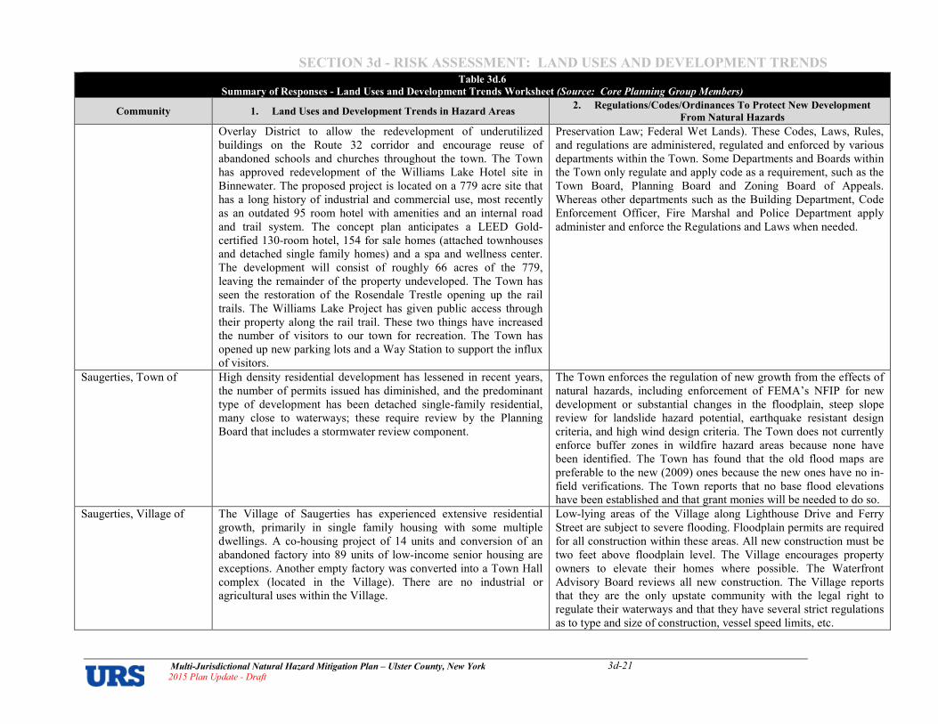
SECTION 3d � RISK ASSESSMENT: LAND USES AND DEVELOPMENT TRENDS
Multi�Jurisdictional Natural Hazard Mitigation Plan – Ulster County, New York 2015 Plan Update � Draft
3d�21
Table 3d.6
Summary of Responses � Land Uses and Development Trends Worksheet (Source: Core Planning Group Members)
Community 1. Land Uses and Development Trends in Hazard Areas 2. Regulations/Codes/Ordinances To Protect New Development
From Natural Hazards
Overlay District to allow the redevelopment of underutilized
buildings on the Route 32 corridor and encourage reuse of
abandoned schools and churches throughout the town. The Town
has approved redevelopment of the Williams Lake Hotel site in
Binnewater. The proposed project is located on a 779 acre site that
has a long history of industrial and commercial use, most recently
as an outdated 95 room hotel with amenities and an internal road
and trail system. The concept plan anticipates a LEED Gold5
certified 1305room hotel, 154 for sale homes (attached townhouses
and detached single family homes) and a spa and wellness center.
The development will consist of roughly 66 acres of the 779,
leaving the remainder of the property undeveloped. The Town has
seen the restoration of the Rosendale Trestle opening up the rail
trails. The Williams Lake Project has given public access through
their property along the rail trail. These two things have increased
the number of visitors to our town for recreation. The Town has
opened up new parking lots and a Way Station to support the influx
of visitors.
Preservation Law; Federal Wet Lands). These Codes, Laws, Rules,
and regulations are administered, regulated and enforced by various
departments within the Town. Some Departments and Boards within
the Town only regulate and apply code as a requirement, such as the
Town Board, Planning Board and Zoning Board of Appeals.
Whereas other departments such as the Building Department, Code
Enforcement Officer, Fire Marshal and Police Department apply
administer and enforce the Regulations and Laws when needed.
Saugerties, Town of
High density residential development has lessened in recent years,
the number of permits issued has diminished, and the predominant
type of development has been detached single5family residential,
many close to waterways; these require review by the Planning
Board that includes a stormwater review component.
The Town enforces the regulation of new growth from the effects of
natural hazards, including enforcement of FEMA’s NFIP for new
development or substantial changes in the floodplain, steep slope
review for landslide hazard potential, earthquake resistant design
criteria, and high wind design criteria. The Town does not currently
enforce buffer zones in wildfire hazard areas because none have
been identified. The Town has found that the old flood maps are
preferable to the new (2009) ones because the new ones have no in5
field verifications. The Town reports that no base flood elevations
have been established and that grant monies will be needed to do so.
Saugerties, Village of
The Village of Saugerties has experienced extensive residential
growth, primarily in single family housing with some multiple
dwellings. A co5housing project of 14 units and conversion of an
abandoned factory into 89 units of low5income senior housing are
exceptions. Another empty factory was converted into a Town Hall
complex (located in the Village). There are no industrial or
agricultural uses within the Village.
Low5lying areas of the Village along Lighthouse Drive and Ferry
Street are subject to severe flooding. Floodplain permits are required
for all construction within these areas. All new construction must be
two feet above floodplain level. The Village encourages property
owners to elevate their homes where possible. The Waterfront
Advisory Board reviews all new construction. The Village reports
that they are the only upstate community with the legal right to
regulate their waterways and that they have several strict regulations
as to type and size of construction, vessel speed limits, etc.

SECTION 3d � RISK ASSESSMENT: LAND USES AND DEVELOPMENT TRENDS
Multi�Jurisdictional Natural Hazard Mitigation Plan – Ulster County, New York 2015 Plan Update � Draft
3d�22
Table 3d.6
Summary of Responses � Land Uses and Development Trends Worksheet (Source: Core Planning Group Members)
Community 1. Land Uses and Development Trends in Hazard Areas 2. Regulations/Codes/Ordinances To Protect New Development
From Natural Hazards
Shandaken, Town of
Last year and this year, most of our developments are alterations
and repairs to single family homes. We had four single family
homes being built. We get a lot of sheds, garages, wood stove
permits. 75 percent of our town is owned by the State. We do not
have much land to develop.
The Town of Shandaken has zoning codes and flood plain
management ordinances for development near the Esopus Creek.
Additionally, the Town of Shandaken has adopted (June 2013) a
Town specific Flood Hazard Mitigation Plan and are currently in
process of entering into the Community Rating System.
Shawangunk, Town of
The Town is approximately 56.5 square miles in size. The
predominant land uses, in acreage, continue to be agriculture, open
space, and vacant land uses. According to the Town’s Farmland
Preservation Plan, approximately 21 percent of the Town’s area is
in agricultural use. Most agricultural uses are located in the Wallkill
River Valley, which encompasses the mid and easterly sections of
the Town. Much of the Town’s open space and vacant land uses are
found on the flanks and hilltops of Shawangunk Ridge in the
western portion of Shawangunk. Residential uses, primarily single5
family detached dwellings, are found throughout the entire Town,
but tend to be concentrated in the southerly area within and around
the hamlet of Wallkill, and adjoining communities in nearby
Orange County, including Pine Bush and Walden. Depending on
location, the minimum lot size ranges from 0.5 acres in the
established hamlets which are served by public water and sewer, to
7 acres in the Shawangunk Ridge area. Other uses, including
commercial uses, are located in the Wallkill and Walker Valley
hamlets, along Route 300, Route 208, and Route 52, and scattered
throughout the community. Because the Town is the southernmost
town in Ulster County, and closer in proximity to growth areas in
the NYC metropolitan region, it had been experiencing significant
developmental pressures prior to the economic recession. In 2014,
applicants are beginning to revisit applications, update them, and
reappear before the boards. Most applications which received
decisions in the past 5 years have been primarily small lot (3 or
less) subdivisions. At this time, there are approximately six
subdivisions that have received preliminary or final subdivision
which have not commenced construction – these represent 93
single5family lots. Four proposed subdivisions, totaling
approximately 239 lots, have received positive declarations under
SEQRA and have yet to submit environmental impact statements.
There are at least another eight projects that are “dormant” which
The Town of Shawangunk board and officials enforce local
regulations, and ensure that state and federal regulations are
complied with during land use application reviews. The Town
regulates new development from the effects of natural hazards,
primarily through regulations contained in the Town Zoning Law
and other laws including: The Zoning Law mandates the submission
of cluster subdivisions for subdivisions of four lots or more. Among
its purposes, the cluster subdivision regulations recommend
preservation of the following resources to limit impacts to natural
hazard areas: lands with slopes of 15% or more, the 1005year
floodplain, or land with unique or unusual landforms (e.g.,
Shawangunk Ridge). The cluster subdivision layout limits impacts to
these resources by placing them within dedicated open space areas,
protected by conservation easement. The Zoning Law, in Section
177511, requires that among other features, the 1005year floodplain
be subtracted from net acreage when calculating minimum lot area.
The effect is that development is reduced in areas where this natural
hazard is present. During application review, it is the Planning
Board’s policy to prohibit development from the floodplain. It does
so by imposing map notes which require that dwellings be sited in
the areas outside the floodplain, or outside of other environmental
sensitive or natural hazard areas. The Zoning Law establishes two
zoning districts, the RS51 and RS52 (Ridge Stewardship zones),
which regulate the slopes and ridgetop of Shawangunk Ridge. A
purpose for protecting these areas is to limit development on extreme
slopes and fragile soils. The law limits vegetation removal to 20,000
square feet without site plan approval, and it limits the density of
residential development to one dwelling unit per 3 to 7 acres. Article
XV, Stormwater Management and Erosion & Sediment Control, of
the Zoning Law regulates land development to ensure that
stormwater runoff is controlled and mitigated. The intent of the law
is to control stormwater quantity/quality so as to reduce impacts to

SECTION 3d � RISK ASSESSMENT: LAND USES AND DEVELOPMENT TRENDS
Multi�Jurisdictional Natural Hazard Mitigation Plan – Ulster County, New York 2015 Plan Update � Draft
3d�23
Table 3d.6
Summary of Responses � Land Uses and Development Trends Worksheet (Source: Core Planning Group Members)
Community 1. Land Uses and Development Trends in Hazard Areas 2. Regulations/Codes/Ordinances To Protect New Development
From Natural Hazards
could add over an additional 200 lots. A 605dwelling unit, mixed
residential/commercial development is commencing review at this
time. These projects are scattered throughout the Town, although
the largest projects are in the vicinity of the Wallkill hamlet. It is
anticipated that the Planning Board will continue to play a critical
role in ensuring that projects are designed to limit impacts to natural
hazard areas through the site and subdivision review process.
receiving streams, including the potential to increase flooding. Local
Law 1 of 2007 establishes the regulations applicable to the
administration and enforcement of the local land use and building
laws. In particular, it ensures that building permits are issued only in
strict accordance with the plans that have been approved by the
applicable board to ensure that the conditions and limitations which
may have been imposed during land use application review are
followed at all steps of the development process. Local Law 2 of
2009, Flood Damage Prevention, regulates activities proposed within
the special flood hazard area (1005year floodplain); it requires that
an applicant obtain a floodplain development permit prior to
undertaking any development within a special flood hazard areas.
The law requires that developments be reviewed to assess their
impact on the floodway, and construction standards are imposed on
structures proposed to be situated within a special flood hazard area.
Ulster, Town of
At the time the last version of the plan was prepared, the Town of
Ulster was reviewing a 255lot subdivision fronting the Esopus
Creek (six of the 25 being on the water front), and also a 1005lot
subdivision across the street from the Esopus Creek. The 255lot
subdivision was approved, but after several years the property
owner later requested that the lots be recombined; this request was
granted (none of the lots had been developed). The 1005lot
subdivision request was later withdrawn. At this time there is no
planned development in the Town.
The Town of Ulster continues to enforce building code regulations
for both new construction and renovation in the flood plain. Other
hazards and wildfire buffer zones, the Town of Ulster defers to the
current New York State Building Code.
Wawarsing, Town of
Last year and this year, most of our developments are repairs to
single family homes, Oak Ridge Roads, Hamlet of Spring Glen,
Mountaindale Road, Carlo Drive Development in Kerhonkson,
Banadics Road, Arrowhead Road, Cape Avenue aka Ulster Heights
Road (County of Ulster Road), Lewis Road, Agricultural on Berme
Road, South Gully Road.
The Town of Wawarsing enforces current New York State Building
code regulations for development in the floodplain. Other hazards
such as wind and landslides, the Town follows the New York State
Building Code. Future plan to update current Comprehensive Plan to
be reviewed.
Woodstock, Town of
The Town of Woodstock Planning Board is reviewing the Town’s
Comprehensive Plan to determine if changes are needed to update
specific zoning district development standards in hazard areas or
sensitive areas such as aquifer and critical environmental areas.
Most of the Town’s developable lands have already been
developed, leaving hazard areas at risk unless planned development
can be implemented.
The Town of Woodstock adopted Wetlands and Watercourse
Protection Standards in 2009.

SECTION 3d � RISK ASSESSMENT: LAND USES AND DEVELOPMENT TRENDS
Multi�Jurisdictional Natural Hazard Mitigation Plan – Ulster County, New York 2015 Plan Update � Draft
3d�24
Potential for Future Development to Impact Vulnerability for Non�delineable Hazards
Some hazards have discrete, delineable hazard areas associated with them. In other words, lines can be
drawn on a map to show approximate areas that are potentially susceptible to the hazard versus those that
are not. Delineable hazards identified in this plan include coastal erosion, dam failure, flooding, storm
surge, wave action, and wildfires. In this section, we will address the potential for future development
trends to impact vulnerability for non5delineable hazards. These hazards could impact any location – their
geographic footprint is county5wide. Non�delineable hazards identified in this plan include extreme
temperatures, extreme wind, lightning, tornados, drought, earthquakes; and severe storms such as
hurricanes, tropical storms, nor’easters, and winter storms. Because these hazard areas cover the
entirety of Ulster County and each of its municipalities, future development trends in non5delineable
hazard areas would be the same as those observed county5wide.
Development is occurring throughout the county, and population is growing. As a whole, Ulster County
faces the challenge of accommodating growth while preserving environmentally sensitive lands and open
space. As population increases and more residential and commercial buildings, infrastructure, public
facilities and other assets are constructed to support such growth, potential future hazard vulnerability is
likely to increase. In general, more people, buildings, and infrastructure will be exposed to natural
hazards over time. If current demographic trends continue, the proportion of the population representing
young children, the elderly, and those with other special needs is likely to increase somewhat in the
foreseeable future.
Ulster County and its communities are cognizant of the risks that it faces due to the impacts of natural
hazards. Management of risk in the midst of growth is of paramount importance in each community’s
overall attainment of sustainability and disaster resiliency. Many municipalities have programs in place
today which address certain natural hazards – whether it is a comprehensive or master plan, floodplain
management ordinance, or steep slope ordinance. New development on vacant parcels is likely to increase
exposure to natural hazards – though many impacts are expected to be reduced or eliminated because they
are built to codes and standards which, in many cases, offer a certain degree of protection from future
damages. In addition to development of vacant parcels, several of Ulster County’s communities are
undergoing significant redevelopment. Older buildings (built before current codes and standards were
adopted) are being demolished and replaced with new buildings built to current codes and standards. This
trend has been observed in Ulster County in recent years, and it has been exacerbated due to the recovery
process from the impacts of storms Irene, Lee, and Sandy. This type of development in hazard areas can
work to somewhat reduce overall vulnerabilities for those parcels due to the fact that the redeveloped
structures are being built to higher codes and standards than the previous structures had been.
In terms of conditions affecting vulnerability, Greenfield development (development that occurs on
previously undeveloped parcels), is more likely to result in an increase in a community’s vulnerability to
natural hazards because it represents a net increase in exposure of people and property. Redevelopment,
on the other hand, is not always as straightforward. Redevelopment bringing pre5existing building stock
into compliance with current codes and standards could offer a certain degree of protection from future
events, and decrease a community’s overall vulnerability. However, redevelopment where pre5existing
building stock is replaced with higher value or higher density development could, in turn, increase a
community’s overall vulnerability.
Extreme Temperatures. The extreme temperature hazard area covers the whole of Ulster County and is
essentially uniform for all jurisdictions; therefore, future development trends for the extreme temperature
hazard area would be the same as those county5wide. If current demographic trends continue, the
SECTION 3d � RISK ASSESSMENT: LAND USES AND DEVELOPMENT TRENDS
Multi�Jurisdictional Natural Hazard Mitigation Plan – Ulster County, New York 2015 Plan Update � Draft
3d�25
proportion of the population whose health can be particularly vulnerable to extremes in temperature (for
example, the young and elderly) is likely to increase in the foreseeable future.
Extreme Wind. One hundred percent of the land and built environment in the County is susceptible to
extreme wind events. This is also true for currently vacant (developable) parcels. The wind hazard area
encompasses the entire planning region and is essentially uniform from one jurisdiction to the next.
Therefore, future development trends for the extreme wind hazard area would be the same as those
development trends identified on a municipal basis earlier in this chapter. New construction is subject to
the requirements of the New York State Uniform Fire Prevention and Building Code (Uniform Code),
which contains provisions for wind resistant design. It is anticipated that while an increasing number of
structures will be present, they will be built to a code that will offer a certain degree of protection from
the most frequent high wind events.
Lightning. One hundred percent of the land and built environment in the participating jurisdictions is
susceptible to lightning. This is also true for currently vacant (developable) parcels. The lightning hazard
area encompasses the entire planning region and is uniform from one jurisdiction to the next. Therefore,
future development trends for the extreme wind hazard area would be the same as those development
trends identified on a municipal basis earlier in this chapter. New construction is subject to the
requirements of the New York State Uniform Fire Prevention and Building Code (Uniform Code), which
contains provisions for lightning resistant design. It is anticipated that while an increasing number of
structures will be present, they will be built to codes which include basic measures to protect against
lightning strikes.
Tornados. One hundred percent of the land and built environment in the County is susceptible to tornado
events. This is also true for currently vacant (developable) parcels. The tornado hazard area encompasses
the entire planning region and is essentially uniform from one jurisdiction to the next. Therefore, future
development trends for the tornado hazard area would be the same as those development trends identified
on a municipal basis earlier in this chapter. New construction is subject to the requirements of the New
York State Uniform Fire Prevention and Building Code (Uniform Code), which contains provisions for
wind resistant design including the extreme high winds experienced during tornados. It is anticipated that
while an increasing number of structures will be present, they will be built to a code that will offer a
certain degree of protection from the most frequent high wind events.
Drought. The drought hazard area encompasses the entire planning region and is uniform from one
jurisdiction to the next, although the local impact depends on the prevalence of agricultural land in
individual municipalities. While the individual jurisdictions often strive to focus on the preservation of
farmland and other open space, possible pressures on agricultural land to be zoned for residential and
other development, may reduce the economic effects of drought on agriculture, while the impact on
potable water supplies may increase.
Severe Storms: Hurricanes, Tropical Storms, Nor’easters, and Winter Storms. One hundred percent of
the land and built environment in the participating jurisdictions is susceptible to severe weather events.
This is also true for currently vacant (developable) parcels. Severe weather events such as
hurricanes/tropical storms, nor’easters, tornadoes, and winter storms/ice storms can occur anywhere in the
participating jurisdictions. These events have certain hazards associated with them, depending on the
particular event, and include: flooding, storm surge, wave action, coastal erosion, and extreme winds.
Refer elsewhere in this section for discussions regarding development trends in those hazard areas. Note
that for winter storms and nor’easters, the New York State Uniform Fire Prevention and Building Code
(Uniform Code) also contains provisions regarding snow/ice loads. It is anticipated that while an
increasing number of structures will be present, they will be built to codes which include basic measures
to protect against the potentially crushing effects of high accumulations of snow and ice on roofs.

SECTION 3d � RISK ASSESSMENT: LAND USES AND DEVELOPMENT TRENDS
Multi�Jurisdictional Natural Hazard Mitigation Plan – Ulster County, New York 2015 Plan Update � Draft
3d�26
Potential for Future Development to Impact Vulnerability for Delineable Hazards
Dam Failure. The New York State Department of Environmental Conservation Dam Safety Program
maintains an inventory of dams in the State and conducts safety inspections of dams, completes technical
reviews of proposed dam construction or modification, monitoring of remedial work for dam safety
compliance, and is involved in emergency preparedness activities. At the time of writing, research of
readily available data sources did not reveal any dams proposed or under construction, in addition to those
listed by the US Army Corps of Engineers National Inventory of Dams, or the Stanford University
National Performance of Dams Program.
Table 3d.7
Potential for Future Development to Impact Dam Failure Hazard
Vulnerability
Jurisdiction
DAM FAILURE
Hazard
Potential
Potential for
Future
Development to
Increase
Hazard
Vulnerability
Are measures
identified in the
jurisdiction’s plan
integration
strategy5 that can
mitigate risk?
Ulster, County of � � �
Denning, Town of � � �
Ellenville, Village of
� � �
Esopus, Town of � � �
Gardiner, Town of � � �
Hardenburgh, Town of � � �
Hurley, Town of � � �
Kingston, City of
Kingston, Town of
Lloyd, Town of � � �
Marbletown, Town of � � �
Marlborough, Town of � � �
New Paltz, Town of � � �
New Paltz, Village of
Olive, Town of
� � �
Plattekill, Town of � � �
Rochester, Town of � � �
Rosendale, Town of � � �
Saugerties, Town of
Saugerties, Village of
Shandaken, Town of � � �
Shawangunk, Town of � � �
Ulster, Town of � � �
Wawarsing, Town of � � �
Woodstock, Town of � � �
Flood. Individuals and larger developers often look toward land along rivers, streams, canals, bays, and
near the ocean for development because of the passive and active recreational opportunities that they
offer. In turn, flood hazard areas (for flooding and storm surge) are often areas where development
pressures are high due to the recreational value of these lands, particularly in communities where the
amount of undeveloped land is small and the density of development is high. Development within
mapped flood hazard areas is currently regulated for communities participating in FEMA’s National
5 See Jurisdictional Annexes of Appendix 1.2; Worksheet 6.

SECTION 3d � RISK ASSESSMENT: LAND USES AND DEVELOPMENT TRENDS
Multi�Jurisdictional Natural Hazard Mitigation Plan – Ulster County, New York 2015 Plan Update � Draft
3d�27
Flood Insurance Program (NFIP). All municipalities in the County participate in FEMA’s National Flood
Insurance Program, and thereby must have in place a floodplain management ordinance to regulate
activities in the floodplain, as well as a designated floodplain manager/NFIP Coordinator to enforce the
relevant ordinances. This will work to protect new development and substantial improvements in the
County’s floodplains. In addition, the Towns of Rosendale and Shandaken have included a discussion of
floodplains in their comprehensive plan. The Town of Lloyd doesn’t include floodplains, but does include
a section on the restraints to development due to hydrologic considerations. While an increased number of
assets could be susceptible, it is assumed that they will be built to codes that will offer a certain degree of
protection from the most frequent events.
Table 3d.8
Potential for Future Development to Impact Flood Hazard Vulnerability
Jurisdiction
FLOOD
Hazard
Potential
Potential for
Future
Development to
Increase
Hazard
Vulnerability
Are measures
identified in the
jurisdiction’s plan
integration
strategy6 that can
mitigate risk?
Ulster, County of � � �
Denning, Town of � � � Ellenville, Village of
� � �
Esopus, Town of � � � Gardiner, Town of � � � Hardenburgh, Town of � � � Hurley, Town of � � � Kingston, City of � � � Kingston, Town of � � � Lloyd, Town of � � � Marbletown, Town of � � � Marlborough, Town of � � � New Paltz, Town of � � � New Paltz, Village of � � � Olive, Town of
� � �
Plattekill, Town of � � � Rochester, Town of � � � Rosendale, Town of � � � Saugerties, Town of � � � Saugerties, Village of � � � Shandaken, Town of � � � Shawangunk, Town of � � � Ulster, Town of � � � Wawarsing, Town of � � � Woodstock, Town of � � �
6 See Jurisdictional Annexes of Appendix 1.2; Worksheet 6.

SECTION 3d � RISK ASSESSMENT: LAND USES AND DEVELOPMENT TRENDS
Multi�Jurisdictional Natural Hazard Mitigation Plan – Ulster County, New York 2015 Plan Update � Draft
3d�28
Ice Jams. The ice jam hazard is similar to the flood hazard in that ice jams may cause rivers and streams
to overflow their banks. If a structure is near the banks of the rivers or streams, it may also be subject to
structural damage from the impact of ice striking the structure. The jurisdictions’ flood hazard ordinances
are assumed to currently deal with the flooding aspect of the ice jam hazard, and future damages due to
this hazard will depend on development within the floodplain and adherence to the relevant building
codes.
Table 3d.9
Potential for Future Development to Impact Ice Jam Hazard Vulnerability
Jurisdiction
ICE JAMS
Hazard
Potential
Potential for
Future
Development to
Increase
Hazard
Vulnerability
Are measures
identified in the
jurisdiction’s plan
integration
strategy7 that can
mitigate risk?
Ulster, County of � � �
Denning, Town of � � � Ellenville, Village of
� � � Esopus, Town of � � � Gardiner, Town of � � � Hardenburgh, Town of � � � Hurley, Town of � � � Kingston, City of � � � Kingston, Town of � � � Lloyd, Town of � � � Marbletown, Town of � � � Marlborough, Town of � � � New Paltz, Town of � � � New Paltz, Village of � � � Olive, Town of
� � � Plattekill, Town of � � � Rochester, Town of � � � Rosendale, Town of � � � Saugerties, Town of � � � Saugerties, Village of � � � Shandaken, Town of � � � Shawangunk, Town of � � � Ulster, Town of � � � Wawarsing, Town of � � � Woodstock, Town of � � �
7 See Jurisdictional Annexes of Appendix 1.2; Worksheet 6.

SECTION 3d � RISK ASSESSMENT: LAND USES AND DEVELOPMENT TRENDS
Multi�Jurisdictional Natural Hazard Mitigation Plan – Ulster County, New York 2015 Plan Update � Draft
3d�29
Storm Surge. The Hudson River Valley is vulnerable to coastal storms and their associated storm surges.
The River is actually a tidal estuary over its 153 mile course from the New York Harbor to the Federal
Dam at Troy. Coastal storm surge in the Atlantic Ocean during certain hurricanes and tropical storms can
cause a surge of water to flow up the Hudson River and inundate portions of communities along its banks.
During Sandy, the USGS reported that the Hudson River was approximately six feet higher than normal
near Poughkeepsie, peaking at 9.54 feet. Risk will increase over time with rising sea levels. Local flood
hazard ordinances offer some degree of protection from this hazard, and future damages will depend on
the nature and magnitude of development within the floodplain and the degree of adherence to the
relevant building codes.
Table 3d.10
Potential for Future Development to Impact Surge Hazard Vulnerability
Jurisdiction
SURGE
Hazard
Potential
Potential for
Future
Development to
Increase
Hazard
Vulnerability
Are measures
identified in the
jurisdiction’s plan
integration
strategy8 that can
mitigate risk?
Ulster, County of
Denning, Town of
Ellenville, Village of
Esopus, Town of � � �
Gardiner, Town of
Hardenburgh, Town of
Hurley, Town of
Kingston, City of � � �
Kingston, Town of
Lloyd, Town of � � �
Marbletown, Town of
Marlborough, Town of � � �
New Paltz, Town of
New Paltz, Village of
Olive, Town of
Plattekill, Town of
Rochester, Town of
Rosendale, Town of
Saugerties, Town of � � � Saugerties, Village of � � � Shandaken, Town of
Shawangunk, Town of
Ulster, Town of � � �
Wawarsing, Town of
Woodstock, Town of
8 See Jurisdictional Annexes of Appendix 1.2; Worksheet 6.

SECTION 3d � RISK ASSESSMENT: LAND USES AND DEVELOPMENT TRENDS
Multi�Jurisdictional Natural Hazard Mitigation Plan – Ulster County, New York 2015 Plan Update � Draft
3d�30
Earthquakes. The earthquake hazard area encompasses the entirety of Ulster County. PGA values of
between 2 and 3%g have a 10 percent chance of being exceeded over 50 years. The earthquake hazard
area encompasses the entire County planning area and is nearly uniform from one jurisdiction to the next,
although the effects of an earthquake may vary from one jurisdiction and across jurisdictions as the soil
type varies. While new development could lead to an increased number of assets susceptible to this
hazard in the future, new construction is subject to the requirements of the New York State Uniform Fire
Prevention and Building Code (Uniform Code), which contains provisions for earthquake resistant
design. It is anticipated that while an increasing number of structures will be present, they will be built to
a code that will offer a certain degree of protection from the most frequent events.
Table 3d.11
Potential for Future Development to Impact Earthquake Hazard
Vulnerability
Jurisdiction
EARTHQUAKE
Hazard
Potential
Potential for
Future
Development to
Increase
Hazard
Vulnerability
Are measures
identified in the
jurisdiction’s plan
integration
strategy9 that can
mitigate risk?
Ulster, County of � � �
Denning, Town of � � � Ellenville, Village of
� � �
Esopus, Town of � � � Gardiner, Town of � � � Hardenburgh, Town of � � � Hurley, Town of � � � Kingston, City of � � � Kingston, Town of � � � Lloyd, Town of � � � Marbletown, Town of � � � Marlborough, Town of � � � New Paltz, Town of � � � New Paltz, Village of � � � Olive, Town of
� � �
Plattekill, Town of � � � Rochester, Town of � � � Rosendale, Town of � � � Saugerties, Town of � � � Saugerties, Village of � � � Shandaken, Town of � � � Shawangunk, Town of � � � Ulster, Town of � � � Wawarsing, Town of � � � Woodstock, Town of � � �
9 See Jurisdictional Annexes of Appendix 1.2; Worksheet 6.
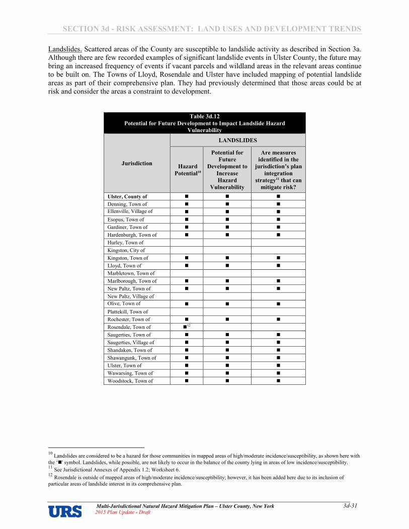
SECTION 3d � RISK ASSESSMENT: LAND USES AND DEVELOPMENT TRENDS
Multi�Jurisdictional Natural Hazard Mitigation Plan – Ulster County, New York 2015 Plan Update � Draft
3d�31
Landslides. Scattered areas of the County are susceptible to landslide activity as described in Section 3a.
Although there are few recorded examples of significant landslide events in Ulster County, the future may
bring an increased frequency of events if vacant parcels and wildland areas in the relevant areas continue
to be built on. The Towns of Lloyd, Rosendale and Ulster have included mapping of potential landslide
areas as part of their comprehensive plan. They had previously determined that those areas could be at
risk and consider the areas a constraint to development.
Table 3d.12
Potential for Future Development to Impact Landslide Hazard
Vulnerability
Jurisdiction
LANDSLIDES
Hazard
Potential10
Potential for
Future
Development to
Increase
Hazard
Vulnerability
Are measures
identified in the
jurisdiction’s plan
integration
strategy11 that can
mitigate risk?
Ulster, County of � � �
Denning, Town of � � �
Ellenville, Village of
� � �
Esopus, Town of � � �
Gardiner, Town of � � �
Hardenburgh, Town of � � �
Hurley, Town of
Kingston, City of
Kingston, Town of � � �
Lloyd, Town of � � �
Marbletown, Town of
Marlborough, Town of � � �
New Paltz, Town of � � �
New Paltz, Village of
Olive, Town of
� � �
Plattekill, Town of
Rochester, Town of � � �
Rosendale, Town of �12
Saugerties, Town of � � �
Saugerties, Village of � � �
Shandaken, Town of � � �
Shawangunk, Town of � � �
Ulster, Town of � � �
Wawarsing, Town of � � �
Woodstock, Town of � � �
10
Landslides are considered to be a hazard for those communities in mapped areas of high/moderate incidence/susceptibility, as shown here with
the ‘�' symbol. Landslides, while possible, are not likely to occur in the balance of the county lying in areas of low incidence/susceptibility. 11
See Jurisdictional Annexes of Appendix 1.2; Worksheet 6. 12
Rosendale is outside of mapped areas of high/moderate incidence/susceptibility; however, it has been added here due to its inclusion of
particular areas of landslide interest in its comprehensive plan.

SECTION 3d � RISK ASSESSMENT: LAND USES AND DEVELOPMENT TRENDS
Multi�Jurisdictional Natural Hazard Mitigation Plan – Ulster County, New York 2015 Plan Update � Draft
3d�32
Wildfires. Areas that are typically considered to be safe from wildfires include highly urbanized,
developed areas that are not contiguous with vast areas of wild lands. Areas typically considered to be
prone to wildfires include large tracts of wild lands containing heavier fuels with high continuity such as
those forested areas in many parts of the County. Pressure to develop some forested areas, especially for
residential use, will generally result in increases to the urban5wildlife interface and the value of improved
property within these areas in most jurisdictions, and hence an increased risk of future property damage
and public danger due to wildfires.
Table 3d.13
Potential for Future Development to Impact Wildfire Hazard Vulnerability
Jurisdiction
WILDFIRES
Hazard
Potential
Potential for
Future
Development to
Increase
Hazard
Vulnerability
Are measures
identified in the
jurisdiction’s plan
integration
strategy13 that can
mitigate risk?
Ulster, County of � � �
Denning, Town of � � �
Ellenville, Village of
� � �
Esopus, Town of � � �
Gardiner, Town of � � �
Hardenburgh, Town of � � �
Hurley, Town of � � �
Kingston, City of � � �
Kingston, Town of � � �
Lloyd, Town of � � �
Marbletown, Town of � � �
Marlborough, Town of � � �
New Paltz, Town of � � �
New Paltz, Village of � � �
Olive, Town of
� � �
Plattekill, Town of � � �
Rochester, Town of � � �
Rosendale, Town of � � �
Saugerties, Town of � � �
Saugerties, Village of � � �
Shandaken, Town of � � �
Shawangunk, Town of � � �
Ulster, Town of � � �
Wawarsing, Town of � � �
Woodstock, Town of � � �
13
See Jurisdictional Annexes of Appendix 1.2; Worksheet 6.

SECTION 3d � RISK ASSESSMENT: LAND USES AND DEVELOPMENT TRENDS
Multi�Jurisdictional Natural Hazard Mitigation Plan – Ulster County, New York 2015 Plan Update � Draft
3d�33
Conclusion
Ulster County is balancing the objectives of preserving natural, cultural and historic resources; facing the
reality of an economy which is undergoing a big change as the nation moves into the post5industrial era;
and, seeing development that is driven by agricultural and natural resources as well as the occurrences of
the nation’s largest urban area only 70 miles away. The County is involved in economic development,
housing, open space, stormwater and transportation planning projects – among others. This is an
indication that they are concerned with their communities and want to ensure that they are safe, thriving
and appealing places to live, work, and play.
The following recent development trends are expected to continue in the future:
• The County and its’ jurisdictions are expected to continue to focus on preserving open space
throughout the area;
• Most new development is expected to continue to occur in the Hudson River Valley, especially
along Interstate Highway 87 corridor;
• Additional development is expected to take place along transportation corridors in the County,
particularly in and around existing hamlets that have developed throughout the County;
• Redevelopment is expected to take place throughout the County, as sites that were vacated due to
changes in the economy are reused, modified or replaced;
• Agriculture and natural resources is expected to continue to be a focus of the Ulster County
economy;
• Ulster County is expected to continue to be both recreational destination and drive both the
commercial and industrial development in the County;
• Ulster County is expected to continue to be a location where individuals that seek to leave the
bustle of the New York City urban area seek to locate;
• Ulster County communities are generally expected to continue their historic practice of
rebuilding after major disasters, as vast areas of preserved open space render much of the county
undevelopable and, due to the considerable areas of mountainous terrain, valleys and river
valleys are often the most readily5developable locales.
As such, the County and its jurisdictions will continue to focus on:
1. Preserving open space throughout the County;
2. Ensuring that development within the County will meet the minimum requirements of the
National Flood Insurance Program as well as meeting the County’s minimum Stormwater
Management requirements;
3. Enforcing minimum building codes meeting the requirements of New York State Building Code;
4. Ensuring that development is limited to areas that are not subject to high landslide potential.
Note: All data was taken from websites of Ulster County or the participating jurisdictions.
SECTION 3e: RISK ASSESSMENT – CONCLUSIONS ON HAZARD RISK
Multi�Jurisdictional Hazard Mitigation Plan – Ulster County, New York 2015 Plan Update – Draft
3e�1
SECTION 3E – CONCLUSIONS ON HAZARD RISK
Priority Risk Index The hazard profiles presented in this section were developed using best available data and result in what
may be considered principally a qualitative assessment as recommended by FEMA in its guidance
document entitled Local Mitigation Planning Handbook. It relies heavily on historical and anecdotal
data, stakeholder input, and professional and experienced judgment regarding observed and/or anticipated
hazard impacts; and carefully considers the findings in other relevant plans, studies and technical reports.
In order to draw some meaningful planning conclusions on hazard risk for Ulster County as a whole and
each participating jurisdiction, the hazard profiling and risk assessment processes were used to generate
hazard classifications according to a “Priority Risk Index” (PRI) . a tool used to measure the degree of
risk for identified hazards in a particular planning area. The purpose of the PRI, described further below,
is to categorize and prioritize all potential hazards as high, moderate or low risk. The PRI is used to assist
the Ulster County Planning Committee in gaining consensus on the determination of those hazards that
pose the most significant threat to Ulster County based on a variety of factors. The PRI is not
scientifically based, but is rather meant to be utilized as an objective planning tool for classifying and
prioritizing hazard risks in Ulster County based on standardized criteria. Combined with the asset
inventory and quantitative vulnerability assessment provided in the previous sections, the summary
hazard classifications generated through the use of the PRI allows for the prioritization of those high
hazard risks for mitigation planning purposes, and more specifically, the identification of hazard
mitigation opportunities for Ulster County jurisdictions to consider as part of their proposed mitigation
strategies. Each jurisdiction focused on the identification of mitigation actions that will reduce or
eliminate their own unique hazard risks.
The application of the PRI results in numerical values that allow identified hazards to be ranked against
one another (the higher the PRI value, the greater the hazard risk). PRI values are obtained by assigning
varying degrees of risk to five categories for each hazard (probability, impact, spatial extent, warning time
and duration). Each degree of risk has been assigned a value (1 to 4) and an agreed upon weighting
factor1, as summarized in Table 3a.21. To calculate the PRI value for a given hazard, the assigned risk
value for each category is multiplied by the weighting factor. The sum of all five categories equals the
final PRI value, as demonstrated in the example equation below. According to the weighting scheme
applied for Ulster County, the highest possible PRI value is 4.0.
PRI VALUE = [(PROBABILITY x .30) + (IMPACT x .30) + (SPATIAL EXTENT x .20) + (WARNING TIME x .10) + (DURATION x .10)]
As part of the 2015 Plan Update, the application of the PRI was done for every participating
jurisdiction. Prior to being finalized, PRI values for each identified hazard were reviewed and accepted
by the members of the CPG.
1 The Ulster County Planning Committee, based upon any unique concerns or factors for the planning area, may adjust the PRI weighting scheme
during future plan updates.

SECTION 3e: RISK ASSESSMENT – CONCLUSIONS ON HAZARD RISK
Multi�Jurisdictional Hazard Mitigation Plan – Ulster County, New York 2015 Plan Update – Draft
3e�2
Table 3e.1
Priority Risk Index for Ulster County
PRI Category Degree of Risk Assigned
Weighting
Factor Level Criteria Index Value
Probability
Unlikely Less than 1% annual probability 1
30%
Possible Between 1 and 10% annual probability 2
Likely Between 10 and 100% annual probability 3
Highly Likely 100% annual probability 4
Impact
Minor
Very few injuries, if any. Only minor property
damage and minimal disruption on quality of
life. Temporary shutdown of critical facilities.
1
30%
Limited
Minor injuries only. More than 10% of property
in affected area damaged or destroyed.
Complete shutdown of critical facilities for more
than one day.
2
Critical
Multiple deaths/injuries possible. More than
25% of property in affected area damaged or
destroyed. Complete shutdown of critical
facilities for more than one week.
3
Catastrophic
High number of deaths/injuries possible. More
than 50% of property in affected area damaged
or destroyed. Complete shutdown of critical
facilities for 30 days or more.
4
Spatial Extent
Negligible Less than 1% of area affected 1
20% Small Between 1 and 10% of area affected 2
Moderate Between 10 and 50% of area affected 3
Large Between 50 and 100% of area affected 4
Warning Time
More than 24 hours Self.explanatory 1
10%
12 to 24 hours Self.explanatory 2
6 to 12 hours Self.explanatory 3
Less than 6 hours Self.explanatory 4
Duration
Less than 6 hours Self.explanatory 1
10%
Less than 24 hours Self.explanatory 2
Less than one week Self.explanatory 3
More than one week Self.explanatory 4
SECTION 3e: RISK ASSESSMENT – CONCLUSIONS ON HAZARD RISK
Multi�Jurisdictional Hazard Mitigation Plan – Ulster County, New York 2015 Plan Update – Draft
3e�3
PRI Results
The application of the PRI was done separately for each jurisdiction in Ulster County, and for the County
as a whole. Assigned risk levels were based on the detailed hazard profiles developed for this section, as
well as input from the Planning Committee and results of the vulnerability assessment. The results were
then used in calculating PRI values and making final determinations for the risk assessment.
Table 3e.2 summarizes the degree of risk assigned to each category for all identified hazards based on the
application of the PRI for Ulster County, as a whole.
Table 3e.3 presents an overview of the PRI Results for each jurisdiction.
Detailed tables for each jurisdiction (similar to Table 3e.2) are included in Appendix 3e.1.

SECTION 3e: RISK ASSESSMENT – CONCLUSIONS ON HAZARD RISK
Multi�Jurisdictional Hazard Mitigation Plan – Ulster County, New York 2015 Plan Update – Draft
3e�4
Table 3e.2
Summary of PRI Results for Ulster County*
* Key: Red = High hazard raking; Orange = Moderate hazard ranking; Yellow = Low hazard ranking.

SECTION 3e: RISK ASSESSMENT – CONCLUSIONS ON HAZARD RISK
Multi�Jurisdictional Hazard Mitigation Plan – Ulster County, New York 2015 Plan Update – Draft
3e�5
Table 3e.3
PRI Results for Each Jurisdiction
Jurisdiction
Atmospheric Hazards Hydrologic Hazards Geologic
Hazards
Wil
dfi
re
Ex
trem
e
Tem
per
atu
res
Ex
trem
e W
ind
Hu
rric
an
e a
nd
Tro
pic
al
Sto
rm
Lig
htn
ing
No
r’ea
ster
To
rna
do
Win
ter
Sto
rm
Da
m F
ail
ure
Dro
ug
ht
Flo
od
Ice
Ja
ms
Sto
rm S
urg
e
Ea
rth
qu
ak
e
La
nd
slid
e
ULSTER COUNTY 2.7 2.9 2.6 2.2 2.4 2.5 2.7 2.2 2.2 3.1 1.8 1.8 1.9 2.6 2.6
Denning, Town of 2.7 2.9 2.6 2.2 2.4 2.5 2.7 2.2 2.2 3.1 1.8 #N/A 1.9 2.6 0.0
Ellenville, Village of 2.7 2.9 2.6 2.2 2.4 2.5 2.7 2.2 2.2 3.1 1.8 #N/A 1.9 2.6 0.0
Esopus, Town of 2.7 2.9 2.6 2.2 2.4 2.5 2.7 2.2 2.2 3.1 1.8 1.8 1.9 2.6 0.0
Gardiner, Town of 2.7 2.9 2.6 2.2 2.4 2.5 2.7 2.2 2.2 3.1 1.8 #N/A 1.9 2.6 0.0
Hardenburgh, Town of 2.7 2.9 2.6 2.2 2.4 2.5 2.7 2.2 2.2 3.1 1.8 #N/A 1.9 2.6 0.0
Hurley, Town of 2.7 2.9 2.6 2.2 2.4 2.5 2.7 2.2 2.2 3.1 1.8 #N/A 1.9 #N/A 0.0
Kingston, City of 2.7 2.9 2.6 2.2 2.4 2.5 2.7 #N/A 2.2 3.1 1.8 1.8 1.9 #N/A 0.0
Kingston, Town of 2.7 2.9 2.6 2.2 2.4 2.5 2.7 #N/A 2.2 3.1 1.8 #N/A 1.9 2.6 0.0
Lloyd, Town of 2.7 2.9 2.6 2.2 2.4 2.5 2.7 2.2 2.2 3.1 1.8 1.8 1.9 2.6 0.0
Marbletown, Town of 2.7 2.9 2.6 2.2 2.4 2.5 2.7 2.2 2.2 3.1 1.8 #N/A 1.9 #N/A 0.0
Marlborough, Town of 2.7 2.9 2.6 2.2 2.4 2.5 2.7 2.2 2.2 3.1 1.8 1.8 1.9 2.6 0.0
New Paltz, Town of 2.7 2.9 2.6 2.2 2.4 2.5 2.7 2.2 2.2 3.1 1.8 #N/A 1.9 2.6 0.0
New Paltz, Village of 2.7 2.9 2.6 2.2 2.4 2.5 2.7 #N/A 2.2 3.1 1.8 #N/A 1.9 #N/A 0.0
Olive, Town of 2.7 2.9 2.6 2.2 2.4 2.5 2.7 2.2 2.2 3.1 1.8 #N/A 1.9 2.6 0.0
Plattekill, Town of 2.7 2.9 2.6 2.2 2.4 2.5 2.7 2.2 2.2 3.1 1.8 #N/A 1.9 #N/A 0.0
Rochester, Town of 2.7 2.9 2.6 2.2 2.4 2.5 2.7 2.2 2.2 3.1 1.8 #N/A 1.9 2.6 0.0
Rosendale, Town of 2.7 2.9 2.6 2.2 2.4 2.5 2.7 2.2 2.2 3.1 1.8 #N/A 1.9 #N/A 0.0
Saugerties, Town of 2.7 2.9 2.6 2.2 2.4 2.5 2.7 #N/A 2.2 3.1 1.8 1.8 1.9 2.6 0.0
Saugerties, Village of 2.7 2.9 2.6 2.2 2.4 2.5 2.7 #N/A 2.2 3.1 1.8 1.8 1.9 2.6 0.0
Shandaken, Town of 2.7 2.9 2.6 2.2 2.4 2.5 2.7 2.2 2.2 3.1 1.8 #N/A 1.9 2.6 0.0
Shawangunk, Town of 2.7 2.9 2.6 2.2 2.4 2.5 2.7 2.2 2.2 3.1 1.8 #N/A 1.9 2.6 0.0
Ulster, Town of 2.7 2.9 2.6 2.2 2.4 2.5 2.7 2.2 2.2 3.1 1.8 1.8 1.9 2.6 0.0
Wawarsing, Town of 2.7 2.9 2.6 2.2 2.4 2.5 2.7 2.2 2.2 3.1 1.8 #N/A 1.9 2.6 0.0
Woodstock, Town of 2.7 2.9 2.6 2.2 2.4 2.5 2.7 2.2 2.2 3.1 1.8 #N/A 1.9 2.6 0.0
#N/A = the hazard is not applicable in this jurisdiction
Final Determinations
The conclusions drawn from the application of the PRI process for Ulster County, including the PRI results
and input from the Planning Committee, resulted in the classification of risk for each identified hazard
according to three categories: High Risk, Moderate Risk and Low Risk. Hazards with a PRI of 3.0 or more
were deemed “high risk”; hazards with a PRI between 2.4 and 2.9 were deemed “moderate risk”; and hazards
with a PRI of 2.3 or less were deemed “low risk”. For purposes of these classifications, risk is expressed in
relative terms according to the estimated impact that a hazard will have on human life and property
throughout all of Ulster County. It should be noted that although some hazards are classified below as posing
low risk, their occurrence of varying or unprecedented magnitudes is still possible in some cases and their
assigned classification will continue to be evaluated during future plan updates2. Table 3e.4 presents
conclusions on hazard risk for the County as a whole, based on the PRI scores for each hazard in the County.
Table 3e.5 presents an overview of the resultant hazard risk rankings for each jurisdiction. Detailed tables for
each jurisdiction are included in Appendix 3e.1.
2 Overall conclusions on hazard risk were re.evaluated as part of the first plan update for every participating jurisdiction.

SECTION 3e: RISK ASSESSMENT – CONCLUSIONS ON HAZARD RISK
Multi�Jurisdictional Hazard Mitigation Plan – Ulster County, New York 2015 Plan Update – Draft
3e�6
Table 3e.4
Hazard Risk Rankings for Ulster County
HIGH RISK
PRI ≥ 3.0
Hurricane and Tropical Storm
Nor’easter
Coastal Erosion
Flood
Storm Surge
Wave Action
MODERATE RISK
2.4 ≤ PRI ≤ 2.9
Extreme Temperatures
Extreme Wind
Hurricane and Tropical Storm
Nor’easter
Tornado
Winter Storm
Landslide
Wildfire
Winter Storm
Landslide
Wildfire
LOW RISK
PRI ≤ 2.3
Lightning
Lightning
Dam Failure
Drought
Ice Jam
Surge
Earthquake
Drought
Earthquake
SECTION 3e: RISK ASSESSMENT – CONCLUSIONS ON HAZARD RISK
Multi�Jurisdictional Hazard Mitigation Plan – Ulster County, New York 2015 Plan Update – Draft
3e�7
Table 3e.3
Hazard Risk Rankings for Each Jurisdiction
Jurisdiction
Atmospheric Hazards Hydrologic Hazards Geologic
Hazards
Wil
dfi
re
Ex
trem
e
Tem
per
atu
res
Ex
trem
e W
ind
Hu
rric
an
e a
nd
Tro
pic
al
Sto
rm
Lig
htn
ing
No
r’ea
ster
To
rna
do
Win
ter
Sto
rm
Da
m F
ail
ure
Dro
ug
ht
Flo
od
Ice
Ja
ms
Sto
rm S
urg
e
Ea
rth
qu
ak
e
La
nd
slid
e
ULSTER COUNTY M M M L M M M L L H L L L M M
Denning, Town of M M M L M M M L L H L #N/A L M L
Ellenville, Village of M M M L M M M L L H L #N/A L M L
Esopus, Town of M M M L M M M L L H L L L M L
Gardiner, Town of M M M L M M M L L H L #N/A L M L
Hardenburgh, Town of M M M L M M M L L H L #N/A L M L
Hurley, Town of M M M L M M M L L H L #N/A L #N/A L
Kingston, City of M M M L M M M #N/A L H L L L #N/A L
Kingston, Town of M M M L M M M #N/A L H L #N/A L M L
Lloyd, Town of M M M L M M M L L H L L L M L
Marbletown, Town of M M M L M M M L L H L #N/A L #N/A L
Marlborough, Town of M M M L M M M L L H L L L M L
New Paltz, Town of M M M L M M M L L H L #N/A L M L
New Paltz, Village of M M M L M M M #N/A L H L #N/A L #N/A L
Olive, Town of M M M L M M M L L H L #N/A L M L
Plattekill, Town of M M M L M M M L L H L #N/A L #N/A L
Rochester, Twon of M M M L M M M L L H L #N/A L M L
Rosendale, Town of M M M L M M M L L H L #N/A L #N/A L
Saugerties, Town of M M M L M M M #N/A L H L L L M L
Saugerties, Village of M M M L M M M #N/A L H L L L M L
Shandaken, Town of M M M L M M M L L H L #N/A L M L
Shawangunk, Town of M M M L M M M L L H L #N/A L M L
Ulster, Town of M M M L M M M L L H L L L M L
Wawarsing, Town of M M M L M M M L L H L #N/A L M L
Woodstock, Town of M M M L M M M L L H L #N/A L M L
#N/A = the hazard is not applicable in this jurisdiction

SECTION 3e: RISK ASSESSMENT – CONCLUSIONS ON HAZARD RISK
Multi�Jurisdictional Hazard Mitigation Plan – Ulster County, New York 2015 Plan Update – Draft
3e�8
Key Risk Findings
Key Risk Findings are problem statements developed from the risk assessment by each participating
jurisdiction. Each jurisdiction was encouraged to consider different types of mitigation actions for addressing
their highest hazards and Key Risk Findings.
Key Risk Findings for Ulster County are presented in Table 3e.6. Key Risk Findings provided by
participating jurisdictions are included in Appendix 3e.1.
Table 3e.6
Key Risk Findings for Ulster County Currently there are no municipalities in Ulster County enrolled in the NFIP’s CRS. Many residents and businesses in Ulster County
will likely see much higher insurance rates in the near future with approximately 600 of the 1400 policyholders likely to be affected
by the removal of pre.FIRM subsidies.
Plank Road is a 3.5.mile County road that is impacted often by flooding. There are several locations where flood damage occurs
repeatedly, including several road embankments and at culverts that often plug or are undersized and overtop. This is a vital road
for the community as it is the only other way to access points west of Mount Tremper other than State Route 28, which is
susceptible to flood damage at an undersized bridge in Mount Tremper and at "Campground Curve" near Phoenicia.
Stony Clove Lane Bridge is a County.owned bridge located at the base of a dead end town road. It provides access to nearly 40
homes and is likely undersized. The bridge has proven to be subject to repetitive erosion/depositional.related damages.
Bridge 202 on Plank Road is a County.owned bridge that has been shown through recent HEC.RAS modeling to cause a
significant backwatering effect during 50.year storms that inundates Miller Road, a dead.end road with about 20 homes.
Bridge Street Bridge is a County.owned bridge that provides crucial ingress and egress from the Hamlet of Phoenicia. The structure
has been damaged (and closed for several months) on two occasions since 2005.
The Old Mount Tremper Bridge is a County.owned bridge that has been closed since 1986 because of its deteriorated condition and
could pose a downstream flood hazard if it collapses into the Esopus Creek.
A section of Ulster County Route 47 downstream of McKenely Hollow, as well as the terminus of the road itself (intersection with
County Route 47) and surrounding homes, is very vulnerable to moderate storms and has been inundated by flooding on several
occasions since the 1980s. Several locations within one mile upstream and downstream are very vulnerable to embankment failure
from flooding, which would also force road closure if it were to fail. This is a critical road for access to several businesses, State
land, and a large and remote YMCA Campus.
Creekside Drive is a County road that is impacted often by flooding. There are several locations where flood damage occurs
repeatedly, including several road embankments and at the location of a critical bridge. This is a vital road for the community as it
is the only other way to access the western portion of the County other than State Route 28, which is susceptible to flood damage.
Just outside of the Hamlet of Woodstock, a portion of Ohayo Mountain Road (300 feet) is slumping into the Saw Kill. There are
areas where guard rails are sinking into the stream, where the road is eroding into the stream, and where the stream is undermining
the road.
Currently an under.sized/clogged culvert causes inundation on well.traveled Glenford.Wittenberg Road in a populated
neighborhood during small flow events. The impasse results in a 15.mile detour over the top of Ohayo Mountain.
Currently an under.sized culvert causes inundation of well.traveled Zena.Sawkill Road during moderate flows resulting in a
roadway that becomes impassable and results in a 2.mile detour through a dense residential neighborhood.
Currently an under.sized culvert on Zena.Sawkill Road, in conjunction with a low spot in the road, causes backwatering and
inundation of a well.traveled road even during moderate flows resulting in a roadway that becomes impassable and results in a 5.
mile detour through a residential neighborhood.
A critical mountainous road in a rural portion of the Town is extremely vulnerable to washouts during flash flooding events,
resulting in loss of ingress/egress (County Route 42) through remote areas located above a susceptible structure and unpredictable
stream section.
County Route 3 routinely floods during small storms cutting of ingress/egress.
Debris.accumulating at Route 42 Maltby Hollow Bridge causes flooding up and downstream and erosional hazard to the road and
bridge abutments. More than 100 homes upstream would be cut off from the rest of the town.
Because of diminishing capacity to convey floodwaters effectively, water is scouring out eastern abutment of the Route 42 Watson
Hollow Bridge as well as causing a backwatering effect upstream of the bridge, resulting in inundation and other erosion problems.
Unstable banks, gravel deposition, and accumulation of woody debris are problems along County Route 42 in the Hamlet of West
Shokan. The problem area is roughly a mile from Ashokan Reservoir to Maltby Hollow. This area is the only access/egress for 183
homes. Two of the highest importance areas are at Longitude: .74.283762/ Latitude: 41.967746; and at Longitude: .
74.286900/Latitude: 41.966992.
In the Dry Brook Watershed there are several vulnerable locations that frequently become inundated or routinely wash out during
the flash floods that often hit the steep mountainsides and narrow valleys in the Town. Because many of the town roads are dead.
ends, residents and emergency responders get cut.off.

SECTION 3e: RISK ASSESSMENT – CONCLUSIONS ON HAZARD RISK
Multi�Jurisdictional Hazard Mitigation Plan – Ulster County, New York 2015 Plan Update – Draft
3e�9
Table 3e.6
Key Risk Findings for Ulster County The Dry Brook stream has deposited a large gravel bar and threatens to encroach into Dry Brook Road (County Route 49) cutting
off ingress egress by the residents upstream. Location is on dead end road which would cut.off access to residents and emergency
personnel if it fails.
A section of Ulster County Route 47 along the West Branch Neversink River (a very remote mountainous area less than 5 miles
away from Frost Valley YMCA, a camp that hosts roughly 38,000 people annually), is very vulnerable to even moderate (10.year)
storms and has been inundated and washed out by flooding on several occasions since the 1980s. Not only is this is a critical road
for access to State land and the remote YMCA Campus, it also serves as the only ingress/egress for a hundred homes (and
emergency service personnel) other than a 70 mile, two hour detour.
With several significant flooding events within the past decade, gravel bars have formed and large woody debris has accumulated
at many locations throughout the Town along the West Branch Neversink River. Several of these depositional areas are in locations
that either direct streamflow alongside or directly at Frost Valley Road, or are located just upstream of bridges.
The Wallkill River (and the Klein Kill Creek), in the vicinity of the Village of New Paltz, inundates portions of several Ulster
County roads in this populated area, resulting in dangerous rescue conditions for emergency responders and lengthy detours for
residents and first responders alike. Of particular concern are three areas prone to inundation along sections of: County Rd #18A
between State Route 299 and Mountain Rest Road, as well as the portion along the Klein Kill (Humpo Creek); County Road #117
between Springtown Road and Libertyville Road; County Road #61 from its junction with State Route 299 going 3/4.mile south.
Kyserike Road (Ulster County Road 29A) is an important local road that services several homes and farms. In this location, a low.
lying stretch of road frequently becomes inundated by the Kripplebush Creek causing detours and requiring routine maintenance.
Bruynswick Road is a critical road that services dozens of homes and businesses. In this location, a decaying culvert continues to
cause backwatering and requires constant maintenance. Inundation of the roadway is common and results in lengthy detours.
Binnewater Road is a critical road that services dozens of homes and businesses. In this location, a decaying culvert continues to
cause backwatering and requires constant maintenance. Inundation of the roadway is common and results in lengthy detours.
Creek Locks Road (UC Road #73) is a critical road that services dozens of homes and businesses. In this location, a large
embankment continues to slump into the Rondout Creek. This site continues to worsen each year, and soon the failure will impact
the road, resulting in lengthy detours.
Ulster County Rd #13 (Tongore Road) is a critical road that connects the Lower Esopus Valley with NYS Route 213. In this
location, a large embankment continues to slump into the Esopus Creek. This site continues to worsen each year, and soon the
failure will impact the road, resulting in lengthy detours.
River Road (Ulster County Road #81) is a critical road that serves dozens of homes, businesses, and highly.used pubic access areas
on the hillside along the Hudson River. Due to erosion, multiple locations along this road continually slump and slide down to the
river, cutting off access and resulting in lengthy detours.

anna_foley
Typewritten Text
THIS PAGE INTENTIONALLY LEFT BLANK

SECTION 4 – CAPABILITIES AND RESOURCES
Multi�Jurisdictional Hazard Mitigation Plan – Ulster County, New York 2015 Plan Update � Draft 4�1
SECTION 4 � CAPABILITIES AND RESOURCES
Performing a Capability Assessment is one step of a FEMA�approved hazard mitigation plan update. A
mitigation planning Capability Assessment consists of taking an in�depth look at community mechanisms
(such as plans, codes, ordinances, staffing, etc.) that can affect hazard mitigation activities. Performing
the Capability Assessment helps communities identify the regulatory, administrative, technical, and fiscal
capacities and capabilities of their jurisdiction and consider ways that these tools can be used to further
hazard mitigation and disaster resiliency goals.
Capability Assessments were undertaken by each participating jurisdiction as part of the development of
the first edition of the Hazard Mitigation Plan in 2009. At that time, URS distributed worksheets1 to the
UCECEM and the Core Planning Group in order to initiate this capability assessment. The worksheets
requested information pertaining to existing plans, polices, and regulations that contribute to or hinder the
ability to implement hazard mitigation actions. They also requested information pertaining to the legal
and regulatory capability, technical and administrative capacity, and fiscal capability of each jurisdiction.
Completed worksheets were received in 2008 from Ulster County and nine jurisdictions (Ulster County,
Gardiner, Hurley, Kingston City, Kingston Town, Lloyd, Marlborough, New Paltz Village, Shandaken,
and Ulster), illustrating each jurisdiction’s capabilities to implement a hazard mitigation strategy.
For the 2015 Plan Update, each JAT was asked to review their prior feedback, and identify any changes
that have occurred since the initial plan was developed. Each JAT either: (a) reviewed their prior
feedback and certified that all information previously provided was still current, or (b) reviewed their
prior feedback and provided markups to the consultant noting any changes in capabilities that have
occurred since that time. Jurisdictions that had not performed a local capability assessment during the
development of the initial plan were required to do so during the plan update. During the 2015 Plan
Update, each JAT also provided an assessment of their overall legal and regulatory, technical and
administrative, and fiscal capabilities; and then identified opportunities for bridging recognized gaps in
capabilities to ensure that they are in line with jurisdictional mitigation actions and goals. Each
jurisdiction documented their assessment of capabilities on Worksheet 4 – Capability Assessment Update.
The consultant used worksheet responses to update this plan section to reflect each jurisdiction’s
assessment of their current capabilities. Capability assessment updates for each jurisdiction are included
in Appendix 1.2 – Worksheets: Municipal Annexes. As part of the plan update, 22 jurisdictions have
assessed their capabilities (the original ten, plus the following twelve additional jurisdictions: Denning,
Ellenville, Hardenburgh, New Paltz Town, Olive, Plattekill, Rosendale, Saugerties Town, Saugerties
Village, Shawangunk, Wawarsing, and Woodstock). Seven of the ten jurisdictions that provided feedback
in the 2009 Plan have reported some changes in their local capabilities over the first plan maintenance
cycle (Ulster County, Gardiner, Kingston City, Kingston Town, New Paltz Village, Shandaken, and
Ulster). Three jurisdictions (Esopus, Marbletown, and Rochester) did not participate in the 2015 plan
update and did not undertake a capability assessment.
This plan section describes the activities currently reported to be underway which contribute to or can be
utilized for hazard mitigation. This assessment of capabilities emphasizes the technical and financial
resources available at the State and Federal levels, which the County can access to effectively implement
a hazard mitigation program.
1 During the initial plan development process, URS distributed FEMA’s Capability Assessment Worksheet to each jurisdiction (“Worksheet Job
Aid #2: Local Hazard Mitigation Capabilities”, as included in the FEMA How�To #3 Developing the Mitigation Plan, online at http://www.fema.gov/media�library�data/20130726�1521�20490�5373/howto3.pdf ) .
SECTION 4 – CAPABILITIES AND RESOURCES
Multi�Jurisdictional Hazard Mitigation Plan – Ulster County, New York 2015 Plan Update � Draft 4�2
Capabilities and Resources – Ulster County and Participating Jurisdictions
Legal and Regulatory Capability
As indicated in Table 4.1
2, Ulster County and its incorporated jurisdictions have several policies,
programs, and capabilities, which help to prevent and minimize future damages resulting from hazards.
These tools are valuable instruments in pre� and post�disaster mitigation as they facilitate the
implementation of mitigation activities through the current legal and regulatory framework. The
checkbox (■) indicates that the local government reported to have that particular code, ordinance, or plan.
Table 4.1 � Jurisdictional Legal and Regulatory Capabilities
Jurisdiction
Bu
ild
ing
Cod
e
Zo
nin
g O
rdin
an
ce
Su
bd
ivis
ion
Ord
ina
nce
Sp
ecia
l P
urp
ose
s O
rdin
an
ce
Gro
wth
Ma
na
gem
ent
Ord
ina
nce
Sit
e P
lan
Rev
iew
Req
uir
emen
ts
Co
mp
reh
ensi
ve
Pla
n
Ca
pit
al
Imp
rov
emen
ts P
lan
Eco
no
mic
Dev
elo
pm
ent
Pla
n
Em
erg
ency
Res
po
nse
Pla
n
Po
st�D
isa
ster
Rec
ov
ery
Pla
n
Po
st�D
isa
ster
Rec
ov
ery
Ord
ina
nce
Rea
l E
sta
te D
iscl
osu
re
Ord
ina
nce
Ev
acu
ati
on
pla
n
Ov
era
ll l
ega
l an
d r
egu
lato
ry
cap
ab
ilit
y
to i
mp
lem
ent
ha
zard
mit
iga
tio
n
stra
teg
ies*
Ulster, County of ■ ■ ■ ■ ■ M
Denning, Town of ■ ■ ■ ■ ■ ■ ■ M
Ellenville, Village of ■ ■ ■ ■ ■ ■ ■ ■ ■ M
Esopus, Town of Did not participate.
Gardiner, Town of ■ ■ ■ ■ ■ ■ ■ ■ ■ ■ ■ H
Hardenburgh, Town of ■ ■ ■ ■ ■ ■ ■ ■ ■ M
Hurley, Town of ■ ■ ■ ■ ■ ■ ■ ■ M
Kingston, City of ■ ■ ■ ■ ■ ■ ■ ■ ■ ■ ■ M
Kingston, Town of ■ ■ ■ ■ ■ ■ M
Lloyd, Town of ■ ■ ■ ■ ■ ■ ■ ■ M
Marbletown, Town of Did not participate.
Marlborough, Town of ■ ■ ■ ■ ■ ■ ■ ■ ■ ■ ■ ■ ■ M
New Paltz, Town of ■ ■ ■ ■ ■ ■ M
New Paltz, Village of ■ ■ ■ ■ ■ ■ M
Olive, Town of ■ ■ ■ ■ L
Plattekill, Town of ■ ■ ■ ■ ■ ■ L
Rochester, Town of Did not participate.
Rosendale, Town of ■ ■ ■ ■ ■ ■ ■ ■ ■ ■ ■ M
Saugerties, Town of ■ ■ ■ ■ ■ ■ ■ ■ M
Saugerties, Village of ■ ■ ■ ■ ■ ■ ■ ■ ■ M
Shandaken, Town of ■ ■ ■ ■ ■ ■ ■ ■ ■ H
Shawangunk, Town of ■ ■ ■ ■ ■ ■ L
Ulster, Town of ■ ■ ■ ■ ■ ■ ■ ■ M
Wawarsing, Town of ■ ■ ■ ■ ■ ■ ■ ■ ■ M
Woodstock, Town of ■ ■ ■ ■ ■ ■ ■ ■ H
* H=High, M=Moderate, L=Low Capabilities
2 A description of each legal and regulatory capability that was considered can be found in Appendix 4.1.

SECTION 4 – CAPABILITIES AND RESOURCES
Multi�Jurisdictional Hazard Mitigation Plan – Ulster County, New York 2015 Plan Update � Draft 4�3
Administrative and Technical Capability
The ability of a local government to develop and implement mitigation projects, policies, and programs is
contingent upon its staff and resources. Administrative capability is determined by evaluating whether
there are an adequate number of personnel to complete mitigation activities. Similarly, technical
capability can be evaluated by assessing the level of knowledge and technical expertise of local
government employees, such as personnel skilled in surveying and Geographic Information Systems.
Table 4.2 provides a summary of the administrative and technical capabilities currently in place in each
participating jurisdiction. The checkbox (■) indicates that the local government reported that they
maintain a staff member for the given function.

SECTION 4 – CAPABILITIES AND RESOURCES
Multi�Jurisdictional Hazard Mitigation Plan – Ulster County, New York 2015 Plan Update � Draft 4�4
Table 4.2 � Jurisdictional Administrative and Technical Capabilities
Jurisdiction
Pla
nn
er(s
) w
ith
kn
ow
led
ge
of
lan
d d
evel
op
men
t a
nd
ma
na
gem
ent
pra
ctic
es
En
gin
eer(
s) w
ith
kn
ow
led
ge
of
lan
d d
evel
op
men
t a
nd
ma
na
gem
ent
pra
ctic
es
En
gin
eer(
s) o
r p
rofe
ssio
na
l(s)
tra
ined
in
co
nst
ruct
ion
pra
ctic
es r
ela
ted
to
bu
ild
ing
s
an
d/o
r in
fra
stru
ctu
re
Pla
nn
er(s
) o
r en
gin
eer(
s) w
ith
an
un
der
sta
nd
ing
of
na
tura
l
an
d/o
r h
um
an
ca
use
d h
aza
rds
Flo
od
pla
in m
an
ag
er
Su
rvey
ors
Sta
ff w
ith
ed
uca
tio
n o
r
exp
erti
se t
o a
sses
s th
e
com
mu
nit
y's
vu
lner
ab
ilit
y
to h
aza
rds
Per
son
nel
sk
ille
d i
n G
IS
an
d/o
r H
AZ
US
Sci
enti
sts
fam
ilia
r w
ith
th
e
ha
zard
s o
f th
e co
mm
un
ity
Em
erg
ency
Ma
nag
er
Gra
nt
wri
ters
Co
de
En
forc
emen
t O
ffic
ial
Pu
bli
c W
ork
s o
r H
igh
wa
y
Su
per
inte
nd
ent
Em
erg
ency
Ma
nag
emen
t
Co
ord
ina
tor
Ov
era
ll t
ech
nic
al
cap
ab
ilit
y
to i
mp
lem
ent
ha
zard
mit
iga
tio
n s
tra
tegie
s*
Ov
era
ll a
dm
inis
tra
tiv
e
cap
ab
ilit
y t
o i
mp
lem
ent
ha
zard
mit
iga
tio
n s
tra
teg
ies*
Ulster, County of ■ ■ ■ ■ ■ ■ ■ ■ ■ ■ ■ H H
Denning, Town of ■ ■ ■ ■ ■ ■ ■ ■ M L
Ellenville, Village of ■ ■ ■ ■ ■ ■ ■ ■ ■ M L
Esopus, Town of Did not participate.
Gardiner, Town of ■ ■ ■ ■ ■ ■ ■ ■ ■ ■ ■ M H
Hardenburgh, Town of ■ ■ ■ ■ ■ ■ M M
Hurley, Town of ■ ■ ■ ■ ■ ■ ■ ■ M M
Kingston, City of ■ ■ ■ ■ ■ ■ ■ ■ ■ ■ ■ H H
Kingston, Town of ■ ■ ■ ■ ■ ■ ■ ■ M H
Lloyd, Town of ■ ■ ■ ■ ■ ■ ■ ■ ■ M M
Marbletown, Town of Did not participate.
Marlborough, Town of ■ ■ ■ ■ ■ ■ ■ ■ ■ ■ ■ ■ ■ ■ M M
New Paltz, Town of ■ ■ ■ ■ ■ ■ ■ ■ ■ ■ ■ H H
New Paltz, Village of ■ ■ ■ ■ ■ ■ ■ ■ ■ ■ H H
Olive, Town of ■ ■ ■ ■ L M
Plattekill, Town of ■ ■ ■ ■ ■ ■ ■ ■ ■ ■ ■ ■ M M
Rochester, Town of Did not participate.
Rosendale, Town of ■ ■ ■ ■ ■ ■ ■ ■ ■ H H
Saugerties, Town of ■ ■ ■ ■ ■ ■ ■ ■ ■ ■ ■ ■ M L
Saugerties, Village of ■ ■ ■ ■ ■ ■ ■ ■ ■ ■ ■ H M
Shandaken, Town of ■ ■ ■ ■ ■ ■ ■ ■ ■ ■ ■ ■ ■ M M
Shawangunk, Town of ■ ■ ■ ■ ■ ■ ■ ■ ■ L M
Ulster, Town of ■ ■ ■ ■ ■ ■ ■ ■ ■ ■ ■ ■ M H
Wawarsing, Town of ■ ■ ■ ■ L M
Woodstock, Town of ■ ■ ■ ■ ■ ■ ■ H L
* H=High, M=Moderate, L=Low Capabilities

SECTION 4 – CAPABILITIES AND RESOURCES
Multi�Jurisdictional Hazard Mitigation Plan – Ulster County, New York 2015 Plan Update � Draft 4�5
Fiscal Capability
The ability of a local government to implement mitigation activities is also associated with the funding
available for policies and projects. Funding for such initiatives is often based on local revenue and
financing, as well as outside grants. Costs associated with mitigation activities range from staffing and
administrative costs to the actual cost of the mitigation project.
Table 4.3 provides a summary of the fiscal capabilities currently in place in each participating
jurisdiction. The checkbox (■) indicates that the financial resource was reported to be available in the
local jurisdiction for mitigation purposes.
Table 4.3 � Jurisdictional Fiscal Capabilities
Jurisdiction
Co
mm
un
ity
Dev
elop
men
t
Blo
ck G
ran
ts (
CD
BG
)
Ca
pit
al
Imp
rov
emen
ts P
roje
ct
Fu
nd
ing
Au
tho
rity
to
Lev
y T
ax
es f
or
Sp
ecif
ic P
urp
ose
s
Fee
s fo
r W
ate
r, S
ewer
, G
as,
or
Ele
ctri
c S
erv
ice
Imp
act
Fee
s fo
r H
om
ebu
yer
s
or
Dev
elo
per
s fo
r N
ew
Dev
elo
pm
ents
/Hom
es
Incu
r D
ebt
thro
ugh
Gen
era
l
Ob
lig
ati
on
Fu
nd
s
Incu
r D
ebt
thro
ugh
Sp
ecia
l
Ta
x a
nd
Rev
enu
e B
on
ds
Incu
r D
ebt
thro
ugh
Pri
va
te A
ctiv
ity
Bo
nd
s
Wit
hh
old
Sp
end
ing
in
Ha
zard
�Pro
ne
Are
as
Oth
er
Ov
era
ll f
isca
l ca
pab
ilit
y
to i
mp
lem
ent
ha
zard
mit
iga
tio
n s
tra
tegie
s*
Ulster, County of ■ ■ ■ ■ ■ L
Denning, Town of ■ ■ ■ L
Ellenville, Village of ■ ■ ■ ■ ■ L
Esopus, Town of Did not participate.
Gardiner, Town of ■ ■ ■ ■ ■ M
Hardenburgh, Town of ■ ■ ■ M
Hurley, Town of ■ ■ ■ ■ ■ ■ L
Kingston, City of ■ ■ ■ ■ ■ ■ L
Kingston, Town of ■ ■ ■ ■ ■ ■ M
Lloyd, Town of ■ ■ ■ ■ ■ ■ ■ L
Marbletown, Town of Did not participate.
Marlborough, Town of ■ ■ ■ ■ ■ ■ ■ M
New Paltz, Town of ■ ■ ■ ■ L
New Paltz, Village of ■ ■ ■ ■ ■ ■ M
Olive, Town of ■ L
Plattekill, Town of ■ ■ ■ ■ ■ H
Rochester, Town of Did not participate.
Rosendale, Town of ■ ■ ■ ■ ■ L
Saugerties, Town of ■ ■ ■ ■ ■ ■ ■ L
Saugerties, Village of ■ ■ ■ ■ ■ ■ L
Shandaken, Town of ■ ■ ■ ■ ■ ■ ■ ■ ■ ■ M
Shawangunk, Town of ■ ■ ■ ■ L
Ulster, Town of ■ ■ ■ ■ ■ ■ L
Wawarsing, Town of ■ ■ ■ ■ ■ ■ ■ ■ L
Woodstock, Town of ■ ■ ■ ■ ■ ■ ■ H
* H=High, M=Moderate, L=Low Capabilities

SECTION 4 – CAPABILITIES AND RESOURCES
Multi�Jurisdictional Hazard Mitigation Plan – Ulster County, New York 2015 Plan Update � Draft 4�6
Conclusion
This capability assessment finds that Ulster County and its participating jurisdictions which submitted
completed capability assessment worksheets collectively have a significant level of legal, technical, and
fiscal tools and resources necessary to implement hazard mitigation strategies. As shown in the preceding
tables, legal and regulatory capabilities to implement hazard mitigation strategies were considered to be
moderate to high in 86 percent of the responding jurisdictions. Similarly, technical capabilities were
considered to be moderate to high in 86 percent of the responding jurisdictions; and administrative
capabilities were considered to be moderate to high in 82 percent of the responding jurisdictions. Fiscal
capabilities to implement hazard mitigation strategies were considered to be moderate to high by far
fewer respondents, with only 36 percent of the responding jurisdictions. One hundred percent of the
responding jurisdictions considered their political leadership’s willingness to enact policies and programs
that reduce hazard vulnerabilities as moderate or high � even if met with opposition. Each jurisdiction also
considered ways of improving their capabilities to ensure that they are in�line with their mitigation actions
and goals. Local responses are provided in Table 4.4. This table also shows that municipalities have
identified opportunities to bridge recognized gaps in capabilities to ensure that they are in�line with
jurisdictional mitigation actions and goals.

SECTION 4 – CAPABILITIES AND RESOURCES
Multi�Jurisdictional Hazard Mitigation Plan – Ulster County, New York 2015 Plan Update � Draft 4�7
Table 4.4 – Opportunities for Improving Local Capabilities
Jurisdiction
Overall
Legal &
Regulatory
Capability
Overall
Technical
Capability
Overall
Fiscal
Capability
Overall
Admin
Capability
Overall
Level of
Political
Willingness
Locally identified opportunities to bridge recognized gaps in capabilities to
ensure that they are in�line with jurisdictional mitigation actions and goals
Ulster, County of M H L H H None identified.
Denning, Town of M M L L M
We are currently working with the County and the local stream management program
to assess and alleviate potential flood mitigation hazards in our community, and
identify and ultimately access mitigation funding to address the hazards.
Ellenville, Village of M M L L M
To bridge gaps in the local capabilities arena and make sure that the mitigation
actions and goals are implemented, the Village of Ellenville has hired their village
engineer, Barton & Loguidice, DPC. As a municipal consulting engineering firm for
the past 11 years for the Village, B&L is committed to helping the Village and
making sure the public welfare is in the best interest. As for fiscal gap, there are
many different grants and financing for communities that can be applied for to help
implement the hazard mitigation strategies that the Village has decided to implement,
an example is NY Rising.
Esopus, Town of Did not participate.
Gardiner, Town of H M M H H None identified.
Hardenburgh, Town of M M M M M
We are a small municipality. We have administrators that are life�long residents with
extensive knowledge of our streams, infrastructure, soils, and stream erosion patterns
based on historic information. Our senior citizens have conveyed this information to
Town administrators.
Hurley, Town of M M L M M
Questions regarding classifying the district and allowable uses where the majority of
our special flood hazard area exists. Pursue and support any avenues available that
promote buyouts of repetitive loss properties.
Kingston, City of M H L H H
We need to better educate all parties involved in hazard mitigation. I believe that
with better understanding of the hazards we would be better prepared. Sometimes I
feel that the only time we discuss this is when it happens; this needs to stop. Bi�
monthly meetings with city leaders are a start. The Common Council should also be
involved in this process. Reviewing what other communities have done and using
proven plans.
Kingston, Town of M M M H H
The Town of Kingston government officials have a high level of awareness regarding
local flooding disaster evacuation issues. In addition all local governments in New
York State fiscal budgets are strained by increased pressure to reduce spending. This
has been the main impediment to locally funded projects. The actions could be
expedited with more frequent funding opportunities from both New York State and
the Federal Government Agencies.
Lloyd, Town of M M L M H None identified.
Marbletown, Town of Did not participate.
Marlborough, Town of M M M M H
The town has made strides over the years to develop town codes and zoning to help
mitigate and potential environmental hazards within the community and also has a
very supportive town board that actively ensures administrative support is given to
the different town departments.

SECTION 4 – CAPABILITIES AND RESOURCES
Multi�Jurisdictional Hazard Mitigation Plan – Ulster County, New York 2015 Plan Update � Draft 4�8
Table 4.4 – Opportunities for Improving Local Capabilities
Jurisdiction
Overall
Legal &
Regulatory
Capability
Overall
Technical
Capability
Overall
Fiscal
Capability
Overall
Admin
Capability
Overall
Level of
Political
Willingness
Locally identified opportunities to bridge recognized gaps in capabilities to
ensure that they are in�line with jurisdictional mitigation actions and goals
New Paltz, Town of M H L H H
The Town has been and is committed to trying to maximize the availabilities of State
and Federal grants for hazard mitigation. We will be considering an impact fee for
all new commercial property development and large scale residential development as
these can potentially increase the need for additional infrastructure to minimize the
impact of storm water runoff into local streams and tributaries that contribute to
flooding during weather events. The Town is also attempting to get a PILOT
(payment in lieu of taxes) from the State of New York to offset the amount of
property that is off of the tax rolls. Due to the 2 percent tax cap and the large
percentage of tax exempt properties located within the Town of New Paltz, creating
an overburden to the taxpayer, additional tax levies are not an option at this time.
New Paltz, Village of M H M H M Developing.
Olive, Town of L L L M M
In January 2014 a Flood Advisory Committee was appointed by the Olive Town
Board and we are currently applying for and receiving funding from the Ashokan
Watershed Stream Management Program (AWSMP) to do Local Flood Analysis
(LFA) on the portion of the Esopus Creek running within the Town of Olive as well
as a portion of the Bushkill Stream. In addition, funds will be provided to do a Town
wide Flood Mitigation Plan. A majority of the funding for the FMP will be coming
from the AWSMP and a grant has been received from the Hudson River Valley
Greenway for doing the FMP for the portion of the Town of Olive that is not in the
Ashokan Watershed. We have received proposals in response to RFPs from six
engineering firms for doing the LFA & the FMP and will be interviewing two of
those firms on November 13, 2014. Once the LFA is completed we are hoping that
the NY Community Rising funds will be available to implement proposed mitigation
projects. Everyone in Olive is concerned about implementing hazard mitigation but
funding at the local level is extremely limited, especially with the fiscal pressures
from New York State. With outside funds we will be able to assess, plan, and
implement mitigation. With proper funding anything is possible.
Plattekill, Town of L M H M H
Look at and revise local laws and zoning codes to help alleviate hazards. Look at
updating the 2003 Town Comprehensive Master Plan to help support stronger
building codes. Look at reviewing and updating our Town Emergency Management
Plan if applicable. Work with all town department heads and staff to develop an open
line of communication to help better prepare the community for any potential
disasters.
Rochester, Town of Did not participate.
Rosendale, Town of M H L H H
The town will depend on assistance in funding if needed along with the NY Rising
identified improvements. The town is in the process of installing a generator that will
help support the technical & administrative areas. We are expecting DEC to install
generator at the Flood Control Station to keep the system running during flood
emergencies.

SECTION 4 – CAPABILITIES AND RESOURCES
Multi�Jurisdictional Hazard Mitigation Plan – Ulster County, New York 2015 Plan Update � Draft 4�9
Table 4.4 – Opportunities for Improving Local Capabilities
Jurisdiction
Overall
Legal &
Regulatory
Capability
Overall
Technical
Capability
Overall
Fiscal
Capability
Overall
Admin
Capability
Overall
Level of
Political
Willingness
Locally identified opportunities to bridge recognized gaps in capabilities to
ensure that they are in�line with jurisdictional mitigation actions and goals
Saugerties, Town of M M L L M
1. Provide funding to participate in the Hazard Mitigation Plan and develop and enact
the goals required.
2. Provide informational materials, logistical and legal support and funding to be
used in floodplains and other hazard�prone areas.
3. Provide clearer guidelines and timelines on developing and implementing
whatever is needed.
4. Describe support structures for localities being provided by county/state haz mit
agencies. How do we fit in?
5. The questions above usually cannot be answered in single�word responses. For
example, Saugerties has very good legal and regulatory and technical capabilities
overall, but our capabilities in major disaster incidents are severely crimped by fiscal
impediments; our fiscal capabilities are low generally and are not geared to handle
hazard mitigation strategies; and our administrative capabilities are very good in
action but not defined in a plan or other formal way for major hazard mitigation
events. Our political leadership wants to do the right thing but often needs the
support structure to make that happen, and that costs money.
Saugerties, Village of M H L M H
Try to work jointly with the Town of Saugerties which surrounds our Village and has
a much larger tax base to implement strategies. The area of potential flooding is
relatively small and we have devoted much time and effort to dealing with our
flooding problems. I feel that we are in good overall shape to respond to future
natural emergencies. We have a very community�minded population with lots of able
volunteers.
Shandaken, Town of H M M M H
The Town of Shandaken lies wholly within the Catskill State Forest Preserve and the
New York City Watershed. This provides us opportunities from funding sources that
may not be available to jurisdictions outside of these environmentally sensitive areas
including but not limited to sizable “Good Neighbor Funds” provided through NYC�
DEP and USDA monies for Emergency Watershed Protection funding. We also
reside in a low�moderate income community and economically depressed region of
the County, this affords us grant opportunities for projects that we generally could
not afford from our current tax base. We have fostered strong partnerships with many
of the agencies operating throughout the Town and are keenly aware of our
environment and pride ourselves on being its local stewards as it affects our quality
of life and economy.
Shawangunk, Town of L L L M M None identified.
Ulster, Town of M M L H H
Local officials have a high level of awareness regarding local flood disaster
evacuation issues. Fiscal budgets of all local governments in the State are strained by
increased pressure to reduce spending. This has been the main impediment to locally
funded projects. The six homes currently in the process of being purchased are being
funded by FEMA. The actions could be expedited with more frequent funding
opportunities from both New York State and the Federal Government Agencies.
SECTION 4 – CAPABILITIES AND RESOURCES
Multi�Jurisdictional Hazard Mitigation Plan – Ulster County, New York 2015 Plan Update � Draft 4�10
Table 4.4 – Opportunities for Improving Local Capabilities
Jurisdiction
Overall
Legal &
Regulatory
Capability
Overall
Technical
Capability
Overall
Fiscal
Capability
Overall
Admin
Capability
Overall
Level of
Political
Willingness
Locally identified opportunities to bridge recognized gaps in capabilities to
ensure that they are in�line with jurisdictional mitigation actions and goals
Wawarsing, Town of M L L M M More inter�governmental cooperation and unity between all Federal, State, County
and Town for Emergency Preparedness and mitigation.
Woodstock, Town of H H H L M
The Town will educate to the extent practicable the appropriate department heads
with regard to dealing with potential hazards affecting our community. It should be
noted that flooding is the principal hazard, and wind secondary.
SECTION 4 – CAPABILITIES AND RESOURCES
Multi�Jurisdictional Hazard Mitigation Plan – Ulster County, New York 2015 Plan Update � Draft 4�11
Capabilities and Resources – State of New York
The State’s Plan includes an evaluation of the State’s overall pre� and post� hazard mitigation policies,
programs, and capabilities; the policies related to development in hazard prone areas; and the State’s
funding capabilities. The Ulster County Multi�Jurisdictional Hazard Mitigation Plan incorporates many
of the resources identified in the State Plan to demonstrate the capabilities present for local jurisdictions
to consider in the development of local hazard mitigation. Please refer to Appendix 4.2 for additional
information, including but not limited to State grant and loan funding sources with the potential to address
hazard mitigation projects that can be accessed by local jurisdictions. It provides an overview of these
funding sources, potential availability, applicability of pre� or post� disaster requirements, and the type of
funding that is available. The State Plan should be referred to directly for more specifics (on the web at
http://www.dhses.ny.gov/oem/mitigation/plan.cfm).
This capability assessment finds that the State of New York’s various departments collectively have a
significant level of legal, technical, and fiscal tools and resources necessary for implementation of hazard
mitigation strategies.
Capabilities and Resources – Federal
The Federal government offers a wide range of funding and technical assistance programs to help make
communities more disaster resistant and sustainable. Additional information – including a partial list of
documents, websites, and funding and technical assistance programs that communities can access to assist
in their long�term recovery – can be found in Appendix 4.3. Further information on these and other
Federal programs can be found in the Catalog of Federal Domestic Assistance (CFDA) available on
online at www.cfda.gov.
This capability assessment finds that the various Federal agencies collectively have a significant level of
resources necessary to support local implementation of hazard mitigation strategies.

anna_foley
Typewritten Text
THIS PAGE INTENTIONALLY LEFT BLANK
SECTION 5 – MITIGATION GOALS
Multi�Jurisdictional Hazard Mitigation Plan – Ulster County, New York 2015 Plan Update � Draft
5�1
SECTION 5 � MITIGATION GOALS Goals were developed by taking into consideration both state and jurisdictional goals for mitigation. The
goals or actions in this County plan are broadly aligned with the goals of the State of New York’s Hazard
Mitigation Plan. None of the goals or actions in this County plan contradicts the goals of the State
Hazard Mitigation Plan. In fact, the Ulster County Multi(Jurisdictional Hazard Mitigation Plan Goals are
in support of furthering the State’s goals in many ways. The goals and actions of this County plan are also
aligned with, and in support of, the goals of the Ulster NY Rising Community Reconstruction Plan
(NYRCRP) and the NYRCRP for the Towns of Shandaken and Hardenburgh.
New York State Hazard Mitigation Plan � Vision and Goals
New York State’s 2014 Hazard Mitigation Plan Vision Statement reads:
“New York State will continually aim to reduce deaths, injuries, and economic
losses stemming from natural hazards, and to lead by example in fostering
community resilience and protecting the environment in the face of future natural
events to improve the lives of the people of the State.”
The 2014 New York State Hazard Mitigation Plan’s goals are:
• Goal 1: Promote a comprehensive state hazard mitigation policy framework for effective
mitigation programs that includes coordination between federal, state, and local organizations
for planning and programs.
• Goal 2: Protect property including public, historic, private structures, and critical facilities
and infrastructure.
• Goal 3: Increase awareness and promote relationships with stakeholders, citizens, elected
officials, and property owners to develop opportunities for mitigation of natural hazards.
• Goal 4: Encourage the development and implementation of long(term, cost(effective, and
resilient mitigation projects to preserve and/or restore the functions of natural systems.
• Goal 5: Build stronger by promoting mitigation actions that emphasize sustainable
construction and design measures to reduce or eliminate the impacts of natural hazards.
NYRCRP Ulster Communities � Vision and Goals
The March 2014 Ulster NYRCRP presents proposed programs, policies and construction initiatives
developed by the NYRCR Ulster Communities (the Villages of Ellenville, New Paltz and Saugerties; and
the Towns of New Paltz, Rochester, Rosendale, Saugerties, Wawarsing and Woodstock). The plan’s
vision statement reads:
“Our vision is to protect our residents and our man�made and natural resources by
implementing ecologically�sound policies and programs that will sustain our local
and regional environments and promote further growth in our economies.”
SECTION 5 – MITIGATION GOALS
Multi�Jurisdictional Hazard Mitigation Plan – Ulster County, New York 2015 Plan Update � Draft
5�2
The goals of the Ulster NYRCRP are:
• Advance educational outreach to ensure our residents understand natural hazards and how they
can protect themselves, their homes, neighborhoods, and communities against future disasters.
• Contribute to community recovery and regional preparedness with a defined approach to crisis
planning, attracting and retaining volunteers, and enhanced communication between and among
our municipalities and emergency services.
• Identify a plan for business continuity designed to ensure the availability of goods and services
and to advance economic opportunity in the region.
• Develop policy, design, and construction standards to make our community more resilient in the
future.
• Cultivate partnerships among private organizations, public agencies, and municipalities to address
hazard mitigation, and ensure coordinated preparedness, and response.
• Identify and evaluate natural resources, waterways, and watersheds to restore, preserve, protect,
and conserve our natural assets and reduce the vulnerability of our watersheds to storm(related
hazards.
NYRCRP for the Towns of Shandaken and Hardenburgh � Vision and Goals
The March 2014 NYRCRP for the Towns of Shandaken and Hardenburgh presents proposed and featured
projects to increase resiliency against future disasters, based on the needs identified during the planning
process, and an assessment of the vulnerability of critical assets in both Towns. Through collaborative
discussions, stakeholder engagement, review of existing plans and studies, and a focused intention
towards holistic community recovery, the Committee adopted the following vision to guide the recovery
and resiliency efforts of the Towns of Shandaken and Hardenburgh:
“To rebuild stronger, safer and more vibrant communities that will be more
resilient in the face of future disasters by planning and developing actions to secure
funding and other resources.”
The goals of the NYRCRP for the Towns of Shandaken and Hardenburgh are:
• Reduce the impact of flooding on the built environment in the Towns, including critical facilities,
transportation infrastructure, and communications systems.
• Enhance economic vitality through revitalizing hamlet centers, diversifying the business base,
and promoting economic growth and tourism.
• Ensure essential services are available for all before, during, and after a disaster.
• Develop initiatives to address housing challenges related to flood risk, affordability, availability,
and limited parcel availability.
• Protect, preserve, and enhance natural, cultural, and historic resources and assets.

SECTION 5 – MITIGATION GOALS
Multi�Jurisdictional Hazard Mitigation Plan – Ulster County, New York 2015 Plan Update � Draft
5�3
Ulster County Multi�Jurisdictional Hazard Mitigation Plan Goals
Hazard Mitigation Plan Goals are long(term statements of what the participating jurisdictions hope to
achieve over time through implementation of the plan. They are based on the findings of the risk
assessment, and apply to each jurisdiction adopting the plan (and its updates).
Ulster County and its participating jurisdictions will continually aim to reduce deaths, injuries, and
economic losses stemming from natural hazards, and to lead by example in fostering community
resilience and protecting the environment in the face of future natural events to improve the lives of the
people of the County.
As part of the 2015 Plan Update process, the 2009 Plan goals were reviewed. They were deemed to still
be relevant, and in alignment with the goals expressed in the NYSHMP, the Ulster Communities
NYRCRP, and the NYRCRP for the Towns of Shandaken and Hardenburgh. Therefore, Ulster County’s
2015 Plan Goals are as follows:
1. Promote disaster(resistant development.
2. Build and support local capacity to enable the public to prepare for, respond to, and
recover from disasters.
3. Reduce the possibility of damage and losses due to drought.
4. Reduce the possibility of damage and losses due to flooding caused by floods,
hurricanes and nor’easters.
5. Reduce the possibility of damage and losses due to earthquakes.
6. Reduce the possibility of damage and losses due to lightning strikes.
7. Reduce the possibility of damage and losses due to ice jams.
8. Reduce the possibility of damage and losses due to dam failure.
9. Reduce the possibility of damage and losses due to landslides.
10. Reduce the possibility of damage and losses due to wildfires.
11. Reduce the possibility of damage and losses due to winter storms.
12. Reduce the possibility of damage and losses due to extreme temperatures.
13. Reduce the possibility of damage and losses due to tornadoes and high winds caused
by windstorms, hurricanes and nor’easters.
14. Reduce the possibility of damages to emergency and critical facilities from damage
due to flooding, wildfires, and extreme winds.
Ulster County is committed to focusing on hazard mitigation as a means of fostering resiliency. The 2009
Plan has been expanded as part of this first plan update to include the following key objectives that will
serve as guiding principles for mitigation as the plan is implemented in the years to come:
• Ensure all component municipalities remain in good standing / participate in the National
Flood Insurance Program (NFIP);
• Increase public awareness through identification of high risk areas and areas of repetitive loss;
• Discourage development of areas in floodplains or Special Flood Hazard Areas (SFHA) and
other high risk areas;
• Minimize damage to existing buildings subject to damage from natural hazards;

SECTION 5 – MITIGATION GOALS
Multi�Jurisdictional Hazard Mitigation Plan – Ulster County, New York 2015 Plan Update � Draft
5�4
• Protect and maintain critical facilities.
• Improve floodplain conveyance through modification or removal of flood facilities when
appropriate.
• Utilize best available data to identify the location and potential impacts of natural hazards on
people, property and natural environment.
• Improve systems that provide warning and emergency communications.
• Retrofit, purchase, or relocate structures in high hazard areas including those known to be
repetitively damaged.
• Coordinate hazard mitigation efforts, including planning and projects, with other mitigation
efforts within the planning area to leverage all potential partnerships.
• Inform the public on the risk exposure to natural hazards and ways to increase the public’s
capability to prepare, respond, recover and mitigate the impacts of these events.
• Increase resilience and the continuity of operations of identified critical facilities
• Support programs within the planning area that are recognized under the federal Community
Rating System program.
• Seek mitigation projects that provide the highest degree of natural hazards protection at the
least cost.
• Seek risk reduction projects that minimize or mitigate their impacts on the environment.
SECTION 6 – MITIGATION STRATEGIES
Multi�Jurisdictional Hazard Mitigation Plan – Ulster County, New York 2015 Plan Update – Draft 6�1
SECTION 6 – MITIGATION STRATEGIES
Overview
Each jurisdiction that participated in the 2009 Plan developed a unique mitigation strategy – an action
plan describing how their mitigation actions would be implemented, prioritized, administered, and
incorporated into the community’s existing planning mechanisms. Each jurisdiction developed an action
plan unique to their community and its specific vulnerabilities and capabilities.
As part of the 2015 Plan Update, participants were required to provide updated mitigation strategies. This
was done using a two�step process.
1. First, each participating jurisdiction provided updates regarding the status and relevance of each
action previously included in the 2009 Plan, along with a determination of which measures to
would be carried forward to the updated 2015 Plan mitigation strategies, and which would be
omitted. They also described changes in local priorities since the last plan was approved.
Documentation of this step can be found on each jurisdiction’s Worksheet 5, as included in
Appendix 1.2 – Worksheets: Municipal Annexes.
2. Next, each participating jurisdiction considered updated risk information to add new mitigation
measures to their local strategies.
To jumpstart the process of updating local mitigation strategies, URS hosted a working session of the full
CPG on November 21, 2014. This session was attended by representatives of the County and the Towns
of Denning, Kingston, Marlborough, New Paltz, Plattekill, Rosendale, Shandaken, Ulster, and
Wawarsing; and the Village of Saugerties. Thereafter, one�on�one working sessions were held with
municipal JATs at UCECEM on July 21, 2015 and August 5, 2015. These sessions were attended by
representatives of the County; the Towns of Gardiner, Kingston, Lloyd, Marbletown, New Paltz, Olive,
Plattekill, Rochester, Ulster, and Wawarsing; and the Villages of Ellenville, New Paltz, and Saugerties.
At the working sessions, communities were reminded that their hazard mitigation strategies represent the
heart of the overall hazard mitigation plan, and URS provided information on how to develop or update a
local mitigation strategy. NY Rising communities were reminded that their flood mitigation strategies
should directly link with those proposed under NY Rising. The workshops presented attendees with a
chance to begin to:
• Develop actions to reduce risk and make your community more disaster�resilient;
• Develop cost�effective actions that save the community money in the long run;
• Build a strategy for the successful implementation of the community’s mitigation action plan;
• Coordinate with other local officials, planners and stakeholders on potential hazard mitigation
ideas and projects;
• Use worksheets, examples and other tools to help you and your community build a mitigation
strategy that makes a connection between natural hazard risk, action and implementation;
• Communicate directly with URS mitigation planning staff to better understand how to develop an
effective and worthwhile Hazard Mitigation Plan.
The working sessions were intended to be strictly informational. Communities did not develop their
strategies at the working sessions but, rather, developed them later in coordination with their respective
JAT members. The consultant was available throughout the process to answer questions and provide
feedback, even outside of these working sessions.

SECTION 6 – MITIGATION STRATEGIES
Multi�Jurisdictional Hazard Mitigation Plan – Ulster County, New York 2015 Plan Update – Draft 6�2
Communities evaluated a range of mitigation actions to address their greatest vulnerabilities and key risk
findings. In the CPG, members often referred to developing mitigation strategies for what they considered
their “highest hazards” – those of greatest concern due to high average annual damages and/or isolated
key risk findings where the level of risk was deemed to be unacceptable. Mitigation actions were not
considered for hazards that were not identified for a given community. “Lesser hazards” – those of least
concern due to low average annual damages and/or risk findings where the identified risk was deemed to
be acceptable – were typically addressed via less tangible measures, often via education and awareness
programs.
Range of Actions and Projects
Mitigation actions are specific actions, projects, activities, or processes taken to reduce or eliminate long�
term risk to people and property from the hazards and their impacts. Implementing mitigation actions
helps achieve the plan’s goals. The actions to reduce vulnerability to threats and hazards form the core of
the plan and are a key outcome of the planning process. In general, the primary types of mitigation actions
that were considered by the participating communities to reduce their long�term vulnerability include:
• local plans and regulations;
• structure and infrastructure projects;
• natural systems protection; and
• education and awareness programs.
As part of the hazard mitigation plan update, each participating jurisdiction identified and analyzed a
comprehensive range of specific mitigation actions and projects to reduce the impacts of the hazards
identified in the risk assessment. The comprehensive range means that jurisdictions analyzed, or
evaluated, different types of mitigation actions (i.e., a mix of structural and non�structural approaches).
Emphasis was placed on mitigating the impacts or vulnerabilities identified in the risk assessment, not on
the hazards themselves. These impacts and vulnerabilities were summarized in Section 3E of this plan
which documents each community’s identified hazards, their subset of highest hazards for mitigation
consideration, and key risk findings.
To identify potential mitigation actions, each jurisdiction started with the problem statements identified
from the risk assessment (Section 3E), and developed mitigation actions for addressing those problems.
The mitigation actions ultimately selected by each jurisdiction were a function of each jurisdiction’s
particular range of capabilities for implementing hazard mitigation projects (as outlined in Section 4).
A subset of the typical types of actions that were considered by the jurisdictions (in 2009 and 2015) is
listed and described in Table 6.1, and is organized according to the Mitigation Goal the action is intended
to help achieve.
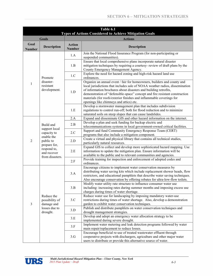
SECTION 6 – MITIGATION STRATEGIES
Multi�Jurisdictional Hazard Mitigation Plan – Ulster County, New York 2015 Plan Update – Draft 6�3
Table 6.1
Types of Actions Considered to Achieve Mitigation Goals
Goals Actions
Goal
Number Description
Action
Number Description
1
Promote
disaster�
resistant
development.
1.A Join the National Flood Insurance Program (for non�participating or
suspended communities).
1.B
Ensure that local comprehensive plans incorporate natural disaster
mitigation techniques by requiring a courtesy� review of draft plans by the
County Emergency Management Agency.
1.C Explore the need for hazard zoning and high�risk hazard land use
ordinances.
1.D
Organize an annual event / fair for homeowners, builders and county and
local jurisdictions that includes sale of NOAA weather radios, dissemination
of information brochures about disasters and building retrofits,
demonstration of “defensible�space” concept and fire resistant construction
materials (for roofs/exterior finishes and inflammable coverings for
openings like chimneys and attics) etc.
1.E
Develop a stormwater management plan that includes subdivision
regulations to control run�off; both for flood reduction and to minimize
saturated soils on steep slopes that can cause landslides.
2
Build and
support local
capacity to
enable the
public to
prepare for,
respond to,
and recover
from disasters.
2.A Expand and disseminate GIS and other hazard information on the internet.
2.B Develop a plan and seek funding for backup electric and
telecommunications systems in local government�owned critical facilities.
2.C Support and fund Community Emergency Response Team (CERT)
programs that also include a mitigation component.
2.D Create a virtual and physical library that contains all technical studies,
particularly natural resources.
2.E
Expand GIS to collect and develop more sophisticated hazard mapping. Use
information to update the mitigation plan. Ensure information will be
available to the public and to relevant communities and agencies.
2.F Provide training for inspection and enforcement of adopted codes and
ordinances.
3
Reduce the
possibility of
damage and
losses due to
drought.
3.A
Encourage citizens to implement water conservation measures by
distributing water saving kits which include replacement shower heads, flow
restrictors, and educational pamphlets that describe water saving techniques.
Also encourage conservation by offering rebates for ultra�low�flow toilets.
3.B
Modify water utility rate structure to influence consumer water use
including: increasing rates during summer months and imposing excess use
charges during times of water shortage.
3.C
Reduce water use for landscaping by imposing mandatory water�use
restrictions during times of water shortage. Also, develop a demonstration
garden to exhibit water conservation techniques.
3.D Publish and distribute pamphlets on water conservation techniques and
drought management strategies.
3.E Develop and adopt an emergency water allocation strategy to be
implemented during severe drought.
3.F Implement water metering and leak detection programs followed by water
main repair/replacement to reduce losses.
3.G
Encourage beneficial re�use of treated wastewater effluent through
cooperative projects with dischargers, agriculture and other major water
users to distribute or provide this alternative source of water.

SECTION 6 – MITIGATION STRATEGIES
Multi�Jurisdictional Hazard Mitigation Plan – Ulster County, New York 2015 Plan Update – Draft 6�4
Table 6.1
Types of Actions Considered to Achieve Mitigation Goals
Goals Actions
Goal
Number Description
Action
Number Description
4
Reduce the
possibility of
damage and
losses due to
flooding
caused by
floods,
hurricanes,
and
nor’easters.
4.A
Join the National Flood Insurance Program. As a participant, floodplains
within the participating community will be identified and mapped. In return,
the participating community will become eligible for flood insurance as long
as the local governing body adopts and enforces a compliant floodplain
ordinance.
4.B Limit uses in floodways to those tolerant of occasional flooding, including
but not limited to agriculture, outdoor recreation, and natural resource areas.
4.C Develop a Countywide gauging and warning system for flash and riverine
flooding.
4.D Continue to implement best management practices for floodplain areas.
4.E
Identify and document repetitively flooded properties. Explore mitigation
opportunities for repetitively flooded properties, and if necessary, carry out
acquisition, relocation, elevation, and flood�proofing measures to protect
these properties.
4.F
Conduct a routine stream maintenance program (for currently non�
participating communities) and seek financial assistance to clean�out stream
segments with heavy sediment deposits.
4.G
Develop specific mitigation solutions for flood�prone roadways and
intersections under the leadership of State DOT. Develop a work plan
identifying when sites will be surveyed and what role the local government
can play in the selection and implementation of mitigation activities (e.g.
any monetary or contextual support through the local capital improvement
plan).
4.H
Implement identified stormwater recharge, rate or volume projects identified
in Regional Stormwater Management Plans to decrease “flash” in streams
during/after storm events.
4.I Implement specific actions to enhance/improve participation in/compliance
with National Flood Insurance Program (NFIP)
5
Reduce the
possibility of
damage and
losses due to
earthquakes.
5.A Retrofit old/dilapidated critical facilities.
5.B Public awareness through video/brochures about simple steps homeowners
can take to mitigate damage.
5.C
Examine provisions for earthquake resistant retrofits for existing structures
and infrastructure, paying particular attention to unreinforced masonry
structures built prior to the adoption of building codes requiring earthquake
resistant design for new construction.
6
Reduce the
possibility of
damage due to
lightning
strikes
6.A Carry out inventory of compliance with existing local codes/standards,
especially for critical facilities.
6.B
Adopt building safety codes such as National Fire Protection Association
(NFPA) �780, Standard for the Installation of Lightning Protection Systems
(1997).
6.C Public awareness/outreach regarding use of ground outlets and surge
protectors in homes and businesses.
7
Reduce the
possibility of
damage and
losses due to
ice jams
7.A Implement monitoring and early warning measures at key locations
7.B Investment in ice�clearing/breaking equipment and appropriate training for
county personnel.
7.C Construction of ice control structures such as booms, tension weirs and
sloped�block barriers.

SECTION 6 – MITIGATION STRATEGIES
Multi�Jurisdictional Hazard Mitigation Plan – Ulster County, New York 2015 Plan Update – Draft 6�5
Table 6.1
Types of Actions Considered to Achieve Mitigation Goals
Goals Actions
Goal
Number Description
Action
Number Description
8
Reduce the
possibility of
damage and
losses due to
dam failures.
8.A Enforce participation in/compliance with National and NYSDEC /
NYSEMO Dam Safety Programs.
8.B
Investigate sources of funding to assist private dam owners to complete
required repairs/maintenance. Investigate low interest loans to owners and/or
jurisdiction acting as guarantor of private owners’ loans.
8.C Notify owners of property in dam break inundation areas of risks, implement
restrictions for new development in these areas.
9
Reduce the
possibility of
damage and
losses due to
landslides.
9.A Create comprehensive geological mapping for areas prone to landslides and
rockslides.
9.B Locally identify and map specific areas of potential slope failure and limit
future development in these areas.
9.C Develop a public outreach program that addresses the economic impacts of
landslides on personal property.
9.D Consider adopting a steep slope ordinance, if one is not already in place, to
regulate development on these higher risk areas.
9.E
Develop a vegetation management plan. Proper vegetation can supply slope�
stabilizing root strength, and facilitate in intercepting precipitation.
Establishing and maintaining appropriate vegetation of areas above the bluff
slope may be the single most important and cost�effective mitigation
measure available.
10
Reduce the
possibility of
damage and
losses due to
wildfires
10.A In consultation with NYSDEC Forest Protection & Fire Management and
local forest rangers, develop mapping of wildland/urban interface areas.
10.B Develop inventory of addresses for route alerting during wildfire
emergencies that require public warning and information.
10.C
In consultation with NYSDEC Forest Protection & Fire Management and
local forest rangers, review local EOPs for possible wildfire components
regarding Fire�Rescue, Alert Warning Communications, and Evacuation.
10.D Prescribed burning for hazard reduction.
10.E Initiate a public outreach program for homeowners.
10.F Retrofit buildings with fire resistant materials, especially roofing.
10.G Implement Community brush and debris removal and hazard fuels reduction.
10.H Use Firewise landscaping in higher risk areas.
10.I Mitigation for streets, highways, and roads that provide key fire access and
fuelbreaks.
11
Reduce the
possibility of
damage and
losses due to
winter storms.
11.A Promote (or purchase, for critical facilities) NOAA weather radios.
11.B Educate residents about driving in winter storms and handling winter�related
health effects
11.C Plant ice and windstorm�resistant trees and implement landscaping practices
to reduce tree�related hazards
11.D Bury utility lines to avoid power outage due to winter storms (if risk is very
high then only this action might be cost�effective)
12
Reduce the
possibility of
damage and
losses due to
extreme
temperatures.
12.A
Develop and distribute outreach tools for homeowners and building permit
applicants on protection of structures against cold weather damage and
proper maintenance of heating/cooling systems.
12.B
Review existing emergency response plans for enhancement opportunities:
work with social support agencies, homeowners associations and general
public to develop and implement monitoring and warning systems focused
on vulnerable populations and provision of adequate shelter facilities.
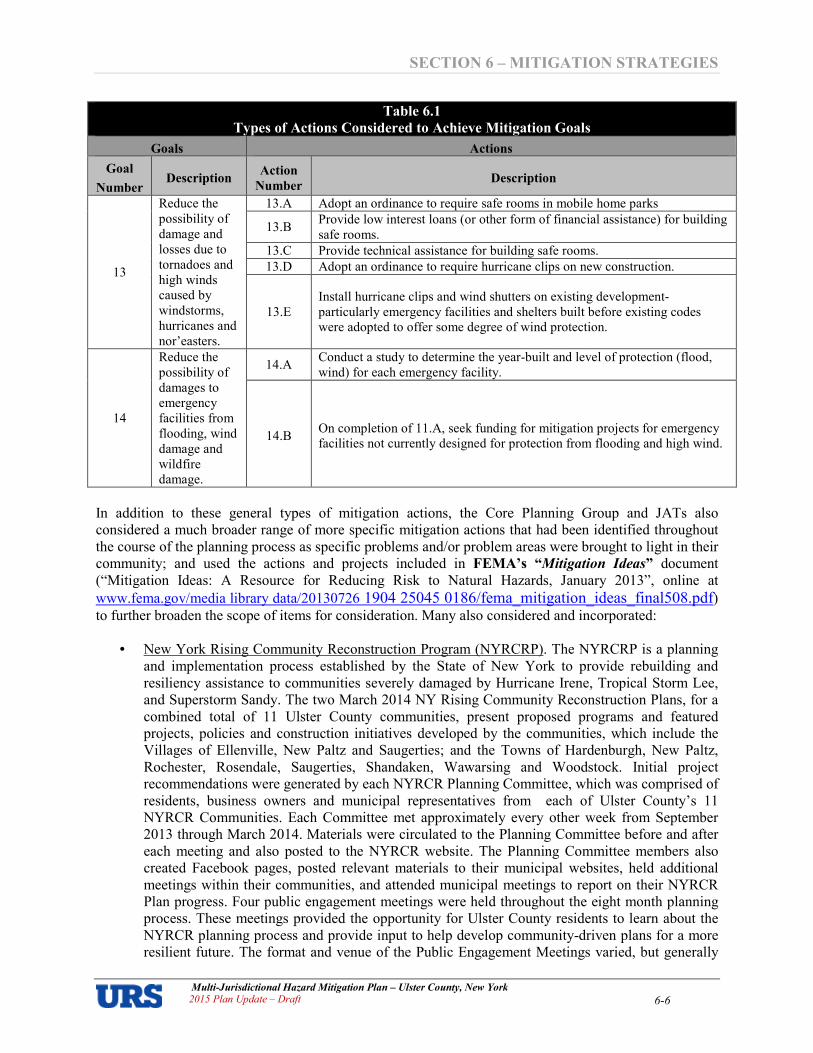
SECTION 6 – MITIGATION STRATEGIES
Multi�Jurisdictional Hazard Mitigation Plan – Ulster County, New York 2015 Plan Update – Draft 6�6
Table 6.1
Types of Actions Considered to Achieve Mitigation Goals
Goals Actions
Goal
Number Description
Action
Number Description
13
Reduce the
possibility of
damage and
losses due to
tornadoes and
high winds
caused by
windstorms,
hurricanes and
nor’easters.
13.A Adopt an ordinance to require safe rooms in mobile home parks
13.B Provide low interest loans (or other form of financial assistance) for building
safe rooms.
13.C Provide technical assistance for building safe rooms.
13.D Adopt an ordinance to require hurricane clips on new construction.
13.E
Install hurricane clips and wind shutters on existing development�
particularly emergency facilities and shelters built before existing codes
were adopted to offer some degree of wind protection.
14
Reduce the
possibility of
damages to
emergency
facilities from
flooding, wind
damage and
wildfire
damage.
14.A Conduct a study to determine the year�built and level of protection (flood,
wind) for each emergency facility.
14.B On completion of 11.A, seek funding for mitigation projects for emergency
facilities not currently designed for protection from flooding and high wind.
In addition to these general types of mitigation actions, the Core Planning Group and JATs also
considered a much broader range of more specific mitigation actions that had been identified throughout
the course of the planning process as specific problems and/or problem areas were brought to light in their
community; and used the actions and projects included in FEMA’s “Mitigation Ideas” document
(“Mitigation Ideas: A Resource for Reducing Risk to Natural Hazards, January 2013”, online at
www.fema.gov/media library data/20130726 1904 25045 0186/fema_mitigation_ideas_final508.pdf) to further broaden the scope of items for consideration. Many also considered and incorporated:
• New York Rising Community Reconstruction Program (NYRCRP). The NYRCRP is a planning
and implementation process established by the State of New York to provide rebuilding and
resiliency assistance to communities severely damaged by Hurricane Irene, Tropical Storm Lee,
and Superstorm Sandy. The two March 2014 NY Rising Community Reconstruction Plans, for a
combined total of 11 Ulster County communities, present proposed programs and featured
projects, policies and construction initiatives developed by the communities, which include the
Villages of Ellenville, New Paltz and Saugerties; and the Towns of Hardenburgh, New Paltz,
Rochester, Rosendale, Saugerties, Shandaken, Wawarsing and Woodstock. Initial project
recommendations were generated by each NYRCR Planning Committee, which was comprised of
residents, business owners and municipal representatives from each of Ulster County’s 11
NYRCR Communities. Each Committee met approximately every other week from September
2013 through March 2014. Materials were circulated to the Planning Committee before and after
each meeting and also posted to the NYRCR website. The Planning Committee members also
created Facebook pages, posted relevant materials to their municipal websites, held additional
meetings within their communities, and attended municipal meetings to report on their NYRCR
Plan progress. Four public engagement meetings were held throughout the eight month planning
process. These meetings provided the opportunity for Ulster County residents to learn about the
NYRCR planning process and provide input to help develop community�driven plans for a more
resilient future. The format and venue of the Public Engagement Meetings varied, but generally

SECTION 6 – MITIGATION STRATEGIES
Multi�Jurisdictional Hazard Mitigation Plan – Ulster County, New York 2015 Plan Update – Draft 6�7
included power point presentations, display boards and mapping, workgroups with maps and
markers, survey sheets and comment boxes. The 11 NY Rising communities considered their
respective NYRCRP initiatives when formulating their mitigation strategies as part of this
plan update.
Ulster County and its municipalities will always consider those actions they believe to be the most
important during the recovery process, in addition to those actions and project types that have been
specifically listed per county and municipality. Due to the effects of recent disasters, this section has been
amended to include the following mitigation actions and project types:
Flood Mitigation Actions. Retrofitting structures prone to periodic flooding is an effective mitigation
technique to reduce the flood loss of property and is consistent with all of the goals. Techniques include
the elevation of structures, acquisition, mitigation reconstruction, dry flood proofing, wet flood proofing,
and drainage improvements and installation of generators.
• Elevation: involves raising a structure on a new foundation so that the lowest floor is above
the Base Flood Elevation (BFE). Almost any type and size of structure can be elevated
(depending on the location of the structure – the stricter regulations governing construction in
A zones such as higher BFEs may preclude the elevation of certain types of structure in
coastal areas). As part of this plan update, local floodplain administrators in each community
provided feedback describing the implementation of the NFIP in their respective
jurisdictions. The City of Kingston, Town of New Paltz, and Village of Saugerties indicated
that their current floodplain management ordinance already exceeds FEMA or State
minimum requirements. Based on the language of local codes for these communities, the City
of Kingston and Town of New Paltz both regulate to a minimum of BFE plus two feet; while
the Village of Saugerties regulates to a minimum of BFE plus four feet.
• Acquisition of structures: or "buyout" option is the most effective mitigation technique to
reduce the loss of property due to flooding. The owners of repetitive flood loss structures or
substantially damaged structures sell their structure to the community on a cost share basis
for the fair market value of the structure prior to the last flood event. The structure is
demolished and removed with a deed restriction placed on the property in perpetuity, thus
eliminating the structure from future flood damage. This approach is most effective when
flood prone structures located within the same vicinity are grouped together and acquired.
The remaining property can be converted into usable recreational space with minor structure
restrictions. It should be noted that owners of repetitive loss structures may be required to pay
higher flood insurance rates if they fail to mitigate the structure.
• Mitigation Reconstruction: is a component of the Severe Repetitive Loss (SRL) grant
program that allows demolition and reconstruction of structures when traditional elevation
cannot be implemented. This activity can be used for structures that were substantially
damaged or destroyed. Currently this is a pilot program utilized mainly on the gulf coast but
can be considered a potential approach to mitigation activities.
• Dry flood proofing: techniques include the building of floodwalls adjacent to existing walls,
the installation of special doors to seal out floodwaters, and special backflow valves for water
and sewer lines. Generally, dry floodproofing is only approvable for non�residential
structures.
• Wet flood proofing: includes measures applied to a structure that prevent or provide
resistance to damage from flooding while allowing floodwaters to enter the structure or area.
SECTION 6 – MITIGATION STRATEGIES
Multi�Jurisdictional Hazard Mitigation Plan – Ulster County, New York 2015 Plan Update – Draft 6�8
Generally, this includes properly anchoring the structure, using flood resistant materials
below the BFE, protection of mechanical and utility equipment, and use of openings or
breakaway walls. Application of wet flood proofing as a flood protection technique under the
NFIP is limited to enclosures below elevated residential and non�residential structures and to
accessory and agricultural structures that have been issued variances by the community. Wet
flood proofing also includes low cost mitigation measures such as raising air conditioners,
heat pumps, and hot water heaters on platforms above the BFE.
• Drainage: Improving the drainage capacity around roads and low�lying areas is a time�tested
technique to mitigate flood damage. Maintenance of drainage canals and laterals is essential
to maximize their efficiency and continued long term effectiveness. Actions in general to
reduce the effects of flooding are widening and deepening the earthen canals, cleaning of
existing ditches, and replacing existing culverts, upgrading pumps, and installing check
valves and inverts in certain culverts. Maintaining and improving drainage serves to assist
the communities with problems experienced from floods, hurricanes, tornadoes and
thunderstorms/lightning/high winds.
• Generators: Another cost effective retrofitting technique includes the installation of
generators. By providing power with generators during and after severe storms many critical
facilities may continue to provide necessary services to the community. The installation of
generators serves to assist the communities with problems experienced from floods,
hurricanes, tornadoes and thunderstorms/lightning/high winds.
Wind Mitigation Actions. Retrofits to protect against wind damage are an effective mitigation
technique to reduce property losses due to wind and are consistent with all of the goals. Techniques
include retrofits to existing structures, and burying electric power lines..
• Structural Retrofits. Structures can be retrofitted to withstand high winds by installing
hurricane shutters, roof tie�downs and other storm protection features. The exterior integrity
is maintained by protecting the interior of the structure and providing stability against wind
hazards associated with hurricanes. These types of measures can be relatively inexpensive
and simple to put in place. It should be noted that for the structural retrofits to work, the
structure must be basically sound prior to the retrofit.
• Burying Power Lines. Another retrofitting technique is to bury electric power lines to avoid
tree limbs falling on them or from wind damage resulting in a break in service to the
consumer. Burying electric power lines serves to assist the communities with problems
experienced from floods, hurricanes, ice, tornadoes and thunderstorms/lightning/high winds.
Early Warning Systems. Early warning systems serve to assist the communities with problems
experienced from floods, hurricanes, tornadoes and thunderstorms/lightning/high winds as well as other
lower priority hazards. With sufficient warning of a flood, a community and its residents can take
protective measures such as moving personal property, cars, and people out of harm’s way. When a flood
threat recognition system is combined with an emergency response plan that addresses the community's
flood problems, considerable flood damage can be prevented. This system must be coupled with warning
the general public, carrying out appropriate tasks, and coordinating the flood response plan with operators
of critical facilities. A comprehensive education and outreach program is critical to the success of early
warning systems so that the general public, operators of critical facilities, and emergency response
personnel will know what actions to take when warning is disseminated. Ulster County would like to
improve its public notification system to alert citizens of the county regarding the possibility of
impending flooding caused by hurricanes, tropical storms, and heavy rains resulting from prolonged
SECTION 6 – MITIGATION STRATEGIES
Multi�Jurisdictional Hazard Mitigation Plan – Ulster County, New York 2015 Plan Update – Draft 6�9
thunderstorms. A warning period is available for most emergency situations, although the amount of lead
time may vary from hazard to hazard. Proper use of this warning period will save lives, reduce injuries,
and protect property.
Earthquake Mitigation Actions. Significant seismic events, while not common to the region, do pose a
potentially significant threat to Ulster County and the surrounding area. The most practical preventative
actions to be considered concerns appropriate building code enforcement. While this is not necessarily
practical for existing structures except for during renovations or reconstruction, there are activities that
can be taken to mitigate further exposure to risk.
• Building Retrofit: The use of reinforced concrete materials in combination with cross ties is a
proven technique to provide current structures with additional stabilization. The addition of
seismic stabilizer platforms for important critical mechanicals within buildings will
significantly reduce adverse impacts.
Mitigation Action Plans for Each Jurisdiction
Each jurisdiction documented their local evaluation process using FEMA Region 2’s Mitigation Action
Worksheet1. Mitigation Action Worksheets completed by each JAT are included in Appendix 1.2 –
Worksheets: Municipal Annexes (with one worksheet per mitigation action). Each community’s
collection of projects in their local annex is referred to as their local “Mitigation Action Plan” or
“Mitigation Strategy”.
The action worksheets document each jurisdiction’s analysis of actions and/or projects considered to
reduce the impacts of hazards identified in the risk assessment, and identify the actions and/or projects
that each jurisdiction intends to implement. Action evaluation criteria are shown in Table 6.2. Special
emphasis was placed on the extent to which benefits would be maximized according to a planning level
assessment of whether the costs appeared to be reasonable as compared to the anticipated benefits.
Worksheets also document how the actions identified will be prioritized, implemented, and administered
by each jurisdiction. Priorities (how important the action is) are generally identified as high, medium, or
low priority based on each jurisdiction’s own assessment of action evaluation criteria. Responsible
agencies are documented, along with potential resources for implementation (i.e., staff, funding,
materials, etc.) and an estimated timeframe for completion.
Table 6.2 � Action Evaluation Criteria
Cost Effectiveness
Losses avoided
(i.e., benefits)
� How effective will the action be at protecting lives and preventing injuries?
� How significant will the action be at reducing damage to structures and infrastructure?
Cost estimate � How much do you estimate it will cost to implement the action?
Cost effectiveness
(i.e., benefit/cost)
� Do the losses avoided outweigh the cost of the action?
� In other words, will it save your community money in the long term?
� Eliminate actions that are not cost effective
Other Factors
Technical � Is the mitigation action technically feasible?
� Eliminate actions that are not.
Political � Is there overall public support for the mitigation action?
� Is there the political will to support it?
Legal � Does the community have the authority to implement the action?
1 FEMA Region 2’s “Mitigation Action Worksheets”, as distributed at the four, FEMA�hosted Mitigation Strategy Workshops in nearby
Monmouth County, NJ on April 2�5, 2013. As per this workshop, priority indicated as high, medium, or low with no need to rank.

SECTION 6 – MITIGATION STRATEGIES
Multi�Jurisdictional Hazard Mitigation Plan – Ulster County, New York 2015 Plan Update – Draft 6�10
Table 6.2 � Action Evaluation Criteria
Environmental � What are the potential environmental impacts of the action?
� Will it comply with environmental regulations?
Social � Will the proposed action affect one segment of the population?
� Will it disrupt established neighborhoods, break up voting districts or cause the relocation
of lower income people?
Administrative
capability
� Does the community have the personnel and administrative capabilities to implement the
action and maintain it or will outside help be necessary?
Local
champion
� Is there a strong advocate for the action among local departments and agencies that will
support its implementation?
Other community
objectives
� Does the action further other community objectives, such as capital improvements,
economic development, environmental quality, or open space preservation?
Unique action items are included for each jurisdiction requesting approval of the plan. Mitigation action
plans were developed uniquely by each jurisdiction participating in this plan, with no competition
between jurisdictions.
Not all of the actions initially considered were ultimately selected for community action plans based on
existing local conditions such as technical feasibility, political acceptance, lack of funding, or other
constraints. The actions locally�deemed to be most suitable for the jurisdiction to implement were carried
over for detailed evaluation and prioritization. The community and County action plans that were
ultimately developed, together with action items spearheaded at the County level with local participation,
include action items to address every hazard profiled in this mitigation plan. Communities will consider
widening the scope of their mitigation strategies at each update to encompass a greater range of hazards,
following progress or completion of the actions in their initial strategies.
Table 6.3 is an overview�level summary of the general types and numbers of projects comprising each
local mitigation action plan. Please refer to Municipal Annexes in Appendix 1.2 for detailed
information about each action item. Together, Ulster County and its jurisdictions intend to implement
nearly 200 hazard mitigation actions or projects to reduce risk from natural disasters.
Note that some jurisdictions have opted to include emergency response and preparedness actions in their
local mitigation action plans. While these types of actions may be included herein as part of a local action
plan, they are not credited toward meeting the plan’s mitigation action requirement.

SECTION 6 – MITIGATION STRATEGIES
Multi�Jurisdictional Hazard Mitigation Plan – Ulster County, New York 2015 Plan Update � Draft 6�11
Table 6.3 – Overview of Local Mitigation Strategies
Jurisdiction
Highest hazards � at a
minimum � are addressed
in the mitigation strategy?
Key risk findings
addressed?
Number of
Actions
Identified
Mitigation Action Types
Local
Planning
/Regulations
Structure and
Infrastructure
Projects
Natural
Systems
Protection
Education /
Awareness
Programs
Preparedness
/ Response
Activities
Ulster, County of Highest hazards � at a minimum �
addressed in mitigation strategy
Key risk findings
addressed 35 3 27 1 4 0
Denning, Town of Highest hazards � at a minimum �
addressed in mitigation strategy
Key risk findings
addressed 16 0 16 0 0 0
Ellenville, Village of Highest hazards � at a minimum �
addressed in mitigation strategy
Key risk findings
addressed 4 0 2 2 0 0
Esopus, Town of Highest hazards � at a minimum �
addressed in mitigation strategy
Key risk findings
addressed Esopus did not participate.
Gardiner, Town of Highest hazards � at a minimum �
addressed in mitigation strategy
Key risk findings
addressed 8 0 4 0 1 3
Hardenburgh, Town of Highest hazards � at a minimum �
addressed in mitigation strategy
Key risk findings
addressed 20 1 17 0 0 2
Hurley, Town of Highest hazards � at a minimum �
addressed in mitigation strategy
Key risk findings
addressed 3 0 3 0 0 0
Kingston, City of Highest hazards � at a minimum �
addressed in mitigation strategy
Key risk findings
addressed 7 0 6 0 0 1
Kingston, Town of Highest hazards � at a minimum �
addressed in mitigation strategy
Key risk findings
addressed 3 0 3 0 0 0
Lloyd, Town of Highest hazards � at a minimum �
addressed in mitigation strategy
Key risk findings
addressed
Not yet
received
Marbletown, Town of Highest hazards � at a minimum �
addressed in mitigation strategy
Key risk findings
addressed Marbletown did not participate.
Marlborough, Town of Highest hazards � at a minimum �
addressed in mitigation strategy
Key risk findings
addressed
Not yet
received
New Paltz, Town of Highest hazards � at a minimum �
addressed in mitigation strategy
Key risk findings
addressed 6 0 6 0 0 0
New Paltz, Village of Highest hazards � at a minimum �
addressed in mitigation strategy
Key risk findings
addressed 9 2 6 0 1 0
Olive, Town of Highest hazards � at a minimum �
addressed in mitigation strategy
Key risk findings
addressed 28 1 22 1 1 3
Plattekill, Town of Highest hazards � at a minimum �
addressed in mitigation strategy
Key risk findings
addressed
Not yet
received
Rochester, Town of Highest hazards � at a minimum �
addressed in mitigation strategy
Key risk findings
addressed Rochester did not participate.
Rosendale, Town of Highest hazards � at a minimum �
addressed in mitigation strategy
Key risk findings
addressed
Not yet
received
Saugerties, Town of Highest hazards � at a minimum �
addressed in mitigation strategy
Key risk findings
addressed 5 1 2 1 1 0

SECTION 6 – MITIGATION STRATEGIES
Multi�Jurisdictional Hazard Mitigation Plan – Ulster County, New York 2015 Plan Update � Draft 6�12
Table 6.3 – Overview of Local Mitigation Strategies
Jurisdiction
Highest hazards � at a
minimum � are addressed
in the mitigation strategy?
Key risk findings
addressed?
Number of
Actions
Identified
Mitigation Action Types
Local
Planning
/Regulations
Structure and
Infrastructure
Projects
Natural
Systems
Protection
Education /
Awareness
Programs
Preparedness
/ Response
Activities
Saugerties, Village of Highest hazards � at a minimum �
addressed in mitigation strategy
Key risk findings
addressed 4 0 2 0 0 2
Shandaken, Town of Highest hazards � at a minimum �
addressed in mitigation strategy
Key risk findings
addressed 19 3 10 1 0 5
Shawangunk, Town of Highest hazards � at a minimum �
addressed in mitigation strategy
Key risk findings
addressed
Not yet
received
Ulster, Town of Highest hazards � at a minimum �
addressed in mitigation strategy
Key risk findings
addressed 6 0 6 0 0 0
Wawarsing, Town of Highest hazards � at a minimum �
addressed in mitigation strategy
Key risk findings
addressed 7 0 4 0 0 3
Woodstock, Town of Highest hazards � at a minimum �
addressed in mitigation strategy
Key risk findings
addressed 22 1 20 0 0 1
Total Number of Actions County�wide*: 202 12 156 6 8 20
* Totals will increase on receipt of actions from the Towns of Lloyd, Marlborough, Plattekill, Rosendale, and Shawangunk.

Kingston
Shandaken
HardenburghWoodstock
Saugerties
MarlboroughShawangunk
Denning
Wawarsing
Plattekill
UlsterHurley
Olive
Kingston
MarbletownEsopus
Rochester
Rosendale
Lloyd
Gardiner
NewPaltz
LegendUlster CountyPriority" Low" Med" High
Local MunicipalitiesPriority
LowMedHigh
Mitigation Actions- Countywide
anna_foley
Snapshot
anna_foley
Rectangle
anna_foley
Text Box
6-13
anna_foley
Typewritten Text
FIGURE IN DEVELOPMENT
anna_foley
Typewritten Text
FIGURE IN DEVELOPMENT

SECTION 7 PLAN MAINTENANCE AND INTEGRATION
Multi�Jurisdictional Hazard Mitigation Plan – Ulster County, New York 2015 Plan Update � Draft
7�1
SECTION 7 PLAN MAINTENANCE AND INTEGRATION
A formal plan maintenance process for monitoring, evaluating, and updating the Hazard Mitigation Plan
must take place to ensure that the Plan – and specifically the mitigation strategy remains current and
relevant. Updates are required every five years from the date the plan is approved1. Regularly scheduled
evaluations during the fiveyear cycle are important to assess the effectiveness of the program and to
reflect changes that may affect mitigation priorities, and a process must be undertaken to keep the public
engaged throughout the plan’s ongoing implementation. As part of the 2015 Plan Update, the UCECEM
and the County JAT have reviewed the 2009 to 2014 plan maintenance procedure, and have opted to
pursue a very similar strategy for the next five years (2015 to 2020) though some changes have been
made to account for both expressed municipal preferences for a slightly modified approach in some areas,
and minor differences in the FEMA guidance since the initial plan was prepared.
The UCECEM will continue to take the lead role in coordinating the overall plan maintenance effort, with
ongoing support and feedback from the County JAT. Mr. Steven Peterson, who was identified as
Coordinator for the 2015 Plan update, will oversee the overall plan maintenance process. Each CPG
member will take the lead role on plan maintenance activities for their respective jurisdiction2. Details of
County and municipal responsibilities with regard to plan maintenance and integration are
described in the remainder of this section.3
Monitoring the Plan
An important step in any mitigation planning process is to document the method by which the CPG will
monitor the plan’s implementation throughout the fiveyear period of record. The lead entity in each
jurisdiction coordinates with other departments/agencies responsible for implementing hazard mitigation
actions identified in the plan in order to maximize the opportunities to implement actions, track progress
of actions, identify and address any barriers to implementation of the actions, and to take advantage of
grant funding opportunities. Monitoring the plan, therefore, becomes part of the regular function of the
office and position to which it is assigned.
Approach. The plan monitoring approach outlined in the 2009 Plan and shown below was reselected for
the next 5 year cycle. However, reference to the old FEMA HowTo #4, Worksheet #1 Progress
Monitoring Report has been replaced by something more userfriendly and tailored to some specific
requests of the participants, as the old worksheet had been found to be fairly intimidating during the first
plan maintenance phase. Additional details are presented below.
Annual Work Progress Monitoring Reports will be prepared by the County and each participating
jurisdiction to track the progress of each of their respective hazard mitigation actions. Annual Work
Progress Monitoring Reports shall be prepared by the team members listed on Worksheet 1 submittals in
Appendix 1.2 for each participating jurisdiction and submitted on an annual basis to both UCECEM and
their local governing body at this same time to demonstrate local progress or changes todate, beginning
one year from the date of FEMA’s approval of the Final plan. UCECEM will maintain a central
repository of responses. A blank Annual Work Progress Monitoring Report is included at the end of this
subsection. The Annual Work Progress Monitoring Reports provide an overview of the hazard mitigation
1 After FEMA completes its plan review and determines that all requirements have been adequately addressed, it issues a
determination of “Approvable Pending Adoption”. Participating jurisdictions then each move forward with formally adopting the
plan. For multijurisdictional plans, FEMA considers the plan approval date to be the date of the first jurisdictional adoption. 2 Many jurisdictions have more than one individual CPG member. In completing the Statement of Authority to Participate
(discussed in Section 1), each jurisdiction designated a primary CPG representative as well as an alternate. For plan maintenance
purposes, it is the position title of the person designated as the ‘primary representative’ who is responsible for shepherding plan
maintenance activities. 3 Feedback was solicited on a draft of this plan section as distributed via email from URS to UCECEM on March 24, 2014 and
again on October 22, 2015 with feedback received on December 15, 2015 and subsequently incorporated.
SECTION 7 PLAN MAINTENANCE AND INTEGRATION
Multi�Jurisdictional Hazard Mitigation Plan – Ulster County, New York 2015 Plan Update � Draft
7�2
action(s), responsible and supporting agencies/entities responsible for implementation, a delineation of
the various project milestones, the current status of the project, any issues that may hinder
implementation; and next steps.
Annual Work Progress Monitoring Reports are to be completed by each municipality once per year
for each project in their mitigation strategy, beginning one year from the date of FEMA’s approval
of the Final plan4.
Past Progress. The 2009 Plan was approved by FEMA on March 9, 2009; therefore, according to the
process outlined above, Annual Work Progress Monitoring Reports were targeted for municipal
completion and submittal to UCECEM in January of 2010, 2011, 2012, 2013, and 2014. Each of the
jurisdictions took strides toward implementing their hazard mitigation initiatives. However, project
tracking and monitoring were hampered by lack of funds and lack of staff. UCECEM received a very
limited number of Annual Work Progress Monitoring Reports during Cycle 1 (20092011). Monitoring
of progress in 2011, 2012 and 2013 was hampered by Hurricane Irene, Tropical Storm Lee, and
Superstorm Sandy, following which many communities found that all available resources were dedicated
to urgent recovery efforts. Thereafter, monitoring occurred on a more adhoc level, with verbal
evaluations and discussions as opposed to direct, paper tracking. This highlighted a need for increased
vigilance at the local level to both implement mitigation strategies and monitor progress accordingly.
o 2010 to 2013 – Plan monitoring occurred on an adhoc basis at the jurisdiction and County
levels, with verbal evaluations and discussions of progress as opposed to direct, paper
tracking.
o 2014 to 2015 – As part of this hazard mitigation plan update, project progress was tracked via
Worksheet #5, for all progress made on mitigation projects over the whole of the first
planning cycle. Detailed tracking (copies of Worksheet 5 submittals for each jurisdiction) is
provided in Appendix 1.2 – Worksheets: Municipal Annexes, and additional information
may be obtained by contacting members of the relevant County or municipal JAT as listed
in each Municipal Annex Worksheet #1.
4 For multijurisdictional plans, this is the date of the first jurisdictional adoption of the plan, regardless of whether
the first jurisdiction is a county government entity or some other local municipal government.
SECTION 9 PLAN MAINTENANCE
Multi�Jurisdictional Hazard Mitigation Plan – Ulster County, New York 2015 Plan Update � Draft
7�3
Annual Work Progress Monitoring Report
Municipality: Progress Report Period:
Date Prepared:
Mitigation Action Project Title:
Brief Project Description:
Risk Addressed:
Who is responsible for implementing the action?
Contact Person (include name, title, department, phone, email): List Supporting Agencies and Contacts (if any):
Has the project been initiated (check one): __yes ___no If yes, when? If no, why not?
Status (check one): __on schedule __completed __delayed*
* If delayed subsequent to initiation, explain here: Original target date for completion:
Current estimated target date for completion:
Original cost estimate:
Cost Status (check one): __ unchanged __overrun _underrun If overrun/underrun, explain here:
Anticipated overrun amount:
Anticipated underrun amount:
Description of the Project (fill in table with a description of each phase, if applicable, and the time frame for completing each phase):
Project Milestones (e.g. grant application, approval, design, permitting, construction, etc.) Complete? (y/n) Projected Completion Date

SECTION 9 PLAN MAINTENANCE
Multi�Jurisdictional Hazard Mitigation Plan – Ulster County, New York 2015 Plan Update � Draft
7�4
Annual Work Progress Monitoring Report
Municipality: Progress Report Period:
Date Prepared:
Mitigation Action Project Title:
Indicator of Success: In most cases, you will describe any damages/losses that have been avoided as a result of the project. Leave blank if project is not completed. In cases where it is difficult to quantify the benefits in dollar amounts, you will use other indicators, such as the number of people who now know about mitigation or who are taking mitigation actions to reduce their vulnerability to hazards.
What was accomplished during this reporting period?
What obstacles, problems, or delays did you encounter, if any? (i.e., Was there political support for the action? Were enough funds available? Were workloads equitably or realistically distributed? Was new information discovered about the risks or community that made implementation difficult or no longer sensible? Was the estimated time of implementation reasonable? Were sufficient resources (funds, personnel) available?)
How was each problem resolved?
What is/are the next step(s) to be accomplished over the next reporting period?
If the action has been completed, were the outcomes as expected?
Other comments:
SECTION 7 PLAN MAINTENANCE AND INTEGRATION
Multi�Jurisdictional Hazard Mitigation Plan – Ulster County, New York 2015 Plan Update � Draft
7�5
Evaluating the Plan
After a mitigation plan is formally approved by FEMA and adopted by participating jurisdictions, it
should be evaluated on a regular basis in order to assess the effectiveness of the plan at achieving its
stated purpose and goals.
Approach. The plan evaluation approach outlined in the 2009 Plan and shown below was reselected for
the 2015 Plan Update.
The Core Planning Group will convene once per year for an Annual Plan Evaluation Meeting. Annual
Plan Evaluation Meetings will be led by UCECEM and will be conducted within three months after each
annual batch of Annual Work Progress Monitoring Reports are due (see “Monitoring”, above). At each
meeting, the Core Planning Group will review the Annual Work Progress Monitoring Reports, and use
the following criteria as points for group discussion to evaluate the effectiveness of the plan at achieving
its stated purpose and goals:
o Do the goals and objectives address current and expected conditions?
o Has the nature and magnitude of risks changed?
o Are the current resources appropriate for implementing the plan?
o Are there any implementation problems (such as technical, political and/or legal), or
coordination issues with the other agencies and/or Committee members?
o Have the outcomes occurred as expected?
o Have the agencies and other Committee partners participated as proposed?
o Where shortcomings are identified, what can be done to bring things back on track?
o What is the current progress with regard to plan integration?
o Have any comments been received on the plan from municipalities/public/stakeholders?
Following each Annual Plan Evaluation Meeting, the UCECEM will prepare meeting minutes that will
document, at a minimum, the Group’s consensus responses to the topics above. UCECEM will distribute
meeting minutes to all Core Planning Group members via email, and will post meeting minutes on the
web site.
Past Progress. The 2009 Plan was approved by FEMA on March 9, 2009. According to the process
above, Annual Plan Evaluation Meetings were targeted for January of 2010, 2011, 2012, 2013, and 2014.
Plan evaluation activities in 2011, 2012 and 2013 were hampered by Hurricane Irene, Tropical Storm Lee,
and Superstorm Sandy, following which many communities found that all available resources were
dedicated to urgent recovery efforts. Thereafter, evaluation occurred as described below. This highlighted
a need for increased vigilance at the local level to both implement mitigation strategies and monitor
progress and overall plan evaluation accordingly.
o 2010 to 2015. Plan evaluation discussions occurred on an adhoc basis at the jurisdiction and
County levels, with verbal evaluations and discussions of progress as opposed to direct, paper
tracking.
Updating the Plan
As part of the process to maintain FEMA mitigation funding eligibility, a plan update must always be
submitted to NYSOEM/FEMA for their review. This must occur within five years of the plan’s approval
by FEMA (and during subsequent fiveyear cycles thereafter).
Approach. The plan update approach outlined in the 2009 Plan was expanded upon and slightly
modified for the 2015 Plan Update.

SECTION 7 PLAN MAINTENANCE AND INTEGRATION
Multi�Jurisdictional Hazard Mitigation Plan – Ulster County, New York 2015 Plan Update � Draft
7�6
The Ulster County Hazard Mitigation Plan was first approved by FEMA on March 9, 2009. An update
was due on March 9, 2014. The County applied for, and was granted, an extension to this project timeline
for several reasons:
• First, the planning process was severely hampered with response and recovery efforts related to
Irene, Lee, and Sandy in 2011 and 2012 and even into 2013 and later with Sandy recovery and
NY Rising planning processes as CPG members and their communities were working above
capacity during much of the first plan maintenance cycle.
• Second, the County did not have the funding available to contract out the plan update in the
absence of a grant to offset the cost of the project. Ulster County and its jurisdictions initiated the
process for this first required plan update by submitting a planning grant application to FEMA on
May 1, 2012 under the HMGP program. Notification of grant award was received on September
19, 2012 (HMGP4020 Planning Grants). URS was identified by the County to facilitate the
update process; a notice to proceed was issued on August 13, 2013 – only 7 months before the
end of the first fiveyear cycle.
• Third, in the midst of response and recovery from three federally declared disasters, and an
abbreviated project timeline available, the prior UCECEM Director (who had played a lead
County role for the initial plan development and early phases of the first update) was retiring,
with his tenure ending on August 21, 2014 and the Deputy Director assuming the duties of both
Deputy and Acting Director for some time thereafter.
This 2015 plan update represents the first required update of the document. UCECEM has taken the lead
on Plan development and updates, and will continue to do so in the future. UCECEM shall be responsible
for ensuring that the plan is maintained in accordance with all applicable guidance and regulations.
The Update Process Itself. Regardless of whether or not a plan update is grant funded5, the following
must occur within 5 years from the date that the plan is adopted by the first of its participating
jurisdictions:
o An updated planning process must be undertaken.
o An updated plan document must be prepared.
o The updated document must be resubmitted to FEMA (through NJOEM).
o The updated plan must be reviewed by FEMA, who will provide formal comments indicating
both required and recommended revisions.
o At a minimum, all required revisions must be addressed.
o The revised document needs to be routed back to FEMA, who will review to ensure that all
required revisions have been satisfactorily addressed. If so, they will deem the plan
“approvable pending adoption.”
o The plan must then be adopted by participating jurisdictions.
5 Funding the Updates. In the past, Ulster County has sought out grant funding to offset the fairly significant costs associated
with both the initial plan development and the first plan update. Should the County wish to do so in the future, FEMA’s Hazard
Mitigation Grant Program (HMGP) or Predisaster Mitigation Program (PDM) would continue to be the most applicable funding
sources. The HMGP is a postdisaster program. Under this program, funds become available statewide for applicants with
approved hazard mitigation plans in place each time there is a Federal disaster declaration anywhere in the state. A certain
portion of HMGP disaster funds are set aside for projects; the remainder is set aside for planning. The PDM program is a pre
disaster program. Under this program, funds are appropriated annually and are competitive at a national level. Annual
appropriation amounts tend to vary widely, and its availability in the future is not guaranteed. If the UCECEM is interested in
obtaining grant funds for the next required plan update (2015 to 2020) then a grant application should be submitted for the first
opportunity after the plan is adopted. This would allow for the possibility of the application not being approved on the first pass,
and would allow sufficient time for an alternate approach to be taken within the requisite 5year window. If grant funding is
selected as the primary funding source for any given update cycle, the County should be keenly aware of grant application review
times, as well as applicable County procurement rules, when moving forward. It is not uncommon for grant submittal, review,
approval, RFP issuance, review of proposals, selection of a contractor, and contract negotiations and contract execution to take
one to two years out of the 5year cycle. In addition, grant funding is not guaranteed so the County should be prepared with a
backup funding source for meeting requirements if outside assistance does not materialize.

SECTION 7 PLAN MAINTENANCE AND INTEGRATION
Multi�Jurisdictional Hazard Mitigation Plan – Ulster County, New York 2015 Plan Update � Draft
7�7
Allowing one year for the update process, and one year for the review/approval/adoption process has
historically been observed. That having been said, it is recommended that the County initiate each
requisite plan update no later than three years after the plan’s approval date6. If grant funding is sought,
applications should be submitted at the first opportunity following the plan’s approval date (and no later
than two years after the plan is approved).
The plan update involves a comprehensive review and evaluation of each section of the plan, and also
discusses the results of evaluation and monitoring activities detailed in the Plan Maintenance section of
the previously approved plan. Plan updates may validate the information in the previously approved plan,
or may involve a major plan rewrite. A plan update cannot be an annex referring to the previously
approved plan; it must stand on its own as a complete and current plan. Plans are required to be updated
to reflect changes in development, progress in local mitigation actions, and changes in priorities. Other
criteria considered during the update included:
o if changing situations have modified goals/objectives/actions and/or hazards;
o if additional information is available to perform more accurate vulnerability assessments;
o if it is determined that participating jurisdictions wish to be added to and/or removed from the
Plan; or
o if it is determined that the Plan no longer addresses current and expected future conditions.
At the time of each update, UCECEM shall consult with NYSOEM and FEMA for the latest Guidance in
place regarding plan updates to ensure that the latest criteria are addressed in the update process. Plan
updates will be posted on the County web site, and made available in hard copy at the UCECEM offices.
Past Progress. The 2009 Plan was approved by FEMA on March 9, 2009. UCECEM applied for grant
funds under FEMA’s HMGP program to offset the cost of the update on May 2, 2012; notification of
grant award was received on September 20, 2012. URS was selected to facilitate the update process. A
contract was subsequently negotiated, with URS receipt of a notice to proceed on August 13, 2013. The
County extended the initial plan update target timeline to allow the CPG to meet local participation
requirements, and to incorporate NY Rising program recommendations into local mitigation strategies.
This document represents the first plan update.
Public Participation in Plan Maintenance
The public and other stakeholders must be given opportunities to become involved during the Plan’s
regular maintenance and implementation. It is important to understand perceptions of the plan’s
effectiveness and degree of success to help maintain support for the plan and provide accountability for
those responsible for its maintenance and implementation.
Approach. The following array of activities was selected by UCECEM based on feedback received from
Core Planning Group Members at the time of development of the initial plan in 2009. These activities
were reviewed as part of the 2015 Plan Update and the following activities were selected for the 2015 to
2020 planning cycle:
o UCECEM will continue to maintain the mitigation planning website.
o Each participating jurisdiction will maintain a link on their jurisdiction’s web page to the
County mitigation planning website, if they have not already done so.
o UCECEM will prepare an annual fact sheet on the plan. This fact sheet will be submitted via
email to Core Planning Group members for posting on community notice boards, at a
6 After FEMA completes its plan review and determines that all requirements have been adequately addressed, it issues a
determination of “Approvable Pending Adoption”. Participating jurisdictions then each move forward with formally adopting the
plan. For multijurisdictional plans, FEMA considers the plan approval date to be the date of the first jurisdictional adoption.

SECTION 7 PLAN MAINTENANCE AND INTEGRATION
Multi�Jurisdictional Hazard Mitigation Plan – Ulster County, New York 2015 Plan Update � Draft
7�8
minimum, and preferably supplemented with distribution at meetings as applicable.
UCECEM will post the fact sheet on the County mitigation plan web site.
o Participating jurisdictions will conduct annual interviews and/or smaller meetings with civic
groups, the public and other stakeholders. This will be accomplished through incorporating
discussion of the mitigation plan into other regularly attended meetings.
o Participating jurisdictions will consider annual flyers, newsletters, newspaper advertisements,
and Radio/TV announcements to supplement annual interviews/meetings, and will
implement some or all of these at the discretion of the jurisdiction. At a minimum, the
County will issue an annual press release.
o Participating jurisdictions are responsible for keeping track of any comments they receive on
the plan, and bringing these forward for discussion at the Annual Plan Evaluation Meetings.
Past Progress. UCECEM reports the following progress was made in continued outreach to the public
and other stakeholders over the first plan maintenance cycle:
o UCECEM has successfully continued to maintain the mitigation planning website.
o Continual outreach to the public at various events.
o UCECEM provides MultiJurisdictional Hazard Mitigation Plan Fact Sheet and website
information to county staff.
o Beginning in 2013, all participating jurisdictions conducted regular outreach to the public and
other stakeholders regarding the plan update. Their activities are summarized in the
Outreach Logs for each jurisdiction, as included in Municipal Annexes of Appendix 1.2.
Plan Integration
For a participating jurisdiction to succeed in reducing risk in the long term, the information and
recommendations of the hazard mitigation plan must be integrated into daytoday local government
operations, as well as into comprehensive plans. Throughout the planning process, partnerships are
formed between departments and agencies, and sustained actions between these partners will increase the
community’s resilience to disasters. “Plan integration” can be thought of as the process whereby each
participating jurisdiction will incorporate the mitigation plan findings and projects into other planning
mechanisms (local governance structures that are used to manage local land use development, building
codes and community decision making).
Approach. The overall approach of the 2009 Plan included various plan integration options for
municipalities to choose from during the plan maintenance phase. It was not specific as to which
jurisdictions would undertake which activities. However, the latest FEMA guidance requires multi
jurisdictional plans to be more specific, identifying what particular activities will be undertaken by each
specific jurisdiction. To this end, as part of the 2015 Plan update process, municipalities were asked to
consider a range of possible plan integration activities, and by completing a worksheet, select a series of
jurisdictionspecific activities from this list of options(with flexibility to add additional, unlisted options
at their individual discretion). A wide range of possibilities was considered, such as: protecting life and
property in high hazard areas by limiting densities of new development; increasing resilience by limiting
the extension of public infrastructure in high hazard areas; and adding a specific hazard mitigation
element to the next update of local master, general or comprehensive plans to name a few. Worksheet 6
(see jurisdictional annexes of Appendix 1.2) documents the full range of plan integration options that
were considered, as well as each jurisdiction’s identified plan integration activities that will be undertaken
during the 2015 to 2020 plan maintenance cycle. Each jurisdiction has committed to undertake these
activities over the next fiveyear plan maintenance cycle.
Past Progress. As part of the 2015 Plan Update, the targeted plan integration activities from the last
version of the plan were put into tabular form on a worksheet, and each jurisdiction was asked to
complete the worksheet to indicate their respective accomplishments. A summary of Plan Integration
activities that were undertaken during the first plan maintenance cycle is also provided on Worksheet 6
(see jurisdictional annexes of Appendix 1.2).
SECTION 8 FOR MORE INFORMATION
Multi�Jurisdictional Hazard Mitigation Plan – Ulster County, New York 2015 Plan Update � Draft
8�1
SECTION 8 FOR MORE INFORMATION
If you have any questions or comments on the Multi�Jurisdictional Hazard Mitigation Plan for Ulster
County, New York, additional information can be obtained by contacting:
Steven Peterson, Director
Ulster County Department of Emergency Communications/Emergency Management
238 Golden Hill Lane
Kingston, New York 12401�6440
Phone: 845�331�7000
Fax: 845�331�1738
E�Mail: [email protected]
For jurisdiction specific information, it is recommended that the individuals identified as representatives
of the jurisdictions in Section 1 of this plan be contacted.
You may also wish to refer to the County’s website or the communities’ websites for additional
information on the mitigation plan process. Information about this hazard mitigation plan is maintained
on the Ulster County website at:
www.ulstercountyny.gov/emergencyservices/management/haz_mit/index.html

anna_foley
Typewritten Text
THIS PAGE INTENTIONALLY LEFT BLANK

APPENDIX CD
Multi�Jurisdictional Hazard Mitigation Plan – Ulster County, New York 2015 Plan Update – Draft
APPENDIX CD
Appendices for the
Ulster County Multi�jurisdictional Hazard Mitigation Plan
are included herein on CD only.
Appendices
Appendix 1.1 – Statements of Authority to Participate
Appendix 1.2 – Worksheets: Municipal Annexes
• 1.2.1 Annex – Ulster County
• 1.2.2 Annex – Denning, Town of
• 1.2.3 Annex – Ellenville, Village of
• 1.2.4 Annex – Esopus, Town of
• 1.2.5 Annex – Gardiner, Town of
• 1.2.6 Annex – Hardenburgh, Town of
• 1.2.7 Annex – Hurley, Town of
• 1.2.8 Annex – Kingston, City of
• 1.2.9 Annex – Kingston, Town of
• 1.2.10 Annex – Lloyd, Town of
• 1.2.11 Annex – Marbletown, Town of
• 1.2.12 Annex – Marlborough, Town of
• 1.2.13 Annex – New Paltz, Town of
• 1.2.14 Annex – Olive, Town of
• 1.2.15 Annex – Plattekill, Town of
• 1.2.16 Annex – Rochester, Town of
• 1.2.17 Annex – Rosendale, Town of
• 1.2.18 Annex – Saugerties, Town of
• 1.2.19 Annex – Saugerties, Village of
• 1.2.20 Annex – Shandaken, Town of
• 1.2.21 Annex – Shawangunk, Town of
• 1.2.22 Annex – Ulster, Town of
• 1.2.23 Annex – Wawarsing, Town of
• 1.2.24 Annex < Woodstock, Town of
Appendix 1.3 – Meeting Materials
Appendix 1.4 – County Press Releases and Articles in Local News Media
Appendix 1.5 – Jurisdictional Website Coverage of the Plan
Appendix 1.6 – Natural Hazards Survey Results
Appendix 1.7 – Comments on the September 2015 Draft Plan
Appendix 2.1 – Hazard Descriptions
Appendix 3c.1 – Assets in Hazard Areas
Appendix 3c.2 – Historic in Hazard Areas
Appendix 3e.1 – Hazard Rankings and Key Risk Findings
Appendix 4.1 – Legal and Regulatory Tool Descriptions
Appendix 4.2 – State Resources
Appendix 4.3 – Federal Resources

anna_foley
Typewritten Text
THIS PAGE INTENTIONALLY LEFT BLANK