Hazard Mitigation Plan EMMET - Charlevoix County
160
Tri-County Office of Emergency Management 1 Hazard Mitigation Plan 2016 Charlevoix, Cheboygan & Emmet County, Michigan
-
Upload
khangminh22 -
Category
Documents
-
view
2 -
download
0
Transcript of Hazard Mitigation Plan EMMET - Charlevoix County

Tri-County Office of Emergency Management
1
Hazard Mitigation Plan
2016
Charlevoix, Cheboygan &
Emmet County, Michigan

Tri-County Office of Emergency Management
2
Produced by:
Tri-County Office of Emergency Management
PO Box 480
Petoskey, Michigan 49770
TABLE OF CONTENTS
I. Acknowledgements…………………………………………………………………...Pg. 4
II. Transmittal Letter………………………………………………………………….... Pg. 6
III. Preface..............................................................................................................Pg. 7
IV. Executive Summary..........................................................................................Pg. 8
V. Purpose of the Plan...........................................................................................Pg. 10
VI. Flood Mapping and Insurance Information…………………………………….....Pg. 15
VII. Dams……………………………………………………………………………..…..Pg. 15
VIII. Charlevoix County...........................................................................................Pg. 20
IX. Cheboygan County...........................................................................................Pg. 41
X. Emmet County...................................................................................................Pg. 84
XI. Laws, Policies & Ordinances……………………………………………………...Pg. 112
XII. Area Development…………………………………………………………...…….Pg. 113
XIII. Hazard Mitigation Goals and Objectives.........................................................Pg. 115
XIV. Identification and Selection of Strategies......................................................Pg. 117
XV. Implementation of the Plan............................................................................Pg. 120
Appendix A (Dams in Michigan) ...........................................................................Pg. 125

Tri-County Office of Emergency Management
3
Appendix B (Thunderstorms) ...............................................................................Pg. 126
Appendix C (Seasonal Snowfall) .........................................................................Pg. 127
Appendix D (Tornados) ........................................................................................Pg. 128
Appendix E (Documentation)………………………………………………………….Pg. 130

Tri-County Office of Emergency Management
4
I. ACKNOWLEDGEMENTS
This plan is the culmination of the interdisciplinary and interagency planning effort that
required the assistance and expertise of numerous agencies, organizations, and
individuals. Without the technical assistance and contributions of time and ideas of
these agencies, organizations, and individuals, this plan could not have been
completed.
Following is a list of the key contributors to the Plan who participated in the Tri-County
Hazards Mitigation Planning Committee:
TRI-COUNTY EMERGENCY MANAGEMENT
Emergency Management Director
Megan Anderson
Emergency Management Emergency Planner
Mike McCully
CHARLEVOIX COUNTY
Charlevoix County LEPC
Charlevoix County Chapter
Michigan Township Association
CHEBOYGAN COUNTY
Cheboygan County GIS Specialist
Sharon Weiss
Cheboygan County LEPC
Cheboygan County Chapter
Michigan Township Association
Tri-County Office of Emergency Management
5
EMMET COUNTY
Emmet County GIS Specialist
Harry Kitchen
Emmet County LEPC
Emmet County Chapter
Michigan Township Association

Tri-County Office of Emergency Management
6
II. LETTER OF TRANSMITTAL
Mike Sobocinski
Michigan State Police Emergency Management Division
4000 Collins Road
PO Box 30636
Lansing MI 49809-8136
Dear Mr. Sobocinski:
Enclosed, please find the Charlevoix, Cheboygan and Emmet County Hazard Mitigation
Plan. This Plan has been developed in conjunction with the County Planners, Michigan
Township Associations for each county, the public, and the State of Michigan. The Plan
lays out the process of evaluating the potential hazards, land use, and mitigation
strategies to protect lives and property in the Tri-County Region.
This transmittal letter serves notice that all future development decisions in Charlevoix,
Cheboygan and Emmet Counties will consider hazard vulnerability reduction as a
standard practice. The intent of the Hazard Mitigation Plan is not to limit development,
but to ensure that all development occurs in a manner that minimizes the possibility of
damage from potential natural hazards to the greatest extent possible.
Thank you for your time and consideration. If you have any questions, please feel free
to contact the Tri-County Emergency Management Coordinator, Megan Anderson at
855-515-1624
Sincerely,
Megan Anderson, Director
Tri-County Office of Emergency Management

Tri-County Office of Emergency Management
7
III. PREFACE
Hazard mitigation is any action taken before, during, or after a disaster to permanently
eliminate or reduce the long-term risk to human life and property from natural,
technological, and human-related hazards. This procedure is an essential element of
emergency management, which includes four basic “phases”: Mitigation, Preparedness,
Response, and Recovery. The evaluation improves the preparedness posture of the
Tri-County region for the next incident, and when successful, mitigation is intended to
lessen the impacts of hazards to such a degree that succeeding incidents will remain
incidents and not become disasters.
Communities may mitigate to reduce the impact of hazards on people and property
through the coordination of resources, programs, and authorities. Through a
combination of regulatory, administrative, and engineering approaches, losses can be
limited by reducing susceptibility to damage. Mitigation allows repairs and
reconstruction to be completed after an incident occurs in such a way that does not just
restore the damaged property, but also reduces or minimizes the potential for future
disasters. This process is needed to ensure that such cycles are broken, that post-
disaster repairs and reconstruction take place after damages are analyzed, and that
less vulnerable conditions result from such repair.
Recognizing the importance of reducing community vulnerability to natural hazards,
Charlevoix, Cheboygan and Emmet Counties are actively addressing the issue through
the development and implementation of this plan. The many benefits to be realized
from this effort are:
1. Protection of the public health and safety
2. Preservation of essential services
3. Prevention of property damage
4. Preservation of the local economic base
This process will help ensure that Charlevoix, Cheboygan and Emmet Counties remain
a vibrant, safe, enjoyable place in which to live, raise a family, maintain a tourist base,
and continue to conduct business.

Tri-County Office of Emergency Management
8
IV. EXECUTIVE SUMMARY
In 2000, the Disaster Mitigation Act shifted the Federal Emergency Management
Agency’s (FEMA) scope of work to promoting and supporting prevention, or what is
called hazard mitigation planning. FEMA now requires government entities to have
natural hazards mitigation plans in place as a condition for receiving grant money, such
as hazard mitigation grant program funds, in the future.
To meet this requirement, the Michigan State Police provided funding to regional
planning agencies throughout the State of Michigan to work with individual counties in
developing their Hazard Mitigation Plans. The Tri-County Office of Emergency
Management worked with all three Counties, local units of government and neighboring
communities to develop plans for the Tri-County area. These plans included a general
community profile, a comprehensive inventory of existing hazards, a hazard analysis,
goals and objectives, and feasible mitigation strategies to address the prioritized
hazards.
The Tri-County Hazard Mitigation Plan focuses on hazards such as drought,
earthquakes, wildfires, structure fires, flooding, shoreline erosion, subsidence,
thunderstorms and high winds, and severe winter weather. It was created to protect the
health, safety, and economic interests of the residents and businesses by reducing the
impacts of natural hazards through planning, awareness, and implementation.
Through this Plan, a broad perspective was taken in examining multiple hazard
mitigation activities and opportunities in the region. Each hazard was analyzed from a
historical perspective, evaluated for potential risk, and considered for possible mitigation
actions.
The plan serves as the foundation for hazard mitigation activities and actions within the
Tri-County area, and will be a resource for building coordination and cooperation within
the community for local control of future mitigation and community preparedness around
the following:
Hazard Mitigation Planning Goals for Charlevoix, Cheboygan & Emmet Counties:
Goal 1: Increase local participation in hazards mitigation
Goal 2: Integrate hazard mitigation considerations into the County’s
comprehensive planning process
Goal 3: Utilize available resources and apply for other resources for hazard mitigation
projects
Goal 4: Develop and complete hazard mitigation projects in a timely manner

Tri-County Office of Emergency Management
9
The Charlevoix, Cheboygan and Emmet County Committee participants
designated the following top Hazard Mitigation Priority Areas with recommended
strategies listed in the text:
1. Fire Hazards: Structural and Wildfires
2. Severe Winter Weather throughout the Counties
3. Severe Thunderstorms, High Winds, and Tornadoes throughout the Counties
4. Flooding and Dams: Along the shorelines of Lake Michigan, Lake Huron, inland
streams, rivers and lakes
5. Shoreline and Steep Slope Erosion: Along the shorelines of Lake Michigan and
Huron.

Tri-County Office of Emergency Management
10
V. PURPOSE OF THE PLAN
The Disaster Mitigation Act of 2000 shifted the Federal Emergency Management
Agency’s (FEMA) scope of work to promoting and supporting prevention, or what is
called Hazard Mitigation Planning. FEMA has now required government entities to
create mitigation plans as a condition of receiving grant money, such as hazard
mitigation grant program funds. To meet this requirement, the Michigan State Police
funded regional planning agencies to work with individual counties to develop Hazard
Mitigation Plans. The Tri-County Office of Emergency Management was the agency to
develop this plan.
The purpose of the Tri-County Hazard Mitigation Plan is to find solutions to existing
problems; anticipate future problems; prevent wasteful public and private expenditures;
protect property values; and allocate land resources. The implementation of the plan is
to prevent loss of life, injury, property damage, breakdown in vital services like
transportation and infrastructure, economic slumps, diminished tourist activity, liability
issues, and damage to a community’s reputation. For Charlevoix Cheboygan and
Emmet Counties, the planning process utilized the following steps in the development of
the plan. Emphasis was placed on hazards that have had significant impact on the
community in the past.
The following steps were taken in the preparation of this plan:
1. Identification of hazards and risks
2. Preparation of draft plan
3. Identification of hazard mitigation goals and objectives for the emergency
management program
4. Update and review of each section of the plan
5. Combining the three plans into a single document
6. Selection of evaluation criteria
7. Selection of mitigation strategies using locally chosen criteria
8. Public Comment
9. Completion of the final plan
The plan also lays out the implementation of the plan, and the monitoring and periodic
revision of the plan.
What is a Hazard?
A hazard is an event or physical condition that has potential to cause fatalities, injuries,
property damage, infrastructure damage, agricultural loss, damage to the environment,
interruption of business, or other types of harm or loss. This plan focuses on hazards
such as drought, extreme temperatures, structural fires, wildfires, urban and riverine
flooding, waters that cause shoreline flooding and erosion, ground

Tri-County Office of Emergency Management
11
subsidence/landslides, thunderstorms, high winds, tornadoes, and winter weather
hazards. This plan is intended to be a resource for building coordination and
cooperation within a community for local control of future mitigation and community
preparedness.
According to the 2012 Michigan Hazard Analysis the hazards found in northern Lower
Michigan are placed into two categories as follows:
Natural Hazards: Thunderstorms, Severe Winter Weather, Severe Winds, Tornadoes,
Extreme Temperatures, Flooding, Shoreline Hazards, Dam Failures, Drought, Wildfires,
Invasive Species.
Technological Hazards: Structural fires, Scrap Tire Fires, Oil and Gas Well Accidents,
Infrastructure Failures. Human-Related Hazards: Nuclear Attack, Public Health
Emergencies, Terrorism.
What is Mitigation?
Mitigation is the sustained action taken to lessen the impact from natural, technological,
and human-related hazards and to work to reduce the long-term risk to human life and
property, and their effects. This long-term planning distinguishes mitigation from actions
geared primarily to emergency preparedness and short-term recovery. This Plan can
be used to lessen the impact; to support and be compatible with community goals; to lay
out considerations in choosing and evaluating methods; and to look at the feasibility of
mitigation strategies.
Referenced Documents
2012 Michigan Hazard analysis, 2010 US Census, 2012 US Economic Census, FEMA
flood mapping data, Cheboygan and Emmet County GIS maps including flood plain
maps, population maps.

Tri-County Office of Emergency Management
12
VI. The Planning Process
Agency’s (FEMA) scope of work to promoting and supporting prevention, or what is
called Hazard Mitigation Planning. FEMA has now required government entities to
create mitigation plans as a condition of receiving grant money, such as hazard
mitigation grant program funds. To meet this requirement, the Michigan State Police
funded regional planning agencies to work with individual counties to develop Hazard
Mitigation Plans. The Tri-County Office of Emergency Management was the agency to
develop this plan.
The original process started with NEMCOG looked at relevant plans, maps, studies
and reports. Federal, state, regional and local government sources. These
documents were reviewed to develop a current community profile. Information
sources included: U.S. Census, zoning ordinances, master plans, recreation plans,
capital improvement plans, parcel maps, aerial photography, MIRIS land use/land
cover, USGS topographic maps, National Weather Service, NRCS soils maps,
Michigan Department of Transportation, Michigan Hazard Analysis, local hazard
analysis, Flood Insurance Rate Maps, emergency management plans, and Section
302 Sites from the LEPC.
NEMCOG’s Geographic Information System (GIS) was used as a decision support
tool and public education tool throughout the process. Existing data sets were
incorporated, and new data sets created in order to analyze existing conditions and
study potential future scenarios. Specialized maps showing community hazards, land
cover/use, infrastructure, topography, soils, national wetlands inventory, forest cover,
gas and oil wells, zoning, future land use and community facilities were prepared as
part of the plan development. Maps helped identify community characteristics,
vulnerable populations, and hazard areas. GIS data and maps will be retained by the
community for future use to help implement and monitor hazard mitigation activities.
Information was disseminated to the communities and public using public meetings,
presentations, news releases, and contacts. A secondary benefit of the planning
process was the education of community leaders and citizens of the community
regarding hazard awareness. This education supported the decision-making process
and will assist communities in making better, more informed decisions in the future.
In addition, the process strengthened partnerships between local units of government,
planning commissions, emergency services, public agencies and private interests to
pool resources and helped facilitate communication and understanding between
various entities. By fostering lines of communication and increasing awareness of the
cross jurisdictional impacts of land use and policy decisions, better and more informed
decisions will be made in the future.
The planning process provided several opportunities for public, community and
agency input and comments. Public meetings involved the County Board of
Commissioners during plan development and the draft plan was presented for
commissioners’ approval. Staff met regularly with the Local Emergency Planning

Tri-County Office of Emergency Management
13
Committee during plan development. This group has representatives from local
communities, state and federal agencies and citizens. The group, together with the
Tri-County Emergency Management Director, was instrumental in guiding plan
development. Public meetings were advertised and held in Charlevoix, Cheboygan
and Emmet Counties. Notices of the public meetings were sent to LEPC members
and local communities officials. Meeting notices were also published in the local
newspaper.
A different approach was used in updating the plan. Since the purpose was to update
the original plan and not to create a new plan the process was simplified and started
with staff meetings between the Director, Deputy Director and Planner in the office of
Emergency Management. A questionnaire was developed and posted on the Tri-
County Emergency Management web site for public comment. Public Hearings were
scheduled in all three communities. The following notice was posted in the local paper:
The Charlevoix, Cheboygan, and Emmet County Office of Emergency
Management is revising the Hazard Mitigation Plan for the Tri-County area. A
public hearing will be held at the Cheboygan County Building, 870 S Main St.,
Cheboygan, MI 49721, Wednesday September 30th, 7:00 PM in the
Commissioner’s meeting room to accommodate any member of the public that
would like to offer suggestion or input into the local Hazard Mitigation plan. A
survey is also available for citizens to share some insight about local concerns
at www.cceoem.net.
At about the same time, representatives from Tri-County Emergency Management
attended meetings of the Michigan Township Association in each County and made
local officials aware of the questionnaire and how to find the document on our website.
The Michigan Township Association for each county involves at least one
representative from each Township. With that, each township was provided the
information about the plan and the type of input we were looking to get from them. This
information was also on the agenda’s and discussed at meetings of the LEPC on
November 9, 2015, January 11, 2016, April 11, 2016 and August 8, 2016. Tri-County
Emergency Management also attended Fire Chief Association Meetings in each of the
three counties to make them aware of the HMP and ask for their input. In March we
had only heard from a few of the many communities, so an email was sent to all
members of the MTA’s again, explaining the project, the types of projects that are
fundable through FEMA and asking for their input on projects. The process then
continued until the three plans were combined, information was moved around in the
plan to make the document flow and make sense, the combined plan was reviewed,
information in each section was updated as needed and drafts were presented to local
communities and the public. Public hearings were held in each county for a second
time. The draft was then sent to MSP/EMHSD and ultimately FEMA for their approval
and/or comment. Specific mitigation projects were provided for the plan from the

Tri-County Office of Emergency Management
14
following communities: Charlevoix County: Hayes Township, Charlevoix Road
Commission: Cheboygan County: Beauregard Township, Cheboygan County Road
Commission and Forest Township: Emmet County, Cross Village, Bear Creek
Township, Emmet County Road Commission, Emmet County Engineer.

Tri-County Office of Emergency Management
15
VI. Flood Mapping and Insurance Information
Figure 1
As illustrated in figure
1, Cheboygan County
has been mapped
almost in its entirety.
There are two
townships that do not
appear on the list of
participating
communities. They
are Ellis and Walker
Townships. While
they do not appear on
the list of participating
communities they are
not on the list of non-
participating
communities either. In
Charlevoix County the
following Townships
are not on either list:
Boyne Valley,
Chandler, Hudson,
Melrose, Peaine, St. James, and Wilson Townships. Finally, in Emmet County: Bear
Creek, Bliss, Carp Lake, Center, Friendship, Littlefield, McKinley, Maple River, Pleasant
View, Resort and Wawatam Townships are not on either list. This can happen when a
community has not been mapped for flood issues by FEMA. These findings mean that
these Townships are not currently participating in the National Flood Insurance Program
(NFIP) and that flood plain mapping has not been completed for the Townships listed
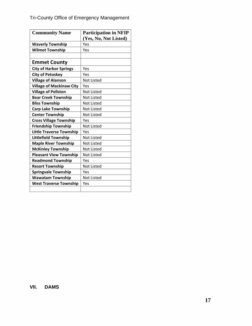
above. This is indicated in (Table 1) below.
According to FEMA records, there are no repetitive loss properties with regards to
flooding in the Tri-County region.
Table 1

Tri-County Office of Emergency Management
16
Community Name Participation in NFIP
(Yes, No, Not Listed)
Charlevoix County
Boyne City Yes
City of Charlevoix Yes
City of East Jordan Yes
Village of Boyne Falls Not Listed
Bay Township Yes
Boyne Valley Township Not Listed
Chandler Township Not Listed
Charlevoix Township Yes
Evangeline Township Yes
Eveline Township Yes
Hayes Township Yes
Hudson Township Not Listed
Marion Township Yes
Melrose Township Not Listed
Norwood Township Yes
Peaine Township Not Listed
South Arm Township Yes
St. James Township Not Listed
Wilson Township Not Listed
Cheboygan County
City of Cheboygan Yes
Village of Mackinaw City Yes
Village of Wolverine Yes
Aloha Township Yes
Beaugrand Township Yes
Benton Township Yes
Burt Township Yes
Ellis Township Not Listed
Forest Township Yes
Grant Township Yes
Hebron Township Yes
Inverness Township Yes
Koehler Township Yes
Mackinaw Township Yes
Mentor Township Yes
Mullett Township Yes
Munro Township Yes
Nunda Township Yes
Tuscarora Township Yes
Walker Township Not Listed
Tri-County Office of Emergency Management
17
Community Name Participation in NFIP
(Yes, No, Not Listed)
Waverly Township Yes
Wilmot Township Yes
Emmet County
City of Harbor Springs Yes
City of Petoskey Yes
Village of Alanson Not Listed
Village of Mackinaw City Yes
Village of Pellston Not Listed
Bear Creek Township Not Listed
Bliss Township Not Listed
Carp Lake Township Not Listed
Center Township Not Listed
Cross Village Township Yes
Friendship Township Not Listed
Little Traverse Township Yes
Littlefield Township Not Listed
Maple River Township Not Listed
McKinley Township Not Listed
Pleasant View Township Not Listed
Readmond Township Yes
Resort Township Not Listed
Springvale Township Yes
Wawatam Township Not Listed
West Traverse Township Yes
VII. DAMS

Tri-County Office of Emergency Management
18
The Tri-County region is an area with many waterways that connect with each other. It
is also a region that supports these connections with dams and locks. Most of these
dams are for recreational purposes. According to MDEQ there are 13 Dams in
Charlevoix County, 25 Dams in Cheboygan County and 18 Dams in Emmet County.
Dams are and have been regulated by the Michigan Department of Environmental
Quality. While the inspection of these dams falls under the jurisdiction of the State of
Michigan Department of Environmental Quality, the Tri-County Office of Emergency
Management monitors these dams closely. The only dam in the Tri-County region that
requires a EAP is the dam on the Cheboygan River at the locks. This plan is
maintained and implemented by the Tri-County Office of Emergency Management
should an incident occur. Below is an inventory of the Dams in the Tri-County area.
Table 1
DAM_ID DAM_NAME CNTY_NAME AUTHORITY
515 Boyne River Dam Charlevoix FERC
700 Charlevoix KMart Retention Basin Dam Charlevoix Inventory
1156 Belvedere Golf Club Dam Charlevoix Inventory
1158 Marion Hills Dam Charlevoix Inventory
1159 Stoner Creek Dam Charlevoix Inventory
1160 Walloon Lake Dam Charlevoix Inventory
1576 Horton Creek Dam Charlevoix Inventory
2194 Massey Dam Charlevoix Inventory
2565 Walloon Lake CC Dam #3 Charlevoix Inventory
2566 Walloon Lake CC Dam #14 Charlevoix Inventory
1503 Lawton Walleye Pond Dam Charlevoix MOU
1940 Deer Lake Level Control Structure Charlevoix Part 307
514 Boyne Falls Dam Charlevoix Part 315
519 East Jordan Dam Charlevoix Part 315
545 Tower Dam Cheboygan FERC
546 Kleber Dam Cheboygan FERC
520 Cheboygan Dam Cheboygan FERC/MOU
521 Alverno Dam Cheboygan FERC/Part 307
1161 Berry Creek Ranch Dam Cheboygan Inventory
1162 Jury Dam Cheboygan Inventory
1163 Little Sturgeon Club Dam Cheboygan Inventory
1164 Maxson Dam Cheboygan Inventory
1167 Twin Lakes Dam Cheboygan Inventory
2196 Towner Dam Cheboygan Inventory
2477 Ginop Dam Cheboygan Inventory
464 Echo Lake Dam Cheboygan MOU
492 Dog Lake Dam Cheboygan MOU

Tri-County Office of Emergency Management
19
1447 Crooked Lake Walleye Pond Cheboygan MOU
1513 Mill Creek Dam Cheboygan MOU
47 Little Black River Structure C Cheboygan Part 315
40 Little Black River Structure A Cheboygan Part 315
42 Little Black River Structure B Cheboygan Part 315
66 Little Black River Structure D Cheboygan Part 315
249 Wildwood Lake Dam Cheboygan Part 315
2622 Northland Properties Dam #1 Cheboygan Part 315
2623 Northland Properties Dam #2 Cheboygan Part 315
19 Dingman Marsh Flooding Dam Cheboygan Part 315/ MOU
246 Cornwall Creek Dam Cheboygan Part 315/ MOU
405 Stony Creek Dam Cheboygan Part 315/ MOU
1165 Roberts Lake Dam Cheboygan Part 315/ MOU
2633 Spring Lake Dam Emmet
37 Starks Mill Dam Emmet Inventory
768 Lake Street Dam And Flume Emmet Inventory
1213 Five Mile Creek Dam Emmet Inventory
1258 Birchwood Farms #2 Dam Emmet Inventory
1591 Paradise Lake Dam Emmet Inventory
1592 Crooked Lake Dam Emmet Inventory
2475 Ottawa Trout Pond #1 Dam Emmet Inventory
2478 Ottawa Trout Pond # 3 Dam Emmet Inventory
2564 Windward Dam Emmet Inventory
2656 Carp Lake River Lamprey Barrier Emmet Inventory
1249 Goose Pond Dam Emmet MOU
1267 Wycamp Lake Dam Emmet Part 307
424 Maple River Dam Emmet Part 315
1222 Birchwood Farms Dam Emmet Part 315
33 O'Neal Lake Dam Emmet Part 315/ MOU
494 French Farm Lake Dam Emmet Part 315/ MOU
1146 Mitchell Dam Emmet Removed
The State of Michigan also has a “Dam Management Grant Program. This is a program
that encoiurages the removal of dams that have no economic purpose and also
provides funding for the repair of dams with a clear ecomomic purpose.

Tri-County Office of Emergency Management
20
The information below (Article 1) was taken from the Michigan Department of Natural
Resources web site and explains the program in more detail.
Article 1
Dam Management Grant Program Overview Program Purpose There are approximately 2,500 Michigan dams listed in the State of Michigan Dam Inventory and many more that are not included in this database. Most of these dams were built decades ago for a variety of uses including power generation, water supply, flood storage and recreation. However, many dams no longer serve their original purpose, have no economic purpose, are threatening public safety and are literally falling apart. For example, several hydropower dams have been decommissioned and sold to local
municipal or township governments to manage as waterfront recreation sites, but the structures have met or exceeded their expected life. These dams require continuous, often expensive maintenance that many owners are either unable or reluctant to provide. Representatives of several communities have approached the Department seeking financial and technical assistance to remove dams rather than repair and maintain these facilities. It is also likely the State will be required to take ownership of some of these decaying assets through tax reversion. The program will help to enable the removal of dams without any economic purpose. In addition to the dams with no economic purpose, there are a number of dams with a clear economic benefit but need substantial investment to reduce public safety issues. For example, the Department of Natural Resources owns approximately 250 dams of which six are rated as high hazard and 16 others are considered to be a significant risk to public safety. The highest priority dams that require immediate attention are: 1) the Kalamazoo River Dams (Otsego, Plainwell #1 and Trowbridge Dams in Allegan County) which require perpetual maintenance as we await EPA's safe removal of PCBs from impoundments; and 2) Wraco Wildlife Flooding (Roscommon County) which required emergency repairs to prevent collapse this summer and urgently requires additional repairs to stabilize the dam. More than 80 of the lower hazard dams also require significant repairs. These dams exist to support fish rearing operations, recreational fishing and camping, and wildlife habitat and hunting opportunities. There are many other economically viable dams with various owners with similar public safety issues this program can help address.
Tri-County Office of Emergency Management
21
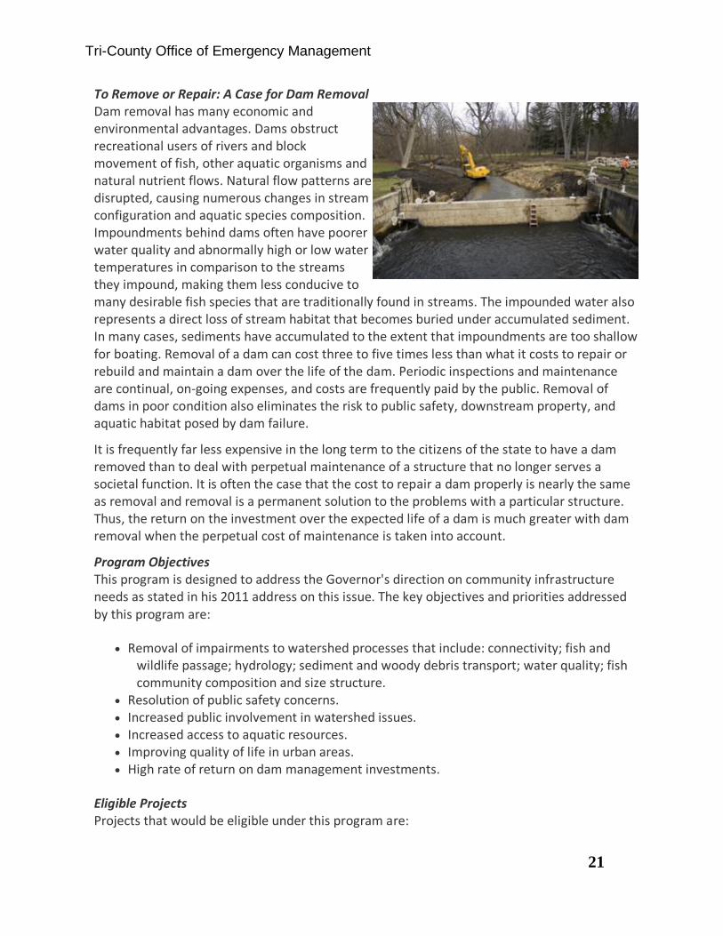
To Remove or Repair: A Case for Dam Removal Dam removal has many economic and environmental advantages. Dams obstruct recreational users of rivers and block movement of fish, other aquatic organisms and natural nutrient flows. Natural flow patterns are disrupted, causing numerous changes in stream configuration and aquatic species composition. Impoundments behind dams often have poorer water quality and abnormally high or low water temperatures in comparison to the streams they impound, making them less conducive to many desirable fish species that are traditionally found in streams. The impounded water also represents a direct loss of stream habitat that becomes buried under accumulated sediment. In many cases, sediments have accumulated to the extent that impoundments are too shallow for boating. Removal of a dam can cost three to five times less than what it costs to repair or rebuild and maintain a dam over the life of the dam. Periodic inspections and maintenance are continual, on-going expenses, and costs are frequently paid by the public. Removal of dams in poor condition also eliminates the risk to public safety, downstream property, and aquatic habitat posed by dam failure.
It is frequently far less expensive in the long term to the citizens of the state to have a dam removed than to deal with perpetual maintenance of a structure that no longer serves a societal function. It is often the case that the cost to repair a dam properly is nearly the same as removal and removal is a permanent solution to the problems with a particular structure. Thus, the return on the investment over the expected life of a dam is much greater with dam removal when the perpetual cost of maintenance is taken into account.
Program Objectives This program is designed to address the Governor's direction on community infrastructure needs as stated in his 2011 address on this issue. The key objectives and priorities addressed by this program are:
• Removal of impairments to watershed processes that include: connectivity; fish and wildlife passage; hydrology; sediment and woody debris transport; water quality; fish community composition and size structure.
• Resolution of public safety concerns. • Increased public involvement in watershed issues. • Increased access to aquatic resources. • Improving quality of life in urban areas. • High rate of return on dam management investments.
Eligible Projects Projects that would be eligible under this program are:
Tri-County Office of Emergency Management
22
• Removal of dams that have no economic purpose resulting in the enhancement of aquatic environments and the reduction of long term infrastructure costs.
• Repair/major maintenance of dams which have an economic purpose that are an imminent public safety issue and are deemed of unsatisfactory condition by the DEQ Dam Safety Program or are under DEQ order.
Ineligible Projects Projects with scope of work outside the grant focus area are not eligible for Dam Management Grant support. Within the focus area, the following types of projects are also not eligible:
• Feasibility or ecological studies. • Experimental and unproven methods to rehabilitate river channels after dam removals
or used in rehabilitating a dam. • Routine maintenance activities and operational costs. • Any project where the estimated repair/major maintenance is less than 50% of the
estimated cost of replacing the structure.

Tri-County Office of Emergency Management
23
VIII. CHARLEVOIX COUNTY
Charlevoix County is located in northwestern Lower Peninsula of Michigan. It borders
Lake Michigan on the western portion of the County and includes Beaver Island which is
located off shore from Charlevoix in Lake Michigan. Beaver Island presents a special
challenge for public safety agencies in that there are year around residents and during
the late fall, winter and early spring months the island is not accessible by boats.
Therefore, in the event of emergencies the only way to access the island is by air
transportation. This creates long response times from the mainland.
Charlevoix County offers its residents and visitors access to magnificent natural
features including Lake Michigan shoreline and inland lakes such as Lake Charlevoix
and Walloon Lake.
Tri-County Office of Emergency Management
24
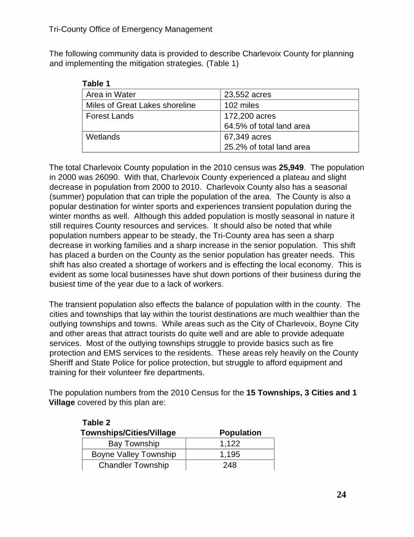
The following community data is provided to describe Charlevoix County for planning
and implementing the mitigation strategies. (Table 1)
Table 1
Area in Water 23,552 acres
Miles of Great Lakes shoreline 102 miles
Forest Lands 172,200 acres
64.5% of total land area
Wetlands 67,349 acres
25.2% of total land area
The total Charlevoix County population in the 2010 census was 25,949. The population
in 2000 was 26090. With that, Charlevoix County experienced a plateau and slight
decrease in population from 2000 to 2010. Charlevoix County also has a seasonal
(summer) population that can triple the population of the area. The County is also a
popular destination for winter sports and experiences transient population during the
winter months as well. Although this added population is mostly seasonal in nature it
still requires County resources and services. It should also be noted that while
population numbers appear to be steady, the Tri-County area has seen a sharp
decrease in working families and a sharp increase in the senior population. This shift
has placed a burden on the County as the senior population has greater needs. This
shift has also created a shortage of workers and is effecting the local economy. This is
evident as some local businesses have shut down portions of their business during the
busiest time of the year due to a lack of workers.
The transient population also effects the balance of population wilth in the county. The
cities and townships that lay within the tourist destinations are much wealthier than the
outlying townships and towns. While areas such as the City of Charlevoix, Boyne City
and other areas that attract tourists do quite well and are able to provide adequate
services. Most of the outlying townships struggle to provide basics such as fire
protection and EMS services to the residents. These areas rely heavily on the County
Sheriff and State Police for police protection, but struggle to afford equipment and
training for their volunteer fire departments.
The population numbers from the 2010 Census for the 15 Townships, 3 Cities and 1
Village covered by this plan are:
Table 2
Townships/Cities/Village Population
Bay Township 1,122
Boyne Valley Township 1,195
Chandler Township 248

Tri-County Office of Emergency Management
25
As stated above, on peak days, the seasonal population can be three (3) times the
normal population, especially with festivals and special events that include, but are not
limited to:
Beaver Island – Homecoming
Boyne City – Mushroom Festival; 4th of July Fireworks
Boyne Falls – Boyne USA events, Polish Festival
Charlevoix – Venetian Festival, Art Fair
East Jordan – Freedom Festival
Melrose – Northern Michigan Antique Flywheelers
According to the 2012 Economic Census (Table 3) below Charlevoix County has a large
number of individuals living in poverty at 13.4%, even though 91.3% of residents have
at least a high school education.
Charlevoix Township 1,645
Evangeline Township 712
Eveline Township 1,484
Hayes Township 1,919
Hudson Township 691
Marion Township 1,714
Melrose Township 1,403
Norwood Township 723
Peaine Township 292
St. James Township 365
South Arm Township 1,873
Wilson Township 1,964
Boyne City 3,735
City of Charlevoix 2,513
City of East Jordan 2,351
Village of Boyne Falls 294

Tri-County Office of Emergency Management
26
2012 Economic Census (Table 3)
Population 26,238
Median Household Income $46,709
Individuals Below Poverty Level 13.4%
Education Attainment, High School
or Greater
91.3%
Health Insurance Coverage,
Population Uninsured
10.8%
Median Housing Value $149,700.00
Total Housing Units 17,299 .
Number of Companies 3623
*Information provided above was retrieved from the 2012 United States Census Bureau
website.
Natural Hazards and Climate Change
Scientists are now convinced that human activity, primarily the burning of fossil fuels to
produce electricity and drive cars, is changing the climate. These activities emit gases,
primarily carbon dioxide that blanket the planet and trap heat. Some of the signs of
climate change we are seeing throughout the Great Lakes region include; increasing
average annual temperatures; more frequent severe rainstorms; shorter winters; and
duration of lake ice cover. In general, Michigan’s climate will grow considerably
warmer and probably drier during this century, especially in the summer.

Tri-County Office of Emergency Management
27
Potential Impacts from Climate Change
Northwest, Lower Michigan depends heavily on groundwater, freshwater from Lake
Michigan, and rainfall for agriculture, drinking, and industrial uses. As the population in
this region continues to grow, the demand for water for all the needs increases. The
projected changes in rainfall, evaporation, and groundwater recharge rates from climate
change events may affect ecosystems and freshwater users.
❖ Lower summer water levels are likely to diminish the recharge of
groundwater, cause small streams to dry up, and reduce the area of
wetlands, resulting in poorer water quality and less habitat for wildlife.
❖ Lake levels are expected to decline in both inland lakes and the Great
Lakes, as more moisture evaporates due to warmer temperatures and
less ice cover.
❖ Pressure to increase water extraction from the Great Lakes will grow,
exacerbating an already contentious debate in the region.
❖ Development and climate change will degrade the flood-absorbing
capacities of wetlands and floodplains, resulting in increased erosion,
flooding, and runoff polluted with nutrients, pesticides, and other toxins.
Floods Data
Flood hazard information can usually be derived from the Flood Rate Insurance Maps
(FIRM) available for jurisdictions. So, in order to delineate potential flood plain areas
(seasonal floodplains) for each county, Networks Northwest overlaid wetland, soils, and
elevation data to determine the most likely flood prone areas. Once overlaid, isolated
polygons (areas) were removed in order to show a more accurate representation of
potential flood prone areas along lakes, rivers, and streams. Sources:
Temporary/seasonally flooded areas data are from the National Wetland Inventory of
the US Fish and Wildlife Service; Hydric soils data are from the county digital soil

Tri-County Office of Emergency Management
28
surveys (where available); and Digital Elevation Model data are from the Center for
Geographic Information, Michigan Department of Information Technology.
Fire Data
Modern forest fire data were obtained from the USDA forest service and the
Departments of Natural Resources in Minnesota, Wisconsin, and Michigan. Fire
regimes data (fire prone areas) were provided by the USDA Forest Service, North
Central Research Station located in Wisconsin. Land type associations, and historical
and modern fire rotations were used to identify the fire prone areas.
Tornadoes - National Weather Service, Michigan Hazard Analysis
Damaging Winds - National Weather Service, Michigan Hazard Analysis
Large Hail - National Weather Service
Winter Weather - National Weather Service Landslide/Erosion
Shoreline erosion and landslide incident zones delineated by the US Geological
Service. Digital Elevation Model data from the Center for Geographic Information,
Michigan Department of Information Technology. High Lake Michigan water levels
causing erosion along the coast and Lake Charlevoix.
Other hazards may exist, but are not considered to be substantial risks.
Tri-County Office of Emergency Management
29
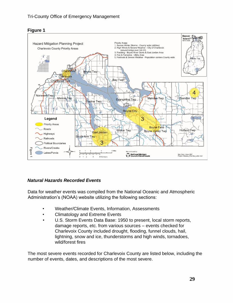
Figure 1
Natural Hazards Recorded Events
Data for weather events was compiled from the National Oceanic and Atmospheric
Administration’s (NOAA) website utilizing the following sections:
• Weather/Climate Events, Information, Assessments
• Climatology and Extreme Events
• U.S. Storm Events Data Base: 1950 to present, local storm reports,
damage reports, etc. from various sources – events checked for
Charlevoix County included drought, flooding, funnel clouds, hail,
lightning, snow and ice, thunderstorms and high winds, tornadoes,
wild/forest fires
The most severe events recorded for Charlevoix County are listed below, including the
number of events, dates, and descriptions of the most severe.

Tri-County Office of Emergency Management
30
1. Flood – 3 events
1993: (regional)
2. Extreme Cold and wind chill events
• February 15, 2015: Extreme cold weather hit the area. Freezing well
heads and causing numerous cases of frost bite
• February 19, 2015: temperatures again dipped into -10 to -20 degree
range causing freezing of wells and frost bite.
3. Hail – 14 events
• July 1996: 0.75 inches (East Jordan) - 2-inch accumulation
• September 1996: 1.0 inch (Boyne City) - 6-inch accumulation
• July 2003: .88 inches (East Jordan) - nickel sized
• August 2004: .75 inches (Boyne Falls)
4. Snow and Ice – 66 events (12 inches or more of snow)
• March 1993: (statewide) $500,000 property damage; heavy snow
• April 1993: (region) $50,000 property damage; heavy snow
• January 1994: (region) $5.0 million property damage; heavy snow/freezing
rain.
• November 1996: (county) 9 to 17 inches of snow
• December 2001: (county) 99 inches of snow 25th-28th; records were
broken, and a State of Emergency was declared by Governor John Engler.
The county requested $15,906.85 in disaster assistance.
• November 2003: (region) $40,000 property damage; winter storm
• Winter 2013 brought record snowfall to the region.
• In February 2015 record cold temperatures caused frozen wells and many
other issues to the region.
5. Thunderstorm and High Wind – 32 events
• October 1993: (county); high winds with many trees, power poles and
power lines blown down; power outages; 59 mph gusts
• September 1998: (St. James, Beaver Island; East Jordan; Boyne Falls);
thunderstorm/wind with numerous trees uprooted on the southern portion
of the Island; numerous trees snapped off.
• November 1998: (county); high winds with trees and homes damaged
• August 2, 2015: Straight line winds knocked down powerlines and caused
major damage in the area. Mainly in Leelanau and Grand Traverse
Counties.

Tri-County Office of Emergency Management
31
a Probability of Natural Hazards:
The probability that a natural hazard such as hail, thunderstorms and high winds,
tornadoes, and snow and ice will affect this area of Michigan is an annual possibility.
The magnitude and severity depends on the season, which determines temperature,
moisture in the air, ice cover on the lakes, etc. Also, the severity of an event is
connected with tourist activity during the year, the pace of developing second homes,
and an increasing base population in northwest, Lower Michigan leads to more
development. The events recorded by NOAA show that natural hazard events may be
happening more frequently, but the geographic impact of the natural hazards’ impact
has remained the same in Charlevoix County. The areas where natural hazards overlap
in Charlevoix County can include heavy snow that causes trees and power lines down,
and then melting, rain and flooding. (Table 4)
Table 4
Thunderstorm
and High Wind
32 events
57%
chance
S Charlevoix
Twp. Round
Lake Boyne City & Boyne Falls Evangeline
Twp. South of
Advance Hayes
Township Beaver Island East Jordan Boyne Falls Boyne City Charlevoix
26,090
$235,000 property damage
Tornadoes
4 events
7%
chance
Boyne City East Jordan
Chandler
Twp.
3,503 + seasonal
4
Boyne Valley
NE
Wildfires
99 events
100%
chance
County
26,090
4

Tri-County Office of Emergency Management
32
b
Charlevoix County Natural Hazards Task Force and Public Input
To create the original Charlevoix County Natural Hazards Task Force, invitations for the
meetings were sent to the following entities requesting their participation:
County Administrator/Coordinators
County Board of Commissioners
County Sheriff/Emergency Services (911 Services Coordinators, Public Safety)
County Emergency Manager/Coordinators
County Public Works Directors
County Health Department Director
County Planning or Community Development Directors
County Drain Commissioner/Soil Erosion Officers
County Road Commission Directors
County Conservation District Director/Soil Erosion Officers
Township elected and appointed officials
Township Supervisors
Township Clerks
Michigan State Police
Michigan Department of Environmental Quality
Michigan Department of Natural Resources
Michigan Department of Transportation
U.S. Coast Guard
Hospitals
City/Village Maintenance/Utilities
Tribal Governments
Environmental/Conservation Groups/Organizations
American Red Cross
Groundwater Protection Organizations
Housing Associations
Chambers of Commerce
National Weather Service (Gaylord)
Michigan Family Independence Agencies
Two meetings were planned and the actual participants in the development of the plan
are listed below. First the Task Force identified the natural hazard priority areas and
second the Task Force developed the mitigation strategies for the priority issues.
Charlevoix Area Hospital
Charlevoix County Board of Commissioners
Charlevoix County Building and Safety Department
Tri-County Office of Emergency Management
33
Charlevoix County GIS Department
Charlevoix County Planning Department (2)
Charlevoix County Road Commission
Charlevoix County Sheriff Department
Charlevoix Housing Commission
City of East Jordan
East Jordan Family Health
Emergency Management Coordinator
Grand Traverse Band of Ottawa and Chippewa Indians
Marion Township/Charlevoix County Farm Bureau
Northwest Michigan Community Health Agency
A different approach was used in updating the plan. Since the purpose was to update
the original plan and not to create a new plan the process was simplified. A
questionnaire was developed and posted on the Tri-County Emergency Management
web site for public comment. Public Hearings were scheduled in all three communities.
The following notice was posted in the local paper:
The Charlevoix, Cheboygan, and Emmet County Office of Emergency Management is revising the
Hazard Mitigation Plan for the Tri-County area. A public hearing will be held at the Charlevoix County
Sheriff’s Department, 1000 Grant St., Charlevoix, MI 49720, Wednesday October 6th, 7:00 PM in the
lower level meeting room to accommodate any member of the public that would like to offer suggestion
or input into the local Hazard Mitigation plan. A survey is also available for citizens to share some
insight about local concerns at www.cceoem.net.
At about the same time, representatives from Tri-County Emergency Management
attended meetings of the Michigan Township Association in each County and made
local officials aware of the questionnaire and how to find the document on our website.
The Michigan Township Association for each county involves at least one
representative from each Township. With that, each township was provided the
information about the plan and the type of input we were looking to get from them. The
meeting for Charlevoix County took place on September 28, 2015 at 7:00 PM. This
information was also on the agenda’s and discussed at meetings of the LEPC on
October 20, 2015, January 19, 2016, April 19, 2016 and July 19, 2016. Tri-County
Emergency Management also attended Fire Chief Association Meetings in each of the
three counties to make them aware of the HMP and ask for their input. In March we
had only heard from a few of the many communities, so an email was sent to all
members of the MTA’s again, explaining the project, the types of projects that are
fundable through FEMA and asking for their input on projects. The process then
continued until the plan was reviewed, information in each section was updated as
needed and drafts were presented to local communities and the public. Public hearings
were held in each county for a second time. The draft was then sent to MSP/EMHSD
and ultimately FEMA for their approval and/or comment. Specific mitigation projects
were provided for the plan from the following Charlevoix County jurisdictions: Hayes
Tri-County Office of Emergency Management
34
Township and Charlevoix County Road Commission regarding the Beaver Island Road
Garage.
The original group analyzed the map areas for the top natural hazard priority areas by
documenting the most threatening. They did a qualitative assessment of points and
concerns where they saw potential conflicts with and the relationship to critical facilities
and population centers. The general list created included:
• Wildfire, high winds/tornadoes in Chandler Township where a natural
gas transmission facility is located
• Highway U.S. 31 as a main traffic corridor
• The dam and water system at Village of Walloon Lake
• Boyne River dams – flooding and sewage and water treatment plants
in Boyne City
• Big Rock decommissioned nuclear power plant on the shores of Lake
Michigan
• 4th of July festival (tornado summer of 2001) in Boyne City
• Morel Mushroom festival in the spring in Boyne City
• Wilson Township and East Jordan area: East Jordan Iron Works;
flooding; East Jordan plastics plant; telephone and communications
centers in East Jordan; East Jordan possible flooding area
• Hudson Township: Hoffman Lake area is growing in population, and
has an EMS/Access center
• Wildfire areas near Thumb Lake (Lake Louise Christian Community)
with pines
• Major gas pumping station on Thumb Lake Road
• Winter festival at Boyne Mountain
• Dam at Boyne Falls to the dam at the Kircher property to Boyne City
(culverts)
• Charlevoix: US Highway 31 Bridge
• Wildfire areas on Beaver Island
• Transportation to and from Beaver Island with severe weather issues
• Large festivals – Beaver Island Homecoming event, Mushroom
Festival Boyne City, Boyne USA events and Polish Festival in Boyne
Falls, Venetian Festival and Art Fair in Charlevoix, Freedom Festival in
East Jordan
• The seasonal population fluctuation in the summer can be up to three
times the offseason population
• Road closure problem area on US 131 north of the Village of
Walloon/Shorts Hill

Tri-County Office of Emergency Management
35
The participants then took the complete list above and developed their Top Five Natural
Hazards Priority Areas. Due to the rural nature of the county, there has not been a lot
of property damage, injuries, or deaths due to natural hazard.
Top Five Natural Hazards Priority Areas
a. Severe winter storms: Potential throughout the County and concerns about
Utilities
Charlevoix County is in a Snow
Belt area. Snowstorms can be
very dangerous for a
community for short periods of
time. Heavy snows can shut
down towns and businesses for
a period of a few days if the
snow is falling faster that it can
be cleared in a timely fashion.
Blowing and drifting with
blizzard conditions cause
driving hazards.
b. City of Charlevoix: Potential of severe thunderstorms and high winds and
severe winter storms around the U.S. 31 Bridge
There is a historical record of high wind
events around the Lake Michigan shoreline
area and a few tornadoes in the county.
Severe winds, or straight line winds that
sometimes occur during severe
thunderstorms can be very damaging to a
community. Severe winds have the
potential to cause loss of life from flying
debris. Damage from straight line winds is more widespread than tornadoes and
usually affects multiple counties. There is also risk of infrastructure damage due
to downed power lines caused by falling trees and limbs.
There is a history of severe thunderstorm events in the county with some
concerns regarding the influx of tourists. Thunderstorms are hazards that bring a
Tri-County Office of Emergency Management
36
variety of problems during the spring, summer, and fall seasons. They can
cause lightning, flash flooding, hail, strong winds, and even tornadoes.
Given its proximity to Lake Michigan, Charlevoix County is subject to lake-
induced precipitation and is recognized by the National Weather Service as a
Snow Belt area. Snowstorms can be very dangerous for a community for short
periods of time. Heavy snows can shut down towns and businesses for a period
of a few days if the snow is falling faster that it can be cleared in a timely fashion.
Blowing and drifting with blizzard conditions cause driving hazards.
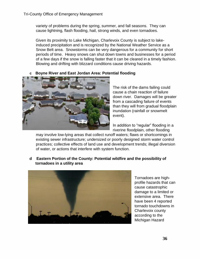
c Boyne River and East Jordan Area: Potential flooding
The risk of the dams failing could
cause a chain reaction of failure
down river. Damages will be greater
from a cascading failure of events
than they will from gradual floodplain
inundation (rainfall or snowmelt
event).
In addition to “regular” flooding in a
riverine floodplain, other flooding
may involve low-lying areas that collect runoff waters; flaws or shortcomings in
existing sewer infrastructure; undersized or poorly designed storm water control
practices; collective effects of land use and development trends; illegal diversion
of water, or actions that interfere with system function.
d Eastern Portion of the County: Potential wildfire and the possibility of
tornadoes in a utility area
Tornadoes are high-
profile hazards that can
cause catastrophic
damage to a limited or
extensive area. There
have been 4 reported
tornado touchdowns in
Charlevoix county
according to the
Michigan Hazard

Tri-County Office of Emergency Management
37
Analysis. Servicebut there is concern of the potential threat affecting utility
facilities.
e Wildfires in the rural areas of Charlevoix County
The forest types (jack pine, red pine, white
pine) that are most fire prone are not
located in this area, but the rural, forested
topography of this portion of the county
make it susceptible to wildfire. Additional
factors that increase fire risk include
lightning and human factors, such as the
number of persons residing in, camping in,
or traveling through an area.
Charlevoix County’s summer season brings numerous tourists to the area that
often enjoy camping on private, county, and state lands. The summer camping
season brings with it numerous campfires and the number one cause of wildfires
in Michigan is the result of human action, which makes the county highly
susceptible during those months.
In addition, Charlevoix County has also become a favored building site for
vacation homes. Many of these homes are located in remote areas of the county
on unimproved roads or long and narrow private driveways. These remote
locations and narrow roads pose numerous difficulties for emergency responders
including: discovery and reporting of fires; travel distances; access for fire trucks;
lack of turnarounds for water trucks and other equipment; and limited means of
warning these remote locations.
With nearly 65% of the total lands in Charlevoix County being forested and a
major source of economic benefit relying on the aesthetic appeal of the County’s
wildlands, wildfires are a moderate to significant risk. This risk is present
throughout the County with the exception of the urban areas. However, the risk
is much greater in the rural townships east of M131 and along the M131 corridor
including the area near Waloon Lake Village. With that, Charlevoix County has a
tight association of Fire Chiefs that meet on a regular bases and are connected
through mutual aid agreements with each other. However, since most of the Fire
Departments are volunteer it may take a response from several departments to
get enough manpower to safely work a wild fire incident depending on the time of
day and resources available. The region also has the advantage of a MDNR

Tri-County Office of Emergency Management
38
office in Indian River that can quickly bring the resources of the State of Michigan
to the scene of major wild fire events.
As seen in the study
from Michigan State
University on the left,
wild fire risks are
moderate for most of
the County except
for the urban hubs in
the County.
c. Festival events at seasonal population centers throughout the County:
Potential of severe thunderstorms, high winds, and tornadoes
There is a historical record of severe thunderstorms
and high wind events in these sections of the county
with concerns regarding the influx of tourists.
Thunderstorms are hazards that bring a variety of
problems during the spring, summer, and fall
seasons. They can bring potential lightning, flash
flooding, hail, strong winds, and even tornadoes.
Severe winds, or straight line winds that sometimes occur during severe
thunderstorms can be very damaging to a community. Severe winds have the
potential to cause loss of life from property damage and flying debris. Damage
from straight line winds is more widespread than tornadoes and usually affects
multiple counties. There is also risk of infrastructure damage due to downed
power lines from falling trees and limbs.

Tri-County Office of Emergency Management
39
Tornadoes are high-profile hazards that can cause catastrophic damage to a
limited or extensive area. According to the Michigan Hazard Analysis 2012 there
have been four tornados in Charlevoix County.
_______ Not Completed ________ In Progress ________Completed
Action Agenda Layout:
Priority and Action Strategies Responsible Parties Timeframe Priority Area 1 Severe Winter Storms Mitigation
Strategies:
a. A National Oceanic and Atmospheric Administration weather station for the area
Emergency Management Coordinator Planning Department Townships Incorporated Cities and Villages Elected Officials
1-5 years after adoption of the plan
b. Public education, awareness, and
preparedness; also for decision
makers
Emergency Management Coordinator County Planning County Building Inspector Business Owners Non-Profit Organizations Townships, Cities, Villages
1-3 years after adoption of the plan
c. Identify, improve, and/or construct shelter capacity
Emergency Management Coordinator Planning Department County Building Inspector Business Owners Non-Profit Organizations Public Citizens Townships, Cities, Villages
1-5 years after adoption of the plan
d. Emergency Operations Center planning to include winter storms in future exercises
Emergency Management Coordinator Local Emergency Planning Committee Planning Department
Sheriff’s Department
1-2 years after adoption of the plan
e. Identify and maintain critical
fueling facilities Emergency Management Coordinator Facilities Department, Road Commission
Ongoing
f. Work with utility companies – implement sound tree planting strategies around power lines; relocate electrical lines
underground; bury lines for new
construction
Emergency Management Coordinator Utility Companies Planning Department Townships, Cities, Villages
1-5 years after adoption of the plan
g. Inventory of public four-wheel
drive and special use vehicles Emergency Management Coordinator Planning Department Sheriff’s Department Facilities Department Road Commission
1-2 years after adoption of the plan
Wind Mitigation Strategies:

Tri-County Office of Emergency Management
40
a. Work with utility companies –
implement sound tree planting
strategies around power lines;
maintenance of trees education;
burying lines for new construction
Emergency Management Coordinator Utility Companies Planning Department Townships, Cities, Villages
1-5 years after adoption of the plan
b. Business and homeowner
education County Building Inspector Planning Department Insurance Agencies Chambers of Commerce MSU Extension Personnel Emergency Management Coordinator
1-3 years after adoption of the plan
c. Identify, improve, and/or construct
shelter capacity Emergency Management Coordinator Planning Department County Building Inspector Business Owners Non-Profit Organizations Public Citizens Townships, Cities, Villages
1-5 years after adoption of the plan
Priority Area 2 Severe Thunderstorms and High
Winds, Mitigation Strategies:
a. A National Oceanic and Atmospheric Administration weather
station for the area
Emergency Management Coordinator Planning Department Townships, Cities, Villages Elected Officials
1-5 years after adoption of the plan
b. Coordinate the use of sirens that
are in place and public education Emergency Management Coordinator Planning Department Law Enforcement Agencies
Townships, Cities, Villages
1-3 years after adoption of the plan
c. Identify, improve, and/or construct shelter capacity
Emergency Management Coordinator Planning Department County Building Inspector Business Owners Non-Profit Organizations Public Citizens Townships, Cities, Villages
1-5 years after adoption of the plan
d. Pre-plan and label alternate
transportation routes Emergency Management Coordinator Road Commission MI Department of Transportation Planning Department GIS Department
1-3 years after adoption of the plan
e. Develop inventory of homes
located on seasonal roads Planning Department GIS Department Road Commission
1-2 years after adoption of the plan
f. Work with utility companies –
implement sound tree planting
strategies around power lines;
maintenance of trees education;
burying lines for new construction.
Emergency Management Coordinator Utility Companies Planning Department Townships, Cities, Villages
1-5 years after adoption of the plan

Tri-County Office of Emergency Management
41
g. Continue support of the Road
Commission in their clearance of
blocked roads
Emergency Management Coordinator Planning Department Elected and Appointed Officials
Ongoing
Severe Winter Storms Mitigation
Strategies:
a. A National Oceanic and Atmospheric Administration weather station for the area
Emergency Management Coordinator Planning Department Townships Incorporated Cities and Villages Elected Officials
1-5 years after adoption of the plan
b. Public education, awareness, and
preparedness; also for decision
makers
Emergency Management Coordinator Planning Department County Building Inspector Business Owners Non-Profit Organizations Townships, Cities, Villages
1-3 years after adoption of the plan
c. Identify, improve, and/or construct shelter capacity
Emergency Management Coordinator Planning Department County Building Inspector Business Owners Non-Profit Organizations Public Citizens Townships, Cities, Villages
1-5 years after adoption of the plan
d. Emergency Operations Center planning to include winter storms in future exercises
Emergency Management Coordinator Local Emergency Planning Committee Planning Department Sheriff’s Department
1-2 years after adoption of the plan
e. Identify and maintain critical
fueling facilities Emergency Management Coordinator Facilities Department Road Commission
Ongoing
f. Work with utility companies –
implement sound tree planting
strategies around power lines;
relocate electrical lines
underground; bury lines for new
construction
Emergency Management Coordinator Utility Companies Planning Department Townships, Cities, Villages
1-5 years after adoption of the plan
g. Inventory of public four-wheel
drive and special use vehicles Emergency Management Coordinator Planning Department Sheriff’s Department Facilities Department Road Commission
1-2 years after adoption of the plan
Priority Area 3 Flood Mitigation Strategies:
a. Assessment of flood threat and
results of dam inspections Researchers, Engineers, and Architects Planning Department Townships, Cities, Villages County Conservation District Drain Commissioner Insurance Agencies Emergency Management Coordinator Non-profit organizations
1-5 years after adoption of the plan

Tri-County Office of Emergency Management
42
b. Create a better flood warning
system Emergency Management Coordinator County Planning Townships, Cities, Villages Elected and Appointed Officials County Conservation District Drain Commissioner
1-3 years after adoption of the plan
c. Re-engineer culverts for flood
mitigation Researchers, Engineers, and Architects Planning Department Townships, Cities, Villages, Road
Commission
1-5 years after adoption of the plan
d. Public education Emergency Management Coordinator
Planning Department
County Building Official
Business Owners
Non-Profit Organizations
Townships, Cities, and Villages
1-3 years after adoption of the plan.
Priority Area 4 Wildfire Mitigation Strategies:
a. Inventory dry hydrants and water
sources and ensure sources are
accessible
Emergency Management Coordinator,
Local Fire Departments, GIS
Departments
1-2 years after adoption
b. Put water source location maps in
all emergency vehicles
County GIS Department, Fire and Law
enforcement agencies 1-2 years after adoption
c. Study roads in the area for
emergency vehicle accessibility and
enforce minimum standards for
private roads to ensure emergency
vehicle access
Planning Departments, Emergency
Management Coordinator, Cities,
Towns, Villages, Planning Commissions,
Zoning Administrators, GIS
Departments, and Road Commissions.
1-3 years after the plans adoption
d. Revise ordinances to include
standards that ensure access,
stipulate maximum grade, minimum
driveway width, and turnaround
areas
Planning Departments, Emergency
Management Coordinator, Cities,
Townships, Villages, Planning/Zoning
Administrators, and Road Commissions.
1-5 years after the plans adoption
e. Public awareness and education Emergency Management Coordinator County Planning Townships, Cities, Villages
1-3 years after adoption
Tornado Mitigation Strategies:
a. Consistent weather event
warnings.
Emergency Management Coordinator,
NOAA Office, County Planning,
Townships, Cities, Villages
1-3 years after adoption of the plan
b. Identify, improve, and/or
construct shelter capacity
Emergency Management Coordinator,
Planning Department, County Building
Official, Business Owners, Non-Profit
Organizations, Public
1-5 years after adoption of the plan

Tri-County Office of Emergency Management
43
c. Work with utility companies
– implement sound tree
planting strategies around
power lines; relocate
electrical lines underground;
bury lines for new
construction
Emergency Management Coordinator
Utility Companies, Planning Department,
Townships, Cities, and Villages
1-5 years after adoption
d. Public Awareness and
Education
County Building Official, Planning
Department, First Responders, Insurance Agencies, Townships, Cities,
Villages, MI Department of Natural
Resources, Non-profit organizations,
MSU Extension Personnel, Emergency
Management Coordinator.
1-3 years after adoption of the plan
Priority Area 5 Festival events - Severe thunderstorms, High Wind, and Tornadoes Mitigation Strategies:
a. Charlevoix County Board of
Commissioners to
recommend that all groups
sponsoring festivals to plan
mitigation strategies for their
respective festivals
Emergency Management Coordinator,
Planning Department, Planning
Commission, Board of Commissioners,
Townships, Villages, Cities
1-2 years after adoption of the plan
b. Require mass gathering
events to have a permit
review process to include
natural hazards mitigation
Townships, Cities, Villages, Planning
Department, Emergency Management
Coordinator
1-2 years after adoption of the plan
c. Identify, improve, and/or
construct shelter capacity.
Emergency Management Coordinator,
Planning Department, County Building
Official, Business Owners, Non-Profit
Organizations, Public Citizens,
Townships, Cities, and Villages.
1-5 years after adoption of the plan
d. Work with utility companies
– implement sound tree
planting strategies around
power lines; relocate
electrical lines underground;
bury lines for new
construction
Emergency Management Coordinator, Utility Companies, Planning Department, Townships, Cities and Villages
1-5 years after adoption of the plan
e. Public awareness and
education
Emergency Management Coordinator County Planning Townships, Cities, Villages
1-3 years after adoption of the plan
f. Develop and implement
mutual support and aid
practices with surrounding
communities
Emergency Management Coordinator County Planning Townships, Cities, Villages Non-profit
1-3 years after adoption of the plan

Tri-County Office of Emergency Management
44
While it appears there are still many unfinished projects, most are ongoing and of a
nature that will never be completed such as “Public Education”. This is an ongoing
effort for all emergency managers.
VIII: CHEBOYGAN COUNTY
Cheboygan County is located at the northern tip of the Lower Peninsula.
The county is composed of 19 townships: Aloha, Beaugrand, Benton, Burt, Ellis,
Forest, Grant, Hebron, Inverness, Koehler, Mackinaw, Mentor, Mullett, Munro,
Nunda, Tuscarora, Walker, Waverly, and Wilmot. Also located in Cheboygan
County are the City of Cheboygan, the villages of Mackinaw City, Wolverine, and
Indian River (Census Designated Place). The City of Cheboygan is the county seat
and is located on Lake Huron. The name Cheboygan stands for "Water of the
Chippewa’s." The first settler was Jacob Sammons, a cooper from Mackinaw City
who built a log cabin there in 1844, and then founded a town. The area grew
Figure 1-1, Cheboygan County
Mackinaw Cit y
Wolverine

Tri-County Office of Emergency Management
45
productive during the lumber days, and was incorporated as a village in 1871, while
it later becoming a city in 1889.
Cheboygan County’s northern border runs for 32.5 miles along the Straits of
Mackinac and Lake Huron. It is bordered on the east by Presque Isle County, on
the south by Otsego County and on the west by Emmet and Charlevoix Counties.
Cheboygan County covers 715.6 square miles, or 457,984 acres. Fifty-seven
percent of the County is in public ownership and 63 percent of the county is
forested.
Population Overview
Over the past decade Cheboygan County’s population leveled off from its rapid growth
experienced in the decade from 1990 to 2000. The growth rate for Cheboygan County
in the period from 1990 to 2000 was among the highest in the region and continued a
60-year trend (Table 3) in population growth. However, Cheboygan County actually
experienced a slight decrease in population in the period between 2000 and 2010. In
2000 the population of Cheboygan County was 26448, in 2010 the population dropped
to 26152. It should also be noted that while population numbers appear to be steady
the Tri-County area has seen a sharp decrease in working families and a sharp
increase in the senior population. This shift has placed a burden on the County as the
senior population has greater needs and less income as a rule. This shift also means a
smaller workforce to support the region and the economy. This is evident as some local
businesses have shut down portions of their business during the busiest time of the
year due to a lack of workers.
In 2010, the population density for Cheboygan County was 36 persons per square mile.
The highest concentrations of people are located close to the City of Cheboygan and
around the villages of Mackinaw City and Indian River. Smaller concentrations are found
in the villages of Topinabee, Wolverine, Tower, Alverno and Afton. The many miles of
waterfront in Cheboygan County are also areas with higher population concentrations.
Many residences are located along the shores of the Cheboygan and Black Rivers,
around the inland lakes of Mullet, Burt, Douglas and Black and along the Straits of
Mackinac.
Table 3

Tri-County Office of Emergency Management
46
Table 4
Cheboygan County Population by Municipality 1990-2010
Unit of Gov. 1990 2000 % Change 2010 % Change
Cheboygan
Co.
21,398 26,448 23.6% 26,152 -1.1%
Aloha Twp. 707 1041 47.2% 949 -8.8%
Beaugrand
Twp.
1,004 1,157 15.2% 1,168 1.0%
Benton Twp. 2,388 3,080 29.0% 3,206 4.1%
Burt Twp. 533 654 22.7% 680 4.0%
Cheboygan
City
4,999 5,295 5.9% 4867
Ellis Twp. 345 519 50.4 596 14.8%
Forest Twp. 929 1,080 16.3% 1,045 -3.2%
Grant Twp. 686 947 38.0% 846 -10.7%
Hebron
Twp.
202 303 50.0% 269 -11.2%
Indian River * * * 1959
Inverness
Twp.
1952 2278 16.7% 2261 -0.7%
Koehler
Twp.
722 1168 61.8% 1,283 9.8%
Mackinaw
Twp.
604 576 -4.6% 539 -6.4%
0
5000
10000
15000
20000
25000
30000
1950 1960 1970 1980 1990 2000 2010
Cheboygan County Population 1950 to 2010

Tri-County Office of Emergency Management
47
Mackinaw
City
875 859 -1.8% 806
Mentor Twp. 518 781 50.8% 818 4.7%
Mullettt Twp. 1,056 1,284 21.6% 1,312 2.2%
Munro Twp. 512 679 32.6% 571 -15.9%
Nunda Twp. 725 925 27.6% 1042 12.6%
Tuscarora
Twp.
2,297 3,091 34.6% 3,038 -1.7%
Walker Twp. 256 292 14.1% 327 12.0%
Waverly
Twp.
371 472 27.2% 457 -3.2%
Wilmot Twp. 592 826 39.5% 878 6.3%
Wolverine
Village
283 359 26.9% 244
As with Charlevoix county the economic balance in Cheboygan County is effected
by the influx of seasonal population. While some area of the county experience a
large increase in seasonal population that boosts the economy and provides for
better police and fire protection other areas of the county do not benefit from the
seasonal influx and depend on the County Sheriff and State Police for law
enforcement, but struggle to afford equipment and training for fire protection.
According to the 2012 Economic Census (Table 1, below), even though 88.4% of the
population have at least a high school education, 17.8% of the people of Cheboygan
County live in poverty.
2012 Economic Census (Table 1)
Population 25427
Median Household Income $39,486
Individuals Below Poverty Level 17.8%
Education Attainment, High School
or Greater
88.4%
Health Insurance Coverage,
Population Uninsured
14.5%
Median Housing Value $110,800.00
Total Housing Units 18,288 .
Number of Companies 2810
In Cheboygan County the original hazard mitigation plan was developed with input
from the Cheboygan County Local Emergency Planning Committee (LEPC). The
committee is comprised of representatives from local units of governments; local,

Tri-County Office of Emergency Management
48
state and federal agencies; law enforcement, fire departments and community
organizations. Committee members provided feedback throughout plan development,
including identification of hazards and high hazard areas, definition of goals and
objectives, identification of hazard mitigation strategies and selection of an action
plan.
The intent of a hazard mitigation plan is to inventory possible hazards, assess the
vulnerability of community to the hazards it faces, and to provide possible mitigation
activities for those hazards. The focus of the hazard mitigation plan is the
development of projects and policies that can be implemented to reduce or prevent
losses from future disasters. The Cheboygan County portion of the Tri-County Hazard
Mitigation Plan includes text, tables, charts and maps necessary to describe and
discuss the following:
• A hazard analysis based on a current community profile, hazard
identification, risk assessment, and vulnerability assessment.
• A listing of the communities’ goals and objectives;
• A discussion of the alternatives for solving problems.
• Evaluation and prioritization of alternatives.
• Selection of feasible mitigation strategies.
• Recommended mitigation strategies. The plan contains a hazard
mitigation element that can be easily integrated into county or township
comprehensive plans.
The process of Hazard Mitigation Planning consists of the following steps:
• Develop community profile and identify community hazards and risks
• Identification and definition of goals and objectives
• Identification of alternatives for solving problems
• Selection of evaluation criteria
• Selection of Alternatives
• Preparation of final plan
• Implementation of plan
• Monitoring and periodic revision of the plan
In the original plan NEMCOG staff worked closely with the Tri-County Office of
Emergency Management and the Cheboygan County Local Emergency Planning
Committee to prepare the Hazard Mitigation Plan. In addition, considerable effort was
made to gain input from stakeholders in the county. This included meetings with
townships; township association; county board of commissioners; local, state and
federal agencies; local officials; community leaders and general public.

Tri-County Office of Emergency Management
49
NEMCOG looked at relevant plans, maps, studies and reports. Federal, state,
regional and local government sources. These documents were reviewed to develop
a current community profile. Information sources included: U.S. Census, zoning
ordinances, master plans, recreation plans, capital improvement plans, parcel maps,
aerial photography, MIRIS land use/land cover, USGS topographic maps, National
Weather Service, NRCS soils maps, Michigan Department of Transportation,
Michigan Hazard Analysis, local hazard analysis, Flood Insurance Rate Maps,
emergency management plans, and Section 302 Sites from the LEPC.
NEMCOG’s Geographic Information System (GIS) was used as a decision support
tool and public education tool throughout the process. Existing data sets were
incorporated and new data sets created in order to analyze existing conditions and
study potential future scenarios. Specialized maps showing community hazards, land
cover/use, infrastructure, topography, soils, national wetlands inventory, forest cover,
gas and oil wells, zoning, future land use and community facilities were prepared as
part of the plan development. Maps helped identify community characteristics,
vulnerable populations, and hazard areas. GIS data and maps will be retained by the
community for future use to help implement and monitor hazard mitigation activities.
Information was disseminated to the communities and public through the use of public
meetings, presentations, news releases, and contacts. A secondary benefit of the
planning process was the education of community leaders and citizens of the
community in regards to hazard awareness. This education supported the decision
making process and will assist communities in making better, more informed
decisions in the future. In addition, the process strengthened partnerships between
local units of government, planning commissions, emergency services, public
agencies and private interests to pool resources and helped facilitate communication
and understanding between various entities. By fostering lines of communication and
increasing awareness of the cross jurisdictional impacts of land use and policy
decisions, better and more informed decisions will be made in the future.
The planning process provided several opportunities for public, community and
agency input and comments. Public meetings involved the County Board of
Commissioners during plan development and the draft plan was presented for
commissioners’ approval. Staff met regularly with the Local Emergency Planning
Committee during plan development. This group has representatives from local
communities, state and federal agencies and citizens. The group, together with the
Tri-County Emergency Management Director, was instrumental in guiding plan
development. Public meetings were advertised and held in Cheboygan County.
Notices of the public meetings were sent to LEPC members and local communities
officials. Meeting notices were also published in the local newspaper.
A different approach was used in updating the plan. Since the purpose was to update
the original plan and not to create a new plan the process was simplified. A
questionnaire was developed and posted on the Tri-County Emergency Management

Tri-County Office of Emergency Management
50
web site for public comment. Public Hearings were scheduled in all three communities.
The following notice was posted in the local paper:
The Charlevoix, Cheboygan, and Emmet County Office of Emergency Management is revising the
Hazard Mitigation Plan for the Tri-County area. A public hearing will be held at the Cheboygan County
Building, 870 S Main St., Cheboygan, MI 49721, Wednesday September 30th, 7:00 PM in the
Commissioner’s meeting room to accommodate any member of the public that would like to offer
suggestion or input into the local Hazard Mitigation plan. A survey is also available for citizens to share
some insight about local concerns at www.cceoem.net.
At about the same time, representatives from Tri-County Emergency Management
attended meetings of the Michigan Township Association in each County and made
local officials aware of the questionnaire and how to find the document on our website.
The Michigan Township Association for each county involves at least one
representative from each Township. With that, each township was provided the
information about the plan and the type of input we were looking to get from them. The
meeting for Cheboygan County took place on September 24, 2015 at 7:00 PM in the
Inverness Township Hall. This information was also on the agenda’s and discussed at
meetings of the LEPC on November 9, 2015, January 11, 2016, April 11, 2016 and
August 8, 2016. Tri-County Emergency Management also attended Fire Chief
Association Meetings in each of the three counties to make them aware of the HMP and
ask for their input. In March we had only heard from a few of the many communities, so
an email was sent to all members of the MTA’s again, explaining the project, the types
of projects that are fundable through FEMA and asking for their input on projects. The
process then continued until the plan was reviewed, information in each section was
updated as needed and drafts were presented to local communities and the public.
Public hearings were held in each county for a second time. The draft was then sent to
MSP/EMHSD and ultimately FEMA for their approval and/or comment. Specific
mitigation projects were provided for the plan from the following Cheboygan County
jurisdictions: Beauregard Township, Cheboygan County Road Commission and Forest
Township.
Climate
Cheboygan County's climate is directly affected by the Great Lakes and inland lakes of
Michigan. The effect of Lake Huron on Cheboygan's climate is particularly strong during
periods of easterly to northeasterly winds. Under these conditions, the long trajectory of
the air over Lake Huron gives Cheboygan cooler summer temperatures while increased
snow shower activity may accompany the milder fall and early winter temperatures. As a
result of the prevailing westerly winds, Cheboygan does experience some additional lake
effect; however, this is minimal and essentially limited to increased cloudiness during the
late fall and early winter. With light southwesterly winds, a localized lake breeze may be
nearly as effective in giving Cheboygan cooler summer temperatures. Differences in
temperature and precipitation exist between the northern and southern portions of the

Tri-County Office of Emergency Management
51
county. This is generally attributed to the moderating influence of the lakes in the northern
portion of the county. The local weather conditions in the southern portion are similar to
those in the Vanderbilt and Gaylord areas.
The average temperature in the summer months as recorded by the Cheboygan weather
station is 65 degrees Fahrenheit, while the winter average is 19 degrees (Table 2). From
1981 to 2010, the temperature for the region varied from highs in the mid to upper 70’s in
the summer to single digits in the winter months, Historical temperature data illustrates
the following county temperature extremes:
• Highest recorded temperature: 104 degrees (8/6/47)
• Lowest recorded temperature: 38 degrees below zero (2/6/95)
In the late winter as ice builds up on the lakes, Cheboygan is subjected to temperature
variations which are more closely associated with interior locations. Diminished wind
speeds or winds that do not traverse large unfrozen lakes often produce clearing skies
and the colder temperatures expected at continental locations. Because movement of
pressure systems controls day-to-day weather across the nation, this area seldom
experiences prolonged periods of hot, humid weather in the summer or extreme cold
during the winter.
Table 2: Temperature Extremes
Element JAN FEB MAR APR MAY JUN JUL AUG SEP OCT NOV DEC ANN
Max °F 26.3 28.3 36.6 48.7 62.1 71.5 77.4 75.5 67.6 55.8 42.5 31.5 52.0
Min °F 8.2 7.6 16.7 29.5 40.4 50.7 57.1 55.6 48.0 37.1 27.9 17.0 33.0
Mean °F 17.3 18.0 26.7 39.1 51.3 61.1 67.3 65.6 57.8 46.5 35.2 24.3 42.5
HDD base 65
1482 1317 1188 778 431 149 46 74 221 576 894 1263 8419
CDD base 65
0 0 0 0 5 33 114 92 5 0 0 0 249

Tri-County Office of Emergency Management
52
Severe Weather
According to the Michigan Hazard Analysis the Tri-County Region experiences
approximately 28 to 30 thunderstorm days per year. These are storms that can
produce heavy rain, high winds, hail and tornadoes. Although relatively rare, tornados
have occurred in Cheboygan County. Michigan is located on the northeast fringe of the
Midwest tornado belt. The Michigan hazard analysis of 2012 states that in a period
from 1950 to 2009 Cheboygan County has experienced 6 tornadoes. The lower
frequency of tornadoes occurring in Michigan may be, in part, the result of the colder
water of Lake Michigan during the spring and early summer months, a prime period of
tornado activity. The majority of tornados have occurred in the month August, although
tornados can occur in the spring and fall. In 1970, a tornado struck Cheboygan County
on October 2nd.
The geographical location of the Tri-County region makes this area vulnerable to strong
wind events. Surrounded by lakes Michigan and Huron this region is in an area where
high winds are likely. Strong winds and thunderstorm winds are the most prevalent
severe weather that affects Cheboygan County. Annually, thunderstorms will occur on an
average of 28 to 30 days and on average one or two thunderstorms per year will have
severe winds. Since 1967 there have been 39 severe wind events recorded in Cheboygan
County causing over $50,000 in damage. Strong winds are most likely in the summer
months of June, July, and August, but can occur any time of year. One of the most
powerful windstorms ever recorded in the Great Lakes region occurred on November 10,
1998. Wind speeds from this powerful storm reached 82 knots. A similar event occurred
on December 24, 2015 when winds gusted up to 80 mph and knocked out the 911
communication system for part of the Tri-County region. This storm also caused wide
spread damage to homes and businesses in the area and uprooted trees blocking some
roads.
Winter storms consisting of heavy snow, freezing rain and blizzards are common
seasonal hazards can be expected to occur several times every year. Since 1997, 41
heavy snowstorms and 4 blizzards have been recorded in Cheboygan County. (Figure
1) Over the past 10 years the county averaged 2-3 heavy snowstorms and/or blizzards
each year, although the number and intensity of snowstorms can fluctuate dramatically
from year to year. Improved weather forecasting methods and better understanding of
global phenomenon such as el-ninó and la-nina have increased the reliability of
forecasting future long-term trends. While general trends, such as mild or severe winters
can be, and are, predicted, they are not always completely accurate.

Tri-County Office of Emergency Management
53
Figure 1
Source: Michigan Committee for Severe Weather Awareness

Tri-County Office of Emergency Management
54
Water Resources
Surface Water
Cheboygan County contains numerous
rivers and inland lakes (Figure 2). Thirty-
eight miles of Lake Huron shoreline
establish the northern boundary of the
county. Inland lakes cover 10% (51,358
acres) of the county's total surface area,
the largest percentage of any county in the
state. There are several large bodies of
water in the county. The largest inland
lake in the county and the fourth largest in
the State is Burt Lake (17,335 acres). The
second largest is Mullett Lake (16,744
acres), followed by Douglas Lake (3,745
acres) and Black Lake, of which 7,887
acres are in the county. Of the 182 miles
of inland lakeshore, 46 miles are publicly
owned.
Cheboygan County, along with portions of the Counties of Presque Isle, Emmet, Otsego, Montmorency and Charlevoix, is within the Cheboygan River Watershed. Also within the Cheboygan River Watershed and the boundary of Cheboygan County are the watersheds of the Sturgeon, Pigeon and Black Rivers. Drainage from the Cheboygan River Watershed flows into the Cheboygan River through the City of Cheboygan and into Lake Huron. Portions of the county northwest and east of the City of Cheboygan are part of the coastal watershed, which drains directly into Lake Huron.
Within each of these watersheds are numerous lakes and rivers. The Sturgeon River
Watershed, in the western portion of the county, includes the Sturgeon River. Directly
adjacent is the renowned Pigeon River Watershed. The Pigeon River flows into Mullett
Lake that empties into the
Cheboygan River and directly into Lake Huron. The western portion of the county
includes the Black River Watershed. The Upper Black River and its tributaries within the
Figure 2 Cheboygan Co. Surface Waters

Tri-County Office of Emergency Management
55
county drain directly into Black Lake. The Black River carries lake water directly into the
Cheboygan River.
Groundwater
Groundwater is the source of drinking water for over 90 % of Northeast Michigan's
population. In the more rural areas, virtually everyone uses a well to provide clean
drinking water. Large supplies of groundwater can be found under the surface throughout
much of northern Michigan.
Cheboygan County has been blessed with abundant groundwater supplies of very high
quality. The generally thick glacial deposits in Cheboygan County result in ample
groundwater aquifers and a large number of springs and streams with cold, steady, high
quality flows of groundwater. The bedrock geology and the large amount of limestone in
the glacial deposits influence the chemical quality of groundwater and most surface
waters, resulting in moderately high hardness and alkalinity.
The groundwater of Cheboygan County is an extremely valuable resource. Groundwater
discharge is important to the recreational values of the county. Groundwater is the
principal source of water in streams and rivers during dryer, rainless periods, providing
Cheboygan County with rivers and streams that flow year-round. Groundwater has a
large influence on water temperatures. Because groundwater leaves the ground at a
constant temperature year round, it has the effect of moderating water temperature.
Streams that receive large amounts of groundwater are generally cooler in summer and
warmer in winter than those where groundwater inputs are small. These temperature
moderations and year-round flows provide ideal conditions for many fish, including trout,
as well as other wildlife.
A number of factors, such as soil permeability, the amount, timing and intensity of
precipitation, vegetative cover and land use govern the amount of groundwater recharge
on any area of land. Precipitation and permeability usually exert the greatest influence
on groundwater recharge. In Cheboygan County, rainfall intensity is seldom greater than
soil permeability, resulting in large quantities of infiltration and groundwater recharge.

Tri-County Office of Emergency Management
56
Wetlands
Cheboygan County's wetlands (Figure 3) are unique ecosystems that serve as the transitional zone between upland and aquatic habitats. The purity and clarity of lakes and streams is maintained and enhanced, in large part, by wetlands. Wetlands filter out nutrients and sediments, some of the most harmful pollutants associated with lakes and streams. Without wetlands these pollutants can cloud once clear waters and accelerate the growth of choking aquatic weeds. Since many of the existing undeveloped waterfront properties contain environmental limitations such as wetlands, floodplains, or soils poor for septic development, there will be more and more pressure to alter these landscapes. To preserve the water quality of area lakes and streams and their associated property values, attempts must be made to preserve wetlands and other environmentally sensitive landscapes. This will insure that the quality of life and natural resources of the county remain its chief economic assets. The ecological functions that wetlands provide benefit numerous property owners. Conversely, land use alterations that disturb or alter wetland functions can create nuisances or cause damage to surrounding land owners (e.g., downstream flooding as a result of upstream wetland filling) as well as effecting broader public health issues (e.g., wetland loss can lead to water quality impairment of lakes and streams).
Woodlands
According to 2001 statistics from the U.S. Forest Service, forestland accounts for
approximately 63% of the county’s total land area. The major forest species found in the
county are Maple/Beech/Birch (30%) and Aspen (27%). Northern White Cedar and
Elm/Ash/Cottonwood total approximately 10% and 8% respectively. Smaller amounts of
forestland are comprised of Red Pine (5%), Balsam Fir (5%), and Oak/Hickory (4%).
Smaller acreages of Jack Pine, Exotic Softwoods, Eastern White Pine, Black Spruce,
Figure 3, Cheboygan Co. Wetlands Source: N atio nal Wetla n d s Inven tory

Tri-County Office of Emergency Management
57
Tamarack, Black Ash/American Elm/Red Maple, Sugar Maple/Beech/Yellow Birch, Paper
Birch, and Balsam Poplar are also present.
Forestland in Cheboygan County is fairly evenly split between State and private
ownership. 53% is privately owned and 47% is State-owned in the form of Pigeon River
State Forest, Black Lake State Forest, and Hardwood State Forest. In addition to using
the forest resources for timber and fiber, woodlands are also used for all types of outdoor
recreation.
Land Use
The purpose of this section is to present the existing land uses, the status of planning and
zoning and potential hazardous land uses in the county. Vulnerable populations can be
identified using the existing land use map, zoning maps, and future land use maps
combined with hazardous areas and land uses.
To recognize and mitigate potential hazards, the community must have an accurate
assessment of existing land uses. The process identifies urban built-up land uses such
as residential and commercial along with natural land cover types like farmlands, forests,
and wetlands. The map presented below (Figure 4) is a hybrid that combines land cover
and land use.
Planning and Zoning are the principal tools that local communities have to manage
growth, preserve community character, protect property values and enhance the
economic viability of the area. Planning helps establish and focus the desired future of
the community and zoning ordinances are used as one of the primary ways to implement
the community master plan and achieve community goals. It is not the intention to
compare strengths and weaknesses of zoning regulations among various zoning
ordinances but to give a comprehensive perspective on county planning and zoning. Until
recently, the potential to use these tools for hazard mitigation has been largely ignored.

Tri-County Office of Emergency Management
58
Figure 4
Residential
According to the MIRIS Land Cover/Use update, 2.9 percent or 14,582 acres of the
County's total land area was used for residential purposes. For the most part, residential
development found in the county consists of single-family dwellings; however, single-
family duplexes, multi-family residential, condominiums, mobile homes and mobile home
parks are also included in this category (Figure 4). Residential uses are concentrated in
the community centers of Cheboygan, Mackinaw City, Indian River and Wolverine. Many

Tri-County Office of Emergency Management
59
of the larger lakes such as Burt, Mullett, Black and Douglas Lakes and the major rivers
have high concentrations of residential development both along the lakeshores and in
subdivisions adjacent to the lakes. Many of these once seasonal, weekend residential
developments have undergone a transition to year around residences, in addition to new
dwellings being built on waterfront property. Residential development is also occurring
along county roads as larger parcels are split into ten-acre and smaller parcels.
Commercial
Commercial land uses include primary/central business districts, shopping center/malls,
and secondary/neighborhood business districts including commercial strip development.
The 1998 land use inventory identified 1,031 acres (0.2%) in commercial use.
Commercial facilities are found primarily in the City of Cheboygan and south out of the
city limits along M-27 (Figure 4). Other urbanized communities, such as Mackinaw City,
Indian River and Wolverine have smaller commercial service centers with limited services
found in other outlying sections of the county.
Industrial
In addition to industrial and extractive development, this land use category includes
transportation, oil and gas, communication and utility facilities. Development falling under
this category made up only 0.8 percent of the total County land area. These land uses
cover approximately 3,868 acres of the County. Much of the industrial development is
located near the main community centers.
Institutional/Recreational
Land devoted specifically for institutional and recreational purposes amounted to
approximately 0.4 percent or about 2,088 acres of Cheboygan County. Land uses
included in this category are public parks and campgrounds, golf courses, schools,
churches and public buildings.
Agricultural Lands
With some 32,152 acres classified as farmland, agriculture is the county's fourth largest
land use category. The bulk of the county's agricultural land is found in the northern
portion of the county in Beaugrand, Munro, Inverness, Benton, Aloha and Grant
Townships with smaller sections of farm land found in all other townships. It is interesting,
but not surprising, to note that much of the agricultural property is found along or very
near the county's major rivers and lakes. Predominate agricultural land uses are
pastures, hay land and growing crops such as beans, oats, and barley. A small amount
of land is used for livestock such as cattle, milk cows, and hogs.
Non-Forest Lands
Non-forest land is defined as areas supporting early stage of plant succession consisting
of plant communities characterized by grasses or shrubs. Non-forest land makes up
nearly 11 percent of the County's land area. One type of opening are those created by
turn of the century logging operations and subsequent wildfires. Other non-forest areas
consist of abandoned or idle farmland. A majority of these areas are located within the

Tri-County Office of Emergency Management
60
active agriculture band mentioned above with the largest portions of this land type found
around the City of Cheboygan, Inverness and Benton Townships. Typical grass species
are quack grass, Kentucky bluegrass, upland and lowland sedges, reed canary grass and
clovers. Typical shrub species include blackberry and raspberry briars, dogwood, willow,
sumac and tag alder.
Upland Forests
Upland forests make up 237,074 acres or 46.5 percent of the county’s surface area. The
following species predominate areas classified as upland forests: sugar and red maple,
elm, beech, yellow birch, cherry, basswood, white ash, all aspen types, white, red, jack
and scotch pines and any managed Christmas tree plantations. Other upland conifers
include white or black spruce, balsam fir, and douglas fir along with areas covered by
larch and hemlock.
Lowland Forests
The county’s land use inventory shows that 87,999 acres or 17.3 percent of the county’s
surface area consists of lowland forests. Lowland forests are defined as those containing
ash, elm and soft maple along with cottonwood and balm-of-Gilead. Lowland conifers
such as cedar, tamarack, black and white spruce, and balsam fir stands are also included.
The upland and lowland forests combine to encompass 325,073 acres or 63.8 percent of
the county’s total surface area. Forests, therefore, constitute Cheboygan County’s largest
single land use category. Of the total forests, 72.9 percent are upland forests, while 27.1
percent are lowland forests.
Wetlands
As can be noted from Table 5, 26,312 acres or 5.2 percent of the County's land area was
identified as non-forested wetlands. Wetlands are those areas between terrestrial and
aquatic systems where the water table is at, near, or above the land surface for a
significant part of most years. The hydrologic regime is such that it permits the formation
of hydric soils or it supports the growth of hydrophilic vegetation. Examples of wetlands
include marshes, mudflats, wooded swamps and floating vegetation situated on the
shallow margins of bays, lakes, rivers, ponds, and streams. These wetland categories
include shrub wetlands, fresh-water marshes, wet meadows, open bogs, emergent
wetlands and aquatic bed wetlands.

Tri-County Office of Emergency Management
61
Table 5
Cheboygan County - 1998 Land Use
Land Use Type Number of Acres Number of Square
Miles
Percent of Total Area
Residential 14,582 22.8 2.9%
Commercial 1,031 1.6 0.2%
Industrial 3,868 6.0 0.8%
Institution/Recreation 2,088 3.3 0.4%
Agricultural 32,152 50.2 6.3%
Non-Forest 54,468 85.1 10.7%
Upland Forest 237,074 370.4 46.5%
Lowland Forest 87,999 137.5 17.3%
Wetlands 26,312 41.1 5.2%
Beaches 77 0.1 0.02%
Surface Water 49,937 78.0 9.8%
Total 509,588 796.2 100%
Source:1998 update of 1978 MIRIS Land Cover/Use Inventory by Wade-Trim
It is important to note that existing land use statistics used in this report are based on
Michigan Resource Information System (MIRIS) data. Forested and wetland information
contained in the MIRIS data was not verified by field inspection when the data was
compiled. Thus, areas shown as wetlands on the MIRIS system may not actually meet
State and Federal criteria for legally regulated wetlands. However, the information is still
valuable for general land use planning decisions.
Beaches
Only 77 acres or 0.02 percent of the county’s surface area is classified as beaches. Beaches include all sloping accumulations of exposed sand and gravel along shorelines and sand dunes.

Tri-County Office of Emergency Management
62
Surface Water
Cheboygan County is home to four major inland lakes - Burt, Mullett, Black and Douglas
Lakes. These are linked together and to two Great Lakes by a series of major rivers. In
fact, surface water makes up nearly 10 percent of the county's land use types (49,937
acres) and is the county's third largest land use category. (Figure 5) The combination of
wetlands types (including lowland forests) and surface water makes up nearly one third
of the county's surface area. Therefore, protecting the county's water and wetland
resources should be a major priority in land use planning.
Figure 5
Hazard Analysis Evaluation Measures
This model uses a common set of 8 evaluation measures to evaluate each hazard
facing the community. Those measures are: 1) likelihood of occurrence; 2) potential
for damage; 3) potential for casualties; 4) ability to mitigate; 5) public awareness; 6)
current response capabilities; 7) inter agency cooperation; and 8) economic impact.
Each corresponding benchmark factor was assigned a specific point value (10, 7, 4 or
1 point), based on each individual factor’s relative severity and negative impacts. In

Tri-County Office of Emergency Management
63
recognition of the fact that some factors need to be given more consideration than
others, each of the criteria was weighted. A percentage value has been assigned to
each measure based on the relative significance of the measure in ranking the
hazards. The sum of all measures must equal 100 percent. The following is a synopsis
of each hazard evaluation measure, weight and benchmark factor used in this analysis:
Likelihood of Occurrence
Likelihood of occurrence measures the frequency with which a particular hazard
occurs. The more frequently a hazard event occurs, the more potential there is for
damage and negative impact on a community.
Size of Affected Area
Each hazard affects a geographic area. For example, a blizzard might affect an entire
state or even several states, while a flood might only affect a portion of a county or
municipality. Although size of the affected area is not always indicative of the
destructive potential of the hazard (a tornado is a good example), generally the larger
the affected area, the more problematic the hazard event is to a community.
Capacity to Cause Physical Damages
The capacity to cause physical damages refers to the destructive capacity of the hazard.
While the destructive capacity of some hazard events, such as floods and tornadoes, is
often immediate and readily apparent, some hazards may have significant destructive
capacity that is less obvious as it may occur over an extended period of time such as
extreme temperatures or drought.
Speed of Onset
Speed of onset refers to the amount of time it typically takes for a hazard event to
occur. Speed of onset is an important evaluation measure because the faster an event
occurs; the less time local governmental agencies typically have to warn the potentially
impacted population of appropriate protective actions.
Potential for Causing Casualties
Potential for causing casualties refers to the number of casualties (deaths and injuries)
that can be expected if a particular hazard event occurs.
Percent of Population Affected
Percent of Population affected refers to the percent of the county population that may
be affected directly or indirectly by the hazard event.
Economic Effects
Economic effects are the monetary damages incurred from a hazard event and include
both public and private damage. Direct physical damage costs, as well as indirect
impact costs such as lost business and tax revenue, are included as part of the total
monetary damages.
Tri-County Office of Emergency Management
64
Duration
Duration refers to the time period the hazard event is actively present and causing
damage (often referred to as the “time on the ground”.) Duration is not always
indicative of the damaging potential of a hazard event (a tornado is a good example).
However, in most cases, the longer an event is “active” and thus causing damage, the
greater the total damages will be.
Seasonal Pattern
Seasonal pattern refers to the time of year in which a particular hazard event can
reasonably be expected to occur. Some hazard events can occur at any time of the
year, while others occur primarily during one particular season (i.e., blizzards in
winter). Oftentimes, hazard patterns coincide with peak tourism seasons and other
times of temporary population increases, greatly increasing the vulnerability of the
population to the negative impacts of certain hazard events.
Predictability
Predictability refers to the ease with which a particular hazard event can be predicted
- in terms of time of occurrence, location, and magnitude. Predictability is important
because the more predictable a hazard event is, the more likely it is a community will
be able to warn the potentially impacted population and take other preventive
measures to minimize loss of life and property.
Collateral Damage
Collateral damage refers to the possibility of a particular hazard event causing
secondary damage and impacts. For example, blizzards and ice storms can cause
power outages, which can cause loss of heat, which can lead to hypothermia and
possible death or serious injury. Generally, the more collateral damage a hazard event
causes, the more serious a threat the hazard is to a community.
Environmental Impact
Environmental Impact refers to the environmental damage that may be caused by a
particular hazard event. The effects of a hazard event must be thought through to
identify possible environmental impact. For example, a flood event may overwhelm a
sewage treatment plant which then discharges raw sewage thereby contaminating
water supplies.
Availability of Warnings
Availability of warnings indicates the ease with which the public can be warned of a
hazard. This measure does not address the availability of warning systems in a
community, per se. Rather, it looks at the overall availability of warning in general for
a particular hazard event. For example, a community might receive warning that a
flood will occur within 24 hours, but receive no warning when a large structural fire
occurs. Generally, hazards that have little or no availability of warning tend to be more
problematic for a community from a population protection and response standpoint.

Tri-County Office of Emergency Management
65
Mitigative Potential
Mitigative potential refers to the relative ease with which a particular hazard event can
be mitigated against, through application of structural or non-structural (or both)
mitigation measures. Generally, the easier a hazard event is to mitigate against, the
less future threat it may pose to a community in terms of loss of life and property.
Public Awareness
The amount of public awareness indicates the ease with which the public can be
informed about particular hazards. This measure does not address the current level of
public awareness that exists in the community. Rather, it looks at the overall value of
public awareness in general for a particular hazard event.
Hazard Analysis Evaluation Benchmark Factors
Likelihood of Occurrence Affected Area
Excessive Occurrence 10 pts Large Area 10 pts
High Occurrence 7 pts Small Area 7 pts
Medium Occurrence 4 pts Multiple Sites 4 pts
Low Occurrence
1 pt Single Site 1 pt
Speed of Onset Population Impact
Minimal/No Warning 10 pts High Impact 10 pts
Less than 12 Hours 7 pts Medium Impact 7 pts
12-24 Hours 4 pts Low Impact 4 pts
Greater than 24 Hours
1 pt No Impact (none) 1 pt
Economic Effects Duration
Significant Effects 10 pts Long Duration 10 pts
Medium Effects 7 pts Medium Duration 7 pts
Low Effects 4 pts Short Duration 4 pts
Minimal Effects
1 pt Minimal Duration 1 pt
Seasonal Pattern Predictability
Year-round Occurrences 10 pts Unpredictable 10 pts
Three Season Occurrences 7 pts Somewhat Predictable 7 pts
Two Season Occurrences 4 pts Predictable 4 pts
One Season Occurrence
1 pt Highly Predictable 1 pt
Collateral Damage Availability of Warnings
High Possibility 10 pts Warnings Unavailable 10 pts
Good Possibility 7 pts Generally Not Avail. 7 pts
Some Possibility 4 pts Sometimes Available 4 pts

Tri-County Office of Emergency Management
66
No Possibility
1 pt Warnings Available 1 pt
Mitigative Potential Percent of Population Affected
Easy to Mitigate 10 pts 60% to 100% 10 pts
Possible to Mitigate 7 pts 30% to 60% 7 pts
Difficult to Mitigate 4 pts 15% to 30% 4 pts
Impossible to Mitigate
1 pt 15% or less 1 pts
Environmental Damage Damage Capacity
High Possibility 10 pts High Capacity 10 pts
Good Possibility 7 pts Medium Capacity 7 pts
Some Possibility 4 pts Low Capacity 4 pts
No Possibility
Public Awareness
1 pt No Capacity 1 pt
Significant Value 10 pts
Some Value 7 pts
Limited Value 4 pts
No Value 1 pts

Table 6
Cheboygan County Hazard Rating
Criteria Likelihood to
Occur Size of Area Affected
Warning
system
available
% Pop. Affected
Ability to
Mitigate Collateral Damage
Total Weight Must = 100%
WEIGHT =========> 30% 20% 5% 15% 25% 5% 100%
Hazards
Winter Weather Hazard 10 10 1 10 5 7 8.15 1
Fixed Site Hazmat 7 7 4 4 7 7 6.40 2
Transportation Hazmat 10 4 10 4 4 7 6.25 3
Extreme Temperature 3 10 3 10 5 2 5.90 4
Transportation Accident 10 2 10 4 4 7 5.85 5
Public Health 4 7 6 7 7 2 5.80 6
Infrastructure Failure 4 5 7 5 7 4 5.25 7
Structural Fire 10 3 7 1 4 2 5.20 8
Terrorism/Sabotage/WMD 4 5 10 5 4 5 4.70 9
Dam Failure 4 4 4 1 7 7 4.45 10
Civil Disturbance 4 5 4 4 5 3 4.40 11
Wildfire 7 3 6 1 4 4 4.35 12
Shoreline Flooding 5 5 1 4 4 4 4.35 12
Severe Winds 4 4 3 4 5 7 4.35 14
Lightning 10 2 5 1 1 3 4.20 15
Nuclear Attack 1 10 2 7 1 7 4.05 16
Pipeline Accident 5 2 10 1 5 4 4.00 17
Earthquake 1 10 7 5 1 4 3.85 18
Hail 4 4 5 3 2 3 3.35 19
Tornados 4 1 5 5 2 7 3.25 20
Scrap Tire Fire 1 1 7 1 8 4 3.20 21
Riverine Flooding 1 3 5 4 4 7 3.10 22
Drought 1 4 2 5 2 7 2.80 23
Oil/Gas Well Incident 1 1 10 1 4 2 2.25 24
Subsidence 1 1 10 1 1 2 1.50 25
Tri-County Office of Emergency Management
d 2.1 Hazard Identification and Risk Assessment
Composite Hazard Rankings High to Moderate County Significance Winter Weather Hazards – 8.15
Fixed Site Hazmat – 6.40
Transportation Hazmat – 6.25
Riverine/urban Flooding – 5.95
Extreme Temperatures – 5.9
Transportation Accidents –5.85
Public Health – 5.8
Moderate to Low County Significance Infrastructure Failure – 5.25
Terrorism/Sabotage/WMD – 4.7
Dam Failure – 4.45
Civil Disturbance – 4.4
Low County Significance Shoreline Flooding – 4.35
Wildfire – 4.35
Severe Winds – 4.35
Lightning – 4.2
Nuclear Attack – 4.05
Pipeline Accident – 4.0
e Risk Assessment and Vulnerability Assessment Summary Risk Assessment
The goals of risk assessment are to determine where hazards exist, and develop an
understanding of how often they will arise and how much harm they cause. Based on the
weighted hazard ranking process recommended in the Michigan Hazard Analysis workbook, a
composite of hazards and their relative risk are presented below. This list will be used as the
foundation for developing hazard mitigation goals and strategies in subsequent chapters.
• High Risk: -- very likely to occur during hazard mitigation planning horizon of 20 years,
and/or affect all or most of the county.
• Medium Risk: -- somewhat likely to occur during hazard mitigation planning horizon of 20
years, and/or affect a significant area of the County.
• Low Risk: -- means it is not likely to occur, or cover only a limited area within county.

Tri-County Office of Emergency Management
69
Vulnerability Assessment
This step looks at such points as population concentrations, age-specific populations, development
pressures, types of housing (older homes, mobile homes), presence of agriculture, sprawl (spreading
resources too thin), and other issues that may make Cheboygan County more vulnerable to specific
hazards. Basic criteria are listed below.
• High Vulnerability: -- If an event occurred it would have severe impacts over large
geographic areas or more densely populated areas and have a serious financial impact on County
residents and businesses.
• Medium Vulnerability: -- If an event occurred it would have confined impacts on the safety
of residents but would have a financial impact on County residents and businesses.
• Low Vulnerability: -- If an event occurred it would have very minimal impact on the safety
of County residents and minimal financial impact on County residents and businesses.
Table 7
Cheboygan County -- Risk and Vulnerability Assessment Summary
Ranked Hazards in Cheboygan County Risk
Assessment
Vulnerability
Assessment
Winter Weather Hazards High High
Fixed Site Hazmat High Medium
Transportation Hazmat High Medium
Riverine Flooding High Low
Extreme Temperatures High High
Transportation Accidents High Medium
Public Health Medium Medium
Infrastructure Failure Medium High
Terrorism/Sabotage/WMD Medium Low
Dam Failure Medium Low
Civil Disturbance Medium Low
Shoreline Flooding Medium Low
Wildfire Medium Low
Severe Winds High Medium
Nuclear Attack Low Medium
Oil/Gas Pipeline Accident Low Medium
Shoreline Erosion Low Low
Oil/Gas Well Incident Low Low
Drought Low Medium
Lightning Low Low
Hail Low Low
Scrap Tire Fire Low Low
Subsidence Low Low
Earthquake Low Low
Tri-County Office of Emergency Management
70
Specific Vulnerabilities in Cheboygan County
Winter Weather Hazards.
Located at the northern tip of Michigan’s Lower Peninsula with an extensive shoreline along
Lake Huron Cheboygan County is very susceptible to all forms of severe winter weather. The
description and extent of these weather conditions are defined in Chapter 6. Although local
residents are generally prepared to cope with these conditions, and State and local highway
and police agencies are equipped to provide adequate response to these often extreme
conditions the immediate and rapid onset of these conditions, especially to travelers, can
often be extremely hazardous. I-75 and the Mackinaw Bridge to the Upper Peninsula serve
as the principal land-transport north-south artery in the state, and carry significant traffic all
times of the year.
In many cases it is not the extent or overall amount of snowfall, but the rapid change in
encountered conditions. With the right combination of wind-speed and direction, white-out
conditions can occur in otherwise clear conditions. Knowledge of these conditions through
signs posted at critical positions along I-75 and other vulnerable state highways could provide
warning of rapid deterioration of driving conditions to unsuspecting drivers.
The National Oceanic and Atmospheric Administration (NOAA) office in Gaylord, Michigan
has prepared a series of maps relating wind direction and the risk and distribution of Lake-
Effect snow across the Northern Lower and Eastern Upper Peninsulas of Michigan. From
this series of maps, it becomes apparent that when winds are from the West (Figure 6) and
West-Southwest (Figure 7) Cheboygan County, especially along the I-75 corridor and Straits
area are vulnerable to significant Lake-Effect snow, and often accompanying white-out
conditions.
Actions involving public education and communication are important approaches toward
mitigating this winter hazard. A program to distribute situational information to drivers at the
Mackinaw Bridge and northbound rest areas would be beneficial. NOAA is also urging road-
signs, both portable and fixed to provide travelers with direct and immediate warnings of
changing road conditions.
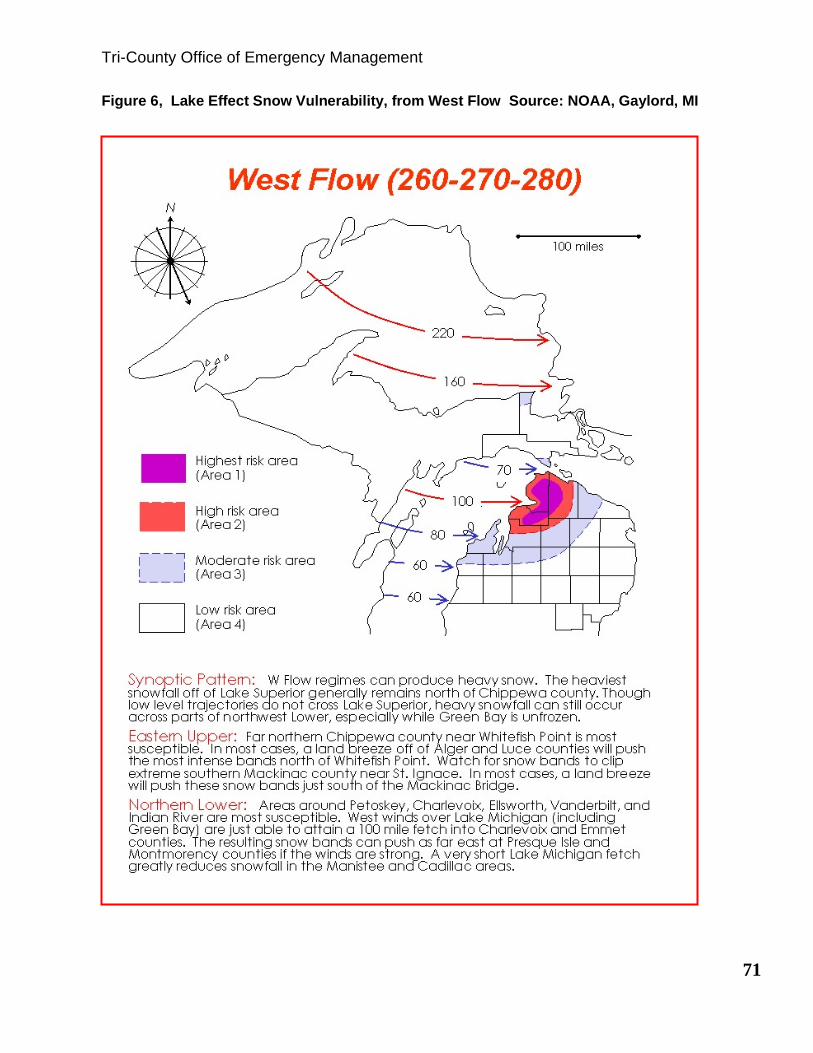
Tri-County Office of Emergency Management
71
Figure 6, Lake Effect Snow Vulnerability, from West Flow Source: NOAA, Gaylord, MI

Figure 7, Lake Effect Snow Vulnerability, from West-Southwest Flow
Source: NOAA, Gaylord, MI
NOAA Weather Radio broadcasts warnings and post-event information for all types of
hazards - weather (such as tornadoes, hurricanes, and floods), natural (such as
earthquakes, forest fires, and volcanic activity), technological (such as chemical
releases, oil spills, nuclear power plant emergencies, etc.), and national emergencies.
Working with other Federal agencies and the Federal Communications Commission
(FCC) Emergency Alert System (EAS), NOAA Weather Radio is an all-hazards radio
network, making it the single source for the most comprehensive weather and
emergency information available to the public.
Another source of weather related vulnerability for Cheboygan County, and the
northern tip of the Lower Peninsula was distribution of NOAA Weather Radio signal.
At the time of the original plan there was no NOAA Weather Radio coverage for the
N N
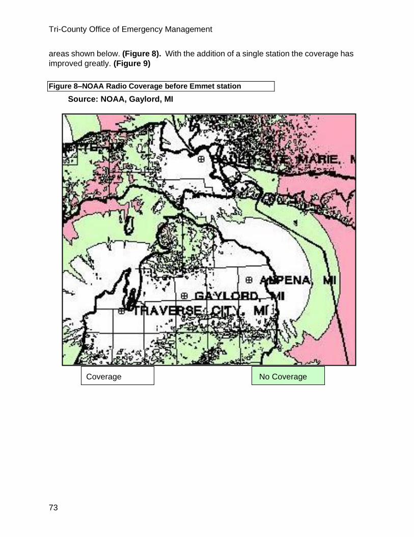
Tri-County Office of Emergency Management
73
areas shown below. (Figure 8). With the addition of a single station the coverage has
improved greatly. (Figure 9)
Figure 8–NOAA Radio Coverage before Emmet station
Source: NOAA, Gaylord, MI
Coverage No Coverage
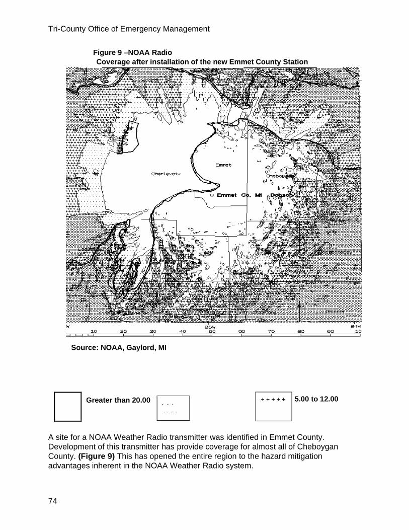
Tri-County Office of Emergency Management
74
Figure 9 –NOAA Radio
Coverage after installation of the new Emmet County Station
Source: NOAA, Gaylord, MI
5.00 to 12.00
A site for a NOAA Weather Radio transmitter was identified in Emmet County.
Development of this transmitter has provide coverage for almost all of Cheboygan
County. (Figure 9) This has opened the entire region to the hazard mitigation
advantages inherent in the NOAA Weather Radio system.
. . . . . . .
Greater than 20.00 + + + + +

Tri-County Office of Emergency Management
75
Riverine and Urban Flooding
Major flooding was recorded in
Cheboygan on the Little Black River in
1923, 1925, 1929, 1935, 1938, 1943,
1948 and 1954. The largest of these
floods was the 1923 flood, followed by
the 1938 flood. Average annual
floodwater damages were primarily to
urban property in the City of Cheboygan
estimated from Work Plans to be
$35,612.07 at current dollar value. The
installation of flood prevention
structural measures has had a very
significant effect in reducing floodwater
damages in the flood plain area of the Little Black Watershed.
In September of 1997, the U.S. Department of Agriculture, Natural Resource
Conservation Service published a Flood Plain Management Study for the Little Black
River. The approximate areas of inundation for the 100-year and 500-year floods
were shown and indicated minimal vulnerability to the areas. The Plan suggested
several Non-structural Measures to help mitigate flooding in the Little Black
Watershed”
• Develop and implement, or update a flood plain protection and zoning
ordinance based on the 100-year frequency high water profile and the flood plain
delineation.
• Flood-proof existing buildings and residences in the flood plain to reduce
flood damages.
• Develop alternate routes for automobile, truck and emergency vehicle traffic
around those roads that will be inundated during flooding.
• Debris, fallen trees and brush should be removed from the floodway at least
yearly. Snow and ice from road clearing operations should not be piled in
floodway.
• Owners and occupants of all types of buildings and mobile homes should
obtain flood insurance coverage for the structure and content, especially if located
within or adjacent to delineated flood hazard areas.
Additionally, the following structural measures were suggested in the Little Black River
Flood Management Study:
Flood stages can be reduced by improving flow conditions within the channel by
increasing stream and storm sewers’ carrying capacity. The existing series of dams
and open channels generally provide protection from a 100-year flood.
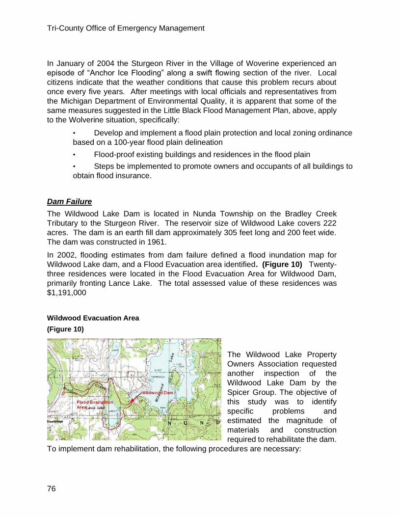
Tri-County Office of Emergency Management
76
In January of 2004 the Sturgeon River in the Village of Woverine experienced an
episode of “Anchor Ice Flooding” along a swift flowing section of the river. Local
citizens indicate that the weather conditions that cause this problem recurs about
once every five years. After meetings with local officials and representatives from
the Michigan Department of Environmental Quality, it is apparent that some of the
same measures suggested in the Little Black Flood Management Plan, above, apply
to the Wolverine situation, specifically:
• Develop and implement a flood plain protection and local zoning ordinance
based on a 100-year flood plain delineation
• Flood-proof existing buildings and residences in the flood plain
• Steps be implemented to promote owners and occupants of all buildings to
obtain flood insurance.
Dam Failure
The Wildwood Lake Dam is located in Nunda Township on the Bradley Creek
Tributary to the Sturgeon River. The reservoir size of Wildwood Lake covers 222
acres. The dam is an earth fill dam approximately 305 feet long and 200 feet wide.
The dam was constructed in 1961.
In 2002, flooding estimates from dam failure defined a flood inundation map for
Wildwood Lake dam, and a Flood Evacuation area identified. (Figure 10) Twenty-
three residences were located in the Flood Evacuation Area for Wildwood Dam,
primarily fronting Lance Lake. The total assessed value of these residences was
$1,191,000
Wildwood Evacuation Area
(Figure 10)
The Wildwood Lake Property
Owners Association requested
another inspection of the
Wildwood Lake Dam by the
Spicer Group. The objective of
this study was to identify
specific problems and
estimated the magnitude of
materials and construction
required to rehabilitate the dam.
To implement dam rehabilitation, the following procedures are necessary:
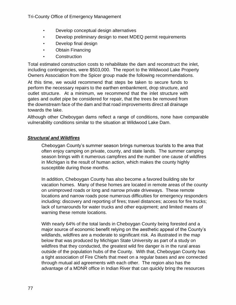
Tri-County Office of Emergency Management
77
• Develop conceptual design alternatives
• Develop preliminary design to meet MDEQ permit requirements
• Develop final design
• Obtain Financing
• Construction
Total estimated construction costs to rehabilitate the dam and reconstruct the inlet,
including contingencies, were $503,000. The report to the Wildwood Lake Property
Owners Association from the Spicer group made the following recommendations.
At this time, we would recommend that steps be taken to secure funds to
perform the necessary repairs to the earthen embankment, drop structure, and
outlet structure. At a minimum, we recommend that the inlet structure with
gates and outlet pipe be considered for repair, that the trees be removed from
the downstream face of the dam and that road improvements direct all drainage
towards the lake.
Although other Cheboygan dams reflect a range of conditions, none have comparable
vulnerability conditions similar to the situation at Wildwood Lake Dam.
Structural and Wildfires
Cheboygan County’s summer season brings numerous tourists to the area that
often enjoy camping on private, county, and state lands. The summer camping
season brings with it numerous campfires and the number one cause of wildfires
in Michigan is the result of human action, which makes the county highly
susceptible during those months.
In addition, Cheboygan County has also become a favored building site for
vacation homes. Many of these homes are located in remote areas of the county
on unimproved roads or long and narrow private driveways. These remote
locations and narrow roads pose numerous difficulties for emergency responders
including: discovery and reporting of fires; travel distances; access for fire trucks;
lack of turnarounds for water trucks and other equipment; and limited means of
warning these remote locations.
With nearly 64% of the total lands in Cheboygan County being forested and a
major source of economic benefit relying on the aesthetic appeal of the County’s
wildlands, wildfires are a moderate to significant risk. As illustrated in the map
below that was produced by Michigan State University as part of a study on
wildfires that they conducted, the greatest wild fire danger is in the rural areas
outside of the population hubs of the County. With that, Cheboygan County has
a tight association of Fire Chiefs that meet on a regular bases and are connected
through mutual aid agreements with each other. The region also has the
advantage of a MDNR office in Indian River that can quickly bring the resources

Tri-County Office of Emergency Management
78
of the State of Michigan to the scene
of major wild fire events. However, it
should be said that as with Charlevoix
and Emmet Counties most of the fire
departments are volunteer
departments. With that the time of
day and who is available will greatly
effect the number of presonel that
respond to the scene of a fire. This
means that the fire may be well
seated before enough personel can
respond to safely begin firefighting
operations.
Risk and Vulnerability Assessment
Hazard Ranking Methodology
After a thorough review of the community profile, a county hazard ranking was
completed using a three step process. The first step was selecting evaluation criteria,
the second step assigned relative weights to each of the rating criteria, and the third
step assigned point values in each of the selected criteria for each of the hazards.
Evaluation Criteria
Selection of evaluation criteria was accomplished by determining what aspects of the
hazards were of most concern to the community. This process was completed by
assigning a level of importance ranging from “Always Important” to “Not Worth
Considering” to each hazard aspect. Table 8 shows a complete list of all aspects
considered and level of importance assigned by the committee.
Each evaluation criteria was then assigned a “weight” to express the level of importance
each criteria will have in ranking hazards. The sum of weights of all of evaluation
criteria must equal 100%. Each individual criteria was then assigned a percentage value
based on the relative importance that specific criteria would have in ranking the various
hazards. Point values of 1-10 were assigned using the scoring parameters as outlined
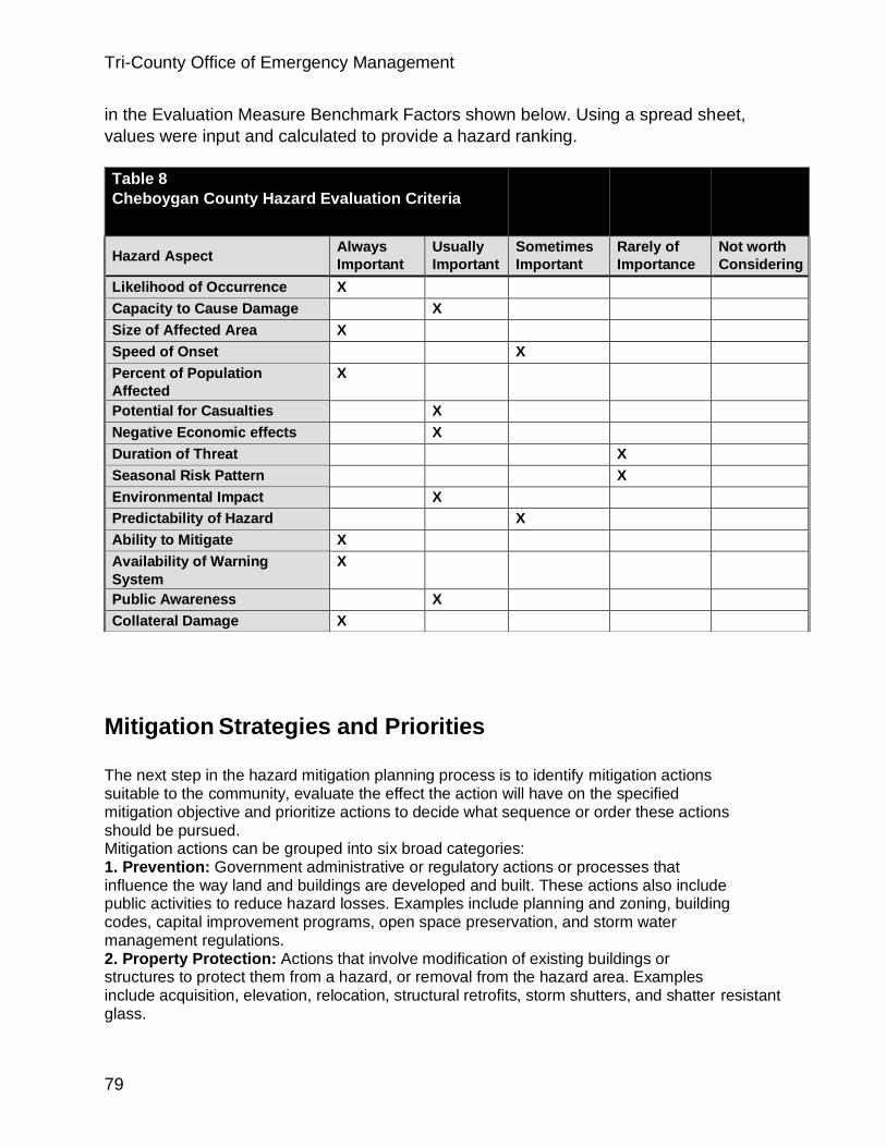
Tri-County Office of Emergency Management
79
in the Evaluation Measure Benchmark Factors shown below. Using a spread sheet,
values were input and calculated to provide a hazard ranking.
Mitigation Strategies and Priorities The next step in the hazard mitigation planning process is to identify mitigation actions suitable to the community, evaluate the effect the action will have on the specified mitigation objective and prioritize actions to decide what sequence or order these actions should be pursued. Mitigation actions can be grouped into six broad categories: 1. Prevention: Government administrative or regulatory actions or processes that influence the way land and buildings are developed and built. These actions also include public activities to reduce hazard losses. Examples include planning and zoning, building codes, capital improvement programs, open space preservation, and storm water management regulations. 2. Property Protection: Actions that involve modification of existing buildings or structures to protect them from a hazard, or removal from the hazard area. Examples include acquisition, elevation, relocation, structural retrofits, storm shutters, and shatter resistant glass.
Table 8
Cheboygan County Hazard Evaluation Criteria
Hazard Aspect Always
Important Usually
Important Sometimes
Important Rarely of
Importance Not worth
Considering
Likelihood of Occurrence X
Capacity to Cause Damage X
Size of Affected Area X
Speed of Onset X
Percent of Population
Affected X
Potential for Casualties X
Negative Economic effects X
Duration of Threat X
Seasonal Risk Pattern X
Environmental Impact X
Predictability of Hazard X
Ability to Mitigate X
Availability of Warning
System X
Public Awareness X
Collateral Damage X

Tri-County Office of Emergency Management
80
3. Public Education and Awareness: Actions to inform and educate citizens, elected officials, and property owners about the hazards and potential ways to mitigate them. Such actions include outreach projects, real estate disclosure, hazard information centers, and school-age and adult education programs. 4. Natural Resource Protection: Actions that, in addition to minimizing hazard losses, also preserve or restore the functions of natural systems. These actions include sediment and erosion control, stream corridor restoration, watershed management, forest and vegetation management, and wetland restoration and preservation. 5. Emergency Services: Actions that protect people and property during and immediately after a disaster or hazard event. Services include warning systems, emergency response services, and protection of critical facilities. 6. Structural Projects: Actions that involve construction of structures to reduce the hazard impact. Such structures include dams, levees, floodwalls, seawalls, retaining walls, and safe rooms.
Identification of Mitigation Actions The public was invited to a meeting held in Cheboygan County on May 10, 2004 to discuss and identify hazards and possible mitigation actions. Communities, agencies, LEPC and general public were invited to attend the workshop that was held in conjunction with the Cheboygan County Local Emergency Planning Committee. ________Done _________In Progress __________Not Done
Mitigation Actions A. Multi-Hazard Actions. #1 Priority Responsible Agency Funding Sources Application Time Frame Build the capabilities of the county GIS program to function as a tool to address multiple hazards. This effort would require the creation/updating of datasets such as parcels/ownership, location of all structures, driveways with ingress/egress conditions, roads, forest types, ownership types, floodplains, utilities (power lines, gas lines and water lines), wetlands, water features, bridges and culverts, (SARA III sites) 1 A,B,C,E,P,D,J Federal- F76, F77, F79, F104, F10 Homeland Security Local- General Fund State- MDIT County wide Ongoing Provide trained, equipped, and prepared search and rescue teams. 1 B,C,D,F,S,W Local- LEPC State- Health Department Federal- F38, F104 County wide Short Term

Tri-County Office of Emergency Management
81
Review and develop site emergency plans for schools, factories, office buildings, shopping malls, hospitals, correctional facilities, etc .to cover all potential hazards. 2 A,B,C,D,E,K,M,N ,R Federal- F87, F104 County wide Short Term Promote and implement solutions for keeping roads and driveways accessible to emergency vehicles and fire equipment. 3 A,B,C,D,E,F,J,U State- MDOT Federal- F102 County wide Ongoing Study and evaluate methods to improve NOAA Weather radio reception in county. 3 A,B,C,O Federal- F104 County wide Mid-term Increase usage of NOAA Weather Radio by subsidizing purchase and distribution of radios to county residents, organizations and businesses. Use NOAA radios as a community emergency alert system to information on hazard events. 4 A,B,C,D,K,O.U,X Federal- F104 County wide Short Term Encourage residents to develop a Family Disaster Plan that includes the preparation of a Disaster Supplies Kit. 5 A,C,D,G,H,I,P,U Federal- F104 Local- General Fund State- Health Department American Red Cross, Civic Groups County wide Mid-term
A. County Emergency Management Office| B. County| C. Local Units of Gov.| D. Local Fire Dept.| E. County Road Commission| F. NEMCOG| G. MSU Extension| H. District Health Dept.| I. American Red Cross| |J. USFS & MDNR| K. Insurance Companies| L. Real Estate Companies| M. Local Businesses| N. Civic Groups and Churches| O. National Weather Service|, P. Utility Co.| Q. State Gov.|, R. Schools|, Hospitals & Health facilities|, S. Fed. Gov.| U. Landowners,; V. Salvation Army; W. Police, X. Bridge Authority. Cheboygan Hazard Mitigation Plan Mitigation Strategies and Priorities
A. Multi-Hazard Actions. #2 Priority Responsible Agency Funding Sources Application Time Frame Organize outreach program to vulnerable populations during and after hazard events, including wildfires, extreme winter and summer weather events, periods of extreme temperatures, public health emergencies, and other hazards that can impact the community. 4 A,C,D,E,I,N,P, S

Tri-County Office of Emergency Management
82
Local- General Fund Federal- F9, F70, F97, F98, F100, F104 American Red Cross County wide Mid-term Pre-planning for debris management staging and storage areas … 4 A,B,C,D,E,Q Federal- F104 County wide Mid-term Encourage continuation of house numbering program 5 A,B,C,D,E,S, Federal- F104 County wide Ongoing Produce and distribute family emergency preparedness information relating to all natural hazards affecting the County. 5 A,D,E,G,H,I,J,L ,N,O,Q,U,V Local- General Fund State- Health Department Federal- F54, F104
County wide To address multiple hazards in the county recommend tree trimming and maintenance efforts to prevent limb breakage and safeguard nearby utility lines. Where cost effective bury and protect power lines. The end goal is to create and maintain a disaster-resistant landscape in public rights of- way. A,E,P County wide Long-term Acquire portable/changeable message signs to direct crowds and provide information. A,B,C,E,H,Q,X County wide Mid-term Individual communities should prepare future land use plans and capital improvement programs to plan for their future hazard mitigation needs. A,B,C,D,F County wide Long-term Encourage key gasoline stations have the capacity to pump gasoline during power outages. A,M,W County wide Long-term Develop plans to identify and inform persons of "Safe Areas" during festivals/events. (include signs and directions to shelters) A,B,C,D,E,N,Q County wide Long-term
A. County Emergency Management Office| B. County| C. Local Units of Gov.| D. Local Fire Dept.| E. County Road Commission| F. NEMCOG| G. MSU Extension| H. District Health Dept.| I. American Red Cross| |J. USFS & MDNR| K. Insurance Companies| L. Real Estate Companies| M. Local Businesses| N. Civic Groups and Churches| O. National Weather Service|, P. Utility Co.| Q. State Gov.|, R. Schools|, Hospitals & Health facilities|, S. Fed. Gov. |U. Landowners,; V. Salvation Army; W. Police, X. Bridge Authority. Cheboygan Hazard Mitigation Plan Mitigation Strategies and Priorities

Tri-County Office of Emergency Management
83
Winter Weather Hazards 3 Priority Responsible Agency Funding Sources Application Time Frame Study and support pre-arranged shelters for stranded motorists/travelers, and others. 1 A,I,N,R Local- General Fund State- Health Department Federal- F14, F92, F102, F104, F108 County wide Mid-term Inventory existing and acquire equipment and portable signs for road closures and traffic control in accident areas, and to inform motorists of high wind area, lake effect snow area and road glazing area on major highways. 2 A,B,C,E,Q,W,X State- S38 Federal- F104 County wide Shortterm Study and improve location and design and maintenance of water and sewer systems (to include insulation of critical components to prevent damage from ground freeze) C,H, County wide Ongoing Produce and distribute family emergency preparedness information relating to severe winter weather hazards A,G,I,N County wide Mid-term Study and employ available NOAA data to predict location and warn motorists of potential white-out road hazards. A,E,O,W County wide Shortterm
A. County Emergency Management Office| B. County| C. Local Units of Gov.| D. Local Fire Dept.| E. County Road Commission| F. NEMCOG| G. MSU Extension| H. District Health Dept.| I. American Red Cross| |J. USFS & MDNR| K. Insurance Companies| L. Real Estate Companies| M. Local Businesses| N. Civic Groups and Churches| O. National Weather Service|, P. Utility Co.| Q. State Gov.|, R. Schools|, Hospitals & Health facilities|, S. Fed. Gov.| U. Landowners,; V. Salvation Army; W. Police, X. Bridge Authority. Cheboygan Hazard Mitigation Plan Mitigation Strategies and Priorities
Fixed Site Hazmat, #1 Priority Responsible Agency Funding Sources Application Time Frame

Tri-County Office of Emergency Management
84
Provide annual training to County Fire Departments related to on site products, and how they are handled. 1 A,B,C,D,W Federal- F68, F79, F81,
F104 County wide Shortterm Develop and exercise site emergency plans and community response plans as required under SARA Title III. 1 A,B,D,H Federal- F68, F77, F104 County wide Ongoing Provide training in and compliance with all safety procedures and systems related to the manufacture, storage, transport, use, and disposal of hazardous materials, including public education to help identify and eliminate clandestine neighborhood drug labs in the County A,B,C,D,M,U County wide Ongoing/Short term Educate public and implement steps to encourage "shelter in place" response to Hazmat incidents. A,B,C,D,U County wide Mid-term Continue brownfield cleanup activities. B,C County wide Ongoing
A. County Emergency Management Office| B. County| C. Local Units of Gov.| D. Local Fire Dept.| E. County Road Commission| F. NEMCOG| G. MSU Extension| H. District Health Dept.| I. American Red Cross| |J. USFS & MDNR| K. Insurance Companies| L. Real Estate Companies| M. Local Businesses| N. Civic Groups and Churches| O. National Weather Service|, P. Utility Co.| Q. State Gov.|, R. Schools|, Hospitals & Health facilities|, S. Fed. Gov. |U. Landowners,; V. Salvation Army; W. Police, X. Bridge Authority. Cheboygan Hazard Mitigation Plan
Mitigation Strategies and Priorities 7
D. Transportation & Trans Hazmat #2 Priority Responsible Agency Funding Sources Application Time Frame Provide more training for firemen, police and first responders to school bus and commercial bus accidents. 1 A,B,D,E,R,W Federal- F104 County wide Ongoing/ Short-Term Provide more training for aircraft emergencies involving all county fire departments 2 A,B,C,D,W Federal- F54, F104, F105
County wide Short-term Encourage and enforce use of designated truck routes, and strict enforcement of weight and travel restrictions for truck traffic. 3 A,B,C,E,Q Federal- F62, F63, F66,
F104 County wide Ongoing

Tri-County Office of Emergency Management
85
Study and employ available NOAA data to predict location and warn motorists of potential white-out road hazards. E,O,Q County wide Mid-term Review and enhance airport maintenance, security, and safety programs. A,B,C County wide Long-term Explore placement of computerized weather kiosks at major Lake Huron marinas in conjunction with U.S. Power Squadron. K,N,O U.S. Power Squadron Mackinaw , Beaugrand, Benton Twps, City of Cheboygan Long-term
A. County Emergency Management Office| B. County| C. Local Units of Gov.| D. Local Fire Dept.| E. County Road Commission| F. NEMCOG| G. MSU Extension| H. District Health Dept.| I. American Red Cross|| J. USFS & MDNR| K. Insurance Companies| L. Real Estate Companies| M. Local Businesses| N. Civic Groups and Churches| O. National Weather Service|, P. Utility Co.| Q. State Gov.|, R. Schools|, Hospitals & Health facilities|, S. Fed. Gov .|U. Landowners,; V. Salvation Army; W. Police, X. Bridge Authority. Cheboygan Hazard Mitigation Plan Mitigation Strategies and Priorities
Riverine Flooding, Priority Responsible Agency Funding Sources Application Time Frame Review and enforce basic building code requirements related to flood mitigation. 1 A,B,C Local- General Fund
Federal- F96, F102, F104 County wide Ongoing Promote accurate identification and mapping of floodprone areas. 2 A,B,C,F,J,S Federal- F20, F23, F31, F39,
F104 County wide Short-term Increase public awareness of need for permits (MDEQ Part 31) for building in floodplain areas. 2 A,B,C,G,Q State- MDEQ
Federal- F23, F39, F104 County wide Short-term Study and implement appropriate solutions to property damage caused by “anchor ice” flooding in the Village of Wolverine

Tri-County Office of Emergency Management
86
4 A,B,C,D,E,O,Q Federal- F1, F9, F38, F39, F41, F43, F44, F70, F87, F96, F102, F104, F108
Village of Wolverine, Wilmot Twp, Cheboygan County Short-term Promote and employ soil erosion techniques within watershed. 4 A,B,G,N,S State- S1 Federal- F3, F22, F23, F41, F104
County wide Ongoing Consider government acquisition, relocation or condemnation of structures within floodplain. A,C,B,J,K County wide Long-term Review and identify possible sites for drainage easements. B,E,G County wide Long-term Review and provide for detection and prevention/discouragement of illegal discharges into storm-water sewer system. A,C County wide Mid-term
A. County Emergency Management Office| B. County| C. Local Units of Gov.| D. Local Fire Dept.| E. County Road Commission| F. NEMCOG| G. MSU Extension| H. District Health Dept.| I. American Red Cross|| J. USFS & MDNR| K. Insurance Companies| L. Real Estate Companies| M. Local Businesses| N. Civic Groups and Churches| O. National Weather Service|, P. Utility Co.| Q. State Gov.|, R. Schools|, Hospitals & Health facilities|, S. Fed. Gov.| U. Landowners,; V. Salvation Army; W. Police, X. Bridge Authority. Cheboygan Hazard Mitigation Plan
Mitigation Strategies and Priorities 9
F. Extreme Temperatures Priority Responsible Agency Funding Sources Application Time Frame Identify location and organize outreach to vulnerable populations during periods of extreme temperatures… 1 A,B,C,N,I Federal- F104 County wide Mid-term

Tri-County Office of Emergency Management
87
G. Infrastructure Failure Priority Responsible Agency Funding Sources Application Time Frame Review and develop strategies to insure redundancies in utility and communications systems, and mutual aid assistance for failures in utility and communication systems. 1 A,B,C,D,H,N,O,W Local- Private Federal- F35, F104 County wide Long-term
A. County Emergency Management Office| B. County| C. Local Units of Gov.| D. Local Fire Dept.| E. County Road Commission| F. NEMCOG| G. MSU Extension| H. District Health Dept.| I. American Red Cross|| J. USFS & MDNR| K. Insurance Companies| L. Real Estate Companies| M. Local Businesses| N. Civic Groups and Churches| O. National Weather Service|, P. Utility Co.| Q. State Gov.|, R. Schools|, Hospitals & Health facilities|, S. Fed. Gov.| U. Landowners,; V. Salvation Army; W. Police, X. Bridge Authority. Cheboygan Hazard Mitigation Plan
Mitigation Strategies and Priorities 10
H. Dam Failures Priority Responsible Agency Funding Sources Application Time Frame Encourage MDEQ to enforce annual review requirements of dam Emergency Action Plan (EAP) with the local Emergency Operations Plan (EOP). 1 A,J,P State- MDEQ, Federal- F103, F104 County wide Ongong Regulate development in the dam's hydraulic shadow (where flooding would occur if there was a severe dam failure). A,B,C Mid-term
A. County Emergency Management Office| B. County| C. Local Units of Gov.| D. Local Fire Dept.| E. County Road Commission| F. NEMCOG| G. MSU Extension| H. District Health Dept.| I. American Red Cross|| J. USFS & MDNR| K. Insurance Companies| L. Real Estate Companies| M. Local Businesses| N. Civic Groups and Churches| O. National Weather Service|, P. Utility Co.| Q. State Gov.|, R. Schools|, Hospitals & Health facilities|, S. Fed. Gov .|U. Landowners,; V. Salvation Army; W.
Police, X. Bridge Authority
While it appears there are still many unfinished projects, most are ongoing and of the
nature that will never be completed such as “Public Education”. This is an ongoing
effort for all emergency managers.

Tri-County Office of Emergency Management
88
IX: EMMET COUNTY
Emmet County is located in the northern Lower Peninsula and is traversed by US
Highways 31 and 131 with Lake Michigan to the west and north. The county also
encompasses the Waugoshance Island group in Wilderness State Park. The county
seat, in the City of Petoskey, and the City of Harbor Springs, are at the heart of a large
natural harbor in Little Traverse Bay. The county is experiencing some of the most
rapid growth in the state, with major resort developments on Little Traverse Bay.
The community data located below (Table 1), is provided to describe Emmet County for
planning and implementing the mitigation strategies.

Tri-County Office of Emergency Management
89
Major Geographic Features of Emmet County
Table 1
Area in Water 10,560 acres
Miles of Great Lakes shoreline 60 miles
Forest Lands 208,100 acres
69.5% of total land area
Wetlands 58,589 acres
19.6% of total land area
The total County population in the 2010 census was 32,694. This represents an
increase in population of 1257 residence. While this represents a small increase in
population it falls far below the projected population estimated with the 2000 census. It
should also be noted, that as with Charlevoix and Cheboygan Counties the population
increases dramatically with the summer season. While this population are transient in
nature, they still require and tax the resources of the County. While Emmet County saw
a small increase in population demographics show that the region has seen a large
reduction in population of the 20– 45 year-old, age group. Many in this age group left
the area in search of work during the 2008 recession.
Township/Cities/Villages Population
Table 2
Bear Creek Township 6201
Bliss Township 620
Carp Lake Township 759
Center Township 568
Cross Village Township 281
Friendship Township 889
Littlefield Township 2978
Little Traverse Township 2380
McKinley Township 1297
Maple River Township 1348
Pleasant View Township 823
Readmond Township 581
Resort Township 2697
Springvale Township 2141
Wawatam Township 661
West Traverse 1606

Tri-County Office of Emergency Management
90
According to the 2012 Economic Census (Table 3) below Emmet County has a large
number of individuals living in poverty at 11.0%, even though 94.2% of the population
have at least a high school education. These figures also support the issues that were
discussed above about the lack of working families to support the economy.
2012 Economic Census (Table 3)
Population 33,161
Median Household Income $53,113
Individuals Below Poverty Level 11.0%
Education Attainment, High School or
Greater
94.2%
Health Insurance Coverage,
Population Uninsured
12.3%
Median Housing Value $165,500.00
Total Housing Units 21,223 .
Number of Companies 4688
THE DEVELOPMENT OF THE PLAN
A. Data Methodology and Map Development
Emmet County’s staff identified the critical facilities and infrastructure on the base map
and then the Northwest Michigan Council of Governments digitized the facilities as point
files. Hazards points, polygons, and population centers data was then added to the
base maps utilizing the following data (Table 4):
City of Harbor Springs 1194
Mackinaw City (part) 609
City of Petoskey 5670
Village of Alanson 738
Village of Pellston 822

Tri-County Office of Emergency Management
91
Critical Infrastructure (Table 4)
Airports
• Emmet County/Pellston Regional Airport
• Harbor Springs
• Boyne Highlands
1 Communications Facility
1 Dam
1 Emergency Management Services Facilities
11 Fire Stations
1 Fish Hatchery
23 Government Buildings
3 Hazardous Materials Sites or Facilities
4 Historic Sites
2 Hospital Facilities
3 Industrial Facilities
5 Medical Facilities
• Primary physicians per 100,000 population 1998 is 123.5
6 Police Stations
14 Resort/Recreational Facilities
18 Schools
1 Senior Apartment Complex
4 Utility Facilities
3 Water and Sewage Treatment Facilities
• Water: 38.8% public system or private company; 61.2%
individual wells;
• Sewer: 40.3% public sewer; 58.0% individual septic/cesspool;
1.7% other
2 Water Well/Towers

Tri-County Office of Emergency Management
92
Flood Data
Flood hazard information can usually be
derived from the Flood Insurance Rate
Maps (FIRM) which are available for some
overlaid wetland, soils, and elevation data
to determine the most likely flood prone
areas. Once overlaid, isolated polygons
(areas) were deleted in order to show a
more accurate representation of potential
flood prone areas along lakes, rivers, and streams. Sources: Temporary/Seasonally
Flooded Areas data are from the National Wetland Inventory of the US Fish and Wildlife
Service; Hydric soils data are from the county digital soil surveys (where available); and
Digital Elevation Model data are from the Center for Geographic Information, Michigan
Department of Information Technology.
Fire Data
Modern forest fire data was obtained from the USDA forest service and the
Departments of Natural Resources in Minnesota, Wisconsin, and Michigan. Fire
regimes data (fire prone areas) were provided by the USDA Forest Service, North
Central Research Station in Wisconsin. Land type associations, and historical and
modern fire rotations were used to identify the fire prone areas.
Tornadoes - National Weather Service and the 2012 Michigan Hazard Analysis.
Damaging Winds - National Weather Service and the 2012 Michigan Hazard Analysis.
Large Hail - National Weather Service
Winter Weather - National Weather Service and the 2012 Michigan Hazard Analysis.
Landslide/Erosion
Shoreline erosion and landslide incident zones delineated by the US Geological Service. Digital Elevation Model data from the Center for Geographic Information, Michigan Department of Information Technology.
Other hazards may exist in northwest Michigan communities, but are not
considered to be substantial risks.

Tri-County Office of Emergency Management
93
Hazards Information
Data for events was compiled from the National Oceanic and Atmospheric
Administration’s web site utilizing the following sections:
• Weather/Climate Events, Information, Assessments
• Climatology and Extreme Events
• U.S. Storm Events Data Base: 1950 to present, local storm reports, damage
reports, etc. from various sources – events observed for Charlevoix, Cheboygan
and Emmet Counties included hail, snow and ice, fog, flooding, jthunderstorms
and high winds, excessive heat, extreme cold, tornadoes, waterspouts, lightning,
and wild/forest fires.
The most severe events recorded for Emmet County, and regional events which
included Emmet County, are listed below.
Hail – 12 events
• June 1998: (county) $100,000 property damage; large hail up to 2.5 inches in
diameter caused damage to cars on two lots west of Petoskey
• June 2005: (Petoskey and Conway) .75 inches to .88 inches
• October 2005: (Cross Village) 1.0 inch
• July 2006: (Alanson) .75 inch
• June 2008 (Brutus) .75 inch
• June 2010 (Bay View) .75 inch
• June 2011 (Bay View) .75 inch
• September 2012 (Pellston Airport) .88 inch
Fire – 6 events
• 1989: 44 acres, Littlefield Township
• 1989: 10 acres, Pleasant View Township
• 1991: 12 acres, Readmond Township
• 1992: 20 acres, Pleasant View Township
• 1994: 32 acres, Bliss Township
• 2000: 35 acres, Bliss Township
Snow, Ice and Extreme Cold – 64 events (10 inches or more of snow)
• December 1996: (Cross Village) 12-18 inches of heavy snow; (county) 8-12
inches of snow
• January 1997: (county) ice storm; up to 3 inches of ice; widespread power
outages and numerous driving accidents
• February 1997: (county); 10-14 inches of heavy snow
• March 1997: (county); 8-12 inches of heavy snow
• November 2000: (county); 16-20 inches of heavy snow

Tri-County Office of Emergency Management
94
• December 2001: (county); 71 inches of heavy snow 25th-28th; records were
broken and a State of Emergency was declared by Governor John Engler.
The county requested $59,538.34 in disaster assistance.
• March 2002: (region); 10-16 inches of heavy snow/winter storm; also freezing
rain and sleet; trees and power lines down
• February 2003: (region); winter storm with some ice
• April 2003: (region); winter storm with rain, sleet, and snow; tree limbs and
power lines down
• November 2003: (region) $40,000 property damage; winter storm
• January 2004: (region); winter storm; no travel recommended; (Cross Village
and Bliss); 12 inches of heavy snow; (Petoskey); 4-12 inches of heavy snow
• February 2004: (region) Six to twelve inches of snow fell
• December 2004: (county) Up to 8 inches of snow fell in parts of central and
northern Emmet County; Up to 12 inches of snow, the snow was heaviest in
eastern Upper and northwest Lower Michigan, closer to Lake Michigan; 6 to
10 inches of snow fell, with the highest amounts near Petoskey
• January 2005: (county) 6 to 10 inches of snow fell along the Lake Michigan
shoreline of eastern Upper and northwest Lower Michigan
• October 2006: Heavy Snow
• November 27 & December 1, 2007 Winter storm hits the region dumping
snow and high winds.
• January 10 & 29, 2008, Winter Storm hits the region dumping snow and high
winds.
• February 2008: Ice Storm
• November 2008: Heavy Snow
• February 2009: Heavy Snow
• December 2009, Winter Storm hit the region
• December 2010, Winter Storm hits region
• January 2012: Winter Storm hits region
• December 2012 Winter Storm hits the region
• March 2012: Heavy Snow
• Winter 2013-2014 record snowfall hits the region
• February 2015 record low temperatures hit the area, freezing wells and
causing other damage.
Fog – 1 event
• January 1995 (region) Dense fog blanketed much of Lower Michigan during the
evening on the 11th through the morning on the 13th. The fog caused
numerous traffic accidents, which resulted in four fatalities
Flood – 3 events
• January 1993: (region) $ 5,000 property damage; Rainfalls of 1.5 to 2.5
inches fell in about 26 hours

Tri-County Office of Emergency Management
95
• March 1993: (region) Rainfalls of 0.50 to 1.00 inches fell from about a 12-hour
period
• April 1993: (region) $5.0 million; From 2.00 to 3.25 inches of rain fell in a 12-
hour period from the evening hours of the 19th to the morning hours of 20th
Thunderstorm and High Wind – 50 events
• October 1993: (county); high winds with many trees, power poles and power
lines blown down; power outages; 59 mph gusts
• June 1994: (12 miles west of Cheboygan); thunderstorm/winds; two-foot
diameter maples trees were downed and several 6-12-inch diameter trees, a
corn bin, numerous tree branches were blown down;
• July 1994: (Harbor Springs); thunderstorm/winds; utility poles toppled; 52
knots
• November 1994: (region – mostly southern Michigan) 1 injury, $100,000
property damage; high winds of 50 knots
• July 1995: (county) thunderstorm/wind; 30-50 mph gusts
• October 1997: (Bliss/Carp Lake); thunderstorm/winds; numerous trees of
various sizes were downed in Wilderness State Park; U.S. Coast Guard
received reports of several waterspouts in northern Lake Michigan; a report of
a wind gust of around 90 knots was received from a ship on northern Lake
Michigan;
• August 1998: (Conway); thunderstorm/wind; trees toppled; 52 knots
• July 1999: (Harbor Springs); thunderstorm/winds; large benches ripped from
the ground and thrown; (Pellston Airport); trees and power lines down; 65
knots
• June 2001: (Petoskey) $15,000 property damage; thunderstorm/winds;
numerous large tree limbs blown down; one large limb fell on a house; 50
knots
• August 2001: (Alanson) 1 injury – tree fell on a car, injuring occupant;
thunderstorm/winds; numerous trees were down; 50 knots
• September 2001: (Petoskey); thunderstorm/winds; trees down; 50 knots
• October 2001: (region); high wind; trees down; 50 knots
• August 2002: (Harbor Springs) thunderstorm/winds; trees and power lines
down; 50 knots
• October 2002: (Petoskey); thunderstorm/winds; two trees down; 50 knots
• August 2003: (Petoskey/Alanson) $51,000 property damage;
thunderstorm/winds; number trees and power lines down damaging several
homes and cottages near Crooked and Pickerel Lakes, a small aluminum
boat was tossed into a tree, trailers at a dealership in Petoskey were rolled off
the parking lot and into a ditch; 55 knots
• November 2003: (region) $155,000 property damage; high wind; trees and
power lines down, power outages; 56 mph at Harbor Springs and 62 mph at
Pellston Airport; 68 knots

Tri-County Office of Emergency Management
96
• April 2004: (county) $20,000 property damage; At the Pellston Regional
Airport a parked turboprop commercial aircraft was spun into nearby boarding
docks, damaging the wings and tail section of the aircraft and a Cessna 150
was flipped by the strong winds, causing substantial damage.
• July 2004: (region) $5,000 property damage; trees and power lines were
downed.
• June 2005: (Petoskey) $25,000 property damage; 55 knots; numerous trees
downed; restaurant damaged by falling tree
• September 2005: (County) $15,000 property damage; 55 knots; numerous
trees and power lines downed
• July 2006: (Alanson) $2,000 property damage; large tree limbs downed into a
backyard
• July 2007: (Petoskey) Severe Thunderstorm with winds gusting to 52 to 58
knots. Power lines and some trees down.
• June 2010: (Bay View Area) Severe Thunderstorms with winds gusting to 52
knots
• June 2012: (Crab Lake Area) Severe Thunderstorms with wind gusts at 52
knots
• July 2012: (Pellston Airport) Severe Thunderstorm with wind gusts to 54 knots
• August 2, 2015 Straight line winds and severe thunderstorms swept across
Northern Michigan causing downed trees and powerlines and severe damage
to the region. Most damage being in Leelanau and Grand Traverse Counties.
Excessive Heat – 1 event
• August 2001: (region) Temperatures stayed at mid to upper 90s for 5 days
across all of northern Michigan.
Tornadoes – 5 events
• September 1953: (county) F1 classification
• June 1955: (county) $3,000 property damage; F1 classification; 1 mile long,
33 yards wide
• July 1957: (county) $25,000 property damage; F1 classification; 6 miles long,
33 yards wide
• August 1987: (county) $25,000 property damage; F0 classification; 0 miles
long, 30 yards wide
• August 1996: (Pellston Airport); F0 classification; 0 miles long; 5 yards wide
Waterspout – 1 event
• August 1999: (county) unseasonably cold air over the warmer waters of Lake
Michigan triggered numerous cold air funnel clouds over Little Traverse Bay;
three of which developed into waterspouts.
Tri-County Office of Emergency Management
97
Shoreline Erosion
Shoreline erosion is caused mostly by wind, waves, waterlevels and human
activities along the shoreline of the Great Lakes. It constantly affects
communities along the shoreline and if severe enough can cause great damage
to costal areas in Emmet County. This can include, but is not limited to washing
out roadways and infrastructure to washing out foundations of buildings built too
close to the water’s edge. While there are no recently recorded incidents of
damage by shoreline erosion, it is and will continue to be a possible source of
damage to buildings and infrastructure. According to MDEQ records the
Townships most at risk of damage from shoreline erosion in Emmet County are
Bear Creek, Bliss, Cross Village, Readmond, Resort and West Traverse.
Earthquakes
There has been no occurrence of earthquakes in the county in recent history and
the closest ones have been in Ohio and Indiana which are about seven hours
from Emmet County.
Subsidence
The Michigan Hazards Analysis of 2012 and local information indicate that there
have been no significant events in the county. Given the geological structure
below the county, no significant subsidence issues are expected in the future.
Probability of Hazards:
It is probable that hazards such as hail, thunderstorms and high winds,
tornadoes, and snow and ice will affect this area of Michigan annually. The
magnitude and severity depends on the season, which determines temperature,
moisture in the air, ice cover on the lakes, etc. Also, the level of disaster of an
event is connected with tourist activity during the year, the pace of developing
second homes, and an increasing base population in northwest, Lower Michigan.
The events recorded by NOAA show that natural hazard events may be
happening more frequently, but the geographic impact of the natural hazards’
impact has remained the same in Emmet County.
The areas where natural hazards overlap in Emmet County can include heavy
snow and ice storms, which can down trees and power lines, and then a
combination of rain and melting snow and ice can contribute to flooding.

Tri-County Office of Emergency Management
98
Emmet County Hazards Task Force and Public Input
To create the Emmet County Hazards Task Force, invitations for the meetings
were sent to the following entities requesting their participation:
County Administrator/Coordinator
County Board of Commissioners
County Sheriff/Emergency Services (911 Services Coordinators, Public Safety)
County Emergency Manager/Coordinator
County Public Works Director
County Health Department Director
County Planning or Community Development Director
County Drain Commissioner/Soil Erosion Officers
County Road Commission Director
County Conservation District Director/Soil Erosion Officers
Township elected and appointed officials
Township Supervisors
Township Clerks
Michigan State Police
Michigan Department of Environmental Quality
Michigan Department of Natural Resources
Michigan Department of Transportation
U.S. Coast Guard
Hospitals
In the development of the original plan, the first Task Force meeting was held to identify
the hazard priority areas and the second Task Force meeting was held to develop the
mitigation strategies for the priority issues. The following organizations/individuals
participated in these meetings:
Emmet County Emergency Management Coordinator
Emmet County Sheriff Department
Emmet County Planning Department
Charlevoix/Emmet Conservation District
Little Traverse Bay Bands of Odawa (2)
American Red Cross (2)
At the first Task Force meeting, the Networks Northwest staff presented the background
of the required project; the principal natural hazards in Michigan; described what
mitigation planning is about; the purpose of the plan; suggested goals; and the political
process. A full county hazards map was available for review with four separate
quadrant maps. These sectional maps were for the participants to review the areas of

Tri-County Office of Emergency Management
99
the county they were most familiar with. The Emergency Management Coordinator and
Planners reviewed all the maps to give input on the entire county.
The original group analyzed the map areas for the top hazard priority areas by
documenting the most threatening. They did a qualitative assessment of points and
concerns where they saw potential conflicts with, and their relationship to, critical
facilities and population centers. The general list created included:
• Lake Michigan shoreline and bluff erosion from Harbor Springs to Cross
Village, endangering roads and homes in the corridor
• Mackinaw Bridge
• Need power substations (Wolverine Power); tap Consumers Energy
• Harbor Springs – flood (1923) affected structures and people. Today, there
are schools, major roads, and an EMS building in the flood route
• Bear River dam in Petoskey
• Carp River dam in Carp Lake
• US 31 West of Petoskey – Bluffs paralleling US-31 have the potential for
erosion along Little Traverse Bay
• Boyer Creek/Tannery Creek flooding area – yearly near US 31 and M-119
• Pipeline pumping station
• Communications area southeast of town (winter weather)
• Forest fire potential (Of notable concern was the airport in Pellston)
• Structural fires throughout the county (need for more fire stations to decrease
response times)
• Hazardous Materials – Mitchell Road: populated and flood zone, farms
• Industrial areas – Circuit Controls M-119; Northern Michigan Diecast
Industrial park;
• Little Traverse Park; Moeller Drive; Mitigation strategy – revert back certain
industrial areas to non-industrial, planning of industrial parks and hazards;
transportation of hazardous materials and avoiding cities
• Minimum driveway size for emergencies
• Need a NOAA weather station
• Transportation Issues on U.S. 31 through Bay View
• Pipeline pumping station at Pellston
• Walloon Lake Dam and Bear River flooding; Bridge Street area with houses
and senior apartments; Sheridan Road area
• Severe winter weather
• Severe thunderstorms and high winds in the Petoskey area
• Little Traverse Bay erosion during high water; Boulder Avenue area, water
rushing down the slope and erosion
• Alanson Lock area
• Maple River dam
• Storm water runoff down steep roads with erosion

Tri-County Office of Emergency Management
100
• Increase in development in dune areas
• Ice damage on Little Traverse Bay and Walloon Lake
• Mitchell Road washout – small creek to near the High School, to Winter Park,
to Lockwood MacDonald Building, then under US 31 to the Bay
The participants then took the complete list above and developed their Top Five Hazard
Priority Areas. Due to the rural nature of the county, there has not been a lot of property
damage, injuries, or deaths due to hazards.
A different approach was used in updating the plan. Since the purpose was to update
the original plan and not to create a new plan the process was simplified. A
questionnaire was developed and posted on the Tri-County Emergency Management
web site for public comment. Public Hearings were scheduled in all three communities.
The following notice was posted in the local paper:
The Charlevoix, Cheboygan, and Emmet County Office of Emergency Management is revising the
Hazard Mitigation Plan for the Tri-County area. A public hearing will be held at the, Emmet County
Building, 200 Division St., Petoskey, MI 49770, on Tuesday September 29, 2015, 7:00 PM, in the
Commissioner’s meeting room to accommodate any member of the public that would like to offer
suggestion or input into the local Hazard Mitigation plan. A survey is also available for citizens to share
some insight about local concerns at www.cceoem.net.
At about the same time, representatives from Tri-County Emergency Management
attended meetings of the Michigan Township Association in each County and made
local officials aware of the questionnaire and how to find the document on our website.
The Michigan Township Association for each county involves at least one
representative from each Township. With that, each township was provided the
information about the plan and the type of input we were looking to get from them. The
meeting for Emmet County took place on October 21, 2015 at 7:00 PM. This information
was also on the agenda’s and discussed at meetings of the LEPC on November 10,
2015, February 17, 2016, April 20, 2016 and August 17, 2016. Tri-County Emergency
Management also attended Fire Chief Association Meetings in each of the three
counties to make them aware of the HMP and ask for their input. In March we had only
heard from a few of the many communities, so an email was sent to all members of the
MTA’s again, explaining the project, the types of projects that are fundable through
FEMA and asking for their input on projects. The process then continued until the plan
was reviewed, information in each section was updated as needed and drafts were
presented to local communities and the public. Public hearings were held in each
county for a second time. The draft was then sent to MSP/EMHSD and ultimately
FEMA for their approval and/or comment. Specific mitigation projects were provided for
the plan from the following Emmet County jurisdictions: Cross Village, Bear Creek
Township and Emmet County Road Commission, Emmet County Engineer.
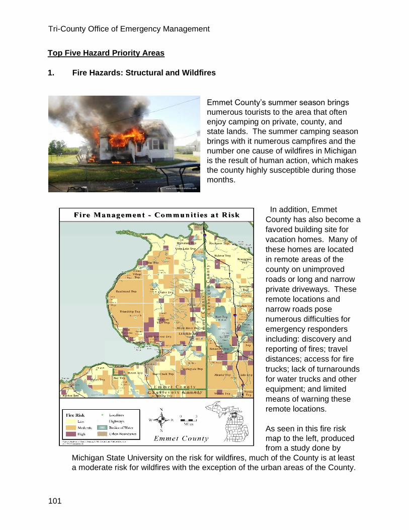
Tri-County Office of Emergency Management
101
Top Five Hazard Priority Areas
1. Fire Hazards: Structural and Wildfires
Emmet County’s summer season brings
numerous tourists to the area that often
enjoy camping on private, county, and
state lands. The summer camping season
brings with it numerous campfires and the
number one cause of wildfires in Michigan
is the result of human action, which makes
the county highly susceptible during those
months.
In addition, Emmet
County has also become a
favored building site for
vacation homes. Many of
these homes are located
in remote areas of the
county on unimproved
roads or long and narrow
private driveways. These
remote locations and
narrow roads pose
numerous difficulties for
emergency responders
including: discovery and
reporting of fires; travel
distances; access for fire
trucks; lack of turnarounds
for water trucks and other
equipment; and limited
means of warning these
remote locations.
As seen in this fire risk
map to the left, produced
from a study done by
Michigan State University on the risk for wildfires, much of the County is at least
a moderate risk for wildfires with the exception of the urban areas of the County.

Tri-County Office of Emergency Management
102
The areas most at risk for wildfires in Emmet County are in the outlying
Townships in the County. Nearly 65% of the total lands in Emmet County are
forested and a major source of economic benefit. With the ever present risk of
wildfires, Emmet County has a tight association of Fire Chiefs that meet on a
regular bases and are connected through mutual aid agreements with each
other. The region also has the advantage of a MDNR office in Indian River that
can quickly bring the resources of the State of Michigan to the scene of major
wild fire events. However, it should be said that as with Charlevoix and
Cheboygan Counties most of the fire departments in Emmet County are
volunteer departments. This means the time of day and who is available will
greatly effect the number of presonel that respond to the scene of a wildfire. This
also means that the fire may be well seated before enough personel can respond
to safely begin firefighting operations.
2. Severe Winter Weather throughout the County
Emmet County’s winter weather is influenced
by lake effect snows, which can be very
dangerous for a community for short periods
of time. The blowing and drifting of snow
during blizzard conditions does create a
driving hazard. Heavy snows can shut down
towns and businesses for a period of several
days. Ice damages can occur when the ice is
breaking up and strong winds occur pushing
the ice onto shore. Winter storms can also
result in freezing rain and ice storms, which
contribute to hazardous driving conditions,
downed power lines, and blocked roads.

Tri-County Office of Emergency Management
103
3. Severe Thunderstorms, High Winds, and Tornadoes throughout the County
There is a historical record of damaging
wind events in Emmet County and a few
tornadoes in the county. Severe winds,
or straight line winds that sometimes
occur during severe thunderstorms can
be very damaging to a community.
Severe winds have the potential to cause
property damage and loss of life from
flying debris. Damage from straight line
winds is more widespread than tornadoes
and often affects multiple counties.
Fallen trees, limbs, and power lines are a typical risk to power lines and other
infrastructure.
There is a historical record of severe thunderstorm events in the county and
thunderstorms are hazards that bring a variety of problems during the peak
tourist seasons of spring, summer, and fall. Potential thunderstorm event pose
likely threats such as lightning, flash flooding, hail, strong winds, and even
tornadoes.
Tornadoes are high-profile hazards that can cause catastrophic damage to a
limited or extensive area. There have been five recorded tornado touchdowns in
Emmet County from 1950 to 2009. So the potential is there in the future for
additional damage by tornados.
4. Flooding: Harbor Springs, Boyer Creek, Tannery Creek, Bear River,
Alanson Locks, Maple River
Although Emmet County has few dams,
the risk of the dam failure is always
present with an aging infrastructure. The
Emmet County Hazard Analysis
published in January of 2015 indicated
three (3) structures as being a
“Significant Hazard” Emmet County Staff
estimates indicate that a dam failure
would likely impact a maximum of 500
people. Damages could be greater from
flash flood types of events than they
would from gradual floodplain inundation.
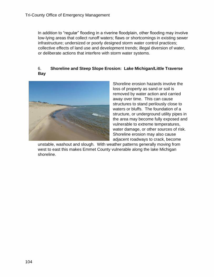
Tri-County Office of Emergency Management
104
In addition to “regular” flooding in a riverine floodplain, other flooding may involve
low-lying areas that collect runoff waters; flaws or shortcomings in existing sewer
infrastructure; undersized or poorly designed storm water control practices;
collective effects of land use and development trends; illegal diversion of water,
or deliberate actions that interfere with storm water systems.
6. Shoreline and Steep Slope Erosion: Lake Michigan/Little Traverse
Bay
Shoreline erosion hazards involve the
loss of property as sand or soil is
removed by water action and carried
away over time. This can cause
structures to stand perilously close to
waters or bluffs. The foundation of a
structure, or underground utility pipes in
the area may become fully exposed and
vulnerable to extreme temperatures,
water damage, or other sources of risk.
Shoreline erosion may also cause
adjacent roadways to crack, become
unstable, washout and slough. With weather patterns generally moving from
west to east this makes Emmet County vulnerable along the lake Michigan
shoreline.
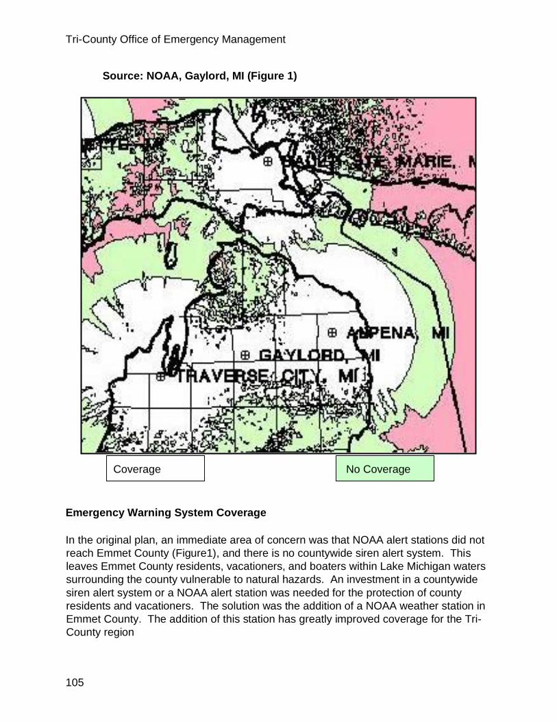
Tri-County Office of Emergency Management
105
Emergency Warning System Coverage
In the original plan, an immediate area of concern was that NOAA alert stations did not
reach Emmet County (Figure1), and there is no countywide siren alert system. This
leaves Emmet County residents, vacationers, and boaters within Lake Michigan waters
surrounding the county vulnerable to natural hazards. An investment in a countywide
siren alert system or a NOAA alert station was needed for the protection of county
residents and vacationers. The solution was the addition of a NOAA weather station in
Emmet County. The addition of this station has greatly improved coverage for the Tri-
County region
Source: NOAA, Gaylord, MI (Figure 1)
Coverage No Coverage

Tri-County Office of Emergency Management
106
Economic Impact Analysis
The total Damaging Events’ Costs recorded since 1950 by the National Oceanic and
Atmospheric Administration for Emmet County and the region are as follows:
1. Hail $100,000
2. Snow and Ice $5,149,538
3. Thunderstorm and High Wind $321,000
4. Tornadoes $53,000
Total damage in Emmet County from Structural and Wild fires for 2002-2004,
according to the National Fire Incident Report System (NFIRS), was $1,694,455.
The incidents above indicate past issues in and around Emmet County. While there are
no certainties when it comes to disasters. One thing that is certain is that severe
weather will reoccur throughout the Tri- County area. Some incidents will be large
enough to be considered disasters, others will be considered part of what is expected to
happen in northern Michigan.
IMPLEMENTATION OF THE EMMET COUNTY HAZARD MITIGATION PLAN
Hazards Mitigation Plan - Managers and Technical Assistance
The leader for implementing the Hazard Mitigation Plan is the Emmet County Board of
Commissioners, with the staff leaders being the Emergency Management Coordinator
and the Planning Department. Working partnerships can be established with the
following to provide technical assistance to accomplish the goals and objectives of the
Plan.
Emmet County Government
Townships, cities, and villages
Emmet County Conservation District
Emmet County Drain Commissioner
Emmet County Road Commission
Little Traverse Bay Bands of Odawa Indians
Tip of the Mitt Watershed Council
Michigan State University Extension
Michigan Department of Environmental Quality
Michigan Department of Natural Resources
U.S. Environmental Protection Agency
U.S. Army Corps of Engineers
U.S. Department of Agriculture Natural Resources Conservation Service
Insurance Companies
Tri-County Office of Emergency Management
107
Real Estate Companies
All hazard mitigation planning could be pursued with a tool available to local
governments, which is identified in the Michigan Public Act 226 of 2003, the Joint
Municipal Planning Act. This Act provides for joint land use planning by cities, villages,
and townships and allows two or more municipalities’ legislative bodies to create a
single joint planning commission to address planning issues. This tool helps with
planning for complex multijurisdictional issues, such as hazards.
The intent of this legislation is for local governments to consider the following:
Individual units of government modifying their ordinances simultaneously to
include language that would incorporate aspects of protection
Developing an overlay zoning district that would cross jurisdictional
boundaries that would be incorporated into existing independent units of
government’s zoning ordinances
Forming a new joint multi-jurisdictional planning commission or zoning board
Sharing zoning administration
Sharing enforcement activities
Funding the Implementation of the Plan
To assist with the funding of the proposed hazard mitigation strategies, here is a list of
potential financial assistance entities to help fund the implementation projects of the
Plan.
Federal Emergency Management Administration – Hazard Mitigation Grant Program
U.S. Environmental Protection Agency
U.S. Department of Agriculture Natural Resources Conservation Service
U.S. Department of Agriculture Rural Development: Rural broadband opportunity – high
speed telecommunication funding from the Public Telecommunications Facilities
Planning and Construction grants
U.S. Department of Housing and Urban Development
Michigan Department of Environmental Quality
Michigan Department of Natural Resources
National Oceanic and Atmospheric Administration
Community and Regional Foundations
Businesses often assist with educational initiatives that provide developers and the
general public with the information they need to make homes more disaster resistant.

Tri-County Office of Emergency Management
108
Action Agenda
Following is table summary for accomplishing the recommended natural hazards
mitigation actions for Emmet County. The County and four of the Townships have
zoning.
__________ Completed ____________In Progress ___________Not Done
Action Agenda Layout:
Priority and Action Strategies Responsible Parties Timeframe
Priority Area 1 Fire Hazards: Structural and Wildfire Mitigation Strategies:
a. Seek funding for a countywide
siren alert system or a NOAA
alert station is needed for the
protection of county residents
and vacationers.
Emergency Management Coordinator County Planning Townships Incorporated Cities and Villages
1-3 years after adoption of the plan
b. Introduce ordinance which
encourage proper road and
driveway construction for
vehicle and fire equipment
access
County Road Commission County Planning and Zoning Townships Incorporated Cities and Villages
1-3 years after adoption of the plan
c. Educate and establish programs
which encourage the safe use
and maintenance of fireplaces
and chimneys.
County Building Inspector County Planning First Responders Public Citizens Insurance Agencies Elected Officials MSU Extension Personnel Emergency Management Coordinator
1-5 years from adoption of the plan
d. Have adequate water supplies for
emergency fire fighting County Building Inspector Emergency Management Coordinator Township Fire Chiefs
1-5 years from adoption of the plan
e. Maintain roads and develop connector roads to reduce fire response time
County Road Commission County
Planning Ongoing
f. Develop additional fire stations
where needed County Planning To be addressed in the County Master
Plan (Expected Completion 2007)
g. Identify and/or construct
prearranged shelters County Planning County Building Inspector Emergency Management Coordinator Elected Officials
To be addressed in the County Master
Plan (Expected Completion 2007)

Tri-County Office of Emergency Management
109
Structural Fire Mitigation
Strategies:
a. Education and enforcement of
building and zoning codes County Building Inspector County Planning and Zoning Townships Incorporated Cities and Villages
Ongoing
b. Education for developers,
realtors, business owners,
architects, and engineers
County Building Inspector County Planning First Responders Public Citizens Insurance Agencies Elected Officials Non-profit organizations MSU Extension Personnel Emergency Management Coordinator
1-5 years from adoption of the plan
c. Public education and school
programs, which encourage the
development of a Site
Emergency Plan for public
buildings, a Family Disaster
Plan for private households,
and the preparation of a
Disaster Supplies Kit
County Building Inspector County Planning First Responders Public Citizens Insurance Agencies Elected Officials Non-profit organizations MSU Extension Personnel Emergency Management Coordinator
1-5 years from adoption of the plan
d. Encourage first responder
education of methods and
training on a regular basis
First Responders Emergency Management Coordinator
1-3 years from adoption of the plan
e. Review existing publicly owned facilities and identify their
potential need for retrofitting
County Building Inspector Elected Officials Emergency Management Coordinator
1-3 years from adoption of the plan
Wildfire Mitigation Strategies:
a. Educate and encourage the
proper maintenance of property
in or near wildlands, to include
the introduction of defensible
buffer zones, short grass,
thinning trees, and sweeping
and cleaning dead or dry leaves
and needles, from roofs, decks,
eaves, porches, and yards
County Building Inspector County Planning First Responders Public Citizens Insurance Agencies Elected Officials Non-Profit Organizations MSU Extension Personnel Emergency Management Coordinator Townships Incorporated Cities and Villages
1-3 years from adoption of the plan
b. Encourage safe disposal of yard
and house waste rather than
open burning
County Department of Public Works Townships Incorporated Cities and Villages
Ongoing
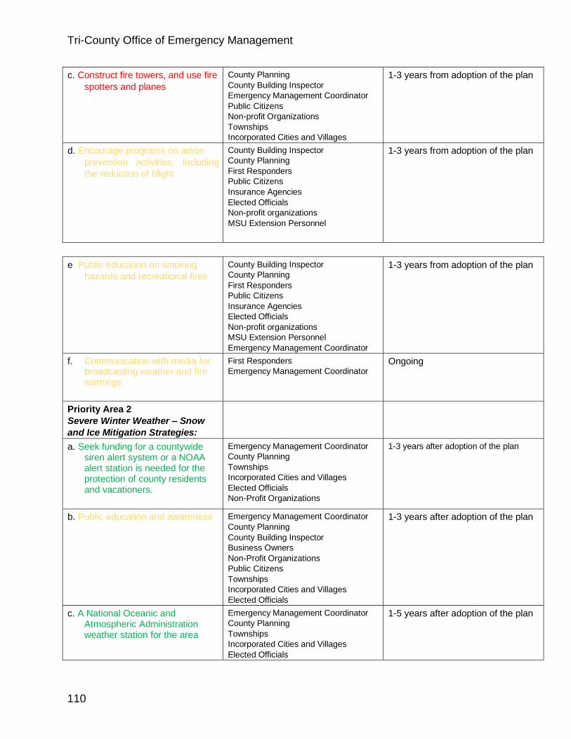
Tri-County Office of Emergency Management
110
c. Construct fire towers, and use fire
spotters and planes County Planning County Building Inspector Emergency Management Coordinator Public Citizens Non-profit Organizations Townships Incorporated Cities and Villages
1-3 years from adoption of the plan
d. Encourage programs on arson prevention activities, including
the reduction of blight
County Building Inspector County Planning First Responders Public Citizens Insurance Agencies Elected Officials Non-profit organizations MSU Extension Personnel
1-3 years from adoption of the plan
e. Public education on smoking
hazards and recreational fires County Building Inspector County Planning First Responders Public Citizens Insurance Agencies Elected Officials Non-profit organizations MSU Extension Personnel Emergency Management Coordinator
1-3 years from adoption of the plan
f. Communication with media for broadcasting weather and fire warnings
First Responders Emergency Management Coordinator
Ongoing
Priority Area 2 Severe Winter Weather – Snow
and Ice Mitigation Strategies:
a. Seek funding for a countywide siren alert system or a NOAA alert station is needed for the protection of county residents and vacationers.
Emergency Management Coordinator County Planning Townships Incorporated Cities and Villages Elected Officials Non-Profit Organizations
1-3 years after adoption of the plan
b. Public education and awareness Emergency Management Coordinator County Planning County Building Inspector Business Owners Non-Profit Organizations Public Citizens Townships Incorporated Cities and Villages Elected Officials
1-3 years after adoption of the plan
c. A National Oceanic and Atmospheric Administration weather station for the area
Emergency Management Coordinator County Planning Townships Incorporated Cities and Villages Elected Officials
1-5 years after adoption of the plan

Tri-County Office of Emergency Management
111
d. Identify, improve, and/or construct shelter capacity
Emergency Management Coordinator County Planning County Building Inspector Business Owners Non-Profit Organizations Public Citizens Townships Incorporated Cities and Villages Elected Officials
1-5 years after adoption of the plan
e. Promote community response for snow removal activities such as using community services clients to assist the elderly
Public Citizens Non-profit organizations MSU Extension Personnel Emergency Management Coordinator Elected Officials
1-3 years after adoption of the plan
f. Enforcement of building code
snow load requirements which
is 70 lbs. per sq. ft. especially
when there is snow, rain and
then freezing
County Building Inspector Public Citizens Insurance Agencies
Ongoing
Priority Area 3 Severe Thunderstorms, high
winds, and tornadoes Mitigation
Strategies:
a. Seek funding for a countywide
siren alert system or a NOAA
alert station is needed for the
Emergency Management Coordinator County Planning Townships
1-3 years after adoption of the plan
protection of county residents
and vacationers. Incorporated Cities and Villages Elected Officials Non-profit organizations
b. Address the practice of placing
utilities underground for new
construction
County Planning County Building Inspector Townships Incorporated Cities and Villages
Ongoing
c. A National Oceanic and
Atmospheric Administration
weather station for the area
Emergency Management Coordinator County Planning Townships Incorporated Cities and Villages Elected Officials
1-5 years after adoption of the plan
d. Education and enforcement of
building codes for such
activities as bracing elevated
platforms, and anchoring and
tie downs
County Building Inspector Public Citizens Insurance Agencies
Ongoing
e. Tree management coordination Business Owners Public Citizens Insurance Agencies Non-Profit Organizations
Ongoing

Tri-County Office of Emergency Management
112
f. Public education Emergency Management Coordinator County Planning County Building Inspector Business Owners Non-Profit Organizations Public Citizens Townships Incorporated Cities and Villages Elected Officials
1-3 years after adoption of the plan
Priority Area 4 Flooding – Flood Mitigation
Strategies:
a. Seek funding for a countywide
siren alert system or a NOAA
alert station is needed for the
protection of county residents
and vacationers.
Emergency Management Coordinator County Planning Townships Incorporated Cities and Villages Elected Officials Non-profit organizations
1-3 years after adoption of the plan
b. Assessment of flood threat and
dam inspections results Researchers, Engineers, and Architects County Planning Townships Incorporated Cities and Villages Elected Officials Non-profit organizations Insurance Agencies Emergency Management Coordinator
1-5 years after adoption of the plan
c. Drainage improvements Researchers, Engineers, and Architects County Planning Townships Incorporated Cities and Villages
1-5 years after adoption of the plan
d. Enforcement of Storm Water
Management Ordinance Researchers, Engineers, and Architects County Planning Townships Incorporated Cities and Villages County Soil Erosion and Storm Water Management Officer
Ongoing
e. Enforcement of building and
zoning codes County Planning County Building Inspector
Ongoing
f. Open space designations: acquisition or conservation
easements by land
County Planning Business Owners Non-Profit Organizations Public Citizens
To be addressed in the County Master
Plan (Expected Completion 2007)
conservancies, county,
townships Townships Incorporated Cities and Villages Elected Officials
g. Education for realtors through the
creation of a handbook for
distribution
Researchers, Engineers, and Architects County Planning County Building Inspector County Soil Erosion and Storm Water Management Officer
1-5 years after adoption of the plan

Tri-County Office of Emergency Management
113
h. Public education Emergency Management Coordinator County Planning County Building Inspector Business Owners Non-Profit Organizations Public Citizens Townships Incorporated Cities and Villages Elected Officials
1-3 years after adoption of the plan
Priority Area 5 Shoreline and Steep Slope –
Landslide Erosion Mitigation
Strategies:
a. Seek funding for a countywide
siren alert system or a NOAA
alert station is needed for the
protection of county residents
and vacationers.
Emergency Management Coordinator County Planning Townships Incorporated Cities and Villages Elected Officials Non-profit organizations
1-3 years after adoption of the plan
b. Enforcement of the Storm Water Management Ordinance and the Soil Erosion and
Sedimentation Control
Ordinance: slide areas,
drainage control, grading,
debris flow measures,
vegetation (native species)
placement
Researchers, Engineers, and Architects County Planning Townships Incorporated Cities and Villages County Soil Erosion and Storm Water Management Officer Non-Profit Organizations Insurance Agencies
Ongoing and To be addressed further in the County Master Plan (Expected Completion
2007)
c. Utilize the Critical Dunes Overlay County Planning Townships Incorporated Cities and Villages County Soil Erosion and Storm Water Management Officer
Ongoing and To be addressed further in the County Master Plan (Expected Completion
2007)
d. Education and enforcement of building and zoning codes: setbacks, lot sizes, driveways, relocation of structures, Lake Michigan coastal zoning ordinances – U.S. Army Corps of Engineers and Michigan Department of Environmental Quality
Emergency Management Coordinator County Planning County Building Inspector Business Owners Non-Profit Organizations Public Citizens Townships Incorporated Cities and Villages Elected Officials County Soil Erosion and Storm Water Management Officer
1-3 years after adoption of the plan
e. Building code enforcement
through permits County Building Inspector
Ongoing

Tri-County Office of Emergency Management
114
f. Open space designations: acquisition or conservation
easements by land
conservancies, state, county, or
townships
County Planning Business Owners Non-Profit Organizations Public Citizens Townships Incorporated Cities and Villages
To be addressed in the County Master
Plan (Expected Completion 2007)
Elected Officials
g. Education for developers,
realtors, and engineers Researchers, Engineers, and Architects County Planning County Building Inspector Business Owners County Soil Erosion and Storm Water Management Officer
1-5 years after adoption of the plan
h. Public education Emergency Management Coordinator County Planning County Building Inspector Business Owners Non-Profit Organizations Public Citizens Townships Incorporated Cities and Villages Elected Officials County Soil Erosion and Storm Water Management Officer
1-3 years after adoption of the plan
h. Erosion and Flooding Mitigation;
Seek funding for Good Hart area
seasonal flooding to prevent
damage to roadways and houses
along the M119 corridor.
Emergency Management Coordinator County Planning Incorporated Cities and Villages Elected Officials
Non-Profit Agencies
4-6 years after adoption of the plan
• Working with utility companies to protect the power grid • Working with other
governmental entities, organizations, businesses, and the public to
implement the plan and have input in any revisions or updates in the future
Emmet County can also utilize watershed management plans that have been
developed within the county boundaries. Proposed mitigation strategies that
have been laid out in the Little Traverse Bay Watershed Management Plans
include:
• Resident, commercial/industry, and government official education
• Stabilizing erosion at road/stream crossings.
• Correcting most severe streambank and lakeshore erosion sites.

Tri-County Office of Emergency Management
115
• Reducing the pollutant load from storm water in the urban areas.
• Restricting livestock from streams.
• Maintaining adequate recreational access.
• Removing sediments from appropriate locations.
• Contacting landowners of sensitive lands and educating about land
stewardship and protection options.
• Ensuring that state and federal wetland laws are properly administered
and enforced.
• Developing local ordinances to protect wetlands.
• Educating landowners, developers, and citizens on the importance of
wetland protection.
The County should consider the following key land use issues and the
relationship to hazard mitigation:
o Safe, beneficial uses for hazard prone areas Concentration issues
o Proximity issues o Location of public facilities and infrastructure
Development standards for public facilities and
infrastructure
o Effect of accumulated development on community
systems and facilities
While it appears there are still many unfinished projects, most are ongoing and of
the nature that will never be completed such as “Public Education”. This is an
ongoing effort for all emergency managers.

Tri-County Office of Emergency Management
116
X. LAWS, POLICIES, AND ORDINANCES
Policies, ordinance and regulation: Charlevoix, Cheboygan and Emmet Counties all
have policies that support hazard mitigation. These policies are supported through
zoning ordinances, building and fire codes and community planning. Each County has
a zoning board that decides if projects presented to the County meet the zoning
ordinance that are established by the County board of commissioners for each County
respectively. Projects are then sent to the planning commission who decides if the
project meets requirements of the Counties master plan and/or ordinances that apply.
It is then sent back to County board of Commissioners to discuss the findings of the
other boards and determine if the project will fit the community. The board of
commissioners will vote on the project to either move the project forward or deny the
application for the project.
Once it has been established that a building can be built the way the building is
constructed is regulated by the Michigan Building Code. Each county has a Building
Division. The head of that division is the Building Official. Who is required by state law
PA54 to be licensed with the State Bureau of Building and Construction Codes. Plans
for a project are submitted to the Building division for review and approval. Once
approved, the building process is inspected for compliance with the approved plan and
the Michigan Building Code. Each inspector is also required to be licensed in their
respective field of expertise. This entire process is consistent with state and local laws
and provides a high level of safety to buildings, taking into account where the project is
to be built, reasons for/or not building the project in a particular location, wind shear and
construction features that support buildings that are strong enough to with stand most
natural disasters.

Tri-County Office of Emergency Management
117
XI. AREA DEVELOPMENT AND PROGRESS
The entire region has seen a major shift in demographics since the 2008 recession. During that recession there was a sharp decrease in the population of 25 to 55-year-old residents. Now that the economy is recovering we are seeing some of that 25 to 55 age group return to the area. This has created a housing shortage in the region. The area is seeing many multifamily housing projects springing up throughout the Tri-County area. However, making the housing affordable is another issue. According to Megan Atwood reporter for 9&10 News; “Some in the Traverse City area can't find workers because potential workers can't afford a place to live. Northwest Michigan has seen a housing shortage for the past decade, and within the past few years particularly for small families and single people.”
Another part of this equation is the fact that the area’s economy is seasonal. During the summer months there is a sharp increase in populations which creates a booming economy between Memorial Day and Labor Day and while the area is a popular spot for the autumn color season, winter ski and snowmobile season, it is not nearly as busy as it is during the summer months. This has caused some business owners to become creative. One such owner bought an old motel and renovated the rooms to provide housing for his summer workers. I’m sure there are other similar stories throughout the region. However, the other side of this is that for most workers, their employment is seasonal. When the fall season comes around many find themselves out of work and faced with how to make ends meet with the unemployment checks that they receive.
There are also many improvements that have taken place or are being proposed. The town of Indian River installed sanitary sewers in its downtown district. This could potentially open the door for further development within that area. Indian River is also proposing an I75 business loop to bring more people into town.
Cheboygan has recently approved a plan for a new Meijer store. Emmet, Cheboygan and Charlevoix are also seeing infrastructure improvements, including refurbishment of the I75 bridges on M27, the M33 project, improvements to M75 at Waloon Lake, East Jordon Road project and a new Township office, DPW, EMS and Fire Station in Boyne City. Traverse City while out of the jurisdiction of this plan, is in the process of approving a new Costco store.
One of the major accomplishments during the past few years is the addition of a NOAA weather station in Emmet County. This was in all three previous plans and as seen in

Tri-County Office of Emergency Management
118
the illustrations greatly improved coverage in the area. Since the last HM cycle all three counties now have GIS capabilities. This was identified in the Cheboygan County plan and has proven to be a key in hazard mitigation planning. Another great tool has been the Tri-County enrollment in the Everbridge, Be Alert system. Tri-County EM has worked diligently to get this program running and with the help of the schools has been successful in gaining enrollment of residents. As stated elsewhere in this document, Public Education is and will continue to be an ongoing priority of the Tri-County EM program. In working with utility companies through miss dig residents and contractors are told when calling for utility locations that they can’t plant or install anything under power lines or within five feet on either side of the lines.
While land acquisition of flood prone areas is always a good solution, only about 1/3 of the Tri-County has been mapped at this point. The flood prone areas must be identified first for this action to be effective.

Tri-County Office of Emergency Management
119
XII. HAZARDS MITIGATION GOALS AND OBJECTIVES
The mission of the Tri-County Hazard Mitigation Plan is to protect the health and safety of the
public and preserve property in the Tri-County area that includes prevention of injury, loss of
life, property damage, breakdown in vital services like transportation and infrastructure,
economic slumps, maintain tourist base, and liability issues. This is done by taking action to
permanently eliminate or reduce the long-term risks from hazards.
Specific goals and objectives have been established based upon the community’s hazard
analysis, as well as input from the LEPC in each County, Michigan Township associations in
each County and the public through meetings, posting of the draft plan on line and at the
clerk’s office in each County with a request for comments. A notice of public hearing was
placed in the local newspaper with meeting dates and times to allow the public an opportunity
to comment, and the final draft of the plan will be presented to the County board of
Commissioners in each of the three Counties.
Goal 1: Increase local awareness and participation in hazard mitigation strategies
Objectives:
A. Encourage cooperation and communication between planning and emergency
management officials
B. Encourage additional local governmental agencies to participate in the hazard
mitigation process
C. Encourage public and private organizations to participate
Goal 2: Integrate hazard mitigation considerations into each County’s
comprehensive planning process Objectives:
A. Enforce and/or incorporate hazard mitigation provisions in ordinances, and
procedures, and into each county’s master plan
B. Incorporate hazard mitigation into basic land use regulation mechanisms
C. Update of zoning ordinances, shoreline protection rules, etc.
D. Incorporate hazard area classifications into standard zoning classifications
E. Develop community education programs and public warning systems
F. Strengthen the role of the Local Emergency Planning Committee in the land
development process
G. Integrate hazard mitigation into the capital improvement planning process so that
public infrastructure does not lead to development in hazard areas
H. Encourage County agencies to assess local roads, bridges, dams, and related
transportation infrastructure for hazard vulnerability
Goal 3: Utilize available resources and apply for additional funding for hazard
mitigation projects Objectives:
A. Prepare a list of desired community mitigation projects to submit to the State for
mitigation grant funding
B. Encourage the application for project funding from other entities

Tri-County Office of Emergency Management
120
Goal 4: Develop and complete hazard mitigation projects in a timely manner Objectives
A. Encourage public and business involvement in hazard mitigation projects

Tri-County Office of Emergency Management
121
XIII IDENTIFICATION AND SELECTION OF MITIGATION STRATEGIES
A. Participation in the Plan:
As stated above the Tri- County office of Emergency Management worked diligently to
get participation in the plan.
B. Selection of Feasible Mitigation Strategies
The Tri-County Office of Emergency has worked diligently with local units of government
as well as public safety in all three counties to identify and add new mitigation strategies
to this plan. We have identified new issues in all three Counties and added them to
uncompleted issues on the original lists. We then formed a single list of strategies
below. Based on the guidelines that at least some of the strategies should be the type
that is fundable through FEMA project grants for Hazard Mitigation. Including:
• Physical construction, demolition, engineering or property acquisition/alteration,
expanded infrastructure capacity.
• Warning systems, sirens, communications infrastructure, emergency generators.
• Water retention / detention areas, creation of new open space, installation of
structural bracing, wind resistant windows, storm or tornado shelters, anchorage for
mobile homes.
By anticipating future problems, the three Counties can reduce potential injury, structure
losses, loss of power such as electric and gas, and prevent wasteful public and private
expenditures.
The strategies were then organized and the process of combining existing open
strategies with new strategies that were identified through the processes described
above was completed.
1. Fire Hazards: Structural and Wildfires Structural
Fire Mitigation Strategies:
a. Education and enforcement of building and zoning codes
b. Education for developers, realtors, business owners, architects, and engineers
(All 3 Counties)
c. Public education and school programs, which encourage the development of a
Site Emergency Plan for public buildings, a Family Disaster Plan for private
households, and the preparation of a Disaster Supplies Kit
d. Encourage first responder education of methods and training on a regular basis.
(All 3 Counties)
e. Seek funding and grants to improve services and training in the rural areas of all
3 counties, where services are not adequate to provide minimal fire protection.

Tri-County Office of Emergency Management
122
f. Review existing publicly owned facilities and identify their potential need for
retrofitting with generators and other services to bring then up to a minimum
standard. (All 3 Counties)
Wildfire Mitigation Strategies:
a. Educate and encourage the proper maintenance of property in or near wildlands,
to include the introduction of defensible buffer zones, short grass, thinning trees,
and sweeping and cleaning dead or dry leaves and needles, from roofs, decks,
eaves, porches, and yards.
b. Encourage safe disposal of yard and house waste (Recycle or Compost
programs) rather than open burning.
c. Construct fire towers, and use fire spotters and planes
d. Encourage programs on arson prevention activities, including the reduction of
blight. (Partnership between Police and Fire
e. Public education on smoking hazards and recreational fires
f. Communication with media for broadcasting weather and fire warning
g. Maintain the relationship that exists now between MDEQ Forest Resources
Division and the Local Fire Chief’s organizations
Both Structural and Wildfire Mitigation Strategies:
a. Introduce ordinance which encourage proper road and driveway construction for
vehicle and fire equipment access. Especially areas that close down for the
winter months and do not maintain Fire Department Access Routes.
b. Educate and establish programs which encourage the safe use and maintenance
of fireplaces and chimneys.
c. Have adequate water supplies for emergency firefighting. Pre incident plan to
identify areas that have no supply. Install water supply lines and hydrants for
drafting from lakes and other sources of water.
d. Maintain roads and develop connector roads to reduce fire response time
e. Develop additional fire stations where needed
f. Identify and/or construct prearranged shelters
2. Severe Winter Weather throughout the Counties
a. Encourage the use of Be Alert and IPAWS for the protection of county residents
and vacationers.
b. Public education and awareness
c. Identify, improve, and/or construct shelter capacity.
d. Promote community response for snow removal activities such as using
community services clients to assist the elderly.
e. Encourage elderly residents to call if help is needed. Such as their heat is out,
they need help with snow removal, out of food, etc.
f. Enforcement of building code snow and wind load requirements.
Tri-County Office of Emergency Management
123
3. Severe thunderstorms, High Winds, and Tornadoes throughout the Counties
a. Encourage the use of IPAWS and the Everbridge Be Alert applications that are
available through Tri-County Emergency Management.
b. Address the practice of placing utilities underground for new construction
c. Education and enforcement of building codes for such activities as bracing
elevated platforms, and anchoring and tie downs
d. Tree management coordination
e. Public education
Tornado Mitigation Strategies:
a. Seek funding for a countywide siren alert system or a NOAA alert stations are
needed for the protection of county residents and vacationers. Mostly needed in
Urban areas and Cities. No system currently exists.
b. Consistent weather event warnings
c. Public awareness and education
4. Flooding: Around Lakes, Streams and Wetlands throughout the Tri-County
area.
a. Assessment of flood threat and dam inspections results
b. Drainage improvements
c. Enforcement of storm water management ordinance
d. Enforcement of building and zoning codes
e. Open space designations: acquisition or conservation easements by land
conservancies, county and townships
f. Public education
5. Shoreline and Steep Slope Erosion: Lake Michigan & Huron Shoreline Area
a. Enforcement of the Storm Water Management Ordinance and the Soil Erosion and
Sedimentation Control Ordinance: slide areas, drainage control, grading, debris flow
measures, vegetation (native species) placement
b. Utilize the Critical Dunes Overlay
c. Education and enforcement of building and zoning codes: setbacks, lot sizes,
driveways, relocation of structures, Lake Michigan coastal zoning ordinances – U.S.
Army Corps of Engineers and Michigan Department of Environmental Quality
d. Building code enforcement through the permit process. (Building Officials in all three
Counties)
e. Open space designations: acquisition or conservation easements by land
conservancies, state, county, or townships.
f. Erosion and Flooding Mitigation; Seek funding for Good Hart area seasonal flooding
to prevent damage to roadways and houses along the M119 corridor in Emmet
County.
Tri-County Office of Emergency Management
124
XIV Implementation of the Tri-County Hazard Mitigation Plan
Under the leadership of each Counties Board of Commissioners respectively, this
plan will be administered by the Tri-County Office of Emergency Management with
the assistance of Directors and Employees of each County with input and assistance
from local governments and /or outside sources when appropriate.
The Tri-County Office of Emergency Management will assist County employees and
work with each County to seek grant funding for projects identified in this plan when
available. Other funding sources could include, but are not limited to:
a. Federal Emergency Management Administration-Hazard Mitigation Grant
Program.
b. U.S. Environmental Protection Agency
c. U.S. Department of Agriculture Conservation Services
d. U.S. Department of Agriculture Rural Development: Rural broadband
opportunity- high speed funding from Public Telecommunication Facilities
planning and construction grants.
e. U.S, Department of Housing and Urban Development
f. Michigan Department of Environmental Quality
g. Michigan Department of Natural Resources
h. National Oceanic and Atmospheric Administration
i. Community and Regional Foundations
j. Area Businesses.
The natural hazards identified in the original plans have not changed and the probability
of these hazards reoccurring is absolute. They will continue to occur in all three
Counties. Therefore, the mitigation strategies listed below apply to all three Counties.
Unless stated otherwise. Additionally, new mitigation projects were identified and
added to the original list.
a. Winter Storms are common to the region and occur several times each
winter. While these storms can drop up to 24 inches of snow at a time most
of these storms produce between 8 to 12 inches of snow at a time and are
handled as part of living in northern Michigan. Mitigation Strategies include:
i. Expand public awareness that in the event of a large storm with a
possible power outage, it may be several days before emergency

Tri-County Office of Emergency Management
125
workers could get to them. This may include alternative sources of
heat and supplies that will last up to 72 hours following an event.
Implementation: On Going (Tri-County EM, LEPC’s)
ii. Identify shelters throughout the county that could be opened during a
storm event and develop a plan for opening the shelters and alerting
residents to their location in the event of a storm.
Implementation 1 to 3 years (Tri-County EM, LEPC’s, MTA’s)
iii. Ensure that the shelters identified in ii above are equipped with back-
up generators, chairs, TV, kitchens, and are Michigan barrier free
compliant.
Implementation 1 to 3 years (Tri-County EM, Building Divisions,
Planning Divisions, MTA’s)
iv. Provide back-up generators for the township hall and fire station in
Forest Twp. These buildings are also used as shelters in severe
weather and have no back-up power. 1-3 years (Tri-County EM,
Building Division, Forest Twp. Elected Officials)
v. Promote community programs that provide snow removal for the
elderly and/or handicapped residents of the county.
Implementation: Immediate and ongoing. (Fire Departments,
community volunteers)
vi. Apply for grant funding to raise and rebuild the garage for road
equipment on Beaver Island. The trucks will not fit in the garage with
the snow plows attached. This means that the plows outside must be
lined up and attached to the trucks each time it snows. ASAP (Building
Division, Island leadership)
b. High winds and gales
i. Pass and enforce local ordinances that prohibit plantings under and
around power lines.
Implementation: 1-3 years (Building and Planning Divisions)
ii. Pass and enforce local ordinances that require new developments
and subdivisions to install utilities underground.
Implementation: 1-3 years (Building and Planning Divisions)
iii. Enforce provisions in the Michigan Building Code that address wind
bracing, etc. (Building Official)
c. Thunderstorms, Tornadoes and Hail
i. Seek funding for warning sirens in the most populated areas and
tourist destinations of the Tri-County region. These systems can be
expanded as population and tourism demands.
Implementation: 1-5 years (Tri-County EM, Planning Divisions, Elected
Officials)
ii. Identify shelters throughout the county that could be opened during a
storm event and develop a plan for opening the shelters and alerting
residents to their location in the event of a storm.
Tri-County Office of Emergency Management
126
Implementation: 1 to 3 years (Tri-County EM, Planning Divisions,
Elected Officials)
iii. Require new mobile and pre-manufactured home parks to provide a
storm shelter for residents of the park.
Implementation: 1-3 years (Building and Planning Divisions)
iv. Pass and enforce local ordinances that prohibit plantings under and
around power lines.
Implementation: 1-3 years (Planning Division)
v. Pass and enforce special event ordinances that require a plan for
patrons to seek shelter in the event of severe weather.
Implementation: 1-3 years (Planning Divisions, Elected Officials)
d. Flooding
i. Pass and enforce local zoning ordinances regarding building and
development of property that falls within a flood plain.
Implementation: 1-3 years (Planning Division, Zoning Boards, Building
Division and County Board of Commissioners)
ii. Examine and improve existing storm systems to ensure storm water
drains properly. U.S. 31 near M119 and in the Bayview area Storm
Sewers are inadequate causing repetitive flooding.
Implementation: 2-5 years (Emmet County Engineer)
iii. Install storm sewers in Cross Village at the commercial district and at
the Catholic church, repetitive flooding during heavy rain events in
Emmet County: 2-5 years (Emmet County Engineer)
iv. Inspect and repair existing dams and locks to ensure their integrity,
including the Cornwall Creek Dam in Nunda Township.
Implementation: 3-5 years (MDEQ, Tri-County EM)
v. Repair foundations on cabins in the girl’s camp that were damaged
by years of flooding. In Hayes Township, Charlevoix County.
Implementation: 1-3 years (Building Division and Hayes Township
Elected Officials)
vi. Repair flooding that occurs on Campbell Rd. in Beaugrand Township.
vii. Erosion and Flooding Mitigation; Seek funding for Good Hart area
seasonal flooding to prevent damage to roadways and houses along
the M119 corridor in Emmet County (MDOT, Emergency
Management, Road Commission). Implementation 4-6 years)
e. Wild Fires and Structure Fires
i. Partner with DNR and MDEQ and exercise response capabilities to
wildfires.
Implementation: 1-3 years (Charlevoix, Cheboygan & Emmet County
Fire Chief Associations, MDEQ)
ii. Remove trees that have died from insect manifestation. The dead
trees cause increased fuel load to the area as well as a hazard to
motorists:

Tri-County Office of Emergency Management
127
Implementation: 1-3 years (Road Commissions, Tri-County EM)
iii. Install heat in the fire apparatus garage in Hayes Township. Fire
pumps freeze during cold weather: 1-2 years (Tri-County EM Hayes
Twp. Fire Chief, Hayes Twp. Elected Officials)
iv. Seek grant funding for training and equipment for a regional task
force for wildfires.
Implementation: 3-5 years (Tri-County EM, 3 Fire Chief Associations,
MDEQ)
v. Identify water supplies available for both structure fires and wildfires.
Improve and/or install systems where possible.
Implementation 1-3 years (Fire Chief Associations, Tri-County EM)
vi. Identify and preplan seasonal roads and transportation routes for
access to rural areas.
Implementation 1-3 years (Fire Chief Associations, Tri-County EM,
County Elected Officials)
vii. Encourage and implement mutual and automatic aid agreements, to
ensure adequate manpower is available for firefighting.
Implementation: Ongoing (Tri-County EM, Fire Chief Associations,
Elected Officials)
f. Ground water purity and protection from contamination.
i. Pass and enforce local ordinances regarding chemical storage, spill
protection for areas where storage and use of hazardous materials is
taking place, including but not limited to the storage of old motor
vehicles.
Implementation: 1-5 years (Planning Divisions)
ii. Educate the public about the storage and disposal of hazardous
chemicals.
Implementation: 1-3 years (Garbage Companies, Planning Divisions,
Elected Officials)
iii. Consider partnering with local disposal companies for hazardous
waste drop off days.
Implementation: 1-3 years (Garbage Companies, Planning Divisions,
Elected Officials)
iv. Encourage and educate residents who have buried underground
storage tanks to have them removed and/or pumped out and filled.
Implementation: 1-5 years (MDEQ, Planning Divisions
Monitoring and Evaluation
The Charlevoix, Cheboygan and Emmet County Hazard Mitigation Plan will be monitored on a
regular basis by the Emergency Management Coordinator and the Planning Departments in
each County respectively. Because Tri-County region is a dynamic, changing community, it is
expected that the plan should be reviewed on a five-year basis and subsequent laws and
ordinances in each community changed to meet the needs and dynamics of each County.

Tri-County Office of Emergency Management
128
To assess the effectiveness of the Plan, some questions to ask in the review include:
1. How many and which mitigation strategies were developed? Implemented?
2. Did any new hazard events take place the past year to report?
This review will be administered by the Emergency Management Coordinator with the LEPC in
each County, each Counties Planning Commissions, and the public. If changes are needed,
the plan will be revised by the Tri-County Office of Emergency Management.
Although review of the plan will occur every five years, a formal revision may not be needed.
New editions of the plan will be based on annual reviews, monitoring, evaluation, and an
accumulation of official feedback and public input. Tri-County Emergency Management has an
area on their web site that encourages public comment and input on not only these mitigation
strategies, but any observations and/or additions to the contents herein. When it is appropriate
to publish a revised version of the plan, the Tri County Office of Emergency Management will
be the agency to take the lead in the revision process. Each new edition of the plan will again
be officially adopted by the County Board of Commissioners in each of the three Counties
respectively. Approval will also be required from the MSP-EMHSD and FEMA.
This Plan received input on projects for mitigation from the following jurisdictions in the Tri-
County region: Charlevoix County, Cheboygan County, Emmet County, Hayes Township,
Beauregard Township, Forest Township Cross Village and Bear Creek Township. As these
Townships have provided information about hazard mitigation projects within their jurisdiction
they are listed as poarticipating communities. With that said, the Tri-County Office of
Emergency Management will continue to work with jurisdictions that did not participate in the
mitigation process. In order to be considered a “participating community” under FEMA
guidelines they would need to identify their most significant hazards and identify their mitigation
priorities. The plan can then be amended by the Tri-County Office of Emergency
Management. That community could then be counted as a participating community.

Tri-County Office of Emergency Management
129
Appendix A
As seen in the
attached figure
from the 2012
Michigan
Hazard
Analysis there
are a
significant
number of
dams in the
Tri-County
region. While
some of these
dams are small
and pose no
major flood risk
others are
larger and
could bring
catastrophic
results should
they fail. While
MDEQ is
responsible for
the required
inspections of
existing dams
the Tri-County
Office of
Emergency
Management
will request
reports on
existing dams

Tri-County Office of Emergency Management
130
that pose a risk to the area.
Appendix B
Appendix B represents
the average number of
thunderstorms that
effect the area each
year according to the
2012 Michigan Hazard
Analysis.
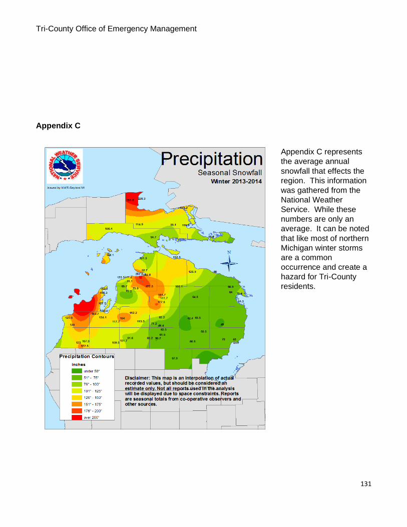
Tri-County Office of Emergency Management
131
Appendix C
Appendix C represents
the average annual
snowfall that effects the
region. This information
was gathered from the
National Weather
Service. While these
numbers are only an
average. It can be noted
that like most of northern
Michigan winter storms
are a common
occurrence and create a
hazard for Tri-County
residents.

Tri-County Office of Emergency Management
132
Appendix D
Number of Tornadoes in Michigan, by County: 1950- 2009
2012 Michigan Analysis
County Tornadoes: County Tornadoes: (A-K) 1950-2009 (L-Z) 1950-
2009
Alcona 11 Lake 2
Alger 6 Lapeer 20
Allegan 26 Leelanau 3
Alpena 14 Lenawee 31
Antrim 9 Livingston 24
Arenac 7 Luce 2
Baraga 2 Mackinac 5
Barry 18 Macomb 18
Bay 12 Manistee 2
Benzie 4 Marquette 6
Berrien 28 Mason 5
Branch 15 Mecosta 9
Calhoun 15 Menominee 7
Cass 14 Midland 8
Charlevoix 4 Missaukee 8
Cheboygan 6 Monroe 28
Chippewa 6 Montcalm 11
Clare 8 Montmorency 6
Clinton 17 Muskegon 7
Crawford 10 Newaygo 12
Delta 11 Oakland 31
Dickinson 7 Oceana 5
Eaton 25 Ogemaw 14
Emmet 5 Ontonagon 2
Genesee 41 Osceola 16
Gladwin 9 Oscoda 5
Gogebic 3 Otsego 3

Tri-County Office of Emergency Management
133
IMPORTANT NOTE: Tornadoes that crossed
county lines are counted more than once in this
table. Therefore, the statewide total is less than
the sum of the individual county totals. Source: National Weather Service
Appendix D represents
the number of tornados
that have been confirmed
in the State of Michigan
by County from 1950 to 2009. The Tri-County area is highlighted in red. It should be noted
that there has been at least one more confirmed tornado in the Tri-Counties since 2009.
Gd. Traverse 4 Ottawa 18
Gratiot 12 Presque Isle 6
Hillsdale 23 Roscommon 8
Houghton 1 Saginaw 21
Huron 12 Sanilac 14
Ingham 27 Schoolcraft 3
Ionia 17 Shiawassee A25
Iosco 11 St. Clair 20
Iron 5 St. Joseph 9
Isabella 13 Tuscola 17
Jackson 17 Van Buren 18
Kalamazoo 25 Washtenaw 24
Kalkaska 7 Wayne 28
Kent 31 Wexford 7
Keweenaw 2 STATEWIDE: 923

Tri-County Office of Emergency Management
134
Appendix E
Documents
1. Charlevoix
Tri-County Office of Emergency Management
135

Tri-County Office of Emergency Management
136
Charlevoix County Chapter
MEMORANDUM
DATE: September 28, 2015
FROM: Marilyn Beebe, Secretary
SUBJECT: Charlevoix County Chapter – MTA Meeting Minutes
The September 28, 2015 MTA – Charlevoix County Chapter met at Whiting Park. In
attendance were representatives from the townships of Bay, Boyne Valley, Eveline,
Melrose, and Wilson. Also present Russell Magee, Charlevoix County Road
Commission, and Shirley Roloff, Charlevoix County Commissioner.
Meeting speakers were State Representative Tristin Cole and Megan Anderson,
Charlevoix, Cheboygan, Emmet County Office of Emergency Management.
Representative Cole gave an update of state and local issues.
• Road funding
• DNR opening roads to ORVs (4 wheelers) on state land
• Energy
• Medial Marijuana
• Process of supporting bills and how committees function
• Importance of direct communication with him
• Answered direct questions
Megan Anderson, Deputy Director of Charlevoix, Cheboygan, Emmet County Office
of Emergency Management updated the group on the OEM’s work on the Hazard
Mitigation Plan.
• Public hearing on October 7th to hear public concerns regarding planning for
hazards in their community and to learn about the planning process
• Survey for public to gauge the public’s awareness at:
http://www.cceoem.net/hazard/
• Survey for local officials to help OEM understand the types of problems in
local municipalities that the OEM can address I the plan:
http://www.ceoem.net/local
• “Be Alert” Emergency Notification Network

Tri-County Office of Emergency Management
137
The meeting adjourned at 8:30 PM. The next chapter meeting is scheduled for
October 26, 2015 at the Evangeline Township hall.
Respectfully submitted
Marilyn L. Beebe, Clerk
Wilson Township

Tri-County Office of Emergency Management
138
Charlevoix County Chapter
MEMORANDUM
DATE: February 28, 2016
FROM: Marilyn Beebe, Secretary
SUBJECT: Charlevoix County Chapter – MTA Meeting Minutes
The February 28, 2016 MTA – Charlevoix County Chapter met at the Boyne City
city hall. In attendance were representatives from the townships of Bay, Eveline,
Melrose, Norwood, South Arm, and Wilson. Also present were Ron Reinhardt,
Charlevoix County Commissioner, Michael Cain, Boyne City city manager, Larry
Levengood, Charlevoix County Planning Commission; with speakers Megan
Anderson, CCEOEM and Tim Maylone, Cherry Capital Connection.
Megan Anderson, Deputy Director of Charlevoix, Cheboygan, Emmet County Office
of Emergency Management gave a quick review of the “BeAlert” notification system.
• Receive severe weather information / urgent community alerts
• Several school systems use the alerts to notify parents of emergency issues
• Alerts about specific neighborhoods
• Compatible with landlines, cell phones
• Alerts by text, email, or voice message
Megan recommended putting the “BeAlert” link in local newsletters to help get the
word out to the community. She also touched on a rewrite of the Hazard Mitigation
Plan and a survey that local officials are being asked to complete.
Mr. Tim Maylone, General Manager of Cherry Capital Connection and
director of Wireless Internet Service Providers Association (WISPA). Mr.
Maylone started by highlighting changes in telecommunications in recent
times. Legislative:
• Satellite, cable and WISP were re-defined as Title II “Telecommunication
Providers” from Title I “Information Service Providers”, which was a
significant change classifying WISPs as utilities.
• Creation of the Metro Act, Broadband Act, and Telecommunications Act that
define use of public resources
Obstacles to the industry, including Cherry Capital Connection:
• Services to offer: TV, phone, internet
• Cost for construction
• Legislation to invest and do business in Michigan

Tri-County Office of Emergency Management
139
• Zoning regulations (much of the tower related zoning was introduced in the
1990’s) Cherry Capital Connection’s business model:
• Network neighborhood, which are cost effective and financially sustainable
• Can construct a tower in 1 to 2 days, creating a network neighborhood (the
towers are significantly different from Cell towers)
• Establishes revenue as the infrastructure is built) Recommendations:
• Zoning language requires review
• Remove barriers
The meeting adjourned at 8:250 PM. The next chapter meeting is scheduled for
March 28, 2016 at the Boyne Valley Township hall.
Respectfully
submitted, Marilyn L.
Beebe
Clerk, Wilson Township

Tri-County Office of Emergency Management
140
Charlevoix County
Local Emergency Planning Committee
October 20, 2015 1:00 p.m.
City of Charlevoix Fire Department
AGENDA
I. Call Meeting to Order
II. Approve agenda
III. Approve minutes
IV. Introductions
V. Old Business
a. Hazard Mitigation Plan Update
VI. New Business
a. Reappointment to Membership
b. 2016 Calendar
VII. Public Comments
VIII. Member Comments
IX. Adjourn

Tri-County Office of Emergency Management
141
Charlevoix County LEPC January 19, 2015
Minutes
PERSONS PRESENT: M. Anderson, L. Potter, L. Levengood, J. Evans, C. Vondra, M. McCully, D. Schneider, S. Hankins
I. CALL TO ORDER: The meeting was called to order at 1:09.
II. ELECTIONS Motion to approve S. Shephard as Chair made by L. Levengood, seconded by D. Schneider. Motion carries. Motion to approve C. Potter-Browe as Vice-Chair made by L. Levengood, seconded by D. Schneider. Motion carries. Motion to approve M. McCully as Secretary made by M. Anderson seconded by D. Schneider. Motion carries.
III. APPROVAL OF THE AGENDA Motion to approve the agenda made by D. Schneider, seconded by L. Potter. Motion carries. IV. APPROVAL OF MINUTES Motion to approve minutes, as amended, by M. Anderson, supported by J. Evans. Motion carries. V. INTRODUCTIONS: VI. OLD BUSINESS: a. Mike McCully- OEM Hazard Mitigation OEM has been making the rounds at the MTA meetings to try to work with the municipalities to uncover projects that can be incorporated in the plan. The work as of late is continuing to blend the three separate plans into one according to the state and federal requirements.
VII. NEW BUSINESS:
a. Tabletop A tabletop exercise is being planned for the next meeting and topics were discussed. Because of a
recent radio outage, a lengthy discussion about the outage itself led to the topic of a radio
outage being chosen as the desired topic.
VIII. PUBLIC COMMENTS: None IX. LEPC MEMBER COMMENTS: None X. ADJOURN: Motion to adjourn at 2:07 by D. Schneider, seconded by M. McCully. Motion carries.

Tri-County Office of Emergency Management
142
Charlevoix County
Local Emergency Planning Committee
April 19, 2016
East Jordan Ambulance
AGENDA
I. Call Meeting to Order
II. Approve agenda
III. Approve minutes
IV. Introductions
V. Old Business
a.Hazard Mitigation Plan Update
VI. New Business
VII. Public Comments
VIII. Member Comments
IX. Adjourn

Tri-County Office of Emergency Management
143
Charlevoix County
Local Emergency Planning Committee
Char-Em ISD, Boyne City
July 19, 2016 1:00 P.M.
Agenda
I. Call Meeting to Order
II. Approve Agenda
III. Approve Minutes
IV. Introductions
V. Old Business
a. Hazard Mitigation Plan
VI. New Business
a. Tier 2 Reports
b. 302 Site Plans
VII. Public Comment
VIII. Member Comments
IX. Adjorn
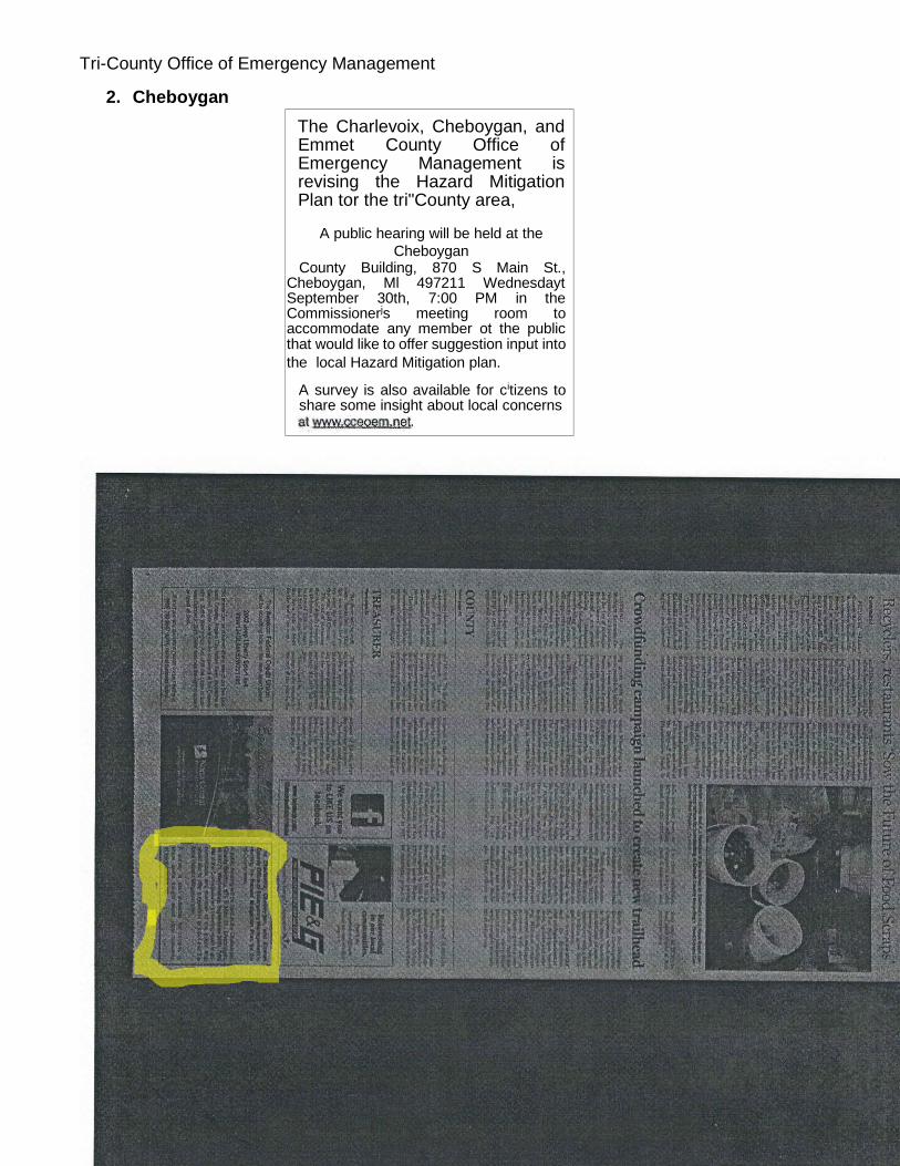
Tri-County Office of Emergency Management
144
2. Cheboygan
The Charlevoix, Cheboygan, and Emmet County Office of Emergency Management is revising the Hazard Mitigation Plan tor the tri"County area,
A public hearing will be held at the
Cheboygan County Building, 870 S Main St.,
Cheboygan, Ml 497211 Wednesdayt September 30th, 7:00 PM in the Commissionerjs meeting room to accommodate any member ot the public that would like to offer suggestion input into
the local Hazard Mitigation plan.
A survey is also available for citizens to share some insight about local concerns
Tri-County Office of Emergency Management
145
Cheboygan County Chapter, MTA September 24, 2015 Inverness Township The meeting was called to order by Sec/Treas Barb Hall at 7:00pm. The Pledge of Allegiance was recited by all. Roll call was taken and there was a total of 35 members present representing: Aloha, Beaugrand, Benton, Burt, Forest, Grant, Hebron, Inverness, Koehler, Mackinaw, Mullett, Munro, Nunda, Tuscarora and Wilmot Townships. Absent Townships: Ellis, Mentor, Walker and Waverly. Motion by Harold Koviak and supported by Linda Ginop. Motion carried. Treasurer’s Report: No checks were written. The balance in the checking account is $83.40 and in the savings is $2015.68 which includes $ .17 interest. The total is $2099.08. A motion was made by Steve Crusoe and supported by Ted Knight to approve the Treasurer’s report as presented. Motion carried. Speakers: Harold Koviak, District Five rep, has AMAR information if needed, gave legislative update – nothing on a road package, presidential election in March will not have any ballot proposals, talked retreats at Boyne Highlands, Convention coming in January(Need to register for Conference get a code to get housing). Emergency Management, Mike McCulley and Megan Anderson – handed out Be Alert cards – talked Hazard Mitigation Plan-Survey on line. Public Hearing Sept 30th 7PM at Cheboygan County Building. CCEOEM.net/local. Mike’s # 248-891-7312 Megan’s email [email protected] MDOT Alex Nikoloff – Transportation, TAP money-paved shoulders/bike paths, fix old train depot into visitor centers. 80-20 match. Website – on line-open no deadlines, conditional commitments. Road – Brett-Road Funding close, Bob Chadwick introduced self. Tuscarora Supervisor Mike Ridley thanked Alex from MDOT for coming. Old Business: Hold discussion of using some of treasury for a project until next month. New Business: Benton Clerk Jayne Passeno mentioned that the State MTA group looking at giving general township supervisor same powers as Charter Township Supervisors. Need more info on this. The next MTA meeting will be held October 29th at Mentor Township. Thank you to Inverness Township for hosting this months’ MTA meeting and for goodies. Motion to adjourn by Steve Crusoe and seconded by Jayne Passeno. Adjourned at 7:32PM. Barb Hall
Tri-County Office of Emergency Management
146
Cheboygan County
Local Emergency Planning Committee
November 9, 2015
10:00 a.m.
Cheboygan County Building
Board of Commissioner’s Room
870 South Main Street
Cheboygan, Michigan
AGENDA
I. Call Meeting to Order
II. Approve agenda
III. Approve minutes
IV. Introductions a. Mike McCully- OEM and Hazard Mitigation Staff
V. Old Business a. Hazard Mitigation Plan Update
VI. New Business a. 2016 Calendar
VII. Public Comments
VIII. Member Comments
IX. Adjourn
Tri-County Office of Emergency Management
147
Cheboygan County
Local Emergency Planning Committee
January 11, 2016
10:00 a.m.
Cheboygan County Building
Board of Commissioner’s Room
870 South Main Street
Cheboygan, Michigan
AGENDA
I. Call Meeting to Order
II. Approve agenda
III. Approve minutes
IV. Introductions
V. Old Business a. Hazard Mitigation Plan Update
VI. New Business
VII. Public Comments
VIII. Member Comments
IX. Adjourn

Tri-County Office of Emergency Management
148
Cheboygan County
Local Emergency Planning Committee
April 11, 2016
10:00 a.m.
Cheboygan County Building
Board of Commissioner’s Room
870 South Main Street
Cheboygan, Michigan
AGENDA
I. Call Meeting to Order
II. Approve agenda
III. Approve minutes
IV. Introductions
V. Old Business a. Hazard Mitigation Plan Update
VI. New Business
VII. Public Comments
VIII. Member Comments
IX. Adjourn for Exercise

Tri-County Office of Emergency Management
149
Cheboygan County
Local Emergency Planning Committee
August 8, 2016
10:00 a.m.
Cheboygan County Building
Board of Commissioner’s Room
870 South Main Street
Cheboygan, Michigan
AGENDA
I. Call Meeting to Order
II. Approve agenda
III. Approve minutes
IV. Introductions
V. Old Business a. Hazard Mitigation Plan Update
VI. New Business a. 302 Site Plans b. Tier II Reports
VII. Public Comments
VIII. Member Comments
IX. Adjourn
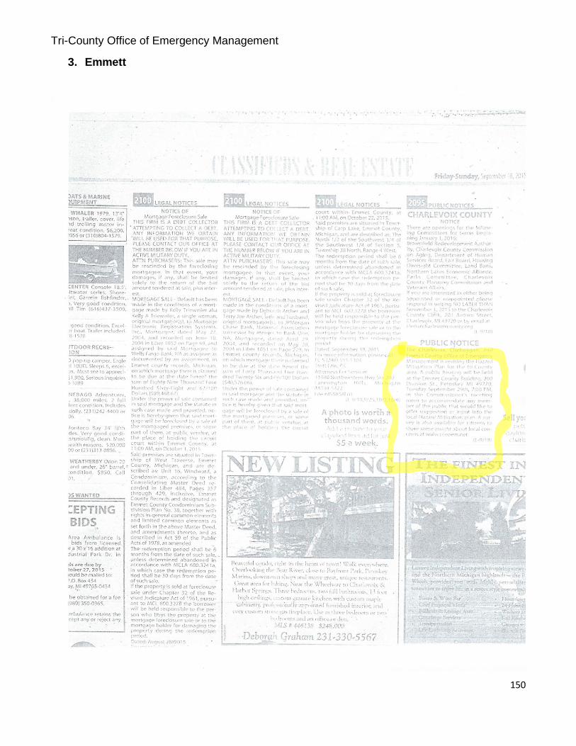
Tri-County Office of Emergency Management
150
3. Emmett
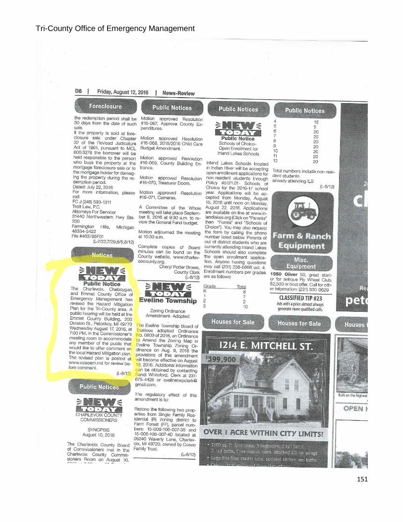
Tri-County Office of Emergency Management
151

Tri-County Office of Emergency Management
152
EMMET COUNTY TOWNSHIPS ASSOCIATION
A Chapter of The
MCHIGAN TOWNSHIPS ASSOCIATION
EMMET COUNTY, MICHIGAN
MINUTES – October 21, 2015
The Regular meeting of the Emmet County Townships Association was conducted at the
Crash Rescue Building of the Pellston Regional Airport on October 21, 2015. The meeting
was called to order by the President, Roger Moore at 7:00PM. The Pledge of Allegiance was
recited by all.
ROLL CALL OF TOWNSHIPS:
Present (22): Bear Creek (1) – Hoffman
Bliss (1) – Cease
Little Traverse (4) – Dohm, Garver, Chattaway, Arman
Littlefield (3) – Henning, Morford, Derrohn
Maple River (4) – Eby, Blumke, Gregory, Wekwert
McKinley (2) – Bohn, Ball
Pleasantview (2) – Wiechmann, Rogier (new Supervisor) Readmond (2)
– Kruski, Krupa
Wawatam (1) – Moore
West Traverse (2) – Baiardi, Baker
Absent: Carp Lake
Center Cross Village
Friendship
Resort
Springvale
Guests: Harold Koviak – MTA, Megan Anderson – Emergency Management, Jim Tamlyn, EC
Commissioner, Kelley Atkins, Airport Manager.
No additional items for the agenda.
MINUTES: It was moved by Wiechmann, seconded by Dohm and passed unanimously by
voice vote to approve the minutes of the meeting on July 15, 2015, as presented.
TREASURER’S REPORT: In the absence of Mays, Baiardi presented the written Treasurer’s
Report that had been supplied by Mays. The checking balance after the July expenses was
$488.19. The County supplied the refreshments for the October 21st meeting so no new bills

Tri-County Office of Emergency Management
153
were presented. Baiardi made a motion to accept the report as presented. Seconded by Ball
and passed unanimously by voice vote.
MTA UPDATE: Harold Koviak reported that the Supervisor, Clerk and Treasurer clinics had
been well attended. The big concern now in the legislature is the “road fix” and what will be put
forward to be considered. The hope is that something can be done yet this year but time is
running out as we are all aware that nothing typically can get done in the election
year. Harold also informed the group of some changes to the reservation system for the
upcoming MTA annual conference. There will be a bus from the UP that will stop in either
Gaylord or Mackinaw to pick up anyone that may want a ride to Detroit for the event.
Dohm commented on the status of some changes that are being implemented for the
assessing certification. He felt that Judy Allen had been instrumental, along with MTA and the
local chapters, in getting some of these changes in place. This should help with more being
able to enter the assessing field and achieving certification at higher levels in a shorter amount
of time.
An additional item was added to the agenda with the attendance of Megan Anderson from the
Office of Emergency Management. She updated us on Hazard Mitigation Management and
grants that are available to governmental entities through CCEOEM and encouraged anyone
that might have an interest to contact her for help in applying for these grants. All in attendance
were encouraged to also complete a survey on their website cceoem.net/local. This is the link
for municipalities.
BUSINESS:
The next meeting will be held January 20, 2016 at the Littlefield Township Fire Hall and the
program will be the report from the Road Commission. Some program ideas for upcoming
meetings included at visit to the 911 Center and perhaps a visit to a Fire Station and being
informed of the changes that Departments are mandated to comply with now.
There was a motion to adjourn offered by Weichmann and supported by Ball. It passed by
unanimous voice vote. The meeting was adjourned at 7:20PM.
PROGRAM: Moore introduced the program for the meeting. Jim Tamlyn had invited the group
to tour the Crash Rescue Building and learn a bit about the facility and how it had come about.
It is an impressive $7 million+ building that was funded 95% by the Federal government, 2.5%
by the State and 2.5% by Local dollars. Kelley Atkins then gave the group the grand tour of the
facility. THANK YOU to Kelley and Jim for allowing us to visit.
Respectfully submitted,
Cindy J. Baiardi, Secretary
Tri-County Office of Emergency Management
154
Emmet County
Local Emergency Planning Committee
November 10, 2015
10:00 a.m.
Emmet County EOC 1694 S. US 131 Hwy
Petoskey, MI
AGENDA
I. Call Meeting to Order
II. Approve agenda
III. Approve minutes
IV. Introductions
V. Old Business a. Hazard Mitigation Plan Update
VI. New Business a. Health Department Regionalization b. LEPC Tabletop
VII. Public Comments
VIII. Member Comments
Adjourn

Tri-County Office of Emergency Management
155
Emmet County
Local Emergency Planning Committee
February 17, 2016
10:00 a.m. Emmet County EOC
1694 S. US 131 Hwy
Petoskey, MI
AGENDA
I. Call Meeting to Order
III. Approve agenda
IV. Approve minutes
V. Introductions
VI. Old Business
a. Hazard Mitigation Plan Update
VII. New Business
VIII. Public Comments
IX. Member Comments
X. Adjourn

Tri-County Office of Emergency Management
156
Emmet County
Local Emergency Planning Committee
April 13, 2016
11:00 a.m.
Emmet County EOC 1694 S. US 131 Hwy
Petoskey, MI
AGENDA
I. Call Meeting to Order
II. Elections
III. Approve agenda
IV. Approve minutes
V. Introductions James Cousino
VI. Old Business a. Hazard Mitigation Plan Update
VII. New Business
VIII. Public Comments
IX. Member Comments
Adjourn

Tri-County Office of Emergency Management
157
Emmet County
Local Emergency Planning Committee
August 16, 2016
10:00 a.m. Emmet County EOC
1694 S. US 131 Hwy
Petoskey, MI
AGENDA
I. Call Meeting to Order
III. Approve agenda
IV. Approve minutes
V. Introductions
VI. Old Business
a. Hazard Mitigation Plan Update
VII. New Business
a. 302 Site Plans
b. Tier II Reports
VIII. Public Comments
IX. Member Comments
X. Adjourn

Tri-County Office of Emergency Management
158
4. Questionaire

Tri-County Office of Emergency Management
159
Edit this form

Tri-County Office of Emergency Management
160
Powered by
This form was created inside of Emergency Management. Report Abuse Terms of Service Additional Terms
Continue »