Ground water management
33
Groundwater management in Southeast Arabia from the Bronze Age to the Iron Age: a critical reassessment Julien Charbonnier Received: 14 March 2013 / Accepted: 9 September 2014 © Springer Science+Business Media Dordrecht 2014 Abstract This paper aims to review the evidence of irrigation structures in Southeast Arabia during the Bronze Age (c. 3200–1300 B.C.) and the Iron Age (c. 1300–300 B.C.). The preliminary results of the excavation of hydraulic structures in Masa ¯fı ¯ (United Arab Emirates) are also presented. While in Arabia many studies have been devoted to the qanāt technology, and especially its origin, it is demonstrated that these structures are badly dated. Conversely, it appears that wells played a significant role in water supply during the pre-Islamic period as well as in the present-day. Keywords Arabia · Irrigation · Oasis · Falaj · Qanāt · Well · Channel · Iron Age · Bronze Age Introduction A significant number of studies are dedicated to the qanāt. Indeed, this technique of water channelling has been used on every continent and at different periods (Beaumont 1989; Mostafaeipour 2010). A qanāt is a slightly sloped tunnel draining groundwater up to the surface. It is ventilated by shaft holes that are also used to remove the spoil when digging underground (Fig. 1). Qanāts must always be dug with a gradient as the water reaches the surface by gravity. In the Middle East, qanāts have been documented in Syria (Braemer et al. 2010), Northern Iraq (Wilkinson and Rayne 2010), Saudi Arabia, Yemen (Serjeant and Lewcock 1983) and Iran (Briant 2001; Mostafaeipour 2010). In Southeast Arabia (i.e. the north of Oman and the United Arab Emirates) thousands of qanāts have been dug, many of them are still in use today. In 1982, the Public Authority for Water Resources of the Sultanate of J. Charbonnier (&) Department of Archaeology, Durham University, South Road, Durham DH1 3LE, UK e-mail: [email protected] 123 Water Hist DOI 10.1007/s12685-014-0110-x
-
Upload
independent -
Category
Documents
-
view
0 -
download
0
Transcript of Ground water management

Groundwater management in Southeast Arabia from the
Bronze Age to the Iron Age: a critical reassessment
Julien Charbonnier
Received: 14 March 2013 /Accepted: 9 September 2014
© Springer Science+Business Media Dordrecht 2014
Abstract This paper aims to review the evidence of irrigation structures in Southeast
Arabia during the Bronze Age (c. 3200–1300 B.C.) and the Iron Age (c. 1300–300 B.C.).
The preliminary results of the excavation of hydraulic structures in Masafı (United Arab
Emirates) are also presented. While in Arabia many studies have been devoted to the qanāt
technology, and especially its origin, it is demonstrated that these structures are badly
dated. Conversely, it appears that wells played a significant role in water supply during the
pre-Islamic period as well as in the present-day.
Keywords Arabia · Irrigation · Oasis · Falaj · Qanāt · Well · Channel ·
Iron Age · Bronze Age
Introduction
A significant number of studies are dedicated to the qanāt. Indeed, this technique of water
channelling has been used on every continent and at different periods (Beaumont 1989;
Mostafaeipour 2010). A qanāt is a slightly sloped tunnel draining groundwater up to the
surface. It is ventilated by shaft holes that are also used to remove the spoil when digging
underground (Fig. 1). Qanāts must always be dug with a gradient as the water reaches the
surface by gravity.
In the Middle East, qanāts have been documented in Syria (Braemer et al. 2010),
Northern Iraq (Wilkinson and Rayne 2010), Saudi Arabia, Yemen (Serjeant and Lewcock
1983) and Iran (Briant 2001; Mostafaeipour 2010). In Southeast Arabia (i.e. the north of
Oman and the United Arab Emirates) thousands of qanāts have been dug, many of them
are still in use today. In 1982, the Public Authority for Water Resources of the Sultanate of
J. Charbonnier (&)
Department of Archaeology, Durham University, South Road, Durham DH1 3LE, UK
e-mail: [email protected]
123
Water Hist
DOI 10.1007/s12685-014-0110-x

Oman estimated that qanāts provided 9 million m3 of water and irrigated 55 % of the
arable lands in the country (Dutton 1989, p. 237).
To dig and to maintain a qanāt, and then to share its water flow, individuals must come
together and cooperate. Families or small groups of people cannot build qanāts, as they
require large investments (Beaumont 1989, p. 27; Costa and Wilkinson 1987, p. 37). They
must be constructed jointly and water must be distributed between users. An organisation is
set up to supervise the sharing of water and to maintain the canals. Today, in Southeast
Arabia, this organisation is led by the wakīl who appoints workers for maintenance tasks
and settles quarrels about water access. The‘arīf is responsible for water distribution. There
are wakīl and‘arīf only in oases where the number of owners is sufficiently large to require
their service. If a qanāt is owned by a small number of people, they organise themselves to
share its water (Charbonnier 2014).
More qanāts have been excavated in Southeast Arabia since the last 30 years than in any
other region of the world. The origin of this technology is still debated and several articles
have been devoted to this topic (see al-Tikriti 2002a; Boucharlat 2001, 2003; Lightfoot
2000).
The main issues that arose were:
● When was the qanāt technology developed? The Bronze Age (Orchard and Orchard
2007) or the Iron Age (al-Tikriti 2010)?
● Where was it developed? In Iran or in Arabia (English 1968; Wilkinson 1977; Goblot
1979; al-Tikriti 2002a; Boucharlat 2001, 2003; Potts 1990 among others)?
Some researchers have pointed out the fact that qanāts dating back to the first half of the
first millennium B.C. were found in the U.A.E. (al-Tikriti 2002a). Others have claimed that
these structures were draining only shallow groundwater (underflow) and not deep aquifers
as “true” qanāts do. According to Boucharlat, it is necessary to differentiate between these
two types of structures. He proposes naming both of them “underground water-draining
galleries” and to restrict the term qanāt to the structures draining a deep aquifer and that
can’t be detected on the surface (Boucharlat 2001, 2003).
The typology proposed by R. Boucharlat is important. When studying these structures it
is fundamental to understand which source of water they depended on. It influenced their
evolution and their lifespan, with some resources being more affected by short-term cli-
mate variations. Qanāts can drain many types of groundwater: fossil aquifers, colluvial
deposits, groundwater located in alluvial fans or underflows in wādī beds among others. In
Southeast Arabia, qanāts tap the two last types of resources. However, as D. Balland stated
some years ago, the need to adapt each qanāt to a specific environment is the main reason
Fig. 1 Plan and section of a qanāt (after English 1968: Fig. 1)
J. Charbonnier
123

for the diversity of forms in which they occur (Balland 1992, p. 2). In Iran, there are thick
colluvial deposits at the foot of the mountains that provide water; in Oman it is easier to tap
underflow than deeper aquifers. I would argue in accordance with G. Weisgerber that the
general technical characteristics of all these types of qanāts are identical: they are dug the
same way and for the same purposes (Weisgerber 2005, p. 62). Thus, I will use the local
term falaj (pl. aflāj) for all these structures, regardless of the aquifer drained.1
In this paper, I aim to take a step back from the controversy about the origin of falaj
technology. Instead, I will review the available data regarding groundwater irrigation
techniques in Southeast Arabia and I will outline what we know about water management
in the Bronze (c. 3200–1300 B.C.) and the Iron Ages (c. 1300–300 B.C.). New data coming
from the site of Masafı (U.A.E.), excavated by the author, will also be presented. I will
highlight the fact that groundwater resources were important during the pre-Islamic peri-
ods, as the climate was already arid, but were also exploited by means of wells. The period
of introduction of the falaj, conversely, is difficult to estimate, as these structures remain
badly dated.
Beginnings of agriculture in Southeast Arabia: environmental and economic contexts
Southeast Arabia is surrounded by the Persian Gulf to the northwest, the Gulf of Oman to
the northeast, the Indian Ocean to the south and the Rub‘al-Khalı desert to the west. It is
crossed by the al-Hajar chain, which is about 700 km long and up to 3,000 m high
(Sanlaville 2000, p. 138). In some areas of the mountains precipitations reach 200–300 mm
per year but in the surrounding piedmonts and coastal plains, they are below 100 mm on
average (Sanlaville 2000, p. 49).
Since the beginning the Holocene, the climate of Southeast Arabia has significantly
changed. Today the summer monsoon affects Yemen and Dhofar, south of the Sultanate
of Oman. At the beginning of the Holocene (9th millennium B.C.) the monsoon advanced
northward and reached Southeast Arabia, as shown by the study of speleothems from
caves in Oman. This phenomenon caused a rise in precipitations (Fleitmann and Matter
2009, p. 640). Lakes formed in these regions at that time (Parker et al. 2006) as well as
savanna grasslands (Parker et al. 2004). At the end of the 6th millennium B.C., the
monsoon began shifting toward the south (Fleitmann and Matter 2009, p. 641). As a
result, a marked decrease in monsoon precipitation was recorded in the second half of the
5th millennium B.C. The monsoon had ceased to affect Southeast Arabia by this time
(Fleitmann et al. 2007, p. 180; Fleitmann and Matter 2009, p. 640). Awafi lake (northern
U.A.E.) records peaks of aridity at the beginning and at the end of the 4th millennium B.
C. followed by the return of moist conditions until the end of the 3rd millennium B.C.
(Parker et al. 2006, pp. 472–473). It is against this background, between the end of the 4th
and the beginning of the 3rd millennium B.C., that significant cultural and economic
changes occurred in Southeast Arabia: increase in social complexity, appearance of
monumental stone architecture (tombs and tower-like structures), introduction of pottery
and agriculture (Cleuziou and Tosi 1997, p. 128). Indeed, local economy was based on
herding, gathering and fishing at the end of the Neolithic. The aridification is believed to
have contributed to these social transformations (Cleuziou and Tosi 1997, p. 132; Mery
2013, p. 3). There is however a gap between the aridification process (5th–4th millennia
1 The term falaj is used ambiguously in Oman since it can also mean a structure diverting floodwater or a
network of canals. For this paper I restrict its meaning to a qanāt.
Groundwater management in Southeast Arabia
123
B.C.) and the introduction of agriculture in Southeast Arabia (perhaps the end of the 4th
millennium, with certainty the first half of the 3rd millennium B.C.). The region wasn’t
deserted during the 5th and 4th millennia B.C. Many more sites are conversely known,
suggesting an increase in population (Cleuziou 2005, pp. 141–142). Maritime resources,
as well as mangroves, were actively exploited at that time (Biagi and Nisbet 2006;
Cleuziou 2005, p. 134).
During the Hafit (3200–2700 B.C.) and Umm an-Nar (2700–2000 B.C.) periods,
Southeast Arabia was integrated into a regional exchange network. Throughout this time,
copper from the al-Hajar mountains was exported to Mesopotamia and the Indus region
(Cleuziou 1999, p. 99). Population continued to increase and social structures became more
complex and stratified, hence the need for agriculture to sustain this process (Cleuziou
2005, p. 144). Contacts with Mesopotamia, Iran and Indus seem to have ignited the spark
for the adoption of agriculture as the first crops cultivated were imported from these
regions (Tengberg 2003, p. 235).
Archaeobotanical evidence suggests that agriculture was practiced since at least the
Umm an-Nar periods in Southeast Arabia (Cleuziou and Costantini 1980; Willcox and
Tengberg 1995; Tengberg 2003). Common wheat (Triticum cf. aestivum) and six-rowed
barley (Hordeum vulgare subsp. hexastichum L.) were cultivated near the 3rd millennium
at the site of Bat. Remains of naked wheat, emmer (Triticum dicoccum Schubl.), two-rowed
barley (Hordeum vulgare subsp. distichum L.), six-rowed barley, oat (Avena sp.), pea
(Pisum sativum L.) and melon (Cucumis melo L.) have also been found at Hılı (Tengberg
2003, p. 232). Date seem to have been eaten in several settlements: Hılı, Bat and Tell
Abraq (Cleuziou and Costantini 1980; Cleuziou 1997, p. 390–392; Cleuziou 1998, p. 60–
61; Cleuziou 1999, p. 84; Tengberg 2003, p. 232). Wood remains of palm trees (Phœnix
dactylifera) were also collected at Hılı, suggesting that this species was cultivated locally
(Tengberg 2003, p. 232). Furthermore, many date stones were excavated at Hılı, which
shows the importance of date palms in the 3rd millennium B.C. economy. In tomb A (Hılı
north) young adults had lost up to 90 % of their molars due to excessive consumption of
sugar (Cleuziou and Tosi 2007, p. 150). It is difficult to believe that dates were imported
from abroad, as suggested by W. al-Tikriti (al-Tikriti 2010, p. 243, footnote 23), since the
local economy and society were not sufficiently complex to allow for the import of massive
amounts of dried dates present in the archaeological record. Dates were also part of the diet
in coastal sites, such as Tell Abraq and Umm an-Nar on the Arabian Gulf (Willcox and
Tengberg 1995; Tengberg 2003, p. 233), and Ra’s al-Jinz on the Gulf of Oman, where they
were probably traded for fish (Cleuziou 1999, pp. 98–99).
The origin of date palm cultivation is unclear. According to recent studies, wild Phœnix
dactylifera was growing in the Middle East, North Africa and around the Persian Gulf. It is
also suggested that it could have been domesticated in this latter region (Gros-Balthazard
et al. 2013, pp. 17–19 et 24). Two charred date stones were recovered on a Neolithic site in
the island of Dalma, 200 km east of Abu Dhabi. These remains are dated from the end of
the 6th-beginning of the 5th millennium B.C. It is however not known if these dates were
imported from abroad (Mesopotamia?), gathered from the wild or represent an earlier stage
of domestication (Beech and Shepherd 2001, pp. 87–88).
Evidence of hydraulic structures during the Bronze Age
All the crops attested in 3rd millennium sites need a significant amount of water to grow.
Although moister conditions characterized the region during the first half of the 3rd
J. Charbonnier
123
millennium B.C., it seems that rains were insufficient and irregular for dry farming and
crops had to be irrigated (Preston et al. 2012). The climate then became significantly more
arid during the last quarter of this millennium according to paleoclimate record (4.2 ka
hyperarid event; Cullen et al. 2000). Bronze Age irrigation systems are poorly documented.
In or near the mountains, some dams could indicate the diversion of runoff water during
this period; however, they are difficult to date and, sometimes, to interpret (see Brunswig
1989; Costa and Wilkinson 1987; Hastings et al. 1975; Weisgerber and Yule 2003). I will
leave aside these constructions and will focus on the use of groundwater, which is required
on the foothills where runoff is scarce rare.
Channels and ditches: Hılı 8
According to Cleuziou the falaj could have been used since the beginning of the 3rd
millennium B.C. (Cleuziou 1998, pp. 61–62; Cleuziou 1999, p. 90; Cleuziou 2009, p. 731).
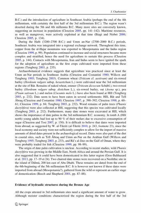
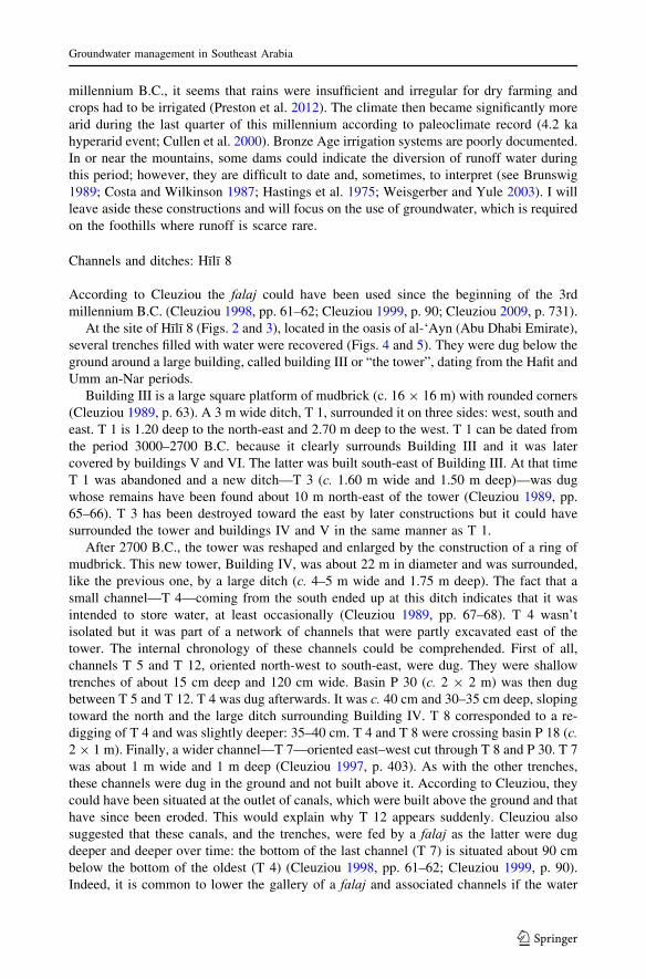
At the site of Hılı 8 (Figs. 2 and 3), located in the oasis of al-‘Ayn (Abu Dhabi Emirate),
several trenches filled with water were recovered (Figs. 4 and 5). They were dug below the
ground around a large building, called building III or “the tower”, dating from the Hafit and
Umm an-Nar periods.
Building III is a large square platform of mudbrick (c. 16 9 16 m) with rounded corners
(Cleuziou 1989, p. 63). A 3 m wide ditch, T 1, surrounded it on three sides: west, south and
east. T 1 is 1.20 deep to the north-east and 2.70 m deep to the west. T 1 can be dated from
the period 3000–2700 B.C. because it clearly surrounds Building III and it was later
covered by buildings V and VI. The latter was built south-east of Building III. At that time
T 1 was abandoned and a new ditch—T 3 (c. 1.60 m wide and 1.50 m deep)—was dug
whose remains have been found about 10 m north-east of the tower (Cleuziou 1989, pp.
65–66). T 3 has been destroyed toward the east by later constructions but it could have
surrounded the tower and buildings IV and V in the same manner as T 1.
After 2700 B.C., the tower was reshaped and enlarged by the construction of a ring of
mudbrick. This new tower, Building IV, was about 22 m in diameter and was surrounded,
like the previous one, by a large ditch (c. 4–5 m wide and 1.75 m deep). The fact that a
small channel—T 4—coming from the south ended up at this ditch indicates that it was
intended to store water, at least occasionally (Cleuziou 1989, pp. 67–68). T 4 wasn’t
isolated but it was part of a network of channels that were partly excavated east of the
tower. The internal chronology of these channels could be comprehended. First of all,
channels T 5 and T 12, oriented north-west to south-east, were dug. They were shallow
trenches of about 15 cm deep and 120 cm wide. Basin P 30 (c. 2 9 2 m) was then dug
between T 5 and T 12. T 4 was dug afterwards. It was c. 40 cm and 30–35 cm deep, sloping
toward the north and the large ditch surrounding Building IV. T 8 corresponded to a re-
digging of T 4 and was slightly deeper: 35–40 cm. T 4 and T 8 were crossing basin P 18 (c.
2 9 1 m). Finally, a wider channel—T 7—oriented east–west cut through T 8 and P 30. T 7
was about 1 m wide and 1 m deep (Cleuziou 1997, p. 403). As with the other trenches,
these channels were dug in the ground and not built above it. According to Cleuziou, they
could have been situated at the outlet of canals, which were built above the ground and that
have since been eroded. This would explain why T 12 appears suddenly. Cleuziou also
suggested that these canals, and the trenches, were fed by a falaj as the latter were dug
deeper and deeper over time: the bottom of the last channel (T 7) is situated about 90 cm
below the bottom of the oldest (T 4) (Cleuziou 1998, pp. 61–62; Cleuziou 1999, p. 90).
Indeed, it is common to lower the gallery of a falaj and associated channels if the water
Groundwater management in Southeast Arabia
123
Fig. 2 Map of Northern Oman and U.A.E. showing the location of Bronze and Iron Age sites (© Julien
Charbonnier)
Fig. 3 Map of the site of Hılı (after al-Tikriti 2002a: Fig. 3)
J. Charbonnier
123

table sinks (Costa and Wilkinson 1987, p. 38). Hılı’s trenches would have been lowered at
the same time as above ground irrigation channels were connected to a falaj according to
Cleuziou. In Hılı, the wells were also dug deeper and deeper during the occupation of the
site (see below), which could indicate a lowering of the water table during the second half
of the 3rd millennium B.C. This phenomenon might have been a consequence of the 4.2
hyperarid event at the end of this millennium.
Although these channels clearly date back to the Early Bronze Age, as the large ditch
was covered by structures dating back to the end of the 3rd millennium B.C. (Cleuziou
1989, pp. 16–18), their interpretation is difficult. No remains of a falaj were uncovered in
Hılı, weakening Cleuziou’s hypothesis. The deepening of the channels could indicate a will
to store more water. It would have been interesting to continue digging the channels toward
the east and the south in order to find out if they were related to a hydraulic structure such
as a falaj or a well.
Similar ditches have been discovered around several Umm an-Nar towers in Oman. K.
Frifelt reports that large ditches (up to 4 m wide) were found around tower 1145 in Bat
(Frifelt 1976, p. 59). As in Hılı, no above ground canals were discovered (Frifelt 2002, p.
104). Recently, a ditch was partly excavated in Salut by an Italian mission. It surrounded a
3rd millennium tower (ST 1) and was about 10 m wide. Michele Degli Esposti, who was in
Fig. 4 Hılı 8 and surrounding trenches (Cleuziou 1997: Fig. 5)
Groundwater management in Southeast Arabia
123
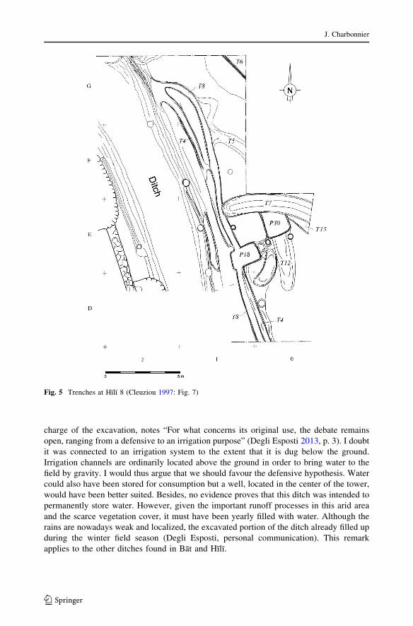
charge of the excavation, notes “For what concerns its original use, the debate remains
open, ranging from a defensive to an irrigation purpose” (Degli Esposti 2013, p. 3). I doubt
it was connected to an irrigation system to the extent that it is dug below the ground.
Irrigation channels are ordinarily located above the ground in order to bring water to the
field by gravity. I would thus argue that we should favour the defensive hypothesis. Water
could also have been stored for consumption but a well, located in the center of the tower,
would have been better suited. Besides, no evidence proves that this ditch was intended to
permanently store water. However, given the important runoff processes in this arid area
and the scarce vegetation cover, it must have been yearly filled with water. Although the
rains are nowadays weak and localized, the excavated portion of the ditch already filled up
during the winter field season (Degli Esposti, personal communication). This remark
applies to the other ditches found in Bat and Hılı.
Fig. 5 Trenches at Hılı 8 (Cleuziou 1997: Fig. 7)
J. Charbonnier
123

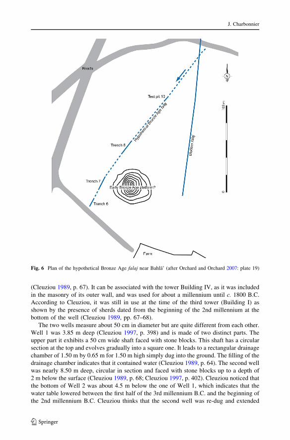
Falaj: Bahla’
Recently, J. and J. Orchard announced the discovery of a falaj dating back to 3000 B.C. in
the region of Bahla’ (Sultanate of Oman), south of the Al Hajar mountains. Test trenches
were dug in this structure (Fig. 6). It was partly built as a tunnel and partly as an open-air
trench. The gallery was 2.70 m high and 0.5 m wide. Small “bridges” crossed it when it
was flowing in the open.
According to J. and J. Orchard, there are several indications that the falaj dates back to
the Early Bronze Age:
– Sherds collected both at the surface of the site it crosses and inside in the fill of the
gallery all belong to this period.
– The gallery cuts one of the ditches surrounding a large circular mound. This structure is
assumed to date back to the 3rd millennium B.C. as it is covered with Bronze Age
sherds. It also reminds the trenches surrounding the Hılı 8 and Bat towers.
– Two charcoal samples, coming from loci with a stratigraphic relationship to the
underground gallery, have been dated to 2910–2850 cal B.C. and 2620–2470 cal B.C.
The first one was taken from a hearth partly dug in one of the “bridges” crossing the
falaj and partly in the fill of the gallery. The second one was collected fill of the gallery
itself. (Orchard and Orchard 2007, pp. 150–151).
The conclusions of J. and J. Orchard can be criticised. Taken independently, each of the
arguments they put forward may be contested. The stratigraphic relationship between the
ditches and the gallery is not clearly stated in the description they provide. Is the gallery
intersecting or running under the ditch? Has the gallery cut the ditch or has the ditch cut the
gallery? Neither sections nor photographs have been provided that would support the
hypothesis of J. and J. Orchard. It is possible that the Bronze Age sherds found in the
gallery could come from older occupation layers and could have fallen inside, and similar
processes could account for the charcoal sample collected in the fill of the gallery. Con-
cerning the second sample, the stratigraphic relationship between the hearth, the “bridge”
and the fill of the gallery has not been clearly demonstrated. Finally, the downstream
section of the structure hasn’t been recognised and is not currently related to any site.
Wells
For the moment, there is no clear evidence that the falaj was used during the Bronze Age.
Wells, on the other hand, were found near many Umm an-Nar towers, including those of
Bat (Frifelt 2002, p. 104). The wells discovered at Maysar 25 and Maysar 1, two Bronze
Age settlements located in wādī Samad, were 15 m and 13 m deep respectively. Their
upper parts were built with stone blocks (Weisgerber 1981, p. 203; Weisgerber 2005, p.
65). The two wells are dated according to their spatial associations with other archaeo-
logical features: one is located in the center of the Umm an-Nar tower Maysar 25, the other
in a Bronze Age settlement.
Two wells were also discovered during the excavation of Hılı 8 (Fig. 7). The first one is
contemporary with Building III as it was established in its center. In Eastern Arabia, many
3rd millennium towers were equipped with a well, generally located in the center (see
Frifelt 1976 or 2002 for Bat, Degli Esposti 2011 for Salut). It was abandoned and filled
with loose earth and stones when Building IV was built about 2700 B.C. (Cleuziou 1989, p.
64). Well 2 was dug through the “ruins of compartment 25 of Building V” c. 2700 B.C.
Groundwater management in Southeast Arabia
123
(Cleuziou 1989, p. 67). It can be associated with the tower Building IV, as it was included
in the masonry of its outer wall, and was used for about a millennium until c. 1800 B.C.
According to Cleuziou, it was still in use at the time of the third tower (Building I) as
shown by the presence of sherds dated from the beginning of the 2nd millennium at the
bottom of the well (Cleuziou 1989, pp. 67–68).
The two wells measure about 50 cm in diameter but are quite different from each other.
Well 1 was 3.85 m deep (Cleuziou 1997, p. 398) and is made of two distinct parts. The
upper part it exhibits a 50 cm wide shaft faced with stone blocks. This shaft has a circular
section at the top and evolves gradually into a square one. It leads to a rectangular drainage
chamber of 1.50 m by 0.65 m for 1.50 m high simply dug into the ground. The filling of the
drainage chamber indicates that it contained water (Cleuziou 1989, p. 64). The second well
was nearly 8.50 m deep, circular in section and faced with stone blocks up to a depth of
2 m below the surface (Cleuziou 1989, p. 68; Cleuziou 1997, p. 402). Cleuziou noticed that
the bottom of Well 2 was about 4.5 m below the one of Well 1, which indicates that the
water table lowered between the first half of the 3rd millennium B.C. and the beginning of
the 2nd millennium B.C. Cleuziou thinks that the second well was re-dug and extended
Fig. 6 Plan of the hypothetical Bronze Age falaj near Bahla’ (after Orchard and Orchard 2007: plate 19)
J. Charbonnier
123
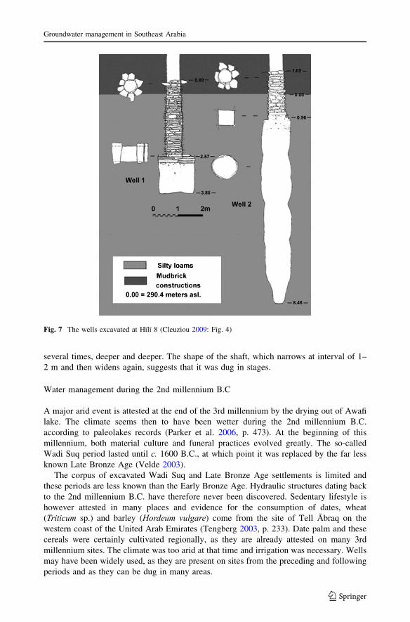
several times, deeper and deeper. The shape of the shaft, which narrows at interval of 1–
2 m and then widens again, suggests that it was dug in stages.
Water management during the 2nd millennium B.C
A major arid event is attested at the end of the 3rd millennium by the drying out of Awafi
lake. The climate seems then to have been wetter during the 2nd millennium B.C.
according to paleolakes records (Parker et al. 2006, p. 473). At the beginning of this
millennium, both material culture and funeral practices evolved greatly. The so-called
Wadi Suq period lasted until c. 1600 B.C., at which point it was replaced by the far less
known Late Bronze Age (Velde 2003).
The corpus of excavated Wadi Suq and Late Bronze Age settlements is limited and
these periods are less known than the Early Bronze Age. Hydraulic structures dating back
to the 2nd millennium B.C. have therefore never been discovered. Sedentary lifestyle is
however attested in many places and evidence for the consumption of dates, wheat
(Triticum sp.) and barley (Hordeum vulgare) come from the site of Tell Abraq on the
western coast of the United Arab Emirates (Tengberg 2003, p. 233). Date palm and these
cereals were certainly cultivated regionally, as they are already attested on many 3rd
millennium sites. The climate was too arid at that time and irrigation was necessary. Wells
may have been widely used, as they are present on sites from the preceding and following
periods and as they can be dug in many areas.
Fig. 7 The wells excavated at Hılı 8 (Cleuziou 2009: Fig. 4)
Groundwater management in Southeast Arabia
123
This 2nd millennium “hydraulic hiatus” hinders our analysis of the evolution of irri-
gation techniques in Southeast Arabia. The impact of climate change during this period is
difficult to assess.
Evidence of hydraulic structures during the Iron Age
The climate became more arid around 1000 B.C. and then remained stable during the
following millennium (Parker et al. 2006, p. 473). At that time it was similar to the present-
day (Fleitmann et al. 2007, p. 180). Despite this evolution, a significant increase in the
number of settlements occurred during Iron Age (1300–300 B.C.) and especially during the
Iron Age II (1100–600 B.C.). The resources and environments exploited during the Iron
Age seem to have been more diversified as the settlements were more widespread across
the region (Magee 2000). As a matter of fact, evidence of water management is much more
plentiful in the Iron Age.
During the Iron Age, evidence of date cultivation comes from the site of Muwailah (U.
A.E.) where thousands of charred date and date stones have been recovered in a store room
(c. 800–600 B.C.; Tengberg 1998, p. 196f). Date remains have also been found at Ru-
mailah, in al-‘Ayn (U.A.E.), along with wheat and barley (Iron Age II and III; Costantini
and Costantini Biasini 1986).
Falaj
Many aflāj have been found next to settlement sites in northern U.A.E. and Oman, of
which some have been partly excavated. Although there is no doubt about the fact that they
were really structures designed to drain groundwater, none have been dated from the Iron
Age with complete certainty.
However, according to some authors (al-Tikriti 2002a; Magee 2000), the use of aflāj is
clearly evidenced from the Iron Age II (1100–600 B.C.). Several structures have been
discovered on the foothills of the al-H˙ajar mountains, mainly in the United Arab Emirates.
Al-Mādam (U.A.E.)
Other dried aflāj were recorded and partly excavated by a French and a Spanish mission in
the depression of al-Madam (Emirate of Sharjah), 75 km north of al-‘Ayn (Fig. 8).
The northernmost one, AM-21 is visible on the surface of about 2 km. AM-31 is located
2.5 km to the south and its shaft holes are visible on about 1 km (Cordoba and Mouton
2001). The best studied one is AM-2, located 3 km south of AM-31. These structures have
been dated to the Iron Age based on little more than the fact that they seem to head toward
Iron Age sites.
AM-21 seems to head toward the present-day village of Umm S˙afah, where an Iron Age
occupation is also attested (Cordoba and Mouton 2001, p. 23), and is visible at a distance
of 2 km. Two Iron Age bowls have been recovered in the spoil heap of one of its access
shafts (Benoist et al. 1997, p. 65) but this indicates only that the structure cut through an
Iron Age site (Cordoba and Mouton 2001, p. 45).
AM-31 is visible on about 2.5 km and seems also to head toward Umm S˙afah. One of its
access shafts has been excavated but no dating elements were collected (Cordoba and
Mouton 2001, p. 42). The only element that could suggest a pre-Islamic date would be its
J. Charbonnier
123
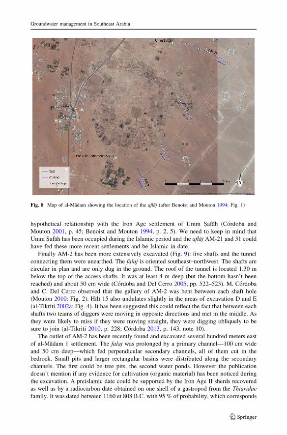
hypothetical relationship with the Iron Age settlement of Umm S˙afah (Cordoba and
Mouton 2001, p. 45; Benoist and Mouton 1994, p. 2, 5). We need to keep in mind that
Umm S˙afah has been occupied during the Islamic period and the aflāj AM-21 and 31 could
have fed these more recent settlements and be Islamic in date.
Finally AM-2 has been more extensively excavated (Fig. 9): five shafts and the tunnel
connecting them were unearthed. The falaj is oriented southeast–northwest. The shafts are
circular in plan and are only dug in the ground. The roof of the tunnel is located 1.30 m
below the top of the access shafts. It was at least 4 m deep (but the bottom hasn’t been
reached) and about 50 cm wide (Cordoba and Del Cerro 2005, pp. 522–523). M. Cordoba
and C. Del Cerro observed that the gallery of AM-2 was bent between each shaft hole
(Mouton 2010: Fig. 2). Hılı 15 also undulates slightly in the areas of excavation D and E
(al-Tikriti 2002a: Fig. 4). It has been suggested this could reflect the fact that between each
shafts two teams of diggers were moving in opposite directions and met in the middle. As
they were likely to miss if they were moving straight, they were digging obliquely to be
sure to join (al-Tikriti 2010, p. 228; Cordoba 2013, p. 143, note 10).
The outlet of AM-2 has been recently found and excavated several hundred meters east
of al-Madam 1 settlement. The falaj was prolonged by a primary channel—100 cm wide
and 50 cm deep—which fed perpendicular secondary channels, all of them cut in the
bedrock. Small pits and larger rectangular basins were distributed along the secondary
channels. The first could be tree pits, the second water ponds. However the publication
doesn’t mention if any evidence for cultivation (organic material) has been noticed during
the excavation. A preislamic date could be supported by the Iron Age II sherds recovered
as well as by a radiocarbon date obtained on one shell of a gastropod from the Thiaridae
family. It was dated between 1160 et 808 B.C. with 95 % of probability, which corresponds
Fig. 8 Map of al-Madam showing the location of the aflāj (after Benoist and Mouton 1994: Fig. 1)
Groundwater management in Southeast Arabia
123

to the Iron Age II. Mollusks from Thiaridae family are freshwater snails and it is suggested
that they lived in the channels when active. Many shells were indeed found during the
excavation (Cordoba 2013, pp. 147–148). However, the freshwater reservoir effect, which
“can result in anomalously old radiocarbon ages of samples from lakes and rivers”
(Philippsen 2013), doesn’t seem to be taken into account. It would also be useful to analyse
other shells to confirm this dating.
According to M. Cordoba and C. Del Cerro, AM-2 shafts exhibit small steps, allowing
access to the underground gallery, similar to those discovered in a well located in the Iron
Age II site AM-1 (Cordoba and Del Cerro 2005, p. 523). Similar steps have been found in
the well of Hılı 8, Bronze Age in date, but they could have been carved at every period.
It has been suggested that the abandonment of this structure, as well as the desertion of
the Iron Age settlement at the end of the Iron Age II, could be related to a drop of the water
table. Cordoba indicates that the primary channel and the tunnel were re-cut in order to be
lowered, perhaps to follow the water table (Cordoba 2013, p. 148). At some point it was
too deep and the area had to be abandoned (Cordoba and Del Cerro 2005, p. 525).
AM-2 can thus be dated to the Iron Age with a little bit more certainty than the other
structures.
Hīlī 15 (U.A.E.)
The falaj of Hılı was discovered in the 1980s (Fig. 3). This structure, Hılı 15, was located
less than 50 cm below the present-day ground surface. Several trenches were opened at
intervals of about 500 m in order to unearth it.
Fig. 9 Plan of falaj al-Madam 2 (after Cordoba 2013: Fig. 1)
J. Charbonnier
123
The portion excavated corresponds to the downstream end of the falaj. Downstream,
Hılı 15 is an open-air channel, about 50 cm wide, faced with stone blocks2 (al-Tikriti
2002b: Fig. 37a). It is dug below the ground surface and is about 40 cm deep at the level of
Area B (al-Tikriti 2002b, p. 78, Fig. 36). Upstream, the channel is covered with stone slabs
(from Area E) and its bottom is located up to 2 m below the ground. A tunnel, discovered
accidentally 1.5 km northeast of the portion excavated, could correspond, according to W.
al-Tikriti, to the upstream part of Hılı 15 (al-Tikriti 2010, p. 228; al-Tikriti and Haddou
2001).
In area H, an access shaft, made of mudbrick, was unearthed. Stone slabs surround the
edge of the shaft. The internal diameter of the Iron Age shaft holes does not exceed 50 cm
(al-Tikriti 2002a, p. 112; al-Tikriti 2002b, pp. 114–115). The presence of a shaft in this
area suggests that the stone slabs sitting on top of the gallery were covered by earth. It was
therefore not possible to remove one of the slabs to access the gallery.
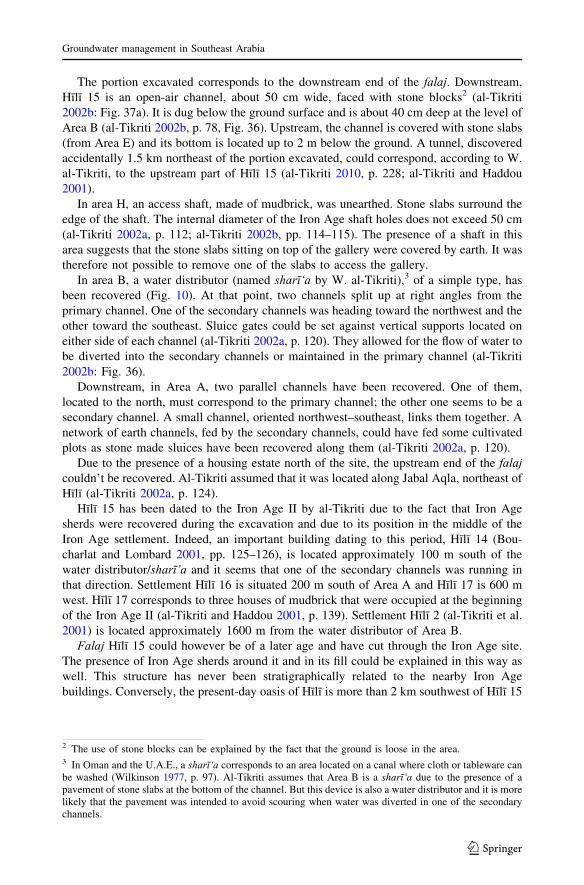
In area B, a water distributor (named sharī‘a by W. al-Tikriti),3 of a simple type, has
been recovered (Fig. 10). At that point, two channels split up at right angles from the
primary channel. One of the secondary channels was heading toward the northwest and the
other toward the southeast. Sluice gates could be set against vertical supports located on
either side of each channel (al-Tikriti 2002a, p. 120). They allowed for the flow of water to
be diverted into the secondary channels or maintained in the primary channel (al-Tikriti
2002b: Fig. 36).
Downstream, in Area A, two parallel channels have been recovered. One of them,
located to the north, must correspond to the primary channel; the other one seems to be a
secondary channel. A small channel, oriented northwest–southeast, links them together. A
network of earth channels, fed by the secondary channels, could have fed some cultivated
plots as stone made sluices have been recovered along them (al-Tikriti 2002a, p. 120).
Due to the presence of a housing estate north of the site, the upstream end of the falaj
couldn’t be recovered. Al-Tikriti assumed that it was located along Jabal Aqla, northeast of
Hılı (al-Tikriti 2002a, p. 124).
Hılı 15 has been dated to the Iron Age II by al-Tikriti due to the fact that Iron Age
sherds were recovered during the excavation and due to its position in the middle of the
Iron Age settlement. Indeed, an important building dating to this period, Hılı 14 (Bou-
charlat and Lombard 2001, pp. 125–126), is located approximately 100 m south of the
water distributor/sharī’a and it seems that one of the secondary channels was running in
that direction. Settlement Hılı 16 is situated 200 m south of Area A and Hılı 17 is 600 m
west. Hılı 17 corresponds to three houses of mudbrick that were occupied at the beginning
of the Iron Age II (al-Tikriti and Haddou 2001, p. 139). Settlement Hılı 2 (al-Tikriti et al.
2001) is located approximately 1600 m from the water distributor of Area B.
Falaj Hılı 15 could however be of a later age and have cut through the Iron Age site.
The presence of Iron Age sherds around it and in its fill could be explained in this way as
well. This structure has never been stratigraphically related to the nearby Iron Age
buildings. Conversely, the present-day oasis of Hılı is more than 2 km southwest of Hılı 15
2 The use of stone blocks can be explained by the fact that the ground is loose in the area.3 In Oman and the U.A.E., a sharī‘a corresponds to an area located on a canal where cloth or tableware can
be washed (Wilkinson 1977, p. 97). Al-Tikriti assumes that Area B is a sharī‘a due to the presence of a
pavement of stone slabs at the bottom of the channel. But this device is also a water distributor and it is more
likely that the pavement was intended to avoid scouring when water was diverted in one of the secondary
channels.
Groundwater management in Southeast Arabia
123
and the latter is already flowing at the surface so it couldn’t have irrigated Hılı’s palm
grove. No Islamic settlement has been found in close proximity. It would have been
interesting to follow the secondary channels to see if they reached one of the settlements,
for example Hılı 14 (located only 100 m south of the water distributor of Area B). The falaj
was located close to the ground surface and the excavators haven’t provided any
description of earth layers covering it.
It is also striking that the assumed gardens (next to Area A) haven’t been excavated over
an extensive area in order to understand their nature: were they palm grove or open fields?
Bida Bint‘Sa‘ūd (U.A.E.)
Located 13 km north of Hılı, the site of Bida Bint‘Sa‘ud was also studied by al-Tikriti’s
team. There, two aflāj were discovered (Fig. 11), one of which, oriented west-south-west/
east-north-east, was partly excavated. Water flowing in the falaj in the past was coming
from the east. Ten shafts have been unearthed (Fig. 12), as well as a large open-air basin or
cistern (15 m long) that could be accessed via a staircase (al-Tikriti 2002a, b; al-Tikriti
2010). Shaft holes are about 50 cm wide by 1 m long and are faced by stone blocks to a
depth of about 1.50 m. The underground gallery is about 70–80 cm wide (al-Tikriti 2002a:
Fig. 12). The bottom of the falaj is located about 4 m below the surface (al-Tikriti 2002a, p.
124).
An Iron Age settlement was excavated one hundred meters north of the cistern and
consisted of a mud brick building, 20 m by 15 m, surrounded by ephemeral structures (al-
Tikriti 2002a, p. 124). The falaj has been dated from the Iron Age II by al-Tikriti due to the
proximity of this settlement and because only Iron Age sherds have been found during the
excavation, both on the surface and inside the underground gallery, the shafts and the
cistern (al-Tikriti 2002a, p. 129; al-Tikriti et al. 2001, p. 66).
Fig. 10 The water distributor (Area B) of falaj Hılı 15 from the southwest (©Julien Charbonnier)
J. Charbonnier
123
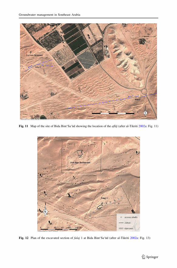
Fig. 11 Map of the site of Bida Bint‘Sa‘ud showing the location of the aflāj (after al-Tikriti 2002a: Fig. 11)
Fig. 12 Plan of the excavated section of falaj 1 at Bida Bint‘Sa‘ud (after al-Tikriti 2002a: Fig. 13)
Groundwater management in Southeast Arabia
123
Masāfī (U.A.E.)
The oasis of Masafı is located in a basin north of the mountains of al-H˙ajar, in the Emirate
of Fujairah. Channels were unearthed in 2010 and 2011 in sector 1, southeast of the palm
grove (Fig. 13).
The main channel (St 481), excavated by the author over about 4 m (Fig. 14), is located
20 m north of a large building dating back to the Iron Age (Fig. 15). It corresponds to the
downstream end of an irrigation structure that provided water to a network of small earthen
channels built above the ground, which probably irrigated agricultural plots. The small
channels were excavated over about 3–4 m, north of St 481 (Benoist et al. 2012).
Channel St 481 is oriented northwest–southeast and turns towards the east at its
southern end. It is dug below the ground surface and measures c. 25 cm wide. The
sidewalls are built of small stone blocks (c. 10–20 cm long) and are about 30 cm high.
They support a cover of stone slabs (c. 70 cm long). At its northern end, St 481 rests again
a low wall made of vertical stone slabs (St 485) that seems to delimit sector 1 to the north.
The channel St 481 is filled with layered and graded sediments, indicating a rhythmic
sedimentation related to water flow.4 The upper part of these sediments is orange in colour,
which indicates that the channel dried up and that the iron particles present in the sedi-
ments oxidised when in contact with the air.
At the downstream end of St 481, the orange sediments were passing between two slabs of
wall St 485 and were visible at the bottom of a channel that was running toward the northeast
(St 495). St 495 is c. 20 cm wide, 6 cm deep and is delimited by two small ridges made of
packed silt and gravel (Fig. 16a). St 481 was also providing water to channel St 1032 (c.
15 cm wide), running toward the north and to channel St 494, running toward the southwest.
The later is visible for about 6 m and measures 10–15 cm wide. As with channel St 495, it
runs along the wall St 485. St 1032 and 494 were also filled with orange silty clay. A basin
was also discovered at the junction of channels St 494 and St 1032. It consists of an earth
levee, unfortunately only preserved over a quarter of a circle, but it was probably sub-
circular or oval originally. Orange silty clay sediments covered the bottom of the basin,
which had been destroyed to the north and the west. The bottom of the basin was situated c.
35 cm bellow the surrounding channels. If the basin was circular, its diameter was likely
around 2.5 m. It could have surrounded a tree, but no root traces have been found and we
must keep in mind that it was only partially preserved. Circular basins surrounding fruit trees
are current in the present-day oases of Eastern Arabia (see below). Circular tree basins have
also been discovered at the surface of 1st millennium B.C. irrigation systems in Yemen, such
as wādī Harıb, wādī Markha and Ma’rib (Bowen 1958, p. 60; Brunner 1997, p. 196; Heh-
meyer 1989, p. 38), and in the U.A.E. (see Qattarah below). Alternatively, the basin of
Masafı could have held water coming from channel ST 481.
This network of channels corresponds to the latest phase of irrigation in sector 1 (phase
III). Under channel St 495, an older channel was unearthed: St 1031 (phase II). It is
oriented northeast–southeast and was fed by channel St 481 (Fig. 16b). It is filled with silts
and gravels, c. 15 cm wide and is built, like the others, above the ground. St 1031 was
partly filled with orange silty clay sediments.
An older channel, St 1030 (phase I), was leaning against wall St 485 (Fig. 16c). St 1030
is c. 15-20 cm wide and is filled with silts and gravels. This structure had been cut to the
west by channels St 1031 and St 495. It doesn’t seem to be related to channel St 481 but
4 The sediments have been sampled and are currently being studied in a laboratory with the help of a
microscope by Louise Purdue (CNRS-CEPAM, Nice).
J. Charbonnier
123

could, instead, have been fed by an older channel, St 486, whose remains have been
discovered west of St 481.
The channels found at Masafı can be dated to the Iron Age for several reasons. Sector 1
was abandoned after the Iron Age and reused as a cemetery during the late Islamic period.
One of the graves (19th or 20th century AD) was dug in levels covering St 481 and cut the
Fig. 13 Map of Masafı oasis (© Julien Charbonnier, Mission Archeologique Francaise aux Emirats Arabes
Unis)
Fig. 14 The channel St 481 at Masafı and associated canals, view from the north (© Julien Charbonnier,
Mission Archeologique Francaise aux Emirats Arabes Unis)
Groundwater management in Southeast Arabia
123
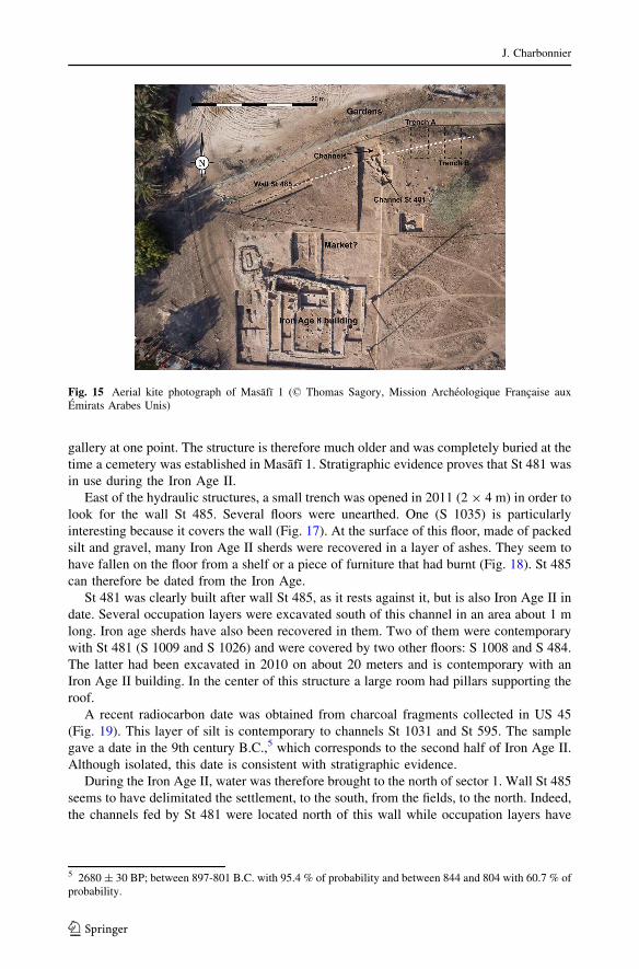
gallery at one point. The structure is therefore much older and was completely buried at the
time a cemetery was established in Masafı 1. Stratigraphic evidence proves that St 481 was
in use during the Iron Age II.
East of the hydraulic structures, a small trench was opened in 2011 (2 9 4 m) in order to
look for the wall St 485. Several floors were unearthed. One (S 1035) is particularly
interesting because it covers the wall (Fig. 17). At the surface of this floor, made of packed
silt and gravel, many Iron Age II sherds were recovered in a layer of ashes. They seem to
have fallen on the floor from a shelf or a piece of furniture that had burnt (Fig. 18). St 485
can therefore be dated from the Iron Age.
St 481 was clearly built after wall St 485, as it rests against it, but is also Iron Age II in
date. Several occupation layers were excavated south of this channel in an area about 1 m
long. Iron age sherds have also been recovered in them. Two of them were contemporary
with St 481 (S 1009 and S 1026) and were covered by two other floors: S 1008 and S 484.
The latter had been excavated in 2010 on about 20 meters and is contemporary with an
Iron Age II building. In the center of this structure a large room had pillars supporting the
roof.
A recent radiocarbon date was obtained from charcoal fragments collected in US 45
(Fig. 19). This layer of silt is contemporary to channels St 1031 and St 595. The sample
gave a date in the 9th century B.C.,5 which corresponds to the second half of Iron Age II.
Although isolated, this date is consistent with stratigraphic evidence.
During the Iron Age II, water was therefore brought to the north of sector 1. Wall St 485
seems to have delimitated the settlement, to the south, from the fields, to the north. Indeed,
the channels fed by St 481 were located north of this wall while occupation layers have
Fig. 15 Aerial kite photograph of Masafı 1 (© Thomas Sagory, Mission Archeologique Francaise aux
Emirats Arabes Unis)
5 2680± 30 BP; between 897-801 B.C. with 95.4 % of probability and between 844 and 804 with 60.7 % of
probability.
J. Charbonnier
123
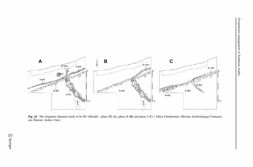
Fig. 16 The irrigation channels north of St 481 (Masafı) : phase III (A), phase II (B) and phase I (C) ( Julien Charbonnier, Mission Archeologique Francaise
aux Emirats Arabes Unis)
Groundwater
managem
entin
Southeast
Arab
ia
123

gradually built up south of it. The small channels remind the irrigation channels visible in
the present-day palm grove of Masafı. Recent levelling north of sector 1 has unfortunately
destroyed the gardens associated with them.
Fig. 17 West section in Trench B (Masafı) and relation between floor S 1035 and Wall 485 (© Julien
Charbonnier, Mission Archeologique Francaise aux Emirats Arabes Unis)
Fig. 18 Iron Age II sherds at the
surface of floor S 1035 (Masafı)
(© Julien Charbonnier, Mission
Archeologique Francaise aux
Emirats Arabes Unis)
J. Charbonnier
123
St 481 looks like the downstream end of a falaj (see above Hılı 15) and could perhaps
have drained groundwater from the edge of the mountains east of the valley. In the absence
of its upstream part, now buried under if not destroyed by modern houses, it is however not
Fig. 19 East section of Trench North (Masafı) and position of US 45 (© Julien Charbonnier, Mission
Archeologique Francaise aux Emirats Arabes Unis)
Fig. 20 Plan of falaj M46 at
Maysar (after Weisgerber 1981:
Fig. 3)
Groundwater management in Southeast Arabia
123
possible to confirm this. There is also a possibility that it conveyed surface water or that it
was fed by a well, maybe artesian. Artesian conditions in the past can be assumed in
Masafı based upon interviews of older inhabitants of the oasis and a preliminary geo-
morphological study. Indeed, we discovered a late Islamic abandoned well south of the
palm grove that, according to the inhabitants of Masafı, was supplied with water after
rainfall events, causing a rise of the water table. At that point, the water then flowed into a
tunnel and then a channel that fed a large basin located 150 m to the west (Charbonnier and
Purdue 2012, paper given to the 45th Seminar for Arabian Studies in London).
Maysar (Oman)
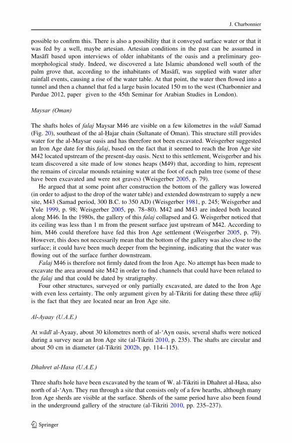
The shafts holes of falaj Maysar M46 are visible on a few kilometres in the wādī Samad
(Fig. 20), southeast of the al-H˙ajar chain (Sultanate of Oman). This structure still provides
water for the al-Maysar oasis and has therefore not been excavated. Weisgerber suggested
an Iron Age date for this falaj, based on the fact that it seemed to reach the Iron Age site
M42 located upstream of the present-day oasis. Next to this settlement, Weisgerber and his
team discovered a site made of low stones heaps (M49) that, according to him, represent
the remains of circular mounds retaining water at the foot of each palm tree (some of these
have been excavated and were not graves) (Weisgerber 2005, p. 79).
He argued that at some point after construction the bottom of the gallery was lowered
(in order to adjust to the drop of the water table) and extended downstream to supply a new
site, M43 (Samad period, 300 B.C. to 350 AD) (Weisgerber 1981, p. 245; Weisgerber and
Yule 1999, p. 98; Weisgerber 2005, pp. 78–80). M42 and M43 are indeed both located
along M46. In the 1980s, the gallery of this falaj collapsed and G. Weisgerber noticed that
its ceiling was less than 1 m from the present surface just upstream of M42. According to
him, M46 could therefore have fed this Iron Age settlement (Weisgerber 2005, p. 79).
However, this does not necessarily mean that the bottom of the gallery was also close to the
surface; it could have been much deeper from the beginning, indicating that the water was
flowing out of the surface further downstream.
FalajM46 is therefore not firmly dated from the Iron Age. No attempt has been made to
excavate the area around site M42 in order to find channels that could have been related to
the falaj and that could be dated by stratigraphy.
Four other structures, surveyed or only partially excavated, are dated to the Iron Age
with even less certainty. The only argument given by al-Tikriti for dating these three aflāj
is the fact that they are located near an Iron Age site.
Al-Ayaay (U.A.E.)
At wādī al-Ayaay, about 30 kilometres north of al-‘Ayn oasis, several shafts were noticed
during a survey near an Iron Age site (al-Tikriti 2010, p. 235). The shafts are circular and
about 50 cm in diameter (al-Tikriti 2002b, pp. 114–115).
Dhahret al-Hasa (U.A.E.)
Three shafts hole have been excavated by the team of W. al-Tikriti in Dhahret al-Hasa, also
north of al-‘Ayn. They run through a site that consists only of a few hearths, although many
Iron Age sherds are visible at the surface. Sherds of the same period have also been found
in the underground gallery of the structure (al-Tikriti 2010, pp. 235–237).
J. Charbonnier
123

Al-Jabīb (U.A.E.)
Located 50 km north of al-‘Ayn, al-Jabıb falaj is visible for several hundred meters and
may be associated with a site located a few kilometres to the west. This site has not been
excavated but sherds suggest an Iron Age date. According to W. al-Tikriti, the contem-
poraneity of the site and of the falaj could be confirmed by the comparison between the
depth of the gallery and the distance to the site (al-Tikriti 2002a, p. 131). One of the shafts
has been rapidly excavated confirming the fact that this structure is a falaj.
Iz0747, Izkī (Oman)
J. Schreiber discovered site Iz0747 during a survey. It is located northeast of the oasis of
Izkı, near a tributary of wādī H˙alfayn. Pottery sherds collected on its surface date it to the
Iron Age II (Haser 2010, p. 163). The shaft holes of a falaj are visible on about 400 m.
They seem to bypass the site, which suggests, according to J. Schreiber, that the falaj also
dates from the Iron Age (Schreiber 2007, p. 136).
Wells
A well was discovered in the Iron Age settlement of Tell Abraq (Magee 1995: Fig. 8.5). W.
al-Tikriti mentions two wells 3.6 and 5 m deep excavated in the site of Dhahret al-Hasa (al-
Tikriti 2010, p. 237).
Al-Mādam (U.A.E.)
A 7 m deep well was excavated on the site al-Madam 1 (Fig. 9) about 10 m east of House
1. It is located inside the enclosure attached to this house. The stratigraphic relationship
between the edge of the well, the enclosure and the house confirms their contemporaneity.
The well was dug and used at the end of Iron Age II and during Iron Age III (Cordoba and
Del Cerro 2005, p. 519).
The well is rectangular with rounded corners in plan and its bottom is dug into the
bedrock. Small notches carved into the well’s side allowed one to reach its bottom in order
to clean it. The excavators think that water was drawn from it with the help of a rope
attached to the top of a structure consisting of three trunks. According to them, this is
suggested by the plan of the edge of the well and by the stratigraphy outside of the well but
they do not provide further explanation (Cordoba and Del Cerro 2005, p. 519).
A small basin located next to the edge of the well was probably intended to provide
water to the livestock. Indeed, husbandry seems to have constituted the main economy of
AM-1, as suggested by the important amount of sheep and goat bones found during the
excavation, the large enclosures around the houses, and the absence of silos and of storage
jars (Cordoba and Del Cerro 2005, p. 518).
Two other wells have been identified next to structure 6. They are associated to a
900 m2 flat area of bedrock that was devoted to the manufacturing of mudbricks (Fig. 9).
Channels cross this sort of platform. Mudbricks, complete and fragmentary, were dis-
covered on the platform. Many children’s footprints were found at the surface of piles of
mud and mudbrick fragments located in small basins at the northeast corner of the plat-
form. Adult footprints and fingerprints were also discovered suggesting that these basins
were used to crush old mudbricks in order to reuse them (Cordoba and Del Cerro 2005, pp.
Groundwater management in Southeast Arabia
123
520–521; Cordoba 2013, pp. 144–146). Water, drawn from the wells, was required to
prepare the mudbricks that were used to build the houses of AM-1. The area can be dated
from the Iron Age II thanks to the numerous sherds found during the excavation and
because it is abutting the Iron Age house 6 (Cordoba 2013: Fig. 6.2). The area wasn’t
reoccupied during the Islamic period.
Qattārah (al-‘Ayn, U.A.E.)
Until a few years ago, no wells associated with Iron Age gardens and fields had been
recorded in Southeast Arabia. The excavation led at Bayt Bin ‘Atı al-Darmakı,6 south of
Qattarah oasis in al-‘Ayn, uncovered a stratigraphic sequence spanning from the beginning
of the Iron Age to the Late Islamic period (Power and Sheehan 2012: 296). Several
trenches were opened in which P. Sheehan and T. Power have distinguished five main
phases: an industrial installation dating from the beginning of the Iron Age was first
established on the bedrock; it was then replaced by fields (Iron Age II); the area is
thereafter devoted to copper production (Iron Age); in the Early Islamic period, a settle-
ment made of perishable materials occupied the area; mudbrick houses were finally built in
the Late Islamic period (Power and Sheehan 2011, p. 267).
Here, I will concentrate on the deepest layers. At the beginning of the Iron Age
(Horizon 1), a large basin was dug in the shallow ground in order to reveal the bedrock
surface in which square tanks, regularly spaced out, were cut (unearthed in the Workshop
trench). The tanks are c. 45 on one side and c. 50 cm deep, with vertical sides and flat
bottoms. Channels of c. 20 cm wide and c. 3 cm deep connect them together. Located at the
northern end of the large basin, a 3 m deep well probably provided water to this instal-
lation. The fact that water was flowing from one tank to another through the channels is
suggested by the fact that the bedrock slopes from the north to the south, the well being
located upstream. The tanks were kept clean before their abandonment and their fill
contained neither organic material nor any element suggesting agriculture (Power and
Sheehan 2011, p. 271). Power and Sheehan suggest that these structures were associated
with an industrial activity: dying, tanning or copper processing for example. Although no
slag was recovered during the excavation, they have a preference for copper production.
Indeed after the ore is heated in order to remove carbon dioxide, the remaining copper
oxide is heated again in the presence of carbon. The oxygen is in this way removed. At that
point it is necessary to plunge it into water in order to separate silicate and carbonated
scum, which will float at the surface, from copper. This process can be repeated several
times. The tanks recovered in Bin ‘Atı could have been used for this last operation (Power
and Sheehan 2011, p. 272).
Later, during the Iron Age II, the area was devoted to agriculture (Horizon 2). A ditch
was found in a trench located south of the Late Islamic buildings and the “workshop
trench” (made prior to the building of the Energy Centre). The ditch, oriented northwest–
southeast, exhibits a ‘V’-shaped section and is 0.80 m wide for 1.50 m deep. Four sub
circular basins (c. 2 m in diameter and 1 m in depth) are distributed along the ditch. Close
to some of them were discovered small curvilinear channels. According to Power and
Sheehan, the ditch was providing water to the basins from which water was brought to the
crops by means of channels (Power and Sheehan 2011, p. 272). The fact that the ditch and
6 This excavation was led in the context of the renovation of Bayt Bin ‘Atı al-Darmakı and the construction
of an art centre by the Abu Dhabi Authority for Culture and Heritage inside this building.
J. Charbonnier
123
the channels run below the ground level is surprising however; irrigation channels are
generally built above the ground so the water can reach the fields by gravity.
Above the large basin of Horizon 1, in the Workshop trench, small channels (c. 12 cm
wide and 2 cm deep) were built (Horizon 2a) on a “mid-yellowish brown fine silty sand”
(Power and Sheehan 2011, p. 272). They could have been used to irrigate some crops.
Just above and in the Energy Centre trench (Horizon 2b), similar channels were
unearthed but this time associated with two wells. In the Workshop trench the well, located
next to the one of Horizon 1, is 1.84 9 2.35 wide.
More information on Iron Age agricultural practices comes from Horizon 2c in the
Workshop trench. Indeed, circular earth structures, c. 3 m wide and 12 cm deep, arranged
in rows were unearthed. In the center of each of these basins was located a pit of about
50 cm in diameter and 35 cm deep that could correspond to a root bowl (Fig. 21). Ashes
seem to have been added to the earth in the pits (Power and Sheehan 2011, p. 272). In the
Energy centre area, similar structures and a well of about 3 m in diameter and 4.5 m deep
were found. Two intact Iron Age II vessels were for example found at the bottom of this
well (Power and Sheehan 2011: 273).
The circles surrounding these pits correspond, according to the excavators, to circular
basins that allowed for the irrigation of each tree separately. Power and Sheehan note that
the root bowls were too small for palm trees (Power and Sheehan 2011, p. 272). I will also
stress the fact that, in the oases of Southeast Arabia, palm trees are generally not sur-
rounded by circular basins. They are thus irrigated at the same time as the other crops.
Circular basins are however generally dug around juvenile palm trees.
In Horizon 3, the irrigation structures of Horizon 2 were not in use anymore and the area
was devoted to copper production (Power and Sheehan 2011, p. 273).
The structures unearthed in Bin ‘Atı are dated from the Iron Age according to the
stratigraphy. Iron Age material has been recovered during the excavation of Horizon 1, 2
and 3. During this period, the evidence shows that wells were used for irrigation and
industrial activities in the area but we must keep in mind that the excavation in Bin ‘Atı
concerned a relatively small surface.
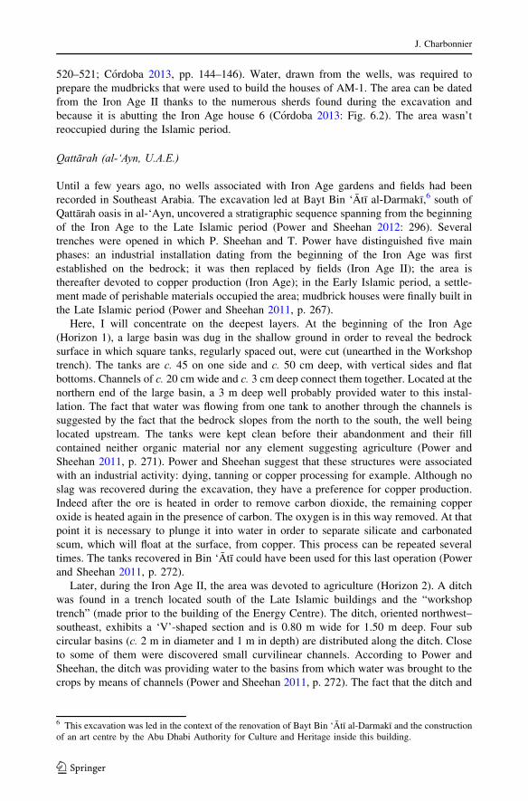
Fig. 21 Tree pits of Horizon 2C (background) above the rock-cut tanks of Horizon 1 (foreground) (Power
and Sheehan 2011: Fig. 6)
Groundwater management in Southeast Arabia
123
Discussion: where did the water come from used during the Bronze and Iron Ages?
The review of the corpus of excavated hydraulic structures allows us to make some
statements concerning the history of water management in Southeast Arabia. Several aflāj
have been dated to the Iron Age and some scholars have linked the development of this
technology with the increase of sites noticed at the beginning of the Iron Age II (Magee
1998, 2000; al-Tikriti 2010) or the increase of aridity noticed during this period (Magee
2004). Other scholars have speculated about the appearance of falaj during the Early
Bronze Age (Cleuziou and Orchard). However, it is obvious that none of the aflāj exca-
vated in Southeast Arabia are dated with certainty from the pre-Islamic period, apart from
the one of al-Madam. Stratigraphic evidence is lacking and most of the structures are dated
based on their proximity with a Bronze or an Iron Age settlement.
The galleries of the aflāj, and the associated canals, hypothetically dated from the Iron
Age, are characteristically narrow (20–50 cm wide), but this is not restricted to the pre-
Islamic structures. The Islamic period aflāj excavated in Bat (falaj al-Sharsa) and Masafı
by the author were respectively 50–100 cm and 30–80 cm wide. The use of stone blocks to
build the sidewalls or to cover the galleries, as in Hılı, is also known for Islamic period
aflāj. It is necessary to reinforce canal sidewalls with stone blocks when the ground is
loose, such as in sandy or gravelly areas. Two examples are the aflāj of al- Sharsa, in Bat,
and Samad al-Shan, in wādī Samad, dug into alluvial sediments. Stone slabs cover even
their underground galleries (Charbonnier 2013; Weisgerber 2005, pp. 74–75: Fig. 27).
Conversely, the evidence for the use of wells has been completely overlooked. During
the Iron Age II, wells were however used in Bin ‘Atı to irrigate the plots and for craft
activities. One well discovered in al-Madam was associated to the manufacture of
mudbricks and another one could have provided water to the flocks. Wells were also found
in 3rd millennium sites, such as Hılı, Maysar or Bat. These Bronze Age wells were
probably not used to irrigate the fields, as they were located within the settlement. Nev-
ertheless, it is possible that wells were used for agricultural purposes, even if no well
associated with an irrigation system has so far been found. Furthermore, water table was
closer to the surface during the 3rd millennium B.C., maybe due to moister climatic
conditions in the first half of this millennium (see above) (Preston et al. 2012).
Before the advent of mechanical pumps, crops were irrigated with the help of wells in
some areas of Eastern Arabia, like the coastal region of the Batinah (Costa and Wilkinson
1987, pp. 43–53). Nowadays most of the plots are irrigated by wells in the oasis of Masafı
and many of them are ancient, as indicated by their construction technique. Only one falaj
has been recorded in the oasis while nine wells were still in use. The areas irrigated by the
wells range from 0.2 to 5 ha (for the artesian well).
Wells were perhaps used in the region around Mleıh˙a (occupied from the 3rd Century B.
C. to the 4th Century AD) on the western piedmonts of the U.A.E. (Mouton 1999, p. 272;
Boucharlat 2001, p. 160). The Nabatean city of Hegra, current Mada’in S˙alih
˙(Saudi
Arabia), depended on water supplied by wells. The city was surrounded by gardens fed by
scattered wells each of which could, according to J.-B. Rigot, have irrigated up to 3.2
hectares (Nehme et al. 2006, p. 71).
During the pre-Islamic period, in Southeast Arabia, it was perfectly possible to irrigate
the gardens in this manner, especially as the water table was only a few meters deep in
places such as Hılı, Bin ‘Atı or al-Madam.
No remains of lifting devices have been documented around the Bronze Age wells
found in Oman and U.A.E. Even if hoists and winches were not in use at that time, it was
possible to go down with the help of small notches cut into the rocky walls. Some were
J. Charbonnier
123
found in a well on the site of Mylouthkia, in Cyprus, dating back to the PPNB (Peltenburg
et al. 2000, pp. 846–848). Cleuziou mentions the presence of similar notches in the Bronze
Age wells of Hılı 8 (Cleuziou 2003, p. 19). The water could have been drawn from the
wells manually. J. Oleson thinks that the limit for extracting water this way is about 25 m
(Oleson 2000, p. 222). According to J. C. Wilkinson they can be up to 45 m deep at al-S˙ır
in Oman (Wilkinson 1977, p. 73). Even without a pulley, the rope could have been simply
pulled over a wooden beam (Weisgerber 2005, p. 65). The value of manual drawing should
therefore not be underestimated. According to J. C. Wilkinson, date palms (Phoenix
dactylifera L.) are irrigated only by means of this type of wells in some areas of Oman
(Wilkinson 1977, p. 73).
Even if water isn’t flowing by gravity from the wells and must be drawn, wells present
also some advantages compared to aflāj. Unlike a falaj, a well can be constructed and
maintained by a single family. It is therefore not necessary to share the water drawn from it
and to establish rules of water management. In the oases fed by wells, dwellings tend to be
scattered over the whole surface (Wilkinson 1977, p. 97). Plots are clustered around wells
with a radial network of canals extending outwards. Such an organization has also been
described by T. Wilkinson in the area of S˙oh˙ar, in the Omani Bat
˙ina. Abandoned wells
form mounds of varying sizes, depending on how water was acquired (human or animal
traction), and are more or less regularly spaced depending on the period (irrigation by well
is attested from the ninth to the twentieth century AD). Each well fed a garden (Costa and
Wilkinson 1987, pp. 43–53).
When the groundwater table is decreases, it takes a lot of energy and time to lower aflāj
tunnels and the irrigation systems (Weisgerber 2005, pp. 76–77). Wells bottom however
can be more easily lowered. Wells allow for the irrigation of vegetables or seasonal crops
at a small scale. The flow of a falaj is only available from time to time because it must be
shared between the inhabitants of the oasis while some crops need daily water supply.
Conclusion
The adoption of agriculture in Southeast Arabia followed an aridification process but
seems to have also been related to an increase in social complexity reinforced by the
development of copper exploitation and its exportation toward Mesopotamia and the Indus
valley. During the 3rd millennium B.C., Holocene lakes had dried up and vegetation cover
had reduced. Agriculture was necessary to sustain the population inland. Unfortunately, no
irrigation system dating back to this period has been discovered. Wells were common in
settlements, suggesting that this simple technique could have been also used for irrigating
crops.
Evidence from Hılı suggests that the water table was closer to the surface that now-
adays in some areas. The roots of date palms, which were already cultivated in Southeast
Arabia, can reach water up to 17 m below the surface. Feral palms grow on wādī banks,
near water ponds or springs without any irrigation. We may then wonder whether the date
palms were irrigated during the 3rd millennium B.C. Many of them could have benefited
from the close water table. Their productivity would have been lower but the labor
investment as well: only artificial pollination and vegetative propagation (planting of
suckers) would have been necessary to produce good quality dates. This hypothesis should
be given consideration.
We have no information on Wadi Suq/Late Bronze Age irrigation techniques but they
could have been in continuity with the 3rd millennium. In some places, the arid episode at
Groundwater management in Southeast Arabia
123

the end of this millennium could have led to the drop of the water table—as it seems to be
the case at Hılı—but we must keep in mind that wells can be deepened in order to adapt to
such an evolution.
At the beginning of Iron Age II, while aridity increased again, many new settlements
were created and some areas were repopulated. It has been suggested that the development
or introduction of the falaj technique is linked to this evolution: the falaj would have
initiated or sustained this process (al-Tikriti 2010, pp. 240–246). Evidence for its spread
across the whole region during the Iron Age are however debatable as most of the
structures are badly dated. We have suggested that wells could in fact have been used in
many places at that time.
Irrigation systems and associated garden spaces had never been discovered and exca-
vated until recently. With the result of the excavation in Masafı and in Bin ‘Atı, we have
more information about Iron Age field systems. Unfortunately, these operations concerned
very limited areas. Yet they show that archaeology of gardens is possible and provides
some indication about agricultural practices, agrosystems (types of crops grown, organi-
sation of gardens, type of water resources used etc.), irrigation techniques and the evolution
of the environment (vegetation cover, climate and water resources).
Acknowledgments Above all, the author would like express his gratitude to the organiser of the workshop
“Deriver les eaux… le canal a travers les ages” held in Lyon in May 2012: Louise Purdue, Ferreol Salomon,
Jean-Francois Berger and Jean-Philippe Goiran. I also would like to deeply thank Anne Benoist (director of
the Masafı archaeological project) and Sophie Mery (director of the French Archaeological Mission in the
U.A.E.). And finally thanks to Daniel Lawrence and Andrew Blair for comments on the early drafts.
References
al-Tikriti WY (2002a) The south-east Arabian origin of the falaj system. Proceedings of the Seminar for
Arabian Studies 32:117–138
al-Tikriti WY (2002b) al-aflaj fı daoula al-emirat al-‘arabıa al-moutah˙ida. Dirasa atharia fı anz
˙ima al-raı al-
qadıma, Abu Dhabi
al-Tikriti WY (2010) Heading North: an ancient caravan route and the impact of the falaj system on the Iron
Age culture. In: Avanzini A (ed) Eastern Arabia in the First Millennium BC. Arabia Antiqua
6. L’Erma di Bretschneider, Rome, p. 227–247
al-Tikriti WY, Haddou MM (2001) The Iron Age site at Hili 17 (Al Ain, U.A.E.). In: Mouton M, al-Tikriti
WY (eds) The architectural remains of the Iron Age sites in the United Arab Emirates and Oman.
Documents de l’Archeologie de l’Arabie (CD-Rom) n°2, Department of Antiquities and Tourism of al-
‘Ain (Abu Dhabi), al-‘Ain and Maison de l’Orient Mediterraneen, Lyon
al-Tikriti WY, al-Haj AA, al-Niyadi MA (2001) Bida Bint Saud, Abu-Dhabi (U.A.E.). In: Mouton M, al-
Tikriti WY (eds) The architectural remains of the Iron Age sites in the United Arab Emirates and Oman.
Documents de l’Archeologie de l’Arabie (CD-Rom) n°2, Department of Antiquities and Tourism of al-
‘Ain (Abu Dhabi), al-‘Ain and Maison de l’Orient Mediterraneen, Lyon
Balland D (1992) Introduction. In: Balland D (ed) Les eaux cachees. Etudes geographiques sur les galeries
drainantes souterraines. Departement de geographie de l’Universite de Paris-Sorbonne, Paris, p.1–5
Beaumont P (1989) The qanat : a means of water provision from groundwater sources. In: Beaumont P,
Bonine M, McLachlan K (eds) Qanat, Kariz et Khattara : Traditionnal water systems in the Middle East
and North Africa. The middle east centre, School of Oriental and African Studies, University of London,
London, and Middle East and North African Studies Press, Cambridgeshire, p. 13–31
Beech M, Shepherd E (2001) Archaeobotanical evidence for early date consumption on Dalma Island,
United Arab Emirates. Antiquity 75:83–89
Benoist A, Cordoba M, Mouton M (1997) The Iron Age in al-Madam (Sharjah, UAE): some notes on three
seasons of work. Proceedings of the Seminar for Arabian Studies 27:59–73
Benoist A, Mouton M (1994) L’Age du fer dans la plaine d’al-Madam (Sharjah, EAU) : prospection et
fouilles recentes. Proceedings of the seminar for Arabian Studies 24:1–12
J. Charbonnier
123

Benoist A, Bernard V, Charbonnier J, Goy J, Hamel A, Sagory T (2012) Une occupation de l’Age du Fer a
Masafi. Chroniques yemenites 17 http://cy.revues.org/1803
Biagi P, Nisbet R (2006) The prehistoric fisher-gatherers of the western coast of the Arabian Sea: a case of
seasonal sedentarization? World Archaeol 38(2):220–238
Boucharlat R (2001) Les galeries de captage dans la peninsule d’Oman au premier millenaire avant J.-C. :
question sur leurs relations avec les galeries du plateau iranien. In Briant P (ed) Irrigation et drainage
dans l’Antiquite, qanat et canalisations souterraines en Iran, en Egypte et en Grece. Persika 2, Thotm
Editions, Paris, p. 157–183
Boucharlat R (2003) Iron Age Water-draining Galleries and the Iranian ‘Qanat’. In: Potts D, al-Naboodah H,
Hellyer P (eds) Archaeology of the United Arab Emiratesp.roceedings of the first international con-
ference on the archaeology of the U.A.E. Trident Press, London, 162–172
Boucharlat R, Lombard P (2001) Hili 14, Abu-Dhabi (U.A.E.). In: Mouton M, al-Tikriti WY (eds) The
architectural remains of the Iron Age sites in the United Arab Emirates and Oman. Documents de
l’Archeologie de l’Arabie (CD-Rom) n°2, Department of Antiquities and Tourism of al-‘Ain (Abu
Dhabi), al-‘Ain and Maison de l’Orient Mediterraneen, Lyon
Bowen RL (1958) Irrigation in Ancient Qataban (Beih˙an). In: Bowen RL, Albright FP (eds) Archaeological
discoveries in South Arabia. The John Hopkins Press, Baltimore, pp. 43–131
Braemer F, Geyer B, Castel C, Abdulkarim M (2010) Conquest of new lands and water systems in the
western Fertile Crescent (Central and Southern Syria). Water Hist 2–2:91–114
Briant P (2001) Irrigation et drainage dans l’Antiquite, qanat et canalisations souterraines en Iran, en Egypte
et en Grece. Persika 2. Thotm Editions. Paris.
Brunner U (1997) Geography and Human Settlements in Ancient Southern Arabia. Arab Archaeol Epigr 8
(2):190–202
Brunswig RH (1989) Cultural history, environment and economy as seen from an Umm an-Nar settlement:
evidence from test excavations at Bat, Oman, 1977/78. J Oman Stud 10:9–50
Charbonnier J (2013) Survey and excavationof falaj al-Sharsah (6th–23thFebruary2013). In: CableCM,Kondo
Y and Thornton C American-Japanese Bat Archaeological Project, report of the 7th season (unpublished)
Charbonnier J (2014) In the shadow of the palm trees: time management and water allocation in the oasis of
Adam (Sultanate of Oman). Proceedings of the Seminar for Arabian Studies 44:83–98
Cleuziou S (1989) Excavations at Hili 8: a preliminary report on the 4th to 7th campaigns. Archaeol United
Arab Emirates 5:61–88
Cleuziou S (1997) Construire et proteger son terroir : les oasis d’Oman a l’Age du Bronze. In: Burnouf J,
Bravard J-P, Chouquer G (eds) La dynamique des paysages protohistoriques, antiques, medievaux et
modernes. XVIIe Rencontres Internationales d’Archeologie et d’Histoire d’Antibes. APDCA, Anti-
bes, p. 389–412
Cleuziou S (1998) The foundation of early Bronze Age Oases in the Oman Peninsula. In: Pearce M, Tosi M
(eds) Papers from the EAA Third annual meeting at Ravenna 1997, volume. I : Pre- and protohistory.
BAR international series 717, Archaeopress, Oxford, p. 59–70
Cleuziou S (1999) Espace habite, espace utilise, espace vecu dans les communautes d’Arabie orientale a
l’Age du Bronze. In: Braemer F, Cleuziou S, Coudart A (eds) Habitat et societe. XIXe Rencontres
Internationales d’Archeologie et d’Histoire d’Antibes. Editions APDCA, Antibes, p. 83–108
Cleuziou S (2003) Un systeme d’irrigation par gravite depuis les nappes souterraines dans la peninsule
d’Oman au IIIe millenaire avant notre ere. In: OH2, Origine et histoire de l’hydrologie, Colloque
international, Dijon, 9-11 mai 2001 (CD-Rom), Universite de Bourgogne
Cleuziou S (2005) Pourquoi si tard ? Nous avons pris un autre chemin. L’Arabie des chasseurs-cueilleurs de
l’Holocene au debut de l’Age du Bronze. In: Guilaine J (ed) Aux marges des grands foyers du
Neolithique: peripheries debitrices ou creatrices ? Editions Errance, Paris, p. 123–148
Cleuziou S (2009) Extracting wealth from a land of starvation by creating social complexity: a dialog
between archaeology and climate ? C R Geosci 8–9:726–738
Cleuziou S, Costantini L (1980) Premiers elements sur l’agriculture protohistorique de l’Arabie orientale.
Paleorient 6:245–251
Cleuziou S, Tosi M (1997) Hommes, climats et environnements de la Peninsule arabique a l’Holocene.
Paleorient 23(2):121–135
Cleuziou S, Tosi M (2007) In the shadow of the ancestors. The prehistoric foundations of the early Arabian
civilization in Oman. Ministry of Heritage and Culture, Sultanate of Oman, Muscat
Cordoba JM (2013) New perspectives about Iron Age and the oasis culture in the Oman peninsula. Two
conclusive seasons at al Madam (Sharjah, UAE). Isimu 16:139–151
Cordoba JM, Del Cerro MdC (2005) Archeologie de l’eau dans al Madam (Sharjah, Emirats Arabes Unis).
Puits, aflaj et secheresse pendant l’age du Fer. Iranica Antiqua 40:515–532
Groundwater management in Southeast Arabia
123
Cordoba JM, Mouton M (2001) Les sites d’habitat de l’Age du Fer et les aflaj a al-Madam. In: Mouton M,
al-Tikriti WY (eds) The architectural remains of the Iron Age sites in the United Arab Emirates and
Oman. Documents de l’Archeologie de l’Arabie (CD-Rom) n°2, Department of Antiquities and Tourism
of al-‘Ain (Abu Dhabi), al-‘Ain and Maison de l’Orient Mediterraneen, Lyon
Costa PM, Wilkinson TJ (1987) The Hinterland of Sohar, archaeological surveys and excavations within the
region of an Omani Seafaring City. The Journal of Oman Studies 9, Ministry of Heritage and Culture,
Sultanate of Oman, Muscat
Costantini L, Costantini Biasini L (1986) Palaeoethnobotanical Investigations in the Middle East and
Arabian Peninsula. East West 36(4):354–365
Cullen HM, deMenocal PB, Hemming S, Hemming G, Brown FH, Guilderson T, Sirocko F (2000) Climate
change and the collapse of the Akkadian empire: Evidence from deep sea. Geology 28(4):379–382
Dutton RW (1989) Aflaj renewal in Araqi : a village case study from Oman. In: Beaumont P, Bonine M,
McLachlan K (eds) Qanat, Kariz et Khattara : Traditional water systems in the Middle East and North
Africa. The Middle East Centre, School of Oriental and African Studies, University of London, London,
and Middle East and North African Studies Press, Cambridgeshire,p. 237–256
English PW (1968) The origin and spread of qanats in the old world. Proc Am Philos Soc 112(3):170–181
Esposti Degli (2011) The excavation of an early Bronze Age tower near Salut (Bisyah, Sultanate of Oman):
the Iron Age levels. Egitto e Vicino Oriente 34:189–224
Degli Esposti (2013) The 5th and 6th campaigns of excavation at the Salut Bronze Age tower (ST1). Italian
Mission to Oman Field Reports. University of Pisa
Fleitmann D, Matter A (2009) The speleothem record of climate variability in Southern Arabia. C R Geosci
341:633–642
Fleitmann D, Burns SJ, Mangini A, Mudelsee M, Kramers J, Villa I, Neff U, al-Subarry AA, Buettner A,
Hippler D, Matter A (2007) Holocene ITCZ and Indian monsoon dynamics recorded in stalagmites from
Oman and Yemen (Socotra). Quatern Sci Rev 26:170–188
Frifelt K (1976) Evidence of a third millennium B.C. town in Oman. J Oman Stud 2:57–67
Frifelt K (2002) Bat, a Centre in the Third Millennium Oman. In: Cleuziou S, Tosi M, Zarins J (eds) Essays
on the Late Prehistory of the Arabian Peninsula. Serie Orientale Roma XCIII, Istituto Italiano per
l’Africa e l’Oriente, Rome, p. 101–110
Goblot H (1979) Les qanats, une technique d’acquisition de l’eau, Ecole des Hautes Etudes en Sciences
Sociales, Industrie et artisanat 9. Mouton Editeur, Paris
Gros-Balthazard M, Newton C, Ivorra S, Tengberg M, Pintaud J-C, Terral J-F (2013) Origine et domesti-
cation du palmier dattier (Phoenix dactylifera L.). Revue d’ethnoecologie 4 http://ethnoecologie.
revues.org/1524
Haser J (2010) In: Avanzini A (ed) Eastern Arabia in the first millennium BC, Arabia Antiqua
6, « L’Erma » di Bretschneider, Rome, p. 109–141
Hastings A, Humphries JH, Meadow RH (1975) Oman in the third millennium BCE. J Oman Stud 1:1–55
Hehmeyer I (1989) Irrigation farming in the ancient oasis of Marib. Proceedings of the Seminar for Arabian
Studies 19:33–44
Lightfoot DR (2000) The origin and diffusion of qanats in Arabia: new evidence from the northern and
southern Peninsula. Geogr J 166(3):215–226
Magee P (1995) Cultural change, variability and settlement in southeastern Arabia. Unpublished PhD thesis.
University of Sydney
Magee P (1998) Settlement patterns, polities and regional complexity in the Southeast Arabian Iron Age.
Paleorient 24(2):49–60
Magee P (2000) Patterns of settlement in the Southeast Arabian Iron Age. Adumatu 1:29–39
Magee P (2004) The impact of southeast Arabian intra-regional trade on settlement location and organi-
zation during the Iron Age II period. Arab Archaeol Epigr 15:24–42
Mery S (2013) The first oases in Eastern Arabia: society and craft technology, in the 3rd millennium BC at
Hili, United Arab Emirates. Revue d’ethnoecologie 4 http://ethnoecologie.revues.org/1631
Mostafaeipour A (2010) Historical background productivity and technical issues of qanats. Water Hist 2–
1:61–80
Mouton M (1999) Mleiha : environnement, strategies de subsistance et artisanats. In: Mouton M (ed) Mleiha
vol. I: Environnement, strategies de subsistance et artisanats. Travaux de la Maison de l’Orient 29,
Maison de l’Orient and de Boccard, Lyon and Paris, p. 265–285
Mouton M (2010) Mleiha et le peuplement de la peninsule d’Oman a la periode Pre-Islamique Recente. In:
Avanzini A (ed) Eastern Arabia in the first millennium BC. Arabia Antica 6, « L’Erma » di Bret-
schneider, Rome, p. 181–211
J. Charbonnier
123
Nehme L, Arnoux T, Bessac J-C, Braun J-P, Dentzer J-M, Kermorvant A, Sachet I, Tholbecq L, Rigot J-B
(2006) Mission archeologique de Mada’in Salih (Arabie Saoudite): recherches menees de 2001 a 2003
dans l’ancienne Hijra des Nabateens. Arabian Archeol Epigr 17:41–124
Oleson JP (2000) Irrigation. In: Wikander O (ed) Handbook of ancient water technology. Technology and
change in history. Brill, Koln, pp. 183–215
Orchard J, Orchard J (2007) The third millennium BC oasis settlement of Oman and the first evidence of
their irrigation by Aflaj from Bahla. In: Archaeology of the Arabian Peninsula through the Ages.
Proceedings of the International Symposium (7th–9th may 2006). Ministry of Heritage and Culture,
Sultanate of Oman, Muscat, p. 143–173
Parker AG, Eckersley L, Smith MM, Goudie AS, Stokes S, Ward S, White K, Hodson MJ (2004) Holocene
vegetation dynamics in the northeastern Rub’ al-Khali desert, Arabian Peninsula: a phytolith, pollen and
carbon isotope study. J Quat Sci 19–7:665–676
Parker AG, Goudie AS, Stokes S, White K, Hodson MJ, Manning M, Kennet D (2006) A record of Holocene
climate change from lake geochemical analyses in southeastern Arabia. Quatern Res 66:465–476
Peltenburg E, Colledge S, Croft P, Jackson A, McCartney C, Murray MA (2000) Agro-pastoralist coloni-
zation of Cyprus in the 10th millennium BP: initial assessments. Antiquity 74:844–853
Philippsen B (2013) The freshwater reservoir effect on radiocarbon dating. Heritage Science 1/24
http://www.heritagesciencejournal.com/content/1/1/24
Potts DT (1990) The Arabian Gulf in antiquity. Volume I: From the prehistory to the fall of the Achaemenid
Empire. Oxford University Press, New York
Power T, Sheehan P (2011) Bayt Bin ‘Atı in Qattarah oasis: a prehistoric industrial site and the formation of
the oasis landscape of al-‘Ain, UAE. Proceedings of the Seminar for Arabian Studies 41, pp. 267–282
Power T, Sheehan P (2012) The origin and development of the oasis landscape of al-‘Ain (UAE). Pro-
ceedings of the Seminar for Arabian Studies 42, pp. 291–308
Preston GWp.arker AG, Walkington H, Leng MJ, Hodson MJ (2012) From nomadic herder-hunters to
sedentary farmers: the relationship between climate change and ancient subsistence strategies in south-
eastern Arabia. J Arid Environ 86:122–130
Sanlaville P (2000) Le Moyen-Orient arabe. Le milieu et l’homme. Armand Colin, Paris
Schreiber J (2007) Transformationsprozesse in Oasensiedlungen Omans. Die Vorislamische Zeit am Bei-
spiel von Izki, Nizwa und dem Jebel Akhdar. Unpublished PhD thesis, Ludwig-Maximilans University,
Munich
Serjeant RB, Lewcock R (1983) Sana‛a’: an Arabian Islamic City. Middle East Centre, Cambridge
TengbergM (1998) Paleoenvironnements et economie vegetale en milieu aride - recherches archeobotaniques
dans la region Golfe arabo-persique et dans le Makran pakistanais (4eme millenaire av. notre ere - 1er
millenaire de notre ere). Unpublished PhD thesis. University of Montpellier
Tengberg M (2003) Archaeobotany in the Oman peninsula and the role of Eastern Arabia in the spread of
African crops. In: Neumann K, Butler A, Kahlheber S (eds) Food, Fuel and Fields : Progress in African
Archaeobotany. Africa Praehistorica 15, Heinrich Barth Institut, Koln, p. 229–237
Velde C (2003) Wadi Suq and Late Bronze Age in the Oman Peninsula. In: Potts D, Al Naboodah H, Hellyer
P 2003 (eds) Archaeology of the United Arab Emirates. Proceedings of the First International Con-
ference of the Archaeology of the U.A.E., Trident Press, London, p. 102–113.
Weisgerber G (1981) Mehr als Kupfer in Oman. Ergebnisse der Expedition 1981. Der Anschnitt 33:174–263
Weisgerber G (2005) The impact of the dynamics of qanats and aflaj on oases in Oman: Comparisons with
Iran and Bahrain. Internatinales Frontinus-Symposium Wasserversorgung aus Qanaten – Qanate als
Vorbilder im Tunnelbau, 2.-5. Oktober 2003, Walferdange, Luxemburg. Schriftenreihe der Frontinus-
Gesellschaft 26:61–97
Weisgerber G, Yule P (1999) Preliminary report on the 1996 season of excavation in the Sultanate of Oman.
In: Yule P (ed) Studies in the archaeology of the Sultanate of Oman. Verlag Maria Leidorf, Rahden, pp.
97–117
Weisgerber G, Yule P (2003) Al-Aqir near Bahla’- an Early Bronze Age dam site with planoconvex
‘copper’ ingots. Arab Archaeol Epigr 14(1):24–53
Wilkinson JC (1977) Water and Tribal Settlement in South-East Arabia, a study of the Aflaj of Oman.
Clarendon Press, Oxford
Wilkinson TJ, Rayne L (2010) Hydraulic landscapes and imperial power the Near East. Water Hist 2–2:115–
144
Willcox G, Tengberg M (1995) Preliminary report on the archaeobotanical investigations at Tell Abraq with
special attention to chaff impressions in mud brick. Arab Archaeol Epigr 6:129–138
Groundwater management in Southeast Arabia
123