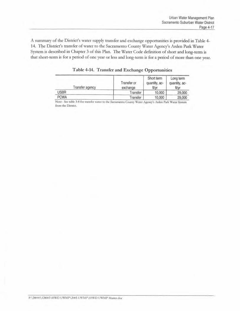
2005 Urban Water Management Plan
249
-
Upload
khangminh22 -
Category
Documents
-
view
1 -
download
0
Transcript of 2005 Urban Water Management Plan
~ ."
BROWN ANDCALDWELL-- ~ - --- ----
10540 Whte Rock Road, Suite 180Sacramento, Californa 95670
Tel: (916) 440123Fax: (916) 635-8805
W\V\V, brownandcaldwell,com
December 13, 2005
Mr. Warren JungSacramento Suburban Water District3701 Marconi Avenue, Suite 100Sacramento, California 95821-5303 017-128007-001
Subject: Submittal of 2005 Urban Water Management Plan
Dear Mr. Jung:
I am pleased to submit to you ths Draft-Final 2005 Urban Water ManagementPlan (plan). This draft Plan is written accordig to the requiements of the UrbanWater Management Plannig Act and the guidelies as provided by the CaliforniaDepartment of Water Resources. The comments received during the publicreview period have been incorporated into ths Plan.
If you have any questions, please do not hesitate to contact me at (916) 853-5365.
Sincerely,
BROWN AND CALDWELL
tf.J~ ~Melanie Holton, P.E.
Project Manager
EnclosuresMH:ds
cc: Paul Selsky, Brown and Caldwell
P:\28000\128007-SSWD UWMP\2005 UWMP\coyer letter - 12-13-2005,doc
EnvironmentalEngine ers & Consultants
SACRAENTO SUBURBAN WATER DISTRICT
2005 URBAN WATER MAAGEMENT PLA
December 2005
Prepared tr:
BROWN AND CALDWELL10540 White Rock Road, Suite 180Rancho Cordova, Californa 95670
(916) 444-0123


CHAER 2DESCRIPTION OF EXISTING WATER SYSTEM
Ths chapter describes the Distrct's system. It contais a description of the servce area and itscliate, and the water supply facilties, includig the groundwater wells, surface water supply facilties,
booster pumping stations, reservoirs, and the piping system. .
2.1 Descnption of Servce Area
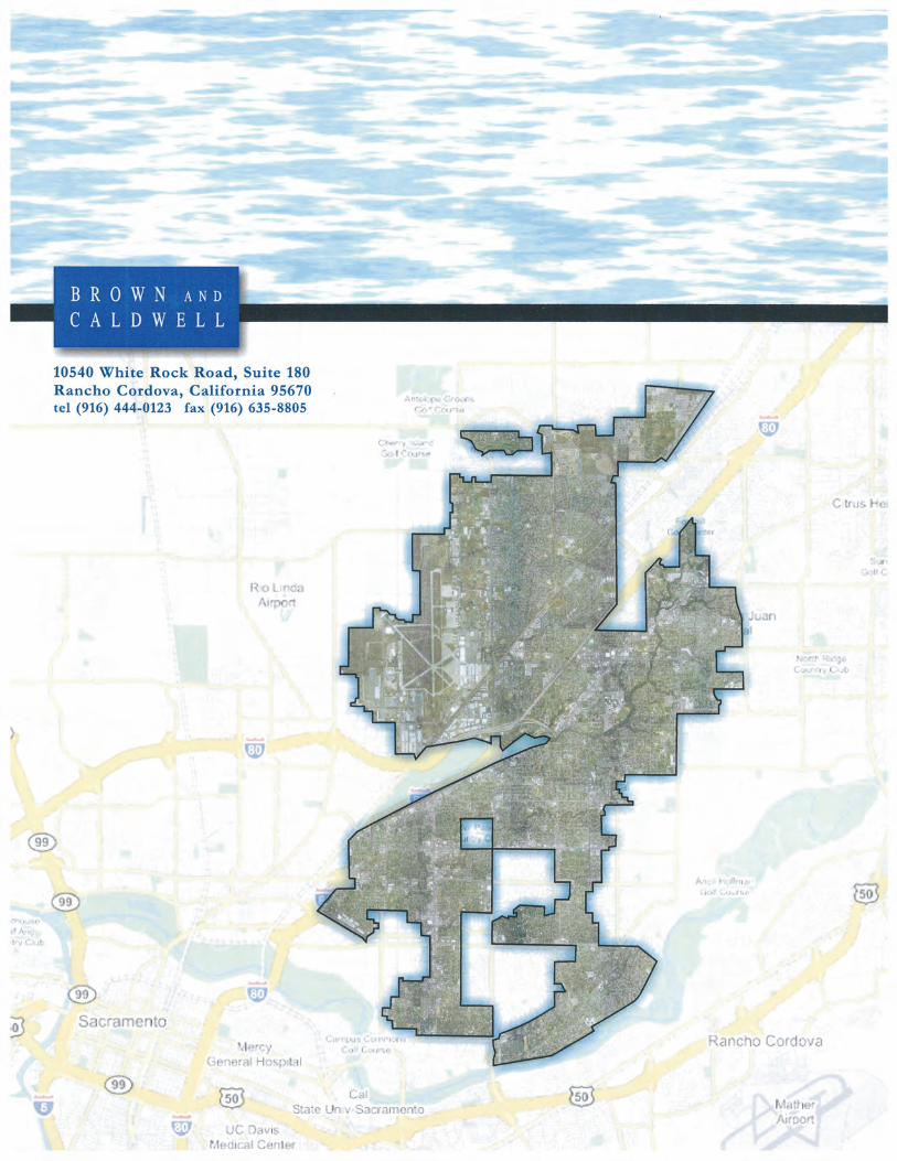
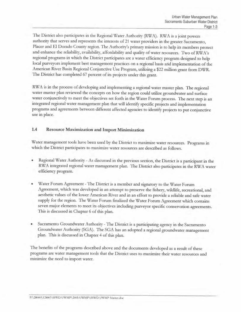
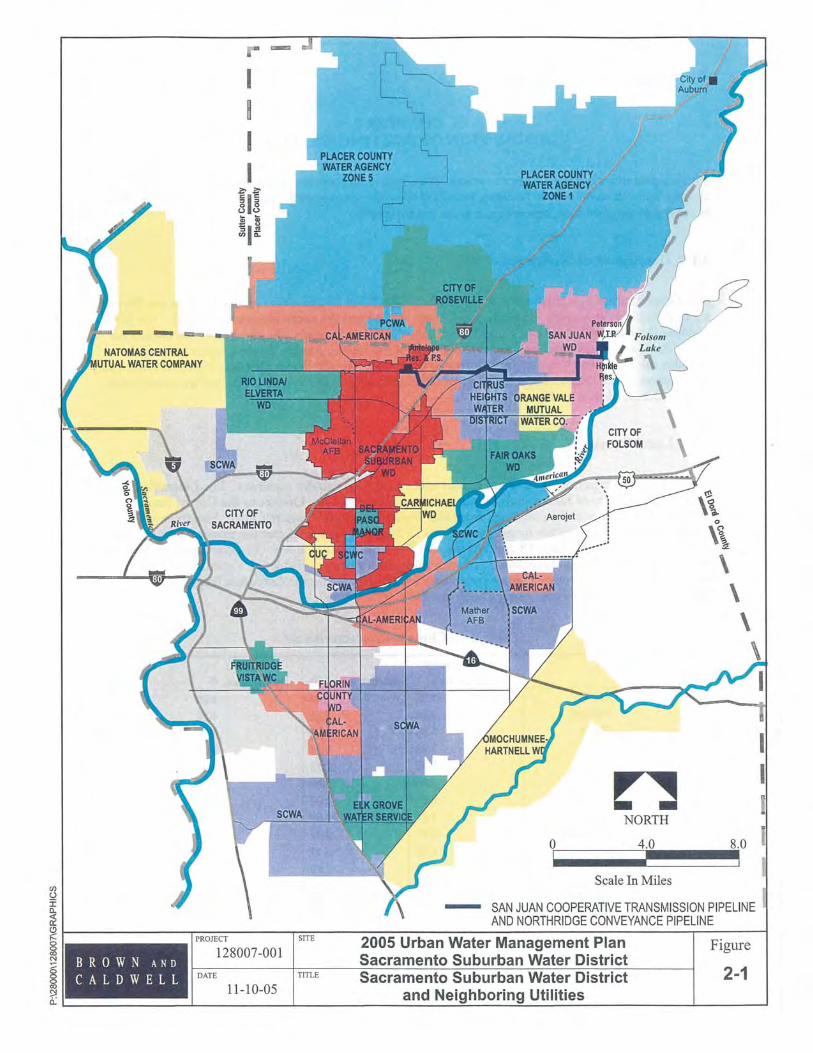
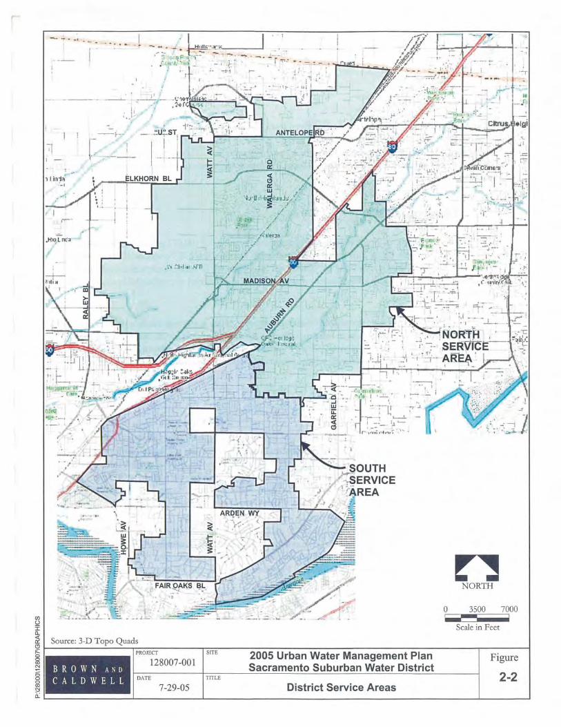
The Distrct serves a popultion of approxiately 170,000 in Sacramento County. With the Distrctare two major servce areas, the nort servce area (NSA) and the south servce area (SSA). The NSAincludes the former Nortdge Water Distrct, the Capehar housing area, the former McClellan AiForce Base, and the Nort Highlnds servce area of the former Arcade Water Distrct. The SSAincludes the Town and Countr servce area of the former Arcade Water Distrct. Fige '2-1 ilustratesthe location of the Distrct's servce area and the neighborig water systems. The servce areas withthe Distrct are shown on Fige 2-2.
2.2 Local Cliate
The servce area experiences cool and humd witers and hot and dr sumers. The Distrct's weatheris sim to the City of Sacramento because of the proxity of the Distrct to the City of Sacramento.Based on the historical data obtaied from the Western Regional Cliate Center, Sacramento'saverage monthy temperatue ranges from 46 to 75 degrees Fahrenheit, but the extreme low and highdaiy temperatues ,have been 18 and 115 degrees Fahenheit, respectively. The combination of hotand dr weather results in high water demands durg the sumer. Table 2-1 sumares the iSacramento Region's average cliate conditions for 2004 based on the Californa Irtion
Management Information System (CIMIS) database.
~Table 2-1. Climate Characteristicsa
Standard average AverageETob, in Averaqe rainfall, in temperature, of
January 1.59 2.44 46.0February 2.20 5.40 49.9March 3.66 0.95 60.0April 5.D8 0.24 61.9May 6.83 0.13 66.1
-June 7.80 0.00 71.8July 8.67 0.02 75.2
August 7.81 0.00 74.6
September 5.67 M3 71.,6
October 4.03 3.49 61.0
November 2.13 2.70 51.2
December 1.59 5.14 46.8
Annual 4.76 20.5 61.3· 2004 Data recorded from Sacramento Valley, Fair Oaks station 131, CIMIS www.cimis.water.ca.i¡ovb Data a\'eraged since initial 1997 record, ETa (evapotranspiration), is the loss of water fromthe soil both by evaporation and by transpiration from the plants growing thereon.
P:\28000\128007-SSWD UWMP\200S UWMP\SSWD UWMP Master,doc
Urban Water Management PlanSacramento Suburban Water District
Page 2-4
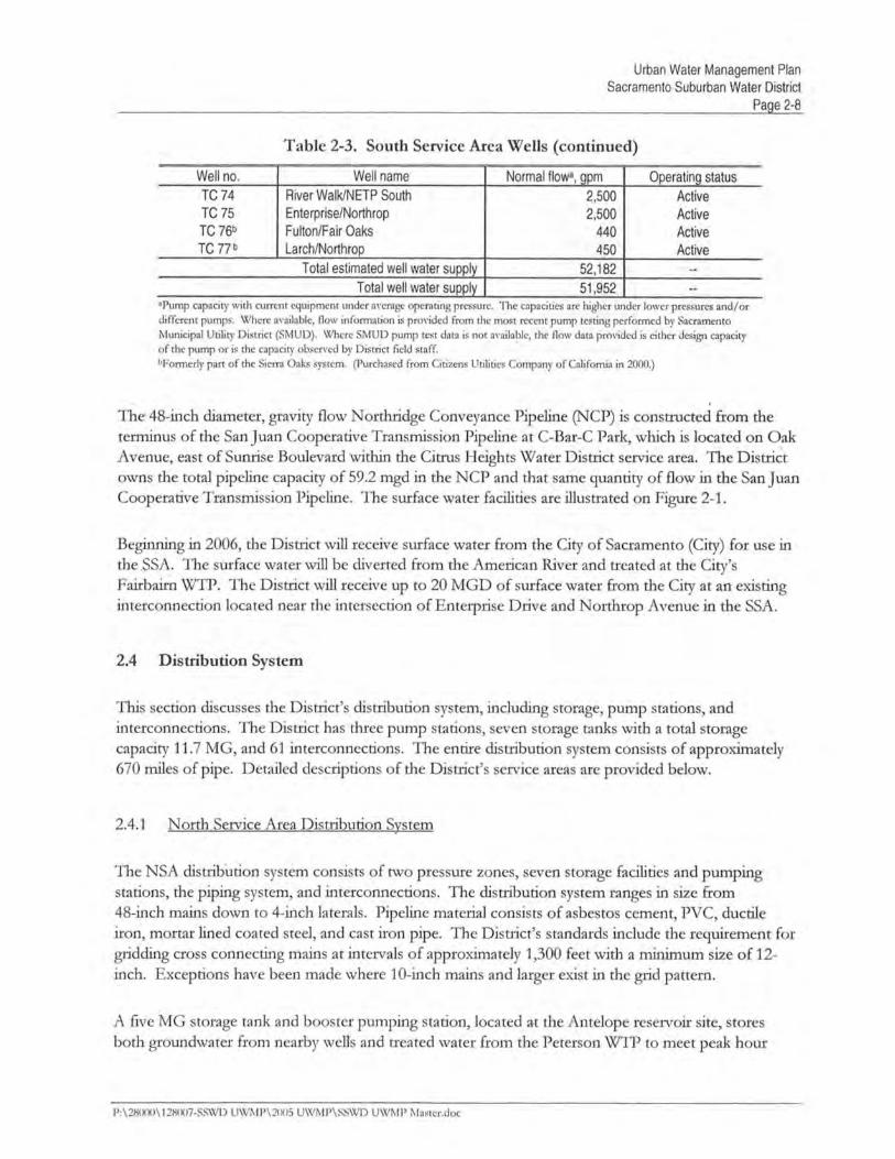
2.3 Water Supply Facilties
Water supply for the Distrct is curendy derived from active groundwater wells and surface water fromFolsom Reservoir. In the futue the Distrcts water supply wi also include water from the American
River from the City of Sacramento's Faibai water treatment plat. Ths section describes the
Distrct's wells and surface water facilties. Fige 2-3 depicts the locations of the key water systemfacilties.
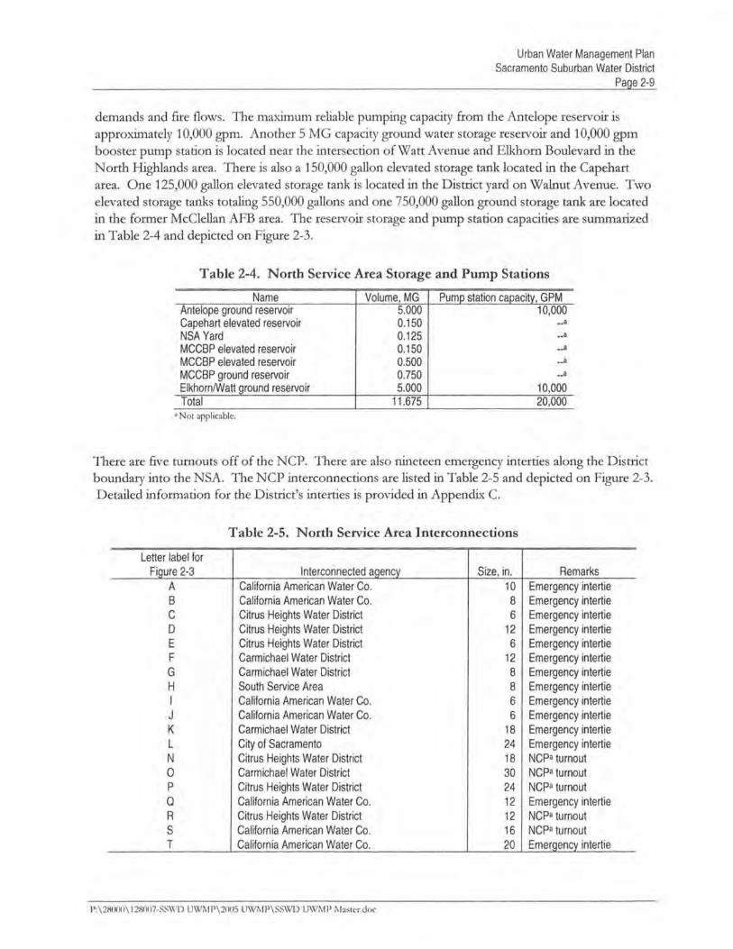
2.3.1 Groundwater Facilties
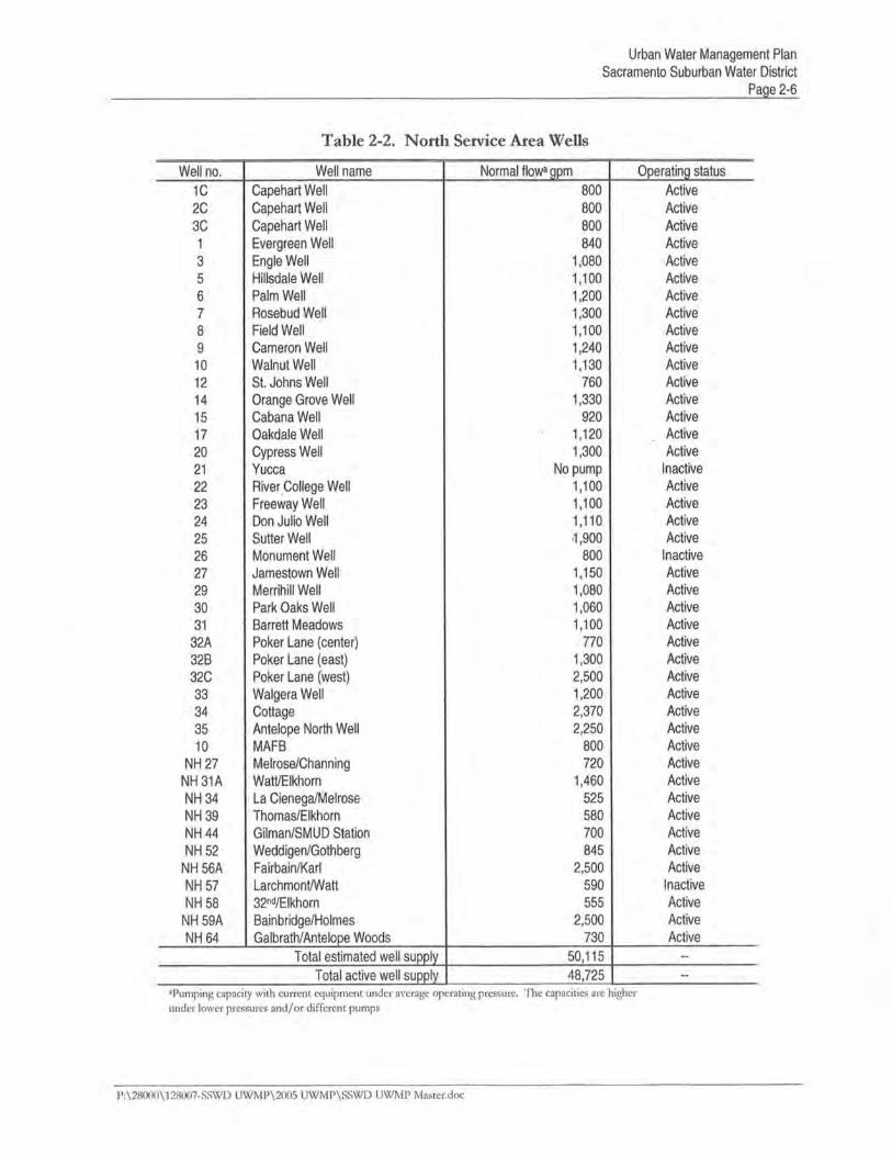
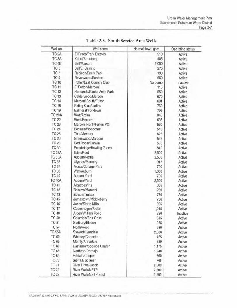
The Distrct has a tota of 91 active wells with a combined capacity of 100,677 galons pet; miute
(gm). Al of the wells pump diecdy into the distrbution system. The NSA contais 41 active wellswith a combined capacity of 48,725 gpm. With the SSA there are 50 active wells with a combined,capacity of 51,952 gpm. The groundwater production system is desiged to provide 100 percent of thesystem demand.
Tables 2-2 and 2-3 sumare the capacity and characteristics of the active and inactive wells in theDistrct. The term "active" is used to refer to wells that are fuy operational and used for water supplywith the Distrct. The term "inactive" is used to refer to wells that are not curendy operational andcannot contrbute to the Distrct supply without some tye of additional maitenance, upgrade, ortreatment prior to use.
2.3.2 Surface Water Facilties
Surface water from PCW A is used as a conjunctive supply for the NSA to help aleviate the demand onthe groundwater aquifer. The surface water is diverted from Folsom Lake and treatment is providedby the Sydney N. Peterson Water Treatment Plant (WTP). The Peterson WTP is owned and operatedby San Juan Water Distrct. The San Juan Water Distrct also supplies treated surface water fromFolsom Reservoir for a famy of water entities (San Juan Water Distrct, Orange Vale Water Company,Citrs Heights Water Distrct, City of Folsom, and Fai Oaks Water Distrct).
The Peterson WTP has a nomial capacity of 120 mion gallons per day (MGD) and transports thetreated water to the Hie Reservoir, which has 62 mion gallons (JG) of storage capacity. Fromthe Hinkle Reservoir, the potable surface water supply for the Distrct is delivered by gravity flowthough the San Juan Cooperative Transmission Pipelie followed by the Northdge ConveyancePipelie.
P:\28000\128007-SSWD UWMP\2005 UWMP\SSWD UWMP Master.doc

CHAER 3HISTORICAL AND PROJECTED WAT:~R USE
Water demand projections along with fieflow requiements provide the basis for sizing and stagigfutue water facilties. Water use and production records, combined with projections of popultion,employment, and urban development, provide the basis for estiatig futue water supply
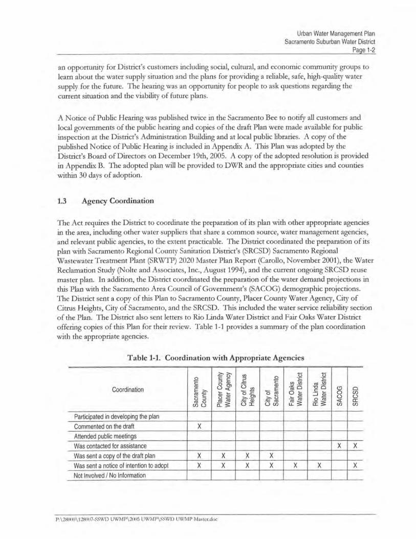
requiements; Ths chapter presents an analysis of avaiable demographic and water use data, customercoiiections, historical groundwater and surface water production, unt water use, and the resultigprojections for futue water supply needs for the Distrct.
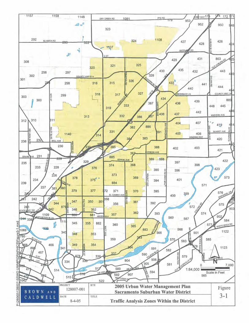
3.1 Population, Employment, and Housing
Projected popultion, employment, and housing estiates (dwellg unts (DU)) for the Distrct servce
area are based on estiates from the Sacramento Area Council of Governents (SA COG). Made infive-year increments, the projections begi in 2005 and extend to' the year 2025. These demographicprojections are used to develop estiates of futue Distrct water use. Projected SACOG demographicdata presented by traffic analysis zone (TAZ) are used for ths study. Figue 3-1 shows the TAZswith the Distrct.
The Distrct boundares do.not fal along TAZ boundares in al cases~ As a result, an estiate wasmade regadig how much of a given TAZ is with the Distrct servce area. Appendi D contais alist of the TAZs and the correspondig estiate of the propoli:onal amount of each TAZ with theDistrct. Iri most cases it is assumed that the population, housing, and employees with a TAZ aredistrbuted unformy wi~ al pars of that TAZ.
SACOG projections used in ths Plan were approved by the SACOG Board of Directors in December2004. SACOG's projections are based on curent growt data and region-level near-term projectionsthat have been published recently. These projections are based on data from the followig sources:
. The u.s. Census Bureau's 2000 census of population and housing
. Annual housing and population estiates for years 2000-2004 from the Californa State
Department of Finance (DOF), Demographic Research Unit (DRU). InfoUSA 2004 employment data
. Projections of employment, population, and households to 2012, from the 2004 annual report of
the Center for the Contiuig Study of the Californa Economy (CCSCE). Current General Plan data used in the Sacramento Region Blueprit Project
P: \28000\ 128007-SS\XD U\xMP\2005 UWP\SS\X UWMP Master.doc
Urban Water Management PlanSacramento Suburban Water District
Page 3-3
The demographic projections in the Distrct's 2003 UW were based on SACOG's 2001demographic projections. SACOG updated their 2001 projections in December 2004. The previous2001 projections were based on data from SACOG's housing inventory data, and from the 1990census. For the popwation and household projections, the new baselie stars with householdcharacteristics, the number of persons, and their spatial location as recorded in the 2000 Census. Inconswtation with the plannig staff of SACOG's member jursdictions, al avaible officia planngdocuments were used to estiate the location and amount of growth though 2005. For employment,the 2004 estiates from InfoUSA were the priar source, (SACOG, 2004).
Some differences in the demographic projections in ths Plan compared to the 2003 Plan are that thepersons per household (PPH) are down considerably. Accordig to SACOG, the census 2000 shows acontiued declie in household size due to a variety of social and economic factors. The PPH is notgeographicaly homogenpus since it includes housing tye and other important socio-economicvarables.
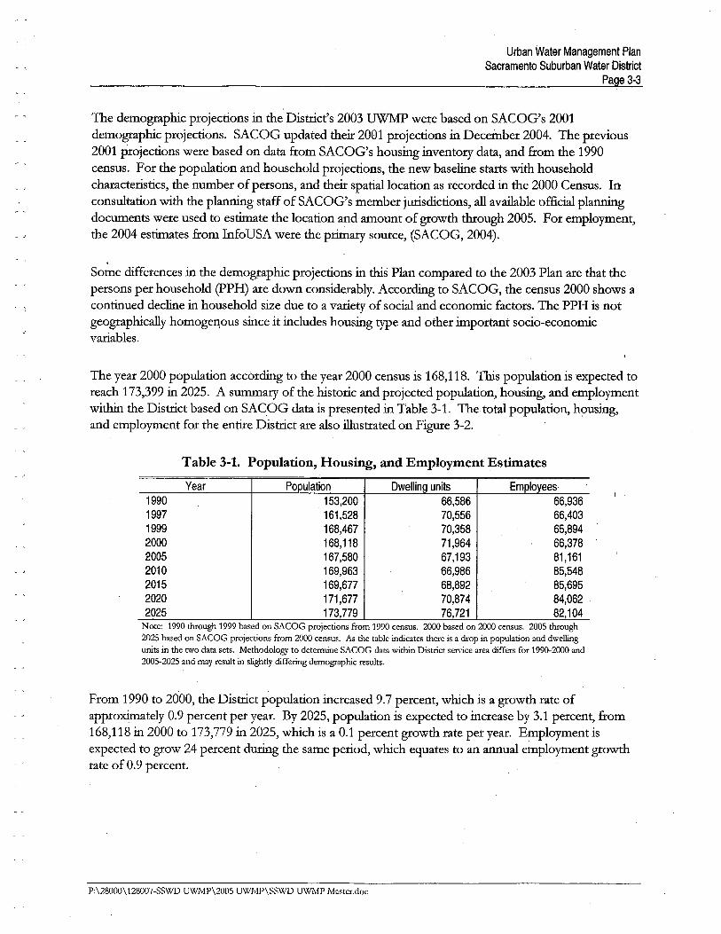
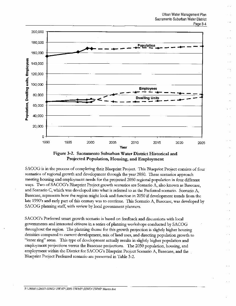
The year 2000 popultion accordig to the year 2000 census is 168,118. TIs popwation is expected toreach 173,399 in 2025. A sumary of the historic and projected popwation, housing, and employmentwith the Distrct based on SACOG data is presented in Table 3-1. The total popwation, housing,and employment for the entie Distrct are also ilustrated on Fige 3-2.
Table 3-1. Population, Housing, and Employment Estimates
Year Population DwellnQ units Employees1990 153,200 66,586 66,9361997 161,528 70,556 66,4031999 168,467 70,358 65,8942000 168,118 71,964 66,3782005 167,580 67,193 81,1612010 169,963 66,986 85,5482015 169,677 68,892 85,6952020 171,677 70,874 84,0622025 173,779 76,721 82,104
Note: 1990 through 1999 based on SACOG projections from 1990 census. 2000 based on 2000 census. 2005 though2025 based on SACOG projections from 2000 census. As the table indicates there is a drop in population and dwellgunits in the two data sets. Methodology to determne SACOG data within Distrct service area differs for 1990-2000 and2005-2025 and may result in slightly differing demographic results.
Prom 1990 to 2000, the Distrct popwation increased 9.7 percent, which is a growth rate ofapproxiately 0.9 percent per year. By 2025, popwation is expected to increase by 3.1 percent, from168,118 in 2000 to 173,779 in 2025, which is a 0.1 percent growth rate per year. Employment isexpected to grow 24 percent durg the same period, which equates to an annual employment growthrate of 0.9 percent.
P:\28000\128007-SSWD UWMP\2005 UWMP\SSWD UWMP Master.doc
Urban Water Management PlanSacramento Suburban Water District
Page 3-4
200,000
180,000
160,000
lØ~ 140,0000isE 120,000w
~c 100,000~Dl
:É
~ 80,000cê 60,0000~'3Cl 40,0000Q.
20,000
.. ..o~a~n _ _ .. _ _ _- - - .. - - ..~....
Employees~ - - .. - - .. - - .. - - .... .c"" Dwellng Units .. _ - ....- _ .. _ __ .. _ __ .. __ ii~
o
1990 1995 2000 2005 2010 2015 2020 2025Year
Figure 3-2. Sacramento Suburban Water District Historical andProjected Population, Housing, and Employment
SACOG is in the process of completig their Blueprit Project. Ths Blueprit Project consists of fourscenaros of regional growt and development though the year 2050. These scenarios approachmeetig housing and employment needs for the projected 2050 regional population in four differentways. Two of SACOG's Blueprit Project growt scenaros are Scenaro A, also known as Basecase,and Scenario C, which was developed into what is referred to as the Preferred scenaro. Scenaro A,Basecase, represents how the region might look and fuction in 2050 if development trends from thelate 1990's and eary par of ths centu was to contiue. Ths Scenaro A, Basecase, was developed by
SACOG planng staff, with review by local governent planers.
SACOG's Preferred smar growt scenaro is based on feedback and discussions with localgovernents and interested citiens in a series of planng workshops conducted by SACOGthoughout the region. The plang theme for ths growt projection is slightly hiher housingdensities compared to curent development, mi of land uses, and diectig population growt to
"iner rig" areas. Ths tye of development actually results in slightly hiher population and
employment projections versus the Basecase projections. The 2050 population, housing, andemployment with the Distrct for SACOG's Blueprit Project Scenario A, Basecase, and theBlueprit Project Preferred scenario are presented in Table 3-2.
P:\28000\128007-SSWD UWP\200S UW\SSWD UWP Master,doc
Urban Water Management PlanSacramento Suburban Water District
Page 3-8
3.2.2 Unaccounted-for Water
Unaccounted-for water use is unmetered water use such as for fie protection and traig, system and
street flushig, sewer cleanig, constrction, system leaks, and unauthoried connections.Unaccounted-for water can also result from meter inaccuracies. Since the Distrct is not completelymetered, data are unavaiable for determg the percent of unaccounted-for water. Unaccounted-forwater is assumed for ths study to be approxiately 10 percent of total water production.
'l
3.3 Unit Water Use
Unit water use factors are developed to estiate futue water needs based on the housing andemployment projections discussed previously. There are two mai categories of water users used toestiate futue water needs, residential and nonresidentiaL. Residential futue water needs are
detenned using the projections for dwellg unts with the Distrct, coupled with a unit water use
factor per dwellg unit. Nonresidential futue water needs are detenned using the projections foremployment with the Distrct, coupled with a unit water use factor per employee. Studies show thereis a good correlation between nonresidential water use and number of employees .(California UrbanWater Agencies, 1992).
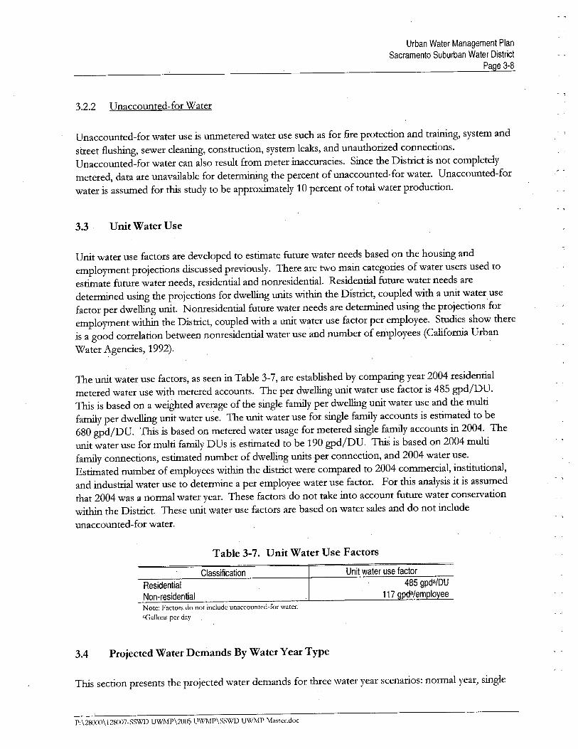
The unt water use factors, as seen in Table 3-7, are established by comparig year 2004 residentialmetered water use with metered accounts. The per dwellg unit water use factor is 485 gpdjDU.11s is based on a weighted average of the single famiy per dwellg unit water use and the multifamiy per dwellg unit water u~e. The unit water use for single famiy accounts is estiated to be680 gpdjDU. 11s is based on metered water usage for metered single famiy accounts in 2004. Theunit water use for multi famiy DUs is estiated to be 190 gpdjDU. 11s is based on 2004 multifamiy connections, estiated number of dwellg units per connection, and 2004 water use.Estiated number of employees with the distrct were compared to 2004 conuercial, institutional,and industral water use to detenne a per employee water use factor. For ths analysis it is assumedthat 2004 was a normal water year. These factors do not take into account futue water conservationwith the Distrct. These unit water use factors are based on water sales and do not include
unaccounted-for water.
Table 3-7. Unit Water Use Factors
Classification
117ResidentialNon-residentialNote: Factors do not include unaccounted-for water."Gallons per day
3.4 Projected Water Demands By W ater Year Type
11s section presents the projected water demands for three water year scenarios: noimal year, single
P:\28000\128007-SS'vílD UWMP\2005 UWMP\SSWD UWMP Master.doc
Urban Water Management PlanSacramento Suburban Water District
Page 3-9
dr year, and multiple dr year. The demands for all water year scenarios are projected though 2025.
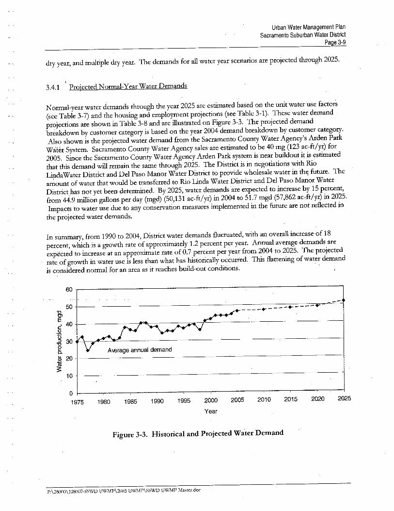
3.4.1 Projected Normal-Year Water Demands
Normal-year water demands though the year 2025 are estiated based on the unit water use factors(see Table 3-7) and the housing and employment projections (see Table 3-1). These water demandprojections are shown in Table 3-8 and are ilustrated on Figue 3-3. The projected demandbreakdown by customer category is based on the year 2004 demand breakdown by customer category.Also shown is the projected water demand from the Sacramento County Water Agency's Arden Parkwàter System. Sacramento County Water Agency sales
are estiated to be 40 mg (123 ac-ft/yr) for
2005. Since the Sacramento County Water Agency Arden Park system is near buid out it is estiated
that ths demand wi remai the same though 2025. The Distrct is in negotiations with Rio
LidaWater Distrct and Del Paso Manor Water Distrct to provide wholesale water in th~ futue. Theamount of water that would be transferred to Rio Lida Water Distrct and Del Paso Manor WaterDistrct has not yet been determed. By 2025, water demands are expected to increase by 15 percent,from 44.9 mion gallons per day (mgd) (50,131 ac-ft/yr) in 2004 to 51.7 mgd (57,862 ac-ft/yr) in 2025.Impacts to water use due to any conservation measures implemented in the futue are not reflected inthe projected water demands.
In sumary, from 1990 to 2004, Distrct water demands fluctuated, with an overall increase of 18percent, which is a growth rate of approxiately 1.2 percent per year. Annual average demands are
expected to increase at an approxiate rate of 0.7 percent per year from 2004 to 2025. The projectedrate of growth in water use is less than what has historically oCCUlTed. 1bs flattenig of water demandis considered normal for an area as it reaches buid-out conditions.
+- - - - -.. - -- -+---1"---..--
A \erage annual demand
1980 1985 1990 1995 2000 2005 2010 2015 2020 2025
Year
Figure 3-3. Historical and Projected Water Demand
P:\28000\128007-SSWD U\Xli\lP\200S UWMP\SSWD UWMP Master.doc
Urban Water Management PlanSacramento Suburban Water District
Page 3-10
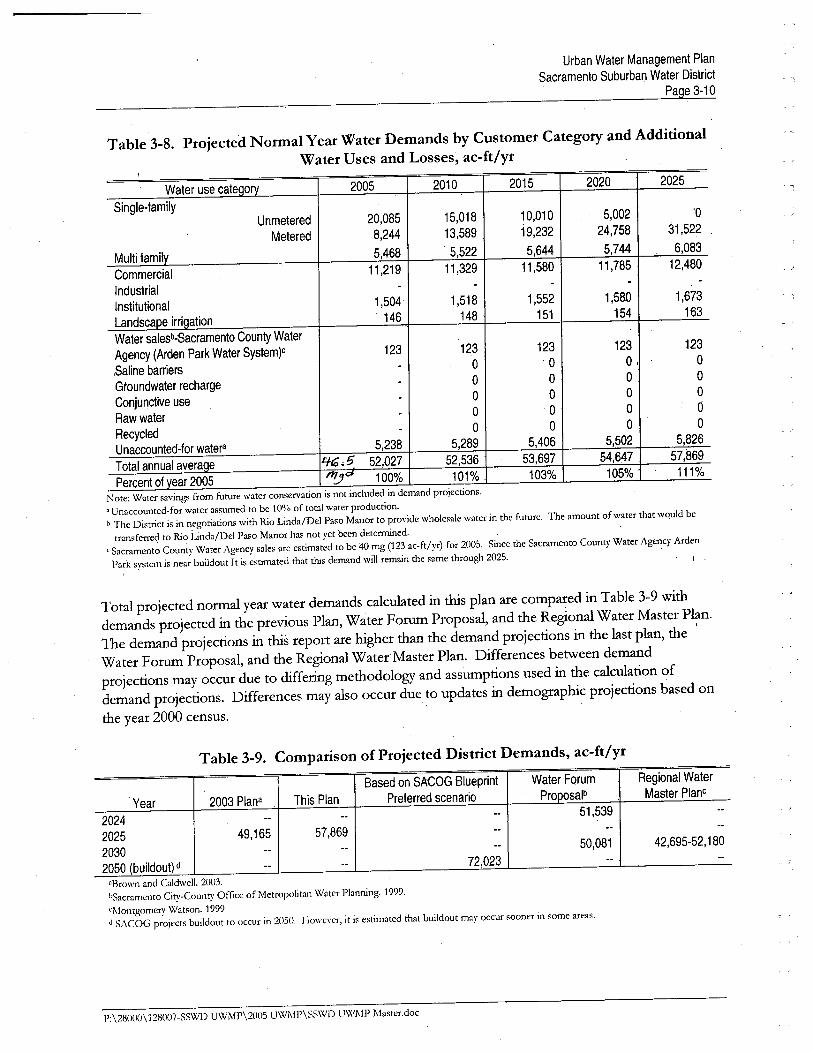
Table 3-8. Projected Normal Year Water Demands by Customer Category and AdditionalWater Uses and Losses, ac-ft/yr
- ,
Water use cateQorv 2005 2010 2015 2020 2025
Single-familyUnmetered 20,085 15,018 10,010 5,002 '0
Metered 8,244 13,589 19,232 24,758 31,522
Multi family 5,468 ' 5,522 5;644 5,744 6,083
Commercial 11,219 11 ,329 11 ,580 11,785 12,480
Industrial- - - - -
Institutional 1,504 1,518 1,552 1,580 1,673
Landscape irriQation 14£ 148 151 154 163
Water salesb-Sacramento County Water
Agency (Arden Park Water System)c 123 123 123 123 123
,Saline barriers- 0 0 0, 0
Gtoundwater recharge- 0 0 0 0
Conjunctive use- 0 0 0 0
Raw water- 0 0 0 d
Recycled- 0 0 0 0
Unaccounted-for watera5,238 5,289 5,406 5,502 5,826
Total annual average 4~ J; 52,()27 52,536 53,697 54,£7 57,89
Percent of year 2005 "! 01 100% 101% ' 103% 105% 111%
Note: Water saving. from future water conservation is nor included in demand projections,'Unaccounted-for water assumed to be 1 0°/0 of total water production,ii The District is in negotiations with Rio Linda/Del Paso Manor to provide wholesale water in the future, The amount of water that would be
transferred to Rio Linda/Del Paso Manor has not yet been determned.c Sacramento County Water Agency sales are estimated to be 40 mg (123 ac-ft/yr) for 2005, Since the Sacramento County Water Agency Arden
Park system is near buildout i t is estimated that this demand will remain the same through 2025. '
Total projected normal year water demands calculated in ths plan are compared in Table 3-9 withdemands projected in the previous Plan, Water Forum Proposal, and the Regional Water Master Plan.The demand projections in ths report are higher than the demand projections in the last plan, the 'Water Foru Proposal, and the Regional Water
Master Plan. Differences between demand
projections may occur due to differig methodology and assumptions used in the calculation ofdemand projections. Differences may also occur due to updates in demographic projections based onthe year 2000 census.
Based on SACOG Blueprint Water Forum Regional Water
Year 2003 Plana This Plan Preferred scenario Proposalb Master Plane
2024 -- -- -- 51,539 --
2025 49,165 57,869 -- -- --
2030 -- -- -- 50,081 42,695-52,180
2050 (buildout) d-- -- 72,023 -- --
Table 3-9. Comparison of Projected District Demands, ac-ft/yr
'Brown and CaldwelL. 2003,bSacramento City-County Office of MetropoLtan Water Planning. 1999,
'J\lontgomery Watson, 1999d SACOG projects buildout to occur in 2051.L. Howewr, it is estimated that buildout may occur sooner in some areas,
P:\28000\128007-SSWD UWMP\2005 UWMP\SSWD U\XIMI' Master.doc
Urban Water Management PlanSacramento Suburban Water District
Page 3-11
3.4.2 Projected Single-Dry YearWater Demands
" , Water use patterns change durg dr years. Durg dr years some water agencies cannot provide
their customers with 100 percent of what they deliver durg normal water years. One way to analyzethe change in demand is to document e:Kpected changes to water demand by sector. Expected changesin demand may include assumig increasing demands due to increased in-igation needs and demandreductions resultig from rationig programs and policies. It is assumed that overall demands wi notchange durg a single dr year. Any demand reductions due to the implementation of the Distrct'swater shortage contigency plan are not included in the single dr year demand estiates. Table 3-10provides a estiate of the projected single-dr
year water demands.
2005 2010 2015 2020 2025
Total demand 52,027 52,536 53,697 54,647 57,869
Percent of projected normala 100% 100% 100% 100% 100%
Table 3-10. Projected Single Dry Year Water Demands, ac-ft/yr
Note: Water savings from future water conservation is not included in demand projections.'Projected normal from Table 3-8.
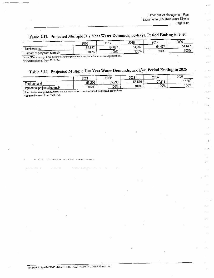
3.4.3 Projected Multiple-Dry Year Water Demands
Ths section projects the impact of a multiple dr year pei-iod for each 5-year period durg the 20-yearprojection. It is assumed that overall demands wi not change durg a multiple dr year. Any demandreductions due to the implementation of the Distrcts water shortage contigency plan are notincluded in the multiple dr year demand estiates. Tables 3-11 though 3-14 provide an estiate ofthe projected multiple-dr year water demands for each 5-year period.
Table 3-11. Projected Multiple Dry Year Water Demands,ac-ft/yr, Period Ending in 2010
2006 2007 2008 2009 2010
Total demand 52,129 52,230 52,332 52,434 '52,536
Percent of proiected norrñala100% 100% 100% 100% 1QO%
Note; Water savings from future water consen'ation is not included in demand projections,'Projected normal from Table 3-8.
Table 3-12. Projected Multiple Dry Year Water Demands, ac-ft/yr, Period Ending in 20152011
i2012
i2013
i 2014 i 2015
Total demand 52,768 53,000 53,233 53,465 53,697
Percent of projected normala 100% 100% 100% 100% 100%
Note; Water savings from future water conservation is not included in demand projections."Projected normal from Table 3-8.
P:\2Hll(Jll\128007-S~WD UWMP\20ll5 UWMP\SS\,(1) UWI\lP Master.doc
Urban Water Management PlanSacramento Suburban Water District
Page 3-12
Table 3-13. Projected Multiple Dry Year Water Demands, ac-ft/yr, Period Ending in 2020.~ '1
2016i
2017i
2018i 2019 i 2020
Total demand 53,887 54,077 , 54,267 54,457 54,647
Percent of projected normala 100% 100% 100% 100% 100%
Note: Water savings from future water conservation is not included in demand projections.aprojected normal from Table 3-8,
Table 3-14. Projected Multiple Dry Year Water Demands, ac-ft/yr, Period Ending in 2025. i I I i
2021 2022 2023 2024 2025
Total demand 55,290 55,933 56,576 57,219 57,869
Percent of projected normala 100% 100% 100% 100% 100%
Note: Water savings from future water conservation is not included in demand projections.'Projected normal from Table 3-8.
P:\28000\128007-SS\XID UWMP\2005 UWMP\SS\xID UWMP Mastcr.doc
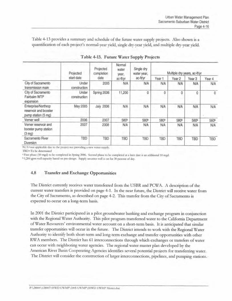
CHAPTER 4WATER SUPPLIES
The Distrct uses both surface water and groundwater as its supply sources. Ths section describes thesurface and groundwater sources, quantities, supply constraits, and the water quality of the water ,supply sources. In addition, ths section describes curent and projected water supplies, water supply
reliabilty and vuerabilty, water shortage expectations, and water shortage revenue and expenditueimpacts. Recycled water is discussed in Chapter 5 of ths Plan.
4.1 Sunace Water
Ths section provides a description of the Distrct's surface water supply as well as the physical andlegal constraits of ths supply. Curently, the Distrct receives surface water from Folsom Lake viSan Juan Water Distrct in the nort servce area. Begig in mid-2006, the Distrct wi begireceivig surface water from the American River via the City of Sacramento in the south servce are~.
4.1.1 Description
In 1991, the NSA began using surface water in lited quantities. Surface water use sigficantly
expanded in 1998 with the completion of the Conveyance and Cooperative Transmission Pipelie.Surface water use in lieu of groundwater pumping has increased signficantly over the last few years tomeet approxiately 60 to 70 percent of the NSA demand (30 percent of the Distrcts overall dem~nd).The Distrct continues to use surface water to meet a substantial fraction of its overal water demand.Surface water supplies have included surface water from Placer County Water Agency (pCW A),
_section215 Central V aleyPrQject (CVP)wJlt~r from the ,United State,s, Bureau of Reclamation '(USBR),-- ---- _.._,-----
smplus water from SanJuan Water Distrct on an as-avaiable basis, and a short-term transfer from'Nevada Irrgation Distrct (NID). -"
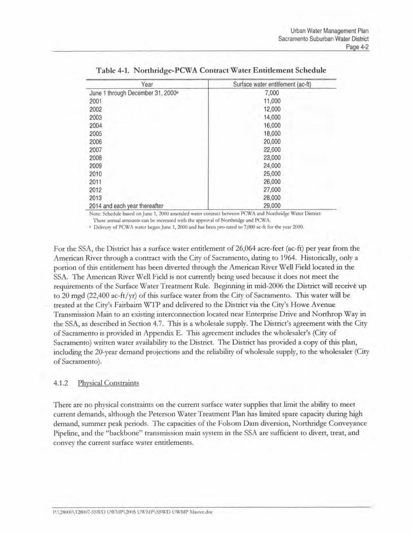
The NSA began receivig surface water from PCW A via PCW A's Middle Fork Project in 2000. Theformer Nortdge Water Distrct and PCW A entered into a take or pay agreement for delivery of upto 29,000 ac-ft ofPCWA's water right, per year. The agreement increases from 7,000 ac-ft per yearstartig in the year 2000 to 29,000 ac-ft per year in 2014. The 29,000 ac-ft per year wi be maitaiedthough the twenty-fifth year of the agreement. Ths water is not avaiable in dr years. The terms ofthe agreement can be extended bymutual consent of both partes. The Nortdge-PCWA contractentitlement schedule is shown in Table 4-1. In addition, the Distrct has an annual Warren Actcontract with ongoing negotiations for a long term contract that allows the use of USBR facilties to"wheel" the PCW A water to the Distrct.
Since 1991, the NSA has received a nomial amount of Section 215 USBR CVP water. Section 215
water is surlus or "spilway" water available typically in winter and sprig. This water has been treatedat the Peterson WTP and delivered for use with the NSA. The District is eligible to purchase thssurplus water in average water years.
1':\280(1)\ 128007-SSWD UWMP\2005 UWi\I1'\SSWD UWM1' Master.doc
Urban Water Managment PlanSacramento Suburban Water District
Page 4-5
- )
" "I
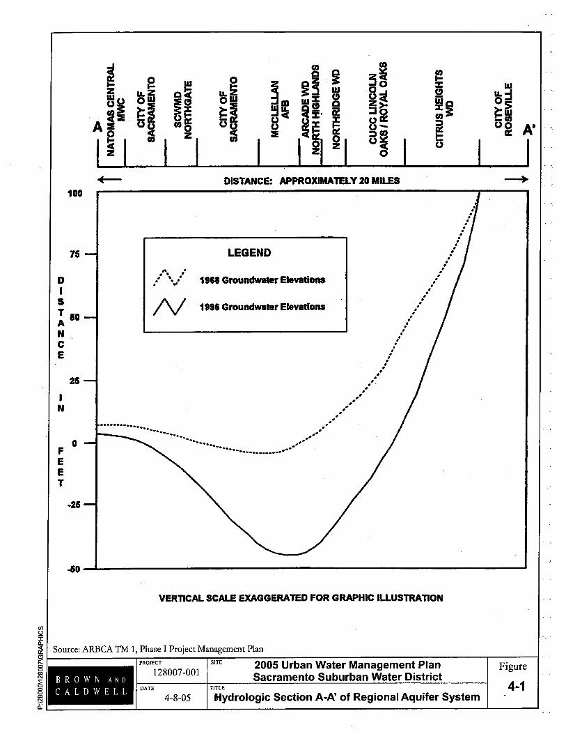
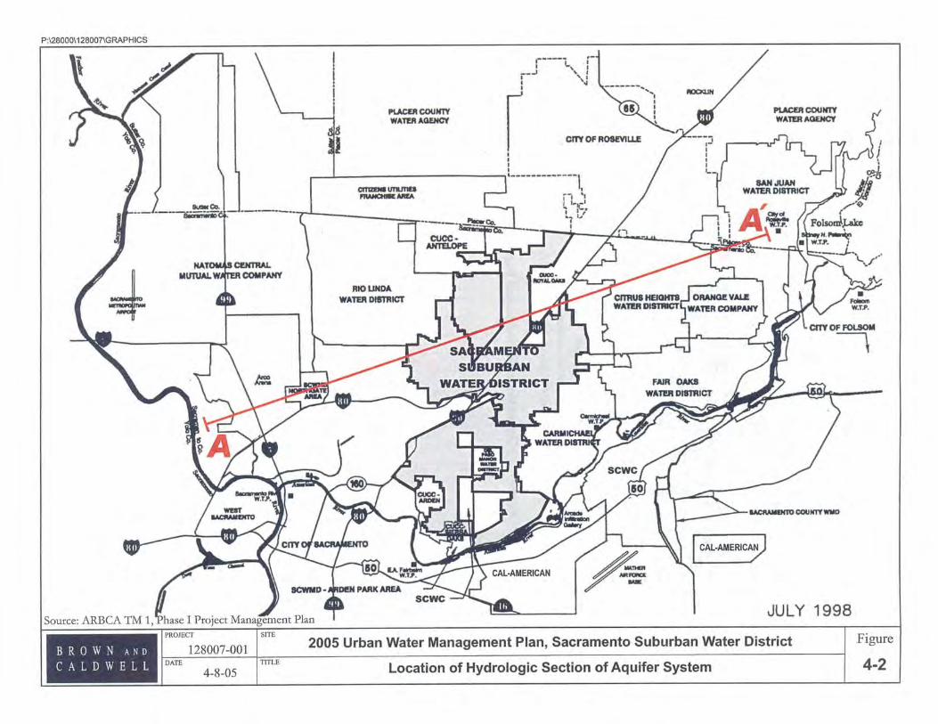
on the hydrologic cross section depictig the change in watet levels on Figue 4-1. Groundwater levelsunder the NSA have dropped approxiately 40 feet from 1968 to 1996. The location of cross-sectionA-A'is shown on Fige 4-2.
- 1
-- 1l
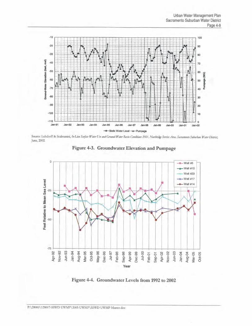
The Distrct has an in lieu pumping recharge program in place. Ths program involves the importtionof surface water to offset groundwater usage. Resultig in the local recovery of groundwater levelsthoughout the NSA. Accordig to alune, 2002 report prepared by Luhdorff and Scalfor the
NSA, the Distrct has observed an increase in groundwater elevations of up to 20 feet as a result of itsimporttion of treated surface water. Groundwater levels contiue to fluctuate seasonaly, as are
tyíëäly observed, but also appear to have stabiled or slightly increased since 1998. As an example,
Fige 4-3 shows the reduction in pumping and the resultant recovery of groundwater levels in theDistrct's Walut Well (Well 10).
.. -",.
- ì
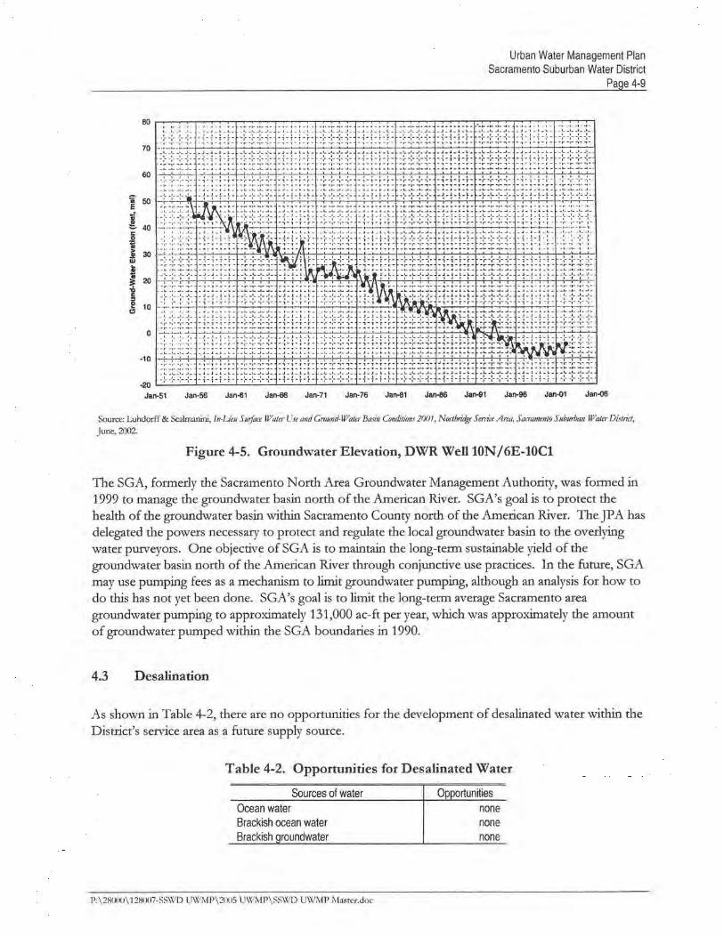
G~o~dwater elevation levels plotted for selected Distrct wells for the sprig and fal months for theyears 1992 though 2005 are shown on Fige 4-4. Ths graph indicates a faily stable water table f01)those ten years, due in par to the use of surface water and decreased use of groundwater in the NSA.
_ J
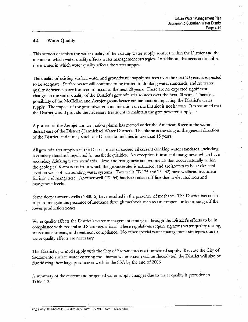
DWR monitors several wells in and around the Distrct. The Luhdorff and ScalaniJune 2002report ilustrates several hydrographs from these DWR monitored wells which indicate the dramatic
declie in water levels over the last 50 years and the relative stabilation of water levels since the eary1990's. Figue 4-5 shows a hydrograph of water levels from 1955 to 2002 from DWR Well 10N/6E-1 OC1, which is located approxiately two mies nort of the NSA.
- ,
i i.
, ¡
Water level data for the SSA wells, datig back as far as May of 1940 in one case; indiate a generaldeclie of groundwaterlevels consistent with the rest of the County.
- 1 , r
A review of groundwater pumping and groundwater levels over the last five years shows that
groundwater supplies are sufficient when supplemented with a'surface water supply to meet totademands. Ths is demonstrated by stabiling the groundwater levels due to the reduction in
groundwater pumping.
4.2.2 Physical Constraits
The physical con5trait on the curent groundwater supply is the pumping capacity of eXistig wells.The pumping capacity of the Distrct wells is sufficient to supply the Distrct's total demand.
4.2.3 Legal Constraints
There are no legal constraints that lit groundwater pumping. The Distrct is a stakeholder in theSGA which may result in futue groundwater legal constraints.
P:\28000\128007-SSWI) UW1\lP\2005 'UWMP\SSWI) UWMP Master,doc
l/t):iQ.
~ Source: ARBCA TM 1, Phase I Project Management PlanCli:ooco'"~6ooco!)Ii
DI
ST 50ANCE
I
N
FEET
~ gZ u.Z~~ OW~:I ~I
A:I Uu2 ~l.
U)
3~0°~~:Jou£íu-G~
o
f!%(!
!~~õ
en
~l !w% (!(! ai:¡. æ~~ ~l1
~u.w
~IUu~
a~l~
i.ii
~~SuU:I
I
+- DISTANCE: APPROXIMATEY 20 MILES100
75
......:........................................,.,,
, ,,.,,",,,
..'....',.'."
......... ...... ...__...-ø....
LEGEND
.. .,. ,. . .. .,. .. 1961 Groundwatr Eleva
N 1996 Groundwar Elevatons
25
o
.. .............. ...............
......
-25
.ao
VERTICAL SCALE EXGGERATED FOR GRAPHIC ILLUSTRTION
PROJECT SITE 2005 Urban Water Management PlanSacramento Suburban Water DistrictBROWN AND
CALDWELL
128007-001
DATE TITLE
Hydrologic Section A-A' of Regional Aquifer System4-8-05
wu. ::0-~Gj- (Iua A'
I - '1--
Figure
4-1
Urban Water Management PlanSacramento Suburban Water District
Page 4-10
4.4 Water Quality
This s~ction describes the water quality of the existig water supply sources with the Distrct and themanner in which water quality affects water management strategies. In addition, ths section describesthe manner in which water quality affects the water supply.
The quality of existig surface water and groundwater supply sources over the next 20 years is expectedto be adequate. Surface water wi contiue to be treated to drg water standards, and no waterqmility deficiencies are foreseen to occur in the next 20 years. There are no expected signficantchanges in the water quality of the Distrct's groundwater sources over the next 20 years. There is apossibilty of the McClellan and Aerojet groundwater contamiation impactig the Distrct's watersupply. The impact of the groundwater contamiation on the Distrct is not known. It is assumed thatthe Distrct would provide the necessary treatment to maitai the groundwater supply. '
A porton of the Aerojet contamation plume has moved under the American River in the waterdistrct east of the Distrct (Carmchael Water Distrct). The plume is travelig in the general diectionof the Distrct, and it may reach the Distrct boundaries in less than 15 years.
All groundwater supplies in the Distrct meet or exceed all curent drg water standards, includigsecondary standards regulated for aesthetic qu'alities. An exception is iron and manganese, which havesecondary drkig water standards. Iron and manganese are two metals that occur natually withthe geological formations from which the groundwater is extracted, and are known to be at elevatedlevels in wells of surroundig water systems. Two wells (TC 75 and TC 32) have wellead treatmehtfor iron and manganese. Another well (TC 54) has been taken off-lie due to elevated iron andmanganese levels.
Some deeper system wells (? 800 ft) have resulted in the presence of methane. The Distrct has takensteps to mitigate the presence of methane though methods such as ai strppers or by capping off thelower production zones.
Water quality affects the Distrct's water management strategies though the Distrct's efforts to be incompliance with Federal and State reguations. These regulations requie rigorous water quality testig,source assessments, and treatment compliance. No other special water management strategies due towater quality effects are necessary.
The Distrct's planned supply with the City of Sacramento is a fluoridated supply. Because the City ofSacramento surface water entering the Distrct water system wil be fluoridated, the Distrct wi also be
fluoridatig their large production wells in the SSA by the end of 2006.
A summary of the current and projected water supply changes due to water quality is provided inTable 4-3.
P:\28()(i0\1280(i7-S~\'n) U\VMP\2005 UWMP\SS\J'l) UWiVlP Mamr,doc
Urban Water Management PlanSacramento Suburban Water District
Page 4-11
Table 4-3. Current and Projected Water Supply Changes Due to Water Quality, percent
Water supply sources 2005 2010 2015 2020 2025
Surface Water
Purchase - USSR (215) 0 0 0 tl 0
Transfer- PCWA 0 0 0 0 0
Entitlement - City of Sacramento 0 0 0 0 0
Supplier produced groundwater 0 0 0 0 0
Recycled watera 0 0 0 0 0
Desalination water 0 0 0 0 0
4.5 Current and Projected Normal Year Water Supplies
Based upon the Nortdge-PCWA contract water entitlement schedule in Table 4-1, USBR 215 water,curent and futue surface water supply, and groundwater supply, curent and projected water supplies
durg a normal water year are presented in Table 4-4. USBR 215 water projected supplies are basedon deliveries occurg in 1998. In normal years, 10,000 annual acre-feet of USBR 215 water is
assumed to be avaiable. The water supply from PCW A is based on the schedule presented inTable 4-1. The City of Sacramento supply is based on an agreement with the City. The groundwat~rsupply is based on the assumptions described in Section 4.2.1. The r~cycled water supply is describedin Chapter 5. No water supply loss due to water quality is anticipated.
Water supply sources
Surface Water
Purchase - USSR (215)a
Transfer - PCWA
Entitlement - City of Sacramento
Supplier produced groundwater
Recycled waterb
Water supply loss due to water quality
Desalination water
Total
Percent of normal year supply
2005
Table 4-4. Projected Normal Year Water Supplies, ac-ft/yr
2020
10,00018,000
" 11 ,200
24,000o
(0)o
63,200
100%
Units of Measure: ac-ft/yr"l1ie District only purchases USBR (215) water when PCW.'" water is not m'ailable.bRecycled water is discussed in Chapter 5 of ths Plan,
4.6 Water Supply Reliability
2010
10,000
25,00022,40024,000
o
(0)o
81,400
100%
2015
10,000
29,00022,499 _
." 24,000
o
(0)o
85,400
100%
10;000
29,00022,400,..24,000
tl
(0)o
85,400
100%
2025
10,00029,00022,40024,000
o
(0)o
85,400
100%
11s section describes the reliabilty of the water supply and vulnerabilty to seasonal or cliatic
shortage. A water supply reliabilty comparison is made in Table 4-5 for the year 2025, consideringthree water supply scenarios: average/normal water year; single diy water year; and multiple diy wateryears.
1':\28()()O\128007-SS\XIJ) UWM1'\2005 UWM1'\SSWD U\'i'M1' Master.doc
Urban Water Management PlanSacramento Suburban Water District
Page 4-12
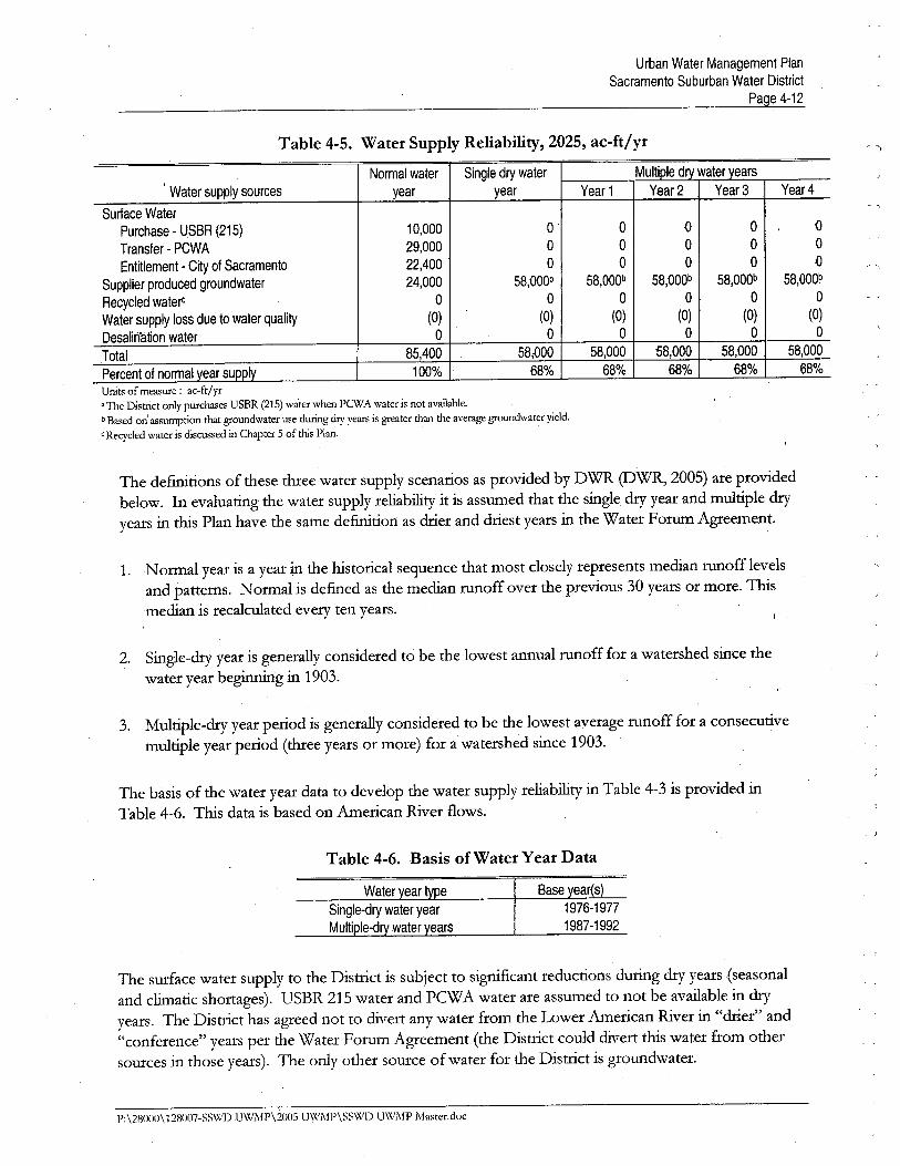
Table 4-5. Water Supply Reliability, 2025, ac-ft/yr,
Multiple dry wateryearsNormal water Single dry water,
Water supply sources year year Year 1 Year 2 Year 3 Year 4
Surface WaterPurchase - USBR (215) 10,000 0 ° Û 0 0
Transfer - PCWA 29,000 0 0 ° 0 °
Entitlement - City of Sacramento 22,400 0 0 0 0 °
Supplier produced groundwater 24,000 58,OOOb 58,000b 58,OOOb 58,OOOb 58,000b
Recycled watert ° 0 0 0 0 °
Water supply loss due to water quality (0) (0) (0) (0) (0) (0)
Desalirïåtíon water 0 0 0 0 0 °
Total 85,400 , 58,.000 58,000 58,000 58,000 58,000
Percent of normal year supplv 100% 68% 68% 68% 68% 68% '
Units of measure: ac-ft/yr"The Distrct only purchases USBR (215) water when PCWj\ water is not avaiable,b Based on' assumption tht groundwater use durig dry year is greater than the average groundwater yield.
C Recycled water is discussed in Chapter 5 of ths Plan,
The defitions of these thee water supply scenarios as provided by DWR (DWR, 2005) are providedbelow. In evaluatig the water supply reliabilty it is assumed that the single dr year and multiple di-yyears in ths Plan have the same defition as drer and drest years in the Water Foru Agreement.
1. Normal year is a year in the historical sequence that most closely represents median runofflevelsand patterns. Normal is defied as the median runoff over the previous 30 years or more. 1bs
median is recalculated every ten years.
2. Single-dr year is generally considered to be the lowest annual runoff for a watershed since the
water year begig in 1903.
3. Multiple-dr year period is generally considered to be the lowest average runoff for a consecutive
multiple year period (thee years or more) for a watershed since 1903.
The basis of the water year data to develop the water supply reliabilty in Table 4-3 is provided inTable 4-6. 1bs data is based on American River flows.
Table 4-6. Basis of Water Year Data
Base ear s1976-1977
1987-1992
The surface water supply to the Distrct is subject to signficant reductions during dr years ~seasonal
and climatic shortages). USBR 215 water and PCW A water are assumed to not be avaiable in di-yyears. The Distrct has agreed not to divert any water from the Lower American River in "di-ier" and"conference" years per the Water Forum Agreement (the Distrct could divert ths water from othersources in those years). The only other source of water for the Distrct is groundwater.
P:\28()()11\128007-SS\XlD UWj"IP\2005 UWì\IP\SSWD U\XlMP Master.doc
Urban Water Management PlanSacramento Suburban Water District
Page 4-13
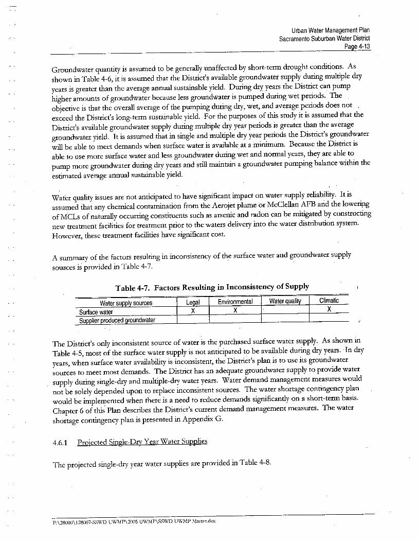
Groundwater quantity is assumed to be generally unaffected by short-term drought conditions. Asshown in Table 4-6, it is assumed that the Distrct's available groundwater supply durg multiple dryyears is greater than the average annual sustaiable yield. Durg dr years the Distrct can pumphigher amounts of groundwater because less groundwater is pumped durg wet periods. Theobjective is that the overall average of the pumping durg dr, wet, and average periods does notexceed the Distrct's long-term sustainable yield. For the puroses of ths study it is assumed that theDistrct's avaiable groundwater supply durg multiple dr year periods is greater than the average
groundwater yield. It is assumed that in single and multiple dr year periods the Distrct's groundwaterwi be able to meet demands when surface water is avaiable at a mium. Because the Distrct isable ,to use more surface water and less groundwater durg wet and normal years, they are able topump more groundwater durg dr years and sti maitai a groundwater pumping balance with theestiated average annual sustaiable yield.
Water quality issues are not anticipated to have signficant impact on water supply reliabilty. It isassumed that any chemical contamiation from the Aerojet plume or McClellan AFB and the lowerigof MCLs of natually occurg constituents such as arsenic and radon can be mitigated by constrctignew treatment facilties for treatment prior to the waters delivery into the water distrbution system.However, these treatment facilties have signficant cost.
A sumary of the factors resultig in inconsistency of the surface water and groundwater supplySOUliCes is provided in Table 4-7.
Table 4-7. Factors Resulting in Inconsistency of Supply
I sources Le alX
Environmental
X
Water uali Climatic
X
roundwater
The Distrct's only inconsistent source of water is the purchased surface water supply. As shown inTable 4-5, most of the surface water supply is not anticipated to be avaiable durg dr years. 'In dr
years, when surface water avaiabilty is inconsistent, the Distrct's plan is to use its groundwatersources to meet most demands. The Distrct has an adequate groundwater supply to provide watersupply durig single-dr and multiple-dr water years. Water demand management measures wouldnot be solely depended upon to replace inconsistent sources. The water shortage contigency planwould be implei-ented when there is a need to reduce demands signficantly on a short-term basis.Chapter 6 of ths Plan describes the Distrcts curent demand management measures. The watershortage contigency plan is presented in Appendi G.
4.6.1 Projected Single-Dry Y ear Water Supplies
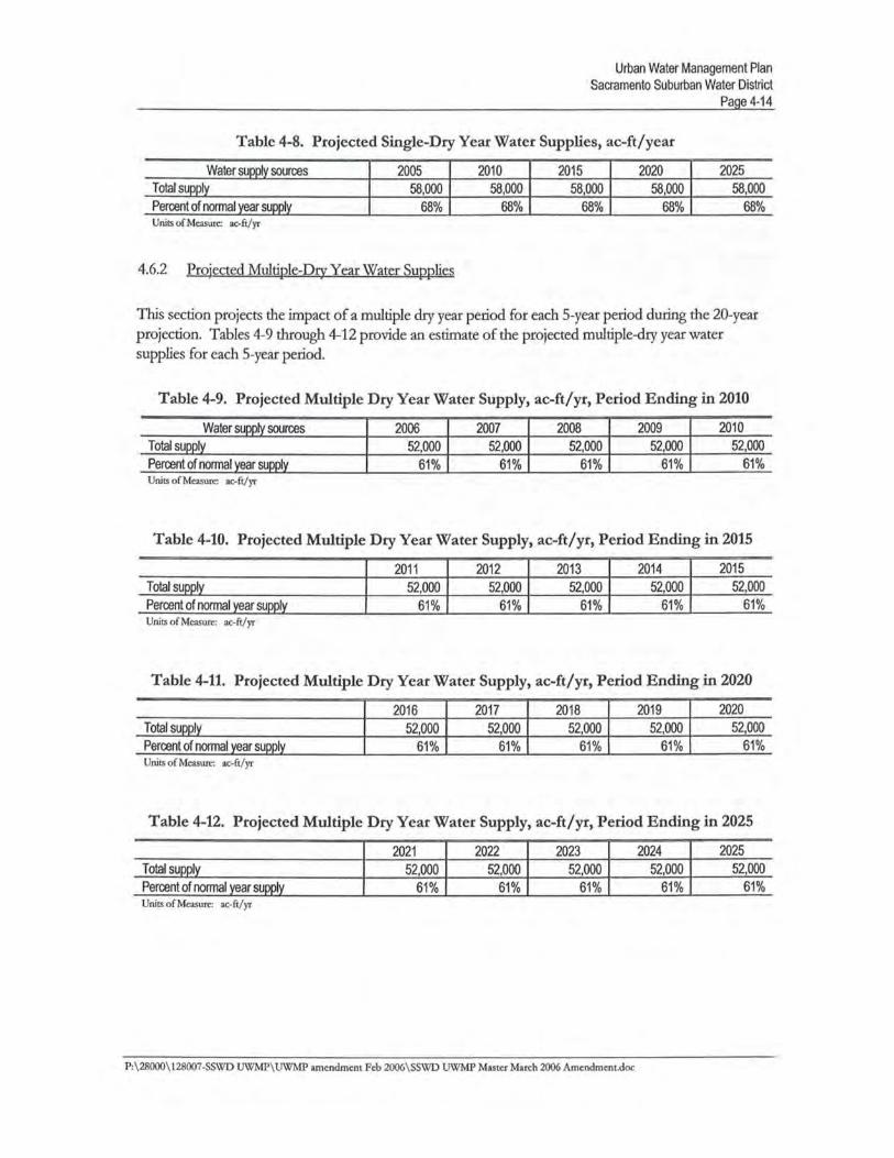
The projected single-dry year water supplies are provided in Table 4-8.
P:\28000\128007-SS\VD U\XlMP\2005 UWMP\SSWD UWMP Master.doc
CHAER 5RECYCLED WATER
The purose of ths chapter is to provide information on recycled wastewater and its potential for useas a water resource in the Distrct. The elements of the chapter are (1) the quantity of wastewatergenerated in the servce area, (2) description of the collection, treatment, and disposal! reuse of thatwastewater, (3) the curent plans for water recyclig, and (4) the potential for water recyclig in theservce area.
5.1 Recycled Water Plan Coordination
Sacramento Regional County Sanitation Distrct (SRCSD) is the agency responsible for collectigtreatig, and dischargig treated wastewater in the greater Sacramento region. Most of the local water
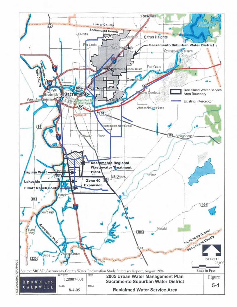
agencies are in coordiation with SRCSD regardig various issues such as conservation methodologiesand rebates, reuse potential, and other issues. The Distrct has no authority or control over municipalwastewater generated in the Distrct's area. The Distrct also curently has no authority of reuse il itsarea, and there is no reuse water avaiable in its servce area. However, the local water pureyorsunderstand that reuse wil become an important element of integrated water supply planng, andsupport the development of a reuse supply component.
SRCSD is currently conductig a regional-wide reuse study. The study is a more detaied investigationof reuse potential for the region and is expected to develop a list of reuse projects to begi plannigand design. The plan has already identified a potential project includig a satellte scalping plant in thenort Sacramento County area that could serve new development and existig large landscapingdemands in the area. A portion of ths area could include the Distrct's NSA depending on theeconomics developed durg the specific project plannig efforts.
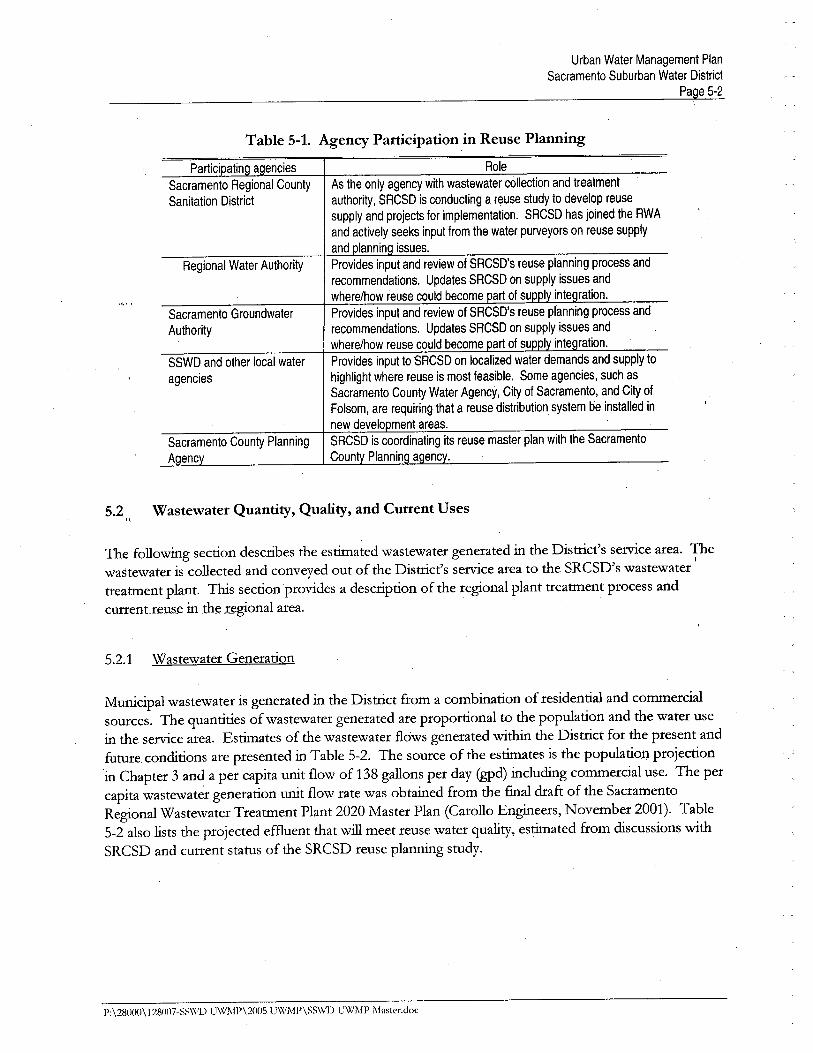
The plannig effort involves coordiation, updates, and input from individual local water disu-icts, and
from the regional water agencies, the Regional Water Authority (RWA), and the SacramentoGroundwater Authority (SGA). Table 5-1 lists the agencies involved in reuse plannig and each
respective involvement.
P:\28000\128007-SSWD UWi\IP\2005 UWMP\SS\XlD U\VMP Master,doc
Urban Water Management PlanSacramento Suburban Water District
Page 5-2
Table 5-1. Agency Participation in Reuse Planning
Partici atin a enciesSacramento Regional County
Sanitation District
Regional Water Authority
Sacramento Groundwater
Authority
SSWD and other local water
agencies
Sacramento County Planning
A enc
Role
As the only agency with wastewater collection and treatment
authority, SRCSD is conducting a reuse study to develop reuse
supply and projects for implementation. SRCSD has joined the RWA
and actively seeks input from the water purveyors on reuse supply
and lannin issues.Provides input and review of SRCSD's reuse planning process and
recommendations. Updates SACSD on supply issues andwhere/how reuse could become art of su i ínte ration.Provides input and review of SACS D's reuse planning process and
recommendations. Updates SACSD on supply issues andwhere/how reuse could become art of su i inte ration.Provides input to SRCSD on localized water demands and supply to
highlight where reuse is most feasible. Some agencies, such asSacramento County Water Agency, City of Sacramento, and City of
Folsom, are requiring that a reuse distribution system be installed in
new develo ment areas.SRCSD is coordinating its reuse master plan with the Sacramento
Count Plannin a enc .
5.2 Wastewater Quantity, Quality, and Current Uses
The followig section describes the estiated wastewater generated in the Distrcts servce area. Thei
wastewater is collected and conveyed out of the Distrct's Sel-vCe area to the SRCSD's wastewatertreatment plant. Ths section provides a description of the regional plant treatment process and
curenUeu_s_e in the r~gional area.
5.2.1 Wastewater Generation
Municipal wastewater is generated in the Distrct from a combination of residential and commerciasources. The quantities of wastewater generated are proportional to the population and the water usein the service area. Estiates of the wastewater flows generated with the Distrct for the present andfutue conditions are presented in Table 5-2. The source of the estiates is the population projection
in Chapter 3 and a per capita unit flow of 138 gallons per day (gd) includig commercial use. The percapita wastewater generation unit flow rate was obtained from the fial draft of the SacramentoRegional Wastewater Treatment Plant 2020 Master Plan (Carollo Engieers, November 2001). Table5-2 also lists the projected effuent that wil meet reuse water quality, estiated from discussions withSRCSD and current status of the SRCSD reuse plannig study.
P;\28001l\1280117-SS\'(,D UWMP\200S UWMP\SS\'(1) UWMP Masier.doc
Urban Water Management PlanSacramento Suburban Water District
Page 5-3
Table 5-2. Wastewater Collected and Treated, ac-ft/yr
2000 2005 2010 2015 2020 2025
Wastewater collected in service2,758 2,750 2,789 2,784 2,817 2,851
areaa
Quantity that meets recycled0 0 0 0 0 0
water standardSource: Carollo Engineers, November 2001; Final Draft 2020 Master Plan, SRCSD.Note: Per capita projections and water conservation based on historically recorded values (and do not reflect any new or planned water conservationmeasures),, Wastewater is only collected in service area, There is not treatment in the District's service area.
5.2.2 Wastewater Collection and Treatment
The wastewater is collected by gravity in a series of mai, trnk, and interceptor sewers owned andoperated by SRCSD. Collected wastewater is transported to the Sacramento Regional Wastewater
Treatment Plant (SRWTP) in Elk Grove. The regional plant serves the entie Sacramentometropolitan area includig the unicoiporated county area adjacent to the City of Sacramento, theCity of Citrs Heights, aad the City of Folsom. The treatment plant receives and treats approxiately156 (2004) mgd of dr weather flow on average. The CUlTent capacity of the plant to treat dr weatherflows is approxiately 181 mgd. The treatment plant produces a disinfected secondary effuent that isdischarged into the Sacramento River below Freeport. The principal 'treatment processes are priaiy
sedientation, pure-oxygen activated sludge, secondar sedientation, andchloriation/ dechloriation. Planned disposal methods and quantities are presented in Table 5-3.
Table 5-3. Disposal of Wastewater
Method of dis osal
River dischar e
Reusea
Treatment level
Seconda effluentTitle 22
2005174 m
1.0-1.5 m dSource: Email communication with Kent Craney of SRCSD - September 13, 2005, 2025 river discharge volume estimated, Reuse volumes dependent on outcome of ongoing reuse master plan to be completed in 2006, SRCSD has a stated goal of recycling 30-40 mgd by 2020-2030.
5.3 Water Recycling Current Uses
Currently, there are no recycled water uses with the Distrct. A 1994 survey of reuse potential (Nolteand Associates, Inc., Sacramento County Water Reclamation Study, August 1994) evaluated the role ofreclaied water as a long term water resource. The study evaluated and identified reclaied watermarkets that would be fiancially feasible to serve, and established a plan to implement reclaimed wateruse. SRCSD constrcted a reclaimed water treatment facilty at the regional treatment plant. Thewater reclamation plant is designed to treat a maxium of 5 mgd with coagulation, sand fùtration, anddisinfection of secondary effuent from the regional plant. SRCSD is currently serving approximately 2mgd of reclaimed water in the Laguna Creek area, near the regional treatment plant. Uses of therecycled water include irrigation of parks, schoolyards, and streetscapes in the Laguna West and
P: \28000\ 128()07-S~\1V) UWMP\2005 U\X/MP\S~\'(,1) UWMP Master.doc
Urban Water Management PlanSacramento Suburban Water District
Page 5-4
Lakeside developments and nonpotable uses at the regional plant. The reclamation plant is capable ofbeing expanded to 10 mgd to serve additional demand for landscape irgation for the Ellott Ranch
South development and futue developments in the area. These areas can be seen on Figue 5-1. Theareas that are intended for use of recycled water are located near the regional plant, which is asignficant distance from the Distrct. Current recycled water uses are presented in Table 5-4.
Table 5-4. Existing Recycled Water Uses
2004,
Type of use Treatment level ac- ft
Agriculture -- 0
Landscape -- 0
Wildlife habitat -- 0
Wetlands -- nIndustrial -- 0
GroundWater recharae -- 0
Total -- 0
5.4 Potential and Projected Use of Reclaimed Water
Currently, no recycled water is used in the Distrct's servce area. As par of the 1994 Nolte report, theformer Arcade and Northrdge Water Distrct service areas were investiated for reuse potential alongwith other urban water distrcts. The reuse potential results are being updated in the cun-ent SRCSDreuse master plan. Ths section presents the projected potential use and methods to optie reuse inthe futue.
5.4.1 Potential Use of Reclaied Water
The potential for landscape irgation with recycle water as listed in the 1994 Nolte Report for theformer Arcade and Northdge Water Distrcts was identified as 1,715 and 1,235 ac~ft/year,respectively, for a total of 2,950 ac-ft/year. The potential recycled water use included parks andschoolyards for landscape irrigation. Ths is an insignficant portion (six percent) of the total year 2004water demand in the combined Distrct area. The 1994 Nolte report concluded there is no potentialuse of recycled water for agrcultual irgation, widlfe habitat enhancement, wetlands, industral reuse,and groundwater recharge.
The curent SRCSD reuse study is revisitig these projections and updatig them based on current andpredicted water supply needs for the region. The study is not yet complete.
P:\28000\128(i(i7-SSWD U\XIMP\200S U\VMP\SSWD UWMl' Master.doc
Urban Water Management PlanSacramento Suburban Water District
Page 5-6
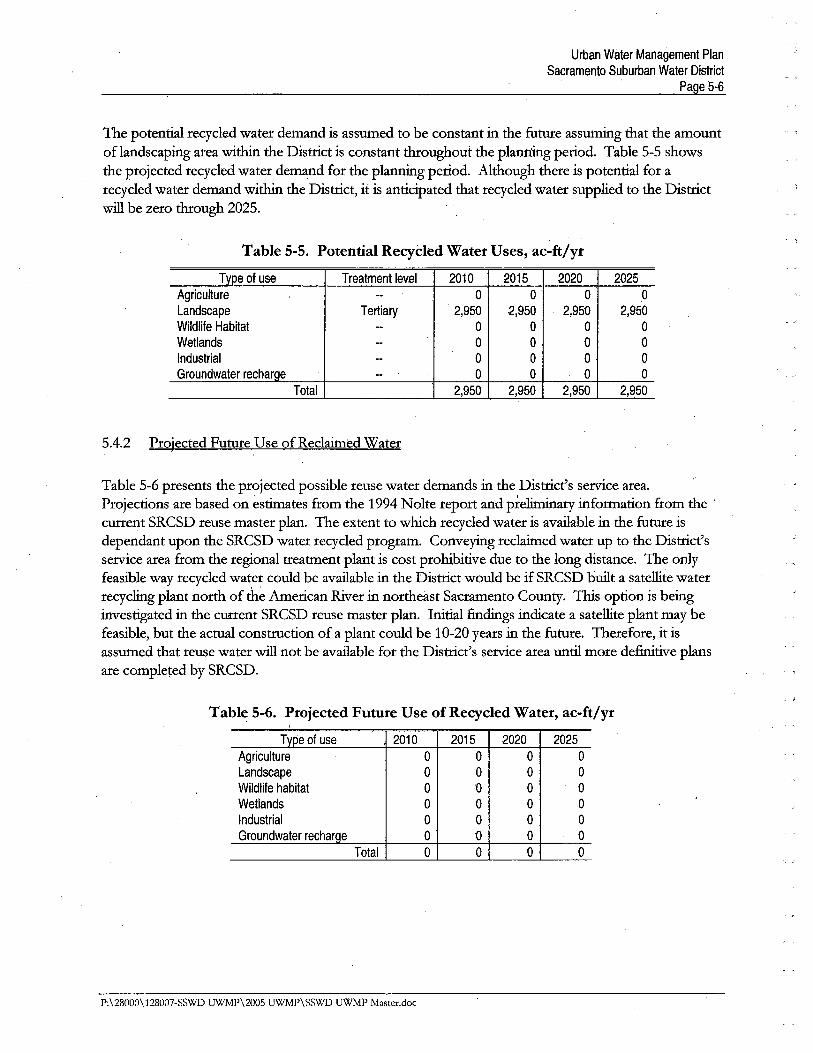
The potenti recycled water demand is assumed to be constant in the futue assumg that the amountof landscaping area with the Distrct is constant thoughout the plag period. Table 5-5 showsthe projected recycled water demand for the planng period. Although there is potential for arecycled water demand with the Distrct, it is anticipated that recycled water supplied to the Distrctwi be zero though 2025.
Table 5-5. Potential RecyCled Water Uses, ac-ft/yr
Tvpe of use Treatment level 2010 2015 2020 2025
Agriculture -- 0 0 0 0
Landscape Tertiary 2,950 2,950 2,950 2,950Wildlie Habitat -- 0 0 0 0
Wetlands -- 0 0 0 0Industrial -- 0 0 0 0
Groundwater recharoe n 0 0 , 0 0
Total 2,950 2,950 2,950 2,950
5.4.2 Projected Futue Use of Reclaied Water
Table 5-6 presents the projected possible reuse water demands in the Distrct's servce area.Projections are based on estiates from the 1994 Nolte report and preliar information from the .
curent SRCSD reuse master pla. The extentto which recycled water is avaiable in the futue isdependant upon the SRCSD water recycled program. Conveyig reclaed water up to the Districtsservce area from the regional treatment plant is cost prohibitive due to the long distance. The onlyfeasible way recycled water could be avaiable in the Distrct would be if SRCSD buit a satellte waterrecyclig plant nort of th~ American River in noi1:east Sacramento County. Ths option is being
investited in the curent SRCSD reuse master plan. Initial fidigs indicate a satellte plant may befeasible, but the actual constrction of a plant could be 10-20 years in the futue. Therefore, it isassumed that reuse water wi not be avaiable for the Distrct's servce area unti more defitive plans
are completed by SRCSD.
Table 5-6. Projected Future Use of Recycled Water, ac-ft/yr
Tvpe of use 2010 2015 2020 2025Agriculture 0 0 0 0
Landscape 0 0 0 0
Wildlife habitat 0 0 0 0
Wetlands 0 0 0 0
Industrial 0 0 0 0
Groundwater recharoe 0 0 0 0
Total 0 0 0 0
P,\28000\128007-SSWD UWMP\2005 UWMP\SSWD UWMP Master.doc
Urban Water Management PlanSacramènto Suburban Water District
Page 5-7
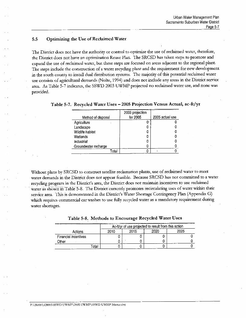
5.5 Optimizing the Use of Reclaimed Water
The Distrct does not have the authority or control to optie the use of reclaimed water, therefore,
the Distrct does not have an optiation Reuse Plan. The SRCSD has taken steps to promote and
expand the use of reclaied water, but these steps are focused on areas adjacent to the regional plant.The steps include the constrction of a water recyclig plant and the requiement for new developmentin the south county to install dual distrbution systems. The majority of ths potential reclaimed wateruse consists of agrcultual demands (Nolte, 1994) and does not include any areas in the Distrct servcearea. As Table 5-7 indicates, the SSWD 2003 UW projected no reclaied water use, and none wasprovided.
Table 5-7. Recycled Water Uses - 2005 Projection Versus Actual, ac-ft/yr
2003 projection
Method of disposal for 2005 2005 actual use
Agriculture 0' 0
Landscape 0 0
Wildlife habitat 0 0
Wetlands 0 0
Industrial 0 0
Groundwater recharge 0 0
Total 0 , 0
Without plans by SRCSD to constrct satellte reclamation plants, use of reclaied water to meetwater demands in the Distrct does not appear feasible. Because SRCSD has not committed to a waterrecyclig program in the Distrct's area, the Distrct does not maitai incentives to use reclaiedwater as showiÚii -T able 5-8. The Distrct curently proiI()iesurecirculatig uses of water \vith theirservice area. Ths is demonstrated in the Distrct's WaterShortage Contigency Plan (Appendi G)which requies commercial car washes to use fuy recycled water as a mandatory requiement durgwater shortages.
Table 5-8~ Methods to Encourage Recycled Water Uses
Ac-ftyr of use projected to result from this action
Actions 2010 2015 2020 2025
Financial incentives 0 0 0 0
Other 0 0 0 0
Total 0 0 0 0
P:\28000\128007-SS\XI)) U\XIMP\2005 UWMP\SS\XI)) UWMP lVlnster.doc
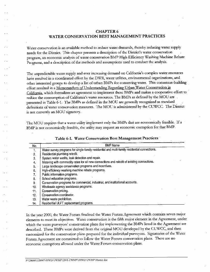
CHAER 6WATER CONSERVATION BEST MAAGEMENT PRACTICES
Water conservation is an avaiable method to reduce water demands, thereby reducing water supplyneeds for the Distrct. Ths chapter presents a description of the Distrct's water conservation
program, an economic analysis of water conservation BMP High Efficiency Washig Machie RebatePrograms, and a description of the methods and assumptions used to conduct the analysis.
The unpredictable water supply and ever increasing demand on Californa's complex water resources
have resulted in a coordiated effort by the DWR, water utities, environmental organiations, andother interested groups to develop a list of urban BMPs for conserving water. 1bs consensus-buidigeffort resulted in a Memorandum of Understandig Regardig Urban Water Conservation inCaliforna, which formalies an agreement to implement these BMPs and makes a cooperative effort to 'reduce the consumption of Californa's water resources. The BMPs as defied by the MOU arepresented in Table 6-1. The BMPs as defied in the MOU are generally recogned as standarddefitions of water conservation measures. The MOU is admstered by the CUWCc. The Distrctis not curently an MOU signatory.
The MOU requies that a water utity implement only the BMPs that are economically feasible. If aBMP is not economically feasible, the utity may request an economic exemption for that BMP.
Table 6-1. Water Conservation Best Management Practices
, No. BMP Name1. Water survey programs for single-family residential and multi-family residential connections.2. Residential plumbing retrofit.
3. System water audits, leak detection and repair.4. Metering with commodity rates for all new connections and retrofit of existing connections.
5. Large landscape conservation programs and incentives.
6. High-efficiency washing machine rebate programs.
7. Public information programs.
8. School education programs.
9. Conservation programs for commercial, industrial, and institutional accounts.10. Wholesale agency assistance programs.
11. Conservation pricing.
12. Conservation coordinator.
13. Water waste prohibition.
14. Residential ULFT re lacement
In the year 2000, the Water Forum fialized the Water Forum Agreement which contais seven majorelements to meet its objectives. Water conservation is the fift major element in the Agreement, underwhich the water pureyors' conservation plans for implementig the BMPs listed in the Agi:eement aredescribed. These BMPs were derived from the origial MOU developed by the CUWCC, and thencustomied for the conservation plans prepared for the individual purveyors. Signatories of the WaterForum Agreement are commtted to follow the \X1ater Forum conservation plans. There are noeconomic exemptions allowed under the Water Forum conservation plans.
P,\2800ll\128()07-SS\VD UWMP\2()OS UWMP\SSWD U\VMP Ma~ter.doc
Urban Water Management PlanSacramento Suburban Water District
Page 6-2
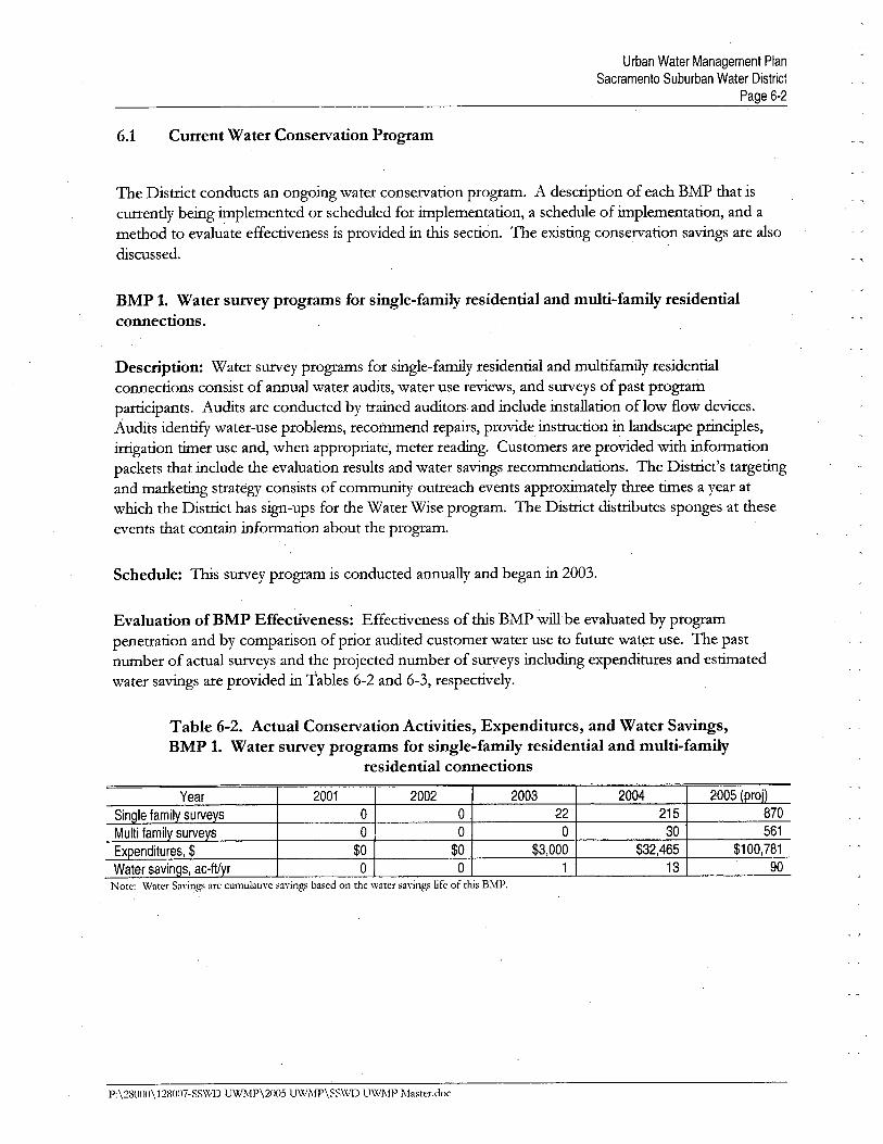
6.1 Current Water Conservation Program
The Distrct conducts an ongoing water conservation program. A description of each BMP that iscurently being implemented or scheduled for implementation, a schedule of implementation, and amethod to evaluate effectiveness is provided in ths section. The existig conservation savigs are also
discussed.
BMP 1. Water survey programs for single-family residential and multi-family residentialconnections.
Description: Water surey programs for single-famiy residential and multifamiy residentialconnections consist of annual water audits, water use reviews, and sureys of past programpartcipants. Audits are conducted by traied auditors and include installation oflow flow devices.Audits identify water-use problems, recommend repais, provide,instrction in landscape priciples,
irgation tier use and, when appropriate, meter readig. Customers are provided with information
packets that include the evaluation results and water savigs recommendations. The Distrct's targetigand marketig strategy consists of community outreach events approxiately thee ties a year at
which the Distrct has sign-ups for the Water Wise program. The Distrct distrbutes sponges at theseevents that contai information about the program.
Schedule: TIs surey program is conducted annually and began in 2003.
Evaluation of BMP Effectiveness: Effectiveness of ths BMP wil be evaluated by programpenetration and by comparison of prior audited customer water use to futue water use. The pastnumber of actual sureys and the projected number of sureys includig expenditues and estiatedwater savigs are provided in Tables 6-2 and 6-3, respectively.
Table 6-2. Actual Conservation Activities, Expenditures, and Water Savings,BMP 1. Water survey programs for single-family residential and multi-family
residential connections
Year 2001 2002 2003 2004 2Q05 (proj)
Sino Ie family surveys a a 22 215 870
Multi family surveys a 0 a 30 561
Expenditures, $ $0 $0 $3,000 $32,465 $100,781
Water savinos, ac-fVyr 0 0 1 13 90
Note: Water Sayings are cumulatiw savings based on the water sa\'inb", life of ¡his Bl\P.
P:\2800n\128007-SS\X,1) UWl\P\2005 UWl\P\SS\X.1) U\v'MP Master.doc
Urban Water Management PlanSacramento Suburban Water District
Page 6-3
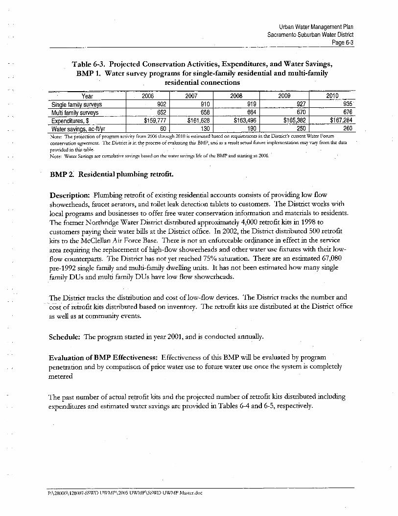
Table 6-3. Projected Conservation Activities, Expenditures, and Water Savings,BMP 1. Water survey programs for single-family residential and multi-family
residential connections
Year 2006 2007 2008 2009 2010
Single family survevs 902 910 919 927 935
Multi family survevs 652 '658 '664 670 676
Expenditures, $ , $159,777 $161,628 $163,496 $165,382 $167,284
Water savings, ac-ftvr 60 130 190 250 260Note: The projection of program activity from 2006 through 2010 is estimated based on requirements in the District's current Water Forumconservation agreement. The District is in th~ process of evaluating this BMP, and as a result actual future implementation may vary from the dataprovided in this table,Note: Water Savings are cumulative savings based on the water savings life of the BMP and starting in 2006.
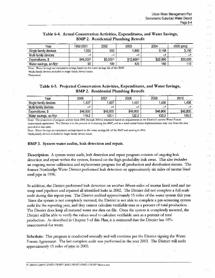
BMP 2. Residential plumbing retrofit.
Description: Plumbing retrofit of existig residential accounts consists of providig low flowshowerheads, faucet aerators, and toilet leak detection tablets to customers. The Distrct works withlocal programs and businesses to offer free water conservation information and materials to residents.The former Nortdge Water Distrct distrbuted approxiately 4,000 retrofit kits in 1998 tocustomers paying their water bils at the District office. In 2002, the Distrct distributed 500 retrofitkits to the McClellan Ai Force Base. There is not an enforceable orqiance in effect in the servcearea requig the replacement of high~flow showerheads and other water use fitues with their low-
flow counterparts. The Distrct has not yet reached 75% satuation. There are an estiated 67,080pre-1992 single famiy and multi-famiy dwellg units. It has not been estiated how many singlefamiy DUs and multi famiy DUs have low flow showerheads.
The Distrct tracks the distrbution and cost of low-flow devices. The Distrct tracks the number andcost ofrettofit kits distrbuted based on inventory. The retrofit kits are distrbuted at the Distrct officeas well as at community events.
Schedule: The program started in year 2001, and is conducted annually.
Evaluation of BMP Effectiveness: Effectiveness of ths BMP wi be evaluated by programpenetration and by comparison of prior water use to future water use once the system is completelymetered
The past number of actual retrofit kits and the projected number of retrofit kits distributed includigexpenditues and estiated water savings are provided in Tables 6-4 and 6-5, respectively.
P:\28000\128007-SS\XlD UWMP\2005 UWMP\SSWD UWMP Master.doc
Urban Water Management PlanSacramento Suburban Water District
Page 6-4
Table 6-4. Actual Conservation Activities, Expenditures, and Water Savings,BMP 2. Residential Plumbing Retrofit
Year 1992-2001 2002 2003 2004 2005 (proD
Sinole familv devices 7,000 500 1,800 3,148 3,150
Multi familv devices ..a ..a __a __a __a
Expenditures, $ $49,OOOb $3,500 b $12,600 b $22,000 $22,000Water savinos, ac-ftvr 90 100 120 1£0 110
- ,
Note: Water Savings are cumulative ~avingsbased on the water savings life of this BMP."Multi family devices included in single family device count.bEstimated,
Table 6-5. Projected Conservation Activities, Expenditures, and Water Savings,BMP 2. Residential Plumbing Retrofit
Year 2006 2007 2008 2009 2010
Single family devices 1,437 1 ,437 1,437 1 ,436 1 ,43£
Multi family devices __a __a ..a __a __a
Expenditures, $ $46,800 $46,800 $46,800 $46,800 $46,800
Water savinos, ac-ftvr 119.2 123.1 122.2 133.2 169.3Note: The projection of program activity from 2006 through 2010 is estimated based on requirements in the District's current Water Forumconservation agreement. The District is in the process of evaluating this BMP, and as a result actual future implementation may var from the dataprovided in this table.Note: Water Sa\'ings are cumulative savings based on the water savings life of the BMP and starting in 2006."Multi/arnly devices included in single family device count.
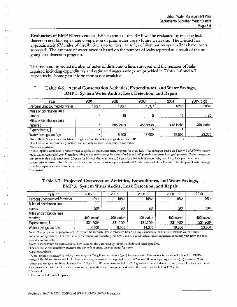
BMP 3. System water audits, leak detection and repair.
Description: A system water audit, leak detection and repai program consists of ongoing leakdetection and repair with the system, focused on the high probabilty leak areas. 1bs also includesan ongoing meter calibration and replacement program for all production and distrbution meters. 'Te
former Nortdge Water Distrct performed leak detection on approxiately six mies of mort liedsteel pipe in 1996.
In addition, the Distrct performed leak detection on another fifteen mies of mortar lied steel and tar-wrap steel pipelies and repaired all identified leaks in 2002. The Distrct did not complete a fu-scaleaudit durg ths report year. The Distrct audited approxiately 15 mies of the water system ths year.
Since the system is not completely metered, the Distrct is not able to complete a pre-screenig systemaudit for the reportg year, and they cannot calculate verifiable uses as a percent of total production.The Distrct does keep all metered water use data on fie. Once the system is completely metered, the
Distrct wi be able to verify the values used to calculate verifiable uses as a percent of totalproduction. As described in Chapter 3 of this Plan, it is estiated that the Distrct has 10%unaccounted-for water.
Schedule: Ths program is conducted annually and wil contiue per the District signg the WaterForu Agreement. The last complete audit was perfonned in the year 2003. The Distrct wi auditapproxiately 15 mies of pipe in 2005.
P:\28000\128007.SS\\,1) UWMP\2005 UWÌ\!P\SSWD uWÌ\!P Master.doc
Urban Water Management PlanSacramento Suburban Water District
Page 6-5
Evaluation of BMP Effectiveness: Effectiveness of ths BMP wil be evaluated by trackig lea,kdetection and leak repai and comparison of prior water use to futue water use. The Distrct has
appro~ately 673 tnes of distrbution system lies. 41 tnes of distrbution system lies have beensureyed. The estiate of water saved is based on the number of leaks repaied as a result of the on-going leak detection program.
The past and projected number of tnes of distrbution lies' sureyed and the number of leaks
repaied includig expenditures and estiated water savigs are provided in Tables 6-6 and 6-7,
respectively. Some past information is not avaiable.
Table 6-6. Actual Conservation Activities, Expenditures, and Water Savings,
BMP 3. System Water Audits, Leak Detection, and Repair
Year 2001 2002 2003 204 2005 lproil
Percent unaccounted-for water 10%a 10%a 10%a 10%a 10%a
Miles of distribution lines
survey __b 15 0 15 ,20Miles of distribution linesrepaired __b 685 leaks 455 leaks 418 leaks 400 leaksd
Expenditures, $ __b __b __b __b __b
Water savings, ac-ftvr __b 8,200 13,600 , 18;500 23,300Note: Water Savings are cumulatiye sayings based on the water savings life of this BM1','The District is not completely metered and can only estimate un-accounted- for water.bData not ayailable.
CA leak repair is estimated to reduce water usage by 9.5 gallons per minute (gpm) for eye'!' leak. This sayings is based on Table 4-3 of AWWA manual
M36, Water Audits and Leak Detection, using an assumed a\'erage leak size of 0.2 in and 100 pounds per square inch (psi) pressure, Water savings perleak g;\'en in this table range from 2.3 gpm for 0,1 inch diameter hole to 38 h'Pm for a 0.4 inch clameter hole, thus 9.5 gallons per rnnute is acons~r\'ative estimate. O\'er the course of one year, the water savings per leak with a 0.2 inch diameter hole is 15 ac-ft. The life span of water sa\'ingsfrom'leak repair is estimated to be fi\'e years,dEstimated.
,Table 6-7.-ProjectedConservation Activities, Expenditures, and Water Savings,BMP 3. System Water Audits, Leak Detection, and Repair
Year 2006 2007 2008 2009 2010
Percent unaccounted~for water 10%a 10%a 10%a 10%a 10%a
Miles of distribution lines
survey 20d 20d 20d 20d 20d
Miles of distribution lines
repaired 400 leaksd 400 leaksd 400 leaksd 400 leaksd 400 leaksd
Expenditures, $ $31,200e $31,200e $31 ,200e $31,200e $31 ,.200e
Water savinQs, ac-ftyr 4,800 9,500 14,300 19,000 23,800Note: The projection of program actiyity from 2006 through 201 0 is estimated based on requirements in the District's current Water Forumconser\'ation agreement. The District is in the process of e\'aluating this BM1', and as a result actual future implementation may \'a,!' from the datapro\'ided in this table,Note: Water Sa\'ings are cumulatiw ~aying~ ba~ed on the water ~a\'ings life of the BMP and starting in 2006."The District is not completely metered and can only e~timate un-accounted-for water."Data not a\'ailabk.c A leak repair is estimated to reduce water u~age by 7.4 gallon~ per minute .(gpm) for eye'!' leak. Thi~ $a\-inh'" is based on Table 4-3 of A WW A
manual M36, Water A.udits and Leak Detection, u~ing an a~~umed ayerage leak ~izc of 0.2 in and (¡ pound~ per square inch W~i) pre~~ure, Watersa\'ings pcr leak ¡,~Yen in this table range from 1,9 ¡''Pm for 0.1 inch diameter hole to 29,6 ¡''Pm for a 0.4 inch diameter hole, thus 7.4 gallons per minuteis a con~erYntiYe estimate, OYer the cour~e of one year, the water sa\'in/,'" per leak with a 0.2 inch diameter hole i~ 11,9 ae-ft.dEstimated
'Doe~ not include cost of repair~,
P;\280()0\128007-SS\VD UWMP\2005 U\VMP\SS\VD UWMP Master.doc
Urban Water Management PlanSacramento Suburban Water District
Page 6-6
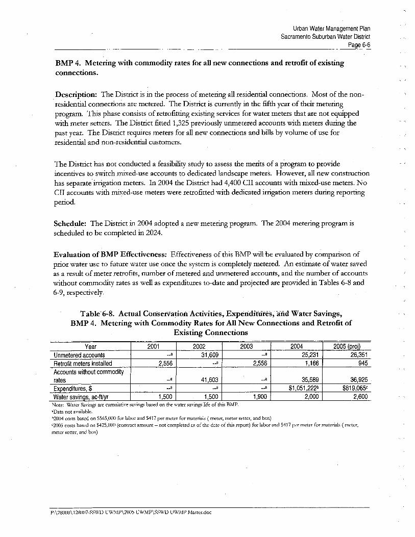
BMP 4. Metering with commodity rates for all new connections and retrofit of existingconnections.
Description: The Distrct is in the process of meterig all residential connections. Most of the non-residential connections are metered. The Distrct is curently in the fifth year of their meterigprogram. Ths phase consists of retrofittg existig servces for water meters that are not equippedwith meter setters. The Distrct fitted 1,325 previously unmetered accounts with meters durg thepast year. The Distrct requies meters for all new connections and bils by volume of use forresidential and non-residential customers.
The Distrct has not conducted a feasibilty study to assess the merits of a program to provideincentives to switch mied-use accounts to dedicated landscape meters. However, all new constrctionhas separate irgation meters. In 2004 the Distrct had 4,400 CII accounts with mied-use meters. NoCII accounts with mied-use meters were retrofitted with dedicated irgation meters durg reportgperiod.
Schedule: The Distrct in 2004 adopted a new meterig program. The 2004 meterig program isscheduled to be completed in 2024.
Evaluation of BMP Effectiveness: Effectiveness of tls BMP wil be evaluated by comparison of
prior water use to futue water use once the system is completely metered. An estiate of water savedas a result of meter retrofits, number of metered and unmetered accounts, and the number of accountswithout commodity rates as well as expenditues to-date and projected are provided in Tables 6-8 and6-9, respectively.
Table6-8. ActÚál ûJliseiVatioiiActivities, Experíditures, arid Water Savings,BMP 4. Metering with Commodity Rates for Al New Connections and Retrofit of
Existing Connections
Year 2001 2002 2003 2004 2005 (proD
Unmetered accounts _.8 31,609 __8 25,231 26,351
Retrofit meters installed 2,556 ..8 2;556 1,166 945
Accounts without commodity
rates ..8 41,603 __8 35,589 36,925 '
Expenditures, $,
__8 _.8 __8 $1,051,222b $819,065cWater savinQs, ac-ftyr 1,500 1,500 1,900 2,000 2,600
Note: Water Sayini,rs are cumulative saving. based on the water savini,rs life of this BMP,"Data not available,1,2004 costs based on $565,000 for labor and S417 per meter for materials ( meter, meter setter, and box)
"2005 costs based on $425,000 (coiitract amount -not completed as of the date of this report) for labor and$417 p'" meter for materials (meter,meter setter, and box)
P:\28000\1281107-SS\'(.'D U\VJ\P\2005 UWMP\SSWD U\XiMP Maw:r.doc
Urban Water Management PlanSacramento Suburban Water District
Page 6-7
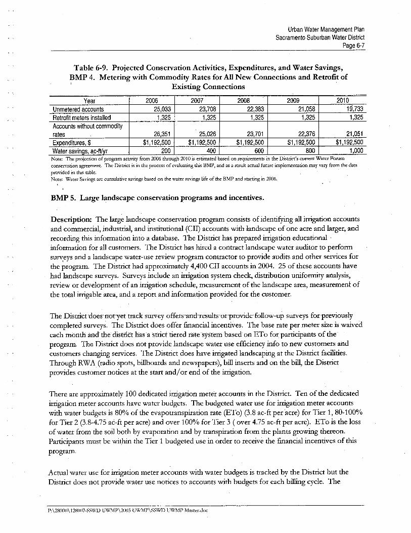
Table 6-9. Projected Conservation Activities, Expenditures, and Water Savings,BMP 4. Metering with Commodity Rates for All New Connections and Retrofit of
Existing Connections
Year 2006 2007 2008 2009 2010
Unmetered accounts 25,033 23,708 22,383 21,058 19,733
Retrofit meters installed 1,325 1,325 1,325 1,325 1,325
Accounts without commodity
rates 26,351 25,026 23,701 22,376 21,051
Expenditures, $ $1,192,500 $1,192,500 $1,192,500 $1,192,500 $1,192,500Water savinas, ac-ftvr 200 400 600 800 1,000
'Note: The projection of program activity from 2006 through 2010 is estimated based on requirements in the District's current Water Forumconsen-ation agreement. The District is in the process of evaluating this BMP, and as a result actual future implementation may vary from the dataprovided in this table.Note: Water Savings are cumulative savings based on the water savings life of the BMP,and starting in 2006.
BMP 5. Large landscape conservation programs and incentives.
Description: The large landscape conservation program consists of identifyg all irgation accountsand commercial, industral, and institutional (CII) accounts with landscape of one acre and lager, andrecordig ths information into a database. The Distrct has prepared irrigation educational .information for all customers. The Distrct has hied a contract landscape water auditor to performsureys and a landscape water-use review program contractor to provide audits and other servces forthe program. The Distrct had approxUately 4,400 CII accounts in 2004. 25 of these accounts havehad landscape sureys. Sureys include an irgation system check, distrbution uniformty analysis,review or development of an irgation schedule, measurement of the landscape area, measurement ofthe total irgable area, and a report and information provided for the customer.
The Distrct -does- not-yet track 'Survey offers.'and-resultsorprovide-follow-upsureys for-previously
completed sureys. The Distrct does offer fiancial incentives. The base rate per meter size is waivedeach month ànd the distrÌct has' a strct tiered rate system based on ETo for partdpafits of the U
program. The Distrct does not provide landscape water use efficiency info to new,customers andcustomers changig servces. The Distrct does have irgated landscaping at the Distrct facilties.Though RWA (radio spots, bilboards and newspapers), bil inserts and on the bil, the Distrctprovides customer notices at the start and/or end of the irgation.
There are approxiately 100 dedicated irgation meter accounts in the Distrct. Ten of the dedicatedirgation meter accounts have water budgets. The budgeted water use for irrigation meter accountswith water budgets is 80% of the evapotranspiration rate (ETo) (3.8 ac-ft per acre) for Tier 1, 80-100%for Tier 2 (3.8-4.75 ac-ft per acre) and over 100% for Tier 3 ( over 4.75 ac-ft per acre). ETo is the lossof water from the soil both by evaporation and by transpiration from the plants grwig thereon.Partcipants must be with the Tier 1 budgeted use in order to receive the fiancial incentives of thsprogram.
Actual water use for irrigation meter accounts with water budgets is tracked by the Distrct but theDistrict does not provide water use notices to accounts with budgets for each bilg cycle. 11ie
P:\28000\12801i-SS\\1l) UWMP\2005 UWMP\SS\xll) UWMP Master.doc

Urban Water Management PlanSacramento Suburban Water District
Page 6-8
Distrct has not developed a marketig/ targetig strategy for landscape sureys at ths tie. The
Distrct staff promotes the program verbally when they come into contact with largelandscape/iration customers.
- '\
Schedule: Ths program is conducted annually and began in August 2004.
Evaluation of BMP Effectiveness: Effectiveness of ths BMP is evaluated by comparson of largelandscape customer prior water use to futue water use. An estiate of water saved as a result of meterretrofits, number of metered and unmetered accounts, and the number of accounts withoutcoÏÏodity rates as well as expenditues to-date and projected are provided in Tables 6-10 and 6-11,respectively.
Table 6-10. Actual Conservation Activities, Expenditures, and Water Savings,BMP 5. Large Landscape Conservation Programs and Incentives
Year 2001 2002 2003 2004 2005 (proD
BudQets developed n n n 1 15
Surveys completed -- -- -- 14 25
Follow-up visits -- n -- 0 5
Expenditures, $ -- -- n $600 $5,000Water savings, ac-ftyr -- n -- 53 147
Note;, Water Savinh'S are cumulative savings based on the water sayings life of this BMl'.
Table 6-11. Projected Conservation Activities, Expenditures, and Water Savings,BMP 5. Large Landscape Conservation Programs and Incentives
Year 2006 2007 2008 2009 2010
Budgets developed ------~ - ----. -----11 ,-~, '",. 11- ,_u__,,___. _ " 11 ,-- 11 11
Surveys completed 11 11 11 11r
11,
Follow-up visits 11 11 11 11 11
Expenditures, $ $20,200 $20,200 $20,200 $20,200 $20,200Water savinQs, ac-ftyr 41 82 123 165 1£6
Note: The projection of program activity from 2006 through 2010 is estimated based on requirements in the District's current Water Forumconseryation agreement. The District is in the process of evaluating this BMP, and as a result actual future implementation may vary from the dataprovided in this table,Note: Water Savings are cumulative savings based on the water savings life of the BMP and starting in 2006.
BMP 6. High-effciency washing machine rebate programs.
Description: The Disuict is not curently implementig ths BMP since ths BMP is not cost effectiveto the Distrct. An economic evaluation of ths BMP is provided in Appendi H of ths plan anddiscussed in Section 6.2 of this chapter.
Schedule: Not applicable. TIie Disuict is not currently implementig ths BMP.
Evaluation ofBMP Effectiveness: Not applicable. The Disu1ct is not currently implementig thsBMP.
P:\28000\128007-SSWD UWMP\200S U\VMP\SS\Vl) UWMP MasteLdoc
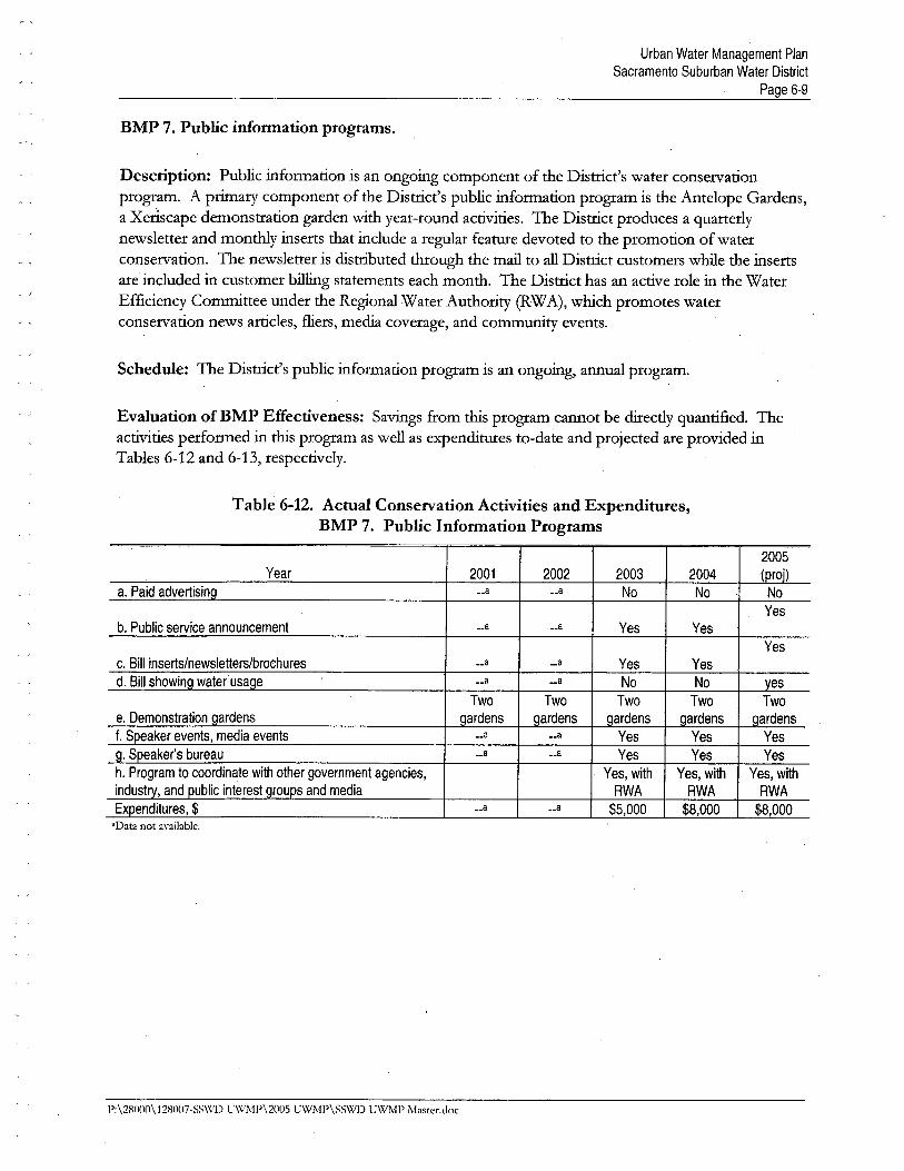
Urban Water Management PlanSacramento Suburban Water District
Page 6-9
BMP 7. Public information programs.
Description: Public information is an ongoing çomponent of the Distrct's water conservationprogram. A priary component of the Distrct's public information program is the Antelope Gardens,a Xeriscape demonstration garden with year-round activities. The Distrct produces a quarterlynewsletter and monthy inserts that include a reguar featue devoted to the promotion of waterconservation. The newsletter is distrbuted though the mai to all Distrct customers whie the insertsare included in customer bilg statements each month. The Distrct has an active role in the WaterEfficiency Commttee under the Regional Water Authority (RW A), which promotes waterconservation news artcles, flers, media coverage, and conUTunity events.
Schedule: The Distrct's public information program is an ongoing, annual program.
Evaluation of BMP Effectiveness: Savings from ths program cannot be dii-cdy quantified. Theactivities performed in ths program as well as expenditues to-date and projected are provided inTables 6-12 and 6-13, respectively.
Table 6-12. Actual Conservation Activities and Expenditures,BMP 7. Public Information Programs
2005Year 2001 2002 2003 2004 -(proD
a. Paid advertisinci __8 __8 No No No
Yesb. Public service announcement __8 __8 Yes Yes
Yesc. Bil inserts/newsletters/brochures __8 __8 Yes Yesd. Bil showing water usage __8 ..8 No No ves
Two Two Two Two Twoe. Demonstration ciardens ciardens ciardens ciardens ciardens ciardensf. Speaker events, media events __8 ..8 Yes Yes Yes
ci. Speaker's bureau __8 __8 Yes Yes Yesh. Program to coordinate with other government agencies, Yes, with Yes, with Yes, withindustry, and public interest ciroups and media RWA RWA RWA
Expenditures, $ __8 ..8 $5,000 $8,000 $8,000"Data not available,
1':\28000\ 128007-SS\X/J) U\X1\1'\2005 UWM1'\SS\XiJ) UWMP i\laster.doc
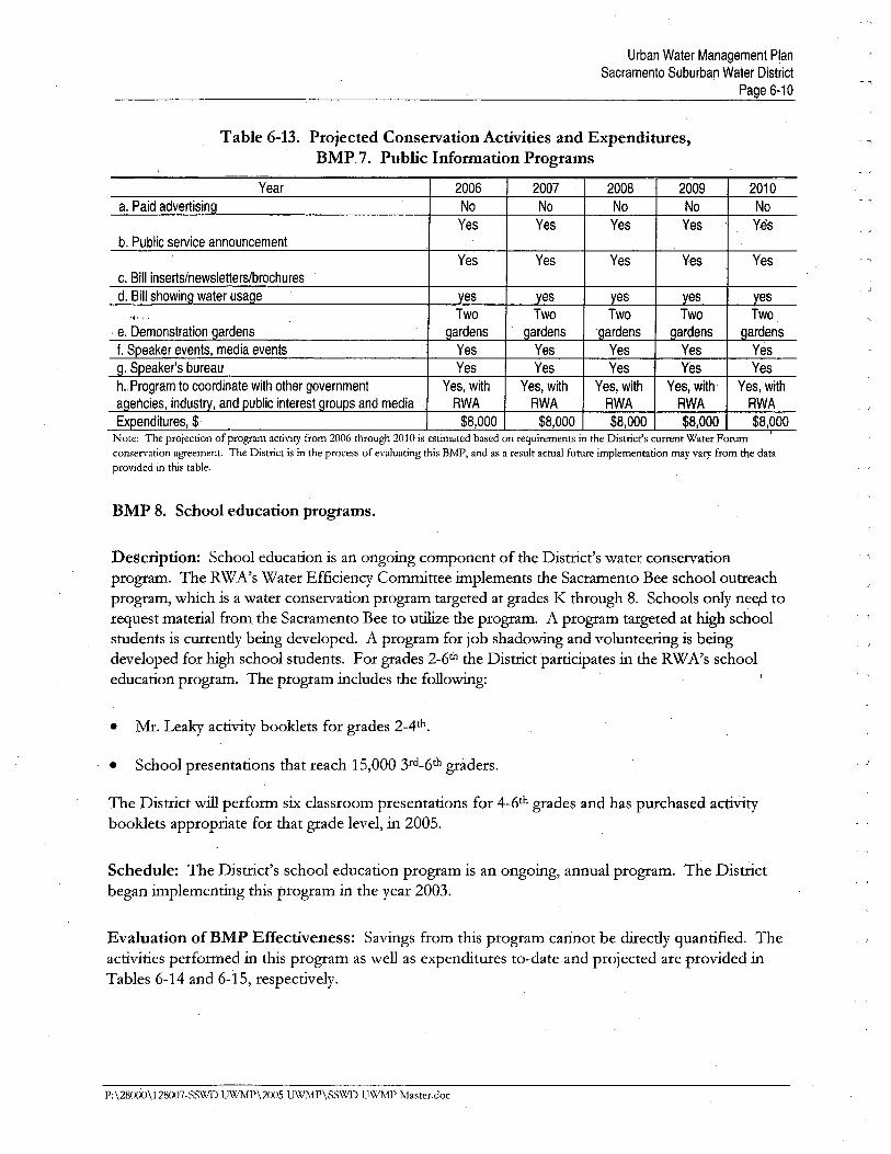
Urban Water Management PlanSacramento Suburban Water District
Page 6-10
Table 6-13. Projected Conservation Activities and Expenditures,BMP 7. Public Information Programs
Year 2006 2007 2008 2009 2010
No No No No No
Yes Yes Yes Yes Yes
Yes Yes Yes Yes Yes
esTwo
ardensYes
Yes
Yes, with
RWA
$8,000
a. Paid advert is in
b. Public service announcement
BMP 8. School education programs.
Description: School education is an ongoing component of the Distrct's water conservationprogram. The RW A's Water Efficiency Commttee implements the Sacramento Bee school outreachprogram, which is a water conservation program targeted at grades K though 8. Schools only net; to
req~est material from the Sacramento Bee to utie the program. A program targeted at high schoolstudents is curently being developed. A program for job shadowig and volunteerig is beingdeveloped for high school students. For grades 2-6th the Distrct partcipates in the RW A's schooleducation program. The program includes the followig:
. Mr. Leaky activity booklets for grades 2-4th.
. School presentations that reach 15,000 3rd_6th graders.
The District wil perform six classroom presentations for 4_6th grades and has purchased activity
booklets appropriate for that grade level, in 2005.
Schedule: The Distrct's school education program is an ongoing, annual program. The Distrctbegan implementig this program in the year 2003.
Evaluation of BMP Effectiveness: Savings from this program cannot be directly quantified. Theactivities performed in this program as well as expenditures to-date and projected are provided inTables 6-14 and 6-15, respectively.
P;\28000\12B007-SS\X'D UWMP\2005 UWMP\SSWD UWMP Master.doc
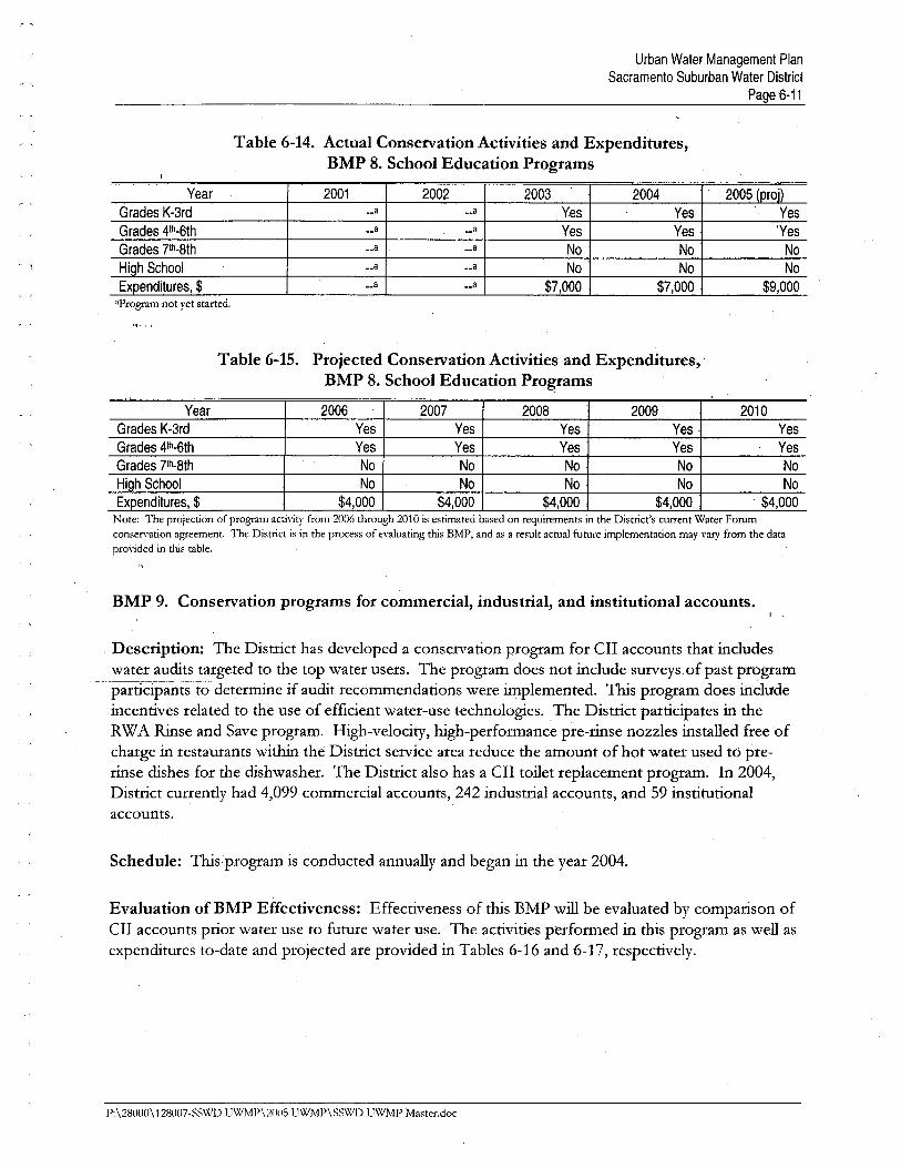
Urban Water Management PlanSacramento Suburban Water District
Page £-11
Table 6-14. Actual Conservation Activities and Expenditures,BMP 8. School Education Programs
Year 2001 2002 2003 2004 2005 (proD
Grades K-3rd __8 ..8 Yes Yes Yes
Grades 4th-6th ..8 __8 Yes Yes 'Yes
Grades 7th-8th __8 __8 No No No
High School __8 __8 No No No
Expenditures, $ __8 __8 $7,000 $7,000 $9,000'Program not yet started.
Table 6-15. Projected Conservation Activities and Expenditures,BMP 8. School Education Programs
, Year 2006 2007 2008 2009 2010Grades K-3rd Yes Yes Yes Yes Yes
Grades 4th.6th Yes Yes Yes Yes Yes
Grades 7th-8th,
No No No No No
HiQh School No No No No No
Expenditures, $ $4,000 $4,000 $4,000 $4,000 $4,000Note: The projection of program acti\"ity from 2006 through 2010 is estimated based on reguirements in the Distrct's current Water Forumconsen'ation agreement. The District is in the process of e\"aluating this BMP, and as a result actual future implementation may vary from the datapro\"ided in ths table.
"
BMP 9. Conservation programs for commercial, industrial, and institutional accounts.
Description: The District has developed a conservation program for cn accounts that includeswater audits targeted to the top water users. The program does not include surveys of past program
- -p-altlcipán1:sto determie if audit recommendations were implemented. This program does includeincentives related to the use of efficient water-use technologies. The Distrct participates in theRW A Rise and Save program. High-velocity, high-performance pre-rinse nozzles installed free ofcharge in restaurants withi the Distrct service area reduce the amount of hot water used to pre-rise dishes for the dishwasher. The Distrct also has a cn toilet replacement program. In 2004,Distrct currently had 4,099 commercial accounts, 242 industral accounts, and 59 institutionalaccounts.
Schedule: This'program is conducted annually and began in the year 2004.
Evaluation of BMP Effectiveness: Effectiveness of this EMP wil be evaluated by comparison ofen accounts piiar water use to future water use. The activities perfonned in this program as well asexpenditures to-date and projected are provided in Tables 6-16 and 6-17, respectively.
P:\28000\128007-SS\X/D UWMP\211115 UWMP\SSWD UWMP Master.doc
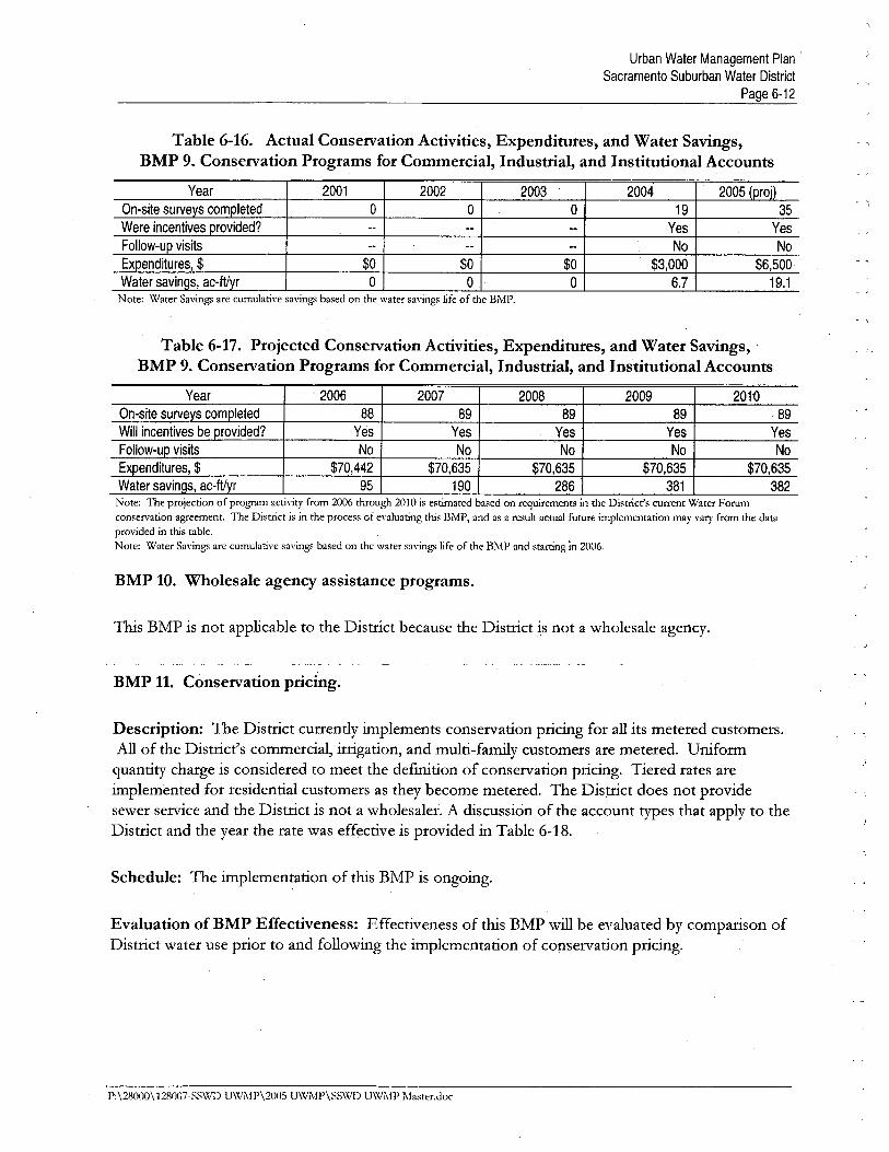
Urban Water Management Plan'Sacramento Suburban Water District
Page 6-12
Table 6-16. Actual Conservation Activities, Expenditures, and Water Savings,BMP 9. Conservation Programs for Commercial, Industrial, and Institutional Accounts
Year 2001 2002 2003 2004 2005 (proD
On-site surveys completed 0 0 0 19 35
Were incentives provided? -- -- n Yes YesFollow-up visits -- n -- No No
Expenditures, $ $0 $0 $0 $3,000 $6,500 'Water savinas, ac-ftvr 0 0 0 6.7 19.1
Note: Water Savings are cumulative savings based on the water savings life of the BMP.
Table 6-17. Projected Conservation Activities, Expenditures, and Water Savings,BMP 9. Conservation Programs for Commercial, Industrial, and Institutional Accounts
Year " 2006 2007 2008 2009 2010On-site surveys completed 88 89 89 89 89
Will incentives be provided? Yes Yes Yes Yes YesFollow-up visits No No No No No
Expenditures, $ $70,442 $70,635 $70,635 $70,635 $70,635Water savinas, ac-ftvr 95 190 286 381 382
Note: The projection of program activity from 2006 through 2010 is estimated based on requirements in the District's current Water Forumconservation agreement. The District is in the process of enJuating this BMP, and as a result actual future implementation may val'' from the dataprovided in this table,Note: Water Savings are cumulative savings based on the water savings life of the BMP and starting in 2006,
BMP 10. Wholesale agency assistance programs.
Ths BMP is not applicable to the District because the Distrct is not a wholesale agency.
BMP 11. Conservation pricing.
Description: The Distrct currently implements conservation pricing for all its metered customers.All of the Distrct's commercial, irrigation, and multi-famiy customers are metered. Uniformquantity charge is considered to meet the defintion of conservation pricing. Tiered rates areimplemented for residential customers as they become metered. The Distrct does not providesewer service and the Distrct is not a wholesaler. A discussion of the account types that apply to theDistrct and the year the rate was effective is provided in Table 6-18.
Schedule: The implementation of this BMP is ongoing.
Evaluation ofBMP Effectiveness: Effectiveness of this BMP wil be evaluated by comparison ofDistrct water use prior to and following the implementation of conservation pricing.
P:\28000\12S007-SS\\'1) U\VMP\200S UW;"fP\SSWD UWMP Master.doc
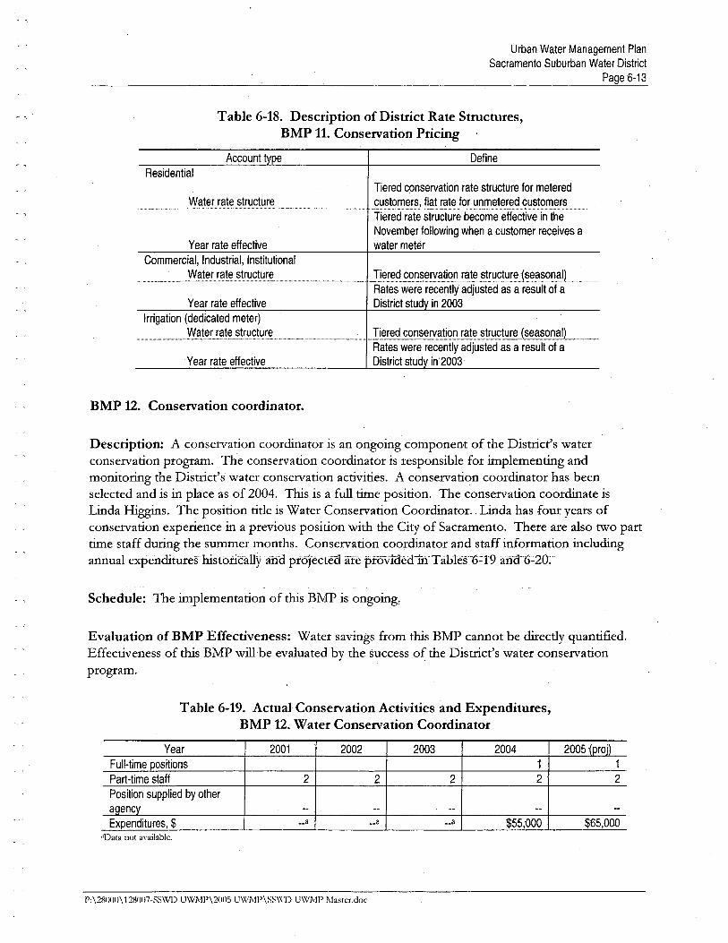
Urban Water Management PlanSacramento Suburban Water District
Page 6-13
Table 6-18. Description of District Rate Structures,BMP 11. Conservation Pricing
Account type Define~ .,
Residential
Water rate structureTiered conservation rate structure for metered
_~~t9-n_~,r~fl§l-i~t~qrJ!~,rn~_t~-i~g~!:~tome!~__mTiered rate structure become effective in the
November following when a customer receives a
water meterYear rate effective
Commercial, Industrial, InstitutionalWater rate structure ,m___, J:!~red_~Q,r:~~~?t~n-rate _~t~£t!!~J~?'~Q~lL,_______
Rates were recently adjusted as a result of a
District study in 2003Year rate effective
Irrigation (dedicated meter)
Water rate structure
Yearrate effective
mm..____'_,_ ..-Ti~red,gQ,r:s~!:-a~Q!_r.?t~_str~cturej~~s0f!J)______
Rates were H!cently adjusted as a result of a
District study in'2003
BMP 12. Conservation coordinator.
Description: A conservation coordiator is an ongoing component of the Distrct's waterconservation program. The conservation coordinator is responsible for implementig andmonitorig the Distrct's water conservation activities. A conservation coordiator has beenselected and is in place as of 2004. Ths is a full tie position. The conservation coordiate isLinda Higgs. The position title is Water Conservation Coordiator. Linda has four years ofconservation experience ,in a previous position with the City of Sacramento. There are also two parttie staff durig the summer months. Conservation coordiator and staff infoimation includigannual expenditureShistonêallyand' ptöJècteâãfèprovwedûf T á15leš-6::l9ahâ--6~20:"
Schedule: The implementation of this BMP is ongoing,
Evaluation ofBMP Effectiveness: Water savings from this BMP cannot be diectly quantified.Effectiveness of ths BMP wil ,be evaluated by the success of the Distrct's water conservationprogram.
Table 6-19. Actual Conservation Activities and Expenditures,BMP 12. Water Conservation Coordinator
Year 2001 2002 2003 2004 2005 ~proj)
Full-time positions 1 1
Part-time staff 2 2 2 2 2
Position supplied by other
agency -- -- -- -- --
Expenditures, $ __8 __8 __8 $55,000 $£5,000'Data not ayailabJe,
1':\28110()\128007-SSWD UWMP\20n5 UWMP\SS\'(.1) UWMP Mastcr.doc

Urban Water Management PlanSacramento Suburban Water District
Page 6-14
Table 6-20. Projected Conservation Activities and Expenditures,BMP 12. Water Conservation Coordinator
Year 2006 2007 2008 2009 2010
Full-time positions 1 1 1 1 1
Part-time staff ' 2 , 2 , 2 2 2
Position supplied by other
açiency -- -- -- -- --
Expenditures, $ $75,000 $75,000 $75,000 $75,000 $75,000Note: The projection of program acti\'ity from 2006 through 2010 is estiated based on requirements in the District's current Water Forumconser\'ation agreement. The District is in the process of e\'aluating this BMP, and as a result actual future implementation may var from the dataprovided in this table.
BMP 13. Water waste prohibition.
Description: Water waste prohibition is an ongoing component of the Distrct's waterconservation program. This Distrct has adopted its own set of water conservation regulations.A copy of the Distrct's regulations is provided in Appendi G. Chapter 7 of ths plan provides adescription of the prohibited water uses in Distrct's water waste regulations.
The Distrct does not include water softener checks in the home water survey program. TheDisti-ict does not include information about Demand Initiated Regeneratig and exchange-tyewat~r softeners in education efforts to encourage replacement of less efficient tier models.
A summary of the program includig annual expenditures in the past and projected is provided i'Tables 6-21 and 6-22, respectively.
Schedule: The implementation of this BMP is ongoing. This program started in Febiuar 2002'.
Evaluation of BMP Effectiveness: Water savings from this program cannot be diectlyquantified.
Table 6-21. Actual Conservation Activities and Expenditures,BMP 13. Water Waste Prohibition
, Year 2001 2002 2003 2004 2005~proil
Waste ordinance in effect Yes Yes Yes Yes
On-site visits __8 2,000 2,500 3,100
Water softener ordinance No No No No
Expenditures, $ __8 __8 $12,000 $16;00"Data not a\'ailablc,
P:\281100\128007-SSWD UWMP\2U05 U\XlMP\SS\l1) UWMP Masrer,doc
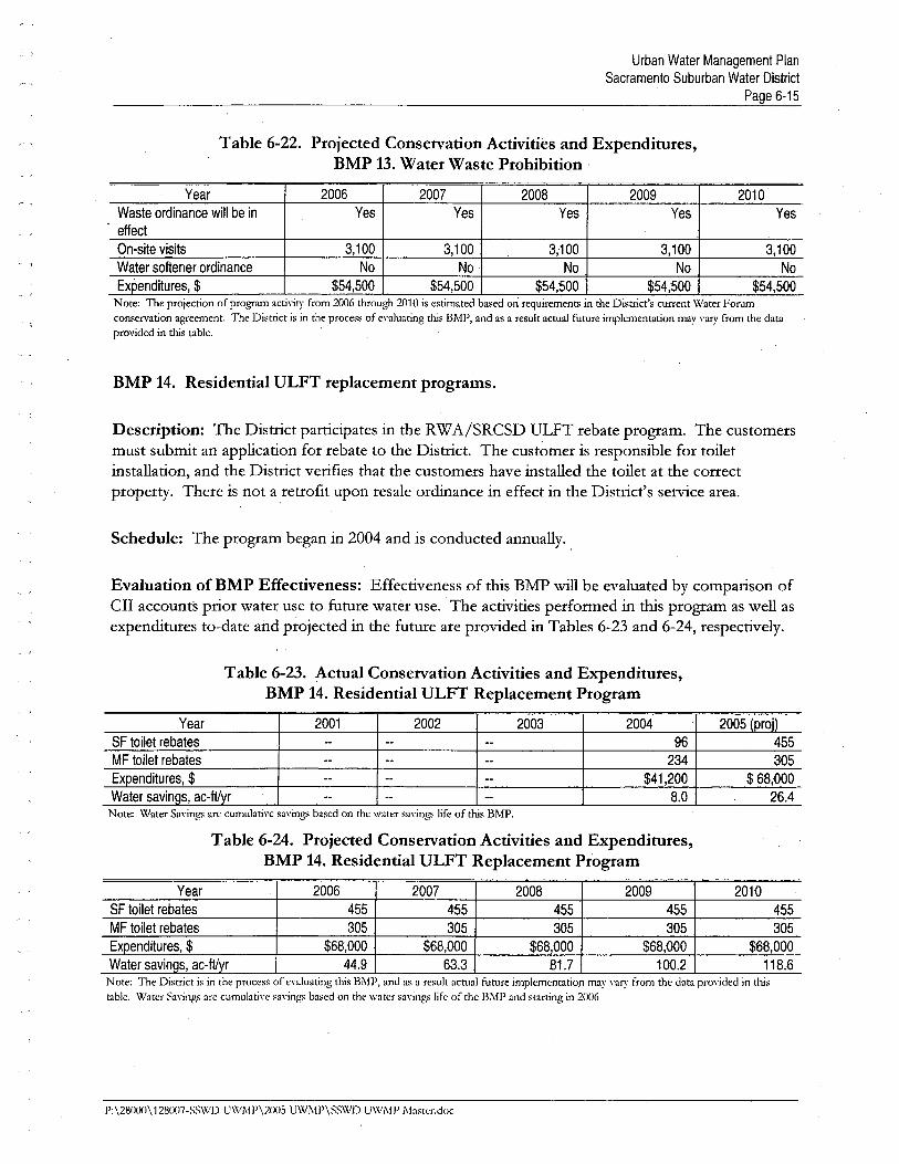
Urban Water Management PlanSacramento Suburban Water District
Page £-15
Table 6-22. Projected Conservation Activities and Expenditures,BMP 13. Water Waste Prohibition'
Year 2006 2007 2008 2009 2010
Waste ordinance wil be in Yes Yes Yes Yes Yeseffect
On-site visits 3,100 3,100 3,100 3,100 3,100Water softener ordinance No No No No No
Expenditures, $ $54,500 $54,500 $54,500 $54,500 $54,500Note: The projection of program activity from 2006 through 2010 is estimated based on reguirements in the District's current Water Forumconservation agreement. The District is in the process of evaluating this BMP, and as a result actual future implementation may vary from the dataprovided in this table,
BMP 14. Residential ULFT replacement programs.
Description: The Distrct partcipates in the RW A/SRCSD ULPT rebate program. The customersmust submit an application for rebate to the Distrct. The cust~mer is responsible for toiletinstallation, and the Distrct verifies that the customers have installed the toilet at the correctproperty. There is not a retrofit upon resale ordiance in effect in the Distrct's service area.
Schedule: The program began in 2004 and is conducted annually. ,
Evaluation of BMP Effectiveness: Effectiveness of this BMP wil be evaluated by comparison ofCII accounts prior water use to future wa-tër use. The activities performed in ths program as well asexpenditures to-date and projected in the future are provided in Tables 6-23 and 6-24, respectively.
Table 6-23. Actual Conservation Activities and Expenditures,BMP 14. Residential ULFT Replacement Program
Year 2001 2002 2D03 2004 2005 (proD
SF toilet rebates -- -- -- 96 455MF toilet rebates -- -- -- 234 305Expenditures, $ n -- -- $41 ,200 $ 68,DOO
Water savings, ac-ftyr -- n -- 8.0 26.4Note: Water Savings are cumulative sa\'ings based on the water savings life of this BMP.
Table 6-24. Projected Conservation Activities and Expenditures,BMP 14. Residential ULFT Replacement Program
Year 2006 2007 2008 2009 2010SF toilet rebates 455 455 455 455 455MF toilet rebates 305 305 305 305 305Expenditures, $ $68,000 $£8,000 $68,000 $68,000 $£8,000Water savings, ac-ftyr 44.9 63.3 81.7 100.2 118.6
Note: The District is in the process of evaluating this BMP, and as a result actual future implementation may vary ¡rom the data provided in thistable. Water Savings are cumulative savings based on the water sa\'ings life of the BMP and starting in 2006
P:\280UO\128l107-SS\X.1) UWMP\20(lS UWJ\P\SSWD UWJ\P 1\a'tcr.oc
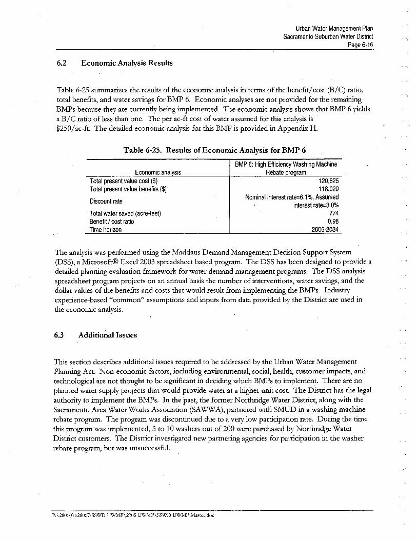
Urban Water Management PlanSacramento Suburban Water District
Page 6-1û
6.2 Economic Analysis Results
Table 6-25 sumaries the results of the economic analysis in terms of the benefitl cost (B/C) ratio,total benefits, and water savigs for BMP 6. Economic analyses are not provided for the remaingBMPs because they are currently being implemented. The economic analysis shows that BMP 6 yieldsa B/C ratio ofless than one. The per ac-ft cost of water assumed for ths analysis is$250/ac-ft. The detaied economic analysis for ths BMP is provided in Appendi H.
-,
.. 1
Economic anal sis
Total present value cost ($)
Total present value benefits ($)
Table 6-25. Results of Economic Analysis for BMP 6
BMP 6: High Efficiency Washing Machine
Rebate ro ram
Discount rate
Total water saved (acre-feet)
Benefit / 'Cost ratio
Time horizon
120,825118;029
Nominal interest rate=6.1 %, Assumedinterest rate=3.0%
7740.98
2006-2034
The analysis was performed using the Maddaus Demand ManagemeIlt Decision Support System
(DSS), a MicrosoftC Excel 2003 spreadsheet based program. The DSS has been designed to provide a
detailed plannig evaluation framework for water demand management programs. The DSS analysisspreadsheet program projects on an annual basis the number of interventions, water savings, and thedollar values of the benefits and costs that would result from implementig the BMPs. Industiyexperience-based "common" assumptions and inputs from data provided by the Distrct are used inthe economic analysis.
6.3 Additional Issues
TIs section describes additional issues requied to be addressed by the Urban Water ManagementPlannig Act. Non-economic factors, includig environmental, social, health, customer impacts, andtechnological are not thought to be signficant in decidig which BMPs to implement. There are noplanned water supply projects that would provide water at a higher unit cost. The Distrct has the legalauthority to implement the BMPs. In the past, the former Northdge Water Distrct, along with theSacramento Area Water Works Association (SA WW A), partnered with SMUD in a washig machierebate program. The program was discontiued due to a veiy low participation rate. Durig the tie
this program was implemented, 5 to 10 washers out of 200 were purchased by Northridge WaterDistrct customers. The Distiict investigated new partnerig agencies for participation in the washerrebate program, but was unsuccessfuL.
P:\28000\128007-SS\\lD UW1\1P\2005 U\XlMP\SSWD UWMP Master.doc
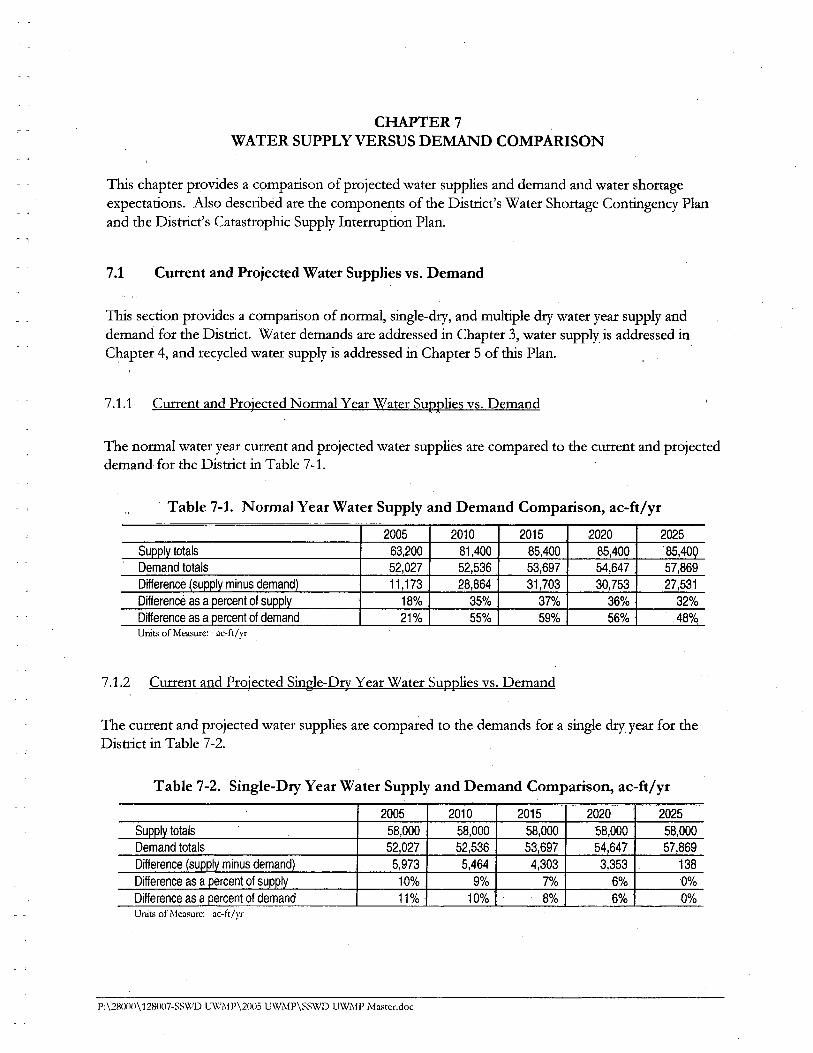
c , CHAER 7WATER SUPPLY VERSUS DEMAD COMPARISON
TIs chapter provides a comparison of projected water supplies and demand and water shortgeexpectations. Also described are the components of the Distrct's Water Shortage Contigency Planand the Distrct's Catastrophic Supply Interrption Plan.
7.1 Current and Projected Water Supplies vs. Demand
TIs section provides a comparison of normal, single-dr, and multiple dr water year supply and
demand for the Distrct. Water demands are addressed in Chapter 3, water supply is addressed inChapter 4, and recycled water supply is addressed in Chapter 5 of ths Plan.
7.1.1 Curent and Projected Normal Year Water Supplies vs. Demand
The normal water year curent and projected water supplies are compared to the curent and projecteddemand for the Distrct in Table 7-1.
Table 7-1. Normal Year Water Supply and Demand Comparison, ac-ft/yr
2005 2010 2015 ,2020 2025
Supply totals 63,200 81,400 85,400 85,400 . 85,400
Demand totals 52,027 52,536 53,697 54,647 57,869
Difference (supply minus demand) 11 ,173 28,864 31,703 30,753 27,531
Difference as a percent of supply 18% 35% 37% 36% 32%
Difference as a percent of demand 21% 55% 59% 56% 48°/q
Unit.. of Mea..ure: ac-ft/yr
7.1.2 Current and Projected Single-Dry Year Water Supplies vs. Demand
The curent and projected water supplies are compared to the demands for a single dry year for theDistrct in Table 7-2.
Table 7-2. Single-Dry Year Water Supply and Demand Comparison, ac-ft/yr
2005 2010 2015 2020 2025
Supply totals 58,000 58,000 58,000 58,000 58,000Demand totals 52,027 52,536 53,697 54,647 57,869Difference (supply minus demand) 5,973 5,464 4,303 3,353 138
Difference as a percent of supply 10% 9% 7% 6% '0%
Difference as a percent of demand 11% ' 10% 8% 6% 0%Units of Measure: ac-ft/yr
P:\28000\128007-SS'WD UWMl'\2005 U\x!\!P\SSWD UWMP Master.doc
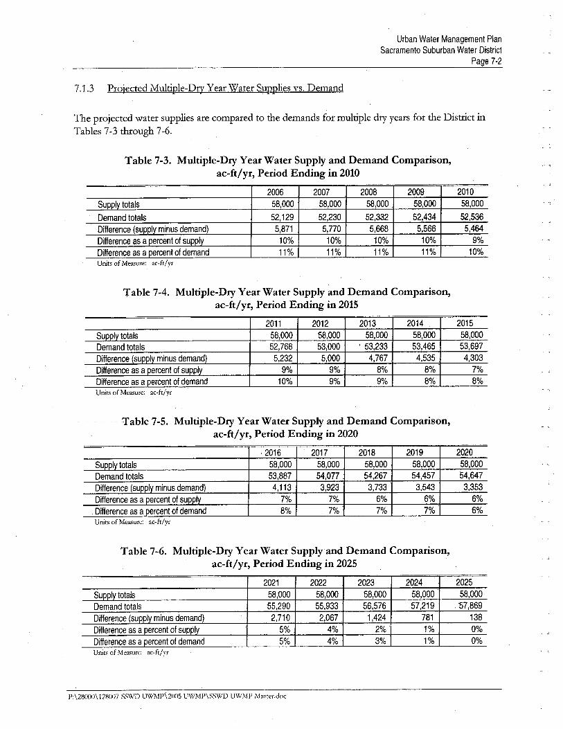
Urban Water Management PlanSacramento Suburban Water District
Page 7-2
7.1.3 Projected Multiple-Dry Year Water Supplies vs. Demand
The projected water supplies are compared to the demands for multiple dr years for the Distrct inTables 7-3 though 7-6. C. -1
Table 7-3. Multiple-Dry Year Water Supply and Demand Comparison,ac-ft/yr, Period Ending in 2010
2006 2007 2008 2009 2010
Supply totals 58,000 58,000 58,000 58,000 58,000
Demand totals 52,129 52,230 52,332 52,434 52,536
Difference (supply minus demand) 5,871 5,770 5,668 5,566 5,464
Difference as a percent of supply 10% 10% 10% 10% 9%
Difference as a percent of demand 11% 11% 11% 11% 10%
Units of Measure: ac-ft/yr
Table 7-4. Multiple-Dry Year Water Supply and Demand Comparison,ac-ft/yr, Period Ending in 2015
2011 2012 2013 2014 2015
Supply totals 58,000 58,000 58,000 58,000 58,000
Demand totals 52,768 53,000 ' 53,233 53,465 , 53,697
Difference (supply minus demand) 5,232 ,5,000 4,767 , 4,535 4,303
Difference as a percent of supply 9% 9% 8% 8% 7%
Difference as a percent of demand 10% 9% 9% 8% 8%Units of Measure: ac-ft/yr
. Table 7-5. Multiple-Dry Year Water Supply and Demand Comparison,. ac-ft/yr, Period Ending in 2020
1 .2016 I ' 2017 i 2018 2019 2020
Supply totals 58,000 58,000 58,000 58,000 58,000
Demand totals 53,887 54,077 54,267 54,457 54,647
Difference (supply minus demand) 4,113 3,923 3,733 3,543 3,353
Difference as a percent of supply 7% 7% 6% 6% 6%
Difference as a percent of demand 8% 7% 7% 7% 6%Units of Measure: ac-ft/yr
Table 7-6. Multiple-Dry Year Water Supply and Demand Comparison,ac-ft/yr, Period Ending in 2025
2021 2022 2023 2024 2025
Supply totals 58,000 58,000 58,000 58,000 58,000
Demand totals 55,290 55,933 56,576 57,219 ,57,869
Difference (supply minus demand) 2,710 2,067 1 ,424 781 138
Difference as a percent of supply 5% 4% 2% ' 1% 0%
Difference as a percent of demand 5% 4% 3% 1% 0%Units of Measure; ac-ft/yr
P:\28000\ 12801l-SS\VD UWMP\2l105 UWMP\SS\X,D UWMP Ì\laster,doc
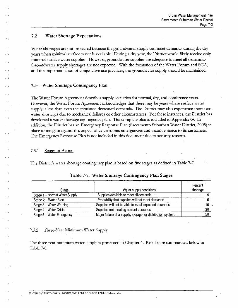
Urban Water Management PlanSacramento Suburban Water District
Page 7-3~ -i
7.2 Water Shortage Expectations~ -i
r .,
Watetshortages are not projected because the groundwater supply can meet demands durg the diyyears when mial surface water is available. Durg a dr year, the Distrct would liely receive onlymial surface water supplies. However, groundwater supplies are adequate to meet al demands.'
Groundwater supply shortages are not expected. With the formation of the Water Foru and SGA,and the implementation of conjunctive use practices, the groundwater supply should be maitaied.~ .,
7.3.,. Water Shortage Contingency Plan
The Water Foru Agreement describes supply scenarios for normal, dry, and conference years.However, the Water Foru Agreement acknowledges that there may be years where surface watersupPly is less than even the stipulated decreased demands. The Distrct may also experience short-termwater shortages due to mechanical failures or other circumstances. For these instances, the Distrct l;asdeveloped a water shortage contigency plan. The complete plan is included in Appendi G. Inaddition, the Distrct has an Emergency Response Plan (Sacramento Suburban Water Distrct, 2005) inplace to mitigate agaist the impact of catastrophic emergencies and inconvenience to its customers.The Emergency Response Plan is not included in ths document due to securty reasons.
7.3.1 Stages of Action
The Distrct's water shortage contigency plan is based on five stages as defied in Table 7-7.
Table 7-7. Water Shortage Contingency Plan Stages
Percentshorta eSta e
Sta e 1 - Normal Water Su
Sta e 2 - Water Alert
Sta e 3 - Water Warnin
Sta e 4 ,- Water Crisis
Sta e 5 - Water Emer enc
o
5
15
30
50
7.3.2 1bee-Year Mium Water Supply
The thee-year mium water supply is presented in Chapter 4. Results are summaried below inTable 7-8.
1':\2800n\12800ï-SS\Xf\) UWJ\fP\2005 UWMP\SSWD UWMl' Master.doc

Urban Water Management PlanSacramento Suburban Water District
Page 7-4
Table 7-8. Estimated Minimum Water Supply, Ac-ft/yr
Source 2006 2007 2008 . Normal
Surface Water
Purchase - USSR (215) 0 0 0 10,000
Transfer - peWA 0 0 0 29,000Entitlement - City of Sacramento 0 .0 0 22,400Supplier produced groundwater 58,000b 58,OOOb 58,OOOb 24,000Recycled water 0 0 0 0
Water supply loss due to water quality(0) (0) (0) (0)
Desalination water U 0 U 0Total 58,000 58,000 58,000 85,400
- i
- ,
7.3.3 Catastrophic Supply Interrption Plan
The Distrct has prepared a securty vuerabilty assessment and maitais an Emergency Response'Plan to address respondig to catastrophic supply interrptions as well as other emergencies. TheDistrct also has standby power in the form of portable diesel, natual gas and propane generator units.11s increases the reliabilty of supply. The Emergency Response Plan is not included in thsdocument due to securty reasons.
The'Distrct uties an emergency organiational strctue and chai of command in response to alemergencies with or affectig its service area. The Emergency Response Plan defies the emergencymai:agement positions.
The organiational response is divided into two levels of emergency. The two tyes of emergencies arecateg()t:edas follows:
Site emergency - does not exceed the followig criteria:
. Lited to one Distrct facilty AND
. Incident has no potential for serious impact on the public OR
. Incident has no potentil for serious impact on water quality/delivery
Distrctemergen~y - exceeds site emergency criteria:
. Incident affects multiple Distrct facilties OR
. Incident has the potential for serious impact on the public OR
. Incident has the potential for serious impact on water quality/delivery
The roles and responsibilties of each individual in the emergency organiation are defied for bothlevels of emergency. The following Table 7-9 summai-ies the response actions to possible majorcatastrophes withi the Disuict. The Emergency Response Plan provides detailed response actions foreach individual possible major catastrophe.
P: \28(lOIl\ 128007-SS\X/D UWMP\2(JOS UWMP\SS\X/ UWÌ\fP Master,doc
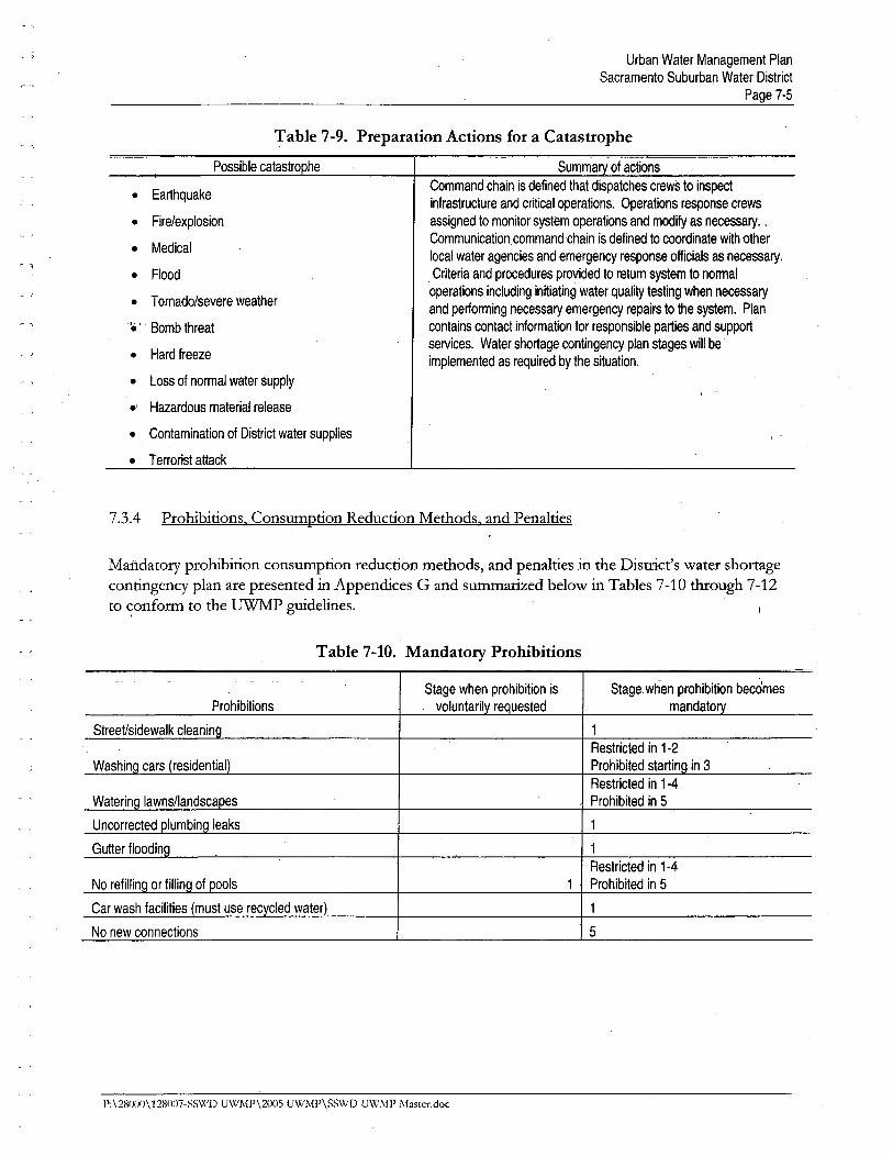
Urban Water Management PlanSacramento Suburban Water District
Page 7-5
Table 7-9. Preparation Actions for a Catastrophe
Possible catastro he Summa of actions
Command chain is defined that dispatches crews to inspectinfrastructure and critical operations. Operations response crews
assigned to monitor system operations and modify as necesary. .
Communication, command chain is defined to coordinate with other
local water agencies and emergency response officials as necessary.
Criteria and procedures provided to return system to normal
operations including initiating water quality testing when necessary
and performing necessary emergency repairs to the system. Plan
contains contact information for responsible parties and support
services. Water shortage contingency plan stages wil be
implemented as required by the situation.
~ i
. Earthquake
. Fire/explosion
. Medical
. Flood
. Tornado/severe weather
"ë ' , Bomb threat
. Hard freeze
. Loss of normal water supply
.' Hazardous material release
. Contamination of District water supplies
. Terrorist attack
7.3.4 Prohibitions. Consumption Reduction Methods. and Penalties
Mandatory prohibition consumption reduction methods, and penalties in the Distrt's water shortagecontigency plan are presented in Appendices G and sumaried below in Tables 7-10 though 7-12to ~onform to the UWP gudelies.
Table 7-10. Mandatory Prohibitions
Prohibitions
Street/sidewalk clean in
Stage when prohibition isvoluntaril re uested
Stage when pmhibition' becomes
mandato
Washin
1
Restricted in 1-2
Prohibited startin in 3
Restricted in 1-4
Prohibited in 5
1
1
Restricted in 1-4
Prohibited in 5
1
5
Waterin
No new connections
P:\28000\12ilOll7-SS\Xlj) UWMP\2005 UWMI'\SS\Xi!) UWMP Ma5ter.doc
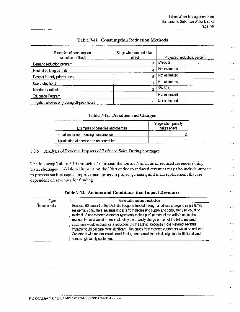
Urban Water Management PlanSacramento Suburban Water District
Page 7-6
Table 7-11. Consumption Reduction Methods
Examples of consumption
reduction methods
Stage when method takes
effect
2
4
5
1
2
1
1
Pro'ected reduction, ercent
5%-50%
Not estimated
Not estimated
Not estimated
5%-50%
Not estimated
Not estimated
- 1
"l
, i
Table 7-12. Penalties and Charges
Stage when penaltytakes effect
Termination of service and reconnect fee
7.3.5 Analysis of Revenue Impacts of Reduced Sales During Shortages
2
1
The followig Tables 7-13 through 7-16 present the Distrct's analysis of reduced revenues durgwater shortages. Additional impacts on the Distrct due to reduced revenues may also include impacts
to projects such as capital improvement program projects, meters, and mai replacement that aredependent on revenues for fundig.
Table 7-13. Actions and Conditions that Impact Revenues
Antic' ated revenue, reduction
Because 60 percent of the District's budget is funded through a flat-rate charge to single family
residential consumers, revenue impacts from decreasing supply and.consumer USe would be
minimaL. Since metered customer types only make up 40 percent of the utilty's users, the
revenue impacts would be minimaL. Only the quantity charge portion of the bil to metered
customers would experience a reduction. As the District becomes more metered, revenue
impacts would become more significant. Revenues from metered customers would be reduced.
Customers with meters include multi-family, commercial, industrial, irrigation, institutional, and
some sin Ie famil customers
T e
Reduced sales
P: \28000\ 128007-SSWD UWMP\2005 U\VMP\SSWD UWj\IP Master.doc
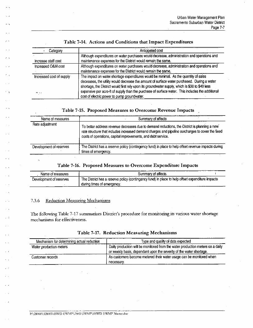
Urban Water Management PlanSacramento Suburban Water District
Page 7-7
Table 7-14. Actions and Conditions that Impact Expenditures
Antici ated cost
Although expenditures on water purchases would aecrease, administration and operations and
maintenance ex enses for the District would remain the same.
Although expenditures on water purchases would oecrease, administration and operations and
maintenance expenses for the District would remain the same.
The impact on water shortage expenditures would be minimaL. As the quantity of sales
decreases, the utility would decrease the amount of surface water purchased. During a water
shortage, the District would first rely upon its groundwater supply, which is $30 to $40 les
expensive per acre-ft of supply than the purchase of surface water. This includes the additional
cost of electric ower to um roundwater.
r ~
Cate 0
Increase staff cost
Increased O&M cost
~ .,
Increased cost of supply
~ .,
Table 7-15. Proposed Measures to Overcome Revenue Impacts
Name of measures
Rate adjustment
Summary of effects
To better address revenue decreases due to demand reductions, the District is planning a new'
rate structure that includes increased demand charges and pipeline surcharges to cover the fixed
costs of operations, capital improvements, and debt service.
Development of reserves The District has a reserve policy (contingency fund) in place to help offset revenue impacts during
times of emerç¡ency.
"
Table 7-16. Proposed Measures to Overcome Expenditure Impacts
Name of measures
Development of reserves
7.3.6 Reduction Measurg Mechanisms
The followig Table 7-17 summaries Distrct's procedure for monitorig its various water shortagemechanisms for effectiveness.
Table 7-17. Reduction Measuring Mechanisms
Mechanism for determinin actual reduction
Water production meters
Customer records
P:\28000\128007-SS\'i/J U\XiMI'\2()IJ5 UWJ\fP\S~WD UWMI' Ma~wr.doc
CHAPTER 8REFERENCES
A & N Technical Servces, Inc. 1999. Guide to Data and Methods for Cost-Effectiveness Analysis ofUrban Water Conservation Best Management Practices. Prepared for the Calforna UrbanWater Conservation Council. Draft document dated March 31,1999.
Brown and Caldwell. December 2000. Nortdge Water Distrct Urban Water Management Plan.
Brown and Caldwell. Decemher 2000. Arcade Water Distrct Urban Water Management Plan.
Brown and Caldwell. Februar 2003. Sacramento Suburban Water Distrct Urban Water, ManagementPlan.
,
Californa Urban Water Conservation Council. 1999. The Memorandum of Understandig RegardigUrban Water Conservation in Californa.
Californa Urban Water Agencies. 1992. Evaluatig Urban Water Conservation Programs: AProcedures ManuaL.
'\
Carollo Engieers, November 2001. Final Draft Sacramento Regional Wastewater Treatment Plant2020 Master Plan.
Departent of Water Resources (DWR). February 27, 2004. CalifOl11a's Gwundwater Buleti 118-Update 2003, Sacramento Valley Groundwater Basin, Nort American Subbasin.
EDA W /SWRI. October 1999. Executive Sumary of the Water Foru Proposal Final EIR.
Luhdorff and Scalmani. June 2002. In-lieu Surface Water Use and Groundwater Basin Conditions,
Northdge Servce Area.
Luhdorff and Scalmani. March 2000. Groundwater Basin and Well Conditions, Nortdge WaterDistrct. '
Montgomery Watson. 1999. Regional Water Master Plan, Phase I Final Report Executive Summary.Prepared for American River Basin Cooperatig Agencies.
Nolte and Associates, Inc. 1994. Sacramento County Water Reclamation Study Summary Report.Prepared for Sacramento County Sanitary Distrct.
Placer County Water Agency. February 1999. Placer County Water Agency and Northdge Water
P;\28000\128007-SS'WD UWMP\200S UWi\fl'\SS\X,1) UWMP Master,doc
Urban Water Management PlanSacramento Suburban Water District
Page 8-2
Distrct Groundwater Stabilation Project, Final Envionmental Impact Repoit. - ,
SACOG. December 16,2004. Projections Update Metropolitan Transportation Plan 2027.
Sacramento City - County Office of Metropolitan WaterPlannig. 1999. Water Foru Action Plan.
Sacramento City - County Office of Metropolitan Water Plannig. October 1999. FinalEnvironmental Impact Report for the Water Foru Proposal.
Sacramento Suburban Water Distrct. Apri 2005. Emergency Response Plan.
Western Regional Cliate Center. 1999. Web-Site: Western U.S. Cliate Historical Sumaris,Cliatogolical Data Sumaries, (ww.wrcc.dr.edu).
P:\28000\128007-SSWD UWMP\2005 U\VMP\SSWD UWJ\lP Ma~ter.doc

APPENDIX A
Notice of Public Hearing
"1'1,
'\
'1 SACRAMENTO SUBURBAN WATER D1ST3701 MARCONI AVE, SUITE 100SACRAMENTO CA 95821-
DECLARATION OF PUBLICATION
(C,C,P. 2015.5)
COUNTY OF SACRAMENTO
STATE OF CALIFORNIA
I ama citizen of the United States anda resident of the County aforesaid; Idil over the age of eighteen years.
;¡nanot :i p:irty to or interested in theèlbove entitled matter. i am the prinlerilnei principal clerk of the publisher ofThe Sacramento Bee, printed andpublished in the City of Sacramento,
County of Sacramento. State of Cali.fornia. daily, for which said newspaperhas been adjudged a newspaper of
neneral circulation by the Superior
Court of 1he County of Sacramento,
Slate of California. under the date ofSeptember 26. 1994. Action No.379071; that the notice of which tiie;innexed is a printed copy. has beenpiiblished in each issue t11ereof and
not in any supplement thereof on thefollowing dates, to wit:
October 3, 10, 2005
I r.crtify (or (Jeclare) under penalty ofperjury that the foregoing is true rtndr.orrect cinathat this declaration was¡lxecuted a! Sacramento, California,
on Octen01 0, 2005.l ..

APPENDIX B
Adoption Resolution

APPENDIX C
Detailed Intertic Information
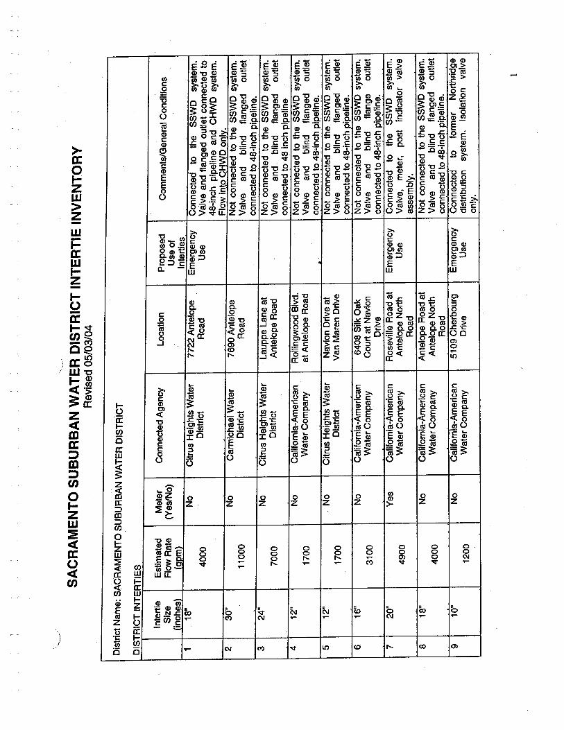
,,,,-
,,
SA
CR
AM
EN
TO
SU
BU
RB
AN
WA
TE
R D
IST
RIC
T IN
TE
RT
IE IN
VE
NT
OR
YR
evis
ed 0
5/03
/04
Dis
tric
t Nam
e: S
AC
RA
ME
NT
O S
UB
UR
BA
N W
AT
ER
DIS
TR
ICT
DIS
TR
ICT
IN
TE
RT
IES
Inte
rtie
Est
imat
edM
eter
Con
nect
ed A
genc
yL
ocat
ion
Prop
osed
Com
men
ts/G
ener
al C
ondi
tions
Size
Flo
w R
ate
(Yes
/No)
Use
of
Cin
ches
)(o
om)
Inte
rtie
s1
18"
No
Citr
us H
eigh
ts W
ater
7722
Ant
elop
eE
mer
genc
yC
onne
cted
toth
eSS
WD
syst
em.
4000
Dis
tric
tR
oad
Use
Val
ve a
nd fl
ange
d ou
tlet c
onne
cted
to48
-inc
h pi
pelin
e an
d C
HW
D s
yste
m.
230
"F
low
into
CH
WD
onl
v.N
oC
arm
icha
el W
ater
7690
Ant
elop
eN
ot c
onne
cted
to th
e SS
WD
sys
tem
.11
000
Dis
tric
tR
oad
Val
vean
dbl
ind
flan
ged
outle
tco
nnec
ted
to 4
8-in
ch p
ipel
ine.
324
"N
oC
itrus
Hei
ghts
Wat
erL
aupp
e L
ane
atN
ot c
onne
cted
to th
e SS
WD
sys
tem
.70
00D
istr
ict
Ant
elop
e R
oad
Val
vean
dbl
ind
flan
ged
outle
tco
nnec
ted
to 4
8 In
ch p
ipel
ine
412
"N
oC
alif
orni
a-A
mer
ican
Rol
lngw
ood
Blv
d.N
ot c
onne
cted
to th
e SS
WD
sys
tem
.17
00W
ater
Com
pany
at A
ntel
ope
Roa
dV
alve
and
blin
dfl
ange
dou
tlet
. '
conn
ecte
d to
48"
inch
pip
elin
e.5
12"
No
Citr
us H
eigh
ts W
ater
Nav
ion
Driv
e at
Not
con
nect
ed to
the
SSW
D s
yste
m.
1700
Dis
tric
tV
an M
aren
Driv
eV
alve
and
blin
dfl
ange
dou
tlet
conn
ecte
d to
48:
-inch
pip
elin
e.6
16"
No
Cal
ifor
nia-
Am
eric
an64
06 S
ilk O
akN
ot c
onne
cted
to th
e SS
WD
sys
tem
.31
00W
ater
Com
pany
Cou
rt a
t Nav
ion
Val
vean
dbl
ind
flan
geou
tlet
Dri
veco
nnec
ted
to 4
6-in
ch p
ipel
ine.
720
"Y
esC
alif
orni
a-A
mer
ican
Ros
evile
Roa
d at
Em
erge
ncy
Con
nect
edto the
SSW
Dsy
stem
.49
00W
ater
Com
pany
Antelope North
Use
Val
ve,
met
er,
post indicator valve
Roa
das
sem
bly:
818
"N
oC
alif
orni
a-A
mer
ican
Ant
elop
e R
oad
atN
ot c
onne
cted
to th
e S
SW
D s
yste
m.
4000
Wat
er C
ompa
nyAntelope North
Val
vean
dbl
ind
flan
ged
outle
tR
oad
conn
ecte
d to
4~
.lnch
pip
elin
e.9
10"
No
Cal
ifor
nia-
Am
eric
an51
09 C
herb
ourg
Em
erge
ncy
Con
nect
edto
form
erN
orth
fidg
e
1200
Wat
er C
ompa
nyD
rive
Use
dist
ribu
tion
syst
em.
Isol
atio
nva
lve
only
.
1
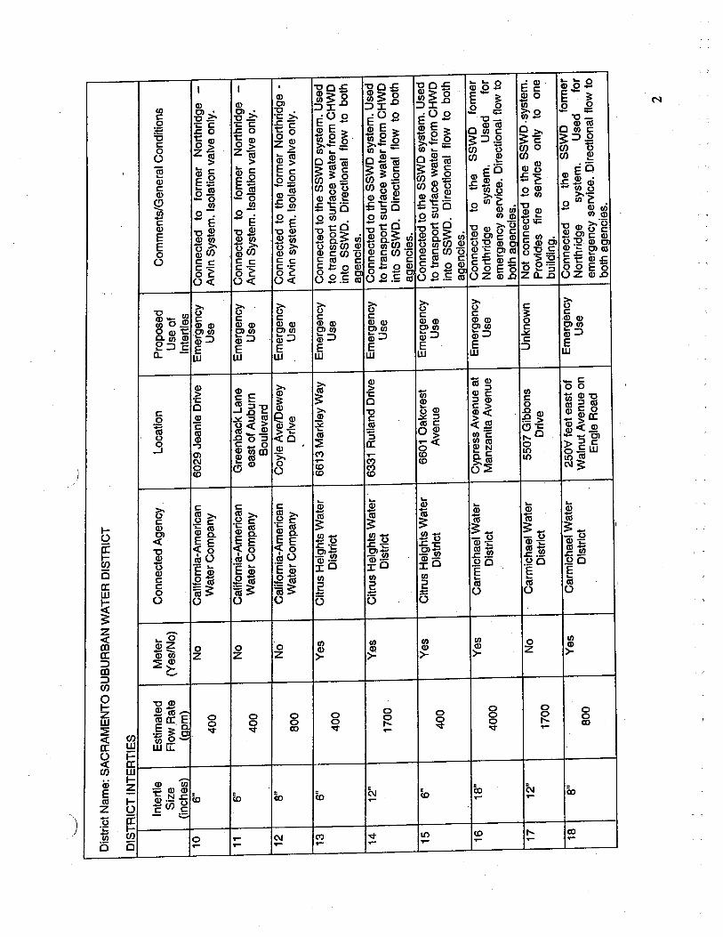
,--~
,'
Dis
tric
t Nam
e: S
AC
RA
ME
NT
O S
UB
UR
BA
N W
AT
ER
DIS
TR
ICT
DIS
TR
ICT
IN
TE
RT
IES
-
Inte
rtie
Est
imat
edM
eter
Con
nect
ed A
genc
yL
ocat
ion
Prop
osed
Com
men
ts/G
ener
al C
ondi
tions
Size
Flo
w R
ate
(Yes
/No)
Use
of
(inc
hes)
(aom
)In
tert
les
106"
No
Cal
iorn
ia-A
mer
ican
6029
Jea
nie
Driv
eE
mer
genc
yC
onne
cted
to f
orm
er N
orth
ridg
e -
400
Wat
er C
ompa
nyU
seA
rvin
Sys
tem
. Iso
latio
n va
lve
only
.
116"
No
Cal
ifor
nia-
Am
eric
anG
reen
back
Lan
eE
mer
genc
yC
onne
cted
to f
orm
er N
orth
ridg
e -
400
Wat
er C
ompa
nyea
st o
f Aub
urn
Use
Arv
in
Sys
tem
. Iso
latio
n va
lve
only
.B
oule
vard
12a"
No
Cal
ifor
nia-
Am
eric
anC
oyle
Ave
/Dew
eyE
mer
genc
yC
onne
cted
to th
e fo
rmer
Nor
thrid
ge -
800
Wat
er C
ompa
nyD
rive
Use
Arv
in s
yste
m. I
sola
tion
valv
e on
ly.
136"
Yes
Citr
us H
eigh
ts W
ater
6613
Mar
kley
Way
Em
erge
ncy
Con
nect
ed to
the
SS
WD
sys
tem
. Use
d40
0D
istr
ict
Use
to tr
ansp
ort s
urfa
ce w
ater
from
CH
WD
into
SSW
D. D
irec
tiona
l flo
w to
bot
hi
aaen
cies
.14
12"
Yes
Citr
us H
eigh
ts W
ater
6331
Rut
land
Driv
eE
mer
genc
yC
onne
cted
to th
e S
SW
D s
yste
m.U
sed
1700
Dis
tric
tU
seto
tran
spor
t sur
face
wat
er fr
om C
HW
Din
to S
SWD
. Dir
ectio
nal f
low
to b
oth
aaen
cies
.15
6"Y
esC
itrus
Hei
ghts
Wat
er66
01 O
akcr
est
Em
erge
ncy
Con
nect
ed to
the
SS
WD
sys
tem
. Use
d
400
Dis
tric
tA
venu
eU
seto
tran
spor
t sur
face
wat
er fr
om C
HW
Din
to S
SWD
. Dir
ectio
nal f
low
to b
oth
aaen
cies
.16
18"
Yes
Car
mic
hael
Wat
erC
ypre
ss A
venu
e at
Em
erge
ncy
Con
nect
edto
the
SSW
Dfo
rmer
4000
Dis
tric
tM
anza
nita
Ave
nue
Use
Nor
thri
dge
syst
em.
Use
dfo
rem
erge
ncy
serv
ice.
Dire
ctio
nal f
low
to,
both
aae
ncle
s.
1712
"N
oC
arm
icha
el W
ater
5507
Gib
bons
Unk
now
nNot connected to the SSWD. system.
1700
Dis
tric
tD
rive
Prov
ides
fir
e se
rvic
e on
ly to
one
build
ing.
188"
Yes
Car
mic
hael
Wat
er25
0'c
feet
eas
t of
Em
erge
ncy
Con
nect
edto
the
SSW
Dfo
rmer
800
Dis
tric
tW
alnu
t Ave
nue
onU
seN
orth
ridg
esy
stem
.U
sed
for
Eng
le R
oad
emer
genc
y se
rvic
e. D
irect
iona
l flo
w to
both
aae
ncie
s.-
2
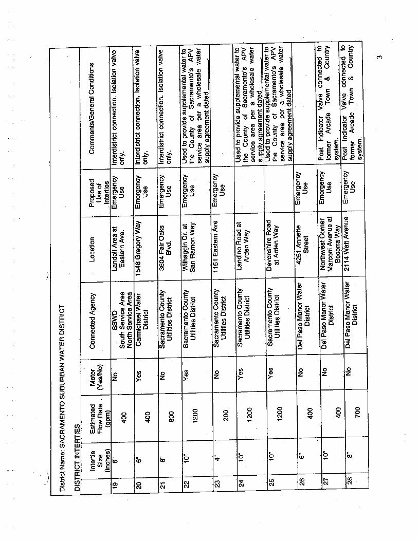
,.._,
~/'"
Dis
tric
t Nam
e: S
AC
RA
ME
NT
O S
UB
UR
BA
N W
AT
ER
DIS
TR
ICT
DIS
TR
ICT
IN
TE
RT
IES
-
Inte
rtie
Est
imat
edM
eter
Con
nect
ed A
genc
yL
ocat
ion
Prop
osed
Com
men
ts/G
ener
al C
ondi
tions
Size
Flo
w R
ate
'(Y
es/N
o)U
se o
f(i
nche
s)(a
om)
. Int
ertle
s19
6"N
oSS
WD
Land
olt A
rea
atE
mer
genc
yIn
terd
istr
ict c
onne
ctio
n. Is
olat
ion
valv
e40
0S
outh
Ser
vice
Are
aE
aste
rn A
ve.
Use
only
.N
orth
Ser
vice
Are
a20
6"Y
esC
arm
icha
el W
ater
1548
Gre
gory
Way
Em
erge
ncy
Inte
rdls
trlc
t con
nect
ion.
Isol
atio
n va
lve
400
Dis
tric
tU
seon
ly.
218"
No
Sac
ram
ento
Cou
nty
3604
Fai
r O
aks
Em
erge
ncy
Inte
rdis
trlc
t con
nect
ion.
Isol
atio
n va
lve
800
Utilties District
Blv
d.U
seon
ly.
2210
"Y
esSacramento County
Wilh
aggi
n O
r. a
tE
mer
genc
yU
sed
to p
rovi
de s
uppl
emen
tal w
ater
to
1200
Utllties District
San
Ram
on W
ayU
sethe County of Sacramento's APV
service area per a wholesale water
supp
lv a
cree
men
t dat
ed
234"
No
Sac
ram
ento
Cou
nty
1151
Eas
tern
Ave
Em
erge
ncy
200
Utilties District
Usa
2410
"Y
esSacramento County
Land
ino
Roa
d at
Use
d to
pro
vide
sup
plem
enta
l wat
er to
1200
Utllties District
Ard
en W
ayth
eC
ount
yof
Sacr
amen
to's
APV
service area per a wholesale water
. "
supp
lv a
area
men
t dat
ed
2510
"Y
esSacramento County
Dev
onsh
ire
Roa
dU
sed
to p
rovi
de s
uppl
emen
tal w
ater
to
1200
Utilties District
at A
rden
Way
the
Cou
nty
of
Sacr
amen
to's
APV
service area per a wholesale water
supp
lv a
cire
emen
t dat
ed
266"
No
Del
Pas
o M
anor
Wat
er42
51 A
nnet
teE
mer
genc
y,
400
Dis
tric
tSt
reet
Use
2710
"N
oD
el P
aso
Man
or W
ater
Nor
thw
est C
orne
rE
mer
genc
yP
ost I
ndic
ator
\,al
veco
nnec
ted
toD
istr
ict
Mar
coni
Ave
nue
atU
sefo
rmer
Arc
ade
Tow
n&
Cou
ntry
400
,Bec
erra
Way
syst
em.
288"
No
Del
Pas
o M
anor
Wat
er21
14 W
att A
venu
eE
mer
genc
yP
ost I
ndic
ator
Val
ve c
onne
cted
to
700
Dis
tric
t-
Use
form
erA
rcad
eT
own
&C
ount
rysy
stem
.
3
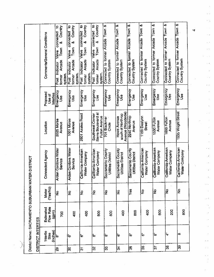
..._w
.....
Dis
tric
t Nam
e: S
AC
RA
ME
NT
O S
UB
UR
BA
N W
AT
ER
DIS
TR
ICT
DIS
TR
ICT
IN
TE
RT
IES
Inte
rtie
Est
imat
edM
eter
Con
nect
ed A
genc
yL
ocat
ion
Prop
osed
Com
men
ts/G
ener
al C
ondi
tions
Size
Flo
w R
ate
(Yes
/No)
Use
of
(inc
hes)
(oom
)In
tert
les
298"
No
Ard
en C
ordo
va W
ater
2025
Mor
seE
mer
genc
yP
ost I
ndic
ator
Val
ve c
onne
cted
to70
0Se
rvic
eA
venu
eU
sefo
rmer
Arc
ade
Tow
n&
Cou
ntry
syst
em.
306"
No
Ard
en C
ordo
va W
ater
1001
Mor
seE
mer
genc
yP
ost I
ndic
ator
Val
ve c
onne
cted
to40
0Se
rvic
eA
venu
eU
sefo
rmer
Arc
ade
Tow
n&
Cou
ntry
syst
em.
316"
No
Cal
ifor
nia-
Am
eric
an28
01 A
zale
a R
oad
Em
erge
ncy
Pos
t Ind
icat
or V
alve
con
nect
ed to
400
Wat
er C
ompa
nyU
sefo
rmer
Arc
ade
Tow
n&
Cou
ntry
syst
em.
328"
No
Cäl
ifor
nia-
Am
eric
anS
outh
wes
t Cor
ner
Em
erge
ncy
Pos
t Ind
icat
or V
alve
. co
nnec
ted
to80
0W
ater
Com
pany
Sie
rra
Bou
leva
rd a
tU
sefo
rmer
Arc
ade
Tow
n&
Cou
ntry
Ful
ton
Ave
nue
syst
em.
338"
No
Sacramento County
701
Bla
ckm
erE
mer
genc
yC
onne
cted
to fo
rmer
Arc
ade
Tow
n &
800
Utilties District
Cir
cle
Use
Cou
ntry
Sys
tem
346"
No
Sac
ram
ento
Cou
nty
How
e A
venu
eE
mer
genc
yC
onne
cted
to fo
rmer
Arc
ade
Tow
n &
400
Utilties District
sout
h of
Nor
thro
pU
seC
ount
ry S
yste
mA
venu
e (W
oods
ide)
358"
Yes
Sacramento County
2240
Nor
thro
pE
mer
genc
yC
onne
cted
to fo
rmer
Arc
ade
Tow
n &
800
UtiltIes District
Ave
nue
Use
Cou
ntry
Sys
tem
,
366"
No
Cal
ifor
nia-
Am
eric
an11
50 D
ealy
nnE
mer
genc
yC
onne
cted
to fo
rmer
Arc
ade
Tow
n &
400
Wat
er C
ompa
nySt
reet
Use
Cou
ntry
Sys
tem
378"
No
Cal
ifor
nIa-
Am
eric
an15
30 F
ulto
nE
mer
genc
yC
onne
cted
to fo
rmer
Arc
ade
Tow
n &
800
Wat
er C
ompa
nyA
venu
eU
seC
ount
ry S
yste
m
384"
No
Cal
iorn
ia-A
mer
ican
1600
Fu
lton
Em
erge
ncy
Con
nect
ed to
form
er A
rcad
e T
own
&
200
Wat
er C
ompa
nyA
venu
eU
seC
ount
ry S
yste
m
398
No
Cal
ifor
nia-
Am
eric
an19
35 W
right
Str
eet
Em
erge
ncy
Con
nect
ed to
form
er A
rcad
e T
own
&
800
Wat
er C
ompa
nyU
seC
ount
ry S
yste
m
4
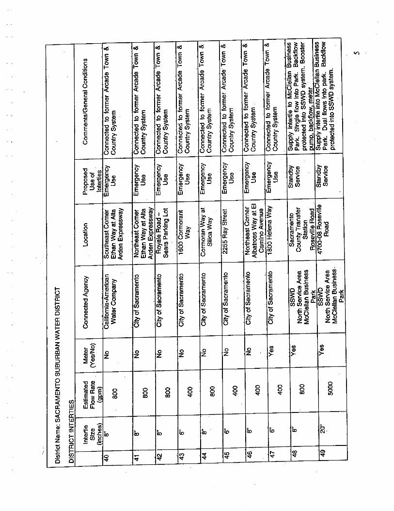
Dis
tric
t Nam
e: S
AC
RA
ME
NT
O S
UB
UR
BA
N W
AT
ER
DIS
TR
ICT
DIS
TR
ICT
IN
TE
RT
IES
-
Inte
rtie
Est
imat
edM
eter
Con
nect
ed A
genc
yL
ocat
ion
Prop
osed
Com
men
ts/G
ener
al C
ondi
tions
Size
Flo
w R
ate
(Yes
/No)
Use
of
(inc
hes)
(oom
)In
tert
ies
408"
No
Cal
ifor
nia-
Am
eric
anS
outh
east
Cor
ner
Em
erge
ncy
Con
nect
ed to
form
er A
rcad
e T
own
&80
0W
ater
Com
pany
Eth
an W
ay a
t Alta
Use
Cou
ntry
Sys
tem
Ard
en E
xpre
ssw
ay
418"
No
City
of S
acra
men
toN
orth
east
Cor
ner
Em
erge
ncy
Con
nect
ed to
form
er A
rcad
e T
own
&80
0E
than
Way
at A
ltaU
seC
ount
ry S
yste
mA
rden
Exp
ress
way
428"
No
City
of S
acra
men
toRoyale Road -
Em
erge
ncy
Con
nect
ed to
form
er A
rcad
e T
own
&80
0S
ears
Par
king
Lot
Use
Cou
ntry
Sys
tem
, ,
436"
No
City
of S
acra
men
to16
00 C
orm
oran
tE
mer
genc
yC
onne
cted
to fo
rmer
Arc
ade
Tow
n &
400
Way
Use
Cou
ntry
Sys
tem
448"
No
City
of S
acra
men
toC
orm
oran
Way
at
Em
erge
ncy
Con
nect
ed to
form
er A
rcad
e T
own
&
800
Silc
a W
ayU
seC
ount
ry S
yste
m
456"
No
City
of S
acra
men
to22
55 R
ay S
tree
tE
mer
genc
yC
onne
cted
to fo
rmer
Arc
ade
Tow
n &
400
Use
Cou
ntry
Sys
tem
466"
No
City
of S
acra
men
toN
orth
east
Cor
ner
Em
erge
ncy
Con
nect
ed to
form
er A
rcad
e T
own
&
400
Alb
atro
ss W
ay a
t EI
Use
Cou
ntry
Sys
tem
Cam
ino
Ave
nue
476"
Yes
City
of S
acra
men
to18
00 H
elen
a W
ayE
mer
genc
yC
onne
cted
to fo
rmer
Arc
ade
Tow
n &
400
Use
Cou
ntry
Sys
tem
488"
Yes
SSW
DSa
cram
ento
Stan
dby
Supp
ly in
tert
ie to
McC
lella
n B
usin
ess
800
Nor
th S
ervi
ce A
rea
Cou
nty
Tra
nsfe
rSe
rvic
eP
ark.
Sin
gle
flow
Into
Par
k. B
ackf
low
McC
lella
n B
usin
ess
Stat
ion
prot
ecte
d In
to S
SWD
sys
tem
. Boo
ster
Park
Ros
evile
Roa
dD
umo.
bac
kflo
w. m
eter
4920
"Y
esSS
WD
4700-08 Rosevi1e
Stan
dby
Sup
ply
inte
rtie
into
McC
lella
n B
usin
ess
5000
Nor
th S
ervi
ce A
rea
Roa
dSe
rvic
ePark. Dual flows into park. Backflow
McC
lella
n B
usin
ess-
prot
ecte
d in
to S
SW
D s
yste
m.
Park
5

'...._
.,...
Dis
tric
t Nam
e: S
AC
RA
ME
NT
O S
UB
UR
BA
N W
AT
ER
DIS
TR
ICT
DIS
TR
ICT
IN
TE
RT
IES
Inte
rtie
Est
imat
edM
eter
Con
nect
ed A
genc
yL
ocat
ion
Prop
osed
Com
men
ts/G
ener
al C
ondi
tions
Size
Flo
w R
ate
(Yes
/No)
Use
of
(inc
hes)
(oom
)In
tert
ies
508"
No
SSW
D41
95-9
7 C
orne
liaE
mer
genc
yN
ot c
onne
cted
to th
e SS
WD
sys
tem
.80
0In
ter-
dist
rict
Way
Use
Sup
plie
s' w
ater
to tw
o re
side
ntia
l lot
sIn
tert
ieat
SSW
D b
ound
ary.
,
518"
Yes
Rio
Lin
da W
ater
Dis
tric
t68
36 3
0m S
tree
tE
mer
genc
yConnected to former Arcade North
800
Use
Hig
hlan
ds s
yste
m.
,
5224
"Y
esSS
WD
Wal
erga
Roa
d at
Dai
ly U
seC
onne
cted
toth
eSS
WD
syst
em.
7000
Arc
ade
Ser
vice
Are
aB
ainb
ridg
e W
ayO
pera
tiona
l as
of M
arch
200
2 fo
r(N
orth
Hig
hlan
ds)
emer
genc
y or
dai
ly u
sage
. Dire
ctio
nal
Nor
thrid
ge S
ervi
cefl
ow
avai
labl
e.
Are
a53
8"N
oC
alif
orni
a-A
mer
ican
7547
Wat
t Ave
nue
Em
erge
ncy
800
Wat
er C
ompa
nyU
se
5412
"Y
esC
alif
orni
a-A
mer
ican
Ant
elop
e R
oad
atE
mer
genc
yC
onne
cted
to th
e S
SW
D N
orth
ridge
1700
Wat
er C
ompa
nyW
aler
ga R
oad
Use
syst
em. V
alve
Met
er a
nd p
ost i
ndic
ator
,va
lve.
5516
"Y
esThe Links ~ Antelope
Otta
wa
Way
at
Stan
dby
Supp
lyin
tert
iebe
twee
nfo
rmer
3100
Cre
e W
ay a
t The
Serv
ice
Nor
thrid
ge s
yste
m a
nd to
the
Link
's_L
inks
at A
ntel
ope
hous
ing
com
plex
. Val
ve, m
eter
5612
"N
oSS
WD
Whi
tney
Ave
nue
atSt
andb
y U
seIn
tert
ie b
etw
een
SSW
D N
orth
and
1700
Nor
th S
ervi
ce A
rea
Mis
sion
Ave
nue
South Service Areas.
Meter wil be
Sou
th S
ervi
ce A
rea
inst
alle
d su
mm
er 2
004.
6
APPENDIX D
SACOG Traffc Analysis Zones within the District Boundaries
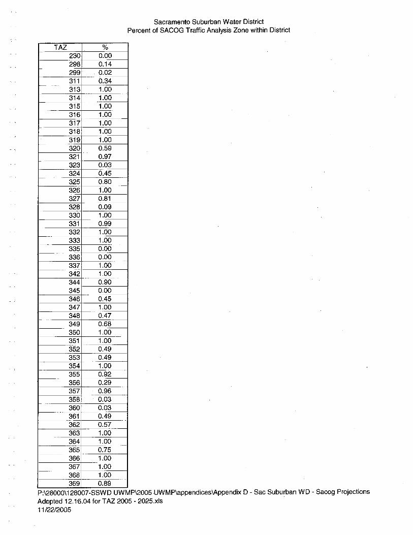
Sacramento Subur'an Water DistrictPercent of SACOG Traffc Analysis Zone within District
TAZ %230 0.00298 0.14299 0.02311 0.34313 1.00314 1.00315 1.00316 1.00317 1.00318 1.00319 1.00320 0.59321 0.97323 0.03324 0.45325 0.80326 1.00327 0.81328 0.09330 1.00331 0.99332 1.00333 1.00335 0.00336 0.00337 1.00342 1.00344 0.90345 0.00346 0.45347 1.00348 0.47349 0.68350 1.00351 1.00352 0.49353 0.49354 1.00355 0.92356 0.29357 0.96358 0.03360 0.03361 0.49362 0.57363 1.00364 1.00365 0.75366 1.00367 1.00368 1.00369 0.89
P:\28000\128007-SSWD UWMP\2005 UWMP\appendices\Appendix D - Sac Suburban WD - Sacog ProjectionsAdopted 12.1'6.04 for T AZ 205 - 2025.x18 '11 /22/2D05
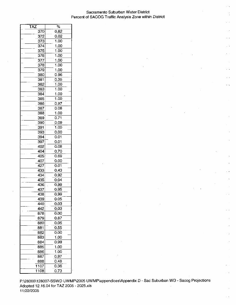
Sacramento Suburban Water DistrictPercent of SACOG Traffic Analysis Zone within District
TAZ %370 0.82372 0.02373 1.00374 1.00375 1.00376 1.00377 1.00378 1.00379 1.00380 0.96381 0.35382 1.00383 1.00384 1.00385 1.00386 0.97387 0.08388 1.00389 0.71390 0.09391 1.00393 0.00394 0.01397 0.01402 0.08404 0.70405 0.69407 0.00427 0.01433 0.43434 0.92435 0.04436 , 0.99437 0.95438 0.99439 0.05440 0.03442 0.03878 0.00879 0.87880 0.05881 0.55882 0.00883 1.00884 0.99885 1.00886 1.00887 0.97888 0.48
1107 0.361108 0.73
P:\28000\128007-SSWD UWMP\2005 UWMP\appendices\Appendix D - Sac Suburban WD - Sacog ProjectionsAdopted 12.16.04 for T AZ 2005 - 2025.xls11 /22/2005
"
APPENDIX E
Sacramento Groundwater Authority Groundwater Management Plan

SACRAMENTO GROUNDWATER AUTHORITY
'il' i'
GROUNDWATERMANAGEMENT PLAN
'\
DECEMBER 2003

SACRAMENTO GROUNDWATER AUTHORITYGROUNDWATER MANAGEMENT' PLAN
PAGE LEFT BLANK INTENTIONALLY
December 2003
Sacrto Growate AuMam Giondie &e§OSin No Sacrllto, Coty
Sacramento Groundwater Authority5620 Birdcage Street, Suite 180Citrs Heights, CA 95610Tel: (916) 967-7692Fax: (916) 967-7322
Members:
California-American Water Company
Carmichael Water District
Citrs Heights Water District
Del Paso Manor Water District
Fair Oaks Water District
Folsom. city of
Natomas Central Mutual Water Company
Orange Vale Water Company
Rio LindalElverta Community Water District
Sacramento, city of
Sacramento, county of
Sacramento Suburban Water District
San Juan Water District
Southern California Water Company
agricultural and selfsupplied representatives
December 11, 2003
To Interested Parties and Individuals:
The Sacramento Groundwater AUthority (SGA) is pleãsed to 'release this Groundwater Management Plan (GMP), adoptedDecember 11,2003. The plan represents a critical step inestablishing a framework for maintaining a sustainablegroundwater resource for the various users overlying the basinin Sacramento County north of the American River. It includesspecific goals, objectives and an action plan to provide a "roadmap" for coordination among the 14 overlying waterpurveyors.
SGA and its members are committed to the regional objectives,established by the historic Sacramento Water ForumAgreement, and these objectives are incorporated into the plan.Since SGA's formation in 1998, SGA members have takenmany steps to preserve the valuable groundwater resourcesunderlying our region. These activities and specific futureactions are described in the GMP.
The plan is the product of several months of effort, withvaluable input from technical and policy review committees aswell as the public. SGA is grateful for the excellent input,technical assistance and funding provided through partnershipswith the U.S. Ary Corps of Engineers and the CaliforniaDepartment of Water Resources.
This plan represents a starting point for basin management; itis intended to be adaptive. Comments and suggestions toimprove our management efforts in the basin are welcome.
Sincerely,
~ "U J¡.,jLEdward D. WinklerExecutive Director
RESOLUTION NO. 2003-07
A RESOLUTION OF THE SACRAMENTO GROUNDWATER AUTHORITYADOPTING A GROUNDWATER MANAGEMENT PLAN AND A FINDING OFEXEMPTION FROM THE CALIFORNIA ENVIRONMENTAL QUALITY ACT
,
The Board of Directors of the Sacramento Groundwater Authority (SGA) does herebyfind that:
WHEREAS, the SGA was formed under the Joint Exercise of Powers Act(Chapter 5 of Division 7 of Tite 1 of the California Government Code) on August 11,1998 by the Cities of Citrs Heights, Folsom, and Sacramento, and the County of
Sacramento; andi"" t.
WHEREAS, the SGA was created for the purposes of protecting, preserving, andenhancing, for current and future beneficial uses, the groundwater resources in the NorthAreaGroundwater Basin, in Sacramento County, north of the American River; ai;d
WHEREAS, the SGA has prepared a Groundwater Management Plan for theNorth Area Groundwater Basin; and
WHEREAS, the Groundwater Management Plan wil further ongoing efforts toprotect groundwater and interdependent environmental resources in the North AreaGroundwater Basin, wil facilitate collection of information to further understand andevaluate additional policies and programs for protection of the groundwater resources in
'\ the North Area Groundwater Basin, and wil assist in other ongoing efforts to study the
feasibility of conjunctive use programs utilizing the North Area Groundwater Basin.
NOW, THEREFORE, be it resolved that:
1. The SGA Board hereby adopts a Groundwater Management Plan for the
North Area Groundwater Basin, in Sacramento County, north of the American River,copy attached hereto as Exhibit A.
2. The SGA Board further finds that the adoption of the GroundwaterManagement Plan is exempt from the requirements of the California EnvironmentalQuality Act. (CEQA Guideline §§ 15061, 15306, 15307, 15308, and 15262).
, PASSED AND ADOPTED by the Board of Directors of the SacramentoGroundwater Authority, on December 11,2003.
By -cæ~~ilori~
Attest:
r, Administrative Services Manager/Clerk
Acknowledgments,
This Groundwater Management Plan (GMP) is a direct result of the commitment thatSacramento Groundwater Authority (SGA) members made to sustain the groundwaterresource for present and future uses in northern Sacramento County. SGA would like tothank the staff of Montgomery Watson Harza in preparing the critical elements of thisplan. Also of great value in preparing this plan was the insight generated by public
outreach studies by Lucy & Company. Preparation of this GMP was generouslysupported by a fuding partership with the U.S. Army Corps of Engineers. Much of the
", 'data used to generate the information in this GMP was compiled using grant funds and afunding partership with the California Department of Water Resources. Finally, SGAwould like to thank the dedication of the Policy Committee and the Technical ReviewCommittee in guiding the preparation of this plan. The names of the committee members
, and alternates are listed below:
Policy Committee
Ron Bachman, chairTom Barandas (alternate)Jack DeWit
'\ Tom GrayLyle Hoag (alternate)
Shauna LoranceGary Reents
Rob Roscoe (alternate)Mike Winn
Technical Review Committee
Marshall DavertBil Dendy
Warren Jung (alternate)Mary KellerEd KrzShauna Lorance (alternate)Bob Niblack (alternate)
Jim Peifer ( alternate)Toni PezzettiRich Plecker
Rob RoscoeJoe ScalmaniniJohn Woodling
SACRAMENTO GROUNDWATER AUTHORITYGROUNDWATER MANAGEMENT PLAN
PAGE LEFT BLANK INTENTIONALLY
December 2003
SACRAMENTO GROUNDWATER AUTHORITYGROUNDWATER MANAGEMENT PLAN
TABLE OF CONTENTS
1 INTR 0 D U CTI ON ........ ...... ................ ......... .............. ..... ........... .................. ...... ............ .......... ................ ......1
1.1 OTHER REGIONAL MANAGEMENT EFFORTS ....................................................................................: 11.1.1 SMWA ........................................... .........................................................................................................31.1.2 Water Forum.............. .... ..... .......... ....... ....... .............. ............. ..... ...... .......... .......... ............. ....... ...... .......31.1.3 Cooperating Agencies...................................................................................................................... ......41.1.4 R WA.. ........................................................................................... ........... .......... ............. ..... ........... ò....... 41.1.5 Other Ongoing Groundwater Management-Related Activities within the SGA Area............................4
'il" i'1.2 PURPOSE OF THE SGA GMP ....................................................................................................................51.3 AUTHORITY TO PREPAR AND IMPLEMENT A GMP ........................................................................51.4 GMP COMPONENTS...................................................................................................................................5
2 WATER RESOURCES SETTING .............................................................................................,................. 7
2. 1 GROUNDWATER SUPPLIES ..................................................................................................................... 72.1.1 Overview of Hydrogeologic Setting .......................................................................................................7
2:2 SURFACE WATER SUPPLIES ................................................................................................................. is2.2.1 Water Rights/Contract Entitements . ...................................................................................................162.2.2 Surface Water Quality .............................................,..... ..................................................................... .19
2.3 "OTHER" SUPPLIES...... ................. ...... ............... ................. .......... ........... ........... ...... ..... ........ ..... ............212.4 EXISTING FACILITIES AND OPERATIONS .........................................................................................21
2.4.1 Major Infrastructure................................................................................................ ........... ...... ...........212.4.2 Operations... .................................................. ................ ........................................ .... ......... ....... ..........24
¡.5 FUTURE FACILITIES AND OPERATIONS ............................................................................................242.6 EFFECTS OF WFA IMPLEMENTATION ................................................................................................24
2. 6.1 Water Year Types......................:.................. ........................................................ .................... ............242.6.2 WF A Water Supply Availability ....................................... ......................... ..........................................~29
3 MAN AGE MENT PLAN ELEMENTS ....... ......... ............. ..... ................ .......... ............ ...... .......... .......... ..33
3. 1 GROUNDWATER MANAGEMENT GOAL ............................................................................................333:2 BASIN MANAGEMENT OBJECTIVES ...................................................................................................333.3 GMP COMPONENTS.................................................................................................................................353.4 COMPONENT CATEGORY 1: STAKEHOLDER INVOLVEMENT ......................................................35
3.4.1 Involving the Public... .................. ...... .................................... ....................... ............ .......... ........... ...... 353.4.2 Involving Other Agencies Within and Aciacent to the SGA Area ...............................................,.........363.4.3 Utilzing Advisory Committees.......... ..................... .......... ............................... ....................................393.4.4 Developing Relationships with State and Federal Agencies................................................................ 393.4.5 Pursuing Partnership Opportunities......................... ............................................. ........... ...................40
3.5 COMPONENT CATEGORY 2: MONITORIG PROGRAM ..................................................................413.5.1 Groundwater Elevation Monitoring........ .................................................. .................. .......... ........ ......413.5.2 Groundwater Quality Monitoring................ .............................................................. ..........................433.5.3 Land Surface Elevation Monitoring......................... ................................................... .............. ...........443.5.4 Surface Water Groundwater Interaction Monitoring ..........................................................................473.5.5 Protocols for the Collection of Groundwater Data .............................................................................483.5.6 Data Management System........................ ................... ................. ....................... ................ .......... ......48
3.6 COMPONENT CATEGORY 3: GROUNDWATER RESOURCE PROTECTION ..................................493.6.1 Well Construction Policies......................... ................... .......................................................... ............493.6.2 Well Abandonment and Well Destruction Policies ..............................................................................503.6. 3 Wellhead Protection Measures............... .................................... ........... ..............................................523.6.4 Protection of Recharge Areas........ ....... ................................................. ............. ................................. 533.6.5' Control of the Migration and Remediation of Contaminated Groundwater........................................ 533.6.6 Control of Saline Water Intrusion............................ ........................................................ ........; ........... 55
3.7 COMPONENT CATEGORY 4: GROUNWATER SUSTAINABILITY ................................................553.7.1 Conjunctive Management Activities........................... ..................................................... .......... ...........56
Page i December 2003
SACRAMENTO GROUNDWATER AUTHORITYGROUNDWATER MANAGEMENT PLAN
3.7.2 Demand Reduction.. ........................ .............. ................ ........ ....................................... ....... .................573.8 COMPONENT CATEGORY 5: PLANNING INTEGRATION................................................................. 58
3.8.1 Existing Integrated Planning Efforts ...................................................................................................59
4 PLAN IMPLEMENT A TI ON ...... ..........0....... ...... 0 0 0... ......... ......... ........... ......,. ......... 0 0..... ...... ...... ...... .......... ..... 0 61
4.1 ANNAL GMP IMPLEMENTATION REPORT ......................................................................................614.2 FUTURE REVIEW OF GMP......................................................................................................................614.3 FINANCING .............. ..... ........ ......... ........... ...... ..... ...... .......... ............... .................... ...... ...... ........ ......... .....61
5 RE FEREN CES ...... ...... 0..... 0 0.. 0 ....... ........... 0 ........ ..........000...... 0 0 ............ 0 0.. ...... ...... ...... .......... ..,........... 0 ......... 0.. 0 6 7
6 APPENDICES
6.1 APPENDIX A. SGA JOINT POWERS AGREEMENT6.2 APPENDIX B. WATER SUPPLY DATA BY SGA MEMBER AGENCY6.3 APPENDIX C. OUTREACH AND EDUCA TIUN
6.3.1 Attachment A. SGA is Notices Published inthe8acramenio- Bee
6.3.2 Attachment B. "Summary of Public Outreach Planfor Groundwater Management" (Lucy &Company, 2003).
6.4 APPENDIX D. STANDARD OPERATING PROCEDURE FOR MANUAL WATER LEVELMEASUREMENTS
6.5 APPENDIX E. FINAL DRAFT - "RELATIONSHIP OF THE WATER FORUM AGREEMENT TOLAND USE DECISION MAKIG", WATER FORUM SUCCESSOR EFFORT, JANUARY 2002
6.6 APPENDIX F. MODELING
December 2003 Page ii
SACRAMENTO GROUNDWATER AUTHORITYGROUNDWATER MANAGEMENT PLAN
LIST OF TABLES
TABLE 1.TABLE 2.TABLE 3.TABLE 4.
LOCATION OF SGA GMP COMPONENTS .................................;..................................................................6TREATMENT CAPACITY AT WTPSPROVIDING SURFACE WATER WITHIN THE SGA BOUNDARIES ...........22GROUNDWATER WELLS WITHIN SGA BOUNDARIES.................................................................................22YÈAR 2002 AND PROJECTED 2030 WATER SUPPLY SCENARIOS FOR WATER PURVEYORS WITHIN SGABOUNDARIES .......... ........... ... .., .............. .......... .... ....... ....... .... .... ...... ...... ........... ....... ...... .'. .... ....... ... ..... ..... .25RW A ARB CUP - SUMMARY OF PROGRAM FACILITIES ..;.......................................................................30SUMMARY OF GMP ACTIONS ...................................................................................................................63
TABLE 5.
TABLE 6.
LIST OF FIGURES
FIGURE 1. BOUNDARY OF THE SGA AND AREA COVERED BY THiSGROUNDWATERMANAGEMENTPLAN.................2FIGURE 2. LOCATION OF NORTH AMERICAN GROUNDWATER SUBBASIN ....................................................................8FIGURE 3. REGIONAL STRATIGRAPHIC COLUMN .........................................................................................................9FIGURE 4. PRINCIPAL CONTAMINANT PLUMES..........................................~...............................................................11FIGURE 5. SPRING 2002 GROUNDWATER ELEVATION CONTOURS............................................................................. 14FIGURE 6. LONG-TERM REPRESENTATIVE HYDROGRAPHS IN THE SGA AREA .........................................................17FIGURE 7. EXISTING PRINCIPAL INFRASTRUCTURE AND ADDITIONAL INFRASTRUCTURE RESULTING FROM
AMERICAN RIVER BASIN REGIONAL CONJUNCTIVE USE PROGRAM .........................................................23FIGURE 8. USE OF GROUNDWATER AND SURFACE WATER BY PURVEYOR ................................................................27FIGURE 9. TOTAL ANNUAL GROUNDWATER EXTRACTION BY SGA MEMBER AGENCIES (1998 - 2002) .................~29FIGURE 10. ORGANIZA TIONOF MANAGEMENT PLAN ELEMENTS .................................................................................34FIGURE 11. SGA MEMBER AGENCIES AND OTHER ADJACENT LOCAL AGENCIES.......................................................37FIGURE 12. INITAL PROPOSED WELLS FOR CONSIDERATION IN SGA GROUNDWATER ELEVATION MONITORING
NETWORK ..... .... ........ ... ..... .................. ...... ..... ...;..... ........ ............ ..... ........ ... ... ... ....... .......... ........... ..... .......42FIGURE 13. EXISTING AND PROPOSED WELLS IN SGA GROUNDWATER QUALITY MONITORING NETWORK...............45FIGURE 14. DMS SCREEN CAPTURE ..............................................................................................:............................51FIGURE 15. SURFACE GEOI,0Y OF THE SGA AREA - IMPLICATIONS FOR SURFACE RECHARGE RATES ....................54
Page iii December 2003

SACRAMENTO GROUNDWATER AUTHORITYGROUNDWATER MANAGEMENT PLAN
ABAeroj etAFAF/yearAFRP AARB CUPARWRIBMOCal-AmCALFEDCAScfsCHWDCMPCOCCooperating AgenciesCSUSCTPCVPCVPIACVRWQCBCWCCWDDCADCEDeltaDHSDPMWDDMSDWRDWSAP ProgramEMDEWAFolsomFOWDGMPgpmGroundwater ForumIGSM
InSARISIJPALincolnLSCE
ABBREVIATIONS AND ACRONYMS
Assembly Bil
Aerojet.;General Corporation facilityAcre- feetAcre- feet per yearAir Force Real Propert AgencyAmerican River Basin Regional Conjunctive Use ProgramAmerican River Water Resources InvestigationBasin Management ObjectiveCalifornia-American Water CompanyCALFED Bay-Delta ProgramCalifornia Aquifer SusceptibilityCubic feet per secondCitrus Heights Water District ,Sacramento Coordinated Water Quality Monitoring ProgramContaminants of concernAmerican River Basin Cooperating AgenciesCalifornia State University, SacramentoCooperative Transmission PipelineCentral Valley ProjectCentral Valley Project Improvement ActCentral Valley Regional Water Quality Control BoardCalifornia Water CodeCarmichael Water District1,2-dichloroethanecis-l,2-dichloroetheneSacramento/San Joaquin River DeltaCalifornia Departent of Health Services
Del Paso Manor Water DistrictData Management SystemCalifornia Department of Water ResourcesDrinking Water Source Assessment and Protection ProgramSacramento County Environmental Management DepartentEnvironmental Water AccountCity of FolsomFair Oaks Water DistrictGroundwater Management PlanGallons per minuteCentral Sacramento County Groundwater ForumNorth American River and Sacramento County Combined IntegratedGroundwater and Surface Water ModelInterferometric Synthetic Apertre RadarIntegrated Storage InvestigationJoint Powers AuthorityCity of LincolnLuhdorff & Scalmanini Consulting Engineers
December 2003 Page iv

SACRAMENTO GROUNDWATER AUTHORITYGROUNDWATER MANAGEMENT PLAN
LUSTM&IMather AFBMcClellan AFBMCLMWH
llg/Lllmhos/cmmg/Lmgd
iii I.mslNA WQANCMWCNGSNTPOVWCPBEPCAsPCEPCWAPLPODR~clamationRLECWDRosevileRWARWMPSac RegionalSac SuburbanSACOGSacramentoSAFCASCWASCWCSGASJWDSMWASOPSouth SutterSRCSDSWRCBTCETDSUSACEUSEP AUSGSWater ForumWEP
Leaking Underground Storage TankMunicipal and industralMather Air Force BaseMcClellan Air Force BaseMaximum Contaminant LevelMontgomery Watson Harzamicrograms per litermicromhos per centimeterMilgrams per literMilion gallons per dayMean sea levelNational Water Quality AssessmentNatomas Central Mutual Water CompanyNational Geodetic SurveyNorthridge Transmission PipelineOrange Vale Water CompanyPhysical Barrier EffectivenessPotential Contaminating ActivitiesT etrachloroethenePlacer County Water AgencyPublic LawPlace of UseU.S. Bureau of ReclamationRio LindaÆlverta Community Water DistrctCity of RosevileRegional Water AuthorityRegional Water Master PlanSacramento Regional Wastewater Treatment PlantSacramento Suburban Water DistrictSacramento Area Council of GovernmentsCity of SacramentoSacramento Area Flood Control AgencySacramento County Water AgencySouthern California Water CompanySacramento Groundwater AuthoritySan Juan Water Distrct
Sacramento Metropolitan Water AuthorityStandard Operating ProcedureSouth Sutter Water DistrictSacramento Regional County Sanitation DistrictState Water Resources Control BoardTrichloroetheneTotal dissolved solidsU.S. Ary Corps of EngineersU.S. Environmental Protection AgencyU.S. Geological SurveySacramento Area Water ForumWater Effciency Program
Page v December 2003
SACRAMENTO GROUNDWATER AUTHORITYGROUNDWATER MANAGEMENT PLAN
WFAWTP
Water Forum AgreementWater treatment plant
December 2003 Page vi
SACRAMENTO GROUNDWATER AUTHORITYGROUNDWATER MANAGEMENT PLAN
1 INTRODUCTIONThe Sacramento Groundwater Authority (SGA) is a joint powers authority (JP A) created tomanage the Sacramento region's North Area Groundwater Basin. The SGA's formation in 19981resulted from a coordinated effort by the Sacramento Metropolitan Water Authority (SMW A)and the Sacramento Area Water Forum (Water Forum) to establish an appropriate managemententity for the basin. The SGA is recognized as one of the essential tools to implement acomprehensive program to preserve the lower American River and ensure a reliable water supplythrough the year 2030.
The SGA draws its authority from a joint powers agreement2 signed by the cities of CitrusHeights, Folsom, and Sacramento-and-dor-acramento to exercise their commonpolice powers to manage the underlying groundwater basin. The agreement is included asAppendix A in this document. In tu, these agencies chose to manage the basin in acooperative fashion by allowing representatives of the 14 local water pureyors and a
representative from each agricultural and self-supplied pumpers to serve as the Board ofDirectors of the SGA3.
At the core of the SGA's management responsibility is a commitment to not exceed the averageannual sustainable yield of the basin, which was estimated to be 13 1 ,000 acre- feet4 in the WaterForum Agreement (WFA)5. To accomplish this objective and to provide a safe, reliable watersupply for the rapidly growing northern Sacramento CoUnty, this groundwater management plan(GMP) is necessary to begin to identify the many actions that sho;ti1d be taken in the North AreaGroundwater Basin. Thi's GMP represents a starting point from which the SGA wil continuallyassess the status of the groundwater basin and make appropriate management decisions to ensurea sustainable resource. The SGA's boundary as well as the area covered by this GMP includeonly the portion of Sacramento County north of the American River (Figure 1). Continuing
effort wil be made to ~qordinate SGA's GMP activities with adjacent areas.
1.1 OTHER REGIONAL MANAGEMENT EFFORTS
Over the past several decades, the water supplies of the region have been impacted by:
. Prolonged drought and prolonged wet periods.
. Increasing pressure to dedicate surface water for environmental puroses.
. Declining groundwater levels.
. Impacts and growing ,threats to surface water quality and groundwater quality.
1 The SGA was originally formed in 1998 as the Sacramento North Area Groundwater Management Authority. In
2002, it was renamed the Sacramento Groundwater Authority.2 The agreement is included in this report as Appendix A.3 SGA Board members include representatives of California-American Water Company, Carichael Water
District, Citrs Heights Water District, City of Folsom, City of Sacramento, County of Sacramento, Del PasoManor Water Distrct, Fair Oaks Water District, Natomas Central Mutual Water Company, Orange Vale WaterCompany, Rio Linda/Elverta Community Water District, Sacramento Suburban Water District, San Juan WaterDistrict, Southern California Water Company, and individual representatives from agriculture and self-suppliedgroundwater users (principally parks and recreation districts).
4 This value was estimated based on water use and facilities in the basin at the time of the WF A. This value was
based on a number of assumptions, and was not intended to be a fixed value that could not be modified asconditions and assumptions changed in the basin. Examples of changed conditions include new or improvedwater conveyance, treatment, and storage facilities or changes in water supply contracts.
5 The WFA is available online at httv://ww.waterforum.org or contact the Water Forum offce at (916) 264-1999.
Page 1 December 2003
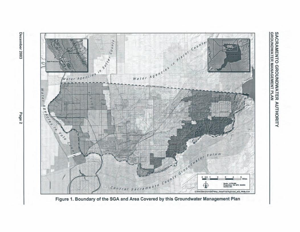
SACRAMENTO GROUNDWATER AUTHORITYGROUNDWATER MANAGEMENT PLAN
All the while, demand for water in the region has continued to grow.
To address these problems, water purveyors in the region have invested substantial time andresources in a progression of regional planning efforts. In particular, the planing efforts mostdirectly related to the SGA's efforts include:
. The SMW A.
. The Water Forum process.
. The American River Basin Cooperating Agencies Regional Water Master ,Plan
(Cooperating Agenci~s RWMP).
. The Regional Water Authority (RWA), successor to the SMWA.
Each of these regional planning efforts is discussed further below.
1.1.1 SMW A
Formed in 1990, the SMW A was a combined JPA and non-profit public benefit association of 17public water suppliers within Sacramento County6. A prim~ry objective of the SMW A was tofacilitate actions needed to restore and maintain the quantity and the quality of the groundwaterin the area. In support of that objective, the SMW A was a vital paricipant in the development ofthe WFA (see below)". The SMWA also developed and adopted a GMP as authorized byAssembly Bil (AB) 3030 of 1992 (commonly referred to as AB 3030 Plans, see the CaliforniaWater Code (CWe) § 10750 et seq.), but the plan was not fully implemented. In 2001, theSMWA was superceded by the RWA (see description below).
1;1.2 Water Forum
Begun in 1993, the Water Forum is a group comprised of business and agricultural leaders,citizens groups, envirQJUentalists, water managers, and local governents in the Sacramento
Region that joined together to fulfill two co-equal objectives:
. To provide a reliable 'and safe water supply for the region's economic health and planeddevelopment through the year 2030.
. To preserve the fishery, wildlife, recreational, and aesthetic values of the lower AmericanRiver.
In 2000, Water Forum members approved the WFA, which consists of seven integrated actionsnecessary to accomplish these objectives. The WF A prescribes a local conjunctive use programfor Folsom Reservoir, the lower American River, and the adjacent groundwater basin. One ofthe seven elements is groundwater management. This element divides Sacramento Countygroundwater basins into three subunits, the North, Central, and South areas, and recommendsthat the SGA (then known as the Sacramento North Area Groundwater Management Authority)serve as the governing body for the North Area Groundwater Basin. The groundwater elementalso estimated and recommended an average annual sustainable groundwater yield for the SGA
6 The SMW A members were located both north and south of the American River and included (note that some
purveyor names have been changed and/or undergone consolidation since the formation of the SMW A): City ofFolsom, City of Galt, Arden Cordova Water Service Company, Arcade Water District, Carmichael WaterDistrict, Citrus Heights Water District, Clay Water District, Del Paso Manor Water District, Elk Grove WaterWorks, Fair Oaks Water District, Galt Irrgation District, Northrdge Water District, Omochumne-Hartell WaterDistrict, Orange Vale Water Company, Rancho Murieta Community Services District, Rio Linda/ElvertaCommunity Water District, and San Juan Water District.
Page 3 December 2003
SACRAMENTO GROUNDWATER AUTHORITYGROUNDWATER MANAGEMENT PLAN
area of 131,000 acre-feet per year (AF/year) (roughly equivalent to the 1990 groundwater
pumping rate within the North Area Groundwater Basin). The Water Forum continues to.function with a dedicated staff in the Water Forum Successor Effort program to coordinate withother agencies and groups, such as, the SGA, to ensure that the elements of the WF A are carriedout. '
1.1.3 Cooperating Agencies
The Cooperating Agencies are an ad-hoc group of local water purveyors in northern SacramentoCounty and southern Placer County? Each of the Cooperating Agencies is a signatory of theWFA. The Cooperating Agencies were formed to complete a RWMP, the objective of which isto identify the facilities and operational agreements necessary to implement the WF A for thenorthern Sacramento/Placer area. This plan wil result in identifying opportities to improve
th'e. availability of water supplies through additional conjunctive use of surace water andgroundwater in the region. These expanded conjunctive use opportnities are a key componentto assuring a sustainable groundwater resource within the SGA's area. Upon completion of theRWMP, the Cooperating Agencies have sunset as an organization with much of their fuctionassumed by the R W A.
1.1.4 RW A
The R W A succeeded the SMW A in 200 I through a JP A to serve and represent the regionalwater supply interests, and assist members in protecting and enhancing the reliability,availability, affordability, and quality of water resources. One of the principal missions of theRWA is facilitating implementation of the conjunctive use program prescribed by the WFA andthe R WMP. The R W A currently has eighteen members and three associate members8 includingeach of the Cooperating Agencies except the Sacramento County Water Agency (SCW A).Nearly all members are signatory to the WFA.
As with the Cooperating Agencies, the success of implementing additional conjunctive useopportnities wil be an important factor in the SGA's ability to ensure a reliable groundwater
supply within its area. The activities of the R W A and SGA are highly coordinated as they sharea common offce and staff.
1.1.5 Other Ongoing Groundwater Management-Related Activities within the SGA Area
In addition to the on-going programs by individual SGA members, there are several other on-going groundwater-related activities within the SGA area. Coordination between these efforts
7 The "Cooperating Agencies" include water purveyors in both Sacramento County and Placer County: California-
American Water Company, Carmichael Water District, Citrus Heights Water District, City of Folsom, City ofRoseville, City of Sacramento, Del Paso Manor Water District, Fair Oaks Water District, Placer County WaterAgency, Rio Linda/Elverta Community Water District, Sacramento County Water Agency, Sacramento
Suburban Water Distrct, and San Juan Water District.8 The membership of the R W A encompasses water users in both Sacramento County and Placer County including:
California-American Water Company, Carmichael Water District, Citrus Heights Water District, City of Folsom,City of Lincoln, City of Rosevile, City of Sacramento, Del Paso Manor Water District, EI Dorado IrrigationDistrict, Fair Oaks Water District, Fruitrdge Vista Water Company, Orange Vale Water Company, PlacerCounty Water Agency, Rancho Murieta Community Services District, Rio LindaÆlverta Community WaterDistrict, Sacramento Suburban Water District, San Juan Water District, and the Southern California WaterCompany. Associate members do not directly retail drinking water and do not vote in RW A matters. Associatemembers include: EI Dorado County Water Agency, Sacramento Municipal Utility District, and SacramentoRegional County Sanitation District.
December 2003 Page 4
SACRAMENTO GROUNDWATER AUTHORITYGROUNDWATER MANAGEMENT PLAN
and the SGAwil be discussed in more detail later in this GMP. The activities closely related tothe SGA' s groundwater management efforts include, but are not limited to, the following:
.' Groundwater contamination investigation and remediation activities at the formerMcClellan Air Force Base (McClellan AFB).
. Groundwater contamination investigation and remediation activities at the Aerojet-General Corporation facility (Aerojet).
. Monitoring of groundwater levels and quality by the California Department of Water
Resources (DWR).
""'. Monitoring of groundwater levels and quality at California State University, Sacramento(CSUS).
. Monitoring of groundwater quality by the U.S. Geological Survey (USGS) as part of itsNational Water Quality Assessment (NA WQA) Program.
. Monitoring of site investigations and remediation efforts at known leaking underground
storage tanks (LUSTs) coordinated by the Central Yalley Regional Water Quality ControlBoard (CYRWQCB).
. In the mid-l 990s, DWR conducted a study on the feasibility of conjunctive use innorthwest Sacramento County and western Placer County (DWR, 1997). NatomasCentral Mutual Water Company (NCMWC), an SGA member, was a cooperating agencyto the study. Two multi-depth monitoring wells were constrcted in the northwest
Sacramento County as a result of the study and are currently monitored by DWR.'\
1.2 PURPOSE OF THE SGA GMP
The groundwater management goal of the SGA is to maintain a sustainable, high-qualitygroundwater resource for the users of groundwater basin underlying Sacramento County north ofthe American River consistent with the objectives of the WFA. To meet that goal, the purpose ofthis GMP is to serve as the initial framework for coordinating the many independe't
management activities into a cohesive set of management objectives and related actionsnecessary to meet those objectives.
1.3 AUTHORITY TO PREPARE AND IMPLEMENT A GMP
The authority of the SGA to manage the North Area Groundwater Basin is provided through thejoint powers agreement. The SGA Board of Directors elected to prepare this GMP as one of thetools necessary to effectively manage the basin. The SGA is preparing this GMP consistent withthe provisions ofCWC § 10750 et seq. as amended January 1,2003.
1.4 GMP COMPONENTS
The SGA GMP includes the following required and recommended components:
. CWC § 10750 et seq. (seven mandatory components). Recent amendments to the CWC §10750 et seq. require GMPs to include several components to be eligible for the award offunds administered by DWR for the construction of groundwater projects or groundwaterquality projects9.
. DWR Bulletin 118 (2003) components (seven recommended components).
9 These amendments to the ewe were included in Senate Bil1938, effective January 1,2003.
Page 5 December 2003
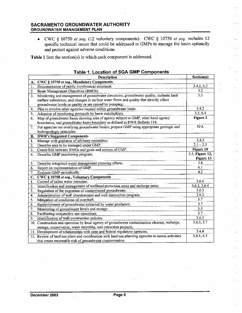
SACRAMENTO GROUNDWATER AUTHORITYGROUNDWATER MANAGEMENT PLAN
. ewe § 10750 et seq. (12 voluntary components). ewe § 10750 et seq. includes 12
specific technical issues that could be addressed in GMPs to manage the basin optimallyand protect against adverse conditions.
Table 1 lists the section(s) in which each component is addressed. '
Table 1. Location of SGA GMP Com onentsDescri tion S~ction s
A~..CWÇ-l_-i07S9_~~,~~~,Man.!!ltory_ço!!QIr!!,~_____,_,_____________'~, __ ,________I~Docu~~n.!~!ioa of publi~ inyolvemeii-t~tatement._,____________________ _,--..4. 1~__2_: Basin M~na~!i~nt Object!ve~~IV0~2:_,__,_______,,_,____,______,,________ __1.1_____.._3. Monitoring and management of groundwater elevations, groundwater quality, inelastic land 3.5
surface subsidence, and chånges in surface water flows and quality that directly affect_~undwateÜe.vels or..ual!!y_~r are cal!~~d byjJ..Q1pl!!g.._______,___,_____~_____,_, ___,_____
_4.:__Plan to involve oth~_~eni¿i~ locate.d ~!!hin Æ~un9w?ter_~sin:__,__..___,_____,__,_ _~d_.._..___5~_ A4.o2!io~Qf monitor!!..0tocol~..y blli!!~,llke.holder~___,_,_"____,__,_..____ _..__~~'...__
6. Map of groundwater basin showing area of agency subject to GMP, other local agency Figure 2_ boundari_~__an~round~~!~.!~ll~l~~'2l!llda_IYll~~efine.~In I?_WR aulletinl1,,~________,,_ __,______
7. For agencies not overlying groundwater basins, prepare GMP using appropriate geologic and N/Ah dro eolo ic rinci les. '
B. DWR's Suggested ComponentsI. Mana_ge with guidance of adviso!yommittee.
2. Describe area to be managed under GMP.
3. Create link between BMOs and goals and actions ofGMP.
4. Describe GMP monitoring program.
5. Describe,int~ated water management 2!llnning efforts~_____6. Re ort on implementation ofGMP.
7. Evaluate GMP eriodicall .C. CWC § 10750 et seq., Voluntary Compt!nents1. Control of saline water intrsion. 3.6.62. Identification and management of wellhead protection areas and recharge areas. 3.6.3,3.6.4
3. Re8!lation ofthè migration of contaminated g!9un~~teL___________ ___3.6.5 __4:. Administrat!on~well aban~nment an~ well~~stll..t!on2!~8!ll~_______~ __ 3.6.2,__5. Mitigation of conditions,of overd~lt,:..._,____,_______,______,___ _,_-l:L__,_6:_~lenishm~nt of groul!dwater extracted by~at~æro~uce~_, ..____,_ __.lL_7. Monitoring of groundwater levels and storage.,_,-,,___,_ __l.~____8:_ Facilitating conjunctive _use, operations. ___, ,___,____ ,_,--L,_9. Identification of well constlUct-I0n..1ic-I~:___________,______ ).6.110. Construction and operation by local agency of groundwater contamination cleanup, recharge, 3.65,3.7
_st~~e, conservation, wate! recycling Land ex.tra~~.!~ects. ____,_, ________I L~vel02!lent ofrel!!ionshi~~!h st!!e. an~J:ede.r~-le8!lato~~nci~____,__ ,___3.4.4 ,___12. Review ofland use plans and coordination with land use planning agencies to assess activities 3.8.1,6.5
that create reasonable risk of roundwater contamination.
3.4.32.1 - 25Figure 10
3.5, Figure 12,,_l'ure lL
3.84.14.2
December 2003 Page 6

SACRAMENTO GROUNDWATER AUTHORITYGROUNDWATER MANAGEMENT PLAN
2 WATER RESOURCES SETTINGLocations of water pureyors within the SGA boundaries are shown in Figure'l. Within the
SGA boundaries, water pureyors curently utilize both surface water and groundwater. Somerely exclusively on either groundwater or surface water to meet their needs; others use acombination of surface water and groundwater. The groundwater and surface water suppliesavailable to the region are summarized below.
2.1 GROUNDWATER SUPPLIES
This section provides a reginnal description of the geologic and hydrogeologic conditions of theunderlying groundwater basin. A map showing the area of the ,groundwater basin, as defined byDWR Bulletin 118 (2003), and the SGA boundaries within this basin is presented in Figure 2.
The North American Subbasin is defined by DWR as the area bounded on the west by theFeather and Sacramento rivers, on the north by the Bear River, on the south by the AmericanRiver, and on the east by the Sierra Nevada (DWR, 2003). DWR Bulletin 118 (2003) providesadditional information about the North American Subbasin on the agency's Web sitelO including:
. Surface Area: 548 square miles.
. The eastern basin boundary is a north-south line extending from the Bear River south to
Folsom Reservoir. This represents the approximate edge of the alluvial basin where littleor no groundwater flows into or out of the groundwater basin from the Sierra Nevada.
,
. The western portion of the subbasin consists of nearly flat flood basin deposits from theBear, Feather, Sacramento and American rivers, and several small east side tributaries
The SGA area is located in the southern portion of the North American Subbasin extending as farnorth as the Sacramea.t9- Placer County line. Regional and grouped data are provided in thissection; water purveyor-specific data are presented in Appendix B.
2.1.1 Overview of Hydrogeologic Setting
The groundwater resources of Sacramento County have been extensively investigated andreported in the DWR Bulletin 118-3, Evaluation of Ground Water Resources: Sacramento
County (July, 1974).
2.1.1.1 Hydrostratigraphy of SGA Area
DWR Bulletin 118-3 identifies and describes the various geologic formations that constitute thewater-bearing deposits underlying Sacramento County. These formations include an upper,unconfined aquifer system consisting of the Victor, Fair Oaks, and Laguna Formations, and alower, semi-confined aquifer system consisting primarily of the Mehren Formation. Theseformations are shown on Figure 3 and are typically composed of lenses of inter-bedded sand,silt, and clay, interlaced with coarse-grained stream channel deposits. Figure 3 ilustrates thatthese deposits form a wedge that generally thickens from east to west to a maximum thickness ofabout 2,000 feet under the Sacramento River.
10 At: http://www.dpla2.water.ca.gov/publications/groundwater/bulletin 118/basins/5-21.64 North American.pdf.
Page 7 December 2003
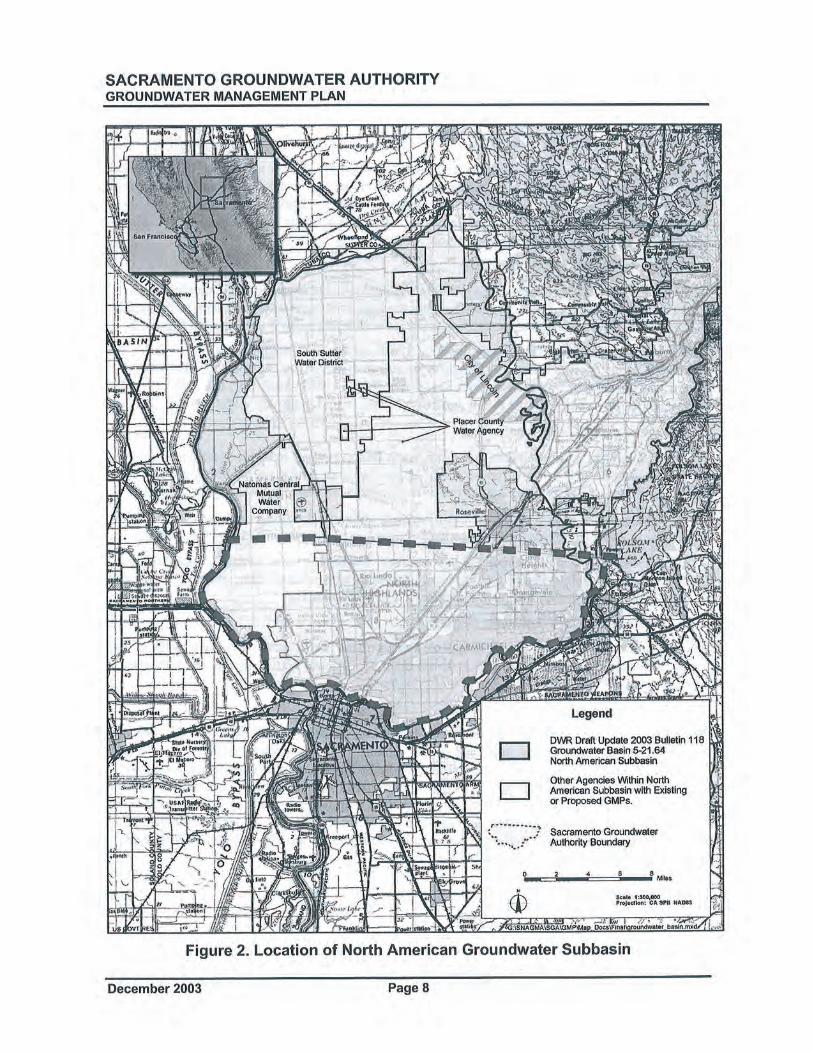
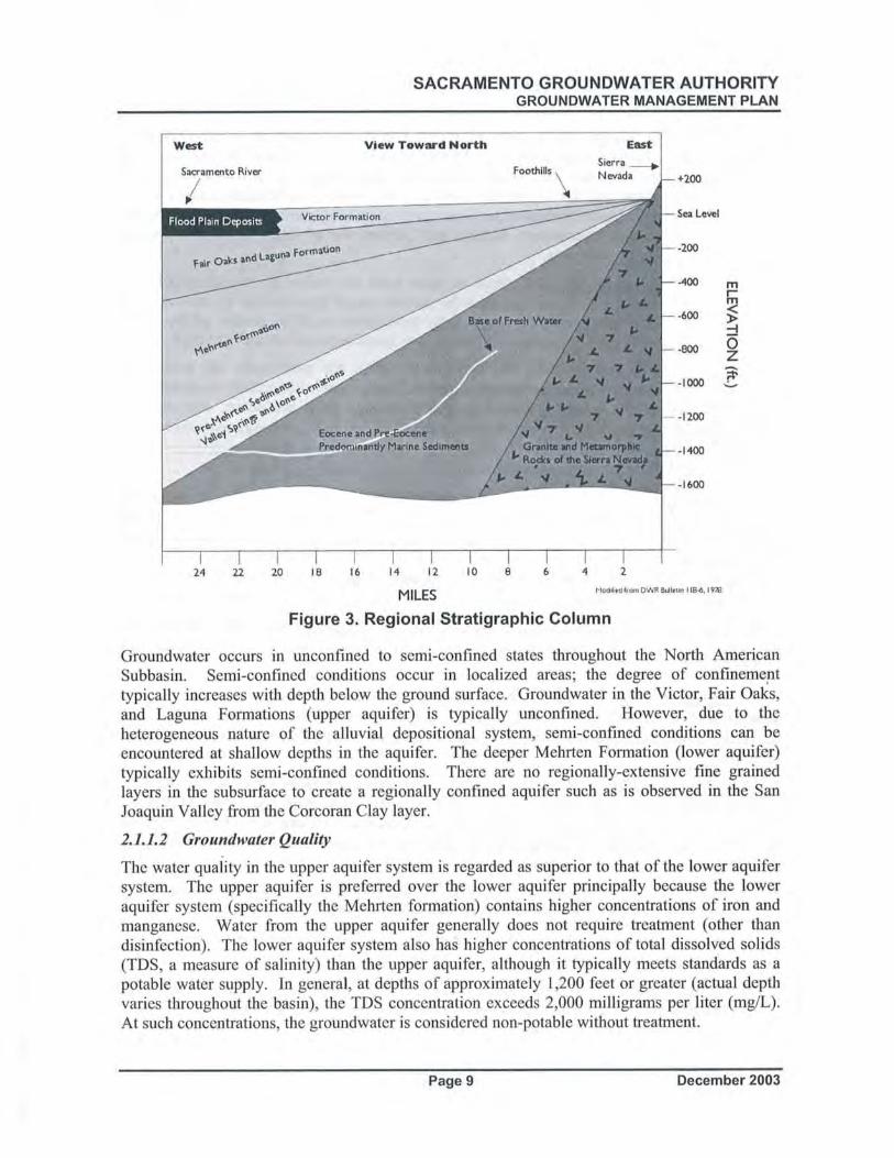
SACRAMENTO GROUNDWATER AUTHORITYGROUNDWATER MANAGEMENT PLAN
Backeround Water Oualitv. This description of background water quality is based on data usedto populate the Data Management System (DMS). Available groundwater quality data frommonitoring between 1991 and 2002 for 260 wells were used to populate the DMS. The DMSwas used to query data and develop statistics and graphics for the constituents included in thisevaluation. Evaluations were performed for constituents of primary 'concern related to aesthetics,regulatory impacts, and contaminant plumes, ,and constituents of futue concern related to
aesthetics and regulatory concerns.
Total Dissolved Solids. TDS results in most wells are within the secondar drinkngwater standard; therefore, TDS wil not limit the potable use of groundwater by the overlyingagencies. The TDS levels vary quite significantly throughout the SGA portion of the basin,ranging from 34 to 657 mg/L, although most wells have levels between 140 and 320 mg/L.
Iron and Manf!anese. Iron and manganese results for most wells are within the
secondary drinkng water standards; therefore, iron and manganese wil not limit the potable useof groundwater by the overlying agencies. Iron can range from non-detect, less than 10micrograms per liter (¡.g/L), to very high levels such as 16,000 ¡.g/L, although most wells haveaverage values less than 200 ¡.g/L. Manganese concentrations range from non-detectable, lessthan 2 ¡.g/L, to 1,700 ¡.g/L, although most wells have average, values less than 50 ¡.g/L.
Arsenic and Chromium. Arsenic and chromium results for most wells are within thecurrent primary drinking water standards; therefore, arsenic and chromium wil not limit thepotable use of groundwater by the overlying agencies. Currently, there is a primary federalMaximum Contaminant Level (MCL) for arsenic of 10 ¡.g/L, however compliance is not yetrequired in California below 50 ¡.g/L. Arsenic concentrations range from non-detectable, l~ssthan 1 ¡.g/L, to 22 ¡.g/L, although most wells have average values less than 5 ¡.g/L.
Currently, total chromium has a primary MCL of 50 ¡.g/L. Chromium concentrationsrange from non-detectable, less than 1 ¡.g/L, to 52 ¡.g/L, although most wells range. between 8and 12 ¡.g/L.
Nitrate. It appears that all wells are within the, current primary nitrate drinking waterstandard and nitrate wil not limit the potable use of groundwater by the overlying agencies.
Curently, nitrate has a primary MCL of 45 mg/L. Most SGA wells have low levels (.: 15 ¡.g/L)of nitrate.
Known "Principal" Plumes. Principal groundwater contaminant plumes within or near the SGAarea are known to exist from source areas at the former McClellan AFB, the former Mather AirForce Base (Mather AFB), and Aerojet and are shown on Figure 4. During Phase II
development of the DMS, contaminant plume data were collected by SGA from the followingdocuments:
. URS. Former McClellan Air Force Base, Installation Restoration Program, GroundwaterMonitoring Program: Quarterly Report, Third Quarter 2002. January 2003.
. Montgomery Watson Harza (MWH). Mather Air Force Base Annual and Fourth Quarter2002 Sitewide Groundwater Monitoring Report. March 2003.
. Aerojet Environmental Remediation. Aerojet Sacramento Site, American River Study
Area Groundwater Monitoring Results, April - June 2002. August 2002.
, 1
December 2003 Page 10


SACRAMENTO GROUNDWATER AUTHORITYGROUNDWATER MANAGEMENT PLAN
Although other localized plumes exist within the SGA area, the principal plumes shown inFigure 4 are the largest and have the greatest current impact on existing groundwater use. For
the McClellan AFB plumes, the primary contaminants of concern (COe) are trichloroethene(TCE), tetrachloroethene (PCE), cis-I,2-dichloroethene (DCE), and 1,2-dichloroethane (DCA).The McClellan AFB plume edges represent the California drnking water MCL of 5 ¡.g/L TCE,the most extensive contaminant.
For the Mather AFB plumes, the primary COCs are TCE, PCE, and carbon tetrachloride. TheMather AFB plume edges represent a composite COC concentration of 0.5 ¡.g/L, which is one-tenth of the MCL for these constituents.
For the Aerojet plume, the primary COCs are TCE and perchlorate. The Aerojet plume edgesrepresent a concentration of 5 ¡.glL TCE, the most extensive contaminant.
There are currently about i 90 active LUST sites within the SGA area (source:htt://geotracker.swrcb.ca.gov). While many sites can be fullyremediated, the aggregate impactfrom undetected contamination on groundwater quality in the basin cannot be determined at thistime and may ultimately be considerable.
2.1.1.3 Recharge and Extraction of Groundwater in Sacramento County
Evaluating changes in aquifer conditions requires understanding the dynamic processes andinteractions taking place as extractions andrecharge in the aquifer occur. Conceptual models ofthe aquifer that describe induced recharge, aquifer storage, and differences between localized andregional effects on the aquifer are discussed below. . These conceptual models are meant ,toclarify concepts; not all aspects of groundwater hydraulics are described. Some of the conceptspresented pertain only to'the northern Sacramento County aquifers.
Recharf!e. Groundwater in northern Sacramento County moves from sources of recharge to areasof discharge. Recharge to the local aquifer system occurs along active river and stream channelswhere extensive sand and gravel deposits exist, particularly in American River and SacramentoRiver channels. Prior tö'development of the area, additional recharge would have occured alongthe eastern boundar of the SGA area at the transition point from consolidated rocks of the SierraNevada to the alluvial dep~sited basin sediments. Other sources of recharge within the areainclude inflow of groundwater generally from, the northeast; subsurface recharge from fracturedgeologic formations to the east; and deep percolation from applied surface water, precipitation,and small streams. An example of recharge from deep percolation can be seen in the westernSGA area where extensive agricultural operations in NCMWC have redistributed surface waterfrom the Sacramento River over a much broader area. Some of the water not used by the cropsgrown in the area wil eventUally act as a source of recharge to the groundwater basin.
Changes in the groundwater surface elevation result from changes in groundwater recharge,discharge, or extraction. In some instances within northern Sacramento County, this change ingroundwater elevation can induce natural recharge at locations where rivers or streams and theaquifer are hydraulically connected. To the extent that a hydraulic connection exists, as
groundwater conditions change, the slope or gradient of the groundwater surface may change aswell. A steeper gradient away from the stream would induce higher recharge from surface waterinto the aquifer.
December 2003 Page 12
SACRAMENTO GROUNDWATER AUTHORITYGROUNDWATER MANAGEMENT PLAN
The rate of recharge from streams that are hydraulically disconnected from the groundwatersurface is indifferent to changes in groundwater elevations or gradient. This is typically tre
with smaller streams where the groundwater surface is located far below the streambed. In suchcases, surface water percolates though the unsatuated zone to the groundwater and is a fuctionof the aquifer materials underlying the streambed and ,the water level in the surface stream. Therate of infiltration under these conditions is not controlled by the change in elevation of theunderlying groundwater. There is also some evidence to suggest these conditions exist along theSacramento River in northern Sacramento County.
Localized Impacts of Groundwater Extraction. When extractions occur from a single well, aconcentrated localized corte of depression is formed around the welL. The shape and depth of thelocalìzëô-cone-Öfdepression depend on several factors including (but not limited to): (1) the rateof extraction, (2) the presence of nearby sources of recharge and extraction, (3) aquifertransmissivity, and (4) the "confined" or "unconfined" state of the aquifer, (i.e., storagecoefficient). Over a period of time, extraction from an unconfined aquifer can de-water the
aquifer around the welL. However, when extraction ceases, the water level within the aquifertyically rebounds to its pre-extraction condition.A confined or semi-confined aquifer behaves differently since the water is under pressure from arecharge source. Instead of de-watering the aquifer, a change in confining pressure occurs as aresult of extractions; the aquifer remains saturated. . In a confined aquifer, the pressure orpiezometrc surface elevation decline is more dramatic than in an unconfined aquifer; however,the recovery to pre-extraction conditions is typically much faster. '
,
Rel!Ïonal Impacts of Groundwater Extraction. Large' regional cones of depression can form inareas where multiple groundwater extraction wells are in operation. The location and shape of aregional cone of depression is influenced by the same factors as a single welL. The regional coneof depression within the SGA area is shown on, Figure 5, a water elevation contour map forspring of 2002. This ~map was prepared using water elevation data from DWR's water datalibrary available on,.line at: htt://wdl.water.ca.gov. The Inverse Distance to a Power grddingmethod was used to contoUr the water elevation data posted on Figure 5. This contouringmethod is a weighted average interpolator and is best used when there is a uniform distributionof data. WithInverse Distance to a Power, data are weighted during interpolation such that theinfluence of one point relative to another declines with distance from the grid node. Normally,Inverse Distance to a Power behaves as an exact interpolator. When calculating a grid node, theweights assigned to the data points are fractions, and the sum of all the weights are equal to 1.0., 'Fluctuations in regional cones of depression are measured over years and result from: (1)changes in recharge, and (2)' changes in extractions from increasing and decreasing waterdemands. A sequence of successive dry years can decrease the amount of natural recharge to theaquifer and often a coinciding increase in groundwater extraction, creating an imbalance betweennatural recharge and extractions. Consequently, groundwater elevations decrease in response tothis imbalance between recharge and extraction. Over time, the shape and location of theaquifer's regional cone of depression fluctuates.
Intensive use of the groundwater basin has resulted in a general lowering of groundwater
elevations near the center of the basin away from the sources of recharge. As early as 1968,pumping depressions were evident in northern Sacramento County. These depressions havegrown and coalesced into a single cone of depression centered in the SGA area as shown inFigure 5.
Page 13 December 2003
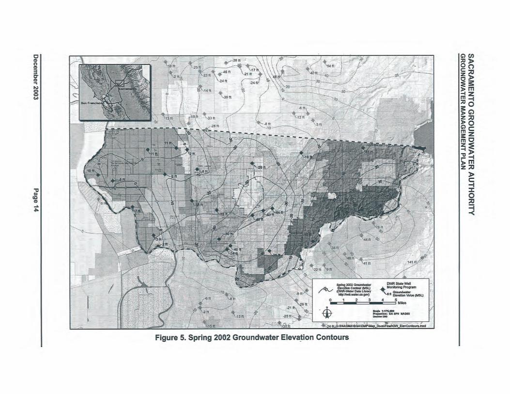
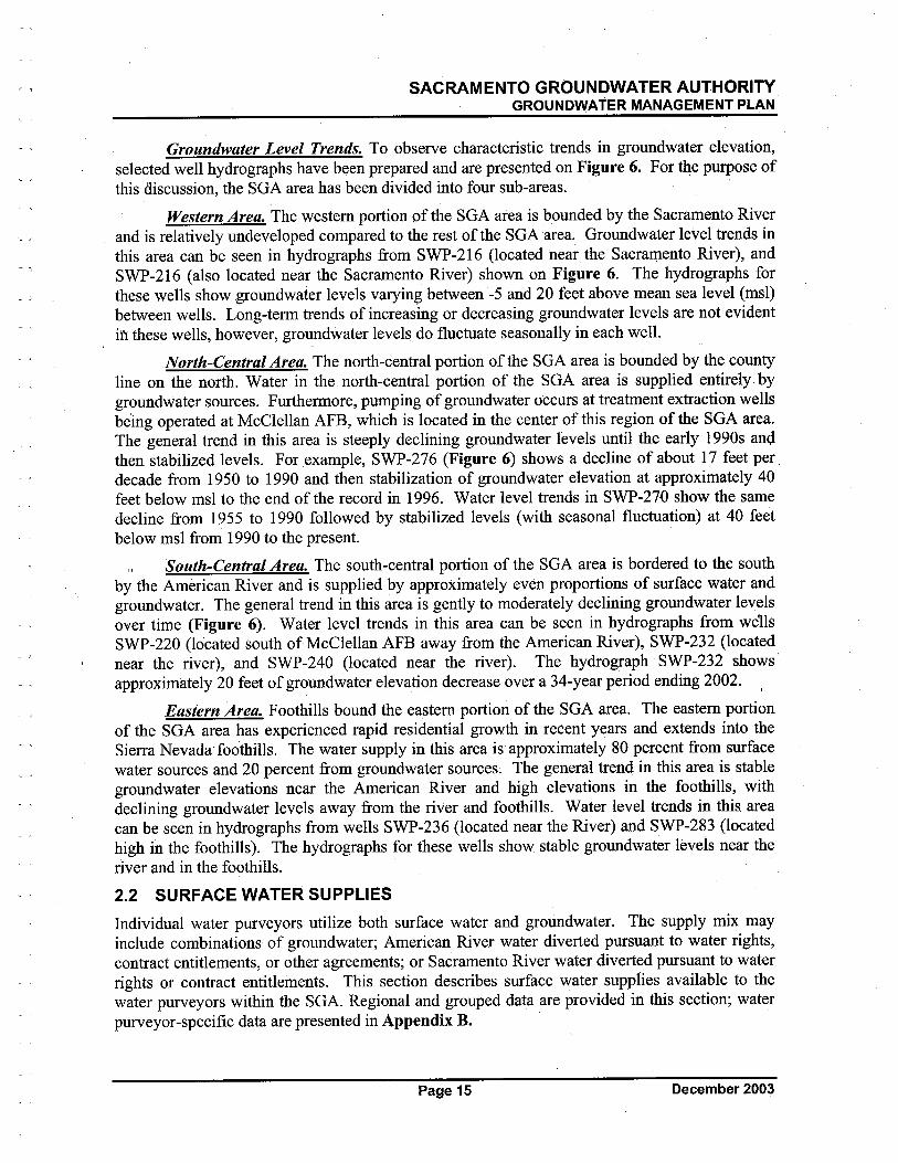
SACRAMENTO GROUNDWATER AUTHORITYGROUNDWATER MANAGEMENT PLAN
- ,
Groundwater Level Trends. To observe characteristic trends in groundwater elevation,selected well hydrographs have been prepared and are presented on Figure 6. For the purose of
this discussion, the SGA area has been divided into four sub-areas.
Western Area. The western portion of the SGA area is bounded by the Sacramento Riverand is relatively undeveloped compared to the rest of the SGAarea. Groundwater level trends inthis area can be seen in hydro graphs from SWP-216 (located near the Sacramento River), andSWP-216 (also located near the Sacramento River) shown on Figure 6. The hydrographs forthese wells show groundwater levels varying between -5 and 20 feet above mean sea level (msl)between wells. Long-term trends of increasing or decreasing groundwater levels are not evidentifi these wells, however, groundwater levels do fluctuate seasonally in each welL.
North-Central Area. The north-central portion of the SGA area is bounded by the countyline on the north. Water in the north-central portion of the SGA area is supplied entirely bygroundwater sources. Furthermore, pumping of groundwater occurs at treatment extraction wellsbeing operated at McClellan AFB, which is located, in the center of this region of the SGA area.The general trend in this area is steeply declining groundwater levels until the early i 990s andthen stabilized levels. For example, SWP-276 (Figure 6) shows a decline of about i 7 feet perdecade from 1950 to 1990 and then stabilization of groundwater elevation at approximately 40feet below msl to the end of the record in 1996. Water level trends in SWP-270 show the samedecline from 1955 to 1990 followed by stabilized levels (with seasonal fluctuation) at 40 feetbelow msl from 1990 to the present.
'\ South-Central Area. The south-central portion of the SGA area is bordered to the southby the American River and is supplied by approximately even proportions of surface water andgroundwater. The general trend in this area is gently to moderately declining groundwater levelsover time (Figure 6). Water level trends in this area can be seen in hydrographs from we1ls
SWP-220 (located south of McClellan AFB away from the American River), SWP-232 (locatednear the river), and SWP-240 (located near the rivet). The hydrograph SWP-232 shows'approximately 20 feet of groundwater elevation decrease over a 34-year period ending 2002.
Eastern Area. Foothils bound the eastern portion of the SGA area. The eastern portionof the SGA area has experienced rapid residential growth in recent years and extends into theSierra Nevada'foothils. The water supply in this area is approximately 80 percent from surfacewater sources and 20 percent from groundwater sources~ The general trend in this area is stablegroundwater elevations near the American River and high elevations in the foothils, withdeclining groundwater levels away from the river and foothils. Water level trends in this areacan be seen in hydrographs from wells SWP-236 (located near the River) and SWP-283 (locatedhigh in the foothils). The hydrographs for these wells show stable groundwater levels near the
river and in the foothills.
2.2 SURFACE WATER SUPPLIES
Individual water purveyors utilize both surface water and groundwater. The supply mix mayinclude combinations of groundwater; American River water diverted pursuant to water rights,contract entitlements, or other agreements; or Sacramento River water diverted pursuant to waterrights or contract entitlements. This section describes surface water supplies available to the
water purveyors within the SGA. Regional and grouped data are provided in this section; waterpurveyor-specific data are presented in Appendix B.
Page 15 December 2003

SACRAMENTO GROUNDWATER AUTHORITYGROUNDWATER MANAGEMENT PLAN
2.2.1 Water Rights/Contract Entitlements
2.2.1.1 American River Water Rights
Four of the water purveyors within the SGA boundaries have water rights on the American,
River: Carmichael Water Distrct (CWD), City of Folsom (Folsom), City of Sacramento
(Sacramento), and San Juan Water District (SJWD).
The place of use (POD) for CWD's water right is coincident with the boundaries of the District.
The POD for Folsom's water right is coincident with the city limits and portions of the landsowned by Aerojet.
The POD for Sacramento's water rights on the American River extends beyond the boundaries ofthe city limits. The authori~ed POD outside the city limits includes (1) portions of California-American Water Company (Cal-Am), Arden service area; (2) Del Paso Manor Water District
(DPMWD); (3) Sacramento Suburban Water Distrct (Sac Suburban), Arcade service area (Townand Countr subarea) and portions of Northridge service area; (4) SCW A, Arden Park Vistaservice area; (5) Southern California Water Company (SCWC), Arden Town service area; and(6) portions of CWD. In addition, a portion of Sacramento's American River POD overlaps withthe place of use for the Sacramento River water rights and contract entitlements ofNCMWC.
The POD for SJW's water rights is the District's wholesale service area which encompassesSJW retail service areas in Sacramento and :Placer Counties, Citrus Heights Water Distrct(CHWD), Fair Oaks Water Distrct (FOWD), Orange Vale Water Company (OVWC), and thatportion of Folsom that lies north of the American River.
2.2.1.2 American River Contract Entitlements,
In Sacramento County, two water purveyors have existing water supply contract entitlementswith the U.S. Bureau of Reclamation (Reclamation) Central Valley Project (CVP): Folsom andSJWD. SJW provides CVP water to agencies within its wholesale service area.
In addition, SJW and .sCW A executed a water supply contract entitlement with Reclamationfrom Public Law (PL) 101-514 (commonly referred to as "Fazio Water") in 1999. However, thecontract is curently being tenegotiated under the CVP long-term contract renewals. SJW'scontract entitlement is for 13,000 AF/year, and this supply is used within SJW's SacramentoCounty wholesale area. SCWA's contract entitlement is for 22,000 AF/year, and this supply isused within Zone 40 (south of the American River). Folsom has a subcontract with SCW A for7,000 AF/year (out of the potentially available 22,000 AF/year).
Sac Suburban has a water sale agreement with Placer County Water Agency (PCWA). The PODfor this water includes Sac Suburban's Northridge service area and Arcade service area (NorthHighlands subarea only) and the service areas of SJW, FOWD, OVWC, CHWD, the formerMcClellan AFB, Cal-Am (Antelope and Lincoln Oaks\Royal Oaks service areas), and RioLinda/Elverta Community Water District (RLECWD).
2.2.1.3 Sacramento River Water Rights
Two of the water pureyors within the SGA boundaries have water rights on the SacramentoRiver: Sacramento and NCMWC. The POD for NCMWC's water rights on the SacramentoRiver is the water company service area that includes both the Sacramento County and SutterCounty areas. The POD for Sacramento's water rights on the Sacramento River is the city limits.
December 2003 Page 16
~S
AC
RA
ME
NT
O~
RO
UN
DW
AIE
R A
UT
HO
RIT
YGROUNDWATER MANAGEMENT PLN
PAG
E L
EFT
BL
AN
K I
NT
EN
TIO
NA
LL
Y
Dec
embl
!r,2
003
Page 18
SACRAMENTO GROUNDWATER AUTHORITYGROUNDWATER MANAGEMENT PLAN
2.2.1.4 Sacramento River Contract Entitlements
One water purveyor within the SGA boundaries has a CVP contract entitlement on theSacramento River: NCMWC. The POU for this water is the water company service area thatincludes both the Sacramento County and Sutter County areas.
2.2.1.5 Other Agreements
Sacramento has agreements with Sac Suburban (for use within the Arcade Service Area only)and DPMWD to make surface water available for use within the portions of their service areasthat lie within Sacramento's POU.
Sac Suburban has aJemp¿rary contractwith Reclamation for surplus water (often referred to asSection 215 water). This contract has been exercised since 1991. Sac Suburban's Section 215supplies ranged between approximately 100 AF/year and 11,880 AF/year during the period 1991through 2000. Section 215 water is available on an intermittent basis subject to hydrologicconditions.
2.2.2 Surface Water Quality
Based on current Update Reports to the Watershed Sanitary Surveys for the American andSacramento Rivers, these are both excellent supplies for drinking water in the SacramentoMetropolitan Area. The source waters can be treated to meet all Title 22 drinking water standardsusing conventional and direct fitration processes, as well as membranes. There are no persist~ntconstituents in the raw waters that require additional treatment processes. However, there aresometimes seasonal treatment requirements for rice herbicides on the Sacramento River, whichcan be addressed through chemical oxidation processes. High turbidities during storm events aresometimes a treatment challenge, which can be managed by optimizing operations includingadjusting chemical types and dosing schemes and reducing plant flow (Montgomery Watson andArchibald & Wallberg,.2000).
2.2.2.1 American River
Surface water quality in the American River is a function of the mass balance of water qualityfrom tributary streams, diversions, agricultual retu flows, subsurface drainage flows,permitted discharges from municipal and industrial (M&I) sources, and urban runoff. In general,the quality of water in the American River is high from the river's headwaters to its confluencewith the Sacramento River. It is low in alkalinity, low in disinfection by-product precursormaterials, low in mineral content, and low in organic contamination. Limited data also indicatethat the source of water is low in microbial contamination from Giardia and Cryptosporidium.Turbidity levels in the American River tend to be higher in the winter than summer because ofhigher flows associated with winter storms.
Folsom Reservoir. Water diverted from Folsom Reservoir is provided to the following SGAmembers: SJW, CHWD, FOWD, OVWC, Folsom, and Sac Suburban11. Because the treatmentfacilities serving these areas share a common Folsom Dam intake facility, the raw water isconsidered to be similar with respect to quality. Characterization of Folsom Reservoir raw waterquality is based on data collected by the Cities of Folsom and Rosevile as well as SJWD.
Water diverted from the Folsom Dam is treated by SJWand Folsom using conventionalfiltration processes with chlorine disinfection. Treated water quality varies depending on thespecific tye of treatment provided, but meets or exceeds all federal and state drinking water
11 Water is also diverted, treated, and distributed by Roseville, located within Placer County.
Page 19 December 2003
SACRAMENTO GROUNDWATER AUTHORITYGROUNDWATER MANAGEMENT PLAN
standards for both SJW and Folsom under current operations. Both agencies include corrosioncontrol practices in their treatment of the water.
American River at CWD's Ba;amont War Membrane Filtration, Water Treatment Plant. CWDuses ,American River water diverted by three Ranney Collectors for water supply, therefore thisis groundwater under the direct influence of surface water. This source now supplies 80 percentof CWD's needs. The Collectors are located within the American River floodplain and adjacentto the streambed. They serve as intake and pump structures to provide pre-filtered water to theBajamont Way Membrane Filtration (Bajamont) Water Treatment Plant (WTP). The BajamontWTP has a design capacity of 16 milion gallons per day (mgd) and can be expanded to 22 mgd.The WTP is composed of microfiltration membrane units. After filtration, the water ischlorinated with sodium hypochlorite and the pH is adjusted with caustic soda prior todistribution. The treated water meets all curent Title 22 drinking water quality standards
(Archibald & Wallberg and MWH, 2003).
Lower American River at Sacramento's E.A. Fairbairn Water Treatment Plant. Water isdiverted' by Sacramento on the lower American River just downstream of the Howe A venuecròssing at the E.A. Fairbairn WTP. This water may be used by other entities within the POU ona wholesale basis. Water diverted at the plant undergoes conventional treatment and
disinfection. The treated water meets all curent Title 22 drinking water quality standards
(Archibald & Wallberg and MWH, 2003).
2.2.2.2 Sacramento River
Sacramento River water quality is largely influenced by a mass balance of water quality fromupstream reservoir release operations, tributary flows (including the lower American River),agricultural runoff, subsurface drainage flows, and diversions, with other impacts from permitteddischarges from M&I sources, urban ruoff and spills. In general, the quality of the SacramentoRiver is high in the vicinity of the SGA boundary. There are moderate amounts of alkalinity andminerals and low levels of disinfection by-product precursors. Turbidity levels in theSacramento River are higher during the winter and early spring months, usually associated withreservoir releases or runoff from storm events. There' are very infrequent detects of organicchemicals, many of which are pesticides or herbicides from agricultural operations. Datacollected to date indicate that there is a low prevalence of Giardia and Crytposporidium in theriver, with protozoa only detected sporadically and at very low concentrations.
The characterization of the Sacramento River water quality in the vicinity of the SGA boundaryis based on reports for the Sacramento River Water Treatment Plant (Sacramento River
Watershed Sanitary Survey; 1995 Report and 2000 Update, prepared by MWH and Archibald &Wallberg).
Sacramento River at Sacramento's Sacramento River Water Treatment Plant. Water isdiverted by Sacramento on the Sacramento River just downstream of the confluence with theAmerican River. This water can be supplied to Sacramento and other entities within the place ofuse on a wholesale basis. Characterization of the Sacramento River raw water quality at theSacramento River WTP is based on data collected by Sacramento (Sacramento River WaterTreatment Plant - Finalization of Preliminary Design, prepared by Montgomery Watson, 1998).
Water is treated by Sacramento using conventional filtration processes with chlorine disinfection.Treated water quality meets or exceeds all federal and state drinking water standards undercurrent operations. Sacramento includes corrosion control in their treatment of the water.
December 2003 Page 20
SACRAMENTO GROUNDWATER AUTHORITYGROUNDWATER MANAGEMENT PLAN
Primary drinking water standards are set for constituents that cause an adverse impact to humanhealth. Secondary drinking water standards are set for constituents that cause an unpleasingàesthetic impact on the water quality; these are not health-based standards. There were noviolations of primary or secondary drinking water standards reported for any of the
characterization points discussed above.
2.3 "OTHER" SUPPLIES
Currently, limited opportnities exist for using recycled water north of the American River. InSacramento County, the most probable recycled water opportnity exists at the Sacramento
Regional Wastewater Treatment Plant (Sac Regional) located on the Sacramento River nearFïeeport (south of the American River and outside the SGA boundaries). At this time, however,Sac Regional does not appear to be a likely source of recycled water for the area north of theAmerican River. The cost of pumping recycled water from Sac Regional to areas north of theAmerican River is currently prohibitìve. A more economic reclamation program might includethe scalping of wastewater flows north of the American River for treatment at satellite plants.
In Placer County, Rosevile has a recycled water program and is delivering recycled water forirrigation of golf courses and streetscape. Under this program, Rosevile is studying potentiallocations for direct groundwater recharge with recycled water, in both Placer and northernSacramento counties.
2.4 EXISTING FACILITIES AND OPERATIONS
2.4.1 Major Infrastructure"
For the purposes of this GMP, the existing major infrastrctue is divided into three majorcategories: surface water supply facilities, groundwater supply facilities, and, systemdistribution/transmission and storage facilities. Figure 7 presents a regional map of existing ahdplanned principal infrastrcture12.
2.4.1.1 Surface Water Supply Facilties
There are four major diversion and treatment facilities on the American and Sacramento rivêrsthat provide surface water withinthe SGA boundaries (see Table 2). '
2.4.1.2 Groundwater Supply Facilities
The water pureyors within the SGA boundaries maintain and operate 269 groundwater wells(see Table 3 and Figure 6). Most production capacities are in the range of 330 to 2,250 gallonsper minute (gpm).
2.4.1.3 System Distributionffransmission and Storage Facilities
The Cooperative Transmission Pipeline (CTP)/Northridge Transmission Pipeline (NTP) is theonly existing major transmission facility capable of conveying water across the region. Majorintra-agency transmission and distribution systems are also shown on Figure 7. Most agency-to-agency interconnections are presently used for emergency purposes only.
12 Much of the planned infrastructure is attributable to the R W A's American River Basin Regional Conjunctive
Use Program (see Section 3 for a description). Individual agencies may be considering facilities that are notshown here.
Page 21 December 2003
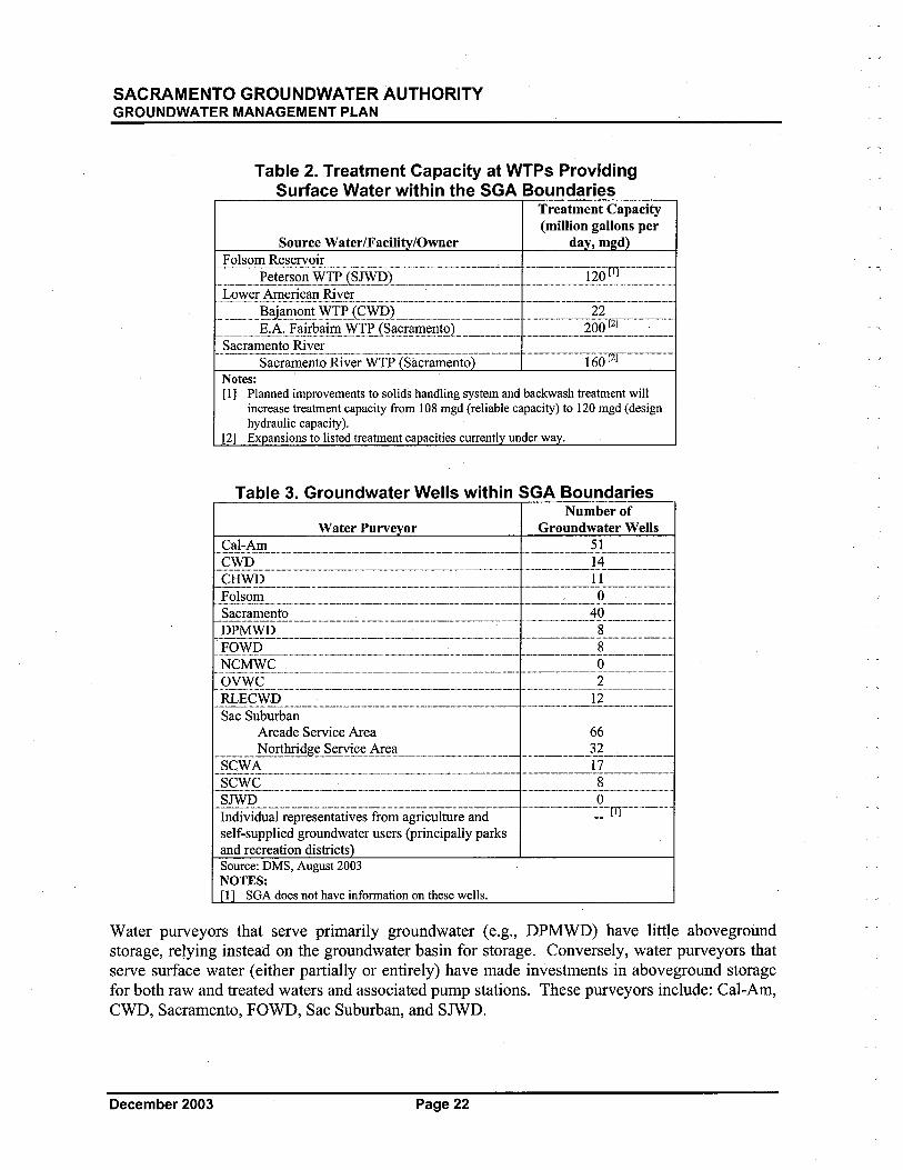
SACRAMENTO GROUNDWATER AUTHORITYGROUNDWATER MANAGEMENT PLAN
Table 2. Treatment Capacity at WTPs ProvidingSurface Water within the SGA Boundaries
Treatment Capacity
(milion gallons perSource Water/Facil /Owner da , m d
Folsom Reservoir
,:=,:,)~t~i~~iiSYir.tS-lF--)..:::::::~:'::':=..':..::===:,::..:=,::::=.:,=:,~llQ:~=:::,:..~~::::Lower American River.~._..___.._......_.__._._'_"'''__'_'H''__'_'_'__''___'_..........__........H.___.._._._____.._.....__._........_.___...........W___..H......___.....w_...__.........
..._.::~i;~~~k~~3¥t~~~i~!i~n-~L,,:,=::::..= '..=:=:..::::::,:.2gg~~.c=:::,:.~_-::.Sacramento River
."""---..'.-Säerãm-entö.Ri~e~W-TP-Sãcrãm-e~iõ---'-'--"--- ""'-'--.--'-'--'-'.--i'60T1:¡-'.-",.,---"-'"Notes:(1) Planned improvements to solids handling system and backwash treatment wil
increase treatment capacity from 108 mgd (reliable capacity) to 120 mgd (designhydraulic capacity)_
(2) Ex ansions to listed treatment capacities current! under wa .
Table 3. Groundwater Wells within SGA BoundariesNumber of
Water Purveyor Groundwater WellsCal-Am 51.......____..H.......____.H._........__....._......___...._._..__H_.........._.___...._._ ...____.,' ..._____............_ .......____......_.....___........._._____.......___._.......CWD 14.......__......._..__..._....._._...._....._._-_..._..--_._......._._-_......_..._-_.__....._.._._.__._..._..-..._.._.__...._...._---_......._...._-_..._......__...........CHWD 11._..__......._........H.__.........____.___.._.__..........___.._._...._..___...._.._._____..H.......___..._...__.._......___._....___.__.....__...........Folsom , 0......__._...._.___._.......H....._..........____..._....__............___....._...___._........_.____.._._._..___.......___...__.__..........___...........__...........Sacramento 40._____..........__..._.........___..Hh..__........,__._..........._.._.......___...._.....__.._..._...____....._...___._...._.._..........__.............__.......DPMWD 8._.....____H......._____..._h...___...........___..H_.........._..............._........H...._.............___...._.......___..._._.___.H....__............_.._.H..._....___.........FOWD 8._....H_._....H_.___._.H......_..H........._H._....._.__.. ...H_._....H......__.... ....._.___...._.......___ .._._.__._......H..___.............__......_....__.........NCMWC 0._.....____........_.____.._..........___..........._._._.__._._....._.__._........._._____.._._._......____.........._._._H_.._........_........_.___.._._._..____._......._.__._._._._._..___......
,_..9.Y~,Ç__.._,_,..._...._.,...._...,.,_,_,.,_'.'..m_._..........,.'."..m...'.'.m..__m..mm.'_.._....,_,...____....m'_..__..._.,_.._...._.._~.,,_"_'._..m.__.._..'m'RLECWD 12.H..._..__.._.._..__.__._......__......_..___.H.........._._..........._.____.._._...___..............___.._..._..___.._..._H.____._........___._...__.............__._.....
Sac SuburbanArcade Service Area 66,._...___"__~~~h!_'ig~_s_~~!,~~.,N~a__._..,._.__., ,_______'_'_'m__ ..,"",.,__'_.'.m'._._~:?....__,.. m__m_SCW A 17....___._._.._._._._..__...._______._.....____._._....._.___..___.._.___h ......_.____..__._. ...........__.___.____....._....._.._.__._...___.......~..SCWC 8..___....._...__......._..____........_..__..__........___.............._...__..._..._....._._....._.._.____._...___..H.....___...._......__._..........______..........___...........SJWD 0-"I~di~id~~i-r~p-;e~~;¡tri~~;¡frõ-~";g~i~~ih;~e-;iÎ~i-'...-..- m--------m'--'::--m-'-'- ",--,-",-,self-supplied groundwater users (principally parksand recreation districts)Source: DMS, August 2003NOTES:(i) SGA does not have information on these wells.
Water purveyors that serve primarily groundwater (e.g., DPMWD) have little abovegroundstorage, relying instead on the groundwater basin for storage. Conversely, water purveyors thatserve surface water (either partially or entirely) have made investments in aboveground storagefor both raw and treated waters and associated pump stations. These purveyors include: Cal-Am,CWD, Sacramento, FOWD, Sac Suburban, and SJWD.
December 2003 Page 22
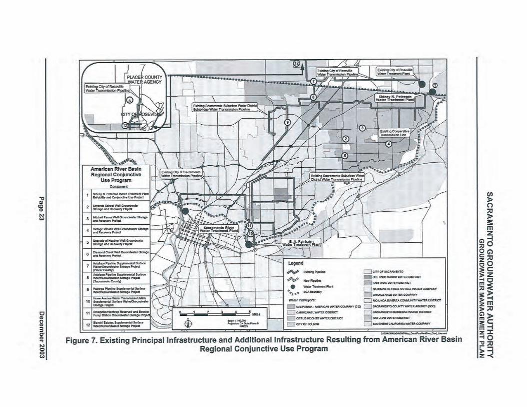

SACRAMENTO GROUNDWATER AUTHORITYGROUNDWATER MANAGEMENT PLAN
2.4.2 Operations
Recent (year 2002) surface water and groundwater use by the water purveyorswithìn the SGAboundaries are shown in Table 4 and on Figure 8. Table 4 shows that Sacramento, Sac
Suhqrban, and Cal-Am extracted the largest volumes of groundwater. These dìstricts serve thelargest, and some of the most densely populated, regions wíthin the SGA boundaries. NCMWC,OVWC, Folsom, and SJWD extracted the least amount of groundwater. These agencies get thevast majority of their water from surface water sources, as shown in Figure 8. Total
groundwater extraction by SGA member agencies during the last five years (1998 - 2002) isshown in Figure 9.
2.5 FUTURE FACILITIES AND OPERATIONS
Phase I of the R WMP identífied and described a "menu" of proj ect and program alternatives forimplementing-the WF A north of the American River. Phase II provided detaíled hydrologic(íncluding surface water and groundwater modelíng), engineering (including conceptual design,operational analyses, and estimates of costs), and legal/institutional (including operationalagreements and funding) evaluations of those projects and programs that best alígned wíth thegoals and objectives of the individual water purveyors and the WFA. The recommendationsresulting from Phase II were used to structure the SGA and RWA's regional projects andprograms including: SGA-Sacramento Area Flood Control Agency (SAFCA) Pilot Study, 2002CALFED Bay-Delta Program (CALFED) Environmental Water Account (EWA) Pílot Study,Sac Suburban's Groundwater Stabilízation Project, Proposition 13 Groundwater StorageProgram Constrction Grant (I.e., American River Basin Regional Conjunctive Use Progra~ orARB CUP), and other ongoing efforts. Some of the planned infrastrcture is shown in Figure 7aIlp described in Table 5.
2.6 EFFECTS OF WFA IMPLEMENTATION
Implementatíon of the local conjunctive use program prescribed by the WFA wí1 determine theyear 2030 water supply scenarios for the water purveyors wíthin the SGA's boundaries. (Moredetaíled water purveyor-specific data are presented in Appendix B.) In general, the intent of theWF A is to increase the use of groundwater in dry years and reduce surface water diversions. Thedecrease in avaílable dry year diversions is a consequence of the WF A objective to proviaeinstream flows in the lower American River for environmental purposes. In wet years, whenmore surface water is avaílable, diversion wí1 be increased and groundwater extraction wíl bereduced, thereby promotíng recharge of the basin.
2.6.1 Water Year Types
The WF A identifies three principal water year types. These year types are based on estimatedMarch through November unimpaired inflow into Folsom Reservoir and are categorized aswet/average years, drier years, and driest years. For the water purveyors lísted in Table 4, thespecific year týpe criteria are stated. .
December 2003 Page 24
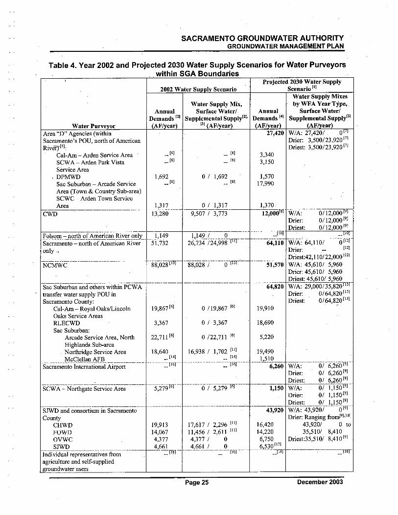
SACRAMENTO GROUNDWATER AUTHORITYGROUNDWATER MANAGEMENT PLAN
Table 4. Year 2002 and Projected 2030 Water Supply Scenarios for Water Purveyorswithin SGA Boundaries
Water Purve orArea "D" Agencies (withinSacramento's POD, nort of AmericanRivër)' (5):
, Cal-Am - Arden Service Area
SCW A - Arden Park VistaService Area
, DPMWDSac Suburban - Arcade Service
Area (Town & Countr Sub-area)SCWC - Arden Town ServiceArea---"---_.._-_._.._---_._..._-"-
CWD
2002 Water Su I Scenario
Water Supply Mix,Surface Waterl
Supplemental SuppiyliJ.(3) AFI ear
Projected 2030 Water SupplyScenario (1)
Water Supply Mixesby WFA Year TyPe,
Surface WaterlSupplemental Supply(3)
AFI earW/A: 27,4201 0 7Drier: 3,500/23,920 (7)Driest: 3,500/23,920 (7)
(6)
(6)
(6)
(6)
1,692(6)
o i 1,692(6)
1,3 1 7 0 I 1,3 1 7.._-_._--_._----_.._--_._._.13,280 9,507 I 3,773
,l~g;_i:~,=_n~£ìli_i:r_!\~¡:!i~an _R-!Y~_9E_IL_ __1.l~2______ ",__l,1:49 -,(-..",-,-,,""Q-r----mSacramento - north of American River 51,732 26,734 124,998 11)only,.
-NCMWC-"'--'-----m--m--'---'-""'-mm-'-- "--g'8,02S-'(HT- .. .....8-8~O~i8.- i.m.... ._......'O..M'(TJr-._.....
Sac Suburban and others within PCW A, transfer water supply POD in
Sacramento County:
Cal-Am - Royal Oaks/LincolnOaks Service AreasRLECWDSac Suburban:
Arcade Service Area, NorthHighlands Sub-area
Northrdge Service AreaMcClellan AFB.......__............._._._._.__........._....h...._.H._....__........._
Sacramento International Airport
19,867 (6) o !l9,867 (6)
3,367 o I 3,367
22,711(6) o 122,711 (6)
3,3403,150
1,57017,990
1,370
---12;000(8) W/~Om,OOor9r-Drier: 0!l2,000 (9)
Driest: 0!l2,000 (9)-..-..-,- 10 (iõT-----64;1"i-0 -WI Ã:--64,ii-Õi----a-U2l-
Drier: (12)Driest:42,1 10/22,000 (12)
51,570 W/A: 45,6101 5,960Drier: 45,6101 5,960Driest: 45,6101 5,960
---ii4,'ií20' -WI A:-Ž9,OOO'¡ 35-;20 (ßT-
Drier: 0/64,820 (15)
Driest: 0/64,820 (15), r19,910
18,690
5,220
18,640(14)
m=~-TT6r
16,938 I 1,702 (II) 19,490
m "'__,_""'_,_,__'_.."mmm_~:;:__,_,__ "'-'-'-).J~J£i6ij'
,_.._,_,_.._,__.._,_,_,__..__,..m,___,_,_..__,_.._'__'_ ---,-m"-"--'T6J'-'-'- -'-',..,----..-'---..-m..--!6--..-SCW A - Nortgate Service Area 5,279 0 I 5,279
SJWD and consortium in SacramentoCountyCHWD 19,913 17,617 I 2296 (11)FOWD 14,067 1l,456 I 2:611 (II)OVWC 4,377 4,377 I 0SJWD 4,661 4,661 I 0lIidivTci:iairepre~~tati~esTi-om-----'---- ----'-=tïr'------..-------:=--'Iï6)-'---
agriculture and self-suppliedroundwater users
VI i A:---"-oT6~260T9i--Drier: 01 6,260 (9)
Driest: 01 6,260 (9)
'---l,-Iso' -VI IA:--0i-i,50 r9T"Drier: 01 1,150(9)
Driest: 01 1,150(9)
'---43;920-W/A:-43,9201 -'--(9T-
Drier: Ranging fromI9).(l8)43,9201 0 to35,5101 8,410
Driest:35,5101 8,410(9)
16,42014,2206,7506530 (17)---L---=Ii-6J
-..---'----..-----..__ (ï61-"
Page 25 December 2003
SACRAMENTO GROUNDWATER AUTHORITYGROUNDWATER MANAGEMENT PLAN
Table 4. Year 2002 and Projected 2030 Water Supply Scenarios for Water Purveyorswithin SGA Boundaries continued
NOTES:(I) Values rounded to nearest 10 AF.
(2) Surface water/supplemental water supply mixes from SGA DMS - year 2002 values as reported by individual water purveyors.Year 2002 water demands based on sudace water/supplemental water supply mixes (assumes no shortages).
(3) Supplemental supplies may include groundwater extraction, demand management, and/or recycled water.
(4) From Cooperating Agencies R WM, Phase II, Technical Memorandum 2, Table I.(5) Does not include portions ofCWD and Sac Suburban (Northridge ServiceArea) also located within the Area "D" boundaries.(6) SGA DMS reports data by water purveyor but not by service area.(7) Assumes:
(1) Sac Suburban PSA accepted by Water Forum Successor Effort.(2) Surface water from Sac Suburban and DPMWD contract agreements with Sacramento may be used within Area "D".(3) Diversions at Fairbairn WTP are dependent upon flows bypassing the WTP exceeding the Hodge Flow Condition. (Hodge
Flow Condition: Parties to the litigation (Environmental Defense Fund et al. v. East Bay Municipal Utilty District) cannotdivert water from the American River unless in stream flows measure at least 2,000 cubic feet per second (cfs) from OctoberIS through February; 3,000 cfs from March through June; and 1,750 cfs from July through October 14.)
(8) CWD wil divert up to its license amount of 14,000 AF. By the year 2030, it is most likely that the water demand for CWD wil bereduced to their historic baseline level of 12,000 AF by implementation of the Urban Water Conservation Best ManagementPractices. Signatories to the WF A acknowledge and agree that CWD shall not relinquish control of or otherwise abandon the rightto any quantity it has foregone delivery and/or diversion of under this Agreement, and shall retain the right (if any) to transfer thatwater for the other beneficial uses, after that water has served its purpose of assisting in the implementation of the Improved Patternof Fishery Flow Releases, for diversion or rediversion at, near or downstream of the confluence of the lower American River.
(9) Wet/Ave Years: As it applies to these diverters, years when projected March through November Unimpaired Inflow to FolsomReservoir is greater than 950,000 AF.Drier Years: As it applies to these diverters, years when projected March through November Unimpaired Inflow to FolsomReservoir is less than 950,000 AF.Driest Years (i.e. Conference Years): Years when projected March through November Unimpaired Inflow to Folsom Reservoir isless than 400,000 AF. Conference years are those years that require diverters and others to meet and confer on how best t6 meetdemands and protect the American River.
(10) Portion of Folsom (north of American River) included in SJW.(II) Data reflects participation in 2002 EW A Pilot Study.(12) Wet/Average, Drier, and Driest year diversions are estimated. Diversions at Fairbairn WTP are dependent upon the flows
bypassing the WTP exceeding the Hodge Flow Condition. (Hodge Flow Condition: Parties to the litigation (Environmental DefenseFund et al. v. East Bay Municipal Utilty District) cannot divert water from the American River unless instream flows measure atleast 2,000 cfs from October IS through February; 3,000 cfs from March through June; and 1,750 cfs from July through October14.)
(13) SGA DMS includes surface water diversions from both Sacramento and Sutter counties.(14) McClellan AFB included in Sac Subi,ban (Northridge) data.(IS) Wet/Ave Years: As it applies to these diverters, years when projected March through November Unimpaired Inflow to Folsom
Reservoir is greater than 1,600,000 AF.Drier Years: As it applies to these diverters, years when projected March through November Unimpaired Inflow to FolsomReservoir is less than 1,600,000 AF.
(16) Currently not tracked in the SGA DMS.(17) Includes portion of Folsom (north of American River).
(18) Decrease in amount of surface water in ro ortion to the decrease in unim aired flow from Folsom Reservoir.
,
2.6.1.1 Definition of Wet/Average Years
For most diverters, wet/average years are defined as those years when the projected Marchthrough November unimpaired inflow into Folsom Reservoir is equal to or greater than 950,000acre-feet (AF). For Sac Suburban's water sale agreement with pew A, a wet/average year isdefined as a year when the March through November unimpaired inflow into Folsom Reservoiris greater than 1,600,000 AF. For Sacramento, diversions from the American River at theFairbairn WTP are based on meeting the Hodge Flows in the lower American River.
December 2003 Page 26
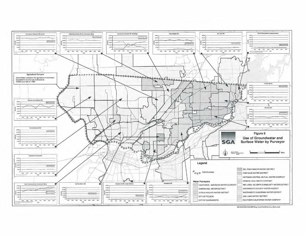
,S
AC
RA
ME
NT
O G
RO
UN
DW
AT
ER
AU
TH
OR
ITY
GROUNDWATER MANAGEMENT PLAN '
PAG
E L
EFT
BL
AN
K I
NT
EN
TIO
NA
LL
Y
December 2003
Page 28
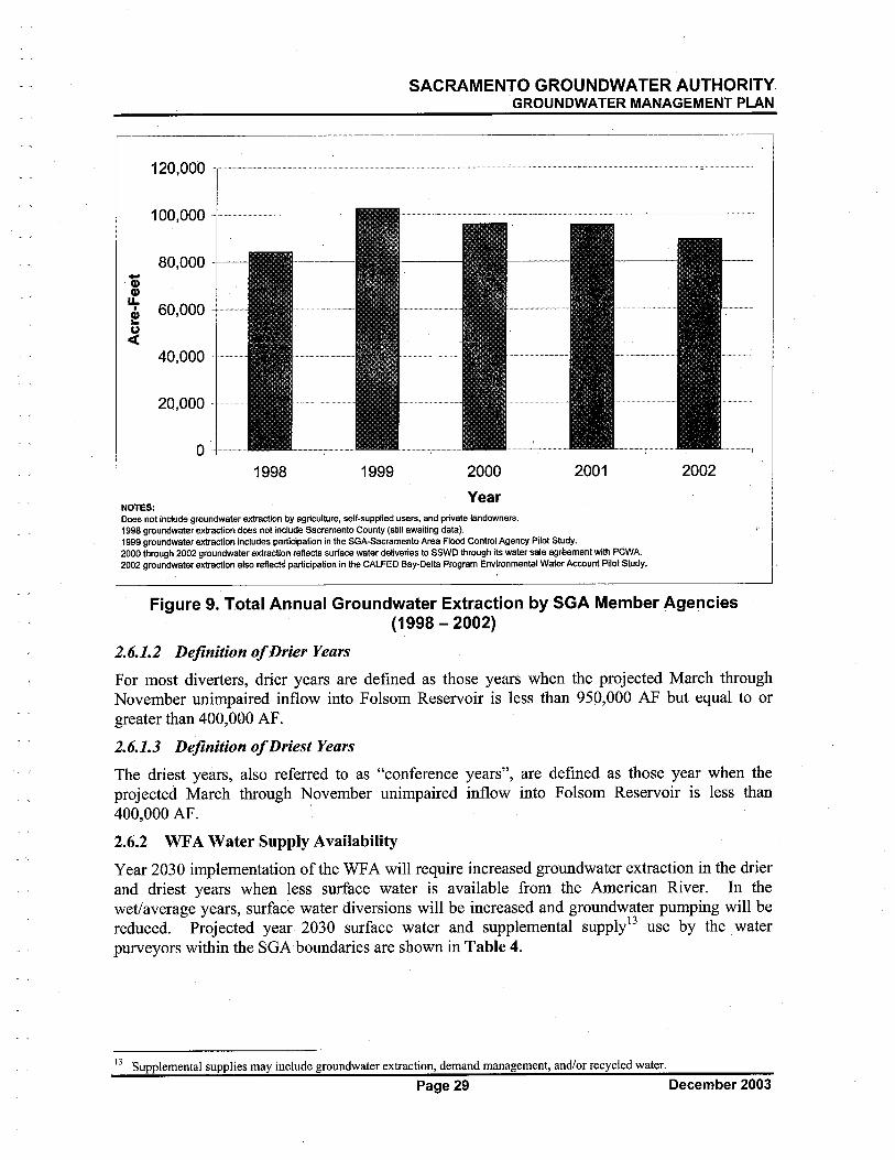
SACRAMENTO GROUNDWATER AUTHORITYGROUNDWATER MANAGEMENT PLAN
120,000 ," m==-l80,000
100,000 '
-Q)Q)
t 60,000 ---u.i40,000-
20,000
0'1998 1999 2000 2001 2002
YearNOTES:Does not include groundwater extaction by agriculture, self-supplied users, and private landowners.1996 groundwater extraction does not include Sacramento County (still awaiting data),1999 groundwater extraction includes partcipation in the SGA-Sacramento Area Floo Control Agency Pilot Study.2000 through 2002 groundwater extraction reflects sunace water deliveries to SSWD through its water sale agreement with PCWA,2002 groundwater extaction also reflects participation in the CALFED Bay-Delta Program Environmental Waler Accunt Pilot Study.
Figure 9. Total Annual Groundwater Extraction by SGA Member Agencies(1998- 2002)
2.6.1.2 Definition o/Ðrier Years
For most diverters, drier years are defined as those years when the projected March throughNovember unimpaired inflow into Folsom Reservoir is less than 950,000 AF but equal to orgreater than 400,000 AF.
2.6.1.3 Definition of Driest Years
The driest years, also referred to as "conference years", are defined as those year when theprojected March through November unimpaired inflow into Folsom Reservoir is less than400,000 AF. '2.6.2 WFA Water Supply Availabilty
Year 2030 implementation of the WF A will require increased groundwater extraction in the drierand driest years when less surface water is available from the American River. In thewet/average years, surface water diversions will be increased and groundwater pumping wil bereduced. Projected year 2030 surface water and supplemental supply13 use by the water
purveyors within the SGA boundaries are shown in Table 4.
13 Supplemental supplies may include groundwater extraction, demand management, and/or recycled water.
Page 29 December 2003
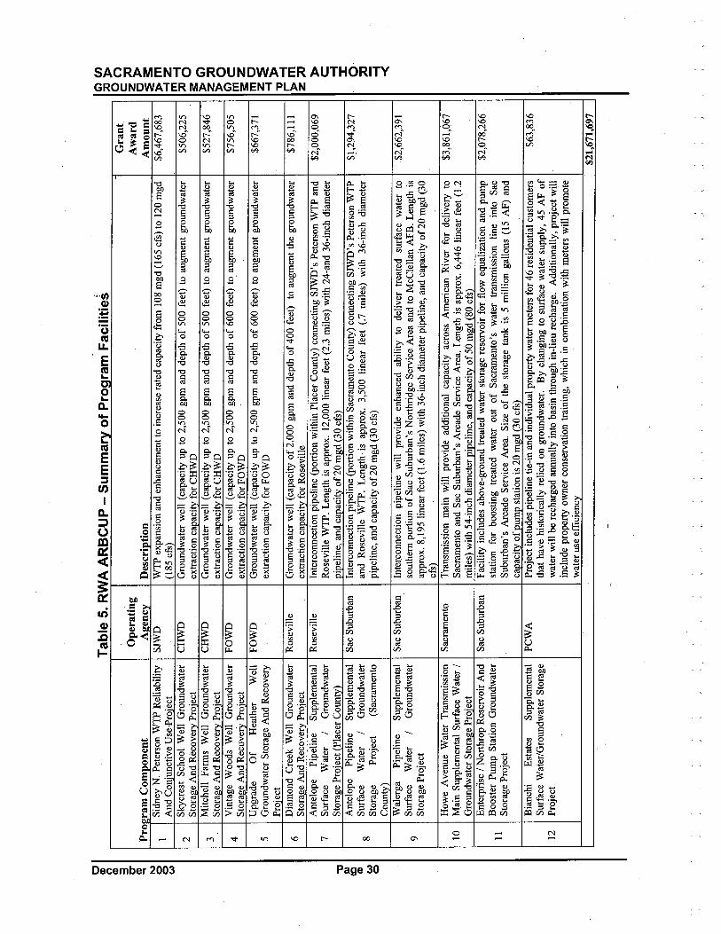
c CD n CD 3 e- CD .. '" o o w
Tab
le 5
. RW
A A
RB
CU
P -
5f
PFa
cilif
---
- --
- -
---
-G
rant
Ope
ratin
gA
war
dPr
oiir
am C
ompo
nent
Aiie
ncv
Des
crip
tion
Am
ount
1Si
dney
N. P
eter
son
WT
P R
elia
bilit
ySJ
WW
TP
expa
nsio
n an
d en
hanc
emen
t to
incr
ease
rat
ed c
apac
ity f
rom
108
mgd
(16
5 cf
s) to
120
mgd
$6,4
67,6
83A
nd C
oniu
nctiv
e U
se.P
roie
ct(1
85 c
fs)
2Sk
ycre
st S
choo
l Wel
l Gro
undw
ater
CH
WG
roun
dwat
er w
en (
capa
city
up
to 2
,500
gpm
and
dep
th o
f 50
0 fe
et)
to a
ugm
ent g
roun
dwat
er$5
06,2
25St
oral
!e A
nd R
ecov
ery
Proj
ect
extr
actio
n ca
paci
ty f
or C
HW
D
3Mitchen Farms Wen Groundwater
CH
WG
roun
dwat
er w
en (
capa
city
up
to 2
,5.0
0 gp
m a
nd d
epth
of
500
feet
) to
aug
men
t gro
undw
ater
$527
,846
Stor
age
And
Rec
over
y Pr
ojec
tex
trac
tion
capa
city
for
CH
W
4V
inta
ge W
oods
Wen
Gro
undw
ater
FOW
DG
roun
dwat
er w
en (
capa
city
up
to 2
,500
gpm
and
dep
th o
f 60
0 fe
et)
to a
ugm
ent g
roun
dwat
er$7
56,5
05St
orag
e A
nd R
ecov
erY
Pro
iect
extr
actio
n ca
paci
ty f
or F
OW
DU
pgra
deO
fH
eath
erW
ell
FOW
DG
roun
dwat
er w
ell (
capa
city
up
to 2
,500
gpm
and
dep
th o
f 60
0 fe
et)
to a
ugm
ent g
roun
dwat
er$6
67,3
715
Gro
undw
ater
Sto
rage
And
Rec
over
yex
trac
tion
capa
city
for
FO
WD
Proi
ect
6Diamond Creek Well Groundwater
Ros
evile
Gro
undw
ater
wen
(ca
paci
ty o
f 2,
000
gpm
and
dep
th o
f 40
0 fe
et)
to a
ugm
ent t
he g
roun
dwat
er$7
86,1
11St
oral
!e A
nd R
ecov
ery
Proj
ect
extr
actio
n ca
paci
ty f
or R
osev
ille
Ant
elop
ePi
pelin
eSu
pple
men
tal
Ros
evile
Inte
rcon
nect
ion
pipe
line
(por
tion
with
in P
lace
r C
ount
y) c
onne
ctin
g S
JW's
Pet
erso
n W
TP
and
$2,0
00,0
697
Surf
ace
Wat
er/
Gro
undw
ater
Ros
evile
WT
P. L
engt
h is
app
rox.
12,
000
linea
r fe
et (
2,3
mile
s) w
ith 2
4-an
d 36
-inc
h di
amet
erSt
orag
e Pr
oiec
t (Pl
acer
Cou
nty)
pipe
line,
and
cap
acity
of
20 m
gd (
30 c
fs)
Ant
elop
ePi
pelin
eSu
pple
men
tal
Sac
Sub
urba
nIn
terc
onne
ctio
n pi
pelin
e (p
ortio
n w
ithin
Sac
ram
ento
Cou
nty)
con
nect
ing
SJW
's P
eter
son
WT
P$
l ,29
4,32
7
8Su
rfac
eW
ater
/G
roun
dwat
eran
d R
osev
ile W
TP.
Len
gth
is a
ppro
x. 3
,500
line
ar f
eet (
.7 m
iles)
with
36-
inch
dia
met
erSt
orag
ePr
ojec
t(S
acra
men
topi
pelin
e, a
nd c
apac
ity o
f20
mgd
(30
cfs
)C
ount
y)W
aler
gaPi
pelin
eSu
pple
men
tal
Sac
Subu
rban
Inte
rcon
nect
ion
pipe
line
will
pro
vide
enh
ance
d ab
ility
to d
eliv
er tr
eate
d su
rfac
e w
ater
to$2
,662
,391
9Su
rfac
eW
ater
/G
roun
dwat
erso
uthe
rn p
ortio
n of
Sac
Sub
urba
n's
Nor
thri
dge
Serv
ice
Are
a an
d to
McC
lella
n A
FB. L
engt
h is
Stor
age
Proj
ect
appr
ox. 8
,195
line
ar f
eet (
1.6
mile
s) w
ith 3
6-in
ch d
iam
eter
pip
elin
e, a
nd c
apac
ity o
f 20
mgd
(30
cfs) ,
How
e A
venu
e W
ater
Tra
nsm
issi
onSa
cram
ento
Tra
nsm
issi
on m
ain
wil
prov
ide
addi
tiona
l cap
acity
acr
oss
Am
eric
an R
iver
for
del
iver
y to
$3,8
61,0
6710
Mai
n Su
pple
men
tal S
urfa
ce W
ater
/Sa
cram
ento
and
Sac
Sub
urba
n's
Arc
ade
Serv
ice
Are
a. L
engt
h is
app
rox.
6,4
46 li
near
fee
t (1.
2G
roun
dwat
er S
tora
ge P
roie
ctm
iles)
with
54-
inch
dia
met
er p
ipel
ine,
and
cap
acity
of
50 m
gd (
80 c
fs)
Ent
erpr
ise
/ Nor
thro
p R
eser
voir
And
Sac
Sub
urba
nFacility includes above-ground treated water storage reservoir for
flow
equ
aliz
atio
n an
d pu
mp
$2,0
78,2
66
11B
oost
er P
ump
Sta
tion
Gro
undw
ater
stat
ion
for
boos
ting
trea
ted
wat
er o
ut o
f Sa
cram
ento
's w
ater
tran
smis
sion
line
into
Sac
Sto
rage
Pro
j ect
Subu
rban
's A
rcad
e Se
rvic
e A
rea.
Siz
e of
the
stor
age
tank
is 5
mili
on g
allo
ns (
15 A
F) a
ndcapacity of pump station is 20 mgd (30 cfs) ,
Bia
nchi
Est
ates
Supp
lem
enta
lPC
WA
Proj
ect i
nclu
des
pipe
line
tie-i
n an
d in
divi
dual
pro
pert
wat
er m
eter
s fo
r 46
res
iden
tial c
usto
mer
s$6
3,83
6Su
rfac
e W
ater
/Gro
undw
ater
Sto
rage
that
hav
e hi
stor
ical
ly r
elie
d on
gro
undw
ater
. By
chan
ging
to s
urfa
ce w
ater
sup
ply,
45
AF
of12
Proj
ect
wat
er w
il be
rec
harg
ed a
nnua
lly in
to b
asin
thro
ugh
in-l
ieu
rech
arge
. Add
ition
ally
, pro
ject
wil
incl
ude
prop
ert o
wne
r co
nser
vatio
n tr
aini
ng, w
hich
in c
ombi
natio
n w
ith m
eter
s w
il pr
omot
ew
ater
use
eff
cien
cy$2
1,67
1,69
7
"D II CC CD W o
C' e
n;: ))
On
~~ :E s:
): m ~z m -i
;: 0
~ G)
z ::
): 0
C' C mZ
~C Z :E
~ )
);:
-i):
m Z :: )) C -i :i o :: :: -(
,SACRAMENTO GROUNDWATER AUTHORITYGROUNDWATER MANAGEMENT PLAN
2.6.2.1 Water Use byTear Type
Water Use in WetlAveraee Years. In wet/average years, surface water diversions wil bemaximized. In those years, surface water use by the water pureyors within the SGA boundarieswil total approximately 222,060 AF/year. Estimates for each water purveyor's surface wateruse in wet/average years are shown in Table 4.
Supplemental supplies wil make up the difference between demands and available surface watersupplies. In wet/average years, the need for supplemental supplies is estimated to be
approximately 49,190 AF/year and is generally assumed to be met with groundwater supplies. Its,hc,mld be noted that this is well below the 131,000 AF/year long-term sustainable yield estimatecited in the WFA. Estimates for each water purveyor's supplemental supplies in a wet/averageyear are shown in Table 4.
Water Use in Drier Years. In drier years, surface water diversions wil be less than those inwet/average years, ranging from 169,140 to 138,730 AF/year. In drier years, 'the anualdiversion amounts prescribed in theWFA are on a sliding scale based on the inflow to FolsomReservoir. Estimates for each water pureyor's surface water use in wet/average years areshown in Table 4.
Supplemental supplies wil make up the difference between demands and available surface watersupplies. The need for supplemental supplies is estimated to range from 102,110 to 132,520AF /year. It should be noted that in some drier years, the groundwater extraction rate wil exceedthe 131,000 AF/year long-term sustainable yield estimate cited in the WFA. Estimates for eachwäter purveyor's surface water use in drier years are shown in Table 4.
Water Use in Driest Years. In the driest years, surface water diversions wil be minimized,totaling 138,730 AF/year. As shown in Table 4, this is approximately an 83,330 AF/year
reduction in diversions from the wet/average years. In the driest years, the need for
supplemental supplies wil increase to 132,520 AF/year. The majority of these supplemental
supplies wil be derived from groundwater extraction, exceeding the 131,000 AF/year long-termsustainable yield estimate cited in the WF A. ' ,
Page 31 December 2003

SACRAMENTO GROUNDWATER AUTHORITYGROUNDWATER MANAGEMENT PLAN
PAGE LEFT BLANK INTENTIONALLY
December 2003 Page 32
SACRAMENTO GROUNDWATER AUTHORITYGROUNDWATER MANAGEMENT PLAN
3 MANAGEMENT PLAN ELEMENTSThe elements of this GMP include an overall goal, a set of management objectives, and a seriesof plan components that discuss and identify the actions necessary for meeting the goal andobjectives (see Figure 10).
3.1 GROUNDWATER MANAGEMENT GOAL
The goal of this GMP is to ensure a viable groundwater resource for beneficial uses includingagricultural, industral, and municipal supplies that support the WFA's co-equal objectives ofproviding a reliable and safe, water supply and preserving the fishery, wildlife, recreational, andaesthetic values-oHhelower American River.
3.2 BASIN MANAGEMENT OBJECTIVES
To meet the goal stated above, the SGA has adopted five specific basin management objectives(BMOs). These BMOs include the following:
1. Maintain or improve groundwater quality in the SGA area for the benefit of basingroundwater users. The groundwater supplied for public consumption meets all publichealth criteria. However, occurrences of large-scale groundwater contamination aredocumented in the basin. It is the intent of the SGA that use of groundwater by mèmberagencies in the basin is not hindered by contamination, and that such use does not Cal.lsedegradation of the quality of the resource. Where cOQtamination is documented, or
occurs in the future, the SGA wil coordinate with appropriate state and federal regulatoryagencies to pursue actions that result in the conÚiinment and eventual remediation of thecontamina,nt.
2. Maintain groundwater elevations that result in a net benefit to basin groundwaterusers. Over the past several decades, the extensive groundwater pumping to support
urban development has resulted in a persistent cone of depression. The lowering ofgroundwater elevations can have adverse impacts ranging from increased energy costs tothe need to deepen existing wells or even construct new ones. Increased conjunctive usein the basin, particularly additional groundwater extraction during drier years, may resultin short-term water levels being drawn down below previous historical lows. The SGAintends that the impacts during these times be minimized and that overall groundwaterlevels in the basin be improved over time from the present condition.
3. Protect against any potential inelastic land surface subsidence. Land subsidence can
cause significant damage to essential infrastructure. Historic land surface subsidencewithin the SGA area has been minimal, with no known significant impacts to existinginfrastructure. Given the historical trends, the potential for land surface subsidence fromgroundwater extraction in the north area basin is remote. However, the SGA intends tomonitor for potential land surface subsidence. If inelastic subsidence is documented inconjunction with declining groundwater elevations, the SGA wil investigate appropriateactions to avoid adverse impacts.
Page 33 December 2003

c CD n CD 3 e- CD .. I\ o o w
. . .' .' .'..'
PLAN COMPONENTS
". ". ......
.....
(i CJ
;; ~
00 ~~ :: š:
):m
-i Z
m -
l;;
0~ G)
z ::
):0
(i C ~z me
z~ -i~ ;: -l
):m
z :: ~ C -l :i o :: :;
~ ....'\...
.... ......
... ..
.. . . . ....
..
. . ... il,.
.... ...
......
(; 0
A L
.....
.
Ens
ure
a V
iabl
e G
roun
dwat
erR
esou
rce
for
Ben
efic
ial U
ses
"t II (Q CD W .i
.
Mai
ntai
n or
Mai
ntai
nP
rote
ct A
gain
stP
rote
ct A
gain
st
Impr
ove
Gro
undw
ater
Pro
tect
Aga
inst
Adv
erse
Im
pact
s to
Adverse Impact to
Gro
undw
ater
Ele
vatio
ns a
sSu
bsid
ence
Surf
ace
Wat
erSu
rfac
e W
ater
òr
Qua
lity
Net
Ben
efit
Flow
sG
roun
dwat
er Q
ualit
y
.
. .' .'..'
..' .'
'"...
.. ~ ".
lUA
N,H
ElU
EN
T O
BJE
CT
IVE
S ...
...
Stak
ehol
der
Mon
itori
ngG
roun
dwat
erG
roun
dwat
erPl
anni
ngIn
volv
emen
tPr
ogra
mR
esou
rce
Prot
ectio
nSu
stai
nabi
lity
Inte
grat
ion
..
~ \~, , . - ' ~
......
......
......
......
......
......
......
......
......
......
......
......
......
11...
......
......
......
......
......
......
......
......
......
......
......
......
......
......
......
......
......
.,F
igur
e 10
.-0r
gani
zatio
n of
Man
agem
ent l
lan
Ele
men
ts
SACRAMENTO GROUNDWATER AUTHORITYGROUNDWATER MANAGEMENT PLAN
4. Protect against adverse impacts to surface water flows in the American River andSacramento River. Among other important uses, the American and Sacramento riversprovide habitat for a variety of fish and wildlife species. The SGA and its members arecommitted to the objectives of the WF A, including the objective to protect and enhancethe lower American River. Important elements of the WF A include commitments to
reduce lower American River diversions during dry years and to not exceed agreed upongroundwater extractions of 131,000 AF /year on average. In addition, the SGA plans tomonitor and evaluate the relationship (if any) between groundwater pumping andadjacent river or stream flows.
5. Protect against adverse impacts to water quality resulting from interaction betweengroundwater in the basin and surface water flows in the American River andSacramento River. In most natural settings, groundwater is higher in TDS and mostother constituents than surface water. At the present time, the flow regime is such thatgroundwater is not discharging to the river systems in the SGA area. It is possible thatfutue actions could temporarily alter that condition. It is the SGA' s intent that
controllable operations of the groundwater system do not negatively impact the waterquality of the area's rivers and streams. The SGA will seek to gain a betterunderstanding of potential impacts of the discharge of local-area groundwater to surfacewater channels. '
3.3 GMP COMPONENTS,
The GMP includes a variety of components that are required by CWC § 10753.7, recommendedby DWR Bulletin 118 (2003), optional under CWC § 10753.8, and other components that theSGA has already' begun. These components can be grouped into five general categories: (1)stakeholder involvement, (2) monitoring program, (3) groundwater resource protection, (4)groundwater replenishment, and (5) planning integration. Each category and its components arepresented in this sectÌun.. Under each component is a discussion, proposed actions, and
identification of the objectives toward which the component is directed.
3.4 COMPONENT CATEGORY 1: STAKEHOLDER INVOLVEMENT
The management actions taken by the SGA may have a wide range of impacts on a broad rangeof individuals and agencies that ultimately have a stake in its successful management of thebasin. The local consumer may be most concerned about water rates or assurances that eachtime the tap is turned a steady, safe stream of water is available. To large state and federal waterresource agencies, the degree to which the SGA can achieve local supply reliability and furtherbanking and exchange programs enhances the state and federal programs' opportnity to meetstatewide needs, particularly in drier years. To address the needs of all of these stakeholders, theSGA has pursued several means of achieving broader involvement in the management of theNorth Area Groundwater Basin. These include: (1) involving members of the public, (2)involving öther local agencies within and adjacent to the SGA area, (3) using advisorycommittees for development and implementation of the GMP, (4) developing relationships withstate and federal water agencies, and (5) pursuing a variety of partnerships to achieve localsupply sustainability. Each of these is discussed fuher below.
3.4.1 Involving the Public
Groundwater in California is a public resource, and the SGA is committed to involving thepublic in the development and implementation of its GMP. When the JPA creating the SGA wassigned by the cities of Citrs Heights, Folsom, and Sacramento and the County of Sacramento,
Page 35 December 2003
SACRAMENTO GROUNDWATERAUTHORITYGROUNDWATER MANAGEMENT PLAN
those entities chose an inclusive governance strctue consisting of Board membership from allwater suppliers overlying the SGA portion of the basin. Many of these Board members are.elected officials representing the various water distrcts and the citizens they serve.
In the preparation of this GMP, the SGA has filed four separate notices in the Sacramento Bee(Appendix C). In accordance with CWC § 10753.2, a
notice of intent to adopt a resolution toprepare a GMP and inviting the public to the August 14, 2003 SGA Board meeting waspublished. Upon adoption of the resolution of intent, the resolution was also published in theSacramento Bee. Additionally, a separate notice inviting the public to paricipate in developingthe GMP and explaining how they could do so was published in May 2003 in the SacramentoBee. Finally, the SGA provided a public comment period on the draft GMP and noticed and helda second meeting for the public to comment on the GMP prior to its adoption.
the SGA has also demonstrated its commitment to outreach and education. In addition to allrequired public notification, the SGA prepared a public outreach plan as part of a partershipwith DWR. The plan includes many strategies for communicating with both internal andlìxternal audiences for various aspects of the program. The Public Outreach Plan Summary fromthe report by Lucy & Company (2003) is included in Appendix C.
In November 2003, the SGA released a Web site (ww.sgah20.org). The SGA wil use its Website to distribute information on GMP implementation activities to the public.
Actions. The SGA wil take the following actions:
1. Continue efforts to encourage public participation as opportnities arise.
2. Review and take actions from the public outreach plan as necessary during
" implementation of various aspects of the GMP.
3. Provide briefings to the Water Forum Successor Effort on GMP implementation progress.
4. Work with members to maximize outreach on GMP activities including the use of theSGA Web site, member Web sites, or bil inserts.
3.4.2 Involving Other Agencies Within and Adjacent to the SGA Area
The SGA' s legal boundary is limited to that of the JP A signatories in Sacramento County norfhof the American River. This includes all of Sacramento County north of the American River.
All water purveyors in northern Sacramento County are SGA members and are participating inthe development and implementation of this GMP. Figure 11 shows the SGA pureyors andsome of the key adjacent entities that SGA has begun coordinating with during development ofthe GMP, One key agency within the SGA boundary that is not a water pureyor is the Air ForceReal Propert Agency (AFRP A), which oversees remediation efforts of contaminated soil andgroundwater at the former McClellan AFB. The SGA and the AFRP A have established acommittee to meet and discuss issues related to groundwater management and remediationefforts at the 'former McClellan AFB, and is integrating some of the monitoring wells atMcClellan AFB into the SGA monitoring network (see Section 3.5).
Other users in the basin not noted on Figure 11 include agriculture and other self-supplied
groundwater producers. The SGA should ensure effective outreach to these groups.
The SGA boundary covers approximately the southern one-third of the North AmericanSubbasin as defined by DWR (Figure 2). The remainder of the subbasin includes portions ofSutter and Placer counties.
December 2003 Page 36
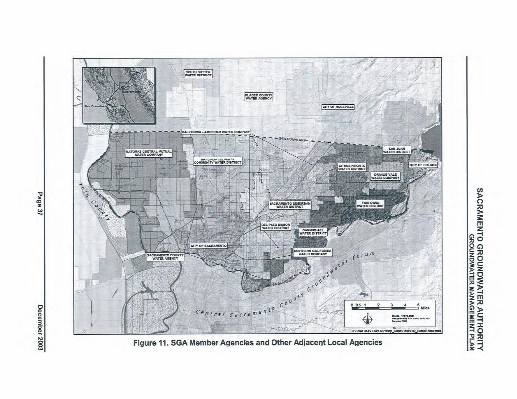
SACRAMENTO GROUNDWATER AUTHORITYGROUNDWATER MANAGEMENT PLAN
In 2000, NCMWC adopted a GMP for its service area in both Sacramento and Sutter counties(Luhdorff & Scalmanini Consulting Engineers (LSCE), 2000). That GMP wil continue to applyto NCMWC's Sutter County service area, while the SGA GMP wil be in effect for theSacramento County portion. NCMWC and SGA are coordinating to ensure that NCMWC'smanagement needs continue to be met in Sacramento County through the SGA GMP.
In Placer County, the SGA is closely connected to groundwater management activities throughthe RW A. PCW A, Rosevile, and the City of Lincoln (Lincoln) are all members of the RW A.PCW A adopted an AB 3030 GMP in 1998, which includes Rosevile. PCW A adopted anupdated GMP in compliance with SB 1938 in November 2003. The RWA Executive Director ison a steering committee for implementation of the West Placer County Groundwater
Management Plan. Lincoln is not covered by the PCW A plan, and adopted its own SB 1938-compliant GMP in November 2003. The RWA Executive Director is a member of the AdvisoryCommittee organized to develop and implement that plan. Finally, SGA staff have briefedPCW A staff responsible for groundwater management on the SGA GMP development and havedesignated a representative from Placer County as a member of the SGA GMP Technical ReviewCommittee (see Section 3.4.3).
In Sutter County, much of the subbasin is managed either by, South Sutter Water District (SouthSutter) or by NCMWC. NCMWC is an SGA member although the Sutter County portion of thedistrict does not fall under this GMP because it is beyond the boundaries of the SGA' s authority.South Sutter adopted a~ AB 3030 GMP in 1995. South Sutter provided a copy of that GMP tothe SGA, and the SGA provided a briefing to the South Sutter General Manager on its currentGMP development efforts. Finally, the SGA appointed a representative from Sutter ComityDepartent of Public Works as a member of the SGA GMP Techiical Review Committee.
In addition to involving other agencies within the North American Subbasin, the SGA hasbriefed representatives of Yolo County (representing the Yolo Subbasin) to the west and theCentral Sacramento County Groundwater Forum (or Groundwater Forum, representing the SouthAmerican Subbasin) to the south. The SGA also maintains close coordination with the CentralSacramento County through the R W A by being an active associate member of the GroundwaterForum's water pureyor interest group.
Actions. The SGA wil take the following actions:
1. Continue high level of involvement demonstrated through the SGA GMP developmentinto implementation of the plan by continued participation on committees described
above.
2. Provide copies of the adopted GMP and subsequent annual reports to representativesfrom Placer, Sutter, and Yolo counties, and the Groundwater Forum.
3. Meet with representatives from Placer, Sutter, and Yolo counties, and the GroundwaterForum as needed.
4. Coordinate a meeting with agricultural pumpers in the SGA area to inform them of the
SGA's management responsibilities and activities, and develop a list of agriculturalgroundwater pumpers concerns and needs relative to the SGA's management of the area.
5. Coordinate a meeting with other self-supplied pumpers in the SGA area to inform themof the SGA's management responsibilities and activities, and develop a list of self-supplied groundwater pumpers concerns and needs relative to the SGA's management ofthe area.
December 2003 Page 38
SACRAMENTO GROUNDWATER AUTHORITYGROUNDWATER MANAGEMENT PLAN
3.4.3 Utilzing Advisory Committees
The SGA is committed to using advisory committees in its GMP development andimplementation. Prior to beginning development of the GMP, the SGA Board appointed an adhoc committee to make recommendations for' the composition of a Policy Committee andTechnical Review Committee to guide development of the GMP. The ad hoc committeerecommended that the Policy Committee be composed öf SGA members representing the overall
~ , composition of the groundwater users within the SGA boundaries and that the Technical Review
Committee include broader membership including agencies outside the SGA boundaries toconsider technical issues related to the plan. Each committee met on approximately a monthlybasis during GMP development.
, The primary groups represented on the Policy Committee include:,
. Cal-Am
. Sacramento
. NCMWC
. Sac Suburban
. San Juan Family14
. Agriculture
The primary groups reprfsented on the Technical Review Committee include:
. Sacramento
. NCMWC
. Placer County/R,~sevile
. Sac Suburban
. San Juan Family
. DWR
. Sutter County
Actions. The SGA wil take the following action:
1. Upon adoption of the GMP, the Policy Committee wil meet to discuss the continuationand composition of committees to guide implementation of the plan. Provide these
recommendations to the SGA Board of Directors.
3.4.4 Developing Relationships with State and Federal Agencies
Working relationships between the SGA and the local, state, and federal regulatory agencies arecritical to developing and implementing the various groundwater management strategies andactions detailed in this GMP. Examples of the SGA, RW A, Cooperating Agencies, and theirmember agencies working cooperatively with the regulatory agencies include:
. Cooperating Agencies RWMP. Both Reclamation and DWR participated II andprovided fuding for the RWMP effort (Phases I and II).
14 The San Juan Family is comprised of SJWD, CHWD, FOWD, OVWC, and Folsom (north of the American
River).
Page 39 December 2003
SACRAMENTO GROUNDWATER AUTHORITYGROUNDWATER MANAGEMENT PLAN
. Banking and Exchange Program. A partnership of the Cooperating Agencies and theSGA was the first signatory of a Memorandum of Understanding with DWR's IntegratedStorage Investigation (ISI) in March 2000. The potential for a regional banking andexchange program was investigated through pilot studies and related activities. DWR'sISI provided funding for this effort.
. SGA-SAFCA Pilot Study. In 1999/2000, the SGA's first pilot study was conducted inconjunction with a local flood control agency (SAFCA) and Reclamation. '
. EW A Pilot Study. In 2002, SGA's pilot study was the first water acquisition made byReclamation on behalf of the EW A.
. SGA DMS. The U.S. Army Corps of Engineers (USACE) and DWR participated in the'Illi ,.
development of and provided funding for theSGA DMS (Phases I and II).
. American Basin Conjunctive Use Feasibilty Study. In the mid-1990s, DWR
conducted a feasibility study of conjunctive use parts of Sacramento, Sutter, and westernPlacer counties. NCMWC, an SGA member, was a cooperator in the study. Theinvestigation serves as a good example of developing relationships between state andlocal agencies.
The SGA also coordinates and develops working relationships with other local, state, and federalregulatory agencies (e.g., Sacramento County, California Department of Health Services (DHS),U.S. Environmental Protection Agency (USEPA), etc.), as appropriate.
Actions. The SGA wil take the following action:
'\ 1. Continue to develop working relationships with local, state, and federal regulatoryagencies.
3.~.5 Pursuing Partnership Opportunities
The SGA is committed to facilitating partnership arrangements at the local, state, and federallevels. In the past decade, Sacramento-area water community and other 10ca11eaders have madegreat strides toward regional planning and collaboration on water issues. The historic WF,f,which involved over40 stakeholders and 7 years of facilitated discussions, resulted in a regionalframework to balance the competing demands for increased use of surface and groundwater withthe environmental needs of the lower American River through the year 2030. Several importantpartnerships have been formed to implement the WF A as well as provide a host of other benefitsto water agencies and the customers that they serve.
The SGA itself is a unique partnership between the cities and county entering a joint powersagreement and allowing the agency to be overseen by a board of local water pureyors and se1f-supplied and agricultural interests. Regionally, the SGA is closely partered with the RW A, theWater Forum Successor Effort, and the Cooperating Agencies. Together these activities defineand support a conjunctive use program, which is critical to supporting the overall managementgoal of a safe and reliable water supply.
While the facilities necessary for local supply reliability through 2030 have been identifiedthrough the R WMP, the potential exists to expand conjunctive use operations in the basin toachieve broader regional and statewide benefits. The needed facilities, however, would requiresubstantial resources. To investigate any further opportnities would require resources providedthrough partnerships from potential beneficiaries.
December 2003 Page 40
SACRAMENTO GROUNDWATER AUTHORITYGROUNDWATER MANAGEMENT PLAN
Actions. The SGA wil take the following actions:
1. Continue to promote partnerships that achieve both local supply reliability and achievebroader regional and statewide benefits.
2. Continue to track grant opportities to fud groundwater management activities and
local water infrastrcture projects.
3.5 COMPONENT CATEGORY 2: MONITORING PROGRAM
At the heart of this GMP is a monitoring program capable of assessing the status of the basin andresponses in the basin to futue management actions. The program includes the monitoring, of
groundwater elevations, monitoring of groundwater quality, monitoring and assessing thepotential for land surface subsidëncë-:rësiiltiiig from groundwater extraction, and developing abetter understanding of the relationship between surface water and groundwater along theAmerican and Sacramento rivers. Also important is the establishing of monitoring protocols toensure the accuracy and consistency of data collected. Finally, the monitoring program includesa tool, the DMS, for assembling and assessing the groundwater-related data in the North AreaGroundwater Basin.
3.5.1 Groundwater Elevation Monitoring
The SGA has compiled historic water level data measurements extending from prior to 1950
through 2002. Sources of historic water level data for the SGA area include:
. DWRSCW A'\ . SGA Member Agencies
. USGS
. CSUS
DWR and SCW A have maintained a program of measuring more than 30 wells in the basin,from which SCW A routinely generates annual contour maps for the county. However, the wellsmonitored have been added to and dropped off of the network over time, so it is difficult tocompare a historic contour plot to a recent one. For this reason, the SGA is establishing astandardized network of wells that combines those monitored by DWR and SCW A with wellsfrom member water purveyors and other sources. It is the SGA's intent that these wells bemaintained as a consistent long-term network that represents overall groundwater elevationconditions in the basin. Figure 12 shows the wells currently proposed for this network.
The wells were selected to provide uniform geographic coverage throughout the 195 square mileSGA area, and in an area around the northern, western, and southern perimeter of the SGA1S.
The well netWork was developed by first establishing a network of sampling grids using thefollowing method:
. Overlay a matrix of evenly spaced points over the SGA area.
. Surround matrix of points with polygons.
. Conform boundaries of polygons to the SGA boundaries and regenerate area grds.
15 No wells were selected east of the boundary because it is in consolidated rock outside of the groundwater basin.
Page 41 December 2003
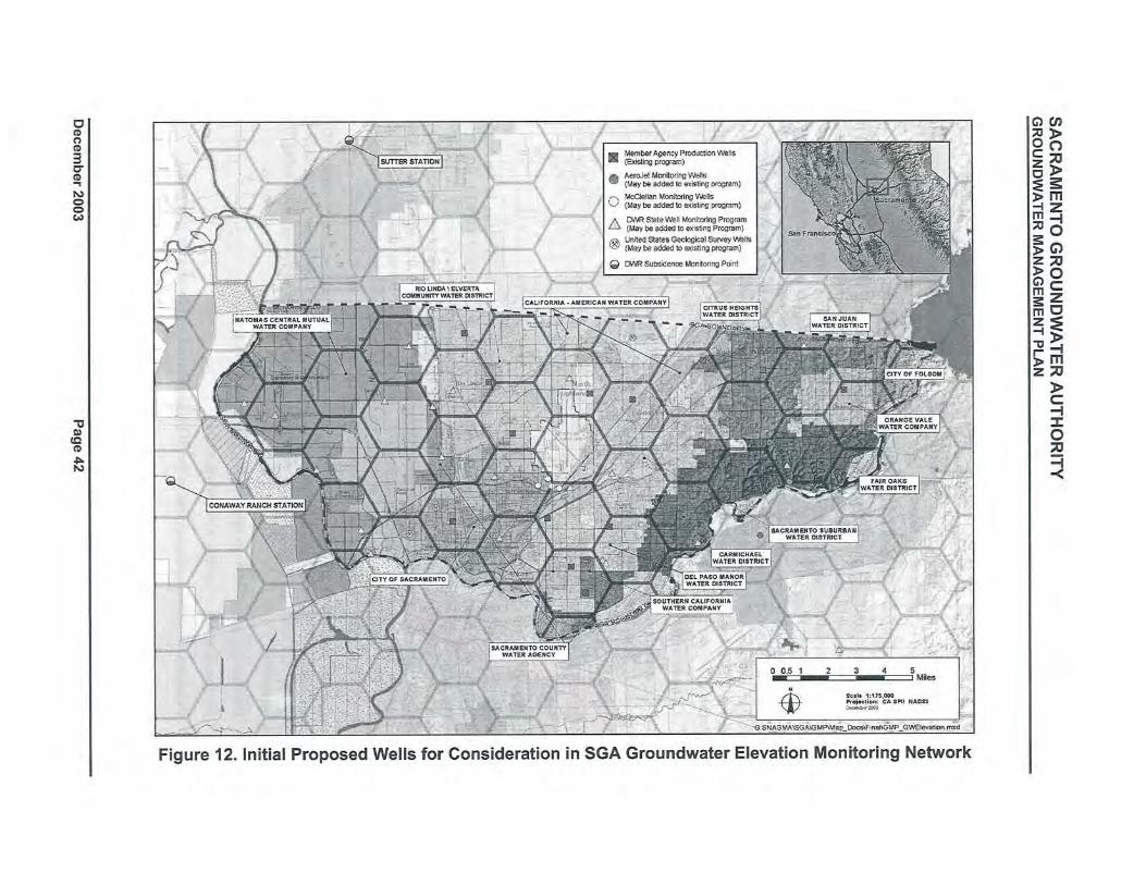
SACRAMENTO GROUNDWATER AUTHORITYGROUNDWATER MANAGEMENT PLAN
. The resulting grid, shown on Figure 12, includes 44 polygons of roughly equal area of about fivesquare miles each. The proposed set of member agency monitoring wells were selected from theDMS to represent water levels for as many polygons as possible. Individual wells were selectedby:
. Giving preference to wells currently in DWR's and SCWA's monitoring program. Thesewells were selected because (a) they have long records of historic water level data and areuseful in assessing trends within the groundwater basins, (b) uniform protocols were usedin measuring and recording the water level data, and (c) these are non-producing wells, sowater level readings represent relatively static levels.
"i" i'
. Identifying member agency wells with well constrction information, long records of
water level data and giving preference to those wells with the lowest recent extraction
volumes.
'. Plotting the location of USGS wells within the SGA area and choosing wells in those
areas void of DWR or member agency wells.
Actions. Additional actions by the SGA wil include:
I. Coordinate with member agencies and DWR to identify an appropriate group of wells formonitoring for a spring 2004 set of groundwater elevation measurements.
2. Coordinate with DWR and SCW A to ensure that the selected wells are maintained as partof a long-term monitoring network.
3. Coordinate with DWR and SCWA to ensure that the timing of water level data collectionby member agencies coincides within one month of DWR and SCW A data collection.Currently DWR and sew A collect water level data in the spring and fall. l
4. Coordinate with member agencies to ensure that needed water level elevations arecollected and verify that uniform data collection protocols are used among the agencies.
5. Coordinate with the' USGS to determine the potential for integrating USGS monitoringwells constructed for the NA WQA Program into the SGA monitoring network:
6. Consider ways to fill gaps in the monitoring well network by identifying additionalsuitable existing wells or identifying opportnities for constructing new monitoring wells.
7. Assess groundwater elevation trends and con,ditions based on the network annually.
8. Assess the adequacy of the groundwater elevation monitoring well network annually.
9. Identify a subset of monitoring wells that wil be monitored more frequently than twiceannuaUy to improve the SGA' s understanding of aquifer responses to pumpingthroughout the year.
3.5.2 Groundwater Quality Monitoring
"
Because most of the wells in the basin are used for public water supply, an extensive record ofwater quality data is available for most wells dating from about 1985 to present. The SGA hascompiled available historic water quality data for constituents monitored as required by DHSunder Title 22. Sources of water quality data include:
. DWR
. SGA Member Agencies
Page 43 December 2003
SACRAMENTO GROUNDWATER AUTHORITYGROUNDWATER MANAGEMENT PLAN
. USGS
. CSUS
This level of monitoring is sufficient under existing regulatory guidelines to ensure that thepublic is provided with a safe, reliable drinking water supply. It would ultimately be importantto have in place a network of shallow (less than 200 feet deep), dedicated monitoring wells toserve as an early warning system for contaminants that could make their way to the greaterdepths in the basin where SGA members primarily extract groundwater. The SGA has identifiedthe locations of several wells associated with the USGS NA WQA program and is working withAFRP A to identify a subset of the approximately 400 monitoring wells located in and around theformer McClellan AFB for integration into the SGA monitoring effort. The SGA will alsocoordinate with the CVR\yQCB, which oversees the remediation of LUSTs, to identify existingdedicated monitoring wells iii the basin.
Figure 13 shows the existing SGA member agency production wells. Title 22 water qualityreporting is required by DHS for each of these public drinking water supplies. The SGA's waterquality monitoring network includes these wells. The water quality monitoring well networkmay be expanded to include additional DWR, USGS, McClellan AFB, Aerojet, CVRWQCB,and privately owned wells, based on the outcome of coordination meetings with these agencies.
Actions. The following actions wil be taken by the SGA to monitor and manage groundwaterquality:
1. Coordinate with member agencies to verify that uniform protocols are used whencollecting water quality data. '
2. Coordinate with 'the USGS to obtain historic water quality data for NA WQA wells,determine timing and frequency of monitoring under USGS program, and to discuss thepotential for integrating USGS monitoring resources with the SGA network.
3. Coordinate with member agencies and other local, state, and federal agencies to identifywhere wells may. exist in areas with sparse groundwater quality data. Identifyoppòrtnities for coll~cting and analyzing water quality samples from those wells.
4. Assess the adequacy of the groundwater quality monitoring well network annually.
3.5.3 Land Surface Elevation Monitoring
Subsidence of the land surface resulting from compaction of underlying formations affected byhead (water level) decline is a well-documented concern throughout much of the Central Valley.
During a typical pumping season, changes in land surface elevatiön can be observed as a resultof both elastic and inelastic ~ubsidence in the underlying basin. Elastic subsidence results fromthe reduction of pore fluid pressures in the aquifer and typically rebounds when pumping ceasesor when groundwater is otherwise recharged resulting in increased pore fluid pressure. Inelasticsubsidence occurs when pore fluid pressures decline to the point that aquitard (a clay bed of anaquifer system) sediments collapse resulting in permanent compaction and reduced ability tostore water in that portion of the aquifer.
December 2003 Page 44
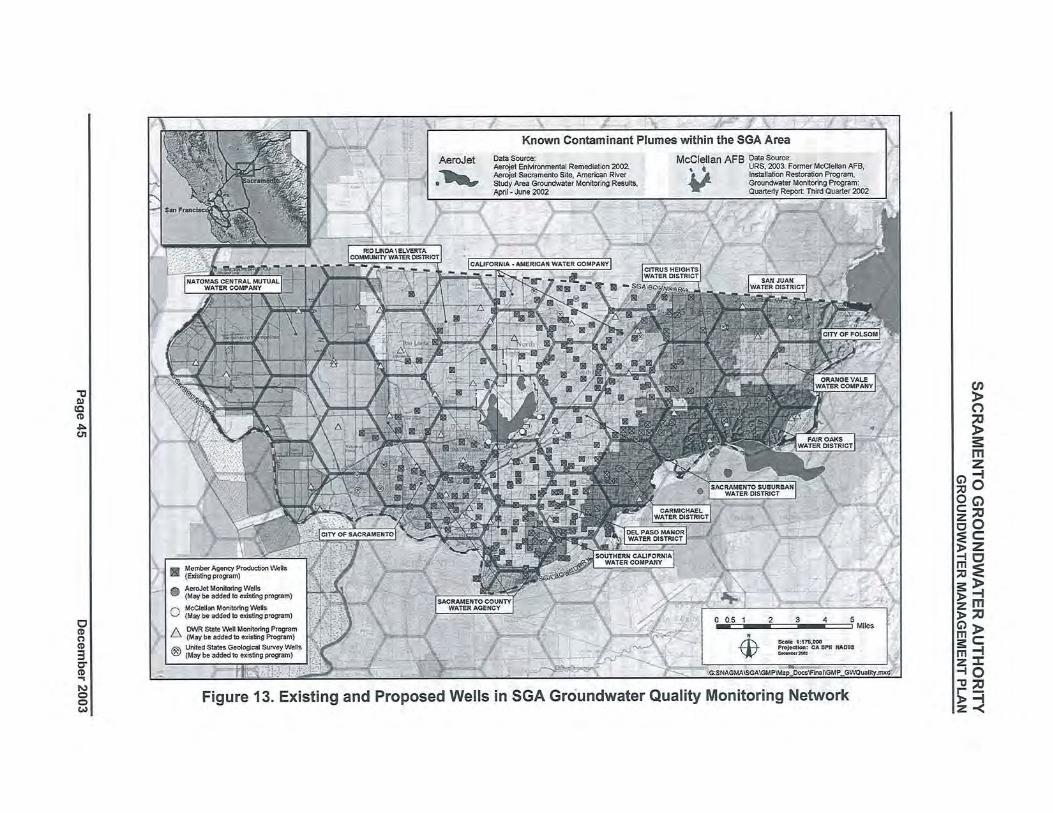
SACRAMENTO GROUNDWATER AUTHORITYGROUNDWATER MANAGEMENT PLAN
While some land surface subsidence from compaction of water-bearing deposits caused by theremoval of groundwater is known to have occured west of the Sacramento River16, the extent ofsubsidence east of the Sacramento River has been, minimaL.DWR maintains three subsidence monitoring stations in Sacramento Valley. The Sutter Stationis located just north of the SGA area, where State Highway 99 crosses the Natomas Cross-Canal(Figure 12). Total subsidence at the Sutter Station from spring 1995 to spring2003 has been0.026 feet (0.312 inch)
17. Total subsidence at the Conaway Ranch Station, located west of the
SGA area (Figure 12), from spring 1992 to spring 2003 has been 0.044 feet (0.526 inchi8.
Historical benchmark elevation data for the period from 1912 through the late 1960s obtainedfrom the National Geodetic Surey (NGS) were used to evaluate land subsidence in northSacramento County. From 1947 to 1969 the magnitude of land subsidence measured atbenchmarks north of the American River in Sacramento County ranged from 0.13 feet to 0.32feet, with a general decrease in subsidence in a northeastward direction. This decrease is
consistent with the geology of the area: formations along the eastern side of the SacramentoValley are older than those on the western side and are subject to a greater degree of pre-consolidation making them less susceptible to subsidence. The maximum documented landsubsidence of 0.32 feet was measured at both benchmark L846, located approximately two milesnortheast, of the former McClellan AFB, and benchmark G846, located approximately one milenortheast of the intersection of Greenback Lane and Elkhorn Boulevard.
Another land subsidence evaluation was performed in the Arden-Arcade area19 of Sacramento
County from 1981 to 1991. Elevations of nine wells in the Arden-Arcade area were surveyed in1981, 1986, and 1991. The 1986 results were consistently higher than the 1981 results; this wasattributed to extremely high rainfall totals in early 1986 that recharged the aquifer and caused arise in actual land surface elevations. The 1991 results were consistently lower than the 1986results; this was attibuted to five years of drought immediately preceding the 1991
measurements, which caused depletion of the aquifer and resulting land surface subsiden€e.Comparison of eight20 of the locations indicates that seven benchmarks have lower elevations in1991 than in 1981 and one benchmark has a higher elevation in 1991. Of the seven benchmarkswith lower elevations in 1991, the maximum difference is 0.073 feet (less than one inch).Whether this is, inelastic subsidence is indeterminate from the data, but it is clear that themagnitude of the potential subsidence in the benchmarks during that period is negligible.
Actions. While available data and reports indicate that land surface subsidence is not a problemin the SGA area, the SGA is interested in pursuing additional possible actions to continue tomonitor for potential land surface subsidence. These may include:
1. Investigate the feasibility and costs of re-sureying the wells in the Arden-Arcade areathat were last measured in 1991.
" l
16 From 1988-1992 cumulative net sediment compaction of 0.78 feet was measured at the extensometer in Yolo
County between June 15, 1988 and October 1, 1992 (USGS data from the Woodland land subsidence monitoringstation, Yolo County, California, water years 1988-1992, USGS Open File Report 94-494)
17 Based on information provided by Central District ofDWR to MWH on 12/11/03.18 Based on information provided by Central District ofDWR to MWH on 12/17/03.19 The boundaries of the Arden-Arcade area are (1) Sacramento's city limits on the wèst, (2) Sacramento's city
limits and the American River on the south, (3) CWD on the east, and (4) Sacramento's city limits and SacSuburban (Northrdge Service Area) on the north.
20 One of the nine wells could not be compared between 1981 and 1991 because the benchmark was destroyed andreplaced between 1981 and 1986.
December 2003 Page 46
SACRAMENTO GROUNDWATER AUTHORITYGROUNDWATER MANAGEMENT PLAN
c ,
2. Coordinate with the USGS to ascertain the suitability of the use of InterferometrcSynthetic Aperte Radar (lnSAR) images of the SGA and surounding area. If thetechnology appears suitable, identify the costs of determining ground surface elevationsand identify potential cost-sharing parters.
3. Coordinate with other agencies, particularly the City and County of Sacramento and theNGS to determine if there are other suitable benchmark locations in the SGA area to aidin the analysis of potential land surface subsidence.
4. Educate SGA member agencies of the potential for land surface subsidence and signs thatcould be indicators of subsidence.
C L
lil'l'
3.5A--Sudace-a~ "G~oundwater-Interaction-Monito~ing---- _n______"_
The interaction between groundwater and surface water has not been extensively evaluatedwithin the SGA area. The SGA is currently aware of the following:
. A recent draft decision by the State Water Resources Control Board (SWRCB, 2003)
regarding the American River, the SWRCB concluded that from Nimbus Dam to abou~6,000 feet below the dam, groundwater elevations and surface water elevations weresimilar enough to each other that groundwater could be tributary to the American River.Beyond 6,000 feet down reach from Nimbus Dam, groundwater elevations aresuffciently lower than the river channel to conclude that the American River is a losingreach down to the confluence with the Sacramento River.
'\. Groundwater modeling (described in Section 3.8.1) has been used to estimate flow
volumes between surface water and groundwater for various hydrologic conditions.
. CSUS in cooperation with DWR has recently installed several monitoring wells in ap.dadjacent to the American River to investigate groundwater interaction with the AmericanRiver and how recent USACE levee reinforcement projects might have changed thesurface water~groundwater flow relationships.
. In 1991, Sacramento Regional County Sanitation District (SRCSD), Sacramento County,and Sacramento established the Sacramento Coordinated Water Quality MonitoringProgram (CMP). Since that time, the CMP has monitored surface water quality for avariety of constituents including trace elements at several locations on the AmericanRiver and Sacramento River. Within the SGA area, the CMP monitors the SacramentoRiver at the Interstate 5 Veteran Memorial Bridge, and the American River at NimbusDam and at Discovery Park.
Actions. The SGA will pursue actions to better understand the relationship between surface andgroundwater in the SGA area, including:
1. Compile available stream gage data and information on tributary inflows and diversionsfrom the American and Sacramento rivers to quantify net groundwater recharge ordischarge between gages ,in the SGA area.
2. Coordinate with local, state, and federal agencies to identify available surface waterquality data from the American and Sacramento rivers adjacent to the SGA area.
3. Correlate groundwater level data from wells in the vicinity of river stage data to furtherestablish whether the river and water table are in direct hydraulic connection, and if thesurface water is gaining or losing at those points.
Page 47 December 2003
SACRAMENTO GROUNDWATER AUTHORITYGROUNDWATER MANAGEMENT PLAN
4. Continue to coordinate with local, state, and federal agencies and develop parterships to
investigate cost-effective methods that could be applied to better understand surfacewater-groundwater interaction along the Sacramento and American rivers.
5. Coordinate with CSUS to analyze data obtained from recently constructed monitoringwells on the CSUS campus to better understand the relationship between the groundwaterbasin and surface water flows at that location.
3.5.5 Protocols for the Collection of Groundwater Data
The SGA has evaluated the accuracy and reliability of groundwater data collected by memberagencies (MWH, 2002). The evaluation indicated a significant range of techniques, frequenciesand documentation methods, for the collection of groundwater level and groundwater qualitydata. Although the ground,,ater data collection protocol may be adequate to meet the needs ofthe individual water districts, the lack of consistency between districts in the past yields anincomplete picture of basin-wide groundwater conditions. Other types of groundwater datacollection protocols are included in Sections 3.5.1 and 3.5.2 above.
Actions. To improve the comparability, reliability and accuracy of groundwater data, the SGAtake the following actions:
1. Use a Standard Operating Procedure (SOP) for collection of water level data by each ofthe member agencies. Appendix D includes an SOP for Manual Water LevelMeasurements., This SOP was prepared using guidance documents available throughUSEP A and was included in the SGA technical memorandum summarizing the accuracyand reliability of groundwater data (MWH, 2002).
,
2. Provide member agencies with guidelines on the collection of water quality data developedby DHS for the collection, pretreatment, storage, and transportation of water samples (DHS,1995).
3. Provide training on the implementation of these SOPs to member agencies, if requested.
3.5.6 Data Manageiñent.System
The SGA membership includes 14 public agency and investor-owned water purveyors.Historically, the member agencies have maintained a varying range of groundwater-related datain a wide variety of formats. In order for the SGA to achieve its primary objective of sustainingthe groundwater resource of the North Area Groundwater Basin, it was essential to develop adata storage and analysis tool, the DMS. The DMS was developed by MWH under contract withthe USACE. Other local sponsors included DWR and the SGA.
Development of the DMS is' a two-phase project. Phase I was completed in Januar 2003 andincluded initial development of the user interface and population of the DMS to a demonstrationlevel of approximately one-fourh of the water purveyor wells. Phase II, to be completed byJanuary 31, 2004, wil fully populate the database and add further customization of the userinterface with additional analysis featues. Once the DMS is fully populated and quality-controlchecked a summary of existing basin conditions wil be prepared. From this initial summary,analyses wil be performed on at least an annual basis to assess the impacts of current and futureSGA management actions on the groundwater system.
The DMS is a public domain application developed in a Microsoft Visual Basic environment andis linked to a SQL database of the SGA purveyor data. The DMS provides the end-user withready access to both enter and retrieve data in either tabular or graphical formats. Security
- l
December 2003 Page 48
SACRAMENTO GROUNDWATER AUTHORITYGROUNDWATER MANAGEMENT PLAN
features in the DMS allow for access restrictions based on a variety of user permission levels.Data in the DMS include:
. Well construction details.
. Known locations of groundwater contamination and potentially contaminating activities.
. Long-term monitoring data on:
Monthly extraction volumes.
Water elevations.
Water quali'ty.
. Aquifer characteristics based on well completion reports.
The DMS allows for the viewing of regional trends in water level and water quality notpreviously available to the SGA (see Figure 14 for a DMS screen captue). The DMS has thecapability of quickly generating well hydro graphs and groundwater elevation contour maps usinghistoric groundwater level data. The DMS also has the ability to view water quality data forTitle 22 required constituents as a temporal concentration graph at a single well or anyconstituent can be plotted with respect to concentration throughout the SGA' area. Presentationof groundwater elevation data and groundwater quality data in these ways wil be useful for
making groundwater basin management decisions.
The SGA is currently in the process of establishing data transfer' protocols so that groundwaterdata within the SGA area (by member agencies, DWR, AFRPA, USGS, etc...) can be readilyappended to the database and analyzed through the DMS. Annual summaries of groundwatermonitoring data wil be prepared using the analysis tools in the DMS and presented in the updateto the State of the Basin report (see Section 4).
Actions. To maintain ãrïd improve the usability of the DMS, the SGA wil take the followingactions:
1. Continue to update the DMS with current water purveyor data.
2. Make recommendations to the DMS developer on utilities to add to the DMS toincrease its functionality.
3.6 COMPONENT CATEGORY 3: GROUNDWATER RESOURCE PROTECTION
The SGA considers groundwater protection to be one of the most critical components of ensuringa sustainable groundwater resource. In this GMP, resource protection includes both preventionof contamination from entering the groundwater basin and remediation of existingcontamination. Prevention measures include proper well construction and destruction practices,development of wellhead protection measures, and protection of recharge areas. Containmentand remediation include measures to prevent contamination from human activities as well ascontamination from natural substances such as saline water bodies.
3.6.1 Well Construction Policies
The Sacramento County Environmental Management Department (EMD) administers the wellpermitting program for Sacramento County. The standards for constrction are identified inSacramento County Code No. SCC-1217 as amended on April 9, 2002. In addition to generalwell construction standards, Sacramento County has a policy of special review by appropriateregulatory agencies for well permits within 2,000 feet of a known contaminant plume (referred to
Page 49 December 2003
SACRAMENTO GROUNDWATER AUTHORITYGROUNDWATER MANAGEMENT PLAN
as Consultation Zones) and prohibits the driling of new public supply wells at the former
McClellan AFB. As part of the development of the DMS, the most recent extents of known.contaminant plumes associated with the former McClellan AFB, the former Mather AFB, andAerojet were delineated for the SGA.
Acti¿ns. The SGA wil take the following actions:
1. Ensure that all member agencies are provided a copy of the county well ordinance andunderstand the proper well constrction procedures. '
2. Inform member agencies of Sacramento County's Consultation Zone and provide a copyof the boundary of the former McClellan AFB prohibition zone to appropriate memberagencies.
'.', 3. Provide a copy of the most recently delineated plume extents at the former McClellanAFB, the former Mather AFB, and Aerojet to the EMD and SGA members for theirreview and possible use.
4. Coordinate with member agencies to provide guidance as appropriate on wellconstrction. Where feasible and appropriate, this could include the use of subsurfacegeophysical tools prior to construction of the well to assist in well design.
3.6.2 Well Abandonment and Well Destruction Policies
The EMD administers the well destruction program for Sacramento County. The standards förconstruction are identified in Sacramento County Code No. SCC-I217 as amended on April 9,2002. One concern expressed by the EMD21 is that many abandoned domestic wells have notbeen properly destroyed. Historically, the north part of Sacramento County has been served byorganized water districts, so there are not many privately owned domestic wells. As part ofdevelopment of the DMS, DWR well records for all known wells in the basin were reviewed forreported abandonment and destruction. The wells were rated for the confidence of properdestrction based on the information provided on the report. This information was entered into
the DMS. It is the SGA's opinion that the database as it currently stands, accurately reflectsdocumented well destrction activities within the SGA area. The actions listed below wilprovide improved protection of groundwater quality within the SGA area.
Actions. The SGA wil take the following actions:
1. Ensure that all member agencies are provided a copy of the code and understand theproper destruction procedures and support implementation of these procedures.
2. Follow up with member agencies on the reported abandoned and destroyed wells toconfirm the information collected from DWR.
3. Provide a copy of the information on abandoned and destroyed wells in northern
Sacramento County to fill any gaps in their records.
4. Meet with the EMD to discuss ways to ensure that wells in the SGA area are properlyabandoned or destroyed.
5. Obtain "wildcat map from California Division of Oil and Gas to ascertain the extent ofhistoric gas well driling operations in the area as these wells could fuction as conduitsof contamination if not properly destroyed.
~ 1
- l
21 Faith King, pers. comm., August t t, 2003.
December 2003 Page 50
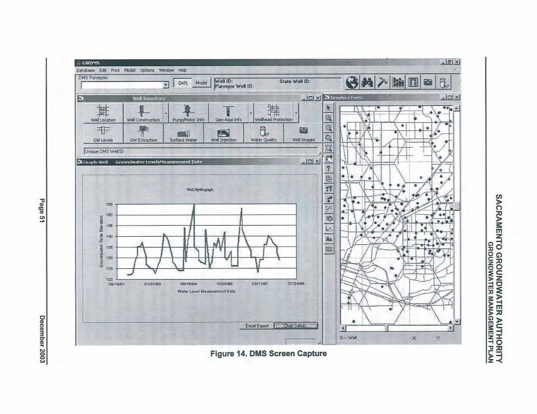
SACRAMENTO GROUNDWATER AUTHORITYGROUNDWATER MANAGEMENT PLAN
3.6.3 Wellhead Protection Measures
Identification of wellhead protection areas is a component of the Drinking Water SourceAssessment and Protection (DWSAP) Program administered by DHS. DHS set a goal for allwater systems statewide to complete Drinking Water Source Assessments by mid-2003. All
SGA member agencies have completed their required assessments by performing the three majorcomponents required by DHS:
. Delineation of capture zones around sources (wells).
. Inventory of Potential Contaminating Activities (PCAs) within protection areas.
. Vulnerability analysis to identify the PCAs to which the source is most vulnerable.
De'lneation of capture zones includes using groundwater gradient and hydraulic conductivityaata-to ucalcula1eilÙ~ surface area ove:rying the portion of the aquifer that contrbütes water to a
well within specified time-of-travel periods. Typically, areas are delineated representing 2-, 5-,~nd lO-year time-of-travel periods. These protection areas need to be managed to protect thedrinking water supply from viral, microbial, and direct chemical contamination.
Inventories of PC As include identifying potential origins of contamination to the drinking watersource and protection areas. PCAs may consist of commercial, industrial, agricultural, andresidential sites, or infrastructue sources such as utilities and roads. Depending on the tye ofsource, each PCA is assigned a risk ranking, ranging from "very high" for such sources as gasstations, dr cleaners, and landfills, to "low" for such sources as schools, lakes, and non-irrigatedcropland.
Vulnerability analysis includes determining the most significant threats to the quality of thewater supply by evaluating PCAs in terms of risk rankings,proximity to wells, and PhysicalBarrier Effectiveness (PBE). PBE takes into account factors that could limit infitration ofcontaminants including type of aquifer, aquifer material (for unconfined aquifers), pathways lofcontamination, static water conditions, hydraulic head (for confined aquifers), well operation,and well constrction. The vulnerability analysis scoring system assigns point values for PCA
risk rankings, PCA locations within wellhead protection areas, and well' area PBE; the PCAs towhich drinking water wells are most vulnerable are apparent once vulnerability scoring iscomplete.
The SGA has already added PCA and capture zone information from the DWSAP into the DMS.The DMS includes a featue that wil automatically calculate wellhead protection areas if no dataare available or if new well locations are proposed.
Actions. The SGA wil take the following actions:
1. Request that member agencies provide vulnerability summaries from the DWSAP to theSGA to be used for guiding management decisions in the basin.
2. Contact groundwater basin managers in other areas of the state for technical advice,effective management practices, and "lessons leamed,"regarding establishing wellheadprotection areas.
c "
- "
December 2003 Page 52
SACRAMENTO GROUNDWATER AUTHORITYGROUNDWATER MANAGEMENT PLAN
3.6.4 Protection of Recharge Areas
The SGA has also evaluated surface geology within and directly adjacent to its boundary for thepurpose of delineating areas of potentially high recharge rates. Surface geology and estimates ofrelative recharge rates are shown on Figure 15. Much of the surface area considered to have thehighest potential for recharge is already developed, so opportities to ensure protection of theSeareas are somewhat limited.
Recently, most members of the SGA participated in the California Aquifer Susceptibility (CAS)Study administered by the SWRCB. Objectives of this study included sampling for many knownc,gntaminants at low detection levels to act as early indicators of potential problems particularlyin recharge areas of aquifers. The results of this s1tdy are not yet available.
Actions. The SGA will take the following action:
i. When CAS results are available, meet with the SWRCB to discuss those results andconsider follow-on actions.
3.6.5 Control of the Migration and Remediation of Contaminated Groundwater
The migration of contaminated groundwater in the SGA area is of primary concern' from theMcClellan AFB and Aerojet groundwater contamination plumes as shown in Figure 4. Also ofconcern is the localized contamination of groundwater by industrial point sources such as drcleaning facilities and numerous fuel stations throughout theSGA area.
While the SGA does not have authority or the responsibility for remediation of this.,
contamination, it is committed to coordinating with responsible parties and regulatory agenciesto keep SGA members informed on the status of known contamination in the basin. Forexample, the SGA has requested and entered into its DMS a coverage of known LUSTs withinthe basin. This information is maintained by the SWRCB and CVRWQCB. Also, the SGA hasbeen in communication with the AFRP A, which is overseeing remediation efforts at McClellanAFB (see Section 3.4.2).
Actions. The SGA wil take the following actions:
l. Coordinate with known responsible parties to develop a network of monitoring wells toact as an early warning system for public supply wells.
2. If detections occur in these monitoring wells, facilitate meetings between the responsibleparties and the potentially impacted member agency to develop strategies to minimize thefurther spread of contaminants. An example of a strategy would be to consider alteringgroundwater extraction patterns in the area to change to groundwater gradient.
3. Provide SGA members with all information on mapped contaminant plumes and LUSTsites for their information in developing groundwater extraction patterns and in the sitingof future production or monitoring wells.
4. Meet with representatives of the CVRWQCB to establish a mutual understanding aboutthe SGA's groundwater management responsibilities. Identify ways to have open andexpedient communication with CVRWQCB regarding any new occurrences of LUSTs,particularly when contamination is believed to have reached the water table.
Page 53 December 2003
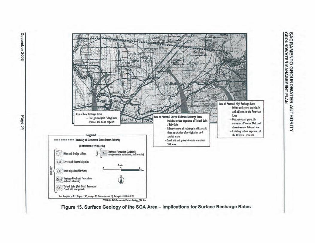

SACRAMENTO GROUNDWATER AUTHORITYGROUNDWATER MANAGEMENT PLAN
3.6.6 Control of Saline Water Intrusion
Saline water intrsion from the Sacramento/San Joaquin River Delta (Delta) is not curently aproblem in Sacramento County as a whole or in the North Area Groundwater Basin, and it is not'expected to become a problem in the future. Higher groundwater elevations associated withrecharge in the American and Sacramento rivers have maintained a historical positive gradientpreventing significant migration of any saline water bodies associated with the Delta frommigrating east into the Sacramento County region. These groundwater gradients will continue toserve to prevent any localized pumping depressions in the basin from inducing flow from theDelta into the North Area Groundwater Basin.
A more~local source of saline water is beneath the base of fresh water in the North AreaGroundwater Basin. Berkstresser (1973) mapped the base of fresh water (the point below whichthe specific conductivity of the water is greater than about 3,000 micromhos per centimeterÜimhos/cm)) for the Sacramento Valley. For the North Area Groundwater Basin, the minimumdepth of fresh water is at an elevation of about 800 feet below mean sea level near the easternbasin margin and increases to a depth of approximately 2,00.0 feet below mean sea level on thewestern margin of the basin. The municipal suppliers in the North Area Groundwater Basingenerally extract groundwater from depths of less than 500 feet, so their extractions are asubstantially above the, base of fresh water. Therefore, current pumping practices would not beexpected to create a situation where deeper saline water is being drawn into the fresh, wateraquifer. 'Actions. The SGA wil take the following actions:
1. Track the progression, if any, of saline water bodies moving toward the east from theDelta. Because this is a highly unlikely scenario, this action wil be limited tocommunicating with DWR's Central District Offce on a ,biennial basis to check forsignificant changes to TDS concentrations in wells. DWR has a regular program ofsampling water quality in select production wells throughout the adjacent Solano, SanJoaquin, and Yolo counties. This wil serve as an early warning system for the potentialof saline water intrsion from the Delta.
2. Observe TDS concentrations in public supply wells of North Area Groundwater Basinwater suppliers that are routinely sampled under the DHS Title 22 Program. These datawil be readily available in the SGA's DMS and are already an on-going task for theannual review of basin conditions.
,
3. Inform all member water purveyor managers of the presence of the interface and theapproximate depth of the interface below their service area for their reference when sitingpotential wells. The SGA wil also ensure that the EMD, which issues well permits, isaware of the interface. The SGA wil provide a map indicating the contour of theelevation of the base of fresh water in Sacramento County to the EMD for their referencewhen issuing well permits.
3.7 COMPONENT CATEGORY 4: GROUNDWATER SUSTAINABILITY
To ensure a long-term viable supply of groundwater, SGA members are seeking to maintain orincrease the amount of groundwater stored in the basin over the long-term. The WFA'sgroundwater management element provides a framework by which the groundwater resource inthe Sacramento County-wide area can be protected and used in a sustainable manner. It
recommends an average annual sustainable groundwater yield within the SGA area of 131,000
Page 55 December 2003
SACRAMENTO GROUNDWATER AUTHORITYGROUNDWATER MANAGEMENT PLAN
AF /year. As documented in Section 2 of the GMP, historic groundwater extractions haveresulted in a net depletion of groundwater stored under the SGA area. To ensure a sustainableresource, SGA and R W A members have undertaken several actions toward increasedconjunctive use of groundwater and surface in the basin and wil continue to do so. Historically,water purveyors in the basin away from the rivers did not have access to surface water and alarge cone of depression resulted in the middle of the SGA area. Recent conjunctive useactivities have resulted in providing neW surface water supplies to these areas. Although waterpurveyors in the region wil rely more heavily on groundwater during dr periods, the netincrease in available surface wil result in a maintained or improved amount of groundwater instorage in the basin over the long term.
Two primary activities wil result in an improved ability to sustain the viability of thegroundwater resource for the region. Conjunctive management activities include the planingand construction of facilities to increase the'available water supply to the areaas well as to createopportities for the banking and exchange of water with partners after local needs are met.These partnerships wil result in some of the necessary capital improvements to help sustain there~ource in a cost-effective way. Additionally, the SGA's ability to sustain the gtoundwaterresource wil be met in part through reductions in potable water demand through conservationmeasures and through the use of recycled water for landscape irrigation supply. Thesegroundwater sustainability activities are discussed below.
3.7.1 Conjunctive Management Activities
The SGA and RW A members are committed to expanded conjunctive use operations and areinvestigating a variety of ways of recharging water into the available storage space in the basin.O~portnities for direct recharge from overlying land in the basin are limited, because much ofthe land is developed or is overlain by flood basin deposits.. Most of the recharge occurringthrough curent conjunctive use is from in-lieu recharge. One component of the RW A ARB CUP
(ste below) is an aquifer storage and recovery well, which wil inject water just north of thebasin. Current and potential futue facilities in the basin are further described in the CooperatingAgencies RWMP Phase II Final Report (MWH, 2003).
Cooperatinf! Af!encies R WMP., As discussed in Section 2.5, Phase I of the R~Pidentified and described a "menu" of project and program alternatives for implementing theWF A north of the American River. Phase II provided detailed hydrologic, engineering, andlegal/institutional evaluations of those projects and programs that best aligned with the goals andobjectives of the individual water purveyors and the WF A. The recommendations resulting fromPhase II were used to strcture the SGA and RW A's regional projects and programs.
Sac Suburban's Groundwater Stabilzation Proiect. This project allows groundwaterelevations underlying the SGA area to increase natually (in-lieu recharge) by providing up to29,000 AF of surface water per year to an area that has historically relied on groundwater. From1998 through 2001, Sac Suburban utilized an annual average of about 12,850 AF of surfacewater, reducing its use of groundwater and resulting in stabilization of groundwater elevationsthat had been declining historically at a rate of about 1.5 feet per year (LSCE, 2002). Thisproject is a prime example of the types of activities to be included in a conjunctive use programenvisioned in the WF A.
RWA ARBCUP. The objective of the RWA ARBCUP is to implement elements of theregional conjunctive use program developed in the Cooperating Agencies RWMP. Though theRW A ARB CUP, treated surface water wil be delivered to areas that have historically used
December 2003 Page 56
SACRAMENTO GROUNDWATER AUTHORITYGROUNDWATER MANAGEMENT PLAN
groundwater in wet years, resulting in in-lieu recharge. In dry years, the stored water wil berecovered in areas that have historically used surface water, allowing forbearance of surfacewater diversions.
The RW A ARB CUP wil provide an additional average water supply yield in the region of21,400 AF/year. Projects such as these strongly suppòrt the goal and objectives of the SGA~sGMP. The project consists of 12 program components (see Table 5 and Figure 7) constrctedby seven public agencies. Facilities include an expansion of surface water treatment plantcapacity, water transmission system improvements (including pipelines, a pump station, and anaboveground water storage tank for flow equalization), groundwater extraction wells, and meterreplacements. In 2001, the RWA submitted a grant application to DWR for a groundwater
'.-storage-construction -grant andwas-,.subsequently' awarded $21.67" milion. The R W A memberagencies are matching the grant with local fuds to construct the project.
SGA-SAFCA Pilot Studv. In 1999/2000, a pilot study was conducted with SAFCA andReclamation as a means of exercising the groundwater storage potential resulting form theregional cone of depression and investigáting the mechanics of a large-scale conjunctive useprogram. In this pilot study, an on-call surface water supply was provided to SAFCÄ.Specifically, SAFCA diverted and stored (banked) 2,100 AF of water in the basin. Thefollowing year, surface water in the amount of 1,995 AF was made available by exchangethrough the extraction of groundwater in-lieu of diverting a CVP supply from Folsom Reservoir.SAFCA used this water on an as-needed basis to satisfy its refill obligations associated withflood management reservation in Folsom Reservoir.
EWA Pilot Studv. In 2002, the SGA conducted an expanded pilot study. It entered intoan agreement with Reclamation (on behalf of the EW A) for thè one-year sale of up to 10,000 AFof surface water. A portion of this surface water (up to 5,000 AF) was made available inFolsomReservoir through a transfer of a portion of SJWD's CVP contract entitlement. The other 5,000AF was made available by Sacramento through forbearance of a surface water diversion right onthe lower American River. In both cases, local demand was met by recovery of previouslybanked groundwater.
Actions. The SGA wil take the following actions:
1. Continue to investigate conjunctive use opportnities within the SGA area. The SGA andits members wil coordinate with the RW A and its members, as appropriate.
2. Continue to investigate opportnities for the development of direct recharge facilities inaddition to in-lieu recharge (e.g. injection wells or surface spreading facilities, throughconstrcted recharge basins or in river or streambeds).
'\
3.7.2 Demand Reduction
Another way to stay within the sustainable yield of the basin and continue to achieve in.,lieurecharge is by reducing demand on potable water supplies through conservation and by makingrecycled water available for irrigation of landscaping.
Water Conservation. The RW A has developed and implemented a regional WaterEfficiency Program (WEP). The WEP assists members to meet their water conservationagreements with the, Water Forum, the California Urban Water Conservation Council, and forsome members the Central Valley Project Improvement Act (CVPIA). The water conserved aspart of this effort is essential to the Water Forum's ability to meet its objectives of providing asafe, reliable water supply to 2030 and protecting the lower American River in two ways. First,
Page 57 December 2003
SACRAMENTO GROUNDWATER AUTHORITYGROUNDWATER MANAGEMENT PLAN
the conserved water will serve to meet increased futue demands. Second, the conserved waterwil reduce the overall demand on the groundwater basin in drier years and can reduce thedemand for water diverted from the lower American River. The goal of the WF A is to achievesystem-wide conservation of slightly more than 25 percent by the y~ar 2030.
SGA members have also implemented other conservation measures outside of the WF A. Oneexample is in NCMWC's tai1water recovery system implemented in 1986. The programachieves conservation through the reapplication of water that runs off of agricultual fields
within the NCMWC system. The system also results in reduced ruoff of agricultural appliedwater to the Sacramento River thereby decreasing agricultual pesticides that would have been inthe river.
Water Recvclinl!. SRCSD treats wastewater for the Sacramento region at its Elk GroveWastewater Treatment P1a'ht'and is looking for ways to increase the delivery of recycled from the
- , "p1antto-landscape-irrígation uses. SRCSD joined the RW A as an associate member inSeptember 2003. By joining the RW A, SRCSD can work closely with other member agencies toinvestigate opportnities to use recycled water throughout the area to more effectively develop
the regional water supply. Currently, SRCSD is recycling 5 mgd at its Elk Grove facility anddelivering it to nearby landscape irrigation users. SRCSD expects the capacity of that facility toincrease to 10 mgdover the next few years. Currently, recyCled water is only delivered to userssouth of the SGA area. SRCSD is investigating ways to deliver recycled water north of theAmerican River in the future.
Actions. The SGA wil take the following actions:,
1. Coordinate with the RW A and its members that have sigped specific agreements to theWF A to ensure that those conservation efforts are on track. F or members that are notsignatory, the SGA wil ensure that they are' informed of the benefits and regionalimportance of R W A's WEP.
2. Coordinate with SRCSD through the R W A to investigate opportities for expanded useof recycled water throughout the county.
3;8 COMPONENT CATI;GORY 5: PLANNING INTEGRATION
With the large number of autonomous water agencies and companies serving the greaterSacramento area, the need to integrate water management planning on a regional scale is a highpriority and was one of the key reasons that the RW A and SGA organizations were formed.Individual members derive their supplies from the American River, the Sacramento River, theNorth Area Groundwater Basin, or some mix of these sources. Individual agency infrastructuresystems are mostly independent; where interconnections do exist between agencies, they aretypically for emergency purposes only.
The WF A provides a regional conjunctive use framework with commitments from individualagencies concerning groundwater and surface water operations, including limitations on surfacewater diversions from the lower American River during dry years. The SGA and RW A planningefforts seek to better integrate the individual plans of member agencies to implement variouselements of the WF A in keeping with the 2030 regional framework. Such integration alsopromotes operational effciency, cost savings, and in some cases generates larger statewide-system benefits. For example, the 2002 SGA partnership with Reclamation to provide water tothe EW A involved integrating plans and operational actions of five SGA member agencies toproduce over 7,000 AF of water in Folsom Reservoir for EWA purposes. The SGA provided theinstitutional and contractual mechanisms to ensure that individual agencies implemented theDecember 2003 Page 58
SACRAMENTO GROUNDWATER AUTHORITYGROUNDWATER MANAGEMENT PLAN
operational changes necessary to produce the water and to ensure that the quality and yield of thegroundwater basin was protected.
The 'RW A, which is better positioned to facilitate integrated planning because of its greatergeographic extent (Sacramento, Placer, and EI Dorado counties), is actively implementing theARB CUP and plans to implement the follow-on program to the Cooperating Agencies RWMP.In addition, the RW A has implemented a regional WEP, a program to coordinate thedevelopment of agency drinking water source assessment and protection documents, and isactively coordinating with regional land use planning agencies regarding the availability offuture water supplies to support planned growth.
3~8~1 Existing Integrated Planning Efforts- -- .---. -----_.'_. ---..
The SGA and RW A have already demonstrated implementation of integrated management in theregion. Some of the integrated planning efforts to date are listed below.
Water Efficiencv Prol!ram.Described in Section 3.7.2
Bankinl! and Exchanl!e. Described in Section 3.4.4
Urban Water Manal!ement Planninl!. Twelve SGA members are required to prepareUrban Water Management Plans. These plans, as defined by CWC § 10610 et seq., requirepublic water suppliers with more than 3,000 customers or that deliver more than 3,000 AF ofwater annually to identify conservation and efficient water use practices to help ensure a long-term, reliable water supply. To date, all 12 members have submitted plans to DWR. Ten of thepl~ns have been approved by DWR. One additional plan has been resubmitted and is underreview by DWR. One plan is currently being amended by the member agency.
Rel!ional Sanitation. Described in Section 3.7.2
DWSAP Prol!ram. The DWSAP Program is administered by DHS. As a first step to acomplete source protection program, DHS required water systems to conduct a preliminaryassessment. The assessment includes:
,.
:'delineation 'of the area around a drinking water source through which contaminants mightmove and reach that drinking water supply; an inventory of possible contaminating activities(PCAs) that might lead to the release of microbiological or chemical contaminants within thedelineated area; and a determination of the PCAs to which the drinking water source is mostvulnerable (htt://ww.dhs.ca.gov/ps/ddwem/dwsap/overview.htm). "
The assessments only apply to agencies that deliver groundwater for public drinkng supply. Allof the 11 SGA member agencies required to submit assessments have done so. Data from theassessments have been incorporated into the SGA's DMS.
Land Use Planninl!. In March 2002, the Water Forum Successor Effort approved a setof procedures for, coordinating land use decision-making with water resources planning. Assignatories to the WF A, the SGA members are committed to following the procedures outlinedin Appendix E. In addition, the SGA wil assist members in complying with these procedures.
Through the R W A, better coordination and communication have been initiated with theSacramento Area Council of Governents (SA COG) regarding meeting the water supply needsof future planned growth.
Intel!rated Surface Wate,. and Groundwater Modelinl!. The SGA is interested musingand building upon existing groundwater models for the SGA area. In the late 1990s, a range ofgroundwater extraction and recharge scenarios were simulated using the North American River
Page 59 December 2003

SACRAMENTO GROUNDWATER AUTHORITYGROUNDWATER MANAGEMENT PLAN
and Sacramento County Combined Integrated Groundwater and Surface Water Model (IGSM22).
This model was originally developed for the American River Water Resources Investigation(ARWRI) conducted by Reclamation and later updated by the Cooperating Agencies for theirRWMP effort (see Appendix F).
The original version of IGSM used for the study originated from the ARWRI version of themodel used for the "Draft Water Forum Solution Model" developed for the Water Forum. Thepurose of the Water Forum was development of a conjunctive use strategy for the groundwaterbasin underlying northern Sacramento County and southern Placer County.
The SGA is interested in maintaining and updating the IGSM because it is the basis for the WFAand the Cooperating Agencies RWMP alternative analyses, and because it is the model used forregional planning by Reclamation and DWR for projects such as the ARWR, the CVPIA, andthe CALFED process. "
The SGA recently completed a study in cooperation with DWR that focused on updating theCalibration ModeL. The objectives of this effort were to convert the existing IGSM input files torun in the most current version of IGSM (versioIÍ 6.0). Historical water budgets from 1969 toi 995 were developed and a comparison of model results with actual measured values forgroundwater elevations and streamflows over the calibration period were provided. The SGA ispursuing having the calibration period extended from 1995 to 2000.
Actions. The SGA wil take the following actions:
1. Prepare and adopt a formal integrated water management plan in accordance with ewe §10540 et seq. The plan wil include, but not be limited to, the elements listed above. TheSGA wil form an ad hoc committee with the RW A to determine which agency would bemost appropriate to prepare that plan.
2. Review the Water Forum Land Use procedures and make recommendations on what
additional role, ifany, the SGA should take with respect to land use decisions within theSGA area.
, ,
- 1
22 The IGSM is a finite element, quasi three-dimensional, multi-layered model that integrates sudace water and
groundwater on a monthly time step. The IGSM was developed for use as a regional planning tool for largeareas influenced by both sudace water and groundwater. The tool is well-equipped to accommodate input andoutput of land use and water use data over large areas. Data input includes hydrogeologic parameters, land use,
water demand, precipitation and other hydrologic parameters, boundary inflows, and historical water supply. Forpurposes of parameter definition and developing water budgets around physical and/or political boundaries, theIGSM divides Sacramento, Placer, Sutter, and San Joaquin counties into subregions. Each subregion is furtherdivided into unique numbered elements varying from 200 to 800 acres in size. Overlying this grid is a coarseparametric grid utilized for specifying aquifer and other parameters.
December 2003 Page 60
SACRAMENTO GROUNDWATER AUTHO~ITYGROUNDWATER MANAGEMENT PLAN
4 PLAN IMPLEMENTATIONTable 6 summarizes the action items presented in Section 3 and an implementation schedule.Many of these actions involve coordination by the SGA with other local, state and federalagencies and most of these wil begín within 6 months, following adoption of this GMP. A fewactivities involve assessing trends in basin monitoring data for the purose of determining theadequacy of the monitoring network. These assessments wil be made as new monitoring databecome available for review by the SGA, and results wil be documented in an annual State ofthe Basin report (see below).
4.1 ANNUAL GMP IMPLEMENTATIONREPORT
The SGA wil report on progress made implementing the GMP in an annual State of the Basinreport, which wil summarize groundwater conditions in the SGA area and documentgroundwater management activities from the previous year. This report wil include:
. Summary of monitoring results, including a discussio~ of historical trends.
. Summary of management actions during the period covered by the report.
. A discussion, supported by monitoring results, of whether management actions are
achieving progress in meeting BMOs.
. Summary of any plan component changes, including addition or modification of BMÖs,during the period covered by the report. '
The State of the Basin report will be completed by April 1 st each year and wil report onconditions and activities completed through December 31 st of the prior year.
4.2 FUTURE REVIEW OF GMP
This GMP is intended to' be a framework for the first regionally-coordinated management effortsin the SGA area. As such, many of the identified actions wil likely evolve as the SGA activelymanages and learns more about the basin. Many additional actions wil also be identified in theannual summary report described above. The GMP is therefore intended to be a livingdocument, and it wil be important to evaluate all of the actions and objectives over time todetermine how well they are meeting the overall goal of the plan. The SGA plans to evaluatethis entire plan within five years of adoption.
4.3 FINANCING
It is envisioned that implementation of the GMP, as well as many other groundwatermanagement-related activities wil be funded from a variety of sources including the SGA; in-kind services by member agencies; state or federal grant programs; and local, state, and federalparterships. Some of the items that would likely require a.dditional resources include:
. Monitoring for groundwater quality or elevations in non-pureyor wells.
. Customization of the DMS interface.
. Preparation of GMP annual reports.
. Updates of the overall GMP.
. Update of data sets and recalibrationlimprovement of existing groundwater modeL.
Page 61 December 2003
SACRAMENTO GROUNDWATER AUTHORITYGROUNDWATER MANAGEMENT PLAN
. Collection of additional subsidence data.
. Construction of monitoring wells where critical data gaps exist.
. Stream-aquifer interaction studies.
. Implementation of the GMP including:
Committee coordination.
Project management.
· Implementation of regional conjunctive use program.
During year one of plan implementation, an estimate of some of the likely costs associated withthe above activities wil be prepared.
December 2003 Page 62
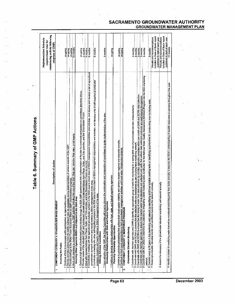
,,,,,1
_f,,n
ti~~,
e,,,f
f0rl
s..!
,,,,,,
n~,,~
r,,g
el'u
~li~
,'p,,!
!,ig
ip,a
,tig~
..",~
,,,pp
()rt
u-"i
,~,,~
,,,~,
~,,,,
..,,,_
_,,,,
,,,,,,
,,..,,
..,,,_
,_,,,
,,,''''
''''''''
''''''
"'....
,~ R
evie
~..a
.-r.
take
..¡¡lo
.,ns
from
the_
p'~
~nc
out
reac
h p!
"!,_
,,s n
eæss
aiy
durin
9JpI
".re
nt,,!
I,,!!o
f var
ious
asp
ect o
f the
GM
E._
____
.._.._
..,__
"',_
..___
__,_
_.._
___
m~!
"!"y
ii:"_
bri"
~rig
~!o_
ih_e
"",,t
erF'
,,ru_
"!ê.
ugC
E..~
!l~_
~_n:
()rt
_,,~
_§M
fln:
p.I"
rn"'
nt~"
n_P'
9_gr
"s_s
,___
,,.._
____
____
____
____
__""
____
____
____
____
___
4 W
orkw
ith m
embe
rs to
max
imiz
e ou
trea
ch o
n G
MP
activ
~ies
incl
udin
g th
e us
e of
\he
SGA
Web
site
, mem
ber
Web
site
s, o
r bi
ll in
sert
s,In
volv
ing
Ote
r A
genc
ies
With
in a
nd A
djac
enllo
the
SGA
Are
a
1Ç"n
linu"
~ig~
I"V
"lgf
invo
"'"r
n"~t
clei
n()~
str"
t"c1
thr,
,~gb
tb,,S
GA
G~!
"r."
V"I
"PIT
"ntín
t"iI
TPI
"IT
"~t,,
tio.~
gft~
,,p.le
n~y"
"niin
ueci
parl
igip
aii"
noii~
"!"!
"ille
""d"
..gri
",cl
abov
,,,:!
!"r(
)vic
l"""
pi"_
s"f!
b",,,
c1,,P
!,,c
1..G
M!"
,,,~c
Js~~
~,,9
.~,,~
t,,_n
n~,,I
!,,p
lr1.
.!"r
"P!"
.."~t
"tiy
-"..-
i~()
rrF'
l"g"
r,S~
lt"r,
,,ncl
'(gl,,
c,,~
nti,,
..,,,n
clJ~
"_G
r()~
ncl\V
"ter
F'"r
~rr"
,,,.._
..,,,_
...,_
3 M
eet w
ith r
epre
sent
ativ
es f
rom
Pla
ær,
Sut
ter,
end
Yol
o co
untie
s, a
nd th
e G
roun
dwat
er F
orum
as
need
ed,
4 C
oord
inat
e a
mee
ting
with
\he
agric
ultu
ral g
roun
dwat
er p
umpe
rs in
the
SG
A a
rea
to in
form
'them
of S
GA
's m
anag
emen
t res
pons
ibilt
ies
and
activ
ities
, and
dev
elop
and
dev
elop
a li
st o
f agr
icul
tura
lgr
ound
wat
er p
umpe
rs c
onæ
rns
and
need
s re
lativ
e to
SG
A's
man
agem
ento
f the
are
a.¡¡
cëië
irdiiï
atea
më"
iiiïg
wiïi
i- ëi
iher
seí¡
:sup
pïie
dpum
perS
iiïiiï
ei:iG
A à
ï:eãi
õ iiï
ïëirr
ï iiie
ïñ o
t'SG
A's
man
agem
ent r
espo
nsib
iltie
s an
d ac
liviti
es, a
ndde
veië
ip a
list
of s
ê~-s
uppl
ied
grëi
ûiïd
Wai
er"'"
" -.
.,,,
Dum
pers
con
cern
s an
d ne
eds
rela
tive
to S
GA
's m
anag
emen
t of t
he a
rea,
Util
zing
Adv
isor
y C
omm
_s
1 U
pon
adop
tion
"fth
e G
MP,
lhe
Polic
y C
omm
ittee
will
mee
t to
disc
uss
\he
cont
inua
tion
and
Com
posi
tion
of c
omm
ittee
s to
gui
de im
plem
enta
tion
of th
e pl
an,
Dev
elop
ing
Rel
atio
nshi
ps w
ith S
tate
and
Fed
eral
Age
ncIe
s
1 C
ontin
ue to
dev
elop
wor
king
rel
atio
nshi
ps w
ith lo
cal,
stat
e, a
nd fe
dera
l reg
ulat
ory
agen
cies
,Pursuing Partership Opportnities
Tab
le 6
. Sum
mar
y of
GM
P A
ctio
ns
Des
crip
tion
of A
ctio
ni. COMPONENT CATEGORY 1: STAKEHOLDER INVOLVEMENT
Invo
lvin
g th
e Pu
blic
Implementation Schedule
(app
roxi
mat
e tim
e fo
rco
mm
enci
ng a
ctiv
ity f
ollo
win
gad
optio
n of
GM
P)
-"":
~=-=
=:=
=:::
::..::
=I.
::::::
:==
=:1
~i~;
~-:::
:::=
:~:
'" II CO CD en Co
1Ç()
~!in
~"!"
p.!"
in"i
.par
l~"i
:bíp
...t~
"t"~
t:I"v
"~"t
bl,,,
,,,I.
.~pp
1y,-
eli"
~i1i
ty"n
claq
ii"v"
~ro.
"c1"
~r,,g
l,,n,
,I,,,
~c1~
t,,t,,
\Vic
!,,~
,,~,,~
t..,
2 C
ontin
ue to
trac
k gr
ant o
ppor
tuni
tes
to fu
nd g
roun
dwat
er m
anag
emen
t acl
lvlti
es a
nd lo
cal w
ater
infr
astr
uctu
re p
roie
cts,
II. COMPONENT CATEGORY 2: MONITORING PROGRAM
Gro
undw
ater
Ele
vatio
n M
onito
ring
1 C
oord
inat
e w
ith m
embe
r ag
enci
es a
nd D
WR
to Id
entif
y an
app
ropr
iate
gro
up o
f wel
ls fo
r m
onito
ring
for
a sp
ring
2004
set
of g
roun
dwat
er e
leva
tion
mea
sure
men
ts,
?Ç()
"rci
~"t"
V'!t
:P""
R"~
c1SÇ
INA
t~"~
s~r"
.!t:~
!tli"
..,,,,
,C!e
cl\V
,,,ii~
"~"i
n"i~
l"in
","~
p~it"
f"I(
)~g:
t"r.
n:~~
ii"E
i~gn
"l\(
)rl,"
""""
,,_, "
",?"
,Ç()
!iJi~
t1t"
..\V
itt:"
!)\I~
_..n
..d,S
G,IN
A_t
~"'l
~!'r
,,,,tb
a-ith
_",~
n:i!!
g..o
!..~
a..!e
r..le
\,eLi
Ja_t
"-""
II"ci
i"n_~
Y.r
"rr~
eE"g
enci
,,..,c
:i'lg
icl".
."~
~t:,
i~()
~",
in~
~th
"f,!)
""R
",~
c1_S
.f""A
cI,,t
,,_""
II,e,
~t,i
~n,
"""
""'"
"""_
,,,4
Coo
rdin
ate
with
mem
ber
agen
cies
to e
nsur
e th
at n
eede
d w
ater
leve
l ele
vatio
ns a
re c
olle
cted
and
ver
ify th
at u
nifo
rm d
ata
colle
ctio
n pr
otoc
ols
are
used
am
ong
the
agen
cies
,5
Coo
rdin
ate
with
the
US
GS
to, d
eter
min
e th
e po
tent
ial f
or in
tegr
atin
g U
SG
S m
onito
ring
wel
ls c
onst
ruct
ed fo
r th
e N
atio
nal W
ater
Qua
lity
Ass
essm
ent (
NA
WQ
A)
Pro
gram
into
the
SG
A m
onito
ring
netw
ork,
,èt
~~~i
~~rV
iiiy~
t~ßl
ïiiiip
~in!
Ï~rÏ
nji~
r;ni
i~~I
Ir'~
~g~~
iFi-
~n¡!
tin9i
ig~i
iigrÏ
iiï~~
iiï~I
~~~j
~iiiï
iiViê
ll~gd
g~r'\
;ii~9
gPJÏ
g~un
~i~~
tëir
ï:~~i
j~ïii
ïiliïe
VlI
1~rÏ
iÏ~r
Ïiïii
Vlli
s:7
Ass
ess
grou
ndw
ater
ele
vatio
n tr
ends
and
con
ditio
ns b
ased
on
the
netw
rk a
nnua
lly.
8Äss
essi
iïead
equa
cyëi
ltil'g
rëiu
iïdW
aier
eiË
ivïïi
iëiiï
rrëi
iïiïë
iriiï
gwË
iifne
twör
iïïiïi
ïuai
iy:'"
gidË
iiïiii
yïïs
ubsË
iiëilm
ëiri
iiìïr
ingw
eiis
iiïïii
wiii
berr
öiïii
ön;¡
irrë
iïëir
euëi
ïiiyi
iïïin
iWeË
aniïu
aiiy
iëiir
rpïë
ivË
itiëS
GÄ
'sui
ïder
Siai
ïdiiï
göïïi
quiie
ïres
poiïs
Ëis
iëip
umpi
ng¡i
ïrïu
giïö
ui¡i
ïËiy
Ëiïi
ï:
c CD (' CD 3 C-
CD .. II Q Q Co
. ._g
.n.~
.9.9
.~n9
.3
mon
ths
-am
ëiiïï
hs"
6 m
onth
s
"'èm
ëiiït
iïs'"
3 m
onth
s
on-a
aina
",..~
~::~
i,ng"
"
on-a
oina
3 m
onth
s"'
3rrö
iïiiïs
""""
',.",
'fl1g
rijE
~_,
.~__
_ ""
"",..
""'''' 3 months
3 m
onth
s
árrë
iiïïiï
s"R
esui
ïïind
"n;ë
ìïmm
erid
ïiUöi
ïs"
incl
uded
in S
tate
of B
asin
rep
ort
",p~
~!i..
t:"c1
"in!
\i:I"
f"t1
cbY
"",r
"",
Res
ults
and
rec
omm
enda
tions
incl
uded
in S
tate
of B
asin
rep
ort
"'p!
"~li,
s,h,
,,,d,
i~A
p~I,
,()t
,,,,,g
b)',,
,,r,,,
,12
mon
ths
en :t (" ~ :l m zC) -l
:: 0
o G'
c: ::
~O :E c:
): Z -le
~~ s: :t
): -
lZ
m): ::
C) :t
m c
:~
-lZ
:i-l
0'" ::
S; ::
Z -
(
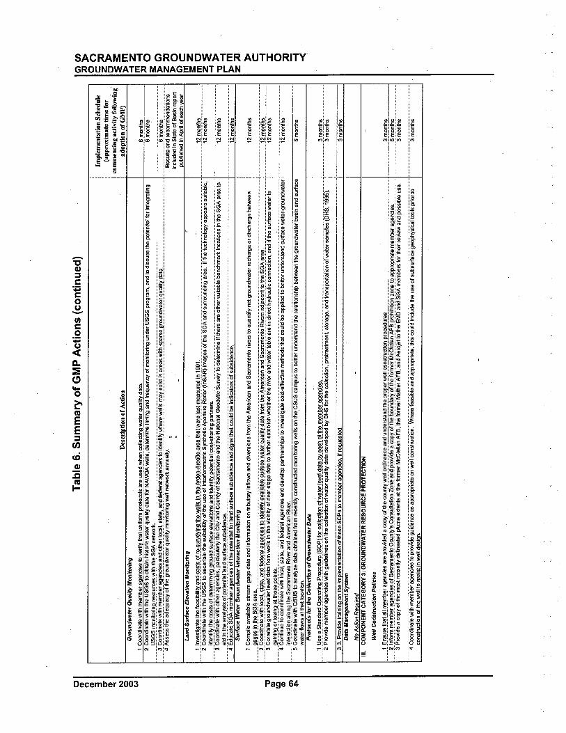
c (l (" (l 3 C" (l .. N (; (; w
Tab
le 6
. Sum
mar
y of
GM
P A
ctio
ns (
cont
inue
d)
"t II (Q (l en .i
Implementation Schedule
(app
roxi
mat
e tim
e fo
rco
mm
enci
ng a
ctiv
ity f
ollo
win
gD
escn
Dtio
n of
Act
ion
adop
tion
of G
MP
)Groundwater Qualit Monitoring
1 C
oord
inat
e w
ith m
embe
r an
enci
es to
ver
i tha
t uni
lorm
pro
toco
ls a
re u
sed
whe
n co
llect
nn w
ater
aua
litv
data
,6
mon
ths
2 C
oord
inat
e w
ith th
e U
SG
S to
obt
ain
hist
oric
wat
er q
ualit
y da
ta fo
r N
AW
QA
wel
ls, d
eter
min
e tlm
in¡¡
and
lreq
uenc
y 01
mon
itorin
g un
der
US
GS
pro
gram
, and
to d
iscu
ss th
e po
tent
ial f
or in
tegr
atin
g6
mon
ths
mi,S
GSr
r9ni
t9ri
na"'
,,~~s
~i!~
t~E
lSG
AnE
l~9E
k'm
mm
mm
mm
mm
mm
mm
mm
mm
mm
mm
6iñõ
iiïiis
m_a
C;9
~r:in
e.tE
l\Nit~
",e.
rr~e
.re.
aEln
~iE
l~!l
n~iit
hElr
lii""
l,ste
.te.!
_e.n
~_te
.e.r
e.Ie
.ae.
nc;e
.st~
lde.
ntif
ylY
e.re
.\Ne.
lls",
e.Y
El~
lstjn
e.re
e.~\
Vit~
~I'e
.~e.
ar9~
n~\\e
.tElr
q~e.
liiy~
e.te
.,...
. ....
.4
Ass
ess
the
adeq
uacy
01
the
grou
ndw
ater
qua
lity
mon
itorin
g w
ell n
etw
rk a
nnua
lly,
i"m
Res
ïïiis
ãiië
i'ree
ëiñi
ñëiië
iäijõ
iis ,-
""
0-
incl
uded
In S
tate
of B
asin
rep
ort
nubl
ishe
d in
Anr
il of
eac
h ve
arLa
nd S
urfc
e E
leva
tion
Mon
itOrin
g:
mm
llnX
e.~!
iae.
te.ll
e.fe
e.~i
~ilii
Y!l
n~~~
t~9!
re.:~
~rv"
Yin
at~e
._\N
ElI
I~i,n
ttie.
_Ar_
~e.n
:A~!
!e.e
.re.
e._t
Ie.t\
Ne.
rele
.~!"
'Ele
.~~r
El~
in!,
~!l!
:mm
_m_m
mm
mm
m12
mon
ths
2 C
oord
inat
e w
ith th
e U
SG
S to
asc
erta
in th
e su
itabi
lit o
f the
use
of I
nter
fero
met
ric S
ynth
etic
Ape
rtre
Rad
ar (
InS
AR
) im
ages
01
the
SG
A a
nd s
urro
undi
ng a
rea,
Ii th
e te
chno
logy
app
eãrs
"sïii
ïaï,i
e,:m
mm
mm
mm
i2iïõ
ïïiiis
i~e.
n!if
ylhe
.""~
!~,(
)t~e
.tElr
rini
naar
9,~n
~,~~
r:'!"
,e.le
.Xe.
ti~n~
e.n,
~i~E
ln!i
!l'te
.n!i
e.I"
,~t:s
~e.r
inap
arte
.~:
3 C
oord
inat
e w
ith o
ther
age
ncie
s, p
artic
ular
iy th
e C
ity a
nd C
ount
y of
Sac
ram
ento
and
the
Nat
iona
l Geo
detic
Sur
vey
to d
eter
mln
eii t
here
are
oth
er s
uita
ble
benc
hmar
k lo
catio
ns In
the
SG
A a
rea
¡om
.."'
-mm
mm
m""
""""
'Ùiïõ
iïifi
s"
aid
in th
e an
alys
is o
f pot
enlia
lland
sur
face
sub
side
nce.
m4E
dïiC
ãieS
GÄ
iïeiñ
berÏ
icÏe
iidË
isõf
ïfie
õõïe
iiiiÏ
iiiör
iãiïë
isïir
ïæsï
ibsi
deiic
eäiië
isic
Ïiïs
ïfiÏ
iieëï
ïidbe
iiïëi
iCãï
õrSõ
lsïib
siëi
eiïc
e:i2
iïõiïï
iism
Sur
fce
Wat
er G
roun
dwat
er In
tera
ctio
n M
onito
ring
1 C
ompi
le a
vaila
ble
stre
am g
age
dala
and
info
rmat
ion
on tr
ibut
ary
inflo
ws
and
dive
rsio
ns lr
om th
e A
mer
ican
and
Sac
ram
ento
riv
ers
to q
uant
if ne
t gro
undw
ater
rec
harg
e or
dis
char
ge b
etw
een
12 m
onth
s"m
aaae
.~in
,ttie
.,SG
AaE
e.e.
!"m
mm
mm
mm
m"m
,"',m
mm
mm
mm
mm
m,"
m,m
mm
mm
..m..m
mm
mm
mm
mm
mm
m_.
.'mm
mm
mm
mm
m,m
m'm
m...
......
......
......
......
......
......
......
......
......
......
....
?C;9
~r~i
ne.tE
l\Yth
l,,""
I!~!
e.te
.!e.
n~fe
.e."
'Ie.a
e.nc
ie.~
tlli~
e.n!
if'!X
e.i'e
.~IE
l~~i
fe."
"\V
e.tE
lr9~
e.lit
de.te
.fr"
rrtlE
lArr
Elr
i""r
lan~
Se.c
"'rr
Eln
t9R
IVer
sa~j
a_ce
ntt"
the.
SGA
e.re
a'm
mm
mm
m12
mon
ths
......
......
mm
_....
......
......
......
......
......
......
......
......
......
......
.3
Cor
rlate
gro
undw
ater
leve
l dat
a fr
om w
ells
in th
e vi
cini
ty o
f riv
er s
tage
dat
a to
furt
her
esta
blis
h w
heth
er th
e riv
er a
nd w
ater
tabl
e ar
e in
dire
ct h
ydra
ulic
con
nect
ion,
and
if th
e su
rfac
e w
ater
is12
mon
ths
ae.in
ina"
rlos
ina"
ttlos
e.p"
int~
,mm
mm
mm
mm
mm
mm
mm
mm
mm
mm
mm
mm
mm
mm
mm
m'i2
iïõïïi
iism
4 C
ontin
ue to
cor
dina
te w
ith lo
cal,
slat
e, a
nd f
eder
al a
genc
ies
and
deve
lop
part
ners
hips
to in
vest
igat
e co
st-e
ffct
ive
met
hods
that
cou
ld b
e ap
plie
d to
bet
ter
unde
rsta
nd s
urfa
ce w
ater
ijrou
ndw
aler
inte
ract
ion
alon
g th
e S
acra
men
to R
iver
and
Am
eric
an R
iver
,5
Coo
rdin
ate
with
CS
US
to a
naly
ze d
ata
obta
ined
from
rec
ently
con
stru
cted
mon
itorir
'g w
ells
on
the,
CS
ÜS
cãm
pus
to b
ette
r un
ders
tand
the
rela
tions
hip
betw
een
the
grou
ndw
ater
bas
in' a
nd s
urfa
ce6
mon
ths
wat
er fl
ows
at th
at lo
catio
n,P
roto
cols
for
the
Col
lect
ion
of G
roun
dwat
er D
ata
li,~E
le._
St"r
l~"r
~9PE
lrat
lnaF
''l~e
.~~r
El(
S9F'
Lfl
lr~l
l~i,,
npl~
'!te.
rIE
lx"L
~_at
a_bY
Ele
.~~_
ll!m
E)r
rE),
i:~E
)re.
ge.n
c:E
l~!
3 m
onth
s2 Provide member agencies with guidelines on the collecton of
wat
er q
ualit
dat
a de
velo
ped
by D
HS
for
the
colle
ctlo
n,"iï
reirË
ãïie
iii. s
tora
ge, a
nd tr
ansp
ortti
on o
f wãi
er"S
empl
es'(D
H'S
: 199
5ï:..
mm
..mm
m "
m3i
ñõiii
is '
~3.P
rovi
deir
aini
niiD
iï th
e im
olem
enta
tion
of th
ese
SOPs
to m
embe
r aa
enci
es, i
f re
aues
led,
3 m
onth
sD
ata
Man
agem
ent S
yste
m
No
Act
ion
Reo
uire
d-
II.
CO
MPO
NE
NT
CA
TE
GO
RY
3: G
RO
UN
DW
AT
ER
RE
SOU
RC
E P
RO
TE
CT
ION
-
Wel
l Con
stru
clio
n P
olic
ies
,m"!
,',i:,
n_s.
~re
.,tt'"
!_""
"rre
.,,,!:
''!,,g
E)''
~lE
ls..e
ElI'
æ.v
ided
a C
(EL~
_th_
e_""
1,ly
,~.e
!2!.5
ni,n
-ce_
a.r~
_!'_
~,,!
~ii'
!~m
E).
.P!ll
~!,,
\\E)I
I,_""
ns_t
ni~
llnp.
æce
j!'.r
_~_'
__'m
_"""
_"..,
'__"
'_..,
.._.._
____
____
____
__'_
__''_
_''_
_'''_
_' "
'"__
____
____
__~.
rP,n
!~~_
____
__,
?",I
,nfc
r"",
rre,
,,,be
r,ag
enci
Els
,of,
Sacr
amen
to,,c
;,,un
iy:s
,,q"n
sul,t
;ti,o
n"Z
,o,n
E),
an~"
prov
ide"
a,,c
opyo
f,t,h
e,~i
i~n~
aiy,
~f,I
,tiE
l"f"
r",e
r,M
~Cle
nan,
A,F
,B"P
'l~i,~
ition
,,~,,,
n,e.
"t,o
,app
ropr
iat,e
""'E
),i:,
bera
aEln
~iE
l~""
""""
""",
,,6
mon
ths
3 P
rovi
de a
cop
y of
the
mos
t rec
ently
del
inea
ted
plum
e ex
tent
s al
the
form
er M
cCle
llan
AF
B, t
he fo
rmer
Mat
her
AF
B, a
nd A
eroj
elto
the
EM
D a
nd S
GA
mem
bers
for
thei
r re
view
and
pos
sibl
e us
e.m
m "
, '3
iñõi
iihs
4coo
riiii
iäie
wiïi
iiïem
berÏ
igei
ïëiË
isïõ
iïrõ;
;jdeg
ïiiëi
Ïiiiæ
ãsÏi
iïïì,ö
ïìriã
ïeõi
ïwei
ieëi
ïsïr
ïëïio
ii:W
iiërË
iïeas
i¡:ie
ãiië
iäiïï
iröï
ìriã
ie:ïi
iiseë
ïiidi
iidïid
eife
ïisëo
ïsïib
sïir
iãæ
gooi
ïiiys
iCãi
ïëiis
iïriõ
rïõ
..m"3
iïõiii
iis
cons
truc
ton
of th
e w
ell t
o as
sist
in w
ell d
esin
n.
C' e
n::~ O
nc
::êi
~:i s:
~m -l Z
m -
l::0 ~ G)
z ::
~O C' C ~Z me
~~ ;i -l
~m z :: ~ C -l ~ o :: ~
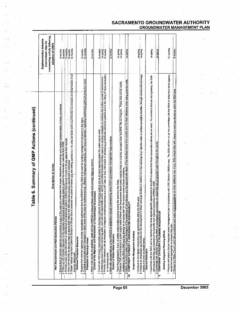
1R~g
i,~~t
t~at
rrE
!rr~
~rE
!g~~
gi~s
pr()
~iilE
!\'In
E!,
!~i1
i!y~
i,rrr
rE!r
iE!~
f!()
rrtii
~i:'l
SA~t
otti~
SGA
t()~
~usl
lilf(
)r9i
,iilin
9rrE
!nE
!911
rr~n
til""
l~i(
)n~i
nthl
l~E
!sln
, ,!,
m_m
mm
mm
mm
".2
Con
.tact
gro
undw
ater
bas
in m
anag
ers
in o
ther
are
as o
f1he
sta
te fo
r te
chni
cal a
dvic
e, e
ffect
ive
man
agem
ent p
ract
ices
, anc
ttess
ons
lear
ned,
" re
çiar
dinç
i est
ablis
hino
wel
lhea
d pr
otec
tion
area
sPr
otec
tion
of R
echa
rge
Are
as
1 W
hen
CA
S r
esun
sare
ava
ilabl
e, m
e"t w
ith th
e S
WR
CB
to d
iscu
ss th
ose
resu
lts a
nd c
onsi
der
follo
w-o
n ac
lions
Con
trol
of t
he M
igra
tion
and
Rem
edia
tion
of C
onta
min
ated
Gro
undw
ater
--~l
-lf~
~~~~
-š~~
~~~i
Tlf
i~~P
~%~¡
~~;¡
~~~t
J:$~
Il~~
~~1t
o~~g
';~~~
i~;~
:~~~
~~~~
:;ï~i
jyE
!~~~
~~~i
~gë~
Jl;~
¡~~~
if~~
~~i%
~-~t
~~9i
~šJ9
Jiin
irri
Z-e
lhi,ï
Url
tierŠ
-g-r
eãd~
()f~
jítai
ï¡iïa
n-t~
~-r~
---
3 P
rovi
de S
GA
mem
bers
with
all
info
mia
tion
on m
appe
d co
ntam
inan
t plu
mes
and
LU
ST
sile
s fo
r th
eir
info
rmat
ion
in d
evel
opin
g gr
ound
wat
er e
xtra
ctio
n pa
ttem
s an
d in
the
sitin
g of
fulu
re p
rodu
ctio
nor
mon
itorin
g w
ells
4 M
eet w
ilh r
epr"
sent
ativ
es o
f the
RW
QC
B to
est
ablis
h a
mut
ual u
nder
stan
ding
abo
ut S
GA
's J
lrci."
dwat
er m
anag
emen
t res
pons
ibilt
ies
Con
trol
of
Salin
e W
ater
Int
rusi
on
1 T
rack
the
prog
ress
ion,
if a
ny, o
f sal
ine
wal
er b
odie
s m
ovin
g to
war
d th
e ea
st fr
om th
e D
elta
,-'-
i-O
t,šei
ve,'O
Scon
-ê9t
ratiO
si!
publ
ic s
uppl
ywe"
s of
Nõ,
ih-A
rea
Gro
undw
ater
Bas
in w
aïër
supp
iiers
IÏi-
ãiar
ërou
tineT
ysam
piif
uiïr
JerT
he'O
HS'
Tiîi
e-2H
'rogr
am. T
hEÍs
edai
awiii
bere
adily
----
avai
labl
e in
the
SGA
's O
MS
and
are
alre
all a
n on
::0in
g ta
sk f
or th
e an
nual
rev
iew
of
basi
n co
nditi
ons.
3 In
fom
i all
mem
ber
wat
er p
urve
yor
man
ager
s of
the
pres
ence
of t
he in
terf
ace
and
the
appr
oxim
ate
dept
h of
the
inte
rfac
e be
low
thei
r se
rvic
e ar
ea fo
r th
eir
refe
renc
eiv.
heri
sitin
g po
tent
ial w
ells
,VI. COMPONENT CATEGORY 4: GROUNDWATER SUSTAINABILITY
Tab
le 6
. Sum
mar
y of
GM
P A
ctio
ns (
cont
inue
d)
I
p I,
Well Abandonment and Well Destruction Policies I
1 E
nsur
e th
at a
ll m
embe
r a
ande
s ar
e ro
vide
d a
co o
f th
e co
de a
nd u
nder
stan
d th
e T
O a
T d
estr
uctio
n ro
cedu
res
and
su r
t im
lam
enta
tion
of th
ese
roce
dure
s?r
=()
1I0V
/i,PV
!!!t
irrE
!rrl
iiir!
:9~n
~i~~
()nJ
tierE
p"r:
E!d
a~E
!~il(
)~E
!i:E
!~d_
i:E!~
!T(Y
~i:V
/~II
~t()
9(nf
irrt
ti~In
f()r
rE!t
i()n
~!I~
~tE
!il-
i""r
io.W
Rm
mm
mm
mm
mm
mm
3 ~r
ovid
ea~p
Y"f
lhiii
nfor
rrat
iono
naba
ndon
edan
ilile
stT
(yed
V!e
llsin
nor:
hern
Sacr
arre
ntoC
oun!
ylof
illan
ygap
sint
heir
rE!~
orils
m!m
""~,
,,fv,
E!E
!.tV
!i,tb
,th~,
E,f
v,Pt
()ili
~~~s
s_V
/E!y
~t()
~,,~
urE
!J~E
!LV
/E!I
I~in
tti"S
GA
arE
!aE
!rE
!Pr(
)~i:Y
E!l
i,!nd
()~~
()ri
l"si
r()Y
E!i
l_m
mm
mm
mm
mm
mm
mm
mm
mm
mm
_Jm
mm
mm
mm
m.m
5 O
btai
n 'w
ildca
t map
from
Cal
iforn
ia D
ivis
ion
of O
il an
d G
as to
esc
erta
in th
e ex
tent
of h
isto
ric g
as w
ell d
rillin
g op
erat
ions
in th
e ar
ea a
s th
ese
wel
ls c
ould
func
tion
as c
ondu
its o
f cdn
tam
lnat
lon
if no
t'oroperly destroyed. L, - ¡
Wel
lhea
d P
rote
ct/o
n M
easu
res
!
Des
criD
tion
of A
ctio
n
"t II CC (l Ø
)t1
Implementation Schednle
(app
roxi
mat
e tim
e fo
rco
mm
enci
ng a
ctiv
ity f
ollo
win
gad
optio
n of
GM
P)
3 m
onth
s6
mon
ths
iziïë
í"iti
siïi
ïõiïi
Ïiš
"'iZ
'iïëí
"iiïs
m
6 m
onth
si2
mëí
iïïiïs
m
6 m
onth
s
__§.,iionths --,--,----
"n-g
oing
6 m
onth
s
6 m
onth
s
____
()'!9
0ing
__~,
_on
-goi
ng
on.a
oin
Con
junc
tive
Man
agem
enf
Act
iviti
es
~g6~
¡:~~
:¡6m
~::::
::::~
~~~~
*~~f
Jr~~
~od~
'C~¡
;m"~
~ig/
~~e~
r~!~
:;gei
aCiii
ï¡es
iiïad
diïië
í"io
iiï:i¡
eure
ciïa
rg~(
e:g:
iiïje
cïië
íiïw
eiis
õrsu
ï+ce
spre
adiiï
giac
liitie
s,tïr
ëu9h
CÕ
"sïr
ucïe
drec
iïarg
elm
mm
6~~~
~:ba
~in
s or
in r
iver
or.
st
ream
bed
s).
Dem
and
Red
uctio
n
1 Coordinate with the RWA and its members
that
hav
e si
gned
spe
cifc
agr
eem
ents
to th
e W
FA
to e
nsur
e th
at th
ose
cons
erva
tion
effo
rts
are
on tr
ack,
V/i1
I11n
surE
!tiiE
!tth
llYE
!r"i
nf()
rr~(
)ft~
Il~E
!nE
!~a"
ilreg
l()"
E!l
lrrp
()rt
an""
()fR
'IA:s
WE
~'_m
m2
Coo
rdin
ale
with
SR
CS
D th
roug
h th
e,R
WA
10
inve
stig
ate
oppo
rtun
ities
for
expa
nded
use
of r
e.cy
.cle
d w
ale'
Ihro
ugho
ut th
e co
unty
,V
. CO
MPO
NE
NT
CA
TE
GO
RY
5: P
LA
NN
ING
IN
TE
GR
AT
ION
Exi
stin
g In
tegr
ated
Pla
nnin
g E
ffor
t
1 Prepare and adopt a fomial integrated
wat
er m
anag
emen
t pla
n in
acc
rdan
ce w
ith c
we
Sec
tion
t054
0 et
seq
. The
SG
A w
il fo
mi a
n ad
hoc
com
mitt
ee w
ith th
e R
WA
to d
eler
min
e w
hich
ege
ncy
____
____
_V/(
)~ld
__li~
rr()
~t_~
llPro
ll_i:E
!t~_
tllp.
!ep.
~!.E
tti~t
_p!!
:n.:_
____
____
____
____
____
____
___,
____
____
____
____
____
____
____
____
____
,_,,_
,__,
__,_
,___
____
____
____
____
____
____
_.__
_.__
____
__'_
m__
____
____
____
_,2
Rev
iew
the
Wat
er F
orum
Lan
d U
se p
roce
dure
s an
d m
ake
reco
mm
enda
tions
on
wha
t add
itona
l rol
e, if
any
, SG
A s
houl
d tå
ke w
ith r
espe
ct to
land
use
dec
isio
ns w
ithin
the
SG
A a
rea
For
mem
bers
that
are
not
sig
nato
ry, t
he S
GA
c (l (' /I 3 e- (l .. I\ o o w
on-g
oing
on--
oina
12 m
onth
s
6mo"
ï¡:s
----
----
----
----
en ~ n ~ 3: m zG' -l
:;0 a C'
c ::
~o :E c:
~z me
:; :E
:s~
~ -
lzm ~
::G
' ~m
c:
~ -l
z :i
-l 0
"t ::
i- -
~ -l
z -(
SACRAMENTO GROUNDWATER AUTHORITYGROUNDWATER MANAGEMENT PLAN
PAGE LEFT BLANK INTENTIONALLY
'\
December 2003 Page 66
SACRAMENTO GROUNDWATER AUTHORITYGROUNDWATER MANAGEMENT PLAN
5 REFERENCESAerojet Environmental Remediation. Aerojet Sacramento Site, American River Study Area
Groundwater Monitoring Results, April- June 2002. August 2002.
Archibald & Wallberg and MWH. American River Watershed Sanitary Surey, 2003 UpdateReport. December 2003.
Berkstresser, C.F., Jr. Base of Fresh Ground-Water - Approximately 3,000 micromhos - in theSacramento Valley and Sacramento-San Joaquin Delta, California. U.S. GeologicalSurvey W ater- Resoui;ces Investigation 40-73, map. 1973.
California Departent of Health Services. Collection, Pretreatment, Storage and Transportation
of Water and Wastewater Samples. Fifth Edition. May 1995.
California Department of Water Resources (DWR). Evaluation of Ground Water Resources:Sacramento County. Bulletin 118-3. July 1974.
DWR. Evaluation of Ground Water Resources: Sacramento Valley. Bulletin 118-6. August 1978.
DWR. American River Basin Conjunctive Use Project, Feasibility Report. June 1997.
DWR. California's Groundwater: Bulletin 118 -Update 2003. October 2003.
Lucy & Company. Public Outreach Plan for Groundwater Management Program. June 2003. '
Luhdorff & Scalmanini ,Consulting Engineers (LSCE). AB 303'0 Ground-Water ManagementPlan, Natomas Area. August 2002.
LSCE. In-Lieu Surface Water Use and Ground-Water Basin Conditions 2001, NorthridgeService Area, Sacramento Suburban Water District. June 2002.
Montgomery Watson. "Sacramento River Water Treatment Plant - Finalization of PreliminaryDesign. 1998.
Montgomery Watson. Regional Water Master Plan Phase I, Technical Memorandum 3:Summary of Existing Water Supplies. 1999.
Montgomery Watson and Archibald & Wallberg. Sacramento River Watershed Sanitary Survey,2000 Update Report. December 2000.
Montgomery Watson Harza (MWH). Data Management System, Task 4 SummaryMemorandum, Evaluate Accuracy and Reliability of Groundwater Data, January 2002.
MWH. Mather Air Force Base Annual and Fourh Quarter 2002 Sitewide GroundwaterMonitoring Report. March 2003.
MWH. American River Basin Cooperating Agencies Regional Water Master Plan Phase II FinalReport. December 2003.
State Water Resources Control Board (SWRCB). Draft Order Denying Petition to revise theDeclaration of Fully Appropriated Streams to Allow Processing of Application toAppropriate Treated Groundwater Discharged into the Lower American River. May2003.
URS. Former McClellan Air Force Base, Installation Restoration Program, GroundwaterMonitoring Program: Quarterly Report, Third Quarter 2002. January 2003.
Page 67 December 2003
SACRAMENTO GROUNDWATER. AUTHORITYGROUNDWATER MANAGEMENT PLAN
Iil. I-
PAGE LEFT BLANK INTENTIONALLY
'.
December 2003 Page 68

APPENDIX F
Wholesale Water Supply Agreement between City of Sacramentoand Sacramento Suburban Water District

:'j-!
WHOLESALE WATER SUPPLY AGREEMENT BETWEENTHE CITY OF SACRAMENTO
AND SACRAMENTO SUBURBAN WATER DISTRICT
THIS AGREEMENT is made and entered into thi.1.f day Of.JaV , 200~
by the CITY OF SACRAMENTO, a charer municipal cOlporation (hereinafter referre to as "City)and the SACRAMENTO SUBURBAN WATER DISTRICT, a California speci is .ct (hereinafterreferred to as "District").
RECITALS
A. On Februar 13, i 964, the City and Arcade Water Distrct ("Arcade") entered into anagreement, a copy of which is attached to this Agreement as Exhibit A (the "1964 WaterSupply Agreement"), under which the City granted to Arcade the right to divert up to 26,06acre feet of water per year from the American River under the City's "Permit Supply," as thatterm is defined in the i 964 Water Supply Agreement, for use withn the service area ofArcade that was within the portion of the authorized place of use ("POU") for the City'sAmerican River water nght permits, referred to as "Area D" in the 1964 Water SupplyAgreement. On September 19, 2001, the City and Arcade entered into an agreement underwhich the City consented to the transfer by Arcade of all rights and obligations under thei 964 Water Supply Agreement to the District, upon the consolidation of Arade withNortdge Water Distnct (''Northrdge'') to form the Distnct. This Agreement
does not
involve the diversion of water by the Distrct under the 1964 Water Supply Agreement.Except as expressly provided below, nothing in this Agreement affects the nghts andobligations of the City and the District under the 1964 Water Supply Agreement.
B. The Distnct owns and operates public útility water systems and provides public utilty waterservice to the public located in Sacramento County, Californa, for residential andcommercial and industnal purposes, pursuant to authority granted to it by the CaliforniaLegislature.
C. The District desires to (i) obtain a wholesale supply of treated surace water under thsAgreement, and (2) preserve the nght of
the District to divert untreated wat~r if the Distrct
elects to do so, under the 1964 Water Supply Agreement for use within the service areadescribed in the 1964 Water Supply Agreement. The District has capacity in its AmericanRiver diversion facilties to divert and put to beneficial use within such service area
approximately 3,500 acre-feet of water per year under the 1964 Water Supply Agreement.
D. The City and Arcade previously entered into agreements under which (1) Arcade reimburedthe City for a portion of the costs incurred by the City to construct City water trsmissionmains, and (2) Arcade acquired ownership rights in a portion of such trsmission mains, for
the purpse of conveying water from the City's E.A. Fairbairn Water Treatment Plant
("Fairbairn Plant") to Arcade, as shown in Exhibit B. The District is the successor toArcade's ownership rights.
10-14-03 Final Page iCiTY
AGREEMENT NO.2004-013
E. The City is expanding the capacity of the Fairbairn Plant. Until such expanion is completed,
studies conducted by the City indicate that the City's Fairbairn Plant, storage facilities andtransmission mains have adequate Non-Finn Capacity (as defined below) as of
the date of
this Agreement to supply the District a maximum of up to ten millon gallons per day("mgd") of treated water. After the City's planned expansion of the Fairbairn Plant and
improvement of trasmission main capacities, the City expects to have adequate FirmCapacity (as defined below) to supply the District additional treated water, as providedherein. The maximum day flows specified herein for the use of
Non-Firm and Firm Capacity
are hereafter collectively referred to as the "District Water Requirements".
F. The City has completed environmental review for the expansion ofthe Fairbairn Plant, and
the expansion project currently is under construction.
G. The City and the District are both signatories to the Sacramento Water Forum Agreement,
and this Agreement is consistent with that agreement.
H. Subject to the terms and conditions contained herein, the City is wiling to provide awholesale supply of treated surface water to meet the District Water Requirements.
I. The City entered into an agreement with Nortdge's predecessor, the Northrdge Park
County WateT Distrct, dated January 3 i, i 980 (the ") 980 Water Supply Agreement"), underwhich the City grted to Northrdge Park County Water Distrct the right, subject tospecified conditions, to divert up to 9,023 acre-feet per year from the American River underthe City's Permit Supply for use within the service area of
Northrdge Park County Water
District that was within that portion of the POD referred to as "Area D" in the 1980 WaterSupply Agreement. The conditions specified for the 1980 Water Supply Agreement to beeffective were not fulfilled. The parties agree that this Agreement does not constitute, andwil not be interpreted as, an acknowledgment or admission by the City that the i 980 Water
_, _, _$upply Agreement remains a valid or binding agreement, nor does this Agreement involveany diversion of water by the Distrct (as successor to Northrdge) under the 1980 WaterSupply Agreement.
In consideration ofthe foregoing and of the mutual covenants herein contained, the paries
hereto agree as follows:
1. Recitals Incorporated:
The foregoing recitals are incorporated by reference.
2. Purpose:
The purpose ofthis Agreement is to establish the conditions under which the City wil divert,treat, convey and sell surface water to the District on a wholesale basis to meet the District WaterRequirements, for use within the District Service Area, both before and after expansion of the
10-14-03 FinalPage 2
Fairbairn Plant and the completion of improvements to the City's water transmission facilities.Nothing in this Agreement affects the right of the District to divert and put to beneficial use withinthe District Service Area untreated surface water under the 1964 Water Supply Agreement if theDistrict so elects, subject to the provisions of Section 4, below.
3. Definitions:
a. Arcade: Arcade Water District, one of the predecessor entities of the District.
b. Capital Costs: Costs incurred by the City to design and construct diversion, pumping,
treatment, storage and transmission facilities used to provide treated water to theDistrict under this Agreement, including reasonable administrative costs.
c. City: The City of Sacramento.
d. City Transmission Facilities: All facilities, including transmission mains, storage
facilities and all appurtenances that are owned and operated by the City to supplywater from the City Treatment Facilities, as they exist today and as, they may bemodified and expanded in the futue.
e. City Treatment Facilities: All facilities that are owned and operated by the City to
divert,and process water to meet the requirements established for drnking water bythe California Deparment of Health Services and the United States EnvironmentalProtection Agency, including the Fairbairn Plant, groundwater wells, and theSacramento River Water Treatment Plant, as they exist today and as they may bemodified and expanded in the future.
f. City Water Rights and Entitlements: The City's surface water rights andentitlements, including pre-l 9 i 4 rights, five water right permits issued by the StateWater Resources Control Board and a water rights settlement contrct entered into in1957 with the United States Bureau of Reclamation.
g. Connection Fee: The fee(s-) paid by the District for its share of Capita Costs for Non-
Firm and Firm Capacity used to provide treated water to the District under thisAgreement, as provided in Section 9.b., below.
h. Delivery Criteria: The operating guidelines and criteria governing the delivery of
treated water under this Agreement.
i. District: The Sacramento Suburban Water District.
j. District Water Facilities: All facilities, including transmission mains, storage
facilities and all appurtenances, which are owned and operated by the District tosupply water. The Distrct Water Facilities to be used to obtain water under thisAgreement are shown on Exhibit B.
10-14-03 FinalPage 3
k. District Water Requirements: The maximum-day flow amounts specified for the
delivery to the District of treated water utilzing Non-Firm and Firm Capacity inaccordance with the provisions of this Agreement.
I. District Service Area: Those lands served by the District, as may change from time
to time, within the POU. The current District Service Area is shown on Exhibit C tothis Agreement.
m. Expanded Fairbairn Plant: The City's E.A. Fairbairn Water Treatment Plant(Fairbairn Plant) after the current projects to expand the Fairbairn Plant's treatmentcapacity to 200 mgd and to modify the water intae to comply with current fishscreening requirements are cOIIpleted, and the modified water intae and expandedtreatment capacity are fully operationaL.
n. Fairbairn Plant: The City's E.A. Fairbairn Water Treatment Plant located on the
south ban of the Lower American River downstream of Howe Avenue.
o. Firm Capacity: Capacity in the City Treatment and Transmission Facilities that is
available to divert, treat and deliver water to the Distrct on an equal priority to theuse of such capacity to meet the demands of the City's other water supply customers,except as provided otherwise in this Agreement.
p. 1964 Water Supply Agreement: The February 13, 1964 agreement between the City
and Arcade Water District, attched hereto as Exhibit A.
q. Non-Firm Capacity: Capacity in the City Treatment and Transmission Facilities thatis available to divert, treat and deliver water to the District in accordance with theprovisions of this Agreement after the capacity demands of the City's other watersupply customers are fully met.
r. Northridge: Northrdge Water District, one of the predecessor entities of theDistrict.
s. POU: All lands where the City is authorized to use surface water pursuant to theCity's four American River water right permits.
t. Service Charge: A monthly fee for fixed administrative costs biled to the District, asprovided in Section 9.a., below.
u. Service Connection: A point of connection for delivery of treated water from the
City Transmission Facilities to the District, Water Facilities pursuant to thisAgreement, of which there may be more than one as determined by the parties fromtime to time.
v. Transmission Main Improvements: Planned improvements to the City Transmission
10-14-03 FinalPage 4
Facilities that wil assist in providing adequate Firm Capacity for the delivery oftreated water to the Distnct in accordance with Section 6.b., below, as shown onExhibit B to this Agreement.
w, Treated water or treated surface water: Water that is treated to meet therequirements established for drinking water by the California Departent of
Health
Services and the United States Environmental Protection Agency.
x. Unit Rate: The charge biled to the, District at a cost per unit quantity oftreated waterdelivered under ths Agreement, as provided in Section 9.a., below.
y. Water Forum Agreement: The Sacramento Water Forum Agreement dated Januar
2000 and any subsequent amendments or supplements thereto, including thePurveyor Specific Agreement signed by the Distrct on June 5, 2003.
z. Wholesale Water Rate: The Unit Rate and Service Charge biled to the Distrct, as
provided in Section 9.a., below.
4. Diversion of Untreated Water by the District:
Nothing in this Agreementaffects the right of the District under the i 964 Water SupplyAgreement to divert untreated water for use within the portion ofthe Distrct Service Area locatedwithin "Area D," in accordance with the terms of the i 964 Water Supply Agreement, provided that
(a) the Distnct complies with all applicable legal, regulatory and contracrual requirements, includingapplicable provisions of the W ater Forum Agreement, and (b) notwithstanding any provision of thisAgreement to the contra, the City may deduct any amount of untreated water diverted by theDistrict under the i 964 Water Supply Agreement from the amount of
water otherwise required to be
diverted, treated and delivered to the Distrct under this Agreement.
5. Deliverv Criteria for Treated Water:
The delivery of treated water under this Agreement wil be governed by the operating
guidelines and cnteria set forth in the Delivery Critena attached hereto as Exhibit D. The DeliveryCnteria may be modified from time to time by the murual,written agreement of
the City's Director of
Utilities and the District's General Manager, provided that such modifications are consistent with theprovisions of this Agreement.
6. Maximum Treated Water Diversions and Deliveries:
a. Pre-Fairbairn Plant Expansion. Pnor to the completion and commencement of
operation of the Fairbairn Plant Expansion and Transmission Main Improvements,only Non-Finn Capacity will be available to divert, treat and deliver water to theDistnct in accordance with the provisions of this Agreement. The water diverted,treated and delivered to the District utilizing Non-Finn Capacity, prior to thecompletion and commencement of operation ofthe Fairbairn Plant Expansion and
10-14-03 FínalPage 5

,Transmission Main Improvements, will not exceed a maximum amount of ten
million gallons per day (mgd), and wil not exceed the. maximum instantaneous rate
specified in the Delivery Criteria.
b. Post-Fairbairn Plant Expansion. After the completion and commencement of
operation of the Fairbairn Plant Expansion and Transmission Main Improvements,Firm Capacity wil be available to divert, treat and deliver water to the District inaccordace with the provisions of this Agreement. The water diverted, treated anddelivered to the District utilizing Firm Capacity, after the completion andcommencement of operation of the Fairbairn Plant Expansion and TrasmissionMain Improvements, wil not exceed a maximum amount of twenty mgd, and wilnot exceed the maximum instataneous rate specified in the Delivery Criteria.
c. Additional Water. At any time during the term of this Agreement after the
completion and commencement of operation of the Fairbairn Plant Expansion and
Transmission Main Improvements, District may request that the City divert, treat and, deliver additional water to the District utilizing up to ten mgd of
Non-Firm and/or
Firm Capacity beyond the twenty mgd maximum specified in subsection b, above(hereafter referred to as "Additional Water"). To the extent that the City determinesin its sole discretion that adequate Non-Firm Capacity and/or Firm Capacity isavailable in the City Treatment and Transmission Facilities, up to such additional tenmgd, the City wil utilize Non-Firm Capacity and/or Firm Capacity, as determined byCity, to divert, treat and deliver Additional Water to District on the same terms andconditions as provided in this Agreement, including the Delivery Criteria, exceptthat the Wholesale Water Rate and Connection Fee for Capital Costs paid by Districtfor the diversion, treatment and delivery of Additional Water wil be determined bymutual agreement of the City and Distrct at that time. No Additional Water wil bediverted, treated or delivered hereunder until the parties have agreed upon suchWholesale Water Rate and Connection Fee to be paid by the District.
d. Notwithstading any other provision of this Agreement to the contr, the City wil
not be required to divert, treat or deliver any water to the District under thisAgreement if any City facility(ies) necessar to do so are shut down for maintenanceor repair, provided that such shut down also prevents the use of such facilities for theCity's retail water customers.
e. Water treated and delivered to the District under this Agreement may only be used by
the Distrct to provide municipal and industral water service within the DistrictService Area, and wil not be used by the District for any other purpose.
f. Notwithstanding any other provision of this Agreement to the contrary, no water
diverted and treated at the Fairbairn Plant, utilizing either Non-Firm or FinnCapacity, wil be delivered to District under this Agreement at any time when theCity's diversions at the Fairbairn Plant are restricted or limited, or the diversion ofwater for the District would cause the City's diversions to be restricted or limited, by
10-14-03 FinalPage 6
the Water Forum diversion restrictions incorporated in the City's four AmericanRiver water right permits, which diversion restrictions are shown on Exhibit E tothis Agreement.
g. The limitation specified in subsection f., above, wil not prevent the delivery by theCity to the Distrct oftreated water diverted from the Sacramento River, utilizing
Non~Firm and/or Firm Capacity, provided that facilities and capacity to divert, treatand deliver such water are available and the parties agree in writing upon, or amendthis Agreement to set forth, the terms and conditions for the diversion, treatment anddelivery of such water to the District, consistent with all applicable legal, regulatoryand contractual requirements, including applicable provisions of the Water Forum
Agreement.
h. The parties acknowledge and agree that the City (1) does not lose or otherwise forfeitor abandon its rights to any quantity of water that is not diverted at the Fairbairn Plant
by operation ofthe Water Forum diversion restrictions shown on Exhibit E, and (2)retains its rights to divert or redivert such water for municipal and industrial use at ordownstream of the confluence of the American River and the Sacramento River, aswell as any rights City may have to transfer that water for other beneficial uses. TheCity and the Distrct intend that, (1) in the event that water deliveries to the Districtunder this Agreement are curtailed pursuant to subsection f., above, and (2) the Cityreceives revenues for a transfer of water that would have been delivered to theDistrct but for such curtailment, the City wil consult with the District for thepurpose of providing to the District a credit against payments due from the Distct tothe City under this Agreement in an amount that reflects an equitable sharngbetween the City and the District of net revenues received by the City for suchtransfer.
7. Services Performed bv the City:
The City wil supply treated surface water to the District in accordance with the terms ofthisAgreement. The City wil provide Distrct with the City's water quality testing data on an anualbasis or on such other schedule as may be agreed to by the paries.
8. Oblieations of the District:
a. The Distrct wil take delivery ofthe treated surface water made available by the City
pursuant to the Delivery Criteria.
b. The District wil pay any and all costs associated with diverting, treating anddelivering water to the District pursuant to this Agreement, as set forth in Sections 9and iO ofthis Agreement. In addition, the District will be wholly responsible for itspro rata share (comparng the quantities of water that the City delivers to the Districtand to other City retail and wholesale customers) of any and all costs reasonablyincurred by the City in order to comply with all laws and regùlations that may apply
10-14-03 FinalPage 7
to the diversion, treatment and delivery of water to the District hereunder, including
but not limited to, the California Environmental Quality Act, the National
Environmental Policy Act, the Federal and State Endangered Species Acts, theFederal Reclamation Laws, the Clean Water Act and the Porter-Cologne Water
Quality Control Act. Furher, the District wil be wholly responsible for its pro ratashare (comparing the quantities of water that the City delivers to the District and toother City retail and wholesale customers) of any and all costs associated with anyother requirements and/or conditions that are or may be imposed on the diversion,treatment and/or delivery of water to the District by any federal, state or local agency,
including but not limited to the U.S. Bureau of Reclamation, the California
Deparment of Water Resources, the State Water Resources Control Board, the U.S.Fish and Wildlife Service, the National Marine Fisheries Service or the CaliforniaDepartment ofFish and Game.
c. Any deliveries of water to the District wil be subject to any and all requirementsand/or conditions contained in or in the future imposed on any of the City WaterRights and Entitlements.
9. Cost Allocation and Payment:
The cost allocations and payment for any water delivered pursuant to this Agreement will begoverned by the following paragrphs.
a. Operations and l\aintenance
(i) The District wil be charged a Wholesale Water Rate for diversion, treatment
and conveyance of water. The Wholesale Water Rate shall consist ofa UnitRate c_alculated on a cost-per-unit quantity basis for water actually delivered,
plus a monthi-ySerVice'Charge~f()r fixed administrative costs incurredirrespective of the quantity of water delivered. The Wholesale Water Ratewil be determined by the City in an equitable maner such that the Districtneither subsidizes nor is subsidized by any other City customer or contrctor.In no event, however, wil the unit cost of
water delivered exceed the City's
annual operating, maintenance and applicable capital improvement costs(excluding Capital Costs included in the Connection Fees described inSection 9.b., below) for surface water treatment and conveyance divided bythe number of gallons produced. Operating, maintenance and capital
improvement costs included in the Unit Rate will include but not be limitedto costs for operating, maintenance, personnel, services and supplies, and anequitable proration of appropriate overhead distrbution. Operating,
maintenance and capital improvement costs included in the Unit Rate wilalso include any costs attributable to any limitation, requirement,
modification or other condition that applies, or that may in the futue beapplied, to any of the City Water Rights and Entitlements, but wil excludethose costs that have no relationship to diverting, treating and delivering
10-14-03 FinalPage 8
water to the District, such as unrelated distrbution system expenses or capitalimprovement costs. The initial Wholesale Water Rate (consisting ofa UnitRate plus a monthly Service Charge) is shown on Exhibit F to thisAgreement.
(2) The City may adjust the Wholesale Water Rate on an annual basis to reflect
actual or anticipated cost increases.
(3) Biling procedures and payment for water wil be in accordance with the
City's stadard practice. The Wholesale Water Ratewill be in addition to theConnection Fee(s) described in subsection b., below.
(4) The Wholesale Water Rate for water diverted, treated and delivered usingNon-Firm Capacity and Firm Capacity wil be the same.
b. Connection Fees for Use arNon-Firm and Firm Capacity
(1) The District wil pay a Connection Fee for its share of Capital Costs fordiversion, pumping, treatment, storage and transmission facilities, which feewil include reasonable administrative costs. The initial Connection Fee foruse of Non-Firm Capacity in the City's existing facilities to divert, treat anddeliver water to the District up to the maximum amount and rate specified inSection 6.a., above, is shown on Exhibit G to this Agreement.
10-14-03 Final
(2) The District wil pay City the initial Connection Fee specified in Exhibit G
in a single payment not later than thirt days after the City's completion andcommencement of operation of the Fairbairn Plant Expansion, or prior toreceiving any water diverted, treated and delivered under this Agreement,whichever occurs first.
(3) Although the initial Connection Fee described in subsection b(l), above, isbased on the use of Non- Firm Capacity, the initial Connection Fee specifiedin Exhibit G is the same as the Connection Fee that would be charged for theuse of Firm Capacity. This is because the City's preliminar studies showthat adequate Non-Firm Capacity is likely to be available in the City'sexisting facilties for the delivery of treated water, in accordance with theprovisions of this Agreement, up to the maximum amount and rate specifiedin Section 6.a., above, at all times. If Non-Firm Capacity is not available inthe City's existing facilities for the delivery of treated water, in accordancewith the provisions of this Agreement, up to the maximum amount and ratespecified in Section 6.a., above, for a cumulative total amount of thirty ormore days prior to the City's completion and commencement of operation ofthe Fairbairn Plant Expansion and Transmission Main Improvements, theCity wil provide the District a credit against payments due from the Districtto the City under this Agreement in the amount specified in Exhibit H.
Page 9
(4) In the event that the City completes and commences operation of theFairbairn Plant Expansion and Trasmission Main Improvements, thereby
making available Firm Capacity to divert, treat and deliver water to theDistrict up to the maximum amount and rate specified in Section 6.b., above,the District wil pay an additional Connection Fee for the District's share ofCapital Costs for Firm Capacity in such expanded and improved diversionand treatment facilities, based on the difference between the maximumamounts specified in Section 6.b. and Section 6.a. of this Agreement. Theadditional Connection Fee will use the same unit cost fee that is specified forthe initial Connection Fee in Exhibit G, except that such unit cost fee willinclude annual adjustments to reflect increases in the constrction cost indexin the same manner that the amount of the City's water system developmentfee is adjusted pursuat to Section 13.04.820(C) of the Sacramento CityCode. The District wil have the option of paying the additional ConnectionFee (i) in a single payment prior to receiving any water diverted, treated anddelivered using Firm Capacity as specified in Section 6.b., above, or (ii) inthe form of an annual capital recovery charge payable upon such terms andconditions as may be reasonably determined by the City.
(5) The Connection Fees specified above shall be in addition to the District'spayment of a portion of the City's cost to design and construct theTransmission Main Improvements, pursuant to the Agreement for Payment ofCost Share between the District and the City, dated October 1,2003.
10. Service Connections:
a. Treated water delivered to the District under this Agreement wil be provided from
th~_ Çity_TraJl~l!is~ion facilities to-lhe Q~lijct ~t-!hce S~~i~~Soruec!i~E to bedesigned and constructed by" the District at the location shown on Exhibit B.Additional Service Connections may be established by mutual written agreement ofthe City's Director of Utilities and the District's General Manager, provided that theCity wil determine whether an additional Service Connection wil be designed andconstrcted by the Distrct or by the City.
b. If a Service Connection is designed and constructed by the City, subject to review
and comment by the District, the District will pay all direct and indirect costsincurred by the City to design, bid and construct the Service Connection, includingall reasonable costs of administering design and construction contracts, as well as thecost of preparng all environmental documents and obtaining all permits, propertyrights or other approvals required for the installation, operation, maintenance andrepair of the Service Connection in compliance with all applicable laws andregulations. Such payments will be in addition to the charges, costs and fees set forthin Section 9, above, and wil be made in the following maner:
(l) After performing a preliminary design of the Service Connection, the City
10-14-03 FinalPage i 0
Director of Utilities wil estimate all costs described herein, and suchpreliminary design and estimate will be provided to the Distrct for approval.Such approval wil not be unreasonably withheld.
(2) Durng the design phase and the construction phase, the City wil bill theDistrict at regular intervals for reasonable costs incured by the City duringthe billing cycle. The District will pay each invoice within six weeks.
(3) Upon completion of construction of the Service Connection, and theresolution of any claims, disputes or litigation related to its design orconstrction, including claims or litigation related to the acquisition ofpermts, property rights or other approvals, claims or litigation related to thepreparation or approval of environmental documents, stop notice claims orlitigation, and contract claims or litigation, the City will provide the District
with a statement of any and all costs actually incurred by the City. Suchstatement will include any and all costs reasonably incurred by the City withregard to any of the claims, disputes or litigation described above, includinganYHand all costs related to the settlement of any such claims, disputes orlitigation. If such costs exceed the amount of money theretofore paid by theDistrctto the City, the District will pay to the City the amount by which suchactual costs exceed the amount already paid. Any payments made by theDistrict pursuant to this provision wil be made no later than six weeks afterthe statement of costs actually incurred by the City is provided to the Distrct.
(4) Notwithstanding anything contained herein to the contrar, the District wilreimburse the City for any and all reasonable preliminar design costs
incurred by the City in connection with any proposed Service Connection,even if such preliminary design or any cost estimate based on such design is
not accepted or approved by the District.
c. If a Service Connection is designed and constrcted by the District, the District wil
be wholly responsible for designing, bidding and constrcting the Service
Connection, as well as preparng all environmental documents and obtaining allpermits, propert rights or other approvals required for the installation, operation,maintenance and repair of the Service Connection in compliance with all applicablelaws and regulations. Such activities will be paid for entirely by the Distrct, and willbe subject to the following requirements:
(1) Prior to the construction of any Service Connection by the Distrct, both the
preliminary design and the final design must be approved in wrting by theCity Director of Utilities. Such approval wil not be unreasonably withheld.If either or both the preliminary design or final design is not approved by theCity Director of Utilities, the City will notify the District in writing of thereason or reasons why such design is not acceptable, and the DistriCt wilperform such revisions as may be necessary to obtain the approval of the
10-14-03 FinalPage i i
City.
(2) In addition to paying its own costs, the District will reimburse the City for
reasonable costs incurred by the City during the design and construction ofthe Service Connection by the District. Upon completion of construction ofthe Service Connection, and the resolution of any claims, disputes orlitigation related to its design or construction, including claims or litigationrelated to the acquisition of permits, propert rights or other approvals, claimsor litigation related to the preparation or approval of environmental
documents, stop notice claims or litigation, and contract claims or litigation,the City wil provide the District with a statement of any and all costs actuallyincurred by the City to review, inspect or otherwise participate in the designand construction of the Service Connection. Such statement wil also includeany and all costs reasonably incurred by the City with regard to any of theclaims, disputes or litigation described above, including any and all costsrelated to the settlement of any such claims, disputes or litigation, providedthat any such settlement was approved in advance by the District staff, andprovided further that such approval will not be unreasonably withheld. TheDistrict will pay the costs identified on such statement no later than 6 weeksafter the City provides such statement to the District.
(3) Notwithstanding anything contained herein to the contrary, the District willreimburse the City for any and all reasonable costs incurred by the City inconnection with the design of any proposed Service Connection by theDistrict, even if the preliminar or final design is not approved or if suchService Connection is not constrcted.
d. The City wil own, operate, maintain and repair all facilities associated with theService Connection, including flowmeter, flow transmitter, pressure transmitter,motor operated valve (M.O. Y.), S.C.A.D.A. and electrical pedestaL. As par of suchoperation, maintenance and repair, the City wil calibrate instrmentation at
reasonable scheduled intervals, at least annually, and wil report such calibration asrequested by the District. If such facilities are constructed by the District, upon thecompletion and City acceptance of such facilities, the District wil convey to the City
(i) title to such facilities, and (2) permanent access rights to operate, maintain andrepair such facilities, at no cost to the City. All operation, maintenance and repaircosts incurred by the City will be reimbursed by the District by including such costsin the Wholesale Water Rate paid by the District under Section 9, above. Formetering errors in excess of 2 percent, Wholesale Water Rates may be adjustedupward or downward, as appropriate.
e. The Distrct wil design, construct, own, operate and maintain all facilities
downstream of the Service Connection, including surge control facilities to mitigatethe effects of flow stoppage. The District wil submit plans for surge controlfacilities for review and approval of the City prior to construction, which approval
10-14-03 FinalPage 12
will not be unreasonably withheld.
f. Unless required by the City's Director of Utilities or otherwise required by law orregulation, backflow prevention devices will not be required at the Service
Connections provided that (i) the District has a backflow prevention progr meetingState regulations, and (ii) all facilities within the District Service Area meet thestandards of the California Department of Health Services and U.S. EPA.
g. Delivery pressure wil be a minimum oDO pounds per square inch ("psi"), but in noevent will it be greater than 80 psi. The City will not be obligated to supply water toany or all Service Connection points at an aggregate rate exceeding the maximumsset forth in Section 6, above.
. 11. Term of A2reement:
This Agreement wil become effective as ofthe date it is signed by the last signatoryand is approved by the Board of Directors ofthe District and the City Council, and wil continue infull force and effect unless terminated by mutual wrtten agreement of the paries hereto or byoperation of law.
12. Failure to Deliver Water:
It is understood and agreed that, while the City wil make every reasonable effort totreat and convey water pursuant to the terms of this Agreement, the City is not waranting orguaranteeing that it wil be able to divert, treat, store and/or deliver water, nor wil the City be liablefor any failure to deliver water to the District hereunder, provided such failure is caused in whole orin par by an emergency condition or other factors beyond the direct control ofthe City. It is furtherunderstood and agreed thát City Wiirifot be Jia1JJefõfahy fãîltire-tö-ôelìverwatet' unhe Distrcthereunder, prior to completion of the Fairbairn Plant Expansion project and/or Fairbairn intae
modification project, that is caused in whole or in part by any construction conditions orrequirements or other actions or omissions occurng in the course of project constrction, whether ornot beyond the direct control of the City.
13. The City Water Ri2hts and Entitlements:
This Agreement wil not affect or limit in any way the City Water Rights andEntitlements. Notwithstading anything herein to the contrar, it is understood and agreed that theDistrict's rights hereunder wil at all times be subject to, and exercised in accordance with, anylimitation, requirement, modification or other condition that applies, or that may in the future beapplied, to any of the City Water Rights and Entitlements.
14. Fluoridation:
The Distrct acknowledges that treated water delivered to the Distrct may containfluoride, and agrees that, in the event that the City treats water with fluoride, the District wil be
10-14-03 FinalPage 13

solely responsible for: (I) any public notification to all or any portion of the District Service Areathat the water provided hereunder has been treated with fluoride; and (2) for all costs associated withor resulting from the introduction of fluoridated water into the Distrct facilities, includingmonitoring and testing costs. In the event that the City treats water delivered to the Districthereunder with fluoride, the District will comply, at no cost to the City, with any requirementspertaining to such fluoridation imposed by any governental agencies with
jurisdiction, including
without limitation, the Department of Health Services. The District's failure to comply with any
such requirements applicable to the wholesale of water hereunder wil relieve the City of any
responsibility to deliver water pursuant to this Agreement, until such requirements are fulfilled.
15. Notices:
Unless indicated otherwise herein, all notices, invoices, payments, statements or otherwriting authorized or required by this Agreement may be delivered personally, or sent in the UnitedStates mail, postage prepaid, or sent by electronic mail if the recipient confirms receipt, andaddressed to the respective parties as follows:
The City:Director, Deparment of UtilitiesCity of Sacramento1395 35lhA venueSacramento, CA 95822Electronic mail:greents~cityofsacraiento.org
The District:General ManagerSacramento Suburban Water District370 i Marconi Avenue, Suite 100Sacramento, CA 95881Ele.~ti!ll1ic mail:rroscoe~sswd.org
All notices, invoices, payments or other writings will be deemed served on the daythat they are personally served, deposited, postage prepaid, in the United States mail, or if servedelectronically, on the day that the recipient acknowledges receipt. A pary may change the abovedesignations by providing notice thereof to the other pary.
16. Indemnifcation and Defense:
a. By The District: The Distrct wil fully indemnify, hold haress and defend the
City, its offcers and employees, from any claims, actions or liability for anydamages, any injury to persons or property, or any violation of any law or regulation,occurng by reason of anytng done or omitted to be done by the District, itsoffcers or employees, under this Agreement. Except as specified in subsection b.,below, the District wil fully indemnify, hold harmless and defend the City, itsoffcers and employees from any claims, actions or liability for any damages, any
10-14-03 FinalPage 14

injury to persons or property, or any violation of any law or regulation, occurrn'g byreason of any action taken by the City, its offcers or employees, if such action isrequired or authorized under this Agreement, unless such damages, injury, orviolation result solely from thewilful or intentional acts of
the City.
b. By The City: Notwithstanding anything to the contrary herein, the City wil fullyindemnify, hold hannless and defend the District, its offcers and employees, fromany claims, actions or liability for any damages, any injury to persons or property, orany violation of-any law or regulation, occurring by-reason
of anything done or
omitted to be done by the City, its offcers or employees in connection with theprocessing, treating or conveyance of
water by the City Treatment and Transmission
Facilities. Such duty to indemnify, hold harless and defend wil include all claims,actions or liability occurrng by reason of anything done or omitted to be done by theCity in connection with any delivery by the City of
water that fails to comply with the
definition of Treatment contained herein.
17. Dispute Resolution:
a. Disputes: If a dispute arses concerning any controversy or claim arising out of or
relating to ths Agreement or the breach thereof, or relating to its application orinterpretation, the aggreved pary will notify the other part of
the dispute in wrting
within twenty days after such dispute arses. if the paries fail to resolve the dispute
wi thin thirt days after delivery of such notice, each pary wil promptly nominate asenior offcer of its organization to meet at any mutually-agreed time and location toresolve the dispute. The parties agree to use their best effort to reach a just andequitable solution satisfactory to both parties. Should the paries be unable to resolvethe dispute to their mutual satisfaction within thirty days thereafter, the dispute wilbe SiibJecnoarl5tfation~-pursuantto-subsection-b;;el6w-;T-he-timeperiods-set fort
in this section are subject to extension as agreed to by the paries.
b. Arbitration: A dispute that is not resolved in accordance with subsection a., above,
wil be subject to arbitration by an arbitrator in Sacramento, California, provided,however, that each pary reserves the right to fie with a court of competent
jurisdiction an application for temporary or preliminar injunctive relief on thegfounds that the arbitrtion award to which the applicant may be entitled may berendered ineffectual in the absence of such relief. Except as otherwise providedherein, the arbitration wil be conducted under and wil be subject to the provisions ofthe Californa Arbitration Act (Code of Civil Procedure sections 1280 through1294.2). The paries in the arbitration wil select a single, qualified, neutralarbitrator. If they cannot agree on an arbitrator, or an alternative selection process,the paries wil request that the Presiding Judge of
the Sacramento County Superior
Court select an arbitrator in accordance with the provisions of section 128 1.6 of the
Code of Civil Procedure.
A hearng on the matter to be arbitrated wil take place before the arbitrator in the
10-14-03 FinalPage i 5
County of Sacramento at a time and place selected by the arbitrator. However, the
hearing will take place no later than sixty days after selection of the arbitrator. Thearbitrator will select the time and place for the hearing, and will give the partieswritten notice of the time and place at least twenty days before the date of thehearing. At the hearing, any relevant evidence may be presented by the paries, andthe fonnal rules of evidence applicable to judicial proceedings wil not apply. Thearbitrator will hear and determine the matter. The arbitration award may include anaward of damages and/or an award or decree of specific performance or declaratoryor injunctive relief, will be in wrting and will specify the factual and legal bases forthe award. An award rendered pursuant hereto may be confirmed, corrected orvacated by a court of competent jurisdiction in accordance with the provisions of theCalifornia Arbitration Act. The arbitrator wil have no authority, power or right toaward punitive or other damages not measured by the prevailing par's actual
damages, and wil not make any ruling, finding or award that is inconsistent with orwhich alters, changes, amend, modifies, waives, adds to or deletes from any of
the
provisions of this Agreement.
The ongoing cost of the arbitrtion, including the arbitrator's fees, wil be borneequally by the parties. Each pary will also pay the costs of its own counsel, experts,witnesses and prepartion and presentation of proofs. Additional incidental costs ofarbitration may be allocated by the arbitration award.
c. Defense to Suit: The parties agree that the failure to comply with the provisions of
this Section will be a complete defense to any suit, action or proceeding instituted inany federal or state court, or before any administrative body, with respect to anydispute that is subject to arbitration hereunder, provided, however, that this
subsection c. wil not apply to any application for tempora or preliminar injunctiverelief authorized under this Section.
18. Records Inspection:
Each pary wil be entitled to inspect and photocopy the records of the other par thatpertain to this Agreement, upon providing reasonable notice to such other pary of its intent to do so.Each part may also appoint an auditor or auditors to examine the financial records of the other
party to detennine the adequacy of cost accumulation and billing information maintained by eachpary. After reasonable notice, each pary wil make available to the other par's auditor or auditorsall requested records, and will assist and cooperate with such auditors. Each par wil keep itsaccounting and financial records in accordance with generally-accepted accounting principles andany applicable laws or regulations.
19. Amendments:
No amendment or modification to this Agreement will be valid unless executed inwriting and approved by the governing bodies of the parties, provided, however, that the DeliveryCriteria may be modified by mutual written agreement of the City Director of Utilities and the
10-14-03 FinalPage i 6
District General Manager without obtaining approvals from the governng bodies of the partieshereto, as specified in Section 5, above.
20. No Third-Party Beneficiary:
This Agreement is not intended to, and will not be interpreted as conferrng, any
benefit or right whatsoever upon any person or entity that is not a pary hereto.
21. Exhibits Incorporated:
All Exhibits referred to herein and attached hereto are fully incorprated into thisAgreement as if such Exhibits were set forth in their entirety at this place.
. 22. General Provisions:
a. This Agreement wil be construed in accordance with, and governed by, the laws of
the State of California. The place where this Agreement is to be performed and itssitus or forum wil at all times be in the County of Sacramento.
b. The headings of the sections and paragraphs in this Agreement are inserted for
convenience only. They do not constitute par ofthis Agreement and will not be usedin its constrction.
c. This Agreement is the result of the joint efforts and negotiations ofboth parties, and
both paries agree that this Agreement wil be interpreted as though each of theparies paricipated equally in the drafting and composition of this Agreement andeach and every par hereof.
d. This Agreement may not be assigned by either party without the wrtten consent ofthe non-assigning pary, and any purported assignent without such consent will be
void.
e. The provisions of this Agreement shall bind the paries' successor entities and
authorized assigns.
f. Neither pary nor its agents, consultants or contractors are or shall be considered to be
agents of the other party in connection with the performance of this Agreement.Nothing in this Agreement shall be construed to create a joint venture, parnership orother relationship between the paries, other than the City acting in its municipalcapacity with respect to the provision of wholesale water service to the District.
g. The waiver by either party to this Agreement of a breach of any provision of this
Agreement shall not be deemed a continuing waiver or a waiver of any subsequentbreach of that or any other provision of
the Agreement.
10-14-03 FinalPage i 7
Approved as to Form:
BY:~~Ci ttomey
10-14-03 FinalPage i 8
CITY ~RAl20
By:~iThomas Lee
For: Robert Thomas, City Manager
Attest:
By: ~øe( Secretary
WATER
. EGM~r-
CHYAGREEMENT NO.
2004-'013
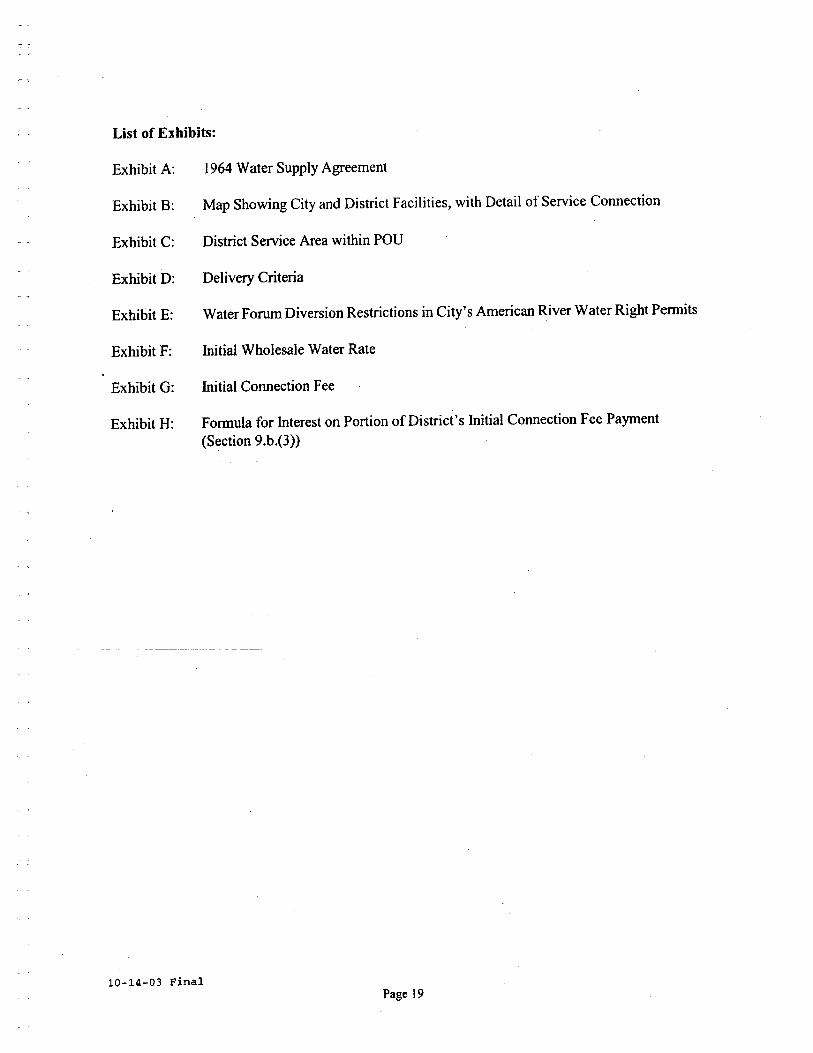
List of Exhibits:
Exhibit A: i 964 Water Supply Agreement
Exhibit B: Map Showing City and District Facilities, with Detail of Service Connection
Exhibit C: Distrct Service Area within POD
Exhibit D: Delivery Criteria
Exhibit E: Water Forum Diversion Restrictions in City's American River Water Right Pennits
Exhibit F: Intial Wholesale Water Rate
Exhibit G: Initial Connection Fee
Exhibit H: Fonnula for Interest on Portion of District's Initial Connection Fee Payment(Section 9.b.(3))
10-14-03 FinalPage i 9
Exhibit A
1964 Water Supply Agreement
10-14-03 FinalPage 20
-.
AGREEMENT BETWEN CITY OF SACRAMENTOAND ARCADE COUNTY WATER DISTRICT
City of Sacramento, a municipal corporation,
hereinafter called Sacramento, and Arcade County Water
District, a county water district, hereinafter called
Arcade, jointly recite the following:
A. ,Sacramento has the right to a water supply
from the American River under Permits Nos.
11358, 11359, 11360, and 11361 on Applica-
. tions 12140, 12321, 12622, and 16060, as they
now exist or may hereafter be amended, as such
permi ts are supplemented by an agreement be-
tween Sacramento and the United States Bureau
of Reclamation dated June 28, 1957. Such
water supply is hereafter referred to as the
Permit Supply; the said agreementis sQmetimes
referred to as the Bureau Agreement.
B. The quantity of the Permit Supply was based upon
serving the area shown as "Potential Water
Service Areas" on Sacramento's Exhibit 3 to the
State Water Rights Board introduced in the pro-
ceedings before that Board which resulted in
Decision D 893. Said Exhi bi t 3 is attached
hereto, marked Exhi bi t A and made a part of this
agreement. Said Exhi bi t A also delineates the
area to be served by water from Applications 12321
-1-
'.
and 12662~ above referred to~ which were the
applications assigned to Sacramento by the
Sacramento Municipal Utility District with
the express provision of such limitation in
use. Only Area D of such Potential Water Ser-
vice Areas as shown by said Exhibit A is in-
volved in this agreement. The Permit Supply
equals 1.133 cubic feet per second per 100
gross acres of the Potential Water Service
Areas~ and this figure is the basis for the
water supply provided by this agreement to
Arcade. The use basis shall be 50% as estab-
'"1£/.
l!i.Ii shed before the State Water Rights Board and
by the Bureau Agreement~ that is to say ~ the
annual use of such supply shall not exceed a
quantity equal to 50% of the quantity which
would be produced if such supply ran continu-
ously throughout the year. Therefore, the water
supply provided to Arcade by this agreement
shall be 410.146 acre-feet of annual use for
each 100 gross acres of the Potential Water
Service Area served by Arcade.
C. Arcade now serves 5988 acres of Area D as shown
on Exhibit A which is also wi thin the boundaries
.0:
ìt,c.,
of Arcade~ and 373 acres of Area D which is out-
side Arcade i s boundaries ~ or a total of 6361
-2-
"
acres, which at the rate of 1.133 c fs per
100 acres equals 72 cfs, which is the maxi-
mum diversion allowable under this agreement
at its date. As is provided by Paragraph 11
of the Bureau Agreement, the Ci ty is en-
ti tIed to reasonable flexibility in its de-
,mands based on maximum daily requirements
and maximum peaks during such days. Arcade
shall be entitled to this same flexibility
with the limiting provision that during any
twenty-four hour period a quantity of water at
the rate set forth, maintained for the full
twenty-four hour period, shall not be exceeded.
The maximum quantity to be diverted in any year
shall be 26,064 acre feet allowable under this
agreement at its date. During the life of this
agreement it shall be the intent that Arcade
will be provided water to serve its customers
in such parts of Area D as shown on Exhibit A
that Arcade may serve and should the areas be-
ing so served vary from the figures used in this
agreement at its date then the maximum diversion
allowable and the maximum permissible quantity
to be òiverted shall be proportionately adjusted
in accordance with the diversion and quantity
cri teria set forth in this paragraph above.
-3-
Increases in the size of Area D as shown on
Exhibi t A which Arcade serves shall be agreed
upon in advance, provided however that nothing
in this agreement shall be construed as limi t-
ing or affecting the power of Arcade to conduct
and act on any annexation or inclusion proceed-
ingswhich may hereafter be brought. Hereafter
in this agreement the permissible quantity which
Arcade may divert, as established by this para-
graph, shall be sometimes referred to as
Arcade i s Permissible Annual Diversion.
NOW , THEREFORE , THE PARTIES AGREE AS FOLLOWS:
1. Sacramento grants to Arcade the right to divert
from the American River that portion of its
Permit Supply which Arcade requires for serving
any portion of Area D as shown on Exhibit A
which Arcade may actually serve from time to
time, not to exceed the rate of diversion and
annual quantity di vertèd as determined by Para-
graph C of the recitals in this agreement.
Arcade shall meter such diversions continuously
and keep the original records thereof subject
to inspection by Sacramento, and shall report
in writing to Sacramento at least twice each
year, and oftener if required, both the maximum
di version rates and the quanti ties of such
-4-
"
diversion, on a monthly basis.
2. The diversion of American River water by Arcade
under this agreement shall be from a facility
which serves area only wi thin Area D as shown
on Exhibit A. If Arcade wishes to construe t
facilities which will also divert water to
serve outside of Area D as shown on Exhibit A,
then Arcade must have suitable agreements wi th
the U. S. Bureau of Reclamation for the furnish-
ing of the additional water to be diverted by
that facility and be used outside or Area D as
shown on Exhibit A. Arcade shall furnish proof
to Sacramento that either the diversion facility
to be built will serve only area wi thin Area D
as shown on Exhibi t- A or that a combination di-
version which may be built is the subject of
separate agreement with the U. S. Bureau of
Reclamation.
3. The operative date of this agreement shall be the
first day of the calendar year in which Arcade
di verts any water under this agreement, but in no
event later than January l, 1966.
4. Payment for water by Arcade to Sacramento under
this agreement is intended to be on the same
basis or actual cost or the water as represented
by payments to the Bureau by Sacramento, plus
-5-
-".,
possible future additional costs as set forth
in this paragraph. Definitions and methods of
payment computation are as follows:
a. Arcade's Permissible Annual Diversion is
as defined in recital "c" of this agreement.
b. Sacramento's Maximum Permissible Diversion
'shall be defined as the figure shown in Sche-
dule -"B" of the Bureau Agreement for the year
2030 or a reduced figure if such is ever estab-
lished under the provisions of paragraph 13 of
the Bureau Agreement.
c. Sacramento i s Unit Cost of water in any year
shall be the amount of money paid to the U. S.
Bureau of Reclamation under the Bureau Agree-
ment divided by the maximum quantity of water
which Sacramento may divert from the American
River under the Bureau Agreement for said payment.
d. Arcade's actual diversion shall be the annual
quantity of water diverted by Arcade in accordance
wi th the terms of this agreement and measured as
provided by this agreement.
e. Arcade's Minimum Quantity for payment in any
year shall be determined by computing the ratio
between Arcade 's Permissible Diversion and Sacra-
mento i s Maximum Permissible Diversion and mul tiply-
ing this ratio by the Diversion permissible under
-6-
Schedule B of the Bureau Agreement as it is
printed without modification by other terms of
the Bureau Agreement.
f. Payment by Arcade to Sacramento in any year
shall be Sacramento's Unit Cost of water mul ti-
plied by either "Arcade's actual diversion" or
,"Arcade's -Minimum Quantity for paymentl, which-
ever shall be the greater.
g. If in the future the City of Sacramento
shall be assessed taxes by any public agency on
water rights or diversions which comprise any
part of the Permit Supply then this shall consti-
tute an "additional costll and this shaii becharged to Arcade on the same pro rated basis of
computation as was used to charge Arcade for pay-
ments made by Sacramento under its Bureau
Agreement.
5. Payments for water to Sacramento by Arcade shall
be made twice annually, immediately after
July 1st of any year for the payments due for
the first six months of that year, and immedi-
ately after January 1st of each year for pay-
ments due for the second six months of the
preceding year.
6. All diversions and deliveries, by Arcade under
this agreement are subject to all of the
-7-

;.'
provisions of Decision D 893 of the State
Water Rights Board and the, condi tions of
Sacramento permits, including releases and
flows for fish life, including protection of
fish life, and to Sacramento iS'' Agreement of
Assignment" wi th Sacramento Municipal Utility
,District dated June 28, 1957.
7. This Agreement shall not take effect until
it has been approved in writing by the U. S.
Bureau of Reclamation and until the State
Water Rights Board has approved Arcade 1 s points
of diversion as an addition to those speCi-
fied in Sacramento iS permits. The parties will
cooperate to obtain such approval.
8. This Agreement shall be in effect concurrent
wi th, and at all times consonant with,
the American River diversion permits, and
State regulations òr State laws relating there-
to, held by Sacramento and with all terms of
the Bureau Agreement. For reference, the
Bureau Agreement shall be considered as an
appendix to this agreement.
9. Arcade shall hold Sacramento harmless and
indemnify it for any loss or damage resul t-
ing from any act or occurrence in anyway\.
-8-
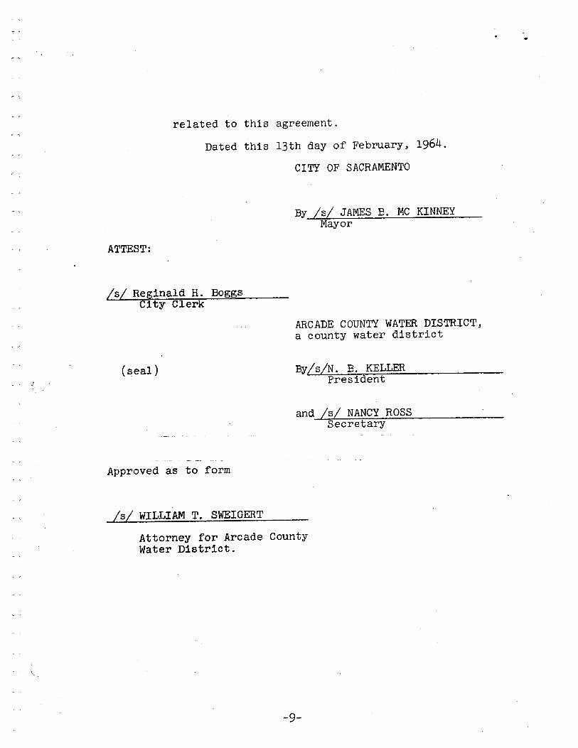
related to this agreement.
Dated this 13th day of February, 1964.
CITY OF SACRAMENTO
By /s/ JAMES B. MC KINNEYMayor
ATTEST:
/s/ Reginald H. BoggsCity Clerk
ARCADE COUNTY WATER DISTRICT,a county water district
(seal) By/sIN. B. KELLEPres ident
and /s/ NANCY ROSSSecretary
Approved as to form
/s/ WILLIAM T. SWEIGERT
Attorney for Arcade CountyWater District.
-9-
..
'\
RESOLUTION NO. 43
Adopted by The Sacramento City Council on date ofFEB.. 13 1964
.- -l
BE IT RESOLVED BY THE COUNCIL OF THE CITY OF SACRAMNTO:
That the Mayor and City Clerk are hereby authorized and
directed to sign and execute on behalf of the Ci ty of Sacramento
that certain agreement by and between the CITY OF SACRAMENTO, a
municipal corporation, therein called SACRAMENTO, and ARCADE
COUNTY WATE DISTRICT, a county water district, therein called
ARCADE, covering the selling of certain quanti ties of water
under the terms of the City i S agreement with the United States
Bureau of Reclamation.
JAMES B. McKINNEYMAYOR
ATTEST:
REG IN ALD H. BOGGSCITY CLEK
CERTIFIED AS TRUE COpy
OF RESOLUTION NO. 43
February 14, 1964Date Certified
/s/ REGINALD H. BOGGSCi ty Clerk, City of
Sacramento
( SEAL)
Exhibit B
Map Showing City and District Facilities, with Detail of Service Connection
10-14-03 FinalPage 2 i
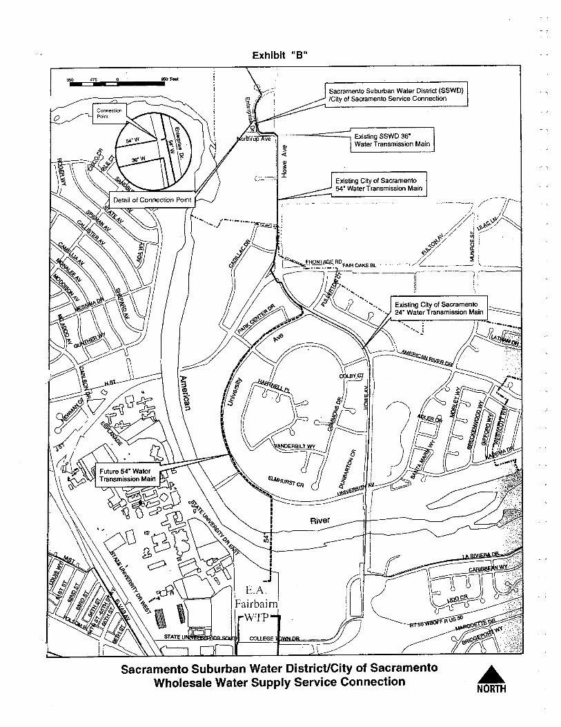
Exhibit "8"
95 475- - 95 Fe,
Sacramento. Suburban Water Distnct (SSWD)ICity o.f Sacramento. Service Cannectian
Ql
! ~: Ql¡ 3:, 0.,_,.._, i:;".-.....
Existing SSWD 36"Water Transmissio.n Main
Existing City af Sacramento.54" Water Transmission Main
COLLEGE
I
( ~~r cARBB¡ \ 'In~(1\1 ( \~ ~
'L- ~JJ ".",~
_JE.A.
FairbairnWTP
Sacramento Suburban Water District/City of SacramentoWholesale Water Supply Service Connection .
NORTH

ExhibitC
District Service Area within POU
10-14-03 FinalPage 22
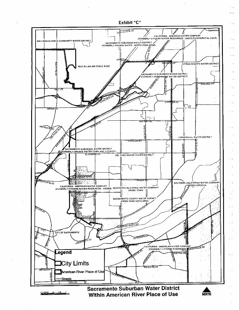
Exhibit "e"
RIO LINDA ELVERTA COMMUNITY WATER OISTRICT
\
CALIFORNIA, AMERICAN WATER COMPANY
(F~~MERL Y CITIZENS WATER RESOURCES ~ LINCOLN OAKS/ROYAL OAKS)
SACRAMENTO SUBURBAN WATER DISTRICT /(FORMERL Y ARCADE WATER. NORTH HIGHLANOS)
McCLELLAN AIR FORCE BASE
CTRUS HEIGHTS WATER OISTRICT
"
Streets14TH A
00.1250.2 05 OJ'S 1 l-Sacramento Suburban Water DistrictWithin American River Place of Use
ÂNOTH

Exhibit D
Delivery Criteria
10-14-03 FinalPage 23
EXIBIT D
CITY I SACRANTO SUBURANENTRPRISE DRI SERVICE CONNCTION
DELIVRY CRITERI
Ths document outlines the genera delivery guidelines and criteria for the operation of serviceconnections between the City of Sacramento (City) and the Sacraento Suburban Water Distrct
(Distct). The intial wholesae water service connection is locted on Enterprise Drve betweenNorthrop A venue and Ventue Cour.
LIST OF CONTACTS:
The followig listing of City and District contact names and phone numbers is provided in orderof contact priority.
Distrct: WORKJames Arnz Oprator on Call 679-2892 (Cell-869-7359)
*Field Oprations Dispatch (for Operator on Call) 972-7171Richard Crebley, Treatment Plant Supervisor 679-2884 (Cell-416-5468)
*Utilty Emergency Number (24-hr Line) 972-7171Da York, Field Oprations Maner 679-2880 (Cell-869-7349)Waren Jung, Distrct Engineer, Operations 679-3987 (Cell-416-5467)
*Daiy 8am-5pm; afer hour, weekends and holidays-sae number to anwerig service.
City of Sacraento:E.A. Fairbai WTP Control RoomE.A. Fai WT HotlineSteve Wiley, Plant Operator SupervisorMike Yee, Plant Servce Division ManagerKathy Mullen, Water Superintendent
Roland Pang, Water Superitendent
WORK382-3106383-1516382-3712264-5583382-3105382-3119
OPERATIONAL PARTERS:
Per the ageement the followig operational pareters shall be maitaed by the City and
District operators controlling the service connection.
Distrct Delivery Criteria Doument October 9, 2003
1
Pre-Faibai Plant ExpanionIowe Avenue Tramission Mai ConsctionInstataeous maximum flow rate = 10 mgd (6,950 gpm)*Maximum daly volume = 10 mg
Post-Fairbairn Plant ExpanionIowe Avenue Transmission Main ConstructionInstataeous maxum flow rate = 20 mgd (13,900 gpm)*Maximum daily volume = 20 mg* A10% tolerace shal be allowed due to operational varations.
Per the operational requirements of the City supply and distnbution system, the followingadditional operationa pareters shall be maitaed.
Minium Pump'Star Service Connection PressureMinum Service Connection Opration Pressur
= 35 psi= 30 psi
OPERATIONAL PROCEDURS:
1. For intial st-up, and for subsequently signficant shut-down periods, Distct will call
the E.A. Fairbairn Water Treatment Plant (FWTP) Control Room to communcatedelivery sttu.
2. The FWTP Operator will check the system pressure at the service connection using theCity's Supervisory Control and Data Acquisition (SCADA) system. If
the pressure
equas or exceeds 35 psi, the FWTP Operator will use the SCADA system to open themotor operated valve (MOY) locted at the service connection. if
the system pressur at
the service connection is less than 35 psi, or the FWTP Oprator has reason to suspectthat the pressur shall fall to or below 35 psi with a short period from the call fordelivery (based on historic demand trends), the FWTP Operator will deny District'srequest for delivery and not ope the valve.
The SCADA system shall enunciate visually and audibly a low pressure condition (35
psi) and a low-low pressue condition (30 psi) in the FWT Control room, and at theDistrct control station. Should the low-low pressure condition remain in effect for 90seconds, the Distct's boster pump sttion control logic shall intializ boster pumpstation shut-down. Should the Distnct's booster pump station control logic fail to
perform shut-down of the boster pumps, the City shall be obligate to close the service
connection MOV.
3. When a request for delivery is authorized by the FWTP Operator, and the serviceconnection MOV has ben opened, the Distrct Oprator shall receive a fuly open valveposition signal though the pump station SCADA system. The Distnct can then star the
Distrct Delivery Criteria Document October 9,2003
2
first pump at the pump staon using the VFD to rap up flow while the FWT'Opratorand the Distrct monitors system pressure on the City side of
the service connection. If
the pressu fals to or below 35 psi the Distrct shall adjus the flow to reta suction sidepressure at or above 35 psi. The District shall strive to set stabilized operation of thepuip station to maita servce connection pressur at or above 35 psi. If at any tiethe suction side pressure should fall to or below 30 psi the Distrct's booster pmnp stationcontrol logic shall intiate boster pump sttion shut down.
4. If the system pressure remains above 35 psi the Distct shall be authorized to sta
additional pumps whle monitorig servce connection pressur to ensure that pressurdoes not fall below 35 psi. The Distct shall control the booster pump station control
logic to maita the servce connection pressure at or above 35 psi. At no time shall the
service connection pressure drop below 30 psi.
5. The City shall be respnsible for reading and rerdig the time and flow quatities.
6. District can tae a daily flow rate of up to 6,950 gpm (withi a 10% tolerace due tooperational varations) as meaur by the City maitaed seice connection flowmeteras long as servce connection pressurs and conditions in paragrphs 2,3, and 4 are metprior to completion of the FWT expanion and consction of the Howe AvenueTramission Mai.
7. Distrct can tae a daily flow rate of up to 13,900 gpm (withn a 10% tolerance due tooperationa varations) as meaured by the City maitaed servce connection flowmeteras long as the serce connection pressures and conditions in paragraphs 2,3, and 4 are
met once expaion of the FWT and consction of the Howe Avenue Trassion
Mai have been completed.
8. If the Distrct encounters an emergency sitution that requies additional water for theirsystem for a short durtion, the City may allow the Distrct to tae water even though thesystem pressur at the servce connection is below 30 psi. In the event of an emergency,the Distrct may request the FWTP Operator to over ride the service connection MOV.
9. if the City encounters an emergency sitution that requis additional water for theirsystem, the City may close the service connection MOY even though the system pressureat the service connection is at or above 30 psi. In the event of an emergency, the FWTOperator shall notify the Distrct before closing the service connection MOY.
to. The aforementioned delivery cnteria ca be modified at the discretion of the City.
Distrct Delivery Cntera Doent October 9, 2003
3
AGREEMENT:
Both paries ag to the procedures and conditions set fort in ths document to deliver Citywater to the Service connection, by and between the CITY OF SACRAENTO and the District.
Dated: ,2003
CITY OF SACRAMENTO
By: ¡7 "¡4~, f'Mike Yee, Plant ices Manager
DISTRICT
By: ¿','~Ed Formosa Assistat Genera Manager
Distct Delivery Criteria Doument October 9, 2003
4
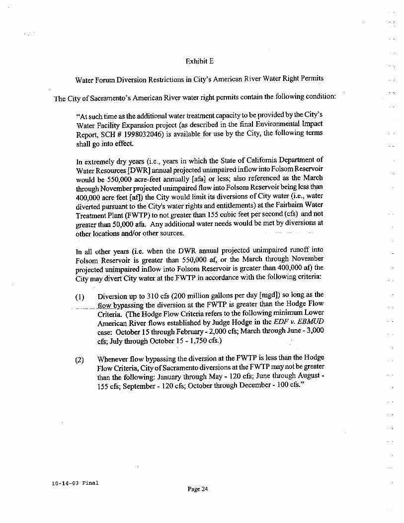
Exhibit E
Water Forum Diversion Restrictions in City's American River Water Right Permits
The City of Sacraento's American River water right permits contain the following condition:
"At such time as the additional water treatment capacity to be provided by the City'sWater Facility Expansion project (as described in the final Environmenta ImpactReport, SCH # 1998032046) is available for use by the City, the following termsshall go into effect.
In extremely dr years (i.e., years in which the State of California Deparent ofWater Resources (DWR) anual projected unimpaired inflow into Folsom Reseroirwould be 550,000 acre-feet anually (afa) or less; also referenced as the Marchthough November projected unmpaired flow into Folsom Reservoir being less than400,000 acre feet (at)) the City would limit its diversions of
City water (i.e., water
diverted puruant to the City's water rights and entitlements) at the Fairbairn WaterTreatment Plant (FWTP) to not greater than 155 cubic feet per second (cfs) and not
greater than 50,00 afa. Any additional water needs would be met by diversions at
other locations and/or other sources.
In all other years (i.e. when the DWR anual projected unmpaired ruoff intoFolsom Reservoir is greater than 550,00 af, or the March through Novemberprojected unpaired inflow into Folsom Reservoir is greater than 400,000 at) theCity may divert City water at the FWTP in accordace with the following criteria:
(1) Diversion up to 310 cfs (200 millon gallons per day (mgdD so long as the
____un Jlow Qypassing the diversion at the FWTP is greater than the Hodge FlowCriteria. (Te Hodge Flow Criteria refers to the following minimum LowerAmerican River flows established by Judge Hodge in the EDF v. EBMUDcase: October 15 though Febru - 2,000 cfs; March through June - 3,000crs; July though October 15 - 1,750 cfs.)
(2) Whenever flow bypassing the diversion at the FWTP is less than the HodgeFlow Criteria, City of Sacramento diversions at the FWTP may not be greaterthan the following: Januar through May - 120 cfs; June through August-155 cfs; September - 120 cfs; October through December - 100 cfs."
10-14-03 FinalPage 24
10-14-03 Final
Exhibit F
Initial Wholesale Water Rate
SACRAMENTO SUBURBAN WATER DISTRICTWHOLESALE WATER RATE
FISCAL YEAR 2003-2004
Page 25
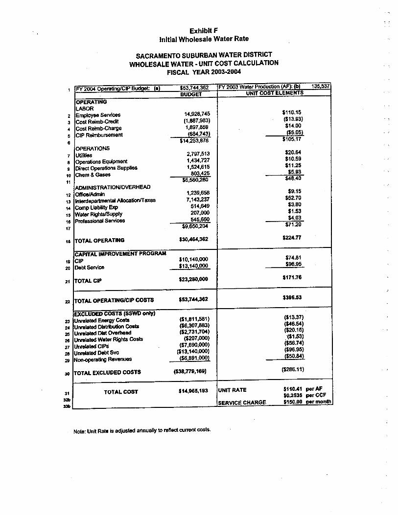
Exhibit F
Initial Wholesale Water Rate
SACRAMENTO SUBURBAN WATER DISTRICTWHOLESALE WATER - UNIT COST CALCULATION
FISCAL YER 2003-2004
19
20
1 FY 200 ontinoCIP Budaet: fa) $53,744,362 FY 2003 Water Prouctn (AF): fbl 135,537
BUDGET UNIT COST ELEMENTS
OPERATINGLAOR
2 Employee Serv 14,928,745 $110.15
3 Cost Reimb-it (1,887,983) ($13.93)
4 Cot Reimb-arge 1,897,859 $14.00
5 CIP Reimbursnt (68,743) ($5.05)
6 $14,253,878 $105.17
OPERATIONS7 Utlit 2,797,513 $20,64
8 Opration Equipmnt 1,434,727 $10.59
9 Dire Operatis Supplies 1,52",615 $11.25
0 Chm & Ga 803,425 $5.93
1 $6,56,280 $48."0
ADINISTRA TION/VERHEA2 OfAdmln 1,239,658 $9.15
3 Interdepntal ADtinfaxes 7,143,237 $52.70
4 Comp Liabilit Ex 514,649 $3.80
5 Water Rightsupply 207,00 $1.53
6 Prfessil Sers 545,660 $4.03
7 $9,65,204 $71.20
. TOTAL OPERATING $30,4,362 $224.77
CAPITAL IMPROVEMENT PROGRACIP $10,140,00 $74.81
Det Se $13,140,00 $96.95
TOTAL CIP $23,280,000 $171.6
TOTAL OPERA TIGICIP COS $53,7".3 $396.53
EXCLUDE COSTS (SSWD onl)Unrlate Enrg Co ($1,811,581 ) ($13.37)
Unrlate DIbu Co ($6,307,88) ($4.54)Unrlate 0I Ovad ($2,731,704) ($20.15)
Unrlate Waf Rihts Co ($207,00) .~$1.53)
Unrlate CIPs ($7,690,00) ($5.74)
Unrlate Det Svc ($13,140,00) ($96.95)
Nonratlng Reven ($6,891,00) ($5.84)
TOTAL EXCLUDED COSTS ($3,779,169) ($286.11)
TOTAL COST $14,965,193 UNIT RATE $110.41 per AF$0.2535 per CCF
SERVIE CHAGE $150.00 oer month
.- -l
21
22
23
24
25
26
27
28
29
30
31
3233
Note: Unit Rat. is adjuste annually to refl currnt costs.
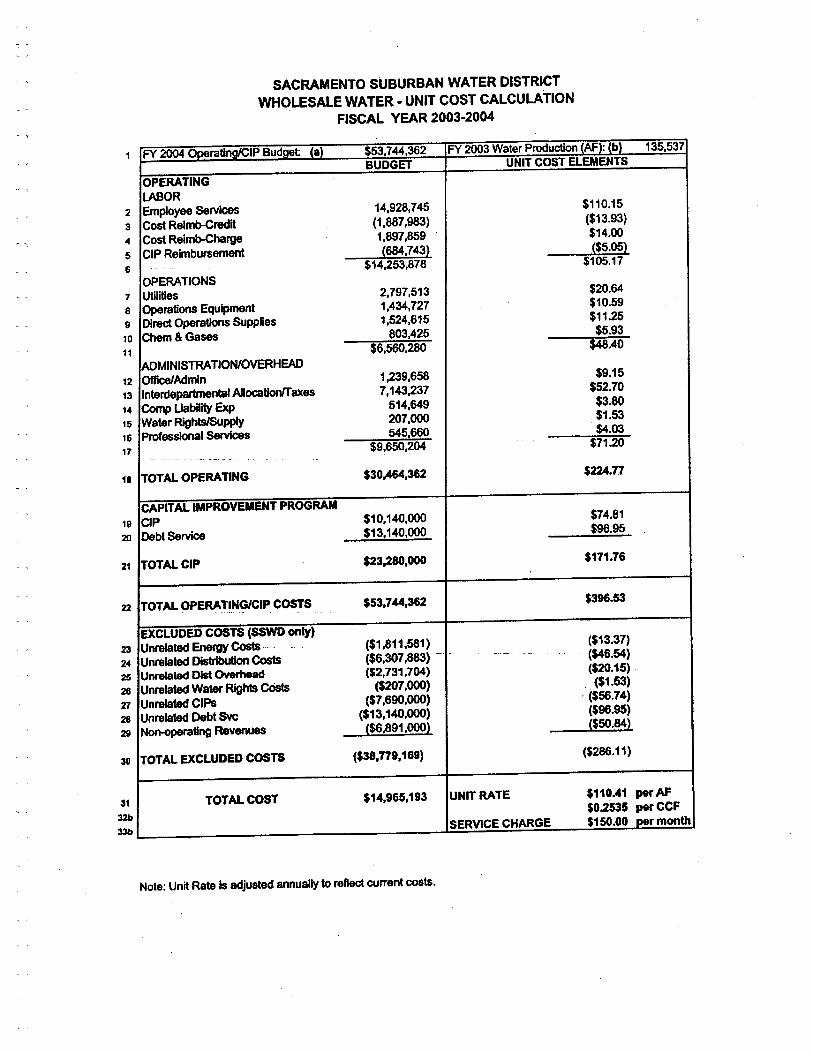
SACRAMENTO SUBURBAN WATER DISTRICTWHOLESALE WATER. UNIT COST CALCULATION
FISCAL YEAR 2003.2004
8
91
1
1 FY 20 OoeraürCIP Budaet: (a) $5,744,362 FY 203 Water Prouctn eAF): eli 135,537
BUDGET UNIT COST ELEENTS
OPERTINGlAOR
2 Emplyee Servic 14,928.745 $110.15
3 Cos Relmb-reit (1,887,98) ($13.93)
4 Cos Reimb-harg 1,897,859 $14.00
5 CIP Reimburseme (68.743) ($5.05)
6 $14,253,878 $105.17
OPERATIONS7 Utiliti 2,797,513 $20.64
Opration Equipmnt1,434.727 $10.59
Dire Oprati Supplies 1,524,615 $11.25
0 Che & Gas 803,425 $5.93
1 $6.56,280 $48.40
ADMINISTRTION/OVERHEA2 OfAdmin 1,239,658 $9.15
3 Interdpart Aloctlaxes 7,143,237 $52.70
Cop libiit Ex 514,649 $3.80
Water Rlhtsupp 207,00 $1.53
Profesl Se 545,66 $4.03
$9,650,204 $71.2" "-_.- ----- ~- ,-
TOTAL OPERATING $30,4,362 $22.77
CAPITAL IMPROVEMENT PROGRACIP $10,140,00 $74.81
Debt Serv $13,140,00 $96.95
TOTAL CIP $23,280,000 $171.76
TOTAL OPERATING/CIP COSS $53,744,362 $396.53
EXCLUDED COSTS (SSD only)Unrlate En Co n - ($1,811,581) ($13.37)
Unrlate Ditr Co ($6,307,88) n' ,- -- '($46.54)
Unrte Di Ov ($2,731,704) ($20.15)
Unrelate Wate RI CO ($207,00) . ($1.53)
Unrete CIPS ($7,690,00) - ($5.74)
Unrelate Det Sv ($13,140,00) ($96.95)
Noting Revenues ($6,891,00) ($50.84)
TOTAL EXCLUDED COSTS ($3,779,169) ($286.11 )
TOTAL COST $14,965,193 UNIT RATE $110.41 per AF$0.2535 per CCF
SERVICE CHARGE $150.00 per month
1
1
14
15
16
17
,.
19
20
21
22
23
24
25
26
Xl
28
29
30
31
3233
Note: UnitRate Is adjusted annually to refl current cots.
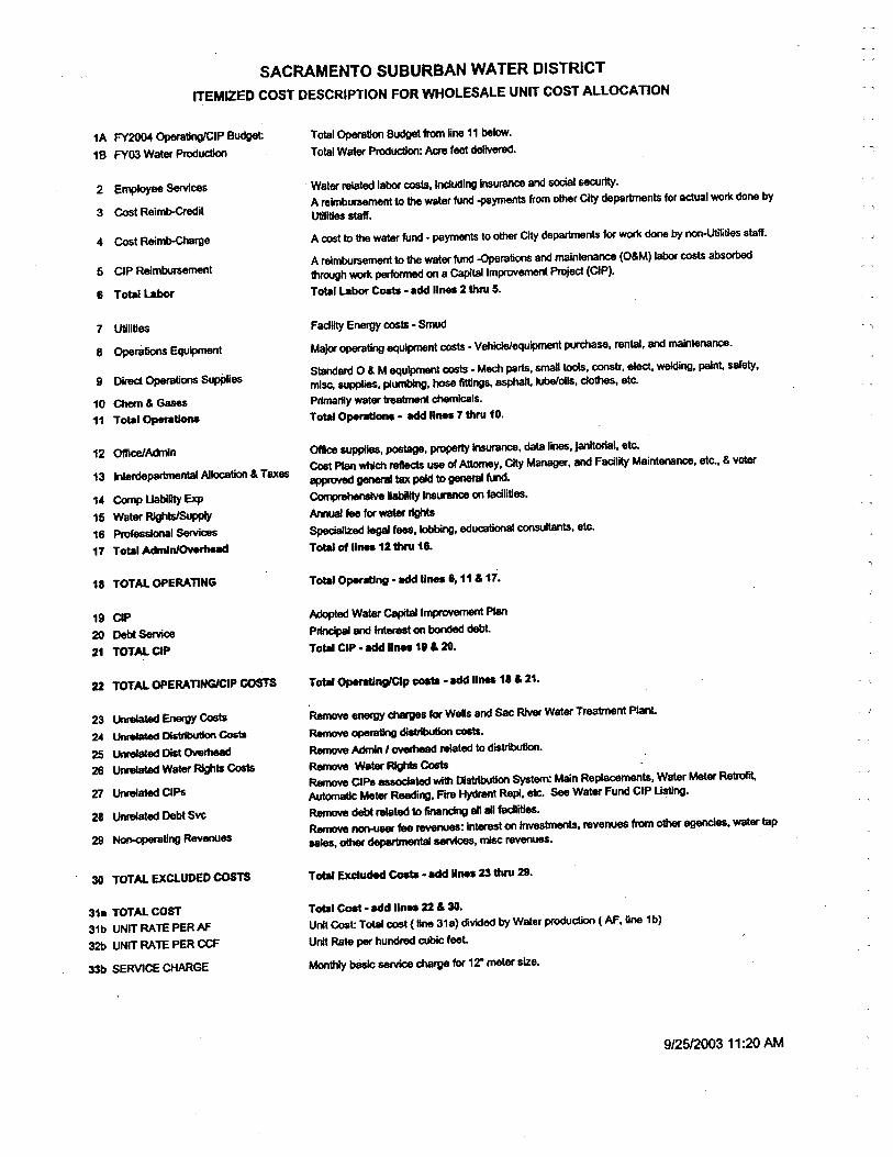
SACRAMENTO SUBURBAN WATER DISTRICT
ITEMIZD COST DESCRIPTION FOR WHOLESALE UNIT COST ALLOCATION
1A FY20 OplingCIP Budg:1B FY03 Water Pruc
2 Empoyee $eces
3 Cot Reimb-il
4 Cot Reimbrge
5 CLP Reimbrsnt
6 Total La
7 UtllUes
8 Opti Equipt
9 Dire Option Supp10 Ch & Ga11 Tol-IOpetI
12 oiicAdn13 Interpa Alloti & Taxes
14 Co libili Ex15 Water RI16 Proesl Sece17 TOl-1 Admlnl~
18 TOTAL OPERATING
19 CLP
20 De Se21 TOTAL CIP
22 TOTAL OPERATINGIP COST
23 Un En Co24 Un 0I Co25 UMec Di Ovrh26 Unr Wate RIts Co
27 Unated ClPs
28 Unted Debt Svc
29 Notlng Revenes
30 TOTAL EXCLUDED CO
31. TOTAL COST
31b UNIT RATE PER M32b UNIT RATE PER CC
33 SERVICE CHGE
Totl Opti Bu fr ~ne 11 belo.
Tota Water Pr: AI, fee deiver.
, Water reted labo cots, Incing inura an sol &erl.A reimburs to th wate fund -paymnts from otr Cit departnt for actal work clne byUtliti stff.
A co to th wat fund - paymts to ot CI depant for wo do by noUtlitis staff.
A rembrsme to th water fund -Oration and mainten (O&M) la cots absOlthh wo pe on a Ca Imprem Prec (CLP).Totl Labo Co - add line 2 thru 5.
Fadllty Energ cots - Sm
Majo opti equipmnt cots - Vehiceqipt puse, renta. an mantenanc.
Staar 0 & M equipt cots - Ma part. sm to. cotr, elec. weing. pant $Bfety,
mise suppie. plumng, ho fing. as luboils, cl. etc.
Primariy water 1rbn chicls.
Tota Opeon. - add lin 7 thru 10.
Of supie, pota, prrt In. da lin. jaitorl. ete.Cot Pl wh re us of Aty. CI Mana. an Faclit Maintennc, etc., & votap ge ta pa to genera fu.Co Ba Inoo on falites.An te fo wa rihtSpized le fee. lo, eduction coltts. etc.Tot of line 12 th 16.
Tot Openg. ad line 6.11 & 17.
Adte Wate Ca Imp PlPrl an Inert on bo deTota CIP . ad line 11 & 20.
Tot OpengClp co . ad line ,. & 21.
Rem ene ch fo Wels and Sa Ri Water Trea1nt PlRe c:tl di co.Re Ad , ov reted to distr.Rem Wate RI CoRe ClPe 8S wi DI Syste Man Replts. Watr Meter RetrAu Mete Rein. F'ir Hyrat Rep!, et. Se Wat Fund CIP Us.Re de re to fincng al all fait.Rem no fe RIes: Inte on In. revenu fr ot ag, waer tapaa. ot de se, mi re.Totl Exude eo - ad Unu 23 th 29.
Totl Co. add Iin.. 22 & 30.Un Cot Totl cot (li 31a) divied by Waler prcl (M.line 1b)
Uni Ra pe hundre cu feet
Mo bà se chrg fo 12" meter size.
9/251003 11 :20 AM

LEGEND
0 D1STRIBVßON
G GENERAH HYDRP PUMPING
S STORGET TRTMENT
TM TRMISSIONw WEUS
10/14120031:12 PM
10-14-03 Final
Exhibit G
Initial Connection Fee
SACRAMENTO SUBURBAN WATER DISTRICTWHOLESALE WATER - INITIAL CONNECTION FEE
FISCAL YEAR 2003-2004
Page 26
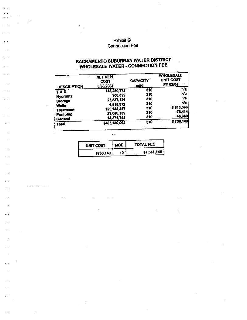
Exibit GConnection Fee
c ,SACRAENTO SUBURBAN WATER DISTRICT
WHOLESALE WATER. CONNECTION FEE
NET REPL WHOLESALE
COST CAPACIT UNIT COST
DES PTION 6101200 m d FY 03lM
T&D 143,2,772 310 nil
Hydrants 98,892 310 nil
Storge 25,837,126 310 nil
W.11s 6,118,872 310 nil
Trent 190,143,487 310 $ 613,366
pumpig 23,68,189 310 76,41.
Ge..1 14,371,753 310 46
Total $45,180,082 310 $ 736,140
UNIT COST MGD TOTAL FEE
$736,140 10 $7,361,140
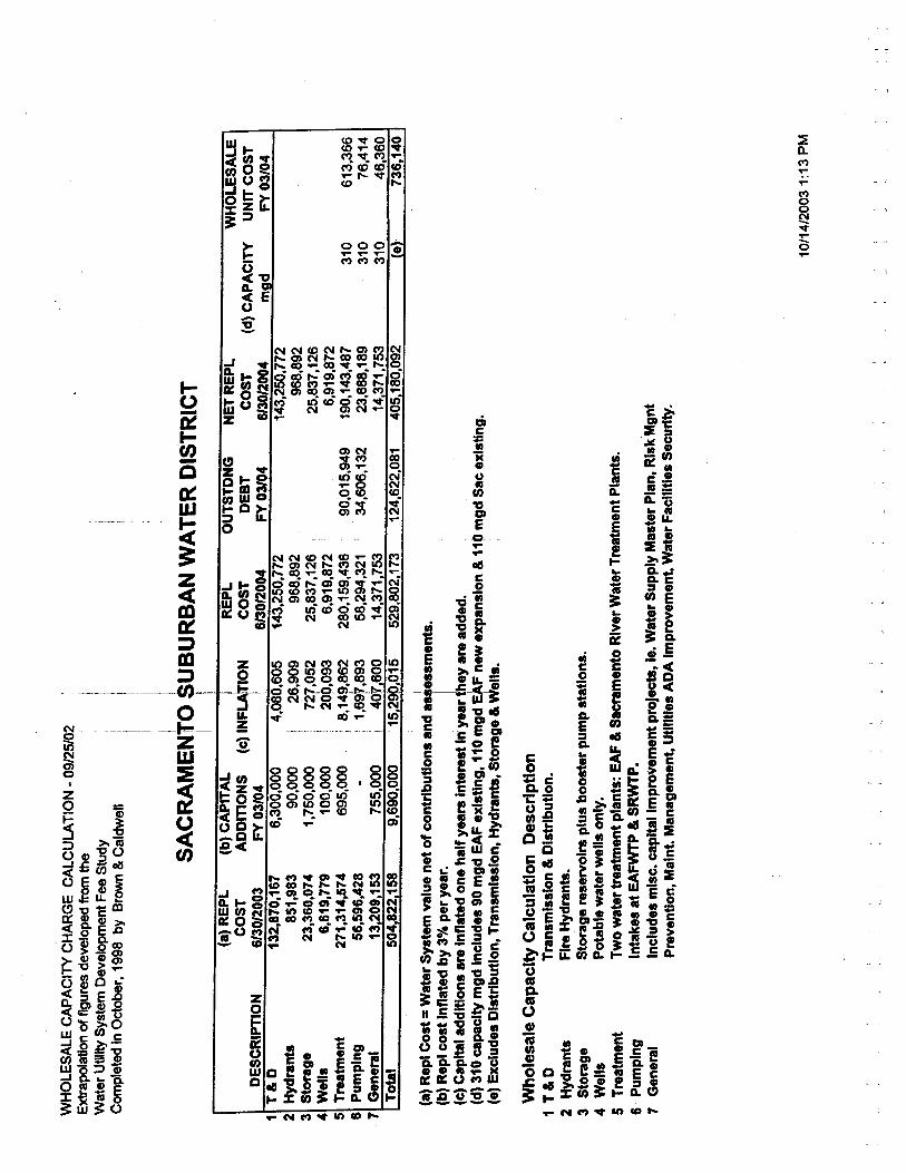
WH
OL
ESA
lE C
APA
CIT
Y C
HA
RG
E C
AL
CU
LA
TIO
N -
09/
25/0
2Extpolation of figures developed from the
Wat
er U
tility
Sys
tem
Dev
elop
men
t Fee
Stu
dyC
ompl
eted
In O
ctob
er. 1
998
by B
row
& C
aldw
ell
i
i I i ' ¡I,
SAC
RA
ME
N~O
~U
BU
RB
AN
WA
TE
R D
IST
RIC
T"
iI I
(a)
RE
PL
(b)
CA
PIT
AL
(c)
INFL
A~O
NR
EPL
OU
TST
DN
GN
ET
RE
PL
WH
OL
ESA
LE
CO
STA
OD
InO
NS
CO
STD
EB
TC
OST
(d)
CA
PA
CIT
YU
NIT
CO
ST
iD
ESC
RIP
TIO
N61
3012
003
FY
03/
04i
6130
1200
4FY
031
0461
3012
004
mgd
FY 03104
T&
O13
2,87
0,16
76,
300,
000
4.08
0,60
514
3,25
0,77
214
3,25
0,77
2H
ydra
nts
851,
983
90.0
0026
,909
968,
892
96,8
92St
orag
e23
,360
,074
1,75
0.00
727,
052
25,8
37,1
2625
.837
.126
Wel
ls6,
619,
779
100.
0020
9.09
36,
919,
872
6.91
9,87
2T
reat
men
t27
1,31
4,57
469
5.00
08.
149.
862
280,
159.
436
90;0
15,9
4919
0.14
3.48
731
061
3,36
6Pu
mpI
ng56
,596
,428
-; 1,697,893
58,2
94,3
2134
,606
,132
23,6
88.1
8931
076
,414
Gen
eral
13,2
09,1
5375
5.00
0i
401,
600
14,3
71,7
5314
,371
,753
310
46,3
60T
otl
504.
822.
158
9,69
0.00
015
290,
015
529,
802,
173
124,
622,
081
405,
180,
092
(e)
736,
140
,
1 2 3 4 5 6 7
1
(a)
Rep
l Cos
t = W
ater
Sys
tem
val
ue n
et o
f con
trib
utio
ns a
nd a
s,es
smen
ta,
(b) Repl cost Inflated by 30/. per year. I
(c)
Cap
itl a
dditi
ons
are
Infla
ted
one
half
year
s In
tere
st In
yea
r th
ey a
re a
dded
. 'i
(d)
310
capa
city
mgd
Incl
udes
90
mgd
EA
F e
xist
ing,
110
mgd
EA
F n
ew e
xpan
sion
& 1
1K)
mgd
Sac
exi
stin
g.(e
) E
xclu
des
Dis
trib
utio
n, T
rans
mis
sion
, Hyd
rant
s, S
tora
ge &
Wel
ls.
Who
lesa
le C
apac
ity C
alcu
latio
n D
escr
iptio
n1
T&
D2 Hydrants
3 Storage
4 Wells
S Treatment
6 Pumping
7 General
TransmIssIon & DIstbutIon.
Fire
Hyd
rant
s.St
orag
e re
serv
oirs
plu
s bo
oste
r pu
mp
stat
ions
.Po
tabl
e w
ater
wel
ls o
nly.
Two water tratment plants: EAF & Sacramento RIver Water Treatment Plants.
Inta
kes
at E
AF
WP
& S
RW
TP
.Includes misc. capital
Impr
ovem
ent p
roje
c, Ie
. Wat
er S
uppl
y M
aste
r P
lan,
RIs
k M
gnt
Prev
entio
n, M
alnt
. Man
agem
ent,
Util
ties
AD
A I
mpr
ovem
ent,
Wat
er F
acilt
Ies
Secu
rity
.
10/1
4/20
031:
13 P
M

APPENDIX G
Water Shortage Contingency Plan
'\
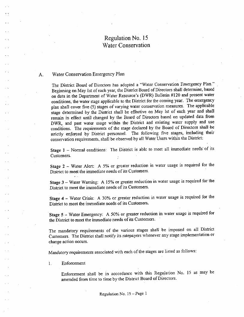
Regulation No. i 5Water Conservation
A. Water Conservation Emergency Plan
The District Board of Directors has adopted a "Water Conservation Emergency Plan."Beginning on May 1 st of each year, the District Board of Directors shall determine, basedon data in the Department of Water Resource's (DWR) Bulletin #120 and present waterconditions, the water stage applicable to the District for the coming year. The emergencyplan shall cover five (5) stages of varying water conservation measures. The applicablestage determined by the District shall be effective on May 1st of each year and shallremain in effect until changed by the Board ofDjrectors based on updated data fromDWR, and past water usage within the District and existing water supply and useconditions. The requirements of the stage declared by the Board, of Directors shall bestrictly enforced by District personneL. The following five stages, including theirconservation requirements, shall be observed by all Water Users within the District:
Stage 1 - Normal conditions: The District is able to meet all immediate neeaif of itsCustomers.
Stage 2 - Water Alert: A 5% or greater reduction in water usage is required for theDistrict to meet the immediate needs of its Customers.
Stage 3 - Water Warning: A 15% or greater reduction in water usage is required for theDistrict to meet the immediate needs of its Customers.
Stage 4 - Water Crisis: A 30% or greater reduction in water usage is required for theDistrict to meet the immediate needs of its Customers.
Stage 5 - Water Emergency: A 50% or greater reduction in water usage is required forthe District to meet the inuediate needs of its Customers.
The mandatory requirements of the various stages shall be imposed on all DistrictCustomers. The District shall notify its ratepayers whenever any stage implementation orchange action occurs.
Mandatory requirements associated with each of the stages are listed as follows:
1. Enforcement
Enforcement shall be in accordance with this Regu,lation No. 15 as may beamended from time to time by the District Board of Directors.
Regulation No. 15 - Page 1

III...,
2. Stage i - Mandatory Requirements - Nonnal Conditions
All requirements of Sections Band ,C of this Regulation i 5 shall be in effect forStage 1.
3. Stage 2 - Mandatory Requirements - Water Alert
Upon detennination by the Board of Directors that Stage 2 conditions exist, thefollowing mandatory requirements shall apply to all Water Users:
a. All mandatory requirements of Stage 1 shall remain in effect.
b. The District shall require Water Users to reduce consumptionapproximately 5%.
4. Stage 3 - Mandatory Requirements - Water Waring
Upon detennination by the Board of Directors that Stage 3 conditions exist, tHefollowing mandatory requirements shall apply to all Water Users:
a. All mandatory requirements of Stage 1 shall remain in effect.
'\Mandatory requirements of Stage 2 shall remain in effect except that anyless-stringent Stage 2 requirements will be superseded by the morestringent requirements of a Stage 3 condition as described below.
c. The District shall require all Water Users to reduce consumption
approximately i 5%.
b.
d. Outside irrgation shall be limited to two (2) days per week. Sti;eet
addresses ending with odd numbers (1, 3, 5, 7 & 9) shall be allowed towater on Tuesdays and Saturdays of each week. Street addresses endingwith even numbers (2, 4, 6, 8 & 0) shall be allowed to water, only onWednesdays and Sundays. No watering will be allowed on Mondays,Thursdays, and Fridays.
e. Washing of vehicles and other mobile equipment shall be conducted at
commercial establishments that use fully recycled water. Alternative
washing of vehicles is permitted, but only with the use of a water savernozzle with the vehicle parked on the lawn, provided no runoff occurs on
sidewalks or street, and the washing is done on a permitted watering dayfor that address.
f. Hydrant pennits for construction water will be confined to jetting and
compaction of materials. No water shall be used for street washing.
Regulation No. 15 - Page 2
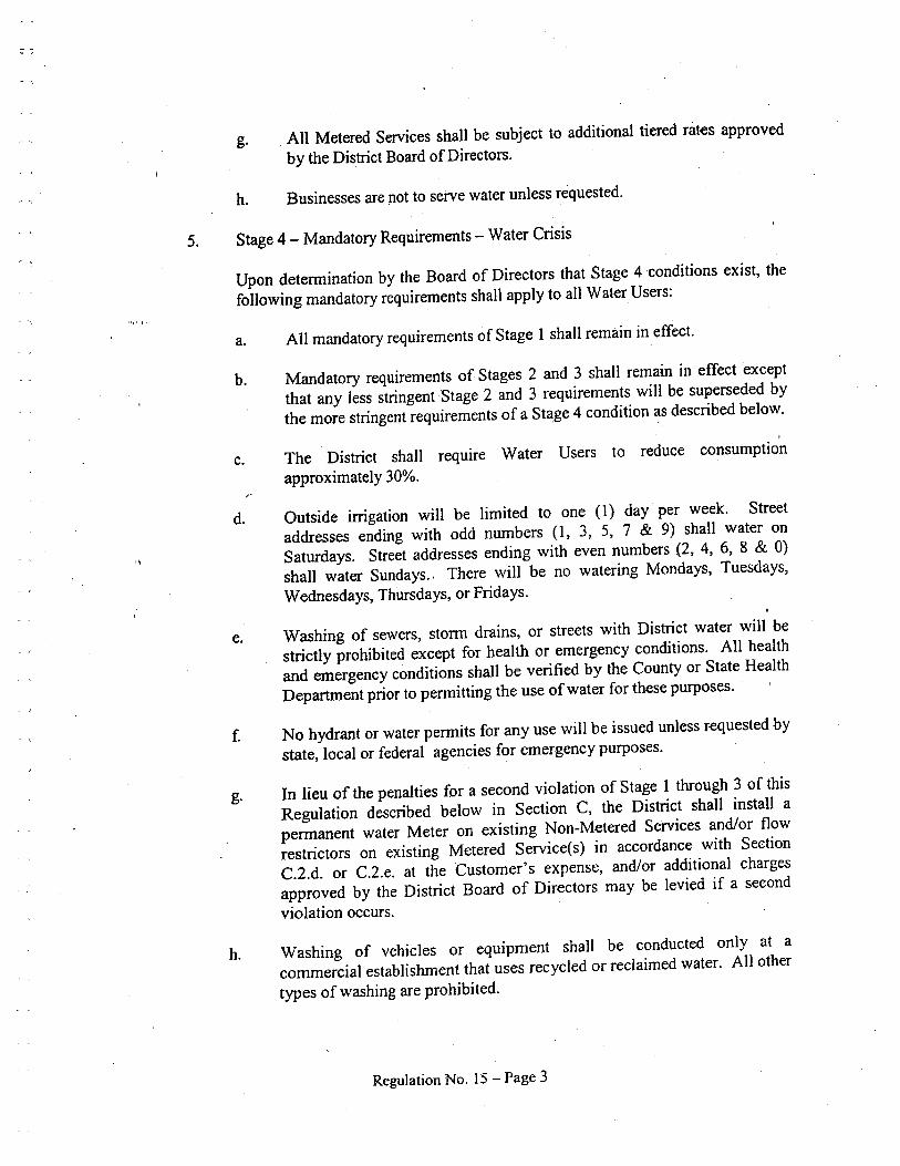
r- ""
Iil., I'
g. All Metered Services shall be subject to additional tiered rates approved
by the Distrct Board of Directors.
h. Businesses are not to serve water unless requested.
5. Stage 4 - Mandatory Requirements - Water Crisis
Upon determination by the Board of Directors that Stage 4 conditions exist, the
following mandatory requirements shall apply to all Water Users:
a. All mandatory requirements of Stage 1 shall remain in effect.
b. Mandatory requirements of Stages, 2 and 3 shall remain in
effect except
that any less stringent Stage 2 and 3 requirements wil be superseded by
the more stringent requirements of a Stage 4 condition as described below.,
c. The Distrct shall require Water Users to reduce consumptionapproximately 30%.
d. Outside irrgation wil be limited to one (1) day per week. Streetaddresses ending with odd numbers (1, 3, 5, 7 & 9) shall water on
Saturdays. Street addresses ending with even numbers (2, 4, 6, 8 & 0)shall water Sundays.; There will be, no watering Mondays, Tuesdays,
Wednesdays, Thursdays, or Fridays.
'\
e. Washing of sewers, storm drains, or streets with District water wil bestrictly prohibited except for health or emergency conditions. All healthand emergency conditions shall be verified by the County or State HealthDeparment prior to permitting the use of
water for these purposes.
f. No hydrant or water permits for any use will be issued unless requested by
state, local or federal agencies for emergency purposes.
g. In lieu of the penalties for a second violation of Stage 1 through 3 of this
Regulation described below in Section C, the District shall install apermanent water Meter on existing Non-Metered Services and/or flowrestrictors on existing Metered Service(s) in accordance with SectionC.2.d. or C.2.e. at the Customer's expense, and/or additional charges
approved by the District Board of Directors may be levied if a secondviolation occurs.
h. Washing of vehicles or equipment shall be conducted only at acommercial establishment that uses recycled or reclaimed water. All othertypes of washing are prohibited.
Regulation No. 15 - Page 3
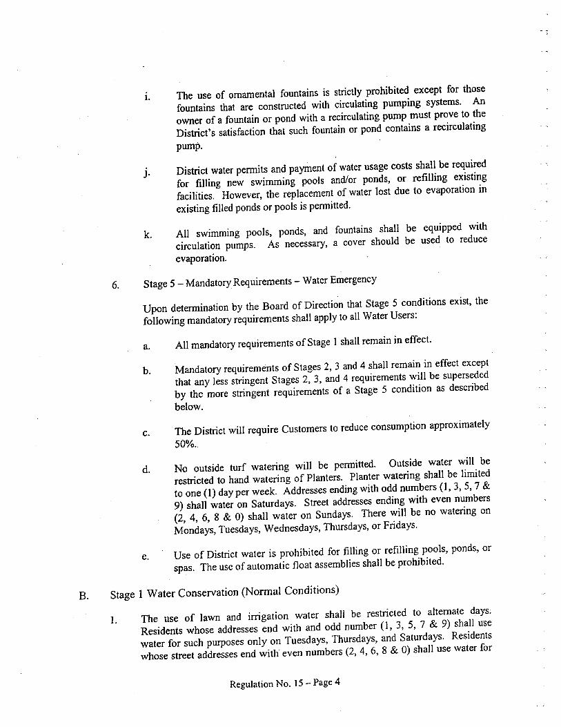
i. The use of ornamental fountains is strictly prohibited except for those
fountains that are constructed with circulating pumping systems. Anowner of a fountain or pond with a recirculating pump must prove to theDistrct's satisfaction that such fountain or pond contains a recirculatingpump.
J. District water penn its and payment of water usage costs shall be required
for fillng new swimming pools and/or ponds, or refilling existingfacilities. However, the replacement of water lost due to evaporation inexisting filled ponds or pools is pennitted.
k. All swimming pools, ponds, and fountains shall be equipped with
circulation pumps. As necessary, a cover should be used to reduceevaporation.
6. Stage 5 - Mandatory Requirements - Water Emergency
Upon detennination by the Board of Direction that Stage 5 conditions exist, thefollowing mandatory requirements shall apply to all Water Users:
a. All mandatory requirements of Stage i shall remain in effect.
b. Mandatory requirements of Stages 2, 3 and 4 shall remain in effect exceptthat any less stringent Stages 2, 3, and 4 requirements will be supersededby the more stringent requirements of a Stage 5 condition as describedbelow.
c. . The District will require Customers to reduce consumption approximately
50%..
d. No outside turf watering wil be pennitted. Outside water wil berestrcted to hand watering of Planters. Planter watering shall be limitedto one (1) day per week. Addresses ending with odd numbers (1,3,5, 7 &9) shall water on Saturdays. Street addresses ending with even numbers(2, 4, 6, 8 & 0) shall water on Sundays. There wil be no watering onMondays, Tuesdays, Wednesdays, Thursdays, or Fridays.
e. Use of District water is prohibited for filling or refilling pools, ponds, orspas. The use of automatic float assemblies shall be prohibited.
B. Stage 1 Water Conservation (Normal Conditions)
1. The use of lawn and irrgation water shall be restricted to alternate days.Residents whose addresses end with and odd number (1, 3, 5, 7 & 9) shall usewater for such purposes only on Tuesdays, Thursdays, and Saturdays. Residents
whose street addresses end with even numbers (2, 4, 6, 8 & 0) shall use water for
Regulation No. 15 - Page 4
such purposes only on Wednesdays, Fridays, and Sundays. No lawn or irrgation
watering shall be pennitted on Mondays.
2. The use of water for washing down sidewalks and/or driveways is strictly
prohibited.
3. All vehicle washing shall be restricted to the use of a bucket or pail, not exceeding
three (3) gallons in capacity, and the use of a hose equipped with an automaticshutoff nozzle.
4. Water Users shall not pennit water to flow into gutters or to 'Collect in pools uponor contiguous to their Parcels.
5. No Water User shall knowingly pennit leaks or waste of water. Where water is
wastefully or negligently used on a Water User's Premises, so as to seriouslyaffect general service, the District may discontinue the service to the Premises ifsuch conditions are not corrected within twenty-four (24) hours after giving theWater User notice. Door hangers shall constitute written notice.
6. Automatic sprinkler system timers are required to be set to operate during periodsof low consumption at off-peak hours between midnight and 5 :()ü a.m. (betw'een2:00 a.m. and 5:00 a.m. is recommended.)
7. In those instances of tenant ~ccupancy, Landowners retain full responsibility for
the actions of their tenants.
8. All new car-washing facilities shall be designed with recirculating systems torecycle rinse water. All remodeled car-washing facilities will be equipped withrecirculating systems prior to reconnection of
water service.
9. The "dump and fill" practice of pool maintenance is prohibited. Pool drainingand refilling shall be allowed only for health, maintenance, or structural con-siderations and in accordance with all County Regulations. Customer requestsmust be submitted in writing by pool consultants and approved by the District.Pool covers are recommended to reduce evaporation.
C. Enforcement
I. The District may discontinue water service to any Parcel when the use of water
thereon constitutes a violation of this Regulation 15 or which results in theassessment of servìce charges for a violation, as defined below.
2. Service charges will be assessed for a violation of the District's conservation rules
in accordance with the following provisions. A Customer will be notified whenviolations may result in service charges.
Regulation No. i 5 - Page 5
Ili., ".
a. Upon observation by authorized District personnel of the existence of aviolation, the District shall request Customer complianc~ in writing bypersonal service, or by certified mail to the billing address of the Parcel uponwhich the violation occurs.
b. Upon observation by authorized District personnel of a second violation ofany kind of this Regulation 15 on the same Parcel, the Customer andLandowner shall be notified in writing at the established billing address, bypersonal service or by certified mail, of the violation and that an additionalcharge for servicing the violation will be added to Customer's next bill inaccordance to Regulation 3, Section L. 1.
c. Upon observation by authorized District personnel of a third violation on thesame Parcel of any kind of this Regulation 15, the Customer and Landownershall be notified in writing at the established billing address, ~y personalservice or by certified mail, of the violation and informed that an additional
, charge for servicing the said violation will be added to Customer's next bil inaccordance to Regulation 3, Section L.2, and that ~ subsequent violation mayresult in disconnection of service.
"
d. On flat rate services, if violations continue upon further observations, theLand.owner shall be notified (in wrting, by personal service, or by certifiedmail of the violation) that a water Meter shall be installed on that ParceL. TheLandowner shall bear the cost of installing such a Meter. The cost shall bebased on the District's costs for time and materials. The installation of thisMeter shall cause the billing to be changed from a flat rate to a Metered Rate.i
The monthly charge for a Metered Service wil be computed at the currentMetered Rate as more specifically set forth in Regulation No.3. Theinstallation of this Metered Service shall be deemed permanent.
e. On existing Metered Services, if water conservation violations continue uponfuher observations, the Landowner shall be notified in writing at theestablished billing address, by personal service, or by certified mail,
of the
violation and informed that an additional charge for servicing
the said
violation will be included in hislher next biling. The amount of
said charge is
as follows:
(i) i -inch or smaller service - 25% of the amount of the water bilfor the month in which the violation occurs.
(ii) 1 Yi inch or larger service - 50% of the amount of the water billfor the month in which the violation occurs.
3. Where a water conservation violation occurs on a Parcel improved with multiplefamily units, and it is not practical to detennine which unit is responsible for theviolation, the District will assess the stated service charge described above in
Regulation No. i 5 - Page 6
iii.' i'
.\
subparagraphs a, b, and c of Paragraph C.2. against each of the units includedwithin the responsible unit or units.
4. The first violation charged to a Parcel shall mark the beginning of the District'smonitoring of water waste for that ParceL. Should no further violations oce,urprior to April 1st of the following year, then that Parcel's violations shall beexpunged and counting of any new violations wil begin on a clean record.Copies of all violations described above shall be kept on fie by the District
throughout the year.
5. , Upon the fifthWater(;onservation violation of a non-metered account and the
third violation on a metered account, the District may discontinue or reduce thewater supply to the Parcel responsible for the violations. To restore service or fullflow capabilities, the affected Customer will be required to request a hearing ofthe District Board of Directors, where the Customer may present evidence to theBoard concerning Customer's violations and request the restoration of waterservice. At its next regular meeting after the hearing, the Distrct Board shall
enter on the record its findings and decision concerning the service restorationrequest and each issue thereunder. The Board's decision wil be finaL. Thesecretary of the Board will mail the Board's wrtten findings and decision to theCustomer within thirty (30) days after the date that the Board renders its decision.
'\
Regulation No. 15 - Page 7

APPENDIX H
Water Conservation Evaluation
'\
~ j
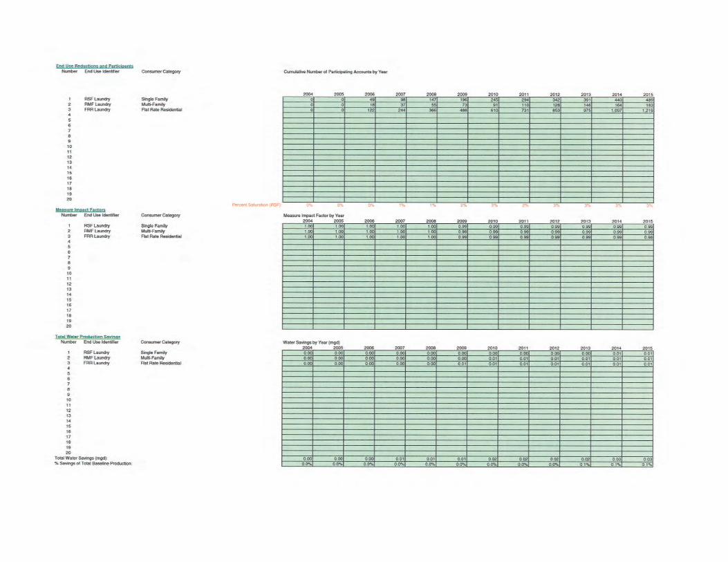

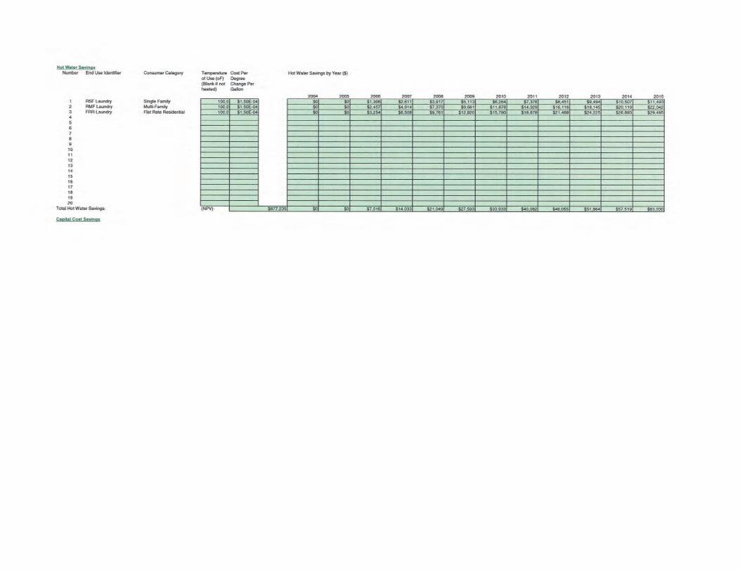

APPENDIX I
DWR UWMP Checklst
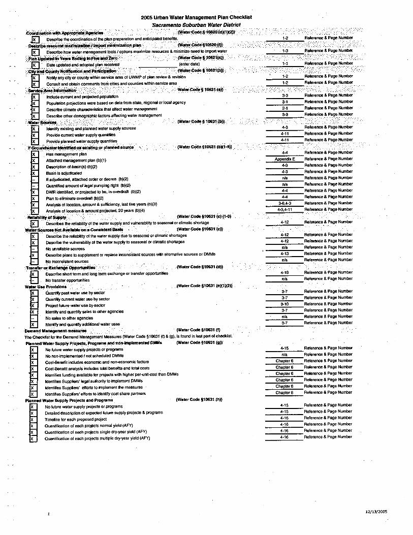
2005 Urban Water Management Plan ChecklistSacramento Suburban Water District
c.i~.wlt~~~¥ï ,.'..','..'.~iÏ".~~:§iii~;(~)(')(2J)..El ,..,
Olscribelt" CQrdina~,n~lth!!PI~np'!!~ration and ~nticipaæd b!n!!lits.. '" ',',., .",' ,', ',',., ,",',' ,',', .,'" " J
"lllì~uril!ìnlizlonI1mi¡1Tinlmlzllanplari, "".'" ',','.'., ,', ,.,,(vial~(:c:§1ll~l1)1'..E1. ','. D!!~rili~OwYlt!!.';a~~geni!!nt ì()ISI~Ptions maid~iz~ ;!!~u.c!!s & minimi.~!!'n-itoimplrt~~t!!.,PIi'Íl :U~ll1IiÝ-iraEiì~!Îiilriij:velliK~' , '(Wir'co§~P!~l(all
qlD"D~t!!UpdaÎllandadoPtllPlan'll",!!d ,',,",',' "'",',, ,(!!nl!!rdat!!) ',.." '" ," ",.;~ii;á~~rI~ci~nl"~~~;.d; ,','; ." "" .,',., "..' '(WlI'(:èi§1ll21(b)),
,','
, I! Noli any city or county within sarvc!! a.!!a 01 UWMP 01 plan .!!vi!!w & r!!vision
I8 Consun and obtain comments Irm.:ni!!s and counti!!s wiin sarvice a.!!ai1Ï1ólÌ'~,¡ni~ri;i';:;' '. " '.' ,w .'. .'. ,',' . ' 'weie.:c#i§ 'll'(aJ1
Iinclud!! curi!!nt and projllll poulation
'X""", .',' ",P, OP, """u, la",Ii.,'"., projllions w, !!.!! basad on data lrom st!!t!!, .egional or lol ag!!ncy
, X Desrib! climet!! cha.act!!ristic that allect wat!!r manag!!m!!nt
.. X , ,Olscrib! oth!!r d!!moraphic lactors alllling wat!!r management
"ltàlerSourè' '" (Wate.Coe § 1ll';(~)) ,
...~.....;.;;:::;~~-"Gl'rich81ll,kkn~l!exlatlrig~piarinø.au,ce (Wel"rCodii.§1~1 (b)(1-4))
X Has management planX Attche manag!!m!!nt plan (b)(l)X Olscription 01 b!sin(s) (b)(2)X Bisin is adjudictll
lIadjudictll, attchllord. or decr"" (b)(2)
Quantlfll amount ollegel pumping right (b)(2)DWR idnlill, o. projllll to b!, in ov!!rdrah (b)(2)Plan to !!Iiminat!! ov!!rdrah (b)(2)
Analysis 01 loction, amount & sul.ci!!ncy, last live Y"ars (b)(3)
." XAnal~lsollolin & amount projllll, 20 Y"ars (b)(4) " " ,.Rtllàlltot SuPP (WaleI' Cod§1ll'(c) (1-3)
ID, ,D!!ritiS lli.!!liabilitolth!! wat!!r sUPJl'y and vulne.ability to seasonal or climatic shortge
¥,-i";" x~=::~:-::::i:;:i~:n;~::;:~:i:ue to s!!asonal or climatic ShO:::e.cod §1061
,1c)l
X Olscrib! th!! vulnerabilty ollh wat!!. supply to s!!asonal or climatic shortages- No unreliable sourcs
'X , '" D!!scrib! plans to suppl!!ment or .!!place inconsistent sources with altemativ!! sourcs or DMMs-- No incnsistent sourcs'-'C'.': ..,.'_._,... - ',',,"TmneoiExè:l' Oppoi,nll (Wat!!.Co§1061 (d))
)E' Describ! short term and long term !!xchange o. transler opportunit!!s
Ð, No t.ansf!!r opportuniti!!s
Wetr"Uae P.rvllone(Wate.Cod!! §1061(eK1)(2))~ Quanli ~st wat!!r usa by seor
X Quanli currnt wat!!. usa by setorX Projelutu.!! wat!!r usa by,setorX , IdllO, t,iI and, 'quantit, sal!!S to oth!!r ag!!ncies
-- No sal!!s 10 oth!!r ag!!ncies
, X Id!!ntil and quanli additional wat!!r us!!s
'D8end Menageni niåsure (Wel!!. Cod!!§1061 ,(I)TIl ClKklistlo. th!! Demand Manag!!m!!nt Measures (Wat!!. Coe §1061 (I) & (9), is lound in last part 01 checklist.
PlannøWet.Supply Pro~. P.ograms andnòn-Implamenled DMMs (Wale. Cod §1061 (g))X No lutur!! wat!!r supply projects or pro.amsX No non-impl!!mentll I not schlluill DMMsX Cost-B!n!!lit includes ecnomic and non-enomic lactorsX Cost-B!n!!fit analysis incud!!s total b!n!!1i and total costsX Id!ntlfies funding av!!i1able lor projec with higher perolnit-cost than DMMsX Id!!ntilies Suppii!!rs' legal authority to impl!!ment DMMs
X Identifies Suppliers' ellort to impl!!m!!nt the m!!asuresX Identifies Supplí!!rs' !!lIort to identify cost shar!! partners
plinned Wale. Supply P.ojects and P.og.ems (Wal!!. Code §1 0631, (h))
I No futu.e water supply projlls or programs
'X Detailed d!scriplion of !!xpel!!d lutur!! supply proj!!cts & programsX Tim!!line 10. !!ach proposad projectX Quantification 01 each projécls normal yi!!ld (AFY)
X Quantilication of each projects single dry-year yield (AFY)X Quantification of !!ach projects multiple dry-year yield (AFY)
4-4
Apndix E4-3
4-3
nla
nla
4-4
4-4
3-,4-34-3,4-11
4-15
nla
Chapter 6
Chapt!!. 6
Chapter 6
Chapt!!r 6
Chapter 6
Chapter 6
4-15
4-15
4-16
4-16
4-16
4-16
1-2
1-2
Rele.enc & Pag! Numb!rRel!!.!!nc & Numb!r
~- ';'-;:t:;-:,\-:-'i-'
3-3
3,1
2-1
3-3
R!!I!!.!!nc & Page Numb!r '
Rel!!.!!nc & Pag!! Numb!r
R!!I!!.enc & Page Numb!r
R!!I!!.!!ri & Page Numb!r
R!!I!!rance & Pag!! Numb!r
R!!le.!!nce & Page Numb!r
R!!le.a~,&Pag!!,Numb!.
R!!I!!.enc!! & Pag!! Numb!r
R!!I!!renc & Pag!! Numb!.
R!!I!!renc & PBg!! Numb!r '
R!!I!!r!!nc & Pag!! Numb!r
R!!I!!.!!nc & Pag!! Numb!r
R!!I!!.!!nc & Pag!! Numb!r
R!!I!!.enc & Pag!! Numb!r
R!!I!!.!!nc & Piig!! Numb!r
R!!f!!.!!nc & Page Numb!r
R!!f!!.!!nc &' Page Numb!r
Rel!!renc & Page Numb!rR!!I!!renc & Pag! Numb!rR!!I!!renc & Pag! Numb!rRel!!renc & Page Numb!rRef!!renc & Pag!! Numb!r
Rel!!r!!nc & Pag!! Numb!r
R!!I!!rence & Page Numb!r
R!!le.!!nc & Page Numb!rR!!I!!.!!nc & Page Numb!rR!!I!!.ence & Pag!! Numb!r
R!!f!!.!!nce & Pag!! Numb!r
R!!I!!.!!nce & Pag!! Numb!.
R!!f!!.!!nc & Pag!! Numb!r
R!!f!!.ence & Page Numb!r
RBf!!renc & Page Numb!r
R!!ler!!nc & Page Numb!r
Relerenc & Page Numb!r
R!!ler!!nce & Page Numb!.
R!!I!!.!!nc!! & Page Numb!.
R!!fer!!nce & Page Numb!r
Ref!!r!!nce & Pag!! Numb!r
R!!fer!!nce & Page Numb!r
Referenc & PBg!! Numb!r
Reference & Page Number
R!!I!!rence & Page Numb!r
Reler!!nce & Page Numb!r
Rele.ence & Page Number
12/13/2005

Referenc,& PagOpportùnitie1òr devilÖprnnlClfdeulinated wrìter (v'~iêrci§1lÏiiljr,"
Ð ' Desribe oprtunities for development of desalinated water, including, but ~t lim'ited ;~, oca~ watar,
brackish water, and groundwater, as a long-term supply " ' "'. '.",','",',"'"Di8trd ,Is aCUWCCalgnaory .(Wa~r ~~1lÏ1iJ)),Urban suppliers that are CUWCC members may submit the annual reports identifyng water demand management measures currently being implemanted, or scule forimplementation, to satisfy the requirements of subdivisions (I) and (g). The supplier's CUWCC Bet Management Practics rert should be attched to the UWMP.
~a , Agenc is a CUWCC member
nla 2oo3,Q annual updates are attached to plannla, Both annual updtes are considered completed by'CUWCC website
II Supplier reIves or pro)K receiving water from a wholesale i1upplier
æ Agency recives or projeclS reciving wholesale water
X Agency provide wrien demand projecions to wholesaler, 20 yearsX ALL wholesalers provied written water availabilit projections, by source, to agency, 20 yearsX Raliability of wholesale supply provided in writing by ALL wholesale agencies
Water Shortage Contingency Plan Section (Water COOe § 1062) ",',' ",'Stage,ofActn(Waier Co§1Ò62(ajj~ Provide slagas of action
~ ,', ::i:::st:~a:~~~r5~u:~~tn:~~:~: ~~~:~: stage
TJireYe,ar,Mlnimum 'WaierSupplÐ Identifiel driest3-year period
'éJ Minimum water supplyavailabie bysourc for the naxt three yaars
Preparalon'forca188lophlc Wal~raUPPiyliilérPllon(YalerCo'~1lÏ2~è))1E Provided catastrophic supply interruption plan - discussed in Chapter 7, Plan not included
due to seurity reasons.
Prohibitns (Wai.cooè:HlÏ(ci))El, List the mandatory prohibitions against speific water use practices during watershortgas ,,' "
Con8umptn Rß!uctlon MelhOOs (Watr Cod§1~(ii))~ " List consumpti~n reducti~n methods ..... 10 reduce water use in the most restrictive stages ';th up ìo a 50% reduction.penallIeS(Waie,COOe51062,(f) ,EI List excass'ive u,se penalties or charges for excessive use ,"
ReveÍl and Expendllurelmpectf (Waler Co§1062(9))~ Describe how actions and conditions impact revenues
X Describe how actions and conditions impact expendituresX Describe measures to overcome the revenue and expenditure impacts
Wat Shortge ConllngencyOrdlnancelesolution (Waler CodS l06(h))El Attach a copy of Ihe draft water shortage contingency resolution or ordinance. '
Reducion Measuring Mechenlsm (WelerCOc§1062 (I))1) Provided mechanisms for determining aclual reductions ' ' ,i: i ~ .
Reccling Plan AgencyCoordlnallon WaterCOOe§ 10633Ð Describe the coordination of the recycling plan preparation information to the extent available..
wasteweiërSysiemDe8crlption(Waler'Co§ 106 (a))1E Describ~ the wastewater cOI,lection and trealment systems in the supplier's service area
EJ Quantify the volume of wastewater collected and treatedW8slewaier.Dlspol and ,Recycled WalerUses
I' Describes methods of wastewater disposal
X Describe the current ty, place and use of recycled waterX Describe and quanti potential uses of recycled waterX Determination of technical and economic feasibility of serving the potential uses
, X No opportunitias for recled water.
Projeed ,Uses of Reccled Waier
Ð Projected use of recled waler, 20 yearsÐ Compare UWMP 200 projections with UWMP 2005 actual (10633(e))
Plan to Opllmlze lJse of Recycled Walar (WalarCOOe§106 (I))~ Describe actions that might be taken to encourage recled water uses
X Describe projected resullS of these actions in terms of acre-feet of recycled water used per yearX, Provide a recycled water use optimization plan which includes actions to faciltate the use of rec,ycled water
Walerquaill Impacts onavallabllil 01 aupply (Waler COOe §106)EJ Discusses water quality impacts (by source) upon water management strategies and supply reliabilityÐ No water quality impacts projected
Supply and Demand Comparison to 20,Years(Waler COOe § 1065 (a))
EJ Compare the projected normal wate~ supply to projected normal water use over the next 20 years, in 5-year increments.Supply end Demand Comparison: Single-ry Year Scenario (WalerCOOe § 1065 (a))
EJ Compare the projected single'dry year water supply to projected single-dry year water use over the next 20 years,in 5-year increments
(Waler Co §1061 (k))4-1
1.2
ApFAppF
(WalerC~l1062(b))4-12
4-12
Chapter 7
Chapter 7
Chapter 7
,. ri-Y\:';;L.".i;',,-,:;_~x, '" , .,- 'C"-/' ~,:
Referenc & Pege Number
Referenc'& Pag NumbrReferenc & Page NumbrRelerenc & Page Numr
'.\;
Referenc & Page NumbrReferenc & Pege Number
Relerenc & Page Number
.;,;~);:!t"/':g;;~~,,-,---:,:--,._;,-'. .::'-'-:, .~: -
Relerenc & Page Number
Relerenc & Page Number.. ,.-- ,......, ....--..,' " ';"./-:,:~":
Referenc &, Pa~ ~~,~~~
Referenc&P~Qe N~";bërReferenc & Page Number
Relerenc & Page Number
Chapter 7
Chapter 5
Chapter 5
Chapter 5
(Waler Co§ 106 (a-d))
(Water COOe § '106 (ë))Chapter 5
Chapter 5
Chapter 5
Chapter 5
Chapter 5
4-11
4-11
7-1
1-Jul
Referenc & Page 'Number
Raferenc & Page Number
Referenc & Page NumbrRafèrenc & Page Number
Releranc & Page Number
Referenc & Page Numbel
Relerenc & Page Number
Raferenc & Page Number
Referenc & Page Numbe
Referenc & Page Number
Referenc & Page Number
Referenc & Pag Number
Reference & Page Number
Referenc & Page Number
Referenc & Page Number
Relerence & Page Numbr
12/13/2005
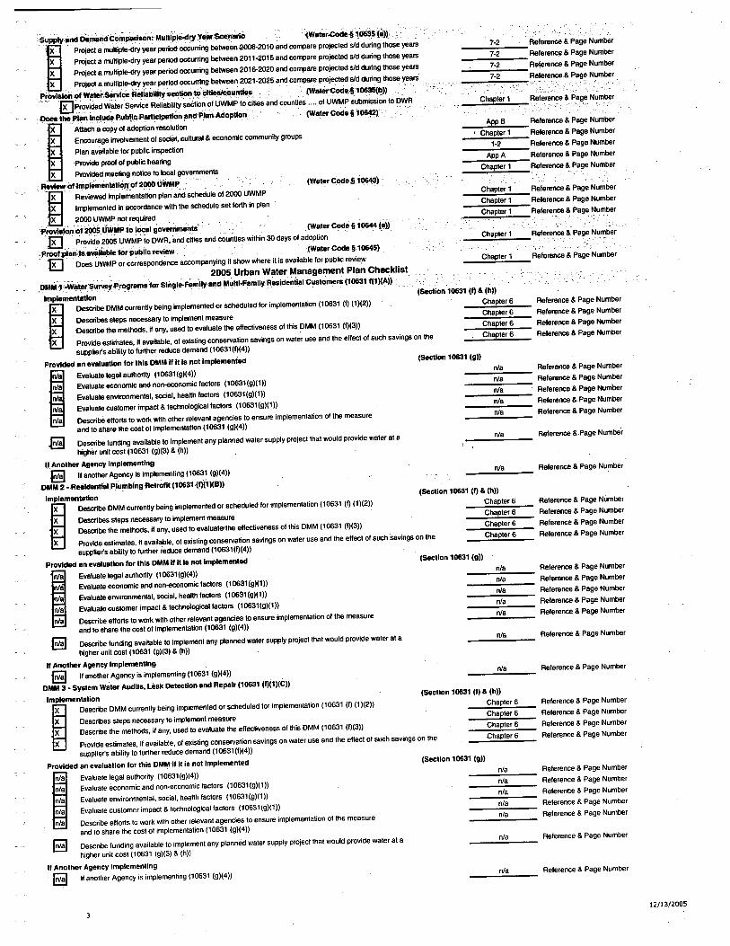
lì~~§ê:igE=:=Tê~~~::.~l, Project a multiple-dry
year period ocurrng betwen2021-2025 and compare projeced sid during those years
ProvliOn :ofWiiSericefle,liabllltaclonto !l1t~untle!l ,(Waier'Code§106(I)))''lK~r?Vided WaterS~rvice Reliabilty selion of UWMP to
cities and counties.... of UWMP submi,ssion to DWR
I)the ,P,IB"lnclu~ Publl!lPBrtIClpøOn¡indPl8n Adoption (WBterCode§ 1~2i
I Attech a copy of adoption resolution
X En,courage, involvement of soial, cultural & economic community groups
X Plan avellable lor public inspectionX Provid prool 01 public hearingX Provided meting notic to locl govemments
R~V""foflnplemeni¡Ci.nDf200 Uytp¡"
~ Reviewed implementation plan and schedule 01200 UWMP
X ,lmpl,em, ,e, nt,ed" in aCCrdan,ce, "with the, ,SChedUie set forth in plan
X 200 UWMP not required'¡'rovliC~f20ÙWM!,to locl governments (Water CodeS 10644
(Bíi
EJ ,Pn¡Vid,,2005 U.WMPto DWR,and ¿ities and counties within 30 days of adoption 'prof:pIn;lUVRll8blefOr,pubIlCrevielN(water Code §,106)
'18 'Òoes UWMP or correspondence accmpanying it show wpere it is available lor public revier-m', ,', " ' ,'" '.'. '" 2005Urban WaterManagementPlan Checklist
D..M ,'~~"llrSul')'prorBinafor Sliigle-FamIIYB,ndMulll-FBmlly R,eaidentl8lCuatomera (1061f(1 )lA))
Implmentøtlon
I, Describe DMM currently being implemented or scheduled for implementation (10631 (I) (1)(2))
X Describe steps necessry to implement measureX Describe the methods, II any, used to evaluete the effectiveness of this DMM (10631 (1)(3))X Provide estimates, if eveilable, of existing conservation savings on water use and the effect of such savings on the
suppliets abilty to lurther reduce demand (10631(1)(4))
Provide an eVRlualon for this DMM If II Is not Implemented
La Evaluate legal authority (1061(g)(4))
nla Evaluate economic and non-enomic lactors (10631 (g)(1 ))
ni Evaluate environmental, soial, health factors (1061(g)(1))
ni Evaluate customer impact & technological factors (10631(g)(1))
nla Describe effort to work with other relevant agencies to ensure implementation of the measureand to share the cost 01 implementation (1061 (g)(4))
.8 Describe funding available to implement any planned water supply project that would provide water at ahigher unit cost (10631 (g)(3) & (h))
If, Another Agency Implementing~ "another Agency is implementing (1061 (g)(4))
:DMM 2 _Rea\cntIaIPlumblngRetrofll(1061,(f)1)(B))
Implementaion; Describe DMM currently being implemented or scheduled for implementation (10631 (I) (1)(2))
X Describes,steps necssary to implement measureX Describe the methods, if any, used to evaluate'lhe effectiveness of this DMM (10631 (1)(3))X Provide estimates, il available, of existing conservation savings on water use and the effect of such Savings on the
suppliets ebilty to further reduce demand (10631(1)(4))
Provided Bn eVBluatlon for this DMM " II la not Implemented
niB Evaluate legal authority (10631(g)(4))
nla Evaluate economic and non-eonomic factors (10631 (g)(1))
nla Evaluate environmental, social, health factors (10631(g)(1))
nla Evaluate customer impact & technologicl factors (10631(g)(1))
nla Describe efforts to work with other relevant agencies to ensure implementation of the measureand to share the cost of implementation (10631 (g)(4))
8 Describe funding available to implement any planned water supply project that would provide water at ahigher unit cost (10631 (g)(3) & (h))
Ii Another Agency Implementing
8 II another Agency is implementing (10631 (g)(4))DMM3 _ Syatem Weter Audlls, Leak Detection Bnd Repair (10631 (f)(1)(C))
Implementation; Describe DMM currently being implemented or scheduled for implementation (10631 (f) (1)(2))
X Describes steps necessary to implement measureX Describe the methods, il any, used to evaluate the effectiveness of this DMM (10631 (f)(3))X Provide estimates, il available, 01 existing conservation savings on water use and the effect of such savings on the
supplier's ability to further reduce demand (10631 (f)(4))
Provided Bn evaluation lor this DMMil it is not implemenled
nla Evaluate legal authorily (10631(g)(4))
nla Evaluate economic and non,economic factors (10631(g)(1))
nla Evaluate environmental, social, health factors (10631(g)(1))
nla Evaluate customer impact & technological factors (10631(g)(1))
nla Describe efforts to work with other relevant agencies to ensure implementation of the measureand to share the cost of implementation (10631 (g)(4))
8 Describe funding available to implement any planned water supply project that would provide water at ahigher unit cost (10631 (g)(3) & (h))
If Another Agency Implementing
8 II another Agency is implementing (10631 (gX4))
AppB, Chepter 1
1-2
AppA
Chapter 1
(WaterCoc5'06í
(Seion 1061 (f) & (h))Chapter 6
Chapter 6
Chapter 6
Chapter 6
(SetiDn 10631 (g))
nla
nla
nla
nla
nla
nla
nla
(Section 10631 (i) & (h))Chapter 6
Chapter 6
Chapter 6
Chapter 6
(Section 10631 (g)1'
(Section 10631 (f) & (h))Chapter 6
Chapter 6
Chapter 6
Chapter 6
(Section 10631 (g))
3
Referenc & Page Number.__ uu.-..,..
Referenc & Page Number
Referenc & Page Number
Referenc & Page Number
Reference & Page Number
Referenc & Page Number
Referenc & Page Number
Reference & Page Number
Relerenc & Page Number
Reference & Page Number
Reference & Page Number
Relerence & Page Number
Referenc & Page Number
Relerenc & Pege Number
Referenc & Page Number
Referenc & Page Number
Referanc &,Page Number
Referenc & Page Number
Referenc &,Pege Numtir
Reference & Page Number
Reference & Page Number
Reference & Page Number
Referenc & Page Number
Referenc & Page Number
nla
nla
nla
nla
nla
Reference & Page Number
Referenc & Page Number
Referenc & Page Number
Refarenc & Page Number
Reference & Page Number
nla Reference & Page Number
nla Reference & Page Number
Relerence & Page Number
Reference & Page Number
Relerence & Page Number
Reference & Page Number
nla
nla
nla
nla
nla
Reference & Page Number
Relerence & Page Number
Reference & Page Number
Relerence & Page Number
Reference & Page Number
nla Reference & Page Number
nla Reference & Page Number
12/13/2005

~Îo4-Meiliî~~Ïi~811~~1cl1.(f)1)(a))..,.'Implemen18tion
æ Desri1lMM currntly being implemented or scheduled jor implementation(1061 (I) ~1)(2))
X Describes steps necssry to implement measureX Describe the methods, if any, use to evaluate the effeciveness of this DMM (1061 (1)3))X Provide estimates, ~ available, of existing conservation savings on water use and tti effect of such savings on the
suplier's abilit to furter reduc demand (10631(1)(4))
Provide an evaluation lor this DMM If Ills not implemented
nla Evaluate lagelauttirity (1061(g)(4))
nla Evaluate ecnoi;lc and non-enomic factors (10631(g)(1))
nla Evaluate envronmental, sol, health factors (1061 (g)(1))
nla Evaluate customer impact & technological factors (1061(g)(1))
nla Describe effort to work with other relavant agencies to ensure implementation of the measureand to share the cost of implementation (10631 (g)(4))
'8 Describe funding available to implement any planned water supply projec that would provide water at ahigher unit cost (10631 (g)(3) & (h))
If Another Agency Implementing
"E1d If another Agenc is imple~enting (1061 (g)(4)) ,DM'i5 ~,LargeUi~~~~ConIlDl;prQlrøm~andinëentlvell 11 061 (1)1)1E))Implemen18tion
i DescribeOMM currenlfy being implemented or scheduled for implementation (10631 (I) (1)(2))
X Describes steps necessry to implement measureX Describe the methods, ~ any, usd to evaluate the effectiveness of
this DMM(10631 (1)(3))
, X Provide estimates, ~ available, of existing conservation savings on waler use and the effec of such savings on thesupplier's abilit to furter reduce demand (10631 (1)(4))
Provide an eval\latlon lor this DMM If II is not Implemented
nla Evaluate legal authrity (10631(g)(4))
nla Evaluate ecnomic and non-enomic factors (10631(g)(1))nla Evaluate environmental, soial, health factors (10631(g)(1))
nla Evaluate customer impact & technologicl factors (1061(g)(1))
nla Describe effort to work with other relevant agencies to ensure implementation of the measureand to share the cost of implementation (1061 (g)(4))
EI Describe funding available to implement any planned water supply projec that would provide water at ahigher unit cost (1061 (g)(3) & (h))
If Another Agency Implementing
J~ ,lIanother Agencyisimple~enting(10631 (g)(4)) " 'DMM6-Hlgh-'fffclency WiishlngMati1niiRebae ,Programs (10631(1)1 )(F))Implementation '\
ia Describe DMM currently bein!! implemented or scheduled lor implementation (1061 (I) (1 )(2))
nla Desribes sleps necssry to implement measure
nla Describe the methods, ~ any, use to, evaluate the effectiveness of this DMM (10631 (1)3))
nla Provide e~timates, if available, of existing conservation savings on water use and the effec of such savings on thesupplier's abilty to further reduce demand (10631 (f)(4))
Provided an eveluation lor this DMM If Ills not Implemented
I Evaluate legal authority (1061(g)(4))
X Evaluate economic end non-enomic factors (10631(g)(1))X Evaluate environmental, social, health faCtors (10631(g)(1))X Evaluate customer impact & techno,logicalfactors (10631 (g)!1))X Describe efforts to work with other relevant agencies to ensure implementation of the measure
and to share the cot of implementation (10631 (g)(4))
EJ Describe funding available to implement any planned water supply project that would provide water at ahigher unit cot (1061 (g)(3) & (h))
If Another Agency Implementing
8 If another Agency is implementing (10631 (g)(4))DMM 7 _ Public 1nlormatlon Programs (1061 (f)1)(G))
Implemen18tion
'i Describe DMM currently being implemented or scheduled for implementation (10631 (I) (1)(2))
X Describes steps necessary to implement measureX Describe the methods, if any, used to evaluate the, effectiveness of this DMM (10631 (1)(3))X Provide estimates, ~ available, of exisling conservation savings on water use and the effect of such savings on the
supplier's ability to further reduce demand (10631 (f)(4))
Provided an evaluation lor this DMM Ii It Is not Implemented
nla Evaluate legal authority (10631(g)(4))
nla Evaluate economic and non-economic factors (10631 (g)(1))
nla Evaluate environmental, social, health factors (10631(g)(1))
nla Evaluate customer impact & technological factors (10631(g)(1))
nla Describe ellorts to work with other relevant agencies to ensure implementation of the measure
and to share the cost of implementation (10631 (g)(4))
EI Describe funding available to implement any planned water supply project that would provide water at ahigher unit cost (10631 (g)(3) & (h))
If Another Agency Implementing~ II another Agency is implementing (10631 (g)(4))
4
(Seion 1 061 (g))nla
nla
nla
nla
nla
nla
Referenc & Page Number
Referenc & Page Number
Reference & Page Number
Re1erenc & Page Number
Referenc & Page Number
Referenc & Page Number
Referenc & Page Number
Reference & Page Number
Referenc & Page Number
Referenc & Page Number
(Section 10631 (I) & (h))Chapter 6
Chapter 6
Chapter 6
Chapter 6
(Seion 1061 (g))nla
nla
nla
nla
nla
nla
nla
(Section 10631 fi & (h))nla
nle
nla
nla
Chapter 6
nla
(Seion 10631 (I) & (h))Chapter 6Chapter 6Chapter 6
Chapter 6
(Section 1 0631 (g))nla
nla
nla
nla
nla
Reference & Page Number
Referenc & Page Number
Referenc & Page Number
Referenc & Page Number
Referenc & Page Number
Referenc & Page Number
Referenc & Page Number
Reference & Page Number ,Referenc & Page Number
Reference & Page Number
Reference & Page Number
Reference & Page Number
Referenc & Page Number
Reference & Page NumbrReferenc & Page Number
I
Reference & Page Number
Referenc & Page Number
Reference & Page Number
Reference & Page Numbe.
Referenc & Page Number
Referenc & Page Number
Reference & Page Number
Referenc & Page Number
Reference & Page Number
Reference & Page Number
Reference & Page Number
Reference & Page Number
Reference & Page Number
Reference & Page Number
Reference & Page Number
Reference & Page Number
nla Reference & Page Number
nla Relerence & Page Number
12/13/2005
iiMM."~:&001:i~lItlÒpRir8m&(1061(fJ1)(H))Implementation
I Desribe DMM currently being implemented or scheduled lor implementation (10631 (I) (1)(2))
'X ,Desribes steps necesary to implement measure
X Describe the methods, II any, use to evaluate the effeciveness of this DMM (10631 (1)(3))
X Provide estimates, il available, of exisling conservation savings on water use and the effec 01 such savings on thesupplier's abilit to further reduc demand (10631 (1)(4))
Provide an evaluaion lor this DMM If It is not Implemented
nls Evaluate legl authority (1061(g)(4))
nla Evaluate ecnomic and non-enomic lactors (1061(g)(1))
nla Evaluate anvironmental, social, health factors (10631(g)(I))
nla Evaluate customer impact & technologicallactors (10631(g)(1))
nla Describe effort to work with other relevant agencies to ensure implementation of the measureand to share th cost of implementation (10631 (g)(4))
~ Describe funding available to implement any planned water supply project that would provide water at a
higher unll cost (10631 (g)(3) & (h)) ,If Another Agency Implementing
,13 If another Agenc is implementing (1061 (g)(4))DMM:9-:onservtlo" prorøms for Commercial. Industrial and Institutional (1 0631(f)1 )(1))
Implementation
æ Describe DMM currently being implemented or scheduled I?r implementation (10631 (1)'1)(2))
X Describes steps necessary to implement measureX Dascribe the methods, II any. used to evaluate the effectiveness of this DMM (10631 (1)(3))
, X Provide estimates, II available, 01 existing conservation savings on water use and the effect of such savings on thesupplier'S abilty to lurther reduce demand (10631(1)(4))
Provide an evaluation for this DMM lilt Is not Implemented
nla Evaluate legl authori (1061(g)(4))
nla Evaluate ecnomic and non-eonomic lactors (10631(g)(1))
nla Evaluate environmental, social, health lactors (1061 (g)(l))nla Evaluate customer impact & technologicaiiactors (10631(g)(l))
ni Describe efforts to work with other relevant agencies to ensure implementation of the measureend to share the cost 01 implementation (1061 (g)(4))
8 Describe funding available to implement any planned water supply project that would provide water at a
higher unit cost (10631 (g)(3) & (h))
If Another AgencY Implementing
8 If another Agency is implemanting (10631 (g)(4))
DMM 1,0- WtileleAgency'Progrøms(1 0631 (f)1 )(J))Implementation
I Describe DMM currently being implemented or scheduled lor implementation (10631 (f) (1)(2))
X Describes steps necessry to implement measureX Describe the methods, if any, used to evaluate the effectiveness of this DMM (10631 (1)(3))X Provide estimates, il available, 01 existing conservation savings on water use and the effect of such savings on the
supplier's abilty to lurther reduce demand (10631 (1)(4))
Provided an evaluation for this DMM If it Is not Implemented
nla Evaluate legal authority (10631(g)(4))
nla Evaluate ecnomic and non-enomic lactors (10631(g)(1))
nla Evaluate environmental, social, health lactors (10631(g)(I))
nla Evaluate customer impact & technologicallactors (10631(g)(l))
nla Describe efforts to work with other relevant agencies to ensure implementation of the measureand to share the cost of implementation (10631 (g)(4))
8 Describe lunding available to implement any planned water supply project that would provide water at ahigher unit cost (10631 (g)(3) & (h))
If Another Agency Implementing
8 If anolher Agency is implementing (10631 (g)(4))DMM 11 - Conse,rvlon Pricing (1061 (f)1 )(K))
Implementation
æ Describe DMM currently being implemented or scheduled loriinplementation (10631 (I) (1)(2))
X Describes steps necessary to implement measureX Describe the methods, if any, used to eveluate the effectiveness of this DMM (10631 (1)(3))X Provide estimates, if available, 01 existing conservation savings on water use and the effect of such savings on the
supplier's ability to further reduce demand (10631(1)(4))
Provided an evaluation for this DMM il it Is not implemented
ni tvaluate legal authority (10631(g)(4))
nla Evaluate economic and non-economic factors (10631(g)(l))
nla Evaluate environmental, social, health factors (10631(g)(l))
nla Evaluate customer impact & technological factors (10631(g)(I))
nla Describe efforts to work with other relevant agencies to ensure implementation of the measureand to share the cost of implementation (10631 (g)(4))
8 Describe funding available to implement any planned water supply project that would provide water at ahigher unil cost (10631 (g)(3),& (h))
ii Another Agency Implementing
8 II another Agency is implementing (10631 (g)(4))
(Seion 1 0631 (I) & (h))
Chapter 6
Chapter 6
Chapter 6
Chapter 6
(Seion 10631 (g))
nla
nla
nla
nla
nla
nla
nla
(Setion 1061 (1)& (h))Chapter 6
Chapter 6
Chapter 6
Chapter 6
(Seion 1061 (g))nla
nla
nla
nla
nla
nla
nla
(Setion 1063111 & (h))
Chapter 6
Chapter 6
Chapter 6
Chapter 6
(Setion 1 061 (g))
nla
nla
nla
nla
, nla
nla
(Setion 10631 (I) & (h))
Chapter 6
Chapter 6
Chapter 6
Chapter 6
(Setion 1061 (g))
Referenc & Page Number
Referenc & Page Number
Referenc & Page Number
Referenc & Page Number
Referenc & Page Number
Reference & Page Number
Referenc & Page Number
Reference & Page Number
Referenc & Page Number
Referenc & Page Number
Reference & Page Number
Relerence & Page Number
Referenc & Page Number
Referenc & Page Number
Referenc & Page Number
Reference & Page Number
Reference & Page Number
Reference & Page Number
Referenc & Page Number
Referenc & Page Number
Referenc & Page Number
Referenc & Page Number,
Reference & Page Numbe
Reference & Page Number
Reference & Page Number
Reference & Page Number
Reference & Page Number
Reference & Page Number
Reference & Page Number
Reference & Page Number
Reference & Page Number
Relerence & Page Number
nla Referenc & Page Number
Referenc & Page Number
Reference & Page Number
Relerence & Page Number
Reference & Page Number
nla
nla
nla
nla
nla
nla
nla
Reference & Page Number
Reference & Page Number
Reference & Page Number
Reference & Page Number
Reference & Page Number
Reference & Page Number
nla Reference & Page Number
12/13/2005
c 1
i:Mr.:t2'~.'Wli~~niiÍVti()~rtoO¡.¡t()r(1~1(f)1)(L))Implementation
æ Describe DMM currently being implemented or scheduled for implementation (1061 (I) (1 )(?))
X 'Describes steps necssary to implement measureX Describe the methods, if any, used to evaluate the ellectiveness of this DMM (10631 (1)(3))X Provide estimates, Ifaveilable, of existing conservation savings on water use and the ellec of suc savings on the
supplier's abililto further reduc demand (1061(1)(4))
Provided an evaluation for this DMM " h Is notlmplamented
I Evaluate legal authority (10631(g)(4))
nJ Evaluate ecnomic and non-enomic factors (1061(g)(1))
nla Evaluate envirdnmental, social, health factors (1061(g)(1))nla Evaluate customer impact & technologicl factors (10631(g)(1))
nla Describe ellorts to work with other relevant agencies to ensure implemenlation of the measureand to share the cost of implementetion (10631 (g)(4))
8 Describe funding available to implement any planned water supply project that would provide water at a
higher unit cost (1061 (g)(3) & (h))
If Another Agency Implementing
I~" If another Age~y is implementing (1061 (g)(4))
D,MM13 .wiisìe WaterPro"lbll!,I1~1 tf)1)(l"ll,
Implementation
æ Describ~,i;MM currently being implemented or scheduled for implementation (10631 (I) (1)(?))
X De~ribes steps necssary to implement measureX Describe the methods, if any, used to evaluate the ellectiveness of this DMM (10631 (1)(3))X Provide estimates, if available, of existing conservation savings on water use and the ellect of such savings on the
supplier's abilty to further reduce demand (10631 (1)(4))
Provl8d an evafuetlon for this DMM If h is not Implemented
I Evaiuat~ I~gal authOri (10631(g)(4))
ni Evaluate ecoriomic and non-economic factors (1061(g)(1))
nla Evaluate environmental, social, heallh factors (1061(g)(1))nla Evaluate customer impact & technological factors (10631(g)(1))
nla Describe ellorts to work with other relevant agencies to,ensure implementation of the measureand to share the cost of implementation (10631' (g)(4))
~ Describe funding available to implement any planned water supply project that would provide water at ahigher unit cost (1061 (g)(3) & (h))
" Another Agency Implementing
8 If another Agency is implementing (10631 (g)(4)) ,DMM14 -Residential Uhra-Low-FlushToUet ReplacementPrograms (1061 (1)(1)(N))
Implementation
I Describe tlMNI currently being implemented or scheduled for implementation (10631 (I) (1)(2))
X Describes steps necessry to implement measureX Describe the methods, if any, used to evaluate the ellectiveness of this DMM (10631 (1)(3))X Provide estimates, il available, of existing conservation savings on water use and the ellect of such savings on the
supplier's'abi,lity to further reduce demand ~1 0631 (1)(4))
Provided an evaluation for this DMMII It Is not implemented
nla Evaluate legal authority (10631(g)(4))
nla Evaluate ecnomic and non-enomic factors (10631(g)(1))nla Evaluate environmental, social, heallh factors (10631(g)(1))
nla Evaluate customer impact & technological factors (10631(g)(1))
nla Describe ellorts to work with other releilant agencies to ensure implementation at the measure
and to share the cost of implementation (1061 (g)(4))
8 Describe funding available to implement any planned water supplyprojecl that would provide water al ahigher unil cost (10631 (g)(3) & (h))
" Another Agency Implementing~ If another Agency is implementing (10631 (g)(4))
(Setion 1061 (I) & (h))Chapter 6
Chapter 6
Chapter 6
Chapter 6
(Setion 10631 (g))
nla
nla
nla
nla
nla
nla
nla
nla
(Seion 10631 (I) & (h))
Chapter 6
Chapter 6
Chapter 6
Chapter 6
(Seion 10631 (g))
nla
nla
nla
nla
nla
nla
nla
nla
(Secion 10631 (I) & (h))Chapter 6
Chapter 6
,Chapter 6
Chapter 6
(Seion 10631 (g))
'6
nla
nla
nla
nla
nla
nla
nla
Referenc & Page Number
Referenc & Page Number
Refere & Page Number
Referenc & Pag Number,
Referenc & Page Number
Referenc & Page Number
Referenc & Page Number
Referenc & ,Page Number
Referenc & Page Number
Referenc & Page Number
Referenc & Page Number,. u__ ,.""" ._u_.__ .
Referenc & Page Number
Referenc & Page Number
, Referenc & Page Number
Referenc & Page Number
Referenc & Page Number
Referenc & Page Number
Referenc & Page Number
Referenc & Page Number
Referenc & Page Number
Referenc & Pege Number
Referenc & Page' Number
Referenc & Page Number
Referenc & Page Number
Referenc & Pege Number
Raference & Page Numberi i
Referenc & Page Number
Referenc & Page Number
Referenc & Page Number
Referenc & Page Number ,Referenc & Page Number
Referenc & Page Number
Referenc & Page Number
12/13/2005