Preparation of Integrated Urban Development Plan (IUDP) of ...
217
Government of Nepal Ministry of Urban Development Department of Urban Development and Building Construction (DUDBC) Babarmahal, Kathmandu Final Report On Preparation of Integrated Urban Development Plan (IUDP) of Changunarayan Municipality Volume I: Main Report Submitted by: Sustainable Development and Research Centre Pvt. Ltd, C2TECH(P) Ltd and RES Engineering Consultancy (JV) Nayabazar, Kathmandu 2077 B.S.
-
Upload
khangminh22 -
Category
Documents
-
view
2 -
download
0
Transcript of Preparation of Integrated Urban Development Plan (IUDP) of ...
Government of Nepal
Ministry of Urban Development
Department of Urban Development and Building Construction (DUDBC)
Babarmahal, Kathmandu
Final Report On
Preparation of Integrated Urban Development Plan (IUDP) of
Changunarayan Municipality
Volume I: Main Report
Submitted by:
Sustainable Development and Research Centre Pvt. Ltd,
C2TECH(P) Ltd and RES Engineering Consultancy (JV)
Nayabazar, Kathmandu
2077 B.S.
i
Project Information
Submission Information
Name of the Report Integrated Urban Development Plan (IUDP) of Changunarayan
Municipality, Bhaktapur District
Nos. of Volumes 5 (Five)
Version No 1
Submission Type Hard Copy and Soft Copy
Copies Produced For Client : 3 (Three)
Team Composition
S.N. Designation Name NEC No. Signature
1. Team Leader/Urban Planner Anjan Raj Shrestha 210 A Architecture
2. Urban Planner Rajendra M Shrestha 807 A Civil
3. Urban Planner Kedarman Shrestha 722 A Civil
4 Urban Planner Baburam Bhattarai 117 A Architecture
5. Urban Planner Kiran Man Joshi 591 A Architecture
6. Environmental Expert Dipak Kumar Amatya
7. Data Analyst Kiran Maharjan
8. Data Analyst
9. GIS Expert Asish Joshi
10. Gis Expert Krishna P Poudel
11 Economist/Financial expert Keshab Raj Pathak
12. Sociologist Rupa Pathak
13. Structural Engineer Binaya C Shrestha 616 A Civil
14. Structural Engineer Shivaram Dhakal 6099 A Civil
15. Water Supply/ Sanitary En Suvash Chand 1345 A Civil
16. Water Supply/ Sanitary En Mangal R Shrestha 666 A Civil
17. Geotechnical Engineer Budhi R Joshi 5570 A Civil
18. HV/AC Engineer Ramesh Khanal 460 A Mechanical
Name of the Project Preparation of Integrated Urban Development Plan (IUDP)
Name of the Client
Department of Urban Development and Building Construction
(DUDBC)
Ministry of Urban Development
Babarmahal, Kathmandu
Name of the Consultant Sustainable Development and Research Centre Pvt.Ltd, C2TECH (P)
Ltd. and RES Engineering Consultancy (JV) Nayabazar, Kathmandu.
ii
Acknowledgement
The Integrated Urban Development Plan (IUDP) of Chagunarayan Municipality has been
prepared under the Contract Agreement between Department of Urban Development and
Building Construction (DUDBC), Babarmahal, Kathmandu and Sustainable Development and
Research Centre Pvt.Ltd, C2TECH (P) Ltd. and RES Engineering Consultancy (JV) Nayabazar,
Kathmandu. We would like to convey our indebtedness to DUDBC for entrusting us the
responsibility to carry out the task of preparing of IUDP.
We would like to express gratitude to Mr. Maniram Gelal, Director General of DUDBC,
Mr.Padma Kumar Mainali, Deputy General Director of DUDBC, Mrs Mira Gywali for their
valuable suggestion and motivation. Further, we convey special thanks to Mrs. Bidya Sing
Architect, Mr. Mr. Samin Paudel civil engineer and Saurav Marasini. civil engineer
We would like to extend sincere thanks to Mr. Som Prasad Misra, Mayor of Chagunarayan
Municipality and Mrs. Bina Bastola, Deputy Mayor of Chagunarayan Municipality. We would
also like to express our special thanks to Mr. Chiranjibi Temsina, Chief Administrative officer
of Municipality & Member of steering committee, Head of technical Section, Planning Section
and other concerned section of the Municipality for their valuable time, support and for their
valuable comments and suggestions during preparation of Integrated Urban Development Plan
(IUDP). We would like to express special thanks chairman of all wards and ward member for
their coordination during field visit and project identification.
Last but not the least, we are also grateful to all technical and management team involved in
IUDP preparation. The acknowledgement will be incomplete if we ignore the support obtained
from each and every individual of the municipality along with their patience. Finally, we would
like to thanks all the helping hands involved directly or indirectly in the preparation of this report.
SDRC/C2TECH/RES
iii
Table of Content
Project Information ......................................................................................................................... i
Submission Information ................................................................................................................. i
Team Composition ......................................................................................................................... i
Acknowledgement ......................................................................................................................... ii
Table of Content ........................................................................................................................... iii
List of Chart ................................................................................................................................ viii
List of Figure ................................................................................................................................ ix
List of Map .................................................................................................................................... x
List of Table ................................................................................................................................. xi
sfo{sf/L ;f/f+z ................................................................................................................................. xiv
Executive Summary .................................................................................................................. xviii
Acronyms/Abbreviations .......................................................................................................... xxiii
Chapter 1: Introduction .............................................................................................................. 1
1.1 Background of the Project ................................................................................................. 1
1.2 Objectives of the Study ..................................................................................................... 2
1.3 Understanding Scope of Work .......................................................................................... 2
1.4 Expected Output ................................................................................................................ 3
1.5 Structure of Report ............................................................................................................ 7
Chapter 2: Methodology ............................................................................................................. 9
2.1 Conceptual Frameworks .................................................................................................... 9
2.2 Field Team Mobilization ................................................................................................. 11
2.3 Secondary Data Collection and Conducting Survey ....................................................... 11
2.4 Public Consultation Plan ................................................................................................. 12
2.5 Primary Data Collection .................................................................................................. 12
2.6 Preparation of GIS Base Map and Thematic Maps ......................................................... 13
2.7 Data Analysis ................................................................................................................... 13
2.8 Vision Setting .................................................................................................................. 14
2.9 Sectoral Development Plan ............................................................................................. 14
2.10 Multi Sectoral Investment Plan ....................................................................................... 14
2.11 Preparation of DED ......................................................................................................... 15
2.12 Preparation of Building Bye-Laws .................................................................................. 15

iv
Chapter 3: Existing Situation ................................................................................................... 16
3.1 Existing Scenario ............................................................................................................. 16
3.2 Municipality Composition ............................................................................................... 16
3.3 Physical Status ................................................................................................................. 17
3.4 Demographic Status ......................................................................................................... 18
3.5 Social Status .................................................................................................................... 19
3.6 Economic Status .............................................................................................................. 19
3.7 Health and Sanitation ...................................................................................................... 20
3.8 Drinking Water Status ..................................................................................................... 20
3.9 Environment Status ......................................................................................................... 21
Chapter 4: Situation Analysis of the Municipality ................................................................. 22
4.1 Trend Analysis ................................................................................................................. 22
4.1.1 Demographic Analysis ............................................................................................ 22
4.1.1.1 Population Growth Rate ...................................................................................... 22
4.1.1.2 Ethnic Distribution .............................................................................................. 23
4.1.1.3 Age and Household Size ..................................................................................... 23
4.1.1.4 Population Projection .......................................................................................... 24
4.1.1.5 Migration Trend Analysis .................................................................................... 25
4.1.2 Land Use Analysis & Urbanization ......................................................................... 25
4.1.2.1 Existing Land use 2018 ....................................................................................... 26
4.1.2.2 Housing/settlements ............................................................................................ 27
4.1.2.3 Existing Urban Structure ..................................................................................... 31
4.1.2.4 Change in the Built-Up Area, Agriculture Land, Water body, Forest ................ 32
4.1.2.5 Risk Analysis ....................................................................................................... 33
4.1.2.6 Open Space .......................................................................................................... 34
4.2 Spatial Analysis ............................................................................................................... 35
4.3 Social Analysis ................................................................................................................ 41
4.3.1 Social Infrastructure ................................................................................................ 41
4.3.2 Education ................................................................................................................. 43
4.3.3 Health ...................................................................................................................... 45
4.3.4 Other Social Institution ............................................................................................ 46
4.3.5 Recreation ................................................................................................................ 47

v
4.3.6 Inclusion .................................................................................................................. 47
4.4 Economic Analysis .......................................................................................................... 52
4.4.1 Agriculture ............................................................................................................... 52
4.4.2 Livestock ................................................................................................................. 55
4.4.3 Mining ..................................................................................................................... 57
4.4.4 Industry .................................................................................................................... 57
4.4.5 Business and Sales ................................................................................................... 58
4.4.6 Import and Export .................................................................................................... 59
4.4.7 Commercial ............................................................................................................. 59
4.5 Financial Analysis ........................................................................................................... 60
4.5.1 Income and Expenditure of Municipality ................................................................ 60
4.6 Institutional Analysis ....................................................................................................... 64
4.7 Linkage Analysis ............................................................................................................. 65
4.7.1 Linkage Analysis at Regional Level ........................................................................ 65
4.8 SWOT Analysis ............................................................................................................... 66
4.9 Demand Analysis of Infrastructures ................................................................................ 72
4.9.1 Physical Infrastructure Demand Analysis ............................................................... 72
4.9.2 Social Infrastructure Demand Analysis ................................................................... 76
4.9.3 Economic Infrastructure Demand Analysis ............................................................. 78
4.10 Potential Lead Sector Identification ................................................................................ 80
Chapter 5: Development Framework for Municipality ......................................................... 84
5.1 Vision of Municipality .................................................................................................... 84
5.2 Goals ................................................................................................................................ 85
5.3 Objectives ........................................................................................................................ 85
5.4 Strategy ............................................................................................................................ 85
5.5 Plan for Implementing Development Framework ........................................................... 86
Chapter 6: Sectoral Development Plan ................................................................................... 88
6.1 Introduction ..................................................................................................................... 88
6.2 Physical Development Plan ............................................................................................. 88
6.2.1 Land Use Zoning ..................................................................................................... 89
6.2.2 Urban Expansion ..................................................................................................... 95
6.2.3 Infrastructure Development ..................................................................................... 96
vi
6.2.4 Physical Development Issues and Problems ........................................................... 96
6.3 Urban Infrastructure Plan ................................................................................................ 97
6.3.1 Water Supply ........................................................................................................... 98
6.3.2 Waste Water .......................................................................................................... 100
6.3.3 Drainage ................................................................................................................ 101
6.3.4 Solid Waste ............................................................................................................ 101
6.3.5 Electricity .............................................................................................................. 102
6.4 Urban Transport Plan .................................................................................................... 104
6.4.1 Road Classification with RoW .............................................................................. 105
6.4.2 Road Network ........................................................................................................ 106
6.4.3 Parking Management ............................................................................................. 107
6.4.4 Issues and Problems .............................................................................................. 110
6.5 Social Development Plan .............................................................................................. 111
6.5.1 Education ............................................................................................................... 112
6.5.2 Public Health ......................................................................................................... 112
6.5.3 Security .................................................................................................................. 113
6.5.4 Cultural and Sports ................................................................................................ 114
6.5.5 Parks and Open Space ........................................................................................... 114
6.5.6 Urban Social Service Centers ................................................................................ 115
6.5.7 Social Development Issues and Problems ............................................................. 120
6.6 Economic Development Plan ........................................................................................ 120
6.6.1 Industrial Development and Trade Promotion ...................................................... 122
6.6.2 Employment Generation, Poverty Reduction ........................................................ 122
6.6.3 Regional Competitiveness of Municipality ........................................................... 123
6.6.4 Agriculture Development ...................................................................................... 123
6.6.5 Strategic Location of Different Market Center/Product Collection Center ........... 124
6.6.6 Possible Economic Zones Based on Local Economic Growth Potentials ............. 124
6.6.7 Potentials and Problems of Economic Development Plan .................................... 126
6.7 Tourism and Cultural Development Plan ...................................................................... 128
6.7.1 Identification and Preservation of Cultural Heritages Site. ................................... 128
6.7.2 Conservation of both Material and Non Material Cultures. .................................. 129
6.8 Financial Development Plan .......................................................................................... 132
vii
6.8.1 Municipality Revenue Improvement Plan ............................................................. 132
6.8.2 Assessment of Possible Financial Resources ........................................................ 133
6.8.3 Allocation of Development Budget ....................................................................... 139
6.8.4 Promotional Strategy of private Sector and Civil Society ..................................... 139
6.8.5 Financial and Economic Analysis ......................................................................... 140
6.8.6 Issues and Problems .............................................................................................. 141
6.9 Environmental Management Plan ................................................................................. 142
6.9.1 Present Status ......................................................................................................... 143
6.9.1.1 Urban Greenery ................................................................................................. 145
6.9.1.2 Conservation of Environmental Sensitive Areas ............................................... 145
6.9.2 Issues and Problems .............................................................................................. 146
6.9.3 Strategy of Environmental Management Plan ....................................................... 147
6.10 Disaster Management Plan ............................................................................................ 149
6.10.1 Present Status ..................................................................................................... 149
6.10.2 Pre-Disaster Plan ............................................................................................... 153
6.10.3 Immediate and Post-Disaster Action Plan ......................................................... 154
6.10.4 Issues and Problems .......................................................................................... 156
6.10.5 Adaptation Strategy for Disaster Management ................................................. 157
6.11 Institutional Development Plan ..................................................................................... 158
6.11.1 Plan and Programs ............................................................................................. 158
Chapter 7: Multi-sectoral Investment Plan .......................................................................... 165
7.1 Introduction ................................................................................................................... 165
7.2 Short-term MSIP ........................................................................................................... 166
7.3 Mid-term MSIP ............................................................................................................. 176
7.4 Long-term MSIP ............................................................................................................ 180
Chapter 8: DED Projects ........................................................................................................ 184
8.1 Introduction ................................................................................................................... 184
8.2 DED of Selection ........................................................................................................... 184
8.3 DED of Major Projects .................................................................................................. 186
Bibliography ............................................................................................................................. 190
viii
List of Chart
Chart No 1: Flow Chart of Methodology ................................................................................ 10
Chart No 2: Field Mobilization Chart ..................................................................................... 11
Chart No 3: Population Projection .......................................................................................... 24
Chart No 4: Damage Status ..................................................................................................... 29
Chart No 5: Reconstruction Status .......................................................................................... 29
Chart No 6: Retrofit Status ...................................................................................................... 30
Chart No 7: Ward-wise Road Density ..................................................................................... 32
Chart No 8: Road Development Trend .................................................................................... 40
Chart No 9: Land Suitability Chart ......................................................................................... 40
Chart No 10: Ward wise Ethical Group .................................................................................. 48
Chart No 11: Religion Distribution ......................................................................................... 49
Chart No 12: Literacy Status ................................................................................................... 50
Chart No 13: Financial Source of Municipality ...................................................................... 62
Chart No 14: 15 yrs Budget Projection ................................................................................... 63
Chart No 15: Linkage at Regional Level ................................................................................. 65
Chart No 16: Local Level Interrelationship ............................................................................. 66
Chart No 17: Lead sector and Connection with Vision ........................................................... 81
Chart No 18: Organizational Chart of Ward Office .............................................................. 160
ix
List of Figure
Figure No 1: General Landscape of Changunarayan Municipality and Field consultation .... 12
Figure No 2: Recently Blacktopped Road at Changunarayan ................................................. 18
Figure No 3: Earthen Road at Municipality ............................................................................ 18
Figure No 4: Aerial View of Changunarayan Municipality 2005 &2018 ............................... 26
Figure No 5: House damaged due to Earthquake Near Changunarayan ................................. 30
Figure No 6: RCC Frame House Build after the Earthquake .................................................. 30
Figure No 7 : Built up Area of Changunarayan ...................................................................... 38
Figure No 8: Nepal Engineering College at Changunarayan .................................................. 44
Figure No 9: Kathmandu Cancer Care, Tathali ....................................................................... 45
Figure No 10: Buddha Peace Park ........................................................................................... 47
Figure No 11: Agriculture at Changunarayan ......................................................................... 54
Figure No 12: Paddy Cultivation at Changunarayan ............................................................... 54
Figure No 13: Goat farm ......................................................................................................... 56
Figure No 14: Sand and Soil Mining near Manohara River .................................................... 57
Figure No 15: Sand and Soil Mining near Manohara River .................................................... 58
Figure No 16: Hotel Hiking ..................................................................................................... 59
Figure No 17: Agriculture at Changunarayan ......................................................................... 81
Figure No 18: Changu Village ................................................................................................ 83
Figure No 19: Concept of proposed Bus Parks ..................................................................... 108
Figure No 20: Proposed Bus Stops (source: google.com) ..................................................... 108
Figure No 21: Solar Street Lamps (Source: google.com) ..................................................... 113
Figure No 22: Concept of Street Furniture in Public Places ................................................. 114
Figure No 23: Changunarayan Temple ................................................................................. 128
Figure No 24: General view of Mountain Form Changunaryan Ridge ................................. 137
Figure No 25: Tunnel farming) ............................................................................................. 137
Figure No 26: Brick Factory .................................................................................................. 138
Figure No 27: Location Image of DED I ............................................................................... 188
Figure No 28: Location of DED II ........................................................................................ 189
x
List of Map
Map No 1: Landuse Map ......................................................................................................... 27
Map No 2: Settlement Pattern ................................................................................................. 27
Map No 3: Road Networks ...................................................................................................... 32
Map No 4: Open Spaces .......................................................................................................... 34
Map No 5: Settlement Pattern ................................................................................................. 35
Map No 6: Settlement Hierarchy ............................................................................................. 38
Map No 7: Road Development in last 10 years ....................................................................... 39
Map No 8: Land Suitability Map ............................................................................................. 41
Map No 9: Education Accessibility Map ................................................................................ 44
Map No 10: Health Accessibility Map .................................................................................... 46
Map No 11: Proposed Land Use Zoning Map ......................................................................... 93
Map No 12: Infrastructure Developmental Plan ..................................................................... 96
Map No 13: Slope Map of the Municipality ........................................................................... 97
Map No 14: Water supply Map ............................................................................................... 99
Map No 15: Proposed Road Network Plan ........................................................................... 107
Map No 16: Proposed Physical Infrastructure Map .............................................................. 109
xi
List of Table
Table No 1: Field Visit Schedule ............................................................................................ 12
Table No 2: Satellite Image Info. ............................................................................................ 13
Table No 3: Municipality Composition ................................................................................... 16
Table No 4: Ward-Wise Population Growth ........................................................................... 22
Table No 5: Number of Population for Owner ........................................................................ 23
Table No 6: Migration Trend Analysis ................................................................................... 25
Table No 7: Existing Land Use of Municipality ..................................................................... 26
Table No 8: Housing Typologies ............................................................................................ 28
Table No 9: Damaged Status ................................................................................................... 28
Table No 10: Tranche Distribution .......................................................................................... 29
Table No 11: Tranche Distribution for retrofit ........................................................................ 30
Table No 12: Ward-Wise Road Density .................................................................................. 32
Table No 13: Change in Built Up Area ................................................................................... 33
Table No 14: Identified Open Spaces ...................................................................................... 34
Table No 15: Settlement Hierarchy ......................................................................................... 37
Table No 16: Built up Area ..................................................................................................... 38
Table No 17: Criteria for the Evaluation of of Land Suitability ............................................. 40
Table No 18: Social Infrastructure .......................................................................................... 41
Table No 19: List of Colleges inside Municipality ................................................................. 43
Table No 20: Description of Educational level ....................................................................... 44
Table No 21: Health Institution inside Municipality ............................................................... 45
Table No 22: Public Services Institution ................................................................................. 46
Table No 23: Ethnic Group of Changunarayan Municipality ................................................. 48
Table No 24: Religious Distribution of People in Changunarayan Municipality ................... 48
Table No 25: Ward-wise Literacy Status ................................................................................ 49
Table No 26: Designation of Women at Various Section ....................................................... 50
Table No 27: Agricultural Crop Production ............................................................................ 52
Table No 28: Percentage of Crops ........................................................................................... 54
Table No 29: Livestock Population ......................................................................................... 55
Table No 30: Milk Production ................................................................................................. 55
xii
Table No 31: Meat Production ................................................................................................ 56
Table No 32: Types of Farm ................................................................................................... 56
Table No 33: Types of Industries ............................................................................................ 57
Table No 34: Types of Business and Sales ............................................................................. 58
Table No 35: Quantity of Export ............................................................................................. 59
Table No 36: Types of Existing Cooperatives ........................................................................ 60
Table No 37: List of Existing Banks ...................................................................................... 60
Table No 38: Income and Expenditure 2074/075 .................................................................... 61
Table No 39: Income and Expenditure 2075/076 .................................................................... 62
Table No 40: 15 yrs Budget Projection ................................................................................... 63
Table No 41: Required Human Resources for Municipality Level ......................................... 64
Table No 42: Required Human Resources Ward-Wise ........................................................... 65
Table No 43: Over All SWOT ................................................................................................. 67
Table No 44: Physical Infrastructure Demand Analysis ......................................................... 73
Table No 45: Social Infrastructure Demand ............................................................................ 76
Table No 46: Economic Infrastructure Demand Analysis ...................................................... 78
Table No 47: Crop Production ................................................................................................ 80
Table No 48: Pocket Area for Agriculture .............................................................................. 80
Table No 49: High Tourism Areas .......................................................................................... 82
Table No 50: Business trend Source and Assets ..................................................................... 83
Table No 51: Occupation/ ....................................................................................................... 84
Table No 52: Proposed Land Use Zoning ............................................................................... 89
Table No 53: LFA for Achieving Physical Development ....................................................... 95
Table No 54: LFA for Achieving the Urban Infrastructure Development ............................ 103
Table No 55: Road Classification with RoW ........................................................................ 105
Table No 56: Road Network Status of Changunaryan Municipality .................................... 106
Table No 57: Upgrading the Existing Road .......................................................................... 106
Table No 58: LFA for the Urban Transportation System Development ............................... 109
Table No 59: LFA for Achieving the Social Development ................................................... 116
Table No 60: LFA for Achieving Economic Development .................................................. 125
Table No 61: LFA for Achieving Tourism and Cultural Development ................................ 131
Table No 62: Revenue Generation Plan ............................................................................... 133
xiii
Table No 63: Allocation of Development Budget ................................................................ 139
Table No 64: LFA for Achieving Financial Development .................................................... 141
Table No 65: LFA for Achieving Environmental Management ........................................... 147
Table No 66: Proposed Accommodation Area at the Time of Disaster ................................ 151
Table No 67: LFA for Achieving Disaster Management ...................................................... 155
Table No 68: Human Resources for Changunarayan Municipality ...................................... 160
Table No 69: LFA for Achieving Institutional Development ............................................... 163
Table No 70: Detail Budget on Short Term MSIP ................................................................ 166
Table No 71: Detail Budget on Mid-Term MSIP .................................................................. 176
Table No 72: Detail Budget on Long-Term MSIP ................................................................ 180
Table No 73: Multi Sectoral Investment Plan for 15 years ................................................... 183
Table No 74: DED of Selection ............................................................................................. 184
Table No 75: Criteria For Selecting Project DED ................................................................. 184
Table No 76: Sailent Features of DED Projects .................................................................... 187
xiv
sfo{sf/L ;f/f+z
o; sfo{s|dsf] kl/ro M g]kfndf s'n hg;+Vofsf] ^) k|ltzt hg;+Vof gu/kflnsf If]q leq
j;f]jf; ub{5g\ . t/ @)&! Tyf @)&@ df u7g ePsf gofF gu/kflnsfx?sf] clwsf+z e" efusf]
s/Lj &) k|ltzt If]qdf ;]jf ;'ljwfx?sf] kx'r Go'g /x]sf] b]lvG5 . Go'g ;]jf ;'ljwf ePsf
a:tLx?sf dflg;x? ;'ljwfsf] nflu :yfgfGt/0f ePsf] klg kfO{G5 . ;fy} gu/ leqsf ;]jf
;'ljwfx?sf] kx'r /x]sf If]qx?df klg j;f]jf; tyf k"jf{wf/ lj:tf/n] cJojl:yt ;x/Ls/0f /
dfkb08 kfngf gu/L jg]sf ;+/rgfx?n] ;x/L jftfj/0fdf x|f; cfPsf] b]lvG5 . of] kl/l:yltnfO{
dWo gu/ ubf{ ;x/Ls/0fnfO{ Jojl:yt jgfpg' kg]{ bfloTj ;x/L ljsf; tyf ejg lgdf{0f
ljefusf] sfwdf cfPsf] 5 . t;y{ ;x/L ljsf; tyf ejg lgdf{0f ljefujf6 k/fdz{bftfsf]
;xfotfn] !*% j6f gu/kflnsfx?df PsLs[t ;x/L ljsf; of]hgf th'{df ePsf 5g\ . PsLs[t
;x/L ljsf; of]hgfsf] d"n p2]Zo gu/kflnsfx?sf] ;x/L If]qnfO{ Jojl:yt ljsf; tkm{ pGd'v
x'b} lbuf] ;x/L k"jf{wf/ lgdf{0f ug'{ xf] .
gu/kflnsfdf :j:y / ;'/lIft jftfj/0f k|bfg u/L gful/sx¿sf] hLjg:t/ psf:g g]kfn
;/sf/n] O{=;= @))& b]lv /fli6«o ;x/L gLlt nfu' u/]sf] lyof] . of] gLlt nfu' u/]sf] s]xL bzs
kl5 O{=;= @)!& b]lv /fli6«o ;x/L ljsf; /0fgLlt sfof{Gjogdf cfPsf] 5 . oL gLlt lgodx?nfO{
;xof]u k'¥ofpg] p2]Zon] PsLs[t ;x/L ljsf; of]hgf th'{dfsf] d"n dd{ /x]sf] 5 .
cfof]hgfx?nfO{ sfo{d'ns jgfpg tyf ef}lts, ;fdflhs, cfly{s, jftfj/0fLo, ;+:yfut / ko{6g
ljsf;nfO{ PsLs[t u/L ;+rfng ug{ o; of]hgf b:tfj]hn] pNn]vgLo of]ubfg k'¥ofpg] 5 .
rfFu'gf/fo0f gu/kflnsfdf /x]sf ;/f]sf/jfnf lgsfox?n] o; k|ltj]bgnfO{ sfo{d'ns jgfO{
k|of]udf NofPdf ;+rfng ul/g] of]hgf tyf cfof]hgfx? kl/0ffd d'lv x'g] b]lvG5 .
rfFu'gf/fo0f gu/kflnsfsf] PsLs[t ;x/L ljsf; of]hgf o; gu/sf] Ps dxTjk'0f{ of]hgf
b:tfj]h xf] . ljutsf cWoogx? / jt{dfg j:t'l:yltsf] cWoog tyf ljZn]if0fn] k|If]k0f u/]sf
If]qut of]hgf÷cfof]hgfx?nfO{ sfo{fGjog ug{ k|ltj]bg dfu{bz{s x'g] b]lvG5.
of]hgf tof/ ubf{sf ljlw tyf k|s[of M of] k|ltj]bg ;xeflutfd'ns j}1flgs k2tL åf/f tof/
ul/Psf] 5 . of]hgf tof/ kfbf{ cfjZos x'g] cfwf/e"t u'0ffTds tyf kl/df0ffTds ;"rgfx?
Kf|fylds tyf låtLo ;f]|taf6 ;+sng ul/Psf] 5 . ;fwf/0ftof, cWoogsf] ;Dk"0f{ k|s[of tLg
r/0fleq ;DkGg ul/Psf] 5 , s_ k"j{ ;flxTox?sf] cWoog, 6]jnsfo{ / lålto ;|f]t tYof+s
;+sng, v_ If]q cWoog tyf k|fylds tYof+s ;+sng, u_ ljZn]if0f tyf of]hgf tof/L . To;}u/L
;Dk"""0f{ If]q sfo{nfO{ rf/ pk–r/0fdf jfl8Psf] lyof] M !_ k|yd sfo{zfnf uf]li7 v_ jf8{ / Sni6/
txdf 5nkmn, u_ uf]i7L 3_ 8f«ˆ6 k|ltj]bg k|:t'tLs/0f . ;xeflutfTds k¢lt, nIfLt ;d'x
5nkmn, cGts{[of, d"Vod"Vo JolQmx? ;+usf] cGtjf{tf, cjnf]sg tyf k|ZgfjnLx?sf] dfWodaf6
cfjZos tYof+sx? ;+sng ul/Psf] 5 . ToR df pNn]v u/] adf]lhd ljZn]if0f ul/ of] PsLs[t
;x/L ljsf; of]hgf tof/ ul/Psf] 5 .
gu/kflnsfsf] a:t'l:ytLM rfFu'gf/fo0f gu/kflnsf eQmk'/ lhNnfdf kg]{ $ j6f gu/kflnsfx?
dWo] Ps xf] . of] gu/kflnsf jfudtL k|b]zdf kb{5 . ;fljssf ufFpkflnsfx? rfFu'gf/fo0f,
emf}v]n, 5fln‹,, b'jfsf]6, ;fljs gu/sf]6 jfu]Zj/L, ;'8fn / tfynL, dxfFdGh'>L gu/sf]
gu/kflnsf ldnL rfFu'gf/fo0f gu/kflnsf 3f]if0ff ePsf] xf] . o; gu/kflnsfsf] k"j{df
dGbgb]pk'/ / jg]kf gu/kflnsf kb{5 eg] klZrd dWok'/ l7dL gu/kflnsf kb{5 . pQ/df
sfu]Zj/L dgf]x/f / z+v/fk'/ gu/kflnsf kb{5 . rfFu'gf/fo0f gu/kflnsf sf7df08f} pkTosfsf]
xv
ltj| a:tL ljsf; e} /x]sf] If]qdf u0fgf x'G5 . To;}n] sf7df08f} pkTosf k|flws/0fn] o;
gu/kflnsfdf gofF ;x/sf] ljsf; ug{ s/Lj ̂ % k|ltzt e" efudf lj:t[t of]hgf tof/ ul/;s]sf]
5 . gu/kflnsfsf] pQ/ klZrd e" efu jfx]s ;j} If]qdf hUuf lsgj]r 38]/Lsf] ?kdf ePsf]
kfO{G5 . gu/kflnsfjf6 k|sfl;t lj=;= @)&$ sf] gu/k|f]kmfO{n cg';f/ s'n hg;+Vof %$%%)
/x]sf] b]lvG5 . hg;+Vofsf] aflif{s j[l4b/ cf}ift #=!% k|lt;t /x]sf] b]lvg cfpb5 . oxL
j[4Lb/nfO{ cfwf/dfgL cfufdL !% jif{sf] hg;+Vof k|If]k0f ubf{ (@$@@ hg;+Vof k'Ug] cg'dfg 5.
s'n gu/sf] e" efu ^@=(* ju{ ls==ld= df %^=(* k|ltzt s[lif / s/Lj @$=^# k|ltzt h+un
If]qkmn a:tL, ;:yfut, ;8s, vf]nf cflbdf kb{5 . gu/kflnsfsf] ef}lts j:t'l:ylt pNn]v ug'{
kbf{ ) b]lv #) l8u|L ;Ddsf] e"efu s/Lj &&=)@ k|ltzt 5 . vf]nf, ;8s / h+un If]q jfx]s
ef}uf]lns ?kdf j;f]jf; If]q gu/kflnsf leq !!=$$ k|ltzt x'g cfpg] b]lvG5 . ef}lts
lgdf{0fdf gu/kflnsf leqsf 3/x? clwsf+z cf/=l;=l;= jf6 jGg yfn]sf] b]lvG5.
gu/kflnsf leq s'n ;8s{ ##$=## ls=ld= 5 . o; dWo /0fgLlts ;8s %%=!( ls=ld=, lhNnf
;8s !^=^( ls=ld= / gu/ ;8s @^@=$% ls=ld=/x]sf] 5 . sfnf]kq] ^^=$! ls=ld, $)=*&
u|fj]n / w'n] ;8s @@&=)% ls=ld= /x]sf 5g\\ . gu/kflnsfdf vfg]kfgLsf] ;'ljwf s/Lj $@=!
k|ltzt 3/x?df kfO{knfO{gjf6 lnPsf] kfO{G5 . ;fy} s'jf / O{gf/jf6 %=( k|ltzt 3/d'nLn]
;'ljwf lnPsf] b]lvG5 . clwsf+z3/x?df zf}rfno ;'ljwf / ljB't ;'ljwf /x]sf] b]lvG5 .
;fdflhs k"jf{wf/ ljsf;sf] cj:yf x]bf{ s'n hg;+Vofdf &# k|ltzt ;fIf/tf ePsf] kfO{G5 . k'j{
k|fy{lds ljBfno, k|fylds ljBfno, lgDg dfWolds ljBfno / SofDk; u/L $% j6f z}lIfs
;+:yfx? /x]sf 5g\ . c:ktfn, :jf:Yo rf}sL, d]l8sn / cfo'{j]bLs :jf:Yo ;+:yfx? !! j6f 5g\
. gu/sf] j8fx?sf] kx'r cg';f/ /flvPsf] 5. gu/sf] cfly{s If]qsf] cj:yf eGg' kbf{ s'n
hg;+Vofsf] s/Lj $$=^ k|ltzt s[lif k]zfdf cfj4 ePsf] b]lvG5 . oxfFsf s[lif k]zfdf
Joj;flosd'ns t/sf/L v]tL, kz'kfng, kmnkm'nv]tLsf ljleGg ;d'xx? /x]sf 5g\ .
of]hgf ;jfn tyf cjz/x? M o; gu/kflnsfsf] d'Vo a:tLx? b'jfsf]6, v/Lkf6L, emf}v]n, ;'8f]n,
cflb x'g . sf7df08f} pkTosf k|flws/0fn] tof/ u/]sf] lj:t[t a:tL ljsf; of]hgfjf6 gu/kflnsf
gofF ;x/sf] ?kdf ljsf; x'g] lglZrt 5 . cjsf lbgx?df ;x/ lj:tf/n] gu/kflnsfdf ;fdflhs
;]jf / 3/]n' pBf]ux? :yfkgf x'g] 5g\ . s7df08f} dxfgu/sf e" efux? el/;s]sf]n] gofF ;x/sf]
?kdf v'nf :yfgsf] vf]hL ubf{ rfFu'gf/fo0f gu/kflnsf klg kg{ cfpb 5 . cfpbf lbgx?df
pkTosfdf :yfkgf x'g] gofF pBf]u / Joj;fox? o; gu/kflnsfdf klg :yfkgf x'g] 5g\ .
pkTosf leq /x]sf ;x/L lj:tf/ If]qx? dWo rfFu'gf/fo0f klg dxTjk"0f{ If]q x'g] b]lvPsf]n] ;x/L
lj:tf/n] o; gu/kflnsfdf /x]sf s[lif ks]6 If]qx? dfl;b} hfg] cj:yf x'g ;Sg] k|jn ;+efjgf
5 .
cu|0fL If]qx?sf] klxrfg tyf bL3{sflng;f]r M gu/kflnsfsf] d'Vo cu|0fL If]qx? Joj;flos s[lif
/ ko{6g xf] . rfFu'gf/fo0f / gu/sf]6 ;+u hf]l8Psf] If]qx? dxTjk"0f{ /x]sf] b]lvG5 . oL cu|0fLo
If]qx?sf] cfwf/df gu/kfnLsfsf] bL3{sfnLg ;f]r to ul/Psf] 5“ko{6g s[lif / ;fdflhs k"jf{wf/
;d[4 rfFu'gf/fo0fsf] d"n cfwf/”. o;} ;f]rnfO{ cfwf/ dfgL gu/kflnsfsf] If]qut of]hgf, nIo,
p2]Zo, /0fgLlt, of]hgfx? to ul/Psf 5g .
If]qut of]hgf k|:tfj: If]qut nIo, p4]Zox? k'/f ug{sf] nflu jx'If]qut nufgLx?df s|dzM
k"j{fwf/x?sf] ljsf; lj:tf/, ;+:yfut Ifdtfdf ;'wf/,jftfj/0f ;+/If0f, s[lif, lzIff, :jf:Yo
vfg]kfgL, kmf]xf]/d}nfsf] Joj:yfkg, k|sf]k Go'lgs/0f h:tf sfo{x?nfO{ hf]8 lbO{Psf] 5 .
cfof]hgfx? th'{df ubf{ jx'If]qut nufgLsf sfo{sfn # r/0fdf ljefhg ul/Psf] 5 . klxnf]r/0f
xvi
)-% jif{, bf]>|f] ^-!) jif{ / t]>|f] !!-!% jif{ x'g] 5 . ;do / >|f]tsf] ;'lglZrttfdf ;fgf :s]nsf
/ tTsfn lgdf{0f x'bf ;d'bfonfO{ k|ToIf k|efj kg]{ / sd nufgLdf ;DkGg x'g] of]hgf tyf
cfof]hgfx?nfO{ klxnf] r/0fsf] sfo{sfndf /flvPsf] 5 . j9L ;do nfUg] / w]/} nufgL ug'{ kg]{,
w]/} ;d'bfox?nfO{ k|ToIf kmfO{bf lbg] h:tf cfof]hgfx?nfO{ k|b]z tyf s]Gb|Lo ;/sf/ ;+u ;dGjo
u/L nufgL h'6fpg' kg]{ x'bf bf]>|f] r/0fdf ^-!) jif]{ sfo{sfndf ;dfj]z ul/Psf] 5 . j[xQ
cfof]gfx?nfO{ t]>f] r/0f (!! -!% jif{) sfo{sfndf /flvPsf] 5 .
gu/sf] ljifout If]qx?df nufgLsf] k|fyldlss/0f ug'{ kbf{ k"jf{wf/df ;x/Ls/0fsf] s8L dflgPsf]
;8sx?sf] ;'wf/nfO{ klxnf] :yfgdf /flvPsf] 5 . gu/kflnsfdf ;8sx? w]/} lj:tf/ ePtf klg
cj:yf gfh's ePsf]n] of] !% jif]{ PsLs[t ;x/L ljsf; cfof]hgfdf k"jf{wf/ ljsf;nfO{ klxnf]
k|fyldstf lbO{Psf] 5 . gu/n] ;8s lgdf{0fdf ;x/L ;8sx?sf] ;'wf/df ljif]z Wofg lbg' kg]{
b]lvG5 . o:tf /0fgLlts ;8sx?n] gu/kflnsfsf] ljleGg j8f tyf j8f ;+u ;DjGwLt a:tLx?
jLrsf] ef}lts b'/L sd ug{ e"ldsf v]Nb} cGo If]q ;+usf] kx'rnfO{ ;xh jgfpg d4t k'Ug]
b]lvG5 . ;x/ leq ljsf; x'g] ;x/L ;8sx?n] ;x/sf] u|fdL0f ahf/ tyf cf;kf;sf u|fdL0f
a:tLx?;+usf] cfk;L ;xsfo{nfO{ cem ;'b[9 u/L ;x/jf;L gful/sx?sf] hLjg ;j{z'ne jGg
jgfpg d4t k'/\ofpb 5 . o; lsl;dsf] ;8sx?nfO{ # efudf ljefhg u/]sf] 5 . klxnf] A ,
bf]>|f] B / t]>f] C df jlu{s/0f ul/Psf] 5 . oL ;8ssf] s'n nDjfO{ @^@=$% lsld 5 . cfufdL
!% jif{ leq oL ;8sx?sf] :t/pGg ug'{ kg]{ 5 . bf]>f] k|fyldstfdf kg]{ ;fdflhs ljsf;
cfof]hgfx? 5g\ . o; If]qsf] ljsf; cGt{ut ;+rfngdf cfPsf dfWoflds ljBfno :t/sf
ljBfdfg ljBfnox?sf] ef}lts ;+/rgfx?sf] ;'wf/ ug'{ kg]{ b]lvPsf] 5 . pRr lzIffsf ;fy}
:jf:Yo ;+u ;DjGwLt gu/ :t/Lo cfw'lgs ;'ljwf ;DkGg c:ktfn lgdf{0f ;fy} pBfg, v'nfIf]q,
;fdflhs ejg cflb ;+/rgfx?df Wofg s]Gb|Lt ug'{ kg]{ 5 . t]>|f] k|fyldstfdf cfly{s ljsf;nfO{
lnO{Psf] 5 . cfly{s ljsf;df klg s[lif / kz'kfng, Jofkf/ / pBf]usf ljsf;nfO{ ljz]if Wofg
lbg' kg]{ b]lvG5 . s'n /f]huf/ hg;+Vof $$=^ k|ltzt s[lif If]qsf] /f]huf/n] cfu6]sf] kl/k]Ifdf
;x/Ls/0f tkm{ pGd'v gu/kflnsfnfO{ cfTdlge{/ agfpb} lgof{t s]Gb|Lt s[lif hGo tyf cGo
pBf]usf] ljsf;sf of]hgfx?nfO{ j9L s]Gb|Lt ug'{ kg]{ 5 . o; jf6 ;x/L :j/f]huf/L ;[hgf x'g'sf]
;fy} ;x/ / cf;kf;sf If]q nfef++ljt x'g] / ljBfdfg cfly{s cj:yfdf Jofks ;'wf/ cfpg]
b]lvG5 .
jx'If]qut nufgLsf sfo{s|dx?sf] nfut : PsLs[t ;x/L ljsf; cfof]hgfsf] !% jif]{ sfo{sfndf
ljleGg ljifout If]qsf cfof]hgfx?nfO{ cg'dfgLt s/Lj ? !*,(^,@%,^),))) /sd cfjZos
k|If]k0f u/LPsf] 5 . pNn]lvt jx'If]qut cfof]hgfx?sf] nfutnfO{ gu/kflnsfn] k|ltjif{ s/Lj ?
!=$( cj{ dflysf] jflif{s jh]6 th'{df ug'{ kg]{ b]lvG5 . t;y{ gu/kflnsfsf] xfnsf] jh]6
j9fpg' kg]{ x'bf s/sf] bfo/f vf]hL ug'{ kg]{, lghL If]qnfO{ nufgLsf] jftfj/0f jgfpg' kg]{, ljleGg
bft[lgsfox?nfO{ nufgLsf] jftfj/0f jgfpg' kg]{ h:tf gLlt Nofpg' kg]{ 5 .
d"Vo of]hgfx?sf] la:t[t O{l~hlgol/Ë l8hfO{gM:yfgLo ;/f]sfnjfnfx? ;Fusf] 5nkmn,
gu/kflnsfsf k|ltlglwx?, of]hgfx?sf] k|fljlws kIf tyf ;+EofJotf cWoog, gu/sf] b"/b[li6
tyf dfkb08x?nfO{ cfwf/ dfGbf b'jfsf]6 – dxfFsfn ;8s / kmf]x/ Joj:yfkgsf] k"jf{wf/ lgdf{0f
of]hgfx?sf] la:t[t O{l~hlgol/Ë l8hfO{g ul/Psf] 5 .
oL of]hgfx?sf] la:t[t O{l~hlgol/Ë l8hfO{g v08 $ sf] k|ltj]bgx?df lj:t[t pNn]v ul/Psf]
5 .
xvii
k|ltj]bgsf] 9fFrf M PsLs[t ;x/L ljsf; of]hgfsf] b:tfj]hnfO{ kfFr 5'§f 5'§} efudf ljefhg
u/L tof/ kfl/Psf] 5 . klxnf] efudf d"n k|ltj]bg /x]sf] 5 eg] bf]>f] efudf gu/kflnsfsf]
gu/ k|f]kmfO{n /x]sf] 5 . To;} u/L t]>f] efudf lh=cfO=;=gSzfx?, rf}yf]efudf l8=O+=l8= / kfFrf}
efudf ejg dfkb08 /x]sf] 5 . d"n k|ltj]bgnfO{ cf7 v08df ljefhg ul/Psf] 5 . v08 Psdf
PsLs[t zx/L ljsf; of]hgfsf] k[i7d'dL, p2]Zo, sfo{If]q tyf k|ltj]bgsf] 9fFrfnfO{ k|:t't ul/Psf]
5 eg] v08 b'O{df PsLs[t ;x/L ljsf; of]hgf th'{df ubf{ ckgfOPsf ljlw / k|s[ofx? kb{5g\
. v08 tLgdf gu/kflnsfsf] ;+If]kdf kl/ro tyf jt{dfg cj:yfsf] af/]df pNn]vul/Psf] 5 .
To;}u/L v08 rf/df gu/kflnsfsf] cj:yf laZn]if0f ul/Psf] 5 eg] v08 kfFrdf ljsf;sf]
vfsfk|:t't ul/Psf] 5 . v08 5 df If]qut ljsf; of]hgf -ef}lts ljsf;, cfly{s tyf ;fdflhs
ljsf;, jftfj/0f tyf lakb Joj:yfkg, ;F:yfut ljsf;_ ;dfj]; ul/Psf] 5 . To;}u/L v08
;ftdf jx'If]qut of]hgfx?sf] tLg r/0fdf pNn]v u/LPsf] 5 . v08 cf7df l8 O{ l8 sf] ;+If]kdf
pNn]v 5 .
xviii
Executive Summary
Introduction
In Nepal, 60 percent of the total population lives within the urban area. Even in most of the new
municipalities, access to services is low in an average area of about 70 percent. For these reasons,
the people of these settlements seem to be relocating for convenience. Even in the areas where
service facilities have been expanded within the municipality, the urban environment has
deteriorated due to unorganized urbanization, construction of infrastructures and buildings
without following the standards & norms. In the present context, the responsibility of making
unmanaged and rapid urbanization systematic relies on Department of Urban Development and
Building Construction, DUDBC. With this in mind, the main objective of report, is to formulate
Integrated Urban Development Plan (IUDP) in 185 municipalities and build sustainable urban
infrastructure by orienting the urban areas of the municipalities towards systematic development.
In order to raise the living standards of the citizens by providing a healthy and safe environment
in the municipality, the Government of Nepal implemented National Urban Policy in 2007. A
decade after the implementation of this policy, National Urban Development Strategy was
implemented in 2017. IUDP project will contribute in implementing the strategically important
projects of the municipalities including the national policy rules to operate the physical, social,
economic, environmental, institutional and tourism development in an integrated manner. If the
concerned bodies in Changunarayan Municipality make this report into action and put it into
practice, the plans and projects to be implemented will be result oriented.
Methodology/Approach
The IUDP report has been prepared by participatory method. The basic qualitative and
quantitative information required for the preparation of the plan has been collected from primary
and secondary data sources. Generally, the whole process of study is completed within three
phases, a) study of literature, table work and secondary source data collection, b) field study and
primary data collection, c) Analysis and plan preparation. Similarly, the entire field work is
divided into four sub-phases: a) first workshop seminar b) discussion at ward and cluster level,
c) seminar d) presentation of draft report. Necessary data has been collected through participatory
methods, targeted group discussions, interactions with key people and public, observations and
questionnaires. This Integrated Urban Development Plan (IUDP) is prepared by analysing as
mentioned above.
Municipality Status /Situation
Changunarayan municipality belonging to Bagmati province is declared in 2071 BS after
annexing 4 VDC’s Old Changunarayan, Chhaling, Duwakot and Jhaukhel. Again in 2074 B.S.,
addition of Mahamanjushree Nagarkot VDC into it, expanded its area. The location coordinate
of Changunarayan municipality is 27°43′00″N 85°25′47″Ewhich is surrounded by Kathmandu
district on the north and west side, Bhaktapur municipality, and Suryabinayak and Thimi
municipality on south and Kavreplanchwok on east. The municipal executive office is located at
Kharipati.The total wards. in the municipality are 9.
xix
Based on the municipal profile 2074 BS the total population is 54,550 and the average annual
population growth rate is 3.15%. Based on this growth rate, the population is projected to reach
92,422 in the next 15 years horizon. The major settlements are Duwakot, Kharipati, Jhaukhel,
Saudol, Saraswatikheland Fullbari Village etc. whereas Rakshya tole and Changunarayan area
are commercial area. The total administrative boundary area of municipality is 62.98 sq.km while
56.98 percent land is agriculture, about 24.63 per cent is forest and rest is other areas. Apart from
river, road and forest areas, the residential area is 11.44 percent within the municipality. Due to
the abundance of forests and bushes, the municipality was found to be environmentally sound.
The Municipality has altogether 334.33 km of road length which consist of all kinds of road like
Feeder Road (55.19 km), District Road (16.69km) and other Urban roads 262.45 (Km). Among
total road, 66.41 km roads are blacktop, gravel 40.87 km and 227.05 km are earthen roads.
Besides, water through Tap/ Pipe line has been the primary source of water for domestic use in
the municipality which constitutes 42.1% of households. There is no integrated sewerage system
in municipality. The major perennial stream/rivers passes is Manhara khola,. Similarly,
Municipality has electricity connection through National Grid but few wards deficit enough
power supply. Most of the areas of municipality have electricity connection.
The society is heterogeneous with different community, religions, cultures and beliefs. There are
religious places in each wards, among these, major religious places such as Changunarayan
Temple, Gumba, etc. where internal/external religious tourist visits whereas for recreation and
relaxation, there are 3 parks including Buddha peace park, picnic spots, play grounds etc.
The municipality is facilitated with 45 Private /Government Schools which providing education
from Montessori level to secondary level. The literacy rate is 73 %. There are adequate number
of pre-primary, post-primary and post-secondary in operation whereas colleges (only 3 numbers)
seem to be inadequate due to which local inhabitants rely to go Kathmandu for higher education.
Local health services are provided through 11 nos of health centers. Health posts, medical shops,
clinic, and Ayurveda health institutions are kept within the reach of each wards but has no
advance medical facilities due to which people go to Kathmandu. The police stations are located
at wards 2,6,7, whereas military camps are in wards 6, 7.
Agriculture and animal husbandry is the mainstay of the economy of the municipality. Almost
44.6 % of population is involved in agriculture. The major agricultural crops are maize, paddy,
wheat, and cash crops like vegetables, fruits etc. Livestock/animal husbandry are another major
income sources of the municipality. Beside these occupation, tourism industry is also another
source of income in the municipality. 50 numbers of brick industries are operated whereas rice
mill, furniture industry, grill industries, food industries etc. are small industries operating in the
municipality. Since, the local markets and Kathmandu are at close proximity, the local products
can be easily marketed and transported to these large cities.
The study found that the 9 co-operative, finance and offices (Money Transfer) are operating with
huge annual transaction. There are 5 commercial & development banks which are mostly located
in the ward no 1,2,5,6 areas. The banks and cooperatives are investing in industries and business.
The main income source of the municipality is tax revenue specially house and land tax (HALT),
land revenue tax, entertainment tax, advertisement tax, rent tax, business tax and vehicle tax.
xx
Total Income of municipality for fiscal year 2075/76 is Nrs 962,879,000 The internal income
(including land revenue and other revenue) is 40.80%.
Planning Issues and Opportunities
The municipality lies in hilly area. The major settlements are Duwakot, Kharipati, Jhaukhel,
Saudol, Saraswatikheland Fullbari Village whereas Rakshya tole and Changunarayan area are
commercial area. Administrative facilities, higher level education, health facilities and good road
access are available due to which people from rural settlements migrates toward these areas. The
haphazard urbanization and settlement is increasing due to which, the agricultural and forest land
is encroached. The study has identified the mainly Duwakot, Kharipati, Jhaukhel, Saudol,
Saraswatikhel and Fullbari areas for the future expansion and urbanization. These areas are highly
suitable for expansion in terms of physical, social, environmental sound, natural disaster risk
management and economic development.
This municipality also has possibility of becoming an inter-country special economic center of
the country. Moreover, it is likely to become a trade center as it is close to the Kathmandu city
with the construction of Special Economic Development Zone announced by the Government of
Nepal, various industries will come into operation.
Commercial and economic activities can be seen in the places like Changunarayan area of the
municipality. Changunarayan Temple is one of the famous religious site located in the
municipality which makes city attractive and religious. Moreover, the economic significance of
this city can be taken as the construction of a special economic development center in terms of
Agro-based and cultural tourism. Also, the Kathmandu Valley Development Authority (KVDA)
has already prepared certain area as a new city.
Although, municipality is near to Kathmandu and linked with strategic roads, the difficult
geographic formation, scattered settlement, recurrent occurrence of natural disaster, the
municipality needs more financial resources for development as an Integrated City.
Lead Sector and Vision
The main leading sectors of the municipality are business, agriculture and tourism. The areas
Chagunarayan and Nagarkot is important for tourism. Municipality has been fixed on the basis
of the leads “ko{6g s[lif / ;fdflhs k"jf{wf/ ;d[4 rfFu'gf/fo0fsf] d"n cfwf/”(Tourism, agriculture and
social infrastructure are the mainstays of Changunarayan)." This is that the regional planning,
goals, goal, purpose, strategies, plans are fixed on the basis. The long-term vision of the
municipality has been decided goals, objectives, strategies and plans
Multi Sector Investment Plan (MSIP)
In order to achieve the regional goals and objectives, multi-sector investments have been made
to develop the infrastructure, improve the institutional capacity, protect the environment,
agriculture, education, health, drinking water, waste management, and disaster reduction. While
formulating the projects, the tenure of multi-sector investment has been divided into three phases.
The first phase will be Short term (0 -5 years), the second Mid-Term (6-10 years) and the third
Long Term (11-15 years). In order to ensure time and resources, small scale and immediate
construction projects that will have a direct impact on the community and be completed with low
xxi
investment have been included in the first phase. The second phase has been included in the
tenure of 6-10 years as the projects that take more time and require more investment which are
directly beneficial to many communities. The third phase of planning is long term in which those
projects and programs have been included requiring additional aids from central government and
time consuming to mobilize investment resources.
In order to prioritize investment in the thematic areas of the city, the improvement of roads, which
is considered important infrastructure, has been given the first place. Despite the extensive
expansion of roads in the municipality, the condition of roads has deteriorated and infrastructure
development has been given first priority during the tenure of the Integrated Urban Development
Plan Project. The city should pay special attention to the improvement of urban roads in road
construction. Such strategic roads seem to play a role in reducing the physical distance between
different wards of the municipality and the settlements associated with the wards that facilitate
access to other areas. The urban roads to be developed within the city will further strengthen the
mutual cooperation with the rural markets of the city and the surrounding rural settlements which
helps to make the life of the city dwellers affordable. This type of urban road is divided into 3
categories. The first A, second B and third C are classified which categories are named as Path,
Sadak, and Marg respectively by National Urban Road Standards (NURS-2076 B.S.)
The second priority is social development sector. It is seen that the physical infrastructures of the
existing educational institutions level need to be improved. The focus should be on the
construction of infrastructure with modern facilities related to higher education, health, open
spaces, social buildings, etc. The third priority is economic development. In economic
development, special attention should be paid to the development of agriculture, animal
husbandry, trade and industry. Employment in the agricultural sector will make the municipality
self-reliant and export-oriented, which will create urban employment and benefit the city and
surrounding areas. In view of the fact that 44.6 percent of the population is employed in the
agricultural sector, it is necessary to make the municipality oriented towards urbanization self-
reliant and focus more on the development plans of export oriented agriculture and other
industries. The IUDP is also focusing in the sectors of environments protections, natural disaster
mitigation and additional sectoral plans. This will create urban prosperity and benefit the city
and surrounding areas and greatly improve the existing economic situation.
It is ensured that this vision will be achieved by raise in economic activity through organic
agriculture production, animal husbandry, tourism, industry, business, commerce, cooperatives,
financial management, institutional management, tourism development and sufficient urban
infrastructures. To meet these objectives, different sectorial plans are developed including 153
projects to be completed within 15 years.
Cost of Multi-Sector Investment Programs
The estimated cost of various thematic sector projects during the 15-year tenure of the Integrated
Urban Development Plan is about Rs. 18,96,25,60,000. It seems that the municipality has to
formulate an estimated annual budget of over Rs 1.49 billion for the estimated cost. While the
total annual budget of 2074/2075 is 68, 87, 58,000.00, this amount is likely to be less. It is
necessary to find out the scope of tax, to create an investment environment for the private sector,
and to create an investment environment for various donors.

xxii
It is necessary to complete all the tasks/projects on time for achieving stated goals, objectives and
vision of the city. But, it is not easy with the resources of municipality only, the municipality has
to co-ordinate with the federal/state government, line agencies, non-governmental organizations,
international non-governmental organizations, FNCCI, private sectors, users committee to
achieve goals and objectives. In Addition, the scope of tax needs to be explored. The completion
of IUDP projects within 15 years plan horizon that leads to well-developed and facilitated city as
model city of the area. Ultimately. The living standard of people will be improved and raised in
the municipality.
Detail Engineering Design of Major Projects
Based on discussions with local stakeholders, municipal representatives, technical aspects and
feasibility studies of the schemes, vision of the city and the criteria, 1. DED of Duwakot Mod-
Mahankaal chowk - High school - Ward No 4 office 2. Integrated DED of Landfill Site with
Access Road Road has been selected for preparation of detailed engineering design.
Details of DED report has been submitted in separate volumes (VOL IV).
Structure of the Report
IUDP document have been divided into five separate volumes (Volume I: Main Report, Volume
II: Municipal Profile, Volume III: GIS Maps, Volume IV: DED and Volume V: Building bye-
laws). The main report (Vol I) has been divided into eight chapters. Chapter one is a background
introduction to the project which further presents objectives, scope and structure of the report.
The second chapter is about the details of methodology carried out for preparing IUDP. The third
chapter is a brief introduction of municipal existing context which summarizes municipal
scenario, chapter four contains situation analysis which consists of details of analysis to crystalize
for framing the development plan. Chapter five gives the development framework of the
municipality based on literature review, workshops and discussion with elected representatives.
Similarly, chapter six presents the sector development plan including physical development,
economic and social development, environment and disaster management, institutional
development including others. Furthermore, chapter seven presents the multi-sector investment
plan (MSIP). Finally, chapter eight presents short description of DED projects.
xxiii
Acronyms/Abbreviations
ADB Asian Development Bank
BOOT Built Operate Own & Transfer
BOQ Bill of Quantities
CBD Central Business District
CBS Central Bureau of Statistics
CC Climate Change
DA Demographic Analysis
DED Detailed Engineering Design
DGPS Differential Global Positioning system
DoE Department of Education
DoH Department of Health
DPR Detailed Project Report
DTO District Transport Office
DTM Digital Terrain Model
DUDBC Department of Urban Development and Building Construction
EZ Economic Zone
FAR Floor Area Ratio
FEED Front End Engineering Design
FGD Focused Group Discussion
GCPS Ground Control Points
GDP Gross Domestic Product
GESI Gender Equity and Social Inclusive
GIS Geographic Information System
GoN Government of Nepal
Govt Government
GPS Global Positioning System
HH Household
HVAC Heating Ventilation and Air Conditioning
IAP Integrated Action Plan
IDP Integrated Development Plan
IGFT Inter-Governmental Fiscal Transfer
INGO International Non-Governmental Organization
IPT Integrated property tax
IRO Inland Revenue Office
IUDP Integrated Urban Development Plan
JV Joint Venture
LEED Leadership in Energy and Environmental Design

xxiv
LFA Logical Framework Approach
LPCD Liters Per Capita Day
LRO Land Reform and Management
Ltd Limited
MLD Market Linked Debentures
MOAD Ministry of Agricultural Development
MOFAGA Ministry of Federal Affairs and General Affairs
MOFALD Ministry of Federal Affairs and Local Development
MOUD Ministry of Urban Development
MSIP Multi Sector Investment Plan
MTMP Municipality Transport Master Plan
Mun Municipality
NEA Nepal Electricity Association
NGO Non-Governmental Organization
NRA National Rifle Association
NTB Nepal Tourism Board
NUDS National Urban Development Strategy
PDP Periodic Development Plan
PPP Public Private Partnership
Prov. Province
PS Public/Private Sector
Pvt Private
RCC Reinforced Cement Concrete
ROW Right of Way
SWOT Strength, Weakness, Opportunity and Threat
TMO Transport Management Office
TOR Terms of Reference
UN United Nations
UTL United Telecom Limited
VDC Village Development Committee
Main Report: Integrated Urban Development Plan (IUDP) of Changunarayan Municipality
1
Chapter 1: Introduction
1.1 Background of the Project
Nepal is one of the fast urbanizing and least urbanized country in South Asia. In developing
countries like Nepal, urbanization is both a challenge and chance to create sustainable urban
cities. Despite the comprehensive city planning, most of the towns of Nepal are clogged with
problems of poverty, unemployment, poorly developed infrastructure, inadequate public services,
and acute shelter deficits and accelerated environmental deterioration. These problems are mainly
the consequence of the discrepancy between the urbanization rate and their economic
development pace and lack of management.
Recently government has announced 293 Municipalities (including 6 Metropolitan, 11 Sub-
Metropolitan and 276 Municipalities) with restructuring of the local bodies in Nepal. Municipal
level is third tier of local government after the provincial and central government. These
municipalities are formed and declared with respect to number of populations. So most of
municipalities are combined form of previous VDCs and now constitute significant percentage
of urban population. These places have their own identity and way of life for their inhabitants.
Urbanization in Nepal, therefore, faces numerous challenges, including the issues related to health
and sanitation, solid waste management, electricity outage, inadequate infrastructure, deteriorating
law and order situation, among others. Due to the lack of the long-term development plans that has
led to uncoordinated actions of agencies involved in urban development. Therefore, the result is poor
and limited impact in urban development efforts.
Whatsoever, Nepal has been practicing the settlement planning attempts since 1944; and in 1956
first National Periodic Plan was commenced. Several past focus only on the physical planning
neglecting the demands of the grass root level several issues regarding poverty, health, and
environmental degradation. To overcome past shortcomings; National Urban Policy 2007 was
introduced which exhibits the interest of central government to support more sustainable and
socially inclusive economic growth in local level. The policy is outstanding with prioritizing
investment to the lagging regions and sectors of the urban area of the country fostering
development of regional cities and intermediate town as well. Therefore, with the aim of reducing
poverty and upgrading urban physical facilities. Despite these attempts were made, it provided
neither approved land use plan nor concrete physical plan implementation mechanism regarding the
major urban centers in the country. Municipal plans prepared in the past employing integrated action
planning technique or structure planning is found to focus mainly on physical aspects. Besides, IAP’s
overwhelming concentration on ward level problems has also led to neglect of municipal level vision
and desires. As a result, though several municipalities show some improvement in physical aspects,
progress is still found lagging in several critical urban areas such as education and health. Issues such
as social exclusion or deprivation, urban poverty, environmental conservation, economic
development, financial mobilization and municipal capacity building have remained largely
unattended in the previous planning efforts.
For systematic planning and to overcome above shortcomings, GoN has developed a guideline
and TOR and make available of fund for preparation of Integrated Urban Development Plans for
emerging municipalities including Changunarayan. Department of Urban Development and
Main Report: Integrated Urban Development Plan (IUDP) of Changunarayan Municipality
2
Building Construction (DUDBC) has gone through the contract with consultant, Sustainable
Development and Research center, C2TECH (P) Ltd. and RES Engineering Consultancy (JV) to
prepare IUDP of Chaunganarayan Municipality.
An Integrated Urban Development Plan (IUDP) comprises a system of interlinked actions, which
seeks to improve in the economic, physical, social, institutions and environmental conditions of
a city.
This proposed IUDP is a comprehensive document with multi-sectoral plans and Detail
Engineering Design of two major sub-projects. The plan has envisaged a holistic document
incorporating municipality’s vision, mission, goals, objectives, programs and projects to guide
the city for next 15 years. The document incorporates short term, mid-term and long-term
programs from 1 year to 5 years, 6-10 years and up to 15 years.
1.2 Objectives of the Study
The main objective of the proposed assignment is to prepare IUDP of Changunarayan
Municipality. However, the specific objectives can be listed as follows:
To set out Long-term Vision and overall Goal, Objective and Strategies for Municipality.
(i.e. 15 years)
To prepare Physical Development Plan, Social, Cultural, Economic, Financial, and
Institutional Development Plan; Environmental Sensitive Plan, Urban Transportation Plan,
Municipal Transport Master Plan (MTMP), Multi-sectorial Investment Plan (MSIP) and
other relevant plans, in consultation with Department of Urban Development and Building
Construction (DUDBC) and Municipality on the basis of vision, objectives and strategies.
To prepare building bye-laws to regulate development in the town integrating Land Use
and road network plan and long-term vision of Municipality.
To prepare Detail Engineering Design of two prioritized sub-projects in each municipality
amounting is not less than 30 crores for each project after consultation with Municipality
and DUDBC.
1.3 Understanding Scope of Work
Following are the scope of consulting services for preparation of IUDP.
Spell out the Vision of the Municipality.
The vision should articulate the desires of the municipality and its citizens, and will provide
the guiding principles and priorities for the plan's implementation.
Study on local economy and its activities including change in demographics and migration
trend for 5, 10- and 15-years period.
Identify the potential area for urban development based on land suitability and other factors.
For present and future (5, 10 and 15 years)
(Housing needs/ market, stock, conditions and recommend strategies for land acquisition,
distribution of land and housing in future.)
Demand in infrastructures (5, 10 and 15 years)
Main Report: Integrated Urban Development Plan (IUDP) of Changunarayan Municipality
3
Transportation, communication, electricity, water supply and sewerage system
Recommendation of complete street pattern, major and minor roads, highways, arterial
roads, traffic circulation, truck yard, bus bays and bus parks.
Study of existing social infrastructure such as health, education, sports, communication,
and security centres and other community facilities by addressing present deficiencies and
future (5, 10 and 15 years) demands.
Identify and assess critical, sensitive and other natural resources including parks, green
belts, recreational areas along with strategies for their protection, preservation and
stewardship against the adverse impact of future development and land use changes.
Identify and assess natural hazards, including how significant weather events have and will
impact these assessments,
Prepare the Proposed Land Use Plan for 5, 10 and 15 years.
Provide a full study of Land Use Zone.
Prepare Building and Planning bye-laws that clearly spells the construction of building:
The Building and Planning Bye-Laws need to be prepared in accordance with Conceptual
Building Bye-laws 2072 of Town Development, Urban Planning and Building Construction
published by Ministry of Urban Development. (MoUD).
Preparation of detail engineering design of three prioritized sectoral projects
Prepare Multi sector investment plan.
1.4 Expected Output
The complete Integrated Urban Development Plan includes but not necessarily limited to the
followings:
Municipal Profile
An up to-date municipal profile has been prepared, comprising of base-line information of the
existing physical, social, economic, demographic, environment, financial and organizational state
of the municipality. Apart from the key statistics, such base line information also includes textual
descriptions, maps, charts, diagram, and key problems prevailing in the settlements and the
municipality.
Analysis
The section l contains at least of the followings:
Trend analysis: The analysis reveals among other things growth trend of—population,
migration, land use, infrastructure provisions, import-export of goods, agricultural outputs, jobs,
and other economic opportunities of last 10 years.
SWOT analysis: This reveals potentiality of the municipality based on its strength and
opportunities. The analysis also reveals the weaker side of the municipalities which tends to pose
threat to the future development of the municipality.
Main Report: Integrated Urban Development Plan (IUDP) of Changunarayan Municipality
4
Spatial analysis: The analysis clearly reveals demand and supply situation of vacant land,
besides including land develop-ability analysis. The analysis, therefore, clearly shows the
location where the future growth can be channelized.
Financial analysis: The analysis reveals income potential (revenue and non-revenue) and
financing sources including expenditure pattern of the municipality for the past recent years and
forecast for the future.
Municipal Vision
To make the vision operational, necessary development principles to guide the sectoral activities
also need to be outlined. Vision and principles is formulated in consultation with municipality/
Municipal body, local stakeholders.
Sectoral Goals, Objectives, Output, and Programs
These is formulated mainly using Logical Framework Approach (LFA) and is supplemented by
performance indicators and means of verification of such indicator as far as practicable. Sectors,
which are required to be included, includes at least physical, environmental, social, economic
development, disaster management, financial mobilization, and organization development. Such
sectoral plans and programs may be formulated in consultation with municipality/Municipal
body, local stakeholders and programs have to be prepared giving due attention to national
concerns such as poverty reduction and social inclusion.
Long-term Physical Development Plan (PDP)
Such physical plan essentially reveals the future desired urban form of the Municipality, keeping
in view of planning horizon of 15 years and also classify the municipality land revealing broadly
urban areas, urban expansion areas, natural resource areas and also calamity prone areas. Such
physical plan is separately supplemented by the relevant data and thematic maps of existing land
use, environmentally sensitive areas, and infrastructure services such as road network with
parking spaces, transportation, water supply and drainage system, sewerage network, solid waste
management including landfill site, telecommunication network and electricity distribution
network. Also, classification of the open space has also been justified within municipality areas.
Plan is supplemented by social and economic data and thematic maps revealing the social and
economic infrastructures of the municipality.
Social Development Plan
Social development plan significantly contributes to bring qualitative improvement in the lives
of the common people. Attention is given focus on social development program when social
development program is getting priority in the present context. Plan has been formulated on the
basis of the analysis of social condition of municipal area. Such plan essentially covers the
following aspect:
Education
Public health
Security (physical as well as social)
Cultural and Sports
Main Report: Integrated Urban Development Plan (IUDP) of Changunarayan Municipality
5
Parks& open spaces
Other urban social service centers (information, library, and space for social gathering...)
Others as per Municipality requirements
Conservation, Cultural& Tourism Development Plan
Cultural development plan significantly contributes to bring qualitative improvement in the
conservation of local cultural heritage, art and architecture. Similarly, more attention is given to
the preservation of tangible and intangible cultures. Cultural planning is integrated with other
planning. Such plan essentially covers the following aspect:
Identification and preservation of important Cultural heritage sites within the Municipality
Identification of specific non-material (in tangibles) cultures in the area
Plan for conservation of both material and non-material cultures and linked them to tourism
development plan
Culture center (local craft, paint, architecture, museum, culture exchange, exhibition....)
Economic Development Plan
Economic development plan is based on the economic potentiality of the municipality. Such plan
essentially covers the following aspect:
Economic development plan: Areas of comparative advantage
Industry development (as per comparative advantage of the municipality / hinterland):
Trade promotion, Tourist development
Employment generation, poverty reduction
Regional competitiveness of the municipality
Agricultural development (commercialization of agro-forestry products- cold storage,
vegetable market)
Rural urban linkage- strategic location of different market centre/ product collection centres
Micro/small industry and business promotion
Possible EZs based on local economic growth potentials (driving forces)
Others as per municipality requirements
Financial Development Plan
The following aspects needs to be considered while formulation the financial plan.
Analysis and projection of municipality’s income and expenditure, revenue improvement
action plan,
Financial analysis and assessment of possible financial resources for the implementation of
IUDP in each municipality.
Allocation of development budget (for coming 15 year), cost sharing among sectoral
Main Report: Integrated Urban Development Plan (IUDP) of Changunarayan Municipality
6
agencies, and expenditure management action plan
Promotional strategy of private sector and civil society (PPP)
Financial and economic analysis of proposed prioritized projects
Others as per municipality’s requirements.
Institutional Development Plan
Human resources development plan and organizational development plan are the areas of the
institutional development plan. Following considerations have been in the formulation of
institutional development plan.
Decentralization, good governance and mobilization of people’s participation
Appropriate and optimum use of local skills,
Review the existing human resources and propose the institutional setup to implement the
IUDP,
Institutional coordination and establishment of network
Organizational capacity and capacity building
Building By-Laws
The complete planning and building bye-laws is formulated. This is based on the municipal vision
and objectives. This covers following;
General definition
Zoning classification and byelaws/ regulations
Implementation mechanism & procedures etc.
Multi-Sectoral Investment Plan (MSIP)
Such plan reveals short and long-term programs/projects, tentative cost estimate, and probable
financing sources prioritized in sequential manner for the planning period of each five years. Such
programs/projects are to cater to both the short-term, mid-term and long-term needs of the
municipality and the wards that will be consistent with the long-term development plan, sectoral
goals and objectives, and the vision. Furthermore, MSIP clearly reveals programs/projects for
each fiscal year for the 15 years.
Such MSIP is pragmatic and be consistent with the financial resource plan. The municipal level
plan/projects (Mega project) and the projects that can be implemented exclusively by
municipality also has been clearly mentioned in MSIP. It is suggested that the plan/projects that
have to be implemented by different line agency in MSIP, included after thoroughly consultation
with the concern offices.
Detail Engineering Design of Prioritized Major Projects
In order to prepare reliable project banks for the recent execution of different projects in
municipality, consultants are expected to prepare Detail Engineering Design of minimum 2
projects in different sector in each municipality. It contains detail engineering and architectural
Main Report: Integrated Urban Development Plan (IUDP) of Changunarayan Municipality
7
design, detail cost estimate and BOQ. The prioritized projects are identified in consultation with
concerned municipalities but with the rationale and discussed and approved by DUDBC. The cost
estimate of each project is not be less than 30 crores. Necessary details engineering drawings
have been submitted in separate volumes.
Urban Transportation Management Plan
Road classification with right of way.
Road network.
Traffic management plan.
Parking management.
Road safety.
All above parameter is integrated with proposed land use plan.
Preparation of Base Map
The Base map includes the following:
GIS based base map including existing streets (with coding system), building footprints with
building use, occupancy and general demographics based on the latest archive satellite image.
Population density and growth rate
Existing land use (housing, commercial, industrial, agricultural, natural, mixed use)
Slope and watershed analysis.
Transportation (roads with classification – national highways, feeder roads, district roads
and urban roads (administrative classification), parking space, bus park, public
transportation routes, frequencies and stops, airport and destinations)
Water supply, sewerage system (sewerage network, discharge points, treatment plant).
Solid waste (coverage of public and private collection system, formal and informal waste
management sites, recycling points).
Electricity (production and transportation infrastructure, grid power coverage, street
lighting)
Public services (health, education, police, rescue services, cemeteries, administrative
services.)
Environment (erosion, pollution, forest, water bodies)
Culture and tourism (temples, museums, cinemas, views, monuments, performance places,
festival routes)
1.5 Structure of Report
As per the join discussion held between the DUDBC and all consultants, Final report is based on
the table of content which has been jointly finalized by DUDBC in presence and facilitation by
IUDP- Technical Assistance Team. The final report is involved the following volumes.
Main Report: Integrated Urban Development Plan (IUDP) of Changunarayan Municipality
8
Volume I: Main Report
Volume II: Municipal Profile
Volume III: Maps
Volume IV: Detailed Engineering Design
Volume V: Building Bye law
Main Report: Integrated Urban Development Plan (IUDP) of Changunarayan Municipality
9
Chapter 2: Methodology
2.1 Conceptual Frameworks
The conceptual framework has been established for the study, analysis and formulation of IUDP
in a logical structure providing picture of how project has been carried out. Many problems exist
in community which lack common vision followed by set of objectives to achieve desired future.
Multi directional growth is the result of this which are not integrated with each other. Lack of
coordination in planning has been witnessed all over the projects especially in underdeveloped
countries like Nepal. Hence it is important to make conceptual framework for the study which
enables for the integrated approach of planning and comprehend things which are not observed
at the moment but are must in nearby future.
Project has been carried out in two primary phases where in the initial phase contextual case study
and field study has been done followed by the important phase of project identification or
planning phase. The study has been conducted on the basis of both the exploratory and descriptive
methods in the first phase followed by recommendation of integrated plan for the sustainable
development of town. Similarly, different data through the primary sources has been collected
through focused group discussions with stake holders, key informants and direct observations
which verified the existing condition of the site, perception of people towards development,
development trends and the impacts of urbanization in changing land use, social spaces,
infrastructure planning, etc. and how that change can be tackled by planning in sustained growth.
Then this information collected were analysed, evaluated and recommendation has been made
with extensive public participation. Planning phase has been extensively inclusive in its process
where vision of the Plan has been set in the primary phase and planning has been done to achieve
the target set in the vision. Planning has been carried with the consideration of existing planning
legislations, standards, policies and requirements of modern planning approaches. Plans have
been made to make it more achievable with its implementation plan and its investment plans, i.e.
MSIP. The graphical chart for the methodology of the project is represented below:
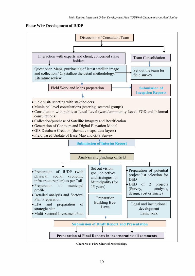
Main Report: Integrated Urban Development Plan (IUDP) of Changunarayan Municipality
10
Phase Wise Development of IUDP
Chart No 1: Flow Chart of Methodology
Discussion of Consultant Team
Interaction with experts and client, concerned stake
holders Team Consolidation
Questioner, Maps, purchasing of latest satellite image
and collection / Crystallize the detail methodology,
Literature review
Submission of
Inception Reports
Set out the team for
field survey
Submission of Interim Report
Analysis and Findings of field
Preparation of IUDP (with
physical, social, economic
infrastructure plan) as per ToR
Preparation of municipal
profile.
Detailed analysis and Sectoral
Plan Preparation
LFA and preparation of
strategic plan
Multi-Sectoral Investment Plan
(MSIP)
Set out vision,
goal, objectives
and strategies for
Municipality (for
15 years)
Preparation of potential
project list selection for
DED
DED of 2 projects
(Survey, analysis,
design, cost estimate)
Preparation
Building Bye-
Laws
Legal and institutional
development
framework
Field Work and Maps preparation
Field visit/ Meeting with stakeholders
Municipal level consultations (steering, sectoral groups)
Consultation with public at Local Level (ward/community Level, FGD and Informal
consultations)
Collection/purchase of Satellite Imagery and Rectification
Generation of Contours and Digital Elevation Model
GIS Database Creation (thematic maps, data layers)
Field based Update of Base Map and GPS Survey
Final update of data
Submission of Draft Report and Presentation
Preparation of Final Reports in incorporating all comments
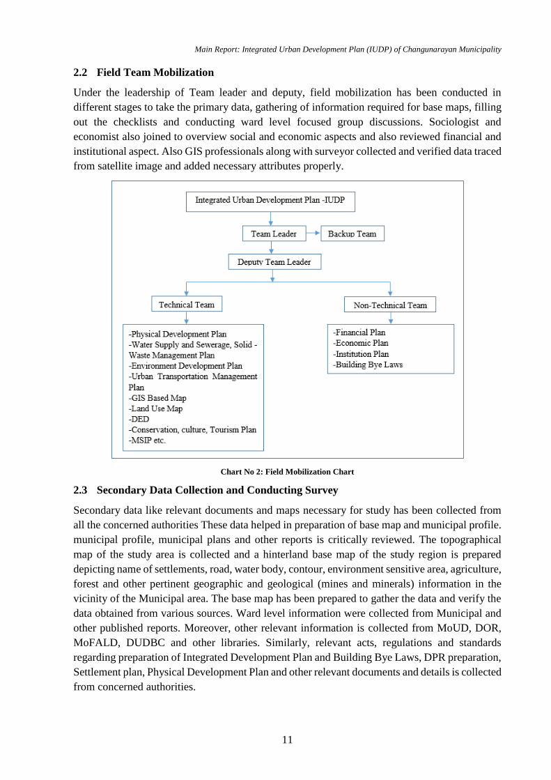
Main Report: Integrated Urban Development Plan (IUDP) of Changunarayan Municipality
11
2.2 Field Team Mobilization
Under the leadership of Team leader and deputy, field mobilization has been conducted in
different stages to take the primary data, gathering of information required for base maps, filling
out the checklists and conducting ward level focused group discussions. Sociologist and
economist also joined to overview social and economic aspects and also reviewed financial and
institutional aspect. Also GIS professionals along with surveyor collected and verified data traced
from satellite image and added necessary attributes properly.
Chart No 2: Field Mobilization Chart
2.3 Secondary Data Collection and Conducting Survey
Secondary data like relevant documents and maps necessary for study has been collected from
all the concerned authorities These data helped in preparation of base map and municipal profile.
municipal profile, municipal plans and other reports is critically reviewed. The topographical
map of the study area is collected and a hinterland base map of the study region is prepared
depicting name of settlements, road, water body, contour, environment sensitive area, agriculture,
forest and other pertinent geographic and geological (mines and minerals) information in the
vicinity of the Municipal area. The base map has been prepared to gather the data and verify the
data obtained from various sources. Ward level information were collected from Municipal and
other published reports. Moreover, other relevant information is collected from MoUD, DOR,
MoFALD, DUDBC and other libraries. Similarly, relevant acts, regulations and standards
regarding preparation of Integrated Development Plan and Building Bye Laws, DPR preparation,
Settlement plan, Physical Development Plan and other relevant documents and details is collected
from concerned authorities.
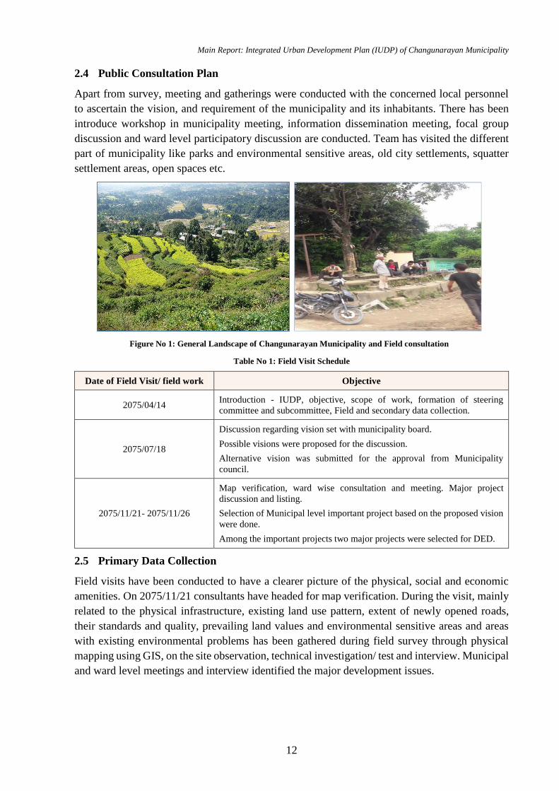
Main Report: Integrated Urban Development Plan (IUDP) of Changunarayan Municipality
12
2.4 Public Consultation Plan
Apart from survey, meeting and gatherings were conducted with the concerned local personnel
to ascertain the vision, and requirement of the municipality and its inhabitants. There has been
introduce workshop in municipality meeting, information dissemination meeting, focal group
discussion and ward level participatory discussion are conducted. Team has visited the different
part of municipality like parks and environmental sensitive areas, old city settlements, squatter
settlement areas, open spaces etc.
Table No 1: Field Visit Schedule
Date of Field Visit/ field work Objective
2075/04/14 Introduction - IUDP, objective, scope of work, formation of steering
committee and subcommittee, Field and secondary data collection.
2075/07/18
Discussion regarding vision set with municipality board.
Possible visions were proposed for the discussion.
Alternative vision was submitted for the approval from Municipality
council.
2075/11/21- 2075/11/26
Map verification, ward wise consultation and meeting. Major project
discussion and listing.
Selection of Municipal level important project based on the proposed vision
were done.
Among the important projects two major projects were selected for DED.
2.5 Primary Data Collection
Field visits have been conducted to have a clearer picture of the physical, social and economic
amenities. On 2075/11/21 consultants have headed for map verification. During the visit, mainly
related to the physical infrastructure, existing land use pattern, extent of newly opened roads,
their standards and quality, prevailing land values and environmental sensitive areas and areas
with existing environmental problems has been gathered during field survey through physical
mapping using GIS, on the site observation, technical investigation/ test and interview. Municipal
and ward level meetings and interview identified the major development issues.
Figure No 1: General Landscape of Changunarayan Municipality and Field consultation
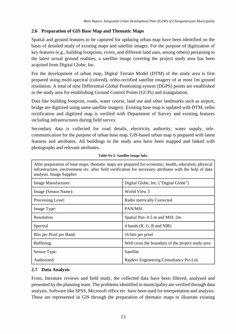
Main Report: Integrated Urban Development Plan (IUDP) of Changunarayan Municipality
13
2.6 Preparation of GIS Base Map and Thematic Maps
Spatial and ground features to be captured for updating urban map have been identified on the
basis of detailed study of existing maps and satellite images. For the purpose of digitization of
key features (e.g., building footprints, rivers, and different land uses, among others) pertaining to
the latest actual ground realities, a satellite image covering the project study area has been
acquired from Digital Globe, Inc.
For the development of urban map, Digital Terrain Model (DTM) of the study area is first
prepared using multi-spectral (colored), ortho-rectified satellite imagery of at most 1m ground
resolution. A total of nine Differential Global Positioning system (DGPS) points are established
in the study area for establishing Ground Control Points (GCPs) and triangulation.
Data like building footprint, roads, water course, land use and other landmarks such as airport,
bridge are digitized using same satellite imagery. Existing base map is updated with DTM, ortho
rectification and digitized map is verified with Department of Survey and existing features
including infrastructures during field survey.
Secondary data is collected for road details, electricity authority, water supply, tele-
communication for the purpose of urban base map. GIS-based urban map is prepared with latest
features and attributes. All buildings in the study area have been mapped and linked with
photographs and relevant attributes.
Table No 2: Satellite Image Info.
After preparation of base maps, thematic maps are prepared for economic, health, education, physical
infrastructure, environment etc. after field verification for necessary attributes with the help of data
analysis. Image Supplier
Image Manufacturer: Digital Globe, Inc. ("Digital Globe")
Image (Sensor Name): World View 3
Processing Level: Radio metrically Corrected
Image Type: PAN/MSI
Resolution Spatial Pan- 0.5 m and MSI: 2m
Spectral 4 bands (R, G, B and NIR)
Bits per Pixel per Band: 16 bits per pixel
Buffering: Well cross the boundary of the project study area
Sensor Type: Satellite
Authorized: Rajdevi Engineering Consultancy Pvt.Ltd.
2.7 Data Analysis
From, literature reviews and field study, the collected data have been filtered, analysed and
presented by the planning team. The problems identified in municipality are verified through data
analysis. Software like SPSS, Microsoft office etc. have been used for interpretation and analysis.
These are represented in GIS through the preparation of thematic maps to illustrate existing
Main Report: Integrated Urban Development Plan (IUDP) of Changunarayan Municipality
14
situation and trend analysis. SWOT analysis, spatial analysis and financial analysis have been
done. Then potential areas for development of municipality has been identified. Also future needs
upto 5, 10 and 15 years demand and deficits are analysed using standard and norms.
2.8 Vision Setting
The vision has been set after identifying lead sector which provides the guiding principles and
priorities for the Plan’s implementation for next 20-30 years for municipality. It has to carry the
overall characteristics of the city. It has to be simple and precise. According to lead sector
identification, Visions are discussed and proposed in vision setting meeting. Vision and principles
has been formulated with broadly participation of municipality bodies. To make the vision
operational, necessary development principles to guide the sectoral activities has been outlined.
Based on long term vision of the town, mid-term and short-term goals and objectives have been
developed. Consultant utilizes different result-based approaches to formulate prioritized sectoral
goals and objectives. It includes generation of alternative strategies/ evaluation & selection of
preferred strategy, detailing and refinement of preferred strategy, formulating policies,
implementation tools, legitimization, monitoring indicators and feedback.
2.9 Sectoral Development Plan
Sectors, which are required to be incorporated, are physical infrastructures, environmental
management, social and economic sectors, disaster management, climate change, economic and
financial management planning and organization development plans. Such Sectoral plans and
programs has been back up by multisector investment plans prepared giving due attention to
national concerns such as poverty reduction and social inclusion.
Based on study of existing infrastructures, environmental situation, health and educational status
and future projected demographic value; an integrated urban plan is prepared. Plan proposed the
state of municipality socially equitable and inclusive, environmentally bearable, economically
viable, effective, efficient and reliable with improved and affordable infrastructure services,
providing accountability to its citizens and more responsive to their demands. These plans were
formulated using Logical Framework Analysis (LFA), which is a strategic project planning and
action tool that helps municipal executives and planners answer these four critical questions:
The consultant with close consultation of DUDBC has done the critical analysis, visioning and
recommendation of strategies of the town based on planning documents such as i) National Urban
Policy-2007, National Urban Development Strategy (NUDS), 2016 (revised), Planning Norms
and Standards, 2015 etc. It has also incorporate development control tools (such as planning and
building bye laws), placement of strategic infrastructures (physical/environmental, social/cultural
and economic) to guide and promote the urban development, and prioritized above projects.
2.10 Multi Sectoral Investment Plan
Short, medium and long term programs/projects have been identified and prioritized for planning
period of upto 5 years, 5-10 years and above 10-15 years with cost estimate and probably
financing sources. These projects are consistent with the long-term development plan, sectoral goals
and objectives, and the vision. Such MSIP are made consistent with the financial resource plan. The
Main Report: Integrated Urban Development Plan (IUDP) of Changunarayan Municipality
15
city level plans/projects (Mega projects) and projects that have to be implemented by different line
agencies in MSIP has been included after thorough consultation with the concerned offices.
2.11 Preparation of DED
In order to prepare reliable project banks for the recent execution of different projects in
municipality, consultants are expected to prepare Detail Engineering Design of minimum 2
projects in different sector in each municipality. It contains detail engineering and architectural
design, detail cost estimate and BOQ. The prioritized project has been identified in consultation
with concerned municipalities but with the rationale and discussed and approved by DUDBC.
The cost estimate of each project is not be less than 30 Crore.
The project prioritization for the DED is done based on the criteria suggested by DUDBC for the
ranking of the projects. The ranking for the prioritized project has been done. The project having
the maximum rank is selected for the DED.
2.12 Preparation of Building Bye-Laws
The building and planning bye-laws of the study area has been formulated with the overlay of
land use map of the Municipality areas. This is based on the Municipal vision and land use
objectives. Building bye laws has mainly covered the general definition, zoning classification and
bye laws/ regulations, implementation mechanism and procedures etc., and expected behavioural
change from Municipal citizens. Preparation of Building and Planning bye-laws contain
following areas regarding the construction of building:
Minimum land area
Maximum ground coverage
Maximum floor ratio (FAR)
Maximum building height
Maximum no. of floors
Right of way for roads
Set back in four sides of the building
Minimum parking area
Provisions of lifts for high rise building
Proximity with various development constraints such as water bodies, forest areas, slope,
and distance from the petrol pumps, etc.
Main Report: Integrated Urban Development Plan (IUDP) of Changunarayan Municipality
16
Chapter 3: Existing Situation
The updated municipal profile of Changunarayan has been prepared separately in Volume II of
the study which includes information of the existing physical, environmental, climate change,
disaster risk, social cultural, economic, financial and organization structure of municipality.
However, the summary of the profile is presented in this chapter.
3.1 Existing Scenario
Changunarayan municipality is situated in Bhaktapur District , Bagmati province of Nepal and is
part of the urban newly expansion part of the Kathmandu Valley. The municipality was formed
by annexing the former Village Development Committees; Old Changunarayan, Chhaling,
Duwakot and Jhaukhel in 2014 A.D. According to CBS, 2011 A.D. The total population of
municipality is 54,550. In 2017, Maha manjushree Nagarkot was merged into
Changunarayan.The UNESCO World Heritage Site Changu Narayan Complex is situated in this
municipality.
The location coordinate of Changunarayan municipality is 27°43′00″N 85°25′47″E which is
surrounded by Kathmandu district on the north and west side, Bhaktapur municipality, and
Suryabinayak and Thimi municipality on south and Kavreplanchwok on east.
3.2 Municipality Composition
This municipality is composed of various wards of previous VDC and municipality listed below:
Table No 3: Municipality Composition
S.N. New
Ward
Previous VDC /
Municipality Population
Area (sq.
km.)
Population
Density
1 1 Changunarayan (14, 15, 16) 6101 3.87 1577
2 2 Changunarayan (12, 13, 17) 6020 4.63 1300
3 3 Changunarayan (5, 6, 7) 5702 3.02 1882
4 4 Changunarayan (8, 9, 10, 11) 6024 6.78 888
5 5 Changunarayan (1, 2, 3, 4) 6398 9.61 666
6 6 Nagarkot(11, 12, 13) 4024 9.48 425
7 7 Nagarkot(8, 9, 10) 5723 9.56 599
8 8 Nagarkot(4, 5, 6, 7) 8294 7.32 1133
9 9 Nagarkot(1, 2, 3) 6264 8.7 720
Total 54,550 62.98 866
Source: Municipal profile 2074
The above table shows that there is high population density at ward 1-3 and low population
density at ward 6 whereas the population density is 1882 persons/sq.km at small area of 3.02
sq.km. of ward 3 and 1577 persons/sq.km of ward 1. Hence, with most of infrastructural services
Main Report: Integrated Urban Development Plan (IUDP) of Changunarayan Municipality
17
are available at area like Rakshya tole, Kharipati and due to presence of compact settlement, ward
1-3 can be considered as major urbanization zone of Changunarayan municipality.
Although, ward 6 has large area i.e. 9.48 sq. km, it comprises of low population density of 425
persons/sq.km. With no sufficient social infrastructures to meet the basic needs of people and low
population, Ward 6 can be considered as one of the rural areas of municipality.
3.3 Physical Status
56.98% area is covered by agriculture land, where as 24.63%, 11.44 %, 3.49% and 1.51 % area
is covered by forests, residential areas, industrial areas and institutional respectively. The data
shows that there is huge opportunity to utilize agriculture as major occupation.
Housing
Types of House
Out of 11677 houses, 33.98% houses are made up of mud bonded bricks or stone foundation,
29.59% houses have RCC pillar foundation, 16.50 % has wooden pillar, 19.93% has cement
bonded brick or stone foundation.
As for comparison on urban scenario, 29.59% of houses of municipality has RCC pillar
foundation which is more than the situation of Nepal and urban area i.e. 9.94% and 28.42%
respectively.
House with Approved Drawing
75.9 % of building are built without municipality approved norms. However, newly constructed
24.1% building have approved drawings as per municipality norms and Nepal Building Code.
Awareness for getting approval is increasing and building are being constructed with proper
norms.
Construction Year
Ward 2, 3,4 and 8 has significant urbanization, more than 80% houses are constructed within the
span of 35 years. Old houses are almost replaced by RCC structures.
Road Infrastructures
Total existing road in the municipality is 334.33 km. Road facilities are available in all wards of
municipality. Most of roads are urban and earthen roads and some are just track opened. Only
19.86 % of road are blacktop whereas 67.91 % are earthen roads.
Road Hierarchy
On the basis of ward-wise road hierarchy, there are altogether 334.33 km roads at the
municipality. The roads present are Feeder, District and Urban roads. Most of roads are urban
with 262.45 km (78.5%) while the least is district road with 16.69 km (4.99%). All wards have
accessibility of all roads except ward 4 which lacks in district road.
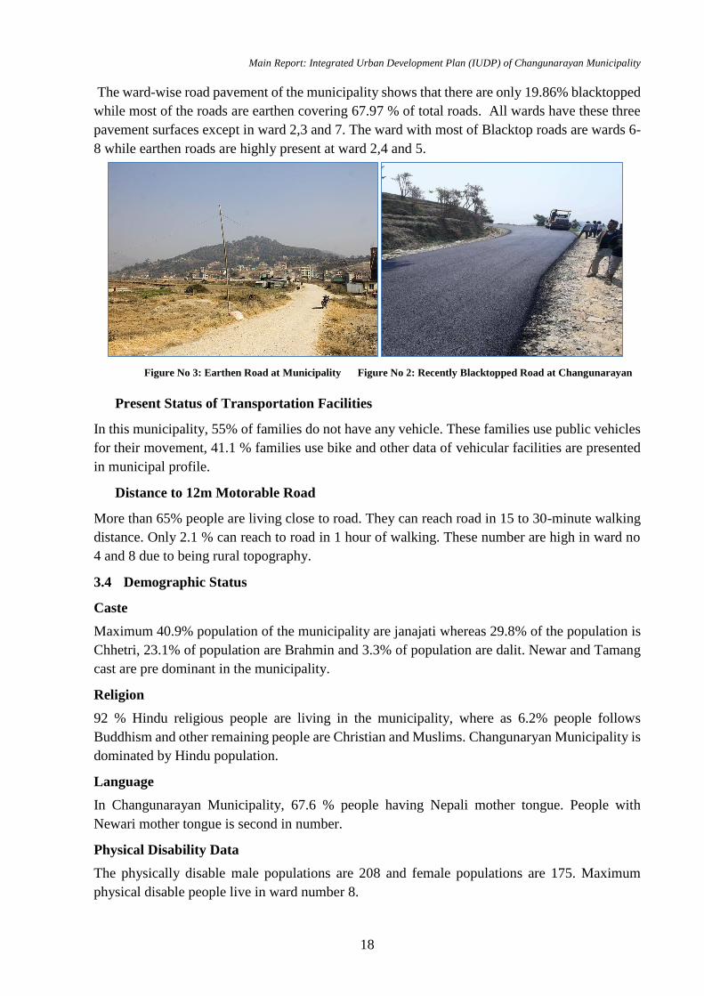
Main Report: Integrated Urban Development Plan (IUDP) of Changunarayan Municipality
18
The ward-wise road pavement of the municipality shows that there are only 19.86% blacktopped
while most of the roads are earthen covering 67.97 % of total roads. All wards have these three
pavement surfaces except in ward 2,3 and 7. The ward with most of Blacktop roads are wards 6-
8 while earthen roads are highly present at ward 2,4 and 5.
Present Status of Transportation Facilities
In this municipality, 55% of families do not have any vehicle. These families use public vehicles
for their movement, 41.1 % families use bike and other data of vehicular facilities are presented
in municipal profile.
Distance to 12m Motorable Road
More than 65% people are living close to road. They can reach road in 15 to 30-minute walking
distance. Only 2.1 % can reach to road in 1 hour of walking. These number are high in ward no
4 and 8 due to being rural topography.
3.4 Demographic Status
Caste
Maximum 40.9% population of the municipality are janajati whereas 29.8% of the population is
Chhetri, 23.1% of population are Brahmin and 3.3% of population are dalit. Newar and Tamang
cast are pre dominant in the municipality.
Religion
92 % Hindu religious people are living in the municipality, where as 6.2% people follows
Buddhism and other remaining people are Christian and Muslims. Changunaryan Municipality is
dominated by Hindu population.
Language
In Changunarayan Municipality, 67.6 % people having Nepali mother tongue. People with
Newari mother tongue is second in number.
Physical Disability Data
The physically disable male populations are 208 and female populations are 175. Maximum
physical disable people live in ward number 8.
Figure No 3: Earthen Road at Municipality Figure No 2: Recently Blacktopped Road at Changunarayan
Main Report: Integrated Urban Development Plan (IUDP) of Changunarayan Municipality
19
Total blind population in Changunarayan municipality is 80. Out of which 31 blinds are male and
49 blinds are female. Ward wise distribution of the blind population is presented in table 14. This
may be because male people get treated at time while female is careless for the treatment and
they are less aware.
Total mental disability population in Changunarayan municipality is 94. Out of which 51 people
are male and 43 people are female. As per municipality profile female population have less mental
disability than male population.
People with others type of disability within the municipality are 40, out of which 19 males are
suffering from other kind of disability and 21 females are suffering from different kind of
disability.
Municipality is responsible for all the citizen, so while planning the infrastructure and
formulation of programs these data of disability need to be addressed.
3.5 Social Status
Educational Level
Children from 25.2% houses are studying in basic level. All together 73% of population are
literate. Most of the child/adults are involved in education.
Other Services
The level of people livelihood is depending on the different access to the facility of the people.
94% households have mobile facility where as 90 % household have access to Television and
only 18% households are using Internet facility.
Distance to Reach School
4.4 % school lies at a distance more than one hour (walking distance) from the settlement whereas
almost 16.6% houses are very near to the academic institutions. More than 68% of household are
at 15-30 min walking distance from one or other education institution. Very few houses are at
more than one-hour walking distance. Being rural in nature ward no 4 and ward 8 have maximum
number of (112+384) which need to travel more than one hour to reach education institute.
Distance to Reach Health Center
In Changunarayan municipality, 55.4 % people take 15-30 minutes time to reach health center
and 27.8% people take 30 minutes and less than 9 % people take more than one-hour time to
reach health center. Being the rural in topography ward no 4 and 8 have more households which
need to travel more than one hour to reach at one of the nearest health center.
3.6 Economic Status
Occupation
Around 44.6% people are involved in agriculture occupation in the municipality. Only 3.3%
people are involved in foreign employment and 13.9 % people are involved in government job.
More than 50% H/H in ward on 4, 5,8 and 9 have the agriculture occupation and remaining other
wards have less no of HH having agriculture as prime occupation. Most of the land in ward no. 6
is not suitable for agriculture so only 1/3 of H/H are involved in agriculture activities.
Main Report: Integrated Urban Development Plan (IUDP) of Changunarayan Municipality
20
Business Details
Since Animal farming goes together with agriculture, large number of HH in municipality are
involved in animal husbandry. 17.7% sheep farming and 19 % family are involved in Poultry
farming. Other business is very insignificant.
Land Ownership
In Changunarayan municipality 78.4% family have self-land ownership. Summary of land
ownership table is given municipal profile.
Most of the people in the municipality use their own land for the cultivation. Only 3.6 % HH give
their land to others, where as 5.8 % HH utilize the land by taking rent from other.
Land Owned
53.8 % of the house hold have land area in between 1-5 ropani. 34.9 % HH have land less than 1
ropani. All housing plots lies in this range. People having agriculture as occupation hold the land
in between 1-5 ropani. and detailed table is given municipal profile.
3.7 Health and Sanitation
Local health services are being provided through different health centres, health posts
Community Health centers and KMC Medical College.
Latrine Availability
In municipality 96.1% household have their own latrine and 3.9 % households are not using their
own latrine although municipality is declared as open defecation free municipality.
Type of Latrine
In municipality almost 86.6 % households use Septic Tank for the sewage management and 9.7
% households have pit latrine for the sewage management. Due to lack of proper drainage people
use septic tank, which is good sign. People have awareness of not to join their sewage line directly
into the river.
3.8 Drinking Water Status
Source of Drinking Water (DW)
The Source of drinking water within the municipality are managed through pipelined networks,
spring water, uncovered wells (Dhunge Dhara) etc. 42.1% of households use tap water through
pipe networks and 36.9% households are still using the uncovered wells.
Water supply system is one of the prime infrastructures for the development. In municipality
42.1% of households use piped water as source of drinking water which is less than urban context
of Nepal i.e. 60% households.
Water Purification
In municipality about 52% population are using water directly without purification. 41.8%
population are using filter for purification and 4.7% and 0.2% use boiling and chlorination for
purification respectively. Awareness of drinking water is still less in this municipality. This may
cause many types of diseases. Summary of the water purification is shown in the municipal
profile.
Main Report: Integrated Urban Development Plan (IUDP) of Changunarayan Municipality
21
3.9 Environment Status
Types of Fuel Used
In the municipality 55.1% family used LP gas as fuel source in their kitchen where as 24.6 %
family use wood for their cooking.
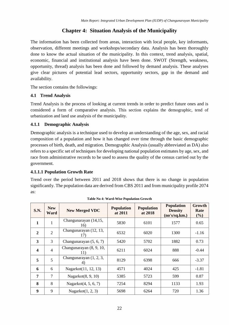
Main Report: Integrated Urban Development Plan (IUDP) of Changunarayan Municipality
22
Chapter 4: Situation Analysis of the Municipality
The information has been collected from areas, interaction with local people, key informants,
observation, different meetings and workshops/secondary data. Analysis has been thoroughly
done to know the actual situation of the municipality. In this context, trend analysis, spatial,
economic, financial and institutional analysis have been done. SWOT (Strength, weakness,
opportunity, thread) analysis has been done and followed by demand analysis. These analyses
give clear pictures of potential lead sectors, opportunity sectors, gap in the demand and
availability.
The section contains the followings:
4.1 Trend Analysis
Trend Analysis is the process of looking at current trends in order to predict future ones and is
considered a form of comparative analysis. This section explains the demographic, tend of
urbanization and land use analysis of the municipality.
4.1.1 Demographic Analysis
Demographic analysis is a technique used to develop an understanding of the age, sex, and racial
composition of a population and how it has changed over time through the basic demographic
processes of birth, death, and migration. Demographic Analysis (usually abbreviated as DA) also
refers to a specific set of techniques for developing national population estimates by age, sex, and
race from administrative records to be used to assess the quality of the census carried out by the
government.
4.1.1.1 Population Growth Rate
Trend over the period between 2011 and 2018 shows that there is no change in population
significantly. The population data are derived from CBS 2011 and from municipality profile 2074
as:
Table No 4: Ward-Wise Population Growth
S.N. New
Ward New Merged VDC
Population
at 2011
Population
at 2018
Population
Density
(no's/sq.km.)
Growth
Rate
(%)
1 1 Changunarayan (14,15,
16) 5830 6101 1577 0.65
2 2 Changunarayan (12, 13,
17) 6532 6020 1300 -1.16
3 3 Changunarayan (5, 6, 7) 5420 5702 1882 0.73
4 4 Changunarayan (8, 9, 10,
11) 6211 6024 888 -0.44
5 5 Changunarayan (1, 2, 3,
4) 8129 6398 666 -3.37
6 6 Nagarkot(11, 12, 13) 4571 4024 425 -1.81
7 7 Nagarkot(8, 9, 10) 5385 5723 599 0.87
8 8 Nagarkot(4, 5, 6, 7) 7254 8294 1133 1.93
9 9 Nagarkot(1, 2, 3) 5698 6264 720 1.36
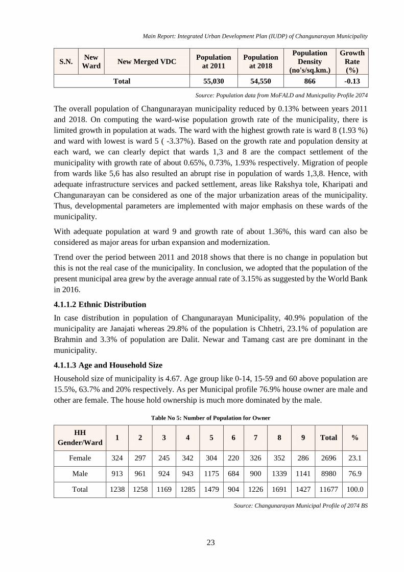
Main Report: Integrated Urban Development Plan (IUDP) of Changunarayan Municipality
23
S.N. New
Ward New Merged VDC
Population
at 2011
Population
at 2018
Population
Density
(no's/sq.km.)
Growth
Rate
(%)
Total 55,030 54,550 866 -0.13
Source: Population data from MoFALD and Municpality Profile 2074
The overall population of Changunarayan municipality reduced by 0.13% between years 2011
and 2018. On computing the ward-wise population growth rate of the municipality, there is
limited growth in population at wads. The ward with the highest growth rate is ward 8 (1.93 %)
and ward with lowest is ward 5 ( -3.37%). Based on the growth rate and population density at
each ward, we can clearly depict that wards 1,3 and 8 are the compact settlement of the
municipality with growth rate of about 0.65%, 0.73%, 1.93% respectively. Migration of people
from wards like 5,6 has also resulted an abrupt rise in population of wards 1,3,8. Hence, with
adequate infrastructure services and packed settlement, areas like Rakshya tole, Kharipati and
Changunarayan can be considered as one of the major urbanization areas of the municipality.
Thus, developmental parameters are implemented with major emphasis on these wards of the
municipality.
With adequate population at ward 9 and growth rate of about 1.36%, this ward can also be
considered as major areas for urban expansion and modernization.
Trend over the period between 2011 and 2018 shows that there is no change in population but
this is not the real case of the municipality. In conclusion, we adopted that the population of the
present municipal area grew by the average annual rate of 3.15% as suggested by the World Bank
in 2016.
4.1.1.2 Ethnic Distribution
In case distribution in population of Changunarayan Municipality, 40.9% population of the
municipality are Janajati whereas 29.8% of the population is Chhetri, 23.1% of population are
Brahmin and 3.3% of population are Dalit. Newar and Tamang cast are pre dominant in the
municipality.
4.1.1.3 Age and Household Size
Household size of municipality is 4.67. Age group like 0-14, 15-59 and 60 above population are
15.5%, 63.7% and 20% respectively. As per Municipal profile 76.9% house owner are male and
other are female. The house hold ownership is much more dominated by the male.
Table No 5: Number of Population for Owner
HH
Gender/Ward 1 2 3 4 5 6 7 8 9 Total %
Female 324 297 245 342 304 220 326 352 286 2696 23.1
Male 913 961 924 943 1175 684 900 1339 1141 8980 76.9
Total 1238 1258 1169 1285 1479 904 1226 1691 1427 11677 100.0
Source: Changunarayan Municipal Profile of 2074 BS
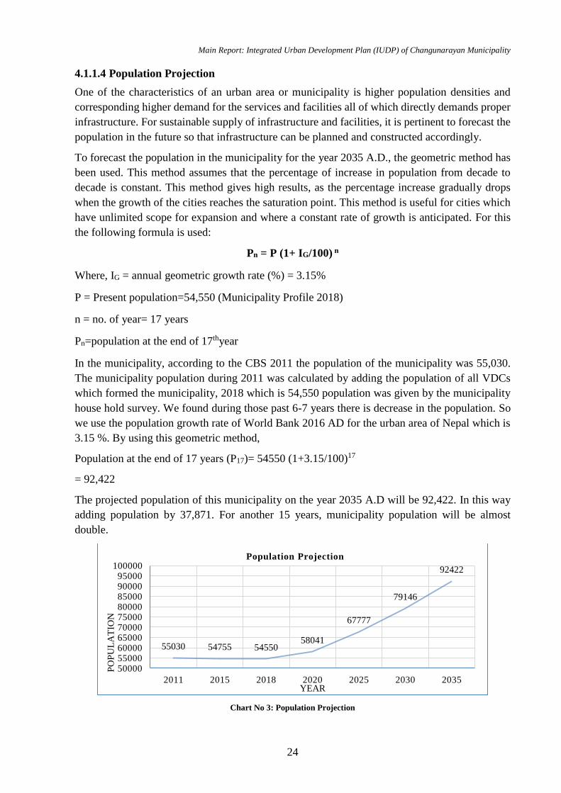
Main Report: Integrated Urban Development Plan (IUDP) of Changunarayan Municipality
24
4.1.1.4 Population Projection
One of the characteristics of an urban area or municipality is higher population densities and
corresponding higher demand for the services and facilities all of which directly demands proper
infrastructure. For sustainable supply of infrastructure and facilities, it is pertinent to forecast the
population in the future so that infrastructure can be planned and constructed accordingly.
To forecast the population in the municipality for the year 2035 A.D., the geometric method has
been used. This method assumes that the percentage of increase in population from decade to
decade is constant. This method gives high results, as the percentage increase gradually drops
when the growth of the cities reaches the saturation point. This method is useful for cities which
have unlimited scope for expansion and where a constant rate of growth is anticipated. For this
the following formula is used:
Pn = P (1+ IG/100) n
Where, IG = annual geometric growth rate (%) = 3.15%
P = Present population=54,550 (Municipality Profile 2018)
n = no. of year= 17 years
Pn=population at the end of 17thyear
In the municipality, according to the CBS 2011 the population of the municipality was 55,030.
The municipality population during 2011 was calculated by adding the population of all VDCs
which formed the municipality, 2018 which is 54,550 population was given by the municipality
house hold survey. We found during those past 6-7 years there is decrease in the population. So
we use the population growth rate of World Bank 2016 AD for the urban area of Nepal which is
3.15 %. By using this geometric method,
Population at the end of 17 years (P17)= 54550 (1+3.15/100)17
= 92,422
The projected population of this municipality on the year 2035 A.D will be 92,422. In this way
adding population by 37,871. For another 15 years, municipality population will be almost
double.
Chart No 3: Population Projection
55030 54755 5455058041
67777
79146
92422
50000550006000065000700007500080000850009000095000
100000
2011 2015 2018 2020 2025 2030 2035
PO
PU
LA
TIO
N
YEAR
Population Projection
Main Report: Integrated Urban Development Plan (IUDP) of Changunarayan Municipality
25
4.1.1.5 Migration Trend Analysis
Internal and external migration has been analysed in this section. It is done in ward level so that
effect to migration in ward level can be analysed.
Table No 6: Migration Trend Analysis
S.N. New
Ward
Population Difference in
Population at
2018
Migration
Trend 2011 2018
With 2011 growth rate
of Nepal i.e. 1.35% at
2018
1 1 5830 6101 5909 192 In-Migrants
2 2 6532 6020 6620 -600 High Out-
Migrants
3 3 5420 5702 5493 209 In-Migrants
4 4 6211 6024 6295 -271 Out-
Migrants
5 5 8129 6398 8239 -1841
Massive
Out-
Migrants
6 6 4571 4024 4633 -609 High Out-
Migrants
7 7 5385 5723 5458 265 In-Migrants
8 8 7254 8294 7352 942 High In-
Migrants
9 9 5698 6264 5775 489 In-Migrants
Source: CBS 2011 and Municipal Profile 2074
Migration trend of 2011-2018 is shown by computing the population data of 2018 as per natural
growth rate i.e. 1.35% and population at 2018. The ward with most of out-migrants are ward (2,4-
6). Massive out-migrants were seen at ward 5 with most of people migrating towards urban areas
like Rakshya tole, etc. to fulfil their basic needs. From analysis, ward 8 welcomed more of
incoming migrants from rural areas of the municipality. Major migration is seen towards wards
8 and 9. Considering natural growth rate 1.35% in 2011, 55,774 should had been population but
it is 54,550 which is not so significantly different. During filed study, it has been found that
people have migrated to Bhaktapur and Kathmandu valley. So it seems that out migration from
this municipality is being countered by in migration from places like Madandeupur, Banepa and
Shankharapur municipality etc.
4.1.2 Land Use Analysis & Urbanization
The urbanization trend took place along the urban road of Changunarayan. With the extension of
branch roads, the urbanization rate further increased. The main settlement and market centers
have been developed along the junction of urban roads and branch roads. The change in the
settlement pattern can be clearly seen through these two google image of 2005 and 2018.
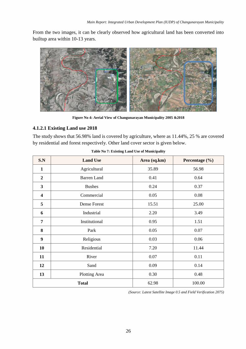
Main Report: Integrated Urban Development Plan (IUDP) of Changunarayan Municipality
26
From the two images, it can be clearly observed how agricultural land has been converted into
builtup area within 10-13 years.
4.1.2.1 Existing Land use 2018
The study shows that 56.98% land is covered by agriculture, where as 11.44%, 25 % are covered
by residential and forest respectively. Other land cover sector is given below.
Table No 7: Existing Land Use of Municipality
S.N Land Use Area (sq.km) Percentage (%)
1 Agricultural 35.89 56.98
2 Barren Land 0.41 0.64
3 Bushes 0.24 0.37
4 Commercial 0.05 0.08
5 Dense Forest 15.51 25.00
6 Industrial 2.20 3.49
7 Institutional 0.95 1.51
8 Park 0.05 0.07
9 Religious 0.03 0.06
10 Residential 7.20 11.44
11 River 0.07 0.11
12 Sand 0.09 0.14
13 Plotting Area 0.30 0.48
Total 62.98 100.00
(Source: Latest Satellite Image 0.5 and Field Verification 2075)
Figure No 4: Aerial View of Changunarayan Municipality 2005 &2018
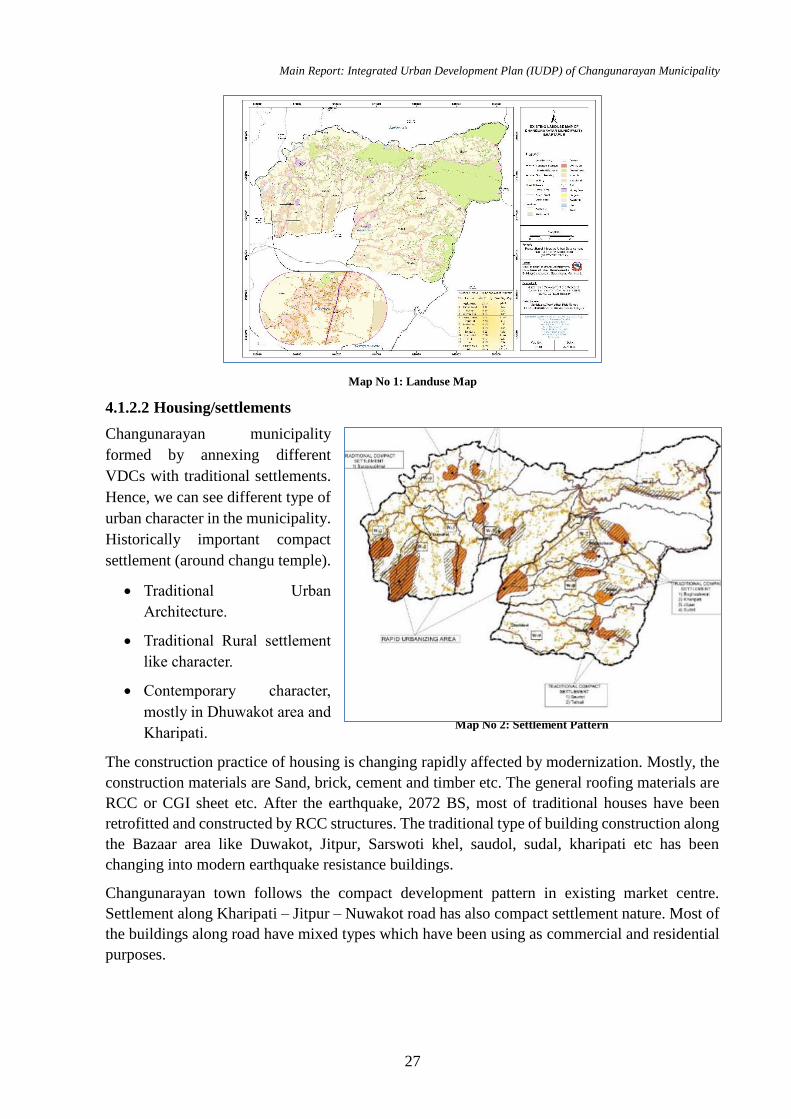
Main Report: Integrated Urban Development Plan (IUDP) of Changunarayan Municipality
27
Map No 1: Landuse Map
4.1.2.2 Housing/settlements
Changunarayan municipality
formed by annexing different
VDCs with traditional settlements.
Hence, we can see different type of
urban character in the municipality.
Historically important compact
settlement (around changu temple).
Traditional Urban
Architecture.
Traditional Rural settlement
like character.
Contemporary character,
mostly in Dhuwakot area and
Kharipati.
The construction practice of housing is changing rapidly affected by modernization. Mostly, the
construction materials are Sand, brick, cement and timber etc. The general roofing materials are
RCC or CGI sheet etc. After the earthquake, 2072 BS, most of traditional houses have been
retrofitted and constructed by RCC structures. The traditional type of building construction along
the Bazaar area like Duwakot, Jitpur, Sarswoti khel, saudol, sudal, kharipati etc has been
changing into modern earthquake resistance buildings.
Changunarayan town follows the compact development pattern in existing market centre.
Settlement along Kharipati – Jitpur – Nuwakot road has also compact settlement nature. Most of
the buildings along road have mixed types which have been using as commercial and residential
purposes.
Map No 2: Settlement Pattern
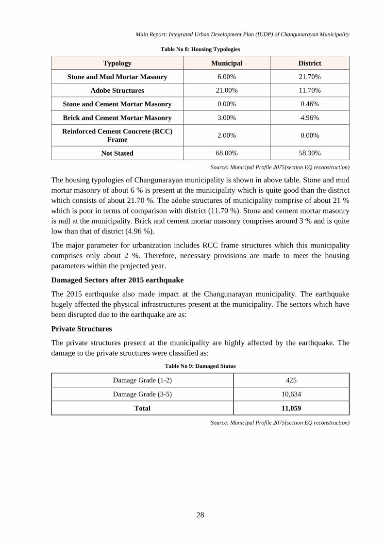
Main Report: Integrated Urban Development Plan (IUDP) of Changunarayan Municipality
28
Table No 8: Housing Typologies
Typology Municipal District
Stone and Mud Mortar Masonry 6.00% 21.70%
Adobe Structures 21.00% 11.70%
Stone and Cement Mortar Masonry 0.00% 0.46%
Brick and Cement Mortar Masonry 3.00% 4.96%
Reinforced Cement Concrete (RCC)
Frame 2.00% 0.00%
Not Stated 68.00% 58.30%
Source: Municipal Profile 2075(section EQ reconstruction)
The housing typologies of Changunarayan municipality is shown in above table. Stone and mud
mortar masonry of about 6 % is present at the municipality which is quite good than the district
which consists of about 21.70 %. The adobe structures of municipality comprise of about 21 %
which is poor in terms of comparison with district (11.70 %). Stone and cement mortar masonry
is null at the municipality. Brick and cement mortar masonry comprises around 3 % and is quite
low than that of district (4.96 %).
The major parameter for urbanization includes RCC frame structures which this municipality
comprises only about 2 %. Therefore, necessary provisions are made to meet the housing
parameters within the projected year.
Damaged Sectors after 2015 earthquake
The 2015 earthquake also made impact at the Changunarayan municipality. The earthquake
hugely affected the physical infrastructures present at the municipality. The sectors which have
been disrupted due to the earthquake are as:
Private Structures
The private structures present at the municipality are highly affected by the earthquake. The
damage to the private structures were classified as:
Table No 9: Damaged Status
Damage Grade (1-2) 425
Damage Grade (3-5) 10,634
Total 11,059
Source: Municipal Profile 2075(section EQ reconstruction)

Main Report: Integrated Urban Development Plan (IUDP) of Changunarayan Municipality
29
Chart No 4: Damage Status
The above Chart presents that the total damage caused to the private structures at Changunarayan
Municipality. 4% structures are found to be moderately damaged and considered to be in range
of damage grade (1-2). 96% structure are severely damaged and considered to be in damage grade
of range 3-5. Therefore, based on the damage grade, almost all private structures at the
municipality are not safe to live in and thus, required an immediate retrofitted and reconstruction
as per recommendation.
Reconstruction Status
Table No 10: Tranche Distribution
Total Eligible HHs 10,937
PA Agreement 9,694
1st Trance received 9,694
2nd Trance received 2,799
3rd Trance received 2,654
Source: Municipal Profile 2075(section EQ reconstruction)
The reconstruction status at Changunarayan Municipality showed that 10,937 households eligible
for reconstruction. While the identified number is 10,937, the number of households entering into
the agreement are only 9694 (88.63 %) and these recipients received 1st tranche to undergo the
construction up to plinth level. Recipients for 2nd tranche came down to just 2799 (25.59 %)
households who finished their construction up to DPC level. Similarly, recipients for 3rd tranche
remained almost identical with 2654 (24.26 %) who finished their construction up to roof of their
houses.
Chart No 5: Reconstruction Status
4%
96%
Damage Status-Private Structures
Damage Grade (1-2) Damage Grade (3-5)
10,9379,6949,694
2,7992,654
0 2,000 4,000 6,000 8,000 10,000 12,000
Total Eligible HHs
1st Trance received
3rd Trance received
Reconstruction Status
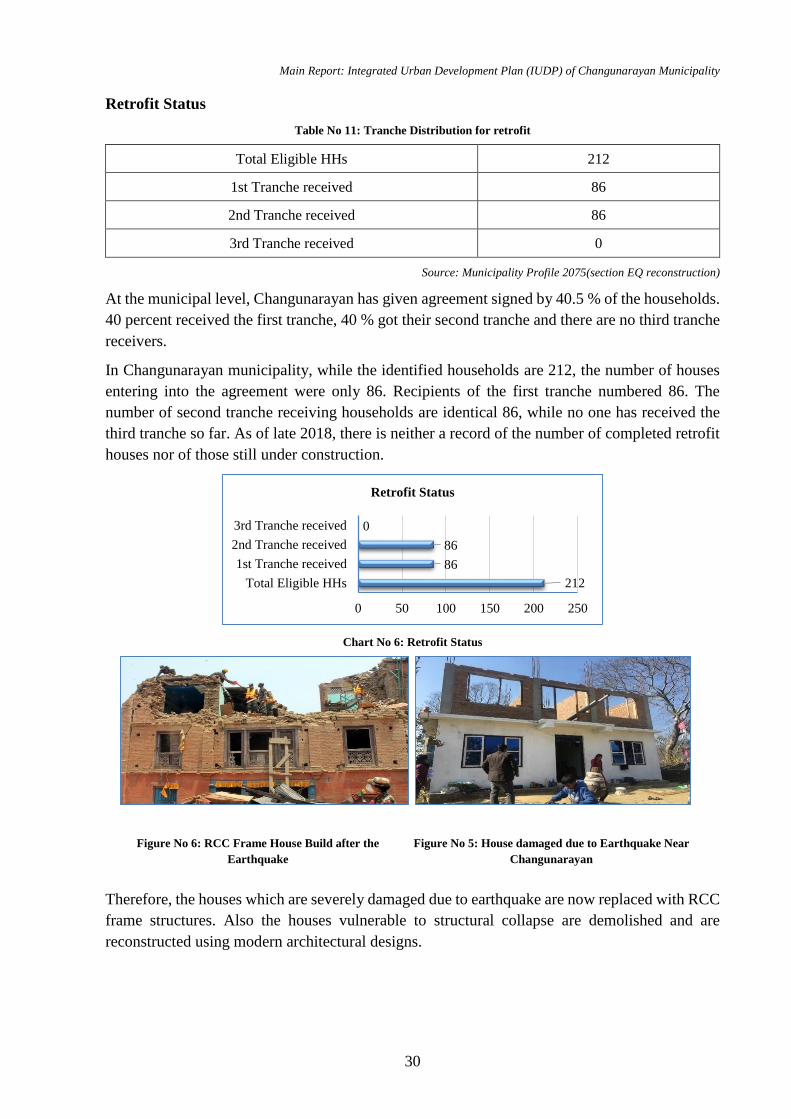
Main Report: Integrated Urban Development Plan (IUDP) of Changunarayan Municipality
30
Retrofit Status
Table No 11: Tranche Distribution for retrofit
Total Eligible HHs 212
1st Tranche received 86
2nd Tranche received 86
3rd Tranche received 0
Source: Municipality Profile 2075(section EQ reconstruction)
At the municipal level, Changunarayan has given agreement signed by 40.5 % of the households.
40 percent received the first tranche, 40 % got their second tranche and there are no third tranche
receivers.
In Changunarayan municipality, while the identified households are 212, the number of houses
entering into the agreement were only 86. Recipients of the first tranche numbered 86. The
number of second tranche receiving households are identical 86, while no one has received the
third tranche so far. As of late 2018, there is neither a record of the number of completed retrofit
houses nor of those still under construction.
Chart No 6: Retrofit Status
Therefore, the houses which are severely damaged due to earthquake are now replaced with RCC
frame structures. Also the houses vulnerable to structural collapse are demolished and are
reconstructed using modern architectural designs.
212
86
86
0
0 50 100 150 200 250
Total Eligible HHs
1st Tranche received
2nd Tranche received
3rd Tranche received
Retrofit Status
Figure No 5: House damaged due to Earthquake Near
Changunarayan
Figure No 6: RCC Frame House Build after the
Earthquake
Main Report: Integrated Urban Development Plan (IUDP) of Changunarayan Municipality
31
4.1.2.3 Existing Urban Structure
Urban structure is the arrangement of land use in urban areas, in other words, how the land use
of a city is set out. It explains where different types of people and businesses tend to exist within
the urban setting. Urban structure can also refer to urban spatial structure, which concerns the
arrangement of public and private space in cities and the degree of connectivity and accessibility.
The urban form is defined by the physical characteristics of the urban framework, customized by:
The geometry of space and construction template
The relationships between the elements of the urban framework
In Changunarayan, the major built up is concentrated in Rakshya tole, Duwakot and Jhaukhel.
The built up change in different timelines as shown in built up change of Duwakot shows that the
ribbon development is predominant in the municipality. The development usually takes place
along the main road and then along the roads connected to main road.
The population density of Changunarayan is 866 person per sq km. Ward 3 has 1882 person per
sq km and ward number 6 is least densely populated with 425 person per sq km. Looking on the
trend of urbanization, it can be predicted that ward no1,2 & 3 will get denser as major economic
activities are concentrated in these wards. Most of the houses in these area is either commercial
or under mixed land use with upper floor as residential and ground floor as commercial. The
prevailing infrastructure along with institutional establishment reveal that the area will develop
as commercial zone while the residential land use will be further pushed towards existing fringe.
Changunarayan municipality does not show any definite pattern and direction. Except the markets
in the feeder roads, municipality is basically rural setting with untouched virgin land which
provides opportunity for planned development. However, due to difficult terrain, it is great
challenge to develop even basic infrastructures in the municipality.
The road network is taken as the skeleton of the urban structure. It clears the relationships
between the elements of urban framework. Also it somehow gives the geometry of shape and
construction template. The degree of connectivity and accessibility is described below.
Urban roads link the internal settlements of the municipality areas properly. The municipality has
good road network but most of them are either earthen or gravelled. Most of the road within the
municipality area are track only i.e. they are seasonal road and are only used during dry season.
The urban road lacks drainage in major portion. The lack of municipal resources to maintain the
road standard is reflected here.
The hierarchy of the road are as follows
Nagarkot road starts form Sallaghari and end at Nagakot
Changunarayan Road
Sallaghari – Duwakot – Sangdaha Road
Pikhel – Chhaling – Telkot Road
Kamalbinayak – Sudal –Adhikarigaun – Nagarkot
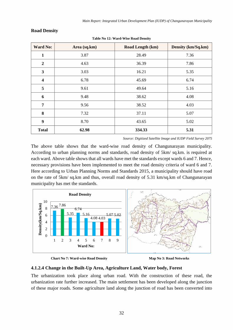
Main Report: Integrated Urban Development Plan (IUDP) of Changunarayan Municipality
32
Road Density
Table No 12: Ward-Wise Road Density
Ward No: Area (sq.km) Road Length (km) Density (km/Sq.km)
1 3.87 28.49 7.36
2 4.63 36.39 7.86
3 3.03 16.21 5.35
4 6.78 45.69 6.74
5 9.61 49.64 5.16
6 9.48 38.62 4.08
7 9.56 38.52 4.03
8 7.32 37.11 5.07
9 8.70 43.65 5.02
Total 62.98 334.33 5.31
Source: Digitized Satellite Image and IUDP Field Survey 2075
The above table shows that the ward-wise road density of Changunarayan municipality.
According to urban planning norms and standards, road density of 5km/ sq.km. is required at
each ward. Above table shows that all wards have met the standards except wards 6 and 7. Hence,
necessary provisions have been implemented to meet the road density criteria of ward 6 and 7.
Here according to Urban Planning Norms and Standards 2015, a municipality should have road
on the rate of 5km/ sq.km and thus, overall road density of 5.31 km/sq.km of Changunarayan
municipality has met the standards.
4.1.2.4 Change in the Built-Up Area, Agriculture Land, Water body, Forest
The urbanization took place along urban road. With the construction of these road, the
urbanization rate further increased. The main settlement has been developed along the junction
of these major roads. Some agriculture land along the junction of road has been converted into
Map No 3: Road Networks Chart No 7: Ward-wise Road Density
7.36 7.86
5.35
6.74
5.164.08 4.03
5.07 5.02
0
2
4
6
8
10
1 2 3 4 5 6 7 8 9
Den
sity
(km
/Sq
.km
)
Ward No:
Road Density

Main Report: Integrated Urban Development Plan (IUDP) of Changunarayan Municipality
33
built up area very rapidly. The changes in agriculture land in these areas is very significant due
to increasing urban facilities.
Table No 13: Change in Built Up Area
S.N. Land use
2005 2017
Change in
land use Area
covered
km2
Percentage,
%
Area
covered,
km2
Percentage
%
1 Agricultural 38.01 60.35% 35.89 56.98 -3.37
2 Forest 15.51 24.63% 15.51 24.63 0.00
3 Residential 5.06 8.03% 7.20 11.44 3.41
4 Industrial 2.22 3.53% 2.20 3.49 -0.04
5 Institutional 0.95 1.51% 0.95 1.51 0.00
6 Open Spaces 0.41 0.64% 0.41 0.64 0.00
7 Urban
Expansion 0.27 0.43% 0.30 0.48 0.00
8 Bushes 0.26 0.41% 0.24 0.37 -0.04
9 Sandy Area 0.08 0.13% 0.09 0.14 0.01
10 River 0.07 0.12% 0.07 0.11 -0.01
11 Commercial 0.06 0.10% 0.06 0.09 0.03
12 Park 0.05 0.07% 0.05 0.07 -0.02
13 Religious 0.04 0.06% 0.03 0.06 0.02
Total 62.98 100.00% 62.98 100 0.00%
(Source: Image Digitization and Field Verification 2075)
From the comparison of 2005 and 2017 land use data, it shows that the forest and agricultural
land are constant and decreasing throughout years while residential and road are increasing.
About 3.37% of agricultural have been decreased over the past years. There are also slightly
changes on water body and open spaces in this Municipality.
4.1.2.5 Risk Analysis
Changunarayan municipality has faced such as natural disasters like earthquake, flood, fire, and
landslide etc. Windstorms and fire during different period of time. Landslide during rainy season
is a major risk of this municipality and flood on Hanumantakhola is a major risk factor. The
settlements which are prone to landslide are Sudal, Duwakot, Changunarayan, Jhaukhel and
Tathali etc. some previous record of events is described below:
In 2002, 49 households were affected and 9 houses were damaged in changunarayan due
to landslide. In same time 5houses were destroyed at Duwakot.
In 2002,38 houses were affected and 7 houses were damaged in Jhaukhel due to landslide
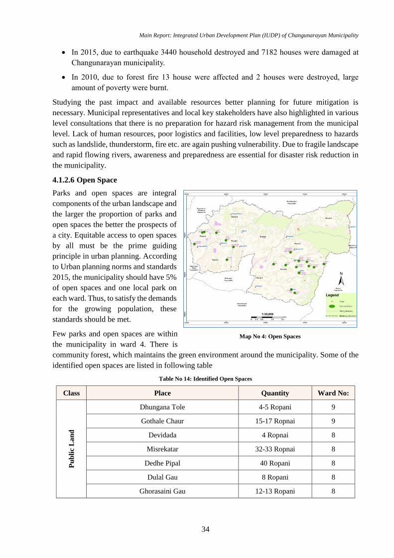
Main Report: Integrated Urban Development Plan (IUDP) of Changunarayan Municipality
34
In 2015, due to earthquake 3440 household destroyed and 7182 houses were damaged at
Changunarayan municipality.
In 2010, due to forest fire 13 house were affected and 2 houses were destroyed, large
amount of poverty were burnt.
Studying the past impact and available resources better planning for future mitigation is
necessary. Municipal representatives and local key stakeholders have also highlighted in various
level consultations that there is no preparation for hazard risk management from the municipal
level. Lack of human resources, poor logistics and facilities, low level preparedness to hazards
such as landslide, thunderstorm, fire etc. are again pushing vulnerability. Due to fragile landscape
and rapid flowing rivers, awareness and preparedness are essential for disaster risk reduction in
the municipality.
4.1.2.6 Open Space
Parks and open spaces are integral
components of the urban landscape and
the larger the proportion of parks and
open spaces the better the prospects of
a city. Equitable access to open spaces
by all must be the prime guiding
principle in urban planning. According
to Urban planning norms and standards
2015, the municipality should have 5%
of open spaces and one local park on
each ward. Thus, to satisfy the demands
for the growing population, these
standards should be met.
Few parks and open spaces are within
the municipality in ward 4. There is
community forest, which maintains the green environment around the municipality. Some of the
identified open spaces are listed in following table
Table No 14: Identified Open Spaces
Class Place Quantity Ward No:
Pu
bli
c L
an
d
Dhungana Tole 4-5 Ropani 9
Gothale Chaur 15-17 Ropnai 9
Devidada 4 Ropnai 8
Misrekatar 32-33 Ropnai 8
Dedhe Pipal 40 Ropani 8
Dulal Gau 8 Ropani 8
Ghorasaini Gau 12-13 Ropani 8
Map No 4: Open Spaces
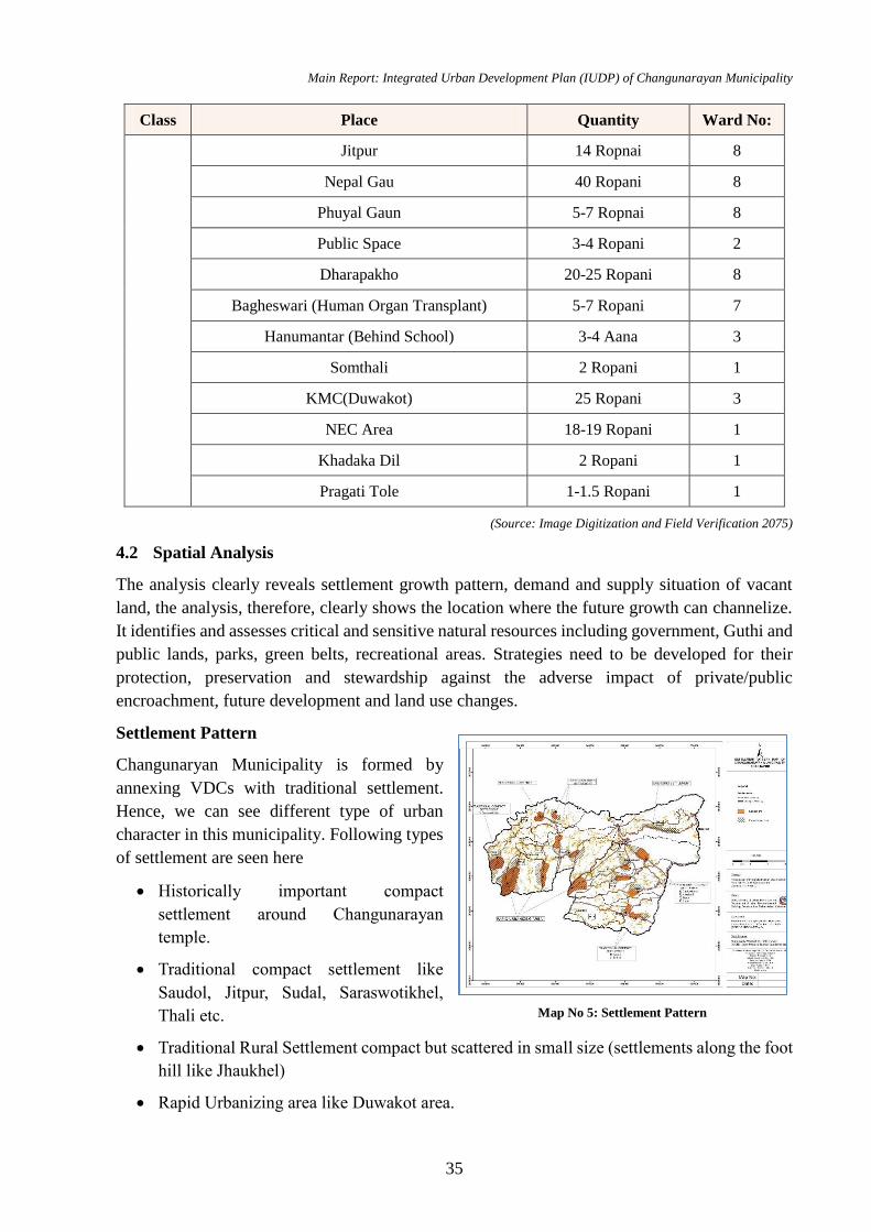
Main Report: Integrated Urban Development Plan (IUDP) of Changunarayan Municipality
35
Class Place Quantity Ward No:
Jitpur 14 Ropnai 8
Nepal Gau 40 Ropani 8
Phuyal Gaun 5-7 Ropnai 8
Public Space 3-4 Ropani 2
Dharapakho 20-25 Ropani 8
Bagheswari (Human Organ Transplant) 5-7 Ropani 7
Hanumantar (Behind School) 3-4 Aana 3
Somthali 2 Ropani 1
KMC(Duwakot) 25 Ropani 3
NEC Area 18-19 Ropani 1
Khadaka Dil 2 Ropani 1
Pragati Tole 1-1.5 Ropani 1
(Source: Image Digitization and Field Verification 2075)
4.2 Spatial Analysis
The analysis clearly reveals settlement growth pattern, demand and supply situation of vacant
land, the analysis, therefore, clearly shows the location where the future growth can channelize.
It identifies and assesses critical and sensitive natural resources including government, Guthi and
public lands, parks, green belts, recreational areas. Strategies need to be developed for their
protection, preservation and stewardship against the adverse impact of private/public
encroachment, future development and land use changes.
Settlement Pattern
Changunaryan Municipality is formed by
annexing VDCs with traditional settlement.
Hence, we can see different type of urban
character in this municipality. Following types
of settlement are seen here
Historically important compact
settlement around Changunarayan
temple.
Traditional compact settlement like
Saudol, Jitpur, Sudal, Saraswotikhel,
Thali etc.
Traditional Rural Settlement compact but scattered in small size (settlements along the foot
hill like Jhaukhel)
Rapid Urbanizing area like Duwakot area.
Map No 5: Settlement Pattern
Main Report: Integrated Urban Development Plan (IUDP) of Changunarayan Municipality
36
New Emerging settlement like in Kharipati etc.
Settlement pattern in Duwakot area is such that around 1000 population are living there per square
kilometre.
Settlement Hierarchy
Settlement hierarchy is the rank of settlement according to infrastructures and facilities available
at the given area of settlement. The hierarchy represents the urban area at top level while rural
area at lower level. The areas with most of infrastructural facilities available at Changunarayan
municipality is shown as:
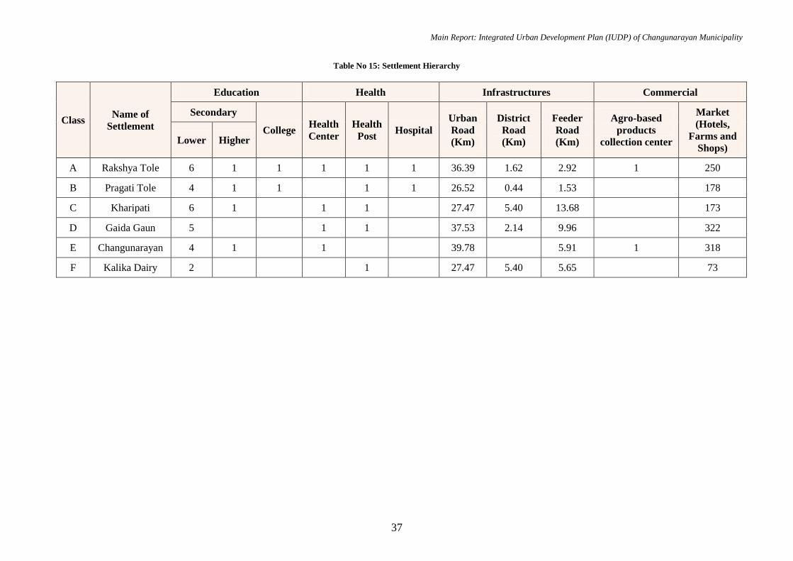
Main Report: Integrated Urban Development Plan (IUDP) of Changunarayan Municipality
37
Table No 15: Settlement Hierarchy
Class Name of
Settlement
Education Health Infrastructures Commercial
Secondary
College Health
Center
Health
Post Hospital
Urban
Road
(Km)
District
Road
(Km)
Feeder
Road
(Km)
Agro-based
products
collection center
Market
(Hotels,
Farms and
Shops) Lower Higher
A Rakshya Tole 6 1 1 1 1 1 36.39 1.62 2.92 1 250
B Pragati Tole 4 1 1 1 1 26.52 0.44 1.53 178
C Kharipati 6 1 1 1 27.47 5.40 13.68 173
D Gaida Gaun 5 1 1 37.53 2.14 9.96 322
E Changunarayan 4 1 1 39.78 5.91 1 318
F Kalika Dairy 2 1 27.47 5.40 5.65 73

Main Report: Integrated Urban Development Plan (IUDP) of Changunarayan Municipality
38
The indicators that define the settlement
hierarchy are taken based on the parameters of
2015 urban planning norms and standards.
As seen, Rakshya tole is class A settlement
with most of facilities available like school,
college, health center, hospital, market and
vegetable collection center and likewise
Pragati tole, Kharipati, Gaida Gaun,
Changunarayan and Kalika Dairy serially (B,
C, D, E and F) interms of services available.
Due to services present, people are seen to be
migrating towards these areas in search to meet
their basic needs.
Rakshya tole is a class A settlement due to presence of adequate social infrastructure. Education
services are available as 6 lower secondary school, 1 higher secondary and 1 college. Health
services are available as 1 health centre, 1 health post and 1 hospital. Also, there are 1 vegetable
distribution centers and adequate number of market and shops. With closest linkage to highway
via feeder road (Sallaghari – Changunarayan), Rakhsya tole can be seen as major urbanization
zone. Similarly, other areas are ranked in hierarchy with availability of social infrastructures.
Most of the settlements are traditional which are compact settlements like Changunarayan,
Kharipati, Pragati tole, etc. These settlements are developed along the major roads of the
municipality and all the settlements are inter connected to each other which makes easy access
for import and export of goods.
The following map shows the settlement hierarchy of Changunarayan Municipality:
Change in Built Up Area
As the construction and expansion of Koteshowr- Jadibuti Road section, huge change in builtup
area has seen around the Duwakot and Jhaukhel area. Due to availability of the low-cost land and
environmentally friendly are some of the reason of development of these area as the residential
area. Some of the pocket of these area and respective data are shown below.
Figure No 7 : Built up Area of Changunarayan
Table No 16: Built up Area
Map No 6: Settlement Hierarchy
Builtup Area 2005
Builtup Area
2018

Main Report: Integrated Urban Development Plan (IUDP) of Changunarayan Municipality
39
From above table we can analyzed that built up area of Changunarayan pocket 1,2 and 3. Pocket
no 2 has been increased by 33% per annum from 2005 to 2018. It simply signifies that the
urbanization pressure is high in pocket 2. Similarly, Pocket 1 and 3 are other area where
urbanization takes place in low than packed 2.
Road Development
This municipality has total road network of 334.33 Km out of which 195 km i.e. 59 % road has
been developed in past 10 years, which signifies that huge investment has been made in the road
development. According to Urban planning norms and standards 2015, the road for a municipality
should be in the rate of 5km/sq.km. This standard is meet in this municipality. However, only
16% of the road are blacktop which should be 80%. Thus, necessary arrangements and plans
should be formulated to meet the norms.
Map No 7: Road Development in last 10 years
Comparative Chart of road development before and after 2008 AD is shown below:
Location Pocket Built up area in sq km Change in
Built up area
Annual Change
in Built up area 2005 AD 2018 AD
Duwakot Pocket 1 0.34 0.51 151% 12%
Jhaukhel Pocket 2 0.16 0.68 430% 33%
Duwakot Height Pocket 3 0.45 0.78 175% 13%
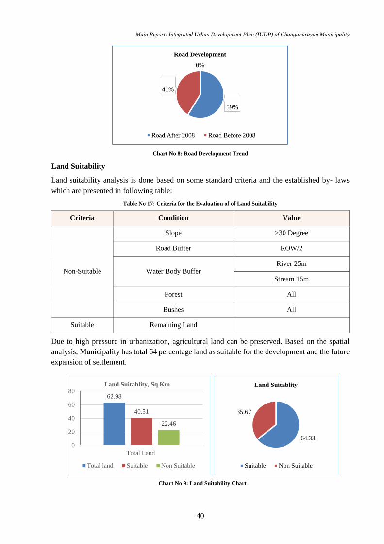
Main Report: Integrated Urban Development Plan (IUDP) of Changunarayan Municipality
40
Chart No 8: Road Development Trend
Land Suitability
Land suitability analysis is done based on some standard criteria and the established by- laws
which are presented in following table:
Table No 17: Criteria for the Evaluation of of Land Suitability
Criteria Condition Value
Non-Suitable
Slope >30 Degree
Road Buffer ROW/2
Water Body Buffer River 25m
Stream 15m
Forest All
Bushes All
Suitable Remaining Land
Due to high pressure in urbanization, agricultural land can be preserved. Based on the spatial
analysis, Municipality has total 64 percentage land as suitable for the development and the future
expansion of settlement.
59%
41%
0%0%
Road Development
Road After 2008 Road Before 2008
62.98
40.51
22.46
0
20
40
60
80
Total Land
Land Suitablity, Sq Km
Total land Suitable Non Suitable
64.33
35.67
Land Suitablity
Suitable Non Suitable
Chart No 9: Land Suitability Chart

Main Report: Integrated Urban Development Plan (IUDP) of Changunarayan Municipality
41
Map No 8: Land Suitability Map
4.3 Social Analysis
4.3.1 Social Infrastructure
Social Infrastructure enhances and governs the social–economic behaviour of the community or
people living in society. It clearly tells the cultural enhancement and physical development of the
society. Other important social infrastructure of this municipality is shown in the following table
and also represented in map
Table No 18: Social Infrastructure
Ward
No: Infrastructure Number
House
Hold (HH) Population
P_Density
(no/Sq.Km)
1
Buspark 2
1244 6101 1577
Finance 1
Government Office 1
Health Post 1
Hospital 1
Public Building 2
School 6
Temple 5
2
College 1
1229 6020 1300 Government Office 2
Hospital 1
Media 1

Main Report: Integrated Urban Development Plan (IUDP) of Changunarayan Municipality
42
Ward
No: Infrastructure Number
House
Hold (HH) Population
P_Density
(no/Sq.Km)
Police Station 1
School 6
Temple 4
3
Government Office 1
1211 5702 1882
Health Post 1
Hospital 1
School 2
Temple 4
4
College 1
1286 6024 888
Buspark 1
Government Office 1
Museum 2
Park 1
School 5
Sport 1
Temple 7
5
Government Office 2
1817 6398 666 Health Post 1
Public Building 3
School 5
6
Government Office 1
904 4024 425
Buspark 1
Health Post 1
Hospital 1
Military 1
Police Station 1
School 7
Temple 2
7
Government Office 1
1126 5723 599 Health Post 1
Military 2
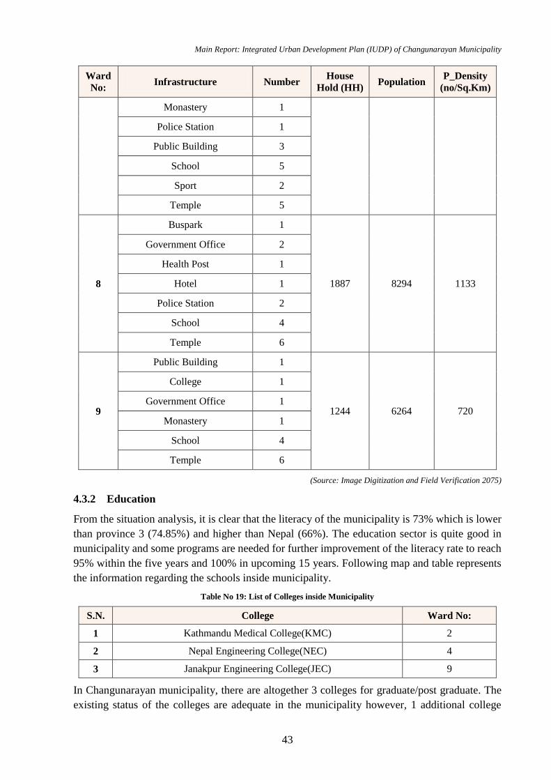
Main Report: Integrated Urban Development Plan (IUDP) of Changunarayan Municipality
43
Ward
No: Infrastructure Number
House
Hold (HH) Population
P_Density
(no/Sq.Km)
Monastery 1
Police Station 1
Public Building 3
School 5
Sport 2
Temple 5
8
Buspark 1
1887 8294 1133
Government Office 2
Health Post 1
Hotel 1
Police Station 2
School 4
Temple 6
9
Public Building 1
1244 6264 720
College 1
Government Office 1
Monastery 1
School 4
Temple 6
(Source: Image Digitization and Field Verification 2075)
4.3.2 Education
From the situation analysis, it is clear that the literacy of the municipality is 73% which is lower
than province 3 (74.85%) and higher than Nepal (66%). The education sector is quite good in
municipality and some programs are needed for further improvement of the literacy rate to reach
95% within the five years and 100% in upcoming 15 years. Following map and table represents
the information regarding the schools inside municipality.
Table No 19: List of Colleges inside Municipality
S.N. College Ward No:
1 Kathmandu Medical College(KMC) 2
2 Nepal Engineering College(NEC) 4
3 Janakpur Engineering College(JEC) 9
In Changunarayan municipality, there are altogether 3 colleges for graduate/post graduate. The
existing status of the colleges are adequate in the municipality however, 1 additional college
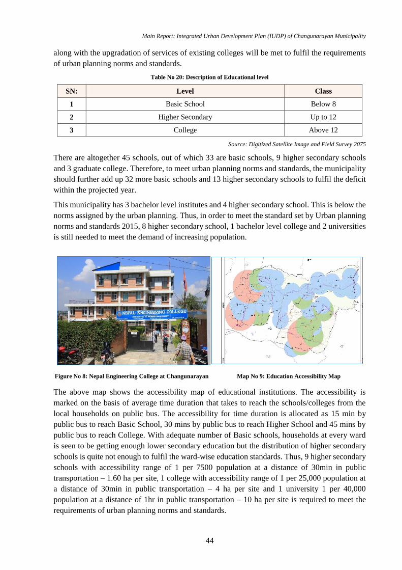
Main Report: Integrated Urban Development Plan (IUDP) of Changunarayan Municipality
44
along with the upgradation of services of existing colleges will be met to fulfil the requirements
of urban planning norms and standards.
Table No 20: Description of Educational level
SN: Level Class
1 Basic School Below 8
2 Higher Secondary Up to 12
3 College Above 12
Source: Digitized Satellite Image and Field Survey 2075
There are altogether 45 schools, out of which 33 are basic schools, 9 higher secondary schools
and 3 graduate college. Therefore, to meet urban planning norms and standards, the municipality
should further add up 32 more basic schools and 13 higher secondary schools to fulfil the deficit
within the projected year.
This municipality has 3 bachelor level institutes and 4 higher secondary school. This is below the
norms assigned by the urban planning. Thus, in order to meet the standard set by Urban planning
norms and standards 2015, 8 higher secondary school, 1 bachelor level college and 2 universities
is still needed to meet the demand of increasing population.
The above map shows the accessibility map of educational institutions. The accessibility is
marked on the basis of average time duration that takes to reach the schools/colleges from the
local households on public bus. The accessibility for time duration is allocated as 15 min by
public bus to reach Basic School, 30 mins by public bus to reach Higher School and 45 mins by
public bus to reach College. With adequate number of Basic schools, households at every ward
is seen to be getting enough lower secondary education but the distribution of higher secondary
schools is quite not enough to fulfil the ward-wise education standards. Thus, 9 higher secondary
schools with accessibility range of 1 per 7500 population at a distance of 30min in public
transportation – 1.60 ha per site, 1 college with accessibility range of 1 per 25,000 population at
a distance of 30min in public transportation – 4 ha per site and 1 university 1 per 40,000
population at a distance of 1hr in public transportation – 10 ha per site is required to meet the
requirements of urban planning norms and standards.
Figure No 8: Nepal Engineering College at Changunarayan Map No 9: Education Accessibility Map
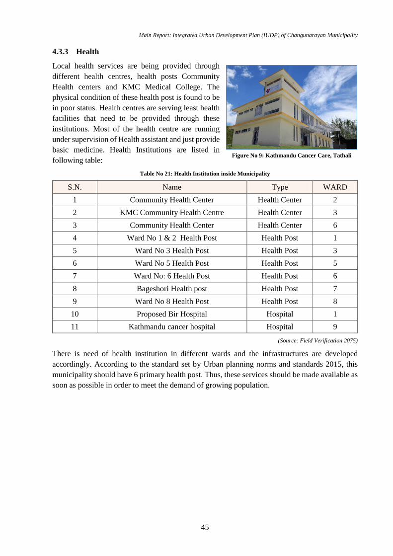
Main Report: Integrated Urban Development Plan (IUDP) of Changunarayan Municipality
45
4.3.3 Health
Local health services are being provided through
different health centres, health posts Community
Health centers and KMC Medical College. The
physical condition of these health post is found to be
in poor status. Health centres are serving least health
facilities that need to be provided through these
institutions. Most of the health centre are running
under supervision of Health assistant and just provide
basic medicine. Health Institutions are listed in
following table:
Table No 21: Health Institution inside Municipality
S.N. Name Type WARD
1 Community Health Center Health Center 2
2 KMC Community Health Centre Health Center 3
3 Community Health Center Health Center 6
4 Ward No 1 & 2 Health Post Health Post 1
5 Ward No 3 Health Post Health Post 3
6 Ward No 5 Health Post Health Post 5
7 Ward No: 6 Health Post Health Post 6
8 Bageshori Health post Health Post 7
9 Ward No 8 Health Post Health Post 8
10 Proposed Bir Hospital Hospital 1
11 Kathmandu cancer hospital Hospital 9
(Source: Field Verification 2075)
There is need of health institution in different wards and the infrastructures are developed
accordingly. According to the standard set by Urban planning norms and standards 2015, this
municipality should have 6 primary health post. Thus, these services should be made available as
soon as possible in order to meet the demand of growing population.
Figure No 9: Kathmandu Cancer Care, Tathali
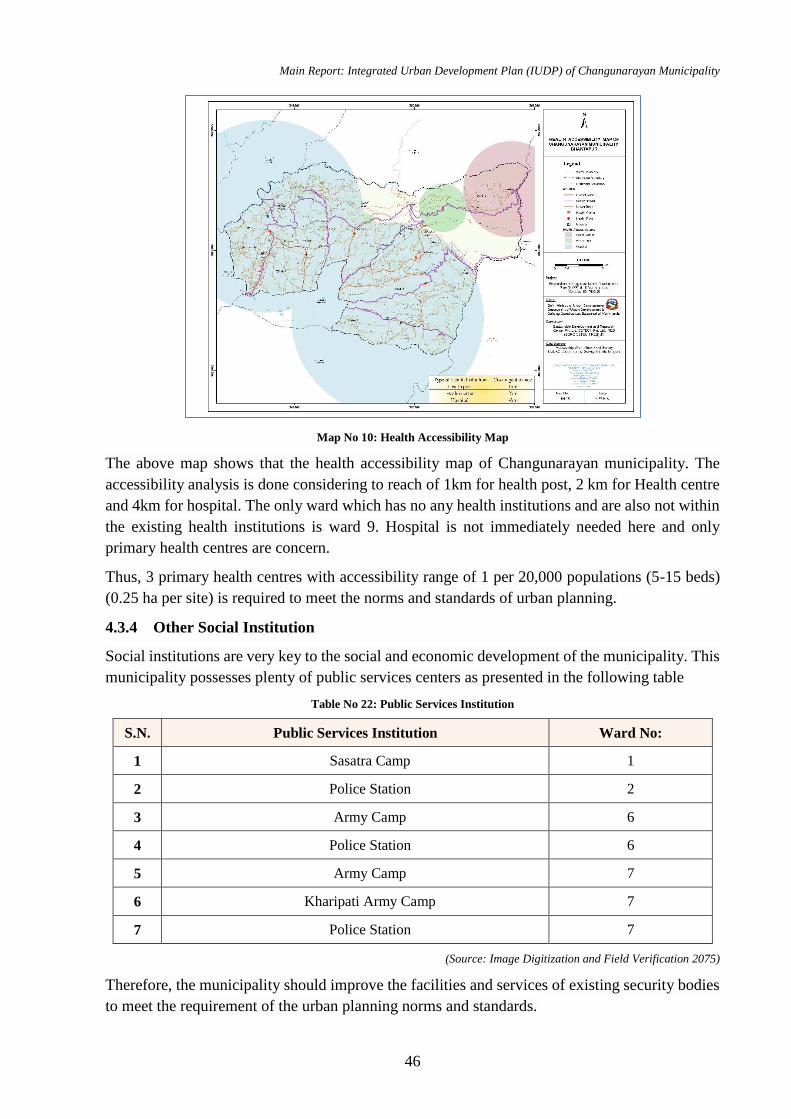
Main Report: Integrated Urban Development Plan (IUDP) of Changunarayan Municipality
46
Map No 10: Health Accessibility Map
The above map shows that the health accessibility map of Changunarayan municipality. The
accessibility analysis is done considering to reach of 1km for health post, 2 km for Health centre
and 4km for hospital. The only ward which has no any health institutions and are also not within
the existing health institutions is ward 9. Hospital is not immediately needed here and only
primary health centres are concern.
Thus, 3 primary health centres with accessibility range of 1 per 20,000 populations (5-15 beds)
(0.25 ha per site) is required to meet the norms and standards of urban planning.
4.3.4 Other Social Institution
Social institutions are very key to the social and economic development of the municipality. This
municipality possesses plenty of public services centers as presented in the following table
Table No 22: Public Services Institution
S.N. Public Services Institution Ward No:
1 Sasatra Camp 1
2 Police Station 2
3 Army Camp 6
4 Police Station 6
5 Army Camp 7
6 Kharipati Army Camp 7
7 Police Station 7
(Source: Image Digitization and Field Verification 2075)
Therefore, the municipality should improve the facilities and services of existing security bodies
to meet the requirement of the urban planning norms and standards.
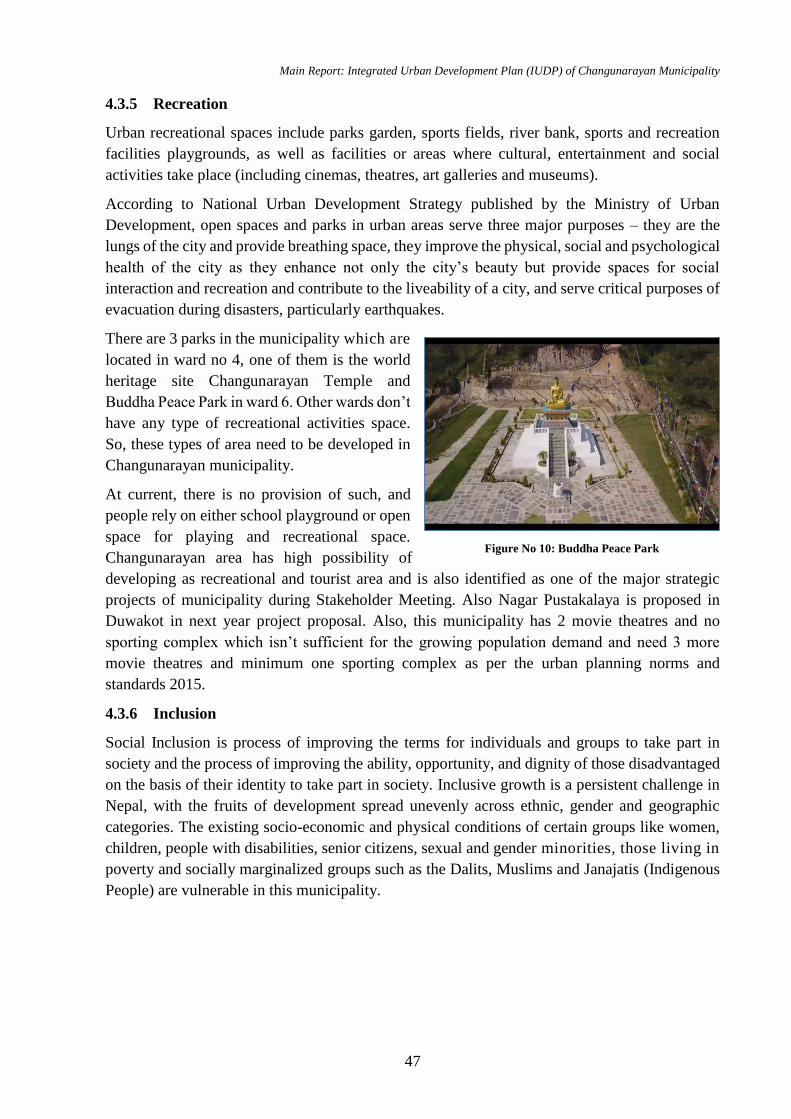
Main Report: Integrated Urban Development Plan (IUDP) of Changunarayan Municipality
47
4.3.5 Recreation
Urban recreational spaces include parks garden, sports fields, river bank, sports and recreation
facilities playgrounds, as well as facilities or areas where cultural, entertainment and social
activities take place (including cinemas, theatres, art galleries and museums).
According to National Urban Development Strategy published by the Ministry of Urban
Development, open spaces and parks in urban areas serve three major purposes – they are the
lungs of the city and provide breathing space, they improve the physical, social and psychological
health of the city as they enhance not only the city’s beauty but provide spaces for social
interaction and recreation and contribute to the liveability of a city, and serve critical purposes of
evacuation during disasters, particularly earthquakes.
There are 3 parks in the municipality which are
located in ward no 4, one of them is the world
heritage site Changunarayan Temple and
Buddha Peace Park in ward 6. Other wards don’t
have any type of recreational activities space.
So, these types of area need to be developed in
Changunarayan municipality.
At current, there is no provision of such, and
people rely on either school playground or open
space for playing and recreational space.
Changunarayan area has high possibility of
developing as recreational and tourist area and is also identified as one of the major strategic
projects of municipality during Stakeholder Meeting. Also Nagar Pustakalaya is proposed in
Duwakot in next year project proposal. Also, this municipality has 2 movie theatres and no
sporting complex which isn’t sufficient for the growing population demand and need 3 more
movie theatres and minimum one sporting complex as per the urban planning norms and
standards 2015.
4.3.6 Inclusion
Social Inclusion is process of improving the terms for individuals and groups to take part in
society and the process of improving the ability, opportunity, and dignity of those disadvantaged
on the basis of their identity to take part in society. Inclusive growth is a persistent challenge in
Nepal, with the fruits of development spread unevenly across ethnic, gender and geographic
categories. The existing socio-economic and physical conditions of certain groups like women,
children, people with disabilities, senior citizens, sexual and gender minorities, those living in
poverty and socially marginalized groups such as the Dalits, Muslims and Janajatis (Indigenous
People) are vulnerable in this municipality.
Figure No 10: Buddha Peace Park
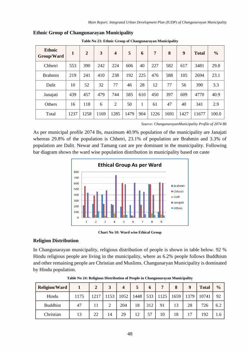
Main Report: Integrated Urban Development Plan (IUDP) of Changunarayan Municipality
48
Ethnic Group of Changunarayan Municipality
Table No 23: Ethnic Group of Changunarayan Municipality
Ethnic
Group/Ward 1 2 3 4 5 6 7 8 9 Total %
Chhetri 553 390 242 224 606 40 227 582 617 3481 29.8
Brahmin 219 241 410 238 192 225 476 588 105 2694 23.1
Dalit 10 52 32 77 46 28 12 77 56 390 3.3
Janajati 439 457 479 744 585 610 450 397 609 4770 40.9
Others 16 118 6 2 50 1 61 47 40 341 2.9
Total 1237 1258 1169 1285 1479 904 1226 1691 1427 11677 100.0
Source: ChangunarayanMunicipality Profile of 2074 BS
As per municipal profile 2074 Bs, maximum 40.9% population of the municipality are Janajati
whereas 29.8% of the population is Chhetri, 23.1% of population are Brahmin and 3.3% of
population are Dalit. Newar and Tamang cast are pre dominant in the municipality. Following
bar diagram shows the ward wise population distribution in municipality based on caste
Chart No 10: Ward wise Ethical Group
Religion Distribution
In Changunarayan municipality, religious distribution of people is shown in table below. 92 %
Hindu religious people are living in the municipality, where as 6.2% people follows Buddhism
and other remaining people are Christian and Muslims. Changunaryan Municipality is dominated
by Hindu population.
Table No 24: Religious Distribution of People in Changunarayan Municipality
Religion/Ward 1 2 3 4 5 6 7 8 9 Total %
Hindu 1175 1217 1153 1052 1448 533 1125 1659 1379 10741 92
Buddhist 47 11 2 204 18 312 91 13 28 726 6.2
Christian 13 22 14 29 12 57 10 18 17 192 1.6
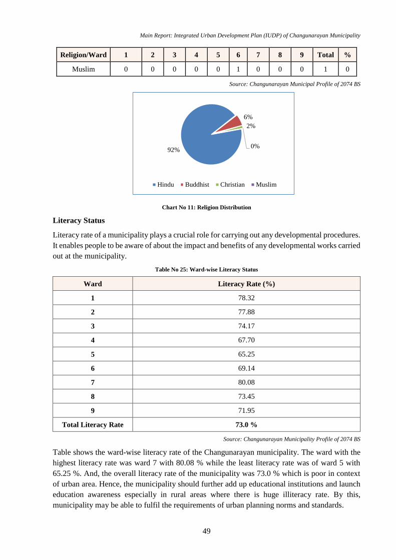
Main Report: Integrated Urban Development Plan (IUDP) of Changunarayan Municipality
49
Religion/Ward 1 2 3 4 5 6 7 8 9 Total %
Muslim 0 0 0 0 0 1 0 0 0 1 0
Source: Changunarayan Municipal Profile of 2074 BS
Chart No 11: Religion Distribution
Literacy Status
Literacy rate of a municipality plays a crucial role for carrying out any developmental procedures.
It enables people to be aware of about the impact and benefits of any developmental works carried
out at the municipality.
Table No 25: Ward-wise Literacy Status
Ward Literacy Rate (%)
1 78.32
2 77.88
3 74.17
4 67.70
5 65.25
6 69.14
7 80.08
8 73.45
9 71.95
Total Literacy Rate 73.0 %
Source: Changunarayan Municipality Profile of 2074 BS
Table shows the ward-wise literacy rate of the Changunarayan municipality. The ward with the
highest literacy rate was ward 7 with 80.08 % while the least literacy rate was of ward 5 with
65.25 %. And, the overall literacy rate of the municipality was 73.0 % which is poor in context
of urban area. Hence, the municipality should further add up educational institutions and launch
education awareness especially in rural areas where there is huge illiteracy rate. By this,
municipality may be able to fulfil the requirements of urban planning norms and standards.
92%
6%
2%
0%
Hindu Buddhist Christian Muslim
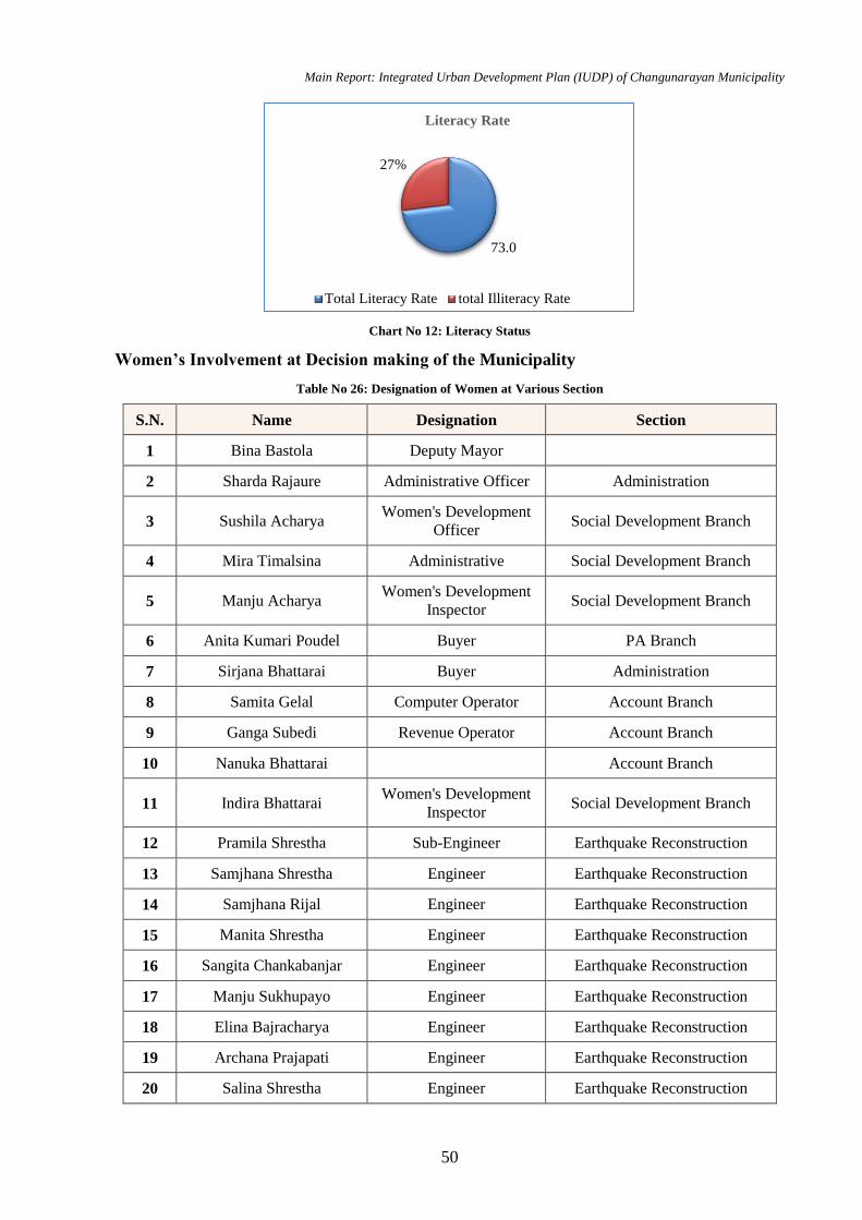
Main Report: Integrated Urban Development Plan (IUDP) of Changunarayan Municipality
50
Chart No 12: Literacy Status
Women’s Involvement at Decision making of the Municipality
Table No 26: Designation of Women at Various Section
S.N. Name Designation Section
1 Bina Bastola Deputy Mayor
2 Sharda Rajaure Administrative Officer Administration
3 Sushila Acharya Women's Development
Officer Social Development Branch
4 Mira Timalsina Administrative Social Development Branch
5 Manju Acharya Women's Development
Inspector Social Development Branch
6 Anita Kumari Poudel Buyer PA Branch
7 Sirjana Bhattarai Buyer Administration
8 Samita Gelal Computer Operator Account Branch
9 Ganga Subedi Revenue Operator Account Branch
10 Nanuka Bhattarai Account Branch
11 Indira Bhattarai Women's Development
Inspector Social Development Branch
12 Pramila Shrestha Sub-Engineer Earthquake Reconstruction
13 Samjhana Shrestha Engineer Earthquake Reconstruction
14 Samjhana Rijal Engineer Earthquake Reconstruction
15 Manita Shrestha Engineer Earthquake Reconstruction
16 Sangita Chankabanjar Engineer Earthquake Reconstruction
17 Manju Sukhupayo Engineer Earthquake Reconstruction
18 Elina Bajracharya Engineer Earthquake Reconstruction
19 Archana Prajapati Engineer Earthquake Reconstruction
20 Salina Shrestha Engineer Earthquake Reconstruction
73.0
27%
Literacy Rate
Total Literacy Rate total Illiteracy Rate
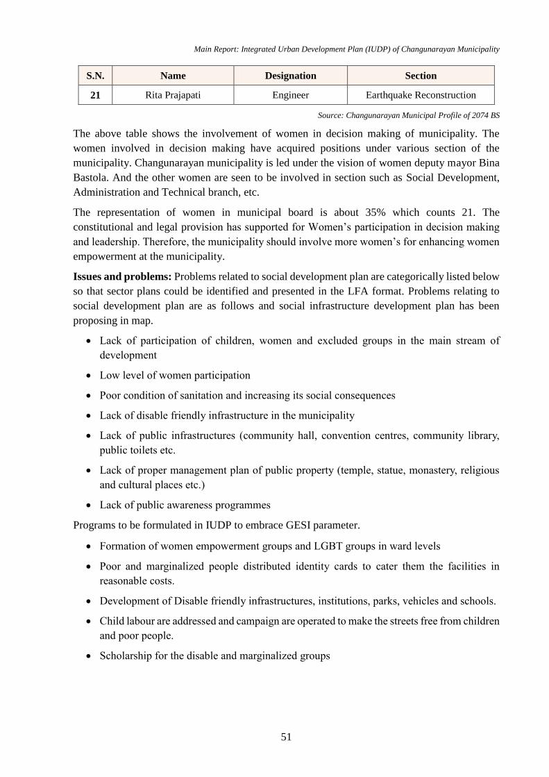
Main Report: Integrated Urban Development Plan (IUDP) of Changunarayan Municipality
51
S.N. Name Designation Section
21 Rita Prajapati Engineer Earthquake Reconstruction
Source: Changunarayan Municipal Profile of 2074 BS
The above table shows the involvement of women in decision making of municipality. The
women involved in decision making have acquired positions under various section of the
municipality. Changunarayan municipality is led under the vision of women deputy mayor Bina
Bastola. And the other women are seen to be involved in section such as Social Development,
Administration and Technical branch, etc.
The representation of women in municipal board is about 35% which counts 21. The
constitutional and legal provision has supported for Women’s participation in decision making
and leadership. Therefore, the municipality should involve more women’s for enhancing women
empowerment at the municipality.
Issues and problems: Problems related to social development plan are categorically listed below
so that sector plans could be identified and presented in the LFA format. Problems relating to
social development plan are as follows and social infrastructure development plan has been
proposing in map.
Lack of participation of children, women and excluded groups in the main stream of
development
Low level of women participation
Poor condition of sanitation and increasing its social consequences
Lack of disable friendly infrastructure in the municipality
Lack of public infrastructures (community hall, convention centres, community library,
public toilets etc.
Lack of proper management plan of public property (temple, statue, monastery, religious
and cultural places etc.)
Lack of public awareness programmes
Programs to be formulated in IUDP to embrace GESI parameter.
Formation of women empowerment groups and LGBT groups in ward levels
Poor and marginalized people distributed identity cards to cater them the facilities in
reasonable costs.
Development of Disable friendly infrastructures, institutions, parks, vehicles and schools.
Child labour are addressed and campaign are operated to make the streets free from children
and poor people.
Scholarship for the disable and marginalized groups
Main Report: Integrated Urban Development Plan (IUDP) of Changunarayan Municipality
52
4.4 Economic Analysis
The main occupation of the people residing in this municipality is Agriculture (44.6%). However,
some people have involved in government job (13.9%), foreign employment (3.3%), and
remaining in others for economic activities.
4.4.1 Agriculture
Due to the topography and soil type, agriculture is the number one source of income generation
in Changunarayan municipality. As agriculture is vital in these areas, statistics of agriculture can
be taken as the indicator of economic development. But lack of modern technology in farming,
lack of irrigation facilities, shortage of agricultural labor, expensive agricultural labor, become
main problems in agricultural activities. But still Changunarayan has managed its economic
growth through agro-farming. Rapid urbanization and trend of land plotting has drastically
reduced the agricultural profession.
The cash crops like vegetables has been cultivated by the farmers. Since, Kathmandu, Lalitpur
Metro-politan Cities lies near to this municipality, it has good market.
Also, there is 1 slaughter house and 2 vegetable markets which doesn’t meet the standards set by
Urban planning norms and standards 2015 which should be 2 slaughter houses and 5 vegetable
markets. Thus, one extra slaughter house and 3 vegetable markets should be established in order
to meet the demands of growing population.
Table No 27: Agricultural Crop Production
Produced Crops Crops produced Land
(Hectare) Quantity (quintal) Price (NRs)
Cereal Crops
Paddy 1154 56607.15 98496444
Maize 565 22818.74 39704602
Millet 29 351.49 632689
Wheat 687 32604.33 52166929
Total 2435 112381.71 191000665
Pulses
Soyabean, Black
Gram, Lintel etc 86 898.10 6735717
Spice Crops
Ginger, Garlic,
Turmeric, Dry
Chilli
67 697.31 23359764
Vegetable Crops
Potato 290 56639.9 311519450
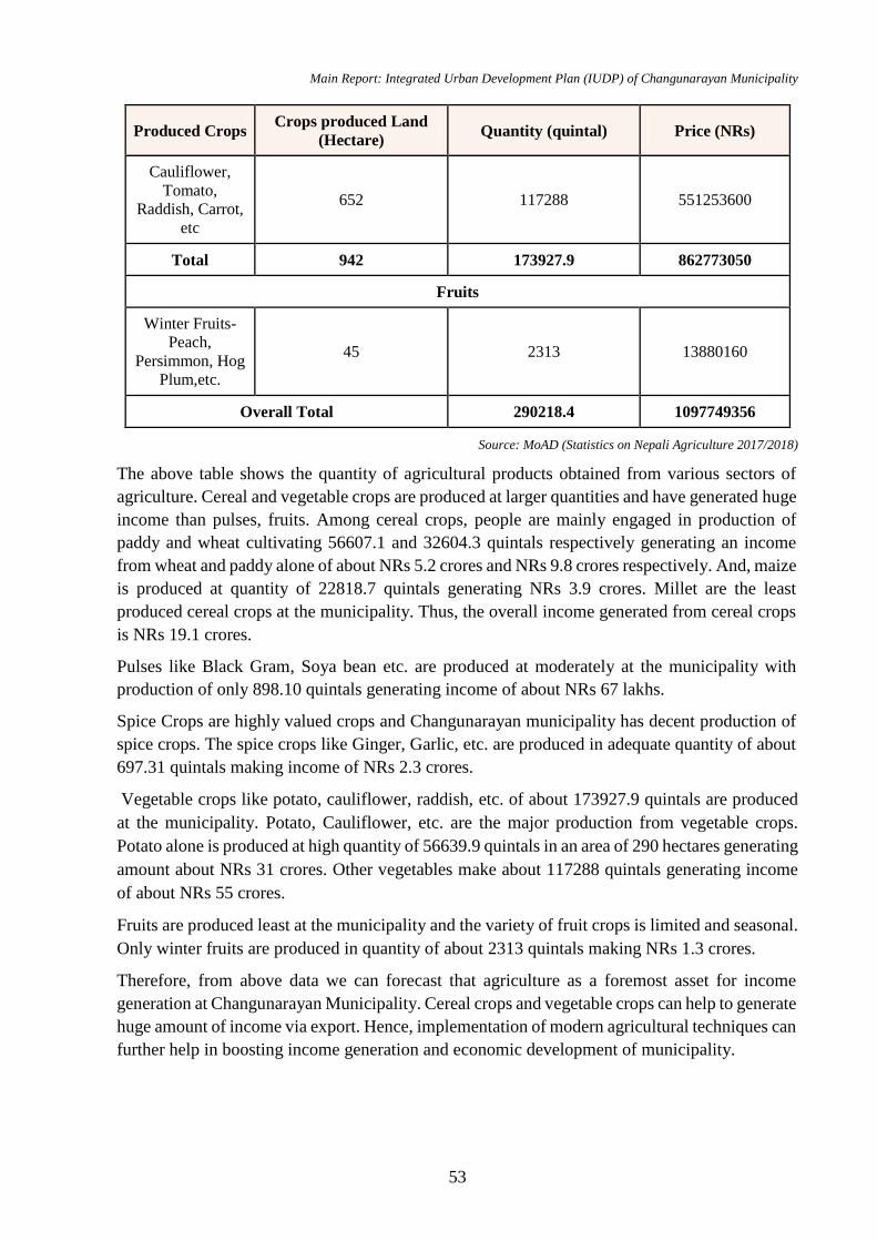
Main Report: Integrated Urban Development Plan (IUDP) of Changunarayan Municipality
53
Produced Crops Crops produced Land
(Hectare) Quantity (quintal) Price (NRs)
Cauliflower,
Tomato,
Raddish, Carrot,
etc
652 117288 551253600
Total 942 173927.9 862773050
Fruits
Winter Fruits-
Peach,
Persimmon, Hog
Plum,etc.
45 2313 13880160
Overall Total 290218.4 1097749356
Source: MoAD (Statistics on Nepali Agriculture 2017/2018)
The above table shows the quantity of agricultural products obtained from various sectors of
agriculture. Cereal and vegetable crops are produced at larger quantities and have generated huge
income than pulses, fruits. Among cereal crops, people are mainly engaged in production of
paddy and wheat cultivating 56607.1 and 32604.3 quintals respectively generating an income
from wheat and paddy alone of about NRs 5.2 crores and NRs 9.8 crores respectively. And, maize
is produced at quantity of 22818.7 quintals generating NRs 3.9 crores. Millet are the least
produced cereal crops at the municipality. Thus, the overall income generated from cereal crops
is NRs 19.1 crores.
Pulses like Black Gram, Soya bean etc. are produced at moderately at the municipality with
production of only 898.10 quintals generating income of about NRs 67 lakhs.
Spice Crops are highly valued crops and Changunarayan municipality has decent production of
spice crops. The spice crops like Ginger, Garlic, etc. are produced in adequate quantity of about
697.31 quintals making income of NRs 2.3 crores.
Vegetable crops like potato, cauliflower, raddish, etc. of about 173927.9 quintals are produced
at the municipality. Potato, Cauliflower, etc. are the major production from vegetable crops.
Potato alone is produced at high quantity of 56639.9 quintals in an area of 290 hectares generating
amount about NRs 31 crores. Other vegetables make about 117288 quintals generating income
of about NRs 55 crores.
Fruits are produced least at the municipality and the variety of fruit crops is limited and seasonal.
Only winter fruits are produced in quantity of about 2313 quintals making NRs 1.3 crores.
Therefore, from above data we can forecast that agriculture as a foremost asset for income
generation at Changunarayan Municipality. Cereal crops and vegetable crops can help to generate
huge amount of income via export. Hence, implementation of modern agricultural techniques can
further help in boosting income generation and economic development of municipality.
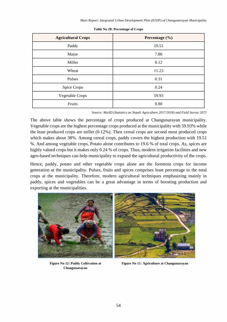
Main Report: Integrated Urban Development Plan (IUDP) of Changunarayan Municipality
54
Table No 28: Percentage of Crops
Agricultural Crops Percentage (%)
Paddy 19.51
Maize 7.86
Millet 0.12
Wheat 11.23
Pulses 0.31
Spice Crops 0.24
Vegetable Crops 59.93
Fruits 0.80
Source: MoAD (Statistics on Nepali Agriculture 2017/2018) and Field Survey 2075
The above table shows the percentage of crops produced at Changunarayan municipality.
Vegetable crops are the highest percentage crops produced at the municipality with 59.93% while
the least produced crops are millet (0.12%). Then cereal crops are second most produced crops
which makes about 38%. Among cereal crops, paddy covers the highest production with 19.51
%. And among vegetable crops, Potato alone contributes to 19.6 % of total crops. As, spices are
highly valued crops but it makes only 0.24 % of crops. Thus, modern irrigation facilities and new
agro-based techniques can help municipality to expand the agricultural productivity of the crops.
Hence, paddy, potato and other vegetable crops alone are the foremost crops for income
generation at the municipality. Pulses, fruits and spices comprises least percentage to the total
crops at the municipality. Therefore, modern agricultural techniques emphasizing mainly in
paddy, spices and vegetables can be a great advantage in terms of boosting production and
exporting at the municipalities.
Figure No 12: Paddy Cultivation at
Changunarayan Figure No 11: Agriculture at Changunarayan
Main Report: Integrated Urban Development Plan (IUDP) of Changunarayan Municipality
55
4.4.2 Livestock
Changunarayan has also managed its economic growth through animal husbandry. There are
poultry farm, Milk dairy, cow goat farm in many areas of the municipality. Facility of different
road linkage makes easy for exporting product to nearby cities like Kathmandu.
Table No 29: Livestock Population
Livestock Population
Cattle 9001
Buffaloes 3336
Sheep 77
Goat 12180
Pigs 3245
Fowl 1003300
Duck 2399
Source: MoAD (Statistics on Nepali Agriculture 2017/2018) and Field Survey 2075
People at Changunarayan municipality are also engaged in animal farming and have managed to
earn adequate income from animal husbandry. Table 28 shows the population of livestock present
at Changunarayan. Fowl, Cattles, Goat and Buffaloes are live stocked at high numbers at the
municipality. For income generation cattle and buffaloes have played crucial role in milk
production at the municipality. Meat production of chickens, pigs are seen high at the
municipality.
Table No 30: Milk Production
S.N. Milking Cows No. Milking
buffaloes No.
Cow Milk
Produced (Metric
tons)
Buffalo
Milk
(Metric
tons)
Total
Milk
Produced
(Metric
tons)
1 1296 918 1578 2323 3901
Source: MoAD (Statistics on Nepali Agriculture 2017/2018)
Milk production is one of the major productions from animal farming at the municipality. Table
69 shows the quantity milk production done at Changunarayan municipality. There are altogether
1296 milk giving cows and 918 buffaloes. The quantity of cow milk produced is 1578 metric tons
whereas that of buffalo is 2323 metric tons. Thus, total 3901 metric tons milk production is done
at the Changunarayan municipality which are used for purpose of making yoghurt, cheese and
also for exporting. Therefore, modern milk production techniques and expansion of animal farms,
dairies can certainly uplift the economic development of the municipality.
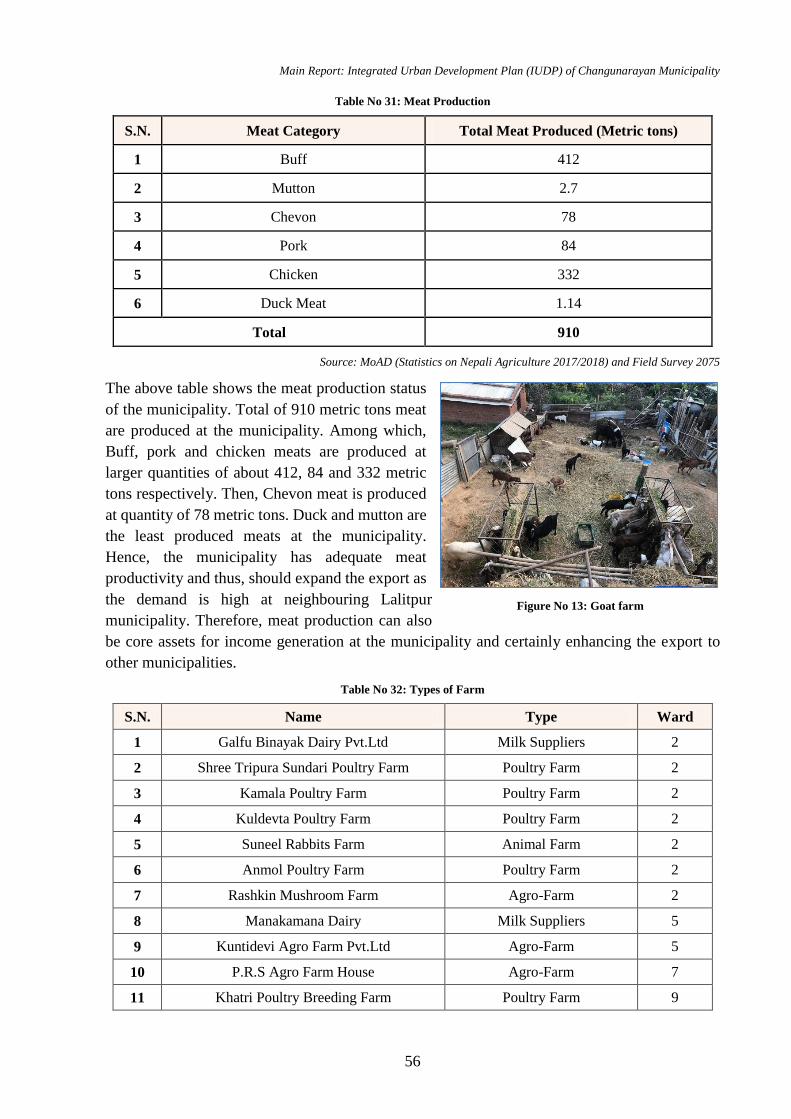
Main Report: Integrated Urban Development Plan (IUDP) of Changunarayan Municipality
56
Table No 31: Meat Production
S.N. Meat Category Total Meat Produced (Metric tons)
1 Buff 412
2 Mutton 2.7
3 Chevon 78
4 Pork 84
5 Chicken 332
6 Duck Meat 1.14
Total 910
Source: MoAD (Statistics on Nepali Agriculture 2017/2018) and Field Survey 2075
The above table shows the meat production status
of the municipality. Total of 910 metric tons meat
are produced at the municipality. Among which,
Buff, pork and chicken meats are produced at
larger quantities of about 412, 84 and 332 metric
tons respectively. Then, Chevon meat is produced
at quantity of 78 metric tons. Duck and mutton are
the least produced meats at the municipality.
Hence, the municipality has adequate meat
productivity and thus, should expand the export as
the demand is high at neighbouring Lalitpur
municipality. Therefore, meat production can also
be core assets for income generation at the municipality and certainly enhancing the export to
other municipalities.
Table No 32: Types of Farm
S.N. Name Type Ward
1 Galfu Binayak Dairy Pvt.Ltd Milk Suppliers 2
2 Shree Tripura Sundari Poultry Farm Poultry Farm 2
3 Kamala Poultry Farm Poultry Farm 2
4 Kuldevta Poultry Farm Poultry Farm 2
5 Suneel Rabbits Farm Animal Farm 2
6 Anmol Poultry Farm Poultry Farm 2
7 Rashkin Mushroom Farm Agro-Farm 2
8 Manakamana Dairy Milk Suppliers 5
9 Kuntidevi Agro Farm Pvt.Ltd Agro-Farm 5
10 P.R.S Agro Farm House Agro-Farm 7
11 Khatri Poultry Breeding Farm Poultry Farm 9
Figure No 13: Goat farm
Main Report: Integrated Urban Development Plan (IUDP) of Changunarayan Municipality
57
S.N. Name Type Ward
12 Saroj Poultry Farm Poultry Farm 8
13 Changunarayan Boer Goat Farm and
Research Center Animal Farm 8
Source: Digitized Satellite Image and Field Survey 2075
Agricultural and animal farms are the farm types present at Changunarayan municipality. Most
of the farms are poultry farms due to which there is huge farming of chickens for egg and meat
production. Agro-farm are limited at the municipality and are only at specific places. With
increasing production of agro-based products, the municipality should expand the agro-farms to
boost the agro-based production at the municipality.
Since, there is proper income generation from milk production and also from meat production of
pork, etc. Thus, the municipality should further add up more cattle farms and animal farms to
make major economic growth from livestock farming.
4.4.3 Mining
Municipality has enhanced the economic growth through
stone and sand mining. There are many stone and sand
crushers functioning in the Changunarayan Municipality.
These resources are exported to Kathmandu and other
areas of valley.
4.4.4 Industry
There are large, medium and small-scale industries in
Changunarayan municipality. Mainly, brick industry,
furniture, rice mill, steel, metal, crushers etc. are main
industries operated in the municipality. Municipality area
has been dominated by brick industry. There are all total
50 brick industry where more than 10,000 people works every day. Each brick industry makes
average annual income of 3.0 million each year.
Except brick industry, other industries are not operated in commercial scale.
Table No 33: Types of Industries
S.N. Name Type of Manufacture Ward
1 Tripura Sundari Brick Factory Bricks
2 Qmed Formulation Pvt.Ltd Pharmaceutical Company 5
3 Gorkha Precast and Windor Pvt.Ltd Concrete 3
4 Suwal Brick and Co Ltd. Bricks 3
5 Eco Brick Company Bricks 7
6 Siddhi Ganesh Dana Udhyog Agro-products 8
7 Khuwa Udhyog Milk Products 9
8 Kanchan Flour Mill Flour Mill 8
Figure No 14: Sand and Soil Mining near
Manohara River

Main Report: Integrated Urban Development Plan (IUDP) of Changunarayan Municipality
58
S.N. Name Type of Manufacture Ward
9 Radha Krishna Agro Seed 9
10 Shikhar Deep Food Industries Pvt.Ltd. Food 5
11 Champak Rice Mill Rice Mill 5
Source: Digitized Satellite Image and Field Survey 2075
The increasing urbanization and loss of farmlands has
seen many people switching from agriculture to non-
farm occupations such as working in brick kilns. The
brick industries at Changunarayan has provided many
employment opportunities to the local households. Other
industries are cottage industries like Mills, etc.
Therefore, the municipality should expand the industries
with growing urbanization trend and allocate special
zones for operating high-scale industries.
4.4.5 Business and Sales
Business and sales indicates the economic growth of a
ward at the municipality. The good road access to Bhaktapur and other municipalities via
Sallaghari-Changunarayan and Nagarkot feeder roads have led to construction of many hotels
and restaurants and the development of local market places such as Rakshya Tole,
Changunarayan, Kharipati etc. Most local businesspersons are small entrepreneurs with limited
investment capacity.
Table No 34: Types of Business and Sales
Business
details
/Ward
1 2 3 4 5 6 7 8 9 Total %
Small shop 72 90 69 57 84 49 104 105 75 705 28.3
Medical shop 1 5 6 1 2 0 4 3 3 25 1.0
Stationery 2 7 12 0 3 2 6 5 3 40 1.6
Hardware 4 8 2 3 4 1 2 6 2 32 1.3
Poultry farming 25 60 24 126 59 16 37 74 52 473 19.0
Sheep farming 7 33 40 77 83 2 25 105 68 440 17.7
Animal
Husbandry 28 47 117 54 87 3 154 179 106 775 31.1
Total 139 250 270 318 322 73 332 477 309 2490 100.0
% 5.6 10.0 10.8 12.8 12.9 2.9 13.3 19.2 12.4 100.0
Source: Changunarayan Municipality Profile of 2074 BS
Figure No 15: Sand and Soil Mining near
Manohara River
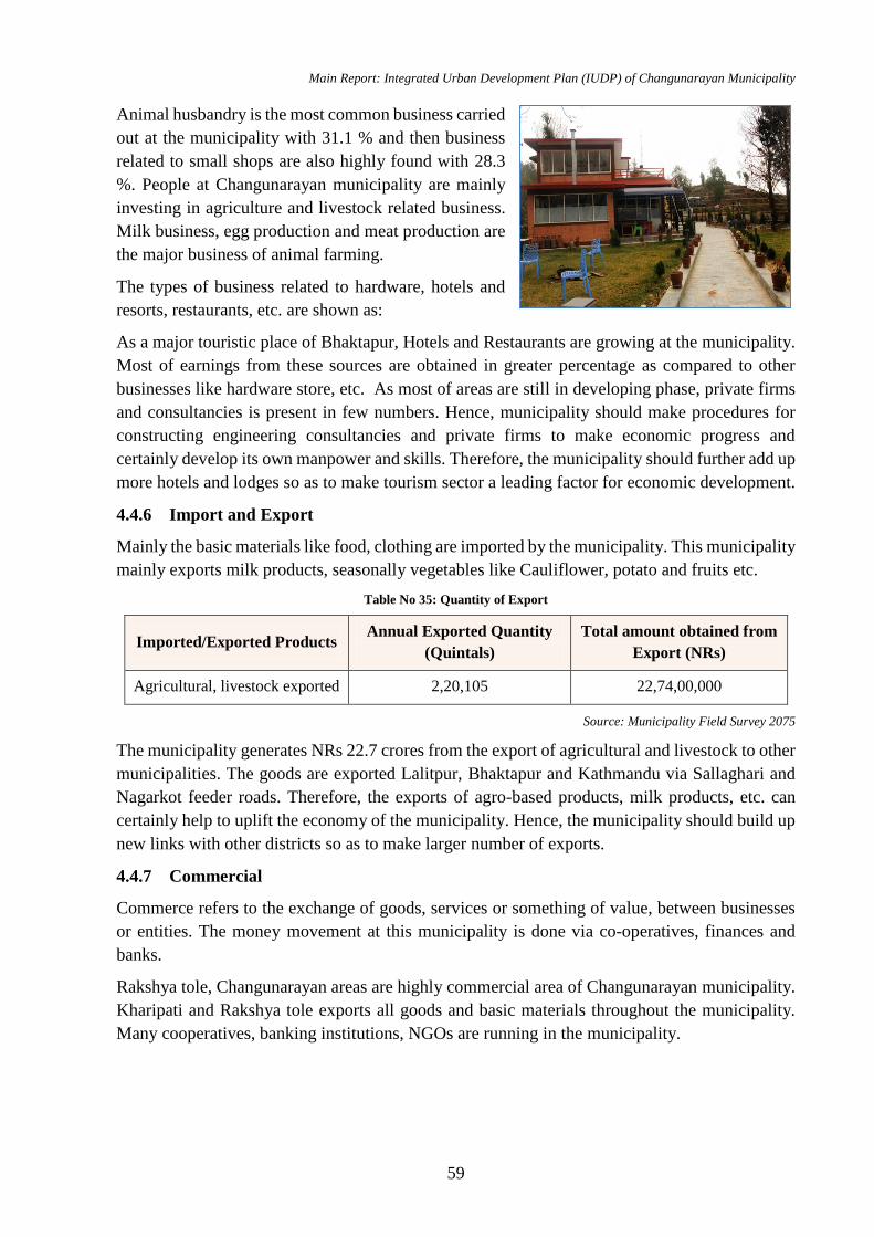
Main Report: Integrated Urban Development Plan (IUDP) of Changunarayan Municipality
59
Animal husbandry is the most common business carried
out at the municipality with 31.1 % and then business
related to small shops are also highly found with 28.3
%. People at Changunarayan municipality are mainly
investing in agriculture and livestock related business.
Milk business, egg production and meat production are
the major business of animal farming.
The types of business related to hardware, hotels and
resorts, restaurants, etc. are shown as:
As a major touristic place of Bhaktapur, Hotels and Restaurants are growing at the municipality.
Most of earnings from these sources are obtained in greater percentage as compared to other
businesses like hardware store, etc. As most of areas are still in developing phase, private firms
and consultancies is present in few numbers. Hence, municipality should make procedures for
constructing engineering consultancies and private firms to make economic progress and
certainly develop its own manpower and skills. Therefore, the municipality should further add up
more hotels and lodges so as to make tourism sector a leading factor for economic development.
4.4.6 Import and Export
Mainly the basic materials like food, clothing are imported by the municipality. This municipality
mainly exports milk products, seasonally vegetables like Cauliflower, potato and fruits etc.
Table No 35: Quantity of Export
Imported/Exported Products Annual Exported Quantity
(Quintals)
Total amount obtained from
Export (NRs)
Agricultural, livestock exported 2,20,105 22,74,00,000
Source: Municipality Field Survey 2075
The municipality generates NRs 22.7 crores from the export of agricultural and livestock to other
municipalities. The goods are exported Lalitpur, Bhaktapur and Kathmandu via Sallaghari and
Nagarkot feeder roads. Therefore, the exports of agro-based products, milk products, etc. can
certainly help to uplift the economy of the municipality. Hence, the municipality should build up
new links with other districts so as to make larger number of exports.
4.4.7 Commercial
Commerce refers to the exchange of goods, services or something of value, between businesses
or entities. The money movement at this municipality is done via co-operatives, finances and
banks.
Rakshya tole, Changunarayan areas are highly commercial area of Changunarayan municipality.
Kharipati and Rakshya tole exports all goods and basic materials throughout the municipality.
Many cooperatives, banking institutions, NGOs are running in the municipality.
Figure No 16: Hotel Hiking
Main Report: Integrated Urban Development Plan (IUDP) of Changunarayan Municipality
60
Table No 36: Types of Existing Cooperatives
S.N. Name Ward
1 Manohara Bachat Tatha Rin Sahakari 1
2 Tathali Saving and Credit Co-operative Ltd. 9
3 Shree Ban Bachat Tatha Shran Sahakari Sanstha 5
4 Jhajhalko Saving and Credit 5
5 Nirdhan Utthan Laghu Bittiya Sanstha Ltd. 5
6 Grameen Bikash Laghu Bittiya Sanstha Ltd. 5
7 Chhinnamasta Women Saving and Credit Cooperative Ltd. 4
8 Muhan Ganesh Saving and Credit Ltd. 7
9 Yuwa Bachat Savings and Credit 7
Source: Digitized Satellite Image and Field Survey 2075
Agricultural and multi-purpose, etc. co-operatives are under operation at the municipality. People
are seen to invest their income from agriculture, business, etc. at co-operatives present in their
ward. These co-operatives also include the scheme to provide loans for the people. Therefore, the
municipality should expand the services of co-operatives to meet the urban planning norms and
standards.
Table No 37: List of Existing Banks
S.N. Name Ward
1 NIC Asia Bank 2
2 Swabalamban Laghubitta Bikash Bank 6
3 Citizen Bank Bhaktapur Chaling BLB 6
4 Subha Labha Saccos 5
5 Bank of Kathmandu, ATM 1
Source: Digitized Satellite Image and Field Survey 2075
The above tables show the types of bank present at the municipality. Banks and financial
institutions are the indicators of development and economy. There is limited banking institution
in Changunarayan municipality. The banks have not yet started investing in the infrastructures
and other development activities. Banks are not interested to finance in sector with greater
possibility of economic development in the municipality.
4.5 Financial Analysis
4.5.1 Income and Expenditure of Municipality
The sources of income of municipality includes local sources, external sources such as sectoral
agencies, IGFT (Inter-Governmental Fiscal Transfer). Local sources are classified into local
taxes, user charges and benefits; and other such as license fees, penalties etc. Constitution of
Main Report: Integrated Urban Development Plan (IUDP) of Changunarayan Municipality
61
Nepal 2015 has empowered municipalities to impose different types of local taxes—land revenue,
and house and land tax; rent tax; enterprise tax; vehicle tax; property tax; entertainment tax;
advertisement tax and charges for the urban services parking, electricity, water, water tape, public
telephone, waste management services. Moreover, it has empowered them to impose different
types of fees such as recommendation fee, approval fee, property valuation fee, building
permission fee etc. and penalties. External sources are classified mainly into government grant
and borrowing. Generally, the municipalities have received administrative grant and development
grant from the Government of Nepal. Most of the municipalities have managed their expenditure
by external and internal sources of income/revenue. As of municipality record, land tax, house
tax, enterprise tax, vehicle tax, property tax, house design and registration fee, entertainment and
advertisement tax, and other utilities tax are main sources of revenue. Among others, Integrated
Property Tax, Business tax, building’s map approval fee, certificate/proof issue fee, and other
rent tax are potential sources of revenue in Changunarayan municipality.
Municipal expenditure can be breakdown into five categories—current expenditure, debt
repayment, social programme, ordinary capital, and capital investment. Current expenditure
includes salaries, allowances, travel and per diem, services, rent, repairs and maintenance, office
supplies, newspaper, fuel, cloth/food allowance, other materials, health supplies, fodder for
captive animal, financial assistance/donation, contingencies and ward administration expenses.
Generally, these are known as an administrative expense. Social programme component includes
the expenditure for education, health, forestry, cultural/sports, disaster relief, financial assistance,
and miscellaneous expenses. Ordinary capital component is composed of all types of expenditure
in connection to the purchase of furniture, vehicle, machinery and equipment. The capital
investment includes the land and building cost, municipal level project cost, and other
development/construction cost (MLD and GTZ/udle 2000). This is the only expenditure related
to the urban infrastructure development. The following tables shows the income and expenditure
of Changunarayan municipality:
Table No 38: Income and Expenditure 2074/075
2074/2075 Income 2074/2075 Expenditure
Internal Income and other 10,98,70,000.00 Current 52,90,00,000.00
Other aid and balance 181392000.00 Development
and other 65,97,58,000.00
Government aid 397496000.00
Total 68,87,58,000.00 Total 68,87,58,000.00
Source: Changunarayanmun.gov.np (Budget and program)
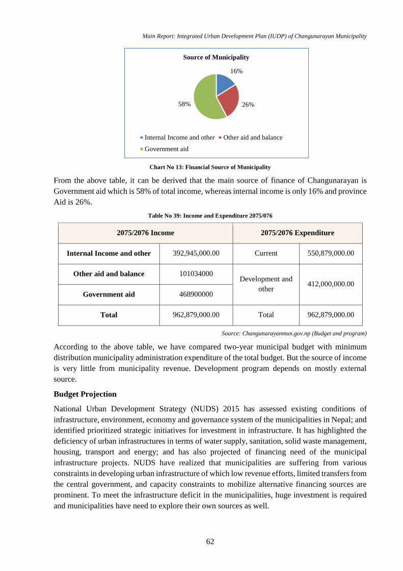
Main Report: Integrated Urban Development Plan (IUDP) of Changunarayan Municipality
62
Chart No 13: Financial Source of Municipality
From the above table, it can be derived that the main source of finance of Changunarayan is
Government aid which is 58% of total income, whereas internal income is only 16% and province
Aid is 26%.
Table No 39: Income and Expenditure 2075/076
2075/2076 Income 2075/2076 Expenditure
Internal Income and other 392,945,000.00 Current 550,879,000.00
Other aid and balance 101034000 Development and
other 412,000,000.00
Government aid 468900000
Total 962,879,000.00 Total 962,879,000.00
Source: Changunarayanmun.gov.np (Budget and program)
According to the above table, we have compared two-year municipal budget with minimum
distribution municipality administration expenditure of the total budget. But the source of income
is very little from municipality revenue. Development program depends on mostly external
source.
Budget Projection
National Urban Development Strategy (NUDS) 2015 has assessed existing conditions of
infrastructure, environment, economy and governance system of the municipalities in Nepal; and
identified prioritized strategic initiatives for investment in infrastructure. It has highlighted the
deficiency of urban infrastructures in terms of water supply, sanitation, solid waste management,
housing, transport and energy; and has also projected of financing need of the municipal
infrastructure projects. NUDS have realized that municipalities are suffering from various
constraints in developing urban infrastructure of which low revenue efforts, limited transfers from
the central government, and capacity constraints to mobilize alternative financing sources are
prominent. To meet the infrastructure deficit in the municipalities, huge investment is required
and municipalities have need to explore their own sources as well.
16%
26%58%
Source of Municipality
Internal Income and other Other aid and balance
Government aid
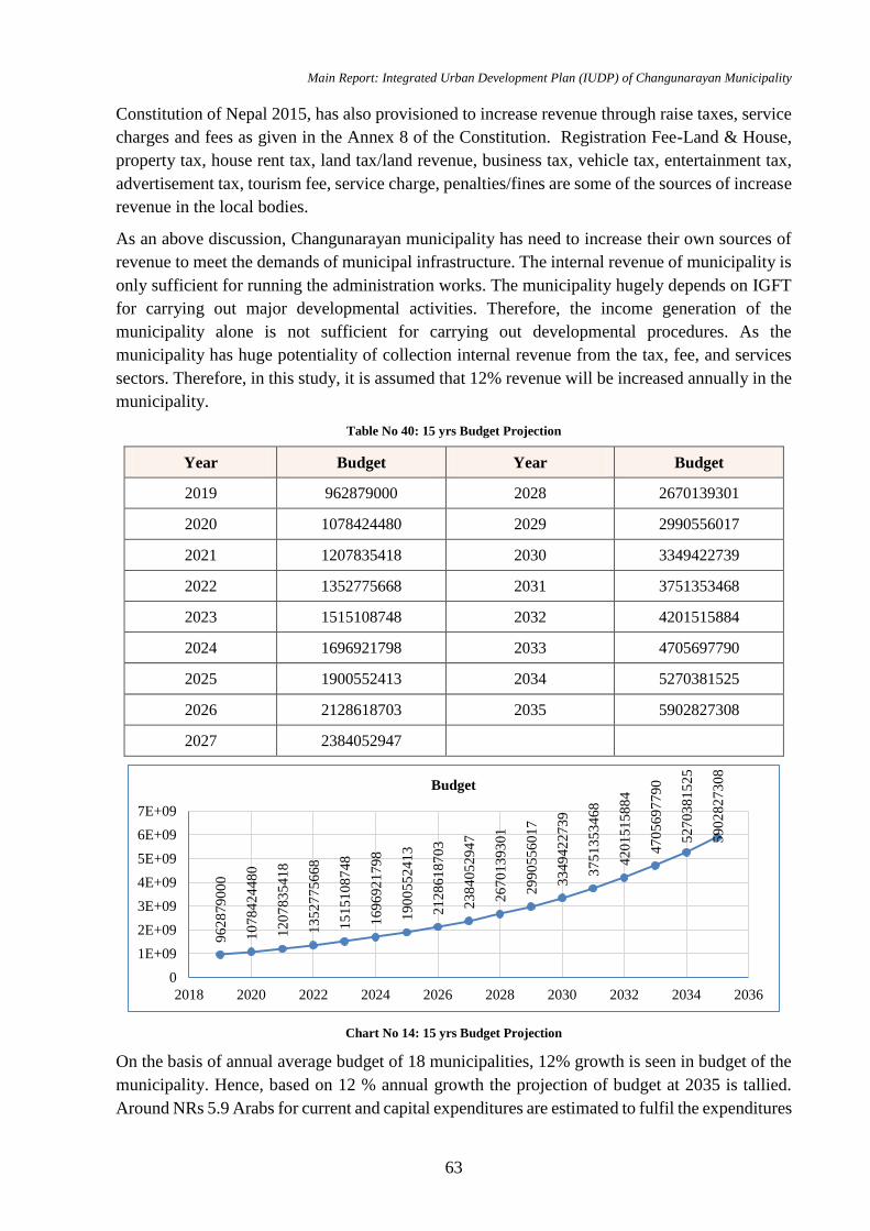
Main Report: Integrated Urban Development Plan (IUDP) of Changunarayan Municipality
63
Constitution of Nepal 2015, has also provisioned to increase revenue through raise taxes, service
charges and fees as given in the Annex 8 of the Constitution. Registration Fee-Land & House,
property tax, house rent tax, land tax/land revenue, business tax, vehicle tax, entertainment tax,
advertisement tax, tourism fee, service charge, penalties/fines are some of the sources of increase
revenue in the local bodies.
As an above discussion, Changunarayan municipality has need to increase their own sources of
revenue to meet the demands of municipal infrastructure. The internal revenue of municipality is
only sufficient for running the administration works. The municipality hugely depends on IGFT
for carrying out major developmental activities. Therefore, the income generation of the
municipality alone is not sufficient for carrying out developmental procedures. As the
municipality has huge potentiality of collection internal revenue from the tax, fee, and services
sectors. Therefore, in this study, it is assumed that 12% revenue will be increased annually in the
municipality.
Table No 40: 15 yrs Budget Projection
Year Budget Year Budget
2019 962879000 2028 2670139301
2020 1078424480 2029 2990556017
2021 1207835418 2030 3349422739
2022 1352775668 2031 3751353468
2023 1515108748 2032 4201515884
2024 1696921798 2033 4705697790
2025 1900552413 2034 5270381525
2026 2128618703 2035 5902827308
2027 2384052947
Chart No 14: 15 yrs Budget Projection
On the basis of annual average budget of 18 municipalities, 12% growth is seen in budget of the
municipality. Hence, based on 12 % annual growth the projection of budget at 2035 is tallied.
Around NRs 5.9 Arabs for current and capital expenditures are estimated to fulfil the expenditures
96
28
79
00
0
10
78
42
44
80
12
07
83
54
18
13
52
77
56
68
15
15
10
87
48
16
96
92
17
98
19
00
55
24
13
21
28
61
87
03
23
84
05
29
47
26
70
13
93
01
29
90
55
60
17
33
49
42
27
39
37
51
35
34
68
42
01
51
58
84
47
05
69
77
90
52
70
38
15
25
59
02
82
73
08
0
1E+09
2E+09
3E+09
4E+09
5E+09
6E+09
7E+09
2018 2020 2022 2024 2026 2028 2030 2032 2034 2036
Budget
Main Report: Integrated Urban Development Plan (IUDP) of Changunarayan Municipality
64
of proposed 15 yrs developmental plans. And if the expenditure of capital alone reaches 5.9 Arabs
then there is deficit of budget for multi-sector developmental plan.
Financial Investment Analysis
The land will reveal income potential and financing sources including expenditure from local
bodies, and possible investments from other line agencies private sectors/FDI etc.
4.6 Institutional Analysis
The analysis has clearly disclosed coordination mechanism, capacity building and tole and
responsibility of stakeholders involved in the town development process, governance situation,
and enable channelizing the resources implement the plan.
Municipality is a local government with substantial authority granted through constitution of
Nepal. After the recent government reform, new governing structure is formed with 8 Department
and each department has several branches. It is the newly formed municipality so it hasn't been
set-up with good institutional framework at various departments like administration, technical,
financial administration etc. Since it is declared recently it is yet to get into full shape with
required technical staffs and administrative staffs.
Ward service and stability are not set up yet. Municipality has an office building which is
insufficient and major offices are running from this building. For the institutional capacity
development, various programs are being conducted according to present Acts, Rules and
Directives. For the capacity development of the government staffs, Municipality has conducted
workshop onto expand the abilities in organizational structure and methodology, process
performance, human resource development, information management system, financial
management, and the coordination, development and extension of public relation sectors of
Municipality.
In upcoming years, various sustainable planning like drinking water and sanitation, forest
management, disaster-risk management and children friendly program will be conducted.
Changunarayan municipality is led by 1 Mayor, 1 Deputy Mayor and 9 Ward Chief’s at the
respective wards of the municipality. Since, it is newly formed municipality so it hasn't been set-
up with good institutional framework at various departments like technical, financial
administration etc. There are altogether 60 staffs including workers at the various section of the
municipality. There is limited number of staff at Planning and Information section.
The municipal office has adequate number of engineers and the workload are easily handled by
available technical human resources. Also, there are adequate number of engineers at Earthquake
reconstruction branch. Women are also given equal opportunities at most of the section of the
municipality works. The description of staff at respective section of the municipality are as:
Table No 41: Required Human Resources for Municipality Level
S.N. Designation Section Existing Required
1 Assistant Chief Administration 2 -
2 Revenue Assistant Revenue - 2
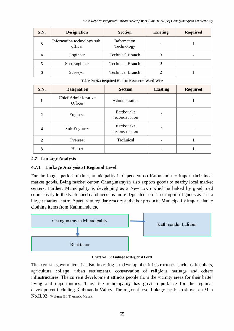
Main Report: Integrated Urban Development Plan (IUDP) of Changunarayan Municipality
65
S.N. Designation Section Existing Required
3 Information technology sub-
officer
Information
Technology - 1
4 Engineer Technical Branch 3 -
5 Sub-Engineer Technical Branch 2 -
6 Surveyor Technical Branch 2 1
Table No 42: Required Human Resources Ward-Wise
S.N. Designation Section Existing Required
1 Chief Administrative
Officer Administration 1
2 Engineer Earthquake
reconstruction 1 -
4 Sub-Engineer Earthquake
reconstruction 1 -
2 Overseer Technical - 1
3 Helper - 1
4.7 Linkage Analysis
4.7.1 Linkage Analysis at Regional Level
For the longer period of time, municipality is dependent on Kathmandu to import their local
market goods. Being market center, Changunarayan also exports goods to nearby local market
centers. Further, Municipality is developing as a New town which is linked by good road
connectivity to the Kathmandu and hence is more dependent on it for import of goods as it is a
bigger market centre. Apart from regular grocery and other products, Municipality imports fancy
clothing items from Kathmandu etc.
Chart No 15: Linkage at Regional Level
The central government is also investing to develop the infrastructures such as hospitals,
agriculture college, urban settlements, conservation of religious heritage and others
infrastructures. The current development attracts people from the vicinity areas for their better
living and opportunities. Thus, the municipality has great importance for the regional
development including Kathmandu Valley. The regional level linkage has been shown on Map
No.IL02, (Volume III, Thematic Maps).
Changunarayan Municipality Kathmandu, Lalitpur
Bhaktapur
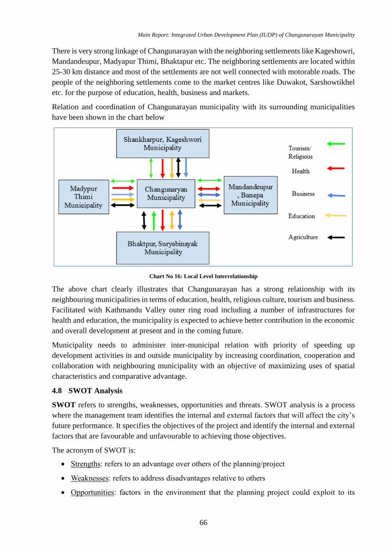
Main Report: Integrated Urban Development Plan (IUDP) of Changunarayan Municipality
66
There is very strong linkage of Changunarayan with the neighboring settlements like Kageshowri,
Mandandeupur, Madyapur Thimi, Bhaktapur etc. The neighboring settlements are located within
25-30 km distance and most of the settlements are not well connected with motorable roads. The
people of the neighboring settlements come to the market centres like Duwakot, Sarshowtikhel
etc. for the purpose of education, health, business and markets.
Relation and coordination of Changunarayan municipality with its surrounding municipalities
have been shown in the chart below
Chart No 16: Local Level Interrelationship
The above chart clearly illustrates that Changunarayan has a strong relationship with its
neighbouring municipalities in terms of education, health, religious culture, tourism and business.
Facilitated with Kathmandu Valley outer ring road including a number of infrastructures for
health and education, the municipality is expected to achieve better contribution in the economic
and overall development at present and in the coming future.
Municipality needs to administer inter-municipal relation with priority of speeding up
development activities in and outside municipality by increasing coordination, cooperation and
collaboration with neighbouring municipality with an objective of maximizing uses of spatial
characteristics and comparative advantage.
4.8 SWOT Analysis
SWOT refers to strengths, weaknesses, opportunities and threats. SWOT analysis is a process
where the management team identifies the internal and external factors that will affect the city’s
future performance. It specifies the objectives of the project and identify the internal and external
factors that are favourable and unfavourable to achieving those objectives.
The acronym of SWOT is:
Strengths: refers to an advantage over others of the planning/project
Weaknesses: refers to address disadvantages relative to others
Opportunities: factors in the environment that the planning project could exploit to its
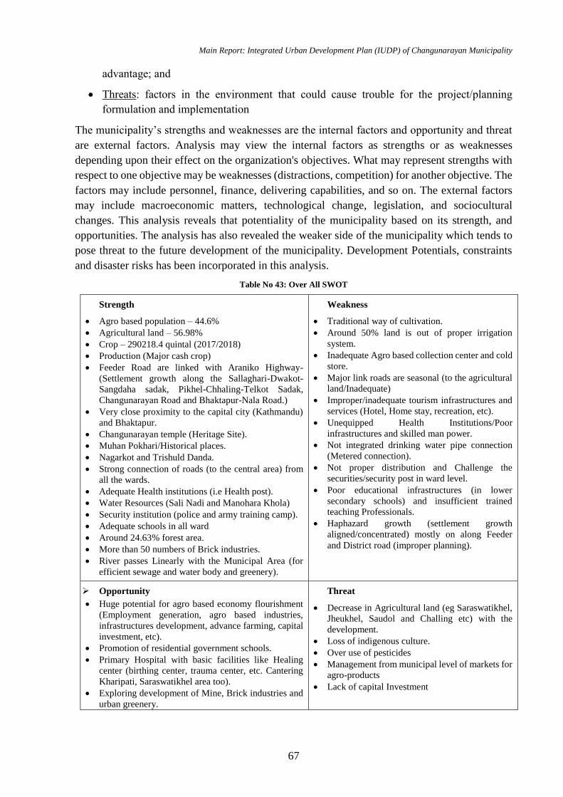
Main Report: Integrated Urban Development Plan (IUDP) of Changunarayan Municipality
67
advantage; and
Threats: factors in the environment that could cause trouble for the project/planning
formulation and implementation
The municipality’s strengths and weaknesses are the internal factors and opportunity and threat
are external factors. Analysis may view the internal factors as strengths or as weaknesses
depending upon their effect on the organization's objectives. What may represent strengths with
respect to one objective may be weaknesses (distractions, competition) for another objective. The
factors may include personnel, finance, delivering capabilities, and so on. The external factors
may include macroeconomic matters, technological change, legislation, and sociocultural
changes. This analysis reveals that potentiality of the municipality based on its strength, and
opportunities. The analysis has also revealed the weaker side of the municipality which tends to
pose threat to the future development of the municipality. Development Potentials, constraints
and disaster risks has been incorporated in this analysis.
Table No 43: Over All SWOT
Strength
Agro based population – 44.6%
Agricultural land – 56.98%
Crop – 290218.4 quintal (2017/2018)
Production (Major cash crop)
Feeder Road are linked with Araniko Highway-
(Settlement growth along the Sallaghari-Dwakot-
Sangdaha sadak, Pikhel-Chhaling-Telkot Sadak,
Changunarayan Road and Bhaktapur-Nala Road.)
Very close proximity to the capital city (Kathmandu)
and Bhaktapur.
Changunarayan temple (Heritage Site).
Muhan Pokhari/Historical places.
Nagarkot and Trishuld Danda.
Strong connection of roads (to the central area) from
all the wards.
Adequate Health institutions (i.e Health post).
Water Resources (Sali Nadi and Manohara Khola)
Security institution (police and army training camp).
Adequate schools in all ward
Around 24.63% forest area.
More than 50 numbers of Brick industries.
River passes Linearly with the Municipal Area (for
efficient sewage and water body and greenery).
Weakness
Traditional way of cultivation.
Around 50% land is out of proper irrigation
system.
Inadequate Agro based collection center and cold
store.
Major link roads are seasonal (to the agricultural
land/Inadequate)
Improper/inadequate tourism infrastructures and
services (Hotel, Home stay, recreation, etc).
Unequipped Health Institutions/Poor
infrastructures and skilled man power.
Not integrated drinking water pipe connection
(Metered connection).
Not proper distribution and Challenge the
securities/security post in ward level.
Poor educational infrastructures (in lower
secondary schools) and insufficient trained
teaching Professionals.
Haphazard growth (settlement growth
aligned/concentrated) mostly on along Feeder
and District road (improper planning).
Opportunity
Huge potential for agro based economy flourishment
(Employment generation, agro based industries,
infrastructures development, advance farming, capital
investment, etc).
Promotion of residential government schools.
Primary Hospital with basic facilities like Healing
center (birthing center, trauma center, etc. Cantering
Kharipati, Saraswatikhel area too).
Exploring development of Mine, Brick industries and
urban greenery.
Threat
Decrease in Agricultural land (eg Saraswatikhel,
Jheukhel, Saudol and Challing etc) with the
development.
Loss of indigenous culture.
Over use of pesticides
Management from municipal level of markets for
agro-products
Lack of capital Investment
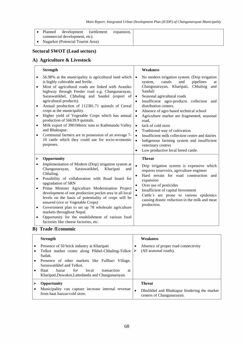
Main Report: Integrated Urban Development Plan (IUDP) of Changunarayan Municipality
68
Planned development (settlement expansion,
commercial development, etc).
Nagarkot (Potencial Tourist Area)
Sectoral SWOT (Lead sectors)
A) Agriculture & Livestock
Strength
56.98% at the municipality is agricultural land which
is highly cultivable and fertile.
Most of agricultural roads are linked with Araniko
highway through Feeder road e.g. Changunarayan,
Saraswatikhel, Chhaling and Saudol (export of
agricultural products).
Annual production of 112381.71 quintals of Cereal
crops at the municipality.
Higher yield of Vegetable Crops which has annual
production of 56639.9 quintals.
Milk export of 3901Metric tons to Kathmandu Valley
and Bhaktapur.
Communal farmers are in possession of an average 7-
10 cattle which they could use for socio-economic
purposes.
Weakness
No modern irrigation system. (Drip irrigation
system, canals and pipelines at
Changunarayan, Kharipati, Chhaling and
Saudal)
Seasonal agricultural roads
Insufficient agro-products collection and
distribution centers.
Absence of agro based technical school
Agriculture market are fragmented, seasonal
road,
lack of cold store
Traditional way of cultivation
Insufficient milk collection centre and dairies
Indigenous farming system and insufficient
veterinary centres
Low productive local breed cattle.
Opportunity
Implementation of Modern (Drip) irrigation system at
Changunarayan, Saraswatikhel, Kharipati and
Chhaling.
Possibility of collaboration with Road board for
upgradation of SRN
Prime Minister Agriculture Modernisation Project
development of one production pocket area in all local
levels on the basis of potentiality of crops will be
ensured (rice or Vegetable Crops)
Government plan to set up 78 wholesale agriculture
markets throughout Nepal.
Opportunity for the establishment of various food
factories like cheese factories, etc.
Threat
Drip irrigation system is expensive which
requires reservoirs, agriculture engineer
Hard terrain for road construction and
expansion
Over use of pesticides
Insufficient of capital Investment
Cattle’s are prone to various epidemics
causing drastic reduction in the milk and meat
production.
B) Trade /Economic
Strength
Presence of 50 brick industry at Kharipati
Telkot market center along Pikhel-Chhaling-Telkot
Sadak.
Presence of other markets like Fullbari Village,
Saraswatikhel and Telkot.
Haat bazar for local transaction at
Kharipati,Duwakot,Lattedanda and Changunarayan.
Weakness
Absence of proper road connectivity
(All seasonal roads).
Opportunity
Municipality can capture increase internal revenue
from haat bazzar/cold store.
Threat
Dhulikhel and Bhaktapur hindering the market
centers of Changunarayan.
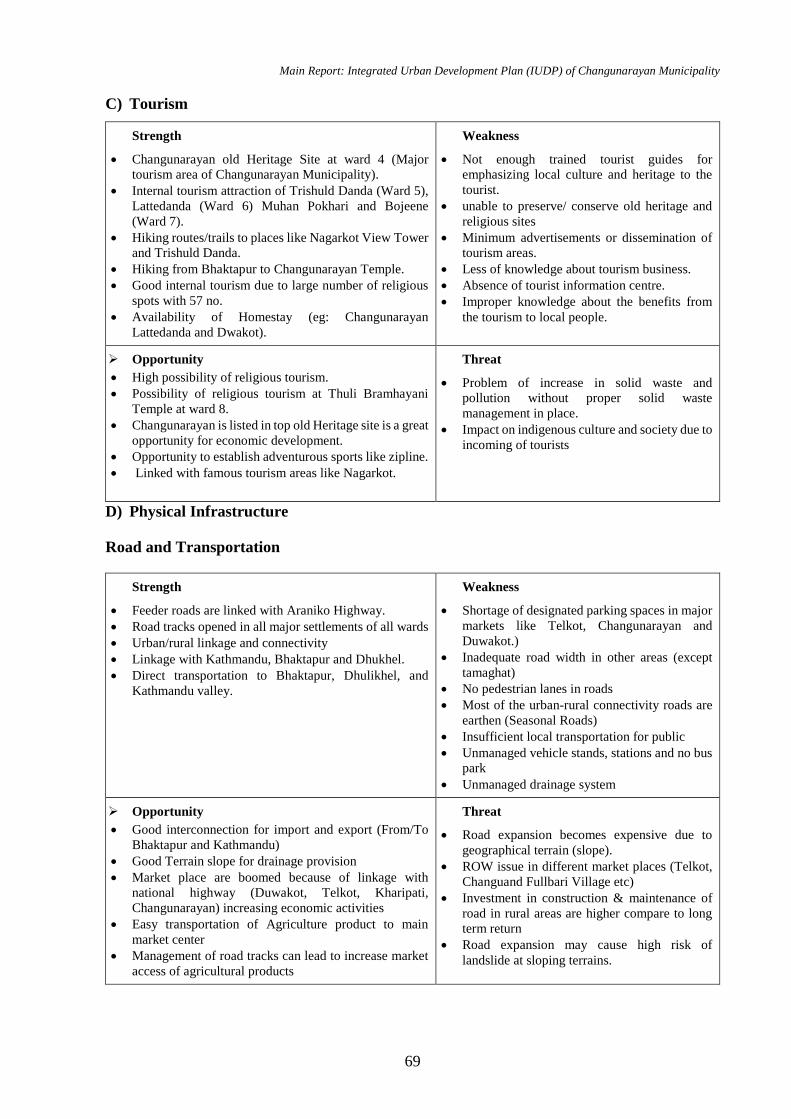
Main Report: Integrated Urban Development Plan (IUDP) of Changunarayan Municipality
69
C) Tourism
Strength
Changunarayan old Heritage Site at ward 4 (Major
tourism area of Changunarayan Municipality).
Internal tourism attraction of Trishuld Danda (Ward 5),
Lattedanda (Ward 6) Muhan Pokhari and Bojeene
(Ward 7).
Hiking routes/trails to places like Nagarkot View Tower
and Trishuld Danda.
Hiking from Bhaktapur to Changunarayan Temple.
Good internal tourism due to large number of religious
spots with 57 no.
Availability of Homestay (eg: Changunarayan
Lattedanda and Dwakot).
Weakness
Not enough trained tourist guides for
emphasizing local culture and heritage to the
tourist.
unable to preserve/ conserve old heritage and
religious sites
Minimum advertisements or dissemination of
tourism areas.
Less of knowledge about tourism business.
Absence of tourist information centre.
Improper knowledge about the benefits from
the tourism to local people.
Opportunity
High possibility of religious tourism.
Possibility of religious tourism at Thuli Bramhayani
Temple at ward 8.
Changunarayan is listed in top old Heritage site is a great
opportunity for economic development.
Opportunity to establish adventurous sports like zipline.
Linked with famous tourism areas like Nagarkot.
Threat
Problem of increase in solid waste and
pollution without proper solid waste
management in place.
Impact on indigenous culture and society due to
incoming of tourists
D) Physical Infrastructure
Road and Transportation
Strength
Feeder roads are linked with Araniko Highway.
Road tracks opened in all major settlements of all wards
Urban/rural linkage and connectivity
Linkage with Kathmandu, Bhaktapur and Dhukhel.
Direct transportation to Bhaktapur, Dhulikhel, and
Kathmandu valley.
Weakness
Shortage of designated parking spaces in major
markets like Telkot, Changunarayan and
Duwakot.)
Inadequate road width in other areas (except
tamaghat)
No pedestrian lanes in roads
Most of the urban-rural connectivity roads are
earthen (Seasonal Roads)
Insufficient local transportation for public
Unmanaged vehicle stands, stations and no bus
park
Unmanaged drainage system
Opportunity
Good interconnection for import and export (From/To
Bhaktapur and Kathmandu)
Good Terrain slope for drainage provision
Market place are boomed because of linkage with
national highway (Duwakot, Telkot, Kharipati,
Changunarayan) increasing economic activities
Easy transportation of Agriculture product to main
market center
Management of road tracks can lead to increase market
access of agricultural products
Threat
Road expansion becomes expensive due to
geographical terrain (slope).
ROW issue in different market places (Telkot,
Changuand Fullbari Village etc)
Investment in construction & maintenance of
road in rural areas are higher compare to long
term return
Road expansion may cause high risk of
landslide at sloping terrains.
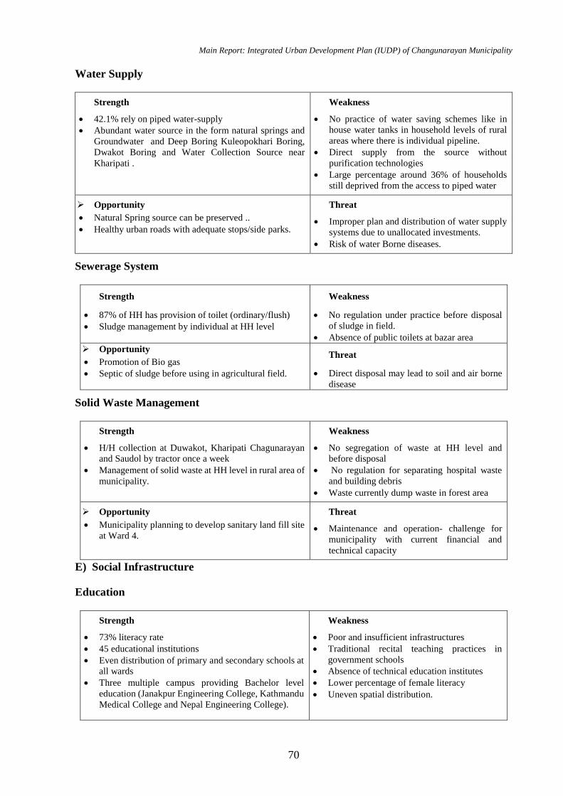
Main Report: Integrated Urban Development Plan (IUDP) of Changunarayan Municipality
70
Water Supply
Strength
42.1% rely on piped water-supply
Abundant water source in the form natural springs and
Groundwater and Deep Boring Kuleopokhari Boring,
Dwakot Boring and Water Collection Source near
Kharipati .
Weakness
No practice of water saving schemes like in
house water tanks in household levels of rural
areas where there is individual pipeline.
Direct supply from the source without
purification technologies
Large percentage around 36% of households
still deprived from the access to piped water
Opportunity
Natural Spring source can be preserved ..
Healthy urban roads with adequate stops/side parks.
Threat
Improper plan and distribution of water supply
systems due to unallocated investments.
Risk of water Borne diseases.
Sewerage System
Strength
87% of HH has provision of toilet (ordinary/flush)
Sludge management by individual at HH level
Weakness
No regulation under practice before disposal
of sludge in field.
Absence of public toilets at bazar area
Opportunity
Promotion of Bio gas
Septic of sludge before using in agricultural field.
Threat
Direct disposal may lead to soil and air borne
disease
Solid Waste Management
Strength
H/H collection at Duwakot, Kharipati Chagunarayan
and Saudol by tractor once a week
Management of solid waste at HH level in rural area of
municipality.
Weakness
No segregation of waste at HH level and
before disposal
No regulation for separating hospital waste
and building debris
Waste currently dump waste in forest area
Opportunity
Municipality planning to develop sanitary land fill site
at Ward 4.
Threat
Maintenance and operation- challenge for
municipality with current financial and
technical capacity
E) Social Infrastructure
Education
Strength
73% literacy rate
45 educational institutions
Even distribution of primary and secondary schools at
all wards
Three multiple campus providing Bachelor level
education (Janakpur Engineering College, Kathmandu
Medical College and Nepal Engineering College).
Weakness
Poor and insufficient infrastructures
Traditional recital teaching practices in
government schools
Absence of technical education institutes
Lower percentage of female literacy
Uneven spatial distribution.
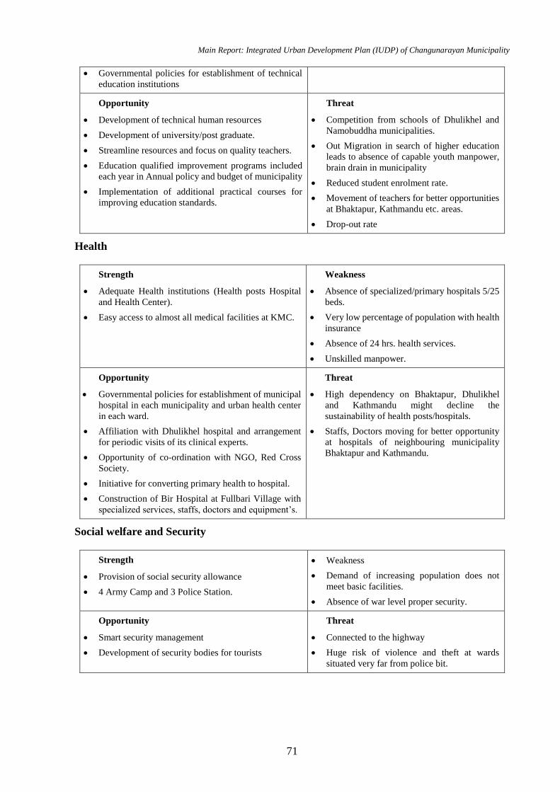
Main Report: Integrated Urban Development Plan (IUDP) of Changunarayan Municipality
71
Governmental policies for establishment of technical
education institutions
Opportunity
Development of technical human resources
Development of university/post graduate.
Streamline resources and focus on quality teachers.
Education qualified improvement programs included
each year in Annual policy and budget of municipality
Implementation of additional practical courses for
improving education standards.
Threat
Competition from schools of Dhulikhel and
Namobuddha municipalities.
Out Migration in search of higher education
leads to absence of capable youth manpower,
brain drain in municipality
Reduced student enrolment rate.
Movement of teachers for better opportunities
at Bhaktapur, Kathmandu etc. areas.
Drop-out rate
Health
Strength
Adequate Health institutions (Health posts Hospital
and Health Center).
Easy access to almost all medical facilities at KMC.
Weakness
Absence of specialized/primary hospitals 5/25
beds.
Very low percentage of population with health
insurance
Absence of 24 hrs. health services.
Unskilled manpower.
Opportunity
Governmental policies for establishment of municipal
hospital in each municipality and urban health center
in each ward.
Affiliation with Dhulikhel hospital and arrangement
for periodic visits of its clinical experts.
Opportunity of co-ordination with NGO, Red Cross
Society.
Initiative for converting primary health to hospital.
Construction of Bir Hospital at Fullbari Village with
specialized services, staffs, doctors and equipment’s.
Threat
High dependency on Bhaktapur, Dhulikhel
and Kathmandu might decline the
sustainability of health posts/hospitals.
Staffs, Doctors moving for better opportunity
at hospitals of neighbouring municipality
Bhaktapur and Kathmandu.
Social welfare and Security
Strength
Provision of social security allowance
4 Army Camp and 3 Police Station.
Weakness
Demand of increasing population does not
meet basic facilities.
Absence of war level proper security.
Opportunity
Smart security management
Development of security bodies for tourists
Threat
Connected to the highway
Huge risk of violence and theft at wards
situated very far from police bit.
Main Report: Integrated Urban Development Plan (IUDP) of Changunarayan Municipality
72
4.9 Demand Analysis of Infrastructures
The forecast of population reveals increase in city size. With development period, the city will
expand rapidly, thus escalating the demand in many urban services like water supply, solid waste
management, housing plots and road. To address these issues, the municipality has to plan
accordingly considering infrastructures large enough to cater future demand. The IUDP is
expected to accommodate the prerequisites of the growing population and the mandatory
infrastructures needed planning likewise.
Demand analysis is performed for the coming years and a supply forecast is attained based on the
“Urban planning norms and standards 2015.” Keeping under consideration the available
existing resources and amenities, a gap is identified for the deficit facilities from the supply
forecast for forthcoming years and projects/programs are formulated.
4.9.1 Physical Infrastructure Demand Analysis
An analysis is done based on “Urban planning norms and standards 2015” for achieving the
standard of city of Nepal and the forecasted scarcity in physical infrastructure is explicit in the
following table.
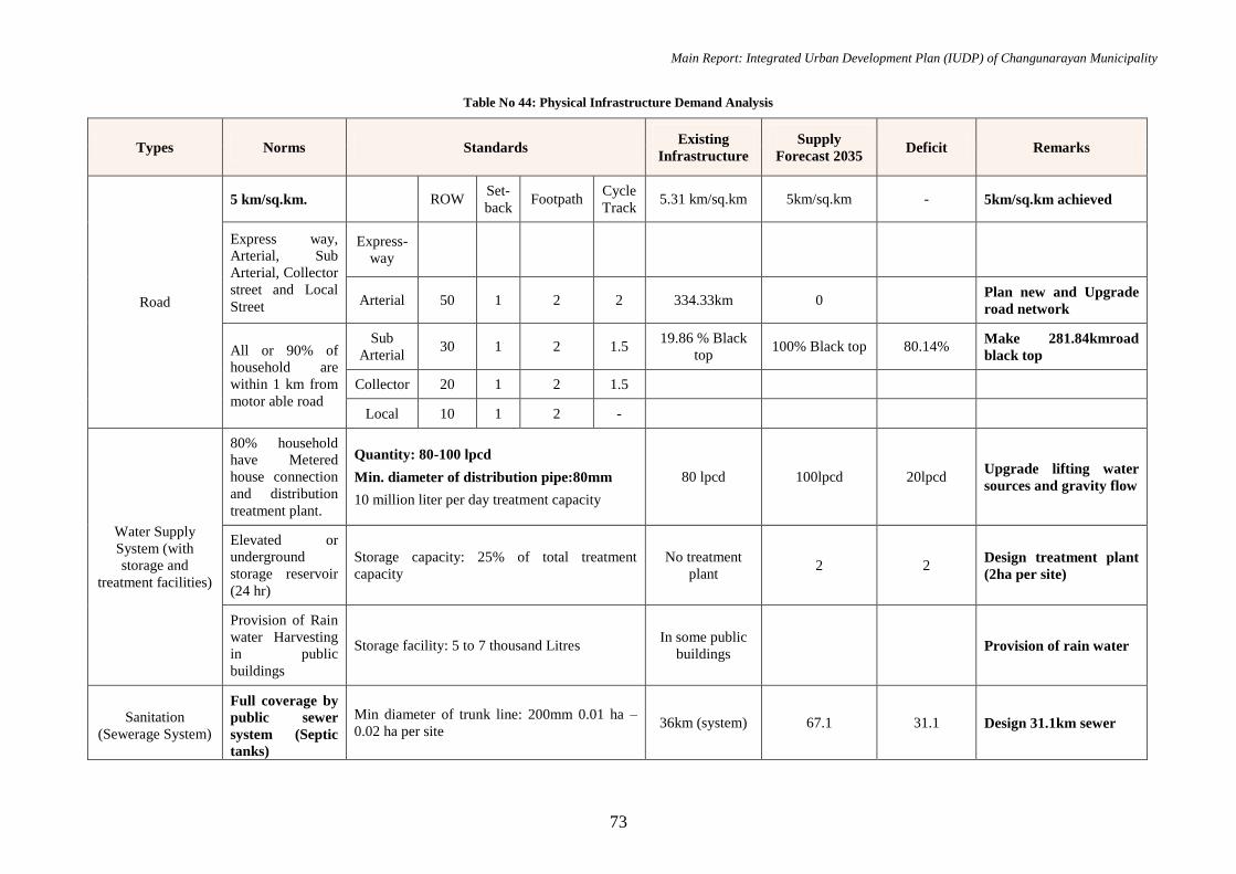
Main Report: Integrated Urban Development Plan (IUDP) of Changunarayan Municipality
73
Table No 44: Physical Infrastructure Demand Analysis
Types Norms Standards Existing
Infrastructure
Supply
Forecast 2035 Deficit Remarks
Road
5 km/sq.km. ROW Set-
back Footpath
Cycle
Track 5.31 km/sq.km 5km/sq.km - 5km/sq.km achieved
Express way,
Arterial, Sub
Arterial, Collector
street and Local
Street
Express-
way
Arterial 50 1 2 2 334.33km 0 Plan new and Upgrade
road network
All or 90% of
household are
within 1 km from
motor able road
Sub
Arterial 30 1 2 1.5
19.86 % Black
top 100% Black top 80.14%
Make 281.84kmroad
black top
Collector 20 1 2 1.5
Local 10 1 2 -
Water Supply
System (with
storage and
treatment facilities)
80% household
have Metered
house connection
and distribution
treatment plant.
Quantity: 80-100 lpcd
Min. diameter of distribution pipe:80mm
10 million liter per day treatment capacity
80 lpcd 100lpcd 20lpcd Upgrade lifting water
sources and gravity flow
Elevated or
underground
storage reservoir
(24 hr)
Storage capacity: 25% of total treatment
capacity
No treatment
plant 2 2
Design treatment plant
(2ha per site)
Provision of Rain
water Harvesting
in public
buildings
Storage facility: 5 to 7 thousand Litres In some public
buildings Provision of rain water
Sanitation
(Sewerage System)
Full coverage by
public sewer
system (Septic
tanks)
Min diameter of trunk line: 200mm 0.01 ha –
0.02 ha per site 36km (system) 67.1 31.1 Design 31.1km sewer
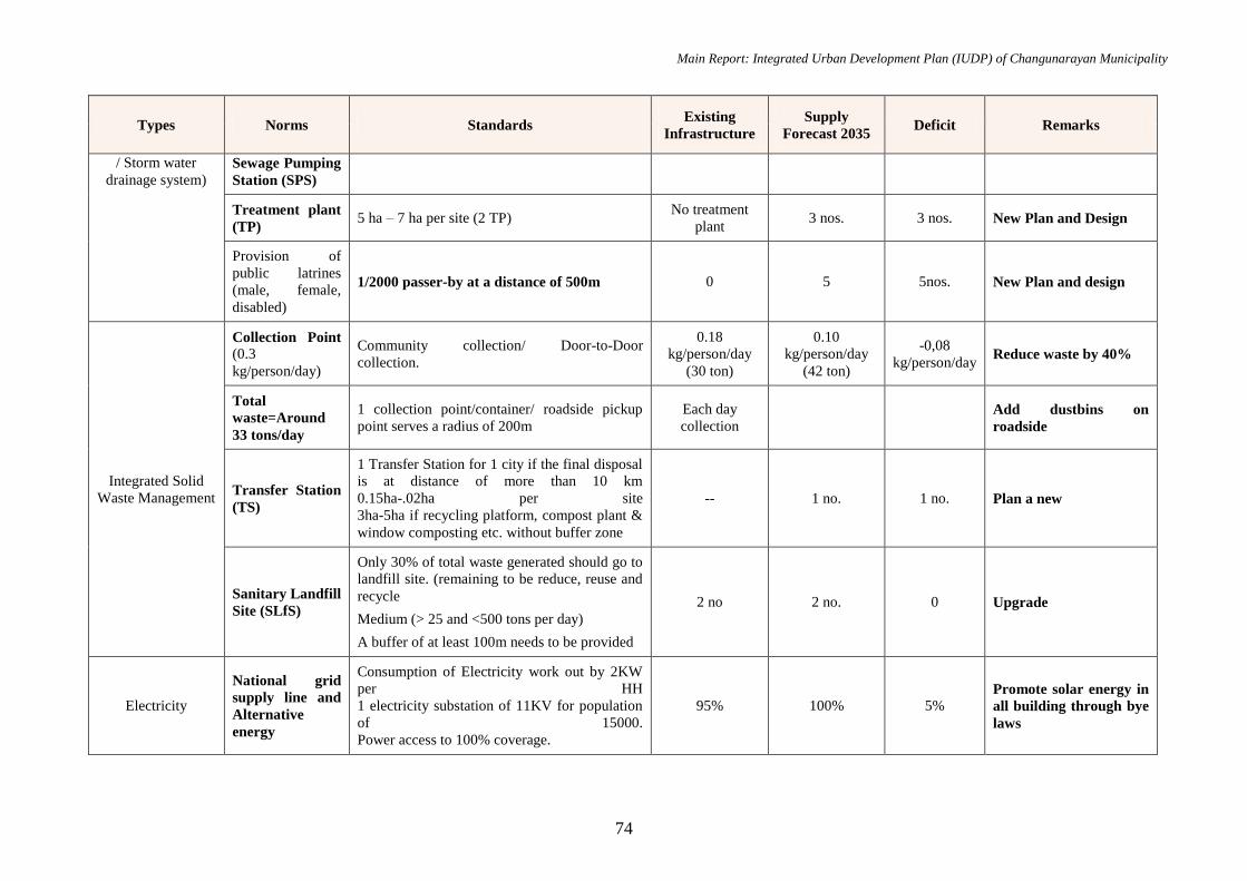
Main Report: Integrated Urban Development Plan (IUDP) of Changunarayan Municipality
74
Types Norms Standards Existing
Infrastructure
Supply
Forecast 2035 Deficit Remarks
/ Storm water
drainage system)
Sewage Pumping
Station (SPS)
Treatment plant
(TP) 5 ha – 7 ha per site (2 TP)
No treatment
plant 3 nos. 3 nos. New Plan and Design
Provision of
public latrines
(male, female,
disabled)
1/2000 passer-by at a distance of 500m 0 5 5nos. New Plan and design
Integrated Solid
Waste Management
Collection Point
(0.3
kg/person/day)
Community collection/ Door-to-Door
collection.
0.18
kg/person/day
(30 ton)
0.10
kg/person/day
(42 ton)
-0,08
kg/person/day Reduce waste by 40%
Total
waste=Around
33 tons/day
1 collection point/container/ roadside pickup
point serves a radius of 200m
Each day
collection
Add dustbins on
roadside
Transfer Station
(TS)
1 Transfer Station for 1 city if the final disposal
is at distance of more than 10 km
0.15ha-.02ha per site
3ha-5ha if recycling platform, compost plant &
window composting etc. without buffer zone
-- 1 no. 1 no. Plan a new
Sanitary Landfill
Site (SLfS)
Only 30% of total waste generated should go to
landfill site. (remaining to be reduce, reuse and
recycle
Medium (> 25 and <500 tons per day)
A buffer of at least 100m needs to be provided
2 no 2 no. 0 Upgrade
Electricity
National grid
supply line and
Alternative
energy
Consumption of Electricity work out by 2KW
per HH
1 electricity substation of 11KV for population
of 15000.
Power access to 100% coverage.
95% 100% 5% Promote solar energy in
all building through bye
laws
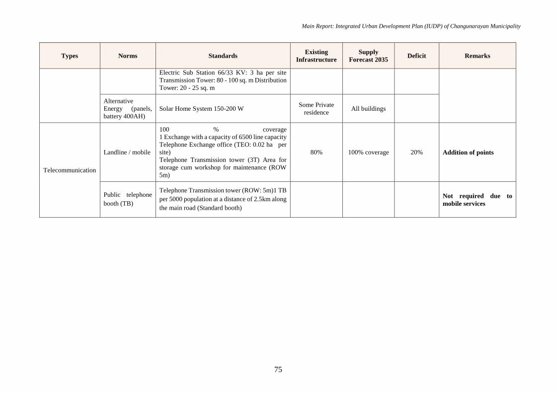
Main Report: Integrated Urban Development Plan (IUDP) of Changunarayan Municipality
75
Types Norms Standards Existing
Infrastructure
Supply
Forecast 2035 Deficit Remarks
Electric Sub Station 66/33 KV: 3 ha per site
Transmission Tower: 80 - 100 sq. m Distribution
Tower: 20 - 25 sq. m
Alternative
Energy (panels,
battery 400AH)
Solar Home System 150-200 W Some Private
residence All buildings
Telecommunication
Landline / mobile
100 % coverage
1 Exchange with a capacity of 6500 line capacity
Telephone Exchange office (TEO: 0.02 ha per
site)
Telephone Transmission tower (3T) Area for
storage cum workshop for maintenance (ROW
5m)
80% 100% coverage 20% Addition of points
Public telephone
booth (TB)
Telephone Transmission tower (ROW: 5m)1 TB
per 5000 population at a distance of 2.5km along
the main road (Standard booth)
Not required due to
mobile services
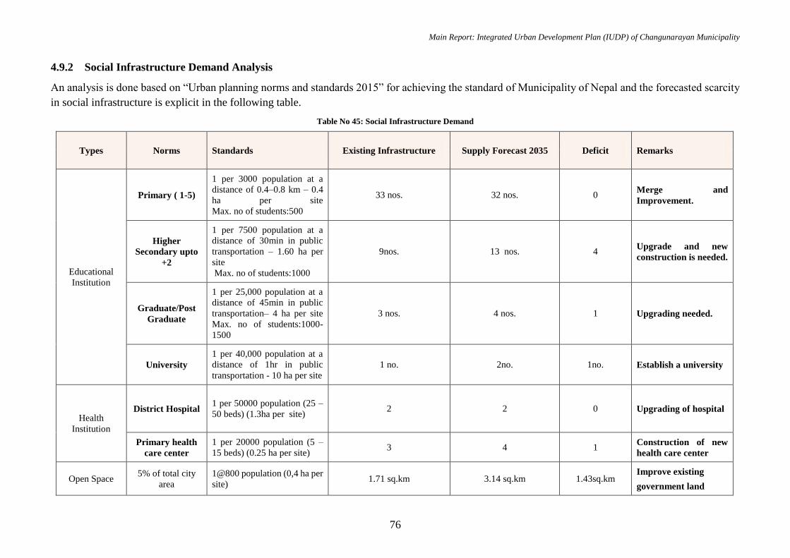
Main Report: Integrated Urban Development Plan (IUDP) of Changunarayan Municipality
76
4.9.2 Social Infrastructure Demand Analysis
An analysis is done based on “Urban planning norms and standards 2015” for achieving the standard of Municipality of Nepal and the forecasted scarcity
in social infrastructure is explicit in the following table.
Table No 45: Social Infrastructure Demand
Types Norms Standards Existing Infrastructure Supply Forecast 2035 Deficit Remarks
Educational
Institution
Primary ( 1-5)
1 per 3000 population at a
distance of 0.4–0.8 km – 0.4
ha per site
Max. no of students:500
33 nos. 32 nos. 0 Merge and
Improvement.
Higher
Secondary upto
+2
1 per 7500 population at a
distance of 30min in public
transportation – 1.60 ha per
site
Max. no of students:1000
9nos. 13 nos. 4 Upgrade and new
construction is needed.
Graduate/Post
Graduate
1 per 25,000 population at a
distance of 45min in public
transportation– 4 ha per site
Max. no of students:1000-
1500
3 nos. 4 nos. 1 Upgrading needed.
University
1 per 40,000 population at a
distance of 1hr in public
transportation - 10 ha per site
1 no. 2no. 1no. Establish a university
Health
Institution
District Hospital
1 per 50000 population (25 –
50 beds) (1.3ha per site) 2 2 0 Upgrading of hospital
Primary health
care center
1 per 20000 population (5 –
15 beds) (0.25 ha per site) 3 4 1
Construction of new
health care center
Open Space 5% of total city
area
1@800 population (0,4 ha per
site) 1.71 sq.km 3.14 sq.km 1.43sq.km
Improve existing
government land
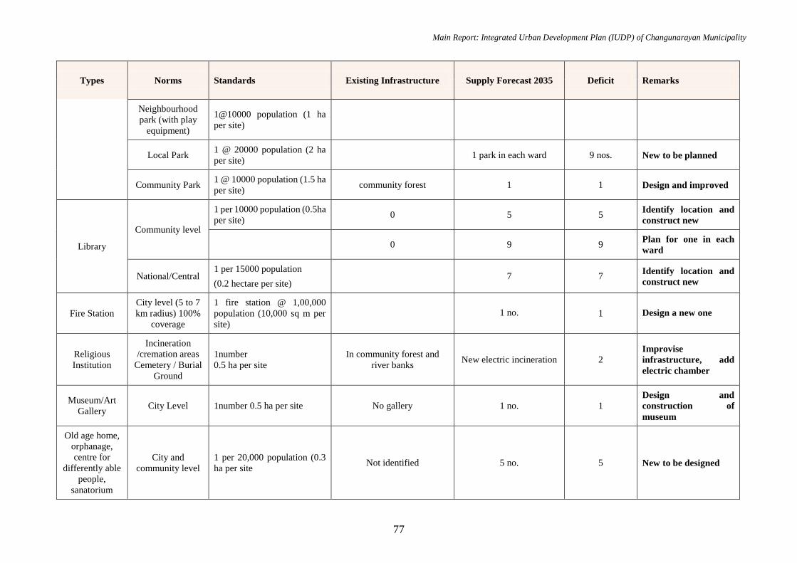
Main Report: Integrated Urban Development Plan (IUDP) of Changunarayan Municipality
77
Types Norms Standards Existing Infrastructure Supply Forecast 2035 Deficit Remarks
Neighbourhood
park (with play
equipment)
1@10000 population (1 ha
per site)
Local Park 1 @ 20000 population (2 ha
per site) 1 park in each ward 9 nos. New to be planned
Community Park 1 @ 10000 population (1.5 ha
per site) community forest 1 1 Design and improved
Library
Community level
1 per 10000 population (0.5ha
per site) 0 5 5
Identify location and
construct new
0 9 9 Plan for one in each
ward
National/Central 1 per 15000 population
(0.2 hectare per site) 7 7
Identify location and
construct new
Fire Station
City level (5 to 7
km radius) 100%
coverage
1 fire station @ 1,00,000
population (10,000 sq m per
site)
1 no. 1 Design a new one
Religious
Institution
Incineration
/cremation areas
Cemetery / Burial
Ground
1number
0.5 ha per site
In community forest and
river banks New electric incineration 2
Improvise
infrastructure, add
electric chamber
Museum/Art
Gallery City Level 1number 0.5 ha per site No gallery 1 no. 1
Design and
construction of
museum
Old age home,
orphanage,
centre for
differently able
people,
sanatorium
City and
community level
1 per 20,000 population (0.3
ha per site Not identified 5 no. 5 New to be designed

Main Report: Integrated Urban Development Plan (IUDP) of Changunarayan Municipality
78
Types Norms Standards Existing Infrastructure Supply Forecast 2035 Deficit Remarks
Police post 1 per 10,000 population (0.1
ha per site) 0 10 10
Design structure and
facility of bits
Security Police Station 1 per 40,000 population (0.5
ha per site) 3 3 0 Improvement
Exhibition
Centers City Level
1 per 50,000 population (4 ha
per site) No 2 nos. 2 nos. Plan and Design new
4.9.3 Economic Infrastructure Demand Analysis
An analysis is done based on “Urban planning norms and standards 2015” for achieving the standard of Municipality of Nepal and the forecasted scarcity
in economic infrastructure is explicit in the following table.
Table No 46: Economic Infrastructure Demand Analysis
Types Norms Standards Existing Infrastructure Supply Forecast 2035 Deficit Remarks
Hall City Hall
(Multipurpose)
1 per 100000 population
(0.2 ha per site) 0 1 no. 1 no.
Plan and design new
hall
Sports
Complexes
City Level (football
ground, volley ball,
swimming pool etc)
District Sports
Center
1 per 50000 population (1ha-
3ha per site)
1 per 100000(3 ha-19ha per
site)
1 no. 2 nos. 1 no. Plan for new
complexes.
Movie Hall City and local
levels
5 seats per 1000 population
(0.6sqm/person) 2 nos. 5 nos. with 200 capacity 3 nos. New to be planned
Vegetable
Market
Neighbourhood
level
1wholesale, 1 retail and 1
Slaughter house for 2
neighbourhood (0.5 ha per
site)
1 Neighbourhood = 6000
population
4 9 wholesale market
5 Wholesale
market
( Haat bazaar)
Identify locations and
design and plan for
new
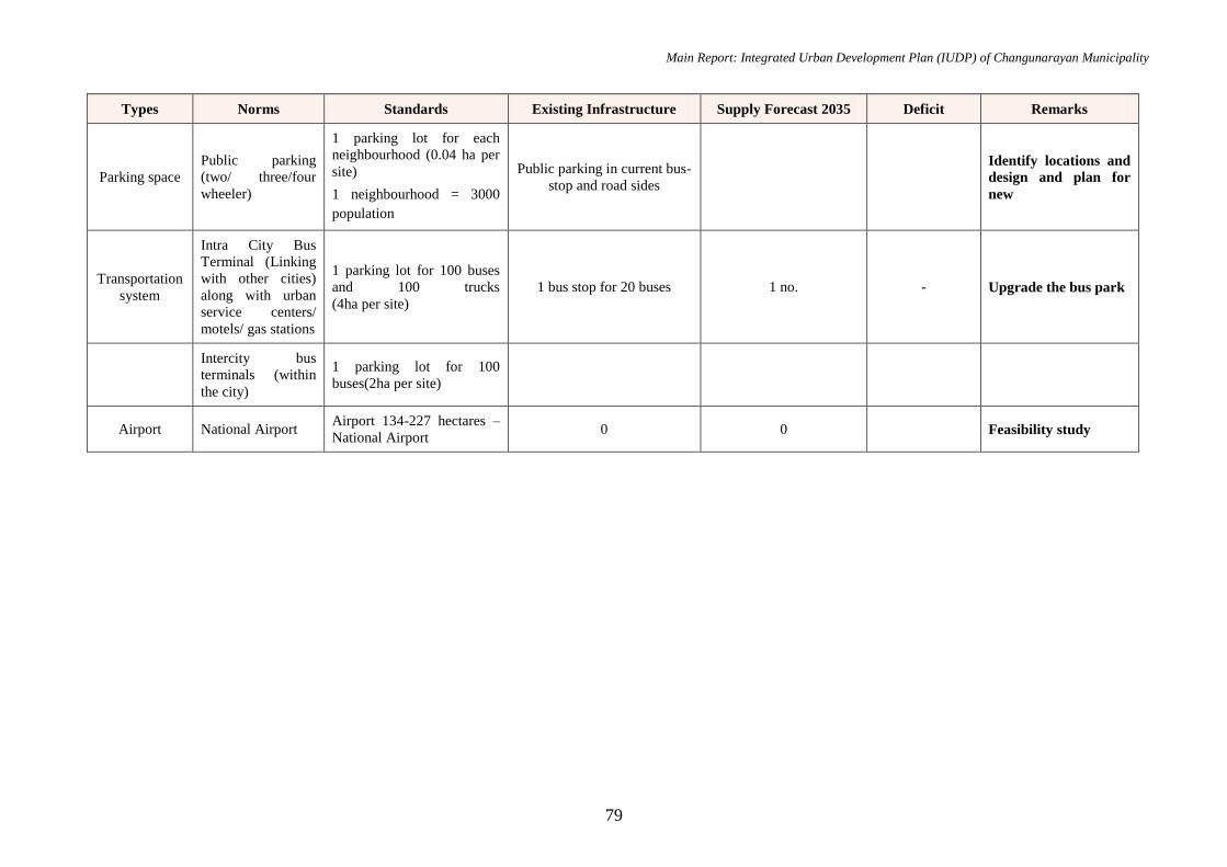
Main Report: Integrated Urban Development Plan (IUDP) of Changunarayan Municipality
79
Types Norms Standards Existing Infrastructure Supply Forecast 2035 Deficit Remarks
Parking space
Public parking
(two/ three/four
wheeler)
1 parking lot for each
neighbourhood (0.04 ha per
site)
1 neighbourhood = 3000
population
Public parking in current bus-
stop and road sides
Identify locations and
design and plan for
new
Transportation
system
Intra City Bus
Terminal (Linking
with other cities)
along with urban
service centers/
motels/ gas stations
1 parking lot for 100 buses
and 100 trucks
(4ha per site)
1 bus stop for 20 buses 1 no. - Upgrade the bus park
Intercity bus
terminals (within
the city)
1 parking lot for 100
buses(2ha per site)
Airport National Airport Airport 134-227 hectares –
National Airport 0 0 Feasibility study
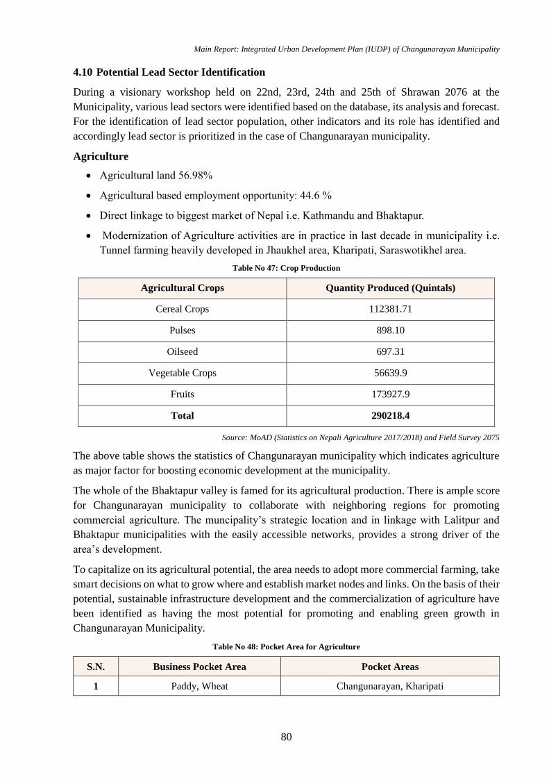
Main Report: Integrated Urban Development Plan (IUDP) of Changunarayan Municipality
80
4.10 Potential Lead Sector Identification
During a visionary workshop held on 22nd, 23rd, 24th and 25th of Shrawan 2076 at the
Municipality, various lead sectors were identified based on the database, its analysis and forecast.
For the identification of lead sector population, other indicators and its role has identified and
accordingly lead sector is prioritized in the case of Changunarayan municipality.
Agriculture
Agricultural land 56.98%
Agricultural based employment opportunity: 44.6 %
Direct linkage to biggest market of Nepal i.e. Kathmandu and Bhaktapur.
Modernization of Agriculture activities are in practice in last decade in municipality i.e.
Tunnel farming heavily developed in Jhaukhel area, Kharipati, Saraswotikhel area.
Table No 47: Crop Production
Agricultural Crops Quantity Produced (Quintals)
Cereal Crops 112381.71
Pulses 898.10
Oilseed 697.31
Vegetable Crops 56639.9
Fruits 173927.9
Total 290218.4
Source: MoAD (Statistics on Nepali Agriculture 2017/2018) and Field Survey 2075
The above table shows the statistics of Changunarayan municipality which indicates agriculture
as major factor for boosting economic development at the municipality.
The whole of the Bhaktapur valley is famed for its agricultural production. There is ample score
for Changunarayan municipality to collaborate with neighboring regions for promoting
commercial agriculture. The muncipality’s strategic location and in linkage with Lalitpur and
Bhaktapur municipalities with the easily accessible networks, provides a strong driver of the
area’s development.
To capitalize on its agricultural potential, the area needs to adopt more commercial farming, take
smart decisions on what to grow where and establish market nodes and links. On the basis of their
potential, sustainable infrastructure development and the commercialization of agriculture have
been identified as having the most potential for promoting and enabling green growth in
Changunarayan Municipality.
Table No 48: Pocket Area for Agriculture
S.N. Business Pocket Area Pocket Areas
1 Paddy, Wheat Changunarayan, Kharipati
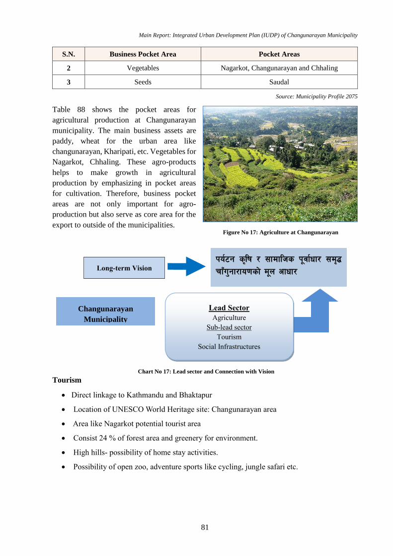
Main Report: Integrated Urban Development Plan (IUDP) of Changunarayan Municipality
81
S.N. Business Pocket Area Pocket Areas
2 Vegetables Nagarkot, Changunarayan and Chhaling
3 Seeds Saudal
Source: Municipality Profile 2075
Table 88 shows the pocket areas for
agricultural production at Changunarayan
municipality. The main business assets are
paddy, wheat for the urban area like
changunarayan, Kharipati, etc. Vegetables for
Nagarkot, Chhaling. These agro-products
helps to make growth in agricultural
production by emphasizing in pocket areas
for cultivation. Therefore, business pocket
areas are not only important for agro-
production but also serve as core area for the
export to outside of the municipalities.
Tourism
Direct linkage to Kathmandu and Bhaktapur
Location of UNESCO World Heritage site: Changunarayan area
Area like Nagarkot potential tourist area
Consist 24 % of forest area and greenery for environment.
High hills- possibility of home stay activities.
Possibility of open zoo, adventure sports like cycling, jungle safari etc.
Long-term Vision
Changunarayan
Municipality
ko{6g s[lif / ;fdflhs k"jf{wf/ ;d[4
rfFu'gf/fo0fsf] d"n cfwf/
Lead Sector Agriculture
Sub-lead sector
Tourism
Social Infrastructures
Figure No 17: Agriculture at Changunarayan
Chart No 17: Lead sector and Connection with Vision
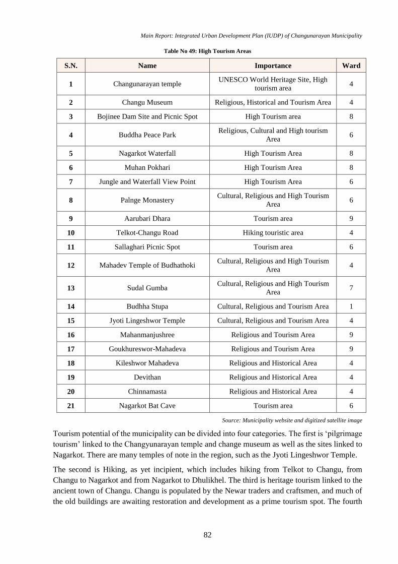
Main Report: Integrated Urban Development Plan (IUDP) of Changunarayan Municipality
82
Table No 49: High Tourism Areas
S.N. Name Importance Ward
1 Changunarayan temple UNESCO World Heritage Site, High
tourism area 4
2 Changu Museum Religious, Historical and Tourism Area 4
3 Bojinee Dam Site and Picnic Spot High Tourism area 8
4 Buddha Peace Park Religious, Cultural and High tourism
Area 6
5 Nagarkot Waterfall High Tourism Area 8
6 Muhan Pokhari High Tourism Area 8
7 Jungle and Waterfall View Point High Tourism Area 6
8 Palnge Monastery Cultural, Religious and High Tourism
Area 6
9 Aarubari Dhara Tourism area 9
10 Telkot-Changu Road Hiking touristic area 4
11 Sallaghari Picnic Spot Tourism area 6
12 Mahadev Temple of Budhathoki Cultural, Religious and High Tourism
Area 4
13 Sudal Gumba Cultural, Religious and High Tourism
Area 7
14 Budhha Stupa Cultural, Religious and Tourism Area 1
15 Jyoti Lingeshwor Temple Cultural, Religious and Tourism Area 4
16 Mahanmanjushree Religious and Tourism Area 9
17 Goukhureswor-Mahadeva Religious and Tourism Area 9
18 Kileshwor Mahadeva Religious and Historical Area 4
19 Devithan Religious and Historical Area 4
20 Chinnamasta Religious and Historical Area 4
21 Nagarkot Bat Cave Tourism area 6
Source: Municipality website and digitized satellite image
Tourism potential of the municipality can be divided into four categories. The first is ‘pilgrimage
tourism’ linked to the Changyunarayan temple and change museum as well as the sites linked to
Nagarkot. There are many temples of note in the region, such as the Jyoti Lingeshwor Temple.
The second is Hiking, as yet incipient, which includes hiking from Telkot to Changu, from
Changu to Nagarkot and from Nagarkot to Dhulikhel. The third is heritage tourism linked to the
ancient town of Changu. Changu is populated by the Newar traders and craftsmen, and much of
the old buildings are awaiting restoration and development as a prime tourism spot. The fourth
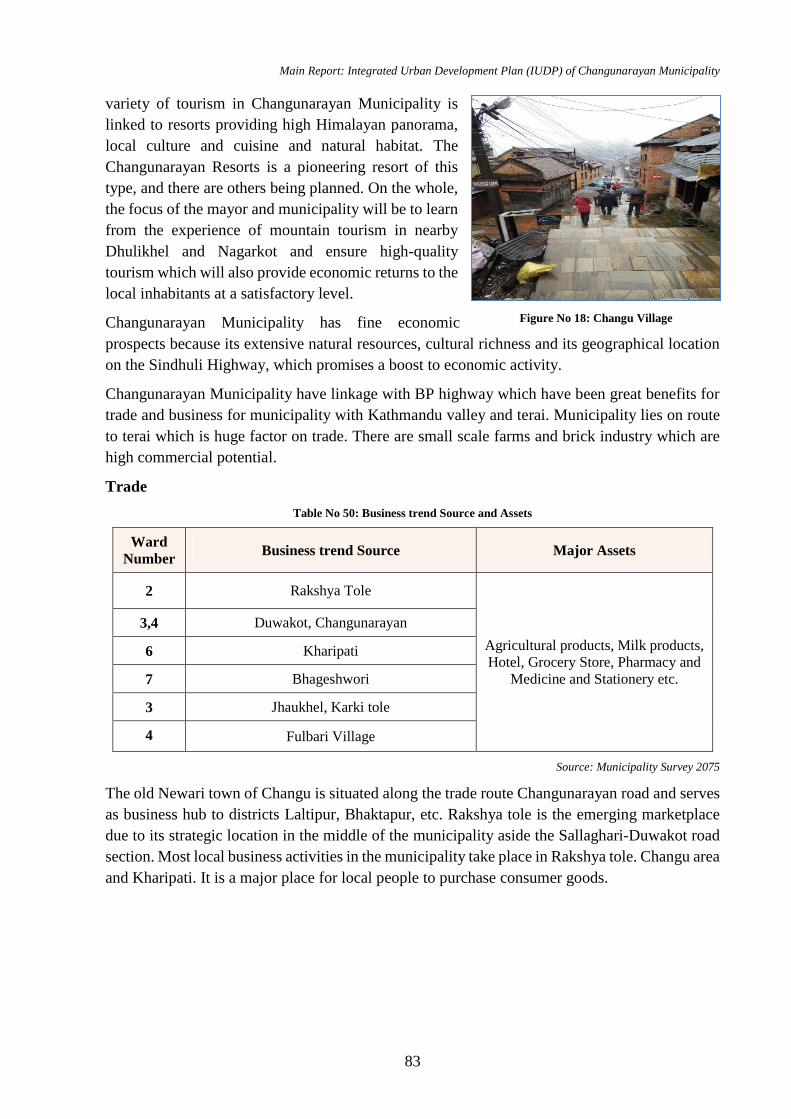
Main Report: Integrated Urban Development Plan (IUDP) of Changunarayan Municipality
83
variety of tourism in Changunarayan Municipality is
linked to resorts providing high Himalayan panorama,
local culture and cuisine and natural habitat. The
Changunarayan Resorts is a pioneering resort of this
type, and there are others being planned. On the whole,
the focus of the mayor and municipality will be to learn
from the experience of mountain tourism in nearby
Dhulikhel and Nagarkot and ensure high-quality
tourism which will also provide economic returns to the
local inhabitants at a satisfactory level.
Changunarayan Municipality has fine economic
prospects because its extensive natural resources, cultural richness and its geographical location
on the Sindhuli Highway, which promises a boost to economic activity.
Changunarayan Municipality have linkage with BP highway which have been great benefits for
trade and business for municipality with Kathmandu valley and terai. Municipality lies on route
to terai which is huge factor on trade. There are small scale farms and brick industry which are
high commercial potential.
Trade
Table No 50: Business trend Source and Assets
Ward
Number Business trend Source Major Assets
2 Rakshya Tole
Agricultural products, Milk products,
Hotel, Grocery Store, Pharmacy and
Medicine and Stationery etc.
3,4 Duwakot, Changunarayan
6 Kharipati
7 Bhageshwori
3 Jhaukhel, Karki tole
4 Fulbari Village
Source: Municipality Survey 2075
The old Newari town of Changu is situated along the trade route Changunarayan road and serves
as business hub to districts Laltipur, Bhaktapur, etc. Rakshya tole is the emerging marketplace
due to its strategic location in the middle of the municipality aside the Sallaghari-Duwakot road
section. Most local business activities in the municipality take place in Rakshya tole. Changu area
and Kharipati. It is a major place for local people to purchase consumer goods.
Figure No 18: Changu Village
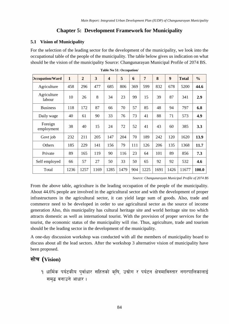
Main Report: Integrated Urban Development Plan (IUDP) of Changunarayan Municipality
84
Chapter 5: Development Framework for Municipality
5.1 Vision of Municipality
For the selection of the leading sector for the development of the municipality, we look into the
occupational table of the people of the municipality. The table below gives us indication on what
should be the vision of the municipality Source: Changunarayan Municipal Profile of 2074 BS.
Table No 51: Occupation/
Occupation/Ward 1 2 3 4 5 6 7 8 9 Total %
Agriculture 458 296 477 685 806 369 599 832 678 5200 44.6
Agriculture
labour 10 26 8 34 23 99 15 39 87 341 2.9
Business 118 172 87 66 70 57 85 48 94 797 6.8
Daily wage 40 61 90 33 76 73 41 88 71 573 4.9
Foreign
employment 38 40 15 24 72 52 41 43 60 385 3.3
Govt job 232 211 205 147 204 70 189 242 120 1620 13.9
Others 185 229 141 156 79 111 126 206 135 1368 11.7
Private 89 165 119 90 116 23 64 101 89 856 7.3
Self employed 66 57 27 50 33 50 65 92 92 532 4.6
Total 1236 1257 1169 1285 1479 904 1225 1691 1426 11677 100.0
Source: Changunarayan Municipal Profile of 2074 BS
From the above table, agriculture is the leading occupation of the people of the municipality.
About 44.6% people are involved in the agricultural sector and with the development of proper
infrastructures in the agricultural sector, it can yield large sum of goods. Also, trade and
commerce need to be developed in order to use agricultural sector as the source of income
generation Also, this municipality has cultural heritage site and world heritage site too which
attracts domestic as well as international tourist. With the provision of proper services for the
tourist, the economic status of the municipality will rise. Thus, agriculture, trade and tourism
should be the leading sector in the development of the municipality.
A one-day discussion workshop was conducted with all the members of municipality board to
discuss about all the lead sectors. After the workshop 3 alternative vision of municipality have
been proposed.
;f]r (Vision)
! wfld{s ko{6sLo k'jf{wf/ ;lxtsf] s[lif, pBf]u / ko{6g If]qdflj:tf/ gu/kflnsfnfO{
;d[4 jgfpg] cfwf/ .
Main Report: Integrated Urban Development Plan (IUDP) of Changunarayan Municipality
85
@ ef}lts,;fdflhs / ko{6g k"jf{wf/ ljsf;df hf]8, pBf]ulzntf / ko{6gsf ]cfo
cfh{gjf6 ;d[4 jGg] gu/sf] ;f]r .
# ko{6g s[lif / ;fdflhs k"jf{wf/ ;d[4 rfFu'gf/fo0fsf] d"n cfwf/
Among three, the selected vision is ko{6g s[lif / ;fdflhs k"jf{wf/ ;d[4 rfFu'gf/fo0fsf] d"n
cfwf/
5.2 Goals
"jftfj/0f d}qL ef}lts, ;fdflhs tyf cfly{s k'jf{wf/x?sf] Aojl:yt Plss[t ljsf; ul/ gu/nfO{ ;'/lIft,
pTkfbgzLn, s[lif, Jofkfl/s, wfld{s ko{6lso agfO{ :jR5 ;'Gb/ ;d[4 gu/ agfpg] . "
To develop Municipality as a secured, Productive, clean, prosperous municipality through
development of Environment Friendly Physical, Social and Economic Infrastructure.
To make agro-production and livestock production as major source for income generation
To promote tourism sectors with major focus in hiking tourism, heritage tourism,
pilgrimage tourism, etc.
5.3 Objectives
The main objective of the IUDP of Changunarayan is to create an environmentally sustainable,
socially inclusive and balanced society with physical, social and economic infrastructures. For
achieving the various sectoral goals, following specific objectives are set in the field of Agro
development plan, Infrastructure development plan, tourism and trade derived from the plan.
To make major improvement in tourism attraction places.
Formulation of tourism plans at Changunarayan temple.
Implementation for security plans and policies with major emphasis on Monasteries,
trekking areas and religious areas.
To accelerate exporting of agricultural and livestock products from the Municipality
To enhance village development by tourism and export of agricultural and livestock
products.
5.4 Strategy
Establishment of trade plans for the export of agro-products, fish products and milk
products.
Construction of parks at temples, monasteries, etc.
Construction of view towers at Nagarkot, Buddha Peace Park, Changu village and
Lattedada.
Developmental plan and procedures for infrastructural development at rural areas like ward
6 etc.
Establishing more no. of colleges and expanding number of schools at Changunarayan,
Main Report: Integrated Urban Development Plan (IUDP) of Changunarayan Municipality
86
Rakshya tole for improving education standards of municipality.
Road Network expansion from Duwakot and Jhaukhel to undeveloped and rural areas for
boosting housing construction at rural areas.
Adaptation of RCC frame structures for housing construction almost at all wards of the
municipality.
Preservation of archaeological, historical sites like Changunarayan and Changu museum.
5.5 Plan for Implementing Development Framework
As there is limited financial and human resource with municipality and municipality is over
dependent in federal and provincial government grant. For implementation of proposed
development plan there should be collaborated effort from three tiers government. For that
municipality development goals and objectives should be collinear with federal and provincial
government’s goal and objectives.
Implementation of the proposed development plan depends upon availability of human and
financial capacity of municipality. There is need of upgradation of financial and human resource
of municipality. So, for this purpose implementation framework has been proposed for
Changunarayan Municipality. To implement proposed plan there should principle guideline for
decision making and formulation of individual plan and programs.
Major foundations that governs the implementation of plans are:
-Municipal council decision
- Sectoral Program
- Building construction
- Program formulation
- Infrastructure Upgradation
Above subjects will be closely exercised by different unit in municipality. Different unit should
be assigned to take responsibility of implementation of plans. This unit should be formed under
municipal council and at least urban planner, sociologist, economist, civil engineers, architects,
administrative officer and accountant must be involved.
Also financial ability of municipality is major requirement to implement plans. So following
provisions should be taken.
The Municipality informs, cooperates and/or reaches cooperation and co-financing
agreements with ministries and relevant agencies for projects proposed in the MDP that
require the participation of these institutions.
The Municipality informs, cooperates and/or reaches co-financing agreements with
neighboring municipalities for projects of common interest. The Municipality cooperates
with the Agency for Regional Development in the implementation of such projects.
The municipality informs, cooperates and reaches partnership agreements with public
companies for public services in the competencies of these companies (issues of water
Main Report: Integrated Urban Development Plan (IUDP) of Changunarayan Municipality
87
supply, sewage, electricity, waste management, etc.)
The Municipality cooperates and establishes partnership agreements (PPP) with the private
sector for projects, in which both sides have a common interest
The Municipality establishes cross-border cooperation relations with municipalities of
neighboring states for projects of common interest
The Municipality cooperates with various donors for projects envisaged by the plan, whose
implementation can be assisted by various donor programmes.
The municipality supports and cooperates with NGOs in a number of projects envisaged
by the plan, especially in those dealing with awareness campaigns and promotion of
municipal values.
During the development of plans, the municipality should ensure the participation and
involvement of the public (citizens and various interest groups) from the beginning stages
and throughout the process, and undertake information campaigns as foreseen by the
provisions of the Law on Spatial Planning.
Building construction is also one of major pillar for the implementation of development plan as
it guides the urban form and spatial transformation of municipality. So, building permit should
be given according to proposed land use plan and municipality should prepare guideline for
formulation of sectoral program and project. Another major factor for implementation of
development plan is political willingness and municipal council decision should match with
development goal envisioned in proposed plan.
Main Report: Integrated Urban Development Plan (IUDP) of Changunarayan Municipality
88
Chapter 6: Sectoral Development Plan
6.1 Introduction
Sectors, which are required to be incorporated, are physical infrastructures, environmental
management, social and economic sectors, disaster management, climate change, economic and
financial management planning and organization development plans. Such Sectoral plans and
programs are back up by multisector investment plans prepared giving due attention to national
concerns such as poverty reduction and social inclusion.
6.2 Physical Development Plan
Physical planning is a comprehensive, multi sectorial master plan, which provides a planned
spatial framework of development for the physical environment within which a balanced program
of social and economic development can be carried out. It provides the legislation necessary for
the planning, controlling and implementation of the physical development process and is done to
ensure the establishment of centralized infrastructure with overall responsibility for planning,
evaluation, co-ordination, administration and implementation.
Goal and Objectives
Increasing the living standard of citizens with well-equipped physical amenities utilizing less
resources and maintaining the ecological stability.
The long-term physical development plan of Changunarayan aims to improve the urban
infrastructures of the Changunarayan. The urban infrastructures are classified as physical, social
and economic.
Objectives
To improve the land and housing demand.
To prepare a proper land use plan catering the future need.
To develop market centers in the urbanizing settlements and develop requisite infrastructure
in the scattered settlement in areas.
To connect the infrastructure with digital technology.
To operate and develop social infrastructure like Education Institution, Health Institution,
Open Space and green parks, Community Hall and Library.
To rehabilitate economic infrastructure like Parking Space, Stadium, Sports Complex, and
Movie Hall.
To identify the places for new bus, stop, parking space and construct bus stops and public
toilets in required places.
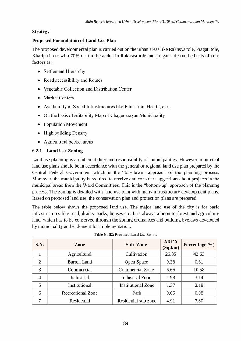
Main Report: Integrated Urban Development Plan (IUDP) of Changunarayan Municipality
89
Strategy
Proposed Formulation of Land Use Plan
The proposed developmental plan is carried out on the urban areas like Rakhsya tole, Pragati tole,
Kharipati, etc with 70% of it to be added in Rakhsya tole and Pragati tole on the basis of core
factors as:
Settlement Hierarchy
Road accessibility and Routes
Vegetable Collection and Distribution Center
Market Centers
Availability of Social Infrastructures like Education, Health, etc.
On the basis of suitability Map of Chagunarayan Municipality.
Population Movement
High building Density
Agricultural pocket areas
6.2.1 Land Use Zoning
Land use planning is an inherent duty and responsibility of municipalities. However, municipal
land use plans should be in accordance with the general or regional land use plan prepared by the
Central Federal Government which is the “top-down” approach of the planning process.
Moreover, the municipality is required to receive and consider suggestions about projects in the
municipal areas from the Ward Committees. This is the “bottom-up” approach of the planning
process. The zoning is detailed with land use plan with many infrastructure development plans.
Based on proposed land use, the conservation plan and protection plans are prepared.
The table below shows the proposed land use. The major land use of the city is for basic
infrastructures like road, drains, parks, houses etc. It is always a boon to forest and agriculture
land, which has to be conserved through the zoning ordinances and building byelaws developed
by municipality and endorse it for implementation.
Table No 52: Proposed Land Use Zoning
S.N. Zone Sub_Zone AREA
(Sq.km) Percentage(%)
1 Agricultural Cultivation 26.85 42.63
2 Barren Land Open Space 0.38 0.61
3 Commercial Commercial Zone 6.66 10.58
4 Industrial Industrial Zone 1.98 3.14
5 Institutional Institutional Zone 1.37 2.18
6 Recreational Zone Park 0.05 0.08
7 Residenial Residenial sub zone 4.91 7.80
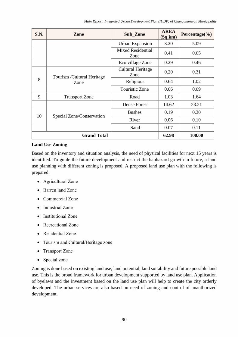
Main Report: Integrated Urban Development Plan (IUDP) of Changunarayan Municipality
90
S.N. Zone Sub_Zone AREA
(Sq.km) Percentage(%)
Urban Expansion 3.20 5.09
Mixed Residential
Zone 0.41 0.65
Eco village Zone 0.29 0.46
8 Tourism /Cultural Heritage
Zone
Cultural Heritage
Zone 0.20 0.31
Religious 0.64 1.02
Touristic Zone 0.06 0.09
9 Transport Zone Road 1.03 1.64
10 Special Zone/Conservation
Dense Forest 14.62 23.21
Bushes 0.19 0.30
River 0.06 0.10
Sand 0.07 0.11
Grand Total 62.98 100.00
Land Use Zoning
Based on the inventory and situation analysis, the need of physical facilities for next 15 years is
identified. To guide the future development and restrict the haphazard growth in future, a land
use planning with different zoning is proposed. A proposed land use plan with the following is
prepared.
Agricultural Zone
Barren land Zone
Commercial Zone
Industrial Zone
Institutional Zone
Recreational Zone
Residential Zone
Tourism and Cultural/Heritage zone
Transport Zone
Special zone
Zoning is done based on existing land use, land potential, land suitability and future possible land
use. This is the broad framework for urban development supported by land use plan. Application
of byelaws and the investment based on the land use plan will help to create the city orderly
developed. The urban services are also based on need of zoning and control of unauthorized
development.
Main Report: Integrated Urban Development Plan (IUDP) of Changunarayan Municipality
91
1. Agriculture Zone
At present, the municipality has 35.89 sq.km coverage as an agriculture area. The area using
predominantly agriculture purposes has to be conserved from sprawl. Development control over
agriculture has to be applied through Municipality byelaws by prohibiting building houses inside
this area except building needed for farming purpose and applying unproductive tax on vacant
land. The tax of this agro-land area should be subsidized. The main aim of this zone is conserving
the food production area within the municipality, reduce ecological footprint and encourage urban
agriculture. The proposed land-use will occupy 26.85 sq.km of total area up to next 15 years.
2. Barren Land Zone
At present, the municipality has 0.41 sq.km area is occupied by open space near river bank and
other location. This area will be used for sanitary landfill site and construction of park and pond.
It occupies 0.38 sq.km area in the 15 year proposed land use zoning map.
3. Commercial Zone
Commercial zone i.e. business zone means the land covered by house, shop, hotel, exhibition
hall, petrol pump, communication or goods transacting spot or any literary, scientific or technical
service, association making available information and consultancy, haat (local market places
where transaction is done in a regular interval), etc. This zone also indicates a commercial
building constructed by Business Company or association in business zone. Commercial zone is
proposed to make urbanization for market expansion. The proposed commercial land use zone
will cover 6.66 sq.km of the municipality. It is further categorized as:
This subzone is proposed to provide services as:
To provide for businesses and services that support Central Business municipality.
To provide for business and services in a residential area.
Overnight accommodations, eating and drinking establishments.
These areas include markets, collection center, banking transactions, market centers and
facilitated infrastructure services.
4. Industrial Zone
The main feature of industrial zone is high concentration of industry in a small space. The
industrial zone at mainly focuses on following sub-zones:
Industrial zone provides a primary means of converting raw agricultural materials into value
added products while generating income and employment and contributing to overall economic
development. Since municipality is rich in agricultural resources, it can be great benefit for the
municipality to implement agro-industries. The Industrial zone is proposed to be in areas like
Rakshya Tole, Chhaling, Jhaukhal, Chundevi, Sudal etc. These industrial zones are proposed to
create small employment opportunities and to run in low-scale making the availability of daily
needs and materials. These industrial zones include industries which manufacture products like
Grills, Furniture, Food products, beverages, etc. Therefore, the overall total proposed industrial
zone of the municipality is 1.98 sq.km.
Main Report: Integrated Urban Development Plan (IUDP) of Changunarayan Municipality
92
5. Institutional Zone
The institutional zone is intended to establish areas within the developed areas of the municipality
to provide flexibility for the development of public structures and uses. Institutional zone means
academic institution including school, college, vocational education centre, university, security
body, health institution including health centre, health post, private and community hospital,
government office responsible for telecommunication, etc. Area of about 1.37 sq.km has been
proposed for such zone.
On the basis of availability of education infrastructures and services, Kharipati, Nepal
engineering college is top prior area since it already includes 2 colleges and adequate higher and
lower secondary education services. Therefore, existing education service area only requires
certain up gradation on education services due to which it is foremost area for proposing
education sub-zone.
Health services availability indicates the physical development of any area. Such areas are
proposed in places where there is advent of all hierarchy of road networks and can be easily
accessible to local households. Health services at Changunarayan will be bub due to Bir hospital
branch.
Government office responsible for telecommunication, library, elder’s home, pati (resting inn/
house), community building, banks are constructed for public use and implemented at major
urban areas. Settlement hierarchy, urbanization trend and road connectivity indicate as a major
area for public service zone.
Though many institutions are scattered around municipality, only one area is identified as an
institutional zone. The area is proposed for various government offices, health institutions, banks,
service centre etc. Since the settlement and infrastructures are scattered along the municipality,
the intuitional pocket area is identified with each ward having their own basic intuitional zone
consisting of schools, health posts, local clubs etc
6. Recreational Zone
Recreational means such as Parks, Movie Theatres are proposed in the urban areas where the
flow of people is maximum/ high. The proposed recreational zone covers 0.04 sq.km of the total
municipality area.
7. Residential Zone
Residential area is divided in three sub zone categories that are residential sub zone, urban
expansion, mixed residential zone. The proposed residential zone covers 8.82 sq.km area of the
total municipality area.
i) Residential Sub Zone
Residential area is divided in three categories. The area having density >300 per hectares are
termed as dense residential area. Similarly, density between 100 and 300 is taken as medium
density and lower than 100 is taken as low-density area. This will cover 4.91 sq.km of area which
is almost 7.8% of total area.
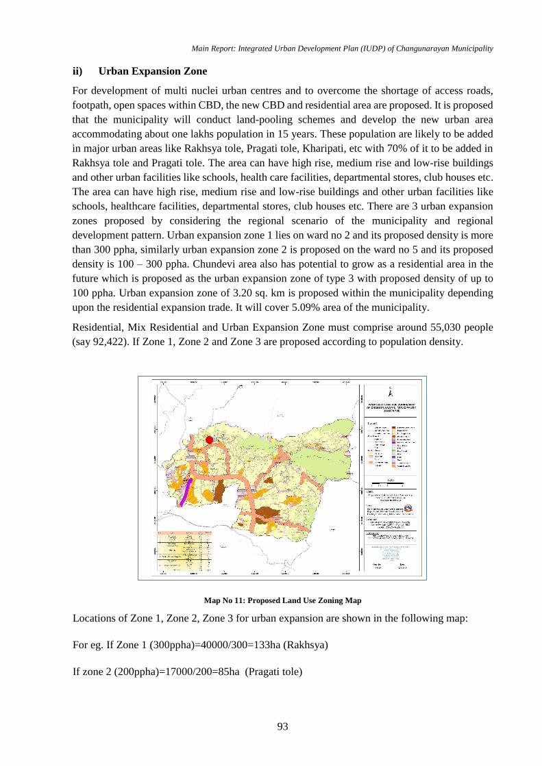
Main Report: Integrated Urban Development Plan (IUDP) of Changunarayan Municipality
93
ii) Urban Expansion Zone
For development of multi nuclei urban centres and to overcome the shortage of access roads,
footpath, open spaces within CBD, the new CBD and residential area are proposed. It is proposed
that the municipality will conduct land-pooling schemes and develop the new urban area
accommodating about one lakhs population in 15 years. These population are likely to be added
in major urban areas like Rakhsya tole, Pragati tole, Kharipati, etc with 70% of it to be added in
Rakhsya tole and Pragati tole. The area can have high rise, medium rise and low-rise buildings
and other urban facilities like schools, health care facilities, departmental stores, club houses etc.
The area can have high rise, medium rise and low-rise buildings and other urban facilities like
schools, healthcare facilities, departmental stores, club houses etc. There are 3 urban expansion
zones proposed by considering the regional scenario of the municipality and regional
development pattern. Urban expansion zone 1 lies on ward no 2 and its proposed density is more
than 300 ppha, similarly urban expansion zone 2 is proposed on the ward no 5 and its proposed
density is 100 – 300 ppha. Chundevi area also has potential to grow as a residential area in the
future which is proposed as the urban expansion zone of type 3 with proposed density of up to
100 ppha. Urban expansion zone of 3.20 sq. km is proposed within the municipality depending
upon the residential expansion trade. It will cover 5.09% area of the municipality.
Residential, Mix Residential and Urban Expansion Zone must comprise around 55,030 people
(say 92,422). If Zone 1, Zone 2 and Zone 3 are proposed according to population density.
Map No 11: Proposed Land Use Zoning Map
Locations of Zone 1, Zone 2, Zone 3 for urban expansion are shown in the following map:
For eg. If Zone 1 (300ppha)=40000/300=133ha (Rakhsya)
If zone 2 (200ppha)=17000/200=85ha (Pragati tole)

Main Report: Integrated Urban Development Plan (IUDP) of Changunarayan Municipality
94
If Zone 3 (100ppha)=15000/100=150ha (Kharipati)
Residential, Urban expansion and Mixed Residential area= (4.91+3.2+0.41+0.29) according to
table= 8.82 sq.km (8740 ha) but 96.33 ha is enough. Or we can change distribution of population
in every zone.
iii) Mixed Residential Zone
Mixed residential zone is type of zoning that blends residential, commercial, institutional or
entertainment uses into one space, where those functions are to some degree physically and
functionally integrated, and that provides pedestrian connections.
Mixed residential zone generally means bazaar area where buildings are used for mixed purpose
such as shops at ground floor and rental/private households living at upper storeys. Mixed
residential zone is proposed based on parameter such as market center, road hierarchy and Mixed
residential zone is proposed mainly focusing Saraswatikhel where there is passage of Sallaghari
–Duwakot-Sangdaha Sadak and most of the buildings at both sides of road are used for mixed
purpose.
Therefore, the mixed residential sub-zone will comprise of area 0.41 sq.km.
iv) Eco Village Zone
Eco village zone occupies 0.29 sq.km i.e about 0.46% area of the municipality in the proposed
land zoning map.
8. Tourism and Cultural/Heritage Zone
Sites of cultural and natural importance are considered under this zone. Tourism and Cultural
zone is further categorised into three sub zones; Cultural heritage zone, religious sub zone and
touristic sub zone. The Changunarayan Temple area within 500m diameter is taken as cultural
heritage zone as the area has many historic and architectural art and artefacts scattered around
and other religious and tourism zone with 300m diameter as cultural and heritage zone. It
incorporates temples, pathways, Chautara, pond, tower, picnic spot and both religious and secular
cultural heritages. Though, the area is heavily encroached by modern and unwanted activities,
municipality with byelaws can encourage conservation works. The detail archaeological and
conservation study are done that is based on it, implementation plan will be prepared. It will be
composed of 0.9 sq. km area. Tourism and cultural/Heritage zone are situated in Changunarayan
temple, other Scatter temple, tourism place etc.
9. Transport Zone
Transport zone refers to the area covered by road in the municipality. It occupies 1.03 sq.km i.e
1.64% area of the total municipality.
10. Special Zone
Special zone is categorized as dense forest, bushes, river and sand area in the municipality.
Special zone such as water body and forest are of natural importance and they should be used
rationally and skilful management and preservation of the natural environment should be done.
Forest and bushes occupies about 14.62 Sq. km and 0.19 sq.km. Whereas water body and sand
Main Report: Integrated Urban Development Plan (IUDP) of Changunarayan Municipality
95
occupies 0.06 sq.km and 0.07 sq.km respectively. These areas are protected and conserved for
the benefits of mankind.
6.2.2 Urban Expansion
Changunaryan is the old city, and mainly depends on the agriculture and the brick industry. Also,
this municipality consist of many sand mines. Following google pictures shows the trend of urban
expansion depending upon the time. In 2007 AD, the whole area is dominated by the brick
factory. In area between Jhaukhel and Duwakot, mostly lands are used for the manufacturing of
brick. But know days the area is developed as the combined industrial zone as well as there seems
the many agricultural forms also there are many houses were built for the residential purposes.
This signifies that, the area between Jhaukhel and Duwakot is developing as the residential zone
day by day and brick factories were shrinks to the small area as shown in following pictures. This
trends also ultimately governs that; the whole area is developing as a residential area in the nearer
future of Changunaryan.
Table No 53: LFA for Achieving Physical Development
Intervention Logic Indicators Means of Verification Assumptions
Goal:
Increasing the living standard of citizens with well-equipped physical amenities utilizing less resources
and maintaining the ecological stability
Objective:
Improvement and development of physical infrastructure and increasing the grasp of general public for
these facilities.
Result:
Land and housing is
accessible for every
income group.
By 2035
100% people will
get grip on land and
housing.
Documentation of
Road and Transport
Management Branch
Land Management and
Building Regulation
Division Records
Field Visits
Records of
Information,
Communication and
Statistics Management
Division
Arrangement of budget as
planned
Work is efficiently
performed
People participated in
focused program
There is political stability
There is no bandhas and
other casualties
Activities:
Land pooling and site and services program commencement.
Facilitation of Investment on affordable group housing and apartments.
Housing Support for low and middle income groups.
Maintaining and updating building records.
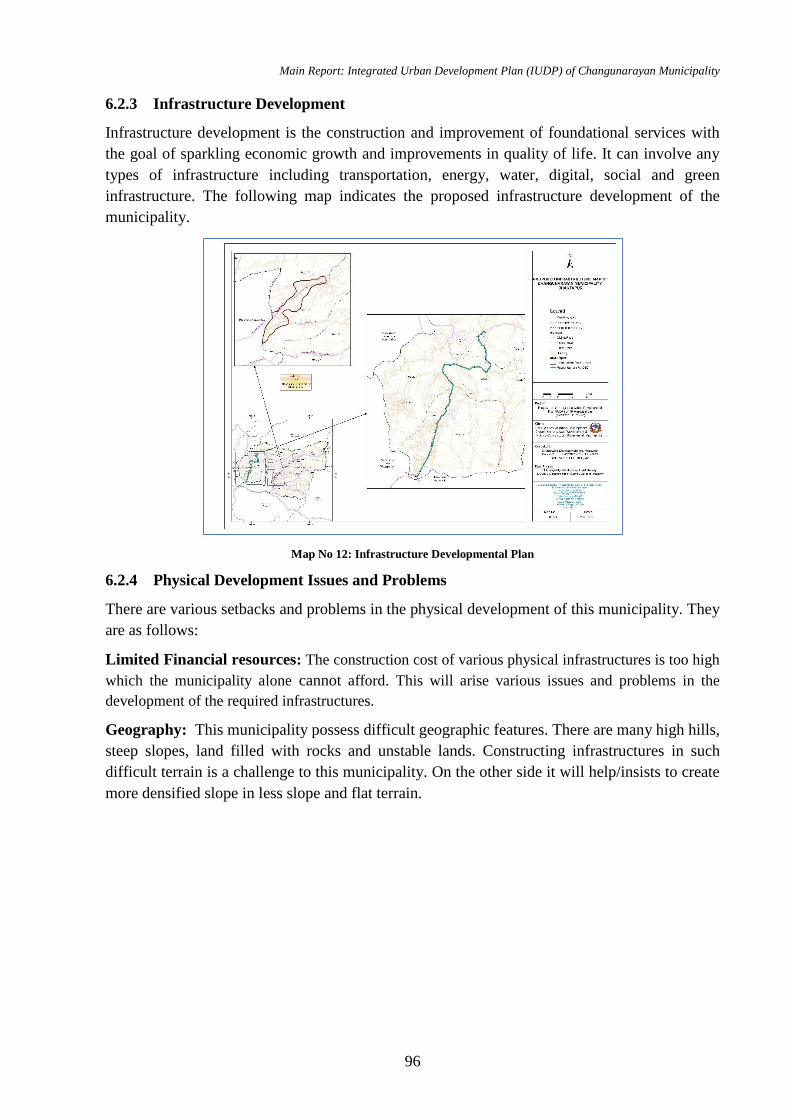
Main Report: Integrated Urban Development Plan (IUDP) of Changunarayan Municipality
96
6.2.3 Infrastructure Development
Infrastructure development is the construction and improvement of foundational services with
the goal of sparkling economic growth and improvements in quality of life. It can involve any
types of infrastructure including transportation, energy, water, digital, social and green
infrastructure. The following map indicates the proposed infrastructure development of the
municipality.
Map No 12: Infrastructure Developmental Plan
6.2.4 Physical Development Issues and Problems
There are various setbacks and problems in the physical development of this municipality. They
are as follows:
Limited Financial resources: The construction cost of various physical infrastructures is too high
which the municipality alone cannot afford. This will arise various issues and problems in the
development of the required infrastructures.
Geography: This municipality possess difficult geographic features. There are many high hills,
steep slopes, land filled with rocks and unstable lands. Constructing infrastructures in such
difficult terrain is a challenge to this municipality. On the other side it will help/insists to create
more densified slope in less slope and flat terrain.
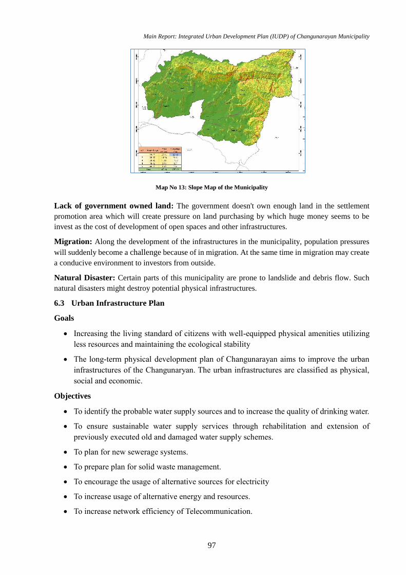
Main Report: Integrated Urban Development Plan (IUDP) of Changunarayan Municipality
97
Map No 13: Slope Map of the Municipality
Lack of government owned land: The government doesn't own enough land in the settlement
promotion area which will create pressure on land purchasing by which huge money seems to be
invest as the cost of development of open spaces and other infrastructures.
Migration: Along the development of the infrastructures in the municipality, population pressures
will suddenly become a challenge because of in migration. At the same time in migration may create
a conducive environment to investors from outside.
Natural Disaster: Certain parts of this municipality are prone to landslide and debris flow. Such
natural disasters might destroy potential physical infrastructures.
6.3 Urban Infrastructure Plan
Goals
Increasing the living standard of citizens with well-equipped physical amenities utilizing
less resources and maintaining the ecological stability
The long-term physical development plan of Changunarayan aims to improve the urban
infrastructures of the Changunaryan. The urban infrastructures are classified as physical,
social and economic.
Objectives
To identify the probable water supply sources and to increase the quality of drinking water.
To ensure sustainable water supply services through rehabilitation and extension of
previously executed old and damaged water supply schemes.
To plan for new sewerage systems.
To prepare plan for solid waste management.
To encourage the usage of alternative sources for electricity
To increase usage of alternative energy and resources.
To increase network efficiency of Telecommunication.
Main Report: Integrated Urban Development Plan (IUDP) of Changunarayan Municipality
98
To strengthen organizational capacity for effective and result oriented plan implementation,
monitoring and evaluation.
6.3.1 Water Supply
From the demand analysis, 9.24 million Liter water is needed to cater 92,422 people based on
urban planning standard. Changunarayan municipality provides 42.1 % of water demand through
pipe line system. Still, there will be deficit 1.84 million Liter per day water supply. The deficit
amount is balanced by Dhunge dhara and by personal wells. For the supply of water as per
demand watershed of Kasan Khola and Hanumante Khola need to be managed and also rain
water harvesting technique can be used.
Objective
To retain and conserve existing water sources and maintain water table
Safe, Affordable and easy water facilities. The deficit amount is balanced by proposed lift
water system and by personal wells. To manage the upcoming water supply demand by
promoting recharging underground water table. Also water can be managed from rain water
harvesting method.
Strategies
Construction of pipeline system for 24 hours water supply facility for all households
Provision of water supply hose along roadside for cleaning, firefighting, greeneries and
others.
Promoting rainwater harvesting in household level by subsidizing on money and technical
support, promoting in public spaces like bus park, park, roadside, which can be used for
cleaning process
Sustainable usage of water sources and conservation of water resources from illegal
encroachment.
Cost of water for public should be reasonable and affordable so decide in scientific way.
Conservation of water sources and formulation of byelaws about ground water pumping to
maintain water table
Provision of public taps on major nodes of municipality.
Policy Recommendation (Guiding Principles)
GoN, MoPPW, 2009
User committee (for operation, maintenance, effective service delivery)
Private Partnership (for some certain period) (BOOT system)
Promotion of rainwater harvesting
Pro-poor strategies for marginalized groups in municipality
Strategic Projects
Construction of Drinking water projects
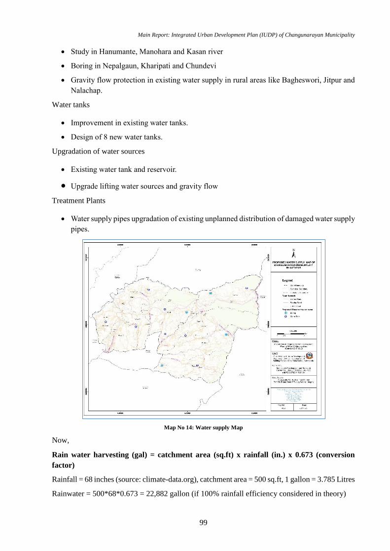
Main Report: Integrated Urban Development Plan (IUDP) of Changunarayan Municipality
99
Study in Hanumante, Manohara and Kasan river
Boring in Nepalgaun, Kharipati and Chundevi
Gravity flow protection in existing water supply in rural areas like Bagheswori, Jitpur and
Nalachap.
Water tanks
Improvement in existing water tanks.
Design of 8 new water tanks.
Upgradation of water sources
Existing water tank and reservoir.
Upgrade lifting water sources and gravity flow
Treatment Plants
Water supply pipes upgradation of existing unplanned distribution of damaged water supply
pipes.
Map No 14: Water supply Map
Now,
Rain water harvesting (gal) = catchment area (sq.ft) x rainfall (in.) x 0.673 (conversion
factor)
Rainfall = 68 inches (source: climate-data.org), catchment area = 500 sq.ft, 1 gallon = 3.785 Litres
Rainwater = 500*68*0.673 = 22,882 gallon (if 100% rainfall efficiency considered in theory)

Main Report: Integrated Urban Development Plan (IUDP) of Changunarayan Municipality
100
Rainwater collected = 500*34*0.673 (50% rainfall efficiency assumed)
=11,441 Gallon = 43,304 litres
Hence, 500 sq.ft catchment area will collect 43,304 Litres of water. If only about 50% of
household (5500) can use the rainwater harvesting technique, 238 million litres water can be
reserved and the scarce amount of water can be readily recovered.
6.3.2 Waste Water
Wastewater is a by-product of domestic, industrial, commercial or agricultural activities. The
characteristics of wastewater vary depending on the source. Types of wastewater include: domestic
wastewater from households, municipal wastewater from communities (also called sewage) and
industrial wastewater from industrial activities. Wastewater can contain physical, chemical and
biological pollutants.
Households may produce wastewater from flush toilets, sinks, dishwashers, washing machines, bath
tubs, and showers. Households that use dry toilets produce less wastewater than those that use flush
toilets.
Wastewater may be conveyed in a sanitary sewer which conveys only sewage. Alternatively, it can
be transported in a combined sewer which includes storm water runoff and industrial wastewater.
After treatment at a wastewater treatment plant, the treated wastewater (also called effluent) is
discharged to a receiving water body. The terms "wastewater reuse" or "water reclamation" apply if
the treated waste is used for another purpose. Wastewater that is discharged to the environment
without suitable treatment causes water pollution.
In Present condition due to the presence of septic tank in each household there is no sewerage
line for black water. But in for the future prospective sewerage system is essential for the
managed municipality. Generally, 70-80 % of supplied water is converted to the waste water as
a by-product. That means the municipality requires the waste water carrying system as well as
the waste water treatment plant of capacity of around 5 million liter per day. Also the location for
the treatment plant and the discharging points is planned.
Also the location for the treatment plant and the discharging points is planned considering the
gradient and identify the tentative area for waste water disposal on the both side of the
Changunarayan, Nagarkot and Bhaktapur-Nala road.
Objective
To maintain operational efficient sewer and drainage network
Manage fecal sludge at household and municipality levels in an environment-friendly and
integrated way.
Strategies
Waste water treatment plant before discharge into river.
Alternative waste water treatment promotion like reed bed.
Septic tank and soak pit or bio-gas to be compulsory.
Operational and well-maintained Sewerage and drainage line along road side
Main Report: Integrated Urban Development Plan (IUDP) of Changunarayan Municipality
101
Guiding Principles
It can be guided by some of the national policies like Steering committee for national
sanitation action,2011
Partnership with private sector, NGOs, INGOs and other organization
Community based sanitation programmes
Strategic Projects
Waste water treatment plant at Public.
Waste water drain along roadside at Changunarayan, Rakshya tole and Jhaukhel area.
Pilot projects for reed bed treatment plant
Waste water treatment in community level at urban expansion area within the available area
of the municipality.
Build a wastewater treatment plant with a biogas reactor at a suitable location in the
municipality.
6.3.3 Drainage
Rainwater Runoff will be collected and transmitted in planned manner to the planned discharge
point. Drainage can be designed as the separate system or the combined system depends upon the
hydraulic design parameters. In urban area drainage system are designed as combined system.
For this municipality combined drainage system should be designed and installed as per design.
Objective
Operational clean and free-flowing drainage system
Strategies and Guiding Principle
Public and private partnership
Household and community level awareness and responsibility
Digitalization in maintenance and operation tracking system
Storm water and natural drainage to be integrated
Strategic Projects
New construction and upgradation of drainage system along road side of Changunarayan
and Kharipati.
Drainage system should be proposed at main market and urban expansion area.
6.3.4 Solid Waste
From the demand analysis, 0.18kg/person of solid waste is needed to dispose effectively. The
disposal of solid waste is done through the landfill site. Landfill side is identified and constructed
within the territory of municipality.
Main Report: Integrated Urban Development Plan (IUDP) of Changunarayan Municipality
102
Objective
Reduce solid waste disposal and effective management
Strategies and Policies
Construction and effective management solid waste landfill site.
Extensive implementation of 3R (Reduce, Reuse and Recycle) containing only 30%
disposal
Collection by dustbin in certain places and in certain distance in roads
Segregation of waste in household level and promotion of biogas installation
Strong institutional and legal mechanism
Strategic Projects
Landfill site in ward no 6 and ward no. 9
Reduce waste by 40 % and add up Collection point (Community collection/ Door to Door
collection).
1 Transfer Station for 1 city if the final disposal is at distance of more than 10 km
0.15ha-.02hapersite
3ha-5ha if recycling platform, compost plant & window composting etc without buffer zone
With capacity 0.10 kg/person/day (42 ton)
Institutional development trainings and separate unit
Awareness campaign and trainings with coordination with local NGOs and private sector
Availability of dustbin in public places like Changunarayan heritage areas and market areas
such as Duwakot, Jhaukhel, Kharipatiand along road sides
6.3.5 Electricity
The electricity connection is to be increased from 95% to 100% in 1 year. Solar panel usage is
encouraged through enforcement of byelaws in building construction and through subsidy
projects.
Objective
Electricity coverage to all over municipality
Promoting alternative renewable sources of energy
Strategies and Guiding Principles
Upgradation and expansion of electricity line to all rural areas with control mechanism for
leakage of electricity
To motivate public for alternative energy giving subsidies and schemes like at least 10%
should be alternative energy
Provision of enough street lights in all streets
Replacing traditional way to underground wire laying
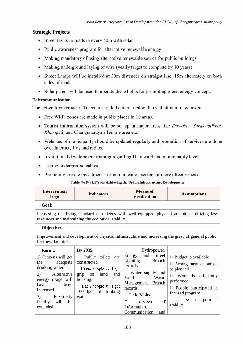
Main Report: Integrated Urban Development Plan (IUDP) of Changunarayan Municipality
103
Strategic Projects
Street lights in roads in every 50m with solar
Public awareness program for alternative renewable energy
Making mandatory of using alternative renewable source for public buildings
Making underground laying of wire (yearly target to complete by 10 years)
Street Lamps will be installed at 30m distances on straight line, 15m alternately on both
sides of roads.
Solar panels will be used to operate these lights for promoting green energy concept.
Telecommunication
The network coverage of Telecom should be increased with installation of new towers.
Free Wi-Fi zones are made in public places in 10 areas.
Tourist information system will be set up in major areas like Duwakot, Saraswotikhel,
Kharipati, and Changunarayan Temple area etc.
Websites of municipality should be updated regularly and promotion of services are done
over Internet, TVs and radios.
Institutional development training regarding IT in ward and municipality level
Laying underground cables
Promoting private investment in communication sector for more effectiveness
Table No 54: LFA for Achieving the Urban Infrastructure Development
Intervention
Logic Indicators
Means of
Verification Assumptions
Goal:
Increasing the living standard of citizens with well-equipped physical amenities utilizing less
resources and maintaining the ecological stability
Objective:
Improvement and development of physical infrastructure and increasing the grasp of general public
for these facilities.
1) Citizens will get
the adequate
drinking water.
2) Alternative
energy usage will
have been
increased.
3) Electricity
facility will be
extended.
By 2035,
Public toilets are
constructed.
grip on land and
housing.
100 lpcd of drinking
water
Hydropower,
Energy and Street
Lighting Branch
records
Water supply and
Solid Waste
Management Branch
records
Information,
Communication and
Budget is available
Arrangement of budget
as planned
Work is efficiently
performed
People participated in
focused program
stability
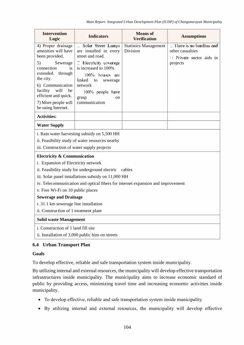
Main Report: Integrated Urban Development Plan (IUDP) of Changunarayan Municipality
104
Intervention
Logic Indicators
Means of
Verification Assumptions
4) Proper drainage
amenities will have
been provided.
5) Sewerage
connection is
extended through
the city.
6) Communication
facility will be
efficient and quick.
7) More people will
be using Internet.
are installed in every
street and road.
is increased to 100%
linked to sewerage
network
grasp on
communication
Statistics Management
Division other casualties
r aids in
projects
Activities:
Water Supply
i. Rain water harvesting subsidy on 5,500 HH
ii. Feasibility study of water resources nearby
iii. Construction of water supply projects
Electricity & Communication
i. Expansion of Electricity network
ii. Feasibility study for underground electric cables
iii. Solar panel installations subsidy on 11,000 HH
iv. Telecommunication and optical fibers for internet expansion and improvement
v. Free Wi-Fi on 10 public places
Sewerage and Drainage
i. 31.1 km sewerage line installation
ii. Construction of 1 treatment plant
Solid waste Management
i. Construction of 1 land fill site
ii. Installation of 3,000 public bins on streets
6.4 Urban Transport Plan
Goals
To develop effective, reliable and safe transportation system inside municipality.
By utilizing internal and external resources, the municipality will develop effective transportation
infrastructures inside municipality. The municipality aims to increase economic standard of
public by providing access, minimizing travel time and increasing economic activities inside
municipality.
To develop effective, reliable and safe transportation system inside municipality.
By utilizing internal and external resources, the municipality will develop effective

Main Report: Integrated Urban Development Plan (IUDP) of Changunarayan Municipality
105
transportation infrastructures inside municipality. The municipality aims to increase
economic standard of public by providing access, minimizing travel time and increasing
economic activities inside municipality.
Objectives
To strengthen major road that connects municipality with other nearest cities and national
highways.
To improve and develop intra connectivity roads
To develop sustainable reliable safe and efficient transportation system inside Municipality.
To identify the places for new bus stop, parking space and construct bus stops and public
toilets in required places.
To provide pedestrian friendly infrastructure in all urban roads with provision of greenary
Strategies
To prepare detailed Municipal transport master plan of municipality. In this plan,
classification of roads to be done according to the service and traffic counts.
Bus parks, bus stops and parking space need to be expand and new construction needed
Provisions of traffic management system including traffic lights etc.
Inter and Intra connectivity of public transportation to be done
Guiding Principles
Guidelines set by Nepal Road Standards 2070
Guidelines set in Urban Road Standards 2071
Strategic Projects
Updating the existing 40.87 km gravel road and 227.05 km earthen roads.
Keeping the RoW of roads in accordance to norms and standards.
Maintaining the hierarchy order of roads.
Improve connectivity standards and infrastructures at Rakshya tole, Changunarayan,
Kharipait, Gaida Gaun, Bageshwori and Nagarkot at Changunarayan municipality
6.4.1 Road Classification with RoW
Road classification on the basis of Right of Way is given below:
Table No 55: Road Classification with RoW
S.N. Urban Road Category Length (Km) Proposed Right of way
1 Class A 67.25 14
2 Class B 39.04 10
3 Class C 156.16 8
Total 262.45
Source: GIS mapping 2075
Main Report: Integrated Urban Development Plan (IUDP) of Changunarayan Municipality
106
Above data gives us the classification of the road on the basis of their qualities and also the right
of way. Road is classified as A, B and C on the basis of the standard of the road. Class A consists
of urban road, district road and road connecting the feeder road. Class B consists of feeder road
joining the class A and Class C consists of road which consists of road without following the
norms.
Also, the road should have the below clearances laterally and vertically for the safety and
betterment of the municipality and its people.
Lateral Clearances
a. For a single carriageway road that goes through an underpass, whole width of the
roadway (carriageway plus shoulder widths) should be cleared in lateral direction.
b. If footpaths are provided minimum lateral clearance should be width of footpath plus 1.0
m.
c. On roads with divided carriageway, left hand side lateral clearance should be as given as
(a.) and (b.) above.
d. Right hand side clearance should be 2.0 m (desirable) with 1.5m minimum.
Vertical Clearances
A vertical clearance of 5.0m measured from the crown of the road surface has been provided for
whole roadway width on all roads. No obstructions should be made on this space.
6.4.2 Road Network
The municipality has all together 334.33 km of road which consist of all kinds of road like, feeder
road connecting municipality to Bhaktapur municipality and capital of city Kathmandu (55.19
km) and other urban roads. Most of the roads in the municipality were found to be Earthen 227.05
Km i.e. 67.91% of roads are fair weather roads and 12.22% of roads are Gravelled which accounts
40.87 km, 66.41 km of roads are blacktopped most of the blacktopped road.
Table No 56: Road Network Status of Changunaryan Municipality
Hierarchy Pavement
Total Length(Km) Blacktop Gravel Earthen
Feeder Road 47.60 2.88 4.71 55.19
District Road 10.92 0.00 5.77 16.69
Urban Road 7.89 37.99 216.57 262.45
Total Length(Km) 66.41 40.87 227.05 334.33
Table No 57: Upgrading the Existing Road
S.N Name Existing
Width
Proposed
Class Proposed RoW
Existing Surface
Type
1 Urban Road 10m Class A 14 m Gravel
8m Class B 10 m Earthen
6m Class C 8 m Earthen
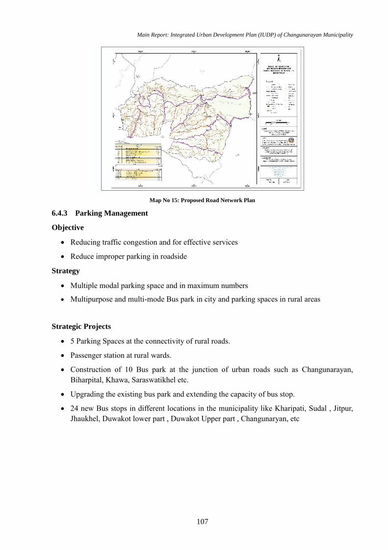
Main Report: Integrated Urban Development Plan (IUDP) of Changunarayan Municipality
107
Map No 15: Proposed Road Network Plan
6.4.3 Parking Management
Objective
Reducing traffic congestion and for effective services
Reduce improper parking in roadside
Strategy
Multiple modal parking space and in maximum numbers
Multipurpose and multi-mode Bus park in city and parking spaces in rural areas
Strategic Projects
5 Parking Spaces at the connectivity of rural roads.
Passenger station at rural wards.
Construction of 10 Bus park at the junction of urban roads such as Changunarayan,
Biharpital, Khawa, Saraswatikhel etc.
Upgrading the existing bus park and extending the capacity of bus stop.
24 new Bus stops in different locations in the municipality like Kharipati, Sudal , Jitpur,
Jhaukhel, Duwakot lower part , Duwakot Upper part , Changunaryan, etc
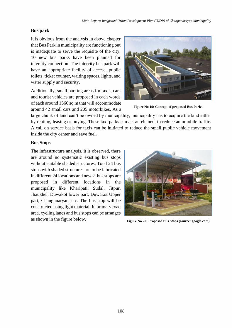
Main Report: Integrated Urban Development Plan (IUDP) of Changunarayan Municipality
108
Bus park
It is obvious from the analysis in above chapter
that Bus Park in municipality are functioning but
is inadequate to serve the requisite of the city.
10 new bus parks have been planned for
intercity connection. The intercity bus park will
have an appropriate facility of access, public
toilets, ticket counter, waiting spaces, lights, and
water supply and security.
Additionally, small parking areas for taxis, cars
and tourist vehicles are proposed in each words
of each around 1560 sq.m that will accommodate
around 42 small cars and 205 motorbikes. As a
large chunk of land can’t be owned by municipality, municipality has to acquire the land either
by renting, leasing or buying. These taxi parks can act an element to reduce automobile traffic.
A call on service basis for taxis can be initiated to reduce the small public vehicle movement
inside the city center and save fuel.
Bus Stops
The infrastructure analysis, it is observed, there
are around no systematic existing bus stops
without suitable shaded structures. Total 24 bus
stops with shaded structures are to be fabricated
in different 24 locations and new 2. bus stops are
proposed in different locations in the
municipality like Kharipati, Sudal, Jitpur,
Jhaukhel, Duwakot lower part, Duwakot Upper
part, Changunaryan, etc. The bus stop will be
constructed using light material. In primary road
area, cycling lanes and bus stops can be arranges
as shown in the figure below.
Figure No 19: Concept of proposed Bus Parks
Figure No 20: Proposed Bus Stops (source: google.com)
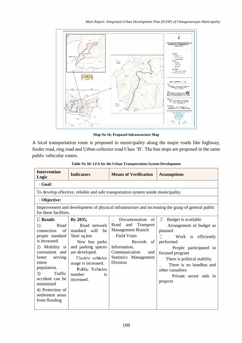
Main Report: Integrated Urban Development Plan (IUDP) of Changunarayan Municipality
109
Map No 16: Proposed Infrastructure Map
A local transportation route is proposed in municipality along the major roads like highway,
feeder road, ring road and Urban collector road Class ‘B’. The bus stops are proposed in the same
public vehicular routes.
Table No 58: LFA for the Urban Transportation System Development
Intervention
Logic Indicators Means of Verification Assumptions
Goal:
To develop effective, reliable and safe transportation system inside municipality.
Objective:
Improvement and development of physical infrastructure and increasing the grasp of general public
for these facilities.
1) Road
connection of
proper standard
is increased.
2) Mobility is
convenient and
faster serving
entire
population.
3) Traffic
accident can be
minimized
4) Protection of
settlement areas
from flooding
By 2035,
Road network
standard will be
5km/ sq.km
New bus parks
and parking spaces
are developed.
usage is increased.
number is
increased.
Documentation of
Road and Transport
Management Branch
Field Visits
Records of
Information,
Communication and
Statistics Management
Division
Budget is available
Arrangement of budget as
planned
Work is efficiently
performed
People participated in
focused program
There is political stability
There is no bandhas and
other casualties
Private sector aids in
projects

Main Report: Integrated Urban Development Plan (IUDP) of Changunarayan Municipality
110
Intervention
Logic Indicators Means of Verification Assumptions
Activities:
Road
i. 5 Vehicle Parking Development
ii. Black Topping of existing 281.84 km road
iii. Upgrading existing urban roads.
iv. Construction of footpath and drainage system in major road
v. Plantation and greenery works around road ways
vi. Pedestrian and cycle lane of 2.5m width construction
vii. Maintenance of Traffic lights and marking on road
viii. Construction of internal ring road
ix. Construction of trekking route
River Corridor
i. Hanumante river corridor construction
ii. River embankment
iii. Garden Development
Bus park
i. Construction of 10 bus park
ii. 5 small Parking space development
iii. 24 new bus stop construction
Airport/Railway
Feasibility study of railway track & airport
Bridge
Maintenance and upgrading of existing bridges
6.4.4 Issues and Problems
Although municipality is mainly focused in developing transportation infrastructures, there are
some major threats in achieving goal of municipality. They are as follows:
Limited Financial resources: The construction cost of road infrastructures is too high, whereas,
the municipality has limited resources. There is a probability that the municipality will not be
able to generate financial resources for development of transportation infrastructures as expected.
Geography: This municipality possess difficult geographic features. There are many high hills,
steep slopes, land filled with rocks and unstable lands. Constructing roads in such difficult terrain
is a challenge to this municipality.
Large number of cross drainage structures: This municipality possess large number of rivulets
and streams which need same amount of cross drainage structures. The increase in number of
cross drainage structures will significantly increase the construction cost of road.
Migration: Although development works are increasing in this municipality, the inevitable
migration of people from this municipality is increasing day by day. At some point, there might
be a situation that municipality will complete upgradation of road to some settlements whose

Main Report: Integrated Urban Development Plan (IUDP) of Changunarayan Municipality
111
population has decreased significantly due to migration. If this scenario occurs, then the
investment of municipality will go in vein.
Natural Disaster: Certain parts of this municipality are prone to landslide and debris flow. Such
natural disasters might destroy road infrastructures
6.5 Social Development Plan
Social development means a commitment that development processes need to benefit people,
particularly but not only the poor, but also provide a recognition to that people, and the way they
interact in groups and society, and the norms that facilitates such interaction, shape development
processes.
The strength of a social development plan lies in its ability to engage citizens, mobilize the
community and to reinforce and build the work completed already. It is the plan providing
opportunities to woman, backwards and disabled people in decision making process.
Changunarayan Municipality is the new municipality developed by intermix of castes and ethnic
people i.e. Bhramin, Chhetri, Newar, etc. and it became essential to develop a social development
plan including all the ethnic groups.
Goals
Achieving a quality life of the citizens through inclusive social environment
Objectives
To develop the safe and reliable, environment friendly social infrastructures like schools,
colleges, hospitals, library, municipality hall, police station, sport center, parks, and open
spaces in the municipality.
To increase the social equality and gender inclusion
To ensure the accessibility of the economically and socially disadvantaged people and
communities to information, health services and education
To plan security of inhabitants in society
To ensure women empowerment
To ensure women and child welfare
To include differently abled people in planning
To uplift the condition and status of socially backward ethnic groups
To conducts programs and activities for youth development right form the school level.
To promote Ayurveda health services system.
To develop tele medicine service
To mobilize the youth in productive sector.
To ensure the involvement of youth in policy making process.
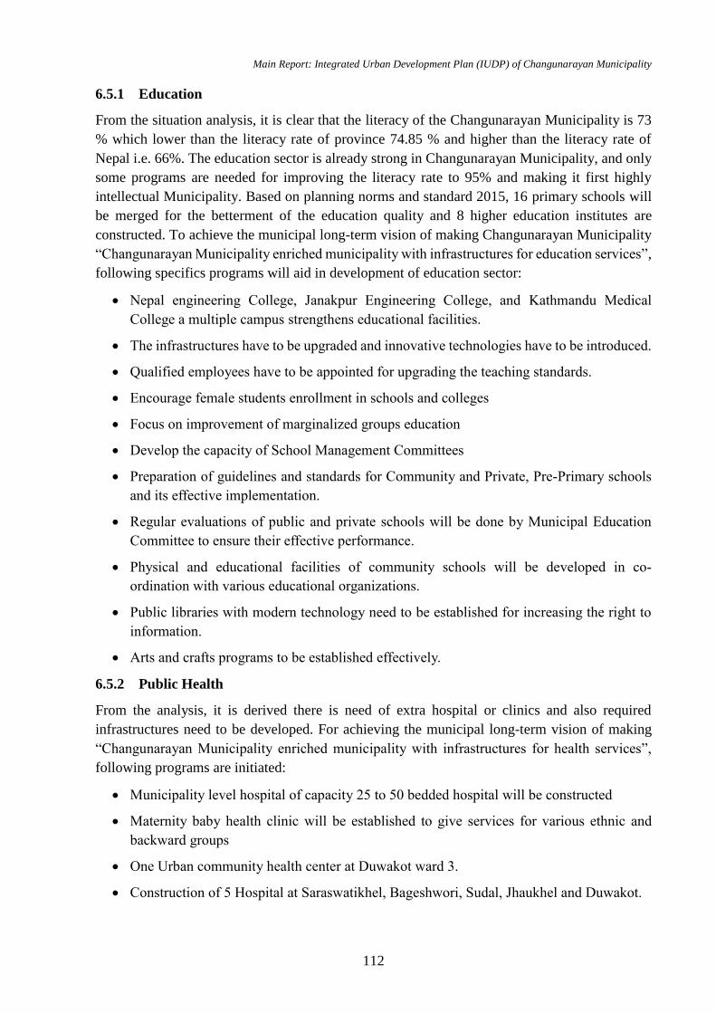
Main Report: Integrated Urban Development Plan (IUDP) of Changunarayan Municipality
112
6.5.1 Education
From the situation analysis, it is clear that the literacy of the Changunarayan Municipality is 73
% which lower than the literacy rate of province 74.85 % and higher than the literacy rate of
Nepal i.e. 66%. The education sector is already strong in Changunarayan Municipality, and only
some programs are needed for improving the literacy rate to 95% and making it first highly
intellectual Municipality. Based on planning norms and standard 2015, 16 primary schools will
be merged for the betterment of the education quality and 8 higher education institutes are
constructed. To achieve the municipal long-term vision of making Changunarayan Municipality
“Changunarayan Municipality enriched municipality with infrastructures for education services”,
following specifics programs will aid in development of education sector:
Nepal engineering College, Janakpur Engineering College, and Kathmandu Medical
College a multiple campus strengthens educational facilities.
The infrastructures have to be upgraded and innovative technologies have to be introduced.
Qualified employees have to be appointed for upgrading the teaching standards.
Encourage female students enrollment in schools and colleges
Focus on improvement of marginalized groups education
Develop the capacity of School Management Committees
Preparation of guidelines and standards for Community and Private, Pre-Primary schools
and its effective implementation.
Regular evaluations of public and private schools will be done by Municipal Education
Committee to ensure their effective performance.
Physical and educational facilities of community schools will be developed in co-
ordination with various educational organizations.
Public libraries with modern technology need to be established for increasing the right to
information.
Arts and crafts programs to be established effectively.
6.5.2 Public Health
From the analysis, it is derived there is need of extra hospital or clinics and also required
infrastructures need to be developed. For achieving the municipal long-term vision of making
“Changunarayan Municipality enriched municipality with infrastructures for health services”,
following programs are initiated:
Municipality level hospital of capacity 25 to 50 bedded hospital will be constructed
Maternity baby health clinic will be established to give services for various ethnic and
backward groups
One Urban community health center at Duwakot ward 3.
Construction of 5 Hospital at Saraswatikhel, Bageshwori, Sudal, Jhaukhel and Duwakot.
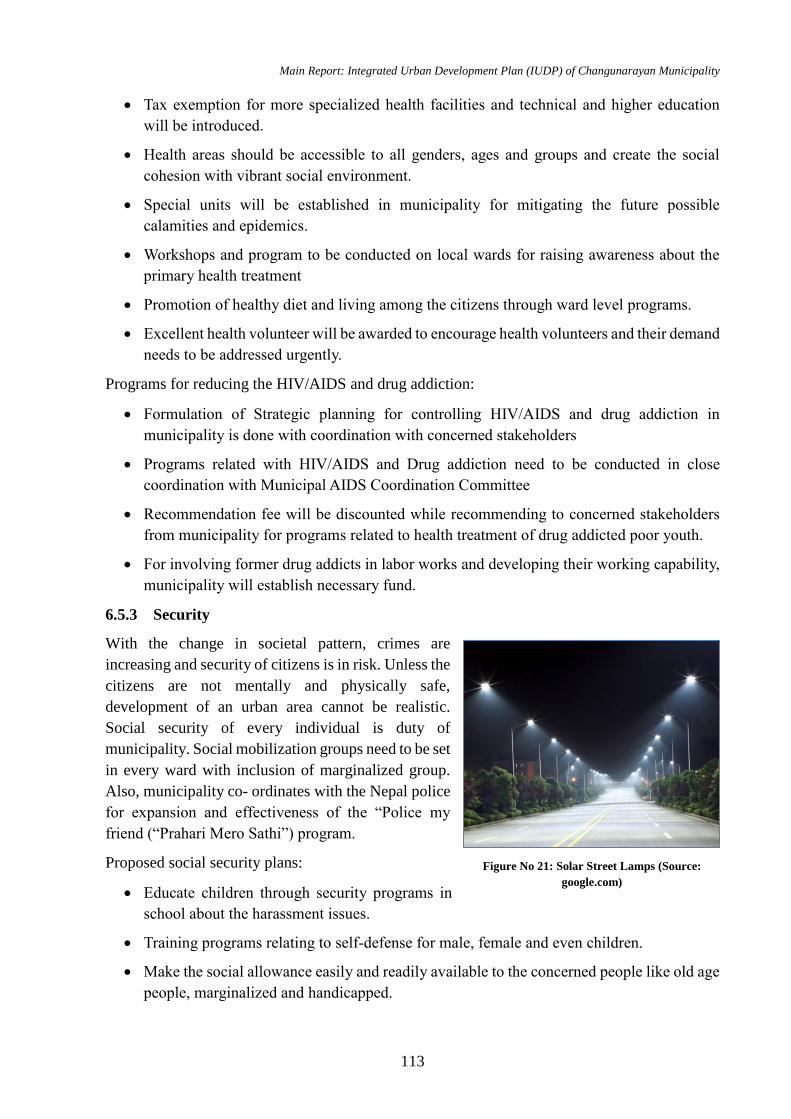
Main Report: Integrated Urban Development Plan (IUDP) of Changunarayan Municipality
113
Tax exemption for more specialized health facilities and technical and higher education
will be introduced.
Health areas should be accessible to all genders, ages and groups and create the social
cohesion with vibrant social environment.
Special units will be established in municipality for mitigating the future possible
calamities and epidemics.
Workshops and program to be conducted on local wards for raising awareness about the
primary health treatment
Promotion of healthy diet and living among the citizens through ward level programs.
Excellent health volunteer will be awarded to encourage health volunteers and their demand
needs to be addressed urgently.
Programs for reducing the HIV/AIDS and drug addiction:
Formulation of Strategic planning for controlling HIV/AIDS and drug addiction in
municipality is done with coordination with concerned stakeholders
Programs related with HIV/AIDS and Drug addiction need to be conducted in close
coordination with Municipal AIDS Coordination Committee
Recommendation fee will be discounted while recommending to concerned stakeholders
from municipality for programs related to health treatment of drug addicted poor youth.
For involving former drug addicts in labor works and developing their working capability,
municipality will establish necessary fund.
6.5.3 Security
With the change in societal pattern, crimes are
increasing and security of citizens is in risk. Unless the
citizens are not mentally and physically safe,
development of an urban area cannot be realistic.
Social security of every individual is duty of
municipality. Social mobilization groups need to be set
in every ward with inclusion of marginalized group.
Also, municipality co- ordinates with the Nepal police
for expansion and effectiveness of the “Police my
friend (“Prahari Mero Sathi”) program.
Proposed social security plans:
Educate children through security programs in
school about the harassment issues.
Training programs relating to self-defense for male, female and even children.
Make the social allowance easily and readily available to the concerned people like old age
people, marginalized and handicapped.
Figure No 21: Solar Street Lamps (Source:
google.com)
Main Report: Integrated Urban Development Plan (IUDP) of Changunarayan Municipality
114
Identify the socially backward ethnic groups and work in their cultural preservation and
uplift in society.
Proposed Physical Security Plans
Police station buildings with enough spaces for catering human resources, modern
equipment, and accessories in each ward need to be constructed.
A municipality level police headquarter is proposed.
Police personnel or security guards have to be assigned by municipalities in the area
suspected to be risky.
Street lamps have to be installed in every street to decrease night-time casualties.
6.5.4 Cultural and Sports
Cultural
A cultural center that provides regular trainings and workshops on the various culture of
Changunarayan Municipality is proposed near the ethnic museum in Changunarayan
Conservation area.
Sports
A multipurpose sports hall will be constructed for multidisciplinary sport activities.
Developing small areas for sport activities within parks or outside, near group of wards.
Construction of multi-purpose hall or a sports hall for indoor games that can be used for
futsal, badminton, tennis, and 5 a side football, basketball, indoors hockey etc.
Inclusion of sports as main subject in educational institutes.
Creating the suitable environment for local club and organizations to participate in sport
activities.
Encouraging local sport club and organizations for registration in municipality and
coordinating the sport activities by formation of Sub metropolitan sport committee.
6.5.5 Parks and Open Space
Parks of Changunarayan municipality not only
uplift the beauty of the municipality but also
provide a natural environment for the citizens to
relax and meet. These parks have higher potential
for developing as picnic spots, playing areas and
gathering area. Several activities for maintaining
these open spaces and parks are proposed:
Demarcation of portions of existing parks
will be done for creating children’s play
area or picnic areas.
Entrance fees for these parks can be levied
Figure No 22: Concept of Street Furniture in Public
Places
Main Report: Integrated Urban Development Plan (IUDP) of Changunarayan Municipality
115
during morning and evening hours and charged for remaining time of the day.
Hunumante, Kasyang Khususng river corridor need to be preserved and develop as children
parks, jogging area, waiting and meeting spaces.
Public spaces and open spaces within the municipality can be developed into park and green
area.
9 local parks are developed in the neighborhood area with 1 park in each ward.
6.5.6 Urban Social Service Centers
After the reform of local bodies, the municipality needs many additional buildings for its service
delivery. Ward offices as well as different section office within the municipality have to build.
Based on availability of land and requirement, need identification can be done. The consultant
has prepared the design and estimate of a building. The consultant has also proposed the
retrofitting, conservation or restoration of old building and for reusing in such administrative
purpose. Proposed activities for the development of other social centers are described beneath.
Municipality Hall
The existing municipality halls need upgrading and improvement of infrastructures for
operation.
Old age Homes, Orphanage Home
1 old age home has been proposed.
Near the old age home, an orphanage home is also proposed.
Exhibition Centers
Exhibition centers for public and private events, arts exhibition, trainings are planned
Library/Information Center
The existing government library is to be upgraded as municipality level library with
appropriate infrastructure
9 community libraries have been planned and developed with e-learning.
Museum
The under construction ethnic museum will be enlarged to widen its scope as a cultural
center with performing art, center of study and research for history, culture and tradition.
Necessary adjoining facilities will be constructed.
Public Toilets
From the municipality profile, it can be derived that there are nominal public toilet facilities with
scarce infrastructure and pitiable hygiene. Hence, 15 public toilets are proposed in important
public places namely i) Nagarkot, ward no 6, ii) Near NEC area, ward no 1, iii) Changunaryana
Temple area, ward no 4, iv) Municipality office area, ward no 5. Minimal charges have to be
allocated for using these facilities for maintaining the cleanliness. The proposed public toilets are
gender friendly and cater differently abled people too.
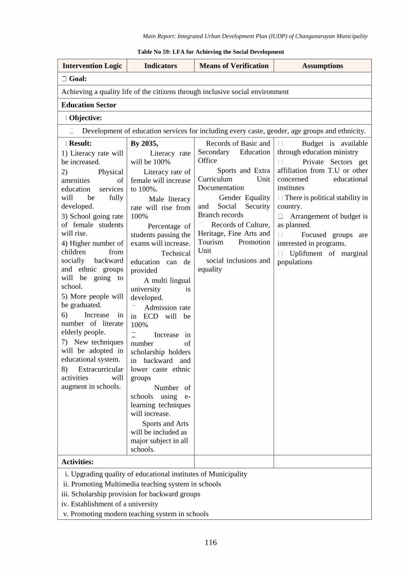
Main Report: Integrated Urban Development Plan (IUDP) of Changunarayan Municipality
116
Table No 59: LFA for Achieving the Social Development
Intervention Logic Indicators Means of Verification Assumptions
Goal:
Achieving a quality life of the citizens through inclusive social environment
Education Sector
Objective:
Development of education services for including every caste, gender, age groups and ethnicity.
Result:
1) Literacy rate will
be increased.
2) Physical
amenities of
education services
will be fully
developed.
3) School going rate
of female students
will rise.
4) Higher number of
children from
socially backward
and ethnic groups
will be going to
school.
5) More people will
be graduated.
6) Increase in
number of literate
elderly people.
7) New techniques
will be adopted in
educational system.
8) Extracurricular
activities will
augment in schools.
By 2035,
Literacy rate
will be 100%
Literacy rate of
female will increase
to 100%.
Male literacy
rate will rise from
100%
Percentage of
students passing the
exams will increase.
Technical
education can de
provided
A multi lingual
university is
developed.
Admission rate
in ECD will be
100%
Increase in
number of
scholarship holders
in backward and
lower caste ethnic
groups
Number of
schools using e-
learning techniques
will increase.
Sports and Arts
will be included as
major subject in all
schools.
Records of Basic and
Secondary Education
Office
Sports and Extra
Curriculum Unit
Documentation
Gender Equality
and Social Security
Branch records
Records of Culture,
Heritage, Fine Arts and
Tourism Promotion
Unit
social inclusions and
equality
Budget is available
through education ministry
Private Sectors get
affiliation from T.U or other
concerned educational
institutes
There is political stability in
country.
Arrangement of budget is
as planned.
Focused groups are
interested in programs.
Upliftment of marginal
populations
Activities:
i. Upgrading quality of educational institutes of Municipality
ii. Promoting Multimedia teaching system in schools
iii. Scholarship provision for backward groups
iv. Establishment of a university
v. Promoting modern teaching system in schools
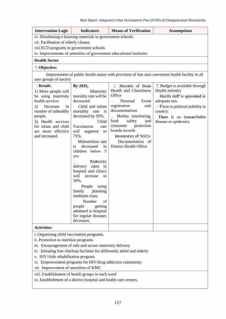
Main Report: Integrated Urban Development Plan (IUDP) of Changunarayan Municipality
117
Intervention Logic Indicators Means of Verification Assumptions
vi. Distributing e-learning materials in government schools
vii. Facilitation of elderly classes
viii.ECD programs in government schools
ix. Improvements of amenities of government educational institutes
Health Sector
Objective:
Improvement of public health status with provision of fast and convenient health facility to all
user groups of society
Result:
1) More people will
be using maternity
health services
2) Decrease in
number of unhealthy
people.
3) Health services
for infant and child
are more effective
and increased.
By 2035,
Maternity
morality rate will be
decreased.
Child and infant
mortality rate is
decreased by 50%.
Child
Vaccination rate
will augment to
75%.
Malnutrition rate
is decreased in
children below 5
yrs.
delivery rates in
hospital and clinics
will increase to
50%.
People using
family planning
mediums rises.
Number of
people getting
admitted to hospital
for regular diseases
decreases.
Health and Cleanliness
Office
Personal Event
registration unit
documentations
Market monitoring,
food safety and
consumer protection
brands records
Documentation of
District Health Office
Budget is available through
Health ministry
adequate nos.
re is political stability in
country.
disease or epidemics
Activities:
i. Organizing child vaccination programs.
ii. Promotion to nutrition programs.
iii. Encouragement of safe and secure maternity delivery
iv. Initiating free checkup facilities for differently abled and elderly
v. HIV/Aids rehabilitation program
vi. Empowerment programs for HIV/drug addiction community
vii. Improvement of amenities of KMC
viii. Establishment of health groups in each ward
ix. Establishment of a district hospital and health care centres.
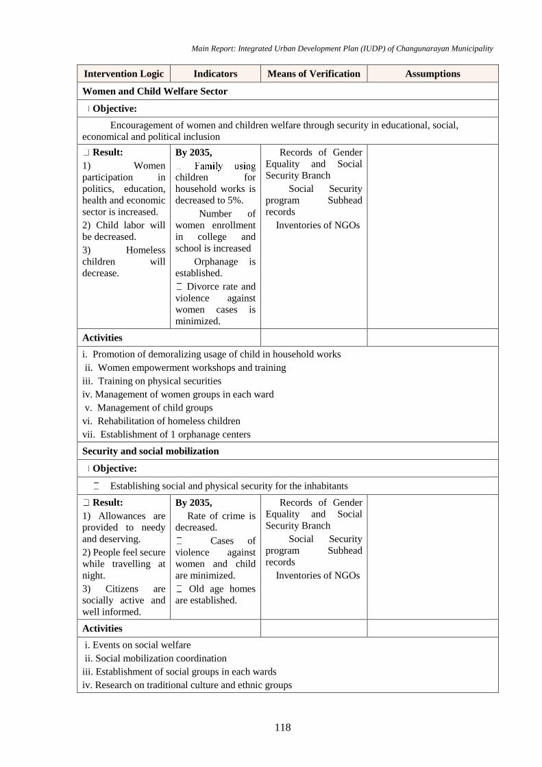
Main Report: Integrated Urban Development Plan (IUDP) of Changunarayan Municipality
118
Intervention Logic Indicators Means of Verification Assumptions
Women and Child Welfare Sector
Objective:
Encouragement of women and children welfare through security in educational, social,
economical and political inclusion
Result:
1) Women
participation in
politics, education,
health and economic
sector is increased.
2) Child labor will
be decreased.
3) Homeless
children will
decrease.
By 2035,
children for
household works is
decreased to 5%.
Number of
women enrollment
in college and
school is increased
Orphanage is
established.
Divorce rate and
violence against
women cases is
minimized.
Records of Gender
Equality and Social
Security Branch
Social Security
program Subhead
records
Inventories of NGOs
Activities
i. Promotion of demoralizing usage of child in household works
ii. Women empowerment workshops and training
iii. Training on physical securities
iv. Management of women groups in each ward
v. Management of child groups
vi. Rehabilitation of homeless children
vii. Establishment of 1 orphanage centers
Security and social mobilization
Objective:
Establishing social and physical security for the inhabitants
Result:
1) Allowances are
provided to needy
and deserving.
2) People feel secure
while travelling at
night.
3) Citizens are
socially active and
well informed.
By 2035,
Rate of crime is
decreased.
Cases of
violence against
women and child
are minimized.
Old age homes
are established.
Records of Gender
Equality and Social
Security Branch
Social Security
program Subhead
records
Inventories of NGOs
Activities
i. Events on social welfare
ii. Social mobilization coordination
iii. Establishment of social groups in each wards
iv. Research on traditional culture and ethnic groups

Main Report: Integrated Urban Development Plan (IUDP) of Changunarayan Municipality
119
Intervention Logic Indicators Means of Verification Assumptions
v. Programs on marginalized groups
vi. Establishment of 1 old age home
Social Infrastructures
Objective:
Construction and Planning of police stations, library, city hall, museum, and exhibition centers,
parks and sports center for benefitting the social interaction of citizens.
Result:
1) City level library
is established.
2) Community
Library is present in
each neighborhood.
3) Changunarayan
Stadium is
developed as
regional Stadium
4) A new stadium is
developed as Sports
Academy.
4) National City hall
is developed.
5) Exhibitions
centers are
constructed in each
neighborhood.
6) Ethnic museum is
well developed.
7) Each ward will
have 1 local park
8) Each ward will
have one police
stations buildings
9) A city police
headquarter is
constructed.
10) A city police
headquarter is
constructed.
By 2035
ommunity
libraries are
established.
A exhibition hall
is constructed.
New parks will
be developed
New police post
building is
constructed.
ity police
headquarter is built.
Existing city hall
is improved and
well executed.
smoothly operating.
Records of Sports
and Extra Curriculum
Unit
Records of Gender
Equality and Social
Security Branch
Documentation of
Culture, Heritage, Fine
Arts and Tourism
Promotion Unit
Social Security
Program Subhead
records
City Police
administrative Branch
Details
Budget is available.
There is political stability in
country.
Arrangement of budget is as
planned.
Focused groups are
interested in programs.
Construction work is
operated smoothly.
Activities:
Sports
ii. Improvement of local playground amenities
iii. Sports scholarship for socially backward groups
iii. 2 Sports complex.
Others
i. Formation of 9 community libraries
ii. Establishment of 1 city library
iv. New police post building construction
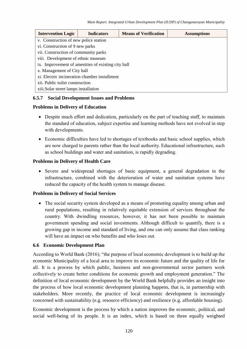
Main Report: Integrated Urban Development Plan (IUDP) of Changunarayan Municipality
120
Intervention Logic Indicators Means of Verification Assumptions
v. Construction of new police station
vi. Construction of 9 new parks
vii. Construction of community parks
viii. Development of ethnic museum
ix. Improvement of amenities of existing city hall
x. Management of City hall
xi. Electric incineration chamber installment
xii. Public toilet construction
xiii.Solar street lamps installation
6.5.7 Social Development Issues and Problems
Problems in Delivery of Education
Despite much effort and dedication, particularly on the part of teaching staff, to maintain
the standard of education, subject expertise and learning methods have not evolved in step
with developments.
Economic difficulties have led to shortages of textbooks and basic school supplies, which
are now charged to parents rather than the local authority. Educational infrastructure, such
as school buildings and water and sanitation, is rapidly degrading.
Problems in Delivery of Health Care
Severe and widespread shortages of basic equipment, a general degradation in the
infrastructure, combined with the deterioration of water and sanitation systems have
reduced the capacity of the health system to manage disease.
Problems in Delivery of Social Services
The social security system developed as a means of promoting equality among urban and
rural populations, resulting in relatively equitable extension of services throughout the
country. With dwindling resources, however, it has not been possible to maintain
government spending and social investments. Although difficult to quantify, there is a
growing gap in income and standard of living, and one can only assume that class ranking
will have an impact on who benefits and who loses out.
6.6 Economic Development Plan
According to World Bank (2016); “the purpose of local economic development is to build up the
economic Municipality of a local area to improve its economic future and the quality of life for
all. It is a process by which public, business and non-governmental sector partners work
collectively to create better conditions for economic growth and employment generation.” The
definition of local economic development by the World Bank helpfully provides an insight into
the process of how local economic development planning happens, that is, in partnership with
stakeholders. More recently, the practice of local economic development is increasingly
concerned with sustainability (e.g. resource efficiency) and resilience (e.g. affordable housing).
Economic development is the process by which a nation improves the economic, political, and
social well-being of its people. It is an index, which is based on three equally weighted

Main Report: Integrated Urban Development Plan (IUDP) of Changunarayan Municipality
121
components: Longevity, measured by life expectancy at birth, Knowledge, measured by adult
literacy and number of years children are enrolled at school and Standard of living, measured by
real GDP per capita at purchasing power parity.
Commonly used criteria of economic development are increase in national income, per capita
real income, comparative concept, standard of living and economic welfare of the community
etc. Economy of an area can be directly related to the employment condition of that area, poverty,
agricultural development, tourism development, road condition, industries and business, etc.
Development in these sectors will therefore lead to the Economic Development of that area.
Goals: Standard of living of citizens is improved through employment generation and poverty
reduction
Objectives
To increase the economy of Changunaryana Municipality through agro farming, tourism
and industry
To identify the potential economic zones
To formulate plans for boosting the economic activities within the DMSC
To develop regional economic growth centers, and linking these centers with medium and
small towns through improved infrastructure
To preserve natural resources and supporting sustainable development
To develop integrated approach, including infrastructure and transport elements; economic,
social and environmental development, and other strategic policies for the municipality;
To promote promotes equal and balanced development across the entire territory of
Municipality.
To promote democratic process of participation and the common interests of increasing the
quality of life and social welfare;
To promote stable economy which will create opportunities for the generation of new jobs
for all residents of Municipality with equal rights for all;
To promotes economic development in the field of agriculture and the service sector by
increasing knowledge and associations;
To develop partnership and inter municipal cooperation and in wider context also with the
purpose of protection, rational use of existing resources, which belong to the community,
and drawing benefits from joint projects.
To increase the economy through commercial agriculture, Tourism, Industry, Trade and
Service Sector.
To increase agriculture production by giving training on mechanized and commercial
agriculture methods and technology.
To develop agriculture pocket areas and develop and upgrade irrigation facilities
To formulate plans for boosting the economic activities within the municipality
Main Report: Integrated Urban Development Plan (IUDP) of Changunarayan Municipality
122
Provide livestock and agriculture insurance and crop divarication and variation program by
providing seeds, fertilizers, modern agriculture tools and mechanics to promote and
encourage farmers.
6.6.1 Industrial Development and Trade Promotion
Industrial development is very much important for a municipality like Changunaryana
Municipality, which is rich in natural and human resources required for industrial growth and
may holds a key position in the growth of a stable economy. Industrialization means to lift up
income, generate employment opportunities and improves both in imports & exports but also
expand development process in different other sectors of the economy. The private sector should
be encouraged through fiscal incentives to set up small industrial estates to provide not only land
and infrastructure but also suitable industrial environment & welfare schemes for workers. The
municipality should coordinate with the province governments, federal government and other
concerned agencies for the development of industrial estates and accessibility of road and electric
Municipality. The estate may run by the private sector on self-financing basis. There is a greater
possibility of agro based industries and Brick industry. The export oriented industry and
hospitality industries can be established in this municipality. The municipality is situated in
between Bhaktapur Metropolitan city in south, Kavrepalanchok District in east and Kathmandu
District in west and north portion. The Duwakot is one of the main market place of whole
municipality since long time. The Duwakot area of this municipality is popular as trade centre
which is making collection of different raw materials, agriculture products from in and around
municipality. The collected raw materials and agro-products is directly exported to other urban
areas. But municipality can take action to establish related industries for processing these
products and can be exported to other parts of Nepal as well as India. A relevant factor of income
is remittances from the diaspora which can be utilized to the productive sectors for the
development of industries.
Goal
Increase the contribution of trade and industry in the municipal development
Objective
Promote local product business and create employment opportunities
Protect and promote local small scale industries
6.6.2 Employment Generation, Poverty Reduction
For the employment generation and poverty reduction, various programs in different economic
sector can be planned.
Proposed activities:
Establishment of agro based industry such as livestock farming, cash crops agricultures and
trade / business centers, tourism within the municipality.
Encourage youth people towards agro based business by providing soft loan, irrigation
facilities, proper market/ correction centers, insurances, awards, trainings and technical
supports.
Main Report: Integrated Urban Development Plan (IUDP) of Changunarayan Municipality
123
Private sector can be encouraged to develop productive sector like Multiplex halls, parking,
sports hall etc.
Trainings will have provided in coordination with various NGO and INGO to promote local
employment.
6.6.3 Regional Competitiveness of Municipality
This Municipality exports the vegetables products to the nearby municipalities like Baktapur
metropolitans, Kathmandu Metropolitans Cities. i.e. its economic development through the
agricultural product is possible in the near future. Also, this municipality is rich in its natural
resources such as forest, high hills and the peaceful area in the north side of valley. Such places
are also possessing the high tourism potential. Also, Bhaktapur and the Kathmandu are the main
tourism places of Nepal, tourist can be attracted towards these places via good, sound and
efficient road and other infrastructure. Regionally, with comparison of Bhaktapur and Kathmandu
metropolitan Municipality this municipality has low socio – economic index as it has literacy rate
of 74% but this municipality has high agricultural land in comparison of another municipality.
6.6.4 Agriculture Development
As clarified in earlier chapters, agriculture is a major source of income generation in
Changunaryana Municipality. Lack of modern technology in farming, irrigation facilities, market
management, and low financial capacity of municipality to invest on agro-farming has become
main hindrances for developing agriculture as main income source.
Proposed activities:
Changunaryana Municipality has clayey, silty clayey, sandy clayey soil with abundant land
available for agriculture. Hence with modern agriculture techniques along with youths’
participation on agro farming can be enticed to agriculture for income generation.
Establishment of cold storage, dairy product centers, butcher centers in different parts of
the municipality with proper linkage to the rural areas for employment generation.
Local chicken farming on hill areas and poultry faming on southwards, farming need to be
encouraged.
Professional cow farming and goat farming can be encouraged in hill areas having enough
grazing lands.
In coordination with Wada Nagarik Manch and Nagarik Sachetana Kendra, youths (male
and female) will be provided training about effective animal farming and agriculture.
Special efforts will be made to promote ginger, turmeric farming in the ward no 5 and 6 of
municipality.
Develop a collection center of agro products in and around Kharipati, Sudal, Duwakot,
Sarashwoti Khel area.
Guidelines and standards for animal farming management will be formed and
implemented.
Off season vegetable farming and organic vegetable production will be promoted to whole

Main Report: Integrated Urban Development Plan (IUDP) of Changunarayan Municipality
124
municipality area.
Promote and develop the organic farming and animal husbandry within area of municipality
through incentives and financial aid like providing seeds for free, trainings on making
organic pesticides, providing loans for construction of greenhouse farming areas.
6.6.5 Strategic Location of Different Market Center/Product Collection Center
Improve the economic performance of the municipal system, mainly in terms of employment and
income of the population. To utilize local resources, municipality should organize according to
value chains and upgrade capacities maintaining a long term sustainable environment, social and
gender equity, the following points should be kept in mind:
Establish a sound governance for the economic system.
Improve the economic performance and competitiveness of the value chains.
Establish a system for providing comprehensive services to entrepreneurs, producers,
population, civil society organizations, and public institutions.
Realize and implement an effective territorial marketing.
Improve capacities in economic development planning
Indigenous productive dynamics are main part of Municipality economic sector
6.6.6 Possible Economic Zones Based on Local Economic Growth Potentials
Transportation, Information and Communication sector, Educational training institutes,
banking sector, Commercial buildings and Manpower companies for employments are the
assuring fields for economic development of Changunaryana Municipality.
Changunaryana Municipality can initiate lobbying with the local banking sector and
finance companies for issuing loans to the local industry and trade.
Economic infrastructures like Parking Space, Bus parks, vegetable markets, Stadium,
Sports Complex, and Movie Hall can escalate the revenue generation of Sub metropolitan.
Informal sector enterprises, which are active in food preparation, selling tea and coffee,
tailoring, street vending of various items and domestic services also increases the economic
growth rate of the Municipality. A program for managing these sectors without hampering
the beauty of the Municipality is the main challenge of Changunaryana municipality.
As there are many forests in Changunaryana Municipality, by organizing the community
forest groups, Herbal farming and bee farming can be initiated for economic uplift.
Educational and medical tourism can be promoted through bio-diversity promotion.
A safari concept in Changunaryana Temple area can be initiated with encouragement of
diverse wildlife in the forest.
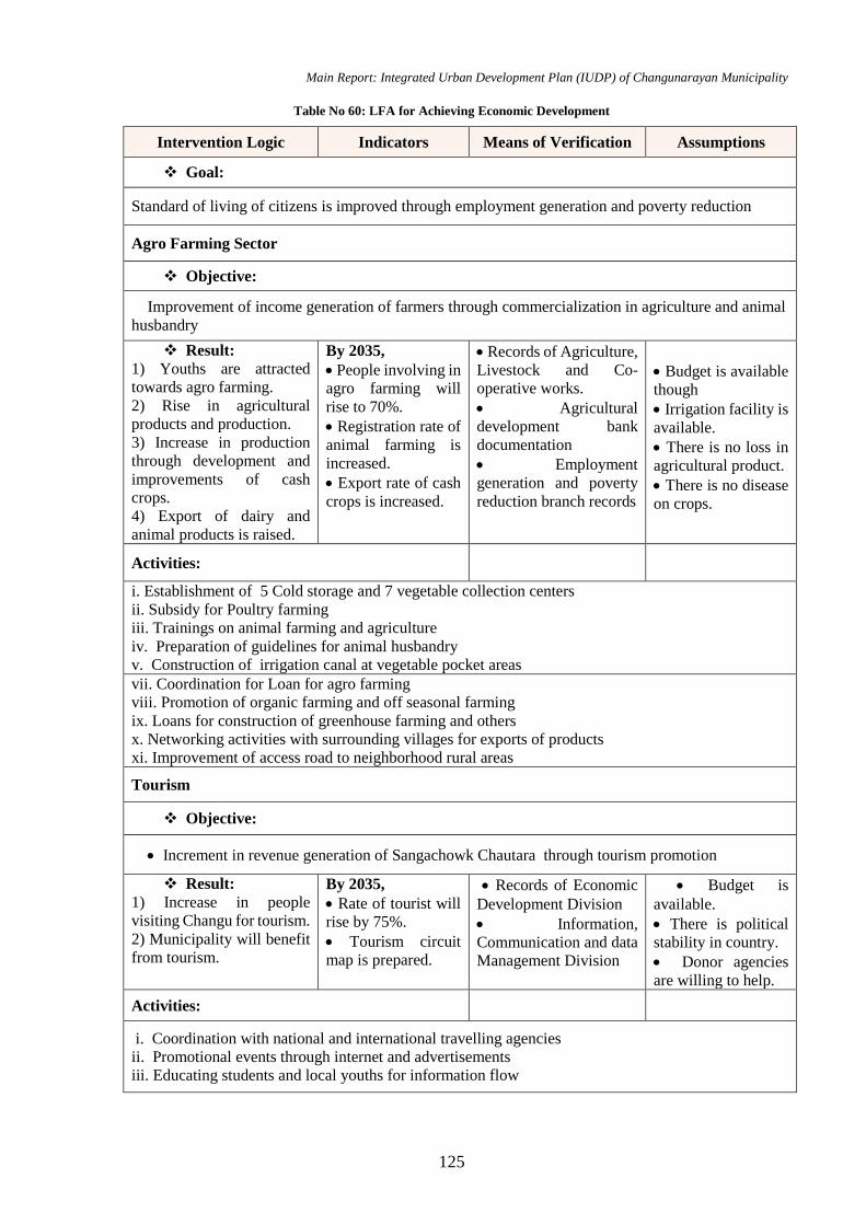
Main Report: Integrated Urban Development Plan (IUDP) of Changunarayan Municipality
125
Table No 60: LFA for Achieving Economic Development
Intervention Logic Indicators Means of Verification Assumptions
Goal:
Standard of living of citizens is improved through employment generation and poverty reduction
Agro Farming Sector
Objective:
Improvement of income generation of farmers through commercialization in agriculture and animal
husbandry
Result:
1) Youths are attracted
towards agro farming.
2) Rise in agricultural
products and production.
3) Increase in production
through development and
improvements of cash
crops.
4) Export of dairy and
animal products is raised.
By 2035,
People involving in
agro farming will
rise to 70%.
Registration rate of
animal farming is
increased.
Export rate of cash
crops is increased.
Records of Agriculture,
Livestock and Co-
operative works.
Agricultural
development bank
documentation
Employment
generation and poverty
reduction branch records
Budget is available
though
Irrigation facility is
available.
There is no loss in
agricultural product.
There is no disease
on crops.
Activities:
i. Establishment of 5 Cold storage and 7 vegetable collection centers
ii. Subsidy for Poultry farming
iii. Trainings on animal farming and agriculture
iv. Preparation of guidelines for animal husbandry
v. Construction of irrigation canal at vegetable pocket areas
vii. Coordination for Loan for agro farming
viii. Promotion of organic farming and off seasonal farming
ix. Loans for construction of greenhouse farming and others
x. Networking activities with surrounding villages for exports of products
xi. Improvement of access road to neighborhood rural areas
Tourism
Objective:
Increment in revenue generation of Sangachowk Chautara through tourism promotion
Result:
1) Increase in people
visiting Changu for tourism.
2) Municipality will benefit
from tourism.
By 2035,
Rate of tourist will
rise by 75%.
Tourism circuit
map is prepared.
Records of Economic
Development Division
Information,
Communication and data
Management Division
Budget is
available.
There is political
stability in country.
Donor agencies
are willing to help.
Activities:
i. Coordination with national and international travelling agencies
ii. Promotional events through internet and advertisements
iii. Educating students and local youths for information flow
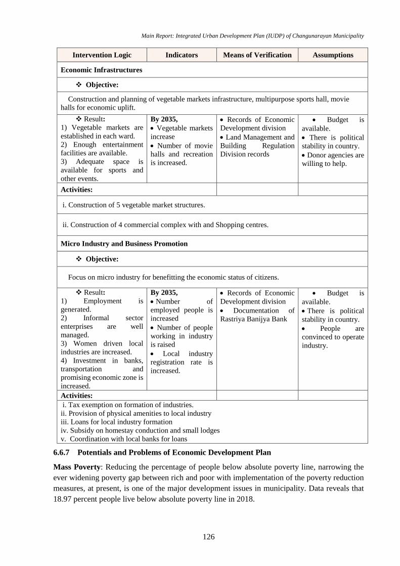
Main Report: Integrated Urban Development Plan (IUDP) of Changunarayan Municipality
126
Intervention Logic Indicators Means of Verification Assumptions
Economic Infrastructures
Objective:
Construction and planning of vegetable markets infrastructure, multipurpose sports hall, movie
halls for economic uplift.
Result:
1) Vegetable markets are
established in each ward.
2) Enough entertainment
facilities are available.
3) Adequate space is
available for sports and
other events.
By 2035,
Vegetable markets
increase
Number of movie
halls and recreation
is increased.
Records of Economic
Development division
Land Management and
Building Regulation
Division records
Budget is
available.
There is political
stability in country.
Donor agencies are
willing to help.
Activities:
i. Construction of 5 vegetable market structures.
ii. Construction of 4 commercial complex with and Shopping centres.
Micro Industry and Business Promotion
Objective:
Focus on micro industry for benefitting the economic status of citizens.
Result:
1) Employment is
generated.
2) Informal sector
enterprises are well
managed.
3) Women driven local
industries are increased.
4) Investment in banks,
transportation and
promising economic zone is
increased.
By 2035,
Number of
employed people is
increased
Number of people
working in industry
is raised
Local industry
registration rate is
increased.
Records of Economic
Development division
Documentation of
Rastriya Banijya Bank
Budget is
available.
There is political
stability in country.
People are
convinced to operate
industry.
Activities:
i. Tax exemption on formation of industries.
ii. Provision of physical amenities to local industry
iii. Loans for local industry formation
iv. Subsidy on homestay conduction and small lodges
v. Coordination with local banks for loans
6.6.7 Potentials and Problems of Economic Development Plan
Mass Poverty: Reducing the percentage of people below absolute poverty line, narrowing the
ever widening poverty gap between rich and poor with implementation of the poverty reduction
measures, at present, is one of the major development issues in municipality. Data reveals that
18.97 percent people live below absolute poverty line in 2018.
Main Report: Integrated Urban Development Plan (IUDP) of Changunarayan Municipality
127
Lack of Physical Infrastructure: Inadequate and disproportionate development of the physical
infrastructure like transportation, communication, electricity is also a major development issue
which has retarded the overall development of the municipality.
Widespread Unemployment: Issue of unemployment, disguised unemployment, and
underemployment is also serious one. Many workers are added annually in the labor market
within municipality and economy Nepal. But, the opportunities for entrepreneurship, quality skill
development and creation of employment opportunities are extremely low in the economy.
Stagnation of Agriculture: One of the major identified causes of underdevelopment and poverty
is stagnation of agriculture. Despite agriculture sector being a source of employment for about
44.6 percent of manpower, its contribution to GDP is very low. Poverty is widespread among the
people engaged in agriculture since the per capita output is low in agriculture. Since majority of
the people are engaged in agriculture, poverty alleviation is possible only when we are able to
increase agricultural productivity and shift the excess manpower from agriculture to other sectors
of the economy by way of creating opportunities of gainful employment. Agricultural production
still remains capricious due to high dependency on monsoon owing to weak irrigation facility.
Agricultural sector has low competitiveness in the international arena because of the dearth of
fertilizer, seeds, irrigation and other facilities necessary for raising productivity. Therefore, one
of the prime development challenge to municipality is to push up the agricultural growth
alongside the increased agricultural productivity through various policy measures (like
commercialization of the agriculture, expanding irrigation facilities, road networks, storage,
fertilizers and inputs etc.) and to sustain its competitiveness by giving continuity to emphasis on
investment and subsidy facilities being provided to this sector.
Natural Resources Utilization: one of the key development issues in municipality is how to
harness the natural resources available in the economy. We are rich in some resources such as
water, forest, minerals etc. We have also land with different altitudes capable of producing several
type cash and food crops, medicinal herbs, flowers, fruits; vegetables etc. Harnessing forest
alongside bio-diversity could also become a potential resource. Municipality can create tourists
magnetic atmosphere and can earn huge amount of foreign exchange if the government and
private sector both take initiative in constructing tourism infrastructure development. It is also a
challenge of developing a municipality as a tourist destination by conserving and expanding the
existing tourists’ locations with adequate publicity; and exploration, identification and expansion
of the new tourist’s sites.
Human Resources: Nepal has a huge potential of human resources, which, if utilized effectively,
can be a major source for the factor of development. But, large portion of the people are still
illiterate, and there is lack of skilled and trained manpower in the different field. Even though
foreign employment is a major source of foreign exchange earnings, we are supplying only
untrained, unskilled or semi-skilled workers for foreign employment. It is also necessary to make
this sector systematic and making institutional arrangement for imparting training and skill for
raising the demand workers at the international level. Now it is a challenge of engaging the youths
in the nation’s development by creating employment opportunity within the country itself.

Main Report: Integrated Urban Development Plan (IUDP) of Changunarayan Municipality
128
6.7 Tourism and Cultural Development Plan
As explained in the concept of urban development planning of Municipality, is to be developed
as one of the Tourism destiny of Province No.3. Changunaryan Temple is the World Heritage
site located nearly 12 km east of the Kathmandu and few miles north of Bhaktpaur. Similarly,
preparing master plan to manage the religious and adventurous tourist during whole year for
increasing the local and international tourist is other challenges of municipality. For stopover of
tourists at Municipality, it has to invest on conservation of historical and archaeological sites,
enhance natural sites, develop services and infrastructures and promote private sectors for
investment.
Goal: Improvement of economy of municipality through Cultural and Religious Tourism
development.
Objectives
Identification and preservation of important Cultural heritage sites within Municipality.
Identification of specific non-tangible cultures in the area
Documentation of historically important sites and formulate plans for its revitalization
Plan for conservation of both tangible and intangible cultures and link them to tourism
development plan
Formulation of plans to promote Changunarayan as religious touristic centers
Develop the culture centers (local craft, paint, architecture, museum, culture exchange,
exhibition).
6.7.1 Identification and Preservation of Cultural Heritages Site.
Cultural Heritage and Historical Sites
Changunarayan Temple, Pancha Laxmi Narayan
Temple, Jyoti Lingeshwor Temple, some major
religious sites for Hindu devotee. Changunaryan
Temple is not only religious place but it is the
oldest temple of Nepal. It remains a milestone in
Nepali Temple architecture with rich embossed
works. The temple is neither in Shikhara style nor
the pagoda style. It has its own architectural style
“Traditional Nepali Style”.
The infrastructure like road network,
accessibility, drainage, solar lights etc. are need
to be improved and green areas, sitting spaces,
parking and toilet facility also be added in these temple areas. A cultural linkages plan creates
connecting nearby cultural and historic sites likes Bhaktapur Durbar Squre, and Changunaryan
Temple
Figure No 23: Changunarayan Temple

Main Report: Integrated Urban Development Plan (IUDP) of Changunarayan Municipality
129
The Identification and construction of cremation site will be conducted. Similarly, museum that
replicate local religion, costume and tradition need to be constructed. Moreover, the museum can
be developed as a regional level Museum with Archaeological, Historic and religious value.
City Beautification
Enhancing the aesthetics of the market city is very essential, not only for social environment but
also for tourism development.
The secondary streets will be paved with semi permeable or permeable building materials like
brick or stones for allowing water infiltration and maintaining the water table. Trees and shrubs
need to be planted along the walkway to reduce the escalating urban heat and creating a cooler
and greener environment. In some areas like Duwakot, Jitpur, Jhaukhel Saraswotikhle etc small
relaxing zones with kiosks, greeneries and seat outs can be developed which creates an engaging
social ambience and uplifts the local economy. All electric wires will be taken underground for
creating a soothing visual environment and proper norms for hoarding boards and advertisement
displays will be formulated so that beauty of the Municipality is not hampered.
The existing area near Changunaryan Temple will be enhanced with ponds, exercise area, jogging
trial and kids play area. Tiny artificial fountain pond can be created for rainwater conservation
inside the parks. Small plaza can be developed for conducting various events like awareness
programs, meetings, and exhibitions in Public Park.
Religious Tourism
Tourism is the one of main planning concept of the IUDP of Municipality. Hence, it is mandatory
to identify the Cultural, historical, natural and ecological sites in and around Municipality for
enticing the tourist to visit. Tourism will help in conservation of the historical values and increase
the economy as well. There are lots of investment that can be done for tourism development,
mainly in infrastructures. Furthermore, improvement of access road connecting to cultural and
touristic sites is done. There will be sufficient investment on the tourist facility in Municipality
like information centers, toilets and bath centers, security, transportation etc.
A Tourism Development Section is formed on Municipality that will be responsible for
conducting tourism development activities year-round. This will provide training to Hotels
entrepreneurs, Travel and tour institutions, municipal staffs and park committees. Municipality
can issue Social and cultural activities calendar and plan Tourism development week (once a
year) for promoting tourism. Furthermore, sports activities can be linked with tourism.
6.7.2 Conservation of both Material and Non Material Cultures.
Sociologists describe two interrelated aspects of human culture: the physical objects of the culture
and the ideas associated with these objects.
Material culture refers to the physical objects, resources, and spaces that people use to define
their culture. These include homes, neighbourhoods, cities, schools, synagogues, temples,
mosques, offices, factories and plants, tools, means of production, goods and products, stores,
and so forth. All of these physical aspects of a culture help to define its members' behaviours and
perceptions.
Main Report: Integrated Urban Development Plan (IUDP) of Changunarayan Municipality
130
Material culture. (1) Occupation. (2) The types of the wall of house (3) household articles (4)
Musical instruments (5) Weapons and hunting instruments (6) Dress and ornaments (7) Food and
drink.
Occupation: The most of people are engaged as farm laborers and very few are cultivators.
They also work as day-laborers in forest, road construction, farmland etc.
The types of the walls of house
Most of houses in municipality are earthen joint, load bearing wall system with rectangular
shape.
Household articles
The house hold articles are given below
Musical Instruments
Among musical instruments, Madal, flutes and Damaha are found with them. The musical
instruments are handmade. The Damaha is also self-made from leather and copper.
Dress and Ornaments: The society is formulated with the settlement of the different
community. Every Community has their own dressing patterns and nature of using
ornaments is different for different community.
Food and Drink
Their diet consists mainly of coarse food grains. They use whatever is locally available. Their
food includes pugs, rice and sometimes vegetables. They eat flesh of chicken, goat. They also eat
fish. They do consume milk and milk products. Even small children are given milk to drink. A
whole family including the young may consume liquor together. Every ceremonial or religious
occasion is celebrated with liquor. Smoking of bidis is very common for both men and women.
Non‐material culture refers to the non-physical ideas that people have about their culture,
including beliefs, values, rules, norms, morals, language, organizations, and institutions. For
instance, the non‐material cultural concept of religion consists of a set of ideas and beliefs about
God, worship, morals, and ethics. These beliefs, then, determine how the culture responds to its
religious topics, issues, and events.
Non material culture includes (1) Language (2) folk songs (3) Activities related to Birth,
Marriage, Death god and goddesses.
When considering non‐material culture, sociologists refer to several processes that a culture uses
to shape its members' thoughts, feelings, and behaviours. Four of the most important of these are
symbols, language, values, and norms.
Plan for Conservation of Material and Non Material Culture
Establishment of the national level museum within the municipality.
Advertisement of the touristic area and increase national and international tourist number
visiting the municipality
Link the tourism and material and non-material culture by establishment of the homestays
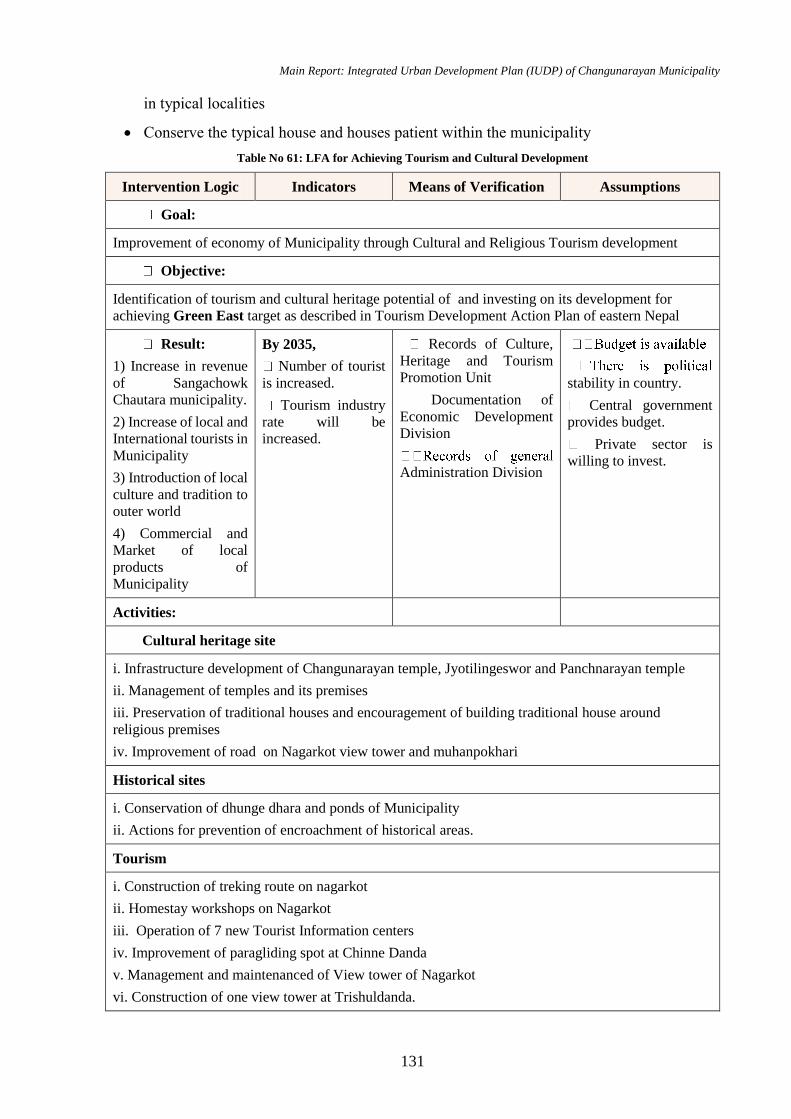
Main Report: Integrated Urban Development Plan (IUDP) of Changunarayan Municipality
131
in typical localities
Conserve the typical house and houses patient within the municipality
Table No 61: LFA for Achieving Tourism and Cultural Development
Intervention Logic Indicators Means of Verification Assumptions
Goal:
Improvement of economy of Municipality through Cultural and Religious Tourism development
Objective:
Identification of tourism and cultural heritage potential of and investing on its development for
achieving Green East target as described in Tourism Development Action Plan of eastern Nepal
Result:
1) Increase in revenue
of Sangachowk
Chautara municipality.
2) Increase of local and
International tourists in
Municipality
3) Introduction of local
culture and tradition to
outer world
4) Commercial and
Market of local
products of
Municipality
By 2035,
Number of tourist
is increased.
Tourism industry
rate will be
increased.
Records of Culture,
Heritage and Tourism
Promotion Unit
Documentation of
Economic Development
Division
Administration Division
stability in country.
Central government
provides budget.
Private sector is
willing to invest.
Activities:
Cultural heritage site
i. Infrastructure development of Changunarayan temple, Jyotilingeswor and Panchnarayan temple
ii. Management of temples and its premises
iii. Preservation of traditional houses and encouragement of building traditional house around
religious premises
iv. Improvement of road on Nagarkot view tower and muhanpokhari
Historical sites
i. Conservation of dhunge dhara and ponds of Municipality
ii. Actions for prevention of encroachment of historical areas.
Tourism
i. Construction of treking route on nagarkot
ii. Homestay workshops on Nagarkot
iii. Operation of 7 new Tourist Information centers
iv. Improvement of paragliding spot at Chinne Danda
v. Management and maintenanced of View tower of Nagarkot
vi. Construction of one view tower at Trishuldanda.
Main Report: Integrated Urban Development Plan (IUDP) of Changunarayan Municipality
132
6.8 Financial Development Plan
Financial development is a part of the development strategy to stimulate economic growth and
reduce poverty, overcoming “costs” incurred in the financial system. It involves the establishment
and expansion of institutions, instruments and markets that support this investment and growth
process. It refers to the fulfilment of the functions of the financial system in the best manner by
eliminating the market distortions.
Goal: Achieving a financial sustainability through optimum utilization of available resources.
Objectives
To identify the areas of economic potential
To recognize the probable revenue generation areas of Changunarayan Municipality and
formulate plan likewise
To promote alternative funding modalities for minimizing the government municipal
budget by promoting PPP
To encourage investments for financial sustainability
To focus towards the duties enhancing knowledge, skill, attitude and behavior of the
incumbents and personnel in Finance, Procurement and Accounting through capacity
development.
To maintain financial discipline with financial management system, financial reporting
system with adequate documentation, records and evidences financial reporting and
financial statement as per the requirement of the financial management and accounting
system for better governance
6.8.1 Municipality Revenue Improvement Plan
The work is to formulate, identification and mobilization of resources required during the period
of IUDP implementation.
Vision: An efficient institution to support the process of development through broad-based,
transparent and tax system
Mission: Ensuring appropriate tax policies and better services for improved tax compliance.
Overall Objective: Ensure equitable, progressive, transparent and predictable tax system
Objective
Reform tax policies
Enhance Taxpayer Service and Education
Improve enforcement mechanism
Strengthen structures and system
Strategy
Reform tax policies to support investment and growth
Main Report: Integrated Urban Development Plan (IUDP) of Changunarayan Municipality
133
Broaden and protect tax base
Revitalize Research & Development for policy recommendations action
Improve taxpayer service to reduce the compliance and administrative cost
Develop, update and disseminate tax related materials and information
Provide taxpayer education and interaction programs Actions
Improve information network
Strengthen institutional capabilities.
Optimize Full-scale e-Governance System
Actions
Introduce a system of recording and reporting tax expenditures
Formulate issue-based guidelines and operational manuals
Introduce e-commerce and virtual transaction taxation policies
Strengthen the monitoring and evaluation system for policy feedback
Develop a uniform and standard teaching material for taxpayer education
Outsource some taxpayer education program
Develop and integrate existing registration, e-RT, e-Payment, e-TDS systems
Expected Result
Taxation Master Plan will be revised and implemented
Commerce Taxation Policy will be devised
e-based Service delivery mechanism will be in place
e-Payment System will be institutionalized
Virtual communication will be developed
Tax related information will be disseminated
Integrated system of tax assessment will be developed
By considering the points mentioned above, revenue improvement plan for Changunarayan
municipality has been prepared and presented in following table, which gives the strategies to be
followed, activities to be completed, time line for achieving those activities and the responsible
agency for accomplishing those activities in order to enhance internal revenue.
Table No 62: Revenue Generation Plan
6.8.2 Assessment of Possible Financial Resources
The work is to formulate, identification and mobilization of resources required during the period
of IUDP implementation. The following things/ subjects needs to be examined for search of
possible financial resources:

Main Report: Integrated Urban Development Plan (IUDP) of Changunarayan Municipality
134
Raising of internal fund- Sources can be collected through raising the internal rate in service
Revenue generation plan for Changunarayan Municipality
Strategies Activities Tasks Time
Frame
Responsible
Agency
Revenue
administration
system
strengthened
Formation of
revenue advisory
committee and
strengthen the
role of revenue
advisory
committee
(RAC)
Develop RAC's coordination and
communication mechanism
Review the progress made in revenue
collection periodically
Discuss on the potential new sources of
revenue
Make RAC a catalyst to coordinate with
government and private sector
stakeholders
Every Year Municipality
Recruitment of
empty post of
revenue section
Assess the staffing needs of revenue
section
Provide adequate and efficient staff with
experience in revenue administration
Every Year Municipality
Hold workshop
and interaction
programs
Hold regular interaction program with
different sections of the municipality
Visit other municipalities having good
examples to expose the revenue section
staff
Hold workshop with the stakeholders
(business houses, civil societies, press,
political parties) to collect suggestions
on revenue enhancement
Every Year Municipality,
MoFAGA
Introduce house
numbering
Issue house numbers to existing houses
within the given time frame
Issue house numbers to the new
constructions at the time of approving
the building permit
2080
Municipality,
DUDBC,
MoFAGA
Prepare Revenue
Implementation
Plan
Approve action plan to improve the
revenue management system
Make regular follow up to see the
achievements made against the action
plan
2080 Municipality
Revenue
generation
data base
updated and
made
functional
Computerize
revenue
generation data
Introduce software for revenue
generation
Enter all hard copy data (property and
business tax data) in the computer
system within a given time frame
Collect and update data of all properties
in the municipality in the database
including properties not liable to pay
taxes
July 2020 Municipality,
MoFAGA
Main Report: Integrated Urban Development Plan (IUDP) of Changunarayan Municipality
135
delivery and any special types of scheme as provided by the municipality more than the
above rate.
Update records of the tax payers on a
regular basis
Link data with
other sections of
the municipality
Introduce GIS system for uses by
revenue, planning and building permit
section
Link revenue data with GIS system
Link revenue system with other sections
of the municipality
2020 Municipality,
MoFAGA
Coordinate and
share data with
government
agencies
Coordinate with Land Revenue Office to
share land parcel data on a regular basis
Exchange business and rent tax data
with Inland Revenue Department
Coordinate with Transport Management
Department to share vehicle data
Coordinate with water supply,
electricity, telephone authorities to
identify and update tax payers records
Periodic
Municipality,
MoFALD,
LRO, IRO,
TMO,
Make computer
system
functional
Train staff in the application of
computer system
Arrange logistics for making computer
system effective and efficient
Arrange for timely and efficient support
system
2020
Municipality,
MoFAGA,
N/INGOs
Tariff system
revisited and
made effective
Carry out
feasibility study
of revenue
Review achievements made in the
previous feasibility study of revenue
Conduct new feasibility study
Implement the recommendations made
in the feasibility study
Periodic Municipality
Introduce
integrated
property tax
(IPT) system
Arrange trainings to prepare for the
introduction of IPT
Arrange IPT preparation budgets
2020
Municipality,
MoFAGA
Revise rates for
taxes fees and
charges
periodically
Collect information from other
municipalities regarding revision in the
tax rates, fees and charges
Revise legal provisions in raising taxes,
fees and charges periodically
Periodic Municipality
Revenue
collection
made efficient
and effective
Introduce billing
system
Provide information to tax payers about
their dues in the beginning of each year
Consider 80/20 rule when collecting
revenues owed.
2020 Municipality,
Introduce carrot
and stick method
Provide discount for timely payment of
taxes in the beginning of the year Immediate Municipality
Main Report: Integrated Urban Development Plan (IUDP) of Changunarayan Municipality
136
Identification and Extraction of Natural Resources: Possible sources of natural resources
are identified and extraction of such identified natural resources as quickly as possible. And
Introduce penalty to the defaulters at the
progressive rate (10% first year, 15%
second year 20% third year, etc.)
Hold regular
revenue
campaign
programs
Use news media, social network,
hoarding boards, television etc. to
inform the citizens to pay taxes
Distribute brochures to the tax payers
explaining about duties in paying taxes
and the services municipality provides
to its citizens
Participate in exhibition and fairs and
provide information to the citizens
Hold annual function to honor the tax
payers
Every Year
Municipality,
CCI,
Citizens
Use banking
system for
revenue
collection
Use banks to collect payment instead of
cash payment
Use other methods of making payments
e.g. personal cheques, bank draft, credit
card
Consider opening a bank counter in the
municipal premises
End of
2019
Municipality
Alternative
avenues for
potential OSR
explored and
enforced
Explore
possibility of
potential OSR
Explore and identify the sources of
potential OSR
Include such ideas in the feasibility
study
Periodic Municipality
Frame out cost
recovery policy
of infrastructure
systems operated
by the
municipality
Recover cost for providing specific
services e.g. sewerage, water supply,
electricity services etc.
Ensure that the revenue collection for
specific service is used for maintaining
such services
Ensure that revenue for sewer system
constructed by the municipality is
collected by the municipality and not by
the water authority
2020
Municipality,
MoFAGA,
DUDBC
Project
implemented
through Users
Group and
PPP model
encouraged
Implement
projects through
User Groups
Prepare guidelines for the selection of
projects implemented by the User
contribution
Select projects having strong
willingness of the community in making
financial contribution
Make provision for O&M costs
Every Year Municipality,
MoFAGA
Implement
projects under
PPP model
Form PPP promotion committee to
identify and implement commercially
viable projects under PPP model Every Year
Municipality,
MoFAGA,
CCI

Main Report: Integrated Urban Development Plan (IUDP) of Changunarayan Municipality
137
the taxation on such resources helps in the collection of funds for municipality. This
municipality has high potential of sand resources as the traces can be seen in the following
pictures.
Tourism: Tourism may be the financial
resources of the municipality. By the
promotion of National and international
tourism, municipality can generate huge
amount of money. Also this municipality
is located near the Kathmandu and
Bhaktapur city. This municipality needs to
develop necessary infrastructures such as
road, hotels and provide sufficient
security to the tourist for the promotion of
touristic areas like Changunaryan area.
Also the Changunaryan ridge can be
developed as the green belt and open zoo
or the jungle safari can be initiated for the
tourism development in the concerned area. Following pictures shows the general view of
mountains form Changunarayan ridge
Agricultural Product
Agriculture generates almost 44.6 % of the
employment in the municipality. With the
advancement of the agricultural method and the
development of the technology, high amount of
the agricultural product can be generated with
the minimal amount of working hours. This
municipality can generate huge amount of
economy i.e. money and employment with the
advancement of the agricultural method.
Following picture shows the tunnel farming in
Changunaryan municipality.
Consider PPP policy 2003 and PPP
Guidelines 2004 in implementing PPP
projects
Select projects based on the policy and
guidelines
Use private
sector in solid
waste
management
Explore use of private sector in solid
waste management
Encourage solid waste management
staff of the municipality to form a
commercial entity to take up this
function.
Immediate
Municipality,
Private
sectors
Figure No 24: General view of Mountain Form
Changunaryan Ridge
Figure No 25: Tunnel farming)
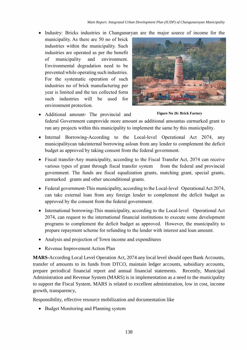
Main Report: Integrated Urban Development Plan (IUDP) of Changunarayan Municipality
138
Industry: Bricks industries in Changunaryan are the major source of income for the
municipality. As there are 50 no of brick
industries within the municipality. Such
industries are operated as per the benefit
of municipality and environment.
Environmental degradation need to be
prevented while operating such industries.
For the systematic operation of such
industries no of brick manufacturing per
year is limited and the tax collected form
such industries will be used for
environment protection.
Additional amount- The provincial and
federal Government canprovide more amount as additional amountas earmarked grant to
run any projects within this municipality to implement the same by this municipality.
Internal Borrowing-According to the Local-level Operational Act 2074, any
municipalitycan takeinternal borrowing asloan from any lender to complement the deficit
budget as approved by taking consent from the federal government.
Fiscal transfer-Any municipality, according to the Fiscal Transfer Act, 2074 can receive
various types of grant through fiscal transfer system from the federal and provincial
government. The funds are fiscal equalization grants, matching grant, special grants,
earmarked grants and other unconditional grants.
Federal government-This municipality, according to the Local-level Operational Act 2074,
can take external loan from any foreign lender to complement the deficit budget as
approved by the consent from the federal government.
International borrowing-This municipality, according to the Local-level Operational Act
2074, can request to the international financial institutions to execute some development
programs to complement the deficit budget as approved. However, the municipality to
prepare repayment scheme for refunding to the lender with interest and loan amount.
Analysis and projection of Town income and expenditures
Revenue Improvement Action Plan
MARS-According Local Level Operation Act, 2074 any local level should open Bank Accounts,
transfer of amounts to its funds from DTCO, maintain ledger accounts, subsidiary accounts,
prepare periodical financial report and annual financial statements. Recently, Municipal
Administration and Revenue System (MARS) is in implementation as a need to the municipality
to support the Fiscal System. MARS is related to excellent administration, low in cost, income
growth, transparency,
Responsibility, effective resource mobilization and documentation like
Budget Monitoring and Planning system
Figure No 26: Brick Factory
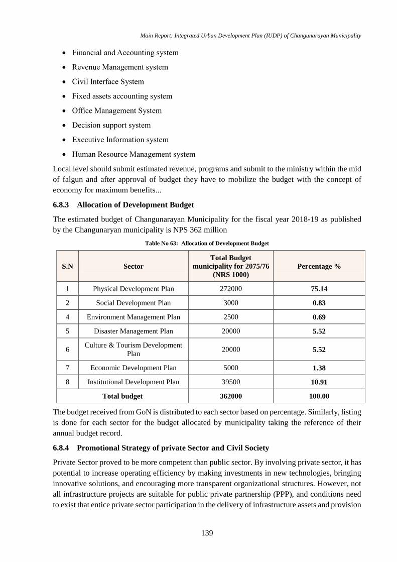
Main Report: Integrated Urban Development Plan (IUDP) of Changunarayan Municipality
139
Financial and Accounting system
Revenue Management system
Civil Interface System
Fixed assets accounting system
Office Management System
Decision support system
Executive Information system
Human Resource Management system
Local level should submit estimated revenue, programs and submit to the ministry within the mid
of falgun and after approval of budget they have to mobilize the budget with the concept of
economy for maximum benefits...
6.8.3 Allocation of Development Budget
The estimated budget of Changunarayan Municipality for the fiscal year 2018-19 as published
by the Changunaryan municipality is NPS 362 million
Table No 63: Allocation of Development Budget
S.N Sector
Total Budget
municipality for 2075/76
(NRS 1000)
Percentage %
1 Physical Development Plan 272000 75.14
2 Social Development Plan 3000 0.83
4 Environment Management Plan 2500 0.69
5 Disaster Management Plan 20000 5.52
6 Culture & Tourism Development
Plan 20000 5.52
7 Economic Development Plan 5000 1.38
8 Institutional Development Plan 39500 10.91
Total budget 362000 100.00
The budget received from GoN is distributed to each sector based on percentage. Similarly, listing
is done for each sector for the budget allocated by municipality taking the reference of their
annual budget record.
6.8.4 Promotional Strategy of private Sector and Civil Society
Private Sector proved to be more competent than public sector. By involving private sector, it has
potential to increase operating efficiency by making investments in new technologies, bringing
innovative solutions, and encouraging more transparent organizational structures. However, not
all infrastructure projects are suitable for public private partnership (PPP), and conditions need
to exist that entice private sector participation in the delivery of infrastructure assets and provision
Main Report: Integrated Urban Development Plan (IUDP) of Changunarayan Municipality
140
of service. When efficiently and transparently procured, the benefits of involving the private
sector in the delivery of infrastructure include (i) efficient use of the resources, (ii) improved asset
and service quality, (iii) improved public sector management, and (iv) overall improvement in
public sector procurement. (ADB 2012)
Some of the strategy for promoting PPP modalities in Changunarayan Municipality is in the field
of tourism, solid waste management and infrastructure development.
The proposed activity for promoting PPP is:
If government provides basic amenities like water, road, sewerage, drainage, electricity to
new areas for hotel development, businessman can be attracted for tourism development.
This is also a type of PPP modalities where services are provided by private sector after
initiation from public sector.
Solid waste management can run on concession contract of PPP model where investment
is done by private sector in the existing amenities or new innovative solutions can be
derived with private ownership for certain period (15-30 years).
PPP model can be implemented in transport services like buses, taxi services. Facility or
operational management contract method can be best suitable for this type with ownership
to public sector. Private sector can be given incentives of tax exemption of 10% on vehicle
renewal and benefit sharing of 80-20%.
The maintenance of assets and equipment of temples can be given to private sector with
benefit incentive.
Open public spaces can be given on lease for 10-30 years to private sector to develop parks,
commercial building etc. depending on the location.
The new projects like Bus Park, sports hall, public library can have the 60-40 public private
model for investment. Benefits can be given to the shareholders like discounts on tickets or
membership.
6.8.5 Financial and Economic Analysis
Financial condition of the municipality is the back bone of economic development of the
municipality. Economic Development mainly related to the living standard of the people i.e it
indicates condition of using the public services of government. Economically, every investment
has its payback period depends upon the complicity of the project. Generally, the investment in
the physical infrastructure i. e. road infrastructure in the name of rural agro - road has higher pay
back period and lower economic values. But development is generally measures in the term of
availability of roads which influences the policy makers to invest in most of the financial
resources in roads which rarely contribute in the economic growth of the municipality. So we
recommend, that financial investment of the municipality is in such way that it directly contribute
the betterment in the technique of agriculture, betterment of institutions, upgrading the road
infrastructures etc.
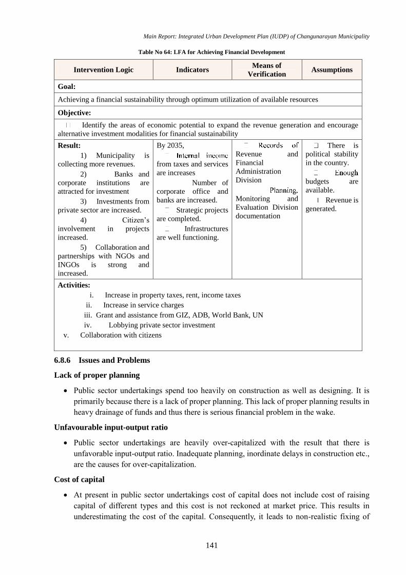
Main Report: Integrated Urban Development Plan (IUDP) of Changunarayan Municipality
141
Table No 64: LFA for Achieving Financial Development
Intervention Logic Indicators Means of
Verification Assumptions
Goal:
Achieving a financial sustainability through optimum utilization of available resources
Objective:
Identify the areas of economic potential to expand the revenue generation and encourage
alternative investment modalities for financial sustainability
Result:
1) Municipality is
collecting more revenues.
2) Banks and
corporate institutions are
attracted for investment
3) Investments from
private sector are increased.
4) Citizen’s
involvement in projects
increased.
5) Collaboration and
partnerships with NGOs and
INGOs is strong and
increased.
By 2035,
from taxes and services
are increases
Number of
corporate office and
banks are increased.
Strategic projects
are completed.
Infrastructures
are well functioning.
Revenue and
Financial
Administration
Division
Monitoring and
Evaluation Division
documentation
There is
political stability
in the country.
budgets are
available.
Revenue is
generated.
Activities:
i. Increase in property taxes, rent, income taxes
ii. Increase in service charges
iii. Grant and assistance from GIZ, ADB, World Bank, UN
iv. Lobbying private sector investment
v. Collaboration with citizens
6.8.6 Issues and Problems
Lack of proper planning
Public sector undertakings spend too heavily on construction as well as designing. It is
primarily because there is a lack of proper planning. This lack of proper planning results in
heavy drainage of funds and thus there is serious financial problem in the wake.
Unfavourable input-output ratio
Public sector undertakings are heavily over-capitalized with the result that there is
unfavorable input-output ratio. Inadequate planning, inordinate delays in construction etc.,
are the causes for over-capitalization.
Cost of capital
At present in public sector undertakings cost of capital does not include cost of raising
capital of different types and this cost is not reckoned at market price. This results in
underestimating the cost of the capital. Consequently, it leads to non-realistic fixing of
Main Report: Integrated Urban Development Plan (IUDP) of Changunarayan Municipality
142
prices and the underestimating market trends. Even it becomes difficult to estimate the
extent of profits and losses as well.
Problem of pricing
Another problem of a public sector undertaking is that of fixing the prices of the goods
produced. As we know that unless pricing policy is sound even good concerns can run into
losses.
Problem of surpluses
In the financial field another problem is that of declaring surpluses. From surplus we mean
the resources available as surplus, after deducting working expenses, normal replacements,
interest payments and dividends. But again in the public sector undertakings it has not been
found possible to device a policy of declaring surpluses. No clear cut principles in this
regard have been laid down by the Government for the guidance of public sector
undertakings.
Problem of raising loans
All public sector undertakings are run with the finance of the Government. Now this has in
turn raised many problems. Sometimes Government may feel it difficult to finance public
sector undertakings such cases, if these undertakings depend on capital market, they bound
to disturb financial structure of the market.
Problem of budgeting
Still another problem is that of budgeting. It is seen that most of the public sector
undertakings have no serious budgeting system.
6.9 Environmental Management Plan
Environmental Management is an effort to control human impact on the surrounding in order to
preserve the natural resources. It focuses on improvement of human welfare in present and future
generations. A clean and healthy municipality not only upgrades the living standard of its citizens
but also reflects the beauty of the municipality. Therefore, protection of environment is obligatory
for any municipality, to promote and improve all aspects of the municipality. This plan also caters
the solid waste management plan, environmental disaster planning, identification and
management of landfill site and municipality level pollution management plans etc.
Goal: Maintaining the ecological balance of Changunaryan by promoting green municipality
concept, improving the urban atmosphere, conserving sensitive areas and preserving bio
diversity.
Objective
To prepare a proper solid waste management system by promoting waste to energy concept
To formulate plans for implementing waste to energy concept
To identify and conserve the environmentally sensitive areas
To create a balance between natural and built environment
Main Report: Integrated Urban Development Plan (IUDP) of Changunarayan Municipality
143
To promote the green design principles in planning and advocate the sustainable
municipality concept
To reduce the waste generation by promoting waste recycling
To prepare environmental policy
To improve urban open spaces and greenery
To reduce environmental pollution
To improve the ground water recharging by promoting rain water harvesting
To prepare climate change adaptation and mitigation strategies and plan.
6.9.1 Present Status
Solid Waste Management
As explained in the Prevailing situation analysis chapter, solid waste management and separation
is already commenced on Changunaryan Municipality. “Waste to energy” program is also in the
priority list of Changunaryan Municipality but a proper strategy and implementation plan haven’t
been formulated. A proposed series of activity for the solid waste management are described
below.
Landfill Site
A landfill site is planned for the municipality. This will solve the solid waste management
problem of the whole municipality.
Waste Reduction, Recycling and Reuse
As waste recycling project was operated and sensitized in municipality, this should be
continued.
A waste separation system at home can be initiated by the municipality or separating glass,
paper, electronics, organic waste and non-organic waste.
The private institutions should be encouraged to participate on “waste to energy” program.
Recently this is initiated, should be extended within all municipal area.
Waste production will be reduced by 40% (from 0.18 kg/person/day to 0.10 kg/person /day)
by investing in organic waste production and waste recycling to achieve the green
municipality standards that suggests 50% of the waste produced per person is recycled.
Training programs can be initiated to use the organic waste in kitchen gardens and roof
gardens.
Municipality can even develop a strategy to charge the people only for the inorganic, non-
degradable waste based on the garbage weight.
The recyclable and reusable material can be collected for free in exchange of the non-
degradable waste or can be purchased from dwellers alternatively.
A plastic free municipality initiative measures can be taken by the municipality in
coordination with schools, private organizations and business owners.
Main Report: Integrated Urban Development Plan (IUDP) of Changunarayan Municipality
144
Charging policy with the deposit that can be refunded for every plastic bottles (soft drinks,
water, and juice) has to be initiated for reduction of plastic bottle waste.
Waste Water Management
The existing condition of wastewater management is already explained in the drainage and
sewerage chapter in physical development planning.
Sewerage Treatment Plants
Sewerage network of around 270 km is planned which is to be constructed phase wise 5
phases.
Two-treatment plants have been planned near area of Kharipaati, Sudal, lower area of
Saraswoti Khel
The bio-gas and manure production from wastes is encouraged and proposed in the plan.
Storm Water Management
Strategy in planning and building byelaws is made, so that the rainwater can be used for
the ground water recharge instead of mixing it with sewer and discharging it to river.
A collection recharging reservoir tanks can be made in various locations of the municipality
for this side drainages, which can be used for watering vegetation around the municipality.
Environmental deterioration
The activities for controlling the environmental pollution are:
Taxation and Awareness
Restricting vehicular emissions by regular checking and banning very old vehicles
producing smokes.
Increasing awareness about reducing the usage of firewood for household purpose.
Charging the people for dumping the waste haphazardly.
Taxation for people who set free their pets like dogs, cow, goat, chicken on road.
Visual Pollution
Visual pollution needs to be corrected by enforcing building bye-laws, restricting the
hoarding board’s usage in commercial areas only.
Control mechanism has to be set for managing built environment that can be achieved only
through planning and building byelaws. An incentive and penalty mechanism have to
clearly stated in the byelaws of municipality, for controlling these built structures.
Slaughter House
A new Slaughter house has been planned considering the different market center within the
municipality on Duwakot, Jitpur, and Saraswotikhel area of municipality, to restrict the air
and visual pollution in the municipality center and manage the environmental issues.
Climate Change: Mitigation and Adaptation Strategies
Main Report: Integrated Urban Development Plan (IUDP) of Changunarayan Municipality
145
A climate change responsive plan and program is to be formulated to reduce and mitigate
the effects of the climate change.
All wards of municipality are in danger of climate change. Hence, the climate change
responsive and adaptive programs need to be prioritized in these areas.
The program like tree plantation and community forest conservation initiated in ward no 6
and others words of municipality encourages clean development mechanism and gaining
incentives for carbon economics and co-ordinate with alternative energy center.
6.9.1.1 Urban Greenery
With the increasing urban population in the municipality core and high densification, there
always a clash between natural environment and manmade structures. These built structures
overshadow the natural environment with lack of greeneries and plants. Even in Changunaryan
Municipality, except the protected forest area on the south of the city, the municipality cores lack
greeneries resulting the cityscape to be grey and dry. This exacerbates various problems in the
municipality area resulting in rising temperatures, and heat waves producing a heat island effect.
For this, urban greenery can be an ideal solution. Urban greenery can mean everything from
municipality parks and traditional street scraping, like trees and planters, to more modern
adaptations, like green roofs and bio swales. In addition to aesthetics, these green solutions result
in cleaner air, improved storm water management, safer neighbourhoods and benefits the local
economy. Urban greenery even makes a strong credit point in LEED certification.
Urban greenery implementation needs to be combined with planning and building byelaws
of Changunaryan Municipality.
Tree plantation along the major roads of Changunaryan Municipality.
Construction of park in each local neighborhood (ward).
Promotional programs for encouraging people to include green roofs, green walls and urban
farming in homes.
For the implementation, incentives and awareness program has to be formulated by the
Changunaryan municipality.
Tax exemptions while getting building permit and incentive of time frame for building
construction for people who are using urban greeneries in their homes.
6.9.1.2 Conservation of Environmental Sensitive Areas
As explained in proposed land use plan of physical development plan, for protection of
environment sensitive area, conservation areas are identified. Further activities for conserving
these areas can be listed as:
River Protection
A river embankment plan is needed for bounding the flow of river as these are seasonal
river.
The afforestation initiation on the bank of rives passes through this municipality is a perfect
example for reducing landslide and maintaining environmental balance.
Main Report: Integrated Urban Development Plan (IUDP) of Changunarayan Municipality
146
Relocation of the squatter settlements from river areas and heritage zones.
Natural Resource Preservation
Conservation of natural resources and ground water table.
Restriction of usage of modern technology material like marble and others during
cremation for accelerating degradation rate of the corpse.
Penalty for people dumping waste near river, forest and temple areas.
Community Forest Conservation
Conservation of wildlife in forest area for developing a safari concept for observing these
animals.
6.9.2 Issues and Problems
Climate Change
Effects
Increase in geographic range and incidence of insect-borne disease particularly malaria and
dengue.
Increased risk of hunger and famine for many of the world’s poorest people who depend
on isolated agricultural systems especially in the tropics.
Displacement due to rising sea level especially small island states
Shifts in distribution, structure and functioning of terrestrial and aquatic ecosystems – loss
of biodiversity
Decreased amount of precipitation in many arid and semi-arid regions.
Biodiversity Loss
Biodiversity refers to the variety of all plants and animals on the earth
Effects
Habitat conversion and destruction
Fragmentation of large ecosystem into smaller ecosystems ·
Over exploitation of species Introduction or accidental release of exotic species ·
Air and water pollution
Land Degradation and Desertification ·
Effects ·
Declining agricultural yields ·
Loss of soil fertility ·
Threat to food security for countries so affected ·
Soil erosion especially by wind.

Main Report: Integrated Urban Development Plan (IUDP) of Changunarayan Municipality
147
Potential reduction in food export earnings
Deforestation
Effects
Release of carbon because forests ecosystems contain about 3 times the amount of carbon
currently present in the atmosphere. ·
Biodiversity loss
Soil erosion
Negative impacts on water quality and quantity
6.9.3 Strategy of Environmental Management Plan
Launch development programs by internalizing environmental management.
Mobilize non-government private sector, local agencies and the public in increasing public
awareness on environment.
Determine and implement additional byelaws on air, water, soil and sound pollution.
To implement a scientific management system for the conservation and development of
bio-diversity and genetic resources, including forests, plants and wildlife devolution,
participatory and peoples' rights based approach. A fixed part of revenue generated through
this will be mobilized in favors of the poor.
To implement participatory, integrated and coordinated watershed management program
To go on expanding the Soil and Watershed Management Program by strengthening it
To implement various forest-based social and economic programs with priority that directly
support in the reduction of human and income poverty.
Table No 65: LFA for Achieving Environmental Management
Intervention Logic Indicators Means of Verification Assumptions
Goal:
Maintaining the ecological balance of Changunaryan by promoting green municipality concept,
improving the urban atmosphere, conserving sensitive areas and preserving bio diversity.
Objective:
Management of urban environment of Sangachowk Chautara through preservation of natural
resources, forest areas, maintaining bio diversity and promoting sustainable city concept to achieve
ecological balance.
Result:
1) Community forests
are managed
effectively.
2) Natural forest will
have diverse wild life.
By 2035,
Number of
people affected
from landslides and
flood is less.
Number of trees
planted alongside
Documentation of
Water Supply and Solid
waste management
branch
Records of Forest,
Environment and Disaster
Management Division
Budget is available
People actively
participate in waste
management program.
GoN is willing to
address the environment
issues
Main Report: Integrated Urban Development Plan (IUDP) of Changunarayan Municipality
148
Intervention Logic Indicators Means of Verification Assumptions
3) Encroachment on
natural areas like forest
and river will decrease.
4) Environment
sensitive areas are
identified and
conservation is done.
5) Calamity rate is
declined.
6) Watershed areas are
utilized ecologically.
7) River pollution is
minimum.
8) Air is cleaner.
9) Waste segregation is
introduced in every
household.
the road is
increased.
Groundwater
table is increased.
Organic waste
dumping rate is
decreased by 50%.
Air pollutant
particles are
decreased.
Land management and
building regulation
division records
Activities:
Environmental pollution
i. Construction of 2 Slaughter house
ii. Enforcement of regulation and byelaws
iii. Vehicular emission restriction
iv. Awareness Program for environmental pollution
v. Construction of cycle lane, footpath on Khahare river corridor
vi. Electric public vehicles promotion
vii. Waste separation concept promotion
viii. Workshop on organic fertilizers from waste
ix. Subsidy for construction of toilets in Panchakanya
Conservation of sensitive area
i. Tree plantation on sensitive areas
ii. Protection of water sources and watershed areas
iii. Provision of Eco parks
Urban greenery
i. Tree plantation along major road
ii. Tax Exemption for promoting urban greenery
iii. Organizing workshops and trainings for green roof and urban farm
iv. Construction of gardens
Sustainable cities concept
i. Construction of cycle lanes in major roads
ii. Promotion of alternative/renewable energy

Main Report: Integrated Urban Development Plan (IUDP) of Changunarayan Municipality
149
Intervention Logic Indicators Means of Verification Assumptions
iii. Promotion of rain harvesting mechanism
iv. Promotion of Electric vehicles
6.10 Disaster Management Plan
Disaster Risk Management is application of disaster risk reduction policies and strategies to
prevent new disaster risk reduce existing disaster risk and control enduring risk, contributing to
the strengthening of resilience and reduction of losses. Disaster risk reduction aims to reduce
frequency of losses and damage caused by natural hazards. Nepal is opportune to have started
two very important initiatives in disaster risk reduction, namely;
Goal: Reducing the risk of life due to disaster related calamities through appropriate groundwork
Objectives
To utilize the local resources to handle the situation that arises during disaster
To identify the open spaces for preparing an evacuation plan
To raise the disaster preparedness awareness among public
To co-ordinate with local communities, stakeholders and central level to mobilize the
affected communities effectively
To proceed disaster risk mitigation efficiently
6.10.1 Present Status
Flood and Landslide
Proposed activities
River embankment needs to be done for restricting the flooding.
Settlement has to be controlled till 50m along riverside by enforcing regulations.
Squatter settlements along riverside need to be relocated.
Formation of committee with flood rescuers and conduct training for them.
Conduction of programs for public awareness.
Coordination and collaboration with national government rescuers.
Alerting quickly through telephone, FM, local radio and newspaper.
Coordinate with Police, army and Red Cross volunteers in various places for rescue
operation.
Landslide prone area are identified and relocation of settlement established near to such
location.
Development of roads and other infrastructure should be done after the through geological
and hydrological investigations of the proposed site.
Fire
Main Report: Integrated Urban Development Plan (IUDP) of Changunarayan Municipality
150
Proposed activities
A rescue operation should be planned with three distinct phases – immediate care, medical
aid first and organized relief.
Management plan of facilities required during rescue operation.
A fire alarm system needs to be installed in public places or mass gathering area.
Provide more fire extinguishers within municipality.
Increase fire brigade capacity.
Coordinate with police and army for emergency.
A preparedness program for fire led disaster are formulated by Municipality at ward level.
Thunderstorm
Proposed activities
Encourage proper earthing system during building construction.
Working on system that provide premonition about thunderstorm.
Increase public awareness about thunderstorm.
Alerting citizens through newspaper, radios, TV and FMs.
Epidemics
Proposed activities
Primary health care and medical supply units for controlling epidemics need to be set up.
A unit in municipality has to be set up which will inform about the probable epidemics to
municipality and the office will take the necessary measures for controlling epidemics.
Alerting public and providing awareness through telephone, local radio, newspaper and
FM.
Earthquake
Proposed activities
An awareness program will be conducted for informing people about what to do during and
after earthquake.
Rehearsal of the exit pattern to closest identified open space will be introduced to all the
citizens once a year.
Educate students about the pre and post-earthquake activities.
Prohibition on construction of large structure in weak topography.
Construction of earthquake resistant structures.
Provide trainings for increasing skilled manpower for building construction.
Several open spaces for gathering during disaster are identified and awareness program for
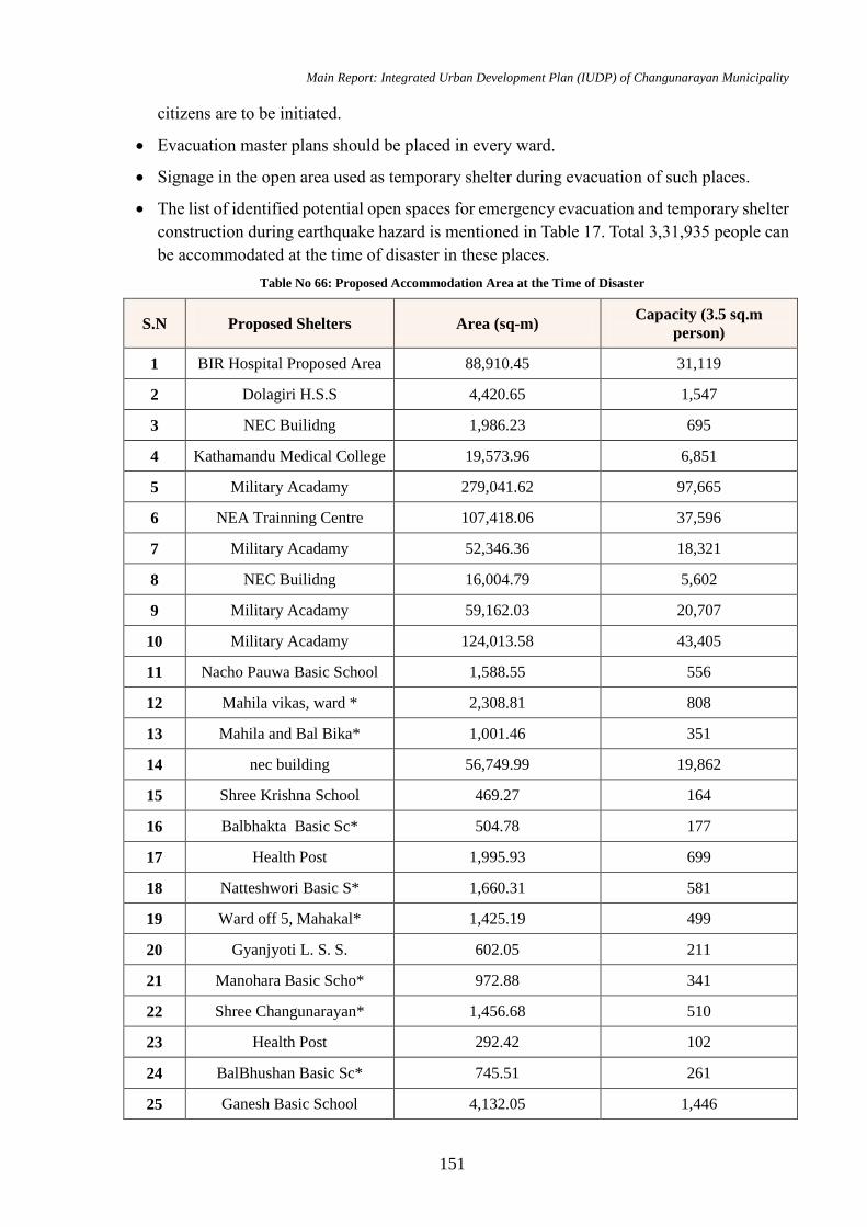
Main Report: Integrated Urban Development Plan (IUDP) of Changunarayan Municipality
151
citizens are to be initiated.
Evacuation master plans should be placed in every ward.
Signage in the open area used as temporary shelter during evacuation of such places.
The list of identified potential open spaces for emergency evacuation and temporary shelter
construction during earthquake hazard is mentioned in Table 17. Total 3,31,935 people can
be accommodated at the time of disaster in these places.
Table No 66: Proposed Accommodation Area at the Time of Disaster
S.N Proposed Shelters Area (sq-m) Capacity (3.5 sq.m
person)
1 BIR Hospital Proposed Area 88,910.45 31,119
2 Dolagiri H.S.S 4,420.65 1,547
3 NEC Builidng 1,986.23 695
4 Kathamandu Medical College 19,573.96 6,851
5 Military Acadamy 279,041.62 97,665
6 NEA Trainning Centre 107,418.06 37,596
7 Military Acadamy 52,346.36 18,321
8 NEC Builidng 16,004.79 5,602
9 Military Acadamy 59,162.03 20,707
10 Military Acadamy 124,013.58 43,405
11 Nacho Pauwa Basic School 1,588.55 556
12 Mahila vikas, ward * 2,308.81 808
13 Mahila and Bal Bika* 1,001.46 351
14 nec building 56,749.99 19,862
15 Shree Krishna School 469.27 164
16 Balbhakta Basic Sc* 504.78 177
17 Health Post 1,995.93 699
18 Natteshwori Basic S* 1,660.31 581
19 Ward off 5, Mahakal* 1,425.19 499
20 Gyanjyoti L. S. S. 602.05 211
21 Manohara Basic Scho* 972.88 341
22 Shree Changunarayan* 1,456.68 510
23 Health Post 292.42 102
24 BalBhushan Basic Sc* 745.51 261
25 Ganesh Basic School 4,132.05 1,446
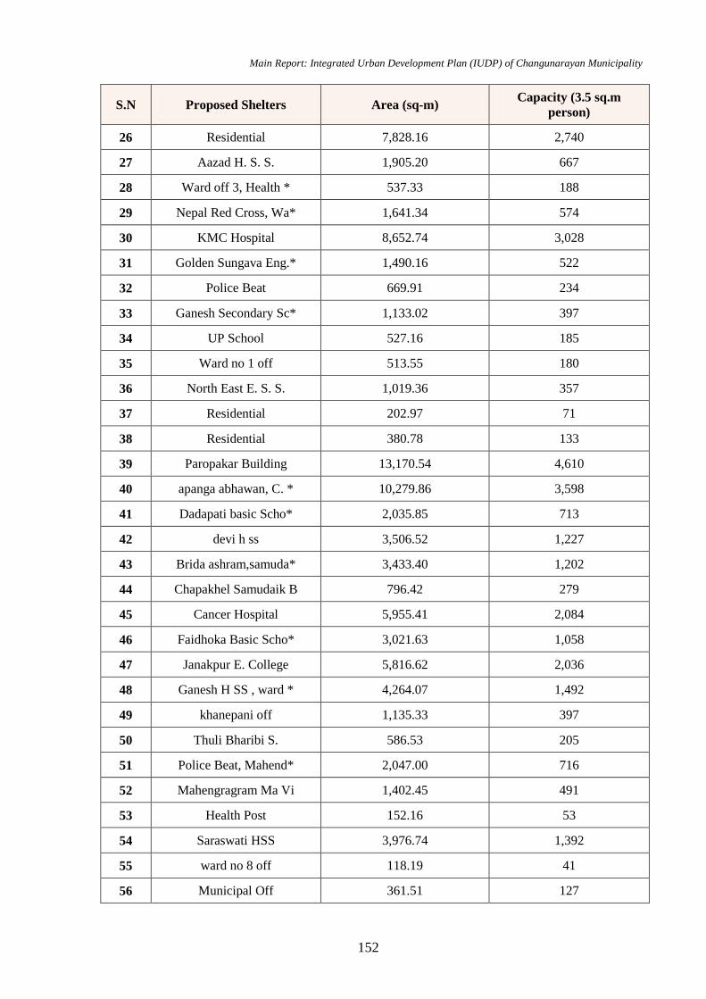
Main Report: Integrated Urban Development Plan (IUDP) of Changunarayan Municipality
152
S.N Proposed Shelters Area (sq-m) Capacity (3.5 sq.m
person)
26 Residential 7,828.16 2,740
27 Aazad H. S. S. 1,905.20 667
28 Ward off 3, Health * 537.33 188
29 Nepal Red Cross, Wa* 1,641.34 574
30 KMC Hospital 8,652.74 3,028
31 Golden Sungava Eng.* 1,490.16 522
32 Police Beat 669.91 234
33 Ganesh Secondary Sc* 1,133.02 397
34 UP School 527.16 185
35 Ward no 1 off 513.55 180
36 North East E. S. S. 1,019.36 357
37 Residential 202.97 71
38 Residential 380.78 133
39 Paropakar Building 13,170.54 4,610
40 apanga abhawan, C. * 10,279.86 3,598
41 Dadapati basic Scho* 2,035.85 713
42 devi h ss 3,506.52 1,227
43 Brida ashram,samuda* 3,433.40 1,202
44 Chapakhel Samudaik B 796.42 279
45 Cancer Hospital 5,955.41 2,084
46 Faidhoka Basic Scho* 3,021.63 1,058
47 Janakpur E. College 5,816.62 2,036
48 Ganesh H SS , ward * 4,264.07 1,492
49 khanepani off 1,135.33 397
50 Thuli Bharibi S. 586.53 205
51 Police Beat, Mahend* 2,047.00 716
52 Mahengragram Ma Vi 1,402.45 491
53 Health Post 152.16 53
54 Saraswati HSS 3,976.74 1,392
55 ward no 8 off 118.19 41
56 Municipal Off 361.51 127
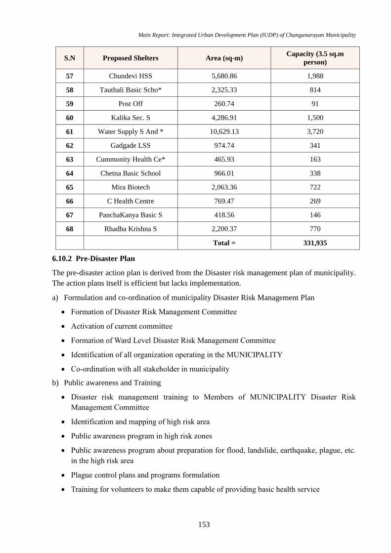
Main Report: Integrated Urban Development Plan (IUDP) of Changunarayan Municipality
153
S.N Proposed Shelters Area (sq-m) Capacity (3.5 sq.m
person)
57 Chundevi HSS 5,680.86 1,988
58 Tauthali Basic Scho* 2,325.33 814
59 Post Off 260.74 91
60 Kalika Sec. S 4,286.91 1,500
61 Water Supply S And * 10,629.13 3,720
62 Gadgade LSS 974.74 341
63 Cummonity Health Ce* 465.93 163
64 Chetna Basic School 966.01 338
65 Mira Biotech 2,063.36 722
66 C Health Centre 769.47 269
67 PanchaKanya Basic S 418.56 146
68 Rhadha Krishna S 2,200.37 770
Total = 331,935
6.10.2 Pre-Disaster Plan
The pre-disaster action plan is derived from the Disaster risk management plan of municipality.
The action plans itself is efficient but lacks implementation.
a) Formulation and co-ordination of municipality Disaster Risk Management Plan
Formation of Disaster Risk Management Committee
Activation of current committee
Formation of Ward Level Disaster Risk Management Committee
Identification of all organization operating in the MUNICIPALITY
Co-ordination with all stakeholder in municipality
b) Public awareness and Training
Disaster risk management training to Members of MUNICIPALITY Disaster Risk
Management Committee
Identification and mapping of high risk area
Public awareness program in high risk zones
Public awareness program about preparation for flood, landslide, earthquake, plague, etc.
in the high risk area
Plague control plans and programs formulation
Training for volunteers to make them capable of providing basic health service
Main Report: Integrated Urban Development Plan (IUDP) of Changunarayan Municipality
154
Training on Earthquake Resistant Construction to construction workers
Training on Earthquake Resistant construction technology to Engineers and Technicians
Retrofitting of houses which are not constructed in accordance with Engineering technique
Development of Risk sensitive land-use planning
c) Rescue activities and capacity development
Formation of Rescue team
Rescue Training
Management of facilities required for rescue operation
Practice of Rescue operation
d) Physical infrastructure management and vulnerability mitigation
Consideration of disaster risk while construction physical infrastructure like telephone,
electricity, road, water supply, etc.
Identification and management of Emergency health centers
Management of Fire-extinguisher van, Ambulance, hose pipe, first aid kit, etc.
Identification of open spaces, building it properly to be utilized as emergency residing place
and declaring it like public parks and open areas of schools, colleges and government
buildings.
Planning to install devices to pre-monitor disaster
Afforestation in the topographically vulnerable area
Prohibition on extracting sand and gravel from river beds
Development of Dumping site and landfill sites
6.10.3 Immediate and Post-Disaster Action Plan
Similarly, the post disaster action plan is also grounded on the municipality.
a) Management of Injured and displaced
Providing information about earthquake or other disaster to people in the municipality and
its precaution needed.
Performing local level rescue operation
Emergency treatment for the affected
Operating Emergency treatment team
Transferring emergency patients to hospitals
Co-ordination with national rescue team
Evaluation of availability of most-needed facilities like road, bridges, telephone, etc. and
Main Report: Integrated Urban Development Plan (IUDP) of Changunarayan Municipality
155
operation it temporarily
Providing food, clothes and shelter to the displaced people
Constructing accommodation areas for providing immediate shelter to the displaced people
Proper management of dead bodies
Management of debris of damaged structures
Implementation of plan and timely evaluation
b) Relief distribution and reconstruction work
Identification of storage location
Management of materials needed for emergency shelter
Rescue collection, storage and distribution
Formation of Disaster Fund
c) Post-disaster plague control
Identification, declaration, and operation of team to evaluate the effects in the areas most
vulnerable to plague
Developing public awareness about Communicable diseases
Building Temporary service center and other health service centers near affected area
Formation of Health operation team to treat injured people
Giving priority to Physically disabled, children, old and females which providing health
facility
Managing nutrition required for pregnant, children, females and other people requiring
immediate help
Providing facility to quickly transfer badly injured people to nearest health centers
Providing vaccination to control communicable disease
Managing water distribution properly
Managing most-needed medicines
Building toilets
Table No 67: LFA for Achieving Disaster Management
Intervention Logic Indicators Means of Verification Assumptions
Goal:
Reducing the risk of life due to disaster related calamities through appropriate groundwork
Objective:
Controlling natural and human induced calamities through pre disaster plans and identifying the most
appropriate action plans during disaster for decreasing the number of affected people
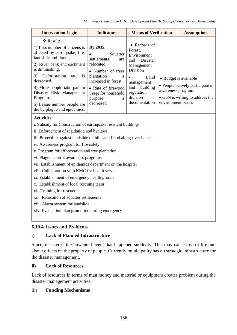
Main Report: Integrated Urban Development Plan (IUDP) of Changunarayan Municipality
156
Intervention Logic Indicators Means of Verification Assumptions
Result:
1) Less number of citizens is
affected by earthquake, fire,
landslide and flood.
2) River bank encroachment
is diminishing.
3) Deforestation rate is
decreased.
4) More people take part in
Disaster Risk Management
Program.
5) Lesser number people are
die by plague and epidemics.
By 2035,
Squatter
settlements are
relocated.
Number of trees
plantation is
increased in forest.
Rate of firewood
usage for household
purpose is
decreased.
Records of
Forest,
Environment
and Disaster
Management
Division
Land
management
and building
regulation
division
documentation
Budget is available
People actively participate in
awareness program.
GoN is willing to address the
environment issues
Activities:
i. Subsidy for Construction of earthquake resistant buildings
ii. Enforcement of regulation and byelaws
iii. Protection against landslide on hills and flood along river banks
iv. Awareness program for fire safety
v. Program for afforestation and tree plantation
vi. Plague control awareness programs
vii. Establishment of epidemics department on the hospital
viii. Collaboration with KMC for health service
ix. Establishment of emergency health groups
x. Establishment of local rescuing team
xi. Training for rescuers
xii. Relocation of squatter settlements
xiii. Alarm system for landslide
xiv. Evacuation plan promotion during emergency
6.10.4 Issues and Problems
i) Lack of Planned Infrastructure
Since, disaster is the unwanted event that happened suddenly. This may cause loss of life and
also it effects on the property of people. Currently municipality has no strategic infrastructure for
the disaster management.
ii) Lack of Resources
Lack of resources in terms of man money and material or equipment creates problem during the
disaster management activities.
iii) Funding Mechanisms

Main Report: Integrated Urban Development Plan (IUDP) of Changunarayan Municipality
157
The policy and the funding mechanism for provision of relief assistance to those affected by
natural calamities is not clearly laid down.
iv) Forecasting Mechanisms
Forecasting mechanisms involves the observation and collection of hydrological and
meteorological data’s, transmission of data to forecasting centers, analysis of data and
formulation of forecast and dissemination of forecast. For this observation and collection of data
center are insufficient within the municipality.
v) Disaster Privation and Mitigation
No polices and plan are formulated for the mitigation and privation of the disaster in the
municipality
6.10.5 Adaptation Strategy for Disaster Management
Emphasis will be given to develop and apply environment-friendly systems in development
and construction works.
For the mitigation of risks of natural disaster, appropriate information flow and pre- disaster
preparedness will be made.
To strengthen collaborative works between the government, nongovernment and private
sector for providing relief and rescue to those affected by disaster.
Challenges
Based on observation, survey and other assessments, following challenges are highlighted and
recommendations are provided for climate change management-
Regional approach- the regional nature of the disasters requires a regional approach to the
solution. In this way, disaster risk management could be an entry point for immediate regional
cooperation as well. This will create trust, which can be a basis for future cooperation for
maximizing benefits.
Empowerment of local government- for effective disaster management, local government
should be empowered by providing adequate fund and resources on the one hand and the local
community should be enabled by education and training on the other hand.
Enhancement of cooperation amongst DRR stakeholders- adequate coordination among the
various organizations related to disaster management combined with sufficient technological
strength and abundant resources can help to combat the problem of inadequate preparedness
against the impending disaster.
Building of aware, prepared and empowered community-the crucial role of grassroots
organizations in educating the community cannot be overlooked and hence planning should be
emphasized in this part as well.
Mass gathering event- in case of special event where there would be mass gathering, such as
Mela, Jatra, in this municipality, it is important that the planning for mass gathering,
overcrowding, event access point, fire safety measures, medical preparedness, emergency
Main Report: Integrated Urban Development Plan (IUDP) of Changunarayan Municipality
158
response team should be kept in mind. Moreover, inclusive multi-hazard preparedness should be
implemented at all levels.
6.11 Institutional Development Plan
Institutional development is the creation or reinforcement of a network of organizations to
effectively generate, allocate and use human, material and financial resources to attain specific
objectives on a sustainable basis.
Goal: Accelerating and managing the development works through efficient and intelligent
organizational structure by strengthening and uplifting the capability of concerned stakeholders
Objectives
To review the existing governance modalities of the city and analyses its effectiveness
To promote the good governance system
To identify the various decision making and implementing tools
To promote multiple stakeholders participation
To establish a proper co-ordination system between different stakeholders
To stimulate capacity development of the human resources.
6.11.1 Plan and Programs
Municipal structure of Changunarayan
It a local government with substantial authority granted through constitution of Nepal. After the
recent government reform, new governing structure is formed with 10 Divisions and each
division has several branches.
1 General Administration Division
Local Service and Human Resource Development Department
Public Procurement and Property Management Department
Local level, state and Federation Coordination Branch
Meeting Management Branch
Marketing Monitoring and Quality Bureau, Food Safety and Consumer Protection Branch
Internal audit branch
Holiday, festival, Jatra festival, Degree and Divination unit
2 Revenue and Financial Administration Division
Revenue Policy and Administration Branch
Financial Administration Branch
3 Urban Infrastructure Development Division
Road and Transport Management Branch
Hydropower, Energy and Street Lighting Branch
Main Report: Integrated Urban Development Plan (IUDP) of Changunarayan Municipality
159
Irrigation and Water Induced Disaster Prevention Branch
Water supply and Solid Waste Management Branch
Public Private Partnership Unit
4 Economic Development Division
Agriculture, Livestock and Co-operative Works Department
Industry and Entrepreneurship Development Department
Employment Generation and Poverty Reduction Branch
5 Social Development Division
Basic and Secondary Education Office Department
Sports and Extra Curriculum Unit Department
Basic Health and Cleanliness Office Department
Gender Equality and Social Security Department
Culture, Heritage, Fine Arts and Tourism Promotion Department
NGO Operation, Co-ordination and Regulation Unit Department
Social Security Program Department
Personal Event Registration Unit Branch
6 Forest, Environment and Disaster Management Division
Forest, Wildlife and Soil Preservation Office
Environment, Ecology and Water Shed Preservation Branch
Disaster Management Branch
7 Land Management and Building Regulation Division
Land-use and Settlement Development Branch
Survey, Map and Land Ownership Branch
Building and Building codes and Construction License Branch
8 Justice, Law and Human Rights Promotion Division
City Police Administration Branch
Justice, Law and Human Rights Promotion Branch
Legislative Branch
9 Planning, Monitoring and Evaluation Division
Plan Formulation and Implementation Branch
Monitoring and Evaluation Branch
10 Information, Communication and Data Management Division
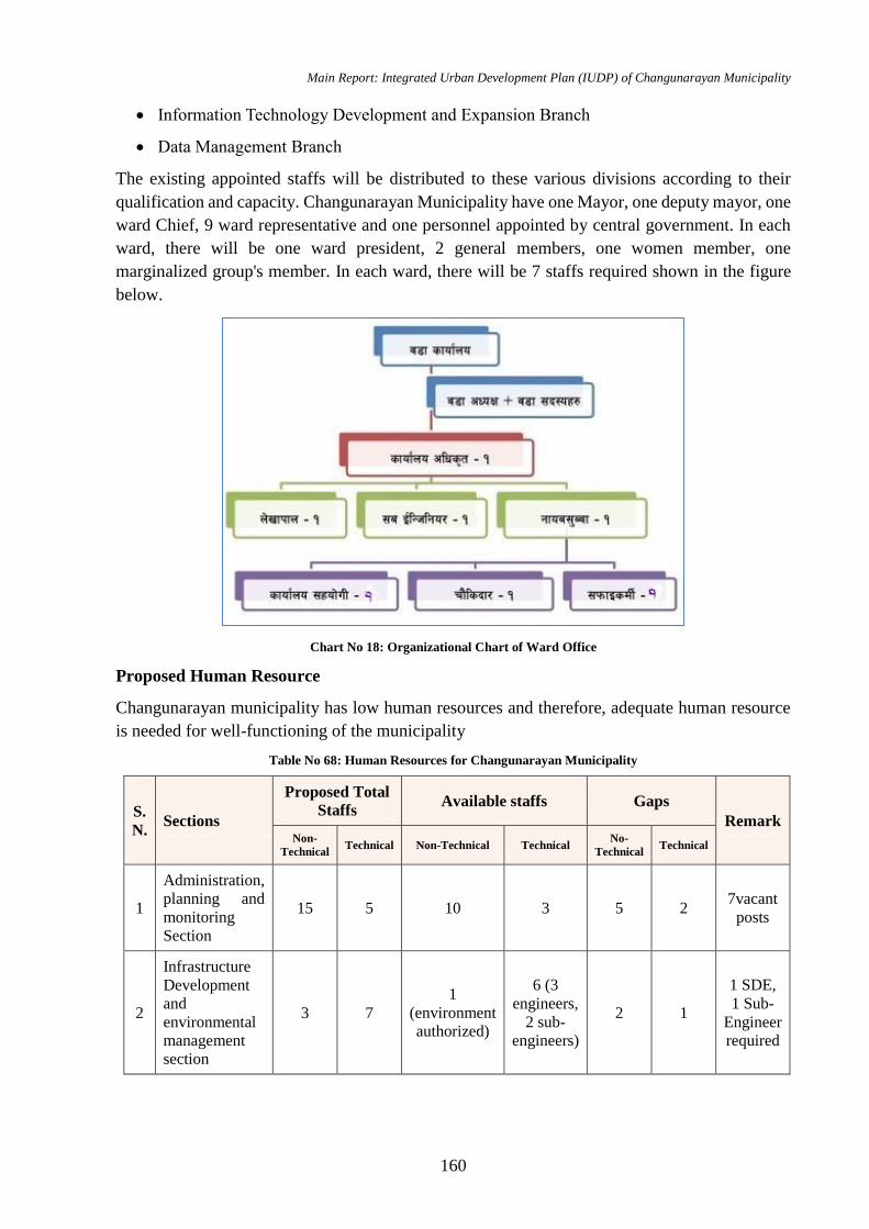
Main Report: Integrated Urban Development Plan (IUDP) of Changunarayan Municipality
160
Information Technology Development and Expansion Branch
Data Management Branch
The existing appointed staffs will be distributed to these various divisions according to their
qualification and capacity. Changunarayan Municipality have one Mayor, one deputy mayor, one
ward Chief, 9 ward representative and one personnel appointed by central government. In each
ward, there will be one ward president, 2 general members, one women member, one
marginalized group's member. In each ward, there will be 7 staffs required shown in the figure
below.
Chart No 18: Organizational Chart of Ward Office
Proposed Human Resource
Changunarayan municipality has low human resources and therefore, adequate human resource
is needed for well-functioning of the municipality
Table No 68: Human Resources for Changunarayan Municipality
S.
N. Sections
Proposed Total
Staffs Available staffs Gaps
Remark Non-
Technical Technical Non-Technical Technical
No-
Technical Technical
1
Administration,
planning and
monitoring
Section
15 5 10 3 5 2 7vacant
posts
2
Infrastructure
Development
and
environmental
management
section
3 7
1
(environment
authorized)
6 (3
engineers,
2 sub-
engineers)
2 1
1 SDE,
1 Sub-
Engineer
required
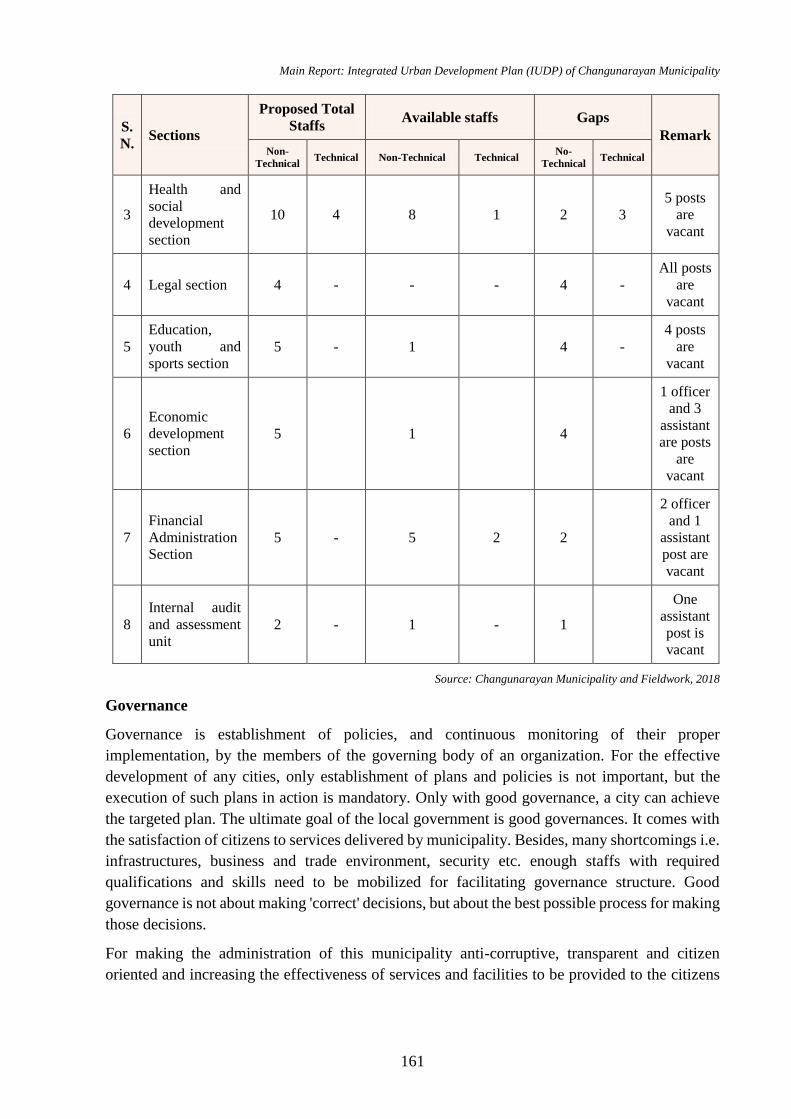
Main Report: Integrated Urban Development Plan (IUDP) of Changunarayan Municipality
161
S.
N. Sections
Proposed Total
Staffs Available staffs Gaps
Remark Non-
Technical Technical Non-Technical Technical
No-
Technical Technical
3
Health and
social
development
section
10 4 8 1 2 3
5 posts
are
vacant
4 Legal section 4 - - - 4 -
All posts
are
vacant
5
Education,
youth and
sports section
5 - 1 4 -
4 posts
are
vacant
6
Economic
development
section
5 1 4
1 officer
and 3
assistant
are posts
are
vacant
7
Financial
Administration
Section 5 - 5 2 2
2 officer
and 1
assistant
post are
vacant
8
Internal audit
and assessment
unit
2 - 1 - 1
One
assistant
post is
vacant
Source: Changunarayan Municipality and Fieldwork, 2018
Governance
Governance is establishment of policies, and continuous monitoring of their proper
implementation, by the members of the governing body of an organization. For the effective
development of any cities, only establishment of plans and policies is not important, but the
execution of such plans in action is mandatory. Only with good governance, a city can achieve
the targeted plan. The ultimate goal of the local government is good governances. It comes with
the satisfaction of citizens to services delivered by municipality. Besides, many shortcomings i.e.
infrastructures, business and trade environment, security etc. enough staffs with required
qualifications and skills need to be mobilized for facilitating governance structure. Good
governance is not about making 'correct' decisions, but about the best possible process for making
those decisions.
For making the administration of this municipality anti-corruptive, transparent and citizen
oriented and increasing the effectiveness of services and facilities to be provided to the citizens
Main Report: Integrated Urban Development Plan (IUDP) of Changunarayan Municipality
162
optimizing the minimum resources obtained by municipality, following governance activities are
articulated in the city.
Various workshops and training need to be organized for the municipal staffs to update
them with the new technology, process and governance.
E-governance should be introduced to track the efficiency of municipal services i.e.
streetlights, parking and Haat bazaar, road uses, waste management, public toilets and other
public services etc.
Digital system is to be introduced in the Municipality offices and regular updates of the
work plan in its websites will be done for making the service more efficient.
For easy and fast service delivery, municipality will establish service centres and mobile
service facilities.
The complaints of citizens needed to be managed by ward member in ward level and officer
in city level.
Electronic information system will be commenced for establishing relation between
municipality, ward committee and citizens.
The services in ward and metropolitan office are executed on first come first serve basis.
Home service for elderly and children will be introduced.
For promoting the transparency of Changunarayan municipality work, public hearing,
public trial and social trial programs will be executed.
Participation
As explained in previous chapters, this municipality is well-known model city for public
participation. Basis of the “sustainable education, health, tourism and trade” is with mobilization
of local resources and citizen’s involvement.
Proposed activities:
Ward Committee involvement in roads, streets, drainage of buildings, the construction of
school buildings and toilets etc.
Daily and weekly cleaning of road and streets in the local wards by ward committee and
banning the entry of loaded vehicle and prohibit actions such as driving over speed
For the involvement of the private sector, incentives through tax exemptions and subsidy
program are introduced.
PPP model can be operated for Park Management and Haat Bazaar Management, Truck
Yards Construction, Vegetable Markets, Convention and Trade Centres construction.
Co-ordination and Establishment of Networks
Some of the below mentioned committees are formed in municipality for effective
implementation of development projects:
Infrastructure development committee
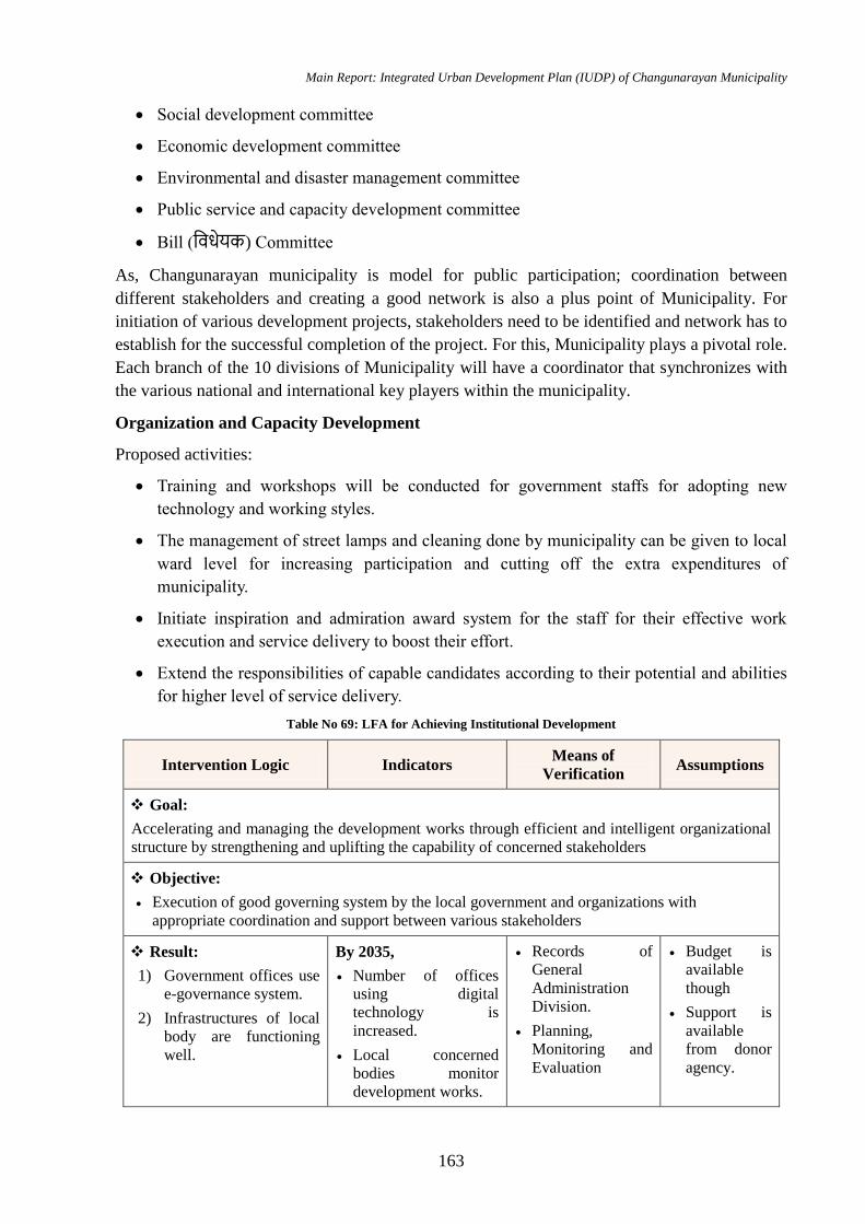
Main Report: Integrated Urban Development Plan (IUDP) of Changunarayan Municipality
163
Social development committee
Economic development committee
Environmental and disaster management committee
Public service and capacity development committee
Bill (विधेयक) Committee
As, Changunarayan municipality is model for public participation; coordination between
different stakeholders and creating a good network is also a plus point of Municipality. For
initiation of various development projects, stakeholders need to be identified and network has to
establish for the successful completion of the project. For this, Municipality plays a pivotal role.
Each branch of the 10 divisions of Municipality will have a coordinator that synchronizes with
the various national and international key players within the municipality.
Organization and Capacity Development
Proposed activities:
Training and workshops will be conducted for government staffs for adopting new
technology and working styles.
The management of street lamps and cleaning done by municipality can be given to local
ward level for increasing participation and cutting off the extra expenditures of
municipality.
Initiate inspiration and admiration award system for the staff for their effective work
execution and service delivery to boost their effort.
Extend the responsibilities of capable candidates according to their potential and abilities
for higher level of service delivery.
Table No 69: LFA for Achieving Institutional Development
Intervention Logic Indicators Means of
Verification Assumptions
Goal:
Accelerating and managing the development works through efficient and intelligent organizational
structure by strengthening and uplifting the capability of concerned stakeholders
Objective:
Execution of good governing system by the local government and organizations with
appropriate coordination and support between various stakeholders
Result:
1) Government offices use
e-governance system.
2) Infrastructures of local
body are functioning
well.
By 2035,
Number of offices
using digital
technology is
increased.
Local concerned
bodies monitor
development works.
Records of
General
Administration
Division.
Planning,
Monitoring and
Evaluation
Budget is
available
though
Support is
available
from donor
agency.
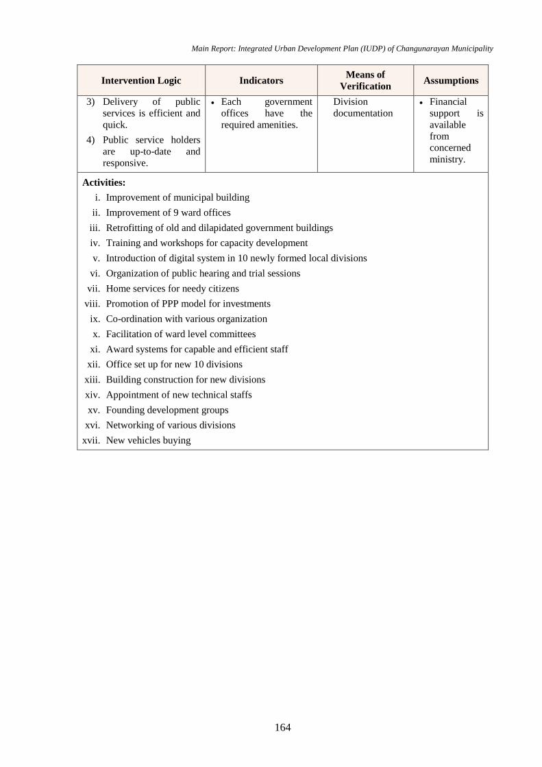
Main Report: Integrated Urban Development Plan (IUDP) of Changunarayan Municipality
164
Intervention Logic Indicators Means of
Verification Assumptions
3) Delivery of public
services is efficient and
quick.
4) Public service holders
are up-to-date and
responsive.
Each government
offices have the
required amenities.
Division
documentation
Financial
support is
available
from
concerned
ministry.
Activities:
i. Improvement of municipal building
ii. Improvement of 9 ward offices
iii. Retrofitting of old and dilapidated government buildings
iv. Training and workshops for capacity development
v. Introduction of digital system in 10 newly formed local divisions
vi. Organization of public hearing and trial sessions
vii. Home services for needy citizens
viii. Promotion of PPP model for investments
ix. Co-ordination with various organization
x. Facilitation of ward level committees
xi. Award systems for capable and efficient staff
xii. Office set up for new 10 divisions
xiii. Building construction for new divisions
xiv. Appointment of new technical staffs
xv. Founding development groups
xvi. Networking of various divisions
xvii. New vehicles buying

Main Report: Integrated Urban Development Plan (IUDP) of Changunarayan Municipality
165
Chapter 7: Multi-sectoral Investment Plan
7.1 Introduction
Multi-Sectoral Investment Plan (MSIP) is an estimate of total cost of list of projects and
allocate each project to 5, 10 and 15 yrs duration for completion giving its priority on the basis
of people needs (as determined in community meetings) and of the urban expansion
programme. From the above sectoral developmental plans, MSIP has been proposed based on
the priority of projects from each sectors which are to be completed within 5 yrs, 10 yr and 15
yrs duration.
As we’ve already discussed in earlier sections of financial plan and economic development
plan, a city development of 15-year plan with ambition of 60 thousand people needs lots of
investment. As these investments could be in the form of annual budget, loans, grants/aid or
some international projects. With model of public private partnership modality of
infrastructural investment, it is also expected to have investment of private sector in city
infrastructure projects. Apart from security and major strategic roads, in most of the sector we
can expect the investment from private sectors and from other donor agencies. All these
budgets should be funnelled down through the single channel of local project implementation
body, which could be TDC or any other new autonomous body. For these projects are identified
under different sections, which could be new construction, upgrading existing scenario or
upgrading the existing quality or capacity. With some standard rate of similar contemporary
projects, under different headings, cost estimation is allocated. As the development plans have
target period of 15 years, it is divided into 3 major milestones, short term, midterm and long-
term projects which have been discussed in the tables stated below. Depending upon the
priority of the project and possible budget required, different projects are put under different
time frame. Some longer-term projects may fall under different time period and some of the
projects are continuous process throughout the development, like: training and updating the
institutional capacity.
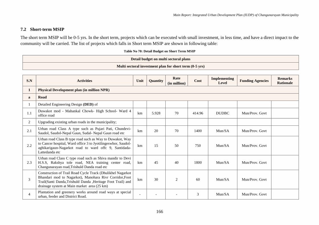
Main Report: Integrated Urban Development Plan (IUDP) of Changunarayan Municipality
166
7.2 Short-term MSIP
The short term MSIP will be 0-5 yrs. In the short term, projects which can be executed with small investment, in less time, and have a direct impact to the
community will be carried. The list of projects which falls in Short term MSIP are shown in following table:
Table No 70: Detail Budget on Short Term MSIP
Detail budget on multi sectoral plans
Multi sectoral investment plan for short term (0-5 yrs)
S.N Activities Unit Quantity Rate
(in million) Cost
Implementing
Level Funding Agencies
Remarks
Rationale
1 Physical Development plan (in million NPR)
a Road
1 Detailed Engineering Design (DED) of
1.1 Duwakot mod - Mahankal Chowk- High School- Ward 4
office road km 5.928 70 414.96 DUDBC Mun/Prov. Govt
2 Upgrading existing urban roads in the municipality;
2.1 Urban road Class A type such as Pujari Pati, Chundevi-
Saudol, Saudol-Nepal Gaun, Sudal- Nepal Gaun road etc km 20 70 1400 Mun/SA Mun/Prov. Govt
2.2
Urban road Class B type road such as Way to Duwakot, Way
to Cancer hospital, Ward office 3 to Jyotilingeswhor, Saudol-
aghikarigaun-Nagarkot road to ward offc 9, Santidada-
Lattedanda etc
km 15 50 750 Mun/SA Mun/Prov. Govt
2.3
Urban road Class C type road such as Shiva mandir to Devi
H.S.S, Rakshya tole road, NEA training center road,
Changunarayan road,Trishuld Danda road etc
km 45 40 1800 Mun/SA Mun/Prov. Govt
3
Construction of Trail Road Cycle Track (Dhulikhel Nagarkot
Bhandari mod to Nagarkot), Manohara Rivr Corridor,Foot
Trail(Santi Danda,Trishuld Danda ,Heritage Foot Trail) and
drainage system at Main market area (25 km)
km 30 2 60 Mun/SA Mun/Prov. Govt
4 Plantation and greenery works around road ways at special
urban, feeder and District Road. - - - 3 Mun/SA Mun/Prov. Govt
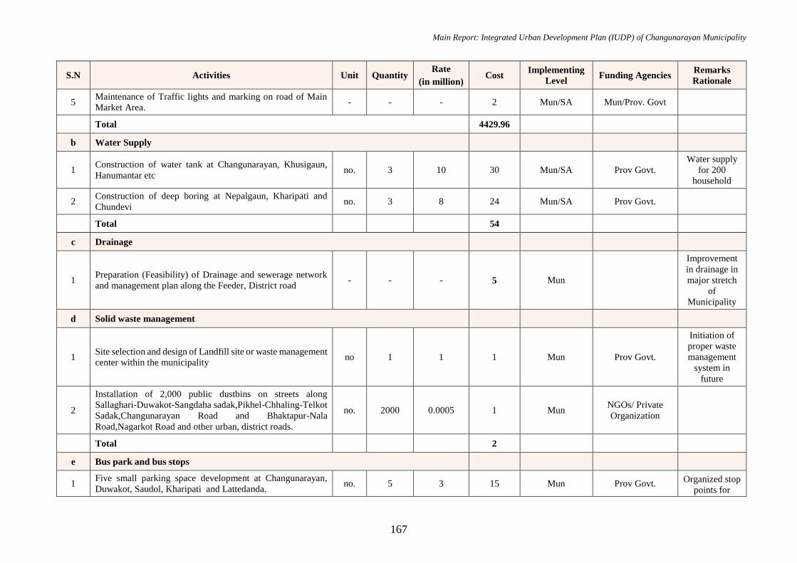
Main Report: Integrated Urban Development Plan (IUDP) of Changunarayan Municipality
167
S.N Activities Unit Quantity Rate
(in million) Cost
Implementing
Level Funding Agencies
Remarks
Rationale
5 Maintenance of Traffic lights and marking on road of Main
Market Area. - - - 2 Mun/SA Mun/Prov. Govt
Total 4429.96
b Water Supply
1 Construction of water tank at Changunarayan, Khusigaun,
Hanumantar etc no. 3 10 30 Mun/SA Prov Govt.
Water supply
for 200
household
2 Construction of deep boring at Nepalgaun, Kharipati and
Chundevi no. 3 8 24 Mun/SA Prov Govt.
Total 54
c Drainage
1 Preparation (Feasibility) of Drainage and sewerage network
and management plan along the Feeder, District road - - - 5 Mun
Improvement
in drainage in
major stretch
of
Municipality
d Solid waste management
1 Site selection and design of Landfill site or waste management
center within the municipality no 1 1 1 Mun Prov Govt.
Initiation of
proper waste
management
system in
future
2
Installation of 2,000 public dustbins on streets along
Sallaghari-Duwakot-Sangdaha sadak,Pikhel-Chhaling-Telkot
Sadak,Changunarayan Road and Bhaktapur-Nala
Road,Nagarkot Road and other urban, district roads.
no. 2000 0.0005 1 Mun NGOs/ Private
Organization
Total 2
e Bus park and bus stops
1 Five small parking space development at Changunarayan,
Duwakot, Saudol, Kharipati and Lattedanda. no. 5 3 15 Mun Prov Govt.
Organized stop
points for
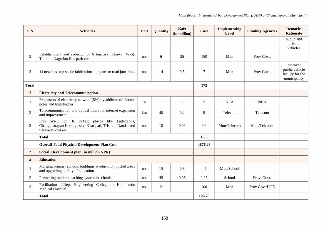
Main Report: Integrated Urban Development Plan (IUDP) of Changunarayan Municipality
168
S.N Activities Unit Quantity Rate
(in million) Cost
Implementing
Level Funding Agencies
Remarks
Rationale
public and
private
vehicles
2 Establishment and redesign of 6 buspark, Khawa (W-5),
Telikot, Nagarkot Bus park etc no. 6 25 150 Mun Prov Govt.
3 14 new bus stop shade fabrication along urban road junctions. no. 14 0.5 7 Mun Prov Govt.
Improved
public vehicle
facility for the
municipality
Total 172
f Electricity and Telecommunication
1 Expansion of electricity network (5%) by addition of electric
poles and transformer % - - 5 NEA NEA
2 Telecommunication and optical fibers for internet expansion
and improvement km 40 0.2 8 Telecom Telecom
3
Free Wi-Fi on 10 public places like Lattedanda,
Changunarayan Heritage site, Kharipati, Trishuld Danda, and
Saraswatikhel etc.
no. 10 0.03 0.3 Mun/Telecom Mun/Telecom
Total 13.3
Overall Total Physical Development Plan Cost 4676.26
2 Social Development plan (in million NPR)
a Education
1 Merging primary schools buildings at education pocket areas
and upgrading quality of education no. 15 0.3 4.5 Mun/School
2 Promoting modern teaching system in schools no. 45 0.05 2.25 School Prov. Govt.
3 Facilitation of Nepal Engineering College and Kathmandu
Medical Hospital no. 2 100 Mun Prov.Gpvt/DOE
Total 106.75
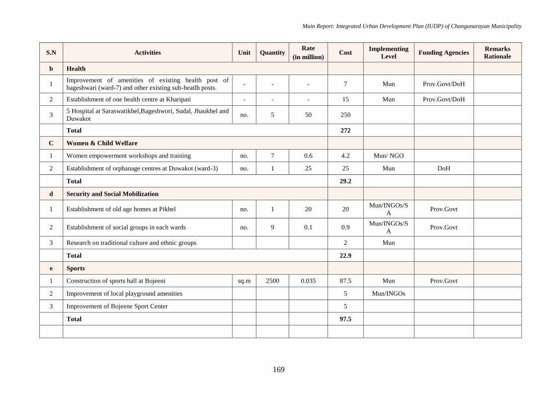
Main Report: Integrated Urban Development Plan (IUDP) of Changunarayan Municipality
169
S.N Activities Unit Quantity Rate
(in million) Cost
Implementing
Level Funding Agencies
Remarks
Rationale
b Health
1 Improvement of amenities of existing health post of
bageshwari (ward-7) and other existing sub-heatlh posts. - - - 7 Mun Prov.Govt/DoH
2 Establishment of one health centre at Kharipati - - - 15 Mun Prov.Govt/DoH
3 5 Hospital at Saraswatikhel,Bageshwori, Sudal, Jhaukhel and
Duwakot no. 5 50 250
Total 272
C Women & Child Welfare
1 Women empowerment workshops and training no. 7 0.6 4.2 Mun/ NGO
2 Establishment of orphanage centres at Duwakot (ward-3) no. 1 25 25 Mun DoH
Total 29.2
d Security and Social Mobilization
1 Establishment of old age homes at Pikhel no. 1 20 20 Mun/INGOs/S
A Prov.Govt
2 Establishment of social groups in each wards no. 9 0.1 0.9 Mun/INGOs/S
A Prov.Govt
3 Research on traditional culture and ethnic groups 2 Mun
Total 22.9
e Sports
1 Construction of sports hall at Bojeeni sq.m 2500 0.035 87.5 Mun Prov.Govt
2 Improvement of local playground amenities 5 Mun/INGOs
3 Improvement of Bojeene Sport Center 5
Total 97.5
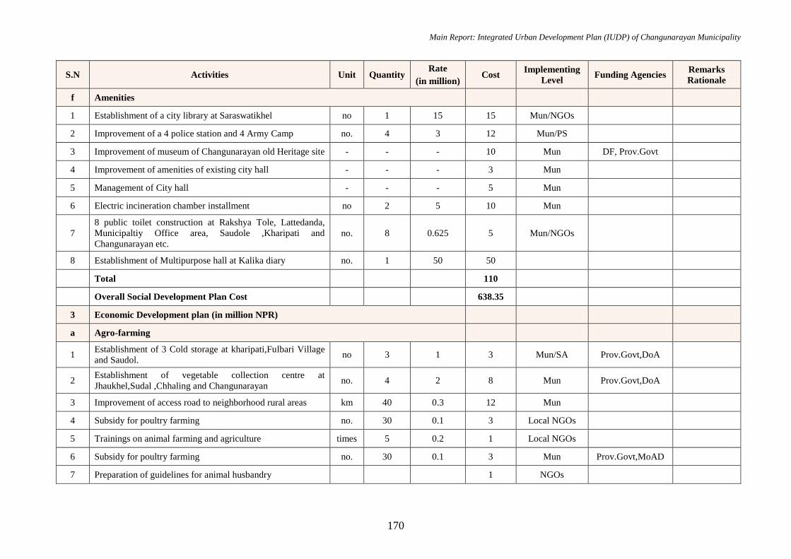
Main Report: Integrated Urban Development Plan (IUDP) of Changunarayan Municipality
170
S.N Activities Unit Quantity Rate
(in million) Cost
Implementing
Level Funding Agencies
Remarks
Rationale
f Amenities
1 Establishment of a city library at Saraswatikhel no 1 15 15 Mun/NGOs
2 Improvement of a 4 police station and 4 Army Camp no. 4 3 12 Mun/PS
3 Improvement of museum of Changunarayan old Heritage site - - - 10 Mun DF, Prov.Govt
4 Improvement of amenities of existing city hall - - - 3 Mun
5 Management of City hall - - - 5 Mun
6 Electric incineration chamber installment no 2 5 10 Mun
7
8 public toilet construction at Rakshya Tole, Lattedanda,
Municipaltiy Office area, Saudole ,Kharipati and
Changunarayan etc.
no. 8 0.625 5 Mun/NGOs
8 Establishment of Multipurpose hall at Kalika diary no. 1 50 50
Total 110
Overall Social Development Plan Cost 638.35
3 Economic Development plan (in million NPR)
a Agro-farming
1 Establishment of 3 Cold storage at kharipati,Fulbari Village
and Saudol. no 3 1 3 Mun/SA Prov.Govt,DoA
2 Establishment of vegetable collection centre at
Jhaukhel,Sudal ,Chhaling and Changunarayan no. 4 2 8 Mun Prov.Govt,DoA
3 Improvement of access road to neighborhood rural areas km 40 0.3 12 Mun
4 Subsidy for poultry farming no. 30 0.1 3 Local NGOs
5 Trainings on animal farming and agriculture times 5 0.2 1 Local NGOs
6 Subsidy for poultry farming no. 30 0.1 3 Mun Prov.Govt,MoAD
7 Preparation of guidelines for animal husbandry 1 NGOs
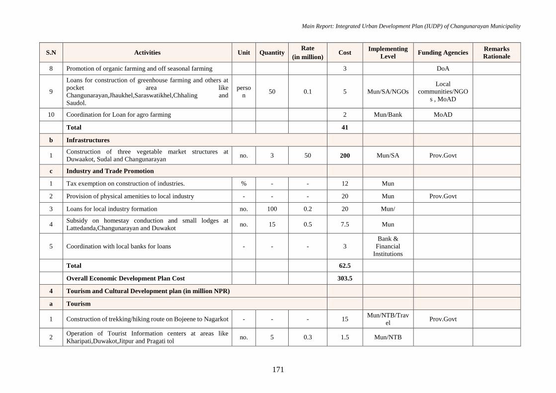
Main Report: Integrated Urban Development Plan (IUDP) of Changunarayan Municipality
171
S.N Activities Unit Quantity Rate
(in million) Cost
Implementing
Level Funding Agencies
Remarks
Rationale
8 Promotion of organic farming and off seasonal farming 3 DoA
9
Loans for construction of greenhouse farming and others at
pocket area like
Changunarayan,Jhaukhel,Saraswatikhel,Chhaling and
Saudol.
perso
n 50 0.1 5 Mun/SA/NGOs
Local
communities/NGO
s , MoAD
10 Coordination for Loan for agro farming 2 Mun/Bank MoAD
Total 41
b Infrastructures
1 Construction of three vegetable market structures at
Duwaakot, Sudal and Changunarayan no. 3 50 200 Mun/SA Prov.Govt
c Industry and Trade Promotion
1 Tax exemption on construction of industries. % - - 12 Mun
2 Provision of physical amenities to local industry - - - 20 Mun Prov.Govt
3 Loans for local industry formation no. 100 0.2 20 Mun/
4 Subsidy on homestay conduction and small lodges at
Lattedanda,Changunarayan and Duwakot no. 15 0.5 7.5 Mun
5 Coordination with local banks for loans - - - 3
Bank &
Financial
Institutions
Total 62.5
Overall Economic Development Plan Cost 303.5
4 Tourism and Cultural Development plan (in million NPR)
a Tourism
1 Construction of trekking/hiking route on Bojeene to Nagarkot - - - 15 Mun/NTB/Trav
el Prov.Govt
2 Operation of Tourist Information centers at areas like
Kharipati,Duwakot,Jitpur and Pragati tol no. 5 0.3 1.5 Mun/NTB
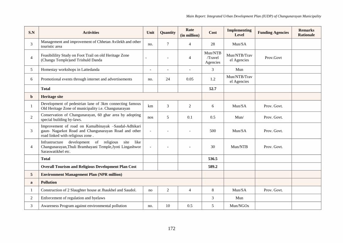
Main Report: Integrated Urban Development Plan (IUDP) of Changunarayan Municipality
172
S.N Activities Unit Quantity Rate
(in million) Cost
Implementing
Level Funding Agencies
Remarks
Rationale
3 Management and improvement of Chhetan Avilekh and other
touristic area no. 7 4 28 Mun/SA
4 Feasibilility Study on Foot Trail on old Heritage Zone
(Changu Temple)and Trishuld Danda - - 4
Mun/NTB
/Travel
Agencies
Mun/NTB/Trav
el Agencies Prov.Govt
5 Homestay workshops in Lattedanda - - - 3 Mun
6 Promotional events through internet and advertisements no. 24 0.05 1.2 Mun/NTB/Trav
el Agencies
Total 52.7
b Heritage site
1 Development of pedestrian lane of 3km connecting famous
Old Heritage Zone of municipality i.e. Changunarayan km 3 2 6 Mun/SA Prov. Govt.
2 Conservation of Changunarayan, 60 ghar area by adopting
special building by-laws. nos 5 0.1 0.5 Mun/ Prov. Govt.
3
Improvement of road on Kamalbinayak –Saudal-Adhikari
gaun- Nagarkot Road and Changunarayan Road and other
road linked with religious zone .
- - - 500 Mun/SA Prov. Govt.
4
Infrastructure development of religious site like
Changunarayan,Thuli Bramhayani Temple,Jyoti Lingashwor
Saraswatikhel etc.
- - - 30 Mun/NTB Prov. Govt.
Total 536.5
Overall Tourism and Religious Development Plan Cost 589.2
5 Environment Management Plan (NPR million)
a Pollution
1 Construction of 2 Slaughter house at Jhaukhel and Saudol. no 2 4 8 Mun/SA Prov. Govt.
2 Enforcement of regulation and byelaws 3 Mun
3 Awareness Program against environmental pollution no. 10 0.5 5 Mun/NGOs

Main Report: Integrated Urban Development Plan (IUDP) of Changunarayan Municipality
173
S.N Activities Unit Quantity Rate
(in million) Cost
Implementing
Level Funding Agencies
Remarks
Rationale
4 Greenery of cycle lane, footpath on Bojeene To Nagarkot
and Trishuld Danda km 9 3 27 Mun/SA Prov. Govt.
5 Electric public vehicle promotion 8 Mun/INGO/loc
al communities
6 Waste separation concept promotion 3 Mun/NGOs
7 Workshop on organic fertilizers from waste no. 9 0.3 3 Local
communities
8 Subsidy for Construction of toilets at rural housings no. 1000 0.001 1 Mun/NGOs
Total 58
b Conservation area
1 Tree plantation on sensitive areas along the alignment of
Manohara Khola and along the Sali Nadi no. 3000 0.0008 2.4 Mun/NGOs
2 Water source protection programs no. 10 0.5 5 Mun/NGOs
3 Provisions for eco parks at Jyotilingashwor no. 1 6 6 Mun Prov. Govt.
Total 13.4
c Urban Greenery
1 Tree plantation along major road like Changunarayan Road
,Sallaghari-Duwakot-Sangdaha Sadak ,Nagarkot Road etc no. 2500 0.0008 2
Mun/Local
NGOs
2 Organizing workshops and trainings for green roof and urban
farm times 4 0.5 2
Mun/Local
communities
3 Rain garden construction training sq.m 80 0.006 0.45 Mun/SA
Total 4.45
d Sustainable City
1 Construction of 10 km cycle lanes on major roads at
Changunarayan and along Bojeene to Nagarkot km 10 2 20 Mun/SA Prov. Govt.
2 Promotion of alternative/renewable energy 5 Mun/NGOs

Main Report: Integrated Urban Development Plan (IUDP) of Changunarayan Municipality
174
S.N Activities Unit Quantity Rate
(in million) Cost
Implementing
Level Funding Agencies
Remarks
Rationale
Total 25
Overall Environment Management Development Plan
Cosr 100.85
6 Disaster Management Plan (NPR million)
1 Subsidy for Construction of vernacular buildings in culturally
sensitive area no. 150 0.02 3 Mun/NRA Prov. Govt.
2 Reinforcement of regulation and byelaws 0.5 Mun/NRA
3 Program for afforestation and tree plantation 0.5 Mun/NGOs
4 Establishment of epidemics department on the hospital no. 1 10 10 Mun/NGOs
5 Collaboration with GoN for health service 0.5 Mun DoH
6 Relocation of squatter settlements no. 1000 0.1 100 Mun/NRA
7 Alarm system for flood in rivers no. 2 2.5 5 Mun
8 Evacuation plan promotion during emergency 1 Mun/NGOs
9 Signage for evacuation routes no. 20 0.05 1 Mun/NGOs
Overall Disaster Management Plan Cost 121.5
7 Institutional Development Plan (NPR million)
1 Establishment of new municipal building office at Kharipati no. 1 100 Mun Prov.Govt
2 Improvement of 9 ward offices no. 9 2 18 Mun Prov.Govt
3 Retrofitting of old and dilapidated government buildings no. 13 0.5 6.5 Mun/NRA
4 Training and workshops for capacity development 3 Mun
5 Introduction of digital system in 2 ward offices no 1 13 13 Mun Prov.Govt
6 Organization of public hearing and trial sessions times 2 Mun
7 Home services for needy citizens perso
n 1500 0.002 3 Mun
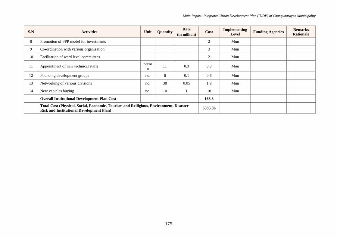
Main Report: Integrated Urban Development Plan (IUDP) of Changunarayan Municipality
175
S.N Activities Unit Quantity Rate
(in million) Cost
Implementing
Level Funding Agencies
Remarks
Rationale
8 Promotion of PPP model for investments 2 Mun
9 Co-ordination with various organization 3 Mun
10 Facilitation of ward level committees 2 Mun
11 Appointment of new technical staffs perso
n 11 0.3 3.3 Mun
12 Founding development groups no. 6 0.1 0.6 Mun
13 Networking of various divisions no. 38 0.05 1.9 Mun
14 New vehicles buying no. 10 1 10 Mun
Overall Institutional Development Plan Cost 168.3
Total Cost (Physical, Social, Economic, Tourism and Relilgious, Environment, Disaster
Risk and Institutional Development Plan) 6595.96
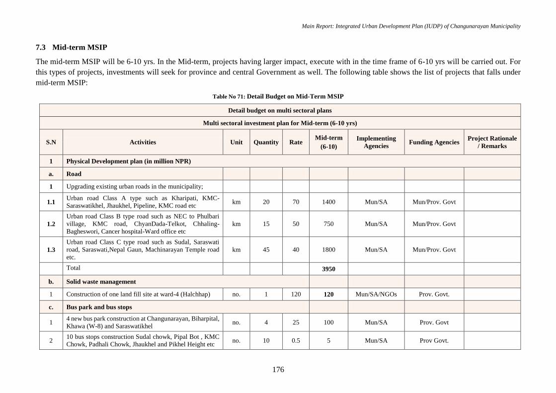
Main Report: Integrated Urban Development Plan (IUDP) of Changunarayan Municipality
176
7.3 Mid-term MSIP
The mid-term MSIP will be 6-10 yrs. In the Mid-term, projects having larger impact, execute with in the time frame of 6-10 yrs will be carried out. For
this types of projects, investments will seek for province and central Government as well. The following table shows the list of projects that falls under
mid-term MSIP:
Table No 71: Detail Budget on Mid-Term MSIP
Detail budget on multi sectoral plans
Multi sectoral investment plan for Mid-term (6-10 yrs)
S.N Activities Unit Quantity Rate Mid-term
(6-10)
Implementing
Agencies Funding Agencies
Project Rationale
/ Remarks
1 Physical Development plan (in million NPR)
a. Road
1 Upgrading existing urban roads in the municipality;
1.1 Urban road Class A type such as Kharipati, KMC-
Saraswatikhel, Jhaukhel, Pipeline, KMC road etc km 20 70 1400 Mun/SA Mun/Prov. Govt
1.2
Urban road Class B type road such as NEC to Phulbari
village, KMC road, ChyanDada-Telkot, Chhaling-
Bagheswori, Cancer hospital-Ward office etc
km 15 50 750 Mun/SA Mun/Prov. Govt
1.3
Urban road Class C type road such as Sudal, Saraswati
road, Saraswati,Nepal Gaun, Machinarayan Temple road
etc.
km 45 40 1800 Mun/SA Mun/Prov. Govt
Total 3950
b. Solid waste management
1 Construction of one land fill site at ward-4 (Halchhap) no. 1 120 120 Mun/SA/NGOs Prov. Govt.
c. Bus park and bus stops
1 4 new bus park construction at Changunarayan, Biharpital,
Khawa (W-8) and Saraswatikhel no. 4 25 100 Mun/SA Prov. Govt
2 10 bus stops construction Sudal chowk, Pipal Bot , KMC
Chowk, Padhali Chowk, Jhaukhel and Pikhel Height etc no. 10 0.5 5 Mun/SA Prov Govt.
Main Report: Integrated Urban Development Plan (IUDP) of Changunarayan Municipality
177
Detail budget on multi sectoral plans
Multi sectoral investment plan for Mid-term (6-10 yrs)
S.N Activities Unit Quantity Rate Mid-term
(6-10)
Implementing
Agencies Funding Agencies
Project Rationale
/ Remarks
Total 225
d. Water Supply
1 Construction of water tank at Saraswari Khel,
Changunarayan, Duwakot, Sudal, Chhaling no. 5 10 50 Mun/SA Prov Govt.
Water supply for
200 household
2 Construction of deep boring at Santidada no 1 8 8 Mun/SA Prov Govt.
Total 58
Overall Physical Development Plan Cost 4353
2 Social Development plan (in million NPR)
A Education
1 Construction of agro-tech department in municipality no. 1 20 13 Mun DoE
2 Distributing e-learning materials in government schools no. 20 0.7 7 Mun DoE
3 Improvements of amenities of government educational
institutes no. 20 1 12 Mun
Total 32
b Health
1 Establishment of one 30 bed Municipal level hospital at
Kharipati 170 Mun
Prov.Gov5t,
DoH,Central Govt
f Amenities
1 Formulation of 9 community libraries ward-wise no 9 3 21 Mun/NGOs Prov.Govt.
2 Construction of an City hall at Saraswatikhel sq.m 2500 0.006 8 Mun Prov.Govt.
3 Construction of 9 new parks ward-wise no 9 5 28 Mun/NGOs Prov.Govt/DoR/Ce
ntral Govt.
Main Report: Integrated Urban Development Plan (IUDP) of Changunarayan Municipality
178
Detail budget on multi sectoral plans
Multi sectoral investment plan for Mid-term (6-10 yrs)
S.N Activities Unit Quantity Rate Mid-term
(6-10)
Implementing
Agencies Funding Agencies
Project Rationale
/ Remarks
4
Solar street lamps installation along Changunarayan Road
,Sallaghari-Duwakot-Sangdaha Sadak ,Nagarkot Road
and other Feeder ,urban and district roads.
no 10000 0.015 96 Mun Prov.Govt.
Total 153
Overall Social Development Plan Cost 359
3 Economic Development plan (in million NPR)
a Agro-farming
1 Construction of irrigation canal at vegetable pocket areas Km 10 5 22 Mun/SA Prov.Govt./DoA
2 Establishment of vegetable collection centre at
Saraswatikhel no. 1 1 0.6 Mun/SA Prov.Govt.
Total 22.6
b Infrastructures
1 Construction of two vegetable market structures at Telkot
and Kharipati no. 2 50 60 Mun/MoAD Prov.Govt.
2 Construction of complex with 2 movie halls at Rakshya
Tole and Pikhel no. 2 50 50 Mun/SA Prov.Govt.
Total 110
Overall Economic Development Plan Cost 132.6
4 Tourism and Cultural Development plan (in million NPR)
a Heritage site
1 Preservation of traditional houses and encouragement of
building traditional house around religious premises - - - 15
Mun/NGOs/Local
Comunities
Preservation of
local culture and
architecture to
Main Report: Integrated Urban Development Plan (IUDP) of Changunarayan Municipality
179
Detail budget on multi sectoral plans
Multi sectoral investment plan for Mid-term (6-10 yrs)
S.N Activities Unit Quantity Rate Mid-term
(6-10)
Implementing
Agencies Funding Agencies
Project Rationale
/ Remarks
preserve local
identity for future
2 Construction of View Tower at Trishuldanda no 1 5 5
Total 20
Overall Tourism and Cultural Development Plan Cost 20
5 Environment Management Development Plan
1 Awareness Program against environmental pollution no. 5 0.5 2.5 Mun/NGOs
2 Tree plantation along the river corridor no. 1000 0.0008 0.8 Mun/NGOs
Total 3.3
6 Disaster Risk Management Plan
1 Plague control awareness programs 0.5 Mun/Local media
2 Establishment of local rescuing team no. 5 0.1 0.5 Mun/SA
3 Training for rescuers times 2 0.25 0.5 Mun/Local NGOs
Total 1.5
7 Institutional Development Plan
1 Co-ordination with various organization - - - 3 Mun
2 Conducting Training and workshops - - - 3 Mun
Total 6
Total Cost (Physical, Social, Economic, Tourism and Religious, Environment, Disaster
Risk and Institutional Development Plan) 4871.4
Main Report: Integrated Urban Development Plan (IUDP) of Changunarayan Municipality
180
7.4 Long-term MSIP
The long-term MSIP will be 11-15 yrs. In the long-term, projects having huge impact in-terms of development, execute with in the time frame of 11-15
yrs will be carried out. For this types of projects, investments will seek for many possible sources such as local bodies, donor agencies, province, central
Government and others. The following table shows the list of projects that falls under long-term MSIP:
Table No 72: Detail Budget on Long-Term MSIP
Detail budget on multi sectoral plans
Multi sectoral investment plan for Long-term (11-15 yrs.)
S.N Activities Unit Quantity Rate
(in million)
Long-term
(11-15)
Implementing
Level Funding Agencies
Project Rationale
/ Remarks
1 Physical Development plan (in million NPR)
a Road
1 Track opening of 30 km road at various wards. km 30 5 150 Mun/SA, DUDBC Prov.Govt.
2 Upgrading existing urban roads in the municipality;
2.1
Urban road Class A type such as Ganesh Mandir-
Mahankal Mandir, Saraswaikhel, Jhaukhel-Ganesh
School, Pakune Pati-Ganesh School, Om Shanti road
etc.
km 24.84 70 1738.8 Mun/SA Prov.Govt.
2.2
Urban road Class B type road such as Begbinayak
Temple, Ward office to Rakshya Tole, Nepal Gaun,
Chundevi -Kathmandu Cancer Hospital
km 27.46 50 1373 Mun/SA Prov.Govt.
2.3
Urban road Class C type road such as Khorpati -
Nagarkot Basic School, Jitpur , Ganesh Manir to
Balmekeshwor School,Chhaling , Bojeeni road etc
km 50.93 40 2037.2 Mun/SA Prov.Govt.
Total 5299
b. Sewerage and Drainage
1 Construction of one treatment plant at Halchhap (W-4) nos. 1 150 150 Mun/SA Prov.Govt
Prevention of
river pollution,
sustainable waste
water treatment
goal
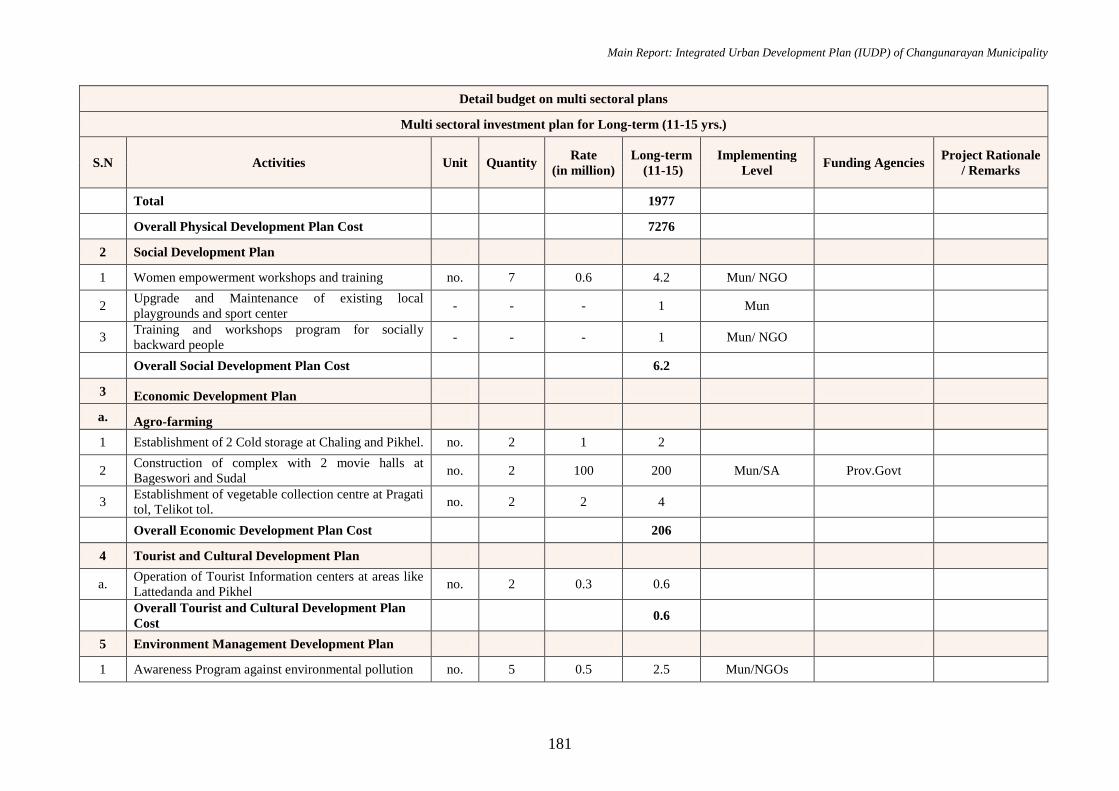
Main Report: Integrated Urban Development Plan (IUDP) of Changunarayan Municipality
181
Detail budget on multi sectoral plans
Multi sectoral investment plan for Long-term (11-15 yrs.)
S.N Activities Unit Quantity Rate
(in million)
Long-term
(11-15)
Implementing
Level Funding Agencies
Project Rationale
/ Remarks
Total 1977
Overall Physical Development Plan Cost 7276
2 Social Development Plan
1 Women empowerment workshops and training no. 7 0.6 4.2 Mun/ NGO
2 Upgrade and Maintenance of existing local
playgrounds and sport center - - - 1 Mun
3 Training and workshops program for socially
backward people - - - 1 Mun/ NGO
Overall Social Development Plan Cost 6.2
3 Economic Development Plan
a. Agro-farming
1 Establishment of 2 Cold storage at Chaling and Pikhel. no. 2 1 2
2 Construction of complex with 2 movie halls at
Bageswori and Sudal no. 2 100 200 Mun/SA Prov.Govt
3 Establishment of vegetable collection centre at Pragati
tol, Telikot tol. no. 2 2 4
Overall Economic Development Plan Cost 206
4 Tourist and Cultural Development Plan
a. Operation of Tourist Information centers at areas like
Lattedanda and Pikhel no. 2 0.3 0.6
Overall Tourist and Cultural Development Plan
Cost 0.6
5 Environment Management Development Plan
1 Awareness Program against environmental pollution no. 5 0.5 2.5 Mun/NGOs
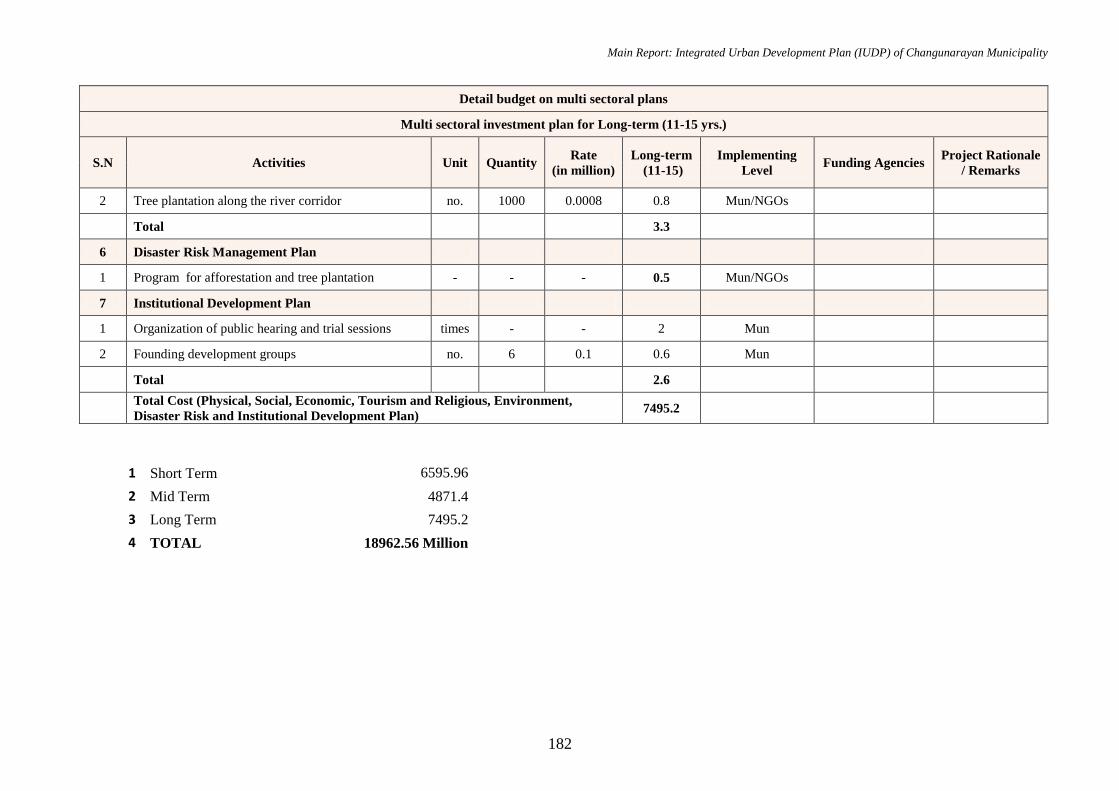
Main Report: Integrated Urban Development Plan (IUDP) of Changunarayan Municipality
182
Detail budget on multi sectoral plans
Multi sectoral investment plan for Long-term (11-15 yrs.)
S.N Activities Unit Quantity Rate
(in million)
Long-term
(11-15)
Implementing
Level Funding Agencies
Project Rationale
/ Remarks
2 Tree plantation along the river corridor no. 1000 0.0008 0.8 Mun/NGOs
Total 3.3
6 Disaster Risk Management Plan
1 Program for afforestation and tree plantation - - - 0.5 Mun/NGOs
7 Institutional Development Plan
1 Organization of public hearing and trial sessions times - - 2 Mun
2 Founding development groups no. 6 0.1 0.6 Mun
Total 2.6
Total Cost (Physical, Social, Economic, Tourism and Religious, Environment,
Disaster Risk and Institutional Development Plan) 7495.2
1 Short Term 6595.96
2 Mid Term 4871.4
3 Long Term 7495.2
4 TOTAL 18962.56 Million
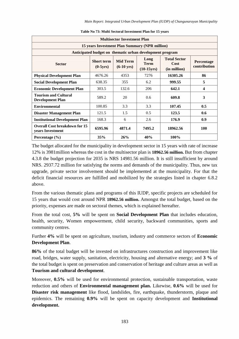
Main Report: Integrated Urban Development Plan (IUDP) of Changunarayan Municipality
183
Table No 73: Multi Sectoral Investment Plan for 15 years
Multisector Investment Plan
15 years Investment Plan Summary (NPR million)
Anticipated budget on thematic urban development program
Sector Short term
(0-5yrs)
Mid Term
(6-10 yrs)
Long
Term
(10-15yrs)
Total Sector
Cost
(in million)
Percentage
contribution
Physical Development Plan 4676.26 4353 7276 16305.26 86
Social Development Plan 638.35 355 6.2 999.55 5
Economic Development Plan 303.5 132.6 206 642.1 4
Tourism and Cultural
Development Plan 589.2 20 0.6 609.8 3
Environmental 100.85 3.3 3.3 107.45 0.5
Disaster Management Plan 121.5 1.5 0.5 123.5 0.6
Institutional Development Plan 168.3 6 2.6 176.9 0.9
Overall Cost breakdown for 15
years Investment 6595.96 4871.4 7495.2 18962.56 100
Percentage (%) 35% 26% 40% 100%
The budget allocated for the municipality in development sector in 15 years with rate of increase
12% is 3981million whereas the cost in the multisector plan is 18962.56 million. But from chapter
4.3.8 the budget projection for 2035 is NRS 14981.56 million. It is still insufficient by around
NRS. 2937.72 million for satisfying the norms and demands of the municipality. Thus, new tax
upgrade, private sector involvement should be implemented at the municipality. For that the
deficit financial resources are fulfilled and mobilized by the strategies listed in chapter 6.8.2
above.
From the various thematic plans and programs of this IUDP, specific projects are scheduled for
15 years that would cost around NPR 18962.56 million. Amongst the total budget, based on the
priority, expenses are made on sectoral themes, which is explained hereafter.
From the total cost, 5% will be spent on Social Development Plan that includes education,
health, security, Women empowerment, child security, backward communities, sports and
community centres.
Further 4% will be spent on agriculture, tourism, industry and commerce sectors of Economic
Development Plan.
86% of the total budget will be invested on infrastructures construction and improvement like
road, bridges, water supply, sanitation, electricity, housing and alternative energy; and 3 % of
the total budget is spent on preservation and conservation of heritage and culture areas as well as
Tourism and cultural development.
Moreover, 0.5% will be used for environmental protection, sustainable transportation, waste
reduction and others of Environmental management plan. Likewise, 0.6% will be used for
Disaster risk management like flood, landslides, fire, earthquake, thunderstorm, plaque and
epidemics. The remaining 0.9% will be spent on capacity development and Institutional
development.
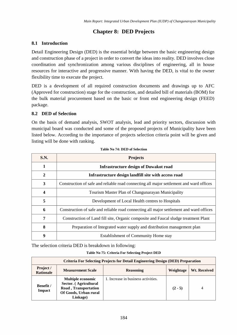
Main Report: Integrated Urban Development Plan (IUDP) of Changunarayan Municipality
184
Chapter 8: DED Projects
8.1 Introduction
Detail Engineering Design (DED) is the essential bridge between the basic engineering design
and construction phase of a project in order to convert the ideas into reality. DED involves close
coordination and synchronization among various disciplines of engineering, all in house
resources for interactive and progressive manner. With having the DED, is vital to the owner
flexibility time to execute the project.
DED is a development of all required construction documents and drawings up to AFC
(Approved for construction) stage for the construction, and detailed bill of materials (BOM) for
the bulk material procurement based on the basic or front end engineering design (FEED)
package.
8.2 DED of Selection
On the basis of demand analysis, SWOT analysis, lead and priority sectors, discussion with
municipal board was conducted and some of the proposed projects of Municipality have been
listed below. According to the importance of projects selection criteria point will be given and
listing will be done with ranking.
Table No 74: DED of Selection
S.N. Projects
1 Infrastructure design of Duwakot road
2 Infrastructure design landfill site with access road
3 Construction of safe and reliable road connecting all major settlement and ward offices
4 Tourism Master Plan of Changunarayan Municipality
5 Development of Local Health centres to Hospitals
6 Construction of safe and reliable road connecting all major settlement and ward offices
7 Construction of Land fill site, Organic composite and Faucal sludge treatment Plant
8 Preparation of Integrated water supply and distribution management plan
9 Establishment of Community Home stay
The selection criteria DED is breakdown in following:
Table No 75: Criteria For Selecting Project DED
Criteria For Selecting Projects for Detail Engineering Design (DED) Preparation
Project /
Rationale Measurement Scale Reasoning Weightage Wt. Received
Benefit /
Impact
Multiple economic
Sector. ( Agricultural
Road , Transportation
Of Goods, Urban rural
Linkage)
1. Increase in business activities.
(2 - 5) 4
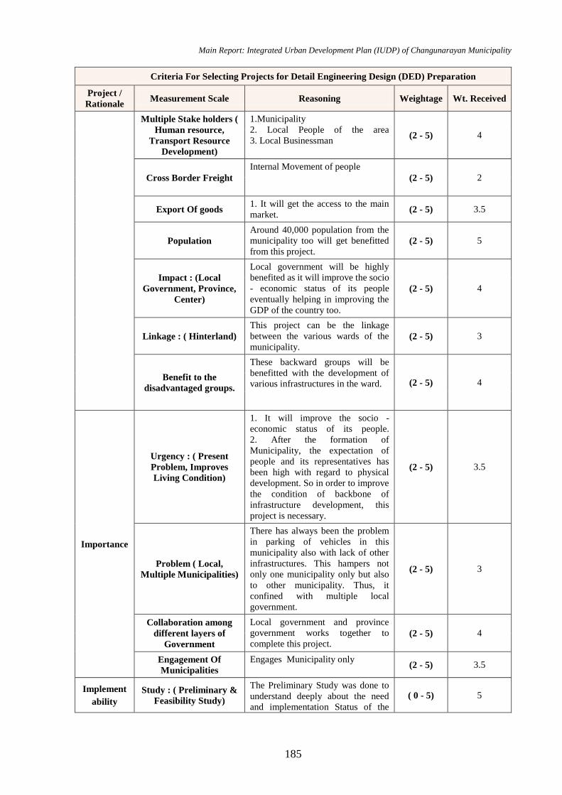
Main Report: Integrated Urban Development Plan (IUDP) of Changunarayan Municipality
185
Criteria For Selecting Projects for Detail Engineering Design (DED) Preparation
Project /
Rationale Measurement Scale Reasoning Weightage Wt. Received
Multiple Stake holders (
Human resource,
Transport Resource
Development)
1.Municipality
2. Local People of the area
3. Local Businessman (2 - 5) 4
Cross Border Freight
Internal Movement of people
(2 - 5) 2
Export Of goods 1. It will get the access to the main
market. (2 - 5) 3.5
Population
Around 40,000 population from the
municipality too will get benefitted
from this project. (2 - 5) 5
Impact : (Local
Government, Province,
Center)
Local government will be highly
benefited as it will improve the socio
- economic status of its people
eventually helping in improving the
GDP of the country too.
(2 - 5) 4
Linkage : ( Hinterland)
This project can be the linkage
between the various wards of the
municipality. (2 - 5) 3
Benefit to the
disadvantaged groups.
These backward groups will be
benefitted with the development of
various infrastructures in the ward. (2 - 5) 4
Importance
Urgency : ( Present
Problem, Improves
Living Condition)
1. It will improve the socio -
economic status of its people.
2. After the formation of
Municipality, the expectation of
people and its representatives has
been high with regard to physical
development. So in order to improve
the condition of backbone of
infrastructure development, this
project is necessary.
(2 - 5) 3.5
Problem ( Local,
Multiple Municipalities)
There has always been the problem
in parking of vehicles in this
municipality also with lack of other
infrastructures. This hampers not
only one municipality only but also
to other municipality. Thus, it
confined with multiple local
government.
(2 - 5) 3
Collaboration among
different layers of
Government
Local government and province
government works together to
complete this project. (2 - 5) 4
Engagement Of
Municipalities
Engages Municipality only (2 - 5) 3.5
Implement
ability
Study : ( Preliminary &
Feasibility Study)
The Preliminary Study was done to
understand deeply about the need
and implementation Status of the
( 0 - 5) 5
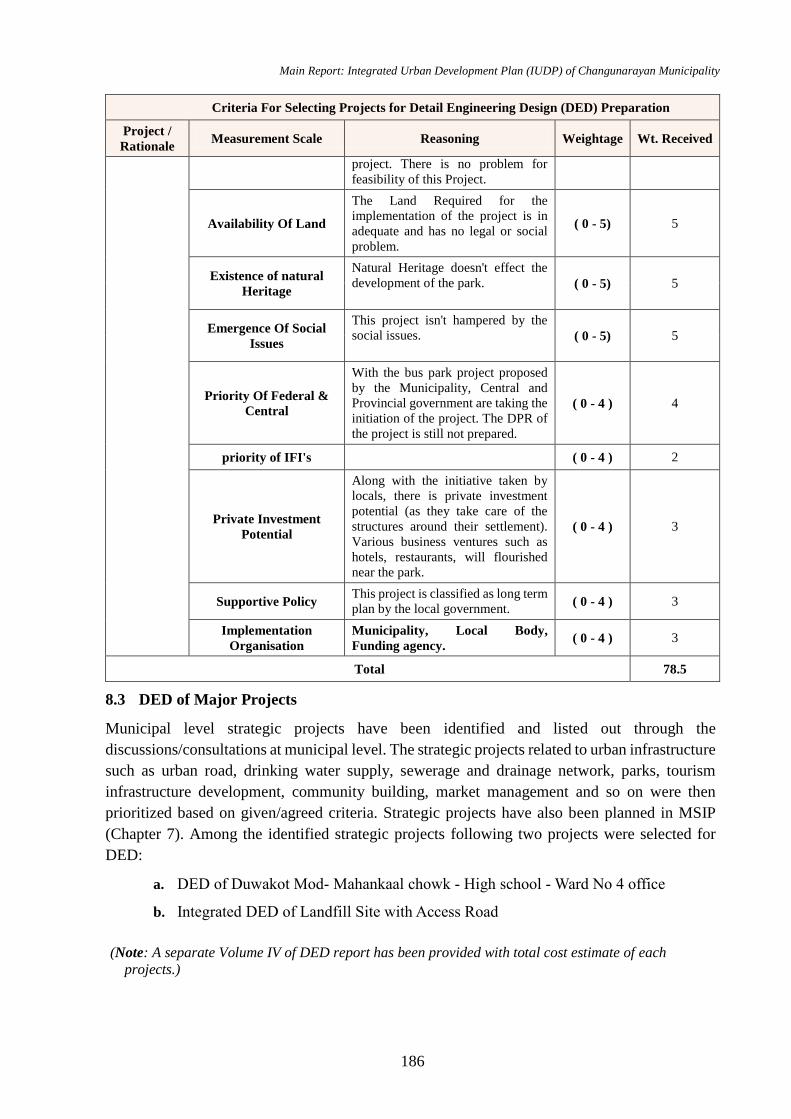
Main Report: Integrated Urban Development Plan (IUDP) of Changunarayan Municipality
186
Criteria For Selecting Projects for Detail Engineering Design (DED) Preparation
Project /
Rationale Measurement Scale Reasoning Weightage Wt. Received
project. There is no problem for
feasibility of this Project.
Availability Of Land
The Land Required for the
implementation of the project is in
adequate and has no legal or social
problem.
( 0 - 5) 5
Existence of natural
Heritage
Natural Heritage doesn't effect the
development of the park. ( 0 - 5) 5
Emergence Of Social
Issues
This project isn't hampered by the
social issues. ( 0 - 5) 5
Priority Of Federal &
Central
With the bus park project proposed
by the Municipality, Central and
Provincial government are taking the
initiation of the project. The DPR of
the project is still not prepared.
( 0 - 4 ) 4
priority of IFI's ( 0 - 4 ) 2
Private Investment
Potential
Along with the initiative taken by
locals, there is private investment
potential (as they take care of the
structures around their settlement).
Various business ventures such as
hotels, restaurants, will flourished
near the park.
( 0 - 4 ) 3
Supportive Policy This project is classified as long term
plan by the local government. ( 0 - 4 ) 3
Implementation
Organisation
Municipality, Local Body,
Funding agency. ( 0 - 4 ) 3
Total 78.5
8.3 DED of Major Projects
Municipal level strategic projects have been identified and listed out through the
discussions/consultations at municipal level. The strategic projects related to urban infrastructure
such as urban road, drinking water supply, sewerage and drainage network, parks, tourism
infrastructure development, community building, market management and so on were then
prioritized based on given/agreed criteria. Strategic projects have also been planned in MSIP
(Chapter 7). Among the identified strategic projects following two projects were selected for
DED:
a. DED of Duwakot Mod- Mahankaal chowk - High school - Ward No 4 office
b. Integrated DED of Landfill Site with Access Road
(Note: A separate Volume IV of DED report has been provided with total cost estimate of each
projects.)
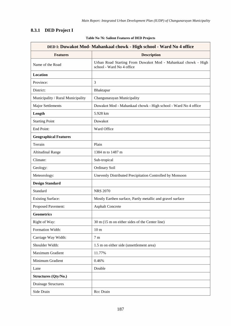
Main Report: Integrated Urban Development Plan (IUDP) of Changunarayan Municipality
187
8.3.1 DED Project I
Table No 76: Sailent Features of DED Projects
DED I: Duwakot Mod- Mahankaal chowk - High school - Ward No 4 office
Features Description
Name of the Road Urban Road Starting From Duwakot Mod - Mahankaal chowk - High
school - Ward No 4 office
Location
Province: 3
District: Bhaktapur
Municipality / Rural Municipality Changunarayan Municipality
Major Settlements Duwakot Mod - Mahankaal chowk - High school - Ward No 4 office
Length 5.928 km
Starting Point Duwakot
End Point: Ward Office
Geographical Features
Terrain Plain
Altitudinal Range 1384 m to 1487 m
Climate: Sub-tropical
Geology: Ordinary Soil
Meteorology: Unevenly Distributed Precipitation Controlled by Monsoon
Design Standard
Standard NRS 2070
Existing Surface: Mostly Earthen surface, Partly metallic and gravel surface
Proposed Pavement: Asphalt Concrete
Geometrics
Right of Way: 30 m (15 m on either sides of the Center line)
Formation Width: 10 m
Carriage Way Width: 7 m
Shoulder Width: 1.5 m on either side (unsettlement area)
Maximum Gradient 11.77%
Minimum Gradient 0.46%
Lane Double
Structures (Qty/No.)
Drainage Structures
a) Side Drain Rcc Drain
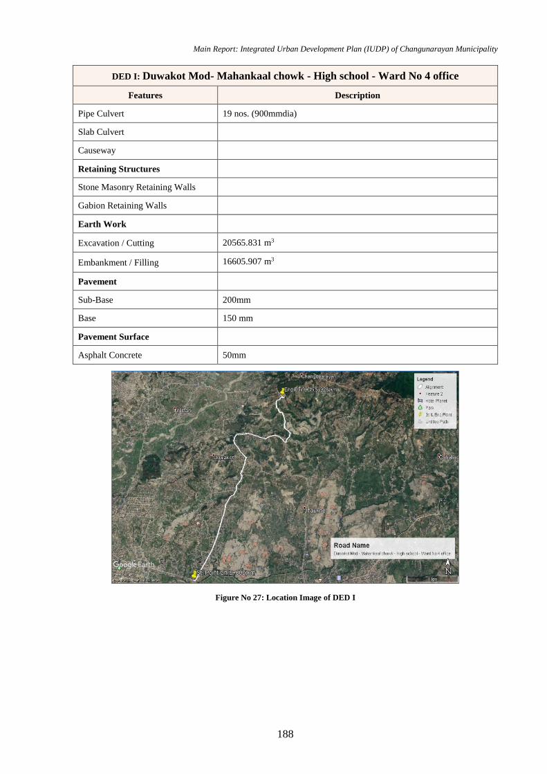
Main Report: Integrated Urban Development Plan (IUDP) of Changunarayan Municipality
188
DED I: Duwakot Mod- Mahankaal chowk - High school - Ward No 4 office
Features Description
b) Pipe Culvert 19 nos. (900mmdia)
c) Slab Culvert
d) Causeway
Retaining Structures
a) Stone Masonry Retaining Walls
b) Gabion Retaining Walls
Earth Work
Excavation / Cutting 20565.831 m3
Embankment / Filling 16605.907 m3
Pavement
Sub-Base 200mm
Base 150 mm
Pavement Surface
Asphalt Concrete 50mm
Figure No 27: Location Image of DED I
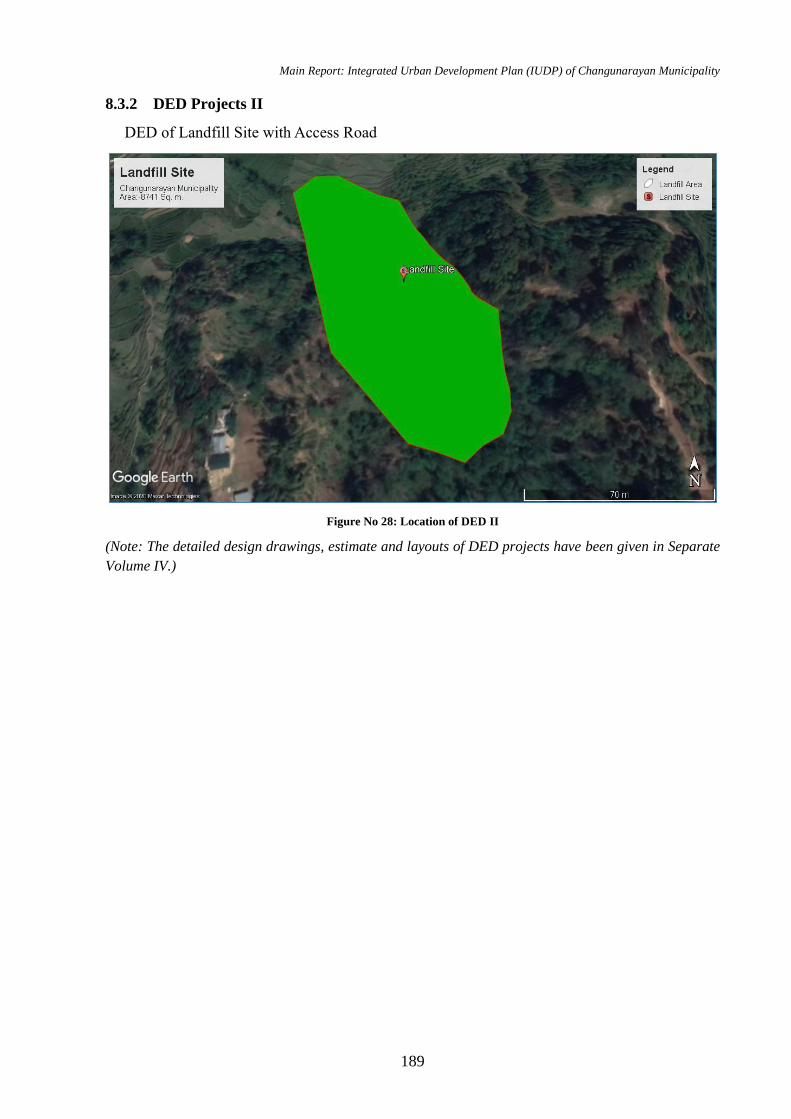
Main Report: Integrated Urban Development Plan (IUDP) of Changunarayan Municipality
189
8.3.2 DED Projects II
DED of Landfill Site with Access Road
Figure No 28: Location of DED II
(Note: The detailed design drawings, estimate and layouts of DED projects have been given in Separate
Volume IV.)
Main Report: Integrated Urban Development Plan (IUDP) of Changunarayan Municipality
190
Bibliography
Dhakal, R. (2004). Urban Land Development Planning Effort in Kathmandu Valley. Tokyo:
Asian Area Studies of City Planning.
Goh, L. E. (2006). Planning That Works: Housing Policy and Economic Development in
Singapore. Journal of Planning Education and Research, 7(3), 147-162.
GoN, MoPPW. (2009). National Urban Water Supply and Sanitation Sector Policy - Final Draft.
GoN, MOPPW.
gtz: udle. (2006). Responding to Urban Development Needs in Nepal. Kathmandu: Format
Printing Press.
Hardy, D. (2011). Garden Cities: Practical Concept, Elusive Reality. Journal of Planning History.
Heritage Foundation: Letchworth Garden City. (29 10, 2015). Retrieved from
http://www.letchworth.com/heritage-foundation/altering-your-home
Irwin, D. M., & Joshi, J. (1996). Integrated Action Planning: The experience in Nepal. In K.
Singh, F. Steinberg, & N. v. Einsiedal (Eds.), Integrated Urban Infrastructure
Development in Asia (pp. 193-211). New Delhi: Oxford & IBH Publishing Co. Pvt. Ltd.
Joshi, J. (2008). Planning Approaches in Nepal (1st ed.). Kathmandu: Lajmina Joshi.
K C, A. (2015). Role of Good Urban Governance for Comprehensive Planning in Nepal: Actors
and Participation. Unpublished Master Thesis. Lalitpur: Tribhuwan University.
LSGA. (1977). Local Self Governance Act, 2055. Kathmandu: Government of Nepal.
Mattingly, M., & Winarso, H. (19 August, 1999). INTEGRATED ACTION PLANNING IN
NEPAL: SPATIAL AND INVESTMENT PLANNING IN URBAN AREAS. Retrieved 2 8,
2014, from http://www.ucl.ac.uk/dpu-
projects/drivers_urb_change/urb_infrastructure/pdf_city_planning/DPU_Mattingly_Nep
al_Spatial_Planning.pdf
Ministry of Local development. (2059). Nagarpalikaka lagi aawadik yojana tarjuma nirdeshika
[ Antim Masyauda]. Kathmandu.
North Hertfordshire District Council. (2007). Letchworth Garden City Town Centre Strategy :
Supplementary Planning Document.
Paudyal, D. P. (2001). The Concept of Decentralized System of Governance in the Context of
Balanced Development of Nepal . Retrieved 15 9, 2014, from
http://www.nepaldemocracy.org/institutions/concept_decentralization.htm
Reid, E. O. (1997). Strategic Utilization of Internet: Singapore’s IT2000 and Library 2000 Plans.
IFLA Journal, 23(3), 203-210.
School of Planning and Architecture. (2010). Alternative Approaches to Master Plan. Delhi:
THESIS (Unpublished). Retrieved 6 8, 2014, from http://www.spa.ac.in/Alternative-to-
Master-Plan-Apporach.pdf
Main Report: Integrated Urban Development Plan (IUDP) of Changunarayan Municipality
191
Singapore Government. (12 February, 2015). Urban Redevelopment Authority. Retrieved 12
February, 2015, from http://www.ura.gov.sg/uol/concept-plan.aspx?p1=View-Concept-
Plan&p2=introduction-to-concept-plan
STEERING COMMITTEE FOR NATIONAL SANITATION ACTION. (2011). SANITATION
AND HYGIENE MASTER PLAN. GoN.
Tiwari, S. R. (1999). Kathmandu Valley Urban Capital Region and Historical Urbanism,
Historical Environment Management : Lessons from History1. Bankok.
Town and Country Planning Association. (2007). Best Practice in Urban Extensions and New
Settlements : A report on emerging good practice. London: RAP Spiderweb Ltd.
(2017). UGIIP SundarHaraicha. Morang: Sundarharaicha Municipality. Retrieved 29 june, 2018
Wapwera, S., & Egbu, C. (2013). Master Planning System: Constraints for Planning Authorities
in Jos Metropolis, Nigeria. The Built & Human Environment Review, 6.
Yuen, B. (1996). Creating the Garden City: The Singapore Experience. Urban Studies, 33(6),
955-966.
Municipal Annual Report 2075/76
Municipal profile 2075, CBs 2068