
INTEGRATED URBAN FLOOD RISK MANAGEMENT APPROACH IN CONTEXT OF UNCERTAINTIES: CASE STUDY HO CHI MINH...
10
Accepted paper for La Houille Blanche 1 INTEGRATED URBAN FLOOD RISK MANAGEMENT APPROACH IN CONTEXT OF UNCERTAINTIES: CASE STUDY HO CHI MINH CITY Long Phi HO (1) , Thong NGUYEN (1) , Nguyen Xuan Quang CHAU (1) and Kim Dan NGUYEN (2) (1) Centre of Water Management and Climate Change - Viet Nam National University Ho Chi Minh City, Viet Nam, [email protected] (2) Université Paris-Est, Laboratory for Hydraulics Saint-Venant, ENPC, EDF R&D, CETMEF, 78400 Chatou, France, [email protected] The paper deals with an Integrated Urban Flood Management Strategy for Ho Chi Minh City to adapt with uncertainties of both natural and anthropogenic impacts. Observed data analysis and hydraulic simulations were utilised to prove the significance of such uncertainties. Hydraulic simulations proved that conventional solutions (e.g. storm sewers, dikes and tide gates) may not be effective to cope with rainfall intensity increase and land subsidence. Beyond constructional intervention that will be still required to improve, soonest as possible, the flood control capacity of the city to a reasonable level, integrated plans should be also considered in order to encourage sustainable urban development initiatives and to mainstream current investments so that irreversible and vulnerable development could be avoided. A 3-component strategy was also suggested and analysed for the case study of Ho Chi Minh City, in which Prevention, Adaptation and Resilience should be considered and prioritised. Key words: Urban flood, Uncertainties, Resilience, Integrated flood management Approche de gestion intégrée des risques des inondations urbaines dans un contexte d’incertitudes : Cas d’étude de Ho-Chi-Minh ville Le document discute une stratégie de gestion intégrée des crues en milieu urbain de Ho-Chi-Minh Ville en s'adaptant aux incertitudes des deux impacts naturels et anthropiques. Des données observées et des résultats de simulations hydrauliques ont été utilisés afin de prouver l'importance de ces incertitudes. Des simulations hydrauliques ont montré que les mesures classiques (par exemple les égouts, les digues et les portes à flot) ne peuvent être efficaces pour faire face à l'augmentation des intensités de précipitation et à l’affaissement de terrains. Outre l’intervention par des ouvrages hydrauliques qui sera encore nécessaire pour améliorer, le plus tôt possible, la capacité du contrôle des inondations dans la ville à un niveau raisonnable, des plans intégrés devraient également être pris en compte afin d'encourager les initiatives de développement urbain durable et d'intégrer les investissements actuels de sorte que les développements irréversibles et vulnérables puissant être évités. Une stratégie à 3 composants a également été suggérée et analysée pour le cas d'étude de Ho-Chi-Minh Ville, dans laquelle la prévention, l'adaptation et la résilience doivent être considérées et mises en priorité. Mots-clés: Inondation urbaine, Incertitudes, Résilience, Gestion intégrée des crues I. INTRODUCTION Ho-Chi-Minh City (HCMC), economic capital of Vietnam, is in permanence jeopardised by rainfall increase and high water levels in rivers. On November 13 2008, high tidal surges, plus the discharge of water from the Dau Tieng Reservoir, breached several sections of the Saigon River dyke system and flooded many parts of HCMC. This caused traffic chaos on major roads in the city centre. Annual direct and indirect economic loss was estimated at tens million $US.
Transcript of INTEGRATED URBAN FLOOD RISK MANAGEMENT APPROACH IN CONTEXT OF UNCERTAINTIES: CASE STUDY HO CHI MINH...
Accepted paper for La Houille Blanche
1
INTEGRATED URBAN FLOOD RISK MANAGEMENT
APPROACH IN CONTEXT OF UNCERTAINTIES:
CASE STUDY HO CHI MINH CITY
Long Phi HO(1)
, Thong NGUYEN(1)
, Nguyen Xuan Quang CHAU(1)
and Kim Dan NGUYEN(2)
(1)
Centre of Water Management and Climate Change - Viet Nam National University Ho Chi Minh City, Viet Nam,
Université Paris-Est, Laboratory for Hydraulics Saint-Venant, ENPC, EDF R&D, CETMEF, 78400 Chatou, France,
The paper deals with an Integrated Urban Flood Management Strategy for Ho Chi Minh City to adapt with uncertainties
of both natural and anthropogenic impacts. Observed data analysis and hydraulic simulations were utilised to prove the
significance of such uncertainties. Hydraulic simulations proved that conventional solutions (e.g. storm sewers, dikes
and tide gates) may not be effective to cope with rainfall intensity increase and land subsidence.
Beyond constructional intervention that will be still required to improve, soonest as possible, the flood control capacity
of the city to a reasonable level, integrated plans should be also considered in order to encourage sustainable urban
development initiatives and to mainstream current investments so that irreversible and vulnerable development could be
avoided.
A 3-component strategy was also suggested and analysed for the case study of Ho Chi Minh City, in which Prevention,
Adaptation and Resilience should be considered and prioritised.
Key words:
Urban flood, Uncertainties, Resilience, Integrated flood management
Approche de gestion intégrée des risques des inondations urbaines dans
un contexte d’incertitudes : Cas d’étude de Ho-Chi-Minh ville
Le document discute une stratégie de gestion intégrée des crues en milieu urbain de Ho-Chi-Minh Ville en s'adaptant
aux incertitudes des deux impacts naturels et anthropiques. Des données observées et des résultats de simulations
hydrauliques ont été utilisés afin de prouver l'importance de ces incertitudes. Des simulations hydrauliques ont montré
que les mesures classiques (par exemple les égouts, les digues et les portes à flot) ne peuvent être efficaces pour faire
face à l'augmentation des intensités de précipitation et à l’affaissement de terrains.
Outre l’intervention par des ouvrages hydrauliques qui sera encore nécessaire pour améliorer, le plus tôt possible, la
capacité du contrôle des inondations dans la ville à un niveau raisonnable, des plans intégrés devraient également être
pris en compte afin d'encourager les initiatives de développement urbain durable et d'intégrer les investissements actuels
de sorte que les développements irréversibles et vulnérables puissant être évités.
Une stratégie à 3 composants a également été suggérée et analysée pour le cas d'étude de Ho-Chi-Minh Ville, dans
laquelle la prévention, l'adaptation et la résilience doivent être considérées et mises en priorité.
Mots-clés:
Inondation urbaine, Incertitudes, Résilience, Gestion intégrée des crues
I. INTRODUCTION
Ho-Chi-Minh City (HCMC), economic capital of Vietnam, is in permanence jeopardised by rainfall increase
and high water levels in rivers. On November 13 2008, high tidal surges, plus the discharge of water from
the Dau Tieng Reservoir, breached several sections of the Saigon River dyke system and flooded many parts
of HCMC. This caused traffic chaos on major roads in the city centre. Annual direct and indirect economic
loss was estimated at tens million $US.

Accepted paper for La Houille Blanche
2
The paper aims to present an Integrated Urban Flood Management (IUFM) Strategy for Ho Chi Minh City to
adapt with Uncertainties of both natural and anthropogenic impacts. Section II describes the hard measures
existing in the City. Section III analyses the main features of uncertainties in climate changes and in
uncontrolled urbanisation. Section IV proposes the IUFM strategies for HCMC as well as the main results of
risk analysis. The main conclusions withdrawn from this work are given in Section V.
II. HARD MEASURES BACKGROUND
I.1 JICA plan: Storm sewer upgrade
Floods/Inundations of Ho Chi Minh City (HCMC) have been caused by some concurrent impacts: upstream
flood, tide, local heavy rainfall (HR) and land subsidence (LS), which have exposed to poor investment in
flood management infrastructures during last decades (Fig. 1).
Figure 1: Hydrological impacts on HCMC area
Since early 2000s, flood sites have been detected over the city, reaching over 150 in 2007 (Fig. 2). In 2001,
the initial attempt to improve urban drainage systems was conducted with the first master plan (so called
Japan International Cooperation Agency JICA- plan). The master plan that based on historical data and
focused mostly on storm sewers upgrade and local landfill, made a framework for some major interventions
in the Central sub-catchment of 100 km2. These USD-multi-million projects following the first master plan
have been implemented since 2003, improving the urban inundation substantially at 70% of inundated sites
in 2011.
I.2 Tide control plan
Since mid 1990s, statistical analysis of hydrological data collected from stations scattered around HCMC
provided evidences of hydrological anomalies (see Section III-1 and Fig. 4 and Fig. 5).
The concerns of climate changes (sea level rise and rainfall increase) have urged further efforts of flood
management and a tide control strategy (so called Ministry of Agriculture and Rural Development, or in
short, MARD plan) was approved in 2008. This plan aims to protect HCMC by a large polder system
composed of 170 km of dikes, 12 heavy tidal gates and hundreds of smaller ones. The system would aim to
maintain water level within the polder by 1.0m AMSL (Above Mean Sea Level) in order to facilitate storm

Accepted paper for La Houille Blanche
3
sewer discharge against backwater (Fig. 3). The plan is being under technical design and still raising
controversies on cost/benefit and timing.
Figure 2: Evolution of Flood/Inundation sites
Legend:
Proposed dike
River
Tidal gate
Figure 3: Proposed tide control plan of HCMC (MARD plan, 2008)
0
5
10
15
20
25
30
35
0
20
40
60
80
100
120
140
160
180
2003 2004 2005 2006 2007 2008 2009 2010 2011
Count of rainfallevent with volume
> 50mm
Water level
Year
Count of Flood sites
Central districts Recently Urbanized Districts Z (cm) R>50mm
Accepted paper for La Houille Blanche
4
III. UNCERTAINTY
III.1 Hydrology
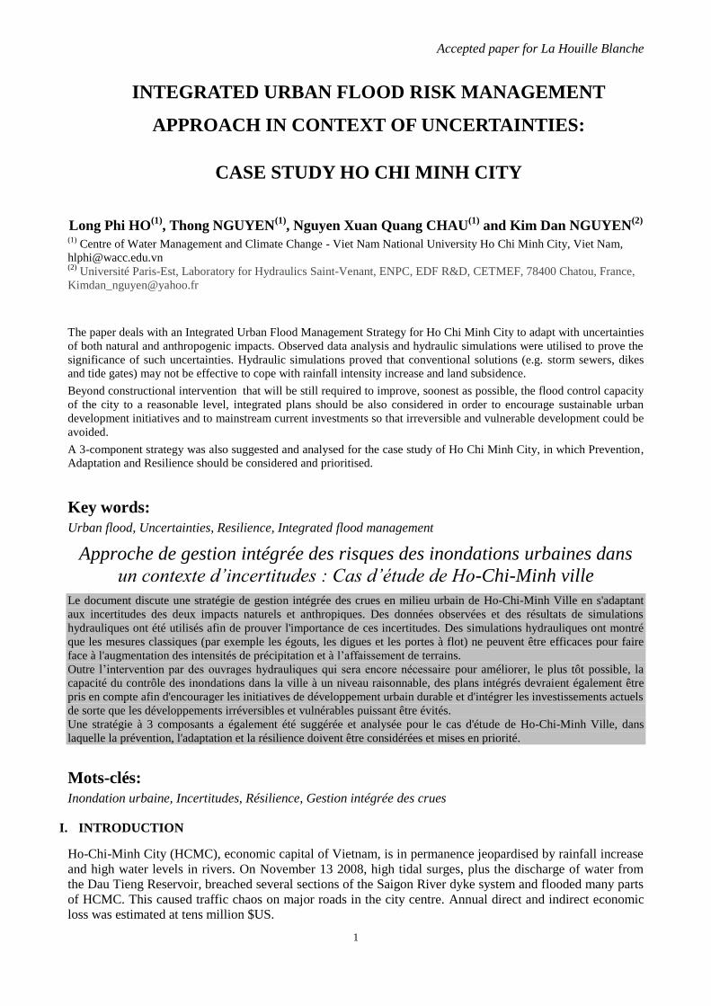
Although observations have showed water level rises at hydrological gauges around Ho Chi Minh City (Fig.
4 and 5), a 10-year moving average of trend slope of water levels has raised questions about the actual
impacts of sea level rise on hydrological anomalies around Ho Chi Minh City. While the increasing rate of
sea levels has been slightly reduced or even unchanged since mid 1990s, water levels in rivers have kept on
accelerating (Fig. 5).
The increasing trend of water levels around the City has accelerated since mid 1980s, which may be
explained by the development of water management practices and landfills to converse lowlands and water
bodies into residential and industrial facilities (see Section III-2 and Fig.7-8).
Figure 4: Water levels in the Sai Gon river (Phu An, Thu Dau Mot, Nha Be) and at the sea (Vam Kenh)
Figure 5: Trend slope of 10-year-averaged water levels in Ho Chi Minh City area and at the sea (Vam Kenh)
During the last 60 years, the rainfall intensity has kept on increasing (Fig. 6), whereas the recurrence period
has reduced with time. The lower performance of flood control system compared with expected as observed
at some flood management projects in Ho Chi Minh City (such as Nhieu Loc-Thi Nghe- and Tau Hu Ben
Nghe storm water upgrading projects) is one of the most concerned topics on urban flood structure design.
The above-mentioned projects were designed based on data collected in the period of 1952-1998, for which
90mm-storm event (in 3 hours) respect to 3-year recurrence was applied. Observed rainfall data during the
period of 2000-2010, however, show that 100mm-storm event in 3 hours occurred almost every year (Fig. 7).
100
110
120
130
140
150
160
170
180
1980 1990 2000 2010 2020
Wat
er
leve
l (cm
)
Year
Yearly max water levels
Phu An
Thu Dau Mot
Nha Be
Sea
0.000
0.500
1.000
1.500
2.000
Tre
nd
Slo
pe
Trend slope of water levels
Phu An
Thu Dau Mot
Nha Be
Vam Kenh
Thu Dau Mot
Phu An
Nha Be
Vam Kenh (sea)

Accepted paper for La Houille Blanche
5
Figure 6: Rainfall intensity increase as observed at HCMC
Figure 7: Rainfall recurrence as observed at HCMC
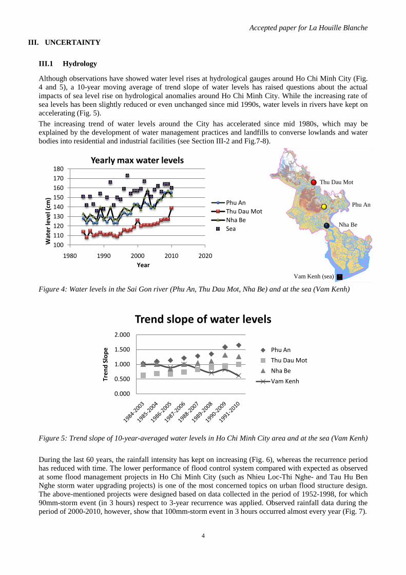
III.2 Urbanisation and lowland invasion
The urbanisation has been developing since 1990s, making a serious change in water body and pervious
areas of HCMC as shown in figure 8 and 9. About 50,000 ha of water body, wetland and pervious areas have
been replaced by impervious areas during the last 25 years.
The spatial plan of HCMC, revised in 2010, would allow an expansion of the city up to 850 km2, i.e. 30%
higher than the scope of JICA plan (650 km2). In 2025, the population living in the HCMC region would be
20-22 millions.
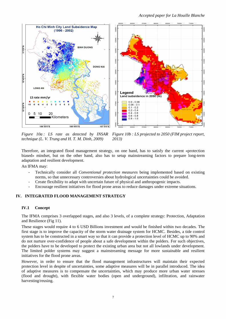
III.3 Land subsidence
During the last decades, ground-water exploitations in HCMC have increased sharply, raising serious
concerns in LS. Up to hundred thousand m3.day
-1 of ground water has been extracted by both legal and
illegal ways, resulted in remarkable reducing of ground water levels in Ho Chi Minh City. An investigation
using InSAR (Interferometric Synthetic Aperture Radar) technique reported in 2009 (L. V. Trung and H. T.
M. Dinh) as shown in figure 10a, revealed a large scale LS in HCMC with an average rate of 1-2 cm per year
since 1995. This has made a “virtual rise of water level” in the Saigon River up to 3 cm per year (in term of
resulted flood depths) in some parts of the City over the last decades.
y = 0.777x - 1453.5
020406080
100120140160180
Xm
ax (
mm
)
Year
Yearly max Rainfall eventTan Son Hoa station
y = 0.0383x + 0.1405
y = 0.02x + 0.0514
y = 0.0135x + 0.04190
0.2
0.4
0.6
0.8
1
1.2
Ret
urn
Fre
qu
ency
Period
Moving Average of Rainfall RecurrenceTan Son Hoa station
R>100mm
R>115mm
R>130mm
Accepted paper for La Houille Blanche
6
.
Figure 8: The reduction of wetland/water body and pervious areas in HCMC.
III.4 Uncertainties and planning implication
Rainfall increasing, water level rise, LS and urbanisation are among uncertainties, the ones that are likely to
increase flooding frequency of HCMC in future. Under such uncertainties, conventional approaches based
only on hard measures would be inadequate and risky. Flood-control structures, which are designed with
limited criteria and by probabilistic approaches based on incomplete historical data, would be vulnerable to
cope with extreme events enhanced by climate change. Therefore, an Integrated Flood Management
Approach (IFMA) is suggested for HCMC.
Water body
Rice
field/Grass
Tree
Bare soil
Residence
Figure 9: Land use change of HCMC (left: 1985, right: 2010)
For the effectiveness of the strategy, the IFMA should consider not only Cost/Benefit and Technical
feasibility but also Social capacities like Governance and Perception. It is more and more recognised that the
gaps between current capacities and requirements may determine the feasibility of a project. Advanced
solutions, which are successfully applied in developed countries, may not be directly applied to developing
countries due to lacking of appropriate Governance and Perception.
0
20000
40000
60000
80000
100000
120000
1985 1989 1995 2000 2005 2010
Ha
Land coverage changeHo Chi Minh City
Water body
Pervious
Accepted paper for La Houille Blanche
7
Figure 10a : LS rate as detected by INSAR
technique (L. V. Trung and H. T. M. Dinh, 2009)
Figure 10b : LS projected to 2050 (FIM project report,
2013)
Therefore, an integrated flood management strategy, on one hand, has to satisfy the current «protection
biased» mindset, but on the other hand, also has to setup mainstreaming factors to prepare long-term
adaptation and resilient development.
An IFMA may:
- Technically consider all Conventional protection measures being implemented based on existing
norms, so that unnecessary controversies about hydrological uncertainties could be avoided.
- Create flexibility to adapt with uncertain future of physical and anthropogenic impacts.
- Encourage resilient initiatives for flood prone areas to reduce damages under extreme situations.
IV. INTEGRATED FLOOD MANAGEMENT STRATEGY
IV.1 Concept
The IFMA comprises 3 overlapped stages, and also 3 levels, of a complete strategy: Protection, Adaptation
and Resilience (Fig 11).
These stages would require 4 to 6 USD Billions investment and would be finished within two decades. The
first stage is to improve the capacity of the storm water drainage system for HCMC. Besides, a tide control
system has to be constructed in a smart way so that it can provide a protection level of HCMC up to 90% and
do not nurture over-confidence of people about a safe development within the polders. For such objectives,
the polders have to be developed to protect the existing urban area but not all lowlands under development.
The limited polder systems may suggest a mainstreaming message for more sustainable and resilient
initiatives for the flood prone areas.
However, in order to ensure that the flood management infrastructures will maintain their expected
protection level in despite of uncertainties, some adaptive measures will be in parallel introduced. The idea
of adaptive measures is to compensate the uncertainties, which may produce more urban water stresses
(flood and drought), with flexible water bodies (open and underground), infiltration, and rainwater
harvesting/reusing.

Accepted paper for La Houille Blanche
8
Figure 11: IFMA components
Such measures are mostly multi-stakeholder involvements and will be gradually developed along with city’s
housing development through appropriate legal frameworks. As the first stage mostly focuses on
constructional intervention using public resources, the second stage is a multi-stakeholder involvement
process, which is enabled through social capacity improvements.
The Prevention and Adaptation measures will not be designed to cope with extreme hazards. However, in
most cases the Protection system could nurture overconfidence of policy makers and Communities and
indirectly encourage intensive development in “assumed-to-be-protected” flood prone areas. Therefore, in
the IFMA for HCMC, the polder system according to the MARD plan should be revised to provide flood
diversion/retention for urgent cases. While sea level rise is still a potential threat, when all reservoirs reach
their full storage capacity, upcoming monsoon rains in upstream catchment would be a real danger now. As
extreme hazards could be a “tomorrow” problem, resilient development will be established to reduce
damages in the flood-prone areas under extreme events. This component requires high awareness and
involvement of communities and decision makers. It may be gradually implemented through legal
frameworks, especially planning and construction regulation.
IV.2 Uncertainty analysis for IFMA
For the IFMA, a probability approach will be still applied to conventional design of Protection systems.
Additional components, which are flexible and robust to maximise the adaptability of the flood management
system, will be proposed to cope with uncertainty factors. The tempo-spatial balance among 3 components
requires a robust decision-making through uncertainty analysis. For the analysis, uncertain parameters like
water level, rainfall intensity, land use, LS, technical performance… can be ranged to make combinations.
For instance, n water levels * m rainfall intensities * p LS rate would make n* m*p combinations.
The decision-making under uncertainties should not rely on just Prediction/Projection in order to favour a
pre-selection of some limited scenarios but rather to explore a large combination of:
- Conventional measures
- Flexible solutions to compensate negative impacts of uncertainties.
- No regret choices, which are ones to be implemented anyway.
- System response behaviour under extremes.
For HCMC, various scenarios were analysed so that effective and feasible decisions could be detected. A
hybrid model of 1D- and 2D urban hydraulic model, which includes canal network, sewer system and 2D-
overland flow, was built for such analysis. Combinations of uncertainties were analysed to assess possible
impacts of uncertain factors (e.g. rainfall, water level and LS).
In Figure 12a, the effectiveness of controlled water levels (from +1.20 m AMSL to +0.60 m AMSL) at
outfalls is not effective to keep the city from inundation. The lowering of control water level may be not
adequate to address the increase of heavy rainfall.

Accepted paper for La Houille Blanche
9
Figure 12a: Future flooding resulted combinations
of rainfall and controlled water levels (no LS)
Figure 12b : Tipping point for tide control
measures (no LS)
Figure 12c: Future flooding resulted combinations
of rainfall and LS (controlled water level at +1.0
AMSL)
Figure 12d : Tipping point for tide control
measures (with LS of 40cm)
Legend: R- rainfall volume in 3 hrs; Z- river water level; GE- ground elevation; all y-axis values are
comparative values to reference scenarios (R=85mm, Z=+1.0 AMSL, no LS)
The analysis shown in the figure 12b reveals a tipping point at water level +2.00 m AMSL. Beyond this
threshold, flooding rises quickly and local interventions (e.g. storm sewer upgrading, pumping or retention)
would be no longer appropriate. Compared with projected sea level rise (SLR), this water level would be
expected in 2050.
In the Fig 12c, even with tide control measures, the inundation volume could rise as much as 900%
depending on LS.
The Fig 12d shows that the combinations of sea level rise, heavy rainfall and LS of 40 cm may result in
2500% increase in flood volume on the streets. The figure also indicates an earlier tipping point for tide
control requirement compared with reference scenarios.
IV.3 Robust decision making (RDM)
A RDM for flood control strategy should include (i) required measures, (ii) their priority and (iii) tipping
point for major intervention, so that the effectiveness could be improved. From the uncertainty analysis some
conclusions can be deduced:
- As back water control may not effective to cope with inundation, storm water sewer upgrade is the
most prioritised measures;
- LS and heavy rainfall variation do require urban detention facilities to accommodate surcharge. The
regulation volume should be expandable with time to adapt with uncertainties. Such facilities should
be considered in spatial- and infrastructure development plans as soon as possible.
- The costly large-scaled tide control measures will be required in future depending on the combined
effect of SLR and LS. In the meanwhile, localised interventions can be applied for some lowland
urbanised areas.
0%100%200%300%400%500%600%700%
Rainfall
Effectiveness of backwater control
Z=60cm
Z=100cm
Z=120cm
0%
2000%
4000%
6000%
8000%
10000%
Water level
Impacts of climate changes
R=85mmR=105mmR=125mmR=145mmR=165mm
0%
200%
400%
600%
800%
1000%
Land subsidence
Impacts of Land subsidence
R=85mmR=105mmR=125mmR=145mmR=165mmR=185mm 0%
500%1000%1500%2000%2500%3000%
Water level
Total impacts at land subsidence 40cm
R=85mm
R=105mm
R=125mm
R=145mm
R=165mm
R=185mm
Accepted paper for La Houille Blanche
10
V. CONCLUSION
The urban flood management is no more only engineering affaires. The prevention-biased strategy has been
developed for HCMC since late 1990s could protect the city at a level up to 80%, provided that there would
be no change in climatic- and non-climatic parameters. Such strategy following the conventional ideology
may not be adequate for extremes nor encourage adaptation for future uncertainties. For uncertainty,
scenarios analyses have been conducted for randomised combinations of hydrologic and non-hydrologic
input parameters. Some noticeable recommendations are:
- For the near future, storm water sewer upgrade should be the most prioritised;
- Urban detention facility development is also effective to reduce the impact of extreme rainfall. The
measures, however, requires multi-stakeholder involvement. Therefore, institution improvements
and legal framework should be started as soon as possible;
- Despite of long-term effectiveness, the construction of a costly large-scale tide control system seems
to be premature. Careful preparations for the multi-effect project should be conducted instead, as
diking to protect lowlands may result in overconfidence and unintentionally nurture further
occupation in the flood prone.
Based on analysis of uncertainties, both in climate change and human-being activities, a RDM for flood
management for HCMC was suggested with prioritised intervention steps. Its success, however, would rely
mostly on building and implementing the appropriate legal frameworks for better governance and
community involvements in order to control LS and to create urban water space.
VI. ACKNOWLEDGEMENTS
The authors would like to thank the Vietnam National University Ho Chi Minh City (VNU-HCM) for
funding the project under grant number A2013-48-01.
VII. REFERENCES
Ruben Dahm, Ferdinand Diermanse and Ho Long Phi (2013). On the flood and Inundation Management of
Ho Chi Minh City, Viet Nam. Proceeding of the International Conference on Flood Resilience:
Experiences in Asia and Europe 5-7 September 2013 Exeter, United Kingdom.
Ho Long Phi (2013). A balanced approach for Urban Flood Management: a Ho Chi Minh City Case study.
Presentation at the World Bank workshop on Flood risk management and Urban Resilience 2. Seoul,
May 28-29, 2013
Abhas K Jiha et al. (2012). Cities and flooding: A guide to integrated urban flood risk management for the
21st century. The World Bank handbook.
Bubeck P. & H. L. Phi (2010). Ho Chi Minh City. In Dircke, P., Aerts, J.C.J.H. & Molenaar, A. (Eds.).
Connecting Delta Cities. Sharing Knowledge and Working on Adaptation to Climate Change.
Rotterdam.
Ho Long Phi (2010). The challenges of Urban Flood Management in HCMC. In: GDLN Seminar on Disaster
Risk Management in East Asia and the Pacific – 2010 series–December 15, 2010 Video Conference.
L. V. Trung and H. T. M. Dinh (2009). Monitoring Land Deformation Using Permanent Scattered INSAR
Techniques (case study: Ho Chi Minh City). The 7th FIG Regional Conference on Spatial Data Serving
People: Land Governance and the Environment – Building the Capacity. Hanoi, Vietnam, 19-22
October 2009.
Ho Long Phi (2008). Impacts of Climate Change and Urbanisation on Urban Inundation in HCMC. In:
Proceeding of the 11th International Conference of Urban Drainage. Edinburg, Scotland. Oct. 2008.
http://web.sbe.hw.ac.uk/staffprofiles/bdgsa/11th_International_Conference_on_Urban_Drainage_CD/I
CUD08/pdfs/713.pdf
Ho Long Phi (2007). Climate Changes and Urban Inundation in Ho Chi Minh City. Proceeding of the Third
International Conference on Climate and Water. Helsinki-Finland. 3-6 Sep 2007, pp 194-199.