Reassessing the role of housing in community‐based urban development
Upload
khangminh22Category
view
1download
0
SOPORE MASTER PLAN-2032
F e e d b a c k I n f r a P r i v a t e L i m i t e d
B E C o n s u l t a n t s
Draft Report May 2013
Town Planning Organisation, Kashmir Government of Jammu and Kashmir
DRAFT REPORT 2
Preface
Cities have become concentrates of intelligence and demand large investments for their development. Large resources
are spent on the development of various urban settlements but the condition of these towns continues to deteriorate
because of piecemeal nature of expenditure and lack of definitive development schemes. Adhoc efforts neither result
in better environment nor strengthen the economic base. In view of this, Town Planning Organisation, Kashmir has
undertaken the preparation of the Master Plans for various towns, which envisages all encompassing development of
these towns. Master Plans are expected to give impetus to the development and economic potential of the towns. In
the first phase, the Master Plans of district headquarters have been taken up which will be followed up by Master Plans
of other small and medium towns. The Government has also decided to outsource few Master Plans; however, the
Master Plan for Sopore, which is on the threshold of becoming Class I town, has been outsourced to M/S Feedback
Infra Private Limited, Gurgaon. The Master Plan-Sopore (2012-32) is the first planning effort in Kashmir region that has
been outsourced to any private consultant by Town Planning Organisation, Kashmir. Prior to this, the Town planning
organization published the first Draft Master Plan Sopore (1975-1995).
The studies involved in the preparation of Master Plan for Sopore (2012-32) concerns with the areas crucial to planning
and development of the region. It has been a great privilege for M/S Feedback Infra Private Limited, Gurgaon to
undertake the assignment of formulating the Master Plan of Sopore (2012-32). In this Draft Master Plan, the
development proposals have been framed after a detailed study and analysis of the crucial issues related to economic
development, infrastructure, transportation, housing, environment and urban sustainability. This comprehensive effort
has established a framework for physical and socio-economic development and upliftment of the town– its constituent
elements and the development policy mechanism by which these goals can be achieved.
At this juncture, the main purpose for Feedback Infra Private Limited. in putting this document is to solicit critical
comments and suggestions to achieve greater participation, meaningfulness and make the Master Plan for Sopore
(2012-32) acceptable to stakeholders who have a role to play in its development and implementable for the Local
Authority. The Draft Master Plan Sopore (2012-32) is being submitted to the government and the Local Authority for
publication under the provision of “J & K Development Act 1970” and the rules framed thereof. The Local Area
constituted needs to be modified to include all the villages of the planning area as per the Annexure “A” of this draft
report.
(Iftikhar A. Hakim) Chief Town Planner Town Planning Organisation, Kashmir
DRAFT REPORT 3
Abbreviations
AQM : Ambient Quality Monitoring B.Ed. : Bachelor of Education CBD : Central Business District CC : Community Centre CCC : Community Commercial Centre CMP : Comprehensive Master Plan CNG : Compressed Natural Gas C/N : Carbon Nitrogen Ratio COD : Chemical Oxygen Demand CRPF : Central Reserved Police Force CRZ : Costal Regulation Zone CT : Census Town DC : District Centre DCC : District Commercial Centre DPR : Detailed Project Report DRC : Development and Regulation Control ECS : Equivalent Car Space ESR : Elevated Service Reservoir ESS : Electric Sub Station EWS : Economic Weaker Section FAR : Floor Area Ratio FC : Freight Complex gms : grams GSS : Grid Sub Station ha/HA : hectare HIG : High Income Group HT : High Tension IDC : Integrated District Centre IFC : Integrated Freight Complex IRC : Indian Roads Congress ISBT : Inter State Bus Terminal J&K : Jammu and Kashmir km : Kilometre kg : Kilogram kV : Kilo Volts LCVs : Light Commercial Vehicles LP : Land Pooling lpcd : Litres per Capita per Day LPG : Liquefied Petroleum Gas LRTS : Light Rail Transit System LU : Land Use LT : Low Tension m : Metre
M.E.T. : Muslim Educational Trust MGD : Million Gallons per Day MKS : Medvedv, Karnik, Sponheuer (Richter scale) MIG : Middle Income Group MLD : Million Litres per Day mm : Millimetres MSL : Mean Sea Level MT : Million Tonnes MVA : Mega Volts NAAQS : National Ambient Air Quality Standards NCC : Neighbourhood Commercial Centre HA : Hectare NH : National Highway OG : Out Growth P : Population PHED : Public Health Engineering Department pm : Per Month PPH : Person per Hectare P&SP : Public and Semi-Public PZ : Planning Zone ROW : Right of Way ROB : Rail Over Bridge SH : State Highway SIDCO : Small Industrial Development Corporation Sq.m : Square Metre Sq.km : Square Kilometre SR : Service Reservoir STP : Sewage Treatment Plant TC : Town Council TDR : Transfer of Development Rights TP : Town Planning TPO : Town Panning Officer TPTM : Transport Planning and Traffic Management UDPFI : Urban Development Plans Formulation and Implementation UIDSSMT : Urban Infrastructure Development Scheme for Small and Medium Towns ULBs : Urban Local Bodies UMPTA : Unified Metropolitan Transport Authority WHO : World Health Organization WFPR : Work Force Participation Rate WTP : Water Treatment Plant
DRAFT REPORT 4
Team Members
Advisory Team (Client) Town Planning Organisation, Kashmir
Iftikhar A. Hakim Chief Town Planner, Kashmir Fayaz A. Khan Town Planner Gulzar A. Dar Assistant Town Planner
Working Team (Consultant) Feedback Infra Private Limited & B.E. Consultants
Core Team Virendra Kumar Vice President Dr. Alok Nath Bansal Traffic Expert P. N. Bhargava Consultant Gajendra Kumar Singh Manager Sanando Bhattacharjee Assistant Manager Nirajbhan Mahajan Assistant Manager
Drafting & Digitization Team
Dhirendra Singh Draftsman Surender Dagar (CAD/ GIS) Draftsman Seema Tanwar Draftsman Amit Sharma (CAD/ GIS) Draftsman
Data Collection/ Survey Team Gajendra Kumar Singh Manager Sanando Bhattacharjee Assistant Manager Nirajbhan Mahajan Assistant Manager Narendra K. Anandkar Draftsman
Report Compilation Deepa Ramakrishnan Senior Executive
DRAFT REPORT 5
TABLE OF CONTENTS Preface Abbreviations Team Members List of Tables List of Figure Annexure
1. Introduction ...................................................................................................................................................... 11
1.1 THE CONTEXT ............................................................................................................................................... 11 1.2 WHAT IS A MASTER PLAN ........................................................................................................................... 11 1.3 NEED OF THE MASTER PLAN ...................................................................................................................... 11 1.4 OBJECTIVE OF THE MASTER PLAN ............................................................................................................ 11 1.5 PLANNING EFFORTS .................................................................................................................................... 11 1.6 APPROACH TO PLAN PREPARATION ....................................................................................................... 12 1.7 SOPORE PLANNING AREA ......................................................................................................................... 13 1.8 VISION AND DEVELOPMENT STRATEGY ................................................................................................... 14 1.8.1 VISION AND GOALS ........................................................................................................................................14 1.8.2 PLANNING PRINCIPLES ...................................................................................................................................14 1.8.3 EVOLVING CITY STRUCTURE ...........................................................................................................................14 1.8.4 BASIC ATTRIBUTES..........................................................................................................................................15 1.8.5 ECONOMICALLY VIBRANT CITY .......................................................................................................................15 1.8.6 PLANNING ZONES ...........................................................................................................................................15
2. Regional Setting and Resource Base .................................................................................................................. 17
2.1 INTRODUCTION ........................................................................................................................................... 17 2.2 HISTORICAL BACKGROUND ...................................................................................................................... 17 2.3 LOCATION AND REGIONAL SETTING ....................................................................................................... 17 2.3.1 PHYSIOGRAPHY AND CLIMATE ........................................................................................................................17 2.3.2 SEISMIC ZONES...............................................................................................................................................18 2.4 ECONOMY AND RESOURCE BASE ........................................................................................................... 18 2.4.1 FRUITS PRODUCTION ....................................................................................................................................18 2.4.2 INDUSTRIAL BASE..........................................................................................................................................18 2.4.3 INDUSTRIAL INFRASTRUCTURE .....................................................................................................................19
3. Demography ...................................................................................................................................................... 20
3.1 INTRODUCTION ........................................................................................................................................... 20 3.2 POPULATION DISTRIBUTION ....................................................................................................................... 20 3.2.1 POPULATION GROWTH TRENDS .....................................................................................................................20 3.2.2 POPULATION DENSITY ....................................................................................................................................21 3.2.3 SEX RATIO ......................................................................................................................................................21 3.2.4 LITERACY ........................................................................................................................................................21 3.3 WORK FORCE PARTICIPATION RATIO (WFPR) ........................................................................................ 22 3.3.1 OCCUPATIONAL STRUCTURE ..........................................................................................................................22 3.4 POPULATION PROJECTIONS...................................................................................................................... 22 3.4.1 PROJECTED POPULATION – SOPORE (TC + OG)................................................................................................22 3.4.2 PROJECTED POPULATION – RURAL AREA WITHIN PLANNING AREA .................................................................23 3.4.3 PROJECTED POPULATION – PLANNING AREA ..................................................................................................23 3.5 PROJECTED WORK FORCE ........................................................................................................................ 24 3.5.1 PROJECTED WORKFORCE ................................................................................................................................24
4. Existing Landuse & Development Concept ......................................................................................................... 26
4.1 PHYSICAL PATTERN OF GROWTH ............................................................................................................. 26
SOPORE MASTER PLAN-2032
DRAFT REPORT 6
4.2 EXISTING LAND USE DISTRIBUTION ............................................................................................................ 26 4.2.1 RESIDENTIAL AREA .........................................................................................................................................27 4.2.2 COMMERCIAL AREA .......................................................................................................................................27 4.2.3 INDUSTRIAL AREA ..........................................................................................................................................27 4.2.4 TRANSPORT AND COMMUNICATION ..............................................................................................................27 4.2.5 PUBLIC AND SEMI-PUBLIC...............................................................................................................................28 4.2.6 RECREATIONAL ...............................................................................................................................................28 4.2.7 UN-DEVELOPED LANDUSE ..............................................................................................................................28 4.3 EXISTING LAND USE INCONSISTENCY ....................................................................................................... 28 4.4 PROPOSED DEVELOPMENT CONCEPT .................................................................................................... 29 4.4.1 PRESENT CONSTRAINTS ..................................................................................................................................29 4.4.2 MISSING CONNECTIVITY LINKS .......................................................................................................................30 4.4.3 DEVELOPMENT OPTIONS ................................................................................................................................31 4.5 PROPOSED DEVELOPMENT STRUCTURE .................................................................................................. 32 4.5.1 CITY STRUCTURE ............................................................................................................................................32 4.5.2 PLANNING MODULE .......................................................................................................................................32 4.6 PROPOSED LANDUSE - 2032 ...................................................................................................................... 34 4.6.1 RESIDENTIAL USE ...........................................................................................................................................34 4.6.2 COMMERCIAL USE ..........................................................................................................................................35 4.6.3 INDUSTRIAL ZONE ..........................................................................................................................................35 4.6.4 RECREATION ZONE .........................................................................................................................................35 4.6.5 PUBLIC AND SEMI-PUBLIC ZONE .....................................................................................................................35 4.6.6 TRANSPORTATION ..........................................................................................................................................35 4.6.7 AGRICULTURE AND ORCHARDS ......................................................................................................................35
5. Economic Base and Work Areas ......................................................................................................................... 36
5.1 CONTEXTUAL ............................................................................................................................................... 36 5.2 MAJOR WORK AREAS –TRADE AND COMMERCE ................................................................................ 36 5.2.1 EXISTING WORK AREAS ..................................................................................................................................36 5.3 RETAIL TRADE ............................................................................................................................................... 38 5.3.1 RETAIL TRADE HIERARCHY ..............................................................................................................................38 5.3.2 COMPONENTS OF COMMERCIAL CENTER .......................................................................................................39 5.4 WHOLESALE ................................................................................................................................................. 39 5.5 INDUSTRIES .................................................................................................................................................... 40
6. Physical Infrastructure ....................................................................................................................................... 41
6.1 DRINKING WATER SUPPLY .......................................................................................................................... 41 6.1.1 EXISTING WATER SUPPLY SCENARIO ...............................................................................................................41 6.1.2 SYSTEM OF WATER SUPPLY ............................................................................................................................41 6.1.3 NORMS AND STANDARDS FOR WATER SUPPLY ...............................................................................................42 6.1.4 PROJECTED WATER DEMAND AND SUPPLY .....................................................................................................42 6.1.5 SERVICE RESERVOIR .......................................................................................................................................42 6.2 SEWERAGE AND SANITATION ................................................................................................................... 43 6.2.1 SEWERAGE SYSTEM ........................................................................................................................................43 6.2.3 LOW COST SANITATION AND COMMUNITY LATRINES .....................................................................................44 6.3 DRAINAGE ................................................................................................................................................... 44 6.3.1 EXISTING DRAINAGE SYSTEM ..........................................................................................................................44 6.3.2 FLOODING OF DRAINAGE SYSTEM ..................................................................................................................44 6.3.3 PROPOSALS AND RECOMMENDATION ............................................................................................................45 6.4 SOLID WASTE MANAGEMENT ................................................................................................................... 45 6.4.1 SANITARY LANDFILL SITE ................................................................................................................................46 6.5 POWER / ELECTRICITY ................................................................................................................................ 46 6.5.1 PRESENT AND FUTURE DEMAND AND SUPPLY OF POWER ..............................................................................47

SOPORE MASTER PLAN-2032
DRAFT REPORT 7
7. Social Infrastructure .......................................................................................................................................... 48
7.1 INTRODUCTION ........................................................................................................................................... 48 7.2 EDUCATION ................................................................................................................................................. 48 7.2.1 BASIC EDUCATION AND LITERACY INDICATORS ...............................................................................................48 7.2.2 PROPOSED EDUCATIONAL FACILITIES .............................................................................................................48 7.3 HEALTH .......................................................................................................................................................... 49 7.3.1 EXISTING HEALTH FACILITIES ..........................................................................................................................49 7.3.2 PROPOSED DISTRIBUTION OF HEALTH FACILITIES-2032 ...................................................................................49 7.4 RECREATIONAL FACILITIES ......................................................................................................................... 50 7.5 SOCIO-CULTURAL FACILITIES ..................................................................................................................... 51
8. Traffic and Transportation ................................................................................................................................. 54
8.1 INTRODUCTION ........................................................................................................................................... 54 8.2 EXISTING TRAFFIC AND TRANSPORT SCENARIO ..................................................................................... 54 8.2.1 ROAD NETWORK CHARACTERISTICS................................................................................................................54 8.2.2 TRAFFIC CHARACTERISTICS .............................................................................................................................56 8.3 PROPOSED TRANSPORTATION NETWORK PLAN .................................................................................... 59 8.3.1 GRADE SEPARATOR AND BRIDGES ..................................................................................................................61 8.3.2 IMPROVEMENT OF INTERSECTIONS ................................................................................................................62 8.3.3 PROPOSED LOGISTIC HUB/ TRUCK TERMINAL .................................................................................................62 8.3.4 RAILWAYS ......................................................................................................................................................63 8.3.5 BUS TERMINALS .............................................................................................................................................63 8.3.6 BUS BAYS/PICK-UP STATIONS .........................................................................................................................63 8.3.7 PEDESTRIAN FACILITIES ..................................................................................................................................63 8.4 PROPOSED PARKING POLICY ................................................................................................................... 64
9. Housing & Slums ................................................................................................................................................ 65
9.1 INTRODUCTION ........................................................................................................................................... 65 9.2 HOUSEHOLD SIZE ......................................................................................................................................... 65 9.3 RESIDENTIAL DENSITY .................................................................................................................................. 65 9.4 INCOME DISTRIBUTION ............................................................................................................................... 66 9.5 HOUSING CONDITION AND OBSOLESCENCE FACTOR ........................................................................ 66 9.6 HOUSEHOLDS PER ROOM AND CONGESTION FACTOR ...................................................................... 66 9.7 SLUMS ............................................................................................................................................................ 67 9.8 HOUSING SHORTAGE AND NEED ............................................................................................................. 67 9.9 PROPOSED HOUSING POLICY .................................................................................................................. 67 9.9.1 PRIVATE SECTOR PARTICIPATION....................................................................................................................68 9.9.2 ROLE OF GOVERNMENTAL ..............................................................................................................................68 9.9.3 HOUSES OF DIFFERENT INCOME CATEGORIES .................................................................................................68 9.9.4 GROUP HOUSING SCHEMES............................................................................................................................68 9.9.5 URBAN VILLAGES ............................................................................................................................................68 9.10 CONCEPT OF CITY WITHOUT SLUMS ........................................................................................................ 68 9.11 URBAN RENEWAL ........................................................................................................................................ 69 9.11.1 AREA FOR RENEWAL.......................................................................................................................................69 9.11.2 GUIDELINES FOR URBAN RENEWAL ................................................................................................................69
10. Environment and Disaster Managment ............................................................................................................. 71
10.1 INTRODUCTION ........................................................................................................................................... 71 10.2 ENVIRONMENT CONSERVATION ZONE ................................................................................................... 71 10.2.1 RIVER JHELUM................................................................................................................................................71 10.2.2 WULAR LAKE ..................................................................................................................................................71 10.2.3 HYGAM WETLAND ..........................................................................................................................................71 10.3 ENVIRONMENT CONSERVATION – ACTION ENVISAGED ..................................................................... 72
SOPORE MASTER PLAN-2032
DRAFT REPORT 8
10.3.1 PRESERVATION OF APPLE ORCHARDS .............................................................................................................72 10.3.2 AGRICULTURE /GREEN BUFFER .......................................................................................................................72
11. Land use Zoning and Development Control Regulation ..................................................................................... 76
11.1 PLANNING ZONES ....................................................................................................................................... 76 11.2 ZONING REGULATIONS .............................................................................................................................. 77 11.3 LANDUSE CONVERSIONS ........................................................................................................................... 78 11.4 SPACE STANDARDS & DEVELOPMENT AND DESIGN CONTROLS ....................................................... 79 11.4.1 DENSITY CONTROL .........................................................................................................................................81 11.4.2 DEVELOPMENT AND DESIGN CONTROLS .........................................................................................................83 11.4.3 GROUP HOUSING (FLATTED A HOUSING COLONIES): ......................................................................................83 11.5 GENERAL PARKING NORMS ...................................................................................................................... 85 11.6 DISASTER MANAGEMENT ........................................................................................................................... 85 11.7 URBAN DESIGN GUIDELINES ...................................................................................................................... 85 11.7.1 URBAN DESIGN CONCEPT ...............................................................................................................................85 11.7.2 URBAN DESIGN OBJECTIVES ...........................................................................................................................86 11.7.3 VISION ...........................................................................................................................................................86 11.7.4 SPECIFIC GUIDELINES......................................................................................................................................86
12. Institutional Framework & Implementation Strategy ........................................................................................ 92
12.1 IMPLEMENTATION STRATEGY ..................................................................................................................... 92 12.1.1 DIVISION OF THE CITY FOR DEVELOPMENT / REDEVELOPMENT ......................................................................92 12.2 URBAN LAND POLICY ................................................................................................................................. 93 12.2.1 POLICY DIRECTIVES .........................................................................................................................................94 12.3 INSTITUTIONAL FRAMEWORK ..................................................................................................................... 94 12.4 PHASING OF DEVELOPMENT ..................................................................................................................... 94 12.5 RESOURCE MOBILIZATION ......................................................................................................................... 95 12.6 REVIEW AND MONITORING OF MASTER PLAN....................................................................................... 97

SOPORE MASTER PLAN-2032
DRAFT REPORT 9
LIST OF TABLES
Table 1-1: Details of Villages notified within Planning Area ............................................................................................ 13 Table 1-2: Planning Zones and its population ................................................................................................................. 16 Table 2-1: Horticulture Production and Land Area covered under horticulture in Sopore region, 2010-11 (in MT) .......... 18 Table 3-1: Population and Growth in Sopore (TC+OG) Area ........................................................................................... 20 Table 3-2 : Distribution of Population in Sopore Master Plan Area ................................................................................. 20 Table 5-1: Retails establishment in the Sopore town ..................................................................................................... 36 Table 5-2: Location and number of vendors in the town ................................................................................................ 37 Table 5-3: Five-Tier Hierarchy of Commercial Activities.................................................................................................. 39 Table 5-4: Components of Commercial Centre............................................................................................................... 39 Table 5-5: Description of area for Integrated Mandi /Freight complex ........................................................................... 40 Table 6-1: Summary of Water Supply System in Planning Area....................................................................................... 41 Table 8-1:Detail of Road Inventory ................................................................................................................................ 55 Table 9-1: Household Size of District, Tehsil, Revenue Villages and Sopore Town, 1981-2011 ......................................... 65 Table 9-2: Existing Residential Density in Planning Area, 2012 ....................................................................................... 65 Table 12-1: Details of Neighbourhood Centre ................................................................................................................ 92
LIST OF FIGURES Figure 2-1: View of Sopore Fruit Mandi ......................................................................................................................... 19 Figure 3-1: Decadal Growth Trend ................................................................................................................................. 21 Figure 3-2: Decadal Growth Trend ................................................................................................................................. 24 Figure 4-1: Physical pattern of growth ........................................................................................................................... 26 Figure 4-2: Location of Horticulture and Orchards ......................................................................................................... 29 Figure 4-3: Development Option and Missing Links ....................................................................................................... 30 Figure 4-4: Option 1 –for Development Concentration towards Northern Side .............................................................. 31 Figure 4-5: Option 2-for development concentration towards Southern Side ................................................................. 31 Figure 5-1: Pictorial View of Sopore Fruit Mandi located on Sopore – Muzbug Road ...................................................... 37 Figure 6-1: Location of Flood Prone Areas in the Sopore Town ...................................................................................... 45 Figure 6-2: Location of receiving Station at Sopore ........................................................................................................ 46 Figure 7-1: District Hospital Sopore ............................................................................................................................... 49
ANNEXURE Annexure – I: Proposed Urbanisable Limit and Urban Villages Annexure – II: Definitions of Various Terms of Use Premises
SOPORE MASTER PLAN-2032
DRAFT REPORT 10
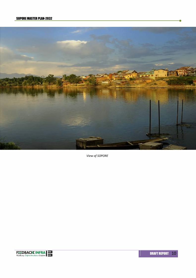
View of SOPORE

Introduction 1
SOPORE MASTER PLAN-2032
DRAFT REPORT 11
1. Introduction
1.1 THE CONTEXT Sopore is an important and growing town in Baramulla District. It is situated at a distance of 48.3 km north-west of Srinagar, the summer capital of Jammu and Kashmir and 19.2 km south-east from district headquarters of Baramulla. Town is also known as an ‘Apple Town’ surrounded by lush horticulture and orchards mainly apple and walnut. River Jhelum divides the town into two parts. Wular Lake which is Asia’s one of the largest freshwater lake is also situated between Sopore and Bandipore. Sopore town has unique character of being a town with apple orchard within the town and its surrounding. In recent years, town has been growing in an unplanned and uncontrolled manner resulting into increase in pressure on land under horticulture, orchards and agriculture. Therefore, with a view to improve quality of life, the Town Planning Organisation, Government of Jammu and Kashmir intended to prepare the master plan for Sopore and appointed M/S Feedback Infrastructure Services Private Limited in joint venture with B.E. Consultant (P) Limited, Jaipur.
1.2 WHAT IS A MASTER PLAN A Master Plan, as the very name suggests is a comprehensive physio-socio economic and environmental plan integrating all the necessary facilities, services and amenities over a defined space in a socially, economically, environmentally conforming and compatible placements in terms of uses, for ensuring a sustainable growth-oriented development over a near future for a projected population.
1.3 NEED OF THE MASTER PLAN A Master Plan prepared for urban area serves as an important instrument to guide the process of urban development. Over the years, it has emerged as an important approach to urban planning in the country. The concept of Master Plan has no doubt made a discernible impact in regulating and channelizing the development and growth of cities and towns. The Master Plan (Perspective year: 2032) provides a policy framework which will serve as a guide in provisioning of services, workspaces and regulated planned development. It lays down broad policies in term of land utilization, residential densities and qualitative and quantitative aspects of infrastructure development.
1.4 OBJECTIVE OF THE MASTER PLAN The main objectives of the Master Plan are as follows: Future growth in a planned manner; Broad land use pattern considering the potential growth and emerging needs of the area; Facilitate commercial, industrial, residential, tourism, recreational and other investments; Provide quality urban infrastructure in all the urban areas and also appropriately in the immediate fringe
villages for improved quality of life; Evolve effective implementation and financial strategy
1.5 PLANNING EFFORTS The first step towards planning for development in Sopore was through the Master Plan in 1975 for the horizon year 1975-1995 with an estimated population of 63,147 persons plus a population of 13,700 commuting to Sopore from nearby areas. The Master Plan proposes development of the town on neighborhood concept with an integrated community structure. The master plan envisaged through planned development of Sopore, so that the city will be expanded from 596 acres to 2,629.54 acres. The envelope of developed land was proposed to increase from 282.9 acres to 1,507 acres. It was proposed to have two planning Divisions – I and II.
SOPORE MASTER PLAN-2032
DRAFT REPORT 12
The Planning Division – I constitutes a new area to be located on the left bank of the river conceived for the purpose of planned development. It was for 26,400 persons at an average density of 44 persons per acre. It comprises of two neighborhoods – B and C. Neighbourhood B includes the area of Dodliteng to Ningli Mohalla along the left bank of river, Channkhan on Kranshivan road, while neighbourhood C includes the areas bounded by Sopore – Sangrama road in the east, by river Jhelum in the North and grazing fields on west. The Planning Division – II comprises of Old Sopore on the right bank of the river Jehlum. It consists of three neighbourhoods – D, E and F which was planned for a population of 38,972 by 1995 at an average density of 47-persons per acre. It also includes the area of Sopore – Kupwara Road and existing Housing Colony, Maharajpora, Chinkipora and Central Business Core. The new expansions was proposed towards the lower reaches between Seer-i-Jagir and Tulbul on the south-west, between Sangrama road and Dara Nambal on the South-east, along Kupwara and Narpur road in close proximity of the New Colony on the North-west and between built-up areas of Mahraj Pora road leading to Dangar Pora on the north-east.
1.6 APPROACH TO PLAN PREPARATION A) Role of Sopore in the Region
The influence of the region cannot be ignored as an important factor in the development of Sopore. The notified area of Sopore is located just on the periphery of Greater Baramulla, which may function as a twin city in future. If the administrative boundaries are ignored, the entire development is just in the form of an urban agglomeration. However, both the towns are being planned in isolation as an individual entity. Considering the surrounding urban agglomeration, the role of the Sopore Town has been envisaged as a Mandi and Industrial town for the region. The city is being planned and developed with a marked difference in the function being a Mandi town. The present freight complex is already congested and lacks basic supported infrastructure. It has become a seasonal phenomenon when apples are ready for sale. It is envisaged that this freight complex will function as regional level collection and distribution centre, which will need additional area with supported infrastructure. Therefore, existing freight area needs to be extended and to be linked with the industrial area.
B) Retaining the character of Apple Town
The town and its surrounding area has large chunk of area under apple, orchards which has a very high commercial value. Other vacant land is available is cultivable land which is single cropped and can be opt for furture development instead of utlising the prime orchard land for urban uses. The master plan envisaged that these horticulture land needs to be retained which will function as city lung spaces. These greens and open areas to be coupled with state of the art infrastructure facilities ensuring better quality of life in Sopore town in times to times.
C) Priority Areas for urban expansion
The potential areas for future urban expansion have been identified after a detailed analysis on physical opportunities and constraints. Various options for development have also been thoroughly assessed. Sopore have been a town with horticulture in surroundings which acts as a constraints for its expansion. In the north and north west, vast areas are under apple plantation which have left no option for further development in that direction. On the south-east, good developable single cropped agricultural land inter-spread with willow plantation can be available and hence that area is likely to develop fast, as it also has good linkage possibility with Srinagar and Baramulla through NH-1. Physical Constraints for Urban Expansion Surrounded by Orchards from west to northeast inter-spread with willow plantation and paddy fields; Marshy land exits to the north side of the town, is surrounded by Malyari land which is a source of vegetables for
the inhabitants; To the south, the Sopore – Sangrama approach road is flanked on either side with orchards for a small depth; Area to the east of Sopore town on the left bank of river Jhelum is Governmental land and is presently under willow
plantation. Area of the southeast is also low lying; Area between Kupwara and Nowapora Kalan roads is above flood level and is mostly used for paddy cultivation; To the south west, the area near Tulibal village is low lying and susceptible to floods; In close vicinity of B.Ed. College of M.E.T., the area situated on the left bank is partly private land and partly
government land;
SOPORE MASTER PLAN-2032
DRAFT REPORT 13
A few patches of orchards are inter-spread in the paddy lands. This area seems good for development. Moreover, a number of Governmental buildings have come up along the Kupwara and Nowpora Kalan roads.
Therefore, we find that orchard lands, paddy fields and swampy lands constitute major constraints on the expansion of the town
Future Growth Potential for extension Considering the physical constraints, land availability, land suitability, ongoing, committed, and proposed major activities nodes and consultant’s’ perception, it is envisaged that the town growth would likely to occur in the following directions: Towards south-eastern side near Krank Shivan Village; Towards Eastern side of the town near Tarazeau Village; Towards North-west along Nowpora and Kupwara roads; Western side along Sopore-Nowpora Road near Sopore Fruit Mandi
D) Economy based on local resource base
Sopore needs to be planned as a town with industry and mandi / wholesale/ warehousing as its main economic activity supported by the residential, commercial, and institutional and other such uses required for a comprehensive urban development. Hence, the character of the town will emerge as an Industrial cum Wholesale activity centre set in an environment of greenery and open areas. The expansion of Industrial area and Mandi/ Freight complex with associated infrastructure should be geared to take on a significant quantum of industrial development in the region.
1.7 SOPORE PLANNING AREA In order to meet the emerging needs of population growth and prospective future development through planning of the entire area and to check haphazard, unregulated and unplanned development, the planning area including Sopore town and 10-villages have been notified under the provision of Jammu & Kashmir Development Act, 1970. The total planning area is 6465.47 HA or 64.65 Sq. km
Sopore Planning Area, 2011
Area (HA) Population % Distribution
Sopore (Town Council + Out Growth) 2,544.30 68,082 60.00
Revenue Villages 3,921.08 *45,397 40.00
Total Planning area 6,465.38 1,13,479 100.0 *Estimated for 2011 In the process of planning area notification, 10-villages adjoining the Sopore Municipal Council area have been taken into account as Sopore Master Planning Area. (Refer Map. 1.1). These villages in the fringe are in the direct influence zone of the city, which will tend to grow as the town starts evolving with time. To control this situation of the fringe development, these villages need to have a controlled development process. The following table shows the villages notified with area and population. Table 1-1: Details of Villages notified within Planning Area
S. No. Name of Villages Area HA) *Population (2011)
1 Adi pora 582.94 3,934 2 Said Pora 587.49
3,079
3 Wagul 196.76 2,805 4 Krank Shivan 261.61 3,698 5 Panji Pora 204.94 1,592 6 Seer Jagir 439.11 12,573 7 Lalad 135.63 1,847
SOPORE MASTER PLAN-2032
DRAFT REPORT 14
S. No. Name of Villages Area HA) *Population (2011)
8 Dara Nambal 382.36 2,404 9 Tarazuea 794.54 9,666
10 Sangrama 335.70 3,798 Total 3,921.08
45,397
*Estimated
1.8 VISION AND DEVELOPMENT STRATEGY 1.8.1 Vision and Goals
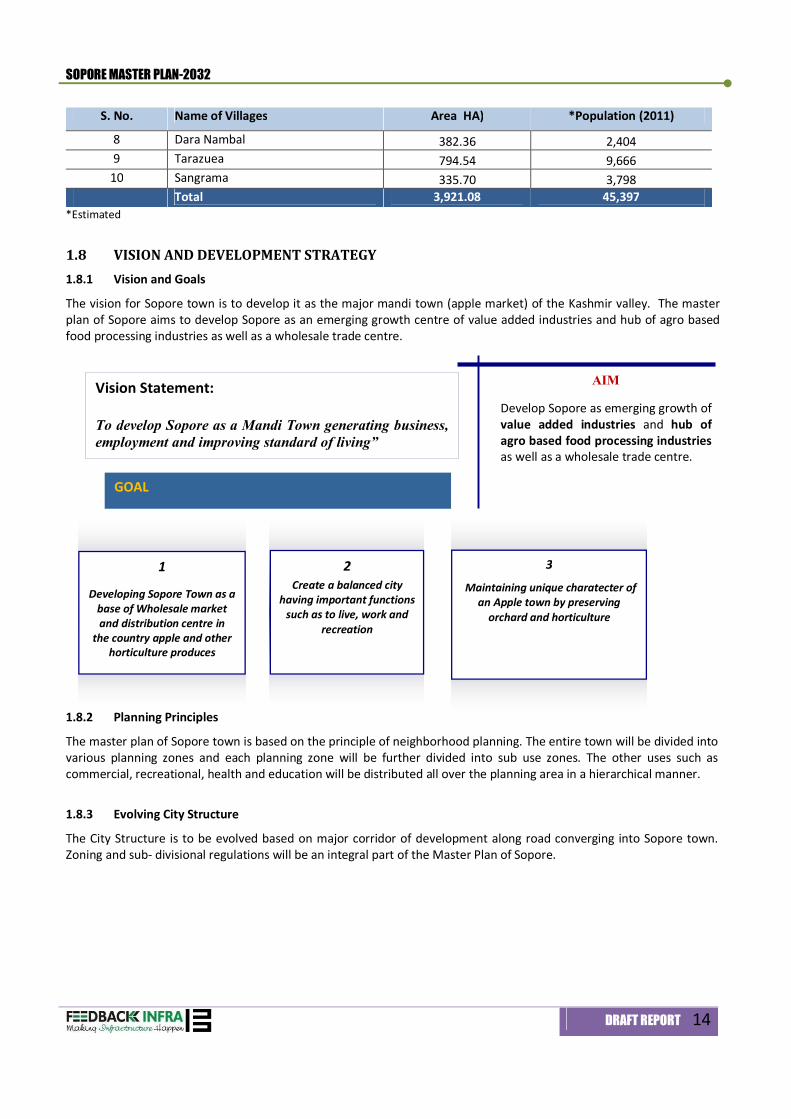
The vision for Sopore town is to develop it as the major mandi town (apple market) of the Kashmir valley. The master plan of Sopore aims to develop Sopore as an emerging growth centre of value added industries and hub of agro based food processing industries as well as a wholesale trade centre.
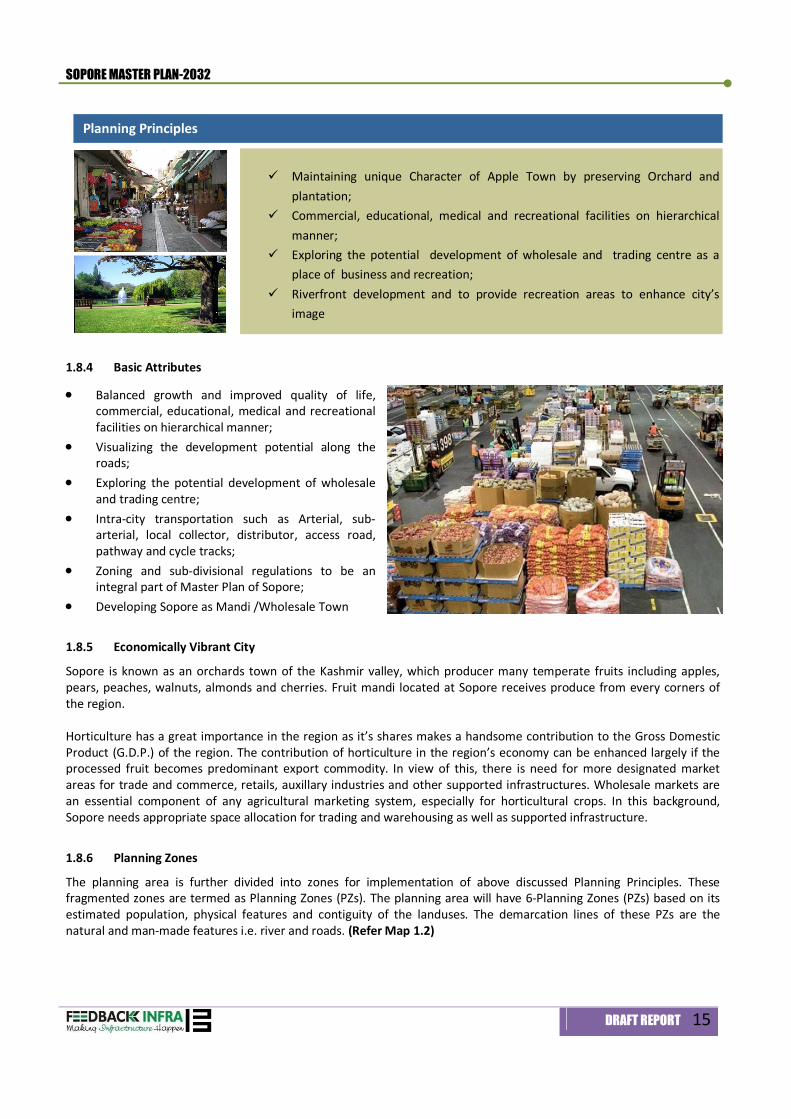
1.8.2 Planning Principles
The master plan of Sopore town is based on the principle of neighborhood planning. The entire town will be divided into various planning zones and each planning zone will be further divided into sub use zones. The other uses such as commercial, recreational, health and education will be distributed all over the planning area in a hierarchical manner.
1.8.3 Evolving City Structure
The City Structure is to be evolved based on major corridor of development along road converging into Sopore town. Zoning and sub- divisional regulations will be an integral part of the Master Plan of Sopore.
Vision Statement: To develop Sopore as a Mandi Town generating business, employment and improving standard of living”
3
Maintaining unique charatecter of an Apple town by preserving
orchard and horticulture
GOAL
AIM
Develop Sopore as emerging growth of value added industries and hub of agro based food processing industries as well as a wholesale trade centre.
1
Developing Sopore Town as a base of Wholesale market and distribution centre in
the country apple and other horticulture produces
2 Create a balanced city
having important functions such as to live, work and
recreation
SOPORE MASTER PLAN-2032
DRAFT REPORT 15
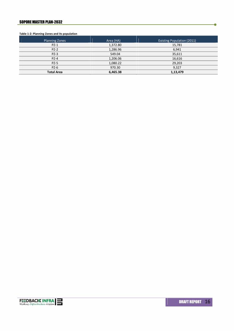
1.8.4 Basic Attributes
Balanced growth and improved quality of life, commercial, educational, medical and recreational facilities on hierarchical manner;
Visualizing the development potential along the roads;
Exploring the potential development of wholesale and trading centre;
Intra-city transportation such as Arterial, sub-arterial, local collector, distributor, access road, pathway and cycle tracks;
Zoning and sub-divisional regulations to be an integral part of Master Plan of Sopore;
Developing Sopore as Mandi /Wholesale Town
1.8.5 Economically Vibrant City
Sopore is known as an orchards town of the Kashmir valley, which producer many temperate fruits including apples, pears, peaches, walnuts, almonds and cherries. Fruit mandi located at Sopore receives produce from every corners of the region. Horticulture has a great importance in the region as it’s shares makes a handsome contribution to the Gross Domestic Product (G.D.P.) of the region. The contribution of horticulture in the region’s economy can be enhanced largely if the processed fruit becomes predominant export commodity. In view of this, there is need for more designated market areas for trade and commerce, retails, auxillary industries and other supported infrastructures. Wholesale markets are an essential component of any agricultural marketing system, especially for horticultural crops. In this background, Sopore needs appropriate space allocation for trading and warehousing as well as supported infrastructure.
1.8.6 Planning Zones
The planning area is further divided into zones for implementation of above discussed Planning Principles. These fragmented zones are termed as Planning Zones (PZs). The planning area will have 6-Planning Zones (PZs) based on its estimated population, physical features and contiguity of the landuses. The demarcation lines of these PZs are the natural and man-made features i.e. river and roads. (Refer Map 1.2)
Maintaining unique Character of Apple Town by preserving Orchard and plantation;
Commercial, educational, medical and recreational facilities on hierarchical manner;
Exploring the potential development of wholesale and trading centre as a place of business and recreation;
Riverfront development and to provide recreation areas to enhance city’s image
Planning Principles
SOPORE MASTER PLAN-2032
DRAFT REPORT 16
Table 1-2: Planning Zones and its population
Planning Zones Area (HA) Existing Population (2011) PZ-1 1,372.80 15,781 PZ-2 1,286.96 6,941 PZ-3 549.04 35,611 PZ-4 1,206.06 16,616 PZ-5 1,080.22 29,203 PZ-6 970.30 9,327
Total Area 6,465.38 1,13,479

Regional Settings & Resource Base 2
SOPORE MASTER PLAN-2032
DRAFT REPORT 17
2. Regional Setting and Resource Base
2.1 INTRODUCTION Sopore known as an Apple Town of India and already has marked distinction in the business map of India. The India's one of the largest export Mandi for apples and dry fruit is situated in Sopore. Sopore town is situated about 35-kms to the north west of Srinagar and 16-kms to the North-East of District headquarter, Baramulla town. Sopore is a medium sized (intermediate) town located close to major city of Baramulla and Srinagar Planning Area. Sopore was classified as a town in 1911 with a population of 8,514, which has increased to 68,082 as per the census 2011.
2.2 HISTORICAL BACKGROUND Sopore was founded by the famous Utpala engineer and irrigation minister Suyya during the peaceful reign of king Avantivarman in 880 A.D. After the independence of India, Sopore saw a rapid rise in population and physical expansion of the town. A new bridge about 2.4 kms downstream from the site of old bridge was constructed. Agglomeration of Administrative Offices brought radical change in Sopore. Till the end of 14th century the town did not observe any significant overall development. The rapid urban growth of the town can be attributed mainly to its locational advantage being situated in the centre of the Kashmir valley. It’s rich and fertile soil, which is good for agriculture and horticulture, River Jhelum for communication and navigation, proximity of Wular Lake and several forest resources have been the key driving force for the development of the Sopore town.
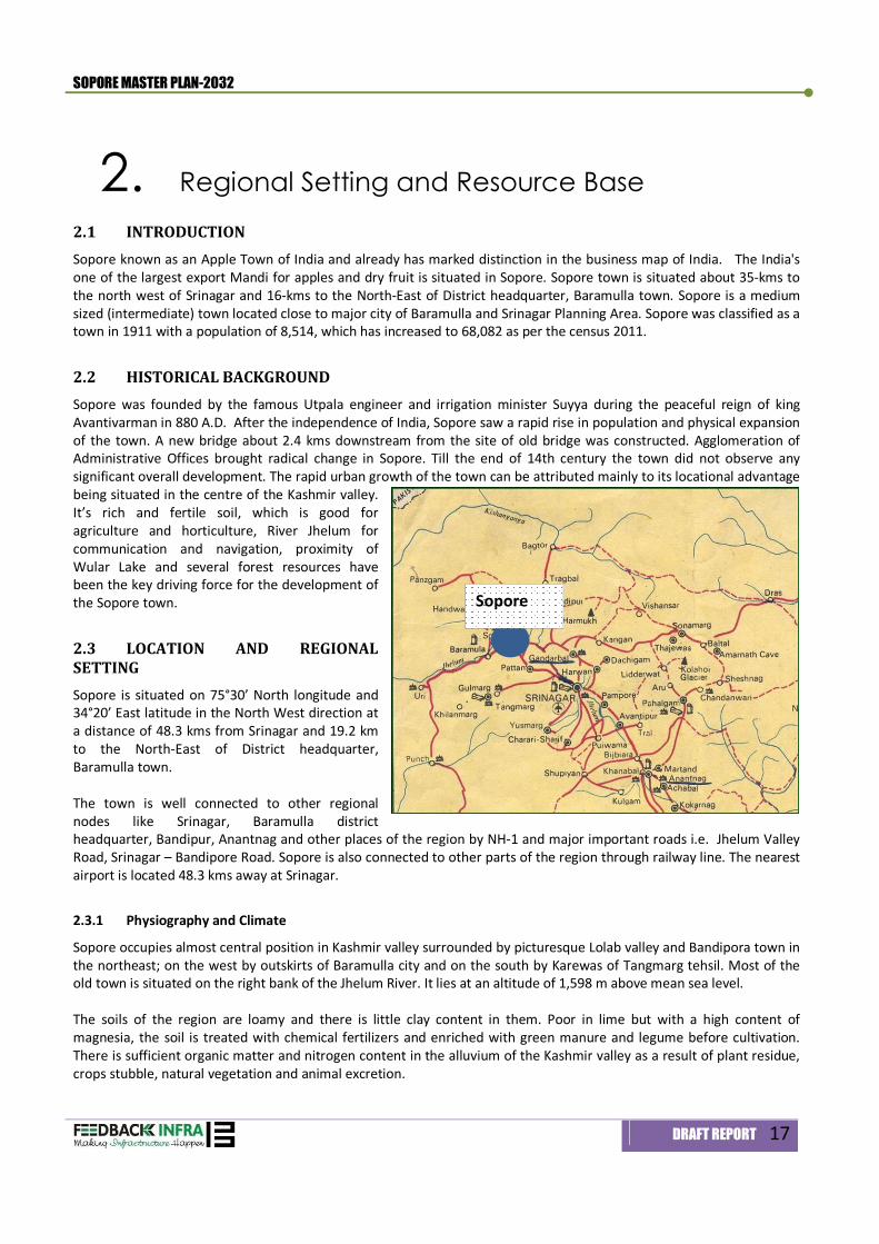
2.3 LOCATION AND REGIONAL SETTING Sopore is situated on 75°30’ North longitude and 34°20’ East latitude in the North West direction at a distance of 48.3 kms from Srinagar and 19.2 km to the North-East of District headquarter, Baramulla town. The town is well connected to other regional nodes like Srinagar, Baramulla district headquarter, Bandipur, Anantnag and other places of the region by NH-1 and major important roads i.e. Jhelum Valley Road, Srinagar – Bandipore Road. Sopore is also connected to other parts of the region through railway line. The nearest airport is located 48.3 kms away at Srinagar.
2.3.1 Physiography and Climate
Sopore occupies almost central position in Kashmir valley surrounded by picturesque Lolab valley and Bandipora town in the northeast; on the west by outskirts of Baramulla city and on the south by Karewas of Tangmarg tehsil. Most of the old town is situated on the right bank of the Jhelum River. It lies at an altitude of 1,598 m above mean sea level. The soils of the region are loamy and there is little clay content in them. Poor in lime but with a high content of magnesia, the soil is treated with chemical fertilizers and enriched with green manure and legume before cultivation. There is sufficient organic matter and nitrogen content in the alluvium of the Kashmir valley as a result of plant residue, crops stubble, natural vegetation and animal excretion.
Sopore
SOPORE MASTER PLAN-2032
DRAFT REPORT 18
The region experiences severe cold climate in winter and a pleasant weather in summer. The entire region experiences snowfall during winter. Overall the town experience moderate temperature ranging between 28°C to 34°C in summer and between 10°C to -10°C in winter. The region has the annual rainfall of 614.7 mm.
2.3.2 Seismic Zones
The valley, by and large is considered as a seismic zone. Earthquakes of various magnitudes, occurred in the past, have rocked the valley. Sopore region has also been affected from time to time by earthquake tremor. No seismic epi-centre has so far been located in the vicinity of the planning area. Framed structure is the traditional method for building construction throughout the length and breadth of the Sopore region.
2.4 ECONOMY AND RESOURCE BASE Sopore is very famous for apple growing. The other agricultural products grown in Sopore are Walnut, Cherry, and Almond etc. The large number of Joinery units are scattered in the periphery of the town. Rearing of livestock is one of the important occupations of the population lives in the outskirts of the town.
2.4.1 Fruits Production
The horticulture is the main contributor of income in the Sopore’s economy, next to the agricultural. The salubrious climatic conditions of the region are most suitable for the growth of quality apples and other fruits including plums, apricots, cherry, strawberry, grapes and various varieties of wild herbs. Table 2-1: Horticulture Production and Land Area covered under horticulture in Sopore region, 2010-11 (in MT)
S. No. Zones Apple Production (MT)
Other Fruits (MT)
Total Fruits Production (MT)
% of Total Area under Horticulture (HA)
% of Total Area
1 Bomai 23,751 662 24413 19.25 1399.0 22.61 2 Sopore 42,192 130 42322 33.37 1889.2 30.54 3 Dooru 32,900 317.1 33217 26.19 1795.8 29.03 4 Achabal 26,631 245 26876 21.19 1102.8 17.83
Total 1,25,474 1354.1 1,26,828 100.0 6186.8 100.0 Source: Office of the Chief Horticultural officer, Baramulla Sopore Region has an area of 6186.8 hectares under fruit production (Refer Table 2-1). The fruit production from Sopore region was 1,26,828 metric tonnes (Refer table 2-1) and about 42,322 metric tonnes from Sopore zone. The apple crop contributes about 99.69 % of the total fruit production of the Sopore Zone. There is an ample scope for setting up of apple based industrial units for juice concentrate, jams, jellies and marmalades. However, it is pertinent to note that Sopore horticulturists have preferred to remain the suppliers of primary products rather than diversify into value-added finished products.
2.4.2 Industrial Base
There are two industrial estates in Sopore i.e. Bagie Islam Industrial estate and Food Park located at Doabgah
a) Industrial Estate Bagie Islam Bagie Islam Industrial Estate was established in 1970 covering an area of 4.13 hectares. The industrial units of Steel fabrication, concrete blocks manufacturing, Soap manufacturing, Cricket Bat Manufacturing unit, Ice Cream manufacturing are functional from this industrial estate, which are employing around 75 workers.
SOPORE MASTER PLAN-2032
DRAFT REPORT 19
b) Food park A Food park measuring land area of 10.16 hectare with 24 industrial units is being established at Doabgah with the financial assistance of Ministry of Food Processing Industries, Govt. of India. Presently, a single unit is in operation and rests of the land area have already been earmarked for other 23-different industrial units. There is a proposal for establishment of a Controlled Atmosphere Cold Storage facility of 1000 metric Ton capacity in the food park.
c) Joinery units
Sopore has about 48-numbers of joinery units distributed in different parts of the town. These joinery units in town not only cater the packaging demand of the town but also of nearby villages. These units are one of the sources of livelihood of the people of Sopore town.
d) Other household Industries Besides, Sopore town has a few units of household industries, which include mustard seeds oil extraction, cotton ginning, furniture making, black-smithy, printing press and bakeries. Small brick making units are also exists along the bank of river Jhelum near Sopore Bridge in the Sopore town. Around 10-12 lakhs bricks are manufactured annually from these brick units.
2.4.3 Industrial Infrastructure
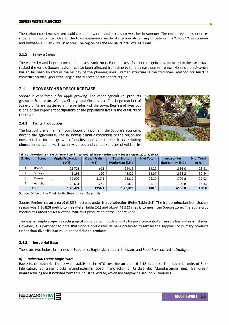
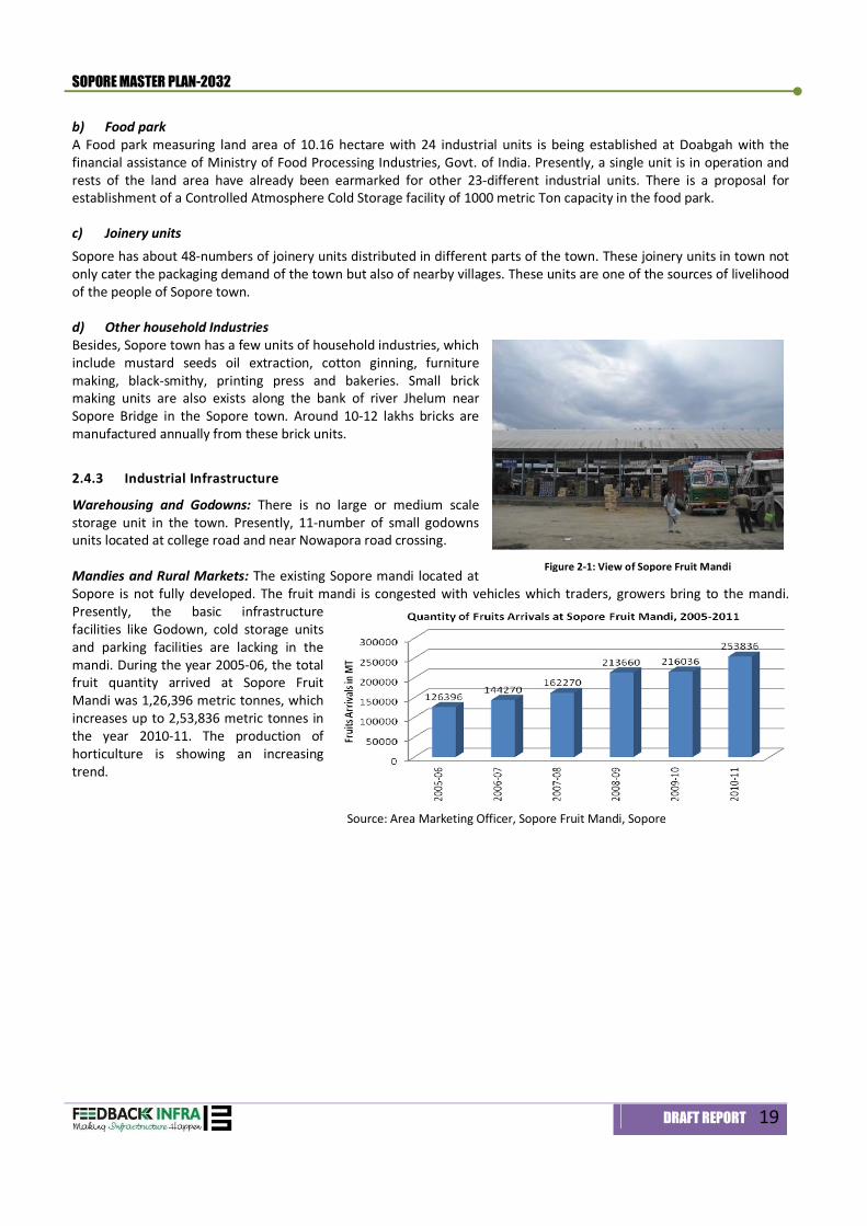
Warehousing and Godowns: There is no large or medium scale storage unit in the town. Presently, 11-number of small godowns units located at college road and near Nowapora road crossing. Mandies and Rural Markets: The existing Sopore mandi located at Sopore is not fully developed. The fruit mandi is congested with vehicles which traders, growers bring to the mandi. Presently, the basic infrastructure facilities like Godown, cold storage units and parking facilities are lacking in the mandi. During the year 2005-06, the total fruit quantity arrived at Sopore Fruit Mandi was 1,26,396 metric tonnes, which increases up to 2,53,836 metric tonnes in the year 2010-11. The production of horticulture is showing an increasing trend.
Figure 2-1: View of Sopore Fruit Mandi
Source: Area Marketing Officer, Sopore Fruit Mandi, Sopore
Demography 3
SOPORE MASTER PLAN-2032
DRAFT REPORT 20
3. Demography
3.1 INTRODUCTION Demography is the study of Human population dynamics. The analysis of Demographic patterns and factors can give an excellent understanding of the present nature of social, economic and industrial development of the settlement under consideration and pave way for reliable predictions of future population of settlements for allocation over the spatial and urban fabric. As per the census-2011, Sopore Planning Area had a population of 1,13,479 which constitutes 60.0 % of Urban and 40.0% of rural population. The master planning area, which includes Sopore Municipal Council area and 10 fringe villages under urban notification area, has been consider for further demographic analysis.
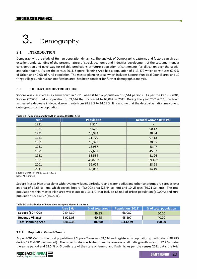
3.2 POPULATION DISTRIBUTION Sopore was classified as a census town in 1911, when it had a population of 8,514 persons. As per the Census 2001, Sopore (TC+OG) had a population of 59,624 that increased to 68,082 in 2011. During the year 2001-2011, the town witnessed a decrease in decadal growth rate from 28.28 % to 14.19 %. It is assume that the decadal variation may due to outmigration of the population. Table 3-1: Population and Growth in Sopore (TC+OG) Area
Year Population Decadal Growth Rate (%) 1911 8,514 - 1921 8,524 00.12 1931 10,982 28.84 1941 11,770 07.18 1951 15,378 30.65 1961 18,987 23.47 1971 27,697 45.87 1981 33,584 21.26 1991 46,823* 39.42* 2001 59,624 28.28 2011 68,082 14.19
Source: Census of India, 1911 – 2011 Note: *Estimated Sopore Master Plan area along with revenue villages, agriculture and water bodies and other landforms are spreads over an area of 64.65 sq. km, which covers Sopore (TC+OG) area (25.44 sq. km) and 10 villages (39.21 Sq. km). The total population within Master Plan area works out to 1,13,479 that include 68,082 of urban population (60.00%) and rural population i.e. 45,397 (40.00 %). Table 3-2 : Distribution of Population in Sopore Master Plan Area
Area ( Ha) % of total area Population (2011) % of total population Sopore (TC + OG) 2,544.30 39.35 68,082 60.00 Revenue Villages 3,921.08 60.65 45,397 40.00 Total Planning Area 6,465.38 100.00 1,13,479 100.00
3.2.1 Population Growth Trends
As per 2001 Census, the total population of Sopore Town was 59,624 and registered a population growth rate of 28.28% during 1991-2001 (estimated). The growth rate was higher than the average of all India growth rates of 17.7 % during the same period and 23.5 % of Growth rate of the state of Jammu and Kashmir. As per the census 2011 data, the total
SOPORE MASTER PLAN-2032
DRAFT REPORT 21
population of Sopore is 68,082. Sopore has registered a growth of 14.19 % during 2001-2011 that shows a declining trend as compared to previous decades as depict in Figure 3.1
Figure 3-1: Decadal Growth Trend
However, the population of comparable Sopore municipal area has increased from 27,697 in 1971 to 33,584 in 1981, 59,624 in 2001 to 68,082 persons in 2011.
3.2.2 Population Density
There is a great variation found in the gross population density in different parts of Sopore Municipal Council. The average gross population density of the town is 40-persons per hectare. The estimated gross population density in Planning Area is very low i.e. 17-persons per hectare. The low gross population density of Sopore reveals that large pockets of orchards, agriculture fields are available in the planning area. Thus, the town is growing linearly along the connectivity networks. Table 3-3: Existing Gross Population Density in Planning Area
Area Population, 2011 Area (HA) Gross Density (p/HA)
Sopore Town 59,794 1,503.00 40
Sopore (TC + OG) 68,082 2,544.30 27
Revenue Villages 45,397* 3,921.08 11
Master Plan Area 1,13,479 6,465.38 17 Source: Census of India, 2011 and Consultant’s Analysis, *Estimated
3.2.3 Sex Ratio
As per the census of India - 2011, the sex ratio (female population per 1,000 male population) in Sopore is 977, which is higher than the district urban average of 859 and national urban average at 940. However, the sex ratio in Sopore has increased steadily from 880 in 1981-91 to 902 in 2001 to 977 in 2011.
3.2.4 Literacy
The literacy rate (percentage of literate population to the total population above 6-years of age) in Sopore is 58.7 % in 2001, which increased to 61.60 % in 2011. The literacy rate has shown marked improvement but its disaggregation into female and male literacy rates show that there is enough scope for both qualitative and quantitative improvement of the figures through appropriate planning of educational facilities. Male literacy figures have decreased from 68.77 percent in 2001 to 66.42 percent in 2011 and female literacy figures have increased from 50.25 percent in 2001 to 56.66 percent in
SOPORE MASTER PLAN-2032
DRAFT REPORT 22
2011. A Gap of 9.76 per cent between male and female can be further narrowed down by special emphasis on the educational measures for female group.
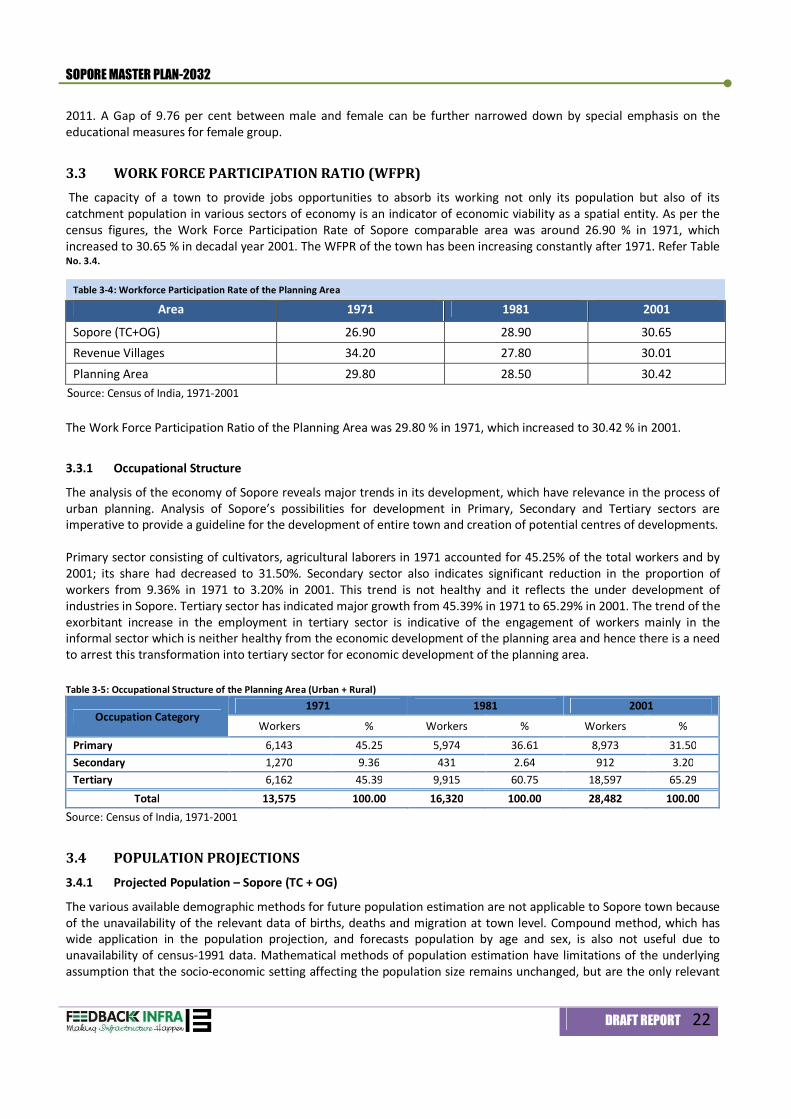
3.3 WORK FORCE PARTICIPATION RATIO (WFPR) The capacity of a town to provide jobs opportunities to absorb its working not only its population but also of its catchment population in various sectors of economy is an indicator of economic viability as a spatial entity. As per the census figures, the Work Force Participation Rate of Sopore comparable area was around 26.90 % in 1971, which increased to 30.65 % in decadal year 2001. The WFPR of the town has been increasing constantly after 1971. Refer Table No. 3.4.
The Work Force Participation Ratio of the Planning Area was 29.80 % in 1971, which increased to 30.42 % in 2001.
3.3.1 Occupational Structure
The analysis of the economy of Sopore reveals major trends in its development, which have relevance in the process of urban planning. Analysis of Sopore’s possibilities for development in Primary, Secondary and Tertiary sectors are imperative to provide a guideline for the development of entire town and creation of potential centres of developments. Primary sector consisting of cultivators, agricultural laborers in 1971 accounted for 45.25% of the total workers and by 2001; its share had decreased to 31.50%. Secondary sector also indicates significant reduction in the proportion of workers from 9.36% in 1971 to 3.20% in 2001. This trend is not healthy and it reflects the under development of industries in Sopore. Tertiary sector has indicated major growth from 45.39% in 1971 to 65.29% in 2001. The trend of the exorbitant increase in the employment in tertiary sector is indicative of the engagement of workers mainly in the informal sector which is neither healthy from the economic development of the planning area and hence there is a need to arrest this transformation into tertiary sector for economic development of the planning area. Table 3-5: Occupational Structure of the Planning Area (Urban + Rural)
Occupation Category 1971 1981 2001
Workers % Workers % Workers % Primary 6,143 45.25 5,974 36.61 8,973 31.50 Secondary 1,270 9.36 431 2.64 912 3.20 Tertiary 6,162 45.39 9,915 60.75 18,597 65.29
Total 13,575 100.00 16,320 100.00 28,482 100.00 Source: Census of India, 1971-2001
3.4 POPULATION PROJECTIONS 3.4.1 Projected Population – Sopore (TC + OG)
The various available demographic methods for future population estimation are not applicable to Sopore town because of the unavailability of the relevant data of births, deaths and migration at town level. Compound method, which has wide application in the population projection, and forecasts population by age and sex, is also not useful due to unavailability of census-1991 data. Mathematical methods of population estimation have limitations of the underlying assumption that the socio-economic setting affecting the population size remains unchanged, but are the only relevant
Table 3-4: Workforce Participation Rate of the Planning Area
Area 1971 1981 2001
Sopore (TC+OG) 26.90 28.90 30.65 Revenue Villages 34.20 27.80 30.01 Planning Area 29.80 28.50 30.42
Source: Census of India, 1971-2001
SOPORE MASTER PLAN-2032
DRAFT REPORT 23
means to estimate the population of Sopore town and Planning Area. Mathematical methods supported by other policy inputs give accurate forecasts of the population within the constraints of limited availability of demographic data. Sopore Town including 3-outgrowths is planned for a population of about 1,09,501 in 2032. The consultant envisages the average annual growth rate of 2.0 % (2012-2017), 2.25 % (2018-2022), and 2.50 % (2023-2032).
Table 3-6: Population in Sopore (Town + Outgrowth) Year Sopore (TC+OG) Annual Growth Rate 2011 68,082 1.30 2012 69,171 1.40 2017 76,520 2.00 2022 85,525 2.25 2027 96,764 2.50 2032 1,09,501 2.50
Source: Consultant’s Estimation Population growth in previous decades for comparable municipal area is much lesser than the rural areas. Urban area shows lesser growth rate than rural areas within planning boundary. After the year 2022, the existing growth rate of 2.0 will reach up to 2.50 till the horizon year 2032. Proposed development in the urban area will be more planned and in concentric manner. The rate of infrastructure development in urban area will be higher/faster than the rural area.
3.4.2 Projected Population – Rural Area within Planning Area
The population of the rural Area, which was 45,397 in 2011, has been estimated to 46,487 persons in 2012. It is estimated that the population if allowed to grow at the computed growth rates will be 61,570 and 80,760 in 2022 and 2032 respectively for the rural villages.
Table 3-7: Estimated Population of Rural Area Year Population Annual Growth Rate 2011 45,397 2.9 2012 46,487 2.9 2017 53,630 2.9 2022 61,570 2.8 2027 70,515 2.75 2032 80,760 2.75
Source: Consultant’s Estimation
3.4.3 Projected Population – Planning Area
The population of the Planning Area including Sopore Urban Area (Sopore Town Council + Outgrowths) and 10-revenue villages is estimated for the horizon year 2017, 2022, 2027 and 2032, which are based on the annual growth rate of 2.4 % in the period 2013-2017, 2.5 % in the period 2018-2022 and 2.6 % in the period 2023-2032. These estimates are based on the premise that the proposals in the Master Plan will give impetus to the growth of the planning area. Refer Table 3.8 for population projection of the planning area.
Table 3-8: Population in Sopore (Town + Outgrowth)
Year Population Annual Growth Rate 2011 1,13,479 2.0 2012 1,15,658 2.0 2017 1,30,150 2.4 2022 1,47,095 2.5 2027 1,67,279 2.6 2032 1,90,261 2.6
Source: Consultant’s Estimation
SOPORE MASTER PLAN-2032
DRAFT REPORT 24
3.5 PROJECTED WORK FORCE 3.5.1 Projected Workforce
As discussed in the preceding section, the probable occupational structure for the horizon years has been used as a policy measures to alleviate the economic problems of the Sopore. The estimate of workforce for the horizon years has been based on assumptions and the explanations of underlying assumptions are necessary to ensure the realization of the objectives of the Master Plan. The emphasis has been laid on the strategies to give impetus to secondary sector to shift from primary sector i.e. agriculture to secondary sector rather than to tertiary sector. The workforce in 2032 estimated as 76,104 persons. Table 3-9: Estimated Workers for Sopore Master Plan Area
Activity 2001 2012 2017 2022 2027 2032 No. % No. % No. % No. % No. % No. %
Primary 8,973 31 11,103 30.0 11,063 25.0 10,591 20.0 10,806 17.0 9,133 12.0 Secondary 912 3 1,480 4.0 3,983 9.0 7,943 15.0 13,349 21.0 21,309 28.0
Tertiary 18,597 66 24,427 66.0 29,206 66.0 34,420 65.0 39,411 62.0 45,663 60.0 Total 28,482 100.0 37,011 100.0 44,251 100.0 52,954 100.0 63,566 100.0 76,104 100.0
WFPR 30.42 32.0 34.0 36.0 38.0 40.0
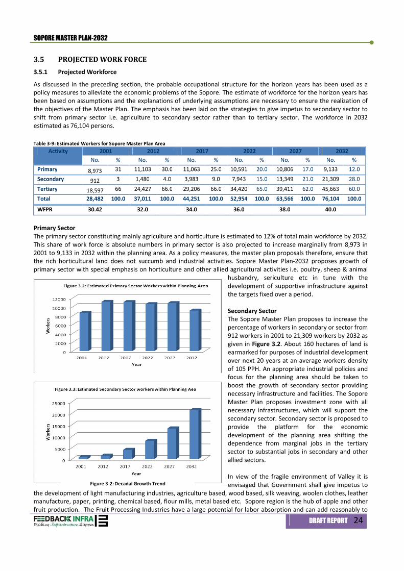
Primary Sector The primary sector constituting mainly agriculture and horticulture is estimated to 12% of total main workforce by 2032. This share of work force is absolute numbers in primary sector is also projected to increase marginally from 8,973 in 2001 to 9,133 in 2032 within the planning area. As a policy measures, the master plan proposals therefore, ensure that the rich horticultural land does not succumb and industrial activities. Sopore Master Plan-2032 proposes growth of primary sector with special emphasis on horticulture and other allied agricultural activities i.e. poultry, sheep & animal
husbandry, sericulture etc in tune with the development of supportive infrastructure against the targets fixed over a period. Secondary Sector The Sopore Master Plan proposes to increase the percentage of workers in secondary or sector from 912 workers in 2001 to 21,309 workers by 2032 as given in Figure 3.2. About 160 hectares of land is earmarked for purposes of industrial development over next 20-years at an average workers density of 105 PPH. An appropriate industrial policies and focus for the planning area should be taken to boost the growth of secondary sector providing necessary infrastructure and facilities. The Sopore Master Plan proposes investment zone with all necessary infrastructures, which will support the secondary sector. Secondary sector is proposed to provide the platform for the economic development of the planning area shifting the dependence from marginal jobs in the tertiary sector to substantial jobs in secondary and other allied sectors. In view of the fragile environment of Valley it is envisaged that Government shall give impetus to
the development of light manufacturing industries, agriculture based, wood based, silk weaving, woolen clothes, leather manufacture, paper, printing, chemical based, flour mills, metal based etc. Sopore region is the hub of apple and other fruit production. The Fruit Processing Industries have a large potential for labor absorption and can add reasonably to
Figure 3-2: Decadal Growth Trend
SOPORE MASTER PLAN-2032
DRAFT REPORT 25
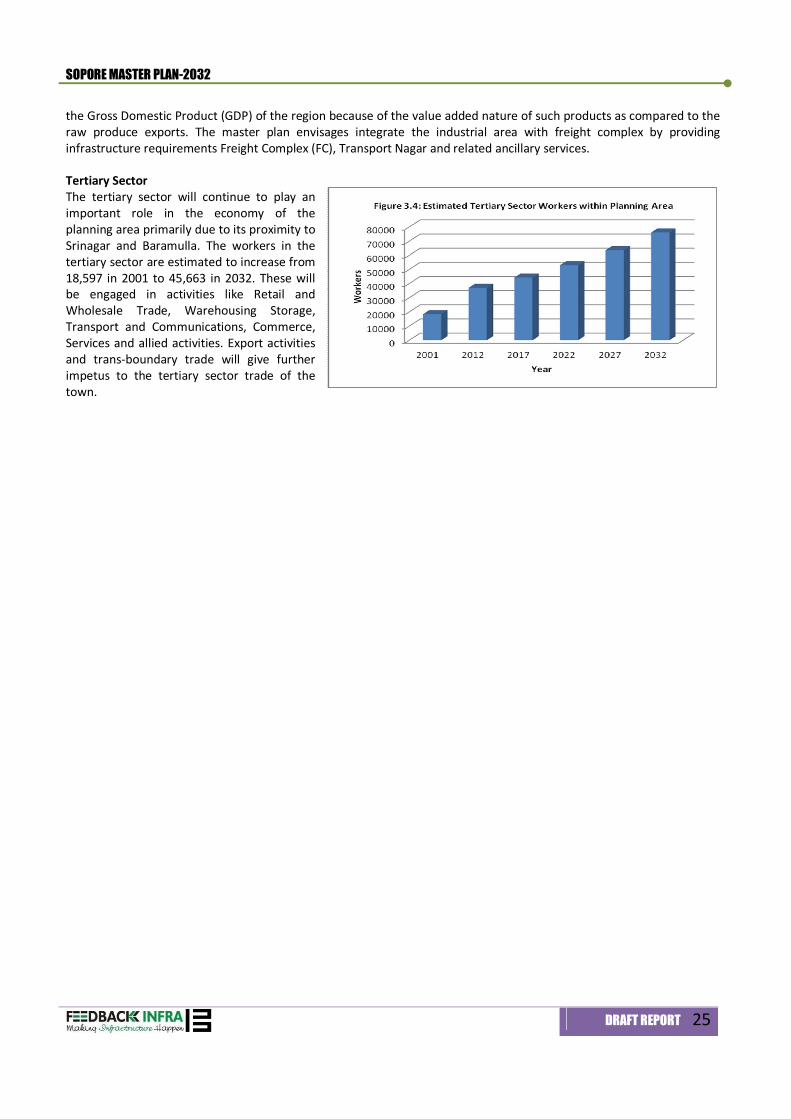
the Gross Domestic Product (GDP) of the region because of the value added nature of such products as compared to the raw produce exports. The master plan envisages integrate the industrial area with freight complex by providing infrastructure requirements Freight Complex (FC), Transport Nagar and related ancillary services. Tertiary Sector The tertiary sector will continue to play an important role in the economy of the planning area primarily due to its proximity to Srinagar and Baramulla. The workers in the tertiary sector are estimated to increase from 18,597 in 2001 to 45,663 in 2032. These will be engaged in activities like Retail and Wholesale Trade, Warehousing Storage, Transport and Communications, Commerce, Services and allied activities. Export activities and trans-boundary trade will give further impetus to the tertiary sector trade of the town.

Land-use & Development Concept 4
SOPORE MASTER PLAN-2032
DRAFT REPORT 26
4. Existing Landuse & Development Concept
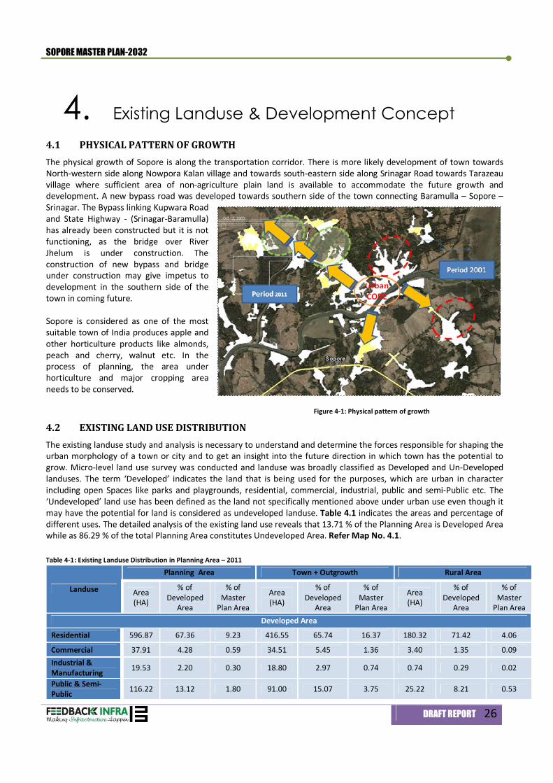
4.1 PHYSICAL PATTERN OF GROWTH The physical growth of Sopore is along the transportation corridor. There is more likely development of town towards North-western side along Nowpora Kalan village and towards south-eastern side along Srinagar Road towards Tarazeau village where sufficient area of non-agriculture plain land is available to accommodate the future growth and development. A new bypass road was developed towards southern side of the town connecting Baramulla – Sopore – Srinagar. The Bypass linking Kupwara Road and State Highway - (Srinagar-Baramulla) has already been constructed but it is not functioning, as the bridge over River Jhelum is under construction. The construction of new bypass and bridge under construction may give impetus to development in the southern side of the town in coming future. Sopore is considered as one of the most suitable town of India produces apple and other horticulture products like almonds, peach and cherry, walnut etc. In the process of planning, the area under horticulture and major cropping area needs to be conserved. Figure 4-1: Physical pattern of growth
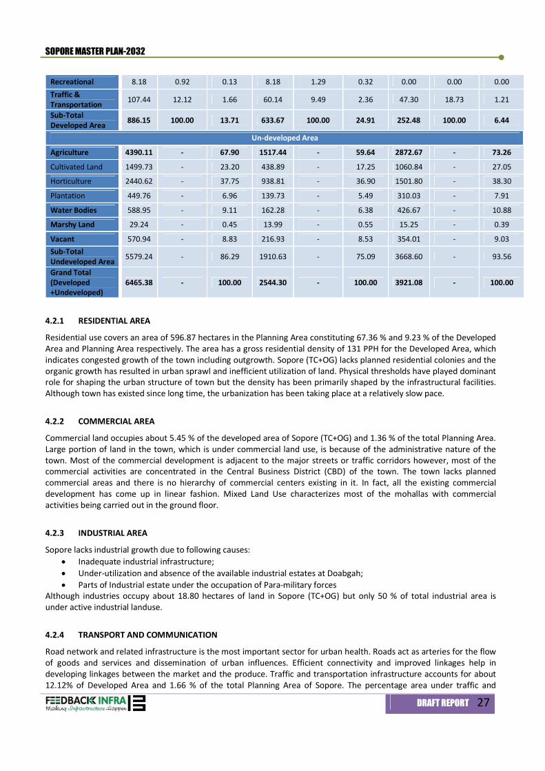
4.2 EXISTING LAND USE DISTRIBUTION The existing landuse study and analysis is necessary to understand and determine the forces responsible for shaping the urban morphology of a town or city and to get an insight into the future direction in which town has the potential to grow. Micro-level land use survey was conducted and landuse was broadly classified as Developed and Un-Developed landuses. The term ‘Developed’ indicates the land that is being used for the purposes, which are urban in character including open Spaces like parks and playgrounds, residential, commercial, industrial, public and semi-Public etc. The ‘Undeveloped’ land use has been defined as the land not specifically mentioned above under urban use even though it may have the potential for land is considered as undeveloped landuse. Table 4.1 indicates the areas and percentage of different uses. The detailed analysis of the existing land use reveals that 13.71 % of the Planning Area is Developed Area while as 86.29 % of the total Planning Area constitutes Undeveloped Area. Refer Map No. 4.1. Table 4-1: Existing Landuse Distribution in Planning Area – 2011
Landuse
Planning Area Town + Outgrowth Rural Area
Area (HA)
% of Developed
Area
% of Master
Plan Area
Area (HA)
% of Developed
Area
% of Master
Plan Area
Area (HA)
% of Developed
Area
% of Master
Plan Area Developed Area
Residential 596.87 67.36 9.23 416.55 65.74 16.37 180.32 71.42 4.06
Commercial 37.91 4.28 0.59 34.51 5.45 1.36 3.40 1.35 0.09 Industrial & Manufacturing 19.53 2.20 0.30 18.80 2.97 0.74 0.74 0.29 0.02
Public & Semi-Public 116.22 13.12 1.80 91.00 15.07 3.75 25.22 8.21 0.53
SOPORE MASTER PLAN-2032
DRAFT REPORT 27
4.2.1 RESIDENTIAL AREA
Residential use covers an area of 596.87 hectares in the Planning Area constituting 67.36 % and 9.23 % of the Developed Area and Planning Area respectively. The area has a gross residential density of 131 PPH for the Developed Area, which indicates congested growth of the town including outgrowth. Sopore (TC+OG) lacks planned residential colonies and the organic growth has resulted in urban sprawl and inefficient utilization of land. Physical thresholds have played dominant role for shaping the urban structure of town but the density has been primarily shaped by the infrastructural facilities. Although town has existed since long time, the urbanization has been taking place at a relatively slow pace.
4.2.2 COMMERCIAL AREA
Commercial land occupies about 5.45 % of the developed area of Sopore (TC+OG) and 1.36 % of the total Planning Area. Large portion of land in the town, which is under commercial land use, is because of the administrative nature of the town. Most of the commercial development is adjacent to the major streets or traffic corridors however, most of the commercial activities are concentrated in the Central Business District (CBD) of the town. The town lacks planned commercial areas and there is no hierarchy of commercial centers existing in it. In fact, all the existing commercial development has come up in linear fashion. Mixed Land Use characterizes most of the mohallas with commercial activities being carried out in the ground floor.
4.2.3 INDUSTRIAL AREA
Sopore lacks industrial growth due to following causes: Inadequate industrial infrastructure; Under-utilization and absence of the available industrial estates at Doabgah; Parts of Industrial estate under the occupation of Para-military forces
Although industries occupy about 18.80 hectares of land in Sopore (TC+OG) but only 50 % of total industrial area is under active industrial landuse.
4.2.4 TRANSPORT AND COMMUNICATION
Road network and related infrastructure is the most important sector for urban health. Roads act as arteries for the flow of goods and services and dissemination of urban influences. Efficient connectivity and improved linkages help in developing linkages between the market and the produce. Traffic and transportation infrastructure accounts for about 12.12% of Developed Area and 1.66 % of the total Planning Area of Sopore. The percentage area under traffic and
Recreational 8.18 0.92 0.13 8.18 1.29 0.32 0.00 0.00 0.00 Traffic & Transportation 107.44 12.12 1.66 60.14 9.49 2.36 47.30 18.73 1.21
Sub-Total Developed Area 886.15 100.00 13.71 633.67 100.00 24.91 252.48 100.00 6.44
Un-developed Area
Agriculture 4390.11 - 67.90 1517.44 - 59.64 2872.67 - 73.26
Cultivated Land 1499.73 - 23.20 438.89 - 17.25 1060.84 - 27.05
Horticulture 2440.62 - 37.75 938.81 - 36.90 1501.80 - 38.30
Plantation 449.76 - 6.96 139.73 - 5.49 310.03 - 7.91
Water Bodies 588.95 - 9.11 162.28 - 6.38 426.67 - 10.88
Marshy Land 29.24 - 0.45 13.99 - 0.55 15.25 - 0.39
Vacant 570.94 - 8.83 216.93 - 8.53 354.01 - 9.03 Sub-Total Undeveloped Area 5579.24 - 86.29 1910.63 - 75.09 3668.60 - 93.56
Grand Total (Developed +Undeveloped)
6465.38 - 100.00 2544.30 - 100.00 3921.08 - 100.00
SOPORE MASTER PLAN-2032
DRAFT REPORT 28
transportation seems to be adequate though most of the roads including arterials are characterized by two lane undivided configuration only. The problem of inefficient road network is particularly more severe in the older parts of the urban area wherein the existing streets are highly narrow and winding wearing poor and dilapidated physical outlook. The pedestrian movement generally squats the carriageways resulting in further reduction of the effective road width as no pedestrian facilities exist in the town. The existing traffic characteristics reveal a chaotic picture predominantly because of lack of basic road infrastructure, pedestrian facilities, non-segregation of vehicular and non-vehicular traffic, inadequate parking areas etc.
4.2.5 PUBLIC AND SEMI-PUBLIC
Land under educational institutions, medical facilities, police stations and police lines, religious, graveyards and other community facilities which is grouped under public and semi-public use constitutes about 13.12 % of the Developed Area and 1.80 % of the total Planning Area. Out of the total 116.22 hectares under public and semi-public land use, four major micro-level uses are defense (strategic), government, education and religious.
4.2.6 RECREATIONAL
Parks, play fields, historical monuments have been grouped as recreational land use and constitute about 8.18 hectare, which is 0.92 % of the Developed Area and 0.13 % of the total Planning Area. The land under recreational use is insignificant keeping in view the population and historical nature of the town. Uniformly distributed and well-planned parks and playfields are grossly lacking. Old town lacks both in active as well as passive recreational spaces. In absence of any developed are for recreational purposes, the open spaces of Idgah, schools and college and other unorganized open spaces are uses as playfield, recreational areas by the local inhabitants.
4.2.7 UN-DEVELOPED LANDUSE
About 86.29 % (5579.24 hectares) of the total Planning Area constitutes the undeveloped landuse, which is under agriculture, plantation, water bodies and vacant land. Majority of land in the undeveloped landuse category consists of land under cultivation, which is predominantly under orchards and paddy fields. Out of the total, water bodies constitute about 9.11 % of the total Planning Area. Large percentage of undeveloped land use in the Planning Area is primarily because of the inclusion of large areas of rural character like Seer Jagir, Lalad, Panjipora, Dara Nambal etc in addition to the existing town area.
4.3 EXISTING LAND USE INCONSISTENCY It is observed that there are certain activities in the town, which are not consistence with the existing land use. It is proposed to shift such activities out of the town to protect environment and the inhabitants of the Sopore town. In addition to this, there are some activities, which are not in sufficient numbers or over utilized due to shortage of land. The details of inconsistence and over-utilized activities distributed in the town are given in Table 4.2 below.
Table 4-2: Inconsistence and over-utilized landuse of the town S. No. Land use location Problems/Remarks
(a) Inconsistence land use 1 Vendors activities on
footpaths Along road from Old Hospital to Bus Terminal and along road from Old Hospital to Main Chowk (Khreeki Chowk)
Traffic Congestion
2 Vendors activities and illegal shops
Inside the premise of the Bus Adda Parking problem and traffic congestion
3 Sumoo Stand Near the entry and exit gates of Bus stand and also near J&K bank main road
Traffic congestion and Parking problem
(b) Over utilized land use 1 Existing Bus Terminal On Sopore -Model Town road, Near New Colony Lack of Space 2 Sopore Municipal Council
Office In front of District Hospital Lack of space; Municipal Council is
functioning from rented building Source: Consultant’s survey, 2011-2012

SOPORE MASTER PLAN-2032
DRAFT REPORT 29
4.4 PROPOSED DEVELOPMENT CONCEPT 4.4.1 Present Constraints
Sopore town is surrounded by horticultural land from west to northeast inter-spread with nominal plantation and paddy fields. Land under horticulture and fruits shall not be utilized for future development for maintaining unique character of Apple Town by preserving orchard and plantation. The Figure 4.1 below shows area under orchards. A detailed analysis of various direction of growth of the town has assessed in the following paragraph. To the south, the Sopore –
Sangrama approach road is flanked on either side with orchards for a small depth;
To the south west, the area
near Tulibal village is low lying and susceptible to floods. In close vicinity of B.Ed. College of M.E.T., the area situated on the left bank is partly private and partly Government land. The former is used for paddy cultivation and the latter has been left vacant by the Flood Control Department. The paddy land is very nominally 0.3048 m higher than the grazing lands near Tulibal village. The paddy land behind B.Ed. College is low lying;
Area to the east of Sopore
town on the left bank of river Jhelum is Governmental land and is presently under willow plantation. Area in the southeast is also low lying and some patches are marshy. These low-lying areas are under paddy cultivation. The low level of lands under paddy varies between 1577.0 to 1579.0 m above MSL. The area is like a flat saucer. The existing development village khuls and irrigation canals ultimately drop their residual water into this marshy area. Besides, the rainwater from the surrounding area also flows towards this saucer;
Area between Kupwara and Nowpora roads is above flood level and is mostly used for paddy cultivation. Few
patches of orchards are sandwiches in between the paddy lands. The area seems good for development in view of the fact that it is contiguous to the new colony of Sopore town. Moreover, a number of Governmental buildings have also come up along the Kupwara and Nowpora roads; and
Figure 4-2: Location of Horticulture and Orchards
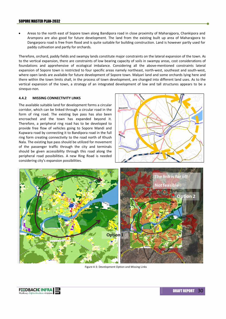
SOPORE MASTER PLAN-2032
DRAFT REPORT 30
Areas to the north east of Sopore town along Bandipora road in close proximity of Maharajpora, Chankipora and Arampora are also good for future development. The land from the existing built up area of Maharajpora to Dangarpora road is free from flood and is quite suitable for building construction. Land is however partly used for paddy cultivation and partly for orchards.
Therefore, orchard, paddy fields and swampy lands constitute major constraints on the lateral expansion of the town. As to the vertical expansion, there are constraints of low bearing capacity of soils in swampy areas, cost considerations of foundations and apprehensive of ecological imbalance. Considering all the above-mentioned constraints lateral expansion of Sopore town is restricted to four specific areas namely northeast, north-west, southeast and south-west, where open lands are available for future development of Sopore town. Malyari land and some orchards lying here and there within the town limits shall, in the process of town development, are changed into different land uses. As to the vertical expansion of the town, a strategy of an integrated development of low and tall structures appears to be a sinequo-non.
4.4.2 MISSING CONNECTIVITY LINKS
The available suitable land for development forms a circular corridor, which can be linked through a circular road in the form of ring road. The existing bye pass has also been encroached and the town has expanded beyond it. Therefore, a peripheral ring road has to be developed to provide free flow of vehicles going to Sopore Mandi and Kupwara road by connecting it to Bandipora road in the full ring form creating connectivity to the road north of Khush Nala. The existing bye pass should be utilized for movement of the passenger traffic through the city and terminals should be given accessibility through this road along the peripheral road possibilities. A new Ring Road is needed considering city’s expansion possibilities.
Figure 4-3: Development Option and Missing Links
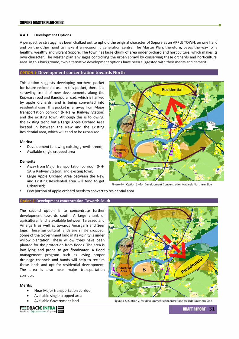
SOPORE MASTER PLAN-2032
DRAFT REPORT 31
4.4.3 Development Options
A perspective strategy has been chalked out to uphold the original character of Sopore as an APPLE TOWN, on one hand and on the other hand to make it an economic generation centre. The Master Plan, therefore, paves the way for a healthy, wealthy and vibrant Sopore. The town has large chunk of area under orchard and horticulture, which makes its own character. The Master plan envisages controlling the urban sprawl by conserving these orchards and horticultural area. In this background, two alternative development options have been suggested with their merits and demerit. OPTION 1: Development concentration towards North This option suggests developing northern pocket for future residential use. In this pocket, there is a sprawling trend of new developments along the Kupwara road and Bandipora road, which is flanked by apple orchards, and is being converted into residential uses. This pocket is far away from Major transportation corridor (NH-1 & Railway Station) and the existing town. Although this is following, the existing trend but a Large Apple Orchard Area located in between the New and the Existing Residential area, which will tend to be urbanized. Merits: • Development following existing growth trend; • Available single cropped area Demerits • Away from Major transportation corridor (NH-
1A & Railway Station) and existing town; • Large Apple Orchard Area between the New
and Existing Residential area will tend to get Urbanised;
• Few portion of apple orchard needs to convert to residential area
Option 2: Development concentration Towards South The second option is to concentrate further development towards south. A large chunk of agricultural land is available between Tarazaeu and Amargarh as well as towards Amargarh and Seer Jagir. These agricultural lands are single cropped. Some of the Government land in its vicinity is under willow plantation. These willow trees have been planted for the protection from floods. The area is low lying and prone to get floodwater. A flood management program such as laying proper drainage channels and bunds will help to reclaim these lands and opt for residential development. The area is also near major transportation corridor.OPTION-2 Merits:
Near Major transportation corridor Available single cropped area Available Government land
Figure 4-4: Option 1 –for Development Concentration towards Northern Side
Figure 4-5: Option 2-for development concentration towards Southern Side
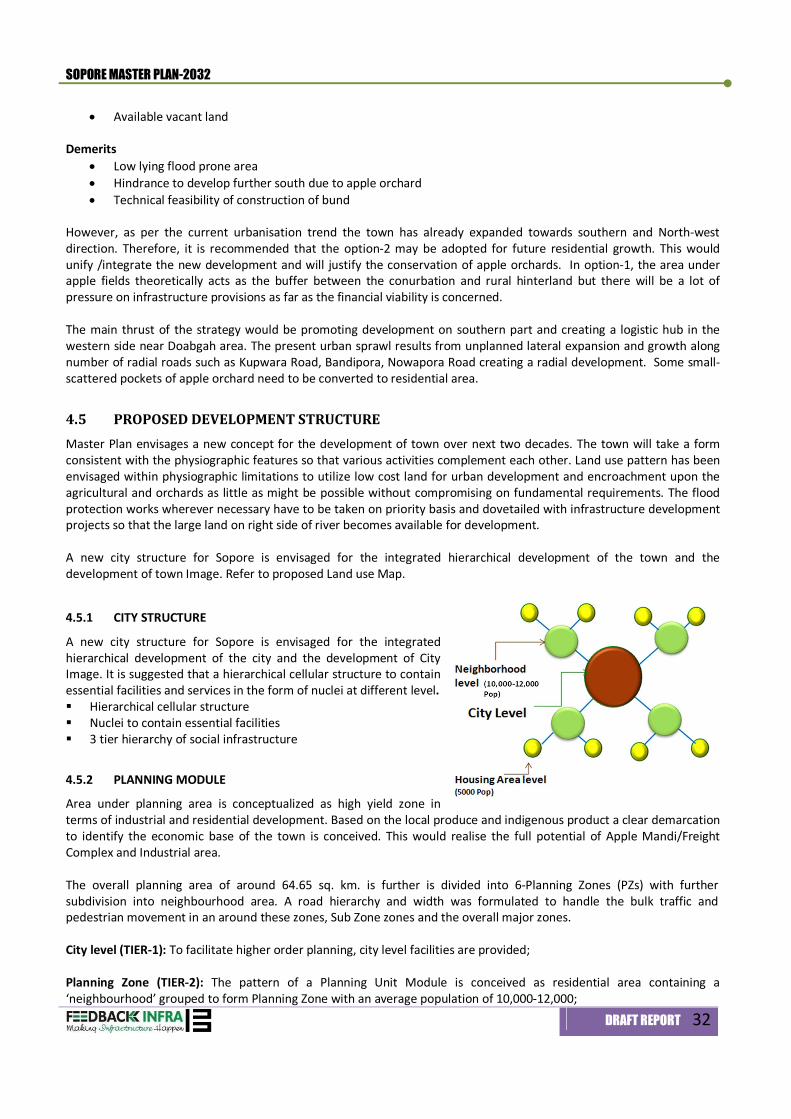
SOPORE MASTER PLAN-2032
DRAFT REPORT 32
Available vacant land Demerits
Low lying flood prone area Hindrance to develop further south due to apple orchard Technical feasibility of construction of bund
However, as per the current urbanisation trend the town has already expanded towards southern and North-west direction. Therefore, it is recommended that the option-2 may be adopted for future residential growth. This would unify /integrate the new development and will justify the conservation of apple orchards. In option-1, the area under apple fields theoretically acts as the buffer between the conurbation and rural hinterland but there will be a lot of pressure on infrastructure provisions as far as the financial viability is concerned. The main thrust of the strategy would be promoting development on southern part and creating a logistic hub in the western side near Doabgah area. The present urban sprawl results from unplanned lateral expansion and growth along number of radial roads such as Kupwara Road, Bandipora, Nowapora Road creating a radial development. Some small-scattered pockets of apple orchard need to be converted to residential area.
4.5 PROPOSED DEVELOPMENT STRUCTURE Master Plan envisages a new concept for the development of town over next two decades. The town will take a form consistent with the physiographic features so that various activities complement each other. Land use pattern has been envisaged within physiographic limitations to utilize low cost land for urban development and encroachment upon the agricultural and orchards as little as might be possible without compromising on fundamental requirements. The flood protection works wherever necessary have to be taken on priority basis and dovetailed with infrastructure development projects so that the large land on right side of river becomes available for development. A new city structure for Sopore is envisaged for the integrated hierarchical development of the town and the development of town Image. Refer to proposed Land use Map.
4.5.1 CITY STRUCTURE
A new city structure for Sopore is envisaged for the integrated hierarchical development of the city and the development of City Image. It is suggested that a hierarchical cellular structure to contain essential facilities and services in the form of nuclei at different level. Hierarchical cellular structure Nuclei to contain essential facilities 3 tier hierarchy of social infrastructure
4.5.2 PLANNING MODULE
Area under planning area is conceptualized as high yield zone in terms of industrial and residential development. Based on the local produce and indigenous product a clear demarcation to identify the economic base of the town is conceived. This would realise the full potential of Apple Mandi/Freight Complex and Industrial area. The overall planning area of around 64.65 sq. km. is further is divided into 6-Planning Zones (PZs) with further subdivision into neighbourhood area. A road hierarchy and width was formulated to handle the bulk traffic and pedestrian movement in an around these zones, Sub Zone zones and the overall major zones. City level (TIER-1): To facilitate higher order planning, city level facilities are provided; Planning Zone (TIER-2): The pattern of a Planning Unit Module is conceived as residential area containing a ‘neighbourhood’ grouped to form Planning Zone with an average population of 10,000-12,000;
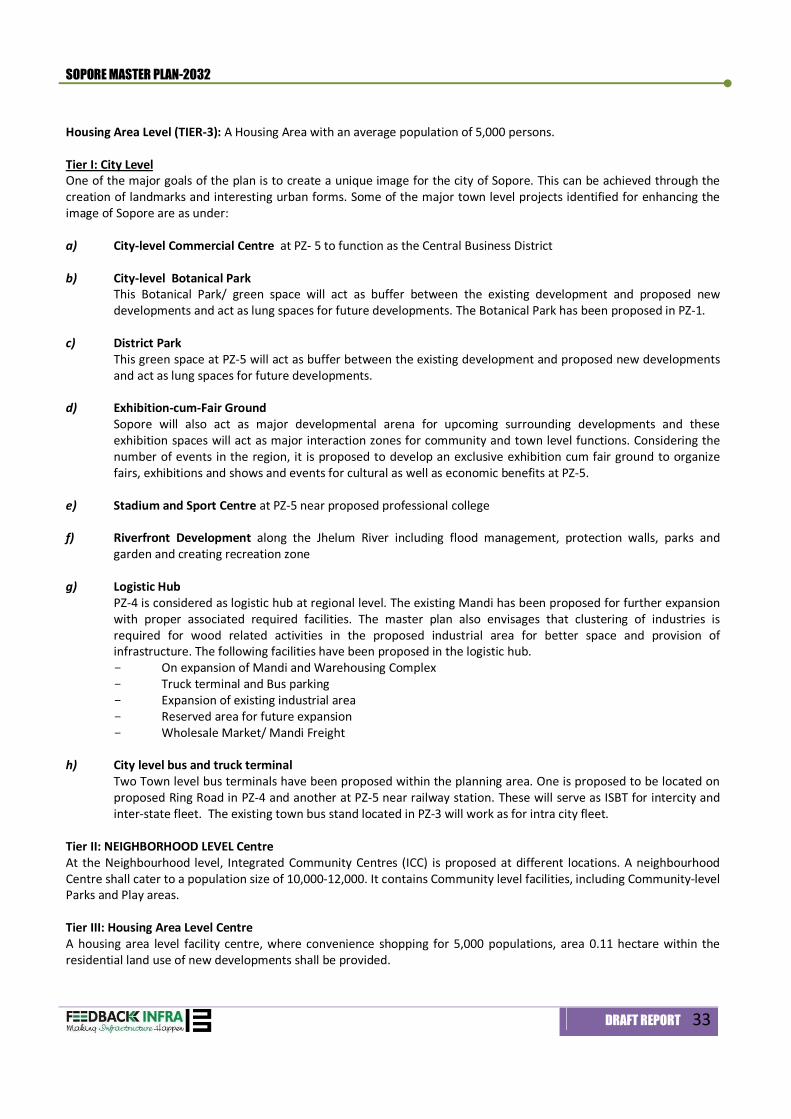
SOPORE MASTER PLAN-2032
DRAFT REPORT 33
Housing Area Level (TIER-3): A Housing Area with an average population of 5,000 persons. Tier I: City Level One of the major goals of the plan is to create a unique image for the city of Sopore. This can be achieved through the creation of landmarks and interesting urban forms. Some of the major town level projects identified for enhancing the image of Sopore are as under: a) City-level Commercial Centre at PZ- 5 to function as the Central Business District
b) City-level Botanical Park
This Botanical Park/ green space will act as buffer between the existing development and proposed new developments and act as lung spaces for future developments. The Botanical Park has been proposed in PZ-1.
c) District Park
This green space at PZ-5 will act as buffer between the existing development and proposed new developments and act as lung spaces for future developments.
d) Exhibition-cum-Fair Ground Sopore will also act as major developmental arena for upcoming surrounding developments and these exhibition spaces will act as major interaction zones for community and town level functions. Considering the number of events in the region, it is proposed to develop an exclusive exhibition cum fair ground to organize fairs, exhibitions and shows and events for cultural as well as economic benefits at PZ-5.
e) Stadium and Sport Centre at PZ-5 near proposed professional college f) Riverfront Development along the Jhelum River including flood management, protection walls, parks and
garden and creating recreation zone
g) Logistic Hub PZ-4 is considered as logistic hub at regional level. The existing Mandi has been proposed for further expansion with proper associated required facilities. The master plan also envisages that clustering of industries is required for wood related activities in the proposed industrial area for better space and provision of infrastructure. The following facilities have been proposed in the logistic hub. - On expansion of Mandi and Warehousing Complex - Truck terminal and Bus parking - Expansion of existing industrial area - Reserved area for future expansion - Wholesale Market/ Mandi Freight
h) City level bus and truck terminal
Two Town level bus terminals have been proposed within the planning area. One is proposed to be located on proposed Ring Road in PZ-4 and another at PZ-5 near railway station. These will serve as ISBT for intercity and inter-state fleet. The existing town bus stand located in PZ-3 will work as for intra city fleet.
Tier II: NEIGHBORHOOD LEVEL Centre At the Neighbourhood level, Integrated Community Centres (ICC) is proposed at different locations. A neighbourhood Centre shall cater to a population size of 10,000-12,000. It contains Community level facilities, including Community-level Parks and Play areas. Tier III: Housing Area Level Centre A housing area level facility centre, where convenience shopping for 5,000 populations, area 0.11 hectare within the residential land use of new developments shall be provided.
SOPORE MASTER PLAN-2032
DRAFT REPORT 34
4.6 PROPOSED LANDUSE - 2032 Land requirement of Sopore town has been worked out from the studies related to sub-sectors like housing demand, community facilities, utilities and services, transportation, industries, besides the land requirement for government offices and commercial establishments. Total land requirement for horizon year 2032 has been worked out under different categories of landuses and is given in Table 4.3. Table 4.3: Land use Distribution of Planning Area-2032
S. No. Land Use Area in Ha % to the total developed
% of the Total Planning Area
1 Residential 957.37 43.41 14.81 2 Commercial 129.57 5.87 2.00 3 Mixed Landuse 31.59 1.43 0.49 4 Manufacturing - Industrial 146.66 6.65 2.27 5 Public and semi-Public 371.63 16.85 5.75 6 Recreational 120.22 5.45 1.86 7 Transportation and Communication 448.62 20.34 6.94 A Sub Total 2205.66 100.00 34.11
8 Agriculture 3868.38 - 59.83 Cultivated Land 1165.44 - 18.03 Horticulture 2292.68 - 35.46 Plantation 410.26 - 6.35
9 Water bodies 279.92 - 4.33 10 Marshy Land 15.68 - 0.24 11 Reserved Green 95.74 - 1.48 B Sub-Total 4259.72 - 65.89
Total (A+B) 6465.38 - 100.00 Refer Map No. 4.2 for Proposed Land Use of the Sopore Planning Area
4.6.1 Residential Use
For the projected population of 1,90,261 persons, the total area required over the next 20-years for urban development is forecasted to be 2205.66 hectares, out of which 957.37 hectares (43.41 %) are earmarked for residential development against 596.87 hectares available at present. The residential area constituting 43.41 % of the proposed developed area will have average gross residential density of 88-persons per hectare. The Master Plan envisages the development of residential areas (both existing and proposed) on the concept of self-sustained neighbourhoods. It identifies 19-neighbourhoods with a population size of about 10,000-12,000 each.
S. No. Planning Zones Neighborhoods Location
1 PZ-1 2 One at Village Tarazuea and one at Village Panjipora & Krank Shivan
2 PZ-2 2 One each at Village Adipora and Village Saidpora
3 PZ-3 5 One at Chinkipora, and 4-at Old Sopore Area
4 PZ-4 2 One each at Muzbug and Nowpora Kalan
5 PZ-5 7 Between River Jhelum and Railway Line
6 PZ-6 1 Towards Southern Side of Existing Railway Line
SOPORE MASTER PLAN-2032
DRAFT REPORT 35
Proposed Residential Density Population density as envisaged in the Sopore Master Plan-2032 varies from low of 120 PPH, medium density 121–180 PPH, high medium density 181-240 PPH and high density of 240 PPH and above. Planning zones ‘PZ-5’ is proposed to be developed as high-density areas with provision of ‘Group and Flatted Housing’. The Master Plan proposes that planning use zone PZ5-1, the areas abutting river Jhelum be developed as low-density areas. Planning use zones PZ1-1 has been proposed as eco-tourism areas while planning zone PZ5 is proposed as a new capital city area. Old city and Central Business District (CBD) have been envisaged as special areas for purposes of the Master Plan.
4.6.2 Commercial Use
Commercial use is proposed in compatible to residential areas in the proposed plan to establish efficient work-home relationship. The existing plan showed concentration of commercial areas near bus stand on Nowpora road. Apple Mandi of 9.2 hectare is located on Mazbug road as wholesale component of commercial use zone. 5.87 % of area in proposed landuse plan is rendered under commercial use zone, with two city level commercial areas, one on Kupwara road integrating with existing commercial area and other on proposed peripheral expressway in the southeast part of town. The hierarchical distribution of commercial area is established through facility centre at city level, neighbourhood level and housing area level, which includes appropriate percent of commercial areas as per development guidelines.
4.6.3 Industrial Zone
Sopore town has two industrial estates, Bagie Islam of 4.13 hectare having small and medium scale activities and A Food Park measuring land area of 10.16 hectare with 24-industrial units. Gauging the potential of fruit mandi, an industrial estate of 127.13 hectare has been proposed near SIDCO complex on peripheral expressway, outside the town to ensure easy mobility of goods/ freight movement. The industrial area of the planning area has increased from 2.20 % to 6.65 %.
4.6.4 Recreation Zone
1.29 % land area under recreational use in the town, which is very low in comparison of standards of UDPFI. The proposed plan gives thrust to green cover and proposes an area of 120.22 (5.45 %) for recreational activities. The proposed green uses includes Botanical Garden, District Park, Exhibition Ground, City level Sports Centre and neighbourhood and housing area level parks/ playgrounds duly included in neighborhood centres and housing area facility. To include flowing green concept, green strip along road network, along riverbanks and along peripheral of proposed expressway shall be developed.
4.6.5 Public and Semi-Public Zone
Public and Semi-public zone comprised of education, health, public utilities etc., considering the infrastructural requirement for the projected population and hierarchical distribution of facilities, facility centre at city level; neighbourhood centre at neighbourhood level and housing area facility centre at housing cluster level is proposed. To make efficient and sustainable planning units, these facility centres includes education, health etc. facilities. There has been an increased an area under Public and Semi-Public Zone from existing 116.22 hectare to 371.63 hectare in horizon year 2032 within planning limit.
4.6.6 Transportation
To increase mobility and connectivity in the town, new road network has been proposed to strengthen and improve the existing roads system of the planning area. The hierarchies of roads i.e. 45 m, 30 m, 28 m, 25 m, 21 m, 15 m and 12 m have been proposed. The total area under transportation landuse has increased from 107.44 hectare to 448.62 hectare.
4.6.7 Agriculture and orchards
To preserve orchards and meet the horticultural requirement of future development, some agriculture land parcels have been consumed. In order to improve the quality of environment and to promote the percentage of green cover, it is proposed to plant trees along all major roads. The proposed peripheral expressway and the town semi-circular road will have thick tree plantation.

Economic Base & Work Areas 5
SOPORE MASTER PLAN-2032
DRAFT REPORT 36
5. Economic Base and Work Areas
5.1 CONTEXTUAL
The economic sector is the main anchor behind the progress and growth of any town. Existing Freight/Mandi complex has been established with the vision to trigger the economic growth of the region, but failed to accentuate the economy of the region. Despite having an important regional economic node of Freight/Mandi Complex, the economic sector remained unproductive. Being weak on the economic front, the region requires strong economic magnets for future economic development of the Region.
5.2 MAJOR WORK AREAS –TRADE AND COMMERCE 5.2.1 Existing Work Areas
a) City Commercial Centre/CBD: The existing commercial areas along the Kupwara Road are the present district centre of the town. The present bus stand in the town creates congestion due to inter and intra city vehicles. The local government has already planned to shift the present bus stand to Model Town. In order to cater to the town level commercial and facilities requirement, a new commercial Centre is envisaged in Planning Zone 5. The Commercial Centre shall comprise of facilities such as, Socio-cultural Club, exhibition gallery and cultural centre, museums, specialty Hospital, general community facilities and housing along with recreational facilities. The existing CBD will work as major commercial centre of the town until the proposed Commercial centre is not functional.
b) Commercial Establishments – Retails: There are 480 retails shops at present in the different parts of the town to
cater to the needs of the inhabitants. Bus Stand area, Bugu, Iqbal Park, Kupwara Road are the major retail centre in the town. The following table shows various location of retails activity.
Table 5-1: Retails establishment in the Sopore town S. No. Locality Name Number of shops Remarks
1 College road near fire station 8 8 Godowns are also located in this area
2 Sabzi Mandi area 20 Retail
3 Court Road 19 Retail
4 Bugu area near J & K bank 66 Retail
5 Tehsil road 5 Retail
6 Tehsil road near old Baba Yousuf School 3 Retail
7 Nowapora crossing 7 3 Godowns are also located in this area
8 Near Bus stand 187 Retail
9 In PHE complex 19 Retail
10 At Government Transport yard 3 Retail
11 Shopping Complex, Igbal Park 48 Retail
12 On Kupwara road 41 Retail
13 Municipal Shops at different places in town 54 Retail
Total 480 -
Source: Municipal Council of Sopore, 2011
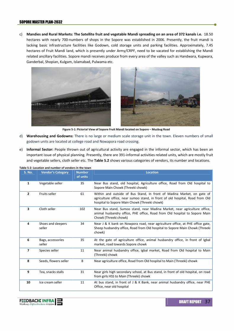
SOPORE MASTER PLAN-2032
DRAFT REPORT 37
c) Mandies and Rural Markets: The Satellite fruit and vegetable Mandi spreading on an area of 372 kanals i.e. 18.50 hectares with nearly 700-numbers of shops in the Sopore was established in 2006. Presently, the fruit mandi is lacking basic infrastructure facilities like Godown, cold storage units and parking facilities. Approximately, 7.45 hectares of Fruit Mandi land, which is presently under Army/CRPF, need to be vacated for establishing the Mandi related ancillary facilities. Sopore mandi receives produce from every area of the valley such as Handwara, Kupwara, Ganderbal, Shopian, Kulgam, Islamabad, Pulwama etc.
Figure 5-1: Pictorial View of Sopore Fruit Mandi located on Sopore – Muzbug Road
d) Warehousing and Godowns: There is no large or medium scale storage unit in the town. Eleven numbers of small godown units are located at college road and Nowapora road crossing.
e) Informal Sector: People thrown out of agricultural activity are engaged in the informal sector, which has been an important issue of physical planning. Presently, there are 391-informal activities related units, which are mostly fruit and vegetable sellers, cloth seller etc. The Table 5.2 shows various categories of vendors, its number and locations.
Table 5-2: Location and number of vendors in the town S. No. Vendor’s Category Number
of units Location
1 Vegetable seller 35 Near Bus stand, old hospital, Agriculture office, Road from Old hospital to Sopore Main Chowk (Threeki chowk)
2 Fruits seller 61 Within and outside of Bus Stand, In front of Madina Market, on gate of agriculture office, near sumoo stand, in front of old hospital, Road from Old hospital to Sopore Main Chowk (Threeki chowk)
3 Cloth seller 102 Near Bus stand, Sumoo stand, near Madina Market, near agriculture office, animal husbandry office, PHE office, Road from Old hospital to Sopore Main Chowk (Threeki chowk)
4 Shoes and sleepers seller
34 Near J & K bank on Nowpora road, near agriculture office, at PHE office gate, Sheep husbandry office, Road from Old hospital to Sopore Main Chowk (Threeki chowk)
6 Bags, accessories seller
35 At the gate of agriculture office, animal husbandry office, in front of Igbal market, road towards Sopore chowk
7 Species seller 11 Near animal husbandry office, Igbal market, Road from Old hospital to Main (Threeki) chowk
8 Seeds, flowers seller 8 Near agriculture office, Road from Old hospital to Main (Threeki) chowk
9 Tea, snacks stalls 31 Near girls high secondary school, at Bus stand, in front of old hospital, on road from girls HSS to Main (Threeki) chowk
10 Ice cream seller 11 At bus stand, in front of J & K Bank, near animal husbandry office, near PHE Office, near old hospital
SOPORE MASTER PLAN-2032
DRAFT REPORT 38
S. No. Vendor’s Category Number of units
Location
11 Meat (Chicken, mutton, Fish) seller
31 Near girls HSS, at bus stand, near old hospital
12 Cobblers 11 Near PHE office gate, near animal husbandry gate, near old hospital
13 Cookeries 17 Near animal husbandry hospital, on road from Girls HSS to Main (Threeki) chowk
14 Blacksmiths 4 On road from Girls HSS to Main (Threeki) chowk
Total units 391 -
Source: Consultant’s survey, 2011
Sopore’s informal sector activities are scattered in the town, these activities will be swollen beyond manageable limits with the induced growth in future. Hence, for these, proper provision for space should be considered. These informal sector units are located themselves strategically near work centres, commercial areas, outside the boundaries of schools, colleges and hospitals, transport nodes and near large housing clusters. It is proposed to integrate the informal sector in trade and services in the planned development. The prime considerations while planning for Informal Sector are:
Making space available for such type of activities in the form of Sunday Market, morning/evening vegetable and other bazaars at vantage points consistent with Street Vendor Policy recommended for the town;
Provide in-built mechanism for space adjacent or in the major activity centers including terminal centers, industrial estates, administrative centers, and even in major commercial centers;
Introduction of various self-employment schemes to eradicate unemployment It is recommended that a Detailed Project Report (DPR) in line with the guidelines prescribed in the National Policy on Street Vendors-2007 for rehabilitation of street vendors and identify compatible areas for activities of this Informal Sector.
5.3 RETAIL TRADE 5.3.1 Retail trade Hierarchy
Retail shopping areas are important as these create an image of the town. To accommodate the required shopping, commercial offices, and other activities like cinema, hotel and related facilities, a three-tier system of commercial development is proposed as follows: 1) City level – Entire city Area 2) Neighbourhood level 3) Housing Areas level
TIER - I: City Level Commercial Centres
City level Commercial centre are envisaged to serve the entire town and the villages within the Sopore master plan area. A new city level commercial centre in an area of 6.90 hectares is envisaged in PZ-5. This city level commercial centre are major shopping complexes, which will serve reasonable range of shops, departmental stores, mall along-with the centres of socio-cultural activities.. Besides commercial facilities, it will also include a library, a multipurpose meeting hall, and an exhibition centre for art exhibitions. The present commercial area located near bus stand in PZ-3, is to be further extended to an area of 9.2 hectares will be functioning as another city level commercial area to serve the area of left bank of river Jhelum.
TIER-II: Neighbourhood level Commercial Centre A total number of Seventeen Integrated Community Centres (ICC) has been proposed for Sopore Master Plan-2032. These Integrated Community Centres will include Community Commercial Centres and Community Facility Centres,
SOPORE MASTER PLAN-2032
DRAFT REPORT 39
which clubbed together. For the distribution of District Commercial Centres or neighbourhood, Commercial Centres, local Shopping for a Neighbourhood commercial centre of 10,000-12,000 populations is proposed with an area of 0.45 hectares. TIER - III Housing Area Shopping Centres Convenience shopping for 5,000 populations, area 0.11 hectares within the residential land use of new developments shall be provided.
5.3.2 Components of commercial Center
The activities that are proposed to be provided in the three-tier system of commerce areas are given in Table 5.3. Table 5-3: Five-Tier Hierarchy of Commercial Activities
Commercial Centre Neighbourhood Commercial Centre Cluster Centre
Tier I Tier II Tier III
Population Served City and Regional level 10,000-12,000 5,000
Area 5.5 hectare 0.45 hectare 0.11 ha Land Requirement Per thousand Persons 550 Sq. m. 306 Sq. m. 220 Sq. m.
Table 5-4: Components of Commercial Centre
Commercial Centre Neighbourhood Commercial Centre Housing Area / Cluster Centre
Tier I Tier II Tier III
Activ
ities
Shopping (Retail Service, Repair & limited Wholesale) Informal Shopping, Commercial Offices, Cinema, Hotel, Guest House, Nursing Home
Shopping Retail Service, Repair Informal Shops, Commercial Offices.
Shopping Retail Service, Repair Informal Shopping
Service Industries: Auditorium, Museum, Library, Science Centre, Art/Craft/Music/ Dance School, Craft/Mela/Book Bazaar, Weekly Markets (on close days), Local Government Offices
Community Hall and Library
Bus Terminal, Fire Post, Police Post, Telephone Exchange, Electric Sub Station, Post and Telegraph Office, Petrol Pump Conveniences Residential Post office, Dispensary, Petrol Pump (filling Station only) Weekly Markets (on close days) Electric Sub-Station Conveniences
Electric Sub-Station Conveniences
Electric Sub Station Conveniences
5.4 WHOLESALE The trade and commerce is estimated at 30 % of the total employment in Sopore Master Plan Area, which works out to 22,831 (50 % of the total tertiary sector employment). Out of the total employment in trade and commerce, 10 % is estimated as wholesale workers, which would be 2,283 persons. Integrated Mandi/Freight Complex The Master Plan proposes to develop the existing Mandi area as an integrated freight complex including wholesale markets, manufacturing and industrial units, and truck terminals near Doabgah Area. This location is integrating with the existing industrial estates and Mandi as well as appropriate linkages for the incoming and outgoing goods. It is envisaged that an easy transportation network will be formed for distribution of wholesale goods in the city through major road network and its regional linkage such as Baramulla-Srinagar road and Jammu-Baramulla rail linkages. The detail distribution of land use for Integrated Freight Complex and Truck Terminal are given below.
SOPORE MASTER PLAN-2032
DRAFT REPORT 40
Table 5-5: Description of area for Integrated Mandi /Freight complex
Use Type Area in Ha % Wholesale / Mandi 35.0 35.0 Warehousing 8.0 8.0 Booking Agencies 2.0 2.0 Commercial and Public & Semi-Public 5.0 5.0 Utilities and Services 3.0 3.0 Service Industries 4.0 4.0 Truck Terminal / Parking 12.0 12.0 Circulation 25.0 25.0 Others 6.0 6.0 Total 100.00 100.0
5.5 INDUSTRIES The number of workers in secondary sector is envisaged to increase from the existing level of 1,480 in 2012 to 7,943 in 2022 and subsequently to 21,309 in 2032. Town Planning Organization Kashmir emphasizes the need for industrial policy by the Department of Industries to create an enabling environment for strengthening the industrial base of the town. The Master Plan asserts that the Government should evolve a mechanism to revisit its State Industrial Policy to ensure that the beneficiaries under different schemes adhere to the scheme and not misuse the package. It is proposed that the Government should - apart from available benefits under the policy - take some concrete measures for sharing the risk involved in a project to lure in private investments at the accelerated rate. The sickness of industrial sector in Sopore is typical of the industrial sector in all towns of the valley although the production of fruit clearly indicates the potential for fruit processing industries in the region. Existing location of Bagie industrial estate and Food park measuring an area of 14.29 hectares will not suffice for the quantum of industrial activities envisaged for 1,90,261 population by 2032 of Sopore Planning Area. The Master Plan has proposed an area of 146.66 hectares as an industrial area in which small to medium scale industrial units are permitted. It is envisaged that out of the total estimated 21,309 secondary sector employment, the industrial area will generate 16,743 employments, which constitute almost 78.57 % of total secondary workers. The remaining secondary sector employments are other tiny rural base non-polluting industries are within the rural area. The proposed Industrial Estate Policy contained in this Master Plan is expected to not only provide employment to inhabitants of town but also become hub of industrial activity for the entire Sopore region. The Government will confine its role to the development of industrial land, which will be subsequently handed over to the unit holders who will plan their activities as per the broad guidelines of the Industries Department.

Physical Infrastructure 6
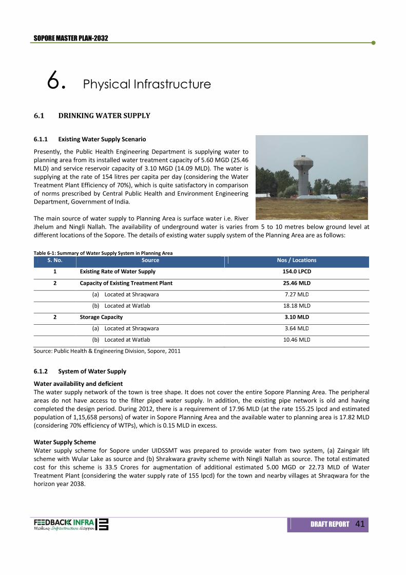
SOPORE MASTER PLAN-2032
DRAFT REPORT 41
6. Physical Infrastructure
6.1 DRINKING WATER SUPPLY
6.1.1 Existing Water Supply Scenario
Presently, the Public Health Engineering Department is supplying water to planning area from its installed water treatment capacity of 5.60 MGD (25.46 MLD) and service reservoir capacity of 3.10 MGD (14.09 MLD). The water is supplying at the rate of 154 litres per capita per day (considering the Water Treatment Plant Efficiency of 70%), which is quite satisfactory in comparison of norms prescribed by Central Public Health and Environment Engineering Department, Government of India. The main source of water supply to Planning Area is surface water i.e. River Jhelum and Ningli Nallah. The availability of underground water is varies from 5 to 10 metres below ground level at different locations of the Sopore. The details of existing water supply system of the Planning Area are as follows: Table 6-1: Summary of Water Supply System in Planning Area
S. No. Source Nos / Locations
1 Existing Rate of Water Supply 154.0 LPCD
2 Capacity of Existing Treatment Plant 25.46 MLD
(a) Located at Shraqwara 7.27 MLD
(b) Located at Watlab 18.18 MLD
2 Storage Capacity 3.10 MLD
(a) Located at Shraqwara 3.64 MLD
(b) Located at Watlab 10.46 MLD
Source: Public Health & Engineering Division, Sopore, 2011
6.1.2 System of Water Supply
Water availability and deficient The water supply network of the town is tree shape. It does not cover the entire Sopore Planning Area. The peripheral areas do not have access to the filter piped water supply. In addition, the existing pipe network is old and having completed the design period. During 2012, there is a requirement of 17.96 MLD (at the rate 155.25 lpcd and estimated population of 1,15,658 persons) of water in Sopore Planning Area and the available water to planning area is 17.82 MLD (considering 70% efficiency of WTPs), which is 0.15 MLD in excess. Water Supply Scheme Water supply scheme for Sopore under UIDSSMT was prepared to provide water from two system, (a) Zaingair lift scheme with Wular Lake as source and (b) Shrakwara gravity scheme with Ningli Nallah as source. The total estimated cost for this scheme is 33.5 Crores for augmentation of additional estimated 5.00 MGD or 22.73 MLD of Water Treatment Plant (considering the water supply rate of 155 lpcd) for the town and nearby villages at Shraqwara for the horizon year 2038.
SOPORE MASTER PLAN-2032
DRAFT REPORT 42
6.1.3 Norms and Standards for Water Supply
Per capita water supply for designing of various schemes as suggested in “Manual on Water Supply and Treatment” of the Central Public Health Engineering Organisation, Government of India.
70 LPCD for Towns provided with piped water supply but without sewerage system; 135 LPCD for Cities provided with piped water supply where sewerage system is existing/contemplated; 150 LPCD for Planning and Mega Cities provided with piped water supply where sewerage system is
existing/contemplated. In view of this condition, the criteria used for fixing the water supply norms include:
100 % houses will be supplied with piped filtered water by the year 2032; 100 % houses will be connected to Municipal Sewerage System requiring flushing of toilets; Adequate water for fire fighting will be stored for entire city
The proposed per capita water requirement works out to 155.25 lpcd for Sopore planning area. However, this does not include the water demand for proposed major industries of the planning area. The water demands for these industrial developments are needs to be estimated separately.
6.1.4 Projected Water Demand and supply
The total estimated water requirement by the horizon year 2032 in the planning area will be 35.48 MLD (considering the rate of 155.25 lpcd for domestic supply and 45,000 litres per hectare per day for proposed industrial demand). The Planning Units wise water demand is detailed in Table 6.2. Table 6-2: Water Demand in Sopore Planning Area-2032
Area Population Domestic Water Demand (MLD)
Industrial Water Demand (MLD)
Total (MLD)
PZ 1 25,000 3.11 - 3.11
PZ 2 14,073 2.18 - 2.18 PZ 3 48,249 7.49 - 7.49 PZ 4 20,040 3.11 5.94 9.05 PZ 5 70,000 10.87 - 10.87 PZ 6 17,900 2.78 - 2.78
Total 1,90,261 29.54 5.94 35.48 On implementation of the water supply scheme under UIDSSMT, there will be a deficit of 1.75 MLD of water availability to the planning area. This deficit shall be met by improving the efficiency of existing water treatment plants and through reduction of distribution and transmission losses of water supply.
6.1.5 Service Reservoir
At present, service reservoirs are located at Shraqwara and Watlab with storage capacity of 0.80 MLD and 2.30 MLD respectively. There is a requirement of 8.86 MLD (excluding industrial water demand) of water storage capacity in planning area for the horizon period of 2032. The Master plan proposes that a series of service reservoirs with total capacity of 5.76 MLD shall be established at neighborhood level. The Phase wise water demand and capacity of service reservoirs are detailed in Table 6.3 Table 6-3: Phasing of Water Demand and Capacities of Service Reservoirs in Sopore Planning Area-2032
Year Population Domestic Water Demand (MLD)
*Required Storage Capacity (MLD)
No. of Reservoir Capacity of Service Reservoirs (MLD)
2012 1,15,658 17.96 2.29 5 0.46 2017 1,30,150 20.21 2.96 7 0.42 2022 1,47,095 22.84 3.75 8 0.47
SOPORE MASTER PLAN-2032
DRAFT REPORT 43
Year Population Domestic Water Demand (MLD)
*Required Storage Capacity (MLD)
No. of Reservoir Capacity of Service Reservoirs (MLD)
2027 1,67,279 25.97 4.69 10 0.47 2032 1,90,261 29.54 5.76 14 0.41
Note: *Excluding the existing service reservoir capacity
6.2 SEWERAGE AND SANITATION
6.2.1 Sewerage System
The total quantity of sewage generation from Sopore town is approximately 14.36 MLD per day, which will increase to 23.63 MLD (80 % of total water supply) by the horizon year 2032. At present, there is no organized system for collection, conveyance, treatment, and disposal of sewage generates within the Sopore. The sewage generated from the individual houses, hotels, other establishments is either directly discharged into the nearby storm water drains without any treatment or after partial treatment through septic tanks. Disposing sewage to the open drains creates unhealthy environment and making the area disease prone. The Sopore Master Plan-2032 should have adequate sewage treatment facilities supplemented with efficient sewerage infrastructure and disposal system to ensure public health and quality environment. Sewerage system can comprise combined sewers for municipal sewage and storm water drainage or a separate system for both or combination of two. Combined sewerage system invariably suffers from the disadvantage of sluggish flow during most part of the year leading to deposition of sewage solids and creating foul and offensive conditions. In view of this problem, Central Public Health and Environment Engineering Organization (CPHEEO) do not recommend the use of combined sewers in the modern designs. Storm water from sewers will be directly disposed off into streams or river whereas the sanitary and industrial wastes will be disposed of into water bodies after proper treatment. Sewerage system will consist of a hierarchy of three levels:
Trunk sewers Main sewers Sub-main sewers
The sewerage system hierarchy will be consistent with the street hierarchy with trunk and main sewers along arterial and sub-arterial roads and sub-main sewers on collectors. The final sewerage design will depend on the actual flows in sewers based on micro-level study by the concerned department with on 30-years of horizon period. To have an efficient sewerage disposal and treatment system, it would require for fulfilling the future demand, an underground sewerage network system in entire planning area and treatment facility for 53.17 MLD (considering the peak factor of 2.25) is proposed. Considering the design guidelines for low-lying area along the river Jhelum, the entire Planning Area will be divided into 3-Sewerage Zones with individual Sewerage Treatment Plant (STP). The details of proposed sewerage zones and location of STPs are given in Table 6.4 below. Table 6-4: Planning Zone wise Sewage Generation -2032
Sewerage Zones Planning Zones Total Sewage Generation (during peak period) Area for STPs (HA)
I PZ-1 & Partial PZ-6 5.59 2.0 II PZ-2, PZ-3 & PZ-4 23.02 4.0 III PZ-5 and Partial PZ-6 24.56 4.0
Total 53.17 10.0 The basic objectives of sewage treatment are to stabilize decomposable organic matter present in the sewage to produce an effluent, which can be disposed of in the environment without disturbing the eco-system of an area. Complete treatment of sewage by 2032 should be one of the fundamental concerns of the planning endeavor. The horizon period for the design of sewage treatment facility is 30 years. The division of planning into two segments by river Jhelum makes it necessary to either provide two sewage treatment plants or carry the raw sewage from one division to the other across the river through pipes. The physiographic makes the carriage of the effluents through sewer system
SOPORE MASTER PLAN-2032
DRAFT REPORT 44
possible to the proposed location without unnecessary use of pumps which otherwise adds to the costs of maintenance of the sewage treatment facility.
6.2.3 Low Cost Sanitation and Community Latrines
The experience reveals that the provision of low cost sanitary latrines at 100 % subsidy can have limited success and have been abandoned. The Master Plan Sopore envisages a scheme for giving impetus to the low cost sanitation facilities by giving technical advice and limited subsidy on self-financial basis in the construction of low cost units. Local authority personnel will have to be trained and subsidy be given to below poverty groups only. The technology for the low cost sanitary units will be Sulabh Suchalya with adequate modification to suit the local conditions. In addition to the low cost facility, community latrines for 5-units with conventional disposal facilities are also proposed to be provided in the core area and large public places on pay and use basis.
6.3 DRAINAGE The drainage system in Sopore comprises natural and man-made drains and water bodies that ultimately discharge surface run-off of storm water into the Jhelum River which passes through the heart of the town.
6.3.1 Existing Drainage System
The drainage system of the town is taken care by the combination of nallahs, irrigation canals and rivers. Major portion of the town is sandwich between river Jhelum or Veth and Pohru River. All nallahs, canal and Pohru river finally meets into river Jhelum. The details of nallahs, rivers and canals are given in Table 6.5.
Table 6-5: Major Drains, Nallahs and River in the town S. No. Name Flow direction Remarks
River
1 River Jehlum North-East to South West Both rivers meets towards South-west direction of town at Doabgha
2 River Pohru North to South Irrigation Canal
3 Naupur Minor Canal North to South The canal finally meets in river Jhelum 4 Baghal Minor Canal North to South It meets in canal Naupur
5 Chinkipur Minor Canal North to Eastern side Finally meets in river Jhelum
6 Zainagir Minor Canal West to Eastern side Finally meets in Wular Lake Nallahs
7 Ningli Nallah South to North It is coming from Southern side of the town and finally meets in River Jhelum near Wular lake
8 Buggu Nallah North to Southern direction Centrally located in the town and finally meets river Jhelum
Source: Consultant’s Analysis and Survey of India’s Topographical sheet
6.3.2 Flooding of drainage system
There are few floods prone areas in the city such as some portion of Sheri Kashmir Colony near Ningli, New Colony and some portion near Doabgaha are water logged for few hours after heavy rains.
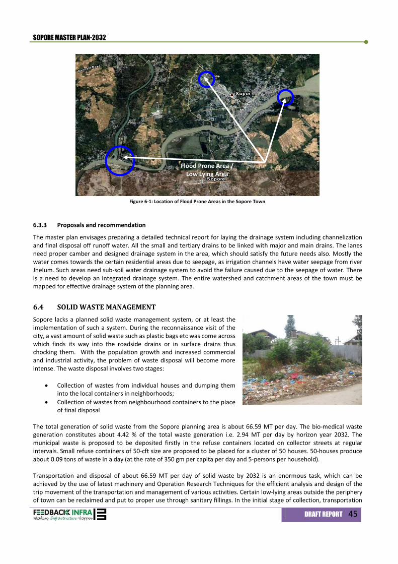
SOPORE MASTER PLAN-2032
DRAFT REPORT 45
Figure 6-1: Location of Flood Prone Areas in the Sopore Town
6.3.3 Proposals and recommendation
The master plan envisages preparing a detailed technical report for laying the drainage system including channelization and final disposal off runoff water. All the small and tertiary drains to be linked with major and main drains. The lanes need proper camber and designed drainage system in the area, which should satisfy the future needs also. Mostly the water comes towards the certain residential areas due to seepage, as irrigation channels have water seepage from river Jhelum. Such areas need sub-soil water drainage system to avoid the failure caused due to the seepage of water. There is a need to develop an integrated drainage system. The entire watershed and catchment areas of the town must be mapped for effective drainage system of the planning area.
6.4 SOLID WASTE MANAGEMENT Sopore lacks a planned solid waste management system, or at least the implementation of such a system. During the reconnaissance visit of the city, a vast amount of solid waste such as plastic bags etc was come across which finds its way into the roadside drains or in surface drains thus chocking them. With the population growth and increased commercial and industrial activity, the problem of waste disposal will become more intense. The waste disposal involves two stages:
Collection of wastes from individual houses and dumping them into the local containers in neighborhoods;
Collection of wastes from neighbourhood containers to the place of final disposal
The total generation of solid waste from the Sopore planning area is about 66.59 MT per day. The bio-medical waste generation constitutes about 4.42 % of the total waste generation i.e. 2.94 MT per day by horizon year 2032. The municipal waste is proposed to be deposited firstly in the refuse containers located on collector streets at regular intervals. Small refuse containers of 50-cft size are proposed to be placed for a cluster of 50 houses. 50-houses produce about 0.09 tons of waste in a day (at the rate of 350 gm per capita per day and 5-persons per household). Transportation and disposal of about 66.59 MT per day of solid waste by 2032 is an enormous task, which can be achieved by the use of latest machinery and Operation Research Techniques for the efficient analysis and design of the trip movement of the transportation and management of various activities. Certain low-lying areas outside the periphery of town can be reclaimed and put to proper use through sanitary fillings. In the initial stage of collection, transportation
Flood Prone Area / Low Lying Area
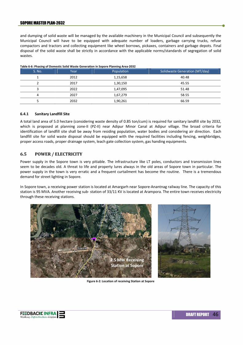
SOPORE MASTER PLAN-2032
DRAFT REPORT 46
and dumping of solid waste will be managed by the available machinery in the Municipal Council and subsequently the Municipal Council will have to be equipped with adequate number of loaders, garbage carrying trucks, refuse compactors and tractors and collecting equipment like wheel borrows, pickaxes, containers and garbage depots. Final disposal of the solid waste shall be strictly in accordance with the applicable norms/standards of segregation of solid wastes. Table 6-6: Phasing of Domestic Solid Waste Generation in Sopore Planning Area-2032
S. No. Year Population Solidwaste Generation (MT/day)
1 2012 1,15,658 40.48 2 2017 1,30,150 45.55 3 2022 1,47,095 51.48 4 2027 1,67,279 58.55
5 2032 1,90,261 66.59
6.4.1 Sanitary Landfill Site
A total land area of 5.0 hectare (considering waste density of 0.85 ton/cum) is required for sanitary landfill site by 2032, which is proposed at planning zone-II (PZ-II) near Adipur Minor Canal at Adipur village. The broad criteria for identification of landfill site shall be away from residing population, water bodies and considering air direction. Each landfill site for solid waste disposal should be equipped with the required facilities including fencing, weighbridges, proper access roads, proper drainage system, leach gate collection system, gas handing equipments.
6.5 POWER / ELECTRICITY Power supply in the Sopore town is very pitiable. The infrastructure like LT poles, conductors and transmission lines seem to be decades old. A threat to life and property lures always in the old areas of Sopore town in particular. The power supply in the town is very erratic and a frequent curtailment has become the routine. There is a tremendous demand for street lighting in Sopore. In Sopore town, a receiving power station is located at Amargarh near Sopore-Anantnag railway line. The capacity of this station is 95 MVA. Another receiving sub- station of 33/11 KV is located at Arampora. The entire town receives electricity through these receiving stations.
Figure 6-2: Location of receiving Station at Sopore
2.5 MW Receiving Station at Sopore
SOPORE MASTER PLAN-2032
DRAFT REPORT 47
6.5.1 Present and Future Demand and Supply of Power
The demand of electricity in the Sopore town will be 76.10 MW and 95-number of transformers will be required by the horizon year 2032.
Estimated population (2032) 1,90,261
Households by 2032 (@ 5 persons per household) 29,750 Power Demand (2032) @ 2 KW per household 76.10 MW No. of Transformer Required ( @ 1-Transformer = 100 KVA, & Power Factor of 0.80) - 2032 95
The power losses can be minimized through following interventions:
Renovation and modernization of 33/11 KV and 11 KV / 440 V sub-stations; Installation of new transformers and capacity augmentation of existing transformers; Metering of all connections; Installation of a HVDS (High Voltage Distribution System); Installation of LT ABC (Arial Bonded Cable)

Social Infrastructure 7
SOPORE MASTER PLAN-2032
DRAFT REPORT 48
7. Social Infrastructure
7.1 INTRODUCTION Social Infrastructure includes education, health, recreation, socio-cultural facilities, police, fire, postal services, telecommunication and distributive services. Development of physical infrastructure cannot lead in overall development at the desired level if the social infrastructure is not simultaneously developed. The education, health, public entertainment etc have to be developed to ensure proper social infrastructure in the planning area.
7.2 EDUCATION 7.2.1 Basic Education and Literacy Indicators
As per the census, 2001, the literacy rate in the town is 58.7 percent, which is lower than the district average literacy rate of 60.3 percent. As per the Provisional Census 2011, district Baramulla have literacy rate of 66.93 percent. The survey conducted during the master plan preparation, the literacy rate is computed to 70 percent for the Sopore town. The ratio between numbers of students per teacher in the Sopore town including private and governmental school is about one teacher for 15-students (1:15) and the proportion varies in different hierarchy of institutions in the town. Presently, there are 5,729 enrolled students and 383-teachers in the town.
7.2.2 Proposed Educational Facilities
Sopore town houses many Governmental and private institutions, which also serves the educational requirement of the nearby villages and settlements of the region. As per the information collected from the Zonal Educational Office, Sopore and primary survey conducted by the consultant, there are 62 primary schools, 30-Middle Schools, 9-High Schools and 3-High Secondary Schools in the Planning Area. In addition to school education, the planning area has one-degree College, 4-Teacher Training Institutions, one-Industrial Training Institute and one-polytechnic institute. The prevailing system of Primary, Middle, High, High Secondary and College will have to be replaced by four tier system of Pre-Primary/Nursery Schools, Primary Schools (I-VIII), Secondary Schools (IX-XII) and College1. Out of the above hierarchy of educational facilities, Secondary Schools and Colleges serve not only Sopore town but also to a large number of rural areas of the region. In case of providing educational facilities in the town, care has to be taken for dissemination of female education. Most of the parents generally show unwillingness to send their girl child where co-education is imparted especially in higher education. Therefore, to avoid drop out of the female children, a Women’s College is envisaged which will serve the Sopore region. The Sopore is in close vicinity to Baramulla and Srinagar, professional institutions will be paramount importance. Table 7-1: Proposed Educational Infrastructure (2012-2032) 2
S. No.
Particulars Standards Area (HA)
Future Requirement
Existing Backlog Land Requirement
(HA) 1 Pre-Primary / Nursery 1 per 2500 pop 0.2 76 62 14 3 2 Primary School (I-VIII) 500 students/School, 1 per
5000 Pop 0.4 38 30 8 3
3 Senior Secondary 1 per 7500 Pop 1.3 25 9 16 21 4 Integrated School (I-X) 1 per 90,000 Pop 3 2 3 Nil 5 Integrated School with
Hostel (I-X) 1000-1500 Students, 1 for 90000 Pop
5 2 Nil 2 11
6 School for Handicapped 400 Students / 45000 Pop 1.6 4 Nil 4 7 7 College 1000-1500 students /1 Lac
Pop 4 2 1 1 4
8 ITI's 500 Students/ 3 Lac Pop 2 1 1 Nil - 9 Polytechnic 400 Students / 3 Lac Pop 2 1 1 Nil -
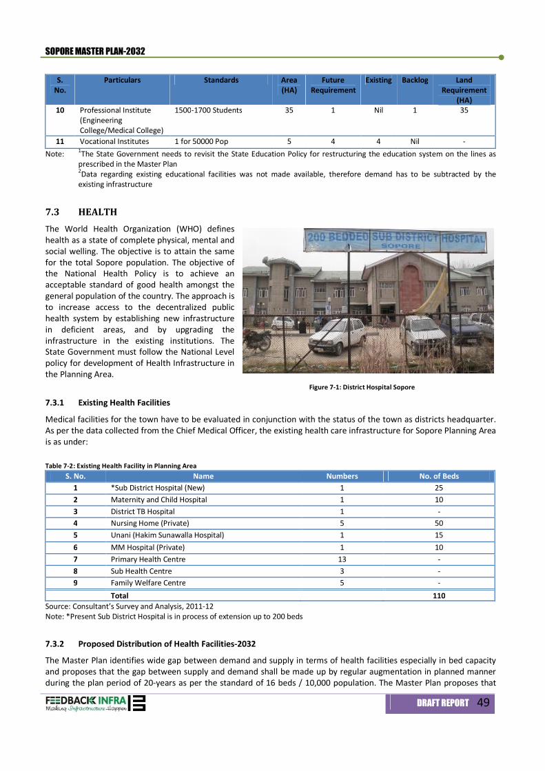
SOPORE MASTER PLAN-2032
DRAFT REPORT 49
S. No.
Particulars Standards Area (HA)
Future Requirement
Existing Backlog Land Requirement
(HA) 10 Professional Institute
(Engineering College/Medical College)
1500-1700 Students 35 1 Nil 1 35
11 Vocational Institutes 1 for 50000 Pop 5 4 4 Nil - Note: 1The State Government needs to revisit the State Education Policy for restructuring the education system on the lines as
prescribed in the Master Plan 2Data regarding existing educational facilities was not made available, therefore demand has to be subtracted by the existing infrastructure
7.3 HEALTH The World Health Organization (WHO) defines health as a state of complete physical, mental and social welling. The objective is to attain the same for the total Sopore population. The objective of the National Health Policy is to achieve an acceptable standard of good health amongst the general population of the country. The approach is to increase access to the decentralized public health system by establishing new infrastructure in deficient areas, and by upgrading the infrastructure in the existing institutions. The State Government must follow the National Level policy for development of Health Infrastructure in the Planning Area. Figure 7-1: District Hospital Sopore
7.3.1 Existing Health Facilities
Medical facilities for the town have to be evaluated in conjunction with the status of the town as districts headquarter. As per the data collected from the Chief Medical Officer, the existing health care infrastructure for Sopore Planning Area is as under: Table 7-2: Existing Health Facility in Planning Area
S. No. Name Numbers No. of Beds 1 *Sub District Hospital (New) 1 25 2 Maternity and Child Hospital 1 10 3 District TB Hospital 1 - 4 Nursing Home (Private) 5 50 5 Unani (Hakim Sunawalla Hospital) 1 15 6 MM Hospital (Private) 1 10 7 Primary Health Centre 13 - 8 Sub Health Centre 3 - 9 Family Welfare Centre 5 - Total 110
Source: Consultant’s Survey and Analysis, 2011-12 Note: *Present Sub District Hospital is in process of extension up to 200 beds
7.3.2 Proposed Distribution of Health Facilities-2032
The Master Plan identifies wide gap between demand and supply in terms of health facilities especially in bed capacity and proposes that the gap between supply and demand shall be made up by regular augmentation in planned manner during the plan period of 20-years as per the standard of 16 beds / 10,000 population. The Master Plan proposes that
SOPORE MASTER PLAN-2032
DRAFT REPORT 50
the existing District Hospital at Sopore shall be upgraded and augmented through establishment of more specialized services like Pediatrics, Obstetrics, General Surgery and Indoor facilities to reduce the unprecedented load of referral cases on the city hospitals. To meet the potential demand of health care facilities at the regional level, the Master Plan proposes that sufficient scope should be left for public-private partnerships and private investments for the development of health infrastructure in the planning area.
Table 7-3: Proposed Health Facilities in the Planning Area S.
No. Particular Standard *Area
(HA) Requirement Existing Deficit Land Requirement
(HA) 1 Intermediate Hospital (A) -
Regional Level 200 Beds/ 1 Lac Pop
3.7 2 1 1 3.7
2 Intermediate Hospital (B) Children + T. B. Hospital
80 Beds / 1 Lac Pop
1 2 1 1 1.0
3 Polyclinic 1 / Lac Pop 0.25 2 0 2 0.5 4 Nursing home / Maternity
Centre 30 Beds / 45,000 Pop
0.25 4 1 3 0.8
5 Trauma Centre - Regional Level
25 Beds / 1.5 Lac Pop
0.25 1 0 1 0.3
6 Dispensary 1 / 15,000 Pop 0.12 13 0 13 1.6 Note: *Area inclusive of existing infrastructure
7.4 RECREATIONAL FACILITIES Sopore presents a dismal picture with respect to green open spaces and recreational facilities. The area under parks are not only grossly inadequate but/ few parks are in bad shape, reflecting neglect towards the provision of recreational facilities. A Sport Stadium is located near MET College. Presently, in absence of any developed area for recreational purposes, the open spaces of Idgah, schools and college and other disorganized open spaces are being used as playfield. For the provision of active recreational facilities, different standards have been adopted to suit the local conditions of Sopore town. The Master Plan proposes active open spaces in the shape of Cluster Park(s), Neighborhood Park (s)/Community Park (s), one District Park and one Biodiversity Park with in the Master Plan Area. About 120.22 hectares of land accounting about 5.45 % and 1.86 % of the total developed land and total planning area respectively is proposed for recreational facilities. The active recreational spaces would be provided in the hierarchical order given below: Table 7-4: Hierarchy Order of Recreational Facilities
S. No. Particular Standards Area (HA) per unit
No. of Units Total Area (HA)
1 Cluster Parks 1 / 5000 Pop 1.5 38 57.0 2 Neighbourhood Parks 1 / 10,000 Pop 3.0 19 57.0 3 Sport Complex (near MET College) 1 at City Level 9.30 1 9.30 4 Exhibition Ground 1 at City Level 18.72 1 18.7 5 City Level Sports Centre 1 at City Level 21.20 1 21.2 6 District Park 1 at City Level 20.73 1 20.7 7 Bio Diversity Park / Botanical Garden 1 at City Level 38.10 1 38.1
(a) Cluster Park The Master Plan envisages development of Sopore town with self-sustained 17-neighborhoods. Cluster parks are proposed to be provided on the standard of one cluster park/5,000 population and having an area 1.5 Hectare. Therefore, each neighborhood accommodating 10,000 - 12,000 population may need at least 2-cluster parks per neighborhood. This provision has also been made for existing residential areas. It is proposed that cluster parks have to be provided in different settlements within town limits and urban villages.
SOPORE MASTER PLAN-2032
DRAFT REPORT 51
(b) Neighborhood Park The Master Plan envisages neighborhood parks in each neighborhood, therefore, 17-neighborhood parks are proposed to be developed catering to the population of 10,000 -12,000 in each neighborhood. Standard adapted for arriving at the total area has been worked out on 1.5 hectare /5000 population and area for each neighborhood park is proposed to be 3.0 Hectare. (c) District Park /Botanical Garden The Master Plan also proposes to provide one District Park besides one Bio-diversity park for active as well as passive recreation to cater to the needs of around 2-lakhs of population projected for 2032. The Botanical Garden with an area of 38.10 hectares will also have some designated area for medicinal plants. (d) Play fields Apart from tot-lots, provision for playfields has also been made in the Master Plan. Playfields and mini-playfields are recommended for each residential unit with an area of 1.5 and 0.5 hectare respectively for each playfield and mini-playfield. (e) City Level Sport centre A stadium located at MET campus already exists in Sopore town, but has limited space for organized multi-sports activities. An area of 21.20 hectares is proposed to be provided for multipurpose sports complex in Planning Zone (PZ-5) Inbuilt provision for adequate parking, guest-house, restaurant and indoor games has been envisaged in the plan. The total area earmarked for play fields, mini-playfields and tot-lots have not been included in the total recreational area as given in Table 7.4. (f) Exhibition Ground An exhibition ground measuring an area of 18.72 hectares is proposed to be provided for multipurpose ground in Planning Zone (PZ-5) inbuilt provision for adequate parking have been envisaged in the plan. (g) Religious cum Cultural Centre The Master Plan proposes one recreational club and one music, dance and drama centre in the town in Planning Zone (PZ-5) to promote local traditional art and culture heritage besides serving as a major centre of exchange and performance of various arts.
7.5 SOCIO-CULTURAL FACILITIES All the facilities provided to meet those fundamental needs which are beyond the capacity of individual households are referred as Community facilities. The facilities are distinguished from utilities and services like water supply as each of them may not necessarily be enjoyed by every member of the household. Sopore like other towns has to provide for a range of community facilities at local and regional level. Community facilities being very essential for the welfare of community life have been given paramount importance in the formulation of the Master Plan. The availability of various community facilities in the town is not adequate. There is shortage of facilities like Community hall, community centre cum library, Sport centre etc. The existing cinema hall (Shakar Cinema Hall) located in Siddique Colony is closed long years back due to threats and attacks in the town. The town has adequate number of graveyards in the town. The total area under graveyards is 22.16 HA or 0.22 Sq. km. The Plan, besides taking note of existing inadequacies in terms of location, space, nature and quality of these facilities has taken into consideration growing needs and level of requirement of different order facilities. The Master Plan proposes various community facilities like Parks and Playgrounds, Fire and Police Stations, Post Offices, Community Centre, Slaughter House/abattoir, Auditorium, Social-cultural center, public libraries and others. Table 7-5: Socio-Cultural Facilities in Planning Area - 2032
S. No.
Particulars Standard Area (HA) Requirement Existing Backlog Total Area (HA)
1 Community Room 1 for 5,000 Pop 0.07 38 2 36 3 2 Community Hall and
Library 1 for 15,000 Pop 0.2 13 1 12 2.4
SOPORE MASTER PLAN-2032
DRAFT REPORT 52
S. No.
Particulars Standard Area (HA) Requirement Existing Backlog Total Area (HA)
3 Recreational Club 1 for 1 Lac Pop 1 2 - 2 2 4 Music, Dance and Drama
Centre 1 for 1 Lac Pop 0.1 2 - 2 -
5 Meditation and Spiritual Centre
1 for 50,000 Pop - 4 - 4 -
6 Milk Booths 1 for 5,000 Pop - 38 2 36 - 7 LPG Godowns 1 for 50,000 Pop 0.2 4 1 3 1 8 Police Office 1 for 15,000 Pop 0.07 13 13 1 9 Police Station 1 for 90,000 Pop 1.5 2 1 1 2
10 Police Post 1 for 40,000 Pop 0.16 5 1 4 1 11 Fire Station 1 for 2 Lac Pop 1 1 - 1 1 12 Sub Fire Station 1 for 1 Lac Pop 0.6 2 2 - - 13 Religious Sites 1 site for 7500 Pop - 25 100 - - 14 Post Office 1 for 15,000 Pop - 13 1 12 - 15 Graveyard / Burial Ground 1 Ha site for
10,000 Pop 1 19 Ha 17.95 Ha 1 Ha 1
16 Cremation Ground 1 for 50,000 Pop 0.5 2 0 2 1
(a) Community Hall The Master Plan proposes fourteen (12) Community Halls/Libraries comprising of marriage hall and a reading room/Library. Land has been earmarked for Community Halls for marriages and other gatherings in each sector. In addition, thirty-six (36) community rooms are proposed which would be established in the cluster centers. (b) Religious Sufficient number of religious places like Mosques and Graveyards, Gurdwaras and temples are visualized scattered all over the Sopore town. Some of the mosques and graveyards in the town are located on the main roads almost touching the carriageway. Even though graveyards have, significant religious importance attached but most of these have been left unattended with aesthetically poor surroundings. The Master Plan proposes that a Detailed Action Plan for the conservation of the existing religious and heritage places. (c) Fire Services Efficient fire fighting operations are important for saving the towns from larger scale of destruction especially in core areas of Sopore town where the development is congested and maneuverability is difficult due to inadequate road system. The system becomes inefficient in towns with major urban sprawl problems, which is planned to be curbed in Sopore town by organized and well-planned development. Presently water from river Jhelum and nallah is tapped in case of the eventuality of fire, which makes the fire fighting operations difficult in the winter months due to low discharge. It is usual to provide for fire-fighting demand as a co-incident draft on the distribution system along with the normal supply to consumers. The standard provision for fire services in kilo-litres per day is 100/P where P is the population in thousands. The Master Plan proposes that water demand for fire-fighting by 2032 shall be worked out at the rate 1% of total demand with one-third of the demand served by service storage. Adequate provision of fire stations along with other facilities is imperative for effecting proper fire fighting system and the provision of fire stations will be made consistent with the static tanks and the proposed residential development in the town. The primitive means of fire fighting has to be replaced by advanced fire fighting system. The Master Plan envisages fire stations for each neighbourhood with one fire tender. (d) Police Post/Station To maintain law and order in newly delineated Master Plan limits, new Police Stations need to be established keeping in view the anticipated expansion of the town and isolated urban villages incorporated into town limits. Police posts/stations are proposed to be provided as per the standards (1/40,000 pop & 1/90,000 pop), which work out to 4-police posts & 1-additional police stations for the population of 1,90,261 by horizon 2032.
SOPORE MASTER PLAN-2032
DRAFT REPORT 53
(e) Post and Telegraph Offices The Master Plan proposes that each neighbourhood shall have one post office besides one telegraph office for every one-lakh population. (f) Slaughter House & Abattoir The Master Plan proposes to earmark one acre of land for slaughter house equipped with most modern technology to avoid hazards to the public health of the Planning Area. (g) Miscellaneous The Master Plan proposes to develop cluster centers in each residential cluster. Facilities and amenities like dispensary, community rooms, Water storage tanks , internet cafe, milk booths, convenient shopping and other community facilities are proposed to be developed at the cluster level in order to make each residential unit self sustaining. In addition to above, provision is made for services like LPG Godowns and petrol pumps. The Master Plan proposes four (03) numbers of LPG Godowns @ 1/50,000 population and Seven (7) number of petrol pumps at the rate of 1 for every 225 pph gross residential density. The placement of these facilities (LPG Godowns and petrol pumps) shall be made along the regional corridors away from the residential areas.

Traffic & Transportation 8
SOPORE MASTER PLAN-2032
DRAFT REPORT 54
8. Traffic and Transportation
8.1 INTRODUCTION Transportation is an important sector for achieving development objectives of an area. The role of transport in enabling and directing urban development has been long. In the planning for a transport system, a number of objectives form the base. The main objective is to enable the mobility of people and goods, faster economic development and enhance social interactions. The concept plan of transport system essentially consists of the road network systems in terms of their form (pattern), hierarchy and identification of potential operating systems (public transport). It also includes location of other components of the transport system with reference to the network configuration and in relation to other activity use dispositions. The required traffic surveys and studies have been carried out to appreciate the traffic and travel characteristics, for identifying issues, constraints and potentials and to work out the most appropriate transport system for the city.
Incorporating urban transportation as an important parameter at the urban planning stage rather than being a consequential requirement;
Encouraging integrated land use and transport planning so that travel distances are minimized and access to livelihoods, education, and other social needs, especially for the marginal segments of the urban population is improved;
Bringing about a more equitable allocation of road space with people, rather than vehicles, is its main focus; Investing in transport systems that encourage greater use of public transport and non-motorized modes instead
of personal motor vehicles; Promoting the use of cleaner technologies; Associating the private sector in activities where their strengths can be beneficially tapped.
8.2 EXISTING TRAFFIC AND TRANSPORT SCENARIO Sopore is well connected through roads and railways to other towns of the Kashmir valley. Sopore lies on Baramulla-Qazigund Railway line, which operates only in Kashmir valley. Sopore is an urban agglomeration situated along both the banks of river Jhelum and connected by Sopore-Kupwara road. Maximum share of through traffic is observed on the Sopore-Kupwara road as this road connects other districts like Kupwara and some major towns such as Handwara, etc. The town has also a bypass road for the movement of through traffic on Srinagar to Kupwara road. This Bye pass road is not functioning due to incomplete construction of bridge along the River Jhelum. Sopore Kupawara Road further in south is connected with NH-1 at Sangrama leading to Srinagar on eastern side and district headquarters Baramulla to its western side. The development pattern of the town also follows a radial pattern along the major road corridor. The town is developing on the northern bank along Sopore-Kupwara road and on southern side towards Sangrama in Srinagar direction due to good connectivity of the respective areas. The nearest airport to Sopore is Srinagar Airport.
8.2.1 Road Network characteristics
The major roads are: Srinagar to Kupwara road via Sopore Sopore-Bandipora Road Sopore-Mazbug Road Sopore-Tarzoo Road Sopore-Nowapora Road Sopore bye pass road (under progress)
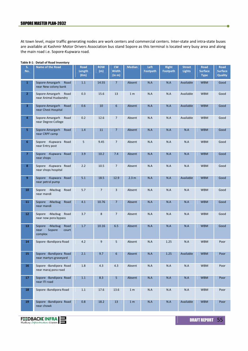
SOPORE MASTER PLAN-2032
DRAFT REPORT 55
At town level, major traffic generating nodes are work centers and commercial centers. Inter-state and intra-state buses are available at Kashmir Motor Drivers Association bus stand Sopore as this terminal is located very busy area and along the main road i.e. Sopore-Kupwara road. Table 8-1: Detail of Road Inventory
S. No.
Name of the Road Road Length (Km)
ROW (m)
CW Width (in m)
Median Left Footpath
Right Footpath
Street Lights
Road Surface
Type
Road Surface Quality
1 Sopore-Amargarh Road near New colony bank
1.1 14.55 7 Absent N.A N.A Available WBM Good
2 Sopore-Amargarh Road near Animal Husbandry
0.3 15.6 13 1 m N.A N.A Available WBM Good
3 Sopore-Amargarh Road near Chest Hospital
0.6 10 6 Absent N.A N.A Available WBM Good
4 Sopore-Amargarh Road near Degree College
0.2 12.6 7 Absent N.A N.A Available WBM Good
5 Sopore-Amargarh Road near CRPF camp
1.4 11 7 Absent N.A N.A N.A WBM Good
6 Sopore -Kupwara Road near Entry post
5 9.45 7 Absent N.A N.A N.A WBM Good
7 Sopore -Kupwara Road near shops
3.9 10.2 7.4 Absent N.A N.A N.A WBM Good
8 Sopore -Kupwara Road near shops hospital
2.2 10.5 7 Absent N.A N.A N.A WBM Good
9 Sopore -Kupwara Road near petrol pump
5.1 18.5 12.9 2.3 m N.A N.A Available WBM Good
10 Sopore -Mazbug Road near mandi
5.7 7 3 Absent N.A N.A N.A WBM Good
11 Sopore -Mazbug Road near mandi
4.1 10.76 7 Absent N.A N.A N.A WBM Good
12 Sopore -Mazbug Road near now pora bypass
3.7 8 7 Absent N.A N.A N.A WBM Good
13 Sopore -Mazbug Road near Sopore court complex
1.7 10.16 6.5 Absent N.A N.A N.A WBM Good
14 Sopore -Bandipora Road 4.2 9 5 Absent N.A 1.25 N.A WBM Poor
15 Sopore -Bandipora Road near martyrs graveyard
2.1 9.7 6 Absent N.A 1.25 Available WBM Poor
16 Sopore -Bandipora Road near maraj pora road
1.8 4.3 4.3 Absent N.A N.A N.A WBM Poor
17 Sopore -Bandipora Road near ITI road
1.1 8.3 5 Absent N.A N.A N.A WBM Poor
18 Sopore -Bandipora Road 1.1 17.6 13.6 1 m N.A N.A N.A WBM Poor
19 Sopore -Bandipora Road near chowk
0.8 18.2 13 1 m N.A N.A Available WBM Poor
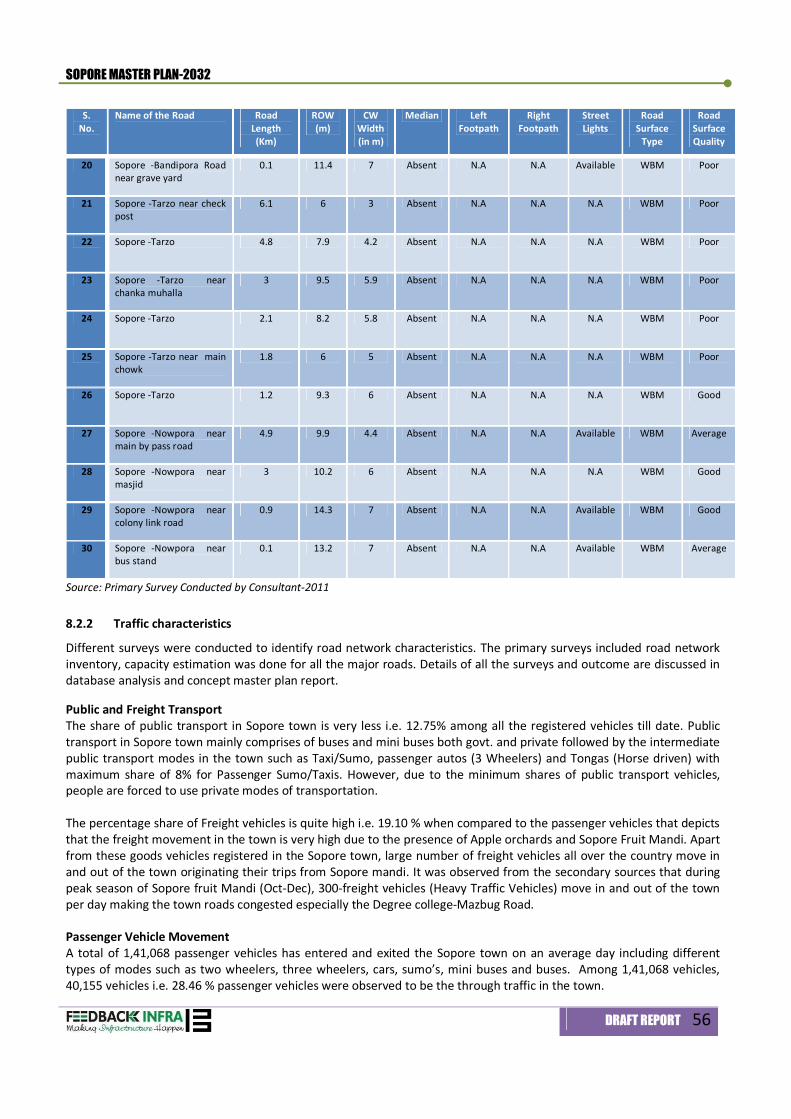
SOPORE MASTER PLAN-2032
DRAFT REPORT 56
S. No.
Name of the Road Road Length (Km)
ROW (m)
CW Width (in m)
Median Left Footpath
Right Footpath
Street Lights
Road Surface
Type
Road Surface Quality
20 Sopore -Bandipora Road near grave yard
0.1 11.4 7 Absent N.A N.A Available WBM Poor
21 Sopore -Tarzo near check post
6.1 6 3 Absent N.A N.A N.A WBM Poor
22 Sopore -Tarzo 4.8 7.9 4.2 Absent N.A N.A N.A WBM Poor
23 Sopore -Tarzo near chanka muhalla
3 9.5 5.9 Absent N.A N.A N.A WBM Poor
24 Sopore -Tarzo 2.1 8.2 5.8 Absent N.A N.A N.A WBM Poor
25 Sopore -Tarzo near main chowk
1.8 6 5 Absent N.A N.A N.A WBM Poor
26 Sopore -Tarzo 1.2 9.3 6 Absent N.A N.A N.A WBM Good
27 Sopore -Nowpora near main by pass road
4.9 9.9 4.4 Absent N.A N.A Available WBM Average
28 Sopore -Nowpora near masjid
3 10.2 6 Absent N.A N.A N.A WBM Good
29 Sopore -Nowpora near colony link road
0.9 14.3 7 Absent N.A N.A Available WBM Good
30 Sopore -Nowpora near bus stand
0.1 13.2 7 Absent N.A N.A Available WBM Average
Source: Primary Survey Conducted by Consultant-2011
8.2.2 Traffic characteristics
Different surveys were conducted to identify road network characteristics. The primary surveys included road network inventory, capacity estimation was done for all the major roads. Details of all the surveys and outcome are discussed in database analysis and concept master plan report. Public and Freight Transport The share of public transport in Sopore town is very less i.e. 12.75% among all the registered vehicles till date. Public transport in Sopore town mainly comprises of buses and mini buses both govt. and private followed by the intermediate public transport modes in the town such as Taxi/Sumo, passenger autos (3 Wheelers) and Tongas (Horse driven) with maximum share of 8% for Passenger Sumo/Taxis. However, due to the minimum shares of public transport vehicles, people are forced to use private modes of transportation. The percentage share of Freight vehicles is quite high i.e. 19.10 % when compared to the passenger vehicles that depicts that the freight movement in the town is very high due to the presence of Apple orchards and Sopore Fruit Mandi. Apart from these goods vehicles registered in the Sopore town, large number of freight vehicles all over the country move in and out of the town originating their trips from Sopore mandi. It was observed from the secondary sources that during peak season of Sopore fruit Mandi (Oct-Dec), 300-freight vehicles (Heavy Traffic Vehicles) move in and out of the town per day making the town roads congested especially the Degree college-Mazbug Road. Passenger Vehicle Movement A total of 1,41,068 passenger vehicles has entered and exited the Sopore town on an average day including different types of modes such as two wheelers, three wheelers, cars, sumo’s, mini buses and buses. Among 1,41,068 vehicles, 40,155 vehicles i.e. 28.46 % passenger vehicles were observed to be the through traffic in the town.
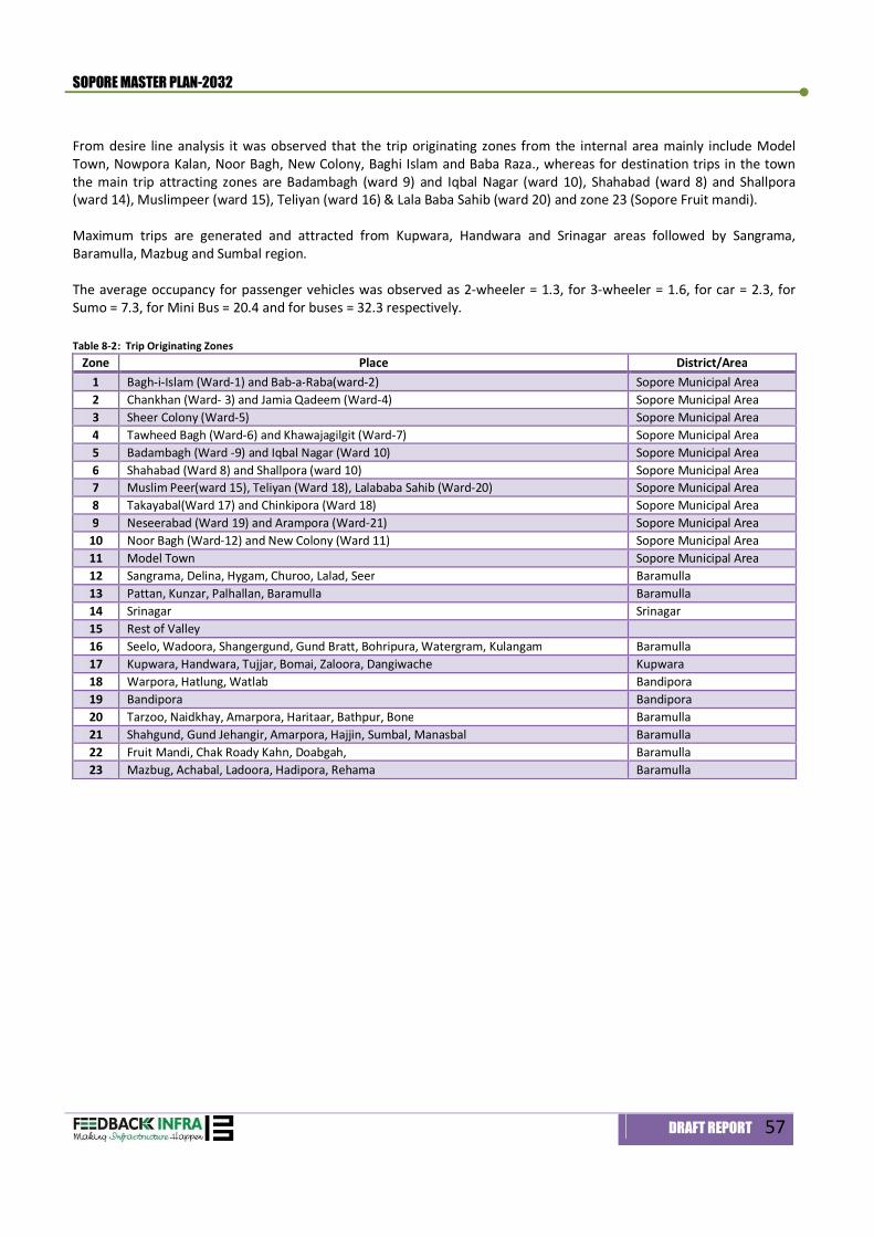
SOPORE MASTER PLAN-2032
DRAFT REPORT 57
From desire line analysis it was observed that the trip originating zones from the internal area mainly include Model Town, Nowpora Kalan, Noor Bagh, New Colony, Baghi Islam and Baba Raza., whereas for destination trips in the town the main trip attracting zones are Badambagh (ward 9) and Iqbal Nagar (ward 10), Shahabad (ward 8) and Shallpora (ward 14), Muslimpeer (ward 15), Teliyan (ward 16) & Lala Baba Sahib (ward 20) and zone 23 (Sopore Fruit mandi). Maximum trips are generated and attracted from Kupwara, Handwara and Srinagar areas followed by Sangrama, Baramulla, Mazbug and Sumbal region. The average occupancy for passenger vehicles was observed as 2-wheeler = 1.3, for 3-wheeler = 1.6, for car = 2.3, for Sumo = 7.3, for Mini Bus = 20.4 and for buses = 32.3 respectively. Table 8-2: Trip Originating Zones
Zone Place District/Area 1 Bagh-i-Islam (Ward-1) and Bab-a-Raba(ward-2) Sopore Municipal Area 2 Chankhan (Ward- 3) and Jamia Qadeem (Ward-4) Sopore Municipal Area 3 Sheer Colony (Ward-5) Sopore Municipal Area 4 Tawheed Bagh (Ward-6) and Khawajagilgit (Ward-7) Sopore Municipal Area 5 Badambagh (Ward -9) and Iqbal Nagar (Ward 10) Sopore Municipal Area 6 Shahabad (Ward 8) and Shallpora (ward 10) Sopore Municipal Area 7 Muslim Peer(ward 15), Teliyan (Ward 18), Lalababa Sahib (Ward-20) Sopore Municipal Area 8 Takayabal(Ward 17) and Chinkipora (Ward 18) Sopore Municipal Area 9 Neseerabad (Ward 19) and Arampora (Ward-21) Sopore Municipal Area
10 Noor Bagh (Ward-12) and New Colony (Ward 11) Sopore Municipal Area 11 Model Town Sopore Municipal Area 12 Sangrama, Delina, Hygam, Churoo, Lalad, Seer Baramulla 13 Pattan, Kunzar, Palhallan, Baramulla Baramulla 14 Srinagar Srinagar 15 Rest of Valley 16 Seelo, Wadoora, Shangergund, Gund Bratt, Bohripura, Watergram, Kulangam Baramulla 17 Kupwara, Handwara, Tujjar, Bomai, Zaloora, Dangiwache Kupwara 18 Warpora, Hatlung, Watlab Bandipora 19 Bandipora Bandipora 20 Tarzoo, Naidkhay, Amarpora, Haritaar, Bathpur, Bone Baramulla 21 Shahgund, Gund Jehangir, Amarpora, Hajjin, Sumbal, Manasbal Baramulla 22 Fruit Mandi, Chak Roady Kahn, Doabgah, Baramulla 23 Mazbug, Achabal, Ladoora, Hadipora, Rehama Baramulla
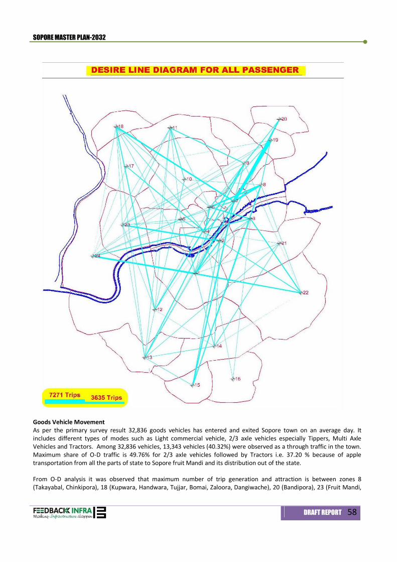
SOPORE MASTER PLAN-2032
DRAFT REPORT 58
Goods Vehicle Movement As per the primary survey result 32,836 goods vehicles has entered and exited Sopore town on an average day. It includes different types of modes such as Light commercial vehicle, 2/3 axle vehicles especially Tippers, Multi Axle Vehicles and Tractors. Among 32,836 vehicles, 13,343 vehicles (40.32%) were observed as a through traffic in the town. Maximum share of O-D traffic is 49.76% for 2/3 axle vehicles followed by Tractors i.e. 37.20 % because of apple transportation from all the parts of state to Sopore fruit Mandi and its distribution out of the state. From O-D analysis it was observed that maximum number of trip generation and attraction is between zones 8 (Takayabal, Chinkipora), 18 (Kupwara, Handwara, Tujjar, Bomai, Zaloora, Dangiwache), 20 (Bandipora), 23 (Fruit Mandi,
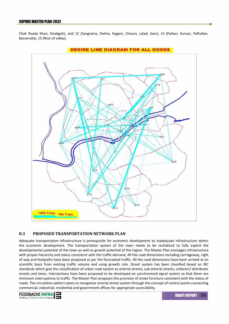
SOPORE MASTER PLAN-2032
DRAFT REPORT 59
Chak Roady Khan, Doabgah), and 12 (Sangrama, Delina, Hygam, Choora, Lalad, Seer), 13 (Pattan, Kunzar, Palhallan, Baramulla), 15 (Rest of valley).
8.3 PROPOSED TRANSPORTATION NETWORK PLAN Adequate transportation infrastructure is prerequisite for economic development as inadequate infrastructure deters the economic development. The transportation system of the town needs to be revitalized to fully exploit the developmental potential of the town as well as growth potential of the region. The Master Plan envisages infrastructure with proper hierarchy and status consistent with the traffic demand. All the road dimensions including carriageway, right of way and footpaths have been proposed as per the forecasted traffic. All the road dimensions have been arrived at on scientific basis from existing traffic volume and using growth rate. Street system has been classified based on IRC standards which give the classification of urban road system as arterial streets, sub-arterial streets, collector/ distributer streets and lanes. Intersections have been proposed to be developed on synchronized signal system so that there are minimum interruptions to traffic. The Master Plan proposes the provision of street furniture consistent with the status of roads. The circulation pattern plans to reorganize arterial street system through the concept of control points connecting commercial, industrial, residential and government offices for appropriate accessibility.
SOPORE MASTER PLAN-2032
DRAFT REPORT 60
The Master Plan Sopore-2032 proposes a network of new arterial, sub-arterial and collector roads, besides improving access linkages within the existing town limits as reflected in the proposed Land Use Plan. The basic objective behind the proposed Transportation Network is to improve connectivity within the Sopore town by developing missing links across river Jhelum. The Transportation Network Plan has been devised to improve the efficacy of proposed land use model by way of providing efficient linkages to functional areas, and establish a balanced and harmonized land Use pattern in Sopore. Two parallel corridors are proposed to be developed as Boulevards along both sides of river Jhelum to ensure accessibility to inner areas of the town as well as protecting the river-banks from further encroachments. Master Plan proposes that the boulevards shall be serving as integral part of River Front Development.
The proposed road network comprises of a radial and ring system. The radial/axial roads are inter-connected by one peripheral ring road and a semi-circular ring road (old/existing ring road). The semi circular road which is around the central core area (a new bridge over Jhelum is under construction), would help in diverting the non-destined traffic to central core away from the central area. It would also help in providing access to central core area from the periphery. The peripheral Ring Road runs at the outer part of Sopore with a proposed ROW of 45 m. On the northern bank of River Jhelum, maximum of outer ring roads alignment is as per the R&B’s proposed alignment along the canal.
Table 8-3: Proposed Major Road Network
S. No. Type of road Name ROW
(Meter) ROW (Feet)
1 Expressway (NH-1) T-1 60 196 2 Arterial Street T-2 45 148 3 Arterial Street T-3 30 98 4 Sub- Arterial Street T-4 28 92 5 Sub- Arterial Street T-5 25 82 6 Collector/ Distributor T-6 21 69 7 Link Roads/ Access Roads T-7 8-20 25-65
The existing roads are proposed to be upgraded in terms of ROW, capacity and other geometrics. The new roads need to be planned and designed for a higher level of service from their entry into Sopore to their meeting with the peripheral Ring Road and other roads. Within the core area, the roads will lose their characteristics and are to be developed as all-purpose roads. The cross sections details of proposed ROW 12 m, 15 m, 18 m, 21 m, 25 m, 28 m, 30 m, 45 m and 60 m are given in Map No. 8.1 titled as ‘Typical Cross Sections of Proposed Roads. Table 8-4: Proposed right of ways and building line of road Networks.
S. No. Name of Road From To ROW (in
Meters)
Building Line (From the centre
of the Road) (in Meters)
Type
Improvement of Existing Roads 1 Srinagar-Baramulla
National Highway-1 Village Delina Village Choora 60 67 T-1
2 Sopore-Sangrama Rd. Govt. Degree College Junction (Post Office)
Northern End of Old Bridge over Jhelum River
21 16 T-6
3 Sopore-Sangrama Rd. Southern End of Old Bridge over Jhelum River
Sangrama 28 18 T-4
4 Sopore- Mazbug Rd. Govt. Degree College Junction (Post Office)
Badami Bagh (Near Nowapura Bypass)
15 11 T-7
5 Sopore- Mazbug Rd. Badami Bagh (Near Nowapura Bypass)
Till the end of Planning boundary (Pohru River)
21 16 T-6
SOPORE MASTER PLAN-2032
DRAFT REPORT 61
Note: Rest all network of proposed roads falls under T-7 category, which is link/ sector road. All these T-7 roads will be designed
with ROW of 12-20 Mts. and Building line will be 12-8 Mts. Respectively; In case Building Line proposed in prevention of Ribbon Development Act (RDA) is more than the building line prescribed in
the Master Plan, Building line whichever is more shall prevail; Building Line within the core town shall be dealt on case-to-case basis keeping in view the nature of use.
8.3.1 Grade Separator and Bridges
Quazigund and Baramulla section of railway line passes just in south of the town. Proposed Ring road will intersect the railway line in north of Sangarama, which finally joins the National Highway-1. The master plan envisages construction of a Road over bridges (ROB) to make free movement of the traffic on peripheral ring road;
The Master plan proposes to construct two river bridges over Jhelum River for proposed Ring road. The following table shows proposed grade separators and Bridges as envisaged under the master plan 2032. Table 8-5: Proposed Grade Separators and Bridges
S. No. GRADE SEPARATORS A Proposed Grade Separators ( ROB/RUB)
1 At railway crossing on proposed Ring Road near Amargarh B Proposed Grade Separators (Bridge over Jhelum)
6 Sopore –Nowpora Rd. Main Commercial Area (D P Dar Hospital)
Till the end of Planning boundary (Pohru River)
21 16 T-6
7 Sopore –Kupwara Rd Main Commercial Area (D P Dar Hospital)
Ring Rd Junction 28 20 T-4
8 Sopore –Kupwara Rd Ring Rd Junction Till the end of Planning boundary
30 22 T-3
9 Sopore- Bandipora Rd Threek chowk Crossing at Chinkipora 15 11 T-7 10 Sopore- Bandipora Rd Crossing at Chinkipora Ring Road Junction 21 16 T-6 11 Sopore- Bandipora Rd Ring Road Junction Warpora (End of
Planning Boundary) 30 22 T-3
12 Sopore- Dangarpora Crossing at Chinkipora Dangarpora 21 16 T-6 New Roads Connections/ Missing Links
1 Service Lane (Parallel to Railway line on Northern Side)
Ring Road Junction on Eastern Side
Eastern Bypass proposed in Baramulla MP
45 33 T-2
2 Parallel Road to NH-1 From Tourist Reception Centre
Bypass Junction Proposed in Baramulla MP
30 22 T-3
3 Boulevard Road (Northern Bank of Jhelum)
Proposed Outer Ring Road near Industrial Area
Near NC of PZ3-1 25 18 T-5
4 Boulevard Road (Southern Bank of Jhelum)
Proposed Outer Ring Road near STP
Near Proposed Botanical Garden
25 18 T-5
5 Outer Ring Road From NH-1 (New Proposed Connection)
Service Road Jn. Parallel to rail line
45 33 T-2
6 Inner ring road- Missing Link
Siddiqi Colony Bandipur Road Crossing at Chinkipora
28 20 T-4
7 Missing Link Inner Loop
Main Market Bandipur Road Crossing at Chinkipora
21 16 T-6
8 North South Link on southern side of Railway Line
Eastern side of T-9 Proposed (Multimodal Hub/ Railway Yard)
New road Link parallel to NH-1
21 16 T-6
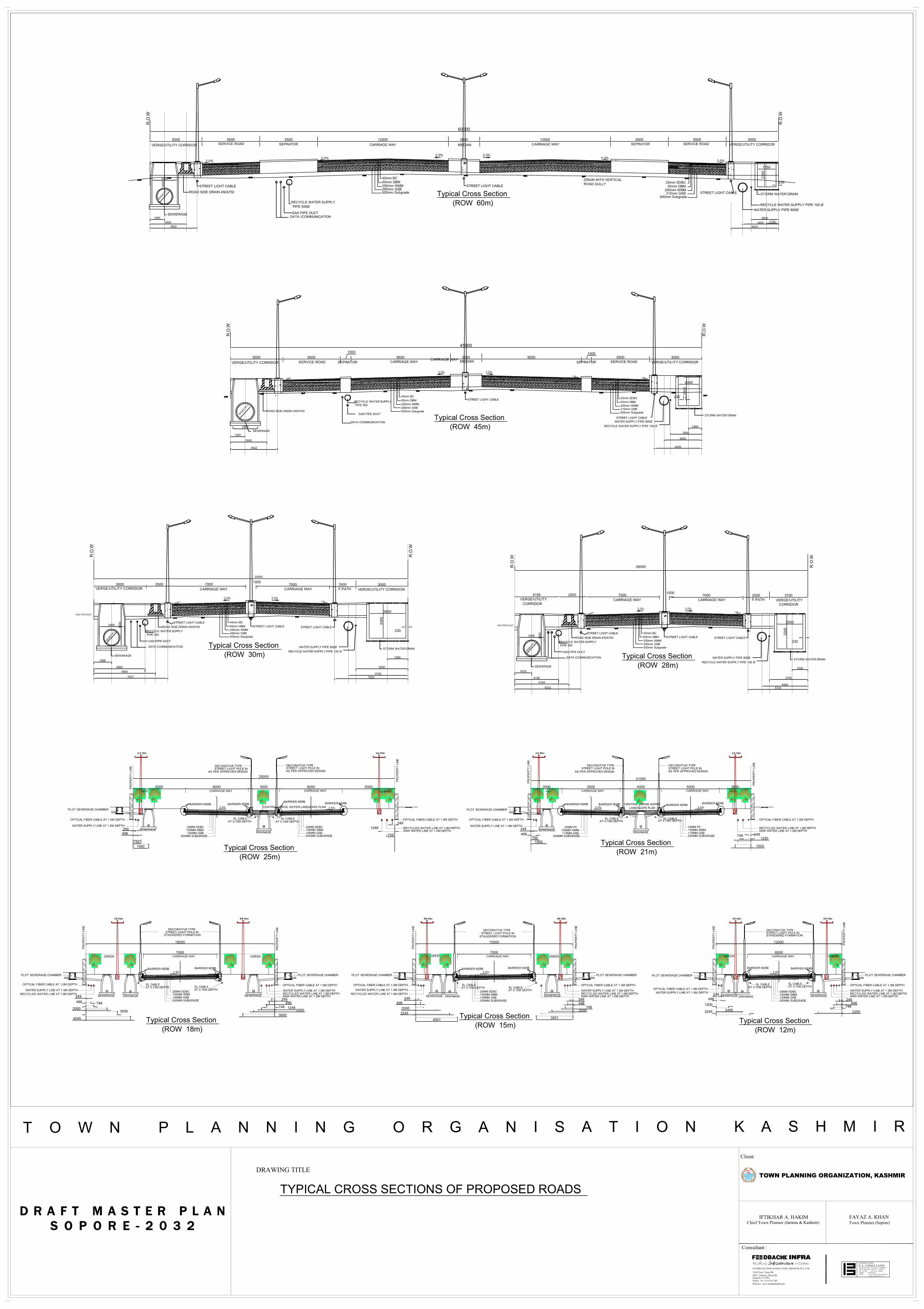
25000
5000 5500 5500 12500 3000 12500 5500 5500 5000
60000
R.O
.W
DRAIN WITH VERTICALROAD GULLY
CARRIAGE WAY CARRIAGE WAYSERVICE ROAD SERVICE ROADMEDIAN
R.O
.W
2.0%2.0% 2.0%
2.0%
40mm BC
500mm Subgrade260mm GSB250mm WMM65mm DBM 25mm SDBC
500mm Subgrade210mm GSB
250mm WMM50mm DBM
VERGE/UTILITY CORRIDOR SEPRATOR VERGE/UTILITY CORRIDORSEPRATOR
Typical Cross Section (ROW 60m)
230
2300
1750
SEWERAGE
4000
2400
STORM WATER DRAIN
DATA /COMMUNICATIONGAS PIPE DUCT
ROAD SIDE DRAIN 450X750
RECYCLE WATER SUPPLY PIPE 500Ø
STREET LIGHT CABLE STREET LIGHT CABLE
STREET LIGHT CABLE
11202600
34004523
WATER SUPPLY PIPE 800ØRECYCLE WATER SUPPLY PIPE 100 Ø
14003500
4522
1600
Ø(TYP.)
2.0% 2.0%
5000 55001000
9500 3000 95001000
5500 5000CARRIAGE WAY CARRIAGE WAY
SERVICE ROAD SERVICE ROADSEPRATOR MEDIAN
45000
R.O
.W
R.O
.W
40mm BC
500mm Subgrade260mm GSB250mm WMM65mm DBM
25mm SDBC
500mm Subgrade210mm GSB250mm WMM50mm DBM
2.0%2.0%
2.0%
2.0%
VERGE/UTILITY CORRIDOR SEPRATOR VERGE/UTILITY CORRIDOR
Typical Cross Section (ROW 45m)
DATA /COMMUNICATION
GAS PIPE DUCT
SEWERAGE
230
2800
2000
2400
3500
4522
1400
STORM WATER DRAIN
1245
3000
3600
STREET LIGHT CABLE
STREET LIGHT CABLE WATER SUPPLY PIPE 800Ø
RECYCLE WATER SUPPLY PIPE 100 Ø
4520
RECYCLE WATER SUPPLY PIPE 500
ROAD SIDE DRAIN 450X750
1600
Ø(TYP.)
2.0%
CARRIAGE WAY VERGE/UTILITY CORRIDOR
R.O
.W
GAS PIPE DUCT
30000
5000 2500 7000 10007000 2500 5000
CARRIAGE WAY F.PATH
R.O
.W
2.0% 2.0%
VERGE/UTILITY CORRIDOR
Typical Cross Section (ROW 30m)
40mm BC
500mm Subgrade260mm GSB250mm WMM65mm DBM
DATA /COMMUNICATION
GAS PIPE DUCT
230
STORM WATER DRAIN
3300
3500
SEWARAGE
1600
Ø(TYP.)
40002400
RECYCLE WATER SUPPLY PIPE 500
ROAD SIDE DRAIN 450X750
1995
5000
57007020
WATER SUPPLY PIPE 800ØRECYCLE WATER SUPPLY PIPE 100 Ø
1698
49005900
7037
STREET LIGHT CABLESTREET LIGHT CABLE STREET LIGHT CABLE
2.0% 2.0% CARRIAGE WAY VERGE/UTILITY
R.O
.W
GAS PIPE DUCT
2500 7000 10007000 2500 3700
CARRIAGE WAY F.PATH
R.O
.W
2.0% 2.0%
VERGE/UTILITY
Typical Cross Section (ROW 28m)
40mm BC
500mm Subgrade260mm GSB250mm WMM65mm DBM
DATA /COMMUNICATION
GAS PIPE DUCT
230
STORM WATER DRAIN
3300
2500
SEWARAGE
1600
Ø(TYP.)
40002400
RECYCLE WATER SUPPLY PIPE 500
ROAD SIDE DRAIN 450X750
1530
3700
44005720
WATER SUPPLY PIPE 800ØRECYCLE WATER SUPPLY PIPE 100 Ø
1618
41955194
6332
STREET LIGHT CABLESTREET LIGHT CABLE STREET LIGHT CABLE
2.0% 2.0%CORRIDORCORRIDOR
4195
28000
CARRIAGE WAYGREEN
PR
OP
ER
TY L
INE
SEWERAGE
OPTICAL FIBER CABLE AT 1.0M DEPTH
WATER SUPPLY LINE AT 1.0M DEPTH
PLOT SEWERAGE CHAMBER
BARRIER KERB
CARRIAGE WAY GREEN
PR
OP
ER
TY L
INE
BARRIER KERB
OPTICAL FIBER CABLE AT 1.0M DEPTH
BARRIER KERB
CENTRAL VERGE AS/PER LANDSCAPE PLAN
RECYCLED WATER LINE AT 1.0M DEPTHRAW WATER LINE AT 1.0M DEPTH
DECORATIVE TYPE STREET LIGHT POLE IN
AS PER APPROVED DESIGN
DECORATIVE TYPE STREET LIGHT POLE INAS PER APPROVED DESIGN
SL CABLE AT 0.75M DEPTH
DRAINAGE
2.5%
CL
20MM SDBC 150MM WBM150MM GSB500MM SUBGRADE
2.5%
CL
BARRIER KERB
20MM SDBC 150MM WBM150MM GSB
500MM SUBGRADE
SL CABLE AT 0.75M DEPTH
6000 3000 6000 50005000
249
749
1248249498
7501500
CARRIAGE WAYGREEN
PR
OP
ER
TY L
INE
SEWERAGE
OPTICAL FIBER CABLE AT 1.0M DEPTH
WATER SUPPLY LINE AT 1.0M DEPTH
PLOT SEWERAGE CHAMBER
BARRIER KERB
CARRIAGE WAY GREEN
PR
OP
ER
TY L
INE
BARRIER KERB
OPTICAL FIBER CABLE AT 1.0M DEPTH
BARRIER KERBLANDSCAPE PLAN
RECYCLED WATER LINE AT 1.0M DEPTHRAW WATER LINE AT 1.0M DEPTH
DECORATIVE TYPE STREET LIGHT POLE IN
AS PER APPROVED DESIGN
DECORATIVE TYPE STREET LIGHT POLE INAS PER APPROVED DESIGN
SL CABLE AT 0.75M DEPTH
DRAINAGE
2.5%
CL
20MM PC150MM WMM115MM GSB500MM SUBGRADE
2.5%
CL
BARRIER KERB
20MM PC150MM WMM115MM GSB
500MM SUBGRADE
SL CABLE AT 0.75M DEPTH
CENTRAL VERGE AS/PER
21000
249498
7501500
2497481250
1503
3000 5500 4000 5500 3000
CARRIAGE WAYGREEN
PR
OP
ER
TY L
INE
SEWERAGE
2.5%
CL
20MM SDBC
DRAINAGE
BARRIER KERB
OPTICAL FIBER CABLE AT 1.0M DEPTHWATER SUPPLY LINE AT 1.0M DEPTH
PLOT SEWERAGE CHAMBER
GREEN
PR
OP
ER
TY L
INE
SEWERAGE
BARRIER KERB
OPTICAL FIBER CABLE AT 1.0M DEPTH
WATER SUPPLY LINE AT 1.0M DEPTH
PLOT SEWERAGE CHAMBER
RECYCLED WATER LINE AT 1.0M DEPTHRAW WATER LINE AT 1.0M DEPTH
DECORATIVE TYPE STREET LIGHT POLE INSTAGGERED FORMATION
SL CABLE AT 0.75M DEPTH
150MM WBM150MM GSB500MM SUBGRADE
SL CABLE AT 0.75M DEPTH
Typical Cross Section (ROW 25m)
Typical Cross Section (ROW 21m)
Typical Cross Section (ROW 12m)
CARRIAGE WAYGREEN
PR
OP
ER
TY L
INE
SEWERAGE
2.5%
CL
DRAINAGE
BARRIER KERB
OPTICAL FIBER CABLE AT 1.0M DEPTH
WATER SUPPLY LINE AT 1.0M DEPTH
PLOT SEWERAGE CHAMBER
GREEN
PR
OP
ER
TY L
INE
SEWERAGE
BARRIER KERB
OPTICAL FIBER CABLE AT 1.0M DEPTH
WATER SUPPLY LINE AT 1.0M DEPTH
PLOT SEWERAGE CHAMBER
RECYCLED WATER LINE AT 1.0M DEPTHRAW WATER LINE AT 1.0M DEPTH
RECYCLED WATER LINE AT 1.0M DEPTH
CARRIAGE WAYGREEN
PR
OP
ER
TY L
INE
SEWERAGE
2.5%
CL
DRAINAGE
BARRIER KERB
OPTICAL FIBER CABLE AT 1.0M DEPTH
WATER SUPPLY LINE AT 1.0M DEPTH
PLOT SEWERAGE CHAMBER
GREEN
PR
OP
ER
TY L
INE
SEWERAGE
BARRIER KERB
OPTICAL FIBER CABLE AT 1.0M DEPTH
WATER SUPPLY LINE AT 1.0M DEPTH
PLOT SEWERAGE CHAMBER
RECYCLED WATER LINE AT 1.0M DEPTHRAW WATER LINE AT 1.0M DEPTH
RECYCLED WATER LINE AT 1.0M DEPTH20MM SDBC 150MM WBM150MM GSB500MM SUBGRADE
20MM SDBC 150MM WBM150MM GSB500MM SUBGRADE
SL CABLE AT 0.75M DEPTH
DECORATIVE TYPE STREET LIGHT POLE IN
STAGGERED FORMATION
SL CABLE AT 0.75M DEPTH
SL CABLE AT 0.75M DEPTH
DECORATIVE TYPE STREET LIGHT POLE IN
STAGGERED FORMATION
SL CABLE AT 0.75M DEPTH
6000
12000
249498
120024953245
249498
7482250
Typical Cross Section (ROW 15m)
Typical Cross Section (ROW 18m)
7000
15000
249498
7482000
3501
249498
20003245
4001
18000
7000
249498
748 12482000
3000
249498 748
20003000
4245
T O W N P L A N N I N G O R G A N I S A T I O N K A S H M I R
IFTIKHAR A. HAKIMChief Town Planner (Jammu & Kashmir) Town Planner (Sopore)
Client:
Consultant :
Gurgaon-122 002.DLF Cybercity, Phase III,15th Floor, Tower 9B,FEEDBACK INFRASTRUCTURE SERVICES PVT. LTD.
Phone: +91 124 4316 100Website: www.feedbackinfra.com
F DBAC
TOWN PLANNING ORGANIZATION, KASHMIR
B. E. CONSULTANTSARCHITECTURE, PLANNING, INTERIORS.A-237, MALVIYA NAGAR, JAIPUR.PH- 2522376, FAX- 0141 - 2520296.MOBILE : 0-98290-52237EMAIL : [email protected]
CONSULTANTS :
D R A F T M A S T E R P L A NS O P O R E - 2 0 3 2
FAYAZ A. KHAN
DRAWING TITLE
TYPICAL CROSS SECTIONS OF PROPOSED ROADS
SOPORE MASTER PLAN-2032
DRAFT REPORT 62
S. No. GRADE SEPARATORS 1 On River Jhelum North of Sir Jagir aqnd south of the proposed industrial area
2 On River Jhelum near Wular Lake
8.3.2 Improvement of Intersections
The transport system plan includes improvement of intersection geometrics including provision of acceleration/deceleration lanes, traffic signs, lighting etc and provision of appropriate traffic control systems. In all only one intersection is recommended for grade separation during the plan period. However, 7-junctions are identified for improvement. It is recommended that all the major intersections, especially those on the arterial and sub-arterials be signalized and in the next level of improvement be linked and integrated and brought under a central Area Traffic Control scheme (ATCs). Grade Separators/Flyovers may be built based on traffic intensity, site conditions and environmental impact assessment (EIA).
S. No. Major Crossing
1 Threeki Chowk
2 Town hall crossing
3 Chowk near Sopore police station
4 Noor bagh crossing circle
5 Sangrama Chowk
6 Crossing near Model town on Sopore -Kupwara Road
7 Amargarh Crossing on Sopore-Kupwara Road
8.3.3 Proposed Logistic Hub/ Truck Terminal
Provision of efficient goods transportation facility is important to promote trade and commerce, and in turn economy of the town. Since the town has, an agro based economy with horticulture produces, there is lot of goods movement between the towns and surrounding villages/region is anticipated in future. Proposed extension of the Mandi freight complex and proposed industrial area will also generate goods traffic not only seasonal but throughout the year. To provide them a permanent and formal parking space, a Truck Terminal has been proposed near the industrial zone on the proposed ring road near Mandi in an area of 12.00 hectares. The truck terminus will have major components like packaging, office complex, restaurant, accommodation, parking and other ancillary facilities. It has to be developed in phases to avoid the creation of surplus infrastructure. Truck Terminal will be designed for the idle parking of the trucks and carriers/containers. Keeping all these aspects in mind the proposed truck terminal/ logistic hub is strategically located on outer ring road. Location of the truck terminal is also well justified with nearness to eastern bypass and logistic hub proposed in Baramulla Master Plan on southern bank of Jhelum river in proximity to Seer Jagir. Movement of Goods Modes The movement of goods modes on the road network needs to be rationalized. Goods modes can be grouped into three types as under:
Small sized vehicles like pick ups Medium sized vehicles like LCVs and Large size vehicles like 2/3 Axle Trucks, Truck Trailer & MAVs
Small size vehicles like ‘Pick ups’ perform an essential distribution function. In space occupancy and maneuverability they are similar to cars. Their movement on all road sections, at all times of day may be permitted. As part of traffic management plans, separate parking areas for ‘Pick ups’ may be identified.
SOPORE MASTER PLAN-2032
DRAFT REPORT 63
Medium size vehicles like LCVs are important to move goods to and from industries, warehouses and other major activities. They affect overall level of service of traffic. These are not to be permitted in the central city i.e. Planning Zone 3 and 5 after the development of Integrated Freight/Mandi Complex. Movement of Large Size Goods Vehicles Large sized goods vehicles consume high proportion of road capacity, impede traffic flows, causes accidents, adversely affect environment and consume large extent of land for parking. As these vehicles are bringing in/taking out traffic from/to other parts of the country, exclusive vehicle related restrictions that are valid only to Sopore town. These vehicles need to be received at the urban periphery and facilitated in terms of planned terminals. Major truck terminals and/or idle parking are proposed to be developed as part of IFC.
8.3.4 Railways
It is strongly felt that though the rail link will deplete the regional traffic flow on the Srinagar – Baramulla Highway, it is going to be an important determinant of regional growth. With the construction of the existing railway head, a relatively large area of the town has been opened for new developments like industries, commerce & trade, and partly some residential developments. Based on its importance, the area as proposed in the Master Plan is to be developed as a major logistic hub/park for promoting fruit industry and Trans-border trade. Considering all this fact the multimodal hub and railway container yard for goods moment is proposed near Seer Jagir in the area of 35 Hectare. The Master Plan conceives railway head as a major focal point for traffic, transportation, as such all-important regional level passenger, and freight terminals have been proposed in its vicinity. Apart from this, the railway head has an inherent potential for generating parking demand for commuters, which has been considered by providing parking lots and terminal facilities in close proximity from the railway station. The basic objective of proposing these allied facilities has been to forge linkages between various modes of public transport to encourage commuters to switch over to Mass Transport System.
8.3.5 Bus Terminals
Sopore has a main bus stand situated in the core area. Intercity and inter-district bus service originates from this bus stand. The condition of bus stand is also very worse as it lies below the road level allowing drained water inside the bus stand. There are three private sumo stands just on the entry of bus stand and along the Sopore-Kupwara road creates congestion due to parking of vehicles all along the main road and footpaths. The master plan proposes a multimodal transit hub is proposed near railway Station Sopore with an area of 14-hectare. Small Bus terminal of 2.4 HA has been proposed on Peripheral Ring Road in PZ-4. It is envisaged that the bus stand is located on the periphery of the town will not add much traffic within the core area. It will not be far away from core area of town. In addition to the bus terminus another small bus stand is proposed in Kupwara road near Model Town. Existing bus stand will remain functional but waiting time of bus will be lesser as compared to existing waiting time.
8.3.6 Bus Bays/Pick-up Stations
Pick-up stations/Bus-Bays are very vital for the convenience of passengers. As Sopore comprises large urban area and villages annexed to town limits, pick-up stations/bus-bays are envisaged to be provided along major roads to facilitate the passenger mobility. The pick-up stations are proposed to be provided on all-important radials at a distance of 500 metres apart preferably away from any intersection by at least 150 metres to avoid any traffic mess on the road. Since Master Plan cannot provide all the details of the bus-bays on the land use plan, the policy of providing bus-bays at regular intervals shall be taken care of in the preparation of comprehensive Mobility Plan to be prepared in the first phase of the Master Plan implementation.
8.3.7 Pedestrian Facilities
Walking is a predominant mode in the city. The transport system plan promotes and facilitates walking. The main strategies and measures proposed as part of the plan are as under:
SOPORE MASTER PLAN-2032
DRAFT REPORT 64
Provision of side-walks on primary arterials, sub-arterials and collectors on both sides of the road and on at least one side on local roads;
Cross pedestrian facilities to be provided as per the warrants recommended by Indian Roads Congress; Side- walks on all the major roads; Improvement measures in terms of pedestrian controlled facilities at intersections, grade separators and
widening of side- walks in the Central Area and along major corridors.
8.4 PROPOSED PARKING POLICY Car ownership and two-wheeler ownership in the town will undoubtedly go up exorbitantly. On-street parking results in the reduction of effective carriageway and it has to be a part of proposed parking policy to make it mandatory for offices and commercial centres to have their own parking lots as per the standards prescribed in the development control regulations. It is proposed that concerned departments shall establish a baseline data regarding existing parking demand in the town. The Master Plan proposes that to reduce the parking demand, car pooling system needs to be introduced at office and corporate level. CBD has to be pedestrianised in selected intense commercial activity areas by developing adequate parking lot at suitable locations. In addition, the Master Plan asserts that a comprehensive parking policy for the area shall be prepared separately taking into account all aspects including existing and potential parking demand, institutional measures and implementation mechanism. However, the recommended parking policy for the town should have the following salient features as per the Urban National Transport Policy (NUTP)-2006:
Preferential allocation of parking space(s) for public transport vehicles and non-motorized modes of transport; Levy of graded scale of parking fee representing truly the value of the land occupied; Development of efficient accessibility to parking lots; Encourage to go in for electronic metering for better realization of parking fee; Development of underground parking in green areas (considering the social acceptance of the people); Development of multi-level parking complexes in city centre(s); Encouraging people to use public transport to reach city centre(s); Development of parking lots on PPP format for reducing burden on public funds

Housing & Slums 9
SOPORE MASTER PLAN-2032
DRAFT REPORT 65
9. Housing & Slums
9.1 INTRODUCTION Housing, one of the basic services, which is to be provided for better quality of life, shall be given the importance in the master plan. The increasing level of urbanization has created the stress on housing sector in Sopore. As indicated by the last two decades of demographic data, it can be seen that there is an increase of population from 1971-2001 but the increase in housing both quantity & quality could not catch the pace of increasing population hence resulting in the housing gap.
9.2 HOUSEHOLD SIZE As per Census 2001, the average household size of Sopore Town was 7.0, which have decreased to 5.2 in 2011, which is lower than the average household size of planning area, Tehsil and District level. The average household size of revenue village within planning area is having high average household size in comparison of Sopore urban area (TC+OG). The average household size of planning area is decreasing since 1981 till decadal year 2011. The predominance of large family size is an indicator of high of occupancy rate and acute stress not only on housing demand but also on the infrastructure facilities in the area. As a policy measure and past trend, the average family size is assumed to decline during the plan period of 20 years. Against average family size of 5.3 for the Sopore (TC+OG) and average size of 6.1 for Planning Area, the average size of 5.0 is adopted for assessing the housing need in Sopore Planning Area. Table 9-1: Household Size of District, Tehsil, Revenue Villages and Sopore Town, 1981-2011
S. No. Particulars 1981 2001 2011
1 Sopore Town 7.1 7.0 5.2
2 Sopore (TC+OG) 7.1 7.1 5.3
3 Revenue Villages in Planning Area 7.9 7.8 6.8
4 Sopore Planning Area 7.48 7.45 6.01
5 Sopore Tehsil 7.3 7.4 7.0
6 Baramulla District (Urban) - 7.6 6.7
7 Baramulla (Rural + Urban) - 7.4 7.0 Source: Census of India, 1981-2011
9.3 RESIDENTIAL DENSITY The residential use covers an area of 596.87 hectares in the Planning Area constituting 67.36 % and 9.23 % of the Developed Area and Planning Area respectively. The area has a gross residential density of 131 PPH for the Developed Area, which indicates congested growth of the planning area. Sopore planning area lacks planned residential colonies and the organic growth has resulted in urban sprawl and inefficient utilization of land. Table 9-2: Existing Residential Density in Planning Area, 2012
S. No. Particulars Planning Area Sopore (TC+OG) Revenue Villages
1 Population 1,15,658 69,171 46,487
2 Gross Residential Density (Developed Area) 131 109 184
3 Net Residential Density (Developed area ) 194 174 232
SOPORE MASTER PLAN-2032
DRAFT REPORT 66
S. No. Particulars Planning Area Sopore (TC+OG) Revenue Villages
4 Gross Population Density (Developed + Undeveloped Area) 18 27 12
9.4 INCOME DISTRIBUTION The effective housing programme is pre-requisite for proper community health and inevitable for wiping out the housing deficiency. Preparation of housing programme without primary analysis of demand is impossible. Primary surveys were conducted for the quantification of different income levels in Sopore. Sopore town has healthy income distribution with only 63.90 percent of households constituting the MIG and HIG groups whereas only 36.10 percent fall in E.W.S and LIG category with almost 11.60 % of population belonging to the EWS Category. Due to this healthy income distribution, housing development will be a profitable phenomenon if properly planned by local authority. The distribution of households into different income groups based on their monthly income is given in Table 9.3.
9.5 HOUSING CONDITION AND OBSOLESCENCE FACTOR During the decadal year 2011, the total numbers of residential houses are 11,699 in Sopore (TC+OG). In the period of 10 years, 7.53% of total semi-pucca houses are converted into pucca (5.90%) and temporary houses (1.62%). In 2011, the percentage of residential houses categorized under dilapidated condition is 4.15%. As per policy measure, the Obsolescence Factor of Sopore Planning Area is assumed to be decreased from 4.15 % to 1.15% during the plan period of 2012-2032. Table 9-4: Distribution of Houses in Pucca, Semi-Pucca and Dilapidated in Sopore (TC+OG)
Year Total No. of Households
Total Residence and residence cum other use
Condition of Houses Pucca Houses Semi-Pucca Houses Temporary
2001 8,419 7,720 5,992 (77.62%) 1,533 (19.86%) 195 (2.53%) 2011 12,823 11,699 9,771 (83.52%) 1,442 (12.33%) 486 (4.15%)
Source: Census Office, Sopore Municipal Council, 2001-2011
9.6 HOUSEHOLDS PER ROOM AND CONGESTION FACTOR It is revealed from the Table 9.5, that the size of dwelling units in Sopore (TC+OG) is showing a decreasing trend during the period of 2001-2011, which is a clear indicator of more demand of housing with smaller dwelling unit size and shift from traditional joint family structure to nuclear family system . An estimated congestion factor of 12.36 % for 2001, decreased to 10.12% during the year 2011. There is a decadal fall of 2.24 % in congestion factor of the town. Considering the past trend and as per policy measure, a congestion factor of 7.88 % shall be taken for plan period of 2012-2022 and 5.64% during period of 2023-2032. Table 9-5: Household per room and Congestion Factor, 2001-2011
Year Total Households
Households having No. of Rooms Total Married Couples
Married couples with having independent
sleeping room
Congestion Factor One
Room Two
Room Three Room
Four Room
Five Room & above
2001 8,419 943 (11.20%)
1,500 (17.82%)
1,646 (19.55%)
2,004 (23.81%)
2,326 (27.62%) 10,224 8,890 12.36%
2011 12,823 1,757 (13.70%)
2,274 (17.74%)
3,054 (23.81%)
2,386 (18.61%)
3,352 (26.14%) 10,860 9,563 10.12%
Source: Census of India, 2001-2011
Table 9-3: Income Distribution S. No. Category *Monthly Income (Rs) % of Total
1 EWS Below Rs. 3300 11.60 2 LIG Rs. 3301 - 7300 24.50 3 MIG Rs. 7301 to 14500 40.19 4 HIG Above Rs. 14500 23.71
Note: *As per Report of Technical Group, Ministry of Housing, 2007-12
SOPORE MASTER PLAN-2032
DRAFT REPORT 67
9.7 SLUMS Sopore town, which is a class II town, has a population of 68,082 persons in 2011. In the town, around 18.61 % of total Sopore (TC+OG) population lives in slum areas. Out of which about 45% of people of slums are living in highly dilapidated, congested and pathetic conditions. Table 9-6: Slums population in Sopore (TC+OG)
S. No. Mohalla Total Population Total Households
1 Naseem Bagh, Doulggah Khan Colony 2,485 413 2 Sher-i-Kashmir Colony, Ningli Colony 3,504 687
3 Shahabad 603 118 4 Nehrapora Colony 2,773 452 5 Mehrajpore A & B, Takyabal 3,308 551
Total 12,673 2,221 Source: Census Officer, Municipal Council of Sopore
9.8 HOUSING SHORTAGE AND NEED The potential households are going to emerge in next two decades due to economic prosperity and shift from traditional joint family structure to nuclear family system. True measure of housing deficiency would, therefore be reached by the correct estimate of the habitable units by 2032, forecast of the number of families and the economic condition of the population. The Master Plan proposes to facilitate the provision of a fully serviced dwelling unit for each family and reduce the gap between housing shortage and supply through innovative measures. The assessment has been done based on certain assumptions: Anticipated population growth as per the growth rates assumed; Constant annual household formation rate for the entire Planning Area; Decrease in household size from present 6.1 to 5.0 during the horizon period of 20 years; Constant household to house ratio of 1.1 for the horizon period of 20 years; Congestion Factor of 7.88% shall be taken for plan period of 2012-2022 and 5.64% during period of 2023-2032; Obsolescence Factor of Sopore Planning Area is assumed to decrease from 4.15 % to 1.15% during the plan period of
20 years Table 9-7: Housing Shortage and Need of the Sopore Planning Area
Year Population Household Size
No. of Households
Natural Housing
Need
Occupied Residential
Houses
Habitable Houses
Apparent Shortage
Concealed Shortage
Deficit
2011 1,13,479 6.1 18,603 16,912 12,206 11,699 4,706 507 5,212 2012 1,15,658 6.1 18,960 17,237 12,206 11,706 5,031 500 5,531 2017 1,30,150 5.5 23,664 21,512 12,206 11,870 9,306 336 9,642 2022 1,47,095 5.5 26,745 24,313 12,206 11,956 12,107 250 12,358 2027 1,67,279 5.0 33,456 30,414 12,206 12,053 18,208 153 18,361 2032 1,90,261 5.0 38,052 34,593 12,206 12,066 22,387 140 22,527
9.9 PROPOSED HOUSING POLICY The main objective of the housing policy for Sopore Planning Area is not only to meet the housing demand by horizon 2032 but also to improve the residential environment at large. In view of this, Master Plan proposes development of self-sustained residential neighbourhoods.
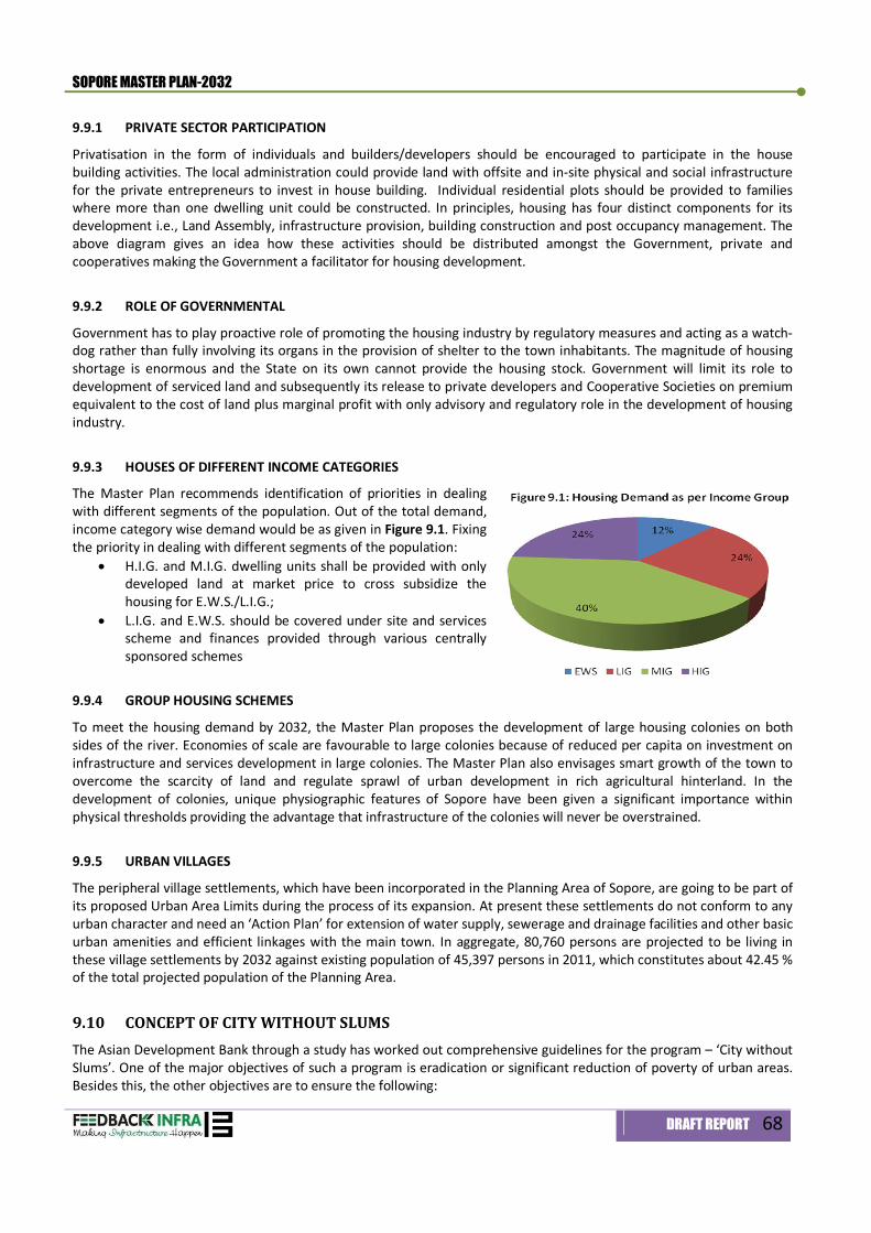
SOPORE MASTER PLAN-2032
DRAFT REPORT 68
9.9.1 PRIVATE SECTOR PARTICIPATION
Privatisation in the form of individuals and builders/developers should be encouraged to participate in the house building activities. The local administration could provide land with offsite and in-site physical and social infrastructure for the private entrepreneurs to invest in house building. Individual residential plots should be provided to families where more than one dwelling unit could be constructed. In principles, housing has four distinct components for its development i.e., Land Assembly, infrastructure provision, building construction and post occupancy management. The above diagram gives an idea how these activities should be distributed amongst the Government, private and cooperatives making the Government a facilitator for housing development.
9.9.2 ROLE OF GOVERNMENTAL
Government has to play proactive role of promoting the housing industry by regulatory measures and acting as a watch-dog rather than fully involving its organs in the provision of shelter to the town inhabitants. The magnitude of housing shortage is enormous and the State on its own cannot provide the housing stock. Government will limit its role to development of serviced land and subsequently its release to private developers and Cooperative Societies on premium equivalent to the cost of land plus marginal profit with only advisory and regulatory role in the development of housing industry.
9.9.3 HOUSES OF DIFFERENT INCOME CATEGORIES
The Master Plan recommends identification of priorities in dealing with different segments of the population. Out of the total demand, income category wise demand would be as given in Figure 9.1. Fixing the priority in dealing with different segments of the population:
H.I.G. and M.I.G. dwelling units shall be provided with only developed land at market price to cross subsidize the housing for E.W.S./L.I.G.;
L.I.G. and E.W.S. should be covered under site and services scheme and finances provided through various centrally sponsored schemes
9.9.4 GROUP HOUSING SCHEMES
To meet the housing demand by 2032, the Master Plan proposes the development of large housing colonies on both sides of the river. Economies of scale are favourable to large colonies because of reduced per capita on investment on infrastructure and services development in large colonies. The Master Plan also envisages smart growth of the town to overcome the scarcity of land and regulate sprawl of urban development in rich agricultural hinterland. In the development of colonies, unique physiographic features of Sopore have been given a significant importance within physical thresholds providing the advantage that infrastructure of the colonies will never be overstrained.
9.9.5 URBAN VILLAGES
The peripheral village settlements, which have been incorporated in the Planning Area of Sopore, are going to be part of its proposed Urban Area Limits during the process of its expansion. At present these settlements do not conform to any urban character and need an ‘Action Plan’ for extension of water supply, sewerage and drainage facilities and other basic urban amenities and efficient linkages with the main town. In aggregate, 80,760 persons are projected to be living in these village settlements by 2032 against existing population of 45,397 persons in 2011, which constitutes about 42.45 % of the total projected population of the Planning Area.
9.10 CONCEPT OF CITY WITHOUT SLUMS The Asian Development Bank through a study has worked out comprehensive guidelines for the program – ‘City without Slums’. One of the major objectives of such a program is eradication or significant reduction of poverty of urban areas. Besides this, the other objectives are to ensure the following:
SOPORE MASTER PLAN-2032
DRAFT REPORT 69
Security of tenure; Minimum acceptable standards of municipal infrastructure and social services; Improved employment and income earning opportunities; Improved education, skills, training and health care; Better access to credit and other financial services for house/plot purchase, home improvement, enterprise
development and livelihood activities; and Improved level of community organization capacity and empowerment
The above objectives are inter-sectoral and inter-departmental. To facilitate the above, the following is envisaged in the Sopore Master Plan-2032:
In case of existing slums, which are on Government lands that are not needed for development of any infrastructure or other urban activities, plans for upgrading of slums may be prepared and implemented;
Other slum pockets may be resettled at appropriate areas with due consideration of their distance from work places;
Under the housing/slums up-gradation scheme 100% of beneficiaries need to be provided with financial assistance to improve the structure condition of their houses.
In any new land development scheme, 1% of the total land shall be reserved / developed for informal sector/vendor markets, which should be available to the urban poor families to conduct their livelihood earning activities. Such a land can be for informal sector units in food/vegetable/eating stalls and any other activities. Part of the land shall be developed for night shelter where fresh migrants to the city, having no shelter, could be provided with facility to sleep and have sanitation and bathing facilities.
9.11 URBAN RENEWAL 9.11.1 Area for renewal
The old areas in planning zones (PZ-3 and PZ-5) have congested residential and commercial areas, which have high building density on land and high occupancy within buildings. Buildings are very old and dilapidated as well as on Narrow Streets. These areas need immediate attention and urban renewal.
9.11.2 Guidelines for urban renewal1
The basic objective of the urban renewal plans are to upgrade the living and working environment by implementing schemes considering the existing physical and socio-economic conditions of the area. The schemes for the urban renewal are to be prepared after a comprehensive study, which should be in the form of a project report and a number of maps and plans. The following sets of plans are considered be essential to project the existing conditions: - Land Use - Physical condition of structures - Facilities and services - Circulation pattern - Open spaces, park and playgrounds - Special feature (if any) - The plan proposals for the urban renewal should indicate:
a. clearance areas and areas to be acquired (This would include subsequent plans for redevelopment of these pockets);
b. population distribution (in relation to holding capacity); c. proposed land use; d. proposed circulation system (indicating widening of streets, pedestrian streets, parking areas, access of
emergency vehicles); e. Up gradation of facilities and services;
1 Note: Reduced space norms may be adopted for community facilities/ social infrastructure. The concept of Accommodation
Reservation i.e. allowing construction of community facilities without counting in FAR may also be applied
SOPORE MASTER PLAN-2032
DRAFT REPORT 70
f. The existing Public and Semi-public uses and services like hospitals, dispensaries, colleges, schools, police stations, fire stations, post offices, local government offices, parking etc. to be retained in their present locations and also additional sites required to be indicated in the Urban Renewal Scheme; and
g. Recreational areas (indicating tot lots, parks, play grounds and other recreational facilities)
The urban renewal plans would be prepared within the framework of the land use plan of the area as proposed in the Master Plan. In case of residential areas, the possibilities of mixed use (on ground floor) and street commercial may be explored. Special characteristics and features of the area would be kept in view. As far as possible, the urban renewal project should be self-financing. The neighbourhood for urban renewable areas, whose deficiency can be, filled as per neighbourhood level facility norms.
Ecology & Environment 10
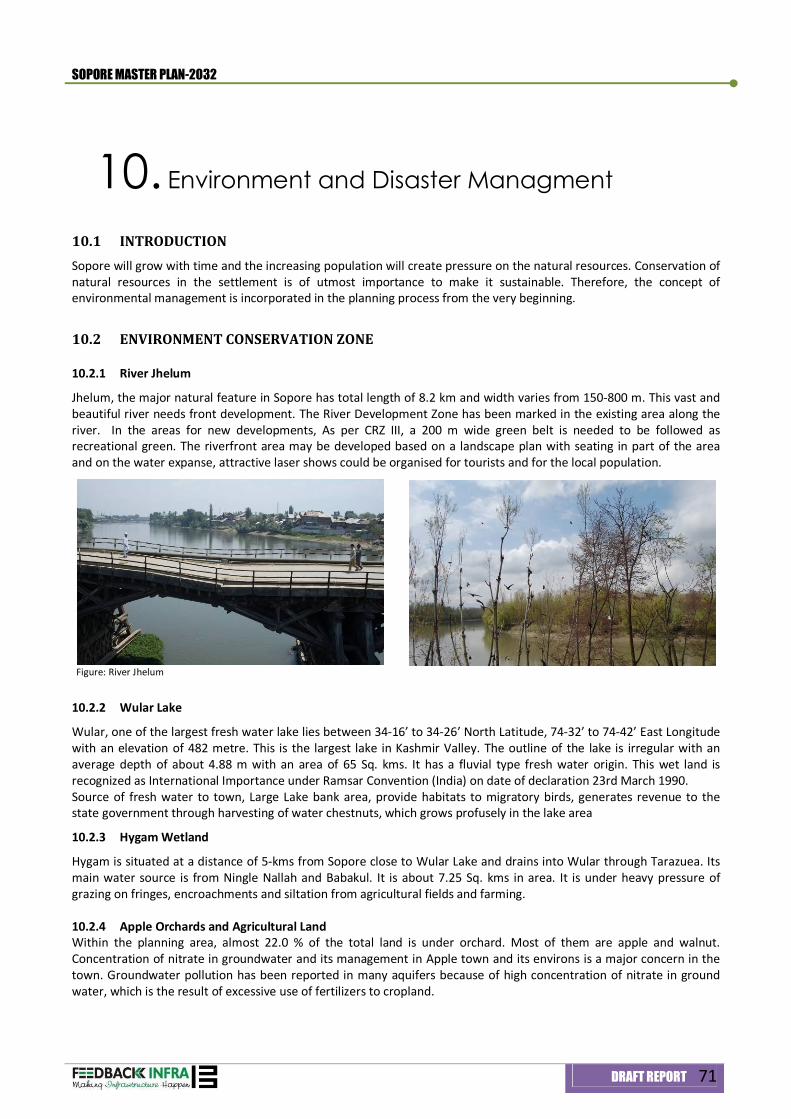
SOPORE MASTER PLAN-2032
DRAFT REPORT 71
10. Environment and Disaster Managment
10.1 INTRODUCTION Sopore will grow with time and the increasing population will create pressure on the natural resources. Conservation of natural resources in the settlement is of utmost importance to make it sustainable. Therefore, the concept of environmental management is incorporated in the planning process from the very beginning.
10.2 ENVIRONMENT CONSERVATION ZONE
10.2.1 River Jhelum
Jhelum, the major natural feature in Sopore has total length of 8.2 km and width varies from 150-800 m. This vast and beautiful river needs front development. The River Development Zone has been marked in the existing area along the river. In the areas for new developments, As per CRZ III, a 200 m wide green belt is needed to be followed as recreational green. The riverfront area may be developed based on a landscape plan with seating in part of the area and on the water expanse, attractive laser shows could be organised for tourists and for the local population.
Figure: River Jhelum
10.2.2 Wular Lake
Wular, one of the largest fresh water lake lies between 34-16’ to 34-26’ North Latitude, 74-32’ to 74-42’ East Longitude with an elevation of 482 metre. This is the largest lake in Kashmir Valley. The outline of the lake is irregular with an average depth of about 4.88 m with an area of 65 Sq. kms. It has a fluvial type fresh water origin. This wet land is recognized as International Importance under Ramsar Convention (India) on date of declaration 23rd March 1990. Source of fresh water to town, Large Lake bank area, provide habitats to migratory birds, generates revenue to the state government through harvesting of water chestnuts, which grows profusely in the lake area
10.2.3 Hygam Wetland
Hygam is situated at a distance of 5-kms from Sopore close to Wular Lake and drains into Wular through Tarazuea. Its main water source is from Ningle Nallah and Babakul. It is about 7.25 Sq. kms in area. It is under heavy pressure of grazing on fringes, encroachments and siltation from agricultural fields and farming. 10.2.4 Apple Orchards and Agricultural Land Within the planning area, almost 22.0 % of the total land is under orchard. Most of them are apple and walnut. Concentration of nitrate in groundwater and its management in Apple town and its environs is a major concern in the town. Groundwater pollution has been reported in many aquifers because of high concentration of nitrate in ground water, which is the result of excessive use of fertilizers to cropland.
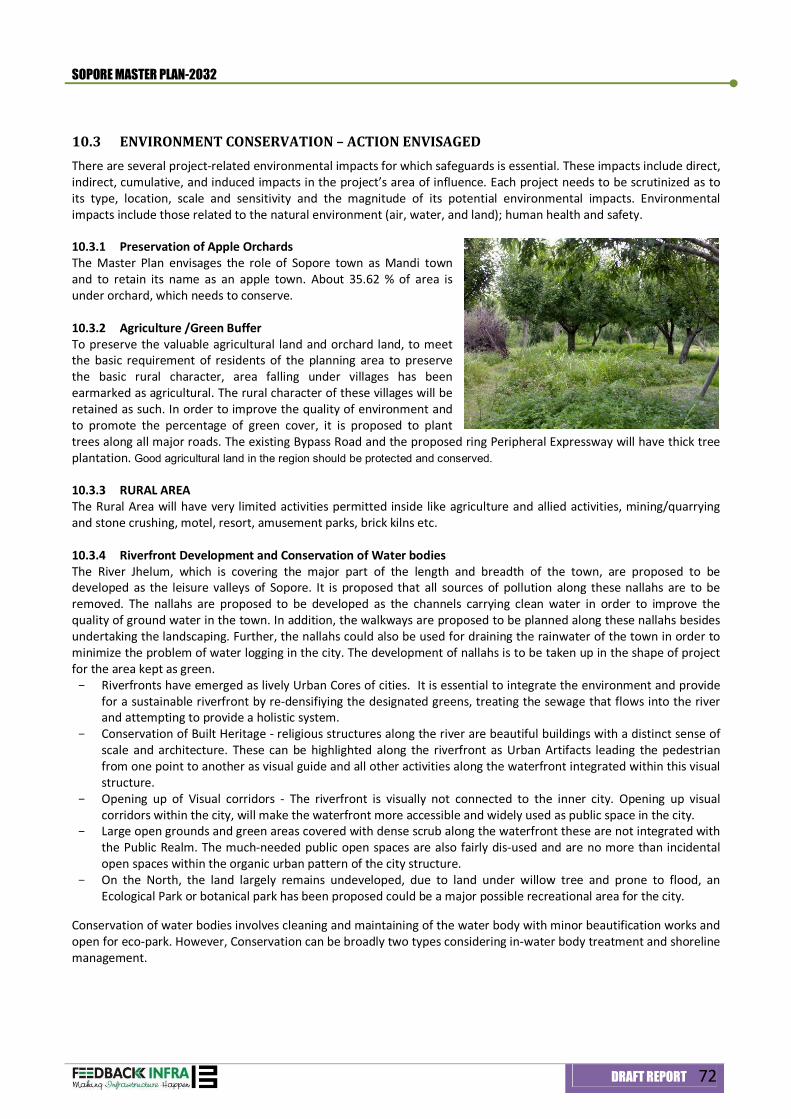
SOPORE MASTER PLAN-2032
DRAFT REPORT 72
10.3 ENVIRONMENT CONSERVATION – ACTION ENVISAGED There are several project-related environmental impacts for which safeguards is essential. These impacts include direct, indirect, cumulative, and induced impacts in the project’s area of influence. Each project needs to be scrutinized as to its type, location, scale and sensitivity and the magnitude of its potential environmental impacts. Environmental impacts include those related to the natural environment (air, water, and land); human health and safety.
10.3.1 Preservation of Apple Orchards The Master Plan envisages the role of Sopore town as Mandi town and to retain its name as an apple town. About 35.62 % of area is under orchard, which needs to conserve. 10.3.2 Agriculture /Green Buffer To preserve the valuable agricultural land and orchard land, to meet the basic requirement of residents of the planning area to preserve the basic rural character, area falling under villages has been earmarked as agricultural. The rural character of these villages will be retained as such. In order to improve the quality of environment and to promote the percentage of green cover, it is proposed to plant trees along all major roads. The existing Bypass Road and the proposed ring Peripheral Expressway will have thick tree plantation. Good agricultural land in the region should be protected and conserved. 10.3.3 RURAL AREA The Rural Area will have very limited activities permitted inside like agriculture and allied activities, mining/quarrying and stone crushing, motel, resort, amusement parks, brick kilns etc. 10.3.4 Riverfront Development and Conservation of Water bodies The River Jhelum, which is covering the major part of the length and breadth of the town, are proposed to be developed as the leisure valleys of Sopore. It is proposed that all sources of pollution along these nallahs are to be removed. The nallahs are proposed to be developed as the channels carrying clean water in order to improve the quality of ground water in the town. In addition, the walkways are proposed to be planned along these nallahs besides undertaking the landscaping. Further, the nallahs could also be used for draining the rainwater of the town in order to minimize the problem of water logging in the city. The development of nallahs is to be taken up in the shape of project for the area kept as green. - Riverfronts have emerged as lively Urban Cores of cities. It is essential to integrate the environment and provide
for a sustainable riverfront by re-densifiying the designated greens, treating the sewage that flows into the river and attempting to provide a holistic system.
- Conservation of Built Heritage - religious structures along the river are beautiful buildings with a distinct sense of scale and architecture. These can be highlighted along the riverfront as Urban Artifacts leading the pedestrian from one point to another as visual guide and all other activities along the waterfront integrated within this visual structure.
- Opening up of Visual corridors - The riverfront is visually not connected to the inner city. Opening up visual corridors within the city, will make the waterfront more accessible and widely used as public space in the city.
- Large open grounds and green areas covered with dense scrub along the waterfront these are not integrated with the Public Realm. The much-needed public open spaces are also fairly dis-used and are no more than incidental open spaces within the organic urban pattern of the city structure.
- On the North, the land largely remains undeveloped, due to land under willow tree and prone to flood, an Ecological Park or botanical park has been proposed could be a major possible recreational area for the city.
Conservation of water bodies involves cleaning and maintaining of the water body with minor beautification works and open for eco-park. However, Conservation can be broadly two types considering in-water body treatment and shoreline management.
SOPORE MASTER PLAN-2032
DRAFT REPORT 73
In-water treatment Dredging and de-silting- Renovation of traditional water bodies including desilting of tanks, De-silting in terms of
quantum of silt to be removed. Develop and deepen the water bodies to ensure better rainwater harvesting and percolation of water to the ground water aquifers. As a result, storage capacity shall be increased.
Shoreline treatment strengthening of bund(s) soil erosion prevention works quality control measures
Shoreline Management Declare water body as a protected area Boundary and Fencing- boundary should be demarcated and fencing (either thorn or by plants) should be Done along the boundary as a physically visible, easily identifiable demarcation Peripheral footpath and Green Belts Electrification Promote Eco-Tourism Community facilities for visitors In conclusion, subsequent to the finalization of project structure of each water body, it is required to get Techno-economic Feasibility and Detailed Project Reports (DPR) for implementation. It should be based on the surveys including water quality and biodiversity of the water body. 10.3.5 Solid Waste Management An effective solid waste management system is necessary for maintaining the health and hygiene within a city. The important points to be considered are as under: Waste segregation should be practiced at household and community level Dustbins should be provided at appropriate locations Regular collection should be done by the competent authority The site for waste disposal should be properly and scientifically selected so that no contaminants percolate
into the ground water, river or lake Hazardous waste and bio-medical waste should be disposed off separately Waste disposal areas should be planned down-wind of villages and townships The pattern of filling disposal site should be planned to create better landscape and be approved by
appropriate agency and the appropriately pre-treated solid wastes should be disposed according to the approved plan. No landfill should be constructed within wetlands and on the riverbed
Intensive programs of tree plantation on disposal areas should be undertaken.
10.3.6 Industrial Area Management In the industrial/residential areas, land should be identified for plantation/green belt development and for each of the developmental/industrial schemes; sufficient plantation may be undertaken in all the available spaces. The plant species should be selected in consultation with the Forest Department. Such areas should not be compounded later on for establishment of industries.
- The industries should preferably be permitted in industrial areas - Establishment of industries outside the industrial area should be as per the initial environment
examination (IEE) permitted in case it is not feasible to locate them within the premises of industrial area - Suitable site for solid waste dumping should be identified for each of the industrial area - The provision of combined effluent treatment facilities should form part of infrastructure provided to the industries - The rainwater harvesting measures by the industrial units should be encouraged
SOPORE MASTER PLAN-2032
DRAFT REPORT 74
10.3.7 FIRE PROTECTION REQUIREMENTS AND SAFETY MEASURES AGAINST EARTH QUAKE The region lies in the top two high risk seismic zones of IV and V of Indian seismic code IS:1893 with the expected intensity of IX or more in the zone V and intensity of VIII in the zone IV. Damage to buildings and other structures in general agreed well with the intensity of ground shaking observed in recent earthquake where epicenter was in neighboring country at various places, with the maximum of VIII at Uri, VII at Baramulla and Kupwara and V at Srinagar on MSK scale. However, the collapse of stone-walls of random rubble types was surprise even at much lesser shaking.
A Civil Defense and Disaster Management unit at Sopore has been already established Sopore town remained earthquake prone area and history shows that number of earthquakes occurred which took precious lives in the past.
The main objective of Disaster Management is to initiate preemptive action before any climatic strikes. Disaster Management is not only an emergency relief and rehabilitation measure. Though it is almost impossible to recover the damage caused by disaster, it is possible to:
1. Minimize the potential risk by developing early warning strategies 2. Prepare and implement plans to provide resilience to such disaster 3. Mobiles resources 4. To help in rehabilitation and post disaster reconstruction 5. Bridges, roads, water tanks, etc., which shall be constructed due consideration of high seismic activities of the
Himalayan region make such civil infrastructure extremely vulnerable for future earthquakes
The Planning design and construction of any building shall be such as to ensure safety from fire. For this purpose, unless otherwise specified in these Regulations, the provisions of Part-IV, Fire Protection Chapter and National Building Code shall apply. For multi-storied, high-rise and special buildings, additional provisions relating to fire protection contained in Annexure C of NBC shall also apply. The approach to the building and open spaces on all sides up to 6 m width and their layout shall conform to the requirements of the Chief Officer. They shall be capable of taking the weight of a fire engine weighing up to 18 tones. These open spaces shall be free of any obstruction and shall be motorable. Exits- Every building meant for human occupancy shall be provided with exits sufficient to permit safe escape of its occupants in case of fire or other emergency for which the exits shall conform to the following:
i. Types – Exits should be horizontal or vertical. A horizontal exit may be a door-way, a corridor, a passage-way to an internal stairway or to an adjoining building, a ramp, a verandah, or a terrace which has access to the street or to the roof of a building. A vertical exit may be a staircase or a ramp, but not a lift.
ii. General requirement – Exits from all the parts of the building, except those not accessible for general public use, shall: (a) provide continuous egress to the exterior of the building or to an exterior open space leading to the
street; (b) be so arranged that, except in a residential building, they can be reached without having to cross
another occupied unit; (c) be free of obstruction; (d) be adequately illuminated; (e) be clearly visible, with the routes reaching them clearly marked and signs posted to guide any person
to the floor concerned; (f) be fitted, if necessary, with firefighting equipment suitably located but not as to obstruct the passage,
clearly marked and with its location clearly indicated on both sides of the exit way; (g) be fitted with a fire alarm device, if it is either a multi-storied, (h) remain unaffected by any alteration of any part of the building so far as their number, width, capacity
and protection thereof is concerned; (i) be so located that the travel distance on the floor does not exceed the following limits:
1. Residential, educational, institutional and hazardous occupancies: 22.5 m 2. Assembly, business, mercantile, industrial and storage building: 30 m

SOPORE MASTER PLAN-2032
DRAFT REPORT 75
Note: The travel distance to an exit from the dead end of a corridor shall not exceed half the distance specified above. When more than one exit is required on a floor, the exits shall be as remote from each other as possible: Provided that for all multi-Storeyed high rise and special buildings, a minimum of two enclosed type staircases shall be provided, at least one of them opens directly to the exterior to an interior open space or to any open place of safety.
iii. Number and width of exits – The width of an exit, stairway / corridor and exit door to be provided at each floor in occupancies of various types shall be as shown in columns 3 & 5 of Table 23 of IS 1893-2002. Their number shall be estimated by applying to every 100 sq. m. of the plinth or covered area of the occupancy, the relevant multiplier in columns 4 & 6 of Table 23, Fractions being rounded off upward to the nearest whole number.
Safety Measures against Earthquake Buildings with ground plus four floors and above or buildings with a height of 15 m and above shall be designed and constructed adopting the norms prescribed in the National Building Code and in the “Criteria for earthquake resistant design of structures” as per IS 1893-2002 published by the Bureau of Indian Standards, making the buildings resistant to earthquake. The supervision certificate and the completion certificate of such building shall contain a certificate recorded by the Registered Engineer / Architect /Planner.

Land-use Zoning & Development Control Regulation 11
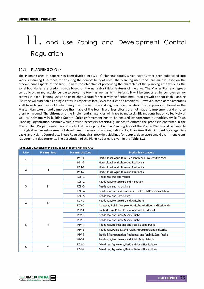
SOPORE MASTER PLAN-2032
DRAFT REPORT 76
11. Land use Zoning and Development Control
Regulation
11.1 PLANNING ZONES The Planning area of Sopore has been divided into Six (6) Planning Zones, which have further been subdivided into various Planning Use-zones for ensuring the compatibility of uses. The planning uses zones are mainly based on the predominant aspects of the landuse with the objective of preserving the character of the planning area while as the zonal boundaries are predominantly based on the natural/artificial features of the area. The Master Plan envisages a centrally organized activity centre to serve the town as well as its hinterland. It will be supported by complementary centres in each Planning use zone or neighbourhood for relatively self-contained urban growth so that each Planning use zone will function as a single entity in respect of local level facilities and amenities. However, some of the amenities shall have larger threshold, which may function as town and regional level facilities. The proposals contained in the Master Plan would hardly improve the image of the town life unless efforts are not made to implement and enforce them on ground. The citizens and the implementing agencies will have to make significant contribution collectively as well as individually in building Sopore. Strict enforcement has to be ensured by concerned authorities, while Town Planning Organization Kashmir would provide necessary technical guidance to enforce the proposals contained in the Master Plan. Proper regulation and control of development within Planning Area of the Master Plan would be possible through effective enforcement of development promotion and regulations like, Floor Area Ratio, Ground Coverage. Set-backs and Height Control etc. These Regulations shall provide guidelines for people, developers and Government /semi -Government departments. The description of the Planning Zones is given in the Table 11.1. Table 11.1: Description of Planning Zones in Sopore Planning Area
S. No. Planning Zone Planning Use Zone Predominant Landuse
1 I PZ I -1 Horticultural, Agriculture, Residential and Eco-sensitive Zone PZ I -2 Horticultural, Agriculture and Residential
2 II PZ II-1 Horticultural, Agriculture and Residential PZ II-2 Horticultural, Agriculture and Residential
3 III
PZ III-1 Residential and commercial PZ III-2 Residential, Horticulture and Plantation PZ III-3 Residential and Horticulture PZ III-4 Residential and City Commercial Centre (Old Commercial Area) PZ III-5 Residential and Horticulture
4 IV PZIV-1 Residential, Horticulture and Agriculture PZIV-2 Industrial, Freight Complex, Horticulture Utilities and Residential
5 V
PZV-1 Public & Semi-Public, Recreational and Residential PZV-2 Residential and Public & Semi-Public PZV-3 Residential and Public & Semi-Public PZV-4 Residential, Recreational and Public & Semi-Public PZV-5 Residential, Public & Semi-Public, Horticultural and Industries PZV-6 Traffic & Transportation, Residential and Public & Semi-Public PZV-7 Residential, Horticulture and Public & Semi-Public
6 VI PZVI-1 Mixed use, Agriculture, Residential and Horticulture PZVI-2 Mixed use, Agriculture, Residential and Horticulture
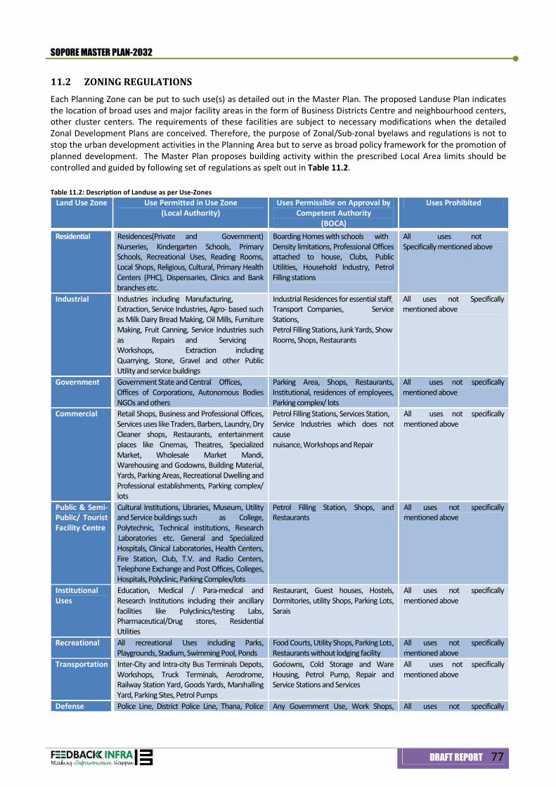
SOPORE MASTER PLAN-2032
DRAFT REPORT 77
11.2 ZONING REGULATIONS Each Planning Zone can be put to such use(s) as detailed out in the Master Plan. The proposed Landuse Plan indicates the location of broad uses and major facility areas in the form of Business Districts Centre and neighbourhood centers, other cluster centers. The requirements of these facilities are subject to necessary modifications when the detailed Zonal Development Plans are conceived. Therefore, the purpose of Zonal/Sub-zonal byelaws and regulations is not to stop the urban development activities in the Planning Area but to serve as broad policy framework for the promotion of planned development. The Master Plan proposes building activity within the prescribed Local Area limits should be controlled and guided by following set of regulations as spelt out in Table 11.2. Table 11.2: Description of Landuse as per Use-Zones
Land Use Zone Use Permitted in Use Zone (Local Authority)
Uses Permissible on Approval by Competent Authority
(BOCA)
Uses Prohibited
Residential Residences(Private and Government) Nurseries, Kindergarten Schools, Primary Schools, Recreational Uses, Reading Rooms, Local Shops, Religious, Cultural, Primary Health Centers (PHC), Dispensaries, Clinics and Bank branches etc.
Boarding Homes with schools with Density limitations, Professional Offices attached to house, Clubs, Public Utilities, Household Industry, Petrol Filling stations
All uses not Specifically mentioned above
Industrial Industries including Manufacturing, Extraction, Service Industries, Agro- based such as Milk Dairy Bread Making, Oil Mills, Furniture Making, Fruit Canning, Service Industries such as Repairs and Servicing Workshops, Extraction including Quarrying, Stone, Gravel and other Public Utility and service buildings
Industrial Residences for essential staff; Transport Companies, Service Stations, Petrol Filling Stations, Junk Yards, Show Rooms, Shops, Restaurants
All uses not Specifically mentioned above
Government Government State and Central Offices, Offices of Corporations, Autonomous Bodies NGOs and others
Parking Area, Shops, Restaurants, Institutional, residences of employees, Parking complex/ lots
All uses not specifically mentioned above
Commercial Retail Shops, Business and Professional Offices, Services uses like Traders, Barbers, Laundry, Dry Cleaner shops, Restaurants, entertainment places like Cinemas, Theatres, Specialized Market, Wholesale Market Mandi, Warehousing and Godowns, Building Material, Yards, Parking Areas, Recreational Dwelling and Professional establishments, Parking complex/ lots
Petrol Filling Stations, Services Station, Service Industries which does not cause nuisance, Workshops and Repair
All uses not specifically mentioned above
Public & Semi-Public/ Tourist Facility Centre
Cultural Institutions, Libraries, Museum, Utility and Service buildings such as College, Polytechnic, Technical institutions, Research Laboratories etc. General and Specialized Hospitals, Clinical Laboratories, Health Centers, Fire Station, Club, T.V. and Radio Centers, Telephone Exchange and Post Offices, Colleges, Hospitals, Polyclinic, Parking Complex/lots
Petrol Filling Station, Shops, and Restaurants
All uses not specifically mentioned above
Institutional Uses
Education, Medical / Para-medical and Research Institutions including their ancillary facilities like Polyclinics/testing Labs, Pharmaceutical/Drug stores, Residential Utilities
Restaurant, Guest houses, Hostels, Dormitories, utility Shops, Parking Lots, Sarais
All uses not specifically mentioned above
Recreational All recreational Uses including Parks, Playgrounds, Stadium, Swimming Pool, Ponds
Food Courts, Utility Shops, Parking Lots, Restaurants without lodging facility
All uses not specifically mentioned above
Transportation Inter-City and Intra-city Bus Terminals Depots, Workshops, Truck Terminals, Aerodrome, Railway Station Yard, Goods Yards, Marshalling Yard, Parking Sites, Petrol Pumps
Godowns, Cold Storage and Ware Housing, Petrol Pump, Repair and Service Stations and Services
All uses not specifically mentioned above
Defense Police Line, District Police Line, Thana, Police Any Government Use, Work Shops, All uses not specifically
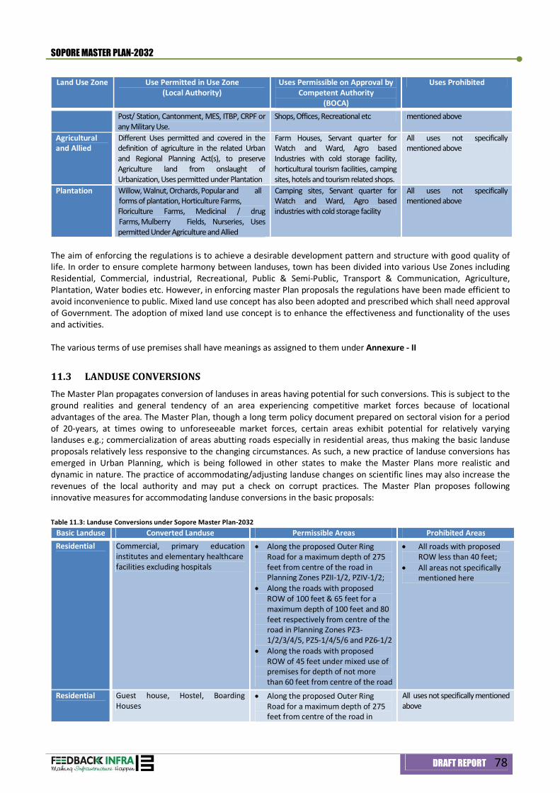
SOPORE MASTER PLAN-2032
DRAFT REPORT 78
Land Use Zone Use Permitted in Use Zone (Local Authority)
Uses Permissible on Approval by Competent Authority
(BOCA)
Uses Prohibited
Post/ Station, Cantonment, MES, ITBP, CRPF or any Military Use.
Shops, Offices, Recreational etc mentioned above
Agricultural and Allied
Different Uses permitted and covered in the definition of agriculture in the related Urban and Regional Planning Act(s), to preserve Agriculture land from onslaught of Urbanization, Uses permitted under Plantation
Farm Houses, Servant quarter for Watch and Ward, Agro based Industries with cold storage facility, horticultural tourism facilities, camping sites, hotels and tourism related shops.
All uses not specifically mentioned above
Plantation Willow, Walnut, Orchards, Popular and all forms of plantation, Horticulture Farms, Floriculture Farms, Medicinal / drug Farms, Mulberry Fields, Nurseries, Uses permitted Under Agriculture and Allied
Camping sites, Servant quarter for Watch and Ward, Agro based industries with cold storage facility
All uses not specifically mentioned above
The aim of enforcing the regulations is to achieve a desirable development pattern and structure with good quality of life. In order to ensure complete harmony between landuses, town has been divided into various Use Zones including Residential, Commercial, industrial, Recreational, Public & Semi-Public, Transport & Communication, Agriculture, Plantation, Water bodies etc. However, in enforcing master Plan proposals the regulations have been made efficient to avoid inconvenience to public. Mixed land use concept has also been adopted and prescribed which shall need approval of Government. The adoption of mixed land use concept is to enhance the effectiveness and functionality of the uses and activities. The various terms of use premises shall have meanings as assigned to them under Annexure - II
11.3 LANDUSE CONVERSIONS The Master Plan propagates conversion of landuses in areas having potential for such conversions. This is subject to the ground realities and general tendency of an area experiencing competitive market forces because of locational advantages of the area. The Master Plan, though a long term policy document prepared on sectoral vision for a period of 20-years, at times owing to unforeseeable market forces, certain areas exhibit potential for relatively varying landuses e.g.; commercialization of areas abutting roads especially in residential areas, thus making the basic landuse proposals relatively less responsive to the changing circumstances. As such, a new practice of landuse conversions has emerged in Urban Planning, which is being followed in other states to make the Master Plans more realistic and dynamic in nature. The practice of accommodating/adjusting landuse changes on scientific lines may also increase the revenues of the local authority and may put a check on corrupt practices. The Master Plan proposes following innovative measures for accommodating landuse conversions in the basic proposals: Table 11.3: Landuse Conversions under Sopore Master Plan-2032
Basic Landuse Converted Landuse Permissible Areas Prohibited Areas Residential Commercial, primary education
institutes and elementary healthcare facilities excluding hospitals
Along the proposed Outer Ring Road for a maximum depth of 275 feet from centre of the road in Planning Zones PZII-1/2, PZIV-1/2;
Along the roads with proposed ROW of 100 feet & 65 feet for a maximum depth of 100 feet and 80 feet respectively from centre of the road in Planning Zones PZ3-1/2/3/4/5, PZ5-1/4/5/6 and PZ6-1/2
Along the roads with proposed ROW of 45 feet under mixed use of premises for depth of not more than 60 feet from centre of the road
All roads with proposed ROW less than 40 feet;
All areas not specifically mentioned here
Residential Guest house, Hostel, Boarding Houses
Along the proposed Outer Ring Road for a maximum depth of 275 feet from centre of the road in
All uses not specifically mentioned above
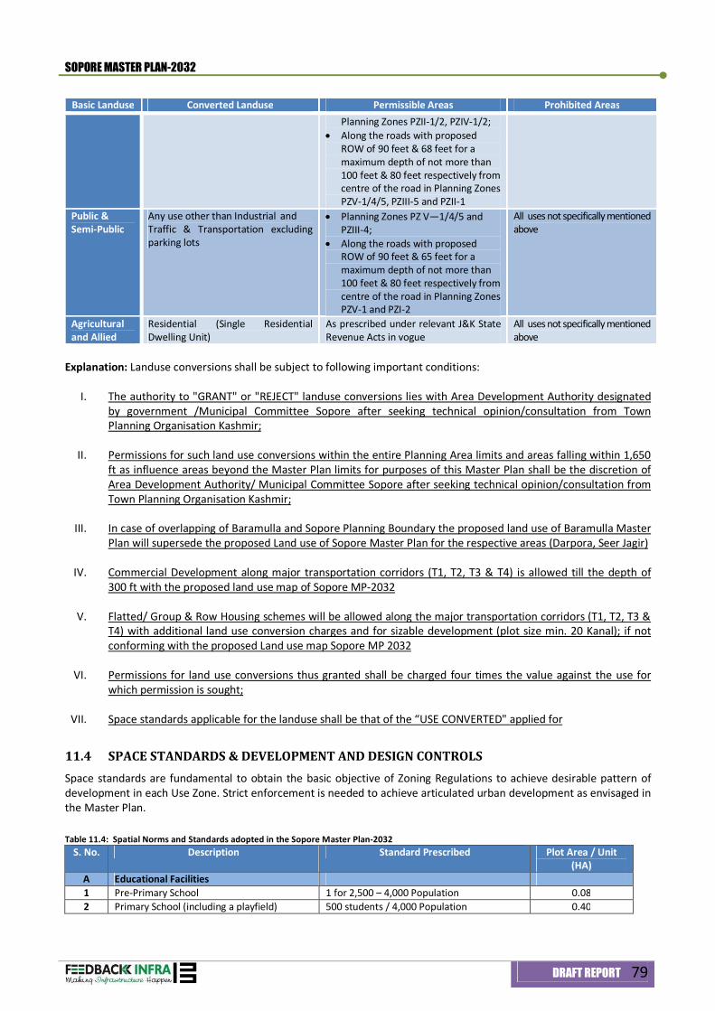
SOPORE MASTER PLAN-2032
DRAFT REPORT 79
Basic Landuse Converted Landuse Permissible Areas Prohibited Areas Planning Zones PZII-1/2, PZIV-1/2;
Along the roads with proposed ROW of 90 feet & 68 feet for a maximum depth of not more than 100 feet & 80 feet respectively from centre of the road in Planning Zones PZV-1/4/5, PZIII-5 and PZII-1
Public & Semi-Public
Any use other than Industrial and Traffic & Transportation excluding parking lots
Planning Zones PZ V—1/4/5 and PZIII-4;
Along the roads with proposed ROW of 90 feet & 65 feet for a maximum depth of not more than 100 feet & 80 feet respectively from centre of the road in Planning Zones PZV-1 and PZI-2
All uses not specifically mentioned above
Agricultural and Allied
Residential (Single Residential Dwelling Unit)
As prescribed under relevant J&K State Revenue Acts in vogue
All uses not specifically mentioned above
Explanation: Landuse conversions shall be subject to following important conditions:
I. The authority to "GRANT" or "REJECT" landuse conversions lies with Area Development Authority designated by government /Municipal Committee Sopore after seeking technical opinion/consultation from Town Planning Organisation Kashmir;
II. Permissions for such land use conversions within the entire Planning Area limits and areas falling within 1,650 ft as influence areas beyond the Master Plan limits for purposes of this Master Plan shall be the discretion of Area Development Authority/ Municipal Committee Sopore after seeking technical opinion/consultation from Town Planning Organisation Kashmir;
III. In case of overlapping of Baramulla and Sopore Planning Boundary the proposed land use of Baramulla Master
Plan will supersede the proposed Land use of Sopore Master Plan for the respective areas (Darpora, Seer Jagir)
IV. Commercial Development along major transportation corridors (T1, T2, T3 & T4) is allowed till the depth of 300 ft with the proposed land use map of Sopore MP-2032
V. Flatted/ Group & Row Housing schemes will be allowed along the major transportation corridors (T1, T2, T3 & T4) with additional land use conversion charges and for sizable development (plot size min. 20 Kanal); if not conforming with the proposed Land use map Sopore MP 2032
VI. Permissions for land use conversions thus granted shall be charged four times the value against the use for which permission is sought;
VII. Space standards applicable for the landuse shall be that of the “USE CONVERTED" applied for
11.4 SPACE STANDARDS & DEVELOPMENT AND DESIGN CONTROLS Space standards are fundamental to obtain the basic objective of Zoning Regulations to achieve desirable pattern of development in each Use Zone. Strict enforcement is needed to achieve articulated urban development as envisaged in the Master Plan. Table 11.4: Spatial Norms and Standards adopted in the Sopore Master Plan-2032
S. No. Description Standard Prescribed Plot Area / Unit (HA)
A Educational Facilities 1 Pre-Primary School 1 for 2,500 – 4,000 Population 0.08 2 Primary School (including a playfield) 500 students / 4,000 Population 0.40
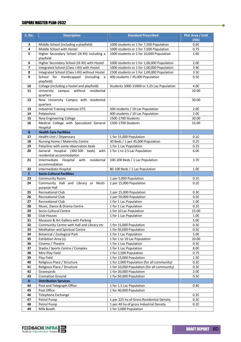
SOPORE MASTER PLAN-2032
DRAFT REPORT 80
S. No. Description Standard Prescribed Plot Area / Unit (HA)
3 Middle School (including a playfield) 1000 students or 1 for 7,500 Population 0.60 4 Middle School with Hostel 1000 students or 1 for 7,500 Population 0.75 5 Higher Secondary School (IX-XII) including a
playfield 1000 students or 1 for 10,000 Population 1.60
6 Higher Secondary School (IX-XII) with Hostel 1000 students or 1 for 1,00,000 Population 2.00 7 Integrated School (Class I-XII) with Hostel 1000 students or 1 for 1,00,000 Population 3.90 8 Integrated School (Class I-XII) without Hostel 1500 students or 1 for 1,00,000 Population 3.50 9 School for Handicapped (including a
playfield) 400 students / 45,000 Population 0.50
10 College (including a hostel and playfield) Students 1000-15000 or 1.25 Lac Population 4.00 11 University campus without residential
quarters - 10.00
12 New University Campus with residential quarters
- 30.00
13 Industrial Training Institute (ITI) 500 students / 10 Lac Population 2.00 14 Polytechnic 400 students / 10 Lac Population 2.00 15 New Engineering College 1500-1700 Students 30.00 16 Medical College with Specialized General
Hospital 1500-1700 Students 15.00
B Health Care Facilities 17 Health Unit / Dispensary 1 for 15,000 Population 0.10 18 Nursing Home / Maternity Centre 30 Beds / 1 per 45,000 Population 0.25 19 Polyclinic with some observation beds 1 for 1 Lac Population 0.25 20 General Hospital (300-500 beds) with
residential accommodation 1 for 1 to 2.5 Lac Population 6.00
21 Intermediate Hospital with residential accommodation
100-200 Beds / 1 Lac Population 3.70
22 Intermediate Hospital 80-100 Beds / 1 Lac Population 1.00 C Socio-Cultural Facilities
23 Community Room 1 per 5,000 Population 0.10 24 Community Hall and Library or Multi-
purpose Hall 1 per 15,000 Population 0.20
25 Recreational Club 1 per 15,000 Population 0.30 26 Recreational Club 1 per 50,000 Population 0.50 27 Recreational Club 1 for 1 Lac Population 1.00 28 Music, Dance & Drama Centre 1 for 1 Lac Population 0.20 29 Socio-Cultural Centre 1 for 10 Lac Population 15.00 30 Club Houses 1 for 1 Lac Population 1.00 31 Museum & Art Gallery with Parking - 1.00 32 Community Centre with Hall and Library etc 1 for 15,000 Population 0.30 33 Meditation and Spiritual Centre 1 for 50,000 Population 0.50 34 Botanical / Zoological Park 1 for 1 Lac Population 5.00 35 Exhibition Area (s) 1 for 1 to 10 Lac Population 10.00 36 Cinema / Theatre 1 for 1 Lac Population 0.50 37 Stadia / Sports Centre / Complex 1 for 1 Lac Population 8.00 38 Mini-Play Field 1 for 2,500 Population 0.75 39 Play Field 1 for 15,000 Population 1.50 40 Religious Place / Structure 1 for 2,000 Population (for all community) 0.20 41 Religious Place / Structure 1 for 10,000 Population (for all community) 0.50 42 Graveyards 1 for 20,000 Population 2.00 43 Cremation Ground 1 for 50,000 Population 0.50 D Distribution Services 44 Post and Telegraph Office 1 for 1.5 Lac Population 0.40 45 Post Office 1 for 40,000 Population - 46 Telephone Exchange - 0.20 47 Petrol Pump 1 per 225 ha of Gross Residential Density 0.20 48 Petrol Pump 1 per 40 ha of gross Industrial Density 0.20 49 Milk Booth 1 for 5,000 Population -
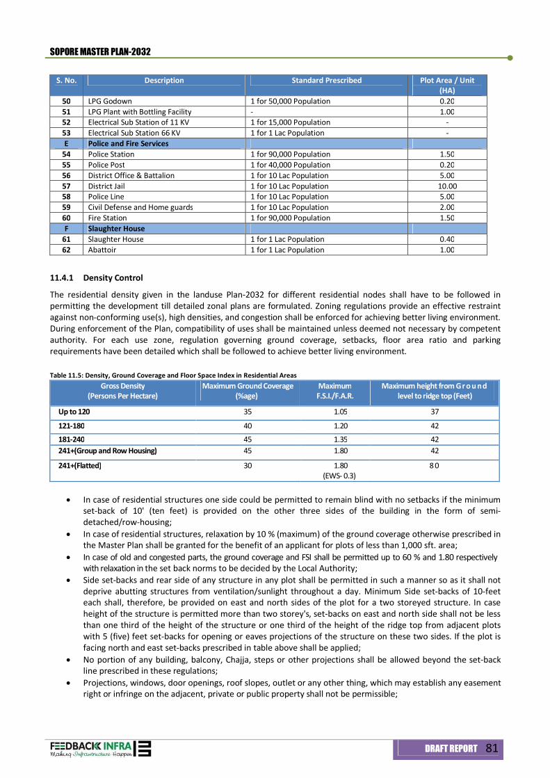
SOPORE MASTER PLAN-2032
DRAFT REPORT 81
S. No. Description Standard Prescribed Plot Area / Unit (HA)
50 LPG Godown 1 for 50,000 Population 0.20 51 LPG Plant with Bottling Facility - 1.00 52 Electrical Sub Station of 11 KV 1 for 15,000 Population - 53 Electrical Sub Station 66 KV 1 for 1 Lac Population - E Police and Fire Services
54 Police Station 1 for 90,000 Population 1.50 55 Police Post 1 for 40,000 Population 0.20 56 District Office & Battalion 1 for 10 Lac Population 5.00 57 District Jail 1 for 10 Lac Population 10.00 58 Police Line 1 for 10 Lac Population 5.00 59 Civil Defense and Home guards 1 for 10 Lac Population 2.00 60 Fire Station 1 for 90,000 Population 1.50 F Slaughter House
61 Slaughter House 1 for 1 Lac Population 0.40 62 Abattoir 1 for 1 Lac Population 1.00
11.4.1 Density Control
The residential density given in the landuse Plan-2032 for different residential nodes shall have to be followed in permitting the development till detailed zonal plans are formulated. Zoning regulations provide an effective restraint against non-conforming use(s), high densities, and congestion shall be enforced for achieving better living environment. During enforcement of the Plan, compatibility of uses shall be maintained unless deemed not necessary by competent authority. For each use zone, regulation governing ground coverage, setbacks, floor area ratio and parking requirements have been detailed which shall be followed to achieve better living environment. Table 11.5: Density, Ground Coverage and Floor Space Index in Residential Areas
Gross Density (Persons Per Hectare)
Maximum Ground Coverage (%age)
Maximum F.S.I./F.A.R.
Maximum height from Gr o u nd level to ridge top (Feet)
Up to 120 35 1.05 37
121-180 40 1.20 42
181-240 45 1.35 42 241+(Group and Row Housing) 45 1.80 42
241+(Flatted) 30 1.80 (EWS- 0.3)
8 0
In case of residential structures one side could be permitted to remain blind with no setbacks if the minimum
set-back of 10' (ten feet) is provided on the other three sides of the building in the form of semi-detached/row-housing;
In case of residential structures, relaxation by 10 % (maximum) of the ground coverage otherwise prescribed in the Master Plan shall be granted for the benefit of an applicant for plots of less than 1,000 sft. area;
In case of old and congested parts, the ground coverage and FSI shall be permitted up to 60 % and 1.80 respectively with relaxation in the set back norms to be decided by the Local Authority;
Side set-backs and rear side of any structure in any plot shall be permitted in such a manner so as it shall not deprive abutting structures from ventilation/sunlight throughout a day. Minimum Side set-backs of 10-feet each shall, therefore, be provided on east and north sides of the plot for a two storeyed structure. In case height of the structure is permitted more than two storey's, set-backs on east and north side shall not be less than one third of the height of the structure or one third of the height of the ridge top from adjacent plots with 5 (five) feet set-backs for opening or eaves projections of the structure on these two sides. If the plot is facing north and east set-backs prescribed in table above shall be applied;
No portion of any building, balcony, Chajja, steps or other projections shall be allowed beyond the set-back line prescribed in these regulations;
Projections, windows, door openings, roof slopes, outlet or any other thing, which may establish any easement right or infringe on the adjacent, private or public property shall not be permissible;
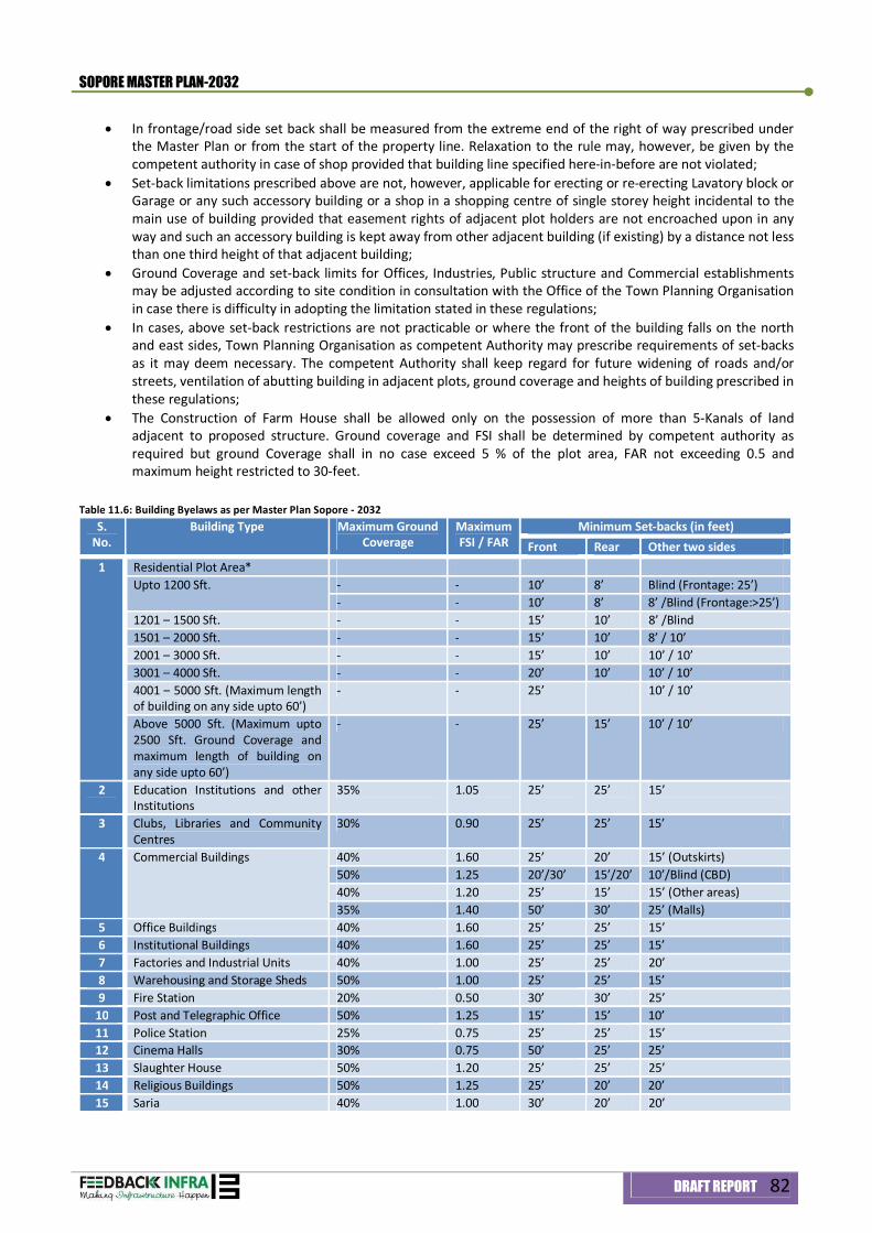
SOPORE MASTER PLAN-2032
DRAFT REPORT 82
In frontage/road side set back shall be measured from the extreme end of the right of way prescribed under the Master Plan or from the start of the property line. Relaxation to the rule may, however, be given by the competent authority in case of shop provided that building line specified here-in-before are not violated;
Set-back limitations prescribed above are not, however, applicable for erecting or re-erecting Lavatory block or Garage or any such accessory building or a shop in a shopping centre of single storey height incidental to the main use of building provided that easement rights of adjacent plot holders are not encroached upon in any way and such an accessory building is kept away from other adjacent building (if existing) by a distance not less than one third height of that adjacent building;
Ground Coverage and set-back limits for Offices, Industries, Public structure and Commercial establishments may be adjusted according to site condition in consultation with the Office of the Town Planning Organisation in case there is difficulty in adopting the limitation stated in these regulations;
In cases, above set-back restrictions are not practicable or where the front of the building falls on the north and east sides, Town Planning Organisation as competent Authority may prescribe requirements of set-backs as it may deem necessary. The competent Authority shall keep regard for future widening of roads and/or streets, ventilation of abutting building in adjacent plots, ground coverage and heights of building prescribed in these regulations;
The Construction of Farm House shall be allowed only on the possession of more than 5-Kanals of land adjacent to proposed structure. Ground coverage and FSI shall be determined by competent authority as required but ground Coverage shall in no case exceed 5 % of the plot area, FAR not exceeding 0.5 and maximum height restricted to 30-feet.
Table 11.6: Building Byelaws as per Master Plan Sopore - 2032 S.
No. Building Type Maximum Ground
Coverage Maximum FSI / FAR
Minimum Set-backs (in feet) Front Rear Other two sides
1 Residential Plot Area* Upto 1200 Sft. - - 10’ 8’ Blind (Frontage: 25’)
- - 10’ 8’ 8’ /Blind (Frontage:>25’) 1201 – 1500 Sft. - - 15’ 10’ 8’ /Blind 1501 – 2000 Sft. - - 15’ 10’ 8’ / 10’ 2001 – 3000 Sft. - - 15’ 10’ 10’ / 10’ 3001 – 4000 Sft. - - 20’ 10’ 10’ / 10’ 4001 – 5000 Sft. (Maximum length of building on any side upto 60’)
- - 25’ 10’ / 10’
Above 5000 Sft. (Maximum upto 2500 Sft. Ground Coverage and maximum length of building on any side upto 60’)
- - 25’ 15’ 10’ / 10’
2 Education Institutions and other Institutions
35% 1.05 25’ 25’ 15’
3 Clubs, Libraries and Community Centres
30% 0.90 25’ 25’ 15’
4 Commercial Buildings 40% 1.60 25’ 20’ 15’ (Outskirts) 50% 1.25 20’/30’ 15’/20’ 10’/Blind (CBD) 40% 1.20 25’ 15’ 15’ (Other areas) 35% 1.40 50’ 30’ 25’ (Malls)
5 Office Buildings 40% 1.60 25’ 25’ 15’ 6 Institutional Buildings 40% 1.60 25’ 25’ 15’ 7 Factories and Industrial Units 40% 1.00 25’ 25’ 20’ 8 Warehousing and Storage Sheds 50% 1.00 25’ 25’ 15’ 9 Fire Station 20% 0.50 30’ 30’ 25’
10 Post and Telegraphic Office 50% 1.25 15’ 15’ 10’ 11 Police Station 25% 0.75 25’ 25’ 15’ 12 Cinema Halls 30% 0.75 50’ 25’ 25’ 13 Slaughter House 50% 1.20 25’ 25’ 25’ 14 Religious Buildings 50% 1.25 25’ 20’ 20’ 15 Saria 40% 1.00 30’ 20’ 20’
SOPORE MASTER PLAN-2032
DRAFT REPORT 83
*The Minimum frontage required for any residential plot shall be 25-feet and minimum Plot size of 1,000 Sft. **In case of commercial buildings with sides blind, the front and rear setbacks shall be increased to 30 and 20
feet respectively
11.4.2 Development and Design Controls
(a) Facade Control Measures Last three decades of senseless residential and other constructions have resulted in the traditional aesthetics becoming the major casualty. Most of the constructions have skewed proportions using imported material without any consideration for ethnic material and proportion, which has drastically affected the traditional character of the Valley towns. Guidelines have been prepared to create a cohesive design character, utilizing a limited vocabulary of design features that reinforces the typical character of Kashmir's towns. The intent is to have each building and other man-made feature contributing to the character of the area so that there is an identifiable mountain resort image instead of a disparate collection of individual components and a cluster formation of units. The design concept will take inspiration from the hill-side architecture and planning emphasizing sloping roofs, and abundant use of natural materials-primarily timber and local stone. (b) Design concepts and proportions of Building Elements The shape of the building will be determined by its functional mass. False appurtenances and decorative architectural elements with no function will not be permitted. It is intended that the style be rustic, solid and true, with its elegance and grace provided by good proportions, good massing and good relationship to the other buildings. (c) Land Slope and Contours Design must evolve considering zero or minimal alteration of existing slopes and contours. Slope cutting shall not be allowed to accommodate any structure that is not compatible to slopes and contours. (d) Land Forms and Geographical Character of soil Landforms and geographical character must be respected while planning any road access and the raising of structure and its allied infrastructure. No retaining wall of concrete or stone shall be permitted for forced placement of any building. (e) Impact on Environment Services such as garbage disposal, wastewater management, Sewerage etc shall be individually or collectively managed to leave underground or above ground resources unpolluted. (f) Energy Efficient Planning All building placements, their windows and roof slopes along with tree foliage shall be planned to achieve maximum energy efficient designs in order to reduce dependence on mechanical and non renewable energy resources which otherwise are environmentally and financially expensive.
11.4.3 Group Housing (Flatted a Housing Colonies):
(a) Flatted Development: Minimum Land Requirement/plot size : 10 Kanals Max. Ground Coverage : 40% Max. FSI : 1.80 Maximum Height : 80 feet
Minimum Setbacks to be determined @ one- third of the height of each building or 25'-0” whichever is maximum Note:
Maximum of 2.5 % of the plot area (in addition to main use applied for) shall be reserved for commercial use with provision of shops in the ground floor and office space in the first floor;
Maximum of 5 % of the plot area shall be reserved for community uses such as marriage hall, religious building, library, reading room, dub etc;
40 % of the total plot area shall be preserved as tot-lots, play fields, public parks and other open spaces;
SOPORE MASTER PLAN-2032
DRAFT REPORT 84
Basement, if constructed and used for parking, services and for essential storage and for providing facilities shall not be counted in FAR;
25 % of the total floor area shall be reserved for low-income group; The basement area may be up to 75 % of the built up area, which shall not be included in FAR if used for
Parking/back-up services; Minimum 1.5 car space per dwelling unit shall be provided for HIG Housing and minimum one ECS per dwelling
unit shall be provided for MG and LIG housing; Stilts, open balconies, lift stairs; lift ducts shall not be counted in FAR
(b) Housing Colonies
1. An individual or a group of persons or a co-operative housing society or firm intending to plot out an estate of 25 Kanals minimum shall give notice in writing to the competent authority which will be accompanied by a layout plan of entire land showing the areas allotted for roads, open spaces, community facilities, the specification of the roads, drains and other infrastructures;
Minimum Land Requirement/plot size 25 Kanals Maximum Ground Coverage 45 % Maximum FSI 1.80
Maximum Height 42-feet
2. No internal road shall be less than 18’-0”; 3. No housing colony shall have area under commercial use more than 2.5 % of total area; 4. Land use of the layout plan approved by the competent authority shall not be changed unless with the prior
consent of the competent authority. Note:
a) Maximum of 2.5 % of plot area in addition to the main use applied for shall be reserved for commercial use with provision of shops in the ground floor and office space in the first floor;
b) Maximum of 5 % of the plot area shall be reserved for community uses as marriage hall, religious buildings, graveyards, library, reading room, club etc;
c) 15 % of the total plot area shall be preserved as tot-lots, play fields, public parks and other open spaces; d) 25 % of the total floor area shall be reserved for low-income group
Use of Building: Any building, the main or accessory, shall not be allowed to be used for any purpose other than
the use specified in the Master Plan.
Any use detrimental to the locality by reason of emission, smoke, noise, odor, vibration, dust or fumes shall not be permissible;
Minimum Size of Plots: Except the single storey shops, no building shall be erected or re-erected for:
A plot which has an area of less than 1,000 Sft and an average width of less than 20 feet or a depth of less than 30 feet shall not be allowed to be permitted for residential activity;
Other purposes on any plot, which has an area not less than standard size allocated in the Master Plan Height of the Building: Maximum height of a residential dwelling with hipped roof shall be measured from the
ground level to the ridge top which shall not exceed 50’-0” (fifty feet) in case of high rise development and not more than 37’-0” (thirty seven feet) in low rise residential development. In case the roof is flat, the height shall be measured from ground level to the top level of parapet and the height shall be restricted to 27’-0" (twenty-seven feet). Access to rooftop shall be allowed in the form of Mumpty having height not more than 7’-0" (seven feet).
Block Length: Where the building (Residential/Official or any other use) is contiguous, the length of the building block shall not be more than 100' (one hundred feet) from one end to another after which a fire gap or fire protection wall or an expansion joint as will be deemed necessary by the Technical Authority, shall be provided.
SOPORE MASTER PLAN-2032
DRAFT REPORT 85
Orientation: New construction in the township should be oriented in such a way so that these structures have
maximum exposure to the solar radiation. In case of planned row housing, buildings should be spaced reasonably apart, so that these do not obstruct the sun light. For the proper orientation of Government /other buildings, technical assistance must be sought by the concerned local authority from Town Planning Organisation Kashmir.
11.5 General Parking Norms Area to be considered under parking in basement/Stilts/Open shall be as under:
Basement 35 sq.m. per ECS Stilts 30 sq.m. per ECS Open / Surface 25 sq.m. per ECS
Car parking provision for Commercial establishments, Institutional Areas, Office Areas and Hotels shall be as follows:
Commercial area : : 1.25 (ECS per 100 sft. of total Floor Area
Institutional area : : 10 ECS for 100 persons /1.25 ECS per 100 sft. of total Floor Area which is ever is more
Hotels : One (ECS for two letable rooms with each letable room not less than 120 Sft. In other cases, car-parking requirement shall be on the basis of bye-laws as worked out by competent authority which shall take into cognizance all facets of development and modernization of society and growing requirements. Basement shall be allowed to be constructed especially in Central Business District for the purposes of provision of services to the main use of the structure. In case basement is constructed for parking purposes, it shall not be counted for FSI/FAR. The purpose for which basement is proposed to be constructed shall be strictly enforced to avoid the change of use.
11.6 Disaster Management All structures - public, semi-public or private - permitted for construction shall include earthquake resistant measures with respect to design, constructional technology and material. These shall be made safe for all types of disasters including floods, earthquakes, wind and fire. For this purpose a certificate from qualified person registered with respective competent authority/institute shall be enclosed with the Plan prior to any permission by the Building Permission Authority. Note: In case of ambiguities in the interpretation of land use (s) due to problems of scale, clarification shall be sought from Master Plan Report with the help of Competent Authority/Town Planning Organisation, Kashmir
11.7 Urban Design Guidelines 11.7.1 Urban Design Concept
Urban design is the discipline through which planning and architecture can create or renew a sense of local pride and identity. It has great potential for enhancing the visual image and quality of neighborhoods by providing a three-dimensional physical form to policies described in the Master Plan. It focuses on design of the public realm, which is created by both public spaces and the buildings that define them. Urban design views these spaces holistically and is concerned with bringing together the different disciplines responsible for the components of cities into a unified vision. Compared to comprehensive plans, urban design plans generally have a short time horizon and are typically area or project specific. Key elements of an urban design plan include the plan itself, the preparation of design guidelines for buildings, the design of the public realm - the open space, streets, sidewalks, and plazas between and around buildings and the public interest issues of buildings. These include massing, placement, sun, shadow, and wind issues.
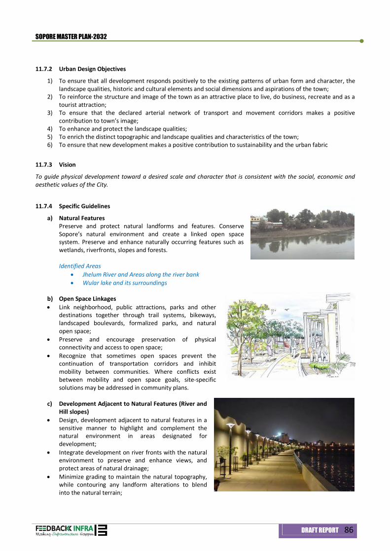
SOPORE MASTER PLAN-2032
DRAFT REPORT 86
11.7.2 Urban Design Objectives
1) To ensure that all development responds positively to the existing patterns of urban form and character, the landscape qualities, historic and cultural elements and social dimensions and aspirations of the town;
2) To reinforce the structure and image of the town as an attractive place to live, do business, recreate and as a tourist attraction;
3) To ensure that the declared arterial network of transport and movement corridors makes a positive contribution to town’s image;
4) To enhance and protect the landscape qualities; 5) To enrich the distinct topographic and landscape qualities and characteristics of the town; 6) To ensure that new development makes a positive contribution to sustainability and the urban fabric
11.7.3 Vision
To guide physical development toward a desired scale and character that is consistent with the social, economic and aesthetic values of the City.
11.7.4 Specific Guidelines
a) Natural Features Preserve and protect natural landforms and features. Conserve Sopore’s natural environment and create a linked open space system. Preserve and enhance naturally occurring features such as wetlands, riverfronts, slopes and forests. Identified Areas
Jhelum River and Areas along the river bank Wular lake and its surroundings
b) Open Space Linkages Link neighborhood, public attractions, parks and other
destinations together through trail systems, bikeways, landscaped boulevards, formalized parks, and natural open space;
Preserve and encourage preservation of physical connectivity and access to open space;
Recognize that sometimes open spaces prevent the continuation of transportation corridors and inhibit mobility between communities. Where conflicts exist between mobility and open space goals, site-specific solutions may be addressed in community plans.
c) Development Adjacent to Natural Features (River and
Hill slopes) Design, development adjacent to natural features in a
sensitive manner to highlight and complement the natural environment in areas designated for development;
Integrate development on river fronts with the natural environment to preserve and enhance views, and protect areas of natural drainage;
Minimize grading to maintain the natural topography, while contouring any landform alterations to blend into the natural terrain;
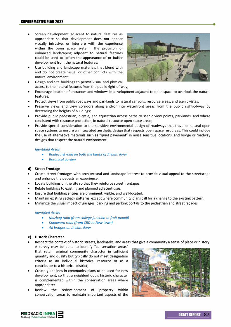
SOPORE MASTER PLAN-2032
DRAFT REPORT 87
Screen development adjacent to natural features as appropriate so that development does not appear visually intrusive, or interfere with the experience within the open space system. The provision of enhanced landscaping adjacent to natural features could be used to soften the appearance of or buffer development from the natural features;
Use building and landscape materials that blend with and do not create visual or other conflicts with the natural environment;
Design and site buildings to permit visual and physical access to the natural features from the public right-of-way;
Encourage location of entrances and windows in development adjacent to open space to overlook the natural features;
Protect views from public roadways and parklands to natural canyons, resource areas, and scenic vistas. Preserve views and view corridors along and/or into waterfront areas from the public right-of-way by
decreasing the heights of buildings; Provide public pedestrian, bicycle, and equestrian access paths to scenic view points, parklands, and where
consistent with resource protection, in natural resource open space areas; Provide special consideration to the sensitive environmental design of roadways that traverse natural open
space systems to ensure an integrated aesthetic design that respects open space resources. This could include the use of alternative materials such as “quiet pavement” in noise sensitive locations, and bridge or roadway designs that respect the natural environment. Identified Areas
Boulevard road on both the banks of Jhelum River Botanical garden
d) Street Frontage Create street frontages with architectural and landscape interest to provide visual appeal to the streetscape
and enhance the pedestrian experience. Locate buildings on the site so that they reinforce street frontages. Relate buildings to existing and planned adjacent uses. Ensure that building entries are prominent, visible, and well-located. Maintain existing setback patterns, except where community plans call for a change to the existing pattern. Minimize the visual impact of garages, parking and parking portals to the pedestrian and street façades.
Identified Areas
Mazbug road (from college junction to fruit mandi) Kupawara road (from CBD to New town) All bridges on Jhelum River
e) Historic Character Respect the context of historic streets, landmarks, and areas that give a community a sense of place or history.
A survey may be done to identify "conservation areas" that retain original community character in sufficient quantity and quality but typically do not meet designation criteria as an individual historical resource or as a contributor to a historical district;
Create guidelines in community plans to be used for new development, so that a neighborhood's historic character is complemented within the conservation areas where appropriate;
Review the redevelopment of property within conservation areas to maintain important aspects of the
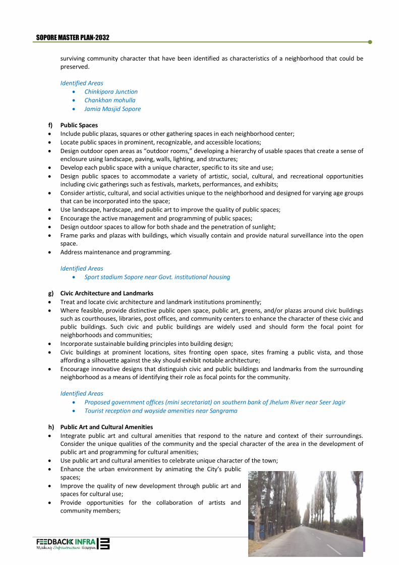
SOPORE MASTER PLAN-2032
DRAFT REPORT 88
surviving community character that have been identified as characteristics of a neighborhood that could be preserved. Identified Areas
Chinkipora Junction Chankhan mohulla Jamia Masjid Sopore
f) Public Spaces Include public plazas, squares or other gathering spaces in each neighborhood center; Locate public spaces in prominent, recognizable, and accessible locations; Design outdoor open areas as “outdoor rooms,” developing a hierarchy of usable spaces that create a sense of
enclosure using landscape, paving, walls, lighting, and structures; Develop each public space with a unique character, specific to its site and use; Design public spaces to accommodate a variety of artistic, social, cultural, and recreational opportunities
including civic gatherings such as festivals, markets, performances, and exhibits; Consider artistic, cultural, and social activities unique to the neighborhood and designed for varying age groups
that can be incorporated into the space; Use landscape, hardscape, and public art to improve the quality of public spaces; Encourage the active management and programming of public spaces; Design outdoor spaces to allow for both shade and the penetration of sunlight; Frame parks and plazas with buildings, which visually contain and provide natural surveillance into the open
space. Address maintenance and programming.
Identified Areas
Sport stadium Sopore near Govt. institutional housing
g) Civic Architecture and Landmarks Treat and locate civic architecture and landmark institutions prominently; Where feasible, provide distinctive public open space, public art, greens, and/or plazas around civic buildings
such as courthouses, libraries, post offices, and community centers to enhance the character of these civic and public buildings. Such civic and public buildings are widely used and should form the focal point for neighborhoods and communities;
Incorporate sustainable building principles into building design; Civic buildings at prominent locations, sites fronting open space, sites framing a public vista, and those
affording a silhouette against the sky should exhibit notable architecture; Encourage innovative designs that distinguish civic and public buildings and landmarks from the surrounding
neighborhood as a means of identifying their role as focal points for the community. Identified Areas
Proposed government offices (mini secretariat) on southern bank of Jhelum River near Seer Jagir Tourist reception and wayside amenities near Sangrama
h) Public Art and Cultural Amenities Integrate public art and cultural amenities that respond to the nature and context of their surroundings.
Consider the unique qualities of the community and the special character of the area in the development of public art and programming for cultural amenities;
Use public art and cultural amenities to celebrate unique character of the town; Enhance the urban environment by animating the City’s public
spaces; Improve the quality of new development through public art and
spaces for cultural use; Provide opportunities for the collaboration of artists and
community members;
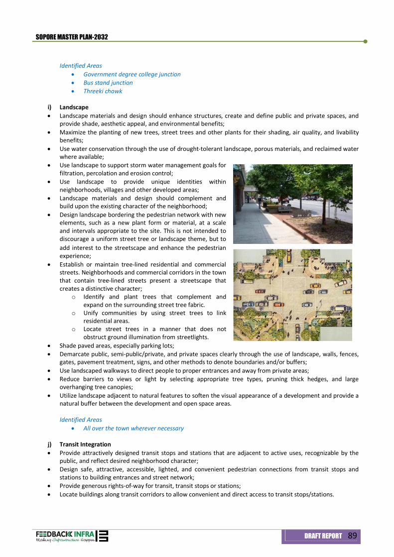
SOPORE MASTER PLAN-2032
DRAFT REPORT 89
Identified Areas
Government degree college junction Bus stand junction Threeki chowk
i) Landscape Landscape materials and design should enhance structures, create and define public and private spaces, and
provide shade, aesthetic appeal, and environmental benefits; Maximize the planting of new trees, street trees and other plants for their shading, air quality, and livability
benefits; Use water conservation through the use of drought-tolerant landscape, porous materials, and reclaimed water
where available; Use landscape to support storm water management goals for
filtration, percolation and erosion control; Use landscape to provide unique identities within
neighborhoods, villages and other developed areas; Landscape materials and design should complement and
build upon the existing character of the neighborhood; Design landscape bordering the pedestrian network with new
elements, such as a new plant form or material, at a scale and intervals appropriate to the site. This is not intended to discourage a uniform street tree or landscape theme, but to add interest to the streetscape and enhance the pedestrian experience;
Establish or maintain tree-lined residential and commercial streets. Neighborhoods and commercial corridors in the town that contain tree-lined streets present a streetscape that creates a distinctive character;
o Identify and plant trees that complement and expand on the surrounding street tree fabric.
o Unify communities by using street trees to link residential areas.
o Locate street trees in a manner that does not obstruct ground illumination from streetlights.
Shade paved areas, especially parking lots; Demarcate public, semi-public/private, and private spaces clearly through the use of landscape, walls, fences,
gates, pavement treatment, signs, and other methods to denote boundaries and/or buffers; Use landscaped walkways to direct people to proper entrances and away from private areas; Reduce barriers to views or light by selecting appropriate tree types, pruning thick hedges, and large
overhanging tree canopies; Utilize landscape adjacent to natural features to soften the visual appearance of a development and provide a
natural buffer between the development and open space areas. Identified Areas
All over the town wherever necessary
j) Transit Integration Provide attractively designed transit stops and stations that are adjacent to active uses, recognizable by the
public, and reflect desired neighborhood character; Design safe, attractive, accessible, lighted, and convenient pedestrian connections from transit stops and
stations to building entrances and street network; Provide generous rights-of-way for transit, transit stops or stations; Locate buildings along transit corridors to allow convenient and direct access to transit stops/stations.
SOPORE MASTER PLAN-2032
DRAFT REPORT 90
Identified Areas Multi modal transit hub proposed near railway station
k) Parking Reduce the amount and visual impact of surface parking lots; Encourage placement of parking along the rear and sides of street-oriented buildings; Avoid blank walls facing onto parking lots by promoting treatments that use colors, materials, landscape,
selective openings or other means of creating interest; Design clear and attractive pedestrian passes/pathways and signs that link parking and destinations; Locate pedestrian pathways in areas where vehicular access is limited; Avoid large areas of uninterrupted parking especially adjacent to community public view sheds; Build multiple small parking lots in lieu of one large lot; Retrofit existing expansive parking lots with street trees, landscape, pedestrian paths, and new building
placement; Promote the use of pervious surface materials to reduce runoff and infiltrate storm water; Use trees and other landscape to provide shade, screening, and filtering of storm water runoff in parking lots
Identified Areas
All over the town wherever necessary
l) Lighting Provide lighting from a variety of sources at appropriate intensities and qualities for safety; Provide pedestrian-scaled lighting for pedestrian circulation and visibility; Use effective lighting for vehicular traffic while not overwhelming the quality of pedestrian lighting; Use lighting to convey a sense of safety while minimizing glare and contrast; Use vandal-resistant light fixtures that complement the neighborhood and character. Focus lighting to eliminate spill-over so that lighting is directed, and only the intended use is illuminated.
Identified Areas
On all streets, important buildings and city level open spaces
m) Signage Design project signage to effectively utilize sign area and complement the character of the structure and
setting Architecturally integrate signage into project design; Include pedestrian-oriented signs to acquaint users to various aspects of a development. Place signs to direct
vehicular and pedestrian circulation; Post signs to provide directions and rules of conduct where appropriate behavior control is necessary; Design signs to minimize negative visual impacts; Address community-specific signage issues in community plans, where needed.
Identified Areas
All over the town wherever necessary
n) Utilities Minimize the visual and functional impact of utility systems and equipment on streets, sidewalks, and the
public realm; Convert overhead utility wires and poles, and overhead structures such as those associated with supplying
electric, communication, community antenna television, or similar service to underground; Design and locate public and private utility infrastructure, such as phone, cable and communications boxes,
transformers, meters, fuel ports, back-flow preventers, ventilation grilles, grease interceptors, irrigation valves, and any similar elements, to be integrated into adjacent development and as inconspicuous as possible;
To minimize obstructions, elements in the sidewalk and public right of way should be located in below grade vaults or building recesses that do not encroach on the right of way (to the maximum extent permitted by codes). If located in a landscaped setback, they should be as far from the sidewalk as possible, clustered and
SOPORE MASTER PLAN-2032
DRAFT REPORT 91
integrated into the landscape design, and screened from public view with plant and/or fencelike elements; Traffic operational features such as streetlights, traffic signals, control boxes, street signs and similar facilities
should be located and consolidated on poles, to minimize clutter, improve safety, and maximize public pedestrian access, especially at intersections and sidewalk ramps. Other street utilities such as storm drains and vaults should be carefully located to afford proper placement of the vertical elements.
Institutional Framework & Implementation Strategy 12

SOPORE MASTER PLAN-2032
DRAFT REPORT 92
12. Institutional Framework & Implementation
Strategy
12.1 IMPLEMENTATION STRATEGY After the formal submission of the Master Plan for Sopore, the Planning Area thereby declared under J&K Development Act 1970 would come under the purview of Local Area Development Authority (LADA) for planning and development of Sopore as an upcoming class I town. With an objective of developing Sopore as a self-sustained town, the proposals of the Master Plan felt the need of having a long-term policy framework to guide its development in a cohesive and sustainable manner. Town Planning Organization, Kashmir prepared the Master Plan for Sopore with due recognition of its fragile environs and rich horticulture resource base. Special planning considerations were adopted while preparing the master plan. The Master Plan implementation requires (i) development of new areas (ii) redevelopment of existing developed areas and (iii) conservation of eco-sensitive areas. Landuse plan, landuse zoning, sub-division and development control regulations would in general be the base for all development, and redevelopment in the city.
12.1.1 Division of the city for Development / Redevelopment
The Sopore Master Planning area is divided into following parts for the purpose of development / redevelopment. a) New Developments in the existing Sopore Master plan area In 6-planning zones, there are large areas still under agriculture; orchard or vacant where urban development is proposed in the selected lands under the Master Plan 2032. In these areas, major new urban development would be taken up. b) New Residential developments Approximately 360.50 hectares of new residential area (around 16.34 % of developed area) is indicated for new residential development. This area is divided into various housing blocks, which form the unit of development. c) Development of Neighborhood Centers Neighbourhood centres are generally the facilities, park and shopping areas to cater to the needs of 10,000-12,000 population. These also include some new residential areas to be developed as integral part of the same. These centres are proposed to be developed to cater to major part of the facilities required at neighbourhood level for the additional population to be accommodated by 2032 and to compensate for existing deficiency. For the development of a neighbourhood centre, it is proposed that an area of 10 hectare is to be acquired out of which about 75 % net area i.e., 7.5 hectare shall be available after providing for roads and common facilities like common parking, shopping etc. 5.5 hectare shall be developed for part provision of social infrastructure for the neighbourhood. The remaining 2.0 hectare shall be developed for housing. Out of the total neighbourhood area, 10 % i.e., 1-hectare shall be given back to the persons from whom the land has been acquired, proportionate to the area acquired at no-profit-no-loss basis. Remaining residential area shall be used for housing to be disposed of in open auction. This method is developed to make the land acquisition process attractive to the landowners. Once this experiment is successful, the same could be adopted for development of other residential and other areas in Sopore. For distribution of 10-hectare area, refer to Table 12.1. Table 12-1: Details of Neighbourhood Centre
S. No. Facilities No. Area per unit (HA))
Total Area (HA)
1 High Secondary School 1 1.5 1.50
2 Dispensary 1 0.1 0.10
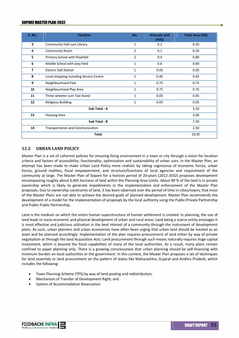
SOPORE MASTER PLAN-2032
DRAFT REPORT 93
S. No. Facilities No. Area per unit (HA))
Total Area (HA)
3 Community Hall cum Library 1 0.2 0.20
4 Community Room 2 0.1 0.20
5 Primary School with Playfield 2 0.4 0.80
6 Middle School with play field 1 0.6 0.60
7 Electric Sub Station 1 0.05 0.05
8 Local shopping including Service Centre 1 0.45 0.45
9 Neighbourhood Park 1 0.75 0.75
10 Neighbourhood Play Area 1 0.75 0.75
11 Three wheeler cum Taxi Stand 1 0.05 0.05
12 Religious Building 1 0.05 0.05
Sub Total - A 5.50
13 Housing Area 2.00
Sub Total - B 7.50
14 Transportation and Communication 2.50
Total 10.00
12.2 URBAN LAND POLICY Master Plan is a set of coherent policies for ensuring living environment in a town or city through a vision for location criteria and factors of accessibility, functionality, optimization and sustainability of urban uses. In the Master Plan, an attempt has been made to make Urban Land Policy more realistic by taking cognizance of economic forces, urban forces, ground realities, fiscal empowerment, and structure/functions of local agencies and requirement of the community at large. The Master Plan of Sopore for a horizon period of 20-years (2012-2032) proposes development encompassing roughly about 6,465 hectares of land within the Planning Area Limits. About 90 % of the land is in private ownership which is likely to generate impediments in the implementation and enforcement of the Master Plan proposals. Due to ownership constraints of land, it has been observed over the period of time in cities/towns, that most of the Master Plans are not able to achieve the desired goals of planned development. Master Plan recommends the development of a model for the implementation of proposals by the local authority using the Public-Private Partnership and Public-Public Partnership. Land is the medium on which the entire human superstructure of human settlement is created. In planning, the use of land leads to socio-economic and physical development of urban and rural areas. Land being a scarce entity envisages it is most effective and judicious utilization in the best interest of a community through the instrument of development plans. As such, urban planners and urban economists have often been urging that urban land should be treated as an asset and be planned accordingly. Implementation of the plan requires procurement of land either by way of private negotiation or through the land Acquisition Acts. Land procurement through such means naturally requires huge capital investment, which is beyond the fiscal capabilities of many of the local authorities. As a result, many plans remain confined to paper planning only. There is a growing consciousness that urban planning should be self-financing with minimum burden on local authorities or the government. In this context, the Master Plan proposes a set of techniques for land assembly or land procurement on the pattern of states like Maharashtra, Gujarat and Andhra Pradesh, which includes the following:
Town Planning Scheme (TPS) by way of land pooling and redistribution; Mechanism of Transfer of Development Right; and System of Accommodation Reservation
SOPORE MASTER PLAN-2032
DRAFT REPORT 94
12.2.1 Policy Directives
The effective public control over land particularly through large-scale acquisition, especially for creating land banks for achieving major proposals of the Master Plan e.g. housing, nodal facilities, terminus centers, socio cultural activities, parallel corridors etc. It is also likely to help to regulate future development of the town and give financial sustainability to weak Urban Local agencies of the town ensuring control over land values;
The plot reconstitution/land assembly/land pooling is needed because of private ownership of the land in Sopore and this process can be used to facilitate land banks without acquisition for planned development;
The areas identified for development of Logistics, Industrial Estate, Wholesale, Fruit Mandi, proposed parallel corridors etc have been attached top priority under land bank development. For this purpose, the Master Plan envisage to declare the roads listed in Table 12.2 as ‘Scheduled Roads’ and notify their alignment at the approval of this policy document by the government;
Provision of Utilities and Services after acquisition of land by local agencies and encouraging the builders and housing cooperatives, urban local agencies etc registered with the planning agencies and making them vital component of urban development of Sopore;
Government besides propagating plot reconstitution and plan layout shall also develop planned colonies after bulk acquisition/land pooling to cater the urban poor who otherwise due to non-affordability are left out of land market. Plots in Housing colonies developed by Government/Private Entrepreneurs/individuals shall be reserved for the urban poor (EWS & LIG) as per norms in vogue to avoid growing of urban slums;
The implementation agencies should invite applications from the interested parties or individuals having chunk of land within the Master Plan limits to promote private interventions in the implementation of landuse proposals;
In the Planning Area, patches of Government land exist. Government land, pasture land, leased, non-leased
land within the Master Plan limits shall be taken over by the Local Authority constituted for the purposes of Planning and Development of Sopore under the provisions of the J&K Development Act 1970, while as such land within the Municipal Council limits shall be handed over to Municipal Council for creation of assets, development of amenities/facilities as per the provisions of the J & K Municipal Act 2000.
12.3 INSTITUTIONAL FRAMEWORK Master Plan proposes that Local Area Development Authority (LADA) should take effective measures aimed at capacity building and institutional restructuring of its organization. It is proposed that the Authority shall strengthen its technical manpower by employing qualified town planners, engineers, architects, and landscape architects etc to execute proposed development activities and make delivery of services efficient. In order to render Master plan a successful exercise, it is proposed that a vibrant and proactive enforcement wing with state-of-the-art technology shall be established in consultation with concerned line departments of Sopore Town. `
12.4 PHASING OF DEVELOPMENT With limited resources in hand, debarring from horticulture resources, the Master plan asserts that Local Area Development Authority (LADA) should evolve a scientific mechanism for resource mobilization and implementation of development proposals. It has been proposed that private participation shall be encouraged to cater the potential infrastructure demand during horizon period of 20-years. It is urged that the Authority (LADA) shall provide a conducive environment for public-private-participation and should develop a mechanism to safeguard the area from destruction through effective checks on development carried out by private developers. Based on priority of targets, potential demand and fiscal investment, it is held that the Master Plan will have a horizon period of 20-years to be implemented in four phases of 5-years duration and continuous with Five Year Plan up to 15th Five Year Plan. The Master Plan for Sopore is proposed to be implemented from financial year 2012 to 2032.
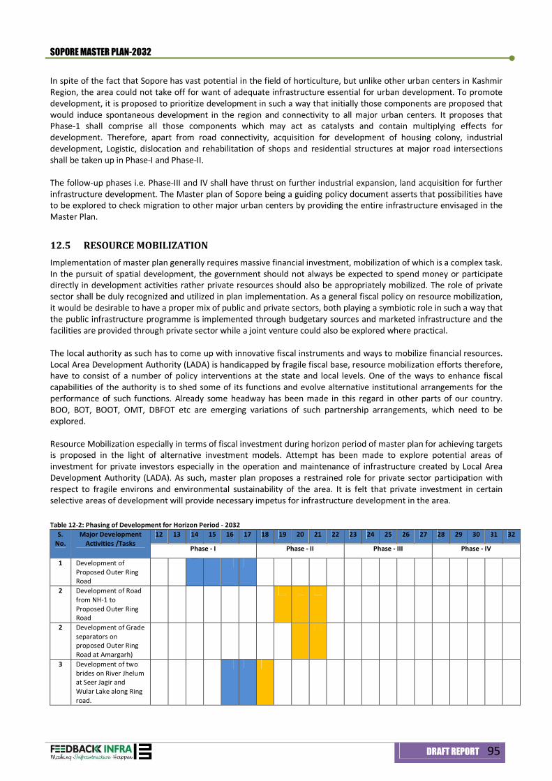
SOPORE MASTER PLAN-2032
DRAFT REPORT 95
In spite of the fact that Sopore has vast potential in the field of horticulture, but unlike other urban centers in Kashmir Region, the area could not take off for want of adequate infrastructure essential for urban development. To promote development, it is proposed to prioritize development in such a way that initially those components are proposed that would induce spontaneous development in the region and connectivity to all major urban centers. It proposes that Phase-1 shall comprise all those components which may act as catalysts and contain multiplying effects for development. Therefore, apart from road connectivity, acquisition for development of housing colony, industrial development, Logistic, dislocation and rehabilitation of shops and residential structures at major road intersections shall be taken up in Phase-I and Phase-II. The follow-up phases i.e. Phase-III and IV shall have thrust on further industrial expansion, land acquisition for further infrastructure development. The Master plan of Sopore being a guiding policy document asserts that possibilities have to be explored to check migration to other major urban centers by providing the entire infrastructure envisaged in the Master Plan.
12.5 RESOURCE MOBILIZATION Implementation of master plan generally requires massive financial investment, mobilization of which is a complex task. In the pursuit of spatial development, the government should not always be expected to spend money or participate directly in development activities rather private resources should also be appropriately mobilized. The role of private sector shall be duly recognized and utilized in plan implementation. As a general fiscal policy on resource mobilization, it would be desirable to have a proper mix of public and private sectors, both playing a symbiotic role in such a way that the public infrastructure programme is implemented through budgetary sources and marketed infrastructure and the facilities are provided through private sector while a joint venture could also be explored where practical. The local authority as such has to come up with innovative fiscal instruments and ways to mobilize financial resources. Local Area Development Authority (LADA) is handicapped by fragile fiscal base, resource mobilization efforts therefore, have to consist of a number of policy interventions at the state and local levels. One of the ways to enhance fiscal capabilities of the authority is to shed some of its functions and evolve alternative institutional arrangements for the performance of such functions. Already some headway has been made in this regard in other parts of our country. BOO, BOT, BOOT, OMT, DBFOT etc are emerging variations of such partnership arrangements, which need to be explored. Resource Mobilization especially in terms of fiscal investment during horizon period of master plan for achieving targets is proposed in the light of alternative investment models. Attempt has been made to explore potential areas of investment for private investors especially in the operation and maintenance of infrastructure created by Local Area Development Authority (LADA). As such, master plan proposes a restrained role for private sector participation with respect to fragile environs and environmental sustainability of the area. It is felt that private investment in certain selective areas of development will provide necessary impetus for infrastructure development in the area. Table 12-2: Phasing of Development for Horizon Period - 2032
S. No.
Major Development Activities /Tasks
12 13 14 15 16 17 18 19 20 21 22 23 24 25 26 27 28 29 30 31 32
Phase - I Phase - II Phase - III Phase - IV
1 Development of Proposed Outer Ring Road
2 Development of Road from NH-1 to Proposed Outer Ring Road
2 Development of Grade separators on proposed Outer Ring Road at Amargarh)
3 Development of two brides on River Jhelum at Seer Jagir and Wular Lake along Ring road.
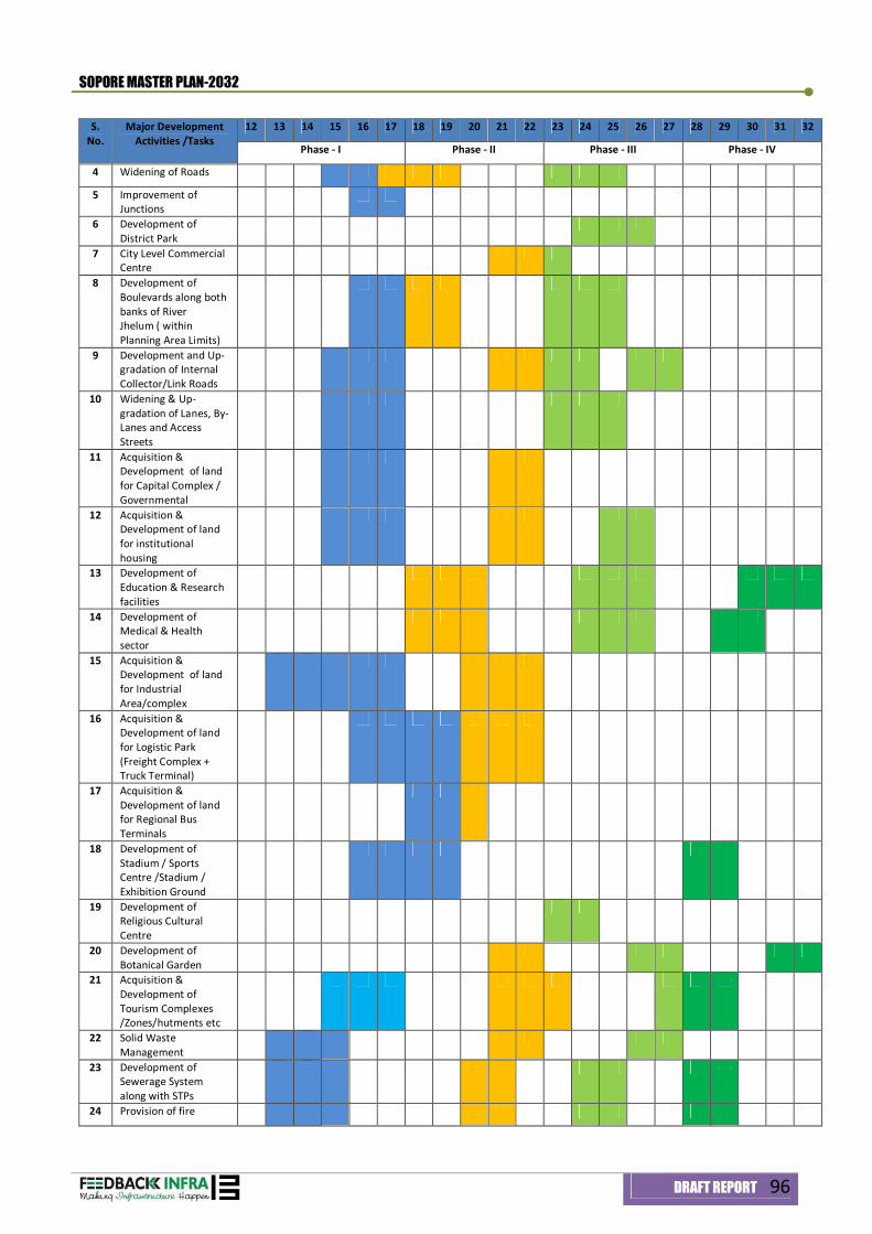
SOPORE MASTER PLAN-2032
DRAFT REPORT 96
S. No.
Major Development Activities /Tasks
12 13 14 15 16 17 18 19 20 21 22 23 24 25 26 27 28 29 30 31 32
Phase - I Phase - II Phase - III Phase - IV
4 Widening of Roads
5 Improvement of Junctions
6 Development of District Park
7 City Level Commercial Centre
8 Development of Boulevards along both banks of River Jhelum ( within Planning Area Limits)
9 Development and Up-gradation of Internal Collector/Link Roads
10 Widening & Up-gradation of Lanes, By-Lanes and Access Streets
11 Acquisition & Development of land for Capital Complex / Governmental
12 Acquisition & Development of land for institutional housing
13 Development of Education & Research facilities
14 Development of Medical & Health sector
15 Acquisition & Development of land for Industrial Area/complex
16 Acquisition & Development of land for Logistic Park (Freight Complex + Truck Terminal)
17 Acquisition & Development of land for Regional Bus Terminals
18 Development of Stadium / Sports Centre /Stadium / Exhibition Ground
19 Development of Religious Cultural Centre
20 Development of Botanical Garden
21 Acquisition & Development of Tourism Complexes /Zones/hutments etc
22 Solid Waste Management
23 Development of Sewerage System along with STPs
24 Provision of fire
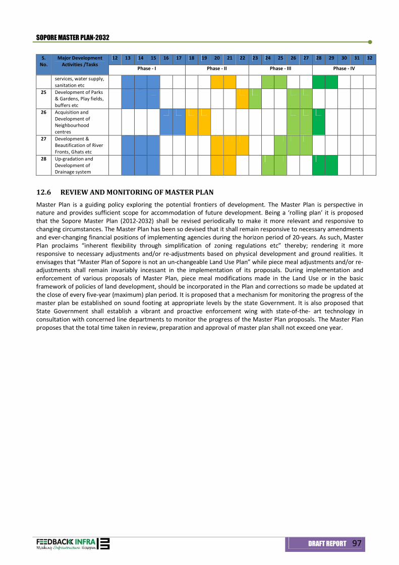
SOPORE MASTER PLAN-2032
DRAFT REPORT 97
S. No.
Major Development Activities /Tasks
12 13 14 15 16 17 18 19 20 21 22 23 24 25 26 27 28 29 30 31 32
Phase - I Phase - II Phase - III Phase - IV
services, water supply, sanitation etc
25 Development of Parks & Gardens, Play fields, buffers etc
26 Acquisition and Development of Neighbourhood centres
27 Development & Beautification of River Fronts, Ghats etc
28 Up-gradation and Development of Drainage system
12.6 REVIEW AND MONITORING OF MASTER PLAN Master Plan is a guiding policy exploring the potential frontiers of development. The Master Plan is perspective in nature and provides sufficient scope for accommodation of future development. Being a ‘rolling plan’ it is proposed that the Sopore Master Plan (2012-2032) shall be revised periodically to make it more relevant and responsive to changing circumstances. The Master Plan has been so devised that it shall remain responsive to necessary amendments and ever-changing financial positions of implementing agencies during the horizon period of 20-years. As such, Master Plan proclaims “inherent flexibility through simplification of zoning regulations etc” thereby; rendering it more responsive to necessary adjustments and/or re-adjustments based on physical development and ground realities. It envisages that “Master Plan of Sopore is not an un-changeable Land Use Plan” while piece meal adjustments and/or re-adjustments shall remain invariably incessant in the implementation of its proposals. During implementation and enforcement of various proposals of Master Plan, piece meal modifications made in the Land Use or in the basic framework of policies of land development, should be incorporated in the Plan and corrections so made be updated at the close of every five-year (maximum) plan period. It is proposed that a mechanism for monitoring the progress of the master plan be established on sound footing at appropriate levels by the state Government. It is also proposed that State Government shall establish a vibrant and proactive enforcement wing with state-of-the- art technology in consultation with concerned line departments to monitor the progress of the Master Plan proposals. The Master Plan proposes that the total time taken in review, preparation and approval of master plan shall not exceed one year.

Annexure
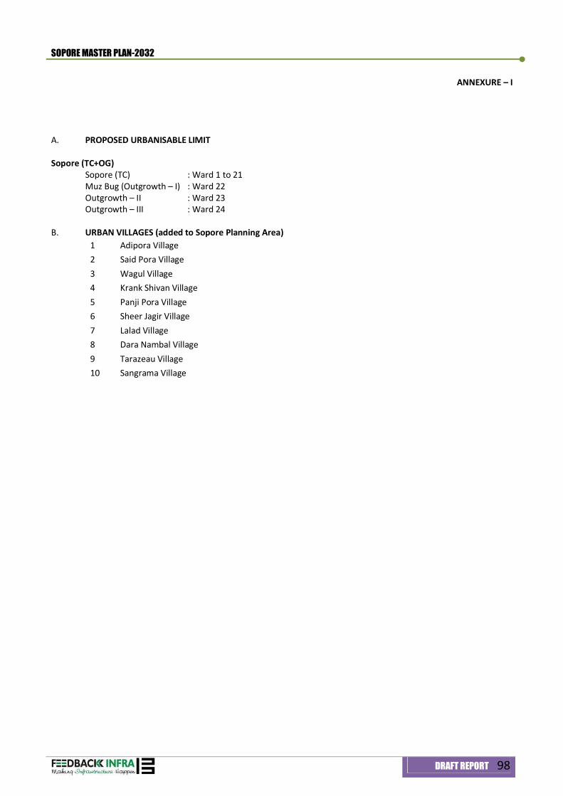
SOPORE MASTER PLAN-2032
DRAFT REPORT 98
ANNEXURE – I
A. PROPOSED URBANISABLE LIMIT Sopore (TC+OG)
Sopore (TC) : Ward 1 to 21 Muz Bug (Outgrowth – I) : Ward 22 Outgrowth – II : Ward 23 Outgrowth – III : Ward 24
B. URBAN VILLAGES (added to Sopore Planning Area)
1 Adipora Village 2 Said Pora Village 3 Wagul Village 4 Krank Shivan Village 5 Panji Pora Village 6 Sheer Jagir Village 7 Lalad Village 8 Dara Nambal Village 9 Tarazeau Village 10 Sangrama Village
SOPORE MASTER PLAN-2032
DRAFT REPORT 99
ANNEXURE – II DEFINITIONS OF VARIOUS TERMS OF USE PREMISES
1. “Abattoir or Slaughter House” – It is a facility where animals are killed for consumption as food products 2. “Animal husbandry” – Agricultural practice of breeding and raising livestock 3. “Auditorium” – A premises having an enclosed space to seat audience and stage for various performances like
concerts, play, recitals, functions, etc 4. “Bank” – A premises for offices to perform banking functions and operations 5. “Boarding and Lodging House” – ‘Boarding House’ is a premises in which rooms are let out on a long term
basis as compared to hotels; ‘Lodging house’ is a premises used for lodging of less than 50 persons 6. “Botanical Garden” – A premises in the form of a garden with plantation for research and exhibition 7. “Burial Ground” – Is a premises with facilities for burying of dead bodies 8. “Bus Depot” – A premises used by a public transport agency or any other such agency for parking,
maintenance and repair of buses. This may or may not include a workshop 9. “Bus Terminal” – A premises used by public transport agency to park the buses for short duration to serve the
population. It may include the related facilities for passengers 10. “Cemetery” – Is a premises with facilities for burying of dead bodies by Christian Community 11. “Central Government Office” – A premises used for the office if Union Government 12. “Children Traffic Park” – A premises in the form of park with facilities for introducing and educating children
about traffic and signaling 13. “Cinema” – A premises with facilities for projection of movies and stills with a covered space to seat audience 14. “Civil Defence and Home Guard” – A premises having facilities for offices and other facilities of civilian
organization for internal defence 15. “Clinic” – A premises with facilities for treatment of outdoor patients by a doctor. In case of a polyclinic, it shall
be managed by a group of doctors 16. “Clinical Laboratory” – A premises with facilities for carrying out various tests for confirmation of symptoms of
a disease 17. “Cold Storage” – A premises where perishable commodities are stored in covered space using mechanical and
electrical devices to maintain the required temperatures, etc 18. “College” – A premises having educational and playing facilities for students of under graduate and post
graduate courses under a university. It includes all professional disciplines 19. “Community Centre” – A premise having an enclosed space for various social and cultural activities of a
residential area 20. “Commercial Office” – A premises used for offices of profit making organization 21. “Community Hall” – A premises having an enclosed space for various social and cultural activities of a
residential area 22. “Conference Centre” – A premises having all facilities for a conference, meeting, symposium, etc., where a
number of different countries may also be participating 23. “Convenience Shopping Centre” – A group of shops not exceeding 50 in number in residential area serving a
population of 5,000 persons 24. “Courts” – A premises used for the office of Judiciary 25. “Cremation Ground” – A premises with facilities of performing last rites of dead bodies by burning 26. “Creche and Day Care Centre” – A premises having nursery facilities for infants during day time. The centre
may be managed by an individual or an institution on commercial or non-commercial basis 27. “Cultural and Information Centre” – A premises with facilities for cultural and information services for an
institution, state and country
SOPORE MASTER PLAN-2032
DRAFT REPORT 100
28. “Dairy Farm” – A premises with facilities for rearing and processing of dairy products. It may have temporary structure for sheds of animals and birds
29. “Demography” – It is the statistical study of human populations 30. “Dharamshala” – A premise providing temporary accommodation for short duration on no-profit basis. 31. “Dispensary” – A premises having facilities for medical advice and provision of medicines managed by public or
charitable institutions 32. “Ecotourism” – It is a form of tourism involving visiting fragile, pristine, and relatively undisturbed natural
areas, intended as a low-impact and often small scale alternative to standard commercial (mass) tourism 33. “Electric Crematorium” – Is a premises with facilities for disposing off the dead body in an electric furnace 34. “Environment Friendly Residence” – Is a premises with low coverage, low height structure for residential use 35. “Epicenter” – Epicenter is the point on the Earth's surface that is directly above the hypocenter or focus, the
point where an earthquake or underground explosion originates 36. “Exhibition Centre and Art Gallery” – A premises with facilities for exhibition and display of paintings,
photographs, sculptures, murals, ceramics, handicrafts or products of a specific class 37. “Fair Ground” – A premises having facilities for exhibition, display, other cultural activities for a group of
participants, animal market, etc 38. “F.A.R.” – Is the ratio of total building floor area to the area of the plot 39. “Fire Post” – A premises with lesser degree of facilities for fire fighting. The post may be attached to a specific
premises with fire prone activities 40. “Farm House” – Is a dwelling on a farm 41. “Fire Station” – A premises with facilities for fire fighting for a catchment area assigned to it. It may include
residence of essential staff 42. “Flatted Group Industry” – A premises having a group of small industrial units having upto 50 workers with
non-hazardous performance. These units may even be located in multi-storeyed buildings 43. “Forest” – Is a thick natural flora. It shall include city forest which may have part natural flora and part man
made flora 44. “Gas Godown” – A premises where cylinders of cooking gas or other gas are stored 45. “Government Reserved Area” – A premises of Government land for reserved use 46. “Group Housing” – A premises comprising of residential flats with basic amenities like Parking, Park,
Convenience shops, Public utility etc. 47. “Guest House, Boarding House and Lodging House” – A guest House is a premises for housing the staff of
Government, Semi-Government, Public Undertaking and Private Limited Company for short duration “Boarding House” – Is a premises in which rooms are let out on a long term basis as compared to hotels “Lodging House” – Is a premises used for lodging of less than 50 persons
48. “Health Centre” – Is a premise having facilities for treatment of indoor and outdoor patients having upto 30 beds. The health centre may be managed by a public or a charitable institution on non-commercial basis. It includes family welfare centre
49. “Heritage Hotel” – A hotel run in an old historical building with or without some additions and alterations 50. “Hinterland” – It is the land or district behind a coast or the shoreline of a river 51. “Historical Monuments” – A premises having structure or ruins thereof, belonging to an age gone past 52. “Hospital” – A premises providing medical facilities of general or specialized nature for treatment of indoors
and out door patients 53. “Hostel” – A premises in which rooms attached to ‘Institutions’ or otherwise are let out on a long term basis 54. “Hotel” – A premises used for lodging of 15 persons or more on payment with or without meals 55. “Indoor Games Stadium” – A premises for indoor stadium with play area and spectator seating including
related facilities for players 56. “Industrial Plot” – A premises for industrial unit 57. “Industrial Plot : Industry Specific Type” – A premises for an industrial unit within a group of such units for
manufacturing of specific products like electronic goods etc
SOPORE MASTER PLAN-2032
DRAFT REPORT 101
58. “Industrial Premises : Extractive and Mining Industry” – An Industrial premises used for carrying on industrial production or manufacturing and extractive and mining industry is a premises for carrying out quarrying and crushing of stone, lime and brick kiln and extraction of sub-soil material etc
59. “Integrated Residential School” – A premises having educational and playing facilities for students’ upto XII standards. It shall have boarding facilities for students and may have residences for faculty members
60. “Integrated School” – A premises having educational and playing facilities for students upto XII standards 61. “Jail” – A premises having facilities for detention, confinement and reform of criminals under the law 62. “Junk Yard” – A premises for covered, semi-covered or open storage including sale and purchase of waste
goods, commodities and materials 63. “Kanal” – A kanal is a unit of area, equivalent to 505.857 square meters or one-eighth of an acre 64. “Library” – A premises having a large collection of books for reading and reference for general public or
specific class 65. “Local Government Office” – A premises used for the offices of Local Government and Local Bodies 66. “Local Shopping Centre” – A group of shops not exceeding 75 in number in residential area serving a
population of 15,000 persons 67. “Master Plan” – It is a comprehensive physio-socio economic and environmental plan integrating all
necessary facilities, services and amenities over a defined space in socially, economically, environmentally conforming and compatible placements in terms of uses, for ensuring a sustainable growth oriented development over foreseeable future for projected population
68. “Memorial” – A premises having the tomb, Samadhi or memorial dedicated to an important personality including all related facilities for visitors
69. “Motel” – A premises designed and operated especially to cater to the boarding, lodging, rest and recreation and related activities of travelers by road
70. “Motor Driving Training Centre” – A premises having facilities for training of driving automobiles 71. “Motor Garage and Workshop” – A premises for servicing and repair of automobiles 72. “Museum” – A premises with facilities for storage and exhibition of objects illustrating antiques, natural
history, art, etc 73. “Music, Dance and Drama Training Centre” – A premises having facilities for imparting training and coaching
for music, dance and dramatics 74. “Neighbourhood” - It is a geographically localised community within a larger city, town, suburb or rural area 75. “Night Shelter” – A premises providing night accommodation to individuals without any charges or with token
charges. It may be run by Local Government or Voluntary Agencies 76. “Notified Area” – A notified area is any land area earmarked by legal provision for future development 77. “Nursing with Kindergarten School” – A premises with facilities for training and playing for children
preparatory to the school 78. “Nursing Home” – A premises having medical facilities for indoor and outdoor patients having upto 30 beds. It
shall be managed by a doctor or a group of doctors on commercial basis 79. “Observatory and Weather Office” – Is a premises with facilities for research and development of data
relating to weather and forecasting thereof 80. “Oil Depot” – A premises for storage of petroleum products with all related facilities 81. “Old Age Home” – A premises with residential and related facilities for old age persons 82. “Open Air Theater” – A premises having facilities for audience sating and a stage for performance and is open
to sky 83. “Orchard” – Is a premise with a thick growth of fruit trees. It may also include garden with fruit trees 84. “Orphanage” – A premises with facilities for boarding of children who are bereaved of parents. It may or may
not have educational facilities 85. “Outdoor Games Stadium” – A premises for outdoor games with pavilion building and stadium structure to
seat spectators including related facilities for players
SOPORE MASTER PLAN-2032
DRAFT REPORT 102
86. “Park” – A premises used for recreational leisure activities. It may have on it related landscaping, parking facilities, public toilets, fencing etc. it will include synonyms like lawn, open space, green, etc
87. “Parking” – A premises used for parking of vehicles. The public parking lots may be run on commercial or non-commercial basis
88. “Personnel Service Shop” – A premises equivalent of a retail shop providing personnel services like tailor, barber etc
89. “Petrol Pump” – A premises for sale petroleum products to consumers. It may include servicing of automobiles 90. “Picnic Hut / Camping Site” – A premises for short duration stay, for recreational or leisure purpose of a
family, located within a tourist and / or recreational centre 91. “Planetarium” – A premises with necessary facilities and equipment for studying planets 92. “Plant Nursery” – Is a premise with facilities for rearing and sale of young plants 93. “Play Ground” – A premises used for outdoor games. It may have on it landscaping, parking facilities, public
toilet etc 94. “Plotted Housing” – A premises for one or more than one dwelling unit and may have on it one main building
block and one accessory block for garage / garages and servant quarters. 95. “Police Post” – A premises having facilities for a local police post of a temporary nature or on smaller scale as
compared to a police station 96. “Police Station” – A premises having facilities for the offices of local police station 97. “Post Office” – A premises with facilities for postal communication for use by the public 98. “Post and Telegraph Office” – A premises with facilities for postal and telecommunication for use by the public 99. “Poultry Farm” – Is a premise with facilities for rearing birds and production of eggs. It may have temporary
structure for sheds to birds 100. “Primary School” – A premises having educational and playing facilities for students upto V standard 101. “Public Utility Premises” – (i) Overhead Tank – A premises having a overhead tank for storage and supply of
water to its neighbouring areas. it may or may not include a pump house (ii) Underground Tank – A premises having an underground tank for storage and supply of water to its neighbouring areas. it may or may not include a pump house (iii) Oxidation Pond – A premises having a tank used for the oxidation process for sewage and other waste (iv) Septic Tank – A premises having an underground tank for collection of sewage and its consequent disposal (v) Sewage Pumping Station – A premises with a pumping station used for pumping sewage on to a higher gradient (vi) Public toilet and Urinal – A premises having latrine and urinals for use of public. It may or may not include drinking water facility (vii) Electric Sub Station – A premises having electrical installation and transformer for distribution of power (viii) Solid Waste Collection Centre – A premises used for collection of garbage for its onwards transportation to sanitary landfill / disposal (ix) Dhobi Ghat – A premises used for cleaning and drying of clothes / linen by washer man
102. “Public Undertaking Office” – A premises used for the offices of a company established under the relevant Act 103. “Radio and Television Station” – Is a premises with facilities for recording, broadcast and transmission of news
and other programs through the respective medium. It may include some hostel accommodation for guest artists, transmission facilities like towers
104. “Railway Booking Office” – A premises used for the offices of railways for the purpose of booking for passengers travel
105. “Railway Freight Godown” – A premises for storage of goods transported by the Railways 106. “Recreational Club” – A premises used for gathering of group of persons for social and recreational purposes
with all related facilities 107. “Reformatory” – A premises with facilities for confinement and reform of offenders 108. “Religious” – A premises dedicated to accommodations and service of God or other objects of religious nature.
It may have different nomenclature in different religions like temple (all faiths), Mosque, Church, Gurudwara, Synagogue, Ashram
SOPORE MASTER PLAN-2032
DRAFT REPORT 103
109. “Repair Shop” – A premises equivalent of a retail shop for carrying out repair of household goods, electronic gadgets, automobiles, cycles etc
110. “Research and Development Centre” – A premises providing facilities for research and development for any specific field
111. “Residence-cum-Work Plot” – A premises providing residential accommodation for one family (a household) and its workspace restricted to ground floor
112. “Residential Flat” – A residential accommodation for a family (a household) which may occur as a part of group housing or independently
113. “Residential Plot-Group Housing” – A premises comprising of residential flats with basic amenities like parking, park, convenience shops, public utility etc
114. “Residential Plot-Plotted Housing” – A premises for one or more than one dwelling unit and may have on it one main building block and one accessory block for garage / garages and servant quarters
115. “Residential Premises : Special Area” – A premises providing residential accommodation in special area with or without mixed use as given in special area code
116. “Retail Shop” – A premises for sale of commodities directly to consume with necessary storage 117. “Restaurant” A premises used for serving food items on commercial basis including cooking facilities. It may
have covered or open or both for sitting arrangement 118. “Road Transport Booking Office” – A premises used for the offices of a road transport agency. It may not
include godown 119. “Rural Settlement” – Is a premises for residence of village people with related facilities, services and work
centres 120. “Satellite and Telecommunication Centre” – Is a premises with facilities for research and development of
satellite and telecommunication technology 121. “Secondary School” – A premises having educational and playing facilities for students upto X standard. It shall
include middle school which are upto VII standard for the purpose of this code 122. “Senior Secondary School” – A premises essentially having repair shops for automobiles, electrical appliances,
building material, etc to provide essential services to neighbouring residential areas 123. “Service Centre” – A premises essentially having repair shops for automobiles, electrical appliances, building
material, etc to provide essential services to neighbouring residential areas 124. “Set-backs” – The distance a structure must be from the edge of a lot 125. “Social and Cultural Institute” – A premises with facilities for activities of socio-cultural nature run by a public,
voluntary or individual on primarily non-commercial basis 126. “Social Welfare Centre” – A premises with facilities for welfare and promotion of community development 127. “Sport Training Centre” – A premises having facilities for training and coaching for different indoor and
outdoor games including swimming. It shall also include centre for physical education 128. “Specialised Hospital” – Hospital for specialized diseases such as highly infectious or contagious diseases 129. “Specialised Park / Ground” – A premises having a park or ground for a designated use like public meeting
grounds, fun park, wonder land etc 130. “State Government Office” – A premises used for the office of State Government 131. “State Government Office” – A premises used for the office of State Government 132. “Storage, Godown and Warehousing” – A premises for storage, Godown and Warehousing means premises
for exclusive use of storage of goods and commodities in a manner as per the requirements of respective commodities. The premises includes the related loading and unloading facilities for the purpose of carriage of the goods and commodities by Road Transport or Rail Transport as the case may be
133. “Swimming Pool” – A premises with related facilities for swimming and spectators seating which shall vary with size, standard and purpose
134. “Technical Training Centre” – A premises with facilities for training in discipline of technical nature. It includes technical school and industrial training institute etc

FEEDBACK INFRASTRUCTURE SERVICES PVT LTD 15th Floor, Tower 9B, DLF Cyber City Phase – III, Gurgaon
B E CONSULTANT Jaipur
SOPORE MASTER PLAN-2032
DRAFT REPORT 104
135. “Telephone Exchange” – Is a premises having facilities for central operation of telephone system for a designated areas
136. “Transmission Tower and Wireless Station” – Is a premises used for installation of a tower for communication purposes
137. “Urban Agglomeration” – An extended city or town area comprising the built-up area of a central place (usually a municipality) and any suburbs linked by continuous urban area
138. “Vending Booth” – A premises in the form of booth for sale of commodities of daily needs either through a mechanical installation or otherwise
139. “Veterinary Hospital” – A premises providing treatment for indoor and outdoor sick animals 140. “Vocational Training Institute” – A premises with training facilities for short-term courses for discipline,
preparatory to the employment in certain profession and trade. It includes training-cum-work centre 141. “Voluntary Health Services” – A premises having medical facilities for treatment of outdoor patients and other
like blood bank, etc by voluntary institutions. This services may also take the form of temporary camp with charitable motive
142. “Weekly Market / Informal Sector Unit” – An area used once in a week by a group of informal establishments in the form of a market. These markets shift from one area to another on different days of the week Informal Unit: Retail / Service unit, stationary or mobile, working without roof including small khokhas on roadside
143. “Wholesale Trade” – A premises for Wholesale trade is a premises from where goods and commodities are sold and delivered to retailers. Such premises includes storage and godown and loading and unloading facilities
144. “Work Participation Rate” – Is the percentage of total workers to the total population 145. “Yoga Meditation, Spiritual and Religious Discourse Centre” – A premises having facilities for self attainment,
achieving higher quality of mind and body, spiritual and religious discourse, etc 146. “Zonal Development Plan” – A plan of a zone (division) of the Urbanisable Area of the Master Development
Plan (and including Land Use Plan), containing detailed information regarding provision of social infrastructure, parks and open spaces and circulation system
147. “Zoological Garden / Aquarium” – A premises in the form of a garden or park or aquarium with a collection of animals, species and birds for exhibition and study. It shall include all related facilities
Copyright © 2022 FDOKUMEN