Jhansi District - Central Ground Water Board (CGWB)
62
क� �य भ ू �म जल बोड जल संसाधन, नद� �वकास और गंगा संर�ण मंालय भारत सरकार Central Ground Water Board Ministry of Water Resources, River Development and Ganga Rejuvenation Government of India Report on AQUIFER MAPPING AND GROUND WATER MANAGEMENT PLAN Jhansi District, Uttar Pradesh उ�र� �े, लखनऊ Northern Region, Lucknow
-
Upload
khangminh22 -
Category
Documents
-
view
0 -
download
0
Transcript of Jhansi District - Central Ground Water Board (CGWB)

क� द्र�य भू�म जल बोडर्
जल संसाधन, नद� �वकास और गंगा संर�ण मंत्रालय
भारत सरकार Central Ground Water Board
Ministry of Water Resources, River Development and Ganga Rejuvenation
Government of India
Report on
AQUIFER MAPPING AND GROUND WATER MANAGEMENT PLAN
Jhansi District, Uttar Pradesh
उ�र� �ते्र, लखनऊ
Northern Region, Lucknow

भारत सरकार Government of India
केन्द्रीय भमूि जल बोर्ड Central Ground Water Board
जल ससंाधन, नदी विकास और गंगा संरक्षण ितं्रालय Ministry of Water Resources, River Development
and Ganga Rejuvenation
जलभतृ िानमित्र और भजूल प्रबंधन योजना जजला झांसी, उत्तर प्रदेश
Aquifer Maps and Ground Water Management Plan of Jhansi District, Uttar Pradesh
उत्तरी के्षत्र, लखनऊ Northern Region, Lucknow
अप्रैल, 2017
April, 2017


Ground water in India is a critical resource to meet irrigation, drinking water and
industrial requirements. Increase in population, industries and government’s efforts to
increase the food grain production by bringing un-irrigated land under irrigation has
led to increasing number of aquifers under unsustainable levels of exploitation. It is
likely to lead to decline in ground water levels, drying up of wells and diminishing
supplies to various uses.
Central Ground Water Board has taken up Aquifer Mapping and Management
Programme with an aim to cover 23 lakh sq. km. mappable area of the country. The
programme envisages delineation of Aquifer, their characterization, aquifer wise
resource availability and their utilisation, water quality, especially in problematic /
vulnerable areas. The ultimate aim of the programme is formulation of Aquifer
Management Plan to facilitate sustainable management of ground water resources.
Bundelkhand region facing recurring drought and serious ground water sustainability
problems, has been given priority by CGWB. A good amount of data has been
generated in Jhansi and Lalitpur districts to delineate aquifer configuration, yield
potential of fractures and ground water quality aspects.
I appreciate the sincere efforts made by the team of officers of Central Ground
Water Board, Northern Region, Lucknow in bringing out the Aquifer Maps and Ground
Water Management Plan of Jhansi district. I am confident that the these maps and
management plan will prove useful to concerned State Government departments in
their planning and will benefit ground water users and scientific community in the
State.
Date: 25.04.2017 (K. B. Biswas)
Foreword
कें रीय भूमि जल बोर्ड जल संसाधन, नदी विकास और गंगा संरक्षण िंत्रालय
भारत सरकार नई ददल्ली
Central Ground Water Board Ministry of Water Resources, River Development
And Ganga Rejuvenation Government of India
New Delhi
K.B. Biswas Chairman


Groundwater has emerged as the preferred water source and poverty reduction tool in India’s rural areas due to its near universal availability, dependability and low capital cost. It has made significant contributions to the growth of India’s Economy and has been an important catalyst for its socio economic development. Its importance as a precious natural resource in the Indian context can be gauged from the fact that more than 85 % of India’s rural domestic water requirements, 50 % of its urban water require-ments and more than 50 % of its irrigation requirements are being met from ground water resources.
The increasing dependence on ground water as a reliable source of water has re-sulted in its large-scale and often indiscriminate development in various parts of the coun-try, without due regard to the recharging capacities of aquifers and other environmental factors. The unplanned and non-scientific development of ground water resources, mostly driven by individual initiatives has led to an increasing stress on the available resources. The adverse impacts can be observed in the form of long-term decline of ground water lev-els, de-saturation of aquifer zones, increased energy consumption for lifting water from progressively deeper levels and quality deterioration. In general, the shallow aquifer is be-ing over-exploited and is also vulnerable to the pollution. Dynamic ground water resources have been estimated. Now, it is becoming necessary to assess the potentiality and quality of deeper aquifers. With increasing emphasis on participatory management of ground wa-ter resources, the stakeholders should have knowledge of aquifer-wise development poten-tial of ground water resources.
Central Ground Water Board has taken up task of Aquifer Mapping and Ground Water Management Plan under NAQUIM in the state of Uttar Pradesh with an objective to (i) Delineation and characterization of aquifers in three dimensions (ii) Identification and quantification of issues and (iii) Development of management plans to ensure sustainabil-ity of ground water resources. Under the initiative, management plans for each aquifer system are being prepared suggesting various interventions to optimize ground water withdrawal and identifying aquifers with portable groundwater for drinking purpose in quality affected areas. The management options also includes identification of feasible area for artificial recharge to ground water and water conservation which help in arresting de-clining water levels besides demand side management option including crop diversifica-tion, increasing water use efficiency etc. Bundelkhand has suffered recurring drought in recent past and is faces acute water scarcity. Central Ground Water Board has given prior-ity for Jhansi and Lalitpur districts in the first phase. Efforts were made to generate suffi-
cient data for aquifer mapping to prepare ground water management plans. An attempt has been made to present block-wise ground water management plan by integrating the available data with Central Ground Water Board and State Government departments.
The sincere efforts of the dedicated team of officers of Central Ground Water Board, Northern Region, Lucknow is highly appreciated. I am sure that these aquifer maps and Ground Water Management Plan of Jhansi district would be of immense help in for-mulating scientifically viable implementable strategies for efficient management of ground water resources ensuring sustainability.
Date: 25.04.2017 (Y. B. Kaushik)
Preface
कें रीय भूमि जल बोर्ड जल संसाधन, नदी विकास और गंगा संरक्षण िंत्रालय
भारत सरकार उत्तरी के्षत्र, लखनऊ
Central Ground Water Board Ministry of Water Resources, River Development
And Ganga Rejuvenation Government of India
Northern Region, Lucknow
Y.B. Kaushik Regional Director


CONTENTS
FOREWORD
PREFACE
S. No. THEMES AND MAPS Page no.
1 GENERAL INFORMATION 1-2
2 GEOMORPHOLOGY 3-4
3 DRAINAGE AND WATER BODIES 5-6
4 CLIMATE AND RAINFALL 7-8
5 IRRIGATION 9-10
6 LAND USE 11-12
7 HYDROGEOLOGY 13-14
8 GROUND WATER LEVELS AND FLOW DIRECTION 15-16
9 DYNAMIC GROUND WATER RESOURCES 17-18
10 AQUIFER MAPPING UNDER NATIONAL AQUIFER MAPPING AND MANAGEMENT PROGRAMME (NAQUIM)
19-20
11 GEOPHYSICAL STUDIES 21-22
12 GROUND WATER EXPLORATION & SUB-SURFACE CONFIGURATION 23-24
13 GROUND WATER YIELD POTENTIAL 25-26
14 GROUND WATER QUALITY 27-28
15 SOIL INFILTRATION & ISOTOPE STUDY 29-30
16 GROUND WATER MANAGEMENT PLAN, BABINA BLOCK 31-32
17 GROUND WATER MANAGEMENT PLAN, BAMAUR BLOC 33-34
18 GROUND WATER MANAGEMENT PLAN, BANGRA BLOCK 35-36
19 GROUND WATER MANAGEMENT PLAN, BARAGAON BLOCK 37-38
20 GROUND WATER MANAGEMENT PLAN, CHIRGAON BLOCK 39-40
21 GROUND WATER MANAGEMENT PLAN, GURSARAI BLOCK 41-42
22 GROUND WATER MANAGEMENT PLAN, MAURANIPUR BLOCK 43-44
23 GROUND WATER MANAGEMENT PLAN, MOTH BLOCK 45-46
24 GROUND WATER MANAGEMENT IN JHANSI DISTRICT 47-48
25 DEMONSTRATIVE PROJECT ON ARTIFICIAL RECHARGE TO GROUND WATER/
CONSERVATION IN MAURANIPUR BLOCK - A SUCCESS STORY
49-50
26 INFORMATION, EDUCATION & COMMUNICATION (IEC) ACTIVITIES 51-52

Tehsil Block(s) Nyay Panchayat Gram Panchayat Villages
Moth Moth 7 65 149
Chirgaon 8 57 120
Garautha Bamaur 9 59 115
Tehroli Gursarai 9 59 119
Bangra 9 52 88
Mauranipur Mauranipur 10 55 86
Babina 7 50 68 Jhansi
Baragaon 5 40 73
GENERAL INFORMATION
Jhansi District lies in the southwetsern part of Uttar Pradesh state. It is bordered on the north by Jalaun district, to the east by Hamirpur and Mahoba districts, to the south by Tikamgarh district of Madhya Pradesh , to the southwest by Lalitpur district, and on the east, by Datia and Bhind districts of Madhya Pradesh.
Total area of the district is 5024 Sq Kms, and lies between 25°07' to 25° 57' north latitude and 78°10' to 79°25' east longitude. It comprises of 5 tehsils and 8 development blocks, 64 Nyay Panchayats, 437 Gram Panchayats and total 818 villages out of which 73 are un-inhabited. Total population of the district as per 2011 census is 1998603.
Major part of the district is rain-fed, under-invested, vulnerable, socio-economically heterogeneous, lacks infrastructure and access to improved technology, ethnically unique, and backward relative to other re-gions.
It is geologically a hard rock area with limited ground water resources. Sufficient surface runoff, network of rivers, streams, forests and animals are the opportunities for a sustained development process.
Agriculture and livestock rearing are the main occupation whereas outsourcing of livelihood by seasonal migration minimizes risks and vulnerability.
Total annual rainfall is received during SW monsoon and ranges from 700 to 1100 mm. The high intensity of rainfall causes moderate to severe erosion resulting in removal of nutrient rich soil and increases sedi-mentation in rivers and reservoirs. The rainfall pattern is highly erratic resulting in recurring droughts.
The district has suffered recurring droughts in recent times. Though major reservoirs exist in the district, however during drought, these are not able to meet the water requirements. Ground water resources are also very limited in hard rock area and are able to meet only drinking water requirement.
The soils in the area are classified in two groups on the basis of color and topography. Black (low land soil), and Red (up land soil), mixed and alluvial soils and at places inhibit the infiltration of surface water under-ground.
Crop production, livestock rearing and seasonal migration, provide more than 90 percent of rural income in the region. Area covered by main crops consists of pulses, oil seeds and Dhan respectively.
Being an agrarian economy means the dependence on monsoon which is uncertain and erratic. To combat this, the district has built number of dams and canals, to name a few viz Baruasagar built in 18 th century is basically an embankment lake, Parichha dam built across Betwa river has a 34 km length water body built for drinking, irrigation and hydroelectricity, Matatila built in 1958 on Betwa river has maximum stor-age capacity of 1132 MCM primarily for irrigation, Dhukwan wier built across Betwa river is 270 km long canal for irrigation.
1

INDEX MAP JHANSI DISTRICT
2

The district is part of Southern Bundelkhand plateau having general slopes in north-easterly direction.
The elevation ranges from about 200 m above mean sea level towards north to about 345 m in the south in
the area.
There are two distinct geomorphological units : (a) Northern highly erodible composite plain province and (b)
Southern Bundelkhand pediplain province.
Southern Bundelkhand pediplain province corresponds to Archaean Granite Gneisses and schists having
weathered mantle of colluviums.
It includes Pediment-Inselberg complex, shallow weathered pediplains, residual linear Quartz reef. Pediment-
Inselberg complex and shallow weathered pediplain, is crisscrossed by lineaments and fractures and having
poor ground water prospects.
The linear Quartz reefs trending NE-SW consists of jointed and shattered Quartz and act as ground water
barrier.
Northern highly erodible composite plain province comprises moderately weathered buried pediplain, deeply
weathered buried pediplain, residual hills, linear Quartz reefs and old meanders.
Moderately and deeply weathered buried pediplain have overburden of 5 to 20 m and form moderate aqui-
fer .
The shallow alluvial sediments and underlying mantle of Granite/gneiss constituting an average thickness of
40m forms the potential aquifer system.
Shallow weathered pediplain has an average thickness of 0-5 m crisscrossed by lineaments and fractured. It
has moderate to good ground water prospects.
The composite plain province in northern side has an average general elevation ranging from 200-120 m amsl.
The province has very good yield potential and largely prevails in Moth, Bamaur, Chirgaon, Gursarai,
Badagaon and Mauranipur blocks.
GEOMORPHOLOGY
3

GEOMORPHOLOGY
4

DRAINAGE AND WATER BODIES
In Jhansi District , entire system of drainage is a part of Yamubna sub basin of Ganga basin.
The area is mainly drained by Betwa, Pahuj, Dhasan, Sukhnai and Jamni rivers and its tributaries. Theses rivers
are perennial in nature.
The General flow direction of rivers is North to North –East and follows the slope of the area. In general drain-
age pattern are dendritic in nature.
The Dhasan Rivers drains in the eastern part of the district in Mauranipur and Gursairai blocks. The major
tributaries of Dhasan are Lakheri, Sukhai and Kureri rivers which are ephemeral in nature.
Pahuj and its tributaries drain in the western part of the district in the Moth, Chirgaon, Baragaon and Babina
Blocks.
Betwa river runs across the district and drains the area of Babina, Baragaon, Chirgaon and Moth blocks.
All the rivers are still active and are grading their course. The rivers are eroding the Older Alluvium remnants
adjusting to their course .
S. No Name of Block Name of River Basin/Sub-basin Catchment area of each sub-
basin (ha)
Joint area with name of block
(ha) 1 Baragaon Betwa River/Pahuj River (Yamuna
sub-basin)
12336.86 12569.25 (Babina)
9445.50 (Chirgaon)
2 Babina Pahuj River (Yamuna sub-basin) 33518.31 5287.20 (Baragaon)
3 Chirgaon Betwa River (Yamuna sub-basin) 25188.48 2819.84 (Baragaon)
4 Moth Betwa River (Yamuna sub-basin) 37014.09 4722.84 (Chirgaon)
5 Bangra Dasan & Lakheri River (Yamuna sub-basin)
30895.76 14235.25 (Mauranipur)
6 Gursarai Dasan & Lakheri River (Yamuna sub
- basin)
42128.70 22522.08 (Bamaur)
7 Bamaur Dasan & Lakheri River (Yamuna sub
- basin)
35391.84 16260.02 (Gursarai)
8 Mauranipur Dasan & Lakheri River (Yamuna sub
- basin)
33025.78 5055.36 (Gursarai)
Total 249499.82 88194.50
River basins / sub-basins and Catchment area of each of the basins covered in the district (Source: District Irrigation Plan for PMKSY)
Name of Dam River Gross storage capacity (MCM)
Effective Storage capacity (MCM)
Siori Lake Lakheri 7.82 7.60
Barwa Sagar Tank Barwa Nala 10.20 ---
Magarpur Tank Local Drain 2.46 ---
Pachwara Lake Local 6.15 5.85
Parichha Betwa 78.76 77.17
Dhekwan Betwa 57.80 57.80
Pahunj Pahuj 18.25 18.21
Barwar Tank Bora 33.78 31.65
Saprar Saprar 76.20 65.70
Matatila Betwa 1132.58 1019.40
Khaprar Khaprar 3.50 2.98
Dongari Pahuj 9.92 8.32
Pathrai Pathral 123.77 78.50
Sijar Tank Sijar 55.85 54.80
Lakheri Lakheri 19.81 13.90
Sijar Sijar 5.58 5.47
Dams/ Reservoirs in Jhansi District (Source: Irrigation and Water Resource Department, Uttar Pradesh )
5

DR
AIN
AG
E A
ND
WA
TER
BO
DIE
S
6

CLIMATE AND RAINFALL
The climate is sub-humid and it is characterized by a hot dry summer and cold winter.
The average annual normal rainfall is 885 mm. About 91% of rainfall takes place for June to September
(Monsoon Season).
January is the coldest month of the year when the mean daily maximum temperature is 24.10 °C and the mean
daily minimum temperature is 9.2°C , May is the hottest month with mean daily maximum temperature is 42.6°
C and mean daily minimum temperature is 28.8°C . The mean monthly maximum temperature is 32.6°C and
mean minimum temperature is 19.2°C .
The mean monthly relative humidity is 41%. In summer season air is very dry and during the monsoon season
the moisture content of air is high.
Mean wind velocity 4.8 kmph.
The potential evapo-transpiration in Jhansi is 1603 mm.
The region has been afflicted with meteorological, hydrological and agricultural drought continuously for the
last 5 years.
7

CLIMATE AND RAINFALL
0
200
400
600
800
1000
1200
1400
160019
81
1982
1983
1984
1985
1986
1987
1988
1989
1990
1991
1992
1993
1994
1995
1996
1997
1998
1999
2000
2001
2002
2003
2004
2005
2006
2007
2008
2009
2010
2011
2012
2013
2014
2015
Rai
n fa
ll(
in m
m)
(Year)
Annual Rainfall Jhansi District
Rainfall (mm)
-60
-40
-20
0
20
40
60
80
1981 1983 1985 1987 1989 1991 1993 1995 1997 1999 2001 2003 2005 2007 2009 2011 2013 2015
Annual Deviation (%) at Jhansi
Deviation (%)
Frequency distribution of Deficit, Excess & Normal Rainfall
Deviation from Normal Rainfall
8

IRRIGATION
In Jhansi district, approximately 66.62% cultivated area is unirrigated/ rain-fed.
Catchment area in the district including river basin and sub-basin is quite large being 249499 ha showing great
potential for water harvesting.
As the net irrigated area, partially irrigated area along with protective irrigation is only 143231 ha (33.38%)
major cropped area remains un-irrigated or totally rain-fed being 285766 ha (66.62%) posing immense chal-
lenges in alleviating irrigation resources.
As per the District Irrigation Plan, total water demands for various sectors such as domestic (0.065 BCM), crops
(0.922 BCM), livestock (0.028 BCM), industrial (0.060 BCM) and power generation (0.051 BCM) indicate that
crop requirement is maximum which must be addressed to through proper water management and enhance-
ment of water use efficiency (WUE).
Availability of surface water is 676 MCM) and groundwater is 613 MCM against the present water demand of
1149 MCM.
Total length of canal in the district 1236 km. Maximum length of canal is in Moth Block 384 km, irrigating 42415
hectare Area.
Maximum irrigation by ground water is in Mauranipur Block and Babina Block, by which 25667 & 22853 hectare
Area
(Source: Statistical Diary U.P. Government and District Irrigation plan PMKSY.)
(Source: Statistical Diary U.P. Government and District Irrigation plan PMKSY.)
9

IRRIGATION
10

LAND USE
Land Use in District Jhansi
S. No.
Name of Block
Total Geo-graphical Area
(in ha)
Area Under Agriculture (in ha) Area under Forest (in ha)
Area Under Wasteland
(in ha)
Area under other Uses
(in ha) Gross
Cropped Area (1)
Net Sown Area (2)
Area Sown more than once (1-2)
Cropping Intensity (%)
1 Chirgaon 51453 65102 39902 25200 163.15 1984 6085 3273
2 Moth 62977 92030 50608 41422 181.85 2596 5385 4385
3 Babina 64923 40307 29021 11286 138.89 2305 6504 12101
4 Baragaon 35489 42347 24997 17060 169.41 261 5860 4516
5 Gursarai 70496 83005 57772 25233 143.68 2551 6710 4259
6 Bamaur 79989 73020 55491 17529 131.59 7076 10215 7423
7 Mauranipur 54226 64917 43913 21004 147.83 495 5559 4306
8 Bangra 51778 50329 36117 14212 139.35 2207 7213 6241
Total 471331 511057 337821 172946 151.28 19475 53531 46504
Area of the district is plain or rolling with interspersed hills and ridges not exceeding 183 m in elevation from
ground level. However, the slope is towards north and as very high.
The total area of the district is 5024 Sq km, out of which 344.60 sq Km falls under forests.
Net sown area sown with crops and orchards is 3363.25 Sq Km.
Gross sown area, which is area sown once or more than once is 5469.94 Sq km. Thus, the cropping intensity is
163%.
Gross area sown during Rabi season is 3254.71 Sq Km.
Gross area sown during Kharif season is 2170.58 Sq Km.
Net irrigated area is 2710.96 Sq Km, net un-irrigated area is 652.29 Sq Kms.
Total cultivable area is 3629.28 Sq Km.
The area under barren and uncultivable land is 320.60 Sq Km.
Land put to non-agricultural use is 444.25 Sq Km.
11
(Source: Statistical Diary U.P. Government and District Irrigation plan PMKSY.)

LAND USE
Land Use Distribution
12

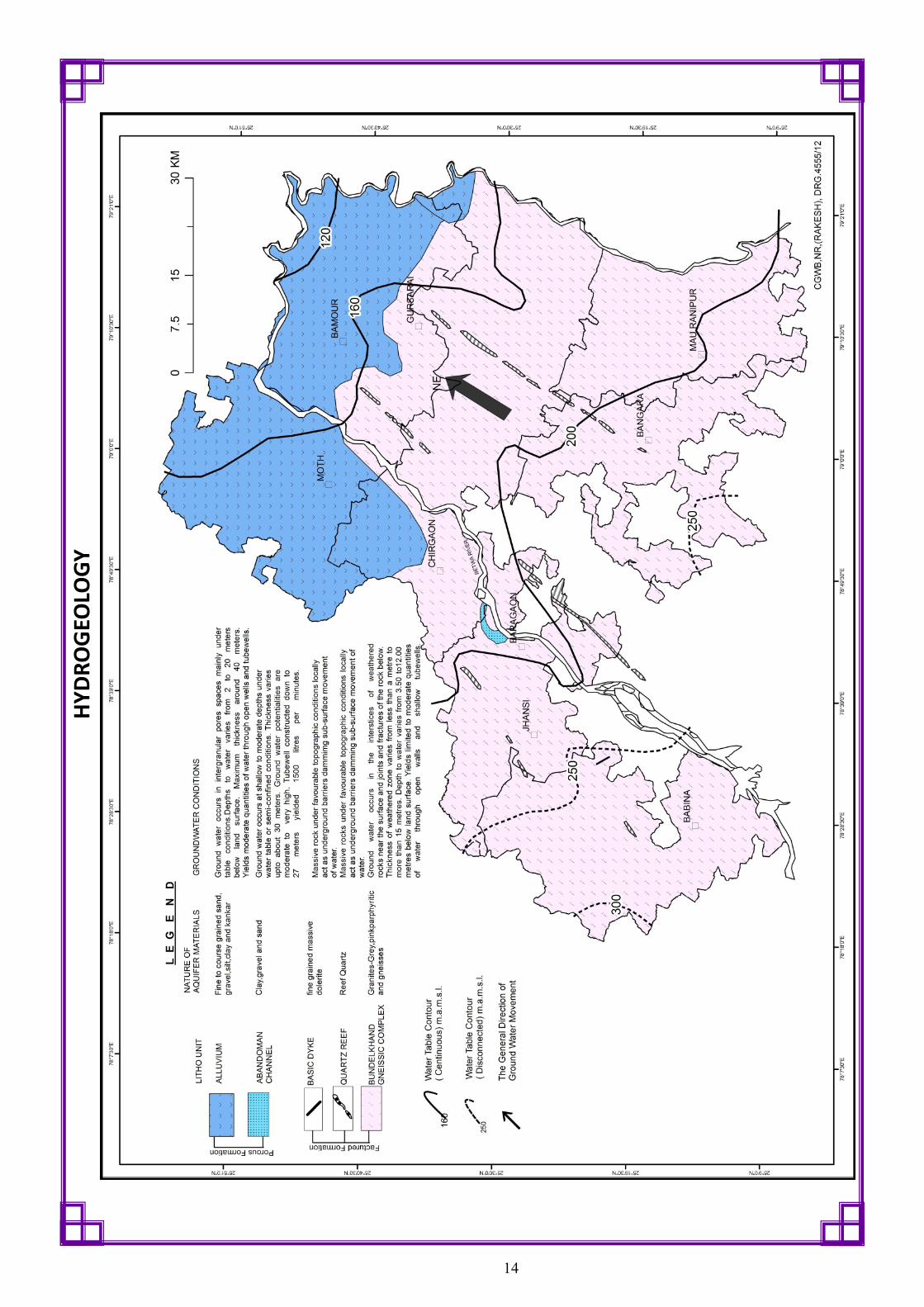
HYDROGEOLOGY
Northern part of the district is occupied by the alluvium of Quaternary age.
Alluvium consist of mainly fine to coarse sand, gravel, pebble, silt, clay and kankar attains a maximum
thickness of about 60 meters.
The alluvium, together with the underlying weathered zone of granite-gneissic basement form a more or less
homogeneous aquifer system.
This aquifer system yields moderate quantities of ground water through dug wells and tube wells. Ground
water occurs under water table conditions in plains.
In southern parts of the district, the weathered zone of Bundelkhand granite-gneissic complex of Achaean age
and overlying residual soils largely form a distinct aquifer system. Ground water occurs in fine interstices of
the weathered rock material which has an average thickness of about 20 – 40 meters. Yield is limited to
moderate through dug wells and tube wells.
This aquifer system exhibits heterogeneity due to impervious nature of frequently occurring outcrops, hillocks
and linear quartz reefs.
Ground water also occurs in underlying fracture zones in hard rock at favourable sites where good
interconnected fractures are present.
Since the thickness of weathered zone is not uniform and good inter-connected fractured zones may not even
exist at many places, finding good yield is difficult in the area.
The General Water Table Contour elevation ranges from 200 to 120 m a msl with gradient of 0.5– 2 m/km.
13
HY
DR
OG
EOLO
GY
14

GROUND WATER LEVELS AND FLOW DIRECTION
Pre-monsoon Water Levels
Water level data of ground water monitoring wells for the year 2015, shows that water level varies from
2.85 to 21.83 mbgl.
Shallow water levels are observed only as patches around Moth and Gursarai. Western part of the district
normally shows water levels between 5 - 8 mbgl.
Deep water levels are present along the eastern margins of the district.
Post-monsoon Water Levels
During post-monsoon, 2015 Water Level varies from 1.00 to 20.96 mbgl.
Shallow water levels are observed only as patches around Moth & Gursarai. Western part of the district nor-
mally shows water levels between 2 and 5 mbgl.
Deep water levels are observed along the eastern margins of the district. The deepest water level of about
20 mbgl is observed at Eraich in northeastern part of the district.
Water Table Elevation Variation
General flow direction of water level is from southwest to northeast
As depicted by water table contours with reference to mean sea level, water table elevation ranges from 200
to 120 m.amsl.
Gradient of water table ranges from 0.5 m/km to as high as 2.0 m/km.
Higher gradient is observed in southwestern parts occupied by hillocks.
Seasonal Water Level Fluctuation
Water level fluctuation, i.e seasonal variation from pre– to post-monsoon period 2015 shows both rise and
fall in different parts of the district. In major part , water levels show decline in the range of 0-2m. This is due
to 2015 being a drought year. Rise has been observed only in small patches in southwestern and southeast-
ern parts.
Block-wise Average Water Level Trend
(Source: GWD, UP Data in Dynamic Resource Estimation)
Block Pre-monsoon Decline (cm/Yr) Post-monsoon Decline (cm/Yr)
BABINA 8.30 3.54
BAMAUR 8.84 7.31
BANGRA 7.87 4.17
BARAGAON 5.97 3.81
CHIRGAON 6.95 4.43
GURSARAI 10.91 5.54
MAURANIPUR 8.72 4.80
MOTH 4.68 2.09
15

GROUND WATER LEVELS & FLOW DIRECTION
16

DYNAMIC GROUND WATER RESOURCES
Block/ Assessment Units
Net Annual Ground Water
Availability (ham)
Existing Gross Ground Water Draft for Irrigation
(ham)
Existing Gross Ground
Water Draft for domestic
& industrial use (ham)
Existing Gross Ground
Water Draft for All uses (ham)
Net Ground Water
availability for future irrigation
development (ham)
Stage of Ground Water
Development (%)
Category
BABINA 6614 4939 566 5505 700 83.23 Safe*
BAMAUR 7584 3772 311 4083 3440 53.84 Safe
BANGRA 6432 4213 580 4792 1271 74.51 Safe*
BARAGAON 7878 5904 450 6354 1250 80.66 Safe*
CHIRGAON 9433 4702 547 5249 3883 55.65 Safe
GURSARAI 9231 4516 537 5052 3939 54.73 Safe
MAURANIPUR 7607 5310 597 5906 1346 77.65 Safe*
MOTH 10853 4658 366 5024 5628 46.29 Safe
TOTAL 65633 38013 3954 41967 21457 63.94
Central Ground Water Board in association with Ground Water Department, Government of U.P. periodically
assesses Dynamic Ground Water Resources using the methodology recommended by the Ground Water Esti-
mation Committee, Government of India (GEC 1997).
The assessment of Dynamic Ground Water Resources provides the basic data to the planner on availability of
ground water for future use.
As per estimation done as on March 2013, Net ground water availability in the district is 65633 ham. Existing
ground water draft for all uses is 38013 ham. Net ground water availability for future irrigation development
is 21457 ham and Stage of Ground Water Development is 63.94%.
All blocks of the district fall under “Safe” category.
Block wise Dynamic Ground Water Resources are given below.
17
* Considered as “Safe” since long-term water levels are not showing significant decline.

DY
NA
MIC
GR
OU
ND
WA
TER
RES
OU
RC
ES
(AS
ON
MA
RC
H 2
01
3)
18

AQUIFER MAPPING UNDER NATIONAL AQUIFER MAPPING & MANAGEMENT PROGRAMME (NAQUIM)
In Jhansi district, it is not uncommon to encounter dry or low-yield well within a very short distance of a high discharge well Yield in dug wells/ borewells may be relatively higher in areas having comparatively thick weathered zone, but it does not sustain pumping for long period as high base flow rapidly dissipates the water column built up after monsoon once ground water extraction starts.
Though normal rainfall is 938 mm, average annual rainfall for the period 1981-2013 has been 856 mm with 55 numbers of rainy days. Due to erratic rainfall pattern, the area has been declared as drought-prone.
The situation in Jhansi district warrants appropriate planning, development and management of ground water. The challenge is to manage the aquifers sustainably. Proper knowledge of the ground water occur-rence in the area, therefore, becomes central to the information essentially required in order to formulate such strategies.
With this view, Central Ground Water Board has taken up National Aquifer Mapping and Management Programme in this district in order to acquire requisite information in addition to that already gathered during various activities undertaken, to come up with sustainable aquifer management plan.
There are four major activity components carried out viz.: (i) data collection / compilation (ii) Data gap analysis (iii) Data generation and (iv) Preparation of aquifer maps and management plan to achieve the objectives.
Following thematic layers and additional data generated in Jhansi districts under NAQUIM. Geomorphological Map Land Use Map Drainage Map Demarcation of water bodies Soil infiltration tests : 223 Nos. Water Level monitoring Rain Fall analysis Slug test : 10 locations. Isotope Analysis: 115 Nos. Geophysical Surveys
Vertical Electrical Sounding 157 Nos. , Gradient Resistivity Profiling : 172 line kms Electrical Resistivity Tomogarphy : 10 2-Dimensional Imaging : 12 line km.
Micro-level Hydrogeological data: existing 1000 wells Exploratory Drilling
Exploratory Wells : 48 Nos Observation Wells: 6 Nos. Pumping Tests: 15
Configuring Hydrogeological Models Ground Water Quality Analysis of shallow aquifers
Basic Analysis: 701 Samples Heavy Metal Analysis: 701 Samples Bacteriological Analysis: 87 Samples Pesticide Analysis: 87 Samples
Integration of available data, and generation of new data has facilitated formulation of effective ground water management strategies.
The high recharge areas were demarcated based on the study of soil infiltration & isotope analysis maps.
The potability of ground water & occurrence of high fluoride & nitrate area identified for shallow aquifers. The quality of deep aquifer water is fresh & potable in all places.
The ground water resource was calculated down to 200 m depth. The discharge of tube wells varies from <1 to 20 lps. The aquifer parameters were identified by pumping tests & slug tests. The fracture analysis and potential zone of ground water occurrence were demarcated.
The aquifer maps in 3-D Fence & Models for difference scenarios were prepared. The aquifer manage-ment plans have been prepared at block level and intervention required for artificial recharge and water conservation have also been worked out.
19

AQUIFER MAPPING UNDER NATIONAL AQUIFER MAPPING & MANAGEMENT PROGRAMME (NAQUIM)
20

GEOPHYSICAL STUDIES
Geophysical surveys complement exploratory drilling in refining the sub-surface information such as
delineation of alluvial, weathered zone and fractured zone and to demarcate aquifer geometry/ con-
figuration. In hard rock areas, geophysical surveys serve as great aid in targeting the favourable sites
having thick weathered/ saturated fracture zones. Objective of the geophysical surveys are to up to
200 m depth and to prepare the aquifer map.
Success in geophysical investigations for weathered and fractured zone aquifer mapping and water
well drilling in hard rocks depends on a number of factors such as, local terrain and hydrogeological
conditions vis-a-vis point of demand; approachability to the area/site for survey, cultural noise, scale
and quantum of measurements; availability of space for borehole drilling at selected point; geophysi-
cal methods and techniques available and their limitations and standardization of geophysical pa-
rameters and defining the geophysical signatures
Geophysical surveys in Jhansi district were mainly initiated through GRPs (Gradient Resistivity Profil-
ing) across lineaments specially mapped at a micro-level for the purpose and NE-SW trending quartz
reefs and NW-SE trending basic dykes. It was followed by VES (Vertical Electrical Resistivity) at all the
sites and ERTs (Electrical Resistivity Tomography) at selected sites. The alluvial covered part was inves-
tigated through VES only.
The methodology and approach evolved of conducting ERT across GRP resistivity lows to delineate the
saturated fractured zones was found the most suitable for the hard rock area.
In the northern alluvial covered blocks of Moth, Bamaur, Gursarai and Chirgaon, the geophysical in-
vestigations helped to delineate the depth to the underlying compact formation (bed rock), alluvium
and weathered zone aquifers, clay beds and demarcate the areas of potential aquifers.
It was found that in general, the thick, potential alluvial aquifers are mostly confined to the western
part of Moth block and eastern part of Bamaur and Gursarai block. A maximum well discharge of
about 46 litres per second (lps) was recorded from the alluvial aquifer so delineated.
In the hard rocks of Jhansi district, the geophysical investigations helped to delineate the weathered
zone aquifers, the zones of possible occurrences of saturated fractured zones underlying the weath-
ered zone and the fractures.
21

Cross-Section (BB’) from Palar to Moti Katra (Baragaon-Chirgaon-Gursarai Blocks)
GEOPHYSICAL STUDIES
ERT results at Badagaon, Mauranipur Block, Jhansi district
Cross-Section (AA’) from Daun to Sujjanpura (Baragaon-Chirgaon-Gursarai Blocks)
Cross-Section (C-C’) from Mudai to Dumrai (Chirgaon-Bamaur Block) Cross-Section (D-D’) from Surai to Pratappur (Moth-Bamaur-Gursarai Blocks)
22

GROUND WATER EXPLORATION & SUB-SURFACE CONFIGURATION
Ground water exploration has been carried out with an objective of delineation and correlation of aquifers and to
estimate the aquifer parameters and quality of ground water. Accelerated drilling was also taken up to mitigate the
drought effect.
In the district 95 exploratory and 7 observation wells have been constructed, both in alluvial and hard rock areas.
Depth of Exploratory Wells varies from 50-200m. The yield of deep tubewells constructed upto 200 mbgl in hard
rock area varies from 200 to 600 lpm at normal drawdown. The hydraulic parameters have been computed based
on the pumping tests on exploratory tubewells constructed by CGWB. The transmissivity varies from 50 to 200 m2/
day.
Sub-surface configuration has been delineated on the basis of geophysical surveys and of lithological logs.
Type of Aquifer
Formation Depth Range (mbgl)
SWL (mbgl)
Thickness (m)
Discharge (lpm)
Sustain-ability
T (m2/d)
Sy/S Suitability for Drinking & Irrigation
Shallow Aquifer
Weathered Zone/ Allu-
vium
5-60 2-20 2-25 50-700 Up to 10 hours
— 0.04 O c cu r re nc e of Nitrate & F l u o r i d e above per-missible in few locations
Deeper Aquifer
Fractured Granite
5-200 0.35 - 26 0.5 - 2.00 10-300 Up to 8 hours
25-500 2.8x10⁻⁴ Yes for both
23

GROUND WATER EXPLORATION & SUB-SURFACE CONFIGURATION
Geological section along A - B
Geological section along C - D
24

GROUND WATER YIELD POTENTIAL
Northern fringes of Jhansi district form part of Marginal Alluvial Plains and are occupied by 50-60m thick
alluvial cover in Moth and Bamor blocks. In these parts, wells tapping zones in alluvium cover give sub-
stantial discharge.
The alluvial cover thins out towards south and is replaced by weathered zone of non-uniform thickness
with average thickness decreasing southwards. In major part weathered zone thickness is 20-40m, except
in the vicinity of rivers/ streams governed by two orthogonal sets of lineaments transecting the area,
trending NE-SW and NW-SE.
Quartz reefs occupying NE-SW trending tensional zones behave as sub-surface barrier for ground water flow.
Wells drilled on the upstream side of reefs yielded much higher flow than those on the downstream side. In a
number of cases, the downstream side wells turned out to be either dry or gave out negligible discharge.
In the hard rock terrain, which occupies major part, exploratory drilling has success rate of around 80% (~20%
wells turned out dry). Majority of the wells (~48%) encountered fractures only within 50m. Wells encountering
fracture zones only in 50-100m or 100-150m range are much less in number (~5-6%). Rarely, fracture zones have
been encountered in 150-200 m range. A few wells encountered 2 or more sets of fractures (~15%).
Fracture vs yield analysis indicates that most of the yielding fractures are encountered. within upper 40m.
The deeper fracture set does not hold much promise in terms of yield. However, in some cases, where fracture
set in 100-150 range is encountered, either in isolation or in combination with overlying set, the yield is relatively
better.
25

GROUND WATER YIELD POTENTIAL
YIELD OF WELLS
26

GROUND WATER QUALITY
Central Ground Water Board has collected 701 water samples each for analysis of Basic Parameters and Heavy Met-
als from dugwells, tubewells, India marka handpumps etc. Similarly, 87 water samples each were collected for bacte-
riological and pesticide analysis. The inference is given below:
ELECTRICAL CONDUCTIVITY:
EC values varied from 221 to 4360 µS cm-1 with an average value of 1014 µS cm-1 (The groundwater at some places
indicated high salinity due to which it is unsuitable even for irrigation uses.
TOTAL HARDNESS:.
Total hardness of the groundwater samples varied between 55.5 to 1776.1 mg/l. The average hardness of the ana-
lyzed samples was found as 345.4 mg/l, 8% samples were having hardness above 600 mg/l.
TDS:
The values of Total Dissolved Solid (TDS) exceeded IS-10500 (2012) desirable drinking water limit (500 mg/l) in 78.5%
of the total samples. However, it is well below the maximum permissible limit of 2000 mg/l .
NITRATE:
Concentration of nitrate in groundwater ranges from 0.02 to 596.3 mg/l with the average concentration value of 34.6
mg/l. Nitrate concentration exceeds the prescribed drinking water limit of 45 mg/l at 21.7% of the total locations.
Whereas in deep tubewells fluoride is within permissible limit.
FLOURIDE:
BIS (2012) estimates the maximum allowable limit for fluoride uptake to human’s in drinking water as 1.5 mg/L. Con-
centration of fluoride in groundwater samples of Jhansi district varies between <1 and 8.8 mg/l and average concen-
tration was found as 1.9 mg/l.Concentration of F- exceeds the permissible limit of 1.5 mg/l in about 62.2% of the
groundwater samples of the study area. Whereas in deep tubewells fluoride is within permissible limit.
IRON:
The concentration of Fe was in the range 38.74 - 36432 µg/l and exceeded the drinking water desirable level (300µg/
l) in 91.6% of the total analysed samples.
TYPE OF WATER:
The facies mapping approach applied shows that Ca-Mg-HCO3 is the dominant hydro-geochemical facies and are the
major contributing ions for the dissolved load. The minor water types are Ca-Mg-SO4-Cl and Na-K-HCO3.Most of the
water samples of the district are marginally suitable for direct uses in drinking purposes.
BACTERIOLOGICAL:
The bacteriological analysis of samples indicates presence of total coliform in 80.2% samples and faecal collifrom in
65.1% of analysed samples. This means 65.1% of the collected groundwater samples were unfit for drinking.
PESTICIDES:
Concentration of pesticides in all the analyzed samples is within the desirable limit prescribed for drinking purpose.
HEAVY METALS:
Concentration of Cd, Cr, Ni, and Pb exceeded the permissible limit in 2.4 %, 2.0 %, 10%, and 5.7% of analyzed sam-
ples respectively. Arsenic in the analyzed samples was within the permissible limit prescribed by BIS, the concentra-
tion in >1% samples exceeded the desirable limit.
ALKALI AND SALINITY HAZARD (SAR):
The calculated value of SAR in the study area ranged from 0.04 – 18.3 meq/l. Based on US salinity diagram, it can be
concluded that most of the water samples fall in the category C3S1, C2S1, C4S1, C3S2, C4S2 and C3S3 indicating me-
dium to high salinity and low alkalinity indicating medium to high salinity and low medium alkali water. This water
can be used for plants with good salt tolerance.
SODIUM PERCENTAGE %:
The sodium percentage (%Na) in the Jhansi district area ranges between 1.6 and 92.7% (Avg. 37.3%) against a maxi-
mum allowance of 60% for irrigation water by (ISI-1993)in general majority of groundwater samples of the Jhansi
district are falling in exclent to permissible quality region, which can be used for irrigation purposes.
RESIDUAL SODIUM CARBONATE:
A RSC value between 1.25 and 2.5 meq/l is considered as the marginal quality and value <1.25 meq/l as the safe limit
for irrigation. In the Jhansi district only < 2.4% of total analysed groundwater samples having RSC values greater than
5 meq/l and could be considered harmful to the growth of plants.
27

GR
OU
ND
WA
TER
QU
ALI
TY
28

SOIL INFILTRATION & ISOTOPE STUDY
VARIATION OF SOIL INFILTRATION RATE
soil infiltration tests were carried out at 223 locations in Jhansi district. Soils with low Infiltration can be responsi-
ble for higher runoff and can become saturated during rain events. There will be less recharge in ground water.
This, in turn, decreases soil strength and increases erosion potential. It can also cause nutrient deficiencies in
plants and generate anaerobic conditions.
Soils that have less Infiltration rates lead to an increase in the overall volume of runoff. This excess run off can
contribute to local and regional flooding of streams and rivers or results in accelerated soil erosion of fields or
stream banks.
Soil infiltration rate varies from 4 to 140 mm/hr. The low infiltration is observed in northern parts in Moth,
Baragoan, Chiorgaon and Gulsarai Block having clay dominant soil (Older Alluvium Area). High infiltration rate ob-
served in Babina, Chirgaon, Bangra & Mauranipur Blocks having coarse grain soil (Weathered Granite).
ISOTOPE ANALYSIS
The water samples were collected from 115 locations in Jhansi district for analyses of isotopes. The samples were
collected from open well, tubewells and India mark handpumps. To study the spatial variations of isotopic com-
position of groundwater samples were collected on grid basis from Jhansi districts. When the groundwater sam-
ples from hand-pumps were collected after purging the standing water column for a few minutes. On site meas-
urements like sample temperature, pH, conductivity along with all other relevant site information were also re-
corded.
The analysis indicates that oxygen isotope ratio (δ18O) of shallow groundwater samples varied from -7.4%
(minimum) to -2.8% (maximum) and hydrogen isotope ratio (δ2H) from -51.0% (minimum) to -25.1% (maximum).
The figure shows spatial variation of δ18O of groundwater of Jhansi district. The depleted isotopic compositions
are observed in few pockets located in south eastern part of the district. The enriched isotopic composition of
groundwater may be due to evaporative fractionation of rainwater prior to infiltration through surface from open
water bodies (i.e., pond, lake or reservoir).
It is observed that the areas with enriched values of δ18O correspond to comparatively lower infiltration rate and
vice versa.
Field set up of Double Ring Infiltrometer. Water sample collection for isotope from Hand pump & Dug well.
29

SOIL INFILTRATION & ISOTOPE STUDY
30

Proposed Interventions Nos./ Area/
Km
GW Re-charge (ham)
Provision for Supple-mental Irri-
gation (ham)
Saving in GW Draft
(ham)
S. No.
Check Dam (Intake capacity 0.01 MCM or 1 ham) 16 Nos 25.60 25.60 1
Nala Bunds (Intake capacity 0.0075 MCM or 0.75 ham) 40 Nos 48.00 48.00 2
Revival, repair of water bodies (1 ha x 3m deep) 40 Nos 155.52 155.52 3
Stream/ Channel Development ((intake capacity 0.01575 MCM or 1.575 ham/ Km length) -average trapezium section is considered as 12m at top and 9m at bottom and 1.5m deep
4 Km 10.08 10.08 4
On-farm Activities 5200 ha 520.00 115.81 5
Water Use Efficiency through Micro-irrigation (Drip/ Sprinkler Irrigation)(10% of Block area).
8400 ha 0.00 561.24 6
Total 759.20 239.20 677.05
Net GW Augmentation Potential (Recharge + Supplemental Irrigation or Saving : 759.20 + 239.20 + 677.05 = 1675.45 ham
15% Proposed to be Allocated for Drinking Water: 251.32 ham
Population to be benefited considering 70 lpcd = 98363
85% Proposed to be Allocated for Irrigation: 1424.13 ham
Area to be brought under irrigation considering 0.25m as Delta factor: 5697 ham
Total geographical area of the block is about 69000 hectare.
Normal annual rainfall in the district is 931.50 mm whereas normal monsoon rainfall is 839 mm.
Geologically the block is predominantly hard rock terrain underlain by Bundelkhand granitic and gneissic com-plex.
The principal crops cultivated in the block are wheat (18936 Ha), Pulses (10452 Ha), Oilseeds (18768 Ha), Maize (1321 Ha) and Barley (606 Ha) etc.
In the block, a total of 55878 hectare area is sown by different crops out of which the net area sown is 26678 hectare and area sown more than once is 29200 hectare.
The net irrigated area in the block is 32006 hectare, whereas Gross irrigated area is 36118 hectare.
The cropping intensity in the block is 209% and irrigation intensity in the block is 113%.
About 69% irrigated area in the block is by Ground water, about 25% is by Canals and remaining about 6% irri-gated area is by ponds.
Nitrate and Fluoride in excess of permissible limits have been found locally in shallow ground water. However deeper ground water resources are fresh.
Net Annual Ground Water
Availability
Existing Gross Ground Water
Draft for Irrigation
Existing Gross Ground Water Draft for Domestic & Indus-
trial Water Supply
Existing Gross Ground Water
Draft for All Uses
Stage of Ground
Water De-velopment
(%)
Category
6614.41 4938.70 566.44 5505.14 83.23 Safe
Management Plan (Based on District Irrigation Plan and CGWB Data)
GROUND WATER MANAGEMENT PLAN, BABINA BLOCK
31
Dynamic Ground Water Resources

GROUND WATER MANAGEMENT PLAN, BABINA BLOCK
32

Proposed Interventions Nos./ Area/
Km
GW Re-charge (ham)
Provision for Supple-mental Irri-
gation (ham)
Saving in GW Draft
(ham)
S. No.
Check Dam (Intake capacity 0.01 MCM or 1 ham) 8 Nos 12.80 12.80 1
Nala Bunds (Intake capacity 0.0075 MCM or 0.75 ham) 40 Nos 48.00 48.00 2
Revival, repair of water bodies (1 ha x 3m deep) 40 Nos 155.52 155.52 3
Stream/ Channel Development ((intake capacity 0.01575 MCM or 1.575 ham/ Km length) -average trapezium section is considered as 12m at top and 9m at bottom and 1.5m deep
4 Km 10.08 10.08 4
On-farm Activities 3860 ha 386.00 185.42 5
Water Use Efficiency through Micro-irrigation (Drip/ Sprinkler Irrigation)(10% of Block area).
8050 ha 0.00 815.65 6
Total 612.40 226.40 1345.48
Net GW Augmentation Potential (Recharge + Supplemental Irrigation or Saving : 612.40 + 226.40 + 1345.48 = 2184.28 ham
15% Proposed to be Allocated for Drinking Water: 327.64 ham
Population to be benefited considering 70 lpcd = 128236
85% Proposed to be Allocated for Irrigation: 1856.64 ham
Area to be brought under irrigation considering 0.25m as Delta factor: 7427 ha
Total geographical area of the block is about 81675 hectare.
Normal annual rainfall in the district is 931.50 mm whereas normal monsoon rainfall is 839 mm.
Geologically the block is predominantly hard rock terrain underlain by Bundelkhand granitic and gneissic com-plex.
The principal crops cultivated in the block are wheat (14208 Ha), Pulses (40775 Ha), Oilseeds (23310 Ha), Maize (895 Ha) and Barley (525 Ha) and Jwar (553 Ha) etc.
In the block, a total of 79845 hectare area is sown by different crops out of which the net area sown is 26678 hectare and area sown more than once is 26736 hectare.
The net irrigated area in the block is 27163 hectare, whereas Gross irrigated area is 31335 hectare.
The cropping intensity in the block is 150% and irrigation intensity in the block is 115%.
About 29% irrigated area in the block is by Ground water, about 59% is by Canals and remaining about 11% irri-gated area is by ponds.
Nitrate and Fluoride in excess of permissible limits have been found locally in shallow ground water. However deeper ground water resources are fresh.
Net Annual Ground Water
Availability
Existing Gross Ground Water
Draft for Irrigation
Existing Gross Ground Water Draft for Domestic & Industrial Water Supply
Existing Gross Ground Water
Draft for All Uses
Stage of Ground Water Development
(%)
Category
7584.47 3772.24 311.01 4083.25 53.84 Safe
GROUND WATER MANAGEMENT PLAN, BAMAUR BLOCK
33
Management Plan (Based on District Irrigation Plan and CGWB Data)
Dynamic Ground Water Resources

GROUND WATER MANAGEMENT PLAN, BAMAUR BLOCK
34

Proposed Interventions Nos./ Area/
Km
GW Re-charge (ham)
Provision for Supple-mental Irri-
gation (ham)
Saving in GW Draft
(ham)
S. No.
Check Dam (Intake capacity 0.01 MCM or 1 ham) 10 Nos 16.00 16.00 1
Nala Bunds (Intake capacity 0.0075 MCM or 0.75 ham) 30 Nos 36.00 36.00 2
Revival, repair of water bodies (1 ha x 3m deep) 30 Nos 116.64 116.64 3
Stream/ Channel Development ((intake capacity 0.01575 MCM or 1.575 ham/ Km length) -average trapezium section is considered as 12m at top and 9m at bottom and 1.5m deep
3 Km 7.56 7.56 4
On-farm Activities 4800 ha 480.00 119.39 5
Water Use Efficiency through Micro-irrigation (Drip/ Sprinkler Irrigation)(10% of Block area).
5500 ha 0.00 410.42 6
Total 656.20 176.20 529.81
Net GW Augmentation Potential (Recharge + Supplemental Irrigation or Saving : 656.20 + 176.20 + 529.81 = 1362.21 ham
15% Proposed to be Allocated for Drinking Water: 204.33 ham
Population to be benefited considering 70 lpcd = 79973
85% Proposed to be Allocated for Irrigation: 1157.88 ham
Area to be brought under irrigation considering 0.25m as Delta factor: 4632 ha
Total geographical area of the block is about 52800 hectare.
Normal annual rainfall in the district is 931.50 mm whereas normal monsoon rainfall is 839 mm.
Geologically the block is predominantly hard rock terrain underlain by Bundelkhand granitic and gneissic complex.
The principal crops cultivated in the block are wheat (10555 Ha), Pulses (28233 Ha), Oilseeds (10661 Ha), Barley (639 Ha) and Jwar (53 Ha) etc.
In the block, a total of 53336 hectare area is sown by different crops out of which the net area sown is 37553 hec-tare and area sown more than once is 15783 hectare.
The net irrigated area in the block is 23949 hectare, whereas Gross irrigated area is 28118 hectare.
The cropping intensity in the block is 142% and irrigation intensity in the block is 117%.
About 71% irrigated area in the block is by Ground water, about 23% is by Canals and remaining about 6% irrigated area is by ponds.
Nitrate and Fluoride in excess of permissible limits have been found locally in shallow ground water. However deeper ground water resources are fresh.
Net Annual Ground Water
Availability
Existing Gross Ground Water
Draft for Irrigation
Existing Gross Ground Water Draft for Domes-tic & Industrial Water
Supply
Existing Gross Ground Water
Draft for All Uses
Stage of Ground Water De-
velopment (%)
Category
6431.73 4212.85 579.56 4792.41 74.51 Safe
GROUND WATER MANAGEMENT PLAN, BANGRA BLOCK
35
Management Plan (Based on District Irrigation Plan and CGWB Data)
Dynamic Ground Water Resources

GROUND WATER MANAGEMENT PLAN, BANGRA BLOCK
36

Proposed Interventions Nos./ Area/
Km
GW Re-charge (ham)
Provision for Supple-mental Irri-
gation (ham)
Saving in GW Draft
(ham)
S. No.
Check Dam (Intake capacity 0.01 MCM or 1 ham) 10 Nos 16.00 16.00 1
Nala Bunds (Intake capacity 0.0075 MCM or 0.75 ham) 20 Nos 24.00 24.00 2
Revival, repair of water bodies (1 ha x 3m deep) 20 Nos 77.76 77.76 3
Stream/ Channel Development ((intake capacity 0.01575 MCM or 1.575 ham/ Km length) -average trapezium section is considered as 12m at top and 9m at bottom and 1.5m deep
2 Km 5.04 5.04 4
On-farm Activities 5000 ha 500.00 233.32 5
Water Use Efficiency through Micro-irrigation (Drip/ Sprinkler Irrigation)(10% of Block area).
3500 ha 0.00 489.97 6
Total 622.80 122.80 723.29
Net GW Augmentation Potential (Recharge + Supplemental Irrigation or Saving : 622.80 + 122.80 + 723.29 = 1468.89 ham
15% Proposed to be Allocated for Drinking Water: 220.33 ham
Population to be benefited considering 70 lpcd = 86236
85% Proposed to be Allocated for Irrigation: 1248.56 ham
Area to be brought under irrigation considering 0.25m as Delta factor: 4994 ha
Total geographical area of the block is about 52900 hectare.
Normal annual rainfall in the district is 931.50 mm whereas normal monsoon rainfall is 839 mm.
Geologically the block is predominantly hard rock terrain underlain by Bundelkhand granitic and gneissic com-plex.
The principal crops cultivated in the block are wheat (20051 Ha), Pulses (13242 Ha), Oilseeds (8143 Ha), Paddy (1812 Ha), Barley (339 Ha) and Millet (899 Ha) etc.
In the block, a total of 51507 hectare area is sown by different crops out of which the net area sown is 28899 hectare and area sown more than once is 22608 hectare.
The net irrigated area in the block is 32386 hectare, whereas Gross irrigated area is 36541 hectare.
The cropping intensity in the block is 178% and irrigation intensity in the block is 113%.
About 39% irrigated area in the block is by Ground water, about 51% is by Canals and remaining about 10% irri-gated area is by ponds.
Nitrate and Fluoride in excess of permissible limits have been found locally in shallow ground water. However deeper ground water resources are fresh.
Net Annual Ground Water
Availability
Existing Gross Ground Water
Draft for Irrigation
Existing Gross Ground Water Draft for Domestic & Industrial Water Sup-
ply
Existing Gross Ground Water
Draft for All Uses
Stage of Ground Water Development
(%)
Category
7878.06 5904.37 449.82 6354.19 80.66 Safe
GROUND WATER MANAGEMENT PLAN, BARAGAON BLOCK
37
Management Plan (Based on District Irrigation Plan and CGWB Data)
Dynamic Ground Water Resources

GROUND WATER MANAGEMENT PLAN, BARAGAON BLOCK
38

Proposed Interventions Nos./ Area/
Km
GW Re-charge (ham)
Provision for Supple-mental Irri-
gation (ham)
Saving in GW Draft
(ham)
S. No.
Check Dam (Intake capacity 0.01 MCM or 1 ham) 8 Nos 12.80 12.80 1
Nala Bunds (Intake capacity 0.0075 MCM or 0.75 ham) 25 Nos 30.00 30.00 2
Revival, repair of water bodies (1 ha x 3m deep) 25 Nos 97.20 97.20 3
Stream/ Channel Development ((intake capacity 0.01575 MCM or 1.575 ham/ Km length) -average trapezium section is considered as 12m at top and 9m at bottom and 1.5m deep
3 Km 7.56 7.56 4
On-farm Activities 5200 ha 520.00 162.80 5
Water Use Efficiency through Micro-irrigation (Drip/ Sprinkler Irrigation)(10% of Block area).
5250 ha 0.00 493.11 6
Total 667.56 147.56 655.91
Net GW Augmentation Potential (Recharge + Supplemental Irrigation or Saving : 667.56 + 147.56 + 655.91 = 1471.03 ham
15% Proposed to be Allocated for Drinking Water: 220.65 ham
Population to be benefited considering 70 lpcd = 86362
85% Proposed to be Allocated for Irrigation: 1250.38 ham
Area to be brought under irrigation considering 0.25m as Delta factor: 5002 ha
Total geographical area of the block is about 54549 hectare.
Normal annual rainfall in the district is 931.50 mm whereas normal monsoon rainfall is 839 mm.
Geologically the block is predominantly hard rock terrain underlain by Bundelkhand granitic and gneissic com-plex.
The principal crops cultivated in the block are wheat (23371 Ha), Pulses (32799 Ha), Oilseeds (10009 Ha), Paddy (1610 Ha) and Barley (445 Ha) etc.
In the block, a total of 71143 hectare area is sown by different crops out of which the net area sown is 39300 hectare and area sown more than once is 31843 hectare.
The net irrigated area in the block is 40395 hectare, whereas Gross irrigated area is 44531 hectare.
The cropping intensity in the block is 181% and irrigation intensity in the block is 110%.
About 37% irrigated area in the block is by Ground water, about 56% is by Canals, remaining about 5% irrigated area is by ponds and 2% by other sources of irrigation.
Nitrate and Fluoride in excess of permissible limits have been found locally in shallow ground water. However deeper ground water resources are fresh.
Net Annual Ground Water
Availability
Existing Gross Ground Water
Draft for Irrigation
Existing Gross Ground Water Draft for Domestic & Industrial Water Supply
Existing Gross Ground Water
Draft for All Uses
Stage of Ground Water Development
(%)
Category
9433.35 4702.21 547.16 5249.37 55.65 Safe
GROUND WATER MANAGEMENT PLAN, CHIRGAON BLOCK
39
Management Plan (Based on District Irrigation Plan and CGWB Data)
Dynamic Ground Water Resources

GROUND WATER MANAGEMENT PLAN, CHIRGAON BLOCK
40

Proposed Interventions Nos./ Area/
Km
GW Re-charge (ham)
Provision for Supple-mental Irri-
gation (ham)
Saving in GW Draft
(ham)
S. No.
Check Dam (Intake capacity 0.01 MCM or 1 ham) 8 Nos 12.80 12.80 1
Nala Bunds (Intake capacity 0.0075 MCM or 0.75 ham) 35 Nos 42.00 42.00 2
Revival, repair of water bodies (1 ha x 3m deep) 35 Nos 136.08 136.08 3
Stream/ Channel Development ((intake capacity 0.01575 MCM or 1.575 ham/ Km length) -average trapezium section is considered as 12m at top and 9m at bottom and 1.5m deep
4 Km 10.08 10.08 4
On-farm Activities 3460 ha 346.00 125.15 5
Water Use Efficiency through Micro-irrigation (Drip/ Sprinkler Irrigation)(10% of Block area).
7400 ha 0.00 802.99 6
Total 546.96 200.96 928.14
Net GW Augmentation Potential (Recharge + Supplemental Irrigation or Saving : 546.96 + 200.96 + 928.14 = 1676.06 ham
15% Proposed to be Allocated for Drinking Water: 251.41 ham
Population to be benefited considering 70 lpcd = 98399
85% Proposed to be Allocated for Irrigation: 1424.65 ham
Area to be brought under irrigation considering 0.25m as Delta factor: 5699 ha
Total geographical area of the block is about 54549 hectare.
Normal annual rainfall in the district is 931.50 mm whereas normal monsoon rainfall is 839 mm.
Geologically the northern part of the block is underlain alluvium and southern part by Bundelkhand granitic and gneissic complex.
The principal crops cultivated in the block are wheat (11450 Ha), Pulses (46214 Ha), Oilseeds (22381 Ha), Bar-ley (431 Ha) and Jwar (472 Ha) etc.
In the block, a total of 79845 hectare area is sown by different crops out of which the net area sown is 53109 hectare and area sown more than once is 26736 hectare.
The net irrigated area in the block is 27163 hectare, whereas Gross irrigated area is 31335 hectare.
The cropping intensity in the block is 150% and irrigation intensity in the block is 115%.
About 49% irrigated area in the block is by Ground water, about 32% is by Canals, remaining about 17% irri-gated area is by ponds and 2% by other sources of irrigation.
Nitrate and Fluoride in excess of permissible limits have been found locally in shallow ground water. However deeper ground water resources are fresh.
Block Net Annual Ground Water
Availability
Existing Gross Ground Water
Draft for Irrigation
Existing Gross Ground Water
Draft for Domes-tic & Industrial Water Supply
Existing Gross Ground Wa-ter Draft for
All Uses
Stage of Ground Wa-
ter Devel-opment
(%)
Category
Gursarai 9231.31 4515.56 536.50 5052.06 54.73 Safe
GROUND WATER MANAGEMENT PLAN, GURSARAI BLOCK
41
Management Plan (Based on District Irrigation Plan and CGWB Data)
Dynamic Ground Water Resources

GROUND WATER MANAGEMENT PLAN, GURSARAI BLOCK
42

Proposed Interventions Nos./ Area/
Km
GW Re-charge (ham)
Provision for Supple-mental Irri-
gation (ham)
Saving in GW Draft
(ham)
S. No.
Check Dam (Intake capacity 0.01 MCM or 1 ham) 10 Nos 16.00 16.00 1
Nala Bunds (Intake capacity 0.0075 MCM or 0.75 ham) 30 Nos 36.00 36.00 2
Revival, repair of water bodies (1 ha x 3m deep) 30 Nos 116.64 116.64 3
Stream/ Channel Development ((intake capacity 0.01575 MCM or 1.575 ham/ Km length) -average trapezium section is considered as 12m at top and 9m at bottom and 1.5m deep
3 Km 7.56 7.56 4
On-farm Activities 4800 ha 480.00 102.08 5
Water Use Efficiency through Micro-irrigation (Drip/ Sprinkler Irrigation)(10% of Block area).
5700 ha 0.00 363.67 6
Total 656.20 176.20 465.75
Net GW Augmentation Potential (Recharge + Supplemental Irrigation or Saving : 656.20 + 176.20 + 465.75 = 1298.15 ham
15% Proposed to be Allocated for Drinking Water: 194.72 ham
Population to be benefited considering 70 lpcd = 76212
85% Proposed to be Allocated for Irrigation: 1103.43 ham
Area to be brought under irrigation considering 0.25m as Delta factor: 4414 ha
Total geographical area of the block is about 54200 hectare.
Normal annual rainfall in the district is 931.50 mm whereas normal monsoon rainfall is 839 mm.
Geologically the block is predominantly hard rock terrain underlain by Bundelkhand granitic and gneissic com-plex.
The principal crops cultivated in the block are wheat (10237 Ha), Pulses (39148 Ha), Oilseeds (14689 Ha), Bar-ley (573 Ha), Millet (1109 Ha) and Jwar (120 Ha) etc.
In the block, a total of 72730 hectare area is sown by different crops out of which the net area sown is 45583 hectare and area sown more than once is 27147 hectare.
The net irrigated area in the block is 35699 hectare, whereas Gross irrigated area is 39616 hectare.
The cropping intensity in the block is 160% and irrigation intensity in the block is 111%.
About 70% irrigated area in the block is by Ground water, about 17% is by Canals, remaining about 11% irri-gated area is by ponds and 2% by other sources of irrigation.
Nitrate and Fluoride in excess of permissible limits have been found locally in shallow ground water. However deeper ground water resources are fresh.
Net Annual Ground Water
Availability
Existing Gross Ground Water
Draft for Irrigation
Existing Gross Ground Water Draft for Domestic & Industrial Water Supply
Existing Gross Ground Water
Draft for All Uses
Stage of Ground Water Development
(%)
Category
7606.70 5309.52 596.92 5906.44 77.65 Safe
GROUND WATER MANAGEMENT PLAN, MAURANIPUR BLOCK
43
Management Plan (Based on District Irrigation Plan and CGWB Data)
Dynamic Ground Water Resources

GROUND WATER MANAGEMENT PLAN, MAURANIPUR BLOCK
44

Proposed Interventions Nos./ Area/
Km
GW Re-charge (ham)
Provision for Supple-mental Irri-
gation (ham)
Saving in GW Draft
(ham)
S. No.
Check Dam (Intake capacity 0.01 MCM or 1 ham) 6 Nos 9.60 9.60 1
Nala Bunds (Intake capacity 0.0075 MCM or 0.75 ham) 35 Nos 42.00 42.00 2
Revival, repair of water bodies (1 ha x 3m deep) 35 Nos 136.08 136.08 3
Stream/ Channel Development ((intake capacity 0.01575 MCM or 1.575 ham/ Km length) -average trapezium section is considered as 12m at top and 9m at bottom and 1.5m deep
4 Km 10.08 10.08 4
On-farm Activities 4800 ha 480.00 250.38 5
Water Use Efficiency through Micro-irrigation (Drip/ Sprinkler Irrigation)(10% of Block area).
6500 ha 0.00 1017.19 6
Total 677.76 197.76 1267.57
Net GW Augmentation Potential (Recharge + Supplemental Irrigation or Saving : 677.76 + 197.76 + 1267 = 2143.09 ham
15% Proposed to be Allocated for Drinking Water: 321.46 ham
Population to be benefited considering 70 lpcd = 125818
85% Proposed to be Allocated for Irrigation: 1821.63 ham
Area to be brought under irrigation considering 0.25m as Delta factor: 7287 ha
Total geographical area of the block is about 65800 hectare.
Normal annual rainfall in the district is 931.50 mm whereas normal monsoon rainfall is 839 mm.
Geologically the northern part of the block is underlain alluvium and southern part by Bundelkhand granitic and gneissic complex.
The principal crops cultivated in the block are wheat (35704 Ha), Pulses (36456 Ha), Oilseeds (4513 Ha), Paddy (5704), Barley (593 Ha) and Millet (1115 Ha) etc.
In the block, a total of 78623 hectare area is sown by different crops out of which the net area sown is 48229 hectare and area sown more than once is 30394 hectare.
The net irrigated area in the block is 53717 hectare, whereas Gross irrigated area is 57708 hectare.
The cropping intensity in the block is 163% and irrigation intensity in the block is 107%.
About 17% irrigated area in the block is by Ground water, about 79% is by Canals, remaining about 3% irri-gated area is by ponds and 1% by other sources of irrigation.
Nitrate and Fluoride in excess of permissible limits have been found locally in shallow ground water. However deeper ground water resources are fresh.
Net Annual Ground Water
Availability
Existing Gross Ground Water
Draft for Irrigation
Existing Gross Ground Wa-ter Draft for Domestic & Industrial Water Supply
Existing Gross Ground Water
Draft for All Uses
Stage of Ground Water Development
(%)
Category
10853.36 4657.68 366.49 5024.17 46.29 Safe
GROUND WATER MANAGEMENT PLAN, MOTH BLOCK
45
Management Plan (Based on District Irrigation Plan and CGWB Data)
Dynamic Ground Water Resources

GROUND WATER MANAGEMENT PLAN, MOTH BLOCK
46

Block Recharge & Supplemental Irrigation Recharge & Saving in GW Draft
Saving in GW Draft
Recharge (ham)
Supple-mental
Irrigation (ham)
Saving in GW Draft
Total Aug-mentation Potential
(ham) Check Dams (Nos)
Nala Bunds (Nos)
Ponds (Nos)
Stream Deve-
lopment (Km)
On-farm Activities
(ha)
Water Use Efficiency/
Micro-Irrigation
(ha)
Babina 16 40 40 4 5200 8400 759.20 239.20 677.05 1675.45
Bamaur 8 40 40 4 3860 8050 612.40 226.40 1345.48 2184.28
Bangra 10 30 30 3 4800 5500 656.20 176.20 529.81 1362.21
Baragaon 10 20 20 2 5000 3500 622.80 122.80 723.29 1468.89
Chirgaon 8 25 25 3 5200 5250 667.56 147.56 655.91 1471.03
Gursarai 8 35 35 4 3460 7400 546.96 200.96 928.14 1676.06
Mauranipur 10 30 30 3 4800 5700 656.20 176.20 465.75 1298.15
Moth 6 35 35 4 4800 6500 677.76 197.76 1267.57 2143.09
Total 76 255 255 27 37120 50300 5199.08 1487.08 6593.00 13279.16
Block-wise Structures/Activities & Benefits
Structures/ Activities Proposed:
1. Check Dams of 10000 Cum (1 ham) capacity.*
2. Nala Bunds of 7500 ham (0.75 ham) capacity.*
3. Ponds: 100m x 100m x 3m = 30000 cum (3 ham).*
4. Stream Development of 15750 cum (1.575 ham) capacity per Km length, considering average trapezium width at top
and bottom = 12m & 9m with 1.5m deepening.*
5. On-farm activities.
6. Water Use Efficiency/ Micro-irrigation (Drip & Sprinkler).
*Capacity calculated for single filling; 4 fillings considered; thus total storage 4 times of the capacity.
GROUND WATER MANAGEMENT PLAN IN JHANSI DISTRICT
47

GR
OU
ND
WA
TER
MA
NA
GEM
ENT
PLA
N IN
JH
AN
SI D
ISTR
ICT
Babina
Bamaur
Bangra
Baragaon
Chirgaon
Gursarai
Mauranipur
Moth
Sa
vin
g in
GW
Dra
ft
Su
pp
le-m
en
tal I
rrig
atio
n (h
am
)
Re
ch
arg
e (h
am
)
To
tal
GW
A
ug
men
tati
on
P
ote
nti
al
fro
m
Rech
arg
e a
nd
sa
vin
g
in
GW
Dra
ft
is 1
32
79
ham
45
149
ha
7
79
58
9 P
op
ula
tion
48

DEMONSTRATIVE PROJECT ON ARTIFICIAL RECHARGE TO GROUND WATER/ CONSERVATION IN MAURANIPUR BLOCK
- A SUCCESS STORY
Central Ground Water Board has taken up Project on Artificial Recharge to Ground Water/ water Conservation In
Mauranipur Block, Jhansi District in view of over exploitation of ground water, drought and water scarcity situation in
the area.
During 2004-07, drying of tanks, ponds, dugwell and fall in water level/ground water table clearly indicated hydrologi-
cal drought in Bundelkhand region of Uttar Pradesh. The Inter ministerial Central team on drought Mitigation Strategy
for Bundelkhand mentioned a drastic reduction of net sown area to about 60% in 04 years. Thus it was needed to fu-
ture strategies for short, medium and long term drought mitigation.
Mauranipur block of Jhansi district was categorized as "Safe" with stage of ground water development of 61.41% as
per Dynamic Ground Water Resource estimation 2004. Subsequently the as per Dynamic Ground Water Resource esti-
mation 2009, block was categorized as, "Over Exploited" with a stage of ground water development 108.38%. The
problem still remained the same, as level of ground water development continued to be >100% besides ground water
levels showing a declining trend of about 31 cm/year in the post monsoon period(1998-2007).
Prior to this, project about 30 check dams were constructed in the block with the sole objective of water conservation
and no provision for artificial recharge. Minor Irrigation Department, Jal Nigam, NABARD and other such organizations
have already constructed number of check dams in the block. Even then, the block needed immediate intervention to
arrest the situation.
Central Ground Water Board, under its Central Sector Scheme of “Ground Water Management and Regulation” has
implemented a Demonstrative Artificial Recharge/ Conservation projects in Mauranipur block.
The main objective is to check the surplus (non-committed) the monsoon run off in and facilitates recharge to ground
water. The most feasible artificial recharge/ conservation structure for the block were check dam and check dam-cum-
rapta across streams up to third order, dugwell recharge, on farm activities and farmers participatory programme.
Central Ground Water Board had sanctioned the artificial recharge project at the cost estimate of Rs 9.9088 crores for
construction of 32 check dams, 100 filtration chambers and 10 piezometers. The State Government implementing
agency is Minor Irrigation Department , Government of U.P.
In this Artificial Recharge Project, 32 check dams were constructed to arrest surplus (non-committed) the monsoon
run off and recharge to ground water. The length of check dams are 12 m to 80 m, height from 1.5 m to 3.8 m with to-
tal storage capacity 474 ham considering three fillings.
The total cost of the 32 check dams is Rs 9.52 crores. The impact of project has been assessed in terms of quantity,
increase in command area of ground water structures and sustainability of ground water structures. It is estimated
that ~ 237 ham water is recharging annually. This is reflected in rising of water levels in an around the artificial re-
charge structures. The hydrograph of three monitoring wells namely Roopadhamna, Rooni and Rewan show the an-
nual rising trend of 4 cm/year to 20 cm /year.
As per Dynamic Ground Water Resource estimation 2011 and 2013 the block has been categorized as "Semi Critical"
and "Safe" respectively showing improvement in ground water conditions. It clearly shows success of Artificial Re-
charged Project in arresting the ground water level and increasing sustainability of ground water abstraction struc-
tures.
49

DEMONSTRATIVE PROJECT ON ARTIFICIAL RECHARGE TO GROUND WATER/ CONSERVATION IN MAURANIPUR BLOCK
CHECK DAM KAKARWARA ON GAIRAHA NALA
y = -0.1152x + 6.0703
y = -0.0433x + 4.7974
y = -0.203x + 5.7762
0.00
1.00
2.00
3.00
4.00
5.00
6.00
7.00
8.00
9.00
10.00
REWAN
RONI P
ROOPADHAMNAP
Linear (REWAN)
Linear (RONI P)
Water Level Trend in Mauranipur Demonstrative project Area
Wat
er
Leve
l in
Me
ter
(Be
low
Gro
un
d L
eve
l)
50

One of the most important programme are being taken under Information, Education & Communica-
tion (IEC) of Ministry of Water Resources, RD & GR, Government of India propagate the massage of
ground water resource management among the users.
It help in making the general public as well as government, semi governments and private organizations
to aware of the problems of over exploitation and or harmful effects of ground water pollution.
One water management training programme, Three TR III and One TR II were conducted by Central
Ground Water Board. The objective of training is also to impart knowledge on rain water harvesting es-
pecially in the water scarcity areas.
These programmes have helped the general public to understand the problems, that they will face in
future if the ground water is continued to be over exploited as well as polluted.
S. No.
Venue/ Block/ District Dates Number of Trainees Theme Training Type
Male Female Total
1. Jhansi District (State Museum)
Water Manage-ment Training Programme
28 February 2011
25 5 30 Artificial Recharge & Rain Water Harvesting.
2. Mauranipur block/ Jhansi
27-28 February 2013
162 12 174 Ground Water Manage-ment through participa-tory approach and local issues.
Tier-III
3. Jhansi District (State Museum)
22-23 January 2015
126 17 143 Ground Water Manage-ment through participa-tory approach and local issues.
Tier-III
4. Babina Block, Jhansi District
28-29 January 2015
153 4 157 Ground Water Manage-ment through participa-tory approach and local issues.
Tier-III
5. Department of Geol-ogy , Budelkhand Uni-versity Jhansi, UP
26-30 December 2016
31 11 42 Sustainable Development and management of Ground Water Resources.
Tier-II
INFORMATION, EDUCATION & COMMUNICATION (IEC) ACTIVITIES
TRAININGS CONDUTED IN JHANSI DISTRICT
51

52
INFORMATION, EDUCATION & COMMUNICATION (IEC) ACTIVITIES

केन्द्रीय भमूि जल बोर्ड, उत्तरी के्षत्र Central Ground Water Board, Northern Region
भजूल भिन सेक्टर- बी, सीतापरु रोर् योजना, अलीगंज
लखनऊ-226021 Bhujal Bhawan
Sector-B, Sitapur Road Yojna, Aliganj Lucknow-226021
Ph:- 0522-2363812, 2362962, Fax:- 0522-2732478 Email:- [email protected]