Water Resources Management in Indonesia
20
1 IR. ANGGIA SATRINI, M. ENG. IR. ANGGIA SATRINI, M. ENG. Head of Section for River, Lake and Head of Section for River, Lake and Reservoir Reservoir for Easten Region for Easten Region Directorate of River, Lake and Directorate of River, Lake and Reservoir Reservoir 1 Republic of Indonesia Ministry of Public Works Directorate General of Water Resources Dresden Germany, 1 – 23 Dresden Germany, 1 – 23 September 2005 September 2005
Transcript of Water Resources Management in Indonesia

1
IR. ANGGIA SATRINI, M. ENG.IR. ANGGIA SATRINI, M. ENG.Head of Section for River, Lake and Head of Section for River, Lake and
ReservoirReservoirfor Easten Regionfor Easten Region
Directorate of River, Lake and Directorate of River, Lake and ReservoirReservoir
1
Republic of IndonesiaMinistry of Public WorksDirectorate General of Water Resources
Dresden Germany, 1 – 23 Dresden Germany, 1 – 23 September 2005September 2005

WATER RESOURCES MANAGEMENT IN INDONESIA
By Anggia SatriniDresden, 1 – 23 Sept 2005

Western Region
Sumatera (437.606 km²)Java (32.200 km²)Kalimantan (539.450 km²)Bali (5.560 km²)
Eastern Region
Sulawesi (189.035 km²)Maluku ( 75.500 km²)Lesser Sunda Islands and Papua (421.952 km²)
INDONESIA17.508 islands, 6.000 inhabited84.000 km coastline1.904.570 km²
MALUKU


Part of ‘Ring of Fire’Largest number of active volcanoes in the world (13%)
500 volcanoes, 129 are active

TsunamiIndonesia, SrilankaIndia, Thailand,Somalia, Myanmar,Malaysia, Maladewa,Seychelles, Bangladesh,Tanzania, South Africa,Kenya, Madagascar

ClimaClimatete
Two seasons :Wet season : Oct – MarchDry season : Apr – Sept
Temperature : 18 – 33 CHumidity : 60 – 80 %

Average Annual Average Annual RainfallRainfall
Islands1. Sumatera2. Java 3. Nusa Tenggara4. Kalimantan
mm/year 2.100 2.200 3.200
Islands5. Sulawesi6. Maluku7. Irian
mm/year 2.600 2.600 1.500 2.800
7
64
32
1
5

Population :The fourth largest population after China, India, and USA207.6 million people (census 2000)Population density : 108/km²Growth rate : 1.2%500 different languages/dialectOfficial Language : Indonesia
Java is the most populous island :120.4 million people (58%)
PopulatPopulationion

Indonesia has about 500 lakes covering a total of 5,000 km² or 0.25% of the country's land area.
Many of them are already under heavy use for
irrigation schemes, as water supplies for
industries and human settlements, as
receptacles of waste products, for fisheries
and recreation activities.

Nation staple food is riceSelf sufficiency in rice in the early 1990’sRice production has fallen in 2002 --- imported rice
In Java and Sumatera Islands, conversion agricultural lands to other uses
At the latest decades, food self-sufficient become worse : lack capability to manage water lack of sustainable financing management deforestation on the upper watershed

Water Resources Water Resources PotentialPotential
9 countries abundant 9 countries abundant of water :of water :
1. Brazil 5.670 km³/year
2. Russia 3.904 km³/year
3. China 2.880 km³/year
4. Canada 2.856 km³/year
5. Indonesia 2.530 km³/year
6. USA 2.478 km³/year
7. India 1.550 km³/year
8. Colombia 1.112 km³/year
9. Zaire 1.020 km³/year
Sumber: Water Resources Institute Washington 1991
5,590 rivers 94.1% less than 50 km long15 rivers longer than 400 kmMost rivers are short with limited flood carrying capacity

WATER BALANCE BY ISLAND
YEAR 2003
545,377.0 (Juta m ³) 28% Total Nationalrainy season dry season
381,763.9 (Juta m ³) 163,613.1 (Juta m ³)
137.2 (Juta m ³) 0.1 % Total Nationalrainy season dry season57.2 (Juta m ³) 80.0 (Juta m ³)
SURPLUS SURPLUS
PAPUA ISLANDTotal Availability of W ater
Total Dem and of W ater
480,968.0 (Juta m ³) 25% Total Nationalrainy season dry season
384,774.4 (Juta m ³) 96,193.6 (Juta m ³)
19,965.7 (Juta m ³) 18 % Total Nationalrainy season dry season
8,319.0 (Juta m ³) 11,646.7 (Juta m ³)SURPLUS SURPLUS
Total Availability of W ater
Total Dem and of W ater
SUM ATERA ISLAND
556,699.0 (Juta m ³) 28% Total Nationalrainy season dry season
389,689.3 (Juta m ³) 167,009.7 (Juta m ³)
4,898.0 (Juta m ³) 4 % Total Nationalrainy season dry season
2,040.8 (Juta m ³) 2,857.2 (Juta m ³)SURPLUS SURPLUS
Total Dem and of W ater
KALIM ANTAN ISLANDTotal Availability of W ater
143,778.0 (Juta m ³) 7 % Total Nationalrainy season dry season
129,400.2 (Juta m ³) 14,377.8 (Juta m ³)
15,440.0 (Juta m ³) 14 % Total Nationalrainy season dry season
6,433.3 (Juta m ³) 9,006.7 (Juta m ³)SURPLUS SURPLUS
SULAW ESI ISLANDTotal Availability of W ater
Total Dem and of W ater
126,451.0 (Juta m ³) 7 % Total Nationalrainy season dry season
101,160.8 (Juta m ³) 25,290.2 (Juta m ³)
65,839.1 (Juta m ³) 59 % Total Nationalrainy season dry season
27,432.9 (Juta m ³) 38,406.1 (Juta m ³)SURPLUS DEFISIT
JAVA AND BALI ISLANDSTotal Availability of W ater
Total Dem and of W ater
42,156.0 (Juta m ³) 2 % Total Nationalrainy season dry season
37,940.4 (Juta m ³) 4,215.6 (Juta m ³)
5,760.0 (Juta m ³) 5 % Total Nationalrainy season dry season
1,440.0 (Juta m ³) 4,320.0 (Juta m ³)SURPLUS DEFISIT
Total Availability of W ater
Total Dem and of W ater
NUSA TENGGARA ISLANDS
61,776.0 (Juta m ³) 4 % Total Nationalrainy season dry season
49,420.8 (Juta m ³) 12,355.2 (Juta m ³)
235.7 (Juta m ³) 0.2% Total Nationalrainy season dry season98.2 (Juta m ³) 137.5 (Juta m ³)
SURPLUS SURPLUS
Total Dem and of W ater
M ALUKU ISLANDTotal Availability of W ater

Overexploitation of groundwater has led to critical problems
In Jakarta : saline groundwater depleted groundwater table caused land subsidence

Water Resources Water Resources DemandsDemands
Estim atedRegion DMI River Irrigation Fishpond Livestock Total natural
Maintenance Dem and BasinDischarge
Sum atera 2,630 2,733 15,992 1,275 155 22,766 482,173 Jawa & Bali 9,850 9,799 54,918 809 258 74,569 122,699 Kalim antan 768 820 3,643 753 29 6,014 556,700 Sulawesi 686 769 14,243 354 110 16,612 143,343 Maluku & NT 406 444 5,526 40 69 6,485 45,909 Irian Jaya 107 124 48 0 2 281 496,422 Indonesia 14,447 14,689 94,370 3,231 623 126,727 1,847,246
Unit : MCM
Annual Water Demand and Estimated Natural Basin Discharge in 2020
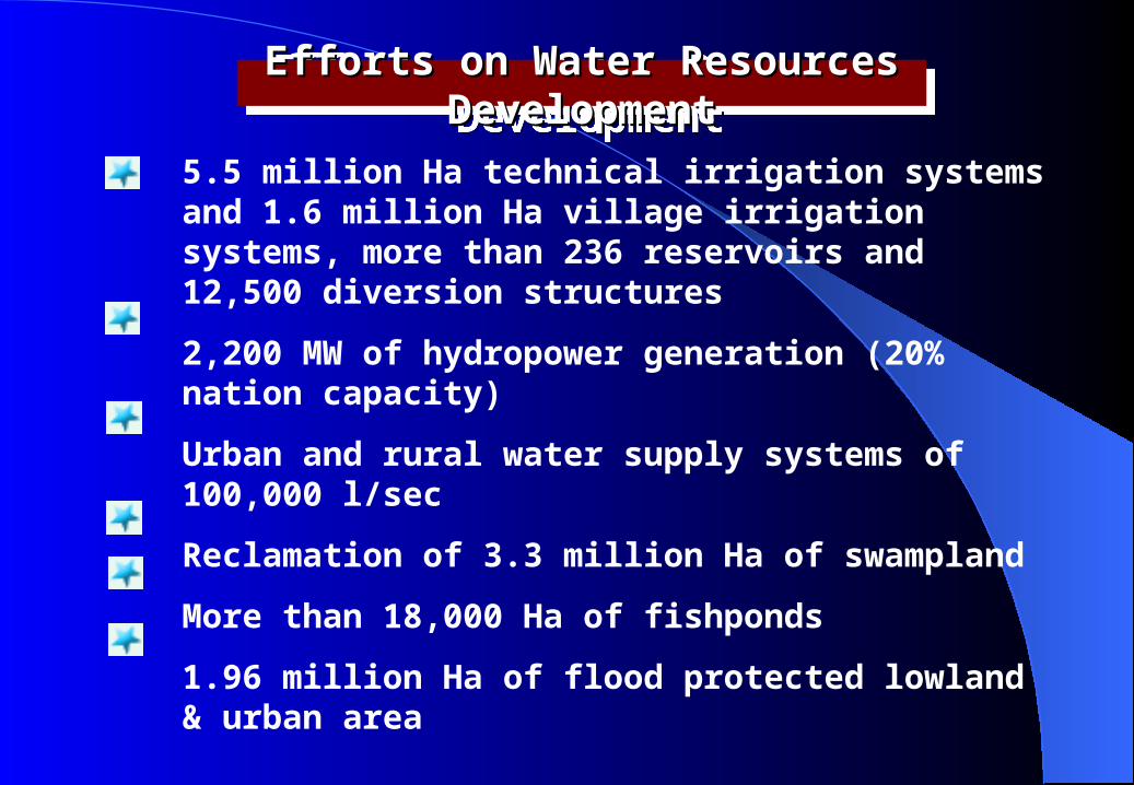
Efforts on Water Resources Efforts on Water Resources DevelopmentDevelopment
5.5 million Ha technical irrigation systems and 1.6 million Ha village irrigation systems, more than 236 reservoirs and 12,500 diversion structures2,200 MW of hydropower generation (20% nation capacity)Urban and rural water supply systems of 100,000 l/secReclamation of 3.3 million Ha of swamplandMore than 18,000 Ha of fishponds1.96 million Ha of flood protected lowland & urban area

Sustainable Irrigation Sustainable Irrigation SystemsSystems
Municipal and Industrial Municipal and Industrial Water SupplyWater Supply
Institution Deficiencies in Institution Deficiencies in WRM :WRM :
Water allocation priorities neither clarify the allocations amongst specific users, nor do they set priorities under long term and emergency shortages.Service on safe drinking of water is available to only part of the population.For what aspects of resource development and management should society pay? To what extend should activities be subsidized? Indonesia’s water resources sector faces increasingly complex long-term investment challenges and management problems

P.BETUAH
P.TABUAN
Campang
Batu Lunik
Tiram
Karangberak
Belimbin
g
W.Nipah
W.Awi
Way
Ngarip
Sanggi Gisting
Tl.Padang
RajabasaPekon Mah
TanjungpenaPendawan
Mendiri
Krui
PugungtampakLIWA
Pajarbulan
Bukit Kemuning
G.Labuhan
Baradatu
Kasui
G.Katon
Simpang empat
Belambangan Umpu
Mesir Ilir Pakuan
Ratu
Serupa Indah
Aji KagunganWay Rarem
Pringsewu
Gedung Tataan
Sukadana
Putih Doh
Panjang
Natar
Pugung RaharjoSribawono
Simpang
Labuhan Maringai
Negeri AgungJabung Asahan
Beringin
SidomulyoPalas
KALIANDA
Bakauheni
Penengahan
Ketapang
P.SEBESI
P.SEBUKU
P.SIUNCAL
P.LEGUNDI
Menggala
Pematang Panggang
Pagar Dewa Wira Laga
Tedung Geram
Sungai SidangTalang
BatuGedung Ajibaru
Rawa Jitu
Gedung Aji
TELUK SEMANGKA
S A M U D E R A I N D O N
E S I A
TELUK LAMPUNG
SELAT
SUNDA
LAUT
JAWA
PROPINSI BENGKULU
SUMATERA SELATAN PROVINCE
Bawan
g
Way Mesuji
Way Buyut
W a y P e d ad a
Way Terusa
n
pu
Way Pengubuan
Batang
Way
D.Jepara
Way Pisang
Wa y K
etib u
n g
Sulan Bekerang
Way
Sekampung
Way
Put ih
Way Ratai
Kanan
Way Pisa
ng
Way Tahmi
Way
Tangkas
Way Um
pu
Way
Kiri
Way Tulung Buyut
WayS
un
Way Abu
Way Sabuk
WayRa
Way
Tatayan
Waya
Way Tebu
Way Semak
Way Padang Rat
u
W.Menang
KananW.
M.Ki
ri
Way
Kota AgungWay
Sabu
Way
Sukadana
dung
Sen
Way
r
gkal
Way Tu lang
Way
ng
em
hari
Way
yangLem
Way
Way
Padang Ratu
Pemeriha
nRumbia
Seputih Surabaya
Way Se
putih
Seputih Raman
Way Ra
manSumberjaya
Way dis
Kan
D. RANAU
METRO
Seputih Banyak
IBUKOTA KECAMATAN
BATAS WILAYAH SUNGAI
IBUKOTA PROPINSIIBUKOTA KABUPATEN
BATAS PROPINSIBATAS KABUPATEN
JALAN NEGARAJALAN PROPINSIJALAN KERETA API
SUNGAI
AIRPORT
PELABUHAN
KETERANGAN :
Way Bungur
Tegineneng Brant
i
KOTABUMI
Besar
5
321
7
Simpang Pugung
Gunung Batin
6
4
8
31 BANDAR LAMPUNG
project area
The Irrigation Area of Way Sekampung, Lampung Province

Sanggi Gisting
Tl.Padang
Bukit Kemuning
G.Labuhan
Baradatu
G.Katon
Simpang empat
Belambangan Umpu
Mesir Ilir Pakuan Ratu
Serupa Indah
Aji KagunganWay Rarem
Pringsewu
Gedung Tataan
NatarPugung Raharjo
SribawonoSimpang
Labuhan Maringai
Negeri AgungJabung
Menggala
Gedung Aji
LAUT
JAWA
W a y P ed ad a
Way Terusa
n
Way Pengubuan
Way
Batanghari
Way
D.Jepara
Sulan Bekerang
WaySek
ampung
Way Pisa
ng
Way Ki
ri
Way TulungBuyut
WayS
un
Way Abu
Way Sabuk
Way Rare
m
Way
Tatayan
Waya
Way Semak
WayPadang
Way Ka
ndis
Besar
Suk a
dana
gkal
Way Tulang Bawang
Way Kanan
ng
Way Le
mpuyan
g
Way
Padang Ratu
Seputih Surabaya
Way
Seputih
Way Ra
manSumberjaya
Way
METRO
Seputih Banyak
Way Bungur
TeginenengBranti
KOTABUMI
3
21
7
Simpang Pugung
Gunung Batin
4
31 BANDAR LAMPUNG
1. DI. PUNGGUR UTARA 31.500 Ha2. DI. WAY BATANG HARI UTARA 7.226 Ha3. DI. WAY RAMAN UTARA 6.515 Ha4. DI. WAY BUNUT 7.233 Ha5. DI. WAY RUMBIA 17.334 Ha6. DI. WAY RUMBIA BARAT 5.790 Ha7. DI. WAY BEKRI 6.500 Ha 8. DI. WAY BATANG HARI 11.562 Ha
5
6
1 2
3
87
4
The Irrigation Area of Way Sekampung, Lampung Province

The Irrigation Area of Way Sekampung, Before and After Rehabilitation and Completing of Batutegi Dam
IrrigationArea Direct Return Total-1 Direct Return Total-2
Flow Flow Flow Flow Canal 420 - 420 463 - 463 Batanghari 7,600 - 7,600 11,562 - 11,562 Bunut 4,980 - 4,980 7,233 - 7,233 Punggur Utara 14,500 - 14,500 31,500 - 31,500 Ram an Utara - 3,000 3,000 2,565 3,950 6,515 Batanghari Utara - 3,900 3,900 3,176 4,050 7,226 Bekri - - - 6,500 - 6,500 Rum bia Barat - - - 5,790 - 5,790 Rum bia Barat - - - 14,551 2,783 17,334 Total Area 27,500 6,900 34,400 83,340 10,783 94,123
After Rehabilitation andCom pleting of Batutegi Dam
Before Rehabilitation