WATER RESOURCES ATLAS OF MADURAI DISTRICT
502
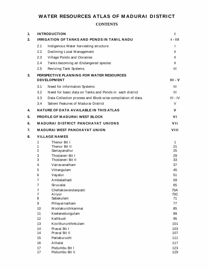
WATER RESOURCES ATLAS OF MADURAI DISTRICT CONTENTS 1. INTRODUCTION I 2. IRRIGATION OF TANKS AND PONDS IN TAMIL NADU I - III 2.1 Indigenous Water harvesting structure I 2.2 Declining Local Management II 2.3 Village Ponds and Ooranies II 2.4 Tanks becoming an Endangered species II 2.5 Reviving Tank Systems. III 3. PERSPECTIVE PLANNING FOR WATER RESOURCES DEVELOPMENT III - V 3.1 Need for information Systems III 3.2 Need for basic data on Tanks and Ponds in each district III 3.3 Data Collection process and Block-wise compilation of data. III - IV 3.4 Salient Features of Madurai District V 4. NATURE OF DATA AVAILABLE IN THIS ATLAS V 5. PROFILE OF MADURAI WEST BLOCK VI 6. MADURAI DISTRICT PANCHAYAT UNIONS VII 7. MADURAI WEST PANCHAYAT UNION VIII 8. VILLAGE NAMES 1 Thenur Bit I 1 1 Thenur Bit II 21 2 Samayanallur 25 3 Thodaneri Bit I 29 3 Thodaneri Bit II 33 4 Vairavanatham 37 5 Vittangulam 45 6 Vayalur 51 7 Ambalathadi 59 7 Siruvalai 65 7 Chellakowendanpatti 70A 7 Ariyur 70C 8 Sabakulam 71 9 Pillayarnatham 77 10 Moolakurchikanmai 85 11 Keelanedungulam 89 12 Kallikudi 95 13 Kovilkurunthnkulam 101 14 Pravai Bit I 103 14 Pravai Bit II 107 15 Pattakuruchi 111 16 Athalai 117 17 Podumbu Bit I 123 17 Podumbu Bit II 129
-
Upload
khangminh22 -
Category
Documents
-
view
3 -
download
0
Transcript of WATER RESOURCES ATLAS OF MADURAI DISTRICT
WATER RESOURCES ATLAS OF MADURAI DISTRICTCONTENTS
1. INTRODUCTION I2. IRRIGATION OF TANKS AND PONDS IN TAMIL NADU I - III
2.1 Indigenous Water harvesting structure I2.2 Declining Local Management II2.3 Village Ponds and Ooranies II2.4 Tanks becoming an Endangered species II2.5 Reviving Tank Systems. III
3. PERSPECTIVE PLANNING FOR WATER RESOURCESDEVELOPMENT III - V
3.1 Need for information Systems III3.2 Need for basic data on Tanks and Ponds in each district III3.3 Data Collection process and Block-wise compilation of data. III - IV3.4 Salient Features of Madurai District V
4. NATURE OF DATA AVAILABLE IN THIS ATLAS V
5. PROFILE OF MADURAI WEST BLOCK VI
6. MADURAI DISTRICT PANCHAYAT UNIONS VII
7. MADURAI WEST PANCHAYAT UNION VIII
8. VILLAGE NAMES1 Thenur Bit I 11 Thenur Bit II 212 Samayanallur 253 Thodaneri Bit I 293 Thodaneri Bit II 334 Vairavanatham 375 Vittangulam 456 Vayalur 517 Ambalathadi 597 Siruvalai 657 Chellakowendanpatti 70A7 Ariyur 70C8 Sabakulam 719 Pillayarnatham 7710 Moolakurchikanmai 8511 Keelanedungulam 8912 Kallikudi 9513 Kovilkurunthnkulam 10114 Pravai Bit I 10314 Pravai Bit II 10715 Pattakuruchi 11116 Athalai 11717 Podumbu Bit I 12317 Podumbu Bit II 129

18 KovilPappakudi 13519 Vilangudi Bit I 14319 Vilangudi Bit II 15320 Silayaneri 15721 Thathaneri 16322 Sellur 16523 B.B.kulam 16924 Sambandar Alangulam 17125 Anaiyur Bit I 17525 Anaiyur Bit II 18126 Mulagaranai 18727 Vagaikulam 19328 Malapangadi 19729 Keelapanangadi 20130 Veepankulam 20531 Boothagudi 21132 Vadugapatti 21933 Kulamangalam Bit I 22733 Kulamangalam Bit II 23534 Karuvanur 24135 Veerapandi Bit I 24935 Veerapandi Bit II 25536 Pechikulam 25937 Thirupalai Bit I 26737 Kannanendal Bit II 27737 Siruthur Bit III 28938 Athikulam 29939 Parasurampatti 30740 Paraiyathikulam 31141 Chokkikulam 315-31648 Iraniam 317 - 32449 Eluppaikudi 325 - 32850 Poonari 329 - 33251 Maranivariyandal 333 - 34052 Kannikudi 341 - 34453 Alathur 345 - 35454 Cheetikulam 355 - 36455 Koolapandi 365 - 37056 Kodimangalam 371 - 37657 Usilampatti 377 - 38458 Erukkalainatham 385 - 38859 Paraipatti 389 - 39460 Mandhikulam 395 - 40261 Periyapatti 403 - 40862 Kavanur 409 - 41663 Therkubethanpatti 417 - 42064 Poolampatti 421 - 42665 Malaipatti 427 - 43266 Velichanatham 433 - 44467 Chinnappatti 445 - 45668 Chatra thondamanpatti 457 - 46669 Manjampatti 467 - 48070 Kadavur 481 - 488

WATER RESOURCES ATLAS OF MADURAI DISTRICT
1. INTRODUCTION:
Water is a prime natural resource.
A basic human need. A precious national asset. Critical elements in development planning
According to our National Water Policy. Planning and development of water resources andtheir use needs to be governed by National perspective.
It has been estimated that out of the total precipitation of around 400 million ha.m.(4000billion cu.m.) in the country, surface water availability is about 178 million ha. m. (1780 billioncu.m.). Out of this, only about 50% can be put to beneficial use because of topographical and otherconstraints. In addition, there is a ground water potential of about 42 million ha.m. (420 billioncu.m.). The availability of water is highly uneven in space and time. Precipitation is confined toonly about three to four months with 20-45 significant rainy days in the year. Hence there is animperative need for effective collection of rain water for storing in appropriate places ( Reservoirs,Lakes, Tanks, Ponds and aquifers) in order to use the stored water efficiently for economical andsocial purposes.
Water as a resource is one and indivisible; rainfall, river water, surface ponds and lakes andground water are all parts of one system. Water is also a part of the larger eco system. Development& Economic growth inevitably lead to increasing demands for water for diverse purposes viz.domestic, industrial, agricultural, hydropower, navigation, recreation, etc. So far, the principalconsumptive use of water has been for irrigation. The demand for water for social and othereconomic uses is also increasing substantially. As a result, water which is already a scarce resourcewill become even more scarce in the near future.
2. IRRIGATION TANKS AND PONDS IN TAMILNADU:
2.1 Indigenous water harvesting structures:
The irrigation tanks and village ponds of South India are traditional Water harvesting struc-tures indigenously designed by native rulers and chieftains over the past severalcenturies and have been among the most important water resources for rural communities.
Tanks & Ponds :
Traditional Water harvesting structure.
Situates in drought-prone or low-level tracts.
Valuable assets to these communities.
multifarious uses - Irrigator.
Drinking water for humans - livestock - domestic needs - ground waterrecharging - firewood and timber production - fish farming, fodder development- silt for agricultural lands.
No better advocacy than the following observation made by the English Historian isneeded to stress the importance of safeguarding the sustainable use of tank systems to reapcontinued benefits.
I

“These are the monuments of real kings, who were the fathers of their people; testators to a posteritywhich they embraced as their own. These are the grand sepulchres built by ambition of an insatiablebenevolence, which not content with reigning in the dispensation of happiness during the contracted term ofhuman life, had strained with all the reachings and graspings of vivacious mind, to extend the domain oftheir bounty beyond the limits of nature, and to perpetuate themselves through generations, the guardians,the protectors, the nourishers of mankind”.
Edmund Burke 1785 on minor irrigation tanks in South India.
2.2 Declining local Management :
These minor irrigation tanks, numbering around 39000 in Tamilnadu were formerlycontrolled by village assemblies. During the medieval period, village communities owned andmanaged tank systems, collecting cess (water tax), and facilitating land transfers withoutinterference from the state. In the 18 th century, the British introduced private land ownershipthrough various settlements and tanks, like other village assets, became the property of the state.Presently in Tamilnadu, rainfed minor irrigation tanks with ayacuts of more than 40 ha andsystems tanks ( chain of tanks fed by river diversion systems are under the purview of the WaterResources Organization of Public Works Department, those rainfed tanks with ayacuts of less than40 ha. are maintained by Panchayat Unions. The latter are greater in number.
2.3 Village Ponds, Ooranies :
In addition to the multi – purpose minor irrigation tanks, the village communities haveformed small Ponds and Ooranies of their own ( In Tamil, “Oorani” means a water storage forthe consumption of the village community ) on need basis with their joint action so as to usethem for their cattle and other domestic purposes. They are as old as the village itself.
During 1980s, hundreds of Percolation ponds were constructed under various droughtrelief programmes such as JVVT, EAS etc in each district for the exclusive purpose of rechargingground water by storing the excess run-off during the monsoon seasons to benefit a number ofagricultural wells situated in their zone of influence.
2.4 Tanks becoming an Endangered species :
In many ways tanks are similar to endangered species . Tank system conditions aredeteriorating year by year. The area under tank irrigation in the state has declined from about 10lakh hectares in 1966-67 to about 6 lakh hectares in 1993-94. The reasons that could be attributedfor such a declining situation are;
Breakdown of traditional local irrigation institutions caused bycentralization
Encroachments and siltation in the water spread areas, supply channeland surplus courses.
Lack of farmer involvement and improper water use. Urbanisation. System failure. Meagre resource allocation.
II

2.5 Reviving Tank Systems :
Realizing the urgent need for the revival of the ingeniously designed Tanks and the Ponds aseffective water harvesting structures to meet the water requirement for the future generations, anumber of national and international agencies are showing interest in rehabilitating the tanksystems of the state. A number of research projects are also being undertaken to find out theproblems in tank systems and to suggest suitable policy measures for reviving the tank systems.
3. PERSPECTIVE PLANNING FOR WATER RESOURCES DEVELOPMENT :3.1 Need for Information system :
Water is one of the most crucial elements in development planning. Efforts to develop,conserve, utilize and manage this important resource have to be guided by national perspective.
The prime requisite for resource planning is a well – developed informationsystem. There is a strong need for establishing a standardized information system with a net workof data banks and data bases, integrating and strengthening the agencies at various levels andimproving the quality of data and processing capabilities. The water resources should be conservedand the availability augmented by measures for maximizing retention and minimizing losses.
R e s o u r c eplanning in the case of water has to be done for hydrological units such as drainage basin as awhole, or for a sub basin. The present administrative boundaries are also to be taken intoconsideration for co-ordinating the developmental activities concerned with water. Special multi –disciplinary units need to be set up in each district to prepare comprehensive plans taking intoaccount not-only the needs of irrigation, but also harmonizing various other uses. Recycling and re-use of water should be an integral part of water resources development & management. In view ofthe vital importance of water for human, animal and plant life, for maintaining ecological balanceand for economic and developmental activities of all kinds, considering its increasing scarcity,planning and management of this resource and its optimal, economical and equitable use hasbecome a matter of utmost urgency.
3.2 Need for basic data on Tanks and Ponds in each district :Statistical data on Tanks show different figures at the different points of time in each dis-trict. Further the available count of tanks and ponds do not provide any informationabout their exact locations, capacity, utility and present status. Hence researchers and theplanners are struggling to get even basic data on this important issue of water harvestingfor perspective planning to offset the uncertainities of water distribution in future.So, there is an urgent need for securing the basic data on the number of Tanks and Pondsavailable in each district and this would serve as a part of the Management I n f o r m a t i o nSystem.With this objective in mind, the District collector, Dr. Chandra Mohan B. I.A.S initiated anattempt to secure and compile all the data relevant to the surface water storage facilitiesavailable in Madurai district and their present status in order to facilitate planning forappropriate action by various Govt. and Non Govt. organizations.
3.3 Data collection process and Block-wise Compilation of data :To facilitate the collection of all the relevant data about the water bodies of Madurai dis-
trict (Reservoirs, Irrigation tanks, Village Ponds and Ooranies) a structured questionnaire(Schedule) was designed in consultation witht officials of WRO Agricultural Engineering,Survey, DRDA, Panchayat Unions and Revenue Department with the guidance of Dr.Chandra Mohan.B. I.A.S District Collector, Madurai.
The data collection was entrusted with Village Administrative Officers after giving theman orientation training by the DRO, Engineers of WRO, Agricultural Engineering and PanchayatUnions at various centers of the District so as to have right perception about the contents of theIII

“Schedule” and to emphasise the importance of their role in collecting the data accurately.
The data collected thus have been validated by conducting field verification. All the waterbodies available in Madurai district have been provided a unique by sequential alpha-numericidentifications code which is self descriptive.
An irrigation tank is codified with 9 or 10 alpha-numeric characters and a Pond (or) Ooranieis codified with 7 or 8 characters.
a) First two characters - Two alphabets to indicate the Block name.All the 13 Blocks in Madurai district arecodified with two alphabets as under.
MW - Madurai WestME - Madurai EastMR - MelurKP - KottampattyVP - VadipattyAN - AlanganallurTK - TirupparankundramTM - TirumangalamTP - T.KallupattySP - SedapattyUP - UsilampattyCP - ChellampattyKG - Kalligudi
b) 3rd, 4th, 5th Characters - Three digit numbers to indicate theRevenue Village code number as perrevenue records.
c) 6th Character - Alphabet T (or) P (or) O to indicatewhether it is a Tank (T) or Pond (P) orOoranie (O).
d) 7th Character - Alphabet S or R to indicate whether thetank is a System tank (S) or Rainfed tank(R). In case of Pond or Ooranie, the 7thcharacter will be a single or two digitsnumber to indicate their serial number inthat village.
e) 8th Character - In case of Tank, Alphabet W or U toindicate the ownership whether it is WRO(W) (PWD) or Panchayat Union (U).
f) 9th Character - This will be a single digit number in thecase of Tanks to indicate serial number oftank in that village.
Area mentioned in FMB is the total area of the field. The data collected in Madurai districthas been compiled as a separate volumes for each Block to facilitate easy reference to handling.
3.4 Salient Features of Madurai District :
Madurai District is in the South Central Region of Tamilnadu lying between longitudes
IV

77°2’ and 78°2’ and between latitudes 9°30’ and 10°27’. The general slope of Madurai District isfrom West to East. The other details of the district are furnished below:-
a) Geographical Area of the District : 3741.73 sq.km.
b) Major Watersheds (Basins) : Part of Gundar basinPart of Vaigai basin
c) Sources of Irrigation : i) Periyar Vaigai Irrigation systemirrigating about 57,000 ha.
ii) Sathyar Reservoir irrigating about200 ha.
iii) Minor Irrigation tanks.iv) Dug wells and Tube wells.
d) Area under cultivation : 150704 hae) Important crops : Paddy, Cholam, Cumbu, Sugarcane,
Groundnut, Banana, Cotton.
f) Reserve Forest : 412.79 ha.g) No. of Municipal Corporations : 1
h) No. of Revenue division : 2
i) No of Villages : 669j) No. of Taluks : 7
k) No. of Panchayat Unions (Blocks) : 13
l) No. of Village Panchyats : 431m) Population :
Male : 1295124 Rural Population : 1129028Female : 1276155 Urban Population : 1433251Total : 2562279 2562279
n) Climate and Rainfall :Madurai district experiences a hot summer from April to June and a cold season from
December to February with the maximum and minimum temperatures of 40°C and 22°Crespectively. The Wind velocity is 11km / hr and relative humidity is 75 % About 48 % of theannual average rainfall is received during North East Monsoon (October – December) about 28%during South West monsoon (June – September) and about 24 % during dry weather and summer(January – May). The Annual Average Rainfall in Madurai district is854.8 mm.
4. NATURE OF DATA AVAILABLE IN THIS ATLAS :
This Atlas has the following data compiled for Madurai Madurai west Block
1. Basic data for each Village with index map, abstract details of water bodies andwells available in each village.
2. Village Maps showing Village boundary, Hamlets, Tanks, Ponds & Ooranies.
3. FMB Extract for each Tank, Pond and Ooranie.4. Basic data for each water body, its present conditions, Pollution level, Task for
Intervention, etc.,
5. PROFILE OF MADURAI MADURAI WEST BLOCK :
V
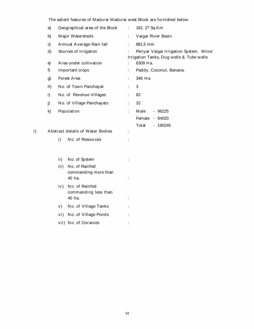
The salient features of Madurai Madurai west Block are furnished below.
a) Geographical area of the Block : 162. 27 Sq.Km
b) Major Watersheds : Vaigai River Basin
c) Annual Average Rain fall : 881.5 mm
d) Sources of Irrigation : Periyar Vaigai Irrigation System, MinorIrrigation Tanks, Dug wells & Tube wells
e) Area under cultivation : 6309 Ha.
f) Important crops : Paddy, Coconut, Banana.
g) Forest Area : 346 Ha
h) No. of Town Panchayat : 3
i) No. of Revenue Villages : 82
j) No. of Village Panchayats : 32
k) Population : Male - 96225
Female - 94020
Total - 190245l) Abstract details of Water Bodies :
i) No. of Resources :
ii) No. of System :iii) No. of Rainfed
commanding more than40 ha. :
iv) No. of Rainfedcommanding less than40 ha. :
v) No. of Village Tanks :
vi) No. of Village Ponds :
vii) No. of Ooranies :
VI
Village Data . . .

Co-ordinated & Compiled by
Thiru. K. Asaithambi - District Revenue Officer, Madurai.
District Rural Development Agency :
Thiru. F. Abdul Razick - Project Officer, DRDA, Madurai.Thiru.G. Sankara Subramanian B.E., M.Tech., - Executive Engineer (RD)
Public Works Department :Er. C.P. Mohan Kumar B.E., - Junior Engineer
Gundar / Vaippar Division :Er. S. Kannappan B.E., - Executive EngineerEr. Chandrasekaran B.E., - Assistant Executive Eng.Er. Sugumaran B.E., - Assistant EngineerEr. L. Gurusamy - Junior Engineer
Panchayat Development Department :Thiru. S. Periyasamy - P.A. to Collector, Madurai.Thiru. R. Venkatachalam B.Com., - Assistant Director (Panchayat)
Agriculture Department :A. Kannan M.Sc., (Ag) - P.A. (Agri)G. Baskararaj M.Sc., (Ag) - Agricultural OfficerJ. Pandian B.Sc., (Ag) - Asst. Agricultural Officer
Survey Department :M. Ramasami - Assistant Director (Survey)K. Subash Chandra Bose - Manager Technical
& Madurai west Block Survey Department Staff
Madurai west Block :Thiru. V. Sivamani - Block Development OfficerThiru. K.S. Sankaraiah - Additional Block Development Officer
All Village Administrative Officers. & All Field Staff.

Co-ordinated & Compiled by
Thiru. K. Asaithambi - District Revenue Officer, Madurai.
District Rural Development Agency :
Thiru. Kirloskumar I.A.S., - Project Officer, DRDA, Madurai.Thiru.G. Sankara Subramanian B.E., M.Tech., - Executive Engineer (RD)
Public Works Department :Er. C.P. Mohan Kumar B.E., - Junior Engineer
Gundar / Vaippar Division :Er. S. Kannappan B.E., - Executive EngineerEr. Chandrasekaran B.E., - Assistant Executive Eng.Er. Sugumaran B.E., - Assistant EngineerEr. L. Gurusamy - Junior Engineer
Panchayat Development Department :Thiru. S. Periyasamy - P.A. to Collector, Madurai.Thiru. R. Venkatachalam B.Com., - Assistant Director (Panchayat)
Agriculture Department :A. Kannan M.Sc., (Ag) - P.A. (Agri)G. Baskararaj M.Sc., (Ag) - Agricultural OfficerJ. Pandian B.Sc., (Ag) - Asst. Agricultural Officer
Survey Department :M. Ramasami - Assistant Director (Survey)K. Subash Chandra Bose - Manager Technical
&Madurai west Block Survey Department Staff
Madurai west Block :Thiru. V. Sivamani - Block Development OfficerThiru. K.S. Sankaraiah - Additional Block Development Officer
All Village Administrative Officers. & All Field Staff.

VILLAGE DATA . . .

D. Raajendiran I.A.S.,District Collector,Madurai District.
PREFACE
Tamilnadu is one of the tank intensive States in the country and accounts for about17% of the total existing.
One third of the area, nearly a million hectares, is irrigated through the tanks andhence their upkeep and development is most important for the agricultural production ofstate.
Moreover other water bodies like Ponds and Ooranies are catering the needs oflivestock, irrigations (partly) and drinking. In order to upkeep the water bodies ingood condition, it is of utmost importance to know the details of waterbodies. Forthis purpose this atlas is prepared and documented for usage by all departments,NGO’s and public.
Thiru. B. Chandra Mohan, I.A.S. former collector, Madurai District, took greaterinterest and initiated this Atlas preparation work.
The Process of documentation of water bodies by name WATER RESOURCESATLAS - Madurai west Block reaches another milestone through this publication.
District CollectorMadurai.

Water Resources Atlas of Madurai District Madurai West Block
1
001 - THENUR PIT I
1.1. VILLAGE DATA :
This Village comes under Madurai North Taluk and Madurai West Block. It has
0 hamlets with a total Population. The Area of this Village is 358.04.0 Hectares. Latitude
is 9059’00” and Longitude is 78001’00” . The splitup of Hamlets & Population are as
follows :
1.2. INDEX MAP :
1.3. WATER BODIES :
This Village has 9 Water Bodies : 6 Tank, 1 Ooranie, 2 Ponds.
Tank Ooranie
No. of Tank 6 No. of Ooranie Drinking Water Cattle
PWD System 6 1 0 1
PWD Non System 0 Pond
Panchayat Union 0 No. of Pond Drinking Water Cattle
Ex - Zamin 0 2 0 2
1.3.1. No. of Wells :
Thenur Bit I has no wells.
Situation : This Village is Situated 16 K.m. distant South of Madurai and on the Madurai to Solavandan Road.
MADURAI
THENUR
SHOLAVANDAN
DINDIGUL
THATCHAMUTHU

Water Resources Atlas of Madurai District Madurai West Block
2

Water Resources Atlas of Madurai District Madurai West Block
3
1.4. PARTICULARS OF TANKS :
1.4.1. Kulam - Code : MW001TSW1 - Basic Data :
Ayacut : -
SF No. / Extent : 23 Ha
Basin : -
Bund Length (m) : -
Bund Width (m) : -
No. of Sluices : -
Sill Level of Sluices (m) : -
Length of Weir (m) : -
Length of Byewash : -
FTL (m) : -
MWL (m) : -
TBL (m) : -
Capacity of Tank (MCFT) : -
Free Catchment (Sq.Km.) : -
Combined Catchment (Sq.Km.) : -
Area of Water Spread at FTL (Sq.Km.) : -
Max. Width of Water Spread at FTL(m) : -
Source of Supply : -
Supply Channels : -
Supply Channel Length : -
1.4.1.1. Present Condition :
Tank : -Weir : -Capacity (Mcft) : -Bund Length (M) : -Bund Condition : -Encroachment in Extent : -Encroachment in No’s : -
Encroachment Nature : -
1.4.1.2. Pollution :
There is no Pollution of this Tank.
1.4.1.3. Task for Intervention :
Supply Channels Desilting Required.
1.4.1.4. Distribution Channel :
There are 3 Distribution channel for this Tank.

Water Resources Atlas of Madurai District Madurai West Block
4
Thenur Bit I - Kulam
SF No. : 23, Area : 6. 23.0 Ha, Code No. : MW001TSW1
Scale 1mm = 2000mm

Water Resources Atlas of Madurai District Madurai West Block
5
1.4. PARTICULARS OF TANKS :
1.4.2. Kulam - Code : MW001TSW2 - Basic Data :
Ayacut : -
SF No. / Extent : 25 Ha
Basin : -
Bund Length (m) : -
Bund Width (m) : -
No. of Sluices : -
Sill Level of Sluices (m) : -
Length of Weir (m) : -
Length of Byewash : -
FTL (m) : -
MWL (m) : -
TBL (m) : -
Capacity of Tank (MCFT) : -
Free Catchment (Sq.Km.) : -
Combined Catchment (Sq.Km.) : -
Area of Water Spread at FTL (Sq.Km.) : -
Max. Width of Water Spread at FTL(m) : -
Source of Supply : -
Supply Channels : -
Supply Channel Length : -
1.4.2.1. Present Condition :
Tank : -Weir : -Capacity (Mcft) : -Bund Length (M) : -Bund Condition : -Encroachment in Extent : -Encroachment in No’s : -
Encroachment Nature : -
1.4.2.2. Pollution :
There is no Pollution of this Tank.
1.4.2.3. Task for Intervention :
Supply Channels Desilting Required.
1.4.2.4. Distribution Channel :
There are 3 Distribution channel for this Tank.

Water Resources Atlas of Madurai District Madurai West Block
6
Thenur Bit I - Kulam
SF No. : 25, Area : 17. 11.5Ha, Code No. : MW001TSW2

Water Resources Atlas of Madurai District Madurai West Block
7
1.4. PARTICULARS OF TANKS :
1.4.3. Kulam - Code : MW003TSW3 - Basic Data :
Ayacut : -
SF No. / Extent : 9 Ha
Basin : -
Bund Length (m) : -
Bund Width (m) : -
No. of Sluices : -
Sill Level of Sluices (m) : -
Length of Weir (m) : -
Length of Byewash : -
FTL (m) : -
MWL (m) : -
TBL (m) : -
Capacity of Tank (MCFT) : -
Free Catchment (Sq.Km.) : -
Combined Catchment (Sq.Km.) : -
Area of Water Spread at FTL (Sq.Km.) : -
Max. Width of Water Spread at FTL(m) : -
Source of Supply : -
Supply Channels : -
Supply Channel Length : -
1.4.3.1. Present Condition :
Tank : -Weir : -Capacity (Mcft) : -Bund Length (M) : -Bund Condition : -Encroachment in Extent : -Encroachment in No’s : -
Encroachment Nature : -
1.4.3.2. Pollution :
There is no Pollution of this Tank.
1.4.3.3. Task for Intervention :
Supply Channels Desilting Required.
1.4.3.4. Distribution Channel :
There are 3 Distribution channel for this Tank.

Water Resources Atlas of Madurai District Madurai West Block
8
Scale 1mm = 2000 mm
Thenur Bit I - Kulam
SF No. : 9, Area : 3. 77.0 Ha, Code No. : MW001TSW3

Water Resources Atlas of Madurai District Madurai West Block
9
1.4. PARTICULARS OF TANKS :
1.4.4. Kulam - Code : MW001TSW4 - Basic Data :
Ayacut : -
SF No. / Extent : 109 Ha
Basin : -
Bund Length (m) : -
Bund Width (m) : -
No. of Sluices : -
Sill Level of Sluices (m) : -
Length of Weir (m) : -
Length of Byewash : -
FTL (m) : -
MWL (m) : -
TBL (m) : -
Capacity of Tank (MCFT) : -
Free Catchment (Sq.Km.) : -
Combined Catchment (Sq.Km.) : -
Area of Water Spread at FTL (Sq.Km.) : -
Max. Width of Water Spread at FTL(m) : -
Source of Supply : -
Supply Channels : -
Supply Channel Length : -
1.4.4.1. Present Condition :
Tank : -Weir : -Capacity (Mcft) : -Bund Length (M) : -Bund Condition : -Encroachment in Extent : -Encroachment in No’s : -
Encroachment Nature : -
1.4.4.2. Pollution :
There is no Pollution of this Tank.
1.4.4.3. Task for Intervention :
Supply Channels Desilting Required.
1.4.4.4. Distribution Channel :
There are 3 Distribution channel for this Tank.

Water Resources Atlas of Madurai District Madurai West Block
10
Scale 1mm = 2000 mm
Thenur Bit I - Kulam
SF No. : 109, Area : 1. 11.5Ha, Code No. : MW001TSW4

Water Resources Atlas of Madurai District Madurai West Block
11
1.4. PARTICULARS OF TANKS :
1.4.5. Kulam - Code : MW001TSW5 - Basic Data :
Ayacut : -
SF No. / Extent : 41 Ha
Basin : -
Bund Length (m) : -
Bund Width (m) : -
No. of Sluices : -
Sill Level of Sluices (m) : -
Length of Weir (m) : -
Length of Byewash : -
FTL (m) : -
MWL (m) : -
TBL (m) : -
Capacity of Tank (MCFT) : -
Free Catchment (Sq.Km.) : -
Combined Catchment (Sq.Km.) : -
Area of Water Spread at FTL (Sq.Km.) : -
Max. Width of Water Spread at FTL(m) : -
Source of Supply : -
Supply Channels : -
Supply Channel Length : -
1.4.5.1. Present Condition :
Tank : -Weir : -Capacity (Mcft) : -Bund Length (M) : -Bund Condition : -Encroachment in Extent : -Encroachment in No’s : -
Encroachment Nature : -
1.4.5.2. Pollution :
There is no Pollution of this Tank.
1.4.5.3. Task for Intervention :
Supply Channels Desilting Required.
1.4.5.4. Distribution Channel :
There are 3 Distribution channel for this Tank.

Water Resources Atlas of Madurai District Madurai West Block
12
Thenur Bit I - Kulam
SF No. : 41, Area : 1. 45.5 Ha, Code No. : MW001TSW5
Scale 1mm = 1000mm

Water Resources Atlas of Madurai District Madurai West Block
13
1.4. PARTICULARS OF TANKS :
1.4.6. Kulam - Code : MW001TSW6 - Basic Data :
Ayacut : -
SF No. / Extent : 43 Ha
Basin : -
Bund Length (m) : -
Bund Width (m) : -
No. of Sluices : -
Sill Level of Sluices (m) : -
Length of Weir (m) : -
Length of Byewash : -
FTL (m) : -
MWL (m) : -
TBL (m) : -
Capacity of Tank (MCFT) : -
Free Catchment (Sq.Km.) : -
Combined Catchment (Sq.Km.) : -
Area of Water Spread at FTL (Sq.Km.) : -
Max. Width of Water Spread at FTL(m) : -
Source of Supply : -
Supply Channels : -
Supply Channel Length : -
1.4.6.1. Present Condition :
Tank : -Weir : -Capacity (Mcft) : -Bund Length (M) : -Bund Condition : -Encroachment in Extent : -Encroachment in No’s : -
Encroachment Nature : -
1.4.6.2. Pollution :
There is no Pollution of this Tank.
1.4.6.3. Task for Intervention :
Supply Channels Desilting Required.
1.4.6.4. Distribution Channel :
There are 3 Distribution channel for this Tank.

Water Resources Atlas of Madurai District Madurai West Block
14
Thenur Bit I - Kulam
SF No. : 43 , Area : 17. 11.5Ha, Code No. : MW001TSW6
Scale 1mm = 2000mm

Water Resources Atlas of Madurai District Madurai West Block
15
1.5. PARTICULARS OF OORANIES :
1.5.1. Ooranie - Code : MW001-O-1 - Basic Data :
Survey Field No. : 6Extent : -Source of Supply : -Length (m) : -Breadth (m) : -Purpose (Drinking Water / Cattle) : -Present Status : -
1.5.1.1. Pollution :
There is no pollution of this Ooranie.
1.5.1.2. Task for Intervention :Desilting, strengthening are required for this Ooranie. There is no encroach-
ment.

Water Resources Atlas of Madurai District Madurai West Block
16
Thenur Bit I - Ooranie
SF No. : 6 , Area : 16. 60.0 Ha, Code No. : MW001-O-1
Scale 1mm = 5000mm

Water Resources Atlas of Madurai District Madurai West Block
17
1.6. PARTICULARS OF PONDS :
1.6.1. Pond - Code : MW001-P-1 - Basic Data :
Survey Field No. : 55Extent : -Source of Supply : -Length (m) : -Breadth (m) : -Purpose (Drinking Water / Cattle) : -Present Status : -
1.6.1.1. Pollution :
There is no pollution of this Pond.
1.6.1.2. Task for Intervention :Desilting, strengthening are required for this Pond. There is no encroachment.
1.6. PARTICULARS OF PONDS :
1.6.2. Pond - Code : MW001-P-2 - Basic Data :
Survey Field No. : 56Extent : -Source of Supply : -Length (m) : -Breadth (m) : -Purpose (Drinking Water / Cattle) : -Present Status : -
1.6.2.1. Pollution :
There is no pollution of this Pond.
1.6.2.2. Task for Intervention :Desilting, strengthening are required for this Pond. There is no encroachment.

Water Resources Atlas of Madurai District Madurai West Block
18
Thenur Bit I -Pond
SF No. : 55 , Area : 2. 28.5 Ha, Code No. : MW001-P-1
Scale 1mm = 2000mm

Water Resources Atlas of Madurai District Madurai West Block
19
Thenur Bit I -Pond
SF No. : 56 , Area : 2. 05.5 Ha, Code No. : MW001-P-2
Scale 1mm = 1000mm

Water Resources Atlas of Madurai District Madurai West Block
20

Water Resources Atlas of Madurai District Madurai West Block
21
001A - THENUR BIT II
1.1. VILLAGE DATA :
This Village comes under Madurai North Taluk and Madurai West Block. It has
0 hamlets with a total Population. The Area of this Village is 358.04.0 Hectares. Latitude
is 9059’00” and Longitude is 78001’00” . The splitup of Hamlets & Population are as
follows :
1.2. INDEX MAP :
1.3. WATER BODIES :
This Village has 8 Water Bodies : 6 Tank, 2 Ooranie, 2 Ponds.
Tank Ooranie
No. of Tank 6 No. of Ooranie Drinking Water Cattle
PWD System 6 2 0 2
PWD Non System 0 Pond
Panchayat Union 0 No. of Pond Drinking Water Cattle
Ex - Zamin 0 2 0 2
1.3.1. No. of Wells :
Thenur Bit II has no wells.
Situation : This Village is Situated 16 K.m. distant South of Madurai and on the Madurai to Solavandan Road.
MADURAI
THENUR
SHOLAVANDAN
DINDIGUL
THATCHAMUTHU

Water Resources Atlas of Madurai District Madurai West Block
22

Water Resources Atlas of Madurai District Madurai West Block
23
1.5. PARTICULARS OF OORANIES :
1.5.1. Ooranie - Code : MW001-O-1 - Basic Data :
Survey Field No. : 147Extent : -Source of Supply : -Length (m) : -Breadth (m) : -Purpose (Drinking Water / Cattle) : -Present Status : -
1.5.1.1. Pollution :
There is no pollution of this Ooranie.
1.5.1.2. Task for Intervention :Desilting, strengthening are required for this Ooranie. There is no encroachment.

Water Resources Atlas of Madurai District Madurai West Block
24
Thenur Bit II -Ooranie
SF No. : 147, Area : 17. 11.5Ha, Code No. : MW001-O-2

Water Resources Atlas of Madurai District Madurai West Block
25
002 - SAMAYANALLUR
2.1. VILLAGE DATA :
This Village comes under Madurai North Taluk and Madurai West Block. It has
0 hamlets with a total Population. The Area of this Village is 358.04.0 Hectares. Latitude
is 9059’00” and Longitude is 78002’00” . The splitup of Hamlets & Population are as
follows :
2.2. INDEX MAP :
2.3. WATER BODIES :
This Village has 1 Water Bodies : 1 Tank.
Tank Ooranie
No. of Tank 1 No. of Ooranie Drinking Water Cattle
PWD System 1 0 0 0
PWD Non System 0 Pond
Panchayat Union 0 No. of Pond Drinking Water Cattle
Ex - Zamin 0 0 0 0
2.3.1. No. of Wells :
Samayanallur has no wells.
Situation : This Village is Situated 7.2 K.m. distant West of Madurai, 0.1 K.m. distant from Samayanallur temple and on the Madurai to Andipatti Road.
MADURAI
SAMAYANALLUR
BLACK

Water Resources Atlas of Madurai District Madurai West Block
26

Water Resources Atlas of Madurai District Madurai West Block
27
2.4. PARTICULARS OF TANKS :
2.4.2. Arasan Kulam - Code : MW002TSW1 - Basic Data :
Ayacut : 55.11
SF No. / Extent : 27/1,46.10.0
Basin : Cholavandan
Bund Length (m) : 1077
Bund Width (m) : 2.00
No. of Sluices : 03
Sill Level of Sluices (m) : 3.151
Length of Weir (m) : 40.23
Length of Byewash : -
FTL (m) : 153.060
MWL (m) : 153.495
TBL (m) : 154.495
Capacity of Tank (MCFT) : 13.25
Free Catchment (Sq.Km.) : 10.70
Combined Catchment (Sq.Km.) : 18.70
Area of Water Spread at FTL (Sq.Km.) : 0.4063
Max. Width of Water Spread at FTL(m) : 792
Source of Supply : -
Supply Channels : -
Supply Channel Length : -
2.4.1.1. Present Condition :
Tank : -Weir : -Capacity (Mcft) : -Bund Length (M) : 1077Bund Condition : -Encroachment in Extent : -Encroachment in No’s : -
Encroachment Nature : -
2.4.1.2. Pollution :
There is no Pollution of this Tank.
2.4.1.3. Task for Intervention :
Supply Channels Desilting Required.
2.4.1.4. Distribution Channel :
There are 3 Distribution channel for this Tank.

Water Resources Atlas of Madurai District Madurai West Block
28
Samayanallur - Arasankulam
SF No. : 27, Area : 47. 23.5Ha, Code No. : MW002TSW1
Scale 1mm = 5000mm

Water Resources Atlas of Madurai District Madurai West Block
29
003 - THODANERI BIT I
3.1. VILLAGE DATA :
This Village comes under Madurai North Taluk and Madurai West Block. It has
5 hamlets with a total Population of 1450. The Area of this Village is 301.09.0 Hectares.
Latitude is 10000’00” and Longitude is 78002’20” . The splitup of Hamlets & Population
are as follows :
3.2. INDEX MAP :
3.3. WATER BODIES :
This Village has 1 Water Bodies : 1 Tanks
Tank Ooranie
No. of Tank 1 No. of Ooranie Drinking Water Cattle
PWD System 0 0 0 0
PWD Non System 1 Pond
Panchayat Union 0 No. of Pond Drinking Water Cattle
Ex - Zamin 0 0 0 0
3.3.1. No. of Wells :
Thodaneri Bit I has a total of 40 wells out of which 19 are open wells, 19 open
wells in ayacut area, 1 tube wells and 1 tube wells in ayacut area.
Situation : This Village is Situated 20.0 K.m. distant from North West of Madurai, 1.0 K.m.
distant from Samayanallur Railway Station. 2.0 K.m. distant from Madurai to Dindigul Road.
VADIPATTI
MADURAI (D)SAMAYANALLUR
12 K.m.
6 K.m
.
MADURAI NORTH (T)
5 K.m
.WEST BLOCK
2K.m
.
DOTANERI14 K.m.

Water Resources Atlas of Madurai District Madurai West Block
30

Water Resources Atlas of Madurai District Madurai West Block
31
3.4. PARTICULARS OF TANKS :
3.4.1. Pannamoopanpatti PeriyaKanmai - Code : MW003TSU1 - Basic Data :
Ayacut : 115.49.5 Ha
SF No. / Extent : 22/-, 92.59.0 Ha
Basin : Thekkar Minor Basin
Bund Length (m) : 3190
Bund Width (m) : 2.00
No. of Sluices : 05
Sill Level of Sluices (m) : 154.360
Length of Weir (m) : 138.07
Length of Byewash : -
FTL (m) : 156.720
MWL (m) : 157.470
TBL (m) : 158.470
Capacity of Tank (MCFT) : 1.48
Free Catchment (Sq.Km.) : 13.04
Combined Catchment (Sq.Km.) : 103.603
Area of Water Spread at FTL (Sq.Km.) : 1.67
Max. Width of Water Spread at FTL(m) : 1100
Source of Supply : -
Supply Channels : -
Supply Channel Length : -
3.4.1.1. Present Condition :
Tank : -Weir : -Capacity (Mcft) : -Bund Length (M) : 3090Bund Condition : -Encroachment in Extent : 0.205Encroachment in No’s : 3
Encroachment Nature : Coconut Trees and palm trees
3.4.1.2. Pollution :
There is no Pollution of this Tank.
3.4.1.3. Task for Intervention :
Supply Channels Desilting Required.
3.4.1.4. Distribution Channel :
There are 1 Distribution channel for this Tank.

Water Resources Atlas of Madurai District Madurai West Block
32
Thodaneri Pit I - Kulam
SF No. : 22, Area : 92. 59.0Ha, Code No. : MW003-TSW1
Scale 1mm = 5000mm

Water Resources Atlas of Madurai District Madurai West Block
33
003 - THODANERI PIT II
3.1. VILLAGE DATA :
This Village comes under Madurai North Taluk and Madurai West Block. The
Area of this Village is 166.28.0 Hectares. Latitude is 9059’30” and Longitude is
78002’20” . The splitup of Hamlets & Population are as follows :
3.2. INDEX MAP :
3.3. WATER BODIES :
This Village has 1 Water Bodies : 1 Ooranie
Tank Ooranie
No. of Tank 0 No. of Ooranie Drinking Water Cattle
PWD System 0 1 0 1
PWD Non System 0 Pond
Panchayat Union 0 No. of Pond Drinking Water Cattle
Ex - Zamin 0 0 0 0
3.3.1. No. of Wells :
Thodaneri Bit II has a total of 113.66 wells out of which 32 are open wells,
60.48.0 open wells in ayacut area, 4 tube wells and 17.18.0 tube wells in ayacut
area.
Situation : This Village is Situated 20.0 K.m. distant from North West of Madurai, 1.0 K.m.
distant from Samayanallur Railway Station. 2.0 K.m. distant from Madurai to Dindigul Road.
VADIPATTI
MADURAI (D)SAMAYANALLUR
12 K.m.
6 K.m.
MADURAI NORTH (T)
5 K.
m.WEST BLOCK
2K.m
.
DOTANERI14 K.m.

Water Resources Atlas of Madurai District Madurai West Block
34

Water Resources Atlas of Madurai District Madurai West Block
35
1.6. PARTICULARS OF OORANIES :
1.6.1. Petchiyendhal Ooranie - Code : MW003-O-1 - Basic Data :
Survey Field No. : 52.2Extent : 0.97.5Source of Supply : -Length (m) : 60Breadth (m) : 110Purpose (Drinking Water / Cattle) : CattlePresent Status : Good
1.6.1.1. Pollution :
There is no pollution of this Ooranie.
1.6.1.2. Task for Intervention :Desilting, strengthening are required for this Ooranie. There is no encroachment.

Water Resources Atlas of Madurai District Madurai West Block
36
Thodaneri Pit II - Ooranie
SF No. : 52, Area : 0.98.5 Ha, Code No. : MW003-O-1
Scale 1mm = 1000mm

Water Resources Atlas of Madurai District Madurai West Block
37
004 - VAIRAVANATHAM
4.1. VILLAGE DATA :
This Village comes under Madurai North Taluk and Madurai West Block. It
has 5 hamlets with a total Population of 1450. The Area of this Village is 301.09.0
Hectares. Latitude is 10001’30” and Longitude is 78003’00” . The splitup of Hamlets
& Population are as follows :
4.2. INDEX MAP :
4.3. WATER BODIES :
This Village has 1 Water Bodies : 1 Tanks and 3 Ooranies.
Tank Ooranie
No. of Tank 1 No. of Ooranie Drinking Water Cattle
PWD System 0 3 0 3
PWD Non System 1 Pond
Panchayat Union 0 No. of Pond Drinking Water Cattle
Ex - Zamin 0 0 0 0
4.3.1. No. of Wells :
Vairavanatham has a total of 182 wells out of which 88 are open wells, 88
open wells in ayacut area, 3 tube wells and 3 tube wells in ayacut area.
Situation : This Village is Situated 22.0 K.m. distant from North West of Madurai, 7.0 K.m. distant from Samayanallur Railway Station.
VADIPATTI
MADURAI (D)MADURAI NORTH (T)MADURAI WEST (B)
SAMAYANALLUR
16 K.m.
VAIRAVANATHAM6
K.m
.

Water Resources Atlas of Madurai District Madurai West Block
38

Water Resources Atlas of Madurai District Madurai West Block
39
4.4. PARTICULARS OF TANKS :
4.4.1. Vairavanatham Kanmai - Code : MW004TSW1 - Basic Data :
Ayacut : 220Ha
SF No. / Extent : 24/-, 6-090.0.39-9.06.0 Ha
Basin : -
Bund Length (m) : 1230
Bund Width (m) : 2.00
No. of Sluices : 03
Sill Level of Sluices (m) : 162.495
Length of Weir (m) : 27.45
Length of Byewash : -
FTL (m) : 162.495
MWL (m) : 162.890
TBL (m) : 163.805
Capacity of Tank (MCFT) : 3.26
Free Catchment (Sq.Km.) : 0.70
Combined Catchment (Sq.Km.) : 1.32
Area of Water Spread at FTL (Sq.Km.) : -
Max. Width of Water Spread at FTL(m) : -
Source of Supply : -
Supply Channels : -
Supply Channel Length : -
4.4.1.1. Present Condition :
Tank : -Weir : -Capacity (Mcft) : -Bund Length (M) : -Bund Condition : -Encroachment in Extent : -Encroachment in No’s : -
Encroachment Nature : -
4.4.1.2. Pollution :
There is no Pollution of this Tank.
4.4.1.3. Task for Intervention :
Supply Channels Desilting Required.
4.4.1.4. Distribution Channel :
There are 3 Distribution channel for this Tank.

Water Resources Atlas of Madurai District Madurai West Block
40
Vairavanatham - Vairavanatham Kanmai
SF No. : 24, Area : 3.77.5 Ha, Code No. : MW004-TSW1
Scale 1mm = 1000mm

Water Resources Atlas of Madurai District Madurai West Block
41
4.6. PARTICULARS OF OORANIES :
4.6.1. Ooranie - Code : MW004-O-1 - Basic Data :
Survey Field No. : 9-2Extent : 0.20.0Source of Supply : Rain waterLength (m) : 28.00Breadth (m) : 60.00Purpose (Drinking Water / Cattle) : CattlePresent Status : Good
4.6.1.1. Pollution :
There is no pollution of this Ooranie.
4.6.1.2. Task for Intervention :Desilting, strengthening are required for this Ooranie. There is no encroachment.
4.6. PARTICULARS OF OORANIES :
4.6.1. Ooranie - Code : MW004-O-1 - Basic Data :
Survey Field No. : 83-6Extent : 0.42.5Source of Supply : Rain waterLength (m) : 60.00Breadth (m) : 38.00Purpose (Drinking Water / Cattle) : CattlePresent Status : Good
4.6.1.1. Pollution :
There is no pollution of this Ooranie.
4.6.1.2. Task for Intervention :Desilting, strengthening are required for this Ooranie. There is no encroachment.
4.6. PARTICULARS OF OORANIES :
4.6.1. Ooranie - Code : MW004-O-1 - Basic Data :
Survey Field No. : 111-4Extent : 0.51.5Source of Supply : Rain waterLength (m) : -Breadth (m) : -Purpose (Drinking Water / Cattle) : -Present Status : -
4.6.1.1. Pollution :
There is no pollution of this Ooranie.
4.6.1.2. Task for Intervention :Desilting, strengthening are required for this Ooranie. There is no encroachment.

Water Resources Atlas of Madurai District Madurai West Block
42
Vairavanatham - Ooranie
SF No. : 9, Area : 1.69.5 Ha, Code No. : MW004-O-1
Scale 1mm = 1000mm

Water Resources Atlas of Madurai District Madurai West Block
43
Vairavanatham - Ooranie
SF No. : 83, Area : 1.9.0 Ha, Code No. : MW004-O-2
Scale 1mm = 1000mm

Water Resources Atlas of Madurai District Madurai West Block
44
Vairavanatham - Kamali Ooranie
SF No. : 111, Area : 4.24.0 Ha, Code No. : MW004-O-3
Scale 1mm = 2000mm

Water Resources Atlas of Madurai District Madurai West Block
45
005 - VITANKULAM
5.1. VILLAGE DATA :
This Village comes under Madurai North Taluk and Madurai West Block. It
has 0 hamlets with a total Population 573. The Area of this Village is 358.04.0
Hectares. Latitude is 9059’00” and Longitude is 78001’00” . The splitup of Hamlets
& Population are as follows :
5.2. INDEX MAP :
5.3. WATER BODIES :
This Village has 8 Water Bodies : 6 Tank, 2 Ooranie, 2 Ponds.
Tank Ooranie
No. of Tank 1 No. of Ooranie Drinking Water Cattle
PWD System 1 1 0 1
PWD Non System 0 Pond
Panchayat Union 0 No. of Pond Drinking Water Cattle
Ex - Zamin 0 2 0 0
5.3.1. No. of Wells :
Vitankulam has a total of 42 wells out of which 20 are open wells, 20 open
wells in ayacut area, 1 tube wells and 1 tube wells in ayacut area.
Situation : This Village is Situated 23.0 K.m. distant North West of Madurai, 1.3 K.m.
distant from Madurai to Nilakkottai Road and 9 K.m. distant from Samayanallur Railway Station.
VADIPATTI
MADURAI (D)MADURAI NORTH (T)MADURAI WEST (B)
SAMAYANALLUR
16 K.m.
VAIRAVANATHAM7
K.m
.

Water Resources Atlas of Madurai District Madurai West Block
46
Water Resources Atlas of Madurai District Madurai West Block
47
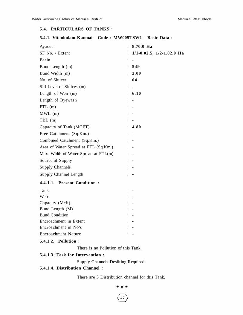
5.4. PARTICULARS OF TANKS :
5.4.1. Vitankulam Kanmai - Code : MW005TSW1 - Basic Data :
Ayacut : 8.70.0 Ha
SF No. / Extent : 1/1-0.02.5, 1/2-1.02.0 Ha
Basin : -
Bund Length (m) : 549
Bund Width (m) : 2.00
No. of Sluices : 04
Sill Level of Sluices (m) : -
Length of Weir (m) : 6.10
Length of Byewash : -
FTL (m) : -
MWL (m) : -
TBL (m) : -
Capacity of Tank (MCFT) : 4.80
Free Catchment (Sq.Km.) : -
Combined Catchment (Sq.Km.) : -
Area of Water Spread at FTL (Sq.Km.) : -
Max. Width of Water Spread at FTL(m) : -
Source of Supply : -
Supply Channels : -
Supply Channel Length : -
4.4.1.1. Present Condition :
Tank : -Weir : -Capacity (Mcft) : -Bund Length (M) : -Bund Condition : -Encroachment in Extent : -Encroachment in No’s : -
Encroachment Nature : -
5.4.1.2. Pollution :
There is no Pollution of this Tank.
5.4.1.3. Task for Intervention :
Supply Channels Desilting Required.
5.4.1.4. Distribution Channel :
There are 3 Distribution channel for this Tank.

Water Resources Atlas of Madurai District Madurai West Block
48
Vitankulam - Vitankulam Kanmai
SF No. : 1, Area : 4.4.0 Ha, Code No. : MW005-TSW1
Scale 1mm = 1000mm

Water Resources Atlas of Madurai District Madurai West Block
49
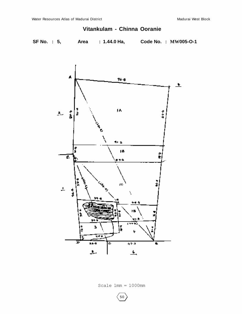
5.6. PARTICULARS OF OORANIES :
5.6.1. Chinna Ooranie - Code : MW005-O-1 - Basic Data :
Survey Field No. : 5/2Extent : 0.09.0Source of Supply : Rain waterLength (m) : 79.00Breadth (m) : 48.00Purpose (Drinking Water / Cattle) : CattlePresent Status : Good
5.6.1.1. Pollution :
There is no pollution of this Ooranie.
5.6.1.2. Task for Intervention :Desilting, strengthening are required for this Ooranie. There is no encroachment.
Water Resources Atlas of Madurai District Madurai West Block
50
Vitankulam - Chinna Ooranie
SF No. : 5, Area : 1.44.0 Ha, Code No. : MW005-O-1
Scale 1mm = 1000mm

Water Resources Atlas of Madurai District Madurai West Block
51
006 - VAYALUR
6.1. VILLAGE DATA :
This Village comes under Madurai North Taluk and Madurai West Block. It
has 0 hamlets with a total Population 723. The Area of this Village is 153-10-0
Hectares. Latitude is 10001’00” and Longitude is 78003’00” . The splitup of Hamlets
& Population are as follows :
6.2. INDEX MAP :
6.3. WATER BODIES :
This Village has 8 Water Bodies : 6 Tank, 2 Ooranie, 2 Ponds.
Tank Ooranie
No. of Tank 2 No. of Ooranie Drinking Water Cattle
PWD System 1 2 0 2
PWD Non System 0 Pond
Panchayat Union 0 No. of Pond Drinking Water Cattle
Ex - Zamin 0 0 0 0
6.3.1. No. of Wells :
Vayalur has a total of 92 wells out of which 43 are open wells, 43 open wells in
ayacut area.
Situation : This Village is Situated 19.2 K.m. distant from Madurai, 4.8 K.m. distant from Samayanallur Railway Station and 4.8 K.m. distant from Madurai to Dindigul Road.
VADIPATTI
MADURAI (D)MADURAI NORTH (T)MADURAI WEST (B)
SAMAYANALLUR
12 K
m.
VAYALUR
6 Km.NAGARI
ALANGANALLUR
KU
MA
RA
M

Water Resources Atlas of Madurai District Madurai West Block
52

Water Resources Atlas of Madurai District Madurai West Block
53
6.4. PARTICULARS OF TANKS :
6.4.1. Vallakulam Kanmai - Code : MW006TSW1 - Basic Data :
Ayacut : 21.94.0 Ha
SF No. / Extent : 1/1-10.24.0
Basin : -
Bund Length (m) : 77
Bund Width (m) : 2.00
No. of Sluices : 02
Sill Level of Sluices (m) : -
Length of Weir (m) : 9.15
Length of Byewash : -
FTL (m) : -
MWL (m) : -
TBL (m) : -
Capacity of Tank (MCFT) : 4.57
Free Catchment (Sq.Km.) : -
Combined Catchment (Sq.Km.) : -
Area of Water Spread at FTL (Sq.Km.) : -
Max. Width of Water Spread at FTL(m) : -
Source of Supply : -
Supply Channels : -
Supply Channel Length : -
4.4.1.1. Present Condition :
Tank : -Weir : -Capacity (Mcft) : -Bund Length (M) : -Bund Condition : -Encroachment in Extent : -Encroachment in No’s : -
Encroachment Nature : -
6.4.1.2. Pollution :
There is no Pollution of this Tank.
6.4.1.3. Task for Intervention :
Supply Channels Desilting Required.
6.4.1.4. Distribution Channel :
There are 3 Distribution channel for this Tank.

Water Resources Atlas of Madurai District Madurai West Block
54
Vallakulam - Vallakulam Kanmai
SF No. : 1, Area : 10.54.0 Ha, Code No. : MW006-TSW1
Scale 1mm = 5000mm

Water Resources Atlas of Madurai District Madurai West Block
55
6.6. PARTICULARS OF OORANIES :
6.6.1. Kandan Ooranie - Code : MW006-O-1 - Basic Data :
Survey Field No. : 50/2Extent : 0.91.0Source of Supply : ChannelLength (m) : -Breadth (m) : -Purpose (Drinking Water / Cattle) : -Present Status : -
6.6.1.1. Pollution :
There is no pollution of this Ooranie.
6.6.1.2. Task for Intervention :Desilting, strengthening are required for this Ooranie. There is no encroachment.
6.6.2. Servai Ooranie - Code : MW006-O-2 - Basic Data :
Survey Field No. : 52/2Extent : 0.23.5Source of Supply : ChannelLength (m) : -Breadth (m) : -Purpose (Drinking Water / Cattle) : -Present Status : -
6.6.2.1. Pollution :
There is no pollution of this Ooranie.
6.6.2.2. Task for Intervention :Desilting, strengthening are required for this Ooranie. There is no encroachment.

Water Resources Atlas of Madurai District Madurai West Block
56
Vallakulam - Kandan Ooranie
SF No. : 50, Area : 17. 11.5Ha, Code No. : MW006-O-1
Scale 1mm = 2000mm

Water Resources Atlas of Madurai District Madurai West Block
57
Vallakulam - Servai Ooranie
SF No. : 52, Area : 4.95.5 Ha, Code No. : MW006-O-2
Scale 1mm = 2000mm

Water Resources Atlas of Madurai District Madurai West Block
58

Water Resources Atlas of Madurai District Madurai West Block
59
007 - AMBALATHADI
7.1. VILLAGE DATA :
This Village comes under Madurai North Taluk and Madurai West Block. It
has 0 hamlets with a total Population. The Area of this Village is 153-10-0 Hectares.
Latitude is 10001’00” and Longitude is 78004’00” . The splitup of Hamlets &
Population are as follows :
7.2. INDEX MAP :
7.3. WATER BODIES :
This Village has 3 Water Bodies : 2 Tank and 1 Ooranie.
Tank Ooranie
No. of Tank 1 No. of Ooranie Drinking Water Cattle
PWD System 1 0 0 0
PWD Non System 0 Pond
Panchayat Union 0 No. of Pond Drinking Water Cattle
Ex - Zamin 0 0 0 0
7.3.1. No. of Wells :
Ambalathadi has a total of 16 wells,16 open wells.
Situation : Ambalathadi Village is one of 4 Units divided from Siruvalai Revenue Village. In the
North & West of this Unit is Siruvalai, in the Eest is Kumaram in the South is Ariyurthese are the boundaries of this unit Ambalathadi. It is situated 14.0 Km. distant fromMadurai to Siruvalai Road.
MADURAI (D)
ARIY
UR
1.5
Km.
ALANGANALLUR
KUMARAM
6 K
m.
12 K
m.
P.N
ATHAM
VAYALUR1
Km.
.5 K
m.
2 Km
.
AMBALATHADI

Water Resources Atlas of Madurai District Madurai West Block
60

Water Resources Atlas of Madurai District Madurai West Block
61
7.4. PARTICULARS OF TANKS :
7.4.1. Ambalathadi Kanmai - Code : MW007TSW1 - Basic Data :
Ayacut : 161.72 Ha
SF No. / Extent : 22/17.05
Basin : Minor Basin Sholavandan
Bund Length (m) : 1260
Bund Width (m) : 2.00
No. of Sluices : 3
Sill Level of Sluices (m) : 161.935. 162.435, 162.565
Length of Weir (m) : 40.70
Length of Byewash : -
FTL (m) : 163.560
MWL (m) : 164.060
TBL (m) : 165.060
Capacity of Tank (MCFT) : 0.1349
Free Catchment (Sq.Km.) : 0.455
Combined Catchment (Sq.Km.) : 8.855
Area of Water Spread at FTL (Sq.Km.) : 0.179
Max. Width of Water Spread at FTL(m) : 315
Source of Supply : -
Supply Channels : -
Supply Channel Length : -
7.4.1.1. Present Condition :
Tank : -Weir : -Capacity (Mcft) : -Bund Length (M) : -Bund Condition : -Encroachment in Extent : -Encroachment in No’s : -
Encroachment Nature : -
7.4.1.2. Pollution :
There is no Pollution of this Tank.
7.4.1.3. Task for Intervention :
Supply Channels Desilting Required.
7.4.1.4. Distribution Channel :
There are 3 Distribution channel for this Tank.

Water Resources Atlas of Madurai District Madurai West Block
62
Ambalathadi - Ambalathadi tank
SF No. : 22, Area : 1756.0 Ha, Code No. : MW007-O-2
Scale 1mm = 5000mm

Water Resources Atlas of Madurai District Madurai West Block
63
7.6. PARTICULARS OF OORANIES :
7.6.1. Pillayar Kovil Ooranie - Code : MW007-O-1 - Basic Data :
Survey Field No. : 22Extent : 17.05.0Source of Supply : Periyar waterLength (m) : 87Breadth (m) : 69Purpose (Drinking Water / Cattle) : CattlePresent Status : Good
7.6.1.1. Pollution :
There is no pollution of this Ooranie.
7.6.1.2. Task for Intervention :Desilting, strengthening are required for this Ooranie. There is no encroachment.

Water Resources Atlas of Madurai District Madurai West Block
64
Ambalathadi - Pillayar Kovil Ooranie
SF No. : 22, Area : 1756.0 Ha, Code No. : MW007-O-1
Scale 1mm = 5000mm

Water Resources Atlas of Madurai District Madurai West Block
65
007 - SIRUVALAI
7.1. VILLAGE DATA :
This Village comes under Madurai North Taluk and Madurai West Block. It
has 0 hamlets with a total Population 1431. The Area of this Village is 389.59.0
Hectares. Latitude is 10001’30” and Longitude is 78004’00” . The splitup of Hamlets
& Population are as
follows :
7.2. INDEX MAP :
7.3. WATER BODIES :
This Village has 5 Water Bodies : 2 Tank and 3 Ooranie.
Tank Ooranie
No. of Tank 2 No. of Ooranie Drinking Water Cattle
PWD System 1 0 0 0
PWD Non System 0 Pond
Panchayat Union 0 No. of Pond Drinking Water Cattle
Ex - Zamin 0 0 0 0
7.3.1. No. of Wells :
Siruvalai has a total of 353 wells. Out of which 353 are open wells, 32 open
wells in ayacut area, 321 open wells in non ayacut area.
Situation : This Village is splitted into 4 units from Siruvalai. In the North Sellanagoundanpatti,
East Ambalathadi and Kumaram are the boundaries of this Village and 16 K.m. distant from Madurai.
MADURAI (D)
10 Km.NAGARI
ALANGANALLUR
KUMARAM
1 K
m.
SIRUVALAI

Water Resources Atlas of Madurai District Madurai West Block
66

Water Resources Atlas of Madurai District Madurai West Block
67
7.4. PARTICULARS OF TANKS :
7.4.1. Siruvalai East tank - Code : MW007TSW1 - Basic Data :
Ayacut : 194.28 Ha
SF No. / Extent : 87/2,88/ 30.915
Basin : Madurai Minor Basin
Bund Length (m) : 1890
Bund Width (m) : 2.00
No. of Sluices : 4
Sill Level of Sluices (m) : 162.130, 163.340
Length of Weir (m) : 40.70
Length of Byewash : 163.830, 163.010
FTL (m) : 14.80
MWL (m) : -
TBL (m) : 164.590
Capacity of Tank (MCFT) : 165.505
Free Catchment (Sq.Km.) : 165.965
Combined Catchment (Sq.Km.) : 0.51
Area of Water Spread at FTL (Sq.Km.) : 0.61
Max. Width of Water Spread at FTL(m) : 30.91
Source of Supply : -
Supply Channels : 6 A Sluice of III BCIII Branch Channel
Supply Channel Length : -
7.4.1.1. Present Condition :
Tank : -Weir : -Capacity (Mcft) : -Bund Length (M) : -Bund Condition : -Encroachment in Extent : -Encroachment in No’s : -
Encroachment Nature : -
7.4.1.2. Pollution :
There is no Pollution of this Tank.
7.4.1.3. Task for Intervention :
Supply Channels Desilting Required.
7.4.1.4. Distribution Channel :
There are 3 Distribution channel for this Tank.

Water Resources Atlas of Madurai District Madurai West Block
68
Siruvalai - Siruvalai East tank
SF No. : 87, Area : 1.90.0 Ha, Code No. : MW007-O-1
Scale 1mm = 1000mm

Water Resources Atlas of Madurai District Madurai West Block
69
7.6. PARTICULARS OF OORANIES :
7.6.1. Kovu Ooranie - Code : MW007-O-1 - Basic Data :
Survey Field No. : 34/-38/4, 183/3Extent : 0.45.5, 1.84.0, 0.44.5Source of Supply : ChannelLength (m) : -Breadth (m) : -Purpose (Drinking Water / Cattle) : -Present Status : -
7.6.1.1. Pollution :
There is no pollution of this Ooranie.
7.6.1.2. Task for Intervention :Desilting, strengthening are required for this Ooranie. There is no encroachment.

Water Resources Atlas of Madurai District Madurai West Block
70
Siruvalai - Kovu Ooranie
SF No. : 88, Area : 30.51.0 Ha, Code No. : MW007-O-1
Scale 1mm = 5000mm

Water Resources Atlas of Madurai District Madurai West Block
71
007 - CHELLANAKOWENDANPATTI
7.1. VILLAGE DATA :
This Village comes under Madurai North Taluk and Madurai West Block. It has
0 hamlets with a total Population. The Area of this Village is 153-10-0 Hectares. Latitude
is 10002’00” and Longitude is 78004’00” . The splitup of Hamlets & Population are as
follows :
7.2. INDEX MAP :
7.3. WATER BODIES :
This Village has 0 Water Bodies :
Tank Ooranie
No. of Tank 0 No. of Ooranie Drinking Water Cattle
PWD System 0 0 0 0
PWD Non System 0 Pond
Panchayat Union 0 No. of Pond Drinking Water Cattle
Ex - Zamin 0 0 0 0
7.3.1. No. of Wells :
Chellanakowendanpatti has a total of 254 wells. Out of which 15 are open
wells, 12 open wells in ayacut area, 4 tube wells in ayacut area, 221 open wells in
non ayacut area.
Situation : This Village is divided into Four units (ie) Siuvalai IV Bits. This Village is Situated toNorth of Chellakavundanpatti West of Vaiyalur South of Pillayarnatham and West of Ambalathadi and 16.0 K.m. distant from Madurai.
MADURAI (D)
10 Km.NAGARI
ALANGANALLUR
KUMARAM
11/ 2
Km
.
CHELLANAKOVUENDANPATTI

Water Resources Atlas of Madurai District Madurai West Block
72

Water Resources Atlas of Madurai District Madurai West Block
73
007 - ARIYUR
7.1. VILLAGE DATA :
This Village comes under Madurai North Taluk and Madurai West Block. It has
0 hamlets with a total Population. The Area of this Village is 153-10-0 Hectares. Latitude
is 10000’00” and Longitude is 78005’00” . The splitup of Hamlets & Population are as
follows :
7.2. INDEX MAP :
7.3. WATER BODIES :
This Village has 3 Water Bodies : 2 Tank, 1 Ooranie.
Tank Ooranie
No. of Tank 2 No. of Ooranie Drinking Water Cattle
PWD System 2 1 0 1
PWD Non System 0 Pond
Panchayat Union 0 No. of Pond Drinking Water Cattle
Ex - Zamin 0 0 0 0
7.3.1. No. of Wells :
Ariyur has a total of 26.61.5 wells. Out of which 13 are open wells, 13 open
wells in ayacut area, 6.61.5 open wells in ayacut area.
Situation : This Village is Situated 16.0 K.m. distant from Madurai, This village is Situated North of Ambalathadi, West of Sambakulam, South of Athalai and East of Kumaram.
MADURAI (D)
ARIYUR 1 Km.
NAGARI
ALANGANALLUR (B)
KUMARAM 12 Km
6 Km.

Water Resources Atlas of Madurai District Madurai West Block
74

Water Resources Atlas of Madurai District Madurai West Block
75
7.4. PARTICULARS OF TANKS :
7.4.1. Melakammai tank - Code : MW007TSW1 - Basic Data :
Ayacut : 159.17 Ha
SF No. / Extent : 4/65/1, 32.40.5
Basin : Minor Basin Sholavandan
Bund Length (m) : 1710
Bund Width (m) : 2.00
No. of Sluices : 2
Sill Level of Sluices (m) : 157.000, 157.580
Length of Weir (m) : 1,6.00, 16.20
Length of Byewash : -
FTL (m) : 159.180
MWL (m) : 159.670
TBL (m) : 160.670
Capacity of Tank (MCFT) : 0.2843
Free Catchment (Sq.Km.) : -
Combined Catchment (Sq.Km.) : 12.823
Area of Water Spread at FTL (Sq.Km.) : 30.65
Max. Width of Water Spread at FTL(m) : 440
Source of Supply : 1115 Sluice of III BC
Supply Channels : III Branch Channel
Supply Channel Length : -
7.4.1.1. Present Condition :
Tank : GoodWeir : FairCapacity (Mcft) : 0.2843Bund Length (M) : 1710Bund Condition : FairEncroachment in Extent : 1.82.0Encroachment in No’s : 12
Encroachment Nature : Paddy
7.4.1.2. Pollution :
There is no Pollution of this Tank.
7.4.1.3. Task for Intervention :
Supply Channels Desilting Required.
7.4.1.4. Distribution Channel :
There are 3 Distribution channel for this Tank.

Water Resources Atlas of Madurai District Madurai West Block
76
Ariyur - Melakanmai
SF No. : 4, Area : 30.68.0 Ha, Code No. : MW007TSW1
Scale 1mm = 5000mm

Water Resources Atlas of Madurai District Madurai West Block
77
7.4. PARTICULARS OF TANKS :
7.4.1. Keelakanmai - Code : MW007TSW2 - Basic Data :
Ayacut : -
SF No. / Extent : 78/2, 11.345
Basin : Minor Basin Sholavandan
Bund Length (m) : 870
Bund Width (m) : 2.00
No. of Sluices : 2
Sill Level of Sluices (m) : 156.800, 156.500
Length of Weir (m) : 45.70
Length of Byewash : -
FTL (m) : 158.205
MWL (m) : 158.805
TBL (m) : 159.805
Capacity of Tank (MCFT) : 0.0783
Free Catchment (Sq.Km.) : 0.2684
Combined Catchment (Sq.Km.) : 13.0914
Area of Water Spread at FTL (Sq.Km.) : 0.0972
Max. Width of Water Spread at FTL(m) : 230
Source of Supply : 11th Sluice of III BC
Supply Channels : III Branch ChannelSupply Channel Length : -
7.4.1.1. Present Condition :
Tank : GoodWeir : FairCapacity (Mcft) : 0.2843Bund Length (M) : 1710Bund Condition : FairEncroachment in Extent : 1.82.0Encroachment in No’s : 12
Encroachment Nature : Paddy
7.4.1.2. Pollution :
There is no Pollution of this Tank.
7.4.1.3. Task for Intervention :
Supply Channels Desilting Required.
7.4.1.4. Distribution Channel :
There are 3 Distribution channel for this Tank.

Water Resources Atlas of Madurai District Madurai West Block
78
Ariyur - Keelakanmai
SF No. : 78, Area : 11.53.5 Ha, Code No. : MW007TSW2
Scale 1mm = 2000mm

Water Resources Atlas of Madurai District Madurai West Block
79
7.6. PARTICULARS OF OORANIES :
7.6.1. Vaganoorani Ooranie - Code : MW007-O-1 - Basic Data :
Survey Field No. : 65/6Extent : 0.47.0Source of Supply : -Length (m) : 60.00Breadth (m) : 35.00Purpose (Drinking Water / Cattle) : -Present Status : -
7.6.1.1. Pollution :
There is no pollution of this Ooranie.
7.6.1.2. Task for Intervention :Desilting, strengthening are required for this Ooranie. There is no encroach-
ment.

Water Resources Atlas of Madurai District Madurai West Block
80
Ariyur - Keelakanmai
SF No. : 65, Area : 3.79.5 Ha, Code No. : MW007-O-1

Water Resources Atlas of Madurai District Madurai West Block
81
008 - SAMBAKULAM
8.1. VILLAGE DATA :
This Village comes under Madurai North Taluk and Madurai West Block. It
has 0 hamlets with a total Population 122. The Area of this Village is 63.93.5
Hectares. Latitude is 10000’00” and Longitude is 78004’00” . The splitup of Hamlets
& Population are as follows :
8.2. INDEX MAP :
8.3. WATER BODIES :
This Village has 2 Water Bodies : 1 Tank and 1 Ooranie.
Tank Ooranie
No. of Tank 1 No. of Ooranie Drinking Water Cattle
PWD System 1 1 0 1
PWD Non System 0 Pond
Panchayat Union 0 No. of Pond Drinking Water Cattle
Ex - Zamin 0 0 0 0
8.3.1. No. of Wells :
Sambakulam has a total of 30.865 wells. Out of which 8 are open wells, 1.68.0
open wells in ayacut area, 7.18.5 open wells in non ayacut area.
Situation : This Village is Situated 17.6 Km. distant North West of Madurai and 8.0 Km. distant from Paravai Railway Station. 3.2 Km. from Madurai to Nilakkottai Road.
MADURAI (D)
10 Km.NAGARI
ALANGANALLUR (B)6 Km.
KUMARAM12 Km.
SAMBAKULAM
3 Km.

Water Resources Atlas of Madurai District Madurai West Block
82

Water Resources Atlas of Madurai District Madurai West Block
83
8.4. PARTICULARS OF TANKS :
8.4.1. Sambakulam tank - Code : MW008TSW1 - Basic Data :
Ayacut : 106.54 Ha
SF No. / Extent : 2/8=10.73.0
Basin : -
Bund Length (m) : 900
Bund Width (m) : 2.00
No. of Sluices : 3
Sill Level of Sluices (m) : -
Length of Weir (m) : -
Length of Byewash : -
FTL (m) : 155.760
MWL (m) : 156.360
TBL (m) : -
Capacity of Tank (MCFT) : 0.11
Free Catchment (Sq.Km.) : 0.14
Combined Catchment (Sq.Km.) : -
Area of Water Spread at FTL (Sq.Km.) : 18.75.5
Max. Width of Water Spread at FTL(m) : 18.75.5
Source of Supply : -
Supply Channels : 10 R of III BCIII Branch Channel
Supply Channel Length : -
8.4.1.1. Present Condition :
Tank : -Weir : -Capacity (Mcft) : 0.11Bund Length (M) : 900Bund Condition : 400Encroachment in Extent : 0410Encroachment in No’s : 7
Encroachment Nature : Paddy
8.4.1.2. Pollution :
There is no Pollution of this Tank.
8.4.1.3. Task for Intervention :
Supply Channels Desilting Required.
8.4.1.4. Distribution Channel :
There are 3 Distribution channel for this Tank.

Water Resources Atlas of Madurai District Madurai West Block
84
Sambakulam - Sambakulam Tank
SF No. : 2, Area : 18.74.5 Ha, Code No. : MW008-O-1
Scale 1mm = 5000mm

Water Resources Atlas of Madurai District Madurai West Block
85
8.6. PARTICULARS OF OORANIES :
8.6.1. Kovu Ooranie - Code : MW007-O-1 - Basic Data :
Survey Field No. : 3/3Extent : 015.5Source of Supply : Rain waterLength (m) : 74Breadth (m) : 63Purpose (Drinking Water / Cattle) : CattlePresent Status : -
8.6.1.1. Pollution :
There is no pollution of this Ooranie.
8.6.1.2. Task for Intervention :Desilting, strengthening are required for this Ooranie. There is no encroach-
ment.

Water Resources Atlas of Madurai District Madurai West Block
86
Sambakulam - Sambakulam Ooranie
SF No. : 3, Area : 1.63.5 Ha, Code No. : MW008-O-1
Scale 1mm = 2000mm

Water Resources Atlas of Madurai District Madurai West Block
87
009 - PILLAIYARNATHAM
9.1. VILLAGE DATA :
This Village comes under Madurai North Taluk and Madurai West Block. It
has 0 hamlets with a total Population 444. The Area of this Village is 86.06.5
Hectares. Latitude is 10000’30” and Longitude is 78004’00” . The splitup of Hamlets
& Population are as follows :
9.2. INDEX MAP :
9.3. WATER BODIES :
This Village has 4 Water Bodies : 1 Tank and 3 Ooranie.
Tank Ooranie
No. of Tank 1 No. of Ooranie Drinking Water Cattle
PWD System 1 3 0 3
PWD Non System 0 Pond
Panchayat Union 0 No. of Pond Drinking Water Cattle
Ex - Zamin 0 0 0 0
9.3.1. No. of Wells :
Pillaiyarnatham has a total of 30.865 wells. Out of which 9 are open wells,
1.89.0 open wells in ayacut area, 11.38.5 open wells in non ayacut area.
Situation : This Village is Situated 17.6 Km. distant North West of Madurai and 8.0 Km. distant from Paravai Railway Station. 3.2 Km. distant from Madurai to Nilakkottai Road.
MADURAI (D)
7 Km.NAGARI
ALANGANALLUR (B)6 Km.
KUMARAM12 Km.
PILLAIYARNATHAM
3 Km.

Water Resources Atlas of Madurai District Madurai West Block
88

Water Resources Atlas of Madurai District Madurai West Block
89
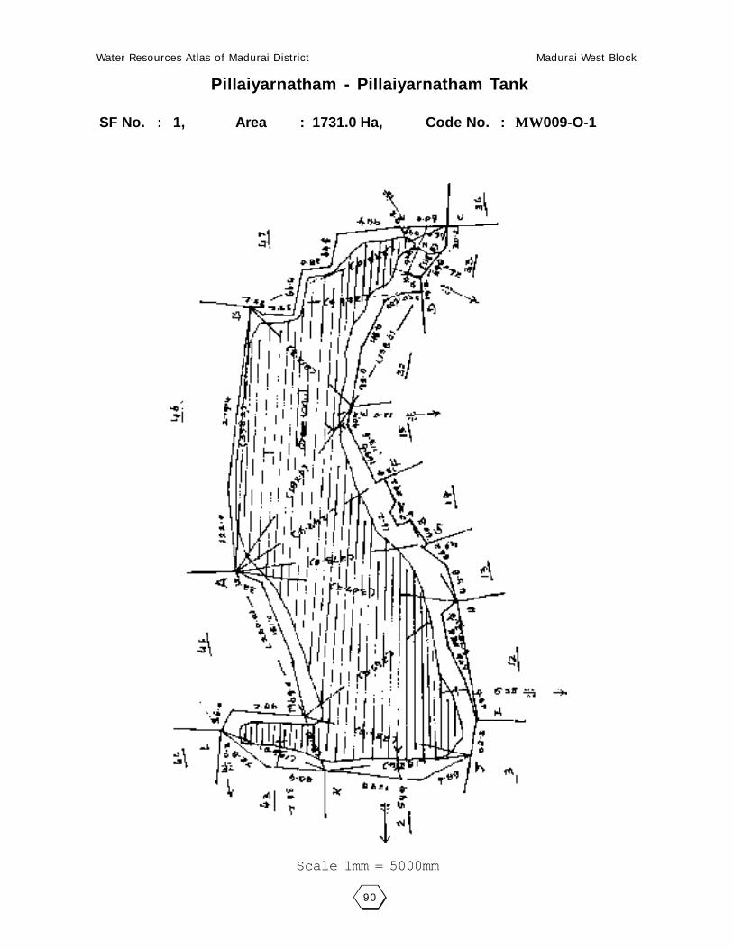
9.4. PARTICULARS OF TANKS :
9.4.1. Sambakulam tank - Code : MW009TSW1 - Basic Data :
Ayacut : 122.56 Ha
SF No. / Extent : 1/1/-17.27.5
Basin : -
Bund Length (m) : 1500
Bund Width (m) : 2.00
No. of Sluices : 4
Sill Level of Sluices (m) : -
Length of Weir (m) : 14.00
Length of Byewash : -
FTL (m) : 155.350
MWL (m) : 156.350
TBL (m) : -
Capacity of Tank (MCFT) : 0.28
Free Catchment (Sq.Km.) : 0.56
Combined Catchment (Sq.Km.) : 0.67
Area of Water Spread at FTL (Sq.Km.) : 17.31
Max. Width of Water Spread at FTL(m) : -
Source of Supply : 10 R of III BCIII Branch Channel
Supply Channels :
Supply Channel Length : -
9.4.1.1. Present Condition :
Tank : -Weir : -Capacity (Mcft) : 0.28Bund Length (M) : 1500Bund Condition : -Encroachment in Extent : 0.80.5Encroachment in No’s : 6
Encroachment Nature : Paddy
9.4.1.2. Pollution :
There is no Pollution of this Tank.
9.4.1.3. Task for Intervention :
Supply Channels Desilting Required.
9.4.1.4. Distribution Channel :
There are 3 Distribution channel for this Tank.
Water Resources Atlas of Madurai District Madurai West Block
90
Pillaiyarnatham - Pillaiyarnatham Tank
SF No. : 1, Area : 1731.0 Ha, Code No. : MW009-O-1
Scale 1mm = 5000mm
Water Resources Atlas of Madurai District Madurai West Block
91
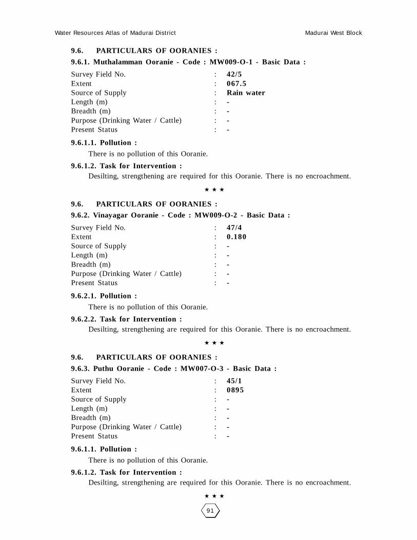
9.6. PARTICULARS OF OORANIES :
9.6.1. Muthalamman Ooranie - Code : MW009-O-1 - Basic Data :
Survey Field No. : 42/5Extent : 067.5Source of Supply : Rain waterLength (m) : -Breadth (m) : -Purpose (Drinking Water / Cattle) : -Present Status : -
9.6.1.1. Pollution :
There is no pollution of this Ooranie.
9.6.1.2. Task for Intervention :Desilting, strengthening are required for this Ooranie. There is no encroachment.
9.6. PARTICULARS OF OORANIES :
9.6.2. Vinayagar Ooranie - Code : MW009-O-2 - Basic Data :
Survey Field No. : 47/4Extent : 0.180Source of Supply : -Length (m) : -Breadth (m) : -Purpose (Drinking Water / Cattle) : -Present Status : -
9.6.2.1. Pollution :
There is no pollution of this Ooranie.
9.6.2.2. Task for Intervention :Desilting, strengthening are required for this Ooranie. There is no encroachment.
9.6. PARTICULARS OF OORANIES :
9.6.3. Puthu Ooranie - Code : MW007-O-3 - Basic Data :
Survey Field No. : 45/1Extent : 0895Source of Supply : -Length (m) : -Breadth (m) : -Purpose (Drinking Water / Cattle) : -Present Status : -
9.6.1.1. Pollution :
There is no pollution of this Ooranie.
9.6.1.2. Task for Intervention :Desilting, strengthening are required for this Ooranie. There is no encroachment.

Water Resources Atlas of Madurai District Madurai West Block
92
Pillaiyarnatham - Muthalamman Ooranie
SF No. : 42/5, Area : 2.83.5 Ha, Code No. : MW009-O-1
Scale 1mm = 2000mm

Water Resources Atlas of Madurai District Madurai West Block
93
Pillaiyarnatham - Vinayagar Ooranie
SF No. : 47, Area : 3.85.0 Ha, Code No. : MW009-O-2
Scale 1mm = 2000mm
Water Resources Atlas of Madurai District Madurai West Block
94
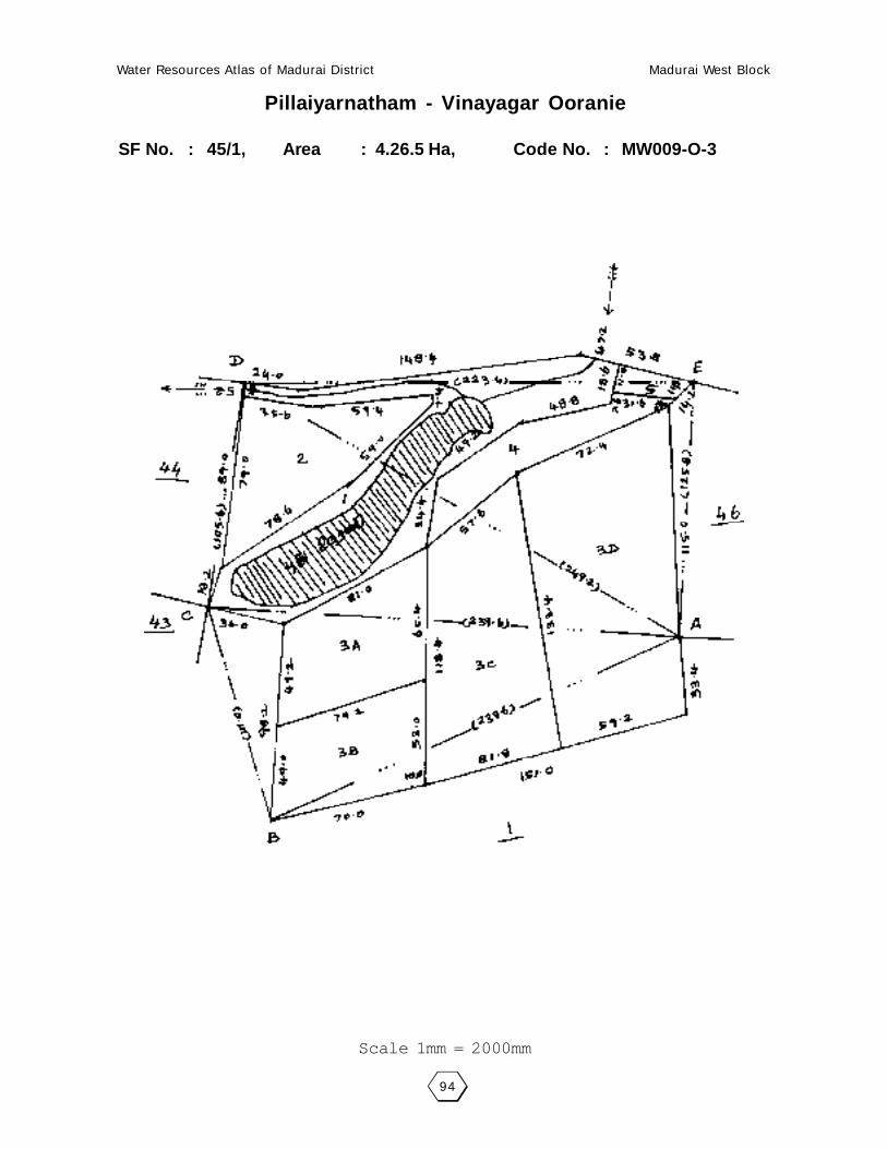
Pillaiyarnatham - Vinayagar Ooranie
SF No. : 45/1, Area : 4.26.5 Ha, Code No. : MW009-O-3
Scale 1mm = 2000mm

Water Resources Atlas of Madurai District Madurai West Block
95
010 - MOOLAKURICHI
10.1. VILLAGE DATA :
This Village comes under Madurai North Taluk and Madurai West Block. It
has 0 hamlets with a total Population 485. The Area of this Village is 147.83.5
Hectares. Latitude is 10000’30” and Longitude is 78003’00” . The splitup of Hamlets
& Population are as follows :
10.2. INDEX MAP :
10.3. WATER BODIES :
This Village has 1 Water Bodies : 1 Tank.
Tank Ooranie
No. of Tank 1 No. of Ooranie Drinking Water Cattle
PWD System 1 0 0 0
PWD Non System 0 Pond
Panchayat Union 0 No. of Pond Drinking Water Cattle
Ex - Zamin 0 0 0 0
10.3.1. No. of Wells :
Moolakurichi has no wells.
Situation : This Village is Situated 17.6 Km. distant North West of Madurai, 3.2 Km. distant from Samayanallur Railway Station and 3.2 Km. distant from Madurai to Dindigul Road.
MADURAI (D)
NAGARI
VADIPATTY6 Km.
SAMAYANALLUR13 Km.
MOOLAKURCHY
Inodeween2 Km.
1 Km.4 Km.
Water Resources Atlas of Madurai District Madurai West Block
96

Water Resources Atlas of Madurai District Madurai West Block
97
10.4. PARTICULARS OF TANKS :
10.4.1. Sambakulam tank - Code : MW0010TSW1 - Basic Data :
Ayacut : 72 Ha
SF No. / Extent : 6-1-63.57.0
Basin : -
Bund Length (m) : 2330
Bund Width (m) : 2.00
No. of Sluices : 05
Sill Level of Sluices (m) : 156.515
Length of Weir (m) : 13.00
Length of Byewash : -
FTL (m) : 156.415
MWL (m) : 156.770
TBL (m) : 157.250
Capacity of Tank (MCFT) : 0.19
Free Catchment (Sq.Km.) : 0.19
Combined Catchment (Sq.Km.) : -
Area of Water Spread at FTL (Sq.Km.) : -
Max. Width of Water Spread at FTL(m) : -
Source of Supply : -
Supply Channels :
Supply Channel Length : -
10.4.1.1. Present Condition :
Tank : -Weir : -Capacity (Mcft) : -Bund Length (M) : -Bund Condition : -Encroachment in Extent : 0.02.0Encroachment in No’s : 4
Encroachment Nature : Tree
10.4.1.2. Pollution :
There is no Pollution of this Tank.
10.4.1.3. Task for Intervention :
Supply Channels Desilting Required.
10.4.1.4. Distribution Channel :
There are 3 Distribution channel for this Tank.

Water Resources Atlas of Madurai District Madurai West Block
98
Moolakurichi - Moolakurichi Kanmai
SF No. : 6, Area : 63.63.5 Ha, Code No. : MW010TSW1
Scale 1mm = 5000mm

Water Resources Atlas of Madurai District Madurai West Block
99
011 - KEELANEDUNKULAM
11.1. VILLAGE DATA :
This Village comes under Madurai North Taluk and Madurai West Block. It
has 1 hamlets with a total Population 270. The Area of this Village is 135.56.0
Hectares. Latitude is 10000’30” and Longitude is 78004’00” . The splitup of Hamlets
& Population are as follows :
11.2. INDEX MAP :
11.3. WATER BODIES :
This Village has 1 Water Bodies : 1 Tank, 1 Ooranie
Tank Ooranie
No. of Tank 1 No. of Ooranie Drinking Water Cattle
PWD System 1 1 0 1
PWD Non System 0 Pond
Panchayat Union 0 No. of Pond Drinking Water Cattle
Ex - Zamin 0 0 0 0
11.3.1. No. of Wells :
Keelanedunkulam has a total of 21 wells out of which 20 are open wells,
15.00.0 open wells in ayacut area, 1.00.0 Open wells in Non Ayacut area and 1 tube
wells and 1.00.0 tube wells in ayacut area.
Situation : This Village is Situated 14.4 Km. distant North West of Madurai, 5.6 Km. distant from Paravai Railway Station and 5.6 Km. distant from Madurai to Dindigul Road.
MADURAI (D)
VADIPATTY
VADIPATTY6 Km.
KUMARAM
3 Km.
1 1/2 Km.

Water Resources Atlas of Madurai District Madurai West Block
100

Water Resources Atlas of Madurai District Madurai West Block
101
11.4. PARTICULARS OF TANKS :
11.4.1. Sambakulam tank - Code : MW0011TSW1 - Basic Data :
Ayacut : 188.97 Ha
SF No. / Extent : 4/3, 14.58.0
Basin : -
Bund Length (m) : 1500
Bund Width (m) : 2.00
No. of Sluices : 6
Sill Level of Sluices (m) : -
Length of Weir (m) : 12.00
Length of Byewash : -
FTL (m) : 152.400
MWL (m) : 152.850
TBL (m) : 153.300
Capacity of Tank (MCFT) : 0.23
Free Catchment (Sq.Km.) : 0.56
Combined Catchment (Sq.Km.) : -
Area of Water Spread at FTL (Sq.Km.) : 14.68
Max. Width of Water Spread at FTL(m) : -
Source of Supply : 121 FSI of III BCIII Branch Channel
Supply Channels :
Supply Channel Length : -
11.4.1.1. Present Condition :
Tank : GoodWeir : -Capacity (Mcft) : 0.23Bund Length (M) : 1500Bund Condition : GoodEncroachment in Extent : -Encroachment in No’s : -
Encroachment Nature : -
11.4.1.2. Pollution :
There is no Pollution of this Tank.
11.4.1.3. Task for Intervention :
Supply Channels Desilting Required.
11.4.1.4. Distribution Channel :
There are 3 Distribution channel for this Tank.
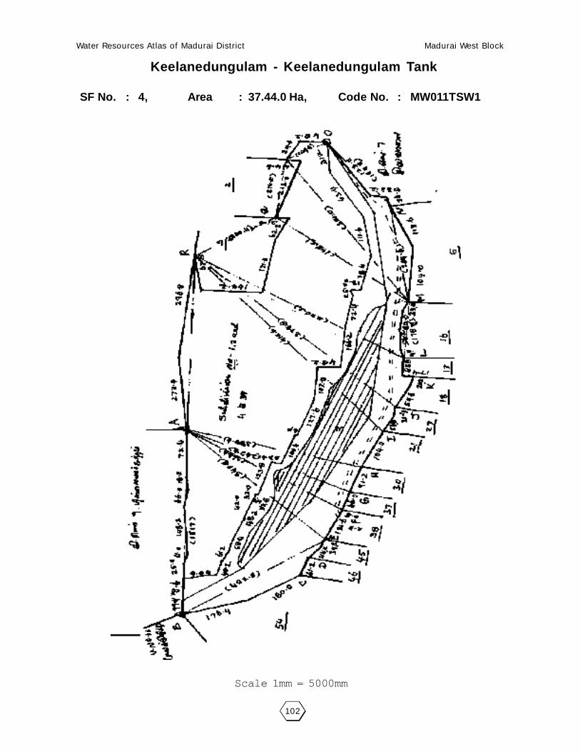
Water Resources Atlas of Madurai District Madurai West Block
102
Keelanedungulam - Keelanedungulam Tank
SF No. : 4, Area : 37.44.0 Ha, Code No. : MW011TSW1
Scale 1mm = 5000mm

Water Resources Atlas of Madurai District Madurai West Block
103
11.6. PARTICULARS OF OORANIES :
11.6.1. Malamadayan Ooranie - Code : MW0011-O-1 - Basic Data :
Survey Field No. : 6Extent : 1.12.0Source of Supply : Kanmai SupplyLength (m) : 90.00Breadth (m) : 65.00Purpose (Drinking Water / Cattle) : CattlePresent Status : Good
11.6.1.1. Pollution :
There is no pollution of this Ooranie.
11.6.1.2. Task for Intervention :Desilting, strengthening are required for this Ooranie. There is no encroach-
ment.
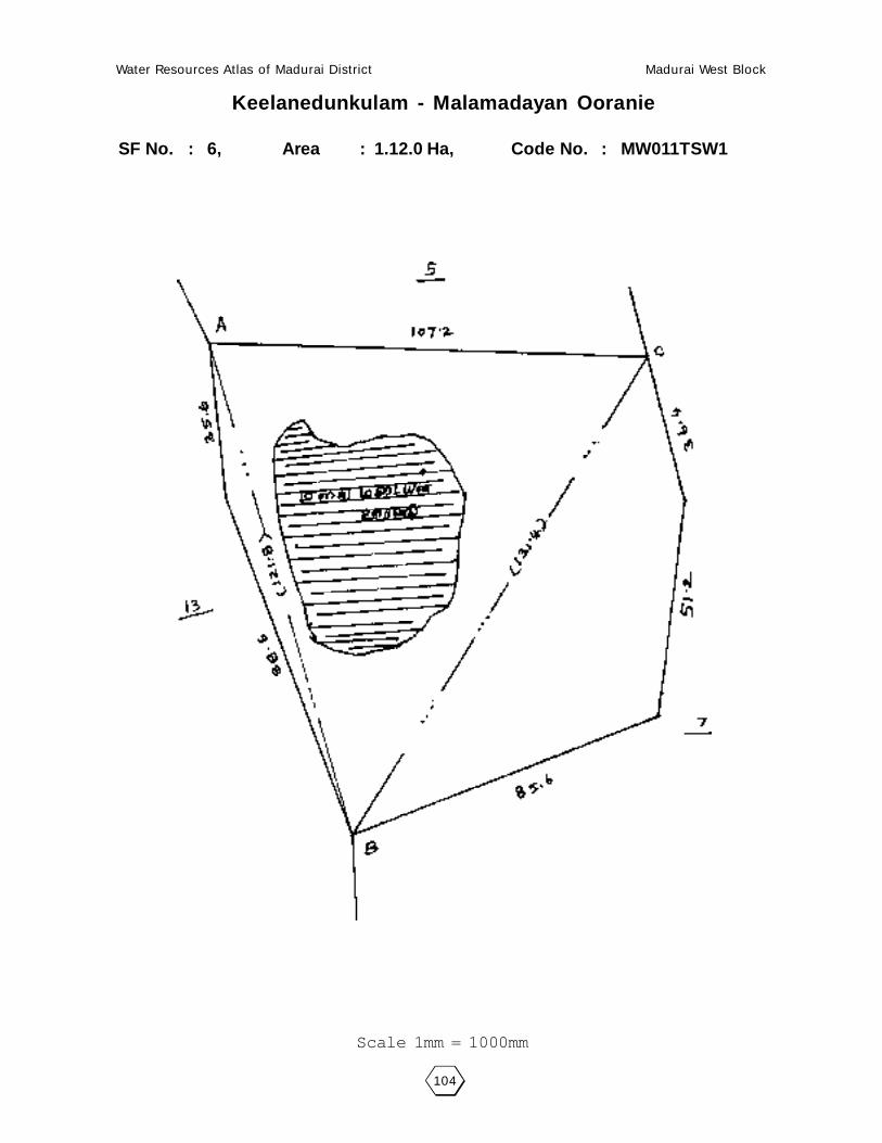
Water Resources Atlas of Madurai District Madurai West Block
104
Keelanedunkulam - Malamadayan Ooranie
SF No. : 6, Area : 1.12.0 Ha, Code No. : MW011TSW1
Scale 1mm = 1000mm

Water Resources Atlas of Madurai District Madurai West Block
105
012 - KALLIKUDI
12.1. VILLAGE DATA :
This Village comes under Madurai North Taluk and Madurai West Block. It
has 1 hamlets with a total Population 545. The Area of this Village is 300.83.5
Hectares. Latitude is 9059’00” and Longitude is 78003’00” . The splitup of Hamlets
& Population are as follows :
Kallikudi : 420 Pudur : 125
12.2. INDEX MAP :
12.3. WATER BODIES :
This Village has 1 Water Bodies : 1 Tank, 1 Ooranie
Tank Ooranie
No. of Tank 1 No. of Ooranie Drinking Water Cattle
PWD System 1 1 0 1
PWD Non System 0 Pond
Panchayat Union 0 No. of Pond Drinking Water Cattle
Ex - Zamin 0 0 0 0
12.3.1. No. of Wells :
Kallikudi has a total of 40 wells out of which 33 are open wells, 30.10.0 open
wells in ayacut area, 7 tube wells and 5.20.0 tube wells in ayacut area.
Situation : This Village is Situated 16.0 Km. distant West of Madurai, 1.6 Km. distant from Samayanallur Railway Station and 1.6 Km. distant from Madurai to Dindigul Road.
MADURAI (D)
VADIPATTY
ALANGANALLUR
KUMARAM
SAMAYANALLUR16 Km.
1.6 Km.

Water Resources Atlas of Madurai District Madurai West Block
106
Water Resources Atlas of Madurai District Madurai West Block
107
12.4. PARTICULARS OF TANKS :
12.4.1. Kallikudi Kanmai - Code : MW0011TSW1 - Basic Data :
Ayacut : 168.84 Ha
SF No. / Extent : 9/3.42.2
Basin : -
Bund Length (m) : 2075
Bund Width (m) : 2.00
No. of Sluices : 5
Sill Level of Sluices (m) : -
Length of Weir (m) : 32.00
Length of Byewash : -
FTL (m) : 148.030
MWL (m) : 148.330
TBL (m) : -
Capacity of Tank (MCFT) : 0.23
Free Catchment (Sq.Km.) : 0.58
Combined Catchment (Sq.Km.) : 0.58
Area of Water Spread at FTL (Sq.Km.) : 3.42
Max. Width of Water Spread at FTL(m) : -
Source of Supply : 121 FSI of III BCIII Branch Channel
Supply Channels :
Supply Channel Length : -
12.4.1.1. Present Condition :
Tank : GoodWeir : FairCapacity (Mcft) : 0.23Bund Length (M) : 2075Bund Condition : GoodEncroachment in Extent : -Encroachment in No’s : -
Encroachment Nature : -
12.4.1.2. Pollution :
There is no Pollution of this Tank.
12.4.1.3. Task for Intervention :
Supply Channels Desilting Required.
12.4.1.4. Distribution Channel :
There are 3 Distribution channel for this Tank.

Water Resources Atlas of Madurai District Madurai West Block
108
Kallikudi - Kallikudi Kanmai
SF No. : 9, Area : 3.42.0 Ha, Code No. : MW012TSW1
Scale 1mm = 5000mm

Water Resources Atlas of Madurai District Madurai West Block
109
12.6. PARTICULARS OF OORANIES :
12.6.1. Thamarai Ooranie - Code : MW0012-O-1 - Basic Data :
Survey Field No. : 89-2Extent : 0.82.0Source of Supply : -Length (m) : 64Breadth (m) : 39Purpose (Drinking Water / Cattle) : -Present Status : Good
12.6.1.1. Pollution :
There is no pollution of this Ooranie.
12.6.1.2. Task for Intervention :Desilting, strengthening are required for this Ooranie. There is no encroachment.

Water Resources Atlas of Madurai District Madurai West Block
110
Kallikudi - Thamarai Ooranie
SF No. : 89-2, Area : 5.22.0 Ha, Code No. : MW012TSW1
Scale 1mm = 5000mm

Water Resources Atlas of Madurai District Madurai West Block
111
013 - KOVILKURUNDANKULAM
13.1. VILLAGE DATA :
This Village comes under Madurai North Taluk and Madurai West Block. It
has 1 hamlets with a total Population. The Area of this Village is 17.17.5 Hectares.
Latitude is 9059’00” and Longitude is 78004’00” . The splitup of Hamlets &
Population are as follows :
13.2. INDEX MAP :
13.3. WATER BODIES :
This Village has Water Bodies :
Tank Ooranie
No. of Tank 0 No. of Ooranie Drinking Water Cattle
PWD System 0 0 0 0
PWD Non System 0 Pond
Panchayat Union 0 No. of Pond Drinking Water Cattle
Ex - Zamin 0 0 0 0
13.3.1. No. of Wells :
Kovil Kurundankulam has no wells
Situation : This Village is Situated 10.2 Km. from Madurai. 3.2 Km. distant from ParavaiRailway Station and near from Madurai to Dindigul Road for 3.2 Km. distance.
MADURAI (D)
VADIPATTY
ALANGANALLUR
KUMARAM
PARAVAI 8 Km.
3.2 Km.
KOVIL KURUNTHNKULAM

Water Resources Atlas of Madurai District Madurai West Block
112

Water Resources Atlas of Madurai District Madurai West Block
113
014 - PARAVAI BIT - I
14.1. VILLAGE DATA :
This Village comes under Madurai North Taluk and Madurai West Block. It
has 1 hamlets with a total Population. The Area of this Village is 17.17.5 Hectares.
Latitude is 9059’00” and Longitude is 78004’00” . The splitup of Hamlets &
Population are as follows :
Kallikudi : 420 Pudur : 125
14.2. INDEX MAP :
14.3. WATER BODIES :
This Village has 1 Water Bodies : 1 Tank, 1 Ooranie
Tank Ooranie
No. of Tank 1 No. of Ooranie Drinking Water Cattle
PWD System 1 1 0 1
PWD Non System 0 Pond
Panchayat Union 0 No. of Pond Drinking Water Cattle
Ex - Zamin 0 0 0 0
14.3.1. No. of Wells :
Paravai Bit-I has a total of 80 wells out of which 20 are open wells, 20 open
wells in ayacut area, 20 tube wells and 20 tube wells in ayacut area.
Situation : This Village is Situated 8.2 Km. distant from Madurai. 3.0 Km. distant fromSamayanallur Railway Station and near from Madurai to Dindigul Road.
P.V.O. (W)
TALUK OFFICE
PARAVAI
8 K
m.
12 K
m.

Water Resources Atlas of Madurai District Madurai West Block
114

Water Resources Atlas of Madurai District Madurai West Block
115
14.4. PARTICULARS OF TANKS :
14.4.1. Kallikudi Kanmai - Code : MW0014TSW1 - Basic Data :
Ayacut : 244.07.5 Ha
SF No. / Extent : 88/-143.92.5
Basin : -
Bund Length (m) : -
Bund Width (m) : -
No. of Sluices : -
Sill Level of Sluices (m) : -
Length of Weir (m) : -
Length of Byewash : -
FTL (m) : -
MWL (m) : -
TBL (m) : -
Capacity of Tank (MCFT) : -
Free Catchment (Sq.Km.) : -
Combined Catchment (Sq.Km.) : -
Area of Water Spread at FTL (Sq.Km.) : -
Max. Width of Water Spread at FTL(m) : -
Source of Supply : -
Supply Channels :
Supply Channel Length : -
12.4.1.1. Present Condition :
Tank : -Weir : -Capacity (Mcft) : -Bund Length (M) : -Bund Condition : -Encroachment in Extent : -Encroachment in No’s : -
Encroachment Nature : -
14.4.1.2. Pollution :
There is no Pollution of this Tank.
14.4.1.3. Task for Intervention :
Supply Channels Desilting Required.
14.4.1.4. Distribution Channel :
There are 3 Distribution channel for this Tank.

Water Resources Atlas of Madurai District Madurai West Block
116
Paravai Bit 1 - Paravai Kanmai
SF No. : 88, Area : 143.92.5 Ha, Code No. : MW014TSW1

Water Resources Atlas of Madurai District Madurai West Block
117
014 - PARAVAI BIT - II
14.1. VILLAGE DATA :
This Village comes under Madurai North Taluk and Madurai West Block. It
has 1 hamlets with a total Population 8055. The Area of this Village is 318.62.5
Hectares. Latitude is 9059’00” and Longitude is 78004’00” . The splitup of Hamlets
& Population are as follows :
14.2. INDEX MAP :
14.3. WATER BODIES :
This Village has 1 Water Bodies : 1 Tank, 1 Ooranie
Tank Ooranie
No. of Tank 1 No. of Ooranie Drinking Water Cattle
PWD System 1 1 0 1
PWD Non System 0 Pond
Panchayat Union 0 No. of Pond Drinking Water Cattle
Ex - Zamin 0 0 0 0
14.3.1. No. of Wells :
Paravai Bit-II has a total of 80 wells out of which 20 are open wells, 20 open
wells in ayacut area, 20 tube wells and 20 tube wells in ayacut area.
Situation : This Village is Situated 8.2 Km. distant from Madurai. 3.0 Km. distant fromSamayanallur Railway Station and near from Madurai to Dindigul Road.
P.V.O. (W)
TALUK OFFICE
PARAVAI
8 K
m.
12 K
m.

Water Resources Atlas of Madurai District Madurai West Block
118

Water Resources Atlas of Madurai District Madurai West Block
119
14.4. PARTICULARS OF TANKS :
14.4.1. Paravai - Code : MW0014TSW1 - Basic Data :
Ayacut : 366 Ha
SF No. / Extent : 2/1-10.83.5
Basin : Cholavandan Mirror
Bund Length (m) : 2995
Bund Width (m) : 2.00
No. of Sluices : 05
Sill Level of Sluices (m) : 2.144.175
Length of Weir (m) : 106.68, 11.28, 9.60
Length of Byewash : -
FTL (m) : 148.750
MWL (m) : 149.200
TBL (m) : 150.450
Capacity of Tank (MCFT) : 1.63
Free Catchment (Sq.Km.) : 55.637
Combined Catchment (Sq.Km.) : 1.627
Area of Water Spread at FTL (Sq.Km.) : 1300
Max. Width of Water Spread at FTL(m) : -
Source of Supply : -
Supply Channels :
Supply Channel Length : -
14.4.1.1. Present Condition :
Tank : -Weir : -Capacity (Mcft) : -Bund Length (M) : -Bund Condition : -Encroachment in Extent : 1.07.5Encroachment in No’s : 120
Encroachment Nature : Coconut
14.4.1.2. Pollution :
There is no Pollution of this Tank.
14.4.1.3. Task for Intervention :
Supply Channels Desilting Required.
14.4.1.4. Distribution Channel :
There are 3 Distribution channel for this Tank.

Water Resources Atlas of Madurai District Madurai West Block
120
Paravai Bit II - Paravai Kanmai
SF No. : 2, Area : 11.00.0 Ha, Code No. : MW014TSW1

Water Resources Atlas of Madurai District Madurai West Block
121
015 - PATTAKKURICHI
15.1. VILLAGE DATA :
This Village comes under Madurai North Taluk and Madurai West Block. It
has 0 hamlets with a total Population 136. The Area of this Village is 9.59.0
Hectares. Latitude is 9059’00” and Longitude is 78004’00” . The splitup of Hamlets
& Population are as follows :
15.2. INDEX MAP :
15.3. WATER BODIES :
This Village has 1 Water Bodies : 1 Tank, 1 Ooranie
Tank Ooranie
No. of Tank 1 No. of Ooranie Drinking Water Cattle
PWD System 1 1 0 1
PWD Non System 0 Pond
Panchayat Union 0 No. of Pond Drinking Water Cattle
Ex - Zamin 0 0 0 0
15.3.1. No. of Wells :
Pattakkurichi has a total of 36 wells out of which 15 are open wells, 9 open
wells in ayacut area, 12.00.0 tube wells in ayacut area.
Situation : This Village is Situated 12.8 Km. distant West of Madurai, 3.2 Km. distant from Paravai Railway Station and 3.2 K.m. distant from Madurai to Dindigul Road.
MADURAI (D)
ATHALA
KOVILPOPPAKUDIPODUNBU
B

Water Resources Atlas of Madurai District Madurai West Block
122
Water Resources Atlas of Madurai District Madurai West Block
123
15.4. PARTICULARS OF TANKS :
15.4.1. Pattakkurichi Kanmai- Code : MW0015TSW1 - Basic Data :
Ayacut : 44.07.5 Ha
SF No. / Extent : 4/25.98.0
Basin : -
Bund Length (m) : 2100
Bund Width (m) : 4.00
No. of Sluices : 4
Sill Level of Sluices (m) : 4
Length of Weir (m) : 148.125, 147.560
Length of Byewash : 11.50
FTL (m) : -
MWL (m) : 149.260
TBL (m) : 149.655
Capacity of Tank (MCFT) : 150.115
Free Catchment (Sq.Km.) : 0.20
Combined Catchment (Sq.Km.) : 0.23
Area of Water Spread at FTL (Sq.Km.) : 0.30
Max. Width of Water Spread at FTL(m) : 25.98
Source of Supply : 12 th Sluices of III BCIII Branch Channel
Supply Channels : -
Supply Channel Length : -
14.4.1.1. Present Condition :
Tank : -Weir : -Capacity (Mcft) : 0.20Bund Length (M) : 21.00Bund Condition : GoodEncroachment in Extent : 4.08.5Encroachment in No’s : 13
Encroachment Nature : -
15.4.1.2. Pollution :
There is no Pollution of this Tank.
15.4.1.3. Task for Intervention :
Supply Channels Desilting Required.
15.4.1.4. Distribution Channel :
There are 3 Distribution channel for this Tank.

Water Resources Atlas of Madurai District Madurai West Block
124
Pattakurichi - Pattakurichi Kanmai
SF No. : 4, Area : 25.98 Ha, Code No. : MW015TSW1

Water Resources Atlas of Madurai District Madurai West Block
125
15.6. PARTICULARS OF OORANIES :
15.6.1. Alagunachiammal Ooranie - Code : MW0015-O-1 - Basic Data :
Survey Field No. : 7/2Extent : 1.12.5Source of Supply : RainwaterLength (m) : 66.00Breadth (m) : 40.00Purpose (Drinking Water / Cattle) : CattlePresent Status : Good
15.6.1.1. Pollution :
There is no pollution of this Ooranie.
15.6.1.2. Task for Intervention :Desilting, strengthening are required for this Ooranie. There is no encroachment.

Water Resources Atlas of Madurai District Madurai West Block
126
Pattakurichi - Alagunachiammal Ooranie
SF No. : 7, Area : 1.33.5 Ha, Code No. : MW015-O-1

Water Resources Atlas of Madurai District Madurai West Block
127
016 - ATHALAI
16.1. VILLAGE DATA :
This Village comes under Madurai North Taluk and Madurai West Block. It
has 0 hamlets with a total Population 1537. The Area of this Village is 224.89.0
Hectares. Latitude is 9059’00” and Longitude is 78004’00” . The splitup of Hamlets
& Population are as follows :
16.2. INDEX MAP :
16.3. WATER BODIES :
This Village has 1 Water Bodies : 1 Tank, 1 Ooranie
Tank Ooranie
No. of Tank 1 No. of Ooranie Drinking Water Cattle
PWD System 1 1 0 1
PWD Non System 0 Pond
Panchayat Union 0 No. of Pond Drinking Water Cattle
Ex - Zamin 0 0 0 0
16.3.1. No. of Wells :
Athalai has a total of 40 wells out of which 40 are open wells, 50.00.0 open
wells in ayacut area.
Situation : This Village is Situated 9.6 Km. distant North West of Madurai. 3.2 Km. distant from Samayanallur Railway Station and 3.2 K.m. from Madurai to Dindigul Road.
MADURAI (D)
PATTAKKURICHI
KOVILPOPPAKUDI
B
ATHALAI PODUMBUR

Water Resources Atlas of Madurai District Madurai West Block
128

Water Resources Atlas of Madurai District Madurai West Block
129
16.4. PARTICULARS OF TANKS :
16.4.1. Athalai tank - Code : MW0016TSW1 - Basic Data :
Ayacut : 142.06.0 Ha
SF No. / Extent : 1/1
Basin : Cholavandan Minor Basin
Bund Length (m) : 1606
Bund Width (m) : 2.00
No. of Sluices : 3
Sill Level of Sluices (m) : 150.890, 149.800
Length of Weir (m) : 37.20
Length of Byewash : -
FTL (m) : 153.575
MWL (m) : 154.075
TBL (m) : 155.325
Capacity of Tank (MCFT) : 0.4505
Free Catchment (Sq.Km.) : 2.337
Combined Catchment (Sq.Km.) : 15.40
Area of Water Spread at FTL (Sq.Km.) : 0.358
Max. Width of Water Spread at FTL(m) : 450
Source of Supply : Tailed of III BCIII Branch Channel
Supply Channels : -
Supply Channel Length : -
16.4.1.1. Present Condition :
Tank : -Weir : -Capacity (Mcft) : 0.4505Bund Length (M) : 1606Bund Condition : -Encroachment in Extent : 4.08.5Encroachment in No’s : 13
Encroachment Nature : -
16.4.1.2. Pollution :
There is no Pollution of this Tank.
16.4.1.3. Task for Intervention :
Supply Channels Desilting Required.
16.4.1.4. Distribution Channel :
There are 3 Distribution channel for this Tank.

Water Resources Atlas of Madurai District Madurai West Block
130
Athalai - Athalai tank
SF No. : 1, Area : 42.59.0 Ha, Code No. : MW016TSW1-1

Water Resources Atlas of Madurai District Madurai West Block
131
16.6. PARTICULARS OF OORANIES :
16.6.1. Ramalingasamiyar Ooranie - Code : MW0016-O-1 - Basic Data :
Survey Field No. : 87/2Extent : 1.33.5Source of Supply : RainwaterLength (m) : 75.00Breadth (m) : 53.00Purpose (Drinking Water / Cattle) : CattlePresent Status : Good
16.6.1.1. Pollution :
There is no pollution of this Ooranie.
16.6.1.2. Task for Intervention :Desilting, strengthening are required for this Ooranie. There is no encroach-
ment.

Water Resources Atlas of Madurai District Madurai West Block
132
Athalai - Ramalinga Samiyar Ooranie
SF No. : 87, Area : 1.33.5 Ha, Code No. : MW016-O-1

Water Resources Atlas of Madurai District Madurai West Block
133
017 - PODUMBU BIT - I
17.1. VILLAGE DATA :
This Village comes under Madurai North Taluk and Madurai West Block. It
has 2 hamlets with a total Population 1537. The Area of this Village is 334.505
Hectares. Latitude is 9059’30” and Longitude is 78005’30” . The splitup of Hamlets
& Population are as follows :
17.2. INDEX MAP :
17.3. WATER BODIES :
This Village has 2 Water Bodies : 2 Ooranie
Tank Ooranie
No. of Tank 1 No. of Ooranie Drinking Water Cattle
PWD System 1 2 0 2
PWD Non System 0 Pond
Panchayat Union 0 No. of Pond Drinking Water Cattle
Ex - Zamin 0 0 0 0
17.3.1. No. of Wells :
Podumbu Bit-I has a total of 45 wells out of which 2 are open wells, 20.42.0
open wells in ayacut area.
Situation : This Village is Situated 10.4 Km. North West of Madurai and 4.8 Km. distant from Samayanallur Railway Station and nearly from Madurai to Palamedu Road.
MADURAI (D)
RENGARAYAPURAM
ALANGANALLUR
16 K
m

Water Resources Atlas of Madurai District Madurai West Block
134

Water Resources Atlas of Madurai District Madurai West Block
135
17.6. PARTICULARS OF OORANIES :
17.6.1. Mattukadu Ooranie - Code : MW0017-O-1 - Basic Data :
Survey Field No. : 16Extent : 0.27.5Source of Supply : RainwaterLength (m) : 108.70Breadth (m) : 95.20Purpose (Drinking Water / Cattle) : CattlePresent Status :
17.6.1.1. Pollution :
There is no pollution of this Ooranie.
17.6.1.2. Task for Intervention :Desilting, strengthening are required for this Ooranie. There is no encroachment.
17.6. PARTICULARS OF OORANIES :
17.6.2. Ooranie - Code : MW0016-O-1 - Basic Data :
Survey Field No. : 56Extent : 1.03.0Source of Supply : PeriyarLength (m) : 108.70Breadth (m) : 95.20Purpose (Drinking Water / Cattle) : CattlePresent Status :
17.6.1.1. Pollution :
There is no pollution of this Ooranie.
17.6.1.2. Task for Intervention :Desilting, strengthening are required for this Ooranie. There is no encroachment.

Water Resources Atlas of Madurai District Madurai West Block
136
Podumbu Bit I- Mattukadu Ooranie
SF No. : 16, Area : 0.27.5 Ha, Code No. : MW017-O-1

Water Resources Atlas of Madurai District Madurai West Block
137
Podumbu Bit I - Mattukadu Ooranie
SF No. : 56, Area : 1.03.0 Ha, Code No. : MW017-O-2

Water Resources Atlas of Madurai District Madurai West Block
138

Water Resources Atlas of Madurai District Madurai West Block
139
017 - PODUMBU BIT II
17.1. VILLAGE DATA :
This Village comes under Madurai North Taluk and Madurai West Block. It
has 2 hamlets with a total Population 6512. The Area of this Village is 345.24.5
Hectares. Latitude is 9059’30” and Longitude is 78005’30” . The splitup of Hamlets
& Population are as follows :
17.2. INDEX MAP :
17.3. WATER BODIES :
This Village has 2 Water Bodies : 2 Ooranie
Tank Ooranie
No. of Tank 2 No. of Ooranie Drinking Water Cattle
PWD System 1 1 0 1
PWD Non System 0 Pond
Panchayat Union 0 No. of Pond Drinking Water Cattle
Ex - Zamin 0 0 0 0
17.3.1. No. of Wells :
Podumbu Bit-II has a total of 201 wells out of which 1 are open wells, 150.00.0
open wells in ayacut area and 2.00.0 tube wells in ayacut area.
Situation : This Village is Situated 10.4 Km. North West of Madurai and 4.8 Km. from Samayanallur Railway Station and nearly from Madurai to Palamedu Road.
MADURAI (D)
KOVILPAPPAKUDI
POTHUMBU

Water Resources Atlas of Madurai District Madurai West Block
140

Water Resources Atlas of Madurai District Madurai West Block
141
17.4. PARTICULARS OF TANKS :
17.4.1. Podumbu Mela Kanmai - Code : MW0017TSW1 - Basic Data :
Ayacut : 73.11.0
SF No. / Extent : 2/32.395
Basin : Minor Basin Cholavandan
Bund Length (m) : 1466
Bund Width (m) : 2.00
No. of Sluices : 2
Sill Level of Sluices (m) : 149.730, 149.385
Length of Weir (m) : 37.75
Length of Byewash : -
FTL (m) : 151.505
MWL (m) : 152.115
TBL (m) : 153.105
Capacity of Tank (MCFT) : 0.3150
Free Catchment (Sq.Km.) : 1.880
Combined Catchment (Sq.Km.) : 14.21
Area of Water Spread at FTL (Sq.Km.) : 0.314
Max. Width of Water Spread at FTL(m) : 505
Source of Supply : Tailed of III BCIII Branch Channel
Supply Channels : -
Supply Channel Length : -
17.4.1.1. Present Condition :
Tank : -Weir : -Capacity (Mcft) : 0.3150Bund Length (M) : 1466Bund Condition : GoodEncroachment in Extent : 1.76.5Encroachment in No’s : 38
Encroachment Nature : -
17.4.1.2. Pollution :
There is no Pollution of this Tank.
17.4.1.3. Task for Intervention :
Supply Channels Desilting Required.
17.4.1.4. Distribution Channel :
There are 3 Distribution channel for this Tank.

Water Resources Atlas of Madurai District Madurai West Block
142
Podumbu Bit II - Podumbu Melakkanmai
SF No. : 2, Area : 32.78.0 Ha, Code No. : MW017TSW1

Water Resources Atlas of Madurai District Madurai West Block
143
17.4. PARTICULARS OF TANKS :
17.4.2. Podumbu Keela Kanmai - Code : MW0017TSW1 - Basic Data :
Ayacut : 126.71.5
SF No. / Extent : 87/70
Basin : Minor Basin Cholavandan
Bund Length (m) : 2370
Bund Width (m) : 2.00
No. of Sluices : 4
Sill Level of Sluices (m) : 150.535, 149.910
Length of Weir (m) : 52.85
Length of Byewash : -
FTL (m) : 152.100
MWL (m) : 152.500
TBL (m) : 153.500
Capacity of Tank (MCFT) : 0.641
Free Catchment (Sq.Km.) : 4.103
Combined Catchment (Sq.Km.) : 5.346
Area of Water Spread at FTL (Sq.Km.) : 0.521
Max. Width of Water Spread at FTL(m) : 560
Source of Supply : 12 & 14 Sluice of 4th BC
Supply Channels : -
Supply Channel Length : -
17.4.1.1. Present Condition :
Tank : -Weir : -Capacity (Mcft) : 0.641Bund Length (M) : 2370Bund Condition : GoodEncroachment in Extent : -Encroachment in No’s : -
Encroachment Nature : -
17.4.1.2. Pollution :
There is no Pollution of this Tank.
17.4.1.3. Task for Intervention :
Supply Channels Desilting Required.
17.4.1.4. Distribution Channel :
There are 3 Distribution channel for this Tank.

Water Resources Atlas of Madurai District Madurai West Block
144
Podumbu Bit II - Podumbu Keelakkanmai
SF No. : 87, Area : 61.93.0 Ha, Code No. : MW017TSW2


Water Resources Atlas of Madurai District Madurai West Block
148
Kovil Pappakudi - Periyakulam Kanmai
SF No. : 158, Area : 56.50.0 Ha, Code No. : MW018TSW1

Water Resources Atlas of Madurai District Madurai West Block
150
Kovil Pappakudi - Chinna Kanmay Ooranie
SF No. : 64 , Area : 1.99.0 Ha, Code No. : MW0018-O-1
Scale 1mm = 2000mm

Water Resources Atlas of Madurai District Madurai West Block
152

Water Resources Atlas of Madurai District Madurai West Block
154

Water Resources Atlas of Madurai District Madurai West Block
156
Vilangudi Bit I - Karisalkulam Kanmai
SF No. : 8, Area : 24.74.5 Ha, Code No. : MW0019-TSW1

Water Resources Atlas of Madurai District Madurai West Block
158
Vilangudi Bit I - Chockan Kulam
SF No. : 113, Area : 17. 11.5Ha, Code No. : MW0019-TSW2

Water Resources Atlas of Madurai District Madurai West Block
160
Vilangudi - Ooranie
SF No. : 52, Area : 0.63.0 Ha, Code No. : MW0019-O-1

Water Resources Atlas of Madurai District Madurai West Block
162

Water Resources Atlas of Madurai District Madurai West Block
164

Water Resources Atlas of Madurai District Madurai West Block
166
Vitankulam Bit I - Periyakulam
SF No. : 2, Area : 51.47.5 Ha, Code No. : MW019-TSW1

167
Water Resources Atlas of Madurai District Madurai West Block
020 - SILAYANERI
20.1. VILLAGE DATA :
This Village comes under Madurai North Taluk and Madurai West Block. It has
no hamlets with a total Population of 8900. The Area of this Village is 154.69.0 Hectares.
Latitude is 9057’30” and Longitude is 78006’30”. The splitup of Hamlets & Population
are as follows :
20.2. INDEX MAP :
20.3. WATER BODIES :
This Village has 2 Water Bodies : 1 Tank, 1 Ooranie
Tank Ooranie
No. of Tank 1 No. of Ooranie Drinking Water Cattle
PWD System 1 1 0 1
PWD Non System 0 Pond
Panchayat Union 0 No. of Pond Drinking Water Cattle
Ex - Zamin 0 0 0 0
20.3.1. No. of Wells :
Silayaneri has no wells.
Situation : This Village is Situated 6.4 Km. North of Madurai and the above distant fromMadurai Railway Junction and 1.6 Km. distant from Madurai to Palamedu Road.

168
Water Resources Atlas of Madurai District Madurai West Block

169
Water Resources Atlas of Madurai District Madurai West Block
20.4. PARTICULARS OF TANKS :
20.4.1. Silayaneri Kulam - Code : MW020TS1 - Basic Data :
Ayacut : 77.53.0 Ha
SF No. / Extent : 1-5 : 36.11.5 Ha.
Basin : Minor Basin Sholavandan
Bund Length (m) : 1635
Bund Width (m) : 2.00
No. of Sluices : 4
Sill Level of Sluices (m) : 142.320, 140.960,
142.330, 142.120
Length of Weir (m) : 18.10
Length of Byewash : -
FTL (m) : 144.250
MWL (m) : 144.850
TBL (m) : 145.850
Capacity of Tank (MCFT) : 0.324
Free Catchment (Sq.Km.) : 2.179
Combined Catchment (Sq.Km.) : 6.240
Area of Water Spread at FTL (Sq.Km.) : 0.368
Max. Width of Water Spread at FTL(m) : 540
Source of Supply : Tail and of 4th BC
Supply Channels : 4th Branch
Supply Channel Length : Nil
20.4.1.1. Present Condition :
Tank : -Weir : -Capacity (Mcft) : 0.324Bund Length (m) : 1635Bund Condition : GoodEncroachment in Extent : -Encroachment in No’s : -
Encroachment Nature : -
20.4.1.2. Pollution :
There is no pollution of this Tank.
20.4.1.3. Task for Intervention :
Supply Channels desiliting required.
20.4.1.4. Distribution Channel :
There are no distribution channel for this Tank.

170
Water Resources Atlas of Madurai District Madurai West Block
Silayaneri - Silayaneri Kulam
SF No. : 1 Area : Ha. Code No. : MW020TS1

171
Water Resources Atlas of Madurai District Madurai West Block
20.5. PARTICULARS OF OORANIES :
20.5.1. Ooranie - Code : MW020-O-1 - Basic Data :
Survey Field No. : 40/2Extent : 2.08.5Source of Supply : Rain FallLength (m) : 90Breadth (m) : 75Purpose (Drinking Water / Cattle) : CattlePresent Status : Good
20.5.1.1. Pollution :There is no pollution of this Ooranie.
20.5.1.2. Task for Intervention :-Nil-
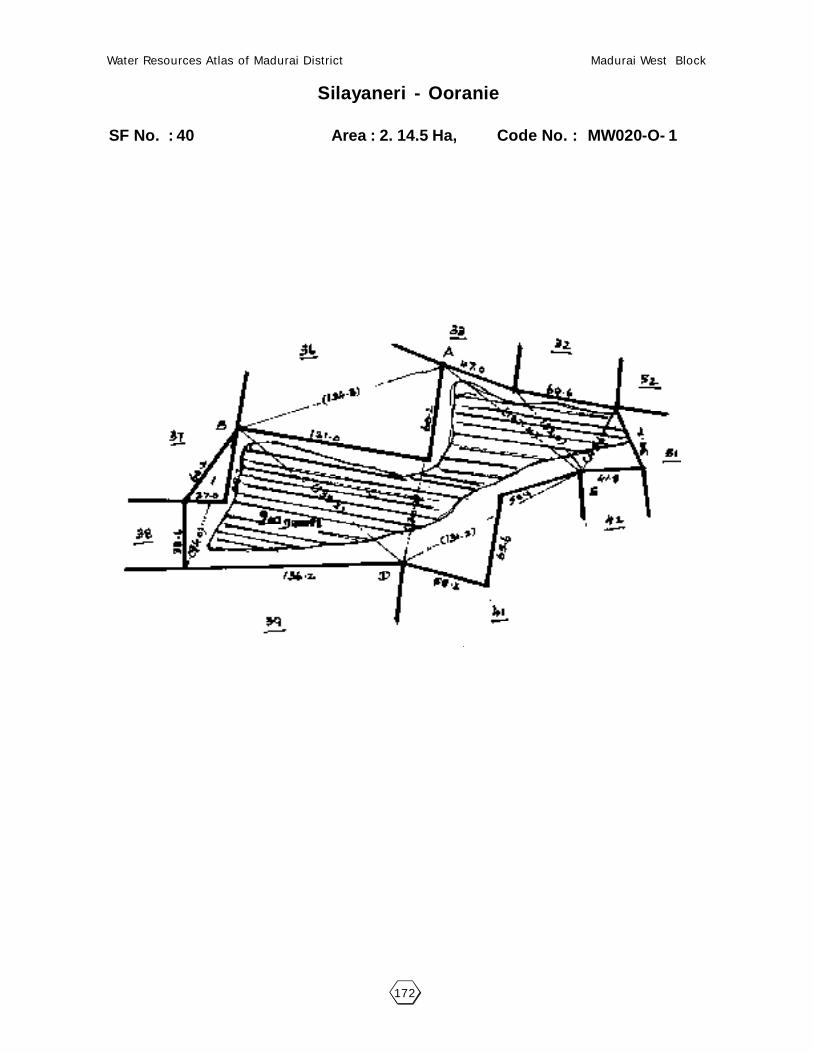
172
Water Resources Atlas of Madurai District Madurai West Block
Silayaneri - Ooranie
SF No. : 40 Area : 2. 14.5 Ha, Code No. : MW020-O- 1

173
Water Resources Atlas of Madurai District Madurai West Block
021 - THATHANERI
21.1. VILLAGE DATA :
This Village comes under Madurai North Taluk and Madurai West Block. It has
no hamlets with a total Population of 11690. The Area of this Village is 690.05 Hectares.
The splitup of Hamlets & Population are as follows :
21.2. INDEX MAP :
21.3. WATER BODIES :
This Village has 0 Water Bodies : No
Tank Ooranie
No. of Tank 0 No. of Ooranie Drinking Water Cattle
PWD System 0 0 0 0
PWD Non System 0 Pond
Panchayat Union 0 No. of Pond Drinking Water Cattle
Ex - Zamin 0 0 0 0
21.3.1. No. of Wells :
Tank is not to be filled. Convected this village is not against.
Situation : This Village is Situated 5.0 Km. distant from Madurai, 5.0 Km. distant from MaduraiRailway Junction and on the Madurai to Dindigul Road.

174
Water Resources Atlas of Madurai District Madurai West Block
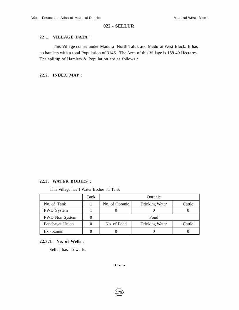
175
Water Resources Atlas of Madurai District Madurai West Block
022 - SELLUR
22.1. VILLAGE DATA :
This Village comes under Madurai North Taluk and Madurai West Block. It has
no hamlets with a total Population of 3146. The Area of this Village is 159.40 Hectares.
The splitup of Hamlets & Population are as follows :
22.2. INDEX MAP :
22.3. WATER BODIES :
This Village has 1 Water Bodies : 1 Tank
Tank Ooranie
No. of Tank 1 No. of Ooranie Drinking Water Cattle
PWD System 1 0 0 0
PWD Non System 0 Pond
Panchayat Union 0 No. of Pond Drinking Water Cattle
Ex - Zamin 0 0 0 0
22.3.1. No. of Wells :
Sellur has no wells.

176
Water Resources Atlas of Madurai District Madurai West Block
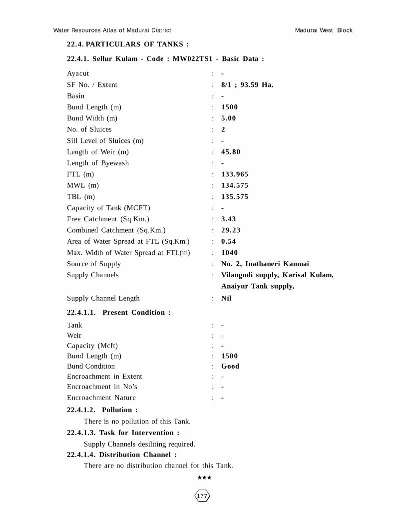
177
Water Resources Atlas of Madurai District Madurai West Block
22.4. PARTICULARS OF TANKS :
22.4.1. Sellur Kulam - Code : MW022TS1 - Basic Data :
Ayacut : -
SF No. / Extent : 8/1 ; 93.59 Ha.
Basin : -
Bund Length (m) : 1500
Bund Width (m) : 5.00
No. of Sluices : 2
Sill Level of Sluices (m) : -
Length of Weir (m) : 45.80
Length of Byewash : -
FTL (m) : 133.965
MWL (m) : 134.575
TBL (m) : 135.575
Capacity of Tank (MCFT) : -
Free Catchment (Sq.Km.) : 3.43
Combined Catchment (Sq.Km.) : 29.23
Area of Water Spread at FTL (Sq.Km.) : 0.54
Max. Width of Water Spread at FTL(m) : 1040
Source of Supply : No. 2, Inathaneri Kanmai
Supply Channels : Vilangudi supply, Karisal Kulam,
Anaiyur Tank supply,
Supply Channel Length : Nil
22.4.1.1. Present Condition :
Tank : -Weir : -Capacity (Mcft) : -Bund Length (m) : 1500Bund Condition : GoodEncroachment in Extent : -Encroachment in No’s : -
Encroachment Nature : -
22.4.1.2. Pollution :
There is no pollution of this Tank.
22.4.1.3. Task for Intervention :
Supply Channels desiliting required.
22.4.1.4. Distribution Channel :
There are no distribution channel for this Tank.

178
Water Resources Atlas of Madurai District Madurai West Block
Scale 1mm = 2000mm
Sellur - Kulam
SF No. : 8/1 Area : 2. 12.0 Ha. Code No. : MW022TS1

179
Water Resources Atlas of Madurai District Madurai West Block
023 - B.B. KULAM
23.1. VILLAGE DATA :
This Village comes under Madurai North Taluk and Madurai West Block. It has
no hamlets with a total Population of . The Area of this Village is 129.18.5
Hectares. The splitup of Hamlets & Population are as follows :
23.2. INDEX MAP :
23.3. WATER BODIES :
This Village has 0 Water Bodies : No
Tank Ooranie
No. of Tank 0 No. of Ooranie Drinking Water Cattle
PWD System 0 0 0 0
PWD Non System 0 Pond
Panchayat Union 0 No. of Pond Drinking Water Cattle
Ex - Zamin 0 0 0 0
23.3.1. No. of Wells :
Tank is not to be filled. Convected this village is not against.

180
Water Resources Atlas of Madurai District Madurai West Block

181
Water Resources Atlas of Madurai District Madurai West Block
024 - SAMBANDAR ALANGULAM
24.1. VILLAGE DATA :
This Village comes under Madurai North Taluk and Madurai West Block. It has
no hamlets with a total Population of 10500. The Area of this Village is 78.12.0 Hectares.
Latitude is 9057’00” and Longitude is 78007’30”. The splitup of Hamlets & Population
are as follows :
24.2. INDEX MAP :
24.3. WATER BODIES :
This Village has 1 Water Bodies : 1 Tank
Tank Ooranie
No. of Tank 1 No. of Ooranie Drinking Water Cattle
PWD System 0 0 0 0
PWD Non System 0 Pond
Panchayat Union 0 No. of Pond Drinking Water Cattle
Ex - Zamin 0 0 0 0
24.3.1. No. of Wells :
S.Alangulam has no wells.
Situation : This Village is Situated 6.4 Km. from Madurai and Madurai Railway Station and1.0 Km. distant from Madurai to Natham Road.
MADURAI (D)
MADURAI NORTH (T)MADURAI WEST (B)
5 Km.
4 Km.
S. ALANGULAM

182
Water Resources Atlas of Madurai District Madurai West Block

183
Water Resources Atlas of Madurai District Madurai West Block
24.4. PARTICULARS OF TANKS :
24.4.1. Silayaneri Kulam - Code : MW024TS1 - Basic Data :
Ayacut : 26.03.0 Ha
SF No. / Extent : 7 ; 8.58.0 Ha.
Basin : Peiyar vaigai basin
Bund Length (m) : 1020
Bund Width (m) : 2.00
No. of Sluices : 3
Sill Level of Sluices (m) : -
Length of Weir (m) : -
Length of Byewash : -
FTL (m) : -
MWL (m) : -
TBL (m) : -
Capacity of Tank (MCFT) : 3.98
Free Catchment (Sq.Km.) : 0.32
Combined Catchment (Sq.Km.) : 0.65
Area of Water Spread at FTL (Sq.Km.) : -
Max. Width of Water Spread at FTL(m) : -
Source of Supply : Anaiyur
Supply Channels : -
Supply Channel Length : -
24.4.1.1. Present Condition :
Tank : Drinking WaterPurpose only
Weir : -Capacity (Mcft) : 3.98Bund Length (m) : 1020Bund Condition : GoodEncroachment in Extent : -Encroachment in No’s : -
Encroachment Nature : -
24.4.1.2. Pollution :
There is no pollution of this Tank.
24.4.1.3. Task for Intervention :
Supply Channels desiliting required.
24.4.1.4. Distribution Channel :
There are no distribution channel for this Tank.

184
Water Resources Atlas of Madurai District Madurai West Block
Scale 1mm = 2000mm
S. Alangulam - Kulam
SF No. : 7 Area : 2. 12.0 Ha. Code No. : MW024TS1

185
Water Resources Atlas of Madurai District Madurai West Block
025 - ANAIYUR - BIT I
25.1. VILLAGE DATA :
This Village comes under Madurai North Taluk and Madurai West Block. It has
no hamlets with a total Population of 12000. The Area of this Village is 238.73.5 Hectares.
Latitude is 9057’30” and Longitude is 78007’00”. The splitup of Hamlets & Population
are as follows :
25.2. INDEX MAP :
25.3. WATER BODIES :
This Village has 2 Water Bodies : 1 Tank, 1 Ooranie
Tank Ooranie
No. of Tank 1 No. of Ooranie Drinking Water Cattle
PWD System 1 1 0 1
PWD Non System 0 Pond
Panchayat Union 0 No. of Pond Drinking Water Cattle
Ex - Zamin 0 0 0 0
25.3.1. No. of Wells :
Anaiyur has a total of 12 wells out of which 6 nos.of open wells, 4 nos.of
ayacut area. 2 open wells in Non-Ayacut Area.
Situation : This Village is Situated 7.2 Km. from Madurai and 6.4 Km. distant from Madurai Railway Station and nearly from Madurai to Kulamangalam Road.
MADURAI (D)
MADURAI NORTH (T)MADURAI WEST (B)
5.5 Km.
4.5 Km.
ANAIYUR BIT - I

186
Water Resources Atlas of Madurai District Madurai West Block

187
Water Resources Atlas of Madurai District Madurai West Block
25.4. PARTICULARS OF TANKS :
25.4.1. Anayur Kulam - Code : MW025TS1 - Basic Data :
Ayacut : 196.06
SF No. / Extent :
Basin : Periyar Vaigai Basin
Bund Length (m) : 2000
Bund Width (m) : 2.00
No. of Sluices : 2
Sill Level of Sluices (m) : -
Length of Weir (m) : 28.30
Length of Byewash : -
FTL (m) : 145.180
MWL (m) : 145.790
TBL (m) : 146.790
Capacity of Tank (MCFT) : 17.16
Free Catchment (Sq.Km.) : 2.15
Combined Catchment (Sq.Km.) : 6.38
Area of Water Spread at FTL (Sq.Km.) : 0.397
Max. Width of Water Spread at FTL(m) : 515
Source of Supply : Anaiyur Distributory
Supply Channels : -
Supply Channel Length : -
25.4.1.1. Present Condition :
Tank : -Weir : GoodCapacity (Mcft) : 17.16Bund Length (m) : 2000Bund Condition : GoodEncroachment in Extent : -Encroachment in No’s : -
Encroachment Nature : -
25.4.1.2. Pollution :
There is no pollution of this Tank.
25.4.1.3. Task for Intervention :
Supply Channels desiliting required.
25.4.1.4. Distribution Channel :
There are no distribution channel for this Tank.

188
Water Resources Atlas of Madurai District Madurai West Block
Scale 1mm = 2000mm
Anaiyur - Kulam
SF No. : Area : 2. 12.0 Ha. Code No. : MW025TS1

189
Water Resources Atlas of Madurai District Madurai West Block
25.5. PARTICULARS OF OORANIES :
25.5.1. Kottankulam Oorani - Code : MW025-O-1 - Basic Data :
Survey Field No. : 15-1Extent : 0.62.0Source of Supply : Rain FallLength (m) : -Breadth (m) : -Purpose (Drinking Water / Cattle) : -Present Status : Unused
25.5.1.1. Pollution :There is no pollution of this Ooranie.
25.5.1.2. Task for Intervention :-Nil-

190
Water Resources Atlas of Madurai District Madurai West Block
Anaiyur - Kottan Kulam Ooranie
SF No. : 15 Area : 1. 16.0 Ha, Code No. : MW025-O- 1
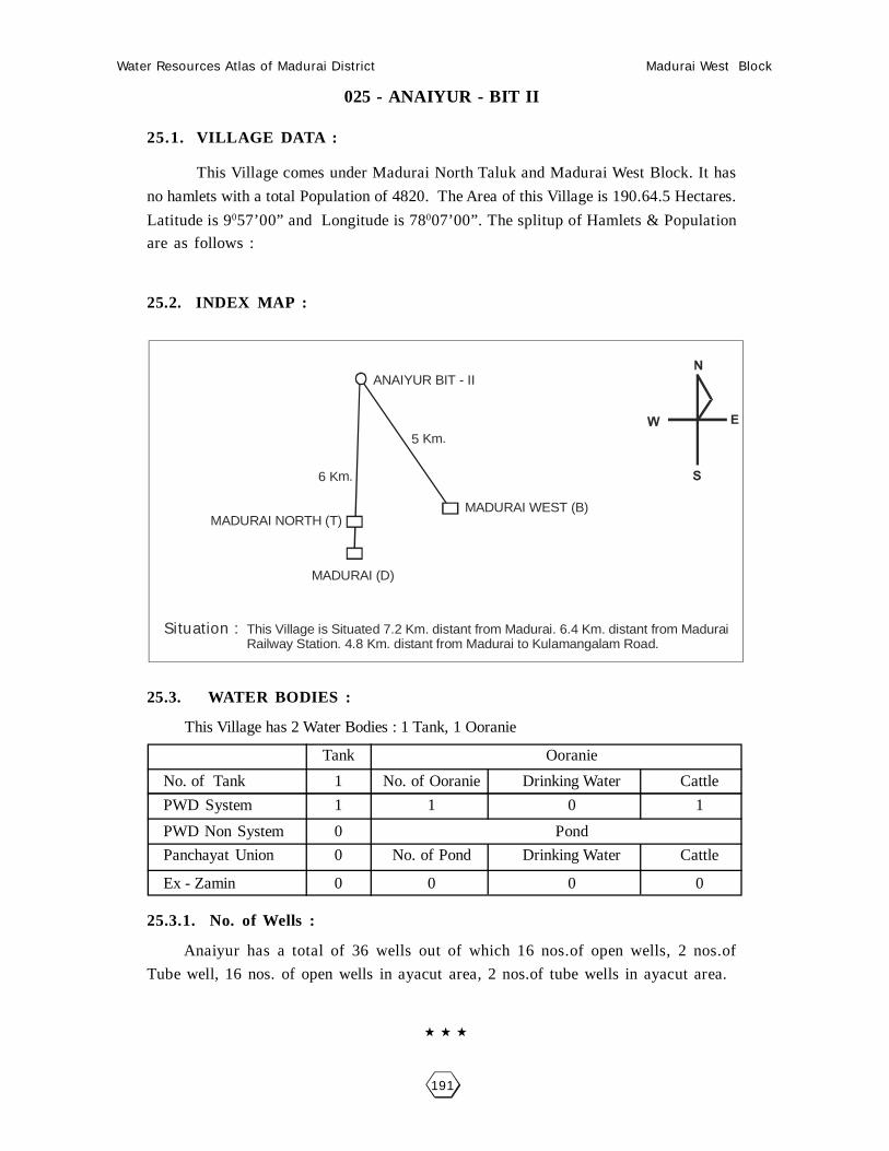
191
Water Resources Atlas of Madurai District Madurai West Block
025 - ANAIYUR - BIT II
25.1. VILLAGE DATA :
This Village comes under Madurai North Taluk and Madurai West Block. It has
no hamlets with a total Population of 4820. The Area of this Village is 190.64.5 Hectares.
Latitude is 9057’00” and Longitude is 78007’00”. The splitup of Hamlets & Population
are as follows :
25.2. INDEX MAP :
25.3. WATER BODIES :
This Village has 2 Water Bodies : 1 Tank, 1 Ooranie
Tank Ooranie
No. of Tank 1 No. of Ooranie Drinking Water Cattle
PWD System 1 1 0 1
PWD Non System 0 Pond
Panchayat Union 0 No. of Pond Drinking Water Cattle
Ex - Zamin 0 0 0 0
25.3.1. No. of Wells :
Anaiyur has a total of 36 wells out of which 16 nos.of open wells, 2 nos.of
Tube well, 16 nos. of open wells in ayacut area, 2 nos.of tube wells in ayacut area.
Situation : This Village is Situated 7.2 Km. distant from Madurai. 6.4 Km. distant from Madurai Railway Station. 4.8 Km. distant from Madurai to Kulamangalam Road.
MADURAI (D)
MADURAI NORTH (T)MADURAI WEST (B)
6 Km.
5 Km.
ANAIYUR BIT - II

192
Water Resources Atlas of Madurai District Madurai West Block

193
Water Resources Atlas of Madurai District Madurai West Block
25.4. PARTICULARS OF TANKS :
25.4.1. Anayur Kulam - Code : MW025TS1 - Basic Data :
Ayacut : 14.58
SF No. / Extent : 213/1
Basin : -
Bund Length (m) : 761
Bund Width (m) : 3.00
No. of Sluices : 2
Sill Level of Sluices (m) : 134.260
Length of Weir (m) : 5.85
Length of Byewash : 5.00
FTL (m) : 136.905
MWL (m) : 137.210
TBL (m) : 138.210
Capacity of Tank (MCFT) : 0.0366
Free Catchment (Sq.Km.) : 0.196
Combined Catchment (Sq.Km.) : 0.324
Area of Water Spread at FTL (Sq.Km.) : 0.0413
Max. Width of Water Spread at FTL(m) : 110
Source of Supply : Free basin
Supply Channels : Periyar channel,
Sambandar Alangulam Tank
Supply Channel Length : -
25.4.1.1. Present Condition :
Tank : GoodGood
Weir : GoodCapacity (Mcft) : 0.0366Bund Length (m) : 761Bund Condition : GoodEncroachment in Extent : -Encroachment in No’s : -Encroachment Nature : -
25.4.1.2. Pollution :
There is no pollution of this Tank.
25.4.1.3. Task for Intervention :
Supply Channels desiliting required.
25.4.1.4. Distribution Channel :There are no distribution channel for this Tank.

194
Water Resources Atlas of Madurai District Madurai West Block
Scale 1mm = 2000mm
Anaiyur Bit II - Kulam
SF No. : 213 Area : 6. 21.5 Ha. Code No. : MW025TS1

195
Water Resources Atlas of Madurai District Madurai West Block
25.5. PARTICULARS OF OORANIES :25.5.1. Oorani - Code : MW025-O-1 - Basic Data :
Survey Field No. : 12Extent : 0.31.0Source of Supply : Rain Water, PeriyarLength (m) : -Breadth (m) : -Purpose (Drinking Water / Cattle) : CattlePresent Status : -
25.5.1.1. Pollution :There is no pollution of this Ooranie.
25.5.1.2. Task for Intervention :Desilting, Strenghting of side walls and steps / ramps repain works are required
for this Ooranie. There is no encroachment.

196
Water Resources Atlas of Madurai District Madurai West Block
Anaiyur Bit II - Ooranie
SF No. : 12 Area : 0. 31.0 Ha, Code No. : MW025-O- 1

197
Water Resources Atlas of Madurai District Madurai West Block
026 - MILAKARANAI
26.1. VILLAGE DATA :
This Village comes under Madurai North Taluk and Madurai West Block. It has
no hamlets with a total Population of 697. The Area of this Village is 212.71.5 Hectares.
Latitude is 9058’30” and Longitude is 78006’00”. The splitup of Hamlets & Population
are as follows :
26.2. INDEX MAP :
26.3. WATER BODIES :
This Village has 2 Water Bodies : 1 Tank, 1 Ooranie
Tank Ooranie
No. of Tank 1 No. of Ooranie Drinking Water Cattle
PWD System 1 1 0 1
PWD Non System 0 Pond
Panchayat Union 0 No. of Pond Drinking Water Cattle
Ex - Zamin 0 0 0 0
26.3.1. No. of Wells :
Milakaranai has a total of 48 wells out of which 26 nos.of open wells,
22.05.5 nos.of open wells in Ayacut Area.
Situation : This Village is Situated 8.8 Km. distant North of Madurai. 8.0 Km. distant from Madurai Railway Junction. 0.8 Km. distant from Madurai to Palamedu Metalled Road.
MADURAI (D)KOVILPAPPAKUDI
1.5 Km
7 Km.
VAGAIKULAM
POTHUMBU1. Km

198
Water Resources Atlas of Madurai District Madurai West Block

199
Water Resources Atlas of Madurai District Madurai West Block
26.4. PARTICULARS OF TANKS :
26.4.1. Kulam - Code : MW026TS1 - Basic Data :
Ayacut : -
SF No. / Extent : -
Basin : -
Bund Length (m) : -
Bund Width (m) : -
No. of Sluices : -
Sill Level of Sluices (m) : -
Length of Weir (m) : -
Length of Byewash : -
FTL (m) : -
MWL (m) : -
TBL (m) : -
Capacity of Tank (MCFT) : -
Free Catchment (Sq.Km.) : -
Combined Catchment (Sq.Km.) : -
Area of Water Spread at FTL (Sq.Km.) : -
Max. Width of Water Spread at FTL(m) : -
Source of Supply : -
Supply Channels : -
Supply Channel Length : -
26.4.1.1. Present Condition :
Tank : -Weir : -Capacity (Mcft) : -Bund Length (m) : -Bund Condition : -Encroachment in Extent : 2.17.0Encroachment in No’s : 91Encroachment Nature : House
Remarks : 2 Cases
26.4.1.2. Pollution :
There is no pollution of this Tank.
26.4.1.3. Task for Intervention :
Encroachment needs to be encloused.
26.4.1.4. Distribution Channel :
There are no distribution channel for this Tank.

200
Water Resources Atlas of Madurai District Madurai West Block
Scale 1mm = 2000mm
Milakaranai - Kulam
SF No. : Area : 2. 12.0 Ha. Code No. : MW026TS1

201
Water Resources Atlas of Madurai District Madurai West Block
26.5. PARTICULARS OF OORANIES :
26.5.1. Oorani - Code : MW026-O-1 - Basic Data :
Survey Field No. : 53Extent : 0.32.5Source of Supply : -Length (m) : -Breadth (m) : -Purpose (Drinking Water / Cattle) : -Present Status : -
26.5.1.1. Pollution :There is no pollution of this Ooranie.
26.5.1.2. Task for Intervention :Desilting, Strenghting of side walls and steps / ramps repain works are required
for this Ooranie. There is no encroachment.
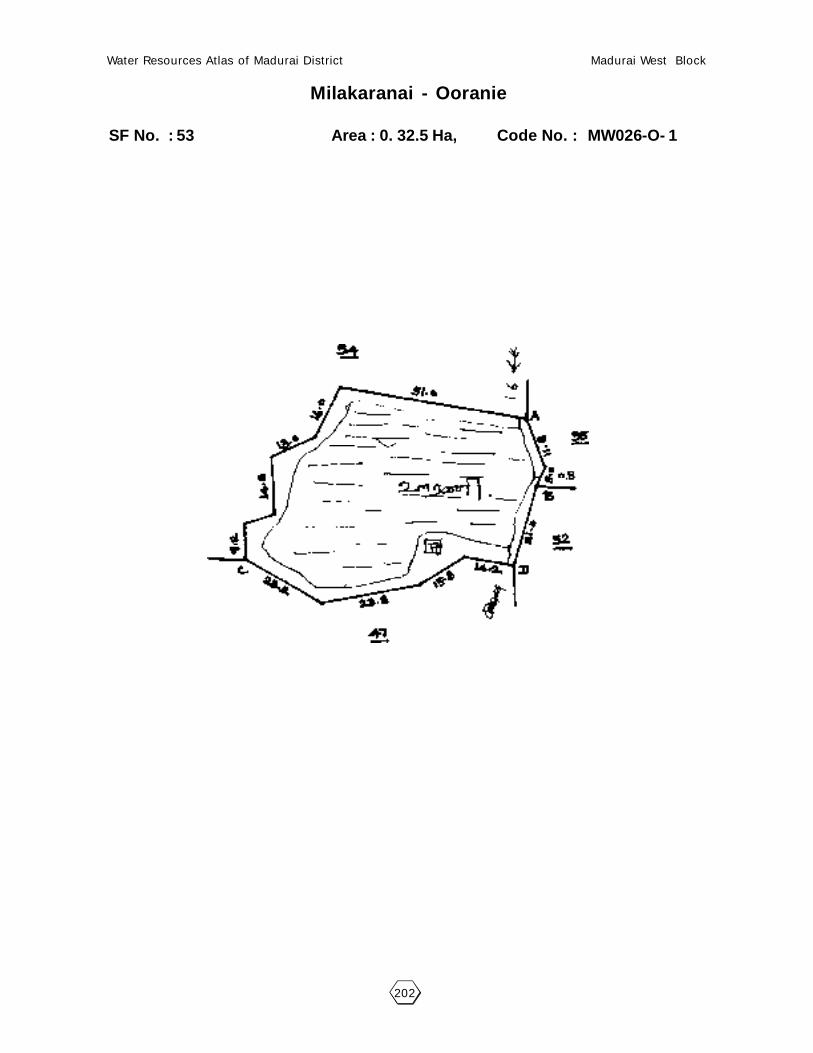
202
Water Resources Atlas of Madurai District Madurai West Block
Milakaranai - Ooranie
SF No. : 53 Area : 0. 32.5 Ha, Code No. : MW026-O- 1

203
Water Resources Atlas of Madurai District Madurai West Block
027 - VAGAIKULAM
27.1. VILLAGE DATA :
This Village comes under Madurai North Taluk and Madurai West Block. It has
no hamlets with a total Population of 1154. The Area of this Village is 76.13.5 Hectares.
Latitude is 9059’00” and Longitude is 78006’30”. The splitup of Hamlets & Population
are as follows :
27.2. INDEX MAP :
27.3. WATER BODIES :
This Village has 1 Water Bodies : 1 Tank
Tank Ooranie
No. of Tank 1 No. of Ooranie Drinking Water Cattle
PWD System 1 0 0 0
PWD Non System 0 Pond
Panchayat Union 0 No. of Pond Drinking Water Cattle
Ex - Zamin 0 0 0 0
27.3.1. No. of Wells :
Vagaigulam has a total of 13 wells out of which 6 nos.of open wells,
7.01.0 nos.of open wells in ayacut area.
Situation : This Village is Situated 11.2 Km. distant North of Madurai and 6.4 Km. distant from Vilangudi Railway Junction and nearly from Madurai to Alanganallur Road.

204
Water Resources Atlas of Madurai District Madurai West Block

205
Water Resources Atlas of Madurai District Madurai West Block
27.4. PARTICULARS OF TANKS :
27.4.1. Vagai Kulam - Code : MW027TS1 - Basic Data :
Ayacut : 40.69.5 Ha
SF No. / Extent : 3/3
Basin : -
Bund Length (m) : 1550
Bund Width (m) : 2.00
No. of Sluices : 5
Sill Level of Sluices (m) : 150.650, 149.680
149.700, 150.300, 150.900
Length of Weir (m) : 7.00
Length of Byewash : -
FTL (m) : 140.175
MWL (m) : 151.785
TBL (m) : 152.785
Capacity of Tank (MCFT) : 0.13
Free Catchment (Sq.Km.) : 0.67
Combined Catchment (Sq.Km.) : 1.08
Area of Water Spread at FTL (Sq.Km.) : 9.22.5
Max. Width of Water Spread at FTL(m) : -
Source of Supply : 13th sluice of IV BC
Supply Channels : IV Branch channels
Supply Channel Length : -
27.4.1.1. Present Condition :
Tank : -Weir : -Capacity (Mcft) : 0.13Bund Length (m) : 1550Bund Condition : GoodEncroachment in Extent : 1.04.0Encroachment in No’s : 13Encroachment Nature : -
27.4.1.2. Pollution :
There is no pollution of this Tank.
27.4.1.3. Task for Intervention :
Supply Channels desiliting required.
27.4.1.4. Distribution Channel :There are no distribution channel for this Tank.

206
Water Resources Atlas of Madurai District Madurai West Block
Vagaikulam - Kulam
SF No. : 3 Area : 13. 84.0 Ha. Code No. : MW027TS1

207
Water Resources Atlas of Madurai District Madurai West Block
028 - MELAPANAGADI
28.1. VILLAGE DATA :
This Village comes under Madurai North Taluk and Madurai West Block. It has
no hamlets with a total Population of 521. The Area of this Village is 101.43.0 Hectares.
Latitude is 9058’00” and Longitude is 78007’00”. The splitup of Hamlets & Population
are as follows :
28.2. INDEX MAP :
28.3. WATER BODIES :
This Village has 1 Water Bodies : 1 Tank
Tank Ooranie
No. of Tank 1 No. of Ooranie Drinking Water Cattle
PWD System 1 0 0 0
PWD Non System 0 Pond
Panchayat Union 0 No. of Pond Drinking Water Cattle
Ex - Zamin 0 0 0 0
28.3.1. No. of Wells :
Melapanagadi has a total of 15 wells out of which 15 nos.of open wells,
17.50.0 nos.of open wells in ayacut area.
Situation : This Village is Situated 11.2 Km. North of Madurai. 8.0 Km. distant from Vilangudi Railway Junction. 3.2 Km. distant from Madurai to Alanganallur Road.

208
Water Resources Atlas of Madurai District Madurai West Block

209
Water Resources Atlas of Madurai District Madurai West Block
28.4. PARTICULARS OF TANKS :
28.4.1. Melapanangadi- Code : MW028TS1 - Basic Data :
Ayacut : 102.53
SF No. / Extent : 62, 12.28
Basin : Periyar Vaigai Basin
Bund Length (m) : 1300
Bund Width (m) : 2.00
No. of Sluices : 3
Sill Level of Sluices (m) : 147.10
Length of Weir (m) : 11.70
Length of Byewash : -
FTL (m) : 150.115
MWL (m) : 150.865
TBL (m) : 151.868
Capacity of Tank (MCFT) : 4.56
Free Catchment (Sq.Km.) : 0.44
Combined Catchment (Sq.Km.) : 0.44
Area of Water Spread at FTL (Sq.Km.) : 0.115
Max. Width of Water Spread at FTL(m) : 270
Source of Supply : Anaiyur distributly
Supply Channels : -
Supply Channel Length : -
28.4.1.1. Present Condition :
Tank : -Weir : -Capacity (Mcft) : 4.56Bund Length (m) : 1300Bund Condition : 2.00Encroachment in Extent : -Encroachment in No’s : -Encroachment Nature : -
28.4.1.2. Pollution :
There is no pollution of this Tank.
28.4.1.3. Task for Intervention :
Supply Channels desiliting required.
28.4.1.4. Distribution Channel :There are no distribution channel for this Tank.

210
Water Resources Atlas of Madurai District Madurai West Block
Melapanangadi - Kulam
SF No. : 62 Area : 12. 97.0 Ha. Code No. : MW028TS1

211
Water Resources Atlas of Madurai District Madurai West Block
029 - KEELAPANANGADI
29.1. VILLAGE DATA :
This Village comes under Madurai North Taluk and Madurai West Block. It has
no hamlets with a total Population of 560. The Area of this Village is 67.26.0 Hectares.
Latitude is 9058’30” and Longitude is 78007’30”. The splitup of Hamlets & Population
are as follows :
29.2. INDEX MAP :
29.3. WATER BODIES :
This Village has 1 Water Bodies : 1 Tank
Tank Ooranie
No. of Tank 1 No. of Ooranie Drinking Water Cattle
PWD System 1 0 0 0
PWD Non System 0 Pond
Panchayat Union 0 No. of Pond Drinking Water Cattle
Ex - Zamin 0 0 0 0
29.3.1. No. of Wells :
Keelapanagadi has a total of 3 wells out of which 3 nos.of open wells,
3 nos.of open wells in ayacut area.
Situation : This Village is Situated 10.4 Km. North of Madurai. 7.2 Km. distant from Vilangudi Railway Junction. 2.4 Km. distant from Madurai to Natham Road.
11 Km.12 Km.
MADURAI (D)MADURAI (T)
MADURAI WEST (B)
KEELAPANANGADI

212
Water Resources Atlas of Madurai District Madurai West Block

213
Water Resources Atlas of Madurai District Madurai West Block
29.4. PARTICULARS OF TANKS :
29.4.1. Keelapanangadi- Code : MW029TS1 - Basic Data :
Ayacut : 69.54
SF No. / Extent : 3/2 - 8.10.0, 10/1- 1.88.5
Basin : Periyar Vaigai Basin
Bund Length (m) : 800
Bund Width (m) : 2.00
No. of Sluices : 3
Sill Level of Sluices (m) : 145.750
Length of Weir (m) : -
Length of Byewash : 4.58
FTL (m) : 148.338
MWL (m) : 148.521
TBL (m) : 149.521
Capacity of Tank (MCFT) : 4.15
Free Catchment (Sq.Km.) : 0.22
Combined Catchment (Sq.Km.) : 0.50
Area of Water Spread at FTL (Sq.Km.) : 0.09
Max. Width of Water Spread at FTL(m) : 220
Source of Supply : Anaiyur distributly
Supply Channels : Veppanakulam tank supply
Supply Channel Length : 630
29.4.1.1. Present Condition :
Tank : -Weir : Natural Ground EscapeCapacity (Mcft) : 4.15Bund Length (m) : 800Bund Condition : GoodEncroachment in Extent : 0.73.5Encroachment in No’s : 4Encroachment Nature : Paddy Cultivation
29.4.1.2. Pollution :
There is no pollution of this Tank.
29.4.1.3. Task for Intervention :
Encroachment needs to be encloused.
29.4.1.4. Distribution Channel :There are no distribution channel for this Tank.

214
Water Resources Atlas of Madurai District Madurai West Block
Keelapanangadi - Kulam
SF No. : 10 Area : 2. 56.0 Ha. Code No. : MW029TS1

215
Water Resources Atlas of Madurai District Madurai West Block
030 - VEPPANKULAM
30.1. VILLAGE DATA :
This Village comes under Madurai North Taluk and Madurai West Block. It has
no hamlets with a total Population of . The Area of this Village is 82.61.0 Hectares.
Latitude is 9059’00” and Longitude is 78007’30”. The splitup of Hamlets & Population
are as follows :
30.2. INDEX MAP :
30.3. WATER BODIES :
This Village has 2 Water Bodies : 2 Tank
Tank Ooranie
No. of Tank 1 No. of Ooranie Drinking Water Cattle
PWD System 1 0 0 0
PWD Non System 0 Pond
Panchayat Union 0 No. of Pond Drinking Water Cattle
Ex - Zamin 0 0 0 0
30.3.1. No. of Wells :
Veppankulam has a total of 4 wells out of which 2 nos.of open wells,
2 nos.of open wells in ayacut area.
Situation : This Village is Situated 9.6 Km. North of Madurai and the same distant from Madurai Railway Junction and 2.4 Km. distant from Madurai to Natham Road.
11 Km.12 Km.
MADURAI (D)MADURAI (N)
MADURAI WEST (B)
VEPPANKULAM
216
Water Resources Atlas of Madurai District Madurai West Block

217
Water Resources Atlas of Madurai District Madurai West Block
30.4. PARTICULARS OF TANKS :
30.4.1. Veppankulam tank - Code : MW030TS1 - Basic Data :
Ayacut : 67.00
SF No. / Extent : 33/1 -0.18.0, 37/1 - 5.55.5
Basin : Periyar Vaigai Basin
Bund Length (m) : 950
Bund Width (m) : 2.00
No. of Sluices : 2
Sill Level of Sluices (m) : 147.90
Length of Weir (m) : 7.32
Length of Byewash : -
FTL (m) : 151.230
MWL (m) : 151.610
TBL (m) : 152.610
Capacity of Tank (MCFT) : 3.27
Free Catchment (Sq.Km.) : 0.09
Combined Catchment (Sq.Km.) : 0.28
Area of Water Spread at FTL (Sq.Km.) : 0.10
Max. Width of Water Spread at FTL(m) : 190
Source of Supply : Anaiyur distributly
Supply Channels : Kuruthankulam tank supply
Supply Channel Length : 720
30.4.1.1. Present Condition :
Tank : -Weir : Natural ground escapeCapacity (Mcft) : 3.27Bund Length (m) : 550Bund Condition : GoodEncroachment in Extent : 0.15.0Encroachment in No’s : 3Encroachment Nature : Paddy Cultivation
30.4.1.2. Pollution :
There is no pollution of this Tank.
30.4.1.3. Task for Intervention :
Encroachment needs to be encloused.
30.4.1.4. Distribution Channel :There are no distribution channel for this Tank.

218
Water Resources Atlas of Madurai District Madurai West Block
Veppankulam - Kulam
SF No. : 37 Area : 6. 05.5 Ha. Code No. : MW030TS1

219
Water Resources Atlas of Madurai District Madurai West Block
30.4. PARTICULARS OF TANKS :
30.4.1. Karuthankulam - Code : MW030TS2 - Basic Data :
Ayacut : 69.00
SF No. / Extent : 14/ 5.70.0
Basin : Periyar Vaigai Basin
Bund Length (m) : 790
Bund Width (m) : 2.00
No. of Sluices : 1
Sill Level of Sluices (m) : 145.60
Length of Weir (m) : 3.90
Length of Byewash : -
FTL (m) : 147.21.0
MWL (m) : 178.30.0
TBL (m) : 179.00.0
Capacity of Tank (MCFT) : 2.10
Free Catchment (Sq.Km.) : 0.06
Combined Catchment (Sq.Km.) : 0.15
Area of Water Spread at FTL (Sq.Km.) : 0.07
Max. Width of Water Spread at FTL(m) : 180
Source of Supply : Anaiyur distributly
Supply Channels : -
Supply Channel Length : -
30.4.1.1. Present Condition :
Tank : -Weir : -Capacity (Mcft) : 2.10Bund Length (m) : 790Bund Condition : GoodEncroachment in Extent : -Encroachment in No’s : -Encroachment Nature : -
30.4.1.2. Pollution :
There is no pollution of this Tank.
30.4.1.3. Task for Intervention :
Supply Channels desiliting required.
30.4.1.4. Distribution Channel :There are no distribution channel for this Tank.

220
Water Resources Atlas of Madurai District Madurai West Block
Veppankulam - Karuthan Kulam
SF No. : 14 Area : 5. 48.0 Ha. Code No. : MW030TS1

Water Resources Atlas of Madurai District Madurai West Block
211
031 - BOOTHAGUDI
31.1. VILLAGE DATA :
This Village comes under Madurai North Taluk and Madurai West Block. It
has 1 hamlets with a total Population 1247. The Area of this Village is 268.70.5
Hectares. Latitude is 9059’30” and Longitude is 78006’30” . The splitup of Hamlets
& Population are as follows :
B. Perumalpatty : 327
31.2. INDEX MAP :
31.3. WATER BODIES :
This Village has 3 Water Bodies : 1 Tank, 2 Ooranie.
Tank Ooranie
No. of Tank 1 No. of Ooranie Drinking Water Cattle
PWD System 1 2 0 2
PWD Non System 0 Pond
Panchayat Union 0 No. of Pond Drinking Water Cattle
Ex - Zamin 0 0 0 0
31.3.1. No. of Wells :
Boothagudi has a total of 186.16.5 wells. Out of which 20 are open wells, 20
pen wells in ayacut area, 2 open wells in non ayacut area.
Situation : This Village is Situated 9.6 Km. distant from Madurai, 9.6 K.m. distant from Madurai Railway Junction and on the Madurai to Kulamangalam Road.
9 Km.
1.5 Km.
MADURAI WEST (B)MADURAI (D) (T)
KULAMANGALAM
BOOTHAGUDY7
Km
.

Water Resources Atlas of Madurai District Madurai West Block
212

Water Resources Atlas of Madurai District Madurai West Block
213
31.4. PARTICULARS OF TANKS :
31.4.1. Boothagudi Tank - Code : MW031TSW1 - Basic Data :
Ayacut : 449.67
SF No. / Extent : -
Basin : Periyar Vaigai
Bund Length (m) : 2400
Bund Width (m) : 2.00
No. of Sluices : 3
Sill Level of Sluices (m) : -
Length of Weir (m) : 27.6, 15.00
Length of Byewash : -
FTL (m) : 156.100
MWL (m) : 156.500
TBL (m) : 157.500
Capacity of Tank (MCFT) : 16.26
Free Catchment (Sq.Km.) : 0.36
Combined Catchment (Sq.Km.) : 2.65
Area of Water Spread at FTL (Sq.Km.) : 0.426
Max. Width of Water Spread at FTL(m) : 420
Source of Supply : Thondalai off tank
Supply Channels : Vadugapatti tank supply
Supply Channel Length : 1200
31.4.1.1. Present Condition :
Tank : -Weir : GoodCapacity (Mcft) : 16.26Bund Length (M) : 2400Bund Condition : OverageEncroachment in Extent : 0.18.0Encroachment in No’s : 5
Encroachment Nature : Trees
31.4.1.2. Pollution :
There is no Pollution of this Tank.
31.4.1.3. Task for Intervention :
Supply Channels Desilting Required.
31.4.1.4. Distribution Channel :
There are 3 Distribution channel for this Tank.

Water Resources Atlas of Madurai District Madurai West Block
214
Boothagudi - Boothagudi Kulam
SF No. : 0, Area : 17. 11.5Ha, Code No. : MW031TSW1

Water Resources Atlas of Madurai District Madurai West Block
215
31.5. PARTICULARS OF OORANIES :
31.5.1. Eswaran Kovil Ooranie - Code : MW031-O-1 - Basic Data :
Survey Field No. : 36/5Extent : 0.58.5Source of Supply : Rain water & PeriyarLength (m) : 78.00Breadth (m) : 55.00Purpose (Drinking Water / Cattle) : CattlePresent Status : Good
31.5.1.1. Pollution :
There is no pollution of this Ooranie.
31.5.1.2. Task for Intervention :-Nil-
31.5. PARTICULARS OF OORANIES :
31.5.2. Vathu Ooranie - Code : MW031-O-2 - Basic Data :
Survey Field No. : 48/5CExtent : 1.41.0Source of Supply : Rain Water of PeriyarLength (m) : 90.00Breadth (m) : 82.00Purpose (Drinking Water / Cattle) : CattlePresent Status : Good
31.5.2.1. Pollution :
There is no pollution of this Ooranie.
31.5.2.2. Task for Intervention :-Nil-

Water Resources Atlas of Madurai District Madurai West Block
216
Boothagudi - Easwaran Kovil Ooranie
SF No. : 36 , Area : 2. 91.5Ha, Code No. : MW0031-O-1

Water Resources Atlas of Madurai District Madurai West Block
217
Boothagudi - Vathu Ooranie
SF No. : 48, Area : 3. 64.5Ha, Code No. : MW0031-O-2

Water Resources Atlas of Madurai District Madurai West Block
218

Water Resources Atlas of Madurai District Madurai West Block
219
032 - VADUKAPATTI
32.1. VILLAGE DATA :
This Village comes under Madurai North Taluk and Madurai West Block. It
has 0 hamlets with a total Population 196. The Area of this Village is 213.23.5
Hectares. Latitude is 10000’30” and Longitude is 78006’00”. The splitup of Hamlets
& Population are as follows :
32.2. INDEX MAP :
32.3. WATER BODIES :
This Village has 3 Water Bodies : 3 Tank.
Tank Ooranie
No. of Tank 3 No. of Ooranie Drinking Water Cattle
PWD System 3 0 0 0
PWD Non System 0 Pond
Panchayat Union 0 No. of Pond Drinking Water Cattle
Ex - Zamin 0 0 0 0
32.3.1. No. of Wells :
Vadukapatti has a total of 52 wells. Out of which 26 are open wells, 18 open
wells in ayacut area and Open wells in Non-Ayacut area.
Situation : This Village is Situated 14.4 Km. distant North West of Madurai, 8.0 K.m. distant from Vilangudi Railway Junction and 1.6 Km. distant from Madurai to Nilakkottai Road.
13 K
m.
1.5
Km
.
MADURAI (D)MADURAI (T)
MADURAI WEST (B)
VADUKAPATTI

Water Resources Atlas of Madurai District Madurai West Block
220

Water Resources Atlas of Madurai District Madurai West Block
221
32.4. PARTICULARS OF TANKS :
32.4.1. Vadukapatti Kanmai - Code : MW0032TSW1 - Basic Data :
Ayacut : 86.08.5 Ha
SF No. / Extent : 1/4, 15.42.5 Ha
Basin : Periyar Vaigai Basin
Bund Length (m) : 2100
Bund Width (m) : 2.00
No. of Sluices : 4
Sill Level of Sluices (m) : -
Length of Weir (m) : 15.85
Length of Byewash : -
FTL (m) : -
MWL (m) : -
TBL (m) : -
Capacity of Tank (MCFT) : 13.82
Free Catchment (Sq.Km.) : 0.53
Combined Catchment (Sq.Km.) : 0.53
Area of Water Spread at FTL (Sq.Km.) : -
Max. Width of Water Spread at FTL(m) : -
Source of Supply : Thondalai OT
Supply Channels : Sathyar Odai
Supply Channel Length : 1200
32.4.1.1. Present Condition :
Tank : -Weir : GoodCapacity (Mcft) : 13.82Bund Length (M) : 2100Bund Condition : GoodEncroachment in Extent : 0.21.0Encroachment in No’s : 11
Encroachment Nature : Cultivation
32.4.1.2. Pollution :
There is no Pollution of this Tank.
32.4.1.3. Task for Intervention :
Supply Channels Desilting Required.
32.4.1.4. Distribution Channel :
There are 3 Distribution channel for this Tank.

Water Resources Atlas of Madurai District Madurai West Block
222
Vadukapatti - Vadukapatti Kanmai
SF No. : 1, Area : 16. 76.0Ha, Code No. : MW0032-TSW1

Water Resources Atlas of Madurai District Madurai West Block
223
32.4. PARTICULARS OF TANKS :
32.4.2. Venkata Samutharam Kulam - Code : MW032TSW2 - Basic Data :
Ayacut : 10.07.0
SF No. / Extent : 27/8,3190
Basin : -
Bund Length (m) : -
Bund Width (m) : -
No. of Sluices : -
Sill Level of Sluices (m) : -
Length of Weir (m) : -
Length of Byewash : -
FTL (m) : -
MWL (m) : -
TBL (m) : -
Capacity of Tank (MCFT) : -
Free Catchment (Sq.Km.) : -
Combined Catchment (Sq.Km.) : -
Area of Water Spread at FTL (Sq.Km.) : -
Max. Width of Water Spread at FTL(m) : -
Source of Supply : -
Supply Channels : -
Supply Channel Length : -
32.4.2.1. Present Condition :
Tank : -Weir : -Capacity (Mcft) : -Bund Length (M) : -Bund Condition : -Encroachment in Extent : 0.040Encroachment in No’s : 4
Encroachment Nature : Cultivation
32.4.2.2. Pollution :
There is no Pollution of this Tank.
32.4.2.3. Task for Intervention :
Encroachment needs tobe Required.
32.4.2.4. Distribution Channel :
There are 3 Distribution channel for this Tank.

Water Resources Atlas of Madurai District Madurai West Block
224
Vadukapatti - Venkatasamuthram Kulam
SF No. : 27, Area : 5. 70.5 Ha, Code No. : MW032-TSW2

Water Resources Atlas of Madurai District Madurai West Block
225
32.4. PARTICULARS OF TANKS :
32.4.3. Mulliyenthal Kulam - Code : MW032TSW3 - Basic Data :
Ayacut : 9.26.5
SF No. / Extent : 41/6, 3.445, 41/9.002.0
Basin : -
Bund Length (m) : -
Bund Width (m) : -
No. of Sluices : -
Sill Level of Sluices (m) : -
Length of Weir (m) : -
Length of Byewash : -
FTL (m) : -
MWL (m) : -
TBL (m) : -
Capacity of Tank (MCFT) : -
Free Catchment (Sq.Km.) : -
Combined Catchment (Sq.Km.) : -
Area of Water Spread at FTL (Sq.Km.) : -
Max. Width of Water Spread at FTL(m) : -
Source of Supply : -
Supply Channels : -
Supply Channel Length : -
32.4.3.1. Present Condition :
Tank : -Weir : -Capacity (Mcft) : -Bund Length (M) : -Bund Condition : -Encroachment in Extent : 0.14.0Encroachment in No’s : 10
Encroachment Nature : Cultivation
32.4.3.2. Pollution :
There is no Pollution of this Tank.
32.4.3.3. Task for Intervention :
Encroachment needs tobe Required.
32.4.3.4. Distribution Channel :
There are 3 Distribution channel for this Tank.

Water Resources Atlas of Madurai District Madurai West Block
226
Vadukapatti - Mulliyenthal Kulam
SF No. : 41, Area : 6. 94.0 Ha, Code No. : MW032-TSW3
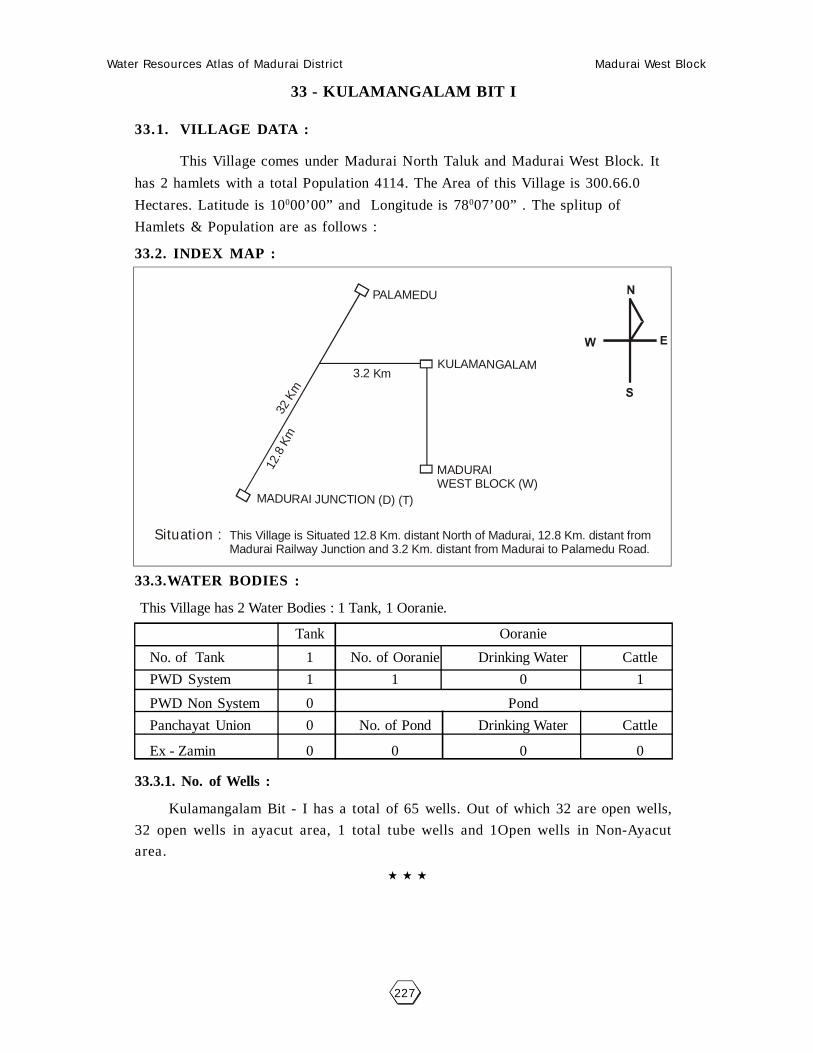
Water Resources Atlas of Madurai District Madurai West Block
227
33 - KULAMANGALAM BIT I
33.1. VILLAGE DATA :
This Village comes under Madurai North Taluk and Madurai West Block. It
has 2 hamlets with a total Population 4114. The Area of this Village is 300.66.0
Hectares. Latitude is 10000’00” and Longitude is 78007’00” . The splitup of
Hamlets & Population are as follows :
33.2. INDEX MAP :
33.3.WATER BODIES :
This Village has 2 Water Bodies : 1 Tank, 1 Ooranie.
Tank Ooranie
No. of Tank 1 No. of Ooranie Drinking Water Cattle
PWD System 1 1 0 1
PWD Non System 0 Pond
Panchayat Union 0 No. of Pond Drinking Water Cattle
Ex - Zamin 0 0 0 0
33.3.1. No. of Wells :
Kulamangalam Bit - I has a total of 65 wells. Out of which 32 are open wells,
32 open wells in ayacut area, 1 total tube wells and 1Open wells in Non-Ayacut
area.
Situation : This Village is Situated 12.8 Km. distant North of Madurai, 12.8 Km. distant from Madurai Railway Junction and 3.2 Km. distant from Madurai to Palamedu Road.
32 K
m
3.2 Km
PALAMEDU
KULAMANGALAM
MADURAIWEST BLOCK (W)
12.8
Km
MADURAI JUNCTION (D) (T)

Water Resources Atlas of Madurai District Madurai West Block
228

Water Resources Atlas of Madurai District Madurai West Block
229
33.4. PARTICULARS OF TANKS :
33.4.1. Kulamangalam Kanmai - Code : MW033TSW1 - Basic Data :
Ayacut : 242.60 Ha
SF No. / Extent : 29/2- 49.90.5 Ha
Basin : Periyar Vaigai Basin
Bund Length (m) : 1850
Bund Width (m) : 2.00
No. of Sluices : 2
Sill Level of Sluices (m) : -
Length of Weir (m) : 3
Length of Byewash : -
FTL (m) : 163.489
MWL (m) : 164.099
TBL (m) : 165.013
Capacity of Tank (MCFT) : 19.30
Free Catchment (Sq.Km.) : 9.74
Combined Catchment (Sq.Km.) : 39.24
Area of Water Spread at FTL (Sq.Km.) : 49.90
Max. Width of Water Spread at FTL(m) : -
Source of Supply : Thandalai OT
Supply Channels : Sathayar OdaiSupply Channel Length :
33.4.1.1. Present Condition :
Tank : -Weir : -Capacity (Mcft) : 19.30Bund Length (M) : 1850Bund Condition : GoodEncroachment in Extent : 0.45.0Encroachment in No’s : 11
Encroachment Nature : Well & Coconut & Palm
33.4.1.2. Pollution :
There is no Pollution of this Tank.
33.4.1.3. Task for Intervention :
Encroachment needs tobe Required.
33.4.1.4. Distribution Channel :
There are 3 Distribution channel for this Tank.

Water Resources Atlas of Madurai District Madurai West Block
230
Kulamangalam Bit I - Kulamangalam
SF No. : 29, Area : 49. 94.0 Ha, Code No. : MW033-TSW1

Water Resources Atlas of Madurai District Madurai West Block
231
33.5. PARTICULARS OF OORANIES :
33.5.1. Moonji Ooranie - Code : MW033-O-1 - Basic Data :
Survey Field No. : 43/3Extent : 0.54.0Source of Supply : RainLength (m) : 106.50Breadth (m) : 86.00Purpose (Drinking Water / Cattle) : CattlePresent Status : -
33.5.1.1. Pollution :
There is no pollution of this Ooranie.
33.5.1.2. Task for Intervention :Desilting, strengthening are required for this Ooranie. There is no encroach-
ment.
33.5. PARTICULARS OF OORANIES :
33.5.2. Moonanthal Ooranie - Code : MW033-O-2 - Basic Data :
Survey Field No. : -Extent : -Source of Supply : RainLength (m) : 97.80Breadth (m) : 86.20Purpose (Drinking Water / Cattle) : CattlePresent Status : -
33.5.2.1. Pollution :
There is no pollution of this Ooranie.
33.5.2.2. Task for Intervention :Desilting, strengthening are required for this Ooranie. There is no encroach-
ment.

Water Resources Atlas of Madurai District Madurai West Block
232
Kulamangalam Bit I - Moonji Ooranie
SF No. : 43, Area : 1. 99.0 Ha, Code No. : MW033-O-1

Water Resources Atlas of Madurai District Madurai West Block
233
Kulamangalam Bit I - Moonanthal Ooranie
SF No. : , Area : 17. 11.5Ha, Code No. : MW033-O-2

Water Resources Atlas of Madurai District Madurai West Block
234

Water Resources Atlas of Madurai District Madurai West Block
235
33 - KULAMANGALAM BIT II
33.1. VILLAGE DATA :
This Village comes under Madurai North Taluk and Madurai West Block. It
has 2 hamlets with a total Population 750. The Area of this Village is 154.23.0
Hectares. Latitude is 10000’00” and Longitude is 78007’30” . The splitup of Hamlets
& Population are as follows :
Elumbur : 650 Kulamangalam II : 100
33.2. INDEX MAP :
33.3.WATER BODIES :
This Village has 2 Water Bodies : 2 Ooranie.
Tank Ooranie
No. of Tank 0 No. of Ooranie Drinking Water Cattle
PWD System 0 2 0 2
PWD Non System 0 Pond
Panchayat Union 0 No. of Pond Drinking Water Cattle
Ex - Zamin 0 0 0 0
33.3.1. No. of Wells :
Vitlangudi has a total of 13 wells.
Situation : This Village is Situated 12.8 Km. distant North of Madurai, 12.8 Km. distant from Madurai Railway Junction and 3.2 Km. distant from Madurai to Palamedu Road.
32 K
m
3.2 Km
PALAMEDU
KULAMANGALAM
MADURAIWEST BLOCK (W)
12.8
Km
MADURAI JUNCTION (D) (T)

Water Resources Atlas of Madurai District Madurai West Block
236

Water Resources Atlas of Madurai District Madurai West Block
237
33.5. PARTICULARS OF OORANIES :
33.5.1. Pillaiyar Kovil Madathu Ooranie - Code : MW033-O-1 - Basic Data :
Survey Field No. : 11/3Extent : 0510Source of Supply : Periyar ChannelLength (m) : 1/0.00Breadth (m) : 97.80Purpose (Drinking Water / Cattle) : CattlePresent Status :
33.5.1.1. Pollution :
There is no pollution of this Ooranie.
33.5.1.2. Task for Intervention :Desilting, strengthening are required for this Ooranie. There is no encroachment.
33.5. PARTICULARS OF OORANIES :
33.5.2. Keeranatham Ooranie - Code : MW033-O-2 - Basic Data :
Survey Field No. : 70/7Extent : 0.58.5Source of Supply : Periyar ChannelLength (m) : 85.80Breadth (m) : 69.60Purpose (Drinking Water / Cattle) : CattlePresent Status :
33.5.2.1. Pollution :
There is no pollution of this Ooranie.
33.5.2.2. Task for Intervention :Desilting, strengthening are required for this Ooranie. There is no encroachment.

Water Resources Atlas of Madurai District Madurai West Block
238
Kulamangalam Bit II - Pillaiyar Kovil Madathu Ooranie
SF No. : 11, Area : 17. 11.5Ha, Code No. : MW033-O-1

Water Resources Atlas of Madurai District Madurai West Block
239
Kulamangalam Bit II - Keeranatham Ooranie
SF No. : 70, Area : 2. 87.5 Ha, Code No. : MW033-O-2

Water Resources Atlas of Madurai District Madurai West Block
240

Water Resources Atlas of Madurai District Madurai West Block
241
34 - KARUVANUR
34.1. VILLAGE DATA :
This Village comes under Madurai North Taluk and Madurai West Block. It
has 1 hamlets with a total Population. The Area of this Village is 248.07.0 Hectares.
Latitude is 10001’30” and Longitude is 78008’30” . The splitup of Hamlets &
Population are as
follows :
34.2. INDEX MAP :
34.3.WATER BODIES :
This Village has 3 Water Bodies : 2 Tank, 1 Ooranie.
Tank Ooranie
No. of Tank 2 No. of Ooranie Drinking Water Cattle
PWD System 0 1 0 1
PWD Non System 0 Pond
Panchayat Union 0 No. of Pond Drinking Water Cattle
Ex - Zamin 0 0 0 0
34.3.1. No. of Wells :
Karuvanur has a total of 38 wells. Out of which 38 are open wells, 12.25.5
open wells in ayacut area.
Situation : This Village is Situated 12.8 Km. distant North of Madurai and on the Madurai to Natham metalled Road.
2 Km
KARUVANOOR1 2
.8 K
m
MADURAI WEST
MADURAI NORTHMADURAI (D)

Water Resources Atlas of Madurai District Madurai West Block
242

Water Resources Atlas of Madurai District Madurai West Block
243
34.4. PARTICULARS OF TANKS :
34.4.1. Periyakulam Kanmai - Code : MW034TSW1 - Basic Data :
Ayacut : 86.47.5 Ha
SF No. / Extent : 94/1 & 38.09.0 Ha
Basin : Periyar Vaigai Basin
Bund Length (m) : 1800
Bund Width (m) : 3
No. of Sluices : 3
Sill Level of Sluices (m) : -
Length of Weir (m) : 21.70 & 19th
Length of Byewash : -
FTL (m) : 528.60
MWL (m) : 531.61
TBL (m) : 534.61
Capacity of Tank (MCFT) : 12.93
Free Catchment (Sq.Km.) : -
Combined Catchment (Sq.Km.) : -
Area of Water Spread at FTL (Sq.Km.) : 94.12
Max. Width of Water Spread at FTL(m) : -
Source of Supply : 9 (L) of 5th BL
Supply Channels :
Supply Channel Length : 100
34.4.1.1. Present Condition :
Tank : Minor RepairWeir : FairCapacity (Mcft) : 6.45Bund Length (M) : 1800Bund Condition : Good ConditionEncroachment in Extent : 1.200Encroachment in No’s : 18
Encroachment Nature : Baddy
34.4.1.2. Pollution :
There is no Pollution of this Tank.
34.4.1.3. Task for Intervention :
Supply Channels Desilting Required.
34.4.1.4. Distribution Channel :
There are 3 Distribution channel for this Tank.

Water Resources Atlas of Madurai District Madurai West Block
244
Karuvanur - Karuvanur Periya Kanmai
SF No. : 94, Area : 38. 19.0Ha, Code No. : MW033-O-1

Water Resources Atlas of Madurai District Madurai West Block
245
34.4. PARTICULARS OF TANKS :
34.4.2. Chinnakulam Kanmai - Code : MW034TSW2 - Basic Data :
Ayacut : 27.78.5 Ha
SF No. / Extent : 45 & 12.88.0 Ha
Basin : -
Bund Length (m) : 1500
Bund Width (m) : 2
No. of Sluices : 2
Sill Level of Sluices (m) : -
Length of Weir (m) : -
Length of Byewash : Natural Ground escape
FTL (m) : 101.82 (6.0)
MWL (m) : 103.82
TBL (m) : 104.83
Capacity of Tank (MCFT) : 1.74
Free Catchment (Sq.Km.) : -
Combined Catchment (Sq.Km.) : Free Basin only
Area of Water Spread at FTL (Sq.Km.) : -
Max. Width of Water Spread at FTL(m) : -
Source of Supply : 9 (R) of 5th BL
Supply Channels :
Supply Channel Length : 800
34.4.2.1. Present Condition :
Tank : FairWeir : Natural Ground EscapeCapacity (Mcft) : 3.20Bund Length (M) : 1800Bund Condition : FairEncroachment in Extent : 1.14.0Encroachment in No’s : 12
Encroachment Nature : -
34.4.1.2. Pollution :
There is no Pollution of this Tank.
34.4.1.3. Task for Intervention :
Supply Channels Desilting Required.
34.4.1.4. Distribution Channel :
There are 3 Distribution channel for this Tank.

Water Resources Atlas of Madurai District Madurai West Block
246
Karuvanur - Chinnakulam Kanmai
SF No. : 45, Area : 12. 88.0Ha, Code No. : MW033-O-2

Water Resources Atlas of Madurai District Madurai West Block
247
34.5. PARTICULARS OF OORANIES :
34.5.1. Ooranie - Code : MW034-O-1 - Basic Data :
Survey Field No. : 23Extent : 018.5Source of Supply : Periyar ChannelLength (m) : 60.00Breadth (m) : 40.00Purpose (Drinking Water / Cattle) : -Present Status : Dry
34.5.1.1. Pollution :
There is no pollution of this Ooranie.
34.5.1.2. Task for Intervention :Desilting, strengthening are required for this Ooranie. There is no encroachment.

Water Resources Atlas of Madurai District Madurai West Block
248
Karuvanur - Ooranie
SF No. : 23, Area : 0. 18.5Ha, Code No. : MW034-O-1

Water Resources Atlas of Madurai District Madurai West Block
249
35 - VEERAPANDI BIT I
35.1. VILLAGE DATA :
This Village comes under Madurai North Taluk and Madurai West Block. It
has 1 hamlets with a total Population 500. The Area of this Village is 226.96.5
Hectares. Latitude is 10000’00” and Longitude is 78008’30” . The splitup of Hamlets
& Population are as
follows :
35.2. INDEX MAP :
35.3.WATER BODIES :
This Village has 2 Water Bodies : 1 Tank, 1 Ooranie.
Tank Ooranie
No. of Tank 2 No. of Ooranie Drinking Water Cattle
PWD System 0 1 0 1
PWD Non System 0 Pond
Panchayat Union 0 No. of Pond Drinking Water Cattle
Ex - Zamin 0 0 0 0
35.3.1. No. of Wells :
Veerapandi has a total of 8 wells. Out of which 4 are open wells, 4 open wells
in ayacut area.
Situation : This Village is Situated 12.0 Km. distant from Madurai and the same distant from Madurai Railway Station and 2.0 Km. distant from Madurai to Natham Road.

Water Resources Atlas of Madurai District Madurai West Block
250

Water Resources Atlas of Madurai District Madurai West Block
251
35.4. PARTICULARS OF TANKS :
35.4.1. Kurunthankulam Tank - Code : MW035TSW1 - Basic Data :
Ayacut : 105.26 Ha
SF No. / Extent : -
Basin : Periyar Basin
Bund Length (m) : 1800
Bund Width (m) : 2
No. of Sluices : 3
Sill Level of Sluices (m) : -
Length of Weir (m) : 20
Length of Byewash : 1.510/98
FTL (m) : 103.96
MWL (m) : 105.78
TBL (m) : 2.44
Capacity of Tank (MCFT) : 1.74
Free Catchment (Sq.Km.) : -
Combined Catchment (Sq.Km.) : Free Basin only
Area of Water Spread at FTL (Sq.Km.) : -
Max. Width of Water Spread at FTL(m) : 34.34 A/C
Source of Supply : 12B of 5th BC
Supply Channels :
Supply Channel Length : 10
35.4.2.1. Present Condition :
Tank : FairWeir : FairCapacity (Mcft) : 1.20Bund Length (M) : 1800Bund Condition : FairEncroachment in Extent : -Encroachment in No’s : -
Encroachment Nature : -
35.4.1.2. Pollution :
There is no Pollution of this Tank.
35.4.1.3. Task for Intervention :
Supply Channels Desilting Required.
35.4.1.4. Distribution Channel :
There are 3 Distribution channel for this Tank.

Water Resources Atlas of Madurai District Madurai West Block
252
Veerapandi Bit I - Kurunthan Kulam
SF No. : 0, Area : 17. 11.5Ha, Code No. : MW035-O-1

Water Resources Atlas of Madurai District Madurai West Block
253
35.5. PARTICULARS OF OORANIES :
35.5.1. Chellaiakovil Ooranie - Code : MW035-O-1 - Basic Data :
Survey Field No. : -Extent : -Source of Supply : VaikalLength (m) : 124.60Breadth (m) : 96.40Purpose (Drinking Water / Cattle) : CattlePresent Status : Good
35.5.1.1. Pollution :
There is no pollution of this Ooranie.
35.5.1.2. Task for Intervention :Desilting, strengthening are required for this Ooranie. There is no encroachment.

Water Resources Atlas of Madurai District Madurai West Block
254
Veerapandi - Chellaiakovil Ooranie
SF No. : 0, Area : 17. 11.5Ha, Code No. : MW035-O-1
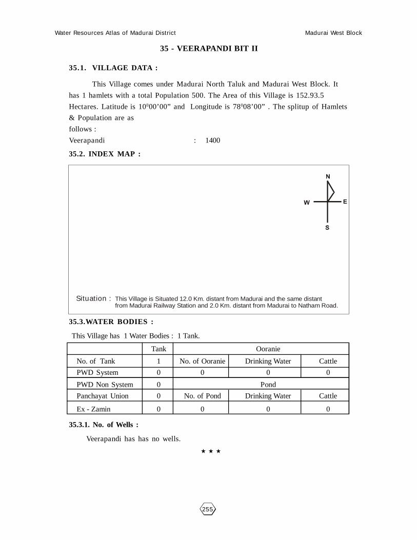
Water Resources Atlas of Madurai District Madurai West Block
255
35 - VEERAPANDI BIT II
35.1. VILLAGE DATA :
This Village comes under Madurai North Taluk and Madurai West Block. It
has 1 hamlets with a total Population 500. The Area of this Village is 152.93.5
Hectares. Latitude is 10000’00” and Longitude is 78008’00” . The splitup of Hamlets
& Population are as
follows :
Veerapandi : 1400
35.2. INDEX MAP :
35.3.WATER BODIES :
This Village has 1 Water Bodies : 1 Tank.
Tank Ooranie
No. of Tank 1 No. of Ooranie Drinking Water Cattle
PWD System 0 0 0 0
PWD Non System 0 Pond
Panchayat Union 0 No. of Pond Drinking Water Cattle
Ex - Zamin 0 0 0 0
35.3.1. No. of Wells :
Veerapandi has has no wells.
Situation : This Village is Situated 12.0 Km. distant from Madurai and the same distant from Madurai Railway Station and 2.0 Km. distant from Madurai to Natham Road.

Water Resources Atlas of Madurai District Madurai West Block
256

Water Resources Atlas of Madurai District Madurai West Block
257
35.4. PARTICULARS OF TANKS :
35.4.1. - Veerapandi Kanmai Code : MW035TSW1 - Basic Data :
Ayacut : 203.29 Ha
SF No. / Extent : 143
Basin : Periyar Basin
Bund Length (m) : 2100
Bund Width (m) : 3
No. of Sluices : 6
Sill Level of Sluices (m) : -
Length of Weir (m) : 3.10, 39.75
Length of Byewash : -
FTL (m) : 103.20
MWL (m) : 105.20
TBL (m) : 107.20
Capacity of Tank (MCFT) : 12.76
Free Catchment (Sq.Km.) : -
Combined Catchment (Sq.Km.) : -
Area of Water Spread at FTL (Sq.Km.) : -
Max. Width of Water Spread at FTL(m) : -
Source of Supply : 12 (R) 5th BL
Supply Channels :
Supply Channel Length : 500
35.4.2.1. Present Condition :
Tank : FairWeir : FairCapacity (Mcft) : 6.35Bund Length (M) : -Bund Condition : FairEncroachment in Extent : -Encroachment in No’s : -
Encroachment Nature : -
35.4.1.2. Pollution :
There is no Pollution of this Tank.
35.4.1.3. Task for Intervention :
Supply Channels Desilting Required.
35.4.1.4. Distribution Channel :
There are 3 Distribution channel for this Tank.

Water Resources Atlas of Madurai District Madurai West Block
258
Veerapandi - Veerapandi Kanmai
SF No. : 143, Area : 17. 11.5Ha, Code No. : MW035-O-1

Water Resources Atlas of Madurai District Madurai West Block
259
36 - PECHIKULAM
36.1. VILLAGE DATA :
This Village comes under Madurai North Taluk and Madurai West Block. It
has 1 hamlets with a total Population 490. The Area of this Village is 85.02.5
Hectares. Latitude is 9058’30” and Longitude is 78008’00” . The splitup of Hamlets
& Population are as
follows :
36.2. INDEX MAP :
36.3.WATER BODIES :
This Village has 4 Water Bodies : 4 Oonaies.
Tank Ooranie
No. of Tank 1 No. of Ooranie Drinking Water Cattle
PWD System 0 0 0 0
PWD Non System 0 Pond
Panchayat Union 0 No. of Pond Drinking Water Cattle
Ex - Zamin 0 0 0 0
36.3.1. No. of Wells :
Veerapandi has a total of 224.10.5 wells. Out of which 14 are open wells,
210.10.5 open wells in ayacut area.
Situation : This Village is Situated 8.0 Km. distant North of Madurai and the same distantfrom Madurai Railway Junction and 1.6 Km from Madurai to Natham Road.
2 Km.
1 Km.MADURAI WEST
MADURAI (D) (T)
KULAMKUDI ROAD
6 Km.PECHIKULAM

Water Resources Atlas of Madurai District Madurai West Block
260

Water Resources Atlas of Madurai District Madurai West Block
261
36.5. PARTICULARS OF OORANIES :
36.5.1. Ooranie - Code : MW036-O-1 - Basic Data :
Survey Field No. : 2Extent : 1405Source of Supply : VaikalLength (m) : 140Breadth (m) : 70Purpose (Drinking Water / Cattle) : CAHPEPresent Status : Poor
36.5.1.1. Pollution :
There is no pollution of this Ooranie.
36.5.1.2. Task for Intervention :Desilting, strengthening are required for this Ooranie. There is no encroachment.
36.5. PARTICULARS OF OORANIES :
36.5.2. Ooranie - Code : MW036-O-2 - Basic Data :
Survey Field No. : 13/4Extent : 6.975Source of Supply : VaikalLength (m) : 120.50Breadth (m) : 68.20Purpose (Drinking Water / Cattle) : CattlePresent Status : Army
36.5.2.1. Pollution :
There is no pollution of this Ooranie.
36.5.2.2. Task for Intervention :Desilting, strengthening are required for this Ooranie. There is no encroachment.
36.5.3. Ooranie - Code : MW036-O-3 - Basic Data :
Survey Field No. : 43Extent : 0.79.5Source of Supply : VaikalLength (m) : 130.00Breadth (m) : 70.00Purpose (Drinking Water / Cattle) : CattlePresent Status : Normal
36.5.2.1. Pollution :
There is no pollution of this Ooranie.
36.5.2.2. Task for Intervention :Desilting, strengthening are required for this Ooranie. There is no encroachment.

Water Resources Atlas of Madurai District Madurai West Block
262
Petchikulam - Ooranie
SF No. : 2, Area : 1. 40.5 Ha, Code No. : MW036-O-1

Water Resources Atlas of Madurai District Madurai West Block
263
Petchikulam - Ooranie
SF No. : 13, Area : 17. 11.5Ha, Code No. : MW036-O-2

Water Resources Atlas of Madurai District Madurai West Block
264
Petchikulam - Ooranie
SF No. : 43, Area : 0. 79.5 Ha, Code No. : MW036-O-3

Water Resources Atlas of Madurai District Madurai West Block
265
36.5. PARTICULARS OF OORANIES :
36.5.1. Ooranie - Code : MW036-O-4 - Basic Data :
Survey Field No. : 14Extent : 0.39.0Source of Supply : VaikalLength (m) : 100Breadth (m) : 60Purpose (Drinking Water / Cattle) : CattlePresent Status : Poor
36.5.1.1. Pollution :
There is no pollution of this Ooranie.
36.5.1.2. Task for Intervention :Desilting, strengthening are required for this Ooranie. There is no encroachment.

Water Resources Atlas of Madurai District Madurai West Block
266
Petchikulam - Ooranie
SF No. : 14, Area : 1. 17.0Ha, Code No. : MW036-O-4

Water Resources Atlas of Madurai District Madurai West Block
267
37 - THIRUPPALAI
37.1. VILLAGE DATA :
This Village comes under Madurai North Taluk and Madurai West Block. It
has 1 hamlets with a total Population 8450. The Area of this Village is 309.41.5
Hectares. Latitude is 9058’30” and Longitude is 78008’00” . The splitup of Hamlets
& Population are as
follows :
37.2. INDEX MAP :
37.3.WATER BODIES :
This Village has 4 Water Bodies : 2 Tank, 2 Oonaies.
Tank Ooranie
No. of Tank 2 No. of Ooranie Drinking Water Cattle
PWD System 2 2 0 2
PWD Non System 0 Pond
Panchayat Union 0 No. of Pond Drinking Water Cattle
Ex - Zamin 0 0 0 0
37.3.1. No. of Wells :
Veerapandi has a total of 7 wells. Out of which 7 are open wells.
Situation : This Village is Situated 9.6 Km. distant North of Madurai, 12.6 K.m. distant from Madurai Railway Junction and on the Madurai to Natham Road.
13 Km.
THIRUPPALAI
MADURAI NORTH (T)MADURAI (D)
5 K
m.
6 K
m.

Water Resources Atlas of Madurai District Madurai West Block
268
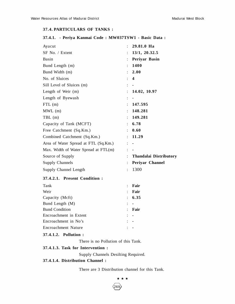
Water Resources Atlas of Madurai District Madurai West Block
269
37.4. PARTICULARS OF TANKS :
37.4.1. - Periya Kanmai Code : MW037TSW1 - Basic Data :
Ayacut : 29.81.0 Ha
SF No. / Extent : 13/1, 20.32.5
Basin : Periyar Basin
Bund Length (m) : 1400
Bund Width (m) : 2.00
No. of Sluices : 4
Sill Level of Sluices (m) : -
Length of Weir (m) : 14.02, 10.97
Length of Byewash : -
FTL (m) : 147.595
MWL (m) : 148.281
TBL (m) : 149.281
Capacity of Tank (MCFT) : 6.78
Free Catchment (Sq.Km.) : 0.60
Combined Catchment (Sq.Km.) : 11.29
Area of Water Spread at FTL (Sq.Km.) : -
Max. Width of Water Spread at FTL(m) : -
Source of Supply : Thandalai Distributory
Supply Channels : Periyar Channel
Supply Channel Length : 1300
37.4.2.1. Present Condition :
Tank : FairWeir : FairCapacity (Mcft) : 6.35Bund Length (M) : -Bund Condition : FairEncroachment in Extent : -Encroachment in No’s : -
Encroachment Nature : -
37.4.1.2. Pollution :
There is no Pollution of this Tank.
37.4.1.3. Task for Intervention :
Supply Channels Desilting Required.
37.4.1.4. Distribution Channel :
There are 3 Distribution channel for this Tank.

Water Resources Atlas of Madurai District Madurai West Block
270
Thiruppalai - Periakanmai
SF No. : 13, Area : 21. 20.5 Ha, Code No. : MW037TSW1

Water Resources Atlas of Madurai District Madurai West Block
271
37.4. PARTICULARS OF TANKS :
37.4.2. - Chinna Kanmai Code : MW037TSW2 - Basic Data :
Ayacut : 18.76.8 Ha
SF No. / Extent : 6/1, 9.29.0
Basin : -
Bund Length (m) : -
Bund Width (m) : -
No. of Sluices : -
Sill Level of Sluices (m) : -
Length of Weir (m) : -
Length of Byewash : -
FTL (m) : -
MWL (m) : -
TBL (m) : -
Capacity of Tank (MCFT) : -
Free Catchment (Sq.Km.) : -
Combined Catchment (Sq.Km.) : -
Area of Water Spread at FTL (Sq.Km.) : -
Max. Width of Water Spread at FTL(m) : -
Source of Supply : -
Supply Channels : Periyar Channel
Supply Channel Length : 1300
37.4.2.1. Present Condition :
Tank : -Weir : -Capacity (Mcft) : -Bund Length (M) : -Bund Condition : -Encroachment in Extent : -Encroachment in No’s : -
Encroachment Nature : -
37.4.1.2. Pollution :
There is no Pollution of this Tank.
37.4.1.3. Task for Intervention :
Supply Channels Desilting Required.
37.4.1.4. Distribution Channel :
There are 3 Distribution channel for this Tank.

Water Resources Atlas of Madurai District Madurai West Block
272
Thiruppalai - Chinnakanmai
SF No. : 6, Area : 26. 04.0 Ha, Code No. : MW037TSW1

Water Resources Atlas of Madurai District Madurai West Block
273
37.5. PARTICULARS OF OORANIES :
37.5.1. Ooranie - Code : MW037-O-2 - Basic Data :
Survey Field No. : 31/1Extent : 0.67.0Source of Supply : RainLength (m) : -Breadth (m) : -Purpose (Drinking Water / Cattle) : CattlePresent Status : Used
37.5.1.1. Pollution :
There is no pollution of this Ooranie.
37.5.1.2. Task for Intervention :Desilting, strengthening are required for this Ooranie. There is no encroachment.
37.5. PARTICULARS OF OORANIES :
37.5.2. Ooranie - Code : MW037-O-2 - Basic Data :
Survey Field No. : 71Extent : 1.17.0Source of Supply : RainLength (m) : -Breadth (m) : -Purpose (Drinking Water / Cattle) : CattlePresent Status : Used
37.5.2.1. Pollution :
There is no pollution of this Ooranie.
37.5.2.2. Task for Intervention :Desilting, strengthening are required for this Ooranie. There is no encroachment.

Water Resources Atlas of Madurai District Madurai West Block
274
Thiruppalai - Oonaie
SF No. : 31, Area : 1. 13.0 Ha, Code No. : MW037-O-1

Water Resources Atlas of Madurai District Madurai West Block
275
Thiruppalai - Oonaie
SF No. : 71, Area : 1. 46.5 Ha, Code No. : MW037-O-2
Scale 1mm = 2000mm

Water Resources Atlas of Madurai District Madurai West Block
276

Water Resources Atlas of Madurai District Madurai West Block
277
37 - KANNANENDAL
37.1. VILLAGE DATA :
This Village comes under Madurai North Taluk and Madurai West Block. It
has 1 hamlets with a total Population 11203. The Area of this Village is 180.50.5
Hectares. Latitude is 9058’00” and Longitude is 78008’30” . The splitup of Hamlets
& Population are as
follows :
37.2. INDEX MAP :
37.3.WATER BODIES :
This Village has 5 Water Bodies : 5 Tanks.
Tank Ooranie
No. of Tank 5 No. of Ooranie Drinking Water Cattle
PWD System 0 0 0 0
PWD Non System 0 Pond
Panchayat Union 0 No. of Pond Drinking Water Cattle
Ex - Zamin 0 0 0 0
37.3.1. No. of Wells :
Veerapandi has a total of 7 wells. Out of which 7 are open wells.
Situation : This Village is Situated 5.0 Km. distant from Madurai, 5.0 K.m. distant from Madurai Railway Junction and 0.1 Km. distant from Madurai to Sivagangai Road.
KANNANENDAL
TALUK HEAD QUARTERS
1 K
m.
CORPORATION LIMIT END
WEST UNION
4 K
m.
5 K
m.
KANNANENDAL VILLAGE LIMIT START
1 Km.
NAGANAKULAM0.5 Km.

Water Resources Atlas of Madurai District Madurai West Block
278

Water Resources Atlas of Madurai District Madurai West Block
279
37.4. PARTICULARS OF TANKS :
37.4.1. Kanakkan Kanmai Code : MW037TSW1 - Basic Data :
Ayacut : 62.57 Ha
SF No. / Extent : 1-1, 3.94.0
Basin : Periyar Vaigai Basin
Bund Length (m) : 810
Bund Width (m) : 2.00
No. of Sluices : 3
Sill Level of Sluices (m) : -
Length of Weir (m) : 22.10, 11.13
Length of Byewash : -
FTL (m) : 139.385
MWL (m) : 139.540
TBL (m) : 140.540
Capacity of Tank (MCFT) : 8.41
Free Catchment (Sq.Km.) : 0.28
Combined Catchment (Sq.Km.) : 12.59
Area of Water Spread at FTL (Sq.Km.) : 12.81
Max. Width of Water Spread at FTL(m) : -
Source of Supply : Thirumalai Distributory
Supply Channels : Sirudhur Tank Surplus
Supply Channel Length : 200
37.4.2.1. Present Condition :
Tank : Good ConditionWeir : -Capacity (Mcft) : -Bund Length (M) : 810Bund Condition : GoodEncroachment in Extent : 0.10.0Encroachment in No’s : 5
Encroachment Nature : Coconut trees, Huts
37.4.1.2. Pollution :
There is no Pollution of this Tank.
37.4.1.3. Task for Intervention :
Supply Channels Desilting Required.
37.4.1.4. Distribution Channel :
There are 3 Distribution channel for this Tank.

Water Resources Atlas of Madurai District Madurai West Block
280
Kannanendal - kanakankulam Kanmai
SF No. : 1, Area : 7. 16.0 Ha, Code No. : MW037-O-1

Water Resources Atlas of Madurai District Madurai West Block
281
37.4. PARTICULARS OF TANKS :
37.4.2. Naganakulam Peria Kanmai Code : MW037TSW2 - Basic Data :
Ayacut : -
SF No. / Extent : 10-1, 9.55.0
Basin : -
Bund Length (m) : -
Bund Width (m) : -
No. of Sluices : -
Sill Level of Sluices (m) : -
Length of Weir (m) : -
Length of Byewash : -
FTL (m) : -
MWL (m) : -
TBL (m) : -
Capacity of Tank (MCFT) : -
Free Catchment (Sq.Km.) : -
Combined Catchment (Sq.Km.) : -
Area of Water Spread at FTL (Sq.Km.) : -
Max. Width of Water Spread at FTL(m) : -
Source of Supply : -
Supply Channels : -
Supply Channel Length : -
37.4.2.1. Present Condition :
Tank : Good ConditionWeir : -Capacity (Mcft) : -Bund Length (M) : -Bund Condition : -Encroachment in Extent : 0.00.5Encroachment in No’s : 1
Encroachment Nature : Coconut trees
37.4.2.2. Pollution :
There is no Pollution of this Tank.
37.4.2.3. Task for Intervention :
Supply Channels Desilting Required.
37.4.2.4. Distribution Channel :
There are 3 Distribution channel for this Tank.

Water Resources Atlas of Madurai District Madurai West Block
282
Kannanendal - Naganakulam Periyakanmai
SF No. : 1, Area : 7. 16.0Ha, Code No. : MW037-O-2

Water Resources Atlas of Madurai District Madurai West Block
283
37.4. PARTICULARS OF TANKS :
37.4.3. Naganakulam Chinna Kanmai Code : MW037TSW3 - Basic Data :
Ayacut : -
SF No. / Extent : 32-1A, 1.28.0
Basin : -
Bund Length (m) : -
Bund Width (m) : -
No. of Sluices : -
Sill Level of Sluices (m) : -
Length of Weir (m) : -
Length of Byewash : -
FTL (m) : -
MWL (m) : -
TBL (m) : -
Capacity of Tank (MCFT) : -
Free Catchment (Sq.Km.) : -
Combined Catchment (Sq.Km.) : -
Area of Water Spread at FTL (Sq.Km.) : -
Max. Width of Water Spread at FTL(m) : -
Source of Supply : -
Supply Channels : -
Supply Channel Length : -
37.4.3.1. Present Condition :
Tank : Good ConditionWeir : -Capacity (Mcft) : -Bund Length (M) : -Bund Condition : -Encroachment in Extent : 0.25.0Encroachment in No’s : 9
Encroachment Nature : Houses
37.4.3.2. Pollution :
There is no Pollution of this Tank.
37.4.3.3. Task for Intervention :
Supply Channels Desilting Required.
37.4.3.4. Distribution Channel :
There are 3 Distribution channel for this Tank.

Water Resources Atlas of Madurai District Madurai West Block
284
Kannanendal - Naganakulam Chinna Periyakanmai
SF No. : 32, Area : 3. 07.0Ha, Code No. : MW037-O-3

Water Resources Atlas of Madurai District Madurai West Block
285
37.4. PARTICULARS OF TANKS :
37.4.4. Oothuvar Kanmai Code : MW037TSW4 - Basic Data :
Ayacut : -
SF No. / Extent : 17-1, 1.42.0
Basin : -
Bund Length (m) : -
Bund Width (m) : -
No. of Sluices : -
Sill Level of Sluices (m) : -
Length of Weir (m) : -
Length of Byewash : -
FTL (m) : -
MWL (m) : -
TBL (m) : -
Capacity of Tank (MCFT) : -
Free Catchment (Sq.Km.) : -
Combined Catchment (Sq.Km.) : -
Area of Water Spread at FTL (Sq.Km.) : -
Max. Width of Water Spread at FTL(m) : -
Source of Supply : -
Supply Channels : -
Supply Channel Length : -
37.4.4.1. Present Condition :
Tank : Good ConditionWeir : -Capacity (Mcft) : -Bund Length (M) : -Bund Condition : -Encroachment in Extent : 0.22.0Encroachment in No’s : 46
Encroachment Nature : Huts
37.4.4.2. Pollution :
There is no Pollution of this Tank.
37.4.4.3. Task for Intervention :
Supply Channels Desilting Required.
37.4.4.4. Distribution Channel :
There are 3 Distribution channel for this Tank.

Water Resources Atlas of Madurai District Madurai West Block
286
Kannanendal - Oothuvar Kanmai
SF No. : 17, Area : 1. 52.0Ha, Code No. : MW037-O-4
Scale 1mm = 2000mm
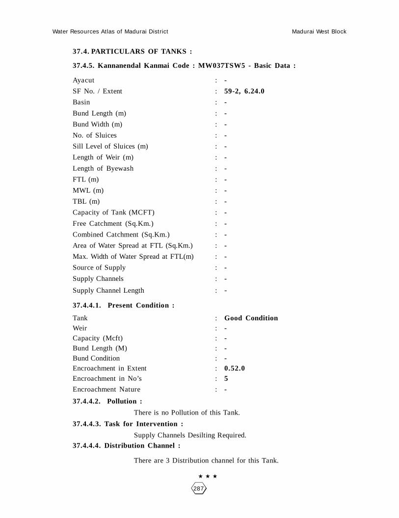
Water Resources Atlas of Madurai District Madurai West Block
287
37.4. PARTICULARS OF TANKS :
37.4.5. Kannanendal Kanmai Code : MW037TSW5 - Basic Data :
Ayacut : -
SF No. / Extent : 59-2, 6.24.0
Basin : -
Bund Length (m) : -
Bund Width (m) : -
No. of Sluices : -
Sill Level of Sluices (m) : -
Length of Weir (m) : -
Length of Byewash : -
FTL (m) : -
MWL (m) : -
TBL (m) : -
Capacity of Tank (MCFT) : -
Free Catchment (Sq.Km.) : -
Combined Catchment (Sq.Km.) : -
Area of Water Spread at FTL (Sq.Km.) : -
Max. Width of Water Spread at FTL(m) : -
Source of Supply : -
Supply Channels : -
Supply Channel Length : -
37.4.4.1. Present Condition :
Tank : Good ConditionWeir : -Capacity (Mcft) : -Bund Length (M) : -Bund Condition : -Encroachment in Extent : 0.52.0Encroachment in No’s : 5
Encroachment Nature : -
37.4.4.2. Pollution :
There is no Pollution of this Tank.
37.4.4.3. Task for Intervention :
Supply Channels Desilting Required.
37.4.4.4. Distribution Channel :
There are 3 Distribution channel for this Tank.

Water Resources Atlas of Madurai District Madurai West Block
288
Kannanendal - Kannanendal Kanmai
SF No. : 59, Area : 9. 53.5Ha, Code No. : MW037-O-5

Water Resources Atlas of Madurai District Madurai West Block
289
37 - SIRUTHUR
37.1. VILLAGE DATA :
This Village comes under Madurai North Taluk and Madurai West Block. It
has 1 hamlets with a total Population 1325. The Area of this Village is 398.38.0
Hectares. Latitude is 9058’00” and Longitude is 78009’30” . The splitup of Hamlets
& Population are as
follows :
37.2. INDEX MAP :
37.3.WATER BODIES :
This Village has 4 Water Bodies : 3 Tank, 1 Ooranie
Tank Ooranie
No. of Tank 3 No. of Ooranie Drinking Water Cattle
PWD System 0 1 0 1
PWD Non System 0 Pond
Panchayat Union 0 No. of Pond Drinking Water Cattle
Ex - Zamin 0 0 0 0
37.3.1. No. of Wells :
Veerapandi has a total of 58.40.0 wells. Out of which 31 are open wells,
21.0.00 open wells in non ayacut area and 1 tube wells, 0.40.0 tube wells in ayacutarea.
Situation : This Village is Situated 9.6 Km. distant North of Madurai, 12.6 K.m. distant from Madurai Railway Junction and 2.0 Km. distant from Madurai to Natham Road.
10 Km.
KAUCLANAMPATTI
MADURAI (D)MADURAI NORTH (T)
12 Km.SIRUTHUR
MADURAI WEST (B)

Water Resources Atlas of Madurai District Madurai West Block
290

Water Resources Atlas of Madurai District Madurai West Block
291
37.4. PARTICULARS OF TANKS :
37.4.1. Kannanendal Kanmai Code : MW037TSW1 - Basic Data :
Ayacut : 80.69.5 Ha
SF No. / Extent : 120/1, 26.56.5
Basin : Periyar Vaigai Basin
Bund Length (m) : 1500
Bund Width (m) : 2.00
No. of Sluices : 4
Sill Level of Sluices (m) : -
Length of Weir (m) : 20.42, 0.51
Length of Byewash : -
FTL (m) : 140.691
MWL (m) : 141.301
TBL (m) : 142.301
Capacity of Tank (MCFT) : 10.72
Free Catchment (Sq.Km.) : 1.09
Combined Catchment (Sq.Km.) : 11.44
Area of Water Spread at FTL (Sq.Km.) : -
Max. Width of Water Spread at FTL(m) : -
Source of Supply : Sluice of Thiruppalai Distibutory
Supply Channels : Thiruppalai Supply Channel
Supply Channel Length : 1500
37.4.4.1. Present Condition :
Tank : Good ConditionWeir : -Capacity (Mcft) : 10.72Bund Length (M) : 1500Bund Condition : GoodEncroachment in Extent : 2.43.0Encroachment in No’s : 36
Encroachment Nature : Cultivation
37.4.4.2. Pollution :
There is no Pollution of this Tank.
37.4.4.3. Task for Intervention :
Supply Channels Desilting Required.
37.4.4.4. Distribution Channel :
There are 3 Distribution channel for this Tank.

Water Resources Atlas of Madurai District Madurai West Block
292
Siruthur - Siruthur Kanmai
SF No. : 120, Area : 35. 29.5Ha, Code No. : MW037TSW1

Water Resources Atlas of Madurai District Madurai West Block
293
37.4. PARTICULARS OF TANKS :
37.4.2. Menendal Kanmai Code : MW037TSW2 - Basic Data :
Ayacut : 1.80.5 Ha
SF No. / Extent : 2/1, 1.83.5
Basin : -
Bund Length (m) : -
Bund Width (m) : -
No. of Sluices : -
Sill Level of Sluices (m) : -
Length of Weir (m) : -
Length of Byewash : -
FTL (m) : -
MWL (m) : -
TBL (m) : -
Capacity of Tank (MCFT) : -
Free Catchment (Sq.Km.) : -
Combined Catchment (Sq.Km.) : -
Area of Water Spread at FTL (Sq.Km.) : -
Max. Width of Water Spread at FTL(m) : -
Source of Supply : -
Supply Channels : -
Supply Channel Length : -
37.4.2.2. Present Condition :
Tank : -Weir : -Capacity (Mcft) : -Bund Length (M) : -Bund Condition : -Encroachment in Extent : 0.22.0Encroachment in No’s : 03
Encroachment Nature : Feusing
37.4.2.2. Pollution :
There is no Pollution of this Tank.
37.4.2.3. Task for Intervention :
Supply Channels Desilting Required.
37.4.2.4. Distribution Channel :
There are 3 Distribution channel for this Tank.

Water Resources Atlas of Madurai District Madurai West Block
294
Siruthur - Siruthur Kanmai
SF No. : 2, Area : 6. 73.0 Ha, Code No. : MW037TSW2
Scale 1mm = 2000mm

Water Resources Atlas of Madurai District Madurai West Block
295
37.4. PARTICULARS OF TANKS :
37.4.3. Chinnathur Kanmai Code : MW037TSW3 - Basic Data :
Ayacut : 44.51.0 Ha
SF No. / Extent : 33/1, 25.925
Basin : -
Bund Length (m) : -
Bund Width (m) : -
No. of Sluices : -
Sill Level of Sluices (m) : -
Length of Weir (m) : -
Length of Byewash : -
FTL (m) : -
MWL (m) : -
TBL (m) : -
Capacity of Tank (MCFT) : -
Free Catchment (Sq.Km.) : -
Combined Catchment (Sq.Km.) : -
Area of Water Spread at FTL (Sq.Km.) : -
Max. Width of Water Spread at FTL(m) : -
Source of Supply : -
Supply Channels : -
Supply Channel Length : -
37.4.3.2. Present Condition :
Tank : -Weir : -Capacity (Mcft) : -Bund Length (M) : -Bund Condition : -Encroachment in Extent : 1.28.0Encroachment in No’s : 04
Encroachment Nature : Feusing
37.4.3.2. Pollution :
There is no Pollution of this Tank.
37.4.3.3. Task for Intervention :
Supply Channels Desilting Required.
37.4.3.4. Distribution Channel :
There are 3 Distribution channel for this Tank.

Water Resources Atlas of Madurai District Madurai West Block
296
Siruthur - Siruthur Kanmai
SF No. : 33, Area : 27. 74.5Ha, Code No. : MW037TSW3
Scale 1mm = 5000mm

Water Resources Atlas of Madurai District Madurai West Block
297
37.5. PARTICULARS OF OORANIES :
37.5.1. Ooranie - Code : MW037-O-1 - Basic Data :
Survey Field No. : 60/3Extent : 0.31.0Source of Supply : RainLength (m) : 90.00Breadth (m) : 70.00Purpose (Drinking Water / Cattle) : CattlePresent Status : Good
37.5.1.1. Pollution :
There is no pollution of this Ooranie.
37.5.1.2. Task for Intervention :Desilting, strengthening are required for this Ooranie. There is no encroachment.

Water Resources Atlas of Madurai District Madurai West Block
298
Siruthur - Ooranie
SF No. : 60/3, Area : 1. 01.5 Ha, Code No. : MW037-O-1
Scale 1mm = 1000mm

Water Resources Atlas of Madurai District Madurai West Block
299
38 - ATHIKULAM
38.1. VILLAGE DATA :
This Village comes under Madurai North Taluk and Madurai West Block. It
has 1 hamlets with a total Population 9040. The Area of this Village is 65.44.5
Hectares. Latitude is 9057’30” and Longitude is 78008’30” . The splitup of Hamlets
& Population are as
follows :
38.2. INDEX MAP :
38.3.WATER BODIES :
This Village has 3 Water Bodies : 3 Tanks
Tank Ooranie
No. of Tank 3 No. of Ooranie Drinking Water Cattle
PWD System 2 0 0 0
PWD Non System 0 Pond
Panchayat Union 0 No. of Pond Drinking Water Cattle
Ex - Zamin 0 0 0 0
38.3.1. No. of Wells :
Veerapandi has no wells.
Situation : This Village is Situated 4.8 Km. distant North of Madurai, 4.8 K.m. distant from Madurai Railway Junction and on the Madurai to Natham Road.
MADURAI (T)MADURAI (D)
3 K
m.
MADURAI WEST (B)
2 Km.
ATHIKULAM

Water Resources Atlas of Madurai District Madurai West Block
300

Water Resources Atlas of Madurai District Madurai West Block
301
38.4. PARTICULARS OF TANKS :
38.4.1. - Athikulam Kanmai Code : MW038TSW1 - Basic Data :
Ayacut : 12.59.0 Ha
SF No. / Extent : 3/1, 5.01.5
Basin : -
Bund Length (m) : -
Bund Width (m) : -
No. of Sluices : -
Sill Level of Sluices (m) : -
Length of Weir (m) : -
Length of Byewash : -
FTL (m) : -
MWL (m) : -
TBL (m) : -
Capacity of Tank (MCFT) : -
Free Catchment (Sq.Km.) : -
Combined Catchment (Sq.Km.) : -
Area of Water Spread at FTL (Sq.Km.) : -
Max. Width of Water Spread at FTL(m) : -
Source of Supply : -
Supply Channels : -
Supply Channel Length : -
38.4.2.1. Present Condition :
Tank : -Weir : -Capacity (Mcft) : -Bund Length (M) : -Bund Condition : -Encroachment in Extent : 008.0Encroachment in No’s : 9
Encroachment Nature : Houses
38.4.1.2. Pollution :
There is no Pollution of this Tank.
38.4.1.3. Task for Intervention :
Supply Channels Desilting Required.
38.4.1.4. Distribution Channel :
There are 3 Distribution channel for this Tank.

Water Resources Atlas of Madurai District Madurai West Block
302
Athikulam - Athikulam Kanmai
SF No. : 3, Area : 6. 02.0 Ha, Code No. : MW038TSW1
Scale 1mm = 5000mm

Water Resources Atlas of Madurai District Madurai West Block
303
38.4. PARTICULARS OF TANKS :
38.4.2. Periyapuliyankulam Code : MW038TSW2 - Basic Data :
Ayacut : 6.64.0 Ha
SF No. / Extent : 17/1, 4.56.0
Basin : -
Bund Length (m) : -
Bund Width (m) : -
No. of Sluices : -
Sill Level of Sluices (m) : -
Length of Weir (m) : -
Length of Byewash : -
FTL (m) : -
MWL (m) : -
TBL (m) : -
Capacity of Tank (MCFT) : -
Free Catchment (Sq.Km.) : -
Combined Catchment (Sq.Km.) : -
Area of Water Spread at FTL (Sq.Km.) : -
Max. Width of Water Spread at FTL(m) : -
Source of Supply : -
Supply Channels : -
Supply Channel Length : -
38.4.2.1. Present Condition :
Tank : -Weir : -Capacity (Mcft) : -Bund Length (M) : -Bund Condition : -Encroachment in Extent : 0.35.0Encroachment in No’s : 42
Encroachment Nature : Houses
38.4.1.2. Pollution :
There is no Pollution of this Tank.
38.4.1.3. Task for Intervention :
Supply Channels Desilting Required.
38.4.1.4. Distribution Channel :
There are 3 Distribution channel for this Tank.

Water Resources Atlas of Madurai District Madurai West Block
304
Athikulam - Periyapuliyankulam Kanmai
SF No. : 17, Area : 5. 25.5 Ha, Code No. : MW038TSW2
Scale 1mm = 2000mm

Water Resources Atlas of Madurai District Madurai West Block
305
38.4. PARTICULARS OF TANKS :
38.4.3. Periyapuliyankulam Code : MW038TSW3 - Basic Data :
Ayacut : 3.39.5 Ha
SF No. / Extent : 20-1, 1.48.5
Basin : -
Bund Length (m) : -
Bund Width (m) : -
No. of Sluices : -
Sill Level of Sluices (m) : -
Length of Weir (m) : -
Length of Byewash : -
FTL (m) : -
MWL (m) : -
TBL (m) : -
Capacity of Tank (MCFT) : -
Free Catchment (Sq.Km.) : -
Combined Catchment (Sq.Km.) : -
Area of Water Spread at FTL (Sq.Km.) : -
Max. Width of Water Spread at FTL(m) : -
Source of Supply : -
Supply Channels : -
Supply Channel Length : -
38.4.2.1. Present Condition :
Tank : -Weir : -Capacity (Mcft) : -Bund Length (M) : -Bund Condition : -Encroachment in Extent : 0.55.0Encroachment in No’s : 82
Encroachment Nature : Houses
38.4.1.2. Pollution :
There is no Pollution of this Tank.
38.4.1.3. Task for Intervention :
Supply Channels Desilting Required.
38.4.1.4. Distribution Channel :
There are 3 Distribution channel for this Tank.

Water Resources Atlas of Madurai District Madurai West Block
306
Athikulam - Periyapuliyankulam Kanmai
SF No. : 20, Area : 2. 31.0Ha, Code No. : MW038TSW2
Scale 1mm = 2000mm

Water Resources Atlas of Madurai District Madurai West Block
307
39 - PARASURAMPATTY
39.1. VILLAGE DATA :
This Village comes under Madurai North Taluk and Madurai West Block. It
has 1 hamlets with a total Population 7267. The Area of this Village is 62.41.5
Hectares. Latitude is 9057’30” and Longitude is 78009’00” . The splitup of Hamlets
& Population are as
follows :
39.2. INDEX MAP :
39.3.WATER BODIES :
This Village has 1 Water Bodies : 1 Tanks
Tank Ooranie
No. of Tank 1 No. of Ooranie Drinking Water Cattle
PWD System 1 0 0 0
PWD Non System 0 Pond
Panchayat Union 0 No. of Pond Drinking Water Cattle
Ex - Zamin 0 0 0 0
39.3.1. No. of Wells :
Veerapandi has no wells.
Situation : This Village is Situated 4.8 Km. distant North of Madurai, 4.8 K.m. distant from Madurai Railway Junction and on the Madurai to Alagarkoil Road.
MADURAI (T)MADURAI (D)
4 K
m.
MADURAI WEST (B)
21/2 Km.
PARASURAMPATTI

Water Resources Atlas of Madurai District Madurai West Block
308

Water Resources Atlas of Madurai District Madurai West Block
309
39.4. PARTICULARS OF TANKS :
39.4.1. Parasurampatti Kanmai Code : MW039TSW1 - Basic Data :
Ayacut : 16.36.0 Ha
SF No. / Extent : 2-1, 12.63.5
Basin : -
Bund Length (m) : -
Bund Width (m) : -
No. of Sluices : -
Sill Level of Sluices (m) : -
Length of Weir (m) : -
Length of Byewash : -
FTL (m) : -
MWL (m) : -
TBL (m) : -
Capacity of Tank (MCFT) : -
Free Catchment (Sq.Km.) : -
Combined Catchment (Sq.Km.) : -
Area of Water Spread at FTL (Sq.Km.) : -
Max. Width of Water Spread at FTL(m) : -
Source of Supply : -
Supply Channels : -
Supply Channel Length : -
38.4.2.1. Present Condition :
Tank : -Weir : -Capacity (Mcft) : -Bund Length (M) : -Bund Condition : -Encroachment in Extent : 0.58.5Encroachment in No’s : 53
Encroachment Nature : Houses
38.4.1.2. Pollution :
There is no Pollution of this Tank.
38.4.1.3. Task for Intervention :
Supply Channels Desilting Required.
38.4.1.4. Distribution Channel :
There are 3 Distribution channel for this Tank.

Water Resources Atlas of Madurai District Madurai West Block
310
Parasurampatti - Parasurampatti Kanmai
SF No. : 2, Area : 14. 52.5Ha, Code No. : MW039TSW1

Water Resources Atlas of Madurai District Madurai West Block
311
40 - PARAYATHIKULAM
40.1. VILLAGE DATA :
This Village comes under Madurai North Taluk and Madurai West Block. It
has 1 hamlets with a total Population 651. The Area of this Village is 44.55.5
Hectares. Latitude is 9058’00” and Longitude is 78009’00” . The splitup of Hamlets
& Population are as
follows :
40.2. INDEX MAP :
40.3.WATER BODIES :
This Village has 1 Water Bodies : 1 Tanks
Tank Ooranie
No. of Tank 1 No. of Ooranie Drinking Water Cattle
PWD System 1 0 0 0
PWD Non System 0 Pond
Panchayat Union 0 No. of Pond Drinking Water Cattle
Ex - Zamin 0 0 0 0
40.3.1. No. of Wells :
Veerapandi has no wells.
Situation : This Village is Situated 7.0 Km. distant from North of Madurai. and 7.0 K.m. distant from Madurai to Alagarkovil Road.
MADURAI (T)MADURAI (D)
7 K
m.
MADURAI WEST
4 Km.
PARASURAMPATTI

Water Resources Atlas of Madurai District Madurai West Block
312
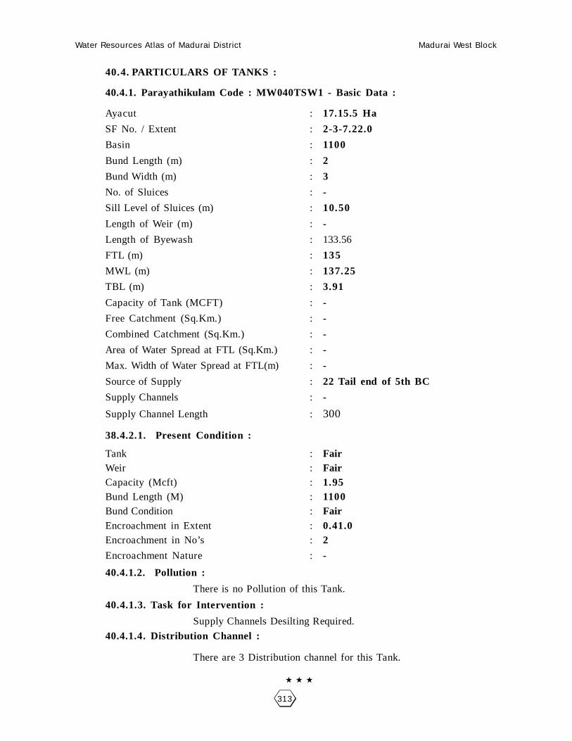
Water Resources Atlas of Madurai District Madurai West Block
313
40.4. PARTICULARS OF TANKS :
40.4.1. Parayathikulam Code : MW040TSW1 - Basic Data :
Ayacut : 17.15.5 Ha
SF No. / Extent : 2-3-7.22.0
Basin : 1100
Bund Length (m) : 2
Bund Width (m) : 3
No. of Sluices : -
Sill Level of Sluices (m) : 10.50
Length of Weir (m) : -
Length of Byewash : 133.56
FTL (m) : 135
MWL (m) : 137.25
TBL (m) : 3.91
Capacity of Tank (MCFT) : -
Free Catchment (Sq.Km.) : -
Combined Catchment (Sq.Km.) : -
Area of Water Spread at FTL (Sq.Km.) : -
Max. Width of Water Spread at FTL(m) : -
Source of Supply : 22 Tail end of 5th BC
Supply Channels : -
Supply Channel Length : 300
38.4.2.1. Present Condition :
Tank : FairWeir : FairCapacity (Mcft) : 1.95Bund Length (M) : 1100Bund Condition : FairEncroachment in Extent : 0.41.0Encroachment in No’s : 2
Encroachment Nature : -
40.4.1.2. Pollution :
There is no Pollution of this Tank.
40.4.1.3. Task for Intervention :
Supply Channels Desilting Required.
40.4.1.4. Distribution Channel :
There are 3 Distribution channel for this Tank.

Water Resources Atlas of Madurai District Madurai West Block
314
Parayathikulam - Parayathikulam Kanmai
SF No. : 2, Area : 17. 11.5Ha, Code No. : MW040TSW1
Scale 1mm = 5000mm

Water Resources Atlas of Madurai District Madurai West Block
315
41 - CHOKKIKULAM
41.1. VILLAGE DATA :
This Village comes under Madurai North Taluk and Madurai West Block. It
has 1 hamlets with a total Population. The Area of this Village is 86.12.5 Hectares.
Latitude is and Longitude is. The splitup of Hamlets & Population are as follows :
41.2. INDEX MAP :
41.3.WATER BODIES :
This Village has 0 Water Bodies : 0 Tanks
Tank Ooranie
No. of Tank 0 No. of Ooranie Drinking Water Cattle
PWD System 0 0 0 0
PWD Non System 0 Pond
Panchayat Union 0 No. of Pond Drinking Water Cattle
Ex - Zamin 0 0 0 0
41.3.1. No. of Wells :
Chokkikulam has no wells.
Chokkikulam Madurai [D]

Water Resources Atlas of Madurai District Madurai West Block
316

Water Resources Atlas of Madurai District Madurai West Block
317
048 - IRANIAM
48.1. VILLAGE DATA :
This Village comes under Madurai North Taluk and Madurai West Block. It
has 2 hamlets with a total Population 1300. The Area of this Village is 196.51.0
Hectares. Latitude is 10000’00” and Longitude is 78010’30” . The splitup of Hamlets
& Population are as
follows :
Sundarajanpatti : 1200 Iraniam : 100
48.2. INDEX MAP :
48.3. WATER BODIES :
This Village has 4 Water Bodies : 4 Tank.
Tank Ooranie
No. of Tank 4 No. of Ooranie Drinking Water Cattle
PWD System 0 0 0 0
PWD Non System 0 Pond
Panchayat Union 0 No. of Pond Drinking Water Cattle
Ex - Zamin 0 0 0 0
48.3.1. No. of Wells :
Iraniam has a total of 149.055 wells. Out of which 10 are open wells, 27.02.0
open wells in ayacut area, 113.93.5 open wells in non ayacut area.
Situation : This Village is Situated 12.8 Km. North of Madurai and Madurai Railway Junction,and almost from Madurai to Alagarkovil Road.
MADURAI
24 Km.
IRANIAM1 Km.
ALAGARKOVIL
SUNDARRAJAMPATTI12 Km

Water Resources Atlas of Madurai District Madurai West Block
318

Water Resources Atlas of Madurai District Madurai West Block
319
48.4. PARTICULARS OF TANKS :
48.4.1. Iraniam Peria Tank - Code : MW048TSW1 - Basic Data :
Ayacut : -
SF No. / Extent : 30/1, 19.10.5
Basin : Madurai Minor Basin
Bund Length (m) : 1200
Bund Width (m) : 2.00
No. of Sluices : 4
Sill Level of Sluices (m) : 144.780
Length of Weir (m) : 50
Length of Byewash : -
FTL (m) : 146.608
MWL (m) : 146.791
TBL (m) : 147.248
Capacity of Tank (MCFT) : 3.28
Free Catchment (Sq.Km.) : 0.60
Combined Catchment (Sq.Km.) : 12.51
Area of Water Spread at FTL (Sq.Km.) : 47.62
Max. Width of Water Spread at FTL(m) : 400
Source of Supply : 10R of Sluice
Supply Channels : -
Supply Channel Length : -
48.4.1.1. Present Condition :
Tank : FairWeir : FairCapacity (Mcft) : 1.64Bund Length (M) : 1200Bund Condition : Below StandardEncroachment in Extent : 1.75.0Encroachment in No’s : 25.27
Encroachment Nature : House
48.4.1.2. Pollution :
There is no Pollution of this Tank.
48.4.1.3. Task for Intervention :
Supply Channels Desilting Required.
48.4.1.4. Distribution Channel :
There are 3 Distribution channel for this Tank.

Water Resources Atlas of Madurai District Madurai West Block
320
Iraniam - Iraniam Kanmai
SF No. : 30, Area : 27. 65.5Ha, Code No. : MW048TSW1

Water Resources Atlas of Madurai District Madurai West Block
321
48.4. PARTICULARS OF TANKS :
48.4.2. Chettiyendal Kanmai - Code : MW048TSW2 - Basic Data :
Ayacut : -
SF No. / Extent : 9/2, 8.14.5
Basin : Madurai Minor Basin
Bund Length (m) : 300
Bund Width (m) : 2.00
No. of Sluices : 2
Sill Level of Sluices (m) : 144.530
Length of Weir (m) : 4.88
Length of Byewash : -
FTL (m) : 146.000
MWL (m) : 146.300
TBL (m) : 146.750
Capacity of Tank (MCFT) : 1.80
Free Catchment (Sq.Km.) : 0.09
Combined Catchment (Sq.Km.) : 0.21
Area of Water Spread at FTL (Sq.Km.) : 26.01
Max. Width of Water Spread at FTL(m) : 100
Source of Supply : 12 Ch Sluice
Supply Channels : -
Supply Channel Length : -
48.4.2.1. Present Condition :
Tank : FairWeir : FairCapacity (Mcft) : 0.90Bund Length (M) : 300Bund Condition : Below StandardEncroachment in Extent : -Encroachment in No’s : -
Encroachment Nature : -
48.4.1.2. Pollution :
There is no Pollution of this Tank.
48.4.1.3. Task for Intervention :
Supply Channels Desilting Required.
48.4.1.4. Distribution Channel :
There are 3 Distribution channel for this Tank.

Water Resources Atlas of Madurai District Madurai West Block
322
Iraniam - Settiyendal Kanmai
SF No. : 9, Area : 13. 30.0 Ha, Code No. : MW048TSW2

Water Resources Atlas of Madurai District Madurai West Block
323
48.4. PARTICULARS OF TANKS :
48.4.3. Pudukulam - Code : MW048TSW3 - Basic Data :
Ayacut : 20/2, 5.31.5
SF No. / Extent : 33/2
Basin : Madurai Minor Basin
Bund Length (m) : 310
Bund Width (m) : 2
No. of Sluices : 1
Sill Level of Sluices (m) : 144.018
Length of Weir (m) : 7.01
Length of Byewash : -
FTL (m) : 145.694
MWL (m) : 145.677
TBL (m) : 146.334
Capacity of Tank (MCFT) : 6.82
Free Catchment (Sq.Km.) : 0.04
Combined Catchment (Sq.Km.) : 0.25
Area of Water Spread at FTL (Sq.Km.) : 14.68
Max. Width of Water Spread at FTL(m) : 150
Source of Supply : 10
Supply Channels : 8
Supply Channel Length : -
48.4.3.1. Present Condition :
Tank : FairWeir : FairCapacity (Mcft) : 3.41Bund Length (M) : 310Bund Condition : Below StandardEncroachment in Extent : -Encroachment in No’s : -
Encroachment Nature : -
48.4.3.2. Pollution :
There is no Pollution of this Tank.
48.4.3.3. Task for Intervention :
Supply Channels Desilting Required.
48.4.3.4. Distribution Channel :
There are 3 Distribution channel for this Tank.

Water Resources Atlas of Madurai District Madurai West Block
324
Iraniam - Pudukulam
SF No. : 33, Area : 0. 00.0Ha, Code No. : MW048TSW3
Scale : 1mm : 2000mm

Water Resources Atlas of Madurai District Madurai West Block
325
48.4. PARTICULARS OF TANKS :
48.4.4. Thulukkankulam Kanmai - Code : MW048TSW4 - Basic Data :
Ayacut : 20/2, 5.31.5
SF No. / Extent : 78/1, 78/10, 6.51.5
Basin : Madurai Minor Basin
Bund Length (m) : 250
Bund Width (m) : 2
No. of Sluices : -
Sill Level of Sluices (m) : -
Length of Weir (m) : 3.04
Length of Byewash : -
FTL (m) : 100.00
MWL (m) : 100.600
TBL (m) : 106.600
Capacity of Tank (MCFT) : 1.61
Free Catchment (Sq.Km.) : -
Combined Catchment (Sq.Km.) : -
Area of Water Spread at FTL (Sq.Km.) : 19.40
Max. Width of Water Spread at FTL(m) : 100
Source of Supply : 16 R of 8th BC
Supply Channels : -
Supply Channel Length : -
48.4.3.1. Present Condition :
Tank : FairWeir : FairCapacity (Mcft) : 3.41Bund Length (M) : 310Bund Condition : Below StandardEncroachment in Extent : -Encroachment in No’s : -
Encroachment Nature : -
48.4.3.2. Pollution :
There is no Pollution of this Tank.
48.4.3.3. Task for Intervention :
Supply Channels Desilting Required.
48.4.3.4. Distribution Channel :
There are 3 Distribution channel for this Tank.

Water Resources Atlas of Madurai District Madurai West Block
326
Iraniam - Thulukankulam
SF No. : 78, Area : 17. 11.5Ha, Code No. : MW048TSW4

Water Resources Atlas of Madurai District Madurai West Block
327
049 - ELUPPAKKUDI
49.1. VILLAGE DATA :
This Village comes under Madurai North Taluk and Madurai West Block. It
has 1 hamlets with a total Population 350. The Area of this Village is 87.36.5
Hectares. Latitude is 10000’00” and Longitude is 78010’30” . The splitup of Hamlets
& Population are as
follows :
49.2. INDEX MAP :
49.3. WATER BODIES :
This Village has 1 Water Bodies : 1 Tank.
Tank Ooranie
No. of Tank 1 No. of Ooranie Drinking Water Cattle
PWD System 0 0 0 0
PWD Non System 0 Pond
Panchayat Union 0 No. of Pond Drinking Water Cattle
Ex - Zamin 0 0 0 0
49.3.1. No. of Wells :
Eluppakkudi has a total of 108.635 wells. Out of which 14 are open wells,
32.05.0 open wells in ayacut area, 62.58.5 open wells in non ayacut area.
Situation : This Village is Situated 12.8 Km. North of Madurai and Madurai Railway Junction,1.6 Km. distant from Madurai to Alagarkovil Road.
MADURAI
24 Km.
ELUPPAKKUDI 1 Km.
ALAGARKOVIL
SUNDARRAJANPATTI
12 Km.

Water Resources Atlas of Madurai District Madurai West Block
328
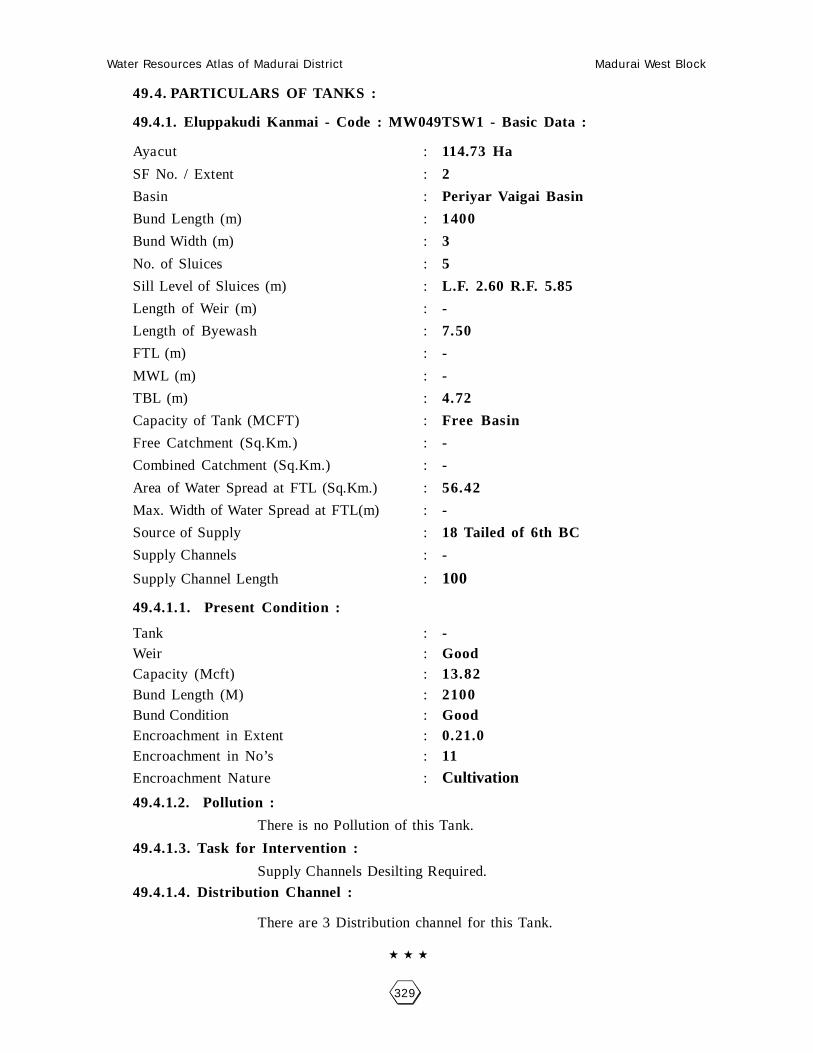
Water Resources Atlas of Madurai District Madurai West Block
329
49.4. PARTICULARS OF TANKS :
49.4.1. Eluppakudi Kanmai - Code : MW049TSW1 - Basic Data :
Ayacut : 114.73 Ha
SF No. / Extent : 2
Basin : Periyar Vaigai Basin
Bund Length (m) : 1400
Bund Width (m) : 3
No. of Sluices : 5
Sill Level of Sluices (m) : L.F. 2.60 R.F. 5.85
Length of Weir (m) : -
Length of Byewash : 7.50
FTL (m) : -
MWL (m) : -
TBL (m) : 4.72
Capacity of Tank (MCFT) : Free Basin
Free Catchment (Sq.Km.) : -
Combined Catchment (Sq.Km.) : -
Area of Water Spread at FTL (Sq.Km.) : 56.42
Max. Width of Water Spread at FTL(m) : -
Source of Supply : 18 Tailed of 6th BC
Supply Channels : -
Supply Channel Length : 100
49.4.1.1. Present Condition :
Tank : -Weir : GoodCapacity (Mcft) : 13.82Bund Length (M) : 2100Bund Condition : GoodEncroachment in Extent : 0.21.0Encroachment in No’s : 11
Encroachment Nature : Cultivation
49.4.1.2. Pollution :
There is no Pollution of this Tank.
49.4.1.3. Task for Intervention :
Supply Channels Desilting Required.
49.4.1.4. Distribution Channel :
There are 3 Distribution channel for this Tank.

Water Resources Atlas of Madurai District Madurai West Block
330
Eluppakudi - Eluppakudi Kanmai
SF No. : 2, Area : 22. 82.5Ha, Code No. : MW049-TSW2

Water Resources Atlas of Madurai District Madurai West Block
331
50 - POONARI
50.1. VILLAGE DATA :
This Village comes under Madurai North Taluk and Madurai West Block. It
has 0 hamlets with a total Population. The Area of this Village is 49.73.0 Hectares.
Latitude is 10000’00” and Longitude is 78010’00” . The splitup of Hamlets &
Population are as
follows :
50.2. INDEX MAP :
50.3.WATER BODIES :
This Village has 2 Water Bodies : 1 Tank, 1 Ooranie.
Tank Ooranie
No. of Tank 1 No. of Ooranie Drinking Water Cattle
PWD System 1 1 0 1
PWD Non System 0 Pond
Panchayat Union 0 No. of Pond Drinking Water Cattle
Ex - Zamin 0 0 0 0
50 .3.1. No. of Wells :
Poonari has a total of 95.015 wells. Out of which 7 are open wells, 6.03.0
open wells in ayacut area, 31.98.5 pen wells in Non-Ayacut area.
Situation : This Village is Situated 15.2 Km. distant North of Madurai. 15.2 Km distant fromMadurai Railway Junction and 2.4 Km distant on the Madurai to Natham Road.
MADURAI
24 Km.
POONARI2.4 Km.
ALAGARKOVIL
SUNDARRAJANPATTI12 Km.

Water Resources Atlas of Madurai District Madurai West Block
332

Water Resources Atlas of Madurai District Madurai West Block
333
50.4. PARTICULARS OF TANKS :
50.4.1. Poonari Kanmai - Code : MW050TSW1 - Basic Data :
Ayacut : 60.81 Ha
SF No. / Extent : 8
Basin : -
Bund Length (m) : 700
Bund Width (m) : 2.00No. of Sluices : 2
Sill Level of Sluices (m) : -
Length of Weir (m) : 25.95
Length of Byewash : -
FTL (m) : (7.OF+) 102-13
MWL (m) : 104.15
TBL (m) : 106.25
Capacity of Tank (MCFT) : 6.5
Free Catchment (Sq.Km.) : Tree Basin Only
Combined Catchment (Sq.Km.) : -
Area of Water Spread at FTL (Sq.Km.) : -
Max. Width of Water Spread at FTL(m) : -
Source of Supply : 16(R) of 6th BL
Supply Channels :Supply Channel Length : 600
50.4.1.1. Present Condition :
Tank : FairWeir : FairCapacity (Mcft) : 4.3Bund Length (M) : -Bund Condition : -Encroachment in Extent : -Encroachment in No’s : -
Encroachment Nature : 2e Tamarin 4
50.4.1.2. Pollution :
There is no Pollution of this Tank.
50.4.1.3. Task for Intervention :
Supply Channels Desilting Required.
50.4.1.4. Distribution Channel :
There are 3 Distribution channel for this Tank.

Water Resources Atlas of Madurai District Madurai West Block
334
Poonari - Poonari Kanmai
SF No. : 8, Area : 12. 65.0Ha, Code No. : MW050-TSW1

Water Resources Atlas of Madurai District Madurai West Block
335
51 - MARANAVARIYANDAL
51.1. VILLAGE DATA :
This Village comes under Madurai North Taluk and Madurai West Block. It
has 1 hamlets with a total Population 721. The Area of this Village is 117.99.0
Hectares. Latitude is 10000’00” and Longitude is 78010’00” . The splitup of Hamlets
& Population are as
follows :
51.2. INDEX MAP :
51.3.WATER BODIES :
This Village has 3 Water Bodies : 3 Tanks.
Tank Ooranie
No. of Tank 3 No. of Ooranie Drinking Water Cattle
PWD System 1 0 0 0
PWD Non System 0 Pond
Panchayat Union 0 No. of Pond Drinking Water Cattle
Ex - Zamin 0 0 0 0
51 .3.1. No. of Wells :
Maranavariyendal has a total of 125 wells. Out of which 37 are open wells, 37
open wells in ayacut area.
Situation : This Village is Situated 12.0 Km. North of Madurai and Madurai Railway Junction.1.6 Km distant from Madurai to Natham Road.
MADURAI (D)MADURAI NORTH (T)
CHETTIKULAM
9.6
Km
.MARANIVARIYANDAL
7.6 Km.
MADURAI WEST (B)

Water Resources Atlas of Madurai District Madurai West Block
336

Water Resources Atlas of Madurai District Madurai West Block
337
51.4. PARTICULARS OF TANKS :
51.4.1. Variyandal Kanmai - Code : MW051TSW1 - Basic Data :
Ayacut : 9.63.0 Ha
SF No. / Extent : 23/7, 3.19.0
Basin : -
Bund Length (m) : 800
Bund Width (m) : 2.0No. of Sluices : 2
Sill Level of Sluices (m) : -
Length of Weir (m) : -
Length of Byewash : Natural Ground Escape
FTL (m) : 102.21
MWL (m) : + 100.600
TBL (m) : + 101.600
Capacity of Tank (MCFT) : 1.0
Free Catchment (Sq.Km.) : Free Basin only
Combined Catchment (Sq.Km.) : -
Area of Water Spread at FTL (Sq.Km.) : 32.18
Max. Width of Water Spread at FTL(m) : 500
Source of Supply : 16(R) of 6th BL
Supply Channels :Supply Channel Length : 600
51.4.1.1. Present Condition :
Tank : -Weir : -Capacity (Mcft) : 0.60Bund Length (M) : -Bund Condition : FairEncroachment in Extent : 0.12.0Encroachment in No’s : 2
Encroachment Nature : Coconut tree, Valai
51.4.1.2. Pollution :
There is no Pollution of this Tank.
51.4.1.3. Task for Intervention :
Supply Channels Desilting Required.
51.4.1.4. Distribution Channel :
There are 3 Distribution channel for this Tank.

Water Resources Atlas of Madurai District Madurai West Block
338
Maranavariyandal - Variyandal Kanmai
SF No. : 23, Area : 5. 93.0Ha, Code No. : MW051-TSW1
Scale : 1mm : 2000mm

Water Resources Atlas of Madurai District Madurai West Block
339
51.4. PARTICULARS OF TANKS :
51.4.2. Maran Kanmai - Code : MW051TSW2 - Basic Data :
Ayacut : 27.72.0 Ha
SF No. / Extent : 27/16, 9.83.0
Basin : -
Bund Length (m) : -
Bund Width (m) : -No. of Sluices : -
Sill Level of Sluices (m) : -
Length of Weir (m) : -
Length of Byewash : -
FTL (m) : -
MWL (m) : -
TBL (m) : -
Capacity of Tank (MCFT) : -
Free Catchment (Sq.Km.) : -
Combined Catchment (Sq.Km.) : -
Area of Water Spread at FTL (Sq.Km.) : -
Max. Width of Water Spread at FTL(m) : -
Source of Supply : -
Supply Channels :Supply Channel Length : -
51.4.2.1. Present Condition :
Tank : -Weir : -Capacity (Mcft) : -Bund Length (M) : -Bund Condition : -Encroachment in Extent : 0.02.0Encroachment in No’s : 2
Encroachment Nature : Sugarkane
51.4.2.2. Pollution :
There is no Pollution of this Tank.
51.4.2.3. Task for Intervention :
Supply Channels Desilting Required.
51.4.2.4. Distribution Channel :
There are 3 Distribution channel for this Tank.

Water Resources Atlas of Madurai District Madurai West Block
340
Maranavariyandal - Maran Kanmai
SF No. : 27, Area : 18. 39.0Ha, Code No. : MW051-TSW2

Water Resources Atlas of Madurai District Madurai West Block
341
51.4. PARTICULARS OF TANKS :
51.4.3. Veppankulam Kanmai - Code : MW051TSW3 - Basic Data :
Ayacut : 8.79.0 Ha
SF No. / Extent : 2/2, 4.09.5
Basin : -
Bund Length (m) : -
Bund Width (m) : -No. of Sluices : -
Sill Level of Sluices (m) : -
Length of Weir (m) : -
Length of Byewash : -
FTL (m) : -
MWL (m) : -
TBL (m) : -
Capacity of Tank (MCFT) : -
Free Catchment (Sq.Km.) : -
Combined Catchment (Sq.Km.) : -
Area of Water Spread at FTL (Sq.Km.) : -
Max. Width of Water Spread at FTL(m) : -
Source of Supply : -
Supply Channels :Supply Channel Length : -
51.4.3.1. Present Condition :
Tank : -Weir : -Capacity (Mcft) : -Bund Length (M) : -Bund Condition : -Encroachment in Extent : -Encroachment in No’s : -
Encroachment Nature : -
51.4.3.2. Pollution :
There is no Pollution of this Tank.
51.4.3.3. Task for Intervention :
Supply Channels Desilting Required.
51.4.3.4. Distribution Channel :
There are 3 Distribution channel for this Tank.

Water Resources Atlas of Madurai District Madurai West Block
342
Maranavariyandal - Veppankulam Kanmai
SF No. : 2, Area : 0. 00.0 Ha, Code No. : MW051-TSW3

Water Resources Atlas of Madurai District Madurai West Block
343
52 - KANNIKUDI
52.1. VILLAGE DATA :
This Village comes under Madurai North Taluk and Madurai West Block. It
has 0 hamlets with a total Population. The Area of this Village is 80.19.0 Hectares.
Latitude is 10000’00” and Longitude is 78010’00” . The splitup of Hamlets &
Population are as
follows :
52.2. INDEX MAP :
52.3.WATER BODIES :
This Village has 1 Water Bodies : 1 Tanks.
Tank Ooranie
No. of Tank 1 No. of Ooranie Drinking Water Cattle
PWD System 1 0 0 0
PWD Non System 0 Pond
Panchayat Union 0 No. of Pond Drinking Water Cattle
Ex - Zamin 0 0 0 0
52 .3.1. No. of Wells :
Kannikudi has a total of 68.44 wells. Out of which 10 nos are open wells,
24.99.0 open wells in ayacut area, 33.45.0 nos open wells in non ayacut area.
Situation : This Village is Situated 12.0 Km. distant North of Madurai, and 2.4 Km distantfrom Madurai to Alagarkovil Road.
MADURAI
24 Km.
2.4 Km.
ALAGHRKOVIL
KANNIKUDI KADACHANENDAL10 Km

Water Resources Atlas of Madurai District Madurai West Block
344

Water Resources Atlas of Madurai District Madurai West Block
345
52.4. PARTICULARS OF TANKS :
52.4.1. Kannikudi Kanmai - Code : MW052TSW1 - Basic Data :
Ayacut : -
SF No. / Extent : - 1
Basin : -
Bund Length (m) : -
Bund Width (m) : -
No. of Sluices : -
Sill Level of Sluices (m) : -
Length of Weir (m) : -
Length of Byewash : -
FTL (m) : -
MWL (m) : -
TBL (m) : -
Capacity of Tank (MCFT) : -
Free Catchment (Sq.Km.) : -
Combined Catchment (Sq.Km.) : -
Area of Water Spread at FTL (Sq.Km.) : -
Max. Width of Water Spread at FTL(m) : -
Source of Supply : -
Supply Channels : -
Supply Channel Length :
52.4.1.1. Present Condition :
Tank : -Weir : -Capacity (Mcft) : -Bund Length (M) : -Bund Condition : -Encroachment in Extent : 0.34.0Encroachment in No’s : 4
Encroachment Nature : Coconut trees & Kalan
52.4.1.2. Pollution :
There is no Pollution of this Tank.
52.4.1.3. Task for Intervention :
Supply Channels Desilting Required.
52.4.1.4. Distribution Channel :
There are 3 Distribution channel for this Tank.

Water Resources Atlas of Madurai District Madurai West Block
346
Kannikudi - Kannikudi Kanmai
SF No. : 1, Area : 25. 59.5Ha, Code No. : MW052-TSW1
Scale : 1mm : 5000mm
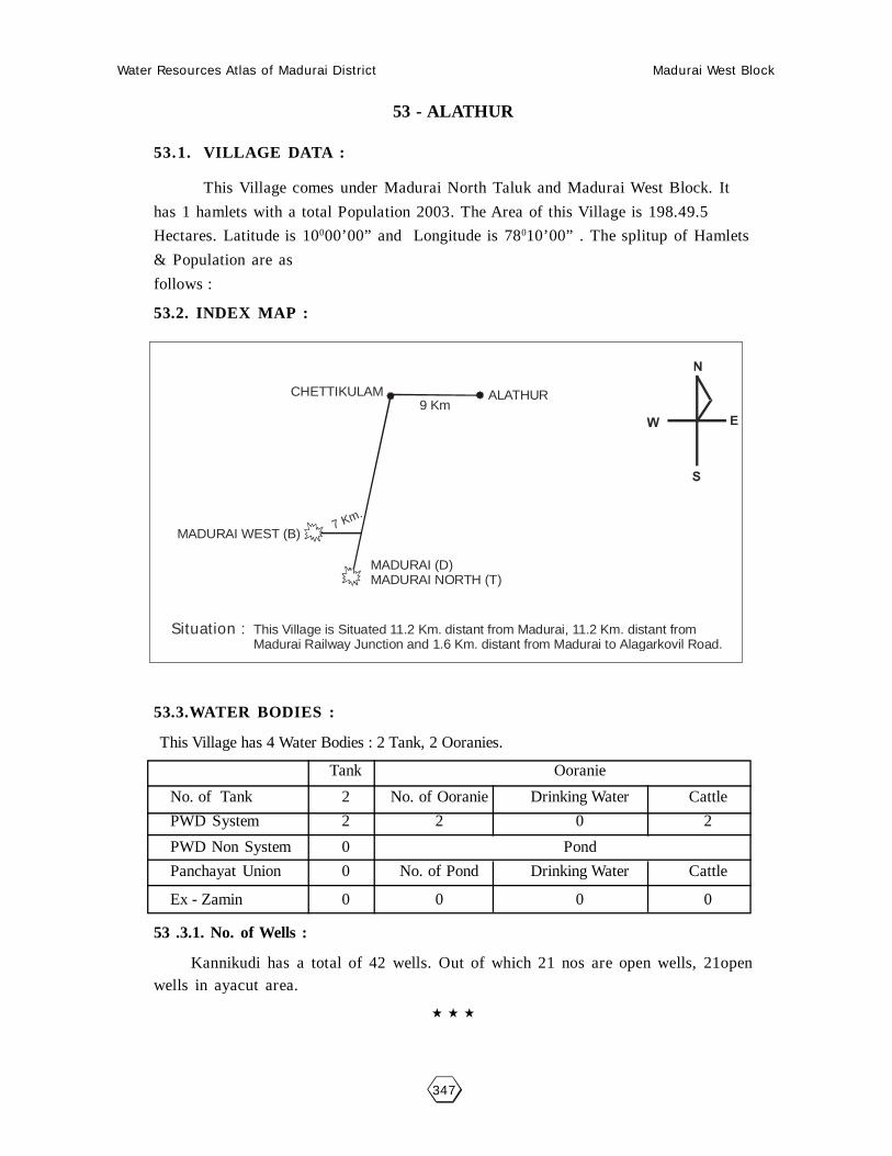
Water Resources Atlas of Madurai District Madurai West Block
347
53 - ALATHUR
53.1. VILLAGE DATA :
This Village comes under Madurai North Taluk and Madurai West Block. It
has 1 hamlets with a total Population 2003. The Area of this Village is 198.49.5
Hectares. Latitude is 10000’00” and Longitude is 78010’00” . The splitup of Hamlets
& Population are as
follows :
53.2. INDEX MAP :
53.3.WATER BODIES :
This Village has 4 Water Bodies : 2 Tank, 2 Ooranies.
Tank Ooranie
No. of Tank 2 No. of Ooranie Drinking Water Cattle
PWD System 2 2 0 2
PWD Non System 0 Pond
Panchayat Union 0 No. of Pond Drinking Water Cattle
Ex - Zamin 0 0 0 0
53 .3.1. No. of Wells :
Kannikudi has a total of 42 wells. Out of which 21 nos are open wells, 21openwells in ayacut area.
Situation : This Village is Situated 11.2 Km. distant from Madurai, 11.2 Km. distant from Madurai Railway Junction and 1.6 Km. distant from Madurai to Alagarkovil Road.
MADURAI (D)MADURAI NORTH (T)
CHETTIKULAM ALATHUR
7 Km.
MADURAI WEST (B)
9 Km

Water Resources Atlas of Madurai District Madurai West Block
348

Water Resources Atlas of Madurai District Madurai West Block
349
53.4. PARTICULARS OF TANKS :
53.4.1. Alathur Peria Kanmai - Code : MW053TSW1 - Basic Data :
Ayacut : 42.23.5
SF No. / Extent : 8/1, 17.08.0
Basin : -
Bund Length (m) : 1600
Bund Width (m) : 2
No. of Sluices : 6
Sill Level of Sluices (m) : -
Length of Weir (m) : -
Length of Byewash : R.F. No mason any weir NCEThrough Sy Phon.
FTL (m) : 102.44
MWL (m) : 104.46
TBL (m) : 106.48
Capacity of Tank (MCFT) : 3.37
Free Catchment (Sq.Km.) : Free Basin Only
Combined Catchment (Sq.Km.) : -
Area of Water Spread at FTL (Sq.Km.) : 42.20
Max. Width of Water Spread at FTL(m) : -
Source of Supply : 5th Sluice
Supply Channels : 18 (L) of 5th BL
Supply Channel Length : 40
53.4.1.1. Present Condition :
Tank : Minor repairWeir : Good ConditionCapacity (Mcft) : 1.50Bund Length (M) : 1600Bund Condition : FairEncroachment in Extent : -Encroachment in No’s : -
Encroachment Nature : -
53.4.1.2. Pollution :
There is no Pollution of this Tank.
53.4.1.3. Task for Intervention :
Supply Channels Desilting Required.
53.4.1.4. Distribution Channel :
There are 3 Distribution channel for this Tank.

Water Resources Atlas of Madurai District Madurai West Block
350
Alathur - Alathur Peria Kanmai
SF No. : 8, Area : 20. 44.0 Ha, Code No. : MW053-TSW1

Water Resources Atlas of Madurai District Madurai West Block
351
53.4. PARTICULARS OF TANKS :
53.4.2. Alathur Chinna Kanmai - Code : MW053TSW2 - Basic Data :
Ayacut : 9.06.5
SF No. / Extent : 57/4, 5.04.0
Basin : -
Bund Length (m) : -
Bund Width (m) : -
No. of Sluices : -
Sill Level of Sluices (m) : -
Length of Weir (m) : -
Length of Byewash : -
FTL (m) : -
MWL (m) : -
TBL (m) : -
Capacity of Tank (MCFT) : -
Free Catchment (Sq.Km.) : -
Combined Catchment (Sq.Km.) : -
Area of Water Spread at FTL (Sq.Km.) : -
Max. Width of Water Spread at FTL(m) : -
Source of Supply : -
Supply Channels : -
Supply Channel Length : -
53.4.2.1. Present Condition :
Tank : -Weir : -Capacity (Mcft) : -Bund Length (M) : -Bund Condition : -Encroachment in Extent : -Encroachment in No’s : -
Encroachment Nature : -
53.4.2.2. Pollution :
There is no Pollution of this Tank.
53.4.2.3. Task for Intervention :
Supply Channels Desilting Required.
53.4.2.4. Distribution Channel :
There are 3 Distribution channel for this Tank.

Water Resources Atlas of Madurai District Madurai West Block
352
Alathur - Chinna Kanmai
SF No. : 57, Area : 6. 58.0 Ha, Code No. : MW053-TSW2
Scale : 1mm : 2000mm

Water Resources Atlas of Madurai District Madurai West Block
353
53.5. PARTICULARS OF OORANIES :
53.5.1. Ayachi Ooranie - Code : MW053-O-1 - Basic Data :
Survey Field No. : 80/9Extent : 0.55.0Source of Supply : RainLength (m) : -Breadth (m) : -Purpose (Drinking Water / Cattle) : CattlePresent Status : Used
53.5.1.1. Pollution :
There is no pollution of this Ooranie.
53.5.1.2. Task for Intervention :Desilting, strengthening are required for this Ooranie. There is no encroachment.
53.5. PARTICULARS OF OORANIES :
53.5.2. Chetti Ooranie - Code : MW053-O-2 - Basic Data :
Survey Field No. : 23/6Extent : 0.20.5Source of Supply : ChannelsLength (m) : -Breadth (m) : -Purpose (Drinking Water / Cattle) : CattlePresent Status :
53.5.2.1. Pollution :
There is no pollution of this Ooranie.
53.5.2.2. Task for Intervention :Desilting, strengthening are required for this Ooranie. There is no encroachment.
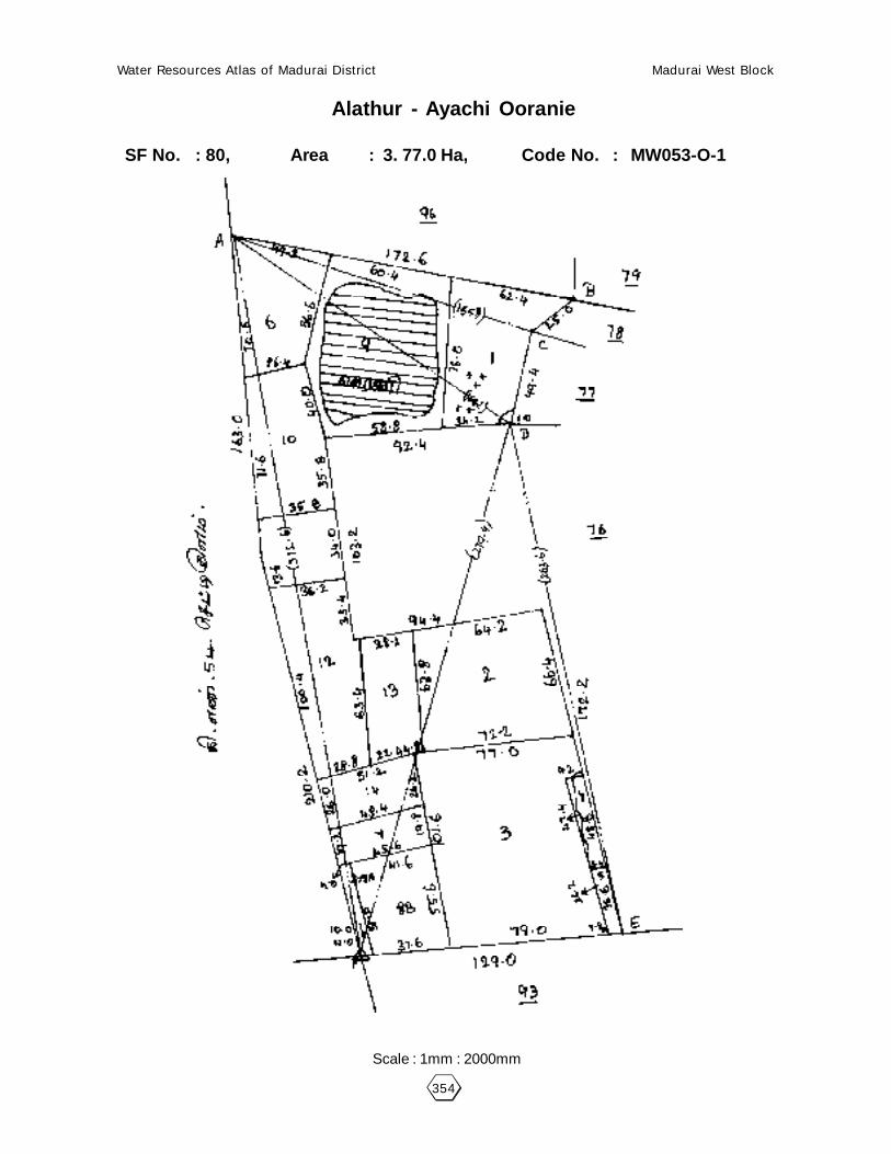
Water Resources Atlas of Madurai District Madurai West Block
354
Alathur - Ayachi Ooranie
SF No. : 80, Area : 3. 77.0 Ha, Code No. : MW053-O-1
Scale : 1mm : 2000mm

Water Resources Atlas of Madurai District Madurai West Block
355
Alathur - Chetti Ooranie
SF No. : 23, Area : 2. 25.5Ha, Code No. : MW053-O-2
Scale : 1mm : 2000mm

Water Resources Atlas of Madurai District Madurai West Block
356

Water Resources Atlas of Madurai District Madurai West Block
357
54 - CHETTIKULAM
54.1. VILLAGE DATA :
This Village comes under Madurai North Taluk and Madurai West Block. It
has 1 hamlets with a total Population 9748. The Area of this Village is 244.12.5
Hectares. Latitude is 9059’30” and Longitude is 78009’00” . The splitup of Hamlets
& Population are as
follows :
54.2. INDEX MAP :
54.3.WATER BODIES :
This Village has 3 Water Bodies : 2 Tank, 3 Ooranie.
Tank Ooranie
No. of Tank 2 No. of Ooranie Drinking Water Cattle
PWD System 0 3 0 3
PWD Non System 0 Pond
Panchayat Union 0 No. of Pond Drinking Water Cattle
Ex - Zamin 0 0 0 0
54.3.1. No. of Wells :
Chettikulam has a total of 56 wells. Out of which 28 are open wells, 28 open
wells in ayacut area.
Situation : This Village is Situated 8.0 Km. distant North of Madurai and Madurai Railway Junction and nearly from Madurai to Natham Road.
MADURAI NORTH (T)MADURAI (D)
MADURAI WEST (B)
7 K
m.
CHETTIKULAM
9 K
m.

Water Resources Atlas of Madurai District Madurai West Block
358

Water Resources Atlas of Madurai District Madurai West Block
359
54.4. PARTICULARS OF TANKS :
54.4.1. Umatchikulam Kanmai - Code : MW054TSW1 - Basic Data :
Ayacut : 14.21.0 Ha
SF No. / Extent : 110/2, 8.11.5
Basin : Periyar Vaigai Basin
Bund Length (m) : 500
Bund Width (m) : 2
No. of Sluices : 1
Sill Level of Sluices (m) : -
Length of Weir (m) : 479.70
Length of Byewash : 481.40
FTL (m) : 484.20
MWL (m) : 2.04
TBL (m) : -
Capacity of Tank (MCFT) : -
Free Catchment (Sq.Km.) : -
Combined Catchment (Sq.Km.) : -
Area of Water Spread at FTL (Sq.Km.) : -
Max. Width of Water Spread at FTL(m) : -
Source of Supply : 17R of 5th BL
Supply Channels : Periyar Channel
Supply Channel Length : 750m
54.4.1.1. Present Condition :
Tank : FairWeir : FairCapacity (Mcft) : -Bund Length (M) : -Bund Condition : -Encroachment in Extent : 1.49.0Encroachment in No’s : 29
Encroachment Nature : House, Paddy, Veli
54.4.1.2. Pollution :
There is no Pollution of this Tank.
54.4.1.3. Task for Intervention :
Supply Channels Desilting Required.
54.4.1.4. Distribution Channel :
There are 3 Distribution channel for this Tank.

Water Resources Atlas of Madurai District Madurai West Block
360
Chettikulam - Umatchikulam Kanmai
SF No. : 110, Area : 32. 09.5 Ha, Code No. : MW054-O-1
Scale : 1mm : 5000mm

Water Resources Atlas of Madurai District Madurai West Block
361
54.4. PARTICULARS OF TANKS :
54.4.2. Vedathakulam Kanmai - Code : MW054TSW2 - Basic Data :
Ayacut : 51.36.0 Ha
SF No. / Extent : 71/1, 30.86.5
Basin : Periyar Vaigai Basin
Bund Length (m) : 1600
Bund Width (m) : 3
No. of Sluices : 4
Sill Level of Sluices (m) : -
Length of Weir (m) : LF.14.85
Length of Byewash : -
FTL (m) : 489.80
MWL (m) : 491.30
TBL (m) : 494.30
Capacity of Tank (MCFT) : 8.75
Free Catchment (Sq.Km.) : -
Combined Catchment (Sq.Km.) : -
Area of Water Spread at FTL (Sq.Km.) : 76.28
Max. Width of Water Spread at FTL(m) : -
Source of Supply : 15 (L) of 5th BL
Supply Channels : Periyar Channel
Supply Channel Length : 10
54.4.2.1. Present Condition :
Tank : FairWeir : FairCapacity (Mcft) : -Bund Length (M) : -Bund Condition : -Encroachment in Extent : -Encroachment in No’s : -
Encroachment Nature : -
54.4.1.2. Pollution :
There is no Pollution of this Tank.
54.4.1.3. Task for Intervention :
Supply Channels Desilting Required.
54.4.1.4. Distribution Channel :
There are 3 Distribution channel for this Tank.
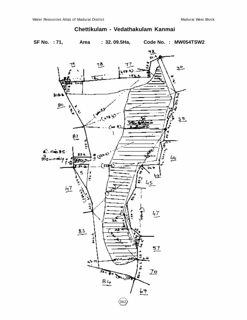
Water Resources Atlas of Madurai District Madurai West Block
362
Chettikulam - Vedathakulam Kanmai
SF No. : 71, Area : 32. 09.5Ha, Code No. : MW054TSW2

Water Resources Atlas of Madurai District Madurai West Block
363
54.5. PARTICULARS OF OORANIES :
54.5.1. Sumaithanki Ooranie - Code : MW054-O-1 - Basic Data :
Survey Field No. : 53Extent : 0.80.5Source of Supply : RainLength (m) : 80.40Breadth (m) : 42.00Purpose (Drinking Water / Cattle) : CattlePresent Status : Dry
54.5.1.1. Pollution :
There is no pollution of this Ooranie.
54.5.1.2. Task for Intervention :Desilting, strengthening are required for this Ooranie. There is no encroachment.
54.5. PARTICULARS OF OORANIES :
54.5.2. Perumal Kovil Ooranie - Code : MW054-O-2 - Basic Data :
Survey Field No. : 87Extent : 1.85.5Source of Supply : RainLength (m) : 62.00Breadth (m) : 30.50Purpose (Drinking Water / Cattle) : CattlePresent Status : Used
54.5.2.1. Pollution :
There is no pollution of this Ooranie.
54.5.2.2. Task for Intervention :Desilting, strengthening are required for this Ooranie. There is no encroachment.
54.5. PARTICULARS OF OORANIES :
54.5.3. Murugan Kovil Ooranie - Code : MW054-O-3 - Basic Data :
Survey Field No. : 108Extent : -Source of Supply : RainLength (m) : 40.20Breadth (m) : 51.50Purpose (Drinking Water / Cattle) : CattlePresent Status : Used
54.5.3.1. Pollution :
There is no pollution of this Ooranie.
54.5.3.2. Task for Intervention :Desilting, strengthening are required for this Ooranie. There is no encroachment.

Water Resources Atlas of Madurai District Madurai West Block
364
Chettikulam - Sumaithanki Kulam
SF No. : 53, Area : 0. 80.5 Ha, Code No. : MW054-O-1
Scale : 1mm : 1000mm

Water Resources Atlas of Madurai District Madurai West Block
365
Chettikulam - Perumal Kovil Ooranie
SF No. : 87, Area : 0. 85.5Ha, Code No. : MW054-O-2
Scale : 1mm : 2000mm

Water Resources Atlas of Madurai District Madurai West Block
366
Chettikulam - Perumal Kovil Ooranie
SF No. : 108, Area : 0. 40.5 Ha, Code No. : MW054-O-3
Scale : 1mm : 1000mm

Water Resources Atlas of Madurai District Madurai West Block
367
55 - KOOLAPANDI
55.1. VILLAGE DATA :
This Village comes under Madurai North Taluk and Madurai West Block. It
has 1 hamlets with a total Population 376. The Area of this Village is 113.39.5
Hectares. Latitude is 10000’30” and Longitude is 78009’00” . The splitup of Hamlets
& Population are as
follows :
55.2. INDEX MAP :
55.3.WATER BODIES :
This Village has 2 Water Bodies : 2 Tank.
Tank Ooranie
No. of Tank 2 No. of Ooranie Drinking Water Cattle
PWD System 2 0 0 0
PWD Non System 0 Pond
Panchayat Union 0 No. of Pond Drinking Water Cattle
Ex - Zamin 0 0 0 0
55.3.1. No. of Wells :
Koolapandi has a total of 34 wells.
Situation : This Village is Situated 11.2 Km. distant North of Madurai, 11.2 Km. distant fromMadurai Railway Junction and on the Madurai to Natham Metalled Road.
MADURAI NORTH (T)MADURAI (D)
MADURAI WEST (B)
10 K
m.
KOOLAPANDI
12 K
m.

Water Resources Atlas of Madurai District Madurai West Block
368

Water Resources Atlas of Madurai District Madurai West Block
369
55.4. PARTICULARS OF TANKS :
55.4.1. Sokkarupandi Kanmai - Code : MW055TSW1 - Basic Data :
Ayacut : 16.59.0 Ha
SF No. / Extent : 46-12.06.0
Basin : Periyar Basin
Bund Length (m) : 1700
Bund Width (m) : 2
No. of Sluices : 3
Sill Level of Sluices (m) : -
Length of Weir (m) : 62
Length of Byewash : -
FTL (m) : 7.25 F+533.00
MWL (m) : 504.50
TBL (m) : 507.50
Capacity of Tank (MCFT) : 2.80
Free Catchment (Sq.Km.) : Free Basin only
Combined Catchment (Sq.Km.) : -
Area of Water Spread at FTL (Sq.Km.) : 29.80
Max. Width of Water Spread at FTL(m) :
Source of Supply : 10(L) of 5th BL
Supply Channels :
Supply Channel Length : 1100
55.4.2.1. Present Condition :
Tank : FairWeir : FairCapacity (Mcft) : 1.40Bund Length (M) : 1700Bund Condition : FairEncroachment in Extent : -Encroachment in No’s : -
Encroachment Nature : -
55.4.1.2. Pollution :
There is no Pollution of this Tank.
55.4.1.3. Task for Intervention :
Supply Channels Desilting Required.
55.4.1.4. Distribution Channel :
There are 3 Distribution channel for this Tank.

Water Resources Atlas of Madurai District Madurai West Block
370
Koolapandi - Sokkarupandi Kanmai
SF No. : 46, Area : 12. 06.0 Ha, Code No. : MW055-O-1

Water Resources Atlas of Madurai District Madurai West Block
371
55.4. PARTICULARS OF TANKS :
55.4.2. Pudukulam Kanmai - Code : MW055TSW2 - Basic Data :
Ayacut : 37.56.0 Ha
SF No. / Extent : 45-16.835
Basin : -
Bund Length (m) : -
Bund Width (m) : -
No. of Sluices : -
Sill Level of Sluices (m) : -
Length of Weir (m) : -
Length of Byewash : -
FTL (m) : -
MWL (m) : -
TBL (m) : -
Capacity of Tank (MCFT) : -
Free Catchment (Sq.Km.) : -
Combined Catchment (Sq.Km.) : -
Area of Water Spread at FTL (Sq.Km.) : -
Max. Width of Water Spread at FTL(m) :
Source of Supply : -
Supply Channels :
Supply Channel Length : -
55.4.2.1. Present Condition :
Tank : -Weir : -Capacity (Mcft) : -Bund Length (M) : -Bund Condition : -Encroachment in Extent : -Encroachment in No’s : -
Encroachment Nature : -
55.4.2.2. Pollution :
There is no Pollution of this Tank.
55.4.2.3. Task for Intervention :
Supply Channels Desilting Required.
55.4.2.4. Distribution Channel :
There are 3 Distribution channel for this Tank.
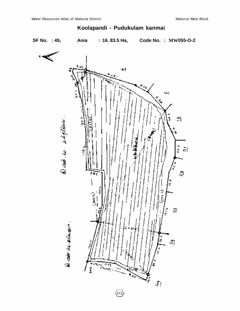
Water Resources Atlas of Madurai District Madurai West Block
372
Koolapandi - Pudukulam kanmai
SF No. : 45, Area : 16. 83.5 Ha, Code No. : MW055-O-2

Water Resources Atlas of Madurai District Madurai West Block
373
56 - KODIMANGALAM
56.1. VILLAGE DATA :
This Village comes under Madurai North Taluk and Madurai West Block. It
has 1 hamlets with a total Population 952. The Area of this Village is 117.70.0
Hectares. Latitude is 10000’00” and Longitude is 78009’30” . The splitup of Hamlets
& Population are as
follows :
Kodimangalam : 952
56.2. INDEX MAP :
56.3.WATER BODIES :
This Village has 2 Water Bodies : 1Tank, 1 Oonaies.
Tank Ooranie
No. of Tank 1 No. of Ooranie Drinking Water Cattle
PWD System 0 1 0 1
PWD Non System 0 Pond
Panchayat Union 0 No. of Pond Drinking Water Cattle
Ex - Zamin 0 0 0 0
56.3.1. No. of Wells :
Kodimangalam has a total of 34 wells. Out of which 16 are open wells, 16
open wells in ayacut area. 1 tuber wells and 1 tube wells in Ayacut area.
Situation : This Village is Situated 1.12 Km. distant from Madurai Railway Junction and 1.6 Km.distant from Madurai to Natham Road.
MADURAI (D)MADURAI NORTH (T)
CHETTIKULAM
9.6
Km
.
KODIMANGALAM
7.6 Km.
MADURAI WEST (B)
MARANIVARIYANDAL
12.6
Km
.

Water Resources Atlas of Madurai District Madurai West Block
374
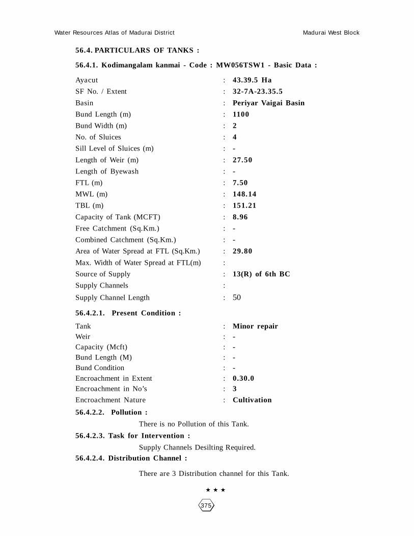
Water Resources Atlas of Madurai District Madurai West Block
375
56.4. PARTICULARS OF TANKS :
56.4.1. Kodimangalam kanmai - Code : MW056TSW1 - Basic Data :
Ayacut : 43.39.5 Ha
SF No. / Extent : 32-7A-23.35.5
Basin : Periyar Vaigai Basin
Bund Length (m) : 1100
Bund Width (m) : 2
No. of Sluices : 4
Sill Level of Sluices (m) : -
Length of Weir (m) : 27.50
Length of Byewash : -
FTL (m) : 7.50
MWL (m) : 148.14
TBL (m) : 151.21
Capacity of Tank (MCFT) : 8.96
Free Catchment (Sq.Km.) : -
Combined Catchment (Sq.Km.) : -
Area of Water Spread at FTL (Sq.Km.) : 29.80
Max. Width of Water Spread at FTL(m) :
Source of Supply : 13(R) of 6th BC
Supply Channels :
Supply Channel Length : 50
56.4.2.1. Present Condition :
Tank : Minor repairWeir : -Capacity (Mcft) : -Bund Length (M) : -Bund Condition : -Encroachment in Extent : 0.30.0Encroachment in No’s : 3
Encroachment Nature : Cultivation
56.4.2.2. Pollution :
There is no Pollution of this Tank.
56.4.2.3. Task for Intervention :
Supply Channels Desilting Required.
56.4.2.4. Distribution Channel :
There are 3 Distribution channel for this Tank.

Water Resources Atlas of Madurai District Madurai West Block
376
Kodimangalam - Kodimangalam Kanmai
SF No. : 32, Area : 29. 46.0Ha, Code No. : MW056TSW1

Water Resources Atlas of Madurai District Madurai West Block
377
56.5. PARTICULARS OF OORANIES :
56.5.1. Sakarapan Ooranie - Code : MW056-O-1 - Basic Data :
Survey Field No. : 21Extent : 0.76.0Source of Supply : Rain waterLength (m) : -Breadth (m) : -Purpose (Drinking Water / Cattle) : -Present Status : -
56.5.1.1. Pollution :
There is no pollution of this Ooranie.
56.5.1.2. Task for Intervention :Desilting, strengthening are required for this Ooranie. There is no encroachment.
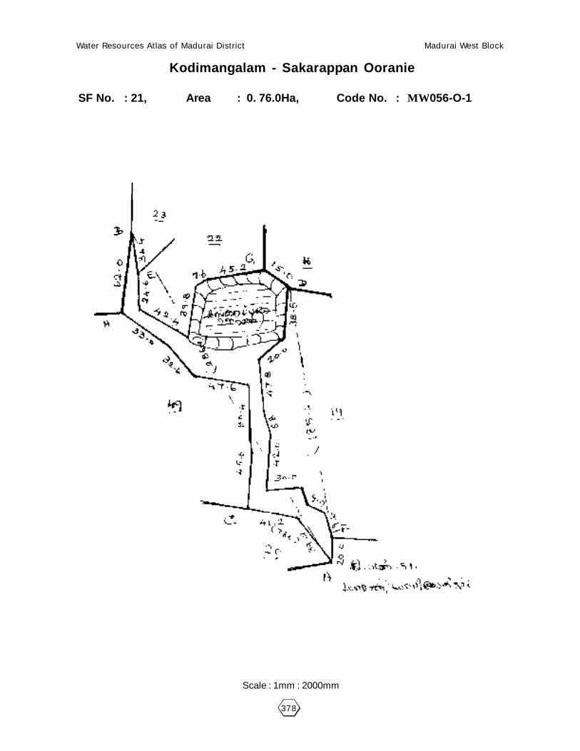
Water Resources Atlas of Madurai District Madurai West Block
378
Kodimangalam - Sakarappan Ooranie
SF No. : 21, Area : 0. 76.0Ha, Code No. : MW056-O-1
Scale : 1mm : 2000mm

Water Resources Atlas of Madurai District Madurai West Block
379
57 - USILAMPATTI
57.1. VILLAGE DATA :
This Village comes under Madurai North Taluk and Madurai West Block.
It has 1 hamlets with a total Population 980. The Area of this Village is 96.99.0
Hectares. Latitude is 1001’00” and Longitude is 78009’30” . The splitup of Hamlets
& Population are as follows :
Usilampatti : 980
57.2. INDEX MAP :
57.3.WATER BODIES :
This Village has 3 Water Bodies : 1 Tank, 2 Oonaies.
Tank Ooranie
No. of Tank 1 No. of Ooranie Drinking Water Cattle
PWD System 1 2 0 2
PWD Non System 0 Pond
Panchayat Union 0 No. of Pond Drinking Water Cattle
Ex - Zamin 0 0 0 0
57.3.1. No. of Wells :
Usilampatti has a total of 39 wells. Out of which 17 nos are open wells,17.00.0 open wells in ayacut area, 2.00.0 nos open wells in non ayacut area and
1.00.0 tube wells in ayacut area and 2 total tube wells.
Situation : This Village is Situated 12.8 Km. North of Madurai and Madurai Railway Junction.0.4 Km. from Madurai to Natham Road.
MADURAI (D)MADURAI NORTH (T)
CHETTIKULAM
USILAMPATTI
12 Km.MADURAI WEST (B)
KAUCHARAMPATTI
15 Km.

Water Resources Atlas of Madurai District Madurai West Block
380

Water Resources Atlas of Madurai District Madurai West Block
381
57.4. PARTICULARS OF TANKS :
57.4.1. - Periya Kanmai Code : MW057TSW1 - Basic Data :
Ayacut : 25.06.0 Ha
SF No. / Extent : 5/1-12.49.0
Basin : Minor Basin
Bund Length (m) : 750
Bund Width (m) : 3
No. of Sluices : 3
Sill Level of Sluices (m) : -
Length of Weir (m) : 11.75
Length of Byewash : -
FTL (m) : (7.50 Ft) 102.28
MWL (m) : 104.28
TBL (m) : 106.29
Capacity of Tank (MCFT) : 8.48
Free Catchment (Sq.Km.) : Free Basin
Combined Catchment (Sq.Km.) : 52.0
Area of Water Spread at FTL (Sq.Km.) : -
Max. Width of Water Spread at FTL(m) : -
Source of Supply : Sulice
Supply Channels : 11 (L) of 6th BC
Supply Channel Length : 300
57.4.2.1. Present Condition :
Tank : -Weir : -Capacity (Mcft) : -Bund Length (M) : -Bund Condition : 0.28.5Encroachment in Extent : 12 twelveEncroachment in No’s : Hurts and Cultivation
Encroachment Nature : -
57.4.1.2. Pollution :
There is no Pollution of this Tank.
57.4.1.3. Task for Intervention :
Supply Channels Desilting Required.
57.4.1.4. Distribution Channel :
There are 3 Distribution channel for this Tank.

Water Resources Atlas of Madurai District Madurai West Block
382
Usilampatti - Periakanmai
SF No. : 5, Area : 12. 52.5Ha, Code No. : MW057TSW1

Water Resources Atlas of Madurai District Madurai West Block
383
57.5. PARTICULARS OF OORANIES :
57.5.1. Vannan Ooranie - Code : MW057-O-1 - Basic Data :
Survey Field No. : 31Extent : 0.76.0Source of Supply : Rain waterLength (m) : -Breadth (m) : -Purpose (Drinking Water / Cattle) : -Present Status : -
56.5.1.1. Pollution :
There is no pollution of this Ooranie.
56.5.1.2. Task for Intervention :Desilting, strengthening are required for this Ooranie. There is no encroachment.
57.5. PARTICULARS OF OORANIES :
57.5.1. Ooranie - Code : MW057-O-1 - Basic Data :
Survey Field No. : 48-1Extent : 0.34.5Source of Supply : -Length (m) : -Breadth (m) : -Purpose (Drinking Water / Cattle) : -Present Status : -
57.5.1.1. Pollution :
There is no pollution of this Ooranie.
57.5.1.2. Task for Intervention :Desilting, strengthening are required for this Ooranie. There is no encroachment.

Water Resources Atlas of Madurai District Madurai West Block
384
Usilampatti - Vannan Ooranie
SF No. : 31, Area : 0. 95.5Ha, Code No. : MW057-O-1
Scale : 1mm : 1000mm

Water Resources Atlas of Madurai District Madurai West Block
385
Usilampatti - Ooranie
SF No. : 48, Area : 0. 66.5Ha, Code No. : MW057-O-2

Water Resources Atlas of Madurai District Madurai West Block
386

Water Resources Atlas of Madurai District Madurai West Block
387
58 - ERUKKALAINATHAM
58.1. VILLAGE DATA :
This Village comes under Madurai North Taluk and Madurai West Block. It
has 1 hamlets with a total Population 585. The Area of this Village is 57.93.0
Hectares. Latitude is 10001’00” and Longitude is 78010’30” . The splitup of Hamlets
& Population are as
follows :
58.2. INDEX MAP :
58.3.WATER BODIES :
This Village has 1 Water Bodies : 1 Tank
Tank Ooranie
No. of Tank 1 No. of Ooranie Drinking Water Cattle
PWD System 1 0 0 0
PWD Non System 0 Pond
Panchayat Union 0 No. of Pond Drinking Water Cattle
Ex - Zamin 0 0 0 0
58.3.1. No. of Wells :
Erukkalainatham has a total of 18.20 wells. Out of which 11 are open wells,
3.00.0 open wells in ayacut area, 1.20.0 open wells in non ayacut area and 1tubewells in ayacut area.
Situation : This Village is Situated 14.4 Km. North of Madurai and Madurai Railway Junctionand 1.6 Km. from Madurai to Natham Road.
MADURAI (D)MADURAI NORTH (T)
CHETTIKULAM
ERUKKALAI NATHAM
12 Km.MADURAI WEST (B)
KAUCHARAMPATTI
16 Km.

Water Resources Atlas of Madurai District Madurai West Block
388

Water Resources Atlas of Madurai District Madurai West Block
389
58.4. PARTICULARS OF TANKS :
58.4.1. - Erukkalainatham Kanmai Code : MW058TSW1 - Basic Data :
Ayacut : 29.21.0 Ha
SF No. / Extent : 1/1, 14.73.0
Basin : Minor Basin
Bund Length (m) : 1300
Bund Width (m) : 2
No. of Sluices : 4
Sill Level of Sluices (m) : -
Length of Weir (m) : 16.5
Length of Byewash : -
FTL (m) : 150.0
MWL (m) : 152.7
TBL (m) : 153.15
Capacity of Tank (MCFT) : 7.29
Free Catchment (Sq.Km.) : Free Basin only
Combined Catchment (Sq.Km.) : -
Area of Water Spread at FTL (Sq.Km.) : 54
Max. Width of Water Spread at FTL(m) : -
Source of Supply : Sluice
Supply Channels : 11 (L) of 6th BC
Supply Channel Length : 500
58.4.2.1. Present Condition :
Tank : Under repairsWeir : FairCapacity (Mcft) : 4.60Bund Length (M) : 1300Bund Condition : FairEncroachment in Extent : 0.10.0Encroachment in No’s : 13 (Thirteen)
Encroachment Nature : Huts & Cultivation
58.4.1.2. Pollution :
There is no Pollution of this Tank.
58.4.1.3. Task for Intervention :
Supply Channels Desilting Required.
58.4.1.4. Distribution Channel :
There are 3 Distribution channel for this Tank.

Water Resources Atlas of Madurai District Madurai West Block
390
Erukkalainatham - Erukkalainatham kanmai
SF No. : 1, Area : 14. 13.0Ha, Code No. : MW058TSW1

Water Resources Atlas of Madurai District Madurai West Block
391
59 - PARAIPATTI
59.1. VILLAGE DATA :
This Village comes under Madurai North Taluk and Madurai West Block. It
has 1 hamlets with a total Population 900. The Area of this Village is 133.88.5
Hectares. Latitude is 10001’00” and Longitude is 78010’00” . The splitup of Hamlets
& Population are as
follows :
59.2. INDEX MAP :
59.3.WATER BODIES :
This Village has 3 Water Bodies : 2 Tanks, 1 Ooranie
Tank Ooranie
No. of Tank 2 No. of Ooranie Drinking Water Cattle
PWD System 2 1 0 1
PWD Non System 0 Pond
Panchayat Union 0 No. of Pond Drinking Water Cattle
Ex - Zamin 0 0 0 0
59.3.1. No. of Wells :
Paraipatti has a total of 50.74 wells. Out of which 21 are open wells, 27.74.0
open wells in ayacut area. 2 total tube wells.
Situation : This Village is Situated 19.2 Km. distant North of Madurai and 19.2 Km distantfrom Madurai Railway Junction. 1.6 Km. distant from Madurai to Natham Road.
MADURAI (D)
PARAIPATTI
13 K
m.
MA
DU
RA
I - N
AT
HA
M
1 Km.
Water Resources Atlas of Madurai District Madurai West Block
392

Water Resources Atlas of Madurai District Madurai West Block
393
59.4. PARTICULARS OF TANKS :
59.4.1. Paraipatti Kanmai Code : MW059TSW1 - Basic Data :
Ayacut : 9396.5 Ha
SF No. / Extent : 30-1, 37
Basin : -
Bund Length (m) : 1675
Bund Width (m) : 2
No. of Sluices : 4
Sill Level of Sluices (m) : -
Length of Weir (m) : 58.20
Length of Byewash : -
FTL (m) : 155.14
MWL (m) : 157.96
TBL (m) : 158.96
Capacity of Tank (MCFT) : 9.23
Free Catchment (Sq.Km.) : -
Combined Catchment (Sq.Km.) : 64.34
Area of Water Spread at FTL (Sq.Km.) : -
Max. Width of Water Spread at FTL(m) : -
Source of Supply : 9 L 96th BC
Supply Channels : 6th BC
Supply Channel Length : 650
59.4.2.1. Present Condition :
Tank : -Weir : -Capacity (Mcft) : -Bund Length (M) : -Bund Condition : -Encroachment in Extent : 7-24-0Encroachment in No’s : 57
Encroachment Nature : Paddy Cultivation
59.4.1.2. Pollution :
There is no Pollution of this Tank.
59.4.1.3. Task for Intervention :
Supply Channels Desilting Required.
59.4.1.4. Distribution Channel :
There are 3 Distribution channel for this Tank.

Water Resources Atlas of Madurai District Madurai West Block
394
Paraipatti - Paraipatti Kanmai
SF No. : 30, Area : 26. 78.5Ha, Code No. : MW059TSW1

Water Resources Atlas of Madurai District Madurai West Block
395
59.4. PARTICULARS OF TANKS :
59.4.2. Kulam Code : MW059TSW2 - Basic Data :
Ayacut : -
SF No. / Extent : 26.03.5, 7.29.5
Basin : -
Bund Length (m) : -
Bund Width (m) : -
No. of Sluices : -
Sill Level of Sluices (m) : -
Length of Weir (m) : -
Length of Byewash : -
FTL (m) : -
MWL (m) : -
TBL (m) : -
Capacity of Tank (MCFT) : -
Free Catchment (Sq.Km.) : -
Combined Catchment (Sq.Km.) : -
Area of Water Spread at FTL (Sq.Km.) : -
Max. Width of Water Spread at FTL(m) : -
Source of Supply : -
Supply Channels : -
Supply Channel Length : -
59.4.2.1. Present Condition :
Tank : -Weir : -Capacity (Mcft) : -Bund Length (M) : -Bund Condition : -Encroachment in Extent : -Encroachment in No’s : -
Encroachment Nature : -
59.4.1.2. Pollution :
There is no Pollution of this Tank.
59.4.1.3. Task for Intervention :
Supply Channels Desilting Required.
59.4.1.4. Distribution Channel :
There are 3 Distribution channel for this Tank.

Water Resources Atlas of Madurai District Madurai West Block
396
Paraipatti - Kulam
SF No. : 37, Area : 7. 29.5Ha, Code No. : MW059TSW2
Scale : 1mm : 2000mm

Water Resources Atlas of Madurai District Madurai West Block
397
060 - MANDIKULAM
60.1. VILLAGE DATA :
This Village comes under Madurai North Taluk and Madurai West Block. It has
0 hamlets with a total Population. The Area of this Village is 358.04.0 Hectares. Latitude
is 9059’00” and Longitude is 78001’00” . The splitup of Hamlets & Population are as
follows :
60.2. INDEX MAP :
60.3. WATER BODIES :
This Village has 3 Water Bodies : 2 Tank, 1 Ooranie
Tank Ooranie
No. of Tank 2 No. of Ooranie Drinking Water Cattle
PWD System 2 1 0 0
PWD Non System 0 Pond
Panchayat Union 0 No. of Pond Drinking Water Cattle
Ex - Zamin 0 0 0 0
60.3.1. No. of Wells :
Mandhikulam has a total of 66 wells. Out of which 27 are open wells, 36.40
open wells in ayacut area, 1.20.0 tube wells in ayacut area.
Situation : This Village is Situated 13.6 Km. North of Madurai and the same distant fromMadurai Railway Junction and nearly from Madurai to Natham Road.
MADURAI (D)
MANDHIKULAM
1 Km.
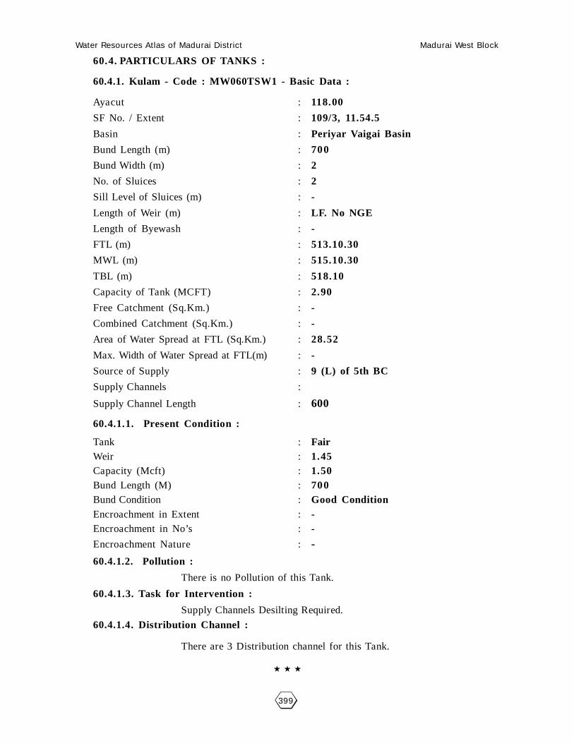
Water Resources Atlas of Madurai District Madurai West Block
399
60.4. PARTICULARS OF TANKS :
60.4.1. Kulam - Code : MW060TSW1 - Basic Data :
Ayacut : 118.00
SF No. / Extent : 109/3, 11.54.5
Basin : Periyar Vaigai Basin
Bund Length (m) : 700
Bund Width (m) : 2
No. of Sluices : 2
Sill Level of Sluices (m) : -
Length of Weir (m) : LF. No NGE
Length of Byewash : -
FTL (m) : 513.10.30
MWL (m) : 515.10.30
TBL (m) : 518.10
Capacity of Tank (MCFT) : 2.90
Free Catchment (Sq.Km.) : -
Combined Catchment (Sq.Km.) : -
Area of Water Spread at FTL (Sq.Km.) : 28.52
Max. Width of Water Spread at FTL(m) : -
Source of Supply : 9 (L) of 5th BC
Supply Channels :
Supply Channel Length : 600
60.4.1.1. Present Condition :
Tank : FairWeir : 1.45Capacity (Mcft) : 1.50Bund Length (M) : 700Bund Condition : Good ConditionEncroachment in Extent : -Encroachment in No’s : -
Encroachment Nature : -
60.4.1.2. Pollution :
There is no Pollution of this Tank.
60.4.1.3. Task for Intervention :
Supply Channels Desilting Required.
60.4.1.4. Distribution Channel :
There are 3 Distribution channel for this Tank.
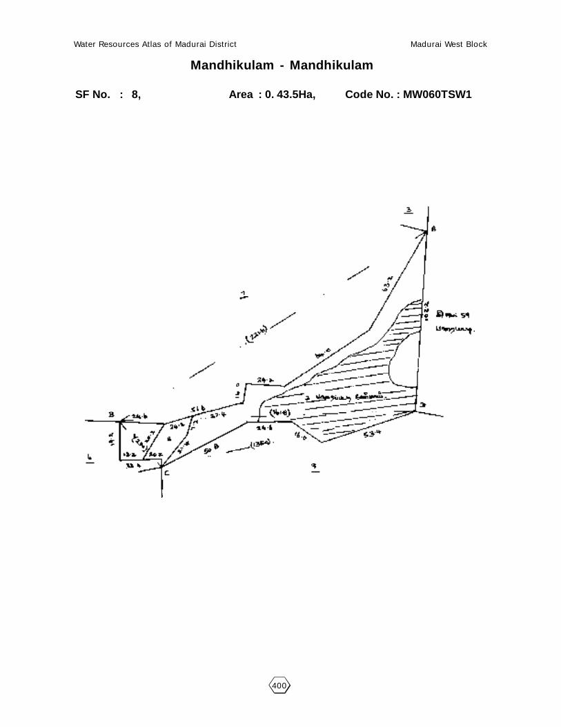
Water Resources Atlas of Madurai District Madurai West Block
400
Mandhikulam - Mandhikulam
SF No. : 8, Area : 0. 43.5Ha, Code No. : MW060TSW1

Water Resources Atlas of Madurai District Madurai West Block
401
60.4. PARTICULARS OF TANKS :
60.4.2. Kulam - Code : MW060TSW1 - Basic Data :
Ayacut :
SF No. / Extent : 44/5, 14.16.5 Ha
Basin : -
Bund Length (m) : 915
Bund Width (m) : 3
No. of Sluices : 2
Sill Level of Sluices (m) : -
Length of Weir (m) : 24.55
Length of Byewash : -
FTL (m) : 102.30
MWL (m) : 104.20
TBL (m) : 106.30
Capacity of Tank (MCFT) : 3.56
Free Catchment (Sq.Km.) : -
Combined Catchment (Sq.Km.) : -
Area of Water Spread at FTL (Sq.Km.) : 28.52
Max. Width of Water Spread at FTL(m) : -
Source of Supply : 4 (R) of 6th BC
Supply Channels :
Supply Channel Length : -
60.4.2.1. Present Condition :
Tank : FairWeir : FairCapacity (Mcft) : 1.80Bund Length (M) : -Bund Condition : Good ConditionEncroachment in Extent : -Encroachment in No’s : -
Encroachment Nature : -
60.4.2.2. Pollution :
There is no Pollution of this Tank.
60.4.2.3. Task for Intervention :
Supply Channels Desilting Required.
60.4.2.4. Distribution Channel :
There are 3 Distribution channel for this Tank.

Water Resources Atlas of Madurai District Madurai West Block
402
Mandhikulam - Palayampatti Kulam
SF No. : 44, Area : 17. 11.5Ha, Code No. : MW060TSW2
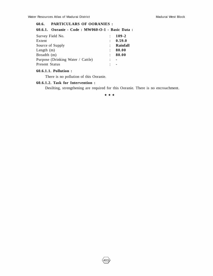
Water Resources Atlas of Madurai District Madurai West Block
403
60.6. PARTICULARS OF OORANIES :
60.6.1. Ooranie - Code : MW060-O-1 - Basic Data :
Survey Field No. : 109-2Extent : 0.59.0Source of Supply : RainfallLength (m) : 80.00Breadth (m) : 80.00Purpose (Drinking Water / Cattle) : -Present Status : -
60.6.1.1. Pollution :
There is no pollution of this Ooranie.
60.6.1.2. Task for Intervention :Desilting, strengthening are required for this Ooranie. There is no encroachment.

Water Resources Atlas of Madurai District Madurai West Block
404
Mandhikulam - Ooranie
SF No. : 109, Area : 0. 60.5 Ha, Code No. : MW060-O-1
Scale 1mm = 1000mm

Water Resources Atlas of Madurai District Madurai West Block
405
061 - PERIAPATTI
61.1. VILLAGE DATA :
This Village comes under Madurai North Taluk and Madurai West Block. It has
1 hamlets with a total Population. The Area of this Village is 98.17.0 Hectares. Latitude
is 10002’00” and Longitude is 78009’30” . The splitup of Hamlets & Population are as
follows :
61.2. INDEX MAP :
61.3. WATER BODIES :
This Village has 2 Water Bodies : 1 Tank, 1 Ooranie.
Tank Ooranie
No. of Tank 1 No. of Ooranie Drinking Water Cattle
PWD System 1 1 0 0
PWD Non System 0 Pond
Panchayat Union 0 No. of Pond Drinking Water Cattle
Ex - Zamin 0 0 0 0
61.3.1. No. of Wells :
Periapatti has a total of 46 wells. Out of which 17 are open wells, 14.30.0
open wells in ayacut area, 9 total tube wells and 5.70.0 tube wells in ayacut area.
Situation : This Village is Situated 14.4 Km. distant North of Madurai, 14.4 Km. distant fromMadurai Railway Junction and 0.8 Km. distant from Madurai to Natham Road.
MADURAI (D)
KANCHARAMPATTI PERIAPATTI
14 Km.
NATHAM ROAD

Water Resources Atlas of Madurai District Madurai West Block
406

Water Resources Atlas of Madurai District Madurai West Block
407
61.4. PARTICULARS OF TANKS :
61.4.1. Kancharampatti - Code : MW061TSW1 - Basic Data :
Ayacut : 78.24.0 Ha
SF No. / Extent : 1-1A
Basin : -
Bund Length (m) : 700
Bund Width (m) : 2
No. of Sluices : 3+1 Pipe
Sill Level of Sluices (m) : -
Length of Weir (m) : 4.30
Length of Byewash : -
FTL (m) : 102.74
MWL (m) : 103.75
TBL (m) : 105.25
Capacity of Tank (MCFT) : 2.44
Free Catchment (Sq.Km.) : Free Basin only
Combined Catchment (Sq.Km.) : -
Area of Water Spread at FTL (Sq.Km.) : 23.97
Max. Width of Water Spread at FTL(m) : 23.97
Source of Supply : 5 (L) of 6th BC
Supply Channels :
Supply Channel Length : 400
61.4.1.1. Present Condition :
Tank : Cylinder repairWeir : FairCapacity (Mcft) : 1.25Bund Length (M) : 700Bund Condition : FairEncroachment in Extent : 0.40.5Encroachment in No’s : 1
Encroachment Nature : Paddy
61.4.1.2. Pollution :
There is no Pollution of this Tank.
61.4.1.3. Task for Intervention :
Supply Channels Desilting Required.
61.4.1.4. Distribution Channel :
There are 3 Distribution channel for this Tank.

Water Resources Atlas of Madurai District Madurai West Block
408
Periyapatti - Kancharampettai Kanmai
SF No. : 1, Area : 11. 40.5 Ha, Code No. : MW061TSW1

Water Resources Atlas of Madurai District Madurai West Block
409
61.6. PARTICULARS OF OORANIES :
61.6.1. Ooranie - Code : MW060-O-1 - Basic Data :
Survey Field No. : 35Extent : 0.37.0Source of Supply : -Length (m) : -Breadth (m) : -Purpose (Drinking Water / Cattle) : -Present Status : -
61.6.1.1. Pollution :
There is no pollution of this Ooranie.
61.6.1.2. Task for Intervention :Desilting, strengthening are required for this Ooranie. There is no encroachment.

Water Resources Atlas of Madurai District Madurai West Block
410
Periyapatti - Ooranie
SF No. : 35, Area : 0. 37.0 Ha, Code No. : MW061-O-1
Scale 1mm = 1000mm

Water Resources Atlas of Madurai District Madurai West Block
411
062 - KAVANOOR
62.1. VILLAGE DATA :
This Village comes under Madurai North Taluk and Madurai West Block. It
has 1 hamlets with a total Population 2200. The Area of this Village is 131.85.0
Hectares. Latitude is 10002’00” and Longitude is 78009’30” . The splitup of Hamlets
& Population are as
follows :
62.2. INDEX MAP :
62.3. WATER BODIES :
This Village has 4 Water Bodies : 1 Tank, 3 Ooranies.
Tank Ooranie
No. of Tank 1 No. of Ooranie Drinking Water Cattle
PWD System 1 3 0 3
PWD Non System 0 Pond
Panchayat Union 0 No. of Pond Drinking Water Cattle
Ex - Zamin 0 0 0 0
62.3.1. No. of Wells :
Kavanoor has a total of 37 wells. Out of which 19 are open wells, 18 open
wells in ayacut area.
Situation : This Village is Situated 11.4 Km. distant North of Madurai and 14.4 Km. distant fromMadurai Railway Junction. 1.6 Km. distant from Madurai to Natham Road.
Water Resources Atlas of Madurai District Madurai West Block
412

Water Resources Atlas of Madurai District Madurai West Block
413
62.4. PARTICULARS OF TANKS :
62.4.1. Kavanoor - Code : MW062TSW1 - Basic Data :
Ayacut : 22
SF No. / Extent : 1/1-1.80.5
Basin : Periyar Vaigai Basin
Bund Length (m) : 1000
Bund Width (m) : 3
No. of Sluices : 3
Sill Level of Sluices (m) : -
Length of Weir (m) : -
Length of Byewash : -
FTL (m) : 102.86
MWL (m) : 104.86
TBL (m) : 106.72
Capacity of Tank (MCFT) : 3.88
Free Catchment (Sq.Km.) : -
Combined Catchment (Sq.Km.) : -
Area of Water Spread at FTL (Sq.Km.) : -
Max. Width of Water Spread at FTL(m) : -
Source of Supply : Vedankulam Distributory
Supply Channels :
Supply Channel Length : 1200
62.4.1.1. Present Condition :
Tank : FairWeir : FairCapacity (Mcft) : 1.90 MCFTBund Length (M) : 1000Bund Condition : FairEncroachment in Extent : -Encroachment in No’s : -
Encroachment Nature : -
62.4.1.2. Pollution :
There is no Pollution of this Tank.
62.4.1.3. Task for Intervention :
Supply Channels Desilting Required.
62.4.1.4. Distribution Channel :
There are 3 Distribution channel for this Tank.

Water Resources Atlas of Madurai District Madurai West Block
414
Kavanoor - Kavanoor Tank
SF No. : 1, Area : 18. 03.0 Ha, Code No. : MW062TSW1

Water Resources Atlas of Madurai District Madurai West Block
415
62.6. PARTICULARS OF OORANIES :
62.6.1. Mayana Ooranie - Code : MW062-O-1 - Basic Data :
Survey Field No. : -Extent : 0.22.0Source of Supply : RainfedLength (m) : 022.0Breadth (m) : 60Purpose (Drinking Water / Cattle) : 40Present Status : Cattle
62.6.1.1. Pollution :
There is no pollution of this Ooranie.
62.6.1.2. Task for Intervention :Desilting, strengthening are required for this Ooranie. There is no encroachment.
62.6. PARTICULARS OF OORANIES :
62.6.2. Kavanoor Ooranie - Code : MW062-O-1 - Basic Data :
Survey Field No. : 8/1Extent : 0.39.5Source of Supply : RainfedLength (m) : 130Breadth (m) : 70Purpose (Drinking Water / Cattle) : CattlePresent Status : -
62.6.2.1. Pollution :
There is no pollution of this Ooranie.
62.6.2.2. Task for Intervention :Desilting, strengthening are required for this Ooranie. There is no encroachment.

Water Resources Atlas of Madurai District Madurai West Block
416
Kavanoor - Mayana Ooranie
SF No. : 0 , Area : 17. 11.5Ha, Code No. : MW062-O-1

Water Resources Atlas of Madurai District Madurai West Block
417
Kavanoor - Kavanoor Ooranie
SF No. : 8, Area : 0. 97.0 Ha, Code No. : MW062-O-2

Water Resources Atlas of Madurai District Madurai West Block
418

Water Resources Atlas of Madurai District Madurai West Block
419
063 - THERKUPETHAMPATTI
63.1. VILLAGE DATA :
This Village comes under Madurai North Taluk and Madurai West Block. It has
2 hamlets with a total Population. The Area of this Village is 1023 Hectares. Latitude is
10001’30” and Longitude is 78009’00” . The splitup of Hamlets & Population are as
follows :
Therkupethampatti : Thavittampatti :
63.2. INDEX MAP :
63.3. WATER BODIES :
This Village has 1 Water Bodies : 1 Tank
Tank Ooranie
No. of Tank 1 No. of Ooranie Drinking Water Cattle
PWD System 1 0 0 0
PWD Non System 0 Pond
Panchayat Union 0 No. of Pond Drinking Water Cattle
Ex - Zamin 0 0 0 0
63.3.1. No. of Wells :
Therkupethampatti has a total of 62 wells. Out of which 30 are open wells, 28
open wells in ayacut area, 1 total tube wells and 1 tube wells in Non-ayacut area.
Situation : This Village is Situated 12.8 Km. distant North of Madurai, 12.8 Km. distant fromMadurai Railway Junction and 1.6 Km. distant from Madurai to Natham Road.
Water Resources Atlas of Madurai District Madurai West Block
420

Water Resources Atlas of Madurai District Madurai West Block
421
63.4. PARTICULARS OF TANKS :
63.4.1. Therkupethampatti - Code : MW063TSW1 - Basic Data :
Ayacut : 40.0
SF No. / Extent : -
Basin : Periyar Vaigai Basin
Bund Length (m) : 500
Bund Width (m) : 2
No. of Sluices : 2
Sill Level of Sluices (m) : L.F 0.90
Length of Weir (m) : -
Length of Byewash : -
FTL (m) : -
MWL (m) : -
TBL (m) : -
Capacity of Tank (MCFT) : -
Free Catchment (Sq.Km.) : -
Combined Catchment (Sq.Km.) : -
Area of Water Spread at FTL (Sq.Km.) : -
Max. Width of Water Spread at FTL(m) : -
Source of Supply : 8(L) of Poolampatti District
Supply Channels :
Supply Channel Length : 10
63.4.1.1. Present Condition :
Tank : FairWeir : FairCapacity (Mcft) : 0.80Bund Length (M) : 500Bund Condition : FairEncroachment in Extent : -Encroachment in No’s : -
Encroachment Nature : -
63.4.1.2. Pollution :
There is no Pollution of this Tank.
63.4.1.3. Task for Intervention :
Supply Channels Desilting Required.
63.4.1.4. Distribution Channel :
There are 3 Distribution channel for this Tank.

Water Resources Atlas of Madurai District Madurai West Block
422
Kavanoor - Theruku Pathampatti
SF No. : 0, Area : 17. 11.5Ha, Code No. : MW063TSW1

Water Resources Atlas of Madurai District Madurai West Block
423
064 - POOLAMPATTI
64.1. VILLAGE DATA :
This Village comes under Madurai North Taluk and Madurai West Block. It has
1 hamlets with a total Population. The Area of this Village is 78.82.5 Hectares. Latitude
is 10002’30” and Longitude is 78008’00” . The splitup of Hamlets & Population are as
follows :
Therkupethampatti : Thavittampatti :
64.2. INDEX MAP :
64.3. WATER BODIES :
This Village has 2 Water Bodies : 1 Tank, 1 Ooranie
Tank Ooranie
No. of Tank 1 No. of Ooranie Drinking Water Cattle
PWD System 1 0 0 0
PWD Non System 0 Pond
Panchayat Union 0 No. of Pond Drinking Water Cattle
Ex - Zamin 0 0 0 0
64.3.1. No. of Wells :
Therkupethampatti has a total of 20 wells. Out of which 10 are open wells, 10
open wells in ayacut area.
Situation : This Village is Situated 16.0 Km. distant from Madurai and Madurai Railway Junction and 3.2 Km. distant from Madurai to Natham Road.
MADURAI NORTH (T)MADURAI (D)
THERKUPETHAM PATTY
3 Km.
POOLAMPATTY
2 Km.MANTHIKULAM

Water Resources Atlas of Madurai District Madurai West Block
424

Water Resources Atlas of Madurai District Madurai West Block
425
64.4. PARTICULARS OF TANKS :
64.4.1. Puliyankulam- Code : MW064TSW1 - Basic Data :
Ayacut : 3.332
SF No. / Extent : 41
Basin : -
Bund Length (m) : 700
Bund Width (m) : 3.00
No. of Sluices : 1
Sill Level of Sluices (m) : 183.700
Length of Weir (m) : 7.00
Length of Byewash : -
FTL (m) : 183.700
MWL (m) : 184.200
TBL (m) : 185.200
Capacity of Tank (MCFT) : 0.01413
Free Catchment (Sq.Km.) : 0.24
Combined Catchment (Sq.Km.) : 0.62
Area of Water Spread at FTL (Sq.Km.) : 0.02571
Max. Width of Water Spread at FTL(m) : 52.00
Source of Supply : Free Basin
Supply Channels :
Supply Channel Length : -
64.4.1.1. Present Condition :
Tank : GoodWeir : GoodCapacity (Mcft) : 0.01413Bund Length (M) : 700Bund Condition : GoodEncroachment in Extent : -Encroachment in No’s : -
Encroachment Nature : -
64.4.1.2. Pollution :
There is no Pollution of this Tank.
64.4.1.3. Task for Intervention :
Supply Channels Desilting Required.
64.4.1.4. Distribution Channel :
There are 3 Distribution channel for this Tank.
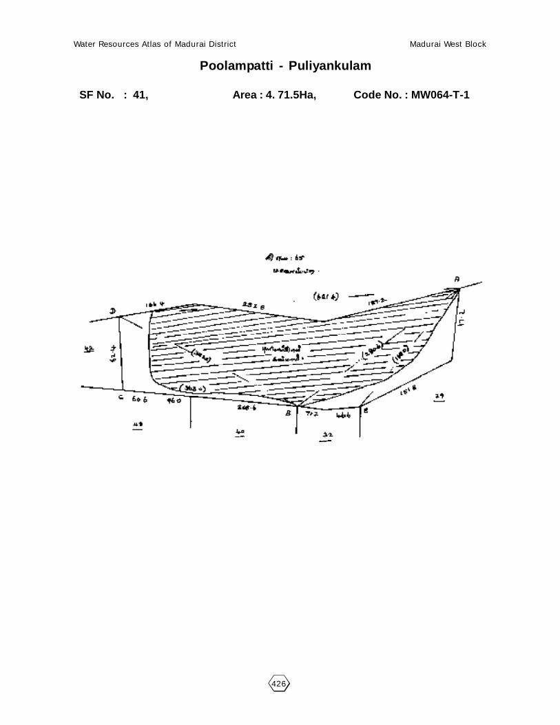
Water Resources Atlas of Madurai District Madurai West Block
426
Poolampatti - Puliyankulam
SF No. : 41, Area : 4. 71.5Ha, Code No. : MW064-T-1

Water Resources Atlas of Madurai District Madurai West Block
427
64.6.1. KOVIL OORANIE - CODE : MW064-O-1 - BASIC DATA :
Survey Field No. : 64Extent : -Source of Supply : RainLength (m) : 35.00Breadth (m) : 47.00Purpose (Drinking Water / Cattle) : CattlePresent Status : Good
64.6.1.1. Pollution :
There is no pollution of this Ooranie.
64.6.1.2. Task for Intervention :Desilting, strengthening are required for this Ooranie. There is no encroachment.

Water Resources Atlas of Madurai District Madurai West Block
428
Poolampatti - Kovil Ooranie
SF No. : , Area : 4. 71.5Ha, Code No. : MW064-O-1

Water Resources Atlas of Madurai District Madurai West Block
429
065 - MALAIPATTI
65.1. VILLAGE DATA :
This Village comes under Madurai North Taluk and Madurai West Block. It has
5 hamlets with a total Population. The Area of this Village is 111.425 Hectares. Latitude
is 10003’00” and Longitude is 78008’00” . The splitup of Hamlets & Population are as
follows :
65.2. INDEX MAP :
65.3. WATER BODIES :
This Village has 4 Water Bodies : 2 Tanks, 2 Ooranies.
Tank Ooranie
No. of Tank 2 No. of Ooranie Drinking Water Cattle
PWD System 2 2 0 2
PWD Non System 1 Pond
Panchayat Union 0 No. of Pond Drinking Water Cattle
Ex - Zamin 0 0 0 0
65.3.1. No. of Wells :
Malaipatti has a total of 58 wells out of which 29 are open wells, 23 open
wells in ayacut area, 6 tube wells in Non-ayacut area.
Situation : This Village is Situated 14.4 Km. North of Madurai and 14.4 Km from Madurai Railway Junction and 0.8 Km. from Madurai to Alagarkovil Road.

Water Resources Atlas of Madurai District Madurai West Block
430

Water Resources Atlas of Madurai District Madurai West Block
431
65.4. PARTICULARS OF TANKS :
65.4.1. Periyakulam - Code : MW065TSU1 - Basic Data :
Ayacut : 5.00 Ha
SF No. / Extent : -
Basin : -
Bund Length (m) : 219
Bund Width (m) : 2.00
No. of Sluices : 1
Sill Level of Sluices (m) : 181.130
Length of Weir (m) : 5.00
Length of Byewash : 182.500
FTL (m) : 182.800
MWL (m) : 183.880
TBL (m) : 0.021
Capacity of Tank (MCFT) : 0.091
Free Catchment (Sq.Km.) : 0.194
Combined Catchment (Sq.Km.) : 0.012922
Area of Water Spread at FTL (Sq.Km.) : 38
Max. Width of Water Spread at FTL(m) : Free Basin only
Source of Supply : -
Supply Channels : -
Supply Channel Length : -
65.4.1.1. Present Condition :
Tank : GoodWeir : GoodCapacity (Mcft) : -Bund Length (M) : 0.1075Bund Condition : 538Encroachment in Extent : GoodEncroachment in No’s : -
Encroachment Nature : -
65.4.1.2. Pollution :
There is no Pollution of this Tank.
65.4.1.3. Task for Intervention :
Supply Channels Desilting Required.
65.4.1.4. Distribution Channel :
There are 3 Distribution channel for this Tank.

Water Resources Atlas of Madurai District Madurai West Block
432
Malaipatti - Periyakulam
SF No. : 0, Area : 17. 11.5Ha, Code No. : MW065-TSW1

Water Resources Atlas of Madurai District Madurai West Block
433
65.4. PARTICULARS OF TANKS :
65.4.2. Chinna PeriyaKanmai - Code : MW065TSU1 - Basic Data :
Ayacut : 25.88 Ha
SF No. / Extent : -
Basin : -
Bund Length (m) : 538
Bund Width (m) : 3.00
No. of Sluices : 1
Sill Level of Sluices (m) : 183.40
Length of Weir (m) : 20.80
Length of Byewash : 187.820
FTL (m) : 188.430
MWL (m) : 184.680
TBL (m) : 0.1075
Capacity of Tank (MCFT) : 0.184
Free Catchment (Sq.Km.) : 0.312
Combined Catchment (Sq.Km.) : 0.0833
Area of Water Spread at FTL (Sq.Km.) : 72
Max. Width of Water Spread at FTL(m) : Free Basin Nawal kulam
Source of Supply : Ammanadikulam, Pudurkulam
Supply Channels : -
Supply Channel Length : -
65.4.2.1. Present Condition :
Tank : GoodWeir : GoodCapacity (Mcft) : -Bund Length (M) : 0.021Bund Condition : 219Encroachment in Extent : GoodEncroachment in No’s : -
Encroachment Nature : -
65.4.2.2. Pollution :
There is no Pollution of this Tank.
65.4.2.3. Task for Intervention :
Supply Channels Desilting Required.
65.4.2.4. Distribution Channel :
There are 3 Distribution channel for this Tank.

Water Resources Atlas of Madurai District Madurai West Block
434
Malaipatti - Chinna Kulam
SF No. : 0, Area : 17. 11.5Ha, Code No. : MW065-TSW1

Water Resources Atlas of Madurai District Madurai West Block
435
066 - VELICHANATHAM
66.1. VILLAGE DATA :
This Village comes under Madurai North Taluk and Madurai West Block. The
Area of this Village is 166.28.0 Hectares. Latitude is 9059’30” and Longitude is
78002’20” . The splitup of Hamlets & Population are as
follows :
66.2. INDEX MAP :
66.3. WATER BODIES :
This Village has 5 Water Bodies : 1 Tank, 2 Ooranie and 2 Ponds.
Tank Ooranie
No. of Tank 1 No. of Ooranie Drinking Water Cattle
PWD System 1 2 0 2
PWD Non System 0 Pond
Panchayat Union 0 No. of Pond Drinking Water Cattle
Ex - Zamin 0 2 0 2
66.3.1. No. of Wells :
Velichanatham has a total of 83 wells, 83 open wells in ayacut area.
Situation : This Village is Situated 19.2 Km. North of Madurai and the same distant from Madurai Railway Junction and nearly from Madurai to Natham Road.

Water Resources Atlas of Madurai District Madurai West Block
436

Water Resources Atlas of Madurai District Madurai West Block
437
66.4. PARTICULARS OF TANKS :
66.4.1. Meenakshipuram Kulam - Code : MW066TSW1 - Basic Data :
Ayacut : -
SF No. / Extent : 30/1, 7.10.5
Basin : -
Bund Length (m) : 480
Bund Width (m) : 2
No. of Sluices : 1
Sill Level of Sluices (m) : -
Length of Weir (m) : Natural Ground escape
Length of Byewash : -
FTL (m) : 102.14
MWL (m) : 104.12
TBL (m) : 106.15
Capacity of Tank (MCFT) : 1.5
Free Catchment (Sq.Km.) : -
Combined Catchment (Sq.Km.) : -
Area of Water Spread at FTL (Sq.Km.) : -
Max. Width of Water Spread at FTL(m) : 3(R) of 6th BC
Source of Supply : -
Supply Channels : -
Supply Channel Length : 300
66.4.1.1. Present Condition :
Tank : FairWeir : FairCapacity (Mcft) : 7.10.5Bund Length (M) : 480Bund Condition : FairEncroachment in Extent : 064.0Encroachment in No’s : 7
Encroachment Nature : -
66.4.1.2. Pollution :
There is no Pollution of this Tank.
66.4.1.3. Task for Intervention :
Supply Channels Desilting Required.
66.4.1.4. Distribution Channel :
There are 3 Distribution channel for this Tank.

Water Resources Atlas of Madurai District Madurai West Block
438
Velichanatham - Meenakshipuram Kulam
SF No. : 30, Area : 7. 83.5 Ha, Code No. : MW066TSW1

Water Resources Atlas of Madurai District Madurai West Block
439
66.6. PARTICULARS OF OORANIES :
66.6.1. Kollankulam Ooranie - Code : MW066-O-1 - Basic Data :
Survey Field No. : 41-5, 59/59.131/1Extent : 021.5, 1.64.0.0.70.0Source of Supply : VaikalLength (m) : 70.90Breadth (m) : 56.40Purpose (Drinking Water / Cattle) : CattlePresent Status : -
66.6.1.1. Pollution :
There is no pollution of this Ooranie.
66.6.1.2. Task for Intervention :Desilting, strengthening are required for this Ooranie. There is no encroachment.
66.6. PARTICULARS OF OORANIES :
66.6.2. Kannimar Kovil Ooranie - Code : MW066-O-2 - Basic Data :
Survey Field No. : -Extent : -Source of Supply : VaikalLength (m) : 82.50Breadth (m) : 60.00Purpose (Drinking Water / Cattle) : CattlePresent Status : -
66.6.2.1. Pollution :
There is no pollution of this Ooranie.
66.6.2.2. Task for Intervention :Desilting, strengthening are required for this Ooranie. There is no encroachment.
66.6. PARTICULARS OF OORANIES :
66.6.3. Puliyankulam Ooranie - Code : MW066-O-3 - Basic Data :
Survey Field No. : -Extent : -Source of Supply : VaikalLength (m) : 160Breadth (m) : 110.50Purpose (Drinking Water / Cattle) : CattlePresent Status : -
66.6.3.1. Pollution :
There is no pollution of this Ooranie.
66.6.3.2. Task for Intervention :Desilting, strengthening are required for this Ooranie. There is no encroachment.

Water Resources Atlas of Madurai District Madurai West Block
440
Velichanatham - Kollankulam Ooranie
SF No. : 41, Area : 4. 00.0 Ha, Code No. : MW066-O-1
Scale 1mm = 2000mm

Water Resources Atlas of Madurai District Madurai West Block
441
Velichanatham - Kannimar Kovil Ooranie
SF No. : 0, Area : 17. 11.5Ha, Code No. : MW066-O-2

Water Resources Atlas of Madurai District Madurai West Block
442
Velichanatham - Puliyankulam Ooranie
SF No. : 0, Area : 17. 11.5Ha, Code No. : MW066-O-3

Water Resources Atlas of Madurai District Madurai West Block
443
66.7. PARTICULARS OF OORANIES :
66.7.1. Kannimarkulam Pond - Code : MW066-P-1 - Basic Data :
Survey Field No. : 14/14, 70/70, 77/3, 89/89Extent : 010.0, 086.5, 0.60.5, 184.5Source of Supply : -Length (m) : -Breadth (m) : -Purpose (Drinking Water / Cattle) : -Present Status : -
66.7.1.1. Pollution :
There is no pollution of this Ooranie.
66.7.1.2. Task for Intervention :Desilting, strengthening are required for this Ooranie. There is no encroachment.
66.7. PARTICULARS OF OORANIES :
66.7.2. Vedarkulam Pond - Code : MW066-P-2 - Basic Data :
Survey Field No. : 97/3, 141/3, 189/1Extent : 059.0, 011.0, 0080, 0680Source of Supply : -Length (m) : -Breadth (m) : -Purpose (Drinking Water / Cattle) : -Present Status : -
66.7.2.1. Pollution :
There is no pollution of this Ooranie.
66.7.2.2. Task for Intervention :Desilting, strengthening are required for this Ooranie. There is no encroachment.

Water Resources Atlas of Madurai District Madurai West Block
444
Velichanatham - Kannimarkulam Pond
SF No. : 14, Area : 3. 13.5 Ha, Code No. : MW066-P-1

Water Resources Atlas of Madurai District Madurai West Block
445
Velichanatham - Vedarkulam Pond
SF No. : 97, Area : 17. 11.5Ha, Code No. : MW066-P-2

Water Resources Atlas of Madurai District Madurai West Block
446

Water Resources Atlas of Madurai District Madurai West Block
447
067 - CHINNAPATTI
67.1. VILLAGE DATA :
This Village comes under Madurai North Taluk and Madurai West Block. It
has 0 hamlets with a total Population of 1650. The Area of this Village is 155.085
Hectares. Latitude is 10001’30” and Longitude is 78003’00” . The splitup of Hamlets
& Population are as
follows :
67.2. INDEX MAP :
67.3. WATER BODIES :
This Village has 5 Water Bodies : 1 Tanks and 4 Ooranies.
Tank Ooranie
No. of Tank 1 No. of Ooranie Drinking Water Cattle
PWD System 1 4 0 4
PWD Non System 0 Pond
Panchayat Union 0 No. of Pond Drinking Water Cattle
Ex - Zamin 0 0 0 0
4.3.1. No. of Wells :
Thodaneri has a total of 136 wells out of which 30 are open wells, 75 open
wells in ayacut area, 2 tube wells and 25 tube wells in non ayacut area and tube
wells in ayacut area.
Situation : This Village is Situated 16 Km. distant North of Madurai and the same distant from Madurai Railway Junction and nearly from Madurai to Natham Mettaled Road.
MADURAI NORTH (T)MADURAI (D)
2.5 Km.CHINNAPATTI
14 Km.
KANJARAMPATTAI

Water Resources Atlas of Madurai District Madurai West Block
448

Water Resources Atlas of Madurai District Madurai West Block
449
67.4. PARTICULARS OF TANKS :
67.4.1. Narayanakudi Kanmai - Code : MW067TSW1 - Basic Data :
Ayacut : 14.00.0 Ha
SF No. / Extent : 12, 9.45.0
Basin : Periyar Vaigai Basin
Bund Length (m) : 915
Bund Width (m) : 2
No. of Sluices : 2
Sill Level of Sluices (m) : -
Length of Weir (m) : -
Length of Byewash : -
FTL (m) : (6.5F+) 101.98
MWL (m) : 102.98
TBL (m) : 104.68
Capacity of Tank (MCFT) : 2 MCFT
Free Catchment (Sq.Km.) : -
Combined Catchment (Sq.Km.) : -
Area of Water Spread at FTL (Sq.Km.) : -
Max. Width of Water Spread at FTL(m) : -
Source of Supply : 2(L) of 6th BC
Supply Channels : -
Supply Channel Length : -
67.4.1.1. Present Condition :
Tank : FairWeir : FairCapacity (Mcft) : 805.5Bund Length (M) : 915Bund Condition : FairEncroachment in Extent : 040.0Encroachment in No’s : Panchayat
Encroachment Nature : Coconut trees
67.4.1.2. Pollution :
There is no Pollution of this Tank.
67.4.1.3. Task for Intervention :
Supply Channels Desilting Required.
67.4.1.4. Distribution Channel :
There are 3 Distribution channel for this Tank.

Water Resources Atlas of Madurai District Madurai West Block
450
Chinnapatti - Narayanakudi Kanmai
SF No. : 12, Area : 9. 45.0Ha, Code No. : MW067-TSW1
Scale 1mm = 5000mm

Water Resources Atlas of Madurai District Madurai West Block
451
67.6. PARTICULARS OF OORANIES :
67.6.1. Thamarai Ooranie - Code : MW067-O-1 - Basic Data :
Survey Field No. : 1Extent : 040.0,026.5Source of Supply : RainLength (m) : 66.00Breadth (m) : 51.00Purpose (Drinking Water / Cattle) : -Present Status : -
67.6.1.1. Pollution :
There is no pollution of this Ooranie.
67.6.1.2. Task for Intervention :Desilting, strengthening are required for this Ooranie. There is no encroachment.
67.6. PARTICULARS OF OORANIES :
67.6.2. Erulaye Ooranie - Code : MW067-O-1 - Basic Data :
Survey Field No. : 56Extent : -Source of Supply : RainLength (m) : 82.50Breadth (m) : 73.70Purpose (Drinking Water / Cattle) : CattlePresent Status : -
67.6.2.1. Pollution :
There is no pollution of this Ooranie.
67.6.2.2. Task for Intervention :Desilting, strengthening are required for this Ooranie. There is no encroachment.
67.6. PARTICULARS OF OORANIES :
67.6.1. Eluppai Ooranie - Code : MW067-O-3 - Basic Data :
Survey Field No. : -Extent : 072.0Source of Supply : RainLength (m) : 5720Breadth (m) : 63.60Purpose (Drinking Water / Cattle) : CattlePresent Status : -
67.6.3.1. Pollution :
There is no pollution of this Ooranie.
67.6.3.2. Task for Intervention :Desilting, strengthening are required for this Ooranie. There is no encroachment.

Water Resources Atlas of Madurai District Madurai West Block
452
Chinnapatti - Thamarai Ooranie
SF No. : 1, Area : 0. 26.5 Ha, Code No. : MW064-O-1.
Scale 1mm = 1000mm

Water Resources Atlas of Madurai District Madurai West Block
453
Chinnapatti - Erulaye Ooranie
SF No. : 56, Area : 0. 40.0 Ha, Code No. : MW067-O-2
Scale 1mm = 1000mm
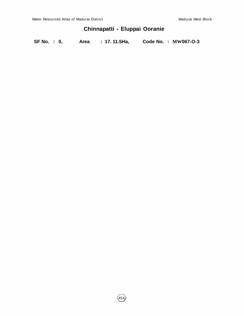
Water Resources Atlas of Madurai District Madurai West Block
454
Chinnapatti - Eluppai Ooranie
SF No. : 0, Area : 17. 11.5Ha, Code No. : MW067-O-3

Water Resources Atlas of Madurai District Madurai West Block
455
67.6. PARTICULARS OF OORANIES :
67.6.2. Thukantan Ooranie - Code : MW067-O-2 - Basic Data :
Survey Field No. : -Extent : 07.0Source of Supply : RainLength (m) : 92.70Breadth (m) : 80.60Purpose (Drinking Water / Cattle) : CattlePresent Status : -
67.6.4.1. Pollution :
There is no pollution of this Ooranie.
67.6.4.2. Task for Intervention :Desilting, strengthening are required for this Ooranie. There is no encroachment.

Water Resources Atlas of Madurai District Madurai West Block
456
Chinnapatti - Thukantan Ooranie
SF No. : 0, Area : 17. 11.5Ha, Code No. : MW067-O-4

Water Resources Atlas of Madurai District Madurai West Block
457
67.7. PARTICULARS OF OORANIES :
67.7.1. Kavanurkulam Pond - Code : MW067-P-1 - Basic Data :
Survey Field No. : 103/7Extent : 030.5Source of Supply : 3 HectersLength (m) : -Breadth (m) : -Purpose (Drinking Water / Cattle) : -Present Status : -
67.7.4.1. Pollution :
There is no pollution of this Ooranie.
67.7.4.2. Task for Intervention :Desilting, strengthening are required for this Ooranie. There is no encroachment.

Water Resources Atlas of Madurai District Madurai West Block
458
Chinnapatti - Kavanoorkulam Pond
SF No. : 103, Area : 17. 11.5Ha, Code No. : MW067-P-1

Water Resources Atlas of Madurai District Madurai West Block
459
068 - CHATRATHONDANMANPATTI
68.1. VILLAGE DATA :
This Village comes under Madurai North Taluk and Madurai West Block. It
has 1 hamlets with a total Population 2125. The Area of this Village is 371.89.5
Hectares. Latitude is 10003’00” and Longitude is 78010’00” . The splitup of Hamlets
& Population are as
follows :
Thodamanpatti :
68.2. INDEX MAP :
68.3. WATER BODIES :
This Village has 4Water Bodies : 4 Tank.
Tank Ooranie
No. of Tank 4 No. of Ooranie Drinking Water Cattle
PWD System 1 0 0 0
PWD Non System 0 Pond
Panchayat Union 0 No. of Pond Drinking Water Cattle
Ex - Zamin 0 0 0 0
68.3.1. No. of Wells :
Chatrathondanmanpatti has a total of 92 wells out of which 37 are open wells,
37 open wells in ayacut area, 12 open wells in non-ayacut area, 3 tube wells in
non-ayacut area.
Situation : This Village is Situated 16 Km. distant North of Madurai, 16.0 Km distant from Madurai Railway Junction and on the Madurai to Natham Road.
MADURAI NORTH (T)MADURAI (D)
16 Km.
CHATRATHODANMANPATTI

Water Resources Atlas of Madurai District Madurai West Block
460

Water Resources Atlas of Madurai District Madurai West Block
461
68.4. PARTICULARS OF TANKS :
68.4.1. Parayan Kulam - Code : MW058TSW1 - Basic Data :
Ayacut : 9.64 Ha
SF No. / Extent : 173
Basin : -
Bund Length (m) : 482
Bund Width (m) : 3.00
No. of Sluices : 1
Sill Level of Sluices (m) : 179.3.80
Length of Weir (m) : 11.00
Length of Byewash : -
FTL (m) : 181.575
MWL (m) : 181.875
TBL (m) : 182.875
Capacity of Tank (MCFT) : 0.020
Free Catchment (Sq.Km.) : 0.018
Combined Catchment (Sq.Km.) : 0.312
Area of Water Spread at FTL (Sq.Km.) : 0.0303
Max. Width of Water Spread at FTL(m) : 112.00
Source of Supply : Free Basin
Supply Channels : Kodangikallu Pitchankulam
Supply Channel Length : -
68.4.1.1. Present Condition :
Tank : GoodWeir : GoodCapacity (Mcft) : 0.020Bund Length (M) : 482Bund Condition : GoodEncroachment in Extent : -Encroachment in No’s : -
Encroachment Nature : -
68.4.1.2. Pollution :
There is no Pollution of this Tank.
68.4.1.3. Task for Intervention :
Supply Channels Desilting Required.
68.4.1.4. Distribution Channel :
There are 3 Distribution channel for this Tank.

Water Resources Atlas of Madurai District Madurai West Block
462
Chatrathondamanpatti - Parayankulam
SF No. : 173, Area : 4. 11.5 Ha, Code No. : MW068-TSW1

Water Resources Atlas of Madurai District Madurai West Block
463
68.4. PARTICULARS OF TANKS :
68.4.2. Kodangikallupitchan Kulam - Code : MW068TSW1 - Basic Data :
Ayacut : 2.276
SF No. / Extent : 66
Basin : -
Bund Length (m) : 225
Bund Width (m) : 2.75
No. of Sluices : 1
Sill Level of Sluices (m) : 187.255
Length of Weir (m) : 6.00
Length of Byewash : -
FTL (m) : 183.550
MWL (m) : 184.050
TBL (m) : 185.050
Capacity of Tank (MCFT) : 0.005
Free Catchment (Sq.Km.) : 0.108
Combined Catchment (Sq.Km.) : 0.292
Area of Water Spread at FTL (Sq.Km.) : 0.0125
Max. Width of Water Spread at FTL(m) : 56.00
Source of Supply : Free Basin
Supply Channels : -
Supply Channel Length : -
68.4.1.1. Present Condition :
Tank : GoodWeir : GoodCapacity (Mcft) : 0.005Bund Length (M) : 225Bund Condition : GoodEncroachment in Extent : -Encroachment in No’s : -
Encroachment Nature : -
68.4.1.2. Pollution :
There is no Pollution of this Tank.
68.4.1.3. Task for Intervention :
Supply Channels Desilting Required.
68.4.1.4. Distribution Channel :
There are 3 Distribution channel for this Tank.

Water Resources Atlas of Madurai District Madurai West Block
464
Chatrathondamanpatti - Kodangi Kallupitchan Kulam
SF No. : 66, Area : 1. 41.5 Ha, Code No. : MW068-TSW2

Water Resources Atlas of Madurai District Madurai West Block
465
68.4. PARTICULARS OF TANKS :
68.4.3. Periyapitchan Kulam - Code : MW069TSW1 - Basic Data :
Ayacut : -
SF No. / Extent : 68
Basin : 143
Bund Length (m) : 2.00
Bund Width (m) : -
No. of Sluices : -
Sill Level of Sluices (m) : -
Length of Weir (m) : 6.00
Length of Byewash : -
FTL (m) : -
MWL (m) : -
TBL (m) : -
Capacity of Tank (MCFT) : 0.003
Free Catchment (Sq.Km.) : 0.084
Combined Catchment (Sq.Km.) : 0.187
Area of Water Spread at FTL (Sq.Km.) : 0.0179
Max. Width of Water Spread at FTL(m) : 38.00
Source of Supply : Free Basin
Supply Channels : -
Supply Channel Length : -
68.4.3.1. Present Condition :
Tank : -Weir : GoodCapacity (Mcft) : 0.003Bund Length (M) : 143Bund Condition : GoodEncroachment in Extent : -Encroachment in No’s : -
Encroachment Nature : -
68.4.3.2. Pollution :
There is no Pollution of this Tank.
68.4.3.3. Task for Intervention :
Supply Channels Desilting Required.
68.4.3.4. Distribution Channel :
There are 3 Distribution channel for this Tank.

Water Resources Atlas of Madurai District Madurai West Block
466
Chatrathondamanpatti - Periya Pitchan Kulam
SF No. : 68, Area : 0. 76.5Ha, Code No. : MW068-TSW3

Water Resources Atlas of Madurai District Madurai West Block
467
68.4. PARTICULARS OF TANKS :
68.4.4. Peekulam - Code : MW069TSW4 - Basic Data :
Ayacut : 5.463
SF No. / Extent : 105
Basin : -
Bund Length (m) : 466
Bund Width (m) : 3.00
No. of Sluices : 1
Sill Level of Sluices (m) : 192.285
Length of Weir (m) : -
Length of Byewash : 11.00
FTL (m) : 193.950
MWL (m) : 194.250
TBL (m) : 195.250
Capacity of Tank (MCFT) : 0.018
Free Catchment (Sq.Km.) : 0.248
Combined Catchment (Sq.Km.) : 0.467
Area of Water Spread at FTL (Sq.Km.) : 0.0241
Max. Width of Water Spread at FTL(m) : 96.00
Source of Supply : Free Basin
Supply Channels : -
Supply Channel Length : -
68.4.4.1. Present Condition :
Tank : -Weir : GoodCapacity (Mcft) : 0.01.8Bund Length (M) : 466Bund Condition : GoodEncroachment in Extent : -Encroachment in No’s : -
Encroachment Nature : -
68.4.4.2. Pollution :
There is no Pollution of this Tank.
68.4.4.3. Task for Intervention :
Supply Channels Desilting Required.
68.4.4.4. Distribution Channel :
There are 3 Distribution channel for this Tank.

Water Resources Atlas of Madurai District Madurai West Block
468
Chatrathondamanpatti - Peekulam
SF No. : 105, Area : 17. 11.5Ha, Code No. : W068-TSW4

Water Resources Atlas of Madurai District Madurai West Block
469
069 - MANJAMPATTI
69.1. VILLAGE DATA :
This Village comes under Madurai North Taluk and Madurai West Block. It
has 2 hamlets with a total Population 2337. The Area of this Village is 472.91.5
Hectares. Latitude is 10002’30” and Longitude is 78011’00” . The splitup of Hamlets
& Population are as
follows :
Manjampatti : 1815 Seegupathi : 522
69.2. INDEX MAP :
69.3. WATER BODIES :
This Village has 7 Water Bodies : 3 Tank, 4 Ooranies.
Tank Ooranie
No. of Tank 3 No. of Ooranie Drinking Water Cattle
PWD System 1 4 0 4
PWD Non System 0 Pond
Panchayat Union 0 No. of Pond Drinking Water Cattle
Ex - Zamin 0 0 0 0
69.3.1. No. of Wells :
Manjampatti has has a total of 96 wells. Out of which 42 nos are open wells, 18open wells in ayacut area, 24 nos open wells in non ayacut area and 1 tube wells, 5
nos tube wells in non ayacut area.
Situation : This Village is Situated 17.6 Km. distant North of Madurai, 17.6 Km distant from Madurai Railway Junction and on the Madurai to Natham Road.
MADURAI NORTH (T)
17.6
Km
.
CHATRATHODANMANPATTI
2.5 Km.
MANJAMPATTI

Water Resources Atlas of Madurai District Madurai West Block
470

Water Resources Atlas of Madurai District Madurai West Block
471
69.4. PARTICULARS OF TANKS :
69.4.1. Andikulam - Code : MW069TSW1 - Basic Data :
Ayacut : 25.36 Ha
SF No. / Extent : 54/1
Basin : -
Bund Length (m) : 960
Bund Width (m) : 3.50
No. of Sluices : 2
Sill Level of Sluices (m) : L.F-184.060
Length of Weir (m) : R.F-18.40
Length of Byewash : -
FTL (m) : 187.190
MWL (m) : 187.690
TBL (m) : 188.690
Capacity of Tank (MCFT) : 0.05487
Free Catchment (Sq.Km.) : 0.384
Combined Catchment (Sq.Km.) : 0.825
Area of Water Spread at FTL (Sq.Km.) : 0.0803
Max. Width of Water Spread at FTL(m) : 86.00
Source of Supply : Free Basin & Nallakulam
Supply Channels : -
Supply Channel Length : -
69.4.1.1. Present Condition :
Tank : GoodWeir : GoodCapacity (Mcft) : 0.05487Bund Length (M) : 960Bund Condition : GoodEncroachment in Extent : -Encroachment in No’s : -
Encroachment Nature : -
69.4.1.2. Pollution :
There is no Pollution of this Tank.
69.4.1.3. Task for Intervention :
Supply Channels Desilting Required.
69.4.1.4. Distribution Channel :
There are 3 Distribution channel for this Tank.

Water Resources Atlas of Madurai District Madurai West Block
472
Manjampatti - Andikulam
SF No. : 54, Area : 10. 16.5Ha, Code No. : MW069-TSW1

Water Resources Atlas of Madurai District Madurai West Block
473
69.4. PARTICULARS OF TANKS :
69.4.2. Thondimaistry Kulam - Code : MW069TSW2 - Basic Data :
Ayacut : 3.74 Ha
SF No. / Extent : 122
Basin : -
Bund Length (m) : 230
Bund Width (m) : 2.50
No. of Sluices : 1
Sill Level of Sluices (m) : 183.950
Length of Weir (m) : R.F-18.40
Length of Byewash : -
FTL (m) : 181.310
MWL (m) : 181.810
TBL (m) : 182.810
Capacity of Tank (MCFT) : 0.006979
Free Catchment (Sq.Km.) : 0.08
Combined Catchment (Sq.Km.) : 0.21
Area of Water Spread at FTL (Sq.Km.) : 0.0271
Max. Width of Water Spread at FTL(m) : 40.00
Source of Supply : Free Basin
Supply Channels : -
Supply Channel Length : -
69.4.2.1. Present Condition :
Tank : GoodWeir : GoodCapacity (Mcft) : 0.006979Bund Length (M) : 230Bund Condition : GoodEncroachment in Extent : -Encroachment in No’s : -
Encroachment Nature : -
69.4.2.2. Pollution :
There is no Pollution of this Tank.
69.4.2.3. Task for Intervention :
Supply Channels Desilting Required.
69.4.2.4. Distribution Channel :
There are 3 Distribution channel for this Tank.

Water Resources Atlas of Madurai District Madurai West Block
474
Manjampatti - Thondi Maistry Kulam
SF No. : 122 Area : 1. 03.5 Ha, Code No. : MW069-TSW2
Scale 1mm = 2000mm

Water Resources Atlas of Madurai District Madurai West Block
475
69.4. PARTICULARS OF TANKS :
69.4.3. Ramachandran Kulam - Code : MW069TSW3 - Basic Data :
Ayacut : 3.708 Ha
SF No. / Extent : 32
Basin : -
Bund Length (m) : 480
Bund Width (m) : 3.00
No. of Sluices : 1
Sill Level of Sluices (m) : 184.560
Length of Weir (m) : 10.00
Length of Byewash : -
FTL (m) : 180.610
MWL (m) : 181.110
TBL (m) : 182.110
Capacity of Tank (MCFT) : 0.1106
Free Catchment (Sq.Km.) : 0.278
Combined Catchment (Sq.Km.) : 0.355
Area of Water Spread at FTL (Sq.Km.) : 0.2402
Max. Width of Water Spread at FTL(m) : 70.00
Source of Supply : Free Basin
Supply Channels : -
Supply Channel Length : -
69.4.2.1. Present Condition :
Tank : GoodWeir : GoodCapacity (Mcft) : 0.1106Bund Length (M) : 480Bund Condition : GoodEncroachment in Extent : -Encroachment in No’s : -
Encroachment Nature : -
69.4.3.2. Pollution :
There is no Pollution of this Tank.
69.4.3.3. Task for Intervention :
Supply Channels Desilting Required.
69.4.3.4. Distribution Channel :
There are 3 Distribution channel for this Tank.

Water Resources Atlas of Madurai District Madurai West Block
476
Manjampatti - Ramachandran Kulam
SF No. : 32, Area : 5. 19.0 Ha, Code No. : MW069-TSW3

Water Resources Atlas of Madurai District Madurai West Block
477
69.6. PARTICULARS OF OORANIES :
69.6.1. Kallurani Ooranie - Code : MW069-O-1 - Basic Data :
Survey Field No. : -Extent : -Source of Supply : VaigalLength (m) : 124.60Breadth (m) : 80.00Purpose (Drinking Water / Cattle) : CattlePresent Status : Good
69.6.1.1. Pollution :
There is no pollution of this Ooranie.
69.6.1.2. Task for Intervention :Desilting, strengthening are required for this Ooranie. There is no encroachment.
69.6.2. Parukkan Ooranie - Code : MW069-O-2 - Basic Data :
Survey Field No. : -Extent : -Source of Supply : VaigalLength (m) : 110.50Breadth (m) : 60.00Purpose (Drinking Water / Cattle) : CattlePresent Status : Good
69.6.2.1. Pollution :
There is no pollution of this Ooranie.
69.6.2.2. Task for Intervention :Desilting, strengthening are required for this Ooranie. There is no encroachment.
69.6.3. Cheyan Ooranie - Code : MW069-O-3 - Basic Data :
Survey Field No. : -Extent : -Source of Supply : VaigalLength (m) : 98.90Breadth (m) : 47.50Purpose (Drinking Water / Cattle) : CattlePresent Status : Good
69.6.3.1. Pollution :
There is no pollution of this Ooranie.
69.6.3.2. Task for Intervention :Desilting, strengthening are required for this Ooranie. There is no encroachment.

Water Resources Atlas of Madurai District Madurai West Block
478
Manjampatti - Kallurani
SF No. : -0, Area : 17. 11.5Ha, Code No. : MW006-O-1

Water Resources Atlas of Madurai District Madurai West Block
479
Manjampatti - Parukkulam Ooranie
SF No. : 0, Area : 17. 11.5Ha, Code No. : MW069-O-2

Water Resources Atlas of Madurai District Madurai West Block
480
Manjampatti - Cheyan Ooranie
SF No. : 0, Area : 17. 11.5Ha, Code No. : MW069-O-3

Water Resources Atlas of Madurai District Madurai West Block
481
69.6. PARTICULARS OF OORANIES :
69.6.4. Manjampatti Ooranie - Code : MW069-O-4 - Basic Data :
Survey Field No. : -Extent : -Source of Supply : VaigalLength (m) : 60.20Breadth (m) : 32.10Purpose (Drinking Water / Cattle) : CattlePresent Status : Good
69.6.4.1. Pollution :
There is no pollution of this Ooranie.
69.6.4.2. Task for Intervention :Desilting, strengthening are required for this Ooranie. There is no encroachment.

Water Resources Atlas of Madurai District Madurai West Block
482
Manjampatti - Manjampatti Ooranie
SF No. : 0, Area : 17. 11.5Ha, Code No. : MW069-O-4

Water Resources Atlas of Madurai District Madurai West Block
483
070 - KADAVUR
70.1. VILLAGE DATA :
This Village comes under Madurai North Taluk and Madurai West Block. It
has 1 hamlets with a total Population. The Area of this Village is 325.93.5 Hectares.
Latitude is 10004’30” and Longitude is 78010’30” . The splitup of Hamlets &
Population are as
follows :
Kallampatti :
70.2. INDEX MAP :
70.3. WATER BODIES :
This Village has 6 Water Bodies : 3 Tank, 3 Ooranies.
Tank Ooranie
No. of Tank 3 No. of Ooranie Drinking Water Cattle
PWD System 3 3 0 3
PWD Non System 0 Pond
Panchayat Union 0 No. of Pond Drinking Water Cattle
Ex - Zamin 0 0 0 0
70.3.1. No. of Wells :
Kadavur has a total of 22 wells. Out of which 8 nos are open wells, 6 open
wells in ayacut area, 2 nos open wells in non ayacut area and 3 tube wells, 3 nos
tube wells in non ayacut area.
Situation : This Village is Situated 21.0 Km. distant from Madurai North Portion. The Railway
Junction is 21.0 K.m. distant from this Village and the road in goes to Madurai to Natham Road.

Water Resources Atlas of Madurai District Madurai West Block
484
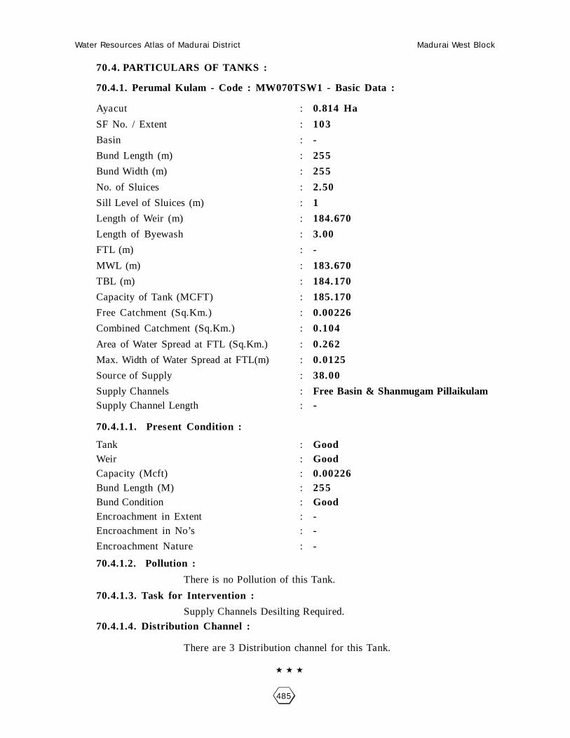
Water Resources Atlas of Madurai District Madurai West Block
485
70.4. PARTICULARS OF TANKS :
70.4.1. Perumal Kulam - Code : MW070TSW1 - Basic Data :
Ayacut : 0.814 Ha
SF No. / Extent : 103
Basin : -
Bund Length (m) : 255
Bund Width (m) : 255
No. of Sluices : 2.50
Sill Level of Sluices (m) : 1
Length of Weir (m) : 184.670
Length of Byewash : 3.00
FTL (m) : -
MWL (m) : 183.670
TBL (m) : 184.170
Capacity of Tank (MCFT) : 185.170
Free Catchment (Sq.Km.) : 0.00226
Combined Catchment (Sq.Km.) : 0.104
Area of Water Spread at FTL (Sq.Km.) : 0.262
Max. Width of Water Spread at FTL(m) : 0.0125
Source of Supply : 38.00
Supply Channels : Free Basin & Shanmugam PillaikulamSupply Channel Length : -
70.4.1.1. Present Condition :
Tank : GoodWeir : GoodCapacity (Mcft) : 0.00226Bund Length (M) : 255Bund Condition : GoodEncroachment in Extent : -Encroachment in No’s : -
Encroachment Nature : -
70.4.1.2. Pollution :
There is no Pollution of this Tank.
70.4.1.3. Task for Intervention :
Supply Channels Desilting Required.
70.4.1.4. Distribution Channel :
There are 3 Distribution channel for this Tank.

Water Resources Atlas of Madurai District Madurai West Block
486
Kadavoor - Perumal Kulam
SF No. : 103, Area : 0. 74.5Ha, Code No. : MW070TSW1
Scale 1mm = 1000mm

Water Resources Atlas of Madurai District Madurai West Block
487
70.4. PARTICULARS OF TANKS :
70.4.2. Shanmugam Pillai Kulam - Code : MW070TSW2 - Basic Data :
Ayacut : 0.908 Ha
SF No. / Extent : 20
Basin : -
Bund Length (m) : 180
Bund Width (m) : 2.50
No. of Sluices : 2
Sill Level of Sluices (m) : 186.330
Length of Weir (m) : 3.00
Length of Byewash : -
FTL (m) : 187.030
MWL (m) : 187.530
TBL (m) : 188.530
Capacity of Tank (MCFT) : 0.0004472
Free Catchment (Sq.Km.) : 0.082
Combined Catchment (Sq.Km.) : 0.126
Area of Water Spread at FTL (Sq.Km.) : 0.00179
Max. Width of Water Spread at FTL(m) : 44.00
Source of Supply : Free Basin only
Supply Channels : -
Supply Channel Length : -
70.4.2.1. Present Condition :
Tank : GoodWeir : GoodCapacity (Mcft) : 0.0004472Bund Length (M) : 180Bund Condition : GoodEncroachment in Extent : -Encroachment in No’s : -
Encroachment Nature : -
70.4.2.2. Pollution :
There is no Pollution of this Tank.
70.4.2.3. Task for Intervention :
Supply Channels Desilting Required.
70.4.2.4. Distribution Channel :
There are 3 Distribution channel for this Tank.

Water Resources Atlas of Madurai District Madurai West Block
488
Kadavoor - Shanmugam Pillai Kulam
SF No. : 20, Area : 0. 18.5 Ha, Code No. : MW070TSW2

Water Resources Atlas of Madurai District Madurai West Block
489
70.4. PARTICULARS OF TANKS :
70.4.3. Veera Kulam - Code : MW070TSW3 - Basic Data :
Ayacut : 1.02 Ha
SF No. / Extent : 67
Basin : -
Bund Length (m) : 435
Bund Width (m) : 3.00
No. of Sluices : -
Sill Level of Sluices (m) : -
Length of Weir (m) : 10.00
Length of Byewash : -
FTL (m) : -
MWL (m) : -
TBL (m) : -
Capacity of Tank (MCFT) : -
Free Catchment (Sq.Km.) : -
Combined Catchment (Sq.Km.) : -
Area of Water Spread at FTL (Sq.Km.) : -
Max. Width of Water Spread at FTL(m) : -
Source of Supply : Free Basin only
Supply Channels : -
Supply Channel Length : -
70.4.2.1. Present Condition :
Tank : -Weir : GoodCapacity (Mcft) : 2Bund Length (M) : 435Bund Condition : GoodEncroachment in Extent : -Encroachment in No’s : -
Encroachment Nature : -
70.4.3.2. Pollution :
There is no Pollution of this Tank.
70.4.3.3. Task for Intervention :
Supply Channels Desilting Required.
70.4.3.4. Distribution Channel :
There are 3 Distribution channel for this Tank.

Water Resources Atlas of Madurai District Madurai West Block
490
Kadavoor - Veera Kulam
SF No. : 67, Area : 4. 54.0Ha, Code No. : MW070TSW3