Ground temperature, active-layer thickness and ground-ice ...
Upload
khangminh22Category
view
0download
0
GROUND WATER INFORMATION BROCHUREBAHRAICH DISTRICT, U.P.
Prashant RaiScientist – C
CONTENTS
Chapter Title Page No.
BAHRAICH DISTRICT- AT A GLANCE2
1. INTRODUCTION4
2. CLIMATE & RAINFALL6
3. GEOMORPHOLOGY & SOIL TYPE7
4. GROUND WATER SCENARIO8
5. GROUND WATER MANAGEMENT STRATEGY13
6. GROUND WATER RELATED ISSUE AND PROBLEMS13
7. AWARENESS AND TRAINING AVTIVITY15
8. AREA NOTIFIED BY CGWA/SGWA15
9 RECOMMENDATIONS15
PLATES:
(I) INDEX MAP - BAHRAICH DISTRICT, U.P.(II) DEPTH TO WATER LEVEL MAP, BAHRAICH DISTRICT, U.P.
(PRE-MONSOON, MAY 2012 )(III) DEPTH TO WATER LEVEL MAP,BAHRAICH DISTRICT ,U.P.
(POST-MONSOON NOV 2012)(IV) GROUND WATER RESOURCES (2009) MAP BAHRAICH
DISTRICT, U.P.(V) HYDROGEOLOGICAL MAP, BAHRAICH DISTRICT, U.P.(VI) HYDROCHEMICAL MAP,BAHRAICH, U.P.

2
BAHRAICH DISTRICT- AT A GLANCE
1. GENERAL INFORMATION
Geographical Area (Sq km) : 5020
Administrative Divisions (As on 2010-11)Number of Tehsils/BlocksNumber of Panchayat/Villages
::
04/14903/1392
Population (As on 2011 Census) : 3478257Average Annual Rainfall (mm) : 1152
2. GEOMORPHOLOGYMajor physiographic units : Upland plains, Gently
undulating slopetowards south. Older &Younger alluvium
Major Drainages : Ghaghra and Sarju3. LAND USE (Sq Km) ( As on 2010 –11 )
Forest area : 677.72Net area sown : 3348.38Area sown more than once : 1672.05
4. MAJOR SOIL TYPES : Clay, sand and loam5. Area under principal crops ( Rice, Wheat,
Maize, Sugarcane,Pulse)(Sq Km)(2010-11) : 4207.016. IRRIGATION BY DIFFERENT SOURCES
(Number of structures/Area (SqKm)2010-11)Dugwells 69 /0.87Tube wells & Pumpsets (Electric/ Diesel) : 6720.5 /1638Tanks/ponds : ---/00Canals : 166 Km/69.40Other sources : NA/0.0Net Irrigated area : 1638.30Gross irrigated area : 1975.40
7. NUMBERS OF GROUND WATERMONITORING WELLS OF CGWB (As on 31-3-2012)No of Dug WellsNo of Piezometers
::
1605
8. PREDOMINANT GEOLOGICALFORMATIONS
: Alluvium
9. HYDROGEOLOGYMajor Water bearing formation(Pre-monsoon Depth to water level (m. bgl) during2012)
::
Sand and Gravel2.50(Katerniaghat) –10.60 (Murthia)
(Post-monsoon Depth to water level (m. bgl) during2012)
: 1.08(Razichauraha) -10.28 (Murthia)

3
Long term water level trend (2003-2012) in 10 yrs inm/yr
: Pre-monsoon:Rise 0.01-0.17Fall 0.003 – 0.05Post- MonsoonRise 0.00 – 0.12Fall 0.002 - 0.09
10 GROUND WATER EXPLORATION BYCGWB (As on 31-3-2013)No of wells drilled (EW, PZ, SH) : EW-07, PZ-04Depth Range of EW’s (mbgl) : 259.92 (Jarhi) –
453.82 (Bahraich)Discharge (lps) : 46.45 (Girjapuri) –
61.77 (Godh)Storativity (S) : 3.28 * 10 -4 (Kewalpur)
– 2.06 * 10 -2 (GirjapuriForm)
Transmissivity (m2/day) 1496(Kewalpur) – 8692(Sujauli)
11. GROUND WATER QUALITYPresence of Chemical constituents more thanpermissible limit (e.g. EC, Cl, F, No3)
: As (nd –0.102 ppm)
12. DYNAMIC GROUND WATER RESOURCES(As on 31/3/2009) (In ham)Annual Replenishable Ground WaterResources
: 130597.73
Gross Annual Ground Water Draft : 70281.89
Projected Demand for Domestic industrialUses upto 2033
: 10732.10
Stage of Ground Water Development : 58.69 %13. AWARENESS AND TRAINING ACTIVITY
Mass Awareness Programmes organized : NilWater Management Training Programmeorganized
: Nil
14. EFFORTS OF ARTIFICIAL RECHARGE &RAINWATER HARVESTING
: NA
Projects completed by CGWB (No & Amountspent)
: NA
Projects under technical guidance of CGWB(Numbers)
: NA
15. GROUND WATER CONTROL ANDREGULATIONNumber Of OE Blocks : NilNo of Crit ical Blocks : NilNo of blocks notified : Nil
16. MAJOR GROUND WATER PROBLEMS ANDISSUES
: Arsenic reported at someplaces.Some part is prone to waterlogging

4
1.0. INTRODUCTIONBahraich is a district in the Devipatan( Gonda) division of Uttar Pradesh
occupying a shape of chili. It covers an area of 5020 sq.km. and is bounded by North latitudes
27º 02’ and 28º 30' ; East Longitudes 81º 04’ and 81º 42’ in the Survey of India degree sheets
62 H and 63 E. In the north it lies with Nepal and in the east it faces Shrawasti district .
Khiri, Sitapur districts are west of the Bahraich district while south of the district is bounded
by District Gonda and Barabanki (Plate- I). Administratively, the district is divided into 4
tehsils and 14 developmental blocks. Administrative detail of the district has been given in
Table 1
Table 1 Administrative detail of the Bahraich district ,U.P..
BLOCKS TEHSIL AREA OF POPULATIONBLOCKS (2001)
MIHIPURWA NANPARA 595.47 275195
NAWABGANJ 244.21 149470
BALHA 300.89 177347
SHIVPUR 380.05 185884
RISIA 261.22 168575
CHITTAURA BAHRAICH 303.71 181824
PAYAGPUR 271.58 158213
VISHESHWARGANJ 255.95 162193
MAHSI MAHSI 376.70 173570TEJWAPUR 266.34 162111FAKHARPUR 345.30 194183HUZARPUR 242.08 150622KAISERGANJ KAISERGANJ 241.03 147618JARWAL 281.97 169303TOTAL BLOCKS 4366.50 2456108TOTAL FOREST 623.55TOTAL URBAN 29.95 237998TOTAL DISTRICT 5020.00 2701478

5
1.1 Drainage:
Ghaghara and Sarju are the main rivers of the district. The river Ghagra forms the
western boundary of the district and enters the district across Indo Nepal International
boundary.
The other important drainage channels are Risiya. Bhabhni, Soti Nadi, Jhigri Nadi &
Bhakla river. All the rivers are effectively perennial since these maintain the flow for most
part of the year. Danger of floods exists in the low-lying areas along the river Ghaghara .
1.2 Irrigation:
Agriculture is the chief occupation in the whole district. For the assured irrigation, large scale
development of surface water and ground water is being made. The irrigation area in
Bahraich district by different sources is given in (Table-2). The total irrigated area by
different sources is 1720.72 sq km .
Table 2 Area irrigated by different Sources (2010-11) ( In sq km)
BLOCKS Canals Tubewell Wells Ponds Others totalPublic Private
1. Mihipurwa 4.57 3.14 150.11 0 0 0.30 158.12
2. Nawabganj 38.84 0.42 63.81 0 0 0.30 103.37
3. Balha 5.67 3.03 111.98 0 0 0.31 120.99
4. Shivpur 0 1.41 150.75 0 0 0.28 152.44
5. Risia 3.36 8.85 127.78 0 0 0.32 140.31
6. Chittaura 16.82 5.56 124.89 4.10 0 0.34 151.71
7. Payagpur 0.14 1.44 158.66 0 0 0.26 160.50
8. Visheshwarganj 0 0.84 158.95 0 0 0.30 160.09
9. Mahsi 0 1.43 141.92 0 0 0.26 143.61
10. Tajwapur 0 2.34 120.77 4.67 0 0.32 128.10
11. Phakharpur 0 2.57 91.15 0 0 0.31 94.03
12. Huzurpur 0 1.65 85.96 0 0 0.31 87.92
13. Kaiserganj 0 2.90 85.96 0 0 0.30 89.16
14. Jarwal 0 3.74 26.29 0 0 0.34 30.37
Total District 69.40 39.32 1598.98 8.77 0 4.25 1720.72

6
Sarju Nahar Pariyojna covers the canal network of the district. Length of the major canal in
the district was 166 Kms as on 31.3.2011. The state tubewells and canals constitute the state
irrigation works, while private tubewells, pump sets, rahat and masonry wells etc. constitute
the private works. Net area sown in the district is 3348.38 sq km, only about 50% of the net
area sown gets irrigation facilities. During the year 2010-11, about 95.72 % of the net
irrigated area was done through groundwater while canal and others only contributes 4.28 %
of the total irrigated area.
1.3 Previous works
Systematic hydrogeological survey of Bahraich district was carried out by Sh. V. M.
Gandotra (1971-72) followed by Sh. S. A. H. Jaffery in the year 1975-76 and 1976-77.
Reappraisal hydrogeological surveys were carried out by S/Sri. S. N. Sinha and A. K.
Bhargava in the year 1989-90 , Sh Arun Kumar (1997 – 98 ) and S/Sri. Prashant Rai & Sant
Lal in the year 2005-06.District report entitled "Hydrogeology and Ground Water Potential of
Bahraich district, Uttar Pradesh was written by Shri. S. A. H. Jeffery in the year 1982
Central Ground Water Board (CGWB), under its ground water exploration
programme, has carried out deep drilling down to a maximum depth of 453.82 mbgl at
Bahraich to identify and demarcate aquifer system in the area besides estimating aquifer
parameters. A total of seven (7) number of tubewells have been sunk by CGWB under
normal exploration.
2. CLIMATE AND RAINFALL
The district experiences sub- humid climate and three district seasons viz. summer,
rainy and winter seasons. The hottest month is May with average mean daily temp. of 39.8 0
C. The coldest month is January with average mean daily temperature of 22.6 0 C. The
highest percentage of humidity occurs in the month of August with normal humidity of 80%
followed by 77% in July .During March to May the air is least humid. The normal annual
wind speed of the district is 5.6 Kmph. The highest normal wind speed is 8.4 Km/h in the
mouth of June and May Minimum wind speed is observed in winters. The Annual normal
Potential Evapo-transpiration of the district is 1422.7mm. The maximum P.E.T. occurs in the
month of May & June with 212.6 mm and 183.2 mm respectively.
The average annual normal rainfall (1901-1970) of the district is 1123.95 mm. The
maximum rainfall occurs during the monsoon period i.e. June to September having normal

7
value of 969.65 mm i.e. 86.3% of annual rainfall. July is the wettest month having the normal
rainfall of 316.45 min followed by August with normal rainfall of 298.95 mm.
3.0 GEOMORPHOLOGY & SOIL TYPE
3.1 Physiography, Geomorphologic Features and Landforms
Broadly the district can be considered to be a flat country with a gentle slope towards
south. The topography is largely influenced or modified by the existing network of rivers and
streams. The maximum elevation is 104 m.amsl. in the south of the district and the
approximate general gradient is 0.40 meter/Km. The district can be almost identifiably
divided into two units, the upland plains underlain by Older Alluvium and the lowland plains
underlain by Newer Alluvium.
The physical features of the district are well defined consisting of four natural
divisions of Ghaghara basin in the north- west, central upland, Rapti basin and Tarai in the
north. The Ghaghara basin runs through north western and southern portion of district. The
Rapti basin that lies on the north eastern side of the central upland, consisting parts of tehsils
of Nanpara and Bahraich, is a gentle undulating plain dotted with occasional patches of scrub
,jungles. In north and northeast lies the Tarai, the low land which remains largely inundated
during rains.
Younger Alluvial Plain:
Younger alluvial plain is found along the Ghaghara River and it is flat to sloping
slightly undulated terrain. It is produced by extensive deposits of alluvium and usually occur
adjacent to flood plains and consist of various fluvial land forms which include back swamp,
oxbow lake, old meander, meander scar, paleochannel and point bar. It mainly comprises of
younger unconsolidated alluvial materials of varying lithology. In the younger alluvial plain
area the ground water table is very shallow and ground water yield prospects are excellent.
Older Alluvial Plain:
Older alluvial plain is similar to younger alluvial plain but are formed at the earlier
stage of depositional regimes comprising of unconsolidated sediments. Groundwater
prospects are good to very good.

8
3.2 Soil Characteristics
The soils of the district consist broadly of “Matiyar” or clay, “Dumat” or loam. The
hard clay soil or Matiyar is ideal for rice cultivation and very fertile. The Dumat or loam is
also fertile soil, ideal for cultivation of various types of crops. This is the reason for high crop
yields in the district. Bhur consisting of sand and loam, domat a mixture of sand and clay in
varying proportions and matiyar (Clay) are the main varieties of soil found in the district.
Bhur is found along the Ghaghara and high banks of other rivers while matiyar occurs in tarai
with sprinkling of small patches of loam. Domat occurs in Rapti basin and Central upland.
4.0. GROUND WATER SCENARIO
4.1 Hydrogeology:
4.1.1 Water Bearing FormationsGround water occurs in the pore spaces of unconsolidated alluvial material in
the zone of saturation. The near surface clay, kankar and sand beds support mainly open
wells where ground water occurs under water table conditions. Kankar occurring at shallow
depths, also yield sufficient water. Most of shallow tubewells tap water only from kankar and
sandy horizons. The shallow aquifers occur under unconfined conditions, while deeper
aquifers occur under semiconfined to confined state of disposition. The confining layers are
impermeable clay beds.
4.1.2 Aquifer Geometry
Alluvial tract of Bahraich district is underlain by sands of various grades, gravels, silt
and clay. The result of exploratory drillings indicates that the aquifers vary great deal in
extent, both vertically as well as laterally. Broadly, a three (3) tier aquifer system can be
inferred in the area. The first aquifer group occurs within 90 meters depth. The aquifer
material is generally coarse to medium grained greyish sand mixed with gravel and cobbles at
places. Quality of formation water of this aquifer is good and suitable for all practical
purposes and yield prospects are good in this aquifer group. This aquifer group has been
extensively exploited by State tubewells and private agencies. The second aquifer group is
separated by first aquifer by an impermeable clay layer of 20-30 meters thickness. The
aquifer material is medium to coarse grained. The yield prospects are good. The aquifer
material of the third aquifer is fine to medium grained mixed with silt. The yield prospects

9
are less in comparison to first and second aquifer groups due to fineness of the aquifer
material. Depth ranges of the aquifer are as follows.
S.N. Aquifer (Depth Range in meters )
1. Ist 00.0- 90.0
2. IInd 110.0- 220.0
3. IIIrd 240.0- 450.0
Ground water in the topmost aquifer occurs under phreatic or water table conditions
while in intermediate and deeper aquifer it occurs under semi confined to confined condition.
4.1.3 Depth To Water Level:
As per depth to water level data of ground water monitoring stations of Bahraich of
year 2012, pre monsoon water level varies from 2.50 mbgl (Katerniaghat ) to 10.60mbgl
(Murthia) .In Post monsoon period depth to water level varies from 1.08(Razichouraha) -
10.28 (Murthia ). Water level fluctuation varies from -0.91 to 2.04 meters. The perusal of the
depth to water level map reveals that depth to water level in the central and northeastern part
is deep, showing the depth to water level ranges of 5 -10 and more than 10 m bgl whereas
rest of the of the district shallow water levels(2-5 mbgl) are observed .
4.1.4 Long Term Water Level Trend ( 2003 – 2012 )
Long-term water level behavior of the ground water regime has been studied from the
water level data of the ground water monitoring stations (NHS) of CGWB. On and average
there is no significant change in depth to water level in the district.
4.1.5 Aquifer with yield, well and aquifer details
A total of seven (7) numbers of exploratory wells have been constructed by CGWB
in Bahraich district under its ground water exploration programme. (Annexure- I)The yield
prospect of the aquifer in the district is very good. The highest discharge of 3706 lpm was
observed at Godh and the lowest discharge was observed at Girjapuri (2785 lpm). Most
aquifer parameters have been determined at various places. The drawdown in most of the
tubewells is in the range of 2.92, at Godh to as high as 6.06 metres at Kewalpur . The
Coefficient of Transmissivity has been determined to be in the range of 1496 (at Kewalpur)

10
to as high as 8692 m2 /day (at Sujauli). The Storativity of the aquifers has been estimated to
be in the range of 3.28 x 10⁻⁴ to 2.06 x 10⁻² at Kewalpur and Sujauli respectively.
4.2 Ground Water resources:
Ground water is the most dependable source of irrigation as wells as domestic
and industrial water supply, due to its assured and timely supply low cost structures. In
Bahraich district, ground water resources cover about 96% of the net irrigated area, and its
demand is increasing regularly with steeply growing population and other developmental
activities. Dynamic ground water resource of Uttar Pradesh is furnished in table no 3 and
plate no IV
Table- 3 DYNAMIC GROUND WATER RESOURCES OF BAHRAICH DISTRICT, UTTAR
PREDESH AS ON 31.03.2009
Sl.
No.
Assessment Units -
Blocks
Annual
Ground
Water
Recharge
(in ham)
Net Annual
Ground
Water
Availability
(in ham)
Existing
Gross
Ground
Water Draft
For All Uses
(in ham)
Net Ground
Water
Availability
For Future
Irrigation
Development
(in ham)
Stage of
Ground
Water
Development
(in %)
Category
of Block
1 2 3 4 5 6 7 8
DISTRICT:BAHRAICH
1 BALAHA 7508.15 6757.34 4017.00 2461.63 59.45 SAFE
2 BISHESHWARGANJ 8390.86 7551.77 5646.01 1653.51 74.76 SAFE
3 CHITAURA 10063.64 9057.28 6186.57 2461.59 68.30 SAFE
4 FAKHERPUR 10762.75 10224.61 6695.46 3227.62 65.48 SAFE
5 HUZOORPUR 7772.22 6995.00 3569.10 3177.91 51.02 SAFE
6 JARWAL 9208.84 8287.96 4835.74 3176.49 58.35 SAFE
7 KAISERGANJ 7940.03 7146.03 4155.01 2740.80 58.14 SAFE
8 MAHASI 8530.13 8103.62 4702.80 3172.54 58.03 SAFE
9 MAHIPURWA 14963.68 14215.50 6005.95 7692.13 42.25 SAFE
10 NAWABGANJ 8710.62 7839.56 4433.32 3108.67 56.55 SAFE
11 PAYAGPUR 8871.94 7984.75 5166.18 2577.17 64.70 SAFE
12 RISIA 9336.05 8402.45 5498.92 2580.51 65.44 SAFE
13 SHEOPUR 10043.76 9541.57 5405.12 3871.09 56.65 SAFE
14 TEJWAPUR 8495.06 7645.55 3964.71 3392.87 51.86 SAFE
TOTAL 130597.73 119752.97 70281.89 45294.51 58.69
11
As per report on Dynamic Ground Water Resources of Utter Pradesh as on
31.03.2009 annual ground water availability of the district is 119752.97 ham .The Grass
ground water draft for all uses is 70281.89 ham .The stage of ground water development is
58.69 %. As per the estimates worked out, all blocks are under safe category.
4.3 GROUND WATER QUALITY
Ground water in the phereatic aquifer in general is colourless, odourless and slightly
alkaline in nature. Specific Conductance (EC), which is a measure of total dissolved solids,
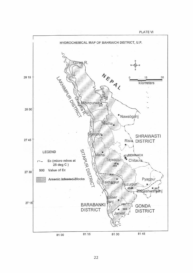
indicates the ground water in the district is fresh and the EC values range from 257 to 900 µ
mhos/cm at 25oC .The arsenic (As) value in the district has been found from nd to 102
ppb.and fluoride ranges from 0.18 to 0.95mg/l. It is observed that the ground water is suitable
for drinking and domestic uses except at few places where As occur above permissible limit
i.e. 50 ppb. The quality of ground water in deeper aquifer is also potable.
CGWB analyzed water samples for arsenic contamination in ground water from the
district. However, Uttar Pradesh Jal Nigam carried out sampling in ten blocks of district,
most of them lying along Ghaghara River where probability of occurrence of arsenic in
ground water is more. U.P. Jal Nigam analyzed a total of 6509 water samples, of which 766
samples have more than 50 ppb As in ground water. Most affected blocks are Tajwapur,
Huzoorpur, Shivpur, Mihinpurwa,Fakharpur,Kaisarganj, Chitaura.( Plate – VI)
4.4 STATUS OF GROUND WATER DEVELOPMENT
In Bahraich district ground water development takes place through Private and
State tubewells and borings with Pumpsets. The ground water development in the district
ranges between 42.25 % (Mihipurwa block) and 68.30 (Chitaura block) through various
structures. In all blocks of the district ground water development takes place through dug
wells, bore wells and State tubewells. The relevant details are given below.
S.No. Type of structure Number Depth range
(mbgl)
Yield
(lpm)
1. Dug wells 69 5.50-30.50 50-100
2. State tubewells 528 80-411 2000-3200
3. Borewells 64436 20-60 120-300

12
Table -4 Blockwise status of sources of irrigation in district / block (31st march 2011)
The wells generally meet out the domestic requirements. There are 64436 diesel
pump sets used in bore wells for irrigation. Maximum number of pump sets is in
Visheshwarganj block i.e. 7020. State tubewell constructed by State Tube well division for
irrigation. CGWB has constructed tubewell in the district upto 453.82 m bgl and tapping
granular zone upto 452 m bgl at Bahraich.
BlockCanallength(km)
Govt.tubewell
(No.)
Perma-nentwells(No.)
Rahat(No.)
PumpsetsGroundpumpset
(No.)Electricity
Run(No.)
DieselRun(No.)
Other
(No.)
Total
(No.)
1. Mihipurwa 11 12 0 0 43 4659 5 4707 0
2. Nawabganj 100 6 0 0 4 2880 5 2889 0
3. Balha 9 42 0 0 20 3281 15 3316 0
4. Shivpur 6 16 0 0 5 6603 4 6612 0
5. Risia 4 89 0 0 12 4909 19 4940 0
6. Chittaura 34 75 33 0 51 5914 0 5965 0
7. Payagpur 0 55 0 0 37 6033 0 6070 0
8. Visheshwarganj 2 89 0 0 50 7020 0 7070 0
9. Mahsi 0 3 0 0 6 3251 0 3257 0
10. Tajwapur 0 25 36 0 27 2721 3 2751 0
11. Phakharpur 0 19 0 0 22 5584 02 5608 0
12. Huzurpur 0 21 0 0 13 3437 0 3450 0
13. Kaiserganj 0 30 0 0 14 3514 0 3528 0
14. Jarwal 0 45 0 0 10 4630 0 4640 0
Total District 166 527 69 0 314 64436 53 64803 0
13
Drinking water tubewells have been constructed in town area and villages for providing
water through pipeline scheme. Depth of drinking water tubewells tapping 15 to 30 m
granular zones varies from 75 to 320 mbgl. The yield of tubewells varies from 1000 lpm to
3200 lpm. In rural area India Mark II Hand pumps have also been constructed for drinking
water that benefited population of the district . Depth of these hand pumps varies from 25-50
m. Centrifugal pumps is commonly used for lifting water from shallow tubewell while
submersible pump is used in deep well for high lift of water.
5.0 GROUND WATER MANAGEMENT STRATEGY
5.1 Ground water development
The stage of ground water development in the district is 58.69%.Ground water
development in Mihipurwa, Huzoorpur,Tejwapur block is low (42 % - 51 % ).Depth to water
level is shallow in most part of the district. Shallow tubewell (upto depth of 35 m),
constructed by hand boring sets, is suitable to meet out the domestic irrigation requirement.
Rotary (direct/Reverse) is suitable for construction of shallow tubewell. Deep tubewell is
constructed through direct rotary method. The well assembly for moderately deep tubewells
may have 40-50 m housing, tapping 30 to 40 m of granular zone. Since fine sand are
encountered in granular zones, it is advised that slot size should be between 0.75 to 1.00 mm.
To increase the life and discharge of well, after lowering of well assembly tube well should
be developed initially by air compressor followed by turbine pump till water is sand free.
5.2 Water conservation structure & artificial recharge
In Bahraich district, there is not a significant decline in depth to water level, artificial
recharge is not required. CGWB has not constructed any recharge structure in the district.
6.0 GROUND WATER RELATED ISSUE AND PROBLEMS
6.1 Water Logging:
A northern west corner of the district and area around Sheopur and Mahsi
falls in the ‘Prone to water logging’ category with depth to water between 2.00 to 3.00 mbgl.(
Plate – II ) Most of the area along Ghaghra River shows ‘water logging’ conditions in post

14
monsoon seasons (Plate III ). It covers whole of the Mahsi Fakharpur,Kaiserganj and Jarwal
and part of the Tejawapur Mihipurwa.
6.2 Water Quality Problem (Geogenic)
The chemical analysis of ground water samples collected indicates that the
problem of Arsenic pollution in ground water has taken serious dimensions in certain parts of
Bahraich district. High concentration of Arsenic was observed in the ground water samples
collected from India Mark – II hand pumps as well as Cast Iron hand pumps. None of the
ground water samples collected from deep tubewell showed the presence of Arsenic above
the permissible limits. The map showing potentially affected areas due to Arsenic pollution in
ground water (Plate V) shows that the problem is more acute in the doab of the Ghaghra and
Sarju covering Belha and Shivpur blocks. Some places in Hazurpur Block also show high
concentration of the arsenic. Interaction with local villagers was very helpful in identifying
probable Arsenic affected areas. Few villagers were identified who were suspected of having
been affected by arsenic pollution.
Arsenic may be found in water owing to its mobilisation through arsenic-rich
rocks. Concentrations of arsenic in fresh water vary in magnitude depending on the source of
arsenic as well as local geo-chemical environment. Under natural conditions, the elevated
concentrations of arsenic are generally found in the ground waters as a result of the strong
influence of water-rock interactions.
6.3 Drilling problems
None.
6.4 Risk to natural disaster
NA
7.0 AWARENESS AND TRAINING AVTIVITY
No programme/activity has been organized in the district so far.
8.0 AREA NOTIFIED BY CGWA/SGWA
None

15
9.0 RECOMMENDATIONS
Following recommendation have been made to sort out ground water problems related
to groundwater development, waterlogging and ground water generated diseases.
1)The problem of Arsenic in ground water in Bahraich district has to be
immediately addressed to. The first and the foremost task is to identify the villages where
Arsenic concentration is above the maximum permissible limit defined by BIS (IS 10500 –
91). Arsenic field-testing kit could prove to a very useful instrument to commence the
detailed investigations in these areas.
2) Certain hand pumps yielding water with higher Arsenic concentration may
be demarcated like being painted red etc. These markings would indicate that these pumps
are not fit to be used for catering to human or livestock needs. Alternative sources of ground
water may be identified and recommended for use. For example, if Cast Iron hand pumps in a
village are found to contain Arsenic higher than permissible limit, India Mark –II hand
pumps tapping aquifers at greater depth may yield safe ground water .
3) The most important aspect of any pollution study is not to scare but make
people aware. It is imperative to make people aware of the groundwater structures having
high concentration of arsenic. The objective is to educate them – to use and/or avoid
groundwater structures according to arsenic content in water.
4) Mainly Mahsi, Tejwapur, Jarwal , Fakherpur and Mihipurwa blocks are
facing water logging problems. Therefore more groundwater development is required to
mitigate the waterlogging problems. Canal water may be regulated so as to implement the
conjunctive use of surface and ground water effectively.

Annexure- ISl.No.
LOCATION/ TYPE
OFWEL
L
YEAROF
DRILLING
DEPTHDRILLED
(mbgl)
AQUIFER ZONESTAPPED(mbgl)
STATICWATERLEVEL(mbgl)
DISCHARGE(lpm)
DRAWDOWN(m)
TRANSMISSIVITY STORATIVITY ECmicromhosat 25 deg C
1 BAHRAICH27 34 3081 37
EW 1998-99 453.82 350-355,376-383,385-390,405-420,423-426,430-436,448-452
7.25 Yet to be devloped
3 GIRJAPURIFARM
EW 304.59 75-100 4.89 2785 4.56 5259 2.06X10E-2 556
4 GODH27 59 4082 16 00
EW 300.50 59-75,129-157,182-210
2.55 3706 2.92 7291 3.6X10E-3 505
5 JARHI28 02 1681 23 10
EW 259.92 45-49,61-67,84-106 5.64 3433 5.01 2360 2.88X10E-3 589
6 KEWALPUR27 59 5581 35 50
EW 300.94 100-110 12.05 3245 6.06 1496 3.28x10E-4 759
7 NANPARA-127 51 0081 30 30
PZ 25.00 10-16,19-22 5.7 0.4 99 - 500
8 NANPARA-2 PZ 211.10 56-62,82-88,100-106,118-124,145-151
8.51 950 1.9 2079 - 490
9 SHIVPURMOHRANIA28 02 1181 33 00
EW 300.11 Abandoned due to lack of granular zone.
10 SUJAULI28 12 40810930
EW 1980-81 302.86 60-70,155-170,185-195,240-270
4.19 3668 3.43 8692 3.25x10E-3 606
11 PAYAGPUR-127 15 50,81 45 50
PZ 131.00 24-30,48-54,66-75,90-102,114-125
5.2 772 2.22
12 PAYAGPUR-2 PZ 207.56 160-172,184-202 5.45 625 6.38


18

19

20

21
22
Copyright © 2022 FDOKUMEN