District Census Handbook, Raigarh - Linguistic Survey Of India
Upload
khangminh22Category
view
0download
0
CENSUS OF INDIA 2001
SERIES-10 UTTAR PRADESH
DISTRICT CENSUS HANDBOOK
Part - A & B
B'AHRAICH DISTRICT
ViLLAGE & TOWN DIRECTORY
VILLAGE AND TOWN WISE
PRIMARY CENSUS ABSTRACT
DIRECTORAE OF CENSUS OPERATIONS, UTTAR PRADESH LUCKNOW


S - Parl 01 Shivpur Vikas Khand
C - ParL of Chilaura Vikas Khand
T - Parl of Tejwapur Vikas Khand
!: ............ ,. . \
! ,._.-.1 " . KHA~'~
! , ..... , .... .
_ ... ':.. ........... .
N K
UTTAR PRADESH
DISTRICT BAHRAICH KILOMETRES
, ..... '._
·Kew~~pu; .. · .... , '\"""
Area (Sq.Km) ... 42,420
Population .. 23,Sl,072 G A N h~". HAN 0,.' " ", Number of Tahsils. .4
" " ... Number of Vikas khand .. 12
UJ Number of Towns .. .4
Number of Villages. 1,226
• DISTRICT BAHRAICH
" "'\' ............. . CHANGE !N JURISDICTION 1991 - 2001
J._.
1
'" ! " \.;. , !
.> , , I
... -..:..... , I
-" ~: ~ I
". , .., -....
,-,. ... -< "!9 '\ • .c_!~.ow
., N ~ J
~ARE'AUJsrTONBWLYCREATBIlD!srRrC'fSHRAwAsrr
......... --~ BOUNDARY, INT£RNATlONAL.
DISTRICT.
TAHSIL
VIKAS KHAND .
HEADQUARTERS DISTRICT, TAHSIL, VIKAS KHAND
STATE HIGHWAY ...
IMPORTANT METALLED ROAD.
RAILWAY LINE BROAD GAUGE
RAILWAY LINE: METRE GAUGE
RIVER AND STREAM.
VILLAGE HAVING 5000 AND ABOVE POPULATION WITH NAME ..
TOWN WITH POPULA TlON SIZE AND CLASS I , III , IV
DEGREE COLLEGE, TECHNICAL INSTITUTION ..
@ © © SH 13


MOTIF
DARGAH OF SYED SALAR MASUD GHAZI
Situated at a distance of 3 km from the main city Bahraich, there is a
Mosuleam (Dargah) of Sufi and saint Syed Salar Masud Ghazi which was built by
Firoj Sah Tughlaq in 1034 AD. Historical legends witness that war happened between the
local king Raja Suhel Deo and Syed Salar Masud Ghazi. In the said battle Syad Salar
Masud Ghazi was killed by the king and he was buried on the spot and later on King Firoj
Sah Tuglaq built a magnificent Dargah. Every year month long fairs are held in Jyshetha
(May/June) and devotees of all religions assemble there for fulfillment of their desires
and to pay their homage. The fair is a symbol of cultural harmony of the people of
various faiths.


Contents
Foreword
Preface
Acknowledgement
District Highlights - 2001 Census
Important Statistics in the District
Ranking of Tahsils in the District
Statement-l
Statement-2
Statement-3 Statement-4 Statement-5 Statement-6 Statement-7
Statement-8
Statement-9
Name of the headquarters of district/tahsil, their rural-urban status and distance from district headquarters, 2001. Name of the headquarters of district/C D block their rural-urban status and distance from district headquarters, 2001. Population of the district at each census from 1901 to 2001. Area, number of villages/towns and population in district and tahsil, 2001. C D Blockwise number of villages and rural population, 2001. Population of Urban Agglomerations/towns, 2001. Villages with population of 5,000 and above at C D Block level as per 2001 census and amenities available. Statutory towns with population less than 5000 as per 2001 census and amenities available. Houseless and Institutional population of tahsils, rural and urban, 2001.
Analytical Note
(i) History and scope of the District Census Handbook
(ii) Brief history of the district
(iii) Administrative set-up
(iv) Physical features
(1) Location and size
(2) Physiography
(3) Drainage
(4) Climate
(5) Natural Economic Resources
Page,
XI XIII
XIV
XVI
XVII
XIX
XX
XX
XXI XXII XXII XXIII
XXIiI
XXIV XXIV
2
'g 4
6
6
6
7
7
7
(v) Census Concepts 11
(vi) Non-Census Concepts 18
(vii) 2001 Census findings-Population, its distribution etc. 24
(viii) Brief analysis of PCA data based on inset tables 1 to 36 26
(ix) Brief analysis of the Village Directory and Town Directory data based ~on inset
tables 37 to 47 51
(x) Brief analysis of the data on houses and household amenities, Houselisting
Operations, Census of India 2001 based on inset tables 48 to 52 62
(vii)

(xi) Major social and cultural events, natural and administrative developments and significant activities during the decade 67
(xii) Brief description of places of religious, historical or archaeological importanc~~ in villages and places of tourist interest in the towns of the district 67
(xiii) Major characteristics and contribution of the district. 68 (xiv) Scope of Village Directory and Town Directory. 69
Part A - Village and Town Directory {Section I and II}
Section I - Village Directory
(a) Note explaining the abbreviations used in the Village Directory 73 (b) Statement-List of villages merged in towns and outgrowths at 2001Census 78
(c) C.D. Block wise presentation of Village Directory Data 79 (i) Map of Mihinpurwa CD Block (Facing Page) 80 (ii) Alphabetical list of villages Mihinpurwa CD Block 81 (iii) Village Directory Mihinpurwa CD Block 84
(i) Map Nawabganj CD Block (Facing Page) 108
(ii) Alphabetical list of vil1ages Nawabganj CD Block 109
(iii) Village Directory Nawabganj CD Block 111
(i) Map Balaha CD Block (Facing Page) 131
(ii) Alphabetical list of villages Balaha CD Block 132
(iii) Village Directory Balaha CD Block 134
(i) Map Ballia Shivpur CD Block (Facing Page) 150
(ii) Alphabetical list of villages Shivpur CD Block 151
(iii) Village Directory Shivpur CD Block 154
(i) Map Risia CD Block (Facing Page) 170
(ii) Alphabetical list of villages Risia CD Block 171
(iii) Village Directory Risia CD Block 173
(i) Map Chitaura CD Block (Facing Page) 193
(ii) Alphabetical list of villages Chitaura CD Block 194
(iii) Village Directory Chitaura CD Block 197
(i) Map Mahasi CD Block (Facing Page) 225
(ii) Alphabetical list of villages Mahasi CD Block 226
(iii) Village Directory Mahasi CD Block 228
(i) Map Tajwapur CD Block (Facin g Page) 250
(ii) Alphabetical list of villages Tajwapur CD Block 251
(iii) Village Directory Tajwapur CD Block 254
(i) Map Pakharpur CD· Block (Facing Pag~) 272
(ii) Alphabetical Ust of villages Pakharpur CD Block 273 (iii) Village Directory Pakharpur CD Block 276
(i) Map Huzoorpur CD Block (Facing Page) 302
(ii) Alphabetical list of villages Huzoorpur CD Block 303
(iii) Village Directory Huzoorpur CD Block 306
(viii)

(i) Map Kaisarganj CD Block (Facing Page)
(ii) Alphabetical list of villages Kaisarganj CD Block (iii) Village Directory Kaisarganj CD Block
(i) Map Jarwal CD Block (Facing Page)
Oi) Alphabetical list of villages Jarwal CD Block (iii) Village Directory Jarwal CD Block
Forest Villages (i) Alphabetical list of Forest villages (ii) Village Directory of Forest Villages
APPENDIX I Abstract of Educational, Medical and other Amenities in villages CD Block level
APPENDIX lA APPENDIX IB APPENDIX IC APPENDIX II
APPENDIX IIA APPENDIX III APPENDIX IV
APPENDIX V
Villages by number of Primary School Villages by Primary, Middle and Secondary Schools Villages with different sources of drinking water facilities available Villages with 5000 and above population which do not have one or more amenities available Census towns which do not have one or more amenities. Land utilization data in respect of Census Towns/non-municipal towns CD Blockwise list of inhabited villages where no amenity other than drinking water facility is available Summary showing number of villages not having -Scheduled Castes population
APPENDIX VI Summary showing number of villages not having -Scheduled Tribes population
APPENDIX VIlA List of villages according to the proportion of the Scheduled Castes to the total popUlation by ranges
APPENDIX VIlB List of villages according to the proportion of the Scheduled Tribes to the total popUlation by ranges
APPENDIX VIII Number of villages under each Gram Panchayat (C D block wise) APPENDIX IX Statement showing number of girls schools in the villages
Section II - Town Directory
330 331 334
358 359 362
387 388
391 399 400 401
402 403 403
404
407
408
409
436 438 438
(a) Note explaining the abbreviations used in the Town Directory 440
Town Directory Statements (l to VII)
(b) STATEMENT I Status and Growth History 444 (c) STATEMENT II Physical aspects and location of towns 446 (d) STATEMENT III Municipal Finance 448 (e) STATEMENT IV Civic and other amenities 450 (f) STATEMENT V Medical, Educational, Recreational and Cultural Facilities 452 (g) STATEMENT VI Trade, Commerce, Industry and Banking 456 (h) STATEMENT VII Civic and other amenities in slums 458 (i) Appendi?C to Town Directory 458
Part B - Primary Census Abstract
(a) (b) (c)
Brief note on Prirnary Census Abstract District Primary Census Abstract (General) Appendix to District Primary Census Abstract i.e. Urban block wise figures of Total, SC and ST Population
(ix)
459 462
469

Primary Census Abstract for Scheduled Castes Primary Census Abstract for Scheduled Tribes
CD Block wise Village Primary Census Abstract
1 Primary Census Abstract Mihinpurwa CD Block 2 Primary Census Abstract Nawabganj CD Block 3 Primary Census Abstract Balaha CD Block 4 Primary Census Abstract Shivpur CD Block 5 Primary Census Abstract Risia CD Block 6 Primary Census Abstract Chitaura CD Block 7 Primary Census Abstract Mahasi CD Block 8 Primary Census Abstract Tajwapur CD Block 9 Primary Census Abstract Phakharpur CD Block
10 Primary Census Abstract Huzoorpur CD Block 11 Primary Census Abstract Kaisarganj CD Block 12 Primary Census Abstract Iarwal CD Block 13 Primary Census Abstract Forest CD Block
476 483
491 503 515 527 539 551 569 581 593 611 623 635 653
Urban Primary Census Abstract 659
Annexure I Number of villages under each Gram Panchayat 673 Annexure II Fertility and Mortality, 1991 Census 673 Annexure III Various measures of fertility and mean age at marriage, 1991 Census 674 Annexure IV Percentage distribution of Migrants by place of birth/place of last
residence, 1991 Census 675 Annexure V Brief account of main religions in the district/tahsil as per 1991 Census 676 Annexure VI Marital status of population as per 1991 Census 678 Annexure VII Age, Sex and Education in the district, 1991 Census 682 Annexure VIII Distribution of different mother tongues returned in 1991 Census 685
(x)

Foreword
The District Census Handbook (DCHB) published by Census Organisation 'since 1951 census, is one
of the important publications in the context of plamling and development at gross-root level. The publication,
which is brought out for each district, contains several'demographic and socia-economic characteristies
village-wise and town-wise of the district alongwith the status of availability of civic amenities, infrastructural
facilities, etc.
2. The scope of the DCHB was initially confined to a few Census Tables and Primary Census Abstract
(PCA) of each village and town within the district. Thereafter, at successive censuses, its scope and
coverage has been enlarged. The DCHB published at the 1961 census provided a descriptive account of
the district, administrative statistics, census tables and a village and town directory including PCA. The 1971
census-DCHB series was in three parts: Part-A related to village and town directory, Part-B to village and
town PCA and Palt-C comprised analytical report, administrative statistics, district census tables and certain
analytical tables based on PCA and amenity data in respect of villages. The 1981 census DCBH was in
two parts: Part-A contained village and town directory and Part-B the PCA of village and town including
the SCs and STs PCA up to tahsilltown levels. New features alongwith restructuring of the formats of
village and town directory were added into it. In Village Directory, all amenities except electricity were
brought together and if any amenity was not available in the referent village, the distance in broad,ranges
fron1 the nearest place having such an amenity, was given. Information on new items such as adult literacy
centres, primary health sub-centres and community health workers in the village were provided so as to meet
the requirements of some of the Revised Minimum Needs Programme. Information on approach to the
village was provided for the first time in the Village Directory so as to give the details on number of
inaccessible villages in each district. In the Town Directory, a statement (IV-A) on slums was introduced
to provide the details on civic and other amenities in the notified slums of Class I and Class II towns.
3. The 1991 census DCHB, by and large, followed the pattern of presentation of 1981 census, except
the format of PCA was restructured. Nine-fold industrial classification of main workers was given against
the four-fold industrial classification presented in the 1981 census. In addition, sex-wise population in 0-6 age
group was included in the PCA for the first time with a view to enable the data users to compile more
real istic I iteracy rate as all .chi ldren below 7 years of age had been treated as ill iterate at the time of 1991
census. One of the impoliant innovations in the 1991 census was the Community Development Block (CD
block) level presentation of village directory and PCA data instead of the traditional tahsilltaluklPS level
presentation. It was expected that the presentation of village directory and PCA data at CD block level will
help the planners in formulation of micro level development plans, CD block being lowest administrative unit.
4. The present series of 200 I census DCHBs have been made more informative and exhaustive i.n
terms of coverage and content. The Village Directory has been enlarged in scope by including a number
of other facilities like banking, recreational and cultural facilities, newspapers and magazines and 'most
important commodity' manufactured in village. Income and expenditure of gram panchayat, wherever possible, has been provided. Apart from these, more details on distance(s) at which basic amenities are available (if not available in the village), are given. This includes educational facilities (namely primary and middle
schools and college)~ medical facilities (viz. Allopathic Hospital, Maternity & Child Welfare Centre and Primary Health Centre), driilking water, post & telegraph (post office and phone), communication, bank,
credit societies and recreational facilities. In Town Directory, the statement on Slums has been modified and its coverage enlarged by including details on all slums instead of 'notified slums'. The information is given in case of all statutory towns irrespective of their class, against only Class I and Class II towns in
the 1981 and 1991 censuses. The basic amenities available in the villages and towns are analysed in depth
(xi)

with the help of a number of cross-classified inset tables and statements. Two other significant additions in the publication are inclusion of 'motif' highlighting significant characteristic of the district and analytical notes as annexures. The analytical notes on (i) fertility and mortality and (ii) various measures of fertility and mean age at marriage are prepared based on 1991 Census. Whereas, in the notes relating to (i) percentage distribution of migrants by place of birth/place oflast residence, (ii) main religions, (iii) marital status of popUlation, (iv) age, sex and education, and (v) distribution of spectrum of mother tongue, nature and extent of changes occurred in the district in its basic socia-demographic features during the decade 1991-2001 are analysed. The eight digits permanent location code (PLCN) to all the villagfls and towns have been assigned keeping in view the future needs.
5. The village and town level amenity data have been collected, compiled and computerised in prescribed record structure under the supervision of Dr. Ranvir Singh, Director of Census Operations, Uttar Pnidesh. Thereafter, efforts have been made to ensure comparability of the information with that of 1991 census data and the information brought out by the respective state governments in their annual reports and statistical handbooks for various years after 1991. The task of planning, designing and coordination of this publication was carried out by Shri R.G. Mitra, Deputy Registrar General (C&T) and Dr. I.C. Agrawal, Senior Research Officer of Social Studies Division. Dr. R.P. Singh, Deputy Registrar General (Map) provided the technical guidance in the preparation of maps. Whereas, Shri Anil Kumar Arora, Deputy Director of Data Processing Division who worked under the overall supervision ofShri Himakar, Addl. Director (EDP) helped in preparation of record structure for computerisation of village and town directory data and the programme for the generation of 'Village Directory and Town Directory statements including analytical inset tables. The draft DeI-ill manuscripts received from the Census Directorates have been scrutinised in the Social Studies Division under the guidance of Shri S.L. Jain, Deputy Director and Shri R.K. Mehta, Assistant Director. I am thankful to all of them and others who have contributed to make this publication possibk
New Delhi Dated: 17.10.2006.
(xii)
D.K. Sikri Registrar General &
Census Commissioner, India

Preface
The District Census Handbooks CDCHBs) are brought-out in two parts giving village and town wise data for each district. The first part contains non-census data for each village and town and is called Village and Town Directories Part A. The Part B provides Census data for rural area up to the village level and for urban areas up to ward level for each town or city in the shape of Primary Census Abstract (PCAs). The information contained in Primary Census Abstract and Village and Town Directory (VDs/TDs) has already been reJeased for data users in soft copy. Data available in District Census Handbooks are very useful for policy planners, Administrators, Researchers and other socia-economic research centers. Till 1991 Census, all the inset tables included in District Census Handbooks were produced manually. But this time the software designed by the Data Processing Division of the Office of the Registrar General, India helped in the fast generations of tables.
I am deeply grateful to Shri lK. Banthia, Ex-Registrar General and Census Commissioner of India for his guidance and support. I would like to thank Shri D.K. Sikri, Secretary, Registrar General and Census Commissioner of India for his sustained support and spontaneous, unfailing guidance through our endeavours. At the outset I thank to Shri R.C. Sethi. Additional Registrar General, India, who drove us to complete the District Census Handbooks within a specific timeframe and make it ready for printing.
I thank to Shri R.G. Mitra, Ex. Deputy Registrar General (C&T), Shri R.P. Singh, Ex. Deputy Registrar General (Map), Dr. I.C. Aggarwal, Ex. Assistant Registrar General (SS) of the office of Register General, India for their guidance at each steps in the preparation of District Census Handbook. Special thanks are due to Shri S.L. Jain, Deputy Director (Social Studies) and Shri Anil Kumar Arora, Deputy Director (EDP), without their untiring efforts and support we could not have completed the District Census Handbook within this time.
The Director of Census Operations, Uttar Pradesh, Dr. Ranbir Singh, under whose guidance, the entire operations were carried out deserves all credit for its success, but he was repatriated to the State Government for taking up some other important assignments before the volume could be made available for the printing. I am also thankful to Shri R. K. Singh, Ex-Joint Director and Shri S.S.A. Iafri, Deputy Director for their valuable guidance and support to complete this project within specific time frame. The task of data collection in respect of both Census and non-census items was a gigantic on which officials in the State Government had to perform along with their normal duties. For their deep sense of devotion to duty and hard work in this regard, I am thankful to all of them.
The preparation of District Census Handbook was done under the supervision and guidance of Shri B.K. Srivastava, Deputy Director of Census Operations and his team of dedicated workers deserve all praise for their perseverance and dedication in preparing for Camera Ready Copy of District Census Handbook.
I am also thankful to Shri Mohan Pandey, Ex-Deputy Director, Shri J. Majhi, Assistant Director, Shri M.M. Pandey, Dr. S.S. Sharma S.1. Grade-I and Shri S.K. Banerjee, S.l. Gr. II who assisted in the work for timely completion of the project. S.I.Gr.II, S.LGr.III, Sr. Compilers, Compilers, Data Entry Operators and Assistant Compilers who assisted in the work also did a tremendous job. Shri A.M. Ansari, Deputy Director (EDP) and his team of devoted workers deserve all praise for timely processing of Household Schedule through Image Based Data Capturing Technology i.e. Scanning. The members of the staff in the Map Section did a commendable job under the guidance of Shri Dashrath Singh, Research Officer (Map) in bringing out various maps.
Lucknow
October, 2008
(xiii)
Pradeep Kumar Deputy Director of CensLls Operations,
Uttar Pradesh, Lucknow


Guidance
Supervision
2 3
Acknowledgem ent
Dr. Ranbir Singh lAS Shri R.K. Singh Shri S.S.A. Jafri
Director Joint Director Deputy Director
I Shri S.C. Tripathi Deputy Director 2 Shri K.C. Upadhayaya Deputy Director 3 Shri G.N. Pathak Deputy Director 4 Shri Mohan Pandey Deputy Director 5 Shri B.K. Srivastava Deputy Director 6 Shri T.A. Usmani Assistant Director 7 Shri M.N. Singh Assistant Director 8 Shri V .K. Nigam Assistant Director 9 Shri Jagannath Majhi Assistant Director
DCH B Section (Collection/Compilation of Statistics and Writeup of Analytical Note) I Dr. Ravi Shankar Assistant Director 2 Shri Mritunjay Kumar 3 Shri Banarsi Lal 4 Shri M.M. Pandey 5 Dr. S.S. Sharma 6 Shri G.C. Gupta 7 Shri S.K. BanerJee 8 Shri V.K. Tiwari 9 Shri T.R. Deorari 10 Shri D.N. Saxena II Shri Riyaz Akhtar 12 Shri Ajay Awasthi 13 Shri R.K. Verma 14 Shri Vishwanath Gupta 15 Shri Pradeep Kumar 16 Shri M .C. M aheshwari 17 Shri Satya Narain 18 Shri Vijay Krishna 19 Shri Khus Ram 20 Shri Devi Dutt Pandey 21 Shri K.K. A wasthi 22 Smt. KalpanaXukreti 23 S hri A Iha Prased
Census and Tabulation Section (peA Unit) I Shri P.C. Tewari 2 Shri R.S. Meena 3 Shri D.D. Sharma 4 Shri Rakesh Kum ar Sharma 5 Shri Suresh Chandra Kaushal 6 Shri Anadi Asthana 7 Shri Nanku Singh 8 Shri Balbir Singh 9 Shri P.K. Pathak 10 Shri D.l. Lyall 11 Shri U.G. Jhingran 12 Shri R.L. Yadav 13 Shri Vinod Solomon 14 Shri Ajay Kumar 15 Shri Ramesh Chandra r6 ShriU.B. Singh 17 Shri L.P. Yadav 18 Shri Ajay Singh Bharti 19 Km. Sonia Jethwani 20 Km. Saubhagya Srivastava 21 Shri D.K .Rawat
(xiv)
Assistant Director Statistical Investigator Grade-I Statistical In v estigator G rade- I Statistical In v estigator G rade- I Statistical Investigator Grade-II Statistical Investigator Grade-II Statistical Investigator G rade- II Statistical Investigator Grade-III Statistical Investigator Grade-III Statistical Investigator Grade-III Statistical Investigator Grade-III Statistical In v estigato r G rade- III Statistical Investigator Grade-III Statistical Investigator Grade-III Statistical Investigator Grade-III Compiler Compiler Compiler Assistant Com piler Assistant Compiler Assistant Com piler Loader
Assistant Director Assistant Director Assistant Director Assistant Director Assistant Director Statistical Investigator Grade-II Statistical Investigator Grade-III Statistical Investigator Grade-Ill Statistical Investigator Grade-III Statistical In v estiga tor G rade-I I I Statistical Investigator Grade-III Statistical Investigator Grade-III Statistical Investigator Grade-III Statistical [nvestigato, Grade-III Senior Compiler Senior C om pifer Senior Com piler Compiler Com piler Assistant Compiler Assistant Com piler

Map Unit
Data Centre
Printing Unit
2 3 4 5 6
2 3 4 5 6 7 8 9 10 1 1 12 13 14 15 16
1 2
Shri Dashrath Singh Shri M.C. Vimal Shri R.K. Gupta Shri Binod Kumar Singh Shri H.C. Tewari Shri Ajay Pratap Singh
Shri S.R. Sahay Shri A.M. Ansari Shri Pooran Chandra Shri S.D. Sharma Shri S.C. Mishra Shri Gaffar Ali Shri Pancham Ram Shri Parshu Ram Shri Ram Prakash Saxena Shri Satya Narayan Shri Subhash Singh Shri Santosh Kumar Srivastava Shri Harish Chandra Prasad Shri Ram Dass Shri M.S. Thapa Shri P.S. Chhikara
Shri Om Prakash Shri Rashid Ahmad Khan
3 Shri Asharfi Lal 4 Shri Satish Chandra Srivastava 5 Shri Ram Sumer
DCHB Section (Village & Town Directory Unit) 1 Shri Ram Kishore Shashtri 2 Shri Nirmal Singh 3 Shri Lalit Kumar 4 Shri Rajendra Singh 5 Shri R.S. Mishra 6 Shri Ram Chandra 7 Shri Hari Lal 8 Shri Ashok Kumar
9 Shri S.N. Singh 10 Shri Sita Ram 1 1 Shri Ganga Ram 12 Shri R.D. Prasad 13 Shri S.K. Sharma 14 Shri Umar Daraz 15 Smt. Sushma Nigam
Manuscript and CRC Preparation 1 Shri R.K. Nigam 2 Shri H.M. Suyal 3 Shri P .K. Bajpai 4 Shri G .C. Kandpal 5 Shri S.N.Yadav 6 Shri lnder Shekher 7 Shri Ishwar Singh 8 Shri Amar Nain 9 Shri Mohammad Irfan Khan 10 Km. Preeti Nag
(xv)
Research Officer (Map) Senior Geographer Senior Geographer Geographer Senior Drawing Assistant Senior Draughtsman
Deputy Director Deputy Director (ED P) Senior Supervisor Junior Supervisor Junior Supervisor Junior Supervisor Junior Supervisor Junior Supervisor Data Entry Operator Data Entry Operator Data Entry Operator Data Entry Operator Data Entry Operator P.A. to Director Deputy Director (EDP) Deputy Director, DP Division, Delhi
Assistant Director S.T.A. Investigator - III Printing Inspector
.Assistant Compiler
Statistical Investigator Grade-II Statistical In vestigator Grade-III Statistical Investigator Grade-III Senior Compiler Compiler Compiler Compiler Compiler Compiler Compiler Compiler Compiler Upper Division Clerk Upper Division Clerk Lower Division Clerk
Senior Supervisor Junior Supervisor Junior Supervisor Data Entry Operator Data EntryOperator Data Entry Operator Data Entry Operator Data Entry Operator Assistant Compiler Assistant Compiler

District Highlights - 2001 Census
1. District Bahraich ranks 34th in terms of population in the state.
2. The percentage share of urban population in the district is 10.0 as against 20.8 of the
population in urban areas of the state.
3. Bahraich district has population density of 539 persons per sq.km. which is less than the state
average 690 persons.
4. Bahraich district ranks 44th in terms of sex ratio (867) which is lower than the state average
(898) females per one thousand males.
5. Bahraich district ranks 68th in literacy 35.2 which is below than the state average 56.3
percent.
6. There are only 22 uninhabited villages out of total 1,226 villages in the district.
7. Decadal growth rate of the district 29.4 is higher to the state average of25.8.
8. Kesarganj tahsil has the highest number of inhabited villages (434) while tahsil Bahraich has
lowest number of in habited villages (126).
9. The district has 4 statutory towns and any town has not been added or declassified after 1991 census
10. There are 385,525 households in the district accounting for 1.5 percent of the total
households in the state. The average size of households in the district is 6.2 persons.
(xvi)

Important Statistics, 2001
State District 8ahraich
Number of Village Total 107,452 1,226
Inhabited 97,941 1,204 Uninhabited 9,511 22
Number of Towns Statutpry 638 4 Census 66 0 Total 704 4
Number of Normal 25,644,759 384,361 Households Institutional 69,848 982
Houseless 43,033 182
Population Total Persons 166,197,921 2,381,072 Male 87,565,369 1,:275,351 Female 78,632,552 1,105,721
Rural Persons 131,658,339 2,'143,074 Male 69,157,470 1,149,080 Female 62,500,869 !393,994
Urban Persons 34,539,582 237,998 Male 18,407,899 '126,271 Female 16,131,683 '111,727
Percentage Urban Population 20.8 10.0
Decadal Population
Growth 1991-2001 Number Percentage Number Percentage
Persons 34,136,268 25.8 540,699 29.4
Male 17,169,307 244 277,839 27.9
Female 16,966,961 27.5 262,860 31.2
Area (insquare Km.) 240,928 4420
Density of Population 690 539 (persons per square km.)
Sex Ratio Total 898 86.7
(Number of females Rural 904 865
per 1000 males) Urban 876 885
Number - Percentage Number Percentage
Literates Persons 75,719,284 56.3 665,826 35.2
Male 48,901,413 68.8 468,536 45.6
Female 26,817,871 422 197,290 22.8
(xvii)

Important Statistics in the district Contd ...
Number Percentage Number Percentag~
Scheduled Castes Persons 35,148,377 21.1 342,747 14.4
Male 18,502,838 21.1 184,717 14.5 Female 16,645,539 21.2 158,030 14.3
Scheduled Tribes Persons 107,963 0.1 8,558 O·fi Male 55,834 0.1 4,220 0.3 Female 52,129 0.1 4,338 0.4
Workers and Non-Workers
Total Workers Persons 53,983,824 32.5 844,320 35.5 (Main & Marginal) Male 40,981,558 46.8 665,915 52.2
Female 13,002,266 16.5 178,405 16.1
(i) Main Workers Persons 39,337,649 23.7 632,957 26.6 Male 34,338,260 39.2 569,693 44.7 Female 4,999,389 6.4 63,264 5.7
(ii) Marginal Workers Persons 14,646,175 8.8 211,363 8.9 Male 6,643,298 7.6 96,222 7.5 Female 8,002,877 10.2 115,141 10.4
Non-Workers Persons 112,214,097 67.5 1,536,752 64.5 Male 46,583,811 53.2 609,436 47.8 Female 65,630,286 83.5 927,316 83.9
Category of Workers (Main & Marginal)
(i) Cultivators Persons 22,167,562 41.1 445,040 52.7 Male 17,479,887 42.7 370,136 55.6 Female 4,687,675 36.1 74,904 42.0
(ii) Agricultural Labourers Persons 13,400,911 24.8 257,751 30.5 Male 8,245,599 20.1 171,131 25.7 Female 5,155,312 39.6 86,620 48.6
(iii) Workers in household '. Persons 3,031,164 5.6 18,836 2.2 industry Male 1,946,545 4.7 13,895 2.1
Female 1,084,619 8.3 4,941 2.8
(iv) Other workers Persons 15,384,187 28.5 122,693 14.5 Male 13,309,527 32.5 110,753 16.6 Female 2,074,660 16.0 11,940 6.7
(xviii)

Ranking of Tahsils in the District
Serial In Terms of Nanpara Mahasi ** Bahraich Kaiserganj Number Value Rank Value Rank Value Rank Value Rank
2 3 I 4 I 5 I 6 I 7 I 8 I 9 I 10 I Total Population 969,830 I 422,890 III 352,192 IV 636,160 II 2 Total area (in square
1697.3 839.3 III 817.04 IV 1022.34 II km.) 3 Density of population
per 571 II 504 III 431 IV 622 square km.
4 Sex Ratio 868 III 854 IV 870 II 871 5 Proportion Urban 4.4 II 0.0 IV 51.0 I 2.5 III . 6 Proportion Scheduled
16.9 14.9 II 13.7 III 10.6 IV Castes 7 Proportion Scheduled
0.9 0.0 II 0.0 III 0.0 IV Tribes 8 Proportion Literate 30.7 IV 32.8 III 52.4 33.8 II 9 'v'\brk participation rate
(Main + Marginal 36.8 II 37.0 30.5 IV 35.2 III 'v'\brkers)
10 Percentage of villages 84.5 79.7 III 80.2 II 71.2 IV having Primary School
11 Percentage of villages having Primary Health 4.4 II 5.6 Sub-Center
3.2 III 3.0 .IV
12 Percentage of villages 84.3 III 89.2 82.5 IV 87.3 II having Well
13 Percentage of villages 22.3 20.4 II 10.3 IV 14.8 III having Post Office
14 Percentage of villages 10.9 10.8 II 8.7 III 4.4 IV having Bus Facility
15 Percentage of villages having approach by 47.2 II 47.2 III 50.0 40.8 IV Pucca Road
16 Percentage of villages having Electricity for 44.1 III 26.4 IV 59.5 53.9 II domestic purpose
17 Percentage of villages 24.7 6.9 IV 17.5 II 15.2 III having Forest area
18 Percentage of villages 59.1 " 42.9 IV 86.5 58.5 III having Irrigated area
(xix)
STATEMENT -1 NAME OF THE HEADQUARTERS OFDlSTRICTffAHSIL, THEIRRURAlrURBAN STATUS AND
DISTANCE FROM DISTRICT HEADQUARTERS, 2001
Name of Whether Sr. Name of District! Tahsil Urban! Distance from tahsil headquarters to No. District!Tahsil Headquarters Rural district headquarters by road (in km.)
1 2 3 4 5 Bahraich Bahraich NPP Urban* 0
1 2 3 4
Note: .
Sr. No.
1 I 2 '1 .)
4 5 6 7 8
9
10
II 12
Nanpara* Nanpara NPP Urban* 2 Mohasi Mohasi Rural 33
Bahraich* Bahraich NPP Urban* 0 Kaiserganj Kaiserganj Rural 37
I. Asterisk in column 2 denotes that the district/tahsil is a rail head. 2. Asterisk in column 4 denotes that the district!tahsil headquarter is a statutory town.
STATEMENT - 2 NAME OF THE HEADQUARTERS OF DISTRICT/CD. BLOCK THEIR RURAL-URBAN
STATUS AND DISTANCE FROM DISTRICT HEADQUARTERS, 2001
Name of the Name of District! C.D. Whether Distance from C.D. Block
District! C.D. Block Urbani Headquarters to district headquarters Block Headquarters Rural by road (in km.)
2 3 4 5 Mahinpurwa Mahinpurwa Rural 60 Nawabganj Nawabganj Rural 48 Balaha Balaha Rural 35 Shivpur Shivpur Rural 47 Risia* Risia NP Urban* 14 Chitaura Chitaura Rural 10 Mahasi Mahasi Rural 33 Tajwapur Tazwapur Rural 13 Phakharpur Phakharpur Rural 17 -Huzoorpur Huzoorpur Rural 27 Kaiserganj _ Kaiserganj Rural 37
. Jarwal * larwal Rural 47 Note: . I. Asterisk in column 2 denotes that the district!CD block is rail head.
2. Asterisk in column 4 denotes that the district! CD. block headquarter is a statutory town.
(xx)

STATEMENT - 3 POPULATION OF THE DISTRICT AT EACH CENSUS FROM 1901 TO 2001
Total{ Census
Decadal Population R ural/ variation Urban Year Population Male Fern ale
Absolute Percentage
2 3 4 5 6 7 8
Total 1901 665315 344500 320815 191 1 662821 344536 318285 -2494 -0.37 1921 . 673879 350762 323117 1 1058 1.67 1931 718791 374920 343871 44912 6.66 . 1941 784717 410842 373875 65926 9.17 1951 851623 448184 403439 66906 8.53 1961 955222 504936 450286 103599 12.16 1971 1120528 607746 512782 165306 17.3 1 1981 1469894 789835 680059 349366 31.18 1991 1840373 997512 842861 370479 25.20 2001 2381072 1275351 1105721 540699 29.38
Rural 1901 627410 324824 302586 191 1 626132 325350 300782 -1278 -0.20 1921 638040 331637 306403 11908 1.90 1931 673352 350270 323082 35312 5.53 1941 731706 382476 349230 58354 8.67 1951 793690 416971 376719 61984 8.47
1961 884613 466721 417892 90923 11.46 1971 1027865 557858 470007 143252 16.19 1981 1334010 717645 616365 306145 29.78
1991 1650009 895806 754203 315999 23.69
2001 2143074 1149080 993994 493065 29.88
Urban 1901 37905 19676 18229 191 1 36689 19186 17503 -1216 -3.21
1921 35839 19125 16714 -850 -2.32
1931 45439 24650 20789 9600 26.79
1941 53011 28366 24645 7572 16.66
1951 57933 31213 26720 4922 9.28
1961 70609 38215 32394 12676 21.88
1971 92663 49888 42775 22054 31.23
1981 135884 72190 63694 43221 46.64
1991 190364 101706 88658 54480 40.09
2001 237998 126271 111727 47634 25.02
(xxi)

STATEMENT - 4 AREA, NUMBER OF VILLAGES/TOWNS AND POPULATION
IN DISTRICT AND TAHSIL, 2001 -
Nwnber Nwnber
Total! Area in Population Number of villages of of Population
Serial District / Tahsil / UA Rural! square per square statutory census Number of nlllllber f Town Urban kilometres kilometres Inhabited Uninhabited towns towns households Persons Males Female;
2 3 4 6 7 9 10 II 12 13
I Bahraich Total 4420.00 539 1,204 22 4 0 385,525 2,381,072 1,275,351 1,105,721 Rural 4384.92 489 1,204 22 0 0 351,866 2,143,074 1,149,080 993,994 Urban 35.80 6,784 0 0 4 0 33,659 237,998 126,271 111,727
2 Nanpara Total 1697.30 571 413 14 1 0 156,790 969,830 519,068 450,762 Rural 1693.07 548 413 14 0 0 150,978 927,057 496,501 430,556 Urban 4.23 10,112 0 0 0 5,812 42,773 22,567 20,206
3 Nanpara (NPP) Urban 4.23 10,112 0 0 1 0 5,812 42,773 22,567 20,206 4 Mahasi Total 839.30 504 231 4 0 0 71,509 422,890 228,041 194,849
Rural 839.30 504 231 4 0 0 71,509 422,890 228,041 194,849 Urban 0.00 0 0 0 0 0 0 0 0 0
5 Bahraich Total 817.04 431 126 2 0 54,186 352,192 188,289 163,903 Rural 796.19 217 126 0 0 28,534 172,747 92,914 79,833 Urban 20.85 8,606 0 0 2 0 25,652 179,445 95,375 84,070
6 Ris ia Bazar (NP) Urban 7.55 1,473 0 0 0 1,701 11,122 5,794 5,328 7 Bahraich (NPP) Urban 13.30 12,656 0 0 0 23,951 168,323 89,581 78,742 8 Kaiserganj Total 1022.34 622 434 0 103,040 636,160 339,953 296,207
Rural 1012.34 613 434 0 0 100,845 620,380 331,624 288,756 Urban 10.00 1,578 0 0 0 2,195 15,780 8,329 7,451
9 J arwal (NP) Urban 10.00 1,578 0 0 0 2,195 15,780 8,329 7,451
STATEMENT - 5 c.n. BLOCKWISE NUMBER OF VILLAGES AND RURAL POPULATION, 2001
Serial Number of villages Rural population * number Name of C.D. block Total Inhabited Persons Males Females
2 3 4 5 6 7 Nawabganj liD 87 149,470 79,767 69,703
2 Balaha 95 70 177,347 96,097 81,250
3 Shivpur 70 72 185,884 100,993 84,891 4 Risia 72 88 168,575 89,792 78,783 5 Chitaura 89 132 181,824 97,871 83,953 6 Mahasi 133 95 173,570 93,399 80,171 7 Tajwapur 98 87 162,111 87,376 74,735 8 Phakh arpu r 87 122 194,183 103,811 90,372 9 Huzoorpur 123 110 150,622 80,671 69,951 10_ Kaisarganj - III 109 147,618 79,165 68,.+53 11 Jarwal ._ liD 120 169,303 90,2-19 79,05-1 12 Mihinpurwa 7 105 275,195 145,701 129.-+94 13 Forest Villages 121 7 7,372 4,188 3,18-i
District (Rural) Total: 1,226 1,204 2,143,074 1,149,080 993,99-1
(xxii)

Seri'dl
, __ !~ .. :I!' J1 b e r Name ofUA/Town 2
Nanpara 2 Ris ia Bazar 3 Bahraich 4 Jarwal
District (Urban) total:
NPP NP NPP NP
Name of tahsil where town # is located
Nanpara Bahraich Bahraich Kaiserganj
STATEMENT -7
4
Persons 5
42,773
11,122
168,323
15,780
237,998
Population
22,567
5,794
89,581
8,329
126,271
Females 7
20,206
5,328
78,742
7,451
111,727
VILLAGE WITH POPULATION OF 5,000 AND ABOVE AT CD BLOCK LEVEL AS PER 2001 CENSUS AND AMENITIES AVAILABLE
SI Nan""e of C.D. No block I 2
Mihinpurwa 2 Mihinpurwa 3 MihinpulWa 4 Mihinpurwa 5 Mihinpurwa 6 Mihinpurwa 7 Mihinpurwa 8 Mihinpurwa 9 Mihinpurwa 10 Mihinpurwa II Mihinpurwa 12 Mihinpurwa 13 Mihinpurwa 14 Nawabganj 15 Nawabganj 16 Balaha 17 13alaha 18 Balaha 19 13alaha 20 ShivplIr 21 ShivplIr 22 Shivpllr 23 Shivpllr 24 Risia 2S Risia 26 Mahasi 27 Mahasi 28 Mahasi 29 Mahasi 30 Taj\\'apllr 31 TaJ\\'aplir 32. Phakharpur 33 Chitaura
.. 34 Phakharpur 3S Phakharpur 36 Phakharpllr 37 Kaisargallj 38 Kaisarganj 39 Kaisarganj 40 Jamal
Location code
Whether it is
Tahsil head ..
Narre ofvillage nllnner Population quarters 3 4 5 6
Chahalwa KariKot
06425700 6094 No
Sujauli Harkhapur Madhawapur Majhara Vrra lhala Gopiya Motipur Mihi Purwa Kundwa Parwani Gauri Kewalpur Chaugorwa Gayaghat Sarramundari 13anjariya Nanpara Dehati Chauksa Har 13aundi Matera Kalan Intaha Moharba Balbhaddarpur Raipllr Mahl;lsi Jot Chand para Rehuya Mans ur Shekh Dahir
06425900 06426300 06427000 06428500 06428700 06428900 06429800 06431600 06433900 06434000 06434100 06434200 06439000 06445100 06448300 06448600 06451300 06451600 06453300 06455000 06456000 06457500 06461800 06464700 06470800 06472900 06473300 06475000 06481400
Khasaha Mohammdpur 06481500 Baundi 06488500 Rampur 06492100 -Madhaupur 06505400 Bubkapur 06506900 Majhara Tawkali Badrauli Ainy Hatinsi GJdahiya No. ITo 4 13irll impur l3elahaura
06512400 06528900 06531900 06532700 06537600
5608 No 8538 No 6502 No 6427 No 6923 No 8098 No 5539 No 6217 No 7532 No 7997 No 6721 No 5262 No
11088 No 5765 No 9175 No 5917 No 6034 No
12705 No 6937 No 5933 No 5455 No 7443 No 5728 No 6890 No 6934 No 6893 yes 6113 No 6977 No 7885 No 5413 No 5439 No 5652 No 6296 No 5391 No
12414 No 5158 No 5241 No
19352 No 5175 No
(xxiii)
An-en ities available
Educational Drinking Commu
nication Medical Water Whether it
is CD. Senior block head- Secondar quarters y School
7 8 No No No No No No No No No No No No No No No No No No No No No No No No No No No No No No No No No No No No No No No No
o
o o o o o o o o o
1 o o o o o o o o o o o o o I o o o I
o o
o o o o o o
Primary . Prinnry Health Health Sub ..
College Centre 9 10 o 0 o o o o o o o o o o o o o o o o o o o o o o o o o o o o o o o o o o o o o o o
o o o o o
o o I o o o
I o o o o o o o
o o o 1 o o o o o o
o o o o o o
centre 11 I)
I)
I)
I)
I)
I)
I)
I)
I)
I ()
()
()
()
1 ()
()
o I ()
()
o o o
o
o o o o I ()
()
I,
o o o
Tap water
12 Yes Yes Yes No Yes Yes Yes Yes Yes Yes Yes Yes
• Yes No Yes No Yes Yes Yes No No Yes Yes Yes Yes
Yes Yes No Yes Yes No Yes No Yes Yes Yes Yes No Yes Yes
Railway station
13 No No No No
. No· No No No No No' No No Yes Yes No No No No No No No No No No No No . :-Jo No No No
No No' No No
'No No No No No No

Serial
STATEMENT - 8 STATUTORY TOWNS WITH POPULATION LESS THAN 5,000 AS PER
2001 CENSUS AND AMENITIES AVAILABLE
Location
code
Whether it is Tahsil
headquarte
Whether it is
C.D. block
Educational
Senior
Secondary
Amenities available Improved
drinking Commu
Medical water nication Banking
Health Railway
number Name of Town number Population rs headquarters School College Hospital Centre Tap water station Bank 2 3 4 5 6 7 8 9 10 11 12 13
This District has no such Statutory Town
STATEMENT - 9 HOUSELESS AND INSTITUTIONAL POPULATION OFTAHSILS, RURALAND URBAN, 2001 CENSUS
Houseless populaiion Institutional EOEulation Number Number
Total! of of Serial Rural! house- house-
number District / Tahsil! Town Urban holds Persons Males Females holds Persons Males Females 2 3 4 5 6 7 8 9 10 II
Bahraich Total 182 902 503 399 982 9,023 5,551 3,472 Rural 162 844 469 375 86] 7,073 3,934 3,139. Urban 20 58 34 24 12] 1,950 1,617 333
2 Nanpara Total 61 322 174 148 334 2,939 1,673 1,266 Rural 61 322 174 148 317 2,803 1,594 1,209 Urban 17 136 79 57
3 Nanpara (NPP) Urban 17 136 79 57 4 Mahasi** Total 29 149 91 58 180 1,396 764 6'1 ~-
Rural 29 149 91 58 180 1,396 764 6'" ~-
Urban 5 I3ahraich Total 49 201 115 86 230 2,743 2,060 683
Rural 29 143 81 62 133 1,001 569 4" ~-Urban 20 58 34 24 97 1,742 1,491 251
6 Ris ia Bazar (NP) Urban 6 26 14 12 6 44 38 6 7 Bahraich (NPP) Urban 14 n 20 12 91 1,698 1,453 245 S . Kaiserganj Total 43 230 123 107 238 1,945 1,054 891
Rural 43 230 123 107 231 1,873 1,007 8M Urban 7 72 47 25
9 .larwal (NP) Urban 7 72 47 25
(xxiv)


ANAL YTICAL NOTE


(i) History and Scope of the District Census Handbook
The District census handbooks were first published after 1951 census. Since then after
every decadal census the publication has remained a constant feature with some
improvements. The Census Organization on behalf of each State GovernmentlUnion
Territory has traditionally brought out this publication. This publication provides data on
demographic characteristics as well as information on the availability of basic amenities in
each village and town of respective districts. The scope of the publication has been changing
with the changing needs of the data users. The 1951 census series of the publication
contained Primary Census Abstract, Village and Town Directories, administrative statistics
and an account of the district. In 1961 the publication was in a single volume containing three
parts covering Census tables, official statistics and Village Directories. The 1971 Census
DCHBs were published in 2 parts. The Part A contained Village and Town Directories and
Part B contained Village and Town PCA. The Part C could not be published in many
State slUTs which contained administrative statistics and district census tables. The 1981
DCHBs were published on the restructured formats of Village and Town Directories. The
DCHBs of 1981 Census were published in 2 parts for each district. The Village and Town
Directories comprised Part 'A' and PCAs of Villages and Towns (ward-wise) including
Scheduled Castes and Scheduled Tribes PCA up to Tahsilffown level were provided in Part
'B'. If any amenity except electricity was not available inthe referent village, the distance in
broad ranges from the nearest place having such amenities was given. Information on some
new items was also provided keeping in view of the needs of the Revised Minimum Needs
Program. The 1991 DCHBs were almost same in scope as waS at 1981. The new features
included in 1991 DCHBs were the nine-fold industrial classification of main workers and the
sex-wise popUlation in the 0-6 age group. Yet other information at the 1991 census was the
CD Block level presentation of data. The VD data was also made available through the
magnetic tapes! floppies. Unfortunately in UP no DCHBs relating to 1991 Census were out of
press till completion of 2001 Census defeating the very purpose of these publications apart
from causing inconveniences to the data users.
The 2001 DCHBs contain more information such as details on greater number of
facilities available to the Villagesffowns. The analysis of data with aid of inset tables and
statements is more informative. The 2001 DCHBs are fully geared to meet the requirements
of GralTl Panchaya!s. At the 2001 Census the DCHBs are entirely available on electronic
format and on eD-ROM; hence the word "Handbook" seems now to be a misnomer.
2

Brief History of the District
The history of the district 'Bahraich' dates back to ancient time. The orthodox legend
connects the present name of the district with 'Brahma', the creator, who is said to have
chosen Bahraich as his own special domain and called together a number of Rishis to
establish his worship here in Ghandarva Van of the epics. The place was thus called
Brahmaich, the assembly ofBrahma. The present name Bahraich appears to be the abberation
of Brahmaich. Another and perhaps more probable origion of the name lies in the fact that the
whole tract, in former days, was held by the Bhars and it was known as Bahraich, from which
it has derived its present name.
The present district of Bahraich once formed a part of the ancient kingdom of
'Kosala'. The ancient history of Bahraich is thercfore closely linked with the history of that
kingdom. Besides the numerous legends connected with this region, valuable evidences such
as sculptures, images, coins, large bricks etc. have been found and the remains of temples,
stupas, monasteries with many brick-strewn mounds are spread all over the district. These
indicate that the tract enjoyed advanced and settled social life since very early times. The
district seems to be ruled by the local chiefs for a very long time.
Prince Nasiruddin Mahmud, the eldest son of Sultan I1tutamish, who was appointed as
governor of A vadh in 1226AD, waged several wars against these chiefs and overthrew a
chief named Bastu or Prithu, who is said to have killed one hundred and twenty thousand
Turks in different engagements. Prince Nasiruddin was responsible for colonizing and
settling the 'Muslims' in the south of the district for the first time.
Bahraich seems to have remained without imperial control on account of the dynastic
trouble which followed the death of Sultan Balban in 1287. During the reign of Firoze
Tughlaq (1351-1388), many janwar strongholds were established in the district by the Sultan
Basiar Sah. The prominent janwar chieftain, is said to have accompanied and assisted the
latter during his expedition to Bengal. Sultan Firoze shah Tughlaq came to Bahriach in
1376AD to visit the tomb of Saiyed Salar. He is said to have built the compound wall and
other buildings at the Dargah Sharif. During the reign of Akbar, the district was made
headquarters of-an administrative division known as Sirkar Bahraich within the subah of
Avadh.
The political history of the district during 19th century is closely related to the rise
and fall of the great talukdari houses, which practically come to occupy the whole district. On
3

February 7, 1856 the kingdom of Avadh was annexed and vested exclusively in the East India
Company and Bahraich was made the head- quarters of a division with Wing,field as
commissioner.
(iii) Administrative Setup
For administrative purpose the district is divided in to four tahsil. Nanpara. Bahraich.
Kaiserganj and Mahasi. The district is further divided into 12 community development
blocks. There are 776 Gram Sabhas and 1,226 revenue villages in which 1,204 are inhabited
and 22 are uninhabited. There are four towns namely Jarwal T.A.,Risia.T.A., Bahraich
N.P.P:and Nanpara N.P;P.
Jurisdictional Changes (1991-2000)
In May 1997 a new district Shrawasti has been carved out from the district Bahraich.
The entire Bhinga tahsil (including 1 town and 2 development blocks), one development
block of tahsil Nanpara, (Jamunaha) and four CD blocks and one town of tahsil Bahraich.
Ekauna, T.A four C.D Blocks - (Ekauna, - Gilaula, Payagpur and Vishaswarganj) have been
subtrated from Bahraich district. Jurisdictional changes during decade 1991-2000 are given in
the following table.
Name of Jurisdictional Changes S1.
District / Notification No.
No. Tahsil
& Date Added Subtracted
1 2 3 4 5 39 BAHRAICR 1434/1-5/97- Entire Bhinga tahsil and one
107/97-R-5 dated town transferred to Shrawasti 25.5.1997 district
I. Bahraich (i) 4619/1-5-94- (i) 6 village transferred to newly Tahsil 176/90-R-5 dated created Mahasi tahsil.
. 30.12.1994 (ii) 184 villages transferred to (ii) 2350(1)/1- Ikauna tahsil of Shravasti
5/97-154/97-R-5 district dated 13.08.1997 (iii) 166 villages transferred to (iii) 2350(1 )/1-5- newly created Payagpur tahsil 97-154/97-R-5 of Shrawasti district.
dated 13.08.1997 ~ _ .. _ ...
4
1

r 'I 2. Kaiserganj 4619/1-5-94- 213 villages transferred to
Tahsil 176/90~R-5 dated newly created Mahasi Tahsil 30.12.1994
3. Mahasi 461911-5-94- (i) 6 villages Tahsil 176/90~R-5 dated transferred from
30.12.1994 Bahraich tahsil (ii) 213 villages transferred from Kaiserganj tahsil (iii) 16 villages transferred from Nanpara Tahsil
4. Nanpara (i) 4619/1-5-94- (i) 16 villages transferred to Tahsil 176/90~R-5 dated newly created Mahasi tahsil
30.12.1994 (ii) 114 villages transferred to (ii) 143411-5/97- Bhinga tahsil of Shrawasti l07/97~R-5 dated district (Entire Jamunaha C.D.
25.5.1997 Block)
District Administration
District administration comprises of Revenue, Development, Police (Law and Order),
Judiciary, and Local self-government. District Magistrate is in-charge of revenue
administration. He is assisted by Additional District Magistrate (Finance and Revenue) i.e.,
ADM (F&R). At the tahsil level Sub Divisional Magistrate is in-charge, who is now
redesignated as Up-Jila Adhikari. He is assisted by Tahsildars in each tahsil and for revenue
collection each tahsil is further entrusted to Naib Tahsildars and Kanongos's circles
respectively. For each revenue village, Lekhpal is in-charge. Chief Development Officer and
District Development Officer are in-charge for development activities in the district. Various
departments have departmental offices at the district level ego Health, Panchayat Raj,
Electricity, TranspOIi, Irrigation, Jal Nigam, Animal Husbandry, Samaj Kalyan, Agriculture,
Horticulture, PWD, etc. each have a departmental district level officer. The development
point of view the district is divided into community development block. Block Development.
Officers (BOO) looks after development works at community developments blocks level.
Assistant Development Officer and Village Development Officers at village level.
Under the police set-up Senior Superintendent of Police in big districts and
Superintendent of Police in small districts are incharge. Additional Superintendent of Police
(ASP) in their respeqtive area. Deputy Superintendent of Police (DSP) look-afi:er the Thanas -
allotted to them. Police Inspectors and Sub-Inspectors are in-charges of their police stations
depending upon the population and area.
5

The judicial administration of the district is headed by District and Session Judge. In
addition there are several Additional District Judge, Civil Judge, Chief Judicial Magistrate
and Munsif Magistrate etc.
The nucleus of the district body for Local self government is consisted of
Mayor and Mukhya Nagar Adhikari (MNA) in the case of Nagar Nigam, Chairman,
Executive Officer in Nagar Palika Parishad and Nagar Panchayat. Chairman District
Board and Gram Pradhan in Panchayats and Pramukh of Kshetra Samiti etc. come
under Local self-government.
(iv) Physical Features
(1) Location and Size
The district is located in sub-Himalayan belt along with the border of Nepal in the
North. It lies between the 27°2' and 28°14' north latitude and meridian 81°15' to 81°28' east
longitude. It is bounded by district Shrawasti in the east, district Gonda in the south-east,
district Barabanki in the south-west, district Sitapur in the west and district Kheri in north
west. Due to carving out of a new district Shrawasti in May, 1997 the area of Bahraich has
diminished to certain extent. The area of the newly organised district is 4420 sq.km.
(2) Physiography
The district is naturally divided into Ghaghara basin in north-east, central upland and
Tarai in the north. The Ghaghara basin covers tahsil NaIipara and tahsil Kaiserganj. On the
basis of geology, soils, topography, climate and natural vegetation the district is defined as
under:
Bahraich Plain The region is situated between the Ghaghara and the Rapti rivers in the
central part of the district in a triangular shape. The slope is tilted towards south east
direction. The streams draining in the region are mostly bifurcated from one place and join
with the same stream after flowing to some distance. Risiya, Soti, Sarju etc are the main
streams. Besides there are numerous perennial depressions or tals of different size and
shapes. Majority of them are of Ox-bow patterns which is the symbol of shifting courses of
streams. Baghel Tal is the largest among all. There is a well marked natural leavel which
stretches from near Jarwal village to accross Nanpara _in the north. This leavel divides
drainage basi"ns of Rapti and Ghaghara.
Ghaghara Khadar It is an elongated belt parallel to Ghaghara river. The region extends
from north to south in a strip form. The physical characteristics are more as Tarai than
6

Khadar. The Ghaghara is the main river which flows from north to south. The Sarju is
another river which joins the Ghaghara near Salankho Purwa Village. Besides, there are
numerous rivulets which are the offshoots of Ghaghara. The flood is common feature in this
region.To check the havoc offload a dam has been constructed on the river Ghaghara.
(3) Drainage:
The Ghaghara river forms the Western boundary of the district. The- other prominent
rivers of the district are Kauriyala, Gidwa, Sarju, Terhi and Soti. The Ghaghara river is
navigable and causes heavy flood during rainy season.
(4) Climate:
The area receives heavy rainfalls averaging upto 1125 mm annually and the north and
north-east parts get flooded. The summer is not very warm. In the year 1997-98 the
maximum and minimum temperature were 44.8 & 4.9 respectively. Due to Tarai the climate
is damp.
(5) Natural and Economic Resources
Forestry :
According to the records of Board of Revenue in the year 94-95 the 95040 hectares
area (76099 hectares in statistical magazine 1999-2000) was covered by the forest in the
district. Due to heavy rainfall the area is covered with abundant vegetations. The average
rainfall is 1125mm. About 87% of annual rainfall in the district is received during the south
west monsoon i.e. from June to September. The abundant vegetation are conducive for
various types of flora and fauna.
Tree in the forest areas, Sal is the predominating species. It is never found alone, but
is everywhere accompanied by many other trees. The most noticeable of these are Tun,
Mahua, Dheo Asna, Bargad Tendu, Bel ,Asidh.
, Owing to the large areas under forest the fauna of the district are numerous and
varied.The list includes tiger, leoperd, wolve, hyana, jackal, foxe, wild pigs, sambhar, chital,
gond, parha, kakar, nilgai and anti lope. Of late the number of tiger has fallen off
considerably, owing to the great extension of cultivation in the district. The leopards too,
which were earlier more number have become scare for the same reason~ The chief bifds of
the district are peacock, patridge, jungle fowl. Snakes are fairly common throughout the
district, especially in the rural areas, the chief being the cobra, karait and rat snake. Indian
crocodile(Naka) and the Ghariyal are found in Ghaghara river.
7

Minerals and Mining:
The minerals are not accountable in the district.
Soil :
The soil of area is mainly of three types i.e. Bhur comprising of sand and loom,
Domat comprising of sand and clay and Matiyar (clay).
Land and Land Use Pattern :
Land use pattern as recorded in statistical magazine 1999-2000 indicates that out of
the total reported area 452,354 of hectares of the district, the net sown area was 292,707
hectares which was 64.71 %. The higher sown area was in tahsil Nanpara and the minimum
area was in tahsil much more Bahraich. Large area of cultiviable waste land is in the Kachhar
of rivers in the Mahasi and Kaiserganj C.D. Blocks of the district. In the magazine indicates
that the forest was in 76,099 hectares, cultiviable banjar land 5,426 hectares, present fallow
(parti) land 12,826 hectares, other fallow (parti) land 7,077 hectares, usar cultiviable land
5,078 hectares, land used for other than cultivation 45,430 hectares, and The net irrigated area
was 74,481 hectares, The total sown area 431,448 hectares in which Rabi crops area was
184,384 hectares, Kharifcrops area was 242,638 hectares and Zaid covered 4,385 hectares.
Agriculture and Crop Pattern :
The three harvest of the district are known by their usual names, Rabi, Kharif and
Zaid. The Kharif or rainfed crops are sown in June and July and harvested in September and \
October. While Rabi or irrigated crops are sown in October and November and harvested in
February - March. According to statistical magazine 1999-2000 the main Kharifcrops of the
district are Paddy (rice) and Jwar and those of main Rabi crops are Wheat, Barley and Gram.
In the year 96-97 the cash crops like Ground nut, LahilMustered, Sugarcane and Potato were
sown in 6.4% area of the total sown area, which shows that the area of the cash crops in the
district is very less. Other crops of the district are Bajra, Maize, Arhar and Peas. In the rural
areas of the district, the vegetables are better cultivated.
Irrigation:
The irrigation facilities available in the district consist of long canal network,
government tube-wells and private tube-wells. According to statistical magazine 1999-2000,
the net irrigated area was 874,859 hectares in the year1996-97 out of whicn 73.7% land was
irrigated by govt. and private tube we-lis, and I I. I % by canals (irrigated area 9,738 heCtares)
During the year1996-97 there were 325 govUubewell in the district, and 2,305 private tube
wells / Boring pump, sets were working per lakhs population in the district.
8

Animal Husbandry ;
As agriculture and animal husbandry are two inseperable units of agriculture
development, the animal husbandry department looks after the veterinary and animal
husbandry work in the district and is concerned with the development of caltle, poultry
breeding, sheep breeding and allied schemes and the prevention and treatment of various
animal diseases. As per statistical magazine 1999-2000 as per live stock Census 1993, the·
district had 1056338 -live stock, in which 339320 were bovines, 238553 buffaloes, 16625
sheeps, 323154 goats, 1872 horses ponneys, 48424 pigs, and 88390 other animals. Sheep and
goats are generally reared with the object of obtaining their hide and flesh. She:eps provide
coarse wool which is utilised by the villagers. According to Statistical Magazine1999-2000,
the poultry and other birds were 188209 in the district.
There are 27 veterinary hospitals, 21 animal husbandry service centres, 10 artificial insemination
centres and 14 sub centres in the year 1997-98, in the district. There sheep and seven pig development centres
were working in the disrict in 1995-96.
Fishery :
For the development of fishery in the district, there are working five govt. ponds in .
the 306.03 hectares. There were 140.00 quintals production of fishes in the year 97-98 and
52.25 lacs fingerlings were distributed. There are 40 Fishery Co-operative Societies, which
purchase and distribute fingerlings.
Industry:
The district is industrially backward. There are three sugar mills at Jarwal, Nanpara
and Chilvaria. It has one distillary at Nanpara. Total of 32 industrial units were registered
under Industrial Act 1948. There were 1198 small-scale industrial units functioning in the
district. In the year 97-98, The number of Khadi industry units were 80 I Total village and
small scale industrial units in the district were 12938.
Trade and commerce:
Bahraich has been a place of unique importance from early times and travelers,
traders and tourist have been visiting this district frequently from far and near. It was
connected by principal trade routes.
9

local self government. The transport on the main road of the district are run by the State Road·.
Transport while on other roads transport are carried out by the private buses. Transport
facilities access to anywhere in the district is available at the private bus stand. Meter
gauge railway line is 140 km long and 12 km of broad guage railway line connects
district with other parts. Truck, taxi, tractor, bullock -cart etc are other mode of road
transport.
Electricity and Power:
Electricity plays an important role in the economic development. Total consumption
of electricity during·. 199:6-97 was 84,600 thousand kwh. Domestic light sector consumed
26739 thousand kwh, and commercial sector consumed 4144 thousand kwh., Industrial sector
consumed 13609 thousand kwh., Public light 2747 thousand kwh, and agriculture 36881
thousand kwh, In public water supply and severage 480 thousand kwh. was consumed. The
electricity consumption per person in 45.96 kwh.
According to statistical magazine 1999-2000, total 900 villages are electrified against
1195 inhabited villages during 1997-98. There are 626 villages electrified by lying L.T.
Mains duringl996-97 and 2491 pump sets/private tube wells are electrified and 635 Harizan
localities are also electrified during the year.
Other non-conventional energy sources, which are being promoted in the district, are
biogas plant and solar energy. There are 3783 biogas plants established in the district. Solar
energy equipments are also established in the district.
Gram Panchayat, its composition, jurisdiction and role III village development
A Gram Panchayat acts as the executive of the Gram Sabha. It is vital for village development.
Composition: The members of the Gram Sabha elect the members of the village or Gram Panchayat. The members of the Gram Sabha generally elect a small committee of 7-15 members from among themselves who constitute the village panchayat. There are 776 Gram Sabhas in the district.
It is necessary that the village Panchayat should have a member belonging to the scheduled caste and also a woman member. If they are not elected, then the government itself appoints two such members. The Village Panchayat tS the sale body, which looks after the various problems ofthe village and takes·steps to improve the conditions of the villages.
10

Its Term : The new Panchayat Raj Act of 1993 has fixed a uniform five year for every Panchayat. It can also be dissolved earlier by the state government, if it fails to perform its duty faithfully. A Sarpanch may be removed from office if two-third Panchas vote against him. But in such a case the sanction ofthe district authorities must be obtained beforehand.
The Panchayat normally meets once in a month. If need be, an emergency meeting can also be called by- the sarpanch.
Qualifications: In order to be elected to a village panchayat, a candidate should posses the following qualifications: .
I. He should be a resident of the village concerned and his name should be in the voter's list of the village.
2. He should be twenty five years old.
3. He should be mentally and physically sound.
4. He should not be a proclaimed offender.
Functions : A Gram panchayat is entrusted with vanous social, economic and judicial functions.
I. It provides civic amenities to the people of the village .
.2. It gets a primary school opened in the village and supervise its work.
3. It look the cleanliness of the village. Drains [or waste water are also provided by the· Panchayat in the village.
4. It gets a Primary Health Centre opened in the village. The Panchayat has also to provide land and building for such a centre. .
5. It gets metalled roads build from the village to the nearest road leading to a market place with the help of the Public Works Department of the district.
6. It arranges for sufficient irrigation facilities, improved seeds, insecticides, chemical manures, improved implements and other such facilities with the help of the Block Development Officer of the area for the uplift of agriculture.
7. It manages and maintains the common property of the village.
8. In some statcs, the Gram Panchayat enjoys also certain judicial powers. It decides petty civil and crim inal case and imposes fine upto Rs. 100.
Census Concepts
Building: A 'Building' is generally a single structure on the ground. Sometimes it is made up of
more than component unit which are used or likely to be used as dwellings (residences) or establishments such as shops, business houses, offices, factories, workshops, worksheds, Schools, places of entertainment, places of worship, godowns, stores etc. It is also possible that building which have component units may be used for a combination of purposes such as ShOP-Cll m =res idence, workshop-cum -res idence,office-cum-Res ide nce, etc.
Usually a structure will have four walls and a roof. But in some areas the very nature of construction of houses is such that there may not be any wall. Such is the case of conical
. structures where entrance is also provided but they may not have any walls. Therefore, such of the conical structures arealsotreated as separate buildings.
. .
11

Permanent houses
Houses, the walls and roof of which are made of permanent materials. The material of walls can be anyone from the following, namely, galvanized iron sheets or other metal sheets, asbestos sheets, burnt bricks, stones or concrete. Roof may be made of from anyone of the following materials, namely, tiles, slate, galvanized iron sheets, metal sheets, asbestos sheets, bricks, stones or concrete.
Semi-permanent houses
Houses in which either the wall or the roof is made of permanent material and the other is made of temporary material.
Temporary houses
Houses in which both walls and roof are made of materials, which have to be replaced frequently. Walls may be made from anyone of the following temporary materials, namely, grass, thatch, bamboo, plastic, polythene, mud, unburnt bricks or wood. Roof may be made from anyone of the following temporary materials, namely, grass, thatch, bamboo, wood, mud, plastic or polythene.
Room A room should have four walls with a doorway with a roof over head and should be wide
and long enough for a person to sleep in, i.e., it should have a length of not less than 2 metres and a breadth of at least 1112 metres and 2 metres in height. A room, however, which is used in common for sleeping, sitting, dining, storing and cooking, etc., should be regarded as a room. An unenclosed verandah, kitchen, store, garage, cattle-shed and latrine and rooms in which a household industry such as a handloom is located, which are not normally used for living or sleeping are excluded from the definition of a' living room for the purpose of this question.
One is likely to come across conical shaped hut or tent in which human beings res·ide. In such improvised accommodation, there will be no four walls to a room and therefore, the above definition would not strictly apply to such types of accommodation. In such cases, the tent or conical hut etc., have been construed to be a room. In certain parts of the country, particularly in rural areas, the pattern of housing may present some problems. For example, a household may be in occupation of several huts put to different uses such as main residence, sitting room, store and even for sleeping at night. By strict application of the definition each one will be reckoned as a census house, but this does not reflect the real situation. While huts used as store or cattle shed pose no problems, those used as sleeping rooms beyond the main residence, should be counted as rooms rather than separate census houses.If a garage is used by a servant and he lives in it as a separate household, it should be reckoned as a room available to the servant's household. If the servant is considered as a member of the household then the garage room should be reckoned as an additional room of the household
Dwelling Room
A room is treated as a dwelling room if it has walls with a doorway and a roof and should be wide and long enough for a person to sleep in, i.e. it should have a length of not Jess than 2 meters and a breadth of at least 1.5 meters and a height of 2 meters. A dwelling room would include living room, bedroom, dining room, drawing room, study room, servant's room and other habitable rooms. Kitchen, bathroom, latrine, store room, passageway and verandah which are not normally usable for living are not considered as dwelling rooms. A room, used for multipurpose such as sleeping, sitting, dining, storing, cooking, etc., is regarded as a dwelling room. In a situation wh~re a ~census houses is used as a shop ~or office., etc., and the household also stays in it then the room is n~ot considered as a dwelling room. But if a garage or servant quarter is used by a servant and if she/ he also lives in it as a separate household then this has been considered as a dwelling room available to the servant's household. Tent or conical shaped hut if used for living by any household is also considered as dwell ing room. A dwelling room, which is shared by more than one household, has not been counted for any of
12

them. If two households have a dwelling room each but in addition also share a common dwelling room, then the common room has not been counted for either of the housc~holds. Census house
A 'census house' is a building or part of a building used or recognised as a separate unit because of having a separate main entrance from the road or common courtyard or staircase, etc. It may be occupied or vacant. It may be used for residential or non- residential purpose or both. . .
In certain peculiar situations, the manner in which buildings and census houses were identified for numbering in the field by the enumerators is described hereunder:
Sometimes a series of different buildings are found along a street which are joined with one another by common walls on either side looking like a continuous structure. These different units are practically independent of one another and are likely to have been built at different times and owned by different persons. In such cases, though the whole structure with all the adjoining units apparently appears to be one building, each portion was treated as a separate building and its constituent units as separate census houses.
On the other hand, one may come across cases, particularly in large cities of multistoreyed ownership flats. In these cases while the structure looks like one building, different persons own the flats. In case of such multi-storeyed structures, having a number of flats owned by different persons, the entire structure was treated as one building and each flat as a separate census house.
If within a large enclosed area, there are separate buildings owned by different persons then each such building is treated as a separate building. There can be a situation where within an enclosed compound there are separate buildings owned by an undertaking or company or even government that are actually in occupation of different persons. For example, Indian Oil Corporation colony where the buildings are owned by the Corporation but these are in occupation of their employees. Each such building was treated as a separate building. But if in anyone of these buildings there were flats in occupation of different households, each such flat was reckoned as a separate census house.
Sometimes it becomes difficult to apply the definition of census house strictly in certain cases. For example, in an urban area, if a flat has five rooms, each room having direct entrance from the common staircase or courtyard. By definition, this has to be treated as five census houses. If all these five rooms are occupied by a single household it was l1Iot realistic to treat them as five census houses. In such a case, 'singleness' of use of these rooms along with the main house should be considered and the entire flat was treated as one census house.On the other hand, if two independent households occupy these five rooms, the first household living in 3 rooms and the second household occupying 2 rooms, then c:onsidering the use, the first three rooms together were treated as one census house and the remaining rooms as another census house. But if each room was occupied by an independent household, then each such room was treated as a separate census house.
In case of hostels, hotels, etc., even if the door of each room in which an inmate lives opens to a common verandah, staircase, courtyard or a 'common room, as it happens almost invariably, the entire hostel! Hotel building was treated as one census house. but if such hostelslhotels have out-houses or other structures used for different purposes OK" the same purpose, then each such structure attached to the main hostel! hotel was tre?ted as a separate census house.
In some parts of the country, in rural areas, the pattern of habitation is such that a group of huts, located in a compound, whether enclosed or unenclosed, - is occLipic~d by one household. While the main residence may be located in one hut, other huts may be used for sleeping, as a kitchen, bath room, baithak, etc. Though each of the huts was a separates structure, they form a single housing unit and therefore, have to be treated collectively as one building and one census house. If some of the huts are used by one household and the others by a second household as residence, then the two groups of huts were treated as separate
13

census houses. However, if there were also other huts in the compound used for other purposes and not as part of the household's residence such as, cattle shed, workshed, etc., these were treated as separate census houses.
On the other hand, in urban areas, where more than one structure within an enclosed or open compound (premises) belonging to the same person, e.g., the main house, the servant's quarter, the garage, etc., only one building number was given for this group and each of the constituent a separate census house number.
Only cases where a structure with roof and pillars has come up was treated as a building. Village
The basic unit for rural areas is the revenue village, which has definite surveyed boundaries. The revenue village may comprise of one or more hamlets but the entire village is treated as one unit for presentation of data. In unsurveyed areas, like villages within forest areas, each habitation area with locally recognized boundaries is treated as one village.
Rural-Urban area
The data in tables on Houses, Household Amenities and Assets are presented separately for rural and urban areas. The unit of classification in this regard is 'town' for urban areas and 'village' for rural areas. In the Census of India 2001, the definition of urban area adopted is as follows:
a) All places with a municipality, corporation, cantonment board or notified town area committee, etc.
b) A place satisfying the following three criteria simultaneously:
i) a minimum population of 5,000;
ii) at least 75 per cent of male working population engaged m non-agricultural pursuits; and
iii) a density of population of at least 400 per sq. km.(l,OOO per sq.mile)
For identification of places which would qualifY to be classified as 'urban' all villages, which, as per the 1991 Census had a population of 4,000 and above, a population density of 400 persons per sq. km. and having at least 75 per cent of male working population engaged in non-agricultural activity were considered. To work out the proportion of male working population referred to above against b) (ii), the data relating to main workers were taken into account.
Apart from these, the outgrowths (OGs) of cities and towns have also been treated as urban under 'Urban Agglomerations'. Examples of out-growths are railway colonies, university campuses, port areas, military camps, etc., that may have come up near a statutory town or city but within the revenue limits of a village or villages contiguous to the town or city. Each such individual area by itself may not satisfy the demographic criteria laid down at (b) above to qualify it to be treated as an independent urban unit but may deserve to be clubbed with the towns as a continuous urban spread. Thus, the town level data, wherever presented, also includes the data for outgrowths of such towns.
City
Towns with population of 1,00,000 and above are called cities. Urban Agglomeration
An Urban Agglomeration is a continuous urban spread constituting a town and its adjoining urban outgrowths (OGs) or two or more physically contiguous towns together and any adjoining urban outgrowths of such towns. In some cases railway colonies, university campuses, port areas, etc., may come up near a city or statutory town outside its statutory limits but within the revenue limits of a village or villages contiguous to the town or city. Each such individual area by itself may not satisfY the minimum popUlation limit to qualify it
14

to be treated as an independent urban unit but may deserve to be clubbed with the town as a continuous urban spread.
For the purpose of delineation of Urban Agglomerations during Census of India 2001, following criteria are taken as pre-requisites:
(a) The core town or at least one of the constituent towns of an urban agglomeration should necessarily be a statutory town; and
(b) The total population of all the constituents (i.e., towns and outgrowths) of an Urban Agglomeration should not be less than 20,000 (as per the 1991 Census).
With these two basic criteria having been met, the following are the possible different situations in which Urban Agglomerations would be constituted:
i) a city or town with one or more contiguous outgrowths;
ii) two or more adjoining towns with their outgrowths; and
iii) A city and one or more adjoining towns with their outgrowths all of which form a continuous spread.
Household
A 'household' is usually a group of persons who normally live together and take their meals from a common kitchen unless the exigencies of work prevent any of them from doing so. Persons in a household may be related or unrelated or a mix of both. However, if a group of unrelated persons live in a census house but do not take their meals from the common kitchen, then they are not constituent of a common household. Each such person was to be treated as a separate household. The important link in finding out whether it was a household or not was a common kitchen. There may be one member households, two member households or multi-member households.
Institutional household
A group of unrelated persons who live in an institution and take their meals from a common kitchen is called an Institutionc.l Household. Examples of Institutional Households are boarding houses, messes, hostels, hotels, rescue homes, jails, ashrams, orphanages, etc. To make the definition more clearly perceptible to the enumerators at the Census 2001, it was specifically mentioned that this category or households would cover only those households where a group of unrelated persons live in an institution and share a common kitchen.
Houseless household
Households who do not live in buildings or census houses but live in the open on roadside, pavements, in hume pipes, under fly-overs and staircases, or in the open in places of worship, mandaps, railway platforms, etc., are treated as Houseless Households.
Scheduled Caste and Scheduled Tribe
Article 341 of the Constitution provides that the President may, with respect to any State or Union territory, specifY the castes, races or tribes or parts of or groups within castes, races or tribes which shall for the purposes of the Constitution be deemed to be Schedulled Castes in relation to that State or Union territory. Article 342 similarly provides for specification of tribes or tribal communities or parts of or groups within tribes or tribal communities which are to be deemed for the purposes of the Constitution to be Scheduled Tribes in relaltion to the various States and Union territories. In pursuance of these provisions, the list of Scheduled Castes and lor Scheduled Tribes are notified for each State and Union territory and! are valid only within the jurisdiction of that Stat~ or Union territory and not outside.
It is important to mention he-re that under the Constitution (Scheduled Caste~s) Order, 1950, no person who professed a religion different from Hinduism was deemed to be a member of a Scheduled Caste in addition to every member of the Ramdasi, Kabirpanthi, Majhabi or Sikligar caste resident in Punjab or Patiala and East Punjab States Union were in relation to that State whether they professed the Hindu or the Sikh religion. Subsequently, in September 1956, by an amendment, the Presidential Order of 1950 and in all subsequent
15
Presidential Orders relating to Scheduled Castes, the Hindu and the Sikh religions were placed on the same footing with regard to the specification of Scheduled Castes. Later on, as per the amendment made in the Constitution (Scheduled Castes) Order 1990, the Hindu, the Sikh and the Buddhist were placed on the same footing with regard to the recognition of the Scheduled Castes.
The list containing the names of the Scheduled Castes and the Scheduled Tribes applicable for the Census ofIndia 2001 in the State are given below:
Scheduled Castes: 1 Agariya 37 Gual 2 Badhik 38 Habura 3 Badi 39 Hari 4 Baheliya 40 Hela 5 Baiga 41 Kalabaz 6 Baiswar 42 Kanjar 7 Bajaniya 43 Kapariya 8 Bajgi 44 Karwal 9 Balahar 45 Khairaha 10 Balai 46 Kharwar (excluding Banbasi) 1 I Balmiki 47 Khatik 12 Bangali 48 Khorot 13 Banmanus 49 Kol 14 Bansphor 50 Kori 15 Barwar 51 Korwa 16 Basor 52 Lalbegi 17 Bawariya 53 Majhwar 18 Beldar 54 Mazhabi 19 Beriya 55 Musahar 20 Bhantu 56 Nat 21 Bhuiya 22 Bhuyiar 57 Pankha 23 Boria 58 Parahiya 24 Chamar,Dhusia, 59 Pasi ,Tarmali
Jhusia, Jatawa 60 Patari 25 Chero 61 Rawat 26 Dabgar 62 Sahariya 27 Dhangar 63 Sanaurhiya 28 Dhannuk 64 Sansiya 29 Dharkar 65 Shilpkar 30 Dhobi 66 Turaiha 31 Dom Scheduled Tribes 32 Domar 1 Bhotia 33 Dusadh 2 Buksa 34 Gharami 3 Jaunsari 35 Ghasiya 4 Raji 36 Gond 5 Tharu
Langua~e and Mother tongue:
As per the census concept, each language is.a group of mother tongues. The census questionnaire collects information on the mother tongue of each person and mother tongue is defined as the language spoken in childhood by the person's mother to the person. If the mother died in infancy, the language mainly spoken in the person's home in childhood will be the mother tongue. In the case of infants and deaf mutes, the language usually spoken by the mother is considered as mother tongue. It is not necessary that the language spoken as mother tongue should have a script. The mother tongues returned by the respondents in
16
census are classified and grouped under appropriate languages according to th(!ir linguistic characteristics. .
Literate
A person age 7 years and above who can both read and write with understanding in any language is taken as literate. A person who can only read but cannot write is not literate. It is not necessary that to be considered as literate, a person should have received any formal education or passed any minimum educational standard. Literacy could also have been achieved through adult literacy classes or through any non-formal educational system. People who are blind and can read in Braille are treated as literates.
Literacy rate
Literacy rate of the population is defined as the percentage of literates in the age group seven years and above. For different age groups the percentage of literates in that age group gives the literacy rate.
Educational level
The highest level of education a person has completed
Work
Work is defined as participation in any eco-nomically productive activity with or without compensation, wages or profit. Such participation may be physical andlor mental in nature. Work involves not only actual work b\.lt also includes effective supervision and direction of work. It even includes part time help or unpaid work on farm, family enterprise or in any other economic activity. All persons engaged in 'work' as defined above are workers. Persons who are engaged in cultivation or milk production even solely for domestic consumption are also treated as workers.
Reference period for determining a person as worker and non-worker is one year preceding the date of enumeration.
Main worker A person who has worked for major part of the reference period ( Le. six months or more
during the last one year preceding the date of enumeration) in any economically productive activity is termed as 'Main worker'.
Marginal worker A person who worked for less than six months of the reference period ( Le. in the last one
year preceding the date of enumeration) in any economic activity is termed as 'Marginal worker'.
Non worker A person who has not worked at all in any economically productive activity during the
reference period (i.e. last one year preceding the date of enumeration) is termed as 'Non worker'.
Cultivator For purposes of the Census a person is classified as cultivator if he or she is engaged in
cultivation on land owned or held from government or held from private persons or institutions for payment in money, kind or share. Cultivation includes effective supervision or direction in cultivation.
A person, who has given out her/his land to a~other person or persons or institution(s) for cultivation for mon~y, kind or share of crop and who does not e_veo supervise or directcultivation in exchinge of land, is ~ot treated as cultivator. Similarly, a-person working on another person's land for wages in cash or kind or a combination of both (agricultural labourer) is not treated as cultivator.
Cultivation involves ploughing, sowing, harvesting and production of cereals and millet crops such as wheat, paddy, jowar, bajra, ragi, etc. and other crops such as sugarcane,
17

tobacco, groundnuts, tapioca, etc. and pulses, raw jute and kindred fiber crop, cotton, cinchona and other medicinal plants, fruit growing, vegetable growing or keeping orchards or groves, etc. Cultivation does not include the following plantation crops - tea, coffee, rubber, coconut and betel nuts (areca).
Agricultural labourer A person who works on another person's land for wages in money or kind or share is
regarded as an agricultural labourer. She/he has no risk in the cultivation, but merely works on another person's land for wages. An agricultural labourer has no right of lease or contract on land on which she/he works.
Household industry worker Household industry is defined as an industry conducted by the head of the household
herself/himself and or by the members of the household at home or within the village in rural areas and only within the precincts of the house where the household lives in urban areas. The larger proportion of workers in household industry should consist of members of the household including the head. The industry should not be run on the scale of a registered factory which would qualify or has to be registered under the Indian Factories Act and should be engaged in manufacturing, processing, servicing and repairs of goods.
It does not include professions such as a pleader, Doctor, Musician, Dancer, Waterman, Astrologer, Dhobi, Barber, etc. or merely trade or business, even if such professions, trade or services are run at home by members of the household.
Other worker A person who has been engaged in some economic activity during the reference period
but not as a cultivator or agricultural labourer or in Household Industry is termed as a 'Other Worker (OW)'. The type of workers that come under this category of 'OW' include all government servants, municipal employees, teachers, factory workers, plantation workers, those engaged in trade, commerce, business, transport, banking, mining, construction, political or social work, priests, entertainment artists, etc. In effect, all those workers other than cultivators or agricultural labourers or household industry workers, are 'Other Workers'.
Work participation rate
Percentage of workers (main + marginal) to total population.
Population density
Population density is the number of persons inhabited per square kilometer of the area.
Age
Age is measured in terms of the completed number of years.
Sex-ratio
Number of females per 1,000 males in a popUlation.
(vi) Non Census Concepts
Improved drinking water:
If the household had access to drinking water supplied from a tap, hand pump, tube well or well (protected or covered) situated within or outside the premises, it is considered as having access to improved drinking water .
.. It may be mentioned that such uniform definition may not be valid across all states.
System of Sewerage
Generally, a sewerage system would mean a network of mains and branches of underground conduits for the conveyance of sewerage to the point of disposal. Sewers that carry only household and industrial wastage are called separate sewers; those that carry storm water from roofs, streets and other surfaces are known as storm water drains, .. "hile those carrying both sewage and storm water are called combined sewers. However, in some towns
18

which are not provided with such underground sewerage system, it is served by open surface drain, box drain, sylk pattern drain, etc., in these towns.
Type of latrine and method of disposal of night soil
There are three prevalent systems of disposal of human wastes, viz. (i) underground sewerage, (ii)sanitary water flush latrines with individual disposal systems, like septic tank, leaching cess pool and collecting well, and (iii) dry type of latrines with manual scavenging.
The system of underground sewerage provides for the street sewerage with which are connected the sanitary latrines constructed in the houses having water closets and fitted with flushing cistern (or hand flushing). Through this sewer the faecal matter is transported without the need for scavenging. This system generally exists in cities and big towns.
Where the streets sewer does not exist these sanitary water flush latrines are connected to a local septic tank with a sub-soil dispersion system or a leaching pit. Here the liquid wastes from the water closet is disposed of locally in leaching pit, a septic tank with a soil dispersion system is constructed. This dispersion requires an optimum travel through the pores of the soil which renders the harmful liquid bacterially innocuous by the slow process of filteration through the soil traversed.
Where the soil is impermeable, collecting wells are constructed and the sanitary water flush latrines are connected with them. These wells are cleaned at periodic intervals by a suitable device. The dry type of latrines are of service type latrines from where human excreta is removed by scavengers from house to house, in most cases carrying it on their heads or shoulders or in baskets with handle or wheel barrows. These are then collected in bullock carts or trucks or tractors and trolleys for being. carried to the dumping grounds.
Fertility
In demography, the word fertility is used in relation to the actual production of children or occurrence of births specially live births. Fertility is a measure of rate at which population adds to itself by births and normally assessed by relating rhe number of births to a full or part of the population, such as number of married women or number of women of child bearing age. The definitions of the terminology used in computing different fertility rates are mentioned below:
Crude birth rate (CBR)
Ratio of the number of live births in a year to the mid year population,. normally expressed per 1,000 population.
Number of live births during the year
CBR = x 1000
Mid-year Population
Crude death rate (CDR)
Ratio of the number of deaths in a year to the mid year population, normally expressed per 1,000 population.
Number of deaths during the year
CDR = x 1000
Mid-year Population
Natural growth rate Growth rafe is obtained as the difference between crude birth rate and crude death (ate in
the absence ofmigration.
19

Age specific fertility rate (ASFR)
Number of live births in a year to female population in any specified age group normally expressed per 1,000 women.
Number of live births in a particular age-group
ASFR =--------x 1000 Mid-year female population
of the same age-group Age specific marital fertility rate (ASMFR)
Number of live births in a year to married female population in any specified age group normally expressed per 1,000 married women.
Number of live births in a particular age-group
ASMFR x 1000 Mid-year married female
population of the same age-group General fertility rate (GFR)
Number of live births per 1,000 women in the reproductive age-group (15-49) years in a given year.
Number of live births in a year GFR= x 1000
Mid-year female population in the age-group (15-49) years
General marital fertility rate (GMFR) Number of live births per 1,000 married women in reproductive age-group (15-49) years
in a given year. Number of live births in a year
GMFR= x 1000 Mid-year married female population
in the age-group (15-49) years.
Total fertility rate (TFR) It is obtained as the total of the age specific fertility rates (number of children born per
woman of the particular age) for the entire reproductive age span. It provides the average number of children that will be born to a woman under the fertility levels indicated by the age specific fertility rates assuming that there is no mortality of women till the completion of reproductive period.
TFR=
Total marital fertility rate (TMFR)
45-49 5 xL:ASFR
15-19 -------1000
Average number of children that would be born to a married woman if she experiences the current fertility pattern throughout her reproductive_ span (15-49) years assuming that
. there-is no mortality of women till the completion of reproductive period.
TMFR
45-49 5 x L ASMFR
15-19 -------------1000
20

Age-specific mortality rate (ASMR)
Number of deaths in a particular age and sex group per 1,000 population of the same age group.
ql
Number of deaths in a particular age-group
ASMR = x 1000 Mid-year population of the
same age-group
Probability of dying between birth and age 1. This can be used as approximate value of Infant Mortality Rate (IMR) which gives the ratio of number of deaths in a year of children aged less than one year to the number of births in that year. q2
Probability of dying between birth and age 2. q5
Probability of dying between birth and age 5. This indicator is also known as Under Five Mortality Rate (U5MR) Infant mortality rate (IMR)
Ratio of the number of infant deaths (deaths of children below one year) in a year to the number of live births in that year.
Number of infant deaths during the year
IMR -----------------------xlOOO Number of live births
during the year Infant mortality rate comprises of two parts, viz., Neo-natal mortality rate and Post neo
natal mortality rate. The neo-natal mortality rate also comprises of two parts viz., Early neonatal mortality rate and late neo-natal mortality rate. These' are defined as: Neo-natal mortality rate (NMR)
Number of infants dying within the first month of life (28 days or under) in a year per 1,000 live births of the same year.
Number of infant deaths aged 28 days or under
during the year NMR = ---------- x 1000
Early neo-natal mortality rate
Number of live births during the year
Number of infant deaths of less than 7 days
during the year ---------------------xlOOO
Late neo-natal mortality rate
Number of live births during the year
Number of infant deaths of 7 days to less than 29 days
during the year - ------------------------ x 1000
Number of live births during the year
21

Post neo-natal mortality rate (PNMR) Number of deaths of29 days to less
than One year during the year -------------x 1000
Number of live births during the year
Peri-natal mortality rate (PMR) Number of still births plus deaths within 1st week of delivery per 1,000 births in a year.
Number of still births and infant deaths of less than 7 days
during the year PMR = ------------'-- x 1000
Still birth rate (SBR)
Number of live births and still births during the year
Number of still births during the year . x 1000
Number oflive births and still births during the year
Maternal mortality rate (MMR)
Number of deaths of women in the age group 15-49 while pregnant or within 42 days of termination of pregnancy from any cause related to pregnancy and child birth per 1,00,000 live births in a given year.
Number of mate mal deaths to women in the agegroup 15-49
MMR = x 100000 Number of live birth
Eligible couple (Couples per 1,00,000 Population)
Number of currently married females in the age group 15-44 years per 1000 persons of all ages.
Child woman ratio (0-4)
1. Number of children in the age group 0-4 years per 1,000 women in the age group 15-49 years.
Child woman ratio (5-9)
2. Number of children in the age group 5-9 years per 1000 women in the age group 15-49 years.
Migration
Migration is the third component of population change, the other two being mortality and fertility.
A person is considered as a migrant by place of birth if the place in which he/she is enumerated during the census is other than the place of hislher birth.
Similarly a person is considered as a migrant by place of last residence if the place in which he/she is enLJmerated during the census is other than hislher elace of immediate last residence outside the village or town and not simply in another house or locality in the- same village or town.
Certain aspects concerning temporary movement! migration of people has been explained below as these are important components concerning migration:
22

(i) Migration of persons in search of job is high in the country. In many cases such migrants are only seasonal in nature. People migrate to other places for work in a particular season and come back again to their usual place of residence after three or four months. All such workers are treated as migrants. Similarly, if a person moved to any other place for attending short term vocational or educational course that lasted for only few months of a year, she/he too were considered as a migrant.
(ii) Where a person had merely gone out to another place or had been shifting from one place to another purely on tour, pilgrimage, visit to hospital for treatment or for temporary business purposes, such persons are not deemed to have had another residence different from the place where she/he or herlhis family normally resides. Shelhe is not considered as migrant.
(iii) A woman temporarily moves into a hospital or to her parents or other relative's house for delivery and if the hospital or the parents/relatives houses is in a place different from usual place of residence, the place where the hospital or parents / relative's house is the place of last residence of the child but not of the mother.
A new response category 'Moved after birth' was added in Census of India 2001 in the question on 'reasons for migration' to bring out additional migration patterns. Natural calamities or distress migration as a reason for migration for last residence migrants included in 1991 Census, is covered under category of 'Others'. The reason for migration has been determined as applicable at the time of migration and not in reference to any point of time after that. For example, if a person had moved from the place of her/his last residence for the purpose of education and subsequently at some point oftime got employment there only, the reason for migration would be 'education' and not 'work/employment'. Internal and International migration
The emigrational movements are of three types (i) Migration within the state itself with its components (a) Migration within the district of enumeration (intra district migration) (b) Migration from one district of state to another district of state (inter district migration), (ii) Migration from one state to another State of the country (inter-state migration), (iii) Migration from one country to another country. The first two streams together constitute internal migration, while the last type of movement is called international migration. The present name of the country, state or district and not the name by which they were known at the time ofherlhis birth or last residence were recorded.
Rural-Urban components of migration Rural or Urban status in respect of migrants have been determined as applicable at the
time of migration and not with reference to any point of time after that. The flow of migrants consists of four streams viz. rural to rural, rural to urban, urban to
rural and urban to urban. Civic status of urban units
Civic Status ofa town/city is determined on the basis of Civic Administrative authority of the town e.g. Municipal Corporation/Corporation, Municipal CommitteelMunicipal Council, Municipality etc. Size class of UA / town
Size-class of UA!fown is based on the population size of the UA/City!fown UAs.fTowns with 1,00,000 and above population are classified as Class 1 UAs. / towns. These Class I VAs. / towns are now further sub classified in to seven sub classes namely Ml to M7 depending on the popUlation size of UAiCity!fown. These are M7 (5,000,000 and above); M6 (2,000,000 to 4,999,999); M5 (1,000,000-1,999,999) M4 (500,000-999,999); M3 (300,000-499,999), M2 (200,000-299,999) & Ml (100,000-199,999). Towns with, 50,QOO to 99,999 population are classified as Class II towns, 20,000 to 49,999 population are Class III towns, popUlation with 10,000-19,999 are Class IV towns, population with 5,000 and 9,999 are Class V towns and towns with less than 5,000 population are Class VI towns.
23

Slum area
The Slum Areas (Improvement and Clearance) {\ct, 1956 which was enacted by the Central Govt. defined slums as (a) Areas where buildings are in any respect unfit for human habitation; or (b) are by reasons of dilapidation, overcrowding, fault arrange-ment and design of such buildings, narrowness or faulty arrarrgement of streets, lack of ventilation, light or sanitation facilities, or any combination of these factors, are detrimental to safety, health or morals.
Mega city:
The concept of 'Mega city' is a recent phenomenon in the Urban Sociology and is defined in term of metropolitan city in the form of large size, problem of management of civic amenities and capacity to absorb the relatively high growth of population.lndian Census in 1991 treated the population size of 5 million and above as the cut off point to identify a place as the mega city. Whereas, for the purpose of inclusion in Centrally sponsored Scheme for Mega cities, in 2001 Census, cities with 10 millions and above population have been treated as Mega cities.
(vii) 2001 Census finding Population Distribution:
The total population of the district is 2,381,072 in which 2,143,074 live in rural and
rest 237,998 in urban parts. There are four .tahsils in district namely Nanpara, Mahasi,
Bahraich, and Kaiserganj. The most populous tahsil is Nanpara followed by Kaiserganj and
Mahasi while Bahraich' is least populated tahsil. The urban population in the district is '10.0.
percent. The urban population is maximum at 51.0 percent in Bahraich tahsil. There are 1,226
villages in the district in which 22 are un-inhabited. The total rural population of 2, 143,074
is spread over 12 CD blocks and seven inhabited forest villages. The most populous CD
Block is Mihinpurwa with a population of 275,195 but the maximum number of inhabited
villages (132) are in Chitaura C.D Block. The population density in the rural area is 489. The
highest proportion (54.3) percent of villages are with a population density range of 501 and
above, per sq.Km. Such villages contain as much as 63.4 percent of total rural population.
Size-class and status of towns:
In the total urban population of maximum number of 168,323 person, live in Bahraich NPP.
The next big town is Nanpara NPP with a population of 42,773. The above two are class I and II
town having the civic status of Nagar Palika Parishad (NPP), rest 2 towns are Nagar Panchayat (N.P)
which are class IV towns Bahraich tahsil contains 2 towns and Nanpara has one town and
Kaiserganj tahsils have also one town each.
Population growth:
At the present territorial jurisdication, the population of the district was 1,840,373 at 1991 ,
Census and grown by 29.4 percent in de-cade 1991-2001 it is 2,381,072 at 2001 Census. -The decadal
growth rate 29.4 percent in the district is higher than the state average growth rate 25.8 percent.
24

Population Density:
The district has an area of 4,420 sq. Km. the population density in the district is 539. In the
rural and urban areas of the district the density are 489 and 6,784 respectively.
Sex-Ratio:
The 'sex-ratio in the district at 867 is behind the state average of 898. Indeed the sex
ratio at the district has been all lower in the district as against to the state since 1901 except
1911 to 1941. As against to urban areas of the district the sex-ratio is higher in rural areas
from 1901 to 1961 and lower from 1971 to 2001. At tahsils, level highest sex··ratio is in
Kaiserganj and lowest in Mahasi. Among CD Blocks the sex-ratio is highest in Mihinpurwa
at 889, and lowest in Shivpur at 841. Out of 1,204 inhabited villages in the district there are
36.5, percent villages (with 43.7 percent of rural population) which are having a sex-ratio
between 850-899. Tn the urban parts of the district the sex-ratio is 885 and highest of920 is in
Risia Bazar NP and lowest of 879 in Bahraich NPP. The sex-ratio of population in the age
group 0-6 is 970 which is higher than the state being only at 916. As against the sex-ratio of
972 in the age-group 0-6 of rural population it is highest at 1004 in Mihinpurwa C D. Block
and lowest at 946. in Chitaura. C.D. Block. It may be noted that out of 1,204 inhabited
villages in 23.9 percent of villages with 26.9 percent of rural population, the sex-ratio in the
age-group 0-6 is between 1,000-1,099. As against the 0-6 age-group the sex~ratio of 942 in
the rural area of the district it is only 940 in urban. Among towns this sex-ratio is highest at
958 in Risia Bazar NP, and lowest at 919 in Jarwal NP.
Work Participation Rate:
In the total population of the district as much as 35.5. percent are workers and rest of
64.5 percent are non-worker. Among worker 26.6. percent are main workers and rest of 8.9
percent are marginal workers of total population. In absolute terms females outnumber males.
as main worker. The extent of main workers is highest at 29.2. percent in Mahasi tahsil and
lowest at 24.3 percent in Bahraich tahsil. In case of marginal workers the population is
highest in Nanpara tahsil as lOA percent in comprasion to only 6.2 percent in Bahraich and
7.8 percent Mahasi tahsil. The extent of workers in rural parts and non-workers in urban parts
is higher. In the district among workers 52.7 percent are cultivators and 14.5 percent other
workers. Total 42.0 percent of female workers are engaged as cultivators.
Literacy:
In the district 35.2 percent population is literate. The literacy is 65.2 percent in urban
areas and 31'.7 percent in rural areas. The males literacy is as high as_45.6 percent as against
about 22.8 percent in females, and therefore, the gap in male/female literacy rate is 22.8
percentage points. In rural areas, among 12 CD Blocks, the highest literacy is at 37.3
25

percent in Kaiserganj and lowest at 26.3 percent in Balaha. The literacy among males in
rural areas is 42.7 percent in comparison to 18.4 percent among females. The lowest female
literacy of 14.2 percent is in Balaha CD Block. Thc gap in male/female literacy rate is
highest in Kaiserganj CD Block which is 26.2 percentage points. In 31.6 percent of
villages covering 34.3 percent of rural population, the literacy range is 21-30 percent.
Among urbanites in the district, as much as 70.5 percent males are literates as against 59.4
percent females. The highest urban literacy is recorded is in Bahraich NPP ie 69.3 percent
and lowest in larwal NP at 42.9 percent. The maximum males literacy is also found in
Bahraich NPP at 74.0 percent and lowest at 52.1 percent in larwal NP. However, the highest
females literacy is in Bahraich .NPP at 63.9 percent and lowest at 32.6 percent in Jarwal
NPP. Still, the maximum gap in male-female literacy rate at 19.5 percentage points is found
in larwal NP. The literacy among Scheduled Castes, in the countryside is 26.6 percent and
50.7 percent in towns. There is 23.3 percent literacy in Scheduled Tribes in rural area and
78.6 percent in urban area. Only 1,530 persons (1,519 in rural and 11 in urban) out of 8,558
Scheduled Tribe populations are found literate in the district.
(viii) Brief Analysis of Primary Census Abstract Data Based on inset Tables 1 to 36 :
Primary Census Abstract gives data up to CD BlocklUAICitylTown level for the country
and. state. It contains information relating to area (in sq km), number of occupied reside~tial
houses, number of households, total population, population in age-group 0-6, sch'eduled caste
and scheduled tribe population with male-female break up along with main and marginal
workers separately by sex. Both main and marginal workers have been further classified into
four broad industrial categories viz., cultivators, agricultural laborers, household industry
workers and other workers and presented along with non-workers by sex. For the first time
during 200 I census the Primary Census Abstract will give number of illiterates, total workers
and classification of marginal workers also into four broad industrial categories. This
corresponds to Union/State PCA presented separately till 1991 except inclusion of som.e
extra features as mentioned above. However, only four fold classification of main and
marginal workers will now be presented instead of nine fold categories.
TABLE 1: DECADAL CHANGE IN POPULATION OF TAHSILS BY RESIDENCE, 1991-2001
Serial Percentage decadal Percentage
number Tahsil Population
variation 1991-2001 urban
ulatior. 1991 2001
Total Rural Urban 1991 2001 Total Rural Urban _ Total Rural Urban
2 3 4 5 6 7 8 9 10 I! 12 13
Nanpara NA NA NA 969,830 927,057 42,773 NA NA NA NA 4.4
2 Mahasi NA NA NA 422,890 422,890 0.00 NA NA NA NA 0.0
3 Bahraich NA NA NA 352,192 172,747 179,445 NA "'A NA NA 51 .. 0
4 Kaiserganj NA NA NA 636,160 620,380 15,780 NA NA NA NA 2.5 District Total 1,840,373 1,650,009 190,364 2,381,072 2,143,074 237,998 29.4 29.9 25,0 10.3 10.0
Figure for 1991 Census at Tahsil level have not been recasted
26

The growth rates of the district for total, rural and urban areas and percentage of urban
population to total population is given in table. The decada! growth rate of the district is
29.4 per cent during 1991-2001. The growth rates for rural and urban areas of the district are
29.9and 25.0 per cent respectively. Out of the total population of the district 90.0. per cent
lives in rural areas while 10.0 per cent lives in urban areas. The proportion of urban
population has slightly declined during the decade from 10.3 per cent in 1991 to 10.0 percent
in 2001 Census.
TABLE 2: NUMBER AND PERCENTAGE OF INHABITED VILLAGES IN SPECIFIED POPULATION SIZE RANGES WITH THE RELATED POPULATION, 2001
Serial District / C.D. Total Total rural population Number Population less Number Population 200-499 number block number and than 200 and
of percenta percentage inhabited ge of of villages villages Persons Males Females villages Males Females Males Females
2 3 4 5 6 7 8 9 10 II 12
I Mihinpurwa 105 275,195 145,701 129,494 4 (3.8) 261 220 4 (3.8) 759 674
2 Nawabganj 87 149,470 79,767 69,703 4 (4.6) 139 149 6 (6.9) 1,116 924 3 Balaha 70 177,347 96,097 81,250 2 (2.9) 133 113 3 (4.3) 571 442
4 Shivpur 72 185,884 100,993 84,891 I (1.4) 90 74 2 (2.8) 353 279 5 Risia 88 168,575 89,792 78,783 2 (2.3) 131 100 7 (8.0) 1,50S 1,230
6 Chi/aura 132 181,824 97,871 83,953 10 (7.6) 510 453 17(12.9) 3,339 2,819
7 Mahasi 95 173,570 93,399 80,171 5 (5.3) 255 187 7 (7.4) 1,314 1,033
8 Tajwapur 87 162,111 87,376 74,735 2 (2.3) 114 93 6 (6.9) 964 775
9 PhakhafT)ur 122 194,183 103,811 90,372 2 (1.6) 71 66 21 (17.2) 4,175 3,634
10 Huzoorpur 110 150,622 80,671 69,951 4 (3.6) 305 286 12 (10.9) 2,529 2,106
II Kaisarganj 109 147,618 79,165 68,453 4 (3.7) 157 126 22 (20.2) 3,841 3,185
12 Jarwal 120 169,303 90,249 79,054 4 (3.3) 288 267 20 (\6.7) 3,599 3,297
13 Forest Villages 7 7,372 4,188 3,184 4 (57.1) 246 32 I (14.3) 295 189
Districts (Rural) Total 1,204 2,143,074 1,149,080 993,994 48 (4.0) 2,700 2,166 128 ( 10.6) 24,360 20,587
Number and Population 500-999 Number and Population 1000· 1999 Number Population 2000-4999 percentage percentage and of villages of villages percentage
of villages Males Females Males females Males Females
13 14 15 16 17 18 19 20 21
16 (15.2) 6,553 5,851 28 (26.7) 21,741 19,795 40 (38.1) 69,456 62,427
17 (19.5) 7,384 6,402 30 (34.5) 23,286 20,290 28 (32.2) 38,813 34,114
7 (10.0) 2,688 2,224 18 (25.7) 15,437 13,029 36 (51.4) 58,834 50,045
4 (5.6) 1,826 1,486 25 (34.7) 20,030 17,055 36 (50.0) 64,656 54,267
10(11.4) 4,074 3,537 34 (38.6) 27,783 25,027 33 (37.5) 49,463 43,107
26 (19.7) 10,550 9,127 55 (41.7) 45,041 38,651 23 (17.4) 35,403 30,279
21 (22.1) 7,741 6,709 32 (33.7) 25,706 21,818 26(27.4) 44,003 37,887
15 (17.2) 5,859 5,146 32 (36.8) 26,315 22,613 30 (34.5) 46,988 39,946
24 (19.7) 9,758 8,2]0 48 (39.3) 37,252 32,331 23 (18.9) 36,803 32,343
32 (29.1) 12,440 10,769 41 (37.3) 32,693 28,330 21 (19.1) 32,704 28.460
32 (29.4) 12,671 10,961 34 (31.2) 24,508 21,398 14 (12.8) 21,679 19,341
33 (27.5) 12,725 11,174 35 (29.2) 26,120 22,748 26 (21.7) 42,160 36,721
0(0.0) 0 ° I (14.3) 939 692 I (14.3) 2,708 2.271
237 (19.7) 94,169 81,596 413 (34.3) 326,851 283,777 337 (28.0) 543,670 ·171,208
27

Number and percentage of villages
Population 5000-9999 Number and percentage
_________ ofvillages
22 25
13(12.4) 0(0.0)
I(U) 1(1.1) 3 (4.3) 1 (1.4)
4~·0 owm 2 (2.3) 0 (0.0)
lW·~ owm 4 (4.2) 0 (0.0)
2 (2.3) 0 (0.0)
3 (2.5) I (0.8)
o (0.0) 0 (0.0)
2 (l.!l) 1(0.9)
2 (1.7) 0 (0.0)
0(0.0) 0 (0.0)
Population 10000 and above
Males Females
26 27
0 0
5,928 5,160
6,939 5,766
0 0
0 0
0 0
0 0
0 0
6,635 5,779
0 0 10,654 8,698
0 0 0 0
37 (3.1) 127,074 109,257 4 (0.3) 30,156 25,-t03
Table-2 gives CD. block-wise population, number and percentage of villages falling in each range of population, size of villages and number of males and females in each population range at C.D. block I~vel in the district. Out of the 1,204 inhabited villages, 48 (4.0 per cent) are small sized village with population below 200 persons. In the size of 200 to 499 persons there are 128 villages having 10.6 per cent villages of the district while in the size class of 500-999 population claims 237 villages with 19.7 per cent of the total villages in the district. 413 villages (34.3 per cent) are in the size class of 1,000-1,999 and 337 villages (28.0 per cent) are in the size class of 2,000-4,999. Total 37 villages (3.1 per cent) fall in the range of 5,000-9,999. In the size Class of 10,000 and above population there are four villages (0.3 per cent) in the district. The biggest village in the district having population of 19,352 persons is located in Kaiserganj' C.D. block.
Table 3: New Towns, Denitrified, Declassified and Merged Towns in 2001 Census
(a) New (i) Statutory town. I. 2. Nil 3. (ii) Census town 1. 2. Nil 3.
(b) Denotified
Name ofto\\TI
(i) Statutory towns of 1991 census denotified and also did not satisfY the criteria to be treated as census to\\ffiS - Nli 1.' 2. Nil 3.
(ii) Statutory towns of 1991 census denotified but identified as census towns based on demographic and economic criteria - Nil
I. 2. Nil 3.
(iii) Census towns of 1991 census are notified as statuton to\\U in 2001 census - Nil I. .
2. Nil 3.
(c) Declass ified I. 2. Nil 3.
(d) Wholly mel-ged with other town(s) 1. Nil 2. Nil 3. Nir
Declassified means the censlis towns of 1991 Census which failed to satisfY the demographic and economic criteria.
28

During the decade 1991-2001, no new town has been addcd or declassified or merged with other town in the district.
TABLE 4: DISTRIBUTION OF VILLAGES BY POPULA TION DENSITY, 2001
Range of population Total number of villages Percentage of villages Population Pe!rcentage density (per square in each population in each population distribution of
kilometer) density range density range population 2 3 4 5
0-10 236 19.6 412.686 19.3 11-20 4 0.3 175 0.0 21-50 12 1.0 5,873 0.3 51-100 12 1.0 5.295 0.2 101-200 34 2.8 23,831 1.1 201-300 48 4.0 49,966 2.3 301-500 204 16.9 285,475 13.3 501 + 654 54.3 1,359,773 63.4 Not known 0 0.0 0 0.0
District Total 1,204 100.0 2,143,074 100.0
Table 4 shows the distribution of villages by population density ranges. The inhabited
villages of the district have been grouped under eight different ranges of density. The
maximum number of village i.e_ 654 accounting for 54.3 per cent of the total. inhabited
villages of the district fall in the density range of 501+ persons having 63.4 per cent
population. The lowest ranges of 0-10 and 11-20 persons per sq. km. cover 240.viillages (19.9
per cent) inhabited villages having 19.3 per cent population of the district. In the medium
densities ranges of 21-50 and 51-100 persons account for 1.0 percent each of inhabited
villages. Both these ranges claim 0.5 per cent rural population.
Table 5 : SexRatio ofState and Districtl901-2001
UTTAR PRADESH BAHRAICH
Census Year Total Rural Urban Total Rural Urban
1 2 3 4 5 6 7
1901 938 941 916 931 932 926
1911 916 922 866 924 924 912
1921 908 918 834 921 924 874
1931 903 916 813 917 922 843
1941 907 922 824 910 913 869 _ ...
1951 908 922 827 900 903 856
1961 907 921 817 892 895 848
1971 876 884 826 844 843 857
1981 882 889 850 861 859 882
1991 876 879 864 845 842 872
2001 898 904 876 867 865 885
NOTE- SexRatio has been defined, here as the numberoffemoles per 1,000 males
As per 2001 census, sex-ratio of 867 females per 1,000 males has been recorded in the
district against the state average of 898. The sex-ratio of the pdistrict was significantly low
as compared to the state average figures from 1951
29

to 2001. The lowest sex ratio of 844 was recorded in the district in 1971 against the state
average of 876 females. It is also observed that the proportion of females in rural areas up to
the year 1961 is higher than that of urban areas in both district and state. It is also higher in
rural areas in state up to 2001 census. It is notable that in rural areas of the state, the sex
ratio is always higher than that of urban areas up to the last census, but in case of district, it
become reverse after 1971 census.
TABLE 6: SEX RATIO BY TAHSILS, 2001
Serial number Name of Tahsil Sex ratio
Total Rural Urban
2 3 4 5 Nanpara 868 867 895
2 Mahasi 854 854
3 Bahraich 870 859 881 4 Kaiserganj 871 871 895
District Total 867 865 885
Table-6 gives. sex-ratios for total, rural and urban areas at tahsil level as per 2001
census. There are 867 females for every thousand males in the district. It becomes clear from
the table that sex-ratio in rural areas is lower than that of urban areas. The sex-ratio among
rural and urban popUlation is 865 and 885 females respectively. The rural sex-ratio in tahsils
varies between 854 in Mahasi tahsil and 871 females in Kaiserganj tahsil. The sex-ratio in
Nanpara and Kaiserganj tahsils are higher than district rural average (865). In urban areas of
tahsil the highest sex-ratio is recorded in Nanpara and Kaiserganj (895) and the lowest is in
Bahraich tahsil's urban (881).
TABLE 7: SEX RATIO BY CD BLOCKS, 2001 Serial number Name ofC 0 block Sex ratio
2 3 MihinpUlwa 889
2 Nawabganj 874 3 Balaha 845 4 Shivpur 841 5 Risia 877 6 Chitaura 858 7 Mahasi 858 8 Tajwapur 855 9 Phakharpur 871 10 Huzoorpur 867 II Kaisarganj 865 12 Jarwal 876 13 Forest Villages 760
District (Rural) Total 865
Table-7 presents C.D. b.lock-wise sex-ratio for rural population in the district. The
sex-ratio in rural areas comes 865 females per 1,000 males; as a whole. Among the C.D.
blocks the highest sex-ratio of 889 females is found in Mihinpurwa C.D. block and is
followed by Risia (877) while the lowest of 841. is recorded in Shiv pur. The sex-ratios of
30

Mihinpurwa, Nawabganj, .Risia, Phakharpur Huzoorpur and Jarwal C.D. blocks are higher
than the district rural average of 865 females and in remaining blocks, this value is below the
district average and in Kaiserganj CD block it is equal with district.
TABLE 8: SEX RATIO OF RURAL POPULATION BY RANGES, 2001 Range of sex ratio Number of inhabited Percentage of villages Population Percentage distribution for villages vi1Iage~ in each range 200 I of population
I 2 3 4 5 Less than 700 19 1.6 5,877 0.3 700-749 23 1.9 16,236 0.8 750-799 103 8.6 142,544 6.7
800-849 307 25.5 576,651 26.9 850-899 900-949 950-999
1000-1099 1100+
440
214 65 25
8
36.5 17.8 5.4
2.1
0.7
935,701 352,589 93,038 19,354
1,084
43.7 16.5 4.3 0.9 0.1
District Total 1,204 100.0 2,143,074 100.0 --------------------~------------~~~------~~~~------~~------
Sex ratio (Rural) for District 865
Table 8 presents the distL __ of villages by sex-ratio ranges bas~:d on 2001
census. The maximum number of villages i.e. 440 accounting for 36.5 per cent of the total
villages having highest population of 43.7 per cent in the district, fall in the sex-ratio range
of 850-899 females per 1,000 males. It is followed by the sex-ratio range of 800··849, which
claims 307 villages (25.5 per cent) with 26.9 per cent population. The highest range of 1,100
and above claims 8 villages (0.7 per cent). This range shares only 0.1 per cent rural
popUlation of the district while in the sex-ratio range of 900-949, there are 214 villages (17.8
per cent). In remaining sex-ratio ranges of 750-799, 700-749, less than 700, 950-999 and
1000-1099 the number of villages are 103 (8.6 per cent), 23(1.9 per cent), 19 (1.6 per cent),
65 (5.4 per cent) and 25(2.1 per cent) respectively. In these ranges, the percentage of
population is comparatively, low.
TABLE 9: SEX RATIO OF URBAN AGGLOMERATIONS / TOWNS, 2001
Serial number Name ofU.A. / Town Urban status of town Sex rati,
I 2 3 4
Bahraich (NPP) 879
2 Jarwal (NP) 895
3 Nanpara (NPP) 895
4 Risia Bazar (NP) 920
Sex ratio (Urban) for the district 885
Table 9 gives the sex-ratio of towns. The sex-ratio in urban areas of the district
comes to 885 females per 1,000 males as a whole. Among the four towns of the district the
sex-ratio varies between 879 in Bahraich to 920 in Risia Bazar NP. Risia Bazar NP has the
highest sex-ratio 920, while Bahraich has the lowest sex-ratio of 879.females.
31

TABLE 10: SEX RATIO OF POPULATION IN THE AGE GROUP 0-6 FOR TAHSILS, 2001
Serial Number Name of Tahsil
Nanpara
2 Mahasi
3 BahraiCh.
4 Kaiserganj
Dish'ict Total
2
Total/ Rural/ Urban
3 Total Rural Urban Total Rural
Urban Total Rural Urban
Total Rural
Urban
Total
Rural
Urban
Total population in 0-6 age Sex ratio for group 0-6 age group
Persons Males Females
4 5 6 201,118 101,421 99,697 193,082 97,295 95,787 8,036 4,126 3,910
86,458 44,123 42,335 86,458 44,123 42,335
o 0 0 65,788 33,842 31,946 36,982 19,003 17,979 28,806 14,839 13,967
133,754 67,922 65,832 130,222 66,081 64,141 3 532 I 841 1 691 ,
487,118 247,308 239,810
446,744 226,502 220,242
40,374 20,806 19,568
7
983 985 948
959
959 o
944 946 941
969 971
919
970
972
940
Table 10 presents population of age-group 0-6 years and sex-ratio for total, rural and
urban areas in respect of each tahsil of the district. Total population in age-group 0-6 is
487,118 persons comprising 247,308 males and 239,810 females. The total sex ratio in this
age-group works out females for cvery thousand males in the district. The proportion of
females in rural areas is higher than that of urban areas. The sex-ratio in rural and urban
areas comes to 972 ·and 940 females in this age-group respectively. The rural sex-ratio in
tahsils varies between 985 in Nanpara tahsil and 946. in Bahraich tahsil. The sex-ratio of·
Nanpara tahsil (985) is higher than district rural average (972).Bahraich tahsil has lowest·
sex-ratio of 946 females, in rural areas. In urban areas, the highest sex-ratio is recorded in
Nanpara urban (948) and the lowest is found in Kaiserganj urban (919), In Mahasi tahsil
urban population is nil.
TABLE 11: SEX RATIO OF POPULATION IN THE AGE GROUP 0-6 FOR C.D. BLOCKS, 2001
Serial Name of C.D. block Total population in 0-6 age group Sex ratio for 0-number 6 age group
Persons Males Females
2 3 4 5 6 Mihinpurwa 58,357 29,115 29,242 1,004
2 Nawabganj 30,904 15,626 15,278 978 3 Balaha 36,108 18,310 17,798 972 4 Shivpur 37,010 18,868 18,142 962 5 Risia 36,731 18,473 18,258 988 6 Chitaura 38,627 19,852 18,775 946 7 Mahasi 35,266 18,029 17,237 956· 8 Tajwapur 33,381 16,925 16,456 972 9 -
Ph~kharpur 41,201 20,887 20,314 973 10 Huzoorpur 31,266 15,909 15,357 965 II Kaisarganj 31,095 15,905 15,190 955 12 larwal 35,443 17,928 17,515 977 13 Forest Villages 1,355 675 680 1,007
District (Rural) Total 446,744 226,502220,242 972
32

Table 11 givesC.D. block-wise sex-ratio of rural child population in the age-group 0-
6 years in the district. The sex-ratio is 972 for the district (rural). The sex ratio of C.D.
blocks varies between 946 to 1,007. It is highest in Forest villages i.e. 1,007 followed by
1004 in Mihinpurwa C.D. block and lowest 946 females is found in Chitaura C.D. block. The
sex-ratio of Forest villages, Mihinpurwa, Risia, Nawabganj, and larwal and Phakarpur C.D.
blocks are higher than the district rural (972) Balaha,and Tajwapur are equals to the district
average while in remaining blocks, it is below the average of the district.
TABLE 12: SEX RATIO OF RURAL POPULATION IN THE AGE GROUP 0-6 BY RANGES, 2001
Range of sex ratio for Number of inhabited Percentage distribution of Population 2001 Percentage distribution villages villages villages of population
2 3 4 5
Less than 700 46 3.8 3,498 0.8 700-749 31 2.6 4,840 l.l
750-799 41 3.4 10,480 2.3
800-849 93 7.7 28,119 6.3
850-899 123 10.2 48,232 10.8
900-949 194 16.1 88,182 19.7
950-999 186 15.4 92,907 20.8
1000-1099 288 23.9 119,959 26.9
1100+ 202 16.8 50,527 II.3
District (Rural} Total 1,204 100.0 446,744 100.0 Sex ratio (Rural) for District 972
Table 12 shows the distribution of villages in 9 sex-ratio ranges of the age-group 0-
6 years as well as percentage of villages, total population and percentage of population of
this age-group falling in each range of sex-ratio in the district.
The maximum number of villages i.e. 288 ( 23.9 per cent) having maximum
population (26.9 per cent) in the district (rural) fall in the sex-ratio range of 1000-1099
females per 1,000 males. It is followed by the sex-ratio range of 1100+ which claims 202
villages (16.8 per cent) with 11.3 per cent population. Next to it, 194 villages (16.1 per cent)
are in the range of 900-949 with 19.7 per cent population. 186 villages (15.4 per cent) having
20.8 per cent population fall in sex-ratio range of 950-999. In remaining sex-ratio ranges of
less than 700,700-749, 750-799,800-849, and 850-899 and claim less number of villages and
these are distributed as 46 (3.8 per cent), 31 (2.6 per cent), 41 (3.4 per cent), 93(7.7 per cent
)and 123 (10.2 per cent) respectively. In these ranges, the percentage of population is also
low. It becomes clear from the table that more than fifty per cent of villages i.e. 870 having
78.7 per cent population, fall in the higher sex-ratio ranges of 900-949 and above.
33

TABLE13 : SEX RATIO OF POPULATION IN THE AGE GROUP 0-6 OF URBAN AGGLOMERATIONS / TOWNS, 2001
Serial Name of UA / Town Urban status Total Sex ratio for 0-6
number of town population age group in 0-6 age
group
Persons J Males I Females
1 2 3 4 I 5 I 6 7
I Bahraich NPP 26,615 13,720 12,895 940
2 larwal NP 3,532 1,841 1,691 919
3 Nanpara NPP 8,036 4,126 3,910 948
4 Risia Bazar NP 2,191 1,119 1,072 958
District(Urban) Total 40,374 20,806 19,568 940
Table 13 shows sex ratio of population In the age group 0-6 of urban
agglomerations/towns at 2001 census. In urban area of the district total population in age
group of 0-6 is 40,374 in which 208,06 are males and 19,568 females and sex ratio of the
urban areas of the district is 940. Among four towns sex ratio varies from 919 in J arwal NP
to 958 in Risia Bazar N.P. In Risia bazar NP and Nanpara towns sex ratio is more than the -
district average. Among four towns. Risia Bazar NP has the highest sex-ratio.
TABLE 14: NUMBER AND PERCENTAGE OF SCHEDULED CASTES AND SCHEDULED TRIBES . POPULATION IN TAHSILS, 2001
Serial Name of Tahsil Total/ Total Total Total Percentage of Percentage of number Rural/ population Scheduled Scheduled Scheduled Castes Scheduled Tribes
Urban Castes Tribes population to total population to total EOEulation EOEulation EOEulation Eopulation
2 3 4 5 6 7 8
Nanpara Total 969,830 164,203 8,427 16.9 0 .. 9 Rural 927,057 162,421 8,421 17.5 0 .. 9
Urban 42,773 1,782 6 4.2 0.0
2 Mahasi Total 422,890 62,976 118 14.9 0.0
: Rural 422,890 62,976 118 14_9 0.0
Urban 0 0 0 0 0.0
3 Bahraich Total 352,192 48,333 12 13.7 0.0 Rural 172,747 38,802 0 22.5 0.0
Urban 179,445 9,531 12 5.3 0.0 4 Kaiserganj Total 636,160 67,235 I 10.6 0.0
Rural 620,380 66,742 I 10.8 0.0 Urban 15,780 493 0 3. [ 0.0
Distl"ict Total Total 2,381,072 342,747 8,558 1-1.4 0.4 RUI'al 2,143,074 330,941 8,540 15A 0.4
U"ban 237,998 -11,806 18 5.0 0.0
Taole 14 depicts the distribution of Scheduled Castes and Scheduled Tribes
population as well as their percentage to total population at tahsil level in rural and urban
areas of the district. Of the 2,381,072 total popUlation, 14.4 per cent belongs to the
Scheduled Castes and 0.4 per cent to Scheduled Tribes. The percentage of Scheduled Castes
34

population constitutes 15.4 per cent in rural population and 5.0 per cent in urban population
of the district. The highest percentage of Scheduled Castes population is recorded in Nanpara
tahsil (16.9) percentage while the lowest is found in Kaisarganj tahsil (10.6). The proportion
of Schduled Tribes population is 0.4 percent in rural and Nil percentage in urban areas.
Scheduled Tribes population in the district is mainly concentrated in tahsil Nanpara(0.9 per
cent).
TABLE 15: NUMBER AND PERCENTAGE OF SCHEDULED CASTES AND SCHEDULED TRIBES POPULATION IN C.D. BLOCKS, 2001
Serial Name ofC.D. block Total population Total Total Percentage of Percentage of number Scheduled Scheduled Scheduled Castes Scheduled Tribes
Castes Tribes population to total population to total 12012ulation 12012ulation 120 12ulation Q012ulation
2 3 4 5 6 7
I Mihinpurwa 275,195 53,125 8,328 19.3 3.0
2 Nawabganj 149,470 32,515 13 21.8 0
3 Bala.ha 177,347 27,326 0 15.4 0
4 Shivpur 185,884 26,211 10 14.1 0
5 Risia 168,575 26,930 0 16.0 0
6 Chitaura 181,824 40,489 0 22.3 0
7 Mahasi 173,570 28,289 0 16.3 0
8 Tajwapur 162,111 22,,176 lIS 13.7 0.1
9 Phakharpur 194,183 21,922 0 11.3 0
10 Huzoorpur 150,622 17,660 0 11.7 0
II Kaisarganj 147,618 16,421 I Il.l 0
12 Jarwal 169,303 17,132 0 10.1 0
13 Forest Villages 7,372 745 70 10.1 0.9
District (Rural) Total 2,143,074 330,941 8,540 . 15.4 0.4
Table 15 shows distribution of Scheduled Castes and Scheduled Tribes population in
each C.D. block of the district. 15.4 per cent of rural population of the district belongs to
Scheduled Castes and 0.4 per cent to Scheduled Tribes. At C.D. block leveL, Scheduled
Castes population varies between 10.1 per cent in Jarwal and Forest villages to 22.3 per cent
in Chitaura C.D. block .. The other C.D. block containing the highest percentage of Scheduled
Castes are Nawabganj (21.8), and Mihinpurwa (19.3). The highest proportion of 3.0 percent
Scheduled Tribes population is counted in Mihinpurwa C.D. block and is followed by Forest
villages (0.9) percent.. The lowest percentage of Scheduled Tribes is recorded in Tajwapur
(0.1). The Scheduled Tribes population in the district is mainly concentrated in Mihinpurwa
and Forest villages, and in CD blocks, Risia,Chitaura, Mahasi, Phakherpur, Huzoorpur and
larwal is nil.
35

TABLE 16: PROPORTION OF SCHEDULED CASTES POPULATION TO TOTAL POPULATION IN VILLAGES, 2001
Percentage range of Scheduled Number of villages Percentage Scheduled Castes Percentage Castes population to total Population
population
2
Nil 76
Less than 5 147
5-10 279 11-20 366
21-30 172
31-40 84
41-50 42
51-75 30
76 and above 8
District Total 1,204
3 6.3 12.2
23.2 30.4 14.3
7.0
3.5 2.5 0.7
100.0
4 0
7,799 47,251 119,504
75,846 40,088
22,488 14,062
3,903
330,941
5
0.0 2.4 14.3 36.1
22.9 12.1
6.8 4.2
1.2
100.0
Table 16 reflects the number of villages according to the proportion of Scheduled
Castes population to their total population in different ranges of percentage at district level.
Total 76 villages accounting for 6.3 per cent of total 1204 inhabited villages in the district
do not have any Scheduled Castes popUlation. The proportion of Scheduled Castes
population is less than 5 per cent in 147 villages (12.2 per cent) . .In 279 villages, it varies
between 5-10 percent while the next range of 11-20 per ccnt accounts for 366 villages
constituting 30.4 per cent of the total villages. The range 21-30 and 31-40.per cent contains
172 and 84 villages respectively. Both these ranges together account for 21.3 percent villages
of the district. 80 villages fall in the range of 41-50 and above percent. 8 villages are such
where the proportion of Scheduled Castes is more than 76 per cent and these villages contain
1.2 percent Scheduled Castes population of the district. The maximum of the 36.1 per cent of
the Scheduled Castes population is covered by range of 11-20 per cent.
TABLE 17: PROPORTION OF SCHEDULED TRIBES POPULATION TO TOTAL POPULATION IN VILLAGES, 2001
Percentage range of Scheduled Tribes Number of villages Percentage Scheduled Tribes Percentage population to total population Population
I 2 3 4 5
Nil 1,169 97.1 0 0.0 Less than 5 23 1.9 441 5.2 5-10 5 0.4 859 10.1 11-20 I 0.1 512 6.0 21-30 0 0.0 0 0.0 31-40 0.1 49 0.6 41-50 0.1 1,112 13.0 51-75 2 0.2 2,4_77 - 29.0 76 and above 2 0.2 3,090 36.2
District Total 1,204 100.0 8,540 100.0
36

Table 17 indicates the distribution of villages by percentage ranges of Scheduled
Tribes population to total population in the villages. 0.4 per cent of rural population of the
district belongs to Scheduled Tribes population. There are 1169 (97.1per cent) villages
where none of Scheduled Tribes has been recorded in the district. 23 (1.9 percent) villages
have proportion of Scheduled Tribes population up to less than 5 per cent and remaining
12 (1.I per cent) villages have above 5 percent Scheduled Tribes population. 2 villages are
such where proportion of Scheduled Tribes population is above 76 per cent aecounting for
36.2 per cent of the total Scheduled Tribes population of the district. In 2 villages the
proportion of Scheduled Tribes population ranges between 5 I -75 per cent accounts for 29.0
per cent of the total population of the district.
TABLE 18: NUMBER AND PERCENT AGE OF SCHEDULED CASTES AND SCHEDULED TRIBES POPULATION IN URBAN AGGLOMERATIONS / TOWNS 2001 ,
Serial Name ofUA Town Total Total Total Percentage of Percentage of number population Scheduled Scheduled Scheduled Castes Scheduled Tribes
Castes Tribes population to total population to total population population population population
1 2 3 4 5 6 7
Bahraieh (N??) 168,323 8,244 12 4.9 o ·0
2 Jarwal (NP) 15,780 493 0 3.1 o . ~ 3 Nanpara (NP?) 42,773 1,782 6 4.2 o , .) 4 Risia Bazar (NP) 11,122 1,287 0 11.6 0·"
District(Urban) Total 237,998 11,806 18 5.0 O. 1)
Table 18 shows nuumber and percentage of Scheduled Caste and Scheduled Tribes
population recorded during 200 I census in the district above. The table: depicts that
Scheduled Caste population in Risia Bazar NP is highest at 11.6 percent, but very low, in
Nanpara NPP (4.2percent), Bahraich NPP (4.9percent) and lowest is 3.1 per cent in Jarwal
NP. Scheduled Tribe population is negligible in the urban areas of the district. There is none
Scheduled Tribe population in Risia Bazar NP and Jarwa.l NP town.
TABLE 19: SEX RATIO AMONG SCHEDULED CASTES AND SCHEDULED TRIBES IN C. D. BLOCKS, 2001
Serial number Name of C D block Scheduled Castes sex Scheduled Tribes sex ratio ratio
2 3 4
Mihinpurwa 891 1,038
2 Nawabganj 859 300
3 Balaha 833 0
4 Shivpur 822 1,000
5 Risia 863 0
6 Chitaura- 847 0
7 Mahasi 853 0
8 Tajwapur 835 761
9 Phakharpur 854 0
10 Huzoorpur 858 0
II Kaisarganj 846 0
12 Jarwal 869 0
13 Forest Villages 753 667
District (Rural) Total 855 1,028
37

Table 19 shows sex-ratio among Scheduled Castes and Scheduled Tribes in each C.D.
block of the district. The Scheduled Castes sex-ratio is 855 for district (rural). Among the
C.D.blocks, the highest sex ratio of 891 females is found in Mihinpurwa C.D. block and
lowest of 753 females is recorded in Forest villages. This table also shows the sex ratio of
, Scheduled Tribes population in rural areas of the district. Sex-radtio of 1.028 is above parity
reflecting excess of females over males at district level. The sex- ratio in Mihinpurwa CD
block is above the parity line while in remaining Nawabganj, Tajwapur and Forest villages
are below the line of equality. The lower value of sex ratio of 300 females is recorded in
Nawabganj CD blocks.
TABLE 20: SEX RATIO AMONG SCHEDULED CASTES AND SCHEDULED TRIBES IN URBAN AGGLOMERATIONS / TOWNS, 2001
Serial number Name of U.A I Town Scheduled Castes Scheduled Tribes sex ratio sex ratio
I 2 3 4
I Bahraich (NPP) 863 1,000
2 larwal (NP) 853 0 3 Nanpara (NPP) 892 2,000
4 Risia Bazar (NP) 895 0
Sex ratio (Urban)"for the district 871 1,250
Table 20 shows sex-ratio among Scheduled Castes and Scheduled Tribes in urban
agglomerationsltowns 2001. Among four towns sex ratio of Scheduled Castes is highest in
Risia Bazar NP town and it is lowest in .. Jarwal NP town. In case of Scheduled Tribes the
sex-ratio in Nanpara NPP is 2000 and in Bahraich NPP is 1000 females, Being nil population
in Risia Bazar and Jarwal NP the sex-ratio in zero.
TABLE 21 : NUMBER AND PERCENT AGE OF LITERATES AND ILLITERATES BY T AHSILS, 2001
Serial Name of Tahsil Total/ Number of literates and illiterates Percentage of literates Gap in Rural/ Number of literates Number of illiterates male-female number Urban
Persons Males Females Persons Males Females Persons Males Females literacy rate
2 3 4 5 6 7 8 9 10 II 12 13
Nanpara Total 235,651.00172,153.00 63,498.00 734,179.00 346,915.00387,264.00 30.7 41.2 18.1 23.1
Rural 215,343.00160,559.00 54,784.00 711,714.00 335,942.00375,772.00 29.3 40.2 16.4 23.8
Urban 20,308.00 11,594.00 8,714.00 22,465.00 10,973.00 11,492.00 58.5 62.9 53.5 9.4
2 Mahasi Total 110,504.00 80,404.00 30,100.00 312,386.00 147,637.00164,749.00 32.9 43.7 19.7 24.0
Rural 110,504.00 80,404.00 30,100.00 312,386.00 147,637.00164,749.00 32.9 43.7 19.7 24.0
Urban 0.00 0.00 0.00 0.00 0.00 0.00 0 a 0 0
3 Bahraich Total 149,995.0092,993.00 57,002.00 202,197.00 95,296.00 \06,901.00 52.4 60.2 43.2 17.0
Rural 46,650.00 33,776.00 12,874.00 126,097.00. 59,138.00 66,959.00 34.4 45.7 20.8 24.9
Urban 103,345.00 59,217.00 4~128.00 76,100.00 36,158.00 39,942.00' 68.6 73.5 63.0 105
4 Kaiserganj Total' . 169,67_600-122,986.00 46,690.00 4.66,484.00 216,967.00249,517.00 33.8 .fs 2 20.3 24.9 ..
Rural 164,417.00 I 1'9,605.0044,812.00 455,963.00 212,019.00243,944.00 33.5 45.0 20.0 25.0
Urban 5,259.00 3,381.00 1,878.00 10,521.00 4,948.00 5,573.00 42.9 52.1 32.6 19.5
District Total: Total 665,826.00 468,536.00 197,290.00 1,715,246.00 S06,SI5.00 90S,43 1.00 35.2 45.6 22.8 22.S
Rural 536,914.00 394,344.00 142,570.00 1,606,160.00 754,736.00 851,424.00 31.7 42.7 18.4 24.3
Urban 128,912.00 74,192.00 54,720.00 109,U86.00 52,079.00 57,UU7.00 65.2 70.4 59.4 11.0
38

District and tahsil-wise literacy rates besides the number of literates and illiterates for
total, rural and urban areas are given in table-21. The literacy rates are worked out by
excluding population of 0-6 years. As per 2001 Census, the proportion of literates to total
population comes to 35.2 per cent in the district. This proportion in rural area is 31.7 per cent
against 65.2 per cent in urban areas. In the district the literacy rates of males (45.,6 per cent)
is much higher than that of females (22.8 per cent), Among the tahsils, Bahraich tahsil tops'
with 52.4 per cent literates followed by Kaiserganj tahsil(33.8 per cent). Nanpara tahsil with
30.7 per cent literates stands at the bottam in the district. Qut of 4 tahsils, the literacy rates of
one tehsils are higher than that of district average. It is observed that in urban areas of district
the I iteracy rates are higher than the rural areas.
The gap between male and female literacy is very high which comes to 22,8 per
centage points in the district, as a whole, The trend at tahsil level is not much different.
However this gap in urban literacy is low which comes to 11.0 percentage points against the
rural areas, where the gap between male and female literacy is 24.3 percentage points.
TABLE 22: NUMBER AND PERCENTAGE OF LITERATES AND ILLITER",TES BY SEX IN C. D. BLOCKS, 2001
Serial Name of Number of literates and illiterates Percentage of literates Gap in'·
number CO.block Number of literates Number of illiterates male-fenlale
Persons Males Females Persons Males Females Perso Males Females literacy rate n5
2 3 4 5 6 7 8 9 10 II 12
Mihinpurwa 64,289.00 47,342.00 16,947.00 210,906.00 98,359.00 112,547.00 29.6 40.6 16,9 23.7
2 Nawabganj 39,438.00 28,905.00 10,533.00 110,032.00 50,862.00 59,170.00 33.3 45.1 19.4 25.7
Balaha 37,089.00 28,106.00 8,983.00 140,258.00 67,991.00 72,267.00 26.3 36.1 14.2 21.9
4 Shivpur 41,465.00 31,383.00 10,082.00 144,419.00 69,610.00 74,809.00 27.9 38.2 15.1 23.1
5 Risia 39,435.00 29,641.00 9,794.00 129,140.00 60,151.00 68,989.00 29.9 41.6 16.2 25.4
6 Chitaura 48,829.00 35,377.00 13,452.00 132,995.00 62,494.00 70,501.00 34.1 45.3 20.6 24.7
7 Mahasi 47,505.00 34,483.00 13,022.00 126,065.00 58,916.00 67,149.00 34.3 45.8 20.7 25.1
8 Tajwapur 41,313.00 29,632.00 11,681.00 120,798.00 57,744.00 63,054.00 32.1 42.1 20.0 22.1
9 Phakharpur 49,292.00 35,693.00 13,599.00 144,891.00 68,118.00 76,773.00 32.2 43.0 19.4 23.6
10 Huzoorpur 36,148.00 27,303.00 8,845.00 114,47400 53,368.00 61,106.00 30.3 42.2 16.2 26.0
II Kaisarganj 43,446.00 31,15800 12,28800 104,172.00 48,007.00 56,165.00 37.3 49.3 23.1 26.2
12 Jar.val 46,\66.00 33,514.00 12,652.00 123,\37.00 56,735.00 66,402.00 34.5 46.3 20.6 25}
Forest 13 Villages 2,499.00 1,807.00 692.00 4,873.00 2,381.00 2,492.00 41.5 51.4 27.6 23.8
Distdct (Rural) Total 536,914.00 394,344.00 142,570.00 1,606,160,00 754,736.00 851,424.00 31.7 42.7 18.4 24.3
Table 22 reveals number of literates, illiterates and the literacy rates in rural areas at
C.D. block level in the district. :5 I. 7 per cent of t~e total rural population excludii\gthe age-·
group bf 0-6 years is literates in the district. The corresponding proportion of male and
female literates comes to 42.7 and 18.4.per cent respectively which shows very wide gap of
24.3 per centage points in male and female literacy. At C.D. block level, Kaiserganj has the
39

highest rural literacy rate of 37.3 per cent while as 49.3 per cent male and 23.1 per cent
female are literates.. The lowest literacy rate in rural areas is noted in Balaha. C.D. block
(26.3 per cent). There are wide variations in male and female literacy in all the C.D. blocks
of the district. The maximum difference of 26.2 percentage points is found in Kaiserganj
C.D. block.
T AllLE 23 : DISTRmUTION OF VILLAGES BY LITERACY RATE RANGE, 2001
Range of literacy rate Number of Percentage Population Percentage for villages inhabited villages distribution of distribution of
villages population
I 2 3 4 5
0 2 0.2 228 0.0 1-10 33 2.7 31,304 1.5
11-20 164 13.6 299,291 14.0
21-30 380 31.6 734,574 34.3
31-40 352 29.2 655,755 30.6 41-50 183 15.2 308,366 14.4 51-60 61 5.1 80,999 3.8 61-70 23 1.9 30,606 1.4
71-80 3 0.2 239 0.0 81-90 2 0.2 1,705 0.1 91-99 0 0.0 0 0.0
100 0.1 7 0.0 District Total 1,204 100.0 2,143,074 100.0
Lituacy rate for District 35.2
Table 23 gives the distribution of villages by literacy rate ranges in the district.
There is no literate in two villages (0.2 per cent) of the district and population of these village
is only 228 persons. One villages (0.1 per cent) has all the literate population. 61 villages
accounting for 5.1 per cent of the total villages are in the literacy range of 51-60 per cent and
23 villages (1.9 per cent) fall in the literacy range of 61-70 per cent. The lower literacy rate of
I to 50 per cent observed in 1112 villages (92.3 per cent) of the district. The higher literacy
ranges of 71 to 100 per cent covers 6 villages (0.5 per cent). The range of 21-30 have the
maximum number of 380,villages forming 31.6 per cent of the total inhabited villages.
TABLE 24: NUMBER AND PERCENTAGE OF LITERATES AND ILLITERATES BY SEX IN URBAN AGGLOMERA nONS / TOWNS, 2001
Serial Name and urban number
status of UAlTown
I 2 -
Bahrmch (NPP)
2 larwal (NP)
3 Nanpara (NPP)
4 Risia Bazar (NP)
District (Urban) Total
Number of literates and illiterates Percentage of literates
Number of literates Number of illiterates
Persons Males Females Persons
3 - 4 5 6 .. -_. -98,198 )6,107 42,091 -70,12)
5,259 3,381 1,878 10,521
20,308 11,594 8,714 22,465
5,147 3,110 2,037 5,975
128,912 74,192 54,720 109,086
40
Males
7 33,474
4,948
10,973
2,684
52,079
Female Perso 5 ns
8 9 -36,6) 1 69.3
5,573 42.9
11,492 58.5
3,291 57.6
57,007 65.2
Males Females
10 11 74. 0 63.9
52.1 32.6
62.9 53.5
66.5 47.9
70.3 59.4
i
Gap in male-female literacy
rate
12 I (J,e
19.5
9.4
18.7
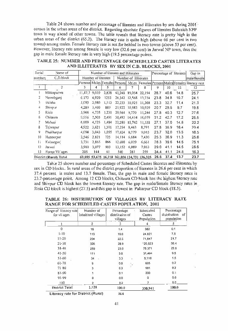
Table 24 shows number and percentage of literates and illiterates by sex during 2001 censlls in the urban areas of the district. Regarding absolute figures of literates Bahraich NPP town is way ahead of other towns. The table reveals that literacy rate is pretty high in the urban areas of the district (65.2). The literacy rate is quite high (above 66 per cent in two towns) among males. Female literacy rate is not for behind in two towns (above 53 per cent). However, literacy rate among female is very low (32.6 per cent) in Iarwal NP town, thus the gap in male female literacy rate is very high (19.5 percentage points.
TABLE 25: NUMBER AND PERCENTAGE OF SCHEDULED CASTES LITERATES AND ILLITERATES BY SEX IN C.D. BLOCKS, 2001
Serial Name of Number of literates and illiterates Percentage of literates Gap in number C.D.block Number of literates Number of illiterates male/female
Personsl Males IFemales Personsl_ Males iFemales Person~Male~l_Females literacy rate I 2 3 J 4 1 5 6 I 7 I 8 9 I 10 J 11 12
Mihinpurwa 11,87,7 9,039 2,838 41,248 19,054 22,194 28.7 40.6 14.8 25.7 2 Nawabganj 6,173 4,920 1253 26,342 12,568 13,774 23.8 34.8 10.7 24.1 3 Balaha 5,093 3,980 1,113 22,233 10,925 11,308 23.3 32.7 11.4 21.3 4 Shivpur 4,289 3,400 889 21,922 10,983 10,939 20.7 29.5 9.7 19.8 5 Risia 5,966 4,735 1,231 20,964 9,720 11,244 27.8 40.3 12.7 27.6 6 Chitaura 9,996 7,505 2,491 30,493 14,414 16,079 31.2 42.7 17.2 25.5 7 Mahasi 6,009 4,525 1,484 22,280 10,742 11,538 27.1 37.0 14.8 22.2 8 Tajwapur 4,922 3,621 1,301 17,254 8,463 8,791 27.8 36.9 16.4 20.4 9 Phakharpur 4,098 3,043 1,055 17,824 8,779 9,045 23.7 32.0 13.5 18.5 10 Huzoorpur 3,546 2,821 725 14,114 6,684 7,430 25.3 36.9 11.3 25.6 II Kaisarganj 3,731 2,865 866 12,690 6,029 6,661 28.3 39.6 14.5 25.1 12 larwal 3,980 3,077 903 13,152 6,089 7,063 29.0 41.1 14.5 26.6 13 Forest Villages 205 144 61 540 281 259 34.4 41.1 24.8 16.3
District (Rural) Total 69,885 53,675 16,210 261,056124,731136,325 26.6 37.4 13.7 23.7
Table 25 shows number and percentage of Scheduled Castes literates and illiterates by sex in CD blocks .. In rural areas of the district proportion of literates is 26.6 per cent in which 37.4 percent is males and 13.7 female. Thus, the gap in male and female literacy rates is 23.7-percentage point. Among 12 CD blocks, Chitaura CD block has the highest literacy rate and Shivpur CD block has the lowest literacy rate. The gap in male/female literacy rates in Risia CD block is highest (27.5) and this gap is lowest in Pakarpur CD block (18.5).
TABLE 26: DISTRIBUTION OF VILLAGES BY LITERACY RATE RANGE FOR SCHEDULED CASTES POPULATION, 2001
Range of literacy rate Number of Percentage for villages inhabited villages distribution of
villages
1 2 3
0 16 1.4
1-10 113 10.0
11-20 254 22.5
21-30 326 28.9
31-40 259 23.0
41-50 111 9.8
51-60 34 3.0
61-70 9 0.8
71-80 3 0.3
81-90 0.1
91-99 0 0.0
100 2 0.2
District Total 1,128 100.0
Literacyrate for District (Rural) 26.6
41
Scheduled Castes
Population
4
382
24,821
71,847
120,523
75.371
31,494
5,110
605
581
200
0
7
330,941
Percent distributio
populat
5 ~e
n of ion
0.1
7.5
21.7
36.4
22.8
9.5
1.5
0.2
0.2
0.1
0.0
0.0
100.0

Table 26 presents the distribution of villages by literacy rate range for Scheduled
Castes population at the 2001 census. In maximum number of inhabited villages (326).
which has 36.4 per c<;:nt of total rural Scheduled Castes population, the literacy range is in 21-
30 percent range. In the district there are two villages where literacy rate is hundred percent..
In majority of villages the range of literacy rates is below 51-60 percent.
TABLE 27: NUMBER AND PERCENTAGE OF SCHEDULED CASTES LITERATES AND ILLITERATES BY SEX IN TOWNS, 2001
Serial number
I
2
3
4
Name and urban status
Number of literates and illiterates Percentage of literates
of Town
Gapin I
male/fem\
r:-_N_u_m-,b~e~r ~Of_l_itrer_a_te_s :--t-N_um_berr_o_f:-i_lliTte-::-r_at_es-:--t--= __ ~~:---C-_-:-i 1'::;, II.
Persons I Males I Females Persons Males I Females Persons I Males IFemales
2 3 I 4 I 5 6 7 I 8 9 I 10 I 11 Bahraich eNPp)
Jarwal (NP)
Nanpara (NPP)
Risia Bazar (NP)
3,650
186
598 461
2,319
134
392 300
1,331
52 206 161
4,594
307 1184 826
2,105
132
550
379
2,489
175 634 447
District (Urban) 4,895 3,145 1,750 6,911 3,166 3,745
53.3
47.0
42.4 46.3
50.7
62.8 64.1
52.1
57.6
42.1
27.8
31.2 33.9
60.8 39.1
12 20.6
36.3
20.9 23.7
21.7
Table 27 brings out thc number and percentage of Scheduled Castes literates and illiterates by sex in urban agglomerations/towns population at the 2001 census. The percentage of literates is slightly higher than illiterates in the district (urban). The percentage of literates is least in Nanpara NPP among 4 towns but the gap in male/female literacy rate is highest in case of larwal NP town. The male in all the 4 towns enjoy higher literacy rate than females. The gap in male/female literacy rate is Icast in case of Bahraich NPP and also the female literacy rate is highest.
TABLE 28: NUMBER AND PERCENTAGE OF SCHEDULED TRIBES LITERATES AND ILLITERATES BY SEX IN C. D. BLOCKS, 2001
Serial Name of Number of literates and illiterates Percentage of literates Gap in
Number C. D. block Number r of literates Number of illiterates male/female
Persons I Mal es I Females Personsl Males IFemales Persons I MaleslFemales literacy rate
I 2 3 I 4 I 5 6 I 7 I 8 9 I 10 I 11 12
Mihinpurwa 1,459 982 477 6,869 3,105 3,764 23.0 31.4 14.8 16.5 2 Nawabganj 8 7 5 3 2 72.7 77.8 50.0 27.8 3 Shivpur 2 I I 8 4 4 22.2 20.0 25.0 -5.0 4 Tajwapur 26 20 6 92 47 45 28.6 37.7 15.8 21.9 5 Kaisarganj 0 0 0 1 1 0 0.0 0.0 0.0 0.0 6 Forest Villages 24 19 5 46 23 23 40.0 50.0 22.7 27.3
District (Rural) Total 1,519 1,029 490 7,021 3,183 3,838 23.3 31.8 14.9 16.9
Table 28 brings out the number and percentage of Scheduled Ttribes literates and
illiterates by sex in CD Blocks at the 2001 census. The number of illiterates is higher than
literates in the district and,-CD Blocls:s, with exception to Nawabganj CD block. The literacy -
rate of the Scheduled Tribes population at 23.3 per cent IS much lower than the
corresponding rate of 50.7per cent in Case of Scheduled Castes community. The gap in male
and female literacy rate at 16.9 per cent is also lesser than what it is in case of the Scheduled
42

Castes community ( 21.7 per cent). The literacy rate is highest in Nawabganj CD Block and
lowest in Kaiserganj CD Block. The gap in male/female literacy rate in Shivpur
CD block is in favour of the females, which is an exception. The highest gap of male
female literacy rate of27.8 percentage point is found in Nawabganj CD block.
TABLE 29: DISTRIBUTION OF VILLAGES BY LITERACY RATE RANGE FOR SCHEDULED TRIBES POPULATION, 2001
Range of literacy rate Number of Percentage Scheduled Percenta~ for villages inhabited villages distribution of Tribes distribution
villages Population populatio
1 2 3 4 5 0 6 17.1 35 0.4
1-10 3 8.6 1,906 22.3
11-20 4 11.4 1.274 14.9
21·30 5 14.3 3,145 36.8
31·40 7 20.0 2,108 24.7
41-50 3 8.6 51 0.6
51-60 0 0.0 0 0.0
61-70 0 0.0 0 0.0
71-80 0 0.0 0 0.0
81-90 0 0.0 0 0.0
91-99 0 0.0 0 0.0
100 7 20.0 21 0.2
District Total 35 100.0 8,540 100.0
Literacy rate for District (Rural) 23.3
Table 29 gives the distribution of villages by literacy rate range for the Scheduled
Tribes population at the 2001 census. In the district the Scheduled Tribes population is found
in 35 villages out of which in 7 villages the literacy is 100 per cent. However, the maximum
(36.8 per cent) of the Scheduled Tribes population (3145) is found in only 5 villages with
literacy range from 21- 31 percentages.
TABLE 30 NUNPPER AND PERCENTAGE OF SCHEDULED TRIBES LITERATES AND ILLITERATES BY SEX IN TOWNS, 2001
Serial Name and urban Number of literates and illiterates Percentage of literates Gap in nuNPPer male/female
1
3
status of
Town
2
Bahraich (NPP)
Nanpara (NPP)
District (Urban)
Number of literates
Persons I MaleS/Females
3
7
4
11
I 4
4
1
5
I 5
3
3
6
Number of illiterates
Persons I Males I Females
6
5
2
7
I 7 I 8
2 3
3 4
Persons I Males IFemales
9 I 10 1 _ 11
77.8 100.0 60.0
80.0 100.0 75.0
78.6 100.0 66.7
literacy rate
12
40.0
25.0
33.3
Table 30 gives NPP and percentage of Scheduled Tribes literates and illiterates by sex
In urban agglomerations/towns population at the 2001 census. There is smaH number of
Scheduled Tribes population in the towns of the district. In Risia Bazar NP and Jarwal NP
43

there is none Scheduled Tribe population.In between Nanpara NPP and Bahraich NPP
towns which have Scheduled Tribe population, the percentage of literates is 100 per cent
male and 66.7 per cent female. The gap in male/female literacy in Nanpara NPP and
Bahraich NPP town is 33.3 percentage points.
TABLE 31: NUNPPER AND PERCENTAGE OF MAIN WORKERS, MARGINAL WORKERS, AND NON-WORKERS BY SEX IN TAHSILS, 2001
Serial Name of Tahsil Persons I Total Main workers Marginal workers Total workers Non worker.;
2
3
4
Males I population (Main and marginal Females workers)
Number Percentage Number Percenta2:e Number Percentage Number Percentage
2 3 4 5 6 7 8 9 10 11 12
Nanpara Persons 969,830 256,290 26.4 100,450 10.4 356,740 36.8 613,090 63.2
Males 519,068 227,525 43.8 44,606 8.6 272,131 52.4 246,937 47.6
Females 450,762 28,765 6.4 55,844 12.4 84,609 18.8 366,153 81.2
Mahasi Persons 422,890 123,409 29.2 33,174 7.8 156,583 37.0 266,307 63.0
Males 21&,041 110,882 48.6 14,015 6.1 124,897 54.8 103,144 45.2
Females 194,849 12,527 6.4 19,159 9.8 31,686 16.3 163,163 83.7
Bahraich Persons 352, I 92 85,547 24.3 21,696 6.2 107,243 30.5 244,949 69.5
Males 188,289 76,858 40.8 12,146 6.5 89,004 47.3 99,285 52.7
Females 163,903 8,689 5.3 9,550 5.8 18,239 II.J 145,664 88.9
Kaiserganj Persons 636,160 167,711 26.4 56,043 8.8 223,754 35.2 412,406 64.8
Males 339,953 154,428 45.4 25,455 7.5 179,883 52.9 160,070 47.1
Females 296,207 13,283 4.5 30,588 10.3 43,871 14.8 252,336 85.2
District Total Pel'sons 2,.381,072 632,957 26.6 211,363 8.9 844,320 35.5 1536,752 64.5
Males. 1,275,351 569,693 44.7 96,222 7.5 665,915 52.2 609,436 47.8
Females 1,105,721 63,264 5.7 115,141 10.4 178,405 16.1 927,316 83.9
Table 31 gives the number and percentage of main workers, marginal workers and
non-workers by sex at tahsils level in the district as per 2001 census. The proportion of the
total workers works out to 35.5 per cent of the total population in the district. The total
workers are comprised of 26.6 per cent of main workers and 8.9 per cent of marginal workers
and the remaining 64.5 per cent are non-workers.
Among the main workers, males participation rate in the district is 44.7 per cent and
5.7 per cent of females. Male and female marginal workers account for 7.5 and 10.4 per cent
respectively. The percentage of female marginal workers is higher than males. Total
workers (main and marginal workers) among tahsils varies from 30.5 per cent in Bahraich
tahsil to 37.0 per cent in Mahasi tahsil.
44

TABLE 32: NUMBERAND PERCENTAGE OF MAIN WORKERS, MARGINAL WORKERS, AND NONWORKERS BY SEX IN C. D. BLOCKS, 2001
Serial Name ofC.D. Persons / Total Main workers Marginal workers Total workers (Main and marginal workers)
number block Males I Population Females
2
3
4
5
7
8
9
10
II
12
13
2
Mihinpurwa
Nawabganj
Balaha
Shivpur
Risia
Chitaura
Mahasi
Tajwapur
Phakharpur
HULoorpur
3
Persons
Males
Females
Persons
Males
Females
Persons
Males
Females
Persons
Males
Females
Persons
Males
Females
Persons
Males
Females
Persons
Males
Females
Persons
Males
Females
Persons
Males
Females
Persons
Males
Females
Kaisarganj Persons
Males
Females
Janval Persons
Males
Females
Forest Villages Persons
Males
Females
Percent Number Percentage Number Percentage Number age
4 5 6 7 8 9 10
275,195
1"45,701
129,494
149,470
79,767
69,703
177,347
96,097
81,250
185,884
100,993
84,891
74,364 27.0 35,250 12.8 109,614 39.8
64,016 43.9 12,644 8.7 76,660 52.6
10,348 8.0 22,606 17.5 32,954 25.4
38,764 25.9 18,072 12.1 56,836 38.0
33,795 42.4 7,881 9.9 4 I ,676 52.2
4,969 7.1 10,191 14.6 15,160 21.7
46,547 26.2 16,910 9.5 63,457 35.8
42,331 44.1 8,669 9.0 51,000 53.1
4,216 5.2 8,241 10.1 12,457 15.3
53,004
49,665
3,339
168,575 42,870
89,792 37,520
78,783 5,350
181,824 48,173
97,871 42,087
83,953 6,086
173,570 49,235
93,399
80,171
162,111
87,376
74,735
194,183
103,81 I
45,138
4,097
46,000
41,534
4,466
56,003
49,690
90,372 6,313
150,622 39,600
80,671 37,293
69,951 2,307
147,618
79,165
68,453
169,303
90,249
79,054
7,372
4,188
3,184
41,567
36,982
4,585
41,873
39,127
2,746
3,143
2,243
900
28.5
49.2
3.9
25.4
41.8
6.8
26.5
43.0
7.2
28.4
48.3
5.1
28.4
47.5
6.0
28.8
47.9
7.0
26.3
46.2
3.3
28.2
46.7
6.7
24.7
43.4
3.5
42.6
53.6
28.3
12,363
6,328
6,035
17,309
8,196
9,113
17,841
8,449
9,392
10,355
5,41 I
4,944
13,819
5,522
8,297
20,695
7,226
13,469
10,310
5,238
5,072
12,887
5,183
7,704
16,482
8,488
7,994
281
145
136
6.7
6.3
7.1
10.3
9.1
J 1.6
9.8
8.6
J 1.2
6.0
5.8
6.2
8.5
6.3
Il.l
10.7
7.0
14.9
6.8
6.5
7.3
8.7
6.5
11.3 9.7
9.4
10.1
3.8
3.5
4.3
65,367 35.2
55,993 55.4
9,374 I I
60,179 35.7
45,716 50.9
14,463
66,014
18.4
36.3
50,536 51.6
15,478
59,590
18.4
34.3
50,549 54.1
9,041 11.3
59,819 36.9
47,056 5B
12,763 17.1
76,698 39.5
56,916 54.8
19,782 21.9
49,910 33.1
42,531 52.7
7,379 10.5
54,454 36.9
42,165 53.3
12,289 18.0
58,355 34.5
47,615 52.8
10,740 13.6
3,424 46.4
2,388 57.0
1,036 32.5
Distl'ict (Rural) Total Pel'sons 2,143,074 581,143
l\hles 1,149,080 521,421
Females 993,994 59,722
27.1 _ 202,574
45.4 89,380 6.0 ,. 113,194
9.5 783,717 36.6
7.8 610,801 53.2
11.4 "172,916 17.4
Non workers'
Number Percentage.
11 12
165,581 60.2
69,041 47.4
96,540 74.6
92,634 62.0
38,091 47.8
54,543 78.3
113,890 64.2
45,097 46.9
68,793 84.7
120,517 64.&
45,000 44.6
75,517 89
108,396 64.3
44,076 49.1
64,320 81.6
115,810 63.7
47,335 48.4
68,475 81.6
113,980 65.7
42,850 45.9
71,130 88.7
102,292 63.1
40,320 46.1
61,972 82.9
1 17.485
46,895
70,590
100,712
38,140
62,572
93,164
37,000
56,164
110,948
42,634
68,314
3,948
1,800
2,148
1,359.357
538,279
821,078
60.5
45.2
78.1
66.9
47.3
89,5
63.1
46.7
82.0
65.5
47.2
86.4
53.6
43.0
67.5
63.4
46.8
82.6
Table 32 shows C.D. block-wise number and percentage of main workers, marginal
workers and non-workers for rural population of the district. Of the 2143,074 total rural
45

population of the district, 27.1 per cent has been categorised as main workers and the
marginal workers constitute 9.5 per cent and the remaining 63.4 per cent fall in the category
of non-workers. Thesex-wise break up at district level shows that 45.4 per cent males and 6.0
per cent females are in the category of main workers. Male and female marginal workers .
account for 7.8 and 11.4 per cent respectively. The percentage of female marginal workers is
higher than male marginal workers: Similar trend is visible at C.D. block level.
The percentage of total rural workers of the district comes to 36.6 per cent. Forest
villages have highest proportion of total workers forming 46.4 per cent of the total
population. It is closely followed by Mihinpurwa (39.8 per cent), Phakarpur (39.5 per cent),
Na\vabganj (38 per cent), Tajwapur and Kaisarganj (36.9 per cent) and Balaha 35.8 per cent.
The lowest percentage of 33.1 per cent is recorded in Huzoorpur C.D. block.
TABLE 33: NUMBER AND PERCENTAGE OF MAIN WORKERS, MARGINAL WORKERS, AND NON-WORKERS BY SEX IN URBAN AGGLOMERATIONS / TOWNS 2001 ,
S.No. Name and urban Persons Total Main Marginal workers Total workers Non workers status ofUA / / Males / Population workers (Main and
Town Females marginal workers)
Number Percentage Number Percentage Number Percentage N"umber Percentage I 2 3 4 5 6 7 8 9 10 II 12
I Bahraich (NPP) Persons 168,323 37,316 22.2 4,505 2.7 41,821 24.8 126,502 75.2
Males 89,581 34,739 38.8 3,836 4.3 38,575 43.1 51,006 56.9
Females 78,742 2,577 3.3 669 0.8 3,246 4.1 75,496 95.9 2 larwal (NP) Persons 15,780 3,377 21.4 1,547 9.8 4,924 31.2 10,856 68.8
Males 8,329 3,049 36.6 786 9.4 3,835 46.0 4,494 54.0
females 7,451 328 4.4 761 10.2 1,089 14.6 6,362 85.4 3 Nanpara (NPP) Persons 42,773 8,572 20.0 2,414 5.6 10,986 25.7 31,787 74.3
Males 22,567 8,073 35.8 1,952 8.6 10,025 44.4 12,542 55.6
Females 20,206 499 2.5 462 2.3 961 4.8 19,245 95.2 4 Risia Bazar (NP) Persons 11,122 2,549 22.9 323 2.9 2,872 25.8 8,250 74.2
Males 5,794 2,411 41.6 268 4.6 2,679 46.2 3,115 53.8
Females 5,328 138 2.6 55 1.0 193 3.6 5,135 96.4 District (Urban) Total Persons 237,998 51,814 21.8 8,789 3.7 60,603 25.5 177,395 74.5
. Males 126,271 48,272 38.2 6,842 5.4 55,114 43.6 71,157 56.4
Females 111,727 3,542 3.2 1,947 1.7 5,489 4.9 106,238 95.1
Table 33 indicates that as against 21.8per cent of main workers in the urban areas of the
district, such workers are as high as 22.9 per cent in Risia Bazar NP. But the extent of
marginal workers is higher 9.8 per cent in larwal NP.
46

TABLE 34: DISTRIBUTION OF WORKERS BY SEX IN FOUR CATEGORIES OF ECONOMIC ACTIVITY IN T AHSILS, 2001
Serial Name of Persons / Total Population Totitl Category of workers number Tahsil Males / number Cultivators Agricultural Household Other
Females of Labourers Industry workers workers workers (Main;t-
Mar inal)
2 3 4 5 6 7 8 9
Nanpara Persons 969,830 356,740 189,069 116,821 7,585 43,265
(36.8) (53.0) (32.7) (2.1) (12.1)
Males 519,068 272,131 152,387 75,635 5,441 38,668
(52.4) (56.0) (27.8) (2.0) (14.2)
Females 450,762 84,609 36,682 41,186 2,144 4,597
(18.8) (43.4) ( 48.7) (2.5) (5.4)
2 Mahasi Persons 422,890 156,583 96,087 47,634 2,384 10.478
(37.0) (61.4) (30.4) (1.5) (6.7)
Males 228,041 124,897 83,282 30,641 1,748 9,226
(54.8) (66.7) (24.5) ( 1.4) (7.4)
Females 194,849 31,686 12,805 16,993 636 1,252
(16.3 ) (40.4) (53.6) (2.0) (4.0)
3 Bahraich Persons 352,192 107,243 29,810 22,723 4,188 50,522
(30.5) (27.8) (21.2) (3.9) (47.1)
Males 188,289 89,004 24,133 15,252 3,153 46.466
(47.3) (27.1) (17.1) (3.5) (52.2)
Females 163,903 18,239 5,677 7,471 1,035 4,056
(11.1 ) (31.1) (41.0) (5.7) (22.2)
4 Kaiserganj Persons 636,160 223,754 130,074 70,573 4,679 18,428
(35.2) (58.1 ) (31.5) (2.1) (8.2)
Males 339,953 179,883 110,334 49,603 3,553 16,393
(52.9) (61.3) (27.6) (2.0) (9.1)
Females 296,207 43,871 19,740 20,970 1,126 2,035
(14.8) (45.0) (47.8) (2.6) (4.6)
Distl'ict Total Persons 2,381,072 844,320 445,040 257,751 18,836 122,693
(35.5) (52.7) (30.5) (2.2) (14.5)
Males 1,275,351 665,915 370,136 171,131 13,895 110,,753
(52.2) (55.6) (25.7) (2.1) (16.6)
Females 1,105,721 178,405 74,904 86,620 4,941 11,940
(16.1 ) (42.0) (48.6) (2.8) (6.7)
NOle: Percentage of Worker to lOla! worker are given in brackets
It can be seen from the table 34, the economy of the district is primarily agricultural
as supported by the fact that cultivators constitute 52.7 per cent of the total workers (main +
marginal) and remaining 37.2 per cent of total workers are engaged as agricultural labourers
(30.5 per cent), household industry workers (2.2 per cent) and other workers (14.5 per cent)
in this district.
The distribution of workers by four categories of economic activity shows very high
dependency on agriculture s~ctor, absorbing large number of workers. The proportion of
cultivators varies between 27.8 per cent in Bahraich tahsil and 61.4 per cent in Mahasi tahsil.
47

These variations within the district may be due to cropping and land holding pattern. The
percentage of female cultivators is 42.0 per cent which is also low as compared to 55.6 per
cent of male cultivators in the district. The percentage of other workers and household
industry workers is very low in the district. The agricultural labourers occupy the second
position next to cultivators in the district as well as in each tahsil. The highest proportion of
47.1 per cent of other workers is recorded in Bahraich tahsil while the lowest proportion of
6.7 per cent is found in Mahasi tahsil.
TABLE 35: DISTRIBUTION OF WORKERS BY SEX IN FOUR CATEGORIES OF ECONOMIC ACTIVITY IN CD. BLOCKS, 2001
Serial Name ofe. D. Block Personsl Total Total number Category of workers number Malesl population of workers
Females (Main + Cultivators Agricultural Household Other Marginal) Labourers Industry workers
workers
2 3 4 5 6 7 8 9
Mihinpurwa Persons 275,195 109,614 58,448 40,629 1,1605 8,932
(39.8) (53.3) (37.1) (1.5 ) (8.1 )
Males 145,701 76,660 44,128 23,941 1.119 7,472
(52.6) (57.6) (31.2) (1.5 ) (9.7)
Females 129,494 32,954 14,320 16,688 486 1,460
(25.4) (43.5) (50.6) ( 1.5) (4.4)
2 Nawabganj Persons 149,470 56,836 27,725 19,294 1,309 8,508
(38.0) (48.8) (33.9) (2.3) (15.0)
Males 79,767 41,676 21,699 11,448 948 7,581
(52.2) (52.1) (27.5) (2.3) (\8.2)
Females 69,703 15,160 6,026 7,846 361 927
(21.7) (39.7) (5\.8) (2.4) (6.\ )
3 Balaha Persons 177,347 63,457 34,790 20,899 1,319 6.449
(35.8) (54.8) (32.9) (2.1) . (10.2)
Males 96,097 51,000 28,977 14,911 1,005 6.107
(53.1) (56.8) (29.2) (2.0) (12.0)
Females 81,250 12,457 5,813 5,988 314 342 (15.3) (46.7) (48.1 ) (25) 12 .,)
4 Shivpur Persons 185,884 65,367 42,120 18,450 1,603 3.194 (35.2) (64.4) (28.2) (2.5) (4.9)
Males 100,993 55,993 37,802 14,095 1,148 2.948
(55.4) (67.5) (25.2) (2.1 ) (5.3) Females 84,891 9,374 4,318 4,355 455 246
(11.0) (46.1) (46.5) (4.9) (2.6)
5 Risia Persons 168,575 60,179 34,109 19,5!)6 1.410 5.064 (35.7) (56.7) (32.6 ) (2.3) (8.4)
Males 89,792 45,716 27.252 12,752 990 ·un (50.9) (59.6) (27.9) (2.2) (\0.3)
Females 78,783 14,463 6,857 6,844 420 342
(18.4) (47.4) (47.3) (2.9) (2.4)
48

1 2 3 4 5 6 7 8 9
6 Chitaura Persons 181,824 66,014 30,226 22,475 1,726 11,587
(36.3) (45.8) (34.0) (2.6) (17.6)
Males 97,871 50,536 24,343 14,835 1,053 10,305
(51.6) (48.2) (29.4) (2.1) (20.4)
Females 83,953 15,478 5,883 7,640 673 1,282
(18.4) (38.0) (49.4) (4.3) (8.3)
7 Mahasi Persons 173,570 59,590 39,987 15,528 921 3,154
(34.3) (67.1) (26.1 ) (1.5) (5.3)
Males 93,399 50,549 36,274 10,774 663 2,838
(54.1) (71.8) (2 I.3) ( 1.3) (5.6)
Females 80,171 9,041 3,713 4,754 258 316
(11.3) (41.1) (52.6) (2.9) (3.5)
8 Tajwapur Persons 162,111 59,819 33,473 19,576 921 5,849
(36.9) (56.0) (32.7) ( 1.5) (9.8)
Males 87,376 47,056 28,483 12,711 663 5,199
(53.9) (60.5) (27.0) (1.4 ) (11.0)
Females 74,735 12,763 4,990 6,865 258 650
(17.1) (39.1 ) (53.8) (2.0) (5.1 )
9 Phakharpur Persons 194,183 76,698 44,236 26.544 1,210 4,708
(39.5) (57.7) (34.6) (1.6) (6.1)
Males 103,811 56,916 35,461 16.638 884 3,933
(54.8) (62.3) (29.2) (1.6) (6.9)
Females 90,372 19,782 8,775 9.906 326 775
(21.9) (44.4 ) (50.1) ( 1.6) (3.9)
10 Huzoorpur Persons 150,622 49,910 33,693 12,388 996 2,833
(33.1 ) (67.5) (24.8) (2.0) (5.7)
Males 80,671 42,531 29,849 9,334 713 2,635
(52.7) (70.2) (21.9) ( 1.7) (6.2)
Females 69,951 7,379 3,844 3,054 283 198
(10.5) (52.1 ) (41.4 ) (3.8) (2.7)
II Kaisarganj Persons 147,618 54,454 30,209 18,394 1,227 4,624
(36.9) (55.5) (33.8) (2.3) (8.5)
Males 79,165 42,165 24,794 12,320 998 4,053
(53.3) (58.8) (29.2) (2.4) (9.6)
Females 68,453 12,289 5,415 6,074 229 571
(18.0) (44.1) (49.4) (1.9) (4.6)
12 Jarwal Persons 169,303 58,355 32,618 19.585 1,426 4,726
(34.5) (55.9) (33.6) (2.4) (8.1 )
Males 90,249 47,615 28,053 14,093 1,093 4,376
(52.8) (58.9) (29.6) (2.3) (9.2)
Females 79,054 10,740 4,565 5,..t92 333 350
(13.6) ( 42.5) (51.1) (3.1 ) (3.3)
13 Forest Villages Persons 7,372 3,424 583 8-47 72 1,922
(46.4) (17.0) (24.7) (2.1) (56.1 )
Males 4,188 2,388 443 585 26 1,334
(57.0) (18.6) (2·U) (I.I ) (55.9)
Females 3,184 1,036 140 262 46 588
(32.5) (13.5) (25 3) (4.4) (56.8)
District (Rural) Total Persons 2,143,074 783,717 442217 25-U05 15,745 71,550
(36.6) (56.4) (32.4) (2.(1) (9.1 )
Males 1149,080 610,801- 367558 _ 168A37 11,303 63,503
(53.2) (60.2) (27.6) (1.9) (lOA)
Females 993,994 172,916 74659 85.768 4,4-12 8,047
(17.4) (43.2) (49.6) (2.6) (4.7)
Note: Percent of Worker to total worker are given in brackets
49

Table 35 presents C.D. block-wise distribution of workers by sex in four categories of
economic activity. In the rural areas of the district total workers (main+marginal) is 36.6 per
cent of total population. Among these workers, cultivators constitute 56.4 per cent, 32.4 per
cent agricultural labourers, 2.0 per .cent household industry workers and 9.1 per cent other
workers. The agricultural sector plays a major role in providing employment to the working
force of rural population despite the fact that it is not commercial viable. Household
industries also could not make much progress in rural areas as reflected in the data and these
household industries employ only 2.0 per cent workers of the total working force. There,fore
surplus working force has to depend on primary activities. Among cultivators, the percentage
of females (43.2 per cent) is not higher than males (60.2 per cent) in the rural areas of the
district. The females play an in a pertant role in rural economy of the district. The
proportion of cultivators and other workers differ considerably from one C.O. block to other.
The proportion of cultivators varies between 67.5 per cent in Huzoorpur C.O. block to 17.0
per cent in forest villages. Similarly for other workers, the lowest proportion is 4.9 per cent
in Shivpur C.O. block while 56.1 per cent is the highest in forest villages. The percentage of
other workers and household industry workers together is quite low i.e. only I J. J per cent in
the district. The percentage of agricultural labourers is highest in Mihinpurwa black (37.1)
block and is followed by Phakarpur (34.6). In other C.O. blocks, this proportion is below.
Similarly, household industry workers varies in C.O. blocks between 1.5 per cent in
Mihinpurwa ,Mahasi and Tajwapur and 2.6 per cent in Chitaura CD block.
TABLE 36: DISTRIBUTION OF WORKERS BY SEX IN FOUR CATEGORIES OF ECONOMIC ACTIVITY OF URBAN AGGLOMERATIONS / TOWNS, 2001
Serial Name and urban status Persons I Total Total Category of workers number ofUA I Town Males I population number of
Females workers (Main + Cultivators Agricultural Household Other
Marginal) Labourers Industry workers workers
I 2 3 4 5 6 7 8 9 Bahraich (NPP) Persons 168,323 41,821 1,404 1,143 2,364 36,910
(24.8) (3.4) (2.7) (5.7) (88.3)
Males 89,581 38,575 1,304 986 2,035 34,250
(43.1 ) (3.4) (2.6) (5.3) (88.8) Females 78,742 3,246 100 157 329 2,660
(4.1) (3.1) (4.8) (10.1) (81.9) 2 Jarwal (NP) Persons 15,780 4,924 711 1,847 148 2.218
(31.2) (14.4) (37.5) (3.0) ( 45.0) Males 8,329 3,835 602 1,245 116 1,872
(46.0) (15.7) (32.5) (3.0) (48.8) Females 7,451 1,089 109 602 32 346
(14.6) (10.0) (55.3) (2.9) (31.8)
50

2 3 4 5 6 7 8 9 3 Nanpara (NPP) Persons 42,773 10,986 290 361 438 9,897
(25.7) (2.6) (3.3) (4.0) (90.1) Males 22,567 10,025 265 272 341 9,147
( 44.4) (2.6) (2.7) (3.4) (91.2) Females 20,206 961 25 89 97 750
(4.8) (2.6) (9.3) (10. I) (78.0)
4 Risia Bazar (NP) Persons 11,122 2,872 418 195 141 2,118 (25.8) (14.6) (6.8) (4.9) (73.7)
Males 5,794 2,679 407 191 100 1,981 ( 46.2) (15.2) (7.1 ) (3.7) (73.9)
Females 5,328 193 11 4 41 137 (3.6) (5.7) (2.1) (21.2) (71.0)
District (Urban) Total Persons 237,998 60,603 2,823 3,546 3,091 51,143 (25.5) (4.7) (5.9) (5.1) (84.4)
Males 126,271 55,114 2578 2,694 2,592 47,250
(43.6) (4.7) (4.9) (4.7) (85.7) Females 111,727 5,489 245 852 499 3,893
(4.9) (4.5) (15.5) (9.1) (70.9)
Table 36 presents distribution of workers by sex in four categories of economic
activity in urban areas of the district. It can be observed from the table that four categories
of economic activity are cultivators, agricultural labourers, household industry workers and
other workers. Figures in the table have been given for total number of workers induding
main and marginal workers. At district level, urban areas recorded highest percentage of
other workers (84.4), followed by agricultural labourers with 5.9 per cent (4.9 per cent male
and 15.5 per cent female). If we observe each town, the table reveals that highest percentage
of cultivators (14.6) is recorded in Risia Bazar. In the agriculture labourers category Jarwal
NP recorded very high percentage (37.5). Household industry workers are very low 3.0 i e
per cent in Jarwal NP, 4.0per cent in Nanpara NPP and 4.9 per cent in Risia Bazar NP. As
the usual trend recorded in the urban areas, other workers are in high percentage (90.1 per
cent in Nanpara NPP, 88.3 per cent in Bahraich NPP and 73.7 per cent in Risia Bazar NP).
(ix) Brief analysis of the Village Directory and Town Directory data: (37 to 47)
One of the major part of the District Census Handbook is Village and Town Directories.
These are non-census data incorporated showing educational, medical, drinking water,
banking facilities, communication facilities and other such developmental indicators in the
towns and villages. From this non-census data -certain inset tables have been generatt~d and
reproduced below showing major trends in the availability of above amenities.
51

TABLE 37: DISTRIBUTION OF VILLAGES ACCORDING TO AVAILABILITY OF DIFFERENT AMENITIES, 2001
Serial Name ofe. D. Number Type of amenity available Type of amenity available number block of Educat Medical Improved Post Teleph Trans- Banks Agricultural Approa Power
inhabited ion drinking Office # one port Credit ch by supply villages water" commun Societies pucca
i-cations road $
2 3 4 5 6 7 8 9 10 11 12 13 Mihinpurwa 105 90 20 105 29 9 19 5 4 57 45
(100) (85.7) ( 19.0) (100.0) (27.6) (8.6) (18.1 ) (4.8) (3.8) (54.3) (42.9) 2 Nawabganj 87 72 33 84 14 14 20 3 4 48 27
(100) (82.8) (37.9) (96.6) ( 16.1) (16.1) (23.0) (3.4) (4.6) (55.2) (31.0) 3 Balaha 70 61 21 70 19 13 6 2 2 38 46
(100) (87.1) (30.0) (100.0) (27.1 ) (18.6) (8.6) (2.9) (2.9) (54.3) (65.7) 4 Shivpu,' 72 64 26 71 22 19 13 II 7 26 30
(100) (88.9) (36.1 ) (98.6) (30.6) (26.4) (l8.1) (15.3) (9.7) (36.1) (41.7) 5 Risia 88 78 33 86 II 25 10 5 8 31 48
(100) (88.6) (37.5) (97.7) ( 12.5) (28.4) (11.4) (5.7) (9.1 ) (35.2) (54.5) 6 Chitaura 132 109 41 129 14 34 14 5 8 69 84
(100) (82.6) (31.1 ) (97.7) (10.6) (25.8) (10.6) (3.8) (6.1 ) (52.3) (63.6) 7 Mahasi 95 74 26 92 24 15 14 9 6 37 29
(100) (77.9) (27.4) (96.8) (25.3) (15.8) (14.7) (9.5) (6.3) (38.9) (30.5) 8 Tajwapur 87 71 39 86 13 20 9 4 4 52 31
(100) (81.6) (44.8) (98.9) (14.9) (23.0) (10.3) (4.6) (4.6) (59.8) (35.6) 9 Phakharpur 122 88 27 122 23 22 10 6 12 47 47
(100) (72.1) (22.1 ) (l00.0) (18.9) (18.0) (8.2) (4.9) (9.8) (38.5) (38.5) 10 Huzoorpur 110 92 29 104 20 21 12 7 7 43 46
(100) (83.6) (26.4) (94.5) (18.2) (19.1) (10.9) (6.4) (6.4) (39.1) (41.8) 11 Kaisarganj 109 78 35 107 II 48 6 4 8 51 73
(100) (71.6) (32.1) (98.2) (10.1) (44.0) (5.5) (3.7) (7.3) (46.8) (67.0) 12 Janval 120 78 22 119 16 44 9 2 7 44 81
(100) (65.0) (18.3) (99.2) (13.3) (36.7) (7.5) (I. 7) (5.8) (36.7) (67.5) 13 Forest Villages 7 1 0 7 0 0 2 0 I I 0
(100) (14.3) (0.0) (100.0) (0.0) (0.0) (28.6) (0.0) (14.3) (14.3) (0.0) District Total 1,204 956 352 1,182 216 284 144 63 78 544 587
(100) (79.4) (29.2) (98.2) (17.9) (23.6) (12.0) (5.2) (6.5) (45.2) (48.8)
Note: - Percentages are given in brackets. • Based on the improved drinking water source, drinking water supply has been classified as 'Improved' or otherwise. If the household has access to drinking water supplied from a tap or a hand pump I tube well situated within or outside the premises it is considered as having access to 'Improved drinking water source'. However, the concept of improved drinking water is state specific and this is to be considered accordingly. # Post office includes Post office, telegraph office and Post and telegraph office. $ Transport communication includes bus service, rail facility and navigable waterways.
Table 37 deals with the C.O. block-wise distribution of villages according to the
availability of different amenities like educational, medical, improved drinking water, post
office, telephone, transport, communications, agricultural credit societies, approach by pucca
road and power supply within the village. Out of 1204 inhabited villages in the district 956
villages or 79.4 per cent have b_een provided with the educational facilities of one type or the
other .. Similarly 352 villages in the district constituting 29.2 per cent have medical facilities
of one type or the other. Improved drinking water facility is available in 1182 or 98.2 per cent
villages. As regards, post office facility which includes facilities like telegraph office and
post telegraph, 216 villages constituting 17.9 per cent of villages have been provided with
52

this facility within the village. 284 or 23.6 per cent villages have been provided with the
telephone facility, 144 or 12.0 per cent with transport facility, 63 or 5.2 per cent villages
with bank facility and 78 or 6.5 per cent with agricultural credit societies. Similarly there are
544 or 45.2 per cent villages which have been linked with the pucca road. Total 587 or 48.8
per cent of villages have been provided with the electricity supply. Almost similar trend of
distribution of villages by availability of amenities in the villages at C.D. block has been
found with slight variations. Shivpur C.O. block has the highest 88.9 per cent villages where
educational facility is available and lowest 65.0 per cent is found in Jarwal ,CO block.
Medical facility is highest in Tajwapur (44.8 per cent) and lowest (18.0 per cent) in Jarwal
C.D. block. Improved drinking water is available to cent-percent villages in Forest villages,
Mihinpurwa, Balaha and Phakarpur blocks while in other blocks, it is above 94.5 per cent.
Telephone facility is highest in Kaiserganj (44.0 per cent) while 15 villages 0[(15.08 per
cent) Mahasi C.O. block enjoy this facility. Transport and communications is less
developed in Kaiserganj where only 5.5 per cent villages are covered by this facility
whereas 23.2 per cent villages of Nawab ganj C.O. block are availing this facility. In the
field of power supply 587 villages (48.8 per cent) have been covered in the district.
TABLE 38: NUMBER AND PERCENT OF RURAL POPULATION SERVED BY DIFFERENT AMENITIES, 2001
Serial Name of C. Total Type of amenity available Type of amenity available:
numbe D. block population Education Medical Improved Post Office Telephon Trans- Banks Agricultu Approac Power of drinking # . e port ral Credit h by supply
2
Mihinpunva
2 Nawabganj
3 Balaha
4 Shivpur
5 Risia
6 Chitaura
7 Mahasi
8 Tajwapur
9 Phakharpur
10 Huzoorpul'
II Kaisarganj
12 Janval
inhabited water* communi Societies pucca villages cations $ road
3
275,195
(100)
149,470
(100)
177,347
(100)
185,884
(100)
168,575
(100)
181,824
(100)
173,570
(100)
162, III
(100)
194,183
(100)
150,6~2
(100)
147,618
(100)
169,303
(100)
4
254,936
(92.6)
141,076
(94.4)
156,844
(88.4)
170,941
(92.0)
157,518
(93.4)
169,774
(93.4)
158,604
(91.4 )
144,262
(89.0)
158,014
(81.4)
135,138
(89.7)
122,755
(83.2)
139,378
(82.3)
5 75,924
(27.6)
76,207
(51.0)
68,181
(38.4)
88,263
(47.5)
66,838
(39.6)
73,070
(40.2)
79,228
(45.6)
85,822
(52.9)
63,652
. (32.8)
45,238
(30.0)
76,115
(51.6)
47,047
(27.8)
6
275,195
(100.0)
145,309
(97.2)
177,347
(100.0)
182,876
(98.4)
168,052
(99.7)
178,770
(98.3)
170,554
(98.3)
160,239
(98.8)
194,183
(100.0)
146,607
(97.3)
146,134
(99.0)
169,015
(99.8)
7
106,673
(38.8)
43,222
(28.9)
65,681
(37.0)
79,463
(42.7)
39,228
(233)
32,126
(17.7)
74,612
(43.0)
41,928
(25.9)
72,349
(37.3)
46,121
(30.6)
46,514
(31.5)
45,962
(27.1)
53
8 9 10 II 12 13
36,412 68,,127 21,064 14,381 173,321 152,777
(5.2) (63.0) (55.5) (13.2) (24.8) (7.7)
45,669 51,081
(30.6) (34.2)
54,969 18,550
(31.0) (10.5)
58,960
(31.7)
52,935
(31.4)
64,425
(35.4)
29,172
(15.7)
17,099
(10.1)
28,368
(15.6)
33,206 35,250
(19.1) (20.3)
43,583 25,507
(26.9) (15.7)
53,320 26,614
(27.5) (13.7)
35,770
(23.7)
82,083
(55.6)
83,405
(49.3)
23,074
(15.3)
32,469
(22.0)
15,151
(8.9)
21,73& 22,268 93,908
(62.8)
104,456
(58.9)
69,593
(46.6)
130,436
(73.5)
(14.5) (14.9)
11,399 6,728
(6.4) (3.8)
38,934
(20.9)
10,262
(6.1 )
8,978
(4.9)
40,104
(23.1)
12,412
(7.7)
19,387
(10.0)
14.454
(9'.6)
16,824
( 11.4)
9,690
(5.7)
28,535
( 15.4)
15,532
(9.2)
72,542 82,790
(39.0) (44.5)
57,523 95,500
(34.1) (56.7)
19,048 112,957 130,576
(10.5) (62.1) (71.8)
20,863
(12.0)
10,685
(6.6)
32,254
(16.6)
95,559
(55.1)
101,846
(62.8)
93,516
(48.2)
18,343 66.181
(12.2) (·B:9)
18,336 75.351
(12.4) (510)
77,396
(44.6)
75,978
(46.9)
85,192
(43.9)
76,982
(51.1 )
95,493
(64.7)
8,70,)
(5.1 )
88.084 123,929
(52.0) (73.2)

2 3 4 5 6 7 8 9 10 11 12 13
Forest 13 Villages 7,372 79 0 7,372 0 0 118 0 4,979 39 0
(100) (I.I ) (0.0) (100.0) (0.0) (0.0) (1.6) (0.0) (67.5) (0.5) (0.0)
District Total 2,143,074 1,909,319 845,585 2,121,653 693,879 644,737 370,580 225,246 220,661 1135,283 1196.642
(100) (89.1) (39.5) (99.0) (32.4) (30.1) (17.3) (10.5) (103) (53.0) (55.8)
/~,(ote : . Percentages are given in brackets . • Based on the improved drinking water source, drinking water supply has been classified as 'Improved ' or otherwise. If the household has access to drinking water supplied from a tap or a hand pump I tube well situated within or outside the premises it is considered as having access to . Improved drinking water source' However, the concept of improved drinking water is state specific and this is to be considered accordingly. # Post off.ce includes Post office, telegraph office and Post and telegraph office. $ Transport communication includes bus service, rail facility and navigable waterways.
Table 38 depicts the number and proportion of rural population served by different
type of amenities. Out of total rural population of2, 143,074 persons in the district, 1,909,319
or 89.1 per cent have educational facility of one or the other type. Similarly 845,585 or 39.5
per cent population has medical facilities while 2,121,653 or 99.0 per cent have got improved
drinking water facility. Post office facilities are available to 693,879 or 32.4 per cent
population. Telephone facility is available to 644,737 or 30.1 percent. Transport
communications facility is available to 370,580 or 17.3 per cent. Bank facility is available to
225,246 or 10.5 per cent. 220,661 or 10.3 per cent have been provided with the facility of
agricultural credit societies. 1,135,283 or 53.0 per cent have been provided with the facility of
approach by pucca road. Power supply is available to 1,196,642 or 55.8 per cent rural
popUlation In the district. Similar trend of availability of facilities is visible to the rural
population at C.D. block level except forest villages which arenot easily approachable.
However, in Mihinpurwa C.D. block facilities of educational, medical and improved drinking
water are available to larger proportion of population .
TABLE -39; AMENITlES, ARRANGED BY DISTANCE RANGES FROM THE PLACES WHERE THESE ARE AVAILABLE, 2001
Village not having the amenity of Distance range of place from the villages where the amenity is available
Less than 5 kilometres 5-10 kilometres 10+ kilometres Total (Col. 2 - 4
2 3 4 5 1. Education :-
(a) Primary School 228 29 4 261
(b) Middle School 537 416 56 1,009
(c) Degree College 117 248 832 1,197
2. Medical:-
(a) Hospital 309 361 506 1,176
(b) PHC 254 532 390 1,176 3. Post Office 708 233 47 988 4. Telephone 494 230 196 920 5. Bus Service 410 476 218 l.lO-l 6. Banks
(a) Commercial Bank 572 378 200 1,150 (b) Cooperative Bank 256 568 361 1,185
7. Agricultural Credit Societies 702 310 114 1,126
54

Table 39 presents distribution of villages not having certain amenities within the
village at district level. . They have to go out of their village to avail these facilities. Such
villages have been presented according to various distance ranges in this table. 261 villages
do not have primary'school in it self and out of these villages, children of 228 villages have
to travel less than 5 kms. for schooling. Out of 1204 inhabited villages as many as 1009 are
deprived of middle schools and 1197 of degree colleges. Of these 537avail the facility of
middle school at a distance of less than 5 kms., 416 at a distance 5-10 kms. and the remaining
56 at a distance of 10+ kms. In respect of degree college 117avail this facility at a distance of
less than 5 kms., 248.between 5 to 10 kms. and rest 832 villages at a distance of 10+ kms.
Similarly there are 1176 villages in the district which have been devoid of Hospital
facility and 1176 also of PHC facilities. Of these 309villages have the facility of Hospital
available within 5 kms. while in resp{~ct of 361 villages the inhabitants have to cover a
distance of 5-10 kms. in order to avail chis facility. Similarly overwhelming number i.e. 506
villages have this facility at a distance of 10+ kms. As regards PHC 254 avail this facility at
a distance of less than 5 kms., 532 at a distance of 5-10 kms. and the remaining 390 have to
travel a distance of more than 10 kms. to avail this faCility.
Regarding Post Office, 988 \ illages do not have this facility in the village itself. Of
these majority i.e. 708. have this facility at a distance of less than 5 kms., another 233 villages
avail it at a distance of 5-10 kms. In the remaining 47 villages habitants have to travel a
distance of 10+ kms.
As regards Telephone, there are 920 villages in the district which are without
telephone facilitiy. Of these 494 avail this facility at a distance of less than 5 kms., 230 at a
distance of 5-1 0 kms. and remaining 196 have to traverse a distance of 10+ kms.
For Bus service out of 1104 villages which do not have facility, 410 villages avail this
facility at a distance of less than 5 i5:ms., 476 at a distance between 5-10 kms. and 218 at a
distance of 10+ kms.
In the entire district 1150 villages are deprived of Commercial Bank and 1185 of Co
operative Bank. Of these 1150. villages which are deprived of Commercial Banks 572
villages avail this facility at a distance of less than 5 kms., 378 between 5-10 kms. and the
remaining 200 at a distance of 10+ kms. Regarding Co-operative Banks out of 1185 villages
256 villages avail this facility at a distance of less than 5 kms., 568 at a distance of 5-10 kms.
and remaining 361 at a distance of 10+ kms.. 1126 villages do not have agricultural credit
societies. This facil_ity to 702 villages is available at a distance of less than 5 kms., 310 at a
distance of 5-1 0 kms. and the remaining 114 at a distance of 10+ kms.
55

TABLE 40: DISTRIBUTION OF VILLAGES ACCORDING TO THE DISTANCE FROM THE NEAREST STATUTORY TOWN AND A V AILABILlTY OF DIFFERENT AMENITIES, 2001
Distance Number of Type of amenit~ available range from the inhabited Education Medical Post Telephone Transport Banks Agricultural Approach
nearest villages in Office # communications Credit by pucca statutory town each range $ Societies road (in kilometres)
I 2 3 4 5 6 7 8 9 10
Less than 5 253 200 62 38 83 23 9 13 125 (100.0) (79.1) (24.5) (15.0) (32.8) (9.1 ) (3.6) (5.1) (49.4)
5 -IS 678 546 213 118 154 83 39 47 306 (100.0) (&0.5) (31.4) (17.4) (22.7) (12.2) (5.8) (6.9) (45.1)
16 - 50 240 187 66 48 39 34 13 12 92
(100.0) (77.9) (27.5) (20.0) (16.3) (14.2) (5.4) (5.0) (38.3) 51+ 17 10 3 6 2 2 0 2 12
(100.0) (58.8) (17.6) (35.3) (\ \.8) ( 11.8) (0.0) ( 11.8) (70.6)
Unspecified 16 13 8 6 6 2 2 4 9
(100.0) (81.3} (50.0) (37.5) (37.5) (12.5) (12.5) {25.0) (56.3 )
Dist.-ict Total 1,204 956 352 216 284 144 63 78 544
(100.0} (79.4} (29.2} (17.9} (23.6) (12.0) (5.2) (6.5} (45.2}
# Post office includes Post office, Telegraph office and Post and telegraph office.
S Transport communication includes bus service. rail facility and navigable waterways.
Table 40 deals with the distribution of villages according to distance from the nearest
statutory town and availability of different amenities within the village. Out of total 1204
inhabited villages in the district, there are 253 villages which have nearest towns upto a
distance of 5 kms. Of these only 200 villages forming 79.1 per cent of total villages, are
having the educational facilities of one type or the other and 62 villages constituting 24.5 per
cent have the medical facilities within the village, 38 villages forming 15.0 per cent have the
facility of post office within the village and 83 or 32.8. per cent have the facility of telephone.
23 villages constituting 9.1 per cent have been linked by transport service. 9 villages
comprising 3.6 per cent have been provided bank facilities, while 13 villages constituting
only 5.1 per cent have been provided by agricultural credit societies. 125 villages comprising
49.4 per cent have been provided with pucca road.
There are 678 inhabited villages in the district which fall in the distance range of 5-15
kms. Of these 546 villages constituting 80.5 per cent have been provided with the
educational facilities. 213 villages comprising 31.4 per cent have been provided with
medical facilities. 118 villages constituting 17.4 per cent enjoy the post office facility.
154.villages comprising 22.7 per cent have been provided_ the telephone facility. 83villages
constituting 12.2 per cent have been linked with transport communications. 39 villages
comprising 5.8 per cent have bank facility. 47 villages constituting 6.9 per cent arc having
agricultural credit societies, while 306 villages or 45. I per cent are approachable by pucca
56

road. 240 villages fall in the distance range of 16-50 kms. Of these, 77.9 per cent villages
have educational facility, 27.5 per cent with medical, 20.0 per cent with post office, 16.3 per
cent with telephone and transport & communications available to 14.2 per cent villages.
Banks and agricultural credit societies facilities are available to 5.4. and 5.0 per cent of
villages.
There are 17villages in the district which are situated beyond 50 kms.from the nearest
town and out of these 10 or 58.8per cent enjoy the educational facility in the village itself
whereas 3 villages comprising 17.6. per cent have been provided with medical facility of one
type or the other total 6 villages comprising 35.3 per cent have the post office facility. 2
villages comprising 11.8 per cent have been provided with telephone facility, bus service
agricultural credit societies, while 12villages comprising 70.6 per cent have been linked by
pucca roads. There are 16 villages whose distance ranges from the nearest statutory town
have not been given. Such villages have been grouped under the unspecified category. 13 or
81.3 per cent villages have the educational facility of one or other type. Eight village
constituting 50.0 per cent have the medical,6 villages (37.5 per cent) have post office and
telephone, 2 villages (12.5 per cent) have transport and banks and 4 villages (25 per cent)
have agricultural credit society facilities. Nine villages 8 (56.3 per cent) have also been
connected by pucca road.
TABLE 41: DISTRIBUTION OF VILLAGES ACCORDING TO POPULATION RANGE AND AMENITIES AVAILABLE, 2001
Population Number of Type of amenity Type of amenity available range inhabited available
villages in Education Medical Improved Post Telephone Transport Banks Agricultural Approach Power each range drinking Office # communi Credit by Pucca supply
water· cations $ Societies road
I 2 3 4 5 6 7 8 9 10 11 12
1-499 176 66 22 168 0 22 17 1 0 57 54
(100.0) (37.5) (12.5) (95.5) (0.0) (12.5) (9.7) (0.6) (0.0) (32.4) (30.7)
500-999 237 172 37 232 20 44 9 3 15 81 102
( 100.0) (72.6) (15.6) (97.9) (8.4) (18.6) (3.8) (1.3) (6.3) (34.2) (43.0)
1000-1999 413 365 127 406 52 99 52 13 17 187 209
( 100.0) (88.4) (30.8) (98.3) (12.6) (24.0) (12.6) (3.1) (4. I) (45.3) (50.6)
2000-4,999 337 316 145 335 112 100 51 33 37 189 192
(100.0) (93.8) (43.0) (99.4) (33.2) (29.7) (15.1 ) (9.8) (11.0) (56.1) (57.0)
5000-9999 37 34 19 37 29 16 13 12 8 28 28 (100.0) (91.9) (51.4) (100.0) (78.4) (43.2) (35.1) (32.4 ) (21.6) (75.7) (75.7)
10000 + 4 3 2 4 3 3 2 I I 2 2
(100.0} {7S.0) (50.0) (100.0) {75.0) (75.0) (SO.O) (25.0) (25.0) (50.0) (50.0)
District total 1,204 956 352 1,i82 216 284 144 63 78 544 587
(100.0) (79.4) (29.2) (98.2) (17.9) (23.6} (12.0) (5.2) (6.5) (45.2) (48.8) .
# Post office includes Post office, Telegraph office and Post and telegraph office.
$ Transport communication includes bus service, rail facility and navigable waterways. * Based on the improved drinking water source, drinking water supply has been classified as 'Improved' or otherwise. If the household has access lo drinking water supplied from a lap or a hand pump / tube well situated within or outside the premises it is considered as having access to : Improved drinking waler source'.
However, the concept of improved drinking water is state specific and this is to be considered accordingly.
57

Table 41 deals with the distribution of villages by population ranges and amenities
available therein. In the district out of a total 1204 inhabited villages, overwhelming 176.
have a population of less than 500 persons. Of these, 66. villages (37.5 per cent) have
educational facility, 22 (12.5 per cent) have medical facility, 168 (95.5 per cent) have
improved drinking water facility. None village has post office facility. 22 (12.5. per cent)
have telephone facility. 17 (9.7 per cent) have been linked by bus service. One (0.6 per cent)
have Bank facility. None village has been provided with the agricultural credit societies. 57
villages (32.4 per cent) have been linked with pucca road and 54. villages (30.7 per cent)
have been provided with electricity.
Out of 237 villages, which fall in the population range of 500-999 persons,
172villages (72.6 per cent) have been provided with the educationl facility, 37 (15.6 per cent)
with medical facility, 232villages (97.9 per cent) have improved drinking water facility. 20
villages (8.4 per cent) have been provided with post office facilities, 44 villages (18.6 per
cent) with telephone facility, 9 villages (3.8 per cent) with transport facilities, 3villages (1.3
per cent) with bank facility, 15 villages (6.3 per cent) with agricultural credit societies and 81
villages (34.2 per cent) have approach by pucca road. 102 and villages (43.0 per cent) in this
range have electricity.
413 villages fall in population range of 1,000-1,999 persons. Out of these villages
365 (88.4 per cent) have educational 209 (50.6 per cent) power supply and 406 (98.3 per
cent) have improved drinking water facilities. Whereas 127 villages (30.8 per cent) enjoy the
medical facility, 52 villages (12.6 per cent) have post office facility, 99 villages (24.0 per
cent) have telephone facility, 52 villages (12.6 per cent) have transport and communications
facilities, 13 villages (3.1 per cent) have bank facilities, 17 villages (4.1per cent) have
agricultural credit societies and 187 villages (45.3 per cent) have approach by pucca road.
There are 337 villages in the district which are covered under 2,000-4,999 popUlation
range. In this range, 316 villages (93.8 per cent) enjoy the facility of education, 335 (99.4 per
cent) improved drinking water, 100 (29.7 per cent) telephone, 51 (15.1 per cent) transport and
communications, 189 (56.1 per cent) approach by pucca road and 192 (57.0 per cent) with
power supply. 145 villages (43.0 per cent) have medical facility. 112 villages (33.2 per cent)
have post office facility, 33villages (9.8 per cent) have bank facility, 37 village (11.0 per
cent) is having agricultural credit societies. There are 41 villages in the district having a
population of more than 5,000 persons and in those villages maximum facility of amenities
are available.
58

TABLE 42: DISTRIBUTION OF VILLAGES ACCORDING TO LAND USE, 2001
Serial Name of C. D. block Number of inhabited Total area Percentage of Percentage of irrigated area to number villages cultivable area to total cultivable area
total area
2 3 4 5 6
I Mihinpurwa 105 39,933.5 68.9 60.1
2 Nawabganj 87 27,006.3 65.4 63.4
3 Balaha 70 26,425.6 58.3 51.0
4 Shivpur 72 23,931.8 96.5 63.7
5 Risia 88 2,603.7 46.2 85.4
6 Chitaura 132 30,749.1 84.0 62.4
7 Mahasi 95 23,978.3 78.0 40.2
8 Tajwapuf 87 27,419.2 NA 37.5
9 Phakharpur 122 27,332.2 59.4 45.5
10 Huzoorpur 110 18,337.1 NA 14.7
II Kaisarganj 109 18,815.1 77.1 60.9
12 Jaf\val 120 12,883.2 36.8 82.5
13 Forest Villages 7 NA NA NA District Total 1,204 279,415.2 NA. 44 .. 7
SOle: . ellilivable area = irrigaled area + unirrigaled area
Table 42 presents CD blockwise distribution of villages according to land use. It
also gives details of total area and cultivable area available of inhabited villages in the
district Cultivated area includes irrigated as we,ll as unirrigated area. It further elaborates that
what is the extent of cultivable area under irrigation. There are total 1,204 inhabited villages
in the district having a total area of 279,415.2 hectares. Total Cultivable area is not avilable
while 44.7 per cent of total cultivable area has got the irrigation facility. The area figures
have been collected from the revenue record maintained for each village by the State
Government.
A look at the land use pattern at C.D. block level shows that in Mihinpurwa block, all
the 105 villages have a total land area of 39,933.5.hectares, of this 68.9 per cent of land is
cultivable and of the aforesaid area 60.1 per cent is irrigated. In Nawabganj block, all the
87.villages have a total area of 27,006.3 hectares, of this cultivable area is 65,4 per cent and
63.4.per cent is irrigated. In Balaha block, all the 70 villages have a total area of 26,425.6
hectares. Of this, cultivable area is 58.3 per cent. Of cultivable area 51.0 per cent is
irrigated. Shivpur block with 72 villages have a total land area of 23,931.8 hectares, of this
96.5. per cent is cultivable area and out of this cultivable area 63.7per cent is irrigated. Risia
block with 88.villages have a total land area of 2,603.7 hectares. Of this 46.2 per cent is
cultivated area, out of which 85.4.per cent is irrigated. Chitaura block with a total 132
villages have an area of 30,749.1 hectares. Of this 84 per cent is cultivable area. Out of
which 62.4 per cent is irrigated. Mahasi block with 95 villages have an area of 23,978.3
hectares. Of this 78 per cent is cultivable area and out of which 40.2 per cent is irrigated.
Tajwapur block with 87 villages have an area of 27,419.2 hectares and of cultivated are only
59

37.5 per cent is irrigated. Phakharpur block have 122 villages with an area of 27,332.2
hectares in which 59.4 per cent land is cultivable and of this 45.5 per cent is irrigated.
Huzoorpur block with 110 villages have an area of 18,337.1 hectares and of cultivated area
only 14.7 per cent is irrigated. Kaisarganj block with 109 villages have an area of 18,815.1
hectares and of this land, 77.1 per cent is cultivable and of this 60.9 per cent is irrigated.
larwal block have 120 villages with an area of 12,883.2 hectares. Out of this 36.8 per cent is
cultivable land and of this 82.5 per cent is irrigated.
TABLE 43: PER CAPITA RECEIPT AND EXPENDITURE IN STATUTORY TOWNS SI Class, name & Per capita receipt Per capita expenditure No. urban status of Total Through From Total General Public Public Public Other
the Town taxes all Administ health works instituti (s)
other ration and ons sources convent
ences 1 2 3 4 5 6 7 8 9 10 11
1 I,Bahraich,NPP 192 12 180 188 131 2 27 0 28
2 IV,Jarwal,NP 205 54 151 138 25 30 83 0 0
3 Ill,Nanpara,NPP 177 7 170 147 11 0 0 0 136 lV,Risia
4 Bazar,NP 133 16 117 123 115 1 7 0 0
District 187 14 173 174 101 4 25 0 44
Table 43 gives the per capita receipt and expenditure ( in rupees) for each to\vn in the
district. The average per capita receipt for towns of the district works out to Rs 187 of which
Rs 14 are derived through local taxes and the remaining Rs 173 received from all other
sources. The average of total expenditure incurred per head is Rs 174. Out of this Rs 101 are
spent on general administration, Rs 4 on public health and conveniences, Rs 25 on public
works and Rs 44. is spent other items. Among all the four towns the receipt and expenditure
recorded per head are the highest in larwal NP and Bahraich NPP respectively.
TABLE 44: SCHOOLS / COLLEGES PER 10,000 POPULATION IN STATUTORY TOWNS, 2001
Sl. Name and urban status of Town Type of educational institution No. Primary Junior Secondary / Senior College
Secondary Matriculation Secondary / Middle
1 2 3 4 5 6 7 1 Bahraich, NPP 1.7 1.1 0.4 0.4 0.1 2 Jarwal, NP 1.3 1.3 0.6 0.0 0.0 3 Nanpara, NPP 2.3 1.4 0.9 0.7 0.2 4 Risia Bazar, NP 12.6 0.9 0.9 1.8 0.0
District 2.3 1.1 0.5 0.5 0.1 i
..
~ Table 44 shows in urban areas of the district, the average number of primary schopls
per 10,000 population which comes to 2.3 primary schools, 1.1 junior secondary/middle, 0.5
secondary/matriculation, 0.5 senior secondary schools and the ratio of colleges is only 0.1
60

college per. Among the towns, the ratio of primary, secondary/ and senior secondary is
highest in Risia Bazar and Nanpara NPP has highest ratio of Junior secondary/ middle
schools, college education is available only in Bahraich NPP and Nanpara NPP.
TABLE 45: NUMBER OF BEDS IN MEDICAL INSTITUTIONS IN TOWNS, :2.001
SI. Name and urban status of the Number of beds in medical institutions per 10,000 No. Town population -
I 2 3 I Bahraich, NPP 27 2 Jarwal, NP 3 3 Nanpara, NPP 6 4 Risia Bazar, NP 27
District 22
Table 4S depicts the number of beds available in medical institutions per 10,000
popu [at ion in each town of the district. On an average there are 22 beds per 10,000 population
in urban areas as a whole. Whereas it is the highest 27 in both Bahraich NPP and Risia Bazar
NP while lowest number of 3,.beds is recorded in Iarwal NP and is closely preceded by 6
beds in Nanpara NPP.
TABLE 46: PROPORTION OF SLUM POPULATION IN TOWNS, 2001
SI.No. Name of the Town Total Slum Percentage of slum popula population population total population
1 2 3 4 5 -NA
Slum Not Available
TABLE47; MOST IMPORTANT COMMODITY EXPORTED OUT OF AND MANUFACTURED IN TOWNS, 2001
SI.No. Name and urban status Most important commodity
-
of Town
Manufactured Exported
I 2 3 4
I Bahraich, NPP Mustard Oil, Tobacco, Iron Goods Mat, Iron Goods, Pulses
2 Jarvval, NP Tobacco, Biscuit, Furniture Furniture, Vegetable, Khoke
3 Nanpara, NPP Furniture, Biscuit, Edible Oil Leather, Food grains, Wooden Goods
4 Risia Bazar, NP Tobacco, Edible Oil, Maida Tobacoo, Edible Oil, Rice
Table 47 indicates most important articles manufactured and exported from the each
town in the district. The district is well known for manufacture of furniture and other
woodden goods. These are also main exports of the district. The chief export items of the
district are furniture, vegitable~ leather, food, grains and wood.den goods. These are the main
items which are manufactured in Jarwal and Nanpara NPP town.
61

(x) Brief analysis of the data on houses and household amenities collected during, House listing Operations, Census oflndia 2001: (48 to 52)
Data on houses and household amenities have traditionally been undertaken a few months
before each census. Based upon data collected in the houselist, a few tables on the use of
census house, materials of wall, floor and roof etc. are prepared. In 1991 census, the house
list was considerably expanded with 22 items of information. Again in 2001 census many
new items on household assets like radio/transistor, television, telephone, cycle,
scooter/motorcycle/moped, car/jeep and banking facility availed by household ctc. for the
first time has been added in the schedule. The district wise tables have been prepared and
these are placed in the subsequent tables. The following is the distribution of households by
number of rooms occupied.
TABLE 48: HOUSEHOLDS BY TENURE STATUS AND NUMBER OF ROOMS OCCUPIED IN THE DISTRICT 2001 ,
Tenure status Number of dwelling households Number of households
Total Scheduled Castes Scheduled Tribes
Total I Rural JUrban Total I Rural IUrban TotallRurallUrban
1 2 3 I 4 I 5 6 I 7 I 8 9 I 10 I 11
Owned No exclusive room 11,554 10,875 679 2,316 2,246 70 152 1~5 7
One room 140,786131,2989,48830,31329,506 807 1,7531,548 205
Two rooms 128,779119,7049,07523,17222,476 696 1,3961,248 148
Three rooms 55,150 50,727 4,423 8,217 7,954 263 487 448 39 3+ rooms 40,047 35,055 4,992 4,571 4,355 216 366 337 29
Median number of rooms 2 2 2 2 2 2 2 2 2
Rented No exclusive room 178 128 50 29 21 8 12 11 One room 2,605 1,203 1,402 379 244 135 49 24 25 Two rooms 2,272 1,217 1,055 265 215 50 44 27 17 Three rooms 773 388 385 46 29 17 19 17 2 3+ rooms 432 239 193 25 17 8 12 11 Median number of rooms 2 2 2 1 2 2
Others No exclusive room 149 134 15 36 36 0 3 3 0 One room 2,039 1,411 628 340 270 70 47 41 6 Two rooms 1,176 959 217 187 169 18 41 40 I Three rooms 353 262 91 62 52 10 2 2 0 3+ rooms 184 137 47 19 16 3 4 3 Median number of rooms 1 1 1 1 2
District total 386,477353,73732,74069,97767,606 2,371 4,3873,905 482
DOlO SOurce: Census of India 200 J, !-{- series: "Tables on Houses, Household amenities and Assers. "
The data presented in table 48 depicts number of hou?eholds by tenure status and
number cif rooms occupied in the district. The total number of households in the district
stands at 386,477 consisting of 353,737 rural and 32,740 urban households. 69,977
households belong to Scheduled Castes and 4387 to Scheduled Tribes. 376,3 16 households
62

are living in their owned houses constituting 97.4 per cent of total households" Of these
households, the maximum number of households (140,786) have occupied single roomed
accommodation and is followed by double roomed accommodation numbering to 128,779
households. Next position is claimed by households (55,150) occupying three roomed
accommodation. Number of households in owned accommodation occupying three plus
rooms rank at fourth place with 40,047 households while 11,554 households are without any
exclusive room.
6,260 households living in rented accommodation account for 1.6 per cent of total
number of households in the district. The maximum number of 2,605 households are living
in single roomed accommodation followed by 2,272 households in double roomed
accommodation. Households with three rooms (773) and three plus (432) are small in
numbers. Other households numbering to 3,901 forming only 1.0 per cent of total
households, are distributed in single roomed accommodation numbering 2,039 where as
1,176 in double roomed and 353 in three roomed accommodation. In rural areas majority of
households have bigger size and majority of them have their own houses while in urban areas
show reverse picture.
TABLE 49: PERCENTAGE DISTRIBUTION OF HOUSEHOLDS LIVING IN PERMANENT, SEMI PERMANENT AND TEMPORARY HOUSES, 2001
-Serial
District! Total Rural Urban
num Permanent Semi- Temp Perman Semi- Tempo Permanent Semi- Temporary Tahsil ber permanent orary ent permanent rary permanent
I 2 3 4 5 6 7 8 9 10 II
Nanpara 28.0 30.2 41.8 26.3 30.4 43.3 75.8 22.7 1.5
2 Mahasi 22.9 22.0 55.0 22.9 22.0 55.0 0.0 0.0 0.0
3 Bahraich 57.2 27.9 14.9 35.8 38.4 25.9 81.6 16.0 2.4
4 Kaiserganj 31.8 18.4 49.8 31.2 18.4 50.4 61. I 16.5 22.4
District Total 32.1 25.2 42.7 27.8 25.9 46.3 79.3 17.2 3.6
Data source: Census of India 2001, H-series: Tables on Houses, Household amenities and Assets.
Note:-Permanent:- Permanent houses refers to those houses whose wall & roofs are made of pucca materials i.e. where, burnt briks. G.!. Sheets or other metal sheets, stone cement concrete is used for wall and tiles slate, shingle, corrugated iron, zinc or other metal sheets asbestos sheets bricks, lime and stone and RBC/RCC concrete are used for roof. Semi permanent:- 2 Sem i-permanent houses refer to those houses made of other types of materials. Temporary:- 3 Temporary houses refers to those houses having wall and roofs made of Kutcha
materials i.e. wherc grass, leaves, reeds, baNPPoo mud, unburnt bricks are used for the construction of walls and gr(iSS, leaves reeds, baNPl'oo hatch, mud. unburnt bricks, wood etc .are used for roofs.
The percentage distribution of households as shown in the above table reveals that
more than 32. percent of the households in the district had permanent houses. The trend is
different in rural (27.8.per cent) and urban area (79.3.per cent). Among tahsils highest
proportion of permanent houses were accounted in tahsil Bahraich (57.2 per cent) followed
63

by Kaiserganj (31.8.per cent), Nanpara (28.0.per cent) and lowest in Mahasi (22.9.per cent).
In respect of semi-permanent houses, the returns were 2S.2.per cent of district level whereas
among tahsils, in Nanpara it was 30.2.per cent and lowest was 18.4 per cent in tahsil
Kaiserganj Rural areas represented a similar ratio at district and tahsil level except in
Bahraich tahsil but semi permanent houses in the urban areas were in the proportion range of
0.0.10 22.7. per cent. Temporary houses in the district lie between 3.6 percent in urban to
46.3 percent in rural areas.
TABLE 50: PERCENTAGE OF HOUSEHOLDS HAVING IMPROVED DRINKING WATER SOURCE ELECTRICITY, BATHROOM, TOILET AND DRAINAGE FACILITY, 2001 ,
Serial Tahsil Total! Number of Number and percentage of households havi'ng number Rural/ households Improved Electri Bathroom Toilet Drainage
Urban drinking water* city
I 2 3 4 5 6 7 8 9 Nanpara Total 157,748 132,392 15,964 18,169 24,121 55,124
(83.9) (10.1 ) (11.5) (15.3) (34.9)
Rural 152,305 127,261 12,108 15,679 19,566 50,150
(83.6) (7.9) (10.3) (12.8) (32.9)
Urban 5,443 5,131 3,856 2,490 4.555 4,974
(94.3) (70.8) (45.7) (83.7) (91.4 ) 2 Mahasi Total 71,376 60,950 2,790 7,224 9267 25,180
(85.4) (3.9) (10.1) (13.0) (35.3)
Rural 71,376 60,950 2,790 7,224 9,267 25,180
(85.4) (3.9) (10.1) (13.0) (35.3)
Urban 0 0 0 0 0 0
(0.0) (0.0) (0.0) (0.0) (0.0) 3 Bahraich Total 53,736 47,827 23,036 15,046 24,776 34,608
(89.0) (42.9) (28.0) (46.1) (64.4) Rural 28,600 23,738 3,583 2,378 4,027 13,058
(83.0) (12.5) (8.3) ( 14.1) (45.7) Urban 25,136 24,089 19,453 12,668 20,749 21,550
(95.8) (77.4) (50.4) (82.5) (85.7) 4 Kaiserganj Total 103,617 93,070 12,233 15,234 16,570 45,353
(89.8) (11.8) (14.7) (16.0) (43.8) Rural 101,456 91,011 11,320 14,717 15,647 43,564
(89.7) (11.2 ) (14.5) (15.4) (42.9) Urban 2,161 2,059 913 517 923 1,789
(95.3) (42.2) (23.9) (42.7) (82.8)
District Total Total 386,477 334,239 54,023 55,673 74,734 160,265 (86.5) (14.0) (14.4) (19.3) (41.5)
Rural 353,737 302,960 29,801 39,998 48,507 131,952 (85.6) (8.4) (11.3) (13.7) (37.3)
Urban 32,740 31,279 24,222 15,675 26,227 28,313
Electricity was available for 14.0 per cent of households at district level, in urban
areas had better access of electricity. Bathrooms and toilet facilities were available in 14.4
and 19.3 per cent of households. Tahsil Mahasi was .poorly served in respect of these
amenities. Similarly drainage facility was also poor in Nanpara and Mahasi tahsils, At
64

district level drainage facility was available for 41.5,per cent of households, whereas the
proportion of rural and urban areas households accounted to 37.3 and 86.5,per cent
TABLE 51: NUMBER AND PERCENT OF HOUSEHOLDS BY TYPE OF FUEL USED FOR COOKING,
Serial Tahsil number
I 2
Nanpara
2 Mahasi
3 Bahraich
4 Kaiserganj
Total! Total Fire Crop Rural! househo wood residue Urban Ids
3 4 5 6 -Total 1)7,748 106,947 37,761
(67.8) (23.9) Rural 152,305 103,170 37,466
(67.7) (24.6) Urban 5,443 3,777 295
(69.4) (5.4) Total 71,376 45,922 23,104
(64.3) (32.4)
Rural 71,376 45,922 23,104
(64.3) (32.4)
Urban 0 0 0
(0.0) (0.0)
To1al 53,736 27,453 10,149
(51.1) (18.9)
Rural 28,600 16,333 9,256
(57.1) (32.4)
Urban 25,136 11,120 893
(44.2) (3.6)
Total 103,617 65,408 33,226
(63.1) (32. I)
Rural 101,456 63,737 32,953
(62.8) (32.5)
Urban 2,161 1,671 273
(77.3) (12.6)
200t . Cowdung
cake
7
9,237
(5.9)
9,193
(6.0)
44
(0.8)
1,715
(2.4)
1,715
(2.4)
0
(0.0)
2,188
(4.1)
2,036
(7.1)
152
(0.6)
2,695
(2.6)
2,681
(2.6)
14
(0.6)
Elect Coal/ ri- Lignit
city e (chare oal)
8 9
92 13
(0.1) (0.0)
88 9
(0.1) (0.0)
4 4 (0.1) (0.1)
63 16
(0.1) (0.0)
63 16
(0.1) (0.0)
a 0 (0.0) (0.0)
47 13
(0.1) (0.0)
28 0
(0.1) (0.0)
19 . 13
(0.1) (0.1)
90 14
(0.1) (0.0)
90 13
(0.1) (0.0)
o I
(0.0) (0.0)
Cooking gas
(L.P.G.)
10
1,422
(0.9)
989 (0.6)
4"" .).)
(8.0)
191
(0.3)
191
(0.3)
0
(0.0)
8,005
(14.9)
355
(1.2)
7,650
(30.4)
1397
( 1.3)
1,262
(1.2)
135
(6.2)
Bio-gas Keros Others No ene cooking
11 12 13 14
93 1,843 162 178 (0.1) (1.2) (0.1 ) (0.1 )
75 996 162 157 (0.0) (0.7) (0.1 ) (0.1 )
18 847 0 21 (0.3) (15.6) (0.0) (OA)
53 211:1 18 76 (0.1) (0.3) (0.0) (0.1 )
53 2Hi 18 76 (0.1 ) (0.3) (0.0) (0.1 )
0 0 a a (0.0) (0.0) (0.0) (0.0)
150 5,561 48 122
(0.3) (10.:3) (0.1 ) (0.2)
24 4gB 28 42
(0.1) (1.7) (0.1) (0.1 )
126 5,063 20 80
(0.5) (20.1) (0.1) (0.3)
52 56:3 45 127
(0.1) (O.~i) (0.0) (0.1 )
52 50!) 44 118
(0.1) (O.ti) (0.0) (0.1 )
0 57 1 9 (0.0) (2.EI) (0.0) (0.4)
District Total Total 386,477 245,730 104,240 15,835 292 56 11,015 348 8,185 273 503
(63.6) (27.0) (4.1) (0.1) (0.0)
269 38
(0.1) (0.0)
(2.9) (0.1) (2.1) (0.1) (0.1)
Rural 353,737 229,162 102,779 15,625 2,797 204 2,2'18 252 393
(64.8) (29.1) (4.4) (0.8) (0.1) (O.El) (0.1) (0.1) .
Urban 32,740 16,568 1,461 210 23 18 8,218 144 5,9El7 21 110
(50.6) (4.5) (0.6) (0.1) (0.1) (25.1) (0.4) (18.2) (0.1) (0.3)
Percentage in brackets Data source: Census of India 2001, H-series: Tables on Houses, Household amenities and Assets.
It is observed from the above table that 63.6 per cent of households in the district use
firewood as fuel, for cooking, the proportion in the rural area is 64.8 and in urban area it
comes to 50_6 per cent of households. LPG (cooking gas) has been reported as one of the
fud for cooking of food in to 2.9 per. cent of the hou-seholds. The composltjon of rural and -
urban comes to 0.8 and to 25.1 per cent respectively. Kerosene is used for cooking in as
many as 2.1 per cent of the households (0.6 per cent rural and 18.2 per cent urban
households). The other methods like crop residence, cowdung cake, coal, lignite, charcoal,
65

electricity and biogas etc. ranges between to 0.0 per cent to 27.0 per cent of the households
of the district. The pattern of fuel used for cooking follows the same trend in tahsils (rural
areas) where predominant fuel is firewood. The table shows that firewood, crop residue and
cowdung cake are the predominant fuel for cooking the food.
TABLE 52: NUMBER OF HOUSEHOLDS AVAILING BANKING SERVICES AND NUMBER OF HOUSEHOLDS HAVING EACH OF THE SPECIFIED ASSET, 2001
Total Availability of Availability of household assets
Total number of household assets Serial
Total! number of households Scooter, None of
number Tahsil Rural!
house- availing Radio/Tr Telepho Motor Car,
the· UI'ban holds banking ansistor
Television Bicycle Cycle,
Jeep, specified ne
Van services Moped assets
1 2 3 4 5 6 7 8 9 10 II 12
Nanpara Total 157,748 40,970 56,569 8,939 3,227 97,697 4,399 1,290 48.176
Rural 152,305 39,394 54,466 7,190 2,562 95,371 3,947 1,202 46,308
Urban 5,443 1,576 2,103 1,749 665 2,326 452 88 1,968
2 Mahasi Total 71,376 15,893 21,105 3,901 1,448 42,545 2,446 797 23,828
Rural 71,376 15,893 21,105 3,901 1,448 42,545 2,446 797 23.828
Urban 0 0 0 0 0 0 0 0 0
3 Bahraich Total 53,736 18,640 19,143 16,508 4,955 33,118 5,903 1,191 13.200
Rural 28,600 7,972 9,185 2,639 617 18,536 1,368 371 7.935
Urban 25,136 10,668 9,958 13,869 4,338 14,582 4,535 820 5,265
4 Kaiserganj Total 103,617 34,044 36,495 6,355 2,687 70,608 3,513 1,105 26,768
Rural 101,456 33,228 35,850 5,981 2,532 69,676 3,405 1,087 25,818 Urban 2,161 816 645 374 155 932 108 18 950
District Total Total 386,477 109,547 133,312 35,703 12,317 243,968 16,261 4,383 112,0~2
Rural 353,737 96,487 120,606 19,711 7,159 226,128 11,166 3,457 103.889 Urban 32,740 13,060 12,706 15,992 5,158 17,840 5,095 926 8,183
Data source: Censlls of India 200/, H-series: Table on Houses. HOllsehold amenities and Assets.
Above table reveals that out of the total households (386,477) of the district, in all
109,547 could avail banking services at district level while only 133,312 avail radio I
transistor, 35,703 television, 12,317 telephone, 243,968 bycycle, 16,261 scooterl motorcycle,
4,383 car /jeep and 112,072 house holds do not avail the facility of such type of the specified
assets ..
It also reveals that at tahsil level highest number i.e 40,970 households were availing
banking services as well as all other households' assets in Bahraich tahsil. The highest of
none of specified assets 48,276 Were in the tahsil Nanpara, against it, the lowest of 13,200
households were recorded in Bahraich tahsil. Highest number of 56,569 households were
availing radio Itrainsistor and lowest 19,143 in Bahraich tahsil. In case of'television and . .
telephone the highest number of households were in Baharich also. A total of 97,697
households had bycycles and maximum number of 5,903 households were availing schooter
I motorcycle, moped etc in tahsils Nanpara and Baharich respectively.
66

(XI) Major Social and Cultural Events, Natural and Administrative Development and
Significant Activities during the Decade:
During the decade a new district Shravasti has been carved out from this district and a
new tahsi I Mahasi was carved out from tahsil Nanpara and Kaisarganj within the district
Bahraich.
(XII) Brief discription of Places of Religious or Historical or Archaeological inportance
in villages and places of and Tourist Interest in the towns of the district.
Dargah Sharif : The main place of interest in Bahraich is the Dargah (Mausoleum) of
Saiyed Salar Masud who was the nephew of Mahmud of Ghazni. It was here that he breathed
his last in 424 Hijri (1033 A.D.) after defeat at the hands of raja Suhel deo and his forces. It is
said that dargah was built by Zohra Bibi, the blind dauthcr of Saiyed Jamal-ud-din of Rudauli
in Bara Banki district, after she regained her eyesight on pilgrimage to the dargah. She also
built a toNPP for herself here, and then died at the age of 18, she was buried here. Her mother
and other relatives made a pilgrimage to her grave yearly, performing a ceremony like that of
a marriage saying that they were marrying the virgin Zohra Bibi to the unman~ied martyr
Masud. The pilgrimage gradually increased its importance and the to NPP became a sacred
place.
Charda (Tahsil Nanpara) There are ruins of an old fort to west of village chard a, which
reseNPPle, same in size, those of Sahet - Mahet. Probably of Buddhist origin, the ruins
appear to be remains of one of the chain of forts that guarded the plains against the inroads of
the hill tribes. According to local tradition this was the fourteenth of the chain of forts and
this fact accounts for the name of the place. Like all the other remains of the district, it is
assigned to Raja Suhel Deo, the opponent of Saiyyed Salar, but it is evidently of earlier
origin, and its construction may be assigned to the Buddhist.
A daily market is held here where a considerable business is carried on. A fair is also
held on each Saturday, the attendance being about 300 persons.
Dogaon. (Tahsil Nanpara) It is an ancient and historical place. The existence of a few local
tradition and discovery of numerous copper coins indicate the name of Dogaon or Doganeo
as unit. These coins consist of dams and fraction of dams of the reigns of Akbar and
Shahjahan. The coins were found all 9ver the state in large numbers and especially in
Nanpara and Bahraich - a fact which led to the discovery of the site of Dogaon. There are
numerous traces of brick work and several masonry wells, which undoubtedly belong to the
period at which Dogaon flourished. On the ruins still stands a hamlet still known as Dogaon.
67

In the Dastur-ul-Amal, of the time of Aurangzeb, it IS described as a village that once
possessed a mint.
Jarwal (Tahsil Kaiserganj) Jarwal is an old town. Its original name was Jarauli, which was
held by Bhars. In the days of Ghias-ud-din Tughlaq, one saiyed Jamaluddin received from the
emperor a grant of 15,000 bighas here and his son, Zikria over threw the Bhar raja Chhatrasal
and founded the family of saiyeds who took up residue here.
The place, though primarily an agricultural centre, is famous for trade and industry.
Jarwal sugar factory is operating here since 1945, Markets are held on all Mondays and
Fridays, the chief trade being in skin and hides.
The following are also places of religious, historical, archeological and tourist
interests:
1. Jangaii Nathan Mahadeo
2. Pragya Jagran Sanstban
3. Kali Kunda
4. Siddhnath
5. Gayatri Shakti Pith
6. Gullavir
7. Mata Bhagwati Kunj
8. Shri Rampur Ashram
9. Chittaura Jheei
10. Anarkali Jheel
11. Talab (near Payagpur Railway Station)
12. Girija Puri Bairaz
(XIII) Major Characteristics anp. Contribution of the District:
The people of the district played an important role in the struggle of freedom. This district is
famous in literature and there are several places of religious, historical and there are many important
places of tourist interest.
68

(xiv) Scope of Village Directory and Town Directory Column Heading wise
Explanation And Coverage of Data
Village Directory:
The village directory as the title connotes presents information pertaining to rural areas of
the district at C.D block/ village level. For each C.D. block a list of villages serialized by
English alphabetical order along with their location code numbers of 2001 and 1991 census
has been presented. The rational of giving 2001 location code along with 1991 location code
is to facilitate the identification of villages for matching information collected at each Census.
The villages which have been wholly merged in Nagar Nigam, Nagar Palika Parishad and
Nagar Panchayat are not included in the list. In case of partly merged villages, the remaining
rural part of the villages has been treated as independent revenue village and the data have
been presented for such villages in the village directory.
However, the villages treated as outgrowth of an Urban Agglomeration or Nagar
Panchayat are listed in the village directory but no data are presented against the name of
such villages. All these villages are listed in the Primary Census Abstract (rural) without
presenting their data for providing cross references. Uninhabited or depopulated villages are
listed but only area of the village and land use pattern is given. A note against such a village
indicates the state of its being depopulated or uninhabited.
The village directory brings out some basic information about a village. These data can
broadly be classified into the following categories:
1. Population and households
2. Amenities.
3. Other infrastructural facilities etc.
4. Availability of news paper! magazine
5. Com mod i ties manufactured
6. Total area of village and land use pattern
Town Directory:
CoisA & 5
Cols.6 to 13
Cols.14 to 16
Cols.17
Column 18
Column 3 & 19-23
The Town Directory covers all the towns in a district. The towns are arranged by English
alphabetical order. The data are presented in seve~ statements serially numbered (I) to (VII).
The following mode of listing of towns has been followed:-
(i) All the towns having statutory status which are not part of an Urban Agglomeration are
listed once in the alphabetical arrangementofthe towns.
(ii) All the towns which are part of an Urban Agglomeration and enjoy independent status of
a statutory town are listed twice in the alphabetical arrangement of the towns as well as
under the main town of an Urban Agglomeration. However, the data are presented
69

separately only once under the main UA. In alphabetical arrangement a note is given
against such towns that they are part of such and such Urban Agglomeration.
(iii) The outgrowth(s) of a town which do not qualify themselves for being treated as
independent town are not listed in the main body of the Directory. Against name/names
of the town having outgrowth(s) an asterisk (*) has been placed to indicate that the town
has outgrowth(s).
(iv) Census towns are also listed in the body of Directory. These are the towns which do not
enjoy statutory status but are declared towns for the purpose of population Census.
Town Directories of the districts give an account of status and growth history of towns,
location and physical aspects of the towns, municipal finances during 1998-1999, civic and
other amenities up to 1999 (as well in notified slums), medical, educational, recreational and
cultural faci lities by year 1999, and trade, commerce, industry and banking activities in year
1999. In this way population and growth rates of towns from 1901 to 2001, density in 2001,
sex-ratio during 1981, 1991 and 2001 censuses, rainfall and temperature of the towns,
receipts and expenditures in the towns of the district, road length, system of sewerage,
number of latrines, method of disposal of night soil, water supply position and fire fighting
services, number of electric connections, number of hospitals, colleges, cinemas etc. and
number of banks as well as commodities of manufactured and exports are enumerated vividly
in various statements relating to the town directories of the districts.
The Village Directory is the compilation of basic information pertaining to a particular
village. The format of the Directory has been revised from time to time but it has been
continued to remain' as the traditional source of village level basic data. It contains a list of
villages with Location Code Numbers, Population, amenities namely Educational and
Medical facilities, availability of Drinking Water, Post, Telegraph and Telephone facilities,
Commercial and Co-operative Banks, Agricultural and Non-agricultural and other Credit
Societies, Recreational and Cultural facilities, Communication, Approach Roads to village,
Power Supply and Newspaper/Magazine etc .. The name of villages of each Rural
Development Block of the District has been arranged alphabetically and location codes
number of the Census of India 2001 and corresponding code number of 1991 Census have
been given for each village for easy reference.
Generally a 'village' is taken as a statutorily recognised unit of an area having definite
and recognised boundary and separate land records. Thus in Census the basic unit of rural
areas is taken as a revenue village which has definite surveyed boundaries. A revenue village
may comprise of several hamlets but the entire village is treated as one Unit for presentation
of data. In Mizoram, however, the concept of village is different from what have been
mentioned above since there is no surveyed village in the State. Therefore an inhabited area
70

with locally recognised boundaries and having a name of its own is treated as a village. The
un-inhabited villages i.e., the villages where no population was found during Census
Operations have also be included in the list of villages and C.D. Blockwise in the Village
Directory.
Although there is no Panchayat Institution in the District, the villages have Village
Councils which are democratically elected local bodies. In addition to the information as to
the availability or otherwise of the basic amenities as mentioned in the preceding paragraphs,
following nine appendices have also been included:
I. Appendix I Abstract of Educational, Medical and other amenities in villages - CD.
Block level.
2. Appendix II Villages \vith 5,000 and above population, which do not have one or more
amenities.
3. Appendix III Land Utilization Data in respect of Census TownslNon-Municipal Towns.
4. Appendix IV C.D. Block-wise list of inhabited villages where no amenities other than
drinking water facility is available.
5. Appendix V Summary showing number of villages not having Schedu led Castes
population.
6. Appendix VI Summary showing number of villages not having Scheduled Tribes
population.
7. Appendix VII List of villages according to the proportion of the Scheduled Caste and the
Scheduled Tribes to the total population by ranges.
8. Appendix VIII Number of villages under each Gram Panchayat (C.D. Block wise)
9. Appendix IX Statement showing number of girls schools in the villages.
Since a large number of abbreviations had to be used due to space problems, a detail
and explanatory notes on each of these abbreviations has also been incorporated for easy
clarification of the subject concerned.
71

SECTION -I VILLAGE DIRECTORY
72


SECTION -I VILLAGE DIRECTORY
Note explaining the abbreviations used in the village directory: The "Village Directory" is one of the traditional compilations of the Census. It gives the
list of villages, their location numbers, their area, population, number of households,
amenities such as educational, medical, drinking water,' post and telegraph, commercial and
co-operative banks, agricultural non-agricultural and other credit societies, recreational and
cultural facilities, communication, approach to village, nearest town with a distance, power
supply availability of newspaper and magazines, most important commodity manufactured
and land use of each village.
Village is a statutory recognized unit having a definite boundary and separate land
records. In case, a complete village is treated as an outgrowth of urban agglomeration, data
on amenities for that village, have not been given in the Village Directory but shown along
with the urban component. The villages which are consider as a Census Town, the amenities
data are shown in the Town Directory. For those villages which have partly merged in an
outgrowth of U .A., the amenities data are shown in the Village Directory for that particular
village.
The 'un-inhabited' villages (villages with no population) have been indicated as such
after furnishing details in columns 1 to 3 i.e., Serial number, Name of village & location
code number and area of the village against column no. 4 to 18. The land use data for such
villages are shown in col. 19 to 23.
The Village Directory format has 23 columns and the details given under each column are
for the village are as follows:-
Columns 1 : Serial Number
Self explanatory. All the villages within the CD Block are presented serially in the
ascending order of their location code number.
Columns 2 : Name and Location Code Number of village.
The name and location code number of the village are shown against these columns. This
also includes the forest and uninhabited villages.
Column 3 : Area of the village
The area of the villages in hectares are giYen. Wherever the area figures was not
furnished by the concerned department tne column is left blank.
Column 4: Total population
The total population of the village as per 2001 Census is given against this column.
73

Column 5: Number of households
The number of households as per 2001 Census is given In this column.
Amenities:
In column 6 to 23, availability in respect of different amenities such as education,
medical, drinking water, post, telegraph, banks, credit societies, communication, power,
approach road etc. in each village has been depicted with appropriate codes against the
column concerned. Wherever the amenities are not available in the village, a dash (-) is
shown in the column and next to it in brackets the distance in broad ranges viz.< 5 kms., 5-10
kms. and 10+ kms of the nearest place where the facility is available is given. Column wise
details are given below:
Column 6: Educationa)
Classes upto class V included In Primary School. This will include nursery school,
kindergarten school. Pre-basic school, pre-primary school, junior basic school upto class V.
Classes from VI to VIII are included in the middle school.
Classes from IX and X included in High secondary school. Classes XI and XII are
included in senior secondary school.
In case of composite schools like middle school with primary school or secondary school
with middle school, these are also included in the number of primary and middle schools,
respectively.
Accordingly any of the followingtypes of institutions if exists within the village is shown
as per codes given below:
(i)
(i i)
(ii i)
(iv)
(v)
(vi)
(vii)
(viii)
(ix)
Primary School P
Middle School M
Secondary School S
Senior Secondary School PUC
College C
Industrial School
Training School Tr
Adult literacy class/centre AC
Others (specify) e.g. Sanskrit 0
Pathshala, Senior basic school,
Navodaya Vidyalaya, Makhtab, etc.
More than one institution of a type in the village is indicated by the number within brackets against the abbreviation, e.g. P(3), M( 4), etc.
74

Column 7 : Medical
Availability of medical facility within the village is indicated by following codes:
(i) Allopathic Hospital, Ayurvedic Hospital
Unani Hospital Homeopathic Hospital
(ii) Allopathic Dispensary, Ayurvedic Dispensary
Unani Dispensary Homeopathic Dispensary
(iii) Maternity & Child Welfare
(iv) Maternity Home
(v) Child Welfare Centre
(vi) Health Centre
(vii) Primary Health Centre
(viii) Primary Health Sub-Centre
(ix) Family Welfare Centre
(x) T.B. Clinic
(xi) Nursing Home
(xii) Registered Private Medical Practitioner
(xiii) Subsidised Medical Practitioner
(xiv) Community Health Worker
(xv) Others
HHAHUHHom
DDADUDHom
MCW
MH
CWC
HC
PHC
PHS
FWC
TB
NH
RMP
SMP
CHW
o More than one institution of a type in the village is indicated by the number within
brackets against the abbreviations, e.g. H(3), D(4), etc.
Column 8 : Drinking Water
The type of the drinking water supply sources available within the village are indicated by codes as follows:
(i) Tap Water T
(ii) Well Water W
(iii) Tank Water
(iv) Tubewell Water
(v) Handpump
(vi) River Water
(vii) Canal
(viii) Lake
(ix) Spring
(x) Others
(xi) Summer Sorce
TK TW
HP
R
C
L
S
o SS-
Column 9: Post, Telegraph and Telephone
It is indicated by codes asshown below whether within the village exists the following amenities:
(i) Post Office
(ii) Telegraph Office
(iii) Post & Telegraph Office
PO
TO
PTO
75

(iv) Telephone Connection PH
Column 10: Commercial and Co-operative Banks
If the village is served by any banking service, commercial bank, co-operative bank etc. the same is indicated in codes mentioned below along with the number of banks in brackets. If not available the distance of nearest place where the facility exist is given:
(i) Commercial Bank CM
(ii) Co-operative Bank
Column 11: Credit Societies
CP
If the village enjoys the services of Credit Societies i.e. Agricultural Credit Societies, Non Agricultural Credit Society or Other Credit Societies, the same is indicated in codes mentioned below along with the number of such societies in brackets. In case the facility is not available within the village the distance of the nearest place where such facility lexist is given:
(i) Agricultural Credit Society ACS
(ii) Non-Agricultural Credit Society NCS
(iii) Other Credit Society OCS
Column 12 : Recreational and cultural facilities
If facilities such as CinemaNideo hall, Sports Club, Stadium/Auditorium is available in the village. The samc is rccorded in these columns. If not available the particulars of the nearest place with the facility is recorded. The information is indicated in codes mentioned below along with the number of such facilities in brackets:
(i) Cinema / Video Hall CV
(ii) Sports Club SP
(iii) Stadium / Auditorium
Column 13 : Communications
ST
If the village is served by any mode of public / private transport like Bus, Railway station or Navigable water ways they are to be mentioned as follows:
(i) Bus BS
(ii) Railway Station
(iii) Navigable Waterway
Column 14: Approach to village
RS
NW
Approach to village refers to the state of road leading to village. The approach to the village is indicated in following codes:
(i) Paved Road PR
(ii) Mud road MR
(iii) Foot path FP
(iv) Navigable River NR
(v) Navigable CanalNavigable
(vi) waterways ot!1er. than River,Canal NC,NW
Column 15 : Nearest Town and distance
The distance is given in' kilometers in brackets against the name of the town nearest to the village.
76

Column 16 : Power supply
Availability of Power Supply in the village, whatever may be the form of its use is given by using following codes:
(i) Electricity for domestic use ED
(i i) Electricity for agricultural use EAG
(iii) Electricity for other purposes EO
(iv) Electricity for all purposes EA
Column 17 : Newspaper / Magazine
If village receives any News Paper/Magazines the same is noted in this column using following codes:
(i) Newspaper N
(i i) Magazine M
Column 18: :Most important commodities manufactured
The name of three most important commodities manufactured in the village is recorded against this column.
Column 19 to 23 : Land use i.e. area under different types of land use
Land use data maintained by the State/ UT Govts. are furnished against these columns. The data concerning area under Forest, Irrigated land (by source), Un-irrigated land, Culturable waste and Area not available for cultivation in the village are shown against these columns. The area figures are given in hectare(s) up to one decimal. Desh '-' is recorded wherever the information is not made available by the concerned department. The codes used for different types of irrigation facilities available in the village are indicated below:
(i) Government Canal GC
(ii) Private Canal PC
(iii) Well (without electricity) W
(iv) Well (with electricity) WWE
(v) Tubewell (with electricity) TW
(vi) Tubewell(without electricity) TWE
(vii) Tank TK
(viii) River R
(ix) Lake L
(x) Waterfall WF
(xi) Others 0 (xii) Total T
The village directory also carries the following appendices. Appendix-I It gives the abstract of educational, medical and other amenities available In
villages C D Block wise of the district.
Appendix-I-A Indicates number of villages C D BJock wise having one or more prImary schools.
Appendix-I-B Indicates number of villages C D Block wise having primary, middle and secondary schools.
Appendix-I-C Shows number of villages C 0 Block wise with different sources of drinking water facilities.
77

Appendix-II Indicates the list of villages with 5,000 and above population which do not have one or more important amenities.
Appendix-II-A Indicates list of Census Towns which do not have one or more amenities.
Appendix-III It gives the land utilization data in respect of Census Towns / non-municipal Towns.
Appendix-IV C D Block wise list of inhabited villages where no amenity other than drinking water facility is available.
Appendix-V Summary showing number of villages having or not having Scheduled Castes population.
Appendix-VI Summary showing number of villages having or not having Scheduled Tribes population.
Appendix-VII A The appendix shows the list of villages according to proportion of the
Appendix-VII B Scheduled castes and Scheduled Tribes to the total population by ranges.
Appendix-VIII Indicates CD Block wise number of villages under each Gram Panchayat.
Appendix-IX Shows number of different types of girls school in a village.
STATEMENT
LIST OF VILLAGES FULLY MERGED IN TOWNS AND OUTGROWTH AT 2001 CENSUS
Serial. Name of the Village Number
Location Code number
Merged in Town and Outgrowth
1 2 3 4
1N0t applicable as there are no villages merged in towns & any outgrowths at 2001 census.1
78

leD Block wise Presentation of Village Directory Datal
79


Ul
BOUNDARY INTERNATIONAL
DISTRICT
VIKAS KHAND ..
VILLAGE WITH PERMANENT LOCATION CODE NO.
FOREST WITH PERMANENT LOCATION CODE NO.
HEADQUARTERS VIKAS KHAND
POPULA nON SIZE CLASS OF VILLAGES BELOW 200
200 - 499 , 500 - 999 1000 - 4999 5000 & ABOVE
@
• • UNINHABlTrJJ VILLAGES W1TH PERMANENT LOCATION CODE NO. C ~~4~~8~~ ~ ~ ~ ~ STATE HIGHWAY
IMPORTANT METALLED ROAD
RIVER AND STREAM
POST orrrCE , TELEGRAPH OFFICE
HIGH SCHOOL \ INTER COLLEGE
PRIMARY HEALTH CENTRE.
BANK ..
SH 26
.. ~
PO. TO
S
~
B
VIKAS KHAND MIHINPURWA ( TAHSIL NANPARA )
DISTRICT BAHRAICH
KILOMETRES 5 10
(


Alphabetical list of Villages (C.D_ block wise) Name of the Dist .. ict-Bahraich
Serial Name of village 2001 Census location 1991 Census location number code number code number
I 2 3 4 Name of CD Block: Mlhtnpurwa Name of Sub-Dist: 0001
1 Ahlad Gaon 06436100 460010001000100109 2 Ainchuwa 06434300 460010001000080091 3 Amba 06425300 460010001000010005 4 Amritpur 06428400 460010001000040034 5 Antahwa 06434700 460010001000090095 6 Argorawa 06430300 460010001000050053 7 Argorawa 06435100 460010001000090099 8 Ayodhya Gaon 06435600 460010001000100104 9 8abhaniya Fata 06430900 460010001000060058
10 8ajpur 8ankati 06425800 460010001000020010 11 8akhari 06433300 460010001000070082 12 8akhtawar Gauri 06430400 460010001000050054 13 8alapur 06434800 460010001000090096 14 8andariya Gauri No.1 06424900 460010001000010002 15 8andariya Gauri No.2 06424800 460010001000010001 16 8ardiya 06425500 460010001000010007 17 8arkhariya 06426200 460010001000020014 18 Basthanwa 06432600 460010001000070075 19 Bejha 06427900 460010001000030029 20 Bhagariya 06432200 460010001000070071 21 8hagwanpur Kurmiyana 06435200 460010001000090100 22 Bharha 06434600 460010001000090094 23 Bharthapur 06425000 460010001000010003 24 8hiwrabir Ghat 06429400 460010001000050044 25 Bishun Nath Gaon 06436200 460010001000100110 26 8isunapur 06425400 460010001000010006 27 Bojhiya 06428000 460010001000030030 28 Chafariya 06426100 460010001000020013 29 Chahalwa 06425700 460010001000020009 30 Chaudhari Gaon 06432800 460010001000070077 31 Chikaniya 06435300 460010001000090101 32 Chitlahwa 06431000 460010001000060059 33 Chorwa 06431300 460010001000060062 34 Dharampur 06427100 460010001000030022 35 Dharmapur 06427700 460010001000030028 36 Fakirpuri 06425600 460010001000010008 37 Gangapur 06428200 460010001000030032 38 Gaura Pipra 06431400 460010001000060063 39 Gaurariya 06432000 460010001000060069 40 Ghumna Bharu 06430800 460010001000060057 41 Girgtt"1 06429200 460010001000050042 42 Gopiya 06431600 460010001000060065 43 Gurh 06429300 460010001000050043 44 Hansuliya 06433700 460010001000080085 45 Haribarpur Lalpur 06426600 460010001000020018 46 Harkhapur 06427000 460010001000030021 4r Jalim Nagar 06429'900 460010001000050049 48 Jangal Gulariha 06426700 460010001000020019 49 Jhala 06429800 460010001000050048
81

Alphabetical list of Villages (C.D_ block wise) N arne of the District, Bahraich
Serial Name of village 200 I Census location
number code number 1 2 3
50 Joglnlya 06434400 51 Kailashpur Jhoman Gaon 06435900 52 Kakraha 06431200 53 Kanjarwa 06431700 54 Kari Kot 06425900 55 Karmohna 06432300 56 Katghar 06435800 57 Kathoutiya 06427500 58 Katraniya 06429700 59 Kharaiya 06431900 60 Kl1ariya 06429500 61 Kundwa 06434100 62 Lalbojhe 06427300 63 Lalpur Chanda Jhar 06431500 64 Laukahi 06432500 65 Lohara 06426000 66 Madariya 06435700 67 Madhawapur 06428500 68 Mahdewa 06433800 69 Mahrajsingh Nagar 06427600
70 Majgawa 06433100 71 Majhara 06428700 72 Majhawa 06428100 73 Mangauriya 06430100
74 Matehi 06426400 75 Matehi Kalan 06432900 76 Mihi Purwa 06434000 77 Mohnapur Gangapur 06436000 78 Motipur 06433900 79 Murtiha 06430700
80 Nainiha 06429600
81 Naubana 06428600
82 Nidhi Purwa 06431100
83 Nishan Gara 06426900
84 Pairua 06428800
85 Parariya 06433600
86 Pargahwa 06435400
87 Parsohna 06432400
88 Parwani Gauri 06434200
89 Petarha 06432100
90 Pounda 06433200
91 Puraina 06428300 92 Puraina Raghunath 06433000
93 Raghawapur 06429100
94 Rajapur 06430200
95 Rampurwa 06426500
96 Ranipur 06435000
97 Ray Bojha -98 - Roshan Kola
06435500 06434900
99 Sahoni 06432700
100 Salar Purwa 06430500
82
1991 Census IDea code number
4 -~ 460010001000090092 460010001000100107 460010001000060061 460010001000060066 460010001000020011 460010001000070072 460010001000100106 460010001000030026 460010001000050047 460010001000060068 460010001000050045 460010001000080089 460010001000030024 460010001000060064 460010001000070074 460010001000020012 460010001000100105 460010001000040035 460010001000080086 460010001000030027 460010001000070080 460010001000040037 460010001000030031 460010001000050051 460010001000020016 460010001000070078 460010001000080088 460010001000100108 460010001000080087 460010001000060056 460010001000050046 460010001000040036 460010001000060060 460010001000020020 460010001000040038 460010001000070084 460010001000090102 460010001000070073 460010001000080090 460010001000060070 460010001000070081 460010001000040033 460010001000070079 460010001000050041 460010001000050052 460010001000020017 4600100010000900~8 46001D001000100j03 460010001000090097 460010001000070076 460010001000060055

Alphabetical list of Villages (C.D. block wise) Name of the Distdct:Bahraich
Serial Name of village 2001 Census location number code number
1 2 3 101 Sarra Kalan 06433400 102 Semari Ghatahi 06427400 103 Semari Malmala 06427200 104 Semrahana 06429000 105 Somaie Gauri 06430000 106 Songawa 06431800 107 Sujauli 06426300 108 Tela Gauri 06425200 109 Urra 06428900 110 Visram Gaon 06434500
83
1991 Census location code number
4 460010001000070083 460010001000030025 460010001000030023 460010001000040040 460010001000050050 460010001000060067 460010001000020015 460010001000010004 460010001000040039 460010001000090093

2 3
CD Block: :lfibinpurw. (0546)
5
6
9
Bandariya Gauri No.2 (06424800)
Bandar;)'a Gaun No.1 (06424900)
Bharthapur (06425000) ,
Tela Gauri (06425200)
Amba (06425300)
Bisunapur (06425400)
Bardiya (06425500)
FakiIl>un (06425600)
Chahalwa (06425700)
10 Bajpur Bankati (06425800)
II Kari Kot (06425900)
86.0
86.0
730
no
278.0
152.0
67.0
248.0
2,320.0
206.4
68.0
o o ~
s o f-
4
441
190
767
1,492
2,039
1,742
6,094
2,497
5,608
DISTRICT CENSUS HANDBOOK: BAHRAICH
Census of India 2001 -Amenities and
Amenities available (if not available within the village, a dash (-) is sho\~n in the column and next to it in brackets the disunce in broad ranges viz.< 5 kms., 5-IO·kms. and 10+ kms of the
nearest place where the facilitv is available is given
o o ~ ~
-0 (3
-& " o
..c: ''0
" .D E " ;z:
6 7
" " o ..c: "" 11
9
••. ----. Uniriliabited ---.-------.
-'-"'-- L'r.rr.habited ---.--------
75 PM(lO+) C(lO+)
H(lO+) Mc\V(lO--) PHCCIO+)
P« H(lO+) 33 5) M(5-10) MCW(lO+)
C(IO+) PHC(IO+)
125 P M« 5) C(lO+)
H(IO+) MCW(IO+) PHC(IO+)
THPSSHP
THPRC SS-HP
THPSSHP
PO(5-10) PH«5)
PO«5) PH«5)
PO«5) PH«5)
163 P(2) M C(lO+)
MCWH«5) THPWSS- PO(~5) PHC(IO+) W PH(5-10)
280 P M( < 5) C(5- H(I 0+) 10) MCW«5)
PHC(l0--)
THPWSS- PO(~5) W PH(5-10)
10
01(1 Q-c)
CPO 0+)
11
ACS(lo--) !"CS(I('~.1
OCS(jQ-i-)
CM(5-10) ACS(IC>-) CP(10+) NCS(IO+)
OCS(IO+)
ACS CM(5-IO) NCS(lO+) CP(IO+) OCS(lO+)
ACS CM(5-10) NCS(lO+) CP(5-10) OCS(lO+)
CM(5-10) ACS« 5) CP(IO+) NCS(IO+)
OCS(lO+)
211 P M« 5) C(lO+)
CHWH(l0--1 THPWTK POPH(S. ACS(S-IO) MCW(5-IO) CM(5-IO) PHC(5.IO) SS-W 10) CP(lO+) NCS(5-10)
OCS(IO+)
P« H(lO+) THPSS-903 5)M(5-10) MCW(S-IO) HP PO(S-IO)
PH« 5) C(5·10) PHC(S.IO)
399 P M(S·I 0) C(10+)
H(1O+) MCW(S.IO) PHC(5·10)
. 986 P M S PUC H(IO+) C(lO+) MCW(5·101
PHC(5·10)
84
T HP W SS- PO(~ S)
W PH« 5)
THPWTK POPH CSS-W
ACS« 5) ClvI(S-IO) NCS(IO"-)
CP« 5) OCS(I0--)
CM«S\ CP(5-10)
CM«S) CP(S-IO)
ACS« S) NCS(IC>-) OCS(lo--)
ACS« 5) NCS(l0--, OCS(10""
12
CV(lC>-) SP(l0--) ST(j('H-)
CV(lO+) SP(lO+) ST(IO+)
CV(lO+) SP(lO+) ST(IO+)
CV(IO+) SP(IO+) ST(lO+)
CV(lO+) SP(1O+) ST(IO+)
CV(1o+) SP(lO+) ST(1O+)
CV« 5) SP(IO+) ST(1o--)
CV(1O+) SP(1C>-) ST(l{)-,)
C\'(Io--) SP(ID--) ST(1O+)
BS(5-10) RS(I C>-; N"V.!t1 (h.)
BS« 5) RS(5-10) NW«5)
BS« 5) RS«5) NW(lO+)
NWBS« 5) RSI.< 5)
BS(5-IO) RS(5-10) NW(lO+)
BS{5.]0)
RS(5-10) NW«S)
BS(IO"-) RS(iO+) NW(lO+)
BS{lO+) RS(li:M-) ~"\\'(J 0"-)
BS/< 5) RS« 5) NW(JO+)

•••••••• Uninhabited ._ ••••••••••
.. _ ..... Uninhabited .......•....
MR fP Nanpara (Mb) (5~)
PRfP NR NW Nanpara (Mb) (77) •
PR Nanpara (Mb) (65) ED
PRMR Nanpara (Mb) (65) ED
PRMR Nanpara (Mb) (67) ED
PRMR Nanpara (Mb) (66) ED
fP
PR Nanpara (70)
PRMR Nanpara (72)
PRMR fP
Nanpara (68)
69.2
1.5
GC(3.8) TK(478.0) T(481.8)
GC(43.8) T(43.8)
W(0.6) TWE( 500.7)
1.5 TK(2.8) 0(246.0) T(750.1)
85
138.4 70.8
219.4 4.2
0.8
1634.5
102.8
Bandariya Gauri No.2
Bandariya Gauri No.1
Bharthapill
Tela Gauri
Amba
Bisunapur
Bardiya
Fakirpuri
642.6 Chahal", ...
Bajpur Bankati
102.8 Kari Kot
1
6
9
10
11

t J:O
E " t:
12
13
14
IS
16
17
18
19
20
2
Lohara (06426000)
Chafariya (06426100)
Barkhariya (06426200)
Sujauli (06426300)
Malehi (06426400)
Rampurwa (06426500)
Harihaq>ur Lalpur (06426600)
Jangal Gulariha (06426700)
Nishan Gara (06426900)
3
68.0
522.0
74.0
357.0
1.269.0
o o ~ c
.2 « :; 0-o 0.
4
318
4,995
4,606
8,538
1,287
2,586
150
2,351
89
DISTRICT CENSUS HANDBOOK: BAHRAICH
Census of India 2001 -Amenities and
'" Ol
Amenities available (if not available within the village, a dash (-) is shown in the column and next to it in brackets the distance in broad ranges viz.< 5 kens., 5-10 kens. and 10+ kens of the
nearest olace where the facilit is available is given
5 u o o ~
'" "0 (3
-& ;:I o
..c '0
" J:O
E ;:I
z 6 7 8
P« - H« 53 5)M«5)C« 5) MCW(5-10) TIiPTW
5) PHC(5-10) \V SS-W
- H« 842 P(2) M S AC 5) MC\V« 5) T liP SS-
C(IO+) PHC« 5) liP
725 P(2) M C(1o+)
H(IO+) MCW(5-10) PHC(5-1O)
TIiPTW WSS-W
9
PO« 5) PH«S)
PO« 5)
PH«5)
PO«5) PH«5)
10
CM« 5) CP(10+)
CM«5) CP(5-10)
CM«5) CP(5-10)
1,296 P(3) M C(1o+)
HD MCW(1O+) PHC(IO+)
T liP W SS- PO PH(5) CM W CP(1O+)
PM(5-10) PO TO
207 H(IO+) I liP W SS- PIO PH« CM«5)
C(IO+) MCW(1o+) W 5) PHC(10+)
CP(5-10)
365 PM(5-IO) H(IO+) TIiPTW
PO PH CPCM«
C(10+) MCW(S-IO) WCSS-W 5) PHC(5-10)
P« H(1O+) T liP W SS- PO(~ 5) 26 S)M(S-IO) CM« 5) MCW(S-IO) W PH«S) C(1o+) PHC(S-IO)
CP« 5)
P(S- - H« 294 10)M(5-10) 5) MCW(I 0+) T HP SS- PO PH(5) CM(S-IO)
C(1O+) PHC(S-IO) liP CP(IO+)
P« H(lO+) I,HP W SS- PO(~ S) 12 S)M(S·IO) CM«S) MCW l5-10) W· PH«5) C(10+) PHC(S-IO)
CP(S-IO)
86
II
ACS« 5) NCS(ID+) OCS(10+)
ACS« 5) NCS(IO+) OCS(1O+)
ACS« 5) NCS(10+) OCS(IO+)
ACS NCS(IO+) OCS(IO+)
ACS«5) NCS(1O+) OCS(lO+)
ACS« 5) NCS(1O+) OCS(IO+)
ACS(S-IO) NCS(IO+) OCS(IO+)
ACS(S-IO) NCS(lO+) OCS(10+)
ACS('" 5) NCS(IO+) OCS(lO+)
12 13
ev(s·lo) BS(S-IO) SP(IO+) RS(S.IO) ST(1O+) NW(1O+)
CV ,;P(IO+) ST(1O+)
CV«5) SP(1O+) SI(10+)
CV(lo+) SP(1O+) ST(IO+)
(;V(1O+) SP(1O+) ST(IO+)
CV(IO+) SP(1O+) SI(1O+)
CV(S-IO} SP(1O+) SI(1O+)
CV(IO+) SP(1O+) ST(lO+)
CV{lQ--) SP(lO+) SI(lfr)
BS(5-IO) RS(5-10) NW(1O+)
BS(IO+) RS(IO+) NW(IO+)
BS RS(5-10) NW(1O+)
BS(5·10) . RS(1O+)
NW(1o+)
BS(5-10) RS(1O+) NW(1O+)
BS(1O+) RS(S-IO) NW(IO+}
BS(5-10) RS(lO+) NW{lO+)
BSRS SW(lQ--;

VILLAGE DIRECTORY
Village Directory Land Use (As on 1999)
14 15
PRMR FP Karikot (2)
PR Nanparn (71 )
PRMR Chafariya (2)
FP
PRMR Mihiputwa (50)
FP
PRMR Nanpara (67)
FP
PRMR FP
Mihipurwa (45)
PRMR Nanpara (65)
FP
:'1R FP Mihipurwa (55)
PRl\1R FP . MIhiputwa (l05)
"" :a 0
" c: E .~ E
:3 '"' ..Q ~ §~ 0.. ~ ~
o.. o " :;: ~ 0.. -
'ii 0.. .5 .~ t< v; " " 0 c:
0 " ~ '" "- Z E 16 17 18
EDEAG EOEA
EDEAG
ED
NM
Land use (i.e. area under different types of land use in hectare)*"
-5 c: ~ .~ !oJ)
!oJ) -5 c: :a "3
" "
" ~ " :;: '" C-
"'" .'l e ~ 0 (I.
u . .2 6 " iil ~ ~ .;;;
"0 ~
~ ~ " :'l
~ ;> 0 b/) e c: 'r: 3 co \l '" "3 "0
c: -< :::> u «
19 20 21 22 23
PC(4.1) 1\\'(100.0)
2.1 1\VE(30.0) 12.4 W1'(30.3) T(l64.4)
" ~ .;;
'0 ''> E Z 2
Laham
1\\,(103.9) T(103.9)
97.6 ChafMiya
505.7 14.8 11.9 Barkhariya
GC(SI1.7) W(0.7) WE(211.0)
4963 TW(400.0) . 1VlE(l00.0)
661.5 8.0 2.7 Sujauli
TK(25.0) O(i5.0) T(l623.4)
24.2 TW(33.7) 33.7 444.6 Matehi
GC(345.0) 1\\'(61.9) 630.3 Rampurwa T(406.9)
137.3 189.9 Hariharpur Lalpur
Jangal Gulariha
207.0 Nishan Gara
87
'ii .<> E " c: -;; '5 '"
12
14
15
16
lZ
18
19
20

DISTRICT CENSUS HANDBOOK: BAHRAICH
Census of India 200 I '" Amenities and
Amenities available (if not available within the village, a dash (-) is shown in the column and
next to it in brackets the distance in broad ranges viz.< 5 kIDs., 5-10 lans. and 10+ kIDs of the ~ nearest place where the facility is available is !tiven
" e ~ ~ .5 c
"" ~ £ " " e ~ ~ U .D ~ .g ~
c .c ~ " " 8" c 0 c .~
~
~ ~ 0 5 " E~ 'B u 0 0 E "
~ .c Ii .'" 0
" '" ;:; ~ Po .g - Co
:; ~ 0 ~ " 0. ";;;'" ....l 0 " "2 0
~ ~~I ~ -0 8 %.~ " " 0:; .;; .c "0 t:o~ ~"
"J " C ~ ~ " <.> 0 ~ ~ " "" -5 .~ " ~ o .-
0:; " -" c
t ~ '0 0 £ .c c g "U ;.::: .~
c· .D ;; :; .c
~ ~ -;;; ...: ~ ~ ;; 5 .~ E '" ''0 " ~ ~~ '" '0 ~
0- c 'E § -- ~ '" 0 Ii .~ e/) v = " c '" 0. '" c "2 " "5 U .~ ~.~ " ~ " "5 '5
.D <.> ~ E E 2 E E
" :;; c ~ E .~ ~ ~ .!: -g E " " z 0 0 " " " 8 0 0 "".c 0::::
'" f- f- :z tIl 2 p.. u -< " 0-:: S 05 CJ e
2 3 4 5 6 7 8 9 10 II 12 13
Harkhapur P lvl(5·10) H(IO+) HPWSS- PO ACS(5·10) CY(I(IT) BSRS(5-
21 1,386.0 6,502 1,067 CM(5-10) 10) (06427000) C(lO+) MCW(IO+) W PH(IO+) :NCS(lO+) SP(5-10) PHC(lO+)
CP(l(IT) OCS(lO+) ST(1O+)
NW(IO+)
HH SMP
22 Dharampur
694.8 2,353 329 P M(lO+) CHWH(lO+) T HPW SS- PO
C)"'I« 5) ACS« 5) CY(1 (IT) BS« 5)
(06427100) C(lO+) MCW(10+) \\' PH(10+) CP(lO+)
NCS(10+) SP(IO+) RS«5) PHC(10-t) OCS(10+) 5T(1O+) NW(1Q.,.)
23 Semari Malmala
3,694 P(2) M(lO+) MCWH(IO+) T HP W SS- PO'~ _) CM(1O+)
ACS« 5) CV(I(IT) BS(5-10) (06427200)
568 C(10+) PHC(IO+) W l' NCS(1O+) SP(1O+) RS(S-IO)
PH(IO+) CP(IO+) OCS(1O+) 5T(1O+) NW(IO+)
24 Lalbojho
223.7 I,S44 274 PM(S-IO) H(IO+) T HP W SS- PO(;O+) CM(1O+)
ACS« S) CY(1O+) BS«S) (06427300) CCI 0+) MCW(5-10) W PH(IO+) CP(lo+)
NCS(IO+) SP(IO+) RS(IO+) PHC(1O+) OCS(1O+) ST(1O+) NW(1o+)
25 Semari Ghatahi
3,474 582 P(2) M H(10+) THPW SS- PO
CM(IO+) ACS(lO+) CV(1O+) BS«5)
(06427400) C(10+) MCW(1O+) w PH(IO+) CP(IO+)
NCS(IO+) SP(1O+) RS(IO+) PHC(IO+) OCS(IO+) ST(IO+) NW«5)
H(5-
26 Kalhoutiya
530.7 2,255 337 PM«S) 10) T HP S8-
PO«5) CM(5-1O) ACS(S-IO) CV(lO+) BS«S)
(06427S00) C(10+) MCW(lo+) HP PH(lO+) CP(lO+)
NCS(5-IO) SP(1O+) RS(IO+)
PHC(5·10) OCS(S-IO) 5T(10+) NW(lo+)
Mahrajsingh PM«S) H(lO+) THPWSS- PO(~5) ACS(5-10) CV(lO+) BS(5.10)
27 Nagar 1,909 307 C(10+) MCW(lO+)
CM(5-10) NCS(lO+) SP(lO+) RS(IO+)
(06427600) PHC(IO+)
W PH(IO+) CP(IO+) OCS(IO+) S1(IO+) NW(IO+)
28 Dhannapur
121.5 882 126 PM(S-IO) H(1O+) THPWSS- PO
CM(IO+) ACS« S) CY(IO+) BS(1o+)
(06427700) C(10+) MCW(S-IO) W PH(lo+) CP(5-IO)
NCS(1o+) SP(lo+r RS(IO+)
PHC(lO+) OCS(lO+) ST(1O+) NW(lO+)
Bejha P« H(IO+) T HP W SS- PO PH« 5) CM(-IO+) ACS« S) CY(lO+) BS(lo+) 29
(06427900) 2,549 371 5)M(S-10)
MCW(5-10) W CP(5-10) NCS(lO+) SP(1O+) RS(lO+)
CCw .. ) PHC(S-IV) OCS(IO+) ST(lO+) NW(lO+)
Bojhiya 3,921
PQ)M(IO+) H(IO+) T HP W ss- PO(~ 5) CM(1Q+) ACS(IO+) CY(1O+) BS(S-IO)
30 (06428000)_
773.9 647 CCI 0+) MCW(5-10) W PH«-S) NCS(IO+} SP(1O+) RS(5-10)
PHC(lO+) CP(IO+)
OCS(1O+) ST(1O+) NW(l(J+)
88
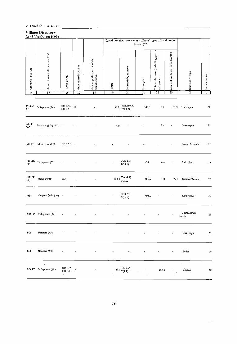
VILLAGE DIRECTORY
Villa2e Directory Land Use (As on 1999)
" ~ .;; .9 -5 ~ e 0. 0. <: 14
PR!l.lR FP
E ~
~ ~ c:
~ :;:; "d c:
" 3 ~
" " " z IS
Mihipurwa (24)
:>,
0.. 0. ;;; ~
" 0 0.
16
~ FP Nanpara (Mb) (55) _
MR FP Mihipurwa (20)
PRMR Harppapur (2)
FP
MRFP Mihipur (21 )
NC
MR Nanpara (Mb) (50)
MR FP Mihipurwa (24)
MR Nanpara (45)
MR Nanpara (63)
MR FP MihiPtrFWa (! 8)
EDEAG •
ED
-
EDEAG EOEA
2:' :;:; 0
" E c: .~ E
8 eo
~ c t -0
0 ~
tl ~ 0.
0. .5 . ..:; ~ 10 " " r:
" 0 E Z ::2
17 18
Land use (i.e. area under different types of land use in hectare)'"
~ 0
u.. 19
~ £ :>,
e '0 .!l ~ ] 20
59 0 TIVE(304.7)
.• T(304.7}
4.0
Ge(5S.1) T(5S.1)
IS30 TK(39.2) . T(39.2)
O(1S.9) T(IS.9)
290 TK(7.9) . T(7.9)
89
-0
~ eo '5 'c ;::J
21
547.5
124.1
581.9
493.0
-6 r: ~ .~ '"' eo ·5 r: :;:; ~ " u . .£ -3 " ~ ~ ~ .~
.£ %3 ~
E ,.
'0 0 c: 3 E;,
" :; "" " ;; :;: U
22 23
0.1 67.9
5.4
0.9
1.0 79.0
IS3.6
" l .;: '''0
" E z 2
Harkhapur
Dharampur
Semari MalInala
Lalbojhe
Semari Ghatahi
Kathoutiya
Mahrajsingh Nagar
Dharmapur
Bejha
t;
E ~ : ." " r.
:1
22
23
24
25
26
27
211
29
30

" .c E :J
"
3J
32
33
34
2
Majl18wa (06428100)
Gangapur (06428200)
Puraina (06428300)
Amritpur (06428400)
3
761.0
556.i
291.3
o o ~
" .~ :; 0-o 0.
S ~ 4
3.166
4.S00
1,942
1.005
DISTRICT CENSUS HANDBOOK: BAHRAICH
CensUlS of India 2001 -Amenities and
Amenities available (if not available within the village, a dash (-) is shmm in the column and. next to it in brackets the distance in broad ranges viz.< 5 kms., 5-10 kms. and 10+ kms of the
nearest place where the facility is available is given
6
P(2) AC 479 M(lO+)
C(lO+)
604 P(2) M C(IO+)
315 P(2)MC<S) C(lO+)
136 PM«5) C(lO+)
7
H(lO+) MCW(IO+) PHC(IO+)
H(lO+) MCW(S·IO) PHC(IO+)
MCWCH\V H(IO+) PHC(lO+)
8 9
" .~ 0. o
8 "" :::;
10
: HPW SS· PHPO« S) CM(~O+) CP(lO+)
HPW SS· PO W PH(lO+)
THPWR C L SS.W
PO«5) PH(lO+)
CM(IO+) CP(IO+)
c. .. !« 5)
CP(lO+)
11
ACS« S) NCS(IO+) OCS(lO+)
12
CV{l0"-) SP(l0"-) ST(I0"-)
ACS(S·IO) CY(l()-,.) NCS(lO+) SP(l()-,.) OCS(I()-") ST(IO+)
ACS(l()-,.) NCS(lO+) OCS(lO+)
C\'(l0--) SP(IO+) ST(lO+)
13
BS(5-10) RS(S.IO) NW(lO+)
BS RS« S) NW(l()-,.)
BS RS(lOT) NW(lO+)
H(lO+) THP1'WC PO(~5) CM«S) ACS(lO+) CV(IO+) BS MCW(S.IO) S8 HP NCS(IO+) SP(IO+) RS(lO+)
• PH(IO+) CP(IO+) NW(IO+) ___________________________________________ PH_c_(~IO+~) _________________________ O_C_S~(l_O+~) __ S_1'~(1_O+~) ________ _
35
36
37
38
39
40
41
Madhawapur (06428500)
Naubana (06428600)
Majhara (06428700)
Pairua (06428800)
Una (06428900)
Semrahana (06429000)
Raghawapur (06429100)
690.5
1.576.0
339.5
8.0
6,427
4.518
6.923
1,681
8,098
S48
P(2) M 997 C(lO+)
667 P MC(IO+)
1,185 P M(5-10) C(lO+)
297 P M« 5) C(10+)
1,246 P(5) M(2) C(lO+)
75 PM(5-10) C(IO+)
• H« -5)MCW(l0+) :HPWSS- PO«S)
PHC(lO+) PH« 5)
H(IO+) MCW(5-10) PHC(IO+)
H(5.
T HP W SS· PO(~ 5)
W PH(lO+)
CM(lO+) CP(1O+)
CM(IO+) CP(lO+)
10) MCW(lO+) PHC(5-10)
~~_WTK PO PH«5) CM(~S) CP«5)
H(IO+) MCW«5) PHC(IO+)
T HP W SS· PO(~ 5)
W PH« 5)
HA CWC PHC 1 HP TW RMP CHW(2) W SS.W MCW(S·IO)
PO PH(lO+)
H(S- • 10) MCW(5- ~v HP W SS· POC5.IO)
10) PHC(5-10) PH(5-10)
_._.-_ .. Uninhabited _ .... _ .. _._.
90
CM«S) CP(1O+)
CM(lO+) CP(IO+)
Q.,1(l0+) CP(IO+)
AC8«5) NCS(IO+) OCS(IO+)
ACS(lO+) NCS(lO+) OCS(1O+)
ACS(lO+) NCS(lO+) OCS(1O+)
ACS(lO+) NCS(lO+) OCS(lO+)
ACS(lO+) NCS(lO+) OCS(lO+)
ACS(IO+) NCS(lO+) OCS(IO+)
CY(IO+) SP(lO+) S1'(1O+)
CV(1O+) SP(lO+) ST(IO+)
CV(lO+) SP(lO+) ST(1O+)
CV(lO+) SP(1O+) S1(1O+)
CV(lO+) SP(lO+) S1(10+)
CV(lO+) SP(lO+) S1(10+)
BS(lO+) RS(lO+) NW(lO+)
BS(IO+) RS(lO+) NW(IO+)
BS(5-10) RS(IO+) NW«5)
BS«5) RS(lO+) NW(IO+)
BS RS(IO+) NW(IO+)
BS RS(lO+) NW(lO+)

VILLAGE DIRECTORY
Village Directory Land Use (As on 1999)
E .!<
6 1: " ~ " ~ ;;;
;: ~ c: s " ~ S
~ 10 0. 0. ~ « ;z: 14 15
/vIR IT l\·lihipUlwa (16)
PR Mihipurwa (IS)
PR t.-lR Nanpara (Mb) (40)
PRMR Nanpara (Mb) (40)
PRMR Mihipurwa (16)
MRIT Mihipurwa (22)
MRFP Mihipurwa (21)
NRNC
PRMR Mihipurwa (IS)
IT
PRMR Nanpara (Mb) (40)
FP
PR 1v-lR Nanpara (Mb) (34)
FP
e-;;; 0
" E c: .~ E
8 ell
~ " ;0.., ~ " 0. 10
a. " 0 ~ 0. 0. ;;; " 0. .5 '..= ;; 3 0; " " C
0 " 0
E 0. ;z: ~ 16 17 18
ED
EDEAG Jaggery
EDEAG EOEA
EDEAG -
ED N Jaggery
- laggery
-------- Unmhabited ------------
Land use (i.e. area under different types of land use in hectare)'·
-B c ;;; .~ ell el) ·5 " ;;; ~ " U ~ . .2
" 2. ;! <>
" * ~ g ,.., ~ .~ -0 e ~ " ~
~ -0 > "0 ~ OIl 10 c
~ ell :§ 3 ell
" " 0 ] c: :; ."
~ "-< :> U ~
19 20 21 22 23
TW(54.4) 3.2 11.9
88' TK(2.3) ." R(3·.3) T(S.7) 133.7
TK(I.4) T(1.4)
TW(360.7) 164.8 TWE(42.4) 744.6 4S7.2
T(403.0)
32 - GC(3S.7) .1 T(3S.7) S09.7 0.3
3S.1 GC(62.0) 400.4 O.S
TK(lOO.4)
"SO 6 11.(SI.1) • . L(lS.S) 9.0
T(200.3)
GC(l1.7) .., W(2.0)
1.94 nv(s.()) II 7 7.3 7.3
T(21.7) .
91
" l ~
.;: ._ " 0
" E Z " :r.
2
Majhawa 31
Gangapur 3:
Purarna 33
Amritpur 3~
Madhawapur 35
Naubana 36
Majhara T
Pairua 38
Una 39
Semrahana .!.I)
R,aghawapur ':1

42
43
44
45
2
Girgtti (06429200)
Gurh (06429300)
Bhiwrabir Ghat (06429400)
Khariya (06429500)
46 Nainiha (06429600)
47
48
49
50
51
Katraniya (06429700)
fuala (06429800)
Jalim Nagar (06429900)
Somaie Gauri . (06430000)
tvl"Mtgauriya (06430100)
3 4
3,136
3,486
320.5 562
583.1 1,905
805.7 1,390
240.0 1,445
673.9 5,539
542.8 4,361
704.7 1,584
3,251
DISTRICT CENSUS HANDBOOK: BAHRAICH
CenSlllS of India 2001 -Amenities ami
Amenities available (if not available within the village, a dash (-) is shown in the colunm and next to it in brackets the distance in broad ranges viz.< 5 kens., 5-10 kms. and 10+ kens of the
nearest o[ace where the facility is availab[e is "iven
6
" u
7
P« 604 S)M(S.IO) H(lO~)
C(lo+) MCW(S-lO, PHC(5-l0)
HADAMC'.v
8
HP SS-
" " o .<:: "-'" }]
~
o a. 9
PO« 5) PH«5)
564 P M« 5) C(10+)
elVc He ?::s HP TW W CHW H« 5, SS-IV PHC(lI}--)
PO PH(1o+)
Ht 5- THPnV 10) MCIV(lO+! PHC(lO+)
77 P M C(10+)
CHWH(5-1O) 263 P AC M(S-IO) MCW(1O+)
C(1o+) PHC(5-1O)
IV R C SS- PO(S-lO) IV PH(lo+)
HP SS-HP POe < 5) PH(5-W)
10
CM«5) CP(5-l0)
evl«5) CP(lO+)
[[
ACS« 5) NCS(1o+) OCS(1O+)
NCS(lO+) OCS(1o+)
ACS(1O+) CM(10+) NCS(1O+) CP(IO+) OCS(1O+)
CM(5-10) ACS(5-IO) NCS(lO+)
CP(5-10) OCS(10+)
206 P M(S-10) C(10+)
PHS CHW R(S-IO) MCW(5-IO) PHC(5-10)
HP SS-HP PO PH(S- CM(5-10) ACS(S-IO) 10) CP(5-10) NCS(lO+)
222 P(l 0+) M( 5-10) C(1O+)
940 P MC(IO+)
698 P(3) M« 5) C(1O+)
R(1O+) MCW(5-10) PHC(5-IO)
H(IO+) MCW(1I}--) PHC(1O+)
H(lo+) MCW(lCl-) PHC(1I}--;
T HP SSHP
PO«5) PH(1O+)
T HP W SS- PO(~ 5)
W PH(IO+)
T HP W SS- PO(~ 5)
W PR(1O+)
OCS(IO+)
CM(1O+) ACS(1O+) NCS(1O+)
CP(1 0+) OCS(1O+)
CM«5) CP(lO+)
CM«5) CP(10+)
ACS(10+) NCS(10+) OCS(10+)
ACS« 5) NCS(I()-') OCS(10+)
[2
C\'(1 0+)
SP(l(J--) ST(lO+)
SP(liJ-'-) ST(l0-'-)
CV(IO+) SP(lO+) ST(IO+)
I3
BS(5-l0) RS(lO+) N\\'(lO+)
BS RS\IO+) N\\'(lO+)
BS(lO+) RS{IO+) ]\1\\,(10+)
CV(5-10) BS RS(5-10)
SP(1O+) I'Nl(1O+) ST(1O+)
CV(5-10) BS RS(S-10)
SP(1O+) NIV(lO+) ST(1O+)
CV(lO+) SP(1O+) ST(lO+)
CV(1O+) SP(1O+) ST(1O+)
C\'(IO+) 5P(l0+) 5T(10+)
BS« 5) RS{lo+) ]\1\"(10+)
BS« 5) RS{10+) NW(1O+)
BS« 5) RS{IO+) NW(JO+)
294 PM(5-10) C(IO+)
H(1O+) MCW«), PHC(ICI-,
T,HP W SS- PO(;-I 0)
OW PR(IO+)
ACS(S-IO) CV(lO+) CM(S-IO) NCS(IO-) SP(1O+)
BS{S-IO) RS(lO+) )'.'WOO+)
521 PM(5-IO)C(IO+)
H(1~)
MCW(5-l0) PHC(S-Hn
92
CP(1O+) OCS{10~) ST(IO+)
T HP W SS- PO PH« 5) CM(~O+) ACS« :;) W CP(S-IO) NCS(IO+)
OCS(1O+)
CV{l0-'-)
SP\IO+) ST(IO+)
BS(lO+) RS{IO+) NW(1O+)

VILLAGE DIRECTORY
ViUa1!:e Directory Land Use (As on 1999)
E -'"
2-::l c: ~ " ~ 'iJ
:; "J c
'" " .9 g ~ e
0-~ 0-
<f. Z
14 15
Nanpar-. (36)
;;:; MR Mihipulwa (J 5)
PRMR FP
Mihiputwa (12)
PR Mihipurwa (6)
PR Mihipurwa (7)
PRMR Mihipmwa (13)
FP
MRFP Mihiputwa (15)
PRMR Mihipurwa (18)
FP
MRFP Mihipurwa (21 )
N"RNW
Mihiputwa (19)
0 'iJ 0
" E c .~ E
8 bll
~ C
.?;> ~ '0
0. 1:.! 0. g- o B a "'-
0- .5 .~ kl ~ " " 1] c 0 " :< E 0., Z 16 17 18
ED
EDEAG -
EAG N
EDEAG N
ED
ED laggery
I.ggery
Land use (i.e. area under different types ofland use in hectare)"
~
~ 19
~ :; ~
'" e '0 ..'l ~ E 20
GC(S.2)
GC(30.9) 1(309)
RO.5) 118.70(178)
1(19.4)
47 6 TW(161.5) · 1(161.5)
3023 TW(110.3) · 1(110.3)
TK(9.1) 1(9.1)
385 TK(SA) · l(SA)
93
TK(0.3) T(03)
0.4
- TKO.O) 1(7.0)
'0 .'l
.~ '" ;:J
21
1046.2
723.2
53.0
301.7
237.1
5.4
03
1; c ~ 0
"" '~
"" .~ .5 -0 1i -5 . .3 e. " til ~ ~ .~ " " ~ ;> -0 0 ;;;, c 3 :; '0 ~
~ .:;: U
22 23
1.3 26.6
6.1 72.2
0.0 156.1
0.0
0.5
58A
21 4
1.2
" ~ .E .:; E
'''0 ~ " E
\l Z r.
2
Girgtti
Gurh 43
Bhiwrabir Ghat 44
Khariya 45
Nainiha 46
Katraniya 47
!hala 48
lalim Nagar 49
Sornaie Gaun SO
Mangauriya 51

53
5~
55
2
RaJ.pur (06430200)
Argorawa
(06430300)
Bakhta .... -ar Gauri (06430400)
Salar Punva (06430500)
56 Murtiha (06430700)
57
58
59
Ghumna Bharu (06430800)
Babhaniya F ala (06430900)
Chitlahwa (06431000)
60 Nidhi PUlwa (06431100)
3
662.1
238.4
101.5
377.3
145.5
1.7
333.4
580.i
o o ~
4
974
2,503
52
884
698
921
759
1,052
4.702
DISTRICT CENSUS HANDBOOK: BAHRAICH
Cens1.Ils of India 2001 -Amenities and
Amenities available (if not available within the village, a dash (-) is shown in the column and next to it in brackets Ole distance in broad ranges viz.< 5 kms., 5-10 kms. and 10+ krns of the
nearest olace where the facilitv is available is given
o o ~ ~
"" "0 .c 1A " o .c '0
" -" E " Z
6 7
·E " E E o u
8 9 10 II 12
132 P(2)M«5) C(1O+)
H(10+) MCW(5-IO) PHC(5-IO)
HP WSSW
PHPO(5- CM\IO+)
10) CP(IO+)
ACSI.I0--1 NCS(1O+) OCS,IO+)
CV(l':-l SP(!(~'
ST(1[~1
BS(5-lC1I RS(I(>- ) NW(!C-)
432 P M(lO+) C(10+)
H(10+) MCW(IO+) PHC(IO+)
P« 5) M(lO+) H(!O+) C(lO+) MCW« 5)
PHC(lO+)
136 P I M(IO+) C(lO+)
H(IO+) MCW(10+) PHC(IO+)
- P(5- -94 10) M(IO+) H(IO+)
C(IO+) MCW(IO+) PHC(5-10)
131 PM(5-10) C(IO+)
H(lO+) MCW(lO+) PHC(lO+)
HP WSSW
PO« 5) PH(lO+)
T W SS-W PO« 5) PH(lO+)
HP SS-HP PO« 5) PH(10+)
HP SS-HP PO PH(lO+)
HP SS-HP PO(5-10) PH(lo+)
P« 74 5) M(5-10)
C(lO+)
- H(5- THPWSS- -10) MCW(5- W PO(5-10)
203 PM(5-10) C(lO+)
10)PHC(10+) PH(lo+)
H(IO+) MCW(lO+) PHC(lO+)
T HP SSHP
PO«5) PH(5-10)
CM(1O+) ACS(lO+) CP(lO+) NCS(lO+)
OCS(lO+)
CM«;) CP(1O+)
CM(IO+) CP(1O+)
ACS« 5) NCS(1o+) OCS(IO+)
ACS(IO+) NCS(IO+) OCS(lO+)
CM(1O+) ACS(IO+) CP(1O+) NCS(IO+)
OCS(IO+)
CM(lO+) ACS(IO+) CP(lo+) NCS(IO+)
OCS(IO+)
Cyw-)
SP(10--) ST(10-)
CY(llr) SP(l0--) ST(1O-)
CY(lO+) SP(l0--) ST(l ~,+)
CV(lO-) SP(l C>-)
ST(I C>-)
CV(]O-) SP(l C>-) ST(lO-)
BS(5-: ':'1 RS(IO-) NW(10-)
BS« 5) RS(I'r) NW(1O+)
BS« 5)
RS« 5j NW(lO-,.)
BS(l(}-) RS(5-IO) NW(l(}-)
BS(5-10) RS(5-10) NW(lO+)
ACS(IO+) CV(lO+) 8S(5-IO) CM(lO+) NCS(IO+) SP(lH RS(5-10) CP(lO+) OCS(IO+) ST(1('-) NW« 5) . _ _;_ ___ _;__-
CM(IO+) CP(lO+)
ACS(IO+) NCS(IO+) OCS(IO+)
CV(lO-) SP(lO-) ST(J(~)
8S(5-IO) RS(5-IO) NW(lC:>'-)
-00 PC:»~ M , C(IO+)
H(lO+) TSS-HP PO«5) CM«5) ACS(IO-) CV(](H MCW(lO+) PH(10+) CP(1O+) NCS(IO+) SP(!(-)
RS 8S';-10) NW(1( .... )
PHC(IO+) OCS(l0--) SHE-) ------------------------------~~------------------~--
61 Kakraha (06431200)
37l:<.~ 1.943 298 P M(5-IO)
C(lO+)
H D SMP(5) MCW(lO+) PHC(5-10)
94
HPWSSW
ACS(I!)'-) PO PH« 5) CM(lO+) :-ICS(I!),-)
CPO 0+) OCS( I 0-- J
CVtj.:-) SPUC~l
STn v--)
8S RS'< 5) NW(Fr)

VILLAGE DIRECTORY
Villal.!:e Directory Land Use (As on 1999)
E "" ~ 8 t:
~ " ~ 'il "'d ;;:
9 " :l: '5 9
2 ~ 0.. 0. " < Z 14 15
Nanpara (4)
MR Nanpara (Mb) (37)
)l.1R FP NR NW Mihipurwa (22)
MR FP Mihipurwa (32)
MR FP MihipUlwa (32)
MR MihipUtwa (22)
MRFP Mihipurwa (I 7)
PRMR Mihipurwa (23)
PR Mihipurwa (20)
MJl. Nanpar. (Mb) (38)
b "-0.. 0; \J :l: ~
16
EDEAG EOEA
ED
EDEAG
" " .~
"" " ~ <; g. 0.
~ " Z 17
Q 'il 0
E E :3 "i'! " '0
to: " &.3 .§ ~
;;> ~ c: 0 E ::;: 18
Jaggery
Jaggery
Land use (i.e. area under different types of land use in hectare)·"
1:: 3 ~ ;>.
e '0
~ '0
~ til ~ 'E 1: "" 'c 0 .§ "" ;::J
19 20 21
R(6.0) T(6.0)
TW(l6.0) T(16.0)
3 0 I TW(l6.0) 4_ T(l6.0)
04 TW(98.0) . T(98.0)
17.6
W(91.0)
71 8 TW(45.3) . TK(2.7)
T(139.0)
185.3
GC(42.3)
598.9 PC(54) R(36) Tl>L2)
95
200.5
77.4
48.9
-5 t: ;; .g co
.~ til t: 'il ~ " u .,S 2- " " ~ " Vi ~ ~ ~ ~ '> ~ " "" > " " ::: " -.::: '"
u ;; "5 '0
;; .( z U
22 23 2
1.0 Rajapur
Argorav.'a
2.5 Bak .... H.awar Gaun
14.0 Salar Purwa
342.1 Murtiha
0.3 23.0 Ghumna Bharu
2.3 Babhaniya Fata
68.2 95.7 C1utlahwa
191.9 377.3 l\ ,,1m Purwa
22 Ka.':raha
'0 .:0
§ c ~ " T.
53
55
56
5"7
58
59
6(1
<,

62
63
64
65
66
67
68
69
;;
o " E Z 2
Chorwa (06431300)
Gaura Pipra (06431400)
Lalpur Chanda n,ar (06431500)
Gopiya (06431600)
Kanjarwa (06431700)
Songawa (06431800)
Kharaiya (06431900)
Gaumnya (06432000)
70 Petarha (06432100)
71 Bhaganya (06432,200)
3
544.6
1,003.0
632.6
1,030.0
347.2
218.9
218.9
35.0
23.3
675.1-
o o ~
4
3,776
3,874
1,715
6,217
1,576
763
452
1,458
2,073
1,124
DISTRICT CENSUS HANDBOOK: BAHRAICH
Census of India 2001 -Amenities and
Amenities available (if not available within the village, a dash (-) is "hm\n in the column and next to it in brackets the distance in broad ranges viz.< 5 kms., 5-10 1kms. and 10+ kms of the
nearest place where the facilitv is available is l!iven
o o ~ ~
"" -0 ij " c .c '0
" .D E " Z
6
605 P M(s-I 0) C(lO+)
7 8
HADAMc\V
554 P(2) M(2) MH CWC HP W SS-AC(2) C(lO+) CHW H(IO+) W
PHC(IO+)
229 P M C(IO+) H(5-
10) MCW(5- HP W SS-10) PHC(5-1 0)
9
PO PH(lO+)
PO« 5) PH(5-10)
~
"E " E E o u 10 II
CM(5-IO) ACS«51 CP(5-10) :-:CS(l0-+)
OCS(l0-)
CM(IO+) CP(lO+)
ACS(l0-+,) NCS(l0-+') OCS(l0-',)
12
C\'r.s-IO) SP(IO+) SIn f}'-)
C\'(lO+) SP(IO+) S1(1O+)
ACS(5-IO) CV(s-IO) CM(5-10) NCS(IO+) SP(lO+) CP(5-10) OCS(l0-') SI(1O+)
13
BS(5-10) RS(5-10) }JW(IO+)
BS(lO+) RS(lO+) !,<,V(lO+)
BS(5-IO) RS(5-10) NW(lO+)
H« -I 000 P(2) M(5-1 0) 5) MCW« 5) ~ HP W SS- PO PH« 5) Clvl« 5) ACS«5)
NCS«5) OCS« 5)
CV«5) SP«5) SI« 5)
BS«5) RS« 5) NW(lO+)
, C(lO+) PHC« 5) CP« 5)
264 P AC M(5-10) H(IO+) C(lO+) MCW(5-10)
PHC(5-10)
103 P ACM(5-10) H(lO+) C(IO+) MCW(5-10)
PHC(5-10)
97 PACM(5-10)H(10+) C(lO+) MCW(5-10)
PHC(5-10)
HPWSSW
HPWSSW
HPWSSW
PO« 5) PH(5-10)
ACS(5-IO) CV(5-10) BS(5-10)_ CM(5-10) NCS(l0-+') SP(lO+) RS(5-10) CP(5-10) OCS(I0-+,) S1(IO+) NW(IO+)
PO PH(5- CM(5-IO) ACS« 5)
10) CP(S-IO) NCS(IO+) OCS(I0-')
CV(s-IO) BS(5-10) SP(lO+) RS(5-10) SI(IO+) NW(lO+)
PO«5) PH(5-10)
CM(5-IO) ACS(5-10) C\'(5-10) BS(5-10) NCS(10-t·) SP(IO+) RS(5-10)
CP(5-10) OCS(10-t.) SI(1O+) NW(1O+)
- H(5- -233 PM(5-10)C(5' IO)MCW(5_ THPWSS- PO«5) ACS(5-10) CV(5-10) BS(5-10)
10) 10) PHC(5-10) W PH« 5) CM«5) CP(5-10)
NCS(lO+) SP(1O+) RS(5-10) OCS(10+) ST(1O+) NW(S-IO)
275 P(2) M(5-10) H(IO+) C(5-10) MCW(5-10)
389 P(2)M(10+) C(IO+)
PHC(5-10)
H(fo+) MCW(lO+) PHC(IO+)
99
HPWSSW
PH PO(5- Clvl(lO+) ACS(IO+) 10) CP(1O+) NCS(IO"')
OCS(I0--)
THPWR PO«5) SS-W PH« 5)
CM« 5)- ACS« 5) NCS(lfh)
CP(5-IO) OCS(lO-')
CV(lO+) SP(lO+)
STi! 0+)
C\'IIO+) SP,\IO+) STt! 0+)
BS(5-10) RS(lO+) J'><W(IO+)
BS RS(lO+) NW(lO+)

VILLAGE DIRECTORY
Village Directory Land Use (As on 1999)
15
!viR FP Mihipurwa (9)
PRMR FP Mihipurwa (13)
MR FP Mihipurwa (6)
PR MR Mihipurwa (3)
MR Mihipwwa (7)
MR Mihipurwa (8)
MR Mihipurwa (9)
MR FP Mihipmwa (10)
PRMR Mihipmwa (I 3)
FP
PRMR FP
Mihipurwa (13)
16
EDEAG _
EDEAG EOEA
.- EDEAG i
EOEA
17 18
NM
Land use (i.e. area under different types of land use in hectare)**
19 20
GC(6169.7) TK(49.9)
13.7 R(410.7)
T(6630.3)
TW(l80.0) 223.6 TWE(32.0)
T(212.0)
TW(87.0) 151.2 TWE(4.0)
T(91.0)
97
GC(209.2) PC(60.0)
TK(O.2) R(4.2) T(273.5)
GC(100.7) PC(35.0) R(S.g)
T(141.5)
GC(80.2) PC(IOO.4) T(180.6)
GC(lOO.9)
PCe2.3) T(103.2)
L(S.3) T(S.3)
GC(246.1) 57.1 R(7.7)_
T(253.8)
21
1.1
93.1
20.0
54.0
253.8 -
22 23 2
3.2 eho"".
0.2 4.9 Gaura Pipra
2.4 1 6 Lalpur Chanda
. Jhar
594.1 215.0 Gopiya
Kanjarwa
Songawa
Kharaiya
70.1 196.6 Gaurariya
1.3 Petarha
211.4 37.0 Bhag:0ya
6:
63
64
65
66
61
68
69
70
71

DISTRICT CENSUS HANDBOOK: BAHRAICH
CensUls of India 2001 -Amenities and
Amenities available (if not available within the village, a dash (-) is shO\\TI in the column and next to it in brackets the distance in broad ranges viz.< 5 kms., 5-10 kms. and 10+ kms of the
~ ~ nearest place where the facility is available is giv':n
" ~ " g " ~ ~ " ."
·B ~ 8 ~ U .D ~ " a " -" " " E
,;
.~ ~ 5 0 " .~ ~ ~ " u 0 0
" t~ ~ .c .!: 0
" ~ IT t :; c.. ~ ~ 0 ~
0 a. .~ -:: ~ ~ 5 ..-l 0 -0 11 0 ;:: . ..-...
~ -0 8 ~ .] ~ ~.§ >d ;; .c -0 s~ " " .~
1;; ;; :: " v. !l:
~ -5 " -0 o ._
~~~ t:
\J 0 B .c ~ " g .~ .~ 0 .c 9-.D ;; :; '0 ~ -;;; ~ '"
Hi. E '" ~ ~i ." g D.. " 'E ~ " '0 0 \J .~
eo " ::
" 0. -;;; " ] " ~ ;:-, '" " 5
.D " :;;; E " <.> E " E 'i5 .~ i)
~ ~ " .= E E " Z 0 " -0 '" Ci :0 0 "".c 8 '" f- Z Ul ~ 0.. U < 15
2 3 4 5 6 7 8 9 10 11 12 13
72 Kannohna
3865 1.641 PM("5) H(lO+) T HP SS- ACS(lO.,.) CV(1o--) B5\< 5) 244 PO« 5) CM(IO+) (06432300) C(lo+) MCW(lO+) HP
PH(lO+) CP(lO+) KCS(lD-'-) SP(lo--) RS(I 0--)
PHC(lO+) OCS(lO+) ST(lo--) NW(lCh·)
73 Par~otU1a
485.8 1,788 265 P ACM«5) H(lO+) THP SS- ACS(lO+) CV(IO+) BS« 5)
PO« 5) CM(lO+) (06432400) C(IO+) MCW(lO+) HP
PH(IO+) CP(lO+) KCS(lO+) SP(lo--) RS(l0--)
PHC(IO+) OCS(lO+) ST(lo--) NW(l0--)
74 Laukahi
751A 4,268 619 PM«5) H(lO+) THPWTK - ACS« 5; CY(lO+) BS(lO+) R SS-W PO« 5) CM«5) (06432500) C(lO+) MCW(5-1O)
PH«5) CP(5-IO) NCS(10+) SP(lO+) RS(IO+)
PHC(5-10) OCS(lO+) ST(lO+) N\\,(IO+)
75 Basthanwa
449.5 1,790 268 P 0(2) M«5) H(IO+) HPWSS-PO«5) CM(lO+)
ACS(IO+) CV(lO+) BS(IO+) (06432600) C(1o+) MCW(lO+) HP NCS(lo+) SP(lO+) RS(lO+)
PHC« 5) PH(1O+) CP(lO+)
OCS(lO+) ST(lO+) NW(IO+)
D(2)DA
76 Sahoni
365.6 2,644 392 P MC(IO+) H(lO+) THPSS- PO
CM(lO+) ACSC< S) CV(IO+) BS(lO+)
(06432700) MCW(1O+) HP PH(1O+) CP(IO+)
NCS(lO+) SP(IO+) RS(lO+)
PHC(IO+) OCS(IO+) ST(IO+) NW(lO+)
77 Chaudhari Gaon
585.5 3,641 582 P(5) M« 5) H(IO+) THPTW
PO«5) CM(10+) ACS(lO+) CV(IO+) BS(IO+)
(06432800) C(lO+) MCW(S-IO) WSS-W NCS(lO+) SP(IO+) RS(lO+)
PHC« 5) PH«5) CP(lO+)
OCS(lO+) ST(lO+) N\\'(10+)
Matehi Kalan ACS(J(f;-) CV(lO+) BS
78 519.7 3,485 540 P MC(IO+) H(IO+) THPWSS-PO
CM(IO+) RS(IO+) (06432900) MCW(IO+) W PH(IO+)
CP(lO+) NCS(ICH-) SP(lO+)
N\\'(1O+j PHC(IO+) OCS(ICH-) ST(lO+)
Puraina H(lO+) THPSS- ACS(I(}+) CY(lO+) BS(IO+)
79 Raghunath 2955 3,883 579 P MC(lO+) MCW(lO+) HP
PO«5) CM(IO+) NCS(l(}+) SP(lO+) RS(lO+) (06433000)
PHC(lO+) PH(lO+) CP(IO+)
OCS(IO+) ST(IO+) NWOo--)
Majgawa P(3)M(5-10) H(IO+) THPSS-PO« 5) CM«5)
ACS(lO+) CY(IO+) B5(5-10) 80
(06433100) 282.5 1,153 182
C(lO+) MCW«5) HP NCS(1O+) SP(IO+) R5(IO+)
. PHC(5-10) PH«5) CP(5-10)
OCS(lO+) ST(1O+) N,,\'i(IQ---,
Pourida P(3)M(5-IO) H(lO+) CM«5)
ACS(IC>-<-) CV\IO+) BSl5-IO' 81 442.0 2.737 427
CO 0+) . . MCW«5) HP ;;S-HP PO« S) :-1CS(l0--) SP(IO+) RSlI(>--! (06433200) _ PH\< 5) ep(S-IO)
PHC(5-10) OCS(lQ---) 51\10--) :-;WOo--·
98

VILLAGE DIRECTORY
Village Directory Land Use (As on 1999)
E -"
~ " u
" .~ ~ "0
.:;; "d 9
c: ;3:
~ 9 ~ 0 " is.. "' 0- " < :z:
14 15
lv[R FP Mihipurwa (16)
NR
Mil,ipUlwa (18)
)v[R FP Nanpara (34)
l'v1R FP MihipUlwa (18)
l'v1R FP Mihipurwa (18)
PR l'v1R FPNR Mihipurwa (IS) NCNW
PR l'v1R FP
Mihipurwa (I 5)
PR Matehi Kalan (3)
l'v1R NW Balai Gaun (3)
Balai (3)
C '0 0
" c: E ':;J E en 8
t c >. t~ 0. "- o ::>
~ 0. ~ ~ ~ u
~ 0. .S .~
~ ::> ;3: 0
c: 0 " E "- z ~ 16 17 18
ED
ED
ED N
ED N
Basket
Land use (i.e. area under different types of land use in hectare)"
19 20
GC(208.2) L(l8 2) T(226.5)
GC(lIO.I) L(331 ) T(143.2)
7 5 GC(l42.5) 1 .4 T(l42.5)
nv'E(65.0) T(65.0)
425 TWE(39.8) . T(39.8)
GC(66.3) TWE(66.3) T(l32.6)
GC(l16.3) '''''F(6.5) T(122.8)
R(3.1 )T(3.1)
99
"0
~ co
"E 'c ::J 21
124.4
290.2
295.2
319.6
228.1
325.1
79.8
.c: " ~ "" "" c: '0 ~ c:
;.::.
* ~ ~ " :J ~ >
8 <3 "" "5 "0
" U " 22
0.3
459.3
2.0
2.1
" .~ .E; ~ ._c::
" :D t> ~ It ";:e ~
.:;
15 ._ c
c: " "' E " .< z
23 2
43.6 Kannohna
60.2 Parsohna
Laukahi
Basthanwa
Sahoni
56.2 Chaudhari Gaon
59.0 Matehi Kalan
?mama Raghunath
0.4 Majgawa
3.2 Pounda
~ .c E ::>
" ~
" '"
72
73
14
75
76
77
78
79
80
81

DISTRICT CENSUS HANDBOOK: BAHRAICH
Census t(Jjf India 2001 -Amenities and
Amenities available (if not available within the village, a dash (-) is sho",. in the colunm and
next to it in brackets the distance in broad ranges viz.< 5 kms., 5-10 kms. and 10- kms of the
'" nearest place where the facility is available is given) 1: ~
" " ~ "0 " " ~ III .£. 0 u U <.> " ~
..c '" -~ '"5 "
.c C; " " if " " .:: := !j
.~ g " a 'i::~ U ~ <.> ~
~ - ,<e 0
" ~ ~~ " >. 0 ~ 0 '" :2 u ~ ~ "0 -' 0
"0 ~ ~ ~.§ '" ~ ~ '" '" "d .:; -" 8 ::: .~ S " " c: ~ :: t) ::l ~.=
'" 3 1 -5 ~ '" '- g .~ u ~ = "
" '0 0 B '- "d .;,: i' c ! .D .:; -"
~ §- _: ;,:; c::> 'B E 6_ '0 '" '" j~ g " ~ .g 1 ~ '" '0 0 ~ .~ '"" -"
u C C 0- " " E ~ '" >.
" .D <.> :.;: = u ~ § _; E
'" '5 E c: u ~ ~ E " " 'i3 .5 'i. .~ ~ !) E ...::. " Z 0 0 '" "0 " ",.c: g r:; .§ '" t- f- Z w ~ Q _0 < 0 C=:::~:r. 8 §
2 3 4 5 6 7 8 9 10 II 12 13
Bakh3Ji P ACM(10+) H(10+) THPTW PO ACS<.< 5) c:V
BS(IO+> 82 1,173 15:! OhIO+) SP(1O+· (06433300) C(10+) MCW(10+) \\. SS-W PH(I')") KCSdO+) RS(j(;-) PHC(IO+)
CP,.lO+) OCS<;1O+)
ST(10-, !'<\V(IO+)
Sarra Kalan P(5) AC 0
MCWH(1O+) THPTW PO .';CS(IO+) CV(1O-, BS(IO+) 83 2,064.0 4,466 667 M(10+) 01(10+)
(06433400) C(lO+)
PHC(5-IO) WSS-W PH(lCr) CP(l(>-'-)
KCSI,lO+) SP(lO-, RS(IO+) OCS(IO+) ST(lO-, }<\\'(1 (>+)
Parariya - H(5-
ACS(5-10) CV(5-10) BS(5-10) 84 2,452 408 P O(2)M«5) 10) MCW(5- THPRSS- PO«5) Oi(lO+)
(06433600) C(10+) 10) PHC(5-10) HP PH(5-10) CP(5-IO) NCS(5-10) :;P(ICr) RS(5-IO) OCS(5-10) :;T(IO+) NW(lO+)
Hansuliya P ACM«5) H« THPTW ACS(5-10) eV(5-10) BS(5-IO)
85 364.7 2,033 333 5) MCW«5) PO«5) CM(5-10) (06433700) C(10+) WSS-W NCS(lO+) :,P(lO+) RS(5-10)
PHC«5) PH(lO+) CP(5-10) OCS(IO+) :,T(lO-) N\V(5-10)
H(5-
86 Mahdewa
8.1 742 120 PM(5-10) 10) THPTW PO« 5) CM(5-10)
ACS(5-10) CV(5-!0) BS(5-10)
(06433800) C(10+) MCW(1O+) WSS-W PH«5) CP(5-10)
NCS(IO+) :SP(5-JOj RS(5-JO)
PHC(5-10) OCS(IO+) 8T(5-1O) N\V(10+)
HADDA MCWMH
87 Motipur
10.0 7,532 1,294 P(2) AC 0 ewc HC PHC T HP W SS- PO PH(12) 0!«5) ACS« 5) CV«5. BS R$« 5)
(06433900) M«5)C«5) PHSFWCTB W NCS« 5) SP«5J N\V« 5)
RMP(3)SMP CP« 5) OCS« 5) ST(1 Cr)
CHW(2) 0(2)
P(2) M(2) HAD(5)DH
THPTW CV
88 MihiPurwa
7,997 1,276 S(2) 0(5) RMP(S)
WTKSS- PO« 5) C_i\<5) ACS« 5)
SP(1 (;-. BS« 5)
(06434000) C(IO+) MCW(5-10)
W PH«5) CPt.5-10) :t-:CS(IO+)
ST(1O-) RS(1O+)
PHC(5-10) OCS(IO+) NW(IO+)
89 Kundwa
1,185.0 6,721 1,281 P(2) M S H(JO+) THPTW
PO« 5) C_1CP« ACS« 5) CV«5, BS« 5)
(06434100) PUCC(lO+) MCW«5) WSS-W 5i NCS(IO+) SP(JC-\ RS« 5)
PHC« 5) PH«5) OCS(IO+) ST(l(.--) N\VtlO+)
P(2),M S H(JO+) THPW SS- PO(~5) ACS« 5)_ CV(1~-\ RS B$(5-
Parwani Gauri C.i«5) -10) 90 34S.9 5,262 859 PUC:C(JO+) SP()C-, (06434200) MCW(JO+) w- _ SCS(I 0+)
N!\\IO+j PHC(S--lO)
PH« 5) CPi.,-IO) - OCS(5-10) ST(1(-'
100

VILLAGE DIRECTORY
Villaj!e Directory Land Use (As on 1999)
14 15
l\,[R MihipUlwa (I 6)
PRMR FPNR MihipUlwa (14) NC
PRMR Millinpurwa (10)
FP
PRMR FP Mihipurwa (5)
:;:;- MR Mihipurwa (7)
PR Mihipurwa (2)
PRMR Mihipurwa (0)
FP
PRMR Mihinpurwa (2)
PRMR Mihipurn:a{2)
16 17
ED N
EDEAG NM EOEA
EDEAG NM
EDEAG NM
EDEAG EOEA
EDEAG NM. EOEA
18
Land use (i.e. area under different types of land use in hectare)"·
19 20
214.0
194.9
101
GC(14.8) 5.7 TW(4.1)
R(O.O)
GC(18.9) TK(1.9) R(0.9) L(O.O) T(21.7)
GC(250.7) L(9.4) T(260.1)
0.1
21 22
306.3
340.0
23 2
Bakhari
Sarra Kalan
4.9 51 9.7 Parariya
2.2 Hansuliya
Mahdewa
7.0 3.1 Motipur
0.0 59.4 Mihi Purwa
0.7 109.9 Kundv.a
14 50.2 Parv.·a.'11 GallIi
82
83
84
85
86
87
88
89
'}()
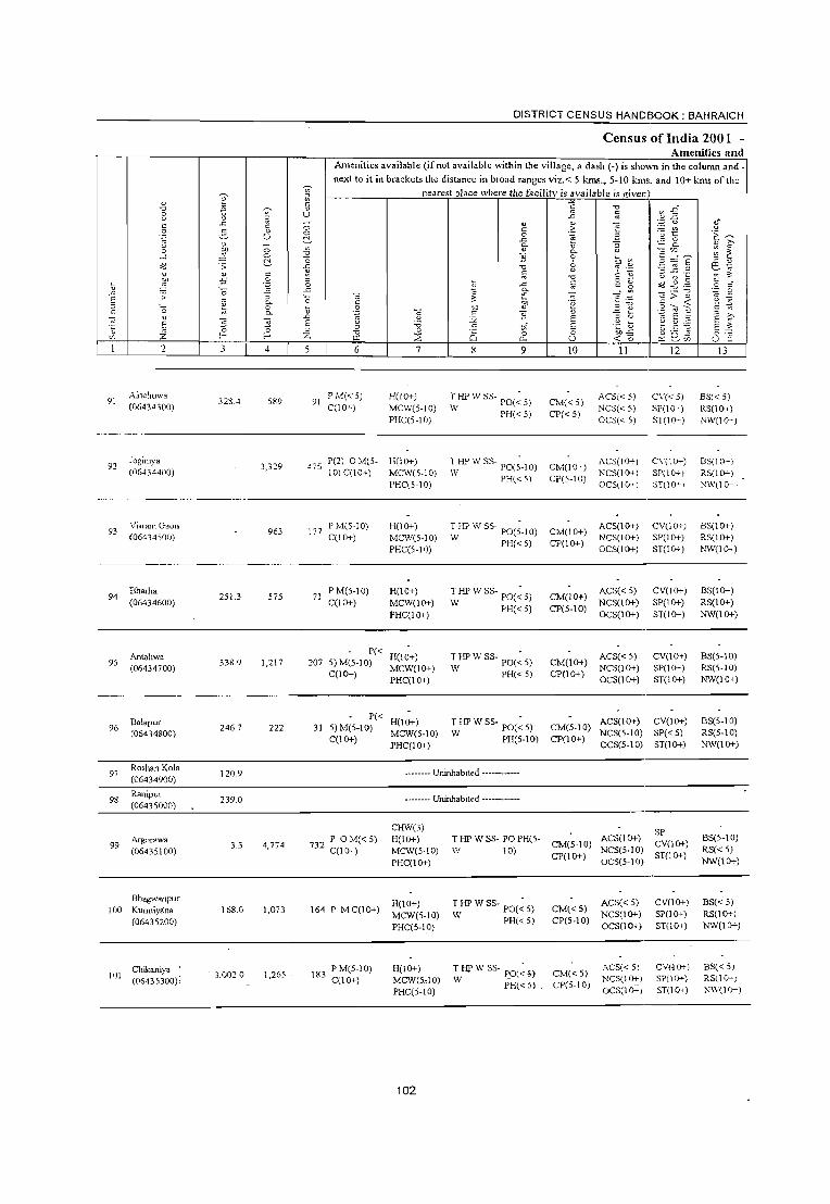
DISTRICT CENSUS HANDBOOK: BAHRAICH
Census of India 2001 -Amenities and
Amenities available (if not available within the village, a dash (-) is shown in the column and.
next to it in brackets the distance in broad ranges viz.< 5 kms., 5-10 kms. and 10+ kms of the ~ nearest olace where the facility is available is given e ;;:
1) c: ~ "0 fl " "0 rs B~ ::; ~ U -'" ~ " ;;: .c " " E .= u 8' c: c: 0 c: .~ '§~ '~ 5 " 0 'E ~ u 0 3
1) ~ .c
~ - 0
" '" " ~ c. "
Co ~ " 0 ~ 0 " is" e ~.-. ~ ;;;
...l 0 "0 "] "0 " ~ oG .s: ~ "
<Jl iJ .2 ~ § o:l E "R
"0 U r:: ._'
:1 ..c: .~ ~ " " " c: ~ "0
C 1)
~~~ ~ " :W -5 .~ " o .- c:
0 3 .c: ~ c: ~ .~ c
" '0 .c e .S -"' .s: ;; '0 " ~ " ...: ~
~ > ;::
" ~ D- c: '" "E j~ §-~ ~ " '0 0 \l .~ "" " " " 0. ""§ .S "] " ] Ai " :;:-.
" -;; s -'" "'" E " " E
E "0 E " 'i3 ." 1i E .~ b E ~ " z 0 " "0 " 0 0 0 ~~ 0
'" f- f- Z Ul ~ a. U U " 2 3 4 5 6 7 8 9 10 11 12 13
91 Amchuwa
328.-1 5S9 PMC<5) H(lO+) T HP IV SS· • ACS«)) C\'« 5) ES« 5) 91 IV PO«5) CM«5) (06434300) C(lO+) MCW(5·10) NCS«5) SP(l(>+) RS(lCh-)
PHC(5·IO) PH« 5) CP«5)
OCS« 5) ST(lG-'-) NW(l0-)
92 Joginiya
3,329 475 P(2) OM(S- H(jO+) THPWSS- PO(;-IO) CM(IO+)
ACS(j()+) C\'(lO~) BS(I(I-) (06434400) 10) C(lO+) MCW(5-IO) IV PH« 5) CP(5-10)
NCS(lO+) SP(lO+) RS(IO+) PHC(5·IO) OCS(lf}+) ST(l (r-I !'-'\\'(l0-')
93 Visram Gaon
963 In PM(5-10) H(lO+) THPWSS- PO(;.IO) CM(IO+)
ACS(lO+) CV(lO+) BS(lO+i (06434500) C(lO+) MCW(5-10) W PH«5)
NCS(IO+) SP(IO+) RS(lO+) PHC(5-IO)
CP(lO+) OCS(IO+) ST(IO+) )'o,,\V(I Ch-)
94 Eharha
251.3 575 71 PM(5-10) H(lO+) THPWSS- PO(~5) CM(IO+)
ACS« 5) CV(lO+) BS(lO+) (06434600) C(lO+) MCW(1O+)
W PH«5) CP(5-10) NCS(IO+) SP(lO+) RS(lO+)
PHC(IO+) OCS(lO+) ST(1O+) NW(1O+)
Antahwa P« H(IO+) T HP W SS- PO(~ 5) ACS« 5) CV(lO+) BS(5-10) 95
(06434700) 338.9 1,217 207 S)M(5-10)
MCW(lO+) CM(lO+)
NCS(1O+) SP(lG-'-) RS(5-IO) C(lO+)
PHC(lO+) W PH«5) CP(lO+)
OCS(lO+) ST(IO+) NW(IO+)
Balapur P« H(lO+) T HP W SS- PO(~ 5) ACS(lO+) CV(lO+) BS(5-10) 96 246.7 222 31 5)M(5-10) CM(5-10)
(06434800) C(lO+)
MCW(5-10) W PH(5-10) CP(lO+) NCS(5-IO) SP« 5) RS(5-10)
PHC(lO+) OCS(5-10) ST(1O+) NW(lO+)
97 Roshan Kola (06434900)
120.9 -------- Uninhabited ------------
98 Ranipur
239.0 -------. Uninhabited ------------(06435000)
CHIV(3) SP
99 Argorawa
3.3 4,774 732 P OM«5) H(lO+) T HP W SS- PO PH(S-
CM(5-10) ACS(lO+)
CV(lO+) BS(5-10)
(06435100) C(lO+) MCW(5-1O) \V 10) CP(lO+)
NCS(5-1O) sm 0+) RS« 5)
PHC(IO+) OCS(5-10) NW(lO+)
Bhagwanpur H(lO+) THPWSS- PO(~5) ACS« 5) CV(lO+) BS« 5)
100 Kurmiyana 168.0 1,073 164 PMC(IO+) MCW(5-10)
CM«S) NCS(1O+) SP(1O+) RS(1O+)
(06435200) PHC(S-IO)
W PH«5) CP(5-10) OCS(lO+) ST(1O+) NW(lO+)
Chikaniya PM(5·IO) H(lO+) T HP W SS- PO(~ » CM«5) -- ACS« 5) CV(.lO+) BS« 5)
101 (06435300) :
3,0020 1,265 183 C(10+) MCW(5,10) W PH«5) .
NCSCIO+I SP(1O+) RS(l (}-)
PHC(5-10) CP(5·10)
OCS(lO+) ST(IO+) NW(](}+)
102
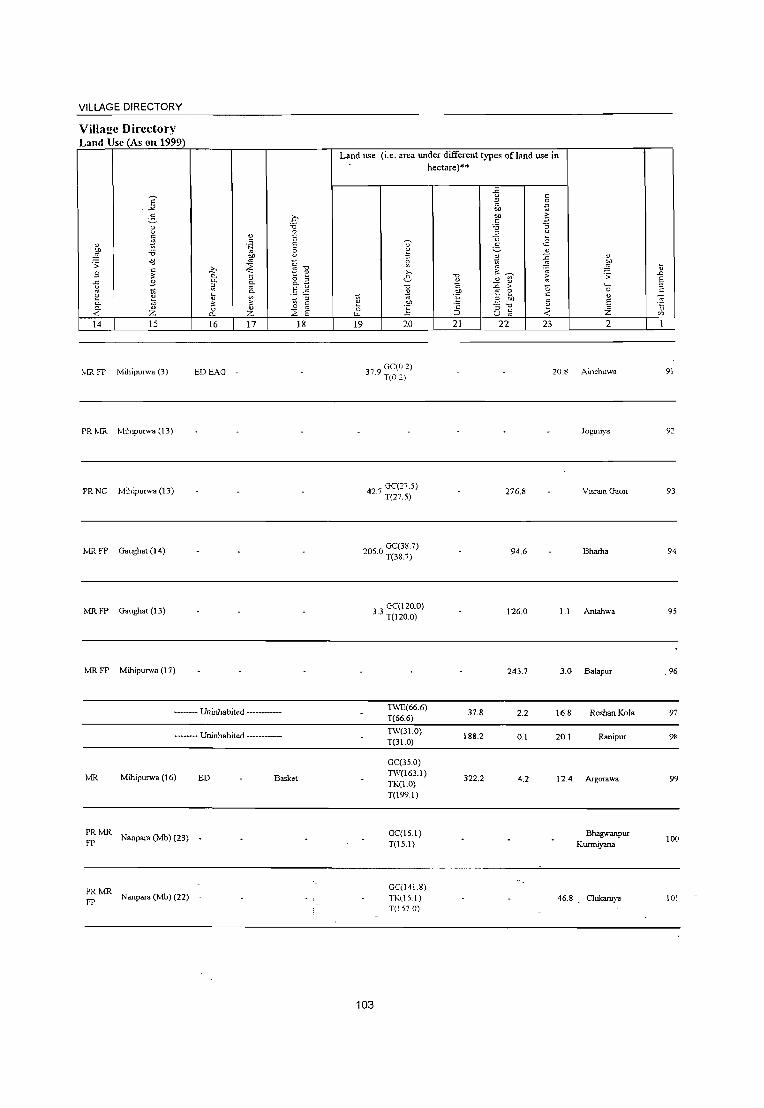
VILLAGE DIRECTORY
ViIla2e Directory Land Use (As on 1999)
E .:.:
~ ~ c: ~ " ~ ::0
.;; >J
" .s " -5 .s 3 ~ 0.. ii 0.. « :z: 14 15
o.lR fP Millipulwa (3)
PR lvlR MihipUlwa (13)
PR NC MihipUlW' (13)
MR FP Gaughat (14)
MR FP Gaughat (13)
MR FP MihipUlwa (17)
" c: .~
00
~ .20 0.
" 0.
~ 0.
'" c.. :u ~ " 0 " 0.. :z: 16 17
EDEAG
-------- Uninhabited ------------
-------- Uninhabited ------------
0 '0 0
E E B C ~
"0 e 0 B c.. § .~
::> -.; " 0
E ~ 18
lvlR Mihipurwa (16) ED Basket
~!vIR Nanpara (Mb) (23)
~!vIR Nanpara (Mb) (22) _
Land use (i.e. area under different types ofland use in hectare)'"
~ (3
LL
19
~ ~ ,., e ]
i 20
r 9 GC(02) I. T(O 2)
_ GC(27.5) 42.1 T(27.5)
GC(38.7) 205.0 T(38.7)
"0
~ CD
°E 'c :J
21
.iJ " ;;; 0
CD .~
CD oE; " '5 ~ " u ,.2 ~ " ~ ~ ~ .~
" ~
,. " '" ~ ,.
'0 0
" El ~ '0 ii " " ~ U '" 22 23
20.8
276.8
94.6
" ~ .;;
''0
" E z 2
Ainchuwa
Joginiya
VisramGaon
Bhama
3 3 GC(120.0) . T(120.0)
126.0 1.1 Antahwa
243.7 3.0 B.l.pur
TWE(66.6) 37.8 2.2 16.8 RoshanKola
T(66.6)
TW(31.0) 188.2 0.1 20.1 Ranipur
T(31.0)
GC(35.0) 1'\\'(163.1)
322.2 4.2 12.4 Argorawa TK(1.0) T(l99.1)
GC(l5.1) Bh.gwanpur T(15.1) Kurmiyaoa
GC(141.8) TK\]S.I) 46.8 Chikaniya T(1S70)
103
~ .D E ::>
" '" ." " '"
91
93
94
95
96
97
98
99
100
101
______________________________________________________ ~D~IS~T~R~I~C~T~C~E=N~S~U~SHANDBOOK:BAHRAICH
Census of India 2001 -Amenities and
102
2
Pargahwa (06435400)
103 Ray Bojha (06435500)
I 04 Ayodhya Gaon (06435600)
I OS Madari}'a (06435700)
106 Katghar (06435800)
Kailashpur 107 lhoman Gaon
(06435900)
108 Mohnapur Gangapur (06436000)
109 Ahlad Gaon (06436100)
110 Bishun N.th Gaon (06436200)
3
329.8
557.3
8.0
226.0
133.8
321.2
298.3
8.0
8.0
o o ~ c .~ :; 0. o 0.
4
2,249
3,584
1,120
2,198
1,625
989
788
3,350
Amenities available (if not available within the village, a dash (-) is shown in the colunm and next to it in brackets the distance in broad ranges viz.< 5 kms., 5-10 kms. and 10+ kms of the
nearest place where the facility is available ,is given
o o ~ ~
"0
"0
~ " o
.<:
"0 ~
..0
E " Z
6 7
302 PC:?) OM(S- H(IO+) IO)C«5) MCW(S-IO)
PHe« 5)
8
~
o c.. 9
~S~!w C POe < 5) PH(5-IO)
528 P M« 5) C(10+)
MCW H(10-) T HP W SS-PHC(lO+) W PO PH
171 PM(1O+) C(10+)
HH DH ~!C\\' T HP \\' " -H(1 (}r) PHC(5- W ss- P0(5-IO) 10) PH(IO+)
363 P M C(IO+)
209 P M(5-! 0) C(lO+)
\6\ PM«5) C(lO+)
H(lO+) MC\V(5-1O) PHC(IO+)
H(!O+) MCW(5-IO) PHC(IO+)
H(IO+) MCW(5-10) PHC(IO+)
166 P« H(\O+)
S)M«S) MCW(S-IO) C(\O+) PHC(\O+)
139 PM(lO+) C(lO+)
529 PM(\O+) C(IO+)
H(10+) MCW«S) PHC(S-IO)
HHRMP(2) CHWH(1O+) MCW«S) PHC(S-IO)
104
HPIVSSW
HPIVSSIV
HPIVSSIV
HPIVSSW
PO«5) PH«5)
PO«5) PH(lO+)
PO«5) PH«5)
PO«S) PH«S)
T HPIV SS- PO(;-IO)
IV PH(1O+)
T HP IV SS- PO(;-lO)
w PH(1O+)
10
CM(5-IO) CP(lO+)
o.!« 5) CP(IO+)
II 12
SP ACS(l(}r) NCS(S-IO) CV(IO+) OCS(5-10) ST(1O+)
ACS NCS(lO+) OCS(1O+)
CV(lO+) SP(1(.H-) ST(10+)
CM(5-IOI ACS«5) NCS«5)
CV(I0-) SP(lO-.-) ST(1O+) CP(I(}r) OCS« 5)
13
BS(S-IO) RS(S-lO) ]-,.1\\'(\0+)
BS RS l\'W(lO+)
BS(5-10) RS« 5) }''W« 5)
CM CP(5- ACS« 5) CV(5-l0) BS(5-10) 10) NCS(IO+)
OCS(IO+)
CM«5) CP(5-10)
ACS« 5)
NCS(lO+) OCS(lO+)
CM CP(5- ACS( < S) 10) NCS(lO+)
OCS(IO+)
CM«S) CP(S-IO)
ACS«S) NCS(lO+) OCS(IO+)
CM(S-IO) ACS« S) NCS«S)
CPO 0+) OCS« S)
SP(1O+) RS(5-10) ST(1O+) NW(IO+)
CV(1O+) SP(1O+) ST(1O+)
CV(lO+) SP(lO+) ST(1O+)
CV(lO+) SP(lO+) ST(lO+)
CV(lO+) SP(1O+) ST(1O+)
BS(5-10) RS(IO+) NIV(IO+)
BS(S-IO) RS(S-IO) NW(lO+)
BS(S-IO) RS(S-IO) NW(lO+)
BS(S-IO) RS«S) NW«S)
----------------~
CM(S-IO) ACS« 5) CP(1O+) NCS«5)
OCS« S)
CV(1O+) SP(lO+) 3T(1O+)
BS« 5) RS«5) NW«S)

VILLAGE DIRECTORY
Village Directory Land Use (As on 1999)
E -'"
5 8 a
" .~ ;t -0
.;: <d .3
c: ;l:
g .9
2 ~ "- "' "- " « :z 14 15
PR MR Mihipulwa (18)
.?;> 0.
~ i; ;l: 0
Cl,
16
PR Nanpara (]\;{bj(13) ED EAG -
" " 'N
'" 0/)
~ " 0.
~ ~ " :z 17
MR Nanpara (Mb)(13) ED EAG N M
PR Nanpara (]\;{b) (20) -
MR FP Nanpara (IO)
PR MR Nanpara (]\;{b) (21) ~~ ~~G
PR Nanpara (Mb) (20) -
MR EDEAG
Nanpara (Mb) (13) EO EA N M
MR Nanpara (]\;{b) (13) ED EAG N M
D :;:; 0 E E 8 C
-0 ~ " 0 :; 0.
U .5 ~ <;; OJ
c: 0 E ~ 18
Land use (i.e. area under different types of land use in hectare)··
-5 " ;:: .~ eo
.~ eo c
:;:; ~ OJ U .,2
~ 5 " ::> *- ~ " ~ ~ ~ ;.,
'"" ~ 6 ~ " OJ
:-'0 ~ > 0 0 E '" 0
'" ~ i "E 3 to e ;; " 'c :; -0 c 0 ~ i. ""' => u « 19 20 21 22 23 2
GC(1375) 60.0 197.6 Pargahwa
T(137.5)
TW(318.7) TWE(75.3) 63.8 22.3 76.: Ray BoJha T(3940)
GC(3.!) . TW(65.8)
65.4 0.8 18.0 Ayodhya Gaon TWE(303) T(99.8)
W{148.2) 3651.0 194.7 Madariya
T048.2)
GC(44.1) PC(10.5)
47.5 0.2 18.5 Kalghar TW(34.1) T(88.6)
GC(108.1) 3.0 294.2 Kailashpur
T(108.1) fuoman Gaon
PC(180.5) 26.3 Mohn"pur TW(20.4) 0.8
T(200.9) Gangapur
TW(116.1) TWE(50.1) 18.5 Ahlad Gaon T(166.2)
TW(l10.5) 96 Bishun Nath TWE(l20.2) 105.1 4.8 .4 Gaon
T(230.7)
105
t '" E " c
" "5 '"
ICC
103
104
105
106
107
108
109
110

e " "0 '" ~ 8 " " ~
" .<: t:
.~ 2- ~
u u " 0 :t 0 -l C
<d .:;: ~
" " ! ~ -5 'J '_
..c :;: 0
E " " '0 ~ E-" "-.S " '5 E " ~ Z 0 ~ '" f-
2 3 4
Block Tot,,1 40473.4 275195
~
iil " " u ;; 0
~ .., -0
-0 .<: ~
" 0 .<:
'0 ~ .0 E i 5
DISTRICT CENSUS HANDBOOK: BAHRAICH
Census of India 2001 -Amenities and
Amenities available (if not available within the village, a dash (0) is shown in the column and next to it in brackets the distance in broad ranges viz. < 5 kIDs., 5010 kms. and 10+ kms of the
" t:
.~
" -0 t.tl
6
nearest place where the facility is available is _g""ic:.v"'en"t-___ ,
"§ '5 " ~ 7
H(S) IL-\(S)
HH(3) 0(10) DA(4) DIl(2)
'" " :;;
"" c :.:;; c
8 8
MCW(9) T(SI) 11.ff!(2) W(SI)
" "' .0
" " " .~ 0 .<: if il
0. '§ 0
8 -0
2 -0 .<: ~ e " "" .~
" '] " E 7/. E 0 0 0. U
9 10
'0 .£ ~
~ " u '" .<J ~
.=: c ,;: ] 0-e ~
-" .., .=: " 1 ~
'';;; '2 'E " C 'u " ;:: g <d "" " ;;: "" " ~ ] t:
.~ " B ~ ~ ~ 'to ~ " -5 " Q -< 0 ~ 'l:i II 12
g E ~ ~
'" ~ " e. ~
~ .., t:
.~ " .~ C E ::-. ~ E
0 U " 13
P(134) M(26) CWC(4) TK(5)
43137 S(6) PUC(3) HC(2) HP(I03) I AC(13) PHC(2) TW(14)
PO(29) TO PTO CM(4) CP ACS(4) PH(2S)
CV(3)
SP(l)
BS(I6) RS(4) NW(6)
0(14) PHS(3) FWC R(7) C(7)
TB RMP(ll) L SM1'(7) CHW(lS) 0(2)
106

VILLAGE DIRECTORY
ViIlaj!e Directory Land Use (As on 1999)
" ~ .;; .9 g 0
0. "-< 14
PR(57) ~lR(89)
fP(60) NC(6) NR(8) 1',\,(6)
E ..>(
2-8 c: ~ 'i3 <:! c:
" .9
~ ;:; z 15
b 0. 0. ;;: \; ~
" a.. 16
ED(44) EAG(27) EO(12) EA(12)
<1J c .~
CJ)
~ ;;-c..
3 " Z
17
N(16) 1\1(9)
.q -g E E ;:;
~ ] <; c..
.~ §
" ~ <:;
E ~ IS
Land use (i.e. area under different types ofland use in hectare)"
11 ~ 19
]' ::>
2 >-. e
v ~
f 20
GC(9959.J5) PC(398.09) W(242.5) WE(2U) TW(2700.3) TWE(1527.2
6051.45) _TK(749.71) R(527_97) L(84.73} WF(36.79)
0(357.69) T(16621.H)
107
v ~ ,. of:
'" :::> 21
11205.7
{; c ::> .g ~
.~ CJ) c:
'i3 :;
~ <.>
. .s ~ " * ~ ~
~ " " ~ > 0 E ~ E1 5 '0
8 :;; <: 22 23
8964.1 5288.0
" ~ \; .;; ..0
E ._ ::> c:
" -;;; E ·c Z " '" 2


VIKAS KHAND NAWABGANJ, BALAHA & RISIA ( TAHSIL NANPARA )
DISTRICT BAHRAICH
BOUNDARY INTERNATIONAL
DISTRICT
TAHSIL
VIKAS KHAND
5
VILLAGE WITH PERMANENT
LOCA TION CODE NO.
FOREST WITH PERMANENT
LoeA TION CODE NO.
HEADQUARTERS TAHSIL, VIKAS KHAND
POPULATION SIZE CLASS OF VILLAGES
BELOW 200
200 - 499 , 500 - 999 , 1000 - 4999
KILOMETRES
o 5
(j}
... _._._._.-._._._._._ ~ ./
L
)----------)
I 06467400 I
@ @
..0
~
1J
, _ _ . I
l>
10
f UNINHABITED VILLAGES WITH PERMANENT LOCATION CODE NO. :§64§:fo§<f~~ 'i 0
5000 & ABOVE • UNBAN AREA WITH LOCATION CODE NO.
STATE HIGHWAY
IMPORTANT METALLED ROA]) ..
RAILWAY LINE METRE GAUGE
RIVER AND STREAM.
POST OFFICE, TELEGRAPH OFFICE.
HIGH SCHOOL \ INTER COLLEGE
PRIMARY HEALTH CENTRE
BANK
SH 26
..=== PO, TO
s
~
B
S> w ~$-L j'
VIKAS KHAND
BALAHA RISIA NAWABGANJ
NO.OF VILLAGES POPULATION
70 177,347
89 168,575
95 149,470


Alphabetical list of Villages (C.D. block wise) N arne of the District· Bahraich .
Serial Name of village number
1 2 . Name of CD Block: NawabganJ Name of Sub-Dist: 0001
1 Bakhatawar Gaon 2 Bankashahi 3 Bankuri 4 Bansantpur Kalika 5 Bargadaha Chilbila 6 Basantpur Udal 7 Bavedih 8 Belchandpur 9 Bhagat Purwa 10 Bhagtapur 11 BhagwanpurKaringa 12 Bhawaniyapur Tikuri 13 Bishunapur 14 Chanaini 15 Charda 16 Chaugoie Bilaspur 17 Chaugorwa 18 Daulatpur 19 Dewara 20 Dharm Nagar 21 Dubidhapur 22 Fultekra 23 Ganeshpur Nimnahara 24 Gangapur 25 Gawarkha 26 Gendpur 27 Gidharaiya 28 Gokulpur 29 Gapa/pur 30 Govindpur Pandit 31 Gulariha 32 Hariharpur Puraina 33 Hathiya Bojhi 34 Holiya 35 Imam Nagar Gadrahwa 36 Jaitapur 37 Jalalpur 38 Jamdan 39 Jamunaha Naubasta 40 Jamunha Babaganj 41 Jhauhana 42 Jokhan Gaon 43 Kalwari 44 Kalyanpur 45 Keshawpur Murawa 46 Kewaldih 47 Kewalpur 48 Khairahaniya 49 Khushali Purwa
2001 Census location 1991 Census location code code number number
3 4
06436300 460010002000110111 06445400 460010002000180201 06440400 460010002000140151 06445200 460010002000180199 06437200 460010002000110120 06436800 460010002000110116 06443500 460010002000170182 06437800 460010002000120126 06444500 460010002000180192 06444600 460010002000180193 06438400 460010002000120132 06441300 460010002000150160 06437300 460010002000110121 06445600 460010002000180203 06440800 460010002000140155 06442200 460010002000160169 06445100 460010002000180198 06438300 460010002000120131 06441800 460010002000150165 06445800 460010002000180205 06437000 460010002000110118 06443700 460010002000170184 06444800 460010002000180195 06440900 460010002000140156 06437400 460010002000110122 06438600 460010002000120134 06442800 460010002000160175 06439100 460010002000130139 06439900 460010002000130147 06445300 460010002000180200 06443800 460010002000170185 06442300 460010002000160170 06437900 460010002000120127 06443900 460010002000170186 06436500 460010002000110113 06439400 460010002000130142 06442000 460010002000150167 06444100 460010002000170188 06443100 460010002000160178 06437100 460010002000110119 06441100 460010002000140158 06441200 460010002000140159 06437500 460010002000110123 06441700 -460010002000150164 06436400 460010002000110112 06444200·· 460010002000170189 06439000 460010002000120138 06440000 460010002000130148 06439200 460010002000130140
109

Alphabetical list of Villages (C.D. block wise) Name of the District·Bahraich _
Serial Name of village 2001 Census location 1991 Census location code number code number _number
1 2 3 4 50 Lakhahlya 06441000 460010002000140157 51 Lakshamanpur Gulaldih 06440300 460010002000130150 52 Lakshamanpur Lahsorwa 06444000 460010002000170187 53 Lakshamanpur Salarpur 06440700 460010002000140154 54 Madhawapur Raghunath 06442900 460010002000160176 55 Madhopur Nidauna 06437700 460010002000120125 56 Majgawa 06443600 460010002000170183 57 Makanpur 06441600 460010002000150163 58 Mansor Nagar Sale Gaon 06443200 460010002000160179 59 Mashdiya 06437600 460010002000120124 60 Mirjapur Chahlwa 06436600 460010002000110114 61 Mirjapur Tilak 06445000 460010002000180197 62 Muralidhar Dadauli 06439500 460010002000130143 63 Nataie Gaon 06440200 460010002000130149 64 Nawwa Ganwa Bhat Purwa 06444300 460010002000170190 65 Nawwa Gaon 06441500 460010002000150162 66 Nidh Nagar Sankalpa 06439800 460010002000130146 67 Nidha Nagar Pokhara 06438800 460010002000120136 68 Pach Pakari 06438900 460010002000120137 69 Parampur 06438500 460010002000120133 70 Pir Nasiruddin 06443300 460010002000160180 71 Pure Surjman 06443000 460010002000160177 72 Rahim Nagar 06442700 460010002000160174 73 Ram Nagar Gulariha 06442500 460010002000160172 74 Ram Nagar Sumera 06443400 460010002000160181 75 Rampur Husen Bux 06439700 460010002000130145 76 Rampur Munna Pathak 06436900 460010002000110117
77 Ranjit Bojha 06438200 460010002000120130 78 Sahawa 06438700 460010002000120135 79 Sahjanwa 06439600 460010002000130144 80 Sankalpa 06438000 460010002000120128
81 Satijor 06445700 460010002000180204 82 Shankarpur 06436700 460010002000110115 83 Sheo Nagra 06442100 460010002000150168
84 Sheo Rampur Teliyani 06439300 460010002000130141
85 Sheopur Mohraniya 06438100 460010002000120129
86 Sheopur Semra 06441900 460010002000150166 87 Sheopura 06444900 460010002000180196
88 Sirsiya 06444400 460010002000170191
89 Sisaiya 06442400 460010002000160171 90 Sorahiya 06440600 460010002000140153
91 Sujauli 06440500 460010002000140152
92 Sumerpur 06441400 460010002000150161
93 Tokhaiedih 06444700 460010002000180194
94 Umariya 06442600 460010002000160173
95 V_iraie Gaon 06445500 460010002000180202 .
110

2
CD Block: Nawabganj (0547)
Bakhata\\'ar Gaon (06436300)
K~sha\\'pur
(06436400)
Imam Nagar Gadrahwa (06436500)
Mirjapur Chahlwa (06436600)
Shankarpur (06436700)
Basantpur Udal (06436800)
Rampur Munna Pathak (06436900)
Dubidhapur (06437000)
347.5
182.0
121.7
288.9
187.4
4,820.0
166.7
331.5
.5 o f-
4
2.322
668
897
1,758
1,363
2,132
1,014
2,126
DISTRICT CENSUS HANDBOOK: BAHRAICH
Census of India 2001 -Amenities and
Amenities available (if not available within the village, a dash (-) is shO\\TI in the column and next to it in brackets the distance in broad ranges viz.< 5 kms., 5-10 kIDs. and 10+ kms of the
nearest place where the facility is available is given)
6 7 8 9
P(3) 'f(5 10) - H(S- T HP \" 5-388 ,,- 10) MCW(5- • ~-PO(S-IO)
C(lO+) 10) PHC(5-10) HP PH(S-IO)
P(2) M(S 10) - H(5- T HP \\' -S 119 ,- 10) MCW(5- s - P0(5-IO)
C(lO+) 1.0) PHC(S-IO) HP PH1S-IO)
ACP«5) CHWH«5) HPWTK 132 M« 5) C(lO+) MCW« 5) SS-HP
PHC«5)
H(5-
PH(2) PO«5)
10
CM(5-IO) CP(lO+)
II
ACSI,5-1 ~CS(5-1 I
OCS,:5-1 t
CM(5-IO) ~g~g:~' CP(5-IO) OCS(l(l--,
CM«5) CP«5)
ACS« 5)
NCS« 5) OCS(lI}-\
12
CV(10-) SP(lO-) ST(lrr)
C\'n I}-)
SP(lG-) ST(Jer-)
CV(lI}-)
SP(S-IO) ST(lO+)
13
B5,5-101 RS1o-10) }\."\\'j :1.)-)
BS< 5-1 0) RS< 5-1 (I) 1\,\',:(1--)
BSt, < 5)
RSt:< 5)
NW« 5)
288 P(2) AC M(5- 10) 10)C(l0+) MCW(lO+)
T HP W TK PH PO(5- CM(5-10) ACS(5-IO) CV(lO+) CSS-HP 10) CP(5-IO) NCS(lI}-, SP(lO+)
NWBS(5-10) RS(5-10)
PHC(5-10)
CHW(2)H« 231 P ACM«5) S)MCW«5) HPWTKC PH(4)
C(1O;t) PHC«5) SS-HP PO«S)
371 P(2) M C(IO+)
H« -5) MCW(IO+) T HP W TK PO« 5) PHC«S) CSS-T PH«5)
P« H(5-161 5) M(5-1 0) 10) MCW(5- HP W SS-
C(lO+) 10) PHC(S-10) HP
- H« 333 P(2) AC M(5- 5) MCW« 5) HP W SS-
10) C(10+) PHC« 5) HP
P0(5-10) PH(1O+)
PO« 5) PH(5-IO)
CM«5) CP«5)
OCS(lI}-} ST(l()-,-)
ACS« 5) NCS«5; OCS« 5)
CV(IO+) SP(5-10) ST(IO+)
BS« 5) RS{< 5) )'.'\1{,10+)
CM«5) CP(S-IO)
ACS« 5) NCS« 5) OCS«5)
CV(5-10) NWBS« SP(5-10) 5) RS« 5) ST(lO+)
AC,(S-10) CV(lO+) CM(5-10) NCS(5-IO) SP(lO+) CP(l 0+) OC:,(l 0-- • ST (1 0+)
CM«5) CP(5-IO)
AC:S« 5, KCS« 5, OCS(l c~,
CV\S-IO) SP,S-IO) ST(1O+)
B5(5-1 0)
RS(5-10) ]\jW(1O+)
N ..... -BS« 5) R5« 5;
--------------------------------------------------------------9
10
larnunha Babaganj (06437100)
Bargadaha Chilbila (06437JOO)
285.3
277.7 -
3,667
1,747
P(4) M(2) 539 0(2) C(I 0+)
262 P(2) M( < 5) C(lO+)
HU MCW(5- T HP W C PO PH 10) PHC(5-10) SS-HP
H« -5) MCW« 5) T HP W TK PC~< 5}PHC« 5) C SS-HP PH« 51
CM(1O+) CP(5-10)
CM«5) CP«5)
ACS NCS(lO-. OCS(lO-l
ACS« 5· }:CS(l (.r-I OCS(1 0- ,
----------------------------------------------------~--~----
111
C\'(5-10) SP(1O+) STflO+)
CY<lO+) SP(1O+) ST(I()-,-)
BS RSNW
~-'.l; BS« 5} ;>.5(.< 5

VILLAGE DIRECTORY
Village Directory Land Use (As on 1999)
E -'<
e-8 C
~ " 5 :;:; .;; ,:;
c: ;;; " g £
e ~ 0- i1 c..
<:; Z 14 15
tv!R FP Nanpara (Mb) (15)
PR ],,!R Nanpara (Mb) (17)
FP
PR Babaganj (3)
PRlvlR Babaganj (6)
FP
PR Babaganj (3)
PR!vIR Manepara (15)
FPNC
PR !vIR FP
Babaganj (6)
PR !vIR FPNC Babaganj (2) NW
PR!vIR Nanpara (Mb) (14)
PR !vIR Babagang{3)
FP
o :;:; 0
" E c: .~ E
:3 "" ~ " Z:- S -0
"- c; ~ " 0- ~ ~ "'- 0-
Ii § ~
<!S ~ -;;; ='
" 0 c 0 " E 0- Z ~ 16 17 18
ED Butter Oil, Oil
ED Butter Oil
NM
NM
EDEAG NM
EOEA
Land use (i.e. area under different types of land use in hectare)**
-5 c: =' .~ ~ ell -s c:
:;:; "§ ::l U
~ ~
c: ;.=. " :; ~ ~ ~
:;: ~ >, ~ .;:;
" ~ ;; e " ~
~ " " ~ > "5 "5
~ ~ "E e c: " ell ;1 OIl
~ E ·2 :; -0 0 .~ -< -i. ~ ;:J u ~
19 20 21 22 23 2
169 TK(S.I) . 1(8.1)
12.0 18.5 11.8 Bakhatawar Gaon
54.: 0.2 :6.7 Kesha\\pur - }"lurawa
TK(1.7) 1.1 12 4 ~narn Nagar
1(1.7) . Gadrahwa
GC(3014) TW(83.1)
130.0 0.3 28.2 Mirjapur Chahlwa TK(S.8) 1(390.3)
GC(23.3) 37.5 0.9 18.6 Shankarpur
1(23.3)
GC(l0.9) 223.8 10.0 32.0 Basantpur Udal
1(109.9)
GC(IOO.O) Rampur Munna
TW(25.5) 50.0 Pathak
1(125.5)
GC(104.2) TW(24.5) 155.1 0.1 14.1 Dubidhapur 1(128.7)
GC(285.0) Jamunha 1(2854) Babaganj
GC(79.0) lW(19.2) Bamldaha 0(5.3) - 310.0 22 9 Chilb~. 1(103.5)
112
~ ~
E ~
" "t '"
L

___________________________ _:D::.I:.:S_:_T.:_:R::.:IC:_T:_C=-::.E:.:N::.S::.US:::_HANDBOOK: BAHRAICH
Census of India 2001 -Amenities and
II
12
13
14
IS
16
17
18
19
20
21
2
Bishunapur (06437300)
Gawarkha (06437400)
Kalwari (06437500)
Mashdiya (06437600)
Madhopur Nidauna (06437700)
Belchandpur (06437800)
Hathiya Bojhi (06437900)
Sankalpa (06438000)
Sheopur Mohraniya (06438100)
Ranjit Bojha (06438200)
D<iulalpur (06438300)
3
127.4
253.2
283.0
415.6
238.9
283.0
350.3
104.8
186.5
351.0
188.6
o o ~
" ~ :J no 0.
4
871
1,231
2,356
1,207
S5
1,071
1,081
2,264
342
Amenities available (if not available within the village, a dash (-) is shown in the colunm and next to it in brackets the distance in broad ranges viz. < 5 kms., 5-10 kms. and 10+ kms of the
nearest place where the facility is available i" given
o o ~
6 7 8 9
P ACM«5) H« THPWn.:: • 141 C(10+) 5) MCW«5) RSS.HP PO«5)
PHC« 5) PH« 5)
P ACM«5) H« THPWn.:: • 208 C(5-IO) 5) MCW« 5) C SS.HP PO« 5)
390 P(3) M C(lO+)
PHC« 5) PH« 5)
CHWH«5) MCW«5) PHC« 5)
HPW S5-HP
PO« 5) PH« 5)
------- Uninhabited ------------
III
CM«5) CP(5·10)
CM«5) CP(5-10)
CM«5) CP«5)
II
ACS\< 5j
NCS(lO~)
OCS« 5)
ACS« 5) NCS(JO+)
OCS« 5)
ACS(<< 5)
NCS« 5) OCS« 5)
12
C\\I()-) SP(I()-) ST(I ()-)
CV(l()-) SP(J 0·-)
ST(lO+)
CV(l(h-) SP(IO+) ST(lO+)
13
BS« 5) RS«5) NW(I~)
BS« 5)
RS« 5) NW(l~)
B5« 5) RS«5) NW(IO+)
165 P(2) M(5.10) CHWH(5·10) T HP W 5S· PO PH(5. ACS« 5) C(IO+) MCW(S-IO) HP 10) CM(5·10) NCS(l~)
CV(5·IO) BS(5·10)
PHC(1O+) CP(5-10) OCS(1O+) SP(IO+) RS(5·10) ST(lOr) NW(1~)
P« 15 5) M(S·IO)
C(lO+)
179 PM(IO+) C(10+)
H(5-10) MCW(5· TWSS·W PO«5) 10) PHC(IO+) PH(S·IO)
H(lO+) MCW(lO+) PHC(IO+)
THPWSS· PO(;O+)
HP . PH(l 0+)
... -.--- Uninhabited "'-"-'--'
• H(5. • 172 P AC(2)M(S· 10)MCW(5. THPWSS' PO«5)
10) C(IO+) 10) PHC(IO+) HP PH(5-IO)
332 P(3) M« 5) C(10+)
58 P M(5·10) C(IO+)
MCW H« 5) T HP W n.:: PO(~ 5) PHC«5) SS·HP PH«5)
CHWH(5·10) HPWSSMCW(S·IO) HP PHC(S·IO)
113
PO(5·10) PH(5·10)
ACS«5) CM(5·10) NCS(1~) CP(S·IO) 0c:,(1~)
CM(IO+) CP(1O+)
ACS(1O+) NCS(1~)
OCS(lO+)
CV(5·IO) BS(5·10) SP(1O+) RS(5-10) ST(lO+) NW(lO+)
CV(IO+) SP(lO+) ST(1Or)
BS(IO+) RS(IO+) NW(lO+)
ACS(5·10) C\·(5·!O) 85(5·10) CM(5·IO) NCS(lO+) SP(1Or) RS(5-10) CP(5·IO) OCS(1O+) ST(lO+) NW(lO+)
CM«5) CP«5)
AC5« 5)
NCS« 5) OC'5« 5)
CV«5) SP(lO+) ST(lQ-)
AeS(5·10) C\,\5·10) CM(5·IO) KCS(5.IO) Sh5.IO) CP(5~ro) OCS(5.10) ST(5-16j
BS« 5) RS« 5)
NW(lO+)
8S« 5) RS« 5) N\\'« 5)

VILLAGE DIRECTORY
ViIla~e Directory Land Use (As on 1999)
E -'"
5 " u
~ " ~ :;; .;; o<l
" .3 :: ~ £
e ~ "-0- " < Z 14 15
PRl\,1R IT
Babagall) Bazar (3)
PRJ>.1R FPNC Babaganj Bazar (3) NW
PRMR Babaganj (4)
FP
" " .~
"" ~ :>,
-0.. 0- g.. ~
0.. :;; ~ ::
0 " 0.. Z 16 17
NM
------- Uninhabited ------------
PRMR Rupedeeha (6) ED
FP
MR FP Rupaidiha (6)
PRMR Rupaideeha (14) ED
-------- Uninhabited ------------
PRMR Rupaideha (7) ED
FP
PRJ>.1R Rupaideha (4) ED
PR Rupaideha (1)
c 'iJ 0 E E 0 u
~ " Ci 5 o.~
E U ._ ~ " ~ " .£ E ~
18
Land use (i.e. area under different types of land use in hectare)··
~ 0 ~
19
~ " :? '" e ] .j 20
PC(34.3) T\\'(20.3) TWE(O.S) 0(2.8) T(58.2)
GC(160.6) W(56.0) TK(0.9) R(2.4) T(217.5)
GC(82.0) W(80.0) TIVE(11.6) T(173.6)
202 - GC(20.2) .1 T(20.2)
60 6 PC(50.0) · T(50.0)
81 4 WE(38.5) · T(38.5)
98 2 GC(149.5) · T(149.5)
50.0 0(8.0) T(8.0)
nVE(l2.4) 12.7 T(12.4)
TK(I.O) 75.00(82.2)
T(83.2)
114
~ '" 'E ·2 ::> 21
171.8
240.2
160.6
100.0
76.5
66.9
110.3
124.0
158.0
-5 ~ ell
"" .:0 -0
" u " :.::-
~ ::
_;e ~
" e > c ;;;, .3 :; ~ 0
22
0.1
0.6
5.8
2.5
0.0
0.9
0.6
0.7
4.1
" .~ -5 ~ .~ " ~ " ~
~ :>
0 ._ c c " " E
~ ~ < 23 2
103 BlShunapur
22.4 Gawarkha
Kalwa"
232.9 Mashdiya
77.1 Madhopur Ntdauna
167.1 Belchandpur
127.9 Hathiya Bojhi
Sankalpa
51 8 Sheopur . Mohraniya
Ra"Jit Bojha
Daulatpur
~ E " " '" "5 '"
11
12
13
15
16
17
18
IS
2(~

~3
24
25
26
27
28
29
30
31
2
Bhagwanpur Karinga (06438400)
Parampur (06438500)
Gendpur
(06438600)
Sahawa
(06438700)
Nidha Nagar
Pokhara (06438800)
Pach Pakari (06438900)
Kewalpur (06439000)
Gokulpur (06439100)
Khushali PUlWa (06439200)
Sh~o Rampur
Teliyal1l (06439300)
5 o
b
3
260.8
143.3
162.0
283.3
144.9
170.0
542.3
194.2
SS.S
20.6
4
2,31S
841
2,226
1,738
838
991
11,088
617
391
85
DISTRICT CENSUS HANDBOOK: BAHRAICH
Census of India 2001 -Amenities and
Amenities available (if oat available within the village, a dash (-) is shown in the column and next to it in brackets the distance in broad ranges viz.< 5 krns., 5-10 krns. and 10+ krns of the
nearest place where the facility is available is !!iven
o co ~
5 6
4~9 P(2) M(lO+) C(10+)
141 P M(S-IO) C(lO+)
7
H(IQ-,-)
MCW(S·10) PHC(lO+)
8 9
liP II' 55- PH liP PO(1O+)
CHIV H(5·1 0) MCW(S-10) T HP \If SS- PO(;-IO)
PHC(S-IO) liP PH(S-10)
10
CM(] (\-) CP(10-)
II
AC5(l (h-)
NCS(1O+) OCS(1O+)
12
C\\10+) SPI.10+) ST(10+)
13
BS,ICf-'-) RS,lO+) },'WO 0+)
CM(5.10) ACS(S-10) C\'(5-10) BS\5-10) CP(5.10) NCS(lO+) SP(IO+) RS(5.10)
OC5(1O+) ST(5-10) K\I'OO+)
348 P M« 5) C(lO+)
H« 5) MCW«S) TIiPHPWS5-PHPO«5)CM(~_IO) ACS(5-IO) PHC«S) CP«5) NCS(IO+)
OCS(IO+)
CI'(5-10) SP(lO+) ST(IO+)
BS«5) RS«S) NW(IO+)
CHlVH(S-IO) -293 P OM(S-to) MCW(S-IO) THI'WSS- PO(5.10)
C(lO+) PHC(S-IO) HI' PH(S-IO)
135 PM(S-IO) C(lO+)
CHIV H(5-l 0) MCW(S·IO) PHC(S,IO)
Hl'SS-HP PO(S-IO) PH(S-IO)
H(5-
146 P M(5-10) C(10+)
10) MCW(lO+) PHC(5-10)
Hl'SS-HP PO(5-10)
HADDA
1,635 P AC M(S-IO) ~ ~PHC HP 1W W C(I 0+) PHS FWC TK C SS-
P« 1105)M(5-IO)
C(IO+)
RMP(7)CHIV
H« THI'TW 5) MCW( < 5) W SS-HI' PHC« 5)
PH(5-10)
PO TO PTOPH
PO«5) PH«5)
P« H(lO<-) 77 5) M(5-10) MCW(S-10)
C« 5) PHC(S-10).
T HP W SS, PO(~ 5)
HI' PH«5j
P« H« . 14 5) M« 5) C« 5) MC\V(~ 5) T HI' W SSe PO« 51
5) PHC« 5) HI' PH« 5)
115
ACS(5-! 0) C\'(5-! 0) BS(5-! 0) CM(5-10) NCS(lO+) SP(1O+) RS(5-10) CP(5-10) OCS(IO+) ST(IO+) 'NW(IO+)
ACS« 5) CM(5-10) NCS(lO+) CP(S-IO) OCS(IO+)
CV(IO+) SP(1O+) ST(1O+)
8S(5-10) RS(S-10) NW(1O+)
CM(5-10) ACS(5-10) CV(5-IO) 8S(5-10) CP(5-10) NCS(S-IO) SP(IO+) RS(S-lO)
CMCP
CM«S) CP«5)
CM«S) CP« 5)
eM«) CP«5)
OCS(S-IO) ST(lO+) NW(lO+)
ACSNCS DCS
/l.CS« 5) )l[CS(IO+) OCS(IO+)
ACS« 5) NCS(IO+) OCS(IO+)
ACS« S) NCS(IO+) OC3(10+)
cv SP(1O+) ST(IO+)
CV(IO+) SP(IO+) ST(1O+)
CV«5) SP« 5) ST« 5)
CV(IO+) SP(IO+) ST(10+)
BSRS NW(1O+)
BS« 5) RS« 5) )';"W« 5)
BS« 5) RS« 5) NW(1O+)
BS« 5)
RS« 5) )','W«5)

VILLAGE DIRECTORY
Village Directory Land Use (As on 1999)
E -'" 5 ~ c
" ~ ~ :.a .;; ~
.3 ~ ~ £
~ e ~ 0.
~ " ;z: 14 IS
PR MR Rupaidooh (13)
PR MR Nanpara (Mb) (19)
MR Nanpara(Mb)(J5)
PR Nanpara (Mb) (20)
PRMR Rupaidiha (10)
PRMR Rupaidiha (10)
PRMR FP
Rupaidih (J )
MRFP Rupaidiha (4)
MR. FP Rupaidiha (2)
MRFP Rupaidiha (4)
2;> :.a 0
" E " E .~
0/) 8
~ § >. ~ ~ ;:; (; g. ::>
;;: 0. -E U 0. ._ .~
;:; ~ ~
;:l ?: " 0 ''> 0
E 0.. Z ~ 16 17 18
EDEAG .
ED
EDEAG EOEA
NM
Jaggery
Land use (i. e. area under different types of la nd use in hectare)**
-5 " ~ .~ tJl en ·S " '0 "3
e ~ ·2 2- " :; " ~ " 51 ~ ~ " '" -0 " ~ ;; :::- " a'J
" ~ ~ > '0
"' °E e g
.~ 3 "" " ~ 'c :; -0 ~ E 0 ~ <: z "- ::> u 19 20 21 22 23 2
7 5 GC(222.0) 35.6 0.5 Bhagv.'anpur
. 1(222.0) Karinga
GC(l13.0) PC(3.6)
14.2 128.0 Parampur TK(0.3) 1(116.9)
GC(lOS.6) 27.6 1.0 15.2 Gendpur
1(105.6)
GC(214.4) 5.9 1(214.4) 21.7 2.3 26.3 Saha ..... a
GC(82.2)
192 TK(2.1) . 0(2.1)
20.1 9.8 Niclha Nagar Pokhara
1(86.4)
GC(52.3) L(0.6) 26.2 88.3 4.3 Pach Pakari 1(52.9)
GC(137.1) TW(135.2) TK(S.2) 75.9 49.8 Kewalpur 0(27.4) 1(304.9)
PC(96.0) TK(80.0)
8.0 2.0 Gokulpur R(18.0) 1(194.0)
GC(20.0) TW(4.0)
3.0 2.0 Khushal, Purwa WF(1.0) 1(25.0)
PC(51.0) I r . Sheo Rampur TK(0.6) io
1(51.6) .) Idiyani
116
~
§ " ." " '"
22
23
24
2S
26
27
28
29
30
31

32
33
34
35
36
37
38
39
40
41
Jaitapur (06439400)
MuraIidhar Dadauli (06439500)
Sahjanwa (06439600)
Rampur Husen Bux (06439700)
Nidh Nagar Sankalpa (06439800)
Gopalpur (06439900)
Khairahaniya (06440000)
Nataie Gaon (06440200)
Lakshamanpur Gulaldih (06440300)
Bankuri (06440400)
506 I 2.834
154.1 868
445.9 3,580
302.8 1,592
456.5 2,330
218.5 1,154
360.2 1,196
59.0
142.9 281
180.0 1,701
DISTRICT CENSUS HANDBOOK: BAHRAICH
Census of India 2001 -Amenities and
Amenities available (if not available within the village, a dash (-) is sho\\n in the column and next to it in brackets the distance in broad ranges viz. < 5 kms., 5-10 kens. and 10- kms of the
nearest place where the facilitv is available is !!iven
453 P(2) M( < 5) C« 5)
126 PM«5) C(lO+)
H« 5) MCW« 5) T HP IV SS· PO(~ 5)
PHC« 5) HP PH« 5)
He< T HI' T\\' 5)MCW(S-10)WTKSS- PO«5) PHC(5·10) HP PH« 5)
P ACM«5) CHWH«5) THPTW 597 C(IO+) MCW(5·10l W TK SS- PO«5)
PH«5) PHC(5·10) HP
H« -274 P ACM«5) 5)MCW«5) THPWTK PO«5)
C(10+) PHC«5) SS·HP PH«5)
385 P M(5-10) C(1O+)
- H(5. 10) MCW(S- T HP W SS- PO« 5)
10) PHC(5-10) HP PH(5-10)
CM« 5)
CP«5)
CM«5) CP« 5)
CM«5) CP«5)
CM«5) CP«5)
ACS( (5)
NCS(IO+) OCS(lO+)
ACS« 5) NCS(1O+) OCS(1O+)
ACS« 5)
NCS(IO+) OCS(1O+)
ACS«5) NCS(1O+) OCS(1O+)
CY\ICr-_, SP(lO+i ST(IO-)
CY«5) SP(ICr-) ST(ICr-)
CV«5) SP(I(J-) ST(ICr-)
CV«5) SP«5) ST(1Cr-)
BS« ), RS« 5)
NW(lC>-)
SS« 5) RS« 5) NW(IC>-)
SS« 51 RS«5) NW(lO+)
SS« 5) RS«5) NW(1O+)
ACS(5·IOj CV(5-IO) BS(5-10) CM(5·10) NCS(lo+) SP(1O+) RS(5-10) CP(5-10) OCS(I(J-) ST(1Cr-) NW(IO+)
- H(5· 207 P(2)M(5-IO) 10) MCW(S- HPWSS- POPH(5- CM(5-10) AC~;(5-10) CY(lO+)
C(10+) 10) PHC(5-10) HP 10) CP(5-10) NCS(S-IO) SP(1O+)
BS(5-10) RS(5-10) NW(1O+)
226 P M(5-10) C(lO+)
43 PM«5) C(lO+)
271 P(2) M 0 C(lO+)
- H(5-10) MCW(S- HP W SS- POe < 5)
10) PHC(5.10) HP PH(5-10)
-----.-- Uninhabited ---.-----•.
- H(5· 10) MCW(5- HP W SS- PO« 5)
10)PHC(5-10) HP PH«5)
H« -5) MCW« 5) T HP W SS- PO« 5)
PHC« 5) HP PH« 5)
117
OCS(1O+) ST(1O+)
ACS(5-10) CV(1O+) CM(5-10) NCS(5-10) SP(lO+) CP(S.IO) OC:S(S-10) ST(1O+)
CM«5) CP« 5)
CM(lO+) CP(5-IO)
ACS« 5) NCS« 5) 0(,S«5;
ACS« 5; ~CS(l C>- j
o.C5(1(>-,
CV(lO+) SP(lo+) STn C>-)
C\'\;·10) SP(i (>-)
SToe>-)
BS(5-10) RS(5-10) NW(1O+)
BS« 5)
RS« 5) l<'Vi(l0+)
BS~.< 5) RS« 5) N'\'<]O--} .

VILLAGE DIRECTORY
Villaj!e Directory Land Use (As on 1999)
E -'" ~ " u c
... ~ ~ 'i3 .;; "d
9 c
'" g .9 0 ~ 0. '" c. " < z 14 15
lvIR FP Rupaidiha (4)
:~:tvIR Nanpara (Mb) (16) _
" c .~
eo "
2:' ~ Po t 0- C. iii ~ t ~
'" '" 0 " c. Z 16 17
PR :tvIR FP Nanpara (Mb) (21) EAG N M
MR FP Nanpara (Mb)(22) -
MR FP Rupeidiha (7)
MR FP Rupaidiha (5)
PR Rupaidiha (6)
-------- Uninhabited ---------
PR MR Rupaidiha (4)
MR Nanpara (Mb) (13) ED
0 'i3 c E E 8 c ,5 -g ~ ~ o ::> o.~
.§ .~ - " ~ " o '" ~ E
18
Land use (i.e. area under different types ofland use in hectare)**
-fi c: ;; 0
eo .~
eo .~ .S "C ~ " v ·oS c c- " ~ ~ " ~ :1 " :a ~ .s;
~ > "0 ''0 c 0;, c: 1)
.3 '" E ;; "C " ~ .:;: z u
]' " ;; » e "0
~ ."
~ '"" .,; "f: " eo 0 ~ '" "- ::> 19 20 21 22 23 2
GC(250.0)
0.6 1.9 20.3 Jaitapur TW(21.0) TK(2.2) T(523.2)
TW(91.6) TWE(O.I) T(91.7)
~ Muralidhar 17._ Dadauli 62.8 3.2
TK(6.S) 149.0 8.3 37.7 Sahjanwa
T(6.5)
nV(302.8) 302 8 Rampur Husen TK(3.2) 3.3
T(306.0) . Bux
GC(395.3)
118 PC(2.3) . R(4.6)
20.9 2.3 412.9 Nidh Nagar Sankalpa
T(402.1)
GC(1IS.4) TWE(24.7) 78.4 GopaJpur T(l40.1)
GC(14.2) TK(2.0) Khairahaniya T(16.2)
WE(2S.0) TK(IO.0) 24.0 Nataie Gaon T(35.0)
TW(42.0) Labharnanpur
38.0 TK(l6.0) 46.9 T(S8.0)
Gulaldih
GC(30.0) W(15.0)
112.·J 0.2 14.7 Bankuri TW(3.2) T(5tA)
118
t E ~ '" 1)
'"
32
33
34
35
36
37
38
39
40
41

DISTRICT CENSUS HANDBOOK: BAHRAICH
Census of India 2001 -Amenities and
Amenities available (if not available within the village, a dash (-) is -5hown in the column and next to it in brackets the distance in broad ranges viz.< 5 kms., 5-10 kms. and 10- kms of the
nearest place where the facilitv is available is 2iven
~ __ ~ ____ 2 ____ ~ __ ~3 __ ~ __ 4 __ J-~5 __ L-__ ~6 ____ L-__ ~7 __ ~~~8 __ _L __ ~9 __ _L __ ~I~O __ ~~I~1 __ J_~1~2 __ ~~13~~
43
44
45
46
47
48
49
50
51
52
Sujauli (06440500)
Sorahiya (06440600)
Lakshamanpur Salarpur (06440700)
Charda (06440800)
Gangapur (06440900)
Lakhahiya (06441000)
lhauhana (06441100)
lokhan Gaon (06441200)
Bhawaniyapur Tikuri (06441300)
Surnerpur (06441400)
NaWV{3 qaon (OM41500)
164.7 1,607
929.1 4,885
248.7 2,152
296.8 3,379
132.1 971
1.2 2,970
2.0 710
244.0 1,447
228.0 1,951
386.5 1,863
241 POM«5) C(10+)
CHWH«5) -MCW« 5) I HP W SS· PO« 5)
PHC«5) HP PH«5) CM\ID-r) CP(5-IO)
ACS~< :1)
NCS(10~)
OCS(10~)
P(4) AC M(5- CHW(2) H« HP W C SS CM: CP(5 ACS 835 10) C(IO+) 5) MCW« 5) HP - PH PO« 5) I~) • NCS(10~)
343 P(2) M(IO+) C(1O+)
PHC« 5) OCS(10+)
H(IO+) MCW(5.10) PHC(5·10)
DA(3)MCW
I HP W 55· PO(~ 5)
HP PH«5) CM«;) CP(1O+)
ACS{IO+) NCSCIO+) OCSCIO+)
CV(5·H" SP(1O+j 51(10--)
CV(1o--) SP(1O+) SI(1O+)
CV(1O-j SP(1O+) ST(IO+)
Y;WBS«
5) RS« 5r
BS(5·10) RS«5) NW(1O+)
BS« 5) RS«5) NW(IO+)
512 P(4) M S ACCWCPRS HPWSS·
PO PH(l2) CM« 5) CP(5·IO)
ACS« 5) NCSCICH-) OCS(ICH-)
CV(5·IO) BS RS« 5) OC(IO+) CHW H«5) HP
PHC« 5)
P M« 5) 180 C(lO+)
. H(5· 10) MCW«5) HPWSS· PRC(5.10) HP
PO«5) PH«5)
CHW(3)H« . 488 P(3) ACM« 5)MCW(5.10)~~.~TK PO«5)
5) C(IO+) PHC(5-10) PH« 5)
P« CHW(3)H« • 130 5)M(5·10) 5)MCW(5.10)~::.~TK PO«5)
C(IO+) PHC(5-10) PH«5)
........ Uninhabited .. -_ .. _ ...
P(2) 0(2) 245 M« 5) C(5·
10)
CWCCHW H«5) MCW«5) PHC«5)
H(S· o P« 5) M« 10)
323 5)C(5-10) MCW(IO+) PHC(S.IO)
T HP W SS· PH(7) T PO«5)
THPWSS· PO(;.IO)
HP PH(S.IO)
- H(S· 302 P(3) ACM(S- 10) MCW«5) HPWTK_ PO(S-10)
10) C(1O+) PHC(5.10) SS·HP PH(lo+)
119
SP(IO+) NW(IO+)
(;lvi« 5) CP(1O+)
Clvf« 5) CP«5)
Clvf« 5) CP(5·10)
ST(1O+)
ACSC5·10) CV(IO+) NCSCW+) SP(IO+) OCS(lO+) ST(1O+)
ACS« 5) NCSCIO+) OCS(1O+)
ACSC< 5) NCS(IO+) OCSCIO+)
CV(1O-) SP(IO+) ST(IO+)
CV(lO-) SP(IO+) ST(1o--)
BS«5) RS(5·10) NW(1O+)
NWBS« 5) RS(5. 10)
NWBSC< 5) RS(5-10)
Clvf(5.10) ACSC< 5) NCS(IO+)
CP(5·10) OCSCIO+)
CV(5.10) BS RS« 5) SP(lO-) NW(1O+) ST(1O+)
ACS(5.10) CV(lCr-) Clvf(1o+) NCSCIO+) SP(J 0+)
CP(5·10) OCSCIO+) ST(1O-)
ACS(5·10) CV(1O-) Clvf(S·IO) KCS(5.10) SP(1O+. cp(fo+) OCS(lO+) STeHr)
BS(S-IO) RS(5-10) NW(IO+)
BS(5·10) RS(5-10) NW(ID-'-)

VJLLAGE DJRECTORY
Village Directory Land Use (As on 1999)
Land use (i.e. area under different types of land use in hectare)·"
E -e c: ~ .~
-'" bI)
c: 0 bI) ·5 ;::, c:
~ :.a :.a ] 0 -¥; <:: " E
" ~ <::
E '[ c: ,_£
:1 :.a .~
3 ;::, " otJ " " ~ " .;; "'d
~ E~ g ~ ~ b '" " -"
<:: '" 3-;;- ~ -" :;: "- h h e '0 .;; E g -" 0. Co g_3 ~
0>
" ;;l " .§ .~ '0 :0 >- -0 ''0 g e g c..
~ ~ Of e EO c: " ~ ~ " 3 00 " c. ~ '" ell 'r: - '0
i} E 'E "'- " 0 " 0
E 0 ] " <:: ~ Z <:: z P- Z ::E "- ~ o '" '" 14 15 16 17 18 19 20 21 22 23 2
GC(30.0)
MR Nanpara(Mb)(l3) ED W(21.1)
68.6 0.1 11.5 Sujauli 4c TW(3.8) T(54.9)
GC(l1.7) PRlvIR
Rupaidiha (6) ED N TW(35.6)
FP 1.7 TK(l2.2) 726.1 50.1 83.7 Sorahiya 43
T(596)
PRMR GC(200.7)
Lakshamanpur Babaganj (3) 0(48.0) 44
FP T(248.7)
Salarpur
GC(67.7) P)UvIR
Babaganj (4) EDEAG N Clay Pots TW(6.5)
215.3 6.3 52.0 Charda 45 FP TK(13.0)
T(87.2)
GC(14.0) PRMR
Babaganj (6) TW(1.8)
123.0 0.2 14.8 Gangapur 46 FP TWE(13.8)
T(29.6)
PRMR Jamog (1)
GC(278.0) 68.5 Lakhahiya 47
FPNC T(278.0)
PRMR Mahrajnagar (5)
GC(78.0) 55.0 22.0 lhauhana 48
FPNC T(78.0)
------ Uninhabited ---------- 95.6 lokhan Goon 49
GC(30.0) TW(150.0)
Bhawaniyapur PRMR Babaganj (3) ED TWE(20.0) 50 TK(1.5)
Tikuri
T(201.5)
TW(90.0)
PRMR Nanpara (Mb) (8) TWE(IO.0)
1.0 Sumetpur 51 TK(1.0) T(101.0)
GC(103.2)
PR Babagaiij (8) ED TW(90.1) TK(3.0)
153.8 1.6 '34.8 NaWYla Gaon 52
T(196.3)
120

________________________________________________________ ~D~IS~T~R~IC~T~C==E~N=S~US.HANDBOOK:BAHRAICH
Census of India 2001 -Amenities and
53
54
55
56
2
Makanpur (06441600)
Kalyanpur (06441700)
Dewara
(06441800)
Sheopur Semra (06441900)
3 4
358.6 2,442
403.5 2.089
438.7 2.434
332.3 1,550
Amenities available (if not available within the village, a dash H is shown in the column and next to it in brackets the distance in broad ranges viz.< 5 lans., 5-10 lans. and 10+ kms of the
nearest place where the facility is available . ..:i=.s.=f!:_i\;..:'e::.:n'>-__ ---. -c -"'0
6
427 P(2) M AC C(10+)
351 P(3) M AC o C(IO+)
392 P(2) M S PUCC(10+)
~ ~
7 8 9 10 II 12
CHWH(S-IO) HPSS-HP POPH(S- C'!(510) AGS(5-10) CV(1O+) MCW(S-IO) 10) 'v - NGS(IO+) SP(IO+) PHC(5-10) CP(5-IO) OGS(10+) ST(10-'-)
MCWCWC HPWTKC -CHWH(10+) SS-HP PO«5) PHC(5-IO) PH(5-10)
CHW H(1O+) T HP W TK PO MCW(5-10) SS-HP PH(IO+) PHC(5-IO)
ACS(5-10) CV(]I}+) CM(5-IO) NCS(IO+) SP(10-'-) CP(10+) OCS(1O+) ST(I0-'-)
CM(5-10) ACS(1O+) CP(5-IO) N(;S(IO+)
OCS(IO+)
CV(iO+) SP(IO+) ST(1O+)
260 P(2)M(5-10) H(10+) THPWTK PO(~S) CM(IO+) ACS(1O+) C(10+) MCW(IO+) C SS-HP PH(lo+) CP(S-IO) NCS(1O+)
CV(lO+) SP(lO+) ST(IO+) PHC(1O+) OCS(IO+)
13
BS(5-10) RS(5-10) NW(IO+)
BS(5-10) . RS(5-10) !,<,V(1O+)
BS(5-10) RS(5-10) !'<W(10+)
NWBS(S-10) RS(1O+)
-------------------------------------------------------------------------S7
58
59
60
61
Jalalpur (06442000)
Sheo Nagro
(06442100)
Chaugoie Bilaspur
(06442200)
Hariharpur Puraina (06442300)
Sisaiya
(06442400)
Ram Nagar 62 Gulariha
_ (06442500)
390.1 2,130
121.0 709
287.0 1,870
214.5 1,386
186.0 146
247.3 1,31:?
340 PM«S) C(10+)
H« -5)MCW«5) THPWSS- PO(IO+)
PHC« 5) HP PH«5)
113 - P« H(lo+)
5) M« 5) C(5- MCW(5-1O) THPWTK PO(~5)
10) PHC(IO+) SS-HP PH(5-10)
328 P(2) M C(IO+)
219 P(2)M«5) C(1O+)
MCWH(5-10) THPWTK PO(~5} PHC(5-10) C SS-HP PHi < 5)
CHWH«5) -MCW(5-10) THPWTK PO«5) PHC( < 5) C SS-HP PH( < 5)
P« CHWH«5) -195)M«5) MCW(5-10) THPWTK PO«5)
C(1O+) PHC(5-10) C SS-HP PH« 5)
241 P(2)M«5) C(1O+)
H« THPWTK -5) MCW«5) CSS-HP PO«5) PHC(5-10) - PH«5)
121
CM(IO+) CP(5-10)
ACS(5-10) CV(1o+) NCS(IO+) SP(lO+) OCS(IO+) ST(1O+)
BS(5-IO) RS(5-10) NW(IO+)
ACS(5-10) CV(5-10) BS« 5) CM(IO+) NCS(lO+) SP(1o+) RS(5-IO) CP(5-IO) OCS(IO+) ST(IO+) NW« 5)
/>.,CS« 5) CM(5-1O) ]']CS(IO+) CP(5-IO) ClCS(IO+)
CM«5) CP«5)
CM«5) CP«5)
ACs{< 5) NCS(IO+) OCS(IO+)
ACS« 5) NCS(IO+) OCS{IO+)
ACS{< 5) CM(5-10) ]\ICS(IO+) CP« 5) OCS{IO+)
CV(lO+) SP(IO+) ST(IO+)
CV(lO+) SP(IO+) ST(1O+)
C\'(1O+) SP(lO+) ST(1O+)
CV(1O+) SP(IO+) ST(IO+)
NWBS(5-10) RS(lO+)
BS«5) RS(5-IO) NW(1O+)
BS« 5) RS(5-10) NW(1O+)
B${< 5) RS(5-IO) 'NW(I(},-)

VILLAGE DIRECTORY
Villaj!c Directory Land Use (As on 1999)
14 15
:'1R FP Babaganj (0) ED
~ FP Nanpara (Mb)(23) ED
MRFP Nanpara (Mb) (12) ED
MR FP Nanpara (Mb)(12) -
MRFP Nanpara(Mb)(lS) ED
MR FP Nanpara (Mb) (9)
PR MR Nawabganj (Mb) FP (11)
PRMR FP Nanpara(Mb) (19) -
PRMR FP Nanpara (Mb) (19)
PRMR FP Nanpara (Mb) (17)
16 17 18
-_
Land use (i.e. area under different types of land use in hectare)**
19 20
GC(200.0) T(200.0)
Ge(241.8) W/(42.S) nVE(1.5) T(285.8)
Ge(4A) nV(220.8) TK(10.0) T(235.2)
Ge(SO.2) TW(65.3) TWE(S.3) T(153.9)
Ge(4.4) 1.0 TK(1.1)
T(5.5)
Ge(226.3) TWE(212.1) TK(1.0) 0(111.3) T(550.6)
Ge(6.0) 69.5 TW(9.9)
T(15.9)
122
21 22 23 2
150.0 2.0 6.6 Makanpur
105.7 4.6 Kalyanpur
144.8 2.9
143.4 0.9 Sheopur Semra
356.0 JaJalpur
0.2 Sheo Nagra
11.S 11.3
Chauga;e BilaspUT
Hariharpur Puraina
11.5 Sisaiya
Ram Nagar GuJariha
~ _o
E
" "
53
54
55
56
57
58
59
60
61
62

\3 .D
E
DISTRICT CENSUS HANDBOOK: BAHRAICH
Census of India 2001 -Amenities and
Amenities available (if not available within the village, a dash (-) is shown in the column and next to it in brackets the distance in broad ranges viz.< 5 krns., :;-10 krns. and 10+ krns of the
~ nearest place where the facilitv is available is given II.l s:::: ~ "0
~ ~ U Q ~ ~ ..c c 0 C 05.__ e 5 u ~. _g 3 v ~ E"- t ""5 ~ g ~ ] 9 .~ - ~ "0 -0 B rf.2
'l) "> c ~ § c ~ :t -5 .~ g ~ ~ ~ ~ .. ~ ";;: '0 :l ~ ro ~ ~ ~ ~ ::=
" c '0 g g- ~ ·~u ro fO '3 'g ~ g ~ E 5 ~ E ~ :5 ~ ~.~ t
'_Z~~~ __ -2Z~-____ ~~~=o __ ~~~=o __ ~~t~~ __ _E~~ __ ~ __ ~~~ __ +-__ 6~~~~ __ ~&~-f __ ~8~-t- ~~ r 2 3 4 5 6 7 8 9 10 11 12 13
63
64
65
66
67
68
69
70
71
72
73
Umariya (06442600)
Rahim Nagar (06442700)
Gidhar"iya (06442800)
Madhawapur Raghunath (06442900)
Pw-e Surjrnan (06443000)
Jamunaha Naubasla (06443100)
Mansor Nagar Saie Gaon (06443200)
Pir Nasiruddin (06443300)
Ram Nagar Sumera (06443400)
Bavedih (06443500)
Majgawa (06443600)
325.5 2,333
154.2 1,245
41.2 290
291.0 1,469
S2.2 314
1,452
207.6 997
268.7 1,349
466.1 2,919
11.3
644.1 1,563
425 P(3) M C(10+)
MCWCHW H(5-10) PHC(5-10)
THPWSS-PO HP PH(IO+)
H« -200 P ACM«5) 5)MC\\'«5) Tr:r WTK PO«5)
C(10+) PHC(1o+) C ~S-HP PH« 5)
ACP«5) 267 M(S-IO)
C(10+)
H« 5) MCW«5) THPWTK PO(~5) PHC« 5) C SS-HP PH« 5)
- H(5- WTKRC 10) MCW(S- SS-HP PO«S) 1 0) PHC(5-10) PH« 5)
P« CHWH(S-10) -52 S) M(5-10) MCW(S-IO) T HP W SS- PO« S)
C(10+) PHC(IO+) HP PH(lO+)
P OM«S) 226 C(S-10)
CM(lG-r) CP(5-10)
CM«5) CP« 5)
CM«5) CP« 5)
CM«S) CP(5-IO)
ACS(5-10) C\'(lO+) NCS(IO+) SI'(IO+) OCS(5-10) STilO+)
ACS« 5)
NCS«5) OCS«5)
C\\<5) S?(IO+) STd 0-)
C\"« 5j
SI\IO+) Smo+)
ACS(S-IO) CV(IO+) NCS(IO+) SI'(IO+) OCS(1O+) STn 0+)
BS RS(5-10) NW(1O+)
NWBS« 5) RS(l 0+)
NINBS« . 5) RS(IO+)
BS(5-10) RS(5-10) NW(lO+)
ACS(5-10) CV(5-10) BS(5-10) CM(5-10) NCS(1O+) SI\IO+) RS(lO+) CP(S-10) OCS(1O+) ST(1O+) NW(1O+)
eY(5-IO) BS(5-10) sp(10+) RS(5-10) ST(1O+) NW(1O+)
H(5- T HP W SS- -176 P MC(5-10) 10) MCW(5- HP PO PH«S) CM«S)
ACS«5) NCS(IO+) OCS(IO+)
C\'(5-10) BS(5-10)
10) PHC(S-IO) CP(S-IO) SP(IO+) RS(S-IO) ST(IO+) NW(lO+)
208 P M(5-10) C(IO+)
CHWH(S-IO) -MCW(5-10) HPWTKC PO(<:5) PHC(IO+) SS-HP PH(S-IO)
MCW 42S P(2) AC(4) CHW(2) H« T HP W SS- PO PH
M«S)C(IO+) 5)PHC(10+) HP
, P(S. 2S6 10\ M(S-IO)
C(IO+)
--Uninhabited ----
H(5- T HP W SS- -10) MCW(5- HP PO(S-IO) 10) PHC(5-10) PH« 5)
123
CM(5-10) AC'S(S-IO) C\'(1O+) NC'S(5-10) SPfIO+)
CP(5-10) OC'S(S-IO) STl,IO+)
CM«5) CP«5)
ACS« 5) NCS(lO+) OCS(IO+)
CY(<:S) SPl 1 0+) STl.IO+)
ACS(S-IO) G\IO+) CM(S-IO) NCS(S-IO) SI'l.IO+) CP(5-10) 0C:S(5-10) ST(1O+)
BS(5-10) • RS(IO+) NW(lO+)
BS« 5) RS(IO+) NW(lO+)
£S(S-10) RS(IO+) NW(lO+)

VILLAGE DIRECTORY
Village Directory Land Use (As on 1999)
14 15
PRMR Nanpara (Mb) (23)
FP
MRFP Nanpara (Mb) (I 6) NCNW
:VIR FP Nanpa ... a (Mb) (16) NCNW
lvlRFP Nanpara (Mb) (IS)
16
lvIR Nawabganj (Mb) (S) -
PR lvIR Nanpara (Mb) (9)
FP
lvIR FP Nanpara (Mb) (8) EDEAG
PRlvIR Nanpara (Mb) (II)
FP -
lvIR Nawabganj (Mb) (3) ED
" " .~
ell
~ " c. " c.
~ " z 17
-------- Uninhabited ------------
Nawabganj (Mb) lvIR FP
(10)
18
Land use (i.e. area under different types of land use in hectare)'"
19 20 21 22 23 2
GC(414.0) 12.0 4.0 Umariya
T(414.0)
GC(1002) W(30.0)
2.0 0.1 15.2 Rahim Nagar TK(7.0) T(l372)
GC(37.6) 0.1 3.5 Gidharaiya
T(37.6)
WE(2.0) Madhawapur
2618.5 L(2.0) Raghunath
T(26S.9)
GC(39.1) 7S.6 14.0 Pure Sutjrnan
T(78.2)
GC(20.2) TK(1.2) Jamunaha 0(11S.2)
1.6 Naubasta
T(136.6)
TK(S.9) 5 8 Mansor Nagar 0(92.1) 0.7 5.1
T(l00.9) . Saie Gaon
GC(7S.7) T(7S.7)
3.2 8.5 Pir Nasiruddin
GC(l22.7) 38.4 Ram Nagar TW(40.0) 234.7 13.0
T(162.7) Sumera
10.0 Bavedih
.GC(247.0) 42.3 IT(0.6) 353.7 10.1 Majgawa
T(247.0)
124
63
65
66
67
68
69
~O
71
-~
<3

______________________________________________________ ~D~IS~T~R~IC~T~C~E~N~S~U.SHANDBOOK:BAHRAICH
Census of India 2001 -Amenities and
75
76
77
78
79
80
81
82
83
84
" "0
8 c
.~ o
..J
>:l
" :1 ;; ''0
" E Z 2
Fullekra (06443700)
Gulariha (06443800)
Holi)'a (06443900)
Lakshamanpur LahsoIwa
(06444000)
lamdan (06444100)
Kewaldih (06444200)
NawwaGanwa Bhat Putwa (06444300)
Sirsiya (06444400)
Bhagal Purwa (06444500)
Bhagtapur (06444600)
Tokl1aledih (06444700)
3 4
398.6 1,152
479.8 1,727
153.0 896
29.2 756
304.0 2,027
11.3
64.8
416.4 2,015
165.2 422
156.3 736
343.3 2
Amenities available (if not available within the village, a dash (-) is shown in the column and next to it in brackets the distance in broad ranges viz. < 5 kms., 5-10 kms. and 10+ kms of the
nearest ~Iace where the facility is available is civen
5 6
207 P M(5-10) C(lO+)
315 PM«5) C(lO+)
136 P M« 5) C(10+)
P« 123 5)M«5)
C(lO+)
386 PM AC(2) C(lO+)
7
H(5-10) MCW(lO+) PHC(5-IO)
H(10+) MCW(lO+) PHC(lO+)
H(IO+) MCW(5-IO) PHC(lO+)
CHW(3) H(IO+) MCW(IO+) PHC(10+)
DDHCHW H(IO+) MCW(lO+) PHC(IO+)
8
" c o .c fiE
9
1 HP \\" SS- -HP PO«5)
PH« 5)
1 HP W SS- PO(~ 5)
HP PH(10+)
1HPWTK PO(~5) R SS-HP PH(1 0+)
THPWR SS-HP PO«5)
PH(1O+)
HPWS5- PO HP PH(IO+)
-------- Uninhabited ------
---- Uninhabited ---------
H(5- -313 P(2)M(5-IO) 10) MCW(5- THPWTK PO(5-10)
C(5-10) 10)PHC(5-IO) R SS-HP PR(5-10)
P« H« -64 5) M« 5) 5) MCW(IO+) 1 HP W SS- PO« 5)
C(lO+) PHC(5-10) HP PH« 5)
P« 114 5)M«5)
C(IO+)
- H« 1HPWC 5) MCW(lO+) SS-HP PO« 5) PHC(5-JO) PR{< 5)
P« H(IO+) 5) M(S-I 0) MCW(S-IO)
C(lO+) PRC(.1-10)-
125
«5) SS-PO«5)
-PH« 5)
10 11 12 13
CM(5-10) ,\CS<_5-10) C\'(IO+) NCSiJC,-,-) SP(IO+)
8S\5-10) RS(10+) NWOO+) CP(5-IO) OCS<. I 0+) STOO+)
CM(IO+) CP(10+)
CM(10+) CPO 0+)
CM(IO+) CP(lO+)
CM(1O+) CP(5-10)
CM«5) CP(5-10)
CM(IO+) CP«5)
CM(1O+) CP«5)
CM«5) CP(5-10)
ACS« 5) NCS<_IO+) OCS<IO+)
ACS{< 5) NCS(lO+) OCS(lO+)
ACSi.lO+) NCS(IO+) OCS(IO+)
ACS(IO+) NCS(IO+) OCS(IO+)
A.CS« 5) NCS(IO+) OCS(IO+)
ACS(IO+) NCS(IO+) OCS« 5)
A.CS(IO+) NCS(IO+) OCS«5)
ACS« 5)_ NCS(1O+) OCS(IO+)
CY(1O+) 5P(l0+) S1(10+)
CY(lO+) SP(IO+) S100+)
CV(IO+) SP(IO+) S1(10+)
CV(IO+) SP(IO+) ST(1O+)
85(10+) RS(IO+) ~-W(10-'-.1
BS(lO+) RS(1O+) NW(IO+)
85(10+) RS(IO+) J'-.'W(10+)
BS(IO+) RS(IO+) NW(IO+)
NWBS(5-CV(5-IO) 10) RS(5-SP(lO+) S1(1O+) 10)
CV« 5) SP(lO+) S1(10+)
CV«5) SP(lO+) ST(lO+)
CV(lO+) SP(lO+) ST(lO+)
BS«5j RS(5-10) NW«5)
BS«5) RS(5-IO) NW(lc>-)
BS(5-1()! "RS(lo-,..1 NW(lfr-l:
VILLAGE DIRECTORY
Villa~e Directory Land Use (As on 1999)
14
!vIR FP
MRFP
!vIR FP
NR
15
Nawabganj (Mb) (10)
Nawabganj (Mb) (13) .
lamunaha (IS)
MR FP lamunaha (15)
MR FP Nawabganj (Mb) (16)
16 17
-----. Uninhabited -----------
--- Uninhabited -----
MR FP Nawabganj (Mb) (8) -
MR FP Nawabganj (Mb) (4) -
MR FP Nawabganj (Mb) (3) -
Nanpara (22)
IS
Land use (i.e. area under different types ofland use in hectare)""
19 20
OC(llO.O) W[(255.1)
96.1 TK(lO.O)
T(485.1)
OC(119.3) TK(1.0) T(120A)
WI'(45.2) T(45.2)
nV(40.6) 0(0.7) T(41.3)
Ge(lIS.8) TK(1.4) T(117.2)
100 TK(2.0) · T(2.0)
10.0 TK(2.0)
255 W/'(196.1) · T(196.1)
206 TWE(20.6) · T(20.6)
2.8
126
"'" ~ 01)
"E
'" ::::> 21
274.0
63.0
117.0
158.8
6.7
89.7
~ ;; eo eo
.S
""" :J U
2-~ ~ '" ~
~ :> 0 ;;, B
:; "0
" (.) '" 22
c .~ :> .::: 1j ~
. .2
" ~
u
~ ~ ;; -0 "0 " " ii E .< ~ 23 2
Fultel:ra
3.8 Gula."ha
1.2 33.5 Holiy.
27.1 Lakshamanpur Lahsar ....
25.1 lamdan
Kewaldih
Na""", Ganwa Boot Purwa
325.5 Sni)-a
Bhagat Purwa
Bhagtapur
0.3 1.3 T oI;haiedih
" -'" E g ~ t '"
i-l
75
i6
77
78
79-
SO
81
82

___________________________ -=D.:..:IS:_:T.:_R:.:_IC=.T.:_:C.=E::_:N.=S_:U..:_S HANDBOOK: BAHRAICH
Census of India 2001 -
85
86
87
88
2
Gancshpur Nimnahara (06444800)
Sheopura (06444900)
MiIjapur T ilak (06445000)
ChaugOIwa (06445100)
3 4
150.9 546
7i. 7
206.4 2,754
237.7 5,765
Amenities and Amenities available (linot available within the village, a dash (-l is shown in the column and next to it in brackets the distance in broad ranges viz.< 5 kms., 5-10 kIlls. and 10+ kms of the
nearest place where the facility is available j~C!, l!"i\:..:'e"'n'f-__ --,
'" c:
.~ " -0
Ul
6
102 PM«5) C(lO+)
7 8 9
H(e -5) MCW(] Cr-) T HP \\. TK POe < 5)
PHC(IO+) 5S-H!' PH« 5)
-------- l'ninhabited ------------
- H« 428 P AC(4) 0(3) 5 MCW - T HP \\' SS- PO(~ 5)
M«5)C(10+) ). - (q) liP PH«S') , PHC(10-'-)
795 P(6) M S C(lO+)
HUDUCWC THPWTK PO HCPHC MCW(1O+) C SS-HP PH(lOO)
~ .0
.~ to " C-o
8 -0
~
10
CM(lCr-,
CP«5)
11
AC~i« 5) ~CS(I(},-)
OCS(IO+)
CM« 5) • AC:,« 5) CP« 5) NC:,(lo--)
OC:5(10--)
ACS« 5) CM(2) CP NCS(lO+)
OCS(IO+)
12
C\'I< 5)
SPri(r-) ST(i(~)
C\\< 5) S?(1Cr-) STfJ0-'-)
CV SP(IO+) ST(JO+)
13
BS,,<5)
RS(I0-'-) NW(1O+)
Bs« 5) RS<)O+) N'W(1O+)
BS}..IV
RS(IO+)
-------------------------------------------------------------89
90
91
92
93
-94
95
Bansantpur Kalika (06445200)
Govindpur Pandi! (06445300)
Bankashahi (06445400)
Virnie Gaon (06445500)
Chanaini (06445600)
Satijor (06445700)
Dharm NaSar (06445800)
216.1 1,120
245.7 2,690
261.5 2,508
271.6 874
353.0 1,660
249.; 2,628
290.7 2,420
H« 215 P ACM«5) 5)MCW(l0+) HPSS-HP POPH«5)CM«5)
C(IO+) PHC(lO+) CP« 5)
CHWH« 5) 402 P(2) AC(2) MCW(1O+) W SS-W
M«5) C(IO+) PHC(IO+) PO PH«S) CM«5)
CP«5)
ACS« 5)
NCS« 5) OCS(lO+)
ACS« 5) 1'<:S« 5) OCS(1O+)
CV(1O+)
Sp(IO+) ST(lO+)
CV(lO+) SP(IO+) ST(IO+)
386 P(2) M(1O+) C(IO+)
CHWH(5-10) THPWC PHPO(5- ACS(5-10) CV(IO+) MCW(1O+) L SS-HP 10) CM(IO+) NCS(5-10) SP(IO+) PHC(5-10) CP(5-10) OCS(5-10) ST(lO+)
BS« 5) RS(IO+) 1'W(1O+)
BS« 5) RS(IO+) l'I-W(1O+)
'NWBS(S-
10) RS(IO+)
H(5-P« 10)
106 5) M(5-10) MCW(1O+) T HP W C PO(5-IO) SS-HP PH(5-10)
CM(IO+)
CP(5-10)
ACS(5-10)
NCS(1O+) OCS(1O+)
C\'(S-IO) 1'WBS(5-
SP(IO+) 10)
C(1o+) PHC(1O+) ST(lO+) RS(10+)
231 P M(S-IO) C(1O+)
400 PM AC 0 C(1O+)
H(5-10) MCW(1O+) PHC(1O+)
HPWSSHP
PO«S) PH«5)
- H« -5)MCW(10+) THPWSS- PO«5)
PHC«5) HP PH«5)
ACS(5-10) CVLl 0+) CM(5-IO) NCS(IO+) SP(IO+) CP(5-1Q) OCS(IO+) ST\ I 0+)
CM« S) CP«5)
ACS NCS(1O+) OCS(IO+)
C\,\<S) SP(10+) ST(1O+)
(5 - H\5- HP'''TK "CS(510) c\"S-IO) 360 P(3) ACM - 10)MCW(5- T " PO(S-IO)' CM\5-IO)" - \
10)C(10+) IO)PHC(5-10) CSS-HP PH(S-IO) CP(5-1O) NCS(5-10) SP(5-10) OCS(5-10) ST(5-10)
127
BS(IO+) RS(1O+) I'--W(1O+)
8$« 5)
RS(IO+) :t-;-W(1O+)
SS(S-IO) RS(1O+)
SW(1O+)

VILLAGE DIRECTORY
Villav:e Directory Land Use (As on 1999)
E -'" 2-~
.~ " ;g "0
.;; '" c .s " g .9 ~
0 <;_ ~ 0- " < Z 14 15
PR lvrn. N awabganj (Mb) (2) _ IT
" c .~ eJ)
~ >, IS. Co " ~ iO\ 0-t ~ " 0 " t>.. Z 16 17
-------- Uninhabited ------------
~ lvrn. Nanpara (l-.lb) (18) ED
~ MR Nanpara (lvlb) (15) ~~ ~~G N M
MR Nawabganj (lvlb) (2) ED
MR Nawabganj (lvlb) (1) ED
PRMR FP
Nawabganj (Mb) (6) -
MRFP Nawabganj (Mb) (5) -
MRFP Nanpara (lvlb) (21)
PRMR Nawabganj (]vlb) (4) -
FP
MRFP Nanpara(Mb) (15)
0 'i3 0 E E 8
~ -0
" 0 B "-.5 o!: ;;; " C 0 " ~ E 18
Land use (i.e. area under different types ofland use in hectare)·"
8 :; ;;: >-. e
"0 3
~ .j 0 .... 19 20
GC02.5) 1'\'(18.4)
2.9 0 (135.9)
128
T(l66.i)
GC(4.0) TK.(O.9) T(4.8)
GC(12.0) 1'\'(20.0) T(32.0)
GC(91.1)
GC(221.6) T(221.6)
GC(46.9) TW(21.7) T(1l5.5)
TW(71.l ) T(71.J)
1'\'(96.1 ) T(96.1)
GC(lOO.O) T(lOO.O)
]
.~ ;:
::l
21
0.4
0.1
90.5
155.1
402.2
122.4
.c u c 2 0
'Z' eo '" eJ) .~ c '0 ] ~ ._s 2- " ~ ~ " ~ ~ .~ ;; " \'l
~ ;> <5 '0 :: c " B OJ)
'" E :; "0 " ~ -< Z U
22 23 2
2.8 II" Ganeshpur
.". NUTUlahara
Sheopura
:1.1 Mirjapur Tilak
1.9 33.1 Chaugorwa
0.4 18 9 Bansantpur . Kalika
0.3 Govindpur Pandit
3.4 22.7 Bankashahi
Viraie Gaon
8.4 38.3 Chanaini
2.4 18.8 Satijor
DhannNagar
~ .JO
E " c
'" '5 '"
85
86
87
88
89
90
91
92
93
94
95

" '?
-0 .5 ~ 0 il " .a ;;;
" " .~ 3 " u " v
0 ~ 0
...l 0 t:'-«l .:;:
" " " :1 -:S ~ i; ._ .£ ;; " ::; E " " '0 ~
g-" Co
" " E " <S 0 \1 Z '" i- i-
2 3 4
Block Towl 27750.9 149470
~
~
" " u ;; 0 t:'-'" -0 -0 .a ~ ::l 0
.s:: '0 il
.D E " Z
5
DISTRICT CENSUS HANDBOOK: BAHRAICH
C(;mSUS of India 2001 _
Amenities and Amenities available (if not available within tbe village, a dash (-) is shown in tbe colunm and next to it in brackets tl,e distance in broad ranges viz.< 5 kms., 5-10 kms. and 10+ kms of the
2 .~ " -0 w 6
nearest place where tbe facilitv is availa ble j:; given
~ ;; '" ] " ~
-0 " " 8 2 7 8
H(3) HA(2)
HU(2) 0(2) T(61) DA(4) DU \V(82)
" s:: 0
.a 0-
" B -0
~ .a 2-::n " B ;;:' 0
0..
9
~ ""l ~~ ..,
" ;> E '.g -=~ il :; "- ·1~ 0
I; ~f V-
$: -~ -0 " ~ " 'u
" S. .~ ~~ ._ il ~~ ~ E .;: t E 0 !:Jj..c
U -< -0 10 11
..0 :l -e ~
,,' .OJ " E .~ z ~
0- ~ '" ~ " '" '" ~~E ::l B e .3 B .a .2 ~ 0 C! «l " S '" -0 ;;; .~ ;;: ~ " " " '?~ .~
;: ::l >.
~ Ii 2 E i "'" E " Q~ 0 'E 0:: U
12 13
P(ll1) M(15) DH MC:V(7) TK(32) PO(H) 24052 S(3) PUC ME C\VC(5) HP(83) TO PTO
AC(34) 0(15) HC(2) nr(4) PH(I34)
CM(4) CP(2)
ACS(4) :-;CS OCS CV(2)
BS(6) RS(2) ;\'W(20)
PHC(2) R(S) C(25) PHS(2) FWC L(2) RlI1P(7) CH\V(38)
129

VILLAGE DIRECTORY
Villaj!e Directory Land Use (As on 1999)
E -"
5 8 "
" .~ ~ ;;: "l
c:
" " g " 0 ~ is. 0. " <:: z 14 15
PR(~8)
MR(80) FP(63) NC(S) l'i~
NW(20)
>. c. ~ il
'" 0 0..
16
ED(26) EAG(7) EO(3) EA(:J.)
c-:u 0 .., E c: E .~ 0
eo u
~ C ." 5 ~ t (;
"- a. ~ l5. § ,~ ~ " "
~
" 0
" E Z 2 17 18
N(9) M(7)
Land use (i.e. area under different types of land use in hectare)"
..,; ~ 0
t-'.
19
8 :; i:; » e.. -0 .'l ~ ] 20
GC(6643.53) PC(237.1S) W(202.01) WE(65.49) TW(2292.72)
~ T\VE(335.S5 364 •. 2) TK(223.15)
130
R(25.01) L(2.57) WF(l) 0(630.93) T(11263.78)
-0
<'4
'E C
:::> 21
6867.5
~ c: " 0
~ ':1
.~ eo
" :u ~ " -;:; . .s 5 " " ~ ~ ;;
" ~ s ~ > "0 0
~ r: E! '" -0 " 8 ~ -< 22 23
535.0 3128.8
" ~ il .co .;;: E
'0 " c:
" ~ E z " '" 2


Map of Balaha CD Block
(See Page - 108)
131


Alphabetical list of Villages (C.D. block wise) N arne of the District" Bahraich .
Serial Name of village 2001 Census location 1991 Census location code
number code number number 1 2 3 4
Name of CD Block: Balaha Name of Sub-Dist: 0001
1 Amba Pokhar 06449600 460010003000240242 2 Amwa Husenpur 06448900 460010003000230235 3 8agha 06448200 460010003000220228 4 Bahadur PUlWa 06450500 460010003000250251 5 8alha 06452000 460010003000270266 6 8alsinghpur 06446900 460010003000200216 7 Banjariya 06451300 460010003000250259 8 Bankatwa 06450700 460010003000250253 9 8araiya Kalan 06447500 460010003000210222
10 Baruha 06446600 460010003000190213 11 Bhaluhlya Bharat 06450000 460010003000240246 12 Bhaluhiya Hulas 06448400 460010003000220230 13 Bhatehta 06451700 46001000300027C263 14 Bhawaniyapur Banghusari 06447400 460010003000210221 15 Bhopatpur Belwa 06450900 460010003000250255 16 Chandanpur 06447600 460010003000210223 17 Chiraiya 06445900 460010003000190206 18 Oaljit PUlWa 06447300 460010003000210220 19 Oau!atpur 06446000 460010003000190207 20 Gayaghat 06448300 460010003000220229 21 Ghurghutta 06449000 460010003000230236 22 Girdharpur 06449500 460010003000240241 23 GulalpulWa 06452200 460010003000270268 24 Gulariha Jagtapur 06447100 460010003000200218 25 Gulra 06448000 460010003000220227 26 Hanspur 06447800 460010003000220225 27 Hara Basehari 06450100 460010003000240247 28 Imaliya Gangapur 06452500 460010003000280271 29 Jagannathpur Pure Bechaie 06449800 460010003000240244 30 Kakraha 80dhawa 06451400 460010003000260260 31 Kakri 06451500 460010003000260261 32 Keshawapur 06450600 460010003000250252 33 Khairisamaisa 06446100 460010003000190208 34 Kola Jhinsiya 06449100 460010003000230237 35 Koyalahwa 06452100 460010003000270267 36 Lagdiha 06447000 460010003000200217 37 Lakhahiya Kalan 06452700 460010003000280273 38 Lakshmanpur Matehi 06448800 460010003000230234 39 Lal Bojhi 06452900 460010003000280275 40 Madhuban 06449700 460010003000240243 41 Maghi 06449400 460010003000230240 42 Maheshpur 06446400 460010003000190211 43 Maholi Sher Khan 06449200 460010003000230238 44 Majhauwa Bhulaura 06451900 460010003000270265 45 Matiha- 0645-1000 460010003000260256 46 Meharban Nagar 06451800 460010003000270264 47 Nanpara·Oehati 06451600 460010003000270262 48 Narayanpur Kalan 06451100 460010003000260257
132

Alphabetical list of Villages (C.D. block wise) Name of the Distr-jet- Bahraieh
Serial Name of village 2001 Census location 1991 Census location code number code number number -
I 2 3 4 -49 Nausar Gumanha 06447200 460010003000200219 SO Newada Nanhujot 06450200 460010003000250248 51 Nibiya Ray Bojha 06448700 460010003000230233 52 Nibiya Shah Mohammadpur 06450400 460010003000250250 53 Pakariya Oiwan 06447700 460010003000210224 54 Parsa Agaiya 06452600 460010003000280272 55 Patrahiya 06451200 460010003000260258
56 Puraina Bhawani Bux 06448500 460010003000220231 57 Rajapur Girant 06446500 460010003000190212 58 Rajapur Kalan 06447900 460010003000220226
59 Rajwapur 06450300 460010003000250249
60 Saraiyan 06449300 460010003000230239
61 Sarramundari 06445500 460010003000220232
62 Senduri 06450800 460010003000250254
63 Shah pur Kalan 06446700 460010003000200214
64 Shah pur Khurd 06446800 460010003000200215
65 Siletanganj 06452300 460010003000270269
66 Siswara 06452800 460010003000280274
67 Tajpur 05452400 460010003000280270
68 Teri 06446200 460010003000190209
69 Tulsipur 06449900 460010003000240245
70 Vaibahi -06446300 460010003000190210
133


\:; .D
E
a " " U
o o ~
DISTRICT CENSUS HANDBOOK: BAHRAICH
Census of India 2001 -Amenities and
Amenit~e~ available (if not available within the village, a dash (.) is shown in the column and I next to It In brackets the distance In broad ranges viz, < 5 kms" 5·10 kms, and 10+ km. of the
nearest p~ace where the faciJity ;.Cj available is Riven I
~ i~ ~ ~6 .D ~';! "\.).2
g g ~ 1i ~ ~ .~ ~ ~ ...r:: _ -.. .;: &. 1) ~
~ ~ ~ "j,i Il_ § ~ E j j ..c: "0 B " "5 ~ .2 '-' <"J
C ~ ~ "'0 I~i) ':.)0 .... ...,3 .~ _g B e.. ~ g 'g ~ ~ ~ g g - . ~ .-~ e ~i ~ ~ >:J ~ .~ g_ "0 ~ ~ ~ .~ 1- ~ § _ ~ .~ 5
'_ 0 ~ 0 eJ) ~ _ !,:~ ~ cd c: VI
~ ~ 0. A .~ ~ ~ "2 E J""~ E § E ~ ~'7~~r---~Z~---t--~~~'--,_~~~-t~Z7§--t---~~7~----t---~~~---r--~8~--t-~~~:---r--~~7--1--:~~:~~~-t~~~~~~~r-~~~'~~
" "
2 4 5 6 7 8 9 10 II 12 13
CD Block: 8"I"h" (0548)
Chiraiya (06445900)
Daulatpur (06446000)
K..hauisamaisa
(06446100)
285.0 226
1,4550 4,547
1853 1,309
P« H(1O+) 895)M(S·10) MCW«5)
co 0+) PHC(IO+)
827 P(2) M(S·10) H(lO+) C(10+) MCW(S·IO)
PHC(5·10)
T HP W SS· PO(~ 5)
HP PH« 5)
CM«5) CP(lO+)
~vHP W SS· PH PO« 5) CM(~ 5)
I CP(1O+)
AC~:(1O+)
NCS(IO+) OCS(1O+)
ACS« 5)
NCS(IO+) OCS(10+)
P« H(lO+) T HP W TK' AC"( 5) 256 5) M( 5) PO« 5) CM(5·10) .) <
< MCW(IO+) SS HP NC"(IO+) C(IO+) • PH« 5) CP« 5) "
PHC(1O+) OC:l(1O+)
CY(!O+) SP(IO+) ST(10+)
CY(1O+) SP(IO+) ST(1O+)
CY(lO+) SP(1O+) ST(1O+)
BS(1O+) RS(IO+) NW(1O+)
65(10+) RS(1O+) NW(1O+)
BS RS(5· 10) NW(IO+)
--------------------------------------------------------------------------
6
10
Teri (06446200)
Vaibahi (06446300)
Maheshpur (06116400)
Rajapur Girant (06446500)
Baruha (06446600)
Shahpur Kalan (06446700)
Shahpur Khurd (064,16800)
227.1 739
573.1 3,100
319.0 2,148
415.8 124
440.2 644
291.8 2,024
632 '7 1,832
117 P M(5-IO) C(lO+)
496 P(3) M C(lO+)
367 P(2) M C(10+)
P« 28 5) M« 5)
C(JO+)
136 P(2) M« S) C(lO+)
252 P M C(l 0+)
H(5· • 10) MCW(5- THPWSS· PO(5.10)
10) PHC(IO+) HP PH(lO+)
. H(5· 10) MCW(5· THPWSS· PO«5)
10) PHC(S.10) HP PH« 5)
H(IO+) MCW(lO+) PHC(IO+)
H(5-
THPWSS· PO PH HP
10) MCW« 5) T SS· PHC(IO+)
PO« 5)
PH« 5)
H« • 5) MCW« 5) T HP W 5S· PO« 5)
PHC(IO+) HP PH(IO+)
H(IO+) MCW(1o+) PHC(IO+)
H(S·
T HP W SS· PO HP PH(IO+)
301 P AC M« 5) 10) C(IO+) MCW(IO+)
HP 5S·HP POe < ~ PH« 5)
PHC(10+)
134
CM(5.10) AC:,(5-IO) CY(lO+) NC:5(IO+) SP(IO+)
CP(lO+) OCS(1O+) ST(1O+)
CM«5) CP(5·10)
CM(lO+) CP(IO+)
ACS« 5) NCS(lO+) OCS(IO+)
ACS« 5) NCS(IO+) OCS(lO+)
CM(5-10) ACS« 5) CP(5.10) NCS(IO+)
OCS« 5)
CM«5) CP(IO+)
CM(1O+) CP(lO+)
ACS(<:5)
NCS(" 5) O(;S« 5)
AG5(10+) NCS(lO+) 0(;5(10+)
CY(1O+) SP(lO+) ST(1O+)
CY(lO+) SP(JO+) ST(1O+)
CY(lO+) SP(JO+) ST(1O+)
CY(IO+) SP(1o+) 3T(l0+)
CV(lO+) SP(1O+) 5T(10+)
B3(5.10)
RS(lO+) NW(1O+)
BS(1O+) RS(lO+) NW(IO+)
BS(1O+) RS(lO+) NW(IO+)
BS(5-10) RS(1O+) NW(IO+)
BS{10+) RS(1O+) NW(IO+)
BS{5·10) RS(lO+) NW(IO+)
CM(5.10). ACS(5·10) eV(5·10) BS(5·10) NCS(1o+) SP(10+) RS(5·10)
CP(lO+) OC5(10+) ST(IO+) NW(10+)
VILLAGE DIRECTORY
Village Directory Land Use (As on 1999)
14 15
PR MR MihipUlwa (26)
PR MR Mihipurwa (24)
MR FP G-aydhar (18)
;"IR FP Mihipurwa (I 7)
PRMR Mihipurwa (24)
FP
PRMR Mihipurwa (22)
FP
/vIR FP MihinpUIWa (17)
PR MR Rampur (4)
PRMR
FP
~IR FP
Mihipun\'a (20)
~'lllti PUIW. (10)
16 17 18
ED
ED
ED
ED
EDEAG
ED
ED
Land use (i.e. area under different types of land u.qe in hectare)··
19 20 21 22 23
0.2 R(94) T(94) 7.6 0.1
GC(l61 0) TK(9.5)
3194 14.5 R(1.4) T(l71.9)
GC(I 7 1.6) TK(0.4) R(I.7)
1.9
T(l73.1)
2
Chiraiya
Daulatpur
Khairisamaisa
TI!r1
Vaibahi
0.9 Maheshpur
Rajapur Girdllt
GC(235.0) T(235.0)
138.7 66.3 Baruha
Shahpur Kalan
Shahpur Khurd
135
6
9
10

II
12
13
14
15
16
17
18
19
2
Balsmghpur (06446900)
Lagdiha (06447000)
Gulariha Jagtapur (06447100)
Nausar Gumariha (06447200)
Daljit Purwa (06447300)
Bhawaniyapur Banghusari (06447400)
Barniya. Kalan (06447500)
Chandanpur (06447600)
Pakariya D", .. 'all
(06447;00)
Hanspul (06~~;~OO)
9190
218.3
6940
510.6
33.5
3033
426.0
608.0
625.6
1260 1
4
4.639
1.139
2,981
1,795
2,837
771
2,985
4,333
2,942
1 ~2
DISTRICT CENSUS HANDBOOK: BAHRAICH
Census of India 200 I -Amenities and
Amenities av .. il .. bk (if not available within Ihe village, a dash-Co) is shown in the column and
next to it in brackel, the distance in broad ranges viz.< 5 kms., 5-10 kms. and 10+ kms "fthe
nearest place where the facility is available; is given
o o t!.
6
824 P(2) M(10+) C(IO+)
204 P M(IO+) C(10+)
585 P M« 5) C(10+)
333 P M« 5) C(1O+)
476 P(2) M(I 0+) C(lO+)
148 PM«5) C(IO+)
537 P(2) M(10+) C(IO+)
765 P(4) M AC C(IO+)
515 P(2)M«5) C(10+)
19 P M(5-10) C(lO+)
7 8 9
MCWH(lO+) THPWTK PO PHC(IO+) SS-HP PH(IO+)
H(IO+) MCW(lO+) PHC(IO+)
THPWR SS-HP PO« 5)
PH(IO+)
10 11
ACS CM(5-10) NCS(1O+) CP«5) OCS(IO+)
CM(5-10) ACS«5) CP(IO+) NCS(lO+)
OCS(IO+)
H(IO+) MCW«5) PHC(lO+)
T HP W SS- PH PO« 5) CM(~-IO) ACS« 5) HP CP(IO+) NCS(1O+)
OCS(10+)
H(IO+) MCW(lO+) PHC(1O+)
THPTW WSS-HP
PO PH(lO+)
H« -5) MCW«5) THPWSS- PO(5-10)
PHC«5) HP PH«5)
H( < T HP W SS- PO 5) MCW« 5) HP PH(1O+) PHC(IO+)
MCWPHC H(IO+)
MCWFWC CHWH«5) PHC«5)
H(lO+) MCW(1O+) PHC(IO+)
TTWWR PO SS-HP PH(IO+)
THPTW WSS-HP
PO PH(1O+)
T HP \\' ss- PO(;-IO)
HP PH(1O+)
H(5- -10) MCW{5- T HP II' 55- POt < 5)
10)PHC{10+) 13' PH«5)
136
CM(5-10) ACS« 5) CP(IO+) NCS(IO+)
OCS(1O+)
CM«5) CP(10+)
CM«5) CP(1O+)
CM«5) CP(IO+)
CM«S) CP(IO+)
ACS« 5) NCS(IO+) OCS(IO+)
ACS(lO+) NCS(10+) 0(;5(10+)
AC5« S) NCS(IO+) OCS(1O+)
AC5« 5) NC5(10+) OCS« 5)
CM(5-10) ACS(IO+) CP(IO.) NCS(1O+)
OCS(lO+)
CM(5-10) .-\CS\< 5)
CP(- 10) NCS(IO+) ,- OCS(1O+)
12
CV(IO+) SP(IO+) ST(10+)
CV(IO+) SP(lO+) 5T(10+)
CV(1O+) SP(1O+) ST(1O+)
CV(10+) SP(1O+) ST(1O+)
CV(IO+) 5P(10+) 5T(10+)
CV(1O+) 5P(10+) 5T(10+)
CV(IO+) SP(IO+) ST(1O+)
CV(10+) SP(IO+) 5T(10+)
CV(IO+) 5P(10+) 5T(10+)
CI'(5-10) SP\IO+) 5T\10+)
13
B5(1O+) R5(IO+,\ NW(IO+)
B5(10+) R5(10+) NW(IO+)
BS(IO+) RS(1O+) NW(1O+)
BS(IO+) RS(IO+) NW(lO+)
BS(IO+) R5(10+) NW(lO+)
B5(1O+) RS(IO+) NW(lO+)
B$(IO+) R5(l0+) NW(IO+)
BS(IO+) RS(1O+) K\V(IO+)
B5\10+) RS(IO+) KW(IQ.,.)
8$15-10) RS(S·10) ?'-.W(1O-)

VILLAGE DIRECTORY
Village Directory Land Usc (As on 1999)
E _,.,
3 u u
" " ~ ~ 'fj
,:; ;; .s " " ~ S
;;; 0 ~ 0. " 0.. " .,; :z 14 15
tvIR FP Millipulwa (35)
NR
MR Mihipurwa (15)
Mihipurwa (1 0)
MRFP Mihipurwa (15)
PR Rampur(3)
MR Rampur(3)
PRMR MihipulVJa (12)
PRMR Mihipurwa (12)
MR Thademakalan (8)
PR lvlR FP Gamgbat (9)
c 'fj 0
" c: E .~ E
0
"" " '" " _Q ~ '" -0 t: ~ 0.. U 0 0.. ,,_ Q. ~ ;;; '" .5 "- . .;'; v ~ " " '" c:
0 " 0 E 0.. ;<: ::;:
16 17 18
ED
ED
EDEAG N
EOEA
EDEAG EOEA
EDEAG EOEA
Land use (i.e. area under different types of land u..e in
hectare)"
~ " ;; 0
"" .~
"" .~ c: 'fj 1j " c; .~
8 ~ " 5 ~ ~ Si ~ .:;;
>, ~ ,. e ] " ~ '" ~ ,.
"0 ~ g .~ " \1 to :; OIl
'" ~ ·c ::; -0 " a ~ .:;: "'"
::J U
19 20 21 22 23
R(20.0) 3.0
T(20.0)
TW(l23.3) TWE(34)
461.4 10.1 67.7 R(3.1) T(129.8)
TW(2L9) 378.0 2.0 11.5
T(2L9)
GC(22.7) TK(2.2) 344.6 365.9 T(24.9)
u
:W ;;: ·0
" E z 2
BalsinghpuT
Lagdiha
Gutariha Jagtapur
Nausar Gumariha
Daljit PUfWa
PC(IO.O) 40.1 Bhawaniyapur TK(O.I) 226.8
Banghusar, T(IO.I)
I 0 TW(372.5) . T(372.5) 43.7 Baraiya Kalan
TW(501.2) T(50J2)
87.7 4.9 Chandanpur
Pakariya Di\l,"a!l
Hanspur
137
v .D E " c:
'" " '-"
II
12
t 3
14
15
16
17
18
19
20

DISTRICT CENSUS HANDBOOK: BAHRAICH
Census of India 2001 -Amenities and
Amenities available (if not available within the village, a dash (:) is shown in the column and
next to it in brackets tI,e distance in broad ranges viz. < 5 )cms., 5- I 0 kms. and 10+ kms of the ~ nearest place where the facility is available is "iven ~
v ~ " -~
" ~ .., '0 ~ JO-
e " ;;; U JO ~ " " " "" ;; v " .~
';j u ~ " " .~ ~t _g 5 .., 0 .~ ~ U 0 " .<::'- '" .", 0
B " "- \:i ';; 0-0 ~ 0 ~ " <>- ~ ~'Zl :;; ~ -' 0 -0 ] 0 ;;, ]:g1 .<::'- 8 13
? ..,
'" ;; ~ " =? ";:::1 e~
" " " ;i c: " ::l ...c ._
~ "-"0 U 0 ~
:1 -5 .~ " o ._
~ v 3 " 0 v '" ~ " g 0 c: 'v "" ~ _:=:!"-C ";:; 0
.D "0 ~ _.: VI
E ;; :; '- ~ ;;, -;;;
~~ ~ ~ > " .~ .~ g "- 0 " .~ " <[
" '''0 0 ~ .5: oil " \:i 0_-"': " ~
" "- -;;; " ] ":; <:e E " ;.,
" JO ~ u :.;;; E " u ~ ~ ~ E .:":: '" '5 E ;;; :!,) .... ~
E '0 :> .S ,,; E .~ -5 E~ ~ Z 0 " 'U " 0 0 0 ~Q,~ o ._
:n f-- f-- :z: U.I ;;: 0. U :~ 0 u '" 2 3 4 5 6 7 8 9 10 IJ 12 13
21 Rajapur Kalan
5340 3,752 644 P(3) M(S-I 0) MCWH(lO+) 1HPW SS- • ACS(5·10) CV(lO+) BS(JO+)
(064<\7900) CO 0+) PHC(5.10) HP PO PH« 5) CM(5·10)
NCS(IO+) SP(IO+) RS(lO+) CP(lO+)
OCS(lO+) S1(1O+) NW(IO+)
22 Gulra 396 P(2) M( < 5) - H« 1 HP W SS· ACS« S) CV«S) BS« 5)
365.1 2,218 5) MCW(5·10) PO« 5) CM«5) (06448000) C(lO+)
PHC(5.10) HP PH(5.10) CP«5) NCS(IO+) SP(lO+) RS(5·10) OCS(lO+) S1(1O+) NW(lO+)
23 Bagha
329.1 2,171 381 PM«S) . H« 1 HP WR PO PH(S- ACS« S) CV(IO+) BSC< 5)
(06448200) C(IO+) 5) MeW(5-IO) SS-HP 10) CM«5)
NCS«5) SP(IO+) RS(IO+) PHC(5-IO) CP(S-IO)
OCS« 5) SI(IO+) NW(IO+)
Gayaghat P(4) M AC H MCW PHS HPWSS-POPH(25) ~IO+) ACS« 5) CV«5)
BS RS(5-2<\ 14.2 9,175 1,640 10)
(06448300) C(10+) PHC(IO+) HP NCS(lO+) SP(lO+) NW(IO+)
OCS(lO+) 5T(l0+)
Bhaluhiya Hulas PM«5) H« HPW SS- ACS«5) CV(5-IO)
BS RS(S-
25 (06448400)
91.0 474 82 C(lO+)
5) MCW(lO+) HP
PO« 5) CM«5) NCS(lO+) SP(lO+)
10)
PHC(lO+) PH« 5) CP(lO+) OCS(IO+) ST(IO+)
NW(IO+)
Puraina Bhawani 486 P AC M« 5) H« HPWSS· ACS« 5) CV«5)
BS RS(5-
26 Bux (06448500)
2,442 C(lO+)
5) MCW« 5) HP
PO PH« 5) CM« 5) NCSilO+) SP(10+)
10)
PHC(lO+) CP(IO+) OCSilO+) SI(1O+)
NW(IO+)
Sarramundari P(3) M(S-IO) - H(5- WR PO PH(S- ACSI< 5) CV(lO+) B3(5-10) 27 1,033.0 5,917 975 10) MCW(5- ~S~ CM(S-lO)
(06448600) C(lO+) 10) PHC(5-10) HP
10) CP(S·IO)
NCS(lO+) SP(IO+) RS(5-10) OCS(lO+) SI(IO+) NW(IO+)
Nibiya Ray Bojha P« H(lO+) 1 HP '[\\' ACS(IO+) CV(lO+) BS(lO+)
28 (06448700)
536 72 5) M(lO+) MCW(lO+) WSS·HP
PO(5-IO) CM(lO+) NCS(lO+) SP(lO+) RS(IO+)
CCI 0+) PHC(lO+)
PH(IO+) CP(1O+) OCS(1O+) SI(1O+) NW(IO+)
Lakslunanpur P M(l 0+) H(IO+) : W TK SS· PO(;O+) ACS(lO+) CV(IO+) BS(IO+)
29 Matl!hi 674.0 2,764 466 C(IO+) MCW(lO+)
CM(IO+) NCS(lO+) SP(lO+) RS(lO+)
(06448800) PHC(IO+)
PH(IO+) CP(IO+) OCS(IO+) S1(1O+) l'iW(IO+)
A.11l'wa Hus~npur P M(5·1 0) C(5· PHC H(5-1 0) THPWTK: CM(5-IO)
ACS(5·10) CV(5-10) BS(5-10) 30
(06448900) 855 138
10) MCW(5-IO) SS.HP PO(o.IO) NCS(5-10) SP(5-10) RS(5-10) PH(5.10) CP(5-10)
OCS(S·IO) SI(5·10) ]'.!W(5-IO)
138

VILLAGE DIRECTORY
Village Directory Land Usc (As on 1999)
E -"
~ ~ " v ~
? :0 .;:: "l S
c
" ..c S ~ t; 0 " a. :. "- " <:: :z 14 15
PR MR Mihipurwa (12)
MR FP Goighat (4)
PRMR Mihipurwa (l0)
FPNR
PR. Nanpara (Mb) (10)
PR Nanpara (Mb) (10)
PR Nanpar. (Mb) (10)
MRFP Mihipurwa (12)
PRMR Nanpara (Mb) (12) FP
PR Nanpara (Mb) (11 )
PRMR Nanpara (lvlb) (8)
FP
16 17 18
ED
ED N
ED
ED
ED
Land use (i.e. area under different Iypes of land 'l<C in
hectare)"
19 20
TW(4.3) T(4.3)
TIV(JOO) T(30.0)
TIV(I 50 0) T(l50.0)
TIV(O.I) T(O.1)
GC(33.7) TK(0.9)
226.9 L(lS.7) WF(13.4) T(66.7)
_ GC{104.0) 0, T(l04.0)
GC(87.0) T(87.0)
139
21
40.3
6S0.0
720.4
452.0
158.0
22 23 2
260.1 10.0 Rajapur Kalan
365.1 Gulra
Bagha
6.1 l.l Gayaghat
23.4 2.0 Bhaluhiya Hula.
Pura ina Bhawani Bux
59.5 226.9 Sarramundari
Nibiya Ray Bojha
5 -6 0 Lakslunanpur ). Matern
3.0 245.0 Amwa Husenpur
21
22
23
24
25
26
2i
28
29
30

31
32
33
34
35
36
37
38
39
40
'0
" E Z 2
Ghurghutta (06449000)
Kola Jhinsiya (06449100)
Malloli Shor Khan (06449200)
Saraiyan (06449300)
Magh; (06449400)
Oirdharpur (06449500)
Amba Pokhar (06449600)
Madhuban (06449700)
J agannathpur
Pure Bechaie (06449800)
Tulslpur (06449900)
3
410.7
181.9
179.0
607.7
120.6
573.0
475.5
316.6
237.0
3:::9.1
o o ~
4
4.919
313
1.100
3,561
2,944
4,127
3,840
2,720
1.999
1.3~O
DISTRICT CENSUS HANDBOOK: BAHRAICH
Census of India 2001 -Amenities and
Amenities available (if not available within the village. a dash (.:) is shown in the column and next to it in brackel. the disr....nce in broad ranges viz. < 5 kIns., 5 .. 10 lcms. and 10+ lcms of the
nearest place where the facility is available is given
o o ~ '0
o ~ " o .c ._ o
\l .D E " Z
6 7 8
vf o
0..
9 10 II 12 13
830 P(2) M C(lO+)
CHW(3) H(5- _ 10) MCW«5) THPWSS- POPH(S- CM(5-10) ACS(S-IO) CV(5-10) 8S«5) PHC«5) HP 10) CP(5-10) NCS(5-IO) SP(lO+) RS«5)
- P(5- H(1 ;+) 69 10)M(5-10) MCW(5-10)
C(lO+) PHC(IO+)
165 PM(5-10) C(lO+)
H(IO+) MCW(lO+) PHC(5-10)
TWSS-W PO(lO+) PH(IO+)
T W SS-HP PO(I 0+) PH(IO+)
CM(lO+) CP(IO+)
CM(IO+) CP(IO+)
OCS(5-IO) ST(lO+) NW(lO+)
ACS(lO+) NCS(IO+) OCS(lO+)
ACS(IO+) NCS(lO+) OCS(IO+)
CV(1O+) SP(IO+) ST(IO+)
CV(IO+) SP(1O+) ST(IO+)
8S(10+) RS(IO+) NW(IO+)
BS(IO+) RS(IO+) NW(IO+)
P« H(lO+) 6295)M«5) MCW(5-10)
C(I 0+) PHC(5-1 0)
THPWSS-POPH(5- CM(5-10) ACS«5)
W 10) CP(5-10) NCS(1O+) OCS(IO+)
CV(5-10) 8S(5-10) SP(5-10) RS(5-10) ST(1O+) NW(IO+)-
- H(5-483 P(2) M(5-1 0) 10) MCW(5- HP W SS-
C(5-10) 10) PHC(5-10) W PO(5-10) PH(5-10)
639 P M« 5) C(1o+)
FWC H(lo+) -MCW(5-10) THPWTK PO«5) PHC(5-10) SS-HP PH«5)
551 P(2)M(5-10) 10)MCw~2- THPWC PO(5-10) C(5-10) 10) PHC« 5) SS-HP PH(5-10)
414 P(2) M C(10+)
PHCPHS
FWC CHW(2) T HP W TK POe ~ 5) H(IO+) SS-W PH(1O+) MCW(5-IO)
- H(S- " 300 PM«5)C(S- 10)MCW(S- THP~~-
10) 10) PHC(S-10) HP PO(S-IO) PH(5-IO)
AC P« 5) 207 ~1(5-IO)
C(1O+)
H(S- • -10) MCW(5- -: W TK 5S- PO(5-1 0)
10) PHC(S-Ili) PH(S-IO)
140
ACS(S-IO) CV(S-IO) 8S(5-IO) CM(5-10) NCS(5-10) SP(5-IO) RS(5-10) CP(5-10) OCS(5-10) ST(5-10) N\\'(5-10)
ACS«5) CM« 5) NCS(\O+) CP(5-10) OCS(IO+)
CV(1O+) SP(1O+) ST(IO+)
BS(5-10) RS(IO+) N\V(IO+)
ACS(5-10) CV(5-10) BS« 5) CM(5-10) NCS(5-10) SP(5-IO) RS(5-10) CP(5-10) OCS(5-\0) S1(5-10) N\\'(\O+)
CM(IO+) ACS(IO+) CP(5-IO) NCSflO+)
OCS(JO+)
CV(1O+) SP(lO+) ST(1O+)
ACS(S-IO) CV(S-10) CM(5-10) NCS(5-10) SP(5-10) CP(5-IO) OCS(5-10) ST(1O+)
BS(5-10) RS(5-10) N\\'(10+)
BS\5-10) RS(5-10) . N"\\"(IO+)
CM«5) CP(S-IO)
ACS\< 5) eV(5-10) 8S\5-IO) NCS(IO+) SP(S-10) RS\5-I0) OCS(IO+) "sT(S-IO) N\\'(10+)

VILLAGE DIRECTORY
Village Directory Land Usc (As on 1999)
E .;,t.
:3 i:! c:
.~ ., ~ -0
.;; ,;j
.9 c: :t
.<: S ~
~ 2 0. 0. " <{ :z 14 15
PRMR FP
Nanpara (Mb) (8)
MRfP Nanpara (Mb) (12)
.c 0. 0.. a li
" 0 0.
16
ED
MR fP Nanpara (Mb) (10) •
MR. Nanpara (Mb) (8)
MR. FP Nanpara (Mb) (8)
MR Nanpara (Mb) (9) EDEAG
MR Nanpara (Mb) (8)
MRfP Nanpara (Mb) (15) EDEAG EOEA
MR Nanpara (Mb) (7) EAG
MRfP Nanpara (Mb) (10)
?c ~
" 0 E c:
'N E '" ~ '"' ~ ~~
~ ~
" o " 0. 0.-
'" .5 .~ 0.
~ ~ " c:
" 0 '" :z ::E E 17 IS
Saap, Sugar, Jaggery
Land use (i,e, area under different types of land lL,e in
hectare»>
~
" (; t.<.
19
e-::; ~
"" e ." 11 '" .!!!l ,!; 20
TW(48.0) L(S.4) T(53.4)
GC(24.1) T(24.1)
GC(28.9) T(28.9)
GC(S73.0) 116.0 TWE(573.0)
T(1146.0)
GC(451.6) WE(II.O) TK(l4.7) T(477.4)
316.6
TK(3.1) T(3.1)
GC(249.2) PC(3.2) TW(249.2) TWE(9.7) T(511.4)
141
"" .!! " ell
'E
'" :::> 21
56.0
307.5
0.3
0.6
-5 ,§ '" '" "" ~ '" c: ~ ~ " Ii .~ ~ ~
~ :;; " .;: ~ ~ .~
~
~ ;; ... ~
~ 4) '_ ;> '5 0 0
00 :: " E E E
" -0
'" 0 ~ < :z 22 23 2
2.0 301.7 . Ghurghutta
246.7 40.4 Kola /hinsiya
231.i 21.7 Maholi Sher Khan
Saraiyan
S.4 136.1 Maghi
Girdharpur
3.6 23.9 Amba Pokhar
Madhuban
Jagannathpur ?\Ire Ekchaie
Tuisipur
tl .D E
" c: ] li '"
31
32
33
34
35
36
37
38
39
40 I

DISTRICT CENSUS HANDBOOK: BAHRAICH
Census of India 2001 -Amenities and
Amenities available (if not available within the village, a dash (.) is shown in the column and
next to it in brackets the disl<lnce in broad ranges viz.< 5 kms., 5·10 lans. and 10+ lans of the
'" nearest_jJlace where the facility is available is given a " 1: 5 ~ 'ti ~ .0 -0 ii ~ " 0 U .D " " " u " ~ ',= t; ii .c 0 " " c c ,. " ~ t
"N 2- " <:> " .~
.. E~ u 0 .::
~ .c .~ 0
" Q. Il ~ Q. " '"' 0 '" 0 '" " 0. ~{/) ~ ~
..J ~ '" -0 '2 0 5 ::£ E " ~
~ 0 " ~l -3 ::::> '" "l ;; .c -0 u -; ..t .2 ~ '" " " " ~ ~ -0 C 1) u 0 ~ ~
~ -5 ~ " ~ ;1 o .-
"l " S -" t 0 ;;J ..c: c g g
'0 .c "- -' ~ _ .~ :.0 0
.D ;; " '- '" ~ e -;< e .0:: '" > " :c ;::; E '" "- 0 c '" U
" -0 C <>: ~ .5
:J '- ~ 0 b 0 OJ) " Il ~ ~ _g~E c ~ c 0 Co .~ '" c '2 " '"' "
.0 " :;;; E " " " E ;;! E '" '" "5 ~ 13 ~ g :.0 "5 E '" E "
'B c 1i E E ~ " 0 0 " 'U " 8 0 0 >1'-5 ~ .- ;3 ~ -
VJ ;z: f- f- ;z: W ~ "- u <>: 0 ~ 8tr.l u e 2 4 5 6 7 8 9 10 11 12 13
Bhaluh.ya BhaJ'at PACOM« • H(S·
ACS(5·10) CV(5·IO) BS(5·10) 41 237.4 1,718 257 10) MCW(S. T HP W 5S· PO« 5) CM«5)
(06450000) 5) C(5·10) 10) PHC(5.IO) W PH(S.lO) CP(S·IO)
NCS(lO+) SP(S·IO) RS(5·IO) OCS(IO+) ST(5·10) NW(IO+)
MCWPHC
42 Ham Bas~hari
323.3 2,629 413 P(Z) M PHSfWC HPWSS.
PO PH(5) CM«5) ACS« 5) CV« 5) BS« 5)
(06450100) C(lO+) CHW(2)H« HP CP(S·IO)
NCS« 5) SP« 5) RS« S) 5) OCS(lO+) 5T(l0+) >'W(lO+)
Nc:wada P M« 5) C(5·
H(5· THPTW ACS(S·IO) CV(S·IO) BS(5·10)
43 Nanhujot 1388 707 121 10)
10) MCW(5· WTKSS· PO(5·10) CM(5·10) NCS(5·10) SP(S·IO) RS(5·10)
(06450200) 10) PHC« 5) HP PH(5·10) CP(5.10) OCS(5·10) ST(5·10) ~W«5)
Rajwapur H(S· THPTW
ACS<5-10) CV(5-10) B5(5·10) 44 254.8 1,881 311 P MC(5·IO) 10) MCW(5. WTKSS. PO(S·IO) CM(5·10)
(06450300) 10) PHC« S) HP PH(S·IO) CP(S·IO)
NCS(5·10) SP(S·IO) RS(5-10) OCSf5.10) ST(S·IO) NW(5·10)
Nibiya Shah . H(5· ACS(S·IO) CV(S·IO) BS(5-10)
45 Mohammadpur 2556 1,927 273 P M(S·IO) C(S'IO) MCW(S. T HP W TK PO(5.10) CM(5·10) NCS(S.IO) SP(S·IO) RS(1O+)
(06450400) 10) 10) PHC(5-10) R C SS-HP PH(S.IO) CP(S·IO) OCS(5·10) ST(5-10) NW«5)
Bahadur Pmw3 22S P M« 5) C« CHWH(1O+)
THPWTK PO(~S) ACS(S-IO) CV(S·IO) as«S) 46 210.0 1,253 MCW«S) CM(S·IO)
(06450500) 5) SS·HP PH« S) NCS(5-10) SP(1O+) RS(S·IO) PHC« 5) CP« 5)
OCS{5-10) ST(1O+) NW(lO+)
47 Keshawapur
547.0 2,397 447 PM(5-10) MCW H(5·}0) T HP W SS· PO(;.IO) CM(S·10)
ACS(S·IO) CV(5·10) BS(5-10)
(06450600) C(lo+) PHC(S·}0) PH(S.IO) CP(S·IO) NCS(5·10) SP(S·IO) RS(10+) OCS(S·IO) ST(5·10) NW(1O+)
Bankatwa P« H(IO+) T HP W SS· PO(;-lO) ACS(S-IO) CV(5.10) BS« S)
48 218.0 1,069 194 5)M(5·10) MCW«S)
CM(5·10) NCS(5.10) SP(lO+) RS(S.IO) (06450700) C(10+) HP PH(5.10) CP(S-IO)
PHC(S.10) OCS(S-IO) ST(1O+) NW(lO+)
Sendun • P« • H(5· ACS(5·10) CV(S-IO) BS(5·10)
49 (06450800)
114.1 660 80 5) M« 5) C(S. 10) MCW(S. ;~ TW PO« 5) CM«5) NCS(S-IO) SP(S-IO) RS(5·10) .
10) 10) PHC(S-I 0) PH(S·IO) CP(5·IO) OCS(5·10) ST(1O+) ~W(lO+)
Bhop<.npur BcI wa P M« 5) C« H« ACS« 5) CV« S) BS« 5)
50 2829 2,660 433 5) MCW« 5) T SS·T PO« 5) CM«5) (06450900) 5) NCS« 5) SP(IO+) RS« 5)
PHC« 5) PH« 5) CP(5-IO) OCS« 5) ST(lO+) \'W(l0+)
142

VILLAGE DIRECTORY
Villaf/:e Directory Land Usc (As on 1999)
14 15
MR Nanpara (Mb) (5)
PR MR Nanpar. (3)
MRFP Nanpar. (Mb) (6)
PRMR FP
Nanpara (Mb) (7)
MRFP Nanpara (Mb) (6)
PRMR Nanpara (Mb) (4)
FP
16
EDEAG EOEA
ED
ED
17
MR FP Nanpara (Mb) (S) ED EAG -
MRFP Nanpara (Mb) (5) EAG NM
PRMR Nanpara (Mb) (5)
PR ~[R Nanpara (Mb) (2) ED
FP
18
Sugar, Jaggery
Land use (i.e. area under different types of land use in heclare)"
19
143
20
GC(0.4) TK(6.4)
Y(6.8)
TWE(346) T(34.6)
TWE(l205) T(l20.5)
TW(229.0) TWE(229.0) T(458.0)
GC(194.6) PC(34.6) T(229.2)
TW(8S.S) T(SS.S)
TW(131.3) T(13LO)
TW(55.0) TWE(S.O) T(63.0)
TW(124.9) T(1249)
"0 .!l '" '" 'E
'" :::> 21
134.9
37.2
0.2
0.4
9.3
70.7
87.2
30
80.3
.i': u ;; -g OIl
~ "'" c: '6 ~ "
.:0
2- u
il ~ ., OIl
'" ~
" ~ ~ ;; " II ~ £ 0 '_ 0 a c
" OIl ~ e ;; "0 U
~ .;: z u 22 23 2
74.4 7.1 Bhaluhiya Bharat
10.1 72.S Ham Basehari
12.5 Newad. NanhuJot
26.3 Rajwapur
3 7 Nibiya Shah . Mohammadpur
0.2 5.2 Bahadur Pmw"
Keshawapur
0.5 181.3 Bankatwa
Senduri
05 2049 Bhop"tpur 5<1",.
:;; .D E " c:
~ " '"
41
43
44
45
46
47
48
49
50

DISTRICT CENSUS HANDBOOK: BAHRAICH
C<ensus of India 2001 -Amenities and
Amenities available (if not available within the village, a dash (-) is shown in the column and
next to it in brackel, the distance in broad ranges viz.< 5 kms., 5-10 kms. and 10+ kms of the
~ ~ nearest place where the facilitv is available ill ~iven iii
1.> ~ c: ." ;:; ~ u ~ ." ~ .D-
e ~ ~ U .D ;1 .~ -c .s: 51 ;; 1.> " " c: c: ., '= ~ ~
.~ 2. " 0 c: .~ ~l E~ u 0 u ~
~ .c . .;: 0 U 0.
11 0.
1.> ,.., U
~ U ~ ~
0 ~ 0 " 0. ":::(/)
~ " ...l 0 :2 "2 0 §:::' E =- t ~ 0 6 ;~ :1 <d .;;: .c "0 '3 ~.~ 87< u c: ~ ::i
u ,: " v. " 1.>
" U 0 -'-'l -5 .~ " g 'g " ~ ::§ 0 .!l .s: ~ ~ 1) 3 .~ C
1.> '0 .s: E ~_; VI _:2:..0 .~ .D ;;: :; ,_
" ~ '" ~ > :I c: '" 0- 0 c: r!' E ~! 1 g - ~ c " '0 ~ 0
" 0 "" c: 0- .~ '" c: 3 " .= '" E " ~ S 1.> .D U j; E ~ 5.2 ~
E 5 ;:; E u 'U ~: ~ ~ " " .S .J' E t c:: "'0 i; Z 0 0 " " " CS " 0 op -5 ~Qa o :-:: 'll f- f- Z r.rl 2 0. U <1, 0 U e:
2 3 4 5 6 7 8 9 10 II 12 13
MaIm. P M(S-IO) - H«
ACS(IO+) CV(1O+) BS« 5) 51 377.0 2,011 352 5) MCW(I 0+) T HP R SS- PO« 5) CM«5) (0645\000) C(lo+)
PHC(5-10) T PH« 5) CP(lO+) NCSIlO+) SP(IO+) RS« 5) OCS(IO+) ST(10+) NW(\O+)
Narayanpur P ACM(5-10)H(1O+) THPWR ACS(S-lO) CV(lO+) BS(5·10)
52 Kalan 4.5 2,269 411 PO« 5) CM«5) (06451100)
C(5-10) MCW(S-lO) 3S-T PH(-< 5) CP(5-10)
NCS(5-IO) SP(1O+) RS(5-IO)
PHC(1O+) OCSf5-10) ST(IO+) NW«5)
53 Palrahiya
542.0 4,244 797 P(3) M H(IO+)
HP W SS-T PO(5-IO) CM(5-IO) ACS(5-10) CV(S-IO) BS(5-10)
(06451200) C(lO+) MCW(S-IO) PH(S-IO) CP(5-IO)
NCS(S-IO) SP(5-10) RS(5·10)
PHC(S-IO) OCS(S-IO) ST(S-IO) NW(5-10)
Banjariya 968 P(3) M( < 5) HH H(lo+)
T HP W SS- PO PH(2) ACS(5-10) CV(S-IO) BS(5·10) 54 547.4 6,034 MCW(5-IO) CM(5-10)
(06451300) C«5) T NCS(5-10) SP(S-IO) RS(5-10) PHC(5-10) CP(5-10)
OCS(5-10) ST(1O+) NW(1O+)
Kakrnha P M« 5) C(5-
H(S-ACS(5-10) CV(5-10) BS(5-10)
55 Bodhawa 315.3 2,404 394 10)
10) MCW(5- HP W 8S-T PO«S) CM(5-IO) NCS(lO+) SP(1O+) RS(5-10)
(06451400) 10) PHC(5-1 0) PH(5-10) CP(5·10) OCS{lO+) ST(lO+) ).,1\'1(10+)
Kakri H«
THPTW ACS« 5) CV«5) BS« 5) 56
(06451500) 440.6 2,241 418 P(3) MC«5) 5) MCW«5)
WSS-T PO PH CM«5)
NCS« 5) SP(lO+) RS« 5) PHC« 5) CP«5)
OCS« 5) ST(1O+) NW(IO+)
Nanpar-. Dehati P« H« THPTW PH(IO) ACS« 5) CV« 5) BS« 5)
57 (06451600)
1,216.0 12,705 2,065 5) M« 5) C« 5) MCW« 5) WSS-T PO« 5)
CM«5) NCS« 5) SP(1O+) RS« 5)
5) PHC«5) CP«5) OCS(lO+) ST(IO+) NW(IO+)
Bhat.hta P M« 5) C« H(IO+) THPTW
ACS« 5) CV« 5) BS« 5) 58
(06451700) 1,011.0 1,921 343
5) MCW«5) WTKSS- PO PH(IO) CM«5)
NCS« 5) SP« 5) RS« 5)
PHC« 5) HP CP«5)
OCS« 5) ST(1O+) ).,1\\'«5)
SMP(4)CHW
59 Meharban Nagar
150.0 1,955 348 P(2) M« 5) H« 5) T HP W ss- PH(6)
CM«5) ACS« 5) CV« 5) RS BS« 5)
(06451800) C«5) MCW«5) HP PO« 5) NCS« 5) SP(IO+) NW«5)
PHC« 5) CP«5)
OCS« 5) ST(1O+)
Majhauwa P(IO) M« 5)
CHW H« 5) T HP W SS· PH PO« 5) CM(-< 5) .-\CS(5-10) CV« 5) B:5«5)
60 Bhulaura 361.9 4,320 675 C« 5)
MCW«S) :-.ICS(5-10) SP« 5) R:5( < 5)
(OM51900) PHC(10·) HP CP« 5) OCS(5-IO) 5T« 5) ).,,\\11}--)
144

..
VILLAGE DIRECTORY
Village Directory Land Use (As on 1999)
14 IS 16
~~ tvlR Nanpara (Mb) (24) ~~ ~~G
FP
PR
MRFP
MRFP
PRMR FP
PRMR FP
MRFP
PRMR FP
PR
Nanpara (Mb) (10) .
Nanpara (Mb) (9)
Nanpara (Mb) (5)
Nanpar. (Mb) (5)
Nanpara (Mb) (3)
Nanpara (Mb) (3)
Nanpara (Mb) (2)
Nanpara (Mb) (2)
Nanpara (Mb) (4)
EDEAO fOEA
EAG
ED
EDEAG
EDEAG
EDEAG
EDEAO EOEA
ED
17 18
N Leather
Land use (i.e. area under different types of land use in
hectare)"
19 20
Ge(2.8) TW(40.0) R(40.0)
T(82.8)
R(4.0) T(4.0)
PC(l2.8) W(IS.?) TW(126.6) TK(9.0) T(167.0)
Ge(19.!) TWE(l143) T(133.4)
TWE(230.9) T(230.9)
TW(10J.l) 11.9 TWE(OA)
T(101.5)
WE(4.9)
TW(S.I) T(13.1)
WE(l21.4) 2.9 nV(4L5)
T(1629)
145
21
40.0
87.4
214.0
120.9
597.7
0.2
181.4
.E_
22 23 2
Matm.
160.0 Narayanpur Kalan
Patrahiya
Banjariya
Kakraha Bodhawa
34.3 Kakri
105.6 78.5 Nanpara Dehati
5.8 25.2 Bhatehta
2.9 M'harban Nagar
0.0 '6 6 Majhauw. - . Bhulaura
\l .D
E " "
51
52
53
54
55
56
57
58
59
60

DISTRICT CENSUS HANDBOOK: BAHRAICH
Census of India 2001 -Amenities and
Amenities available (if not available within the village, a dash (-J is shown in the column and
next to it in brackel.'l the distance in broad ranges viz,< 5 kms" 5-10 kms, and 10+ kms of the
~ ~ nearest place where the facility is available ~; given
" iil " ~ " ~ "" ~ .D-'0 ~ " '" " ;; ~ U .D " .~ ~ " ~ g " '" " ;:; " " " c:: .'l .~ " " " ·5 ,-
.~ ~ v u 0 0
" ;~ u w
~ '" ,_:: 0
" 0. " ':; 0. " '" " Ol .. 0 .& 0 ~ " 0. .~:
,,::r.n ? ~
...l 0 '0 }] 9 §=S ::: t
~ .;; ~ '" '0 0 ~l·~ -; .2 .~ e~ u
" " .~ ~ fJ '0 " " u 0 W " :;:
eo ,s " B " g 'g .;) t) B " " ~ ~ '_ 0 '" " ~:'9~ 0
'" ~ _.: Vl .= 0 .D ;; 0
" ,_ -; ~ " '" > " .~ .~ E '" P- o " eo "
~~ ~ g --- ~ " '_ ~ 0
" .~ OIl " " ,f! ~ " ~ " 0 0. -; " ] ';J co;: E
" » " .D " :;;; E :' u '" E " E ~ '" E '5 '5 E " 'i3 .5 t;f E .~: U ~ g --a " ~:: :; Z 0 0 " '0 " 0 0 0 ~~ ~ ~Qa '" I-- I-- Z tll ~ 0- U U ~
2 3 4 5 6 7 8 9 10 11 12 13
Balha HMCW
T HP W ss- PO PH(J 8) CP CM( < ACS« 5) CV«5) BS« 5) 61 171.0 2,224 423 P(2) M C« 5) CHW(2) (06452000)
PHC(5-10) HP 5) NCS« 5) SP(IO+) RS« 5)
OCS« 5) ST(IO+) NW(1O+)
Koyalahwa P M« 5) C« CHW H«5) THPTW
ACS(5-IO) CV(5-IO) BS(5-10) 62 212.0 1,144 MCW«5) WTKSS- PO(5-10) CM(5-10)
(06452100) 180 5) PHC« 5) HP PH(5-10) CP(5-IO)
NCS(5-10) SP(5-10) RS(S-IO) OCS(5-IO) ST(5-IO) N\V(S-IO)
Gulalpurwa P M« 5) C« CHWH«5)
THPTW ACS(5-10) CV(5-10) BS« 5) 63
(06452200) 284.1 1,794 299 5) MCW«5)
WSS-HP PO«5) CM(5-10)
NCS(5-10) SP(1O+) RS(S-IO) PHC« 5) PH(5-IO) CP(5-IO)
OCS(5-IO) ST(1O+) N\V(1O+)
Siletanganj 389 P(2) M« 5) PHCCHW(2)
T HP W SS- PO(~ 5) ACS(5-IO) CV(5-10) BS(5-10) 64 505,0 2,273 H(5-IO) CM(5-IO)
(06452300) C«5) MCW(5-10) HP PH«5) CP(5-IO)
NCS(5-10) SP(5-IO) RS(5-IO) OCS(5-10) ST(1O+) N\V(1O+)
Tajpur PM«5)C« H«
THPTW ACS« 5) CV« 5) BS« 5) 65
(06452400) 26,5 3,322 544 5) 5) MCW«5)
WSS-HP PO«5) CM«5)
NCS« 5) SP(1O+) RS« 5) PHC«5) PH«5) CP«5)
OCS«5) ST(1O+) N\V« 5)
bnaliya Gangapur P(3) OM(5-MCW
THPTW ACS(5-IO) CV(5-IO) BS(5-IO) 66
(06452500) 272.3 1,458 249 10) C(5-10) CHW(2) H(5- W C SS-HP PO(5-10) CM«5)
NCS(5-10) SP(IO+) RS(5-IO) _ 10) PHC(5-10) PH«5) CP(5.IO)
OCS(5·10) ST(JO+) N\V(1O+)
CWCCHW(2) BS RS(5-
67 Pan;a Agaiya
585.5 3,195 548 P M(5·1 0) H(IO+) HPSS-HP PO«5) CM«5)
ACS«5) CV(5-IO) 10)
(06452600) C(IO+) MCW(5·10) PH«5) CP(5-IO)
NCS(IO+) SP(IO+) N\V(1O+)
PHC(5-10) OCS(1O+) ST(IO+)
Lakhahiya Kalan - H(5-
AC8(5-10) CV(5-10) BS(5-10) 68 515.4 2,607 402 P M(5-10) C(5'10) MCW(5- HP SS-HP PO«5) CM«5)
(06452700) 10) 10) PHC(5-10) PH«5) CP(5-IO) NCS(1O+) SP(1O+) RS(5-10) OCS(1O+) ST(1O+) NW(1O+)
Siswara - H(5- PH(2)
ACS CV(5-10) BS(5-10)
69 (06452800)
304.3 2,089 320 PM(S-10)C(5'IO)MCW(S_ HPTWW PO(5-10)
CM(5-IO) NC;(IO+) SP(1O+) RS«5) 10) 10) PHC(S.IO) SS-HP CP(5-IO) OC:,(IO+) ST(IO+) Jo,'W(IO+)
Lal Bojhi P(2) M(2) H(5- THPTW
ACS(5-10) CV(5-IO) BS(5-IO) 70 238.0 1,802 300 S(2) C(5-1 0) 10) MCW(5- WTKSS- PO« S) CM(S-IO)
NC:S(5-10) SP(IO+) RS« 5) (06452900) 10) PHC(S-IO) HP PH«S) CP(S-IO)
OC:S(1O+) ST(1O+) )\"W«5)
146

147

______________________________________________________ ~D~IS~T~R~I~C~T~C~E~N~S~U~S~HANDBOOK:BAHRAICH
Census of India 2001 -Amenities and
Amenities available (if not available within the village, a dash (-) iis shown in the column and
next to it in brackets the distance in broad ranges viz.< 5 kens., 5-10 krns. and 10+ kms of the ~ ~ nearest Dlace where the facility is available is given
v !! 5 -~ ~ .D -g ~ VI U .D ~ ~:J fJ 1) ~ 1) al ~u.u § ~ 5 '8 g .~ ~ 'y t .~ .~ v ~ ~ .c ~ "3 .!: 8.. ~ ~
~ ~ ~ ~ ! t l~ ~ iI Jj ~ .5 § :J ~, ~ ] § .~ (J 0 5 ~ ~ ~ .~ 0 ~ ..c: «l C ~ ~ ~ .0::: 0 C ,_ ~ ;; ~ «l ~ E ~ Ie ~ > -g .~ .2 .> :l g. o.~ OIl {!' " a ~ 5 - ~ '2 ~ o ~ 0. ] :; ~ ~ "3 t -; 0 .~ E ~ ~ ~
~ j ~ ~ l ~ 1 8 1 ~ .~~ j~~ ~1
Block Total 16425.6 177347
H(2) HIl MCW(9)
P(106) M(14) CWC, 30016 S(l) AC(7) PHC(.)
PHS(3) 0('2) FWC(4)
SMP(4)
CHW(21)
148
T(59) W(62) TK(14) HP(63) TW(16) R(7) C(3) L(2)
PO(19) PH(83)
CM CP ACS(2) BS(5) RS'

VILLAGE DIRECTORY
Village Directory Land Usc i_As on 1999)
14
PR(lR) MR(60) ~T(~4)
NR(!)
15 16
ED(~J)
EAG(26) EO(14) EA(I~)
!7
1'1(5) M(2)
18
Land use (i.e. area under different types of land use in hectare)"
19 20
GC(26J4.75J ) PC(60.6) W(18.69) WE(249.09) TW(29RZ.55)
"RZ 2 TWE{1687.2 1. . 8)
149
TK(98.484) R(79.575) L(24.05) WF(13.41) T(7847.642)
21 22 23
7551.5 1229.7 35RZ.6
2


VIKAS KHAND SHIVPUR ( PART OF TAHSIL NANPARA AND TAHSIL MAHSI )
DISTRICT BAHRAICH
\ '<:-
<i,>
0 ~
f...,
C..J
,_,
~
b
[fl
H
/
,G
./
~
r
15'
A
BOUNDARY DISTRICT ___ _
VIKAS KHAND __________________________ _
VILLAGE WITH PERMANENT LOCATION CODE NO. - ~ ~ ~ ~ ~ ~ ~ ~ 1 HEADQUARTERS VIKAS KHA.ND _ _ _ _ _ _ _ _ _ _ @
POPULATiON SIZE CLASS OF VILLAGES BELOW 200
200 - 499 , 500 - 999 , 1000 _ 4999 , 5000 AND ABOVE __ _ • • IMPORTANT METALLED ROAD- _____________________ _
RIVER AND STREAN __________________ ~
POS'I' OFFICE , TELEGRAPH OFFICE _ _ _ _ _ _ _ _ _ _ _ _ PO,TO
HIGH SCHOOL \ INTER COLLEGE
PRIMARY HEALTH CENTRE ______________ _
BANK- _ _ _ _ _ _ _ _ _ _ _ _ _ _ _ _ ___ _
I
538 •
KILOMETRES
s
). I
>, ·'\JeT Sa ... I ,it ... ~ ./1(
I
~\
1
I I
: PO ~ \~-""--l..,_1 \ .... ,
.542 ( / PO / .B r 544 \r"'L_
( , /~45,>-, ?
~ To Nanpara
----,<--=--,.-" I
• I I I I
/ -~-', / I \ ,/ I I - .... ,
I / ! 579 I
• //-<-~-~ r l..
( ,-, , I \ . \
580 I
I , \
\ , I
/
;.._, I
M - Part of Tahsil Mahsi
Population,
No. of Villages
A


Alphabetical list of Villages (C.D. block wise)
N arne of the District· Bahraich Serial Name of village 2001 Census location 1991 Census location code
number code number number 1 2 3 4
Name of CD Block: Shivpur Name of Sub-Dist: 0001
1 Alinagar Kalan 06456500 460010004000350315 2 Ambarpurwa 06455300 460010004000330300 3 Arnawa 06453600 460010004000300283 4 Aswa Mohammadpur 06458100 460010004000380343 5 Baghauli 06457400 460010004000360324 6 Bahorikapur . 06454600 460010004000310293 7 Bardaha 06455700 460010004000330304 8 Baruhi 06455900 460010004000340306 9 Basantapur 06454300 460010004000310290 10 Baundi 06455000 460010004000320297 11 Bela Makan 06453500 460010004000290281 12 Chahlar 06457100 460010004000360321 13 Chandela 06456700 460010004000350317 14 Chaugoie 06456400 460010004000350314 15 Chauksa Har 06453300 460010004000290279 16 Oallapurwa 06453000 460010004000290276 17 Ohanawa 06457300 460010004000360323 18 Girda 06453200 460010004000290278 19 Gujrati Purwa 06455400 460010004000330301 20 Intaha 06457500 460010004000360325 21 Jarbadhiya 06453100 460010004000290277 22 Jhalan Kalan 06458400 460010004000380346 23 Jura 06457900 460010004000380341 24 Khaira Kalan 06454400 460010004000310291 25 Kotwa 06454700 460010004000310294 26 Lalpur Sheopur 06458000 460010004000380342 27 Laluhi 06456600 460010004000350316 28 Laukiha 06455600 460010004000330303 29 Maina Newariya 06458300 460010004000380345 30 Manikpur 06457800 460010004000380340 31 Masudnagar Basthanwa 06457700 460010004000370339 32 Matera Kalan 06456000 460010004000340310 33 Mogariha 06458500 460010004000380347 34 Nakha 06456200 460010004000350312 35 Nakhi 06456300 460010004000350313 36 Newada Pure Kasbati 06453800 460010004000300285 37 Pakra Oewariya 06458200 460010004000380344 38 Pathak Purwa 06453400 460010004000290280 39 Pathar Kalan 06457000 460010004000360320 40 Pathar Khurd 06456800 460010004000350318 41 Pipriya 06454000 460010004000300287 42 Rajapur Janub 06457200 460010004000360322 43 Rakhauna 06455800 460010004000330305 44 Rampur Ohobiya Har 06453700 460010004000300284 45 Ray Ganj 06453900 460010004000300286 46 Sadhuwapur Gokulpur 06456900 460010004000350319 47 Sahattar 1 0645]600 460010004000360331 48 Saiyad Nagar 06454900 460010004000320296 49 Sankalpa 06454500 460010004000310292
151

Alphabetical list of Villages (CD. block wise) Name of the District· Bahraich
Serial Name of village 2001 Census location 1991 Census location code number code number n~llnber
1 2 3 4 50 Semanya 06456100 460010004000340311 51 Sheopur 06455500 460010004000330302 52 Sohbatiya 06454200 460010004000310289 53 Tigra 06455200 460010004000320299 54 Valdu Purwa 06455100 460010004000320298 55 Vitaniha 06454100 460010004000310288 56 Yakghara 06454800 460010004000320295
152

Alphabetical list of Villages (Cn. block wise)
Name of the District, Bahraich <
Serial Name of village 200 I Census location 1991 Census location code
number code number number I 2 3 4
. Name of CD Block: Shlvpur Name of Sub-Dist: 0002
1 Behra 06467800 460010004000340309 2 Bhagwanpur Vilaspur 06469000 460010004000370338 3 Oeodattpur 06468300 460010004000360330 4 Ohakiya 06467700 460010004000340308 5 Oharm Kunda 06468200 460010004000360329 6 Khaira Ohaukal 06468400 460010004000370332 7 Kishunpur Mitha 06468700 460010004000370335 8 Kursaha 06468100 460010004000360328 9 Majha Oariya Khurd 06467500 460010004000290282 10 Munimpur Kalan 06468000 460010004000360327 11 Musallampur 06468500 460010004000370333 12 Narotampur 06467600 460010004000340307 13 Pipari Mafi 06467900 460010004000360326 14 Raghaujot 06468800 460010004000370336 15 Shankarpur Lakshmanpur 06468900 460010004000370337 16 Tikwapara 06468600 460010004000370334
153

" " ~ "0 0 ~
u " ~ ~ ..c:
~
.~ ;.§, v U
V u ::.; 0 ~ ...l 0 ~ ~ ;;
" " ~
"" -5 0
:u ~ ~ '0 .D .;; E '"
::>
::> '_ ~ 0. 0
~ 0 0.
" ~ 5 '3 E :u Z 0 0
'" l- I-
I 2 3 4
CD Block: Shh'pur (05-19)
Dollapurwa 25.0 3,792
(06453000)
Jarbadhiya 2 IS.O 673
(06453100)
Girda 2,159
(06453200)
4 Chaulcsa Har
879.9 6,937 (06453300)
Pathak Purwa 597.2 2,196
(06453400)
Bela Makan 6
(06453500) 20.0 3,153
Amawa 25.0 2,628
(06453600)
Rampur Dhobiya 8 40.0 4,643
Har (06453700)
Newada Pure 9 Kasbati 607.0 2,353
(06453800)
DISTRICT CENSUS HANDBOOK: BAHRAICH
Census ofIndia 2001 _ Amenities and
Amenities available (if not available within the village, a dash (-) is ,dlOwn in the colunm and
next to it in bracket, the distance in broad ranges viz.< 5 kms., 5-10 kms. and 10+ kms of the ~ ne"reslplace where the facility is available is Riven ~ ~ S "0 ..0' (l ~ ] .0 .3 - "
u 8 " '" 0 ~ .!: ~ 0 0
" 3 u (; .~ ~
C ..c: ._;; '" 0. \i ~ "- " ~ " '" '" ~ "0 ] 0. ~ ::: "0 0 ", :gE' "
.., .=: e 2 ..c: "0 '" " u ";:1 B ..c: " ~ ~ ~ ""0 C: .':~ 0 '0:; '" ::> 0 « S c:
..c: ~ c ~ u .~ 0 -" 5: ." :;:; i ..c: 0. ;;: ,_ ~ '" -;;; e -;: " 0 "' ~ 'u :il c:
~ c: .a .'" ':> 'c :u ~ .,.
" t; t: ~ c "2 :; g E ::> ~ .D .;; E " E
E u .~ lj u
i " 'OJ .5 ;;f E c 'OJ E
" "0 " CS 0 0 " ._ 5
0 Z t.Ll :::! "- u ~ C) "" ~'" u 5 6 7 8 9 10 II 12 13
732 PM(lO+) H(IO+) T liP W SS· PO(I-O+) CM«5) ACS«';) CV(1O+) BS(1O+)
C(IO+) MCW(IO+) W PH(IO+) CP(S-IO)
NCS(IO+) SP(IO+) RS(lO+) PHC(IO+) OCS(IO+) ST(IO+) NW(IO+)
P(2) M« 5) - H(S- ,
ACS(lO+) CV(1O+) BS(1O+) 126 10) MCW(5- T liP S3- PO(S-IO) CM(lO+)
C« 5) 10) PHC(S-IO) liP PH(IO+) CP(5-IO) NCS(IO+) SP(lo+) RS(1o+) OCS(IO+) ST(ler) NW(IO+)
412 P M(5-10) H(IO+) T liP SS-
CM(lo+) ACS« 5) CV(IO+) BS(lO+)
C(lO+) MCW(lO+) liP PO(lO+)
NCS(IO+) SP(1o+) RS(lO+) PHC(IO+)
PH(IO+) CP(5-10) OCS(lo+) ST(IO+) NW(IO+)
PHSCHW
1,153 P(4) ACM« H(lO+) HP WSS·
PO PH« 5) CM(5·IO) ACS« 5) CV(IO+) BS« 5)
5)C«5) MCW(5-10) W NCS(l(H-) SP(lO+) RS(lo+) PHC(5-10)
CP(S-IO) OCS(lO+) ST(IO+) NW(lo+)
P« H(5-
41S 5) M(5-IO) 10) T liP W SS- PO(~ 5) CM(lO+)
ACS(5.10) CV(1O+) BS(5-10)
C(lO+) MCW(lO+)
W PH«5) CP(S-IO) NCS(IO+) SP(IO+) RS(IO+)
PHC(5-10) OCS(1I}+) ST(1O+) NW(lO+)
P(2)M(5-10) PHCPHS H(5-
CPCM« ACS«5) CYST BS(5-10) 58S
C(lO+) 10) MCW(5- HP W SS- PO PH
NCS(IO+) SP(IO+) RS(IO+) 10) HP 5) OCS(1O+) NW(1O+)
496 P(3) M( < 5) H(1O+) THPWSS- PO(;-IO) CM(1O+) ACS(lO+) CV(IO+) BS(5-10)
C(lO+) MCW(IO+) W PH(lO+) CP«5) NCS(IO+) Sp(IO+) RS(IO+)
PHC(IO+) OCS(1O+) ST(lO+) NW«S)
P(2) M HDPHC
CMCP(S- ACS«S) CV(lO+) BS(IO+) 945 CHW MCW(S- T liP W SS- PO
C(! 0+) 10) W PH(!O+) 10) NCS(1O+) SP(IO+) RS(IO+) OCS(IO+) ST(1O+) NW(lo+)
PMSPUC H(IO+) T liP W SS- PO PH« 5) CM(~-IO) ACS(5-IO) CV(IO+) NWBS« 446
C(5·IO) MCW(IO+) W CP« 5)
NCS(IO+) SP(lO+) 5) RS(IO+) FHC(5-IO) OCS(IO+) ST(IO+)
154

VILLAGE DIRECTORY
Villaj!c Directory L,md Usc (As on 1999)
.9
14
E "'" t:: Y u u
" .~ " c
" s ~ u
'" \) z 15
MR. FP Shivpur (12)
MR. FP Shivpur (3)
FP Shivpur (12)
MR. FP Nanpara (Mb) (18)
NR
MR. FP Shivpur (7)
MR. Baharabazar (8)
16
ED
PR Nanpara (Mb)(25) ED RAG -
Nanpara (Mb) (40) -
FR MR. Nanpara (Mb)(38) -
17 18
J ag,gery. Sugar
Jaggery. Sugar
Land use (i.e. arca under different types ofland use in hectare)'·
19
155
20
GC(332.2)
85 TWE(210.8) . L(121.4)
T(664.4)
GC(316.7} TW(3J6.7) TK(101.0) R(IO.0) WF(I.4) T(7457)
21 22 23
112.1 40.0 354.0
280.6 130.8 127.8
638.8 106.0
'0 " E '" Z 2
DaliapUlwa
Jarbadhiya
Girda
Chauksa Har
Pathak Purwa
Bela Makan
Rampur Dhobiya Har
Newada Pure Kasbati
;; .0 E
" c
4
6
8
9

10
11
12
13
14
15
16
17
18
19
2
Ray Ganj (06453900)
P'priya (06454000)
Vit..anlha (06454100)
Sohbatiya (06454200)
Basantapur
(06454300)
K.haira Kalan (06454400)
Sankalpa (06454500)
Bahorikapur (06454600)
Kotwa
(06454700)
Yakghara (0645~800)
3 4
490.0 1,705
1.0 1.834
791.0 4.733
488.0 4.448
477 .4 4.192
102.6 4.192
102.0 1.117
305.3 1,817
369.0 1,599
15.0 2,851
DISTRICT CENSUS HANDBOOK: BAHRAICH
Census ofIndia 2001 -Amenities and
Amenities available (ifoot available within the viliage, a dash (-) is shown in the column and
next to it in brackets the distance in broad ranges viz.< 5 kms., 5-10 lans. and 10+ kms of the nearest place where the facilitv is available i" Qiven
6 7 8 9
'tJ
" '" -;;; 'u t E E o u 10 II 12 13
317 P M S C(lO+)
H(IO+)
MCW«5) PHC« 5)
T HP W TK PO PH(5-RSS-W 10) CIv!(S-IO)
CP(S-IO)
ACS(S-IO) ~~(IO+) NCS« 5) SP(IO+) OCS« S)
NWBS« 5) RS(IO+)
341 P(3) MAC C(lO+)
H« -S) MCW« 5) ~VHP W SS- PO« 5)
PHC(S-IO) PH(5-10)
CM(S-IO) ACS(lO+) CP(5-IO) NCS(IO+)
OCS(lO+)
CV(lO+) SP(lO+) ST(lO+)
BS(5-IO) RS(1O+) NW(lO+)
787 P(2) M C(10+)
- H(S-10) MCW(S- THPWSS- POPH(S- CM(S-IO) ACS(IO+)
10) PHC(5-10) HP 10) CP(5-10) NCS(IO+) OCS.(lO+)
CV(IO+) SP(IO+) ST(1O+)
BS(5-10) RS(IO+) 1'\\'(10+)
7S7 P« H(IO+)
S)M(S-IO) MCW(S-IO)
C(l 0+) PHC(5- 10)
T HP W SS- PO(~ S)
W PH(S-IO) GM«S) CP« S)
ACS« 5) NCS(IO+) OCS(lO+)
CV(S-IO) BS( < S) SP(lO+) RS(5-10) ST(lO+) NW(1O+)
731 P OM«5) C« 5)
RMPCHW H(IO+) MCW«5) PHC« S)
T HP W SS- PO PH(20) CP GM( < W S)
ACS NCS(S- CV(;-10)
10) SP(lO+) BS« 5) RS(5-10) )o,TW(IO+) OCS(I 0+) ST(l 0+)
CHWH(S-IO) 739 P ACM(S-IO) MCW(5-10) THPWTK POPH(5- CPCM(S- AC,(S-IO)
C(lO+) PHC(S-IO) CSS-W 10) 10) NCS(lO+)
CV(S-IO) BS(5-10) SP(lO+) RS(5-10)
P ACM(S-IO) CHWH(S-IO) THPWSS- Po«- S) 197 MCW(S-IO)
C(IO+) PHC(S-IO) W PH« S)
- H(5- -326 P AC M(S-I 0) 10) MCW(5- T HP W SS- POe < 5)
C(IO+) 10)PHC(S-10) W PH«S)
OCS(IO+) ST(l 0+) NW(l 0+)
AC:S«5) CV(S-IO) BS RS(5-CM(S-IO) NCS(IO+) SP(IO+) 10) CP(S 10) N\\'(IO+)
- OCS(l 0+) ST(l 0+) .~~--~--~-------
GM«5) CP« S)
ACS« 5) NCS(S-IO)
OCS(lO+)
CV(5-10) BS RS(5-10)
SP(lo+) NW(1O+) ST(lO+)
AC M( 5) MCW PHS HP W SS-306 P < CHW H(S-I 0)
C(5-IO) PHC(5-10) W PO PH« 5) CS)M CP« ACS« 5)
NCS« 5)
CV(S-IO) BS R5(5- ,
SP(S-IO) 10) ST(lO+) N\"'(1O+)
PHS H(" 5) 493 P AC M« 5) MCW« 5)
C(lo+) PHC(S-IO)
156
THPWR SS-W
PO« 5) PH(S-IO)
OCS«S)
GM(5-IOl ~~~i~::~~ ~:r;I~) CP(5-IOI 0(,S(5-10) 5T(10+)
)o,"\\'BS(S-10) RS<, l()+)

VILLAGE DIRECTORY
Village Directory Land Use (As on 1999)
14 IS
:FP Nanpara(Mb)(17)
MRfP Nanpara (Mb) (15)
MRfP Nanp .... (Mb) (12)
NR
MRfP Imamgnj (3)
NR
MRfP Nanpara (Mb) (2)
MRfP Nanpara (Mb) (10)
MR Nanpara (Mb) (7)
PR Nanpara (Mb) (7)
PR Nanpara (Mb) (6)
/vlR fP Nanpara (Mb) (15)
NR
16 17 18
-
ED NM Pot
ED
Land use (i.e. area under different types of land use in hectare)··
~ " " .~ " "'" ;; o:Jl
.S .::;
~ "§
" . .2 :.:;, ~
~ :D ..s .;;
~ ~ ~ " :0 > "0 " 0
11 ;;. r:
" :; "0 " U g .;: 19 20 21 22 23
R(S04.7) 0.9 1 (5047) 0.1
R(28) 0.1 0(504.7) 0.1
T(507.5)
TK(O.4) R(7 .3) 0(7 0) 434.6 0.2 488.9 1(14.7)
GC(O.S) 0.2 TK(0.8) 475.8 477.S
R(0.2) 1(1.5)
GC(17.0) TK(0.5)
245.8 0.2 0.1 0(0.1) 1(17.7)
GC(29.1) TW(43.6) 30.0 2.0 T(72.6)
Ge(213.8) PC(1I0.0)
6.0 TWE(103.8) T(427.6)
35.7 Ge(188.5) 101.2 35.6 8.5
R(SO.O) 1(50.0)
500.0 20.0 500.0
157
u
~ B .;; "' § '0 C
" ;; .~
Z 'lJ
2
Ray Ganj 10
Pipriya 11
Vitaniha 12
Sohbatiya 13
Basantapur 14
Khaira Kalan 15
Sankalpa 16
Bahorikapur 17
Kotwa 18
y~ 19

20
" " 8 " .~ v o
....J
"3
" :W ;; "0 " E Z 2
Saiyad Nagar (06454900)
3 4
430.7 2.409
DISTRICT CENSUS HANDBOOK: BAHRAICH
Census of India 200 I -Amenities and
Amenities available (if not available within the village, a dash C·) is shown in the column and next to it in brackets the distance in broad ranges viz.< 5 kmg., 5·10 kms. and 10+ kIDs of the
nearest place where the facility is available is given
6 7 8 9
H« • 46\ PM«5)C« 5) MCW«5) T~WTK PO«5)
5) PHC« 5) SS·HP PH« 5)
" '" .D
" .~ " 0-o
8 "0
" '" u >; E E " u 10
CM«5)
CP« 5)
II
ACS« 5) NCS(1O+) OC;(1O+)
12
CV(1O+)
SP(1O+) ST(lO+)
13
8S« 5) RS(IO+)
NW«5) --------------------------------------------------------------------------
21
22
23
24
25
26
27
28
29
Baundi (06455000)
Valdu PUlwa
(06455100)
Tigra (06455200)
Ambarpurwa (06455300)
Gujrali Purwa (06455400)
Sheopur (06455500)
Laukiha (06455600)
Bardaha (06455700)
Rakhaooa (06455800)
597.0 5,933
432.0 1,423
404.0 3,008
&84.0 1,226
117.0 884
16.0 1,805
416.3 3,185
12.0 4,423
299.6 3,859
974 P(7) M« 5) C(lO+)
280 P M C(\ 0+)
495 P(2) M C(lO+)
D(4)RMP CHW H« 5) HP W SS-
MCW«5) W
PHC« 5)
PO(2) PH(IO)
H« -5) MCW«5) THPWTK PO«5) PHC« 5) R SS-W PH« 5)
He5-10) MCW(5- WRSS-W PO«5) 10) PHC(5-10) PH« 5)
ACS CMCP(5. 10) NC8(l 0+)
OCS(IO+)
CV(IO+)
SP(IO+) ST(lO+)
CM«5) I ACSNCS CV(1o+)
CP(5-IO) OCS(5-10) SP(lO+) ST(IO+)
CM(5-IO) ACS(5·10) CV(lO+) CP(lO+) NCS(5-10) SP(lO+)
OCS(5-10) ST(1O+)
270 P M S PUC H(IO+) T HP W SS CP CIvI(5- NCS ACS(5- CV SP - PO PH(3) 10)
C(lO+) MCW« 5)
PHC« 5)
\ 70 P M S PUC H(lO+) C(IO+) MCW(IO+)
PHC« 5)
326 PM S PUC HPHC C(lO+) MCW(1O+)
566 P M S PUC HAMCW C(lO+) PHC« 5)
W 10) OCS(lO+) ST(lO+)
T HP W ss- PH(3)
W PO«5)
THPTW POTO WSS·T PTOPH
T HP W SS- PO(~ 5)
W PH(IO+)
C1v1C5-10) ACS(5-10) CV(lO+) NCS(lO+) SP(lO+)
CP(5-10) OCS(IO+) ST(lO+)
CIvI CP« ACS NCS 5) OCS
CM CP(IO+)
ACS« 5) NCS(1O+)
OCS(1O+)
CV(IO+) SP{IO+) ST(lO+)
CV(lO+) SP(IO+)
ST(1O+)
P(3) M 797 AC() 0
C(lO+)
H« HPRSS-5) MCW« 5) HP
PO TO CIvI CP(5- ACS{< 5)
PTO PH« 10) NCS(lO+) CV(lO+) SP(IO+) ST(lO+)
692 P M« 5) C(IO+)
PHC« 5)
CHWH«5) MCW« 5)
PHC« 5)
158
5) OCS(lO+)
THPWC PH(3) SS-W PO« 5)
CIvI«5) CP(5-10)
ACS(5-IO) NCS(1O+) OCS(IO+)
CV(lO+) SP(lO+) ST(lO+)
BS« 5) RS(lO+) NW(1O+)
BS« 5) RS(IO+)
NW(IO+)
BS(5·1O) RS(IO+) NW(IO+)
RS BS(5-10) NW(!o+)
BS« 5) RS(IO+) NW(lO+)
BS« 5) RS(1O+)
NW«5)
BS(IO+) RS(lO+) ]'..'W(10+)
BS« 5) RS(IO+) NW(lO+)
BS« 5) RS(IO+) N'W(lO+)
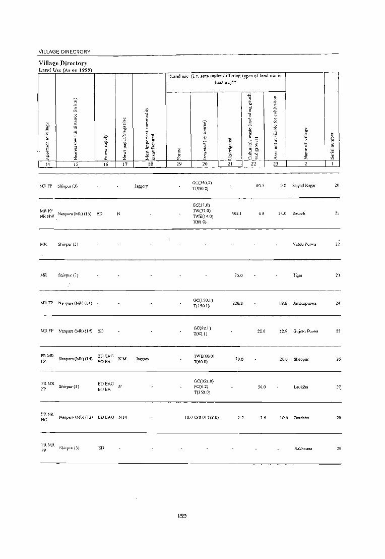
VILLAGE DIRECTORY
Villaj!:c Dircct{)ry Land Usc (As on 1999)
v
:1 ;;: .9 -t; '" ,e "-n.
<:;
14
MRFP
MRFP NRNW
MR
ivlR
MRFP
MRFP
PRMR FP
PRMR FP
PRNR NC
PRIvIR FP
E "'" 5 i:! c ~ '0 ..:j c
" .9 ;;;
" 'i: " ;z: 15
Shivpur (3)
Nanpara (Mb) (J 5)
Shivpur (2)
Shivpur (7)
Nanpara (Mb) (14)
Nanpara (Mb) (14)
Nanpara (Mb) (14)
Shivpur(l )
Nallpara (Mb) (12)
Shivpur (3)
~ CO 0
" E c E 'N
'" 8 oJ)
'" i::-o ~ ~ ~ ~ 0.
0. g. &.2 a E ~ 0. .- '-
~ ~ ;;; ;:I c
0 " 0 '" 0- ;z: ~ E 16 17 18
Jagg~IY
ED N
ED
EDEAG NM Jaggery
EOEA
EDEAG EOEA
N
EDEAG NM
ED
Land IL,e (i,e, area under different types of land IL,e in hectare)--
U' ~
" S; ,.., e ." .!l ;;; " <> "" (; ~ t.<.
-5 ·3 ;:I
'" .", .g "" c co ~ ~ .,2 ~ " ~ i '"
." " ~ ;; ~ " rl
~ > "5 .!:!' 0
3 eo " t: ~
';: :; -0 ~ :::> u fJ <
19 20 21 22 23
Ge(350.2) T(350.2)
80.5 00
GC(37.0)
" ~ 1; ';;: .D
E '_ ;:I 0 c
" E '" '" '5 ;z. '" 2
Saiyad Nagar 20
TW(37.0) TWE(14.0)
462.1 34.0 Baundi 21 6.8
T(88.0)
Valdu Purwa 22
75.0 Tigra 23
Ge(150.1) 220.2 19.6 AmbBIpUIWa 24
T(150.1)
Ge(82.1) 22.0 12.9 Gujrati Purwa 25
T(82.1)
TWE(60.0) 1(60.0)
70.0 20.0 Sheopur 26
Ge(352.8) PC(0.2) 56.0 Laukiha 2~ T(353.0)
IS.O 0(8.0) T(S.O) 1.2 7.6 10.0 Bardaha 28
Rakhauna 29
159

U .D
30
31
32
33
34
35
36
37
38
39
E :0 c:
v '0
8 " o .~ \)
o ...J
<>l
Bamhi (06455900)
Ma{~ra Kalan (06456000)
St!marl)'<! (06456100)
Nakha (06456200)
Nakhi (06456300)
Chaugoie (06456400)
Alinagar Kalan (06456500)
Laluhi (06456600)
Chandda (06456700)
Pathar Klmrd l06456~00)
18.0
897.3
230.0
390.8
10.0
12.0
295.3
150
5133
150
~
'" :0
"' c: " (.)
1,432
5,455
1,301
3,997
1,369
783
3,525
3,105
2.781
972
DISTRICT CENSUS HANDBOOK: BAHRAICH
Census of India 200 I -Amenities and
"' 1;
Amenities available (if not available within Il,e village, a dash (-) is shown in the column and
next to it in brackets the distance in broad ranges viz. < 5 kms., 5-10 kms. and 10+ kms of the
nearest place where the facility is available i" given
5 u
301 PM«5) C(lO+)
MHPHC H(IO+)
MCW«5)
: HP W SS- PH PO« 5) CM(~ 5)
CP(5-10)
~< H~ -969 5)M«5)q< 5)MCW«5) :HPWSS- POPH(l9) CM«5)
5) PHC«5) CP«5)
ACS« 5) NCS(IO+) OCS(lO+)
ACS«5) NCS« 5) OCS(IO+)
CV(lO+)
SP(IO+) ST(lO+)
CV(lO+)
SP(lO+) ST(lO+)
P M( ( H« THPWR PH(2) 207 < 5) C < 5) MCW« 5)
5) PHq< 5) SS-W PO« 5) CM(5-IO) ACS« 5) CP(5-10) NCS(lO+)
OCS(IO+)
CV(lO+)
SP(IO+) ST(1O+)
802 P M« 5) qlO+)
CHW(3) H« T HP W TK PH(6)
5) MCW« 5) C S5-W PO« 5) PHq< 5)
CM«5) CP(S-IO)
ACS«5) CV(lO+) NCS(5-10) SP(lO+)
OCS(IO+) 5T(l0+)
BS« 5) RS(lO+) NW(lO+)
BSC< 5) RS(IO+)
NW(lO+)
Bs« 5) RS(IO+)
NW'\IO+)
BSC< 5) RS(5-10) ]\.'\V(l0+)
227 P(2)M«5) C(5-IO)
H(lO+) MCW(5-10)
PHC(5-IO)
THPTW WSS-W
POC< 5) PH« 5)
eMC<5) CP« 5)
ACS« 5) NCS« 5) OCS(IO+)
CV(5-10) BSC < 5)
131 PM«5)q5- H(IO+) 10) MCW«5)
PHqIO+)
666 P(2)M«5) C(1o+)
H(lO+)
MCW«5) PHq5-IO)
T HP W SS- PO(; 5)
HP PH« 5)
T HP W TK PH(4) SS-W PO«S)
CM«5) CP«S)
CM«S)
CP«5)
ACS« 5) NCS(lO+) OC5(lO+)
ACS:«5) NCS« 5) OC.S(IO+)
SP(lO+) RS(5-10) ST(IO+) NW(5-10)
CV(lO+)
SP(IO+) 5T(10+)
BS(,< 5)
RS(,IO+) !'oW(5-10)
CV(S-IO) BS« 5) SP(1o+) RS(5-IO) ST(lO+) NW(5-IO)
524 P(2) M C(lO+)
MCW THPTW CHW(3) H(5- W SS-W 10) PHC(S-I 0)
PO TO ACS(5-IO) CV(lO+) PTO PH(3) CM(5-10) NC:l(5-10) SP(lo+)
CP(5-IO) OCS(S-IO) ST(lO+)
B5 RS(,IO+) ]\.'\\'(10+)
498 P AC M« 5) C(lO+)
FWCCHW H(lO+) MCW(5-IO) PHC(5-IO)
T HP W ss- PO(~ 5)
W PH(5-10)
P M« 5) C(5- H(5- T HP W SS- PO PHl5-145 10) 10) MCW(5- W 10)
10) PHC(5-10) ..
160
ACS« 5) CV(lO+) CM(5-10) NC:l(5-10) 5P(l0+) CP(5-IO) OC:l(5-IO) ST(lO+)
CM«5) CP(5-10)
AC:l( < 5)
NC:>« SJ OCS«S)
CV(IO+) SP(lO+)
5T(l0+)
B$(5-10) RS(IO+) :-,'\\\5-10)
BS RS(Il~)
:--,\\10+)

VILLAGE DIRECTORY
Village Directory Land Use (As on 1999)
E "" ~ i! " fi " ~ 'i3
.;: ;; >,
" 9 0. 3: "-.c 9 ~ u
" ~ £ ~ "- '" "- " 0 ..; Z "-14 15 16
tvIR FP Nanpara (Mb) (19) ED
PR Nanpara (Mb) (15) ED
PRMR Nanpara (Mh) (16) ED
FP
MRFP Bardaha (1) ED
NC
MRFP Nanpara (Mb) (10) ED
MR FP Nanpara (Mb) (12) -
PR Nanpara (Mb) (9) ED
PRMR Nanpara (Mb) (15) ED FP
MRFP Nanpara (Mb) (14)
PRMR FP
Nanpara (Mb) (16) ED
c-'i3 0 ., E
" 'N E '" :3 00
~ c" ~ ~ ., o " "- "- -" .5.li "-
'" ~ " '" c
" 0 E Z ~
17 18
NM
NM
NM
N
NM
L1nd use (i.e. area under different lypes of land use in hectare)""
-5 " " 0
'" .~
'" eo .~ " 'i3 ~ " U ,~ U" " ~ v \)
" !;l :,; " ~ ~ g t >, ~ ~ .c
"0 ~ .;; e ., ~ E " ... "0 ;e :,; > '0 '_ " 0 c .!l OIl '" 0 " "E ~ eo " ~ ~ " :i E ~ '", -"'"0
0 " " ~ z \)
~ :::> (.) '" '" 19 20 21 22 23 2
TW(342A) 10.0 0.2
T(342.4) 37.0 Baruhi 30
Matera Kalan 31
1.0 200.0 S~mariya 32
GC(226.1) PC(158.1) WE(2.0)
20.3 TK(1.0) 113.1 47.3 4.7 Nakha 33
0(65.1) T(452.2)
107.8 2.1 14.4 Nakhi 34
49.4 3.1 lOA Chaugoie 35
Alinagar Kalan 36
TW(26.0) T(26.0)
42.0 60.0 30.0 Laluhi 31
TW(S.O) TK(L3) Chandela 38 T(93)
W(l27.0) 16.5 WF(1.0) 131.0 25.0 Pathar Khurd 39
T(l28.0) , ~
161

40
41
43
44
45
V .D
E " c
~ " (IJ
46
47
48
49
" '" o u c: .g 5 c
...J
~ ."
'" ~ ;; '0
" E Z 2
Sadhuwapur
Gokulpur (06456900)
Pathar Kalan (06457000)
Ch.hlar (06457100)
Rajapur Janub (06457200)
Dhanawa (06457300)
Baghauli (06457400)
Intaha (06457500)
Sahattar (06457600)
Masudnagar Basthanw8 (06457700)
M"mkpur (06457800)
4
317.2 1,761
17.0 1,148
17.0 1,245
98.0 330
140.0 1,924
339.9 1,288
1,685.0 7,443
56.3 302
212.0 2,152
3400 1.389
DISTRICT CENSUS HANDBOOK: BAHRAICH
Census ofIndia 2001 -Amenities and
Amenities available (if not available within the village, a dash (-) is shown in the column and
next to it in bracket:; the distance in broad ranges viz.< 5 kms., 5-10 kms. and 10+ kms of the
nearest place where the facility is available i!~.c;gii:..:v.:::enT __ ---"
... .D E " Z
5 6 7 8 9
- H(5- , 302 P 0(2) M(5- 10) MCW(S- T HP SS-
10) C(IO+) 10) PHC(5-10) HP PO« 5) PH« 5)
204 P M(5-10) C(IO+)
213 PM(5·10) C(10+)
H(5. 10) MCW(IO+)
PHC(IO+)
H(5-10)
MCW(\O+) PHC(IO+)
P« 10) 64 S)M«5) MCW(IO+)
H(S-
C(l0+) PHC(S-IO)
316 PM«5) C(l0+)
199 P(2) M(2) C(l0+)
PHSCHW
H(5·IO) MCW(1O+) PHC(S·IO)
H(lO+)
MCW(5-10) PHC(5-10)
HPWSS
HP PO« 5) PH(<5)
~ W SS· PO« 5)
PH«5)
T HP W SS- poe; S)
W PH« S)
THPWSS- PO(;S)
W PH« 5)
T HP W S5· poe; 5)
W PH«5)
10 II 12
CM(5-IO) ACS«5) CV(IO+) CP(5-IO) NCS(lO+) SP(lO+)
OCS(IO+) ST(IO+)
CM(lO+) ACS«S)
CP(5.10) NCS(iO+) OCS(IO+)
CV(lO+) SP(IO+)
ST(JO+)
13
B5(5-IO) RS(IO+) NW(5-10)
BS(lO+) RS(IO+) NW(I(}+)
CM«5) ACS«S)
CP(5.JO) NCS(lo+) OCS(IO+)
CV SP ST BSC5·10) RS(5·10) NW(IO+)
CM(lO+) ACS«5)
CP(S-IO) NCS(l0+) OCS(IO+)
CM(lO+) ACS«5)
CP(5.10) NCS(lO+) OCS(IO+)
CV(\O+)
SP(lO+)
ST(IO+)
CV(lO+)
SP(IO+)
ST(lO+)
CM(5-10) ACS(5-10) CV(lO+)
CP(5-10) NCS(IO+) SP(lO+) OCS(IO+) ST(lO+)
BSC5-1O)
RSCI0+) NW(lO+)
BS(5-10)
RS(10+) NW(lO+)
BSC5-10) RS(lO+)
NW(IO+)
P(2) M 1,226 C(lO+)
HPHCRMP CHW(4) T HP W R PO PH(20) CM« 5) MCW(lO+) C SS-W CP(lO+)
ACS NCS(I0+)
OCS(IO+)
CV(1O+) SP(lO+)
ST(lO+)
BS RS(1O+) NW(l0+)
P« H« -54 5)M«5) 5)MCW(10+) THPWTK PO«5)
c(lO+) PHC«5) RSS·W PH«5)
P(2) AC 345 M(lO+)
C(lo+)
H(lO+) MCW(lO+) PHC(lO+)
CHW H« 5) 23R P(2) M(5.~0) MCW(S.IO)
, C(IO+) PHC(5-10)
162
THPWSS· POPH W
T HP W S5· poe; 5)
W PH«5)
CM(5-10) ACS« 5) NCS(lO+)
CP(1O+) OCS(IO+)
CM«5) CP(IO+)
ACS« 5) NCS(l0+) OCS(lO+)
CV(lO+) SP(lO+)
ST(I0+)
CV(IO+) SP(lO+) ST(lO+)
ACS(5-10) CV(lO+) CM(5.lol) NCS(l0+) SP(lO+) CP(5-IO) OCS(IO+) ST(lO+)
8S« 5) RSCIO+) NW(IO+)
BS(5·10) RS(IO+) NW(1O+)
BS(5·10) RS(IO+)
NWlIO+)

VILLAGE DIRECTORY
ViIlagc Dircctory Land Usc (As on 1999)
14
MRFP Nlt
IS
hnamganj (6)
Mil. FP Shivpur (6)
Mil. FP Shivpur (6)
ED
ED
PR Nanpara(Mb)(19) ED
PR Nanpara (Mb) (19) ED
MR FP Nanpara (Mb) (12) -
16
PRMR Nanparn (Mb) (25)
EDEAG FPNR EOEA
MRFP Nanpara (Mb) (25) -
PR Nanpara (Mb) (10)
MRFP Nanpara./Mb) (I c)
17 18
Land use (i.e. area under different types of land lJ.,e in
hectare»>
19 20
GC(201.S) TW(137.9)
3.5 TK(4.I) R(46.7) T(390.1)
GC(200.0) WE(95.2) T(295.2)
W(638) 0(180.0) T(243.8)
TW(24.0)
2.0 TK(8.0) 0(32.5) T(64.5)
TW(80.0)
80 TK(20.0) . 0(100.0)
T(200.0)
W(600.0) TW(4.0)
100.0 TWE(300.0) R(2158.4) T(3062.4)
W(300.0) T(300 0)
WE(21.1)
31.6 TW(40.4) TWE(3.4) T(648)
163
'" 7J "E ·c :J 21
54.9
104.8
4.0
4.0
20.0
339.9
300.0
3i9.9
.c L> .g ~ '" ;; "" " ".2
'"i3 B ~ .~ 2- .E ~ ~ " '" ~ " ~ ;; :; " ~
~ ;> '5 ·0 E c
" 3 oil ~ E :; "0 1!. " u ~ .;: Z
22 23 2
10.5 Sadhuwapur
47.7 Gokulpur
3.3 Pathar Kalan
0.7 Chahlar
1.3 RaJapur Janub
8.0 Dhanawa
273.9 39.3 Baghauli
Intaha
Sahaltar
53.0 37.0 Masudnagar Basth.anwa
~tarllk.--pur
\l .a E " c
-;;; "5 'Il
40
41
42
43
44
4S
46
47
48
49

so
51
52
53
54
55
56
57
58
59
2
Jura
(06457900)
Li11plll Sh~()J.)Ur
(0('·1S8000)
Aswa
MohaJlunadpur
(06458100)
Pakra O.wariya (06458200)
!\llama N¢wariya
(06458300)
fualan Kalan (06458400)
Mogariha (06458500)
Majha Oariya Khurd (06467500)
Narotampur (06467600)
Dhaktya (06467700)
3
581.3
901.9
924.3
418.7
342.9
507.4
25.0
1,929.0
20.0
o o ~ c o
~ ~
"o "-
"5 o
f-
4
2,854
4.184
4,955
1,732
2,000
2,648
1,846
3,129
3,443
1,348
DISTRICT CENSUS HANDBOOK: BAHRAICH
Census of India 2001 -Amenities and
Amenities available (if not available within the village, a dash (-J is shown in the column and
next to it in brackeL. the distance in broad ranges viz.< 5 km.,., 5··10 kms. and 10+ km., of the
nearest place where the facility is available is given
o o ~
'" '0
" .c :.: :> o .c 'o \i
.D
E :> Z
6 7
435 P M(S-IO) C(S· H(I 0+) 10) MCW(IO+)
PHC(IO+)
6"0 P M« 5) - C(lO+)
PHSCHW H(IO+) MCW(IO+)
PHC« 5)
8
-f. o "-9
T HP W ss- PO(;-I 0)
W PH(5-10)
T HP W SS- PO(~ _ W »
PH(IO+)
P(2) 0 M(S- MCW RJv!P(4) T HP W TK PO PH(5-848 CHW(2) H(5- ,
10)C(10+) 10) PHC(S-IO) ::>S-HP 10)
272 P M(5-1 0) C(IO+)
H(lO+) MCW(IO+) PHC(IO+)
344 P(2) M(5-10) H(IO+) C{lO+) MCW(S-IO)
406 PM(IO+) C(lO+)
347 P M« 5) C(lO+)
PHC« 5)
H(lO+) MCW(1O+) PHC(IO+)
H(lO+) MCW(5-10) PHC(lO+)
511 P 0(2)M(5- H(lO+) 10)C(10+) MCW(1O+)
609 P(2) M( < 5) C«5)
PHC(IO+)
H(lO+) MCW«5) PHC« 5)
T HP SS-W PO« 5) PH« 5)
THPTW WSS-W
PO(5-10)
PH« 5)
T HP W SS- PO(~ 5)
W PH(lO+)
T HP W SS- PO(;-IO)
W PH(5-10)
!S~WR PO(5-IO) PH(5-IO)
THPWSS-POPH
W
PM«5)C(5- - H« THPWR 244
10) 5)MCW(5-10)S'_W PO«5)
PHC« 5) S PH« 5)
164
u
.~ "o e ." c '" ~ u
Ii E E o u 10 II
CM(S-IO) ACS«S) CP(5-IO) NCS(lO+)
OCS(lO+)
CM«5) CP« 5)
ACS« 5)
NCS(IO+) OCS(lO+)
12 13
CV(S-IO) BS-,S-IO) SP(10+) RS<:S-IO) S1(10+) )',-N(IO+)
CV(5-10) 85;5-10) SP(IO+) RSi< 5) S1(10+) )',-,1[(10+)
CM«S) CP(S-IO)
ACS NCS(S- CVC;O+)
10) 5P(l0+) 8S<.< 5) R5"s-10) )',-,\'(10+) OCS(lO+) 5T(l0+)
ACS«5) CM(lO+). NCS(lO+) CP« 5) OCS(lO+)
CM(lO+) CP(5-10)
CM(IO+) CP(lO+)
CM(lO+) CP(IO+)
ACS«5) NCS(IO+) OCS{lO+)
ACS«5) NCS(lO+) OCS(lO+)
ACS(lO+) NCS(lO+) OCS(lO+)
CM(5-10) ACS«5) CP(5-10) NCS(lO+)
OCS(lO+)
CM(lO+) CP(lO+)
CM« 5) CP(5-IO)
ACS«5) NC:,(IO+) OCS(IO+)
AC:i« 5) ~c:,(10+)
OC:i(IO+)
CV(IO+) 5P(l0+) 51(10+)
CV(lO+) SP(lO+) ST(lO+)
CV(IO+) SP(lO+) ST(lO+)
B5« 5)
R5« 5) NW(lO+)
B5(S-IO) R5(5-10) )\W(1O+)
B5(10+) R5(10+) ]\W(IO+)
CV(5-10) B5(5-10) SP(lO+) R5(5-10) ST(lO+) )\-"\'(5-10)
CV(lO+) SP(lO+) ST(IO+)
S1 CV(lO+) SP(lO+)
CV(lO+) SP(IO+) ST(1O+)
B5(5-IO) R5(10+) \W(IO+)
B5( < 5)
R5(10+) \-W(10+)
E.5i,< 5)
:0<.10+) \-,\'(S-IO)

VILLAGE DIRECTORY
VilIal!e Directory Laml Usc (As on 1999)
14 15
MR FP Nanpara (Mb) (8)
16
PRMR FP Nanpara (Mb) (10) ED
PRFP NR
Nanpara (Mb) (15)
MR FP Nanpara (Mb) (13) ~~ ~~G
PRMR FP Nanpara (Mb) (17)
MR FP Nanpara (Mb) (1S) ED
MR FP Risia Bazar (Np (l0) -
FP Nanpara (Mb) (35)
MR Bahara (2)
MR Shivpur (7) ED
17 18
laggety
lagsety
Land use (i.e. area under different types of land use in hectare)·'
19 20
TW(J23.0) 2.6 R(O.9)
T(123.9)
WE(lS4.6)
12.9 TW(195.2) T(379.9)
WE(313.1)
201.41WE(4.9) T(31S.1)
TW(l37.6)
51 1WE(8.7) . TK(3.0)
T(149.3)
GC(47.5) 5.6 W(47.5)
T(94.9)
GC(47.8)
4.1 W(47.8) T(95.7)
165
TW(590.0) 1WE(20.0)
4.8 TK(280.0)
T(890.0)
21
350.0
387.0
417.9
222A
407.0
470.0
22
80.5
53.2
67A
12.2
18.6
0.4
9.0
7.3
23 2
27.9 Jura
130.2 Lalpur Sheopur
76.6 Aswa Mohammadpur
37.3 Pakra Dewariya
34.5 Maina Newariya
25A lhalan Kalan
Mogariha
Majha Dariya Khurd
61.0 Narotampur
50
51
52
53
54
55
56
57
58
59

~ .D
60
61
62
63
64
65
66
67
68
E " c:
2
Behra
(06467800)
Pipari Mali (06467900)
Munirnpur Kalan (06468000)
Kun;aha
(06468100)
DhannKunda
(06468200)
Deodattpur
(06468300)
Khaira Dhaukal (06468400)
Musallampur (06468500)
Tikwapara
(06468600)
502.8
681.0
144.0
404.8
15.0
6262
202.5
o o ~
4
3,372
2,784
2,574
164
1.037
2,096
2,949
3,568
1.011
DISTRICT CENSUS HANDBOOK: BAHRAICH
Census of India 2001 -Amenities and
Amenities available (if not available within the village, a dash (-) is shown in the column and
next to it in brackets the distance in broad ranges viz. < 5 kms., 5-10 kms. and 10+ kms of the
nearest place where the facility is available is 2iven
o o ~
"' "0
"0 ~ " o ..c ...... o ij
.D
E i
6 7 8 9
c: '" .D
" .~ ij 0. o I; '0 c: '"
10 11 12
S55 P(2) M C(10+)
HACHW H(IO+) MCW(S-IO)
PHC(S-IO)
THPWSS- PO TO CM«5) CP(S-IO)
ACS(~;-IO) CV(1O+)
W PTOPH NCS(1O+) SP(IO+)
OCS(1O+) ST(IO+)
460 P M(S-I 0) C(lO+)
H(S-
10)
MCW(1O+) PHC(S-IO)
H(S-
~WC SS- PO(;S)
PH«S)
388 P ACM«5) 10) ~HPWSS- PO(;5) C(lO+) MCW(IO+) PH(S-IO)
PHC(5-IO)
CM«5) CP(S-IO)
ACS
NCS(lO+) OCS(lO+)
ACS« 5) CM(IO+) NCS(tO+)
CP(lO+) OCS(10+)
P« H(IO+) 295)M«5) MCW(1O+)
C(lO+) PHC(IO+)
THPWSS- PO(;S) CM(IO+) ACS«5)
W PH(S-IO) CP(IO+) NCS(1O+) OCS(1O+)
189 P« H(1O+)
5) M« 5) MCW(lO+) T HPW SS- POe; 5) CM(lO+) ACS« 5)
W PH(S-IO) CP(lo+) NCS(lO+) OCS(lO+) C(IO+) PHC(lo+)
362 P M« 5) C(lO+)
541 P M C(1O+)
P(2) M(5-10) 594
C(lO+)
P« 155 5) M(5-10)
C(IO+)
H(IO+) MCW(1O+)
PHC(IO+)
THPWTK
RCLSS- PO«S) W PH(lO+)
HC(3) H(I 0+) MCW(S-IO) THPWTK PO(;O+)
PHC(5-IO) SS-W PH« 5)
H« -5) MCW(5-10) T HP W S8- PO« 5)
PHC(IO+) W PH«5)
CHWH(JO+) T HP W SS- PH(2)
MCW(5-10) W PO« 5)
PHC(5-IO)
166
CM«S) CP(IO+)
CM(5-10) ACSOO+) CP(S-IO) NCS(IO+)
OCS(IO+)
ACS« 5) CM«5)
NCS(IO+) CP(5-10)
OC5(10+)
ACS« 5) CM«5)
NCS(lO+) CP(S-IO\
OCS(IO+)
CV(lO+)
SP(lO+)
ST(1O+)
CV(lO+)
SP(lO+) ST(lO+)
CV(lO+)
SP(1O+)
8T(1O+)
CV(1O+)
SP(IO+)
8T(10+)
CV(1O+) SP(IO+) ST(IO+)
CV(lO+) SP(lo+) ST(lO+)
CV(lO+) SP(IO+) ST(IO+)
C\'(IO+) SP(!O+)
5T\10+)
13
BS(S-IO) RS(Hh')
NW(lO+)
BS« 5)
RS«5) NW(lO+)
BS(5-10)
RS(lC>+)
NW(lO+)
BS(5-10)
RS(IO+)
NW(1O+)
BS« 5) RS(IO+) NW(lO+)
NWBS« 5) RS(10+)
BS(IO+) RS(iO+) NW(lO+J
BS«5) RS.Jr}+) NW\lO+)
BS,;-tO) RS ,0-"\ NWll].,.)

VILLAGE DIRECTORY
Village Directory Land Use (As on 1999)
Land use (i.e. area under differenllypes of land use in hectare)··
..<;
" E " ~ a .= -'" '" " § '" >
.~ c .= 1l ." :;; ] a ::s c: " E U ...
" ~ " E -.:;- 5 . .2 ·N u u :! :a '" B "" ;:; ~ ::0 " <iI:I '" s: ~ ~ .;;
~ S] \l ~
.!:;> >- ,,~ ..Ci S 0- ... ... e -0
" ~ ~ .;;
E 0- " o :J .!l ~ .9 ~ ~ o.~
-0 '" ::c > "0 ,~ " .5 .~ 0 c
0 "gj \l 0.
~ .!l os e 8 c: " ] ::;. ~
:J .. i!-: " E ~ " ~ " e .!:P ·2 " 0. 0 0 '" a .E " c: .<: " «: z 0. Z ::E E ('-< ::::> u '" Z '" 14 15 16 17 18 19 20 21 22 23 2 1
Nanpara (18) EDEAG NM jagse')' B.bra 60
GC(28.4)
MR Nanpara (20) TW(3S.3)
115.9 TK(I.S)
48.2 228.5 PipariMafl 61
T(65.2)
GC(70.3) MRFP Nanpara (Mb) (25) 2.2 TWE(20.4) 204.3 2.0 39.5 Munimpur Kalan 62
TK(2.3)
MRFP Nanpara (Mb) (27)· - 02 GC(11.2)
NC . T(l1.2) 48.4 4.4 79.4 Kursaha 63
GC(l8.4) MRFP Nanpara (Mb) (29) 2.0 TWE(8.4) 197.4 2.1 176.6 DhannKunda 64
T(26.8)
PRMR FPNR Nanpara (Mb) (25) Deodattpur 65 NCNW
GC(696.0) PC(IS.O)
PRMR W(S.O)
FPNR Nanpara (Mb) (40) EDEAG TWOS.O)
244.9 173.5 593.3 Khaira Dhaul:al 66 NCNW TWE(2.0)
TK(316.S) R(342.4) T(1391.8)
MRFP Nautaulla (3) NM GC(316 i)
Musallampur 67 T(316.7)
GC(I50)
PRMR TW(loo.O)
FP Bhatara (15) ED TWE(l50 0) 50.0 1- , 2.0 likwapara 68
TK(S.O) 1(2700)
167

69
70
71
72
Kishunpur Mitha (06468700)
Raghaujot (06468800)
Shankarpur Laksrunanpur (06468900)
Bhagwanpur Vilaspur (06469000)
Block Total
607.6 4,583
5.3 1,216
6.0 1,672
508.0 1,840
23931.8 185884
DISTRICT CENSUS HANDBOOK: BAHRAICH
Census of India 2001 -Amenities and
Amenities available (if not available within the village, a dash (-) iis shown in the column and next to it in brackets the distance in broad ranges viz.< 5 kms., 5-10 krns. and 10+ kms of the
nearest place where the facility is available is.= ,giiv"'e"'nf-__ --. ~ -g-
714 P(2) M C(lO+)
225 P M« 5) C(IO+)
RMl'(4) H(lO+) MCW(5-10) PHC(5-10)
H(IO+)
MCW«5) PHC(IO+)
THPWTK -C SS-W PO« 5)
PH« 5)
HPWSSW
PO« 5)
PH« 5)
.D '"
CP CM« ACS« 5) 5) NCS(lO+)
OCS(lO+)
CM«5) CP(lO+)
ACS« 5) NCS(lO+) OCS(!O+)
P(2) M(2) S :r ~~~cw HP W SS-262 PUC AC
C(10+) H(lO+) PHC(5- W 10)
PO PH(2) CM« 5) CP(JO+)
ACS« 5) NCS(lO+) OCS(lO+)
P(2) M S H« 270 PUC C I Tr 5) MCW( < 5) HI' SS- PO« 5)
PH« 5) AC PHC« 5)
P(99) M(n)
32346 S(8) PUC(7) C I Tr AC(l5) 0(7)
H(4) HA(2) HH D(S) DR T(60)
MCW(5) W(66) PO(13) MH(2) CWC TK(ll) TO(4) HC(3) H1'(71) PHC(5) TW(4) PTO(4) PHS(6) FWC R(ll) C(7) PH(103)
RMP(ll) L(3) CHW(26)
168
CM«5) CP(5-10)
CM(6)
CP(S)
ACS« 5) NCS(lO+) OCS(IO+)
AC;(7) NCS(3) OCS
CV(lO+)
SP(IO+) ST(IO+)
CV(IO+) SP(lO+) ST(IO+)
CV(JO+) SP(!O+) ST(lO+)
CV(IO+) SP(lO+) ST(IO+)
CV(3) ST(4) SP(2)
BS(5-10) RS(lO+) NW(1O+)
BS RS(lO+) NW(lO+)
BS RS(lO+) NW(IO+)
BS« 5) RS(IO+) NW(1O+)
BS(8) RS NW(7)

VILLAGE DIRECTORY
Villaj!e Directory Land Use (As on 1999)
" "" ;§ .;;: S
] 8 0. .. -0: 14
PR
PRMR FP
PRMR FP
PR(26) MR(56) FP(51) NC(5) NR(J2) NW(7)
'? "'" 5 " u c .5 .~ -0
~ c ~ .s -.;. e " " " ;z: 15
Matam (IS)
Garrunikhabazar (7)
Ganunikhabazar (5)
Nanpara (24)
>-. P. 0.
ii: ~
" 0 "-16
-
ED(30) EAG(S) EO(4) EA(4)
" c .~
on " ~ .. " .. ~ " ;z: 17
N(12) M(9)
0 :;; 0
E E 8 c ~] o '" .. ~ ,§ ,~
'" (3 c " ::s E
18
Flour
Flour
Land use (i.e. area under different types ofland use in hectare)"
~ 0
""' 19
~ :; ~ ,.., e -0
~ .~ !; 20
Ge(IOO.O) W(200.0) TW(200.0) TK(lO.O) R(10.8) 0(86.5) T(607.3)
GC(47.0) TW(63.6) T(l10.6)
GC(128.9) PC(26.0) TK(5.1) R(22.3) T(182.2)
GC{4224.56) PC(309.24) W(1391.11) WE(615.96) TW(2519.47)
486. TWE(906.44 1 ) TK(760.31)
R(3156.41) L(IH.4) WF(2.4) 0(983.91) T(14709.75)
169
"0 !l " .~ I: '§ 21
96.2
8388.3
il c '" .9 " "" <;;
"" >-C ';;l
'0 -; .z u
~ u .~ ~ " ~ ~ " on
;§ ~ '",
'3 ;; ;;: " :0
._ e "0
~ 0
c " 01)
~ e ." .. " .:;: u iii ;z:
22 23 2
Kishunpur Mitha
52.6 22.1 Raghaujot
59.6 6 0 Shankarpur . Lakshmanpur
Bhagwanpur Vilaspur
2177.9 3578.3
b ..0 e '" c -;; '5 '" 1
69
70
71
72


Map of Risia CD Block
(See Page - 108)
170


Alphabetical list of Villages (C.D. block wise) Name of the District· Bahraich
Serial Name of village 200 1 Census location 1991 Census location code
number 1 2 ..
Name of CD Block: Rlsla Name of Sub-Dist: 0001
1 Acharaura 2 Ali Nagar Khurd 3 Amwa Jauhar Sisaie 4 Amwa Molbi 5 Babhani 6 Bahboliya Mahada 7 Baijnathpur 8 Balbhaddarpur 9 Bangaie 10 Bangia 11 Barehara 12 Bargawan 13 Barie Para 14 Bhadwara 15 Bhagtapur 16 Bhagwanpur Katghara
117 Bhaisaha 18 Bhaisahi 19 Bhaluwa Bhakuraha 20 Bhaukhara 21 Bhawaniyapur Ramgari 22 Bhopatpur Chauki 23 Bisunapur 24 Bulbul Newaj 25 Charsanda Mafi 26 Dhanauli Khurd 27 Dihwa 28 Elaspur Agalya 29 Gaura Dhanauli 30 Gokulpur 31 Gondaura 32 Hundarwa 33 Huseni Purwa 34 Husenpur Mirdangi 35 Husenpur Mohammadpur 36 Jagannathpur 37 Jahan Chak 38 Jamaluddin Jot 39 Jamunaha 40 Jokaha 41 Kaggar 42 Kalpi Para 43 Kamla Jot 44 Karaniya 45 Karaunda 46 Karijor 47 KelJ'a(alpur 48 Khairi Dikauli 49 Khudad Bhari
code number number 3 4
06467300 460010005000480435 06461300 460010005000420375 06462500 460010005000430387 06460700 460010005000410369 06465100 460010005000460413 06466600 460010005000480428 06462700 460010005000430389 06464700 460010005000460409 06459300 460010005000390355 06465200 460010005000460414 06459000 460010005000390352 06464000 460010005000450402 06458800 460010005000390350 06460900 460010005000410371 06463200 460010005000440394 06462300 460010005000430385 06464500 460010005000450407 06466000 460010005000470422 06465500 460010005000460417 06459900 460010005000400361 06459200 460010005000390354 06464400 460010005000450406 06463300 460010005000440395 06462900 460010005000440391 06463700 460010005000450399 06459600 460010005000400358 06463400 460010005000440396 06460000 460010005000400362 06459700 460010005000400359 06463100 460010005000440393 06463600 460010005000440398 06464800 460010005000460410 06458900 460010005000390351 06464100 460010005000450403 06465400 460010005000460416 06461200 460010005000420374 06464900 460010005000460411 06460100 460010005000400363 06459100 460010005000390353 06461900 460010005000430381 06460400 460010005000410366 06462000 460010005000430382 06466300 460010005000470425 06465900 460010005000470421 06463800 460010005000450400 06462600 460010005000430388 06461100 460010005000420373 06466900 460010005000480431 06460200 460010005000400364
171

Alphabetical list of Villages (C.D. block wise) N arne of the District· Bahraich
Serial Name of village 2001 Census location 1991 Census location code number code number number
1 2 3 4 -50 Lakhalya jadld 06463500 460010005000440397 51 Lakshamanpur Shankarpur. 06461500 460010005000420377 52 Lauki 06464300 460010005000450405 53 Lila Para 06460800 460010005000410370 54 Madara Gari 06461700 460010005000420379 55 Maharatha 06462200 460010005000430384 56 Maharu 06464200 460010005000450404 57 Maila Barganwa 06465300 460010005000460415 58 Majhauwa Mujehna 06466100 460010005000470423 59 Masupur 06458700 460010005000390349 60 Mohammadpur Khurd 06461600 460010005000420378 61 Moharba 06461800 460010005000420380 62 Mohraniya 06459500 460010005000400357 63 Mukam 06466400 460010005000470426 64 Narsingh Diha 06465800 460010005000470420 65 Nibiya Begampur 06459800 460010005000400360 66 Nibiya Husenpur 06467400 460010005000480436 67 Padari Tara 06463900 460010005000450401 68 Paraspur 06460300 460010005000410365 69 Parsa Kaitholi 06462800 460010005000430390 70 Parsa Khargaman 06460500 460010005000410367 71 Parsa Kodi Khan 06465600 460010005000470418 72 Patna Ghusiyari 06466700 460010005000480429 73 Piprahwa 06458600 460010005000390348 74 Pure Alast Khan 06462100 460010005000430383 75 Pure Ramdin 06461000 460010005000420372 76 Raghunathpur 06459400 460010005000400356 77 Ram Batti 06461400 460010005000420376 78 Rampur Baraie 06464600 460010005000460408 79 Rampur Kabula 06466800 460010005000480430 80 Ramwapur 06466500 460010005000480427 81 Rasulpur 06467000 460010005000480432 82 Saida 06467200. 460010005000480434 83 Samokhan 06460600 460010005000410368 84 Shankarpur 06466200 460010005000470424 85 Teliya 06465000 460010005000460412 86 Tula Majhauha 06462400 460010005000430386 87 Turawa Purwa ·06463000 460010005000440392 88 Utghaniya 06467100 460010005000480433 89 Uttampur 06465700 460010005000470419
172

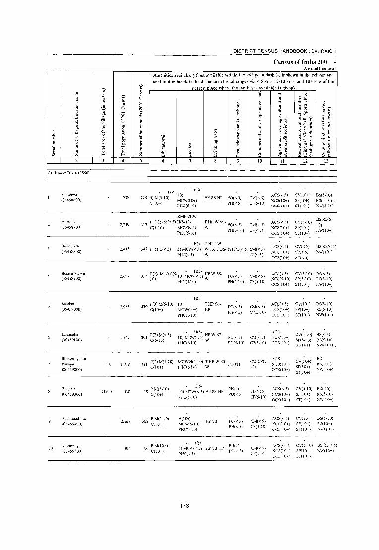
2 3
VI
~
" " U
4 5
DISTRICT CENSUS HANDBOOK: BAHRAICH
Census ofImlia 2001 -Amenities and
Amenities available (if not available within the village, a dash (-) is shown in the column and
next to it in brackets the distance in broad ranges viz. < 5 kms., 5-10 lans. and 10+ kms of the
nearest place where the facility is available i" given
6 7 8 9 10 11 12 13
CD Block: Risia (0550)
2
Piprahwa (06458600)
729 114
H(5-P« 10)
5) M(5-1 0) MCW(JO+)
C(10+) PHC(5-10)
RMPCHW
HPSS-HP PO«5) PH«5)
CM("5) CP(5-tO)
.:"CS« 5) ~CS(JO+)
OCS(IO+)
CV(IO+) SP(JO+) ST(IO+)
BS(5-IO) RS(5-10) • }',V(5-10)
CV(S-IO) BS RS(5· 10) Masupur 313 P O(2)M«5)H(5-10) TwHPWSS- PO(~5) AC:>«5)
(06458700) 2,239 C(5-IO) MCW«5) CM('" 5) ~C:l(lO+) __________________________________________ P_H_C(~5_-1_0)~ _________ PH_(_5_.1_0) ___ CP_C_<_5_) ____ OCS(1O+)
SP(lO+) hW(IO+) 51(10+)
10
Baril! Para
(06458800)
Huseni Purwa (06458900)
Barehara (06459000)
}amunaha
(06459100)
Bhawaniyapur
Ramgari
(06459200)
Bangaie
(06459300)
Raghunathpur 1,(6459401)
\toimullya l06459500)
2,485
2,OS7
2,985
1,347
10 1,938
196.0 550
2,267
394
H« THPTW 347 P M C« 5) 5) MCW« 5) WTKCSS·PH PO« 5) CM« 5)
PHC(" 5) W CP« 5)
ACS« 5) :-ICS(1O+) OCS(10+)
CV«5) SP« 5)
ST«5)
BS RS« 5) hW(1O+)
. - H(S-321 P(2) M 0 C(S'lO) MCW« S) HP W SS· PO« S)
10) PHC(S.IO) W PH(5.10)
H(5-
430 P(3) M(5·IO) 10) C(IO+) MCW(IO+)
THP S5· HP
PO«5) PHC<5)
201 P(2) M( < 5) C(S-JO)
PHC(S·IO)
. H(S. _ 10) MCW« 5) HP W 55·
PHC(5.10) W PO« 5) PH(S·tO)
311 P(2) M(5-10) MeW H(S-l 0) T HP W SS· PO PH C(IO+) PHC(5·10) W
79 P M(S-IO) C(1O+)
362 P M(S·I 0) C(lO+)
66 PM(1O+) C(10+)
H(S· PH(4) 10) MCW« 5) HP SS·HP PO« oj PHC(5·10)
H(1O+) MCW(S·IO) PHC(5·10)
H«
HP SS·
5) MCW« 5) HP SS·HP PHC« 5)
173
PO« 5)
PH« 51
PHlc) PO« 5)
CM«S) CP(5·IO)
CM«S) CPC5·IO)
CM«5) CP(5·IO)
ACS« 5) CV(5·10) BS« 5) :-;CS(5.IO) SP(5·10) RS(5·10) OCS(10+) ST(IO+) hW(IO+)
ACS« 5) NCS(IO+) OCS(IO+)
.-\CS
:-IC3(10+) OCS(lO+)
CV(IO+) SP(IO+) ST(10+)
BS(5·10) RS(S·IO) NW(1O+)
CV(S·IO) BS« 5) SP(S·IO) RB(5·10) 5T(1O+) ~W(1O+).
ACS CM CP(5. :-ICS(IO+)
10) OCS(IO+)
CV(IO+) SP(10+) ST(1O+)
BS RS(IO+) ~W(lO+)
CM«5) CP(S·IO)
CM«S) CP(S·IOI
CM«5) CP« 5)
ACS« 5) ~ICS(1O+)
OCS(10+)
AC5« S) ~'CS(IO+)
(ICS(10~)
.',CS« 5)
';CS(IO+) (JCS(I Q--)
CV(S·lO) BS« 5) SP(IO+) RS(5·10) ST(1O+) N,V(lO+)
eV(1O+) SP(IO+) ST(1O+)
B5(5·10) RS(lCi-'-} ~·W(10 ... )
ev(s·lo) 3SRS«5) 5P(10+) ~'\"(IO-)
5T(10+)

VILLAGE DIRECTORY
ViIla2e Directory Land Usc (As on 1999)
" ~ .;; 9 -fi '" 0
is. 0. ~
14
PR
MRFP NC
E -'" ;§, " <.>
" ~ 'i3 ,. " 3: B to; 1:!' .. Z 15
Nanpar. (8)
Nanpara (Mb) (7)
Nanpara. (Mb) (4)
FP NC Nanpara (Mb) (5)
Nanpara (6)
MRFP Nanpara (Mb) (6)
PRMR Nanpara (Mb) (5)
FP
MRFP Nanpara (Mb) (2)
Sin;),a (15)
PR MR NanpaJo (Mb) \6)
~ 'i3 0
" E " E .~
00 :3
~ c
..Q ~ '0 1:! 0.
0. o " ~
go o.~
0. .5 .~ II ~ ::s ;;: 0; c 0 " 0 .. 0. Z ~ E 16 17 18
EAG
ED
EDEAG NM
EOEA
EDEAG EOEA
ED N
Land use (i.e. area under different types ofland use in hectare)··
-fi " " 0 .. "fJ OIl OIl ·Ei " 'i3 e -E ._;: 8' _§,
" :; ~ :0 " Sl .. ~ ~ II 3:~
.;;; ,., '0 > .;; -0 e " l'l E ~ '" .., :0 E (:;
._ ::s
B .!!P e c 0 " E .. I:: E 00 '" " '" OIl
~ "3 '0 I.l E "5 0 ] " ;;: '" ~ u .. Z en
19 20 21 22 23 2 1
Piprahwa
Masupur
Barie Para
Huseni Purwa
Bareham
Jamunaha 6
4.0 T(4.0) Bhawaniyapur
Ramgari
Bangaie
Raghlmathpur 9
Mohraruya 10
174

DISTRICT CENSUS HANDBOOK: BAHRAICH
Cl1!nsus oflndia 2001 -Amenities and
Amenities available (if not available within the village, a dash (-) is shown in the column and
';; next to it in brackets the distance in broad ranges viz.< 51cms., 5-10 Icms. and 10+ Icms ofth.
'V' 1;; nearest place where the facility is available ils given
" S 5 c '0 ij1 " '" 2 " ~ U .l:> c: " ~ ..
:-3 -0 ,;
" ..c: - " " c 0 c ,i; .~ '"5 t " .~ 6 " 0 .~ ~ U 0
~ "" ~ ~ g_ " " - '"
Q. :l : ~ 0 "" 0 "0 " 0. .2 -';'" ..l ~ 0
Ci ] 0 ~ ~ ~::{e :l "
~ ;; ~ "&
." 8 '3 ~.2 p:) ~
~ .~ ~ .. " " c " ~ ~ ;g -5 9 :J '" "0 o ._ \) 0 ~
ij c 2 "" " " ~ ~ v E 0 ,,' .~ ;;: ..c: Q. " _~:.a .~ 0
.l:> .;; 0 ;; .~ -;;; " } -,; • ...: (It
~ > .;: .@ '§ 5 " 0. 0 c: ~ 'u ~~ :l .~ ~ 0 ij 0 -;;; "" ij .~ ~ .g .... S " '" c: c .. Q. .~ .5 " '" .D " E " \) '" E " ~ " "5 S E " ;a -" .~ ij e g:.a E .. E ;:l .5 .r E S ~ 0 0 ~ " '" ~-5 ~Qb3 :Z "0
:::E Q & 0 o ._
<Zl l- I- (Il U < 0 u e I 2 3 4 5 6 7 8 9 10 11 12 13
P« H(S-
II Dhanauli Khurd
],212 1995)M(5-10) 10) HPWSS-
PO(5-10) CM(5-10) ACH(S-IO) CV(S-IO) BS« 5)
(06459600) C(5-IO)
MCW(1O+) W PH(5-10) CP(5-10)
NCS(IO+) SP(1o+) RS(5-IO) PHC(5-10) OCS(1O+) 3T(10+) NW(1O+)
Gaura Dhanauli P(2) M« 5) CHW(2)H«
THP SS- ACS«5) CV(5-10) BS« 5) 12 2.419 447 5) MCW«5) PO«5) CM«5)
(06459700) C(5-10) PHC(5·10)
HP PH«5) CP«5)
NCS(1O+) SP(1O+) RS« 5) OCS(lO+) 3T(l0+) )'<'W(lO+)
N ibiya BegaJUpur P(2) M«5) PHS H« 5) THPTW
ACS«5) CV(lO+) BS«5) 13
(06459800) 2,115 341
C(lO+) MCW«5) WTKSS- PHPO«5)CM«5)
NCS(1O+) SP(lO+) RS(5-10) PHC« 5) W CP«5)
OCS(IO+) 5T(1O+) NW(1O+)
DCHW(2) PO(2)TO
14 Bhaukhara
4,925 792 P(4) M S 0 H«5) THPSS-W PTOPH« CM«5)
ACS«5) CV(lO+) BS« 5) (06459900) C(5-10) MCW«5)
5) CP«5) NCS(IO+) SP(1O+) RS«5)
PHC(5-10) OCS(IO+) ST(lO+) NW(IO+)
Elaspur Agalya P(3) M C(5· - H«
ACS« 5) CV(5-10) BS(5-10) IS 3,075 479 5) MCW(5-10) HP W SS- PO«5) CM«5)
(06460000) 10) PHC«5) W PH«5) CP«S)
NCS(1O+) SP(1O+) RS« 5) OCS(IO+) ST(1O+) J'o,'W(IO+)
Jamaluddin Jot P M« 5) C(5· H«
T HP W SS- PO(~5) AGS«5) CV(lO+) BS« 5) 16
(06460100) 1,238 203
10) 5) MCW«5) CM«5)
NCS(IO+) SP(lO+) RS(IO+) PHC«5) W PH«5) CP«5)
OCS(IO+) ST(1O+) NW(1O+)
HADACHW
17 Khudad Bhari
2,123 296 PM(5-10) H« 5) THPTW PO«5) CM«5)
ACS(5-IO) CV(IO+) BS« 5) (06460200) C(10+) MCW«5) WSS-W
PH«5) CP(5-10) NCS(5-10) SP(5.10) RS(5-10)
PHC(5·10) OCS(5-10) ST(1O+) NW(IO+) •
Paraspur P(2) M« 5) CHWH«5)
THPWSS- PO(~5) ACS(5-10) CV(5-10) BS«5) 18
(06460300) 3,449 504
C(5-IO) MCW(5-10) CM«5)
NCS(1O+) SP(1O+) RS(5-10) PHC(IO+) W PH(5.10) CP(5-10)
O(;S(1O+) ST(IO+) NW(IO+)
Kaggar P M«5) CHWH«5)
THPWSS· PHPO«5)CM(~5) ACS«5) CV(1O+) BS« 5) 19 1,882 305 MCW«5)
(06460400) C(10+) PHC(1O+) W CP«5)
NCS(IO+) 5P(10+) RS« 5)
OCS(1O+) 5T(10+) !'.W(1O+)
Parsa Khru:gaman P(2) M« 5) CHW H« 5)
T HP W SS- PH(6) AC5«5) CV(lO+) BS« 5) 20 1,397 233
C(10+) MCW(<:5)
W PO« 5) CM«5)
NCS(1O+) SP(1O+) RS« 5) (06460500) PHC(IO+) 1 CP« 5)
OC5(10+) .. 5T(1O+) \W(1O+)
175

VILLAGE DIRECTORY
ViUaj!;e Directory Land Use (As on 1999)
E .:,;
2-" il ~ " 01) '6 ~ <Il .s:
.0 c S " " " -{i S " " 'ii '" 0 . Ii Q. ~ il: " 0 <l; Z jl,
14 15 16
PR Matarabazar (5) ED
MR FP Matara (3) ED
:;:- MR Malara (3) ED
ED N
Nanpara (Mb) (10) •
FP Ris B (N (10) EDEAG N la azar p EO EA
PRMR FP Matara (8)
MR FP Nanpara (Mb) (5)
EDEAG EOEA
ED
PRMR FP Nanpara (Mb) (14) ED
PR Nanpara(~lb)(14) ED N
.f' '" 0
" E " E .1')
" 0
f 0
;::", t! 1! o 2
~ ,§ ~ " ~ ;; " " 0 " " z ::?: E 17 18
Land use (i.e. area under different types of land use in
;; ~ 0
>t.
19
8 :; 0
'" '"' e .."
~ .!;!l ~ 20
494.8
28 2 WF(24S.2) . T(248.2)
176
hectare)··
.."
* .!;!l .!:i c
;:J
21
.ii u c ~ 0 . ., '>Il " 01) ·s .s -a " -e 0
~
5 .£ ..!!
{l ~ '" .;; ,,~
" '" ;0 " :;:; e 15 '" c E 01)
~ - .." " c U '" <l;
22 23
" ~ Ii <;: .c :> E '- " 0 c
" " E '5 Z I/O
2 1
Dhanauli Khurd 11
Gaura Dhanaul i
Nibiya Begampur 13
Bhaukhara 14
Elaspur Agalya 15
Jamaluddin Jot 16
Khudad Bhari 17.
Paraspur IS
Kaggar 19
p""" Khargaman cO

DISTRICT CENSUS HANDBOOK: BAHRAICH
Census of India 2001 _ Ameniti d es an
Amenities available (if not available within the village, a dash (-) is shown in the colullU1 and next to it in brackets the distance in broad ranges viz.< 5 kms., 5·10 kms. and 10+ kms of the
~ ~ nearest Dlace where the facility is available is £iven
~ 5l v " ~ "0 5 "
"0 .Li 2 u ~ U
.. " ~ :J
v :J .t> " " u "
.<: ::! 0 " " ~ ~ .;
c .~ " u 0 2- v 0 "§ E~ '':: (.J 0 a ~ .c .. ·2 i3 v - Co I; ] Co. " >. 0 '" 0 ~ ..!l "- '" '" ~ ~ ~
-a ...l 0 -0 3 0
~ _g ~'l ~ .;, ~ 6~ "d ;; ~ -a 7 .~
" " c c u C "
::s ..c ._
" '" .", u 0 ~ ::! ~ -5 .~ :> !l c o ._
o(!-il~ t; 0 .<: '" " g 0 r3
.D :::. '0 .c
'" "- ....r ~ ..... ._ "'tj . .:: 0
;; :; ._ -;;; " '" > :> ~ '':: E ~ Co 0 C " ~ .S ~ ~ § ....... <r:: i1. :> ._
0 t; 0 -;;; eo " ~ ~ e '':: '" E '2 c 0 '" "- '':: " "2 :> >. '" " ~ '" u :;;l E :> u ~ ~ ~ E " E 5 5 u 'i5 " tf E .~ b E ~ '5 :>
'" 0 0 z .", " 8 0 0 0' -5 ~ \I tl o ._
'" Z f- f- ~ ~ "- u <t: 0 (.J e I 2 3 4 5 6 7 8 9 10 II 12 13
Samokhan 445 P(3) M( < 5) H« HPWSS- ACS« 5) CV(IO+) BS(5-IO) 21 313.0 2,796 5) MCW«5) PO«5) CM(I(};.)
(06460600) C(10+) PHC(I(};')
W PH«5) CP« 5)
NCS«5) SP(1O+) RS« 5) OCS«5) ST(1O+) NW(1O+)
AmwaMolbi H(I(};') THP SS- PO TO - ACS«5) CV(IO+) BS(5-10) 22 4,217 642 P M C(l(};.) PTO PH(3) CM« 5) (06460700) MCW(5-10) HP NCS(1O+) SP(1O+) RS(5-10)
PHC« 5) CP(5-10)
OCS(lO+) ST(IO+) NW(1O+)
Lila Para P« H« :HPW SS- PO(~5) ACS(S-IO) CV(1O+) BS« 5)
23 2,509 401 5) M« 5) C(5- 5) MCW« 5) CM«5) (06460800) NCS(lO+) SP(1O+) RS(5-IO)
10) PHC« 5) PH(IO+) CP(5-10) OCS(IO+) ST(1O+) NW(1O+) _
24 Bhadwara
3914 2,553 462 P M« 5) - H« THPTW PO«5) CM«5)
ACS«5) CV(1O+) BS(5-10)
(06460900) C(IO+) 5)MCW(l0+) WSS.HP NCS(IO+) SP(lO+) RS«5) PHC(I(};') PH«5) CP«5)
OCS(lO+) ST(1O+) NW(lO+)
Pure Ramdin - H(5·
ACS«5) CV(5-10) BS«5) 25
(06461000) 153.0 1,218 200 PM(5-10)C(5· 10)MCW(5. TWSS·W PO(5-10) CM«5)
NCS(1O+) SP(1O+) RS(5-10) 10) 10) PHC(5-10) PH«5) CP(5-10)
OCS(lO+) ST(1O+) NW(lO+)
26 Kewalpur
1,796 272 P M(5·10) H(I(};') THPWSS- PO(;5) CM«5) ACS«5) CV(1O+) BS«5)
(06461100) C(JO+) MCW(IO+) W PH(IO+) NCS(1O+) SP(1O+) RS(lO+)
PHC(IO+) CP(5.10)
OCS(1O+) ST(1O+) NW(1O+)
iagannathpur PM«5) H«
T HP W SS- PO(;.J 0) ACS« 5) CV(IO+) BS
27 480 77 5) MCW«5) CM«5) RS(1O+) (06461200) C(IO+)
PHC(l(};.) W PH«5) CP(5-10) NCS(lO+) SP(1O+)
NW(1(}-) OCS(lO+) ST(1O+)
Ali Nagar Khurd 280 P OM« 5) CHW H«5)
THPWSS- PO(;-IO) ACSI<5) CV(lO+) BS RS(S-
28 1.952 MCW«5) CM«5) 10) (06461300) C(1o+)
PHC(S-IO) W PH«S) CP(5-10) NCS(lO+) SP(lO+)
NW(l(}-) OCS(IO+) ST(lO+)
Ram Batti P(2) M« 5) - H(5-
ACS« 5) CV(5-IO) BS« 5) 29 1,781 262 10) MCW« 5): HP W SS- PO« 5) CM«5)
(06461400) C(5·10) PHC« 5) PH« 5) CP(5-10)
NCS(lo+) SP(lO+) RS(5-10)
OCS\IO+) ST(IO+) NW(I(}-)
Lakshamanpur P(3) M HMCWHC
PH(2) CMCP(5-ACS C\'(5-10)
BS RS(5-
30 Shankarpur 3,069 462 C(lO+)
RMP(2) HP SS-HP PO(5-10) 10)
NCStIO+) SPtIO+)
10)
(06461500) PHC(5-10) OCStIO+) ST\lO+)
NW(IC>-)
177

VILLAGE DIRECTORY
Village Directory Land Use (As on 1999)
Land use
E '" ~ b
~ ~ 0
" " E ~ " E u 'N eo ~ '" 0
~ OIl 0
o:d ~ "'0 :; c 2;- t! " S il: 0.
" &.3 .c S 0. 0.
~ " '" .5 .! E '" 0. 8 ~ ~ "
-z; -z; Q, " il: " .. " Q, " 0 u 0 " l5 « :z. 0.. :z. ~ E '" 14 15 16 17 18 19
PRMR FP Matara (3) EDEAG •
MR Nanpara (Mb) (12) ED EAG •
MR FP Matara (5)
:;::- MR Nanpara (Mb) (15) •
MR FP Nanpara (Mb )(0)
MRFP Nanpara (Mb) (11)
MR Nawabganj (Mb) (8) •
PR Nawabganj (Mb) (8) ED
MR Nanpara (Mb) (9) ED
PR MR Nanpara (Mb) (9) ED EAG N M
178
(i.e. area under different types ofland use in
';;' f:! " 0
'" e 1 ] 20
TW(24.0) TWE(l3.8) T(37.8)
TWE(3.0) TK(I.5) T(4.5)
GC(2.0) TWE(8.9) T(lO.9)
hectare)"
'0 3
.~ ;§ 21
28.9
.<::
" 0
;l 0
t>O .~
t>O -5 .5 '0 :; .z 0
0 • .,S g ..2
%l ~ '" il:~ .;;
..2 tl ~
.0 > -0 ., 0
" a ~ '" - '0 ~ " " u ., 22 23
17.6
u OIl
~ ~ ..c .;; E ._ " 0 c
" ~ E ., u :z. til
2 1
Samokhan 21
AmwaMolbi 22
Lila Para 23
Bhadwara 24
Pure Ramdin 25
Kewalpur 26
Iagannathpur 27
All Nagar Khurd 28
RamBatti 29
Lakshamanpu: Shankarpur
30

DISTRICT CENSUS HANDBOOK: BAHRAICH
Census of India 2001 -Amenities and
Amenities available (if not available within the village, a dash (-) is shown in the column and next to it in brackets the distance in broad ranges viz.< 5 kms., 5-10 kms. and 10+ kms of the
0;;- nearest place where the facilitv is available i!1 eiven ~ " " 1:! .,
] "0 tl Ii ." uj 0 ., (.) .D " " " a " .; c .c C " " "
.~ u C > '8 t .~ ~ 0 2- OJ c ii c 0 .;;;:
.~ u ~ .c .;: 8-" " - ., "- u .. ~~ " .. 0 "" 0 "0 " "- ::or:: 'Zl
;'l ~ ...J ~ 0 "0 "2 0 :;=e o(j ;; ~ " ~p .~ '" -~
"0
" -; ~ .e ~ .. " " c ~ "0 c: ~
" 0 " ., il:
OJ) -5 .~ c (> ...... ~ 4.l .9 c •
t ~ 0 ~ .t:
" ,: ~ o c
'"" .c g. _.~ (I) - .~ ~ '':; 0 ..0 ;; 0 :; '- '" -;;; a > ~ " ';:J
EO " 0. 0 c il: ;;;, 'g .i~ i .:! 5 "
._ 1:! 0 U 0 .S " 0-, c .,
" 0 " 0. ';:J '" 11 .~ S § " >--;;; "
..0 .. .:! -'" EO " u S .. E '5 '5 e " "" " of E .~~ ~ e g:.a E~ 'is " ~ 0 i .g " is 0 0 ;~ .;3 ~ Q, ~ o .-on Z f-o txl ~ "- u <C 0 () e
I 2 3 4 5 6 7 8 9 10 II 12 13
Mohammadpur 63 PM«5)
PHS H« 5) PHPO(5- ACS(5-10) CV(5-10)
BSRS(5-31 Khurd 367 MCW«5) HPSS-HP CM«5) 10)
(06461600) C(lO+)
PHC(5-IO) 10)
CP(5·IO) NCS(IO+) SP(1O+)
NW(lO+) OCS(IO+) S1(10+)
32 Madara Gari 480 P M(lo+) - H« HPTWW ACS« 5) CV(1O+) B3(<5) (06461700)
3,150 C(lO+) 5) MCW(lo+) TK SS-W PO PH CM«5)
NCS(1O+) SP(1O+) RS(10+) PHC(IO+) CP(IO+)
OCS(1O+) S1(10+) NW(1O+)
33 Moharba
5,728 857 P(3) M« 5) H(10+) ~ HP W SS- PO PH« 5) CM(~ 5) ACS« 5) CV(1O+) B3« 5)
(06461800) C(IO+) MCW(IO+) NCS(lO+) SP(lO+) RS(5.10) PHC(IO+)
CP(5-10) OCS(1O+) S1(10+) NW(IO+)
lokaha P« H(IO+) HPWSS- ACS« 5) CV(IO+) . BS(IO+)
34 (06461900)
1,857 250 5) M« 5) MCW(lO+) W
PO« 5) CM«5) NCS(1O+) SP(1O+) R3(IO+)
C(IO+) PHC« 5)
PH« 5) CP(1O+) OCS(lO+) S1(10+) NW(IO+)
35 Kalpi Para
764 III P M«5) H(IO+) HPWSS-
PO« 5) CM(5-IO) ACS« 5) CV(IO+) B3(IO+)
(06462000) C(lO+) MCW(IO+) W NCS(lO+) SP(IO+) RS(IO+) PHC(5-10)
PH(5-10) CP(lO+) OC:;;(1O+) S1(10+) hW(1O+)
Pure Alast Khan 266 P(2) M( < 5) CHWH(IO+)
ACS« 5) CV(10+) BS(IO+) 36
(06462100) 352.0 1,564
C(10+) MCW«5) HPSS-HP PO« 5) CM(5-10)
NCS(lO+) SP(lO+) RS(IO+) PHC(IO+) PH(5-10) CP(IO+)
OCS(1O+) S1(10+) hW(1O+)
Maharatha P« H(1O+) ~HPWSS- PO(~5) ACS(10+) CV(10+) BS(5-IO)
37 (06462200)
1,851 272 5)M(5-10) MCW(lO+)
CM(lO+) NCS(1O+) SP(IO+) RS(5·10)
C(IO+) PHC(IO+)
PH(1O+) CP(1O+) OCS(lO+) S1(1O+) };W(lO+)
Bhagwanpur RMP(2)CHW
410 P(2) M« 5) H(1O+) 1 HP W SS- PH(5) AC'S« 5) CV(1O+) BS(IO+) 38 Katgharn 2,729
C(10+) MCW«5) W PO« 5) CM(5-10)
N(,S(1O+) SP(IO+) RS(10+) (06462300)
PHC(1O+) CP(lO+)
O(,S(lO+) S1(10+) hW(IO+)
1 ula Majhauha P« CHWH(1O+)
1HPWSS- - ACS« 5) CV(lO+) BS(IO+) 39 1,141 171 5)M«5) MCW(lO+) W PO« 5) CM(5-10)
(06462400) NCS(lO+) SP(1O+) R5(IO+) C(10+) PHC(lO+) PH(lO+) CP(1O+)
OeS(lo+) ST(1O+) SW(IO+)
Amwa Jauhar PM«S) H(1O+) 1HPW SS- - ACS(S·10) CV(lOi-) B5(IO+)
40 SlSaie 1,822 253 C(lO+) MCW«S)
W PO(5-10) CM(5-10) NCS(lO+) SP(lO+) Rs(lo+)
(06462500) PHC(lO+) PH(IO+) CP(lO+)
OeS(10+) ST(10+)1 XW(lO+)
179

VILLAGE DIRECTORY
Villal!e Directory Land Use (As on 1999)
E "'" .s " (J
c: ~ " g 'il
';: oll S c
il: .c S (J
'" U; 2 e 0. '" 0. " -0: ;z. 14 15
" c: 'N '" 01)
~ ..0 0. 0. " ft 1;]
0. t ~ " 0 " 0. ;z. 16 17
PR!vIR Nanpara (Mb) (9) ED EAG N M
!vIR FP Laxmanpur (3)
Nanpara (Mb) (13) •
!vIR FP NC
Nanpara (Mb) (12) .
MRFP NawabganJ (Mb)
EAG (IS)
MR FP Nanpara (Mb) (17) .
!vIR FP Risia Bazar (Np (16) • NM
MR FP Risia Bazar (Np (IS) .
PR Risia Bazar (Np (IS) ED
MR Risia Bazar (N p (I 5) ED
~ 'il 0 E E 0 Q
"'0
~ " 8.E ,~ .~ ~ c: o .,
::E E 18
Land use (i.e. area under different types of land use in hectare)"
..c: c: " " 0
'" .~ 01)
01) -s c: 'il ] " <> ~
3 ,,8
" tl :0 ..!!!
'" ';;j
" " ~ ~ :0 ;> 0 e 0
~ c z '" :; '0 " () ~ 4:
'ii' l:!
" Sl € '0
.!l ] '" 01)
~ '" 'E .!?J>
~ 0 .E ~
19 20 21 22 23
TK(20.0) R(3.3) T(23.3)
180
" ~ ;: '0
" E c: ;z. 2
Moharrunadpur Khurd
Madara Gall
Mohama
lakah.
Kalpi Para
Pure Alast Khan
Maharatha
Bhagwanpur Katghara
Tula MaJhauha
Amw.Iauhar Sisait!
t .c E " c
-;;; "5 '" 1
31
32
33
34
35
36
37
38
39
40 ~
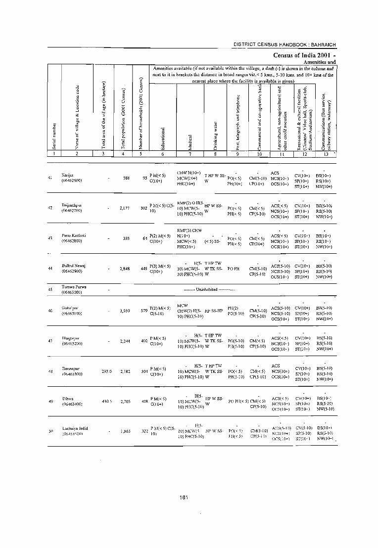
DISTRICT CENSUS HANDBOOK: BAHRAICH
Census of India 2001 _
Amenities and Amenities available (if not available within the village, a dash (.) is shown in the column and next to it in brackets the distance in broad ranges viz.< 5 kms., 5·10 kms. and 10+ kms of the
~ ~ nearest place where the facility is available is given '? " " '" "\"j
'" s Ii "0 ",.t:i Vi' .. <l 8 0 u ..c '" " .2 " a ':J u oj a ..<: <; " " <i! Ii c: 'S ~t2 0 0 g 0 0 a .~ ~ .~ u f:!. .c :: ~ 0
" 0. :; 0. " >, 0 ;:; " : ~ 0 bI) :l2 ~ 0. .~ Ol'" ....l ~ 0 .!l 0 l3=,? f:!. 0
:3 Oil U " " <:! .s: 1i "0 % 'is ~ 1.2 el.~ " " c: :g :;;
" o 0 ~ ·Cl :t
~ -5 0 o .-o>J ~.g .~ 0 B -" :;; r: g .~ c
" ._
.c ~ 0 .D 0 '" Ol ...: '" _ ._ "0
E ;; "5 .... Ol :t e:g ,,> " '.;:l
'" 0. 0 c: ~ 'ij a,::: .~ s " '_ " 0 u 0 bI) " u _g e e ~ c: 0 :. 0. '.;:l Ol r: ] .~ E § , E ~ " '5
..c " .~ :;;; E :;l " '" E S E 0 .~ U ~ g :.a "
"0 c: of E E1 " '" 0 ?: ~ "0 " 8 0 0 es:~ .:; ~ '0 S
o ._
'" Z E- ~ :2 0. U <f. 0 ~ ~'" u :: I 2 3 4 5 6 7 8 9 10 II 12 13
Karijor 93 PM«S) CHWH(1O+)
THPWSS· PO(~5) ACS
CV(lO+) BS(lO+) 41 588 MCW(1O+) CM(5·10) NCS(1O+) (06462600) C(lO+) PHC(1O+) W PH(IO+) CP(1O+) OCS(lO+)
SP(lO+) RS(IO+) ST(IO+) NW(IO+)
Baijnathpur RMP(2) 0 H(5. ACS« 5) CV(lO+) BS(S·IO) 42 2,177 302 PM«S)C(S· 10)MCW(5. HPWSS· PO«S) CM«S) (06462700)
10) 10) PHC(5.10) W PH«5) CP(5·10) NCS(IO+) SP(lO+) RS(S·IO) OCS(IO+) ST(IO+) NW(IO+)
RMP(3)CHW
43 Parsa KaithoJi
64 P(2)M«5) H(lO+) ACS« 5) CV(lO+) BS(lO+)
393 PO« 5) CM«5) (06462800) C(IO+) MCW«5) «5) SS· PH« 5) CP(lO+)
NCS(IO+) SP(IO+) RS(IO+) PHC(IO+) OCS(lO+) ST(IO+) NW(IO+)
Bulbul Newaj 445 P(3) M« 5) H(5· THPTW
ACS(5·10) CV(lO+) BS(5·10) 44 2,848 10) MCW(5· WTKSS· PO PH CM(5·10) (06462900) C(10+)
1O)PHC(5·IO) W CP(S·IO) NCS(5·10) SP(IO+) RS(5·10) OCSOO+) ST(1O+) NW(IO+)
45 Turawa Purwa .......• Uninhabited •........... (06463000)
Gokulpur 579 P(2) M« 5) MCW
PH(2) ACS(S·IO) CV(IO+) BS(S.IO) 46 3,939 CHW(2)H(5. HP SS·HP CM(5.10)
(06463100) C(5.10) 10) PHC(5·10)
PO(5·10) CP(5·10)
NCS(5·10) SP(IO+) RS(5·10) OCS(IO+) ST(IO+) NW(lO+)
Bhagtapur 402 P M« 5) H(5. THPTW
ACS« S) CV(lO+) BS(S·IO) 47 2,244 10) MCW(5· WTKSS· PO(5-10) CM«5)
(06463200) C(IO+) NCS(IO+) SP(lO+) RS(5·10) 10)PHC(S·10) W PH(S·IO) CP(S-IO)
OCS(IO+) ST(lO+) NW(IO+)
Btsunapur PM«S) H(S- THPTW ACS
CV(lO+) BS(S·IO) 48
(06463300) 293.0 2,782 504
C(lO+) 10) MCW(5. WTKSS· PO« 5) CM«5) NCS(JO+)
SP(JO+) RS(S·IO) 10) PHC(5·10) W PH(S-IO) CP(5-1O) OCS(lO+)
ST(IO+) NW(IO+)
Dihwa PM«5) - H(5.
ACS(<oS) cV(JO+) BS(JO+) 49
(06463400) 430.5 2,705 408
C(JO+) 10) MCW(5. ~ W ss- PO PH« 5) CM« 5)
NCS(IO+) SP(lO+) RS(5-IO) 10) PHC(S·IO) CP(S·IO)
OC~;(IO+) ST(IO+) NW(5-IO)
Lakhaiya Jadid P M« S) C(5. H(S-
AC1\5-IO) CV(S·IO) BS(lo,.) 50
(O6~63500) 1.865 322
10) 10)MCW(5- HPW 55- PO« 5) CM(5-IO)
NCS(IO+) SP(S-IO) RS(5·IO) 10) PHC(S-1 0) PH« 5) CP(5·IO)
OeStlo+) ST(I~) NW(l~)
181
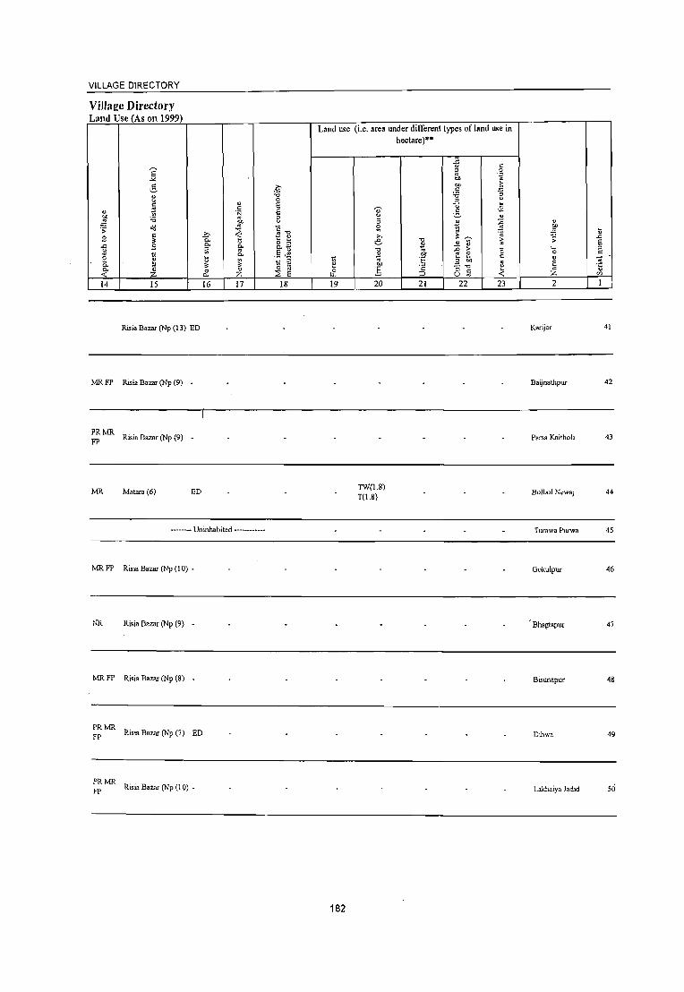
VILLAGE DIRECTORY
Villae:e Directory Land Use (As on 1999)
Land use
E "" ~ .~ ~
"0 0
c " S ~
c: " S s OIl :<; 8 ~ "" o\l '" "13 "S;
~ ~ .?;>
S 0,
" f! _
0, o " .c S 0, o,~
g a '" .5 ~ ::: ~ Il
0,
~ -. 1:! ~ ~ ~ 0- '" 3: 0- " 0 " 0 '" & « :z: 0. :z: ~ S 14 15 16 17 18 19
Risia Bazar (Np (13) ED
MR FP Risia Bazar (Np (9) -
PRMR FP Risia Bazar (Np (9) -
MR Mal.anl(6) ED
------- Uninhabited ------------
MR FP Risia Bazar (Np (10) -
NR Risia Bazar (Np (9) -
MR FP Risia Bazar (Np (8) -
~~ MR Risia Bazar (Np (7) ED
~~ MR Risia Bazar (Np (10) _
182
(i.e. area under different types ofland me in
'0;'
" ;; ~ ;... e "0
~ OIl
g 20
TW(1.8) T(1.8)
hectare)··
"0
~ .~ t: ." ;:J
21
{j c ;; 0
OIl "~
OIl E; c: :<; :; ~ " -.,2 3 u
1;l Z .=!
'" " ." .!! ~ ~ .D > C e: ::: c: .3 OIl
'" - "0 u " c: ~ u '" 22 23
" ~ Il .D ;; S ._ " 0 c:
" S '" li " :z: 0)
2 I
Karijor 41
Baijnathpur 42
Parsa Kaitholi 43
Bulbul Newaj 44
Turawa Purwa 45
Go"ulpur 46
Bhagtapur 47
Bisunapur 48
Dihwa 49
Lakhaiya ladld 50

DISTRICT CENSUS HANDBOOK: BAHRAICH
Census oflndia 2001 -Amenities and
Amenities available (if not available within the village, a dash (-) is shown in the column and
next to it in brackets the distance in broad ranges viz.< 5 krns., 5·10 kms. and 10+ krns of the ,..., ~ nearest place where the facility is available is_~iven Ol
" ~ " ~ -0 5 ~ " " U~ ::; " ~ .U '" c
" Ol .D " C -" - " " -;e ';:; 0 ~ 5 0 '" !'l
0 3 0 " .£; g .~ ~ .~ U 0 " ... ~ .<: '" .,! g_ " " - "
P- tl .~ " '" 0 "" 0 " 0- ]~E " " ....l .!S 0 :!< ] 'i' ~o " tl o(i ~ ~ 0 ::; :.1 c:l ~ "Ii "0
~ :~ 3] .g ~ '" " " c "
c ~ ~ '" -0 " 0 ... OJ) .;; 0 " ~ " ~ ~ ,g Ii ~ .~ 0 "" ,; g 0 " <... -" 0-.,
-' ~ _._ "'0 '= 0 .D ;; 0 ;; ._ ~ :;: ~ ,,> :> B '~ E '" P- o C " 00 ~~ §~~ 'c "
._ ~ 0 Ii 0 01) ..!l Ii .£! e c 0 '" P- ':; ~ c " '" " 5 '5
.D B " :;:; 3 E " " "oil E " E '" '" E E " 'i5 c tf E 'c ii 2 g :.a ~ " Ii Z 0 0 i. "0 " 8 0 ell':; ~Qi6 0:: r r :2 0
(/J U.1 c.- u <f. 0 U :;: I 2 3 4 5 6 7 8 9 10 Iii 12 13
Gondaw-a 158 P M(S-I 0) • H(S-
ACS(<5) CV(1O+) BS(5-10) 51 875 10) MCW(S- HP W ss- PO«S) GM« 5) (06463600) C(IO+)
10) PHC(S.IO) W PH(S-IO) CP(5·10) NCS(1O+) SP(1O+) RS(5-10) OCs(lO+) S1(10+) NW(IO+)
Charsanda Mafi 232 P M« 5) C(S. H(1O+) THPTW
ACS« 5) CV(1O+) BS{< 5) 52 1.427 WTKSS. PO«5) CM«5) (06463700) 10) MCW(5-10)
W PH«5) CP«5) NCS« 5) SP(1O+) RS« 5)
PHC« 5) OCSI<5) ST(1O+) NW(IO+)
Karaunda 330 P(3) M(3) CHWH(1O+)
T liP W ss- PO(~ 5) ACS«5) CV(lO+) BS{< 5) 53 2.139 MCW(1O+) GM«5) (06463800) C(IO+)
PHC(IO+) W PH«5) CP«5) NCS(lO+) SP(1O+) RS« 5) OCS(1O+) ST(1O+) NW(1O+)
CWCPHS
Padari Tara 262 P(2) 0 M(5· FWCCHW
TliPTW ACS(5.10) CV(1O+) BS« 5) 54 1.790 H(5.IO) PO PH« 5) GM« 5) (06463900) 10) c(lO+) wss-w NCS(5-10) SP(5-IO) RS(5·10)
MCW«5) CP(5·10) OCS(5-10) ST(1O+) NW(lO+)
PHC(S-JO)
Bargawan 194 P M« 5) C(5-H(5-
ACS(5-IO) CV(lO+) BS(IO+) 55 224,8 1,275 10) MCW(5. T HP TW PO«5) GM(1O+)
(06464000) 10) 10) PHC(5-10) W TK S3- PH(5-IO) CP(5-IO) NCS(S-IO) SPOO+) RS(5·10) OCS(5-10) ST(IO+) NW(1O+)
Husenpur 88 P M« 5) C(5-
H(S- -AC~i(5-10) CV(lO+) BS{< 5)
56 Mirdangi 607 10)
10) MCW«5) :HPWSS- PO«5) GM(S·IO) NCi(1O+) SP(IO+) RS(5·10)
(06464100) PHC(5·10) PH(5-IO) CP(IO+) OC8(1O+) ST(1O+) 1\'\'1(10+)
Maharu P M« 5) C(5· • H(5·
AC:S(5-10) CV(1O+) BS{<5) 57 1,265 218 10) MCW«S) TliPWSS· PO«5) GM(5·10)
(06464200) 10) PHC(5.10) W PH(5.10) CP(IO+)
NC:S(1O+) SP(1O+) RS(5-10) OCS(1O+) ST(1O+) NW(lO+)
58 Lauki
2,176 308 PM«5) H(lO+) T HP W ss- PH PO« 5) ~ CP(5·
ACS(5·IO) CV(lO+) BS« 5) (06464300) C(JO+) MCW(lO+) NCS(IO+) SP(IO+) RS(IO+)
PHC(lO+) OCS(IO+) ST(1O+) NW(IO+)
Bhopatpur MCWRMP A(,S(1O+) CV(1O+) BS
59 Chauki 2,850 420 P M C(IO+) CHWH(1O+) liPWSS- PO
CM(lO+) RS(10+)
(06464400) PHC(lO+) W PH(1O+)
CP(lO+) NCS{IO+) SP(1O+)
l\W(1O+) OC:S(IO+) ST(IO+)
Bhaisaha 1,823 283
PM«5) H(lo+) TWWSS- PH(2) GM(1O+)
.-\CS(IO+) CV(IO+) BS(5·10) 60
(06464500) C(IO+) MCW« 5) W PO« ;) ~CS(IO+) SP\IO+) RSI,lo-..)
PHC(IO+) CP(lO+)
OC$(IO+) S1(lo-..) ~'W(1O+) ..
183
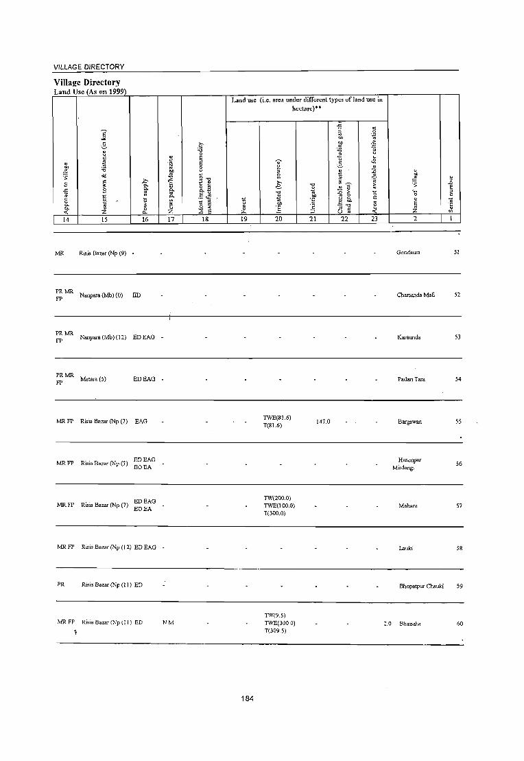
VILLAGE DIRECTORY
Villaj!e Directory Land Use (As on 1999)
Land use
E "" 6 .~
." 1:l 0
'" " § "
5 .~ '" .~ .. 0
..!S ." 00 " ~ ~
.. "-0 ~ " .?;> ~ " £ " 0. g_~ 0. ..c B 0. .., ~ '" '" ~
A .~ ~ 2 .- ~ ~ ~ 0. " " '" '" 0. " 0 o '" 0
-< :z. Cl.. :z. :2 E tI..
14 15 16 17 18 19
MR Risia Bazar (Np (9) -
PRMR FP Nanpara (Mb) (0) ED
~MR Nanpara (Mb) (12) EDEAG _
~MR Malara (5) EDEAG -
MR FP Risia Bazar (Np (7) EAG
MRFP Risia Bazar (Np (7) EDEAG EOEA
EDEAG MRFP Risia Bazar (Np (7)
EOEA
MR FP Risia Bazar (Np (12) ED BAG -
PR Risia Bazar (Np (11) ED
MRFP Risia Bazar (Np (I I) ED NM
184
(i.e. area under different types of land use in hectare)··
e ;; g
e ."
~ .~ .!3 20
TWE(81.6) T(81.6)
TW(200.0) TWE(100.0) T(300.0)
TW(95) TWE(300.0) T(309.5)
-0
~ 00
'E
'" ::> 21
147.0
-5 " ;:l 0 .. :~ 00
00
'" :; ;; .2 " "
.. '" <E v ..2 tl ~ '" ,,~ ... " ~ >
'" ~ e " '" .a ell -." ~ ;:l c u '" -< 22 23
0
'" ~ u .D .;;: E ,_ ;:l
0 c
" -;; E "5 ~ ;z: ....,
2 1
Gondaora 51
Charsanda Mafi 52
Karaunda 53
Padari Tara 54
Bargawan 55
Husenpur 56
Mirdangi
Maharu 57
Lauki 58
Bhopatpur Chauki 59
:.0 BhaiSaha 60

DISTRICT CENSUS HANDBOOK: BAHRAICH
Clmsus of India 2001 -Amenities and
Amenities available (if not available within the village, a dash (-) is shown in the colunm and
next to it in brackets the distance in broad ranges viz. < 5 Icms., 5-10 krns. and 10+ Ian. of the ~ nearest place where the facility is available ils given
" 51 ., ~ " " '0 u :2. " ~ " '" '" U '" ~
" ., 51 .D
" .<: 0 " " ':; tj .;
c .~ '" ::~ .~
'" ~ " 0 c ,g 'fJ U 0 " ~ C'"'
" t!. .t::: ~ &. " ~ " 0 '"
c. " " e OIl " 0. .~ -'" :: ~ ...l ~ 0 -0 ] '" ~ =&S t:>- o 8 ~.~ " " <ld ;; ~ "0 ~ ~.~ e:e
" " " c " " '" ~ .. -0 " 0 ....
~ oS 0 " .!i .t::: ;; g 'g ~ ~ .~ " . ij ..... .~ 0 .g g .D 0 .<:
~ e ,_" III -'_ "1:j
S .;;
'" -s '- -;0 '" j~ '" > " ,§ .~ "- 0 § !:Il 'G .~ ~ ~ " ..... ~ 0 ij bIl _!,! ij " '" " 0 c. .~ '" c " »
'" " s s ~ .:< :;; .!l E " t> e g ~ E '" " c ij '5 E " -0 .S ..t E EZ
Z 0 0 i " " ~S~ '" E- E- -0 ::E Q 0 '" "'':; o .-U1 c., U -< Q V ::
2 3 4 5 6 7 8 9 10 II 12 13
Rampur Baraie PM(S-IO) H(S-
ACS(S-IO) CV(S-IO) . _ElS«5) 61 2,400 357 10) MCW(5- T HP W SS- PO« 5) CM(5-IO} (06464600) C(10+) 10}PHC(5-10) PH(5-10) CP(5-10)
NCS(1O+) SP(5-10) RS(5-10) OCS(1O+) ST(1O+) NW(lO+)
62 Balbhaddarpur
6,890 J 046 P(4) M(5-10) H(1O+) ~HPWSS- POPH(4) CM«S) ACS« 5) CV«5) BS(5-10)
(06464700) , C« 5) MCW«5) NCS(1O+) SP(IO+) RS«5) PHC(5-10)
CP«5) OCS(1O+) ST(lO+) NW(lO+)
Hundarwa - P« - H« ACS«5) CV«5) BS(5-10) 63 438 70 5)M«5)C« 5)MCW(10+) ~HPWSS- PO«5) CM«S) (06464800) NCS(lO+) SP(lO+) RS«5)
5) PHC« 5) PH« 5) CP(1O+) OC:S(1O+) ST(IO+) NW(IO+)
64 Jahan Chak
359 56 PM(5-10) H(JO+)
HPSS-HP PO« 5) CM«5) ACS«5} CV(JO+) BS«5)
(06464900) C(10+) MCW(5-10) PH«5) CP(5-10)
NCS(1O+) SP(lO+) RS«5) PHC(5-10) OCS(1O+) ST(!O+) NW(1O+)
Teliya - P« - H« ACS« 5) CV(1O+) BS«5) 65 101 20 5) M« 5) C(5- 5) MCW(S-10) ~ HPW S5- PO« 5) CM«5)
(06465000) NCS(1O+) SP(1O+) RS«5) 10) PHC«5) PH«S) CP«5)
OCS(IO+) ST(1O+) NW(lO+)
RMP(3)CHW BS RS(5-
66 B.bhani
1,325 217 P M« 5) C(5- H(S-IO) T HP W SS- PH(2) CMCP(S- ACS« 5) CV(1O+)
10) (06465100) 10) MCW«5) W PO(S-IO) 10) NCS(IO+) SP(IO+)
NW(lO+) PHC(5-10) OCS(1O+) ST(IO+)
PHSCHW(2)
67 BangIa
4,778 724 P(3) M(5-1 0) H(1O+)
HPSS-HP PO« 5) CM«5) ACS« 5) CV(1O+) BS«5)
(06465200) C(1O+) MCW(5-IO) PH«S) CP(S-IO)
NCS(1O+) SP(JO+) RS«5) PHe(5-10) OCS(IO+) ST(10+) NW(10+)
Maila Barganw. P« H(IO+) ACS( < 5) CY(1O+) BS(5-10)
68 (06465300)
304 44 5)M(S-10) MCW(S-IO)
HP SS- PO« 5) CM«5) NCS(IO+) SP(IO+) RS(IO+)
C(IO+) PHC(5-IO)
PH«5) CP(5-IO) OC5(1O+) ST(1O+) NW(IO+)
Husenpur PM«5)C« H(JO+) HPTWW ACS« 5) CV«5) BS(lO+)
69 Moh.nunadpur 995 ISS 5) MCW(IO+) SS-HP
PO(I 0+) CM«5) NCS« 5) SP(lO+) RS« 5)
(06465400) PHC« 5)
PH(IO+) CP«5) OCS( < 5) ST(IO+) NW(IO+)
Bhalu\-\'3 "76 PM«5)C« H(lO+) HPWSS- ACSl< C\\< 5) BS(I(h-)
70 Bhakuraha 1,987 MCW«5) W
PO(lO+) CM«5) 1'CS\< SPlIO+) RS« 5) .. - 5)
PH(lO+) CP« S) (06465500) PHC« 5) OCS« ST(lO+) NW(IO+)
185

VILLAGE DIRECTORY
ViIlal!.e Directory LlIlld Use (As Oil 1999)
Land use
E "" ~ .t' "
-0 u 0
" u
~ ~ " " ·N
~ :.a '" 8 iii' dil <=." .s: ~ S ~ -'=' ~ u 0. " &2 .c S a 0.
~ " .$ ~ ~
0. 2 \"l ~
.- -;..:.-=>:="~ - .,,_. !l 3: ~ '" 0. o " & 0. " 0 Z :::E e .,; Z 0.
14 15 16 17 18 19
MR FP Risia Bazar (Np (10) -
MRFP Risia Bazar(Np (4) ED
MR FP Risia Bazar (Np (4) -
Risia Bazar (Np (3) -.
PR Risia Bazar (Np (2) -
PR Risia Bazar (Np (7) ~~ ~~G N M
Risia Bazar (Np (1 ) -
Risia (2)
PR Risia Bazar (Np (1) ~~ ~G
PR Risia Bazar (Np (3) -
186
(i.e. area under different types of land use in hectare)"
.J:: u c
" 0
" . .:1
"" .. "" > c .:J
:.a :; .2 " .~ '0;' " " ~ ;::, " " ~ :c
2 .:: " >, 3: ~ .~
"0 e " ..2 !l " -0 0; .D ;>- "0 oS "" ~ 2 '" '" '5 _g: " ] ~ u
" " <: o '" 20 21 22 23
" OIl ,g ;;: ._ 0 u e " z 2
Rampur Boraie
Balbhaddarpur
Hundarwa
Jahan Chak
Tetiya
Babhani
Bangia
Maila Bargan,...
Husenpur Mohazrunadpur
Bhaluwa Bhak"Uraha
\"l .&> E :;l
" ] \"l til
1
61
62
63
64
65
67
68
69
70

DISTRICT CENSUS HANDBOOK: BAHRAICH
Census ofIndia 2001 -Amenities and
Amenities available (if not available within the village, a dash H-is shown in the column and
next to it in brackets the distance in broad ranges viz. < 5 kms., 5-10 kms. and 10+ kms ofthe .
'" nearest_))]ace where the facility is available is given " " " 15 :::! ~ "0 ll-§ '" " 0 u ;g U c:
<.> " .0 '" ''::; u ,;
c ..c: :::! 0 " " c: .~ ~ ~ t u .g 3 " 0 E~ u 0
~ " C- ..c:
~ ,:; 8.. " '" ;; '" if : ~ 0 bI)
"0 0. ·c -;~
...1 ,g 0 "0 "2 0 3==8" C- o ~j .~ " " o<l .s: ..c: "0 -; .2 .2 eO; " " " " "
u
" " " :; '" "" ~ ~.g C! ~ -5 ._g .\l c:
o ._ c tl 0 ..c: ~ g 0 ..... ..::; ..c: 0. .. ...: ., -'_ ~ .~ 0
.0 ;; 0 '- -;;; " .. .. '" > " .;:
E " " " ~ ~] 0. 0
" 'G g ...... -< S " '- ~ 0 11 .Q .Ef .2 u .:; .. E 'c ... " 0 0. -;;; -d 0 ~ 1<' -;; " '3 '3
.0
'" u -'" s E e ~ ~ E E " 'i5 .5 of E .~ tl E l 'E " .. 0 0 ~ "" " Cl 0 0 OJ, -5 JQ~
o ._
'" Z E- E- ~ 2 0. U ~ 0 u :: 1 2 3 4 5 6 7 8 9 10 11 12 13
Pars. Kodi Khan P M« 5) C(5-H(5- -
ACS(S-IO) CV(5-10) BS(lO+) 71 762 131 10) MCW(5- THPWSS- PO(5-10) CM(5-10) (06465600) 10) 10)PHC(5-IO) W PH(5-IO) CP(5-10)
NCS(lO+) SP(lo+) RS(5-10) OCS(lO+) ST(1O+) NW(5.10)
Uttampur H(5· -ACS(S-IO) CV(S-IO) BS(IO+)
72 826 138 P MC(IO+) 10) MCW(5- T HP W SS- PO(5-10) CM(5-10) (06465700) 10) PHC(5-1 0) W PH(5-10) CP(5-10)
NCS(1O+) SP(lO+) RS(5-10) OCS(IO+) ST(lO+) NW(5-1O)
NaninghDiha - H(5- .
CM ACS«5) CV(1O+) BS(IO+) 73 1,754 289 P M C(5-1 0) 10) MCW(5- T HP W SS- PO« 5)
(06465800) 10)PHC(5-10) W PH(5-10)
CP(1O+) NCS(IO+) SP(1O+) RS(5-10) OCS(lO+) ST(IO+) NW(IO+)
74 Karaniya
112.0 1,207 181 P M« 5) C(5- CHW H(5-1O) T HP W SS- PH(2)
CM(IO+) ACS«5) CV(lO+) BS(IO+)
(06465900) 10) MCW(1O+) W PO«5) NCS(IO+) SP(IO+) RS(5-IO) PHC(5-10) CP(5-10)
OC8(10+) 8T(1O+) NW(IO+)
Bhaisahi P« CHWH«5) T HP W SS- PH PO« 5) CM(~O+) ACS«5) CV(IO+) B8(IO+)
75 915 153 5)M«5) MCW(1O+) (06466000)
C(10+) PHC« 5) W CP«5) NCS (1 0+) SP(lO+) RS« 5) OCS'(IO+) ST(1o+) NW(IO+)
Majhauwa 149 PM«5)C«
H« AC8«5) CV«5) BS(5-10) 76 MUjehna 1,027 5) MCW«5) TWSS-W PH PO« 5) CM« 5)
5) NC8(10+) SP(lO+) RS« 5) (06466100) PHC« 5) CP(lO+)
OCS(lO+) ST(lO+) NW(1O+)
Shankarpur CHW H«5) THPTW ACS
CV« 5) B8(IO+) 77 2,187 376 PM«5)C« MCW«5) WTKSS- PO PH« 5) CM« 5) NCS(lO+)
(06466200) 5) SP(1O+) RS« 5) PHC« 5) W CP«5) OC:l(lO+)
ST(1O+) NW(1O+) •
Kamla Jot CHW H(S-10) THPTW ACS NCS« CV(;O+) BS(5-10)
78 (06466300)
137.0 1,370 216 PM(5-1O)C(5' MCW(5_IO) WTKSS- PO(5-10) CM(1O+) 5) SP(lO+) RS(5-IO) 10) PHC(5-10) W PH(5-10) CP(S-lO) OC:S(lO+) S1(10+) NW(IO+)
RMP(2)CHW
79 Mukam
1,289 164 P AC M(S-IO) H(5-IO) 1 HP W SS- PH(S)
CM«5) ACS« 5) CV(5-10) BS(IO+)
(06466400) C(5-10) MCW«S) W PO«5) CP(5-10)
NCS(lO+) Sp(IO+) RS(5-10)
PHC(S-IO) OCS(1O+) S1(1O+) NW(1O+)
- H(5- ACS« 5) C\'(5-IO) B:3I5-10) Ramwapur 1,370 226 PM(5-10)C(5' IO)MCW(5_ HP:TK PO« 5) CM«5) 80
(06466500) NCS(IO+) SP(IO+) R:3I5-10) 10) 10) PHC(5-10) SS-1 PH« 5) CP(5-10)
OC:S(IO+) ST(I~) NW(IO+)
187

VILLAGE DIRECTORY
Village Directory Land Use (As on 1999)
,... E .:.e t:: v u '-'
" t1 " ~ 'i3 ~ .;;
S " _::, ~ p.
a. -5 s [;l '" ,-.-0
~.
~ a. ~ '" ;;:
0. " 0 -< Z Po.
14 IS 16
MR FP Risia Bazar (Np (7) •
MR FP Risia Bazar (Np (7) •
PR Risia Bazar (Np (6) ED
MR FP Risia Ba= (Np (5) •
PRMR FP Risi. B.= (Nt> (4) ED EAG .
PR
MRFP
MRFP
MR
Risi. Bazar (Np (3) ED EAG •
Risia Bazar (Np (4) ED
Kaml. Jot (0)
Risi. Bazar (Np (10) ED EAG EOEA
Risia Bazar (Np (9) -
Land use
.~ "0 0
" g " '/J '" :=; bl)
'" " ~ ." ~ u
" o :; go o.~
a.. .5 ~ ~ .: g e "
0 '" 0 Z :2 e Iz.
17 18 19
188
(i.e. area under different types of land u.'e in hectare)··
.<: <.> " " 0
'" ." to '" eo 3 .6 "0 3 .2
<.> . .8 8 5 " :; tl ::0 S\ ~
'" '" "' u .;;;
e "0 .£
:>
~ '" "0 J:J e -0 ~
bl) ~ E " .e 01)
'" .!?!' .;; -." " .s ::s r:: 4: ~ U '" 20 21 22 23
" ell .-~ ;; ._ 0
" e '" :z: 2
Parsa Kodi Khan
Uttampur
Narsingh Diha
Karaniya
Bh.isahi
Majhauwa Mujehna
Shankarpur
Kamla Jot
Mukam
] E " t::
1 '" 1
71
73
74
75
76
77
78
79
80

DISTRICT CENSUS HANDBOOK: BAHRAICH
CCDlSUS of India 2001 -Amenities and
Amenities available (if not available within the village, a dash (.) is shown in the column and
next to it in brackets the distance in broad ranges viz. < 5 kms., 5·10 kms. and 10+ kms of the ';;' nearest place where the facilitv is available is J!iven
" iii " S 5 "C "'" ",.c "'" 8 " '" U " :;
" iii .D '" " c: .c - " " 0; .~ '0 oJ c: <=> c: 'S ii t " 0 3 " <=> 0 a .~ ~ .~ u ~ .c ~ . .!S g_
" :; " >, " ;; '" P-
= ~ 0 l "0 " "" .~ 03'" ..l 0 "2 0 ~=e C- o 6 "" "' " " <Ii :; .c "'" " % .~ ~ ~.~ 8<;;; " " c: ~ c:
" :W -5 ._g " " "'" o .- " 0 - a l"l 0 .\l .c c: c: :5 o<J .:l .g 0 c '- .. .0 0 '" .s:::
" :;- ....: '" _ ' ... "'C .~ .~ s :; .. :; '- '" 0: ;;, ..
e~ ~;>~ .~ ~ P- o c: U " '- ~ 0 0 .~ 00 .£ t; E e .9";;: E c: c: 0 P- o; c:
~"I " "3 "3 .0 ~ " :.;:; ~
~ " " ... E " '" E S 'i3 -d" 'c t e g ~ '5 " " '" 0 0 ~ "'" " "8 0 0 ""-5 ~ Q~ o .-tt> Z f- f- ~ :2 "- u "'.0 U t: I 2 3 4 5 6 7 8 9 10 II 12 13
Bahboliya PM«5)C(5-
- H(5-ACS(<:5) CV(5-10) BS(1O+) 81 Mahada 3,896 558 10) MCW(5. HP TW W PO«5) CM«5)
(06466600) 10) 10) PHC(5-10) TK SS·W PH«5) CP« 5)
NCS(<:5) SP(1O+) RS(5·10) OCS«5) ST(IO+) NW(IO+)
82 Patna Ghusiyari
1,701 252 P M C(1o+) H(1O+)
HPSS-PH(5)
CM«5) ACS« 5) CV(1O+) 8S(5·10)
(06466700) MCW(5-10) PO« 5) CP(5-l0)
NCS(1o+) SP(IO+) RS(IO+) PHC(5-10) OCS(IO+) ST(IO+) NW(IO+)
Rampur Kabula P M« 5) C« CHWH(5-IO) HPTWW ACS(S.IO) CV(5·10) 8S(1O+) 83 2,036 321 MCW(5·10) PO« 5) CM(5-10)
(06466800) 5) PHC(5·10)
TK SS-W PH(5·IO) CP(5-IO)
NCS(lO+) SP(1O+) RS(5-10) OCS(IO+) ST(IO+) NW(IO+)
84 Khairi Dikauli
1,044 141 PM(5.IO)C(5. CHWH(5·10) HPTWW
PO«5) CM«5) ACS«5) CV(S·lO) 8S(5·l0)
(06466900) 10) MCW(5·1O) TK SS.W PH(5-IO) CP(5-10)
NCS(IO+) SP(IO+) RS(5-10) PHC(5.10)
OCS(IO+) ST(IO+) NW(1O+)
85 Rasulpur
130 21 P M C(10+) H(1O+)
PO« 5) CM«5) ACS« 5) CV(1O+) 8S(5-10)
(06467000) MCW(5·IO) « 5) SS· PH«5) CP(5-10)
NCS(lO+) SP(lO+) RS(lO+)
PHC(5·10) OCS(1O+) ST(1O+) NW(lO+)
86 Utghaniya
1,793 264 P(3)M(5-IO) H(lO+)
HPSS· PO«5) CM«5) ACS« 5) CV(IO+) BS«5)
(06467100) C(IO+) MCW(IO+) PH« 5) CP(lO+)
NCS(1O+) SP(IO+) RS(IO+)
PHC(IO+) OCS(lO+) ST(IO+) NW(lO+)
Saida 375 P(2) M(5·1 0) H(IO+) ACS
CV(IO+) BS(5-10) 87 2,251 HP SS·HP PO(5-IO) CM(S-IO) NCS{IO+)
(06467200) C(JO+) MCW(5-IO) PH(IO+) CP(lO+) OCS(IO+)
SP(IO+) RS(1O+)
PHC(IO+) ST(lO+) NW(1!h-)
Acharaura CHWH(5.10) THPTW
PH PO(5- ACS« 5) CV(IO+) BS(5·10) 88 1,969 333 P M(5·} 0) C(5· MCW(5.1 0) WTK 55· CM(lO+)
(06467300) 10) PHC(5.10) W 10)
CP(S·IO) NCS(IO+) SP(lO+) RS(5.10)
OCS(5-10) ST(IO+) NW(1o-r
Nihiya Husenpur P 0(2) M(5-CHWH(5·10)
T HP W SS· PH(3) ACS« 5) CV(S·IO) BS(1!h-) 89 1,533 203 MCW«5) CM(5·10)
(06467400) 10) C(S·IO) PHC(S·IO)
W PO« 5) CP(5·10)
NCS\lO+) SP(1O+) RS(5·10)
OCS\lO+) ST(Il);-) NW(lO-',
189

VILLAGE DIRECTORY
ViIlaj!e Directory Land Use (As 011 1999)
E -" 3 ~ c
" 'l eo '6 :!2 :;: olJ
"' c !l:
~ S I· e :l
0. ~ 0. U « :z. 14 15
PRMR Risi. Bazar (Np (8)
FP
Rasia (9)
.i:> "-"-ii: il !l: 0 c. 16
ED
EO
MR FP Risia Bazar (Np (6) -
MR FP Risia Bazar (Np (6) -
Rasia (9)
MR Rasia (11)
MR .. EDEAG PR RlSla Bazar (Np (16) EO EA
MR Achraura (0) EAG
MR Risia Bazar (Np (8) ~g ~~G
.~ "0 0
" c E ';::3 E '" e ~
~ c"'" t! " o :; go o.~
"- .5 ~ ~ " ~ C
" 0 e :z. ::E
17 18
Land use (i.e. area under different types ofland USe in hectare)··
19
190
20
W(4.6) WE(J.S) T(6.1)
21 22 23 2
BahboJiya Mahada
Patna Ghusiyari
Rampur Kabula
Khair:i Dikauli
Rasulpur
Utghaniya
Saida
Acharaura
~ibiya Husenpur
81
82
83
84
85
86
87
88
89

~
" .5 ." -;;-0 u .... " ~ -" c:: c:: .S 5 " <;; u .... " ;::; 0 011
..J ~ 0 ~ ,. ;;:
'I) " " ~ .:; .~
" ,_
.D ;;: 0 "5 S g 0-
" '_ 0
" 0 0--;;; " E '5 '5 '5 '" 0 0
Z b b '" 1 2 3 4
Block Total 2603,7 168575
-;;;-~
" " U ;::; 0 ~ ~
'0 '0 -" " !!l 0 ..c .... 0
~ s Z 5
DISTRICT CENSUS HAI~DBOOK : BAHRAICH
Census of India 2001 -Amenities and
Amenities available (if not available within the village, a dash (-) is "hown in the column and next to it in brackets the distance in broad ranges viz.< 5 kms., 5-10 kms. and 10+ krns of the
nearest place where the facility is available is I1:lven
~ ." ..c .0 ;j l'i " " :~ -;:; oJ
" e " ;. t! u
0 .::: a '0 .~ ~ -" Ii ,.;: 0
" '" 0- ;; 0- : ; " "- .... '" '" '2 0 .;::
1 :;:~ " 3 6 '" ., e '0 '" ·1~ '" ~
.... c " " .c ._
~ 3: ." .... " ~ ~ ;j 0 'G ,. " .9 " " ..c c:: 0
<C 0- ~~ ~:.o .;;; 0
'" 3: ::: -;;; E :':~ -;;; > " 1l .~
" "" '0 :l" " ';o~ a 0 eo " 11 .::: i~ 0
.~ ~ " ] .;;;
" ~ :.;; E " u ., 5::! E
" '0 " 1;( E .~ ~~ ~ DS E~ " '0 " 8 0 0 ~ c ._
::E -< ,1 U l': W 0. II " ~'" 6 7 8 9 10 11 12 13
H HA D DA T(S2) MCW(4) W(68)
26047 P(l16) M(14) CWC HC TK(lS) S AC 0(8) PHS(4) FWC HP(83)
RMP(l6) TW(19) C CHW(32) 0 L(3)
PO(ll) TO(2) PTO(2) PH(SS)
CM(S) ACS(8) BS(10)
191

VILLAGE DIRECTORY
ViIlaj?;e Directory Land Use (As on 199~
" :1 ;; .9 -5 '" B 0. 0. ~
14
PR(31) l\1R(63) FP(49) Ne(3)
NR
E .!<
~ " u c: ~ '0 o)! c ;!: .9
~ '" " Z 15
~ 0. 0.
0: Ii ;!: 0 a. 16
ED(43) EAG(24) EO(12) EA(U)
" c .~
bI)
'" ~ " 0.
'" a.
~ " Z 17
N(lO) M(6)
q '0 0 E E 0
" "'0
t! " o :; c.~
.5 ~ 1;l ;:J
c: 0 '" ~ E 18
Land use (i.e. area under different types c;>f land use in hectare)"
]' " 5l ,..., e '0
;'g ~ .<;!l 0 ..::: ~
19 20
GC(2) W(4.6) WE(1.5) TW(235.25)
527.0 TWE(507.25 ) TK(21.5) R(3.31) WF(24S.2) T(1027.61)
192
'0
;'g .<;!l l::
'" ;:J
21
175.9
-5 c: ;;] .~ 00 OIl .eo c: :; '0 "
u '0 .~ g
..!!
* JO
~ '" ;!:
" -;;- > " '" :0 > '0 e B c:
.B eo '" '0 " " c .0: U '" 22 23
17.6 2.0
" ~ Ii .t. .;; E .... " 0 c
" " E '5 " Z '" 2 1


VIKAS KHAND CHIT AURA
(TAHSIL BAHRAICH AND PART OF TAHSIL MAHSI)
\\ '(, r,
'\ ,
BOUNDARY DlSTRICT ___ _
TAHSIL ___ _
'" " % s
en :t
/'
{
I "L ,. \_
VIKAS KHANE ______________________________ _
VILLAGE WITH PERMANENT LOCATION CODE NO. ~ ~ ~ ~ ~ Ot;5~3600~ --~ ~ ~ =: HEADQUARTERS, DISTRICT, TAHSIL, VIKAS KHAND _ _ _ _ @ © - - ©
POPULATION SIZE CLASS Of VILLAGES BELOW 200
200 - 499 , 500 - 999 , 1000 - 4999 , 5000 AND ABOVE • •
UNINHABITED VILLAGES WITH PERMANENT LOCATION CODE NO. i --06499800-: -------: URBAN AREA WITH LOCATION CODE NO. _________ ____
STATE HIGHWAY _________________ _
IMPORTANT METALLED ROAD _
RAILWAY LINE, METRE GAUGE _____ _
RIVER AND STREAM __________________ ~
POST OFFICE, TELEGRAPH OFFICE - - __ - - __ - _ _ _ PO • TO
HIGH SCHOOL \ INTER COLLEGE _ _ _ _ _ _ _ _ _ _ _ _ _ S
!RIMARY HEALTH CENTRE
BANK __________ _
DISTRICT BAHRAICH KlLOMETRES
2 3
/'
A
Population ... 181,824
No of Villages.,. 133


Alphabetical list of Villages (C.D. block wise)
Name of the District· Bahraich Serial Name of village 2001 Census location 1991 Census location code
number code number number 1 2 3 4
Name of CD Block: Chltaura Name of Sub-Dist: 0002
1 Baldi Purwa 06469200 460020007000010002 2 Dharmanpur 06469500 460020007000010006 3 Jani Jot 06469100 460020007000010001 4 Rampur Gorwa 06469400 460020007000010004 5 Sisaia Chak 06469600 460020007000020021 6 Teriya 06469300 4600200070_00.oJQOO~
Name OT ~D Block: Chitaura Name of Sub-Dist: 0003
1 Ahiraura 06500800 460020007000070105 2 Ajatapur 06499700 460020007000060094 3 Aliua Bulbul 06493600 460020007000030033 4 Aminpur Nagraur 06499500 460020007000060092 5 Andhra Chak 06494400 460020007000030041 6 Araji Jot Keshav 06502800 460020007000090125 7 Ashokha 06500000 460020007000060097 8 Babhni 06495600 460020007000040053 9 Baghaura 06497700 460020007000050074 10 Bahadur Chak 06502500 460020007000090122 11 Bahadurpur 06501200 460020007000070109 12 Bahrakh(Dehat) 06494700 460020007000030044 13 Bakshi Pura 06498800 460020007000050085 14 Bania-Hari 06502000 460020007000080117 15 Banwari Gopalpur 06494000 460020007000030037 16 Barai Bilasa 06497300 460020007000050070 17 Baraihiya 06503200 460020007000090129 18 Bashir Ganj 06495000 460020007000030047 19 Begampur 06492900 460020007000030026 20 Bhagwanpur Mati 06492800 460020007000030025 21 Bhoga Jot 06491100 460020007000010007 22 Bichhfa 06491500 460020007000010011 23 Bishunpur Rahu 06497400 4600200070.00050071 24 Biswariya 06494600 460020007000030043 25 Bra Gaon 06503300 460020007000090130 26 Bragunnu 06498900 460020007000060086 27 Brawa Bhadauli 06501700 460020007000080114 28 Chafriya 06491300 460020007000010009 29 Chakapur 06494900 460020007000030046 30 Chaku Jot 06492600 460020007000020023 31 Chardaha Chandan 06497800 460020007000050075 32 Chhawani Sardar 06500400 460020007000070101 33 Chilwariya 06502400 460020007000080121 34 Churaila 06499800 460020007000060095 35 Damodar Jot 06492500 460020007000020022 36 Deeha 06499600 460020007000060093 37 Dharsanwa 06502700 460020007000090124 38 Duhru 06503600 460020007000090133 -39 Dularpur 06499400 460020007000060091 40 Fakeer Chak 06499200 460020007000060089 41 Fatna 06496700 460020007000040064
194

Alphabetical list of Villages (c.n. block wise) N arne of the District, Bahraich
,
Serial Name of village 2001 Census location 1991 C ensus location code number code number ,number
1 2 3 4 42 Fulwanya Mafl 06491900 460020007000020015 43 Gaura 06500200 460020007000060099 44 Godan Basahi 06493200 460020007000030029 45 Godi 06491800 460020007000020014 46 Govindapur 06501500 460020007000080112 47 Gulhariya 06492700 460020007000020024 48 Hatwarimau 06499000 460020007000060087 49 Hazi Bilai 06498200 460020007000050079 50 Itaunjha 06499100 460020007000060088 51 Itkauri 06495100 460020007000040048 52 Jagadhar Bhar 06492000 460020007000020016 53 Jagdishpur Sokha 06493300 460020007000030030 54 Jagtapur 06501000 460020007000070107 55 Jalal Patti 06495400 460020007000040051 56 Jatesar 06493400 460020007000030031 57 Jauhra 06496800 460020007000040065 58 Jhansa 06494100 460020007000030038 59 Kaimi Chak 06503100 460020007000090128 60 Kaira Hasan 06496200 460020007000040059 61 Kaitha Chak 06494200 460020007000030039 62 Kakra Niwada 06503500 460020007000090132 63 Kalpi Para 06498400 460020007000050081 64 Kamali 06493700 460020007000030034 65 Kamolia 06503000 460020007000090127 66 Katahna Wan Grant Khurd 06496500 460020007000040062 67 Katehnawan Girant Kalan 06495800 460020007000040055 68 Katiliya Bhup Singh 06495900 460020007000040056 69 Katra Bahadur Ganj 06496900 460020007000040066 70 Khalilpur 06501300 460020007000070110 71 Kishunpur Mafi 06491700 460020007000020013 72 Kurwari Mafi 06491400 460020007000010010 73 Kusaura 06502600 460020007000090123 74 Lalpur Meera Mau 06496600 460020007000040063 75 Laukna 06492400 460020007000020020 76 Machhiyahi 06502200 460020007000080119 77 Majhauwa Bujurg 06496300 460020007000040060 78 Makolia 06496000 460020007000040057 79 Mallapur 06491600 460020007000020012 80 Masihabad 06500900 460020007000070106 81 Meerpur Kasba 06494500 460020007000030042 82 Mohammad Nagar 06494300 460020007000030040 83 Mohrna 06501600 460020007000080113 84 Murau Purwa 06492300 460020007000020019 85 Musgra 06498000 460020007000050077 86 Nagar 06500500 460020007000070102 87 Nagraura 06500700 460020007000070104 88 Narauli 06497500 460020007000050072 89 Nauwa Gaon 06495500 460020007000040052 90 Pahar Pakkar 06498700 460020007000050084 91 Parerwa Khan 06495300 460020007000040050
92 Parsaura 06497900 460020007000050076
195

Alphabetical list of Villages (C.D. block wise) Name ofthe District'Bahraich
Serial Name of village 2001 Census location 1991 Census location code number code number number
1 2 3 4 93 Paull Amaull 06501800 460020007000080115 94 Rajapur Mafi 06494800 460020007000030045 95 Rampur . 06492100 460020007000020017 96 Rasoolr Chak 06493000 460020007000030027 97 Rasoolpur Sarinya 06501400 460020007000080111 98 Ratnapur Tepraha 06497000 460020007000050067 99 Renda Lal 06502100 460020007000080118 100 Rewali 06499900 460020007000060096 101 Risiya Jamal 06493900 460020007000030036 102 Sagra 06498300 460020007000050080 103 Salarpur 06498500 460020007000050082 104 Samsa Tarhar 06493500 460020007000030032 105 Sankalpa Mafi 06491000 460020007000010005 106 Sansar Para 06500100 460020007000060098 107 Sar 8ahda 06503400 460020007000090131 108 Shahnewajpur 06493100 460020007000030028 109 Shah pur Jo(Yusuph 06500600 460020007000070103 110 Shekhwapur 06498100 460020007000050078 111 Shyampur Nandauna 06501900 460020007000080116 112 Sidha Prasi 06498600 460020007000050083 113 Singaha 06491200 460020007000010008 114 Sisai Salon 06495200 460020007000040049 115 Sitkaha Jot Keshav 06502900 460020007000090126 116 Sohrwa 06493800 460020007000030035 117 Suha Para 06500300 460020007000060100 118 Sujatpur 06497200 460020007000050069 119 Surjapur Mafi 06497100 460020007000050068 120 Susrauli 06499300 460020007000060090 121 Taj Khodahi 06501100 460020007000070108 122 Tanda Jalal 06496400 460020007000040061 123 Tepraha 06492200 460020007000020018 124 Turhni Rajjab 06496100 460020007000040058 125 Uchwa Puraini 06495700 460020007000040054 126 Unnaisa 06502300 460020007000080120 127 Wazeerpur 06497600 460020007000050073
196

CD Block: Chit.ura «()551)
2
3
4
5
6
8
9
10
JaniJot (06469100)
Baldi Pwwa (06469200)
Toriya (06469300)
Rampur GOIWa (06469400)
Dhannanpur (06469S00)
Sisaia Chak (06469600)
Sankalpa Mafi (06491000)
Bhoga Jot (06491100)
Singaha (06491200)
0afriya (06491300)
147.0
405.0
298.0
153.0
924.0
201.0
64.0
237.0
3109
349.0
o o o
798
846
1,917
821
3,243
1,452
138
1,584
2,657
1,420
-DISTRICT CENSUS HANDBOOK: BAHRAICH
CC11l.ms ofIndia 2001 • Amenities and
Amenities available (if not available within the village, a dash (-) i; shown in the column and next to it in brackets the distance in broad ranges viz.< 5 krns., 5-10 krns. and 10+ krns of the
nearest place where the facility is available is given
;::; o o ~
:2 o
1 o
.<: .... o ~
.c E Z 5
'" c: o .~ u .g ~
6
148 P M(5-10) C(JO+)
177 PM«S) C(10+)
317 P(2) M C(IO+)
127 P M(5-10) C(1O+)
560 P M(5.10) C(lO+)
277 P M(5·10) C(lO+)
29 P M(S-lO) C(lO+)
311 P M(S-IO) C(lO+)
478 P M C(IO+)
240 P M(5-IO) C(10+)
H(lO+) MCW(lO+) PHC(IO+)
BS RS(5· THPWSS· PHPO(S- CM(5-10) ACS(lO+) CV(lO+) 10) W 10) CP(IO+) NCS(lO+) Sp(lO+) NW(I()'-,
OCS(l,_O+...:..)_S_T;_(1_O+...:..) ___ _
- H(5- -10) MCW(S- :HPWSS- PHPO«5)CM(5-10) ACS{IO+) 10)PHC(5-10) CP(1O+) NCS(lO+)
OCS{W+)
CV(lO+) SP(1O+) ST(1O+)
H(IO+) MCW(S-lO) PHC(IO+)
H(1O+) MCW(S-IO) PHC(S-10)
MCW CHW(2) H(IO+) PHC(IO+)
H(lO+) MCW(S-10) PHC(IO+)
HPWSSW
PO(5-10) CM(5-10) ACS(!i-lO) CV(lO+) NCS{lO+) SP(lO+)
PH(5-10) CP(lO+) OCS(liO+) ST(1O+)
HP SS-HP PO(5.10) CM(5.10) ACS(S·IO) CV(lO+) PH(lO+) CP(S-IO) NCS{lO+) SP(1O+)
OCS{IO+) ST(IO+)
HPWSSW
PO PH CM(5.10) ACS«S) CP(IO+) NCS(lO+)
OCS(1O+)
THPWSS- PHPO«5)CM(~.10) ACSlIO+) W CP(5-10} NCS(IO+)
OCS(lO+)
CV(lO+) SP(lO+) ST(IO+)
CV(IO+) SP(lO+) ST(1O+)
CHWH(IO+) MCW« 5) HPW 5S.T PO(S.IO) CM(S.IO) ACS(5-10) CV(1O+) PHC(lO+) PH(5.10) CP(S-lO) NCS(IO+) SP(1O+)
OCS(lO+) ST(1O+)
H(IO+) MCW(5-10) PHC(lO+)
THPWTK PO(;'IO) CM(lO+) ACS(5-IO) CV(lo+) R SS-T PH(lo+) CP(IO+) NCS(1O+) SP(lO+)
OCS~IO+) ST(lO+)
CHWH(lO+) • MCW« 5) T HP W SS- PO(IO+)
PHC(IO+) T PH(IO+)
CHWH(lO+) . MCW(5.IO) T HP W SS· PO(5.IO) PHC(lO+) T PH(IO+)
197
ACS(IO+) CM(5·10) NCf>(IO+) CP(l 0+) OCSO 0+)
CV(lO+) SP(lO+) ST\lO+)
AC5l5-10) C\\l ().-) CM(1O+) NCS(IO+) SP(lO+) CP(S·IO) OCS\lO+) ST(lO+)
BS(5-IO, RS(IO+) NW(I().-,
BS(1O+) RS(IO+) NW(lO+)
BS(S·10) RS(lO+) NW(1O+)
BS(IO+; RS(IO+) NW(IO+)
BS« S; RS(1().-) NW(l().-)
NWBS(S· !O) RS(l()'-)
BS(I0-.I RS(I0-) NW(I().-)
BS(;-IO) RS(l0-, NW(lC-,
BS(ll~
RS(10- , NW(10-)

VILLAGE DIRECTORY
Village Directory Land Use (As on 1999)
Land use
E -'" ~ c '" 'il u 0 c " S
" " ~ ';:3 S
~ 'il " 0 OIl u
.;;: "l ~ ".", s c .Q ~ " " Co
" g_a .c .!3 0. 0. u OJ " S ~ " ;;; 0. 8 a .;;; 'l- ... -~ ~ ----- .~ 0. " '" o '" ... Co Z 0 &: <>: c. ;z. ~ s 14 15 16 17 18 19
PRMR Garamkhabazar (11) .
FP
PRMR Garamkhabazar (6)' ED
FP
PRMR Gannkhabazar (l0)
PRMR Risia Bazar (Np (11) •
FP
PRMR Garmikhabazar (10) -
PRMR Ganunkha (II )
FP
:;::- MR Mogajot (10)
PRMR Risia Bazar (Np (10) .
PR Risi. Bazar (Np (I 0) -
MRFP Gambhikhabazar (4) -
198
(i.e. area under different types of land use in
hectare)'·
~ " 0
" ,., e "0 .!l '" -bI)
] 20
TW(47.0) TWE(lOO.O) T(147.0)
TW(200.0) TWE(200.0) T(405.0)
1WE(200.0) T(200.0)
GC(26.0) T(26.0)
GC(50.0) TW(174.0) T(224.0)
GC(46.0)
GC(16.0) T(16.0)
GC(25.0) T(25.0)
TW(l85.0) TWE(175.0) T(360.0)
T(40.0)
"0
* :§' ;§ 21
90.0
177.0
230.0
130.0
35.0
167.0
0.9
228.0
.c u '" :;; 0
.~
ell '" "" E " 'il " " v
u ,£ g .£
%l i u
'" '" ~
" ~ .;;
.;; " ~ ~ :c ._
<5 0 E 8 c:: " .e~ li ~ " " .:;: u '" Z 22 23 2
JaniJot
4.0 Baldi Purwa
290.0 8.0 Teriya
6.0 14.0 Rampur Goma
605.4 8.8 Dharmanpur
11.0 14.0 Sisaia Chak
4.0 7.0 SanI.. .. lpa Mali
23.0 32.0 Bhoga Jot
Singaha
28.0 .. 3.0 Chafriya
a .D C " " -;;; "5 '" 1
2
~
9
10

DISTRICT CENSUS HANDBOOK: BAHRAICH
Census of India 2001 -Amenities and
Amenities available (if not available within the village, a dash (-) is shown in the column and next to it in brackets the distance in broad ranges viz.< 5 krns., 5-10 krns. and 10+'krns of the
~ a nearest place where the facility is availabie is ~iven 5 5 S: ~ ~ ~ aU] ; .~~
~ 8 ~ j .~ ~ ]t f~ ~ 0 VI ]' 0 .~ co tI) :.; ~ ~ 0 :::2 £ g- - ~--t""":Ja .;; ~ ..8 -0 8 ~ ~ -; ] .§ e ~ .s .~ 8 ~ '0 § ~ "0 <; ;g ~ '0 '¥ _g ~ .g_ ~ 5 ~ ~ ~ ~ .~ g' co i '0 ~ ~ e .~ E ~§ ~ ;> ~ .~ .~
" ~ ~ ]e .~ ~ ] -E ilee ] ~ .~ ] ] ~» . ~ E 1J - ::3 -- -6 ~ '_f uf '£ .i~ e g ~ E i
~~~~r---~z~"----i-~~~~r-~~~-t~z~-r--~~~--+---~~~--+---~W~-+--~&~-4--~8~-+~~~~ ~ 8~ 8'§ I I 2 3 4 5 6 7 8 9 10 II "--+-'''-:'12:-''-'-+---><:173 '--I
II
12
13
14
IS
16
17
18
19
20
Kurwari Mafi (06491400)
Bichhla (06491500)
MaUapur (06491600)
Kishunpur Mali (06491700)
Godi (06491800)
Fulwariya Mafi (06491900)
J agadhar Bhar (06492000)
Rampur (06492100)
Tepraha (06492200)
Murau Purwa (06492300)
229.0 3,421
286.0 1,907
285.0 923
127.6 1,368
77.0 401
112.1 630
92.3 604
631.0 5,652
603.0 4,086
90.0 573
PM S PUC CHW H«5) 519 AC 0(2) MCW(5.10) ~WTKL PHPO«S)CM(~5) ACS«5)
C(lO+) PHC« 5) SS·T CP(5.10) NCS(lO+)
CV(1O+) SP(lO+) ST(lO+) OCS(IO+)
CHWH(5.10) 348 P M(5.IO) C(5. MCW(5.10) T HP W SS- PH PO(5. CM(5.10) ACS(IO+)
10) PHC(IO+) T 10) CP(IO+) NCS(lO+)
CV(IO+) SP(lO+) ST(1O+)
154 P M(5·10) C(10+)
232 P M(S·IO) C(IO+)
H(5. (0) MCW(5. HPSS·T 10) PHC(I 0+)
H(5· 10) MCW(S· HP SS· T 10) PHC(IO+)
OCS(1O+)
PO(S.IO) CM(1O+) ACS(lO+) PH(S.IO) CP(IO+) NCS(lO+)
OCS(lO+)
PH POtS. ACS(I 0+) (0) CM(lO+) NCS(lO+)
CP(l 0+) OCS(1 0+)
CV(IO+) SP(lO+) ST(IO+)
CV(lO+) SP(IO+) ST(1O+)
· peS· H(1;+) 65 10)M(S·10) MCW(5.10)
C(IO+} PHC(IO+)
T HP SS· T PO(S.10) PH(lO+}
CM(IO+) ACS(5·10) CV(lO+) CP(S.IO) NCS(\(i+) SP(lO+)
OCS(lCtt) ST(IO+)
89 P M(S.IO) C(1O+)
MCW H(l 0+) T HP SS·T PO(S.IO) PHC(IO+) PH(1O+)
• P(5· H(1~) 80 10) M(S-IO) MCW(5.IO)
C(lO+) PHC(1O+)
THPSS·T PO(5·IO) PH(lO+)
CM(IO+) ACS(5·10) CV(lO+) CP(S.IO) NCS(](I+) SP(lO+)
OCS(Hi+) ST(JO+)
CM(1O+) ACS(5·10) CVCIO+) CP(S.IO) NCS(IO+) SP(lO+)
OCS(W+} ST(IO+)
BS(lO+) RS(lO+) NW(IO+)
BS(5·10) RS(5·10) NW(lO+)
BS(5·10) RS(lO+) NW(1O+)
BS(5·10) RS(IO+) NW(1O+)
BS(IO+) RS(IO+) NW(IO+)
BS(IO+) RS(IO+) NW(lO+)
BS(IO+) RS(IO+) NW(IO+}
1,021 P(3) M(5.10) H(IO+) C(lO+) MCW(1O+)
HP SS·T PO PH(lO+)
CM«5) CP(5·IO)
BS ACS« S) CV(1O+) RS(IO+) NCS(1I}+) SP(1O+) NW(1O+)
PHC(IO+) OC~<_5~) __ S_T~(l_0+~)~ ______ _
PM 0 640 C(IO+)
H(S· • 10) MCW(5. ;~ W TK PH PO« S) CM« 5) 10) PHC(S·IO) CP(5·IO)
ACS NCS(IO+) OCS(Ir.H-)
• peS· H(I~) 95 10)M(5·IO) MCW«5)
T HI' W SS· poe; 5)
T PH(IO+)
CM(lO+) ACS(l(}'-) NCS(lO+)
C(1 0+) PHC(l 0+) cpr < 5) OCS(llH
~
199
CV(1O+) SP(IO+) ST(lO+)
CV(lO+} SP(lO+) ST(IO+)
BS(5·IO) RS(S·IO) NW(1O+)
BS« 5\ RS(5·IO) NW(I(}'-)

VILLAGE DIRECTORY
Village Directory Land Use (As on 1999)
Land use (i.e. area under different types orland use in hectare)··
-" " E
<..> ::> 0 .. ..,
-'" Oh .. 2, £;> Oh >
.S . .,
" '0 "0 :; <..> 0 .2
<.)
c " S ... ~ " g <.)
~ " .~ s 5 eo '0 0 " ,g eJ} <.> !l ~ :;; " .;; ~ ~ =." Sl .!l! eo '" ,g I; c .0 t! ~ ,,~ .~ S "
p, e ." ;; .0
" &3 .!! '" E -li "
p, go 2 ., ., ._ iil S :;; "0
.~ .0 > C ::>
'" ! 0- ~ '" e 0 c :: I; ._ '_
~ B c " ] ~ ;; ::> "" ] E 0. " c .!!!l '" . -- 0 '" '" - ." '" I; 0. " 0 -- " 0 .!3 ::> c ~ ;z. P-. ;z. ::E s J.<. ;::J U '" ;z. (I)
14 15 16 17 18 19 20 21 22 23 2 1
PRMR TW(29.0)
KidvaipUlva (I ) ED Oil TWE(200.0) KUlwari Mali 11 FP T(229.0)
TWE(l20.0)
MRFP Risia Bazar (Np (10) EAG 80 TK(1.8) . R(2.1) 20.0 31.0 29.0 Bichhla 12
T(l23.9)
TW(85.0) MR Kisanpur (1) EAG TWE(200.0) Mallapur 13
T(285.0)
EDEAG TW(1.2)
MR Risia Bazar (Np (8) EOEA
TWE(126.4) 2.2 15.4 Kishunpur Mali 14 T(127.6)
PRMR Bahraich (Mb)(J6)
GC(27.0) 43.0 Godi 15 FP - T(27.0) 77.0 5.0
PRMR GC(78.4)
FP Bahraich (Mb) (15) ED TW(78.S) 0.4 0.1 33.2 Fulwariya Mafi 16
T(78.S)
PRMR Bahraich (Mb) (15) GC(70.3)
FP T(70.3) 92.3 7.5 14.5 J'!S"dhar Bhar 17
GC(9S.3)
PRMR Risia Bazar (Np (1 0) ED TW(247.8) 102.0 8.3 58.9 Rampur 18 TWE(86.4)
T(429.5)
PRMR PC(20.0) FPNR Bahraich (Mb) (17) 12.1 R(7.6) 795.9 2.3 0.9 Tepraha 19 NC T(27.6)
GC(IO.O)
PRMR TW(5.0)
FPNR Gambhirva Bazar (3) . TWE(3.0) 62.0 10.0 8.0 Murau Purwa 20
TK(20) T(20.0)
200

DISTRICT CENSUS HANDBOOK: BAHRAICH
Census ofIndia 2001 -Amenities and
Amenities available (if not available within the village, a dash (.) i .• shown in the colunm and
next to it in brackets the distance in broad ranges viz. < 5 kms., 5·] 0 kms. and] 0+ kms of the
" ~ nearest olaee where the facility is available i. Iliven
~ S ,-. 5 ~ -a B ~ :l u ~ !a
I 1 ~ ~ j .~ ~ ,_, 0 VI ]' t; :1 .3 ~ g =a 2 go .~ ~ .~ ~ -& -g 8 ! .~
" ~ ~ .~ is .\l i ] g g E ";; ~ ;; t '" ~ - .~ ~ .~ g '0 ~ g: is .~ ~ ~ ~ tile
--;; I\) .0 CI;l U ~ _ E ::30
"5 ~ g ~ ~ .g ~ 't rl § .~ ~ r-~~~r---~----,_~~~~--~--t-~--r---~~~--+---~~~--4---~w~-+--~~~~--~u~-+~~. 0
~~i-__ ~2 ____ L-~3 __ J_~4 __ L-~5~J_ __ ~6~ __ L_ __ ~7 __ ~ __ ~8~~ __ ~9~_L __ ~10~_L __ J,~1 __ L-~12~J_~1~3~
21
22
23
24
25
26
27
28
29
30
Laukna (06492400)
Damodar Jot (06492500)
Chaku lot (06492600)
Gulhariya (06492700)
Bhagwanpur Ma fi (06492800)
Bogampur (06492900)
Rasooli Chak (06493000)
Shahnewajpur (06493100)
Godan Basahi (06493200)
JagdlShpur Sokha \06493300)
220.0 1,676
189.0 684
279.8 1,464
189.8 1,495
131.0 1,550
332.0 2,473
32.0 323
414.1 2,877
241 9 1,816
179.~ 795
P« H(IO+) 3175)M«5) MCW«5)
C(lO+) PHC(IO+)
156 P M(lO+) C(IO+)
285 P(2) M( < 5) C(lO+)
H(lO+) MCW(lO+) PHC(1O+)
CHW(2) H(lO+) MCW(5-10) PHC(IO+)
T HP W SS- PO(~ 5) CM« 5)
T PH(S-IO) CP« 5)
ACS(1O+) NCS(lO+) OCS(lO+)
CV(1O+) SP(IO+) ST(1O+)
THPWSS- PH T PO(1O+)
CM(lO+) ACS(IO+) CP(lO+) NCS(lO+)
OCS(lO+)
CV(lO+) SP(1O+) ST(1O+)
~ HP W SS- PH Poe < 5) CM(~ 5)
CP(IO+)
ACS« 5) CV(1O+) NCS(IO+) SP(lO+) OCS(5-10) ST(IO+)
BS«5) RS(5-IO) NW(IO+)
BS(IO+) RS(IO+) NW(JO+)
BS« 5) RS(lO+) NW(IO+)
- H(5- • 284 PM«S)C(5- IO)MCW(5- THPWSS· PO(5_IO) CM«5) ACS«5) CV(5-10) ~~i;-~~)
10) 10) PHC(IO+) T PH(S-IO) CP(5-10) NCS(1O+) SP(5-10) OCS(5-10) ST(5-10) NW(IO+)
254 P M(5-10) C(lO+)
H(1O+) MCW(IO+) PHC(IO+)
HUH(IO+) 393 P M C(1O+) MCW(lO+)
PHC(lO+)
WSS-T ACS(lO+)
PO(5-10) CM(S·IO) NCS(lO+) PH«5) CP(5-1O) OCS(IO+)
CV(1O+) SP(IO+) ST(IO+)
HPWSS-T POPH(10) CM(S-10) ACS(lO+) CV(1O+) NCS(IO+) SP(IO+)
BS(S-IO} -RS(lO+) NW(IO+)
BS RS(lO+) NW(JO-)
CP(1 0+) OCS(I 0+) ST(I 0+) .~~~:__:-----
- P(5- H(l~) 54 10) M(5-10) MCW(lO+)
C(lO+) PHC(IO+)
354 P(2) M(S-IO) H(!O+) C(1O+) MCW(IO+)
PHC(IO+)
HP W SS-T PO(510) CM(S 0) ACS(S-10) CV(lO+) - -I NCS(IO+) SP(IO+)
HPWSSW
PH«5) CP(1O+) OCS(IO+) ST(1O+)
PO(5;IO) PH(lo+)
CM(5-10) ACS(5-IO) CY(lO+) CP(lO+) NCS(IO+) SP(IO+)
OCS(IO+) ST(IO+)
258 P M(5-10) C(10+)
H(5- THPTW 10) MCW(S- SS-HP 10) PHC(IO+)
ACS(5-10) CY(IO+) PO(S-IO) CM(lO+) NCl(lO+) SP(1O+) PH(S-IO) CP(lO+) OCl(IO+) ST(1O+)
H(5-
149 P M(S-IO)C(5· 10) 10) MCW(IO+)
PHC(S-IO) t
201
T HP SS-W PO(5-1O) PH(5-IO)
CM(lO+) CP(1O-)
ACS(5-10) CY(IO+) NCS(lO+) SP\IO+) OCS\IO+) ST\1O+)
BS RS(IO+) NW(lO+)
BS(5-1O) RS(1O+) NW(lO-)
BS(IO-) RS(5-10) NW(IO-)
BS(l0-) RS(5-IO) NW(10-,

VILLAGE DIRECTORY
Villaj!c Dircctory Land Use (As on 1999)
Land use (i.e. area under different types of land use in hectare)"
.c u c:
E ;;l 0
..I< "" .~
6 Of) > .~ " .'" ." :;:; :;
1: 0 ..e " c " E u • .2 ~ c '8 " ·N E ~ "" :;:; '" 0 :; .l!
" ~ "" u ~ .D o;l
~ "'." 0
~ ~ .;; '" '" t
~ 2;> t! "
,., El' ~ .D .9 0- &.3 e ."
" ~ > .;;
E 0- ~ " " .c B :;l 0. ." :0 > 0 '- ::l
" " .5 ~ 0 c " ~ '" 0. ~ .!!l' e 8 c 0 Il ~ " " P.. 5 _. _L ..... ~ ti II OIl t: il on " e li " ." - ." ~ 0- 0 " 0 " i5 E :;l " " « z 0- Z ~ E ~ ::J u '" « z '" 14 15 16 17 18 19 20 21 22 23 2 I
PRMR TW(19.0)
FPNR Gambhirwa Bazar TWE(34.0)
102.0 13.0 22.0 Laukna 21
NCNW (I) TK(14.0)
T(67.0)
PRMR GambhiIva Bazar (0) ED
GC(79.0) 96.0 6.0 8.0 Damodar Jot 22
FP T(79.0)
GC(219.8) MR Bahraich (Mb) (12) EAG PC(I.4) 80.0 1.8 ChaJcu Jot 23
T(221.2)
GC(165.6)
MR Bahraich (Mb) (8) EAG WE(3!.?)
6.1 TW(31.7) 164.8 56.7 Gulhariya 24
T(228.9)
pe(!.S)
PRMR Bahraich (Mb) (9) TW(O.O)
0.2 Bhagwanpur Mali 25 TK(0.2) T(2.1)
!W(10.3)
MR Bahraich (Mb) (7) ED NM TWE(56.6)
303.5 0.5 6.1 &gampur 26 R(0.3) T(67.1)
MR Bahraich (Mb) (10) ED Rasooli Chak 27
TWE(82.3) MR Risia Bazar (Np (8) ED N R(3.0) 281.2 0.2 8.2 Shahnewajpur 28
T(853)
PR R· . (N ED EAG 1W(l18.4) ISla Bazar p (10) EO EA
T(118.4) 50.5 9.0 Godan Basahi 29
PRMR FP Risia Bazar (Np (8) EAG EO • 180.0 Jagdishpur Solcha 30
202

DISTRICT CENSUS HI\NDBOOK : BAHRAICH
Census of India 2001 -Amenities and
Amenities available (if not available within the village, a dash (-) i!l shown in the column and
next to it in brackets the distance in broad ranges viz.< 5 krns., 5-10 krns. and 10+ kms of the ~ ~ nearest place where the facility is available is given
" " VI ~ S " C! "" ~~ "" ~ ~
8 u " U '" ~ .c " i;l
" 'a u ~ c: .t:: c: 0 " ";< ~t .~ 6 " 0 c: ·s B t~ u 0
t:'.. .t:: '" . .s g_ " 0 "
0- Il -a ~ ~ 0 :1 "" ..!:! 0. .g ~~ :; ~ -l 0 -0 2 0 ;; ="e ~ 6 '" '" ~~ 0<1 .;: .t:: "" ., " ~ ~.2 ~ u . ;: ~ " c: c: c: '" " ~ e.o -5 0 " '" ." o - u 0 ...
" E "" ~ c: g <>\l " B c:' Il ~ '_ .~ 0 "0 .- 0 .c: 0-
-" " ~>] . .,
.~ .c ;; 0 -a '- ";< ~ t: '" ~~ '" e ., 0. 0 c:: '" '<l .~ ';e ~
.:l
" '_ 1:! 0 Il 0 eo " Il c: ;;; c: 0 ., 0- .~ '" c: ] " ~ " '5 '5
.t:J u :;;; E " u e ~ ~ E ~ E E
" '" c: J E .: ij E ~ Il Z 0 0 " "" " 8 " 0 "'-5 ~QJ5 o .-f- f- Z :::E 0 to W I>- U <_0 () e 2 3 4 5 6 7 8 9 10 1.1 12 13
Jatesar P M(5-IO) C(5·1O) H(S- THPTWR
ACS(5-IO) CV(lO+) BS(lO+) 3 I 68.0 2 C L S 0 S8- PO(S-IO) CM(IO+)
(06493400) 10) MCW(lO+) NCS(lO+) SP(IO+) RS(S-IO) PHC(5-JO)
W PH(lO+) CP(lO+) OCS(IO+) ST(1O+) NW(JO+)
Sam,a T arhar PM(5-10) - H(5-
ACS(:,-IO) CV(1O+) BS(lO+) 32 195.3 1,453 184 10) MCW(S- T TW SS- PO(S-IO) CM(IO+)
(06493500) C(1O+) lO)PHC(IO+) HP
NCS(IO+) SP(IO+) RS(5-IO) PH(IO+) CP(IO+)
OCS(1O+) ST(1O+) NW(5-IO)
Aliua Bulbul - H(5-
ACS(5-10) CV(IO+) B8 RS(S-
33 276.0 1,424 220 P M(5-1 0) C(5' 1 0) MCW(S- HI' W 88- PO(S-IO) CM(IO+) 10) (06493600) 10) 10)PHC(S-10) W NCS(JO+) SP(1O+)
PH(S-IO) CP(lO+) OCS(IO+) ST(1O+)
NW(lO+)
Kamal; P(S- H(S-
ACS(IO+) CV(IO+) BS(IO+) 34
(06493700) 75.5 271 45 10)M(S-10) 10) MCW(5- TW8S- PO(S-IO) CM(lO+)
NCS(\O+) SP(1O+) RS(1O+) C(10+) 10) PHC(5-1 0) PH«S) CP(5-10)
OCS{JO+) ST(1o+) NW(1O+)
Soluwa P(3) M FWCH(lO+) ACS
CV(IO+) BS
3S 6S3.0 4,266 761 MCW(IO+) HPWSS-
POPH(6) CM(lO+) NCS(1O+) RS(lO+) (06493800) C(IO+)
PHC(1O+) W
CP«S) OCS(lo+) 8P(10+)
NW(lO+) ST(IO+)
Risiya Jamal - H(5- ACS(S-IO) CV(lO+)
BS RS(5-
36 87.2 1,9S6 224 P M C(S-I 0) 10) MCW(S- T HP W S8- PO(S-IO) CM(1O+) 10) (06493900)
10)PHC(5-10) W PH(S-IO) CP(lO+) NCS(IO+) 8P(10+)
NW(lO+) OCS(JO+) ST(IO+)
Banwari . - H(S-HPTWW AC8« S) CV(5-10) B3(5-10)
37 Gopalpur 271.S 1,328 204 P M(S-IO) C(S'IO) MCW(S-SS-HP
PO«S) CM(5-10) NCS(5-10) SP(S-IO) RS(S-IO)
(06494000) 10) 10) PHC(IO+) PH«S) CP(S-IO) OCS(S-IO) ST(S-IO) NW(lO+)
]hansa P(S- - H(5- ACS(S-IO) CV(S-IO) B8(S-10)
38 (06494100)
96.0 707 122 10)M(S-10) 10) MCW(S- HP W SS- P0(5-10) CM(S-IO) NCS(S-IO) SP(5-10) RS(S-IO)
C(S-IO) 10)PHC(10+) W PH(5-10) CP(S-IO) OCS(5-10) ST(5-10) NW(lO+)
Kaitha Chak S83 98
P M(S-IO) H(1O+) HPW S8-PO(S-IO) CM(S-IO)
AC~~S-IO) CV(IO+) BS\IO+) 39
(06494200) 71.0
C(1O+) MCW(5-10) W NCS(1o+) SP(1O+) RS(IO+)
PHC(5-10) PH« S) CP(IO+)
OCS(lo+) ST(1O+) NW(1{)-1-)
Mohanunad MCWCWC CV(IO+) BS
4,263 783 P(4) M Tr
CHWH(1O+) HPWSS-
PO(I 0+) CM(S-IO) AC;« S) RS(II}-) 40 Nagar 641.0 C(IO+) W NC;(IO+) SP(IO+)
(06494300) PHC(JO+) PH(lO+) CP(lO+) OC;\IO+) ST(IO+)
N\\\IO+)
203

VILLAGE DIRECTORY
ViIlaj!c Directory Land Use (As on 1999)
Land use
E -" ~ i:'
'i5 u 0 " u E c c
" !l .~ E It 8 :;;;
"" 'l '" ~
';:'; ~ ~] £ " .0
"' '0. il (5 :; 0. .c S ~
Co Q,~
g " .5 .~ ~
0. e Ii ;;; ~ ;;; ;;l
0. " " " a. " 0 " 0 " (5
<l; Z 0. Z ~ E ~
14 15 16 17 18 19
PRMR EDEAG FP Risia Bazar (Np (8) EO EA
PRMR EDEAG FP Risia Bazar (Np (8) EO EA
PR Risia Bazar (Np (8) ED
MR Bahraich (Mb) (II ) ED
PR Bahraich (Mb) (11) EDEAG
NM EOEA
PRMR Bahraich (Mb) (16) ED
MRFP Andhrachak (l )
MRFP Banwari (8)
PR Bahraich (Mb) (II)
PRMR Bahraich (Mb) (11)
EDEAG NM FP EOEA
204
(i.e. area under different types of land use in hectare)**
'" ~ " lii ;., e "0 8 ., .!!!, ,!:; 20
W(60.0) T(60.0)
TW(155.2) T(15S.2)
GC(200.8) T(200.S)
TIV(60.0) T(60.0)
GC(S.7) T(8.7)
TWE(75.0) T(75.0)
GC(170.1) TW(l43.6) TK(24.5) R(2.0) T(340.1)
GC(29.0) TW(29.0) T(29.0)
TW(40.0) TWE(30.0) T(70.0)
TW(400.0) TWE(24LO)
."
" :0 to 'E
':g 21
55.7
190.1
37.0
1.0
.c " § " .. .~ t.I)
"" :>
c: .'" ;;:; " " " u ...
. .'2 6 " oS Z " '" ..!:! OIl
~ .~ ,;g
~ .;;:
" .. :c :> C '-
" e 0 c: 0; "" " ~ E -"''0 ;;l c '" u '" ..; Z 22 23 2
2.7 Jatesar
5.3 I 9.8 Samsa Tarhar
Aliua Bulbul
8.9 0.2 Kamali
5.1 49.6 Soluwa
85.7 2.0 Risiya Jamal
0.4 28.2 Banwari Gopalpur
20.0 10.0 !hansa
3.0 7.0 Kaitha Chak
53.0 9- 0 MohanunBd Nagar
l; ., E ;;l c:
~ " '" I
31
32
33
34
35
36
37
38
39
~O

______________________________________________________ ~D~I=S~T~R~IC~T~C=E=N~S=U=S~HA.NDBOOK:BAHRAICH
Census ofIndia 2001 ..:
41
42
43
44
45
46
47
48
49
so
Andhra Chak (06494400)
Meerpur Kasba (06494500)
Biswariya
(06494600)
Bahraich(Dehat)
(06494700)
Rajapur Mali (06494800)
Chakapur (06494900)
Bashir Ganj (06495000)
ltkauri (06495100)
Sisai Salon (06495200)
Parorwa Khan (06495300)
41.2 195
413.0 982
44.0 402
708.0 79
123.3 1,050
42.2 252
80.0 159
82.2 582
337.9 146
1864 1.876
'" "
Amenities and Amenities available (if not available within the village, a dash (-) is shown in the colunm and next to it in bracket, the distance in broad ranges viz. < 5 kms., 5-10 kens. and 10+ kms of the
nearest place where the facility is available is ,;ven
5 u
P« 36 5) M(5·10)
C(lo+)
H(5. 10) MCW(5· HP SS·HP PO(5.10) 10)PHC(5·10) PH(5·10)
CM«5) CP« 5)
ACS« 5) NCS(1I}+) OCS(1I}+)
CV«5) SP« 5) SI« 5)
BS(5·10) RS(5.!O) NW(lO+)
179 PM(5·10) C(lO+)
H« • 5) MCW« 5) I HP R SS· PH PO« 5) CM« 5) PHC(5.10) HP CP(5.10)
ACS« 5) NCS(lO+) OCS(IO+)
CV(5·l0) BS( < 5)
P(5. PHS H(5-1 0) HP W SS. 64 10)M(S·10) MCW(5·IO) W PO(5·IO)
C(S.10) PHC(5.10) PH(5.10)
14 P MC(IO+) - H(5.
10) MCW(5· T HPW SS· PO(5.10)
10) PHC(5.10) W PH(5.10)
H« 170 PM«5)C« 5)MCW«5) THPWR PO«5)
5) PHC«5) CSS-W PH«5)
43 PM«5)C« 5)MCW(~~~ THPWR PO«5) 5) PHC« 5) C SS-W PH« 5)
PM( 5)C( CHW H«5) THPWR 32 < < MCW« 5) PO« 5)
5) PHC«5) CSS-W PH«5)
85 P I 0 M(S. 10) C(5·10)
25 P MC(1o+)
I Tf 0 peS· 289 10) M(5·10)
C(1O+)
H(lO+) MCW(IO+) PHC(IO+)
H(lO+) MCW(lO+) PHC(lO+)
H(lO+) MCW(lO+) PHC(lO+)
205
T HP W SS· PH(2) W PO« 5)
HPSS-W PO(S·IO) PH(5.10)
T HP W SS· PH(2) W PO« 5)
CM(5.10) ACS(5.10) CP(S.IO) NCS(s.IO)
OCS(5·IO)
SP(5·10) RS(1O+) SI(IO+) NW(1O+)
CV(5.IO) BS RS(5· 10)
SP(5·10) NW(lO+) SIe5·10)
CM(5.10) ACS(5·10) CV(5·10) BS(5·10) CP(5.10) NCS(5·10) SpeS·IO) RS(5·IO)
OCS(5·10) STe5·10) NW(1O+)
CM«5) CP«5)
CM«5) CP« S)
CM«5) CP« 5)
ACS(':S) NCS« 5)
OCS(JO+)
ACS« 5) NCS(lO+) OCS(1O+)
ACS«5) NCS(lO+) OCS(IO+)
ACS(lO+) CM(5·10) NCS(1O+) CP(1O+) OCS(1O+)
ACS« 5) CM(5·10) NCSno.-) CP(5·10) OCS(IO+)
ACSI,S·lO) CM(S·10) NCS(l\)..) CP(IQ--) OCS\I\'>-)
CV«5) Spe< 5) ST«5)
CV«5) SP« 5) STe< 5)
CV«5) SP« 5) ST« 5)
CVeHH SP(IO+) ST(1O+)
CV(lQ--) SP(lO+) ST(1O+)
CV(1Q--l SP(l Q--) ST(!Q--l
BS«5) RS«5) NW(JO+)
BS«5) RS« 5) NW(1O+)
BS«5) RSe<5) NW(lO+)
BS(5·10) RS(S·IO) NW{IO+)
BS RS(1O+) NW(lO+)
RS BS(j·
10) NW(lQ--)

VILLAGE DIRECTORY
Villa~c Directory Land Usc (As on 1999)
e "'" ~ .~
" "0
" 0
c: " E " ." ~ 'N E :; :;:; " 0
"" " o1l ~ ;:: "0 ;; S " b t! " 3: c- o 8.B .c S c- o. :> '" . 5 ~ ;;l " ii "-=~ 2 ~ .., - r-.:.~ -;:3"
0- l< :< ~ .. " 0. " 0 ~ E « z '" z 14 IS 16 17 18
MR Bahraich (Mb) (4)
MR Bahraich (Mb) (2)
EDEAG PR Bahraich (Mb) (8) NM EOEA
EDEAG PR Bahraich (Mb) (8) N EOEA
MRFP Bahraich (Mb) (2)
NRNC
MRFP NR NC Bahraich (5)
MRFP Bahraich (Mb) (2)
NRNC
EOEAG PR Risia Bazar (Np (8)
EOEA
PR Ris.a Bazar (N p (4)
PR RlSia Bazar (Np (8) EDEAG EOEA
Land use (i.e. area under different types of land use in hecure)"
~ Ii'. 19
~
~ :> ~ >. e-.., oS .. .. .§
20
TW(30.0) TK(JO.O) 0(1.2) T(41.2)
TW(50.0)
10 TWE(314.0) . 0(49.0)
T(413.0)
TW(40.0) 2.0 TWE(4.0)
T(44.0)
TWE(608.0) R(IOO.O) T(?08.0)
TW(70.0) T(70.0)
TWE(26.8) T(26.8)
TW(36.0) T(36.0)
TWE(9.0) 0(13.5) T(22.5)
TWE(33A) TK(07) T(34.1)
TWE(24.5) 0(64.6) T(89.1)
206
"0 oS .. .~ .~ " ;:J
21
41.2
38.0
Il.S
37.5
42.2
129.0
75 I
..c: c: " ~ 0 'Z'
ell '" ell >
" 'Z'
:;:; :; " -e ·B g ."
~ " ;',l "" '" .;;; ~ :<~ > ;; " ~ '" ~ e <5
._ 0 c: " 3 ell 3 E - ." :> c: -< £. u ..
22 23 2
5.0 13.2 Andhra Chak
55.0 Meerpur Kasba
Biswariya
Bahraich(Dehat)
30.0 23.2 Rajapur Mali
3.9 Chakapur
1.0 5.6 BashirGanj
Itkauri
119.8 Sisai Salon
Parorwa Khan
z .0 E :>
" 3 !l
'" 1
41
42
43
44
45
46
47
48
4~
50

DISTRICT CENSUS HANDBOOK; BAHRAICH
Ccrnsus ofIndia 2001 _
Amenities and Amenities available (if not availaGle within the village, a dash (-) i; shown in the colunm and
next to it in brackets the distance in broad ranges viz. < 5 kms., 5- W krns. and 10+ kms of the. ~ nearest vlace where the facility is available is Riven
" ~ " ~ 5 i',j ." ~ ~~ ." ? 8 u '" " ., ::> .D '" "
.c ~ ;; " " ] .~ y 1i " ~~ 0 5 " 0 " >
E~ .~ u ~ 0 .~
" ..:: :; ,= g_ " ~ ;; ~ Co .,
0 ~ " 0- .~ -;;~ :;: ~ ...l 0 ." '£ -0 0 0;, 5=e ~ 8 ~ 6~ oil ;;: .c "0 ~ '.:::: ~ ~.= " " " :.l " c "
..., ~
~ .s 0 ::> .. ." o ._ u 0 ...
" l:i ';1 0 ;g ..:: :;; " :5 ~ ~.g .~ g '- '" .c 0.. ...: ~ _._ "0
.D .;; 0 :; '- ~ '" ~ '" > ::> .~ .~ E '" f: :; '" g- o " on .c; § - ~ ::> .... " bD :;; l:i 0 " l:i a " .", .. e " '" " 0 0.. .~ ] " '£ -; t; § ~ -;;; " "E "E
.D ] E '" E ::>
't E E ;:l 'i5 ..J' E .~ 1;) f ~ ~ sz Z 0 0 £ " " ~Q~ l- I- ."
::'E Q 0 0 eJl ·5 o ._
'" ~ 0.. U -< 0 u e: 2 3 4 5 6 7 8 9 10 II 12 13
Ialal Patti PM«5)C« H(5- -
ACS(5·1O) CV(5-10) BS(5-10) 51 106.0 913 148 10) MCW«5) ~HPWSS- PO«5) CM«5) (06495400) 5) NCS(IO+) SP(5-IO) RS«S) PHC« 5) PH« 5) CP«5)
OCS(IO+) ST(5-IO) NW(1O+)
Nauwa Gaon PM«5)C« CHWH«5)
~ HP W SS- PH POe < 5) CM(~ 5) ACS« 5) CV(S-IO) BS(5-10) 52 247.0 1,146 217 MCW«5)
(0649SS00) S) NCS« 5) SP(5-IO) RS«5) PHC« 5) CP« 5)
OCS« 5) ST(5-IO) NW(1O+)
Babhni P« H(lO+) ACS« 5) CV(lO+) BS(5-10)
53 12 4 5) M(S-IO) PO«5) CM«5) (06495600)
C(IO+) MCW(5-10) « 5) SS·
PH«S) CP(5-10) NCS(IO+) SPCIO+) RS(IO+)
PHC(5·IO) OCS(lO+) ST(lO+) NW(1O+)
Uchwa Puraini 196 P M« 5) C« - H(5-
ACS(5-10) CV(S-IO) BS(S-IO) 54 379.1 1,207 10) MCW« 5) ~ HPW SS- PO«5) CM«5)
(06495700) 5) PHC« 5) PH« 5) CP«5)
NCS(lO+) SP(5-IO) RS«5) OCS(lO+) ST(S-IO) NW(IO+)
Katelmawan P« - H(5-ACS(S-IO) CV(S-IO) BS(S·IO)
55 Girant Kalan 270.5 452 76 5) M« 5) C« 10) MCW« 5) ~HP W SS- PO« 5) CM«5) NCS(lO+) SP(5-IO) RS« 5)
(06495800) 5) PHC«5) PH«S) CP«5) OCS(lO+) ST(S-10) NW(IO+)
Katiliya Bhup PI TrM(5- H(lO+) T HP W SS- PH(2) ACS(S-IO) CV(1O+) BS(5-IO)
56 Singh 146.6 1,578 221 10)C(5-10) MCW(1O+) W PO« 5)
CM«5) NCS(IO+) SP(lO+) RS(5-10)
(06495900) PHC(IO+)
CP(5·10) OCS(lO+) ST(IO+) NW(IO+)
57 Makolia
346.0 2,729 401 P(4) M H(1O+) HPWSS- PHPO(5-
CM(IO+) ACS(5-10) CV(IO+) BS(IO+)
(06496000) C(1o+) MCW(5·10) W 10) CP(lO+)
NCS(IO+) SP(lO+) RS(IO+)
PHC(5-10) OCS(lO+) ST(IO+) NW(IO+)
58 Turhni Rajjab
157.0 1,433 235 P MC(IO+) H(1O+) THPWSS- PO(~5) CM(IO+)
ACS(lO+) CV(IO+) BS« 5)
(06496100) MCW(1O+) NCS(lO+) SP(1O+) RS(IO+)
PHC(IO+) W PH«5) CP«S)
OCS(<:S) ST(1O+) NW(1O+)
59 Kaira Hasan
422.0 1,957 327 P M(5-10) MCWH(IO+) THPWSS- PO(l-O+) CM(1O+)
ACS(IO+) CV(IO+) BS« 5)
(06496200) C(lO+) PHC(IO+) NCS(1O+) SP(1O+) RS(IO+) W PH(1O+) CP(1O+)
OCS(5·10) ST(IO+) NW(1O+)
Majhauwa Bujurg 328 I 1,301 252 P OM«5) H(IO+) T HP W SS- PO(~ 5) CM(1Qo-)
ACS« 5) CVtIO+) BS<. < 5) 60
(06496300) C(IO+) MeW(5-l0) W PH« 5) CP(1O+) NCSl.5·10) 51'110+) RS(IO+)
PHC(lO+) OCSt5·10) STtIO+) NW(1O+)
207

VILLAGE DIRECTORY
Village Directory Land Use (As on 1999)
E -'" 5 .€ " "" <> 0 c " § ~
c ., .~
"" '0 0 ~ til <>
o)J " <;"0 ;;: ~ c ..1:- ~ " _g
" 0. 0. " 8..2 -5 _g 1;
0.
" .5 ~ " -;;; 0. o· U 0.. . ~:
~ 'Vi " '" " c 0. " 0 " 0 '" -< Z 0. Z ;?: e 14 IS 16 17 18
MIl. FP Risia Bazar (Np (3) -
MR FP Risi. Bazar (Np (1 0) ED
Risiya (5)
MIl. FP Risi. Bazar (Np (3) •
MIl. FP Risia Bazar (Np (3) -
PR Risia Bazar (Np (2) ED EAG -
PRMIl. Risia Bazar (Np (11) ED
MRFP Risiya (5)
PRMR EDEAG FP
Bahraich (Mb) (13) EOEA
PRMR fP
Bahraich (Ivlb) (14) ED ..
Land use (i.e. area under different types of land use in
~ 0 ~
19
208
hectare)·'
~ " :; ~ ;., e ."
* .!,!, .\:i 20
TWE(134.0) T(134.0)
1WE(73.0) T(73.0)
TK(89.0) T(89.0)
TWE(1.1) T(U)
TW(196.0) T(196.0)
GC(76.0) W(40.0) TK(7.8) T(123.8)
TW(20.2) 2.0 TWE(16.2)
T(36.4)
W(IOO.O) 1.0 TW(4S.0)
T(l48 0)
"" * .!'!' t: '2 ::> 21
30.0
70.0
265.0
141.0
2.3
108.0
66.8
154.0
143.0
-5 " '" "" ell .S "0
~ 5 ~ ,,~
" ~ :0 > ., e 3 til -"0 " c u '" 22
l2.0
24.0
17.0
13.0
1.2
20.0
13.0
160
c 0
';J
'" ~ 5 ,~
" :0 1 > '" '0 " '" ~
23
" til
~ .;;: '-
0
" e " Z 2
7.0 ialal Patti
19.0 Nauwa Gaon
Bahlmi
22.0 Uchwa Puraini
27.0 Katelmawan GuantKalan
1 0 Katiliya Bhup . Singh
22.0 Makolia
Turhni Raiiab
33.0 Kaira Hasan
260 Majhauwa Bujurg
u .D e " " '" 'E '" 1
51
52
53
54
55
56
57
58
59
60

DISTRICT CENSUS HANDBOOK: BAHRAICH
Census of India 2001 -Amenitie sa nd
Amenities available (if not available within the village, a dash (-) is shown in the column and
next to it in brackets the distance in broad ranges viz. < 5 kms., 5-10 kms. and 10+ kms 'of the ~ nearest_place where the facility is available is I~iven
" ;;; " ~ " ~ '" n~ "'" ~ " '" :;; 0 U .D <.> " ;;; "
..<:: 0 " " .. .= u .; " " .2: ~ t " 8 5 " 0 0 _g t~ ~ u ~ ..<:: "§ '.!: & " " '" " - ~
0- " '" : ~ 0 ~ a '" .!:! 0- .~ .. '" ...l a -0 E 0
~ ,3 :g E ~ 8 13 " " o\l :> ..<:: '" ~ .~ ~..c .:: ~~ " " " 1A " " " '" 0:
~ -5 0 '" '" '0 o .- <> 0 ..
" :0 .~ 0 E ..<:: " " g ~ ~.g .8 d ._ '" .0 0 ..<::
~ 0- _" '" _._ "t:I
~ ·E .s: ;:; ._ '" -;;; :g>~ E '" '" ~ e ;6 0- 0 " 'g .~ !l '"
._ ~ 0 u .~ '"' £l ~ g"O!"E c '" " 0 0. ~ C ] " 1;'
'" " "5 "5 .0 :.;:; E " u " E " E E E 'iJ c J e ,~ t ~ ~ ~ e E '5 Z 0 0 " '" 0 8 '" ~Q,~ r- r- :z: '0
~ 0 0 eo .5 o .-
'" ~ 0. U -0: 0 u :: I 2 3 4 5 6 7 8 9 10 II 12 13
61 Tanda lalal
146.0 PM«5) H(lO+) T HP W SS· PO PH( < 5) CM(; 0+) ACS(lI)+) CV(IO+) BS«5) 720 123 (06496400) C(lo+) MCW(lO+) W CP(lI)+) NCS(lI)+) SP(lO+) RS(lO+)
PHC(lO+) OCS(lO+) ST(lo+) NW(IO+)
KatahnaWan - P(5- H(l~) 62 Grant Khurd 270.0 383 59
HPWSS-PO(S-IO) CM(lO+)
ACS(S.IO} CV(lO+} BS(IO+}
(06496500) 10)M(S-10) MCW(S-IO) W
PH(5-10) CP(1O+) NCS(IO+) SP(lO+) RS(IO+)
C(lO+) PHC(lO+) OCS(lO+) ST(lO+) NW(lO+)
Lalpur Meern P« H« T HP W S8- PO(~ 5) ACS« 5) CV(1O+) BS« 5) 63 84.2 326 56 5)M« 5) 5) MCW«5) CM(JO+)
Mau (06496600) C(lo+) PHC(IO+) W PH(IO+) CP(S-10)
NCS(S-IO) SP(lO+) RS(lO+)
OCS(lO+) ST(lO+) NW(lO+) •
Fatna P M« S) C(5-H«
T HP W SS- PO(~ S) ACS(5-10) CV(lo+) BS(IO+) 64 121.7 361 63 S)MCW«5) CM(JO+)
(06496700) 10) W PH« 5)
NCS(lI)+) SP(lO+) RS(lo+) PHC(1O+) CP(lI)+)
OCS(lO+) ST(IO+) NW(lO+)
65 lauhra
313.0 2,044 368 P M C(5-10) HMCWRMP THPSS-
PO(S-IO) CM(IO+) ACS(S-IO) CV(lO+) BS(5-10)
(06496800) PHC(I();t-) HP PH(S-IO) CP(lO+)
NCS(~,-IO) SP(lo+) RS(lO+) OCS(S-10) ST(IO+) NW(IO+)
66 Katrn Bahadur
270.0 2,258 401 PM(S-IO) MCWH(S-10) T HP W SS- PO
CM(5-10) ACSNCS CV(lO+) BS(5-10)
Ganj (06496900) C(lo+) PHC(lo+) W PH(lO+) CP(5-10)
OCS(I,O+) SP(lo+) RS(IO+) ST(IO+) NW(IO+)
Ratnapur 83 PM(IO+) H(lO+) HPWSS- ACS(.)-10) CV(IO+) BS(IO+)
67 Tepraha 358.7 S34 C(10+) MCW(lO+) W
PO(lO+) CM(5-IO) NCS(lO+) SP(IO+) RS(5-10)
(06497000) PHC(5-10)
PH(1O+) CP(5-10) OCS(IO+) ST(IO+) NW(IO+)
SUIjapur Mafl - P(5- -
PH P0(5- ACS« 5) CY(1O+) 8S(10+) 68 166.1 152 25 10) M(lO+) H(lO+) HP SS-HP CM«5)
(06497100) C(10+) MCW(lO+) 10) CP(S-IO)
NCS(IO+) SP(IO+) RS(5-10) _
PHC(IO+) OCS(IO+) ST(IO+) NW(lO+)
Sujatpur - P(5- -
HPW SS- ACS« 5) CV(1O+) 8S(10+) 69 269.0 429 53 10)M(l0+) H(IO+) PO(lO+) CM(S-10)
(06497200) C(lo+) MCW(lO+) W PH(IO+) CP(5-1O)
NCS(IO+) SP(1 0--) RS(lO+)
PHC(lO+) OCS(lO+) ST(1 0--) NW(lO+)
Barni B ilasa 280.3
182 P M(5-10) C(S. H(IO+) HPTWW POTO CM CP(s- ACSI,< 51 CV(10--1 8S(l0+) lD (06497300)
1,06S 10) MCW(lO+) Ss-w PH(1O+) 10) NCS00--) SP(lQ-) RS(lO+)
PHC(IO+) OCS(lO+) ST(IO+) NW(5-IO)
209

VILLAGE DIRECTORY
Vil1aj!c Directory Land Use (As on 1999)
E "'" 5 C>
8 '" 0 c: " E a " E " .~
~ 'i'i eo e ", '" ;;
~ ~~ " >,
S 0. " o ~ -£ 5< 0.
~ c.~
iil .5 ~ .. '" ~
0. 2 1:! ~ ""Vi~"""E" Co " Co 0)
& " ~ E <C :z :z 14 15 16 17 18
MR FP Ciciri(1)
PRMR Risia Bazar (Np (I 1) .
MRFP Bahraich (Mb) (I I )
FP Bahraich (Mb) (11 ) EDEAG -
PR Bahraich (Mb) (11) ED EAG -
PR Bahraich (Mb) (11 ) EDEAG N
MRFP Bahraich (Mb) (11 ) ED
PRMR FP
Bahraich (Mb) 01 ) EAGEO N
MRFP Bahraich (Mb) (II)
NR -
PRMR BahralCh \Mb) (11) BAG
FP
Land use (i.e. area under different types of land use in hectare)"
~ & 19
.,. ~
" ~ >. e ." 2 .. .~ .s 20
GC(6.0) T(6.0)
W(89.0) T(89.0)
GC(32.4)
34 TW(lI.?) . TWE(20.7)
T(64.8)
TW(39.8) T(39.8)
2.0 GC(125.0)
GC(120.0)
TWE(117.1) 11 2 R(0.9) L(O.S)
. 0(6.8)
TO 25.6)
TW(21.6) 0.6 R(2.6)
T(24.1)
TW(9S.2) L(I 7) 0(19.7) T(116.7)
49 \\'E(2264) . T(226.4)
210
"'" !l '" .!!!' .!;; " ::>
21
63.0
141.0
43.0
63.5
139.0
101.0
167.1
201.7
44.4
48.8
-5 " ::> .g '" "" '" "" .~
.S ~ "'" ::> ;:; -~
,_S
" ~
:0 " ~ ~ ,,~ ';0 ;. .;;
" ~ '" :0 > 0 '-~ 8 0
" ., .; "" :i E - '" ::> " -< '" u .. :z 22 23 2
3.0 11.0 Tanda Ialal
13.0 Katahna Wan
27.0 Grant Khurd
7.1 3.7 Lalpur Meem Mau
0.1 3,7 Fatna
15.0 21.0 Jauhra
28.0 21 0 Katra Bahadur . Ganj
6.8 48.0 Ratnapur Tepraha
0.2 Sutjapur Mafl
10.7 5.0 Sujatpur
0.2 Barni Bilasa
\l ..0 E :J c:
-;; "E '" I
61
62
63
64
65
66
67
68
69
70

DISTRICT CENSUS HANDBOOK: BAHRAICH
Census ofIndia 2001 -Amenities and
Amenities available (if not available within the village, a dash (0) is shown in the column and
~ next to it in brackets the distance in broad ranges viz.< 5 kms., 5·10 kms. and 10+ kms of tile
~ ~ nearest Illace where the facilitv is available i~ I!iven
" -c; " " ~ " ",.0 0 11 a u '" ~ " -'" .~ ~ .; " -" ii 0 " " ~~ it .:< 0 5 c: .~ .~ U
0 0 3 C;~
" ~ ..c: <; ;; • ..=; &. " ;.., " 0 '"
Q.
'" '" 0 "" " " 0- 'c -:;Vl ~ ~ ...l ~ 0 "0 ] 0 ~=E ~ " .. '"
'" ;; ..c: -0 'T .~ -3 _a .2 60: " " " g " "' " '" ~ on .s 0 :g "0 g 'g u 0 '-0
" ~ ~ .~ 0 !l -'" :; ~ u B 0 c; " '0 -'" "- _. '" _:-2~ .~ 0 .0 ;; "0 ,_
" ~ ::: " ~ > " .~ E '" 0- 0
" eon '0 ~; ~ § _ <t: '" " ''0 ~ 0 ~ .g e QO " <; of: e ~ E ~ " "- " c ] ::> ;..,
~ " '5 .D '" :;;; E " " E '" E " E " '5 " 1 E .~: ~ ~ g :t; EZ '0 ::>
" Z 0 ::> "0 " :8 0 'F -5 ~ Q~ o .-r/) f- f- Z IZl ::;; U -:' 0 u I'! I 2 3 4 5 6 7 8 9 10 11 12 13
Bishunpur Rahu MCWCHW
HPWSS- ACS«S) CV(S-IO) BS(S-IO) 71 295.0 2,313 360 P M C(S-I 0) H(S-IO) PO«5) CM(S-IO) (06497400) PHC(IO+)
W PH«5) CP(S-IO)
NCS(IO+) SP(5-IO) RS(S-IO) OCS(1O+) ST(5-10) NW(1O+)
Narauli - P(s- -
ACS« S) CV(1O+) BS(1O+) n 44.0 210)M(S-10) H(IO+) HPSS-HP PO(1O+) CM(lO+) (06497500) C(1O+) MCW(IO+) PH« 5) CP(S-IO) NCS(IO+) SP(lO+) RS(IO+)
PHC(IO+) OCS(IO+) ST(IO+) NW(1O+)
73 Wazeerpur
17 S.5 1,618 208 PM(5-10) H(lO+) ill' W SS-
PO(S-IO) CM(S.IO) ACS(S-IO) CV(1O+) BS(IO+)
(06497600) C(lO+) MCW(S-IO) W NCS(IO+) SP(1O+) RS(IO+) PHC(S-IO)
PH(S·IO) CP(S-IO) OCS(1o+) ST(1O+) NW(1O+)
Baghaura 206 P M« S) C(S-H«
ACS(S-IO) CY(1O+) BS(lO+) 74 211.5 1,492 S)MCW«5) WRSS-W PO«S) CM(S-IO)
(06497700) 10) PHC(IO+) PH«S) CP(S·IO)
NCS(IO+) SP(IO+) RS(IO+) OCS(IO+) ST(IO+) NW(1O+)
Chardaha 188 P M« S) H(lO+) ACS(5-10) CY(1O+) BS(IO+) is Chandan 970 1,119
ill' W S5-PO«S) CM(S-IO)
(06497800) C(IO+) MCW«S) W
PH(1O+) CP(S-IO) NCS(IO+) SP(IO+) RS(IO+)
PHC(IO+) OCS(IO+) ST(JO+) NW(JO+)
76 Parsaura
270.6 1,IS8 206 P M(5-IO) H(IO+) ill'W SS-PO«S) CM(1O+)
AC:l(lO+) CV(lO+) BS(IO+) (06497900) C(lO+) MCW(lO+) W NC:l(IO+) SP(IO+) RS(IO+)
PHC(IO+) PH«S) CP(lO+)
OC:l(lO+) ST(1O+) NW(IO+)
Musgra 128 P M« S) C(S. - H(S-
ACS(5-IO) CV(IO+) BS(lO+) 77 191.0 695 10) MCW(S- ill' TW W PO«S) CM«S)
(06498000) 10) 10) PHC(S-IO) SS-W PH(lO+) CP(S-IO) NCS(IO+) SP(IO+) RS(IO+) OCS(IO+) ST(1O+) NW(lO+)
78 Sh<khwapur
138.0 1,335 214 P M(S-JO) CIS. H(1O+) HPWSS-
POO 0+) CM«S) ACS« 5) CV(lO+) BS(lO+)
(06498100) 10) MCW«5) W NCS(1O+) SP(lO+) RS(IO+)
PHC(5-IO) PH(lO+) CP« S)
OCS(IO+) 3T(1O+) NW(IO+)
P« H(S-
79 Hazi Bllal
54.0 478 81 5) M(S-IO) 10) ill' W S8-
PO(1o+) CM(lO+) ACS(S-IO) CV(IO+) BS(IO+)
(06498200) MCW(IO+) W NCS(IO+) SP(IO+) RS(1O+) C(S·10)
PHC(S-IO) PH(1O+) CP(S-IO)
OCS(1O+) ST(1O+) NW(1O+)
Sagra 62 PM(1O+) H(1O+) HPDVW PO\5-10) CM(5·10)
ACS(S·IO) CV(IO+) BS(IO+) ~(j
1( 6498300) 109.0 404
C(IO+) MCW(IO+) TKSS-W NCS(I (iT) SP(lO+) RS(IO+)
PHC(1O+) ;;. PH(1O+) CP(S·IO) OCS(1O+) ST(IO+) NW(1O+)
211

VILLAGE DIRECTORY
Village Directory Land Use (As on 1999)
E "'"" 5 8 "
" .~ ~ "0
01 :;;: S " " ..c: S ~
~ e 0. '" 0. " -< ;z: 14 15
:;; MR Bahraich (Mb) (7)
.0 0. 0. ~ ~
"' 0 p.,
16
EDEAG N EOEA
PR Bahraich (Mb) (12) ED EAG .
PR Bahraich (Mb) (18) ED EAG .
MR FP Bahraich (Mb)(II) :~ :~G
PRMR Bahraich (Mb) (II) EDEAG
FP
PRMR EDEAG FP
Bahraich (Mb) (11 ) EOEA
PRMR Bahraich (Mb) (1 0) EDEAG FP
MR Bahrnich (Mb) (I 0) ~~ ~~G
MR Bahraich (Mb) (11 )
MRFP Bahraich (Mb) (I I )
,
c 'i3 0
" E c: 'N E '" 8 OIl
'" N~ i ~ E 0-
'" .§ ~ 0-
'" ~ ::> ?: " "
0 ., ;z: ~ E 17 1&
Land use (i.e. area under different types of land use in
hectare)··
";i ~ 0
"" 19
~
" ~ ::> fil >-e
"0 .!l .. .~ Ei 20
GC(13.0) T(44.0)
30 GC(94 0) . T(94.0)
20 GC(56.0) . T(56.0)
TWE(70.6) TK(200.0) T(270.0)
TWE(100.0) T(100.0)
TK(2.9) T(2.9)
Ge(1S.0) T(18.0)
GC(IOO.O) TW(21.0) TWE(800)
212
"'" .!l '" 00
:~ c: ;:l
21
25.0
61.0
30.0
134.0
31.0
18.0
-5 " ::> 0
'" . .,
"" '" QI) ~ c: '0 ::>
::> ... -;; .£ ~ " ~ :c "
~ eo
'" ~ "' t ~
.;;: " ~
._ ;,- -0 0
B 2 c: " bIl '" E - -0 " ::> c 4: '" U '" ;z:
22 23 2
Bishunpur Rahu
7.0 4.0 Norauli
6.0 11 .0 Wazeerpur
Baghaura
2.0 70 Chardaha . Chandan
Parsoura
Musgra
0.9 Shekhwapur
1.0 4.0 Hari Biloi
20 100.0 Sagra
~
"" E ::> c: ..
'5 '" I
71
73
74
75
76
77
78
79
80

____________________________________________________ ~D~IS~T~R~I~C~T~C~E~N~S~U~S~HANDBOOK:BAHRAICH
Census ofIndia 2001 -Amenities and
Amenities available (if not available within the village, a dash (-) is shown in the column and next to it in brackets the distance in broad ranges viz. < 5 kms., 5-10 kms. and 10+ kms of the
'" nearest place where the facility is available i._given ~ " 1J
~ :: c "0 ~-§ "0 ~
0
~ U '" " u ~ JO '" C ..c - ~ " -.;; ;§u .r c 0
" .1: .~ .g c " 0 a '0 ~ v u 0 ~ ~~ 8- .c .!: 0
~ " - '" c. " :; 0- :: ~ 0 "" 0 " C- ot ~~E ....l ~ 0 "0 }1 0
8- 0 6 ~ .~ " " 00 ;;: .c -0 -; ~ .2 ill -u ~ '" " " c ~ C
"0 C " " 0 ~ :: "' :W -5 ~ " '" o ._ ~ 0 B .c ~ " g ~ .g .~ 0 c-
oD '0 .c ~
c. _, '" _._ ""0 ';1 .S :> '- -.;; ., -.;; ., > " '" E ., " ~ E. .":: .~ ~ 0. 0 C '0 5 - ~ " '- ~ 0 ~ 0 00 a ",-0 c c: 0 0. ';1 -.;; .S }1 ~ ~ ._ " E
" ~ -.;; ~
"5 '5 .D
'" u -'" E " u 7C e =' E "5 E E u '0 c 1i E .~ ~ e g ~ E ~
Z 0 0 " " " 8 ~Q~ l- I- Z "0 ~ 0 0 ~~ o .-
'" W c. U () E 1 2 3 4 5 6 7 8 9 10 11 12 13
Kalpi Para PM(S-IO) HD
HPWSS-ACS
BS(\O+) 81 200.0 1,618 294 MCW(IO+) POPH(S) CMCP NCS(IO+) CV(\O+)
(06498400) C(IO+) PHC(IO+)
W OCS(IO+)
SP(IO+) RS(IO+) ST(lO+) NW(IO+)
Salarpur P 0(3)
H(IO+) HPWSS- ACS«5) CV(lO+) BS(!O+) 82 105.5 2,472 358 M(lO+) PO(1O+) CM«S) (06498500) MCW(lO+) w NCS(IO+) SP(IO+) RS(1O+) C(IO+)
PHC(IO+) PH(1o+) CP(S-IO)
OCS(lO+) ST(lO+) NW(IO+)
Sidha Prasi - H(5-ACS(S-IO) CV(S-IO) BS(5-10)
83 363.1 324 55 P M(S-I 0) C(S· 10) MCW(S- HP W SS. PO(S-IO) CM(S-IO) (06498600) 10) 10) PHC(5-10) W PH(5·10) CP(5-10)
NCS(S·IO) SP(S-IO) RS(S-IO) OCS(S-lO) ST(S-IO) NW(1O+)
Pahar Pillar - H(S-
THP SS- ACS(5-l0) CV(lO+) BS(1O+) 84 25.0 1,666 391 o P(5-l 0) M(S· 10) MCW(5- POPH(50) CM« 5) (06498700) 10) C(S-lO) 10) PHC(1o+) HP
CP(5-10) NCS(S·lO) SP(lO+) RS(5·10) OCS(S-IO) ST(IO+) NW(IO+)
Bakshi Pun . H(5.
ACS(S·IO) CV(S-IO) BS(S-IO) 85 357.0 1,792 306 P M(5-1 0) C(S. 10) MCW(5- HP W ss- PO(S-IO) CM(S-IO)
(06498800) JO) 10)PHC(5-10) W PH(S-IO) CP(S-IO) NCS(S·IO) SP(S·IO) RS(S-IO) OCS(S-IO) ST(S-IO) NW(IO+)
86 Bragunnu
311.2 1,589 2i7 PM(S·IO) H(1O+) HPWSS·
PO(S-IO) CM(S·IO) ACS(S-IO) CV(IO+) BS(lO+)
(06498900) C(1O+) MCW«5) W PH(lO+) CP(5·10)
NCS(l(}+) SP(lO+) RS(lo+)
PHC(IO+) OCS(IO+) ST(IO+) NW(IO+)
87 Hatwarimau
100.3 280 71 P M(S·I 0) C(S· H(1O+) HPWSS·
PO«S) CM(S-IO) ACS(S-lO) CV(IO+) BS(lo+)
(06499000) 10) MCW« 5) W PH(lO+) CP(5-10)
NCS~IO+) SP(IO+) RS(IO+)
PHC(1O+) OCS(l(}+) ST(lO+) NW(1O+)
ltaunjha P(2) M(1O+) HHMCW
ACS(S-IO) CV(IO+) BS(S-IO) 88
(06499100) 354.2 1,716 313
C(lO+) H(IO+) PHC(S-~ SS· PO(5-10) CM(S·IO)
NC:l(lO+) SP(lO+) RS(IO+) 10) PH(IO+) CP(lO+l
OC:,(lO+) ST(lO+) NW(1O+)
89 Fake<r Chak
263.0 1,461 243 PM(5-10) H(lO+) HPWSS·
P0(5-IO) CM(5-10) ACS(5-10) CV(lO+) BS(lO+)
(06499200) CO 0+) MCW(S-IO) W NCS(IO+) SP(lO+) RS(IO+)
PHC(lO+) PH(IQ-T) CP(1Q--\
OCS(IQ-T) ST(lO+) NW(lO+)
H(5-
Susrauh :440 1,191 214
P M(5-1 0) C(S· 10) THPWSS· PO(;-IO) CM(S-IO) AC5<,5·IOJ CV(S-10) B8(5-IO)
90 (06499300) 10) ~ MCW(lO+) W PH(5-10)
NC5<,5-10) SP(5-10) RS(5-10)
PHC(5-10) CP(5-IO) "OC5<,5-10) ST(S·IO) NW(1O+)
213

VILLAGE DIRECTORY
ViIIa2C Directory Land Use (As on 19992
Land u.'e (i,e, area under different types of land use in hectare)"
-" c u e " 0 .. '''' -" "" .. ~ Co "" ·S ,S 1:!
'i:i "0 :; 0
~ u
" " ~ ~
~ c
~ 5 ,£
" ';:)
" OIl 'i:i '" 8 :0 " ~ OIl " ~ <>0 '" ;::"0 0 .!:: ">
~ ';: ~ '" '" ';;; ~ " " .i!;- t! " >- El: .D .s El: 0. &.a e "0
" 'i1 ~ ';: E -" S 0. 0. ~ :0 '_ " ~ " '" .5 ~ "0 > -0 0 c g " c. ~ ,!:!l e e c
" e ij ~ 1;; ;;l 1;; ,l:; ~ OIl " .~
.. 0. El: c " .!:!l "0 " .~-0. 0 " 0 "
0
E Ci ,!; c " c -': z ~ z p. z ~ ~ ;::J U '" '" 14 15 16 17 18 19 20 21 22 23 2 1
PR MR Bahraich (Mb) (II) :~ ~~G N M Silk 5.0 GC(57,0) 32.0 14.0 Kalpi Para 81
Bahraich (Mb) (II) - GC(93.4) 12.2 Salarpur 82
T(93.4)
EDEAG TW(l78.3)
MR Bahraich (Mb) (8) NM 0(1.3) 82.4 41.9 Sidha Presi 83 EOEA
T(l79.5)
PRMR Bahraich (Mb) (8) EDEAG
NM GC(I.O)
1.0 S.O Pahar Pakkar 84 EOEA T(1.0)
TW(lSO,O) MR Bahraich (Mb) (8) NM TWE(J50.0) S7.0 53.0 48.0 Bakshi Pilla 8S
T(300.0)
W(SO.O) MRFP Bahraich (Mb) (II) ED 10.0 TWE(l8S.0) 3S.0 4.0 26.7 Bragurmu 86
T(23S.0)
GC(30.0) FPNC Bahraich (Mb) (11) 2.0 TW(40.0) IS.6 0.4 12.4 Hatwarimau 87
T(70.0)
PRMR Bahraich (Mb) (10) 1 0 GC(l87.0)
185.0 267.0 ltaunjha 88 FP . T(l87.0) 34.0
MRFP Bahraich (Mb) (11) GC(l33.0) 89.0 22.0 19.0 Fakeer Chak 89 T(133.0)
GC(109.6)
MRFP Bahraich (lvlb) (8) EDEAG TW(44.6) TWE(6S.0)
90.0 260 180 Susrauli 90
T(218.6)
214

DISTRICT CENSUS HANDBOOK: BAHRAICH
Census of India 2001 -Amenities and
Amenities available (if not available within the village, a dash (-) is shown in the column and
next to it in brackets the distance in broad ranges viz.< 5 kmg., 5-10 krns. and 10+ krns of the
'" nearest vlace where the facility is available is given 0:;:
" ~ 5 -;: '0 131 "C s ~ '" " 8 v U .D '" " " '::: U .<: C 0 " " "§
.,. " ~ ~ v 0 " " " .~ 0 0 a ·E ~ .<l ;,::. U ~ .<: " '!: 0
'" " "- ~ ~~ "- " >, " ;::; '" : ~ 0 "" "0 .!l C>. --;;~
...l ~ 0 2 0 ~ ~"~ ~ "0 e OIl '" " " o\i '> 1i "C ~ .~ e-..
" " " :; ::s ..c:::: ._ j;! :;:
"'" " 0 ~
~ -fi 0 " ~ ~ o .-
o\i " S ,,-~ .~ 0 .<: c:: ~ 0 ._
..c: ~ • ..: 1:1; _ ."9 ~ .<l 0 .D .> 0 -;; "- OJ '" -;;; '" > ::> ~ .~ E '" 0.. 0 "
:;: ~ ·c E ~ §'-~ ·c " ,_
~ 0 ~ 0 OIl " Il . .E e " 0 0.. .;:3 OJ .5 B .- .. E ::> >,
" "5 "5 .0 '" ()
"" E ::> " -.. e " E '" '" E e () '0 " oJ E .~ V e g ~ E 1 .~ ::> '" 0 0 ~ "C " ;§ '" 0 ""-fi ~Q~ o .-on Z l- I- ::\ 0
~ 0. C) :< 0 u ~
2 3 4 5 6 7 8 9 10 II 12 13
Dui"'1'ur P OM(5-10) CHWH(5-10)
HPTWW ACS(S·IO) CV(S-IO) BS(S-IO) 91 99.0 2,834 384 MCW(S·IO) PO(S.IO) CM(S·IO) (06499400) C(5·10) TKSS·W NCS(JO+) SP(5·10) RS(S·IO)
PHC(S·IO) PH(S.IO) CP(S.10) OCS(JO+)" ST(S-IO) NW(1O+)
RMPCHW
92 Aminpur Nagraur
217.2 2,380 403 P M(S-! 0) C(S. H(S-I 0) THP W SS· PH(JO)
CM«S) ACS(s·10) CV(S·IO) BS(S·10)
(06499500) 10) MCW(S·IO) W PO(s·IO) NCS(s·IO) SP(S.10) RS(s.IO) PHC(S·10)
CP(s·10) OCS(IO+) ST(S·IO) NW(1O+)
PHSRMP ACS NCS(s· CV(~.I 0)
93 Deeha
201.4 1,644 308 P M C(S·I 0) CHWH(5.10) THPWSS· PO PH CMCP(s. BS(5·10)
(06499600) MCW(S·IO) W 10) 10)OCS(5. SP(S.IO) RS(S·IO) PHC«S) 1 0) ST(S.IO) NW(IO+)
Ajatapur P(5. CHWH(5·10)
HPWSS· ACS(5·10) CV(S·IO) BS(5-10) 94
(06499700) 65.0 281 48 10) M(5·10) MCW(S·IO)
W PO(S·IO) CM(S·IO)
NCS(S·IO) SP(5·10) RS(5·1O) C(5·IO) PHC(5·IO) PH(s·IO) CP(S·IO)
OCS(5·10) ST(5·10) NW(IO+)
95 Churail. (06499800)
63.0 .-.. -. Uninhabited ............
96 Rewali
154.0 786 ISO P(2) M(5.1 0) MCWH(1O+) T HP W SS· PO
CM(S·IO) ACS(5·10) CV(5·10) 8S(5·10)
(06499900) C(IO+) PHC(1O+) W PH(1O+) NCS(S·10) SP(S·10) RS(1O+) CP(5·10)
OCS(S·IO) ST(5·10) NW(1O+)
97 Ashokha
161.1 981 168 PM(S·!O) H(1O+) THPWSS· PO(;.IO) CM(S·IO)
ACS(S·IO) CV(lO+) BS(1O+)
(06500000) C(IO+) MCW(1O+) W PH(S-IO) CP(S·IO)
NCS(1O+) SP(1O+) RS(IO+)
PHC(IO+) OCS(1O+) ST(1O+) NW(IO+)
Sansar Para P(5. H(5· - ACSNCS CV(1O+) 8S(10+)
98 (06500100)
58.S 525 85 10)M(5.10) 10) MCW(S· ~HPWSS- PO(S.IO) CM(1O+) OCS(1O+) SP(1O+) RS(1O+)
C(JO+) 10) PHC(5·10) PH(S.IO) CP(1O+) ST(1O+) NW(1O+)
99 Gaura
74.3 73 • P(5. H(I~)
T HPW SS· PO(;.IO) CM(5·10) ACS(1O+) CV(1O+) 8S(10+)
(06500200) 10 10)M(5·10) MCW(1O+) NC:S(1O+) SP(1O+) RS(IO+) C(lO+} PHC(IO+) W PH(S.IO) CP(1O+)
OC:S(IO+) ST(1O+) NW(IO+)
Suha Para P M(1O+) H(IO+) T HP W ss· PO(;O+) CM(1(H ACS(5·10) CV(lO+) 8S(1O+)
100 (06500300)
243.0 904 174 C(1O+) MCW(1O+) W PH(S.IO)
NCS(I0-'-) SP(IO+) RS(IO+)
PHC(IO+) CP(10-'-)
OCS\I0-'-) ST(IO+) NW(IO+)
215

VILLAGE DIRECTORY
Villal!c Directory Land Use (As on 1999)
E .Yo
2-~
" " ~ " "" '0 ~ o:,j ;;: s " ~ '5 s .. <;; 0 ~ Q. .. 0- Z « 14 IS
" " .;::) .. "" .. ~ b
0. 0- 0. iOl ..
"" ~ ~ 0 " "- Z
16 17
MR FP Bahraich (Mb) (8) ED EAG •
~ MR Bahraich (Mb) (8) ED EO N M
PRMR FP Bahraich (Mb) (8)
MR FP Bahraich (Mb) (8)
EDEAG NM EOEA
EDEAG •
q ." 0 E E 0 ()
;:-0
t! ~ 8.2 .5 .~ -.; E 0 .. ~ E
18
Flour, Bricks
--.---.- Uninhabited ---------.--
PR Bahraich (Mb) (II) ED EAG -
MR FP Bahraich (Mb) (II) ED
MR FP Bahraich (Mb) (11) ED
MR FP Bahraich (Mb) (II) -
MR FP Bahraich (Mb) \11) ED
Land use (i.e. area under different types of land use in hectare»>
.<: u c ;; ~ eo
"" ~ " '0 ~ " u ._s
1:: g u :;
* ~ iii ~ .~
;.., ." > e ~ .£ IT ~
"" E > "5 ~ eo 0 c
~ ~~ ;;, 2 ~ .::l' c :; -0
& ,!; :J U :ii « 19 20 21 22 23
GC(38.0) 30.0 60.0 25.0
T(3S.0)
GC(32.4) TW(32.4) 46.0 3.8 124.8 T(64.8)
GC(151.7) TW(97.1) TWE(51.2) 36.1 1.8 11.7 TK.(3.4) T(303.5)
GC(24.0) TW(l6.0) TWE(7.0)
24.0 6.0 11.0 TK(2.0) 0(24.0) T(73.0)
63.0
GC(71.0) 55.0 11.0 11.0
GC(125.0) W(6S.0)
36.0 TWE(60.0) T(250.0)
GC(48.0)
05 WE(24.0) . TWE(24.0) 10.0
T(96.0)
GC(iO.O) W(40.0)
10.0 9.0 9.0 TW(200) T(130.0)
00 TW(43 0) •. TWE(200.0) 4300 21 0
216
1.)
~ t; ;;: .L
E ''0 " " 1.)
E .. .. "5 z '" 2
Dularpur 91
Aminpur Nagraur 92
Deeha 93
AJatapur 94
Churaila 95
R." .. 1i 96
ruhokha 97
Sansar Para 98
Gaura 99
Suha Para 100
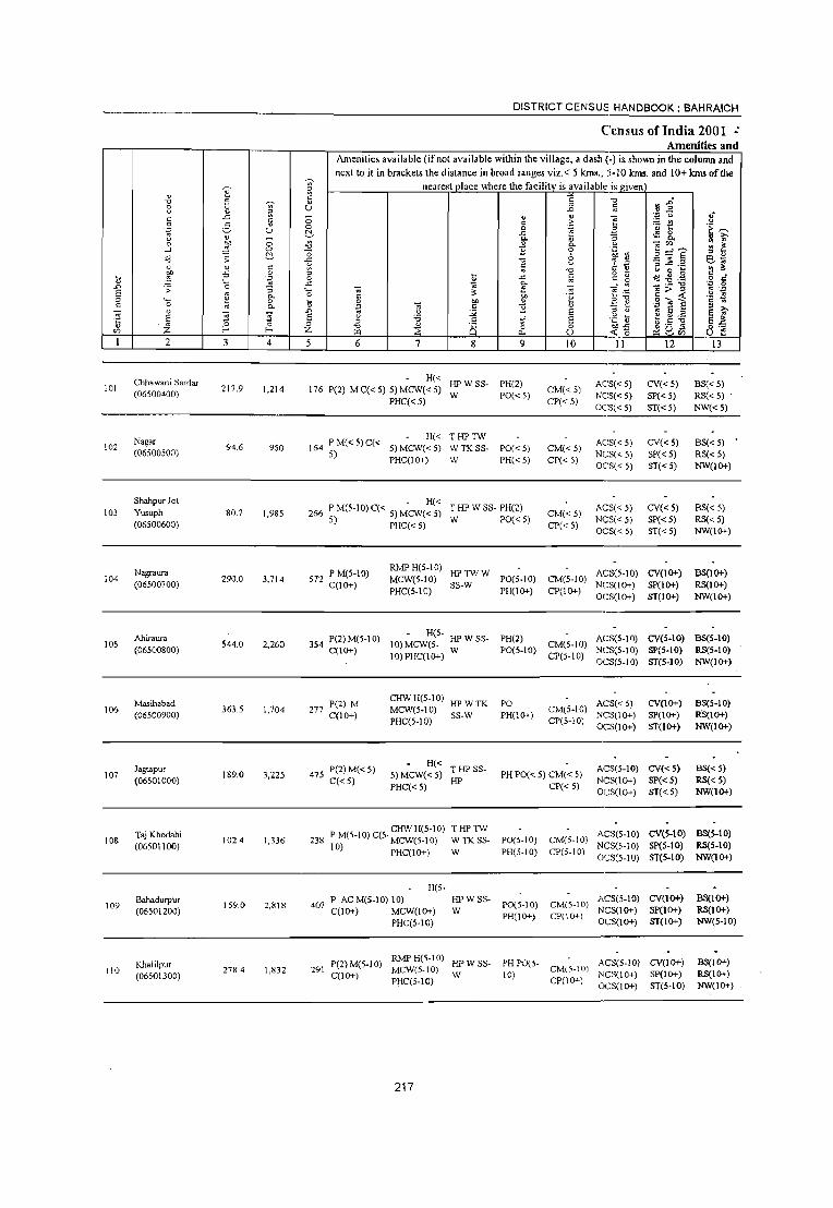
DISTRICT CENSUS HANDBOOK: BAHRAICH
Census of India 2001 :. Amenities and
Amenities available Cifnot available within the village, a dash C·) is shown in the column and
next to it in brackets the distance in broad ranges viz.< 5 km •. , :5·10 kms. and 10+ kms of the ~ nearest olace where the facility is availabl", is given
~ ;;: ~ " ~ '0 " ';;;' "
'0
!l:a" 0 Ii ;; " ~
U .D
C '" ;:; " " .'" " If c: '" i~ (,>
0 2- ~ c .2: _g 0 0 .~ ~ <~ u t:'- .c: "' ~ &, " " - ~ "- iJ .~ " " 0 :1 0 " 0. -';'" ~ ~ ..J 0 :s 'E 0
~=i1 t:'- 0 :3 en ~
'" ;; '" '0 'f .,3 eo; " " c: ~ ~ c: "
::s ..c: ._ " 1!:
~ -5 0 " '0 o ._ " g ~ c: _
iJ .~ 0 B .c: c: c: ~ '.<d '0 .~ .~ § '_ .c: g- o: .D 0 ~ ....: '" _ ._ "0
E ;; "
"5 .... -,; ;;. '" E:; ,,> " .~ .~ "- 0 c " ·3 'O! ~ " '- 1:! 0 ii 0 eo " ii E! ::! c ~ c 0
'" "- 'j? ~ " 11 " )0, -;; " s S .D :.:;; E " " " E " E '" E E " '6 " vf E .~ ~ e ~ ;.a E~ '5 " Z 0 0 " '0 " 8 0 0 ""-5 ~gb5
o ._
'" f-o f-o Z ~ ~ "" U <C 0 o ::: -I 2 3 4 5 6 7 8 9 10 11 12 13 -
Chhawani Sardar H« HPWss· PH(2) AC'S« 5) CV« 5) BS« 5) 101 217.9 1,214 176 P(2) MC«5) 5) MCW«5) CM«5) (06500400)
PHC« 5) W PO«5)
CP«5) NCS« 5) SP«5) RS« 5) OC:S« 5) ST«5) NW«5)
Nagar P M« 5) C« H« THPTW ACS«5) CV«5) BS« 5) 102 94.6 950 164 5) MCW«5) WTKSS- PO«5) CM«5) (06500500) 5)
PHC(IO+) W PH« 5) CP«5) NCS« 5) SP«5) RS« 5) OCS« 5) ST«5) NW(lO+)
Shahpur Jot . H« T HP W SS· PH(2) ACS« 5) CV«5) BS« 5) 103 Yusuph 80.7 1,985 266 P M(S.I 0) C( < 5) MCW( < 5) CM«5)
(06S00600) 5) PHC« 5) W PO« 5) CP« S)
NCS« 5) SP«5) RS« 5) OC:S« 5) ST«5) NW(IO+)
Nagraura PM(5·10) RMPH(5.10)
HPTWW A(;S(5·10) CV(IO+) BS(IO+) 104 290.0 3,714 572 MCW(5-IO) PO(S-IO) CM(5-IO)
(06500700) C(IO+) PHC(5-IO)
SS-W PH(lO+) CP(1O+)
N(;3(10+) SP(1O+) RS(IO+) OCS(1O+) ST(1O+) NW(IO+)
Ahiraura 354 P(2) M(S-I 0) H(5-
HPWSS- PH(2) ACS(5-10) CV(5-IO) BS(5-IO) lOS 544.0 2,260 10) MCW(5- CM(5-10)
(06500800) C(IO+) 10) PHC(1 0+)
W PO(5-10) CP(S-IO)
NCS(5-10) SP(5-10) RS{5-IO) OCS(5-10) ST(5-10) NW(IO+)
Masihabad P(2) M CHWH(S-IO)
HPWTK PO ACS« 5) CV(lO+) BS(5-10) 106
(06500900) 363.S 1,704 277
C(10+) MCW(5.10)
SS-W PH(IO+) CM(S-IO)
NCS(IO+) SP(IO+) Rs(10+) PHC(5-10) CP(5-10)
OCS(lo+) ST(IO+) NW(IO+)
Jagtapur 475 P(2) M« 5) H« THP SS- ACS(5-10) CV«5) BS« 5)
107 (06501000)
189.0 3,225 C«S)
5) MCW«5) HP
PH PO« 5) CM« 5) NCS(IO+) SP« S) RS« S)
PHC« 5) CP« 5) OCS(lo+) ST«5) NW(IO+)
Taj Khodahi CHWH(5-10) THPTW
ACS(5-IO) CV(S-IO) BS(S-IO) 108 1024 1,336 238 P M(S-IO) C(5· MCW(S-IO) W TK SS- PO(S-IO) CM(5-10)
(06501100) 10) PHC(I 0+) W PH(5-10) CP(5-10) NCS(5-10) sp(S·IO) RS{5-IO) OeS(S-IO) ST(5.10) NW(1O+)
H(S-
109 Bahadurpur
159.0 2,818 407 P ACM(5-10) 10) HPWSS-
P0(5-10) CM(5·10) AeS(S-IO) CV(lO+) BS(10+)
(06501200) C(IO+) MCW(lO+) W NCS(lO+) Sp(IO+) RS{10+)
PHC(S-IO) PH(lO+) CP(lO+)
OCS(1O+) ST(IO+) NW(5-10)
Khalilpur P(Z) M(S.I 0) RMPH(5-10)
HPWSS- PH 1'0(5- ACS(5-IO) CV(IO+) BSCJO+) 110
(06501300) 278.4 1,832 291
C(lO+) MCW(S-IO)
W 10) CM(5-10J
NCS(lO+) Sp(IO+) RS{IO+) Pl:IC(5-IO) CP(l~)
OCS(lo+) ST(5-IO) NW(1O+)
217

VILLAGE DIRECTORY
Village Directory Land Use (As on 1999)
Land use (i.e. area under different types of land use in hectare)··
..c " " E ~ 0
':J
"'"' 01) ~
01) -s .§.. q e "0 'i5 :;
1:: 0 " " " ., E ~
U .£ " u S .~ E ., " "" .~ 8 ~ v " ~ ." "" :> i} 1 .,
~
~ <:", 2 ell :;: '" ~ ~ .9 " .c f! '" ,.,
'" == ~ ;; .:;: .&0
:t Q. o 5 e- " '" E 0. 7J " ..c: S 0. 0. - "0 ::0 :> " ._
:> " '" .5 ~ 0 c ~ ~ '" "- B '" <: e " " e t;
~ .,; '" '" '" '6 3 OIl ,. E .,
" on 0. - 1i .i;; 0 " i5 ] c - "0 " '" t; Q. ., E :> " < 0 ::E ::J o '" :z 0) « :z Q. :z I.<.
14 15 16 17 18 19 20 21 22 23 2 1
PRMR Bahrnich (Mb) (2) EDEAG
NM 2.8 13.8 Chhawani Sardar 101 FP EOEA
PRMR GC(41.2)
Bahrnich (Mb) (S) ED NM TW(41.2) 27.8 1.4 Nagar 102 FP
T(82.3)
PRMR1
Bahrnich (Mb) (8) EDEAG
NM TK(0.4)
1.1 4 3 Shahpur Jot 103 FP EOEA T(0.4) . Yusuph
TW(90.0) PR Bahrnich (Mb) (II) ED TWE(200.0) Nagraura 104
T(290.0)
GC(258.6) PRMR
Bahrnich (Mb) (8) EDEAG TW(144.2)
171.4 112.4 Ahiraura 105 FP EOEA TWE(1144) T(517.2)
W(7.6) MR Bahrnich (Mb) (8) TK(9.8) 273.4 10.6 24.7 Masihabad 106
T(l7.4)
EDEAG TW(89.0)
PRMR Bahraich (Mb) (II) EOEA
NM TWE(100.0) Jagtapur 107 T(189.0)
PRMR TW(40.0)
FP Bahrnich (Mb) (5) TWE(0.2) 0.0 8.7 Taj Khodahi 108
T(40.2)
MRFP GC(159.0)
NR Sardarpur (0) ED PC(74.0) 65.0 BahadUll'ur 109
T(233.0)
GC(243.0) TW(169 0)
PR Bahrnich (Jvlb) (11 ) ED TWE(73.4) 18 7 58 18.7 Khalilpur 110 TK(0.8) .. T(486.2)
218

DISTRICT CENSUS HANDBOOK: BAHRAICH
Census ofIndia 2001 -Amenities and
Amenities available (if not available within the village, a dash (-j is shown in the column and
next to it in brackets the distance in broad ranges viz. < 5 kms., 5-10 kms. and 10+ km. of the • ~ nearest place where Ole facilitv is available ill given
" " " '" ~ 5 r: "0
rs~ " 'Vi' " 8 u U ..0 ;; " ;:
" .;:; u .,;
r: J: r: 0 " -;; ~ ~ u
9 -5 " 0 '" ~ a E~ u 0
"" ~ " ~ J:
U
l~ ~ &. " >, ;:; ~
0- '" '" 0 "" " .£ 0- =~ '" ~ ...J ~ 0 -0 2 0 5 ="? " ~
o"d ;; ~ J: "0 :'; .g ] .e e~ " " r: ~ '" § .~ '" ~
'" "0 U 0 ~
~ -s 0 " ~ ~.~ c: ~ .~ 0 " J: :ii " ~ 0 e, " '- J: '" ~ --' ... -'_ "'Q .~ .s ..0 0 OJ E
.;; '-- '" :- ~ '" ~~ ~ > ~ ~ g 0, 0 r: 'E ." " '_ 0 !i 0 bI) " .= e g""S c 0 0, . ., -;; .5 1i " " 1;' -;; " S S ..0 '" u
'" E " v ~ 5 .2 E E E u ;;; of E .~ ~ E ~ :5 "
c . t ,5 ] '" 0 0 " " l5 '" ,h ,:; "0 0 0 0;:::
<Zl Z E-- E-- Z w :2: 0, u ~ 0 ~SCl) u i': 2 3 4 5 6 7 8 9 10 11 12 13
Rasoolpur P M« 5) C« CHWH(5-IO)
HP W C SS- PH PO(5- ACS(S-IO) CV(IO+) BS(5·10) III Sarinya 323.0 1,503 225 MCW(5-10) CM(5-10) (06501400)
5) PHC(5-10)
W 10) CP(5-10)
NCSC~-lO) SP{lO+) RS(5-10) OCS("-IO) ST(IO+) NW(lO+)
Govindapur CHWH(5·IO)
HPWSS· PH(5) ACS(5-10) CV(IO+) BS(5·10) 112 278.7 1,257 262 P M(5·10) C(5· MCW(S-IO) CM(5-IO)
(06501500) 10) PHC(5-10) W PO(5-10) NCS(lO+) SP(lO+) RS(5-1O) CP(5-10)
OCS(IO+) ST(5-IO) NW(lO+)
Mohma P M« 5) C(5-CHWH(5-10)
HPWSS- ACS(';-IO) CV(1O+) BS(5-10) 113 233.5 1,328 198 MCW(S.IO) PO(S-IO) CM(S-IO)
(06501600) 10) HP NCS(IO+) SP(1O+) RS(5-IO) PHC(S·IO) PH(5-10) CP(5·10)
OCS(IO+) ST(IO+) NW(lO+)
114 Bmwa Bhadauli
442.7 1,945 308 P(3) M(5-10) H(1O+) HPWSS- PHP0(5·
CM(5-IO) ACS(S-10) CV(IO+) BS(5-10)
(06501700) C(1O+) MCW(5-10) W 10) NCS(IO+) Sp(IO+) RS(5-10)
PHC(IO+) CP(5-10)
OCS(IO+) ST(lO+) NW(IO+)
lIS Pauli Arnauli
198.7 481 77 - P(5- H(l;') HPWSS-
PO(5-10) CM(5-10) ACS(S-10) CV(1O+) BS(5-1O)
(06501800) 10) M(5-10) MCW(5-IO) W NCS(IO+) SP(IO+) RS(5-10) C(5-10) PHC(IO+) PH(5-10) CP(5·10)
OCS(lO+) ST(IO+) NW(IO+)
Shyampur - P(5- -HPWSS- ACS(S-IO) CV(1O+) BS(5-IO)
116 Nandauna 295.4 1,795 320 IO)M(5-10) H(IO+) W
PO(5-10) CM(5-10) NCS(lO+) SP(lO+) RS(5-10)
(06501900) C(5-10) MCW(5-10) PH(5-10) CP(5-10) PHC(IO+) OCS(IO+) ST(1O+) NW(1O+)
117 Bania Hari
323.9 1,281 219 P MC(IO+) H(IO+) HPWSS-
PO(lO+) CM(lO+) ACS(S-10) CV(lO+) BS(IO+)
(06502000) MCW(lo+) W NCS(IO+) SP(IO+) RS(IO+)
PHC(IO+) PH(lO+) CP(1O+)
OCS(IO+) ST(1O+) NW(1O+)
Renda Lal CHWH(lO+)
HPWSS- ACS(S-IO) CV(lO+) BS(5-10) 118
(06502100) 323.9 882 162 P M C(lO+) MCW(IO+)
W PO(5-IO) CM(5-10)
NCS(IO+) SP(IO+) RS(5-10) PHC(IO+) PH(5·10) CP(5-10)
OCS(lO+) ST(lO+) NW(lO+)
MCWRMP HPW.SS- PH(3) CM CP(5-
ACS CV(IO+) BSRS Machhiyahi P M(5-1O) C(5· H(lO+) NCS(~O+) 119
(06502200) 311.7 2,126 391
HP PO(5-10) 10) Sp(IO+) NW(IO+) 10) PHC(IO+) OCS(lo+)
ST(lO+)
Unnaisa 299 P(3) M C(5. - H(5· ACS(:I-I0) C\'(IO+) BS«5)
120 443.0 1,780 10)MC\V(5- HP:;:W PO(S-IO) CM(5·10) NCS(IO+) SP(lO+) RS(5-10) (06502300) 10) 10) PHC(5-10) SS- PH« 5) CP(5-10) r OCS(IO+) ST(IO+) NW(lO+)
219

VILLAGE DIRECTORY
Village Directory Land Use (As on 1999)
14 IS
PR Chilwaria (8)
16
EAG N
MR EDEAG
Bahraich (Mb) (II) EO EA
MR Chilwaryia (8) ED
MR FP Chilwaria (8) EDEAG -
MR FP Chilwaria (8)
MR FP Chilwaria (S)
~ MR Chilwaria (II)
MR FP Chilwaria (S)
PR MR Chilwaria (8) EDEAG -
MR Chilwaria (8) EDEAG
17 18
Land use (i.e. area under different types ofland use in hectare)··
19 20 21 22 23 2
TK(75.0) R(lO.O) T(S5.0)
Rasoolpur Sannya I II
220
GC(166.0) TWE(32.4) 0(133.6) T(332.0)
TW(106.3) T(l06.3)
GC(252.2) W(lS.O) WE(43.0) TW(30.0) TK(25.0) T(368.2)
GC(20.0) WE(2S.0) TWE(153.4) T(198.4)
GC(32.0) TWE(63.4) TK(IS.0) 0(175.0) T(285.4)
GC(250.1) TK(3.4) T(2S3.S)
GC(250.0) pe(2.4) TK(3.S) T(255.9)
GC(31 1.7) TWE(l97.0) T(50S.7)
0<:(146.0) T(146.0)
112.7 O.S
73.8 5.6
251.9
0.2 l.l
34.6 5.8
2.9 6.0
11.6 0.6
2100 44.0
22.4 Govindapur
33.7 Moluna
60.4 Brawa Bhadauli
0.2 Pauli Amauli
29.4 Shyampur Nandauna
2.3 Bania Hari
19.6 Ronda Lal
Machhiyahi
43.0 Unnaisa
112
113
114
115
116
117
118
119
120

1) ..0
E " c:
121
122
123
124
125
126
127
128
129
130
Chilwariya
(06502400)
Bahadur Chak
(06502500)
Kusaura
(06502600)
Dharsanwa (06502700)
Araji Jot Keshav
(06502800)
Sitkah. Jot
Keshav (0650Z900)
Kamolia
(06503000)
KaimiChak (06503100)
8araihiya (06503200)
Bra Gaon
(06503300)
84.S 2,525
163.0 1,032
272.0 1,978
842.0 2,506
47.4 310
351.0 1,504
428.0 2,192
60.0 585
149.0 896
242.0 1,745
DISTRICT CENSUS HANDBOOK: BAHRAICH
Census of India 2001 -Amenities lind
Amenities available (if not available within the village, a dash (-) is-shown in the column and
next to it in brackets the distance in broad ranges viz.< 5 kms., 5-10 kms. and 10+ kms of the
nearest place where the facility is available is gi.:..ve"'n+-__ ---,
HHDADH
353 P(6) M(2) S MCW PHS PUC C RMPCHW
HPWTK
ss-w
POTO PTO(Z)
PH(30) CMCP
ACS NCS(l(f+) OCS(I Cf+)
CV(li}'-)
SP(lO+) ST(1O+) PHC(lo+)
153 P(2) M(S-10) H(IO+) C(10+) MCW(S-IO)
THPWSS-PO(;_IO) CM(5-10) ACS(5.IO) CV(IO+)
HP PH(IO+) CP(IO+) NCS(10+) SP(1O+)
346 P(2) M C(1O+)
470 pel) M C(1O+)
54 PM(5-10) C(1O+)
PHC(5-10) OCS(I (}+) ST(1O+)
H(IO+)
MCW(10+)
PHC(lO+)
THPWSS- PO(;-10) CM(1O+) ACS(lI}+)
w PH(IO+) CP(IO+) NCS(lI}+)
CV(IO+) SP(lO+)
ST(1O+) OCS(lO+)
HUDAMCW CHW H(I 0+) HPW SS- PO PHC(IO+) W PH(IO+)
ACS(S.IO) CV(1O+) CM(5-10) NCS(IO+) SP(1O+)
CP(IO+) OCS(lO+) ST(1O+)
CHWH(IO+) HPTWW MCW(1O+) SS-W PO«5) PHC(IO+) PH« 5)
ACS(5-IO) CV(lO+) CM(5-10) NCS(IO+) SP(1O+)
CP(IO+) OCS(1O+) ST(1O+)
245 - P(S- H(1~)
10)M(5-10) MCW(5-IO) HP W SS- ACS(5-10) CV(1O+) W PO(5-10) CM(5-IO) NCS(IO+) SP(IO+)
C(IO+) PHC(IO+) PH(S-IO) cP(1O+) OCSOO+) ST(1O+)
- H(5-366 PM(5-10)C(5' 10)MCW(5_ HPSS-HP PHPO(5- CM(1O+) ACS(5-10) CV(1O+)
10) 10) PHC(IO+) 10) CP(1O+) NCS(IO+) SP(IO+) OCS(IO+) ST(IO+)
- H(5-95 PM(5-10)C(5' 10)MCW(5_ HPWSS- PO(S-IO) CM(1O+)
10) 10)PHC(S-10) W PH(5-10) CP(IO+)
ACS(1O+) NCS(lO+) OCS(IO+)
119 PM(5-10) C(lO+)
CWC H(5-1 0) HP W SS- ACS( 10+) MCW(S-IO) W PO(S-IO) CM(1O+) NCS(IO+)
285
PHC(IO+) PH(IO+) CP(IO+) OCS1,l0+)
P(2) M(S 10) MCW PHS T HP SS-- CHWH(lO+)
C(IO+) PHC(IO+) HP
221
PO« 5) PH(IO+)
CM(1O+) CP(IO+l
ACS\IO+)
NCS\IO+) OCS\IO+)
CV(1O+) SP(IO+) ST(IO+)
CV\IO+) SP(IO+)
S1(10+)
C\\IO+) SP\I()->.)
ST\I(}-.)
BSRS
NW(IO+)
BS(S-IO)
RS(lO+) NW(1O+)
8S(5-IO)
RS(1O+)
NW(5-lO)
8S(5-10) RS(1O+)
NW(lO+)
BS(5-10) RS(IO+)
NW(1O+)
BS(5-10)
RS(1O+)
NW(1O+)
BS(5-IO) RS(IO+)
NW(IO+)
BS(5-10) .
RS(lO+) NW(IO+)
BS(S-IO) RS(1O+)
NW(IO+)
BS\5-10)
RS(ICl-+-) 1';\\,\10+)

VILLAGE DIRECTORY
Village Directory Land Use (As on 1999)
E -" ~ " U c:: fl " 00 '0 ~ o<! .;;
2 c:: ~
.c £ u
'" <;;; 2 ~ "- '" 0. " « z 14 15
PRMR Chilwaria (0)
FP
MR Gilaula (11 )
MR Chilwaria (11)
.Q 0. "-tl U Ol: 0 p..
16
EDEAG
EDEAG
EDEAG EOEA
N
.
PR MR Bahraich (Mb) (l 1) ED EAG •
MR Bahraich (Mb) (11) ED EAG •
MR Bahraich (Mb) (11) ED EAG .
. PR MR Gilaula (8) ED
MR Gilaula (8) ED
MR FP Chilwria (11 )
PR MR Chilwaria (11) ED
.~ '0 0
" E c:: E ·S 8 00 .. ".", ~ t " g_.a go §~ "-
~ <;;; :J c:
0 E z ~ 17 18
Land use (i.e. area under different types of land use in
! 0 ~
19
3' :; 5l >,
c:-"'0 B
i 20
GC(68.9) TW(7.0) TWE(I.2) TK(50) r(82.0)
GC(97.0) T(97.0)
40 GC(63.0) . T(63.0)
GC(22.0) T(22.0)
GC(300.0) T(3oo.0)
GC(254.0) T(254.0)
GC(28.0) T(28 0)
GC(60.0)
40 GC(94.0) . T(94 0)
222
hectare ),,*
oo ~ .!'.!' t:
" ;:J
21
16.0
49.0
561.0
20.0
10.0
12.5
24.0
64.0
108.0
iJ " .. '" 00
.S '0
~ ~
~ ~~
" ~ ::c >-e r: ~: " c: C) '"
22
l.l
6.0
12.0
56.0
1.4
5.0
2.0
2.0
3.0
14.0
c:: 0 .;;
'" >-.;; ;; U
..s " ~ '" 1: 0 c:: .. " ~
23
0
~ .;:
'" 0 E Z 2
13.6 Chilwariya
11.0 Bahadur Chak
45.0 Kusaura
98.0 Dhananwa
4.0 Araji Jot Keshav
28.0 Sitkaha Jot Kosha\"
47.0 KamoIia
6.0 Kaimi Chak
14.0 l3arailiya
:10 Bra Gaon
U .0
E " C
" °fi '" 1
121
122
123
124
125
126
127
128
129
130

~
" " ~ '0 ~
0 ~
" " ~ c ..c c .9 2- " :;; u " "
_ 0 eo 0
,._l ~ 0
t:!-.;; .;;
" " c "" ;5 0
t ,; .~ '-.D ;; 0 :; E '" 0.
" '- l: 0 c 0 '" Q.
" -.; '3 '3 '5 E " ~ 0
'" ;z: f-
1 2 3 4
Sar Sahda 131 168.0 778
(06S03400)
Kakra Niwada 132
(06503500) 93.3 1,208
\33 Duhru 167 Q 1,443 (06S03600)
Block Tot.1 30812.1 181824
DISTRICT CENSUS HANDBOOK: BAHRAICH
Census oflndia 2001 -Amenities and
Amenities available (if not available within the village, a dash (-) is shown in the colulTUl and next to it in bracket.~ the distance in broad ranges viz,< 5 km.~" S-IQ kms. and 10+ kms of the
-;;;- nearest.Qiace where the facilitv is available is given a c " U
;; 0 t:!-~ '0 o ..c " '" " 0 !l ..c '- -.; ~ 0 c: t 0 OIl
.~ '" c .D " :.;; E u
" 'ii c
~ -0 " 8 ~ ~ 5 6 7 8
CHWH(1O+) HPWSS-B9 P M(S·10) C(S· MCW(S.IO)
10) PHC(5.IO) W
199 P M(S·10) CHWH(lO+)
HPWSS· C(1O+)
MCW(S·IO) W
PHC(lO+)
H(S. 28 PM(S-IO)C(S·IO) HJ' W SS·
4 10) MCW(lO+) W PHC(lO+)
1I(3) HA 5 lIU(2) 00(2) T(_ 9)
P(140) M(24) D DA(2) DR ~~~:) S(2) PUC(:!) MCW(13)
30140 C 10 Tr(3) CWC(2) HP(ll7) TW(13)
AC(2) 0(11) PHS(4) FWC R(7) C(S)
~~i9) L(S) S
223
" c 0
..c c.
" '2 ." c '" ..c Q. :: <:Jl
" '2 ;f' 0
C>-
9
PO(S·IO) PH«S)
PO(S-IO) PH(IO+)
PO(S·IO) PH«S)
PO(14) TO(2) PTO(l) PR(151)
~ .D
" 'S t 0-0
8 ." ~
-;;; .~
" E a 0 U
10
CM(S·IO) CP(lO+)
CM(S·IO) CP(IO+)
CM(lO+) CP(lO+)
eM(S) CP(2)
'0
~
'" 3 :; .!l
~ ~ " i: .~ o ._ c ~ _. ~
:::;~ _g ~ " u 't ii 0Il;5 ~ 0 -
11 -
t\CS(S-10) NCS(lO+) OCS(1O+)
t\eS(S-10) NCS(1O+) OC5(10+)
ACS(IO+) NCS(lO+) OCS(IO+)
ACS(8) NCS(2)
.D'
~ .2 u
'u t ,~ 0
0-
'" CI)
3 :::iE' B ~ .2
o -" S <!J :-2~ '" > " c ~~ 0 ';l
E § '" " " ._ t;.s "5 ~ 8 rn
12
CV(lO+) SP(1O+) ST(lO+)
CV(1O+) SP(1O+) ST(IO+)
CV(IO+) SPO 0+) ST(IO+)
1i .~ ~
;;-1A ~ ~ " 6~
~ " c 0 c· .~ 0
.~ " '2 " ;>, .. E E~ o ._ u ::
13
SS(S.10) RS(S-10) NW(lO+)
BS(S·IO) RS(S·lO) NW(IO+)
8S(S-IO) RS(IO+) NW(JO+)
BS(Il)
RS(3) l"W(2)

VILLAGE DIRECTORY
Village Directory Land Use (As on 1999)
E "" 3 " '" c: ~ " g :0 ~ .;;
s " ~
-5 s " t;; 0 e c. '" c.. " <1; ;Z;
14 15
MR Chilwaria (8)
MR Gilaula(ll)
MR FP Gilaula (8)
PR(69) MR(109 )
FP(71) NC(6) NR(ft)
NW(l)
b 0-0.
~ u
'" 0 ~
16
ED
ED
ED
ED(76) EAG(S3) EO(28) EA(25)
., c: .~
"" '" ~ " ~ c..
~ " ;Z;
17
N(ll) M(14)
c :0
0
S S B "v ~ e o ;:I O-~
.5 ~ t;; ;:I
0 " ~ s 18
Land use (i.e. area under different types of land use in
hectare)"
~ 0
IJ..
19
~ ;:; s: '" e "0
~ '" g
20
GC(52.0) T(52.0)
GC(I.0) PC(62.0) T(63.0)
GC(40.0)
GC(6344.098 ) PC(161.61) W(469.6) WE(350.11) TW(4077.10 1)
87.7 TWE(5239.5 11) TK(496.18) R(118.43)
L(2.55) 0(488.71) T(16115.164)
224
"0 2 " '"' os '" ;:J
21
95.0
21.3
121.0
9719.5
.fi c: ~ .,5 "" " "" ~ '" :0 ~ 3 .~
"
* ~ " "" ~~ .:: :;
" !l .;;
" :D > ._
0 c 0 ::: " .8 to "
., -v Q E ;:I c: < '" U '" Z 22 23 2
9.0 12.0 Sar Bahda
4.0 5.0 Kakra Niwada
4.0 4.0 Duhru
2748.6 2239.1
U ..0
E " c:
" 'b on
131
132
133


A }If /)
< 0' . " ~
\ if
•
(1
Population. 173,570
No of Villages .. 98
VIKAS KHAND MAHSI (TAHSIL MAHSI)
~ DISTRICT BAHRAICH /'
KILOMETRES L. I 2 3
'"()
C
1J
BOUNDARY: DISTRICT _____ _
TAHSIL ___ _
VJKAS KHAND
VILLAGE WITH PERMANENT LOCATION CODE NO. 06479400 1 _____________ ...J
HEADQUARTERS TAHSIL. VIKAS KHAND - - - - - - @ @
POPULATION SIZE CLASS OF VILLAGES BELOW 200
200 - 499 , 500 - 999 1000 - 4999 , 5000 & ABOVE • •
UNINHABITED VILLAGES WITH PERMANENT LOCATION CODE NO :~ ~ ~6i~~~ ~ X ~ ~ ~ ~ STATE HIGHWAY _ _ _ _ _ _ _ _ _ _ _ _ _ _ _ _ _ _ _ SH 30
IMPORTANT METALLED ROAD
RIVER AND STREAM
- - - - - - - - - - - - - --------
POST OFFICE. TELEGRAPH OFFICE __________ _
HIGH SCHOOL \ INTER COLLEGE ____________ _
PRIMARY HEALTH CENTRE
BANK
~ FO , TO
S
"

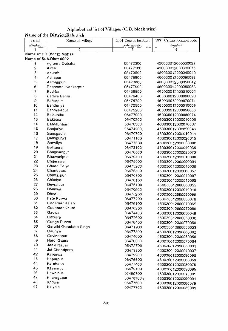
Alphabetical list of Villages (C.D. block wise)
Name of the District·Bahraich . Serial Name of village 2001 Census location 1991 Census location code
number code number number I 2 3 4
Name of CD Block: Mahasl Name of Sub-Dist: 0002
1 Agraura Dubaha 06472300 460030012000030027 2 Airea 06477100 460030012000080075 3 Aourahi 06473600 460030012000040040 4 Ashapur 06478900 460030012000090093 5 Asmanpur 06473800 460030012000050042 6 Babhnauti Sankarpur 06477900 460030012000080083
-7 Badrka 06469800 460030012000010002 8 Badwa Behra 06479400 460030012000090098 9 Baharpur 06476700 460030012000070071 10 Bahduriya 06470500 460030012000010009 11 Bahorikapur 06475200 460030012000060056 12 Baikuntha 06477000 460030012000080074 13 Bakaina 06470200 460030012000010006 14 Bamabhauri 06476300 460030012000070067 15 8anjariya 06474200 460030012000050046 16 Bansgadhi 06470700 460030012000010011 17 Banspurwa 06471100 4600300120000~0015 18 Barwliya 06477600 4600300120000 0080 19 Belhaura 06473100 460030012000040035 20 Bhagwanpur 06476800 460030012000080072 21 Bhawanipur 06470400 460030012000010008 22 Bhgarawal 06479000 460030012000090094 23 Chand Paiya 06473200 460030012000040036 24 Chandpara 06475300 460030012000060057 25 Chhttarpur 06470300 460030012000010007 26 Chkaiya 06470100 460030012000010005 27 Devraipur 06475100 460030012000060055 28 Dhanwa 06470600 460030012000010010 29 Dhnauli 06478200 460030012000090086 30 Fate Purwa 06477200 460030012000080076 31 Gadamar Kalan 06476100 460030012000070065 32 Gadamar Khurd 06476200 460030012000070066 33 Gadwa 06474400 460030012000050048 34 Galkara 06472600 460030012000030030 35 -Ganga Purwa 06476400 460030012000070068 36 Garethi Gurudatta Singh 06471900 460030012000030023 37 Gauriya 06477800 460030012000080082 38 Govindapur 06474600 460030012000050050 39 Hardi Gaura 06476000 460030012000070064 40 Janki Nagar 06472700 460030012000030031 41 Jot Chandpara 06473300 460030012000040037 42 Kaparwal 06479200 460030012000090096 43 Kapurpur 06475500 460030012000060059 44 Karehana 06477400 460030012000080078 45 Kayampur 06479100 460030012000090095 46 Kewalpur 06469700 460030012000010001 47 Kharagapur 06478700'1 460030012000090091 48 Kodwa 06477500 460030012000080079 49 Kolyala 06477700 460030012000080081
226

Alphabetical list of Villages (CD. block wise) N arne of the District· Bahraich
Serial Name of village 2001 Census location 1991 Census location code number code number number
1 2 3 4 50 Katlya 06472000 460030012000030024 51 Lakhanapur 06475700 460030012000060061 52 Lodhauni 06477300 460030012000080077 53 Mahsi 06472900 460030012000040033 54 Maiku Purwa 06471800 460030012000030022 55 Makrandpur 06470900 460030012000020013 56 Masadiha 06475400 460030012000060058 57 Mathaura 06476900 460030012000080073 58 Mudhapur 06474800 460030012000050052 59 Mukeriya 06474500 460030012000050049 60 Munsari 06478600 460030012000090090 61 Murwa 06478400 460030012000090088 62 Nakahi 06474700 460030012000050051 63 Nakawa 06473000 460030012000040034 64 Narkotwa 06472800 460030012000040032 65 Nathuwapur 06475900 460030012000070063 66 Nautala 06474000 460030012000050044 67 Pachdevri 06471700 460030012000030021 68 Padohiya 06473900 460030012000050043 69 Pandit Purwa 06479300 460030012000090097 70 Parsohana 06474300 460030012000050047 71 Pipra 06478000 460030012000080084 72 Pipri 06478100 460030012000080085 73 Pipri Mohan 06471200 460030012000020016 74 Pipriya 06469900 460030012000010003 75 Pure Arjun Singh 06473700 460030012000040041 76 Pure Basti Gaderiya 06472100 460030012000030025 77 Pure Deldar Singh 06472200 460030012000030026 78 Pure Ganga Prasad 06471400 460030012000020018 79 Pure Hindu Singh 06471300 460030012000020017 80 Pure Kuber Panday 06471500 460030012bOO020019 81 Pure Prasad Singh 06472400 460030012000030028 82 Pure Sita Ram 06472500 460030012000030029 83 Raipur 06470800 460030012000020012 84 Rajapur Kalan 06470000 460030012000010004 85 Ramawapur Khurd 06476600 460030012000070070 86 Ramwapur Kalan 06474100 460030012000050045 87 Rehuya Mansur 06475000 460030012000060054 88 Rewati Purwa 06476500 460030012000070069 89 Sadhuwapur 06475600 460030012000060060 90 Sankalpa 06474900 4600300 '12000060053 91 Sansari 06478500 460030012000090089 92 Sigiyansirpur 06471600 4600300 '12000020020
93 Sikandarpur 06473500 460030012000040039 94 Sipahiya Piyuli 06473400 460030012000040038
95 Sisaiya Churaman 06475800 460030012000070062
96 Thailiya 06471000 460030012000020014
97 Tikuri 06478300 460030012000090087
98 Umriya 06478800 460030012000090092
227


DISTRICT CENSUS HANDBOOK: BAHRAICH
C'~nsus ofIndia 2001 _
Amenities and Amenities available (if not available within the village, a dash (-) is shown in the column and
next to it in brackets the distance in broad ranges viz, < 5 krns" 5 .. I 0 km., and 10+ krns of the
'" nearest place where the facilitv is available [s given
~ " v C ~ " '" .D '0 " 8 '" u '" ,:
" ;:; .D ~~ v .2 c .c: <5 " "
.;; u oj
,~ 2-c c S ~
~~ v
Ll 0 0 .:~ E~ G " ~ .c: ~ ·1~
,,;:: 0 " ~ '"
0. 0. ~ '" 0 ell 0 '0 " 0. -;;~ ~ 3: ...1 ~ 0
'0 ]l 0 5 =~ E e~ ~ '" ;t·~ <i ;; .c: '0 tJ -; .2 .2
" c " c
" .s ;l " '0 I: d) tJ 0 ~ ~ ;g ~ ,~ .-
il 0 E .c: ~ I: g ~ " S 0 c· '_ .c: 0. _:"9:..a '." ,9 .D ';; 0 '- -;0 '" '" _ .. ~ III
2 > ~ 5 E " " ~ '" l~ i ~ '_ ~ 0. 0
" tJ C " 0 il 0 01) " ~ _g,;<'E c 0 "- .~ '" c ]l " " '" " '5 .0 <.> :.;; E " tJ
'" E " E 1;' '5 s ;; E
" ;;:; c: ~. E .~~ ~ ~ g :..a E ~
'" 0 0 " '0 -~ 8 (i 0 ,~ -5 ~Qa o ,_ Vl Z f- f- Z '" 0.. U < 0 () E
2 3 4 5 6 7 8 9 10 II 12 13
CD Block: Maha.; (0552)
Kl!walpur 574.9 4,010 744
PM«5) H(lO+) HPWSS- PO PH(5-CM(5-10)
ACS(5-10) CV(lO+) BS(5-10) (06469700) C(10+) MCW« 5) W 10)
CP(1O+) NCS(IO+) SP(IO+) RS(IO+)
PHC(1O+) OCS(lO+) ST(lO+) NW(lO+)
Badrka 149.7 615 107
PM«5) H(IO+) HPWSS-PO«5) CM(5-10)
ACS(5-10) CV(IO+) BS(5-10) (06469800) C(lO+) MCW(IO+) W
PH« 5)1 CP(1O+) NCS(lO+) SP(1O+) RS(1O+)
PHC(IO+) OCS(lO+) ST(1O+) NW(lO+)
H(5-Pipriya
349 I 2,035 288 P(2) M(5-1 0) 10) HPWSS- PH(6)
CM(5-10) ACS(5-10) CV(5-IO) BS(5-10)
(06469900) C(IO+) MCW(IO+) W PO(5-10) CP(1O+)
NCS(IO+) SP(1O+) RS(1O+)
PHC(IO+) OCS(1O+) ST(1O+) NW(1O+)
Rajapur Kalan PM(5-10) • H(S-
ACS(5.10) CV(1O+) BS(5-10) (06470000)
1,714 268 C(lo+)
10) MCW«5) ~ HPW SS- PO PH«5) CM(5-10) NCS(IO+) SP(lO+) RS(1O+)
PHC(IO+) CP(1O+) OCS(IO+) ST(1O+) NW(IO+)
H(5-Chkaiya
1,651 353 P M C(10+) 10) THPWSS- PO(;-10) CPCM« AC5(5-10) CV(5-10) BS(5-10)
(06470100) MCW(1O+) W PH« 5)
5) NCS(IO+) SP(1O+) RS(IO+)
PHC(IO+) OCS(IO+) ST(1O+) NW(1O+)
Bakaina P« H(lO+) ACS« 5) CV(1O+) BS(5-10) (06470200)
3,264 584 5)M(5-\O) MCW(5-10)
HPSS- PO«5) CM«S) NCS(1O+) 5P(l0+) RS(IO+)
C(lo+) PHC(5-10)
PH« 5) CP(5·10) OCS(1O+) ST(1O+) NW(IO+)
Chhttarpur 268.8 \,536 286 P(2) M« 5) H(1O+) HP W C S5- PO(~ 5) CM«5)
ACS« 5) CV(1O+) BS« 5) (06470300) C(lO+) MCW«5) W PH(lO+) CP(1O+)
NCS(1O+) SP(lO+) RS(IO+)
PHC(IO+) OCS(IO+) ST(1O+) NW(IO+)
Bhawanipur PM«5) CHWH(lO+)
HPWSS- PH(9) ACS
CV(1O+) BS(5-10)
(06470400) 200.7 797 134
C(\O+) MCW(5-\0)
W PO(5-10) CM(5-\0) NCS(IO+)
SP(1O+) RS(IO+) PHC(5-10) CP(5-10) OCS(IO+)
ST(IO+) NW(IO+)
Bahduriya 1200 914 ISS
P M(5-10) C(5· H(J 0+) HPWSS-PO« 5) CM(5-\0)
ACS« 5) CV(1O+) BS« 5)
(06470500) \0) MCW(lO+) W J'CO{\O+) SP(1O+) RS(\O+)
PHC(5-IO) PH(5-10) CP(JO+)
0C"i{\ 0+) ST(lO+) NW\JO+)
228

VILLAGE DIRECTORY
Villal!:e Directory Land Use (As on 1999)
Land use (i.e. area under different types of land use in hectare)"
.c
" E v ~ 0
""" "" .~
5 c 00 > c: . .0
" '0 '0 :; (.) 0 "
v c: ., E u ~
c ·E " .~ E 8 5 g '0 0 ., OIl (.) ~ ~ ~
., .;; o(!
~ C." 51 " ~ il S c b f! " ;>, ~~ ;; .D
~ p.
8.B e "0
" 11 > E -5 s p. ~
~
Ol go "0 :c > 15 ._
" " 1;; p. .5 ~ ~ "" ~ 2 0 c: 0 il c
" 0. ~ ~ 1;; " 1;; E 3 OIl . E '" " :t c ~ OIl ." -." " ·5 p. " 0 " 0 '" 0 ] " c .:;: Z -0: :z. p. :z. ~ E '" ::> u " (I)
14 15 16 17 18 19 20 21 22 23 2 1
W(0.2) MRFP Nanparn (Mb) (2S) TW(40.7) 482.5 1.4 51.6 Kewalpur
T(40.8)
PRMR Bahraich (MP) (45) Badrka
FP I
GC(104.0)
PRMR PC(29.5)
Nanparn (Mb) (30) 1WE(74.1) 123.1 2.0 35.3 Pipriya FP
IK(OA) T(207.9)
PRMR Nanpara (Mb) (20)
FP Rajapur Kalan 4
GC(l06.8) MRFP Nanparn (Mb) (32) 1WE(l06.8) 279.3 1.2 531.0 Chkalya
T(213.5)
Bahraich (43) 8akaina 6
GC(l56.7) PRMR
Bahraich (Mb) (45) TW(SO.O) FP R(lA) 0(5.0)
149.5 3.5 Chhttarpur
T(243.1)
PRMR Mahasi(20)
FP BhaW1lI1ipur 8
MR FP Nanparn (Mb) (30) • Bahduriya 9
229

~ u
u
~ '0 0 '" <.> " " c: .c '" c: .~ ~ " u
u -<.> 0 "" 0
oJ ~ 0
C-,;j ;; " " c: "" -5 0
~ ~ .~ '_ .t:J ;; 0 ;; E '" 0.
" ._
~ 0
" 0 .. 0.. u
3 5 .. E '5 Z 0 0
'" r- r-1 2 3 4
10 Dhanwa (06470600)
IS8.7 1,369
Bansgadhi II 280.0 3,190
(06470700)
12 Raipur
896.0 6,934 (06470800)
Makrandpur 13 161.6 1,841
(06470900)
Thailiya 14 578.6 4,643
(06471000)
Banspurwa 15 291.7 2,549
(06471100)
PipriMohan 16 16.1 1,621
(06471200)
Pure Hindu Singh 17 4.3 1,248
(06471300)
Pure Ganga 18 Prasad 92.9 1,289
(06471400)
Pure Kuber 19 Pandal' 791
(06471500)
Siglyansirpur 20 276.8 1,303 ... (06471600)
DISTRICT CENSUS HANDBOOK: BAHRAICH
C~:nsus of India 2001 _ Amenities and
Amenities available (if not available within the village, a dash (.j is shown in the column and next to it in brackets the distance in broad ranges viz.< 5 kms., 5·10 kms. and 10+ kms of the
'" nearestQlace where the facility is available ill given OJ
~ c: ·t' .t:i " U .t:J " ~ ..2 ., 1i 0 " " <.>
e: 0 c: ·5 'u t .~ ~ 0 " C- .c ~ ~~!
.!: 0 Po 0. " >-
'" '" " '0 U 0. -.0'" '" ~ ] 0 13=E' '0 .; "" '" " u
~ '0 ~~ .~ ~] .g 6;; "
<.>
" 0: "
.. '0 C> ._ <.> 0 ~
" 0 2 .c " 1::; ~ ~ ~ .~ 0 <£ ..c: E .,
';l 0 '- <;; ~ -.0
._: VI --;;;] " ._ 0 " if 'g l! ~ §';<~ .I! 5 ~ 0 !lIl " '" ';l <;; " ] § ~ .0 ~ <.> :.;;; E :1 0 te e =' E '0 " 1;[ E ·t: U t.6 ] E~ " i '0 u 8 0 0 '9 -5
o ._ u.I ~ 0.. U -:. 0 ~g!n U :::
5 6 7 8 9 10 II 12 13
• P« H(1o+) HPWss· PO«S)
ACS(lo+) CV(1O+) BS(IO+) 218 S) M« 5) C(5· MCW(1o+) W
CM(5·10) NCS(IO+) SP(1o+) RS(IO+)
10) PHC(S.IO) PH(5·10) CP(1O+) OCS(IO+) ST(1O+) NW(IO+)
526 P(3) M« S) MCWFWC
HPWSS· PO ACS« S) CV(1O+) BS«S) H(1o+) CM(5·10)
CO 0+) PHC(IO+)
W PH(1o+) CP(lo+)
NCS(lo+) SP(1O+) RS(lO+) OCS(IO+) ST(1o+) NW(1O+)
MCWCWC
I \29 P(4) AC M« PHSCHW THPWTK CM ACS« 5) CV(1O+) BS(IO+) , S) C(I 0+) HO 0+) PHC(5. SS. W PO PH( < 5) CP(1 0+) NCS(IO+) SP(1O+) RS(IO+)
10) OCS(IO+) ST(1O+) NW(lO+)
294 P M(lO+) . H(S·
ACS« 5) CV(1O+) BS« 5) 10) MCW(S. THPWTK PO«5) CM«S) CO 0+) 10) PHC(S.10) C SS·W PH« 5) CP(5·10)
NCS(IO+) SP(1O+) RS(IO+) OCS(IO+) ST(1o+) NW«5)
P(4) M DMCWRMP
ACS« 5) CV(lo+) BSNW 751 CHW H«5) THPWC PO«5) CM«5)
AC(3) C(1O+) PHC(5.10) SS·W PH«5) CP(1O+) NCS(lo+) SP(lo+) RS(lo+) OCS(IO+) ST(1O+)
408 P(2) M« 5) H«
THPWC ACS« 5) CV(1O+) BS
5) MCW«5) PO PH« 5) CM(1O+) RS(IO+) C«5)
PHC« 5) SS·W
CP(IO+) NCS(lo+) SP(1O+)
NW(IO+) OCS(lo+) ST(1o+)
CHWH(5·10) • ACS«5) CV(\O+)
BS 258 PM«5)C(S. MCW«5) THPWSS. PHPO«5) CM«5) RS(IO+)
10) PHC(5.10) W CP(5.10) NCS(IO+) SP(IO+) NW(1O+)
OCS(IO+) ST(1o+)
232 P M« 5) CHW H«5)
THPWTK PHPO«5)CM(~5) ACS(5·10) CV(lO+) BS(IO+) MCW(5·10)
C(1O+) PHC« 5) SS·W CP(IO+) NCS(IO+) SP(1O+) RS(IO+)
OCS(IO+) ST(1O+) NW(1O+)
205 P(4)M«5) CHW H«5) PO TO
ACS« 5) CV(1O+) BS« 5) MCW«5) T HP W SS· PTO PH« CM«5)
C(10+) PHC« 5) W 5) CP(5·10)
NCS(lO+) SP(1O+) RS(IO+) OCS(lO+) ST(1O+) NW(IO+)
140PMSPUC H« ACS« 5) CV(lO+) BS« 5)
C I AC 5) MCW« 5) TWSS·W PO PH CM«5)
NCS(1O+) Sp(IO+) RS(IO+) PHC« 5) CP(S·IO)
OCS(1O+) ST(1O+) NW(lO+)
P« • H« ACS« 5) CV(IO+) BS« 5)
197 5) M« 5) C« 5) MCW(5.1 0) HP W SS· PO«5) CM«5) PHC(5.IO) W
NCS(IO+) SP(lO+) RS(IO+) 5) PH«5) CP(lO+)
OCS(IO+) ST(1O+) NW(lO+)
230

VILLAGE DIRECTORY
ViIlal!e Directory Land Usc (As on 1999)
E -'" _§. .~ ~ 'Q
" 0
" " E ~ " " 'N E
~ 'i5 '" 8 >I)
o\l ~ c" ;>
" t: .2;- ~ " :;: Co :J o !;; Co .<: 2 ;;; Co o.~ u '" .5 ~ '" ~
"-8 :J ~ l;\ " "- " 0 " "- " 0 " E < Z c. z ::£ 14 15 16 17 18
MR FP Nanpara (Mb) (35) -
MRFP Nanpara (Mb) (28) -
PR Bahraich (Mb) (28) ED N
PRMR Raipur (4)
EDEAG FPNC EOEA
PRMR Mahasi (6) ED FP
PRMR FP
Bahraich (Mb) (30) ED
PRMR Mahasi (6)
FP
MRFP Bahraich (Mb) (35)
PRMR Mahasi (4)
FP
PRMR Mahasi (3)
FP
PRMR Mahpi(O)
FP
Land use (i.e. area under different types of land use in
1;; ~ ~ 19
231
t '-
" ~ » 6 '0 £ " .!:!' l: 20
GC(45.0) T(45.0)
GC(l56.3)
hectare)·'
'0
~ § " ;:J
21
158.0
TWE(298.9) TK(O.9)
T(456.0)
GC(l6.2) W(60.7) T(76.9)
GC(2.5) T(2.S)
.<: " " :;I .2 '" '"' .g t.Il
" 'i5 :;
" " -;; '-·12 g ~
~ .to 1.)
~ co
~ ~ .~
" ';;;' ~ ;; " ::ii ;> '''0 '0
'" 0 t: B ~ " '" E - "0 " '" " " ~ u '" :z
22 23 2
60.0 105.0 Dhanwa
Bansgadhi
15.5 310.4 Raipur
Makrandpur
Thailiya
Barupurwa
10.6 6.3 PipriMohan
Pure Hindu Singh
Purt Ganga Prasad
Purt Kubor Panday
Sigiyansirpur
Il ..0 E " " -;; ·5 '" I
10
11
12
13
14
15
16
17
18
19
20

______________________________________________________ D_�s_T~R~I~C~T~C~E~N~S~U~SH.ANDBOOK:BAHRAICH
Census of India 2001 -Amenities and
Amenities available (if not available within the village, a dash (-) is shown in the column and
next to it in brackets the distance in broad ranges viz. < S kms., S-1O lans. and 10+ kms of the
" '? nearest place where the facility is available is given '" " ~ " -a "" '" .c-"" u
'" U ~ fi 8 u ::J .c ".2
" ..<: :;! ,- u " E u ~ 0 c .:: " ~ 0 " " 0 .~ t~ ';J v u 0
~ E ~ -" a "' u Po ;; .,;::
"- " '" u ;::; " ~ ~ 0 ~ .; u 0- .;! -;v.l -l 0 '0 ] 0
~) :;=5 ::J " o\l ';';: ~
~ '" 6 .~ 3] .a e~ " "
c u ,': " '" " " "' '0 u 0 ... OIl .:; .Q ::J
a ,_ ~ ~ ,g " t; ~ 0 B -" ~ " ~ 0 c ,_
"'" ..<:
'" ~ --' '" __ ._ "'0
.~ .~ .c .;;; 0 ;; ._ "' ,,> ::J
E "' " Co e :0::: u "' 0. 0 0: 'u .g ~ ~ .;; ~ ::J '_ ~ 0 ~ 0 OIl u ~ " '0 c 0 .. 0. ';J « ,5 ] .::: e ::J ;.-.
" '5 '5 ..0 rl .!l .;< E ::J U ~ 5 .E E "' .. E .~ U .E ::J
~ C ;f E u c ~ E~
" "'- 0 0 i '" i§ 0 0 tJJ -5 ~Q,~ o ._
'" Z f- f- ~ c- U -< 0 u (': I 2 3 4 S 6 7 8 9 10 II 12 13
Pachdevri P(2) M S CHWH(S-IO)
CV(1O+) BS
21 4,352 681 MCW(S-IO) ~ HI' W SS- PO« 5) CM(5-10) AC3« S)
RSCIO+) (06471700) PUC C(S-IO) NCS(IO+) SP(IO+)
PHC(5-10) PH( < 5) CP(1O+) OCS(IO+) 5T(10+)
NW(IO+)
PHCPRS ACS BS
22 Maiku Pmwa
392.6 1,752 323 P M C(IO+) CHW(2) T HI' W S3- PO PH(S-
CM(5-10) NCS(IO+) CV(IO+)
RSCIO+) (06471800) H(IO+) W 10) 5P(10+)
MCW(S-IO) CP(IO+) OC3(10+)
5T(l0+) NW(IO+)
Garethi PM(5-10)
- R(S-ACS« 5) CV(IO+) BS« S)
23 Gurudatta Singh 1,434 218 10) MCW(5- T HI' W 5S- PO« 5) CM(5-10) (06471900)
C(IO+) 10) PHC(5-10) W PH« 5) CP(S-IO)
NCS(IO+) SP(1O+) RS(IO+)
OCS(IO+) 5T(10+) NW(lO+)
24 Kotiya
2,337 396 P(2) M( < 5) H(IO+) T HI' W 55- PO(~ 5) CM«5) ACS« 5) CV(1O+) BS«5)
(06472000) C« 5) MCW«5) W PH«5) CP«5) NCS(lO+) 5P(10+) RS(IO+)
PHC« 5) OCS(1O+) 5T(10+) NW(IO+)
Pure Basti - H(5- POTO ACS(S-IO) CV(1O+) BS«5)
25 Gaderiy. 1,514 269 P M(S-I 0) C(S- 10) MCW(5- HI' W SS- PTa PH(S- CM(S-lO) NCS(S-IO) SP(1O+) RS(IO+)
(06472100) 10) 10)PHC(S-10) W 10) CP(5-10) OCS(1O+) ST(lO+) NW(IO+)
Pure Oeldar P« H(1O+) T HI' W SS- PO(~ 5) ACS(5-10) CV(1O+) BSC< S) 26 Singh 93.8 544 114 5)M(5-10) CM(1O+)
MCW(S-IO) W PH«5)
NCS(IO+) SP(1O+) RSCIO+) (06472200) C(1O+)
PHC(5-10) CP(5-10)
OCS(IO+) ST(1O+) NW(1O+)
27 Agraura Dubaha
400A 687 109 P(2) M« S) H(IO+) T HI' W SS- PO(~ 5) CM«5) ACS« S) CV(IO+) BSC< S)
(06472300) C«5) MCW«5) W PH«5) CP«S) NCS(1O+) SP(1O+) RS(IO+)
PHC« 5) OCS(1O+) ST(1O+) NW(1O+)
Pure Prasad - H(S-ACS« S) CV(1O+) BSC< 5)
28 Singh 353.6 460 86 P M(S-I 0) C(5· 10) MCW(S- HI' W SS- PO(S-IO) CM(S-IO) NCS(5-10) SP(lO+) RS(5-10)
(06472400) 10) 10)PHC(S-IO) W PH(5-10) CP(S-IO) OCS(1O+) ST(1O+) NW(IO+)
Pure Sita Ram 113 P(2) M(5-1 0) - H« ACS(5-10) CV(lO+) BSC5-1O)
29 3S0.8 S24 S)MCW(S-lO) THPWR PO(S-IO) CM(S-IO) NCs() 0+) Sp(IO+) RSCIO+) (06472500) C(5-10) PHC(5-10) SS-W PH(5-10) CP(S-IO) OCS(1O+) ST(1O+) NW(1O+)
P« - H(S-ACS« 5) CV\IO+) BSC5-10) Galkara 10) MCW(S- Hl'R SS- PO(5-10) CM(S-IO) 30 63SA 208 37 S)M(5-10) NCS(1O+) SP\IO+) RS(IO+) (06472600) C(S-IO) 10) PHC(S-IO) HI' PH(S-IO) CP(S-IO) OCS(5-10) ST\IO+) ),;\\'\10+)
232

VILLAGE DIRECTORY
Villaj!c Dircctory Land Usc (As on 1999)
E -" g u u C
'U ~ :W '0 :;: ,:j
3 r: ~
"'" 3 ~
~ 0
0. 0. " -< ;Z
14 15
.?c 0. 0. ;: t ~ 0
0.
16
~~ MR Bahraich (Mb) (28) _
~ MR Mah.,.i (8) ED
MR FP Mahasi (9)
MR FP Mahasi (4) ED
MRFP Mahasi (5) ED
MR Mahasi (5)
MRFP Mahasi (4) ED
FPNR Mahasi (6) ED
PRMR FPNR
Mahasi (5)
MRFP Mahasi(8) NR
C> '0 0
" " E
'N E '" 8 "" ~ ;::
"0 ~ '" t g_a 0.
'" .S ~ 0.
~ ;: " " " 0 E ~ ;Z
17 18
Jaggery
Land use (i.e. area under different types of land use in hectare)"
~ " Sl
'" e ."
~ ~ 1: bO
] o. ~
19 20
TK(O.5) R(478.8)
24.0 L(23.5)
233
T(S02.7)
GC(lOO.O) WE(S.O)
T(lOS.O)
TK(O.9) R(3.9) L(2 8)
W(lO.O) TW(SO.O) T(60.0)
R(21.S) T(21.5)
TK(O.l) R(2.0) T(Z.l)
GC(25.2) R(8.3)
T(33.5)
R(l 556) T(155.6)
"0
¥ 'E " ;:J
21
390.4
353.6
325.6
6354
-5 " ~ 0
"" .~
OIl ;, C ':1
'i3 :;
i u ~
2-.,S
" ~ ~ " "" '" ~ ,,~ .;;
" ~ i; ;;: :D ;> 0 '-'"
2 0 c: " .3 "" '" E - "0 " " " c: .:;: o '" Z 22 23 2
3.9 545.1 Pachdevri
Maiku PulWa
Garethi Gurudatla
Singh
367.8 11.7 KOliya
Pure Basti Gaderiy.
Pure Deldar Singh
20.2 44.4 Agraura Dubaha
5.6 0.5 Pure Prasad Singh
7.9 S.6 Pure Silo Ram
175.2 Galkara
';; .D E " c
'" ';; III
21
2~
23
24
25
26
27
28
29
30

t .D E " r::
DISTRICT CENSUS HANDBOOK: BAHRAICH
Ccn:ms of India 2001 -Amenities and
Amenities available (if not available within the village, a dash (-) i,~ shown in the column and
next to it in brackets the dislance in broad ranges viz. < 5 kms., 5-10 kms. and 10+ kms of the ~ nearest place where the facility is available is ~i:ven
e 5 ~" . ~ ~ u ] g n-§ ou. a ''::; u ~f ~ J:: 0 ~ .~ ~ ~ 12 y
-=- 8 ~ .2 ~ _g .~g_ '.~~ ~ 0 -a e- ~ .~ ~ ~ ~ ~ ~ 0 - ] go - 3=6' ~~ ';; c _g -0 8 if .J~ :; ~ .2 e ~ 'U c: ~ ~ "'C C,) U 0'" ~ ~
-:S ,9 g ~ .c ~ g 'g ~ \) £ ._~ co' '- ~ .c: - 0.. _~~ _
~ :; '0 ~ ~ ~ «l e .~~ tC > =' ~ '::J
'0 ~ g- u § ~ 00 ~ ~ _g ~ .S '?: ~ '~E! \) ce c.. .&J .~ .~ .5 _ E ;::::s (~ ~ e ::::l '"
ce E S '3 e :5 "'2 ~ t;f E .~~) ~ ~ :.a E ~ ~ .~: ~ ~ i ~ 2 (5 0 0 ~ .£; ~ 2. ~ 8 '§
~=~1=1====;2====1==~3===~=~4==~~=~5~=~===~6~==~~==~~7===~==~~8==~==~~~9==~==~~~o==~==:I=I~~'=~~:~1:2~~~=~~13~~~ 31
32
33
34
35
36
37
38
39
Janki Nagar
(06472700)
Narkatwa
(06472800)
Mahsi (06472900)
Nakawa
(06473000)
Belhaura (06473100)
Chand Paiya (06473200)
J at Chandpara
(06473300)
Sipahiya Piyuli (06473400)
Sikandarpur (06473500)
Aaurahi (OM~3600)
575.4 164
55.8 71
6,893
1,281
1,251
234.3 2,773
436.1 6,113
2,651
4,854
567.:) 2,852
H(5· P« 10)
30 5) M(5-10) MCW(lO+) HP R SS-W PO(5.10)
PH(5·10)
CM(5-IO) ACS(5·10) CV(1O+) CP(5.10) NCS(lO+) SP(1o+)
C(5-IO) PHC(IO+) OCS(IO+) ST(1O+)
P« - H« _ 12 5) M« 5) C« 5) MCW(5.10) ~ W SS· PO« 5)
PH« 5) CM«5) CP(1O+)
ACS(5·)0) CV(1O+)
5) PHC(5-10) NCS(IO+) SP(1o+) OCS(10+) ST(IO+)
P(6) M S
1,087 PUC 0 C(10+)
HMCWHC
PHC PHS CHW(3)
PO TO ACS T HP W TK PTO PH« CM CP(5. NCS(10+) RCSS-W 5) 10) OCS(IO+)
- H« 207 P AC M(5-10) 5) MCW« 5) W SS-W
C(1o+) PHC(5-10) PH PO« 5) CM« 5)
CP(5-10)
ACS(d) NCS(10+) OCS(10+)
H« 244 P M« 5)
C(1O+) 5) MCW(5-10) W SS-W PHC(5-10)
PH PO« 5) CM« 5) CP(5-IO)
P AC M« 5) - H« T HP W TK PH(2) 508 C«5) 5)MCW(1O+) CSS-W PO«5)
PHC« 5) CM«5) CP« 5)
ACS« 5) NCS(10+)
OCS(10+)
ACS«:i)
NCS«'i) OCS« 5)
881 P(2) M C(lO+)
MCW HC HP W SS- PO(2) TO CM CP(5- ACS CHW H« 5) W PTO 10) NCS(lO+)
435 P M C(1O+)
PHC« 5) PH(26) OCS(IO+)
- H(5-10) MCW(5. HP W SS- PO« 5)
10) PHC(5-10) HP PH« 5)
HAMCWMH
CM«5) CP(5-IO)
ACS« 5) NCS(IO+) OCS(lO+)
CV(1O+) SP(1o+) ST(lO+)
CV(IO+)
SP(1o+) ST(1O+)
CV(IO+) SP(1o+)
ST(1O+)
CV(lO+) SP(IO+) ST(IO+)
CV(IO+) SP(1O+)
ST(1o+)
CV(lO+) SP(1O+) ST(1O+)
810 P(2) M S C(1O+)
CWC HC PHC T HP W SS- PO ACS(5.10) CV(IO+) CM(lo+) NCS(IO+) SP(1C>'-) PHS FWC W PH(1 0+)
CHWH(lO+)
467 P(2) M(5-10) H(IO+) C(lo+) MCW(lO+)
PHC(5-10)
234
T HP W ss- PO(;-IO)
W PH(1O+)
CP(lO+) OCS(1C>+) ST(lC>'-)
ACS« ;) Cl>f(5-IO) NCS(lCH
CP(IO+) OCS(ICf+)
CV(ICH SP(1 C>-',
ST(1 C>-)
NWBS(5· 10)
RS(lo+)
BS« 5) RS(IO+)
NW(IO+)
BSNW RS(lo+)
BS«5) RS(1o+) NW(1O+)
BS«5) RS(IO+) NW(1O+)
BS« 5) RS(IO+) NW(5-10)
BS(5-10)
RS(IO+) NW(1O+)
BS«5) RS(JO+) NW(1O+)
BS(5·10) RS(IC>'-) NW(lo--) .
BS(5-IO)
RS(I C>- \ NW(lC>-)

VILLAGE DIRECTORY
Village Directory Land Use (As on 19991
" ~ .;;: S
~ 0 Q. 0. « 14
FPNR NW
PRMR FPNR NW
PRMR FP
PRMR FP
MRFP
PRMR
]' 5 ~
'" ~ :;; <1d
" il: S
~ " z 15
Mahasi (10)
Mahasi (3)
Mahasi(5)
Mahasi(4)
Manasi (4)
Mahrajganj (2)
Bahraich (29)
PR MR Mansi (6) FP
MR FP Mahrajganj (5)
MRl Mahsi (6)
.~
." 0 ., ~ .~ ., 0
"" " ., C:."
~ .0 t! " 0- g_E 0- 0-a ., .5 ~ "-
II ., '" ~ " " ~ " Q E "- z
16 17 18
B.D NM
ED
ED BAG BOEA
EDEAG Plywood, Oil
EOBA
ED
Land use (i.e. area under different types of land use in
'iii " ~ 19
~
" ~ " £ >,
e ." B ., bIl .~
20
TK(l70.8) 0(4.6) 1(175.4)
W(10.7)
224 TK(2A) . 0(39.3)
235
T(52.4)
GC(l77.4) T(177.4)
R(30.7) T(30.7)
hectare)"
.". B ., .~ t:
'" ::> 21
575.4
52.4
1075
_.
-5 '" " 0
'" .~
'"' .~ ~ ." " .a " u ~
,£ ~ ., " ::0 ~ .;: il:~
.;;; ., ~ ~
::0 ~ <5 e ~
c
" " .::." e " c: u '" « 22 23
55.4 1983
157.2
5.7
u
'"' ~ t .0 ;;: E
.~ " 0 " u -;; E "E '" :z '" 2 I
Janki Nagar 31
Narlwtwa 32
Mahsi 33
Nakawa 34
Belhaurn 35
Chand Paiya 36
Jot Chandpara 37
Sipahiya Piyuli 38
Sikandarpur 39
Aourahi 40

DISTRICT CENSUS HANDBOOK: BAHRAICH
Census oflndia 2001 -Amenities and
Amenities available (if not available within the village, a dash (-) is shown in the column and
~ next to it in brackets the distance in broad ranges viz.< 5 kens., 5-10 kens. and 10+ kens of the
4)' " nearest place where the facility is available is eiven '" " ~ Il ~ "0
1'lE: "0 ~ 0 <.> .u .. <: <.> " il .D '" <: ..:: :; " " 'Z' " oj
5 .. "§ t! " 0 6 0 c .~
~ .~ " ';1 U 0
'" " 5 .c ~ ~ 8- " '" " 0 ., Cl. " ., ~
0 00 " Cl. .~ ~v.I ...l ~ 0 "0 :9 0 :;=S ~ 5
~ ~ "0 8 ~.~ ~ -Il "0 ~ ~.2 e-.; " " <: '" " <: " ., lI: ;g -5 .~ " '" "0 o ._
~ .g .~ " . Ii 0 2 .c :; " g ·3 5 <,., ., .<: Cl. _" ., -'_ ", .D .;; 0 :; ...... '" ~ .. '" > " " 'Z' E ~ c on .!!! ~~ g-..~ .:! .os Cl. <: " "
._ 0 13 .~ eo " " ., " 0 ., Cl. ~ " :9 Ii .:::. ~
" '" .~ _u
S 5 .D :.:;; E " <.> '" E :s E " E E " 'ti " of E 't t ~ g ~ El " " '" c ?: ~ "0 " 8 0 0 <~ ~Qb3 o .-m Z I- ~ ~ p., U U ~
I 2 3 4 5 6 7 8 9 10 II 12 13
Pure Azjun Singh P« H(IO+) HPWss· ACS« 5) CV(1O+) BS« 5) 41 473.7 112 25 5) M« 5) PO« 5) CM«5) (06473700) MCW(5·1O) W NCS(JO+) SP(IO+) RS(lO+) C(10+)
PRC(5·10) PH« 5) CP(lO+)
OCSOO+) ST(lO+) NW(1O+)
Asmanpur 217 P M« 5) R«
THPWR ACS«S) CV(1O+) 8S« 5) 42 383.7 1,264 5) MCW«5) PO«5) CM«5) (06473800) C(1O+) PHC«5)
SS·W PH« 5) CP(5·10)
NCS(IO+) SP(1O+) RS(1O+) OCS(lO+) ST(1O+) NW(1O+)
Padohiya 207 PM«5) • H(5·
ACS« 5) CV(IO+) 8S(5-10) 43 385.7 1,110 10) MCW( < 5) T HP W SS· PH PO(5- CM(lO+)
(06473900) C(10+) PHC(5-10) W 10) NCS(lO+) SP(IO+) RS(IO+) CP(5-10)
OCS(lO+) ST(1O+) NW(1O+)
44 Nautala
477.9 3,506 567 P(2) M H(IO+) THPWSS- PO CM ACS« 5) CV(1O+) 8S(10+)
(06474000) C(1O+) MCW(IO+) W PH(1O+) CP(1O+) NCS(lO+) SP(1O+) RS(IO+)
PHC(lO+) OCS(lO+) ST(lO+) NW(lO+)
45 Ramwapur Kalan
155.0 1,941 338 PM«5)C« H(IO+) HPWSS· PO« 5) CM«5)
ACS« 5) CV(IO+) 8S(<5)
(06474100) 5) MCW(S-IO) W NCS(lO+) SP(lO+) RS(IO+)
PHC(5·10) PH«5) CP(1O+)
OCS(lO+) S1(10+) NW(1O+)
Banjariya 308 P M(5-10) - R(5-
ACS« 5) CV(IO+) 8S« 5) 46 221.4 1,906 10) MCW(S- HPTWW PO«5) CM«5)
(06474200) C(10+) 10)PRC(5-10) SS-W PH(S-IO) CP(1O+) NCS(IO+) SP(lO+) RS(IO+)
OCS(lO+) S1(10+) NW(1O+)
47 Panohana
2,140 444 PM«S) R(1O+) T HP W SS- PO(~ 5) CM«5) ACS(S-IO) CV(IO+) BS(S-IO)
(06474300) C(1O+) MCW(S-IO) W PH(S-IO) CP(S-IO)
NCS(S-IO) SP(1O+) RS(IO+)
PRC(S·IO) OCS(S-IO) ST(1O+) NW(S-IO)
374 P(2) M S MCWFWC - ACS« 5) CV(IO+) BS(IO+)
48 Gadwa
225.4 2,252 CHWH(5-10) THPWTK PO«5) CM«5) (06474400) C(1O+)
PHC(5-10) SS-W PH«5) NCS(lO+) Sp(IO+) RS(10+)
CP(IO+) OCS(1O+) ST(1O+) NW(1O+)
HUDDUMH
CWC FWC T HP TW ACS« 5) CV(1O+)
BS
49 Mukeriya
547.5 1,763 279 P M« 5) NH(2) RMP(2) W TK SS- PO PH CM«5) RS(IO+) (06474500) C(1O+) R(1O+)
W CP(IO+) NCS(1O+) Sp(IO+)
NW«5) MCW(lO+) OCS(1O+) S1(10+)
PHC(IO+)
236
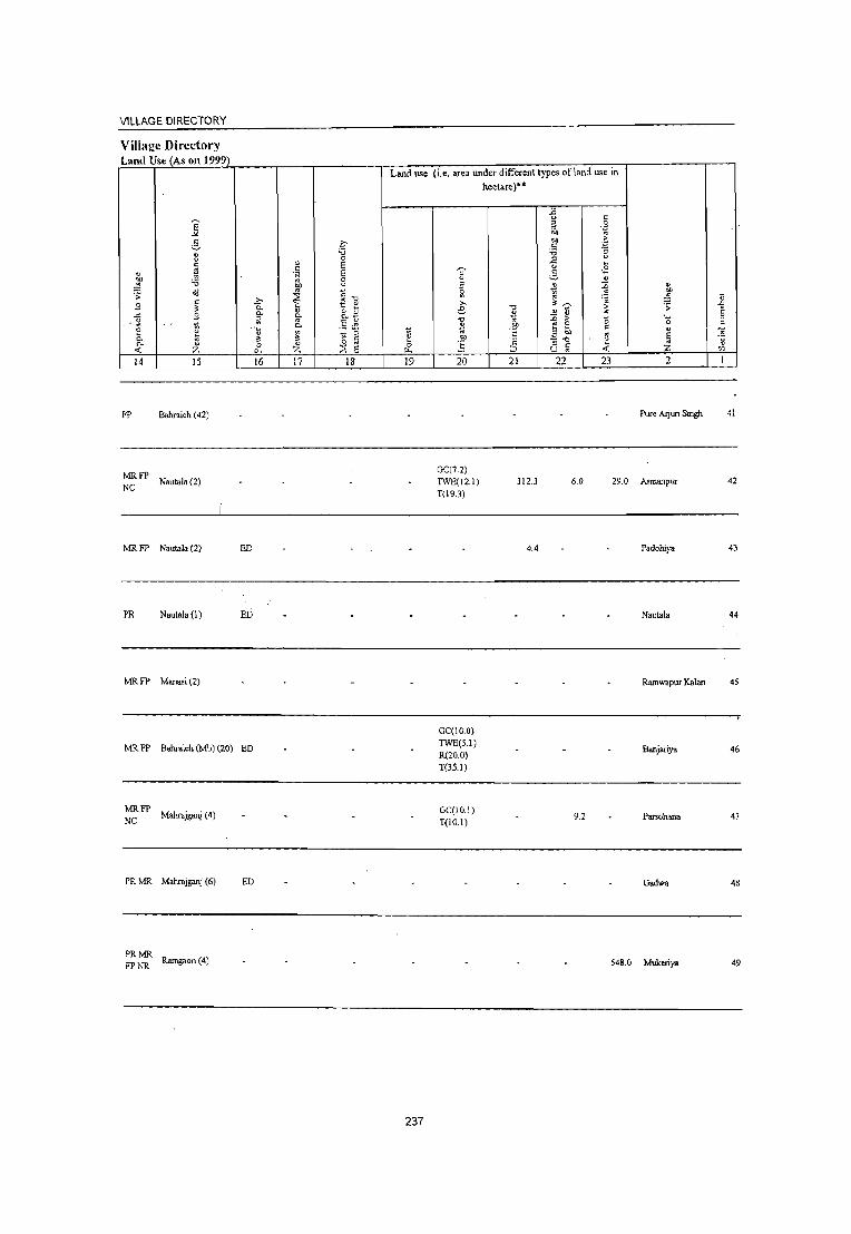
VILLAGE DIRECTORY
Villal!e Directory Land Use (As on 1999)
Land use
E -" ;§. q u '" v 0 t:
., ~ ~ " 0 'N
~ ~ " 8 "" ·s ~
~ ~1l .0 .., t: l: 0- &.a .c: .., P- o. ;: '" .. :; ... ~
0. .5 ~ £
.~
] u ~ 'g ~ 0- \'l " " P- o 0 E .,; :z. 0. :z. ::\ 14 15 16 17 18 19
FP Bahraich (42)
~ FP Nautala (2)
MR FP Nautala (2) ED
PR Nautala (1) ED
MRFP Manasi(2)
MRFP Bahraich (Mb) (20) ED
MRFP Mahrajganj (4) NC
(i.e. area under different types of land use in
~ " :; ~
'" 6 ."
~ .!O' .!:i 20
GC(7.2)
TWE(l2.l)
T(19.3)
GC(IO.O)
TWE(5.l) R(20.0) T(35.1)
GC(10.1) T(10.1)
hectare)"
] '" '5
'0: ::> 21
312.3
4.4
-£ " " .~ " ell eo 'S ~ ~ .2 " 5 ~ ., ~ ~ 0
~ .;; ,,~
> '> ~ .!l 0 '" '_ -" e <5 ~ "
0 ., ell
~ E -." '" ::> " -< u '" :z.
22 23 2
Pure Aljun Singh
6.0 29.0 Asmanpur
Padohiya
Nautal.
Ramwapur Kalan
Banjariya
9.2 Parwhana
PR MR Mahrajganj (6) ED Gadwa
PRMR FP NR Ramgaon (4) 548. 0 Mukeriya
237
ij -" E ~ c ~
"5 '" I
41
42
43
44
45
46
47
48
49

____________________________________________________ ~D~I=S~T~RI~C~T~C~E~N=S~U~S~HANDBOOK:BAHRAICH
Census ofIndia 2001 -Amenities and
~ .D
50
51
52
53
54
55
56
57
58
59
E " c:
2
Govindapur (06474600)
Nakahi (06474700)
Mudhapur (06474800)
Sanka!pa (06474900)
Rehuya Mansur (06475000)
Devraipur (06475100)
6ahorilcapur (06475200)
Chandpara (06475300)
Masadiha (06475400)
Kapurpur (06~i5500)
3
315.3
158.2
109.4
478.4
337.8
434.2
529.6
310.8
149.3
o o C
" .~ .!S
" Co. o Co.
] 4
1,216
1,473
1,113
61
6,977
1,474
3,020
3,155
3,097
4,181
Amenities available (if not available within the village, a dash (-) is shown in the column and next to it in brackets the distance in broad ranges viz. < 5 kms., 5-10 kms. and 10+ kms of the
nearest place where the facility is available is Iliven
6
217 PM«5) C(10+)
230 PM(5-JO) C(IO+)
7
H(1O+) MCW(IO+) PHC(lo+)
8 9
T HP W 5S- PO(~ 5)
W PH« 5)
CHW H(I 0+) HI' W SS-MCW(lo+) W PO«5) PHC(1o+) PH« 5)
P« H(IO+) 192 5)M«5) MCW(lO+) :: W S5- PO« 5)
PH« 5) C(IO+) PHC(lo+)
P« 9 5) M(5-10)
C(5-10)
H(5-10) MCW(5- TWSS-W PO«5) 10)PHC(5-10) PH«5)
10 II
eM« 5) ACS« 5) CP(S-IO) NCS(IO+)
OCS(lO+)
CM(5-10) ACS«5) CP(5-10) NCS«5)
OCS« 5)
eM«5) CP(1O+)
ACS« 5) NCS(IO+) OCS(1O+)
12
CV(1O+) SP(1O+) ST(1O+)
CV(Jo+) SP(IO+) ST(IO+)
CV(1O+) SP(IO+) ST(IO+)
eM« 5) ACS(5-10) CV(JO+) CP(5-10) NCS(IO+) SP(IO+)
OCS(IO+) ST(1O+)
PHS H« 5) 1,196 P M C(1O+) MCW(5-10)
PHC(5·10)
T HI' W SS- PO PH« 5) eM CP(5· ACS(5-10) CV(IO+) W 10) NCS{IO+) SP(lO+)
OCS(I 0+) ST(1 0+)
249 P M( < 5) C(5· H(1 0+) 10) MCW(5-10)
PHC(5-10)
THI'WSS- PO(~5) CM«5) ACS(5·10) CY(IO+) W PH(5-10) CP(5.10) NCS(IO+) SP(IO+)
546 P(2) MAC C(lO+)
523 P(2) M AC C(lO+)
496 P OM(5-10) C(IO+)
706 P 1;1(5-1 0) C(10+l..
OCS(1O+) ST(IO+)
MCWPHS H(1O+) PHC(5. HP W S5- PH(4) 10) W PO«5)
AC,I«5) eM«5) NCS(IO+) CP(5-10) OCS(IO+)
H(IO+) MCW«5) PHC(5-10)
HPWSS- AC:l«5) W PH PO« 5) eM« 5) NC:l(lO+)
MCWPHS RMP CHW HP W SS-H(lO+) PHC(5- W 10)
H(1o+) MCW(5-10) PHC(5.10)
238
T SS-HP
PH(3) PO« 5)
CP(5-10) OC:l(IO+)
eM( < 5) ACS( < 5) CP(5-10) NCS(IO+)
OCS(1o+)
ACS« 5) PO PH« 5) CM(<5) NCS(1o+)
CP(5-10) OC:S(lo+)
CV(1O+) SP(IO+) ST{lO+)
CY(lO+) SP(lO+) ST(IO+)
CV(IO+) SP(IO+) ST(lO+)
CV(IO+) SP(IO+) ST(IO+)
13
6S«5) RS(IO+) NW(1O+)
6S«5) RS(IO+) NW(1O+)
65«5) RS(IO+) NW(1O+)
8S(5-IO) RS(IO+) NW(1O+)
6S«5) RS(IO+) NW(lO+)
6S(5·10) RS(IO+) NW(lO+)
8S RS(IO+) NW(IO+)
6S RS(IO+) NW(lO+)
6S« 5) RS(IO+) NW(lO+)
6S(5-10) Rs(lo+) N\\\10+) •

VILLAGE DIRECTORY
VilIaj!e Directory Land Use (As on 1999)
E ... 3 .~
" ."
" " 0
c ~ ~ c
" 'N "" :; '" 8 ~ '" o1l '" "." .;:
~ .9 c .?;> f! " " 0- RB .c S 0. !;-~ iil .5 ~
~ ~
0. e " ~ ~ " 0- ,,' c· 0- 0 "
0 8 -0: :z: 0. :z: :::E
14 15 16 17 18
MR Bahraich (Mb) (13) -
MR FP Bahraich (Mb) (18) -
MR Bahraich (Mb) (12) -
:: FP Bahraich (28)
PRMR FP Bahraich (Mb) (10) -
:FP Mahrajpur(7) ED
PR Bahraich (Mb) (25) EDEAG NM
PRMR Mahrajganj (2) EDEAG N Steel
PRMR Bahraich (Mb) (28)
EDEAG FP EOEA
Jaggety
PRMR Bahraich (24)
FP
Land use (i.e. area under different types of land use in
~ ~. 0
f.«
19
8.0
239
hectare)"
'OJ' " !5 iii
e: ." 2
i 20
GC(1277.0) T(1277.0)
GC(22.0) TW(l90.0) TWE(S.O) TK(1.0) T(218.0)
GC(284.6) pc(1.0) W(O.S) TWE(15B.I) TK(12S'!) T(569.3)
- \
." 2 " .~
.1': c
::> 21
5035.0
296.2
2.0
-{l r:
" 0
'" .~ '" '" r: .= :; -;
" ~ ....
6 .~
" ~ ~ .;;; ?;~ > " t1 .. ~ B -0
c E '" .. -." " " c .;;: U .. 22 23
3433.0
1.2 44.3
3.8 20.5
v
'" ~ U ;; .0
E ._ " 0 C
" -;; E 'fi '" :z: '" 2 1
Govindapur 50
Nakahi 51
Mudhapur 52
Sankalpa 53
Rehuya Mansur 54
Devraipur 55
Bahorikapur 56
Chandparn 57
Masadiha 58
Kapurp~ 59

DISTRICT CENSUS HANDBOOK: BAHRAICH
Census ofIndia 2001 -Amenities and
Amenities available (if not available within the village, a dash (-) -is shown in the column and
next to it in brackets the distance in broad ranges viz. < 5 kms., 5-10 kms. and 10+ kms of the ~ ~ nearest place where the facilitv is available is Qiven
I :>
" ~
"" " '" :J :2' '" ~ " 8 II ~ u " c
~ .D "
C ..c: " u "§ ".;:J u oj
'0 c > ~t! " 0 5 " 0 '= 'E ~ .= U 0 i3 ~ .t: ~ .!! g_ 1l " Co :; " ,., 0 ~ 0 ~ " Co " -;;;(1) ~ ~ ...l 0 '2 0 ·c li ="S ~ 0 "
OIl ~ 8~ o\l .;;; ..c: "" " tp .~ :; ~ .2 " " " ~ " c " ~ :t
~ .:; 0 :> " '0 o .~ u 0 M
.~ gA !l ..c: " c ::: ~ .g .~ ~ .... .~ 0 " .D 0
.t: .. r;. _,. on ~>-g .;;; :; ._ ';;j .. '" '::1 E " 0. 0 e :t 0;, 'g E:; " ..; .!! 5
:> ._ ~ 0 ~ 0 "" " .E e .2 ';e E c '"
" 0 Co '::1 ';;j .5 '2 E ~ u .0 '" " E :> " " E ;:l '" '3 '3 E u -'" .~ u ~ ~ :.a 'E E :> ;;;
8 ..r E E :t '" 0 0 ;:l '0 " 0 0 @'"s ~ Q~ 0;':
'" Z f-o E- Z D:l ~ 0. U ..; 0 u :: 2 3 4 5 6 7 8 9 10 II 12 13
Sadhuwapur 226 P(2) M(5-! 0) - H(5-
POPH(5- ACS« 5) CV(1O+) BS«5) 60 160.8 1.384 10) MCW(5- THPWC CM(5-IO)
(06475600) C(5-10) 10) PHC(5-10) SS-W 10) CP«5)
NCS(lO+) SP(lO+) RS(lO+) OCS(lO+) 5T(1O+) NW(1O+)
61 Lakhanapur
287,3 1,660 258 P(2) M« 5) H(1O+) HPWSS-PO«5) CM(5-10)
ACS(5-!0) CV(lO+) BS(5-10) (06475700) C(10+) MCW(5-10) W
PH(5-10) CP(5-10) NCS(1O+) SP(1O+) RS(1O+)
PHC(5-IO) OCS(1O+) ST(1O+) NW(1O+)
FWCCHW
62 Sisaiya Churaman
1,879.0 3,151 500 P(2) M(5-IO) H(IO+) T HP W SS- PO PH CM(1O+)
ACS(d) CV(1O+) BS(5-10)
(06475800) C(1O+) MCW(IO+) W NCS(lO+) SP(1O+) RS(lO+)
PHC(lO+) CP«5)
OCS(1O+) ST(1O+) NW(1O+)
Nathuwapur - H«
ACS«5) CV(1O+) BS«5) 63
(06475900) 367.0 2,073 355 P M C(IO+) 5) MCW(5-10) ~s~WTK PO«5) CMCP
NCS«S) SP(1O+) RS(1O+) PHC(5-10) PH« 5)
OCS(1O+) ST(1O+) NW(IO+)
PHSFWC
HardiGaura 690 P(3) M CHW(2)
T HP W SS- PO PH(5- CP ACS
CV(IO+) BS«5) 64
(06476000) 520.6 4,400
C(1O+) H(lO+)
W 10) CM(1O+) NCS(lO+)
SP(1O+) RS(1O+) MCW(1O+) OCS(IO+)
ST(1O+) NW(1O+) PHC(5-10)
Gadamar Kalan P M(1O+) SMPH(5-10)
THPWSS- PO(~5) ACS(<5) CV(1O+) BS«5) 65 277.1 886 191 MCW(IO+) CM(IO+)
(06476100) C(1O+) W PH(1O+) NCS(1O+) SP(lO+) RS(IO+)
PHC(1O+) CP«5) OCS(1O+) ST(1O+) NW(lO+)
P(2) M S DAH«5) PO TO ACS(<5) CV(1O+) BS«5)
66 Gadamar Khurd
57.6 1,354 241 PUC 1 TrC(5-MCW«5) T TW W SS· PTO PH( < CM«S) (06476200) W 5) NCS(1O+) SP(1O+) RS(lO+)
10) PHC« 5) CP«5) OCS(lO+) ST(1O+) NW(1O+)
CHW(2)
67 Bamabhauri
622.4 3,126 482 P M(IO+) H(1O+) THPWTK PO(~S) CM«5) ACS«5) CV(lO+) BS«5)
(06476300) C(1O+) MCW(1O+) SS-W PH(IO+) NCS(1O+) SP(1O+) RS(1O+)
PHC(lO+) CP«5)
OCS(1O+) ST(1O+) NW(IO+)
68 Ganga Purwa
406.6 2,085 360 P M« 5) H(IO+) THPWSS- PO(;-IO) CM«5) ACS(<5) CV(1O+) BS« 5)
(06476400) C(lO+) MCW(S-IO) W PH(S-lO) NCS(1O+) SP(lO+) RS(lO+)
PHC« 5) CP« 5)
OCS(IO+) ST(1O+) NW(1O+)
Rewati Purwa P« H(1O+) HPWSS- ACS(<5) CV(1O+) BS« 5)
69 (06476500)
42.4 425 735)M(5-10) MCW(5-10) W
P0(5-IO) CM«5) NCS(IO+) SP(1O+) RS(IO+)
C(1O+) PHC(5-10)
PH«5) CP«5) OCSOO+) 5T(10+) J>[W(1O+)
240

VILLAGE DIRECTORY
Village Directory Land Use (As on 1999)
Land use
E -" 5 f-B "" 0 c " E ~ c
" .~ E eo 0; 8 ~ eo ~ '" ~ .;;:
~ ~1l c .2c S ::: 0- &a .3 0-
~ ;;; ~
~ 0- .5 ~ 8 ~ t: ~ iil 0- 3: ~ " 0 '" (5 0- " 0 " ..,;' .,., ;z: 0- ;z: ~ E II.
14 15 16 17 18 19
PR MR Bahraich (Mb) (32) ED
MR Bahraich (Mb) (26)
MR Mahrajganj (10) ED
MR FP Bahraich (Mb) (27) ED EAG "
PRMR FP
Mahrajganj (9) ED
MRFP Mahrajganj (10) N
PRMR FPNC
Bahraich (Mb) (22) ED
MR FP Bahraich (Mb) (27) "
PR MR Bahraich (Mb) (25) "
lvm FP Bahraich (24)
241
(i.e. area under different types of land use in
" ~ " lil >-e "" ~ .!!P ..5 20
GC(~8.2) 0(78.2) T(156.4)
GC(102.7) PC(5.5) T(108.2)
GC(277.1) T(277.1)
GC(82.4) PC(lO.O) T(92.4)
GC(282.5) T(282.5)
GC(14.6) T(14.6)
hectare)""
"" ~ .!!P t:
'" ;:::J
21
8.2
1138.4
-5 c ;; 0
'Z' eo ., eo .~
.S ~ "" .2 ~
" <2 5 " ~ :0 " 1 eo
~ ~ ;:; ;;:
~ ~
" .D > " '-:! 8 c 0
" 3 eo " E - "" " '" " c .;;:
C) '" ;z:
22 23 2
15.7 Sadhuwapur
Lakhanapur
107.7 550.6 Sisaiya Churaman
Nathuwapur
389,5 13.0 Hardi Gaura
Gadamar Kalan
30.0 21.6 Gadamar Khurd
Bamabhauri
Ganga Purwa
Rewati Purwa
~ .D E
" c ., '5 '" I
60
61
62
63
64
65
66
67
68
69

DISTRICT CENSUS HANDBOOK: BAHRAICH
Census of India 2001 _
Amenities and Amenities available Cifnot available within the village, a dash C-) is shown in the column and
next to it in brackets the distance in broad ranges viz.< 5 lems., 5-10 lems. and 10+ lems of the ~ nearest place where the facility is available is ~iven
~ a IJ ii ~ "0 "0 ::;
'" 0: ~.D 0 u a u .&> .. ... ;:I U IJ :E u Ii 0: .r: 0: 0 " " «! 0 ~ " 0 0: .~ .... ~~ .~ ~ .~ u 0 a c .r: .~ 8.. IJ 0. ~ :; " » ;:; ~ ~ " 0 ;g :s " 0. .~ «it/) ~ ;J: ....l 0 ".!l 0 a='E " \l C 0
" en ~
00 .;; .r: ." cr ._g -; ~ .2 6 ... IJ IJ 0: 1>l ~
U
0: " ~ ;J:
g -5 .g " ." o ._ u 0 ....
0: • ij 0 .!l .r: 0: 0: g o:j.gg o 0: ._
" .r: 0. " .;;: 0 .&> ;; 0 :; '- «! " " .~
_. ~ "i:;:"3 " .;:: E " 0. 0 6 " Qj, f .~ 0: -< .~ .5
" ._
~ 0 \l if .£ ~e .g -;;; El 0: '" 0: 0 0. '~ «! u ;:I >-
~ " .&> .~ ;Q !l E " " ~ ~ c§ E ., E ::; "5 E (J
"0 .S 111" E .~ n E Z " u Z 0 ~ " "
u 0 0 0 "'-5 ~Q~
o ._
'" r- z r.<l :::: 0. u « 0 u :: I 2 3 4 5 6 7 8 9 10 11 12 13
Ramawapur 114 P M(S·IO) H(1O+) THPWSS· PO(;.IO) ACS« 5) CVCIO+) 8S«S)
70 Khurd 126.3 714 CM«S) (06476600)
C(10+) MCW(S-10) W PH(5.1O) CP« 5)
NCS(I:O+) SP(IO+) RS(IO+) PHC(S·10) OCS(HO+) ST(1O+) NW(IO+)
71 Baharpur
613.1 238 47 PM(S-10) H(1O+) THPRSS·
PO(S-10) CM(S-10) ACS(" S) CV(IO+) 8S(S·10)
(06476700) C(10+) MCW(S-10) HP PH(1O+) CP(S.10)
NCS(lO+) SP(IO+) RS(IO+)
PHC(S·10) OCS(lO+) ST(1O+) NW(1O+)
Bhagwanpur H(IO+) HPWSS· ACS« 5) CV(IO+) BS
72 288,6 1,240 204 P M C(IO+) PO«S) CM«5) RS(lO+) (06476800) MCW(S·IO) W
PH«5) CP«5) NCS(1O+) SP(1O+)
NW(1O+) PHC(5·10) OCS(lO+) ST(IO+)
Mathaura PMSPUC • H« POTO
ACS«5) CV(IO+) BS«5) 73 435,0 1,264 213 1 Tr AC 5) MCW(lO+) HP W TK PTOPH« CM«5)
(06476900) C(IO+) PHC«5) SS·W 5) CP«5)
NCS(IO+) SP(IO+) RS(IO+) OCS(IO+) ST(lO+) NW(lO+)
Baikuntha 307 P M«5) CHWH(S-IO)
ACS«5) CV(IO+) NWBS« 74
(06477000) 285,3 1,839
C(IO+) MCW(IO+) ~:.WTK PO«5) CM«5)
NCS« 5) SP(IO+) 5) RS(lO+) PHC(IO+) PH« 5) CP«5)
OCS(1O+) ST(1O+)
Airea 270 P(2) M MCWHC
ACS«5) CV(lO+) BS
7S 333,8 1,621 H(IO+) THPTW
PO«5) CM«5) RS(IO+) (06477100) C(1O+)
PHC(IO+) WCSS·W
PH(IO+) CP«5) NCS«5) SP(IO+)
NW(IO+) OCS«S) ST(1O+)
76 Fate PUIwa
1,557 261 P(2) MC(S· H(IO+) THPWTK POPH«5) CMCP« ACS« S) CV(lO+) BS«5)
(06477200) 10) MCW(1O+) CSS·W 5) NCS«5) SP(lO+) RS(IO+)
PHC(IO+) OCS« 5) ST(IO+) NWlIO+)
Lodhauni 115 P(2) M« 5) CHWH(5-10)
THPWTK PO(~5) ACS« 5) CV(1O+) BS« 5) 77 201.1 583 MCW(IO+) CM«5)
NCS(1O+) SP(IO+) RS(IO+) (0647 7300) C(1O+) PHC(lo+) SS·W PH«5) CP« 5)
OCS(IO+) ST(IO+) NW(IO+)
Karehana P« • H(5-
ACS« 5) CV(1O+) BS(5-10) 78
(06477400) 329.1 1,541 286 5)M(5-10) 10) MCW« S) HP W SS· PO(S.IO) CM(5-10)
NCS(IO+) SP(IO+) RS(IO+) C(1O+) PHC(5.IO) W PH(S·IO) CP(S·IO)
OCS(1O+) ST(IO+) NW(1O+)
Kodwa p«
H(IO+) HPWSS· AC:;(S·IO) CV(IO+) BS« S) 79
(064775QO) 87.0 583 86 5) M« 5)
MCW(S·IO) W PO(5-10) CM(S·tO)
NC!(IO+) SP(IO+) RS(IO+) C(1O+)
PHC(S.IO) PH«5) CP(5-10)
OCS(IO+) ST(IO+) NW(1O+)
242

VILLAGE DIRECTORY
Village Directory Land Usc (As on 1999)
E "'-
~ .~ " -0 v 0 c: " E ~ c:
" 'N E ~ 'i3 '" 0
01) v ,;j
~ i::-o .s: 53
c: .0 t! " ~ 0-53 0- " 8.8 .<: 0. g a '" .5 ~ :: ~ Ii "'-
~ ~ " 0- '" ~ c: 0. " 0 " 0 '" .,; :z 0. :z ~ E 14 15 16 17 18
MR FP Bahraich (24)
MRFP Bahraich (41)
NR
PRMR fatehpur (3)
FP
PRMR Bahraich (Mb) (22) ED
FP
PRMR Bahraich (Mb) (22)
FPNC
MRFP NC
Farwarpur (38) ED
PRMR Bahraich (Mb) (16)
FPNC
MRFP Bahraich (Mb) (38)
MRFP Bahraich (Mb) (40)
Tikari (1)
Land use (i.e. area under different types of land lL'C in
ii &-19
243
e 3 ~
'" e -0 .ll '" .!!!l ,!; 20
GC(118.2) T(l18.2)
GC(225.0) T(225.0)
GC(194.2) T(194.2)
GC(303.6) TWE(2.0) T(305.6)
GC(453.7) T(453.7)
GC(36.7) T(36.7)
GC(83.7)
hectare)··
-0 2 '" .!!!l t: 'c ::J 21
20.1
153.9
1.0 TWE(83.7) T(167.S)
"" v " " '~ '" 01)
OIl >-c: .'"
'i3 ~ " u .£ e_
" ~ ~ ~ ~ "
~
" ~ >- -0 :: c: B Ol) = - -0 " " " .<: U '"
22 23
2.6
7.3
163.7
154.0
" 01)
~ ;: ._ 0
" E Z 2
Ramawapur Khurd
Baharpur
Bhagwanpur
30.6 Mathaura
Baikuntha
20.9 Airea
Fate Purwa
1.6 Lodhauni
Karehana
Kodwa
~
" .D E " c: -;; "5 '" 1
70
71
72
73
74
75
76
77
78
79

DISTRICT CENSUS HANDBOOK: BAHRAICH
Census of India 2001 -Amenities and
Amenities available (if not available within the village, a dash (.) is shown in the column and next to it in brackets the distance in broad ranges viz.< 5 kms., 5·10 kms. and 10+ kms of the
'"" nearest place where the facility is available is given " ~
" lS 5 ~ ." ~ .g~ "C '" " 0 u '" U .D " u " ~ " "
.~ ~ 1{ " -" c 0 1~ ~ t! .g .s " 0 " .~ .~ ~ 0 .,
U ~ -" ,. .:= &. '" ;; " '" " " 0 '"
0- " ~ ~ 0 eo " 0- . ~: ";tIl ....l ~ 0 "C "2 0 ~=E c "0 " M'" " " III ~ o1J .;; ] "C % .~ '3 .2 .3 '-" '" " " " " " '" "' " "C " 0 ~
~ -5 0 " c, ._
~ .g .~ c • .~ 0 .Ii -" :;; 1= g o " "
,_ -" 0- _ ..... In ";>]
.::; 0 J:J .;; 0 :; ,_ -;; ~ 1: " '" .~ E " c. 0 c ij' u ;5 ~ .~ ~ ~
.~ s " .... ~ 0 II 0 eo II ,~; t " '" c 0
" c. .~ "§ .5 "2 ~ ~ -;; " .D
"'" e '" e " e .5 '5 e " '6 c .J E .~~ ] 2 g:.a e~ .~ " '" 0 0 ~ "C " 8 .£ 0 ;b ~Q~ o .~
</) z r r ~ :::: u u e I 2 3 4 5 6 7 8 9 10 11 12 13
Banvliya P«
H(JO+) HPW SS· ACS(S.IO) CV(IO+) BS(S.IO) 80 615 304 54 5) M«5) PO«S) CM(5·10)
(06477600) C(IO+)
MCW(5·IO) W PH« S) CP(S·IO)
NCS(lO+) SP(lO+) RS(JO+) PHC(S·IO) OCS(IO+) ST(IO+) NW(IO+)
Kolyala P«
H(lO+) HPWSS· ACS« 5) CV(lO+) BS(S·IO) 81
(06477700) 79.9 525 96 5) M(5·1 0)
MCW(5·10) W PO«S) CM«5)
NCS{IO+) SP(lO+) RS(lO+) C{IO+)
PHC(5·10) PH{<5) CP«5)
OCS{IO+) ST(IO+) NW(IO+)
Gauriya P«
H(lO+) HPWSS· ACS{5.10) CV(lO+) BS{5·10) 82
(06477800) 80.9 544 96 5) M(5·10)
MCW(S·IO) W PO« 5) CM(5·10)
NCS(lO+) SP(lO+) RS(lO+) C(lO+)
PHC(S.IO) PH« S) CP{5·10)
OCS{IO+) ST(lO+) NW(IO+)
Babhnauti PM«S)
H(5· PO PH(S. ACS{<5) CV{IO+) BS(5.10)
83 Sank"'1'ur 538.S 2,7S8 471 C(lO+)
10) MCW(5. HPSS·HP 10)
CM«5) NCS{IO+) SP(lO+) RS(IO+)
(06477900) 10) PHC(IO+) CP(5·10) OCS{JO+) ST(JO+) NW(JO+)
Pipra P«
H{IO+) HPWSS· ACS(S·IO) CV(lO+) BS(5·10) 84
(06478000) 86.2 544 93 5)M(S·10)
MCW(S·IO) W PO(5·10) CM(5·10)
NC~:(IO+) SP(IO+) RS(lO+) C(IO+)
PHC(S·IO) PH«S) CP(5·10)
OCS(IO+) ST(IO+) NW(IO+)
Pipri P«
H(lO+) ACS{5·10) CV(lO+) BS(5·10) 85
(06478100) 71.2 560 106 5) M(5·1 0)
MCW(5·10) HPSS· PO«5) CM(5·10)
NCS(lO+) SP(IO+) RS(lO+) C(IO+)
PHC(5·IO) PH«5) CP(5·10)
OCS(IO+) ST(IO+) NW(IO+)
86 Dhnauli
284.7 34 PM«5) H{lO+) HPWSS·
PO«5) CM(5·10) ACS(5·10) CV{lO+) BS(5·10)
(06478200) C(IO+) MCW{<5) W PH«5) CP(5·10)
NCS(lO+) SP(IO+) RS{IO+)
PHC{lO+) OCS(lO+) ST{IO+) NW(lO+)
Tikuri • P{< • H{< HPWTK
PO« S) CM«5) ACS« 5) CV(IO+) NWBS«
87 (06478300)
638 116 5)M«S)C« 5)MCW(lO+) SS.W NCS(IO+) SP(lO+) 5) RS(IO+) 5) PHC(IO+) PH(lo+) CP«5)
OCS(lO+) ST(lO+)
Murwa 3,436 577
PM{5·10) H{lo+) THPWR PO« 5) CM(5·10)
AC:l(5·10) CV(lO+) BS{lO+) 88
(06478400) 258.0
C(lO+) MCW(5·10) SS·W NC:l{5·IO) SP(lO+) RS(IO+)
PHC(5·10) PH(1O+) CP{5·10)
OCS(5.IO) ST(IO+) NW(5·10)
Sansari 147
PM{<S) H(IO+) HPWSS· PO PH« 5) CM(5·IO)
ACS« 5) CV(lO+) BS(5·10) 89
(06478500) 714
C(IO+) MCW(S·IO) W NC:S{lO+) SP(IO+) RS(IO+)
PHC(S·IO) CP(5·IO)
OCS(IO+) ST(lO+) NW(IO+)
244

VILLAGE DIRECTORY
Village Directory Land Use (As on 1999)
Land use
e--" 2- c ::! 'i3
" 0
c: ~ ~
c:
" 'N '" 'i3 "' il ~ ~ o<J " .;;
~ '" c: b g ~ S 3: 0.
-(3 S 0. 0. o " ~
0.-., .5 .~ '" ~ "-0 lil ~ ::;. ~ v: " '" " 0
c: 0- " 0 " E 0
<f. Z p. z 2 II.
14 15 16 17 18 19
MR FP Bahraich (29)
MR FP Bahraich (Mb) (30) -
MR FP Bahraich (26)
MR Bagwanpur (5)
MR FP Dhangagi (3)
MR FP Bahraich (28)
MRFP Mahrajganj (16)
NR
MRFP Bahraich (Mb) (33)
NR
MRFP NR
Bauri (1 0)
MRFP Bahraich (Mb) (24)
245
(i.e. area under different types ofland use in
hectare)"
.J:: o c: " 0 .,
.~ .., .., .:: c: ";l :.0 .E 0
.~ ! 1] " ;; ~ 1 ~ .,
""' 3:~ e '" " :J > ~ '" '" :c > -0
~ .t:!' E 8 c: t: E OIl '" .!!!' '" - '0 ~ .t:; " c: ;:J U .,
20 21 22 23
GC(100.0) R(250.0) 585.0 T(350.0)
" "" ~ .;; ._ 0
" E ., Z 2
Barwliya
Kolyala
Gauriya
Bablmauti Sankarpur
Pipra
Pipri
Dlmau1i
Tikuri
Murwa
Sansari
~ .D E " c: ., " '" I
80
81
82
83
84
85
86
87
8~
89

DISTRICT CENSUS HANDBOOK: BAHRAICH
Omsus of India 2001 -Amenities and
Amenities available (if not available within the village, a dash (:) is shown in the column and next to it in brackets the distance in broad ranges viz.< 5 kms., 5·10 kms. and 10+ kms of the
~ nearest Dlace where the facilitv is available js uiven " Ol
" !§ " " -0
~~ ." " 0 il ~ u '" " (J
J:J '" ..<: - " " ~~ 8 " 5 0 " > t! £ g u 0 0 .~ 'u E~ ... ~ ..c . .:! 0
" '" " " 0 ~ Q, " "
Q,
'" '" 0 ~ ." ~ Q, .~ 0;'" ;g ~ ...J 0 -0 .!l 9 ~ '" _g:gj olJ .;; ~ ..<: ." 0 ~ ._g al ~
~ c: (J :;I..c .... ~ '" " " c:
'" ." " " (J 0 ~ on ~ ell -5 0 "
o ._ ~ .g ,g " ~ :§ '::J 0 B ..c: " c g 0 c· ..
'0 '" ..<: '"
Q, ._ .. (/) =>] '::J 9 .0 .;; ;; ._ -;; :: .. .. E :: E~ u ~ '" Q, 0 " ell ~ " <: '0 "
._ e 0 ~ 0 ';;j
toll ~ . .s ~ ·3 .... e " 0 .. 0- '~ c: £
u " '" 0; " '5 '5 .0 " :;;; E " u ~ ~ .. ,g E " E E u :0 c: 'ii E .~ U E ~ '5 '" '" 0 0 " ." " 8 ~
0 ""-5 ~ Q~ o ._
'" z r r z U1 ::E u .1( 0 U :: I 2 3 4 5 6 7 8 9 10 II 12 13
90 Munsari
484 99 P(2) M( < 5) H(1O+)
PO(5-10) ACS(5-10) CV(1O+) BS(5-IO)
CM(5-IO) (06478500) C(1O+) MCW«5) (5-10) SS-
PH(IO+) CP(5-10) NCS(1O+) SP(1O+) RS(lO+)
PHC« 5) OCS(1O+) ST(1O+) NW(lO+)
91 Kharngapur (06478700)
98.3 ------- Uninhabited ----------
Umriya P«
H(1O+) HPWSS- ACS(5-10) CV(IO+) BS(5-10) 92 272.4 228 505)M(5-10) PO«5) CM(5-10)
(06478800) MCW(S-IO) W NCS(1O+) SP(1O+) RS(1O+) C(IO+)
PHC(S-IO) PH«5) CP(5-10)
OCS(1O+) ST(1O+) NW(1O+)
93 Ashapur
68.4 -------- Uninhabited ------•••• --(06478900)
Bhgarawal PM(S-IO) H(1O+) ~WSS- PO(~S) ACS
CV(lO+) BS(1O+) 94
(06479000) 908 172
C(IO+) MCW(1O+) CM(1O+) NC:;(1O+)
SP(lO+) RS(lO+)
PHC(IO+) PH(S·IO) CP(1O+) OC:;(1O+)
ST(IO+) NW(IO+)
H(S·
9S Kayampur
163.9 580 65 PM«S) 10) ~WSS. PO(~S) CM(S-IO)
AC:5«S) CV(lO+) BS(S-IO)
(06479100) C(lO+) MCW(1O+) NCS(lO+) SP(IO+) RS(IO+)
PHC(IO+) PH«5) CP(5-10)
OC:5(IO+) ST(lO+) NW(lO+)
96 Kap8lWal
934 163 PM«5) H(1O+) TIiPWSS- PO(~5) CM(S-IO)
ACS« 5) CV(IO+) BS(5-10)
(06479200) C(IO+) MCW(IO+) W PH(1O+) CP(5-10)
NCS«S) SP(lO+) RS(1O+)
PHC(IO+) OCS(IO+) ST(lO+) NW(IO+)
97 PanditPwwa
34.8 ------- Uninhabited ------(06479300)
Badwa Behra P«
H(IO+) ACS(S-lO) CV(lO+) BS(S-IO) 98 552.4 865 139 5) M(5-10) liP SS- PO«5) CM(S.IO)
(06479400) C(1O+)
MCW(S·IO) PH«5) CP(S.IO)
NCS(IO+) SP(1O+) RS(IO+)
PHC(S-IO) OCS(IO+) ST(lO+) NW(1O+)
246
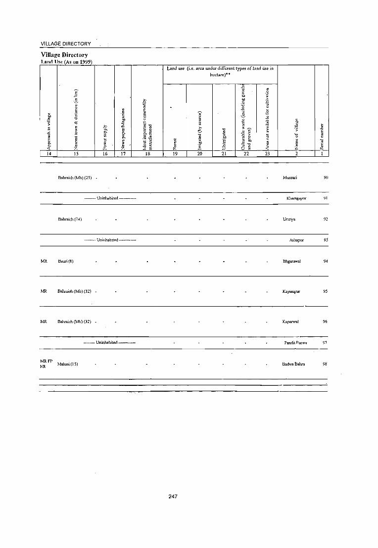
VILLAGE DIRECTORY
Villaj!e Directory Land Use (As on 1999)
Land use (i.e. area under different types of land lise in
hectare)··
.c " E
u ~ .~
-"" eo
2- .~ eo -5 .5 -;
t: " "0
" 0 .
~ u
" ~ ·B ~ " ~
" .;:3 ~ 6 "" '0 .. 0 " ~ "" " " f.l ~ " ;; '" '" <=" 0 "" ~ " .. ~ ~
" ..Q t! " » ~ .~ .9 ~ Po " 'Vi' .;; .0
-ti .9 Po Po &.a e ~ ..!! " E
" .. .~ ~ " .0 > "0
._ " .. g .,
Po ~ .~ ~ 8 0 c: 0 Il '3 c:
" " 0. ~ t: B!, " E il;
~ c:
~ .~ ·2 " "ii Po " 0 .. oS " c: .'i: Z <{ Z 0.. Z E ~ ;:J o .. on
14 15 16 17 18 19 20 21 22 23 2 I
Bahraich (Mb) (25) Munsari 90
-------- Uninhabited -----••• -- Kharagapur 91
Bahraich (74) Umriya 92
•. ----- Uninhabited •••• ---••••• Ashapur 93
MR Bauri(8) Bhgarawal 94
MR Bahraich (Mb) (32) - Kayampur 95
MR Bahraich (Mb) (32) - Kaparwal 96
---- Uninhabited ---- Pandit I·:urwa 97
MRFP NR Mahasi (15) Badwa Behra 98
247

_________________________ -=D.:.:IS:.,:T..:.,:R::.,:IC:.,:T:....:C:,:E:.:N.:.:S:.:U:.::_S HANDBOOK: BAHRAICH
Census of India 2001 -Amenities and
2 3
Block Total 24179.9
., " ~ o o ~
" o .~
;; 0-o 0-
~ 4
173570
o o ~ ., ."
~ " ..2 .... o j E i 5
Amenities available (if not available within the village, a dash (.) is shown in the column and next to it in brackets the distance in broad ranges viz. < 5 krns., 5-10 krns. and 10+ krns of the
nearest place where the facility is available i!:..Ji ~"'ii""v=en'+---..,
6 7
H HA(l) HU D(l) DA DU
8
MCW(10) T(50)
9
MH(l)
P(1l4) M(lt) CWC(3) ~i.~~) PO(lS)
10 II 12 13
5 S(7) PUC(S) HC(4) TO(6) 191.7 C 10 Tr(2) PHe(3) ~~:: PTO(6)
AC(10) 0(2) PHS(S) R(7) C(10) PH(59)
CM(7) CP(3)
ACS(6) BS(l1) NW(7)
FWC(6) L(S) NH(l) RMP(4) SMP CHW(14)
248

VILLAGE DIRECTORY
Village Directory Land Use (As on 1999)
., ~ ;; 9 .<: ~ £ Q. Q.
-< 14
PR(37) MR(84) FP(72)
NC(7) NR(13) NW(7)
E "'" ~ " <.> <: 5 .~
"" o:d
" ;. .'l
~ " Z 15 16
ED(29)
EAG(7) EO(4) EA(4)
17
N(5) M(2)
18
Land use (i.e. area under different types ofland use in hectare)··
19 20
GC(4853.6) PC(4S.94) W(81.03) WE(5) TW(360.65)
55.4 TWE(74S.8) TK(301.94) R(972.22) L(26.3) 0(127.02) T(7512.84)
249
21 22 23
11188.3 5022.2 3319.5
" ~ ;;:
"-< o
" E '" Z 2
" .D E
" "


;>
VIKAS KHAND TEJW APUR (T AHSIL MAHSI AND PART OF TAHSIL KAISARGANJ)
DISTRICT BAHRAICH
k HAND
K - Part of Tahsil KaisarganJ
Populallon ..
No of Villages ...
KILOMETRES 2 3
A
BOUNDARY: TAHSIL __ .. __ .. __ .. ________ .. _ .. _ .... _ .. _ .. ___ .. _ .. __ .
VIKAS KHAND
VILLAGE WITH PERMANENT LOCA nON CODE NO_ r-----------I 06479500 I ___________ J
HEADQUARTERS VIKAS KHAND __ @
POPULATION SIZE CLASS OF VILLAGES . BELOW 200
200 - 499 , 500 .. 999 , 1000 - 4999 , 5000 AND ABOVE __ • STATE HIGHWAY _ _ _ _ _ _ _ _ _ _ _ _ _ _ _ _ _ _ _ SH 30
IMPORTANT METALLED ROAD ___________________ _
RIVER AND S'lREAM .. _ .. ______________ ~
POST OFFICE TELEGRAPH OFFICE_ _ _ _ _ _ _ _ _ _ PO , TO
HIGH SCHOOL \ INTER COLLEGE _________ _
PRIMARY HEALTH CENTRE _ _ _ _ _ _ _ _ _ _ _ _ _ _ _ • BANK ______________________ _


Alphabetical list of Villages (C.D. block wise)
Name of the District· Bahraich Serial Name of village 2001 Census location 1991 Census location code
number code number number 1 2 3 4
Name of CD Block: T3Jwapur Name of Sub-Dist: 0002
1 Adilpur 06484500 460030013000150149 2 Arai Khurd 06485500 460030013000160161 3 Awalpur Masudpur 06484700 460030013000150151 4 Bala Saraya 06482600 460030013000130130 5 Bariya 06486300 460030013000170174 6 Basauna Mafi 06480100 460030013000100105 7 Baukaha 06479900 460030013000100103 8 Baundi Fateullapur 06479700 460030013000100101 9 Baundi Shukul 06485700 460030013000170168 10 Behat Bhaya 06482100 460030013000120125 11 Bhakala Gopalpur 06481800 460030013000120122 12 Bhatpurwa 06484800 460030013000150152 13 Bhirwa 06486200 460030013000170173 14 Bhogajot 06481300 460030013000110117 15 Bhogiyapur 06480400 460030013000100108 16 Bilaspur 06485300 460030013000160159 17 Sir Shahpur 06483000 460030013000130134 18 Chandanpur Sikaria 06485200 460030013000160158 19 Chaukhdiya 06480500 460030013000110109 20 Chetara 06483200 460030013000140136 21 Dahawa 06485800 460030013000170169 22 Dasarathpur 06481600 460030013000120120 23 Dhobiha 06479500 460030013000100099 24 Dhorayal 06483600 460030013000140140 25 Dokari 06486800 460030013000180181 26 Fatehpur 06482200 460030013000120126 27 Gajpatipur 06484100 460030013000150145 28 Ganiyapur 06485100 460030013000160157 29 Godawa 06485900 460030013000170170 30 Gopchandpur 06485600 460030013000170167 31 Hathi Chak 06485400 460030013000160160 32 Hemariya 06484200 460030013000150146 33 Huseripur 06484900 460030013000150153 34 Inami 06486700 460030013000180180 35 Jahdi 06481000 460030013000110114· 36 Jadaupur 06483500 460030013000140139 37 Jamala Jot 06480300 460030013000100107 38 Janijot 06484600 460030013000150150 39 Jhigaha 06480700 460030013000110111 40 Jihura Mafi 06487100 460030013000180184 41 Kataha 06483900 460030013000140143 42 Khaira 06486600 46.0030013000180177 43 Khamriya Hardo Patti 06482400 460030013000130128 44 Khasaha Mohammadpur 06481500 460030013000120119 45 Khmriha Sukul 06482300 460030013000130127 46 Kodaha 06486400 460030013000170175 47 Lakha Baundi 06481900 46dG30013000120123 48 Madara 06483800 460030013000140142 49 Mahbub Chak 06484400 460030013000150148
251

Alphabetical list of Villages (C.D. block wise) N arne of the District· Bahraich .
Serial Name of village 2001 Census location 1991 Census location code number code number number
1 2 3 4 -50 Malgala 06480200 460030013000100106 51 Mirzapur 06479800 460030013000100102 52 Mogalaha 06483400 460030013000140138 53 Muwafikpur 06480900 460030013000110113 54 Nahkatiya 06483700 460030013000140141 55 Narahar Gonda 06482000 460030013000120124 56 Naushahara 06487000 460030013000180183 57 Newada 06480000 460030013000100104 58 Ram Gaon 06479600 460030013000100100 59 Ram Purwa 06482700 460030013000130131 60 Ramgadi 06486900 460030013000180182 61 Sabalapur 06483300 460030013000140137 62 Saray Mehrabad 06481100 460030013000110115 63 Sarpataha 06481700 460030013000120121 64 Shekh Dahir 06481400 460030013000110118 65 Sirajpur 06482800 460030013000130132 66 Sisai Haidar 06484000 460030013000150144 67 Surjana 06482900 460030013000130133 68 Tajawapur 06483100 460030013000140135 69 Tamachpur 06481200 460030013000110116 70 Tarapur Khurd 06480600 460030013000110110 71 Tedwa Basantpur 06486500 460030013000170176 72 Tendawa 8asantpur 06485000 460030013000150154 73 Tendawa Sisatipur 06486000 460030013000170171 74 Tepraha Chak 06480800 460030013000110112 75 Tikora 06484300 460030013000150147 76 Tingai 06487200 460030013000180185 77 Udawapur 06482500 460030013000130129 78 Unchgaon 06486100 460030013000170172
252

Alphabetical list of Villages (CD. block wise) Name of the District:Bahraich
Serial Name of village 2001 Census location 1991 Census location code number code number number
I 2 3 4
Name of CD Block: TaJwapur Name of SUb-Dist: 0004
1 Aladadpur 06503800 460030013000150156 2 Bijjawapur 06504400 460030013000180178 3 Birahim Diha 06504000 460030013000160163 4 Khuajgipur 06504500 460030013000180179 5 Kiratanpur 06503700 460030013000150155 6 Maraucha 06504100 460030013000160164 7 Raipura 06504300 460030013000160166 8 Singahi 06504200 460030013000160165 9 Umari Dhalo 06503900 460030013000160162
253

DISTRICT CENSUS HANDBOOK: BAHRAICH
Census ofIndia 2001 _
Amenities and Amenities available (if not available within the village, a da.l; (-) is shown in the column and
next to it in brackets the distance in broad ranges viz.< 5 kms., 5-10 kms. and 10+ kms of the ~ nearest place where the facilitv is availab!e is Riven
:::: ~ u " ~ '" ;; " "" i1~ 0 .., ~ U .D " u " " '" ',:l u ,;
" .c C 0 u " -;;
" ;- i {!!
u g 5 " 0 .~ II E~ u 0
~ (:'" .c .::; 0 u ;:::; ~ il' " ~ P- " ~
0 e.o 0- -;;U:l :: 1: -l ,;g 0 "0 B 0 .~ 5::;:." E (:'" '0 .:, ~ " " <d ;; .c '" ~ "" u ~ ~ -; ~ .2 ~ '" " u "
u g ~ :;:
~ -5 .~ ;l ." o ._
~ ~.~ " ~ 0 _Ii ..c: ~ " g 0 " . '- .c 0. _, ~ _ ..... "'0 ',:l 0
.D :; 0 :;; '- '" ~ " ~ ~ ii '" > " .~ .~ E " 0. 0 " ;;, g - -< ;;J '0 ~ 0 tJ .~ e.o " t _g ~ _ '" E " '" c: 0- -;; " "2 " ,..,
.~ E "§ "§ .D .~ ;;; S " u -ce E ;:I E '" E u .~ ij ~ g :.0
" '" c: t{ S E A \i '" 0 0 i ." " 8 0 0 t>h-s ~Q~ " ._ "'. Z f-- f-- ~ ::;; P- U « 0 u t:: 2 3 4 5 6 7 8 9 10 II 12 13
CD Block: Tajwapur (0553)
Dhobiha 232.0 1,662 281
PM«5) H(1O+) HPWSS· PO« 5)
ACS« 5) CV(lO+) BSNW (0647 9500) C(lO+) MCW«5) HP
CM«5) NeS« 5) SP(lO+) RS(lO+)
PHC« 5) PH« 5) CP(lO+)
OC:S« 5) ST(lO+)
Ram G30n 410.0 2,581 454
P(2) M(lO+) MCWH(IO+) HPWSS-PO« 5)
CM ACS« 5) CV(lO+) BSNW (06479600) C(IO+) PHC(lO+) HP
PH« 5) CP(lO+) NCS(lO+) SP(lO+) RS(IO+)
OCS(1O+) ST(1O+)
Baundi I
fateullapur 231.0 2,134 321 PM(5-IO) - H(5· THPTW
PO«5) ACS(5·10) CV(5·10) BS RS« 5)
C(lO+) 10) MCW(5· W SS-HP CM«5) NCS(5-IO) SP(5·10) NW«5)
(06479700) 10) PHC(S-lO) PH« 5) CP(d) OCS(5·10) ST(5·10)
Mirzapur P(2) M C(5-· H(S·
PH(3) ACS(5-tO) CV(5·10) BS RS(5·
(06479800) 416.0 2,679 443
10) 10) MCW(5. HP W ss-
PO«5) CM«5)
NCS(lO+) SP(5-IO) 10)
1O)PHC(5-10) HP CP(lO+) OCS(lO+) ST(5-IO)
NW(lO+)
Baukaha < CHWH(5-10)
HPWSS· ACS(<5) CV(S·IO) BS(S·IO) 260.0 1,615 269 P M( 5) C(5· MCW(S.IO) PO« 5) CM«5)
(06479900) 10) PHC(S-IO) HP NCS(1O+) SP(S·IO) RS(5.\O) PH« 5) CP(IO+)
OCS(1O+) ST(5·10) NW(1O+)
Newada 756 P(2)M«5) MCWPHS
HPWSS- CM NCS ACS« CV(;O+) BS« 5) 6
(06480000) 931.3 4,094 CHW(3)H(5. PO PH 5) SP(lO+) RS(IO+) C(5·10)
10)PHC(10+) HP CP(lO+)
OCS(IO+) ST(IO+) NW(IO+)
Basauna Mafi PM«S) • H« ACS«5) CV(1O+) BS« 5)
502.0 1,880 293 5) MCW(IO+) :: W SS· PO« 5) CM(<<5) (06480100) C(IO+)
PHC(1o+) PH« 5) CP(lO+) NC:l« 5) SP(IO+) RS(IO+) OC!l(lO+) ST(lO+) NW(IO+)
Maigala 210 P(2) M« 5) H« HPWSS- PH(6) ACS« 5) CV(JO+) BS« 5)
(06480200) 305.0 1,194
C(IO+) 5) MCW« 5)
liP PO« 5) CM«5)
NCS« 5) SP(lO+) RS(IO+) PHC« 5) CP(lO+)
OCS« 5) 5T(l0+) NW(lO+)
Jamala Jot PM«5)C« • H(5.
ACS« 5) CV(5-IO) BS\< 5) 9
(06480300) 126.0 735 127
5) 10) MCW(S. HP W SS· PO« 5) CM(5·10)
NCS(lO+) 5P(5·IO) RS(IO+) 10) PHC(5.1 0) HP PH(S·IO) CP(5-IO)
OCS(lO+) ST(5·IO) NW(lO+)
Bhoglyapur 256 P(2) M« 5) · H« IiPWSS. PO«;)
ACS« 5) eV(5·JO) BS(5·10) 10
(06~80~OOJ 165.0 1.593
C(5-IO) 5) MCW(S-IO) liP CM(5·IO)
:--iC~~IO+) SP(S-IO) RS(5·10) PHC(5·10) PH« 5) CP(5·10)
OCS(IO+) ST(5.10) N\\'(IO+)
254

VILLAGE DIRECTORY
ViIla1!;c Directory Land Use (As on 1999)
Land use (i.e. area under different types of land use in hectarej+*
..c " " e ~ 0 .'" -'" 00 '" 2- c- OIl >
" '':>
u '0 '0 ;;
" 0
~ " c: " E ~ .£ " " ~ 'il E ~ ~ 00 '0 '" 8 " ~ "" " ~ ~ " <j '" " 51
01)
:: ~ ., :!:j t c: ~ t! "0
" .;;
u ,.., .D 3 " a.
" o ~ e "0
" ~ > :: 6 0. 0. 2 " '" .<: 3 i:l 0.
." .. ~ > 0 ._
" :;l " .5 ~ 0 0 " E 0. ~ oj) c: 8 t 11 "f: 3 ;0 " -;c K " 5· 6 0. "
~
" .~ "5 ". 0 5 a - "0 '" 0. " 0 " .5 " " .< « z 0.. Z ::E E LL. ::J U ., Z '" 14 15 16 17 18 19 20 21 22 23 2
GC(7S.I) PR Bahraich (Mb) (J I) 150.1 TW(7S.0) 81.8 6.4 15.8 Dhobiha
T(1S0.1 )
PRMR Risia Bazar (Np (J 2) • RamGaon 2
FP
PR Bahraich (Mb) (8) Baundi
Fateullapur
PR Bahraich (Mb) (6) EDEAG
NM Mirzapur EOEA
GC(S.O)
PRMR Bahraich (Mb) (8) TW(l02.8) 13.8 13.7 26.2 Baukaha
TWE(I.3) T(109.0)
PRMR Bahraich (Mb) (2)
EDEAG TWE(l69.1) FP EOEA T(169.1)
1043.4 18.9 70.3 Newada 6
PRMR EDEAG FP Bahraich (Mb) (15) EO EA Basauna Mali
PRMR EDEAG FP Bahraich (Mb) (15) EO EA Maigala
MR Bahraich (JI,{b) (10) • lamala Jot 9
Bahraich (JI,{b) (l0) . BhogI)'apur 10
255

______________________________________________________ ~D_IS~T_R~IC~T~C~E~N~S~U~SHANDBOOK:BAHRAICH
Census ofindia 2001 -Amenities and
Amenities available (if not available within the village, a dash (-) is shown in the column and next to it in brackets the distance in broad ranges viz. < 5 kms., 5- XO kms. and 10+ kms of the
~ nearest place where the facility is available iB given "
;;; " E " ~ "C .D "C ~ " 0 ~
~ u '" " 1) -§ u ;;; .D " 8' c: .<: c ;::; " " -;;; ~ " > ... !l 0 3 " 0 .~ E~ .~ u 0 2 0; ~ .<: . .<: " 0- t -:i 0- " >-;::; ~ ~ '"
" E :2 " Co .~ '" on
~ " ...l 0 ] 0 ... =E' " ... ~ 0 0 ~f .g 3 e~ 0:; ;; .<: ." u :; ~ .2
" u c: ~ " c:: u ~ " '"' -s '~ " '" ." o ._ u 0 ...
" t ~ 0 B .<: " t: g ~ .g g .9 e '- '" .<: 0. _':' VJ _ ._ "0 .. 0
.D ;; 0 :; <... -;;; ~ ~ ~ ,,> " ';J E '" 0. 0 " ", f~ ~ § .:..._ ~ u
~ " ..... ~ 0 t .~ "" u t -E ~ '" c: 0 0. -;;; " ] .~ B § " ~
u '3 5
.D .~ :.;;; E ::I U E ~ E u .~ U ~~] E " ." .5 vi E E l:
u Z 0 0 1. ." " CS " " "n -s " '§ en f- f- W ~ 0. U '" 0
~_..tI) u I 2 3 4 5 6 7 8 9 10 II 12 13
II Chaukhdiya
839.0 2,683 453 P M(5-1 0) C(5. CHW H(5-1 0) THPWR
PO PH« 5) CM(S-I 0) ACS« 5) CV(5-IO) BS(5-IO)
(06480500) 10) MCW(S-IO) SS-HP NCS« 5) SP(5-IO) RS(5-IO) • PHC(5-IO) CP(5-10)
OCS« 5) ST(5-IO) NW(5-IO)
RMPCHW
12 T arapur Khurd
415.0 3,405 485 P(2) M H(5-10) HPWSS-
PO« 5) CM(1O+) ACS«5) CV(5-10) BS(5-10)
(06480600) C(1o+) MCW(5-IO) HP NCS« 5) SP(5-10) RS(5-10) PHC(5-10)
PH(5-10) CP(lO+) OCS« 5) ST(5-10) NW(5-10)
ihigaha - H(5-
ACS« 5) CV«5) BS(5-10) 13 186.0 2,753 393 P M(5-10) C(5· 10) MCW(5- HP W SS- PO« 5) CM«5) (06480700)
10) 10) PHC(5-10) HP PH« 5) CP« 5) NCS« 5) SP« 5) RS(5-IO) OCS« 5) ST« 5) NW(IO+)
T opraha Chak P« - H(S-ACS(5-10) CV(5-10) BS(5-10)
14 16.0 275 48 5) M« 5) C« 10) MCW(5- HP W SS- PH PO« 5) CM(5-1 0) (06480800)
5) 10)PHC(5-10)HP CP(5-10) NCS(IO+) SP(5-1O) RS(5-10) OCS(IO+) ST(5-10) NW(S-IO)
MuwaGkpur PM«5)C« RMP H« 5)
HPWRC ACS« 5) CV«5) BS« 5) 15
(06480900) 247.0 1,499 263
5) MCW«S)
SS-HP PO« 5) CM«5)
NCS« 5) SP« 5) RS« S) PHC« S) PH« 5) CP« 5)
OCS« 5) ST« 5) NW«5)
16 Jabd,
239.0 1,693 282 PAC M(5.10) CHW H(S-IO) HP W TIC R PH PO(5-
CM(5-10) ACS(5-10) CV(5-IO) BS(5-10)
(06481000) MCW(5-IO)
SS-HP 10) NCS(JO+) SP(JO+) RS(5-10) C(S-IO) PHC(5-10) CP(5.10) OCS(IO+) ST(IO+) NW(1O+)
Saray Mehrabad 275 PM S PUC H« HPWSS- ACS« 5) CV(5-10) BS(5-10)
17 286.0 1,561 5) MCW«5) PO« 5) CM«5) (06481100) C« 5) HP NCS(JO+) SP(5-10) RS(S-IO)
PHC« 5) PH« 5) CP(5-IO) OCS(IO+) ST(5-10) NW(IO+)
Tamachpur 130 P M« 5) - H« ACS« 5) CV«5) BS« 5)
18 (06481200)
240.0 613 C(IO+)
5) MCW(5-10);: W SS- PO« 5) CM«5) NCS(IO+) SP« 5) RS(5-10)
PHC« 5) PH« 5) CP(JO+) OCS(JO+) ST« 5) l--1W(JO+)
8hogaJot P« H« T HP SS- ACS« 5) CV«5) BS« 5)
19 (06481300)
98.3 79 13 5)M(5-10) 5) MCW«5). HP
PO« 5) CM«5) NCS(1O+) SP« 5) RS(5-10)
C«5) PHC« 5) PH« 5) CP(1O+) OCS(1O+) ST« 5) 1'<,\V(IO+)
Shekh Dahir P(2) M« 5) H«
T HP W ss· PO PH« 5) CM(·< 5) ACS« 5) CV«5) l'<W 8S«
20 875.0 7,885 1,351 C« 5)
5) MCW« 5) NCS(IO+) SP« 5)
S) RS(5-,06481400)
PHC« 5) HP CP« 5) 10) OCS(lO+) ST« 5J
256

PR MR Bahraich (Mb) (lO) ED
PR Bahraich (Mb) (6)
PRMR FP Bahraich (Mb) (7)
MRFP
MRFP
MRFP NR
MRFP NR
Bahraich (Mb) (\ 0)
Bahraich (Mb) (5)
Bednapur (10)
Bahraich (Mb) (5)
MR FP Bahraich(Mb) (\) NRNC
PRMR FP Bahra'Ch (Mb) (1)
MRFP NR Bahraich (Mb) (2) ED
GC(56.7) Shoes 0.4 TW(141.6)
T(198.3)
i57
Chaukhdiya 11
377.4 T arapur Khurd 12
Thigaha 13
Tepraha Chak 14
198.7 12 48.6 Muwafikpur 15
labdi 16
Saray Mehrabad 17
Tamachpur 18
Bhogajot 19
Shekh Dahir 20

DISTRICT CENSUS HANDBOOK: BAHRAICH
CCJrtSUS of India 2001 -Amenities and
Amenities available (if not available within the village, a dash (-) is shown in the colunm and
next to it in brackets the dist.1nce in broad ranges viz. < 5 kms., 5-10 kms. and 10+ kms of the ~ nearestp.lace where the facility_is available is given
" ;;: " E " ~ ." ~.J:i -0 " 8 u ~ U .J:>
C "' .2 " ;;: ..
c .c 0 " " .. ";:3 u .;
" > ~ ~ .Ol 0 2- " 0 " a '::1 U 0 ';J <:~ ~ .c .. .~ g_ ~ " 0 ~
Q. ~ ] ~ ~ 0 "" -0 " 0.
~~E ~ 6 ...l ,:g 0 -0 ] 0
oQ ;; ~ .c "0 8 %.~ -5 ~ .2 eo; " c " s:: ~ il: .s :l '" -0 u 0 ~ en .~
o ._ ~ u B c .
~ ,:g 0 .!i .c :;; C ~ 0 c '0 .c 0. _ ."9 :.;
'.: 0 .D ;; -; '0 -;;; '" e .. --' ~ ~>~ .§ j E g il: <e :0:=
0. " i'f .;;; Be :J '_ 0 ~ 0 b!) ~ sne " '" c 0 0. .~ .. .5 ] " .. " "5 "5
..0 \J .>l E :J U ~ E ::J ~i '5 E E :J :;; C -r E ,t; t; e g :.a .. 0 0 " "0 " 8 2 0 01)-5 ~u5
o ._
'" Z l- I- Z Ltl ~ Q. U -0:_ 0 ~'" u E 2 3 4 5 6 7 8 9 10 11 12 13
Khasaha P(4) M S
MCWCHW 21 Mohanunadpur 838.0 5,413 969 H«5)
HPWSS-PO PH CM«5)
ACS« 5) CV(lO+) BS(5·10)
(06481500) PVCC(lO+)
PHC(lO+) HP
CP(lO+) NCS(IO+) SP(lO+) RS(lO+) OCS(IO+) ST(lO+) NW(lO+)
Dasarathpur P M(S-IO) C(5. CHW H(5-IO) THPTW ACS« 5) CV(5.10) BS(5-10)
22 213.2 2,839 404 10)' MCW«5) WTKSS- PH PO« 5) CM(5.IO) (06481600)
PHC(IO+) HP CP(lO+) NCS(lO+) SP(S-IO) . RS(5-10) OCS(lO+) ST(S-IO) NW(lO+)
23 Saq>ataha
336.0 3,239 PM(10+)C(5- CHWH(5-IO) HPTWW PH(3)
CM(S·IO) ACS«5) CV(5-10) BS(5-10)
(06481700) 520 10) MCW(S.IO) TKSS-HP PO«5) NCS(lO+) SP(5·IO) RS(5-10)
PHC(5-IO) CP(S·IO) OCS(IO+) ST(5-IO) NW«5)
Bhakala PM« 5)
CHWH«5) T HP W SS- PH PO« 5) CM(~ 5) CV(lO+) BS(lO+)
24 Gopalpur 415.0 2,522 489 MCW«5) ACS« 5)
(06481800) C(lO+)
PHC(5·10) HP CP(5.10) NCS(IO+) SP(lO+) RS(lO+) OCS(lO+) ST(1O+) NW(IO+)
Lakha Baundi CHWH(5·IO)
HPWSS- ACS« 5) CV(5-10) BS(S-IO) 2S
(06481900) 280.0 1,362 295 P M C(5-1 0) MCW(5.10)
HP PO PH CM(S-IO)
NCS(IO+) SP(S·IO) RS(lO+) PHC(S-IO) CP(5.10)
OCS(lO+) ST(5-IO) NW(IO+)
Narahar Gonda P M« 5) C(S-CHW(2)H(5-
T HP W SS- PH PO« 5) CM(~ 5) ACS NCS« CV(;.IO) BS(S-IO)
26 388.0 2,975 551 10) MCW(5- S) SP(S-IO) (06482000) 10) 10) PHC« 5) HP CP«5)
RS(5-10) OCS(1O+) ST(5-10) NW(5·IO)
Behat Bhaya PM« 5) MCWCHW
ACS« 5) c:V(lO+) BS« S) 27
(06482100) 3254 2,151 380
C(1O+) H(lO+) PHC« HP W SS- PO«S) CM«5)
NCS(lO+) SP(lO+) RS(IO+) 5) HP PH«5) CP«5) OCS(IO+) ST(lO+) NW(lO+)
Fatohpur PM«5) CHWH(lO+)
HPWSS· ACS«5) CV(lO+) BS«5) 28
(06482200) 117.0 949 165
CO 0+) MCW«5)
HP PO«5) CM«5)
NCS(lO+) SP(lO+) RS(lO+) PHC« 5) PH«5) CP«5)
OCS(IO+) ST(lo+) NW(IO+)
29 Klunriha Sukul
301 5 1,686 256 PM(5.10) H(lO+) HPW SS-
PO«5) CM«5) ACS(5-10) CV(lO+) B5(5·]0)
(06482300) CO 0+) MCW(lO+) HP NCS(lO+) SP(IO+) RS(lO+)
PHC(IO+) PH«5) CP(lO+)
OCS(IO+) ST(IO+) NW(lO+)
Khamriya Hardo 269 P M« 5) C« - H(S-
ACS(5-10) CV(lO+) BS« 5) 298.0 1 ,576 10) MCW« 5) HP W R SS- PO« 5) CM(5·10) 30
Patti (06482400) 5) PHC(5.10) HP PH« 5)
NCS(IO+) SP(IO+) RS(IO+) CP(5·10)
OCS(IO+) ST(lO+) NW(lO+)
258

VILLAGE DIRECTORY
Village Directory Lllnd Usc (As on 1999)
E "'" ~ " " c:
" .5
'" l 'i5 "'3 .;; t: 3 " ~ 3
0 1;;
~ Q. 0. " « z
14 15
PR Bahraich (Mb) (l7)
FP Bahraich (Mb) (8)
PRMR Bahraich (Mb) (6)
FPNR
MRFP Bahraich (Mb) (13)
» Ci. Q.
~ il
" C 0..
16
EDEAG EOEA
EDEAG
EAG
EDEAG
MR FP Bahraich (Mb) (8) EAG
MRFP NR Bedanapur (4) ED
::- MR Bahraich (Mb) (17) .
PRMR FP Bahraich (Mb) (1 7) •
: FP Bahraich (Mb) (32) .
:~ MR Bahraich (Mb) (22) .
Land use
.f'
." 0
" " E
.~ E on 8 " C" ~ t " &2 '" .. .§ ,~ Q.
?i ~ ::> (J ~'"
" <; Z 2: E ~
17 18 19
Sugar
Jaggery
Jaggery
259
(i.e. area under different types of land use in
hectare)··
fi ~ OIl ell
.S .., ~
'" ~ " 3 ~ ~ .. e ;;:~ ."
..!l tl ~ .., .0 ;-e e ~ .!!!, .!:i .f!: .!!!'
1:; :§ ::> c CJ "
20 21 22
GC(120.0) T(120.0)
GC(142.5) TK.(1.4)
149.3 8.8 0(9.6) T(153.5)
TK(0.9) T(0.9)
279.7
74.0 34.0
21.2
" .~ ;-.'" e -.~ " :<3 ~ ';; ;; "0 " " " ~
23
" '" ~ :; '0
" E '" Z 2
Khasaha Mohanunadpur
Dasarathpur
35.3 S"1l'ataha
Bhakala Gopalpur
Lakha Baundi
37.0 Narahar Gonda
30.4 Behat Bhaya
Fatehpur
Kluruiha Sukul
Khamriya Hardo Patti
ij .!J E :;l c:
" '5 ",
21
22
23
24
25
26
27
28
29
30

______________________________________________________ ~D~IS~T~R~IC~T~C~E~N~S~U~S~HANDBOOK:BAHRAICH
Census ofIndia 2001 _ Amenities and
Amenities available (if not available within the village, a dash (-) is shown in the column and
next to it in brackets the distance in broad ranges viz. < 5 kms., 5·10 kms. and 10+ kms of the ~ nearest place where the facility is available is I(iven
u a u S " ~ "'" .D ."
'" V
" '" 0 <..> U .D ~ u .2 <..> OJ a - OJ
~ <.> ~. ..c: u -;; " c: 0 " > ~ .g ~ " 0 0 .~ 2 .~ ~ u .~ .J: . ..:: 0
B 1; ~
Q, OJ '" OJ - ~ Q,
'" <e 0 g 0 u Q, -;; "" '" ~ ...l 0 :2 "] 0 ~ :::"6' ~ 0 6 on ~ " u <d ;; ..c: ." " -; ] ,2 co -1>: ~
<..>
" :~ ~ " u " " ." <..> 0 ~ '" ~
"" -s .£ " " 0 ~ ~.~ " c 0 .J: c: 0 t ~
._ ... ..c: S 0- ~ ~ _ ._ '"0 .;::; 0 .D ;; 0 :; '0 -;;; ~ E ~ ~ 2 ;:> ~ !3 ''::: E .. Q, c: ell '6 ._ !l
" '0 ~ 0 il 0 ell ..2 1; ~ e g,,"'E c: '" c: Q, .~ '" c: S " ~ -;; " "5 "5 .0 <..> :;:; E " <.> ij fi .8 E
'5 E E <..> :; .5 vi E .~ i> ~ .5 ] E 1 Z 0 0 " " " 0 ""-5 f- f- Z ."
~ a 0 <>:8", o ._
rIJ >Il ll< U «. 0 u E I 2 3 4 5 6 7 8 9 10 II 12 13
31 Udawapur
735.0 1,872 317 PM«5)C« H(lO+)
WSS-T PO«5) CM«5) ACS(5·10) CV(5·10) BS« 5)
(06482500) 5) MCW(lO+) NCS(IO+) SP(5·10) RS(lO+) PHC(lO+)
PH«5) CP(IO+) OCS(IO+) S1(1O+) NW(lO+)
RMPCHW
32 Bala Saraya
735.0 3,314 682 P(3) M( < 5) H(IO+) HPWSS· PO« 5) CM«5)
ACS« 5) CV(IO+) BS(IO+) (06482600) C(IO+) MCW(IO+) HP
PH(5·10) CP«5) NCS(lO+) SP(IO+) RS(IO+)
PHC(5·10) OCS(lO+) ST(IO+) NW(lO+)
33 Ram PUlWa
950.0 4,732 799 P(3) M HUMCW HPW SS· PO PH(5· CM«5)
ACS« 5) CV(IO+) BS(IO+) (06482700) C(IO+) PHCH(IO+) HP 10)
CP(5·IO) NCS(IO+) SP(IO+) RS(IO+) OCS(lo+) ST(lO+) NW(lO+)
Sirajpur PM«5) H«
HPWSS· ACS« 5) CV(lO+) BS(lO+) 34 129.0 595 115 5) MCW«5) PO« 5) CM(IO+)
(06482800) C(IO+) PHC« 5)
HP PH(<5) CP(5·10)
NCS« 5) SP(IO+) RS(IO+) OCS« 5) ST(IO+) NW«5)
Surjana 136 PM«5) CHW H«5)
HPWSS· ACS« 5) CV(IO+) BS(IO+) 35 175.2 684 MCW«5) PO«5) CM(IO+)
(06482900) C(lO+) HP NCS« 5) SP(IO+) RS(lO+) PHC« 5) PH«5) CP«5)
OCS(1O+) ST(IO+) NW(lO+)
Bir Shahpur P M«5) CHW H« 5)
HPWSS- ACS« 5) CV(IO+) BS«5) 36
(06483000) 283.0 1,488 284
C(lO+) MCW«5)
HP PO«5) CM«5)
NCS«5) SP(IO+) RS(lO+) PHC« 5) PH«5) CP«5)
OCS« 5) S1(1O+) NW(lO+)
Tajawapur P« H(IO+) 1 HP W SS· PO(~ 5) ACS« 5) CV(IO+) BS(lO+) 37 508.0 3,757 578 5) M«5) CM«5)
(06483100) C(IO+)
MCW(5·10) HP PH(lO+) CP«5) NCS« 5) SP(IO+) RS(lO+)
PHC(5.10) OCS« 5) ST(lO+) NW(lO+)
Chetard 290 P M« 5) H«
THPTW PO«5) ACS« 5) CV(lO+) BS(lO+) 38 3570 1,521 5) MCW«5) CM«5)
(06483200) C(lO+) PHC« 5) W R SS·HP PHI < 5) CP«5)
NCS« 5) SP(IO+) RS(lO+) OCS«5) ST(lO+) NW(lO+)
Sabalapur P« CHW H(lO+)
HP W R SS· PO PH ACS« 5) eV(5·IO) BS(5·10) 39 188.0 1,907 294 5) M« 5) C(5· MCW« 5) CM«5)
(06483300) 10) PHC« 5) HP
CP«5) NCS« 5) SP(5·10) RS(5·10) OCS« 5) ST(5·10) NW(5·10)
P OM«5) FWC H(5·IO)
HPWSS· PH(2) ACS« 5) CV(5·10) BS RS(5.
Mogalaha 289.0 1,410 227 MCW(5·IO) CM«5) IO)NW(5· 40
C(5'10) PO« 5) NCS«5) SP(5·10) (06483400) PHC(5-10)
HP CP«5) 10)
OCS« 5) ST(5·10)
260

VILLAGE DIRECTORY
Village Directory Land Use (As on 1999)
" eo :§ .;; £ -5 '" 0
0. "-<t;
14
MRFP NR
PRMR FP
PRMR
PR
PRMR
E .!< C
V
~ c ~ '0 "d c ~ £ v: ~ '" " Z 15
Bahraich (Mb) (25)
Bedanaur (1 0)
Bedanapur (6)
Bedanapur (4)
Bedanapur (3)
Bahraich (Mb) (1 7)
:;: MR Bahraich (12)
PRMR Badpur (1)
FP
PRMR Bahraich (Mb) (9)
PR Bahraich (Mb) (I 0)
0 '0 0
" e c N e '" 0 01) " ~ "'-0 ..0 t " Q, o ::; 0- go ::s 0.-
'" 0. .5 .~ ~ ~ tl " ~ " 0 " .. _.,,,,_
'~ ... n.. Z e 16 17 18
ED
EDEAG - Jaggery
ED
Land use (i.e. area under different types of land use in hectare)··
~ ::> 0 .... ;>, e
-0
~ il eo C5 ] I>.
19 20 21 22 23
GC(11.9) TK(3.0) 0.6 T(14,9)
GC(100.0) PC(1.6} 12,0 2.4
T(101.6)
GC(200.0) PC(1.2)
16.0 20.0 TK(1.6) T(202.8)
58.0
TW(SO.O)
T(50.0) 100.0
GC(175.0) TK(2,O) WF(lD.8) 10.8 0(10.8) T(198.6)
261
2
Udawapur
Bala Saraya
RamPurwa
2.4 Sirajpur
8.0 Surjana
Bir Shahpur
Tajawapur
Chetara
Sabalapur
Mogalaha
"' " '"
31
32
33
34
35
36
37
38
39
40

41
42
43
44
45
46
47
48
49
50
2
Jadaupur
(06483S00)
Dhorayal
(06483600)
NahkJtiya (06483700)
Madara (06483800)
Kataha (06483900)
Sisai Haidar (06484000)
Gajpatipur (064841(j0)
Hemariya (06484200)
Tikora (06484300)
Mahbub Chak (06484400)
3
351.0
290.0
198.0
43.0
681.1
416.0
49S.0
o o c:-r:
.~ :; 0-o 0-
S o r 4
2,037
1,175
1,483
128
3,582
1,753
3,088
115.0 2.400
1.2 355
10.5 200
" ..0
E ~
DISTRICT CENSUS HANDBOOK: BAHRAICH
Census ofIndia 2001 -Amenities and
Amenities available (if not available within the viliage, a dash (-) i'-shown in the column and next to it in brackets the distance in broad ranges viz. < 5 kens., 5-10 kens. and 10+ lans of the
nearest "lace where the facility is available is ~iven
6 7 8 9
" .~ tl "o
'" " "C
~ ~ u tl E E o u 10 II 12 13
P ACM«5) CM
HWCW
(H(55-)10) HPWSS- PHPO«5)CM(5-IO) ACS«5) 320 C(IO+) < HP NCS« S)
PHC« 5) CP« 5) OCS« ';)
CV(5-10) BS« 5) SP(S-IO) RS(IO+) ST(5-10) NW(10+)
211 PM«5) C(10+)
247 PM«5) C(10+)
CHW H« 5) MCW«5) PHC« 5)
RMPCHW H«5) MCW«5) PHC« 5)
HP SS-HP PO« 5) PH« 5)
CM«5) CP«5)
THPWTK PHPO«5)CM«5) SS-HP CP« 5)
P« H« -21 5) M«5) 5) MCW«5) THPWSS- PO«5)
C(lO+) PHC« 5) HP PH« 5) CM«5) CP«5)
ACS(JO+) NCS(IO+) OCS(10+)
ACS« 5) NCS« 5) OCS«:i)
CV(5-10) BS« 5) SP(5-10) RS« 5) ST(5-10) NW« 5)
CV(1O+) SP(1O+) ST(1O+)
BS« 5) RS(lO+) NW(1O+)
ACS« 5) CV(1O+) BS« 5) NCS« 5) SP(IO+) RS(JO+)
OCS( < 5:.:)_.:ST.:,;(~1 O+.:.....:.) __ NW__;,( <_5...:.)_
P(3) M 579 C(1O+)
CHWH(IO+) ACS MCW«5) HPTWW PHPO«5)CM(5-10) NCS(IO+)
CV(IO+) SP(IO+) ST(1O+)
BS«5) RS(IO+) NW(IO+)
PHC(5-10) SS-T CP(5-10) OCS(lO+)
CHW H(5-10) 9 P M« 5) C« MCW« 5)
30 5) HP SS-HP PO« 5) PH« S)
CM«5) CP« 5)
ACS« 5) NCS(ICH-) OCS(1(H-)
CV(5-10) BS( < 5) SP(S-IO) RS(5-10) ST(5-10) NW(lO+)
PHC(S-IO)
- P« - H(5- T HP SS-487 5) M« 5) C(5- 10) MCW(5- HP
10) 10) PHC(5-1 0)
ACS(\(H-) CV(5-10) BS(5-10) PO(5-10) CM(5-IO) NCS(lO+) SP(5-10) RS(5-10) PH(5-10) CP(5-10) OCS(J()+) ST(5-10) NW(lO+)
H(5- ACS(JI}+) CV(5-10) BS(5-10) 476 P M C(5-10) 10) MCW(5- HP SS-HP PO(5-IO) CM(5-IO\ NCS(5.10) SP(5-10) RS(5-10)
10)PHC(5-10) PH(5-IO) CP(5-10) OCS(5.IO) ST(5-10) NW(5-10)
P« H(5- PH P0(5- ACS(IO+) CV(5-10) BS(5-10) 545)M«5)C(5-10)MCW(5- HPSS-HP 10) CM(5-IO) NCS(S.IO) SP(5-10) RS(5-10)
10) 10) PHC(S-IO) CP(5-10) OCS(5-10) ST(5-10) NW« 5)
- H« HPWSS 34 PM(5-10)C« 5) MCW(5-IO) - PO«))
S) PHC(IO+) HP PH« 5)
262
CM«;) cp« S~
ACS(lO+) NCS(lO+\ OCS(\O+\
CV«5) SP« S)
ST« 5)
BS«5) RS« 5)
NW(lO+)

VILLAGE DIRECTORY
Villal!e Directory Land Use (As on 1999)
Land use (i.e. area under different types of land use in hectare)··
~ c E " 0
-"- ~ .~
5 ;;- !OJ) s .S u :;;
"" ] ~ 0 -e " E ~
tl c ~ <oS
" '!;l E ~ ! :u 0 u
'" " 5 ~ ~ " <d '" C.", Sl "" .:;:
~ ~-;;- ~ ~ c b t! '" >, .;;
.0 £ " "- e .", ~ .:;:
E .9 "- 8.3 ~ " " ~ ~ ::0 ;-
" ._
'" 1>: ,s ~ " :; e 0 c -;; "- .!l .~ c " e ~ ~ ~ - " E '" t: =: e.o
'" E '" "- " VL·C'"
'_§ '" -="0 " '5 p.. " 0 " o '" 0 8 ~ -': '" -< Z 0. Z ;: E ~ ;:J Z '" 14 15 16 17 1& 19 20 21 22 23 2
PRMR Bahraich (Mb) (10) EO laggery ladaupur 41
FP
W(20.0) TW(20.0)
PR 8ahraich (Mb) (4) TWE(I.O) 2.5 Dhorayal 43
TK(5.0) T(46.0)
PRMR 8"dan"pur (4) Porridge, Scissors
GC(I.O) Nahkatiya 43
FP . TW(7.0)
PRMR B"dan"pur (5) Madara 44
FP
PRMR Bahraich (Mb) (13) EO laggery 20.0 Kataha 45
FP
TW(36.0) TWE(50.0)
PR Bahraich (Mb) (5) EAG TK(4.1) 1.5 SisaiHaidar 46 R(7.3) 0(0.2) T(97.S)
PRMR Bahraich (Mb) (7)
TK(I.2) 423.6 6.9 Gajpatipur 47 FP T(1.2)
GC(l20.0) PRMR Bahraich (Mb) (7) R(30004.0) 125.0 1847.0 23867.0 Hemariya 48
T(30124.0)
GC(269.0)
MR Bahraich (Mb) (8) EAGEO TK(439.0)
53217.0 235.0 4.7 Tikora 49 R(204.0) T(912.0)
MR Bahraich (Mb) (3) MahbubChak 50
263

DISTRICT CENSUS HP,NDBOOK : BAHRAICH
Census ofindia 2001 _
Amenities and Amenities available (if not available within the village, a dash (-) is shown in the column and
next to it in brackets the distance in broad ranges viz. < 5 km. •. , 5-10 kms. and 10+ kms of the ~ nearest place where the facility is available is given ';)' ~
" ~ c ~ ." 13 :e~ -0 ~ " :=; ~ U .. c
iii .D '" c: .c - .., " • ., <J 1f c: 0 c .~ '" ~ t! .~ ~ u 0 0 3 .~ ~
" ~ .c
~ -; .~ 8. " '" - ~ 0. ~ " 0 ~ 0 -0 " a. .~ -;;;'" ~ ~ -' 0 ] 0
_g=g~ C'- 0 8 ell '" " " ,;j ;; -& -0 ~ .~ ~;;;
" " c :; :s ..c ._
'" ?:
~ .;:; .~ " -0 o _ <J 0 ~ c
~ 0 £ .c c c ~ ~ ~ . .§ .~ Ii ,_ .c ~ " _g .D 0 ~ ~
_' ~ _ ._ ""0
E ;;: :; '0 " on :: :; .. > " <J '" a. c § - ~ '" il " " ~ 0 il .~
ell .., _g ~ c " 0. "§ C ] " ;:; E E " >,
~ " '5 '5 ..0 :.;; E " <J e g ~ E " E E
" :.0 .E t:f E .~ t E l
" :Z 0 0 " -0 " Ci 0 0 eIl·S ~Q~ o ._
'" f- f- ;Z; III :2 Il. U <t. 0 u E I 2 3 4 5 6 7 8 9 10 11 12 13
Adilpur P M« 5) C« CHW(2)H«
PH(3) ACS(10+) CV«5) BS« 5) 51 187.4 2,324 346 5) MCW(5-10) HP W SS- CM«5) (06484500) 5) PHC(IO+) HP PO«5)
CP«5) NCS(1I}+) SP« 5) RS«5) OCS(IO+) SI« 5) NW(1O+)
lanijot P« - H« ACS(lO+) CV«5) BS(5-IO)
52 187.0 209 27 5) M« 5) q< 5) MCW(5-10) HP W SS- PH PO« 5) CM« 5) (06484600) 5) PHC(IO+) HP CP«5)
NCS(IO+) SP«5) RS(5-10) OCS(lO+) SI« 5) NW(IO+)
Awalpur P« H« I 53 Masudpur 140.0 577 83 5)M«5)q< 5)MCW«5)
HPWSS-PO«S) CM«5)
ACS(5-10) CV«5) BS« 5)
(06484700) 5) PHC« 5) HP
PH«5) CP«5) NCS(IO+) SP«5) RS«5) OCS(lO+) S1« 5) NW«5)
Bhatpurwa H(o::
HPWSS- ACS(5-10) CV«5) BS«5) 54 320.0 1,004 181 P MC(5-IO) 5) MCW«5) PO«5) CM«5) (06484800) HP NCS(IO+) SP(1O+) RS«5)
PHC« 5) PH«5) CP«5) OCS(IO+) SI«5) NW(lO+) ,
Husenpur P« - H(5-ACS« 5) CV(5-IO) BS(5-10)
S5 (06484900)
414.0 2,238 394 5) M«5) 10) MCW(S. HP W SS- PO«5) CM«5) NCS(IO+) SP(5-10) RS(5-10)
C(lo+) 10) PHC(5-10) HP PH(5'IO) CP(5·IO) OCS(10+) SI(5-10) NW(1O+)
Tendawa 282 P M« 5) C(5·
- H(S- ACS(lO+) CV(5-10) BS(5-10) 56 Basantpur 566.0 1,777 10) MCW(5. HP W SS- POPH(d) CM(5-10)
(06485000) 10)
10) PHC(5-10) HP CP(5-IO) NCS(5-10) SP(S-IO) RS(5-10)
OCS(S-IO) SI(5-10) NW«5)
Ganiyapur P(2) ACM« CHWH«5)
HPWSS- PH(2) ACS(eS) CV(lO+) BS(lO+) 57
(06485100) 324.0 1,991 293
5) C(lO+) MCW«5)
HP PO«S) CM(IO+)
NCS« 5) SP(1O+) RS(lO+) PHC« 5) CP«5)
OCS(IO+) S1(10+) NW(lO+)
Chandanpur PM«5)
CHW H«5) HP1WW ACS« 5) CV(lO+) BS« 5)
58 Sikaria 3030 2,046 373 C(lo+)
MCW«S) S5-
PO«S) CM«5) NCS(lO+) SP(lO+) RS(1O+)
(06485200) PHC« S) PH« 5) CP«S) OCS(IO+) ST(IO+) NW(IO+)
59 Bilaspur
167.0 643 114 PM«5) H(1O+) THPWSS- PO(~-IO) CM(lO+)
ACS(5-10) CV(lO+) BS(5-10)
(06485300) CO 0+) MCW(lO+) HP PH(IO+\ CP(S-IO)
NCS(S-IO) SP(IO+) RS(1O+)
PHC(1O+) OCS(1O+) SI(1O+) NW«5)
Hathl ehak P« H(lO+) THPWSS- - ACS(5-10) CV(10+) BS(5-10)
60 229.0 369 75 5) M« 5) MCW(IO+)
PO(S-IO, CM(1OT) NCS(5-10) SP(lO+) RS(lO+) (06485400)
C(lO+) HP PHLlQ-\ CP(5-10) PHC(lO+) OCS(lO+) SI(1O+) NW«5)
264

VILLAGE DIRECTORY
Villaf!c Dircctory Land Use (As on 1999)
Land use
E -'-'
~ 0 :;
~ 0
" " E " " ii .~ E
~ :; e "" ,,;j '" ~-g ;; c >, E
;3 " 0. \:l ~ ~
0- o " ~ £ il ~ c.~
;;; 0- ,5 .~ 0 -~ ~ ~ ~ " Q.
'" ;;;
" c. " 0 " 0 .. 0 .,; Z 0- Z ~ E '" 14 15 16 17 18 19
PR MR Bahrnich (Mb) (3) ED EAG N M
MR Bahraieh (Mb) (4) N
PR MR Bahrnieh (Mb) (3) N
MR Shahar (4) Jaggery
MR Bahrnieh (Mb) (10)
MR Bahrnieh (Mb) (8) ED
PR Bedanapur (2)
PRMR Bahrnich (Mb) (1 5) ED NM
FP
PRMR FPJ'..'R Maroya (8) Jaggery NCNW
PRMR Maroeha (8)
FPNR
265
(i.e. area under different types of land 11,e in hectare)""
~ ~ 01)
ell c: :; " U
'<;' 3 u ~ tl 51
~~ >, e -0 .!! tl ~ "" .<J >
:l .::1' e e '" .b " CIl eo '::-0 ]; c " " ;:J U " 20 21 22
TWE(l2.5) TK(3.8)
409.2 10.0 R(2.9) 0(0.3) T(I9.6)
GC(254.6) PC(45.0) W(2.0) WE(150.0) TW(57.6) T(509.3)
..
c: 0 .~
.f! :; " ,~
" ~ . ., > .. 15 c .. " .d:
23
'" ~ .;; ._
0
" E .. Z 2
Adilpur
Janijot
Awalpur Masudpur
BhatpUlwa
Husenpur
13.3 Tendawa Basantpur
Ganiyapur
Chandanpur Sikaria
Bilaspur
Hathi Chak
\l .<J E " " ~ " '" I
51
52
5~
54
55
56
57
58
59
60

DISTRICT CENSUS HANDBOOK: BAHRAICH
Census ofIndia 2001 _
Amenities and Amenities available (if not available within the village, a dash (-) is shown in the column and
next to it in brackets the distance in broad ranges viz.< 5 krns., 5-10 krns. and 10+ krns of the ~ ~ nearest olace where the facilitv is available i" l!:iven
" ~ OJ
~ C ~ -0 ~.a '0 " 8 ~ u " .::
" " .<:> '" v .2
c .<: e ;; " " f. .; v .,j
C E; i ~ " .~ 3 " 0 E~ u 0 a u .<: :! ,~ g_ " 0. ] " ~ ;; " ~ " 0 ~ .tJ ..!l "- --;rn
~ 6 -l 0 '0 2 0 ~ :;=e
<Ij :: ~ .c '0 8 " 1) -3 ~ .2
iJ1 ~ ~"
" " c " c C: " e " :1 " '0 U 0 ~ 00 -5 .9 _Ii .c ~ g .~ ~ .g .~ c· :;; ,g ._ ;;; 0 0
.D 0 .c " 0. -;;;;] '..::l 0
E .;; ;; '0 -.;;
" ::: " ~ .- .~ .~
~ 0. C ell "E g " ~ " '_ 0 ij 0 eo " " '0 C ~
c 0 "- .;:)
" c '£ " ~ e '':: C'I:l E
~i " " 5 "5 .D
~ u j1 E " u " E :;l
"5 E E :;l 'i3 c vi E ~ tl ~ ~ :.a " 0 0 " -0 v 8 0 0 "".c ~ Q, ~
o ._
'" Z E- E- Z (I1 ~ "- u -< '0 u ::: I 2 3 4 5 6 7 8 9 10 II 12 13
Arai Khurd P« CHWH(1O+) HPWSS· ACS« 5) CV(1O+) 8S(10+)
61 66.0 331 56 5)M(5·10) MCW(5·10) PO« 5) CM«5) (06485500) HP NCS(IO+) SP(IO+) RS(1O+) C(5-10) PHC(5-10) PH(5-10) CP(5.10)
OCS(1O+) ST(1O+) NW(1O+)
Gopchandpur 309 P M« S) MCWCHW
HPWSS- PO CV(IO+) 8S«5) 62 323.0 1,541 H(IO+) CM(1O+)
ACS(IO+) (06485600) C(10+) HP PH(IO+) NCS(IO+) SP(1O+) RS(IO+)
PHC(1O+) CP(1O+) OCS(IO+) ST(1O+) NW(IO+)
63 Baundi Shukul
113.0 563 104 P M« S) H(1O+) HPWSS-PO«S) CM«5)
ACS« S) CV(1O+) 8S(S-10) (06485700) C(lO+) MCW(lO+) HP NCS« S) SP(lO+) RS(JO+)
PHC(5-10) PH(IO+) CP(1O+)
OCS« S) ST(1O+) NW(IO+)
Dahawa 334 P M« 5) CHWH«5) HPWSS- ACS« 5) CV(1O+) 8S(10+)
64 334.0 1,914 MCW«5) PO« 5) CM«5) (06485800) C(IO+)
PHC« 5) HP
PH«5) CP« 5) NCS«5) SP(IO+) RS(lO+)
OCS« 5) ST(IO+) NW(1O+)
Godawa P« H« HPWSS- ACS« 5) CV(1O+) BS« 5) 65
(06485900) 235.0 999 162 5)M«5) 5) MCW«5) HP
PO« 5) CM«S) NCS« 5) SP(1O+) RS(1O+)
C(IO+) PHC« 5) PH«5) CP«5) OCS« 5) ST(1O+) NW(lO+)
Tendawa CHW H(1O+) HPWSS- ACS« 5) CV(IO+) 8S« 5)
66 Sisatipur 204.4 1,233 209 P M C(I 0+) MCW(S-IO) HP
PO«5) CM(1O+) NCS(1O+) SP(1O+) RS(1O+)
(06486000) PHC(1O+) PH(IO+) CP(1O+) OCS(1O+) ST(1O+) NW(IO+)
67 Unchgaon
25S.0 1,005 171 P M(5-10) C(5· H(1o+) HPWSS-
PO«5) CM«5) ACS« 5) CV(1O+) 8S(10+)
(06486100) 10) MCW(1O+) HP NCS(1O+) SP(1O+) RS(1O+)
PHC(1O+) PH(1O+) CP(1O+)
OCS(1O+) ST(1O+) NW(1O+)
Bhirwa P« H(1O+) HPWSS- ACS« 5) CV(lO+) 8S(S.10)
68 (06486200)
342.0 1,640 306 S)M(S-lO) MCW(5-IO) HP
PO«S) CM«S) NCS(lO+) SP(1O+) RS(IO+)
C(1O+) PHC(S-IO)
PH(S-IO) CP(S-lO) OCS(!O+) ST(IO+) NW(1O+)
69 Baril'a
322.0 1,738 270 P M(S-IO) C(5'lO)~C:~S;):: W SS- PO« 5) CM«5) ACSI< 5) CV(IO+) BS(IO+)
(06486300) 10) PHC(5-10) PH(S-IO) CP(S-IO) NCS(IO+) SP(1O+) RS(1O+)
OCS(IO+) ST(1O+) NW(1O+)
l\.oJaha P M«5) H« ~ W SS- PO PH« 5) CM(~ 5) ACS,5·10) CV(1O+) BS« 5)
7(1 \064S64O!j)
439.0 3.238 563 C(10+)
5) MCW« 5) NCS(,S·IO) SP(lO+) RS(IO+) ;. PHC«5) CP(1O+)
OCS(S-IO) ST(IO+) NW(IO+)
266

VILLAGE DIRECTORY
Village Directory Land Use (As on 1999)
E "" 3 " u c ~ " "" :.0 ~ .;; >0 C :3 "' ~ :3
0 ~ 0. ii 0.. « z 14 15
MR FP Bednadi (6)
~~ MR Bahraich (Mb) (20) _
MR Bahraich (Mb) (19) -
~~ MR Badawapur (3)
MR Bahraich (Mb) (17) -
~ MR Bahraich (Mb) (22) _
MR FP Bedanapur (11 )
MR FP Bahraich (Mb) (J 9) -
PRMR FP Bedanapur (l0)
MR FP Hopad. (5)
q "0 0
" E " E .~ 0
'" u
~ " "0 '" ~ 0.. " 0. &.3 :J 0..
'" ~ .5 ~ \J 0..
~. - " ~ CI'J ,c. 0 " ~ E 0.. Z 16 17 18
N
Sugar
Land use (i.e. area under different types of land use in hectare)"
.c u " ;1 .S:
'" -;; ". ·E " ;;:; :; :J u
"§' u ·2 ._g
" ;; ~ 1 ~ ~
'" "0 ~ > e "
~
~ " ~
"0 :0 > " ~ "" :: 0 -;;; "E ~ " " .~
.;: ~
0 '" :; "0 " .!: " .:r. t.t. :.J U '" 19 20 21 22 23
TW(204.0) 2.3 43.8 19.5
T(204.0)
" ".
2 .;;
'0
" E £ 2
Arai Khurd
Gopchandpur
Baundi Shukul
TK(140.0) T(l40.0)
5.1 23.5 Dahawa
Godawa
Tendawa Sisatipur
Unchgaon
Bhim ..
Bariya
hodaha
267
~ .D E " " ~ ~
'"
61
62
63
64
65
66
67
68
69
70

71
72
73
74
75
76
77
78
79
" "0 o U
g .~
o -l "d " ~ .;;
2
Tedwa Basantpur (06486500)
Khaira (06486600)
lnami (06486700)
Dokari (06486800)
Ramgadi (06486900)
Naushahara (06487000)
Jihura Mali (06487100)
Tingai (06487200)
Kiratanpur (06503700)
Aladadpur (06503800)
3 4
99.0 726
235.0 2,679
173.0 753
525.0 3,367
331.0 3,372
353.0 1,649
412.0 2,733
329.0 2,088
306.0 1,262
181.7 761
DISTRICT CENSUS HANDBOOK: BAHRAICH
Census ofIndia 2001 -Amenities and
Amenities available (if not available within the village, a dash (-) is ;hown in the column and next to it in bracket, the distance in broad ranges viz.< 5 kms., 5-10 kms. and 10+ kms of the
nearest place where Ule facilitv is available is ~iv:.::e:!!n4-__ ~ "2 "0-
6 7 8 9
P(" - H(~ 1195)M«5) 5) MCW(5-IO) THPWSS- PO«5)
C(lO+) PHC(5-IO) HP PH(IO+)
432 PM SC«5) H(lO+) MCW(IO+) PHC(IO+)
THPTW W SS-HP
PO« 5) PH(\O+)
136 P M« 5) C(lO+)
CHW H« 5) MCW«5) PHC« 5)
T HP W SS- PO(~ 5)
HP PH«5)
589 P(3) M C(lO+)
H« THP SS-5) MCW« 5) HP PHC« 5)
PO«5) PH(lO+)
HCHW(2) 535 P(3)M(5.10) MCW(5-10) HP W SS- PO(2)
C(IO+) PHC(1O+) HP PH« 5)
294 P(2) M C(lOt)
CHW H(\Ot) HP W S5-MCW(IOt) HP PHC(IOt)
PO« 5) PH«5)
'" C .<0 '"
10
CM«5) CP(lO+)
CM CP(\ 0+)
CM«5) CP(5-10)
CM«5) CP«5)
11 12
ACS(S-IO) CV(lO+) NCS(5-IO) SP(IO+) OCS(S-IO) ST(lO+)
OCS ACS(5- CV(;O+) (0) NCS(lO') SP(lO+)
, ST(IO+)
ACS« 5) NCS(lO+) OCS(lO+)
ACS NCS(1o+) OCS(1O+)
CV(lO+) SP(lO+) ST(lO+)
CV(IO+) SP(lO+) ST(1O+)
ACS«S) CM(5.10) NCS(ICH') CP(5-10) OCS(10t)
CV(lO+) SP(1O+) ST(1Ot)
CM«5) CP(5-10)
ACS«'i) NCS« S) OCS« 5)
CV(\Ot) SPOOt) ST(lOt)
13
BS RS(lo+) NW(lO+) .
BS(S-IO) RS(lO+) NW(IO+)
.I BS«5) RS(lO+) NW(lO+)
BS(lO+) RS(lOt) NW(lOt)
BS RS(lOt) NW(iOt)
BS(lOt) RS(lOt) NW(lOt)
460 P M« 5) C(lOt)
CHW H(5-1O) . MCW«S) THPWSS- PO«S) CM(\Ot)
PHC(IOt) HP PH(S.IO) CP(lOt)
ACS« :5) NCS(IO+) OCS(10)t)
CV(lOt) SP(lOt) ST(lOt)
BS« 5) RS(lOt) NW(lOt)
CHWH«5) -335 P M« 5) C« MCW(lO+) T HP W SS- PO« 5)
5) PHC« 5) HP PH« 5)
P M« 5) C(5· MCW PHC 226 10) H(5-10)
H(IOt) 116 P MC(5-IO) MCW«51
PHC(5-IOI
268
HP SS·T
HP SS-T
PO«5) PH« 5)
PO« 51 PH« 51
CM«5) CP(IO+)
ACS« 5)
NCS(ICl+) OCS(1(l+)
ACS« 5) CM(S-IO) NCS(10+) CP(5-IO) OCS(IO+)
Clvl« 5)
CP« 5)
ACS NCS(lO+) OCS(IO+)
CV(1O+) SP(IOt) ST(lO+)
BS«5) RS(lO+) NW(lO+)
CV(5-10) BS(5·10) SP(IOt) RS(IOt) ST(lOt) NW(lOt)
C\'(5-10) BS« 5)
SP(lO+) RS(lOt) ST(lO+) NWtIO+)

VILLAGE DIRECTORY
Village Directory Land Use (As on 1999)
'? -'" ~ ., ()
" t1 " l :0 :; o(!
g " " ~ 9
'" e .., 0.. ~ 0- " <f, Z 14 15
PRMR Bogdiraja (5)
FP
PRMR Marocha (6)
FP
MR Bahrnich (Mb) (1 7)
MR Kakharpur (8)
PRMR Purabpur (1 0)
FP
b 0-0-a Ii
" e 0-
16
-
EDEAG EOEA
EDEAG
PRMR Bahrnich(Mb) (21) EDEAG •
MR Phruwarpur (8)
MR Bahrnich (Mb) (18)
PR Bahrnich (Mb) (l0) EDEAG
PR Bahrnich (9)
0 :0 0 ., E
" E ';:3
'" c ~ u
~ ;:;'0 t! .., g_3
~ 0- f: ;;l ._ '-~ " B " ..,
~ '" Z E 17 18
Baske~ Mat
Land use (i.e. area under different types of land use in
hectare)"
.c u " fil .~ en en :E " :0 " ~
u
~ ._;: ., ., ~ '" ~ .;;;
., Il > '" ~ > '0 2 " _g ell '" .." " " " .0: u ~
~
t! :; g »
'0 e '0 ~ !l ell
~ '" :~ r 0 " tJ.. ;:J
19 20 21 22 23
GC(70.0) 0(70.0) 72.3 0.1 17.1 T(140.0)
GC(103.l) 0(103.1) 163.6 4.5 34.4 T(206.2)
TW(lO.S) TWE(19.7) 19.2 2.5 T(30.5)
269
., ~ ij .:; .D
E ''0 " " " E ~ .;:
Z " '" 2
Tedwa Basantpur 71
Khaira i2
Inami 73
Dokari 74
Ramgadi 75
Naushahara 76
Jihul1l Mali 77
Tingai 78
KiraIanplJr 79
Aladadpur 80

1! " '0 ::; e " ~ " c '" <!
.S g " u ~ " ;::; 0 OIl
....l ;j 0 t! ~ ;;
" " c OIl .:; .S
~ ;j '- ... .D .;; 0 :; E " 0. ::s '- " 0 c 0 ;; 0.
" u E ::; S
" '" 0 0 Vl ;z: E- E-
2 3 4
81 Villari Dhalo
199.0 965 (06503900)
Birahim Diha ~2
(06504000) 212.0 1,171
Maraucha 83 383.3 3,058
(06504100)
Singahi 84 338.7 2,826
(06504200)
85 Raipurn
85.0 866 (06504300)
86 Bijjawapur
115.7 576 (06504400)
87 Khuajgipur
188.2 1,073 (06504500)
Block Tota! 27419.2 162111
DISTRICT CENSUS HANDBOOK: BAHRAICH
Census ofIndia 2001 _
Amenities and Amenities available (if not available within the village, a dash (-) -is shown in the column and
next to it in bracket, the distance in broad ranges viz.< 5 kms., 5-10 kms. and 10+ kms of the M
~ c: " U ;::; 0 ~
M '0
'0 -5 ;g 0
'" '- " 0 C I; 0
.~ .D S
" " '0 ;z: I.I1
5 6
154 P ACM«5) C(lO+)
P« 233 5)M«5)
C(IO+)
P(2) M 467
C(lO+)
PM«5) 472
C(IO+)
168 PM«5) C(IO+)
96 PM«5) C(IO+)
203 PM«5) C(JO+)
P(94) M(IS) 27648 5(3) PUC(l)
AC(4) 0
nearest vlace where the facility is available is given
.:l ~
" OIl
'" " " :.;;; 'ij " " 8 ::E 7 8
H(lo+) HPWSS-MCW(lO+) HP PHC(IO+)
H(S. T HP SS·
10) MCW(5· HP
10) PHC(IO+)
H(lO+) HP SS-T
MCW«5) PHC« 5)
H(5-10) MCW(5- HP SS·T 10) PHC(5.]0)
H(1O+) HPSS-T
MCW«5) PHC« 5)
H(lO+) HP SS-T
MCW« 5) PHC« 5)
H(IO+) HP SS-T
MCW«5) PHC« 5)
R HA HU T(ll) Wen)
MCW(7) TK(4) PflC(2) PBS HP(86)
~(4) nV(7)
CmV(39) R(6) C L(S)
270
~ .D
" " " .2: 0 ... ..r;; 0. ij " 0. '] 0
3 ."
" '" '0
'" ~ "-:: " OIl 'u " Ii '] E oJ E (3 0
0- U
9 10
PO« 5) CM«5) PH« $) CP(lO+)
PO«5) CM«5) PH« 5) CP(IO+)
PO PH« 5) CM CP(5-10)
PO«5) CM«5) PH«5) CP« 5)
PO PH« 5) CM« 5)
PO« 5) PH«5)
PO«5) PH«5)
PO(14)
PR(3J)
CP(lO+)
CM«5) CP(IO+)
CM«5) CP(IO+)
CM(4)
"0
" '" '" ~
Eo .~ ~n .~ o ._ c g
_:' ~
e ~ E. ~ " u .g u C.[,.:;
<>: 0
1:l
ACS«5) NCS«5) OCS« 5)
ACS« 5) NCS« 5) OCS« 5)
ACS«5) NCS(1O+) OCS(lo+)
ACS(5-IO) NCS(IO+) OCS(lO+)
ACS(5-10) NCS(IO+) OCS(IO+)
ACS« 5) NCS(IO+) OCS(lO+)
ACS«5) NCS(lO+) OCS(1O+)
ACS(4) NCS OCS
~ :Z~ .;:; (.,)
~~ . .!: g_ ';;;Vl
a=e :; ~ .2 U 0 ~
~ .g . .g _._ '"0
., > ::s § - « .~ E ~ ~ g :.0
~~~ 12
CV(IO+) SP(1O+) ST(IO+)
CV(5·10) SP« 5) ST(1O+)
CV(5-IO) I SP(1O+) ST(lO+}
CV(lO+) SP(IO+) ST(IO+}
CV(lO+) SP(IO+) ST(IO+)
CV(IO+) SP(IO+) ST(1O+)
CV(1O+) SP(IO+) ST(1O+)
1f E~ " >-'" ~ ~ C al .:l '-' '" '" " <: •
-:5 § ~ .~
'E ~ " >. E '" E1. o ._ U E
13
BS« 5) RS(1O+) NW(IO+)
B5«5) RS« 5) NW«5)
BS RS(1O+) NW(IO+)
BS(5-IO) RS(JO+) NW(IO+)
BS«5) RS(IO+) NW(1O+)
13S« 5) RS(1O+) NW(1O+)
BS«5) RS(lO+) NW(1O+)
BS(8) NW(4)

VILLAGE DIRECTORY
Village Directory Land Usc (As on 1999)
E "'" 2-i:: " " ~
E '0 .s: ":!
" oS :l -" 3 ~
~ 0
0.. '" 0. " -< Z 14 15
" " 'N
'" bO
~ .Q 0. 0. 0. ~ '" ~
0.
~ ~ 0 " 0. Z 16 17
PR MR Barnaieh (Mb) (19) EAG
PR MR Bahrnich (Mb) (10) ED
PR
MR
MR
MR
PR(52) MR(71) FP(44) NC(2)
NR(10) NW(4)
Bahrnieh (15)
Bahrnich (I 0)
Bahrnich (15)
Bahrnich (26)
Bahrnieh (20)
EDEAG
EDEAG -
EDEAG -
ED(24) EAG(21) EO(9) EA(6)
N(6) M(3}
0 '0 0
E E 8 ;: ~ "" " 8..2 .5·~ ~.:;l
'" " o '" 2 E 18
JaggeI)'
JaggeI)'
Baske~ Mat
Baske~ Twine
Basket
Baske~ Twine
Land usc (i.e. area under differenllypes of land use in
hectare)"
19 20
TW(13.3) TWE(97)
TW(10.9) TWE(19.7) T(30.5)
GC(1703.83} PC(47.8) W(22) \VE(150)
TW(718.925)
150 ~ TWE(282.90 .- 5)
271
TK(601.981) R(30218.2J) WF(10.78) 0(193.96) T(33929.501)
"tJ
" '" "S .;: ::> 21
15.6
56511.7
..c <.> :;l
'" OIl OIl
" '0 " t:i .s " 'in
~ " 11 :0 > '" E 3 OIl
:; ." u :;
22
2276.9
" 0 .~
> .:;
~ .~ " ~ " OIl
:!l > ;;: '" a .....
0
" " \i E '" ~ Z
23 2
3.3 Umari Dhalo
2.5 Birahim Diha
Maraucha
Singahi
Raipura
Bijjawapur
Khuajgipur
24638.8
~ ..0
E
" " '" '5 til
I
81
82
83
84
85
86
87


VIKAS KHAND FAKHARPUR ( PART OF TAHSIL KAISARGANJ & MAHSI )
\
\
J
i
DISTRICT BAHRAICH
I I
I
_, /
KlLOM!:fRES
Population ...
No of Villages ...
BOUNDARY: DISTRICT - - __________________ '_._._._._._._._._._._
TAHSIL _____________________ ._._. __ ._._. __ ._._._
VIKAS KHAND - - - - - - - - - - - - - - - - -- ___________ _
VILLAGE WITH PERMANENT LOCATION CODE NUMBER { - 00512700 - - - - - - -: HEADQUARTERS: VIKAS KHAND- - - - - - - - - - - - - - - - - - - - -@- - - - - -POPULATION SIZE CLASS OF VILLAGES: BELOW 200
200 - 499 . 500 - 999 . 1000 - 4999 . 5000 AND ABOVE _ _ _ _ _ •••
UNINBABETED VILLAGES WITH PERMANENT LOCATJON CODE NUMBER - ~ - ,;;;,;;,;;;O~ - -x - - - - -:
STATE HIGHWAY ____________________ -----SHI3------
IMPORTANT METALLED ROAD __ ~ ____________ _ RIVER AND STREAM ____________________ ~
POST OFFICE TELEGRAPH OFFICE - - - - - - - - - - PO • TO
HIGH SCHOOL \ INTER COLLEGE - - - - - - - - - - - S
PRIMARY HEALTH CENTRE - - - - - - - - - - - - - ~
BANK - _ _ _ _ _ _ _ _ _ _ _ _ _ _ _ _ _ _ _ _ _ _ _ _ _ B
194.188
123


Alphabetical list of Villages (C.D. block wise)
Name of the District:Bahraich Serial Name of village 2001 Census location 1991 Census location code
number code number number 1 2 3 4
Name of CD Block: Phakharpur Name of SUb-Dist: 0002
1 Amwa Tetarpur 06490500 460030014000220220 2 Atodar 06489200 460030014000200205 3 Babhnauti Urf Shahar Golaganj 06488100 460030014000200194 4 Bahorwa 06487800 460030014000190191 5 Bameyari 06490300 460030014000220218 6 Baundi '06488500 460030014000200198 7 Behata Churamane 06489700 460030014000210210 8 Betaura 06487900 460030014000190192 9 Bhadwani 06490700 460030014000300291 10 Bhauri 06487700 460030014000190190 11 Bisawa 06490000 460030014000210213 12 Churwalia 06487400 460030014000190187 13 Darayapur Kalan 06489100 460030014000200204 14 Darayapur Khurd 06489000 460030014000200203 15 Dharehara Nakdilpur 06488800 460030014000200201 16 Dharmapur 06489300 460030014000210206 17 Ghureharipur 06487600 460030014000190189 18 Gohaniya 06490400 460030014000220219 19 Gujauli Kala 06488700 460030014000200200 20 Gujauli Khurd 06488600 460030014000200199 21 Hemanapur 06490600 460030014000300290 22 Jaitapur 06489800 460030014000210211 23 Kanera 06489500 460030014000210208 24 Kodahi 06489400 460030014000210207 25 Manera 06489900 460030014000210212 26 Naubasta 06487500 460030014000190188 27 Pahiya 06489600 460030014000210209 28 Patti Kamalpur 06490200 460030014000220217 29 Rahuwa Khas 06488200 460030014000200195 30 Ramapur Kindhauli 06490100 460030014000220214 31 Ratanpur 06488300 460030014000200196 32 Sa; Gaon 06488400 460030014000200197 33 Samada 06490900 460030014000300297 34 Sangawa 06490800 460030014000300296 35 Silauta 06488900 460030014000200202 36 Sipahiya Hulas 06488000 460030014000190193 37 Tulapur 06487300 460030014000190186
273

Alphabetical list of Villages (C.D. block wise) Name of the DistJ-ict· Bahraich
Serial Name of village number
1 2 Name of CD Block: Phakharpur Name of Sub-Dist: 0004
1 Acholaya 2 Aganapara 3 Ajijpur 4 Akbarpur Bujurug 5 Akhanapur 6 Akhtayara Pur 7 Alinagar 8 Allipur Darauna 9 Arai Kala 10 Babhan Diha 11 Badanapur 12 Baheliya 13 Basauna 14 Baturaha 15 Bedaura 16 Belahari 17 Bhilaura Basanti 18 Bhilaura Baso 19 Bhilaura Kaji 20 Bhupani 21 Bibipur 22 Bubkapur 23 Chandradipa 24 Dahaura 25 Datauli 26 Dhakherawa 27 Dharam Saray 28 Dharua 29 Dhruwa 30 Dihawa Kala 31 Dikoliya 32 Fakharpur 33 Gajadharpur 34 Ghasipur 35 Haibatpur 36 Holpara 37 Husepur 38 Indur 39 Jagatapur 40 Kalha Para 41 Kandausa 42 Katela 43 Keshwa Kunda 44 Khalidpur 45 Khparha 46 Kothwal Kalan 47 Kothwal Khurd 48 Kundas Para 49 Machhiya
-2001 Census location 1991 Census location code
code number. number 3 4 -
06507700 460030014000250250 06507500 460030014000240248 06510000 460030014000280273 06504900 460030014000220222 06511400 460030014000290287 06509600 460030014000280269 06506300 460030014000230236 06512100 460030014000300298 06509900 460030014000280272 06504600 460030014000220215 06510600 460030014000280279 06505100 460030014000230224 06508000 460030014000250253 06505200 460030014000230225 06511600 460030014000290289 06512600 460030014000310303 06511900 460030014000300294 06508100 460030014000260254 06508800 460030014000270261 06508500 460030014000260258 06509000 460030014000270263 06506900 460030014000240242 06509500 460030014000270268 06507800 460030014000250251 06508700 460030014000270260 06511800 460030014000300293 06505800 460030014000230231 06509200 460030014000270265 06511500 460030014000290288 06504800 460030014000220221 06512200 460030014000300299 06506100 460030014000230234 06510100 460030014000280274 06506000 460030014000230233 06507000 460030014000240243 06507600 460030014000250249 06505000 460030014000220223 06507400 460030014000240247 06508600 460030014000260259 06509300 460030014000270266 06510700 460030014000290280 06512500 460030014000310302 06505900 460030014000230232 06506600 460030014000230239 06510400 460030014000280277 06512700 460030014000310304 065128q_0 460030014000310305 06510800 460030014000290281 06509400 46003001<4000270267
274

Alphabetical list of Villages (C.D. block wise)
Name of the District·Bahraich , Serial Name of village 200 I Census location 1991 Census location code
number code number number I 2 3 4
50 Madhaupur 06505400 460030014000230227 51 Mahmodpur 06509800 460030014000280271 52 Majgawan 06513100 460030014000310308 53 Majhara Tawkali 06512400 460030014000310301 54 Majhaura 06505700 460030014000230230 55 Malukpur 06505300 460030014000230226 56 Mohamadpur Kala 06506700 460030014000240240 57 Muhammadpur 06506400 460030014000230237 58 Muse Patti 06505500 460030014000230228 59 Nandwal 06512000 460030014000300295 60 Nathupur 06511700 460030014000300292 61 Pakauri 06510900 460030014000290282 62 Paras Rampur 06506500 460030014000230238 63 Piyarepur 06509100 460030014000270264 64 Rajapur Khurd 06508300 460030014000260256 65 Rasulpur Darehta 06511200 460030014000290285 66 Raundopur 06507300 460030014000240246 67 Sahawapur Mahipal Singh 06504700 460030014000220216 68 Saray J1gana 06511100 460030014000290284 69 Saray Kaji 06511000 460030014000290283 70 Sarayali 06513000 460030014000310307 71 Sardpara 06508900 460030014000270262 72 Sasana 06508200 460030014000260255 73 Saugahana 06512900 460030014000310306 74 Shivpura 06506800 460030014000240241 75 Shivrajpur 06509700 460030014000280270 76 Siddha 06506200 460030014000230235 77 Singarao 06507900 460030014000250252 78 Sirauli 06512300 460030014000300300 79 Supani 06508400 460030014000260257 80 Surjana Khurd 06511300 460030014000290286 81 Suwagada 06507200 460030014000240245 82 Takhawa 06510500 460030014000280278 83 Tatehara 06505600 460030014000230229 84 Tendawa Alpi Misra 06510300 460030014000280276 85 Tendawa Mahant 06507100 460030014000240244 86 Tendawa Ujar 06510200 460030014000280275
275

" " ~ " 0 ~
u " ~ c: .t: c: 0 ~ " .~ u u " -0 ~
0 ...J 0
tc ~ .;;:
" " c: OIl -s '~ ~ ~ ,_
.0 .;; 0 :; E g "-"
,_ 0
" 0 "-" " E '5 '5
:oJ Z 0 0
'" l- I-
J 2 3 4
CD Block: Phakharpur (0554)
Tulapur (06487300)
560.1 247
Churwalia (06487400)
140.0 324
Naubasta
(06487500) 427.2 1,692
Ghureharipur 127.0 765
(06487600)
Bhauri (06487700)
554.2 1,873
Baho[w'd 6 700
(06487800)
Betaura
(06487900) 167.0 1,117
Sipahiya Hulas 20.0 1,994
(06488000)
Bablmauti Urf
9 Shahar Golaganj 20.0 3,259 (06488100)
10 Rahuwa Khas (06~88200)
664.0 4,146
DISTRICT CENSUS HANDBOOK: BAHRAICH
Cemus of India 2001 -Amenities and
Amenities available (if not available within the village, a dash (-) is shown in the column and
next to it in bracket. the distance in broad ranges viz. < 5 krns., 5-10 krns. and 10+ krns of the ~ nearest place where the facilitv is available is .~iven ~ :: c "0 .0' 0)
" ~ ~ U .0 "
~
- " " <e ~ u .;
'0 c: ~ ~ u
0 0 2 .~ tc .t: '!: 0 >: c. ~ ] c. ~ " ~ " C. "";;'Zl 1: " ] ~ 0
0 ~ "' _g:g~ 8 " e 2
.t: " " ~ ~ r:: C 'i; ::J ..c ._
~
" " u 0 ~ ~ II ~
0 'G o:a " 9
c: C 0 .t: r::
~l 0
..c: E _:'9:..0 .~ 0 '_ " ~ " e ::: .. > ~ ." 0 'u c: <I' u
1>i " ~ " '1:1 '" ~ .£ 01) ~ .=: ~~ 0--:-
" c: .~ E § " ;., .0 ... U :;;; 2 E " " E E u :;;; " of E .~ ~; ~ ~ :.0 E i ~ ~
" " 8 0 0 <~: ~ Q~ 0 .§ Z W ;:;! c- U u 5 6 7 8 9 10 11 12 13 -
P« H(5-ACS(5-10) CV(10+) BS(5-10)
37 5)M(5-IO) 10) MCW(5- T SS-T PO« 5) CM(5-IO) NCS(lO+) SP(IO+) RS(1O+)
C(lo+) 10) PHC(5-1O) PH(5-10) CP(lO+) OCS(IO+) ST(IO+) NW(lO+)
P« H(IO+) ACS(5-IO) CV(1O+) BS(5-10)
56 5)M(5-IO) TSS-T PO« 5) CM«5) C(lO+)
MCW(5-10) PH(5-10) CP(lO+)
NCS(]()+) SP(1O+) RS« 5) PHC(5-10) OCS(IO+) ST(1O+) NW(1O+)
PM(5-10) H« ACS«5) CV(IO+) BS« 5) 288
C(IO+) 5) MCW(5-10) HP SS-T PO« 5) CM«5)
NCS(IO+) SP(1O+) RS(IO+) PHC(5-10) PH« 5) CP(IO+)
OCS(10+) ST(1O+) NW(1O+)
143 P M«5) H(lO+) T HP W S5- PO PH« 5) CM(~ 5) AC5« 5) CV(lO+) B5«5) C(lO+) MCW(lO+) T CP(1O+) NCS(lO+) SP(lO+) RS(lO+)
PHC(IO+) OCS(lO+) ST(lO+) NW«5)
300 PM(5-10) MCW
THPWR ACS« 5) CV(lO+) BS(5-10) C(IO+)
CHW(2)H(5-SS-T
PO«5) CM(5-10) NCS(lO+) SP(1O+) RS(1O+)
10) PHC(IO+) PH(5-10) CP(1O+) OCS(IO+) ST(1O+) NW(1O+)
P« H(JO+) T HP W 5S- PO(~ 5)
ACS CV(lO+) BS« 5)
126 5) M«5) CM«5) NCS(IO+)
C(JO+) MCW«5) T PH« 5) CP(lO+) OCS(1O+)
SP(IO+) RS(IO+)
PHC(lO+) ST(IO+) NW«5)
P« H(IO+) ACS« S,) CV(IO+) BS(IO+) 185 5)M(S-10)
MCW(S-IO) HPSS- PO«5) CM(5-IO)
NCS(lO+) SP(1O+) RS(IO+) C(lO+)
PHC(5-10) PH«5) CP(lO+)
OCS(10+) ST(lO+) NW(1O+)
385 PM(5.10) H(IO+) THPWSS· PO(;-IO) CM(1O+)
ACS«;,) CV(IO+) BS(IO+) C(1O+) MCW(5-10) T PH(lO+) CP(1O+)
NCS(10r) SP(1O+) RS(IO+)
PHC(5-10) OCS(IOr) ST(IO+) NW(lO+)
PM«5) H(lO+) ACS« :0) CV(lO+) BS« 5) 561
C(IO+) MCW(lO+) T SS-T PO«5) CM«5)
NCS(lOr) SP(IO+) RS(lO+)
PHC(IO+) PH«5) CP(1O+)
OCS«;') ST(1O+) NW(lO+)
710 P ACM«5) - H« ACS« S) CV\IO+) BS(5·10) 5) MCW(S-IO) T HP W SS- PH(3) CM«5)
NCS(lO~) SP(lO+) RS(lO+) C(lO+) PHC« 5) T PO« 5) CP(5-10) .. OCS(lO+) 31(10+) NW(IO+)
276

VILLAGE DIRECTORY
Village Directory L:md Usc (As on 1999)
E _,. c .q ;,:;, u "" u 0 C u S s c
S u '" .~
~ 'ij
"" 8 .;; o;j
~ " b ~ "" c 1! :< "'
0.. 0.. u o :::>
~ s a ~ o.~
0; 0.. .5 .~ 0 ~ to ~ " 0. '" "' ~ ·,~a~· 0.. " 0 u
.;: ;z. 0.. ;z. 2 E 14 15 16 17 18
/vIR FP Bahraich (Mb) (33) .
/vIR FP Bahraich (Mb) (34) •
/vIR Bahraich (Mb) (32) .
/vIRFP laitapur (3) Jaggel)'
/vIRFP NR
Phakhpur (15)
/vIRFP laitapur (3)
/vIR Jaitapur (0) NM
FP Jaitapur (6)
MR Vondi (4)
MR IT Phakarpur (4)
Land use (i.e. area under different types of land Use in
~ 0
lL.
19
'U' u ;; 51 >. e "" ~ .?Jl J: 20
R(400.1) T(400.1)
L(60.0) T(600)
R(227.5) T(227.5)
hecure)··
"" ~ ell
:§ c
;:J
21
W(6.0) T(6.0) 98.0
TWE(0.2) 13.7 TK.(116.2)
277
TOI6.4)
WE(3.0) 0(40.0) T(43.0)
TW(20.0) 1.6 TWE(4QO)
f(600)
175.S
98.0
571.0
"5 ~ "" OIl c '0 -§ :3 ~ " ~ " ~ > :: a '" :; "" ~ U
22
1.0
4.7
1.0
13.0
c .~
~ :::> u
,£ u
~ u
~ .;;; ;; .;;
"0 '-0 0
c " ..
" E :;: '" Z 23 2
Tulapur
Churwalia
Naubasta
1.0 Ghureharipur
135.0 Bhauri
16.0 Bahama
Betaura
Sipahiya Hulas
363 6 Babhnauti Urf . Shahar Golaganj
8.0 Rahuwa Khas
I) .D
E :::> c
" "fi '" I
2
3
6
7.
8
9
10

v ~ '0 5 8 ~ '" a c .<:
" .~ " v :.::. u v
0 1 ::.; ....l 0
~ 0<1 ;; v " " l' -5 !2
tl '_ " .D ;;: 0 '3 E .. 0-::> '_ ~ 0
" 0 c.. n; " E '5 '5 ;: .., :Z 0 0 VJ I-- I--
I 2 3 4
Ratanpur II 117.1 526
(06488300)
Sai Gaon 12
(06488400) 1,934
Baundi 13 665.1 5,439
(064~8S00)
14 Gujauli Khurd
80.0 376 (06488600)
Gujauli Kala 15
(06488700) 547
Dharehara 16 Nakdilpur 1,129
(06488800)
Silauta 17 16.0 1,087
(06488900)
Darayapur Khurd 18 75.0 34
(06489000)
19 Darayapur Kalan
157.0 (06489100)
20 Atodar
365.0 1,237 (06489200)
Dhannapur 21
(06489300) 18.0 1,634
DISTRICT CENSUS HANDBOOK: BAHRAICH
Census ofIndia 2001 -Amenities and
Amenities available (if not available within the village, a dash (-) i; shown in the colunm and
next to it in brackets the distance in broad ranges viz,< 5 krns" 5-10 krns, and 10+ kms of the ~
nearest place where the facility is available is given ~
::>
" g " '0 ..t5 U " '" .D .. ~ .g - " "
OJ'
0 " ·5 -;;;
~ u
0 0 a 'u .~ ~ ~ .<: " '!: 0
c.. t ~ c.. " >. '" .. ~ ~ c.. ~ on '" ;!: '0
~ 0 ·c =gi ::> ~
'0 6 CIJ rJ 3 e~ .<: '0 u '" :'*
:; .c ::> 1>: " '0 C ~ o·c
" ~
" 0 ::> H fii ~ " !? c 0 .c: " 0 0 .c ~ .J' '"
_:"2~ '';:; 0
'_ n; ~ .. ~ .~::: .. > ::> .~ .~ 0 " on u a"E .~ ';< ~ t .~ CIJ " t " '" .. " '2 -; t ~ >. .D u :;; E " E ::> '" E u '-i3 u;' E ·c b e ~ :.a E ~ ::> .5 ::> '0 " Ci 0 0 til) -~ ~Q~ o~
Z '" :\ "- u -< ~o U E 5 6 7 8 9 10 II 12 13
P« - H« THPTW ACSNCS CV(IO+) BS«5) 98 S)M«5) 5)MCW(10+) WTKSS-T PO«5) CM«5)
C(10+) PHC(IO+) PH« 5) CP(lO+) OCS SP(IO+) RS(lO+)
ST(1O+) NW«S)
P M(5-IO) CHWH(5·10)
T HP W SS- PO(;-IO) ACS(5-10) CV(IO+) BS(S-IO) 331 MCW(S-IO) CM« 5)
C(1O+) W PH«5)
NCS(IO+) SP(IO+) RS(lO+) PHC(5-IO) CP(S-IO)
OCS(10+) ST(lO+) NW(IO+)
914 P(2) M AC HU RMP SMP T HP TW
ACSNCS BSNW ~~(10+) WTKRSS-POPH(36) ~IO+) CV(IO+)
qIO+) OCS SP(IO+) RS(IO+) PHC(IO+) W ST(IO+)
81 P M(S-IO) H(1O+) T HP W SS- PH PO« 5) CM(~ 5) ACS« 5) CV(lO+) BS(5-10) C(10+) MCW(S-IO)
W CP(S-IO) NCS(IO+) SP(lO+) RS(1O+)
PHC(S-IO) OCS(IO+) ST(IO+) NW(IO+)
P« H(S-ACS(S-iO) CV(1O+) BS(5-10)
57 5)M(5·10) (0) MCW(5- HPSS-HP P0(5-10) CM«5) NCS(IO+) SP(IO+) RS(IO+)
C(lO+) (0) PHC(S-IO) PH«S) CP(5-10) OCS(IO+) ST(lO+) NW(lO+)
P(2) M(2) S H(IO+)
THPTW ACS«5) CV(1O+) BS«5)
177 PUq2) J Tr MCW(S-IO)
WTKRSS- PO PH«5) CM«5) NCS« 5) SP(IO+) RS(IO+)
0(4) C(5-IO) W CP«5) PHC« 5) OCS(IO+) ST(1O+) NW(1O+)
186 PM(S-IO) - H« ACS«5) CV(1O+) BS«S) 5) MCW(5-10) THPWSS- PO«5) CM«5)
C(lO+) PHC(5.10) W PH« 5) CP(5-1O)
NCS(lO+) SP(IO+) RS(lO+) OCS(IO+) ST(lO+) NW(lO+)
PM AC O' H(lO+) THPWTK PO(~5) CM«5) ACS« ~;) CV(1O+) BSNW
C(IO+) MCW(S-10) SS-W PH(S-IO) CP(5-10) NCS(lO+) SP(IO+) RS(lO+)
PHC(5-10) OCS(lO+) ST(lO+)
-------- Uninhabited -----------
H« ACS« S) CV(1O+) BS
o P M(S-IO) 5) MCW«5)
THPWTK PO TO CM«5) RS(IO+)
21 C(1O+) PHC« 5)
SS-W PTOPH CP(5-10)
NCS(lO+) SP(lO+) NW(lO+)
OCS(10+) ST(lO+)
PM S - H« - ACS«:5) CV(1O+) BS(5-IO) 261
qlO+) 5)MCW(10+) ~HPWSS- PO«5) CM(lO+)
NCS(lO+) SP(lO+) RS(lO+) PHC(5-IO) PH(5-10) CP(5·10)
OCS(lO+) ST(lO+) NW«5)
278

VILLAGE DIRECTORY
Village Directory Land Usc (As on 1999)
E .>I.
2-~ c: ~ " :1 'U >d :; c:
" " ..c: " ~ :: g 0-Po " « z 14 15
PRMR Phakarpur (I 5)
FPNR
PR lv[R F aIwarpur (14)
FP
PRMR FP NR FaIWarpur (15)
PRMR FP
PR
FaIWarpur (l0)
FaIWarpur (13)
Bahraich (34)
MR FP Boundi Raja (2)
PR lvlR FP Bahraich (3 1 )
'"' 0.. 0-
~ Ii
" 0 0-
16
ED
EDEAG EOEA
ED
" c: 'N
'" 00 .. ~ 0-
" 0-
~ " Z 17
EDEAG •
ED NM
0 'U 0
E E :3 c: ~
"0
" &E .5 ~ on :l c: 0 .. ::;; E 18
laggery
Sweetmeats
....•... Uninhabited .......•..••
~: MR Bahraich (34)
,\ffi. IT Farwarpur (8)
Land use (i.e. area under different types of land use in
hecure)"
~ c: ;; 0
'" '~
"" f .S
" a :> C; h
~ . .s " .~ " " 5 ~ :0 Si ~ ~ » e "0
" ~ ~ ~ ~ "0 '" ;> -0
il B .!'i'
~-:: c:
" t: OJ)
" "" '" "0 ~ (; :§ G c: ~ ::J '" « 19 20 21 22 23
TW(40.1) 69.6 4.0 8.0
T(40.1)
" ~ ;; ._ 0
" E Z 2
Ratanpur
Sai Gaon
GC(III.5) TW(lOO.O)
TWE(lI.5) T(222.9)
344.4 20.0 20.0 Baundi
279
OC(70.6) T(70.6)
TW(10.0)
10 TWE(0.4) . TK(0.8)
T(11.2)
OC(69 0)
PC(46 0)
T(115.0)
;;..
8.0
16.0
23.0 61.0 69.0
Gujauli Khurd
Gujauli Kala
Dharehara
Nakdilpur
Silauta
Darayapur Khurd
Darayapur Kalan
Atodar
Dhannapur
\J ... E
" c
~ " '"
II
l2
13
14
15
16
17
lS
19
:0
:1
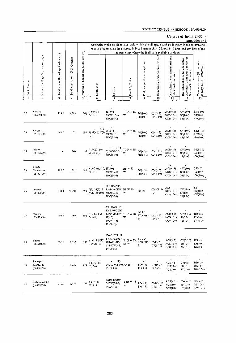
22
24
25
26
27
29
30
._ o
E Z 2
Kodalll (06489400)
Kanera
(06489500)
Pahiya (06489600)
Behata
Churamane (06489700)
jaitapur
(06489800)
Manol'3 (06489900)
Bisawa (06490000)
Ramapur Kmdhauh (06490100)
Patti K.amalpur (OM90200)
3
723.6
148.0
202.0
188.4
ISO.4
196.9
270.0
<::> o Co
" .~ :; 0.. o 0..
4
4,014
1,152
340
1.061
3,558
1,089
2,037
1,220
1,956
DISTRICT CENSUS HANDBOOK: BAHRAICH
Census ofIndia 2001 -Amenities and
'" ;;:
Amenities available (if not available within the village, a dash (-) is shown in the column and next to it in brackets the distance in broad ranges viz. < 5 kIDs., 5-10 kIllS. and 10+ kms of the
nearest place where the facility is available is given
" " u o o ~ '" ." '0
'& ::l o
..c: '0 ~
" .D
E ::l Z
6 7
762 P M« 5) qIO+)
H(lO+) MCW(IO+) PHq5.10)
194 . P« H(lO+)
5)M«5)C(5· MCW(IO+)
10) PHC(5.10)
9
Till' W SS· PO(;O+)
W PH(!O+)
Till' W SS· PO(;O+)
W PH(!O+)
. H« . 56 P AC(2) M« 5) MCW(lO+) Till' W SS· PO« 5)
5)C(10+) PHC(5.10) W PH(5-10)
188 P ACM(5·10) H(lO+) C(IO+) MCW(5-10)
PHC(5·10)
HDDAPHS
HPWSS· W
P(2) M(2) S RMP(3) CHW Ill' W SS· 529 AC(3)C(10+) MCW(S.IO) W
PHC(5·10)
PO«5) PH« 5)
PO PH
" .:: ~ " 0-o
" '" ." :;;
-;;; .~
" E E o u III
CM«5) CP(5·10)
CM(d) CP(S·IO)
CM(IO+) CP(5·10)
CM«5) CP(5·10)
II
ACS« 5) NCS(IO+I OCS(lO+1
ACS« 5) NCS(i'o+1 OCS(lO+)
ACS«5) NCS(IO+) OCS(lO+)
ACS« 5) NCS(lO+) OCS(IO+)
ACS CM CP(S· NCS(lO+) 10) OCS(!O+)
180 P 0 M« 5) C(S·IO)
MHCWCHC PHSFWCNH RMP(5)CHW H«5) MCW«5) PHC« 5)
THPWSS POTO • PTO PH« CM« 5)
W 5) CP«5)
ACS« 5) NCS(IO+) OCS(lO+)
343 P M S PUC I OC(5-10)
191 PM(5·IO) C(IO+)
339 PM«5) C(IO+)
CWCHCPHS FWCRMP(5) CHW(2)H« 5) MCW«5) PHC« 5)
PO TO THPWTK PTOPH« CM«5) SS·W 5) CP(5.tO)
ACS«5) NCS(IO+) OCS(lO+)
H« 5) MCW(S-IO) Ill' SS· PHC« 5)
PO« S) PH« 5)
CHWH(IO+) . MCW(5.tO) THPWSS· PO«5\
PHC(5.IO) W PH« 5)
280
CM«5) CP« 5)
ACS« 5) NCS(IO+', OCS(lO+',
CM(5·1 0) ~~~~~~\ CP(5·IO) OCS(IO+,
12
CV(lO+) SP(IO+) ST(lO+)
CV(lO+) SP(IO+) ST(lO+)
CV(lO+) SP(IO+) ST(lO+)
CV(lO+) SP(IO+) ST(IO+)
CV(lO+) SP(tO+) ST(lO+)
13
BS(5·10) RS(lO+) NW(IO+)
BS(5·10) RS(IO+) NW(lO+)
BS(5·10) RS(IO+) NW(IO+)
BS«5) RS(IO+) NW(lO+)
BS RS(lO+) NW(!O+)
CV(5·10) BS« 5) SP(IO+) RS(IO+) ST(lO+) NW(lO+)
CV(5·10) BS« 5) SP(IO+) RS(IO+) ST(lO+) NW(IO+)
CV«S) SP(IO+) ST(lO+)
CV(5·IO) SP(lO+) ST(IO+)
BS« 5) RS(IO+) NW(lO+\
8S(5.IO, RS(! (}<-)
"W(lO~',

VILLAGE DIRECTORY
Villal!c Dircctory Land Use (As on 1999)
s g o a. 0.
-< 14 IS
Fararpur (7)
Fruwarpur (8)
PRMR . FP NC Fruwarpur (8)
MR FP Jajtapur (2)
PRMR FP Fruwaq>ur (9)
MR Jaitapur (I)
PR Jaitapur (I)
Fruwarpur (3)
PRMR Phakharpur (6)
FP
16
u
" .~
"" ~ u c. .. c.
.. ~ Z 17
EDEAG NM EOEA
ED N
18
Land use (i.e. area under differenllypes of land USe in hectare)"
19
38.0
20
GC(5.0) WF(IS7.0) T(162.0)
1370 GC(40.0) . T(40.0)
W(3S.0) TWE(6S.0) TK(1.I) T(101.1)
(( 7.0 TWE(84.0) 1(840)
281
21 22
155.0
26.0
133.0
(( 7.0
321
2.0
10.0
23
u
"" ;g ;; '0 u E ..
;z. 2
Kodahi
Kane ....
189.0 Pahiya
Behata Churamane
Jaitapur
2.0 Manera
Bisawa
Ramapur Kindhauli
Patti Kamalpur
lil .D E " "
22
23
24
25
26
27
28
29
30
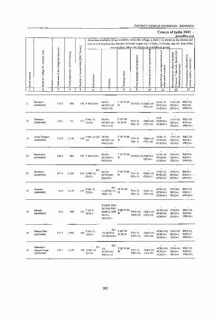
DISTRICT CENSUS HANDBOOK: BAHRAICH
CenslUs ofIndia 2001 -Amenities and
Amenities available (if not available within the village, a dash (-) is ;hown in the column and
next to it in brackets the distance in broad ranges viz. < 5 kms., 5-10 kIlls. and 10+ kms of the ~
nearest place where the facility is available is ~iven ~
~ ::>
" Vl § " -0 1)1 ." :;;
'" " :;; e " u .D
" ~ " " ';:J u ,f
" .<: c c c .~ e '§ ~ .!:!
.~ " " 0 0
'" .e t:~ ;,::. u ~ .0: ,_::; 0
" 0. ~ " 0- Ol '" 0 eo ;; Vl " 0. ,~ -;con ~ ~
....J ::;; 0 "0 "3 0 :;=6' -0 " " Co 8 Oil ~ e" ~ ;; .c "0 '? ':J -; ~ .2 " " c 1A g -0 " " u 0 ~
'" " ~ -5 0 '" o .-
~ " II " . \l .~ 0 E .<: @ " g o " ''0 .c ~
0. _, '" _:"E:.a ':J 0 .D ;; '" -;c ~;> .;:
'" ._ E
.;; ._ '" " 0;, E .,,:! .:! is '" 0- 0 " 'g _g] "
._ 1: 0 ~ ." 00 " Si"";;,E " '" " 0 '" 0- Oi " "3 " '" " .D ~ <.> ;;: E " " ~ E :s
~ ~ '" E "5 :;; E :0 .5 vi E .~ ~ ~ ~:.o " " '" 0 0 ::> "0 " Ci 0 0 00-" ~ Q~ 0:-::
'" ;2: f- f- ;2: <.xl ::2: "- u « '0 u i': -2 4 5 6 7 8 9 10 II 12 13
31 Bam~yari
173.0 920 15~ P M CO 0+) H(lO+) : HP W 88· PO PH« 5) CM(~-IO) AC8« 5) CV(5-10) BS(5-1O)
(06490300) MCW(S-IO) NCS(IO+) SP(IO+) RS(IO+)
PHC(S-IO) CP(5-IO)
OC8(10+) 8T(10+) NW(1O+)
Gohaniya PM«5) H(lO+) THPTW ACS
CV(S-IO) BS(5-10) 32 1320 751 117 PO« 5) CM(5-10) NCS(lO+)
(06490400) C(lO+) MCW(5-10) WSS·W PH« 5) CP(S-IO) OCS(lO+)
SP(1O+) RS(1O+)
PHC(5-10) 8T(10+) NW(IO+)
I
33 Amwa T t!:tarpur
175.0 1,138 182 P M« 5) C(5- H(IO+) T HP W 88· PO(~ 5) CM(5-10)
AC8« 5) CV(S·IO) BS(5-10) (06490500) 10) MCW(S-IO) W PH«S)
NCS(lO+) SP(1O+) RS(IO+)
PHC(S-IO) CP(S-IO)
OCS(IO+) ST(1O+) NW(1O+)
34 Hemanapur
160.0 984 181 P MC(IO+) H(lO+) :HP W SS- PH POe, 5) CM('IO+) ACS« 5) CV(lO+) BS(1O+)
(06490600) MCW(1O+) NCS(1O+)i SP(1O+) RS(1O+)
PHC(1O+) CP(IO+)
OCS(1O+} ST(1O+) NW(IO+)
Bhadwani P«
H(lO+) T HP W SS· PO(~ S) ACS« 5) CV(1O+) BS(1O+) 35 357.4 1,529 243 5)M«5) CM(S-IO)
(06490700) MCW(1o+) W PH«S) NCS(1O+) SP(1O+) RS(1O+) C(lO+)
PHC(IO+) CP(lO+)
OCS(1O+) ST(1O+) NW(1O+)
Sangawa PM«5) H« HPW8S· ACS«5) CV(IO+) BS(5·10)
36 (06490800)
35.0 1,136 197 C(1O+)
5) MCW« 5) W
PO« 5) CM«5) NCS(1O+) SP(1O+) RS(1o+)
PHC« 5) PH«S) CP(S-IO) OCS(1O+) ST(1O+) NW(1O+)
DMCWCWC
Samada PM S HCPHSFWC THPWSS- - ACS(5-10) CV(1O+) BS(5-1O) 37
(06490900) 35.0 959 152
C(1O+) RMP(5)CHW W PO(5-10) CM(5·10)
NCS(1O+) SP(1O+) RS(1O+) H(IO+) PH(S-lO) CP(S-IO)
OCS(1O+) ST(IO+) NW(1O+) PHC(1O+)
Babhan Diha PM«5) H(S.
THPTW ACS(S-IO) CV(5-10) BS(5·10) 38
(06S04600) 117.1 1,045 18S
C(IO+) 10) MCW(S·
WSS-W POC< 5) CM(5-10)
NCS(lO+) SP(lO+) RS(lO+) 10) PHC(IO+) PH(S·IO) CP(S·IO)
OCS(IO+) ST(IO+) NW(IO+)
Sahawapur P« H(5-
10) THPWSS- PO(~S) ACS(5-IO) CV(S·IO) BS(5-10) 39 Mahipal 8mgh 1937 2,239 378 5)M«S)
MCW(IO+) W PH(S.IO) CM(S·10)
NCS(IO+) SP(1O+) RS(1O+) (06504700) C(lO+)
PHC(5-IO) CP(S·IO)
OCS(1O+) ST(1O+) NW(1O+)
282

VILLAGE DIRECTORY
Village Directory Land Use (As on 1999)
14
tvlRFP NC
IS
F arwarpur (8)
tvIR FP Phakharpur (9)
MRFP NC Farwarpur (9)
PR MR Phakharpur (J 2)
PR MR Phakharpur (J 2)
Pharkharpur (6)
tvIR FP Jatipur (6)
PRMR FPNW
F arwarpur (5)
PRMR F arwarpur (5 )
FPNW
ED
c :; 0
'" " E .~ E
"" 8 " >, ~ ~e 0.
0- o " iil ~ o.~
~ 0. .5 ~ ~ U; " " " 0 '" 0 '" "- :z: ;: E
16 17 18
NM
N
Land use (i.e. area under different types ofland use in hectare»>
~ 0 ~
19
283
'V " :; 51 >, e "0 ~
" eo
E 20
GC(89.0)
TK(0.6) T(89.6)
GC(67.0) TW(26.0) TK(49.0)
T(142.0)
GC(89.0) T(89.0)
TW(l42.2)
TWE(323.0) T(323.0)
WE(500)
T(50.0)
TW(2.0) T(2.0)
TW(1.0)
TWE(77.0) T(78.0)
"0
~ .;!l :: '2 ~
21
82.0
0.7
94.0
18.1
30.7
76.2
~ c ;:l 0
" .~ eo eo 5 .5 B "0
~ ~
5 ·E " " :0 " U; ~ "" ; '" ~ ~
.;; " ~
:0 > 0 '0 e e " " il eo " E :; "0 e
~ '" C) -0: Z 22 23 2
12.0 Bameyari
Gohaniya
15.0 Amwa Tetarpur
1.2 1.2 Hemanapur
0.7 0.7 Bhadwani
Sangawa
Samada
1.2 9.0 Babhan Diha
Sahawapur Mahipal Singh
~ .D E ~
~ " '"
31
32
33
34
35
36
37
38
39

DISTRICT CENSUS HANDBOOK: BAHRAICH
Ccmus of India 2001 -Amenities and
Amenities available (if not available within the village, a dash (-) is shown in the colunm and
next to it in brackeL, the distance in broad ranges viz.,< 5 kms" 5-10 km." and 10+ kms of the ~ nearest olace where the facilitv is available is "iven
" ~ ~ " is c '0 .D '0 ~ ~
" II 8 u '" U .0 '" -§ ~ ~ " ~ ,,' .c " .... c c 0 " .~ t! u
g ;.§. " 0 0 a E~ ~
u ~ .c .;: 0
" 0- t; ] 0- U '" 0 btl 0 ~ " 0- '" '" : ~ _, ~ ~
'0 ] 0
.~ ·11 3 =~ E -0 6 " " ,;j ;; .c '0 .; ] .2 Ol -
" 2 u ~ '"
" " c ;:: '0 C ,. u 0 ~ ~ ~ ')I) .:; .~ !i .d c o ";':;
,;j " S " C \l ~ '_ 0 '" c c' 0 .c 0- -~~ ';3 0
..0 ;; 0 :; '_ .... ~ 'r: ~ _: ~!
'" > " .~ .~ E '" 0- 0 C OIl E ~; §-~ " '_ t! 0 t; .~ btl u t; ~ f: c '" c 0 '" 0- 5 " ] .~ '" E " .... " '5 '5 .D :.;;< E " c, ~ E ;J ~I '5 E E u '6 ,5 of E .~ tl ~ g:.o
" Z o· 0 " '0 " 0 0 0 OIl",,' ~ Q~ o .-
'" l- I- Z ~ ::;: "" u <f. ~; u :: 2 3 4 5 6 7 8 9 10 II 12 13
Dihawa Kala PM«5) CHW H(5·IO)
T HP W SS- PO(~ 5) ACS« 5) CV(5-10) BS(5-10) 40 143.6 936 156 MCW(5-IO) CM«5)
(06504~OO) C(IO+) PHC(5-IO) W PH«5) CP(5-IO)
NCS(lO+) SP(IO+) RS(lO+) OCS(ID-~) ST(lO+) NW(lO+)
Akbarpur D PHS FWC
NWBS(5-41 Bujurug 146.3 1,611 248
P 0(2)M(5- H(lO+) HPW SS-PO«5) CM(5-10)
ACS« 5) CV(5-IO) 10)
10) C(lO+) MCW(10+) W' NCS(lD-» SP(lO+) (06504900)
PHC(IO+) PH«5) CP(5-IO)
OCS(lO+) ST(lO+) RS(IO+)
Husepur P« H(I0-» HPW SS-
1-ACS« 5) CV(l0-» BS(IO+)
42 76.8 315 62 5)M«5) PO« 5) CM«5) (06505000) MCW(l0-» W NCS(lD-» SP(i 0-» RS(l0-»
C(lO+) PHC(IO+)
PH(5-10) CP(lO+) OCS(l0-» ST(lO+) NW(lO+)
8aheliya P(2) M(S·IO) H(5-
PO PH(5- ACS(5-IO) CV(5-10) BS(5-10) 43 290.0 1,662 275 10) MCW(5- TWSS-W CM(5-10)
(06505100) C(10+) IO)PHC(5-IO)
10) CP(5-IO)
NCS« 5) SP(IO+) RS(lO+)
OCS« 5) 8T(10+) NW(5-10)
Baturaha P(2) M(S·1 0) MCWCHW
THPWSS· PHPO«5)CM(~5) ACS« 5) CV« 5) BS« 5) 44 218.2 1,576 284 H(S-10)
(06505200) C(lO+) PHC« 5) W CP« 5) NCS«5) SP(I0-» RS(IO+)
OCS«5) ST(lO+) NW(lO+)
Malukpur P« H«
THPWSS- PHPO«5)CM(~5) ACS« S) CV«5) BS«5) 45 208.0 1,428 202 5) M« 5) 5) MCW«5)
(06505300) C(l0-» PHC« 5) W CP«5) NCS« S) SP(IO+) RS(lO+)
OCS« ~,) ST(1O+) NW(lO+)
P(4) M S HMCWPHC
ACS CV 46
Madhaupur 491.0 6,296 959 PUC 0(2)
PHSFWCTB T HP W SS- PO(2) CM«5) NCS(lO.) SP(l0-»
BS(5-10)
(06505400) C(lOt)
RMP(2) W PH(l4) CP«5) OCS(lO.) ST(lOt)
RS(IOt)
CHW(4) NW(lO+)
Muse Patti PM(5-10) H«
~HPWSS- PO(~5) ACS« 5) CV(I0-» 8S« 5) 47
(06505500) 204.0 1,393 206
C(lOt) 5) MCW«5) CM«5)
NCS« 5) SP(lOt) RS(lOt) PHC« 5) PH«5) CP«5)
OCS«") ST(l0-» NW(lO+)
48 Tatehara
204.8 1,216 208 PM(5-IO) H(lOt)
HP SS-T P0(5-10) CM(5-10) ACS« $) CV(5-10) 8S(5-IO)
(06505600) C(lOt) MCW(5-10) NCS(lO+) SP(IOt) RS(IOt)
PHC(5-10) PH«5) CP(5-10)
OCS(lO+) ST(1Ot) NW(lO+)
Majhaura P M« 5) H«
T HP W SS· PO(~ 5) ACS« » CV«5) BS« 5) 49 94.0 463 84 5) MCW«5) CM«5)
(06505700) C(lOt) PHC« 5) W PH«5) CP« 5)
NCS« ;) SP«5) RS(lO+)
OCS« 5) ST« 5) NW(IQ-,-) ~ ,;,.
284

VILLAGE DIRECTORY
Village Directory Land Use (As on 1999)
Land use
E ""-~ .~ "
"0 <.> 0
" " S ~ " e " .~
~ ;;; OIl 8
;; 0;;
~ C"O 9 " b ~ " ~ 0. g_Z 0. " -£ s ~ fJ- .5 ~ '" Vi 0. :: " t;
~ - " ~
a. :;; ~ _.x, ~ ·c 1! a. " 0 " o '" 0
-< ;Z; '"' ;Z; ;::: E ». 14 15 16 17 18 19
!'vIR FP F aJwaJl'ur (I 0)
!'vIR FP Farwwpur (9) ED
NC
!'vIRFP FaJwwpur (II)
!'vIR FP Farwwpur (5) EDEAG EOEA
!'vIRNC F3Iwwpur(3) EDEAG EOEA
PR!'vIR Farwwpur(4)
PR!'vIR Farwwpur (0)
FP
!'vIR FP Farwwpur (3) EDEAG
Bahraich (20) Baske~ Twine
MR FP FaIw3Ipur (c)
285
(i.e. area under different types of land use in
~ :; ~ ,.., e "0
" 'iii .~ ,!.; 20
GC(90.1) PC(O.4) TK(2.1) 0(1.0) T(93.6)
TWE(74.8) T(74.8)
GC(269.S) PC(2.0) TK(2.0) T(273.5)
GC(20.0) TW(lOS.O) TWE(IS.0) T(140.0)
TW(91.1) TWE(50.0) T(l41.1)
GC(173.S) PC(2.0) TK(1.0)
TWE(45.i) T(45.7)
hectare)"
"0
~ "" .~ " ;:J
21
31.2
40.0
33.0
I" 4
-£ " i;l .~ 00 00
,. S
.~
"0 ~ ~ .£ 2- u
~ ~ " '" ! ~-;;;- '« .;;
~ " " :D ,. 0 '0 ::: [: c
" "" '" " =:"0 " E
" " 4. ;i u '" 22 23 2
Dihaw. Kala
15.9 Akbwpur Bujurug
2.0 Husepur
3.0 Baheliya
9.5 28.8 Baturaha
8.0 26.1 Malukpur
Madhaupur
2.0 10 Muse Patti
Tatehara
c 9 - i) Majhaurd
\; .D
E " c
~ " '"
40
41
42
43
44
45
46
47
48
49 ,

DISTRICT CENSUS HANDBOOK: BAHRAICH
Census of India 2001 -Amenities and
Amenities available (if not available within the village, a dash (-i is shown in the column and
next to it in brackets the distance in broad ranges viz.< 5 lans., 5-10 lans. and 10+ lans of the ~ nearest place where the facility is available i~ given
" ~ ~ " !i " -,;,
~.g " ~ " ~: 0 (j U ..0 U ~ " "
.~ u e " .c
" 0 c: .~ " ;:: !l .~ 2- " 0 0 .§' u ~ .~ ~
U ~ .c .~ 8.. " 0- Ii " >-u ~ " .§, ";0'" '" ~
0 ~ 0 0- '" ~ --l 0 " ] c ,. _g:g~ " ~ 0 '" tl- c " e~ o(j ;; .c "0 u ::= .::; 1;1 ~
;::I ..c ._ ~ ~ " " " '" C' " u 0 ~
OIl -5 .~ " " .c c § 'g ~ .g ,g .S " Ii ~ 0 ~
.D '0 .c ... E __ ~ VI
"";>"'g ... 9 E
.;; :; .~ ";0
" ~
ii u -;;; ~ 0- 0 " '" 'u 5 - ::; c ;;;
" '0 ~ 0 \i 0 '" " Ii c 0- .~ ";0 c '2 ._ " E ;:J >-
~ " .D u :;; E " " ~ 5 .2 E ~ E "E 3 E " 'i:i c of E .~ \) ~ "'" E ;!:
" Ii '" 0 0 " '" " 8 0 0 ell':; ~ g~ o~
'" Z f-< f-< Z U1 ~ 0. U -< 0 u e 2 3 4 5 6 7 8 9 10 II 12 J3
Dharam Samy P« H«
T HP W S5- PO(~ 5) ACS« 5) CV«5) BS« 5) 50 I OOA 465 91 5) M(5-10) 5) MCW« 5) CM«5) (06505800) C(lO+) PHC« 5) W PH«5) CP« 5)
NCS« 5) SP(IO+) RS(IO+) OCS« 5) ST(1O+) NW(lO+)
Keshwa Kunda P« H«
T HP W SS- PO(~ 5) ACS« 5) CV«5) BS« 5) 51 46.1 302 59 5) M« 5) 5) MCW«5) CM«5)
(06505900) C(lO+) PHC« 5) W PH«5) CP« 5)
NCS« 5) SP(IO+) RS(IO+) OCS« 5) ST(lO+) NW(lO+)
P« MCW RMP(6) T HP TW PO TO -I BS 52
Ghasipur 18.0 4,092 636 5) M« 5) H(IO+) PHC« W SS-W PTO CM(2)CP
ACS« 5) CV«5) RS(IO+)
(06506000) C(IO+) 5) PH(30)
NCS(lO+) SP(lo+) NW(IO+)
OCS(IO+) ST(lO+)
Fakharpur P« H«
ACS« 5) CV(lO+) BS«5) 53 10.8 1,847 292 5) M« 5) C« 5) MCW«5) TWSS-W PO PH CM«5)
(06506100) 5) PHC« 5) CP« 5)
NCS(IO+) SP(IO+) RS(IO+) OCS(IO+) ST(IO+) NW(lO+)
Siddha PM«5) H«
T HP W SS- PO(~ 5) ACS« 5) CV«5) B5«5) 54 87.3 261 54 5) MCW«5) CM«5)
(06506200) C(IO+) PHC« 5) W PH«5) CP«5)
NCS(IO+) SP(lO+) RS(lO+) OCS(IO+) ST(IO+) NW(IO+)
Alinagar P(2) ACM« H«
T HP W SS- PO(~ 5) ACS« 5) CV«5) BS« 5) 55 87.4 SOl 90 5) MCW« 5) CM«5)
(06506300) 5) C(lO+) PHC« 5) W PH«5) CP« 5)
NCS« 5) SP(lO+) RS(lO+) OCS« 5) ST(lO+) NW(IO+)
Muhallunadpur P M«5) H«
T HP W SS- PO(~ 5) ACS«5) CV«5) BS«5) 56 110.3 740 117 5) MCW«5) CM«5)
(06506400) C(lO+) PHC« 5) W PH«5) CP«5)
NCS« 5) SP(lO+) RS« 5) OCS« 5) ST(IO+) NW«5)
57 Paras Rampur
56.0 1,562 246 P(2)M«5) H(lO+) T HP SS- PH(50)
CM(IO+) ACS« 5) CV«5) BS« 5)
(06506500) C(lO+) MCW«5) HP PO« 5) CP«5)
NCS(IO+) SP(lO+) RS(lO+)
PHC« 5) OCS(IO+) ST(5-10) NW(lO+)
Khalidpur P«
H(IO+) HPWSS- ACS«5) CV« 5) BS«5) 58
(06506600) 184.2 2,789 413 5)M«5)
MCW«5) W PO« 5) CM(IO+)
NCS(IO+) SP(lO+) RS(1O+) C(IO+)
PHC« 5) PH«5) CP«5)
OCS(IO+) ST(5-10) NW(lO+)
Moharnadpur P«
H(lO+) ACS(5-IO) CV(1O+) BS(5-IO) 59 76.9 467 88 5)M(5-IO) HP 5S-T P0(5-10) CM«5)
Kala (06506700) C(lO+) MCW(5-IO)
PH« 5) CP(IO+) NCSlIO+) SP(IO+) RS(IO+)
PHC(5-IO) OCSlIO+) ST(1O+) NW(lO+)
286

VILLAGE DIRECTORY
Village Directory Land Usc (As on 1999)
E _:,;
.:;
~ " ~ 1)
~ :0 ;;: ":I
" g ?: g g
~ 2 p..
'" 0- " <f. Z 14 15
PRMR Farwa'lJUf (2)
FP
MRFP FarwarpUf (2)
PRMR FP
F arwarpUf (I )
PR Phakharpur (0)
MR FP Phakharpur (3)
PRMR PhakharpUf (2)
MRFP PhakharpUf (3)
MR Phakharpur (2)
PR MR Phakharpur (I )
Bahrnich (3)
.e "0 0
" E c: E .~ 8 01)
~ C
"0 ,.... S 0. " ~ ~
"" 0- o " ;;l
O-~
'" .S .~ p.. t ~ -;;; " ?: 0 " 0 " .. "- Z ~ E 16 17 18
EDEAG EOEA
EDEAG EOEA
NM
EDEAG NM
EOEA
ED
Land use (i.e. area under different Iypes of land use in hectare)··
~ ;; Sl ,.... e "" !l "0 '" ~ .~
~ '" t: ·2 0 ] u. ;:l
19 20 21
TW(35.1) 39.6
T(35.1)
TW(18.4) 23.9
T(18.4)
GC(22.2~
TWE(165.1) 54.4 T(l87.3)
TW(30.0) T(30.0)
TWE(29.5) T(9.9)
TW(37.6) T(37.6)
TK(J.4) 64.8 T(IA)
T(76.9)
287
4.0
1.0
10.3
10.6
-5 " ;; .~ .. -.;;
"" ·5 " :0 ] -§ .~ 2- " r;: ~ '" "'~
·00
" " tl .. :c " '0 :; 8 " 3 co '" - "0 " " " < () '"
22 23
1.3
0.9
1.7
5.0
L3
2.6
1)
l .;;: ·0
" E '" Z 2
74.7 Dharam Saray
42.3 Keshwa Kunda
5.4 Ghasipur
5.0 Fakhal1JUr
39.5 Siddha
47.9
2.2
Alinagar
Muhanunadpur
Paras Rampur
Khalidpur
Mohamadpur Kala
t .D E " " ~ t '"
SO
SI
52
53
54
55
56
57
58
59

DISTRICT CENSUS HANDBOOK: BAHRAICH
Ccm:us of India 2001 -Amenities and
Amenities available (if not available within the village, a dash (-) is shown in the column and next to it in brackets the distance in broad ranges viz. < 5 krns., 5-10 kms. and 10+ krns of the
~ nearest ,lace where the facility is available is given fh " ~ c ~ "" ~.D "" ~ ~ " c 8 ~
U JO '" .~ -§ ..c " " "§ oJ" c c 0 c .::: ~ t " 0 :; " 0 0
'" Z .~ ~ .~ U 2', ..c: ,.;: 0
" a. ~ :;; 0. " '" 0 1 0 ~ " 0.. .~ OJ''' ~ ~ _, 0 "" ] 0 _g :;~ ]' 2', "0 8 00 1: &~ ~ ;; ..c: " '" c "- ::I..c: ...... " " c ~ '" " " '-' 0 ~ ~ " ~ -5 .~ " ~
o .~.
~ " $1 c: c' 0 ~ ..c: c 2: 0
'" '0 .c ~ ....: VI _ .'"S :.a .'" .g JO -; ~ OJ § ~ ~ '" ~ ;; '0 '" on ~ ~j " '" 0.. C U '" ~ " '0 ~ 0 ij .~
00 " t; 2 c! c 0.. " " ] ._ " E
" " JO '-' :;:; E ;:J " OJ E " E ;;-" E '5 '5 E 'i3 c .J E .;: ~; ~ ~ :.a E~ - z·- 0 0 "
;:J
" 8 <I)
0 00 .c' ~ Q~ " " 0 " ._ r/) f- f- Z t.tl 2 0.. U -< c: u e
2 3 4 5 6 7 8 9 10 II 12 13
Shivpura PM«5)C(5. H(lO+) ACS(S.IO) CV(5.10) NW 8S(5.
60 300.0 1,343 2S6 T HP W SS· PO« 5) CM(S·IO) 10) (06506800) 10) MCW(S·IO) NCS(5·10) SP(5.IO)
PHC(5.10) PH(5-10) CP(S-IO)
OCS(5·10) ST(5·10) RS(JO+)
61 8ubk.pur
330 5,391 869 P ACM«S) H(IO+) THPWR PO
CM«5) ACS«S.) CV(lO+) NW8S«
(06506900) C(lO+) MCW(JO+) SS·W PH(JO+) NCS(W') SP(JO+) 5) RS(lO+) PHC(1O+)
CP«5) OCS(W') ST(IO+)
Haibalpur P(2) M« 5) H« OCSAC'S« CV(;O+) 8S« 5)
62 (06507000)
1,670 377 C(1O+)
5) MCW« 5) T SStn' PO« 5) CM«5) 5) SP(10+) RS(lO+) PHC« 5) PH« 5) CP(J 0+) NCS(lO') 3T(10+) NW(JO+)
63 T t:ndawa MahaIlt
419.4 2,331 390 P M(5·IO)C(5· H(IO+) T HP W SS· PO PH(5.
CM(JO+) ACS«5) CV(5.10) 8S(5·10)
(06507100) 10) MCW(5-10) W 10) NCS(lO.) SP(lO+) RS(IO+) PHC(5·10)
CP(S.lO) OCS(IOt) ST«S) NW(lo+)
Suwagada PM(5·10) H(5· THPTW
ACS(S·IO) CV(5.10) 8S(5-10) 64
(06507200) 226.0 467 98
C(lO+) 10) MCW(S- WTKRC PO(S-IO) CM(5·JO)
NCS(S .. hO) SP(lo+) RS(lo+) IO)PHC(5.IO) SS-W PH« 5) CP(5·10)
OCS(lO+) ST(lO+) NW(JO+)
Raundopur P« H(S· THPTW
ACS(S·IO) CV(5.10) 8S(5.10) 65
(06507300) 273.0 1,434 243 S)M(5-10) 10) MCW(5· WTKR SS- PO(5-10) CM(5·10)
NCS(S·IO) SP(lO+) RS(lO+) C(lO+) 10) PHC(S·I 0) W PH«5) CP(5-10)
OCS(5-10) 8T(l0+) NW(IO+)
Indur P M« 5) C« MCWH«S) THPTW
ACS«5) CV«S) BS« 5) 66 242.0 1 ,767 306 WTK SS- PO« 5) CM«5)
(06507400) 5) PHC« 5) W PH« 5) CP«5) NCS(lC>;.) SP(lO+) RS(lo+) OCS(IO.;.) ST(IO+) NW(IO+)
P ACM(<5) H« THPTW
ACS« S) CV«5) BS« 5) 67
Aganapara 97.5 1,120 190 5) MCW(lO+) WTKSS· PO« 5) CM«S)
(06507500) C« 5) NCS(lCl+) SP(lO+) RS(IO+) PHC« S) W PH« 5) CP«S)
OCS(W+) ST(IO+) NW(lO+)
lffi DA
68 Holpar.
220.0 1,842 347 PM S I 0 H(IO+) T HP W SS· PO(~ 5) CM(5-10)
ACS« 5) CV(IO+) BS(lO+)
(06507600) C(lo+) MCW(lo+) NCS(](I+) SP{lO+) R8(l0+)
PHC(IO+) W PH«5) CP(5·10)
OCS()()+) ST(1o+) NW(lO+)
• H(S· THPTW ACS« 5) CV(5·IO) 8S(5-IO) Acho\aya 1,855 P M(S.\0)C(5- 10) MCW(S- W TK L SS· PO« 5) CM«5) '69 540.6 337 NCS(JlH SP(lO+) RS(JO+) (06507700) 10) 10)PHC(5.10)W PH(lO+) CP(S·10)
OCS(HH ST(lO+) NW«S)
288

VILLAGE DIRECTORY
Village Directory Land Usc (As on 1999)
E -""
2- i:;-:0 e 0
" u E ~
c: E " 'N
'" :0 '" 8 ,g eo '"l
~ C:'" ·s " .c ~ ~ £ ;;: 0-
0- g_a '" S "-u ;l '" .5 . .M '" ~ "-e 1:! Ii '" l;i " "- 0 '" ;;: ;;: c 0. " 0 "
0 " <f. Z 0. Z :2: E 14 15 16 17 18
MRFP NR NW Phakhall'ur (7)
~~ ;: Phakh"'1'Uf (II ) EDEAG •
PhakhaJl'ur (2)
PR MR Pharkh"'1'ur (8)
MR fP Phakh"'1'ur (6)
MRfP Phakll"'1'Ur (6) ED
PR Phakh"'1'ur (3)
PR Pharkh"'1'ur (2) EDEAG
PRMR Phakh"'1'ur (12) ED
~"R
MRfP Phakh"'1'ur (8)
Land use (i.e. area under different types of land use in
l;i
" (5 11.
19
4.0
" ~ ~ ~
'" e '0
~ eo 1; 20
TWE(30) T(30)
0(1270) 2.0 T(127 .0)
520 GC(44.0) . T(44 0)
GC(72.0) 13.0 T(72.0)
GC(952) R(2.5) T(97.7)
GC(2.2) TW(50A) T(52.5)
100 GC(lOO) . T(lO.O)
289
hectare)"
'0 B '" eo 'E
'" ;:J
21
17.0
336.0
54.0
139.0
113.7
20.3
28.0
-B " ~ .g " 011 ;; Oll
" ';;1
:0 ;; ~ " u .2 .§.
" " 1 " l;i eo '" ,g ;;:
" ~ ~ :: " :;; ;> -0 '0
'" 0 ~ .. c
" .3 '" E - '" " " c .< '" U '" Z 22 23 2
24.0 Shivpura
Bubkapur
Haiba!pur
24.0 49.0 Tendawa Mahan!
52.0 7.0 Suwagada
60 206.0 Raundopue
1.9 Indue
2.1 Aganapara
121 i .2 Holpara
Acholaya
~ .D E ~ c
~ " '" 1
60
61
62
63
64
65
66
67
68
69

~
" ~ " ~
c: "0 " 8 ~ u
'" " c: .c ~ -c: 0
.~ 2- " 0 U ~
" " -0 ~ 0 "0
...l 0
~ 0 olj .;:; .c
" " " c: '" :W .:; .~ " \l 0 '0 .c ..c .;:; :; '-E ~ 0. 0
" '0 0 ti c: " 0.
" ..c '" E "3 "3 E " z 0 0 " en l- I- ;z.
I 2 3 4 5
Dahaura 70 30.0 2,050 345
(06507800)
Singarao 71 1,174 182
(06507900)
Basauna 72
(06508000) 2,317.0 1,151 220
Bhilaura Baso 73
(06508100) 511.5 2,759 456
Sasana 74 1,164 188
(06508200)
7S Rajapur Khurd
243.2 898 160 (06508300)
76 Supani
197.0 1,214 191 (06508400)
77 Bhupani
J 57.0 1,143 228 (06508500)
Jagalapur 78
(06508600) 427.0 1,936 336
Datauli 79
(06508700) 164.0 701 123
DISTRICT CENSUS HANDBOOK: BAHRAICH
CeJllsus of India 2001 _ Amenities and
Amenities available (ifnot available within the village, a dash (-)-is shown in the column and
next 10 it in brackets the distance in broad ranges viz.< 5 kms., 5- J 0 kms. and 10+ kms of the
nearest place where the facility is available is given
~ "0 .D ..c :;; ~ " 'I) ~ u ~ " '" c: .~ ~ 0 a '0 .~ .c ._::: 0 ~ 0.. \l ~
0.. V>
" Q. e r/J ~ e "] 0
~~ " e ", V> a ;¥ "0 '" " 8 :;; i: .;; :; ..c .c ~ "0 U " 0 '" c: 0 'u
~ " s c:
" E .c '"
c: 51 "0 '0
0
~ .~ 0 -;;; ~ '" '"
-;;; :> " ';;1
" c: "" " ~ "0 c: ::: '" ~ 0 "" " tl a
~ 0 e .~ -;;; r:: }i :; .;:; E " »
" ~ E '" " E
~ '0 :: .,f. E .~ i) ~ " '0 E " " "0 " 0 0 0 t.(1~ " ._ s
0 I.I1 :2 0- U « <5 ~ ~en U 6 7 8 9 10 U 12 13
P OM(5-IO) H(IO+) T HP W ss- PO(~ 5) ACS
CV(lO+) BS(5-IO) CM(5-10) NCS(IO+)
C(lO+) MCW«5) W PH«5) CP(5-10) OCS(lO+)
SP(lO+) RS(IO+) PHC(lO+) ST(lO+) NW(lO+)
P M(5-10) H(lO+) THPTW ACS« 5) CV(lO+) NW
POre 5) CM(5-10) BS(lO+) C(lO+) MCW«5) WRSS-W
PH(1O+) CP«5) NCS(lO+) SP(lO+)
RS(IO+) PHC(IO+) OCS(lO+) ST(lO+)
P ACM«5) CHWH(5-10) THPWTK - ACS« 5) C~(lO+) BS(lO+)
C(lO+) MCW« 5) R SS-W POle 5) CM(5-10)
NCS(1O+) S (10+) RS(1O+) PHC(IO+) PH« 5) CP(lO+)
OCS(1O+) ST(IO+) NW(lO+)
P(2) M AC MCWPHS THPTW ACS
CV(5-lO) BS(5-10) C(lO+)
CHWH(1O+) W TK C SS· PO PH CM(1O+) NCS(lO+) SP(IO+) RS(lO+)
PHC(5-IO) W CP(5-10) OCS(lO+) ST(1O+) NW(IO+)
P(2) M(S-I 0) H(5- -
ACS«S) CV(S-IO) BS(S-IO) 10) MCW(S- :HPWSS- POreS) CM(5-10)
C(lo+) 10) PHC(5-10) PH(S-IO) CP(S-IO)
NCS(1O+) SP(S-IO) RS(1O+) OCS(IO+) ST(S-IO) NW(1O+)
PM(5-l0) H(IO+) HP SS-T PO(c S) CM«S)
ACSI,< 5) CV(S-IO) B8(5-10)
C(10+) MCW(5-10) PH« S) CP(S-IO)
NCS(1O+) SP(IO+) RS(IO+) PHC(S-IO) OCS(lO+) ST(lO+) NW(IO+)
PM S PUC H(lO+) THPWSS- PO(~S) CM«S) ACS« 5) CV(1O+) BS(5-l0)
C(IO+) MCW(S-IO) W PH« 5) CP(5-1O)
NCS(IO+) SP(lO+) RS(1O+)
PHC(S-IO) OCS(IO+) ST(1O+) NW(lO+)
PM«5) H(lO+) :,HP W SS- PO(~ 5) CM«S) ACS«5) CV(1O+) BS(1O+)
C(lO+) MCW(lO+) PH« 5) CP(lO+)
NCS(1O+) SP(1O+) RS(IO+)
PHC(IO+) OCS(lO+) ST(lO+) NW(lO+)
P M«5) - H« • - ACS« 5) CV(lO+) BS(lO+)
CO 0+) 5)MCW(lO+) ~,HPWS:;-POPH«5)CM«5)
NCS(1O+) SP(IO+) RS(lO+) PHC(IO+) CP(lO+)
OCS(IO+) ST(lO+) NW(1O+)
PM(5-IO) MCWH(5-IO) T,HPWSS- PO\;-IO) CM(5-IO) AC'KS-IO) CV(5-10) BS(5-IO)
C(lO+) NCS(1O+) SP(IO+) RS(IO+) PHC(5-10) \\ PHiS-IO) CP(5-10) OC'~lo--) ST(IO+) NW(IO+)
290

VILLAGE DIRECTORY
Villagc Dircctory Land Use (As on 1999)
E -'"
~ 8 c S
" ~ '" -0 "d .;;
" .8 " -fi oS
'" ~ 0 0.. " a. " « z 14 15
PR MR Phakharpur (1 1)
~~ :- Phakharpur (13)
MR Phakharpur (1 2)
PRMR. Phakharpur (7)
FP
PR Phakharpur (8)
MR Phakharpur (I 0)
MR FP Phakharpur (I 0)
MR FP Phakharpur (12)
MRFP NC Dhakharpm (12)
Phakharpur (8)
;.-, Q. 0..
ii1
~ 0 a. 16
EDEAG EOEA
ED
EDEAG
EDEAG EOEA
EDEAG
N
N
N
EDEAG -
EDEAG EOBA
EDEAG -
q -0 0
" E c E .~ 8 "" '" "" ~ ~
"0
" g_a ~ .5 ~ 0-
~ " 0 " " '" Z ~ E 17 18
Basket, Twine
Land use (i.e. area under different types of land use in hectare)"
~ & 19
" ~ " 51 ,., e "0 2 '" .!!!' .5 20
GC(185.0) PC(109.0) TWE(lO.O) T(304.0)
R(1.0) 0(4.0) T(S.O)
L(S.O) 0(4.0) T(9.0)
0(12.0) T(l2.0)
WF(l4.0) T(l4.0)
140 GC(69.0) . T(69 0)
291
.., ~ .!1!l .~ c
::J 21
207.0
227.0
60.0
274.0
74.0
~ c
" 0
~ '~
'-'> -s " ;; ;; <.>
" " .£ 3 " u :0 " ~ ~ "" "
;l "..., ;; .;:
u '" " :0 > ~ '-0 0 0 ;: ~
c " ::;
'" E ::.., " 8 g .;: .. Z
22 23 2
Dahaura
Singarao
Basauna
Bhilaura Baso
Sasana
Raj"pur Khurd
109.0 227.0 Supani
132.0 10.0 Bhupani
193.0 298.0 Jagatapur
2.0 Datauli
<; .JJ E :l
" " '5 '" I
70
71
72
73
74
75
76
77
78
79

DISTRICT CENSUS HANDBOOK: BAHRAICH
Census of India 2001 -Amenities and
Amenities available (if not available within the village, a dash (-) in shown in the column and
next to it in brackets the distance in broad ranges viz. < 5 kms., 5-1 () kms. and 10+ kms of the -;;;- nearest place where the facili!Y.is available is r.iven
" " " ~ <! ~ ." '" ,,; " -;;;- u '" ~ 8 u .0 " ..2 iii "
-;:J u 8 " ..c
" ;; 0
" '= !J .~ " " " .~ a E~ 0 0 <> ~ v u ~ ..c ._:: 0 :; P- " ,.., " - '"
P- o '" " 0 ~ 0 " P- .!! -;om '" ?! ...l 0 " 1i 0
~ _g:g~ " ~ ~ "0 8 ~
~~ ~ ;; ..c ." ~
" " " :ll " .:: ~ ;::I oJ:: ._
'" " " " <> 0 ~
~ -5 .~ " c: 0 <> ~ ~ .g " c ~ ._ 0 " ..c " " ~ .~ ..c
" ~ _ ._ '"C
0 .0 ;; 0 :; ._
.~ E ,,> " ;:; E '" " " ~ " 0.. 0 C <> . ." § - ~ " ·0 ~ 0 t; 0 "" " .2 t;
·c Vi
" '" a. .~ -;0 " 11 " ._ " E
" >.
~ E "3 "3 .0 <> :.;;; E " ~ 5.2 E i E u -.; .~ t
" .5 ;;f E ~ C "0 E " "7-
0 0 " -0 " Q 0 0 <% ~Q~ 0 E O'l r- r- z ~ ::?: ... u u I 2 3 4 5 6 7 8 9 10 11 12 13
P« CHW(2)
80 Bhilaurn Kaji
427.0 2.929 520 5) M(5-1 0) H(lO+) : HP W SS- PO(; 5) CM(IO+)
ACS« 5) CV(5-10) BS(5-IO) (06508800)
C(10+) MCW(S-IO)
PH(5-10) CP(5-10) NCS(10+) SP(IO+) RS(1O+)
PHC(5-IO) OCS(l(f+) ST(lO+) NW(lO+)
Sardpara P M« 5) C(S-CHWH«5)
T HP W SS- PO(; 5) ACS(<5) CV(5-10) BS(S-IO) 81 533.4 2,890 487 MCW(1O+) CM(5-10)
(06S08900) 10) W PH(S-IO)
NCS(S-IO) SP(1O+) RS(IO+) PHC(S-IO) CP(S-IO)
OCS(5-10) ST(1O+) NW«S)
Bibipur • F(5- -
T HP W SS- poe; 5) ACS(S-IO) CV(S-IO) BS(S-IO) 82 82.0 335 61 10)M(5-IO) H(IO+) CM(5-10)
(06509000) MCW(5-10) W PH(S-IO) CP(5-10)
NCS(ICI+) SP(1O+) RS(lO+) C(IO+) PHC(S-IO) OCS(IC!+) ST(IO+) NW(1O+)
83 Piyarepur
144.0 565 110 • P(5- H(1;')
T HP W SS- PO(;-IO) CM(5-10) ACS(5-10) CV(5-10) BS(1O+)
(06509100) 10) M(10+) MCW(S-IO) W PH(5-10) CP(5-10)
NCS(ICI+) SP(lO+) RS(1O+) C(lO+) PHC(IO+) OCS(1 (f+) ST(1O+) NW(1O+) •
Dharua 142 P M« 5) H(5- -
ACS« 5) CV(5-10) BS(5-10) 84 339.9 815 10) MCW(5- THPWSS- PO«5) CM(lO+)
(06509200) C(10+) 10) PHC(5-1 0) W PH(5-10) CP(5-10)
NCS(I(J+) SP(1O+) RS(1O+)
OCS(ICI+) ST(IO+) NW(I(}")
Kalha Para 115 PM(5-10) - H(S- ACS« 5) CV(5-10) BS(5-10)
85 162.0 649 10) MCW(5. T HP TW PO«5) CM(1O+) (06509300) C(1O+) 10)PHC(5-10) WSS-W PH(5-10) CP«5)
NCS(ICI+) SP(lO+) RS(IO+)
OCS(I(f+) ST(1O+) NW(I !r+)
86 Machhlya
28.7 220 34 P M(5-10) H(IO+) T HP W SS- PH PO( < 5) CM(~ 5) ACS« 5) CV(lO+) BS(lO+)
(06509400) C(IO+) MCW(IO+) W CP(1O+) NCS(I(l+) SP(1O+) RS(lO+)
PHC(IO+) OCS(1(l+) ST(1O+) NW(1O+)
Chandradipa P«
H(IO+) T HP W SS- PO(~ 5) ACS« 5) CV(lO+) BS(lO+) 87 96.0 676 121 5)M(5-10) CM(1O+)
(06509500) C(IO+)
MCW(5-10) W PH«S) CP(IO+)
NCS(J(f+) SP(1O+) RS(1O+)
PHC(1O+) OCS(l(I+) 8T(10+) NW(I!r+)
Akhla yara Pur PM« 5) H«
T HP W ss- poe; 5) ACS« 5) CV«5) BS« 5) ss
(06509600) 2225 947 144
C(1O+) 5) MCW« 5) CM«5)
NCS« 5) SP« 5) RS(1O+) PHC« 5) T PH« 5) CP«5)
OCS« 5) ST(5-10) NW(I(}..)
Shi\'rajpur P« H«
THPTW ACS« 5) CV«5) BS« 5) 89 214.6 1587 268 5)M«S) 5) MCW« 5)
WSS-W PO«5) CM«S)
NCS(ICI-\ SP(lO+) RS(1 0--) (06509700) C(1O+) PHC« 5) PH« 5) CP« 5)
OCS(1(~) ST(l (}..) NW(1 (}-\
292
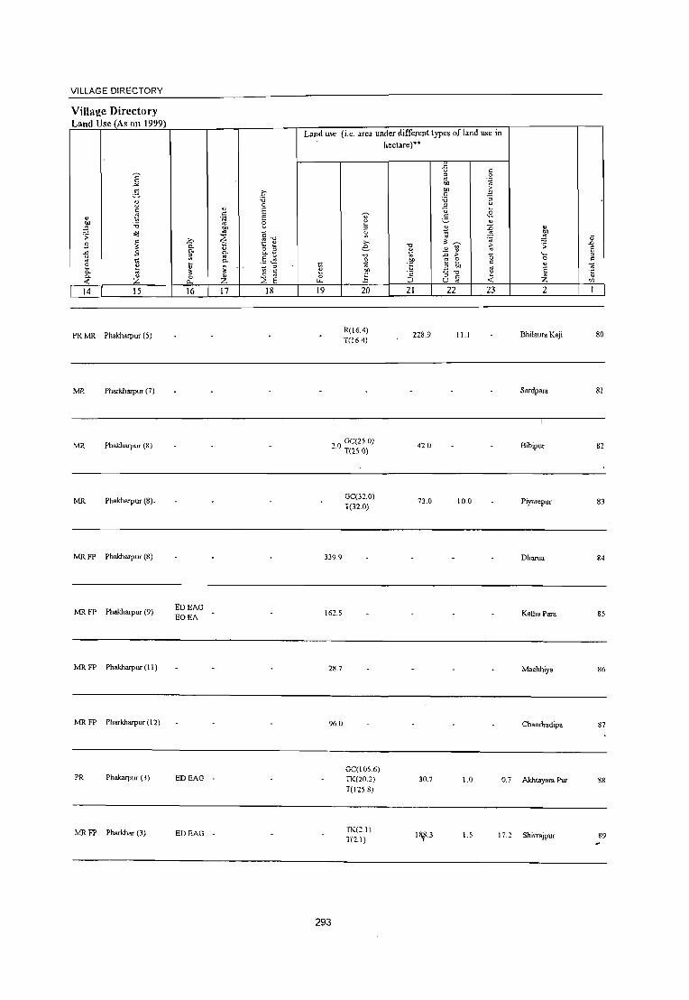
VILLAGE DIRECTORY
Villaj!e Directory Land Usc (As on 1999)
E ~
e. ~ c
.~ " ::W -0
o(i .;; " S " ..: £
~ 2 ~ c. '" C. " ..: Z 14 15
PR MR Phakharpur (5)
MR Pharkharpur (7)
MR Phakharpur (8)
MR Phakharpur (8).
!vIR FP Phakharpur (8)
!vIR FP Phakharpur (9)
!vIR FP Phakharpur (II )
!vIR FP Pharkharpur (12)
PR Phakarpur (3)
MRFP Pharkhar (3)
>. 0. 0. ;;: ij
" 0
"" IG
EDEAG EOEA
EDEAG
EDEAG
.... c:
'N
'" "" '" ~ " 0.
'" 0-
~ " Z 17
c 'i3 0
E E ;:;
~~ ~ ~
o " 0.-
.5 ,~ .. " ~ c: 0 '" ~ E 18
Land use (i.e. area under different types of land lISe in
1;; ~ 0
t.t.
19
.... u ~
" S; >. e -0
~
~ 20
R(16.4) T(16.4)
00 GC(25.0) -. T(2S0)
339.9
162.5
28.7
96.0
293
GC(32.0) T(n.O)
GC(l05.6) TK(202) T(l25.8)
TK(21) T(2.1)
hectare)··
-0
~ CIl
"6 'c ::J 21
228.9
42.0
73.0
30.7
1¥3
{l " " .~ " 01)
"" 5 " 'i3 ;; B u u .~ §
" ~ ~ ~~ ';0
" ~ ~ :;; > 0 e 2 " " "" " ;; -0 " " < U '" 22 23
11.1
10.0
1.0 0.7
1.5 1 i.2
" "" ..:;; (j 'S .D
E ._ " 0 C ., ~ E
'" " Z '/J
2 1
Bhilaura Kaji 80
Sardpara 81
Bibipur 82
Piyarepur 83
Dharua 84
Kalha Para 85
Machhiya 86
Chandradipa 87
Akhtayara Pur 88
Shivrajpur 89

DISTRICT CENSUS HANDBOOK: BAHRAICH
CelliSUS of India 2001 _
Amenities and Amenities available (if not available within the village, a dash (.) is shown in the column and
next to it in brackets the distance in broad ranges viz. < 5 lans., 5·10 kms. and 10+ lans of the
'" nearest place where the facility is available is given
" ~ ~ v E c "0 ",.D " '" " c: 0 U ..0 .. .g ~ "
., ~
'" " ~ ~.
c: ..c: " 0 " .~ '§ t! .9 2- " 0 0 El .~ ~
~ u ~ ..c: .!: 8. ., '" " 0- " ::l : ~ 0 ~ 0 '" " 0- " ~~
...l 0 "0 11 0 .~ ·1~ ~=E ~ -0 6 ::l " 00 .;; ..c: "0 u "3 l! .2 e ... '" " " ~ :;; "0 C '" " 0 ~ '" " .~ -5 .~ ::l
11 :;; 0 i~ ~ " S " C ~ 0 ..c: " "
0 '0 ..c: 0- .....: II'l _:-9~ ." 0
.0 > :; '- -;; ~ :: ~ r: .~:! ~ > ~ ~ '§ E "' 0- 0 " on
::l " '" " '0 " 0 ::s 0 on " t; .:! :~ 9","S '" " :;; 0- .~ ~ c }] e ~ -;; " ..0 ~ E ::l " ... E ::l
"5 "5 E u ~ g:.a '5 E ::l 'i3 c 1;( E 'r:: 10 E~ Z 0 0 " u " 8 0 0 01) _-
~ Qa o ._
'.Il f- f- Z cu ~ 0- U ~ i5 u :: 2 3 4 5 6 7 8 9 10 II 12 13
Malunodpur P« H(IO+) T HP W SS- PO(~ 5) ACS« 5) CV(lO+) BS«5) 90 34.5 361 60 5) M(5·10) CM« 5)
(06509800) C(lO+) MCW«5) W PH«S) CP«5)
NCS(IO+) SP(IO+) RS(IO+) PHC« 5) OCS(lO+) ST(IO+) NW(IO+)
Ami Kala PM«5) - H(5-
ACS« 5) CV(IO+) BS(S-IO) 91 15.0 1,455 242 10) MCW(5. THPWSS- PH(3) CM« 5) (06509900) C(IO+) IO)PHC(S-IO) W PO«5) CP«5)
NCS(IO+) SP(IO+) RS(1O+) OCS(IO+) ST(IO+) NW(IO+)
Ajijpur P M«5) H(S- -
ACS« 5) CV(5-IO) BS(5-IO) 92 16.0 1,321 233 10) MCW(5- THPWSS- PO«5) CM«S)
(06510000) C(lO+) 10)PHC(5-10) W PH«5) CP(5-10)
NCS(lO+) SP(lO+) RS(1O+) OCS(lO+) ST(IO+) NW(lO+)
DDARMP ACS BS
93 Gajadharpur
15.0 2,735 453 P(2) M CHWH(5-IO) T HP W SS- PO PH CMCP(5-
NCS(10+) CV(5-10)
RS(1O+) (06510100) C(lO+) MCW(5-10) W 10)
OCS(10+) SP(lO+)
NW(lO+) PHC(5-10) ST(IO+)
P« RMPCHW
94 T endawa Ujar
147.4 860 145 5) M(, 5) H(5-10) THPTW
PH PO« 5) CM« 5) ACS« 5) CV(5-IO) BS(5-10)
(06510200) C(IO+)
MCW(S-IO) WSS-W CP«S)
NCS(lO+) SP(IO+) RS(IO+) PHC(5-10) OCS(10+) ST(1O+) NW(1O+)
T endawa Alpi P(2) M« 5) - H« - ACS«:5) CV(1O+) BS(S-IO)
95 Misra 1,046.0 2,447 432 C(5-IO)
5)MCW(10+) ~HPWSS-PO«S) CM«S) NCS(10+) SP(lO+) RS(1O+)
(06510300) PHC(5-10) PH(5-10) cp(5-IO) OCS(10+) ST(1O+) NW(1O+)
96 Khparha
470,4 2,618 411 PM(5-10) H(IO+) THPTW PO PH(5-
CM(S-IO) ACS«:5) CV(S-IO) BS(S-IO)
(06510400) C(1O+) MCW(S-IO) WSS-W 10) NCS(10+) SP(lO+) RS(1O+)
PHC(5-10) CP(S-IO)
OCS(IO+) ST(IO+) NW(IO+)
Takhawa P M«S) H«
T HP W SS- PO(~ 5) ACS«5) CV« 5) BS«S) 97 15.0 661 152 5) MCW«5) CM«5)
(06510500) C(IO+) PHC« 5) W PH« 5) CP«5)
NCS(lO+) SP«5) RS« 5) OCS(lO+) ST«5) NW(lO+)
Badanapur P« H(IO+) T HP W SS- PO(; 5) ACS(5-10) CV(lO+) BS(IO+) 98 270.0 398 68 5)M(5-10) CM(5-10)
(06510600) CO 0+)
MCW(IO+) W PH(5-10) CP(lO+)
NCS(lO+) SP(lO+) RS(IO+)
PHC(IO+) OCS(lO+) ST(lO+) NW(lO+)
PHSCHW
Kandausa 386
P 01\1(5-10) H(lO+) HPWSS-PO« 51 CM(5-101
ACS« 5) CV(lO+) BS(IO+) 99
(06510700) 252.3 2,801
C(lO+) MCW(IO+) W NCS(lCI+1 SP(IO+) RS(IO+)
PHC(IO+) ~ PH« 5) CP(lO+)
OCS(l(l+) S1;L.lO+) NW(lO+)
294

VILLAGE DIRECTORY
VilIal!c Dircctory Laml Usc (As on 1999)
E -""
0.-~ c:
" .~ ~ "0
;; ~
S c: :<
.<: S u
" ~ ;: C>. ;) C>.
<f. Z 14 15
Phakhruvur (3)
Phakhaq,"r (4)
MR FP Phakhrupur (6)
PRMR Phakhruvur (5) FP
MR FP Phakhrupur (5)
PR Phakherpur (7)
MR PhakhaJpur (7)
MR PhakhaJpur (9)
MR PhakhaJpur (13)
PR MR Phakhruvur (I I )
ED
ED
ED
ED
Land use
~ :;;; 0
" E c: N E .. 8 OIl
~ C i:' ~
'0
"- t; 0 1::
0- 3 ~
C>. 0.
" .. .5 "- .;:: t ~ "'
::> :J :- c:
Z 0
E 0; 0 :::E 0.. ~
16 17 18 19
295
(i.e. area undetF~i_ff"rentt}'Pes ofland use iii he~tare)"
0' t: :> Ii: '" e '0
~ oJ)
~ 20
TW(l584) TK(lO.6) T(l69 0)
TW(269.8) . T(269.8)
GC(997.0) T(997.0)
GC(293.6) T(293.6)
GC(120.0) T(l20.0)
'0 .!i " .~ t::
'" ;:J
21
25.6
70.9
28.S
149.8
49.0
94.5
.2 " c: ::> .~ ~
'" -s ;:: "05 :; ::> OJ
-;:; .£ ;::
-=- " :0 ~ ~ ~
" '" ~ <> :0 > '5 '" E c: :: '" '" ':;_"'0 '" .f. u ~ 22 23 2
"'.
0.3 Mahmodpur
3.0 Arai Kala
2.5 Ajijpur
28.4 16.0 Gajadhruvur
54 9.2 Tendawa Ujar
Tendawa Alpi Misra
-15.8 36.9 Khparha
Takhawa
90.0 Badanapur
5.5 "36 Kandausa
II .0
E :> c:
90
91
92
93
94
95
96
97
98
99

DISTRICT CENSUS I~ANDBOOK: BAHRAICH
C~nsus ofIndia 2001 -Amenities anti
Anienities available (if not available within the village, a dash (-) is shown in the column and next to it in brackets the distance in broad ranges viz.< 5 krns., 5-10 krns. and 10+ krns of the
~ nearest Illace where the facilitv is available i" given 'f " " c S " ;; " T ~.D
8 il Ol u ..c; " " c: .c ;:; v "
·z u .~ c:
~ ..
~ t ~ ~ " 0 (3 ~~ 1:~
~ u ~ ..c: ._;:; 0
'" ~ :::~ 0- v >,
0 ~ " til :::::
0 ~ -0 C- ' .. (;r.tJ t.f: ,::
....) 0 (3 ] c ~:
~ 5 ::::'E ::: ti o;j ;: t'. ..c: "0 3 ~~ _g -; .2 .2
CO _ -- :::::
" " c ~ ~ .." ~ " 0 ~ v. " ~ -5 .~ " ~ ; ~: " o;j " S c
" 0 -g_ ·E " '0 ..c: .!l a _:2:.0 g .D :;: ::; '- ~ ~ ~ > " .~ E " jl] " 0. 0 C ~ .~ § - ~ ~ " '- ~ 0 t; .~ OIl " c c 0 0. B c ~
v .~ E § " ~ " s S
.D :.;c E :; u E ~ E E " '0 .~: b ~ ~ ~
" .S E E l :Z.
0 0 " " " C5 0 " ~: ~ ~Q~ C "§ '" I-- I-- Z W ~ Cl. u 2 3 4 5 6 7 8 9 10 II 12 13
Kundas Para P Tr AC MCWPHS
T HP W TK PO(2) ACS« 5) CV(1O+) BS« 5) 100 IS.O 4,339 611 O(4)M«S) CHWH(S-IO) CM«5) (06SI0800)
C(lO+) PHC(S·IO) CSS-W PH(21)
CP(S-IO) NCSiIO+) SP(1O+) RS(1O+) OCSiIO+) 3T(10+) NW(lO+)
PHSRMP(3)
101 Pakauri
372 PM«S) CHWH(5.10) T HP W SS- PO(~ 5) CM CP(S· ACSi< 5) CV(lO+) BS« S)
4S.4 S9 (06SI0900) C(lO+) MCW(S·IO) W PH« 5) 10) NCS(!O+) SP(1O+) RS(lO+)
PHC(5·10) OCSoIO+) 3T(1O+) NW(lO+)
Saray Kaji P« H(lO+) THPTW ACS.< 5) CV(5-10) BS(s·IO)
J02 J 50 3,494 547 5)M«5) PO« 5) CM«5) (06511000)
CO 0+) MCW(S·IO) WSS-W
PH« S) CP(5·10) NCSJO+) SP(IO+) RS(lO+)
PHC(5·10) OCS,IO+) ST(1O+) NW(1O+)
103 Saray lagana
136.2 1,823 274 P M«S) H(lO+) ~ HP W SS- PO PH(lO) CM«S)
ACSoj< 5) CV(5-10) BS(5·10)
(06SIII00) C(lO+) MCW(S-IO) NCSojIO+) SP(lO+) RS(IO+)
PHC(S-IO) CP(S-IO)
OCS(IO+) ST(IO+) NW(IO+)
104 Rasulpur Darehta
178.0 2,741 416 PM(S-IO) H(lO+) T HP W SS- PO PH(1 0) CM(S·IO)
ACS« 5) CV(lO+) BS(IO+)
(06511200) C(IO+) MCW(S-IO) W NCS(lO+) SP(!O+) RS(IO+)
PHC(5-10) CP(lO+)
OCSlIO+) ST(lO+) NW(IO+)
lOS Surjana Khurd
363 66 . - P« • H(S- HPWSS. ACS\< 5) CV(IO+) BS(5·10)
(06511300) 29.4 ))M«S)C(5· 10) MCW(5- W PO« 5) CM(j·IO)
NCS\IO+) SP(lO+) RS(IO+) 10) 10) PHC(S·IO) PH« 5) CP(5-10)
OCS(5-10) ST(lO+) NW(s-IO)
Akhanapur - P« . H(S- W' ACS\< 5) CV(5-10) BS« 5) 106
(06511400) 853 103 14 5) M«5) C(5· 10) MCW(5- :HP SS· PO«5) CM(5·IO)
NCS\5-10) SP(lO+) RS(IO+) 10) 10) PHC(5-1 0) PH« 5) CP(5.10)
OCS(5-10) ST(IO+) N\V(IO+)
Dluuwa . P« . H(5. .>.CS,< 5) CV(5-IO) BS(5·10)
107 (06511500)
12.0 412 78 5)M«5)C(5.IO)MCW(5- ;~WR PO\c 5) CM(5.10) NCS,5-10) SP(lO+) R5(IO+)
10) 10) PHC(5·10) PH« 5) CP(5·10) OC,,5-10) ST(1O+) NW(IO+)
Bedaura no ISO P M« 5) C(S- - H(5· THPWTK AC~, N~S(5. CV(~-IO) B5(5·10)
109 1330 10) 10) MCW(5· R" W PO« 5) CM(5·IO) IOl'X'S(5- SP(lO+) R5(IO+) (06511600) 10) PHC(S-IO) ss- PH\< 5) CP\5·IOI 10) ST(IO+) t-.·W(1O+)
Nathupur . P« . H«
AC:~< 5) C\'(5-IO) BS>,< 5) 38: S9 S) M« 5) C(5. 5) MCW(5-10) ;S~V W TK PO« 51 nll< ;) 109
(06511700) 110 l'C:~IO+) SPlIO+) RS>,5-IO)
10) PHC(S-IO) PH« 5) CP(S·IO) OC:.~IO+) ST(IO+) l'iWl < 5)
296

VILLAGE DIRECTORY
Village Directory Land Usc (As on 1999)
E _,.. .5
~ c
" ~ ~ 'i3 ;;: oG
!'l c
" "'" !'l " .,
~ 12 0. '" "- " -< ;z: 14 15
PRMR IT Phakharpur (8)
~~ MR Phakharpur (8)
PRMR Phakharpur (8)
FP
PRMR IT
Phakharpur (9)
MRFP Kaiserganj (16)
MRFP Phakharpur (9)
MRFP Phakharpur (8)
MRIT Phakharpur (9)
MRFP NW
Phakharpur (8)
PRMR Phakharpur (l 0)
.c 0. 0.
~ ~ ~ 0
"'-16
EDEAG EOEA
EDEAG EOEA
EDEAG
EOEA
ED
ED
" c: .~
~ :? \; ft 0.
~ " ;Z;
17
N
NM
Q 'i3 0 E E 0
" c." ~ " o " 0.-
.5 ~ " ~
" 0
E ~ 18
Land use (i.e. area under differenllypes of land use in hectare)··
.2 c: g c ~ .~
'"" ·E .S ."
:; .2 " ~
? i . .2 . .,
:l ~ ~ " ~ ~ E ~
>- ." > ;; .a e \> :a ~ E ~ "0 :D > " '0 " :0: 0 c:
~ ~ .!!!l :; ~ c: " ,~ '" E '" .!!!l "::-0 " '5 is .!i c
G c: ~ Z I.t, ;::> '" '" 19 20 21 22 23 2
Kundas Para 100
Pakaun 101
Saray Kaji 102
GC(53.0) TK(l4) 28.7 3.5 8.3 Samy Jagana 103 T(54.4)
W(2.0)
TW(5.0) TK(S.O) 5.0 4.0 Rasulpur Darehta 104 R(S.O)
T(20.0)
21 TK(1.1) . T(l.!) 13.2 1.6 2.4 Surjana !Churd 105
Ii TK(O.8) . T(O.S)
40.9 1.0 0.2 Akhanapur 106
TK(2.9) 6.1 0(115.3) 6.1 2.2 6.5 Dhruwa 107
T(118.2)
TK(4.5) 6.70(11.2) 100 1 11.1 14.0 Bedaura 108
T(156)
GC(67) :1 [1 0.1 ,- - Nathupur 109 T(6.7) -.
297

~ 'U
'U
~ '0 ~ 8 'U " -" U\ c: c:
~ 2- 'U u
() 'U -0 ~ 0 -' 0
'" ;;: t:!-'U 'U c:
'" .:; .~ \l ~ ,_ .D ;;: 0 "3 E g 0-
" '0 0 c: 0-
.~ 'U
S S E Z 0 0
tI) "" "" I 2 3 4
Dhakherawa 110 178.3 1,020
(06S11800)
Bhilaura Basanti III
(06511900) 214.0 1,027
Nandwal 112 326.3 3.191
(06512000)
Allipur Daraun. 113 230.6 1,821
(06512100)
Dikoliya 114 389.9 2,3S8
(06S12200)
Sirauli 11S
(06512300) 7.0 701
Majhara Tawkali 116 3,008.0 12,414
(06S12400)
Katela 117
(06512S00) 104.8 4S6
II S Bdahari
369.0 3,329 (06512600)
Kothwal Kalan 119
(06512700) 127.3 1,435
~
iii " " u 0 0 t:!-~ ."
'0 -" ~ :> 0 -" '_ 0
~ .D E " Z 5
175
177
DISTRICT CENSUS HANDBOOK: BAHRAICH
Censlils of India 2001 -Amenities and
Amenities available (if not available within the village, a dash (-) is shown in the column and
next to it in brackets the distance in broad ranges viz.< 5 kms" 5-10 kms, and 10+ kmg of the
nearest vlace where the facility is available is ~iven
~ ." ,r; '" f;i
~ .D " U ,,' 'U " c: .~ '" t " 0 3 'u .~ -" ,;C: 0 -;: "" \l ] "- ~ '" ] "" -;;; tI)
~ !:l 0
~ 5=E' '0 8 ~ .:a ~.2 e .!l f;i '0 .:: " () 0 ~ ~ ~
~ 0 'u ~ ~ ,g c:
C .!l -" c 0 0
E _~ v. _._ "0 .~ .!2 Oi ~ ] ~ :> .( ~~ () ~ C '" '" .~ "" 'U \l .§ ~ !5";aE
'" c: '3 " " :;; E :> () fi 5.2 E ~ " :; .~ 13 "
c: ",r E ~ c: "C EE "C " 8 0 0 eJ)':; ~Q~ 0 .~ t1l ~ 0- U -< 0 u 6 7 8 9 10 II 12 13
PM S [ - H« ACS« S) CV(1O+) 8S(S-10) AC(2) 0C(5- 5)MCW(JO+) :HPWSS. PO«5) CM«5) NCS(10+) SP(1O+) RS(IO+)
10) PHC(5-10) PH« 5) CP« 5) OCS(IO+) ST(1O+) NW(1O+)
P« H(IO+) THPWL ACS(S-IO) CV(IO+) 8S(5-10) 5)M«5)
MCW(S-IO) SS-W PO(5-10) CM(5-10)
NCS(S-IO) SP(1O+) RS(IO+) C(JO+)
PHC(S-IO) PH(5-10) CP(S-IO)
OCS(S-IO) ST(1O+) NW(IO+)
488 P(Z) M C(S· - H(S-
CMCP(S-ACS
CV(lO+) 8S(S-10) 10) MCW(5- HP W SS- PO PH NCS(1O+) 10)
10) PHC(S-IO) W 10) SP(1O+) RS(IO+)
OCS(1O+) ST(IO+) NW(IO+)
CHWH«S) :HPWSS. PO(;S) ACS« 5) CV(JO+) BS(5-10)
361 P AC 0(2) MCW(S.IO) CM«S) M« 5) C(IO+) PHC(S-IO) NCS(IO+) SP(1O+) RS(1O+)
PH« S) CP(1O+) OCS(IO+) ST(IO+) NW(IO+)
422 P AC M« 5) H«
T HP W SS. poe; S) ACS« S) CV(S-IO) 8S(5·10) S) MCW«S) CM(5-10)
C(lO+) PHC(S-IO) W PH«S) CP(S-IO)
NCS(1O+) SP(1O+) RS(IO+) OCS(1O+) ST(IO+) NW(1O+)
P« H« ACS(1O+) CV(1O+) 8S(S-10)
98 S)M«S) 5) MCW(lO+) TWSS-W PO« S) CM«5) NCS(JO+) SP(1O+) RS(S-IO)
C(IO+) PHC(1O+) PH« S) CP(S·IO) OCS(IO+) ST(1O+) NW(S·IO)
P(7) M - H(S-
ACS(5-IO) CV(lO+) 8S(S-10) 10) MCW(S- THPWR PO PH« S) CM(S·I 0) 1,990 C(IO+) 10) PHC(S-I 0) SS-W NCS(1O+) SP(1O+) RS(1O+)
CP(lO+) OCS(1O+) ST(IO+) NW(1O+)
P« H« T HP W SS· PO(;O+) ACS« 5) CV(lO+) 8S(1O+)
72 5)M(S-10) 5) MCW« S) CM(IO+) NCS(104) SP(1O+) RS(1O+)
C(1O+) PHC« 5) W PH(1O+) CP(1O+) OCS(104) ST(IO+) NW(IO+)
MCWMH ACS
S28 P(2) M(S-IO) CWC HC PHC T HP W SS- PO(;O+) CM(IO+) NCS(I().I·)
CV(1O+) 8S(10+)
C(1O+) PHSCHW(2) w PH(IO+) CP(1O+) OCS(1().1) SP(IO+) RS(IO+)
H« S) ST(1O+) NW(IO+)
P M(S-10) H(IO+) THPTW PO(S-IO) CM(S-IO\
ACS«5) CV(1O+) 8S(S-10) 227
C(1O+) MCW«S) WCSS-W NCS(1O<·) SP(IO+) RS(lO+)
PHC(IO+) PH« S) CP(IO+)
ocs(lo~·) ST(1O+) NW(1O+)
298

VILLAGE DIRECTORY
Village Directory Land Usc (As on 1999)
E -'" g 1l " tl ~
'" '0 ~ ;; "l
" 8 " -& :3
" ~ 0 0-0- tl
« z 14 IS
PR MR PhakhaIpur (10)
MRFP PhakhaIpur (10)
PRMR PhakhaIpur (I 0)
MRFP PhakhaIpur (1 7)
PRMR PhakhaIpur (10)
FP
FP Phakharpur (10)
l\1RFP NR PhakhaIpur (1 5)
MRFP Phakharpur (1 2)
MRFP PhakhaIpUT (11 )
PRMR KalSlll1.'lU1j (13)
FP
16 17 18
ED
ED
EDEAG
EDEAG
Land use (i.e. area under different types of land use in hectare)"
19 20 21 22 23 2
GC(86.2) T(86.2)
3u.4 IS.9 5 7 Dhakherawa
6(J.O 99.0 20.0 Bhilaura Basanti
I GC(S.O)
235.0 3.0 Nandwal T(50)
GC(4.0) 1.0 TW(II.O) 177.0 6.0 All ipur Darauna
T(lS.O)
2.5 Dikoliya
Sirauli
3008.0 49.0 Majhara Tawkali
TW(67.5) 18.5 11.2 4.5 Katela T(67.5)
TW(258A) TWE(lOA) 47.3 45.2 9.0 Belahari T(268.8)
TW(46.2) T(46.2)
56.1 32 Kothwal Kalan
299
~ .0
E " c:
110
111
112
113
114
115
116
117
118
119

V .D
E ~
110
121
122
123
2
Kotbwal Khurd (06512800)
Saugahana (06512900)
Sarayali (06513000)
Majgawan (06513100)
Block Total
3 4
127.1 483
250.1 1,963
89.0 656
193.2 590
27489.2 194183
DISTRICT CENSUS HANDBOOK: BAHRAICH
Census of India 2001 -Amenities and
Amenities available (if not available within the village, a dash (-) is shown in the column and
next to it in brackets the distance in broad ranges viz. < 5 lang., 5-10 lans. and 10+ lans of the
nearest place where the facility is available is given
o o ~
'" " -0 ~ " o -" '0
" E " ;z:
6
95 P M(5-10) C(10+)
336 P M« 5) C(IO+)
7
H(lO+) MCW(lO+) PHC(IO+)
H(IO+) MCW(IO+) PHC(IO+)
HP SS-T
HP SS-T
9
PO(5-IO)
PH« 5)
PO« 5) PH« 5)
v
·s ~ "-9 o " " c
" ~ " ~ E E o u 10 11 12
CM(5-10) ACS(5·10) CV(lO+) CP(IO+) NCS(II}+) SP(IO+)
CM«5) CP(1O+)
OCS(lI}+) ST(1 0+)
ACS« S) NCS(1(}+) OCS(I(}+)
CV(IO+) SP(IO+) ST(1O+)
III P AC M« 5) H(1O+) C(IO+) MCW« 5)
PHC(IO+)
T HP W SS- PH PO« 5) CM(~-IO) ACS« 5) W CP(1O+) NCS(IO+)
OCS(10+)
CV(IO+) SP(IO+) ST(1O+)
109 PM(5-10) C(lO+)
H(5- -10) MCW«5) :HPWSS- PO«5)
PHC(IO+) PH(IO+)
H(3) HA(2) HU IDI D(4) DA(3) MCW(10) T(104)
P(I11) M(19) MH(2) W(108) PO(25) CWC(4) TK(I6) TO(4)
32347 S(9) PUC(5) HC(4) HP(U5) PTO(4) 10 Tr(2) AC(20) 0(21) PHC(I) TW(19) PH(190)
PHS(l1) R(ll) C(4) FWC(5) TB L(7) NIl RMP(32) SMP CHW(29)
300
CM«5) CP(1O+)
ACS« 5) NCS(](l+) OCS(ICH-)
ACS(ll) CM(7) CP NCS(I)
OCS(3)
CV(lO+) SP(IO+) ST(IO+)
CV
13
BS(10+) RS(1O+) NW(1O+)
BS« 5) RS(IO+) NW(1O+)
BS(5-10) RS(IO+) NW(lO+)
BS«5) RS(IO+) NW(IO+)
BS(6) NW(10)

VILLAGE DIRECTORY
Village Directory Lmd Use (As on 1999)
14 15 16 17
PR Kairharaganj (13) ED EAG
PR
MR
MR
PR(47) MR(I04
)
FP(72) NC(6) NR(S)
NW(lO)
Bahraich (29)
Kaisarganj (13)
Kaisarganj (12)
EDEAG -
ED
ED(47) EAG(2S) EO(14) EA(14)
N(13) Me?)
18
Baske~ Twine, Furniture
Land use (i.e. area under different types of land use in hectare)""
19 20
TW(31.5) T(31.5)
TW(3J.5) T(31.5)
TW(55.1) T(55.1)
GC(3322.15) PC(159.4) W(43)
WE(S3)
TW(1643.14 9)
11148 TWE(1004.S . 7)
301
TK(222.68) R(659.75) L(65) WF(171) 0(314.52) T(7J96.509)
21
33.7
33.7
8842.2
22 23 2
14.6 3.1 Kothwal Khurd
Saugahana
146 3.1 Sarayali
23.5 6.2 Majgawan
1227,4 2176.9
\l .D E ::> =
120
121
122
123


VIKAS KHAND HUZURPUR, JARWA L MAHsll
AND KAISARGANJ ~;tS\'" ~ ( TAHSIL KAISARGANJ )
DISTRICT BAHRAICH
KILOMETRES [ 2 3
VIKAS KHAND NO 0 F VI L LAG E S POPULATION
HUZURPUR 111 150,622
JARWAL 121 169,303
KAISARGANJ 110 147,618
\
[})
4
p::
::> p.
p::
'1:;
::r::
~ ~
~ ~
n
'"""
1JJ
1--l'
4 f1r;g
S}'
o
(';
[57 PO, B
[5B B ,~ 186 5 ,~ 264 PO
f::.., 217 S. 8 ,PO
232 ~ 332 ~.PO
G 3m @ ~@ 172 PO
452 PO • B ,
439 PO • TO
437 ~ To Gonda
EOUNDARY DlSI'RICT .. TAHSIL VIKAS KHAND ..
VILLAGE WITH PERMANENT lDCATION CODE NUMBER HEADQUARTERS: TAHSIL. VIKAS KHAND .. POPULATION SIZE CLASS OF VILLAGES: BELOW 200 200 - 499, 500 - 999, 1000 - 4999, 5000 & ABOVE
UNINHABITED VILLAGES WITH PERMANENT lOCATION CODE NUMBER. URBAN AREA WITH LOCATION CODE NUMBER STATE HIGHWAY IMPORTANT METALLED ROAD .. __
RAILWAY LINE BROAD GAUGE METRE GAUGE RIVER AND STREAM POST OFFICE, TELEGRAPH OFFICE
J
I~~~-=-I
@ @ _._'!-'-.
I 06518400 x I
~ -2J.!L_
~ PO,TO
5 ,


Alphabetical list of Villages (C.O. block wise)
Name of the District'Bahraich Serial Name of village 200 I Census location 1991 Census location code
number code number number I 2 3 4
Name of CD Block: Huzoorpur Name of SUb-Dist: 0004
1 Adilpur 06524000 460030015000410417 2 Ahiratad ·06515100 460030015000330328 3 Ailiha 06514100 460030015000320318 4 Alia Purwa 06522800 460030015000400405 5 Anandpur 06518600 460030015000350363 6 Babba 06520000· 460030015000370377 "1 Babhni 06516400 460030015000340341 8 Badagaon 06516200 460030015000340339 9 Bahuta 06514200 460030015000320319 10 Baikuntha 06514500 460030015000330322 11 Balchandpur 06518800 460030015000360365 12 Bambharpur 06516500 460030015000340342 13 Banpurwa 06521600 460030015000380393 14 Baruhi 06521500 460030015000380392 15 Basantpur 06519600 460030015000370373 16 Behda 06522000 460030015000390397 17 Belgaon 06514700 460030015000330324 18 iBhagaha 06520100 460030015000370378 19 Bhaisahi 06522300 460030015000390400 20 Bhaisha 06520700 460030015000380384 21 Bhanpur 06518300 460030015000350360 22 Bhathi Kunda 06523000 460030015000400407 23 Bhawanipur 06517900 460030015000350356 24 Bhgahariya 06514900 460030015000330326 25 Bhidyari 06523300 460030015000400410 26 Bishunpur Tedi 06523900 460030015000410416 27 Bisunpur 06517200 460030015000350349 28 Bulaha 06516300 460030015000340340 29 Chak Banarasi 06515000 460030015000330327 30 Chakujot 06513900 460030015000320316 31 Chaubhaiya 06523700 460030015000410414 32 Chhed Kuri 06524200 460030015000410419 33 Chilharia 06517800 460030015000350355 34 Chiraiya Ted 06522200 460030015000390399 35 Devnpur 06521000 460030015000380387 36 Dhan Para 06520800 460030015000380385 37 Dharampur 06518900 460030015000360366 38 Duragupur 06515400 460030015000330331 39 Gajipur Kodari 06521800 460030015000390395 40 Gaudariya 06516700 460030015000340344 41 Gaurya 06513300 460030015000320310 42 Gobaraha 06513600 460030015000320313 43 Gekulpur 06514400 460030015000330321 44 Gudawapur 06515600 460030015000330333 45 Gyanapur 06522500 460030015000390402 46 Harduha 06515300 460030015000330330 47 Hariharpur 06517400 460030015000350351 48 Hujurpur
;;..
06521700 460030015000390394 49 Imaliya 06515900 460030015000340336
303

Alphabetical list of Villages (CD. block wise) N arne of the District· Bahraich
Serial Name of village 200 1 Census location 1991 Census location code number code number number
1 2 3 4 50 Jadaupur Bhatahlya 06523600 460030015000410413 51 Jagatapur 06521300 460030015000380390 52 Jagdishpur 06515800 460030015000330335 53 Jaimara 06517100 460030015000350348 54 Jalalpur 06521400 460030015000380391 55 Jiganiya Chhatrpal Singh 06518700 460030015000360364 56 Jiganiya Jasakaran Singh 06519100 460030015000360368 57 Jiganiya Mahipal Singh 06519200 460030015000360369 58 Kaira 06518200 460030015000350359 59 Kaluyapur 06519000 460030015000360367 60 Kandra 06520600 460030015000370383 61 Karidiha 06513400 460030015000320311 62 Karmullapur 06524100 460030015000410418 63 Katdhari Sugariv Singh 06517500 460030015000350352 64 Katghara Kala 06517600 460030015000350353 65 Katghara Khurd 06519300 4600300~5000360370
66 Khanpur 06519800 460030015000370375 67 Khargapur 06522100 460030015000390398 68 Khargauli 06514300 4600300~5000330320
69 Kothawa 06518100 460030015000350358 70 Kursahi 06518400 460030015000350361 71 lalpur A.ima 06523800 460030015000410415 72 Laukahi 06521100 460030015000380388 73 Majhauwa 06515500 460030015000330332 74 Mogalha 06517000 460030015000350347 75 Mohamadpur Kodwa 06516000 460030015000340337 76 Mukam 06517300 460030015000350350 77 Nakhara Abbupur 06523500 460030015000400412 78 Nasarapur 06516100 460030015000340338 79 Newasi 06523400 460030015000400411 80 Nibui Kala 06519900 460030015000370376 81 Nibui Khurd 06520500 460030015000370382 82 Nidura 06518500 460030015000350362 83 Nijampur 06514800 460030015000330325 84 Padum Pichhaura 06523200 460030015000400409 85 Patakhauli 06518000 460030015000350357 86 Patu Pur 06519400 460030015000360371
87 Pipriya Mahipal Singh 06513200 460030015000320309
88 Pure Chheda 06520200 460030015000370379 89 Pure Jaita 06522900 460030015000400406 90 Pure Prahlad 06522700 460030015000400404 91 Ramawapur 06515200 460030015000330329
92 Rampur 06519500 460030015000360372 93 Ranipur 06515700 460030015000330334
94 Rantapur 06516600 460030015000340343
95 Sadyabad 06513700 460030015000320314
96 Sakha 06513500 460030015000320312
97 Sarkhana 06514000 460030015000320317
98 ;;... Saslampur 06520400 460030015000370381
99 Seriya 06514600 460030015000330323
100 Shahpur 06520300 460030015000370380
304

Alphabetical list of Villages (CD. block wise) Name of the District:Bahraich
Serial Name of village 2001 Census location 1991 Census location code number code number number
I 2 3 4 101 Shekhapur 06522400 460030015000390401 102 Shivnaha 06520900 460030015000380386 103 Shivraha 06521900 460030015000390396 104 Singhpur 06521200 460030015000380389 105 Siraula 06523100 460030015000400408 106 Sisya 06516800 460030015000340345 107 Sonhara 06522600 460030015000390403 108 Surjana Kala 06516900 460030015000350346 109 Tajpur 06513800 460030015000320315 110 Tirkoliya 06519700 460030015000370374 111 Uttar Ganga 06517700 460030015000350354
305

DISTRICT CENSUS HANDBOOK: BAHRAICH
CI!nsus of India 2001 -Amenities and
Amenities available (if not available within the village, a dash (-) is shown in the column and
next to it in brackeL' the distance in broad ranges viz.< 5 kens., 5-10 kens. and 10+ kens of the ~ nearest place where the facilitv is available is !liven
" iii ~ " S c:: "0
t1 :2" "0 -;;- " 8 () u " " Ol .<:J '" ';:J 0 ,j ..c: ~ " e " " 0 " .~ ~ e " 0 3 " 0 E~ .~ u ~ 0 il ..: . ..::; 0
" "'- 'is ~ Co " '" -19 ~ '" 0 01) 0 ~ 0. -;;;rn " ~ ...) ~ 0 "0 "§ 0
" A:g~ e~ ~ '" "" ~ ;:; ..c: " '" .~
" " " " f;i <.> .: ~
::I ..c: ._ " ~ ::: "0 <.> 0 ~
"" -5 0 ~ o 'u ~ 1) 9 " ij ~ .~ 0 B ..c ~ c 0 0 " ._ ..c: 0. -' " _:"2:.a .;:; 0
.D .;:; 0 :; ,_ " ~ ~
'" ~~ <'e> :l '" .",
E '" Co 0 " ~ '2 § -.. 4. '2 ~ " ,_
~ 0 'i; .!2 "" ~ ~ e _ '" E '" 0 0. " c: ] E " '" ~ " '5 '5
.<:J :1 () :;;; " <.> ';C E =' E ., E E
" :;0 c ..,. E .~ '> ~ g :.0 E ~
" '" ~ 0 " 'tl " 8 0 0 ~I ~ ~ ~~ o ._
'./) ;z: f- Z Ul 2 0. U U ::: 2 3 4 5 6 7 8 9 10 n 12 13
CD Block: H u.oorpur (0555)
Pipriya Mahipal P(2) OM(5. H(lO+) HPWSS- ACS« 5) CV(lO+)
NWBS(5.
Singh 423.6 2,959 462 PO PH« 5) CM« 5) 10) 10) qlO+) MCW«5) W NCS(lO+) SP(1O+)
(06513200) PHqlo+)
CP(5·10) OCS(IO+) ST(1o+)
RS(IO+)
Goury. . H(5- ACS
CV(5-10) BS(5·10) 350.0 2,724 434 P M(5.IO)C(5· 10)MCW(5_ T W SS-W PO« 5) CM«5) NCS(IO+)
(06513300) 10) 10) PHC(5-JO) PH(5.IO) CP(1o+) OCS(IO+) SP(5-IO) RS(5-10) ST(5·10) NW(5-IO)
H(5-Karidiha
141.0 866 153 P M« 5) C(5· 10) : HP W SS· PO(~ 5) ACS« 5) CV(5.10) BS(5-10)
(06513400) 10) MCW(lO+) CM«5)
NCS(IO+) SP(5-10) RS(5·10) PHC(IO+)
PH« 5) CP(1O+) OCS(lO+) ST(5-IO) NW(IO+)
MCWMH Sakha
2,534 455 P M« 5) C(5- CWCFWC HPTWW ACS«5) CV(5·10) BS«5)
(06513500) 140.0
10) CHWH(5-IO) TKSS-W FO(5-10) CM«5)
NCS(1O+) SP(5-10) RS(5-10)
PHC(5-10) PH« 5) CP(5-10)
OCS(IO+) ST(5-10) NW(1O+)
Gobaraha PM«5)C(5-H(5- ACS«5) CV(5-10) BS« 5)
(06513600) 283.0 2,767 451
10) 10) MCW( < 5) HP SS- PO(<5) CM«5)
NCS(IO+) SP(5-10) RS(5-10) PHC(IO+) PH« 5) CP(5-10)
OCS(lO+) ST(5-10) NW(lO+)
6 3adyabad
283.1 1,528 284 FM(5-IO) H(lO+) T HP W S3- PO(~ 5) CM«5) AC3« 5) CV(IO+) BS(\O+)
(06513700) C(lO+) MCW(1O+) T PH(lO+) NCS(1O+) SP(lO+) RS(1O+)
PHC(1o+) CP(1O+)
OCS(IO+) ST(1O+) NW(lO+)
Tajpur 260 P M« 5) C(5-- H(5- PHPO(5- ACS«5) CV(5-10) BS«5)
153.3 1,688 10) MCW(5- HPWSS- CM«5) (06513800) 10)
10)PHC(5-10) W 10)
CP(5-IO) NCS(lO+) SP(5-10) RS(5-IO) OCS(1o+) ST(5-10) NW(1O+)
Chakujot 899 139
P M S C(5- - H(5- THPWR POPH(S-CM«S)
ACS« 5) CV(IO+) BS(5-10)
(065\3900) 47.0
\0) 10) MCW«5) ss-w 10) NCS(lO+) SP(1O+) RS(5-IO) PHC(5-10) CP(5-10)
OCS(5-10) ST(1O+) NW(1O+)
Sarkhana PM«5)C(S-- H(5- ACS(5-10} CV(5-10) BS«5)
9 (06514000)
66.0 672 134 10)
10) MCW(5- ~S~ W TK PH PO« 5) CM« 5) NCS(5-IO) SP(S-IO) RS(5-IO) 10} PHC(5-10) CP(lO+}
OCS(5-10) ST(5·10) NW(lO+)
- H« ACS« S) CV(IO+) NW
10 Ailiha
313.0 1.376 277 P MC(1O+) 5) MCW(S-I 0) T HP W SS- PO PH CM«5) BS(IO+) (06514100) PHC(1O+) W CP(lO+)
NCS(IO+) SP(JO+) RS(lO+)
OCS(IO+) ST(IO+)
306

MRFP Bahraieh (Mb) (10) ED TWE(l25 0)
2574 4.9 3 S ? Pipriya Mahipal
T(12S.0) -Singh
W(132.0) MRFP Bahraieh (Mb) (6) ED WE(6.2J 17L0 11.6 30.1 Gaurya
T(l382)
TW(56.6) FP Bahraieh (Mb) (7) TWE(44) 64.7 3.0 12.2 Karidiha
T(61.0)
EDEAG GC(185.5)
MRFP Bahraieh (Mb) (10) EOEA
TW(175.1) 93.5 0.6 2.9 Sakha T(360.6)
TW(40.0) PR Bahraich (Mb) (8) EDEAG TWE(100.0) 109.3 30.6 1.3 Gobaraha
T(140.0)
PRMR Bahraieh (Mb) (12) ED TW(1194) 119.2 5.5 39.0 Sadyabad 6
T(l19.4)
PR Bahraieh(Mb)(10) ED Tajpur
FP Bahraich (Mb) (10) • O(l.O)T(1.0) 38575.0 1.8 Chakujot
GC(20.0) 1vlR FP Chakjot (2) ED NM Jagg~ry WE(201) II ' 09 Sarkhana 9
T(40.1)
PRMR Bahraieh (~Ib) (13) TW(l063) 165 -1 12.5 28.! Ailiha 10 . T(l06.3)
307

"" v
~ '" 8 '" .<:
;;: " c::
.C:: 2- 1J u ;;:
u " -0 ~ c ...l C
U
'" ;; " " c: ", -5 0
\:i _:;! 'c ~
.0
E ;: :; "' 0-
" ._
1:! 0
" 0 ., Co
~ " E "3 "$ \:i 0 0 Z (/J f- f-
1 2 3 4
Bahuta II 167.3 528
(06514200)
Khargauli 12 62.3 426
(06514300)
I J Gokulpur
192.0 1,527 (06514400)
14 Baikunlha
116.5 799 (06514500)
Seriya IS
(06514600) 72.4 242
16 Bdgaon
108.0 1.078 (06514700)
Nijampur 17 127.3 615
(06514800)
Bhgahariya 18 1 57.3 740
(06514900)
19 Chak Banarasi
29.2 156 (06515000)
Ahrratad 20 569 61 C
(06515100)
DISTRICT CENSUS HANDBOOK; BAHRAICH
Census of India 2001 -Amenities and
Amenities available (if not available within the village, a dash (-) i$ ~,hown in the colunm and
next to it in brackets the distance in broad ranges viz.< 5 kms., 5-10 k.ms. and 10+ kIDs ofthe ~ nearest place where the facilityis available is given ;;: " ~ ." .D ~
U .0 § ~ -c - " " -;;; ~.
0 " .~ t 0 a u ~ 0 U .<: ,.;: 0
'"' '" p.. \:i 1 0- ~ " " 0- -;;; '/J
'" ~ "Q "3 9 a ~~ ~ " -0 0/) '" e .<: "Q 8 "' .~ ] ~ ~ ~ i: " .<: ._
"Q 0 .9 '" " ~ " 0 'u "1 "
c: .: 0 ..: "
c: s: "tl 'i5 .~ .<: ~ -;; ;; .Q '0 -;;; ?; ~ "' " u ~ " '"" 'i5 " < \) .~ "" " ij _g ~ 0 ";e E 'r:::
~ c: ":01 ! E " '"' .0 ~ E " u " E ~
E u 'i5 c: ;;{ E "C U " 'i5 E " " " " 8 II c: ." 0 0 ""-5 U ;5
o ._ Z ~ :2: 0.. U <f. 0 ~ ~(/J u ~
5 6 7 8 9 10 II 12 13
H(5-T HP W SS· PO PH ACS« 5.1 CY(IO+) BS(IO+)
104 P M C(1O+) 10) MCW(5- CM(5·10) 10) PHC« 5)
W CP(1O+)
NCS(10-') SP(lO+) RS(lO+) OCS(IO-') ST(IO+) NW(IO+)
P« - H(5- _ ACS« 5) CY(S·IO) BS« 5)
66 5) M(5-to) 10) MCW« 5) HP W SS· PO« 5) CM«S) C(5-10) PHC(S.IO) W PH«5) CP(S-IO)
NCS(lo·") SP(1O+) RS(5-IO) OCS(10+) ST(S·IO) NW(IO+)
247 P M(5-1 0) C(5. MCW H(5.1 0) HP W SS- PH(3)
CM«5) ACS«'i) CY(S·IO) BS« 5)
10) PHC(S-IO) W PO«5) NCS(IO-) SP(IO+) RS(5·IO) CP(S-IO)
OCS(lO.,.) ST(S-IO) NW(IO+)
128 P M(S-IO) C(S. CHWH(S·IO) HPW SS- PH(2)
CM«5) ACS« 5) CY(S-IO) BS«5)
MCW«S) PO«5) NCS(IO+) SP(IO+) RS(5-10) 10) PHC(5-10) W
CP(1O+) OCS(lO+) ST(5-10) NW(lO+)
P« • H(5. ACS«S) CY(5·10) BS« 5)
40 S) M(S-IO) 10) MCW« 5) HPW SS- PO«5) CM«5) NCS(I(l+) SP(1O+) RS(S-IO)
C(5·IO) PHC(IO+) W PH« 5) CP(1O+) OCS(!()+) ST(5·10) NW(lO+)
DMCWMH BS RS(5-
192 P M(5-10) C(5. CWCCHW HPW 55-
PO« 5) CM«5) ACS« 5) CV(5·IO)
10) 10) H(5-10) W
PH(5·)0) CP(5·10) NC5(1(}+) SP(5·IO)
NW(1O+) PHC(IO+) OCS(1O+) ST(5-IO)
P« • H(5- ACS« S) CY(S-IO) BS« 5) 112 S) M(5-IO) 10) MCW(5- THPWSS- PO«5) CM(5.)0)
C(5-IO) IO)PHC(IO+) W PH«5) CP(5-10) NCS(IO+) SP(S-IO) RS« 5) oeS(1O+) ST(5-IO) NW(1O+)
• H(5-WTKS5- ACS(':S) CY(S-IO) BS«5) 129 P M(5-10) C(S'IO) MCW(5- PO«S) CM«5)
10) 10) PHC(1O+) W PH« 5) CP« 5)
NCS(IO+) SP(S·IO) RS« 5) OCS(1O+) ST(S-IO) NW(10+1
H(S-P(lO+) 10) THPWSS- PO(;-IO) CM(5-10)
ACS(5-10) CV(IO+) BS(5-IO) 32 M(lO+) MCW(lO+) NCS(1(}+) SP(1O+) RS(S-IO)
C(1O+) PHC(IO+) W PH« 5) CP(S-IO)
OCS(lO+) 3T(10+) NW(1O+)
_ CHWH(5-10) WTK R SS- . ACS« ;1 eY(s·lo) BS« 5)
107 P l>.!(o·IO) C(S. MCW(S.IO) w PO« 5) CM(5·10) NCS(!l4) SpeS·l0) RS«5) 10) PHC(1Q-;-)' PH{< ~) CP(5·10) OCS!,IO+) ST(5·10) ]'I\\",I\)<-)
308

VILLAGE DIRECTORY
Village Directory Land Usc (As on 1999)
fl 2-" " ::
" ~ ]1 'i3 "; Od
2 ~ ""ij 9
2 '" "- ~ Q. " -< Z 14 15
>-. 0.. Q.
;;; ... ~ 0
Cl..
16
:,,0< FP 13"hr"ieh (Mb) (13) -
",liZ FP Baluaieh (Mb) (6)
MR r-P B"luaieh (Mb) (7) ED
" PRMR Balu~aieh (Mb) (6) EAG
PRtvIR Balu~aicll (Mb) (5)
PR Bahraieh (Mb) (6)
I\IR Bahr.ieh (Mb) (8)
,,(R B,hraich (Mb) (10) EAG
1'--
PR ~!R Bh.ilwariya (7)
1'1'
MR Balu'aich (Mb)(IO) -
c 'i3 0
" s c: s 'N " 0 ell ()
" -;; ~ " " t:: ~ ... " o ;:l c.. ~c.. ~
" .S ~ c..
~ '" B " " " Z ~ e 17 18
Jaggery
Jaggery
Jagger)'
Land use (i.e. area under different types of land use in
hectare)**
c: .~
" ~ ~
·E -;; 0
I '"' ~ ~ " ~ § [:
~ e/l
>-. " e " " ; " ;:
1 " ... .:: en ..2 'E '" ~
" "" ~ ... E '" 0 () " L'-< :J ell
... .2 ~ .!O
-" .~
:-" 0 " ~ ~
-< 19 20 21 22 23
TWE(102.0) 65.6
T(102.0)
TW(26.6) 35.6 0.9 6.0
T(26.6)
GC(74.2) TW(74.2) 91.3 1.0 14.3
T(l48.5)
GC(23.0)
TW(19.0) 76.9 12.8
TWE(4.0)
T(46.0)
TW(27.0) 38.2 0.2 6.5
T(27.0)
" ~ .;; '-0 v E " Z 2
Bahuta
Khargauli
Gokulpur
Bailmntha
Seriya
TW(42~S)
T(42.5) 42.5 40.0 24.1 Belgaon
,
W(50.0)
T(SO.O)
TW(50.0) TWE(30.0)
T(80.0)
W(27.0) T(27.0)
309
60.0
20.6
22.0
2.S 0.6 Nijampur
Bhgahariya
0.7 Chak Ban.ras;
1.5 AhirJlad
... " .D S ,,~
" -;; ·c " (/)
11
12
13
14
15
16
17
18
19
20

DISTRICT CENSUS HANDBOOK: BAHRAICIi
Census ofIndia 200] -Amenities and
Amenities available (if not available within the village, a dash (-) is shown in the column and
next to it in brackets the distance in broad ranges viz. < 5 kms., 5·10 lans. and 10+ lans of the ~ nearest place where the facility is available is .iven
~ ;;; ~ !i " ~ "0 i11 '" ~ " "
,. 8 il ;;; U JO <I
-" ~ " ~! ",;:; u oJ
c: c: 0 := !1 ~
.~ g " o. c: .~ E~ u 0 E: " ~ "
~. .c ~
.,;: &. " >, ;; ~
0. ~ : ~ 0 Oil '0 1.> 0. .~! -;e~
-l ;l 0 '0 '2 0 ::l =~ E ~ e '" '" ~ "
~ ;; .c "" ~: .~ -; ~ .~ ~~ " ~ c ~ :ii '0
[:: 0\) :.J 0 - ~ ~
1 -5 0 " ::' 'u ~ .g ,g \J .~ 0 " .c c: ,: 0 .~ c .~ .c " .D 0 :; ~ §' _:- III
_._ "0 .!'l E ;; ._ -.; -.;
1\ ] \'e > ~ v ~ "
~ 0. 0 c: '" ;:; g -.. ~ c: '0 ~ 0 ~ .g OIl 1.> ~ ~ E ~ c: 0. « c: '2 " ,.,
" " :5 :5 JO '" u :.;;; E .' u
E " E E u '0 'c ti ~ g =ii " c: ri E E ~
1.> Z 0 0 " "" 1.> 8 0 ,p -5 ~2,~ o :-:
f-- f-- Z ::E 0
'" Del ~ U <t. 0 u :': 2 3 4 5 6 7 8 9 10 II 12 13
21 Ramawapur
247.3 1,206 198 P M«5) C(5- D MCW CWC HP W SS.
PO« 5) ACS« 5) CV(5-10) BS RS« 5)
(06515200) 10) HCCHWH(5. W CM«5)
NCS(lO+) SP(5-10) NW(lO+) 10) PHC(5-IO) PH« 5) CP(5-IO)
OCSIlO+) ST(5.10)
Harduha P« H« ACS(5-IO) CV(lO+) BS(5-10)
22 47.0 404 61 5) M(5-10) 5)MCW(lO+) TWSS-W PO(5-10) CM(S·IO) (06515300) C(lO+) PHC(IO+) PH(5-10) CP(5.10)
NCS(IO+) SP(IO+) RS(5-IO) OCS(IO+) ST(IO+) NW(IO+)
23 Duragupur
713 114 PM(S-IO) H« THPWSS- - ACS« 5) CV(IO+) B5(5-IO) (06515400) C(lO+)
5) MCW(IO+) w PO«5) CM«5) NCS(lO+) SP(lO+) RS(5-IO)
PHC(1O+) PH« 5) CP(5-10) ocs(lO+) ST(1O+) NW(lO+)
24 Majhauwa
758 133 PM«5) H(lO+) THP SS-
PO« 5) ACS« 5) CV(lO+) BS(lO+)
(06515500) C(1O+) MCW(1O+) HP CM«5)
NCS«5) SP(lO+) RS« 5) PHC(IO+)
PH« 5) CP« 5) OCS(lO+) ST(lO+) NW(lO+)
25 Gudawapur
255.4 1,338 244 P M( < 5) C(5· H(I 0+) HPWSS-
PO(d) ACS« 5) CV(5·IQ) BS« 5)
(06515600) 10) MCW(5.IO) W CM«5)
NCS(IO+) SP(5·IO) RS« 5)
PHC(5-IO) PH«5) CP(lO+)
OCS(IO+) ST(5-10) NW(IO+)
Ranipur P« - H(5-
POPH(5- CMCP(5- ACS(5·IO) CV(5-IO) BS(5·10) 26 752 1065)M(5-10) 10) MCW(5. T HP SS·
(06515700) C(5-IO) 10) PHC« 5) HP
10) 10) NCS(IO+) SP(5.10) RS«5)
OCS(1O+) ST(5-IO) NW(lO+) -
MCWPHC
iagdishpur 86.9 729
P OM«5) PHSNHRMP THPWTK • CMCP(5- ACS(5-10) CV(5-IO) BS«5) 27
(06515800) 124
C(5-IO) SM? 0 H(5. SS.W PO« 5) 10) NCS(1O+) SP(5-10) RS(5-10) 10) PH« 5) OCS(IO+) ST(5-10) NW(IO+)
Imaliya 4,053 679
P(2) M« 5) H(lO+) THPTW POPH(3) CM«5)
ACS« 5) CV(1O+) BS«5) 28
(06515900) C(1O+) MCW«5) WSS-W NCS« 5) SP(lO+) RS«5)
PHC(IO+) CP« 5)
OCS« 5) ST(lO+) NW(IO+)
Mohamadpur P M(5-10) C(5· H(lO+) THPWSS- - ACS(5·10) CV(IO+) BS(5-IO)
29 Kod\\"8 233.0 2,064 342 10) MCW(IO+)
W PO(5-IO) CM(5.10) NCS(IO+) SP(IO+) RS(5-10)
(06516000) PHC(IO+) PH(5-10) CP(5-10)
OCS(1O+) ST(lO+) NW(1O+)
NasardPur 794 116 PM« 5) H(IO+)
THP SS-T PO« 5) CM«5) ACS« 5) CV(lO+) BS(IO+)
30 (06516100) C(1O+) MCW(IO+) NC;«5) SP(IO+) RS« 5)
Pj;lC(lO+) PH« 5) CP« 5)
OCS(lO+) ST(1O+) NW(IO+)
310

VILLAGE DIRECTORY
Village Directory Land Use (As on 1999)
] ~ ... " "
" ~ >I) 'i3 ~ . :; o<i
.9 ~ ~ .9
$5 '" a ~ "- ii « z 14 15
PR Bahraich (Mb) (7)
PRMR FP Chilballya (~)
~: ~~ Chilvaria (5)
MR FP Chilvaria (2)
PR Bahraich (Mb) (10)
PR Chilvaria (10)
/vIR FP Chakujeel (2)
/vIR Bahraich (Mb) (15)
!\1.R Bahraich (Mb) (18)
MR 1'1' ChilwaIi. (2l
):;.
'i5 0 ... S :::
'N e OJ 0 OJ) ()
" " ~ "0 .Q f! ... a. ... g_3 "- "-;;; " .5 ~ ... "-~ " ~ 13 " 0 ...
2: OJ
co. z s 16 17 18
ED
N
ED N
EDEAG
ED ..
ED EAG -
Land use (i.e. area under different types of land use in hectare)*'
.S:
'"' " ::: 'i3
'J
" -;; ~
5 '" .,3
" :=. ~
>
1 " [: OJ)
~ en ~ "0 "0 .:; 1l " " :0 '"
._ ~)
~ ... 0
" - " :§ ..c: ()
~ E -; " :5 " -< i u en
~
" e " ~ ... e
"C
~ i'J en 2; i "" 19 20 21 22 23 2
W(SO.O) T(50.0)
150.0 40.0 5.0 Ramawapur
10.8 0.1 Harduha
Dura,,"lIpur
Majhauwa
TW(IS.2)
0(2.0) 204.0 3.7 30.5 Gudawapur T(17.2)
TK(547.0) 0(343.0) 1.7 169.0 Ranipur T(890.0)
WE(50.0) TW(30.0)
0.1 0.7 3.1 Jagdisltpur TK(2.0) T(82.0)
GC(34.0) W(40.0)
2.0 Imiliya WE(68.0) TW(150.0)
02 W(200.0) . T(200.0)
0.2 0.6 7.2 !\Iohamadpur Kodwa
Nasarapur
311
... " E " :::
~ " (IJ
21
22
23
24
25
26
27
28
29
30

DISTRICT CENSUS HANDBOOK: BAHRAICH
Census of India 2001 -Amenities and
Amenities available (ifnot available within the village, a dash (-) is ;:hown in the column and next to it in brackets the distance in broad ranges viz.< 5 kms., 5-10 lam. and 10+ kms of the
~ nearest place where the facility is available is JDven ~ ~
v ~ ;;; " " "0 .::. "0
" ~ " ;1 z 0 .~ u " " OJ ;; ] "5 ,; .c " " E .~ 2- ;; <::> " .~ '§ " .~ U <::> 0 ~ 5 ?- ~
:J " ~ "E. E '::. "- .::J ;;.-..
" ~ ~. 0 0/) 0 .;g ] c. " :Il ...1 :§ 0 0 'C
~E ~ '0 ,; :II G - " ~ ':; ~
'0 :::l -
" ~ ,,~ - " ;~ v " " " :j - 'C 01, :S ,S: 15 ~ " '0
g~ .~ 0 .3 t -'" " " ~ .g 5 c:"'
'- ~ .c a, " ;;:; '':: 0
~ ':; 0 '- -;: " " " ~ :3 "§> " .~ .~ " ~ ~
~ "- Q § 01' .~
,§ " ~ '0 0 ~ "" ] ~ ~ " 0- OJ .~ -;: " a ;: E E
~f E .0 " 32 ~ :.,)
~
" -;: E " ;;:; '" ·c t ::J \J .2
t "0 "0 " " ~ c -" ~ .5 "0
Z i "0 " C§ Q c:: ~ • .c:: ~~~ r r 2 0 " 8 .§ Cj) t.ll 0.- U .::. ..- .~
" 0 2 4 5 6 7 8 9 10 II 12 13
13~ld,]gaon P«
H(IO+) T HP W SS-POPH ACS(S-IO) C\'(lO+) BS(5-1O) 31 J,R7!) 614 S)M(5-lO) CM(5-]0)
(06516200) C(10+)
MCW(IO+) T CP(S-lO)
NCS(IO+) SP(lO+) RS(S-IO)
PHC(lO+) OCS(1O+) ST(lO+) l\f\V(lO+ )
32 Bulaha
132,6/ 1,087 PM«5) H(IO+) T HP W ss- PO(~ 5) ACS« 5) C\'(IO+) BS« 5)
165 CM« 5) (065 I 6300) C(IO+) MCW(IO+)
T PH« 5) CP« 5) NCS(IO+) SP(10+) RS« 5)
PHC« 5) OCS(IO+) ST(lO+) KW(lO+)
Bablmi P«
H(IO+) ACS« 5) CV(IO+) BS«5) 33 125.9 529 103 5) M(5-!O) T W SS-T PO«5) CM« S)
(06516400) C(IO+)
MCW(5-IO) PH«5) CP« 5)
NCS(10+) SP(IO+) RS« 5)
PHC(lO+) OCS(10+) ST(10+) J:>.'W(IO+)
Bambharpur - P« -
HP WSS- ACS(5-l0) CV(lO+) BS(5-IO) 34 162.0 1,096 197 5) M(5-10) H(IO+) PO«5) CM(5-IO)
(06516500) C(5-IO) MCW« 5) W PH«S) CP(5-IO)
NCS(10+) SP(IO+) RS(5-1<l)
PHC(lO+) OCS(lO+) ST(IO+) j\"W(lO+)
Rantapur 282 P(2) M« 5) - H« ACS(:;-IO) CV(IO+) BS« 5)
35 186.5 1,550 5) MeW(5-IO) ~V HP W SS- PO(S-W) CM(5-lO) (06516600) C(IO+) NCS(5-10) SP(lO+) RS(IO+)
PHC(S-!O) PH« 5) CP(5-l0) OCS(IO+) ST(IO+) NW(IO+)
36 Gaudariya
190.5 1,429 72 PM(S-IO) H(10+)
HP SS-HP PO«5) CM(5-l0) ACS(5-IO) CV(IO+) BS(IO+)
(06516700) 2 C(10+) MCW(10+) NCS(5-IO) SP(IO+) RS(IO+)
PHC(lO+) PH(IO+) CP(5-10)
OCS(IO+) ST(IO+) )i\v(IO+)
Sisya - P« -
HP W SS- ACS(5-10) CV(IO+) BS(IO~) 37 113.6 448 67 5) M(S-IO) H(IO+) PO« 5) CM(5-10)
(06516800) C(5-IO) MCW(IO+) W PH(lO+) CP(5-1O)
l'iCS(10+) SP(IO+) RS(IO~)
PHC(IO+) OCS(5-10) ST(IO+) x\V(IO~)
Suri.na Kala 1.359 228
PM« 5) H(IO+) HP WSS-PO« 5) Ci.,,((< 5)
.\(S« 5) CV(IO+) BS(5-10) _1X
C(IO+) MCW«5) W >-'CS(10+) SP(IO+) RS(IO-) (06516900) PH« 5) CP(10+)
PHC(5-IO) OCS(10+) ST(IO+) :-;\\'(10-)
7 P M« 5) C(5-- H(5-
.-\CS« 5) eV(S-IO) BS« 5) :\ log~llh.a 10) MCW« 5) ~vHP W SS-PO« 5) CM«5) J<) (06517000)
1,034 I 4 10) :-IC5(5-IO) SP(S-IO) RS(S-IO) PHC(IO+) PH(S-IO) CP(5-IO)
OCS(5-IO) ST(5-IO) NW(IO-r)
J~lilnara 456 83
PM« 5) H(IO+) THPWSS-PO(~S) CM«5) ACS« 5) eV(10+) BS« 5)
~ll (06517100) C(lO+) MCW«5) )'/CS(IO+) SP(lO+) RS(5-IO)
PHC(lO+) W PH« 5) CP(lO+)
OCS(lO+) ST(lO+) :-;W(10+)
312

VILLAGE DIRECTORY
Village Directory Land Use (As on 1999)
v ~} >
14 15
PR rvm FP Chilwal;a ( 5)
",ill. FP Chilwal;a (4)
rvill. FP Chilw31;a (4) ED
Ivffi FP Bahraich (Mb) (20) -
Nm FP NC Ballfaich (18)
Nm FP Prayag (6)
Nm FP Payagpur (8)
PR IvlR Pramidaskutti (7)
NLH. Bahraich (Mb) (10)
ED
Balu'aich (Mb) (II) .
16 17 18
JaFery
NM Jaggery
Land use (i.e. area under c!ifferent types of land use in
hectare)*'
19 20
TW(30.0) T(30.0)
TW(332.0) 0.6 TWE(2.0)
T(334.0)
GC(92.1)
T(92.I)
TW(50.0) T(50.0)
10 GC(50.0) .' T(50.0)
21
7.8
52.1
256.5
5.5
20.5
10.0
75.2
is .= 01) ~ 0:: '0 5 :>
" -2 -3 0
" u
~ >
~ e " en ~ "0 ~ " C
::0 " -0 E ... " " .a J;;
" 0 ;; " " " ~ U en
22 23
7.3
3.2
6.2
20.0
" "" ~ .;; '-< 0
" e " Z 2
Badagaon
Bul.h.
Babhni
Bambharpur
Rantapur
4.1 Gaudariya
3.0 Sisya
Sutjana Kala
5.0 l\logalha
10.0 GC(50.0) T(50.0)
40.1 5.3 20.5 l3imara
313
... " .0 S " c
" ·c " '"
31
.32
33
34
35
36
37
38
39
40

____________________________________________________ ~D~IS~T~R~I~C~T~C~E~N~S~U~SHANDBOOK:BAHRAICH
Census of India 2001 -Amenities and
Amenities available (irno! available within the village, a dash (-J is shown in tlle column and
nex1 to it in brackets the distance in broad ranges viz. < 5 kms., 5 .. 10 kms. and 10+ kms of the
nearest place where the facility is available is given'
~ __ ~ __ ~2 ____ ~~3 __ -L __ 4 __ -L~5 __ L_ __ ~6 __ ~~ __ ~7 __ ~ __ ~8 __ ~ __ 9~~ __ ~I~O __ ~._l_l __ ~ __ l_2 __ L_ __ l3 __ ~
41
42
43
44
45
46
47
50
Bisunpur (06517200)
Mukam
(06517300)
HarihaIVUf (06517400)
Katdhall Sugariv Singh (06517500)
Katghara Kala (06517600)
Utt.1r Ganga (06517700)
Chilharia (06517800)
Bhawanipur (06517900)
I'"takhauti (06518000)
Kalll,nv, (06518100)
43.5
146.6
I
465.2
266.7
160.3
220.0
568.1
153.&
1849
96.9
136
864
2,927
1,516
1,435
131
1,329
364
547 ;;.
308
P M« 5) C(5- - H(5- T HP W _ 25 10) 10) MCW« 5) TK R SS-W PO«))
PHC(IO+) PH« 5)
- P« -5) M« 5) H(IO+) C(lO+) MCW(lO+)
PHC(IO+)
120
450 P(3) M C(IO+)
H(IO+)
MCW(S-IO)
FHC(5-IO)
MCWMH
251 P ACM«S) CWCFWC C(l 0+) CHW H(lO+)
PHC(IO+)
HPWSS-W PO« 5)
PH«S)
T HP W SS- PH(6)
W PO« 5)
~ W SS- PO(IO+)
PH(IO+)
CM(IO+) ACS«5) CP(IO+) ~CS(lO+)
CM«5) CP(IO+)
CM«5)
CP« 5)
CM«5) CP(IO+)
OCS(lO+)
ACS« 5) NCS(IO+)
OCS(IO+)
ACS« 5) NCS(IO+) OCS(lO+)
ACSi« 5) NCS(IO+)
OCS« 5)
CV(S-IO) BS(IO+)
SP(S-IO) RS(lO+)
ST(5-10) NW(10+)
CV(IO+)
SP(lO+)
ST(IO+)
CV(IO+)
SP(IO+)
ST(IO+)
CV(IO+)
SP(IO+)
ST(IO+)
BS« 5) RS« 5) NW(lO+)
BS(S-lO)
RS« 5) NW(lO+)
BS(5-1O) RS(5-IO)
NW(IO+)
P« 236 5) M« 5)
C(IO+)
H« T HP W PO PH« ACS« 5) 5) MCW« 5) TK R SS-W 5) CM(IO+) NCS{IO+)
CV(lO+)
SP(IO+)
ST(lO+)
BS(lO+)
RS(lO+)
NW(IO+) PHC(IO+) CP(IO+) OCS(IO+)
5 -5 P« H(I~+) 28 ) M( -10) MCW(5-IO)
THPW PO(~5) TK R SS-W PH« 5)
C(lO+) PHC(IO+)
P M(' 5) C(S - H« HP W SS 226 ' - 5) MCW« 5) W - PO« 5)
10) PHC« 5) PH« 5)
ACP«5) 72 M(S-lO)
C(lO+)
CHW H(IO+) HP W TK MCW(S-IO) R SS-W PO« 5) PHC(l 0+) PH(l 0+)
I' AC M(5-IO) I\-ICW CHW 94 C(10+) H(IO+)
W TK R SS· 1'0(;-10)
ACP«5) 41 M(S-IO)
C(1O+)
PHC(IO+) W PH« 5)
CHWH(IO+) WTKRC MCW(S-IO) SS-W PO« 5) PI-IC(5-10) PH(IO+)
314
ACS(5-IO) CV(lO+) CM(lO+) NCS(JO+) SP(lO+)
BS(JO+)
RS(IO+)
NW(IO+) CP(lO+) OCS(JO+) ST(lO+)
CM«5) CP(JO+)
:\CS« 5) NCS(lO+) OCS(IO+)
ACS« 5) CM(5-l0) NCS« 5)
CP(lO+) OCS« 5)
ACS« 5) CM(5-ltl) :-;CS« 5)
CP(IO+) OCS« 5)
CM(5-iO) ACS« 5) CP(IO+) NCS« 5)
OCS« 5)
CV(S-IO) BS« S) SP(S-IO) RS(5-10) ST(5-10) NW(IO+)
CV(IO+) SP(IO+) ST(IO+)
CV(lO+)
SP(IO+) ST(IO+)
CV(!O+)
SP(IO+) ST(lO+)
BS(5-10) RS(IO+) NW(lO.,.)
B3« 5) RS(lO+)
NW(IO+)
BS(5-10) RS(IO+)
NW(lO+)

VILLAGE DIRECTORY ~~~~~~~~~---------------------------------------------------------------------------~~ Village Directory Land Usc (As on 1999)
c 12
'2-~
~ " Jt 'C ~
b .3 " :: ~ a. .3 :; ;;;
3 ~ il ~ 5: 3: '" " -< :z '" 14 15 16
FP Bahraich (Mb) (10) ED
PR BJlu'J;ch (Mb) (ll) -
PR Chitval'. (5)
PR Bahraich (Mb) ([2) -
FP Bahraich (Mb) ([ [) ED
FP NC Bahraieh (Mb)(15) ED
~JR Bahraieh (lvfb) (l0) ED
~vJR FP >\'R
~'JR FP
MR FP NR
Bahraich (Mb) (15) -
B;,hraich (lvlb) (16)
Baiuaich (NIb) (16) -
c '0 " " E
'" 'N E '" 0 01) D
'" <: ~ '" "" t:: 1::
OJ " .'3 0. a. '" " ~ .§ ..e ~ " " OJ .3 " :z .c. E 17 18
N
Land use (i.e. area under different lypes of land use in hectare)**
~ " "'" 19
8.5
~ " ~ >. 6
"" .'l .~ .s 20
W(4.2)
0(1.0) T(S.2)
GC(95.3) T(9S.3)
TW(SS.O) R(40.0)
T(l28.0)
GC(S2.2) T(82.2)
GC(99.[) T(99.1)
GC(34.2) T(34.2)
315
"" 2.! .§ .E :3 21
99.9
130.2
72.0
44.3
80.[
38.3
,; ~
I 00 u > U
~ z
~ OIl
"0
..!i §
1 '" ~ " Ci " en
22
1.0
199.7
28.0
9.9
18.1
4.[
[ 5.2
.~
.~
" ~ u
~ g ~
.< 23
" ,., :§ .:;
'" u
i 2
Bisunpur
~O.4 Mukam
H.rih.rpur
K.rdhari Sugari\' [3.1 Singh
Katghara Ka[a
U= Ganga
28.3 Chilliaria
9.2 BhJ.wanipur
[.j r JIJkhauli
9.2 Kochaw.
~
u .c
g -;; .;: u
'"
41
42
43
44
4S
46
47
48
49
so

51
52
53
54
55
56
57
S9
60
_________________________ -=-D.:..:IS:.,:.T..:..;R:.:..:IC:_T:.....C=EN:..:_::SUS HANDBOOK. BAHRAICH
Census of India 2001 -Amenities and
KJira (\)651~200)
13IHlnpur
(0651X.!OO)
Kursahi (06518400)
Nidura (06SIR500)
Anandpur (06518600)
Jigaruya Chhatl'pal Singh
(06518700)
Balchandpur (06518800)
Dhal"ampur (06518900)
f...:_aluyapur (06519000)
Jiganiya hsakaran Singh [0651910(1)
'o
3
47.9
2429
16.0
73.7
162.2
18S.4
4.0
187.8
\73.0
76.8
4
436
1,6R3
878
374
1,806
388
1,791
\,420
1,140
Amenities available (if not available within the village, a dash (-) is shown in the column and next to it in brackets the distance in broad ranges viz. < 5 kms., 5-10 kms. and 10+ kms of the
nearest place where the facility is available is given
5 6 7 8 9
H(S- -79 P M« 5) C(5- to) MCW« 5) ~ HP W SS- PO« 5)
10) PHC(5-10) PH« 5)
10
CM«5) CP(IO+)
II
ACS« 5)
HCS(IO+)
(lC:l(IO+)
12
CV(10+) SP(IO+)
S1(1O+)
2&3 P AC M(IO+) H(10+) T HP W SS- - ACS(S-IO) CV(lO+) W PO(5-10) CM(5-1O)
C(IO+) MCW(5-10) PHC(10+)
PH(5-IO) CP(10+) NCS(lO+) SP(lO+) OCS(IO+) ST(IO+)
-------- Uninhabited ------------
H(5- -144 ~ M S PUC lO)MCW«S)~HPWSS-PO«S)
PHC(S-IO) PH« 5)
62 PO M« 5) C(10+)
CHWH(5-10) THP W S5-MCW(S-IO) W PO« 5) PHC(5-1O) PH(IO+)
CM«5) CP(lO+)
CM« 5) CP(IO+)
ACS« 5) NCS(lO+) OCS(lO+)
ACS« 5) NCS(IO+)
OCS(JO+)
CV(IO+) S1'(IO+) ST(IO,)
CV(10+) SP(10+)
ST(lO+)
309 P M« 5) C(5- 5) MCW(~~~ ~ W ss- PO« 5) CM« 5)
10) PHC(5-10) PH(5-IO) CP(S-IO)
ACS« 5) NCS(LO+)
OCS« 5)
C\I(IO+)
SP(lO+) ST(10+)
57 P M(10+) C(IO+)
H(LO+) MCW(lO+)
PHC(lO+)
MCWCHW 274 P ~C M(5-10) H(S.IO)
C(,-lO) PHC(S-IO)
wss-W PO(IO+) PH(lO+)
AeS(S-LO) C\I(lO+) CM(5-IO) NCS(5-10) SP(IO+)
CP(lO+) OCS(5-10) ST(IO+)
T HP W SS- - AeS(S-IO) CV(10+) W PO« 5) CM(5-IO) NCS(IO+) SP(IO+)
PH(5-10) CP(S-IO) OeS(5-10) ST(10+)
M ) CHW H(lO+)
232 P A; (1\+) MCW(IO+) W SS-W C(ll +) PHC(lO+)
PO(IO+) PH(lO+)
ACS(5-10) CV(lO+)
~~;~;~;1) NCS(5-10) SP(10T)
- P(5- H(I~+) 198 IO)M(S-IO) MCW(lO+)
C(IO+) PHC(IO+)
316
T HP W SS-PO(~ 5)
W PH(IO+)
OCS(5-IO) ST(IO+)
CM(lO+) .'\C8(10+) NCS(lO+)
CP« 5) OCS(10+)
CV(lO+)
SP(IO+) ST(10+)
13
BS(lO+) RS(IO+)
NW(IO+)
BS« 5). RS(5-IO) NW(IO+)
BS(IO+) RS(IO+) NW(IO+)
BS(10+)
RS(lO+) NW(IO+)
BS« 5) RS(S-IO)
NW(IO+)
BS« 5). RS(5-10) NW(IO+)
BS(5-10) RS(S-IO) NW(lO+)
BS(5-IO) RS(5-IO) :-i\\'(1O~)
ES(IO+)
RS(IO+) NW(IO+)

VILLAGE DIRECTORY
Village Directory Land Usc (As on 1999)
~
j ~ g
u ~ 01> 'iJ ~ ~ ;;-
~ £ -= £ g,,.
00 0 ~ 0.. ~ a. u ..: z 14 15
MR FP Bahraieh (Mb) (15) -
MR Bahraieh (Mb) (12) ED
" c: .~
!>i,
~ ,.. 0. 0- " :;: 0-
" ii 0-
~ " 0 " a. Z 16 17
-------- Uninhabited ------------
IvlRFP B.hr.ich (Mb) (15) -
FP Bahraieh (Mb) (I S) -
PR Hujurpur (6)
Bahraieh (1vlb) (30) -
PR ivlR
FP N"R Hujurpur (7) NC
~<[R Bahraich (1v1b) (30)
P .. amidaskuni (3)
ED
~ 0
S S 0
" " "tl " t: " &B .5 ~
" Cl " ~ " a 18
Land use (i.e. area under different types orland use in hectare)**
~ 0
"" 19
" i:! " ;; ;.-.
6 "tl !l " en
] 20
TW(40.7)
T(40.7)
TW(40.8)
TK(15.6)
R(4.3)
T(60.7)
TW(80.8)
TK(22.4) R(7.3) T(l10.5)
TW(ISO.O)
T(180.0)
07 TW(96.0) . T(96.0)
0.2 TW(102.0) T(102.0)
TW(~O.U)
L(O.5)
TUlU)
317
"tl !l " ·S ·c ::> 21
.g en ~ c: 'iJ 5 .2 " . .8 5 00
" ~ !l :>
~ 2 ~ OIl
" "tl ;; " c: ::0 " g "
... ... " .;: -= " ~ 8 ~ on -< 22 23
0.0
5.0 3.4
2.7
108.0 72.0
64.0 1.0
100.0 10.0
68.0 1.5
25.1
I) on ~ ...
" .:; J:)
S ...... " 0 c:
" ~ s " OJ· Z on. 2
Kaira 51
Bhanpur 52 I
Kursaru 53
Nidura 54
Anandpur S5
5 4 Jiganiya Chhatrpal . Singh 56
2.5 Balchandpur 57
8.0 Dharampur 58
2.5 haluyapur 59
Ji"aniya Jasakarm 0.3 Sin; 60

__________________________ ---=D:.;_IS=-T;_:R_::I..:.C..:_T_:C:.;:E:.:_N:..:S:.;:U:.::..S, HANDBOOK: BAHRAICH
Census of India 2001 -
61
62
63
64
65
66
67
69
70
2
liganiya Mahipal
Singh (06519200)
Katghara Khurd (06519300)
Patu Pur (06519400)
Rampur (06519500)
Basantpur (06519600)
Tirkoliya (06519700)
Khanpur
(06519800)
Nibui Kala (06519900)
llabba (06520000)
Bllagaha (1l6520100)
3
356.0
511.9
793.8
307.2
162.2
7,9
609,3
o o ~ c .~ ~
;; 0..
,0 0..
.9 o
b
4
2,333
',707
2,722
2,263
4,352
2,OlO
1.175
1,868
934
2,910
Amenities and Amenities available (ifnot available within the village, a dash (-)is shown in the column and
next to it in brackets the distance in broad ranges viz.< 5 kms., 5··10 kms. and 10+ kms of tile
nearest place where the lacili1V is available is ~iven
5 6
426 P M(S-IO) C(tO+)
113 PM«5) C(lO+)
438 P(3) M 0 C(lO+)
400 P(2) M S AC C« 5)
711 P(2) M« 5) C(lO+)
7
DAMCW
SMPH« 5) PHC(S·IO)
H(IO+)
MCW«5) PHC(5-1O)
MCWMH
8 9 10
T HP W ss· PO PH« CM CP W 5)
II
ACS NCS,(IO+) OCS,(IO+)
12
CV(IO+)
SP(IO+)
ST(IO+)
HP TW W ACS(5-10) CV(IO+) SS-W PO« 5) CM(IO+) NC~:(5-IO) SPGIO+)
PH(S-IO) CP« S) OCS(5-10) ST(IO+)
cwc RMP HP TW W PO PH CHW(2) H(S. R SS·W
CM(IO+) ACS(S-IO) CV(lO+)
CP(S-IO) NCS(5-10) SP(IO+) 10) PHC(5-10)
H(IO+)
MCW«5)
PRC(S·IO)
T HP W SS· POC;-IO) CM« 5)
W PH(5.10) CP« 5)
5) MCW(~~~ T HP W SS- PO PH« CM« 5)
PHC(5.10) W 5) CP« 5)
OCS(IO+) ST(lO+)
ACS« 5)
NCS«5) OCl(lO+)
ACS«5) NCS(lO+)
OCS(IO+)
CV(IO+)
SP(IO+)
ST(!o+)
CV(lO+)
SP(!O+)
ST(IO+)
• H(5· 318 P ACM«S) 10) MCW(S· THPWSS·PHPO« CM(5.IO) ACS«5)
C(lO+) 10) PHC« 5) W 5) CP(5.IO) NCS(IO+)
CV(IO+)
SP(IO+) S1'(IO+) OCS(IO+)
216 P M(5-10) C(lO+)
5) MCW(~~~ T HP W ss· PO PH« CM« 5) ACS« 5) PHC« 5) W 5) CP(5.IO) NCS(IO+)
CV(IO+) SP(IO+)
ST(IO+)
333 P ),,1« 5) C(lO+)
178 PM(5-IO) C(lO+)
H« THP W 5)MCW« 5) TK SS.\\' PO« 5) PHC« 5) PH« 5)
H« -, 5) MCW« 5) T HP W SS· PO« 5)
PHC« 5) W PH« 5)
CM«5) CP« 5)
CM«5) CP« 5)
479 P M(S-IO) C(5·H(lO+) Ill) MCW« 5)
PHC(5.IO)
THPWSS-POTO CM(~.IO) W PTO PH(2) CP(S.IO)
OCS(IO+)
ACS« 5) NCS(IO+) OC:S(lO+)
ACS« 5) NCS(lO+) OCS(10+)
CV(IO+)
SP(IO+) ST(lO+)
CV(IO+)
SPCIO+) ST(lO+)
ACS NCS(5- CV(~O+) 10) OCS(5· SP(lO+)
10) ST(IO+)
13
BS RS(lO+) NW(lO+)
BS(5·1O) RS(5-10)
NW(S·lO)
BS(5·10) RS(5-1O)
NW(S-IO)
BS« S) RS(IO+) NW(lO+)
BS« 5)
RS« 5) NW(IO+)
BS« 5)
RS(IO+)
NW(IO+)
BSC< 5) RS(!O+)
NW(IO+)
BS« 5) RS(IO+) NW(lO+)
BS(~+)
RS(lO+) NW(lO+)
BS(S·IO) RS(lO+)
NWCIO+)

VILLAGE DIRECTORY
Village Directory Land Usc (As on 1999)
E "" 2-~ "
" ~ 1 ;; ;; "l
c .3 ~
fi £ r.
~ 0 Q.
~ "-<f, Z 14 IS
'" 0. 0. s: :;;
" 0 0..
[6
PRMR FP Bahraich (Mb) (16) ED
MR FP Kutti Bazar (5)
/vCR Kuttibazar (5)
MRFP NR Bmich (Mb) (18) ED
PRMR Hujurpur (3) ED
FP
MRFP Hujurpur (5)
MRFP Hujurpur (4) ED
MRFP Hujurpur (3)
PRMR HUJurpur (3)
FP ED
PRMR EDEAG FP HUJurpur (6)
EOEA
Land use
0 'ii 0
" E c E 'N
'" 0
'" u
~ c: ~ " " ~ " 0
0. p.~
'" .5 .~ c.
~ :;j ~ ~ c
" 0
E c Z :2 t1.
17 18 19
N
laggery
319
(i.e. area under different types of land u.le in
hectare)"
~ :;j
~
'" e. 'U B '" eo ] 20
TW(70.9) T(70.9)
R(7 .8) T(7.8)
TWE(12.S)
T(12.5)
Ge(l69.8)
W(28.2)
WE(0.2)
TWE(27.4)
T(225.6)
Ge(50.9)
PC(7.9)
WE(O.I)
TWE(O.I)
TK(O.5) T(59.4)
Ge(S.6) TWE(l9.0)
T(24.6)
TWE(12.5) T(l2.5)
TWE(6093)
T(6093)
'U E ~ ·s " :J
21
30.0
4.6
20.0
12.8
21.8
-5 ~ "" ". C :0 :;j
U 2-" -.;
~ " ~ :D > '" 0
;; ;;;, "5 '0
c U '" 22
49
6.6
24.2
4.2
3.2
2.8
4.4
c 0 .:;
~ .:;
"5 u
,~
" ~ ;; ~ C c il :;: 23
" 1 ;: '0
" E Z 2
Jigamy. Mahlpal
Singh
Katghara Khurd
4.0 Patu Pur
1.4 Rampur
Basantpur
2.0 Tirkoliya
80.9 Khanpur
213.9 Nibui Kal.
Babba
Bhagaha
~ .g 3 c
'" '5 \Il
61
62
63
64
65
66
67
68
69
70

DISTRICT CENSUS HANDBOOK: BAHRAICH
Census of India 2001 _
Amenities and Amenities available (if not available within the village, a dash (-) is shown in the column and
next to it in brackets the distance in broad ranges viz. < 5 kms., 5-10 kms. and 10+ kms of the ~ nearest place where the facility is available is j(iven
~ ~ v C ~ """ ." ~ ~ " " ~ :2" ::; ~ U .D
" ~ " "
.<: " ::; " " " ~ ~ 1{
~ 5 " 0 " .:: a E~ u 0 .. t', .<: .~ g_ v ::; ~ 0- ~ ] ~ ~
0 ~ " 0. -;e~ ~ ~ -' 0 "" ] 0
_g~I "0 ~ '" " ~ <d ;; ~ .c "0 B :2 ~~
~ :; c 'i) ::s ..c: ._
'" " " C "0 u 0 ~ ~
OIl -5 .~ " c " .- <d " .9 " C ~ ~ 0 !l ..c '" = g '~ v '0 .c E _..: 'Il _~:.a 0 .D . :; "'5 '0 '" ~ '" r: ~5
,,> , .~ . E " 0- " 00 u " <f " " '0 1:! 0 tl .~ 00 " ~ _g ~ ,:;: ~ fj " " " 0- e " ] " '"' .~ E 5 ".5
.D :.:;: E " ." -;: E ::I E " E " 'i3 ,5 -i E .~ t ~ g :.0 E ~
\j Z 0 0 " "0 " is 0 0 :t ... 5 ~ Q~ o ._
'" l- I- Z Ul ~ 0. U _ " u r: 2 3 4 5 6 7 8 9 10 II 12 13
Pun! Chheda P M«5) H« T HP W SS- PH PO« 5) CM(~ 5) ACS« 5) CV(lO+)
BS 71 421 57 5) MCW«5) RS(IO+) (065202(JO) C(lO+)
PHC« 5) W CP«5) NCS(lO+) SP(1O+)
NW«5) OCS(I(t+) ST(IO+)
Shahpur 156 P M« 5) CHWH«5)
T HP W SS- PO(;O+) ACS« 5) CV(1O+) BS(lO+) 72 1,000 MCW«5) CM«5) (06520300) C(lO+) PHC« 5) W PH«5) CP«5)
NCS(W+) SP(lO+) RS(lO+) OCS(I(f+) ST(1O+) NW(1O+)
Saslampur 303 PM«5)C« H«
HPWSS- PH(5) ACS« 5) CV(lO+) BS
i3 140.4 1,941 5) MCW«5) CM«5) RS(lO+) (06520400) 5)
PHC«5) I W PO« 5)
CP« 5) NCS(lO+) SP(IO+)
NW(IO+) OCS(](f+) ST(IO+)
Nibui Khurd P M« 5) C(5- H« T HP W SS- PO(~ 5) ACS« 5) CV(lO+) BS(IO+)
74 156,4 812 140 5) MCW«5) CM«5) (06520500) 10) PHC« 5) W PH«5) CP« 5)
NCS(lO+) SP(lO+) RS(lO+) OCS(IO+) ST(IO+) NW(IO+)
Kandra 189 PM«5) H«
T HI' W SS- PO PH« 5) CM(~ 5) ACS(5,IO) CV(lO+) BS(lO+) 75 197.3 1,068 S)MCW«5)
(06520600) C(IO+) PHC« 5) W CP«5)
NCS(I!)+) SP(lO+) RS(IO+) OCS(I!)+) ST(1O+) NW(lO+)
Bhaisha - H(5- •
ACS« 5) CV(IO+) BS(5-IO) 76 228.2 1,835 294 P M(5-IO) C(5, 10) MCW(S. T HP 5S- PH PO« 5) CM« 5)
(06520700) 10) 10) PHC(5-10) HI' CP(5-10) NCS(lO+) SP(lO+) RS(5-10) OCS« 5) ST(IO+) NW(IO+)
77 Dhan Para
1,869 338 PM(5-10) H(IO+) THI'SS-
PO«5) CM(5-10) ACS« 5) CV(lO+) BS(5-10)
(06520800) C(1O+) MCW«5) HP NCS(IO+) SP(1O+) RS(1O+)
PHC(5-10) PH(S-IO) CP(5-IO)
OCS(IO+) ST(IO+) NW«5)
Shivnaha 32.0 827 144
PM«5) H(lO+) HPSS- PO«5) CM«5)
ACS(5-10) CV(S-IO) BS(5-IO) 78
(06520900) C(1O+) MCW(5-IO) NCS(1O+) SP(1O+) RS(5-IO)
PHC(5.10) PH« 5) CP(5-10)
OCS(1O+) ST(lO+) NW(1O+)
i9 Devnpur
113.1 616 104 PM«5) H(lO+)
T HP W SS- PO« 5) CM«5) ACS« 5) CV(5-IO) BS(IO+)
(06521000) C(1O+) MCW(5-10) PH«5) CP(IO+)
NCS(IO+) SP(IO+) RS(IO+)
PHC(5-10) OCS(1O+) ST(lO+) NW(lO+)
HADACHW OCSACS« Laukahi P M 0 C(5- H(5-10) HPTWW PO PH« 5) ~~ CP(5-
CV(5-10) BS(5-10) 80
(06521100) 3,445 550
10) MCW«5) SS-W 5)
SP(lO+) RS(5-10)
PHC(5-IO) NCS(lO+)
ST(1O+) NW\IO+)
320

VILLAGE DIRECTORY
Village Directory Land Usc (As on 19991
E "" ~ v u
" -~ '" 2 "0
;; >:l .s c
~
g .s ..,;
0 ~ 8: '" " .0: ;z:
14 IS
PRMR Hujurpur (2)
FP
MR FP Hujurpur (2)
16
ED
PR Bahraich (Mb) (22) ~~ ~~G
~ MR Hujurpur (2)
PRMR Hujurpur (3) EDEAG
FP
PRMR FPNR Hujurpur (S) ED NC
MRFP Hujurpur (6)
PRMR Paragpur (8)
EDEAG FP EOEA
EDEAG MRFP Hrrapor (14)
EOEA
PRMR Hurrpur (8) ED FP
17 18
N
N
N
Land use (i.e. area under different types ofland use in hectare)"
~ 0 ~
19
? ;; :;:
'" to "0
~ OJ)
''§ 20
TWE(l2.5) T(l2.5)
'0 2 .~ .;: c
:::> 21
-8 c ;:l .S; ~ ;e
'" ·s .s ." B -5 ,~ ~ " ~ ~ ,. ." " ~ ;; "
~
" :0 ;> 15 E 0 :;;, c
;:: \i '3 "0
~ .;;: u 22 23
" OIl
~ :;: '0
" E Z 2
Pure Chheda
Shahpur
TWE(50) T(50)
31.6 5.2 20.2 Saslampur
NibuiKhurd
TK(12.S) Kandra
T(12.5)
TWE(lOO.O) 10.0 8.0 Bhaisha
T(100 0)
97.5 50.2 3.6 Dhan Para
Shivnaha
W(O.l)
WE(O.O) 1W(0.0) 2.5 11.0 Devnpur TWE(2.5) T(2.6)
TWE(OO) R(4.4) T(4 5)
5.8 27.9 Laukahi
321
:;; .D E ;:l c
'" '5 'll
7t
72
73
74
75
76
77
78
79
SO

81
82
83
84
85
86
87
88
89
90
v " 8 c o .~
o ....l
"d
" ~ ;; '0
" E Z 2
Singhpur
(06521200)
Jagatap"f (06521300)
Jalalpur
(06521400)
Baruhi (0652IS00)
Banpwwa (06521600)
Hujurpuf (06521700)
Gajipur Kodari (06521800)
Shivraha (06521900)
B<hda (06522000)
Khargapur (0652~IO(l1
3
261.0
173.7
390.6
308 (l
c
~ " 0-o 0-
S o f-
4
1.763
527
780
1,602
1,074
1.729
744
532
1.949
2.705
DISTRICT CENSUS HANDBOOK: BAHRAICH
Celllsus of India 2001 -Amenities and
Amenities available (if not available within the village, a dash (-J is shown in the column and next to it in brackets the distance in broad ranges viz.< 5 lans., 5-10 lans. and 10+ lans of the
nearest ol.ce where the facilitv is available is ~iven
o o C. '" " -0
'& " o .c '0 u
.D E " :z:
6 7
P M(S.IO) C(S. MCW CHW 277 10) H(S-IO)
PHC(S·IO)
8
THP ssHP
9
PO PH
IO
CM«S) CP(5-10)
II
ACS« ~i)
NCS(10+) OCS« ~i)
12
CV(IOt) SP(IOt) ST(1Ot)
13
BS(5·10) RS(lOt) NW(1Ot)
103 P(2) M« 5) C(1Ot)
H(1Ot) MCW«5) PHC« 5)
HPWSS- PHRO«5)CM(5-10) ACS(5-1O) CV(5-lO) BS«5) W NCS(10+) SP« 5) RS(lOt)
CP(5-10) OCS(10+) ST(5-10) NW(lOt)
- P« - H(5. I 126 5) M« 5) C(S. 10) MCW(5- : HP;;:w PH PO« 5) CM« 5)
ACS« S) NCS(IO+) OCS(IO+)
10) 10)PHC«5) R CP(5-10)
239 P M« 5) C(5- H(IOt) 10) MCW(5-10)
PHC(5-10)
HPWSSW
PO(5-10) CM« 5) PH(5-10) CP« 5)
ACS« ~i)
NCS(W+) OCS(IO+)
155 P M« 5) C(lOt)
H(lOt) MCW(5-IO) PHC(5-10)
~WSS- PO(5-10) CM«5)
PH(5-10) CP(S-IO)
ACS« 5) NCS(lO+) OC5(10+)
HDMCW
279 ~;;b~5~10) ~c~~HC HPSS-HP POPH(23) CMCP
RMP(4)CHW
ACS« 5) NCS(IO+) OCS(10+-)
- H(S. 110 PM(5-10)C(5' 10)MCW«5) HPWSS· PH(3)
10) PHC(5-10) W PO« 5)
• - H(5. -86 P M(,-IO) C(S'IO) MCW(5. THP W SS- PO(5-10)
10) 10) PHC(5-IO) W PH(5-10)
311 P M C(IOt)
409 P M« 5) . C(lth)
MCWCHW H(5-10) PHC(IOt)
HPWSS· W
PO(5-10) PH« 5)
H« -5) MCW« 5) T HP W SS- PO« 5)
PH9< 5) W PH« 5)
322
CM(5-10) ACS(10+) CP(5-10) NCS(IO+-)
OCS(IO+)
CM(5-IO) ACS(IO+) CP(5-10) NCS(IO+)
OCS(10+)
ACS«'i) CM(5-10) NCS(IO+) CP(5-10) OCS(IO+-)
CM«5) CP« 5)
ACS NCS(IO+) OCS(IO+) ..
CV(5-10) BS(5-1O) SP(IOt) RS(5-10) ST(IOt) NW(IOt)
CV(5-10) BS(5-10) SP(IOt) RS(5-10) ST(1Ot) NW(lOt)
CV(5-10) BS(5-10) SP(lOt) RS(5-10) 5T(1Ot) NW(5-IO)
CV(1Ot) SP(IOt) ST{lOt)
CV(IOt) SP(1Ot) ST(lOt)
CV(IOt) SP(1Ot) ST(IOt)
CV(1Ot) SP(1Ot) ST(1Ot)
CV(IOt) SP(IOt) ST(1Ot)
BS RS(1Ot) NW(1Ot)
BS(5·10) RS(lOt) NW(IOt)
BS(5-IO) RS(1Ot) NW(1Ot)
BS(5-10) RS(1Ot) NW(1Ot-)
BS RS(1Ot) N'W(IOt)

VILLAGE DIRECTORY
Village Director.)' L,md Usc (As on 1999)_
E -'<
2-v u co:
.~ " ;§ " :; ,:;
9 co:
" -5 9 ~ ;;
.~ 0. " 0- ~
<f. ;Z
14 15
PRlvrn. Hujurpur (6)
FPNC
PR FP Hyjurpur (0)
PRlvffi. FP Payagpur (8)
~:- Pay.gpur (6)
PRMR FP NR Payagpur (6)
b 0-0-
0\ li
" 0 0.
16
EDEAG
EDEAG N EOEA
" c .~
btl
~ ~ 0-
~ " :z 17
PR Bahraich (Mb) (25) ~~ ~~G N M
MRFP Hujurpur (6) ED
MRFP Payagpur (7)
~lR Bahralch (Mb) (30)
PR ~lR Hujurpur (2)
FP up
0 'i3 0 E E 0 u
~"'O - " ~ ~
o " 0.-
,5 ~ " 1i c
E ::E 18
Carpet
Land use (i.e. area under different types of land use in hectare)--
;; .~
0 fl.;
19
323
" ::! " g >, e
"0
~ .!ell .!; 20
TWE(l7.5) T(17.5)
TW(176.8) 1(176.8)
W(O.I) TK(0.2) R(S.O) 1(5.4)
W(O.I)
TK(10.0) 1(10.1)
GC(7.1) 1(7.1)
GC(l1.0) nV(lOo.O) ~(8.3)
T(119.3)
.",
~ .. E ." ::J
21
36.0
190.0
25.0
-5 co: ; .~ oil oil -5 " 'i5 ;;
~ " ·2 ~ ~
* ~ ~
~ .;; ~ ~
~ .;;
" ~
" ~ > "0 ·0 0 ;;, " ~
B \l E "3 " c -': Z u '" 22 23 2
Singhpur
Jagatapur
3.5 1 .7 Jalalpur
Baruhi
Banpurwa
6.8 40.9 Hujurpur
8.8 24.7 G.jipur Kodari
5.2 15.3 Shivrah.
22 Behda
3.8 304.6 Khargapur
\3 -s " ~ co: ~
.~
'll
81
82
83
84
85
86
87
88
89
90

DISTRICT q:.NSUS HANDBOOK: BAHRAICH
Census of India 2001 -Amenities anti
Amenities available (if not available within the village, a dash (-) is shown in the column and
next to it in brackeL' the disLance in broad ranges viz.< 5 kms., 5·10 kms. and 10+ kms oft"e ~ nearest place where the facility is available is giwn
v v ~
~ 5 " "1j
u ~ "1j " 8 is ~ U .D ;; ;;; " '" "
v " -;; :; :J ;j .~ -2, "
0 " .~ .3 .~ ~ E~ 0 0 U ~ '" .z 0
" ~ 0- " ~
0- ~ ~ 0 OIl 0 "1j
V 0- -: ~/.) rr. ~
...J ~ 0 "0 }l 0
~ ] .j :l ~ ~ 8 'OJ, i3 oll ;; '" ""0 6 .~ e~
" " " :l( " ~ ~
:1 -5 .S ::> " "" o ._ ~ ~.~ " i:; 0 2 '" ;; " is .~ c ._
:;; '" e ..: ~ _.- "0 .~ .D ;; 0 :; '- -;; ~ -;; :: > :l
E " ~ E ::::
" ~ 0- 0 " "" "E ::> "0 III " ~ '0 0 ~ .~ '" " .::: ~ r: 0. -;; .5 B " " ~ V .D <.> E " " E ·e E "5 s E <.> :0 "" ·c ~ E i ::> " "if E
" Z 0 0 " ""0 " 8 0 0 '"'''' I"~ Q b5 8 "§ 'll f- f- Z UJ ~ "- u -:1. -0 2 3 4 5 6 7 8 9 10 II 12 13
Chiraiya Tod CHW H(lO+) THPWSS· PO(;.IO)
ACS CY(lO+) BS(5.10)
91 (06522200) 860 114 P MC(lO+) MCW(IO+) CM(IO+) NCS(W+)
PHC(IO+) W PH(5.10) CP(IO+) OCSi';.IO) SP(lO+) RS(lO+) ST(lO+) NW(lO+)
Bha;'ahi P« • H(5· ACS(S·IO) CY(lO+) BS(5·10)
92 673 132 5) M« 5) 10) MCW(5- THPWSS· PO(S.IO) CM(IO+) (06522300)
C(10+) 10) PHC(5.10) W PH('" 5) CP(lO+) NCS(IO+) SP(lO+) RS(IO+) OCSc;·IO) ST(IO+) NW(lO+)
Shekhapur PM«5) H« T HP W SS· PO(~ 5) ACS« 5) CY(lO+) BS« 5)
93 224.4 1,455 221 5) MCW«5) CM«5) (06522400) C(lO+)
PHC« 5) HP PH('" 5) CP« 5) NCS(IO+) SP(lO+) RS(lO+) OCS(IO+) ST(1O+) NW(lO+)
94 Gyanapur
437.0 2,741 467 P M(5.10) C(5. CHW H(5-10) THP 55-
PO(S-IO) CM(5-10) ACS« 5) CY(1O+) BS(5·10)
(06522500) MCW(S-IO)
NCS(lo+) SP(1O+) RS(1O+) 10) PHC(5-10) HP
PH«5) CP(5-10) OCS(S-IO) ST(IO+) NW(1O+)
Sonhara PM«5) H«
THPTW OCS ACS« CV(;O+) BS« 5) 95
(06522600) 239.4 1,576 267
C(lO+) 5) MCW«5)
WSS·W PO PH« 5) CM« 5) 5) SP(lO+) RS(lO+)
PHC« 5) CP« 5) NCS(IO+) ST(1O+) NW(lO+)
Pure Prahlad P« H«
:HPWTK PO(~5) ACS« 5) CV(lO+) BS« 5) 96 125.4 683 118 5) M« 5) C« 5) MCW« 5) CM«5)
(06522700) 5) PHC« 5) SS-W PH(" 5) CP(5-IO)
NCS(IO+) SP(lO+) RS(IO+) OCS(IO+) ST(1O+) NW(lO+)
Alia Purwa PM«5)C« H« .
ACS« 5) CV(lO+) BS« 5) 97
(06522800) 107.9 592 88
5) 5) MCW(5·10) ~S~WTK PO«5) CM«5)
NCS(lo+) Sp(IO+) RS(IO+) PHC« 5) PH« 5) CP(5-10)
OCS(IO+) ST(lO+) NW(IO+)
Pure laita P M« 5) C« CHWH«5)
T~WTK PO(~5) ACS« 5) C\'(1O+) BS« 5) 9~
(06522900) 118.9 368 60 5) MCW(5·10) CM«5)
NCS(IO+) SP\IO+) RS(IO+) PHC« 5) SS· PH« 5) CP(5·10)
OCS(IO+) ST(1O+) N\\'(1O+)
Bhathi Kunda 424.5 1,809 284
PM«5) H(1o+) HPWSS-PO«5) CM«5)
ACS« 5) CV(lO+) BS«5) 99
(06523000) C(1O+) MCW«5) W NCS(lo+) SI'\IO+) RS(IIl-')
PHC« 5) PH« 5) CP(5·10)
OCS(IO+) ST\IO+) N\\'(l0+)
- H(S- T HP W S5. :\CS C\\IQ-,-) Bs.,5·IO) Srr"dula P(3) M« 5)
CM(5·10) NCS(1,O+) \00 2897 2.293 362 C\< 5)
10) MC\V« 5) r PO(S·IO) SP\ W"'") RS\IO ... ) (065:31'10) PHC(5·IO) \\ PH(5·IO) CP(5-IO) OCS(I:O+) ... 5T\IQ-,-) )'J\\'(l0+) .
324
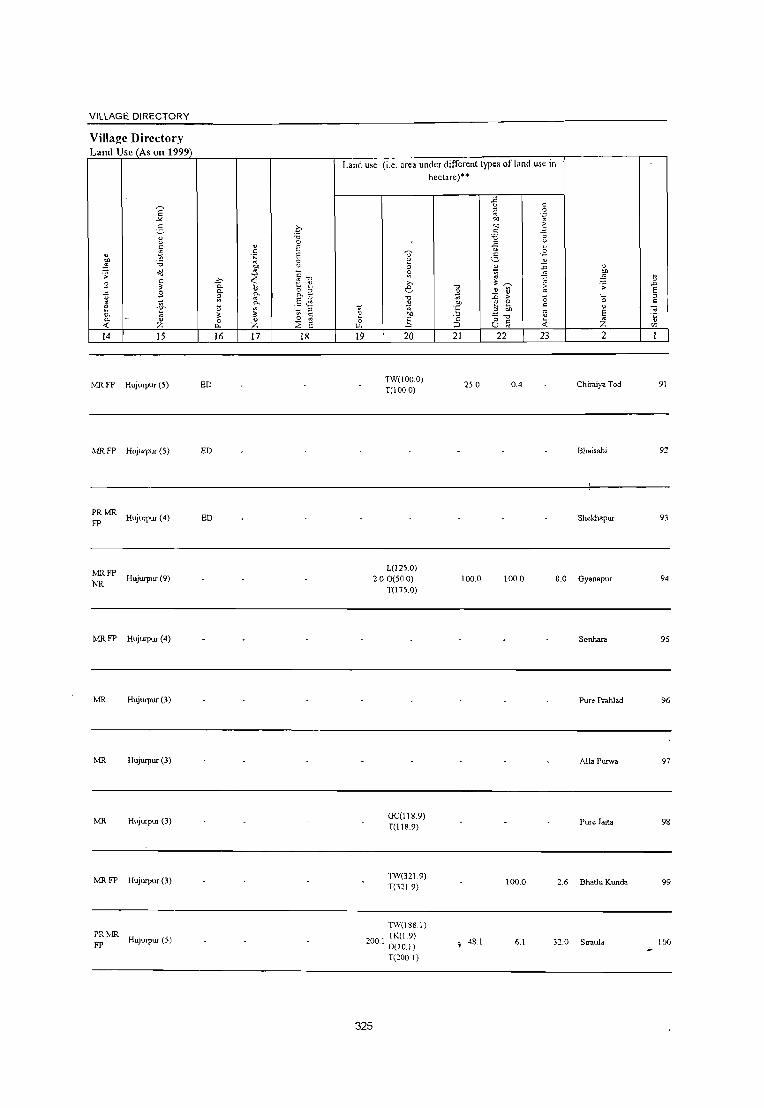
VILLAGE DIRECTORY
Village Directory Land Use (As on 1999)
14 15
MR I'P Hujurpur (5)
MR FP Hujurpur (5)
PRMR Hujurpur (4)
FP
MRFP
NR Hujurpur (9)
MRFP Hujurpur (4)
MR Hujurpur (3)
MR Hujurpur (3)
lvlR Hujurpur (3)
f"lRFP Hujurpur (3)
PRlvlR HUjurpur (5)
FP
16 17 18
ED
ED
ED
Land use (i.e. area under different types of land use in hectare)"
19 20
TW(1000) T(100.0)
L(l25 0) 2.00(50.0)
T(175.0)
GC(l189) T(118.9)
TW(32 I 9) T(3:1 9)
TW(188.1)
200 I TK(1.9) . 0(10.1)
T(200.1)
325
."
;;; "" "E
'" ::> 21
25.0
100.0
, 48.1
.fi c:
" .~ " "" "" ;>
" :J '0 ~ " u .£ ~ .£ t; ~ ~ ";:;;
~ 1> tl :0 ;> 0 E £ c .3 "" " :; -0 " u ;; ~ 22 23
0.4
100.0 8.0
100.0 2.6
6.1 320
" :W ;; .;; -'"
E '0 " c
" E " Z "5
'" 2
Chiraiya Tod 91
Bhaisahi
Shekhapur 93
Gyanapur 94
Sonhara 95
Pur< Prahlad 96
Alla l\uwa 97
Pure Jaita 98
Bhathi Kunda 99
Siraul. 100 ..

DISTRICT CENSUS HANDBOOK: BAHRAICH
CcmlUs of India 2001 _
Amenities and Amenities available (if not available within the village, a dash (-J is shown in the column and
next to it in brackets the distance in broad ranges viz.< 5 kms., 5-10 kms. and 10+ kms of the ~ nearest place where the facilitv is available is gjven
" ~ " ~ " ~ "0 ~ .D' "0 ~ ~
8 ~ u '" ~ ~
.D :~ ~ .c: 0 ., " '" " " " " .~ ~ :::: !l u
.~ 2-.,
0 .~ ~ U 0 2 u ~
~ .c: .!: &. u " ~
0. ij
~ ~ ~ 0 ~
0 "0 " 0. ~~
'" " ...l 0 "0 ] 0 ~:g~ ::l ~
~ 8 ~ 1.11 "" .!l .., .:; .c: "0 ~ ·1; '-" ~
" " " ~ " " " ::1 .c ....
~ " If -5 .~ ::l " "0 0· .. • u '" ~ c ~ 0 ~ ~ " c ~: .., " S .2 ci
'" ." ._
'0 .c: E _; loll (;>"g "5 .9 .D .:; :; '0 '" ~ '" E :-;: ~ E '" 0. C "" § -.. ~
~ u
::l "" 'c ::l '0 0 tl .~ eo " tl - " " 0. '" " ] :; t; 'fi ~ .~ ::l ::-
~. " .D u :;; E E
E '5 '5 E ::l ;;; " E ,~ i; ~ c '0 E ~ " Z 0 0 ::l '0 " 8 :0 0 <~l ~ Q i5 8 "E "" r r z tll ~ 0. U
2 4 5 6 7 8 9 10 11 12 13
Padum Pichhaura PM(5.IO) H« T HI' W SS- PO(~ 5) ACS« 5) CV(lO+) BS(5-IO)
101 176.4 679 102 5) MCW«5) CM(5-10) (06523200) C(lO+)
PHC(5-IO) W PH«5) CP(5-10) NCS(lO+) SP(IO+) RS(IO+) OCS(IO+) ST(lO+) NW(lO+)
102 Bhidyari
419.3 948 173 PM(5-10) MCWH(1O+) T HI' W SS- PH PO« S CM CP(5· ACS« 5,) CV(1O+) BS(5·10)
(06523300) C(IO+) PHC« 5) W >10) NCS(IO+) SP(IO+) RS(1O+) OCS(IO+) ST(IO+) NW(1o+)
I 103
Newasi 482.5 2,658 498
P(2) M HMCW T HI' W SS- PO PHiS. CM(5-IO)
ACS(5-IO) CV(IO+) BS(5-10) (06523400) C(IO+) PHC(S-IO) W 10)
CP(5-IO) NCS(IO+) SP(IO+) RS(5-10) OCS(IO+) ST(IO+) NW(IO+)
Nakhara Abbupur 239 P M(S-IO) CHWH(IO+)
T HI' W SS- PO(;O+) ACS« S) CV(1O+) BS(5-IO) 104 333.5 1,466 MCW«5) CM(5-10)
(06523500) C(IO+) PHC« 5) W PH(IO+) CP(5-10)
NCS(IO+) SP(1O+) RS(1O+) OCS(101-) ST(1O+) NW(IO+)
Jadaupur PM«5) H«
T HI' W SS- PO(;-IO) ACS(5-10) CV(1O+) BS(IO+) lOS Bhatahiya 1,687 261 5) MCW«S) CM(5-IO)
C(lo+) W PH(5-10)
NCS(10f-) SP(lO+) RS(1o+) (06523600) PHC(5-10) CP(5-10)
OCS(10+) ST(1O+) NW(IO+)
Chaubhaiya PM«5) H«
T HI' W SS- PO(;-IO) ACS(5-10) CV(IO+) BS(1O+) 106 168 27 5) MCW«5) CM(5-10)
(06523700) C(IO+) PHC(5-10) W PH(5-10) CP(5-10)
NCS(IOI-) SP(IO+) RSCIO+) OCS(101-) ST(1O+) NW(\Of-)
Lalpur Aima PC< - H(5-
ACSC<!i) CV(1O+) BSNW 107
(06523800) 167.9 1,240 200 5)M«5) 10) MCW(5- T HI' W SS- POe < 5) CM«5)
NCS(10+) SP(1O+) RS(1O+) C(1Of-) 10)PHC(5-10) W PH«5) CP(IO+)
OCS(10+) ST(1O+)
- H(5-ACS(d) CV(lo+)
BS
108 Bishunpur T .di
226.4 1,568 227 P M«5) 10) MCW(S- T HI' W ss- PO« 5) CM«5) RS(1Of-)
(06523900) C(1Of-) 10)PHC(5.IOJ W PH«5) CP(lO+)
NCS(IO+) SP(1Of-) NW(1O+)
OCS(10+) ST(1O+)
109 Adilpur
447.5 2,316 365 PM(5-10)C« H(IO+) T HI' W SS- PO(~ 5) CM«5)
ACS« 5) CV(lO+) BS« 5)
(06524000) 5) MCW(5-IO) W PH(S-IO) CP(5-10) NCS(lO+) SP(lO+) RS(1O+)
PHC(5-10) OCS(10+) ST(1O+) NW(1Of-)
HADA RMP(3) THI'WTK poro CM
ACS CV(1Of-) BSl';"\V
110 Kannullapur
3749 4,518 716 P(3) M S
H(IO+) R SS-W PTO PH« NCS(lO+) (06524100) C(lO+)
MCW(5-IO) 5) CP(lO+)
OCS(IO+) SP(lOf-) RS(1Of-)
PHC(S-IO) STtlO+)
326

VILLAGE DIRECTORY
Village Directory Land Usc (As on 1999)
E -"
~ 1! " v .~
~ ;; 00 9 " :<
~ S 0 ~ & 0- " <f. Z 14 15
PRMR Hujurpur (5)
FP
~~::- HUJurpur (6)
MRFP NR
Kaisarganj (10)
MR FP 'Payagpur (19)
tvrn. FP Hujurpur (7)
MR FP Hujurpur (7)
MR Bhagarwabazar (3)
PRMR Bhagarwabazar (2)
FP
tvrn. FP Bahraich (33)
NRNC
ED
~ rn. FP Bag3JWdbazar (0) ED
16 17 18
Land use (i.e. area under dilTerenllypes of land use in
heclare)"
19·
327
20
GC(l10.9) TW(100.2) 0(10.7) T(221.8)
TK(IA)
R07.7) T(l91)
TK(5.0) T(S.O)
08 GC(l13.3) . TOI3.3)
14 TK(I.2) . TO.2)
21 22
79.2
47.0
120.3
14.6
2.5
23
5.2
50
15.0
4.3
2.6
2.5
4.1
2
17.2 Padum Pichhaura
I 5.2 Bhidyari
470 N.::wasi
1 .6 N akhara Abbupur
14.6
Jadaupur Bhatahiya
Chaubhaiya
Lalpur Aima
Bishunpur T edi
Adilpur
16.5 Kannullapur
101
102
103
104
105
106
107
108
109
110

~ .D
E " c:
" ~
'" I
III
" '0
8 c:
~ u 0 _, ~
" "" ~ ;;: '0
" E " Z 2
Chhed Kuri (06524200)
Block Total
" ~ ~
..c: ~ c:
2- " U
" 0 0/)
~ 0
~ ;;
" c -5 .~ ._ 0 :; " C-~ 0
" Co
5 .5 0 0 f- f-
3 4
463.0 1,933
18353.1 150622
~
~
" " U -0 0
~ ~
'0 -0 ..c: " '" " 0
..c: ._ o ~
..0 E " Z
5
DISTRICT CENSUS HANDBOOK: BAHRAICH
Census ofIndia 2001 -Amenities and
Amenities available (if not available within the village, a dash (-) is shown in the column and
next to it in bracket. the distance in broad ranges viz.< 5 kms., 5-l0 kms. and 1 0+ kms of the
nearest place where the facility is available is ~iven
S '0 ..0'
.D ~ ~ " " " E
u " c: .~ ~ u
0 E! .;:; .~
..c: .!. 0 '" Co "
:; Co ~ ~ " Co 2: E '" ~ 3 0 E " e ~ .g " -;; e:_ 2
'0 :; ..c: ·2 ~ ~ c '0 ~ u Il '" II ;; 0 ;:;
~ ,g c:
" ..c: c: s: :-g .~ ~ '0
.~ -;; ~ ~ t: -;; > " c: "" 'i3 c:
~ " .g "" " ~ a ~ .~ ~ '" .!:O 11 :; E " '" ~ u E " E >J. .g t1 " " ~ " 'i3 .!:O ;;; E ~ c: 'i3 E
'0 " 0 0 0 ~J~ ." .- :; 0 ~ ~ c. U ~ 8~ u 6 7 8 9 10 11 12 13
293 P(2) M« 5) C(1O+)
MCWH(5-10) THPWR PO(5-IO) PHC(5·10) SS·W PH(5.IO)
CM(5-IO) ACS« 5) CP(5-IO) NCS(IO+)
OCS(IO+)
CV(lO+) SP(lO+) S1(1o+)
8S(5-IO) RS(IO+) NW(lO+)
H(2) HA(2) 0(3) DA(3) MCW(I6) T(n) MH(S) W(99)
P(109) M(13) CWC(6) TK(16)
24885 SCSi PUC(2) HC(2) HP(101) C AC(9) PHC(2) PHS TW(7) 0(5) FWC(3) NIl R(12) C
RMP(9) L(7) SMP(2) CHW(23) 0
328
PO(20) TO(2) PTO(2) PH(60)
CM(7) CP(2)
AC5("1) OCS(:!)
B5(10) NW(4)

VILLAGE DIRECTORY
Village Directory Land Usc (As on 1999)
" l ;; 9 -E e 0. 0.
-< 14
I\.1R FP NR
PR(43) MR(89) FP(75) NC(7) NR(13)
NW(4)
E -'"' 2-1;
~ -0
<d c:
" 9 ~
~ " Z 15
Bahraich (32)
>,
0. 0. ;;: \3
" 0 i1.
16
ED(44) EAG(14) EO(7) EA(7)
" c: 'N
'" "" '" ~ ~ 0.
~ " Z 17
N(ll)
M(3)
c 'i'i 0 E E 8 ;:
-0 ~ 1:! 0 B 0.
.5 .:; " ~ c:
0
E 2 18
Land u,e (i.e. area under different types of land use in
hectare)"
" v :; ~ >,
e -0
~ ~ 1:! '" g 0
LI.
19 20
GC(1427.219 ) PC(7.937) W(53 1.58) WE(144.648) TW(3070.l4 5)
323.0 TWE(1185.6 79) TK(628.034) R(86.541) L(125.46) 0(417.799) T(7JJJ.142)
329
'il ;;; Of
'" ::J 21
42616.0
-5 ~ ._g '" ~
'" ~ c: 'i'i -€ 5 . .=.
'J
" ~ ~
~ ~ tl "
~ > 0 ;;, c:
;; -; -0 E c: (J '" -:-:
22 23
918.3 1492.3
" ~ \3 ;; .D
E "0 " c:
" ~ E Z \3
(/)
2
Chhed Kuri 111


Map of Kaisarganj CD Block
(See Page - 302)
330


Alphabetical list of Villages (C.D. block wise)
Name of the District· Bahraich Serial Name of village 200 I Census location 1991 Census location code
number code number number 1 2 3 4
Name of CD Block: KalsarganJ Name of Sub-Dist: 0004
1 Abdullah Bahera 06529300 460030016000460470 2 Achehara 06534800 460030016000510525 3 Agapur 06533700 460030016000510514 4 Ainy 06528200 460030016000450459 5 Ainy Hatinsi 06531900 460030016000490496 6 Akbarpur Khurd 06534000 460030016000510517 7 Alhiyapur 06527700 460030016000450454 8 Badrauli 06528900 460030016000460466 9 Baghaiya 06532800 460030016000500505 10 Baira Qazi 06531000 460030016000480487 11 Bairi Maheshpur 06531100 460030016000480488 12 Bairisatpur 06525900 460030016000430436 13 Bajayafat 06534300 460030016000510520 14 8ambhiwa 06524700 460030016000420424 15 Bansgawn 06527300 460030016000440450 16 Barkhur Oyarapur 06530000 460030016000470477 17 Bhakata 06525100 460030016000420428 18 Bhakhrauli Ij\anpurwa 06527500 460030016000450452 19 Bhakhrauli Mugespur 06527400 460030016000450451 20 Bhithiya 06526400 460030016000440441 21 8ibiya Para 06525700 460030016000430434 22 Budan Pur 06535100 460030016000510528 23 Chak Pihani 06529900 460030016000470476 24 Chak Saugahana 06524600 460030016000420423 25 Chand ida spur 06530700 460030016000480484 26 Chilawa 06532500 460030016000490502 27 Chulamma 06529100 460030016000460468 28 Oadhaila 06533900 460030016000510516 29 Oanawal 06532900 460030016000510506 30 Devlakha 06529200 460030016000460469 31 Dhurkhi 06527000 460030016000440447 32 Dihawa Sher Bahadur Singh 06531800 460030016000490495 33 Fate Purwa 06534200 460030016000510519 34 Firozpur 06532600 460030016000490503 35 Gazipur 06529600 460030016000470473 36 Ghurehara 06528600 460030016000460463 37 Godahiya No. Ho 4 06532700 460030016000500504 38 Gulariha Gazipur 06526500 460030016000440442 39 Guthiya 06530300 460030016000470480 40 Haidarpur Nauvbasta 06535000 460030016000510527 41 Hasana Mulai 06533800 460030016000510515 42 Hatinsha Shamspur 06531500 460030016000480492 43 Ichachhapur 06525500 460030016000430432 44 Ituhua 06526200 4600?0016000430439 45 Jalalpur Basahiya Dargahi 06530800 460030016000480485 46 Jamaluddinpur 06532200 460030016000490499 47 Jhalla 06530500 460030016000480482 48 Jhopadwa 06526100 460030016000430438 49 Kaharai 06531200 460030016000480489
331

Alphabetical list of Villages (CD. block wise) Name of the Distdct· Bahraich
Serial Name of village 2001 Census location 1991 Census location code number code number number
1 2 3 4 50 Kanchanapur 06525300 460030016000430430 51 Kandaila 06533300 460030016000510510 52 Kandauli 06528500 4600300,6000460462 53 Karela Sahabajpur 06527100 460030016000440448 54 Karim Behr 06530100 460030016000470478 55 Karsar Beraura 06530200 460030016000470479 56 Kasehari Buzurg 06529700 460030016000470474 57 .. Kasehari Khurd 06529800 460030016000470475 58 Khajuha 06526900 46003001i 6000440446 59 Khemanipur 06525800 460030016000430435 60 Khurmpur 06533500 460030016000510512 61 Kadari Chandan 06534900 460030016000510526 62 Kadari Newajis Ali 06535200 460030016000510529 63 Kahali 06528700 460030016000460464 64 Kanari 06532300 460030016000490500 65 Kudauni 06529000 460030016000460467 66 Kundasar 06525000 460030016000420427 67 Lakhnidaspur 06530600 460030016000480483 68 ~aIPUr,JalaIPUr 06524500 460030016000420422 69 ahali 06527200 460030016000440449 70 Marauthi 06533200 460030016000510509 71 Materpur 06533400 460030016000510511 72 Methaura 06528300 460030016000460460 73 Metwapur 06528100 460030016000450458 74 Mirpur 06532400 460030016000490501 75 Mohamadpur Saraiya 06524900 460030016000420426 76 Mokala 06526600 460030016000440443 77 Musepur 06528400 460030016000460461 78 Nakauda 06526000 460030016000430437 79 Nakaudi Shahpur 06526300 460030016000430440 80 Narendrapur 06527600 460030016000450453 81 Natthnpur 06534700 460030016000510524
82 Nawgaeya 06531700 460030016000490494
83 Nayamat Pur 06524300 460030016000420420
84 Panchma 06531400 460030016000480491
85 Paresendi 06524400 460030016000420421
86 PatliTaha 06534100 460030016000510518
87 Pawahi 06534500 460030016000510522
88 Pawana 06532000 460030016000490497
89 Pawani 06532100 460030016000490498 90 Pendari Khurd 06534400 460030016000510521
91 Raigarh Baheda 06526800 460030016000440445
92 Rewali 06533000 460030016000510507
93 Rukanapur Kalan 06531600 46003001: 6000490493
94 Rukanapur Khurd 06524800 4600300~6000420425
95 Sahwapur Pachlakhi 06528800 460030016000460465
96 Saidapur 06529400 460030016000470471
97 Salarpur 06525400 460030016000430431
98 Salhuwa 06534600 460030016000510523
99 Santha 06530400 4600300'16000480481
100 Saray Kanhar 06528000 460030016000450457
332

Alphabetical list of Villages (CD. block wise)
Name of the District· Bahl'aich Serial Name of village 2001 Census location 1991 Census location code
number code number number I 2 3 4
101 Shahpur Rasulpur 06530900 460030016000480486 102 Sidrakha 06525200 460030016000420429 103 Sidrakhi 06527800 460030016000450455 104 Sohras 06533100 460030016000510508 105 Sutauli 06526700 460030016000440444 106 Tande Chatur 06527900 460030016000450456 107 Tawakkalpur 06531300 460030016000480490 108 Umari 06525600 460030016000430433 109 Vijaipur 06529500 460030016000470472 110 Wisaidha 06533600 460030016000510513
333

DISTRICT CENSUS HANDBOOK: BAHRAICH
Ccnswi of India 2001 -Amenities and
Amenities available (if not available within the village, a dash (.) is shown in the column and
next to it in brackeL, the distance in broad ranges viz. < 5 kms., 5·lO km •. and 10+ kms of the ~ nearest place where the facilitv is .vail.ble is given
" ~ " ~ " " '0 ~.t:i '0 " e '" u ~
~ " ~
.D ",2
" ..c: 0 " "
-:; u v' C
" ~ e ~ t u 0 2- c.; 0 E~ .~
0 .fl ~ ..c: ._! 0
" 0- ~ .~
0- " "" 0
~ 0 ~ " "- ,,"" ~ ~ ....l 0 '0 ] 0 0i=E' ~ "0 8 ~.~ :J " "i ;; ..c: '0 ~ _2 .~ 6 "cO
1>: " ~ u " " " '0 " " <> 0 ~ '" g -5 .~ ::> "
0';:':; <d " 2 " C :u 0 " ..c: " ~ ~ :~ '0 ..c: ~ -~~ .'2 .D ;; :; ''0 " ~ " '" > ::> E " '"
:'C ::::
~ 0- " '" ~ '0 g - ~ ::> ''0 ~ 0 '2 '" " a " " c " 0- " '" " '] \) :; ~ .~ E § " " '5 '5
.D ~ U :;;; E E ~ " E E :0 ~ E .~ 1) ~ ~ ~ E ;l; ;:I " " z 0 0 ::> "0 " 8 0 0 ",-" ~Q~ o ._
'/) f- f- Z tLl :2 0- U « '0 u :: 2 3 4 5 6 7 8 9 10 11 12 13
CD Block: Kaisarganj (0556)
Nayamat Pur P« H(lO+) HPWTK ACS« 5) CV(IO+) BS«5) 74.7 670 112 5)M(5.10) PO« 5) 0.-1(10+) (06524300) C(10+)
MCW(lO+) SS·W PH« 5) CP(lO+)
NCS(IO+) SP(lO+) RS(IO+) PHC(IO+) OCS(1()+) ST(lO+) NW(1O+)
Paresendi 32.3
PM«5) H(10+) HPTWW ACS«5) CV(1O+) BS«5) 2,565 414 PO PH« 5) 0.-1« 5) (06524400) C(IO+) MCW(IO+) SS·W NCS(IO+) SP(IO+) RS(1O+)
PHC(IO+) CP(lO+)
OCS(1O+) ST(lO+) NW(IO+)
Lalpur,lalalpur P OM«5) · H(5·
PH(3) ACS(5·10) CV(1O+) BS« 5) 260.9 1,804 294 10) MCW(5. HP W TK CM«5)
(06524500) C(1o+) 10) PHC(5.10) SS·W PO« 5) NCS« 5) SP(1o+) RS(1o+) CP(5·10)
OCS(1O+) ST(1O+) NW(lO+)
Chak Saugahana H(IO+) HPWSS· PH(9) ACS
CV(1O+) BS«5) (06524600)
101.0 1,920 267 P M C(5·)O) MCW(5·10) W PO« 5)
CM«5) NCS(IO+) SP(IO+) RS(1O+)
PHC(5·10) CP(5·10) OCS(lO+)
ST(1o+) NW(1O+)
Bambhiwa 118.0 581 93
P M« 5) C(5· • H(5. THPTW PO« 5) 0.-1(5·10)
ACS« 5) CV(IO+) BS« 5) (06524700) 10) 10) MCW« 5) W TK SS.T NCS(1o+) SP(IO+) RS(lO+)
PHC« 5) PH«5) CP(5·10) OCS(lO+) ST(IO+) NW(lO+)
Rukanapur 160 P M« 5) C(5·
· H(5· ACS CV(IO+) BS« 5)
6 Khurd 90.2 1,234 10) MCW(5· rr::w PH PO« 5) CM« 5) NCS(1O+) SP(1o+) RS(1O+)
(06524800) 10) 10)PHC(5.10) SS· CP(5·10) OCS(lO+)
ST(1O+) NW(1o+)
Mohamadpur P« H(10+) HP W R SS· PO(~ 5) ACS« 5) CV(IO+) BS« 5) Saraiya 77.0 214 40 5)M«5)
MCW«5) CM«5)
NCS(IIr-) SP(IO+) RS(1O+) (06524900) C(lO+)
PHC(IO+) W PH(1o+) CP(1O+)
OCS(1O+) ST(1O+) NW(5·IO)
HADAPHC CM CP(S· CV(IO+) BS
Kundasar 258.9 2,934 415
P(2) M(l) H«5)
HP WSS· PO PH(16)
ACS« 5) RS(1O+) (06525000) C(IO+) W 10) NCS(l()->-) SP(lO+)
MCW«5) OCS(lO+) ST(1O+)
NW(IO+)
Bhakala PHCCHW
HP W ss· PH(4) ACS« 5) CV(lO+) BS« 5)
(06525100) 255.6 1,267 212 P MC(5·10) H(5.10)
W PO« 5) 01« 5)
NCS(IIr-) SP(IO+) RS(lo+) MCW«5) CP\5·10)
OCS(llr-l ST([o+) NW(1O+)
334

VILLAGE DIRECTORY
Village Directory L:md Usc (As on 1999)
14 15
MR Kundasar (4)
PR !vOl. Kunda,ar (3)
PR !vOl. Phakharpur (10)
FP
PRMR Kaiserganj (9)
MRFP lakhalkasba (27)
PRMR Kundasar (1 )
PRMR lakhalkasba (21)
PR ~Ol. Jakhal (16)
PRMR Kundasar (7)
16 17 18
ED
EDEAG
EDEAG EOEA
EDEAG N
EDEAG EOEA
NM
ED
EDEAG NM
EOEA
EDEAG N
Land usc (i.e. area under different types of land use in hectare)··
19 20 21 22 23
GC(67.3) TW(60.3)
1.9 4.9 TWE(7.0) T(134.6)
TW(165 0) TWE(122.0)
3.7 31.9 TK(0.6)
T(287.6) I
GC(100.0) TK(6.6) 126.2 2.7 21.9 T(106.6)
TW(27.7) TWE(9.2)
1.4 10.0 TK(OA) T(37.3)
GC(44.4) \VE(2.1)
1180 TW(2.1) . TWE(39.2)
115.8
TK(1.0) T(88.8)
TW(nA) TWE(4.6) 2.4 6.4 T(82.0)
" ~ .;;
'0
" E Z 2
Nayamat Pur
Paresendi
Lalpur,Jalalpur
ehak Saugahana
Bambhiwa
Rukanapur Khurd
TW(76.7) 7.3 1.0 6.3 Mohamadpur
T(76.7) Saralya
GC(214.9) 5.6 Kundasar T(214.9)
38.1
TW(IOO.O) TWE(16.9)
100.0 5.0 23.9 Bhakala 0(10.0) T(l26.9)
335
6
8
9

DISTRICT CENSUS HANDBOOK: BAHRAICH
Census ofIndia 2001 -Amenities and
Amenities available (if not available within the village, a dash (-) is shown in the column and
next to it in brackets the distance in broad ranges viz. < 5 kms., 5-10 kms. and 10+ kms of the ~ nearest place where the facility is available is 'h~en
~ ~ " " ~ '" "0 S ~ ~ .c; 8 v ~ U .D ~ " :;J " ~ ":1 ~ 1:{ "
.c " 0 " " ~
~ ~ E ~ " 0 c: .~ ~
E~ u 0 .;: c.'- .c .;: 0
" 0. ] 0. " '" ~ " ~ ~ 0 ~ 0 "0 " 0. t;'l:l ~ ~
...l 0 (3 ] 9 ~ ~:g~ :::1 'u ~ ;; c.'-
"& '" ;:; ~ e::r.= " "
c: " :u :::1 ....: ._ ~ " '" '" u 0 ~ ~
l -5 .g :;J o ._ c:
\l 0 11 .<: 2 " g ~ .~ ~ 0
~ '0 ~ .c ;;- .~ .D ;; :; '0 ~ ~ ...: ~
2 > ~ E '" '" :;;, ]~ '" "- c: i: :;J "0 ~ 0 \l .~ "" " .g ';; E ;;;
c: '" "- -;;; .5 ] E :;J
" E "5 "5 .D .~ .:.: :;J U " E :;J E 2 E u .g u ~ g :.a '5 :;J "0 .5 ;;;' E E ~
Z 0 " " "0 ~
Ci 0 0 "'-5 ~Q~ o ._ 'fJ r r z tIl 2 Cl. u -< 0 . u E:
2 3 4 5 6 7 8 9 10 II 12 13
Sidrakha P« CHWH(IO+) HPWSS· ACS« 5) CV(lO+) BS« 5) 10 159.7 760 104 5) M(5·10) MCW«5) PO« 5) CM«5) (06525200)
C(lO+) PHC(5·10) W
PH« 5) CP(5·IO) NCS(IO+) SP(lO+) RS(IO+) OCS(lO+I ST(lO+) NW(IO+)
II Kanchanapur
99.8 578 119 PM«5) H(IO+) T HP W SS- PO(;.10) CM(5·10) oes AC~;(5· eV(~.1 0) BS(5·10)
(06525JOO) C(lO+) MCW(5·10) W PH«5) CP(IO+)
10) SP(lO+) RS(1!}» PHC(IO+) NCS(lO+I ST(IO+) NW(IO+)
12 Salarpur
111.2 1,296 195 PM«5) H(IO+) THPWSS- PO(;.IO) CM(5·IO)
ACS« 5) CV(S·IO) BS« 5) (06525400) C(lO+) MCW«5)
W PH«5) CP(lO+) NCS« 5) SP(S·IO) RS(IO+)
PHC(lo+) OCS(lO+) ST(lO+) NW(lO+)
Ichachhapur P« H(1O+) THPTW PH PO(S· ACS« 5) CV(S·IO) BS(5-IO)
13 217.8 1,039 177 5)M«5) CM(5·10) (06525500)
C(1o+) MCW«5) WSS-W 10)
CP(1O+) NCS(IO+) SP(1O+) RS(IO+)
PHC(IO+) OeS(IO+) 5T(10+) NW(1O+)
Umari P« H(IO+) HPTWW ACS«5) CV(lo+) BS(5.10)
14 (06525600)
156.0 1,288 233 5) M«5) MCW«5) TKSS-W
PO«5) CM(5·10) NCS(1o+) SP(1O+) RS(1O+)
C(IO+) PHC(IO+)
PH(1O+) CP(lO+) OCS(lO+) ST(1O+) NW(lO+)
15 Bibiya Para
161.3 903 200 P M« 5) H(lO+) HPTWW PH PO« 5) CM(IO+)
ACS« 51 eV(1O+) BS(5·10) (06525700) C(lO+) MCW«5) SS·W NCS(l lH) SP(lo+) RS(IO+)
PHC«5) CP(5·IO)
OCS(llH") ST(IO+) NW(lO+)
Khemanipur PM«5) CHWH(IO+)
HPW SS- PH(2) ACS« 5) CV(lO+) BS« 5) 16 146.0 617 93 MCW«5) CM(IO+)
(06525800) C(lO+) PHC« 5)
W PO« 5) CP«5)
NCS(IO+) SP(lO+) RS(IO+) OCS(IO;.) ST(IO+) NW(lO+)
17 Bairisalpur
168.0 844 150 PM«5) H(lO+) THPWR PO(5-IO) CIv!« 5)
ACS« 5) CV(5-IO) BS« S) (06525900) C(IO+) MCW«5) SS·W NCS(IO+) Sp(IO+) RS(lO+)
PHC(IO+) PH«5) CP(lO+)
OCS(IO+) ST(1O+) NW(lO+)
PM«5) MCWCWe
T HP W SS· PH(2) ACS
CV(lO+) BS(IO+) IS
Nakauda 291.0 1,532 258 H«5) CM(lO+) NCS(lO+)
(06526000) C(1O+) T PO« 5) SP(1O+) RS(1O+) PHC(IO+) CP(IO+) OCS(10+)
ST(lO+) NW(lO+)
Jhopadwa P«
H(IO+) T HP W 5S· PO(~ 5) ACS« 5) C\'(IO+) BS«5) 19 65.9 68 18 5)M«5)
MCW«5) CM«5)
NCS(lO+) SP\IO+) RS(IIJ..) (065261 ~)O) C(lO+) W PH« 5) CP\IO+)
PHC(lO+) OC$(IO+) ST\lO+) N\\'\l0+) 1
336

VILLAGE DIRECTORY
Village Directory L:lnd Usc (As on 1999)
14 15
PRMR FP Kaiserganj (10)
16 17
EDEAG N M EOEA
MR Jakhal Kasba (28) ED
MR Jruwal (Np) (28) ED
MR FP Jarwal (Np) (27)
MR FP Jarwal (Np) (26)
PR Kai301ganj (14)
PR Kaiserganj (13)
MRFP Jarwal (Np) (25)
PRMR FPNR
huwal (Np) (18)
MRFP Jar"al (Np) (26)
ED
ED
EDEAG EOEA
EDEAG EOEA
EDEAG NM
Land use (i.e. area under differenllypes of land use in hectare)""
18 19
337
20
TWE(9.3) 0(50.0) T(59.3)
TK(O.5)
0(20.0) T(20.5)
TK(3.7) 0(100) T(l3.7)
TW(lS.O) 0(100.0) T(l15.0)
GC(\38.0) T(l38.0)
TW(\37.7) TWE(4.6) T(142.3)
TW(123.6) T(123.6)
0(104.9) T(104.9)
GC(263.7) TW(25.0) T(288.7)
GC(6Ll) 0.5 R(2.0)
T(63.1)
21
90.0
26.6
93.1
84.0
23.2
8.7
4.0
50.0
J.3
22 23 2
3.0 7.4 Sidrakha
0.7 Kanchanapur
I 4.3 Salarpur
5.7 12.2 Ichachhapur
Urnari
2.5 18.5 Bibiya Para
3.7 18.2 Khemanipur
2.8 10.3 Bairisalpur
18.5 Nakauda
2.5 6Ll Jhopadwa
...
il .D
E " :::
10
IT
12
13
14
15
16
17
18
19

DISTRICT CENSUS HANDBOOK: BAHRAICH
Census of India 2001 -Amenities and
Amenities available (if not available within the village, a dash (-) is s!lOwn in the colunUl and
next to it in brackets the distance in broad ranges viz.< 5 luns., 5-10 kms. and 10+ luns of tile ~
nearest place where the facilitv is available is .iv',n ~
~ 1>:
v c: ] "" ~ .0' "0 ~
V C ::; U .0 .. v.2 " " "
.= u 1;' c: .<: ::: " -.; 0 c > ~ t .~ 2- " 0 0 .~ !l .~ ~ U ~ .<: . .!': 0
" "- t ~ "- " >, " ~ ~ " 0 ~ 0 "0 " 0. -.;'" ~ ~ ...l 0
-0 "3 9 :;=E' ~ .;; C!. .<: "0 ::; ~.~ ~ ~.2 ~~
~ c <l "
v " C
'" "0 C V " 0 ~ :t -5 .~ "
o ._ ~ ~ .~ \3 0 \3 .<: ; .:~ ~ 0 C
'0 .c '" ~ ...... _ "0 ';::Z 0
.D ;; -; '" '" > " '" ._
E '" '0 '" " ;n E .~ .~ 5 0. C u " "0
g-~ " ''0 ~ 0 il .~ on " ~ c on c: 0. .. c "3 v .::! ~ ._ '" E
" '" E .D u ~ E " u ~ E ~ E '" .:S ~ "Ei E <..> 'i3 .~ U ~ ~:.o " c 0:' E El: \3 Z 0 " "0 U 8 0 0 ""-5 ~ Q~
o ._ '/l r r z w :2 P.. U « 0 u 1:
2 3 4 5 6 7 8 9 10 11 12 13
20 Iluhua
148.4 527 P M«5) H(IO+) T HP W SS- PH(2) ACS« 5) CV(IO+) BS« 5)
81 CM{<5) (06526200) C(IO+) MCW«5) W PO« 5) NCS(IO+) SP(IO+) RS(IO+) PHC(IO+)
CP(lO+) OCS(IO+) ST(IO+) NW(IO+)
Nakaudi Shahpur P« H(IO+) ACS{< 5) CV(IO+) 8S(5-10) 21 133.3 464 84 5)M«5) T HP SS-T PH PO«5) CM{5-IO) (06526300)
C(lO+) MCW«5)
CP(IO+) NCS(lO+) SP(IO+) RS(lO+)
PHC(IO+) OCS(lO+) ST(IO+) NW(lO+)
Bhithiya P« H(lO+) T\fl'WTK PO PH ACS(5-IO) CV(IO+) BS(5-IO) 22 96.9 575 98 5)M(5-IO) CM(5-10)
(06526400) MCW(IO+) SS-W NCS(lO+) SP(lO+) RS(lO+) C(IO+)
PHC(lO+) CP(IO+)
OCS(lO+) ST(lO+) NW(lO+)
23 Gulariha Gozipur
484.8 2,954 509 PM«5) H(1O+) THPWR
PO« 5) CM(5-IO) ACS« 5) CV(IO+) BS(5-IO)
(06526500) C(IO+) MCW«5) SS·T PH(5-10) CP(lO+)
NCS(5.IO) SP(IO+) RS(lO+) PHC(lO+) OCS(lO+) ST(IO+) NW(lO+)
Mokala PM«5) H(1O+) THPWSS- PO(~5) ACS« 5) CV(IO+) NW
24 3.0 708 122 CM(IO+) BS(lO+) (06526600) C(lO+) MCW(lO+) W PH(1O+) CP(lO+)
NCS(lO+) SP(IO+) RS(lO+)
PHC(IO+) OCS(IO+) ST(lO+)
25 SUUluli
135.0 840 125 P M C(lO+) H(IO+) THPWSS- POPH«5) CM(~-IO) ACS« 5) CV(IO+) BS(5-10)
(06526700) MCW(IO+) W CP(IO+) NCS(lO+) SP(lO+) RS(lO+)
PHC(IO+) OCS(IO+) ST(lO+) NW(IO+)
RMPCHW ACS
26 Raigarh Bahed.
952.0 1,512 262 P M C(10+) H«5)
HPSS-HP PO(1O+) CM(lO+) NCS(lO+) CV(IO+) BS(1O+)
(06526800) MCW(IO+) PH(IO+) CP(1O+) OCS(lO+)
SP(lO+) RS(1O+) PHC(IO+) ST(IO+) NW(1O+)
Khajuha P« H(lO+) T HP W SS- PH PO« 5) CM(~-I 0) ACS« 5) CV(lO+) BS(5-10)
27 81.4 628 89 5) M« 5) (06526900) MCW«5) W CP(1O+) NCS(1O+) SP(lO+) RS(IO+)
C(10+) PHC(lO+) OCS(1O+) ST(lO+) NW(lO+)
P« RMPH(lO+) ACS(1O+) CV(lO+)
NW Dhurkhi
446 80 5)M«5) MCW(IO+) HPW ss-
PH PO« 5) CM(IO+) BS(IO+) 28 107 4 W NCS(lO+) SP(lO+) (06527000)
C(1O+) PHC(IO+) CP(IO+) RS(lO+) OCS(lO+) ST(lO+)
Karda PM«5)
CHWH(5-IO) HPWSS- ACS« 5) CV(lO+) BS(5-10)
29 Sahabajpur 265.7 1,351 238 C(lO+)
MCW(5-10) W
PO« 5) CM(5-10) NCS(lO+) SP(lO+) RS(lO+)
(06527100) PHC(5-10) PH(5-10) CP(1O+) OCS(10· .... ST(IO+) NW(1O+)
338

VILLAGE DIRECTORY
Villaj!c Dircctory Land Usc (As on 1999)
E -'"
2-~ c:
v .~ ~ .:; ,;;
S c 3:
.c: S u
'" 1! 0 :;. .. ,0.. :i < Z 14 IS
MR Jarwal (Np) (32)
MR Jarwal (Np) (26)
MR FP Jarwal (Np) (24)
MRFP Kaiserganj (15)
MRFP Kaiserganj (12)
PRMR Jarwal (Np) (2S)
FP
MR Puraini (5)
MRNR Jarwal (Np) (30)
MRFP Kundakhar (8)
PR MR Puraini (4)
Co ;;:;
0
" c E '~ E
"" 8
'" ~ c"" e ~ 0. 0. V
o " 0. o.~
~ " .5 .~ 0.
il ~ " 3: ~ c: "
0 " 0': z ~ E 16 17 18
ED
EAG
Land use (i.e. area under different types of land use in hectare)··
c: .~ ·E :; u
.~
" ~ .~
~
1! ;; :;; ;., e "" " " c .,
~.
..:
'" "0
~ '" ';3 'E ] '2 (;
L.t. ::> 19 20 21 22 23
GC(88.6)
" 1 :; '_ 0
" E z 2
I.S TWE(53.7) 1.5 142. i Ituhua T(142.4)
GC(129.1)
10 TW(O.5) . TWE(2.8)
T(l32.S)
96.9
339
GC(20.0) 0(330.0) T(3S0.0)
GC(S.9) R(4.5) T(lO.4)
GC(6S,O) T(6S.0)
TK(2.0) 0(19.9) T(21.9)
GC(71.8)
I S PC(I.9) . W(I.7)
T(75.S)
0(15) T(1.S)
GC(2.5) T(2.s)
Nakaudi Shahpur
122.7 Bhithiya
SO.2 7.2 Gulariha Gazipur
1.5 MokaIa
115.0 SutauIi
4.2 3.2 Raigarh Baheda
71 g Khajuha
1.0 1.0 Dhurkhi
Karela SahabalPur
~ ~ c: ~ ::: ~
't '"
20
21
22
23
24
25
26
27
28

30
31
32
33
34
35
36
38
;; .D
E ::> c
2
Mahoil
(06527200)
8ansgav.'J1 (06527300)
Bhamauli Mugespur
(06527400)
Bhakhrauh Kanpurwa (06527500)
Narendrapur (06527600)
Alhiyapur (06527700)
S,drakhi (06527800)
T and. Chatur (06527900)
Saray Kanhar (06528000)
;""{etwapur
(06528100)
3
247.0
330.6
201.1
252.2
38.0
720
160.0
250.3
308.5
51.4
c .£ ;;; "3 a. o a.
S o I-
4
1,143
2,193
1,491
1,821
49
445
866
634
1,338
341
DISTRICT CENSUS HANDBOOK: BAHRAICH
Census of India 2001 -Amenities and
Amenities available (if not available within the viliage, a dash (-) is !lhown in the column and
next to it in brackel, the distance in broad ranges viz.< 5 kms., 5-10 kms. and 10+ kms of the
nearest place where the facilityis available is given
o o ~ ~
'" -0 1l ::> o .c '0 ~ .0
E j_
6 7 8
u C o
_c 0-
-§
9 10 11 12 13
186 ~0~«5)C(5- ~3~~~- HPSS-1iP PO(5-10) CM(5-IO) ACS(S-IO) CV(S-IO) BS(5-IO) CP(S-IO) NCS(lO+) SP(S-IO) RS(IO+)
10) PHC(S-IO) PH(5-10) OCS(5-IO) ST(5-IO) NW(lO+)
P« MCWCWC 271 S)M«S)C(S-CHW(3)H(S- HPSS-HP PO(5-IO)
10) 10) PHC(5-10) PH(S-IO)
I
ACS(5-10) CV(IO+) CM(5-IO) NCS(5-10) SP(lO+) CP(5-IO) OCS(S-IO) ST(lO+)
235 P M« 5) C(5-10)
- H(S-
10) MCW« 5) ~~r:~_T PH PO« 5) CM(S-IO) PHC( < 5) S CP(S-IO)
ACS« 51 NCS(lO+ )
OCS(lO+)
CV(IO+)
SP(IO+) ST(lO+)
MCWCWC
332 P(2) M S C(S- RMP CHW 10) H(S-IO)
PHC(S-IO)
T liP W SS- PO(~ 5)
T PH(5-10)
6 P M« 5) C(lO+)
72 PM« 5) C(lO+)
154 P MC(IO+)
H(lO+)
MCW(IO+) PHC(5-10)
HPWSSW
- H(5- HPWTK 10) MCW«5) SS-W PHC« 5)
- H(5-10) MCW«5) ~WTK PHC(5-10) SS-W
PO«5)
PH«5)
PO«5)
PH«5)
PH(4) PO(5-IO)
- P« - H(5-97 5) M« 5) C(S- 10) MCW(S- T liP W TK PH(3)
10) 10) PHC(5-10) SS-T PO« S)
PM(5_10)C(5. CHWH(5-10) TIiPWTK PH(2) 226 10) MCW(S-IO) SS-W PO(5-10)
PHC(5-1O)
P«
ACS CM(5-IO) NCS(10+)
CP(5-10) OCS(10+)
CM(lO+)
CP(5-10)
ACS« 5) NCS(IO+') OCS(lO+)
CM(5-IO) ACS« 5) NCS(lO+)
CP(5-10) OCS(lO+)
CV(lO+)
SP(1O+)
ST(IO+)
CV(IO+) SP(IO+) ST(IO+)
CV(lO+)
SP(IO+)
ST(IO+)
CM(lO+)
CP(5-10)
ACS« 5) CV(IO+) NCS(5-IO) SP(lO+)
OCS(lO+) ST(lO+)
CM(5-IO) ACS« 5) CP(5-IO) NCS(IO+)
OCS(l()+)
CM(5-IO) ACS« 5) CP(5-IO) NCS(IG-')
OCS(I()->-)
CV(lO+) SP(lO+) ST(IO+)
CV(lO+) SP(IO+) ST(J 0+)
625)M«5) H(lO+) MCW«5)
HPWTK
SS-W PO(S-IO) CM(lO+)
ACS« 5) NCS(IO-') OCS(lG-')
CVlIO+) SP(1O+)
ST(IO+) C(lO+) PHC(5-10l PH« 5) CP(5-10)
340
BS(5-10)
RS(lO+) NW(lO+) ,
BS« S) RS(1O+)
NW(1O+)
BS(5-10) RS(lO+)
NW(!O+)
BS«5) RS(IO+)
NW(IO+)
BS« 5) RS(lO+)
NW(IO+)
BS(5-10)
RS(lO+) NW(1O+)
BS(5-10) RS(IO+) NW(lO+)
BS(5-10) RS(IO+) NW(lO+)
B3(5-101 RS(IO+I N"W(IO+)

VILLAGE DIRECTORY
Villaj!c Dircctory Land Usc (As on 1999)
14 15
MR JaJWal (Np) (16)
MR JaJWal (Np) (16)
MR FP JaJWal (Np) (25)
MR FP JaJWal (Np) (IS)
MR FP Kaiserganj (7)
MR FP Kaiserganj (6)
PRMR FP Kaiserganj (7)
MR FP Jarwal (Np) (17)
tvIR FP Clarwal Kasba (I 7)
PR tvIR FP
Kaiserganj (6)
16
ED
EDEAQ
ED
ED
EDEAG EOEA
17
i':> '0 o E E 8
18
Land use (i.e. area under different types of land use in hectare»>
19 20
'!WE(l27.7) TK(2.7) 1(130.4)
GC(l98.9) TW(88.8) '!WE(IIO.I) TK(1.8) 1(399.6)
WE(23) TW(20.4) '!WE(50.0) TK(IO.3) T(83.0)
W(lO.I) WE(50.1)
252.2 TW(7.1)
T(67.3)
W(84.0) WE(84.0) TK(6.0) T(174.0)
W(160.0) T(160.0)
TW(140.0) '!WE(IO.O) 1(150.0)
GC(90.4) 1(90 4)
GC(2686) 1(~68.6)
WE(45.0) R(S.O)
T(50.0)
341
21
134.8
79.5
152.0
200.1
6.0
10.0
10.0
8.0
10.0
OA
22 23
12.3
2.7
10.0
2.0
2.6
1
2
2.1 Maholi
20.8 Bansgawn
Bhakhrauli Mugespur
Bhakhrauli KanpUIWa
N arendrapur
Alhiyapur
Sidrakhi
T and. Chatur
S3I1!y Kanhar
Metwapur
t .c E '" r:
30
31
32
33
34
35
36
37
38
39

DISTRICT CENSUS HANDBOOK: BAHRAICH
Census ofIndia 2001 _
Amenities and Amenities available (if not available within the village, a dash (-) is shown in the column and
next to it in brackets the distance in broad ranges viz. < 5 kms., 5-10 kms. and 10+ kms of the
'" nearest place where the facilitv is available is given " ~
~
~ " ~ '0
u~ '0 '"
~
" 8 " 5l C) .D " C .c: " " -;;; "::;: u 1f c 0 > ;,: .'!l 0 3 U 0 " 3 E~ .~
0 .~ " ~ C!- .c .;-: 0
" i; :; 0- " >,
'" 0-
~ ~ 0 ~ 0 " 0. .~ ~~E -l 0 -0 }; 0
C!- o f; 00 1) ~ " <d ;; .c "0 '" "5 ~ .Z po -1; ~ "
';;1 ~ " " " C -0 " " 0 ~ '" :< ~ -5 .~ ~ ~
~ o ._
01 " S c
" \; 0 .!l .c c g 0 '0 .c:
~ --' ., _~:.o .~ 0 .D ;;: :; '0 -;;; ~ -;;; '" > " -~ .~ E " 0. C "" 'E
t: .~ § .... :% " '0 ~ 0 ~ .~ "" " ~ 1! c 0- ~ C ] " ._ '" E " :s " 5 5
.D :.;; E " " ... E " E ~ E E
" -ij c -;J; E 'c t ~ g ;0 E ~ !l Z 0 0 " -0 " 8 0 0 00-:; ~ Q~ o ._
'" f-- f-- Z t.<l ~ "- C) ~ 0 u ::: 2 3 4 6 7 8 9 10 II 12 13
Ainy P« HPTWW PH POtS· ACS(S-IO) CV(lO+) BS(5-10) 40 65.0 420 69 5) M« 5) C(5- H(IO+) CM(1O+) (06528200) 10) MCW« 5) SS-W 10)
CP(5-10) NCS(S-IO) SP(lO+) RS(lO+)
PHC(5-tO) OCS(IO+) ST(lO+) NW(IO+)
41 Methaura
149.9 834 135 P O(2)M«5) H(lO+) HPTWW
PH PO« 5) CM(IO+) ACS« 5) CV(IO+) BS(lO+)
(06528300) C(lO+) MCW«5) SS-W CP(5-IO)
NCS(lO+) SP(lO+) RS(lO+) PHC(IO+) OCS(lO+) ST(lO+) NW(lO+)
Musepur PAC M«5) H« Ac:l«5) CV(lO+) BS(5-IO)
42 (06528400)
114.7 901 159 C(5-IO)
5) MCW(5-IO) HP W SS-T PH PO« 5) CM(IO+) NCS(lO+) SP(IO+) RS(IO+)
PHC(5-10) CP(5-10) OCS(lO+) ST(lO+) NW(lO+)
Kandauli - P« HPWSS- ACS(lO+-) CV(IO+) BS(lO+) 43 189.1 1,045 176 5) M« 5) C(5- H(IO+) PO«5) CM«5)
(06528500) 10) MCW«5) W PH«5) CP(5-IO)
NCS(lOr) SP(IO+) RS(lO+) PHC(IO+) OCS(lO+-) ST(lO+) NW(lO+)
Ghurehara 19 P M(5-10) CHW(4)H«
ACS«5) CV(IO+) B5(1O+) 44
(06528600) 15.9 154
C(1O+) 5) MCW«5) TWSS-T PO«5) CM«5)
NCS(IO+) SP(IO+) RS(IO+) PHC(5-10) PH(S-10) CP(lO+)
OCS(10+) ST(1O+) NW(lO+)
Kohali P« H« HPWSS- ACS«:I) CV(lO+) BS(5-10)
45 (06528700)
157.5 1,239 162 5) M« 5) C(5- 5) MCW(IO+) W
PH PO«5) CM(IO+) NCS(10+) SP(1o+) RS(lo+)
10) PHC(5-10) CP(lO+) OCS(lo+) ST(1O+) NW(1O+)
Sabwapur PM«5)C(5-
CHWH(5-IO) HPTWW ACS« 5) CV(lO+) BS(5-10)
46 Pachlakhi 205.8 1,015 178 10)
MCW(S-10) SS-W
PO«5) CM(5-10) NCS(H+-+-) SP(1O+) RS(IO+)
(06528800) PHC(5.10) PH« 5) CP(S-IO) OCS(H+-+-) ST(IO+) NW(lO+)
Badrauli HAMCW
0...1 CP(5-ACS
CV(5-IO) BS« 5) 47
(06528900) 29.0 5,158 850 P M C(5-10) PHSCHW TWSS-W POPH(IO)
10) NCS(lO+)
SP(IO+) RS(IO+-) PHC(5-10) OCS(10+)
ST(IO+) NW(lO+)
Kudauni PM« 5) CHW(2) H(5- T HP W TK CM(5-10)
ACS« 5) CV(1O+) BS(5-10) 48
(06529000) 162.4 2,390 363
C(1O+) 10) MCW« 5) SS-W P0(5-10) NCS(1I)+) SP(1O+) RS(IO+) PHC(5-10) PH« 5) CP(5-10)
OCS(lO+) ST(lO+) NW(lO+)
Chulanuna P M« 5) C« CHW H« 5)
T HP W SS- PO(~ 5) ACS« 5) CV(5-10) BS« 5) 4509 2.13S 3-14 MCW« 5) CM«5) 49
(06529100) 5) W PH« 5)
NCS(IO+) SP(IO+) RS(lO+) PHC« 5) CP(5-IOl
OCS(IO+) ST(1O+) )\.'\\'(10+)
342

VILLAGE DIRECTORY
Village Directory Land Usc (As on 19991
14 IS
PR !vIR FP Karserganj (5)
PR /vIR Baharauli (4)
Iv!R FP Jarwal (Np) (17)
PR Iv!R Bahrauli (3)
Iv!R Bahrauli (4)
Iv!R FP larwal (Np) (17)
Iv!R FP Jarwal (Np) (16)
:;:; Iv!R Kaiserganj (9)
PR Iv!R Jarwal (Np) (15)
FP
Iv!R Jmwal (Np) (10)
;.., 0. 0-a t
" o 0..
16
EDEAG
17
EDEAG NM EOEA
BDEAG EOEA
ED BAG BORA
EAG
EDEAG NM EOEA
ED EAG EOEA
18
lagg0'Y
lagge'Y
Jaggel)'
Land USe (i.e. area under different types of land use in
hectare)'·
19 20
TWE(lO.O) TK(500) T(60.0)
19 WE(28.0) . T(28.0)
0.1
07 TK(1 0) . R(4.4) T(5.4)
0.5
0.9
450.9
Ge(OA) TW(3.2) TWE(\'4) T(4.9)
TWE(0.3) T(O.3)
Ge(l45.1) T045.1 )
343
21 22
5.0
6.0
6.0
8.0
0.4
9.0
10.0
16.0
1.9
0.1
0.7
0.5
\.9
25.0
1.0
t: 0 .~
~ G -. .2
" j .:;; > '" '0 t:
~ ~ 23
'" "" ;§ ;;: '0
" E '" z 2
Ainy
1 3.4 Methaw ..
Musepur
Kandauli
Ghurehara
Kohali
Sahwapur Pachlakhi
707.9 Badnmli
Kudauni
Chulamma
-" JO
E " " '" "5 on
40
41
42
43
44
45
46
47
49

50
51
53
54
55
56
57
58
59
" ~ :;
\3 u E Z 2
Devlakha
(06529200)
Abdullah Bahera (06529300)
Saidapur
(06529400)
Vijaipur (06529500)
Gazipur (06529600)
Kasehari Buzurg (06529700)
Kasehari Khurd (06529800)
Chak Pihani (06529900)
Barkhur Dyarapur (06530000)
Karun B(!hr (06530100)
5 o
f--
3
151 0
39.0
281.1
161.9
124.9
66.5
178.6
100.0
100.0
~
11: c: " U
4
1,554
12
296
1,492
249
837
539
1,196
1,289
209
DISTRICT CENSUS HANDBOOK: BAHRAICH
Census of India 2001 -Amenities and
Amenities available (if not available within the village, a dash (-) is shown in the column and
next to it in bracket. the distance in broad ranges viz. < 5 kms., 5-10 kms. and 10+ kms of the nearest place where the facility is available is ~iven
6 7 9
" > .~
\J Co
8 " ~
" .~
u E E o u 10 II 12 13
271 P M« 5) C(IO+)
CHW H(5-IO) T HI' TW
MCW(5-IO) W SS-W PHC(5-10)
PHPO(5- CM(5-IO) ACS«5)
10) CP(5-IO) NCS«5) OCS(lo+)
CV(lO+)
SP(lO+) ST(IO+)
BS(5-IO) RS(lO+)
NW(lO+)
P« 5).M«5) C(lO+)
H« HI' W SS. 5)MCW«5) W PHC« 5)
PO(5-IO)
PH(5-IO) CM« 5) CP«5)
P« 43 5) M(5-10)
C(lO+)
I CHWH(5-10) MCW(5-IO)
PHC(5-10)
Hl'WSS
W PH PO(5- CM« 5)
10) CP(5-10)
234 P M« 5) C(IO+)
H« -5) MCW« 5) HI' W R 5S- PO« 5)
PHC« 5) W PH« 5)
P« • H(5-52 5) M(5-IO) 10) MCW(5- HI' W SS-
C(lO+) 10) PHC(5-10) W
PO(5-10)
PH(5-10)
142 P M« 5) C(lO+)
H« HI' W SS- PH(2) 5)MCW«5) W PO«5) PHC« 5)
P« H« HI' W SS-86 5)M«5)C« 5)MCW«5) W
5) PHC« 5)
PM( 5)C( H« Hl'WSS-190 ,< < 5) Mc\\'« 5)
5) PHC« 5) W
PH(4)
PO« 5)
PH(8) PO« 5)
H« -204 PM«5)C« 5)MC\\'«5) THPWSS- PO«5)
5) PHC« 5) W PH« 5)
p\< H« HP W SS-37 5) Ml< 5) Cl< 5) Mc\\\< 5) W PO« 51
5) PHC« 51 PH« 5\
344
CM«5)
CP« 5)
CM«5) CP(S-IO)
CM« 5)
CP«5)
CM« 5) CP«5)
eM«5)
CP«5)
CM«5) CP«5)
CM«5) CP« 5)
ACS« 5) CV(lO+)
NCS« 5) SP(IO+) OCS(l 0+)' ST(I 0+)
ACS(S-IO) CV(lO+)
NCS(IO+) SP(lO+)
OCS(lO+) ST(IO+)
BS(5·10) R5(10+) NW(lO+)
BS« 5) RS(lO+)
NW(IO+)
ACS« 5) NCS(IO+)
OCS(IO+)
CV(5-10) BS( < 5)
SP(lO+) RS(IO+) ST(lO+) NW(lO+)
ACS« 5) NCS(IO+)
OCS(lO+)
CV(lO+) SP(lO+)
ST(lO+)
OCS IICS« CV(lO+) 5) NCS(lO+) SP(lO+)
ACS« 5) NCS(lO+) OCS(IO+)
ACS« 5) NCS(IlO+)
OCS(IlO+)
ACS« 5) NCS(lO+) OCS(lO+)
5T(l0+)
CV« 5) SP(IO+) ST(lO+)
CV« 5) SP(IO+) ST(lO+)
CV(lO+)
SP(lO+) ST(lO+)
ACS(S·IO) CV(IO+)
NCS(IO+) SP(IO+) OCS(lO+) ST(IO+)
BS(5-IO) RS(1O+)
NW(IO+)
B5« 5) RS(lO+) NW(lO+)
BS« 5) RS(lO+) NW(lO+)
BS« 5) RS(IO+) NW(lO+)
BS« 5) RS(IO+) NW(lO+)
B5«5) R5(IO+) N\\'(10+)

VILLAGE DIRECTORY
Village Directory Land Usc_(As on 1999)
14
g " Z 15
PR MR Kaiser!ianj (5) fP
MRfP Kesarganj (5)
PRMR fP
Kaisarganj (5)
MRfP Kaiserganj (4)
PRMR FP
Kaiserganj (6)
PRMR Kaiserganj (3)
PRMR Kaisarganj (3)
fP
PRMR Kaiserganj (2)
FP
PRMR Kaiserganj (2)
FP
:~ MR Kaiserganj (2)
16
EDEAG EOEA
EAG
ED
EDEAG EOEA
EDEAG EOEA
ED
ED
17 IS
JaggelY
Jaggery
Jaggery
Land use (i.e. area under different types of land use in hectJIre)··
19
345
20
GC(IOO.O) TeJOO.O)
GC(25.0) T(25.0)
TWE(180) 0(20.0) T(38.0)
TW(160.6) TWE(4.1) TK(100.0) T(264.7)
TK(6.0) 0(100.0) T(106.0)
TK(50.0) 0(74.0) T(124.0)
TW(39.0) T(39.0)
nVE(83.4) T(83.4)
"C
~ 'E '2 ;::J
21
51.0
10.3
1.0
17.4
1.0
0.9
17.9
71.0
50.0
50.0
-5 .~ ~
'" OIl > .S :2 "0 C " u . .,3 ~ v
il :0
'" ~
" ~ " ~ :0 > 15 ~ 8 '" a 00 ;3
"3 "0
u 2 ~ 22 23
1.0
1.5 8.2
3.0 12.5
" :W tl ;; .0
E '0 " '" " ~ E
tl Z '" 2
Devlakha 50
Abdullah Bahora 51
Saidapur 52
Vijaipur 53
Gazipur 54
Kasehari Buzurg 55
Kasehari Khurd 56
Chak Pihani 57
Barkhur Dyarapur 58
Karim Behr 59

\J .D
60
61
62
63
64
65
66
67
68
69
E
" "
2
Karsar Bt!f3ura (06530200)
Guthiya (06530300)
Sanlha (06530400)
!halla (06530500)
Laklmidaspur (06530600)
Chandidaspur (06530700)
lalalpur Basahiya Dargahi (06530800)
Shahpur Rasulpur (06530900)
Bairn Qazi (065310001
BalJ1 ~ lah<shpur (06531100)
3 4
366.0 2,788
100.7 718
245.4 1.189
72.3 'i02
31.4 205
38.8 295
161.9 645
125.4 700
157.2 2,952
:130 :,346
DISTRICT CENSUS HANDBOOK: BAHRAICH
Census ofIndia 2001 -Amenities and
Amenities available (if not available within the viliage, a dash (-) is sflOwn in the column and
next to it in brackets the dist.lnce in broad ranges viz. < 5 kms., 5-10 kms. and 10+ kms of the nearest place where the facilitv is available is "iven
6 7 8 9
P M( 5) C( MCW CHW HP TW W PH(3) 468 < < H« 5) PHC«
5) 5) SS-W PO« 5)
100 P OM«5) C«5)
- H« -5)MCW(10+) ~s~WTK PO«5) PHC« 5) PH« 5)
186 P(2) M(I 0+) C(IO+)
CHWH(IO+) HP WSS-MCW(lO+) W PO(lO+) PHC(IO+) PH(lO+)
124 P OM(1O+) C(IO+)
H(1O+) MCW(5-IO) PHC(IO+)
AC(2)P«5) H(IO+) 31 M(IO+) MCW« 5)
C(lO+) PHC(IO+)
P« H(IO+) 46 5) M(IO+) MCW(5-10)
C(lO+) PHC(IO+)
97 P M(lO+) C(IO+)
H(IO+) MCW(lO+) PHC(IO+)
:_:W PO(lO+) PH(IO+)
HPTWW PO(IO+) TK SS-W PH(IO+)
HPTWW TK SS-W PO(IO+)
PH(IO+)
HPWSSW
PO(1O+) PH(lO+)
'" "E ~
E E o u 10
CM«5) CP« 5)
II
ACS« 5) NCS(lO+) OCS(1O+)
12
CV(IO+) SP(lO+) ST(1O+)
13
BS« 5) RS(lO+) NW(1O+)
CM«5) CP(5-1O)
ACS« 5) NCS(1O+) OCS(lO+)
CV(5-10) BS« 5) SP(IO+) RS(IO+) ST(1O+) NW(lO+)
CM(lO+) ACS(5-IO) CV(lO+) CP(IO+) NCS(lO+) SP(lO+)
OCS(lO+) ST(IO+)
CM(lO+) ACS(5-1O) CV(IO+) CP(lO+) NCS(IO+) SP(IO+)
CM(lO+) CP(IO+)
CM(IO+) CP(IO+)
CM(1O+) CP(IO+)
OCS(l 0+:> ST(l 0+)
ACS(5-1O) CV(lO+) NCS(lO+) SP(IO+) OCS(IO+) ST(IO+)
ACS(5-1CI) CV(lO+) NCS(lO+) SP(lO+) OCS(lO+) ST(IO+)
ACS(5-IO) CV(IO+) NCS(IO+) SP(lO+) OCS(l 0+) ST(l 0+)
BS(lO+) RS(IO+) NW(IO+)
BS(lO+) RS(lO+) NW(lO+)
BS(lO+) RS(IO+) NW(IO+)
BS(lO+) RS(IO+) NW(lO+)
BS(lO+) RS(IO+) NW(lO+)
103 - H(5-
P M(5-10) C(5· 10) MCW(5- WTKRL PHPO«5)CM(5-10) ACS«5) I 0) 10) PHC(5,1 0) SS-W CP(5-10) NCS« 5)
OCS« 5}
CV(1O+) SP(lO+) ST(1O+)
BS(5-IO) RS(lO+) NW(1O+)
H« -421 OP«5)M« 5) MCW«5) THPWSS-PO«S)
5)C(10+) PHC«5) W PH«5) CM«5) CP« 5)
CHW H« 5) 323 P(2) M C« 5) MCW« 5)
PHC« 5)
~ HP W ss- PO PH« 5) CM(~ 5)
CP« 5)
346
ACS«5) NCS(lO+) OCS(lO+)
CV(5-IO) BS« 5) SP(IO+) RS(lO+) ST(IO+) NW(lO+) .
ACS« 51 CV(lO+) NCS(IO+) SP(lO+) OCS(5-IO) ST(IO+)
BS« 5) RS(I C>--)
NW(IO+)

VILLAGE DIRECTORY
Village Directory Land Usc (As on 1999)
Land use (i.e. area under different types of land use in hectare)"
-fi c e ::> 0
'" .~ -'" ell c: C ell :>
''::> ;::. 'B .S -;;
~ "tJ 0
~ " c: " E .B c: ~
" ~ .~ E 8 ~ eo 0 " ~ 'B en u :; " ~ u "d '" ~-g ~ ;;; ell .;:
.b ~ '" .;; !l ;; g " '"
,,~ ..0
" "'- " E a e -a " tl :> .;:
E "'- ~ '" ..c: g c. :0 > '_ ::> ~ '" .§ J1 -a -0 ~
~ Q,
~ .~ ~ e c 0 c ,~~ Ii
~ " ~ I:: _a: .. " ~ 0. " ;;;
" . ~ '2 1! ' .. E
0. " C 0 ., <; l; ::> c Z " -0: Z 0.. Z ~ E "" ;:J u ., <f. '" 14 15 16 17 18 19 20 21 22 23 2 I
PC(O I)
PR Keserganj (3) EDEAG TW(322.0)
8.3 1.7 31.8 Karsar Beraura 60 EOEA TWE(4.6)
T(326.7)
PRMR JatWal (Np) (10) ED
FP 1.6 Guthiya 61
MR Kaiserganj (14) EAG 95 GC(l83.2) · T(183.2)
48.3 9.5 Santha 62
GC(40.1) MRFP Kaiserganj (II) BDBAG · 6.6 TWE(l.O) 19.5 6.6 !hall. 63
T(41.1 )
MRFP Kaiserganj (II) BDEAG · 10 GC(l8.0) 18.0 11.0 1.0 Lakhnidaspur 64 · T(18.0)
GC(22.4) MRFP Kaiserganj (12) EDEAG · 2.0 TWE(l.O) 2.0 Chandidaspur 65
T(23.4)
MRFP Kaiserganj (16) 17 GC(42.1) 21.0 1.7 96 6 Jalalpur Basahiya 66 · T(42.1) . Dargahi
TWE(69.0) ~rn. FP larwal (Np) (16) BD TK(3.6) 9.3 98.2 111.5 Shahpur Rasulpur 67
T(72.6)
PRMR Kaiserganj (4) EDEAG TW(48.3)
FP · T(48.3) 33.3 13.3 36.3 Baira Qazi 68
PRMR faiserganj (3) EDEAG FP i.4 Balli Maheshpur 69
~
, 347

DISTRICT CENSUS HANDBOOK: BAHRAICH
CenslJIs ofIndia 2001 -Amenities and
Amenities available (if not available within the village, a dash (-) is shown in the column and
next to it in brackets the distance in broad ranges viz.< 5 kms., 5-10 krns. and 10+ kms of the
'? 1 nearestplace where the facilitv is available is given
" 5 -c "'" "'" E ~ ~j 0 ., U '"' ~ <J " a .D
" .c 0 " " E '.::3 " i " c: .~ :-:: ~
.~ 2- " a .~ ~ U 0 a <J ~
~ .c . ..!: 8. <J " <:; ., Co ~ "3 ~ ~ c ~ "0 " 0- <J "';tr.l ~ ~ ...) 0 ] 0 .;:: 3=e ~ -0 8 ~ .~ " " olj .;; OJ ~ .<:: "'" ~] .2 ~'" ., .,
" " ~ c: " l! :< ::l "'" u 0 ~ OIl -5 0 o .-
o\l " II ~ ~ .~ c t; .c ~ " ~ 0 d .a '0 .<: ~ Co
--: '" _ ~ "..; 'Z' 0 .;; "3 '- '" '" '" > " ~ '::1 E '" '" :< @, e·,;: 0. 0 C '" c: ..; '" ~ "
._ ~ " "'" 0 ti 0 OIl " ~ .!: ~ ,:< -.. E c: 0 0. .~ '" " ] § ~
'" " '5 .0 <.> :;;; E " " ~ E ='
E ;; E " '0 c: 1;[ E .~ ij ~ ~ ~ E " " l; z 0 r:: " "'" " (:'5 0 0 "".c ~ Q~ 0=-=
'" f-- Z III ::E ~ u ~ '0 u :: 2 3 4 5 6 7 8 9 10 II 12 13
Kaharai P« H« HPWTK ACS« 5) CV(W+) 8S« 5) 70 135.8 1.098 151 5) M«5)C« 5) MCW«5) PH PO(", S) CM('" 5) (06531200) 5) PHC«5)
SS-W CP«5)
NCS(1O+) SP(IO+) RS(IO+) OCS(IO+) ST(1O+) NW(1O+)
T awakkalpur - H(5. ACS«5) CY(1O+) BS(5-10) 71 110.4 581 102 P M(5·1 0) C(5· 10) MCW(5. HP W TK PO«S) CM«S) (06531300) I 0) 10) PHC(S-I 0) SS-W PH« 5) CP(5-10) NCS(IO+) SP(1O+) RS(lO+) OCS(I(H) ST(IO+) NW«5)
Pancluna 103.10
- H(5- HPTWW ACS« 5) CY(1O+) BS(5-10)
72 1,444 219 P M(5-10) C(5'10) MCW(5- TK R L S PH PO« 5) CM« 5) (06531400) 10) IO)PHC(S.IO)SS-W CP(5-IO) NCS(IO+) SP(1O+) RS(1O+) OCS(lO+) ST(JO+) NW(lO+)
Hatinsha P M« 5) C« CHW H«5)
HPW SS- ACS«5) CY(IO+) BS« 5) 73 Shamspur 134.8 1,299 213
5) MCW«5)
W PH PO« 5) CM« 5)
NCS(IO+) SP(IO+) RS(lO+) (06531500) PHC« 5) CP«5) OCS(IO+) ST(IO+) NW(1O+)
Rukanapur Kalan P M« 5) C« MCWCWC
THPWTK PO(~5) ACS«5) CY(1O+) BS«5) 74 100.8 921 153 CHW H«5) CM«5)
(06531600) 5) PHC(d) SS-T PH« 5) CP(S-IO)
NCS(IO+) SP(lo+) RS(IO+) OCS(lIh) ST(1O+) NW(IO+)
Nawgaeya P(3) M« 5) CHW(3)H«
HPTWW ACS«S,) CY« 5) NWBS« 75
(06531700) 380.2 4,840 701
C«5) 5) MCW«5)
SS-W PO PH(4) CM«5)
NCS(IO+) SP«5) 5) RS(1O+) PHC«5) CP«5)
OCS(HH·) ST«5)
HADDA(3) DH(2)MCW
Dihawa Sher MHCWCHC PO TO ACS CY BS
76 Bahadur Singh 120.9 4,189 640 P(2) M(2) S
PHCPHS HPTWW
PTO CM(2)CP NCS(IO+) SP(IO+) RS(IO+)
(06531800) PUC C 0
FWC SS-W
PH(90) OCS(1O+) ST(IO+) NW(1O+)
RMP(IO) CHW
Ainy Hatinsi P« H« ACS«5) CY(5-10) BS«5) 77 323,3 5,241 613 5)M«5)C« 5)MCW«5) HPSS-HP PO«5) CM«5)
(06531900) NCS(1I}+) SP(lO+) RS(IO+) 5) PHC(5-10) PH«5) CP«5) OCS(1I)+) ST(1O+) NW(IO+)
Pawana 229 PM«5)C« - H« THPTW PH(3) CM«5)
ACS« 5) CY(S-IO) BS« 5) 78 114.8 1,459 5) MCW(1O+) w ss-w PO«5) NCS« 5) Sp(IO+) RS(IO+) (06532000) 5)
PHC« 5) CP«5) OCS« S) ST(1O+) NW(IO+)
348

VILLAGE DIRECTORY
Village Directory Land Usc (As on 1999)
E "'" .g 1! " ~ " ~ '0 o;j .;; c S " ~ B
E 1: Q, .. Q, " « z 14 15
PRMR J",wal (Np) (15)
FP
MRFP JilIWal (Np) (16)
PRMR FPNR Janval (Np) (I 7)
NC
PRMR Kaiserganj (3)
PRMR Jwwal (Np) (11)
FP
MRNC lwwal (Np) (I 0)
NW
:- MR Kaiserganj (7)
:- MR Kaiserganj (1 )
:- MR Kaiserganj (2)
" c .~
co " ~ b
Q, Q,
a Q, .. Q,
II ~ " 0 " 0.. Z 16 17
ED
EDEAG NM
EOEA
ED
ED
EDEAG NM
EOEA
EDEAG N EORA
ED EO
ED
Go 'i5 0 E E 0 v
~ '" " &a .5 .~ "2 :J ". , .. :;: E
18
Furniture, oil
Land use (i.e. area under different types of land use in hectare)··
~
" ~ 0
'" .e: '0 B
'0 "' .£ eo 'iii 'E ., " .. '2 l5 :§ u.. :::> 19 20 21
TW(92.0) T(92.0)
TW(6S.7) 29.8
T(65.7)
TW(29.4) 31.9
T(29.4)
TW(58.1) 61,4
T(58.1)
TWE(III.2) TK(111.2) R(J12.4) T(334.8)
TW(34.8) TWE(3J.O) T(65.8}
98.3
349
TW(8.3) 0.4 T(E.3)
19.0
165.3
.£ " ii1 .~ .. .. 'E c 'i5 e -5 . .£ 5 " ~ ~ 11
~ ~~ .;;
:J > .;; ..!! .. .0 ;> '0
._ 0
~ 8 " " .. ., e - '" 1:! " c Z u '" « 22 23 2
99.0 17.0 Kaharai
T awakkalpur
2.3 Panchrna
1.2 12 4 Hatinsha . Shamspur
Rukanapur Kalan
Nawgaeya
1.6 18 5 Dihawa Sher . Bahadur Singh
18.5 45.6 Ainy Hatinsi
0.9 Pawana
II .£)
E :J c 0; '5 '" 1
70
71
72
73
74
75
76
77
78

DISTRICT CENSUS HANDI300K: BAHRAICH
Census ofIndia 2001 -Amenities and
Amenities available (if not available within the village, a dash (-) is sho;vn in the colunm and
next to it in brackets the distance in broad ranges viz.< 5 kms., 5-10 Ian". and 10+ lans of the ~ ~ nearest place where the facility is available is given'
" =' 1)
~ E -'O! "0 ~ :2-"0 U " 0 ~ U .0 liE
" " ~ " ':;1 0 g c: ..c: c: 0 u
.~ '" ::: !9 .~ 5 " 0
c: .8 E~ u 0 " M
" C!- ..c:
II "3 ~ &. u ,., a. ~ '" 0 "" 0 ~ " 0. .~ ~~E ~ ~ ...l ~ 0 "0 "2 0
C!- o 8 ~.~ " " o>j .;; ..c: "0 -; ~ .2 6" " " c: ~ :;; "0 c: " ~ ~ ,g ~
'" :1 oS .~ " o .- c: II 0 E ..c:: :;; c: g 0 " ,_ ..c: ~ -' ~ _._ ""0 .~ 0
.0 ;; 0 "3 <.... -;; ~ " '" > =' .'" E ~~ <.) e 0. 0 c: "" " §-~ 'c ~ " ''0 0 II 0 "" u II .::: ~ .~ e] c: " a. .'" -;; .: ] =' ,.,
~ " .0 " .~ :;;; E " 0 S '" '3 '3 E 0 ,t:; u ~ ~ ~ E " "0 .: -;; E E " " " 0 0 " "0 " i§ 0 0 00-5 J!Q£l 0:':
'" Z f-- f-- Z W ;:: '" u <: 0 u e 2 3 4 5 6 7 8 9 10 11 12 13
Pawani PM«5)C« H« THPWTK - ACS«5) CV(5-10) BS« 5) 79 114.2 383 69 5) MCW«5) 8S-T PO« 5) CM«5) (06532100) 5)
PHC« 5) PH« 5) CP« 5) NCS« 5) SP(1O+) RS(lO+) OCS(JO+) ST(IO+) NW(JO+)
80 JamaJuddinpuT
77.1 496 83 P MC«5) H(IO+) THPTW PH(3)
CM«5) ACS« 5) CV(5-l0) BS«5)
(06532200) MCW«5) WSS-W PO«5) CP«5)
NCS«5) SP(1O+) RS(1O+)
PHC« 5) OCS« 5) ST(1O+) NW(JO+)
Kenan 182 P M« 5) C« H«
THPTW PH(II) ACS« 5) CV(5-10) BS«5) 81
(06532300) 133.6 1,189
5) 5) MCW«5)
WSS-W PO(S-IO) CM«5)
NCS« 5) SP(lO+) RS(lO+) PHC«5) CP«5)
OCS(lO+} ST(1O+) NW(JO+)
Mirpur PMSPUC H« ACS«5} CV(IO+) B3«5)
82 71.2 784 113 5) MCW«5) WSS-W PO«5) CM«5) (06532400) C AC
PHC« 5) PH«5) CP«5} NCS(IO+) SP(lO+) RS«5} OC3(10+) ST(IO+) NW«S)
Chilawa P« H{<
HPTWW ACS«5) CV(5-10) BS«5) 83
(06532500) 109.4 947 155 5) M«5) C« S)MCW«5)
SS-W PH PO« 5) CM« 5)
NCS(IO+} SP(IO+) RS(JO+) 5) PHC« 5) CP«5)
OCS(IO+) ST(lo+) NW(JO+)
Firozpur 46 P M« 5) C« H«
~HPWSS- PO(~5) AC3« 5) CV(5-10} B8«5) 84
(06532600) 42.0 228
5} 5) MCW«5) CM«5)
NCS« 5) SP(IO+) RS(IO+) PHC«5) PH«5) CP« 5)
OCS« 5) ST(IO+) NW(JO+)
Godahiya No. P(9) M CHW(5) H(5- T HP W TK PO(2) ACS« 5) CV(IO+)
NWBS(5-85 ITo 4 2,025.0 19,352 3,301 10) MCW(5- S CM(5-10) 10)
(06532700) C(IO+) 10) PHC(5-1 0) S-W PH(2) CP(5-10)
NCS(5-10) SP(1o+) RS(IO+)
OCS(JO+) ST(IO+)
Baghaiya PM{5-IO) CHW H«5)
T HP W SS- PO(;-IO) ACS(5-1O) CV(lO+) BS(5-1O) 86 413.4 1,210 231 MCW(5-10) CM(5-10)
(06532800) C(lO+) W PH(5-10) NCS(1O+) SP{lO+) RS(IO+)
PHC« 5) CP(5-10) OCS(IO+) ST(1O+) NW(1O+)
Danawal 92 PM«5) H«
ACS«5) CV«5) BS«5) &7
(06532900) 122.& 524 5) MCW«5) TWSS-W PO«5) CM«5)
NCS(1O+) SP(IO+) RS{IO+) C(IO+) PHC« 5) PH«5) CP(S-IO)
OCS«5) ST(1O+) NW(lO+)
Rewali P(2) M« 5) H«
THPWSS- PHPO«5)CM(~5) ACS« 5) CV{lO+) BS«5) 88 330.6 2,100 318
C« 5) 5) MCW« 5)
NCS«5) SP(IO+) RS(I<J-) (06533000) PHC« 5) W CP« 5)
OCS« 5) 5T(10+) NW(I~)
350

VILLAGE DIRECTORY
Villa2e Directory L!lnd Use (As on 1999)
E "" 3 0
Il 'il 0
c: <> E <> ~ " E "" :.;; '!;l
8 ~ "" .;; .:d
~ C "0
.s '" .0 t! " ~ 0. g_a a. ..c. E iil ~ " .5 ~ .. -;;; 0. e a ~ ~ "' " 0. '" " ..... -
0 " a. u 0 " " .,; Z 0. Z ;:;: E 14 15 16 17 18
PRMR FP Kaiserganj (3) ED
~ MR Kaiserganj (2) ED Jagg",),
PRMR FP Kaiserganj (2) ED Jagge')'
PRMR Kaiserganj (2)
EDEAG MR Kaiserganj (I)
EOEA
PRMR Kaiserganj (3) ED Jaggery
FP
MR FP Kaiserganj (6) Jaggery
MR FP Jarwal (Np) (15)
MR larwa1 (Np) (3)
PR !.:aiserganj (3)
Land use (i,e, area under differenllypes of land use in
Wi c;
(x.
19
'" ~ " ~ ,.., e "0
~ . !!!' ..5 20
1W(S.S)
T(5.5)
1W(0.6) T(0.6)
1W(50.7) 1(SO.7)
71.2
351
GC(48.8) 1WE(3.1) 1(52.0)
24 1W(313.4) . T(313.4)
1- 1W(25.0) ./ 1(25.0)
1W(3.7) T(3.7)
~ 2 1W(6.5) . 1(6.5)
hectare)--
"0
~ .:!' t: '2 ::> 21
7.8
77.1
1.7
30.8
2504.0
S.2
6.5
.a " iil "" "" c:: 'il " U 2-il '" ~';;;' u u :;; ;-
'" 8 .8 eo - "0
" " u '" 22
0.7
1.6
0.7
0.7
2002.0
" 0 .~
.~ "§ .£
<>
1 ;-.. -0 " .. <>
.< 23
" ~ ;; '-0
" E " z 2
0.7 Pawani
4.5 Jamaluddinpur
6.6 Konari
Mizpur
1.3 Chilawa
4.S Firozpur
52 9 Godahiya No. . lT04
3.2 Baghaiya
Danawal
R.wali
a .D E '" " -;; '5 O'J
I
79
80
81
82
83
84
85
86
87
88

89
90
91
92
93
94
95
96
97
98
2
Sollr3s (06533100)
Marauthi (06533200)
Kandaila (06533300)
Materpur (06533400)
Khunnpur (06533500)
Wisaidha (06533600)
Agapur (06533700)
Hasana Mulai (06533800)
Dadhaila (06533900)
Akbarpur Khurd (06534000)
._ o
272.7
132.6
354.0
172.9
36.9
21.5
180.8
90.9
143.8
64.6
o o ~ r:: o .~
"' :; 0-o 0-
-;; o t--4
392
2,088
4,543
1,627
249
1,811
1,223
1,075
1,256
205 ~
DISTRICT CENSUS HANDBOOK: BAHRAICH
Census of India 200] -Amenities and
Amenities available (if not available within the village, a dash (.) is shown in the column and. next to it in brackets the distance in broad ranges viz.< 5 krns., 5-10 lan!l. and 10+ lans of the
nearest place where Ule facility is avaiLable is given
-;; r:: o .~
o .g tIl
6 7 8 9
PM«5)C(5. CHWH(IO+) HI'WSS. 74 MCW« 5) W PO« 5)
10) PHC(5.10) PH( < 5)
P« MCWPHC
LO LL 12 L3
cM«5) ACS(5·10) CV(5·10) 68(5.10) CP(5.10) NCS(IO+) SP(IO+) RS(IO+)
OCS(lO+) ST(1O+) NW(lO+)
325 5) M(5·1 0) PHS CHW
C«5) H«5)
HI' W SS· PO PH(S· W 10) CM«5)
CP« 5)
ACS(5·10) CV(S·IO) 6S(5·10) NCS(1O+) SP(IO+) RS(5·IO) OCS(IO+) ST(IO+) NW(IO+)'
H(IO+) 608 P MC(IO+) MCW«5)
HPWSS· PO«5) CMCP(5· ACS(5·10) CV(S·IO) 68(5·10)
W PH(5.IO) 10) NCS(1O+) SP(lO+) R8(lO+)
279 P(3) M« 5) C(5·10)
PHC(5-10)
HHMCW PHS CHW HI' W SS· H(IO+) PHC(5. W PO PH
10)
OCS(lO+) ST(IO+) NW(lO+)
CM«5) ACS(5·IO) CV(5·IO) B8(5·1O)
CP(5.10) NCS(1O+) SP(lO+) RS(IO+) OCS(lO+) ST(IO+) NW(lO+)
H(S· • 42 P MC(5.10) 10) MCW(5- HI'w WRSS' PHPO«5)CM«5) ACS(5·10) CV(5·IO) 6S(5·10)
NCS(IO+) SP(lO+) RS(IO+) 10) PHC(5.10) CP(5·10) OCS(5.IO) ST(IO+) NW(IO+)
- H(5· 279 P M« 5) C(5- 10) MCW« 5) T HP W R PO« 5)
10) PHC(5-10) S8-W PH«5)
210 P(2) M« 5) C(1O+)
CHW H« 5) T HI' W TK PH(2) MCW« 5) SS-T PO« 5) PHC« 5)
CM« 5) ACS(5-IO) CV(5-10) 6S(5-10)
CP(S-IO) NCS(IO+) SP(IO+) R8(10+) OCS(lO+) 8T(10+) NW(1O+)
CM(5.10) ACS« 5) CP(lO+) NCS(1O+)
OCS(IO+)
CV«5) SP(IO+) ST(lO+)
BS«S) RS(5-10) NW(IO+)
CHW H(J 0+) 138 PM«5)C(5- MCW«5) HPWSS· PHPO«5)CM«5) ACS(5-IO) CV(5-IO) BS«S)
10) PHC« 5) W CP(5.10) NCS(lO+) SP(lO+) RS(IO+) OCS(JO+) ST(1O+) NW(lO+)
- H(5-194 PM«5)C(5- JO)MCW(5- THPWTK PHP0(5· CM(5-IO) ACS«5) CV«5)
10) 10) PHqS-IO) SS·W 10) CP(5.10) NCS(5·IO) SP(IO+)
BS(5-10) RS(1O+) NW(IO+) OCS(5-IO) ST(IO+)
H(5- • 32 AC P« 5) 10) MCW(5- T HP W TK PO« 5)
M«5) C(1O+) 10)PHC(5-10) SS·W "PH«5)
CM(S-IO) ACS«5) eV(5-IO) 6S(S·10) CP« 5) NCS(S·IO) SP(IO+) RS(IO+)
OCS(5·1O) 8T(10+) NW(1O+)
352

VILLAGE DIRECTORY
Villaj!c Directory Land Use (As on 1999)
E -'" ~ ., u
" " S
"" '" ~ 'il
~ ;; S " " .r:: S :; 0 E -~o.
Z "--< Z 14 15
MR FP Kaiserganj (6)
PRMR Ksiserganj (5)
FP
PRMR Kaiserganj (5)
FP
PRMR Kaiserganj (7)
FP
:. ~ Kaiserganj (9)
MRFP Kaiserganj (9)
MRFP JarwaJ (Np) (3)
PRMR Kaiserganj (5)
FP
MRFP Jarwal (Np) (5)
MRFP J3IWal~p) (5)
~ 0.. 0..
~ t 0: 0
Po.
16
EDEAG EOEA
ED
EDEAG EOEA
EDEAG EOEA
EDEAG EOEA
ED
EDEAG EOEA
" c ':;! en " ~ 0-
'" 0..
~ " Z 17
Co '<i 0 E E 8 ;:
." ~ " o ;; o..~
.9 ~ ;;; ::> 0 " '" ::::E E 18
JaggeI)'
Oil
Oil
Land use (i.e. area under different types ofland use in
-;;; .!!
0 I.r..
19
.
353
~ 5 ~ ,., e "0
~ eo ] 20
TW(SO.I) T(50.1)
TW(40.1) T(40.1)
GC(354.0) L(35.0) T(389.0)
TW(35.2) T(35.2)
TW(4.5) T(4.5)
W(45.9) L(160.7) T(206.6)
02 TW(22.6) . T(22.6)
TW(20.3) T(20.3)
TW(4S.3) l.8 TK(O.5)
T(45.7)
TW(10.7) 0.2 TWE(O.3)
T(l1.0)
heclare)··
'" .!l '" .::1' t
~ 21
35.2
0.6
38.5
38.5
21.7
69.5
15.2
33.4
21.0
-B " ::> .~ '" "" "" > c: '::J 'il ~ ~ .~ ~ " t;; :a "
~ "" " ~ 0: 'ii' ~ .;; ..!! .10 > "0 '0
~ ::: " " B 00
" E - "" " ::> 0:: .d; -~ z U '" 22 23 2
Sohras
Marauthi
0.7 Kandail.
0.7 MaterpuT
6.4 Khunnpur
62.9 Wisaidh.
0.2 0.9 Agapur
0.7 Hasan. Mulai
61.0 1.9 Dadhaila
28.1 4.3 Akbarpur Khurd
\3 .D E " " '" t '" J
89
90
91
92
93
94
95
96
97
98

Ii -'" E :s
"
99
lOa
101
102
103
104
IDS
106
107
108
2
Patti Taha (06534100)
Fate Putwa (06534200)
Bajayafat (06534300)
Pendari Khurd (06534400)
Pawahi (06534500)
Salhuwa (06534600)
NattJmpur (06534700)
Achehara (06534800)
Kodari Chandan (06534900)
Haidarpur Nauvbasta (06535000)
3 4
48.9 759
187.0
20.1 216
5.2 399
118.8 970
114.9 797
150.4 854
66.0 383
61.0 285
137.5 1,160
DISTRICT CENSUS HANDBOOK: BAHRAICH
CcnSUli ofIndia 2001 -Amenities and
Amenities available (if not available within the village, a dash (-) is shown in the column and next to it in brackets the distance in broad ranges viz.< 5 kms., 5-10 kms. and 10+ kms of the
nearest Dlace where the facility is available is 'iven
6
P(" 136 5) M( <:5)
C(1O+)
7 8
H(" THPTW
" c: o
.g_ " ]
9
5) MCW«5) WTKSS- PO«5) PHC« 5) W PH« 5)
-------- Uninhabited -----------
P« H« -365)M«5) 5) MCW«5) THPWTK PO«5)
C(1O+) PHC« 5) SS-W PH« 5)
" .~ Ii 0-o 6 u
"0
" "' -.; U Ii E E o u 10 II 12
ACS(5-10) CV« 5) CM(5-IO) NCS(lO+) SP(IO+) CP(IO+) OCS(lO+) ST(IO+)
ACS(5-IOI CV(<: 5) CM(5-10) NCS(lO+) SP(1O+) CP(lO+) OCS(1O+) S1(10+)
P« H« HPWSS-73 5) M« 5) C(5- 5) MCW« 5) W
PH PO(5- ACS« 5) 10) CM« 5) NCS(IO+)
CP(5-IO) OCS(IO+}
CV«5) SP(lO+) ST(1O+)
(0) PHC('d)
PM«5) 152 C(lO+)
- H(5- HP W SS- ACS NCS( < CV( < 5) 10) MCW(5- W PO«5) CM(lO+) 5)OCS(<:5) SP(IO+) 10) PHC(5-10) PH(5-IO) CP(5-10) S1(1O+)
CHWH«5) -145 PM«5)C(5- MCW(IO+) 1HPWSS- PO«5)
10) PHC«5) W PH«5)
P M«5) 138 C(IO+)
- H(5- HP W SS-JO)MCW(5- W PO«5) 10) PHC(S-IO) PH« 5)
CM«5) CP« 5)
ACS« 5) NCS(lO+) OCS(lOT)
CV«S) SP(lO+) S1(1O+)
ACS«5) CV«S) CM(1O+) NCS(5-IQ) SP(lO+) CP(5-10) OCS(5-10) S1{10+)
H« HPWSS-PM«5)C(5- 5)MCW«5) PO(S-IO) CM«S)
64 10) PHC(5-10) W PH« 5) CP(5-IO)
ACS« 5) NCS(10+)
OCS(10+)
CV«5) Sp(II)+) ST(1O+)
P« H« HPWSS-48 5) M« 5) C(5- 5) MCW« 5) W
(0) PHC« 5)
CHW H(5-1 0) T HP SS-171 PM«S)C(5- MCW«5)
10) PHC« 5) HP
354
ACS« ~,) CV« 5) PO(5-IO) CM« 5) NCS(l(}+) SP(1I)+) PH(5-IO) CP(5-IO) OCS(IO") $1(11)+)
PHP0(5- ACS«:» CV«5) 10) CM« 5) NCS(W+) Sp(IO+)
CP(S-IO) OCS(IO+) $1(11)+)
13
BS«5) RS(5-IO) NW(1O+)
BS« 5) RS«5) NW(lO+)
BS(5-10) RS(5-10) NW(lO+)
BS«5) RS(5-10) NW(IOT)
BS«5) RS(5-10) NW(IO+)
BS«5) RS(5-10) NW(lO+)
BS(5-10) RS(5-IO) NW(IO+) _
B3(5-IO) RS(5-10) NW(1OT)
8S(5-10) RS(5-IO) NW(lO+)

VILLAGE DIRECTORY
Village Directory Land Use (As on 1999)
E -" ;.§, '" " c:
" ti ~ '<i .s; o:,j
s c:
" ..c S 0
'" ~ 1: .. 0. :i 0. « ;z. 14 IS
MR FP Jarwal (Np) (3) ED
Co :;;; 0 .,
c: E .~ E
"" 8
~ N15 .Q Q. ~ ~
Q. " o :l ;;- Q.~ 1;1 .5 .~ Q. ;; " ;:; "'2 " ::: 0 '" o "
Il. ;z. :::E E 16 17 18
•• -..... Uninhabited .......... ..
MR FP Jarwal (Np) (3) EDEAG .
MR Jarwal (Np) (2)
PRMR FP
Jarwal (Np) (3) ED
MR Jarwal (Np) (4)
MRFP Jarwal (Np) (3)
MRFP Jarwal (Np) (2) ED
MR Jarwal (Np) (2) Chikan Embroide
Jarwal (Np) (2) ED Chikan Ernbroide
Land use (i.e. area under different types of land USe in hectare)""
19 20
08 TW(l5.9) · T(IS.9)
02 TW(5.2) · T(5.2)
02 W(22.S) · T(22.8)
GC(55.2) TW(SS.2) T(110.4)
TW(80.5) T(80.5)
TW(7S.0) TK(J.3) T(76.3)
0(25.6) T(2S.6)
0(20.8) T(20.8)
TW(23.5) T(23.5)
355
"" ~ "S 'c :J 21
0.5
12.5
37.8
30.1
10.3
63.0
7.5
12.5
7S.0
-" " :l
'" "" eo " :;;;
" -;:; ~ ~ " "' U ~ ::c :> " 0
3 ;;,
8 '0 c '" 22
0.6
1.0
I.l
0.4
0.5
0.4
2.0
1.1
c: 0
';1
;; ';1 :; 0
,,3 u :0 " -= ~ .~
~ .:;:
'0 ._ 0 c: u " . s U
.l: 23
" ;z. 2
4.3 Patti Taha
Fate Purwa
2.1 Bajayafat
11.0 Pendari Khurd
32.4 Pawahi
9.1 Salhuwa
10.6 Natthnpur
Achehara
6.2 Kodari Chandan
Haidarpur Nauvbasta
\l ..0 E :l c:
~ u
'" 1
99
100
101
102
103
104
lOS
106
107
108

1'. " -0 -" '" 0 <.> <.> " ~ c .<: c .~ ~ " u
<.> " -0 :W 0 ...J 0
C!-.:j ;;
" " c
l -5 .~ Ii '0 .<0 .;; ;; E " 0.
" '0 " 0
" ~ 0.
E " 5 5 .~
~ 0 0
'" t-- t--
I 2 3 4
Budan Pur 109 194.1 758
(06535100)
Kodari Nowajis 110 44.7 206 Ali (06535200)
Block Total 19002.1 147618
DISTRICT CENSUS HANDBOOK: BAHRAICH
CenSU1! of India 2001 -Amenities and
Amenities available (if not available within the village, a dash (-) i. shown in the column and next to it in brackets the distance in broad ranges viz. < 5 kms., 5-10 larts. and 10+ km. of the
'" a c " U
;::; 0 ~
'" -0 -0 .c " ;l 0 .c ,_ -;; 0 '" tJ .~ .D E <.>
;:J
" '" Z ~
5 6
P M« 5) C(5-151
10)
P« 45 5)M(5-10)
C(5-IO)
P(94) M(l7)
23450 S(3) PUC(l) - C(2) AC(S)
0(7)
nearest_Qlace where the facility is available is give!,
~ '" " .<0 ~
" " " c .~ a 0 .<:
~ ;; c. ~ 0. .~ .'l 0
8 w ~ '" " ~ .: ;:; -0
~
o ._
.'l .c ~ c ~ g. ~ ] ~:.a @,
"" ~ II ,g ~ -;; .S <.> .'l E " <.>
:.0 u 'Of E .~ tl c
" 8 0 0 eo':; ~ c. u <f, 0
7 8 9 10 II -
H« TIiPTW ACS«5) 5) MCW«5) PO«5) CM«5) PHC« 5)
WSS-W PH« 5) CP«5)
NCS(IO+) OCS(lO+)
- H(5-ACS(5-IO) 10) MCW(5- T liP W SS- PO« 5) CM(5-IO)
10) PHC(S-IO) W PH« 5) CP(5-10) NCS(lO+) OCS(lO+)
H(2) HA(3) lIH D DA{4) T(47) DH(l) W(103) MCW(10) TK(l7) MH CWC{6) HP(104) HC PHC(4) TW(24) PHS(4) FWC R(8) L(9) RMP(l6) S CHW(43)
356
PO(ll) TO PTO CM(S) CP ACS(8) PR(llS) OeS(2)
'" .<0'
" .2 '..:l ("l
;.s !l <.> "-
,co:: 0 _ "---;~
;;::::E' "'§ ~ .~
<.> 0 " ~ ~.g - ._ " ,,;> " § " :::
'..:1 " E co:: E ~ ~ g :.a ~ ~ b5
12
CV«5) SP(1O+) ST(lO+)
CV(5-10) SP(1O+) ST(1O+)
CV
.; <.>
E~ " » '" " '" ~ " :0 ,:0 -~ '" '" ~ c 0 c' .~ .S .~ s " '" ;J E ;;-El: o ._ u E
13
8S« 5) RS(5-10) NW(lO+)
BS(5-IO) RS(JO+) NW(1O+)
BS(l) NW(6)

VILLAGE DIRECTORY
Villaj!e Directory Land Usc (As on 1999)
" ~ ;; 9 .c ~ 0
0.' 0. « 14
MR
MR
PR(5l) MR(10S ) FP(7l) NC(2) NR(4) NW(6)
E .;.<
3 1! ~ u; 'il 0<1
" " S
~ " :z. 15
Jarwal (Np) (4)
Jarwal (Np) (6)
" " ·S eo
~ 0 0. 0. " ~ g.
"-Ii ~ " 0 " 0. :z. 16 17
EDEAG -
ED
ED(69) EAG(42) EO(26) EA(2S)
N(ll) M(S)
0 'il 0 E E 0 <>
"." 5 ., ... ~
o " o.~
.5 ~ " ~:t::
2: E 18
Land use (i.e, area under different types of land use in hectare)"
:;; OJ l; ~
19
v " :; 5? ,., e "0
~ OIl
E 20
TW(9S.0) TWE(6.0) 1(101.0)
TW(25.8) 1(25.8)
GC(2864.495 ) PC(2.0S7) W(324.45) WE(2ll.53) TW(2938.86 l}
1128.7 TWE(911.51 ) TK(359.l45) R(128.34) L(19S,73) 0(886.7) T(8822.81)
357
"'" ~ .~ t:
'" ;:J
21
64.4
13.0
5676,2
-5 ;;; '" "" c: 'il " u 5 ~ ~ '"' " V ~ >
E a '" :; -0
u ~ 22
0.3
0.2
2547.4
" .~ of ~ .~ " ~ .;<
~ "0 " '" " -':
23
" '" ~ 'S: '-0
" E '" :z. 2
27.2 Budan Pur
13 5 Kodari Newajis . Ali
1855.4
Ii .0 E
" " '" .~
'"
109
110


Map of Jarwal CD Block
(See Page - 302)
358


Alphabetical list of Villages (C.D. block wise) Name of the Dist.-ict· Bahraich
Serial Name of village 2001 Census location 1991 Census location code number code number number
I 2 3 4 Name of CD Block: Jarwal Name of Sub-Dist: 0004
1 Adampur 06546500 460030017000610642 2 Ahata 06543500 460030017000590612 3 Aima Jaisinghpur 06538100 460030017000540558 4 Ali Nagar 06545300 460030017000600630 5 Ambhapur 06536600 460030017000530543 6 Ari Umari 06541200 460030017000570589
-7"- Atthaisa 06543800 460030017000590615 8 Atvvoa 06547100 460030017000610648 9 Badauli 06539900 460030017000560576 10 Bahrampur 06546300 460030017000610640 11 Bambhaura 06545200 460030017000600629 '12 Baraoliya 06542500 460030017000580602 13 Bariya Gothi 06539200 460030017000550569 14 Basahiya Jagat 06542700 460030017000580604 15 Basahiya Pate 06543700 460030017000590614 16 Belnapara 06539500 460030017000550572 17 Bhadauri 06541100 460030017000570588 18 Bhadrasi 06545900 460030017000610636 19 Bhauli 06540400 460030017000560581 20 Bhikunda 06535800 460030017000520535 21 Bhkhaura Mafi 06538900 460030017000550566 22 Bhopatpur 06537800 460030017000540555 23 ,Bibipur 06542300 460030017000580600 24 Birhimpur Belahaura 06537600 460030017000540553 25 Chahlar 06542000 460030017000570597 26 Chilauli 06537300 460030017000530550 27 Devi Daspur 06537200 460030017000530549 28 Ohanaoliya 06538000 460030017000540557 29 Ohanrajpur 06543900 460030017000590616 30 Ohansari 06543000 460030017000580607 31 Dhawariya 06544300 460030017000590620 32 Oihawa Khurd 06541500 460030017000570592 33 Oikauli Kala 06538400 460030017000540561 34 Dikauli Khurd 06545800 460030017000610635 35 Dosara Para 06536000 460030017000520537 36 Gandara 06539000 460030017000550567 37 Ga-ur 06536400 460030017000520541 38 Gauraya Chak 06546900 460030017000610646 39 Gauspur 06541000 460030017000570587 40 Ghuranpur 06547000 460030017000610647 41 Gobraura 06540700 460030017000560584 42 Gondaura 06545700 460030017000600634 43 Haidarabad 06537500 460030017000540552 44 Hajipur 06539600 460030017000550573 45 Harana Anaura 06540600 460030017000560583 46 Harani Auseri 06540900 460030017000560586 47 Harchanda 06542800 460030017000580605 48 Harrajpur 06536300 460030017000520540 49 Harwa Tand 06536800 460030017000530545
359

Alphabetical list of Villages (C.D. block wise) Name of the District· Bahraich
Serial Name of village 2001 Census location 1991 Census location code number code number number
J 2 3 4 . 50 Hasanapur 06544400 460030017000590621 51 Hasanpur 06540200 460030017000560579 52 Hisampur 06539100 460030017000550568 53 Islamabad 06541400 460030017000570591 54 Jaisinghpur 06537900 460030017000540556 55 Jalalpur Hardo Patti 06540500 460030017000560582 56 Jamapur 06539300 460030017000550570 57 Jarwal(Gramin) 06542600 460030017000580603 58 Jhapatpur 06535500 460030017000520532 59 Jhukiya 06546700 460030017000610644 60 Jotaura 06545500 460030017000600632 61 Jumerpur 06544700 460030017000600624 62 Kanjaya 06536700 460030011000530544 63 Kanrai 06542900 460030017000580606 64 Kapurpur 06538800 460030011000550565 65 Karmullapur 06545000 460030017000600627 66 Kasmada 06546800 460030017000610645 67 Kataka Marautha 06535600 460030017000520533 68 Khanehara 06542100 460030017000570598 69 Khaprawa 06538300 460030017000540560 70 Khase Pur 06546400 460030017000610641 71 Khesuwa 06544900 460030017000600626 72 Khevkar 06535700 460030017000520534 73 Khijarapur 06544500 460030017000590622 74 Kurmaura 06540800 460030017000560585 75 Kursanda 06540000 460030017000560577 76 Lakhawapur Bahraucha 06536100 460030017000520538 77 Lakhnipur ~ 06538700 460030017000550564 78 Lalpur Jagdishpur 06537100 460030017000530548 79 Madarpur 06543200 460030017000580609 80 Maheri 06538200 460030017000540559 81 Mahuri Kala 06539700 460030017000560574 82 Manehara 06543100 460030017000580608 83 Manikapur 06541700 460030017000570594 84 Mirpur Konya 06536500 460030017000530542 85 Mohammadpur Khurd 06546100 460030017000610638 86 Mudya Diha 06546600 460030017000610643 87 Mustfabad 06544000 460030017000590617 88 Nando\iya 06539800 460030017000560575 89 Naraunda 06537000 460030017000530547 90 Nasir Ganj 06543400 460030017000590611 91 Niamatpur Ii 06546000 460030017000610637 92 Nimadipur 06540100 460030007000560578
93 Niyamatpur I 06546200 460030017000610639
94 Nizampur 06541300 460030017000570590
95 Paina 06537400 460030017000540551
96 Pakri 06545100 460030017000600628 97 Para Paras Rampur 06545400 460030017000600631
98 Parsa 06543600 460030017000590613
99 Pedwa 06538600 460030017000550563
100 Prsohar 06545600 460030017000600633
360

Alphabetical list of Villages (C.D. block wise) Name of the Dist.-ict· Bahraich
Serial Name of village 2001 Census location 1991 Census location code number code number number
1 2 3 4 101 Puraml 06535300 460030017000520530 102 Pyarepur 06539400 460030017000550571 103 Ramwapur Raghubir Singh 06540300 460030017000560580 104 Rasulabad 06541800 460030017000570595 105 Rasulpur Nijami 06544100 460030017000590618 106 Reti Hata 06543300 460030017000590610 107 Rewliya 06535400 460030017000520531 108 Rewra 06547200 460030017000610649 .1.09 Rithauda . 06544800 460030017000600625 110 Rodain 06544200 460030017000590619 111 Sahbajpur Bhartha 06541600 460030017000570593 112 Sakhauta 06535900 460030017000520536 113 Sapsa 06544600 460030017000590623 114 Suaia 06537700 460030017000540554 115 Sumerpur 06538500 460030017000550562 116 Sunsa Oaudpur 06536900 460030017000530546 117 Sunsi 06536200 460030017000520539 118 Surajana Jafar Mehadi 06542400 460030017000580601 119 Tappe Sipah 06547300 460030017000610650 120 Upadhi I 06542200 460030017000580599 121 Usara 06541900 460030017000570596
361

2
cn Block: Jarw<ll (0557)
6
9
10
Puraini (06535300)
R~wliya
(06535400)
fuapatpur (06535500)
Kataka Marnutha (06535600)
Khevkar (06535700)
Bhil-lmda (06535800)
Sakhauta (06535900)
Dosaro Para (06536000)
Lakhawapur Bahraucha (06536100)
Sunsi (06536200)
134.0
148.0
158.0
58.1
50.0
166.0
98.0
564.0
II i.O
o o ~
" .~ :; 0. o 0.
"E o f-
4
3,947
2.127
478
3,583
496
218
1,701
618
2,701
1,277
DISTRICT CENSUS HANDBOOK: BAHRAICH
Census ofIndia 2001 -Amenities and
Amenities available (if not available wilhin the village, a dash (-) is shown in the column and
next to it in bracket. the distance in broad ranges viz.< 5 kms., 5-10 kms. and 10+ kms of the nearest place where the facility is available is give."'ni---__ -.
~ "0-
6 7 8 9
627 P M(5-10) C(lO+)
MCWH(5-10) THPWSS- PO(;-IO)
PHCC5-10) W PH(S-IO)
311 PM«5) C(lO+)
- H(5-10) MCW(5- THPWR PO«5) 10) PHC(5-IO) SS-W PH(5-IO)
P« 55 5) M« 5) H(lO+)
C(lO+) MCW(5-IO)
542 P M C(lO+)
PHCC I 0+)
H(lO+) MCW(lO+)
PHCCIO+)
P« H(lO+) 82 5) M« 5) MCW(5-IO)
CCI 0+) PHCCIO+)
P« H(lo+) 405)M«5) MCW(S-IO)
C(lO+) PHC(lO+)
264 P M(5-10) C(lO+)
H(lO+) MCW(5-IO) PHCC5-10)
T HP W S3- PO(~ 5)
W PH« 5)
T HP W SS- PO PH W
THP SS
HP PO« 5) PH«5)
T HP W SS- PO(~ 5)
W PH«5)
THPWSS- PO(~5) W PH« 5)
P« CHWH(lO+) HPWTK 123 5) M(5-10) MCW« 5) PO«5)
PH(lO+) C(IO+) PHCC5-10) S3-W
340 P M« 5) C(IO+)
215 P M(5-10) C(lO+)
CliWH(5-10) HPWSS-MCW(IO+) W PO« j)
PHCCIO+) PH« j)
H(lO+) MCW(lO+) PHC(lO+)
362
HPW ssW
PO« j)
PH(IO+)
] ~
~
u ~ E E o u 10 11 12
CM« 5) ACS(5-10) CV(IO+)
CP(S-IO) NCS(lO+) SP(lO+) OCS(IO+) ST(IO+)
CM«5) CP(5-IO)
ACS« 5) CV(lO+) NCS(jO+) SP(lO+) OCS(5-10) ST(lO+)
ACS« 5) CM(5-10) NCS(IO+) CP(5-IO) OCS(IO+)
ACS« 5) CM(5-IO) NCS(lO+)
CP(5-10) OCS(IO+)
CM(5-IO) ACS«5) CP(5-10) NCS(I 0+)
OCS(IO+)
CM(5-10) ACS« 5» CP(5-10) NCS(IO+)
OCS(lO+)
ACS« 5) CM« 5) NCS(lO+) CP(5-10) OCS(lO+)
CV(lO+) SP(IO+) ST(lO+)
CV(lO+) SP(lO+) ST(lO+)
CV(1O+) SP(lO+) ST(lO+)
CY(1O+) SP(lO+) ST(1O+)
CY(lO+) SP(lO+) ST(lO+)
13
BS(5-10) RS(lO+) NW(IO+)
BS(5-10) RS(lO+) NW(lO+)
BS(IO+) RS(lO+) NW(IO+)
BS(IO+) RS(IO+) NW(lO+)
BS(IO+) RS(IO+) NW(IO+)
BS(lO+) RS(lO+) NW(lO+)
BS(5-10) RS(IO+) NW(lO+)
ACS( < 5) CV(I 0+) BS(5-10) CM(lO+) NCS(lO+) SP(lO+) RS(IO+) CP(IO+) OCS(IO+) ST(IO+) NW«5)
";____;'__;'_--'--
ACS«5) CM(5-IO) NCS(l(l+) CP(5-10) OCS(lO+)
CM(IO+) CP(lO+)
ACS«'i) NCS(lO+) OCS(IO+)
CY(lO+) SP(lO+) ST(IC>-)
CV(lQ,-)
SP(IO+) S1(10+)
BS(lO+) R3(10+) NW(IC>-)
8S(10+) RS(lO+) NW(\O+)
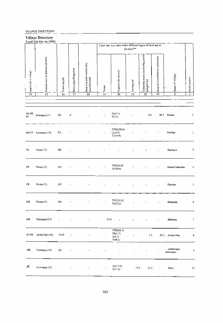
VILLAGE DIRECTORY
Village Directory Land Use (As 011 1999)
E -"'-~ i'>
8 'i3 0
" " E ~
c: " .~ E ~ 'i3 8
~ ;; ;,j
~ ~~ c: '"' .9 " 0. 0- o "
~ .9 ft 0.-;;; e ~ ~
0.. ,e :u ._ .......
~ " I "- '" " ~ c:
0- ., 0 "
0
11 « z 0.. Z ;;;: 14 15 16 17 18
PRMR Kaisarganj (7) ED N
FP
MRFP Kaisarganj (10) ED
PR Puraini (5) ED
PR Puraini (7) ED
PR Puriani(7) ED
MR Puraini (7) ED
MR Kaisarganj (13)
FPNR Jam .. 1 (Np) (34) EAG
MR Kaisarganj (18) ED
Kaisarganj (2:)
Land use (i.e. area under different types of land use in
'A " 0 ~
19
83.0
363
hectare)·'
~ " ~ '"' ." e ~ ."
~ .~ ] ;:
;:J
20 21
TK(3.3) T(3.3)
nVE(200.9)
0(34.0) T(234.9)
TW(250.0) T(250.0)
TW(210.2) T(210.2)
nVE(88.3) TK(I.7) 0(8.1) T(98.2)
OC(?50) T(7S.0)
i5.0
-B c:
" 0
~ .~
"" 'S c: ;.; :; -&
....
.£ 5 " ~ :c 'A .E. ~ ;;; ~ ;; ~ 1)
:;; ;. "0 E e c: " eo
8~ \i
-< 22 23
6.0 28.5
1.6 88.3
253
" ~ ~ .;; .t::. E
'0 " " " ~ e z ~
'" 2
Purnini
Rewliya
Jhapatpur
Katalea Marautha 4
Khevkar
Bhikunda 6
Sakhauta
Dosara Para
Lakha" .. pur 9
Bahraucha
Sunsi If)

t .D
II
12
13
14
15
16
17
18
19
20
21
E " "
2
Harrajpur (06536300)
Gaur (06536400)
Miq>ur Konya (06536500)
Ambhapur (06536600)
Kanjaya (06536700)
Harwa Tand (06536800)
Sunsa Daudpur (06536900)
Naraunda (06537000)
Lalpur Jagdishpur (06537100)
D!:vl Daspur (06537200)
Chilauli (06537300)
Paina (0653i4001
3
104.5
208.0
327.0
16S.0
253.1
o o ~
" .~ -; 0-o 0-
S o f-
4
647
1,794
2,053
3,201
1,225
317
2,195
1,02S
1,211
1,169
589
DISTRICT CENSUS HANDBOOK: BAHRAICH
Census ofIndia 2001 -Amenities and
Amenities available (if not available within the village, a dash (-) is shown in the column and
next to it in brackel, the distance in broad ranges viz.< 5 lems., 5-10 kms. and 10+ kms of the nearest place where the facilitv is available is 'iven
6 7 8 9 10 II 12 13
114 P M(S-IO) C(5· H(lO+) HPWSS- ACS«S) CV(IO+) 8S(5-10) W PO(S-IO) CM(lO+) NCS(IO+) SP(lO+) RS(lO+) 10) MCW(5-IO)
PHC(5-10) PH(IO+) CP(1O+) OCS(lo+) ST(1O+) NW« 5) -:_;.:__:__:__:__:_~
- P(~ H(lO+) 282 5) M« 5) C(o- MCW(IO+)
10) PHC(IO+)
345 P M« 5) C(lO+)
H(lO+) MCW(5-10) PHC(5-10)
~S~ W R PO« 5) PH« 5)
T HPWR POTO SS-W PTOPH
ACS« 5) CV(lO+) CM(5-IO) NCS(5-10), SP(IO+) CP(S-IO) OCS(5-10) ST(1O+)
CM«5) CP«S)
ACS« 5) NCS(IO+) OCS(lO+)
CV(lO+) SP(lO+) ST(lO+)
545 P M« 5) CO 0+)
H~ -5)MCW(lO+) ~HPWSS-PHPO«5)CM«5)
OCS ACS(IO+) NCS(lo+)
CV(lO+) SP(lO+) ST(lO+)
PHC(lO+) CP(lO+)
-------- Uninhabitod ------------
CHW H(5-IO) -208 PM«5)C« MCW(S-IO) THPWSS- PO«5)
5) PHC(IO+) W PH« S)
P« - H« 39 5) M« 5) 5) MCW(5-IO) ~HP SS-
CM«5) ACS«5) CP(5-10) NCS(I01-)
OCS(lO+)
CV(lO+) SP(1O+) ST(1O+)
ACS« 5) CV(IO+) NCS(1O+) SP(lO+)
8S(5-10) RS(1O+) NW(lO+)
85« 5)
RS(I(!-) NW(lO+)
NW 8S(10+) RS(lO+)
NWBS« 5) RS(IO+)
NWBS« 5) RS(IO+)
C(lO+) PHC(IO+) PO« 5) PH«S)
CM«5) CP(lo+)
OCS(10+._) __ S_1~(1_0+_)~ ______ _
332 P M« 5) C(IO+)
162 PM«5) C(IO+)
185 P M(S-I 0) C(10+)
208 P M(5-1 0) C(IO+)
84 PM(S-IO) C(lO+)
H(IO+) MCW(IO+) PHC(IO+)
H(IO+) MCW(lO+) PHC(IO+)
H(lO+) MCW(S-IO) PHC(5-IO)
H(IO+) MCW(S-IO) PHC(5-IO)
H(1O+) MCW(5-JOl PHC(S-IO)
364
HP W SS- POPH W
1 HP W SS- PO(~ S)
W PH«S)
CM«S) CP(1O+)
CM«5) CP(lO+)
ACS NCS(I01') OCS(lO+)
ACS« 5) NCS(IO+) OCS(IO+)
ACS ~ HP IV SS- PH PO« S) CM(~-IO) NCS(IO+)
CP(5-10) OCS(lO')
THPWSS- PO(~5) W PH«S)
THP SS· HP
PO« 5) PH« 5)
ACS CM(5-10) NCS(IO+) CP(5-IO) OCS(IO+)
CM«5) CP(IO+)
ACS( < 5) NCS(J(~)
OCS(I (M-)
CV(IO+) SP(lO+) 51(10+)
CV(IO+) SP(lO+) 5T(l0+)
CV(1O+) SP(\O+) 8T(10+)
CV(1O+) SP(IO+) ST(IO+)
C\\IO+) SP(IO+)
ST\1O+)
85« 5)
RS(lO+) NW(lO+)
BS«5) RS(IO+) NW{1O+)
BS RS(IO+)
N\'\IO+) -
BS RS(JO+) NW(1O+)
85<,5-10) RS(ll>-) !,-;\\\W+)

VILLAGE DIRECTORY
Village Dircrtory Land Usc (As on 1999)
14 15
FP NR Jarwal (Np) (38)
MRFP NR NW Kaisarganj (10)
PRMR FP Bhagarwabazar (5)
PRNC Colonelganj (Mb (15)
16 17
ED
-------- Uninhabited -----------
FP Bahgruwabazar (3)
FP
PRMR FP
PRMR FP
PRMR FPNR NW
PRMR FPNR ('.oW
MRFP NR
Baggarwabazar ( 4)
COlonelganj (Mb (15)
Colonelganj (Mb (15)
Jarwal (Np) (18)
Jarwal (Np) (18)
Gandara (5)
M
18
Land lL~e (i.e. area under different types of land use in hectare)··
19
..
365
20
TK(O.3) T(0.3)
Ge(83.7) 1W(73.2) 1WE(l0.4) T(l67.3)
OC(28 1.7) T(281.7)
21 22
1.3 0.3
53.9 353
27.0
23 2
95.1 Harrajpur
35.2 Gaur
Mirpur Konya
Ambhapur
Kanjaya
Harwa Tand
Sunsa Daudpur
Naraunda
Lalpur Jagdishpur
Devi Daspur
Chilauli
Pain8
11
12
13
14
15
16
17
18
19
20
21
::::2
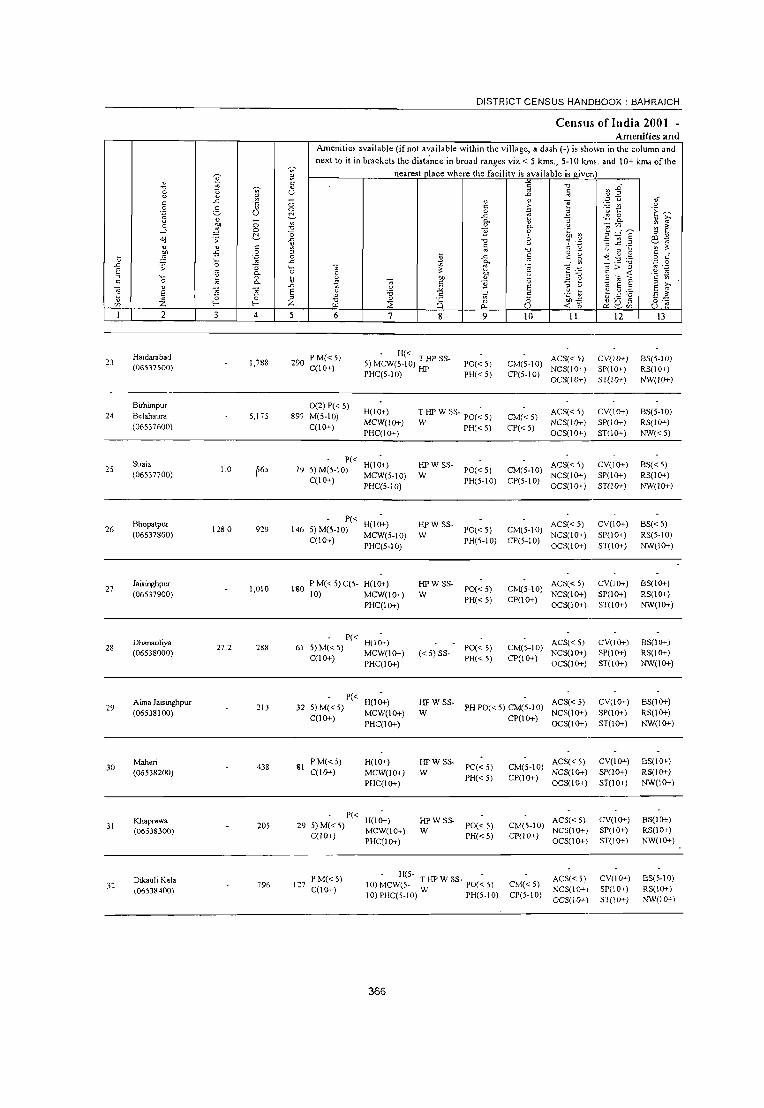
~ u -e ti ::; ~
" 0: C "" " .~ 2- " u
" -0 ~ 0
--' 0
~ <j ;; " " c
~ -5 .~ \; '0 .D ;; :; § " 0-
''0 u 0
" " 0-
~ " "5 '3 E 0 0 z V> r r
I 2 3 4
Haidarabad 23 1,788
(06537500)
Birhimpur 24 Belahaura 5,175
(06537600)
Suaia 25 1.0 565
(06537700) I
Bhopatpur 26 128.0 929
(06537800)
27 Jaisinghpur
1,010 (06537900)
Dhanaoliya 28
(06538000) 27.2 28~
Aima Jaisinghpur 29 213
(06538100)
30 Mahon
438 (06538200)
Khaprawa 31
(06538300) 205
Dikauli Kala 3:: 796
(06538400)
0: " " U
0 0
~ ~ ." -0 .c ~ ::> 0
"" '--0
U .D E ::> z 5
DISTRICT CENSUS HANDBOOK: BAHRAICH
Census ofIndia 2001 -Amenities and
Amenities available (if not available within the village, a dash (-) is sho;vn in the column and
next to it in brackets the dista'nce in broad ranges viz,< 5 kms" 5-10 kms, and 10+ kms of the
nearest place where the facility is available is given"
~ ." .D c ~ ~ .D ~
" " ~ ~ ~-c .~ ~ t! E 0 .2 u ~
"" ,,;: 0 1;-0- U ] 0- ~ " 0- ~ "" ~ i: B 0 ~
~"~ " 8 '" ~ .2 ES~ ." ~
c C .~ ~ .c 'i: ~ ~ " " 0 0 g c
~ "" ~ c u <j " 0 " E ~ .." 'i3 .~ .g -;;; ~ ~~ g :> ::> C ~ ell
~ ~ .~ '" ] u _g ~ 0 '2
" C g E " 1;-u it E " u " E u .~ 1> " " 'i3 .S E c 'i3 E Z " ~
" Q 0 0 ",,,,,
" ._ ;;
0 'E f.ll ~ 0. U < '0 e<: 8'Z) u 6 7 8 9 10 II 12 13 -
290 P M« 5) - H« ACS« 5) CV(IO+) 8S(5-IO) 5) MCW(5-10) T liP SS- PO« 5) CM(5-10) C(lO+)
PHC(5-10) HP NCS(IO+) SP(1O+) RS(IO+)
PH«5) CP(5-10) OCS(IO+) ST(lO+) NW(IO+)
0(2) P« 5) H(10+) T liP W SS- PO(~ 5) ACS« 5) CV(lO+) BS(5-10)
897 M(5-10) CM«5) C(lO+)
MCW(lO+) W PH« 5) CP« 5)
NCS(IO+) SP(lO+) RS(lO+)
PHC(lO+) OCS(IO+) ST(1O+) NW«5)
P« H(IO+) HPW SS- ACS« 5) CV(lO+) BS«5)
79 5) M(5·10) PO« 5) CM(5-10) MCW(5·10) W NCS(lO+) SP(IO+) RS(lO+)
C(IO+) PHC(5-10)
PH(5-10) CP(5-10) OCS(IO+) ST(lO+) NW(lO+)
P« H(IO+) HPW SS- ACS« 5) CV(lO+) BS«5)
146 5) M(5-IO) PO« 5) CM(5-10) C(lO+)
MCW(5-10) W PH(5-10) CP(5-10)
NCS(lO+) SP(IO+) RS(5-10)
PHC(5-10) OCS(lO+) ST(IO+) NW(lO+)
180 PM«5)C(5- H(IO+) HPWSS·
PO«5) CM(5-10) ACS« 5) CV(lO+) BS(lO+)
10) MCW(lO+) W NCS(lO+) SP(lO+) RS(IO+)
PHC(IO+) PH«5) CP(IO+)
OCS(IO+) ST(lO+) NW(IO+)
P« H(1O+) ACS« 5) CV(IO+) BS(1O+)
61 5)M«5) MCW(lO+) «5) SS-
PO« 5) CM(5-IO) NCS(IO+) SP(lO+) RS(lO+)
C(lO+) PHC(IO+)
PH« 5) CP(lO+) OCS(IO+) ST(lO+) NW(lO+)
P« H(lO+) HPW SS- ACS« 5) CV(lO+) BS(lO+)
32 5)M«5) PHPO«5) CM(5-IO) C(lO+)
MCW(lO+) W CP(lO+)
NCS(lO+) SP(lO+) RS(lO+)
PHC(lO+) OCS(IO+) ST(lO+) NW(IO+)
81 p M« 5) H(lO+) HPW SS-
PO« 5) CM(5-10) ACS« 5) CV(lO+) BS(lO+)
C(lO+) MCW(lO+) W NCS(IO+) SP(lO+) RS(li}+-)
PHC(IO+) PH«5) CP(lO+)
OCS(lO+) ST(lO+) NW(lO+)
P« H(lO+) HPWSS- ACS« 5) CV(IO+) BS(IO+)
295)M«5) MCW(IO+) W
PO« 5) CM(5-IO) NCS(lO+) SP(lO+) RS(lO+)
C(lO+) PHC(IO+)
PH« 5) CP(IO+) OCS(IO+) ST(lO+) NW(IO+)
P M« 5) H(5- -
ACS« 5) CV(lO+) BS(5-IO) 117
C(lO+) 10) MCW(S- THPWSS- PO«5) CM«5)
NCS(IO+) SP(IO+) RS(IO+) 10) PHC(5-10) W PH(5-10) CP(5-10)
OCS(IO+) ST(IO+) :-''W(l0+)
366
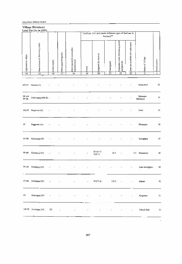
VILLAGE DIRECTORY
Village Directory Land Usc (As on 1999)_
E "'" 2-8 "
" ~ ~ :0 .;; o<l
S " !!:
~ S li 0
~~ ~ « z 14 15
MRFP Gandara (5)
PRMR Colonelganj (Mb (8) -
FPNR
MR FP Baggruwa (I 0)
FP Baggruwa (10)
FP NR Kaisarganj (25)
FP NR Kaisarganj (25)
FP NR Kaisarganj (25)
FP NR Kaisarganj (25)
FP Kaisarganj (25)
MR FP Kaisarganj (10)
c :0 0
" " E
.~ E eo e ~ ·c
""0 .Q ~ ~ "- " "- ~ g_a
~ .5 ~ Q.
iil ~ ~ !!: 0; " 0 " '" 0. Z 2: E 16 17 18
ED
Land use (i.e. area under dilTerent types of land use in hectare)"
~
~ 0 .,. 19
367
8 ;; s: ,., e " ~ '" '"' ]
20
GC(23.7) T(23.7)
GC(75.2)
." ~
'" .. § " ::J
21
-fi " ~ .~
"" .~ "" c :0 :;
~ ... .£
~ " !;l :;;
" ~
!!: .;;;
" ~ ~ " ~ > "0 e a " eo
~ :; ." C U '" 22 23
23.9
123.9
" ~ ;; ,_ 0
" E '" Z 2
Haidarabad
Birhimpur Belahaura
Suaia
Bhopatpur
Jaisinghpur
3.4 Dhanaoliya
Aima Jaisinghpur
Maheri
Khaprawa
Dikaul i Kala
~ "'" E ~
" " " '"
23
24
25
26
27
28
29
30
31
32

DISTRICT CENSUS HANDBOOK: BAHRAICH
CenSU!1 oflndia 2001 -Amenities and
Amenities available (if not available within the village, a dash (-) is shown in the column and
next to it in bracket, the distance in broad ranges viz. < 5 kms., 5-10 km". and 10+ krns of the ~ nearest place where the facility is available is .iven
" ~ ;;; ~ " "0
'" .") ~ " ;; ~.D
8 ii u "'" .,j ~ "
.<: ~ u ~ ~.
" 0 c .~ '" ~ ~ ~ ~ c'l 0 0
~ a .~ ~ ~ ..0: .:; 0
" "" ] Cl. " ,.., '" ~ 0 ~ ~ 0. "';';U) ~ 3
--l 0 "0 }l 0 _g ~~ g ;:J ~
~ "0 2 01) ~
8~ ""l .;; ..0: "0 ~ ·3 " " " ~ ~ " "
:J ..c: ._ ~ ~ "0 u 0 ~
~) -5 ~ ::l
.\l o .- ~ 1) B "
" 0 ..0: fi " g "0 .- 0 c
·0 .c "- ..: ~ _"0 ';:J 0 .D ;: "3 " ~ E -;; '" > ::l '" .-E '" Cl.
·0 " '"" "g :: ,-=::
§ -- :::: ~ ~ ;:J ~ on ::l "0 -::; 0 :v .~ " ~ " " 0. ~ " }l -; ti 'fJ E § ::l
'" v
5 "3 E .;; :;;: E ·c ~ ~ ~;.p E ~
E ::l " -;{ E E 1: " Z 0 0 " "0 " "8 0 '0 011-5 ~ Q.~ o .-'/1 l- I- Z tI.I :2 0. U .,; 0 u ;::
2 3 4 6 7 8 9 10 II 12 13
Surnerpur - H«
ACS« 5) CV(lO+) 8S« 5) 3] 109.0 686 110 PM(5-10)C« 5) MCW«5) HPSS-HP PO«5) Clvl«5) (06538500) 5) PHC«5) PH«5) CP« 5)
NCS(lO+) SP(IO+) RS(IO+) OCS(1o+) ST(IO+) NW(5-10)
Pedwa P M« 5) C« CHW H« 5)
ACS«5) CV(5-10) 85« 5) 34 845 966 152 MCW«5) HP SS-HP PH PO« 5) CM« 5)
(06538600) 5) NCS(1O+) SP(IO+) RS(lO+) PHC« 5) CP« 5)
OCS(lO+) ST(IO+) NW«5)
Lakhmpur P« H« ACS(5-10) CV(5-IO) 8S(5-IO)
35 33.0 393 60 5) M« 5) q< 5) MeW(5-10) HP SS-HP PO«5) CM(S-IO) (0653~70f))
5) PHC« 5) PH«5) CP(1O+) NCS(IO+) SP(IO+) RS(IO+) OCS(1O+) ST(IO+) NW(5-10)
Kapurpur P« H(5-ACS«5) CV(lO+) 8S(5-10)
36 (06538800)
110.0 747 1265)M«5)C« 10) MCW( < 5) HP SS-HP PO«5) CM(5-10) NCS(lO+) SP(lO+) RS(lO+)
5) PHC(5-IO) PH«5) CP(IO+) OCS(lO+) ST(lO+) NW(IO+)
Bhkhaura Mafi P«
H(IO+) ACS
CV(lO+) BS(5-IO) 37
(06538900) 307.0 946 138 5) M(5-IO)
MCW(5-10) TWSS-W PO«5) CM«5) NCS(1O+)
SP(1O+) RS(1O+) C(1O+)
PHC(5-10) PH«5) CP(5-IO) OCS(IO+)
ST(lo+) NW(1O+) .
HADA(5)
Gandara P(2) M(2) 0 MCWRMP(3)
ACS«5) CV(lO+) BS(5-IO) 3~ 3072 5.029 767 CHW(2) T HP W SS- PO PH(30) CM CP(5-
(06539000) C(lO+) H(l0+)PHC(5- W 10) NCS(IO+) SP(1O+) RS(lO+)
10) OCS(IO+) ST(IO+) NW(IO+)
Hisampur 50 P 0(2) M(<. 5) H(lO+) THPWR PH PO« 5) CM(5-IO)
ACS«5) CV(IO+) BS(5-IO) 39
(06539100) 1.3IS 1 C(5-10) MCW(lO+) SS-W NCS(S-10) SP(lO+) RS(lO+)
PHC(lO+) CP(S.10)
OCS(S-IO) ST(lO+) NW«5)
8ariya Gothi P« CHW H(5-10)
HPWSS- ACS(5-10) CV(IO+) BS« 5) 40 60.5 444 73 5) M« 5) C« MCW(S-IO) PO« 5) CM«5)
(06539200) W NCS(lO+) SP(lO+) RS(lO+) 5) PHC(5-10) PH« 5) CP(IO+)
OCS(IO+) ST(lO+) NW(<.S)
PM(5-10) H(5- -
ACS« 5) CV(5-10) BS(5-IO) Jamapur 66.0 803 125 10) MCW(5- T HP W SS- POe <.5) CM«5) 41
(06539300) C(IO+) 10) PHC(S-IO) W PH« 5)
NCS(IO+) SP(IO+) RS(IO+) CP(S-10)
OCS(IO+) ST(1O+) NW(I0-'-)
Pyarepur PM 0 - H(5- T HP W SS ACS« 51 C\'(5-IO) BS(5-IO) ~2 3,405 46; 10) MCW(S- W - PO PH(lO) 0-1« 5)
(06539~OO) C(IO+) NCS(l0-'-1 SP(lO+) RS(lO+) 10) PHC(S-IO) CP(S-10)
OCS(I0-'-\ ST(lO+) NW(l0-'-'
368

VILLAGE DIRECTORY
ViIlaj!e Directory Land Use (As on 1999)
14 15
MR JaIWal (Np) (12)
PR Jarwal (Np) (10)
PR Jarwal (Np) (I 0)
MR Jarwal (Np) (15)
~ MR Gandarn (I )
PRMR FP Kaisarganj (8)
MRFP NRNW Kaisarganj(IO)
PR Jarwal (Np) (20)
PRMR FP Gandara (2)
PR MR larwal (Np) (9) FP 1
16
ED
EDEAG N EOEA
ED
ED
17
EDEAG NM EOEA
ED
ED
ED NM
ED
18
Land lL,e (i.e. area under differenllypes of land use in hectare)··
~ 0
L1.
19
1.0
21.1
58.8
369
~ ~ ~
'" e ."
~ eo ] 20
GC(40.7) T(40.7)
GC(33.4) T(33.4)
TWE(lOO.O)
T(IOO.O)
* "" ·E ·2 :> 21
5.3
-5 " ~ .~ "" "" -5 " '" ~ " u .~ 5 " il 1 ~ " ~ ~
::0 > 0 '" 0 ;;;, " E 3 "" " ;1 -< CJ
22 23
64.9
50.0
1.0
20.0
33.5
6.3
~
:t \:l :; ~
:: ·0 ~ ~
E '" .~
i '" 2
Suml!rpur 33
Pedwa 34
Lakhnipur 3S
Kapurpur 36
Bhkhaura Mati 37
Gandara 38
Hisampur 39
Bariya Golhi 40
Jamapur 41
42

DISTRICT CENSUS HAND1300K : BAHRAICH
Census ofIndia 2001 -Amenities and
Amenities available (if not available within the village, a dash (-) is sho;vn in the column and
next to it in bracket. the distance in broad ranges viz. < 5 kms., 5-10 kms. and 10+ kms of the
v Ol nearest place where the facility is available is given_. v
tl li ~ " U~ 'tJ ~ e v Ol U .D ~
" ..t: " "
''::; u e " 0 ~
~ ~ .~ 5 (; 0 " .~ .~ ~ 0 3 "
~ .c il ]
.;: g_ " '" u 0 ~ a.
~ ~ 0 ~ 'tJ " a. c;~
--' 0 '0 B 0 ;;;, ~:g~ " " ~ [; 1)
~ .;;: .c 'tJ "!' .;: E9.~ v " " ~ § " "
:::3 ..c: ._ ~ " Ul -5 0 "
'tJ o ._ u 0 ~
" u ~ .~ 0 ~ .c f;; " g ~ 'I) B 0 C '0 .c a. ....: ~ _:'2:.0 .~ g .D ;;: :; '_ ~ :: -;;; ~ > ~ E " " ~ .~ ~ Q. 0 " '" ·c
" 'tJ " :;J '0 ~ 0 \l 0 01) " ~ ~ ~ g';a E " Q.
'cr " " '2 " '" ~ v S "§
.D .!< :.;; " u "ie E :;J E " E E "
'0 .5 vf E 'c] ~ ~ :.a EZ Z 0 0 " " ~Q,~ v f- f- Z 'tJ
~ a 0 0 ~o o ._
'" ~ a. U u e 2 3 4 5 6 7 8 9 10 II 12 13
43 Bdnapara
1,421 221 PM(5-10) H(10+) : HP W SS- PO(~ 5) CM«5)
ACS« 5) CV(lO+) BS(5-10) (06539500) C(lO+) MCW(5-10) NCS(IO+) SP(lO+) RS(lO+)
PHC(IO+) PlI« 5) CP(5-IO)
OCS(IO+) ST(IO+) NW(1O+) ,
CHW(2)
44 Hajipur
517 95 P M« 5) H(1o+) T HP W SS- PH(2)
CM«5) ACS« 5) CV(IO+) BS(5-IO)
(06539600) C(IO+) MCW« 5) W PO« 5) CP(5-IO)
NCS(IO+) SP(1O+) RS(IO+) PHC(IO+) OCS(IO+) ST(1O+) NW«5)
Mahuri Kala P(3) M« 5) MCW
-: HP W TK PO PH« 5) CM(~ 5) ACS« 5) CV(5-10) BS«5) 45 1- 2,611 458 CHW(2)H« (06539700) C« 5) 5) PHC(5-IO) SS-W CP« 5) NCS(1O+) SP(1O+) RS(IO+)
OCS(1O+) ST(IO+) NW(IO+)
Nandoliya P« - H(5-ACS« 5) CV(5-10) BS(5-10)
46 653 lOS 5) M(5-10) 10) MCW(5- HP W SS· PO PH CM«5) (06539800) C(5-10) 10) PHC(5-10) W CP(5-10)
NCS(IO+) SP(IO+) RS(1O+) OCS(1O+) ST(1O+) NW(IO+)
Badauli PMACC« H«
THPTW PO TO ACS« 5) CV«5) BS«5) 47
(06539900) 4,367 627
5) 5) MCW«5)
WSS-W PTOPH CM«5)
NCS« 5) SP(IO+) RS(1O+) PHC(5-10) CP« 5)
OCS(IO+) ST(lO+) NW(1O+)
MCW
48 Kursanda
2,796 468 PM(5-10) CHW(2) T HP W SS- - _ ACS« 5) CV(lO+) BS(5-10)
(06540000) C(lO+) H(1O+) PHC(5. w PH PO« 5) CM(q) NCS(IO+) SP(lO+) RS(IO+) 10) CP(5-10) OCS(1O+) 8T(10+) NW«5)
Nimadipur - H(5- - ACS
CV(5-IO) NWBS(5-
49 192.3 1,773 307 P M(5-10) C(5' IO)MCW(5_ T HP W SS- PH PO«5) CM(5-10) NCS(1O+) 10) (06540100) 10) 10) PHC(5-10) W CP« 5) OCS(IO+)
SP(1O+) RS(IO+)
ST(IO+)
Hasanpur P« H(5-PH(3) ACS« 5) CV(5-10) BS(5-10)
50 57.0 260 40 5)M«5)C(5-IO)MCW(5- HP SS-HP CM«5) (06540200)
10) 10) PHC« 5) PO« 5)
CP(5-10) NCS(1O+) SP(IO+) RS(5-IO) OCS(1O+) ST(1O+) NW(1O+)
Ramwapur ACS« 5) CV(IO+)
BS 51 Raghubir Singh 1,076 214
PM(5-10) H(IO+) THPTW PO« 5) CM«5) RS(IO+)
C(IO+) MCW(5-10) WSS-W NCS(1O+) SP(IO+) (06540300)
PHC(5-10) PH«5) CP(5-10)
OCS(IO+) ST(1O+) NW(1O+)
5~ Bhauli
154.7 1,118 193 PM(5-10) H(1O+) THPTW
PO«5) CM«5) ACS« 5) CV(1O+) BS(5-10)
(06540400) C(1O+) MCW(5-10) WSS;W NCS(1O+) SP(1O+) RS(1O+)
PHC(5-10) PH« 5) CP(5-10)
OCS(1O+) ST(1O+) NW(1O+)
Jalalpur Hardo P M« 5) C(5· H(5-
PH(3) ACS« S) CV(5-10) BS(5-10) 53 83 2 640 96 10) MCW(5- HPSS-W 0.1« 5)
Patti (06540500) 10) 10) PHC(5-10)
PO« 5) CP(5-IO)
NCS(IO+) SP(lO+) RS(5-10)
OCS(IO+) 5T(l0+) NW(IO+)
370

VILLAGE DIRECTORY
ViIlaj!c Dircctory Land Usc (As on 1999)
E "'" 5 ~ c:
'" f]
~ "-0 :;: >l B
c:
" -5 B
'" ii e 0.. :; 0- " « z 14 15
Iarwal (10)
PRMR fP
Iarwal (Np) (21)
PRMR Kaisarganj (5)
FP
Kaisarganj (5)
PRMR Kaisarganj (4)
fP
PRMR fP
Iruwal (Np) (11)
MRFP Janval (Np) (9)
NR
MRFP Iarwal (Np) (7)
PRMR Ialwal (Np) (8)
FP
MRfP Jarwal (Np) (8)
MR FP Jarwal (Np)(7)
c 'i3 0
" E c: E 'N
'" ~ 00
~ " 2:> ~ "0
~ 0-0- '" e 5l
0- Q.
'" § 0- • .!': ~ ~ " 0 " 0
., '" Q. Z ~ E 16 17 18
ED
ED
EDEAG
EDEAG NM
ED
ED
EAG
ED
ED
EAG
Land use (i.e. area under different types ofland use in heclare)"-
-5 c ;; ._g
"" i g> 'i3 1: ~
? ~ ·2 " :;
* ~ 5: '" '" " ~ "0 e 7J ., ~ ~
"0 :c >- Q
~ .~ ::: 2 " ~ l: " "" '"' 'c :; ." ~ t2 .§ ~ :::> u < 19 20 21 22 23
GC(573.4) TWE(329) 54.4 T(606.3)
Ge(SI.3)
13 TW(36.3) . TWE(20.0)
T(107.5)
Ge(181.4) TW(I81.4) 158.5 6.4 T(362.7)
Ge(33.2) 33.2 149.7
T(33.2)
0.1 2.9
8.9
371
" ~ :;: '-0
E '" z 2
Belnapara
Hajipur
Mahun Kala
Nandoliya
Badauli
Kursanda
Nimadipur
Hasanpur
Ram .... "l!pur Raghubir Singh
Bhauli
JaJaJpur Harjo Patti
~ .D E
" c:
~ ., (I)
43
44
45
46
47
48
49
50
51
51
53

DISTRICT CENSUS HANDBOOK: BAHRAICH
CenslUls ofIndia 2001 -Amenities and
Amenities available (if nat available within the village, a dash (-) is sflOwn in the column and
next to it in brackets the distance in broad ranges viz. < 5 kms., 5-10 kms. and 10+ kms of the ~ nearest place where the facility is available is_EjVl!n
" il " 5 Ii ] -0 ~.D
"'8 ~ ~ U @ ·3 ~ -" i3\
" .,
E 1l-c c 0 ~ t! ~ 3 U 0
c
~ .~ ~ 0 .:1 ~ -" .~ 0
" "- ] - "- " '" 0 ~ ~ ~
0 .", " Q. -'" ~ " -0 ~ =~ E ....l ~ 0 0 11 0 " ~ ~ 8 '" ~ e~ o;j ;; -" -0 % .~ ~ ~.2 . ., v c ~ ~ -0 u 0 ~ ~ " :W -5 0 " o .-
o;j " S c .~ 0 !l -" ;; c g 0 d
" '0 ..c: ;J- ...: ~ _~:.a .~ 0 .D ;; :; '0 ~ ~ ~ ~ .-: ~>~ .;J E g "- c ~ u '" ~ " ''0 0 0 .", " " .., o .._ -: c "-
:; .~ "5 .5 11 :; .::: ~ .~ E § " '" .,
"5 .D
.!< E " u E ~ ~ E "5 E
" C; c 'i E .~ 13 ~ g ~ E Z
" ~ 0 0 " -0 " 8 0 0 ""-5 ~Q~ o .-
'" Z I-- I-- Z UI 2 Q. U « 0 u E 2 3 4 5 6 7 8 9 10 I( 12 13
H(5-
54 Harana Anaura
2,097 332 PM(5-IO) 10) THPWR ACS« 5) CV(5-IO) BS(5-IO)
(06540600) C(lO+) MCW(IO+) SS-W PO« 5) CM«5)
NCS(IO+) SP(lO+) RS(IO+) PHC(S-IO)
PH« 5) CP(5-IO) OC5(ICH-) 5T(I0+) NW(IO+)
Gobraura P« H(5-PH(2) ACS« 5) CV(5-10) BS(5-10)
55 68.0 478 73 5)M«5)C(5-10)MCW«5) HPSS-HP CM« 5) (06540700) 10) PHC(5-10)
PO« 5) CP(5-10)
NCS(IO+) SP(lO+) RS(5-IO) OCS(lO+) ST(lO+) NW(IO+) .
Kurmaltra - H(S-
ACS(5-IO) CV(5-10) BS(5-10) 56
(06540800) 547 100 P MC(IO+) 10) MCW(5. THPWSS- PO«5) CM«5)
NCS(IO+) SP(lO+) RS(lO+) 10) PHC(S-IO) W PH(S-IO) CP(5-IO)
OCS(lO+) ST(IO+) NW(lO+)
Harani Auseri P« H(lO+) T HP W SS- PO(;O+) ACS« S) CV(IO+) BS(lO+) 57 937 171 5)M«S) CM«5)
(06540900) C(IO+)
MCW(5-10) W PH(IO+) CP(IO+) NCS(IO+) SP(lO+) RS(IO+)
PHC(5-10) OCS(1O+) ST(1O+) NW(1O+)
Gauspur 209 P(2) M(5-10) - H« - ACS«5) CV(IO+) BS(lO+)
58 1,368 5)MCW(10+) ~:_:TK PO«5) CM(IO+) (06541000) C(lO+) NCS(IO+) SP(IO+) RS(IO+)
PHC(5-10) PH(IO+) CP(IO+) OCS(10;) ST(1O+) NW(lO+)
8hadauri P(2) M(5-1 0) H« THPWTK PO(~5) ACS« 5) CV(IO+) 8S(10+)
S9 (06541100)
1,228 197 C(lO+)
5) MCW(lO+) CM(IO+) NCS(IO+) SP(IO+) RS(IO+)
PHC(IO+) RSS-W PH(IO+) CP(lO+) OCS(1O+) ST(lO+) NW(IO+)
60 Ari Umari
1,277 222 PM«5) MCWH(lO+) T HP W SS- PO CM«5)
ACS« 5) CV(IO+) BS(IO+)
(06541200) C(lO+) PHC(IO+) W PH(IO+) NCS(10+) SP(lO+) RS(IO+) CP(IO+)
OCS(lO+) ST(IO+) NW(1O+)
61 Nizampur
438 AC OP«5) H« T HP W SS- PO(~ 5) CM«S)
ACS« S) CV(lO+) BS(lO+)
(06541300) 69 M«5) C(IO+) 5) MCW(IO+) W PH(IO+)
NCS(J(H) SP(1O+) RS(1O+) PHC(IO+) CP(lO+)
OCS(10') ST(1O+) NW(1O+)
Islamabad P« H«
T HP W SS- PO(~ 5) ACS«S) CV(1O+) BS(1O+) 62 467 62 5)M«5) S) MCW(IO+) CM«S)
NCS(10+) SP(IO+) RS(1O+) (06541400) C(10+) PHC(IO+) W PH(lO+) CP(lO+)
OCS(IO+) ST(1O+) NW(1O+)
Dlhawa Khurd P«
H(IO+) T HP W SS- PO(~ 5) ACS« ;) CV(IO+) 8S(10+) 63 226 3S 5) M«5)
MCW(IO+) CM«5)
NCS(1 Cf+) SP(IO+) RS(IO+) (06541500) C(IO+) W PH(IO-l CP(IO-) PHC(IO-) OCS(ICf+) ST(IO+) NW(lO-)
372

VILLAGE DIRECTORY
Village Directory Land Use (As on 1999)
~ o. 0. "-« 14 15
MR FP KaiSarganj (8)
IvIR FP Jarwal (Np) (6)
!viR FP Jarwal (Np) (9)
MR IT Jarwal (Np) (I 3)
lvlR Kaisarganj (12)
MR Kaisarganj (12)
MRFP Kaisarganj (14)
Kaisarganj (15)
:'IR IT huwal (Np) (H)
Kaisarganj (J ~ )
16
ED EO
EAG
ED
ED
ED
ED N
ED
ED
ED
ED
17 18
Land use (i.e. area under different types of land use in hectare)"
19 20 21 22 23
5.3
373
2
Harana Anaura 54
Gobraura 55
Kunnaura 56
Harani Auseri 57
Gauspur 58
8hadauri 59
Ari Umari 60
Nizampur
Islamabad 62
Dihawa Khurd 63

DISTRICT CENSUS HANDBOOK: BAHRAICH
Census oflndia 200 I -Amenities and
Amenities available (if not available within the village, a dash (-) is shown in the column and
next to it in brackeL' the disL1nce in broad ranges viz.< 5 kms., 5-10 kms. and 10+ kms of the ~ nearest place where the facility is available is given
v ;-: v
~ " ~ '" ~ :2. -0 " ::; u ~ U "" :; v ;-: .::: 0
~ " _c
" 0 " " E :;: !I .~ S u " .~ E~ u 0 0 "
v _
G .<: .~ g_ u "- t :; ~ ~ 0 ~ 0 ~ U 0. V e;~
:3 5 " ...J 0 0 11 0 t: _g:g~ G 8 '"" ~ >j .;; .<: " c:: .~ e.-;;
v v " ~ :;; r: " :J .r::: ._
~ ~
" u 0 -
~ .;; 0 " o ._
<j " 9 " i:; .~ 0 3 .<: ;; " ~ .~ C
.D '0 .L:
~ -: ~ _~:.a '2 E ;; ;; '0 " ~ -;;;
~~ ~ > ;:J
~ g 0. " ~ g - ~ " '0 0 t .~ "" ~ E ~ .:= '" E " C 0. '" c 11 " " ~ u
S S .D u :;;: E " u '" E " E '" E E u '0 ·c t ~ g :..a
" r: .r E E ~ t " 0 0 " "" " (is 0 0 "'-5 ~Qi5 8 .~ '/) Z f- f- Z ~ ~ 0. U -< 0
2 3 4 5 6 7 8 9 10 11 12 13
SahbaJpur P« - H(5-ACS(5-10) CV(IO+) BS(5·10) 64 Bhartha 834 148 5) M(5-10) 10) MCW(5- T HP SS- PO PH« 5) CM(, 5)
(06541600) C(lO+) 10) PHC(S-I 0) HP CP(S-IO) NCS(IO+) SP(IO+) RS(IO+)
OCS(lO+) ST(1O+) NW(IO+)
Mantkapur P M«S) - H« ACS« S) CV(S-IO) BS(S-IO) 65 511 87 5) MCW(5-1 0) ~S~ W TIC PO« 5) CM(5-10) (06541 iOO) C(lO+) NCS(IO+) SP(lO+) RS(lO+)
PHC(5-10) PH« 5) CP(5-IO) OCS(lO+) ST(lO+) NW(lO+)
Rasulabad PM«S)I H« T HPW SS - ACS« 5) CV(S-IO) BS(5-IO) 66 613 107 5) MCW(5-IO) - PO«S) CM(5-IO)
(06541800) C(lO+) PHC(5-10) W PH(S-IO) CP(S-IO)
NCS(IO+) SP(IO+) RS(lO+)
OCS(lO+) ST(IO+) NW(IO+)
Usara P« H« ACS« 5) CV(IO+) BS(5-10)
67 (06541900)
1.2 2,568 428 S)M(5-10) 5) MCW(5-1 0) HP SS- PO«5) CM«5) NCS(IO+) SP(IO+) RS(lO+)
C(lO+) PHC(5-10) PH«5) CP(5-10) OCS(lO+) ST(1O+) NW(IO+)
Chahlar PM(5-10) - H« ACS« 5) CV(5-10) BS(5-10) 6~ 626 102 5) MCW(5.1 0) T HP ss- PO«5) CM«S)
(06542000) C(lO+) PHC(S-IO) HP PH« S) CP(S-IO)
NCS(IO+) SP(1O+) RS(IO+)
OCS(lO+) ST(lO+) NW(1O+)
Khanehara P« H(S-
ACS« S) CV(5-10) 8S(5-10) 69
(06542100) 1,287 201 5)M«5) 10) MCW(5- HP SS-HP PO(5-10) CM«5)
NCS(lO+) SP(IO+) RS(lO+) C(lO+) 10) PHC(5-1 0) PH(5-10) CP(5-10)
OCS(lO+) ST(1O+) NW(lO+)
70 Upadhi
2,020 298 PM(5-10) H(IO+) T HP SS- PH(9)
CM«5) ACS(5-IO) CV(lO+) BS« 5)
(06542200) C(IO+) MCW(5-10) HP PO«5) CP«S)
NCS(lO+) SP(IO+) RS(5-10)
PHC(5-10) OCS(IO+) ST(IO+) NW(IO+)
Bibipur PM«S) H«
HPWSS- ACS« 5) CV«5) BS«5) 71
(06542300) 122.5 1,831 290
C(IO+) 5) MCW(lO+)
W PO« 5) CM«5)
NCS(IO+) SP(IO+) RS(5-10) PHC« 5) PH« 5) CP« 5)
OCS(lO+) ST(IO+) NW(lO+)
SuraJana Jafar P 0(2) M(5-
CHW H« 5) THP SS- PH(2) ACS(5-IO) CV«5) BS« 5)
72 Mo!hadi 204 31 10) C(5-10)
MCW« 5) HP PO«;)
CM«5) NCS(lO+) SP(IO+) RS(1O+)
(06542400) PHC« 5) CP« 5) OCS(lO+) ST(IO+) NW(IO+)
Bardoliya P M«5) H« HPW SS- ACS« 5) CV« 5) BSt <;) -3 804 941 149 5) MCW«5) PH PO« 5) CM« 5)
(06542500) CO 0+) W NCS(lO+) SP(lO+) RS(;-IO) PHC« 5) CP« 5) OCS(l(f+) ST(IO+) NW(II)-,-) ..
374

VILLAGE DIRECTORY
Village Directory L'md Usc (_As on 1999)
E -"-
2-" u c:
" ~ ~ 'i5 .;; 00
c: g
" ~ S ~ 0 .'1.)"
0. '" 0- " « ;z. l4 l5
MRFP Jarwal (Np) (6)
MR FP Jarwal (Np) (10)
MRFP Jarwal(Np)(IO)
» 0. 0-
il t ;. 0
0..
l6
ED
ED
ED
MR Colonelganj (Mb (8) -
FP NR Jarwal (Np) (10)
MR Jarwal (Np) (8)
PR l<uwal (Np) (4)
PR Jarwal (Np) (2)
PR FP Jarwal (Np) (l)
PR Jarwal (Np) (2)
ED
ED
ED
ED
EDEAG EOEA
ED
Land use
0 'i5 0
" E c: .~ E
;; ~
~ ~"O ~ " ~ ~
~ o :l <>.~
"'- .5 .~ ~ :l :l ~ c:
" E (; Z ~ '-" 17 18 19
Butler Oil
375
(i.e. area under different types of land use in
u u ~ ~ » e
"0
~ eo
li 20
GC(1ns) T(122.5)
GC(80 4) T(804)
hectare)--
."
~ 0()
'5
'" :::> 21
-5 c: ~ ~ '" '" ·s c:
'i5 3 :l U .£ ~ " ~ ~ ~ ;;; u !) ;;
::0 ;. C '" 0 c: ~ eo -"'"0 ~ " c u '" <t. 22 23
1.2
" :W .s: ._ 0
" E " ;z. 2
Sahbajpur Bhartha
Manikapur
Rasulabad
Usara
Chahlar
Khanehara
Upadhi
Bibipur
SuraJana lafar Mehadi
Baraoliya
;; .!> E :l
" -;; '5 '"
64
6S
66
68
69
70
71
72
73
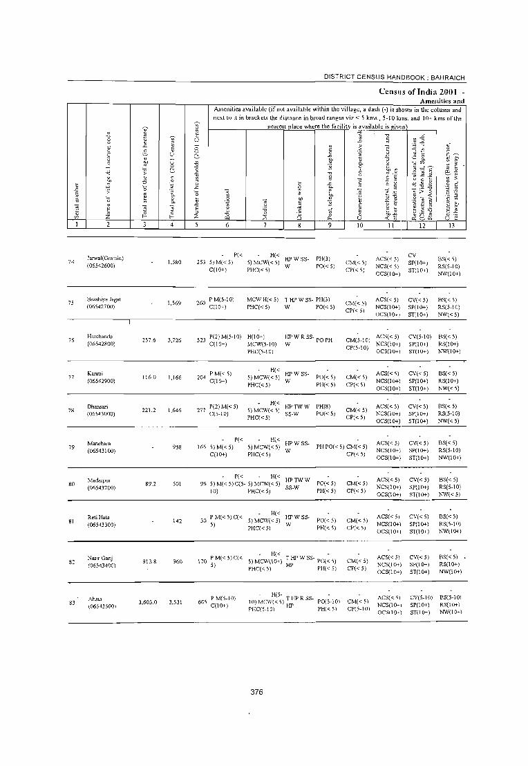
t L> E " c .~ t '-"
74
75
76
77
78
79
80
81
82
83
2
1arwal(Gramin) (06542600)
Basahiya J agat (06542700)
Harchanda (06542800)
Kanrai (06542900)
Dhansari (06543000)
Manehara (06543100)
Madarpur (06543200)
Reti Hata (06543300)
Nas~ Ganj (06543400)
Ahata (06;43500)
257.6
116.0
221 2
89.2
913.8
3,603.0
o o ~ c o .~
-; 0. o 0.
5 o f-
4
1,580
1,569
3,726
1,166
1,646
958
SOl
142
960
3,531
DISTRICT CENSUS HANDBOOK: BAHRAICH
CensUis ofIndia 2001 -Amenities and
Amenities available (if not available within the village, a dash (.) is shown in the column and
next tu it in bn.ckoL, the disL1nce in broad ranges viz.< 5 kms., 5·10 kms. and 10+ kms of the
nearest place where the facilitv is available is Riven
o o ~ ." '0 -& " o .c ''0 v
L> E " Z
6 8 9
P« H« 253 5) M« 5) 5) MCW« 5) HP W SS· PH(3)
C(lO+) PHC«5) W PO«5)
260 P M(5·1 0) C(IO+)
MCW H« 5) T HP W SS· PH(3) PHC«5) W PO«5)
523 P(2) M(5·1 0) H(lo+) HP W R SS· PO PH C(lO+) MCW(5·IO) W
PHC(5.IO)
204 P M« 5) C(lO+)
277 P(2) M( < 5) C(5·10)
H« HPWSS. 5) MCW« 5) W PO« 5) PHC« 5) PH« 5)
H( < HP TW W PH(8) S) MCW« 5) SS.W PO« 5) PHC« 5)
10
CM«5) CP« 5)
II
ACS« 5) NCS« 5)
OCS(lo+)
12
CV SP(lO+) ST(lO+)
13
BS« 5) RS(5·10) NW(lO+)
CM«5) CP« 5)
ACS« 5) CV« 5) BS« 5) RS(5·10) NW«5)
NCS(IO+) SP(lO+) OCS(lI}.-) ST(lO+)
CM(5.IO) ACS«5) CP(5.10) NCS(I 0+)
OCS(IO+)
CM«5) CP« 5)
CM«5) CP« 5)
ACS« 5) NCS(lo+) OCS(lo+)
ACS« 5) NCS(IO+) OCS(lo+)
-------
CV(5·10) BS« 5) SP(lO+) RS(IO+) ST(IO+) NW(IO+)
CV«5) SP(lo+) ST(lO+)
CV«5) SP(lo+) ST(lO+)
BS« 5) RS(IO+) NW«5)
BS« 5) RS(5.10)
NW«5)
P« 165 5)M«5)
C(lO+)
H« HPWSS. 5) MCW«5) W PHC« 5)
PH PO« 5) CM« 5) CP«5)
ACS« 5) NCS(lo+) OCS(lo+)
CV« 5) SP(IO+) ST(lO+)
BS« 5) RS(5·10) NW(lO+)
P« H« HPTWW 96 5)M«5)C(5· 5) MCW«5) SS.W PO«5)
10) PHC« 5) PH« 5)
PM( 5)C( H« HPWSS. 30 < < 5) MCW« 5)
5) PHC« S) W PO« 5) PH« 5)
H« • 170 PM«5)C« 5)MCW(10+) THPWSS· PO«5)
5) PHC«5) HP PH«5)
605 P M(5·1 0) C(1O+)
. H(5· • 10) Mc\\,«5) THPRSS· PO(5.10) PHC(5.10) HP PH( < ; \
376
CM«5) CP« 5)
CM«5) CP« 5)
CM«5) CP« 5)
CM«5) CP(5·10)
ACS« 5) NCS(Io+) OCS(Io+)
ACS« ;) NCS(lo+) OCS(IO+)
ACS« ;) NCS(IO+) OCS(lo+)
ACS« 5) NCS(l(>-1 OCS(1(>-)
CV«5) SP(lO+) ST(IO+)
CV« 5) SP(IO+) ST(lo+)
CV« 5) SP(lO+) ST(lO+)
BS«5) RS(5·10) NW«5)
BS« 5) RS(5·10) NW(IO+)
BS«5) RS(lO+) NW(lO+)
CV(S·10) BS(5·10) SP(IO+) RS(IO+) ST(lO+) NW(IO+)

VILLAGE DIRECTORY
Villaj!c Dircctory Land Use (As on 1999)
E -"
~ ~
" " u ~ ~ 'i;
;: <Ij
S c:
" -'" 9 u
" e ~ c. c. " « z 14 15
:;:; MR Jarwal (Np) (1)
:;:; MR Jarwal (Np) (3)
PRMR Jarwal (Np) (5)
MRFP Jarwal (Np) (4)
]\olRFP Jarwal (Np) (3)
MRFP "owal (Np) (2)
MRFP Jarwal (Np) (3)
MR Jarwal (Np) (2)
MR FP Jarwal (Np) (4)
MRFP Jarwal(Np)(iO)
16
EDEAO EOEA
ED
EDEAO EOEA
EDEAO EOEA
ED
EDEAG EOEA
ED
N
EDEAG N
17 18
Land use (i.e. area under different types of land use in
hectare)""
19
377
20
TW(4.0) TWE(7.7) TK(1.2) R(8.7) 0(120.4) T(142.0)
TW(2.0) TWE(1.5) TK(OA) 0(82.8) T(86.7)
TWE(2.0) 1(2.0)
R(603.0)
21 22
22 3.2
0.3 0.3
911.8
3603.4
23 2
12.1 Jarwal(Gramin)
Basahiya Jagat
Harchanda
Kanrai
Dhansari
10.7 Manehara
Madarpur
RetiHata
6.5 Nasir Ganj
Ahata
\J .0 E " c:
74
75
76
77
78
79
80
81
82
83

84
85
86
87
88
89
90
91
92
93
2
Parsa (06543600)
Basahiya Pate (06543700)
Atthaisa (06543800)
Dhanrajpur (06543900)
Mustfabad (06544000)
Rasulpur Nijami (06544100)
Rodain (06544200)
Dhawariya (06544300)
Hasanapur (06544400)
Khijarapur (06544500)
'0
;; o f-
110.8
1190
97.1
1.3
400
4
1,888
3,255
1,656
1,033
3,710
178
1,604
1.238
830
356
DISTRICT CENSUS HANDBOOK: BAHRAICH
Census ofIndia 2001 -Amenities and
Amenities available (if not available within the village, a dash (-) is !!hown in the colunm and
next to it in brackeL. the disLance in broad ranges viz. < 5 kms., 5-10 iKms. and 10+ kms of the
nearest olace where the facilitv is available is viven
6
322 P M« 5) C(lO+)
480 P 0 M« 5) C« 5)
7 8 9
- H«
" .~ l; 0.. o
8 -0 ;;
~ " E E o u 10
5)MCW(1O+) THPTW PHC« 5) W ss-w
PH PO« 5) CM« 5) CP«5)
PHCCHW H« 5)
MCW« 5)
HPTWW PH(2) SS-W PO« 5)
CM«5) CP«5)
. H« 297 P M(5·10) C« 5) MCW(5-10) T ~ TW
5) PHC(5.10) W:SS-W
PH(7) PO« 5)
CM«5) CP« 5)
H« 161 P ACM«5) 5)MCW(1O+) THPWSS-POTOPH CM«5)
C(IO+) PHC« 5) W CP« 5)
591 P MC(lO+)
35 P M(5-10) C(lO+)
207 P M« 5) C« 5)
MCW H(1O+) HP W SS· PHC« 5) W
- H« THPTW 5) MCW(5-10) W SS-W PHC« 5)
PO PH(l5) CM« 5) CP«5)
PO«5) PH« 5)
CM«5) CP(5-10)
FWCCHW H«5) MCW«5) PHC« 5)
HPTWW PH(2) CM«5) CP« 5)
SS-W PO«5)
P« H(5- , _ -
II 12
AC5(S·II) CV«5) NCS( < 5) SP(IO+) OCS(lO+) 5T« 5)
ACS« 5) NCS(lO+) OCS(lO+)
ACS« 5)
NC5(10+) OCS(lO+)
ACS«5) NCS(lO+) OCS(lO+)
ACS«5) NCS(lO+) OCS(lO+)
ACS« 5) NCS(lO+') OCS(lO+-)
ACS«5) NCS(lO+) OCS(lO+)
CV«5) SP(1O+) ST(IO+)
CV(lO+) SP(1O+) ST(lO+)
CV«5) SP(1O+) ST(1O+)
CV«5) SP(lO+) 5T(1O+)
CV(lO+) SP(lO+) ST(IO+)
CV«5) SP(IO+) ST(lO+)
13
B5« 5) RS(5·10) NW(1O+)
BS«5) R5«5) NW(1O+)
BS« 5) RS(5-10) NW(IO+)
BS(5-IO) RS(5-10) NW(IO+)
BS« 5) RS(5-10) NW(IO+)
BS« 5) RS(5-10) NW(IO+)
BS«5) RS« 5) NW(lO+)
215 5)M(5.10) 10) MCW(5- THPW 5S- P0(5-10) C(5.10) 10) PHC(5-10) W PH(5-10)
AC5(5-10) CV(5-10) B5(5-10) CM(5-10) NC5(lO+) 5P(10+) RS(lO+) CP(5-10) OCS(lO+) ST(lO+) NW(IO+)
137 P M(5-1 0) C(5· H(l 0+) 10) MCW(1O+)
PHC(5-10)
T HP W 5S- PO(~ 5)
W PH« 5)
ACS(5-10) CV(5-10) BS«5) CM(5-10) NCS(IO,') SP(IO+) RS« 5) CP(5-10) OCS(lO+) ST(IO+) NW(IO+)
P« 495)M«5)
C(1O+)
H« HP~"\\' 5) MC\\\ < 5) '"
S5·W PHC« 5)
378
PH PO\< 5) CM« 5) CP« 5)
ACS« 5)
NCS(IO+) OC5(IO+)
CV«5) SP\IO+) SJ\IO+)
BS« 5)
RS(5·10) NW\IO+)
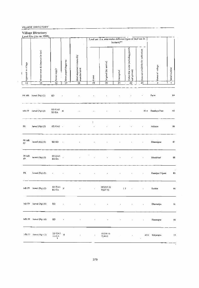
VILLAGE DIRECTORY
Village Directory Lund Usc (As on 1999)
E -'"
5 " u c:
" ~ ~ '0
"d .;; c:
.9 " .9 ~ -;;; 2 ~ 0-0. " '( z 14 15
PR MR Jarwa! (Np) (2)
!viR FP Jarwa! (Np) (2)
PR Jarwal (Np) (2)
PR tvfR FP Jarwal (Npl (3)
PRlviR FP Jarwal (Np) (3)
PR huwa! (Np) (3)
/viR FP Jarwal (Np) (2)
lvfR FP Jarwal (Np) (6)
!viR FP Jan ... a! (Np) (6)
~iR fP Jan"a! (Np) (2)
;.... "i5. 0-
~ t;
" 0
"" 16
ED
EDEAG N EOEA
EDEAG -
ED EO
EDEAG EOEA
EDEAG N EOEA
ED
ED
ED E.'\G N EOEA
~
v
" ';;J "" " ~ ~ 0-
~ " z 17
Land use
c :u 0 E E 0
" C t ~ o ;:l o.~
S ~ ;:I ~ l;; § 0
<2 ::E E 18 19
379
(i.e. area under different types of land use in
" f: " Si ,.., e '0 2 '" 00 .~
20
GC(227.5) T(227.5)
GC(40.0) T(4001
hectare)"
'0 2 .~ t:
':3 21
-B ;; ol)
"" " :u ;:l
u 3 il 3 v ~
v ~
,. 0
E e;, :; '0
;; u 22
! 3
c: .~ .~ :; u
,~ v
~ v
~ ~ ;;
" '0 c:
" '" " E -< z 23 2
Parsa
20.4 Basahiya Pate
Atthaisa
Dharuajpur
Mustfabad
Rasulpur Nijami
Rodain
Dhawariya
Hasanaput
40.0 Khijarapur
\l .D E " c: -;0 '5 '"
84
85
86
87
88
89
90
91
92
93

DISTRICT CENSUS HANDBOOK: BAHRAICH
Ccnswi of India 200} -Amenities and
Amenities available (if not available within the village, a dash (-) is sh~wn in the column and
next to it in brackets the distance in broad ranges viz.< 5 kms., 5-10 kms. and 10+ kms of the
~ ;: nearest Dlaco where the facility is available is civen v " ~ '8 ~ v ." .g ~ . ~ U ..0 :;j
V ;: "
.c " 0 " v e ~ ~
1i .~ ~ "
c: ~ .~ ~ U 0 0 a v C, -C
ij ~ .,;: 0 " ;.-, u
~ fr- o.. ~ ~ 0 ~ 0 0.. -::;'Z)
....l 0 ." "2 0 § ::£ E o:j ;; ~ -0 8 ~ l'l e~ .c ." c;: .:; -; 1§ .2 v v " ~ ~ ." c: V u 0 1-0 ~ " ~ -5 .~ "
o ._ c: ~ 0 ~ .c :;j c: g ~ 'l) .9 0 " '0 -C ~ _"9;.a ';:J 0
..0 .;; :; '0 -;;; ~ " _- ~ ::: > ::l .~ .~ E '" 0.. c: on .~ r: .~
g-~ " '0 " 0 ~ ~ "" " " ." " ~ c: '" 0.. " c: '2 E ;:! ~ .;:; '" E " V ..0 U ~ " u '" E " E 12
'" E ;; ;; E -0 .;: U 1) 1) ....
~ " c: t( E ~ ; ] E ~ Z .= .= z ." ~ ('5 0 0 "'-5
o ._
'" '" "- u <r. 0 x 2 en u :': 2 3 4 5 6 7 8 9 10 II 12 13
Sapsa P« H« -CV(5-10) BS« 5) 94 648 90 5) M(5-IO) 5) MCW(5-IO) ~ HP W SS- PO« 5) CM«5)
ACS(5-10) (06544600) NCS(lO+) SP(lO+) RS« 5)
C« 5) PHC(S-IO) PH« 5) CP«5) OCS(IO+) ST(lO+) NW(lO+)
Jume:rpur P« H« T HP W SS- PO(~ 5) ACS« 5) CV«5) BS«5)
95 225.9 559 92 5) M(5-10) 5) MCW«5) CM«5) (06544700)
C« 5) PHC« 5) W PH«5) CP« 5) NCS(10+) SP(1O+) RS(1O+) OCS(10+) ST(lO+) NW(1O+)
Rithauda P« H« HPWTK CM(~15) ACS« 5) CV« 5) BS« 5)
96 1,067 165 5) M« 5) 5) MCW«5) PO« 5) (06544800)
C(10+) PHC« 5) SS-W
PH« 5) CP« 5) NCS(IO+) SP(1O+) RS« 5) OCS(1O+) ST(IO+) NW«5)
97 Khesuwa
2,659 436 P M(5-1 0) C(5· H(I 0+) T HP W SS- PH(2)
CM(5-10) ACS(5-10) CV(5-10) BS(5-10)
(06544900) 10) MCW(5-10) W PO«5) CP(5-10)
NCS(1O+) SP(1O+) RS(5-10) PHC(5-10) OCS(10+) ST(1O+) NW(1O+)
Kannullapur PM« 5) CHWH(5-10)
THPTW PH(6) ACS« 5) CV«5) BS«5) 98 238.1 1,574 264 MCW«5) CM«5)
(06545000) C(IO+) PHC(5-10)
WTKSS-T PO« 5) CP« 5)
NCS« 5) SP(IO+) RS« 5) OCS« 5) ST(lO+) NW(1O+)
Pakri P« CHWH(5-10)
THPTW PH(6) ACS«5) CV«S) BS« 5) 99
(06545100) 970 530 81 5) M« 5) C« MCW«5)
WTKSS-T PO«5) CM«5)
NCS(IO+) SP(IO+) RS«5) 5) PHC(5-10) CP« 5)
OCS(IO+) ST(1O+) NW(1O+)
100 Barnbhaura
4,661 761 P(2) M(2) S HMCW HP W SS-T PO PH(12) CM(2) CP
ACS(S-IO) CV(S-IO) BSRS
(06545200) PUC C PHC(5-10) NCS(1O+) SP(lO+) NW(IO+) OCS(1O+) ST(1O+)
Ali Nagar - H«
ACS«S) CV(S-IO) BS« 5) 101 2,542 542 P M(5-10) C« 5) MCW« 5) THPSS-T PO«5) CM« 5)
(06545300) 5) PHC(S-IO) PH« 5) CP« 5) NCS(IO+) SP(IO+) RS«5) OCS(1O+) ST(1O+) NW«5)
Pan! Paras P« H(5-
10) ACS(5-10) CV(S-IO) BS(5-10) 10'2 Rampur 2427 1,335 201 5)M(5-IO)
MCW(1O+) HPWSS-T PO(S-IO) CM(5-10)
NCS(1O+) SP(5-10) RS(5-10) (06545400) C(5-10)
PHC(IO+) PH(S-IO) CP(S-IO)
OCS(1O+) ST(5-10) NW(1O+)
Jotaura H«
T HP W SS- PO PH« 5) CM(~ 5) ACS« 5) CV(IO+) BS« 5) 103
(06545500) 2.458 ~15 P MC(IO+) 5) MCW(l()-,-)
T CP(5-10) NCS(lO+) SP(lO+) RS(1O+)
PHC(IO+) OCS(lO+) ST(lO+) NW(IO+)
380

VILLAGE DIRECTORY
Village Directory Land Usc (As on 1999)
14 15
MR larwal (Np) (7)
MR Jarwal (Np) (7)
Ivm Janval (Np) (3)
PRMR FP
Jarwal (Np) (5)
PR Jakhal (7)
MR Jakhal (6)
PR Vakhal Kasba (9)
PRMR Jakhal Kasba (6)
FP
MRFP lakhalroad (5)
~·m FP J akhal Road (4)
16
EDEAG EOEA
ED
ED
ED
EDEAG
EDEAG
EDEAG EOEA
ED
ED
17 18
NM
NM
N
Land use (i.e. area under different types of land use in hectare)"
19 20 21 22 23
1WE(200.0) TK(10.0) T(210.0)
1WE(39.S) 140.7 4.2 27.2
T(39.8)
1WE(20.8) 57.3 1.3 127
T(20.8)
381
2
Sapsa 94
JUITIl!lpur 95
Rimaucla 96
Kh~suwa 97
Kannullapur 98
Pakri 99
Bambhaura 100
Ali Nagar 101
Para Paras 102
Rarnpw-
JotaW'a 103

U .0
E " c:
104
105
106
107
108
109
110
III
112
I I 3
2
Prsohar (06545600)
Gondaura (06545700)
Dikauli Khurd (06545800)
Bhadrasi (06545900)
Niamatpur Ii
(06546000)
Mohrurunadpur Khurd (06546100)
Niyamatpur I (06546200)
Bahrampur (06546300)
Khase Pur (06546400)
.-\dampur (06S-t6S00)
3
536.0
225.8
27i _7
o o ~ c: o .;;;; :; 0. o 0.
"5 o
f-
4
1,855
2.347
137
98
1,629
241
381
1,045
769
~,3i4
DISTRICT CENSUS HANDBOOK: BAHRAICH
Census ofIndia 2001 -Amenities and
Amenities available (if not available within the village, a dash (-) is shown in the column and
next to it in brackets the distance in broad ranges viz.< 5 kms., 5-10 krns. and 10+ krns of the nearest ,lace where the facility is available is ~iven
o o ~ ~
"0
o .c: ~
" o .c: '0 tl
.0 E " Z
6
294 P M(S-l 0) C(10+)
365 PM(S-10) C(1O+)
P« 25 5) M(5-1 0)
C(5-IO)
P« 22 5) M(5-10)
C(10+)
7
MCW RMP 1 HP TW CHW H(5-10) W 5S-1 PHC(5-10)
9
PO« 5) PH(lO+)
H(IO+) MCW(5-10) PHC(5-10)
1 HP W ss- PO(~ 5)
1 PH(5-10)
- H(5- 1HP WR 10) MCW«5) -S-1 PO(5-10) PHC(5.IO) S PH« 5)
- H(5. 1HPWR 10) MCW«5) SS-1 PO(5-10) PHC(5-10) PH« 5)
H(5-
10
CM«5) CP(5-10)
CM«5) CP(5-10)
II
AC5« 5) NC5(l0+) OC5(J0+)
ACS« 5) NC5(10+) OCS(lO+)
12 13
CV(5-10) BS« 5) 5P(l0+) RS(lO+) ST(lO+) NW(1O+).
CV(1O+) SP(1O+) S1(10+)
BS(5-10) RS(lO+) NW(lO+)
ACS(5-10) CV(5-10) BS(5-10) CM(5-10) NCS(IO+) SP(1O+) RS(5-10) CP(5-10) OCS(JO+) S1(1O+) NW(1O+)
CM(5-10) ACS(5-10) CV(5-10) BS(5-10) NCS(lO+) SP(lO+) RS(5·10)
CP(5-10) OCS(lO+) ST(1O+) NW(IO+)
266 P« 10)
5) M(5-10) MCW(lO+) HP W 55-1 PO(5-10) CM(S 10) ACS(5-10) CV(5-10) BS(5-10) ,- NCS(lO+) SP(lO+) RS(5-10)
C(5·10) PHC(5-IO) PH(S-IO) CP(5-10) OCS(lO+) S1(1O+) NW(lO+)
H(5-P« 10)
43 5) M(5-10) MCW(lO+)
C(IO+) PHC(5-10)
H(5-
82 P M(S-IO) C(5·10) 10) MCW(JO+)
PHC(S-10)
P« H(1O+) 157 5) M(5-10) MCW(S-IO)
C(IO+) PHC(S.IO)
HPWSS-T PO(S-IO) PH« 5)
HPW55-1 PO(5-10) PH« 5)
1HPWS5- PO(;-IO)
1 PH« S)
P(5- H(5- 1 HP W S5 -126 IO)M(5-IO) 10) MCW(5- T - P0(5-IO)
C(JO+) 10) PHC(5-10) PH« 5)
CM(S-10) ACS(5-10) CV(5-10) BS(5-10) CP(S-IO) NCS(lO+) SP(lO+) RS(5-10).
OCS(lO+) S1(1O+) NW(lO+)
CM(5-10) ACS« 5) CP(5-10) NCS(lO+)
OCS(lO+)
CV(5-10) BS(5·10) SP(lO+) RS(5-10) S1(1O+) NW(lO+)
01« 5) CP(5-l0)
CM«5) CP(5-10)
ACS« 5) NCS(1O+) OCS(IO+)
CV(5-IO) BS(5-10) SP(1O+) RS(5-10) S1(10+) NW(lO+)
ACS(5-10) CV(5-10) BS(5-10) NCS(IO+) SP(1O+) RS(5-10) OCS(IO+) S1(10+) NW(1O+)
352 P M(" 5) C(1O+)
PHS H(5-1 0) T HP \\. SS- - ACS\5-10) C\'(5-10) MCW(5·10) 1 PH PO« 5, g;j(;~;IOO» l\CS(5-10) SP\< 5)
BS(5-10) RS(5-10) NW(lO+) PHC(5-101 OCS\5-10)\ S1(IO+)
382

VILLAGE DIRECTORY
Villa~e Directory Land Usc (As on 1999)
14 15
MR Jakh.1 Kasba (5)
MR fP JakhaJ Kasba (6)
Jakh.J (9)
MR FP Jakhal (9)
MR fP Jakhal Kasba (9)
PR MR Jakhal Kasba (9)
MR FP Jakhal Kasba (9)
FP Jamal Kasba (8)
Jakhal Kasba (8)
PR Jakhal Road (5)
16
ED
ED
EDEAO
EO EA
17 18
NM
Lane! use (i.e. arca under different types of land use in hecUlre)"
19
383
20
GC(92.6)
1WE(92.7) R(3.S)
L(30.0) T(126.2)
21 22
123.6 3.2
20 2.4
23 2
283.5 Pnohar
191.6 Gondau11I
Dikauli Khurd
Bh.dras,
NiamatpurIi
Mohammadpur
Khurd
Niyamatpur I
BahI1!mpur
Khase Pur
Adampur
104
105
106
107
108
109
JJ()
III
112
J 13

DISTRICT CENSUS HANDBOOK: BAHRAICH
Census of India 2001 -Amenities and
Amenities available (if not available within the village, a dash (-) is sho"n in the column and
next to it in brackel' the distance in broad ranges viz.< 5 Ian •. , 5-10 km •. and 10+ kIn. of the ~ nearest olace where the facilitv is available is given
~ ¥ ~ '2 'C
.~ ~" '0 " B ~ ~ U ..
~ ;;: .D
C ..r: " " 'E ~. c 0 .~ ~ t .2 2- " 0 c
E~ u 0 3 '5 ~ ..r: .~ 0
" 0. ~ ~ 0. " ~
0 ~ 0 ~
" 0. ~~ : ~ ..J 0 'C }1 0 _g:g~ ~ a 8 ~
~ " " ~ ;; ..r: 'C " OJ ~
'3 ~ .. " " c ~ ~ c :;, ..c ._
~ ~
~ .:; .~ " 'C o _ u 0 ~ c
\3 0 " ..r: ~ c: ~ "'l " $< .~ c ._ ..r: E _~:.a
'E .D ;; 0 :; '0 -;;; .. -;;; --" ~ ~ > ;:I E . 0. C ~
;j' 'u e .,::! § ~ .:! :5 " " " '0 ''0 0 ~ 0 '" ~ .::: ~ -"'E " " c .. 0. 'B .. .5 }1 " .. " '5 '5
.EO u
"" E " u ;; E " E ~ E E
" '0 c 1i E of; ~ E ~ ~ E 1:
" Z 0 0 " '0 ~ 8 0 0 eo.:; ~ Q~ o ._ 'll l- f- ;z. ~ "- u <{ 0 u E
2 3 4 5 6 7 g 9 10 II 12 13
Mudya Dilla P« H(IO+) liP TK 55· PH POtS· ACS« 5) CV(IO+) B5(5·10) 114 120.4 355 62 5) M(5-IO) CM(5·10) (06546600)
C(lO+) MCW(S·IO) T 10)
CP(5·10) NCS(IO+) SP(IO+) RS(S-IO)
PHC(5-IO) OCS(1O+) 5T(10+) NW(IO+)
Thukiya P M(S·IO) H(S-
PH POtS· ACS«5) CV(IO+) BS(5-10) 115 1254 1,089 158 10) MCW« S) liP W SS-T CM(S.IO)
(06546700) C(lO+) PHC(IO+)
10) CP(S-IO)
NCS(lO+) SP(1O+) R5(5·IO) OCS(IO+) 5T(l0+) NW(lO+)
Kasmada P(2) M(S·IO) H« T HP W 55· PH(6) ACS
CV(lO+\ B5« 5) 116 187.4 897 128 5) MCW(lO+) CM«S) NCS(lO+)
(06546800) C(lO+) T PO« 5) SP(lO+) RS« 5) PHC(S-IO) CP(5·10) OCS(IO+)
ST(IO+) NW(S-IO)
Gauraya Chak P« H« PH(6)
ACS CV(IO+) NWBS«
117 (06546900)
187.4 518 77 5) M(S·IO) 5) MCW(IO+) T SS·T PO« 5)
CM«5) NCS(lO+) SP(lO+) 5) RS« 5)
C(lO+) PHC(5·10) CP(5·10) OCS(lO+) ST(lO+)
Ghuranpur 100 P M« 5) H« THPTW
ACS« 5) CV«5) BS«5) 118
(06547000) 665
C(IO+) 5)MCW(l0+) W TKR SS· PO« 5) CM«5)
NCS«S) SP(lO+) RS«5) PHC(IO+) T PH« S) CP(5·10)
OCS«5) ST(lO+) NW«5)
119 Atwoa
953 133 PM«S) • H(S· TIiPTW
CM(IO+) ACS(S·IO) CV(S·IO) BS(S·10)
(06547100) C(lO+) 10) MCW(5· WTKS5-T PO(S·IO) NCS(lO+) 5P(l0+) RS(S-IO) 10) PHC(IO+) PH(lO+) CP(IO+)
OCS(IO+) 5T(10+) NW«S)
120 Rev.T3
3,580 543 P M«5) MCWH(IO+)
HPW5S·T PH(2)
CM«5) ACS«S) CV(lO+) BS«5)
(06547200) C(IO+) PHC(IO+) PO« S) CP« 5)
NCS(lO+) SP(IO+) RS« 5) OCS(lO+) ST(lO+) NW(lO+) ,
Tappe Sipah H(5-
ACS«5) CV(lO+) BS«5) 121 207.0 4,367 768 P M C(I 0+) 10) MCW(5· liP SS·HP PO PH CM«S)
(06547300) 10) PHC(5·1 0) CP(S·IO)
NCS(lO+) SP(IO+) RS(lO+) OCS(lO+) ST(IO+) NW(IO+)
H HA DA(5) T(74)
P(85) M(ll) MCW(IO) W(97) PO(I6) PHC PHS TK(ll) TO(3) CM(3) CP ACS(7) BS(4) RS
Block Total U883.2 169303 27153 S PUC C CV FWC HP(ll7) PTO(2) OCS NW(9)
AC(3) 0(10) RMP(4} TW(I6) PH(I6.3) CHW(19) R(U) L(9)
384

VILLAGE DIRECTORY
Village Directory Land Usc (As on 1999)
E -'" ..§_ ~ " " .~ "" ~ "0
;; <d B " ?;
g B
£ ;j 0. ~ 0.
<f. :z. 14 15
PR Jakhal Kasba (\ 3)
PR Jakha! Kasba (\ 3)
I MR FP Jakhal Road (2)
MR Jakha! Road (2)
MR FP lakha! Road (4)
MR FP Jakha! Road (5)
!vIR
PR
PR(44) MR(S4) FP(7S) NC NR(l6) ,,"'W(9)
Jakha! Road (4)
Jarwa! (Np) (5)
'" 0. 0. a ~ ~ 0 0.
16
ED
ED
ED
ED
ED(77) EAG(24) EO(l6) EA(14)
" " .~
"" ~ 0.
'" c..
~ " :z. 17
N
N(l6) M(7)
c 'i3 0 E E 8
" "0 f! " 0 ~ 0-
§ .!! ;;; ::> 0
c: '" ~ E
18
Land u,e (i.e. area under different types of land Use in
hectare)"'"
~ 0 "-19
\87.4
~ ;; ~
'" 6 "0
~ eo
~ 20
GC(l874) T(l874)
GC(2202.936 ) TW(757.05) T\VE(S16.93
352.7 S) TK(16.93) R(61S.24)
L(30) 0(245.3) T(3913.548)
385
" ~ 'E c: :J 21
829.3
-5 " ;; .~ "" oIl :-
" ." 'i3 ~ -fl . .2 ~ " i! ~ '" ?; ~ ~
" ~ '" ::0 > 0 0 e
'" " 3 '" ·3 "0 " :; .:;: U
22 23
5002.8 855.0
" ~ li .L) .s; E ._ ::>
0 " " E '" II .. :z. '" 2
Mudya Diha \ \4
Jhukiya ! \ 5
Kasmada ! \6
Gauraya Chak 117
Ghuranpur 118
Atwoa 119
Rewra 120
Tappe Sipah 12\


Alphabetical list of Villages (C.D. block wise)
Name of the District· Bahraich Serial Name of village
number I 2
Name of CD Block: Forest Villages Na'me of SUb-Dist: 0001
1 Abdullah Ganj/Nanpara 2 Chakiya/Rupaidiha 3 Dharmpur/Murtiha 4 Kakraha Range 5 Katarneya Ghat Range 6 Motipur Range 7 Ni,;;t}(3n Gar9J~ange
2001 Census location
387
code number 3
06440100 06433500 06430600 06427800 06425100 06448100 067426800
1991 Census location code number
4
46001099999999FFF6 46001099999999FFF4 46001099999999FFF3 46001099999999F2 46001099999999F1 46001099999999FFF5 4600109999,99,99F2

2 3
CD Blo<k: Forest ViII3ges (8888)
2
3
6
Katame.ya Ghat
Rang~
(06425\ 00)
Nishan Gara Range (06426800)
DhannpurlMurtih a (06430600)
Kakrnha Range (06427800)
Motipur Range (06448100)
ChakiyaIRupaidi ha (06433500)
Abdullah Ganj/Nanpara (06440100)
Block Total 0.0
4
4,979
484
106
1,631
79
54
39
7372
DISTRICT CENSUS HANDE300K : BAHRAICH
Census ofindia 200l -Amenities and
Amenities available (if not available within the village, a dash (-) is shown in the column and
next to it in bracket, the distance in broad ranges viz.< 5 kms., 5-10 kms. and 10+ kms of the
nearest pl;_lce where tht;; facility is available is given·
o o ~
5 6
930 P(\O+) M(\O+) C(\ 0+)
P« 1565)M(10+)
C(lO+)
P(5· 43 10) M(S·1 0)
C(IO+)
297 P(10+) M(1O+) C(IO+)
29 PM«5) C(10+)
P« 12 5)M« 5)
C(lO+)
7
H(IO+) MCW(IO+) PHC(!O+)
H(S.
8
liP SS·T
9
PO(IO+) PH(IO+)
10) MCW(S· liP W SS·T PO(!O+) 10) PHC(5.10) PH(10+)
H(5· 10) MCW(S· HP W SS·T PO(IO+) 10) PHC(5.10) PH(IO+)
H(!O+) MCW(IO+) PHC(IO+)
H(10+) MCW(5·10) PIiC(5·10)
H«
liP SS·T
HP SS·T
PO(!O+) PH(lO+)
PO(IO+) PH(lO+)
5) MCW« 5) HP W SS·T PO(IO+) PHC(5·10) PH(lO+)
• P(5· H(I~) II 10)M(5·10) MCW(lO+) HP W SS·T PO(IO+)
PH(lO+) C(5·10) PHC(IO+)
1478 P
388
W(4)
HP(7)
10
CM(\O+) CP(lO+)
CM(lO+) CP(IO+)
CM(lO+) CP(lO+)
CM(!O+) CP(lO+)
CM(lO+) CP(lO+)
CM(lO+) CP(IO+)
CM«5) CP(5-10)
II
ACS NCS(\O+) OCS(IO+)
ACS(IO+) NCS(IO+) OCS(IO+)
ACS(IO+) NCS(10+) OCS(IO+)
ACS(lO+) NCS(IO+) OCS(lO+)
ACS(lO+) NCS(lO+) OCS(10+)
ACS(1O+) NCS(IO+) OCS(1O+)
12
CV(IO+) SP(IO+) ST(! 0+)
CV(IO+) SP(IO+) ST(lO+)
CV(IO+) SP(lO+) ST(lO+)
CV(IO+) SP(lO+) ST(IO+)
CV(lO+) SP(lO+) ST(IO+)
CV(lO+) SP(lO+) ST(lO+)
ACS(S-IO) CV(lO+) NCS(J 0+) SP(J 0+) OCS(lO+l ST(lO+)
ACS
13
BS(lO+) RS(!O+) NW(IO+)
BS«S) RS(IO+) NW(lO+)
BS(5·10) RS(IO+) NW(1O+)
BS(lO+) RS(lO+) NW(IO+)
BS RS(lO+) NW(lO+)
BS« 5) RS(lO+) NW(IO+)
BS RS(IO+) NW(lO+)
BS(2)

!vIR
!vIR
!vIR
!vIR
PR
PR MR(S)
Nanpara (Mb) (15)
Nanpara (Mb) (20)
Nanpara (Mb) (28)
Nanpara (Mb) (25)
Nanparn (Mb) (23)
Nanparn (Mb) (45)
Nanpara (Mb) (47) 4867.4
4867.4
389
0.0 0.0 0.0
Katameya Ghat Range
Nishan Gara Range
DhannpurlMurtiha
Kakraha Range
Motipur Range
Chakiya/Rupaidiha
Abdullah Ganj/Nanpara
2
3
4
6


Appendices to Village Directory
390

APPENDIX I - Village Directory Abstract of Educational, Medical and other Amenities in villages - C.D. block level
Name of the District" Bahraich Serial Name of Total Total Educational institutions
number numberot population C.D.block inhabited of C.D. Primary school Midd[e school
villages block
-Villages Institutions Villages Institutions
[ 2 .. Mlhmpurwa
2 Nawabganj 3 Ba[aha 4 Shivpur 5 Risia 6 Chitaura 7 Mahasi 8 Tajwapur 9 Phakharpur 10 Huzoorpur I [ Kaisarganj [2 Jarwal 13 Forest Villages
District(Rura[):
3 105 87 70 72 88
132 95 87
122 110 109 120
7 1204
4 275195 149470 177347 185884 168575 181824 173570 162111 194183 150622 147618 169303
7372 2143074
391
5 90 69 60 64 78
107
74 71 88 90 75 76
1 943
6 134 121 106 99
116 140 114 94
III 109 94 85
1 1324
7 23 [4 [3
20 [2
23 21 15 17 13 15 9 0
195
8 -26 15 14 22 [4
24 21 15 19 13 17 11
0 211

APPENDIX I - Village Directory Abstract of Educational, Medical and other Amenities in villages· C.D. block level Name of the District: Bahraich
Educational institutions (contd.)
Matriculation / Secondary Higher Secondary / PUC / College (graduate and Adult literacy classes/centres school Intermediate / Junior college above)
Villages Institutions Villages Institutions Villages Institutions Villages Institutions
9 10 11 12 13 14 15 16 5 6 3 3 0 0 12 13 3 3 I 1 0 0 25 34
2 0 0 0 0 7 7 8 8 7 7 1 1 13 15 I I 0 0 0 0 I I 2 2 2 2 I I 2 2 7 7 5 5 1 1 8 10 3 3 2 2 0 0 4 4 9 9 4 5 0 0 16 20 5 5 2 2 1 1 9 9 3 3 2 2 2 2 4 5 I I I I 3 3 0 0 0 0 0 0 0 0
48 50 29 30 7 7 104 123
392
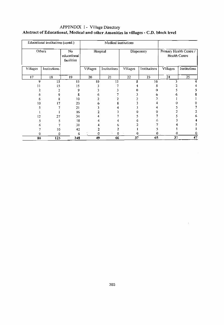
APPENDIX I - Village Directory Abstract of Educational, Medical and other Amenities in villages - C.D. block level
-Educational institutions (contd.) Medical institutions
Others No Hospital Dispensary Primary H~alth Centre / educational Health Centre
facilities
Villages Institutions Villages Institutions Villages Institutions Villages Institutions
17 18 19 20 21 22 23 24 25 -9 15 15 10 13 8 16 3 4
11 15 15 3 7 4 8 2 4 2 2 9 3 3 0 0 5 5 6 9 8 6 7 3 6 6 8 6 8 10 2 2 2 2 1 1
10 17 23 6 8 3 4 0 0 5 7 21 3 4 3 4 5 7
I 1 16 2 3 0 0 2 2
12 27 34 4 7 5 7 5 6
5 5 18 4 4 6 6 3 4
6 7 31 4 6 2 7 4 5
7 10 42 2 2 1 5 I I
0 0 6 0 0 0 0 0 0
80 123 248 49 66 37 65 37 47
393

APPENDIX I - Village Directory Abstract of Educational, Medical and other Amenities in villages - C.D. block level Name of the District· Bahraich
Medical institutions Medical institutions (contd.) (contd.)
Primary Health Sub- Maternity and Child Family Welfare Community Health Others centre Welfare Centre I Centre Workers
Maternity Home I Child Welfare Centre
Villages Institutions Villages Institutions Villages Institutions Villages Numbers Villages Insti-tutions
26 27 28 29 30 31 32 33 34 35 3 3 10 15 11 15 6 21 2 2 9 13 29 38 7 3 3 10 10 4 4 13 21 4 6 6 6 8 1 1 18 26 5 11 4 4 5 5 I 28 32 8 17 4 4 14 15 1 I 27 29 7 7 8 8 II 15 6 6 19 24 4 7
1 7 7 I 34 39 4 4 11 11 12 16 5 5 22 29 10 35
16 27 3 3 22 23 5 13 4 4 10 17 31 43 5 16
10 10 1 I IS 19 2 4 0 0 0 0 0 0 0 0 0 0
48 48 120 158 26 26 269 338 58 146
394
No medical facilities
36 85 54 49· 46 55 91 69 48 95 81 74 98
7 852

APPENDIX I - Village Directory Abstract of Educational, Medical and other Amenities in villages - C.D. block level Name of the District· Bahraich
Drinking water source Drinking water source (contd.)
Tap Well Tank Tubewell River Fountain Canal Others More than one source
37 38 39 40 41 42 43 44 45 81 81 5 14 7 0 7 103 97 61 82 32 4 5 0 25 83 81 59 62 14 16 7 0 3 63 65 60 66 II 4 II 0 7 71 71 52 68 15 19 0 0 83 72
59 109 9 13 7 5 127 121 50 86 14 4 7 0 10 88 87 22 72 4 7 6 0 I 86 75
104 108 16 19 II 0 4 115 109 72 99 16 7 12 0 I 101 104 47 103 27 24 8 I 0 105 104 74 97 II 16 12 0 0 117 108 0 4 0 0 0 0 0 7 4
741 1037 174 147 93 2 64 1149 1098
395
No drinking water
facilities
46 0 I 0 0 2
I 0. 0 0 0
0 6

APPENDIX I - Village Directory Abstract of Educational, Medical and other Amenities in villages - C.D. block level Name of the District· Bahraich
Post, Telegraph & Telephone Transport communications
Post office Telegraph Post & Post Telegraph Post, Phone Bus Railway Navigable office telegraph office & office & telegraph service station waterway
office phone phone office & phone
47 48 49 50 51 52 53 54 55 56 29 6 0 0 9 16 4 6 14 5 1 14 6 2 20 19 0 0 7 0 0 13 5 0 22 4 4 12 3 3 19 8 1 7 II 2 2 5 25 10 0 0 14 2 7 34 12 3 2 24 6 6 4 I I 15 II 0 7 13 0 0 4 0 0 20 8 0 4 23 4 4 12 2 2 22 6 0 10 20 2 2 8 21 10 0 4 II I I 7 I 48 2 0 6 16 3 2 12 3 2 44 4 9 0 0 0 0 0 0 0 2 0 0
216 26 24 89 14 13 284 100 12 75
396

I
I
APPENDIX I - Village Directory Abstract of Educational, Medical and other Amenities in villages - C.D. block levell Name of the District" Bahraich
Banks Power supply Credit societies
Villages Number of Available Not Villages Number of Villages Number of Villages commercial available agricultural non-
and co- credit agricultural operative societies credit
banks societies
. 57 58 59 60 61 62 63 64 65
5 5 45 60 4 4 0 0 0 3 6 27 60 4 4 I I 2 2 46 24 2 2 0 0 0
II II 30 42 7 7 3 3 I 5 5 48 40 8 8 0 0 0 5 7 84 48 8 8 2 2 0
9 10 29 66 6 6 0 0 0
4 4 31 56 4 4 6 8 47 75 12 12 2 2 3
7 9 46 64 7 7 0 0 2
4 6 73 36 8 8 0 0 2 2 4 81 39 7 7 0 0 I
0 0 0 7 1 I 0 0 0
63 77 587 617 78 78 9 9 11
397
Number of other credit
societies
66 0
0 I 0 0 0
3 2 2 I 0
11
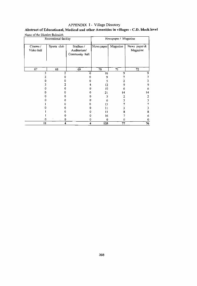
APPENDIX I - Village Directory Abstract of Educational, Medical and other Amenities in villages - C.D. block level
Name of the District· Bahraich Recreational facility Newspaper I Magazine
Cinema/ Sports club Stadium I News paper Magazine News paper& Video hall Auditorium! Magazine
Community hall
67 68 69 70 71 72 3 2 0 16 9 9 2 0 0 9 7 7 0 0 0 5 2 2 3 2 4 12 9 9 0 0 0 )0 6 6 0 0 0 21 14 14 0 0 0 5 2 2 0 0 0 6 3 3 I 0 0 13 7 7 0 0 0 II 3 3
0 0 II 8 8 I 0 0 16 7 6 0 0 0 0 0 0
11 4 4 135 77 76
398

APPENDIX lA • Village Directory
Villages by number of Primary Schools Name of the District:BAHRAICH
Serial Name of C. D. block Total Number of primary schools number number of
1
2 3 4 5 6 7 8 9 10 II 12 13
2 . . Mlhmpurwa Nawabganj Balaha Shivpur Risia Chitaura Mahasi Tajwapur Phakharpur Huzoorpur Kaisarganj Jarwal Forest Villages District Total:
inhabited vil1"op~
3 105 87 70 72 88
132 95 87
122 110 109 120
7 1204
None One
4 5 15 18 10 8
10 25 21 16 34 20 34 44
6 261
399
61 35 33 39 53 86 46 55 72 77 65 68
691
Two
6
Three
7 20 22 17 20 14 14 22 10 14 8 7 7 0
175
6 8 7 3 9 4 2 5 0 4 2 1 0
51
. 3 4 3 2 2 3 4 1 2
1
o o
26

APPENDIX 1B - Village Directory
Villages by Primary, Middle and Secondary Schools ~ District:BAHRAlCH
Serial Name of C. D. block Total Type of educational institutions available number
1 1 2 3 4 5 6 7 8 9 10 11 12 13
2 .. Mlhlnpurwa Nawabganj Balaha Shivpur Risia Chitaura Mahasi Tajwapur Phakharpur Huzoorpur Kaisarganj Jarwal Forest Villages Total:
number of inhabited villages
3 105 87 70 72 88
132 95 87
122 110 109 120
7 1204
No School
4 15 18 10
8 10 25 21 16 34 20 34 44
6 261
400
At least one primary school and no middle
school
5 67 55 47 44 66 84 53 56 71 77 60 67
1 748
At least one primary school and one middle
school
6 23 14 13 20 12 23 21 15 17 13 15 9 0
195
At least one middle school
and one secondary
school 7
5 3
8 1 2 7 3 9 5 3 1 0
48

APPENDIX 1 C - Village Directory
Villages with different sources of drinking water facilities available )istrict:BAHRAICH
Serial Name of C.D. number block
1 2 ..
1 Mlhmpurwa 2 Nawabganj 3 Balaha 4 5 6 7 8 9
10 11 12 13
Shivpur Risia Chitaura Mahasi Tajwapur Phakharpur Huzoorpur Kaisarganj Jarwal Forest Villages District Total:
Number of villages with different sources of drinking water available Only tap
3 1 o 2 0 0 0
0 4 0 0
0 9
Only well
4 o 1 o 0 0
2 1 0 2 1 0 0 8
Only tube well
5 o o o o o o o o o o o o o o
401
Only handpum
p
6 7 4 3 1
14 9 4 11 9 4 4 10 3
83
More than one source only from tap, well, tube well,
handoumo 7
97 80 65 69 72 120 85 75 109 100 103 107 4
1086
I
I

APPENDIX II - Village Directory Villages with 5,000 and above population which do not have one or more amenities
N arne of the District: BARRA! CH
Amenities not available ( indicate N. A where amenity not available)
Location Senior Primary Tap Appro-ach
code Name of C.D. Popu- Secondary Call- Health Sub drinking Bus byPucca Corrunerc
SrNo Name of village number block lation School ege Centre water facility road ial Bank
1 2 3 4 5 6 7 8 9 10 11 12
Chahalwa 06425700 Mihinpurwa 6094 N.A. NA. N.A. AvailabNA. Available N A. 2 Kari Kot 06425900 Mihinpurwa 5608 Available NA NA Availab N.A. Available N A 3 Sujauli 06426300 Mihinpurwa 8538 NA NA. N.A. Availab Availabl Available Available 4 Harkhapur 06427000 Mihinpurwa 6502 NA NA N.A. N.A. A vailabl Available N.A 5 Madhawapur 06428500 Mihinpurwa 6427 N.A. NA N.A A vailab N A. Available N A 6 Majhara 06428700 Mihinpurwa 6923 N.A. N.A N.A. Availab NA. N.A. NA 7 Urra 06428900 Mihinpurwa 8098 N.A. NA. NA. A vailab A vailabl Available N A S Ihala 06429800 Mihinpurwa 5539 N.A. NA. N.A. Availab NA. NA. NA. 9 Gopiya 06431600 Mihinpurwa 6217 N.A. NA. NA. AvailabN.A. AvailableN.A. 10 Motipur 06433900 Mihinpurwa 7532 NA. NA. Available A vailab A vailabJ Available N A II Mihi Purwa 06434000 Mihinpurwa 7997 NA. NA NA. A vailab N A. Available NA 12 Kundwa 06434100 Mihinpurwa 6721 Available NA. NA. A vailab N.A. Available Available 13 Parwani Gauri 06434200 Mihinpurwa 5262 Available NA NA. AvailabN.A. Available N A. 14 Kewalpur 06439000 Nawabganj 11088 N.A. NA. Available NA Availabl Available Available 15 Chaugorwa 06445100 Nawabganj 5765 NA NA NA. Availab Availabl Available Available 16 Gayaghat 06448300 Balaha 9175 NA NA Available NA A vailabl Available Available 17 Sarramundari 06448600 Balaha 5917 NA NA. NA. Availab N.A. NA. N.A. 18 Banjariya 06451300 Balaha 6034 N.A. NA. N.A. A vaHab N.A. NA. NA. 19 Nanpara Dehati 06451600 Balaha 12705 N.A. NA. N.A Availab N.A. Available N A. 20 ChauksaHar 06453300 Shivpur 6937 NA. NA. Available N.A. N.A. NA. NA. 21 Baundi 06455000 Shivpur 5933 NA. NA. NA. NA. N.A. NA. Available 22 Matera Ka.lan 06456000 Shivpur 5455 NA. NA. NA. Availab N.A. AvailableNA. 23 Intaha 06457500 Shivpur 7443 NA NA. NA Availab Availabl Available N A. 24 Mohama 06461800 Risia 5728 NA NA. NA. A vailab N A. NA NA. 25 Balbhaddarpur 06464700 Risia 6890 NA NA. NA Availab NA. NA. NA. 26 Rampur 06492100 Chitaura 5652 NA N.A. NA NA A vailabl Available N A. 27 Raipur 06470800 Mahasi 6934 NA NA. Available A vailab N A. Available Available 28 Mahsi 06472900 Mahasi 6893 Available NA. Available A vailab A vailabl Available Available 29 Jot Chand para 06473300 Mahasi 6113 NA NA. NA NA NA Available Available 30 Rehuya Mansur 06475000 Mahasi 6977 NA. NA. Available A vailab N A. Available Available 31 Shekh Dahir 06481400 Tajwapur 7885 NA NA. NA. Availab NA NA NA.
Khasaha 32 Mohammadpur 06481500 Tajwapur 5413 Available NA. NA. NA NA. Available N A. 33 Baundi 06488500 Phakharpur 5439 NA. NA. N.A. Availab Availabl Available Available 34 Madhaupur 06505400 Phakharpur 6296 Available NA. Available Availab N.A. Available N A. 35 Bubkapur 06506900 Phakharpur 5391 NA. NA N.A. AvailabN.A. AvailableNA. 36 Majhara Tawkali 06512400 Phakharpur 12414 NA. NA. N.A. Availab N.A. NA. NA. 37 Badrauli 06528900 Kaisarganj 5158 NA NA. Available Availab N A Available A ,"ailable 38 Ainy Hatinsi 06531900 Kaisarganj 5241 N.A. NA. NA. NA. N.A. AvailableNA.
Godahiya No. 39 IT04 06532700 Kaisarganj 19352 N.A. NA. NA. Availab N.A. NA. NA.
- Blrhimpur 40 -Belahaura 06537600 Jarwal 5175 NA. NA. NA. A vailab N .A. Availabk N.A~
- 41 Gandara 06539000 Ja:rwaI 5029 NA. NA. NA. A vailab N .A. A vailabk A Ya,llable_
402

APPENDIX II - A Census Town Census Towns which do not have one or more amenities
Name of the District: BAHRAICH
· Serial Name of Location Name of Populatio Amenities not available ( indicate N. A. wh{:re amenity not number census code C.D. n available )
town number block
· Senior College Health Tap Bus Approach Banks
Secondary Centre drinkino "
facility by Pucca School water road
· I 2 3 4 5 6 7 8 9 10 II 12
There is no Census town in the district.
Appendix m - Village Directory Land utilisation data in respect of Census Towns/non- municipal towniS
IName of District - BAHRAICH
S. No
Name of Census Town and C.D block with
in brackets 2
Land Use ( i.e., area under different types of land use in
hactare)
Total Area
3
NIL
403
Forest 4
Irrigate
d by source
5
Cultura
ble Waste
(includi
ng gauchar
Unirrigat & Area not available
ed groves) for cultivation 6 7 8

APPENDIX IV - Village Directory C.D. block wise list of inhabited villages where no amenity other than drinking water facility
is available Name of the District:BAHRAICH
Serial number Location code number
1 2 3 4
06426800 06430600 06427800 06433500
Name of CD Block: Mihinpurwa 5 06425200 6 06425700 7 06426000 8 06426600 9 06429200 10 06429700 11 06430900 12 06434700 13 06434800 14 06436000 Name of CD Block: Nawabganj 15 06436900 16 06437800 17 06439100 18 06439200 19 06439300 20 06442100 21 06443600 22 06444500 23 06444600 24 06444700 Name of CD Block: Balaha 25 06445900 26 06446500 27 06449100 28 06450800 Name of CD Block: Shivpur 29 06453400 30 06454200 31 06457600 32 06468100 33 06468200 Name of CD Block: Risia 34 06458600 35 06460800 36 06461900 37 06462200 38 06464800 39 06465000
. 40 06465300 Name of CD Block: Chitaura 41 06491800 42 06492000
2
404
Name of villa e
Nishan Gara Range Dharmpur/Murtiha Kakraha Range Chakiya/Rupaidiha
Tela Gauri Chahalwa Lohara Hariharpur Lalpur Girgtti Katraniya Babhaniya Fata AntahWa Balapur Mohnapur Gangapur
Rampur Munna Pathak Belchandpur Gokulpur Khushali Purwa Sheo Rampur Teliyani Sheo Nagra Majgawa Bhagat PUrwa Bhagtapur Tokhaiedih
Chiraiya Rajapur Girant Kola Jh;ns;ya Senduri
Pathak Purwa Sohbatiya Sahattar Kursaha Dharm Kunda
Piprahwa Lila Para Jokaha Maharatha Hundarwa Teliya Ma;la Barganwa
God; Jagadhar Bhar
3

APPENDIX N - Village Directory C.D. block wise list of inhabited villages where no amenity other than drinking wat.e:r facility
is available Name ofthe District:BAHRAICH
Serial number Location code number Name of villa e
~~ 1 2 3
1 06426800 Nishan Gara Range 43 06492300 Murau Purwa 44 06492400 Laukna 45 06494100 Jhansa 46 06494400 Andhra Chak 47 06495600 Babhni 48 06495800 Katehnawan Girant Kalan 49 06496500 Katahna Wan Grant Khurd 50 06496600 Lalpur Meera Mau 51 06497200 Sujatpur 52 06498200 Hazi Bilai 53 06500200 Gaura 54 06501800 Pauli Amauli 55 06501900 Shyampur Nandauna Name of CD Block: Mahasi 56 06470200 Bakaina 57 06470600 Dhanwa 58 06471600 Sigiyansirpur 59 06472200 Pure Deldar Singh 60 06472600 Galkara 61 06472800 Narkotwa 62 06473700 Pure Arjun Singh 63 06474800 Mudhapur 64 06474900 Sankalpa 65 06476500 Rewati Purwa 66 06477400 Karehana 67 06477500 Kodwa 68 06477600 Barwliya 69 06477700 Kolyala 70 06477800 Gauriya 71 06478000 Pipra 72 06478100 Pipri 73 06478800 Umriya 74 06479400 Badwa Behra Name of CD Block: Tajwapur 75 06481300 Bhogajot 76 06483100 Tajawapur 77 06483800 Madara 78 06484100 Gajpatipur 79 06484700 Awalpur Masudpur 80 06484900 Husenpur 81 06485400 Hathi Chak 82 0648_5900 Godawa 83 06486200 Bhirwa _Name of CD Block: ~_haknarpur 84 06487300 Tulapur 85 06487400 Churwalia 86 06487900 Betaura
405

APPENDIX IV - Village Directory C.D. block wise list of inhabited villages where no amenity other than drinking water facility
is available Name of the District:BAHRAICH
Serial number Location code number
1
06426800 87 06489500 88 06490700 89 06504700 90 06505000 91 06505900 92 06506700 93 06509000 94 06509100 95 06509500 96 06510600 97 06511000 98 06511300 99 06511400 100 06511500 101 06511700 102 06511900 103 06512300 Name of CD Block: Huzoorpur 104 06514300 105 06514600 106 06514800 107 06515000 108 06515300 109 06516500 110 06517300 111 06519100 112 06522700 Name of CD Block: Kaisarganj 113 06526100 114 06528100 115 06528500 116 117 118
06529300 06529600 06534900
Name of CD Block: Jarwal 119 06537700 120 06537800 121 06538000 122 06538300 123 06541900 124 06545400
_125 06545800 126 06545900 127 06546000 . 128 06546100 129 06546300 130 06546400
2
406
Name of villa e
Nishan Gara Range Kanera Bhadwani
3
Sahawapur Mahipal Singh Husepur Keshwa Kunda Mohamadpur Kala Bibipur Piyarepur Chandradipa Badanapur Saray Kaji Surjana Khurd Akhanapur Dhruwa Nathupur Bhilaura Basanti Sirauli
Khargauli Seriya Nijampur Chak Banarasi Harduha Bambharpur Mukam Jiganiya Jasakaran Singh Pure Prahlad
Jhopadwa Metwapur Kandauli Abdullah Bahera Gazipur Kodari Chandan
Suaia Bhopatpur Dhanaoliya Khaprawa Usara Para Paras Rampur Dikauli Khurd Bhadrasi Niamatpur Ii Mohammadpur Khurd Bahrampur Khase Pur

S Serial
number
1 1 2 3 4 5 6 7 8 9
10 11 12 13
APPENDIX V - Village Directory h . b fill th' ShdldC t 1 f ummary s OWIJ!g num er 0 V ages no avmg c e ue as es _l)_C!£_u ~ Ion
Name ofC.D. block
2 .. Mlhmpurwa Nawabganj 8alaha Shivpur Risia Chitaura Mahasi Tajwapur Phakharpur Huzoorpur Kaisarganj Jarwal Forest Villages District Total:
Total villages
3 110 95 70 72 89
133 98 87
123 111 110 121 7
1226
Uninhabited villages
4 5 8 o o 1
3 o
1 1 1 o
22
407
Inhabited villages
5 105 87 70 72 88 132 95 87 122 110 109 120
7 1204
Number of inhabit~:d villages having no Schedult:d Castes
_population 6 6 3 o 2 5 12 9 4 8 5 9 13 o
76
APPENDIX VI - Village Directory Summary showing number of villages not having Scheduled Tribes population
Serial number
1
2 3 4 5 6 7 8 9
10 11 12 13
Name of C. D. block
2 .. Mlhmpurwa Nawabganj Balaha Shivpur Risia Chitaura Mahasi Tajwapur Phakharpur Huzoorpur Kaisarganj Jarwal Forest Villages District Total:
Total villages
3 110 95 70 72 89 133 98 87 123 111 110 121 7
1226
Uninhabited villages
4 5 8 0 0 1 1 3 0 1 1 1 1 0 22
408
Inhabited villages
5 105 87 70 72 88 132 95 87 122 110 109 120 7
1204
Number of inhabited villages having no Scheduled Tribes
population 6 83 84 70 70 88 132 95 84 122 110 108 120
3 1169
APPENDIX VII A- Village Directory List of villages according to the proportion of the Scheduled Castes to the total population by
ranges
Name of the District:BAHRAICH
Range of Scheduled Castes population Location code Name of village (oercentages) number
I 2 3
Name of CD Block: Forest Villages 5-10
06440100 Abdullah Ganj/Nanpara 06425100 Katarneya Ghat Range
11-20 06433500 Chakiya/Rupaidiha 06426800 Nishan Gara Range 06427800 Kakraha Range 06430600 Dharmpur/Murtiha 06448100 Motipur Range
Name of CD Block: Mihinpurwa Less than 5
06428800 Pairua 06428400 Amritpur 06434800 Balapur 06425000 Bharthapur 06427700 Dharmapur 06436100 Ahlad Gaon 06427100 Dharampur 06434400 Joginiya
5-10 06432600 Basthanwa 06432500 Laukahi 06430900 Babhaniya Fata 06432400 Parsohna 06426900 Nishan Gara 06432800 Chaudhari Gaon 06429300 Gurh 06429400 Bhiwrabir Ghat 06432000 Gaurariya 06425500 Bardiya 06435300 Chikaniya 06429700 Katraniya 06431600 Gopiya 06427400 Semari Ghatahi 06428600 Naubana 06435800 Katghar 06431200 Kakraha 06426100 Chafariya 06434000 Mihi Purwa
11-20 06428700 Majhara 06426400 Matehi 06425800 Bajpur Bankati 06435200 Bhagwanpur Kurmiyana 06435700 Madariya
409

APPENDIX VII A- Village Directory List of villages according to the proportion of the Scheduled Castes to the total population by
ranges
Name ofthe District:BAHRAICH
Range of Scheduled Castes population Location code Name of village ( percenta_ge~ number
1 2 3
06430000 Somaie Gauri 06432100 Petarha 06433900 Motipur 06427000 Harkhapur 06428200 Gangapur 06429600 Nainiha 06429900 Jalim Nagar 06429200 Girgtti 06434100 Kundwa 06436000 Mohnapur Gangapur 06428900 Urra 06431700 Kanjarwa 06435500 Ray Bojha 06434200 Parwani Gaur; 06428500 Madhawapur 06425900 Kari Kot 06427600 Mahrajsingh Nagar 06431300 Chorwa 06435400 Pargahwa 06435100 Argorawa 06434700 Antahwa 06427300 Lalbojhe 06426300 Sujauli 06426200 8arkhariya
21-30 06432300 Karmohna 06430700 Murtiha 06436200 Bishun Nath Gaon 06435600 Ayodhya Gaon 06435900 Kailashpur Jhoman Gaon 06426700 Jangal Gulariha 06431500 Lalpur Chanda Jhar 06430100 Mangauriya 06432700 Sahoni 06430200 Rajapur 06427200 Semari Malmala 06427500 Kathoutiya 06427900 Bejha 06432200 Bhagariya 06425700 Chahalwa 06429800 Jhala 06428300 Puraina 0643290q-· Matehi Kalan 06431100 Nidhi Purwa 06429500 Khariya 06425300 Amba
410

APPENDIX VII A- Village Directory List of villages according to the proportion of the Scheduled Castes to the total population by
ranges
Name ofthe District:BAHRAICH
Range of Scheduled Castes population Location code Name of village (percentages) number
1 2 3
06430300 Argorawa 31-40
06425200 Tela Gauri 06433200 Pounda 06426000 Lohara 06426500 Rampurwa 06431800 Songawa 06433100 Majgawa 06428000 Bojhiya 06433700 Hansuliya 06431400 Gaura Pipra
41-50 06431000 Chitlahwa 06433400 Sarra Kalan 06428100 Majhawa 06430500 Salar Purwa 06434500 Visram Gaon 06433300 Bakhari
51-75 06434600 Bharha 06434300 Ainchuwa 06433000 Puraina Raghunath 06431900 Kharaiya
76 and above 06430800 Ghumna Bharu 06433600 Parariya
Name of CD Block: Nawabganj Less than 5
06438900 Pach Pakari 06444500 Bhagat Purwa
5-10 06445200 Bansantpur Kalika 06444800 Ganeshpur Nimnahara 06445400 Bankashahi 06444600 Bhagtapur 06444000 Lakshamanpur Lahsorwa 06442600 Umariya 06439000 Kewalpur 06445100 Chaugorwa 06438600 Gendpur 0644190_0 Sheopur Semra 064453QO Govindpur Pandit 06437100 ,Jamunha Babaganj 06445700 Satijor
11-20 06445800 Dharm Nagar
411

APPENDIX VII A- Village Directory List of villages according to the proportion of the Scheduled Castes to the total population by
ranges
Name ofthe District:BAHRAICH
Range of Scheduled Castes population Location code Name of village (percentages) number
1 2 3
06445000 Mirjapur Tilak 06442700 Rahim Nagar 06436600 Mirjapur Chahlwa 06436500 Imam Nagar Gadrahwa 06438200 Ranjit Bojha 06440400 Bankuri 06436900 Rampur Munna Pathak 06445500 Viraie Gaon 06440700 Lakshamanpur Salarpur 06438700 Sahawa 06444400 Sirsiya 06439800 Nidh Nagar Sankalpa 06442300 Hariharpur Puraina 06443900 Holiya 06436700 Shankarpur 06445600 Chanaini 06440900 Gangapur 06444100 Jamdan
21-30 06441400 Sumerpur 06443000 Pure Surjman 06436800 Basantpur Udal 06440500 Sujauli 06441000 Lakhahiya 06438400 Bhagwanpur Karinga 06439600 Sahjanwa 06443400 Ram Nagar Sumera 06439400 Jaitapur 06443800 Gulariha 06436300 Bakhatawar Gaon 06442200 Chaugoie Bilaspur 06443300 Pir Nasiruddin 06441700 Kalyanpur 06437400 Gawarkha 06440800 Charda 06443100 Jamunaha Naubasta 06438500 Parampur 06441800 Dewara 06439300 Sheo Rampur Teliyani 06437900 Hathiya Bojhi
31-40 06442000 JaJalpur 06437500 Kalwari _ 06439200 Khushali Purwa 06441600 Makanpur 06439900 Gopalpur
412

APPENDIX VII A- Village Directory List of villages according to the proportion of the Scheduled Castes to the total population by
ranges
Name of the District:BAHRAICH
Range of Scheduled Castes population Location code Name of village (percentages) number
1 2 3
06437000 Dubidhapur 06437300 Bishunapur 06442900 Madhawapur Raghunath 06440000 Khairahaniya 06441100 Jhauhana 06439500 Muralidhar Dadauli 06441500 Nawwa Gaon 06440600 Sorahiya 06443200 Mansor Nagar Saie Gaon 06443700 Fultekra 06441300 Bhawaniyapur Tikuri 06439100 Gokulpur
41-50 .06442500 Ram Nagar Gulariha 06442100 Sheo Nagra 06443600 Majgawa 06437200 Bargadaha Chilbila
51-75 06439700 Rampur Husen Bux 06442800 Gidharaiya 06440300 Lakshamanpur Gulaldih 06438100 Sheopur Mohraniya 06437700 Madhopur Nidauna 06438300 Daulatpur 06438800 Nidha Nagar Pokhara 06436400 Keshawpur Murawa
Name of CD Block: Balaha Less than 5
06449600 Amba Pokhar 06450800 Senduri 06448800 Lakshmanpur Matehi 06450000 Bhaluhiya Bharat
5-10 06449700 Madhuban 06446100 Khairisamaisa 06449400 . Maghi
06451400 Kakraha Bodhawa 06450900 Bhopatpur Belwa 06448900 Amwa Husenpur 06446700 Shah pur Kalan 06448700 . Nibiya Ray Bojha ~ 06446000 Daulatpur 06451000 Matiha 06448300 Gayaghat 06447000 Lagdiha
11-20
413

APPENDIX VII A- Village Directory List of villages according to the proportion of the Scheduled Castes to the total population by
ranges
Name of the District:BAHRAICH
Range of Scheduled Castes population Location code Name ofvillage
(percentages) number
1 2 3
06447500 Baraiya Kalan 06446900 Balsinghpur 06446800 Shahpur Khurd 06450400 Nibiya Shah Mohammadpur 06448200 Bagha 06449300 Saraiyan 06451500 Kakri 06452200 Gulalpurwa 06451600 Nanpara Dehati 06449200 Maholi Sher K~an 06448600 Sarramundari 06450600 Keshawapur 06449100 Kola Jhinsiya 06450100 Hara Basehari 06452600 Parsa Agaiya 06451300 Banjariya 06447400 Bhawaniyapur Banghusari 06447600 Chandanpur 06451900 Majhauwa Bhulaura 06452300 Siletanganj 06449500 Girdharpur 06452000 Balha 06447700 Pakariya Diwan 06446400 Maheshpur 06451700 Bhatehta 06452800 Siswara 06447900 Rajapur Kalan 06449800 Jagannathpur Pure Bechaie 06447200 Nausar Gumariha 06452900 Lal Bojhi 06452700 Lakhahiya Kalan 06451200 Patrahiya 06451100 Narayanpur Kalan
21-30 06446300 Vaibahi 06449000 Ghurghutta 06450500 Bahadur Purwa 06449900 Tulsipur 06446200 Teri 06451800 Meharban Nagar 06450700 Bankatwa
. 06448000 Gulra 06450300 Rajwapur 06447300 Daljit Purwa 06450200 Newada Nanhujot 06452400 Tajpur
414

APPENDIX VII A- Village Directory List of villages according to the proportion of the Scheduled Castes to the total population by
ranges
Name of the District:BAHRAICH
Range of Scheduled Castes population Location code Name of village (percentages) number
1 2 3
06447800 Hanspur 31-40
06452500 Imaliya Gangapur 06447100 Gulariha Jagtapur 06448500 Puraina Bhawani Bux
41-50 06445900 Chiraiya 06446500 Rajapur Girant 06448400 Bhaluhiya Hulas 06452100 Koyalahwa
51-75 06446600 Baruha
Name of CD Block: Shivpur Less than 5
06456300 Nakhi 06468200 Dharm Kunda 06454200 Sohbatiya 06454500 Sankalpa 06455500 Sheopur 06458300 Maina Newariya
5-10 06468700 Kishunpur Mitha 06453500 Bela Makan 06468500 Musallampur 06453200 Girda 06455100 Valdu Purwa 06457500 Intaha 06456100 Semariya 06455200 Tigra 06458200 Pakra Dewariya 06468800 Raghaujot 06454100 Vitaniha 06456000 Matera Kalan 06468100 Kursaha 06455000 Baundi 06454300 8asantapur 06457200 Rajapur Janub 06467600 Narotampur
11-20 06453300 Chauksa Har 06456800 Pathar Khurd -06468300 Deodattpur 06468400 Khaira Dhaukal 06453400 Pathak Purwa 06468600 Tikwapara 06454800 Yakghara
415

APPENDIX VII A- Village Directory
List of villages according to the proportion of the Scheduled Castes to the total population by ranges
Name of the District:BAHRAICH
Range of Scheduled Castes population Location code Name of village (nercentages) number
1 2 3
06456500 Alinagar Kalan 06457900 Jura 06467900 Pipari Mafi 06455300 Ambarpurwa 06468000 Munimpur Kalan 06458000 Lalpur Sheopur 06457300 Dhanawa 06456700 Chandela 06458400 Jhalan Kalan 06453800 Newada Pure Kasbati 06455800 Rakhauna 06454900 Saiyad Nagar 06467800 Behra 06468900 Shankarpur Lakshmanpur 06455700 Bardaha 06457100 Chahlar 06455600 Laukiha 06454400 Khaira Kalan 06455400 Gujrati Purwa 06453700 Rampur Dhobiya Har 06456200 Nakha 06453900 Ray Ganj
21-30 06469000 Bhagwanpur Vilas pur 06467700 Dhakiya 06467500 Majha Dariya Khurd 06454600 Bahorikapur 06457400 Baghauli 06458500 Mogariha 06458100 Aswa Mohammadpur 06456600 Laluhi 06457000 Pathar Kalan 06456900 Sadhuwapur Gokulpur 06457800 Manikpur
31-40 06457700 Masudnagar Basthanwa 06453600 Arnawa 06454700 Kotwa 06453000 Dallapurwa 06455900 Baruhi
51-75 06453100 Jarbaohiya
-.{)6457600 Sahattar Name of CD Block: Risia Less than 5
06463900 Padari Tara
416

APPENDIX VII A- Village Directory List of villages according to the proportion of the Scheduled Castes to the total population by
ranges
Name of the District:BAHRAICH
Range of Scheduled Castes population Location code Name of village (percentages) number .
1 2 3
06461900 Jokaha 06465900 Karaniya 06462400 Tula Majhauha 06462700 Baijnathpur 06465100 Babhani 06460700 Amwa Molbi 06463600 Gondaura 06467400 Nibiya Husenpur
5-10 06462500 Amwa Jauhar Sisaie 06461500 Lakshamanpur Shankarpur 06465000 Teliya 06465400 Husenpur Mohammadpur 06460300 Paraspur 06461000 Pure Ramdin 06459000 Barehara 06463700 Charsanda Mafi 06462000 Kalpi Para 06466700 Patna Ghusiyari 06458800 Barie Para 06466600 Bahboliya Mahada
11-20 06461100 Kewalpur 06461700 Madara Gari 06463200 Bhagtapur 06466000 Bhaisahi 06461400 Ram Batti 06463800 Karaunda 06464400 Bhopatpur Chauki 06465700 Uttampur 06461600 Mohammadpur Khurd 06467300 Acharaura 06465500 Bhaluwa Bhakuraha 06465200 Bangia 06466400 Mukam 06458700 Masupur 06462100 Pure Alast Khan 06463400 Dihwa 06462200 Maharatha 06460900 Bhadwara 06458900 Huseni Purwa 06461800 Moharba 06460800 lila Para 06465800 Narsingh Diha 06459900 Bhaukhara 06463100 Gokulpur
417

APPENDIX VII A- Village Directory List of villages according to the proportion of the Scheduled Castes to the total population by
ranges
Name of the District:BAHRAICH
Range of Scheduled Castes population Location code Name of village (percentages) number
1 2 3
06460000 Elaspur Agalya 06466900 Khairi Dikauli 06462900 Bulbul Newaj 06466800 Rampur Kabula 06459700 Gaura Dhanauli 06460600 Samokhan 06464300 Lauki 06466200 Shankarpur 06461300 Ali Nagar Khurd 06464700 Balbhaddarpur 06467100 Utghaniya
21-30 06466500 Ramwapur 06459100 Jamunaha 06459600 Dhanauli Khurd 06459200 Bhawaniyapur Ramgari 06461200 Jagannathpur 06463300 Bisunapur 06460500 Parsa Khargaman 06462300 Bhagwanpur Katghara 06464500 Bhaisaha 06464000 Bargawan 06466100 Majhauwa Mujehna 06464200 Maharu 06463500 Lakhaiya Jadid 06464600 Rampur Baraie 06460400 Kaggar 06459800 Nibiya 8egampur
31-40 06467200 Saida 06466300 Kamla Jot 06464100 Husenpur Mirdangi 06459300 Bangaie 06460100 Jamaluddin Jot 06459400 Raghunathpur 06459500 Mohraniya 06462600 Karijor
41-50 06464800 Hundarwa 06460200 Khudad· Bhari
76 and above 06467000 Rasulpur
Name of CD Block: Chifaura Less than 5
06495700 Uchwa Puraini 06494500 Meerpur Kasba
418

APPENDIX VII A- Village Directory List of villages according to the proportion of the Scheduled Castes to the total population by
ranges
Name of the District:BAHRAICH
Range of Scheduled Castes population Location code Name of village (percentages) number
1 2 3
06495500 Nauwa Gaon 06493700 Kamali 06493300 Jagdishpur Sokha 06491600 Mallapur 06495100 Itkauri 06500100 Sansar Para 06501200 Bahadurpur 06491400 Kurwari Mafi 06491900 Fulwariya Mafi 06500500 Nagar 06494900 Chakapur 06492900 Begampur 06492400 Laukna 06498500 Salarpur 06492000 Jagadhar Bhar
5-10 06492700 Gulhariya 06502400 Chilwariya 06491200 Singaha 06495400 Jalal Patti 06493100 Shahnewajpur 06500700 Nagraura 06494200 Kaitha Chak 06496000 Makolia 06491100 Bhoga Jot 06492200 Tepraha 06469300 Teriya
11-20 06500900 Masihabad 06469200 Baldi PUrwa 06496100 Turhni Rajjab 06497900 Parsaura 06498600 Sidha Prasi 06494800 Rajapur Mafi 06498700 Pahar Pakkar 06498200 Hazi Bilai 06469600 Sisaia Chak 06493900 Risiya Jamal 06493600 Aliua Bulbul 06494400 Andhra Chak . Q6494600 Biswariya 06491000 Sankalpa Mafi 06491500·· Bichhla 06492800 Bhagwanpur Mafi 06502900 Sitkaha Jot Keshav 06491800 Godi
419

APPENDIX VII A- Village Directory List of villages according to the proportion of the Scheduled Castes to the total population by
ranges
Name of the District:BAHRAICH
Range of Scheduled Castes population Location code Name of village (percentages) number
1 2 3
06502000 Bania Hari 06497200 Sujatpur 06501800 Pauli Amauli 06503100 Kaimi Chak 06495300 Parerwa Khan 06491300 Chafriya
21-30 06500300 Suha Para 06493800 Sohrwa 06469500 Dharmanpur 06503300 Bra Gaon 06502300 Unnaisa 06501000 Jagtapur 06494100 Jhansa 06492600 ChaKu Jot 06501900 Shyampur Nandauna 06503500 Kakra Niwada 06503000 Kamolia 06492300 Murau Purwa 06497100 Surjapur Mafi 064'159400 Rampur Gorwa 06499500 Aminpur Nagraur 06498100 SheKhwapur 06502600 Kusaura 06501600 Mohrna 06496600 Lalpur Meera Mau 06496800 Jauhra 06492100 Rampur 06503200 Baraihiya 06494300 Mohammad Nagar 06495200 Sisai Salon
31-40 06498900 Bragunnu 06499600 Deeha 06502100 Renda Lal 06493000 Rasooli Chak 06497000 Ratnapur Tepraha 06496900 Katra Bahadur Ganj 06503400 Sar Bahda 06501500 Govindapur 06500800 Ahiraura 06497700 Baghaura 06499200 Fakeer Chak -06502700 Dharsanwa 06491700 Kishunpur Mafi 06502200 Machhiyahi
420

APPENDIX VII A- Village Directory List of villages according to the proportion of the Scheduled Castes to the total population by
ranges
Name ofthe District:BAHRAICH
Range of Scheduled Castes population Location code Name of village (percentages) number
1 2 3
06502500 Bahadur Chak 06498800 Bakshi Pura 06501300 Khalilpur 06501400 Rasoolpur Sarinya
41-50 06469100 Jani Jot 06497400 Bishunpur Rahu 06499700 Ajatapur 06500000 Ashokha 06496400 Tanda Jalal 06493500 Samsa Tarhar 06499300 Susrauli 06498400 Kalpi Para 06503600 Duhru 06500400 Chhawani Sardar 06496300 Majhauwa Bujurg 06499100 Itaunjha 06495800 Katehnawan Girant Kalan 06501700 Brawa Bhadauli 06501100 Taj Khodahi 06496200 Kaira Hasan 06497800 Chardaha Chandan
51-75 06493200 Godan Basahi 06492500 Damodar Jot 06498300 Sagra 06497300 Barai Bilasa 06498000 Musgra 06499900 Rewali 06496700 Fatna
76 and above 06499000 Hatwarimau 06502800 Araji Jot Keshav
Name of CD Block: Mahasi Less than 5
06473900 Padohiya 06470100 Chkaiya 06473300 Jot Chandpara 06471100 Banspurwa 06474700 Nakahi 06474100 Ramwapur Kalan
5-10 06474300 Parsohana 06475700 Lakhanapur 06473500 Sikandarpur 06469900 Pipriya
421

APPENDIX VII A- Village Directory
List of villages according to the proportion of the Scheduled Castes to the total population by ranges
Name of the District:BAHRAICH
Range of Scheduled Castes population Location code Name of village (percentages) number
1 2 3
422

APPENDIX VII A- Village Directory List of villages according to the proportion of the Scheduled Castes to the total population by
ranges
Name of the District:BAHRAICH
Range of Scheduled Castes population Location code Name of village (percentages) number
1 2 3
06476900 Mathaura 06478400 Murwa 06475900 Nathuwapur 06479100 Kayampur 06470500 Bahduriya 06477200 Fate Purwa 06471300 Pure Hindu Singh 06475800 Sisaiya Churaman 06476400 Ganga Purwa 06478300 Tikuri 06473200 Chand Paiya 06471000 Thailiya 06478800 Umriya 06470300 Chhtlarpur 06470200 Bakaina
31-40 06469800 Badrka 06475200 Bahorikapur 06471900 Garethi Gurudatla Singh 06479400 Badwa Behra 06473000 Nakawa 06479000 Bhgarawal 06475100 Devraipur 06476200 Gadamar Khurd 06471200 Pipri Mohan 06471800 Maiku Purwa 06477500 Kodwa
41-50 06474600 Govindapur 06477700 Kolyala 06472800 Narkotwa
51-75 06472500 Pure Sita Ram 06478200 Dhnauli
76 and above 06472400 Pure Prasad Singh
Name of CD Block: Tajwapur Less than 5
06483500 Jadaupur 06480600 Tarapur Khurd 06482200 Fatehpur. 06503900 Umari Dhalo -06480700 Jhigaha 06487100 Jihura Mafi 06481600 Dasarathpur 06485100 Ganiyapur
423

APPENDIX VII A- Village Directory
List of villages according to the proportion of the Scheduled Castes to the total population by . ranges
Name of the District:BAHRAICH
Range of Scheduled Castes population Location code Name of village (oercentages) number
1 2 3
06504200 Singahi 06483700 Nahkatiya 06485200 Chandan pur Sikaria 06481700 Sarpataha 06482400 Khamriya Hardo Patti 06483600 Dhorayal 06485000 Tendawa Basantpur
5-10 06481000 Jabdi 06485300 Bilaspur 06503800 Aladadpur 06484400 Mahbub Chak 06484100 Gajpatipur 06486900 Ramgadi 06504100 Maraucha 06486600 Khaira 06479700 Baundi Fateullapur 06486800 Dokari 06486200 Bhirwa 06482000 Narahar Gonda 06483400 Mogalaha 06482900 Su~ana
06487000 Naushahara 06483300 Sabalapur 06480400 Bhogiyapur 06483900 Kataha
11-20 06483000 Sir Shahpur 06484700 Awalpur Masudpur 06481400 Shekh Dahir 06487200 Tingai 06504400 Bijjawapur 06479500 Dhobiha 06503700 Kiratanpur 06504300 Raipura 06480300 Jamafa Jot 06482500 Udawapur 06484200 Hemariya 06481900 Lakha Baundi 06480000 Newada 06485600 Gopchandpur 06480100 Basauna Mafi 06484500 Adilpur 06482700 Ram Purwa 06504500 Khuajgipur 06486500 Tedwa Sasantpur
424

APPENDIX VII A- Village Directory List of villages according to the proportion of the Scheduled Castes to the total population by
ranges
Name of the District:BAHRAICH
Range of Scheduled Castes population Location code Name of village (percentages) number
1 2 3
06482100 Behat Bhaya 06483800 Madara 06485700 Baundi Shukul 06483100 Tajawapur 06480500 Chaukhdiya 06484800 Bhatpurwa 06479900 Baukaha 06479600 Ram Gaon 06481100 Saray Mehrabad 06481800 Bhakala Gopalpur 06486700 Inami
21-30 06480200 Maigala 06482300 Khmriha Sukul 06484900 Husenpur 06482600 Bala Saraya 06484000 Sisai Haidar 06481500 Khasaha Mohammadpur
06486000 Tendawa Sisatipur 06485400 Hathi Chak 06504000 Birahim Diha 06480900 Muwafikpur 06479800 Mirzapur 06485900 Godawa
31-40 06485800 Dahawa 06484600 Janijot 06483200 Chetara 06486100 Unchgaon
41-50 06486400 Kodaha
51-75 06482800 Sirajpur 06481200 Tamachpur 06486300 Bariya
Name of CD Block: Phakharpur Less than 5
06510700 Kandausa 06510200 Tendawa Ujar 06506100 Fakharpur 06506000 Ghasipur 06511000- Salay Kaji 06488400 Sai Gaon
06510600 Badanapur 06510800 Kundas Para 06506600 Khalidpur
425

APPENDIX VII A- Village Directory List of villages according to the proportion of the Scheduled Castes to the total population by
ranges
Name of the District:BAHRAICH
Range of Scheduled Castes population Location code Name of village (oercentages) number
1 2 3
06507300 Raundopur 06512900 Saugahana 06505300 Malukpur 06504900 Akbarpur Bujurug 06490400 Gohaniya 06511700 Nathupur 06507000 Haibatpur 06509700 Shivrajpur 06490100 Ramapur Kindhauli 06513000 Sarayali 06507200 Suwagada
5-10 06505100 BaheJiya 06511200 RasuJpur Darehta 06489800 Jaitapur 06505600 Tatehara 06487800 Bahorwa 06511600 Bedaura 06512100 Allipur Darauna 06490500 Amwa Tetarpur 06488300 Ratanpur 06511500 Dhruwa 06490300 Bameyari 06513100 Majgawan 06490800 Sangawa 06505400 Madhaupur 06508200 Sasana 06512700 Kothwal Kalan 06512500 Katela 06510100 Gajadharpur 06508000 Basauna 06489900 Manera 06510000 Ajijpur 06508400 Supani 06507400 Indur 06507100 Tendawa Mahant 06488500 Baundi 06508800 Bhilaura Kaji 06510900 Pakauri 06507800 Dahaura
- 06508500 Bhupani 0651'1100 Saray Jagana 06511300 Surjana Khurd 06489400 Kodahi 06487600 Ghureharipur 06505500 Muse Patti
426

APPENDIX VII A- Village Directory List of villages according to the proportion of the Scheduled Castes to the total population by
ranges
Name of the District:BAHRAICH
. Range of Scheduled Castes population Location code Name of village
(percentages) number 1 2 3 .
11-20 06508300 Rajapur Khurd 06512600 Belahari 06504700 Sahawapur Mahipal Singh 06508900 Sardpara 06490700 Bhadwani 06489300 Dharmapur 06504600 Babhan Diha 06488100 Babhnauti Urf Shahar Golaganj 06505900 Keshwa Kunda 06505200 Baturaha 06509100 Piyarepur 06510400 Khparha 06508600 Jagatapur 06511900 Bhilaura Basanti 06508100 Bhilaura Baso 06512400 Majhara Tawkali 06490000 Bisawa 06511800 Dhakherawa 06506900 Bubkapur 06505000 Husepur 06507500 Aganapara 06512000 Nandwal 06508700 Datauli 06509900 Arai Kala 06510300 Tendawa Alpi Misra 06487900 Betaura 06509600 Akhtayara Pur 06488900 Silauta 06509000 Bibipur 06487500 Naubasta 06507600 Holpara 06507700 Acholaya 06488200 Rahuwa Khas 06487700 Bhauri 06490900 Samada 06489200 Atodar 06506800 Shivpura 06489500 Kanera
21-30 06509200 Dharua 06504800 Dihawa Kala ..
-06506790 Mohamadpur Kala 06506400 Muhammadpur 06512200 Dikoliya 06507900 Singarao
427

APPENDIX VII A- Village Directory List of villages according to the proportion of the Scheduled Castes to the total population by
ranges
Name of the District:BAHRAICH
Range of Scheduled Castes population Location code Name of village (percentages) number
1 2 3
06512300 Sirauli 06488800 Dharehara Nakdilpur 06488000 Sipahiya Hulas 06509500 Chandradipa 06490600 Hemanapur
31-40 06505800 Dharam Saray 06511400 Akhanapur 06510500 Takhawa 06505700 Majhaura 06489700 Behata Churamane
41-50 06506300 Alinagar 06488600 Gujauli Khurd 06509400 Machhiya 06490200 Patti Kamalpur
51-75 06512800 Kothwal Khurd 06509300 Kalha Para
Name of CD Block: Huzoorpur Less than 5
06515500 Majhauwa 06513200 Pipriya Mahipal Singh 06513400 Karidiha 06516200 Badagaon 06517900 Bhawanipur 06519600 Basantpur 06514000 Sarkhana 06522900 Pure Jaita 06518500 Nidura 06519000 Kaluyapur 06523200 Padum Pichhaura 06516500 Bambharpur
5-10 06521100 Laukahi 06515700 Ranipur 06514300 Khargauli 06515200 Ramawapur 06517100 Jaimara 06524200 Chhed Kuri
- 06521400 Jalalpur 06518800 Patakhauli 06520200 Pure Chheda 06521200 Singhpur 06517500 Katdhari Sugariv Singh 06522400 Shekhapur
428

APPENDIX VII A- Village Directory List of villages according to the proportion of the Scheduled Castes to the total population by .
ranges
Name of the District:BAHRAICH
Range of Scheduled Castes population Location code Name of village (percentages) number
1 2 3
06519900 Nibui Kala 06524100 Karmullapur 06513500 Sakha 06521500 Baruhi 06516700 Gaudariya 06519700 Tirkoliya 06522100 Khargapur 06513600 Gobaraha 06515400 Duragupur 06517600 Katghara Kala 06520800 Dhan Para 06517800 Chilharia 06520300 Shahpur 06520400 Saslampur 06521600 Banpurwa 06523100 Siraula 06515800 Jagdishpur 06513800 Tajpur 06522600 Sonhara 06522500 Gyanapur 06517000 Mogalha 06518900 Dharampur 06522700 Pure Prahlad
11-20 06519400 Patu Pur 06519800 Khanpur 06522000 Behda 06523000 Bhathi Kunda 06523600 Jadaupur Bhatahiya 06520900 Shivnaha 06520500 Nibui Khurd 06517400 Hariharpur 06520700 Bhaisha 06519300 Katghara Khurd 06521700 Hujurpur 06522800 Alia Purwa 06517300 Mukam 06518300 Bhanpur 06515600 Gudawapur 06519100 Jiganiya Jasakaran Singh 06516900 Sudana Kala 06522200 Chiraiya Tod 06518700 Jig;aniya Chha!rpal Singh 06523800 Lalpur Aima 06521900 Shivraha 06513700 Sadyabad
429

APPENDIX VII A- Village Directory List of villages according to the proportion of the Scheduled Castes to the total population by
ranges
Name ofthe District:BAHRAICH
Range of Scheduled Castes population Location code Name of village (percentages) number
1 2 3
06519200 Jiganiya Mahipal Singh 06521300 Jagatapur 06523400 Newasi 06517200 Bisunpur 06524000 Adilpur 06514700 Belgaon 06516600 Rantapur 06513300 Gaurya 06518100 Kothawa 06514100 Ailiha 06516000 Mohamadpur Kodwa
21-30 06515300 Harduha 06520600 Kandra 06514200 Bahuta 06517700 Uttar Ganga 06514400 Gokulpur 06518200 Kaira 06516100 Nasarapur 06514500 Baikuntha 06516800 Sisya 06515000 Chak Banarasi 06513900 Chakujot 06520100 Bhagaha 06516400 Babhni 06521000 Devnpur 06523900 Bishunpur Tedi 06515900 Imaliya 06518600 Anandpur 06514900 Bhgahariya
31-40 06514600 Seriya 06523300 Bhidyari 06520000 Babba 06523700 Chaubhaiya 06523500 Nakhara Abbupur 06514800 Nijampur
41-50 06515100 Ahiratad
Name of CD Block: Kaisarganj Less than 5
06534500 Pawahi 06524800 Rukanapur Khurd 06525400 Salarpur 06530500 Jhalla 06535000 Haidarpur Nauvbasta
430

APPENDIX VII A- Village Directory List of villages according to the proportion of the Scheduled Castes to the total population by
ranges
Name of the District:BAHRAICH
Range of Scheduled Castes population Location code Name of village (percentages) number
1 2 3
06529400 Saidapur 06531100 Bairi Maheshpur 06529700 Kasehari Buzurg 06531900 Ainy Hatinsi 06528700 Kohali 06532300 Konari 06524600 Chak Saugahana 06531000 Baira Qazi 06526600 Mokala 06533900 Dadhaila 06531800 Dihawa Sher Bahadur Singh 06534100 PatliTaha 06524700 Bambhiwa 06531400 Panchma 06526500 Gulariha Gazipur 06531200 Kaharai 06529900 Chak Pihani 06532400 Mirpur 06525200 Sidrakha 06530900 Shahpur Rasulpur 06526700 Sutauli
5-10 06533300 Kandaila 06530100 Karim Behr 06531600 Rukanapur Kalan 06526000 Nakauda 06531700 Nawgaeya 06533800 Hasana Mulai 06532800 Baghaiya 06525000 Kundasar 06527300 Bansgawn 06532100 Pawani 06524500 Lalpur,Jalalpur 06528400 Musepur 06526300 Nakaudi Shahpur 06529100 Chulamma 06529500 Vijaipur 06528500 Kandauli 06530000 Barkhur Dyarapur 06532000 Pawana 06533200 Marauthi
11-20 06524400 Paresendi 06529000 Kudauni 06529800 Kasehari Khurd 06534400 Pendari Khurd
431

APPENDIX VII A- Village Directory
List of villages according to the proportion of the Scheduled Castes to the total population by ranges
Name of the District:BAHRAICH
Range of Scheduled Castes population Location code Name of village ( percentag_es}_ number
1 2 3
06532200 Jamaluddinpur 06530300 Guthiya 06526800 Raigarh Baheda 06530600 Lakhnidaspur 06533100 Sohras 06526900 Khajuha 06532700 Godahiya No, no 4 06528900 Badraufi 06533000 Rewali 06535100 Budan Pur 06527400 Bhakhrauli Mugespur 06532500 Chilawa 06527200 Maholi 06530200 Karsar Beraura 06525800 Khemanipur 06531500 Hatinsha Shamspur 06534900 Kodari Chandan 06534800 Achehara 06534600 Salhuwa 06533500 Khurmpur 06524300 Nayamat Pur 06531300 Tawakkalpur 06528000 Sa ray Kanhar 06525600 Umari 06534000 Akbarpur Khurd 06525900 Bairisalpur 06534700 Natthnpur
21-30 06529200 Oevlakha 06527100 KareJa Sahabajpur 0_6525100 ' Bhakala 06527500 Bhakhrauli Kanpurwa 06533400 Materpur 06533600 Wisaidha 06528300 Methaura 06528800 Sahwapur Pachlakhi 06533700 Agapur 06532900 Oanawal 06528200 Ainy 06529600 Gazipur
_06527900 Tande Chatur 31-40
-065-26490 Bhithiya 06528100 Metwapur 06525500 Ichachhapur 06525300 Kanchanapur
432

APPENDIX VII A- Village Directory List of villages according to the proportion of the Scheduled Castes to the total population by
ranges
Name of the District:BAHRAICH
-Range of Scheduled Castes population Location code Name of village
(percentages) number 1 2 3
06527000 Dhurkhi 06527800 Sidrakhi
41-50 06525700 Bibiya Para
51-75 06535200 Kodari Newajis Ali 06532600 Firozpur
76 and above 06526100 Jhopadwa 06527600 Narendrapur
Name of CD Block: Jarwal Less than 5
06537500 Haidarabad 06543700 Basahiya Pate 06542500 Baraoliya 06538300 Khaprawa 06537200 Devi Daspur 06536100 Lakhawapur Bahraucha 06538800 Kapurpur 06539800 Nandoliya 06541300 Nizampur 06537900 Jaisinghpur 06546400 Khase Pur 06537100 Lalpur Jagdishpur 06544900 Khesuwa 06547100 Atwoa 06539000 Gandara 06538400 Dikauli Kala 06538700 Lakhnipur 06545700 Gondaura 06537600 Birhimpur Belahaura
--06542800 Harchanda 06539900 Badauli 06544400 Hasanapur
5-10 06536400 Gaur 06544700 Jumerpur 06539500 Belnapara 06541500 Dihawa Khurd 06546000 Niamatpur Ii 06537700 Suaia 06540500 Jala[pur HardoPatti 06546390 Bahrampur 06540700 Gobraura 06541600 Sahbajpur Bhartha 06546600 Mudya Diha
433

APPENDIX VII A- Village Directory List of villages according to the proportion of the Scheduled Castes to the total population by
ranges
Name ofthe District:BAHRAICH
Range of Scheduled Castes population Location code Name of village (J:>ercentages) number
1 2 3
06542200 Upadhi 06541900 Usara 06544600 Sapsa 06537400 Paina 06535600 Kataka Marautha 06544000 Mustfabad 06543500 Ahata 06541000 Gauspur 06540200 Hasanpur 06537000 Naraunda 06540900 Harani Auseri 06535900 Sakhauta 06541200 Ari Umari 06543800 Atthaisa 06538600 Pedwa 06543100 Manehara 06544800 Rithauda 06538900 Bhkhaura Mafi 06547300 Tappe Sipah 06547200 Rewra 06540100 Nimadipur
06540800 Kurmaura 06540600 Harana Anaura 06543400 Nasir Ganj 06535500 Jhapatpur 06545100 Pakri 06543000 Dhansari 06537300 Chilauli 06536600 Ambhapur 06546900 Gauraya Chak 06537800 Bhopatpur 06540300 Ramwapur Raghubir Singh 06538500 Sumerpur 06536800 Harwa Tand 06545500 Jotaura ,06540400 Shauli 06536200 Sunsi 06546500 Adampur 06535400 Rewliya 06544200 Rodain 06545600 Prsohar 06542700 Basahiya Jagat 06546100 Mohammadpur Khurd 06542300 Bibipur 06540000 Kursanda
434

APPENDIX VII A- Village Directory List of villages according to the proportion of the Scheduled Castes to the total population by
ranges
Name of the District:BAHRAICH
-Range of Scheduled Castes population Location code Name of village
(percentages) number -1 2 3
06546800 Kasmada 06536000 Dosara Para 06542100 Khanehara 06535300 Puraini 06535700 Khevkar 06541400 Islamabad 06543200 Madarpur 06539600 Hajipur 06543600 Parsa 06545200 Bambhaura 06545400 Para Paras Rampur 06541100 Bhadauri 06546200 Niyamatpur I 06545300 Ali Nagar
21-30 06542900 Kanrai 06541800 Rasulabad 06546700 Jhukiya 06541700 Manikapur 06545000 Karmullapur 06539200 Bariya Gothi 06536500 Mirpur Konya 06536300 Harrajpur 06544300 Dhawariya 06539700 Mahuri Kala
31-40 06538200 Maheri 06543900 Dhanrajpur 06538000 Dhanaoliya
41-50 06544100 Rasulpur Nijami 06545900 Bhadrasi
Note:- Villages having NIL Scheduled Castes Population have been excluded
435

APPENDIX VII B - Village Directory List of villages according to the proportion of the Scheduled Tribes to the total population
by ranges Name of the District:BAHRAICH
Range of Scheduled Tribes Location code Name of village population (percentages) number
I 2 3
Name of CD Block: Forest Villages Less than 5
06427800 Kakraha Range 06425100 Katarneya Ghat Range 06430600 Dharmpur/Murtiha
5-10 06426800 Nishan Gara Range
Name of CD Block: Mihinpurwa Less than 5
06434000 Mihi Purwa 06429900 Jalim Nagar 06432500 Laukahi 06432900 Matehi Kalan 06427900 Bejha 06433900 Motipur 06434200 Parwani Gauri 06425300 Amba 06426000 Lohara 06431800 Songawa 06425900 Kari Kot
5-10 06432600 Basthanwa 06426300 Sujauli 06425000 Bharthapur 06426400 Matehi
11-20 06426500 Rampurwa
31-40 06426600 Hariharpur Lalpur
41-50 06427100 Dharampur
51-75 06432700 Sahoni 06425500 Bardiya
76 and above 06425400 Bisunapur 06425600 Fakirpuri
Name of CD Block: Nawabganj Less than 5
06439000 Kewalpur 06442200 Chaugoie Bilaspur 06443800 Gulariha
Name of CD Block: Balaha Name of CD Block;-Shivpur Lessthah 5
06455500 Sheopur
436

APPENDIX VII B - Village Directory List of villages according to the proportion of the Scheduled Tribes to the total population
by ranges Name of the District:BAHRAICH
Range of Scheduled Tribes population (percentages)
1
Name of CD Block: Risia Name of CD Block: Chitaura Name of CD Block: Mahasi Name of CD Block: Tajwapur Less than 5
Name of CD Block: Phakharpur Name of CD Block: Huzoorpur Name of CD Block: Kaisarganj Less than 5
Name of CD Block: Jarwal
Location code number
2
06458100
06485900 06486400 06486300
06524400
Name of village
3
Aswa Mohammadpur
Godawa Kodaha 8ariya
Paresendi
Note:- Villages having NIL Scheduled Tribes Population have been excluded
437
.
.
Serial number
I
Name of gram
panchayat and location
code number
2
APPENDIX VIII Number of villages under each Gram Panchyat (C.D. block wise
Number of villages with location code
numbers
Number of Area of villages with
gram location panchayat code Location in hectare numbers code
3 4 5
Number of Total households population
6 7
Total SC population
8
Income and expenditure of Gram
panchayat (in Rs.'OOO)
Total ST Total Total population income expenditure
9 10 11
The information is not being provided for districts of Uttar Pradesh due to certain reasons.
Name of District
APPENDIX - IX Statement showing number of girls schools in the villages
Name ofC.D. Block Location Code
2 3
Information not available for this district
438
Name of Village Number
4
No. of Girls School
5


SECTION II TOWN DIRECTORY
439


Town Directory Note explaining the abbreviations used in
Town Directory : Statement I : Status and Growth History
Column (2) : Class, name and civic administration status of town :
Class has been introduced to facilitate analysis Of town directory data at the state and all India levels. It is presented according to 2001 Census Population of the town as follows:
Population Class
100,000 and above I
50,000 - 99,999 II
20,000 - 49,999 III
10,000 - 19,999 IV
5,000 - 9,999 V
Below 5,000 VI
Town with a population of one hundred thousand (1,00,000) and above is treated as a city.
The civic administration status of the towns is indicated within bracket against the name of the town. The following abbreviations are used to denote civic status of town.
(i) . Municipal Corporation M.CorlNN
(ii) Municipal Committee MC
(iii) Municipal Council MCI
(iv) City Municipal Council CMC
(v) Town Municipal Council TMC
(vi) Municipal Board MBINPP
(vii) Municipality M
(viii) Cantonment Board/
Cantonment CB
(ix) Notified Area NA
(x) Notified Town NT
(xi) Notified Area Committee/
Notified Area Council NAC
(xii) Notified Town Area NTA
(xiii) Industrial Notified Area INA
(xiv) Industrial Township ITS
(xv) Township TS
(xvi) Town Panchayat TP
(xvii) Nagar.·Panchayat NP (xviii) Town; Committee/Town
Area 'Committee TC
(xix) Small Town Committee ST
(xx) Estate office EO
(xxi) Gram Panchayat GP
(xxii) Census Town CT
Statement II - Physical Aspects and Location of towns, 1999.
Column 3 to 5 : Physical Aspects
In this columns the Rainfall and Maximum & Minimum Temperature of the town is recorded.
Column 6, 7 and 8 : Name of the State headquarters, District
headquarters and Sub-Divisional he~dquarters ~\'ith distance from the referent town in kIlometers, IS to be recorded respectively. If the names mentioned in these columns are, the same as the referent town itself, the distance is recorded as (0) zero.
Column 9 & 10 : Name of the nearest city with one lakh and
more and five lakh and more population are recorded.
Column 11, 12 and 13 : If referent town enjoys the facility of railway
station, bus route facility or navigable river/canaL Its name is to be mentioned. If not available, then the name of nearest place with distance, where such facility exists is to be mentioned.
440
Statement III
Municipal Finance 1998 -1999
Item-wise amount of receipt and expenditure in thousand rupees, relating to municipal finance of the town for the year 1998-99 is to be recorded.
Statement IV Civic and Other amenities,1999
Column (1 to 6) : Self explanatory.
Column (7) : Road length (in kms.)
Information about kutcha/pucca road is to be recorded separately for the roads within the limits of the referent town.
surface are known as storm water drains, while those carrying both sewage and storm water are called combined sewers.
The codes used for different types of drainage system are as follows :
(i) Sewer
(it) Open Surface Drains
(ill) Box Surface Drains
(iv) Sylk Drains
(v) Cesspool method
(vi) Pit System
(vii) Others
S OSD
BSD
SD
CP Pt o
Column 9 t~ 12 : Number .. of latrines
Number of various types of latrines both Public and Private are given in these columns.
Column 13 : Method of disposal of night soil
The various prevalent method of disposal of night

soil are given below with codes:
(i) Head Loads HL (ii) Basket B (iii) Wheel Barrows WB (iv) Septic Tank ST (v) Pit System Pt (vi) Sewerage S (vii) Others 0
Column 14 and 15 : Water supply
Source and capacity of storage system. The following codes are used in these columns:
Column 14:
(i) Tap water T
(ii) Tube-well water TW
(iii) Tank Water TK
(iv) Well water W
Column 15:
(v) Over Head Tank OHT
(vi) Service Reservoir SR
(vii) River Infiltration Gallery RIG
(viii) Bore Well Pumping System BWP
(ix) Pressure Tank PT
The information on major source of water supply are given in column 14 and the storage capacity against each in kilo-litres (in bracket) are presented in column 15.
Column 16 : Fire Fighting Service
In case the fire fighting service is available in the referent town 'yes' is recorded. If the facility is not available within the town. The name of th¥ nearest place having this facility with its distance from the referent town has been recorded.
Column 17 to 21 : Electrification (Number of connections)
Different types of electric connections have been shown in these columns, i.e. Domestic, Industrial, Commercial, Road lighting (points) & others.
Statement V : Medical, Educational, Recreational and Cultural Facilities, 1999
Column 1 to 3 : Self explanatory.
Column 4 & 5 :
The data covers all such medical institutions run by or aided by Government/Semi GovernmentILocal bodies and Charitable institutions or Social agencies like the Missionaries. Wher~-the- family planning centres are attached to hospitals or malernity and child welfare centres or Primary Health Centres, may be treated as independent units and counted separately using following codes:
(i) Hospital H (ii) Dispensary D
(iii) Health Centre HC
(iv) Family Welfare Centre FWC
(v) T.B. Clinic TB
(vi) Nursing Home NH (vii) Others 0 In case of more than one institutions of any type,
it is indicated within brackets the number of such institution (s) e.g. D(3), NH(8), etc. The institutions have further been distinguished by providing additional codes within the bracket as given be:low :
Ayurvedic A
Unani
Homoeopathic
Column 6 to 9 :
u Hom
The codes used for these columns: are as follows
(i) Arts only A
(ii) Science only S
(iii) Commerce only C
(iv) Arts & Science only AS
(v) Arts & Commerce only AC
(vi) Combined for all
categories-Arts, Science
and Commerce ASC
(vii) Law L Column 10 : Recognized shorthand, typewriting
and vocational training institntes
"Recognised" should mean recognised by some statutory authority, like education department, commerce department, labour department etc. of the government or semi government or autonomous bodies, public sector undertakings etc.
441
(i) Pucca Road
(ii) Kutcha Road
PR
KR
Column (8): System of Sewerage
Generally, by sewerage system is implied the network of mains and branches of underground conduits for the conveyance of sewerage to the point of disposal. Sewers that carry only household and industrial wastes are called separate sewers, those that carry storm water from roofs, streetS and other The following codes are used:
(i) Shorthand SH ~
(ii) Typewriting Type
(iii) Shorthand & Typewriting SH Type
(iv) Others 0
The vocational institutions lik'e - Applied Art!

Painting college, Phannacy college, B. Ed. College, Teacher's Training Institute, Music/Dance School, Nursing School etc. are covered under 'Others'.
Column 11 to 14: Higher Secondary/Intermediate/Senior
Secondary/PUC/Junior College level, Secondary/ Matriculation, Middle Schools/ Junior Secondary and
~Primary Schools.
School up to class V are treated as Primary or elementary schools. These include Nursery schools, Kindergarten schools, Pre-Primary schools, Junior Basic schools upto class V and Primary schools upto class IV.
Schools upto VIII are considered as Middle school or Junior Secondary.
Schools upto class X are considered as Matriculation or Secondary schools.
Schools upto XI or XII classes are considered as Higher Secondary/Intermediate/Pre University/ Junior College etc. This would cover 10+2 classes whether held in schools or college.
If there are composite schools like middle schools with primarY classes or Secondary schools with Middle classes, these are also inclu_ded in the number of Primary and Middle schools, respectively. For example, if in a town, there are two Primary Schools and one Middle school with Primary classes, the number of Primary schools in the town is given as three and that of Middle schools as one though there are only three educational institutions.
If there are more institutions of a type in the town, the number is indicated within bracket along with the abbreviation, e.g. P( 4), M(3).
Column 15 : Adult literacy class/centres This column has been introduced keeping in view
the Minimum Needs Programme of the Planning Commission. There are number of Adult Education Centres which are included in these columns.
If an educational facility is not available in the town, the name of the nearest place and its distance in kilometres from the town where the facility is available is mentioned.
Column 16 : Working Women's hostels with number of seats
The number of working women's hostel if available in the referent town is mentioned with number of seats. If the facility is not available in the town the name of nearest place with distance where the facility is available is recorded.
Column 17 to 19: Recreational and Cultural Facilities
Stadium, Cinema, AuditoriumlDramaiCommunity Hall are covered under recreational & cultur~1 facilities. The particulars of permanent recreational facilities are considered for these columns.
Column 20 :Public Libraries, Reading Rooms Number of public libraries and reading rooms
available in the referent town are recorded in codes as follows:
(i) Public Library PL (ii) Reading room RR
Statement VI : Trade, Commerce, Industry and Banking, 1999
Column 3 to 8 :
442
Name of three most important commodities exported and names of three most important commodities manufactured in the town are recorded.
Column 9 : Number of Banks Number of Banks available in the referent town
both Commercial and Co-operative banks are recorded against this column.
Column 10 & 11 : Number of Agricultural Credit Societies and Non Agricultural Credit Societies
The total number of Agricultural Credit Societies and Non Agricultural Credit Societies in the referent town are recorded against these columns.
Statement VII : Civic and other Amenities in Slums, 1999
This is the statement on civic and other amenities in all slums whether notified or not and for all towns having statutory bodies, like municipality, Municipal Corporation, Town area committee etc.


Town Directory Statements (I to VII)
443

STATEMENT - I Status and Growth HistorY
SrI. Class, name and Location Name of Talukl Name of Area Number of Population and growth rate
No civic status code Tahsil! Police C.D. block (in sq. km.) households incl. (ill brackets) of the town at 01 town number Stationllsland etc. house less the Censuses of
households
(2001 Census) 1901 1911
2 3 4 5 6 7 8 9
III Nanpara (NPP) 45001000 Nanpara Balaha 4.2 5812 10,601 9.782
2 IV Risiya Bazar (NP) 45002000 Bahraich Risia 7.6 1701 Created aft'~r 19B1 Census
3 I Bahraich (NPP) 45003000 Bahraich Chitaura 13.3 23951 27,304 26,907
4 IV Ja/Wal (NP) 45004000 Kaiserganj JalWal 10.0 2195 Created after 1971 Census
444

STATEMENT -I Status and Growth Histo!y
Population and growth rate (in brackets l Density Sex ratio of the town at the Censuses-of (2001 1981 1991 2001
Census)
1921 1931 1941 1951 1961 1971 1981 1991 2001 10 11 12 13 14 15 16 17 18 19 20 21 22
8,468 11,656 13,048 13,192 14,576 18,732 27,452 34,409 42,773 10,112 870 867 895
24.31 8,814 11,122 1,473 904 920
26.19 27,371 33,783 39,963 44,741 56,033 73,931 99,889 135,400 168,323 12,656 884 870 879
24.32
8,543 11,741 15,780 1,578 902 872 895
34.40
445

STATEMENT-II Physical Aspects and Location of Towns, 1999
Name of and road distance in
Physical aspects kilometer( s) from
Serial Class, name and Rainfall Temperature (in centigrade) StateHQ. [Jisltict HQ,
number civic status (inmm) Maximum Minimum of town
2 3 4 5 6 7
III Nanpara (NPP) 1158.6 38 19.7 Lucknow BahraiCh
(165) (35)
2 IV Risiya Baz.ar (NP) 1158.6 38 19.7 Luclmow BahraiCh
(148) (18)
3 I Bahraich (NPP) 1158.6 38 19.7 Lucknow BahraiCh
(130) (0)
4 IV Jarwal (NP) 1158.6 38 19.7 Lucknow BahralCh
(86) (47)
446

STATEMENT-II
Physical Aspects and Location of Towns, 1999
Name of and road distance in kilometer(s) from
Town Directory Statements (I to VII)
443

STATEMENT - I Status and Growth Histo!y
SrI. Class, name and Location Name of Talukl Name of Area Number of Population and growth rate
No. civic status code Tahsil! Police C.D. block (in sq. km.) households incl. (in brackets) of the town at of town number Stationllsland etc. houseless the Censuses of
households
(2001 Census) 1901 1911
2 3 4 5 6 7 8 9
III Nanpara (NPP) 45001000 Nanpara Balaha 4.2 5812 10,601 9.782
2 IV Risiya Bazar (NP) 45002000 Bahraich Risia 7.6 1701 Created aMr 19B1 Census
3 I Bahraich (NPP) 45003000 Bahraich Chitaura 13.3 23951 27,304 26,907
4 IV Jarwal (NP) 45004000 Kaiserganj Jarwal 10.0 2195 Created after 1971 Census
444

STATEMENT· II
Physical Aspects and Location of Towns, 1999
Name of and road distance in kilometer(s) from
Sub-division fTaluk!
Tahsil! Police station! Nearest city with Nearest city with Railway station Bus facility Navigable river!
Development Block! population of one population of five canal (~ within
Island HQ. lakh and more lakh and more ten kilometers)
8 9 10 11 12 13
Nanpara Bahraich lucknow Nanpara Yes Saryu.C
(0) (35) (170) (0) (0) (4)
Bahraich Bahraich lucknow Risia Bazar Yes
(18) (18) (162) (0) (0) (-)
Bahraich Faizabad lucknow Bahraich Yes Saryu. (R)
(0) (llS) (140) (0) (0) (3)
Kaisarganj Bahraich lucknow Jarwal Road Yes Ghagara. (R)
(9) (47) (108) (10) (0) (6)
447

1 2 3 4
Serial number
I
Class, name and civic status of town
2
III Nanpara (NPP)
IV Risiya Bazar (NP)
I BahraiCh (NPP)
IV Jarwal (NP)
STATEMENT - III UDlCloa mance - -M IF- 199899
Receipt (in Rs.'OOO) Receipt through Revenue derived from
taxes, etc. municipal properties and
3
power apart from taxation
292 181 -
2,043
846
448
4
299
2,819 185
Government grant
5
6,985 .-
1,301 -
27,110 -2,199 -
Loan
6

STATEMENT - III M unicmal Finance 1998-99
Receil2t (Contd.) (in Rs. '000) EXDeI diture(in Rs.'OOO) Advance Other Total General Public Public Public Public Others Total
sources receipt administrati safety health and works institutions (specify) expenditure (specify) on convenienc
es
7 8 9 10 II 12 13 14 15 16
7,576 455 3,005 - 2,822 6,282
1,482 1,276 - 15 81 - 1,372
316 32,288 22,011 3,701 399 4,506 10 961 31,588
3,230 399 - 481 1,305 - 2,185
449

STATEMENT - IV Civic and other Amenities 1999 ,
Serial Class, name and civic status of town Population Population 200 I Census Road Sy.te'; of Number oflatrines
nurnbe (200 I Census) Scheduled Castes Scheduled Tribes length (in km. (5) sewerage Total Waterborne
r )
I 2 3 4 5 6 7 8 9
III Nanpara (NPP) 42,773 1,782 6 KR(20) PR(10) OSO 4,800 1,800
2 IV Risiya Bazar (NP) 11,122 1,287 o KR(8) PR(S) OSO 500 450
3 I Bahraich (NPP) 168,323 8,244 12 KR(50) PR(15C OSO 20,100 6,649
4 IV Jarwal (NP) 15,780 493 o KR(10) PR(6.8: OSD 1,285 1,185
450

STATEMENT - IV
Civic and other Amenities 1999
Num~r of latrines Method of Water supply Fire fighting Electrification (number of connections) Service Others disposal of Source of System of service· Domestic Industrial Commercial Road Others
night soil supply storage with lighting capacity in (points)
kilolitres (in brackets)
10 II 12 13 14 IS 16 17 18 19 20
2,500 500 B, ST T,TW OHT Bahraich 2,500 80 800 418 -(180) (35)
50 ST, PI T,W Bahraich 733 40 123 3 (-) (18)
13,451 ST, WB T,TW OHT 7,611 82 2,192 2,139 36 (1200) (-)
100 ST, B TW OHT Baharaich 800 10 40 150 (350) (47)
451

STATEMENT - V Medical, Educational, Recreational and Cultural Facilities, 1999
Serial Class, name and civic Population Medical facilities· Educational f~cilities·
number status of town (2001 HospitalslDispensariesl Beds in Arts/Science/ CommerceJ
Census) T.B. clinics etc. medical Lawl Other colleges (of
institutions degree level :md above)
noted in
column 4
I 2 J 4 5 6
III Nanpara (NPP) H(3) D(-) HCH FWC(- 25 A(-) S(-) C(-) ASH ACi.-) TB(-) NH(-) Other(-) ) ASC l(-) U(-) 0(-)
42,773
2 IV Risiya Bazar (NP) H(-) D(-) HC FWC(-) 30 Nanpara.20 TBH NH(-) Other(-)
11.122
3 I Bahraich (NPP) H(7) D(-) HC(3) FWC(- 457 A(-) S(-) C(-) ASH AC(-) T8 NH(2) Other(-) ) ASC(2) L(-I U(-) 0(-)
168.323
4 IV Jarwal (NP) H(-) D(-) HC FWC(-) 4 8ahra i<:h.4 7 T8(-) NH(-) Other(-)
15.780
452

STATEMENT - V Medical, Educational, Recreational and Cultural Facilities, 1999
Educational facilities· Medical colleges Engineering colleges Polytechnics Recognised shorthand, Higher secondaryl
typewriting and Intermediate! Senior vocational training Secondaryl PUC (Pre-
institutions university college)1 Junior college level
7 8 9 10 11
Lucknow. 165 Lucknow.165 Bahraich. 35 VT SH(-) Type(-) 3 SHType(-) 0(-)
Lucknow. 144 Lucknow. 144 Bahraich.18 2
Lucknow. 130 Lucknow.130 7
Lucknow.83 Lucknow.83 Bahraich.47 Kaiserganj. 9
453

STATEMENT - V Medical, Educational, Recreational and Cultural Facilities, 1999
Educational facilities (Contd .... ) Secondaryl Junior secondary and Primary schools Adult literacy classesl Working women's
Matriculation Middle schools centres, others (specifY) hostels with number of seats
12 13 14 15 16
4 6 10
14
7 18 29
2 2 15
454

STATEMENT - V Medical, Educational, Recreational and Cultural Facilities, 1999
Number of recreational and cultural facilities Stadium Cinema Auditorium I Drama! Public libraries
community Halls including reading rooms
17 18 19 20
4 PL RR
455

1
2 3 4
Serial number
I
STATEMENT - VI ra e, T d C ommerce, n ustrY an an Id dB ki ng, 1999
Class, name and civic status of town
2
III Nanpara (NPP) IV Risiya Bazar (NP) I Bahraich (N?P) IV Jarwal (NP)
Name of three most important commodities exported
Leather Tobacco Mat Furniture
1st 3
456
1 2nd
I 4
Food Grains Edible Oil Iron Goods Vegetable
1 3rd -1 5
Wooden Goods Rice Pulses Khoke

STATEMENT - VI ra e, T d C ommerce, I d n ustry an dB ki an ng, 1999
Name of three most important commodities manufactured Number of Number of Number of non banks agricultural agricultural
credit societies credit societies
1st I 2nd I 3rd
I 6 I 7 I 8 9 10 11
Furniture Biscuit Edible Oil 6 3 Tobacco Edible Oil Maida 4 Mustard Oil Tobaeco Iron Goods 12 Tobacco Biscuit Furniture 3
457

STATEMENT - VII Civic and other amenities in Slums, 1999
Class and households of the Slum Serial name of Name of the (approximate (approximate Paved roads (in System of
number town slum Is it notified ) ) kilometers) sewerage
2 3 4 5 6 7 8
...................... Nil.. ...... ..
Number of latrines Method of points/ Electricity connections
Private disposal of public Road
water borne service others . Community night soil hydrants Domestic lighting Others
9 10 II 12 13 14 15 16 17
...................... Nil ......... .
APPENDIX TO TOWN DIRECTORY TOWNS SHOWING THEIR OUTGROWTH WITH POPULATION
Serial Name of the town with Population of core town Outgrowth Population of outgrowth
Number location code
2 3 4 5
...................... Nil.. ........
458
,PARTnB PRIMARY CENSUS ABSTRACT


Brief note on Primary Census Abstract
~e first census of the third millennium and twenty 1 first century the Census of India, 2001
was the 14th continuous and uninterrupted Indian census since 1872. Thus, 2001 Census will provide data on population and its characteristics marking transition from one century and millennium
to another.
The gigantic operation of Population Enumeration (considered by many to be the single largest and complex peace time administrative exercise in the world) was made possible due to the door to door universal canvassing of the Household Schedule by about 2 million enumerators and supervisors covering 593 districts, 5,463 sub-districts, 5,161 towns and 638,588 villages. The comprehensive Household Schedule which replaced the individual slip had three parts and two sides A and B. Part I contained the
Location Particulars; Part II related to the Individual Particulars and Part III contained questions for Household engaged in CultivationIPlantation. The part
, II of the Household Schedule had 39 columns and '~-23 questions all of which were universally canvassed
and no sampling was resorted to during enumeration.
Data Processing
A quantum leap was made in the technology front while processing the Census 2001 data both for Housel isting and Population Enumeration. The Census schedules for both the phases were scanned through high speed scanners in fifteen data centers across the country and hand-written data from the
schedules were converted into digitized form through Intelligent Character Reading (ICR) software for creation of ASCII records for further processing. The
designing and formatting ofthe Household Schedule had to be done very car~fully using specialized
,software so as to ensure uniformity, which was an essential pre-requisite for scanning. The selection of--appropriate state-of-art teclmology in data processing, has made it possible to produce all the Houselisting as well as Population Enumeration tables on full count basis for the first time in the history of Census. For
Census 2001, about 202 million schedules consisting of about 1,028 million records were scanned and processed within a span of only 10 months starting
October, 2002.
Task Force on Quality Assurance
After the data is processed, it is expedient on the part of the data producing agency to satisfy itself about its quality before putting the same in public domain. This has to be done mainly through the process of internal consistency, comparison with similar data in the past and also through validatio,n with likewise data if available, from external sources. Quite often the local knowledge and perception has to be brought into play to understand both the existing
and the new emerging trends of population distribution and characteristics. The other very important aspect of the data quality is to ensure complete coverage of all geographical areas especially for the population enumeration phase where the data is disseminated right up to the village level in the rural areas and the
ward level in the urban areas. Thus ensuring the complete coverage and correct geographical linkage of each enumeration block was one of the major planks of the quality control, specially for small area population statistics.
A very comprehensive check and edit mechanism was put in place to objectively examine the preliminary Census 200 I Population Enumeration results and finally clear them for use. The responsibility of the final clearance of data was with the Task Force on Quality Assurance (TFQA), headed by the Registrar General and Census Commissioner, India. The other members of the TFQA were the Heads
and senior officers of the Census Division, Data Processing Division, Map Division, Demography Division and Social Studies Division. The Directors of Census Operations were co-opt~d as members whenever'the TFQA discussed the da,ta for their StateslUnion territories. The Directors and their senior officers were required to make detailed presentations of data for their own state both in
459

respect to the quality and the coverage and only after the full possible cleared.
There has been a major departure in Census 2001 from the past in respect of the procedure followed for finalization of the Scheduled Castes and the Scheduled Tribes population. In the earlier censuses, the total Scheduled Castes and Scheduled Tribes populations were finalized at the time of the manual compilation of the Primary Census Abstracts (PCA) at the Regional Tabulation Offices which were specially set up for this purpose. The individual Scheduled Castes and the Scheduled Tribes population for each state was finalized much later based on manual coding done by the coders. In 2001 Census, each individual Scheduled Caste and the Scheduled Tribe have been coded directly on the computers by the Data Entry Operators through a process known as Computer Assisted Coding (CAC) and taken up along with the processing of PC A data. The CAC process involves pulling down, from the relevant dictionary of the Scheduled Cast~s and the
Scheduled Tribes, on the computer screen and coding from the dictionary by referring to the image of the
specific individual entry in the Household Schedule appearing on the screen. The CAC of the response on Religion wherever required, was also undertaken along with the processing of PCA. This is because the Scheduled Castes status had to be determined in relation to the religion of the individual. Two Special Task Forces, one on Religion and the other on Scheduled Castes/Scheduled Tribes were constituted for scrutiny and appropriate classification of these responses.
The main task of the Special Task Force on '
Religion was to appropriately merge or group the new
responses encountered and code it into the appropriate
religious community based on available literature and
local knowledge. The Special Task Force on Scheduled
Castes and Scheduled Tribes examined the different
Scheduled Castes and Scheduled Tribes entries
encoun-tered and classified these into appropriate
category of the Scheduled Castes or the Scheduled Tribes principally based on the Presidential Notification
and the available literature.' Thus a very systematic
and scientific mechanism was operationalised to firm
up the individual religion and the individual Scheduled
Castes/Tribes returns. The Scheduled Castes and the
Scheduled Tribes population in 2001 Census, is thus
being finalized by aggregating the population data for
individual Scheduled Castes and the Scheduled Tribes
at appropriate geographical levels.
The entire work relating to the data validation and scrutiny was completed by all the StateslUnion
Territories under the overall supervision and monitoring of the Census Division of the Office of
the Registrar General, India with active cooperation and support of the Social Studies Division, Data
Processing Division, Data Dissemination Division and Map Division.
Primary Census Abstract
The Primary Census Abstract which is yet another
important population of 2001 Census gives basic
information on Area, Total Households, Total population,
Scheduled Castes, Scheduled Tribes population,
Population in the age group 0-6, Literates, Main workers and Marginal workers classified by the four broad
industrial categories, namely, (i) Cultivators, (ii)
Agricultural laborers, (iii) Household Industry Workers,
and (iv) Other workers 'and also Non-workers. The
characteristics of the Total Population includes
Scheduled Castes, Scheduled Tribes, Institutional and
Houseless population and are presented by sex and rural-urban residence. This data is presented at
different levels, namely, India, StateslUnion territories,
Districts and Cities, Urban Agglomerations
(Population 1,00,000 and above) in three different tables. In addition, the Appendix of said publication
provides Houseless and Institutional Households and their population by residence and sex for 2001 for
India, State and Union territory.
Apart from the India and StatelUnion Territory volumes for Primary Census Abstract, the District
Census Handbook contains Distrkt Primary Census
Abstract, Appendix to District Primary Census Abstract, Primary Census Abstract for Scheduled Castes, Primary Census Abstract for Scheduled Tribes, Village Primary Census Abstract and Urban Primary Census Abstract of the I~oncerned district
in the state.
It was for the firS{ time at the 19S I Census that the Primary Censu~ Abstract -(PCA) was brought out for the Scheduled Castes and the Scheduled Tribes separately on the pattern of General Primary Census Abstract. This practice was continued in 1991 also. In the 1961 and 1971 Censuses, such data were
460

made available in Table C-VIII-Social and Cultural table and to some extent in the series 'Special Tables for Scheduled Castes/Scheduled Tribes'.
The fonnat of Primary Census Abstract has been restructured slightly in the 2001 Census as compared to that of 1991 Census. The nine-fold industrial
. ~lassification of main workers given in the Primary :ensus Abstract of 1991 Census has been discontinued and its place, four-fold industrial classification of both 'main workers' and 'marginal workers' are included.
Name of the Primary Census Abstract
1. District Primary Census Abstract
In 1981 census only main workers were presented in
to four categories. One of the novel features of the primary census abstract of 1991 census was the
presentation of data of the population of age group 0-6 is continued in 2001 Census also. This will help the data users in better analysis and understanding of this literacy data.
Level of presentation in District Census Handbooks:
Level of presentation
2. Primary Census Abstract for Scheduled Castes
District/CD BlocklUAJCityffown
District/CD Block/Town
District/CD Block/Town 3. Primary Census Abstract for Scheduled Tribes
4. Village Primary Census Abstract
5. Urban Primary Census Abstract
The Primary Census Abstract data in different PC As are presented at different levels. The level of presentation of Primary Census Abstracts are as under:
The PCA Data for villages was presented CD Block wise for the first time in 1991 Census. This practice is continued in 2001 Census also. The data for each CD Block is presented both for rural and urban areas separately. All the villages within the CD Block constitute the rural portion and the Census Towns and Outgrowths are shown under the urban portion of the CD Block. In case a CD Block is spread over two or more districts, than portion which falls within the district is presented, the data pertaining to remaining portion of the CD Block is presented in the concerned District Census Handbook. The data in the Urban Primary Census Abstract for each town as well as for town with outgrowths in the district are presented. The data for all the wards and the outgrowths of the town(s) are also pr~sented separately below the concerned town(s).
The District Primary Census Abstract is presented in 59 columns. The Primary Census Abstract for Scheduled Castes and Primary Census Abstract for Scheduled Tribes are presented in 52 columns. The Village Primary Census Abstract and -lJrban Primary Census Abstract are presented in 58 -columns.
The concepts and definitions used in the column' heading are explained under the sub heading 'Census Concepts' in the Analytical Note. The term 'Total Population' includes the Scheduled Castes, the
461
CD BlocklVillage wise
Town/Ward level
Scheduled Tribes, the Institutional and the Houseless populations. The explanation regarding area figures presented at various level in the Primary Census Abstracts are as follows:
Area Figures
The area figures supplied by local revenue authorities of the district in respect oftehsils, Police Stations and by the local bodies in respect of towns are given in square kilometers. The area figures of the villages supplied by the Tahsildars in acres have been converted and shown in hectares. The area figures of the CD Block is the total of the village areas coming under each CD Block. The area figures for the district are the same as adopted by the Surveyor General of India to maintain uniformity at the national level. The total area figures of all the tahsilslCD Blocks within the district may not tally with area figures of the district because fanner represents land use area only. Similarly, the total of all the villages may not tally with the entire rural of Police StationlTahsil. The difference may be due to the fact that while the area covered by hills, forests and rivers etc, have been accounted in the Tahsils and P.S. level the same may not be covered under the area of the Villages. Apart from this it may als'o differ due to varying methods of computation adopted at different levels.
AQappendix to District Primary Census Abstract has also been furnished showing urban enumerationblock-wise particulars on Total Population, the Scheduled Castes Population and the Scheduled Tribes Population for each town.


Primary Census Abstract (General)
462

DISTRICT PRIMARV Location District! CD Block! Total! Area of Number of Total population (including Population in the
code U.AJ City! To'M1 Rural! Town! households institutional and houseless age-group 0-6 number Urban Ward in population)
square
kilometre Persons Males Females Persons Males Femaies,
2 3 4 5 6 7 8 9 10 II
50 Rahnlich Tolal 4420 385,525 2,3BI,072 1,275,351 1,105,721 487,118 l47,30B 239,810 RUI'al 4384,92 351,866 2,143,074 1,149,080 993,99' 4,16,744 226,5(12 220,242 Urban 35.08 33,659 237,998 126,271 111,727 ,10,374 20,806 19,568
0546 Mihinpurwa TOlal 404,73 43,137 275,195 145,701 129,494 58,357 29,115 29,242. Rural 404,73 43,137 275,195 145,701 129,494 58,357 29,115 29,242 Urban
0547 NawabganJ Total 277.51 24,052 149,470 79,767 69,703 30,904 15,626 15,278 Rural 277.51 24,052 149,470 79,767 69,703 30,904 15,626 15,278 Urban
0548 Balaha Total 264,26 30,026 ! 77,347 96,097 81,250 36,108 18,310 17,798 Rural 264.26 30,026 177,347 96,097 81,250 36,108 18,310 17,798 Urban
0549 Shivpur Total 23932 32,346 185,884 100,993 84,891 37,,010 18,868 18,142 Rural 239.32 32,346 185,884 100,993 84,891 37,010 18,868 18,142 Urban
0550 Risia Total 2604 26,047 168,575 89,792 78,783 36,731 18,473 18,258 Rural 26,04 26,047 168,575 89,792 78,783 36,731 18,473 18,258 Urban
0551 Chitaura To\a1 308.12 ;10,140 181,824 97,871 83,953 38,627 19,852 18,775 Rural 308.12 30,140 181,824 97,871 83,953 38,627 19,852 18,;'75 Urban
0552 Mahasi Total 241.8 29,157 173,570 93,399 80,171 35,266 18,029 (7,237 Rural 241.8 29,157 173,570 93,399 80,171 35,266 18,029 17,237 Urban
0553 Tajwapur Total 274,19 27,648 162,111 87,376 74,735 33,381 16,925 16,456 Rural 274.19 27,648 162,1 II 87,376 74,735 33,381 16,925 16,456 Urban
0554 Phakharpur Total 274,89 32,347 194,183 103,811 90,372 41,201 20,887 20,314 Rural 274.89 32,347 194,183 103,811 90,372 41,:201 20,887 20,314 Urban
0555 Huzoorpur Total 183,53 24,885 150,622 80,6ll 69,951 31,266 15,909 15,357 Rural 183,53 24,885 150,622 80,671 69,951 31,266 15,909 15,357 Urban
0556 Kaisarganj Total 190,02 23,450 147,618 79,165 68,453 31,095 15,905 15,190 Rural 190.02 23,450 147,618 79,165 68,453 31,095 15,905 15,190 Urban
0557 Jarwai Total 128,83 27,153 169,303 90,249 79,054 35,443 17,928 17,515 Rural 128,83 27,153 169,303 90,249 79,054 35,443 17,928 17,515 Urban
8888 Forest Villages Total NA 1,478 7,372 4,188 3,184 1,355 675 680 Rural NA 1,478 7,372 4,188 3.184 1,355 675 680 Urban
URBAN
45001000 Nanpara (NPP) Urban 4,23 5,812 42,773 22,567 20,206 8,036 4,126 3,910 45002000 Risia Bazar (NP) Urban 7,55 1,701 11,122 '5,794 5,328 2.191 1,119 1,072
45003000 Bahraich (NPP) Urban 13,3 23,951 168,323 89,581 78,742 26,6,15 13,720 12,895
45004000 Jarwai (NP) Urban 10 2,195 15,780 8,329 7,451 3.5,32 1,841 1,691'
463

CENSUS ABSTRACT
TotaV District! CD Block! Location
Rural! U A! City! Town code Scheduled Castes population Scheduled Tribes population Literates Urban number
Persons Males Females Persons Males Females Persons Males Females
12 13 14 15 16 17 18 19 20 3 2
3'2,7'7 184,717 158,030 8,558 4,220 4,338 665,826 468,536 197,290 Total Bahraich 5(} 330,941 178~406 151,535 8,540 4,212 4,328 536,914 394,344 142,570 Rural
11,806 6,311 5,495 18 8 10 128,912 74,192 54,720 Urban 53,125 28,093 25,032 8,328 4,087 4,241 64,289 47,342 16,947 Total Mihinpurwa 0546 53,125 28,093 25,032 8,328 4,087 4,241 64,289 47,342 16,947 Rural
Urban 32,515 17,488 15,027 13 10 3 39,438 28,905 10,533 Total Nawabganj 0547 32,515 17,488 15,027 13 10 3 39,438 28,905 10,533 Rural
Urban 27,326 14,905 12,421 37,089 28,106 8,983 Total Balaha 0548 27,326 14,905 12,421 37,089 28,106 8,983 Rural
Urban 26,211 14,383 11,828 10 5 41,465 31,383 10,082 Total Shivpur 0549 26,211 14,383 11,828 10 41,465 31,383 10,082 Rural
Urban 26,930 14,455 12,475 39,435 29,641 9,794 Total Risia 0550 26,930 14,455 12,475 39,435 29,641 9,794 Rural
Urban 40,489 21,919 18,570 48,829 35,377 13,452 Total Chitaura 0551 40,489 21,919 18,570 48,829 35,377 13,452 Rural
Urban 28,289 15,267 13,022 47,505 34,483 13,022 Total Mahasi 0552 28,289 15,267 13,022 47,505 34,483 13,022 Rural
Urban 22,176 12,084 10,092 118 67 51 41,313 29,632 11,681 Total Tajwapur 0553 22,176 12,084 10,092 118 67 51 41,313 29,632 11,681 Rural
Urban 21,922 11,822 10,100 49,292 35,693 13,599 Total Phakharpur 0554 21,922 11,822 10,100 49,292 35,693 13,599 Rural
Urban 17,660 9,505 8,155 36,148 27,303 8,845 Total Huzoorpur 0555 17,660 9,505 8,155 36,148 27,303 8,845 Rural
Urban 16,421 8,894 7,527 43,446 31,158 12,288 Total Kaisarganj 0556 16,421 8,894 7,527 43,446 31,158 12,288 Rural
Urban 17,132 9,166 7,966 46,166 33,514 12,652 Total larwal 0557 17,132 9,166 7,966 46,166 33,514 12,652 Rural
Urban 745 425 320 70 42 28 2,499 1,807 692 Total Forest Villages 8888 . 745 425 320 70 42 28 2,499 1,807 692 Rural
Urban URBAN
1,782 942 840 6 2 4 20,308 11,594 8,714 Urban Nanpara (NPP) 45001000 1,287 679 608 5,147 3,110 2,037 Urban Risia Bazar (}IP) 45002000 8,244 4,424 3,820 12 6 6 98,198 56,107 42,091 Urban Bahraich (N]>P) 45003000
493 266 227 5,259 3,381 1,878 Urban larwal (Np) 45004000
464

District! CD Block! U.A.I CitylTown
2
Mihinpurwa
Nawabganj
Balaha
Shivpur
Risia
Chitaura
Mahasi
Tajwapur
Phakharpur
Huzoorpur
Kaisarganj
larwal
Forest Villages
URBAN
Total! Rural/ Urban
3
Total RUI"al Urban
Total Rural Urban Total Rural Urban Total Rural Urban Total Rural Urban Total Rural Urban Total Rural Urban Total Rural Urban Total Rural Urban Total Rural Urban Total Rural Urban Total Rural Urban Total Rural Urban Total Rural Urban
Nanpara (NPP) Urban
Risia Bazar (NP) Urban
Bahraich (NPP) Urban
larwal (NP) Urban
DISTRICT PRIMARY CENSUS.
Illiterates Total workers Main workers
Persons
21 Males Females Persons Males Females Persons Males Females Persons
1,715,24. 1,606,160
109,086
210,906 210,906
110,032 (.10,032
140,258 140,258
144,419 144,419
129,140 129,140
132,995 132,995
126,065 126,065
120,798 120,798
144,891 144,891
114,474 114,474
104,172 104,172
123,137 123,137
4,873 4,873
22
806,815 754,736 52,079
98,359 98,359
50,862 50,862
67,991 67,991
69,610 69,610
60,151 60,151
62,494 62,494
58,916 58,916
57,744 57,744
68,118 68,118
53,368 53,368
48,007 48,007
56,735 56,735
2,381 2,381
22,465 10,973
5,975 2,684
70,125 33,474
10,521 4,948
23
908,431 851,424
57,007
112,547 112,547
59,170 59,170
72,267 72,267
74,809 74,809
68,989 68,989
70,501 70,501
67,149 67,149
63,054 63,054
76,773 76,773
61,106 61,106
56,165 56,165
66,402 66,402
2,492 2,492
11,492
3,291
36,651
5,573
24
844,320 783,717 60,603
109,614 109,614
56,836 56,836
63,457 63,457
65,367 65,367
60,179 60,179
66,014 66,014
59,590 59,590
59,819 59,819
76,698 76,698'
49,910 49,910
54,454 54,454
58,355 58,355
3,424 3,424
25
665,915 610,801 55,114
76,660 76,660
41,676 41,676
51,000 51.000
55,993 55,993
45,716 45,716
50,536 50,536
50,549 50,549
47,056
47,056
56,9\6 56,916
42,531 42,531
42,165 42,165
47,615 47,615
2,388 2,388
10,986 10,025
2,872 2,679
41,821 38,575
4,924 3,835
465
26
178,405 172,916
5,489
32,954 32,954
15,160 15,160
12,457 12,457
9,374 9,374
14,463 14,463
15,478 15,478
9,041 9,041
12,763 12,763
19,782 19,782
7,379 7,379
12,289 12,289
10,740 10,740
1,036 1,036
961
193
3,246
1,089
27
6Jl,957 581,143
51,814
74,364 74,364
38,764 38,764
46,547 46,547
53,004 53,004
42,870 42,870
48,173 48,173
49,235 49,235
46,000 46,000
56,003 56,003
39,600 39,600
41,567 41,567
41,873 41,873
3,143 3,143
8,572
2,549
37,316
3,377
28
569,693 521,4.21 48,2'12
64,016 64,016
33,795 33,795
42,331 42,331
49,665 49,665
37,520 37,520
42,087 42,087
45,138 45,138
41,534 41,534
49,690 49,690
37,293 37,293
36,982 36,982
39,127 39,127
2,243 2,243
8,073
2,411
34,739
3,049
29
63~
59.722 L<n
1O,3~8
10,348
4,969 4,%9
4.~16
4.216
3,339 3,339
5,350 5)50
6.086 6,086
4.097 4.097
4,466
4,466
6,313 6,313
2,307 2,307
4,585 4,585
2.746 2.746
900
900
499 13S
2,577
328
30
385,188 382,641
2,647
47,733 47,733
23,133 23,133
29,271 29,271
38,342 38,342
29,148-29,148
25,880 25,880
37,950 37,950
29,791 29,791
36,6\6 36,6\6
30,236 30,236
26,145 26,145
27,899 27,899,
497 497
272
418
1,337
620

ABSTRACT
__________ __;;In:.::d::,:u:;:s;;:.tr.:.::ia::_l.:::c::;at;::eg!;!;o::,:ry.<...,;;o.;_f.::m.::a;:::in.:_w.:.;..;_or;_::k;_::e.::rs'--______________ Totall District! CD Rural! Block! U.A.I
::ultivators Agricultural labourers Household industry workers Other workers Urban CitylTown
Males Females Persons " Males Females Persons Males Females Persons Males Females
31
352,302 349,801
2,495
41,815 41,815
20,364 20,364
26,814 26,814
36,421 36,421
25,707
25,707
23,014
23,014
35,443 35,443
27,501 27,501
33,461 33,461
28,810
28,810
23,479 23,479
26,550 26,550
428 428
251
407
1,256
581
32
32,986 32,834
152
5,918 5,918
2,769 2,769
2,457 2,457
1,921 1,921
3,441
3,441
2,866 2,866
2,507
2,507
2,290
2,290
3,155 3,155
1,426
1,426
2,666 2,666
1,349
1,349
69 69
21
11
81
39
33
lJI,6JO 12',556
2,074
18,539 18,539
8,179
8,179
\ \,083 \ 1,083
10,710 10,710
8,422
8,422
11,617 11,617
8,088
8,088
11,228 11,228
\5,\60 15,\60
6,097
6,097
10,506 10,506
9,\78 9,178
749 749
231
140
679
1,024
34
110,456 108,653
1,803
\4,73 \ \4,731
6,499 6,499
9,6&4
9,684
9,632 9,632
6,997 6,997
9,443 9,443
6,716
6,716
9,369
9,369
12,38\ 12,381
5,523 5,523
9,034 9,034
8,115 8,115
529 529
199
139
613
852
35
21,174 20,903
271
3,808 3,808
1,680
1,680
1,399 1,399
1,078
1,078
1,425 1,425
2,174 2,174
1,372
1,372
1,859 1,859
2,779 2,779
574
574
1,472 1,472
1,063 1,063
220 220
32
I
66
172
36
14,030 11,577 2,453
1,041 1,041
978
978
1,020
1,020
1,259 1,259
1,048
1,048
1,225 1,225
649
649
630
630
860 860
785 785
943 943
1,085
1,085
54 54
279
105
1,955
114
37
11,796 9,582 2,214
872 872
815
815
876
876
1,067
1,067
790 790
889 889
587
587
539
539
604
604
843
843
926 926
16 16
263
86
1,765
100
466
38
2,234 1,995
23.
169 169
163
163
144
144
192
192
258 258
336 336
62 62
91
91
102 102
181
181
100 100
159 159
38 38
16
19
190
14
39
102,009 57,369 44,640
7,051 7,051
6,474
6,474
5,173 5,173
2,693 2,693
4,252 4,252
9,451
9,451
2,548
2,548
4,351
4,351
3,367 3,367
2,482
2,482
3,973'
3,973
3,711 3,711
1,843 1,843
7,790
1,886
33,345
1,619
40
95,139 53,379 41,760
6,598 6,598
6,117 6,117
4,957 4,957
2,545
2,545
4,026 4,026
8,741
8,741
2,392
2,392
4,125
4,125
3,090
3,090
2,356
2,356
3,626 3,626
3,536
3,536
1,270 1,270
7,360
1,779
31,105
1,516
41 3 2
6,870 Total Bahraicb 3,990 Rural 2.880 Urban
453 Total Mihinpurwa
453 Rural Urban
357 Total Nawabganj
357 Rural Urban
2 \ 6 lotal Ba1aha
216 Rural
Urban 148 Total Shivjlur
148 Rural
Urban 226 Total Risia
226 Rural Urban
710 Total Chitaura 710 Rural
Urban 156 Total Mahasi
156 Rural
Urban 226 Total Tajwapur
226 Rural
Urban 277 Total Phakharpur 277 Rural
Urban
126 lotal Huzoorpur
126 Rural Urban
347 Total Kaisarganj
347 Rural Urban
175 Total larwal
175 Rural
Urban 573 10tal Forest Villages 573 Rural
Urban
430 Urban
107 Urban
2,240 Urban
103 Urban
URBAN
Nanpara (NP'P)
Risia Bazar (NPl
Bahraich (NPP)
Jarv.al (NP)

DISTRICT PRIMARY
Location District! CD Block! Total! Industrial category
code UA! City! Town Rural! number Urban Marginal workers Cultivators Agricultural labourers
Persons Males Females Persons Males Females Persons Males Females
__ ~ ________ ~2 ______ ~3~ __ ~4~2 ____ ~4~3 ____ ~4~4 ____ ~4~5 _____ 4~6 ____ ~4~7 ____ ~48 _____ 4~9 ____ ~5~0 __
50 Bahraich
0546 Mihinpulwa
0547 Nawabganj
0548 Balaha
0549 Shivpur
0550 Risia
0551 Chitaura
0552 Mahasi
0553 Tajwapur
0554 Phakharpur
0555 Huzoorpur
0556 Kaisarganj
0557 Jarwal
8888 Forest Villages
URBAN
4500 I 000 Nanpara (NPP) 45002000 Risia Bazar (NP)
45003000 Bahraich (NPP)
45004000 Jarwal (NP)
Total Rural Urban
Total Rural Urban Total Rural Urban Total Rural Urban Total Rural Urban Total Rural Urban Total Rural Urban Total Rural Urban Total Rural Urban Total Rural Urban Total Rural Urban Total Rural Urban Total Rural Urban Total Rural Urban
Urban
Urban
Urban
Urban
211,363 202,574
8,789
35,250 35,250
18,072 18,072
16,910 \6,9\0
\2,363 12,363
17,309 \7,309
17,841 \ 7,841
10,355
10,355
13,819
13,819
20,695 20,695
10,310 10,310
12,887 \2,887
\6,482 16,482
281 281
2,4\4
323
4,505
1,547
96,222 89,380
6,B42
12,644 12,644
7,881 7,881
8,669 8,669
6,328 6.328
8,196 8,196
8,449 8,449
5,411
5,411
5,522
5,522
7,226 7,226
5,238 5,238
5,183 5, 183
8,488 8,488
145 145
1,952
268
3,836
786
115,141 113,194
1,947
22,606 22,606
10,191 10,19\
~,241
8,241
6,035 6,035
9,113 9,113
9,392 9,392
4,944 4,944
8,297 8,297
13,469 13,469
5,072 5,072
7,704 7,704
7,994 7,994
136 , 136
462
55
669
761
467
59,752 59,576
176
10,715 10,715
4,592 4,592
5,5\ 9 5,5 \ 9
3,778 3,778
4,961 4,96\
4,346 4.346
2,037
2,037
3,682 3,682
7,620 7,620
3,457 3,457
4,064 4,064
4,719 4,719
86 86
18
67
91
17,834 17,751
83
2,313 2,313
1,335 \,335
2.]63
2,\63
1,381 1,381
1,545 1,545
1,329 1,329
83\
83\
982 982
2,000 2,000
1,039 1,039
\,315 1,315
\,503 1,503
\5
15
\4
48
2\
41,918 41,825
93
8,402 8,402
3,257 3,257
3,356 3,356
2,397 2,397
3,416 3,4\6
3,0\7 3,017
1,206 \,206
2,700 2,700
5,620 5,620
2,418 2,418
2,749 2,749
3,2\6 3,216
71 71
4
19
70
l2'i,121 l24,649
1,472
22,090 22,090
11,115 11,115
9,816 9,816
7,740 7,740
11,174 11,174
10,858 to,858
7,440 7,440
8,348 8,348
11,384 11,384
6,291 6.,291
7,888 7.,888
10,407 10,407
98 98
130
55
464
\,024
60,675 59,784
891
9,210 9,2\0
4,949 4,949
5,227 5,227
4,463 4,463
5,755 5,755
5,392 5,392
4,058 4,058
3,342 3,342
4,257 4,257
3,811 3,811
3,286 3,286
5,978 5,978
56 56
73
52
373
852
65,446 .
64,865 581
12,880 12,880
6,\66' 6,\66
4,589 4,589
3,277 3,277
5,419 5,419
5,466 5,466
3,382 .3,382.
5,006 5,006
7,127 7,127'
2,480 2,480
4,602 4,602
4,429 4,429
42 42
57
)
91
\72

CENSUS ABSTRACT
of marginal workers
Household industry
workers Other workers
Totalf District! CD Location Rural/ Block! V.A.I code number
Non-workers Urban City! Town
Persons Males Females Persons Males Females Persons Males Females
51
4,806
',168 638
564 564
331
331
299 299
344 344
362 362
501
501
272 272
291 291
350
350
211 211
284 284
341 341
18 18
159
36
409
114
52
2,099 1,721
378
247 247
133 \33
129 129
81 81
200 200
164 164
76
76
124
124
126
126
109 109
155 ISS
167 167
10 10
78
14
270
100,
53
2.707 2,447
260
317 317
198 198
170 170
263 263
162 162
337 337
196
196
167
167
224
224
102 102
129 129
174 174
8
81
22
139
14
54
20,684 14,181 6,503
1,881
1,881
2,034
2,034
1,276 1,276
501 501
812 812
2,136
2.136
606
606
1,498
1,498
,1)41
1,341
351 351
651 651
1,015 1,015
79 79
2,107
232
3,565
599
55
15,614 10,114 5,490
874
874
1,464 1,464
1,150
1,150
403 403
696 696
1,564
1,564
446 446
1,074
1,074
843
843
279 279
427 427
840 840
64
64
1,787
202
3,145
356
56
5,070 4,057 1,013
1,007
1,007
570 570
126 126
98 98
\\6 116
572
572
160 160
424
424
498
498
72 72
224 224
175
175
15 15
320
30
420
243
57
1,536,752 1,359,357
177,395
165,581
165,581
92,634
92,634
113,890 113,890
120,517 120,517
108,396 108,396
115,810
115,810
113,980 113,980
102,292
102,292
117,485 \\ 7,485
100,712 100,712
93,164 93,164
110,948 110,948
3,948 3,948
31,787
8,250
126,502
10,856
468
58
609,436 538,279
71,157
69,041
69,041
38,091 38,091
45,097 45,097
45,000 45,000
44,076 44,076
47,335
47,335
42,850
42,850
40,320
40,320
46,895 46,895
38,140 38,140
37,000 37,000
59 3 2
927,316 Tonti Bahraich 821,078 Rural 106,238 Urban
96,540 Total Mihinpurwa 0546
96,540 Rural Urban
54,543 Total Nawabganj 0547
54,543 Rural
Urban 68,793 Total Balaha 0548
68,793 Rural
Urban 75,517 Total Shivpur 0549
75,511 Rural
Urban 64,320 Total Risia 0550 64,320 Rural
Urban 68,475' Total Chitaura 0551
68,475 Rural
Urban 71,130 Total Mahasi 0552
71,130 Rural Urban
61,972 Total Tajwapur 0553
61,972 Rural
Urban 70,590 Total Phakharpur 0554 70,590 Rural
Urban 62,572 Total Huzoorpur 0555 62,572 Rural
Urban
56,164 Total Kaisarganj 0556 56,164 Rural
Urban 42,634 68,314 Total Jarwal 0557 42,634 ,"68,314 Rural
Urban
1,800 1,800
2,148 Total Forest Villages 8888
12,542
3,115
51,006
4,494
2,148 Rural
Urban
19,245 Urban
5,135 Urban
75,496 Urban
6,362 Urban
URBAN
Nanpara (NPP) 4500 1000
Risia Bazar (NP) 45002000
Bahraich (NPP) 45003000
Jarwal (NP) 45004000

APPENDIX TO DISTRICT PRIMARY CENSUS ABSTRACT TOTAL, SCHEDULED CASTES AND SCHEDULED TRIBES POPULA nON - URBAN BLOCK WISE Location Name of town Name of ward Boundaries Total Scheduled Scheduled
Code of urban population Castes Tribes block / EB population population
2 3 5 6" 7 ..
45001000 Nanpara (NPP) Ward No.1 EB No.1 562 48 45001000 Nanpara (NPP) Ward No.1 EB No.2 683 303 45001000 Nanpara (NPP) Ward No.2 EB NO.3 582 45001000 Nanpara (NPP) Ward No.2 EB NO.4 634 239 45001000 Nanpara (NPP) Ward No.2 EB NO.5 668 45001000 Nanpara (NPP) Ward No.3 EB NO.6 874 48 45001000 Nanpara (NPP) Ward NO.3 EB NO.7 862 136 45001000 Nanpara (NPP) Ward NO.4 EB NO.8 689 45001000 Nanpara (NPP) Ward NO.4 EB NO.9 525 45001000 Nanpara (NPP) Ward NO.4 EB No. 10 751 45001000 Nanpara (NPP) Ward No.5 EB No. 11 500 45001000 Nanpara (NPP) Ward No.5 EB No. 12 726 45001000 Nanpara (NPP) Ward NO.5 EB No. 13 1,007 :237 45001000 Nanpara (NPP) Ward NO.6 EB No. 14 982 142 45001000 Nanpara (NPP) Ward NO.6 EB No. 15 664 45001000 Nanpara (NPP) Ward NO.7 EB No. 16 617 5 45001000 Nanpara (NPP) Ward NO.7 EB No. 17 573 45001000 Nanpara (NPP) Ward NO.8 EB No. 18 513 45001000 Nanpara (NPP) Ward NO.8 EB No. 19 465 4 45001000 Nanpara (NPP) Ward NO.8 EB No. 20 570 80 45001000 Nanpara (NPP) Ward NO.9 EB No. 21 574 38 45001000 Nanpara (NPP) Ward NO.9 EB No. 22 593 45001000 Nanpara (NPP) Ward No. 10 EB No. 23 540 83 45001000 Nanpara (NPP) Ward No. 10 EB No. 24 691 47 45001000 Nanpara (NPP) Ward No. 10 EB No. 25 548 45001000 Nanpara (NPP) Ward No. 11 EB No. 26 362 45001000 Nanpara (NPP) Ward No. 11 EB No. 27 478 3 45001000 Nanpara (NPP) Ward No. 11 EB No. 28 748 31 45001000 Nanpara (NPP) Ward No. 12 EB No. 29 520 24 45001000 Nanpara (NPP) Ward No. 12 EB No. 30 535 81 45001000 Nanpara (NPP) Ward No. 12 EB No. 31 623 61 6 45001000 Nanpara (NPP) Ward No. 12 EB No. 32 312 17 45001000 Nanpara (NPP) Ward No. 13 EB No. 33 550 83 45001000 Nanpara (NPP) Ward No. 13 EB No. 34 883 10 45001000 Nanpara (NPP) Ward No. 14 EB No. 35 850 45001000 Nanpara (NPP) Ward No. 14 EB No. 36 616 - .
45001000 Nanpara (NPP) Ward No. 14 EB No. 37 698 8 45001000 Nanpara (NPP) Ward No. 15 EB No. 38 733 45001000 Nanpara (NPP) Ward No. 15 EB No. 39 534 45001000 Nanpara (NPP) Ward No. 15 EB No. 40 885 45001000 Nanpara (NPP) Ward No. 16 EB No. 41 527 45001000 Nanpara (NPP) Ward No. 16 EB No. 42 821 18 45001000 Nanpara (NPP) Ward No. 17 EB No. 43 459 45001000 Nanpara (NPP) Ward No. 17 EB No. 44 606 45001000 Nanpara (NPP) Ward No. 18 EB No. 45 563 8 45001000 Nanpara (NPP) Ward No. 18 EB No. 46 424-45001000 N;impara (NPP) Ward No. 18 EB No. 47 502 45001000 Nanpara (NPP) Ward No. 18 EB No. 48 539 45001000 Nanpara (NPP) Ward No. 19 EB No. 49 886 45001000 Nanpara (NPP) Ward No. 19 EB No. 50 567 45001000 Nanpara (NPP) Ward No. 19 EB No. 51 396 3 45001000 Nanpara (NPP) Ward No. 20 EB No. 52 691 45001000 Nanpara (NPP) Ward No. 20 EB No. 53 723
469

APPENDIX TO DISTRICT PRIMARY CENSUS ABSTRACT TOTAL, SCHEDULED CASTES AND SCHEDULED TRIBES POPULATION - URBAN BLOCK WISE Location Name of town Name of ward Boundaries Total Scheduled Scheduled
Code of urban population Castes Tribes block I EB population population
1 2 3 4 5 6 7 45001000 Nanpara (NPP) Ward No. 20 EB No. 54 547 45001000 Nanpara (NPP) Ward No. 21 EB No. 55 756 45001000 Nanpara (NPP) Ward No. 21 EB No. 56 983 45001000 Nanpara (NPP) Ward No. 22 EB No. 57 788 45001000 Nanpara (NPP) Ward No. 22 EB No. 58 869 8 45001000 Nanpara (NPP) Ward No. 23 EB No. 59 913 45001000 Nanpara (NPP) Ward No. 23 EB No. 60 742 45001000 Nanpara (NPP) Ward No. 24 EB No. 61 695 45001000 Nanpara (NPP) Ward No. 24 EB No. 62 657 45001000 Nanpara (NPP) Ward No. 24 EB No. 63 492 45001000 Nanpara (NPP) Ward No. 25 EB No. 64 460 45001000 Nanpara (NPP) Ward No. 25 EB No. 65 834 13 45001000 Nanpara (NPP) Ward No. 25 EB No. 66 613 4 45002000 Risia Bazar (NP) Ward No.1 EB NO.1 751 162 45002000 Risia Bazar (NP) Ward No.1 EB No.2 628 125 45002000 Risia Bazar (NP) Ward No.2 EB NO.3 628 82 45002000 Risia Bazar (NP) Ward No.2 EB NO.4 618 282 45002000 Risia Bazar (NP) Ward No.3 EB NO.5 464 45002000 Risia Bazar (NP) Ward NO.3 EB NO.6 672 158 45002000 Risia Bazar (NP) Ward No.4 EB NO.7 778 142 45002000 Risia Bazar (NP) Ward NO.5 EB NO.8 707 45002000 Risia Bazar (NP) Ward No.5 EB NO.9 583 69 45002000 Risia Bazar (NP) Ward NO.6 EB No. 10 447 54 45002000 Risia Bazar (NP) Ward NO.6 EB No. 11 568 46 45002000 Risia Bazar (NP) Ward NO.7 EB No. 12 559 45002000 Risia Bazar (NP) Ward NO.7 EB No. 13 683 45002000 Risia Bazar (NP) Ward NO.8 EB No. 14 807 72 45002000 Risia Bazar (NP) Ward No.9 EB No. 15 571 21 45002000 Risia Bazar (NP) Ward No.9 EB No. 16 557 25 45002000 Risia Bazar (NP) Ward No. 10 EB No. 17 490 49 45002000'Risia Bazar (NP) Ward No. 10 EB No. 18 611 45003000 Bahraich (NPP) Ward No.1 EB No.1 707 124 45003000 Bahraich (NPP) Ward No.1 EB No.2 625 21 45003000 Bahraich (NPP) Ward No.1 EB No.3 862 31 45003000 Bahraich (NPP) Ward No.1 EB NO.4 661 13 45003000 Bahraich (NPP) Ward No.1 EB No.5 673 10 45003000 Bahraich (NPP) Ward No.1 EB NO.6 628 326 45003000 Bahraich (NPP) Ward No.1 EB NO.7 718 128 45003000 Bahraich (NPP) Ward No.1 EB No.8 488 35 12 45003000 Bahraich (NPP) Ward No.1 EB NO.9 873 124 45003000 Bahraich (NPP) Ward No.1 EBNo.10 937 130 45003000 Bahraich (NPP) Ward No.1 EB No. 11 515 46 45003000 Bahraich (NPP) Ward No.1 EB No. 12 488 108 45003000 Bahraich (NPP) Ward No.1 EB No. 13 884 45003000 Bahraich (NPP) Ward No.2 EB No. 14 968 45003000 Bahraich (NPP) Ward No.2 EB No. 15 911 27 45003000 Bahraich (NPP) Ward No.2 EB No. 16 737 93 45003000 Bahraich (NPP) Ward No.2 EB No. 17 547 38 45003000 Bahraich (NPP) Ward No.2 EB No. 18 477 84 45003000 Bahraich (NPP) Ward No. t EB No. 19 909 142 45003000 Bahraich (NPP) Ward No. 2- - EB No. 20 704
-61
45003000 Bahraich (NPP) Ward No . .2 EB No. 21 976 80 45003000 Bahraich (NPP) . Ward No.2 EB No. 22 637 45003000 Bahraich (NPP) Ward No.2 EB No. 23 824 5
470

APPENDIX TO DISTRICT PRIMARY CENSUS ABSTRACT TOTAL, SCHEDULED CASTES AND SCHEDULED TRIBES POPULA TlON - URBAN BLOCK WISE Location Name of town Name of ward Boundaries Total Schedilled Scheduled
Code of urban population CastE~s Tribes block I EB population population
1 2 3 4 5 6 7 45003000 Bahraich (NPP) Ward No.2 EB No. 24 552 72 45003000 Bahraich (NPP) Ward No.2 EB No. 25 689 144 45003000 Bahraich (NPP) Ward No.2 EB No. 26 522 45003000 Bahraich (NPP) Ward No.2 EB No. 27 383 45003000 Bahraich (NPP) Ward NO.3 EB No. 28 570 283 45003000 Bahraich (NPP) Ward NO.3 EB No: 29 931 295 45003000 Bahraich (NPP) Ward No.3 EB No. 30 497 91 45003000 Bahraich (NPP) Ward NO.3 EB No. 31 465 26 45003000 Bahraich (NPP) Ward NO.3 EB No. 32 727 146 45003000 Bahraich (NPP) Ward NO.3 EB No. 33 737 62 45003000 Bahraich (NPP) Ward No.3 EB No. 34 1,050 311 45003000 Bahraich (NPP) Ward NO.3 EB No. 35 642 4 45003000 Bahraich (NPP) Ward NO.3 EB No. 36 612 5 45003000 Bahraich (NPP) Ward NO.3 EB No. 37 771 20 45003000 Bahraich (NPP) Ward No.3 EB No. 38 549 20 45003000 Bahraich (NPP) Ward NO.3 EB No. 39 691 135 45003000 Bahraich (NPP) Ward NO.3 EB No. 40 502 167 45003000 Bahraich (NPP) Ward No.3 EB No. 41 662 79 45003000 Bahraich (NPP) Ward No.4 EB No. 42 729 45003000 Bahraich (NPP) Ward No.4 EB Nn. 43 652 21 45003000 Bahraich (NPP) Ward NO.4 EB No. 44 969 6 45003000 Bahraich (NPP) Ward No.4 EB No. 45 783 6 45003000 Bahraich (NPP) Ward NO.4 EB No. 46 594 196 45003000 Bahraich (NPP) Ward No.4 EB No. 47 684 155 45003000 Bahraich (NPP) Ward No.4 EB No. 48 684 44 45003000 Bahraich (NPP) Ward No.5 EB No. 49 709 83 45003000 Bahraich (NPP) Ward NO.5 EB No. 50 727 9 45003000 Bahraich (NPP) Ward No.5 EB No. 51 825 144 45003000 Bahraich (NPP) Ward NO.5 EB No. 52 755 86 45003000 Bahraich (NPP) Ward NO.5 EB No. 53 641 45003000 Bahraich (NPP) Ward NO.5 EB No. 54 763 85 45003000 Bahraich (NPP) Ward NO.5 EB No. 55 571 45003000 Bahraich (NPP) Ward NO.5 EB No. 56 399 45003000 Bahraich (NPP) Ward No.5 EB No. 57 611 5 45003000 Bahraich (NPP) Ward NO.5 EB No. 58 975 10 45003000 Bahraich (NPP) Ward NO.5 EB No. 59 832
. 45003000 Bahraich (NPP) Ward No.6 EB No. 60 801 28 45003000 Bahraich (NPP) Ward NO.6 EB No. 61 1,001 429 45003000 Bahraich (NPP) Ward No.6 EB No. 62 811 102 45003000 Bahraich (NPP) Ward NO.6 EB No. 63 573 22 45003000 Bahraich (NPP) Ward NO.7 EB No. 64 499 45003000 Bahraich (NPP) Ward NO.7 EB No. 65 1,085 45003000 Bahraich (NPP) Ward NO.7 EB No. 66 1,023 5 45003000 Bahraich (NPP) Ward NO.7 EB No. 67 863 45003000 Bahraich (NPP) Ward No.7 EB No. 68 819 45003000 Bahraich (NPP) Ward NO.7 EB No. 69 887 147
45003000 Bahraich (NPP) Ward No.7 EB No. 70 769 17 45003000 Bahraich (NPP) Ward NO.7 EB No. 71 1,438 39
45003000 Bahraich (NPP) Ward NO.8 EB No. 72' 606 45003000 BahraichiNPP) . Ward No.8 EB No. 73 639 45003000 Bahraich;(NPP) Ward No.8' EB No. 74 869
45003000 Bahraichi (NPP) Ward NO.8 EB No. 75- 731 45003000 Bahraich (NPP) Ward No.8 EB No. 76 663
45003000 Bahraich (NPP) Ward No.8 EB No. 77 1,147
471

APPENDIX TO DISTRICT PRIMARY CENSUS ABSTRACT TOTAL, SCHEDULED CASTES AND SCHEDULED TRIBES POPULATION - URBAN BLOCK WISE Location Name of town Name of ward Boundaries Total Scheduled Scheduled
Code of urban population Castes Tribes block I EB population population
1 2 3 4 5 6 7 45003000 Bahraich (NPP) Ward No.8 EB No. 78 1,132 6 45003000 Bahraich (NPP) Ward No.8 EB No. 79 502 45003000 Bahraich (NPP) Ward No.8 EB No. 80 956 14 45003000 Bahraich (NPP) Ward NO.8 EB No. 81 840 45003000 Bahraich (NPP) Ward No.8 EB No. 82 562 45003000 Bahraich (NPP) Ward NO.8 EB No. 83 618 45003000 Bahraich (NPP) Ward NO.8 EB No. 84 863 6 45003000 Bahraich (NPP) Ward NO.8 EB No. 85 657 6 45003000 Bahraich (NPP) Ward No.8 EB No. 86 738 78 45003000 Bahraich (NPP) Ward No.8 EB No. 87 728 45003000 Bahraich (NPP) Ward No.8 EB No. 88 650 45003000 Bahraich (NPP) Ward NO.8 EB No. 89 675 45003000 Bahraich (NPP) Ward NO.9 EB No. 90 995 45003000 Bahraich (NPP) Ward NO.9 EB No. 91 696 45003000 Bahraich (NPP) Ward No.9 EB No. 92 587 67 45003000 Bahraich (NPP) Ward NO.9 EB No. 93 869 95 45003000 Bahraich (NPP) Ward No.9 EB No. 94 627 7 45003000 Bahraich (NPP) Ward No.9 EB No. 95 964 72
_ 45003000 Bahraich (NPP) Ward No.9 EB No_ 96 1,044 45003000 Bahraich (NPP) Ward NO.9 EB No. 97 825 45003000 Bahraich (NPP) Ward No.9 EB No. 98 1,292 45003000 Bahraich (NPP) Ward NO.9 EB No. 99 887 2 45003000 Bahraich (NPP) Ward NO.9 EB No. 100 779 6 45003000 Bahraich (NPP) Ward NO.9 EB No. 101 900 45003000 Bahraich (NPP) Ward No. 10 EB No. 102 1,000 6 45003000 Bahraich (NPP) Ward No. 10 EB No. 103 781 10 45003000 Bahraich (NPP) Ward No. 10 EB No. 104 1,199 45003000 Bahraich (NPP) Ward No. 10 EB No. 105 715 164 45003000 Bahraich (NPP) Ward No. 11 EB No. 106 845 3 45003000 Bahraich (NPP) Ward No. 11 EB No. 107 546 45003000 Bahraich (NPP) Ward No. 11 EB No. 108 716 45003000 Bahraich (NPP) Ward No. 11 EB No. 109 729 14 45003000 Bahraich (NPP) Ward No. 11 EB No. 110 567 45003000 Bahraich (NPP) Ward No. 11 EB No.111 769 45003000 Bahraich (NPP) Ward No. 11 EB No. 112 736 25 45003000 Bahraich (NPP) Ward No. 11 EB No. 113 971 50 45003000 Bahraich (NPP) Ward No. 11 EB No. 114 965 45003000 Bahraich (NPP) Ward No. 11 EB No. 115 783 16 45003000 Bahraich (NPP) Ward No. 11 EB No. 116 656 73 45003000 Bahraich (NPP) Ward No. 11 EB No. 117 709 45003000 Bahraich (NPP) Ward No. 12 EB No. 118 1,007 73 45003000 Bahraich (NPP) Ward No. 12 EB No. 119 659 84 45003000 Bahraich (NPP) Ward No. 12 EB No. 120 918 87 45003000 Bahraich (NPP) Ward No. 12 EB No. 121 785 19 45003000 Bahraich (NPP) Ward No. 12 EB No. 122 594 83 45003000 Bahraich (NPP) Ward No. 12 EB No. 123 556 107 45003000 Bahraich- (NPP) Ward No. 12 EB No. 124 748 106 45003000 Bahraich (NPP) Ward No. 12 EB No. 125 828 _ 45003000 Bahraich (NPP) Ward No. 12 EB No. 126 580 33 45003000 Bahraich (NPP) Ward No. 13 EB No. 127 479 45003000 Bahraich (NPP) Ward No_: 13 EB No. 128 6~8 42 45-003000 Bahraich-(NPP) Ward No. 13 -EB No. 1-29 701 6 45003000 Bahraich (NPP) Ward No. 13 EB No. 130 872 8 45003000 Bahraicl1 (NPP) Ward No. 13 EB No. 131 585 29
472

APPENDIX TO DISTRICT PRIMARY CENSUS ABSTRACT TOTAL, SCHEDULED CASTES AND SCHEDULED TRIBES POPULA nON - URBAN BLOCK WISE Location Name of town Name of ward Boundaries Total Scheduled Scheduled
Code of urban population Castes Tribes block I EB population population
1 2 3 4 5 ei 7 45003000 Bahraich (NPP) Ward No. 13 EB No. 132 940 45003000 Bahraich (NPP) Ward No. 14 EB No. 133 1,054 45003000 Bahraich (NPP) Ward No. 14 EB No. 134 533 45003000 Bahraich (NPP) Ward No. 14 EB No. 135 671 45003000 Bahraich (NPP) Ward No. 14 EB No. 136 977 29 45003000 Bahraich (NPP) Ward No. 14 EB No. 137 500 85 45003000 Bahraich (NPP) Ward No. 14 EB No. 138 674 45003000 Bahraich (NPP) Ward No. 14 EB No. 139 959 103 45003000 Bahraich (NPP) Ward No. 14 EB No. 140 679 209 45003000 Bahraich (NPP) Ward No. 15 EB No. 141 826 45003000 Bahraich (NPP) Ward No. 15 EB No. 142 982 38 45003000 Bahraich (NPP) Ward No. 15 EB No. 143 892 8 45003000 Bahraich (NPP) Ward No. 15 EB No. 144 769 6 45003000 Bahraich (NPP) Ward No. 16 EB No. 145 961 45003000 Bahraich (NPP) Ward No. 16 EB No. 146 857 45003000 Bahraich (NPP) Ward No. 16 EB No. 147 797 31 45003000 Bahraich (NPP) Ward No. 16 EB No. 148 410 12 45003000 Bahraich (NPP) Ward No. 16 EB No. 149 841 45003000 Bahraich (NPP) Ward No. 16 EB No. 150 1,258 160 45003000 Bahraich (NPP) Ward No. 16 EB No. 151 621 9 45003000 Bahraich (NPP) Ward No. 16 EB No. 152 910 45003000 Bahraich (NPP) Ward No. 16 EB No. 153 612 29 45003000 Bahraich (NPP) Ward No. 16 EB No. 154 637 83 45003000 Bahraich (NPP) Ward No. 17 EB No. 155 1,396 74 45003000 Bahraich (NPP) Ward No. 17 EBNo.156 637 5 45003000 Bahraich (NPP) Ward No. 17 EB No. 157 962 64 45003000 Bahraich (NPP) Ward No. 17 EB No. 158 942 9 45003000 Bahraich (NPP) Ward No. 17 EB No. 159 535 20 45003000 Bahraich (NPP) Ward No. 18 EB No. 160 953 45003000 Bahraich (NPP) Ward No. 18 EB No. 161 1,096 45003000 Bahraich (NPP) Ward No. 18 EB No. 162 933 45003000 Bahraich (NPP) Ward No. 18 EB No. 163 1,148 217 45003000 Bahraich (NPP) Ward No. 18 EB No. 164 1,056 13 45003000 Bahraich (NPP) Ward No. 18 EB No. 165 880 45003000 Bahraich (NPP) Ward No. 18 EB No. 166 1,082 45003000 Bahraich (NPP) Ward No. 19 EB No. 167 721 45003000 Bahraich (NPP) Ward No. 19 EB No. 168 784 2 45003000 Bahraich (NPP) Ward No. 19 EB No. 169 884 42
45003000 Bahraich (NPP) Ward No. 19 EB No. 170 941 26 45003000 Bahraich (NPP) Ward No. 19 EB No. 171 917 45003000 Bahraich (NPP) Ward No. 19 EB No. 172 1,154 10
45003000 Bahraich (NPP) Ward No. 19 EB No. 173 793 45003000 Bahraich (NPP) Ward No. 19 EB No. 174 681 45003000 Bahraich (NPP) Ward No. 20 EB No. 175 921 8 45003000 Bahraich (NPP) Ward No. 20 EB No. 176 736 3
45003000 Bahraich (NPP) Ward No. 20 EB No. 177 833 45003000 Bahraich (NPP) Ward No. 20 EB No. 178 546 45003000 Bahraich (NPP) Ward No. 20 EB No. 179 865 45003000 Bahraich (NPP) Ward No. 20 EB No. 180 871 45003000 Bahraich (NPP) Ward No. 20 EB No. 181 688 -
. 45003000 Bahraich (NPP) Ward No. 20 EB No. 182 609 -
450030QO Bahraich (NPP) Ward No. 20 EB No_. 183 644 5
45003000 Bahraich (NPP) Ward No. 21 EB No. 184 620 8
45003000 Bahraich (NPP) Ward No. 21 EB No. 185 956 24
473

APPENDIX TO DISTRICT PRIMARY CENSUS ABSTRACT TOTAL, SCHEDULED CASTES AND SCHEDULED TRIBES POPULATION - URBAN BLOCK WISE Location Name of town Name of ward Boundaries Total Scheduled Scheduled
Code of urban population Castes Tribes block I EB population population
1 2 3 4 5 6 7 45003000 Bahraich (NPP) Ward No. 21 EB No. 186 634 32 45003000 Bahraich (NPP) Ward No. 21 EB No. 187 920 50 45003000 Bahraich (NPP) Ward No. 21 EB No. 188 657 19 45003000 Bahraich (NPP) Ward No. 22 EB No. 189 233 45003000 Bahraich (NPP) Ward No. 22 EB No. 190 980 1 45003000 Bahraich (NPP) Ward No. 22 EB No. 191 687 8 45003000 Bahraich (NPP) Ward No. 22 EB No. 192 651 45003000 Bahraich (NPP) Ward No. 22 EB No. 193 697 20 45003000 Bahraich (NPP) Ward No. 22 EB No. 194 682 45003000 Bahraich (NPP) Ward No. 22 EB No. 195 579 45003000 Bahraich (NPP) Ward No. 22 EB No. 196 971 4 45003000 Bahraich (NPP) Ward No. 22 EB No. 197 850 14 45003000 Bahraich (NPP) Ward No. 23 EB No. 198 678 9 45003000 Bahraich (NPP) Ward No. 23 EB No. 199 734 45003000 Bahraich (NPP) Ward No. 23 EB No. 200 847 14 45003000 Bahraich (NPP) Ward No. 23 EB No. 201 633 40 45003000 Bahraich (NPP) Ward No. 24 EB No. 202 1,087 45003000 Bahraich (NPP) Ward No. 24 EB No. 203 1,187 16 45003000 Bahraich (NPP) Ward No. 24 EB No. 204 944 45003000 Bahraich (NPP) Ward No. 24 EB No. 205 704 45003000 Bahraich (NPP) Ward No. 24 EB No. 206 749 45003000 Bahraich (NPP) Ward No. 24 EB No. 207 1,019 45003000 Bahraich (NPP) Ward No. 24 EB No. 208 730 45003000 Bahraich (NPP) Ward No. 24 EB No. 209 588 45003000 Bahraich (NPP) Ward No. 25 EBNo.210 783 45003000 Bahraich (NPP) Ward No. 25 EB No. 211 750 9 45003000 Bahraich (NPP) Ward No. 25 EB No. 212 628 54 45003000 Bahraich (NPP) Ward No. 25 EB No. 213 875 25 45003000 Bahraich (NPP) Ward No. 25 EB No. 214 779 9 45003000 Bahraich (NPP) Ward No. 26 EBNo.215 510 45003000 Bahraich (NPP) Ward No. 26 EB No. 216. 664 51 45003000 Bahraich (NPP) Ward No. 26 EB No. 217 656 15 45003000 Bahraich (NPP) Ward No. 26 EB No. 218 636 45004000 Jarwal (NP) Ward No.1 EB No.1 716 40 45004000 Jarwal (NP) Ward No.1 EB No.2 668 124 45004000 Jarwal (NP) Ward No.2 EB NO.3 730 85 45004000 Jarwal (NP). Ward N.o. 2 EB No.4 443 45004000 Jarwal (NP) Ward No.2 EB NO.5 728 60 45004000 Jarwar (NP) Ward NO.3 EB NO.6 919 45004000 Jarwal (NP) Ward No.3 EB NO.7 546 135 45004000 Jarwal (NP) Ward No.4 EB NO.8 529 45004000 Jarwal (NP) Ward NO.4 EB NO.9 596 30 45004000 Jarwal (NP) Ward NO.5 EB No. 10 738 45004000 Jarwal (NP) Ward NO.5 EB No. 11 343 7 45004000 Jarwal (NP) Ward NO.5 EB No. 12 602 45004000 Jarwal (NP) Ward NO.6 EB No. 13 326 45004000 Jarwal (NP) Ward NO.6 EB No. 14 928 45004000 Jarwal (NP) Ward NO.7 EB No. 15 395 9 45004000 Jarwal (NP) Ward NO.7 EB No. 16 665 45004000 Jarwal (NP) Ward NO.7 EB No. 17 447 45004000 Jarwal (NP) Ward NO.8 EB No. 18 416 45004000 Jarwal (NP) W9rd NCl:-8 EB No. 19 681 45004000 Jarwal (NP) Ward NO.8 EB No. 20 451 45004000 Jarwal (NP) Ward NO.9 EB No. 21 1,055
474

APPENDIX TO DISTRICT PRIMARY CENSUS ABSTRACT TOTAL, SCHEDULED CASTES AND SCHEDULED TRIBES POPULATION - URBAN BLOCK WISE Location Name of town Name of ward Boundaries Total Scheduled Scheduled
Code of urban population Castes Tribes
1 2 45004000 Jarwal (NP) 45004000 Jarwal (NP) 45004000 Jarwal (NP) 45004000 Jarwal (NP) 45004000 Jarwal (NP) 45004000 Jarwal (NP)
3 Ward No.9 Ward No. 10 Ward No. 10 Ward No. 11 Ward No. 11 Ward No. 11
475
block I EB population population
EB No. 22 EB No. 23 EB No. 24 EB No. 25 EB No. 26 EB No. 27
5 309 860 542 359 404 384
6 7
3

Primary Census Abstract Scheduled Castes
476

PRIMARY CENSUS ABSTRACT
Location District! CD Block! Town Total/ Number or
code Rural! households Total population (including POIPulation in the
number Urban with at least institutional and houseless
one population) a.ge-group 0-6
Scheduled
Caste Persons Males Females Persons Males Females
2 3 4 5 6 7 8 9 10
50 Bahraich Total 63,939 342,747 184,717 158,030 70,825 35,847 34,978
Rural 61,956 330,941 178,406 152,535 68,674 34,711 33,963
Urban 1,983 11,806 6,311 5,495 2,151 1,136 1,015 0546 Mihinpurwa Total 9,183 53,125 28,093 25,032 11,698 5,804 5,894
Rural 9,183 53,125 28,093 25,032 11,698 5,804 5,894
Urban 0547 Nawabganj Total 5,990 32,515 17,488 15,027 6,609 3,345 3,264
Rural 5,990 32,515 17,488 15,027 6,609 3,345 3,264
Urban 0548 Balaha Total 5,346 27,326 14,905 12,421 5,424 2,752 2,672
Rural 5,346 27,326 14,905 12,421 5,424 2,752 2,672
Urban 0549 Shivpur Total 5,061 26,211 14,383 11,828 5,538 2,870 2,668
Rural 5,061 26,211 14,383 11,828 5,538 2,870 2,668
Urban 0550 Risia Total 4,890 26,930 14,455 12,475 5,477 2,698 2,779
Rural 4,890 26,930 14,455 12,475 5,477 2,698 2,779
Urban 0551 Chitaura Total 7,646 40,489 21,919 18,570 8,402 4,344 4,058
Rural 7,646 40,489 21,919 18,570 8,402 4,344 4,058
Urban 0552 Mahasi Total 5,142 28,289 15,267 13,022 6,076 3,051 3,025
Rural 5,142 28,289 15,267 13,022 6,076 3,051 3,025
Urban 0553 Tajwapur Total 4,297 22,176 12,084 10,092 4,442 2,264 2,178
Rural 4,297 22,176 12,084 10,092 4,442 2,264 2,178
Urban 0554 Phakharpur Total 4,280 21,922 11,822 10,100 4,606 2,307 2,299
Rural 4,280 21,922 11,822 10,100 4,606 2,307 2,299
Urban 0555 Huzoorpur Total 3,406 17,660 9,505 8,155 3,624 1,863 1,761
Rural 3,406 17,660 9,505 8,155 3,624 1,863 1,761
Urban 0556 Kaisarganj Total 3,203 16,421 8,894 7,527 3,237 1,665 1,572
Rural 3,203 16,421 8,894 7,527 3,237 1,665 1,572
Urban
0557 Jarwal Total 3,342 17,132 9,166 7,966 3,392 1,673 1,719
Rural 3,342 17,132 9,166 7,966 3,392 1,673 1,719
Urban
&&&8 Forest Villages Total 170 745 425 320 149 75 74
Rural 170 745 425 320 149 75 74
Urban
URBAN 45001000 Nanpara (NPP) Urban 292 1,782 942 840 370 190 180
45002000 Risia Bazar (NP) Urban 213 1,287 679 608 291 158 133
45003000 Bahraich (NPP) Urban 1,399 8,244 4,424 3,820 1,393 731 662
45004000 Jarwal (NP) Urban 79 493 266 227 97 57 40
477

FOR SCHEDULED CASTES
TotaV District! CD RuraV Block/Town
Literates JIliterates Total workers Urban
Persons Males Females Persons Males Females Persons Males Females
11 12 13 14 15 16 17 18 19 3 2
74,780 56,820 17,960 267,967 127,897 140,070 130,979 99,551 31,428 Total Bahraich 69,885 53,675 ]6,210 261,056 124,731 136,325 127,780 96,796 30,984 Rural
4,895 3,145 1,750 6,911 3,166 3,745 3,199 2,755 444 Urban 11,877 9,039 2,838 41,248 19,054 22,194 20,762 14,217 6,545 Total Mihinpurwa 11,877 9,039 2,838 41,248 19,054 22,194 20,762 14,217 6,545 Rural
Urban 6,173 4,920 1,253 26,342 12,568 13,774 13,533 9,545 3,988 Total Nawabganj 6,173 4,920 1,253 26,342 12,568 13,774 13,533 9,545 3,988 Rural
Urban 5,093 3,980 1,113 22,233 10,925 11,308 10,429 8,278 2,151 Total Balaha 5,093 3,980 1,113 22,233 10,925 11,308 10,429 8,278 2,151 Rural
Urban 4,289 3,400 889 21,922 10,983 10,939 9,437 7,934 1,503 Total Shivpur 4,289 3,400 889 21,922 10,983 10,939 9,437 7,934 1,503 Rural
Urban 5,966 4,735 1,231 20,964 9,720 11,244 10,292 7,769 2,523 Total Risia 5,966 4,735 1,231 20,964 9,720 11,244 10,292 7,769 2,523 Rural
Urban 9,996 7,505 2,491 30,493 14,414 16,079 15,400 11,587 3,813 Total Chitaura 9,996 7,505 2,491 30,493 14,414 16,079 15,400 11,587 3,813 Rural
Urban 6,009 4,525 1,484 22,280 10,742 11,538 9,873 8,305 1,568 Total Mahasi 6,009 4,525 1,484 22,280 10,742 11,538 9,873 8,305 1,568 Rural
Urban 4,922 3,621 1,301 17,254 8,463 8,791 8,657 6,743 1,914 Total Tajwapur 4,922 3,621 1,301 17,254 8,463 8,791 8,657 6,743 1,914 Rural
Urban 4,098 3,Q43 1,055 17,824 8,779 9,045 9,555 6,781 2,774 Total Phakharpur 4,098 3,043 1,055 17,824 8,779 9,045 9,555 6,781 2,774 Rural
Urban 3,546 2,821 725 14,114 6,684 7,430 6,267 5,204 1,063 Total Huzoorpur 3,546 2,821 725 14,114 6,684 7,430 6,267 5,204 1,063 Rural
Urban 3,731 2,865 86('i 12,690 6,029 6,661 6,700 4,990 1,710 Total Kaisarganj 3,731 2,865 866 12,690 6,029 6,661 6,700 4,990 1,710 Rural
Urban 3,980 3,077 903 13,152 6,089 7,063 6,552 5,213 1,339 Total Jarwal 3,980 3,077 903 13,152 6,089 7,063 6,552 5,213 1,339 Rural
Urban 205 144 61 540 281 259 323 230 93 Total Forest Villages 205 144 61 540 281 259 323 230 93 Rural
Urban URBAN
598 392 206 1,184 550 634 466 425 41 Urban Nanpara (NPP) 461 300 161 826 379 447 311 291 20 Urban Risia Bazar (NP)
3,650 2,319 1,331 4,594 2,105 2,489 2,240 1,914 326 Urban Bahrai ch (NPP) 186 134 52 307 132 175 182 125 57 Urban Jarwal (NP)
478

Location District! CD Block! code Town
number
2
50 Bahraich
0546 Mihinpurwa
0547 Nawabganj
0548 Balaha
0549 Shivpur
0550 Risia
0551 Chitaura
0552 Mahasi
0553 Tajwapur
0554 Phakharpur
0555 Huzoorpur
0556 Kaisarganj
0557 Jarwal
8888 Forest Villages
URBAN 45001000 Nanpara (NPP) 45002000 Risia Bazar (NP) 45003000 Bahraich (NPP) 45004000 Jarwal (NP)
Total/ RuraV Urban
3
Total Rural Urban lotal Rural Urban Total Rural Urban lotal Rural Urban Total Rural Urban Total Rural Urban Total Rural Urban Total Rural Urban Total Rural Urban Total Rural Urban Total Rural Urban Total Rural Urban Total Rural Urban Total Rural Urban
Urban Urban Urban Urban
PRIMARY CENSUS ABSTRACT
Industrial category
Main workers Cultivators Agricultural labourers
Persons Males Females Persons Males Females Persons Males Females
20
93,535 90,951
2,584 13,543 13,543
8,465 8,465
7,517 7,517
7,594 7,594
7,302 7,302
10,716 10,716
7,975 7,975
6,662 6,662
6,808 6,808
4,612 4,612
4,924 4,924
4,529 4,529
304 304
335 262
1,866 121
21
82,607 80,322
2,285 11,566 11,566
7,326 7,326
6,637 6,637
6,925 6,925
6,409 6,409
9,168 9,168
7,349 7,349
5,964 5,964
5,919 5,919
4,361 4,361
4,312 4,312
4,162 4,162
224 224
300 249
1,637 99
22
10,928 10,629
299 1,977 1,977
1,139 1,139
880 880
669 669
893 893
1,548 1,548
626 626
698 698
889 889
251 251
612 612
367 367
80 80
35 n
229 22
479
23
55,495 '55,398
97 7,905 7,905
4,953 4,953
4,581 4,581
5,126 5,126
4,845 4,845
5,542 5,542
5,612 5,612
3,966 3,966
4,126 4,126
3,281 3,281
2,705 2,705
2,717 2,717
39 39
3 4S 40
9
24
50,442 50,350
92 6,955 6,955
4,389 4,389
4,161 4,161
4,800 4,800
4,313 4,313
4,861 4,861
5,321 5,321
3,597 3,597
3,735 3,735
3,157 3,157
2,441 2,441
2,583 2,583
37 37
3 44 37
8
25
5,053 5,048
S 950 950
564 564
420 420
326 326
532 532
681 681
291 291
369 369
391 391
124 124
264 264
134 134
2 2
3
26
27,041 26,908
133 4,555 4,555
2,609 2,609
2,13:> 2,133
2,078 2,078
1,717 1,717
3,025 3,025
2,025 2,025
2,043 2,043
2,381 2,381
1,065 1,065
1,868 1,868
1,322 1,322
87 87
9 32 66 26
27
22,331 22,213
118 3,639 3,639
2,094 2,094
1,749 1,749
1,791 1,791
1,417 1,417
2,372 2,372
1,714 1,714
1,746 1,746
1,939 1,939
964 964
1,581 1,581
1,137 1,137
70 70
5 32 58 23
28
4,710 4,695
15 916 916
515 515
384 384
287 287
300 300
653 653
311 311
297 297
442 442
101 101
287 287
185 185
17 17
4
8 3

FOR SCHEDULED CASTES
of main workers Total! District! CD Block! Town
Rural!
Household industry workers Other workers Marginal workers Urban
Persons Males Females Persons Males Females Persons Males Females
29 30 31 32 33 34 35 36 37 3 2
1,725 1,388 337 9,274 8,446 828 37,444 16,944 20,500 Total Bahraich 1,526 1,232 294 7,119 6,527 592 36,829 16,474 20,355 Rural
199 \56 43 2,155 1,919 236 615 470 145 Urban 138 110 28 945 862 83 7,219 2,651 4,568 Total Mihinpurwa 138 110 28 945 862 83 7,219 2,651 4,568 Rural
Urban 133 113 20 770 730 40 5,068 2,219 2,849 Total Nawabganj 133 113 20 770 730 40 5,068 2,219 2,849 Rural
Urban 168 142 26 635 585 50 2,912 1,641 1,271 Total Balaha 161) 142 26 635 585 50 2,912 1,641 1,271 Rural
Urban 152 130 22 238 204 34 1,843 1,009 834 lotal Shivpur 152 130 22 238 204 34 1,843 1,009 834 Rural
Urban 127 99 28 613 580 33 2,990 1,360 1,630 Total Risia 127 99 28 613 580 33 2,990 1,360 1,630 Rural
Urban 290 226 64 1,859 1,709 150 4,61)4 2,419 2,265 Total Chitaura 290 226 64 1,859 1,709 150 4,684 2,419 2,265 Rural
Urban 73 61 12 265 253 12 1,898 956 942 lotal Mahasi 73 61 12 265 253 12 1,898 956 942 Rural
Urban 99 83 16 554 538 16 1,995 779 1,216 Total Tl\iwapur 99 83 16 554 538 16 1,995 779 1,216 Rural
Urban 87 60 27 214 185 29 2,747 862 1,885 Total Phakharpur 87 60 27 214 185 29 2,747 862 1,885 Rural
Urban 50 46 4 216 194 22 1,655 843 812 Total Huzoorpur SO 46 4 216 194 22 1,655 843 812 Rural
Urban 97 88 9 254 202 52 1,776 678 1,098 Total Kaisarganj 97 88 9 254 202 52 1,776 678 1,098 Rural
Urban 110 74 36 380 368 12 2,023 1,051 972 Total Jarwal 110 74 36 380 368 12 2,023 1,051 972 Rural
Urban 2 2 176 117 59 19 6 13 Total Forest Villages 2 2 176 117 59 19 6 13 Rural
Urban URBAN
4 4 319 288 31 131 125 6 Urban Nanpara (NPP) 4 3 181 170 II 49 42 7 Urban Risia Bazar (l\'P)
171 139 32 1,589 1,403 186 374 277 97 Urban Bahraich (NPP) 20 10 10 66 58 8 61 26 35 Urban Jarwal (NP)
480

Location District! CD Block! Town Total! code Rural!
number Urban Cultivators
PRIMARY CIE:NSUS ABSTRACT
Industrial category of marginal workers
Agricultural labourers Household industry
workers
Persons Males Females Persons Males Females Persons Males Females
__ ~ __________ ;2~ ________ ~3 ____ ~38~ __ ~3~9 __ ~4~O~ __ ~4~1 __ ~4~2~ __ ~4~3~ __ ~4.~4 ____ 4~5 ____ 4~6~
50 Bahraich
0546 Mihinpurwa
0547 Nawabganj
0548 Balaha
0549 Shivpur
0550 Risia
0551 Chitaura
0552 Mahasi
0553 Tajwapur
0554 Phakharpur
0555 Huzoorpur
0556 Kaisarganj
0557 Jarwal
8888 Forest Villages
URBAN 45001000 Nanpara(NPP) 45002000 Risia Bazar (NP) 45003000 Bahraich (NPP) 45004000 Jarwal (NP)
Total Rural Urban Total Rural Urban Total Rural Urban Total Rural Urban Total Rural Urban Total Rural Urban Total Rural Urban Total Rural Urban Total Rural Urban Total Rural Urban Total Rural Urban Total Rural Urban Total Rural Urban Total Rural Urban
Urban Urban Urban Urban
9,040 9,037
3 1,688 1,688
1,089 1,089
812 812
455 455
769 769
892 892
347 347
466 466
1,028 1,028
505 505
456 456
523 523
7 7
2
2,701 2,699
2 385 385
355 355
342 342
185 185
218 2\8
320 320
136 136
112 112
226 226
135 135
123 123
162 162
481
6,339 6,338
1 1,303 1,303
734 734
470 470
270 270
551 551
572 572
211 211
354 354
802 802
370 370
333 333
361 361
7 7
24,942 24,852
90 5,061 5,061
3,586 3,586
1,765 1,765
1,293 1,293
2,057 2,057
3,074 3,074
1,446 1,446
1,348 1,348
1,597 1,597
1,076 1,076
1,196 1,196
1,343 1,343
10 10
2 4
61 23
11,951 11,884
67 2,078 2,078
1,554 1,554
1,013 1,013
774 774
1,034 1,034
1,623 1,623
766 766
535 535
570 570
651 651
493 493
789 789
4 4
2 4
49 12
12,991 12,968
23 2,983 2,983
2,032 2,032
752 752
519 519
1,023 1,023
1,451 1,451
680 680
813 813
1,027 1,027
425 425
703 703
554 554
6 6
12 11
585 560
25 87 87
62 62
35 35
36 36
32 32
108 108
35 35
38 38
37 37
13 13
36 36
41 41
5 18
241 228
13
37 37
35 35
11 II
10 10
20 20
31
31
9 9
19 19
16 16
5 5
17 17
18 18
5 6
344 332
12 50 50
27 27
24 24
26 26
12 12
77 77
26 26
19 19
21 21
8' 8
19 19
23 23
12

FOR SCHEDULED CASTES
TotaV District! CD Block! Town Location
RuraU code Non-workers Urban number Other workers
Persons Males Females Persons Males Females
47 48 49 50 51 52 3 2
2,877 2,051 826 211,768 85,166 126,602 Total Bahraich 50 2,380 1,663 717 203,161 81,6W 121,551 Rural
497 388 109 8,607 3,556 5,051 Urban 383 151 232 32,363 13,876 18,487 Total Mihinpurwa 0546 383 151 232 32,363 13,876 \8,487 Rural
Urban 331 275 56 18,982 7,943 11,039 Total Nawabganj 0547 331 275 56 18,982 7,943 11,039 Rural
Urban 300 275 25 16,897 6,627 10,270 Total Balaha 0548 300 275 25 16,897 6,627 10,270 Rural
Urban 59 40 19 16,774 6,449 10,325 Total Shivpur 0549 59 40 19 16,774 6,449 10,325 Rural
Urban 132 88 44 16,638 6,686 9,952 Total Risia 0550 \32 88 44 16,638 6,686 9,952 Rural
Urban 6\0 445 165 25,089 \0,332 14,757 Total Chitaura 0551 610 445 165 25,089 10,332 14,757 Rural
Urban 70 45 25 \8,4\6 6,962 \ \,454 Total Mahasi 0552 70 45 25 18,416 6,962 11,454 Rural
Urban \43 113 30 13,519 5,341 8,178 Total Tajwapur 0553 143 113 30 13,519 5,341 8,178 Rural
Urban 85 50 35 12,367 5,041 7,326 Total Phakharpur 0554 85 50 35 12,367 5,041 7,326 Rural
Urban 61 52 9 11,393 4,301 7,092 Total Huzoorpur 0555 61 52 9 11,393 4,301 7,092 Rural
Urban 88 45 43 9,721 3,904 5,817 Total Kaisarganj 0556 88 45 43 9,721 3,904 5,817 Rural
Urban 116 82 34 10,580 3,953 6,627 Total Jarwal 0557 116 82 34 10,580 3,953 6,627 Rural
Urban 2 2 422 195 227 Total Forest Villages 8888 2 2 422 195 227 Rural
Urban URBAN
128 122 6 1,316 517 799 Urban Nanpara (NPP) 45001000 40 33 7 976 388 588 Urban Risia Bazar (NP) 45002000
294 221 73 6,004 2,510 3,494 Urban Bahraich (NPP) 45003000 35 12 23 311 141 170 Urban Jarwal (NP) 45004000
482


Primary Census Abstract Scheduled Tribes
483

PRIMARY CENSUS ABSTRACT
Location District! CD Block! Town Total! Number 01
code Rural! households Total population (including Population in the
number Urban with at least institutional and houseless
one population) age-group 0-6
Scheduled Tribe Persons Males Females Persons Males Females
2 3 4 5 6 7 8 9 10
50 Bahraich Total 1,078 8,558 4,220 4,338 2,026 978 1,048
Rural 1,073 8,540 4,212 4,328 2,022 975 1,047
Urban 5 18 8 10 4 3 I 0546 Mihinpurwa Total 1,012 8,328 4,087 4,241 1,982 956 1,026
Rural 1,012 8,328 4,087 4,241 1,982 956 1,026
Urban 0547 Nawabganj Total 4 13 10 3 2
Rural 4 13 10 2
Urban 0549 Shivpur Total 4 10 5
Rural 4 10 5 5
Urban 0553 Tajwapur Total 30 118 67 51 27 14 13
Rural 30 \l8 67 51 27 14 13
Urban 0556 Kaisarganj Total 1·
Rural I Urban
8888 Forest Villages Total 22 70 42 28 10 4 6
Rural 22 70 42 28 10 4 6
Urban URBAN
45001000 Nanpara (NPP) Urban 2 6 2 4
45003000 Bahraich (NPP) Urban 3 12 6 6 3 2
484

FOR SCHEDULED TRIBES
TotaU District! CD Block/Town
Rural! Literates Illiterates Total workers Urban
Persons Males Females Persons Males Females Persons Males Females
II 12 13 14 15 16 17 18 19 3 2
1,530 1,034 496 7,028 3,186 3,842 3,627 2,153 1,474 Total Bahraich 1,519 1,029 490 7,021 3,183 3,838 3,623 2,149 1,474 Rural
II 5 6 7 3 4 4 4 Urban 1,459 982 477 6,869 3,105 3,764 3,543 2,078 1,465 Total Mihinpurwa 1,459 982 477 6,869 3,105 3,764 3,543 2,078 1,465 Rural
Urban 8 7 5 3 2 3 3 Total Nawabganj 8 7 5 3 2 3 3 Rural
Urban 2 8 4 4 4 4 Total Shivpur 2 8 4 4 4 4 Rural
Urban 26 20 6 92 47 45 40 36 4 Total Tajwapur 26 20 6 92 47 45 40 36 4 Rural
Urban Total Kaisarganj Rural Urban
24 19 5 46 23 23 32 27 5 Total Forest Villages 24 19 5 46 23 23 32 27 5 Rural
Urban URBAN
4 3 2 I 1 Urban Nanpara (NPP) 7 4 3 5 2 3 3 3 Urban Bahraich (NPP)
485
PRIMARY Cl8NSUS ABSTRACT
Location District! CD Block! Town Total! Industrial category code Rural/
number Urban Main workers Cultivators Agricultural labourers
Persons Males Females Persons Males Females Persons Males Females
2 3 20 21 22 23 24 25 26 27 28
50 Bahraich Total 2,314 1,686 628 1,623 1,170 453 570 411 159
Rural 2,310 1,682 628 1,623 1,170 453 570 411 159
Urban 4 4 0546 Mihinpurwa Total 2,247 1,622 625 1,582 1,131 451 S64 406 158
Rural 2,247 1,622 625 1,582 1,131 451 564 406 158 Urban
0547 Nawabganj Total 2 2 2 2 Rural 2 2 2 2 Urban
0549 Shivpur Total 4 4 3 3
Rural 4 4 3 3 Urban
0553 Tajwapur Total 37 35 2 35 33 2 2 2 Rural 37 35 2 35 33 2 2 2
Urban 0556 Kaisarganj Total
Rural Urban
8888 Forest Villages Total 19 18 3 2
Rural 19 18 3 2
Urban URBAN
45001000 Nanpara (NPP) Urban I
45003000 Bahraich (NPP) Urban 3 3
486
FOR SCHEDULED TRIBES
of main workers TotaV District! CD Block! Town
RuraV
Household industry workers Other workers Marginal workers Urban
Persons Males Females Persons Males Females Persons Males Females
29 30 31 32 33 34 35 36 37 3 2
11 7 4 110 98 12 1,313 467 846 Total Bahraich II 7 4 106 94 12 1,313 467 846 Rural
4 4 Urban II 7 4 90 78 12 1,296 456 84Q Total Mihinpurwa II 7 4 90 78 12 1,296 456 840 Rural
Urban Total Nawabganj Rural Urban Total Shivpur Rural Urban
3 2 Total Tajwapur 3 2 Rural
Urban Total Kaisarganj Rural Urban
16 16 13 9 4 Total Forest Villages 16 16 13 9 4 Rural
Urban URBAN
1 1 Urban Nanpara (NPP) 3 3 Urban Bahraich (NPP)
487
PRIMARY CENSUS ABSTRACT
Location District! CD Block! Town Total/ Industrial category of marginal workers code Rural!
number Urban Cultivators Agricultural labourers Household industry
workers
Persons Males Females Persons Males Females Persons Males Females
2 3 38 39 40 41 42 43 44 45 46
50 Bahraich Total 390 104 286 884 343 541 7 4 3 Rural 390 104 286 884 343 541 7 4 3 Urban
0546 Mihinpurwa Total 389 104 285 869 333 536 7 4 3 Rural 389 104 285 869 333 536 7 4 3 Urban
0547 Nawabganj Total Rural Urban
0549 Shivpur Total Rural Urban
0553 Tajwapur Total Rural Urban
0556 Kaisarganj Total Rural Urban
8888 Forest Villages Total 13 9 4 Rural J3 9 4
Urban URBAN
45001000 Nanpara (NPP) Urban 45003000 Bahraich (NPP) Urban
488

FOR SCHEDULED TRIBES
Total! District! CD Block! Town Location
Rural! code Non-workers Urban number Other workers
Persons Males Females Persons Males Females
47 48 49 50 51 52 3 2
32 16 16 4,931 2,067 2,864 Total Bahraich 50 32 16 16 4,917 2,063 2,854 Rural
14 4 10 Urban 3 I 15 16 4,785 2,009 2,776 Total Mihinpurwa 0546 31 15 16 4,785 2,009 2,776 Rural
Urban 10 7 3 Total Nawabganj 0547 10 7 3 Rural
Urban 6 Total Shivpur 0549 6 5 Rural
Urban 78 31 47 Total Tajwapur 0553 78 31 47 Rural
Urban Total Kaisarganj 0556 Rural Urban
38 15 23 Total Forest Villages 8888 38 15 23 Rural
Urban URBAN
5 4 Urban Nanpara (NPP) 45001000 9 3 6 Urban Bahraich (NPP) 45003000
489


490

DISTRICT CENSUS HANDBOOK: BAHRAICH
Total population (including
VILLAGE PRIMARY CD Block-
Area of institutional and houseless Population in the Location code
number Village in Number of population) --= ___ ~lge-grOup 0-6
Name ofViUage hectares households Persons Males Females Persons Males Females __ ~ ________ ~2~ ________ ~3~ ______ ~4 ______ ~5 ____ ~6~ ____ ~7~ ____ ~8~. 9 10
0546 Mihinpurwa (Total) 0546 Mihinpurwa (Rural) 0546 Mihinpurwa (Urban)
Mihinpurwa (Rural) 06424800 Bandariya Gauri No.2 06424900 Bandariya Gauri No.1 06425000 Bharthapur 06425200 Tela Gauri 06425300 Arnba 06425400 Bisunapur 06425500 Bardiya 06425600 Fakirpuri 06425700 Chahalwa 06425800 Bajpur Bankati 06425900 Kari Kot 06426000 Lohara 06426100 Chafariya 06426200 Barkhariya 06426300 Sujauli 06426400 Matehi 06426500 Rampurwa 06426600 Hariharpur Lalpur 06426700 Jangal Gulariha 06426900 Nishan Gara 06427000 Harkhapur 06427100 Dharampur 06427200 Sernari Malmala 06427300 Lalbojhe 06427400 Sernari Ghatahi 06427500 Kathoutiya 06427600 Mahrajsingh Nagar 06427700 Dhannapur 06427900 Bejha 06428000 Bojhiya 06428100 Majhawa 06428200 Gangapur 06428300 Puraina 06428400 Arnritpur 06428500 Madhaw\lpur 06428600 Naubana 06428700 Majhara 06428800 Pairua 06428900 Urra 06429000 Sernrahana 06429100 Raghawapur 06429200 Girgtti 06429300 Gurh 06429400 Bhiwrabir Ghat 06429500 Khariya 06429600 Nainiha 06429700 Katraniya 06429800 Jhala 06429900 Jalim Nagar 06430000 Sornaie Gauri 06430100 Mangauriya 064 30200 Rajapur 06430300 Argorawa 06430400 Bakhtawar Gauri 06430500 Salar Purwa
40,473.4 40,473.4
278.0 152.0
248.0 2,320.0
206.4
522.0
357.0 1,269.0
1,386.0 694.8
224.0
530.7
121.0
774.0
761.0 556.7 291.0
690.0
1,575.0 339.5
8.0
320.5 583.0 805.7 240.0 674.0 542.0 704.0
19.0 662.1 238.4 101.5 377.0
43,137 43,137
75 33
125 163 280 211 903 399 986
53 842 725
1,296 207 365 26
294 12
1,067 329 568 274 582 337 307 126 371 647 479 604 315 136 997 667
1,185 297
1,246 75
604 564
77 263 206 222 940 698 294 521 132 432
8 136
491
275,195 275,195
441 190 767
1,492 2,039 1,742 6,094 2,497 5,608
318 4,995 4,606 8,538 1,287 2,586
150 2,351
89 6,502 2,353 3,694 1,544 3,474 2,255 1,909
882 2,549 3,921 3,166 4,500 1,942 1,005 6,427 4,518 6,923 1,681 8,098
548
3,136 3,486
562 1,905 1,390 1,445 5,539 4,361 1,584 3,251
145,701 145,701
129,494 129,494
58,357 58,357
----------un-inhabited-------------------Un-inhabited-------
228 213 111 93 97 48
405 762
1,073 860
3,225 1,329 3,006
176 2,684 2,447 4,446
668 1,317
81 1,194
58 3,552 1,208 1,989
843 1,852 1,182
962 456
1,318 2,068 1,690 2,351
988 549
3,379 2,388 3,914
941 4,342
287
362 730 966 882
2,869 1,168 2,602
142 2,311 2,159 4,092
619 1,269
69 1,157
31 2,950 1,145 1,705
701 1,622 1,073
947 426
1,231 1,853 1,476 2,149
954 456
3,048 2,130 3,009
740 3,756
261
194 371 477 419
1,356 503
1,046 71
1,045 943
1,861; 248 610
29 567
12 1,3210
481 780 361 646 529 456 168 548 7J'7 7JI4 991 449 195
1,414 1,036 1,233
320 1,651
130 ----~-Un-inhabited-------
1,682 1,454 562 1,888 1,598 688
309 253 121 996 698 744
909 692 701
440 3d3 ,131
974· .
2,967 2,297
882 r,820
515 1,270
29 468
2,572 2,064
702 1,431
459 1,233
23 416
1,252 933 293 :548 :!42 522 2,503
52 884
7 208
29,115 29,115
52 17 89
200 232 209 680 256 531
33 549 462 835 117 288
16 275
5 625 233 408 186 339 269 226
75 259 381 388 523 219 102 675 511 597 168 834 74
266 345
65 229 164 163 659 447 154 284 126. 226
4 110
29,242 29,242
59 31
105 171 245 210 676 247 515
38 496 481
1,026 131 322
13 292
7 695 248 372 175 307 260 230 93
289 396 346 468 230 93
739 525 636 152 817
56
296 343
56 211 149 168 593 486 139 264 116 296
3 98

PRIMARY CENSUS ABSTRACT
CENSUS ABSTRACT Mihinpurwa
Scheduled Castes EOEuation Scheduled Tribes EOEulation Literates Persons Males Females Persons Males Females Persons Males Females Name ofViUage
II 12 13 14 15 16 17 18 19 2
53,125 28,093 25,032 8,328 4,087 4,241 64,289 47,342 16,947 Mihinpurwa (Total) 53,125 28,093 25,032 8,328 4,087 4,241 64,289 47,342 16,947 Mihinpurwa (Rural)
Mihinpurwa (Urban) Mihinpurwa (Rural)
--------Un-inhabited----------- Bandariya Gauri No.2 -----Un-inhabited------ Bandariya Gauri No.1
6 3 3 30 17 13 22 21 Bharthapur 57 28 29 30 30 Tela Gauri
226 125 101 I I 224 150 74 Amba 1,372 695 677 355 235 120 Bisunapur
158 89 69 1,091 563 528 320 233 87 Bardiya 1,71& 84& 870 376 265 III Fakirpuri
1,472 804 668 1,407 1,096 311 Chahalwa 282 164 118 498 396 102 Bajpur Bankati 981 535 446 240 117 123 &90 657 233 Kari Kot 100 55 45 3 2 74 54 20 Lohara 482 260 222 1,292 902 390 Chafariya 909 461 448 1,229 950 279 Barkhariya
1,641 884 757 554 276 278 1,514 1,209 305 Sujauli 143 74 69 122 55 67 344 241 103 Matehi 830 427 403 512 199 313 616 404 212 Rampurwa
49 26 23 52 38 14 Hariharpur Lalpur 501 251 250 407 323 84 Jangal Gulariha
5 5 47 43 4 Nishan Gara 886 481 405 1,119 887 232 Harkhapur
79 49 30 1,112 542 570 155 124 31 Dharampur 852 466 386 744 614 130 Semari Malmala 293 164 129 350 282 68 Lalbojhe 293 166 127 793 578 220 Semari Ghatahi 530 266 264 416 346 70 Kathoutiya 342 178 164 375 316 59 Mahrajsingh Nagar
15 10 209 178 31 Dharrnapur 608 310 298 687 504 183 Bejha
1,384 709 675 983 709 274 Bojhiya 1,361 746 615 583 459 124 Majhawa
643 332 311 1,987 1,342 645 Gangapur 533 267 266 574 413 161 Puraina
13 6 7 263 195 68 Amritpur 1,113 595 518 1,872 1,374 498 . Madhawapur
382 191 191 840 658 182 Naubana 759 433 326 739 619 120 Majhara
19 12 7 187 171 16 Pairua 1,293 693 600 1,793 1,266 527 Urra
203 141 62 Semrahana --~·-Un-inhabited---~ Raghawapur
479 265 214 278 231 47 Girgtti 237 136 101 291 230 61 Gurh
39 21 18 193 132 6] Bhiwrabir Ghat 557 271 286 705 483 222 Khariya 203 103 100 390 258 132 Nainiha 115 56 59 273 224 49 Katraniya
1,430 761 669 714 604 110 Jhala 641 349 292 673 525 -148 Jalim Nagar
-202 113 89 140 128 12 SomaieGauri 715 399 316 509- 424 85 Mangauriya 218 1-16 102 334 255 79 Rajapur 745- 378 367 327 247 80 Argorawa
23 16 7 Bakhtawar Gauri 400 214 186 196 156 40 Salar Purwa
492

Location
DISTRICT CENSUS HANDBOOK: BAHRAICH
VILLAGE PRIMARY CD Block-
code Illiterates Total workers Main workers _:.:n=um7'b=er:_ __ N:....:::am=e...::o::f_V:...:i:.:.:ll=agt2:e:._ __ P:...;e~r::so~n:::s:..._...:..:M-::a7le::::s!,__F!...e::::m:7al~e::!.s .......;P:...;e:::r~so::!n;:s!,_-'M~a~le~s!,_...!F~e~m:!!a!!:le:::s!,__...!_P~er~s~o~ns:!.. Males Females
I 2 20 21 22 23 24 25 26 27 28
0546 0546 0546
06424800 06424900 06425000 06425200 06425300
Mihinpurwa (Total) Mihinpurwa (Rural) Mihinpurwa (Urban) Mihinpurwa (Rural) Bandariya Gauri No.2 Bandariya Gauri No.1 Bharthapur Tela Gauri Amba
06425400 B isunapur 06425500 Bardiya 06425600 Fakirpuri 06425700 Chahalwa 06425800 Bajpur Bankati 06425900 Kari Kot 06426000 Lohara 06426100 Chafariya 06426200 Barkhariya 06426300 Sujauli 06426400 Matehi 06426500 Rampurwa 06426600 Hariharpur Lalpur
06426700 Jangal Gulariha 06426900 Nishan Gara 06427000 Harkhapur 06427100 Dharampur 06427200 Semari Malmala 06427300 . Lalbojhe 06427400 Semari Ghatahi 06427500 Kathoutiya 06427600 Mahrajsingh Nagar 06427700 Dharmapur 06427900 Bejha 06428000 Bojhiya 06428100 Majhawa 06428200 Gangapur 06428300 Puraina 06428400 Amritpur 06428500 Madhawapur 06428600 Naubana 06428700 Majhara 06428800 Pairua 06428900 Urra 06429000 Semrahana 06429100 Raghawapur 06429200 Girgtti 06429300 Gurh 06429400 Bhiwrabir Ghat 06429500 Khariya 06429600 Nainiha 06429700 Katraniya 06429800 Jhala 06429900 Jalim Nagar 06430000 Somaie Gauri 06430100 Mangauriya(lQ4:>Q200 Raiallu[ 06430300 -Argorawa 06430400 Bakhtawar Gauri 06430500 Salar Purwa
210,906 210,906
419 160
543 1,137 1,719 1,366 4,687 1,999 4,718
244 3,703 3,377 7,024
943 1,970
98 1,944
42 5,383 2,198 2,950 1,194 2,676 1,839 1,534
673 1,862 2,938 2,583 2,513 1,368
742 4,555 3,678 6,184 1,494 6,305
345
2,858 3,195
369 1,200 1,000 1,172 4,825 3,688 r,444 2,742
640 2,176
29 688
98,359 98,359
207 63
255 527 840
595 2,129
933 2,349
122 1,782 1,497 3,237
427 913
43 871
15 2,665 1,084 1,375
561 1,274
836 646 278 8[4
1,359 1,231 1,009
575 354
2,005 1,730 3,295
770 3,076
146
1,451 1,658
177 513 440 520
2,363 1,772
754 1,396
260 1,023
\3 312
112,547 112,547
212 97
288 610 879
771 2,558 1,066 2,369
122 1,921 1,880 3,787
516 1,057
55 1,073
27 2,718 1,114 1,575
633 1,402 1,003
888 395
1,048
1,579 1,352 1,504
793 388
2,550 1,948 2,889
724 3,229
199
1,407 1,537
192 687 560 652
2,462 1,916
690 r,346
380 1,153
16 376
493
109,614 109,614
76,660 76,660
32,954 32,954
-------Un-inhabited-------------------Un-innabited----------
148 114 34
105 253 692 952 942
2,024 917
2,281 186
1,617 951
2,639 610
1,079 50
840 36
2,786 1,037 1,544
500 1,693 1,063
120 430
1,361 1,503 1,208 1,728
941 618
2,250 1,620 3,364
849 3,602
204
55 170 353 558 478
1,592 686
1,447 106
1,449 926
2,017 376 648
43 530
36 2,100
728 1,123
485 1,071
559 463 267 854
1,262 779
1,137 SIS 358
1,724 1,261 2,298
581 2,348
160
50 83
339 394 464 432 231 834
80 168 25
622 234 431
7 310
686 309 421
15 622 504 257 163 507 241 429 591 426 260 526 359
1,066 268
1,254 44
--------Un-inhabited-----1,784 1,138 646 1,802 1,056 746
279 173 106 630 464 166 347 334 13 577
2,410 1,558
713 1,735
4-63
1,252 21
323
378 1,662 1,301
537 1,074
248 738
20 213
199 748 257 176 661 215 514
I 110
74,364 74,364
89 93 92
258 753
657 1,387
561 922 145
1,306 784
1,548 218 650
50 790
36 2,047
646 1,000
497 1,067
593 459 289 923 974 769
1,457 508
217 1,644 1,243 2,366
427
2,150 167
1,538 826 185 408 341 364
1,642 1,182
533 1,094
452 714
20 141
64,016 64,016
71 47 92
200 436
401 1,351
542 753
95 1,248
767 1,276
177 465
43 514
36 1,794
617 958 482
1,048 528 332 246 676 946 631
1,056 431 191
1,479 1,155 2,043
409 1,986
153
1,046 805 164 392 332 351
1,470 1,123
486 904 248 667
20 141
10,348 10,348 .
18 46
58 317 256
36 19
169 50 58 17
272 41
185 7
276
253 .
29 42 IS 19 65
127 43
247 28
138 401 77 26
165 88
323 18
164 14
492 21 21 .
16 9
13 172 S9 47
190 204
47

PRIMARY CENSUS ABSTRACT
CENSUS ABSTRACT Mihinpurwa
Industrial category of main workers
Cultivators Agricultural labourers Household industry
workers Other workers Persons Males Females Persons Males Females Persons Males
29 30 31 32 33 34 35 36
47,733 47,733
77 14 86
211 435 428
1,026 461 551
67 688 609
1,024 53
279 31
230 I
1,468 340 859 368 779 492 218 231 738 513 263
1,044 361 145
1,220 1,089 1,540
406 1,580
83
1,270 744 121 292 243 163
),054 866 284 715 309 634
18 55
41,815 41,815
60 7
86 158 243 250 999 453 475
53 671 594 909 40
200 30
204
1,299 331 826 363 768 444 168 191
523 506 261 774 308 136
1,114 1,014 1,397
395 1,511
82
862 727 105
5,918 5,918
17 7
53 192 178 27
8 76 14 17 15
115 13 79
I 26
169 9
33 5
II 48 50 40
215 7 2
270 53
9 106 75
143 11 69
408
17 16
279 13 236 7 157 6 968 86 841 25 279 5 658 57 171 - 138 590 44
18 55
18,539 18,539
14,731 14,731
3,808 3,808
1,041 1,041
872 872
------Un-inhabited-------------Un-inhabited------
78 2
42 269 173 245
80 319
63 208 116 397
50 282
19 554
2 508 294 122 126 201
66 153 49
131 435 497 300
93 48
332 94
734 14
419 65
39 39 2
38 150 105 237
70 231
41
193 115 253
35 181
13 306
2 430 275 113 116 195 61 90 46
105 419 362 172
75 32
289 85
559 8
329 53
4
119 68
8 10 88 22 15
144 15
101 6
248
78 19 9
10 6
5 63
3 26 16
135 128
18 16 43
9 175
6 90 12
3 8
56 4
11
30 18 14 2 4
2
26 6 5 3
67 8
14 1
5 8 8
13 19
.)3 28 18 14
25 I
---Un-inhabited------244 66 56
160 84 2 62 4 2 52 4
94 91 3 68 66 2
169 163 6 520 436 84 232 199 33 241 199 42 372 - 241 IJr 143 77 - 66 72 70 2 2 2
31 31
I 4
20 13 9 I 7
4
494
2
6 56 4 9
29 17 12
4
2
24 6
3 65 4 8
4 5 8
13 14 12 19
17 14
25 I
2 2
1 4
20 12 9 I 5
3
Females Persons Males Females Name ofViUage 37 38 39 40 2
169 169
I 2
2
1 1
2
2
2 4 6
I 3
5
9 I
_.
2
7,051 7,051
12 1 3 5
46 48 60 16 41 15
380 41
113 113 85
4 33 45
6 14
20 27 74
8 49 18
100 35 11
64 42 78
6 126
18
22 14 8
21 26 12 55 75
7
4
55
6,598 6,598
11 I 3 4
41 40 59 15 38
355 41
102 101 80
2 33 41
5 14
20 19 66
8 44 16
97 34 11 57 39 73
5 121
17
22 14
7 21 26 11 54 74
7
4
55
453 Mihinpurwa (Total) 453 Mihinpurwa (Rural)
Mihinpurwa (Urban) Mihinpurwa (Rural) Bandariya Gauri No.2 Bandariya Gauri No.1 Bharthapur Tela Gauri Amba Bisunapur
5 Bardiya 8 Fakirpuri
Chahalwa Bajpur Bankati
3 Kari Kot 14 Lohara 25 Chafariya
Barkhariya II Sujauli 12 Matehi 5 Rampurwa
Hariharpur Lal pur 2 Jangal Gulariha
Nishan Gam 4 Harkhapur I Dharampur
Semari Malmala Lalbojhe
Semari Ghatahi 8 Kathoutiya 8 Mahrajsingh Nagar
Dhannapur 5 Bejha 2 Bojhiya
Majhawa 3 Gangapur 1 Puraina
Amritpur 7 Madhawapur 3 Naubana 5 Majhara 1 Pairua
5 Urra Semrahana Raghawapur Girgtti Gurh Bhiwrabir Ghat Khariya Nainiha Katraniya Ihala Jalim Nagar Somaie Gauri Mangauriya
-Rajapur Argorawa Bakhtawar Gauri Sa1ar Purwa

Location
DISTRICT CENSUS HANDBOOK: BAHRAICH
VILLAGE PRIMARY CD Block-
______________ ---=I~ldustriai category
code Marginal workers Cultivators Agrir:ulturallabourers --'.n:.::u.:.:m:-"b_:.e;;_f __ ,;_N-"am=e_;o:..:f:-V;;_l:.::·Il:::a:£g.:..e __ .!..P.:;eT~s::::.on~s::.__:.M:..::::al::::.es::._--..!.F.!:em~a!!le:::.s_....!P;_;e:::!.T.::so:::n.:::s:__....!M~a!!le::!s_.!F..!:e:!.!m!!a~le::::s:___P~e::::r:.:::s::::on:!:s~ Males Females __ ~ __________ ~2 __________ ~4~1 _____ 4~2~ __ ~4~3 ____ ~4~4~ __ ~45~ __ ~4~6~ __ ~4~7~ 48 49
0546 0546 0546
06424800
06424900
06425000 06425200
06425300 06425400
06425500
06425600 06425700
Mihinpurwa (Total) Mihinpurwa (Rural)
Mihinpurwa (Urban) Mihinpurwa (Rural)
Bandariya Gauri NO.2 Bandariya Gaur; No.1
Bharthapur Tela Gaur;
Amba Bisunapur Bardiya
Fakirpuri
Chahalwa
06425800 Bajpur Bankati
06425900 Kari Kot
06426000 Lohara 06426100 Chafariya 06426200 Barkhariya
06426300 Sujauli 06426400 Matehi
06426500 Rarnpurwa
06426600 Hariharpur Lalpur 06426700 Jangal Gulariha
06426900 Nishan Gara 06427000 Harkhapur
06427100 Dharampur 06427200 Semari Malmala
06427300 Lalbojhe 06427400 Semari Ghatahi
06427500 Kathoutiya
06427600 Mahrajsingh Nagar 06427700 Dhannapur
06427900 Bejha
064 28000 Bojhiya 06428100 Majhawa 06428200 Gangapur
06428300 Puraina
06428400 Arnritpur 06428500 Madhawapur
06428600 Naubana
06428700 Majhara 06428800 Pail1!a 06428900 Urra 06429000 Semrahana 06429100 Raghawapur
06429200 Girgtt;
06429300 Gurh 06429400 Bhiwrabir Ghat 06429500 Khariya 06429600 Nainiha
06429700 Katraniya 06429800 Jhala 06429900 Jalim Nagar
'06430000 Somaie Gauri 06430 I 00 Mangauriya
06430200 Rajapur 06430300 Argorawa 06430400 Bakhtawar Gauri
06430500 Salar Purwa
35,250 35,250
59 12
161
434
199
285 637
356 1,359
41
311 167
1,091
392 429
50
739
391 544
3 626 470
261 141 438
529 439 271 433
401 606 377 998 422
1,452 37
246 976
94 222
6 213 768 376 180 641 II
538
182
12,644
12,644
43 8
78
153 122 77
241 144 694
II 201 159 741
199 183
16
306 III 165
3 23 31
131 21
178 316 148
81
84 167 245 106 255 172 362
7
92
251 9
72 2
27 192 178 51
- 170
71
72
22,606 22,606
16 4
83 281
77 208
396
212 665
30
110 8
350 193 246
34
433 280 379
603 439 130 120
260 213. 291 190
349 234 361 271 743 250
1,090 30
154 725
85 150
4
186 576 198 129 471-
II 467
110
495
10,715
10,715 2,313 2,313
8,402 8,402
-----------Un-inhabited----------------Un-inhabited--------
I I 4
5 34 44
135
135 13 I 60
3 58 16
152 34
25
10
251
50 400
2 233 311 28
130 306 103 99
177 127
51 334 181 291 331 330
5
2
4 14 26
28 41 27 25
t 26 14 41 28
8
7
74
IS 93
2 7 6
II 16
110 10 12 16 13 37 16 22 34 99 73
2
2 I
20 18
107 94
104 35
2 32
2 III
6 17
3
177 35
307
226
305 17
114 196 93 87
161 114
14 318 159 257 232 257
3 -----------Un-inhabited--------
50 6 44 178 29 149
71 167
3 67
335 68 91
415 7
156
9 45
I 7
60
17 9
99
28
62
122 2
60 275
51 82
316 7
128
22,090 22,090
58 8
156 398 151
138 324 164
1,169 38
158 138 915 262
235
37
479
33.8 142
134 106 171
5 106 423 324
55 274 299 258 169 672
91 1,111
32
194 789 23 54
3 141 418 295
89 218
4
377
178
9,210 9,210
43 6
74
138 93 45
188
117 608
10 III 132 685
132 82
6
226 93
72
4
20 88
48
305 125 31 64
107
218 69
209 73
283
5
84
213
26 1
17 120 149 42 66
43
68
12,880 12,880
15 2
82 260
58
93
136 47
561 28 47
6 230 130 153
31
253 245 70'
130 86 83 5
58 118 199 24
210 192 40
100 463
18 828
27
110 576
23 28 2'
124
298 146 47
152 4
334
110

PRIMARY CENSUS ABSTRACT
CENSUS ABSTRACT Mihinpunva
of marginal workers
Household industry workers Persons Males Females
50 51 52
564 564
9
113
16 II 14 14 18
5
6 7
22 5 g
3 9 5
27 43
7 15 4
6
2
5 2 4
7
3
247 247
2
50
9 II 6 9 4
3
I 3 5 4 I 8 5 4
16 5 4 2
2
2
3 1 3
4
317 317
2 7
I 63
7
8
14
2
5 6
19
4 2
23 27
2 II 2
4
2
3
3
Other workers Persons Males Females
53 54 55
1,881 1,881
874 874
1,007 1,007
------Un-inhabited--------------------Un-inhabited--------
2
4 9
169 60 17
79 2
10 82
lSI
3 3
10
II
55 2 9
30 89
3 3
4 3 3 3
I 6
159 60
6
24
52 62
2 2
253 46 40
I 18
7 34
5 8 7
II 4
29
16
3 29
3 7
6 12 II 31 10
5 4
242 42 II I 2
4 5 2
21
----------Un-inhabited------
8 8
13 9
2
3
II 9
3
2
'2
496
Non-workers Persons Males Females Name of Village
56 57 58 2
165,581 165,581
293 85
514 800
1,087 800
4,070 1,580 3,327
132 3,378 3,655 5,899
677 1,507
100 1,511
53 3,716 1,316 2,150 1,044 1,781 1,192 1,189
452 1,188 2,418 1,958 2,772 1,001
387 4,177 2,898 3,559
832 4,496
344
1,352 1,684
283 1,275 1,043
868 3,129 2,803
871 1,516
511 1,251-
31 561
69,041 69,041
114 38
235 409 515 382
1,633 643
1,559 70
1,235 1,521 2,429
292 669
38 654
22 1,452
480 866 358 781 623 499 189 464 806 911
1,214 473 191
1,655 1,127 1,616
360 1,994
127
544 832 136 532 364 366
1,305 996 345 746 26.7 532
9 255
96,540 Mihinpurwa (Total) 96,540 Mihinpurwa (Rural)
Mihinpurwa (Urban) Mihinpurwa (Rural) Bandariya Gauri No.2 Bandariya Gauri No. I
179 Bharthapur 47 Tela Gauri
279 Amba 391 Bisunapur 572 Bardiya 418 F akirpuri
2,437 Chahalwa 937 Bajpur Bankati
1,768 Kari Kot 62 Lohara
2,143 Chafariya 2,134 Barkhariya 3,470 Sujauli
385 Matehi 838 Rampurwa 62 Hariharpur Lalpur
847 Jangal Gulariha 31 Nishan Gara
2,264 Harkhapur 836 Dharampur
1,284 Semari Malmala 686 Lalbojhe
1,000 Semari Ghatahi 569 Kathoutiya 690 Mahrajsingh Nagar 263 Dharmapur 724 Bejha
1,612 Bojhiya 1,047 Majhawa 1,558 Gangapur
528 Puraina 196 Amritpur
2,522 Madhawapur ~,771 Naubana 1,943 Majhara
472 Pairua 2,502 UITa
217 Semrahana Raghawapur
808 Girgtti 852 Gurh 147 Bhiwrabir Ghat 743 Khariya 679 Nainiha 502 Katraniya
1,824 Jhala 1,807 Jalim Nagar
526 Somaie Gauri 770 Mangauriya 244 Rajapur 719 Argorawa 22 Bakhtawar Gauri
306 Salar Purwa
Location code
number
0S46 0546 0S46
06424800 06424900 06425000 06425200 06425300 06425400 06425500 06425600 06425700 06425800 06425900 06426000 06426100 06426200 06426300 06426400 06426500 06426600 06426700 06426900 06427000 06427100 06427200 06427300 06427400 06427500 06427600 06427700 06427900 06428000 06428100 06428200 06428300 06428400 06428500 06428600 06428700 06428800 06428900 06429000 06429100 06429200 06429300 06429400 06429500 06429600 06429700 06429800 06429900 06430000 06430100 06430200 06430300 06430400 06430500

DISTRICT CENSUS HANDBOOK: BAHRAICH
Total population (including
VI1LLAGE PRIMARY CD Block-
Location Area of institutional and houseless Population in the code Village in Number of population) age-group 0-6
_.::n",u~m:.::b..:.er;___N:...:.::a:.::m::::e..::o:::f...:V:..:i.:.:ll::lag.:e:........._..:h:::e~ct:::ar:!.:e::::s~_.:.h::;o~u~se:!h::;o:!:ld:!:s~_!..P~er~s~o!!:ns~_M~a:!!le:::s~_!..F!:em~a~le~s __ ~Pe~r~s~on~s. Males Females 2 3 4 5 6 7 8 9 10
06430700 Murtiha 06430800 Ghumna Bharu
06430900 Babhaniya Fata 06431000 Chitlahwa
06431100 NidhiPunNa
06431200 Kakraha
06431300 ChonNa 06431400 Gnura Pipra
06431500 Lalpur Chanda Jhar
06431600 Gopiya 06431700 KanjanNa
06431800 Songawa 06431900 Kharaiya 06432000 Gaurariya 06432100 Petarha
06432200 Bhagariya 06432300 Karmohna
06432400 Parsohna 06432500 Laukahi
06432600 Basthanwa
06432700 Sahoni 06432800 Chaudhari Gaon 06432900 Matehi Kalan 06433000 Puraina Raghunath
06433100 Majgawa 06433200 Pounda 06433300 Bakhari 06433400 Sarra Kalan 06433600 Parariya 06433700 Hansuliya
06433800 Mahdewa 06433900 Motipur
06434000 Mihi PUnNa 06434100 Kundwa
06434200 Parwani Gauri 06434300 Ainchuwa 06434400 Joginiya 06434500 Visram Gaon 06434600 Bharha 06434700 Antahwa
06434800 Balapur 06434900 Roshan Kola 06435000 Ranipur
06435100 Argorawa 06435200 Bhagwanpur Kurmiyana
06435300 Chikaniya
06435400 Pargahwa 06435500 Ray Bojha 06435600 Ayodhya Gaon 06435700 Madariya 06435800 Katghar 06435900 Kailashpur Jhoman Gaon 06436000 Mohnapur Gangapur 06436100 Ahlad Gaon 06436200 Bishun Nath Gaon
145.5 1.7
333.4 580.7
378.0 544.6
1,003.0 632.6
1,030.0 347.2
218.9 218.9
35.0
23.3 675.1
386.5 485.8
751.3 449.0
365.6 585.5
519.7 295.5
282.0 442.0
2,064.0
364.7 8.1
10.0
1,185.0 345.9 32&,4
25L3 338.9 246.7 120.9
239.0 3.3
168.0 3,002.0
329.8 557.3
8.0
226.0 133.8 321.2 298.3
8.0. 8.0
94 131 74
203 700
298 605
554
229 1,000
264
103 97
233 275
389 244
265 619
268 392
582 540 579
182 427
152 667 408
333 120
1,294 1,276 1,281
859 91
475
177 71
207 31
732 164
183 302 528 171 363 209 161 166 139 529
497
698 921
759 1,052
4,702 1,943
3,776 3,874
1,715 6,217 1,576
763 452
1,458 2,073 2,124 1,641
1,788 4,268
1,790 2,644
3.641 3,485 3,883 1,153 2,737
1,173 4,466
2,452 2,033
742 7,532
7,997 6,721
5,262 589
3,329 963 575
1,217 222
4,774
1,073 1,265 2,249 3,584 1,120 2,198 1,625 1,021
989 788
3,350
379 485
393 563
2,474 1,010
2,033 1,980
906
3,367 829 396 241
768 1,107
1,117 870
955
2,263 931
1.329 1,951
1,834 1,929
577
1,437 579
2,280
1,230 1,088
403 4,040
4,269 3,612
2,812 296
1,732 506 293
618 114
319 436 366 489
2,228 933
1,743
1,894 809
2,850 747
367 211 690 966
1,007 771
833 2,005
859 1,315 1,690
1,651 1,954
576 1,300
594 2,186
1,222 945 339
3,492
3.728 3,109 2,450
293 1,597
457 282
599 108
153 236
168 237
1,005 437
879 867 338
1.131 360
144 104 302 440 402
356 420 961 401
640 880
784 918
268 612 267
1,014
582 404 171
1,592
1,280 1,254
918 114 587 218 159
313 53
---------Un-inhabited--------------Un-inhabited------
2,532 2,242 1,035 580 493 237
668 597 255
1,193 1,915
616 1,172
836 542 533 429
1,813
1,056 1,669
504 1,026
789 479 456 359
1,537
459 813 202 521 415 236 256 163 806
75 112 88
107
504 208
457 417
166 589 191 66 53
160 216 206 179
222 455 196
324 455
388 432
131 310
135 526 299 209
86 804 682 643 473
55 290 102
84
157 23
517 119 113 223 383
86 283 196 123 130 83
404
78 124
80 130
501 229 422
450 172 542 169 78 51
142 224 196 177
198 506 205 316 425
396 486
137 302 132 488 283 195
85 788 598
611 445
59 297 116 75
156 30
518 118
142 236 430 116 238 219 113 126
80 402

PRIMARY CENSUS ABSTRACT
CENSUS ABSTRACT Mihinpurwa
Scheduled Castes EOEuation Scheduled Tribes EOEulation Literates Persons Males Females Persons Males Females Persons Males Females Name ofVilla~e
II, 12 13 14 15 16 17 18 19 2 140 73 67 359 258 tOl Murtiha 748 385 363 247 215 32 Ghumna Bharu
42 24 18 188 139 49 Babhaniya Fata 423 223 200 179 131 48 Chitlahwa
1,338 700 638 1,620 1,220 400 Nidhi Purwa 186 96 90 491 385 106 Kakraha 687 381 306 479 387 92 Chorwa
1,540 780 760 1,229 836 393 Gaura Pipra 368 200 168 307 246 61 Lalpur Chanda Jhar 518 275 243 1,499 1,144 355 Gopiya 256 130 126 303 222 81 Kanjarwa 250 126 124 11 6 366 261 105 Songawa 323 181 142 145 99 46 Kharaiya 112 58 54 138 104 34 Gaurariya 269 139 130 443 362 81 Petarha 508 264 244 941 626 315 Bhagariya 329 172 157 600 416 184 Karmohna 100 50 50 288 241 47 Parsohna 223 123 100 591 421 170 Laukahi 93 48 45 110 57 53 358 279 79 Basthanwa 585 302 283 1,386 675 711 759 555 204 Sahoni 241 124 117 546 398 148 Chaudhari Gaon 961 497 464 837 590 247 Matehi Kalan 2,299 1,171 1,128 1,345 981 364 Puraina Raghunath 392 190 202 277 183 94 Majgawa 848 440 408 765 526 239 Pounda 580 293 287 457 301 156 Bakhari 1,837 928 909 1,606 1,151 455 Sarra Kalan 2,040 1,008 1,032 772 566 206 Parariya 759 421 338 463 320 143 Hansuliya
138 121 17 Mahdewa 1,002 562 440 6 2 4 2,241 1,550 691 Motipur 774 427 347 4,177 2,550 1,627 Mihi Purwa 1,051 571 480 1,759 1,315 444 Kundwa 886 485 401 6 3 3 2,026 1,322 704 Parwani Gauri 340 176 164 221 168 53 Ainchuwa 121 61 60 550 428 122 Joginiya 436 245 191 145 101 44 Vi~ram Gaon 302 151 151 68 65 3 Bharha 230 115 liS 278 206 72 Antahwa 3 2 23 21 2 Balapur ----------Un-inhabited--____ Roshan Kola -----------Un-inhabited--____ Ranipur 883 468 415 581 480 101 Argorawa 122 63 59 161 134 27 Bhagwanpur Kurmiyana 99 49 50 250 236 14 Chikaniya 412 234 178 666 499 167 Pargahwa 583 325 258 680 539 141 Ray Bojha 233 135 98 246 212 34 Ayodhya Gaon 269 150 119 463 361 102 Madariya 139 69 70 302 230 72 Katghar 217 119 98 279 218 61 Kailashpur Jhoman Gaon 155 85 70 179 151 28 Mohnapur Gangapur 23 IS 8 159 134 25 AhladGaon 678 368 310 479 402 77 Bishun Nath Gaon
498

Location code
number Name of Village 2
06430700 Murtiha 06430800 Ghumna Bharu 06430900 Babhaniya Fata 06431000 Chitlahwa 06431100 Nidhi Purwa 06431200 Kakraha 06431300 Chorwa 06431400 Gaura Pipra 06431500 Lalpur Chanda Jhar 06431600 Gopiya 06431700 Kanjarwa 06431800 Songawa 06431900 Kharaiya 06432000 Gaurariya 064321 00 Petarha 06432200 Bhagariya 06432300 Karmohna 06432400 Parsohna 06432500 Laukahi 06432600 Basthanwa 06432700 Sahoni 06432800 Chaudhari Gaon 06432900 Matehi Kalan 06433000 Puraina Raghunath 06433100 Majgawa 06433200 Pounda 06433300 Bakhari 06433400 Sarra Kalan 06433600 Parariya 06433700 Hansuliya 06433800 Mahdewa 06433900 Motipur 06434000 Mihi Purwa 06434100 Kundwa 06434200 Parwani Gauri 06434300 Ainchuwa 06434400 Joginiya 06434500 Visram Gaon 06434600 Bharha 06434700 Antahwa 06434800 Balapur 06434900 Roshan Kola 06435000 Ranipur 06435100 Argorawa 06435200 Bhagwanpur Kurmiyana 06435300 Chikaniya 06435400 Pargahwa 06435500 Ray Bojha 06435600 Ayodhya Gaon 06435700 Madariya 06435800 Katghar 06435900 Kailashpur Jhoman Gaon 06436000 Mohnapur Gangapur 06436100 Ahlad Gaon 06436200 Bishun Nath Gaon
DISTRICT CENSUS HANDBOOK: BAHRAICH
VILLAGE PRIMARY CD Block-
-:::--__ ...::I~Il:..:ite;;.:r,::.a::te:::s_:_:__......,.-_=--....:T:.;o:..:ta~l....:w:.:.,o::.:r~k:::e:..::rs:---- ___ :Main workers Persons Males Females Persons Males Females Persons- Males Females
20 21 22 23 24 25 26 27 28
339 674 571 873
3,082 1,452 3,297 2,645 1,408 4,718 1,273
397 307
1,320 1,630 1,183 1,041 1,500 3,677 1,432 1,885 3,095 2,648 2,538
876 1,972
716 2,860 1,680 1,570
604 5,291 3,820 4,962 3,236
368 2,779
818 507 939 199
4,193 912
1,015 1,583 2,904
874 1,735 1,323
742 810 629
2,891
121 270 254 432
1,254 625
1,646 1,144
660 2,223
607 135 142 664 745 491 454 714
1,842 652 774
1,553 1,244
948 394 911 278
1,129 664 768 282
2,490 1,719 2,297 1,490
128 1,304
405 228 412
93
2,052 446 432 694
1,376 404 811 606 324 382 295
1 All
218 404 317 441
1,828 827
1,651 1,501
748 2,495
666 262 165 656 885 692 587 786
1,835 780
1,111 1,542 1,404 1,590
482 1,061
438 1,731 1,016
802 322
2,801 2,101 2,665 1,746
240 1,475
413 279 527 106
2,141 466 583 889
1,528 470 924 717 418
428 334
1,460
499
265 266 422 366
1,829 669
1,538 1,271
701 2,272
734 333 213 813
1,037 720 493 654
2,034 773 905
1,628 1,431 1,276
463 1,067
419 1,784
816 734 224
2,632 2,281 2,418 1,573
166 1,344
322 270 494
61
212 216 209 296
1,260 540
1,144 890 451
1,718 443 198 118 436 575 545 358 476
1,246 490 636
1,096 943 819 313 760 262 982 497 643 214
2,073 2,100 1,924 1,474
153 1,038
304 140 317
61
53 50
213 70
569 129 394 381 250 554 291 135 95
377 462 175 135 178 788 283 269 532 488 457 150 307 157 802 319
91 10
559 181 494
99 13
306 18
130 177
-------Un-inhabited--------Un-inhabited----
2,014 1,366 648 543 288 255 676 399 277
1,137 1,743
454 1,050
576 369 312 266
1,526
699 1,083
347 633 412 281 309 231
(049
438 660 107 417 164 88
3 35
477
265 210 279 333
1,125 587
1,175 725 277
1,807 613 178 128 346 433 515 317 397
1,174 291 569
1,044 1,117
795 334 914 342
1,096 486 592 218
2,052 1,866 1,858 1,500
133 1,045
315 ·116 285
S9
1,066 365 642 771
1,296 281 649 269 312 280 213
1,087
212 201 187 266
1,003 519 957 645 249
1,586 382 176 112 328 415 478 277 371 874 260 532
1,010 895 750 291 691 186 794 369 550 211
1,783 1,764 1,710 1,431
130 889 297 116 238
59
984 239 389 611 997 280 549 260 252 278 206 953
53 9
92 67
122 68
218 80 28
221 .
231 2
16 18 18 37 40 26
300 31 37 34
222 45 43
223 156 302 117
42 7
269 102,
148 69
3 156
18
47
82 126 253 160 299
100 9
60 2 7
134

PRIMARY CENSUS ABSTRACT
CENSUS ABSTRACT Mihinpurwa
Industrial category of main workers
Household industry Cultivators Agricultural labourers workers Other workers
Persons Males Females Persons Males Females Persons Males Females Persons Males Females Name of Village 29 30 31 32 33 34 35 36 37 38 39 40 2
48 147 232 137
724 458 736 362 253
1,116 565 145 84
310 402 265 218
289 810 270 307 786 483 566 303
773 312 600 292 288 182 483 368 788
666 81
792 125 87
159 52
585 357 505
675 779 225 358 206 234 247 208 514
38 145 160 128 673 409 669 323
229 1,002
350 144 80
300 388 258 184 272 600 243 289 772 359 541 260 572
170 450 240 272 177
424 349 738 648 79
693 124 87
134
52
546 232 287 523 594 224 309 199 191 245 201 449
10 2
72 9
51 49 67 39 24
114 215
I 4
10 14 7
34 17
210 27 18 14
124 25 43
201 142 150 52 16 5
59 19 50 18 2
99 1
25
39 125 218 152 185
I 49
7 43 2 7·
65
216 50 47
177 333 94
419 242
17 405
45 24 43 33 14
185 18 97
288 7
134 199 558
173 9
90 23
397 182 205 29
422 119 643 413 48
2)6 188
28 67
5
356 2
130 77
328 33
217 32 71 17
483
174 43 27
119 285
77
269 204
14 318
30 24 31 25 12
159 15 88
207 3
130 190 462 156
9 68 9
253 118 181 27
314 111 565 387 47
183 171 28
42 7
20 58 48 17
150 38 3
87
15
12 8 2
26 3 9
81 4
4 9
96 17
22 14
144 64 24
2
108 8
78 26
33 17
54 13
20 5
8 6 I
30 3
4
5 13 2
18
9 17 6
17
9 4 7 9 3
50 95 14 55
27
11 4 8 6
I 19 2
1 I 3 4
11 .2 10
7
13 6
15
9 4 5
8
2
42
73 14 50
3
5 ----------Un-inhabited-----------------Un-inhabited----__
318 38 10 10 2
95 72
255
33 169 30 54 17 1
419
35 5
73
48 2
17
64
2 2 4 4 9 8
29 16 3 3
23 23 6 6 2 2
2 2 10 - 8
500
9
11 1
2
8
2 4
2
2
1
8 22
5
24
13
I 12
18 48 30 12
115 6
256
9
2 13 60
: 68 9
58 14
119 42
70 39 22 42
3 92 3
96 7
1,097 1,284
413 366
3 10 2 I
59 2
115 4 3
10 160 20 51 25
5 16 2
8()
12
18 34 29 II
112 5
247
8
2 I:!
57 67· 9
57 14
106 35 68 38 22 42
3 86 3
95 7
1,003 1,231
393 346
3 10 2 1
50 2
110 3 3 8
132
20 48 25
5 16 2
77
Murtiha Ghumna Bharu Babhaniya Fata Chitlahwa
14 Nidhi Purwa 1 Kakraha 1 Chorwa 3 Gaura Pipra I Lalpur Chanda Jhar 9 Gopiya
Kanjarwa Songawa Kharaiya Gaurariya Petarha
3 Bhagariya Kannohna Parsohna Laukahi Basthanwa
13 Sahoni 7 Chaudhari Gaon 2 Matehi Kalan
Puraina Raghunath Majgawa Pounda Bakhari
6 Sarra Kalan Parariya Hansuliya Mahdewa
94 Motipur 53 Mihi Purwa 20 Kundwa 20 Parwani Gauri
Ainchuwa Joginiya Visrarn Gaon Bharha
9 Antahwa Balapur Roshan Kola Ranipur
5 Argorawa Bhagwanpur KunniyanE Chikaniya
2 Pargahwa 28 Ray Bojha
Ayodhya Gaon 3 Madariya
Katghar Kailashpur Jhoman Gaon MohnapurGangapur AhladGaon
3 Bishun Nalh Gaon

Location
DISTRICT CENSUS HlANDBOOK : BAHRAICH.
V]lLLAGE PRIMARY CD Block-
Industrial category
code Marginal workers Cultivators Agricultural labourers _::.n;:um7b;::er:.._ _ _;N:..:.:::am~e..:;:o:::f...:V~i~lla~g;;::e=--_....!P...:e::!.r~so:!!n!::s:.._...!!M!!a!!:le~s:..__;F~e:!m!!:a~le~s~.2:P.=:er~s~on!.!:s!.......!!:M:!!a~le~s~..2F::!e:!.m~a~l~es!.....2:P=er~sons Males Females
2 41 42 43 44 45 46 47 48 49
06430700 Murtiha 06430800 Ghumna Bharu
06430900 Babhaniya Fata 06431000 Chitlahwa
06431100 Nidhi Purwa 06431200 Kakraha
06431300 Chorwa 06431400 Gaura Pipra 06431500 Lalpur Chanda Jhar
06431600 Gopiya 06431700 Kanjarwa 06431800 Songawa 06431900 Kharaiya
06432000 Gaurariya 06432100 Petarha
06432200 Bhagariya 06432300 Karmohna
06432400 Parsohna
06432500 Laukahi 06432600 Basthanwa
06432700 Sahoni 06432800 Chaudhari Gaon 06432900 Matehi Kalan 06433000 Puraina Raghunath
06433100 Majgawa 06433200 Pound a
06433300 Bakhari 06433400 Sarra Kalan
06433600 Parariya 06433700 Hansuliya
06433800 Mahdewa
06433900 Motipur 06434000 Mihi Purwa
06434100 Kundwa 06434200 Parwani Gauri
06434300 Ainchuwa 06434400 Joginiya 06434500 Visram Gaon 06434600 Bharha 06434700 Antahwa 06434800 Balapur
06434900 Roshan Kola 06435000 Ranipur 06435100 Argorawa 06435200 Bhagwanpur Kurrniyana 06435300 Chikaniya
06435400 Pargahwa 06435500 Ray Bojha 06435600 Ayodhya Gaon 06435700 Madariya 06435800 Katghar 06435900 Kailashpur Jhoman Gaon 06436000 Mohnapur Gangapur
06436100 Ahlad Gaon Ofi436200 Bishun Nath Gaon
56 143 33
704 82
363 546 424
465 121 155
85
467 604 205 176
257 860
482 336 584
314 481 129 153
77 688
330 142
6 580
415 560
73
33 299
7
154 209
2
948 178 34
366 447 173 401 307
57
32 53
439
15 22 30
257 21
187 245 202
132 61
22 6
108 160 67 81
105 372 230
104 86 48 69
22 69
76 188 128 93
3 290 336 214
43
23 149
7 24 79
2
382 49 10 88 86 67 84
152 29 31 25· 96
41
121 3
447 61
176
301 222
333 60
133 79
359 444
138 95
152 488
252 232 498
266 412
107 84
1 500 202
49 3
290
79 346
30 10
150
130 130
566 129
24 278 361 106 317 155 28
1 28
343
501
127
98 38 92
93 33
134 24
53
202 186 63 51
79 91
283 165 479 113 252 115
80
2 144
17 6
70
15 58
5
31
75
17
34 6
15 64 13
27 7
47 23 28 16 19 23
96 35 45
6 26
12 13 1
18 12 5
24
8 35
12 I
20 2 2
I 110
64
32 77 29
20 107
17
53 155 163 35 35 60 68
187 \30 434 107 226 103
67
1 126
5
46 7
23 4
19
55
_________ Un_inhabited __ ~ _____ _
---Un-inhabited--------549 166 383
6 106 176
II 61
110 15 28 14
164
25 22 10 15 27 6
27 1
32
6 81
154 I
46 83 9 I
J3 132
55
16 33
410 38
2:69 440 388 308
96 155 32
263 413 122 100 177 748 194 123 101 190 216
14 58 75
530 309 133
6 385 230 413
58 31
267 6
154 ]25
389 175
25 254 250 161
310 189 40
38 256
15 5
30 176
12
172 172 188
89 53 22 6
60 137
30 49
85 335 132
SO 40 33 35 10 43 75
164 112 86
3 170 185 104 37 22
136 6
24 58
215 48
7 62 53 56 SO
120 21
23 54
40 II 3
234 26 97
268 200 219
43 133
26 203. 276
92 . 51
92 413
62 73
61 157 181
4 15
366 197 47
3 215
45 309
21 9
131.
130 67
174 127
18 192 197 105 260
69 19
15 202

PRIMARY CENSUS ABSTRACT
CENSUS ABSTRACT Mihinpurwa
of marginal workers
Location Household industry workers Other workers Non-workers code Persons Males Females Persons Males Females Persons Males Females Name ofVilla~e number
50 51 52 53 54 55 56 57 58 2
433 167 266 Murtiha 06430700 655 269 386 Ghumna Bharu 06430800 337 184 153 Babhaniya Fata 06430900 686 267 419 Chitlahwa 06431000
37 10 27 159 37 122 2,873 1,214 1,659 Nidhi Purwa 06431100 I I 5 3 2 1,274 470 804 Kakraha 06431200
1 2,238 889 1,349 Chorwa 06431300 3 3 10 9 2,603 1,090 1,513 GauraPipra 06431400
3 1 2 1,014 455 559 Lalpur Chanda Jhar 06431500 12 7 II 9 2 3,945 1,649 2,296 Gopiya 06431600 1 I 842 386 456 Kanjarwa 06431700
430 198 232 Songawa 06431800 239 123 116 Kharaiya 06431900
2 645 332 313 Gaurariya 06432000 5 5 1,036 532 504 Petarha 06432100
20 9 11 1,404 572 832 Bhagariya 06432200 II 6 14 10 4 1,148 512 636 Karmohna 06432300 I 1,134 479 655 Parsohna 06432400 17 10 7 4 4 2,234 1,017 1,217 Laukahi 06432500
5 2 3 1,017 441 576 Basthanwa 06432600 48 19 29 1,739 693 1,046 Sahoni 06432700
3 3 2,013 855 1,158 Chaudhari Gaon 06432800 1 10 9 2,054 891 1,163 Matehi Kalan 06432900 6 5 7 7 2,607 1,110 1,497 Puraina Raghunath 06433000
690 264 426 Majgawa 06433100 3 2 12 II 1,670 677 993 Pounda 06433200 754 317 437 Bakhari 06433300 2 2 12 6 6 2,682 1,298 1,384 Sarra Kalan 06433400 3 3 1 1,636 733 903 Parariya 06433600
3 2 1,299 445 854 Hansuliya 06433700 518 189 329 Mahdewa 06433800 9 5 4 116 91 25 4,900 1,967 2,933 Motipur 06433900 17 13 4 153 130 23 5,716 2,169 3,541 Mihi Purwa 06434000 3 2 1 86 73 13 4,303 1,688 2,615 Kundwa 06434100 3 2 7 3 4 3,689 1,338 2,351' Parwani Gauri 06434200
2' 1 1 423 143 280 Ainchuwa 06434300 1,985 694 1,291 Joginiya 06434400
641 202 439 VisramGaon 06434500 305 153 152 Bharha 06434600
9 8 723 301 422 Antahwa 06434700 161 53 108 Balapur 06434800
------------Un-inhabited---______ Roshan Kola 06434900 -------Un-inhabited--___ Ranipur 06435000 3 3 7 1 6 2,760 1,166 1,594 Argorawa 06435100 3 I 2 530 292 238 Bhagwanpur Kurmiyana 06435200 3 3 589 269 320 Chikaniya 06435300
6 5 1,112 494 618 Pargahwa 06435400 3 3 18 II 7 1,841 832 1,009 Ray Bojha 06435500 1 I 666 269 397 Ayodhya Gaon 06435600 7 I 6 23 18 5 1,148 539 609 Madariya 06435700 3 3 5 2 3 1,049 424 625 Katghar 06435800 I I 652 261 391 Kailashpur Jhoman Gaon 06435900 4 4 677 224 453 Mohnapur Gangapur 06436000 - 1 522 198 324 Ahlad Gaon 06436100 _5 3 2 14 7 7 1,824 764 1,060 Bishun Nath Gaon 26436200
502

Location code
number Name of Village 2
0547 Nawabganj (Total) 0547 Nawabganj (Rural) 0547 Nawabganj (Urban)
Nawabganj (Rural) 06436300 Bakhatawar Gaon 06436400 Keshawpur Murawa 06436500 Imam Nagar Gadrahwa 06436600 Mirjapur Chahlwa 06436700 Shankarpur 06436800 Basantpur Udal 06436900 Rampur Munna Pathak 06437000 Dubidhapur 06437100 Jamunha Babaganj 06437200 Bargadaha Chilbila 06437300 Bishunapur 06437400 Gawarkha 06437500 Kalwari 06437600 Mashdiya 06437700 Madhopur Nidauna 06437800 Belchandpur 06437900 Hathiya Bojhi 06438000 Sankalpa 06438100 Sheopur Mohraniya 06438200 Ranjit Bojha 06438300 Daulatpur 06438400 Bhagwanpur Karinga 06438500 Parampur 06438600 Gendpur 06438700 Sahawa 06438800 Nidha Nagar Pokhara 06438900 Pach Pakari 06439000 Kewalpur 06439100 Gokulpur 06439200 Khushali Purwa 06439300 Sheo Rampur Tetiyani 0.6439400 Jaitapur 06439500 Muralidhar Dadauli 06439600 Sahjanwa 06439700 Rampur Husen Bux 06439800 Nidh Nagar Sankalpa 06439900 Gopalpur 06440000 Khairahaniya 06440200 Nataie Gaon 06440300 Lakshamanpur Gulaldih 06440400 Bankuri 06440500 Sujauli 06440600 Sorahiya 06440700 Lakshamanpur Salarpur 06440800 Charda 06440900 Gangapur 06441000 Lakhahiya 06441100 Jhauhana 06441200 lokhan Gaon 06441300 Bhawaniyapur Tikuri 0644140_!) Sumerpur· Oq441500 Nawwa Gaon 06441600 Makanpur 06441700 Kalyanpur 06441800 Dewara
Area of Village in Number of hectares households
3 4
27,750.9 27,750.9
347.4 182.0 121.7 288.9 187.3
4,820.0 166.7 331.5 285.3 277.7 127.4 253.2 283.1 415.6 238.9 283.0 350.3 104.8 186.4 351.0 188.0 260.8 143.0 162.0 283.3 145.0 170.0 542.3 194.4 55.0 20.6
506.1 154.1 445.9 302.8 456.0 218.5 360.1
59.2 142.9 180.0 164.7 929.1 249.0 296.8 132.1
2.0 91.0
244.0 228.0 386.4 -
359.6 403.5 438.7
24,052 24,052
388 119 132 288 231 371 161 333 539 262 141 208 390
165 15
179
172 332
58 429 141 348 293 135 146
1,635 110 77 14
453 126 597 274 385 207
226
43 271 241 835 343 512 180 488 130
245 ~23
302 427 351 392
DISTRICT CENSUS HA~DBOOK : BAHRAICH
VILLAGE PRIMARY CD Block-
Total population (including institutional and houseless
population) Population in the
___ ....:a~8.e-group 0-6 Persons
5
149,470 149,470
503
2,322 668 897
1,758 1,363 2,132 1,014 2,126 3,667 1,747
871 1,231 2,356
1,207 55
1,071
1,081 2,264
342 2,315
841 2,226 1,738
838 991
11,088 617 391
85 2,834
868 3,580 1,592 2,330 1,154 1,196
281 1,701 1,607 4,885 2,l52 3,379
971 2,970
710
1,447 1,951 1,863 2,442 2,089 2,434
Males Females Persons Males Females
6 7 8 9 10
79,767 79,767
1,260 372 482 982 748
1,167 534
1,102 1,926
973 468 660
1,253
69,703 69,703
1,062 296 415 776 615 965 480
1,024 1,741
774 403 571
1,103
30,904 30,904
527 146 189 373 287 378 185 458 768 364 196 281 478
----Un-inhabited--------640 567 270
32 23 13 565 506 207
----Un-inhabited--------575 506 221
1,206 206
1,232 466
1,164 922 457 509
5,928 324 203 38
1,470 446
1,934 844
1,243 608 617
1,058 136
1,083 375
1,062 816 381 482
5,160 293 188 47
1,364 422
1,646 748
1,087 546 579
572 52
519 212 501 376 172 206
2,023 147 48 14
573 J72 777 355 474 202 252
----Un-inhabited----150 \31 883 818 816 791
2,594 2,291 I,IIS 1,037 1,825 1,554
534 437 1,633 1,337
369 341 ____ Un_inhabited ______ _
68 365 363 878 499 626 160 598 157
763 684 296 1,016
998 1,366 1,107 1,343
875 865
1,076 982
1,091
382 367 457 475 539
15,626 15,626
283 72
96 198 159 213
90 250 382 185 98
159 227
143
101
112 296
27 258 102 239 179
83 93
1,056 68 27 6
288 87
404 194 220 103 121
37 165 171 455 255 317 80
314 75
140 193 186 238 243 283
15,278 15,278
244 74 93
175 128 165 95
208 386 179 98
122 251
127 6
106
109 276
25 261 110 262 197 89
113 967 19 21
8 285
85 373 161 254
99 131
31 200 192 423 244 309
SO 284
82
156 189 181 219 232 256

PRIMARY CENSUS ABSTRACT
CENSUS ABSTRACT Nawabganj
Scheduled Castes ~o~uation Scheduled Tribes ~o~ulation Literates Persons Males Females Persons Males Females Persons Males Females Name of Village
II 12 13 14 15 16 17 18 19 2
32,515 17,488 15,027 13 10 3 39,438 28,905 10,533 Nawabganj (Total) 32,515 17,488 15,027 13 10 3 39,438 28,905 10,533 Nawabganj (Rural)
Nawabganj (Urban) Nawabganj (Rural)
561 303 258 395 328 67 Bakhatawar Gaon 442 254 188 147 120 27 Keshawpur Murawa 119 68 51 325 261 64 Imam Nagar Gadrahwa 230 124 106 397 313 84 MiIjapur Chahlwa 251 138 113 486 347 139 Shankarpur 429 233 196 5&3 459 124 Basantpur Udal 147 85 62 393 283 110 Rampur Munna Pathak 685 362 323 573 411 162 Dubidhapur 343 175 168 1,364 890 474 Jamunha Babaganj 764 424 340 340 292 48 Bargadaha Chilbila 282 145 137 173 142 31 Bishunapur 314 160 154 344 230 114 Gawarkha 713 386 327 610 425 185 Kalwari
-----Un-inhabited---- Mashdiya 716 386 330 158 129 29 Madhopur Nidauna
5 3 2 Belchandpur 315 167 148 293 227 66 Hathiya Bojhi
------Un-inhabited Sankalpa 625 320 305 241 187 54 Sheopur Mohraniya 305 163 142 408 309 99 Ranjit Bojha 211 135 76 83 63 20 Daulatpur 492 269 223 340 284 56 Bhagwanpur Karinga 225 125 100 146 114 32 Parampur 184 101 83 347 27& 69 Gendpur 286 140 146 293 241 52 Sahawa 546 305 241 78 64 14 Nidha Nagar Pokhara
17 7 10 179 147 32 Pach Pakari 867 470 397 5 4,491 2,825 1,666 Kewalpur 246 131 115 170 126 44 Gokulpur 121 60 61 181 136 45 Khushali Purwa 24 11 13 44 28 16 Sheo Rampur Teliyani
674 359 315 985 700 285 Jaitapur 303 160 143 245 194 51 Muralidhar Dadauli 781 416 365 645 515 130 Sahjanwa 833 439 394 248 196 52 Rampur Husen Bux 396 212 184 333 253 80 Nidh Nagar Sanlcalpa 364 191 173 405 297 108 Gopalpur 403 215 188 312 239 73 Khairahaniya
-------Un-inhabited-------- Nataie Gaon 159 85 74 49 37 12 Lakshamanpur Gulaldih 241 125 116 400 286 114 Bankuri 324 156 168 341 247 94 Sujauli
1,802 967 835 1,467 1,040 427 Sorahiya 353 188 165 722 513 209 Lakshamanpur SaIarpur 897 489 408 835 604 231 Charda 1&6 104 &2 370 268 102 Gangapur 622 349 273 782 617· 165 Lakhahiya 245 130 liS 83 77 6 Jhauhana
---Un-inhabited--- Jokhan Gaon 565 299 - 266 543 396 147 Bhawaniyapur Tilruri 391 224 167 535 367 168 Sumerpur 675 373 302 447 355 92 NawwaGaon 756 --A07 349 531 418 113 Makanpur 531 282 249 579 431 148 Kalyanpur 652 369 283 52.8 424 104 Dewara
504

____________________________________________________ ~D~I~ST~R~I~C~T~C~E~N~S~U~S~~ANDBOOK:BAHRAICH
VILLAGE PRIMARY CD Block-
Location code
number Name of Village 2
0547 Nawabganj (Total) 0547 Nawabganj (Rural) 0547 Nawabganj (Urban)
Nawabganj (Rural) 06436300 Bakhatawar Gaon 06436400 Kesnawpur Murawa 06436500 Imam Nagar Gadrahwa 06436600 Mirjapur Chahlwa 06436700 Shankarpur 06436800 Basantpur Udal 06436900 Rampur Munna Pathak 06437000 Dubidhapur 06437100 Jamunna Babaganj 06437200 Bargadaha Chilbila 06437300 Bishunapur 06437400 Gawarkha 06437500 Kalwari 06437600 Mashdiya 06437700 Madhopur Nidauna 06437800 Belchandpur 06437900 Hathiya Bojhi 06438000 Sankalpa 06438100 Sheopur Monraniya 06438200 Ranjit Bojna 06438300 Daulatpur 06438400 Bhagwanpur Karinga 06438500 Parampur 06438600 Gendpur 06438700 Sahawa 06438800 Nidha Nagar Pokhara 06438900 Pach Pakari 06439000 Kewalpur 06439100 Gokulpur 06439200 Khushali Purwa 06439300 Sheo Rampur Teliyani 06439400 Jaitapur 06439500 Muralidhar Dadauli 06439600 Sahjanwa 06439700 Rampur Husen Bux 06439800 Nidh Nagar Sankalpa 06439900 Gopalpur 06440000 Khairahaniya 06440200 Nataie Gaon 06440300 Lakshamanpur Gulaldih 06440400 Bankuri 06440500 Sujauli 06440600 Sorahiya 06440700 Lakshamanpur Salarpur 06440800 Charda 06440900 Gangapur 06441000 Lakhahiya 06441100 Jhauhana 06441200 lokhan Gaon 06441300 Bhawaniyapur Tikuri 06441400 Sumerpur 06441500 Naw\\I_a Gaon 06441600 Makanpur 06441700 Kalyanpur 06441800 Dewara
Persons 20
110,032
110,032
1,927
521
572
1,361
877 1,549
621
1,553
2,303 1,407
698
887 1,746
1,049
50
778
840
1,856
259 1,975
695
1,879 1,445
760
812 6,597
447 210
41
1,849
623 2,935
1,344
1,997
749
884
232 1,301
1,266
3,418 1,430 2,544
601 2,188
627
904 1,416
1,416 1,911 1,510
1,906
Illiterates Males
21
50,862
50,862
932
252
221
669 40] 708
251
691 1,036
681
326
430
828
511
29
338
388 897
143
948
352
886 681 393 362
3,103
198 67 10
770
252 1,419
648
990
311 378
113 597 569
1,554 602
1,221
266 1,016
292
367 709
643 948
676
919
Females 22
59,170
59,170
995
269
351
692
476 841
370
862 1,267
726
372 457 918
538 21
440
452
959
116 1,027
343 993 764
367
450 3,494
249
143
31
1,079
371 1,516
696
1,007
438 506
119 704
697
1,864 828
1,323 335
1,172
335
537
707
773 963
834 987
505
Total workers Main workers Persons Males Females ~ns Males Females
23 24 25 26 27 28
56,836
56,836
1,188
267
395
832 338 979
446
1,003
1,061 826
436
449 930
41,676
41,676
760
206
262
569
333 661
277
606
899
559
258
336 698
15,160
15,160
428
61
133
263
5 318
169
397
162
267
178
113 232
-------Un-inhabited--------465 322 143
19 18
457 321 136
----Un-inhabited---------552 330 222
838 590 248 82 79 3
1,083 240
819
802
338 488
3,303 229
182
52
1,200
311 1,113
713 779
557 560
663
192
575 511 247
289 2,804
179
116 22
813
247 938
462
682
375 331
420
48
244
291 91
199 499
50
66 30
387 64
175 251 97
182 229
----Un-inhabited----65 65
666 329
2,103 930
1,090
324 988 333
510
315
1,397 564 875
298 895
208
156 14
706 366 215
26 93
125
---Un-inhabited----650 449 201
560 520 40
506 486 20
860
649 1,071
720
566 774
140
83 297
38,7M
38,764
587
213 252
747
1J8 535
331
228 639
637
233
186 590
459 19
300
442
42:1
64 739 214
480 565
183 237
2,704
161 107 21
722
199 804 439
653
408 482
39 544
82 1,184
697
825 309
955 135
308 528 440 647
371 671
33,795
33,795
529
185 247
548
135 500
247
221 598
495
199
180
448
318 18
264
261
338 62
568
177
430
498 178 232
2,388 157 107
20
695 186 767
429
622 343 318
39
446 80
1,057 523 803 286
873 126
306 498
428
625
326
659
4,969
4,969
58
28 5
199
3· 35
84
7 41
142
34
6 142
141
36
181
85
2 171
37
50 67
5 5
316.
4
27
13 37 lO 31
65 164
98
2 127 174
22 23
82 9
2 30 12 22
45
12

PRIMARY CENSUS ABSTRACT
CENSUS ABSTRACT Nawabganj
Industrial category of main workers Household industry
Cultivators Agricultural labourers workers Other workers Persons Males Females Persons Males Females Persons Males Females Persons Males Females Name of Village
29 30 31 32 33 34 35 36 37 38 39 40 2
23,133 23,133
403 139 227 511 108 411 261 104 21& 386 139 106 491
168 15
163
179 214
9 321 116 227 388
89 182 370 152 98 10
455 132 490 290 463 316 204
34 266
18 691 255 304 137
555 110
156 351
- 264 48r 203 618
20,364 2.769 20.364 2.769
386 17 138 227 403 108 105 3 388 23 198 63 104 193 25 346 40 120 19 100 6 360 131
128 40 14
146 17
119 60 153 61
8 I 282 39 108 8 204 23 345 43
87 2 179 3 321 148 98
9 441 127 464 285 439 270 175
34 219
17 608 222 292 132 510 102
156 329 -257 471 194 606
49 4
14 5
26 5
24 46 29
47 I
83 33 12 5
45 8
22 7
10 9
12
8.179 8.179
116 59 22
164 9
109 63 77 26
240 62 31 21
250
106
231 82 20
394 67
121 138 46 19
175 2 6
10 170 22 53
142 145 77
148
3 193
15 309 323 213
58 271
32 113-106 103 108 36
6,499 1,680 6,499 1,680
78 38 32 27 17 5 98 66
9 98 11 42 21 74 3 21 . 5
138 102 47 15 31 17 4
978 978
8
2 39
4
8 71
I 9 I
12
815 815
6
2 19
3
5 71
1 9
7
------Un-inhabited--------151 99 3 3
87 19 -----Un-inhabited-----
115 116 2 I 67 19
268 39 96
116 46 19
154 2 6
10 157 20 48
137 143 58 38
15 1
126 28 25 22
21
13 2 5 5 2
19 110
11
17 2
14
13 5 5
270 4
7 I
17 2 3
11 24
11 2
12 12 4 5
188 4
7
17 2 2
II
13 ------Un-inhabited------.
3 144
15 271 206 207 42
234
49
38 117
6 16 37
10 II II 18 29
1 6 6
10 II II 15 29 1 6 6
-.:---Un-inhabitedl---31 I I3 13
109 104 97 74 36
4 2 6
34
7 6
10 27
506
5 5 9
27
163 163
2
20
3
6
2
82
11
3
2
6.474 6,474
60 15
1 33 21 II 6
39 324
10 23 48
66
38 4
30
30 116 35
7 29
118 26 43 31
1,889 3 3 I
90 44
244 5
42 4
106
2 75 38
173 101 279 113 123
19
107 57 64 53 33 17
6,II7 6.II7
59 15 I
28 21 11 6
38 313
10 23 48 64
36 4
30
26 107 35
7 28
118 25 41 29
1,725 3 3 1
90 38
238 5
38 4
92
2 73 37
167 80
275 III 123
18
106 55 62 48 31 17
357 Nawabganj (Total) 357 Nawabganj (Rural)
Nawabganj (Urban) Nawabganj (Rural) Bakhatawar Gaon Keshawpur Murawa Imam Nagar Gadrahwa
5 MiIjapur Chahlwa Shankarpur Basantpur Udal Rampur Munna Pathak Dubidhapur
11 Jamunha Babaganj Bargadaha Chilbila Bishunapur Gawarkha
2 Kalwari Mashdiya
2 Madhopur Nidauna Be lchandpur Hathiya Bojhi Sankalpa
4 Sheopur Mohraniya 9 Ranjit Bojha
Daulatpur Bhagwanpur Karinga Parampur Gendpur
I Sahawa 2 Nidha Nagar Pokhara 2 Pach Pakari
164 Kewa1pur Gokulpur Khushali Purwa Sheo Rampur TeJiyani Jaitapur
6 Muralidhar Dadauli 6 Sahjanwa
Rampur Husen Bux 4 Nidh Nagar Sankalpa
Gopalpur 14 Khairahaniya
Nataie Gaon Lakshamanpur Gulaldih
2 Bankuri I Sujauli 6 Sorahiya
21 Lakshamanpur Salarpur 4 Charda 2 Gangapur
Lakhahiya Jhauhana Jokhan Gaon
1 Bhawaniyapur Tikuri 2 Sumerpur 2 NawwaGaon
Makanpur 2 Kalyanpur
Dewara

DISTRICT CENSUS HANDBOOK: BAHRAICH
VILLAGE PRIMARY CD Block-
Industrial category Location
code number
-::,--__;Mc=ar::.>g,;in::;a:::l.,.:w:.:_:o::;r.::k::::er:,::s:____ _-;:-__ ...:C:::;u71~ti..:,va:::t~o:.;rs~_-:-_ ~:icultural labourers Name of Village Persons Males Females Persons Males Females Persons, Males Females
_~ ________ ~2~ ________ ~4~1 ____ ~4~2~ __ ~43~ __ ~4~4~ __ ~45~ __ ~4~6 ____ ~4~7 48 49
0547
0547
0547
06436300
06436400
06436500 06436600
06436700
06436800
06436900
06437000
06437100
06437200
06437300
06437400
Nawabganj (Total)
Nawabganj (Rural)
Nawabganj (Urban)
Nawabganj (Rural)
Bakhatawar Gaon
Keshawpur Murawa
Imam Nagar Gadrahwa
Mitjapur Chahlwa
Shankarpur
Basantpur Udal
Rampur Munna Pathak
Dubidhapur
lamunha Babaganj
Bargadaha Chilbila
Bishunapur
Gawarkha
06437500 Kalwari
06437600 Mashdiya 06437700 Madhopur Nidauna
06437800 Belchandpur
06437900 Hathiya Bojhi
06438000 Sankalpa
06438100 Sheopur Mohraniya
06438200 Ranjit Bojha
06438300 Daulatpur
06438400 Bhagwanpur Karinga
06438500 Parampur
06438600 Gendpur
06438700 Sahawa
06438800 Nidha Nagar Pokhara
06438900 Pach Pakari
06439000 Kewalpur
06439100 Gokulpur
06439200 Khushali Purwa
06439300 Sheo Rampur Teliyani
06439400 laitapur
06439500 Muralidhar Dadauli
06439600 Sahjanwa
06439700 Rampur Husen Bux
06439800 Nidh Nagar Sankalpa
06439900 Gopalpur
06440000 Khairahaniya
06440200 Nataie Gaon
06440300 Lakshamanpur Gulaldih
06440400 Bankuri
06440500 Sujauli
06440600 Sorahiya 06440700 Lakshamanpur Salarpur
06440800 Charda
06440900 Gangapur
06441000 Lakhahiya
06441 100 Ihauhana
06441200 lokhan Gaon 06441300 Bhawaniyapur Tikuri
06441400 Suinerput
06441500 Nawwa Gaon
06441600 Makanpur
06441 700 Kalyanpur
06441800 Dewara
18,072
18,072
601
54
143
85
200
444
115
775
422
189
203
263
340
6
157
110
415
18
344 26
339
237 ISS
251 599 68 75 31
478
112
309 274
126
149
78
26 122 247 919
233 265
15 33
198
342 32 66
213 278
400
7,881
7,881
231
21
15 21
198
161
30 385
301
64
59
156
250
4
57
69
252 17 9S 15
145
13 69
57 416
22 9 2
118 61
171 33 60 32 13
26 64
235 340
41 72 12 22 82
143 22 58 95
240
115
10,191
10,191
370
33
128 64
2 283
85
390
121
125 144
107
90
2
100
41
163
249
II 194
224 86
194
183 46
66 29
360
51 138 241
66 117
65
58 12
579 192 193
3 II
116
199
10 8
118
38
285
507
4,592
4,592
411
26
6 35
4 135
53 293
25
19
4
174
II
1,335
1,335
118
9 4 6 4
40
15 108
12
12 2
87
8
3,257
3,257
293
17
2 29
95
38
185
13
7 2
87
3 ----------Un-inhabited-----------
2 I I
28 4 24
---Un-inhabited----
16 2 14
72 45 27 4 3
134
2 116 102
2
149 31 27 65
118 13
45
15 57
100 5
25
17 5
18
18
I 7
21 6
20
9 13 15
3
109
I 99 97
2 131
13 26 58
97 7
25 6
44 85
2 ----Un-inhabited------
29 17
253 108 166
8 8
II
5 13
120 II 10
6
3 6
24 4
133 97
156
2 5 5
---Un-inhabited----112 41 71
11 6 5 14 72
120
306
10 34-
115 36
4 38
5 270
11,115 11,115
143
27 136 40
195
306
59 334
229
167
197 48
170
2
118
47
255 4
197 17
147 125 145 102 254
40
9 30
351
97 222 259
60
49 63
26 86
199 584
88 75
23 182
222' 18 50
13], 152 87
4,949
4,949
75
II 10 13
193
119 13
159
159
49
56
29
91
44
25 125
4
60
8 53
8 61
39 141 20
2
91
54 126 24
39
17 4
26 52
194
174 13 40
17 72
98
16 47 -
53
125 79
6,166
6,166
68
16
126 27
2 187 46
175 70_
118
141 19 79
74
22
130
137
9 94
117 84
63
113 20
7 29
260 43 96
235 21 32
59
34
5
410 75 3S
6 110
124
2 3
80, ' 27
8

PRIMARY CENSUS ABSTRACT
CENSUS ABSTRACT Nawabganj
of marginal workers
Household industry workers Persons Males Females
50 51 52
331 331
10
2
40 47
2
2
10
13 I
I 10 I
24 I
2
27
3
6 7
4 4
4
2
3 2
133 133
9
12 14
9
10
5
12
2
6 2 I 3
3
198 198
28 33
2
3
10
19
15
5 3
I'
3 2
Other 'workers Persons Males Females
53 54 55
2,034 2,034
37 I
10
1,464 1,464
29
2 1
I I 3 2
108 121
3
40 157
106 116
:;
39 lSI
570 570
8
8
2 5
I 6
--------Un-inhabited-----2 2
9 8 ---------Un-inhabited----------
46 42 4 78 73 5 10 10
6 5 75 74
7 7
290 252 38
7 5 2
15 13 2
9 8
7 4 3 ----------Un-inhabited-----
7 7 25 22 75 44 33 16 20 19
7 6 2 2 I I
3 31 17
-----Un-inhabitedl---6 3 2
8 8 3 5
3 2
3 5
508
Non-workers Persons Males Females Name of Village
56 57 58 2
92,634 92,634
1,134 401 502 926
1,025 1,153
568 1,123 2,606
921 435 782
1,426
742 36
614
529 1,426
260 1,232
601 1,407
936 500 503
7,785 388 209
33 1,634
557 2,467
879 1,551
597 636
216 1,035 1,278 2,782 1,222 2,289
647 1,982
377
797 1,391 1,357 1,582 1,440 1,363
38,091 38,091
500 166 220 413 415 506 257 496
1,027 414 210 324 555
318 14
244
245 616 127 569 274 589 411 210 220
3,124 145 87 16
657 199 996 382 561 233 286
85 373 501
1,197 551 950 236 738 161
314 556 512 646 541 569
54,543 Nawabganj (Total) 54,543 Nawabganj (Rural)
Nawabganj (Urban) Nawabganj (Rural)
634 Bakhatawar Gaon 235 Keshawpur Murawa 282 Imam Nagar Gadrahwa 513 Mirjapur Chahlwa 610 Shankarpur 647 Basantpur Udal 311 Rampur Munna Pathak 627 Dubidhapur
1,579 Jamunha Babaganj 507 Bargadaha Chilbila 225 Bishunapur 458 Gawarkha 871 Kalwari
Mashdiya 424 Madhopur Nidauna
22 Belchandpur 370 Hathiya Bojhi
Sankalpa 284 Sheopur Mohraniya 810 Ranjit Bojha 133 Daulatpur 663 Bhagwanpur Karinga 327 Pararnpur 818 Gendpur 525 Sahawa 290 Nidha Nagar Pokhara 283 Pach Pakari
4,661 Kewalpur 243 Gokulpur 122 Khushali Purwa
17 Sheo Rampur Teliyani 977 Jaitapur 358 Muralidhar Dadauli
1,471 Sahjanwa 497 Rampur Husen BUK 990 Nidh Nagar Sankalpa 364 Gopalpur 350 Khairahaniya
Nataie Gaon 13 I Lakshamanpur Gu laldih 662 Bankuri 777 Sujauli
1,585 Sorahiya 671 Lakshamanpur Salarpur
1,339 Charda 411 Gangapur
1,244 Lakhahiya 2 16 Jhauhana
Jokhan Gaon 483 Bhawaniyapur Tikuri 835 Sumerpur 845 Nawwa GaoR 936 Makanpur 899 Kalyanpur 794 Dewara
Location code
number
0547 0547 0547
06436300 06436400 06436500 06436600 06436700 06436800 06436900 06437000 06437100 06437200 06437300 06437400 06437500 06437600 06437700 06437800 06437900 06438000 06438100 06438200 06438300 06438400 06438500 06438600 06438700 06438800 06438900 06439000 06439100 06439200 06439300 06439400 06439500 06439600 06439700 06439800 06439900 06440000 06440200 06440300 06440400 06440500 06440600 06440700 06440800 06440900 06441000 06441100 06441200 06441300 06441400 06441500 06441600 06441700 06441800

DISTRICT CENSUS HANDBOOK: BAHRAICH
VILLAGE PRIMARY CD Block-
Total population (including Location Area of institutional and houseless Population in the
code Village in Number of EOEulation) a~e-grouE 0-6 number Name ofVilla~e hectares households Persons Males Females Persons Males Females
2 3 4 5 6 7 8 9 10
06441900 Sheopur Semra 332.3 260 1,550 827 723 330 155 175 06442000 Jalalpur 390.1 340 2,130 1,119 1,011 356 170 186 06442100 Sheo Nagra 121.2 113 709 382 327 178 87 91 06442200 Chaugoie Bilaspur 287.0 328 1,870 1,004 866 439 234 205 06442300 Hariharpu r Purai na 214.5 219 1,386 724 662 317 153 164 06442400 Sisaiya 186.0 19 146 68 78 32 15 17 06442500 Ram Nagar Gulariha 247.3 241 1,312 702 610 268 144 124 06442600 Umariya 326.0 425 2,333 1,276 1,057 413 198 215 06442700 Rahim Nagar 154.2 200 1,245 663 582 238 110 128 06442800 Gidharaiya 41.2 50 290 154 136 49 24 25 06442900 Madhawapur Raghunath 291.0 267 1,469 773 696 345 174 171 06443000 Pure Surjman 52.2 52 314 169 145 68 32 36 06443100 Jamunaha Naubasta 226 1,452 785 667 322 154 168 06443200 Mansor Nagar Saie Gaon 207.6 176 997 524 473 227 109 118 06443300 Pir Nasiruddin 268.7 208 1,349 765 584 251 131 lio . 06443400 Ram Nagar Sumera 466.1 425 2,919 1,532 1,387 615 304 311 06443500 Bavedih 11.3 ---.. -----Un-inhabited-----.. -----06443600 Majgawa 644.1 256 1,563 844 719 296 139 157 06443700 Fultekra 398.6 207 1,152 636 516 209 113 96 06443800 Gulariha 478.0 315 1,727 901 826 313 146 167 06443900 Holiya 152.9 136 896 506 390 .117 59 58 06444000 Lakshamanpur Lahsorwa 29.2 123 756 406 350 146 70 76 06444100 Jamdan 304.0 386 2,027 1,120 907 400 218 182 06444200 Kewaldih 11.3 --------Un-inhabited-----06444300 Nawwa Ganwa Bhat PUl'V 65.0 -----Un-inhabited---06444400 Sirsiya 416.4 313 2,015 1,105 910 433 219 214
06444500 Bhagat Purwa 165.0 64 422 234 188 94 50 44
06444600 Bhagtapur 156.2 114 736 384 352 119 56 63
06444700 Tokhaiedih 343.0 I 2 I 06444800 Ganeshpur Nimnahara 150.9 102 546 293 253 124 62 62
06444900 Sheopura 77.7 ------Un-inhabited---06445000 Mirjapur Tilak 206.4 428 2,754 1,412 1,342 593 296 297
06445100 Chaugorwa 238.0 795 5,765 3,101 2,664 1,342 711 631
06445200 Bansantpur Kalika 216.1 215 1,120 594 526 222 112 110
06445300 Govindpur Pandit 265.7 402 2,690 1,401 1,289 619 316 303
06445400 Bankashahi 262.0 386 2,508 1,297 1,211 545 275 270
06445500 ViraieGaon 271.5 106 874 462 412 212 99 113
06445600 Chanaini 353.0 231 1,660 864 796 332 160 172
06445700 Satijor 249.7 400 2,628 1,371 1,257 564 271 293
06445800 DharmNagar 290.7 360 2,420 1,240 1,180 558 282 276
509

PRIMARY CENSUS ABSTRACT
CENSUS ABSTRACT Nawabganj
Scheduled Castes EOEuation Scheduled Tribes E0f!ulation Literates
Persons Males Females Persons Males Females Persons Males Females Name of Village
II 12 13 14 15 16 17 18 19 2
134 74 60 355 284 71 Sheopur Semra
644 337 307 708 517 191 Jalalpur
304 166 138 100 85 15 Sheo Nagra
455 242 213 2 2 481 374 107 Chaugoie Bilaspur
237 127 110 297 221 76 Hariharpur Puraina 4 3 I Sisaiya
533 282 251 374 289 85 Ram Nagar Gulariha
179 93 86 752 595 157 Umariya 159 94 65 295 224 71 Rahim Nagar 159 85 74 III 84 27 Gidharaiya 490 247 243 344 276 68 Madhawapur Raghunath
63 31 32 88 66 22 Pure Surjman 388 206 182 357 297 60 Jamunaha Naubasta 373 197 176 232 179 53 Mansor Nagar Saie Gaon 338 195 143 403 324 79 Pir Nasiruddin 683 361 322 1,014 755 259 Ram Nagar Sumera
--------Un-inhabited----------- Bavedih 679 363 316 467 354 113 Majgawa 437 ·242 195 249 220 29 Fultekra 416 215 201 6 3 307 236 71 Gulariha 160 88 72 196 144 52 Holiya 58 26 32 70 62 8 Lakshamanpur Lahsorwa
394 216 178 339 279 60 Jamdan ------Un-inhabited----- Kewaldih ----------U n-inhabited------------ Nawwa Ganwa Bha! Puma
337 185 152 273 230 43 Sirsiya 13 7 6 50 39 II Bhagat Purwa 56 30 26 173 119 54 Bhagtapur
Tokhaiedih 38 23 15 119 99 20 Ganeshpur Nimnahara
-----Un-inhabited Sheopura 282 135 147 567 394 173 Mitjapur Tilak 452 260 192 2,498 1,623 875 Chaugorwa
67 32 35 328 232 96 Bansantpur Kalika 248 139 109 721 546 175 Govindpur Pandit 175 94 81 616 437 179 Bankashahi 143 78 65 112 98 14 ViraieGaon 312 162 150 253 199 54 Chanaini 254 140 114 658 448 210 Satijor 242 \30 112 555 437 118 DharmN~
510

DISTRICT CENSUS HANDBOOK: BAHRAICH
VILLAGE PRIMARY CD Block-
Location
code Illiterates Total workers Main workers number Name of Village Persons Males Females Persons Males Females Persons: Males Females
2 20 21 22 23 24 25 26 27 28 06441900 SheopuT SemTa 1,195 543 652 424 421 3 365 364 06442000 Jalalpur 1,422 602 820 1,068 648 420 519 414 105 06442100 Sheo Nagra 609 297 312 195 190 5 191 190 I 06442200 Chaugoie BilaspuT 1,389 630 759 1,133 602 531 902 545 357 06442300 Hariharpur Puraina 1,089 503 586 845 448 397 536 306 230 06442400 Sisaiya 142 65 77 31 31 26 26 06442500 Ram Nagar Gulariha 938 413 525 394 386 8 372 365 7 06442600 Umariya 1,581 681 900 1,184 816 368 618 584 34 06442700 Rahim Nagar 950 439 51 I 450 293 157 298 293 5 06442800 Gidharaiya 179 70 109 94 91 3 41 40 I 06442900 Madhawapur Raghunath 1,125 497 628 809 432 377 419 405 14 06443000 Pure Surjman 226 \03 123 2\8 126 92 218 126 92 06443100 Jamunaha Naubasta 1,095 488 607 576 411 165 265 200 65 06443200 Mansor Nagar Saie Gaon 765 345 420 554 313 241 285 283 2 06443300 Pir Nasiruddin 946 441 50S 742 450 292 463 390 73 06443400 Ram Nagar Sumera 1,905 777 1,128 795 739 56 447 440 7 06443500 Bavedih -----Un-inhabited--------06443600 Majgawa 1,096 490 606 650 438 212 358 337 21 06443700 Fultekra 903 416 487 700 375 325 481 304 177 . 06443800 Gulariha 1,420 665 755 475 425 50 423 403 20 06443900 Holiya 700 362 338 379 268 III 268 260 8 06444000 Lakshamanpur Lahsorwa 686 344 342 371 251 120 251 246 5 06444100 Jamdan 1,688 841 847 772 566 206 747 556 191 06444200 Kewaldih ----Un-inhabited----06444300 Nawwa Ganwa Bhat Purwa ---Un-inhabited----06444400 Sirsiya 1,742 875 867 896 594 302 780 537 243 06444500 Bhagat Purwa 372 195 177 219 136 83 129 125 4 06444600 Bhagtapur 563 265 298 186 179 7 131 127 4 ()6444700 TQkhaiedih 2 1 2 \ \ 2 1 I 06444800 Ganeshpur Nimnahara 427 194 233 17\ 150 21 101 100 1 06444900 Sheopura ---Un-inhabited---()6445000 MitjapurTilak 2,187 1,018 1,169 807 675 132 705 641 64 ()6445100 Chaugorwa 3,267 1,478 1,789 1,780 1,405 375 1,279 1,212 67 06445200 Bansantpur Kal ika 792 362 430 344 302 42 260 252 g
06445300 Govindpur Pandit 1,969 855 1,114 714 653 61 495 446 49 06445400 Bankashahi 1,892 860 1,032 809 697 112 625 605 20 06445500 ViraieGaon 762 364 398 434 245 189 251 179 72 06445600 Chanaini 1,407 665 742 495 412 83 378 366 12 06445700 Satijor 1,970 923 1,047 897 705 192 741 649 92 06445800 Dharm Na~ar 1,865 803 1,062 767 630 137 518 495 23
511

PRIMARY CENSUS ABSTRACT
CENSUS ABSTRACT Nawabganj
Industrial categp!I of main workers
Household industry
Cultivators Agricultural labourers workers Other workers
Persons Males females Persons Males Females Persons Males Females Persons Males Females Name ofVilla~e
29 30 31 32 33 34 35 36 37 38 39 40 2
312 311 I 39 39 3 3 II II Sheopur Semra
451 352 99 28 23 5 2 2 38 37 Jalalpur 117 116 70 70 4 4 Shea Nagra 743 441 302 153 99 54 2 2 4 3 Chaugoie Bilaspur 359 197 162 163 95 68 I 13 13 Hariharpur Puraina
14 14 12 12 Sisaiya 272 ;171 41 38 3 6 6 53 50 3 Ram Nagar Gulariha 444 435 9 108 104 4 40 26 14 26 19 7 Umariya 279 278 5 2 3 14 13 1 Rahim Nagar
26 25 5 6 6 4 4 Gidharaiya 275 269 6 131 126 5 3 3 10 7 3 Madhawapur Raghunath 200 119 81 18 7 11 Pure Surjman 244 184 60 5 3 2 2 2 14 11 3 Jamunaha Naubasta 110 109 111 110 1 40 40 24 24 Mansor Nagar Saie Gaon 418 348 70 31 28 3 14 14 Pir Nasiruddin 340 337 3 48 45 3 6 6 53 52 Ram Nagar Sumera
------Un-i nhabited-------- Bavedih 229 218 11 73 68 5 3 3 53 48 5 Majgawa 459 285 174 13 12 5 4 4 3 Fultekra 320 302 18 101 99 2 2 2 Gulariha 242 239 3 8 6 2 5 5 13 10 3 Holiya 223 221 2 15 12 3 13 13 Lakshamanpur Lahsorwa 4&0 366 114 193 120 73 17 17 57 53 4 Jamdan
-----------Un-i nhabited-------- Kewaldih --------Un-inhabited----- Nawwa Ganwa Bhat Purwa
598 397 201 170 130 40 5 4 7 6 Sirsiya 69 68 59 56 3 1 Bhagat Purwa
110 109 9 8 11 9 2 Bhagtapur 2 1 Tokhaiedih
88 87 7 7 6 6 Ganeshpur Nimnahara ------Un-inhabited---- Sheopura
293 286 7 238 184 54 27 26 I 147 145 2 Mirjapur Tilak 223 214 9 283 250 33 47 45 2 726 703 23 Chaugorwa III 108 3 61 60 2 2 86 . 82 4 Bansantpur Kalika 256 248 8 201 161 40 6 6 32 31 Govindpur Pandit 465 452 13 144 137 7 2 2 14 I 14 Bankashahi 230 159 71 19 18 I 1 .1 ViraieGaon 315 307 8 57 54 3 6 5 Chanaini 567 481 86 61 59 2 18 18 95 91 4 Satijor 253 244 9 191 180 11 5 4 69 67 2 DharmNa!;lar
512

DISTRICT CENSUS HANDBOOK: BAHRAICH
VILLAGE PRIMARY CD Block-
)ndustrial category Location
code Mar~inal workers Cultivators ~:iculturallabourers number Name ofVilla~e Persons Males Females Persons Males Females Persons Males Females
2 41 42 43 44 45 46 47 48 49
06441900 Sheopur Semra 59 57 2 16 15 I 41 40 I 06442000 Jalalpur 549 234 315 19 12 7 385 219 166 06442100 Sheo Nagra 4 4 4 4 06442200 Chaugoie Bilaspur 231 57 174 4 3 226 54 172 06442300 Hariharpur Puraina 309 142 167 14 7 7 293 133 160 06442400 Sisaiya 5 5 5 5 06442500 Ram Nagar Gulariha 22 21 12 12 06442600 Umariya 566 232 334 34 13 21 432 184 248 06442700 Rahim Nagar 152 152 2 2 149 149 06442800 Gidharaiya 53 51 2 9 8 28 28 06442900 Madhawapur Raghunath 390 27 363 9 4 5 375 22 353 06443000 Pure Surjrnan 06443100 lamunaha Naubasta 311 211 100 5 4 300 206 94 06443200 Mansor Nagar Saie Gaon 269 30 239 17 2 15 217 20- 197 06443300 Pir Nasiruddin 279 60 219 12 3 9 246 39 207 06443400 Ram Nagar Sumera 348 299 49 12 10 2 318 271 47 06443500 Bavedih ···-·-··Un·inhabited--····-· 06443600 Majgawa 292 101 191 13& 25 113 132 73 59 06443700 Fultekra 219 71 148 134 27 107 82 42 40 06443800 Gulariha 52 22 30 3 3 48 22 26 06443900 Holiya III 8 103 96 4 92 12 4 8 06444000 Lakshamanpur Lahsorwa 120 5 115 113 4 109 7 I 6 06444100 lamdan 25 10 15 10 2 8 10 3 7-
06444200 Kewaldih ---·-Un-inhabited-------06444300 Nawwa Ganwa Bhat Purwa ----Un-inhabited-----06444400 Sirsiya 116 57 59 8 8 107 57 50 06444500 Bhagat Purwa 90 II 79 51 10 41 39 38
06444600 Bhagtapur 55 52 3 7 6 48 46 2 06444700 Tokhaiedih 06444800 Ganeshpur Nimnahara 70 50 20 2 66 49 17
06444900 Sheopura ---Un-inhabited----06445000 Mirjapur Tilak 102 34 68 3 2 I 89 27 62
06445100 Chaugorwa 501 193 308 13 3 10 203 81 122
06445200 Bansantpur Kalika 84 50 34 6 2 4 29 10 19
06445300 Govindpur Pandit 219 207 12 15 II 4 90 82 8
06445400 Bankashahi 184 92 92 66 24 42 111 62 49
06445500 Viraie Gaon 183 66 117 61 16 4S 111 45 66
06445600 Chanaini 117 46 71 69 20 49 47 25 22
06445700 Satijor 156 56 100 93 16 77 62 39 23
06445800 Dharm Nagar 249 135 114 12 8 4 226 117 109
513

PRIMARY CENSUS ABSTRACT
CENSUS ABSTRACT Nawabganj
of marginal workers Location
Household industry workers Other workers Non-workers code
Persons Males Females Persons Males Females Persons Males Females Name ofYillall,e number
50 51 52 53 54 55 56 57 58 2
2 2 1,126 406 720 Sheopur Senlra 06441900 14 13 131 2 129 1,062 471 591 Jalalpur 06442000
514 192 322 Sheo Nagra 06442100 737 402 335 Chaugoie Bilaspur 06442200 541 276 265 Hariharpur puraina 06442300 115 37 78 Sisaiya 06442400
10 9 1 918 316 602 Ram Nagar Gulariha 06442500 99 34 65 1,149 460 689 Umariya 06442600
795 370 425 Rahim Nagar 06442700 4 4 12 11 196 63 133 Gidharaiya 06442800
6 1 5 660 341 319 Madhawapur Raghunath 06442900 96 43 53 Pure Surjman 06443000
4 2 2 2 2 876 374 502 Jamunaha Naubasta 06443100 35 8 27 443 211 232 Mansor Nagar Saie Gaon 06443200
2 2 19 18 607 315 292 Pir Nasiruddin 06443300 18 18 2,124 793 1,331 Ram Nagar Sum era 06443400
-----Un-inhabited------ Bavedih 06443500 1 21 2 19 913 406 507 Majgawa 06443600
2 2 452 261 191 Fultekra 06443700 1 1,252 476 776 Gulariha 06443800 3 3 517 238 279 Holiya 06443900
385 155 230 Lakshamanpur Lahsorwa 06444000 4 4 1,255 554 701 Jamdan 06444100
----Un-inhabited---------- Ke .... -aJdih 06444200 ----------Un-inhabited----- Nawwa Ganwa Bhat Purwa 06444300
1,119 SII 608 Sirsiya 06444400 203 9& \05 Bhagat Purwa 06444500 550 205 345 Bhagtapur 06444600
Tokhaiedih 06444700 2 2 375 143 232 Ganeshpur Nimnahara 06444800
-----Un-inhabited------- Sheopura 06444900 5 5 5 5 1,947 737 J,210 Mirjapur Tilak 06445000
14 10 4 271 99 172 3,985 1,696 2,289 Chaugorwa 06445100 49 38 11 776 292 484 Bansantpur Kalika 06445200
114 114 1,976 748 1,228 Govindpur Pandit 06445300 7 6 1,699 600 1,099 Bankashahi 06445400
3 2 8 4 4 440 217 223 ViraieGaon 06445500 1,165 452 713 Chanaini 06445600 1,731 666 1,065 Satijor 06445700
11 10 1,653 6\0 1,043 Dharm Na!2ar 06445800
514

DISTRICT CENSUS HANDBOOK: BAHRAICH
Total population (including
VILLAGE PRIMARY CD Block-
Location Area of institutional and houseless Population in the code Village in Number of population) --:o--_--=a:;;go::e-..sag!'OUp 0-6
~n.;.;u~m~b.;;.er;._ __ N:..;.;:am=e~o:::f:-V;_:i::.:ll.::agl2:e::..... _ _:;.he:::.:c::tar~e::.s _::.:ho:;::u:::s::e;:.h::::ol::d:::,s_-_ -'..!P~e;r-s~o~n;s-=-~~iM;~a~l~e:':;s:.. ~_ '-_ -_; -F~e;m-;-a~l~e-s:.. -_ __;P~e::!r!so~n~s!_~Males Females 2 3 4 5 6 7 8 9 10
0548 0548 0548
06445900 06446000
Balaha (Total) Balaha (Rural) Balaha (Urban) Balaha (Rural) Chiraiya Daulatpur
06446100 Khairisamaisa 06446200 Teri 06446300 Vaibahi 06446400 Maheshpur 06446500 Rajapur Girant 06446600 Baruha 06446700 Shahpur Kalan 06446800 Shah pur Khurd 06446900 Balsinghpur 06447000 Lagdiha 06447100 GularihaJagtapur 06447200 Nausar Gumariha 06447300 Daljit Purwa 06447400 Bhawaniyapur Banghusari 06447500 Baraiya Kalan 06447600 Chandan pur 06447700 Pakariya Diwan 06447800 Hanspur 06447900 Rajapur Kalan 06448000 Gulra 06448200 Bagha 06448300 Gayaghat 06448400 Bhaluhiya Hulas 06448500 Puraina Bhawani Bux 06448600 Sarramundari 06448700 Nibiya Ray Bojha 06448800 Lakshmanpur Matehi 06448900 Amwa Husenpur 06449000 Ghurghutta 06449100 KolaJhinsiya 06449200 Maholi Sher Khan 06449300 Saraiyan 06449400 Maghi 06449500 Girdharpur 06449600 Amba Pokhar 06449700 Madhuban 06449800 Jagannathpur Pure Bechaie 06449900 Tulsipur 06450000 Bhaluhiya Bhara! 06450 I 00 Hara Basehari 06450200 Newada Nanhujot 06450300 Rajwapur 06450400 Nibiya Shah Mohammadpur 06450500 BahadurPurwa 06450600 Keshawapur 06450700 Bankatwa 06450800 Send uri 06450900 Bhopatpur Belwa 06451000 Maliha 06451100 Narayanpur Kalan 06451200 Patrahiya 06451300 Banjariya 06451400 Kakraha Bodhawa
26,425.6 26,425.6
285.0 1,455,0
185.3 267.0 573.0 319.0 415.0 440.1 291.7 492.0 919.0 251.0 694.0 510.0 419.0 303.0 426.0 608.0 625.0 126.0 534.0 365.0 329.0
14,2 91.0
512.0 1,033.0
249.0 674.0 296.0 413.0 186.0 179.0 601.0 121.0 573.0 475.0 317.0 237.0 329.0 237.0 323.0 138.0 254.0 255.0 211.0 547.0 218.0 114.1 282.0 377.0
4.5--
542.0 547.4 315.3
30,026 30,026
89 827 256 117 496 367 28
136 252 306 824 204 585 333 476 148 537 765 515
19 644 396 381
1,640 82
486 975
72 466 138 830 69
165 629-483 639 551 414 300 207 257
413 121 311 273 225 447 194 80
433 352 411 797
968 394
515
177,347 177,347
226 4,547 1,309
739 3,100 2,148
124 644
2,024 1,832 4,639 1,139 2,981 1,795 2,837
771 2,985 4,333 2,942
122 3,752 2,218 2,171 9,175
474 2,442 5,917
536 2,764
855 4,919
313 1,100 3,561 2,944 4,127 3,840 2,720 1,999 1,370 1,718 2,629
707 1,881 1,927 1,253 2,397 1,069
660 2,660 2,011 2,269 4,244 6,034 2,404
96,097 96,097
131 2,435
759 409
1,724 1.118
66 353
1,049 978
2,458 627
1,612 1,028 1,550
417 1,652 2,349 1,638
67 2,066 1,196 1,205 4,965
248 1,282 3,210
282 1,484
470 2,662
192 598
1,968 1,615 2,196 2,044 1,445 1,024
749 885
1,389 403
1,000 1,083
691 1,332
608 354
1,428 t,111 1,223 2,336 3,320 1,305
81,250 81,250
95 2,112
550 330
1,376 1,030
58 291 975 854
2,181 512
1,369 767
1,287 354
1,333 1,984 1,304
55 1,686 1,022
966 4,210
226 1,160 2,707
254 1,280
385 2,257
121 502
1,593 1,329 1,931 1,796 1,275
975 621 833
1,240 304 881 844 562
1,065 461 306
1,232 900
1,046 1,908 2,714 1,099
36,108 36,108
II 896 194 164 589 401
18 117 458 388 950 267 561 329 634 146 612 871 504
24 794 347 400
1,819 90
438 1,066
75
642 183
1,103 52
201 676
579 889 874 704 393 288 393 596 182 409 391 227 381 230 144 561 377 433 882
1,172 433
18,310 18,310
6 401
99 91
321 212
7 59
231 203 480 157 268 148
313 69
316 460 264
11 407 174 207 895
40 214 527
35 345
89 564
32 101 339 308 447 438 350 203 164 195 279 104 224 211 110 200 115 70
283 195 211 477 580 221
17,798 17,798
5 495
95 73
268 189 II 58
227 185 470. 110 293 181 321
77 296 411 240
13 387 173 193 924
50 224 539
40 297
94 539 20
100 337 271 442 436 354 190 124 198 317
78 185 180 117 181 115 74
278 ·182 222 .
405 592 212
PRIMARY CENSUS ABSTRACT
CENSUS ABSTRACT Balaha
Scheduled Castes Eoguation Scheduled Tribes gogulation Literates Persons Males Females Persons Males Females Persons Males Females Name ofVilla~e
II 12 13 14 15 16 17 18 19 2
27,326 14,905 12,421 37,089 28,106 8,983 Balaha (Total) 27,326 14,905 12,421 37,089 28,106 8,983 Balaha (Rural)
Balaha (Urban) Balaha (Rural)
91 46 45 Chiraiya 427 229 198 678 521 157 Daulatpur
80 45 35 260 197 63 Khairisamaisa 172 97 75 37 24 13 Teri 625 346 279 716 460 256 Vaibahi 357 191 166 527 347 180 Maheshpur
51 26 25 36 29 7 Rajapur Girant 461 249 212 112 76 36 Baruha 187 94 93 376 331 45 Shahpur Kalan 197 98 99 199 166 33 Shahpur Khurd 479 263 216 663 515 148 Balsinghpur 108 62 46 250 194 56 Lagdiha
1,069 563 506 313 263' 50 Gulariha Jagtapur 316 181 135 334 264 70 Nausar Gumariha 758 431 327 421 329 92 Daljit PUfWa 111 60 51 190 145 45 Bhawaniyapur Banghusari 302 166 136 517 423 94 Baraiya Kalan 629 334 295 1,103 817 286 Chandanpur 488 267 221 502 423 79 Pakariya Diwan
36 16 20 42 35- 7 Hanspur 641 335 306 917 717 200 Rajapur Kalan 568 320 248 290 219 71 Gulra 240 131 109 505 371 134 Bagha 869 479 390 2,056 1,606 450 Gayaghat 206 113 93 116 100 16 Bhaluhiya Hulas 898 459 439 402 351 51 Puraina Bhawani Bux 744 394 350 755 600 155 Sarram undari
50 26 24 170 120 50 Nibiya Ray Bojha 116 63 53 265 203 62 Lakshmanpur Matehi 74 42 32 189 152 37 Amwa Husenpur
992 562 430 1,180 841 339 Ghurghutta 41 22 19 21 20 1 Kola Jhinsiya
138 67 71 86 58 28 Maholi Sher Khan 408 225 183 545 485 60 Saraiyan 208 115 93 393 299 94 Maghi 668 366 302 902 723 179 Girdharpur
78 41 37 701 563 138 AmbaPokhar 153 88 65 542 408 134 Madhuban 343 194 149 618 470 148 Jagannathpur Pure Bechaie 292 161 131 477 376 101 Tulsipur
82 40 42 479 360 119 Bhaluhiya Bharat 349 187 162 835 621 214 Hara Basehari 190 114 76 229 178 51 Newada Nanhujot 495 274 221 528 408 120 Rajwapur 212 III 101 505 403 102 Nibiya Shah Mohammadpur 259 142 117 246 192 54 Bahadur PUTWa 309 176 133 423 340 83 Keshawapur 169 156 113 79 61 18 Bankatwa
25 II 14 156 104 52 Senduri 226 123 103 509 383 126 Bhopatpur Belwa 189 106 il3 - 444 361 83 Matiha 451 250 201 440 333 107 Narayanpur KaJan
- 793 437 356 990 815 175 Patrahiya 830 469 361 804 596 208 8anjariya 201 107 94 593 445 148 Kakraha Bodhawa
516

__________________ ....,.-______ ~D~IS~T!!R~IC:::..T!....C~E!::.!N!:!:S~U:!iS~tIANDBOOK: BAHRAICH
Location
VlLLAGE PRIMARY CD Block:
code Illiterates Total workers Main workers
__:n:..:u:::.:m~b:..:e~r--.:..N:..:am=e:..:o:::f:_V.:..::.ill:::a:l2g::.e--..:..P.:::er:::s70:!!ns:!----!M::;al~e:!.s_.!.F.::em~a:!::le~s-....:P~e~r~so~n~s~-'M~a~le~s-..!F:.!e~m~a~le=s~__!:P~ers~Jns Males Females _~ ________ ~2 _______ _=20~ __ ~2~1 ____ ~2~2 ____ _=23~ __ ~24~ __ _=25~ __ __=26 27 28
0548 Balaha (Total) 0548 Balaha (Rural) 0548 Ba la ha (U rba n)
Balaha (Rural) 06445900 Chiraiya 06446000 Daulatpur 06446100 Khairisamaisa 06446200 Teri 06446300 Vaibahi 06446400 Maheshpur 06446500 Rajapur Girant 06446600 Baruha 06446700 Shah pur Kalan 06446800 Shahpur Khurd 06446900 Balsinghpur
06447000 Lagdiha 06447100 Gulariha Jagtapur 06447200 Nausar Gumariha 06447300 Daljit Purwa 06447400 Bhawaniyapur Banghusari 06447500 Baraiya Kalan 06447600 Chandan pur 06447700 Pakariya Diwan 06447800 Hanspur 06447900 Rajapur Kalan 06448000 Gu Ira 06448200 Bagha 06448300 Gayaghat 06448400 Bhaluhiya Hulas 06448500 Puraina Bhawani Bux 06448600 Sarramundari 06448700 Nibiya Ray Bojha 06448800 Lakshmanpur Matehi 06448900 Amwa Husenpur 06449000 Ghurghutta 06449100 Kola Jhinsiya 06449200 Maholi Sher Khan 06449300 Saraiyan 06449400 Maghi 06449500 Girdharpur 06449600 Amba Pokhar 06449700 Madhuban 06449800 lagannathpur Pure Bechaie
06449900 Tulsipur 06450000 Bhah.ihiya Bharat 06450100 Ham Basehari 06450200 Newada Nanhujot 06450300 Rajwapur 06450400 Nibiya Shah Mohammadpur 06450500 BahadurPurwa 06450600 Keshawapur 06450700 Bankatwa 06450800 Send uri 06450900 Bhopatpur Belwa 06451000 Matiha 064S \100 Narayanpur Kalan 06451200 Patrahiya 06451300 Banjariya 06451400 Kakraha Bodhawa
140,258 67,991 72,267 140,258 67,991 72,267
225 3,869 1,049
702 2,384 1,621
88 532
1,648 1,633 3,976
889 2,668 1,461 2,416
581 2,468 3,230 2,440
80 2,835 1,928 1,666 7,119
358 2,040 5,162
366 2,499
666 3,739
292 1,014 3,016 2,551 3,225 3,139 2,178 1,381
893 1,239 1,794
478 1,353 1,422 1,007 1,974
990 504
2,151 1,567
~ 1,829
3,254 5,230 1,811
130 1,914
562 385
1,264 771
37 277
718 812
1,943 433
1,349 764
1,221 272
1,229 1,532 1,215
32 1,349
977 834
3,359 148 931
2,610 162
1,281 318
1,821 172 540
1,483 1,316 1,473 1,481 1,037
554 373 525 768 225 592 680 499 992 547 250
1,045 750 890
1,521 2,724
860
95 1,955
487 317
1,120
850 51
255 930 821
2,033 456
1,319 697
1,195 309
1,239 1,698 1,225
48 1,486
951 832
3,760 210
1,109 2,552
204 1,218
348 1,918
120 474
1,533 1,235 1,752 1,658 1,141
827 520 714
1,026 253 761 742 508 982 443 254
1,106 817 939
1,733 2,506
951
517
63,457 63,457
189 1,762
890 215
1,385 638
54 255 508 947
1,765 436
1,123 599
1,202 215
1,749 1,604 1,047
34 1,380
831 792
3,407 148
1,096 2,187
269 950 275
1,416 122 315
1,219 1,119 1,190 1,223
741 573 509 481 697 176 530 842 443 988 319 172 954 ~665
833 1,672 1,851 1,296
51,000 51,000
106 1,308
545 207
1,006 618
46 209 496 578
1,288 347 949 540 836 215
1,117 1,196
868 32
1,167 664 658
2,826 146 740
1,811 175 821 246
1,324 122 300
1,010 816
1,025 1,029
699 512 360 420 665 169 509 572 371 726 316 158 766 600 -
~ 722
1,312 1,664
850
12,457 12,457
83 454 345
8 379
20 8
46 12
369 477
89 174
59 366
632 408 179
2 213 167 134 581
2 356 376
94 129 29 92
15 209 303 165 194 42 61
149 61 32
7 21
270 72
262 3
14 188 65
111 360 187 446
46,547 46,547
1,278 404 214
1,290 0632
52 250 324 264
1,158 350
1,034 524 989 213
1,420 1,231
789 29
1,170 527 659
2,573 143
1,056 1,620
254 835 275 978
73 279
1,002 656 915
1,036 357 474 344 426 519 173 393 379 341 375 206 III 495 519 489
1,283 1,462
531
42,331 42,331
1,138 366 206 948 612
45 208 320 262
1,048 346 917 503 743
213 976 988 695 28
1,091 486 539
2,426 142 727
1,593 167 805 246 962
73 274 947 608 847
1,002 350 462 317 409
513 166 384 331 326 361 203 109 477 504 476
1,248 1,331
508
4,216 4,216
140 38
8 342
20 7
42 4
2 110
4· 117 2\
246
444 243 ..
94 1
79 41
120 147
I 329
27 87 30 29 16
55 48. 68
34
12 27 17 6 7
9
48 15 14
3 2
18 15 13 35
131 23

PRIMARY CENSUS ABSTRACT
CENSUS ABSTRACT Balaha
Industrial category of main workers Household industry
Cultivators Agricultural labourers workers Other workers Persons Males Females Persons Males Females Persons Males Females Persons Males Females Name of Village
29 30 31 32 33 34 35 36 37 38 39 40 2
29,271 29,271
1,005 143 210
1,131 610
42 224 310 183
8n 305 679 397 784 202 806 918 456
20 1,068
335 456
1,554 133 765
1,336
197 536 176 463
71 277 677 576 583 498 274 390 240
197 245 103 242 288
93 278 52 33
155 486 356 823 843 462
26,814 26,814
882 136 202 809 592 42
192
306 181 796 302 644
383 624 202 616 761 428
20 994 317 375
1,444
132 546
1,319
137 513 174 453
71 273 631 534 544 477 270 381 232 186 242 100 236 258
86 270
52 31
146 474 348'-816; 798 449
2,457 2,457
123 7 8
322 18
32 4
2 76
3 35 14
160
190 157
28
74 18
81
110 1
219 17 60 23
2
10
4 46 42 39
21 4
9 8
11 3 3 6
30 7 8
2
9 12 8 7
45 13
11,083
11,083
240 154
3 99
6 10 22
73 247
43 331
120 159
4 576 271
321 5
42 180 129 590
6
233 251
40 296
94 345
2 1
302 74
230 417
34
56 84
172 75 36
116
64 218
39 136
302 24 13
-392 302
58
9,684 9,684
224 133
3 87
5 3
13
5 73
215 42
251 113 77
4 330 186 256
5 38
161 96
575 6
133 244
21 289
67
339 2
296 68
212 404
31
53 65
167 74
32 115 47
213 34
133
294 21
9 370 270
48
1,399 1,399
16 21
12
I 7
9
32 1
80 7
82
246 85 65
4
19 33 15
100 7
19 7
27 6
1 6 6
18
13 3
3 19
4
1 17 5 5 3
8 3 4
22 32
10
1,020 1,020
26 105
22 9
4 2 8
7
2 5
15 J9
2
10 5
12 78
6
17 8 2
13
1 11 4
31
I 7
4
35 36
6 17 5 7 2
6 3 5
42 25 33
4
518
876 876
26 95
16 8
4 2 g
6
2 5
7
19 2
10 2
12 70
6
IS
2
13
1 8 4
22 I 7
4
35 36
5 16 3
6 2 6 2 5
42 -22
28 4
144 144
10
6
8
3
8
2 8
3
9
2
3 5
5,173 5,173
7
2
38 7
4 5 6
31 2
17 5
41
7 23 23 10 4
50 7
62 351
4 52 16 9
5 157
12 2
71 120 42 24 20 22
163 33
29 10 25 51 J6
72 35
4
-78 43
284 7
4,957 4,957
6
2
36 7
3 5 6
29 2
16 5
37 7
23
22 9 3
49 6
56 337
4 42 IS 9
5 157
12 2
69 120 42 24 20 21
161 33 28 10 24 51 16 72 35
4 77 40
235 7
216 Balaha (Total)
216 Balaha (Rural) Balaha (Urban) Balaha (Rural)
Chiraiya Daulatpur
Khairisamaisa
Teri 2 Vaibahi
Maheshpur Rajapur Girant
Baruha
Shah pur Kalan Shahpur Khurd
2 Balsinghpur Lagdiha
Gulariha Jagtapur
Nausar Gumariha 4 Daljit Purwa
Bhawan iyapur Banghusari Baraiya Kalan Chandanpur
Pakariya Diwan Hanspur Rajapur Kalan
Gulra 6 Bagha
14 Gayaghat Bhaluhiya Hulas
10 Puraina Bhawani Bux
I Sarramundari Nibiya Ray Bojha
Lakshmanpur Matehi
Amwa Husenpur Ghurghutta
Kola Jhinsiya
Maholi Sher Khan
Saraiyan
Maghi 2 Girdharpur
AmbaPokhar Madhuban
Jagannathpur Pure Bechaie Tulsipur
1 Bhaluhiya Bhara!
2 Hara Basehari Newada Nanhujot Rajwapur
Nibiya Shah Mohammadpur Bahadur Purwa
Keshawapur Bankatwa
Send uri Bhopatpur Belwa Matiha
1 Narayanpur Kalan 3 Patrahiya
49 Banjariya
Kakraha Bodhawa

Location
DISTRICT CENSUS HANDBOOK: BAHRAICH
VILLAGE PRIMARY CD Block-
Industrial category
code Marginal workers Cultivators Agricultural labourers __;.n_u_m;-b_e.;_r __ .;_N:.:a::.:m::.:e:..:o=:;f;-V.:...::ill:.::al<g.:.e __ ~P;:e::rs70::.:n::.s_...:M~al~e::.s_...:F..::e::.:m:!:a:::le::::s~_P~e:!r::.so~n;!:s!........_M!.::!!:a~le::.:s~~F~e~m~a~le=s~~P~er.sons Males Females __ ~ ________ ~2~ ________ ~4~1 ____ ~4~2~ __ ~43~ ____ 4~4~ __ -245~ __ ~4~6 ____ ~47 48 49
0548 0548 0548
06445900 06446000 06446100
Balaha (Total) Balaha (Rural) Balaha (Urban) Balaha (Rurlll) Chiraiya Daulatpur Khairisamaisa
06446200 Teri 06446300 Vaibahi 06446400 Maheshpur
06446500 Rajapur Girant 06446600 Baruha 06446700 Shahpur Kalan 06446800 Shahpur Khurd 06446900 Balsinghpur 06447000 Lagd iha 06447100 Gulariha Jagtapur 06447200 Nausar Gumariha 06447300 Daljit Purwa 06447400 Bhawaniyapur Banghusari 06447500 Baraiya Kalan 06447600 Chandan pur 06447700 Pakariya Diwan 06447800 Hanspur 06447900 Rajapur Kalan 06448000 GulTa 06448200 Bagha 06448300 Gayaghat 06448400 Bhaluhiya Hulas 06448500 Puraina Bhawani Bux 06448600 Sarramundari 06448700 Nibiya Ray Bojha 06448800 Lakshmanpur Matehi 06448900 Arnwa Husenpur
06449000 Ghurghutta 06449100 Kola ]hinsiya 06449200 Maholi Sher Khan
06449300 Saraiyan 06449400 Maghi 06449500 Girdharpur 06449600 Arnba Pokhar 06449700 - Madhuban 06449800 ]agannathpur Pure Bechaie
06449900 Tulsipur 06450000 Bhaluhiya Eharat
06450 I 00 Hara Basehari 06450200 Newada Nanhujot 06450300 Rajwapur 06450400 Nibiya Shah Mohammadpur 06450500 BahadurPurwa 06450600 Keshawapur 06450700 Bankatwa 06450800' Senduri 06450900 Bhopatpur Belwa 06451000 Matiha--06451100 Narayanpur Ka1an-06451200 Patrahiya .~ 06451300 Banjariya 06451400 Kakraha Bodhawa
16,910 16,910
188 484 486
95 6 2 5
184
683 607
86 89 75
213 2
329 373 258
5 210 304 133 834
5 40
567 15
115
438 49 36
217 463 275 187 384
99 165 55
178 3
137 463 102 613 113 61
459 146 344 389 389 765
8,669 8,669
105 170 179
1 58
6
1
176 316 240
1 32 37 93 2
141 208 IT'>
4 76
178 119 400
4 13
218 8
16
362 49 26 63
208 178 27
349 50 43 II
152 3
125 241
45 365 113 49
289 96
246 64
333 342
8,241 8,241
83 314 307
37
4 8
367 367
85 57 38
120
188 165
8S 1
134 126
14 434
27 349
7 99
76
10 \54 255
97 160 35 49
122 44 26
12 222
57 248
12 170 50 98
325 56
423
519
5,519 5,519
188 77 59
14 2
2 46
645 157 78
8 32 22
311 100 87
I 15 60 37
501 2
19 345
54
23
10 1\\ 269
64 91
80 8
21 42 28
78 10
565 2 2
12 47 81
205 40 21
2,163 2,163
105 34 15
9 2
43 307
15
II 3
134 30 3\
I 5
18 33
219 2 8
128
10
9
4
15 70 19 8
64 7 6
10
35 5
332 2 2 8
23 70 15 31 10
3,356 3,356
83 43 44
5
2 3
338 142 77
8 21 19
177 70 56
10 42
4
282
11 217
44
14
6 96
199
45 83 16
1
15 42 18
43 5
233
4 24 11
190 9
II
9',816 9',816
398 346
72 2 2 2
137 38
435 8
79 43
186 I
15 269 162
2 155 225
55 260
3 21
194 10 61
319 48 25
100 194 161 94
233 90
140 3
132
25 .370
77 37
2 20
443
95 207 163 296 729
5,227 5,227
134 135
43 2
133 9
213
31 26 85
1 6
174 134
2 51
143 48
141 2 5
68 4 6
262 48 21 45
138 119
18 224 43 33
I 124
17 191 29 26
2 8
217-70
144 42
264 322
4,589 4,589
264 211
29
1 2 4
29 222
8 48 17
101
9 95 28
104
82 7
119 1
16 126
6
55
57
4 55 56 42 76
9 47
107 2 8
8 179 48 II
12 166 2S 63
121 32
407

PRIMARY CENSUS ABSTRACT
CENSUS ABSTRACT Balaha
of marginal workers
Location
Household indust~ workers Other workers Non-workers code
Persons Males Females Persons Males Females Persons Males Females Name of Villa Be number
50 51 52 53 54 55 56 57 58 2 I
299 129 170 1,276 1,150 126 113,890 45,097 68,793 Balaha (Total) 0548 299 129 170 1,276 1,150 126 113,890 45,097 68,793 Balaha (Rural) 0548
Balaha (Urban) 0548 Balaha (Rural)
37 25 12 Chiraiya 06445900 7 2 5 2 2 2,785 1,127 1,658 Daulatpur 06446000
81 29 52 419 214 205 Khairisamaisa 06446100 524 202 322 Teri 06446200
2 7 5 2 1,715 718 997 Vaibahi 06446300 2 2 1,510 500 1,010 Maheshpur 06446400
70 20 50 Rajapur Girant 06446500 389 144 245 Baruha 06446600
1,516 553 963 Shah pur Kalan 06446700 8&5 400 485 Shahpur Khurd 06446800
5 3 2 10 9 2,874 1,170 1,704 Balsinghpur 06446900 703 280 423 Lagdiha 06447000
1,858 663 1,195 Gulariha Jagtapur 06447100 1,196 488 708 Nausar Guinariha-- 06447200
5 5 1,635 714 921 Daljit Purwa 06447300 I 556 202 354 Bhawaniyapur Banghusari 06447400
2 2 I 1,236 535 701 Baraiya Kalan 06447500 I 3 3 2,729 1,153 1,576 Chandanpur 06447600 2 7 7 1,895 770 1,125 Pakariya Diwan 06447700
2 I 88 35 53 Hanspur 06447800 3 2 37 19 18 2,372 899 1,473 Rajapur Kalan 06447900 I I 18 16 2 1,387 532 855 Gulra 06448000 4 4 37 34 3 1,379 547 832 Bagha 06448200
44 14 30 29 26 3 5,768 2,139 3,629 Gayaghat 06448300 326 102 224 Bhaluhiya Hulas 06448400
1,346 542 804 Puraina Bhawani Bux 06448500 to 4 6 18 18 3,730 1,399 2,331 Sarrarnundari 06448600
4 4 267 107 160 Nibiya Ray Bojha 06448700 1,814 663 1,151 Lakshmanpur Matehi 06448800
580 224 356 Amwa Husenpur 06448900 96 91 5 3,503 1,338 2,165 Ghurghutta 06449000
191 70 121 Kola Jhinsiya 06449100 I 785 298 487 Maholi Sher Khan 06449200
2 2 4 3 2,342 958 1,384 Saraiyan 06449300 1,825 799 1,026 Maghi 06449400
7 2 5 43 38 5 2,937 1,171 1,766 Girdharpur 06449500 2 2,617 1,015 1,602 Amba PokhaI' 06449600
8 4 4 63 57 6 1,979 746 1,233 Madhuban 06449700 1,426 512 914 Jagannathpur Pure Bechaie 06449800
4 4 861 389 472 Tulsipur 06449900 10 10 1,237 465 772 Bhaluhiya Bharat 06450000
3 3 15 15 1,932 724 1,208 Hara Basehari 06450100 2 2 531 234 297 Newada Nanhujot 06450200
2 2 110 106 4 l,3S1 491 860 Rajwapur 06450300 8 8 7 7 1,085 511 574 Nibiya Shah Mohammadpur 06450400 I 14 II 3 810 320 490 Bahadur Purwa 06450500 4 3 7 4 J 1,409 606 803 Keshawapur 06450600
109 109 750 292 458 Bankatwa 06450700 39 39 488 196 292 Senduri 06450800
3 3 1 I 1,706 662 1,044 Bhopatpur Belwa 06450900 4 3 -
I 1,346 511 835 Matiha 06451000 17 3 14 39 29- 10 1,436 501 935 Narayanpur Kalan 06451100 15 5 10 6 2 4 2,572 1,024 1,548 Patnihiya 06451200 6 5 I 47 33 14 4,183 1,656 2,527 Banjariya 06451300
12 7 5 3 3 1,108 455 653 Kakraha Bodhawa 06451400
520

DISTRICT CENSUS HANDBOOK: BAHRAICH
VILLAGE PRIMARY CD Block-
Total population (including Location Area of institutional and nouseless Population in the
code Village in Number of 2°2ulation) age-grou2 0-6 number Name ofVilla~e hectares households Persons Males Females Persons Males Females
2 3 4 5 6 7 8 9 10
06451500 Kakri 440.6 418 2,241 1,207 1,034 517 252 265 06451600 Nanpara Dehati 1,216.0 2,065 12,705 6,939 5,766 2,430 1,226 1,204 06451700 Bhatehta 1,011.0 343 1,921 1,010 911 407 196 211 .
06451800 Meharban Nagar 150.0 348 1,955 1,056 899 487 254 233 06451900 Majhauwa Bhulaura 362.0 675 4,320 2,324 1,996 961 499 462
06452000 Balha 171.0 423 2,224 1,171 1,053 396 198 198
06452100 Koyalahwa 212.0 180 1,144 616 528 234 112 122
06452200 Gulalpurwa 284.0 299 1,794 959 835 493 280 213
06452300 Siletanganj 505.0 389 2,273 1,237 1,036 509 277 232
06452400 Tajpur 25.0 544 3.322 1,751 1,571 710 354 356
06452500 [maliya Gangapur 272.0 249 1,458 790 668 315 152 163
06452600 Parsa Agai ya 585.0 548 3,195 1,752 1,443 738 354 384
06452700 Lakhah iya Ka[an 515.0 402 2,607 [,393 1,214 564 274 290
06452800 Siswara 304.0 320 2,089 1,127 962 431 220 211
06452900 Lal Bojhi 238.0 300 1,802 976 826 358 192 166
521

PRIMARY CENSUS ABSTRACT
CENSUS ABSTRACT Balaha
Scheduled Castes ~oEuation Scheduled Tribes EOEulation Literates Persons Males Females Persons Males Females Persons Males Females Name ofVilJage
II 12 13 14 15 16 17 18 19 2
265 151 114 352 291 61 Kakri 1,584 878 706 3,748 2,467 1,281 Nanpara Dehati
322 179 143 255 174 81 Bhatehta 460 246 214 301 202 99 Meharban Nagar 679 381 298 1,091 786 305 Majhauwa Bhulaura 360 190 170 1,178 753 425 Balha 552 294 258 309 215 94 Koyalahwa 217 121 96 340 284 56 Gulalpurwa 366 193 173 562 419 143 Siletanganj 893 483 410 662 516 146 Tajpur 487 260 227 319 266 53 lmaliya Gangapur 438 245 193 554 495 59 Parsa Agaiya 474 249 225 679 549 130 Lakhahiya Kalan 353 195 158 615 465 150 Siswara 325 170 155 457 382 75 Lal Bojhi
522

DISTRICT CENSUS HANDBOOK: BAHRAICH
VllLLAGE PRIMARY CD Block-
Location
code llliterates Total workers Main workers number Name of Villa!;\e Persons Males Females Persons Males Females Persons Males Females
2 20 21 22 23 24 25 26 27 28
06451500 Kakri 1,889 916 973 829 618 211 605 575 30 06451600 Nanpara Dehati 8,957 4,472 4,485 3,545 3,141 404 2,97.}. 2,750 222 06451700 Bhatehta 1,666 836 830 739 508 231 384 348 36 06451800 Meharban Nagar 1,654 854 800 480 461 19 339 331 8 06451900 Majhauwa Bhulaura 3,229 1,538 1,691 1,456 1,270 186 1,182 1,129 53 06452000 Balha 1,046 418 628 647 585 62 576 534 42 06452100 Koyalahwa 835 401 434 387 353 34 235 213 22 06452200 Gulalpurwa 1,454 675 779 842 473 369 426 408 18 06452300 Siletanganj 1,711 818 893 942 620 322 609 562 47 06452400 Tajpur 2,660 1,235 1,425 1,209 975 234 986 816 170 06452500 Imaliya Gangapur 1,139 524 615 474 458 16 462 448 14 06452600 Parsa Agaiya 2,641 1,257 1,384 1,185 920 265 940 892 48 06452700 Lakhahiya Kalan 1,928 844 1,084 1,011 734 277 435 410 25 06452800 Siswara 1,474 662 812 594 529 65 474 452 22
06452900 Lal Bojhi 1,345 594 751 819 577 242 548 490 58
523

PRIMARY CENSUS ABSTRACT
CENSUS ABSTRACT Balaha
Industrial cate~0!2: of main workers Household industry
Cultivators As,riculturallabourers workers Other workers Persons Males Females Persons Males Females Persons Males Females Persons Males Females Name of Village
29 30 31 32 33 34 35 36 37 38 39 40 2
222 216 6 346 325 21 9 9 28 25 3 Kakri 807 762 45 568 502 66 190 140 50 1,407 1,346 61 Nanpara Dehati 125 105 20 175 160 15 2 1 82 82 Bhatehta 55 55 209 204 5 75 72 3 Meharban Nagar
550 511 39 124 117 7 8 g 500 493 7 Majhauwa Bhulaura 146 121 25 77 69 8 19 18 334 326 8 Balha 139 136 3 22 19 3 64 48 16 10 10 Koyalahwa 303 296 7 59 51 8 2 I 1 62 60 2 Gulalpurwa 199 194 5 297 261 36 16 14 2 97 93 4 Siletanganj 396 317 79 411 322 89 13 13 166 164 2 Tajpur 346 342 4 72 64 8 9 9 35 33 2 Imaliya Gangapur 590 566 24 288 268 20 5 5 57 53 4 Parsa Agaiya 323 305 18 81 75 6 3 3 28 27 I Lakhahiya Kalan 222 214 8 204 193 II I 47 44 3 Siswara 289 246 43 108 102 6 15 15 . 136 127 9 Lal Bojhi
524

DISTRICT CENSUS HANDBOOK: BAHRAICH
VILLAGE PRIMARY CD Block-
Industrial category Location
code Marginal workers Cultivators ~ricultu[allabourcrs
number Name ofYillase Persons Males Females Persons Males Females Persons Males Females
2 41 42 43 44 45 46 47 48 49
06451500 Kakri 224 43 181 9 6 3 213 36 177 06451600 Nanpara Dehati 573 391 182 89 34 55 212 112 100 06451700 Bhatehta 355 160 195 131 39 92 218 116 102 06451800 Meharban Nagar 141 130 II 7 7 58 48 10 06451900 Majhauwa Bhulaura 274 141 133 144 55 89 71 33 38 06452000 Balha 71 51 20 I I 53 36 17 06452100 Koyalahwa 152 140 12 8 8 132 121 11 06452200 GuJalpurwa 416 65 351 174 22 152 237 39 198 06452300 Siletanganj 333 58 275 5 3 2 323 52 271 06452400 Tajpur 223 159 64 4\ \6 2S 170 \3\ 39 06452500 Imaliya Gangapur 12 10 2 4 2 2 6 6 06452600 Parsa Agaiya 245 28 217 99 8 91 131 15 116 06452?00 Lakhahiya Kalan 576 324 252 16 10 6 549 305 244
06452800 SislVara 120 77 43 \ I 5 72 43 06452900 Lal Bojhi 271 87 184 114 39 75 144 40 104
525

PRIMARY CENSUS ABSTRACT
CENSUS ABSTRACT Balaha
of marginal workers Location
Household indust!1 workers Other workers Non-workers code
Persons Males Females Persons Males Females Persons Males Females Name ofVillaf;e number
50 51 52 53 54 55 56 57 58 2
2 1 1 1,412 589 823 Kakri 06451500 17 12 5 255 233 22 9,160 3,798 5,362 Nanpara Dehati 06451600 2 2 4 3 1,182 502 680 Bhatehta 06451700
76 75 1 1,475 595 880 Meharban Nagar 06451800 I 58 52 6 2,864 1,054 1,810 Majhauwa Bhulaura 06451900 3 3 14 14 1,577 586 991 Balha 06452000 2 10 10 757 263 494 Koyalahwa 06452100 4 3 1 952 486 466 Gulalpurwa 06452200 1 4 3 1,331 617 714 Siletanganj 06452300
12 12 2,113 776 1,337 Tajpur 06452400 2 2 984 332 652 Imaliya Gangapur 06452500
7 6 8 4 4 2,010 832 1,178 Parsa Agaiya 06452600 2 9 8 I 1,596 659 937 Lakhahiya Kalan 06452700
4 4 1,495 598 897 Siswara 06452800 7 2 5 6 6 983 399 584 Lal Bojhi 06452900
526

DISTRICT CENSUS HAND800K : BAHRAICH
VILLAGE PRIMARY CD Block-
Total population (including Location Area of institutional and houseless Population in the
code Village in Number of population) --::--_ _;::sag.::e:graup 0-6 -,-n:;;;u.:..;m~b-"e:...r _......:..N.:..;am=e:...;o:;f:-V~ilI:.:a:l2g::.e _ _..:h:.:e.:::ct::::ar::.:e:::s:,__h:::o~u::::s:::e:::ho~l::!d~s __ --....!P~e~r;so~n-;s-=-~~iM~~a::l~e~s~~~-F~;em;-a~l-;e-s~_..2p~e::!.r~so~n!::s~_ Males Females _~ ________ ~2~ ______ ~3 ______ ~4 ______ ~5~ ____ ~6 ____ ~7~ ____ ~8~ __ 9 10
0549 0549 0549
06453000 06453100 06453200
Shivpur (Total) Shivpur (Rural) Shivpur (Urban) Shivpur (Rural) Oallapurwa Jarbadhiya Girda
06453300 Chauksa Har 06453400 Pathak Purwa 06453500 Bela Makan 06453600 Amawa 06453700 Rampur Dhobiya Har 06453800 Newada Pure Kasbati 06453900 Ray Ganj 06454000 Pipriya 06454100 Vitaniha 06454200 Sohbatiya 06454300 Basantapur 06454400 Khaira Kalan 06454500 Sankalpa 06454600 Bahorikapur 06454700 Kotwa 06454800 Yakghara 06454900 Saiyad Nagar 06455000 Baundi 06455100 Valdu Purwa 06455200 Tigra 06455300 Ambarpurwa 06455400 Gujrati Purwa 06455500 Sheopur 06455600 Laukiha 06455700 Bardaha 06455800 Rakhauna 06455900 Baruhi 06456000 Matera Kalan 06456100 Semariya 06456200 Nakha 06456300 Nakhi 06456400 Chaugoie 06456500 Alinagar Kalan 06456600 Lal u h i 06456700 Chandela 06456800 Pathar Khurd 06456900 Sadhuwapur Gokulpur 06457000 Pathar Kalan 06457100 Chah1ar 06457200 Rajapur] anub 06457300 Dhanawa 06457400 Baghauli 06457500 Intaha 06457600 Sahattar 06457700 Masudnagar Basthanwa 06457800 Manikpur 06457900 Jura 06458000 Lalpur Sheopur 06458100 Aswa Moharnmadpur 06458200 Pakra Dewariya 06458300 Maina Newariya 06458400 Jhalan Kalan
23,931.8 23,931.8
879.9 597.2
607.0 490.0
791.0 488.0 477.4 102.6 102.0 305.3 369.0
430.7 597.0 432.0 404.0 884.0 \\7.0
416.3
299.6
897.3 230.0 390.8
295.3
513.3
317.2
98.0 140.0 339.9
1,685.0 56.3
212.0 340.0 58l.} 901.9 924.3 418.7 342.9 507.4
32,346 32,346
732 126 412
1,153 415 585 496 945 446 317 341 787 757 731 739 197 326 306 493 461 974 280 495 270 170 326 566 797 692 30\ 969 207 802 227 \3\ 666 524 498 145 302 204 213
64 316 199
1,226 54
345 238 435 620 848 272 344 406
185,884 185,884
527
3,792 673
2,159 6,937 2,196 3,153 2,628 4,643 2,353 1,705 1,834 4,733 4,448 4,192 4,192 1,117 1,817 1,599 2,851 2,409 5,933 \,423 3,008 1,226
884 1,805 3,185 4,423 3,859 1,432 5,455 1,301 3,997 1,369
783 3,525 3,105 2,781
972 1,761 1,148 1,245
330 1,924 1,288 7,443
302 2,152 1,389 2,854 4.184 4,955 1,732 2,000 2,M8
100,993 100,993
2,032 394
1,216 3,929 1,231 1,718 1,455 2,587 1,280
962 1,035 2,524 2,417 2,284 2,223
580 977 875
1,572 1,301 3,195
812 1,627
695 48\ 984
1,781 2,429 2,125
726 2,896
668 2,212
744 441
1,973 1,634 1,524
510 942 615 615 181
1,021 692
4,018 172
1,173 722
1,533 2,220 2,670
897 1,032 \,399
84,891 84,891
1,760 279 943
3,008 965
1,435 1,173 2,056 1,073
743 799
2,209 2,031 1,908 1,969
537 840 724
1,279 1,\08 2,738
611 1,381
531 403 821
1,404 1,994 1,734
706 2,559
633 1,785
625 342
1,552 1,471 1,257
462 819 533 630 149 903 596
3,425 130 979 667
1,321 1,964 2,285
835 968
1,249
37,010 37,010
839 134 380
1,248 381 571 532 809 378 310 347 878 857 921 853 250 404 327 522 445
1,199 236 497 257 167 342 608 924 818 322
1,216 268 816 270 176 690 558 518 176 326 215 229
65 359 287
1,598 61
414 278 612 940
1,009 341 426 666
18,868 18,868
362 71
203 642 199 283 270 436 195 168 188 458 433 472 436 115 202 167 292 23\ 613 124 240 138 100 189 316 516 421 158 573 123 404 143 92
382 284 276
73 151 106 94 34
173 139 823 37
2.21 131 320 472 519 161 215 331
18,142 18,142
477 63
177 606 182 288 262 373 183 142 159 420 424 449 417 135 202 160 230 214 586 112 257 119 67
153 292 408 397 164 643 145 412 127 84 30~
27~
242 10~
175 lOS 13~
31 lS( 141 77~
19: 14' 29: 46 49< 18,
21 33

PRIMARY CENSUS ABSTRACT
-CENSUS ABSTRACT Shivpur
Scheduled Castes EOEuation Scheduled Tribes EOEulation Literates Persons Males Females Persons Males Females Persons Males Females Name ofVilla~e
11 12 13 14 15 16 17 18 19 2
26,211 14,383 11,828 10 5 5 41,465 31,383 10,082 Shivpur (Total) 26,211 14,383 11,828 10 5 5 41,465 31,383 10,082 Shivpur (Rural)
Shivpur (Urban) Shivpur (Rural)
1,349 722 627 138 94 44 Dallapurwa 338 199 139 II 8 3 Jarbadhiya 118 67 51 128 87 41 Girda 709 392 317 1,352 1,097 255 ChauksaHar 253 128 125 207 173 34 Pathak Purwa 171 87 84 727 513 214 BelaMakan 855 490 365 487 413 74 Amawa 875 469 406 918 720 198 Rampur Dhobiya Har 340 183 157 622 480 142 Newada Pure Kasbati 338 195 143 233 181 52 RayGanj
510 36() 150 Pipriya 387 212 175 843 689 154 Vitaniha 120 63 57 661 534 127 Sohbatiya 389 213 176 1,050 782 268 Basantapur 745 396 349 723 597 126 Khaira Kalan
32 20 12 110 94 16 Sankalpa 423 236 187 289 208 81 Bahorikapur 556 309 247 404 305 99 Kotwa 334 192 142 896 637 259 Yakghara 373 198 175 418 384 34 Saiyad Nagar 547 312 235 1,639 1,151 488 Baundi
80 41 39 371 277 94 VaJdu Purwa 210 126 84 826 594 232 Tigra 155 89 66 122 111 II Ambarpurwa 158 85 73 288 205 83 Gujrati Purwa 81 43 38 472 362 110 Sheopur
561 330 231 950 747 203 Laukiha 731 392 339 1,518 1,134 384 Bardaha 563 311 252 635 485 150 Rakhauna 548 289 259 275 218 57 Baruhi 449 239 210 1,163 856 307 Matera Kalan
88 46 42 431 342 89 Semariya 755 438 317 806 570 236 Nakha
4 3 I 394 279 liS Nakhi 45 38 7 Chaugoie
431 253 178 883 679 204 Alinagar Kalan 794 437 357 1,003 687 316 Laluhi 383 208 175 620 480 140 Chandela 108 53 55 451 301 150 Pathar Khurd 499 263 236 357 253 104 Sadhuwapur Gokulpur 299 167 132 521 385 136 Pathar Kalan 217 103 114 132 116 16 Chahlar
32 16 16 105 82 23 Rajapur Janub 255 137 118 672 508 164 Dhanawa 301 166 135 175 152 23 Baghauli 494 274 220 1,484 1,165 319 Jntaha 192 113 79 32 32 Sahanar 646 367 279 577 449 128 Masudnagar Basthanwa 399 199 200 276 229 47 Manikpur 352 190 162 510, 408 102 Jura - 542 279 263 877'_ 676 201 Lalpur Sheopur 1,179 637 542 9 4 5 1,100 ; 831 269 Aswa Moharnmadpur 122 68 54 617 443 174 Pakra Dewariya 95 53 42 456 323 133 Maina Newariya 369 192 177 665 486 179 Jhalan Kalan
528

__________________________________________________ ~D~IS~T~R~IC~T~C~E~N~S~U~S~H~NDBOOK:BAHRAICH
V[LLAGE PRIMARY CD Block-
Location code
number Name of Village 2
0549 Shivpur (Total) 0549 Shivpur (Rural) 0549 Shivpur (Urban)
Shivpur (Rural) 06453000 Dallapurwa 06453100 larbadhiya 06453200 Girda 06453300 Chauksa Har 06453400 Pathak Purwa 06453500 Bela Makan 06453600 Amawa 06453700 Rampur Dhobiya Har 06453800 Newada Pure Kasbati 06453900 Ray Ganj 06454000 Pipriya 06454100 Vitaniha 06454200 Sohbatiya 06454300 Basantapur 06454400 Khaira Kalan 06454500 Sankalpa 06454600 Bahorikapur 06454700 Kotwa 06454800 Yakghara 06454900 Saiyad Nagar 06455000 Baundi 06455100 Valdu Purwa 06455200 Tigra 06455300 Ambarpurwa 06455400 Gujrati Purwa 06455500 Sheopur 06455600 Laukiha 06455700 Bardaha
06455800 Rakhauna 06455900 Baruhi 06456000 Matera Kalan 06456100 Semariya 06456200 Nakha 06456300 Nakhi 06456400 Chaugoie 06456500 Alinagar Kalan 06456600 Laluhi 06456700 Chandela 06456800 Pathar Khurd 06456900 Sadhuwapur Gokulpur 06457000 Pathar Kalan
06457100 Chahlar 06457200 Rajapur Janub 06457300 Dhanawa 06457400 Baghauli 06457500 Intaha 06457600 Sahattar 06457700 Masudnagar Basthanwa 06457800 Manikpur 06457900 Jura 06458000 Lalpur Sheopur 06458100 Aswa Mohammadpur 06458200 Pakra Dewariya 06458300 Maina Newariya 06458400 lhalan Kalan
Persons 20
144,419 144,419
3,654 662
2,031 5,585 1,989 2,426 2,141 3,725 1,731 1,472 1,324 3,890 3,787 3,142 3,469 1,007 1,528 1,195 1,955 1,991 4,294 1,052 2,182 1,104
596 1,333 2,235 2,905 3,224 1,157 4,292
870 3,191
975 738
2,642 2,102 2,161
521 1,404
627 1,113
225 1,252 1,113 5,959
270 1,575 1,113 2,344
3,307 3,855 1,115 1,544 1,983
Illiterates Males
21
69,610 69,610
1,938 386
1,129 2,832 1,058 1,205 1,042 1,867
800 781 675
1,835 1,883 1,502 1,626
486 769 570 935 917
2,044 535
1,033 584 276 622
1,034 1,295 1,640
508 2,040
326 1,642
465 403
1,294 947
1,044 209 689 230 499
99 513 540
2,853 140 724 493
1,125 1,544 1,839
454 709 913
Females 22
74,809 74,809
1,7 16 276 902
2,753 931
1,221 1,099 1,858
931 691 649
2,055 1,904 1,640 1,843
521 759 625
1,020 1,074 2,250
517 1,149
520 320 711
1,201 1,610 1,584
649
2,252 544
),549
510 335
1,348 J,155 1,117
312 715 397 614 126 739 573
3,106 130 851 620
1,219 1,763 2,016 __
661 835
1,070
529
Total workers Persons Males Females
23 24 25
65,367 65,367
1,211 240 674
2)57 879
1,085 1,021 1,951
787 666 779
1,902 1,773 1,263 1,457
353 533 500 903 896
2,203 650 925 522 297
521 1,038 1,417 1,284
485 1,898
401 1,349
478 260
1,223 934
946 306 672 355 544 117 641 572
2,555 176 670 383 996
1,452 1,926
839 601 798
55,993 55,993
1,126 237 648
2,279 81 I 948
820 1,579
752 575 646
1,433 1,344 1,194 1,191
317 478 456 876 751
1,844 510 879 417 272 475 910
1,261 1,072
388 1,627
388 1,186
425 250 939 915 842 303 543 324 369 100 606 370
2,139 98
650 375 720
l.I54 1,503
543 554 694
9,374 9,374
85 3
26 78 68
137 201 372
35 91
133 469 429
69 266
36 55 44 27
145 359 140 46
105 25 46
128 156 212
97 271
13 163 53 10
284 19
104 3
129 3\
175 17 35
202 416
78 20
8 276 298 423 296 47
104
Main workers Persollls Males Females
26 27 28
53,OM 53,O{)4
1,114 239 662
2,147 845 946 737
1,572 716 552 498
1,160 1,445 1,146 1,227
304 493 4S:S 891 573
1,546 414
897 396 284 465 778
1,231' 706 321
1,441 366
1,306-423 244 907 873 83]
306 553 339 387 106 565 297
1,781 176 556 358 791
1,267 1,627
256 495 555
49,665 49,665
1,073
236 638
2,099 g08
928 714
1,368 689 541 493
1,083 1,262 1,103 1,155
301 463 443 871
560 1,388
395 869 388 265 423 753
1,197 620 299
1,402 357
1,164 414 238 856 861 807 303 503 318 278 100 560 296
1,739 98
549 353 697
1,137 1,396
244 454 545
3,339 3,339
41 3
24 48· 37 18 23
204 27 II
5 77
183 43 72
3 30 12 20 13
158 19 28
8 19 42 25. 40 86 22 39 9
142 9 6
51 12 24
3 50 21
109 6 5
42 78
7
5 94
130 231 _
12 41 10

PRIMARY CENSUS ABSTRACT
CENSUS ABSTRACT Shivpur
Cultivators Persons Males Females
29 30 31
38,342 38,342
826 188 494
1,713 688 798 463
1,107 619 361 326 815
1,132 608 648 271 349 330 629 500
1,005 270 750 298 190 224 360 589 555 199 996 356 671 357 II
504 771 673 258 399 265
·364 74
538 286
1,312 176 518 250 ~35
1,010
1,086 226 195 384
36,421 36,421
796 186 478
1,677 672 782 459
1,046 599 351 324 772 984 587 609 268 328 321 611 490 883 260 741 292 181 218 352 574 480 186 980 348 626 354
9 490 762 664 256 373 251 255 70
533 285
1,289 98
512 247 468 990 984 219 186 384
1,921 1,921
30 2
16 36 16 16 4
61 20 10 1
43 148 21 39
3 21 9
18 10
122 10 9 6 9 6 8
15 75 13 16 8
45 3 2
14 9 9 2
26 14
109 4 5
23 78 6
. 3
67 20
102 7 9
Industrial category of main workers Household industry
Agricultural labourers workers Other workers Persons Males Females Persons Males Females Persons Males Females Name ofViJlage
32 33 34 35 36 37 38 39 40 2
10,710 10,710
284 51
154 403
5 107 253 245
74 181 169 219 254 352 471
30 95
109 230 n
248 127 73 96 77 In 273 363 108
101 379
1 485 49 36
339 51
132 32
138 49 21 26 13
340
32 99
230
183 384
20 281 137
9,632 9,632
273 50
149 392
3 106 237 185 68
180 166 191 234 336 439 30 88
107 228
70 226 121 62 94 68
149 267 345
98 95
365 I
415 45 3S
306
51 118 31
118 46 21 24 13
331
31 97
205 74
278 17
249 128
1,078 1,078
11 I 5
11 2 1
16 60 6 1 3
28 20 16 32
7 2 2
2 22
6
II 2
9 23
6
18 10 6
14
70 4 1
33
14 I
20 3
2
9
1 2
25 109
106
3 32
9
1,259 1,259
3
6
20 144 26 15
119 9 3 2
10 18 12 57
3 8
13
40 2
66
7 40 41
107
10 7
35
46 6
5 20 23 14 II 8
20
2
8 34
2
II
2 69
2
17
530
1,067 1,067
3
4 20
127 26 12 45
8 3 2 9
17 11 57 3 6
13
36
60
7 28 41
105 9 6
31
30 (\
5 16 21 13 11 7
17
2
8 31
2
11 1
52
17
192 192
2
17
3 74
1
2
4 2 6
12
2
4
16
4 2
3
3
1. -17 2
2,693 2,693
8 11 8
15 6
101 14 7 I
116 41
174 51
41 16 19
253 15 8 2
10 29
104 178 33
14 31
9 104
11 192 44 28 12 5 8 5
2 4
14
2 95
4 9
15
72 88
g
19 17
2,545 2,545
7 10 6
14 6
92 14
7
I III
27 169 50
41 . 15
19
243 14 6
2 9
28 93
173 33 12 26
8 93
9 189 44 27 12 5 5 4
2 4
14 2
88
4 9
13 72
- 82 8
19 16
148 Shivpur (Total) 148 Shivpur (Rural)
Sbivpur (Urban) Shivpur (Rural)
DaIJapurwa
Jarbadbiya
Girda ChauksaHar
2 Pathak Purwa
BelaMakan Amawa
9 Rampur Dhobiya Har Newada Pure Kasbati Ray Ganj
Pipriya 5 Vitaniha
14 Sohbatiya 5 Basantapur
1 Khai ra Kalan
Sankalpa Bahorikapur
Kotwa Yakghara
1 Saiyad Nagar 10 Baundi
I Valdu Purwa 2 Tigra
AmbarpUlwa Gujrati Purwa Sheopur
II Laukiha
5 Bardaha Rakhauna
2 Baruhi 5 Matera Kalan
Semariya 11 Nakha
2 Nakhi
3 Chaugoie Alinagar Kalan Laluhi Chandela
Pathar Khurd
J Sadhuwapur Gokulpur Pathar Kalan
Chahlar Rajapur Janub
Dhanawa Baghauli
7 [ntaha
Sahattar Masudnagar Basthanwa Manikpur
2 Jura
Lalpur Sheopur
6 Aswa Mohammadpur Pakra Dewariya
Maina Newariya Jhalan Kalan

DISTRICT CENSUS HANDBOOK: BAHRAICH
VILLAGE PRIMARY CD Block-
_______________ ~Industrial category
Marginal workers Cultivators Agr!culturallabourers Location
code number Name ofYillage Persons Males Females Persons Males Females Persons Males Females
__ ~ ________ ~2~ ________ ~4~1 ____ ~4~2 _____ 4~3~ __ ~4~4~ __ ~45~ __ ~4~6 ____ ~4!_7 48 49
0549 0549 0549
Shivpur (Total) Shivpur (Rural) Shivpur (Urban) Shivpur (Rural)
06453000 Dallapurwa 06453100 Jarbadhiya 06453200 Girda 06453300 Chauksa Har 06453400 Pathak Purwa 06453500 Bela Makan 06453600 Arnawa 06453700 Rampur Dhobiya Har 06453800 Newada Pure Kasbati 06453900 Ray Ganj 06454000 Pipriya 06454100 Vitaniha 06454200 Sohbatiya 06454300 Basantapur 06454400 Khaira Kalan 06454500 Sankalpa 06454600 Bahorikapur 06454700 Kotwa 06454800 Yakghara 06454900 Saiyad Nagar 06455000 Baundi 06455100 Valdu Purwa 06455200 Tigra 06455300 Ambarpurwa 06455400 Gujrati Purwa 06455500 Sheopur 06455600 Laukiha 06455700 Bardaha 06455800 Rakhauna 06455900 Baruhi 06456000 Matera Kalan 06456100 Sernari ya 06456200 Nakha 06456300 Nakhi 06456400 Chaugoie 06456500 Alinagar Kalan 06456600 Laluhi 06456700 Chandela 06456800 Pathar Khurd 06456900 Sadhuwapur Gokulpur
06457000 Pathar Kalan 06457100 Chahlar 06457200 Rajapur Janub 06457300 Dhanawa 06457400 Baghauli 06457500 Intaha 06457600 Sahattar 06457700 Masudnagar Basthanwa 06457800 Manikpur 06457900 Jura 06458000 Lalpur Sheopur 06458100 Aswa Moharnmadpur 06458200 Pakra Dewariya 06458300 Maina Newariya 06458400 Jhalan Kalan
12,363 12,363
97
12 210
34 139 284 379
71
114 281 742 328 117 230
49 40 45 12
323 657 236
28 126 13 56
260 180 578 164 457
35 43 55 16
316 61
115
119 16
157 II 76
275 774
114 25
205 185 299 ,83 106 243
6,328 6,328
53
10 180
3 20
106 21 I
63 34
153 350
82 91 36 16 15 13 5
191 456 115
10 29
7
52 157 64
452 89
225 31 22 II 12 83 54 35
40 6
91
46 74
400
101 22 23 17
107 299 100 149
6,035 6,035
44
2 30 31
119 178 168
8 80
128 392 246
26 194 33 25 32
7 132 201 121
18 97 6 4
103 116 126
75 232
4 21 44
4 233
7 80
79 10 66 II 30
201 374
13 3
182 168
-192
284
531
6 94
3,778 3,778
61 I 9
86 9 6
26 10 3
86 2
246 258
9 133
2 27 24 2 3
54 7
10 54
4 49 23
150 26
157 I 5
II 4
27 3
47
38 8
74 2
35 157 245
21 10
108 IJS
100 448
67 191
1,381
1,381
35
8 73
2 3
11 5 3
21 I
29 27
4 II 2 8 8
32 5
5
16
3
23 8
107 6
34
5 I 2 9
12
16 4
38
5
I 85
15 10 8 8
_28 224
66 133
2,397 2,397
26
I 13 7
3 15 5
65
217 231
5 122
19 16 I 2
22 2 5
38
I 26 15 43 20
123
10 2
18 3
35
22 4
36 2
30 156 160
6
-100
130 n
224 1
58
7,740' 7,740
36
i 116
9 13 I 243 339 62 26
279 472
52 82 91 46 12 20 10
320 569 227
5 71 11 48
142 133 415 127 295
34 30 42
4 123
50 65
67 5
83 5
40 118 495
93 14 95 47
\62 131 35 45
4,463 4,463
18
100
15 91
189 58 12
152 311
41 61 22 14 7 4 4
190 396 109
2 13
46 74 35
333
72 1&6
31 14 9 4
50 50 21
14
53
40 73
295
86 II 14 9
55 71 32 II
3;277 3,277
18
I 16
8 116 152. 150
4 14
127 161
11 21 69 32
5 16 6
130 173
118 3
58 6 2
68 98 82 55
109 3
16 33
73
44
53 5
30 5
45 200
7
3 81 38
\07 60
3 34

PRIMARY CENSUS ABSTRACT
CENSUS ABSTRACT Shivpur
of marginal workers
Household induscry workers Persons Males Females
50 51 52
344 344
I 5
16
5 II 5 2
13 4 5 4
6
3 I
I 5 3 3 3 2
5 2 4
129 2 2
10
4
12
19 3
5
81 81
4
4
2
5 2
3
2 2 2 3 2
I
2 4
6
5
7 3
3
263 263
16
10 4 I
11 4
2
3
3 I
I
3
4 I 2
125 2
4
4
7
~ 12
2
Ocher workers Persons Males Females
53 54 55
501 501
I 3
2 10 19
11 14 21
2
28 2
10
3 64 21 10 8 3
3
4 37-
6
4 2
22
18 I
4 2
403 403
I 3
2
16
8 14 21
1
25
3
1 3
58 19 10 8 3
2
4 20 4 1
4
15
17 _ {
2 2
98 98
10 3
3
3
7
6 2
17 2
7
2
532
Non-workers Persons Males Females Name of Village
56 57 58 2
120,517 120,517
2,581
433 1,485 4,580 1,317 2,068 1,607 2,692 1,566 1,039 1,055 2,831 2,675 2,929 2,735
764 1,284 1,099 1,948 1,513 3,730
773 2,083
704 587
1,284 2,147 3,006
2,575 947
3,557
900 2,648
891 523
2,302 2,171 1,835
666 1,089
793 701 213
1,283 716
4,888 126
1,482 1,006 1,858 2,732 3,029
893 1,399 1,850
45,000 45,000
906 157 568
1,65'0 420 770 635
1,008 528 387 389
1,091
1,073 1,090
1,032 263 499 419 696 550
1,351 302 748 278 209 509 871
1,168 1,053
338 1,269
280 1,026
319 191
1,034 719 682 207 399 291 246
81 415 322
1,879 74
523 347 813
1,066 1,167
3,54 478 705
75,517 Shivpur (Total) 75,517 Shivpur (Rural)
Shivpur (Urban) Shivpur (Rural)
1,675 Dallapurwa 276 Jarbadhiya 917 Girda
2,930 Chauksa Har 897 Pathak Purwa
1,298 Bela Makan 972 Amawa
1,684 Rampur Dhobiya Har 1,038 Newada Pure Kasbati
652 RayGanj 666 Pipriya
1,740 Vitaniha 1,602 Sohbatiya 1,839 Basantapur
1,703 Khaira Kalan 501 Sankalpa 785 Bahorikapur 6S0 Kotwa
1,252 Yakghara 963 Saiyad Nagar
2,379 Baundi 471 Valdu Purwa
1,335 Tigra
426 Ambarpurwa 378 Gujrati Purwa 775 Sheopur
1,276 Laukiha 1,838 Bardaha
1,522 Rakhauna 609 Bamhi
2,288 Matera Kalan 620 Semariya
1,622 Nakha 572 Nakhi 332 Chaugoie
1,268 Alinagar Kalan 1,452 Laluhi 1,153 Chandela
459 Pathar Jq!urd
690 Sadhuwapur Gokulpur 502 Pathar Kalan 455 Chahlar
132 Rajapur Janub 868 Dhanawa 394 Baghauli
3,009 [ntaha 52 Sahattar
959 Masudnagar Basthanwa 659 Manikpur
1,045 Jura
1 ,666 ~Lalpur Sheopur 1,862 Aswa Mohammadpur
539 Pakra Dewariya 921 Maina Newariya
1,145 Jhalan Kalan
u,cation code
number
0549 0549 0549
06453000 06453100 06453200 06453300 06453400 06453500 06453600 06453700 06453800
06453900 06454000 06454100 06454200 06454300 06454400 06454500 06454600 06454700 06454800 06454900 06455000 06455100 06455200 06455300 06455400
06455500 06455600 06455700 06455800 06455900 06456000 06456100 06456200 06456300 06456400 06456500 06456600 06456700 06456800 06456900 06457000 06457100 06457200 06457300 06457400 06457500 06457600 06457700 06457800 06457900 06458000 06458100 06458200 06458300 06458400

DISTRICT CENSUS HANDBOOK: BAHRAICH
VILLAGE PRIMARY CD Block-'
Total population (including Location Area of institutional and houseless Population in the
code Village in Number of EOEulation) al~e-~ouE 0-6 number Name ofVillal:\e hectares households Persons Males Females Persons Males Females
2 3 4 5 6 7 8 9 10
06458500 Mogariha 347 1,846 J,005 841 357 181 176 06467500 Majha Dariya Khurd 1,929.0 511 3,129 1,733 1,396 640 304 336 06467600 Narotampur 609 3,443 1,864 1,579 688 355 333
06467700 Dhakiya 244 1,348 741 607 250 123 127
06467800 Behra 5028 555 3,372 1,839 1533 606 337 269
06467900 Pi pari Mali 460 2,784 1,505 1,279 562 278 284
06468000 Munimpur Kalan 681.0 388 2,574 1,412 1,162 643 341 302
06468100 Kursaha 144.0 29 164 90 74 41 25 16
06468200 Dharm Kunda 404.8 189 1,037 580 457 201 104 97
06468300 Deodattpur 362 2,096 1,104 992 401 195 206
06468400 Khaira Ohaukal 541 2,949 1,601 1,348 685 360 325
06468500 Musallampur 626.2 594 3,568 1,952 1,616 691 352 339
06468600 Tikwapara 202.5 155 1,011 547 464 191 99 92
06468700 Kishunpur Mitha 607.6 7\4 4,583 2,474 2,109 983 490 493
06468800 Raghaujot 5.3 225 1,216 657 559 226 119 107
06468900 Shankarpur LakshmanpUl 6.0 262 1,672 959 713 181 95 86
06469000 Bhagwanpur Vilaspur 508.0 270 1,840 979 861 394 195 199
533

PRIMARY CENSUS ABSTRACT
CENSUS ABSTRACT Shivpur
Scheduled Castes eo~uation Scheduled Tribes eo~ulation Literates Persons Males Females Persons Males Females Persons Males Females Name ofVilla~e
II 12 13 14 15 16 17 18 19 2
436 242 194 418 348 70 Mogariha 715 392 323 223 186 37 Majha Dariya Khurd 341 182 159 1,064 760 304 Narotampur 287 167 120 406 J08 98 Dhakiya 537 304 233 1,645 !,060 585 Behra 344 184 160 808 624 184 Pi pari Mafi 330 187 143 277 239 38 Munimpur Kalan
14 7 7 44 39 5 Kursaha 4 2 2 240 197 43 Dharm Kunda
233 135 98 404 297 107 Deodattpur 338 185 153 432 337 95 Khaira Dhaukal 194 110 84 660 510 150 Musal1arnpur 117 68 49 396 296 100 Tikwapara 239 122 117 941 763 178 Kishunpur Mitha 87 50 37 349 265 84 Raghaujot
273 151 122 628 481 147 Shankarpur Lakshmanpur 378 205 173 355 263 92 Bhagwanpur Vilas~ur
534
DISTRICT CENSUS H~,NDBOOK : BAHRAICH
VILLAGE PRIMARY CD Block-
Location
code Illiterates Total workers Main workers number Name of Village Persons Males Females Persons Males Females Persons Males Females
2 20 21 22 23 24 25 26 27 28 06458500 Mogariha 1,428 657 771 580 560 20 458 453 5 06467500 Majha Dariya Khurd 2,906 1,547 1,359 1,092 1,043 49 1,044 1,025 19 06467600 Narotampur 2,379 1,104 1,275 1,109 1,002 107 938 897 41 06467700 Dhakiya 942 433 509 588 455 133 460 417 43 06467800 Behra 1,727 779 948 1,065 956 109 989 907 82 06467900 Pipari Mali 1,976 881 1,095 896 774 122 834 769 65 06468000 Munimpur Kalan 2,297 1,173 1,124 1,007 785 222 898 741 157 06468100 Kursaha 120 51 69 58 48 10 57 47 10 06468200 Dharm Kunda 797 383 414 359 331 28 297 278 19 06468300 Deodattpur 1,692 807 885 662 623 39 451 431 20 06468400 Khaira Dhaukal 2,517 1,264 1,253 1,026 847 179 816 718 98 06468500 Musallampur 2,908 1,442 1,466 1,277 1,176 101 1,042 1,021 21 06468600 Tikwapara 615 251 364 299 290 9 280 276 4 06468700 Kishunpur Mitha 3,642 1,711 1,931 1,545 1,385 160 1,263 1,186 77 06468800 Raghaujot 867 392 475 394 372 22 268 258 10 06468900 Shankarpur Lakshmanpur 1,044 478 566 994 676 318 724 599 125 06469000 Bhal\wanpur Vi1aspur 1,485 716 769 752 564 188 613 548 65
535

PRIMARY CENSUS ABSTRACT
CENSUS ABSTRACT Shivpur
Industrial catego!): of main workers Household industry
Cultivators Agricultural labourers workers Other workers Persons Males Females Persons Males Females Persons Males Females Persons Males Females Name of Village
29 30 31 32 33 34 35 36 37 38 39 40 2
317 313 4 87 86 I 3 3 51 51 Mogariha 938 922 16 99 96 3 3 3 4 4 Majha Dariya Khurd 687 663 24 17S 164 II 28 25 3 48 45 3 Narotatnpur 255 252 3 178 143 35 12 10 2 15 12 3 Dhakiya 665 613 52 132 116 16 24 24 168 154 14 Behra 806 742 64 4 3 I 14 14 10 10 Pipari Mafi 694 539 ISS 187 185 2 14 14 3 3 Munimpur Kalan 55 45 10 2 2 Kursaha
282 265 17 8 8 6 4 2 Dharm Kunda 282 274 8 III 107 4 5 53 45 8 Deodattpur 651 591 60 102 66 36 5 5 58 56 2 Khaira Dhaukal 840 832 8 139 126 13 63 63 Musallampur 255 252 3 18 17 I I I 6 6 Tikwapara 906 887 19 277 220 57 9 8 71 71 Kishunpur Mitha 214 205 9 6 6 3 3 45 44 Raghaujot 566 487 79 140 94 46 2 2 16 16 Shankarpur LakshmanpuJ 409 399 10 191 136 55 7 7 6 6 BhagwanEur Vilaseur
536

DISTRICT CENSUS HANDBOOK: BAHRAICH
VILLAGE PRIMARY CD Block-
Industrial category Location
code Marllinal workers Cultivators ~'iculturallabourers
number Name of Villase Persons Males Females Persons Males Females Person5 Males Females
2 41 42 43 44 45 46 47 48 49
06458500 Mogariha 122 107 15 9 6 3 81 79 2 06467500 Majha Dariya Khurd 48 18 30 18 9 9 17 8 9 06467600 Narotampur 171 105 66 26 13 13 131 81 50 06467700 Dhakiya 128 38 90 60 18 42 6'1 19 42 06467800 Behra 76 49 27 15 9 6 33 18 15 06467900 Pipari Mafi 62 5 57 18 2 16 44 3 41 06468000 Munimpur Kalan 109 44 65 34 24 10 73 20 53 06468100 Kursaha I I
06468200 Dharm Kunda 62 53 9 6 5 51 45 6 06468300 Deodattpur 211 192 19 20 20 144 138 6 06468400 Khaira Dhaukal 210 129 81 72 26 46 127 93 34 06468500 Musallampur 235 155 80 4 4 207 131 76 06468600 Tikwapara 19 14 5 I I 18 14 4 06468700 Kishunpur Mitha 282 199 83 23 16 7 25~; 177 76
06468800 Raghaujot 126 114 12 2 2 124 112 12 06468900 Shankarpur Lakshmanpur 270 77 193 190 63 127 77 14 63 06469000 Bhagwanpur Vilaspur 139 16 123 2 2 125 6 119
537

PRIMARY CENSUS ABSTRACT
CENSUS ABSTRACT Shivpur
of marginal workers
Location Household industry workers Other workers Non-workers code Persons Males Females Persons Males Females Persons Males Females Name of Village number
50 51 52 53 54 55 56 57 58 2 7 7 25 22 3 1,266 445 821 Mogariha 06458500
13 I 12 2,037 690 1,347 Majha Dariya Khurd 06467500 9 6 3 5 5 2,334 862 1,472 Narotampur 06467600 7 6 760 286 474 Dhakiya 06467700 4 3 24 21 3 2,307 883 1,424 Behra 06467800
1,888 731 1,157 Pi pari Mali 06467900 1,567 627 940 Munimpur Kalan 06468000
106 42 64 Kursaha 06468100 3 2 678 249 429 Dharm Kunda 06468200
11 11 36 34 2 1,434 481 953 Deodattpur 06468300 11 10 1,923 754 1,169 Khaira Dhaukal 06468400 24 20 4 2,291 776 1,515 Musallampur 06468500
712 257 455 Tikwapara 06468600 6 6 3,038 1,089 1,949 Kishunpur Mitha 06468700
822 285 537 Raghaujo\ 06468800 2 2 678 283 395 Shankarpur Lakshmanpur 06468900
12 10 2 1,08& 415 673 BhagwanEur VilasEur 06469000
538

DISTRICT CENSUS HA!'1DBOOK: BAHRAICH
VILLAGE PRIMARY CD Block-
Total population (including Location Area of institutional and houseless Population in the
code Village in Number of population) age-group 0-6 number Name of Village hectares households Persons Males Females Persons Males Females
__ ~1~ ________ ~2~ ______ ~3 ______ ~4~ ____ ~5~ ____ ~6 ____ ~7~ ____ ~8~_. 9 10
0550 0550 0550
06458600 06458700
Risia (Total) Risia (Rural) Risia (Urban) Risia (Ru ra I) Piprahwa Masupur
06458800 Barie Para 06458900 HuseniPurwa 06459000 Barehara 06459100 Jamunaha 06459200 Bhawaniyapur Ramgari 06459300 Bangaie 06459400 Raghunathpur 06459500 Mohraniya 06459600 Dhanauli Khurd 06459700 Gaura Dhanauli 06459800 Nibiya Begampur 06459900 Bhaukhara 06460000 Elaspur Agalya 06460100 Jamaluddin Jot 06460200 Khudad Bhari 06460300 Paras pur 06460400 Kaggar 06460500 Parsa Khargaman 06460600 Samokhan 06460700 Amwa Molbi 06460800 Lila Para 06460900 Bhadwara 06461000 Pure Ramdin 06461100 Kewalpur 06461200 )agannathpur 06461300 Ali Nagar Khurd 06461400 Ram Batti 06461500 Lakshamanpur Shankarpur 06461600 Mohammadpur Khurd 06461700 Madara Gari 06461800 Moharba 06461900 Jokaha 06462000 Kalpi Para 06462100 Pure Alast Khan 06462200 Maharatha 06462300 Bhagwanpur Katghara 06462400 Tula Majhauha 06462500 Amwa Jauhar Sisaie 06462600 Karijor 06462700 Baijnathpur 06462800 Parsa Kaitholi 06462900 Bulbul Newaj 06463000 Turawa Purwa 06463100 Gokulpur 06463200 Bhagtapur 06463300 Bisunapur 06463400 Dihwa 06463500 .. Lakhaiya Jadid 06463600· Gondaura 06463700 ~harsanda Mafi 06463800: Karaunda 06463900 Padari Tara 06464000 Bargawan
2,603.7 2,603.7
109.0 267.0
1.0 196.0
313.0
391.4 153.0
352.0
220.0
293.0 430.5
224.8
26,047 26,047
114 313 347 321 430 201 311
79 362
66 199 447 341 792 479 203 296 504 305 233 445 642 401 462 200 272 77
280 262 462
63 480 857 250 III 266 272 410 171 253
93 302 64
445
579 402 504 408 322 158 232 330 262 194
539
168,575 168,575
729 2,239 2,485 2,057 2,985 1,347 1,938
550 2,267
394 1,212 2,419 2,115 4,925 3,075 1,238 2,123 3,449
1,882 1,397 2,796 4,217 2,509 2,553 1,218 1,796
480 1,952 1,781 3,069
367 3,150 5,728 1,857
764 1,564 1,851 2,729 1,141 1,822
588 2,177
393 2,848
3,939 2,244 2,782 2,705 1,865
875 1,427 2,139 1,790 \,275
89,792 89,792
394 1,209 \,3\\ 1,079 1,578
716 1,000
299 1,226
228 658
1,323 1,139 2,663 1,667
666 1,156 l,iSH
994 745
1,515 2,262 1,280 1,356
632 967 263
1,028 897
1,633 191
1,650 3,073
977 384 801 968
1,418 561 957 329
1,139 186
1,595
78,783 78,783
335 1,030 1,174
978 1,407
631 938 251
1,041 166 554
1,096 976
2,262 1,408
572 967
\,u36 888 652
1,281 1,955 1,229 1,197
586 829 217 924 884
1,436 176
\,500 2,655
880 380 763 883
1,311 580 865 259
1,038 207
1,253
36,731 36,731
160 484 630 473 660 275 427
93 401 104 297 508 466 917 663 274 375 &46 392 267 634 927 578 540 311 412 103 434
298 747
80 727
1,329 468 212 388 461 597 213 351 130 565 93
538
----Un-inhabited----2,094 1,845 847 1,239 1,005 429 1,507 1,275 554 1,454 1,251 575
968 897 392 479 -777
1,179 976 676
396 650 960 814 599
164-341 381 340 271
18,473 18,473
90 238 309 236 306 136 211
45 205
63 147 263 249 474 349 141 189 408 189 135 329 478 299 273 164 211
59 224 130 375
36 370 643 222 III 193 236 304
98 146 71
298 40
261
405 213 292 289 194 80
194 201 178 1:'.5
18,258 18,258
70 246 321 237 354 139 216
48 196 41
150 245 217 443
'314. 133 1&6 438 203 132 305 449 279 267 147 201
44 210 168 372 44
357 686 246 101 195 225 293 liS 205
59 267
53
277
442 216 262 286 198
84 147 180 162 B6

PRIMARY CENSUS ABSTRACT
CENSUS ABSTRACT Risia
Scheduled Castes EOEuation Scheduled Tribes EOEulation Literates Persons Males Females Persons Males Females Persons Males Females Name of Village
11 12 13 14 15 16 17 18 19 2
26,930 14,455 12,475 39,435 29,641 9,794 Risia (Total) 26,930 14,455 12,475 39,435 29,641 9,794 Risia (Rural)
Risia (U rba n) Risia (Rural)
119 97 22 Piprahwa 318 180 138 379 293 86 Masupur 239 129 110 486 344 142 Barie Para 305 151 154 527 394 133 Huseni Purwa 264 152 112 643 492 151 Barehara 272 137 135 177 132 45 Jamunaha 409 215 194 564 401 163 Bhawaniyapur Ramgari 200 110 90 167 127 40 Bangaie 860 455 405 265 223 42 Raghunathpur 154 84 70 22 18 4 Mohraniya 250 139 III 444 313 \31 Dhanauli Khurd 415 213 202 1,126 814 312 Gaura Dhanauli 601 327 274 431 356 75 Nibiya Begampur 766 410 356 2,008 1,321 687 Bhaukhara 485 261 224 975 766 209 Elaspur Agalya 461 249 212 277 201 76 Jamaluddin Jot 996 549 447 541 444 97 Khudad Bhari 275 151 124 791 580 211 Paraspur 506 274 232 381 287 94 Kaggar 322 170 152 410 300 110 Parsa Khargaman 485 260 225 670 514 156 Samokhan 175 99 76 1,195 819 376 AmwaMolbi 386 203 183 482 350 132 Lila Para 374 206 168 458 379 79 Bhadwara 103 47 56 295 226 69 Pure Ramdin 196 112 84 198 169 29 Kewalpur 103 52 51 86 69 17 Jagannathpur 361 197 164 453 341 112 Ali Nagar Khurd 217 116 101 272 228 44 Ram Batti 218 I3l 87 737 578 159 Lakshamanpur Shankarpur
47 26 21 113 92 21 Mohammadpur Khurd 344 176 168 464 380 84 MadaraGari 876 467 409 1,015 _,883 132 Moharba
31 14 17 535 367 168 Jokaha 73 42 31 64 ,57 7 Kalpi Para
224 118 106 268 204 64 Pure Alast Khan 268 138 130 526 372 154 Maharatha 641 356 285 329 261 68 Bhagwanpur Katghara
31 16 15 282 220 62 Tula Majhauha 117 64 53 333 244 89 Amwa lauhar Sisaie 232 133 99 36 30 6 Karijor 79 34 45 350 262 88 Baijnathpur
89 61 28 Parsa Kaitholi 474 266 208 289 261 28 Bulbul Newaj
-----Un-inhabited--------- Turawa Purwa 617 311 306 1,098 841 257 Gokulpur 255 145 110 391 332 59 Bhagtapur 630 334 296 523 412 III Bisunapur 390 222 168 45~ 337 118 Dihwa 474 245 229 359 261 98 Lakhaiya Jadid
38 24 14 - 152 \31 21 Gondaura 131 73 58 377 248 129 Charsanda Mali 268 151 117 331 278 53 Karaunda
18 10 8 725 519 206 Padari Tara 309 163 146 340 279 61 Bargawan
540

Location
DISTRICT CENSUS HANDBOOK: BAHRAICH
VILLAGE PRIMARY CD Blllck-
code nIiterates Total workers Main workers
_n..;.u~m;-,b_e_r __ ,,-N:.::a:.:m:..:e~o::.:f:-V,,-I::.::·II:.::a~ge::__ _ _.:..P.:::er:::s:::o::.::ns::___:.M:..:a:::l.:::es::_--!.F.::::em:!!!!a~le:::s _ _;P~e~r:!:so:!!n!:s~_;M~a~le::!s_.!F~e:!!m!!:a~le:::.:s~_!..P!:er~s~ons Males Females __ ~ ________ ~2~ ________ ~20~ __ ~2~1 ____ ~2~2~ __ ~2~3~ __ ~24~ __ -=2~5 ____ -=2~6. 27 28
0550 Risia (Total) 0550 Risia (Rural) 0550 Risia (Urban)
Risia (Rural) 06458600 Piprahwa 06458700 MasUpUT 06458800 Barie Para 06458900 HuseniPunNa 06459000 Barehara 06459100 Jamunaha 06459200 Bhawaniyapur Ramgari 06459300 Bangaie
06459400 Raghunathpur 06459500 Mohraniya 06459600 Dhanauli Khurd 06459700 Gaura Dhanauli 06459800 Nibiya Begampur 06459900 Bhaukhara 06460000 Elaspur Agalya 06460100 Jamaluddin Jot 06460200 Khudad Bhari 06460300 Paraspur
06460400 Kaggar 06460500 Parsa Khargaman 06460600 Samokhan 06460700 Amwa Molbi 06460800 Lila Para 06460900 Bhadwara 06461000 Pure Ramdin 06461100 Kewalpur 06461200 Jagannathpur 06461300 Ali Nagar Khurd 06461400 Ram Batti 06461500 Lakshamanpur Shankarpur 06461600 Mohammadpur Khurd
06461700 Madara Gari 06461800 Moharba 06461900 Jokaha 06462000 Kalpi Para 06462100 Pure Alas! Khan 06462200 Maharatha 06462300 Bhagwanpur Katghara 06462400 Tula Majhauha 06462500 Amwa Jauhar Sisaie
06462600 Karijor 06462700 Baijnalhpur 06462800 Parsa Kaitholi 06462900 Bulbul Newaj 06463000 Turawa PUnNa 06463100 Gokulpur 06463200 Bhagtapur 06463300 Bisunapur 06463400 Dihwa 06463500 Lakhaiya Jadid 06463600 Gondaura
-- 06463700 Charsanda-Mafi
06463800 Karaunda 06463900 Padari Tara 06464000 Bargawan
129,140 129,140
610 1,860 1,999 1,530 2,342 1,170 1,374
383 2,002
372 768
1,293 1,684 2,917 2,100
961 1,582 2,658 1,501
987 2,126 3,022 2,027 2,095
923 1,598
394 1,499 1,509 2,332
254 2,686 4,713 1,322
700 1,296 1,325 2,400
859 1,489
552 1,827
304 2,559
2,841 1,853 2,259 2,250 1,506
723 1,050 1,808 1,065
935
60,151 68,989 60,151 68,989
297 916 967 685
1,086 584 599 172
1,003 210 345 509 783
1,342 901 465 712
1,233 707 445
1,001 1,443
930 977 406 798 194 687 669
1,055 99
1,270 2,190
610 327 597 596
1,157 341 713 299 877
125 1,334
1,253 907
1,095 1,117
707 348 529 <;101 457 397
313 944
1,032 845
1,256 586 775 211 999 162 423 784 901
1,575 1,199
496 870
1,425 794 542
1,125 1,579 1,097 1,118
517 800 200 812 840
1,277 155
1,416 2,523
712 373 699 729
1,243 518 776 253 950 179
1,225
1,588 946
1,164 1,133
799 375 521 907 608 538
541
60,179 60,179
183 951 737 508
1,432 590 570 185 745
70 481 780 633
1,383 1,177
566 785 996 676 447 781
1,602 983
1,033 524 584 285 787
1,025 1,174
176 952
2,176 661 343 698 671 976 451 546 222 555 117
1,615
45,716 45,716
179 652 668 466 848 382 514 129 606
69 340 726 565
1,264 782 400 650 893
.507 389 668
1,115 646 727 323 416 160 533 606 798 107 819
1,582 436 167 410 442 704 352 490 206 515 101 957
14,463 14,463
4 299 69 42
584 208
56 56
139 I
141 54 68
119 395 166 135 103 169 58
113 487 337 306 201 168 125 254 419 376 69
133 594 225 176 288 229 272
99 56 16 40 16
658 -----Un-inhabited-----------
1,562 1,045 517 735 617 118
1,227 1,009
676 270 835 560 493 309
780 804 499 267 482 546 483 265
447 205 177 -3
353 14 10 44
42,8710 42,870
182 642
591 353 718 14:; 497 185 603
70 413 60S 584
1,169 633· 272 61B 796
313 260 637 474 475 770 193 383 157 546 861 820 108 753
1,520 487 317 412 464 823 258 471 198 543 93
1,195
968 304. 786 742 605 104 390 559 492 213
37,520 37,520
178 531 563 339 636 116 469 129 575
69 302 576 518
1,108 595 266 582 769 288 248 581 393 394 673 155 346 154 473 538 605 104 720
1.290 430 164 390 412 647 175 424 191 504
88 874
838 297 671 703 461 103 297 545 483 212
5,350 5,350
4 III 28 14 82 19 28 56 28
I III 29 66 61 40 6-
36 27 25 12 56 81 81 97 38 37
3 73
323 215
4 33
230 57
153 22 ·52 176 83 -47
7 39
5 321
130 7
115 39
144 I
93 14 9

PRIMARY CENSUS ABSTRACT
CENSUS ABSTRACT Risia
Industrial category of main workers
Household industry
Cultivators Agricultural labourers workers Other workers
Persons Males Females Persons Males Females Persons Males Females Persons Males Females Name of Village
29 30 31 32 33 34 35 36 37 38 39 40 2
29,148 25,707 29,148 25,707
147 343 207 257 610 137 363 157 549 67
221 445 327 495 441 254 472 553 140 168 305 378 236 450 100 331 155 286 644 578
76 506
1,107 407 288 385 374 686 176 309 193 477
92 1,022
579 273 510 380 503
52 319 421
374 157
145 279 199 247 541
108 348 107 528
66 175 426 31 I 468 410 250 454 538 122 160 291 304 217 412
70 303 152 244 375 429
72 496 976 356 149 368 330 546 113 301 186 443
88 768
509 270 434 361 362
52 232 417
367 157
3,441 3,441
2 64
8 10 69 29 15 50 21
1 46 19 16 27 31
4 18 15 18 8
14 74 19 38 30 28
3 42
269 149
4 10
131 51
139 17 44
140 63
8 7
34 4
254
70 3
76 19
l41
87 4 7
8,422 8,422
35 279 62 70 40
2 95
9 34
3 172 32 II
105 46
5 132 108
12 54
174 29
ISS 222 68 23
I 248 74
150 13
211 347
68 26 20 43 99 56
114 2
49
16
326 4
255 329 99 32 17
121 75 9
6,997 6,997
33 234
61 67 29
2 83
5 30 3
115 31 II
102 42
3 114 97 12 54
143 28 98
163 60 21
1 218
51 94 13
203 253 62 13 15 36 64
37 112
2
1,425 1,425
2 45
I 3
11
12 4 4
57
3 4
2 18 11
31 I
60 59
8 2
30 23 56
8 94 6
13 5 7
35 19 2
45 4
12 4
1,048 1,048
5 118
15 7
6
16 19 g
5 15
120 39 26 2
2 6
10 7 4
28 3
10
13
3 19 29 2
11 18
1 2 2 7 4
16 37
144
790 790
5 105
14 6 6
15 17 5
2 14 73 36 22 2 2 6 8 7 4
24 3
10
7
3 12 23
2 4
13
2 7 4
15
81 ------Un-inhabited------
270 56 14 13 4
216 310 96
32 14
III 73
9
39 19 3
- 3
10 2
15 5
19 2
6 2 7 2
542
12 5
18 2
5 2 7 2
258 258
13
2
3
47
3 4
2
4
6
7 6
7 5
1 37
63
3
4,252 4,252
15 204
11 61
23
12
15 113 126 530 122 II 12
129 151 31
154 39 78 88 25 16
1 9
124 63 17 25 48 11
5 40 34 10 II 3
17 I
13
49 12 16 14
I 20 48 15 36 45
4,026 4,026
13 198
11 60
23
12
10 105 123 502 121 II 12
128 146 27
143 37 76 88 25 15 I 8
100 59 17 17 48 11
5 39 33 10 11
3 16
13
46 II 16 14
I 19 46 15 36 44
226 Risia (Total) 226 Risia (Ru ra I)
Risia (Urban) Risia (Ru ral) Piprahwa
2 Masupur 6 Barie Para
Huseni Purwa Barehara Jamunaha Bhawaniyapur Ramgari Bangaie Raghunathpur Mohraniya
5 Dhanauli Khurd 8 Gaura Dhanauli 3 Nibiya Begampur
28 Bhaukhara Elaspur Agalya
Jarnaluddin Jot Khudad Bhari Paraspur Kaggar
4 Parsa Khargarnan II Samokhan 2 AmwaMolbi 2 Lila Para
Bhadwara Pure Ramdin Kewalpur Jagannathpur Ali Nagar Khurd
24 Ram Bani 4 Laksharnanpur Shankarpur
Mohammadpur Khurd 8 Madara Gari '
Moharba Jokaha Kalpi Para Pure Alast Khan Maharatha Bhagwanpur Katghara Tula Majhauha Amwa Jauhar Sisaie Karijor Baijnathpur Parsa Kaitholi Bulbul Newaj Turawa Purwa
3 Gokulpur Bhagtapur Bisunapur Dihwa
Lakhaiya Jadid Gondaura
2 Charsanda Mafi Karaunda Padari Tara Bargawan

Location code
number Name of Village
2
0550 Risia (Total) 0550 Risia (Rural) 0550 Risia (Urban)
Risia (Rural) 06458600 Piprahwa 06458700 Masupur 06458800 Barie Para 06458900 HuseniPurwa 06459000 Barehara 06459100 Jamunaha 06459200 Bhawaniyapur Ramgari 06459300 Bangaie 06459400 Raghunathpur 06459500 Mohraniya 06459600 Dhanauli Khurd 06459700 Gaura Dhanauli 06459800 Nibiya Begampur 06459900 Bhaukhara 06460000 Elaspur Agalya 06460100 Jamaluddin Jot 06460200 Khudad Bhari 06460300 Paraspur 06460400 Kaggar 06460500 Parsa Khargaman 06460600 Samokhan 06460700 Amwa Molbi 06460800 Lila Para 06460900 Bhadwara 06461000 Pure Ramdin 06461100 Kewalpur 06461200 Jagannathpur 06461300 Ali Nagar Khurd 06461400 Ram Batti 06461500 Lakshamanpur Shankarpur 06461600 Mohammadpur Khurd 06461700 Madara Gari 06461800 Moharba 06461900 Jokaha 06462000 Kalpi Para 06462100 Pure Alast Khan 06462200 Maharatha 06462300 Bhagwanpur Katghara 06462400 Tula Majhauha 06462500 Amwa Jauhar Sisaie 06462600 Karijor 06462700 Baijnathpur 06462800 Parsa Kaitholi 06462900 Bulbul Newaj 06463000 Turawa Purwa 06463100 Gokulpur 06463200 Bhagtapur 06463300 Bisunapur 06463400 Dihwa 06463500 Lakhaiya Jadid 06463600 Gondaura 06463700 Chars3Ilda Mafi 06463800 Karaunda 06463900 Padari Tara 06464000 Bargawan
DISTRICT CENSUS HANDBOOK: BAHRAICH
VILLAGE PRIMARY CD Block-
_______________ :Industrial category
-:: __ M_a.c.;r .... g",in....,a...,1 ,....w_;o,-rk_e;.:_r;:_s ____ -:::-__ ..:C::u::::lt::..iv::.a::.to::::r~s-=-___ ~!culturallabourers Persons Males Females Persons Males Females Persons Males Females
41 42 43 44 45 46 47 48 49
17,309 17,309
I 309 146 155 714 445
73
142
68 175 49
214 542 294 167 200 363 187 144
1,128 508 263 331 201 128 241 164 354
68 199 656 174 26
286 207 153 193 75 24 12 24
420
594 431 441 267
71 166 445
96
8,196 8,196
121 105 127 212 266
45
31
38 150 47
156 187 134 68
124 219 141 87
722 252
54 168 70
6
60 68
193 3
99 292
6 3
20 30 57
177 66 15 11 13 83
207 320 109 101 38
164 185
53
9,113 9,113
188 41 28
502 179 28
III
30 25
2 58
355 160 99 76
144 46 57
406 256 209 163 131 122 181
96 161 65
100 364 168 23
266 177 96 16 9 9
11 337
387 111
332 166 33
2 260
43
543
4,961 4,961
I 63 42 52 53 98 10
15
6
9
15 276
21 93 32 23
5 47 29
138 170
10 154 127 151 36 57 59 19 80
163 20
277 147 98 20
1,545 1,545
23 19 50 25 60
4
6
5 6
13 48
II 35
9 16 4
14 15 24 II 3
40 5
36 15 14 2 8
41 1 2
19 12 22 10
6 5 I
4
3 3 177 45
3,416 3,416
40 23 2
28 38 6
9
3
2 228
10 58 23
7
I
33 14
114 159
7 114 122 115
21 43 57 11
39 162
18 258 135 76 10
132 ----Un-inhabited-------------
231 31 200 83
201 30 4
102 163-
I 54
75 22
3 3
102 51
21
8 179 27
112
I 33
11,174 11,174
241 58 92
606 347
55
115
46 121 43
135 239 272
66 157 266 166
70 1,080
280 78
311 44
88 126 296
8 120 563
10 4 6
59 41
173 61 23
8 20
242
283 348 232 230
67 61
272
38
5,755 5,755
95 48 66
149 206
33
16
25 100 41 88
122 122 28
105 139 128 56
691 147 28
155 29
23 52
178
83 242
4
18 22
167
61 14 8
10 37
116 245
82 92 35 59
127
28
5,419 5,419
146 10 26
457 141 22
99
21 21
2
47 117 150 38 52
127-38 14
389 133
50 156
15
65 74
1\8 8
37 321
6 4 5
41 19 6
9
10 205
167 103 150 -138
32 2
145
10

PRIMARY CENSUS ABSTRACT
CENSUS ABSTRACT Risia
of marginal workers
Household industry workers Persons Males Femilies
50 51 52
362 362
15 3
19
3
7
4
12
16 II
3 28
3 9 7 2
2
2
48 9
3
6
8
7
4
200 200
9 3
10
3
4
2 II
14 - 2
2 20
2 7· 5 2
6 6
5
6
162 162
2 6
9
3
2 I
2 9
I
8
I 2 2
42 3
3 I
8
3
Other workers Persons
53
812 812
2 31
8 36
5
5
12 33
5 48 16 I 8 g
46 15 24 10 83
Males 54
696 696
2 29
8 28
5
5
6
33 5
41 15
5 8
44 8
15 9
76 13 13 10 10 I
2
12 4 I
2 3 I
8 8
Females 55
116 116
2
8
6
7
I
3
2 7 9
7
10 I
------Un-inhabited-----------79 59 20
7 5 2
3 3 6 6
4 4
544
Non-workers Persons
56
108,396 108,396
546 1,288 1,748 1,549 1,553
757 1,368
365 1,522
324 731
1,639 1,482 3,542 1,898
672 1,338 2,453 1,206
950 2,015 2,615 1,526 1,520
694 1,212
195 1,165
756 1,895
191 2,198 3;552 1,196
421 866
1,180
1,753 690
1,276
366 1,622
276 1,233
2,377 1,509 1,555 1,696 1,189
605 592
1,579 1,297
966
Males Females Name of Village 57 58 2
44,076 44,076
215 557 643 613 730 334 486 170 620 159 318· 597 574
1,399 885 266 506 920 487 356 847
1,147 634 629 309
551 !O3 495 291 835
84 831
1,491 541 217
391 526 714 209 467
123 624
85 638
1,049 622 727 650 469 212 295 633 _
493 411
64,320 Risia (Total) 64,320 Risia (Rural)
Risia (Urban) Risia (Rural)
331 Piprahwa 731 Masupur
1,105 Barie Para 936 Huseni Purwa 823 Barehara 423 Jamunaha 882 Bhawaniyapur Ramgari 195 Bangaie 902 Raghunathpur 165 Mohraniya 413 Dhanauli Khurd
1,042 Gaura Dhanauli 908 Nibiya Begampur
2.143 Bhaukhara 1,013 Elaspur Agalya
406 Jamaluddin Jot 832 Khudad Bhari
1,533 Paraspur 719 Kaggar 594 Parsa Khargaman
1,168 Samokhan 1,468 Amwa Molbi
892 Lila Para 891 Bhadwara 385 Pure Ramdin 661 Kewalpur
92 Jagannathpur 670 Ali Nagar Khurd 465 Ram Balti
1,060 Lakshamanpur Shankarpur 107 Mohammadpur Khurd
1,367 Madara Gari .'_ 2,061 Moharba
655 Jokaha 204 Kalpi Para 475 Pure Alast Khan 654 Maharatha
1,039 Bhagwanpur Katghara 481 Tula Majhauha
809 Amwa Jauhar Sisaie 243 Karijor 998 Baijnathpur 191 Parsa Kaitholi 595 Bulbul Newaj
Turawa Purwa 1,328 Gokulpur
887 Bhagtapur 828 Bisunapur
1,046 Dihwa 720 Lakhaiya Jadid 393 Gondaura 297 Charsanda Mafi 946 Karaunda 804 Padari Tara 555 Bargawan
Location code
number
0550 0550 0550
06458600 06458700 06458800 06458900
06459000 06459100 06459200 06459300 06459400 06459500 06459600 06459700 06459800 06459900
06460000 06460100 06460200 06460300 06460400 06460500 06460600 06460700 06460800 06460900 06461000
06461100 06461200 06461300 06461400 06461500 06461600 06461700 06461800 06461900 06462000 06462100 06462200 06462300 06462400 06462500
06462600 06462700 06462800 06462900 06463000 06463100 06463200 06463300 06463400 06463500 06463600 06463700 06463800 06463900 06464000

DISTRICT CENSUS HANDBOOK: BAHRAICH
VILLAGE PRIMARY CD Block-
Total population (including Location Area of institutional and houseless Population in the
code Village in Number of Eopulation) age-grouE 0-6 number Name ofVilla~e hectares households Persons Males Females Persons Males Females
2 3 4 5 6 7 8 9 10
06464100 Husenpur Mirdangi 88 607 321 286 138 77 61 06464200 Maharu 218 1,265 671 594 258 122 136 06464300 Lauki 308 2,176 1,169 (007 489 250 239 06464400 Bhopatpur Chauki 420 2,850 1,532 1,318 658 361 297 06464500 Bhaisaha 283 1,823 978 845 348 181 167 06464600 Rampur Baraie 357 2,400 1,254 1,146 485 250 235 06464700 Balbhaddarpur 1,046 6,890 3,763 3,127 1,445 717 728 06464800 Hundarwa 70 438 267 171 68 36 32 06464900 lahan Chak 56 359 211 148 84 53 31 06465000 Teliya 20 lOl 53 48 II 8 06465100 Babhani 217 1,325 684 641 318 153 165 06465200 BangIa 724 4,778 2,612 2,166 1,001 529 472 06465300 Maila Barganwa 44 304 159 145 66 33 33 06465400 Husenpur Mohammadpur 155 995 527 468 179 83 96 06465500 Bhaluwa Bhakuraha 276 1,987 1,081 906 445 234 211 06465600 Parsa Kodi Khan 131 762 404 358 149 75 74 06465700 Unampur 138 826 438 388 189 103 86 06465800 Narsingh Diha 289 1,754 900 854 411 202 209 06465900 Karaniya 112.0 181 1,207 652 555 279 134 145 06466000 Bhaisahi 153 915 499 416 163 78 85 06466100 Majhauwa Mujehna 149 1,027 549 478 186 95 91 06466200 Shankarpur 376 2,187 1,157 1,030 515 264 251
06466300 Kamlalot 137.0 216 1,370 697 673 286 125 161
06466400 Mukam 164 1,289 665 624 277 131 146
06466500 Ramwapur 226 1,370 739 631 307 149 158
06466600 Bahboliya Mahada 558 3,896 2,046 1,850 940 454 486
06466700 Patna Ghusiyari 252 1,701 885 816 370 182 188
06466800 Rampur Kabula 321 2,036 1,076 960 473 237 236
06466900 Khairi Dikauli 141 1,044 557 487 249 136 113 '
06467000 Rasulpur 21 130 78 52 21 13 8
06467100 Utghaniya 338.0 264 1,793 949 844 381 201 180
06467200 Saida 375 2,251 1,132 1,119 504 211 293
06467300 Acharaura 333 1,969 1,062 907 471 236 235
06467400 Nibiya Husenpur 203 1,533 750 783 425 230 195
545

PRIMARY CENSUS ABSTRACT
CENSUS ABSTRACT Risia
Scheduled Castes EOEuation Scheduled Tribes EOEulation Literates
Persons Males Females Persons Males Females Persons Males Females Name of Village
II 12 13 14 15 16 17 18 19 2
203 100 103 244 178 66 Husenpur Mirdangi
318 179 139 396 317 79 Maharu
383 196 187 566 406 160 Lauki
360 196 \64 727 562 165 Bhopatpur Chauki
439 247 192 459 370 89 Bhaisaha
634 324 310 741 561 180 Rampur Baraie
1,374 754 620 1,576 1,198 378 Balbhaddarpur
193 III 82 141 131 10 Hundarwa 81 60 21 lahan Chak
8 4 4 25 21 4 Teliya
52 30 22 436 286 150 Babhani 666 369 297 755 571 184 Bangia
93 60 33 Maila Barganwa 79 43 36 238 157 81 Husenpur Mohammadpur
272 153 119 564 425 139 Bhaluwa Bhakuraha 211 143 68 Parsa Kodi Khan
105 57 48 238 174 64 Uttampur 272 126 146 373 313 60 Narsingh Diha
32 19 13 374 281 93 Karaniya 104 58 46 135 120 15 Bhaisahi 254 132 122 102 78 24 Majhauwa Mujehna 404 222 182 512 390 -)22 Shankarpur 442 233 209 449 342 107 Kamlalot 183 88 95 377 288 89 Mukam 276 153 123 267 225 42 Ramwapur 381 206 175 991 728 263 Bahboliya Mahada 163 84 79 601 396 205 Patna Ghusiyari 345 172 173 410 295 115 Rampur Kabula 170 93 77 245 172 73 Khairi Dikauli 130 78 52 33 29 4 Rasulpur 358 189 169 546 383 163 Utghaniya 720 354 366 611 447 164 Saida 253 140 113 347 301 46 Acharaura
74 38 36 548 325 223 Nibiya Husenpur
546

DISTRICT CENSUS HANDBOOK: BAHRAICH
VILLAGE PRIMARY CD Block-
Location
code lIliterates Total workers Main workers number Name ofVilla~e Persons Males Females Persons Males Females Persons Males Females
2 20 21 22 23 24 25 26 27 28
06464100 Husenpur Mirdangi 363 143 220 153 147 6 149 145 4 06464200 Maharu 869 354 515 387 375 12 267 260 7 06464300 Lauki 1,610 763 847 630 597 33 479 469 10 06464400 Bhopatpur Chauki 2,123 970 1,153 815 766 49 577 565 12 06464500 Bhaisaha 1,364 608 756 570 545 25 408 399 9 06464600 Rampur Baraie 1,659 693 966 934 717 217 785 654 131 06464700 Balbhaddarpur 5,314 2,565 2,749 2,353 1,828 525 1,883 1,543 340 06464800 Hundarwa 297 136 161 127 126 126 126 06464900 Jahan Chak 278 151 127 109 108 109 108 I 06465000 Teliya 76 32 44 79 45 34 78 45 33 06465100 Babhani 889 398 ,491 562 361 201 381 330 51 06465200 Bangia 4,023 2,041 1,982 1,780 1,374 406 1,455 1,165 290 06465300 Maila Barganwa 211 99 112 70 69 1 66 65 06465400 Husenpur Mohammadpur 757 370 387 354 307 47 301 290 II 06465500 Bhaluwa Bhakuraha 1,423 656 767 651 469 182 396 385 11 06465600 Parsa Kodi Khan 551 261 290 326 236 90 182 173 9 06465700 Uttampur 588 264 324 298 223 75 224 210 14 06465800 Narsingh Diha 1,381 587 794 508 459 49 423 408 15 06465900 Karaniya 833 371 462 572 383 189 395 335 60 06466000 Bhaisahi 780 379 401 285 260 25 255 247 06466100 Majhauwa Mujehna 925 471 454' 271 264 7 257 250 7 06466200 Shankarpur 1,675 767 908 969 57& 391 456 442 14 06466300 KamlaJot 921 355 566 414 393 21 372 358 14 06466400 Mukam 912 377 535 445 322 123 313 282 31 06466500 Rarnwapur 1,103 514 589 527 376 151 428 349 79 06466600 Bahboliya Mahada 2,905 1,318 1,587 1,176 1,058 118 1,010 971 39 06466700 Patna Ghusiyari 1,100 489 611 462 447 15 237 231 6 06466800 Rarnpur Kabula 1,626 781 845 707 528 179 613 456 157 06466900 Khairi Dikauli 799 385 414 300 284 16 277 269 8 06467000 Rasulpur 97 49 48 49 44 5 49 44 5 06467100 Ulghaniya 1,247 566 681 757 509 248 615 439 176
06467200 Saida 1,640 685 955 991 564 427 693 511 182·
06467300 Acharaura 1,622 761 861 583 543 40 529 507 22
06467400 Nibiya Husenpur 985 425 560 457 314 143 310 297 13
547

PRIMARY CENSUS ABSTRACT
CENSUS ABSTRACT Risia
Industrial catelli0!1 of main workers
Household industry
Cultivators A
DISTRICT CENSUS HANDBOOK: BAHRAICH
VILLAGE PRIMARY CD Block-
_ Industrial category Location
code Mars,inal workers Cultivators ~riculturallabourers number Name ofVillas;e Persons Males Females Persons Males Females Persons Males Females
2 41 42 43 44 45 46 47 48 49
06464100 Husenpur Mirdangi 4 2 2 1 1 06464200 Maharu 120 115 5 13 12 I 104 101 3 06464300 Lauki 151 128 23 13 5 8 120 110 10 06464400 Bhopatpur Chauki 238 201 37 76 72 4 138 113 25 06464500 Bhaisaha 162 146 16 8 7 I 122 107 15 06464600 Rampur Baraie 149 63 86 38 II 27 104 47 57 06464700 Balbhaddarpur 470 285 185 43 22 21 322 158 164 06464800 Hundarwa 1 06464900 Jahan Chak 06465000 Teliya 06465 \00 Babhani \8\ 3\ 150 2 2 \72 29 \43 06465200 Bangia 325 209 \ 16 78 46 32 232 152 80 06465300 Maila Barganwa 4 4 4 4 06465400 Husenpur Mohammadpur 53 17 36 2 2 51 15 36 06465500 Bhaluwa Bhakuraha 255 84 171 9 6 3 242 75 167 06465600 Parsa Kodi Khan 144 63 81 72 27 45 n 36 36 06465700 Uttampur 74 13 61 16 3 13 57 9 48 06465800 Narsingh Diha 85 51 34 12 II 57 25 32 06465900 Karaniya 177 48 129 113 27 86 64 21 43 06466000 Bhaisahi 30 13 \7 6 4 2 15 6 9 06466100 Majhauwa Mujehna 14 14 4 4 9 9 06466200 Shankarpur 513 136 377 171 ,52 119 342 84 258 06466300 Kamlalot 42 35 7 I 30 23 7
06466400 Mukam 132 40 92 56 14 42 76 26 50
06466500 Ramwapur 99 27 72 45 3 42 54 24 30
06466600 Bahboliya Mahada 166 87 79 100 67 33 57 14 43
06466700 Patna Ghusiyari 225 216 9 131 126 5 8\ 77 4
06466800 Rampur Kabula 94 72 22 1 61 45 16
06466900 Khairi Dikauli 23 15 8 20 12 8
06467000 Rasulpur 06467100 Utghaniya 142 70 72 32 II 21 52 28 24
06467200 Saida 298 53 245 133 13 120 160 36 124
06467300 Acharaura 54 36 18 7 7 47 36 II
06467400 Nibi~a Husen~ur 147 17 130 102 3 99 40 \I 29
549

PRIMARY CENSUS ABSTRACT
CENSUS ABSTRACT Risia
of marginal workers Location
Household industry workers Other workers Non-workers code
Persons Males Females Persons Males Females Persons Males Females Name ofVilla!!ie number
50 51 52 53 54 55 56 57 58 2
2 454 174 280 Husenpur Mirdangi 06464100 I 2 2 878 296 582 Maharu 06464200 9 5 4 9 8 1,546 572 974 Lauki 06464300 4 2 2 20 14 6 2,035 766 1,269 Bhopatpur Chauki 06464400 6 6 26 26 1,253 433 820 Bhaisaha 06464500
7 5 2 1,466 537 929 Rampur Baraie 06464600 9 9 96 96 4,537 1,935 2,602 Balbhaddarpur 06464700
311 141 170 Hundarwa 06464800 250 103 147 Jahan Chak 06464900
22 8 14 Teliya 06465000 4 4 3 2 763 323 440 Babhani 06465100 4 2 2 II 9 2 2,998 1,238 1,760 BangIa 06465200
234 90 144 Maila Barganwa 06465300 641 220 421 Husenpur Mohammadpur 06465400
2 2 2 1,336 612 724 Bhaluwa Bhakuraha 06465500 436 168 268 Parsa Kodi Khan 06465600 528 215 313 Uttampur 06465700
15 14 1,246 441 805 Narsingh Diha 06465800 635 269 366 Karaniya 06465900
4 2 2 5 4 630 239 391 Bhaisahi 06466000 I 756 285 471 Majhauwa Mujehna 06466100
1,218 579 639 Shankarpur 06466200 10 10 956 304 652 KamlaJot 06466300
844 343 501 Mukam 06466400 843 363 480 Ramwapur 06466500
8 5 3 2,720 988 1,732 Bahboliya Mahada 06466600 4 4 9 9 1,239 438 801 Patna Ghusiyari 06466700 5 I 4 27 25 2 1,329 548 781 Rampur Kabula 06466800
3 3 744 273 471 Khairi Dikauli 06466900 81 34 47 Rasulpur 06467000
47 26 21 II 5 6 1,036 440 596 Utghaniya 06467100 3 2 2 2 1,260 568 692 Saida 06467200
1,386 519 867 Acharaura 06467300 4 3 1,076 436 640 Nibiya Husen~ur 06467400
550

Location code
number Name of Village 2
0551 Chitaura (Total) 0551 Chitaura (Rural) 0551 Chitaura (Urban)
Chitaura (Rural) 06469100 Jani Jot 06469200 Baldi Purwa 06469300 Teriya 06469400 Rampur Gorwa 06469500 Dharmanpur 06469600 Sisaia Chak 06491000 Sankalpa Mafi 0649\\00 Bhogalot 06491200 Singaha 06491300 Chafriya 06491400 Kurwari Mafi 06491500 Bichhla 06491600 Mallapur 06491700 Kishunpur Mafi 06491800 Godi 06491900 Fulwariya Mafi 06492000 Jagadhar Bhar 06492100 Rampur 06492200 Tepraha 06492300 Murau Purwa 06492400 Laukna 06492500 Damodar Jot 06492600 Chaku Jot 06492700 Gulhariya 06492800 BhagwanpurMafi 06492900 Begampur 06493000 Rasooli Chak 06493100 Shahnewajpur 06493200 Godan Basahi 06493300 Jagdishpur Sokha 06493400 Jatesar 06493500 Sarnsa Tarhar 06493600 Aliua Bulbul 06493700 Kamali 06493800 Sohrwa 06493900 Risiya Jamal 06494000 Banwari Gopalpur 06494100 lhansa 06494200 Kaitha Chak 06494300 Mohammad Nagar 06494400 Andhra Chak 06494500 Meerpur Kasba 06494600 Biswariya 06494700 Bahraich(Dehat) 06494800 Rajapur Mafi 06494900 Chakapur 06495000 Bashir Ganj 06495100 Itkauri 06495200 Sisai Salon 06495300 Parerwa Khan 06495400 Jalal Patti 06495500 Nauwa Gaon 06495600 Babhni 06495700 Uchwa Puraini 06495800 Katehnawan Girant Kala
Area of Village in Number of hectares households
3 4
30,812.1 30,812.1
147.0 405.0 298.0 153.0 924.0 201.0 64.0
237.0 310.9 349.0 229.0 286.0 285.0 127.6 71.0
112.1 92.3
6310 603.0 90.0
220.0 189.0 279.8 189.8 131.0 332.0
32.0 414.1 241.9 179.7 68.0
195.3 276.0
75.5 653.0
87.2 271.5
96.0 71.0
641.0 41.2
413.0 44.0
708.0 123.3 42.0 80.0 82.2
337.8 186.0 106.0 247.0
16.5 379.1 270.5
30,140 30,140
148 177 317 127 560 277
29 3\ I
478 240 519 348 154 232
65 89 80
1,021 640
95 317 156 285 284 254 393
54 354 258 149
184 220
45 761 224
204 122 98
783 36
179 64 14
170 43 32 85 25
289 148 217
4
196 76
DISTRICT CENSUS HANDBOOK: BAHRAICH
Total population (including institutional and houseless
population) Persons
5
181,824 181,824
551
798 846
1,917 821
3,243 1,452
138 1,584 2,657 1,420 3,421 1,907
923 1,368
401 630 604
5,652 4,086
573 1,676
684 1,464 1,495 1,550 2,473
323 2,877 1,816
795 2
1,453 1,424
271 4,266 1,956 1,328
707 583
4,263 195 982 402
79 1,050
252 159 582 146
1,876 913
1,146 12
1,207 452
Males 6
97,871 97,871
443 450
1,035 452
1,777 800
77 846
1,449 768
1,855 1,031
507 760 217 328 314
3,028 2,217
321 889 361 773 782 835
1,335 161
1,534 945 406
2 734 752 147
2,259 1,169
717 404 321
2,321 105 519 219
40 56& 141 84
317 77
1,021
479 574
5 658 238
Females 7
83,953 83,953
355 396 882 369
1,466 652
61 738
1,208 652
1,566 876 416 608 184 302 290
2,624 1,869
252 787 323 691 713 715
1,138 162
1,343 871 389
719 672 124
2,007 787 611
303 262
1,942 90
463 183 39
482 III 75
265 69
855 434 572
7
549 214
VILLAGE PRIMARY CD Bloclk-
Population in the ___ __;:;a""g~.-group 0-6
Persons Males Females 8 9 10
3&,627 38,627
154 145 349 III 619 267
25 344 608 320 724
395 170 299
86 107 136
1,239 888 124 359 141
. 285
287 352 629
91 712 416 116
311 380
78 1,030
374 236 176 129 884
50 232 93 19
209 64 24
128 30
404 205 243
8 298 143
19,852 19,852
76 71
192 61
308 141
17 166 320 160 363 212
87 150 45 56 65
585
462 62
161 78
130 137 188 334 40
380 202
50
156 202
43 516 205 131 92 63
453 26
104 46
8 115
41 9
73 15
226 102 107
4
156 78
18,775 18,775
78 74
157 50
311 126
8 178 288 160 361 183 83
149 41 51 71
654 426
62 198 63
155 150 164 295
51 332 214
66
155 178 35
514 169 105
84 66
431 24
12& 47 II 94 23 15 55 15
178 103 136
4 142
65

PRIMARY CENSUS ABSTRACT
CENSUS ABSTRACT Chitaura
Scheduled Castes Eo~uation Scheduled Tribes EOEulation Literates Persons Males Females Persons Males Females Persons Males Females Name ofYillage
11 12 13 14 15 16 17 18 19 2
40,489 21,919 18,570 48,829 35,377 13,452 Chitaura (Total) 40,489 21,919 18,570 48,829 35,377 13,452 Chitaura (Rural)
Chitaura (Urban) Chitaura (Rural)
320 181 139 171 134 37 Jani Jot 85 51 34 147 129 18 Baldi Purwa
191 108 83 714 483 231 Teriya 211 109 102 260 179 81 Rampur Gorwa 693 376 317 612 476 136 Dharmanpur 187 100 87 275 200 75 Sisaia Chak 22 14 8 70 40 30 Sankalpa Mafi
129 74 55 328 239 89 BhogaJot 175 96 79 497 424 73 Singaha 278 147 131 340 246 94 Chafriya 138 72 66 690 516 174 Kurwari Mali 324 181 143 392 287 105 Bichhla
12 6 6 280 225 55 Mallapur 510 275 235 246 184 62 Kishunpur Mali
71 44 27 101 82 19 Godi 27 14 13 212 149 63 Fulwariya Mali 30 16 14 129 92 37 Jagadhar Bhar
1,597 871 726 887 674 213 Rampur 385 208 177 971 669 302 Tepraha 141 84 57 66 52 14 Murau Purwa 74 41 33 263 235 28 Laukna
357 191 166 250 171 79 Damodarlot 332 182 ISO 299 242 57 Chalcu Jot
78 39 39 449 308 141 Gulhariya 268 149 119 303 232 71 Bhagwanpur Mafi 109 56 53 739 522 217 Begampur III 55 56 S6 47 9 Rasooli Chalc 202 114 88 1,021 783 238 Shahnewajpur 928 482 446 585 463 122 Godan Basahi
8 3 5 207 135 72 Jagdishpur Sokha I 1 Jatesar
616 294 322 517 358 159 Samsa Tarhar 193 102 91 306 226 80 Aliua Bulbul
2 1 1 94 65 29 Kamali 902 473 429 871 580 291 Sohrwa 261 150 III 206 169 37 Risiya Jamal
290 212 78 Banwari Gopalpur 155 91 64 106 76 30 Jhansa 46 24 22 ll8 83 35 KaithaChalc
1,239 667 572 942 700 242 Mohammad Nagar 27 13 14 41 34 7 AndhraChak 4 2 2 264 170 94 Meerpur Kasba
57 24 33 48 38 10 Biswariya 29 19 10 Bahraich(Dehat)
122 69 53 315 211 104 RajapurMali II 6 5 49 25 24 Chakapur
90 60 30 BashirGanj 11 6 5 236 164 72 Itkauri 43 23 20 33 26 7 Sisai Salon
366 202 164 666 496 J70 Parerwa Khan 63 35 28 ~ 387 268 119 Jalal Patti
8 4 4 191 144 47 NauwaGaon 1 I Babhni
4 3 326 256 70 Uchwa Puraini 204 107 97 31 23 8 Katehnawan Girant Kalan
552

Location
DISTRICT CENSUS HANIDBOOK : BAHRAICH
VILLAGE PRIMARY CD Bloc:k-
code -;:~ __ ...::I:.:lh:.:;·te:::r;:.at:.:e::::.s--:::---;-_ -::: __ _:T_:o_;;ta::.l.,.:.w:.;.o;.:r;;.:ke;:.;r:.::s,----"7_ -::: __ ..:.M.ain workers _::n=u::m:.::b.::er=--__ N:...:.::am=e...::o::.f....:V:...:i:::ll::Jag2:e:___....:P:...:e:::.r:::so:::.n~s __ M~a~le~s:._~F:...:e::::m:!!a!!:le=s~_.!..P~er~s~on!!:s~_M!!!!:a~le::.:s:._~F::!e:!:m~a!!.le=s~_.!..P!:er~s~o!!:ns:!.- Males Females
2 20 21 22 23 24 25 26 27 28
0551 Chitaura (Total) 0551 Chitaura (Rural) 0551 Chitaura (Urban)
Chitaura (Rural) 06469100 Jani Jot 06469200 Baldi Purwa 06469300 Teriya 06469400 Rampur Gorwa 06469500 Dhannanpur 06469600 S isaia Chak 06491000 Sankalpa Mali 06491100 Bhoga JO\ 06491200 Singaha 06491300 Chafriya 06491400 Kurwari Mafi
06491500 Bichhla 06491600 MaUapur 06491700 Kishunpur Mali 06491&00 Godi 06491900 Fulwariya Mafi 06492000 J agadhar B har 06492100 Rampur 06492200 Tepraha 06492300 Murau PUrwa 06492400 Laukna 06492500 Damodar Jot 06492600 Chaku Jot 06492700 Gulhariya 06492800 Bhagwanpur Mafi 06492900 Begampur 06493000 Rasooli Chak 06493100 Shahnewajpur 06493200 Godan Basahi 06493300 Jagdishpur Sokha 06493400 Jatesar 06493500 Sam sa Tarhar 06493600 Aliua Bulbul 06493700 Kamali
06493800 Sohrwa 06493900 Risiya ]amal 06494000 Banwari Gopalpur 06494100 Jhansa 06494200 Kaitha Chak 06494300 Mohammad Nagai 06494400 Andhra Chak 06494500 Meerpur Kasba 06494600 Biswariya 06494700 Bahraich(Dehat) 06494800 Rajapur Mafi 06494900 Chakapur 06495000 Bashir Ganj 06495100 Itkauri 0649?_200 Sisai Salon D6495300 Parerwa Khan 06495400 Jalal Patti 06495500 Nauwa Gaon 06495600 Babhni 06495700 Uchwa Puraini 06495800 Katehnawan Giranl Kalan
132,995 132,995
627 699
1,203 561
2,631 1,177
68 1,256 2,160 1,080 2,731 1,515
643 1,122
300 418 475
4,765 3,115
S07
1,413 434
1,165 1,046 1,247 1,734
267 1,856 1,231
588 I
936 1,118
177 3,395 1,750 1,038
601 465
3,321 154 718 354
50 735 203 69
346 113
1,210 526 955
11 881
421
62,494 62,494
309 321 552 273
1,301 600
37 607
1,025 522
1,339 744 282 576 135 179 222
2,354 1,548
269 654 190 531 474 603 813 114 751 482 271
I 376 526
82 1,679 1,000
505 328 238
1,621 71
349 181
21 357 116 24
153 51
525· 211 430
4 402 215
70,501 70,501
318 378 651 288
1,330 577
31 649
1,135 558
1,392 771 361 546 165 239 253
2,411 1,567
238 759 244 634 572 644 921 153
1,105 749 317
560 592
95 1,716
750 533 273 227
1,700 83
369 173 29
378 87 45
193 62
685 315 525
7 479 206
553
66,014 66,014
256 461 589 431
1,174 553 40
640 874 444
1,384 842 316 534 125 251 155
2,225 1,259
:>7\ 716 210 412 747 510 818 94
1,062 725 187
2 421 360 130
1,594 677 468 256 156
1,335 61
336 244
21 501 83 47
277 51
750 402 456
I 445 139
50,536 50,536
237 274 538 248
1,062 427
38 426 745 369
1,002 571 253 368 122 162 152
1,630 1,121
223 529 175 405 446 409 670
78 749 506 178
2 328 347
67 1,191
367 347 235 136
1,155 53
274 140
19 333 70 41
163 44
500 269 310
1 322 114
15,478 15,478
19 187 51
183 112 126
2 214 129 75
382 271
63 166
3 89
3 595 138 148
187 35
7 301 101 148
16 313 219
9
93 13 63
403 310 121 21 20
180 8
62 104
2 168
13 6
114 7
250 133 146
123 25
48,173 48,173
187 265 436 243
1,034 326
36 543 738 286 936 663 236 335 125 250 155
1,418 1,067
3S<}
611 56
363 336 352 484
70 926 320 174
2 405 360
66 1,150
651 354 221 112 829 61
220 240
18 444 22 18
158 44
472 248 237
360 92
42,087 42,087
185 247 422 220 999 306
36 413 711 271 893 563 232 254 122 161 152
1,209 984 223 427
52 357 309 342 447 69
710 255 169
2 318 347
64 896 356 317 208 97
816 53
215 140
17 324
21 17
150 40
_ 446 .240 227
255 90
6,086 6,086
2 18, 14 23 35 20
130 27 15 43
100 4
81 3
89 3
209 83
\% 184
4 6
27 10 37
\ 216
65
87 13 2
254 295
37 13 15 13
8
5 100
I 120
1 1 8 4
26 8
10
105 2

PRIMARY CENSUS ABSTRACT
CENSUS ABSTRACT Chitaura
Cultivators Persons Males Females
29 30 31
25,880 25,880
176 104 291 142 948 237
34 230 578 209 391 243 227
91 71
145 136 524 520 304 406
47
191 203 102 165
34 566 255
88
148 71 39
470 265 154 60 77
336 56 52 91
174 12
118 12
393 234 162
239 47
23,014 23,014
174 94
283 132 919 229
34 182 559 205 386 193 223
85 70 71
136 495 479 189 295
46 186 180 99
153 33
533 203
86 I
114 69 38
388 149 149 58 71
333 48 51 52
135 12
117 11
376 229 158
137 45
2,866 2,866
2 10 8
10 29
8
48 19 4 5
50 4 6
74
29 41
liS III
I
5 23
3 12 I
33 52
2
34
2 I
82 116
5 2 6 3 8 I
39
39
1 17 5 4
102 2
Industrial category of main workers
Household industry Agricultural labourers workers Other workers
Persons Males Females Persons Males Females Persons Males Females Name of Village
32 33 34 3S 36 37 38 39 40 2
1l,617 1l,617
9 147 109 80 63 84
200 110
14 294 351
3 207
43 3
I 257 386
50 198
3 137 30
177 186
16 266
36 68
149 279
24 519 288
71 52 31
233 5
SO 146
245
32 26 62
7
22
61 44
9,443 9,443
9 139 106 73 61 72
ISO 104 10
268 303
3 141 42
232 345 32
126 2
136 28
170 163
16 84 26 65
99 269
23 374 163 62 42 23
227 5
47 86
166
25 23 58
7 21
59 44
2,174 2,174
3 7 2
12
50 6 4
26 48
66
25 41 18 72
1 2 7
23
182 10 3
50 10 I
145 125
9 10 8 6
3 60
79
7
3 4
2
1,225 1,225
2 15 2
II
6 12 25 22
2 16
284 14 2 I
6 27
9
4
5 13
2
21
66 21
4
6
2
554
889 889
2 14 2
II
2 12 22 15
2
13
134 14
I
6 27
9
4
4 13
2
18 27 14
4
I
336 336
4
3 7
3
ISO
3 39
7
I
9,451 9,451
2 12 21 19 12 4
2 107 38 38
229 68
4
21 11
102 18
353 147
3 6 6
35 97 46
124 20
90 24
5
107 8 3
140 32
108 109
3 259
118 2
17 24
9 18
8 2
II 7
51
59
8,741 8,741
2 12 19 \3 8 4
2 79 36 34
224
96 4
15 10 89 \5
348 146
I 6 4
35 95 46
122 20 89 22
5
104 7
3 116
11 92
108 3
255
111 I
11 23
8 11
8 2
II 4
47
58
710 Chitaura (Total) 710 Chitaura (Rural)
Chitaura (Urban) Chitaura (Rural) Jani Jot Baldi Purwa
2 Teriya 6 Rampur Gorwa 4 Dharmanpur
Sisaia Chak Sankalpa Mali
28 BhogaJot 2 Singaha 4 Chafriya 5 Kurwari Mafi 2 Bichhla
Mallapur 6 Kishunpur Mali
Godi 13 Fulwariya Mali 3 Jagadhar Bhar 5 Rampur 1 Tepraha 2 Murau Purwa
Laukna 2 Damodar Jot
ChakuJot 2 Gulhariya
Bhagwanpur Mali 2 Begampur
Rasooli Chak Shahnewajpur
2 Godan Basahi Jagdishpur Sokha Jatesar
3 Samsa T arhar I Aliua Bulbul
Kamali 24 Sohrwa 15 Risiya Jamal
, J 6 Banwart Gopalpur Jhansa KaithaChak
4 Mohammad Nagar AndhraChak Meerpur Kasba Biswariya Bahraich(Dehat) Rajapur Mali Chakapur Bashir Ganj Itkauri Sisai Salon Parerwa Khan
3 lalal Patti 4 NauwaGaon
Babhni Uchwa Purnini Katehnawan Girant Kalan

Location
DISTRICT CENSUS HANDBOOK: BAHRAICH
VILLAGE PRIMARY CD Block-
Industrial category
code Marginal workers Cultivators Agricultural labourers
_;:n..::u:.::m..::b.:.:er:.-_..:N~am==-e..::o=-f....:V~il::;la::;g2::e~_..:.P..::e:!.:rs::::o~n~s_.!M~al~e~s _~F!:.em::.:::a::::le~s_.!P..::e:!:rs::::o~n~s_.,!;M~a~l=es:!......_F!..:e::!m.!!.a~l~es:!.........!.P.!:e!.:rs~o~ns Males Females __ ~ ________ ~2~ ________ ~4~1 ____ ~42~ __ ~4~3 ____ ~4~4~ __ ~4~5~ __ _24~6 ____ ~4~7__ 48 49
0551 Chitaura (Total) 0551 Chitaura (Rural) 0551 Chitaura (Urban)
Chitaura (Rural) 06469100 Jani Jot 06469200 Baldi Purwa 06469300 Teriya 06469400 Rampur Gorwa 06469500 Dharmanpur 06469600 Sisaia Chak 06491000 Sankalpa Mafi 06491100 Shoga Jot 06491200 Singaha 06491300 Chafriya 06491400 Kurwari Mafi 06491500 Bichhla 0649 I 600 MaJlapur 0649 I 700 Kishunpur Mafi 06491800 Godi 06491900 Fulwariya Mafi 06492000 Jagadhar Bhar 06492100 Rampur 06492200 Tepraha 06492300 Murau Purwa 06492400 Laukna 06492500 Damodar Jot 06492600 Chaku Jot 06492700 Gulhariya 06492800 Bhagwanpur Mafi 06492900 Begampur 06493000 Rasooli Chak 06493 100 Shahnewajpur 06493200 Godan Basahi 06493300 Jagdishpur Sokha 06493400 Jatesar 06493500 Samsa Tarhar 06493600 Aliua Bulbul 06493700 Kamali 06493800 Sohrwa 06493900 Risiya Jamal 06494000 Banwari Gopalpur 06494100 Jhansa 06494200 Kaitha Chak 06494300 Mohammad Nagar 06494400 Andhra Chak 06494500 Meerpur Kasba 06494600 Biswariya 06494700 Bahraich(Dehat) 06494800 Rajapur Mafi 06494900 Chakapur 06495000 Bashir Ganj 06495 I 00 Itkauri 06495200 Sisai Salon 06495300 Parerwa Khan 06495400 Jaial Patti 06495500 Nauwa Gaon 06495600 Babhni 06495700 Uchwa Puraini 06495800 Katehnawan Girant Kalan
17,841 17,841
69 196 153 188 140 227
4
97 136 158 448 179 80
199
807 192
12 105 154 49
411 158 334
24 136 405
13
16
64 444
26 114 35 44
506
116 4
3 57 61 29
119 7
278 154 219
I 85 47
8,449 8,449
52 27
116 28 63
121 2
J3 34 98
109 8
21 114
421 137
102 123 48
137 67
223 9
39 251
9
10
3 295 II 30 27 39
339
59
2 9
49 24 13 4
54 29
~83
67 24
9,392 9,392
17 169 37
160 77
106 2
84 102 60
339 171 59 85
386 55 12 J
31 I
274 91 III
15 97
154 4
6
61 149
15 84 8 5
167
57 4
48 12
5 106
3 224
125 136
555
18 23
4,346 4,346
15 101
3 75 39
107 3
38 83 II
213 22
I 2
140 11 9 4
74 5
10 17 51 18 44 51
4
43 40 14
4
29
54
29
13 4
I
7
8 6
2
1,329 1,329
4 12 2
10 14 48
2 5 6 4
50
51 8
2 71
4 2
15 20 6 5
35 4
3 6 8 3
25
15
11
2 1
I 2 3
2
3,017 3,017
11 89
65 25 59
1 33 77
7
163 21
I
89 3 9 2 3
8 2
31 12 39 16
40 34
6
4
39
18 I
13 2
6 6 3
10,858 10,858
51 95
136 109
88 119
I 52 42 95
199 155 69
174
547 168
3 101 56 30
400 123 166
5 85
312 9
13
20 344
10 36
4 41
348
74 3
42 33 15
119 5
269 144 130
49 45
5,392 5,392
45 15
106 17 45 72
7
22
63 52
18 96
5,466 5,466
6 80 30 92 43 47
I 45 20 32
147 150
51 78
285 262 116 52
3 100 I 30 26 30
134 266 42 81 III 55
2 3 31 54
191 121 5 4
8 5
20
249 95 3 7
14 22 2 2
38 3 230 118
36 38 3
.7 35 24 9 10 5 13 106 3 2
53 216 27 117 "]6 - 54
31 22
18 23

PRIMARY CENSUS ABSTRACT
CENSUS ABSTRACT Chitaura
of marginal workers
Household industry workers Persons Males Females
50 51 52
501 501
3
5 2
I 3
24 20
4 10
34
3
28
15
2
8
16
7
2
1 2
79
33
164 164
3
2 12
5
10
2
2 10
5
2
2
33
337 337
5
12 19
4
5
24
18
14
3
15
5
2
I 78
Other workers Persons Males Females
53 54 55
2,136 2,136
9 2
12
6 8
23 16 2 6
13
36 12
21 14 1
15 89
I 7
27
52 I
58 2 2
97
13
3 2
22 13
4 I
3
1,564 1,564
8
4
4 19 6 2 3
12
75 12
20 14 I 8
82 1 3
24
35
12
92
12
2 2
21 13
3
3
572 572
2 8
5 4 9
10
3
II
7
7
4 3
17 I
46 2 I 5
556
Non-workers Persons Males Females Name of Village
56 57 58 2
115,810 47,335 115,810 47,335
542 206 385 176
1,328 497 390 204
2,069 715 899 373
98 944
1,783 976
2,O:n 1,065
607 834 276 379 449
3,427 2,&27
202 960 474
1,052 748
1,040 1,655
229 1,815 1,091
608
1,032 1,064
141 2,672 1,279
860 451 427
2,928 134 646 158 58
549 169 112 305
95 1,126
511 690
11 762 313
39 420 704 399 853 460 254 392
95 166 162
1,398 1,096
98 360 186 368 336 426 665
83 785 439 228
406 405
80 1,068
802 370 169 185
1,166 52
245 79 21
235 71 43
154 33
521 210 264
4 336 124
68,475 Chitaura (Total) 68,475 Chitaura (Rural)
Chitaura (Urban) Chitaura (Rural)
336 Jani Jot 209 Baldi Purwa 831 Teriya 186 Rampur Gorwa
1,3 54 Dharmanpur 526 Sisaia Chak
59 Sankalpa Mali 524 Bhoga Jot
1,079 Singaha 577 Chafriya
1,184 Kurwari Mali 605 Bichhla 353 Mallapur 442 Kishunpur Mali 181 Godi 213 Fulwariya Mali 287 Jagadhar Bhar
2,029 Rampur 1,731 Tepraha
104 Murau Purwa 600 Laukna 288 Damodar Jot 684 Chaku Jot 412 Gulhariya 614 Bhagwanpur Mali 990 Begampur 146 Rasooli Chak
1,030 Shahnew!;ipur 652 Godan Basahi 380 Jagdishpur Sokha
Jatesar 626 Samsa Tarhar 659 Aliua Bulbul
61 Kamali 1,604 Sohrwa
477 Risiya Jamal 490 Banwari Gopalpur 282 Jhansa 242 Kaitha Chak
1,762 Mohammad Nagar 82 Andhra Chak
401 Meerpur Kasba 79 Biswariya 37 Bahraich(Dehat)
314 Rajapur Mafi 98 Chakapur 69 Bashir Ganj
151 1tkauri 62 Sisai Salon
605 Parerwa Khan 301 Jalal Patti 426 Nauwa Gaon
7 Babhni 426 Uchwa Puraini 189 Katehnawan Girant Kalan
Location code
number
0551 0551 0551
06469100 06469200 06469300 06469400 06469500 06469600 06491000 06491100 06491200 06491300 06491400 06491500 06491600 06491700 06491800 06491900 06492000 06492100 06492200 06492300 06492400 06492500 06492600 06492700 06492800 06492900 06493000 06493100 06493200 06493300 06493400 06493500 06493600 06493700 06493800 06493900 06494000 06494100 06494200 06494300 06494400 06494500 06494600 06494700 06494800 06494900 06495000 06495100 06495200 06495300 06495400 06495500 06495600 06495700 06495800

DISTRICT CENSUS HANDBOOK: BAHRAICH •
Total population (including
VILLAGE PRIMARY CD Block-
Location Area of institutional and houseless Population in the code Village in Number of population) age"group 0-6
_n_um...;;;;;b~er;____;N_a:;:m;;:e.;;..:.o.:..f..:.V..:.il:;:la:>gl.:e_....:.h:.:e.::.ct:.:ar:_:e:.:s_..:.h:;:o:_:u:.:s.::.eh:.::o::.:l.::.ds::___..:P...:e:.::rs::.:;o:.::n:::.s _ _.:.:M_:;:a::.le:::s:._____:F..:e::_:m!::a:.::le:::;s:___~P.::e:.:rs::::o::_:ns;::__. Males Females __ ~ ______ ~2~ ______ ~3 _______ 4~ ____ ~5~ ____ ~6 ____ ~7 ______ ~8 ____ . 9 10
06495900 Katiliya Bhup Singh 06496000 Makolia 06496100 Turhni Rajjab 06496200 Kaira Hasan 06496300 Majhauwa Bujurg 06496400 Tanda Jalal 06496500 Katahna Wan Grant Khu 06496600 Lalpur Meera Mau 06496700 Fatna 06496800 Jauhra 06496900 Katra Bahadur Ganj 06497000 Ratnapur Tepraha 06497 100 Surjapur Mali 06497200 Sujatpur 06497300 Barai Bilasa 06497400 Bishunpur Rahu 06497500 Narauli 06497600 Wazeerpur 06497700 Baghaura 06497800 Chardaha Chandan 06497900 Parsaura 06498000 Musgra 06498100 Shekhwapur 06498200 Hazi Bilai 06498300 Sagra 06498400 Kalpi Para 06498500 Salarpur 06498600 Sidha Prasi 06498700 PahaT Pakkar 06498800 Bakshi Pura 06498900 Bragunnu 06499000 Hatwarirnau 06499100 Itaunjha 06499200 Fakeer Chak 06499300 Susrauli 06499400 Dularpur 06499500 Arninpur Nagraur 06499600 Deeha 06499700 Ajatapur 06499800 Churaila 06499900 Rewali 06500000 Ashokha 06500 I 00 Sansar Para 06500200 Gaura 06500300 Suha Para 06500400 Chhawani Sardar 06500500 Nagar 06500600 Shahpur Jot Yusuph 06500700 Nagraura 06500800 Ahiraura 06500900 Masihabad 06501000 Jagtapur 0650 II 00 Iaj Khodahi 06501200 Bahadurpur 06501300 Khalilpur 06501400 -Rasoolpur Sarinya 06501500 Govindapur 06501600 Mohma 06501700 Brawa Bhadauli
146.6 346.0 157.0 422.0 328.1 146.0 270.0
84.1 121.7 313.0 270.0 358.7 166.1 268.9 280.3 295.0 44.0
175.5 211.0
97.0 270.6 191.0 138.0 54.0
109.0 200.0 105.4 363.0
25.0 357.0 311.0 100.0 354.2 263.0 244.0
99.0 217.2 201.0
65.0 63.0
154.0 161.0 58.0 74.0
243.0 217.8
94.0 80.0
290.0 544.0 363.4 189.0 102.4 159.0 278.4 323.0 278.0 233.5 442.7
221 401 235 327 252 123 59 56 63
368 401
83 25 53
182 360
2 208 206 188 206 128 214
81 62
294 358
55 391 306 277
71 313 243 214 384 403 308 48
150 168
85 10
174 176 164 266 572 354 277 475 238 407 291 225 262 198 308
557
1,578 2,729 1,433 1,957 1,301
720 383 326 361
2,044 2,258
534 152 429
1,065 2,313
7 1,618 1,492 1,119 1,158
695 1,335
478 404
1,618 2,472
324 1,666 1,792 1,589
280 1,716 1,461 1,191 2,834 2,380 1,644
281
786 981 525
73 904
1,214 950
1,985 3,714 2,260 1,704 3,225 1,336 2,818 1,832 \,503 1,257 1,328 1,945
823 1,457
756 1,032
732 390 212 173 199
1,118 1,245
295 82
235 572
1,224 4
830 787 593 623 374 715 256
755 1,272
677 925 569 330 171 153 162 926
1,013 239
70 194 493
1.089 3
788 705 526 535 321 620 222
233 171 883 735
1,296 1,176 174 150 954 712 981 811 845 744 167 113 907 809 800 661 653 538
1,535 1,299 1,301 1,079
867 777 138 143
---Un-inhabited,---412 374 486 495 271 254
34 39 491 413 634 580 529 421
1,047 938 1,976 1,738 1,216 1,044
905 799 1,741 1,484
712 624 1,494 1,324
973 859 81\ 692 691 566 706 622
1,042 903
348 633 376 427 324 167 106 74
100 487 457 127
33 107 188 503
1 424 325 285 235 147 341
97 102 276 570 66
193 396 275
48 363 301 267 580 598 327
49
166 187 138
17 177 229 182 476 825 423 366 641 249 710 368 320 246 306 347
179 307 204 233 176 82 56 35 51
246 247
65 16 62 95
259
198 171 151 127 77
167 SS 65
142 268
33 106 210 ISO 22
200 157 145 307 321 170 22
75 80 69 6
90 112 102 249 405 221 202 344 117 353 187 172 124 165 171
169 326 172 194 148 85 50 39 49
241 210
62 17 45 93
244
226 154 134 108 70
174 42 37
134 302
33 87
186 125 26
163 144 122 273 277 157 27
91 107 69
" 87 117 80
227 420 202 164 297 132 357. 181
- 148 122 141 176

PRIMARY CENSUS ABSTRACT
CENSUS ABSTRACT Chitaura
Scheduled Castes popuation Persons Males Females
11 12 13
222 144 956 575 301
92 247 577 789 186 38 79
645
951
536 559 117
423 350
61 233 699 120 35
200 699 478
219 764 534 509
612 533 116
507 410
10
189 528
41
264 799 171 706 647 65
724 597 444 359 890
116
76 491 320 166
49
136 315 426 103 22 51
353 508
282 307
63 229 198 35
134 374
63 17
113
394 258 132 402 300 294
330 277
59
270 205
5
104 270 24
154 437
94 386
348 34
376 319 239 194 481
106 68
465
255
135
43 III 262 363
83 16 28
292 443
254 252
54 194
152 26 99
325 57 18 87
305 220
87 362 234 215
282 256 . 57
237 205
5
85 258
17
110
362 77
320 299
31 348 278 205 165 409
Scheduled Tribes population Persons Males Females
14 15 16
------Un-inhabited-----
558
Persons 17
437 474
179 494
403 78 27 45 64
433 662
59 32
145 176 569
6 334 316 143 460
176 355 212 117 378 529 92
1.250 399 384 48
462 542 255 703 589 643 130
286 327
108 34
172 604 302 497
1,252 760 356
1,314 407 548 532 561 303 431 623
Literates Males
18
303 367 127 378 330
60 21 41
51 350 491
45
27 125 114 430
3 252 237 114 332 128 273 137 82
267 378 55
773 294 293 36
357 370 190
455 412 437
92
216
237 87 22
136 377 236 293 819 524 249 801 280 -397 405 401 245 329 474
Females Name of Village
19 2
134 Katiliya Bhup Singh
107 Makolia
52 Turhni Rajjab I 16 Kaira Hasan
73 Majhauwa Bujurg 18 Tanda Jalal 6 Katahna Wan Grant Khurd
4 Lalpur Meera Mau
13 Fatna 83 Jauhra
171 Katra Bahadur Ganj 14 Ramapur Tepraha
5 Surjapur Mafi 20 Sujatpur 62 Barai Bilasa
139 Bishunpur Rahu 3 Narauli
82 Wazeerpur
79 Baghaura
29 Chardaha Chandan 128 Parsaura
48 Musgra
82 Shekhwapur 75 Hazi Bilai
35 Sagra
III Kalpi Para
151 Salarpur 37 Sidha Prasi
477 Pahar Pakkar
105 Bakshi Pura 91 Bragunnu
12 Hatwarimau 105 ltaunjha
172 Fakeer Chak 65 Susrauli
248 Dularpur
177 Aminpur Nagraur 206 Deeha
38 Ajatapur
Churaila 70 Rewali
90 Ashokha
21 Sansar Para 12 Gaura
36 Suha Para
227 Chhawani Sardar
66 Nagar 204 Shahpur Jot Yusuph 433 Nagraura
236 Ahiraura 107 Masihabad 513 Jagtapur 127 Taj Khodahi
lSI Bahadurpur 127 Khalilpur
160 Rasoolpur Sarinya
58 Govindapur 102 Mohma 149 Brawa Bhadauli

DISTRICT CENSUS HANDBOOK: BAHRAICH
VILLAGE PRIMARY CD Block-
Illiterates Total workers Main workers
Location
code
number Name ofYillage Persons Males Females Persons Males Females Persons Males Females
__ ~ _________ 2~ ______ ~2~O~ __ ~2~1~ __ ~2~2~ __ ~2~3 ____ ~2~4 ____ ~25~ __ ~2~6~ 27 28
06495900 Katiliya Bhup Singh 06496000 Makolia 06496100 Turhni Rajjab 06496200 Kaira Hasan 06496300 Majhauwa Bujurg 06496400 Tanda Jalal 06496500 Katahna Wan Grant Khurd 06496600 Lalpur Meera Mau 06496700 Fatna 06496800 Jauhra 06496900 Katra Bahadur Ganj 06497000 Ratnapur Tepraha 064971 00 Su~apur Mafi 06497200 Sujatpur 06497300 Barai Bilasa 06497400 Bishunpur Rahu 06497500 Narauli 06497600 Wazeerpur 06497700 Baghaura 06497800 Chardaha Chandan 06497900 Parsaura 06498000 Musgra 06498\ 00 Shekhwapur 06498200 Hazi Bilai 06498300 Sagra 06498400 Kalpi Para 06498500 Salarpur 06498600 Sidha Prasi 06498700 Pahar Pakkar 06498800 Bakshi Pura 06498900 Bragunnu 06499000 Hatwarimau 06499100 ltaunjha 06499200 Fakeer Chak 06499300 Susrauli 06499400 Dularpur 06499500 Aminpur Nagraur 06499600 Deeha 06499700 Ajatapur 06499800 Churaila 06499900 Rewali 06500000 Ashokha 06500100 Sansar Para 06500200 Gaura 06500300 Suha Para 06500400 Chhawani Sardar 06500500 Nagar 06500600 Shahpur Jot Yusuph 06500700 Nagraura 06500800 Ahiraura 06500900 Masihabad 06501000 Jagtapur 06501100 Taj Khodahi 06501200 Bahadurpur 06501300 Khalilpur 06501400 Rasoolpur Sarinya 06501500 Govindapur 06501600 Mohma 06501700 Brawa Bhadauli
1,141 520 2,255 1,090 1,254 629 1,463 654
898 402 642 330 356 191 281 132 297 148
1,611 768 1,596 754
475 250 120 55 284 110 889 458
1,744 794 I I
1,284 578 1,176 550
976 479 698 291 519 246 980 442 266 119 287 lSI
1,240 616 1,943 918
232 119 416 181
1,393 687 1,205 552
232 131 1,254 550
919 430 936 463
2,131 1,080 1,791 889 1,001 430
151 46
500 654 417
39 732 610 648
1,488 2,462 1,500 1,348 1,911
929 2,270 1,300
942 954 897
1,322
196 249 184
12 355 257 293 754
1,157 692 656 940 432
1,097 568 410 446 377 568
621 1,165
625 809 496 312 165 149 149 843 842 225 65
174 431 950
706 626 497 407 273 538 147 136 624
1,025 113 235 706 653 101 704 489 473
1,051 902 571 105
304 405 233
27 377 353 355 734
1,305 808 692 971 497
[,173 732 532 508 520 754
559
536 1,091
658 491 606 187 174 182 164 917
1,052 129 42· 99
382 684
3 592 513 500 564 333 522 103 137 504 913 107 448 711 615
84 492 652 344 918 583 552 148
401 834 406 472 383 182 114 102 118 554 675 126 42 96
306 580
2 425 430 304 315 183 356 102 116 488 681
83 416 487 472
82 475 413 310 766 555 495
91
135 257 252
19 223
5 60 80 46
363 377
3
3 76
104 1
167 83
196 249 150 166
1 21 16
232 • 24
32 224 143
2 17
239 34
152 28 57 57
-------Un-inhabited------284 244 40 424 132
17 550 365 477 533
1,335 835 909 994 408 877 698 476 529 460 846
282 129
16 304 307 321 493 976 701 556 813 389 772 5\1 439 417 358 574
142 3
246 58
156 40
359 134 353 181
19 105 187 37
112 102 272
425 777 392 482 493 176
17 103 114 618 677 108 42 97
368 343
335 274 275 317 130 462 97
124 473 S92 105 419 449 444
114 247 423 l'7I 772 498 472 127
222 285 127
15 352 299 ,:87 513 727 533 493 720 391 726 557 451 442 452 588
394 687 311 464 361 171 16 99
107 484 555 106 42 96
294 332
2
286 253 245
304 124 338 96
114 461 559
83 394 361 416
82 241 383 170 701 476 462
79
214 215 125
14 270 278 281 476 575 514 354 656 379 679 495 422 370 356 485
31 90 81 18
132 5 1 4 7
134 122
2
74 11 I.
49 21 30 13 6
124 1
10 12 33 22 25 88 28 2 6
40
71 22 10 48
8 70 2 I
82 21
6 37
152 19
139 64 12 47 62 29 72 96
103

PRIMARY CENSUS ABSTRACT
CENSUS ABSTRACT Chitaura
Industrial category of main workers
Cultivators Agricultural labourers Household industry
workers Other workers Persons Males Females Persons Males Females Persons
29 30 31 32 33 34 35
270 532 248 322 385 96
9 57 52
422 310
41 21 70
149 180
1 240 206 139 241
88 217
84 35
168 219
13 5
97 152
224 234
26 289
51 320 62
245 490 194 307 290 94 9
55 48
310 299
40 21 70
103 175
1 196 192 133 234
87 168 83 35
163 206
10
84 140
219 214
26 237 49
316 40
25 42 54 15 95
2
2 4
112 II
46 5
44 14 6 7 I
49 I
5 13 3 4
13 12
5 20
52 2 4
22
89 146 75
110 81 23
8 2
21 61 89 2
18 12
182 51
47 28 48 52 29
119
52 126 144
32 7
96 222
73 3
81 7
207 147 65 40
84 110 61
110 46 22
7
19 43 81 2
18 12
158 48
43 26 42 51 27
67
5 36 14
35
2
2 18 8
24 3
4
2 6
2
52
42 10 121 131
20 6
57 210
5 13
12 I
39 12
71 2
6 2 4
2
3 5 7 5
6 2 3
6 76
I 3
14
3 26 4
10 9 8
3 4 64
7 192 139 60 21
17
15 8 5
19
3 I
43 20
4 .
18
Males 36
4 2 4
2
3 5 6 5
6 I
3
4
61 I 3 8
2 23 I 8 6 5
4 2
43 17 4
11 ---Un-inhabited---
121 202
47 6
133 77
127 165 277 393 292 117 98
288 322 266 245 290 414
117 143 47
6 123 67
123 138 219 380 201 98 97
278 -294
256 216 213 367
4 59
10 10 4
27 58 13 91 19
10 is 10 29 77 47
36 38 42
2
57 99 38 87
154 91
145 34
206 233 122 126 173 55'
154
35 1 2 28 10 40
2 55 98 38 85 89 86
128 29
195 213
93 108 130 48 99
2
2
2 65
5 17 5
II 20 29 18 43
7 55
4 2
14 5
17 14 19 3
10 6 2 3
35 2
560
2
3 2
10 5
17 10 18 3
10 5 2 3
26 2
Females Persons Males Females Name of Village 37 38 39 40 2
2
2 15
6
3 3 2
3 3
3
7
4
4 1
9
66 93 67 46 27 55
41 36
128 273 65
3 9
35 109
2 48 34 12 23 10
112 13 37
176 203 56
397 247
62 II 16
105 137 233 280
83 7
63 45 38
7 162 119
65 83 54 43 25 53
41 35
125 170 64
3 8
32 ·106
I 47 31
9 18 7
95 I3 37
175 199 52
379 214
61 11 15
103 136 229 271
82 7
60 44 38
6
92 110
120 118 247 243 291 262 32 31 42 15
550 511 84 84
195 178 107' 103 57' 56 21 21 72 69 18 17
I Katiliya Bhup Singh 10 Makolia 13 Turhni Rajjab 3 Kaira Hasan 2 Majhauwa Bujurg 2 Tanda Jalal
Katanna Wan Grant Khurd Lalpur Meera Mau
I Fatna 3 Jauhra
103 Katra Bahadur Ganj Ratnapur Teprana Surjapur Mafi Sujatpur
3 Barai Bilasa 3 Bishunpur Rahu I Narauli
Wazeerpur Baghaura
3 Chardaha Chandan 5 Parsaura 3 Musgra
17 Shekhwapur Hazi Bilai
Sagra Kalpi Para
4 Salarpur
4 Sidha Prasi I 8 Pahar Pakkar 33 Bakshi Pura
Bragunnu Hatwarimau ltaunjha
2 Fakeer Chak I Susrauli 4 Dularpur 9 Aminpur Nagraur
Deeha
Ajatapur Churaila
3 Rewali Ashokha Sansar Para Gaura
70 Suha Para
9 Chhawani Sardar 2 Nagar 4 Shahpur Jot Yusuph
29 Nagraura I Ahiraura
27 Masihabad 39 Jagtapur
Taj Khodani 17 Bahadurpur 4 Khalilpur
_ I Raso~lpur Sarinya Govindapur
3 Mohma Brawa Bhadauli

DISTRICT CENSUS HANDBOOK: BAHRAICH
VILLAGE PRIMARY CD Block-
Industrial category Location
code number
--:::--__:.M:.:.a::rJ;;g.:;in::;a~1 :.:.w~o::..:rk~e===rs::._-:-__ -::-__ ..;;:C_;;:u:.,:lt:-iv'7a;:,;to:.,:r.::.s-o::-_-:-_ ~riculturallabourers Name of Village Persons Males Females Persons Males Females Persons Males Females-
____________ ~2~ ________ 4~1~ __ ~42~ __ ~4~3 ____ ~44~ __ ~4~5 ____ ~4~6 ____ ~4~7. 48 49
06495900 Katiliya Bhup Singh 06496000 Makolia 06496100 Turhni Rajjab 06496200 Kaira Hasan 06496300 Majhauwa Bujurg 06496400 Tanda Jatat 06496500 Katahna Wan Grant Khurd 06496600 Lalpur Meera Mau 06496700 Fatna 06496800 Jauhra 06496900 Katra Bahadur Ganj 06497000 Ratnapur Tepraha 06497100 SUDapurMafi 06497200 Sujatpur 06497300 Barai Bilasa 06497400 Bishunpur Rahu 06497500 Narauli 06497600 Wazeerpur 06497700 Baghaura 06497800 Chardaha Chandan 06497900 Parsaura 06498000 Musgra 06498100 Shekhwapur
06498200 Hazi Bilai 06498300 Sagra 06498400 Kalpi Para 06498500 Salarpur 06498600 Sidha Prasi 06498700 Pahar Pakkar 06498800 Bakshi Pura 06498900 Bragunnu 06499000 Hatwarimau 06499100 ltaunjha 06499200 Fakeer Chak 06499300 Susrauli 06499400 Dularpur 06499500 Aminpur Nagraur 06499600 Deeha 06499700 Ajatapur 06499800 Churaila 06499900 Rewali 06500000 Ashokha 06500 I 00 Sansar Para 06500200 Gaura 06500300 Suha Para 06500400 Chhawani Sardar 06500500 Nagar 06500600 Shah pur Jot Yusuph 06500700 Nagraura 06500800 Ahiraura 06500900 Masihabad 0650 I 000 Jagtapur 06501100 Taj Khodahi 06501200 Bahadurpur 06501300 Khalilpur 06591400 R-asoolpur Sarinya 06501500 Govindapur 06501600 Mohma 06501700 Brawa Bhadauli
III 314 266
9 113
11 157 79 50
299 375
21
2 14
341
257 239 225 247 203
60 6
13 31
321 2
29 262 171
245 229 t73 146 85 80 21
62 139
5 2
198 66
190 20
608 302 416 274
17 151 141
25 87
8 258
7 147 95
8 22 II 98
3 II 70
120 20
12 248
139 177 59 II 59 18
6 2
27 122
22 126
56
234 30
140 65 79 33 12
30 67
4 2
34 29 40 17
401 187 202 157
10 93 16 17 47
2 89
104 167 171
I 91
59 76 39
229 255
2 2
93
118 62
166 236 144 42
11 4
199 2 7
136 lIS
11 199
33 81 6
47 9
32 72
164 37
150 3
207 115 214 117
561
7 58
125 8
40 6
169
II 198
85 4
33 7
36 46
9 117 149
2
57 13 64
204 95 6
75
2 3 9
50 20 4
12 7
33 2
12 28
3
25 9 5 5
11
9
4
108 103 161 4 29 27
108 27 1
47 19 11 9
II 148 65
21
3 44
9 105 121
2
5
32 4
59 199
84
3
66
1 2 5
5 157
2 81
28 2
---Un-inhabited,----17 7
5
18 43
156 2
149 17 14 16 1
48 - 22
5 9 6
10
9 17 24
1 31 12 10 6
36 6 -
3 7 1 8
10 5
9 26
132
118 5 4
10 1
12 16 2 2
5 2
100 79
12:7 3
gO
2 12:1
3.3 35
145 103
9
10 249
161 95
119 41
106 24
6 13 27
219 2 7
106 144
98 60
120 ]0 57 28
7
39 96
5
.36 14 :27
6 233 278 375 233
14 70
116 18 55
247
7 73 36 3
10 2
65
5 25 39
8
8 164
77 73
52 5
48 4
6 2
25 97
5 43 43
93 20 91 30 53 13
17 36 4
16 8
15 6
154 169 170 128
10 43 10 12 18
81
93 6
91
70
56 32 30
120 64
I
2 85
84 22 67 36 58 20
II 2
122 2 2
63 101
5 40
29
4 15 6
22 60
20 6
12
79 109 205 105
4 27
_ 106 6
37 I
166

PRIMARY CENSUS ABSTRACT
CENSUS ABSTRACT Chitaura
of marginal workers
Household industry workers
Persons Males Females
50 51 52
I 2
5 7
4
24 42
13
2
5
3
2 2
2 2 I
6
2 4
2
9
I
2
3 4
9
2
3
2
2
4 2.
2
4
2 3
3
15 40
10
4
2
2
2 2
4 I
7
.1
Other workers
Persons Males Females
53 54 55
36 52 2
2
6 32
116 II
4 80
38 107
I 30
4
14
18 153
13
24 37
I
2
6 30 49 II
80
36 86
II
2 13
14 82
8
38 37 5
24 8
27 3
22
8 26
I I
12 15
1
2 67
2 21
19
2
4
71 5
2
2
------Un-inhabited-------5 5
37
2 142
7 6
12 220
5 23 23 2
24 2 2
18 I
30
2 9 4
I 10
214
18 21
12
2 18 1
7
133 3 5 2 6
5 2 2
12 2
562
Non-workers
Persons Males Females Name of Village
Location
code
number
56 57 58 2
1,042 1,638
775 1,466
695 533 209 144 197
1,127 1,206
405 110 330 683
1,629 4
1,026 979 619 594 362 813 375 267
1,114 1,559
217 1,218 1,081
974 196
1,224 809 847
1,916 1,797 1,092
133
502 557 393 56
354 849 473
1,452 2,379 1,425
795 2,231
92ll 1,941 1,134 1,027
728 868
1,099
422 623 350 560 349 208 98 71 81
564 570 169 40
139
266 644
2 405 357 289 308 191 359
154 117 395 615
91 538 494 373
85 432 387 343 769 746 372 47
168 204 142 18
187 327 208 554
1,000 515 349 928 323 722 462 372 274 348 468
620 Katiliya Bhup Singh 1,015 Makolia
425 Turhni Rajjab 906 Kaira Hasan
06495900 06496000 06496100 06496200
346 Majhauwa Bujurg 06496300 325 Tanda lalal 06496400 III Katahna Wan Grant Khurd 06496500 73 Lalpur Meera Mau
116 Fatna 563 lauhra 636 Katra Bahadur Ganj 236 Ratnapur Tepraha
70 Surjapur Mafi 191 Sujatpur 417 Barai Bilasa 985 Bishunpur Rahu
2 Narauli 621 Wazeerpur 622 Baghaura 330 Chardaha Chandan 286 Parsaura 171 Musgra 454 Shekhwapur 221 Hazi Bilai 150 Sagra
719 Kalpi Para 944 Salarpur 126 Sidha Prasi 680 Pahar Pakkar 587 Bakshi Pura 601 Bragunnu III Hatwarimau 792 ltaunjha 422 Fakeer Chak
504 Susrauli I, 147 Dularpur 1,051 Aminpur Nagraur
720 Deeha 86 Ajatapur
Churaila 334 Rewali 353 Ashokha 251 Sansar Para 38 Gaura
167 SuhaPara 522 Chhawani Sardar 265 Nagar 898 Shahpur lot Yusuph
1,379 Nagraura 910 Ahiraura 446 Masihabad
1,303 lagtapur 605 Taj Khodahi
1,219 Bahadurpur 672 Khalilpur -655 Rasoolpur Sarinya 454 Govindapur 520 Mohma 631 Brawa Bhadauli
06496600 06496700 06496800 06496900 06497000 06497100 06497200 06497300 06497400 06497500 06497600 06497700 06497800 06497900 06498000 06498100 06498200 06498300 06498400 06498500 06498600 06498700 06498800 06498900 06499000 06499100 06499200 06499300 06499400 06499500 06499600 06499700 06499800 06499900 06500000 06500100 06500200 06500300 06500400 06500500 06500600 06500700 06500800 06500900 06501000 06501100 06501200 06501300 06501400 06501500 06501600 06501700

DISTRICT CENSUS HAIIlDBOOK : BAHRAICH
VILLAGE PRIMARY CD Block-
Total population (including Location Area of institutional and houseless Population in the
code Village in Number of EOEulation) age-llrouE 0-6 number Name of Village hectares households Persons Males Females Persons Males Females
1 2 3 4 5 6 7 8 9 10
06501800 Pauli Amauli 198.0 77 481 265 216 92 53 39 06501900 Shyampur Nandauna 295.0 320 1,795 983 812 384 186 198 06502000 Bania Hari 323.0 219 1,281 677 604 263 130 133 06502100 Renda Lal 323.9 162 882 457 425 175 72 103 06502200 Machhiyahi 311.0 391 2,126 1,141 985 411 206 205 06502300 Unnaisa 443.0 299 1,780 961 819 334 186 148 06502400 Chilwariya 84.8 353 2,525 1,346 1,179 419 214 205 06502500 Bahadur Chak 163.0 153 1,032 574 458 216 125 91 06502600 Kusaura 272.0 346 1,978 1,050 928 393 195 198 06502700 Dharsanwa 842.0 470 2,506 1,374 1,132 492 253 239 06502800 Araj i Jot Keshav 47.0 54 310 164 146 57 29 28 06502900 Sitkaha Jot Keshav 351.0 245 '1,504 815 689 323 178 145 06503000 Kamolia 428.0 366 2,192 1,192 1,000 386 210 176 06503100 Kaimi Chak 60.0 95 585 291 294 139 54 85 06503200 Baraihiya 149.0 119 896 492 404 149 78 71 06503300 Bra Gaon 242.0 285 1,745 997 748 309 164 145 06503400 Sar Bahda 168.0 139 778 440 338 149 94 55 06503500 Kakra Niwada 93.3 199 1,208 665 543 274 158 116 06503600 Duhru 167.0 248 1,443 788 655 320 175 145
563

PRIMARY CENSUS ABST~CT
CENSUS ABSTRACT Chitaura
Scheduled Castes EOEuation Scheduled Tribes eoeulation Literates Persons Males Females Persons Males Females Persons Males Females Name of Village
II 12 13 14 IS 16 17 18 19 2
89 51 38 95 83 12 Pauli Amauli 432 240 192 663 500 163 Shyarnpur Nandauna 233 115 118 427 346 81 Bania Hari 292 154 138 245 197 48 Renda Lal 801 433 368 657 525 132 Machhiyahi 384 210 174 696 495 201 Unnaisa 136 65 71 1,141 747 394 Chilwariya 397 219 178 415 295 120 Bahadur Chak 520 288 232 540 400 140 Kusaura 923 522 401 894 630 264 Dharsanwa 277 144 133 132 90 42 Araji Jot Keshav 264 138 126 502 376 126 Sitkaha Jot Keshav 532 294 238 833 616 217 Karnolia 113 54 59 66 59 7 Kairni Chak 254 139 115 198 158 40 Baraihiya 374 218 156 424 349 75 Bra Gaon 274 157 117 238 [89 49 Sar Bahda 292 163 129 385 296 89 Kakra Niwada 625 347 278 343 248 95 Duhru
564

DISTRICT CENSUS HANDBOOK: BAHRAICH
VILLAGE PRIMARY CD Block-
Location code Illiterates Total workers Main workers
number Name of Village Persons Males Females Persons Males Females Persons Males Females 2 20 21 22 23 24 25 26 27 28
06501800 Pauli Amauli 386 182 204 194 155 39 145- 141 4 06501900 Shyampur Nandauna 1,132 483 649 667 549 118 522: 488 34 06502000 Bania Hari 854 331 523 406 350 56 322 308 14 06502100 RendaLaI 637 260 377 330 235 95 241 174 73 06502200 Machhiyahi 1,469 616 853 674 560 114 551 454 97 06502300 Unnaisa 1,084 466 618 598 471 127 385 369 16 06502400 Chilwariya 1,384 599 78S 852 655 197 794 604 190 06502500 Bahadur Chak 617 279 338 502 306 196 487 296 191. 06502600 Kusaura 1,438 650 788 609 578 31 532 506 26 06502700 Dharsanwa 1,612 744 868 994 750 244 777 674 103 06502800 Araji Jot Keshav 178 74 104 136 80 56 136 80 56 06502900 Sitkaha Jot Keshav 1,002 439 563 544 405 139 419- 355 64 06503000 Kamolia 1,359 576 783 667 609 58 484 459 25 06503100 Kaimi Chak 519 232 287 218 158 60 133 132 I 06503200 Baraihiya 698 334 364 272 266 6 270 265 5 06503300 Bra Gaon 1,321 648 673 499 474 25 429 419 10 06503400 Sar Bahda 540 251 289 323 225 98 145 130 15 06503500 Kakra Niwada 823 369 454 604 331 273 358 324 34 06503600 Duhru 1,100 540 560 426 398 28 218 206 12
565

PRIMARY CENSUS ABSTRACT
CENSUS ABSTRACT Chitaura
Industrial categ0!2: of main workers Household industry
Cultivators Asriculturallabourers workers Other workers Persons Males Females Persons Males Females Persons Males Females Persons Males Females Name of Village
29 30 31 32 33 34 35 36 37 38 39 40 2
100 98 2 37 35 2 7 7 Pauli Amauli 378 356 22 78 68 10 2 2 64 62 2 Shyampur Nandauna 250 242 8 41 38 3 3 3 28 25 3 Bania Hari 131 108 23 93 44 49 4 3 19 19 RendaLaI 309 276 33 160 103 57 12 10 2 70 65 5 Machhiyahi 238 230 8 40 39 I 33 27 6 74 73 Unnaisa 337 174 163 39 33 6 9 6 3 409 391 18 Chilwariya 133 116 17 249 93 156 2 I 103 86 17 Bahadur Chak 395 375 20 88 84 4 II II 38 36 2 Kusaura 576 510 66 112 94 18 40 24 16 49 46 3 Dharsanwa 123 69 54 1 1 1 I II II Araji Jot Keshav 250 222 28 100 70 30 7 6 62 57 5 Sitkaha Jot Keshav 410 392 18 27 25 2 6 6 41 36 5 Kamolia
72 71 42 42 2 2 17 17 Kaimi Chak 258 255 3 I I 6 6 5 3 2 Baraihiya 336 328 8 47 47 & 8 38 36 2 Bra Gaon
87 84 3 49 39 10 9 7 2 Sar Bahda 296 277 19 36 24 12 18 18 8 5 3 Kakra Niwada 177 171 6 15 12 14 11 3 12 P Duhru
566

DISTRICT CENSUS HANDBOOK: BAHRAICH
VILLAGE PRIMARY CD Block-
Industrial catee,o!I Location
code Marginal workers Cultivators __ ~griculturallabourers number Name of Village Persons Males Females Persons Males Females PerSOIlS Males Females
2 41 42 43 44 45 46 47 48 49
06501800 Pauli Arnauli 49 14 35 2 2 ·40 5 35 06501900 ShyarnpuT Nandauna 145 61 84 30 9 21 105 42 63 06502000 Bania Hari 84 42 42 8 8 73 39 34 06502100 Renda Lal 83 61 22 13 10 3 67 49 18 06502200 Machhiyahi 123 106 17 16 10 6 94 83 II
06502300 Unnaisa 213 102 III 25 23 2 176 74 102 06502400 Chilwariya 58 51 7 16 12 4 5 3 2 06502500 Bahadur Chak 15 10 5 3 06502600 Kusaura 77 72 5 3 2 67 66 I
06502700 Dharsanwa 217 76 141 123 22 101 93 54 39. 06502800 Araj i Jot Keshav 06502900 Sitkaha Jot Keshav 125 50 75 32 13 19 82 27 55 06503000 Karnolia 183 150 33 50 41 9 118 95 23 06503100 Kairni Chak 85 26 59 42 7 35 36 16 20 06503200 Baraihiya 2 I I 2 I I
06503300 Bra Gaon 70 55 15 5 2 3 60 49 II
06503400 SaT Bahda 178 95 83 14 II 3 164 84 80 06503500 Kakra Niwada 246 7 239 229 1 228 12 3 9 06503600 Duhru 208 192 16 93 88 5 98 92 6
567

PRIMARY CENSUS ABSTRACT
CENSUS ABSTRACT Chitaura
of marginal workers Location
Household indust!1 workers Other workers Non-workers code
Persons Males Females Persons Males Females Persons Males Females Name ofVillase number
50 51 52 53 54 55 56 57 58 2
7 7 287 no 177 Pauli Amauli 06501800 10 10 1,128 434 694 Shyampur Nandauna 06501900 3 3 875 327 548 Bania Hari 06502000
2 I 1 I 552 222 330 RendaLaI 06502100 5 5 8 8 1,452 581 871 Machhiyahi 06502200 6 '" 6 6 1,182 490 692 Unnaisa 06502300
37 36 1 1,673 691 982 Chilwariya 06502400 12 10 2 530 268 262 Bahadur Chak 06502500 6 4 2 1,369 472 897 Kusaura 06502600
1,512 624 888 Dharsanwa 06502700 174 84 90 Araj i Jot Keshav 06502800
II 10 960 410 550 Sitkaha Jot Keshav 06502900 2 13 13 1,525 583 942 Kamolia 06503000 4 4 3 3 367 133 234 KaimiChak 06503100
624 226 398 Baraihiya 06503200 4 3 1,246 523 723 Bra Gaon 06503300
455 215 240 Sar Bahda 06503400 4 2 2 I 604 334 270 Kakra Niwada 06503500
14 9 5 3 3 1,0l7 390 627 Duhru 06503600
568

DISTRICT CENSUS HANDBOOK: BAHRAICH
Total population (including
VILLAGE PRIMARY CD Block-
Area of institutional and houseless Population in the Village in Number of population) ___ ---"'a~e-group 0-6
Location code
number Name of Village hectares households Persons Males Females Persons Males Females __ ~ ______ ~2~ ______ ~3~ ____ ~4 ______ ~5 ____ ~6~ __ ~7~ ____ ~8___ 9 10
0552 0552 0552
Mahasi (fatal) Mahasi (Rural) Mahasi (Urban) Mahasi (Rural)
06469700 Kewalpur 06469800 Badrka 06469900 Pipriya 06470000 Rajapur Kalan 06470100 Chkaiya 06470200 Bakaina 06470300 Chhttarpur 06470400 Bhawanipur 06470500 Bahduriya 06470600 Dhanwa 06470700 Bansgadhi 06470800 Raipur 06470900 Makrandpur 06471000 Thailiya 06471100 Banspurwa 06471200 Pipri Mohan 06471300 Pure Hindu Singh 06471400 Pure Ganga Prasad 06471500 Pure KuberPanday 06471600 Sigiyansirpur 06471700 Pachdevri 06471800 Maiku Purwa 06471900 Garethi Gurudatta Singh 06472000 Kotiya 06472100 Pure Basti Gaderiya 06472200 Pure Deldar Singh 06472300 Agraura Dubaha 06472400 Pure Prasad Singh 06472500 Pure Sita Ram 06472600 Galkara 06472700 Janki Nagar 06472800 Narkotwa 06472900 Mahs; 06473000 Nakawa 06473100 Belhaura 06473200 Chand Paiya 06473300 Jot Chand para 06473400 Sipahiya Piyuli 06473500 Sikandarpur 06473600 Aourahi 06473700 Pure Arjun Singh 06473800 Asmanpur 06473900 Padohiya 06474000 Nautala 06474100 Ramwapur Kalan 06474200 Banjariya 06474300 Parsohana 06474400 Gadwa 06474500 Mukeriya 06474600 Govindapur 06474700 Nakahi 06474800 Mudhapur 06474900 Sankalpa 06475000 Rehuya Mansur 06475100 Devraipur
24,179.9 24,179.9
574.9 149.2 349.0
268.7 200.7 120.0 158.7 280.0 896.0 161.6 578.6 291.7
16.1 4.3
92.0
276.8
392.6
93.8 400.4 353.6 350.0 635.3 575.4
55.0
234.3 436.1
567.1 473.7 383.0 385.7 478.1 155.0 221.3
225.3 547.4 315.2
158.2 109.3 478.3 337.0
29,157 29,157
744 107 288 268 353 584 286 134 155 218 526
1,129 294 751 408 258 232 205
140 197 681 323 218 396 269 114 109
86 113 37 30 12
1,087 207 244 508 881 435 810 467
25 217 207 567 338 308 444 374 279 217 230
192 9
1,196 249
173,570 173,570
569
4,010 615
2,035 1,714 1,651 3,264 1,536
797 914
1,369 3,190 6,934 1,841 4,643 2,549 1,621 1,248 1,289
791 1,303 4,352 1,752 1,434 2,337 1,514
544 687 460 524 208 164
71 6,893 1,281 1,251 2,773 6,113 ·2,651 4,854 2,852
112 1,264 1,110 3,506 1,941 1,906 2,140 2,252 1,763 1,216 1,473 1,113
61 6,977 1,474
93,399 93,399
2,235 338
1,143 907 925
1,791 861 428 526 773
1,750 3,718 1,027 2,430 1,324
862 655 710 422 691
2,345 954 777
1,273 814 273 343 252 295 114 94 41
3,701 703 700
1,474 3,240 1,424 2,608 1,536
67 669 597
\,859 1,072 1,016 1,125 1,164
989 651 771 581
34 3,721
781
80,171 80,171
1,775 277 892 807 726
1,473 675 369 388 596
1,440 3,216
814 2,213 1,225
759 593 579 369 612
2,007 798 657
1,064 700 271 344 208 229 94 70 30
3,192 578 551
1,299 2,873 1,227 2,246 1,316
45 595 513
\,647 869 890
1,015 1,088
774 565 702
·532 27
3,256 693
35,266 35,266
785 114 429 335 262 654 301 149 181 242 628
1,364 340
1,012 590 291 241 331 142 298 973 291 296 494 316 113 132 91
121 46 29 16
1,476 284 229 434
1,314 442 943 626
27 265 219 764 289 345 483 426 310 308 311 241
13 1,417
293
18,029 18,029
409 66
202 152 135 312 157 73
102 122 324 692 174 540 296 140 123 160 77
149 472 150 153 255 156 49 66 39 72 27 15 12
789 168 121 190 678 226 514 309
15 128 110 379 126 175 237 210 141 149 159 Il7
7
717 153
17,237 17,237
376 48
227 183 127 342 144 76 79
120 304 672 166 472 294 15\ 118 171 65
149 501 141 143 239 160 64 66 52 49 19 14
4 687 116 lO8 244 636 216 429 317
[2 137 109 385 163 170 246 216 169 159 152 124
6 700 140

PRIMARY CENSUS ABSTRACT
CENSUS ABSTRACT Mahasi
Scheduled Castes QOQuation Scheduled Tribes QOQulation Literates Persons Males Females Persons Males Females Persons Males Females Name ofYillage
II 12 13 14 15 16 17 18 19 2
28,289 15,267 13,022 47,505 34,483 13,022 Mahasi (Total) 28,289 15,267 13,022 47,505 34,483 13,022 Mahasi (Rural)
Mahasi (Urban) Mahasi (Rural)
638 358 280 873 693 180 Kewalpur 185 104 81 302 193 109 Badrka 136 82 54 542 444 98 Pipriya 131 78 53 456 369 87 Rajapur Kalan 43 23 20 378 309 69 Chkaiya
941 508 433 659 503 156 Bakaina 432 234 198 460 345 115 Chhttarpur 130 67 63 101 93 8 Bhawanipur 202 116 86 134 109 25 Bahduriya 114 63 51 529 389 140 Dhanwa 591 343 248 565 419 146 Bansgadhi
1,124 589 535 1,788 1,306 482 Raipur 191 104 87 485 381 104 Makrandpur
1,220 640 580 1,558 1,092 466 Thailiya 106 60 46 728 512 216 Banspurwa 584 308 276 531 396 135 Pipri Mohan 283 148 135 351 241 110 Pure Hindu Singh 152 90 62 181 153 28 Pure Ganga Prasad
300 224 76 Pure Kuber Panday 156 91 65 217 185 32 Sigiyansirpur 622 339 283 1,032 780 252 Pachdevri 633 332 301 193 151 42 Maiku Purwa 440 229 211 456 338 118 Garethi Gurudatta Singh 382 216 166 624 480 144 KOliya 181 94 87 184 150 34 Pure Basli Gaderiya 59 36 23 137 94 43 Pure Deldar Singh 86 40 46 197 152 45 Agraura Dubaha
386 209 177 74 53 21 Pure Prasad Singh 273 147 126 190 145 4S Pure Sita Ram
18 14 4 Galkara 6 5 Janki Nagar
32 18 14 7 7 Narkotwa 805 453 352 1,764 1,236 528 Mahsi 407 233 174 371 248 123 Nakawa 200 110 90 407 309 98 Belhaura 697 370 327 928 727 201 Chand Paiya 236 131 105 2,444 1,524 920 Jot Chandpara 298 168 130 1,254 770 484 Sipahiya Piyuli 302 161 141 1,881 1,296 585 Sikandarpur 409 214 195 593 487 106 Aourahi
8 4 4 5 5 Pure Arjun Singh 193 108 85 282 222 60 Asmanpur
5 2 3 166 115 51 Padohiya 377 204 173 1,143 855 288 Nautala
87 47 40 386 308 78 Ramwapur Kalan 304 166 138 401 300 101 Banjariya 125 66 59 484 329 155 'Parsohana 401 223 178 713 472 241 Gadwa 130 14 56 582 424 158 _ Mukeriya
'50S 273 232 188 148 40 Govindapur 64 36 28 .379 286 93 l'l*ahi
:156 82 74 87 68 14 Mudhapur 3 3 Sankalpa
841 451 390 1,628 1,102 526 Rehuya Mansur 473 250 223 325 260 65 Devraipur
570

Location code
number Name of Village
2
0552 Mahasi (Total)
0552 Mahasi (Rural)
0552 Mahasi (Urban) Mahasi (Rural)
06469700 Kewalpur
06469800 Badrka
06469900 Pipriya
06470000 Rajapur Kalan
06470100 Chkaiya
06470200 Bakaina 06470300 Chhttarpur
06470400 Bhawanipur
06470500 Bahduriya
06470600 Dhanwa
06470700 Bansgadhi
06470800 Raipur
0647Q900 Makrandpur
06471000 Thai I i ya
06471100 Banspurwa 06471200 Pipri Mohan
06471300 Pure Hindu Singh 06471400 Pure Ganga Prasad
06471500 Pure Kuber Panday
06471600 Sigiyansirpur
06471700 Pachdevri
06471800 Maiku Purwa
064 71900 Gareth; Gurudatta Singh
06472000 Kotiya 06472100 Pure Basti Gaderiya
06472200 Pure Deldar Singh
06472300 Agraura Dubaha
06472400 Pure Prasad Singh 06472500 Pure Sita Ram
06472600 Galkara 06472700 Janki Nagar
06472800 Narkotwa
06472900 Mahsi
06473000 Nakawa
06473100 Belhaura
06473200 Chand Paiya
064 73300 Jot Chandpara
06473400 Sipahiya Piyuli
06473500 Sikandarpur
06473600 Aourahi
06473700 Pure Arjun Singh
06473800 Asmanpur
06473900 Padohiya
06474000 Nautala 06474100 Ramwapur Kalan
06474200 Banjariya
06474300 Parsohana
06474400 Gadwa 06474500 Mukeriya
06474600 Govindapur
06474700 Nakahi 0647480Q -Mudhapur
06474900 Sankalpa 06475000 Rehuya Mansur
06475100 Devraipur
Illiterates Persons
20
126,065
126,065
3,137
313 1,493
1,258 1,273
2,605 1,076
696
780
840
2,625
5,146
1,356
3,085 1,821 1,090
897 \,108
491 1,086
3,320
1,559
978 1,713
1,330
407 490
386 334 190 158 64
5,129 910
844
1,845 3,669
1,397
2,973 2,259
107
982 944
2,363 1,555
1,505 1,656
1,539 1,181
1,028 1,094
1,031
58 5,349 1,149
Males 21
58,916
58,916
1,542
145
699
538 616
1,288 516
335 417
384 1,331
2,412
646
1,338
812 466
414 557 198
506 1,565
803
439 793
664
179
191
199 150
100
89 34
2,465 455
391 747
1,716 654
1,3 12
1,049
62 447
482
1,004 764
716 796
692
565
503 485
513 31
2,6\9 521
Females
22
67,149 67,149
1,595
168
794
720 657
1,317 560
361
363 456
1,294
2,734
710 1,747
1,009 624
483 551
293 580
1,755
756
539 920
666
228 299
187 184 90 69
30 2,664
455 .453
1,098
1,953 743
1,661
1,210
45
535 462
1,359 791
789 860
847
616 525 609 5\8
27 2,730
628
571
DISTRICT CENSUS HANDBOOK: BAHRAICH
VILLAGE PRIMARV C D Block~
Total workers Main workers Persons Males Females Persons Males Females
23 24 25 26 27 28
59,590 59,590
1,406 203
845
648
625
1,165 504
141 296
51 \
1,191
2,492 825
1,329
817 447
355 375 214
383 1,231
588 546
986 508
245 196 143 159
69 67 27
2,299
504
365 1,189
2,010
944
1,496 1,123
42
361 343
1,034 1,190
654 625
911 731
614 491
305
33 \,736
584
50,549 50,549
1,244
156 573
458
530
900 499
237 291 482
1,072 2,091
660
1,302
705 431
348 374
209 364
1,210
553 477
722
495 166
192
132 147
62
60 25
1,860
401
352 905
1,568 776
1,429 888
41 348 339
1,004 734 593 582 685 542 336 369
297
23 1,656
461
9,041 9,041
162
47 272
190 95
265
5 4 5
29 119 401 165 27
112
16
7 I
5 19 21 35
69
264 13
79
4 11 12 7 7 2
439 103
13 284 442 168
67
235
13 4
30 456
61 43
226 189 278 122
8 10 80
123
49,235
49,235
1,299
133 612
340 456
903 495
209
277 392
1,052 2,098
652 - 1,317
690 303 350 375 188
369
1,159
562
322 669
486
245 196 143 158 64 66 27
2,033 428 349
974 'i,578
764
1,418 1,077
36 332 339 886 754 426 605
707 560< 315
474 29S.
3J. 1,58:-
265
45,138 45,138
1,199
133 454
305 444
702 491 205 275
388
1,000 1,908
594 1,294
659
298 344 374
183
359 1,144
538
318
558
476
166 192
132 147
62 59 25
1,782
343
339 834
1,305
734
1,368
858 36
323 336
869 537 399 568 664 524
313
363 287
23 1,530
263
4,097
4,097
100
158
35 12
201 4 4 2 4
52 190 58-
23 31
5
6
5
10 15
24
4 111
10
79 4
II lJ. 2
7 2
251 85
10
140' 273
30 50
219
9 3
17 217
27 37
43 36
2
IlJ 8
10 55
2

PRIMARY CENSUS ABSTRACT
CENSUS ABSTRACT Mahasi
Industrial category of main workers Household industry
Cultivators Agricultural labourers workers Other workers Persons Males Females Persons Males Females Persons Males Females Persons Males Females Name ofViUage
29
37,950 37,950
957 121 426 315 424 742 281 161 267 356 878
1,505 549 880 299 206 299 352 110 218
1,079 544 252
609 474 205 186 112
135 62 38 27
1,484
368 259 659 536 609
1,148 716
18 244 308 674 552
358 524 678 539 ~.
224 4~53
280
23 1,400
195
30 31 32 33 34 35 36 37 38 39 40 2
35,443 35,443
882 121 318
282 420 561 277 158 266 354
861 1,393
520 870 287 202 293 351 106 217
1,069 526 251 511 465 144 183 110 132 61 34 25
1,292 304 251
545 469 595
1,128 614
18 240 307 664 384 340 502 635 510 222 351 274
16 1,358
193
2,507 2,507
75
108 33
4
181 4
3 1 2
17 112 29 10 12 4
6 I 4
10 18
98 9
61 3
2 3
4 2
192 64
8 114 67 14 20
102
4 1
10 168
18 22 43 29
2 102
6
7
42 2
8,088
8,088
302 1
131 II 24
111 210
39 7
25 148 457
74
294 199 65 46 21 72
121 65 14 55 44
9 35
5 31 22
2 28
407 45 73
231 527
94 147 346
16 65 21 98
163 48
55 20 11
86 15
9
10 100 65
6,716 6,716
279 1
87 9
21 93
210 39 6
24 114 386
53 284 182 64 46 21 72
114 64
8 54 33
9 19 5
22 14 I
25
356 27 73
209 341
87 137 233
16 63 20 94
124 42 40 20
7 86 ~7
9 7
99
65
1,372
1,372
23
44 2 3
18
34 71 21 10 17
7 1 6
11
16
9 8
3
51 18
22 186
7
10
113
2 1 4
39 6
15
4
8
3
649 649
15
8 6 6 6 2 2 2 1
20 70 6
42 17 9 3
21 3
2
4
2
32 4 1
20 53
7
10 1
7
3
4 9 6
2 4
18 I
572
587
587
14
6 6 2 5
2 2 2 I
19 66
4
41 17 9
3
19 3 2
4 I
31 3
19 50 2
10
7
3
3 6
4
2
16
I
62
62
2
4
I
4 2
2
3 5
3 2
3
2
2,548
2,548
25 11 47
8 2
44
2 7
10 6
66 23
101 175 23
2 2 6
9 12 2
15 12 I 5 4
110 11 16 64
462 54
113
14 I
16 7
110 30 14 26
7 6 5
5
5
67 4
2,392
2,392
24 11 43
8
43 2 6
I 9 6
63 17 99
173 23
2 2 5 9 8
2 13 10 1 3 4
103 9
15 61
445 50 93 11
13 6
108 23 13
26 7
6 5
4
3
57 4
156 Mahasi (Total)
156 Mahasi (Rural)
Mahasi (Urban)
Mahasi (Rural) Kewalpur
Badrka 4 Pipriya
Rajapur Kalan Chkaiya
Bakaina Chhttarpur Bhawanipur
Bahduriya
Dhanwa
Bansgadhi 3 Raipur
6 Makrandpur
2 Thailiya
2 8anspurwa Pipri Mohan
Pure Hindu Singh Pure Ganga Prasad Pure Kuber Panday Sigiyansirpur
4 Pachdevri
Maiku Purwa 2 Garethi Gurudatta Singh
2 KOliya
Pure Basli Gaderiya
2 Pure Deldar Singh Agraura Dubaha
Pure Prasad Singh
Pure Sita Ram
Galkara lanki Nagar
Narkolwa
7 Mahsi
2 Nakawa I Belhaura
3 Chand Paiya 17 lot Chandpara 4 Sipahiya Piyuli
20 Sikandarpur
3 Aourahi
Pure AIjun Singh 3 Asmanpur
1 Padohiya 2 Nautala
7 Ramwapur Kalan Banjariya
Parsohana Gadwa Mukeriya
Govindapur
Nakahi
2 Mudhapur Sankalpa
10 Rehuya Mansur
Devraipur

Location
DISTRICT CENSUS HANDBOOK: BAHRAICH
VILLAGE PRIMARY CD Block-
Industrial category
code Marginal workers Cultivators Agric!llturallabourers .....:;nc::u":m;;:b..:.er;__ __ N:...:.::am=e..::o::-f_;V~i:.:.ll::lag;,:e:_ _ _;P~e::.:.r:o:so~n:::s_-'M~a::;le::::s;___;F~e::.:.m~a!!l=es~....!.P=-er~s~o!!ns~.....!::M.!!a!!:le::s~~F~e::.:.m!!:a~I.:::es~--!:P~e~rs~o:!!n~s, Males Females __ ~ ________ ~2~ ______ ~4~1 ____ ~4~2:__ __ ~4~3~ __ ~4~4 ____ ~4~5 ____ ~4~6 ____ ~47~, 48 49
0552 Mahasi (Total) 0552 Mahasi (Rural) 0552 Mahasi (Urban)
Mahasi (Rural)
06469700 Kewalpur 06469800 Badrka
06469900 Pipriya 06470000 Rajapur Kalan
06470100 Chkaiya 06470200 Bakaina
06470300 Chhttarpur
06470400 Bhawanipur 06470500 Bahduriya
06470600 Dhanwa
06470700 Bansgadhi
06470800 Raipur 06470900 Makrandpur
06471000 Thailiya
06471100 Banspurwa OM71200 Pipri Mohan 06471300 Pure Hindu Singh
06471400 Pure Ganga Prasad 06471500 Pure Kuber Panday
06471600 Sigiyansirpur
06471700 Pachdevri
06471800 Maiku Purwa 06471900 Garethi Gurudatta Singh
06472000 Kotiya
06472100 Pure Basti Gaderiya 06472200 Pure Deldar Singh
06472300 Agraura Dubaha
06472400 Pure Prasad Singh 06472500 Pure Sita Ram
06472600 Galkara 06472700 Janki Nagar
06472&00 Narkotwa 06472900 Mahsi
06473000 Nakawa
06473100 Belhaura
06473200 Chand Paiya 06473300 Jot Chandpara
06473400 Sipahiya Piyuli
06473500 Sikandarpur 06473600 Aourahi 06473700 Pure Arjun Singh
06473800 Asmanpur 06473900 Padohiya 06474000 Nautala 06474100 Ramwapur Kalan
06474200 Banjariya 064 74300 Parsohana
06474400 Gadwa
06474500 Mukeriya 06474600 Govindapur
06474700 Nakahi 06474800 Mudhapur 06474900 Sanka\pa 06475000 Rehuya Mansur 06475 100 Devrai pur
10,355 10,355
107 70
233
308 169 262
9 32 19
119 139 394 173
12 127 144
26
14 72
26 224
317 22
\
5
266
76
16 .215 432 180
78 46
6
29 4
148
436 228
20 204
171 299
17
10
151 319
5,411 5,411
45 23
119
153 86
198 8
32 16 94 72
183 66
8 46
\33
4
26
5 66
15 159 164
19
78
58
13 7\
263
42 61 30 5
25 3
135 197 194
14 21 18 23
6 10
126
198
4,944 4,944
62 47
114 155
83 64
3 25
67 211 107
4 81 11
9 6
11 65
153 3
5
188 18 3
144 169 138
17 16 1 4
13 239
34
6 183 153 276
11
25
121
573
2,037 2,037
39
81
53 10 65
3
17 13 65
176 131
9 22 \3
5
I 6
13 51
66 5
I 2
19 6
43 23 12 22
5 2
19
18 55 9 2
192 19 63 10
7.
20 4
831 831
21
36
51 4
32
2
14 II 27 56 46
5 8 7
4
4 11 29 32
2
11 6 1
21 12 6
21 3 2
15
16 40
6 2
12 7 2
3 7
13 1
1,206
1,206
18
45
2 6
33
3 2
38 120
85 4
14 6
1 2 2
22 34
3
2
8
22 11 6
2
4
I 2
15 3
180 12 61
7
7 3
7,440
7,440
66 69
102 255
118 193
6 31
104
67 160 41
2 89
126
26 6
65 7
173
239
17
3
228 67
12 163 275
76 SO 35 4
10 2
121 328 207
12 12
150
235
3
111 314
4,058
4,058
22 23
53 102 80
163
6 31
82 41 78
19 2
24 \21
26 2
61 2
130 122
17
59 49
11 42
125
32 36
21 3
10 2
112 136 179
11 9
10 21
I
3
105 196
3,382
3,382
44 46 49
153 38 30
22 26 82 22
65 5-
4 4 5
43 117
3
169 18
1 121 150 44 14-
14 I
9 192 28
I 3
140 ... 214
6 118

PRIMARY CENSUS ABSTRACT
CENSUS ABSTRACT Mahasi
of marginal workers Location
Household indust!1 workers Other workers Non-workers code
Persons Males Females Persons Males Females Persons Males Females Name of Village number
50 51 52 53 54 55 56 57 58 2
272 76 196 606 446 160 113,980 42,850 71,130 Mahasi (Total) 0552 272 76 196 606 446 160 113,980 42,850 71,130 Mahasi (Rural) 0552
Mahasi (Urban) 0552 Mahasi (Rural)
2 2 2,604 991 1,613 Kewalpur 06469700 412 182 230 Badrka 06469800
49 29 20 1,190 570 620 Pipriya 06469900 1,066 449 617 Rajapur Kalan 06470000
40 39 1,026 395 631 Chkaiya 06470100 4 3 2,099 891 1,208 Bakaina 06470200
1,032 362 670 Chhttarpur 06470300 556 191 365 Bhawanipur 06470400 618 235 383 Bahduriya 06470500
2 1 858 291 567 Dhanwa 06470600 2 3 2 2 1,999 678 1,321 Bansgadhi 06470700
23 19 4 35 30 4,442 1,627 2,815 Raipur 06470800 1,016 367 649 Makrandpur 06470900
1 I 3,314 1.128 2,186 Thailiya 06471000 6 6 10 8 2 1,732 619 1,113 Banspurwa 06471100
5 1,174 431 743 Pipri Mohan 06471200 893 307 586 Pure Hindu Singh 06471300 914 336 578 Pure Ganga Prasad 06471400 577 213 364 Pure Kuber Panday 06471500
2 2 5 3 2 920 327 593 Sigiyansirpur 06471600 I 3,121 1,135 1,986 Pachdevri 06471700
2 3 3 1,164 401 763 Maiku Purwa 06471800 888 300 588 Garethi Gurudatta Singh 06471900
4 2 2 8 8 1,351 551 800 Kotiya 06472000 1,006 319 687 Pure Basti Gaderiya 06472100
299 107 192 Pure Deldar Singh 06472200 491 151 340 Agraura Dubaha 06472300 317 120 197 Pure Prasad Singh 06472400 365 148 217 Pure Sita Ram 06472500 139 52 87 Galkara 06472600 97 34 63 Janki Nagar 06472700 44 16 28 Narkotwa 06472800
13 4 9 6 4 2 4,594 1,841 2,753 Mahsi 06472900 2 2 777 302 475 Nakawa 06473000 3 I 2 886 348 538 Belhaura 06473100
2 7 7 1,584 569 1,015 Chand Paiya 06473200 2 2 132 124 8 4,103 1,672 2,431 Jot Chandpara 06473300
89 3 86 3 I 2 1,707 648 1,059 Sipahiya Piyuli 06473400 3 2 3 3 3,358 1,179 2,179 Sikandarpur 06473500
6 6 1,729 648 1,081 Aourahi 06473600 70 26 44 Pure AJjun Singh 06473700
903 321 582 Asmanpur 06473800 767 258 509 Padohiya 06473900
8 6 2 2,472 855 1,617 Nautala 06474000 1 I 52 21 31 751 338 413 Ramwapur Kalan 06474100 3 2 9 8 I 1,252 423 829 Banjariya 06474200
6 5 1,515 543 972 Parsohana 06474300 1,341 479 862 Gadwa 06474400 1,032 447 585 -Mukeriya 06474500
602 315 287 Govindapur 06474600 6 2 4 982 402 580 Nakahi 06474700 ..
808 284 524 Mudhapur 06474800 28 II 17 Sankalpa 06474900
9 8 II 7 4 5,241 2,065 3,176 Rehuya Mansur 06475000 1 I 890 320 570 Devraipur 06475100
574

Location code
number Name ofVilJage
2
06475200 Bahorikapur
06475300 Chandpara 06475400 Masadiha
06475500 Kapurpur 06475600 Sadhuwapur
06475700 Lakhanapur
06475800 Sisaiya Churaman
06475900 Nathuwapur
06476000 Hardi Gaura
06476100 Gadamar Kalan
06476200 Gadamar Khurd
06476300 Bamabhauri
06476400 Ganga Purwa
06476500 Rewati Purwa
06476600 Ramawapur Khurd
06476700 Baharpur
06476800 Bhagwanpur
06476900 Mathaura
06477000 Baikuntha
06477100 Airea
06477200 Fate Purwa
06477300 Lodhauni
06477400 Karehana
06477500 Kodwa
06477600 8arwliya
06477700 Kolyala
06477800 Gauriya
06477900 Babhnauti Sankarpur 06478000 Pipra
06478100 Pipri
06478200 Dhnauli
06478300 Tikuri
06478400 Murwa
06478500 Sansari 06478600 Munsari
06478700 Kharagapur
064 7 8 800 U mriya
06478900 Ashapur
06479000 8hgarawal
06479100 Kayampur 06479200 Kaparwal
06479300 Pandit Purwa
06479400 Badwa Behra
Area of Village in Number of hectares households
3 4
434.2
529.5 310.8
149.3 160.7
287.3
1,879.0
367.0 520.0
277.1 57.6
622.0
406.6
42.0
126.2
613.1
288.5
435.0
285.3
333.0
201.1 329.1
87.0
61.0 79.9 80.9
538.3
86.2
71.0 284.7
258.0
538.2
98.3
272.3
68.4
163.9
34.8 552.4
546
523 496
706
226 258
500
355 690
191 241
482
360
73
114
47 204
213 307
270 261
115 286
86 54
96
96
471
93
106 7
116
577
147 99
50
172 65
163
139
DISTRICT CENSUS HANDBOOK: BAHRAICH
Total population (including institutional and houseless
population)
VILLAGE PRIMARY CD Block-
Persons Males Females
Population in the age··group 0-6
Persons Males Females
575
5
3,020
3,155 3,097
4,181
1,384
1,660
3,151
2,073
4,400
886 1,354
3,126
2,085
425 714
238
1,240
1,264
1,839 1,621 1,557
583
1,541
583 304
525 544
2,758 544
560
34
638 3,436
714 484
228
908 580
934
865
6 .7 8 9 10
1,637
1,695 1,611
2,275
750
886 1,660
1,108
2,328 454-
734
1,703
1,102
235 387
131
669
704 974
819 855
300
829 280
175 287 280
1,516
287 327
19 353
1,887 382 269
1,383
1,460 1,486
1,906
634
774 1,491
965
2,072
432 620
1,423
983
190
327
107
571
560 865
802 702
283
712
303
129
238 264
1,242 257
233
15
285
1,549 332 215
-----Un-inhabited-------
576
599
660
876 272 319 712
449 989 194
286
695 492
99 134
55 265
290
350
378 293
104
303
126
62
87 113 505 103
112 7
118 643
131 68
138 90 46
---Un-inhabited-----
475 433 177
319 261 102
495 439 196
-------Un-inhabited------490 375 214
303
300
323 474
148
163 374
231 492
95
155
389 283
55 67
32
153
156 181
185
165 46
149
60
26
48 58
266 49
62 5
68
311 71
35
30
82 56
98
96
273 299
337 402
124
156 338
218 497
99 131
306
209
44 67
23
112
134
169
193 128 58
154
66
36
39 55
239 54
50
2 50
332
60 33
16
95 46
98
118
PRIMARY CENSUS ABSTRACT
CENSUS ABSTRACT Mahasi
Scheduled Castes 1202uation Scheduled Tribes E02ulation Literates
Persons Males Females Persons Males Females Persons Males Females Name of Village
II 12 13 14 15 16 17 18 19 2
910 480 430 1,221 858 363 Bahorikapur
535 303 232 891 649 242 Chandpara
244 124 120 975 712 263 Masadiha
499 278 221 1,121 845 276 Kapurpur
212 108 104 502 358 144 Sadhuwapur
97 53 44 782 549 233 Lakhanapur
729 373 356 561 409 152 Sisaiya Churaman
446 220 226 578 375 203 Nathuwapur
819 428 391 1,293 952 341 Hardi Gaura
179 97 82 278 187 91 Gadamar Kalan
459 245 214 321 229 92 Gadamar Khurd
580 314 266 744 559 185 Bamabhauri
483 256 227 689 496 193 Ganga Purwa
73 56 17 Rewati Purwa
49 33 16 174 127 47 Ramawapur Khurd
93 61 32 Baharpur
215 118 97 369 275 94 Bhagwanpur
265 141 124 332 247 85 Mathaura
240 122 118 442 322 120 Baikuntha
207 lOS 102 572 374 198 Airea
345 191 154 342 280 62 Fate Purwa
122 91 31 Lodhauni
196 100 96 394 307 87 Karehana
220 100 120 139 98 41 Kodwa
46 27 19 104 84 20 Barwliya
223 127 96 230 155 75 Kolya/a
211 146 65 Gauriya
575 313 262 734 549 185 Babhnauti Sankarpur
46 26 20 213 150 63 Pipra
85 56 29 176 146 30 Pipri
25 16 9 6 5 Dhnauli
153 85 68 186 132 54 Tikuri
730 408 322 699 519 180 Murwa
124 62 62 255 179 76 Sansari
270 213 57 Munsari
-------Un-inhabited--------- Kharagapur
63 38 25 41 38 3 Umriya
------Un-inhabited------- Ashapur 289 141 148 263 190 73 Bhgarawal
126 69 57 203 154. 49 Kayampur
128 66 62 208 157 51 Kaparwal
--------Un-inhabited---~-- Pandit Purwa
271 152 119 33 31 2 Badwa Behra
576

Location code
number I
Name ofViIlage 2
06475200 Bahorikapur 06475300 Chandpara 06475400 Masadiha 06475500 Kapurpur 06475600 Sadhuwapur 06475700 Lakhanapur 06475800 Sisaiya Churaman 06475900 Nathuwapur 06476000 Hardi Gaura 06476100 Gadamar Kalan 06476200 Gadamar Khurd 06476300 Bamabhauri 06476400 Ganga Purwa 06476500 Rewati Purwa 06476600 Ramawapur Khurd 06476700 Baharpur 06476800 Bhagwanpur 06476900 Mathaura 064 77000 Baikuntha 06477100 Airea 06477200 Fate Purwa 06477300 Lodhauni 06477400 Karehana 06477500 Kodwa 06477600 Barwliya 06477700 Kolyala 06477800 Gauriya 06477900 Babhnauti Sankarpur 06478000 Pipra 06478100 Pipri 06478200 Dhnauli 06478300 Tikuri 06478400 Murwa 064 78500 Sansari 06478600 Munsari 06478700 Kharagapur 06478800 Umriya 06478900 Ashapur 06479000 Bhgarawal 06479100 Kayampur
06479200 Kaparwal
Persons 20
1.799 2.264 2.122 3.060
882 878
2.590 1.495 3.107
608 1,033 2.382 1,396
352 540 145 871 932
1,397
1.049 1.215
461 1,147
444 200 295 333
2,024 331 384
28 452
2.737 459 214
187
645 377 726
Illiterates Males
21
779 1,046
899 1.430
392 337
1.251 733
1,376 267 505
1.144 606 179
260 70
394 457 652 445 575 209 522 182 91
132 134 967 137
181 14
221 1,368
203 56
100
285 165 338
Females 22
1.020 1,218 1,223 1,630
490 541
1,339 762
1,731 341 528
1,238 790 173 280
75 477 475 745 604 640 252 625 262 109
163 199
1.057 194 203
14 231
1,369 256 158
87
360 212 388
DISTRICT CENSUS HANIDBOOK : BAHRAICH
VILLAGE PRIMARY CD Block-
Total workers Main workers Persons Males Females ~- Males Females
23 24 25 26 27 28
920 1,140
1.049 1,541
388 634 991 778
1,207 376 601
1,014 585 136 186 72
399 418 821 480 483 166 494 179
90 169 172
1,267 176 268
12 203
1,440 220 160
814 868 823
1,160 376 489 959 630
1,171 252 376 920 542 132 184
72 364 368 517 440 472 161 448. 176 86
163 164 903 151 148
12 202
1.176 207
156
106 272 226 381
12 145 32
148 36
124 225
94 43
4 2
35 50
304 40 11
5 46
3 4 6
364 25
120
264 13 4
----Un-inhabited---96 92 4
---Un-inhabited-----316 303 13 183 292
182 289 3
815 611 780 943 231 465 966 717
1,022 208 270 894 557 103 182
71 356 216 568 420 478 121 387 169 86
169 165
1,146 106 140
12 203
1,417 182 138
60
301 183 290
767 522 721 920 227
414 956 581 989 201 233 858 535 101 180
71 349 212 459 406 469 119 380 167
86 163 162 873 103 132
12 202
1.163 173 134
59
301 182 287
48 89 59 23.
4 51 10
136 33
7 37 36 22 2 2
7 4
109 14 9
2 7
2
6 3
273 3 8
254 9 4
I 3
06479300 Pandit Purwa ---------Un-inhabited-------~0~64~7~9~4~OO~B~a~d~w~a~B~e~h~rn~ ____________ 8~3~2~ __ ~4~5~9 ____ ~37~3~ ____ =2~47~ __ ~2~4~5 ______ ~2~ ____ =2~47 ____ ~2_4S~ _____ 2_
577
PRIMARY CENSUS ABSTRACT
CENSUS ABSTRACT Mahasi
Industrial category of main workers Household industry
Cultivators Agricultural labourers workers Other workers Persons Males Females Persons Males Females Persons Males Females Persons Males Females Name of Village
29 30 31 32 33 34 3S 36 37 38 39 40
530 359 520 684 192 367 821 577 741 139 247 802 485
96 172
71
299 176
443 369 445
96 316 141 63
115 155 459 90 21 12
172 1,204
162 133
59
247 158 248
246
508 337 483 666 189 329 815 499 728 136 211 780 477
95 171 71
294 173 383 357 437
95 310 140 63
114 152 438
90 21 12
172 999 155 130
58
247 157
245
244
22 22 37 18 3
38 6
78 13 3
36 22
8
5 3
60 12 8
6
I 3
21
205 7 3
3
2
186 162 218 182
2 28
120 129 143 34 16 81 37
3 7
9 27
121 28 21 24 57 25 22 42
668 II
109
19 134
3
49 18 31
166 105 196 179
2 25
116 72
128 30 15 68 25
2 6
8 26 74 28 21 23 57 24 22 38
416 8
101
19 93
2
20 57 22
3
3 4
57 15 4
13 12
I
47
4
252 3 8
41 1
11 20
4 32
9 5
19
3 6
2 2
3
10
3 2
4
11 4 4
40 6
10 15 4
32 8 5
19
3 6 3 2 2
3
10
2
3
11
4 4
33 6
I ----------Un-inhabited---------
I ------Un-inhabited------
49 18 31 8
-------Un-inhabited------1
578
8
5
2
7
88 70 38 45 28 65
6 II
135 29
4
9 33
4
47 3
21 II
I
13 3
8 10
8
I 6
12 39 II 4
5 7
3
83 65 38 43 28 55
6 10
130 29
4
8
31 4
46
19 II
12 3
8 \0 8 I 6
11 38 10 3
5 7
3
5 Bahorikapur 5 Chandpara
Masadiha 2 Kapurpur
Sadhuwapur
2
10 Lakhanapur
Sisaiya Churaman Nathuwapur
Hardi Gaura Gadamar Kalan Gadamar Khurd Bamabhauri
2 Ganga Purwa Rewati Purwa Ramawapur Khurd
Baharpur Bhagwanpur Mathaura
Baikuntha 2 Airea
Fate Purwa Lodhauni
Karehana Kodwa
Barwliya Kolyala Gauriya Babhnauti Sankarpur
Pipra Pipri
Dhnauli Tikuri
Murwa Sansari
Munsari Kharagapur
Umriya Ashapur
Bhgarawal Kayampur
Kaparwal
Pandit Purwa Badwa Behra

DISTRICT CENSUS HANDBOOK: BAHRAICH
VILLAGE PRIMARY CD Block-
-Industrial categ0!1: Location
code Marginal workers Cultivators ~!-jculturallabourers number Name of Village Persons Males Females Persons Males Females Persons Males Females
2 41 42 43 44 45 46 47 48 49
06475200 Bahorikapur 105 47 58 17 II 6 72 21 51 06475300 Chandpara 529 346 183 46 30 16 382 259 123 06475400 Masadiha 269 102 167 55 12 43 20:5 83 122 06475500 Kapurpur 598 240 358 144 32 112 448 206 242 06475600 Sadhuwapur 157 149 8 2 1 1 149 143 6 06475700 Lakhanapur 169 75 94 90 30 60 53 30 23 06475800 Sisaiya Churaman 25 3 22 4 2 2 21 20 06475900 Nathuwapur 61 49 12 2 1 I 5:1 42 II 06476000 HardiGaura 185 182 3 5 3 2 168 167 I 06476100 Gadamar Kalan 168 51 117 27 7 20 108 26 82· 06476200 Gadamar Khurd 331 143 188 38 15 23 287 l25 162 06476300 Bamabhauri 120 62 58 2 I I 117 60 57 06476400 Ganga Purwa 28 7 21 25 4 21 2 2 06476500 Rewati Purwa 33 31 2 19 18 13 12 06476600 Ramawapur Khurd 4 4 4 4 06476700 Baharpur I I 06476800 Bhagwanpur 43 15 28 24 8 16 III 6 12 06476900 Mathaura 202 156 46 13 6 7 172 136 36 06477000 Baikuntha 253 58 195 4 3 245 56 189 06477100 Airea 60 34 26 14 5 9 4\ 25 16 06477200 Fate Purwa 5 3 2 5 3 2 06477300 Lodhauni 45 42 3 45 42 3
06477400 Karehana 107 68 39 13 10 3 90 55 35
06477500 Kodwa 10 9 I 9 8 I
06477600 Barwliya 4 4 4 4 06477700 Kolyala 06477800 Gauriya 7 2 5 2 2 4 I 3
06477900 Babhnauti Sankarpur 121 30 91 47 13 34 69 16 53 06478000 Pipra 70 48 22 13 5 8 56 42 14
06478100 Pipri 128 16 112 3 3 121 16 105 06478200 Dhnauli 06478300 Tikuri 06478400 Murwa 23 13 10 7 6 16 12 4·
06478500 Sansari 38 34 4 25 23 2 06478600 Munsari 22 22 2·' 22 06478700 Kharagapur -----Un-inhabited------
06478800 Umriya 36 33 3 36 33 3 06478900 Ashapur -----Un-inhabited-------
06479000 Bhgarawal 15 2 13 13 13 2 2
06479100 Kayampur 06479200 Kaparwa! 2 2 -_
06479300 Pandit Purwa ----Un-inhabited------
06479400 Badwa Behra
579

PRIMARY CENSUS ABSTRACT
CENSUS ABSTRACT Mahasi
of marginal workers Location
Household indust!2:: workers Other workers Non-workers code
Persons Males Females Persons Males Females Persons Males Females Name ofYillage number
50 51 52 53 54 55 56 57 58 2
16 15 2,100 823 1,277 Bahorikapur 06475200 27 11 16 74 46 28 2,015 827 1,188 Chandpara 06475300
8 7 1 2,048 788 1,260 Masadiha 06475400 6 2 4 2,640 1,115 1,525 Kapurpur 06475500 6 5 996 374 622 Sadhuwapur 06475600
25 15 10 1,026 397 629 Lakhanapur 06475700 2,160 701 1,459 Sisaiya Churaman 06475800
6 6 1,295 478 817 Nathuwapur 06475900 2 2 10 10 3,193 1,157 2,036 Hardi Gaura 06476000
33 18 15 510 202 308 Gadamar Kalan 06476100 4 3 2 2 753 358 395 Gadamar Khurd 06476200
2,112 783 1,329 Bamabhauri 06476300 1,500 560 940 Ganga Purwa 06476400
289 103 186 Rewati Purwa 06476500 528 203 325 Ramawapur Khurd 06476600 166 59 107 Baharpur 06476700 841 305 536 Bhagwanpur 06476800
5 4 I. 12 10 2 846 336 510 Mathaura 06476900 3 2 1,018 457 561 Baikuntha 06477000 5 4 1,141 379 762 Airea 06477100
1,074 383 691 Fate Purwa 06477200 417 139 278 Lodhauni 06477300
3 2 1,047 381 666 Karehana 06477400 404 104 300 Kodwa 06477500 214 89 125 Barwliya 06477600 356 124 232 Kolyala 06477700 372 116 256 Gauriya 06477800
5 4 1,491 613 878 Babhnauti Sankarpur 06477900 I 368 136 232 Pipra 06478000 4 4 292 179 113 Pipri 06478100
22 7 15 Dhnauli 06478200 435 151 284 Tikuri 06478300
1,996 711 1,285 Murwa 06478400 3 3 10 8 2 494 175 319 Sansari 06478500
324 113 211 Munsari 06478600 -----------Un-inhabited----- Kharagapur 06478700
132 46 86 Umriya 06478800 --------Un-inhabited--------- Ashapur 06478900
592 172 420 Bhgarawal 06479000 397 137 260 Kayarnpur 06479100 642 206 436 Kaparwal 06479200
--------Un-inhabited---- Pandit Purwa 06479300 618 245 373 BadwaBehra 06479400
580

DISTRICT CENSUS HANDBOOK: BAHRAICH
Total population (including
VILLAGE PRIMARY CD Block-
Location Area of institutional and house less Population in the code Village in Number of population) ___ ---a::!8,e-group 0-6
__;;:n.:;;um::.;=-b.:;er:....___.:...N:.:a::m:.:e~o:;f:-V:...:i::.:ll=-agl<:e::....__..:.h:.:e:::.ct:::a!:re::.::s:__.....::.ho:::u::::s:::e:!!h~ol:.;:d:::s _ _;P~e::!.r~so:!!n.::s:_____!M~al!!:e~s __ F:.:e~m!!!!!al~e=..S _ __;P~e:!r~so~n=s~. Males Females __ ~ ________ ~2~ ______ ~3~ ____ ~4 ______ ~5~ ____ ~6~ ____ 7~ ____ ~8~_ 9 10
0553 Tajwapur (Total) 0553 Tajwapur (Rural) 0553 Tajwapur (Urban)
Tajwapur (Rural) 06479500 Dhobiha 06479600 Ram Gaon 06479700 Baundi Fateullapur 06479800 Mirzapur 06479900 Baukaha 06480000 Newada 06480 100 Basauna Mali 06480200 Maigala 06480300 Jamala Jot 06480400 Bhogiyapur 06480500 Chaukhdiya 06480600 Tarapur Khurd 06480700 Jhigaha 06480800 Tepraha Chak 06480900 Muwalikpur 06481000 Jabdi 06481100 Saray Mehrabad 06481200 Tamachpur 06481300 Bhogajot 06481400 Shekh Dahir 06481500 Khasaha Mohammadpur 06481600 Dasarathpur 06481700 Sarpataha 06481800 Bhakala Gopalpur 06481900 Lakha Baundi 06482000 Narahar Gonda 06482100 Behat Bhaya 06482200 Fatehpur 06482300 Khmriha Sukul 06482400 Khamriya Hardo Patti
06482500 Udawapur 06482600 Bala Saraya 06482700 RamPurwa 06482800 Sirajpur 06482900 SUDana 06483000 Bir Shah'pur 06483100 Tajawapur 06483200 Chetara 06483300 Sabalapur 06483400 Mogalaha 06483500 Jadaupur
06483600 Dhorayal 06483700 Nahkatiya 06483800 Madara 06483900 Kataha 06484000 Sisai Haidar 06484100 Gajpatipur 06484200 Hemariya 06484300 Tikora 06484400 Mahbub'Chak 06484500 Adilpur 06484600 Janijot 06484700 Awalpur Masudpur 06484800 Bhatpurwa 06484900 Husenpur
27,419.2 27,419.2
232.0 410.0 231.0 416.0 260.0 931.3 502.0 305.0 126.0 165.0 839.0 415.0 186.0
16.0 247.0 239.0 286.0 240.0
98.3 875.0 838.0 213.2 336.0 415.0 280.0 388.0 325.4 117.0 301.5 298.0 735.0 735.0 950.0 129.0 175.2 283.0 508.0 357.0 \88.0 289.0 351.0 290.0 198.0 43.0
681.1 416.0 495.0 115.0
1.2 10.5
187.4. 187.D 140.0 320.0 414.0
27,648 27,648
281 454 321 443 269 756 293 210 127 256 453 485 393
48 263 282 275 130
\3 1,351
969 404 520 489 295 551 380 165 256 269 3\7 682 799 115 \36 284 678 290 294 227 320 211 247
21 579 309 487 476
54 34
346 27 83
181 394
581
162,111 162,111
1,662 2,5&1 2,134 2,679 1,615 4,094 1,880 1,194
735 1,593 2,683 3,405 2,753
275 1,499 1,693 1,561
613 79
7,885 5,413 2,839 3,239 2,522 1,362 2,975 2,151
949 1,686 1,576 1,&72 3,314 4,732
595 6&4
1,488 3,757 1,521 1,907 1,410 2,037 1,175 1,483
128 3,582 1,753 3,088 2,400
355 200
2,324 209 577
1,004 2,238
87,376 87,376
928 1,3&2 1,205 1,426
894 2,303
964 630 390 829
1,471 1,859 1,449
167 803 952 850 329
42 4,244 2,892 1,535 1,772 1,405
727 1,621 1,194
513 914 830 990
1,784 2,511
314 351 820
2,018 798
1,011 771
1,074 613 777
72 1,908
926 1,662 1,311
201 113
1,265 103 307 522
1,200
74,735 74,735
734 1,199
929 1,253
721 1,791
916 564 345 764
1,212 1,546 1,304
108 696 741 711 284
37 3,641 2,521 1,304 1,467 1,117
635 1,354
957 436 772 746 &82
1,530 2,221
281 333 668
1,739 723 896 639 963 562 706
56 1,674
827 1,426 1,089
154 87
1,059 106
270 482
1,038
33,381 33,381
355 SSg 463 567 353 799 396 281 146 330 510 619 667
50 284 336 377 159
14 1,698 1,116
506 775 531 2&3 591 479 214 351 423 4S1 691 954 124 148 305 766 368 438 282 436 256 305
22 707 361 571 339 64 38
462 43
121 214 465
16,925 16,925
183 291 244 285 188 394 187 148 75
161 262 308 321
31 139 184 186 90
8 846 573 255 399 278 146 279 248
97 196 216 234 367 490
62 70
169 391 165 218 136 211 126 157
14 380 181 298 173 31 27
_ 231 17 61
107 231
16,456 16,456
172 267 219 282 165 405 209 133
71 169 248 311 346
19 145 152 191 69
6 852 543 251 • 376 253 137 312 231 117 155 207 217 324 464
62 78
136 375 203 220 146 225 130 148
8 327· 180 273 166 33 II
2"31 26 60
107 234

PRIMARY CENSUS ABSTRACT
CENSUS ABSTRACT Tajwapur
Scheduled Castes Eoruation Scheduled Tribes rorulation Literates Persons Males Females Persons Males Females Persons Males Females Name ofVilla~e
II 12 13 14 15 16 17 18 19 2
22,176 12,084 10,Q92 118 67 51 41,313 29,632 11,681 Tajwapur (Total) 22,176 ' 12,084 10,092 118 67 51 41,313 29,632 11,681 Tajwapur (Rural)
Tajwapur (Urban) Tajwapur (Rural)
189 113 76 521 390 131 Dhobiha 448 247 201 636 472 164 Ram Gaon 162 84 78 778 515 263 Baundi Fateullapur 707 389 318 789 535 254 Mirzapur 280 160 120 333 255 78 Baukaha 511 292 219 1,105 837 268 Newada 243 124 119 300 247 53 Basauna Mali 242 127 115 291 222 69 Maigala
88 49 39 225 161 64 Jamala Jot 146 68 78 451 317 134 Bhogiyapur 445 241 204 703 530 173 Chaukhdiya
70 38 32 707 575 132 Tarapur Khurd 83 45 38 563 418 145 Jhigaha
23 21 2 Tepraha Chak 371 195 176 315 226 89 Muwafikpur
88 54 34 378 246 132 Jabdi 278 157 121 229 187 42 Saray Mehrabad 350 176 174 22 15 7 Tamachpur
38 22 16 Bhogajol 830 463 367 2,280 1,598 682 Shekh Dahir
1,227 628 599 1,196 875 321 Khasaha Mohammadpur 110 67 43 655 462 193 Dasarathpur 148 84 64 606 456 150 Sarpataha 476 272 204 471 316 155 Bhakala Gopalpur 168 83 85 340 258 82 Lakha Baundi 255 139 116 495 391 104 Narahar Gonda 308 172 136 348 276 72 Behat Bhaya 20 14 6 241 178 63 Fatehpur
346 198 148 428 313 115 Khmriha Sukul 74 40 34 406 286 120 Khamriya Hardo Patti
228 130 98 693 490 203 Udawapur 682 363 319 904 643 261 Bala Saraya 633 352 281 1,811 1,209 602 Ram Purwa 336 179 157 158 104 54 Sirajpur 60 35 25 196 139 57 Surjana
151 80 71 477 364 113 Bir Shahpur 597 329 268 825 604 221 Tajawapur 549 285 264 308 191 117 Chelara 170 88 82 660 449 211 Sabalapur 123 70 53 472 320 152 Mogalaha 32 18 14 361 284 17 Jadaupur 56 37 19 433 306 127 Dhorayal 62 36 26 446 310 136 Nahkatiya 19 II 8 57 42 15 Madara
335 184 lSI 1,005 669 336 Kataha 382 196 186 439 331 108 Sisai Haidar 206 112 94 798 599 199 Gajpatipur 294 161 13"3 196 149 47 Hemariya
142 92 50 Tikora 13 6 7 68 42 26 Mahbub Chak 307 172 135 430" 290 140 Adilpur 73 33 40 29 19 10 Janijot 59 28 31 41 33 8 Awalpur Masudpur 169 97 72 122 96 26 Bhatpurwa 460 246 214 206 162 44 Husenpur
582

Location code
number Name ofViUage 2
0553 Tajwapur (Total)
0553 Tajwapur (Rural)
0553 Tajwapur (Urban) Tajwapur (Rural)
06479500 Dhobiha 06479600 Ram Gaon 064 79700 Baundi Fateullapur
06479800 Mirzapur 06479900 Baukaha 06480000 Newada
06480 I 00 Basauna Mafi 06480200 Maigala 06480300 Jamala Jot
06480400 Bhogiyapur 06480500 Chaukhdiya
06480600 Tarapur Khurd
06480700 Jhigaha
06480800 Tepraha Chak 06480900 Muwafikpur
06481000 Jabdi
06481100 Sara), Mehrabad
06481200 Tamachpur
06481300 Bhogajot
06481400 Shekh Dahir 06481500 Khasaha Mohammadpur
06481600 Dasarathpur
06481700 Sarpataha 06481800 Bhakala Gopalpur
06481900 Lakha Baundi
064 82000 Narahar Gonda
06482100 BehatBhaya
06482200 Fatehpur
06482300 Khmriha Sukul 06482400 Khamril'a Hardo Patti
06482500 Udawapur
06482600 Bala Saral'a
06482700 RamPurwa
06482800 Sirajpur
06482900 Surjana
06483000 Bir Shah pur
06483100 Tajawapur
06483200 Chetara
06483300 Sabalapur
06483400 Mogalaha
06483500 Jadaupur
06483600 Dhorayal 06483700 Nahkatil'a 06483800 Madara
06483900 Kataha 06484000 Sisai Haidar
06484100 Gajpatipur
06484200 Hemariya
06484300 Tikora 06484400 Mahbub Chak 06484500 Adi1pur
06484600 Janijot 06484700 Awalpur Masudpur
06484800 Bhatpurwa
06484900 Husenpur
Illiterates Persons
20
120,798
120,798
1,141 1,945
1,356
1,890
1,282 2,989
1,580 903
510
1,142 1,980
2,698 2,190
252
1,184
1,315
1,332
591 41
5,605
4,217
2,184
2,633 2,051
1,022
2,480 1,803
708
1,258
1,170 1,179
2,410
2,921
437 488
1,01l 2,932
1,213 1,247
938 1,676
742 1,037
71 2,577 1,314 2,290 2,204
213 132
1,894 180 536 882
2,032
Males Females 21
57,744
57,744
538
910 690
891 639
1,466
717 408
229
512 941
1,284 1,031
146
577 706
663 314
20
2,646 2,017
1,073
1,316
1,089 469
1,230
918 335
601
544
500 1,141
1,302
210
212 456
1,414
607
562 451 790
307 467
30
1,239 595
1,063 1,162
109
71 975
84 274 426
1,038
22
63,054
63,054
603 1,035
666
999 643·
1,523
863 495
281 630
1,039 1,414 1,159
106 607
609
669 277
21
2,959
2,200 1,111
1,317
962 553
1,250
885 373
657
626 679
1,269
1,619 227
276
555 1,518
606
685 487 886
435 570
41 1,338
719
1,227 1,042
104 61
919
96 262 456 994
583
DISTRICT CENSUS HANDBOOK: BAHRAICH
VlLLAGE PRIMARY CD Block-
Total workers Main workers Persons Males Females Pers~ms Males Females
23 24 25 26 27 28
59,819
59,819
702
1,029
915
984
649 1,532
812
548 382 616
853 1,024
785
95
555 661
485
226 23
3,662 2,165
1,408
930 1,087
479
1,353
707
262 525
586 621
1,393
1,563
156 209
608 1,429
528
633
417 669 604 595 48
1,072 727
1,090 843
ilL 58
'195 4S
184 279 836
47,056
47,056
470
768
722
754 468
1,208
507 345
216 442
757 977 700
89 441
533
445 154
21
2,440 1,582
889
844
734 445 956
639 248 468
448 508
1,058 1,300
150 179
451 1,125
429
494 383
513 377 426
41
959 538 827 794 115 57
622
45 146
265 694
12,763
12,763
232 261
193
230 181 324
305 203 166 174
96 47 85
6 114
128
40
72
2 1,222
583
519
86 353
34
397
68 14
57
138 113 335
263 6
30 157 304
99 139
34
156
227
169 7
113 189 263
49 3
173
38 14
142
46,000
46,000
482 789 694
675 ,U8
1,.347 520
401
183 496
654
979 613
92 438
521
390 195
21
1,938 1,634
866
709
796 400
807
598 241
427
433
593
1,155
1,277 131
164
353
1,134 373
481
373 520 471 220 47
952
459
1,.051 733 113
58 256
44 125 257
665
41,534
41,534
4,466
4,466
445
643
684
596 391
1,119 412
316
183 399
633 945 597
89 419
467
385 148
21
1,748
1,431 735 684
653
394 781
585
236 421 424
502 986
1,234 125 151
337 1,054
344
435 359 505
356 214 40
885 434 789 694
113 57
248
" 44 115 246 ~.
657
37.
146 10
79
37 228 108
85
97
21 34 16
3 19
54
5 47
190 203
131
25
143. 6
26
13
5 6 9
91
169
43
6 13 16
80 29 46
14
15
115 6
67 25
262 39
8
10 II
8

PRIMARY CENSUS ABSTRACT'
CENSUS ABSTRACT Tajwapur
Industrial category of main workers
Cultivators Agricultural labourers Household industry
workers Persons Males Females Persons Males Females Persons
29 30 31 32 33 34 35
29,791 29,791
358 522 582 389 236 949 359 255 156 240 555 629 397
75 299 393 231 165
7 607
1,064 742 461 212 295 642 451 202 242 213 458 758
1,035 130 105 304 512 353 273 190 441
343 52 43
689 314 918 333
71 ~I '84 12S '56 147 309
27,501 27,501
351 411 577 349 216 816 291 187 156 190 539 612 396
75 282 347 228 128
7 506 963 622 453 192 290 623 443 197 238 213 410 714
1,013 124 96
290 480 327 255 187 429 260
51 36
650 311 669 319
71 10 83 28 50
141 303
2,290 2,290
7 III
5 40 20
133 68 68
50 16 17
17 46
37
101 101 120
8 20
5 19
8 5 4
48 44 22
6 9
14 32 26 18 3
12 83
I 7
39 3.
249 14
6 6 6
11,228 11,228
78 180 76
179 158 364 152 76 27
209 28
280 145
13 68 90
120 6
9 341 485
96 143 506
52 133 131 30
175 205 118 373 130
40 33
434 12 90
138 70 88 82 2
164 92 '86
369 7
37 26 16 19 43
252
9,369 9,369
49 152 73
147 142 269 113 66 27
167 26
264 132
10 66 8S
119 4 9
279 387
90 129 406
51 129 126 30
174 196 79
250 120
37 32
396 9
72 128 68 57 80 2
143 73
_ 83
346 7
37 _
25 16 17 40
250
1,859 1,859
29 28
3 32 16 95 39 10
42 2
16 13 3 2 S I 2
62 98 6
14 100
1 4 5
9 39
123 10
3
38 3
18 10 2
31 2
21 19 3
23
2 3 2
630 630
2
18 18 2
3 3 S 7
6 8
3S 7 I 4 4
24 3
35 10 5
18 31
1 6
6
2 2 1
33
5 5
20 2
13 6 5 3 2 1
45
2 3
26
2
3
, 584
Males Females 36 37
539 539
2 13 17 2 3 3 4
4
5 7
35 7
4
2 I
16 3
31 8 5
IS 18 I 5 6
1 2
30
5 5
18
2 10 6 5 2 2 I
41
2
25
3
91 91
5
2
8
4 2
3 13
3
2
3
4
2
Other workers Persons Males Females Name of Village
38 39 40 2
4,351 4,351
44 69 18
105 31 31
4 63
41 63 35 64
3 67 34 38
2 955
75 23 87 47 52 26 10 9 8
13 16 24 79
14 II
168 6
105 39
4 37 84
I 54 53 45 28 35 10'
120-
48 66
10'1
4,125 4,125
43 67 17 98 30 31
4 59
37 61 34 62
3 67 33 37
2 932
73 18 87 37 52 24 10 9 8
13 12 22 71
13 10
160 6
98 38
3 37 81
I 51 50 35 28 35 10'
115
47 64
10'1
226 Tajwapur (Total) 226 Tajwapur (Rural)
Tajwapur (Urban) Tajwapur (Rural)
I Dhobiha 2 RamGaon
Baundi FateuUapur 7 Mirzapur 1 Baukaha
Newada Basauna Mafi
4 Maigala Jamala Jot
4 Bhogiyapur 2 Chaukhdiya
Tarapur Khurd 2 Jhigaha
Tepraha Chak Muwafikpur Jabdi Saray Mehrabad Tamachpur Bhogajot
23 Shekh Dahir 2 Khasaha Mohammadpur 5 Dasarathpur
Sarpataha 10 Bhakala GopaJpur
Lakha Baundi 2 Narahar Gonda
Behat Bhaya Fatehpur Khmriha Sukul Khamriya Hardo Patti
4 Udawapur 2 Bala Saraya 8 Ram Purwa
Sirajpur Surjana Bir Shahpur
8 Tajawapur Chetara
7 SabaJapur Mogalaha Jadaupur Dhorayal
3 Nahkatiya Madara
3 Kataha 3 Sisai Haidar
10' Gajpatipur Hemariya
-Iikora MahbubChak
'~ Adilpur -Janijot _
Awalpur Masudpur 2 Bhatpurwa
Husenpur
DISTRICT CENSUS HANDBOOK: BAHRAICH
VILLAGE PRIMARY CD Block-
______________ -'fndustrial category
Marginal workers Cultivators Agrieulturallabourers
Location
code
number Name of Village Persons Males Females Persons Males Females Persons Males Females
______________ ~2 __________ 4~1~ __ ~4=2 ____ ~43~ ____ ~44~ __ ~4=5 _____ 4~6~ ____ ~4~7__ 48 49
0553 Tajwapur (Total) 0553 Tajwapur (Rural) 0553 Tajwapur (Urban)
Tajwapur (Rural) 06479500 Dhobiha
06479600 Ram Gaon 06479700 Baundi Fateullapur 06479800 Mirzapur 06479900 Baukaha 06480000 Newada 06480 I 00 Basauna Mali 06480200 Maigala 06480300 Jamala Jot 06480400 Bhogiyapur 06480500 Chaukhdiya 06480600 Tarapur Khurd 06480700 Jhigaha 06480800 Teprah-a Chak 06480900 Muwafikpur 06481000 Jabdi
06481100 Saray Mehrabad 06481200 Tamachpur 06481300 Bhogajot 06481400 Shekh Dahir 06481500 Khasaha Mohammadpur 06481600 Dasarathpur 06481700 Sarpataha 06481800 Bhakala Gopalpur 06481900 Lakha Baundi 06482000 Narahar Gonda 06482100 Behat Bhaya 06482200 Fatehpur 06482300 Khmriha Sukul 06482400 Khamriya Hardo Patti 06482500 Udawapur 06482600 Bala Saraya 06482700 Ram Purwa 06482800 Sirajpur 06482900 Surjana 06483000 BirShahpur 06483100 Tajawapur 06483200 Chetara 06483300 Sabalapur 06483400 Mogalaha 06483500 Jadaupur 06483600 Dhorayal 06483700 Nahkatiya 06483800 Madara 06483900 Kataha 06484000 Sisai Haidar 06484100 Gajpatipur 06484200 Hemariya 06484300 Tikora 06484400 Mahbub Chak 06484500 Adilpur. 06484600 Janijot 06484700 Awalpur Masudpur 06484800 Bhatpurwa 06484900 Husenpur
13,819 13,819
220 240 221 309 221 185 292 147
199 120 199 45
172 3
117 140 95 31 2
1,724 531 542 221 291
79 546 109
21 98
153 28
238 286
25 45
255 295 155 152 44
149 133 375
1 120 268
39 110
5
539 1
59 22
171
5,522 5,522
25 125 38
158 77 89 95 29 33 43
124 32
103
22 66 60 6
692 151 154 160
81 51
175 54 12 47 24
6 72 66 25 28
114 71 85 59 24
8 21
212 1
74 104 38
100 2
_374 1
31 19 37
8,297 8,297
195
115 183 151 144 96
197 118 166 77 75 13 69
3 95 74 35 25 2
1,032 380 388
61 210
28 371
55 9
51 129 22
166 220
17 141 224
70 93 20
141 112 163
46 164
10 3
165
28 3
134
585
3,682 3,682
186 36
171 74 99 88 96 80
135 5
56 8
16
5 71 40 21
165 196 279
43 16 33
235 27
5 8 4 8
33 69
6 53 71 27
7
13 91
8 1
25 72
2 1 2
83 1
11
87
982 982
22 16 19 43 26 37
8 16 16 2 8 5 5
4
26 23
4
49 46 77 19 12 21 30 10
I 6
2 3
24 19
4 12 14 9 5 2 2 6 1
16 26
59 I 2
6
2,700 2,700
164 20
152 31 73 51 88 64
119 3
48 3
II
45 17 17
116 150 202
24 4
12 205
17 4 2 2 5 9
50
2 41 57 18 2
11 89
2
9 46
2
24
9
81
8,348 8,348
30 196 42
194 113 94
195 61 64
102 54 31
131 3
.110 39 23
8
1,121 278 243 122 208
9 196 80 14 88
149 20
202 199 24 42
249 231
74 113 26
136 40
315
73 172 36
104 :,
2§2
23 13 46
3,342 3,342
3 103
19 88 45 51 87 9
17 30 31 23 73
16 22 16
359 96 74 90 55 6
87 43
9 40
22 3
46 32 24 25
110 50 64 45
15 6
18 168
51 55 36 95 2
166
8 11
17
5,006 5,006
27 93 23
106 68 43
108 52 47 72 23
8 58
3 94 17 7 7
1 762 182 169
32 153
3 109
37 5
48 127
17 156 167
17 139 181
10 68 11
130 22
147
22 117
9
96
15 2
29

PRIMARY CENSUS ABSTRACT
CENSUS ABSTRACT Tajwapur
of marginal workers
Household industry workers Persons Males Females
50 51 52
291 291
12 4
3
2
I
3
2 5 2
41 54
4 11 14 2
10
2
1 10
6 8 5
3
20
9
11 2 4
124 124
2 2
3
4
I
22
6 1 7 2 2 8
9
1 3 2
7
- 5
9
167 167
10 2
2
19 48
3 4
12
2
3 6
5
.2
13
4
2
3
Other workers Persons Males Females
53 54 55
1,498 1,498
4 7 3
29 5 3 1 3
11 89
5
22
2 28 27
397
3 16 45 53 35
105 2 2
2 8
3
10 4 4
6
49
2 24
5
185
14 7
34
1,074 1,074
5
25 4
1
3
10 85
3 22
2 17 17
262 3
2 44 12 22 50
2
2 6
3
8 4 3 4
37
23 1 5
144
12 7
13
424 424
4 2 3 4
2
1 4 2
11 10
135
14
1 41 13 55
2
2
I 2
12
2 I
41
2
21
586
Non-workers Persons Males Females Name of Village
56 57 58 2
102,292 40,320 102,292 40,320
960 458 1,552 1,219 1,695
966 2,562 1,068
646 353 977
1,830 2,381 1,968
180 944
1,032 1,076
387 56
4,223 3,248 1,431 2,309 1,435
883 1,622 1,444
687 1,161
990 1,251 1,921 3,169
439 475 880
2,328
993 1,274
993 1,368
571 888
80 2,510 1,026 1,998 1,557
237 142
1,529 164 393 725
1,402
614 483 672 426
1,095 457
285 174 387 714 882 749
78 362 419 405 175
21 1,804 1,310
646 928 671 282 665 555 265 446 332 482 726
1,211 164 172
369 893 369 517 388 561 236 351
31 949 388 835 517 86 56
643 58
161 257 506
61,972 Tajwapur (Total) 61,972 Tajwapur (Rural)
Tajwapur (Urban) Tajwapur (Rural)
502 Dhobiha 938 Ram Gaon 736 Baundi Fateullapur
1,023 Mirzapur 540 Baukaha
1,467 Newada
611 Basauna Mafi 361 Maigala 179 Jamala Jot 590 Bhogiyapur
I, I 16 Chaukhdiya 1,499 Tarapur Khurd 1,219 Jhigaha
102 Tepraha Chak 582 Muwafikpur 613 Jabdi 671 Saray Mehrabad 212 Tamachpur
35 Bhogajot 2,419 Shekh Dahir
1,938 Khasaha Mohammadpur 785 Dasarathpur
1 ,3 81 Sarpataha 764 Bhakala Gopalpur 60 I Lakha Baundi 957 Narahar Gonda 889 Behat Bhaya 422 Fatehpur 715 KhmrihaSukul 608 Khamriya Hardo Patti 769 Udawapur
1,195 Bala Saraya 1,958 Ram Purwa
275 Sirajpur 303 Surjana 511 Bir Shahpur
1,435 Tajawapur
624 Chetara 757 Sabalapur 605 Mogalaha 807 Jadaupur 335 Dhorayal 537 Nahkatiya
49 Madara 1,561 Kataha
638 Sisai Haidar 1,163 Gajpatipur 1,040 Hemariya
151 Tikora '86 Mahbub Chak
886 Adilpur t06 Janijot ~ 232 Awalpur Masudpur 468 Bhatpurwa 896 Husenpur
Location code
number
0553 0553 OS53
06479500 06479600 06479700 06479800 06479900 06480000
06480100 06480200 06480300 06480400 06480500 06480600 06480700 06480800 06480900 06481000 06481100 06481200 06481300 06481400
06481500 06481600 06481700 06481800 06481900 06482000 06482100 06482200 06482300 06482400 06482500 06482600 06482700 06482800 06482900 06483000
06483100 06483200 06483300 06483400 06483500 06483600 06483700 06483800 06483900 06484000 06484100 06484200 06484300 06484400 06484500 06484600 064847iJ()
06484800 06484900

DISTRICT CENSUS HANDBOOK: BAHRAICH
VIILLAGE PRIMARY CD Block-
Total population (including Location Area of institutional and houseless Population in the
code Village in Number of ~o~ulation) age-grouE 0-6 number Name ofVilla~e hectares households Persons Males Females Persons Males Females
2 3 4 5 6 7 8 9 10
06485000 Tendawa Basantpur 566.0 282 1,777 925 852 390 198 192 06485100 Ganiyapur 324.0 293 1,991 1,083 908 390 213 177 06485200 Chandan pur Sikaria 303.0 373 2,046 1,110 936 480 268 212 06485300 Bilaspur 167.0 114 643 356 287 52 21 31 06485400 Hathi Chak 229.0 75 369 206 163 61 30 31 06485500 Arai Khurd 66.0 56 331 174 157 65 26 39 06485600 Gopchandpur 323.0 309 1,541 860 681 302 158 144 06485700 Baundi Shukul 113.0 104 563 315 248 94 54 40 06485800 Dahawa 334.0 334 1,914 1,038 876 387 189 198 06485900 Godawa 235.0 162 999 522 477 218 III 107 06486000 Tendawa Sisatipur 204.4 209 1,233 680 553 205 104 101 06486100 Unchgaon 255.0 171 1,005 520 485 164 77 87 . 06486200 Bhirwa 342.0 306 1,640 895 745 290 133 157 06486300 Bariya 322.0 270 1,738 961 777 315 169 146 06486400 Kodaha 439.0 563 3,238 1,733 1,505 658 331 327 06486500 Tedwa Basantpur 99.0 119 726 389 337 136 71 65 06486600 Khaira 235.0 432 2,679 1,417 1,262 599 294 305 06486700 Inami 173.0 136 753 415 338 162 95 67 06486800 Dokari 525.0 589 3,367 1,803 1,564 677 323 354 06486900 Ramgadi 331.0 535 3,372 1,818 1,554 724 378 346 06487000 Naushahara 353.0 294 1,649 912 737 267 138 129 06487100 Jihura Mali 412.0 460 2,733 1,449 1,284 63S, 305 330 06487200 Tingai 329.0 335 2,088 1,115 973 413- 212 201 06503700 Kiratanpur 306.0 226 1,262 674 588 26,. 124 139 06503800 Aladadpur 181.7 116 761 387 374 202 103 99 06503900 Vrnari Dhalo 199.0 154 965 507 458 162 86 76
06504000 Birahim Diha 212.0 233 1,171 611 560 232 103 129 06504100 Maraucha 383.3 467 3,058 1,679 1,379 571 299 272
06504200 Singahi 338.7 472 2.826 1,509 1,317 560 281 279 06504300 Raipura 85.0 168 866 447 419 20S 84 121
06504400 Bijjawapur 115.7 96 576 317 259 128 71 57
06504500 Khuajgipur 188.2 203 1,073 607 466 212 111 101
587

PRIMARY CENSUS ABSTRACT
CENSUS ABSTRACT Tajwapur
Scheduled Castes EOEuation Scheduled Tribes EOEulation Literates
Persons Males Females Persons Males Females Persons Males Females Name of Village
II 12 13 14 15 16 17 18 19 2
88 43 45 339 262 77 Tendawa Basantpur 80 43 37 889 623 266 Ganiyapur 93 49 44 444 320 124 Chandanpur Sikaria 36 24 12 299 214 85 Bilaspur 88 55 33 85 65 20 HathiChak
98 64 34 Arai Khurd 195 112 83 249 186 63 Gopchandpur 88 48 40 212 162 SO Baundi Shukul
575 326 249 604 437 167 Dahawa 291 164 127 12 7 5 137 107 30 Godawa 287 154 133 418 297 121 Tendawa Sisatipur 386 208 178 449 291 158 Unchgaon 129 64 65 370 294 76 Bhirwa
1,185 659 526 42 29 13 661 468 193 Bariya 1,444 771 673 64 31 33 719 508 211 Kodaha
!O3 60 43 310 208 102 Tedwa Basantpur 198 115 &3 795 565 230 Khaira 144 79 65 152 113 39 Inami 259 147 112 613 489 124 Dokari 226 115 III 1,397 976 421 Ramgadi 145 82 63 444 321 123 Naushahara 104 57 47 780 553 227 Jihura Mafi 223 117 106 764 550 214 Tingai 150 83 67 255 180 75 Kiratanpur 45 22 23 277 144 133 Aladadpur 23 10 13 266 178 88 Umari Dhalo
285 148 137 355 260 95 Birahim Diha 221 123 93 916 622 294 Maraucha 114 69 45 481 349 132 Singahi 103 51 52 84 64 20 Raipura 63 33 30 101 77 24 Bijjawapur
146 86 60 200 148 52 Khuajgipur
'-·588

DISTRICT CENSUS HANDBOOK: BAHRAICH
VILLAGE PRIMARY CD Block,,:
Location code Illi terates Total workers Main workers
number Name ofVilla~e Persons Males Females Persons Males Females Persons Males Females 2 20 21 22 23 24 25 26 27 28
06485000 Tendawa Basantpur 1,438 663 775 469 456 13 423 413 10 06485100 Ganiyapur 1,102 460 642 727 586 141 669 573 96 06485200 Chandanpur Sikaria 1,602 790 812 635 592 43 576 566 10 06485300 Bi1aspur 344 142 202 377 243 134 261 237 24 06485400 Hathi Chak 284 141 143 245 141 104 218 139 79 06485500 Arai Khurd 233 110 123 180 98 82 174 94 80 06485600 Gopchandpur 1,292 674 618 703 539 164 514 482 32 06485700 Baundi Shukul 351 153 198 220 151 69 196 141 55 06485800 Dahawa 1,310 601 709 606 552 54 574 539 35 06485900 Godawa 862 415 447 285 261 24 271 251 20 06486000 Tendawa Sisatipur 815 383 432 549 401 148 390 358 32 06486100 Unchgaon 556 229 327 419 254 165 344 233 III
06486200 Bhirwa 1,270 601 669 438 431 7 353 351 2 06486300 Bariya 1,077 493 584 611 576 35 588 566 22 06486400 Kodaha 2,519 1,225 1,294 953 889 64 834 810 24 06486500 Tedwa Basantpur 416 181 235 252 227 25 251 226 25 06486600 Khaira 1,884 852 1,032 784 731 53 722 693 29· 06486700 1nami 601 302 299 263 247 16 -263 247 16 06486800 Dokari 2,754 1,314 1,440 978 945 33 849 837 12 06486900 Ramgadi 1,975 842 1,133 1,221 1,003 21& 1,175 986 189 06487000 Naushahara 1,205 591 614 576 495 81 503 486 17 06487100 Jihura Mafi 1,953 896 1,057 1,152 701 451 869 591 278 06487200 Tingai 1,324 565 759 859 655 204 794 614 180 06503700 Kiratanpur 1,007 494 513 409 397 12 377 369 8 06503800 Aladadpur 484 243 241 387 219 168 124 121 3 06503900 Umari Dhalo 699 329 370 531 287 244 236 227 9 06504000 Birahim Diha 816 351 465 386 348 38 291 267 24 06504100 Maraucha 2,142 1,057 1,085 917 891 26 892 876 16 06504200 Singahi 2,345 1,160 1,185 981 726 255 803 698 105
06504300 Raipura 782 383 399 325 270 55 280 256 24
06504400 Bijjawapur 475 240 235 325 219 106 181 176 5 06504500 Khuajgipur 873 459 414 496 319 177 233 203 30
589

PRIMARY CENSUS ABSTRACT
CENSUS ABSTRACT Tajwapur
Industrial categ0!1: of main workers
Household industry
Cultivators Agricultural labourers workers Other workers Persons Males Females Persons Males Females Persons Males Females Persons Males Females Name of Village
29 30 31 32 33 34 35 36 37 38 39 40 2
329 322 7 71 68 3 23 23 Tendawa Basantpur 354 332 22 244 170 74 10 10 61 61 Ganiyapur 341 334 7 139 136 3 6 6 90 90 Chandan pur Sikaria 78 75 3 180 161 19 2 2 Bilaspur
214 136 78 4 3 I Hathi Chak 80 43 37 94 51 43 Arai Khurd
459 433 26 41 40 I 7 2 5 7 7 Gopchandpur 131 100 31 56 33 23 2 2 7 6 Baundi Shukul 393 376 17 107 90 17 73 72 Dahawa 168 154 14 44 38 6 6 6 53 53 Godawa 117 113 4 207 184 23 5 4 61 57 4 Tendawa Sisatipur 160 120 40 158 89 69 9 9 17 IS 2 Unchgaon 339 338 4 3 10 10 Bhirwa 455 440 IS 106 99 7 1 1 26 26 Bariya 608 589 19 144 141 3 16 16 66 64 2 Kodaha 169 157 12 69 56 13 12 12 Tedwa Basantpur 336 332 4 219 196 23 2 165 164 Khaira 128 126 2 131 117 14 2 2 2 . 2 Inami 678 670 8 142 140 2 13 13 16 14 2 Dokari 731 712 19 391 226 165 11 3 42 40 2 Ramgadi 333 326 7 147 138 9 23 22 1 Naushahara 537 428 109 220 113 107 22 16 6 90 34 56 Jihura Mafi 416 402 14 326 168 158 13 10 3 39 34 5 Tingai 247 244 3 69 68 61 57 4 Kiratanpur
82 82 8 6 2 9 9 25 24 Aladadpur 218 210 8 10 9 8 8 Umari Dhalo 232 214 18 32 27 5 3 3 24 23 1 Birahim Diha 605 595 10 228 225 3 8 & 51 48 3 Maraucha 539 478 61 IS9 129 30 II 7 4 94 84 10 Singahi 215 203 12 34 24 10 9 7 2 22 22 Raipura 123 122 33 30 3 12 12 13 12 Bijjawapur
91 90 13g 109 29 4 4 Khuajgipur
. 590
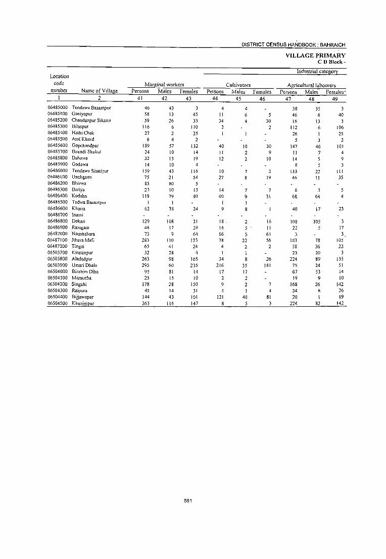
DISTRICT CENSUS HANDBOOK: BAHRAICH
VILLAGE PRIMARY CD Block-
Location Industrial catego!}:
code Marginal workers Cultivators ~riculturallabourers number Name of Village Persons Males Females Persons Males Females Persons Males Females·
2 41 42 43 44 45 46 47 48 49 06485000 Tendawa Basantpur 46 43 3 4 4 38 35 3 06485100 Ganiyapur 58 13 45 II 6 5 46 6 40 06485200 Chandan pur Sikaria 59 26 33 34 4 30 16 13 3 06485300 Bilaspur 116 6 110 2 2 112 6 106 06485400 Hathi Chak 27 2 25 26 I 25 06485500 Arai Khurd 6 4 2 3 2 06485600 Gopchandpur 189 57 132 40 10 30 147 46 101 06485700 Baundi Shukul 24 10 14 11 2 9 11 7 4 06485800 Dahawa 32 13 19 12 2 10 14 5 9 06485900 Godawa 14 10 4 8 5 3 06486000 Tendawa Sisatipur 159 43 116 10 7 3 133 22 III 06486100 Unchgaon 75 ,21 54 27 8 19 46 II 35 06486200 Bhirwa 85 80 5 06486300 Bariya 23 10 13 14 7 7 8 3 5 06486400 Kodaha \\9 79 40 40 9 3\ 68 64 4 06486500 Tedwa Basantpur I I 1 I 06486600 Khaira 62 38 24 9 8 40 17 23 06486700 Inami 06486800 Dakari 129 J08 21 18 . 2 16 108 105 3 06486900 Ramgadi 46 17 29 16 5 II 22 5 17 06487000 Naushahara 73 9 64 66 5 61 3 3 06487100 Jihura Mafi 283 110 173 78 22 56 183 78 105 06487200 Tingai 65 41 24 4 2 2 58 36 22 06503700 Kiratanpur 32 28 4 1 1 23 20 3 06503800 Aladadpur 263 98 165 34 8 26 224 89 135 06503900 Umari Dhala 295 60 235 216 35 181 75 24 51 06504000 Birahim Diha 95 81 14 17 17 67 53 14 06504100 Maraucha 25 15 10 2 2 19 9 10 06504200 Singahi 178 28 150 9 2 7 168 26 142 06504300 Raipura 45 14 31 5 4 34 8 26 06504400 Bijjawapur 144 43 101 121 40 81 20 I 19 06504500 Khuajgipur 263 116 147 8 5 3 224 82 142
591

PRIMARY CENSUS ABSTRACT
CENSUS ABSTRACT Tajwapur
of mar!l!inal workers Location
Household industry workers Other workers Non-workers code
Persons Males Females Persons Males Females Persons Males Females Name ofVilla8e numbe·r
50 51 52 53 54 55 56 57 58 2 1.
4 4 1,308 469 839 Tendawa Basantpur 06485000 I 1,264 497 767 Ganiyapur 06485100
8 8 1,411 518 893 Chandanpur Sikaria 06485200 2 2 266 113 153 Bilaspur 06485300
124 65 59 Hathi Chak 06485400 151 76 75 Arai Khurd 06485500 838 321 517 Gopchandpur 06485600
2 343 164 179 Baundi Shukul 06485700 6 6 1,308 486 822 Dahawa 06485800 5 5 714 261 453 Godawa 06485900
16 14 2 684 279 405 Tendawa Sisatipur 06486000 I I 586 266 320 Unchgaon 06486100
85 80 5 1,202 464 738 Bhirwa 06486200 1,127 385 742 Bariya 06486300
5 4 6 5 2,285 844 1,441 Kodaha 06486400
474 162 312 Tedwa Basantpur 06486500 13 13 1,895 686 1,209 Khaira 06486600
490 168 322 loami 06486700 2 2,389 858 1,531 Dokari 06486800
7 2,151 815 1,336 Ramgadi 06486900 <: 4 1,073 417 656 Naushahara 06487000
22 10 12 1,581 748 833 Jihura Mafi 06487100 2 2 1,229 460 769 Tingai 06487200
2 I 6 6 853 277 576 Kiratanpur 06503700 2 2 3 I 2 374 168 206 Aladadpur 06503800
4 3 434 220 214 Umari Dhalo 06503900 2 2 9 9 785 263 522 Birahim Diha 06504000
3 3 2,141 788 1,353 Maraucna 06504100 1,845 783 1,062 Singahi 06504200
3 3 3 2 541 177 364 Raipura 06504300 2 2 251 98 153 Bijjawapur 06504400 4 3 27 26 577 288 289 KhuajgiEur 06504500
592

__________________________ -=O~IS~T~R~IC::!..T~C.!::.EN!::!:S~U~S~HANOBOOK: BAHRAICH
Total population (including
VILLAGE PRIMARY CD Block-
Area of institutional and houseless Population in the Location
code
number
Village in Number of population) ____ age-group 0-6 Name of Village hectares households -P=-e-r-so-n-s__J::.::J.:M:-=a::le:'::s:.::L-=F-em-a-le-s- Persons Males Females
_~ ________ ~2 ________ ~3~ ____ ~4~ ____ ~5 ______ 6~ ____ ~7 ______ ~8_ 9 10
0554 Phakharpur (Total) 0554 Phakharpur(Rural) 0554 Phakharpur (Urban)
Phakharpur (Rural) 06487300 Tulapur 06487400 Churwalia 06487500 Naubasta 06487600 Ghureharipur 06487700 Bhauri 06487800 Bahorwa 06487900 Betaura 06488000 Sipahiya Hulas 06488100 Babhnauti Urf Shahar
Golaganj 06488200 Rahuwa Khas 06488300 Ratanpur 06488400 Sai Gaon 06488500 Baundi 06488600 Gujauli Khurd 06488700 Gujauli Kala 06488800 Dharehara Nakdilpur 06488900 Silauta 06489000 Oarayapur Khurd 06489100 Darayapur Kalan 06489200 Atodar 06489300 Dhannapur 06489400 Kodahi 06489500 Kanera 06489600 Pahiya 06489700 Behata Churamane .. 06489800 Jaitapur 06489900 Manera 06490000 Bisawa 06490100 Ramapur Kindhauli 06490200 Patti Kamalpur 06490300 Bameyari 06490400 Gohaniya 06490500 Amwa Tetarpur 06490600 Hemanapur 06490700 Bhadwani 06490800 Sangawa 06490900 Samada 06504600 Babhan Diha 06504700 Sahawapur Mahipal Singh 06504800 Oihawa Kala 06504900 Akbarpur Bujurug 06505000 Husepur 06505100 Baheliya 06505200 Baturaha 06505300 Malukpur 06505400 Madhaupur 06505500 Muse Patti 06505600 Tatehara 06505700 Majh,lUra 06505800 Dharam Saray 06505900 Keshwa Kunda 06506000 Ghasipur 06506100 Fakharpur 06506200 Siddha
560.1 140.0 427.2 127.0 554.2
167.0
664.0 117.1
665.1 80.0
75.0 157.0 365.0
723.6 148.0
202.0 188.4 150.4 196.9
270.0 173.0 132.0 175.0 160.0 357.4
117.1 193.7 143.6 146.3
76.8 290.0 218.2 208.0 491.0 204.0 204.8 '.94.0 100A :46.1
10.8
873
32,347 32,347
37 56
288 143 300 126 185 385 561
710 98
331 914
81 57
177 186
7
210 261 762 194 56
188 529 180 343 191 339 158 117 182 181 243 197 152 185 378 156 248 62
275 284 202 959 206 208
84 91 59
- 636 292
54
593
194,183 194,183
247 324
1,692 765
1,873 700
1,117 1,994 3,259
4,146 526
1,934 5,439
376 547
1,129 1,087
34
1,237 1,634 4,014 1,152
340 1,061 3,558 1,089 2,037 1,220 1,956
920 751
1,138 984
1,529 1,136
959 1,045 2,239
936 1,611
315 1,662 1,576 1,428 6,296 1,393 1,216
463 465 302
4,092 1,847
261
103,811 103,811
123 185 931 423
1,000 373 614
1,105 1,793
2,266 270
1,035 2,856
193 324 591 580
15
90,372 90,372
124 139 761 342 873 327 503 889
1,466
1,880 256 899
2,583 183 223 538 507
19
41,201 41,201
46 50
375 172 351 128 243 452
726
866 149
330 1,239
87 85
270 192
8 ---Un-inhabited-----
694 543 230 904 730 300
2,131 604 178 578
1,884 589
1,079 642
1,026 498 412 596 525 848 627 518 547
1,164 503 801 162 878 835 768
3.365 758 639 254 249 171
2.218 979 155
1,883 548 162 483
1,674 500 958 578 930 422 339 542 459 681 509 441 498
1,075 433 810 153 784 741 660
2,931 635 577 209 216 131
1,874 868 106
79-;
236 77
234 732: 285 376 223 477 215 230 239 In 308 259 138 237 473, 222 393
59 314 31.5 295 .373 36() 29() 108;
78: 51
968;
399 44
20,887 20,887
20 29
188 97
175 61
136 224
385
470 79
159 630
38 48
137 72
4
123 167 382 122 29
135 365 140 194 ll5 231 117 139 117 104 178 138 62
120 244 112 190 30
159 158 129 724 198 143
55_ 47 31
493 204
27
20,314 20,314
26 21
187 75
176 67
107 228
341
396 . 70
171 609
49 37
133 120
4
107 133 415 114 48 99
368 145
. 182 108 246
98 91
122 .
88 130 121
76 117
.229 110 203
29 55 57 66 )49 :62 147 53 31 20
175 195
17

PRIMARY CENSUS ABSTRACT
CENSUS ABSTRACT Phakbarpur
Scheduled Castes l2ol2uation Scheduled Tribes l2ol2ulation Literates Persons Males Females Persons Males Females Persons Males Females Name ofVillalle
II 12 13 14 15 16 17 18 19 2
21,922 11,822 10,100 49,292 35,693 13,599 Phakharpur (Total) 21,922 11,822 10,100 49,292 35,693 13,599 Phakharpur (Rural)
Phakharpur (Urban) Phakharpur (Rural)
12 7 5 Tulapur 38 37 Churwalia
291 159 132 360 288 72 Naubasta 76 43 33 175 143 32 Ghureharipur
347 182 165 553 397 156 Bhauri 41 26 15 145 121 24 Bahorwa
184 106 78 132 122 10 Betaura 500 277 223 225 182 43 Sipahiya Hulas 376 215 161 706 602 104 Babhnauti Urf Shahar
Golaganj 751 408 343 913 709 204 RahuwaKhas
33 18 15 113 74 39 Ratanpur 22 12 10 721 535 186 Sai Gaon
459 245 214 1,539 1,057 482 Baundi 167 93 74 133 92 41 Gujauli Khurd
288 224 64 Gujauli Kala 279 152 127 340 239 101 Dharehara Nakdilpur 184 91 93 144 98 46 Silauta
2 2 Darayapur Khurd ----Un-inhabited--------- Darayapur Kalan
236 131 105 322 253 69 Atodar 174 94 SO 609 446 163 Dharrnapur 392 208 184 860 659 201 Kodahi 229 129 100 222 196 26 Kanera
143 93 50 Pahiya 411 210 201 287 212 75 Behata Churamane 201 93 108 1,018 733 285 Jaitapur
82 41 41 178 154 24 Manera 278 145 133 719 468 251 Bisawa
51 23 28 377 275 102 Ramapur Kindhau1i 930 481 449 207 169 38 Pani Kamalpur
59 35 24 273 210 63 Bameyari 23 13 10 265 182 83 Gohaniya 71 36 35 357 267 90 Amwa Tetarpur
282 148 134 161 119 42 Hemanapur 161 90 71 527 329 198 Bhadwani 74 46 28 191 140 51 Sangawa
179 99 80 315 251 64 Samada 115 66 49 385 259 126 Babhan Diha 233 118 115 488 335 153 Sahawapur Mahipal Singh 192 108 84 240 173 67 DihawaKala 47 26 21 377 266 III Akbarpur Bujurug 47 26 21 86 73 13 Husepur 85 38 47 575 378 197 Baheliya
185 98 87 455 318 137 Baturaha 41 23 18 394 316 78 Malukpur
413 228 185 2,068- 1,360 708 Madhaupur 139 68 71 341 225 116 MusePani 69 35 34 240 182 58 Tatehara
174 100 74 - 94 64 30 Majhaura 140 73 67 209 138 7 L Dharam Saray 35 20 15 20 16 4 Kesh~a-KUllda 34 17 17 1,015 660 355 Ghasipur 15 8 7 905 558 347 Fakharpur
25 22 3 Siddha
594

Location code
number Name of Village 2
0554 Phakharpur (Total) 0554 Phakharpur (Rural) 0554 Phakharpur (Urban)
Phakharpur (Rural) 06487300 Tulapur 06487400 Churwalia 06487500 Naubasta 06487600 Ghureharipur 06487700 Bhauri 06487800 Bahorwa 06487900 Betaura 06488000 Sipahiya Hulas
06488100 Babhnauti UrfShahar Golaganj
06488200 Rahuwa Khas 06488300 Ratanpur 06488400 Sai Gaon 06488500 Baundi 06488600 Gujauli Khurd 06488700 Gujauli Kala 06488800 Dharehara Nakdilpur 06488900 Silauta 06489000 Darayapur Khurd 06489100 Oarayapur Kalan 06489200 Atodar 06489300 Oharmapur 06489400 Kodahi
06489500 Kanera 06489600 Pahiya 06489700 Behata Churamane 06489800 Jaitapur 06489900 Manera 06490000 Bisawa 06490 I 00 Ramapur Kindhauli 06490200 Patti Kamalpur 06490300 Bameyari 06490400 Gohaniya 06490500 Amwa Tetarpur 06490600 Hemanapur 06490700 Bhadwani
06490800 Sangawa" 06490900 Samada 06504600 Babhan Diha 06504700 06504800 06504900 06505000 06505JOO 06505200 06505300 06505400 06505500 06505600 06505700 06505800 06505900
Sahawapur Mahipal Singh Dihawa Kala Akbarpur Bujurug Husepur Baheliya Baturaha Malukpur Madhaupur Muse Patti Tatehara Majhaura Dharam Saray
Keshwa Kunda 06506000 Ghasipur 06506100 Fakharpur 06506200 Siddha
Persons .20
144,891 144,891
235 286
1,332 590
1,320 555 985
1,769 2553
3,233 413
1,213 3,900
243 259 789 943
32
915 1,025 3,154
930 197 774
2,540 911
1,318 843
1,749 647 486 781 823
1,002 945 644 660
1,751 696
1,234 229
1,087 1,121 1,034 4,228 1,052
976 369 256 282
3,077 942 236
Illiterates Males
21
68,118 68,118
116 148 643 280 603 252 492 923
1,191
1,557 196 500
1,799 101 100 352 482
13
441 458
1,472 408
85 366
1,151 435 611 367 857 288 230 329 406 519 487 267 288 829 330 535
89 500 517 452
2,005 533 457 190 111 155·
1,558 421 133
Females 22
76,773 76,773
119 138 689 310 717 303 493 846
1,362
1,676 217 713
2,101 142 159 437 461
19
474 567
1,682 522 112 408
1,389 476 707 476 892 359 256 452 417 483 458 377 372 922 366 699 140 587 604 582
2,223 519 519 179 145 127
1,519 52J 103
595
DISTRICT CENSUS HANDBOOK: BAHRAICH
Total workers Persons Males Females
23 24 2S
76,698 76,698
165 202 672 249 897 504 677
1,052 1,714
2,012 138 764
2,350 215 168 578 634 22
56,916 56,916
91 110 519 236 598 281 416 623
1,080
1,299 135 600
1,604
119 166 348 401 II
19,782 19,782
74 92
153 13
299 223 261 429 634
713 3
164 746
96 2
230 233 II
-----Un-inhabited-----630 416 214 692 568 124
2,275 577 179 510
1,638 480 702 631 837 362 180 397 455 518 549 719 426 841 493 440 115 668 493 465
2,469 710 549
, 172 200 100
1,109 487
93
1,348 325 101 346
1,076 356 606
355 595 247 175 310 293 361 336 404 281 612 283 391 106 505 473 407
1,830 420 399 157 159
_ 94 912 451
91
927 252
78 164 562 124 96
276 242 115
5 87
162 157 213 315 145 229 210
49 9
163 20 58
639 290 150
15 41
6, -
197 36
2
VILLAGE PRIMARY CD Block-
Main workers Persons Males Females
26 27 28
56,003 56,003
77 88
514 248 532 412 531 822
l,365
1,363 133 568
1,565 197 167 274 525
16
424 541
1,614 263 179 307
1,159 477 445 413 698 260 180 299 257 322 290 601 276 612 467 326 114 526 487 461
1,598 591 409 158 165 40
910 423
35
49,690 49,690
64 88
505 236 511 262 382 599
1,029
1,228 132 513
1,273 JlO 166 270 360
10
375 508
1,211 255 \0\ 283 923 355 424 317 555 245 175 290 250 295 254 352 270 584 279 31\ 105 494 470 407
1,528 398 397 156 158
39 739 396
34
6,313 6,313
13
9 12 21
150 149 223 336
135 I
55 292.
87
4 165
6
49 33
403 8
78 24
236 122 21 96
143 IS 5 9 7
27 36
249 6
28 188
15 9
32 17 54 70
193 12 2 7 -
- I 171 27

PRIMARY CENSUS ABSTRACT
CENSUS ABSTRACT Phakharpur
Industrial category of main workers Household industry
Cultivators Agricultural labourers workers Other workers Persons Males Females Persons Males Females Persons Males Females Persons Males Females Name of Village
29 30 31 32 33 34 35 36 37 38 39 40 2
36,616 33,461 36,616 33,461
28 49
498 143 478
76 180 485
1,301
1,115 64
490 603 147 148 219 141
5
361 401
1,109 181 118 184 540 282 309 394 439 100 163 177 237 162 lSI 177 207 293 343 287 113 406 326 254 673 369 261 132 121
31 258 184 34
28 49
494 142 463
54 176 414 984
1,076 64
4<\8 534
83 148 216 108
3
328 379 839 175 63
163 465 209 301 305 342 96
159 175 232 158 \39 90
206 284 205 277 104 382 317 246 647 233 254 132 117 31
203 176
33
3,155 3,155
4 1
15 22
4 71
317
39
42 69 64
3 33
2
33 22
270 6
55 21 75 73
8 89 97
4 4 2 5 4
12 87
I 9
138 10 9
24 9 8
26 136
7
4
55
&
15)60 15,160
49 39 13 83 45
335 349 327
49
229 65 52
787 49
50 362
11
50 92
380 65 61 62
390 188 68 15
210 138
11 93 13 75
\30
413 52
308
118 26
98 133 204 530 131 148 26 40
8 430 145
12,381 12,381
36
39 8
73 39
207 205 176
33
138 64 42
587 27
50 238
2,779 2,779
13
5 10 6
128 144 151
16
91
10 200 22
124 7 4
860 860
3
3
J
7
2 27
2 20
758 758
3
3 I
2 7
2
26
I
12
------Un-inhabited---------36 14 83
272
63 38 60
254 142 60 9
168 134
11 87 11 62
108 254
48 289
70 26
92 128 158 502
89 143 24 37
7 323 132
9 108
2 23 2
136 46
8 6
42 4
6 2
13 22
159 4
19 48
3 33 4
24 139
1 20 2 4
7 2 5 4
3
4 7
9 35
36 II
596
3 29
4
24 122
20 2 4
7 2
4 3
2
3 7
9 25
35 10
102 102
1 8
4
17
10
3,367 3,367
22 6
7 8
16 4
24 148
I 19 3 2
13 45 92 13
37 90 6
48 2
45 22 5
22 5
80 5
10 17 11 6
10
18 21 3
386 56
4
1 186 83
3,090 3,090
21 6
7
5
12 4
22 126
18 _ 3
2
11 43 71 13
36 82
3 43
I 41 15 S
21 5
71
4 7
16 II 4
6
17
18 3
370 51
4
I 178 78
277 Phakharpur (Total) 277 Phakharpur (Rural)
Phakharpur (Urban) Phakharpur (Rural)
Tulapur Churwalia
Naubasta Ghureharipur
Bhauri
Bahorwa Betaura Sipahiya Hulas
3 Babhnauti Urf Shahar
Golagan,i 4 Rahuwa Khas
Ratanpur 2 Sai Gaon
22 Baundi
I Gujauli Khurd Gujauli Kala
Dharehara Nakdilpur Silauta Darayapur Khurd Darayapur Kalan
2 Atodar 2 Dhannapur
21 Kodahi
Kanera Pahiya
I Behata Churamane
8 laitapur 3 Manera
5 Bisawa
Ramapur Kindhauli
4 Patti Kamalpur 7 Bameyari
Gohaniya Amwa Tetarpur Hemanapur
9 Bhadwani
I Sangawa 3 Samada
1 Babhan Diha
Sahawapur Mahipal Singh 2 Dihawa Kala
4 Akbarpur Bujurug
Husepur Baheliya
3 Baturaha
Malukpur 16 Madhaupur·
5 Muse Patti 'Tatehara
Majhaura
Dh¥aJn Saray
Keshwa K1J!1Ua 8 Ghasipur S fakharpur
Siddha

DISTRICT CENSUS HANDBOOK: BAHRAICH
VILLAGE PRIMARY CD Block-
Industrial category
Marginal workers Cultivators Agricultural labourers
Location
code
number Name ofYillage Persons Males Females Persons Males Females Persons Males Females
__ ~ ________ ~2~ ______ ~4~1 _____ 4~2~ __ ~4~3~ __ ~4~4 ____ 24~5 ____ ~4~6 ____ ~4~7__ 48 49
0554 Phakharpur (Total) 0554 Phakharpur (Rurlll) 0554 Phakharpur (Urban)
Phakharpur (Rural) 06487300 Tulapur 06487400 Churwalia 06487500 Naubasta 06487600 Ghureharipur 06487700 Bhauri 06487800 Bahorwa 06487900 Betaura 06488000 Sipahiya Hulas 06488100 Babhnauti UrfShahar
Golaganj 06488200 Rahuwa Khas 06488300 Ratanpur 06488400 Sai Gaon 06488500 Baundi 06488600 Gujauli Khurd 06488700 Gujauli Kala 06488800 Dharehara Nakdilpur 06488900 Silauta 06489000 Darayapur Khurd 06489100 Darayapur Kalan 06489200 Atadar 06489300 Dharmapur 06489400 Kodahi 06489500 Kanera 06489600 Pahiya 06489700 Behata Churamane
·06489800 Jaitapur 06489900 Manera 06490000 Bisawa 06490100 Ramapur Kindhauli 06490200 Patti Kamalpur 06490300 Bameyari 06490400 Gahaniya 06490500 Amwa Tetarpur 06490600 Hemanapur 06490700 Bhadwani 06490800 Sangawa 06490900 Samada 06504600 Babhan Diha 06504700 Sahawapur Mahipal Singh 06504800 Dihawa Kala 06504900 Akbarpur Bujurug 06505000 Husepur 06505100 Baheliya 06505200 Baturaha 06505300 Malukpur 06505400 Madhaupur 06505500 Muse Patti 06505600 Tatehara 06505700 Majhaura 06505800 Dhararn Saray 06505900 Keshwa Kunda 06506000 Ghasipur 06506100 Fakharpur 06506200 Siddha
20,695 20,695
88 114 158
365 92
146 230 349
649 5
196 785
18
304 109
6
206 151 661
314
203 479
3 257 218 139 102
98 198 196 259 Jl8 150 229 26
114 1
142 6 4
871 119 140
14 35 60
199 64 58
7,226 7,226
27 22 14
87 19 34 24
51
71 3
87 331
9
78 41
41 60
137 70
63 153
1 182 38 40
2
20 43
,66 82 52 II 28
4
80 1
II 3
302 22 2
I 55
173 55 57
13,469 13,469
61 92
144
278 73
112 206
298
578 2
109 454
9
226 68
5
165 91
524 244
140 326
2 75
180 99
100
78 155 130 177 66
139 201
22 34
131 3 4
569 97
138 13 34
5
597
26 9 1
7,620 7,620
36 96
5
129 10
13 273
160 1
28 222
16 I
26 20
2,000 2,000
10 5 3
20 2
7
33
17 I
10 95
8
12 6
5,620 5,620
26 91
2
109 8
6
240
143
18 127
8
14 14
---------Un-inhabited-----------1~ 22 80 122 48 74 259
69
137 129
2 88
205 20 28
34 13
150 70 37 14 15 9
51
82
2 600
I 138
2
16 -16 2 1
70 8
34 45
83 38
8
7
46 23 10
12 I
26 1 9
162
2
16 9 1
189 61
103 84 2 5
167 12 28
27 12
104 47 27 11 3 8
25
73
2 438
136
7 I
11,384 11,384
52 1&
152
233 82
145 214
76
488 4
163 483
2
273 88 6
102 21
292 243
32 335
165
113 72
61 185 35
184 81
134 212
15 61
59 5 2
150 98
1-, ,. 3 '· -' 40 82 62 57
4,257 4,257
17 17 11
65 17 34 16
18
54 2
76 180
1
63 35
1
19 5
46 60
II 103
I
97
32
11 42 13 55 42 6
14 2
52
2
3
76 14
38 70 54 56
7,127 7,127
35 1
141
168 65
III 198
58
434 2
87 303
I
210' 53
83 16
246 \83
21 232
68 1
81 71
50 143 22
129 39
128 198"
13 9
57 2 2
74 84
12 34 2
12 8

PRIMARY CENSUS ABSTRACT
CENSUS ABSTRACT Phakharpur
of mar8inal workers Location
Household indust!X workers Other workers Non-workers code
Persons Males Females Persons Males Females Persons Males Females Name of Village number
50 51 52 53 54 55 56 57 58 2
350 126 224 1,341 843 498 117,485 46,895 70,590 Phakharpur (Total) 0554 350 126 224 1,341 843 498 117,485 46,895 70,590 Phakharpur (Rural) 0554
Phakharpur (Urban) 0554 Phakha rpur (Rural)
82 32 50 Tulapur 06487300 122 75 47 Churwalia 06487400
1,020 412 608 Naubasta 06487500 516 187 329 Ghureharipur 06487600
2 976 402 574 Bhauri 06487700 196 92 104 Bahorwa 06487800 440 198 242 Betaura 06487900
2 2 942 482 460 Sipahiya Hulas 06488000 1,545 713 832 Babhnauti UrfShahar 06488100
Golaganj 2,134 967 1,167 RahuwaKhas 06488200
388 135 253 Ratanpur 06488300 2 2 3 2 1,170 435 735 Sai Gaon 06488400
26 16 10 54 40 14 3,089 1,252 1,837 Baundi 06488500 161 74 87 Gujauli Khurd 06488600 379 158 221 Gujauli Kala 06488700
4 2 2 551 -243 308 Dharehara Nakdilpur 06488800 1 453 179 274 Silauta 06488900
12 4 8 Darayapur Khurd 06489000 ------------Un-inhabited------------ Darayapur Kalan 06489100
2 2 607 278 329 Atodar 06489200 8 7 942 336 606 Dharmapur 06489300
19 - 19 91 21 70 1,739 783 956 Kodahi 06489400 2 2 575 279 296 Kanera 06489500
161 77 84 Pahiya -06489600 34 18 16 551 232 319 Behata Churamane 06489700
5 2 3 10 3 7 1,920 808 1,112 Jaitapur 06489800 609 233 376 Manera 06489900
3 2 1 1,335 473 862 Bisawa 06490000 2 2 10 10 589 287 302 Ramapur Kindhauli 06490100
6 6 1,119 431 688 Patti Kamalpur 06490200 558 251 307 Bameyari 06490300 571 237 334 Gohaniya 06490400
2 2 741 2&6 455 Amwa Tetarpur 06490500 529 232 297 Hemanapur 06490600
11 7 4 1,011 4fl7 524 Bhadwani 06490700 4 3 587 291 296 Sangawa 06490800
240 114 126 Samada 06490900 2 2 619 266 353 BabhanDiha 06504600 2 2 1,398 552 846 Sahawapur Mahipal Singh 06504700 2 I 443 220 223 DihawaKala 06504800 2 2 1,171 410 761 Akbarpur Bujurug 06504900
200 56 144 Husepur 06505000 994 373 621 Baheliya 06505100
1,083 362 721 Baturaha 06505200 963 361 602 MaIukpur 06505300
4 1 3 117 63 54 3,827 1,535 2,292 Madhaupur 06505400 14 4 10 6 4 2 683 3)8 345 Muse Patti 06505500
667 240 427 Tatehara 06505600 -291 97 194 Majhaura 06505700 265 90 175 DharaJll Saray 06505800
3 3 202 -77 125 Keshwa Kunda 065.05900 6 6 95 88 7 2,983 1,306 1,677 Ghasipur -06506000
1,360 528 832 Fakharpur 06506100 168 64 104 Siddha 06506200
598

DISTRICT CENSUS HANDBOOK: BAHRAICH
Total population (including
VILLAGE PRIMARY CD Block-
Location Area of institutional and houseless Population in the code Village in Number of population) age-group 0-6
_..:.:n:::;um:.:;::-b:::er~_...:N~am=e.::.o-:-f...:V..!.il:.::la~gz::e~_..::h~e~ct~a~re::s_..!.h~o::::u:::se7-h~o~ld=:s:.__.!...P~er~s!:!on~s~___.;M~a~le~s _ _.!...F~em~a~le~s __ ~P~er~s~on!!:s!.._ Males Females __ ~ ________ ~2 ________ ~) ______ ~4 ______ ~S ____ ~6~ ____ 7~ ____ ~8~_ 9 10
06506300 Alinagar 06506400 Muhammadpur 06506500 Paras Rampur 06506600 Khalidpur 06506700 Mohamadpur Kala 06506800 Shivpura 06506900 Bubkapur 06507000 Haibatpur 06507100 Tendawa Mahant 06507200 Suwagada 06507300 Raundopur 06507400 Indur 06507500 Aganapara 06507600 Holpara 06507700 Acholaya 06507800 Dahaura 06507900 Singarao 06508000 Basauna 06508 I 00 Bhilaura Baso 06508200 Sasana 06508300 Rajapur Khurd 06508400 Supani 06508500 Bhupani 06508600 Jagatapur 06508700 Datauli 06508800 Bhilaura Kaji 06508900 Sardpara 06509000 Bibipur 06509 I 00 Piyarepur 06509200 Dharua 06509300 Kalha Para 06509400 Machhiya 06509500 Chandradipa 06509600 Akhtayara Pur 06509700 Shivrajpur 06509800 Mahmodpur 06509900 Arai Kala 065 I 0000 Ajijpur 06510 100 Gajadharpur 065 I 0200 Tendawa Ujar 06510300 Tendawa Alpi Misra 065 I 0400 Khparha 06510500 Takhawa 06510600 Badanapur 06510700 Kandausa 06510800 Kundas Para 06510900 Pakauri 0651 1000 Saray Kaji 06511100 Saray Jagana 06511200 Rasulpur Darehta 06511300 Su~ana Khurd 06511400 Akhanapur 06511500 Dhruwa 0651 1600 Bedaura 06511700 Nathupur 06511800 Dhakherawa 06511900 Bhilaura Basanti 06512000 Nandwal 06512100 Allipur Darauna
87.4 110.3 56.0
184.2 76.9
300.0
419.4 226.0 273.0 242.0 97.5
220.0 540.6
2,317.0 511.5
243.2 197.0 157.0 427.0 164.0 427.0 533.4
82.0 144.0
162.0 28.7 96.0
222.5 214.6
34.5
147.4 1,046.0
470.4
270.0 252.3
45.4
136.2 178.0 29.4 .
85.3
133.0
178.3 .. 214.0 326.3 230.6
90 117 246 413
88 256 869 377 390
98 243 306 190 347 337 345 182 220 456 188 160 191 228 336 123 520 487
61 110 142 115
34 121 144 268
60 242 233 453 145 432 41 I 152 68
386 611
59 547 274 416
66 14 78
150 59
175 177 488 361
599
501 740
1,562 2,789
467 1,343 5,391 1,670 2,331
467 1,434 1,767 1,120 1,842 1,855 2,050 1,174 1,151 2,759 1,164
898 1,214 1,143 1,936
701 2,929 2,890
335 565 815 649 220 676 947
1,587 361
1,455 1,321 2,735
860 2,447 2,618
661 398
2,801 4,339
372 3,494 1,823 2,741
363 103 412 920 382
1,020 --1,027 3,191 1,821
253 391 834
1,534 261 705
2,896 945
1,239 264 747 962 583 965 986
1,081 637 582
1,461 619 499 643 637
1,046 371
1,548 1,567
180 308 451 350 118 364 521 830 185 780 705
1,51 I 461
1,354 1,395
366 208
1,452 2,207
193 1,778
963 1,420
200 56
219_ 507
,89 545 551
1,669 1,013
248 349 728
1,255 206 638
2,495 725
1,092 203 687 805 537 877 869 969 537 569
1,298 545 399 571 506 890 330
1,381 1,323
ISS 257 364 299 102 312 426 757 176 675 616
1,224 399
1,093 1,223
295 190
1,349 2,132
179 1,716
860 1,321
163 47
193 413 193 475 476
1,522 808
96 142 368 642 100 281
1,043 245 487
84 277 357 212 349 387 417 198 245 607 252 195 267 223 379 139 629 643 65
124 176 138 38
146 161 322 62
278 256 603 157 345 539 137 84
688 1,012
79 843 478 641
80 17 89
..178 95
21 I 240 734 368
40 72
194 339
52 126 517 135 243
38 143 173 116 155 189 200
92 129 307 132 93
136 123 197
75 302 309
32 67
102 62 18 67 91
ISO 27
148 129 312
82 182 277
71 36
323 538
SO 416 250 334
45 8
45 97 AI 109. 129 349 179
56. 70
174 303
48 155 526 110 244 46
134 184 96
194 198 217 106 i'I6 300 120 102 131 100 182. 64
327 334 33 57 74 76 20 79 70
172 35
130 127 291
75 163 262 66 48
365 474
29 427 228 307
35 9
44 81 54
102 III 385 189

PRIMARY CENSUS ABSTRACT
CENSUS ABSTRACT Phakharpur
Scheduled Castes EOEuation Scheduled Tribes EOEulation Literates Persons Males Females Persons Males Females Persons Males Females Name of Village
1\ 12 13 14 15 16 17 18 19 2
208 110 98 166 99 67 Alinagar 163 80 83 329 208 121 Muhammadpur
739 456 283 Paras Rarnpur 44 21 23 512 357 155 Khalidpur 99 56 43 56 53 3 Mohamadpur Kala
264 133 131 225 164 6\ Shivpura 772 405 367 1,337 970 367 Bubkapur 65 34 31 503 383 120 Haibatpur
193 \06 87 6\\ 452 159 Tendawa Mahant 23 14 9 160 109 51 Suwagada 30 17 13 313 235 78 Raundopur
145 84 61 346 262 84 Indur 170 93 77 364 259 105 Aganapara 329 176 153 321 254 67 Holpara 336 179 157 257 187 70 Acholaya 177 103 74 546 411 135 Dahaura 285 157 128 403 273 130 Singarao
85 4S 40 272 184 88 Basauna 344 184 160 731 534 197 Bhilaura Baso
77 49 28 266 190 76 Sasana 90 54 36 228 169 59 Rajaput Khurd 98 54 44 457 327 130 Supani
102 60 42 194 146 48 Bhupani 241 136 105 470 379 91 Jagatapur 110 63 47 324 205 119 Datauli 251 130 121 409 338 71 Bhilaura Kaji 302 167 135 442 373 69 Sardpara 57 33 24 161 107 54 Bibipur 67 33 34 105 85 20 Piyarepur
166 88 78 191 147 44 Dharua 411 222 189 160 110 50 Kalha Para 104 55 49 86 65 21 Machhiya 189 103 86 \85 \47 38 Chandradipa 158 91 67 473 316 157 Akhtayara Pur 66 41 25 405 305 100 Shivrajpur
54 45 9 Mahmodpur 230 116 114 526 360 166 Arai Kala 101 52 49 517 343 174 Ajijpur 199 117 82 839 613 226 Gajadharpur
6 4 2 408 266 142 Tendawa Ujar 396 212 184 1,184 824 360 Tendawa Alpi Misra 319 168 151 552 421 131 Khparha 240 134 106 159 122 37 Takhawa
3 2 91 71 20 Badanapur 15 8 7 484 379 105 Kandausa 55 27 28 1,599 1,055 544 Kundas Para 32 19 13 166 99 67 Pakauri 39 23 16 606 475 131 Saray Kaji
165 90 75 189 142 47 Saray J agana 147 86 61 477 362 115 Rasulpur Darehta 35 15 20 \0 10 Surjana Khurd 36 19 17 22 17 5 Akhanapur 26 15 11 64 44 20 Dhruwa - 54 31 23 325 232 93 Bedaura .. 12 7 - 66- 58 8 Nathupur ..
146 77 69 236 181 55 Dhakherawa - -128 70 58 193 141 52 Bhilaura Basanti 492 252 240 913 653 260 Nandwal III 60 51 430 342 88 Allipur Darauna
600

Location
code
number Name ofViUage
2
06506300 Alinagar 06506400 Muhammadpur 06506500 Paras Rampur 06506600 Khalidpur 06506700 Mohamadpur Kala 06506800 Shivpura 06506900 Bubkapur 06507000 Haibatpur 06507100 Tendawa Mahant 06507200 Suwagada 06507300 Raundopur 06507400 Indur 06507500 Aganapara 06507600 Holpara 06507700 Acholaya 06507800 Dahaura 06507900 Singarao 06508000 Basauna 06508100 Bhilaura Baso 06508200 Sasana 06508300 Rajapur Khurd 06508400 Supani 06508500 Bhupani 06508600 Jagatapur
06508700 Datauli 06508800 Bhilaura Kaji 06508900 Sardpara 06509000 Bibipur 06509100 Piyarepur 06509200 Dharua 06509300 Kalha Para 06509400 Machhiya 06509500 Chandradipa 06509600 Akhtayara Pur 06509700 Shivrajpur 06509800 Mahmodpur 06509900 Arai Kala 06510000 Ajijpur
06510 I 00 Gajadharpur 06510200 Tendawa Ujar 06510300 Tendawa Alpi Misra
06510400 Khparha 06510500 Takhawa 06510600 Badanapur 06510700 Kandausa 06510800 Kundas Para
06510900 Pakauri 06511000 Saray Kaji 06511100 Saray Jagana 06511200 Rasulpur Darehta 06511300 SUljana Khurd 06511400 Akhanapur 06511500 • Dhniwa
.06511600 Bedaura 06511700 Nathupu~
06511800 Dhakherawa 06511900 . Bhilaura Basanti 06512000 Nandwal 065 12100 Allipur Darauna
Illiterates
Persons Males Females
20 21 22
335 411
823 2,277
411 1,118 4,054 1,167 1,720
307 1,121 1,421
756 1,521 1,598 1,504
771 879
2,028 898 670 757 949
1,466 377
2,520 2,448
174 460 624 489 134 491 474
1,182 307 929 804
1,896 452
1,263 2,066
502 307
2,317 2,740
206 2,888 1,634 2,264
353 81
348 595 316 784 834
2,278 1,391
154 183 378
1,177 208 541
1,926 562 787 155 512 700 324 711 799 670 364 398 927 429 330 316 491 667 166
1,210 1,194
73 223 304 240
53 217 205 525 140
420 362 898 195 530 974 244 137
1,073 1,152
94 1,303
821 1,058
190 39
175 275 ~
131 364 410
1,016 671
181 228 445
1,100 203 577
2,128 605 933·
152 609 721 432 810 799 834 407 481
1,101 469 340 441 458
799 211
1,310 1,254
101 237 320 249
81 274 269 657 167
509 442
998 257 733
1,092 258 170
1,244 1,588
112 1,585
813 1,206
163 42
173 320 185
- 420
424 1,262
720
601
DISTRICT CENSUS HANDBOOK: BAHRAICH
VILLAGE PRIMARY CD Block-
Total workers Main workers
Persons Males Females Person; Males Females
23 24 25 26 27 28
157 240 522 988 195 581
2,338 773 817 157 530 714 405 698 845 790 698 495
1,058 476 236 662 452 758 177
1,156 1,049
122 154 553 360
54 238 235 535 179 600 366 842 231 731 708 222 100 935
1,218 97
1,507 446 690 163 82
125 242 151 274 293
1,274 643
146 234 440 764 148 426
1,685 575 661 140 450 548 334 504 541 617 417 302 803 314 227
368 396 598 154 857 845
79 150 315 196 52
202 233 479 107 446 356 778 214 708 691 216 99
749 877 89
1,024 432 566 122 49
124 235
-117
272
286 975 549
II 6
82 224
47 155 653 198 156
17 80
166 71
194 304 173 281 193 255 162
9 294
56 160 23
299 204
43 4
238 164
2
36 2
56 72
154 10 64 17 23 17 6
186 341
8 483
14 124 41 33
7 34
2
7
299 94
144 240 477 407 131 431
1,845 582 653 150 457 609 268 434 367 374 529 296 648 250 22~1
317 372 516 137 795 871,
67 146 249 232
23 42
211 486 104 342 361 819 231 727 683
221 97
365 738 84
977 38:1 548
95 40
124 238 .95 122 292
1,037 590
142 234 427 368 127 421
1,533 552 628 136 438 539 253 409 353 345 412 277 626 230 214 259 354 490 129 723 840 66
145 242 182 22 38
211 442
93 309 356 765 214 707
669 215
96 346 694
81 894 370 507
95 37
123 234
88 120 285 927 541
2 6·
50 39 4
\0 312 30 25 14 19 70 15 25 14 29
117 19 22 20 9
58 18 26 8·
72 31
I
7 50
4
44 II 33
5 54 17 20 14 6
19 44
3 83. II 41
3
4
7 2 7
110 49

PRIMARY CENSUS ABSTRACT
CENSUS ABSTRACT Phakharpur
Industrial category of main workers Household industry
Cultivators Agricultural labourers workers Other workers Persons Males Females Persons Males Females Persons Males Females Persons Males Females Name ofYiIlage
29 30 31 32 33 34 35 36 37 38 39 40
69 220
82 142 102 227
1,143 251 431
61 452 375 192 403 312 219
98 216 531 169 207 215 331 357
75 562 752
64 127 208 207
14 29
179 325
53 280 144 406
90 360 616 138 57
190 502
62 688 166 402 92 36 38
155 28
Its 207 578 481
68 215
78 128 99
219 980 240 424
56 433 350 189 385 303 209
95 205 519 159 198 172 321 338
69 534 728
63 126 203 167
14 29
179 319 46
264 141 398 84
355 606 137 57
188 482
62 636 160 381 92 34 38
153 28
113 203 535
453
1 5 4
14 3 8
163 11 7
19 25 3
18 9
10 3
11 12 10 9
43 10 19 6
28 24
1
5 40
6 7
16 3 8 6 5
10 I
2 20
52 6
21
2
2
2 4
43 28
51 16
186 128
21 192 506 307 181
55 2
213 40 27 47
108 412
61 59 38 12 50 38 60 49
113 III
1
40 3 1 2
. 29 .155
25 48
208 369 124 330 39 80 35 59
142 5
279 129 92
4
85 76 56
6 78
376 64
50 15
145 III 21
190 364 289 164 50 2
169 35 20 43 89
'299 54 54 32 12 41 31 56 48 93
105 1
38 3
29 117 23 34
206 326 116 321 37 75 34 57
121 5
248 126 74
3 85 76 49 6
76 312
50
41 17
2 142
18 17 5
44
5 7 4
19 113
7 5 6
9 7 4
20 6
2
2
38 2
14 2
43 8
9 2 5 1
2
21
31 3
18
7
2 64 14
8 2 7
7 I 2
40
15 25
3 9 2 I
7 8
II I 9
19
9
40
2 2 6
16 2 2
I
2
1 3
11 2
8
51
4 2 6
3 10 20
602
8 2 4 5 I 2
39
14 23
I 3 3 2 I
7 8
10
7
16
9
31 2 2 6
9 2 2
2
5 1 3
11 2
5
50
4 2 4
. 2
8 18
3 2
2
6
2
3
9
7
3 1
2
2
2
16 2
202 130
7
10 156 24 26
9 2
18
27 2 7
40 11 8
57 34 4
33 3
90 12 80 6
13 1 6 6 9 3 6
25 13 7
39 16 34 17
5 108
43 17 6
84 48
3
1 '7
11 J 4
73 2S
16 2
200 124
6
10 150 23 26
7 2
17 26
2 6
40 10
8
52 32
4 30
2 87 11 65
5
13 1 3 5 7 3 6
23 10
7 36 13 28 15
5 96 41 14 6
82 48
3
5 11
1 4
72 20
2
Alinagar Muhammadpur
2 Paras Rampur 6 Kha1idpur
Mohamadpur Kala Shivpura
6 Bubkapur Haibatpur Tendawa Mahant
2 Suwagada Raundopur 1ndur Aganapara Holpara Acholaya Dahaura Singarao Basauna
5 Bhilaura Baso 2 Sasana
Rajapur Khurd 3 Supani I Bhupani 3 Jagatapur
Datauli 15 Bhi1auraKaji
Sardpara Bibipur Piyarepur Dharua
3 Kalha Para Machhiya
2 Chandradipa Akhtayara Pur Shivrajpur
2 Mahmodpur 3 AraiKala
Ajijpur 3 Gajadharpur 3 Tendawa Ujar 6 Tendawa Alpi Misra 2 Khparha
Takhawa Badanapur
12 Kandausa 2 Kundas Para 3 Pakauri
Saray Kaji 2 Saray Jagana
Rasulpur Darehta Sutjana Khurd Akhanapur
I Dhruwa 2 Bedaura
Nlithupur Dhakherav.lI Bhi1aura Basanti Nandwal
5 Allipur Darauna

Location
DISTRICT CENSUS HANDBOOK: BAHRAICH
VILLAGE PRIMARY CD Block-
Industrial category
code Marginal workers Cultivators Agric:ulturallabourers __::nc=um:c.;::-b.:;er:__ _ _;N:...;;:;am=e.::.o-=-f...:V...:i::.lla:::lg2:e:....· _ ___:p...:e~rs~o::..:n:.::s _ _;M~a~le:::::s_...:F...:e::;m~a:::.le::::s:.._....!..P::::er~s~on!!:s:..__M~a~le:::::s:__...!F..::e~m~a!!:le:::.:s~....!..Pe::::r~s~on~s Males Females _ _;_l ____ --=2~ ____ 4:...:1 __ __::42::.__~4::_3 __ .....244::!...._ _ _:::.4::_5 __ ~4~6 __ __..:4.!....7_ 48 49
06506300 Alinagar 06506400 Muhammadpur 06506500 Paras Rampur 06506600 Khalidpur 06506700 Mohamadpur Kala 06506800 Shivpura 06506900 Bubkapur 06507000 Haibatpur 06507100 Tendawa Mahant 06507200 Suwagada 06507300 Raundopur 06507400 Indur 06507500 Aganapara 06507600 Holpara 06507700 Acholaya 06507800 Dahaura 06507900 Singarao 06508000 Basauna 06508100 Bhilaura Baso 06508200 Sasana 06508300 Rajapur Khurd 06508400 Supani 06508500 Bhupani 06508600 Jagatapur 06508700 Datauli 06508800 Bhilaura Kaji 06508900 Sardpara 06509000 Bibipur 06509100 Piyarepur 06509200 Dharua 06509300 Kalha Para 06509400 Machhiya 06509500 Chandradipa 06509600 Akhtayara Pur 06509700 Shivrajpur 06509800 Mahmodpur 06509900 Arai Kala 06510000 Ajijpur 06510 I 00 Gajadharpur 06510200 Tendawa Ujar 06510300 Tendawa Alpi Misra 06510400 Khparha 06510500 Takhawa 06510600 Badanapur 06510700 Kandausa 06510800 Kundas Para 06510900 Pakauri 06511000 Saray Kaji 065 1 I I 00 Saray J agana 06511200 Rasulpur Darehta 06511300 Surjana Khurd 06511400 Akhanapur 06511500 Dhruwa 065 I 1600 Bedaura:... 06511700 Nathupur; 06511800 Dhakhera,wa 06511900 Bhilaura Basanti 06512000 Nandwal 06512 I 00 AJlipur Darauna
13
45 581
64 150 493 191 164
7
73 105 137 264 478 416 169 199 410 226
13 345
80 242
40 361 178
55 8
304 128 31
196 24 49 7S
258 5
23
4 25
3 570 480
13 530
65 142 68 42
4 56
-152 I
237 53
4
13 396
21 5
152 23 33 4
12 9
81 95
188 272
5 25
177 84 13
109 42
108 25
134 5
13 5
73 14 30
164 22 37 14
137
13
I 22
I
3 403 183
8 130 62 59 27 12
I
29 152
I 48
8
9
32 185 43
145 341 168 131
3 61 96 56
169 290 144 164 174 233 142
236 38
134 15
227 173 42
3 231 114
I 32
2 12 61
121 5
10
3 3
167 297
5 400
3 .83 41 30
3 27
189 45
603
3
II 44 49
149 296
9 117
4 72 14 16 12 47
228 165 95
107 34 2
273 32
165 24
160 8
53 3
186 112
15 101
7 25 51 27 3 3
2 2
8 79 12
181 8
52 9
18
4 48
8
1 41
6
7
35 15
4
62 2
23 I
12 3 6 7
14 128
4 12 33 11 2
70 12 50 12 27
2
13
29 10 15 84
7
19 6 4
2
4 34
8 41
7 13 3 3
21 - &
14
2
4
9 34
145 234
7 94 3
60 II 10 5
33 100
161 83 74 23
203 20
115 12
133 6
40 2
157 102
17
6 45 23
3
4
45 4
140 I
39 6
15
3 27
27
9
II 173
14 I
175 180 46
2
87 117 244 425
69 2
88 285 183 II 45 48 45 16
127 168
2
115 13 12 63 17 24 23
227 I
20
2 21
2 480 368
348
41 79 55 24
·1
1 144 -
191
4S
2
146 6 1
72 20
9
2
3 74 87
170 33
12 132 65 II 31 30 30 13 90
2
4
44 4
12 50 15 18 7
130
11
20
2 335 133
88 40 36 23
9 1
- I 144
33 7
7
10
27 8
103 160 37
84
43 157 255
36
76 \53 118
14 18 15 3
37 166
2 I.
71 9
13 2 6
16 97
1 9
2
145 235
260 I
43 32 15
158 38

PRIMARY CENSUS ABSTRACT
CENSUS ABSTRACT Phakharpur
of marginal workers
Location
Household industry workers Other workers Non-workers code
Persons Males Females Persons Males Females Persons Males Females Name ofVilla~e number
50 51 52 53 54 55 56 57 58 2
344 107 237 Alinagar 06506300 500 157 343 Muhammadpur 06506400
19 18 4 4 1,040 394 646 Paras Rampur 06506500 2 2 362 215 147 1,801 770 1,031 Khalidpur 06506600 I 272 113 159 Mohamadpur Kala 06506700
762 279 483 Shivpura 06506800 21 18 3 3,053 1,211 1,842 Bubkapur 06506900
I 897 370 527 Haibatpur 06507000 1,514 578 936 Tendawa Mahant 06507100
310 124 186 Suwagada 06507200 904 297 607 Raundopur 06507300
3 3 1,053 414 639 Indur 06507400 715 249 466 Aganapara 06507500
7 6 1,144 461 683 Holpara 06507600 4 2 2 2 2 1,010 445 565 Acholaya 06507700 3 116 108 8 1,260 464 796 Dahaura 06507800 2 2 476 220 256 Singarao 06507900
15 14 I 656 280 376 Basauna 06508000 5 4 13 8 5 1,701 658 1,043 Bhilaura Baso 06508100 7 6 2 2 6g8 305 383 Sasana 06508200
662 272 390 Rajapur Khurd 06508300 21 6 15 6 2 4 552 275 277 Supani 06508400
691 241 450 Bhupani 06508500 32 28 4 1,178 448 730 Jagatapur 06508600
524 217 307 Datauli 06508700 66 12 54 8 5 3 1,773 691 1,082 Bhilaura Kaji 06508800
1 I I 1 1,841 722 1,119 Sardpara 06508900 213 101 112 Bibipur 06509000 411 158 253 Piyarepur 06509100
2 2 I I 262 136 126 Dharua 06509200 3 3 289 154 135 Kalha Para 06509300 4 3 166 66 100 Machhiya 06509400
7 2 25 25 438 162 276 Chandradipa 06509500 712 288 424 Akhtayara Pur 06509600
1,052 351 701 Shivrajpur 06509700 182 78 104 Mahmodpur 06509800
3 2 855 334 521 Arai Kala 06509900 955 349 606 Ajijpur 06510000
1,893 733 1,160 Gajadharpur 06510100 629 247 382 Tendawa Ujar 06510~00
1,716 646 1,070 Tendawa Alpi Misra 06510300 1,910 704 1,206 Khparha 0651(i400
439 150 289 Takhawa 06510500 298 109 189 Badanapur 06510600
34 25 9 48 39 9 1,866 703 1,163 Kandausa 06510700 23 12 11 10 4 6 3,121 1,330 1,791 Kundas Para 06510800
275 104 171 Pakauri 06510900 I I 1,987 754 1,233 Saray Kaji 06511000
16 15 1,377 531 846 Saray Jagana 06511100 3 2 8 8 2,051 854 1,197 Rasulpur Darehta 06511200
4 3 200 78 122 SUrjana Khurd 06511300 21 7 14 Akhanapur 06511400
287 95 192 Dh-ruwa 06511500 678 272 406 Bedaura
- _ 06511600 7 7 231 72 139 Nathupur 06511700
746- 273 473 Dhakherawa 06511800 734 265 469 Bhilaura Basanli 06511900
4 4 I 1,917 694 1,223 Nandwal 06512000 2 2 1,178 464 714 Allipur Darauna 06512100
604

DISTRICT CENSUS HANDBOOK: BAHRAICH
VILLAGE PRIMARY CD Block-
Total population (including Location Area of institutional and houseless Population in the
code Village in Number of eoeulation) a&.e-~rouE 0-6 number Name ofVillas,e hectares households Persons Males Females Persons Males Females
2 3 4 5 6 7 8 9 10
06512200 Dikoliya 389.9 422 2,358 1,305 1,053 455 248 207 06512300 Sirauli 7.0 98 701 369 332 154 75 79 06512400 Majhara Tawkali 3,008.0 1,990 12,414 6,635 5,779 2,832 1,368 1,464 06512500 Kalela 72 456 240 216 95 50 45 06512600 Belahari 369.0 528 3,329 1,747 1,582 715 355 360 06512700 Kothwal Kalan 127.3 227 1,435 777 658 291 152 139 06512800 Kothwal Khurd 127.1 95 483 248 235 105 50 55 06512900 Saugahana 250.1 336 1,963 1,028 935 422 217 205 06513000 Sarayali 89.0 III 656 360 296 87 48 39 06513100 Majgawan 193.2 109 590 341 249 100 57 43
605
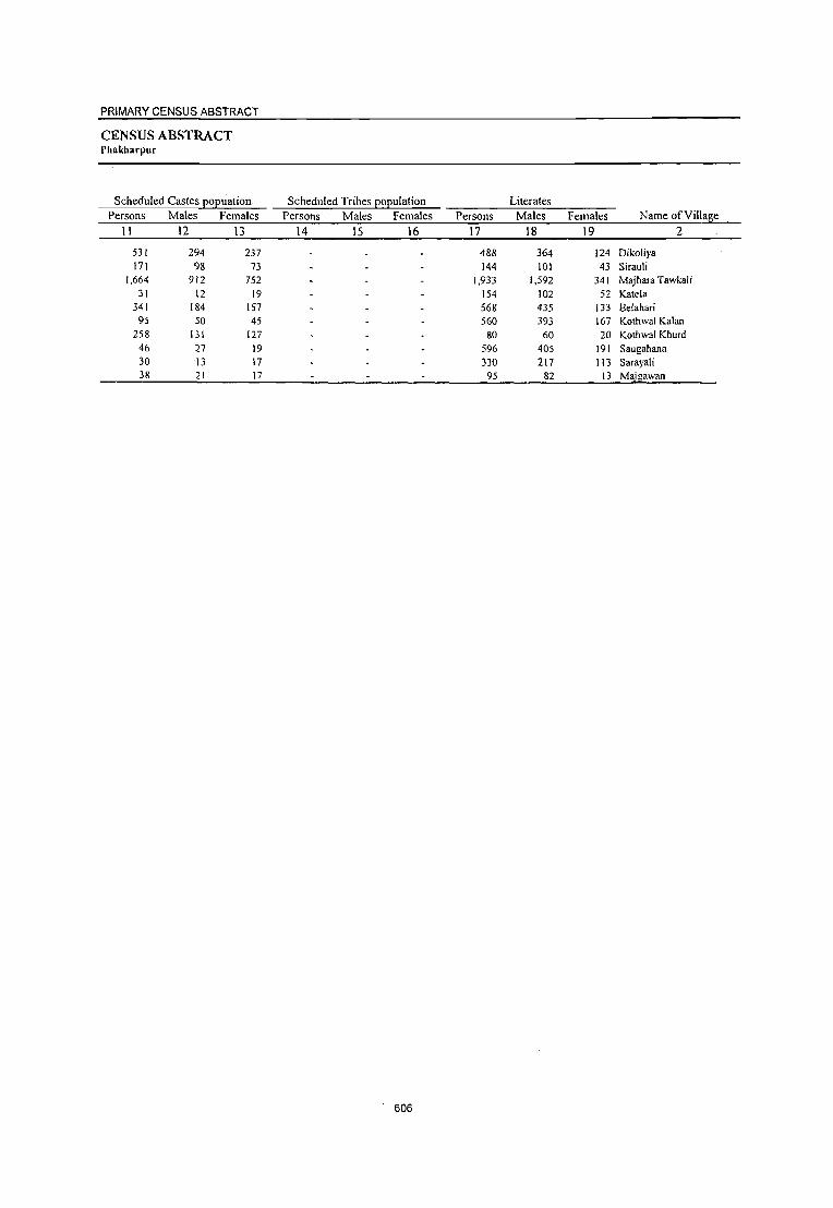
PRIMARY CENSUS ABSTRACT
CENSUS ABSTRACT Phakharpur
Scheduled Castes EOEuation Persons Males Females
II 12 I3
531 294 237 171 98 73
1,664 912 752 31 12 19
341 1M 157 95 SO 45
258 131 127 46 27 19 30 13 17 38 21 17
Scheduled Tribes population Persons Males Females
14 15 16
606
Literates Persons Males Females Name of Village
17 18 19 2
488 364 124 Dikoliya 144 101 43 Sirauli
1,933 1,592 341 Majhara Tawkali 154 102 52 Katela 568 435 133 Belahari 560 393 167 Kothwal Kalan
80 60 20 Kothwal Khurd 596 405 191 Saugahana 330 217 113 Sarayali
95 82 13 Ma"gawan

DISTRICT CENSUS HANDBOOK: BAHRAICH
VILLAGE PRIMARY. CD Block-
Location
code Illiterates Total workers Main workers
number Name of Village Persons Males Females Persons Males Females Persons Males Females
2 20 21 22 23 24 25 26 27 28
06512200 Dikoliya 1,870 941 929 903 678 225 386 381 5 06512300 Sirauli 557 268 289 215 204 11 214 204 10 06512400 Majhara Tawkali 10,481 5,043 5,438 4,787 3,720 1,067 3,803 3,463 340 06512500 Katela 302 138 164 129 120 9 105 105 06512600 Belahari 2,761 1,312 1,449 1,620 988 632 953 795 158 06512700 Kothwal Kalan 875 384 491 452 433 19 448 433 15 06512800 Kothwal Khurd 403 188 215 127 126 I 127 126 I
06512900 Saugahana 1,367 623 744 565 556 9 564 555 9 06513000 Saraya1i 326 143 183 195 195 195 195 06513100 Majgawan 495 259 236 \94 189 194 \89
607

PRIMARY CENSUS ABSTRACT
CENSUS ABSTRACT Phakharpur
Cultivators Persons Males Females
29 30 31
303 300 3 73 72
3,082 2,825 257 83 83
777 673 104 352 341 II 112 112 504 497 7
81 81 71 68 3
Industrial category of main workers Household industry
A!;\ricultural labourers workers Other workers Persons Males Females Persons Males Females Persons Males Females
32 33 34 35 36 37 38 39 40 . 80 78 2 3 3 140 131 9 634 572 62 22 21 65 45 20
12 12 I I 9 9 151 101 50 4 3 21 18 3 89 85 4 6 6 I 14 13 -I 1 1 55 53 2 3 3 2 2
103 103 6 6 5 5 112 III II 10
608
Name of Village
Dikoliya Sirauli
2
Majhara Tawkali Katela Belahari Kothwal Kalan Kothwal Khurd Saugahana Sarayali Maj awan

Location code Marginal workers
number Name ofYillage Persons Males Females 2 41 42 43
06512200 Dikoliya 517 297 220 06512300 Sirauli 06512400 Majhara Tawkali 984 257 727 06512500 Katela 24 15 9 06512600 Belahari 667 193 474 06512700 Kothwal Kalan 4 4 06512800 Kothwal Khurd 06512900 Saugahana 06513000 Sarayali 06513100 Majgawan
609
Persons 44
12
555 19
377
DISTRICT CENSUS HANDBOOK: BAHRAICH
Cu ltivators Males Females
45 46
9 3
118 437 12 7 37 340
VILLAGE PRIMARY CD Block-
Industrial category
~'iculturallabourers
Persons Males Females 47 48 49
504 288 216
266 71 195 3 I 2
284 153 131 4 4

PRIMARY CENSUS ABSTRACT
CENSUS ABSTRACT Phakharpur
of marginal workers
Household indust~ workers Other workers Persons Males Females _ Persons Males Females
50 51 52 53 54 55
4 158 64 94 2 2
3 2 3 2
610
Location
Non-workers code
Persons Males Females Name of Village number
56 57 58 2
1,455 627 828 Dikoliya 06512200 486 165 321 Sirauli 06512300
7,627 2,915 4,712 Majhara Tawkali 06512400 327 120 207 Katela 06512500
1,709 759 950 Belahari 06512600 983 344 639 Kothwal Kalan 06512700 356 122 234 Kothwal Khurd 06512800
1,398 472 926 Saugahana 06512900 461 165 296 Sarayali 06513000 396 152 244 Majgawan 06513100

Location code
number Name ofVi\\age 2
0555 Ruzoorpur (Total) 0555 Ruzoorpur (Rural) 0555 Ruzoorpur (Urban)
Ruzoorpur (Rural) 06513200 Pipriya Mahipal Singh 06513300 Gaurya 06513400 Karidiha 06513500 Sakha 06513600 Gobaraha 06513700 Sadyabad 06513800 Tajpur 06513900 Chakujot 06514000 Sarkhana 06514100 Ailiha 06514200 Bahuta 06514300 Khargauli 06514400 Gokulpur 06514500 Baikuntha G6514600 Seri,a 06514700 Belgaon 06514800 Nijampur 06514900 Bhgahari)'a 06515000 Chak Banarasi 06515100 Ahiratad 06515200 Ramawapur 06515300 Harduha 06515400 Duragupur 06515500 Majhauwa 06515600 Gudawapur 06515700 Ranipur 06515800 Jagdishpur 06515900 Imaliya 06516000 Mohamadpur Kodwa 06516100 Nasarapur 06516200 Badagaon 06516300 Bulaha 06516400 Babhni 06516500 Bambharpur 06516600 Rantapur 06516700 Gaudari)'a 06516800 Sisya 06516900 Surjana Kala 06517000 Mogalha 06517100 Jaimara 06517200 Bisunpur 06517300 Mukam 06517400 Hariharpur 06517500 Katdhari Sugariv Singh 06517600 Katghara Kala 06517700 Uttar Ganga 06517800 Chilharia 06517900 Bhawanipur 06518000 Patakhauli 06518100 Kothawa 06518200 Kaira 06518300 Bhanpur-06518400 Kursahi 06518500 Nidura 06518600 Anandpur
DISTRICT CENSUS HANDBOOK: BAHRAICH
Total population (including Area· of institutional and house less
Village in Number of population) hectares households -P=-e-r-s-on-s--";,,,:;.,LM':;':'::a:':;le"'s;;;;L-F-e-m-al-es-
3 4
18,353.1 18,353.1
423.0 350.0 141.0 140.0 283.0 283.0 153.0 47.0 66.0
313.0 167.0 62.0
192.0 1 [6.0 724
108.0 127.0 157.0 29.0 56.0
247.0 47.0
255.0
86.9
233.0
132.5 125.9 161.0 186.0 170.0 113.0
43.0 146.0 465.1 266.7 160.0 220.0 568.0 153.0 184.9'
24,885 24,885
462 434 153 455 451 284 260 139 134 277 104 66
247 [28 40
192 112 129 32
[07 [98
61 1\4 133 244 106 124 679 342 116 614 165 103 197 282 272
67 228 174
83 25
120 450 251 236
28 226
72 94 41 79
283
5
150,622 150,622
2,959 2,724
866 2,534 2,767 1,528 1,688
899 672
1,376 528 426
1,527 799 242
1,078 615 740 156 6[2
1,206 404 713 758
1,338 752 729
4,053 2,064
794 3,870 1,087
529 1,096 1,550 1,429
448 1,359 1,034
456 136 864
2,927 1,516 1,435
131 1,329
364 547
- 308 436
1,683
6
80,671 80,671
1,555 1,446
457 1,374 1,521
821 908 489 354 774 277 23 [ 823 440 131 605 336 394
86 338 664 230 373 431 704 389 387
2,180 1,088
447 2,084
561 289 577 889 776 241 739 546 256 67
473 1,547
819 758
66 680 204. 283 J74
7
69,951 69,951
1,404 1,278
409 1,[60 1,246
707 780 410 318 602 251 195 704 359 III 473 279 346
70 274 542 174 340 327 634 363 342
1,873 976 347
1,786 526 240 519 66[ 653 207 620 488 200 69
39[ 1,380
697 677
65 649 160 264 134
227 209 883 800.
VILLAGE PRIMARY CD Bloclk-
Population in the age:-group 0-6
Persons Males Females 8 9 10
31,266 31,266
659 617 150 581 550 232 404 174 127 268 109 85
318 154 59
224 140 160 24
125 256
78 140 131 289 154 186 764 395 152 856 229 147 233 326 352
97 270 229
96 31
[79 602 320 297
18
279 71
103 57 95
349
15,909 15,909
325 316
70 299 275 108 203
84 54
134 48 43
155 80 26
131 64 80 13 73
143 48 73 77
139 82 93
383 194 90
430 110 75
127 183 171
61 143 115
55 17 81
296 166 149
8 134 35 51 33 47
176
15,357 15,357
334 301
80 282 275 124 201 90 73
134 61 42
163 74 33 93 76 80 \I 52
113 30 67 54
150 72 93
381 201
62 426 119 72
106 143 181
36 127 114
41 14 98
306 154 148
10 145 36 52 24 48
173
96.9 . 47.9
242.9 16.0 73.0
162.2
____ Un_inhabitedl ___ -
144 62
611
878 374
463 415 203 171
180 72
86 38
94 34

PRIMARY CENSUS ABSTRACT
CENSUS ABSTRACT Huzoorpur
Scheduled Castes Eo~uation Scheduled Tribes ~oEulation Literates Persons Males Females Persons Males Females Persons Males Females Name ofViUage
11 12 13 14 15 16 17 18 19 2
17,660 9,505 8,155 36,148 27,303 8,845 Huzoorpur (Total) 17,660 9,505 8,155 36,148 27,303 8,845 Huzoorpur (Rural)
Huzoorpur (Urban) Huzoorpur (Rural)
53 26 27 612 444 168 Pipriya Mahipal Singh 498 261 237 416 330 86 Gaurya
22 10 12 269 209 60 Karidiha 170 96 74 598 467 131 Sakha 213 112 101 636 475 161 Gobaraha 228 125 103 312 263 49 Sadyabad 159 91 68 469 356 113 Tajpur 225 126 99 229 176 53 Chakujot 20 12 8 34 23 II Sarkhana
263 137 126 202 173 29 Ailiha 110 54 56 71 54 17 Bahuta 24 13 11 89 56 33 Khargauli
328 163 165 391 287 104 Gokulpur 185 100 85 214 148 66 Baikuntha 76 42 34 58 48 10 Seriya
187 105 82 202 172 30 Belgaon 237 135 102 109 92 17 Nijampur 214 113 101 129 104 25 Bhgahariya 38 24 14 36 30 6 Chak Banamsi
280 150 130 146 114 32 Ahiratad 68 37 31 368 268 100 Ramawapur 82 46 36 50 50 Harduha 55 26 29 115 101 14 Duragupur 7 4 3 279 192 87 Majhauwa
167 82 85 353 255 98 Gudawapur 42 21 21 203 160 43 Ranipur 68 38 30 167 134 33 Jagdishpur
1,110 599 511 1,343 980 363 lmaliya 409 215 194 450 369 81 Mohamadpur Kodwa 178 102 76 162 127 35 Nasarapur 103 57 46 728 616 112 Badagaon
227 171 S6 Bulaha 135 75 60 135 113 22 Babhni 54 30 24 202 132 70 Bambharpur
277 160 117 276 234 42 Rantapur 100 54 46 228 Itl2 46 Gaudariya 106 58 48 171 121 50 Sisya 172 88 84 246 202 44 Surjana Kala 101 50 51 190 149 41 Mogalha 27 15 12 65 60 5 Jaimara 23 10 I3 13 13 Bisunpur
101 51 50 127 95 32 Mukam 315 168 147 862 639 223 Hariharpur
99 59 40 200 133 67 Katdhari Sugariv Singh 116 58 58 402 308 94 Katghara Kala 28 12 16 S8 37 21 Uttar Ganga
112 60 52 2S1 189 62 Chilharia 10 6 4 111- 87 24 Bhawanipur 35 20 15 '-- 84 69 15 Patakhauli 58 33 25 120 91 29 Kothawa 97 51 46 - S9 48 11- Ka]ra
210 103 107 443 328 115 Bhanpur -----Un-inhabited-------- Kursahi
34 14 20 113 73 40 Nidura 103 57 46 150 109 41 Anandpur
612

Location
DISTRICT CENSUS HANDBOOK: BAHRAICH
VILLAGE PRIMARY CD Block-
code Illiterates Total workers Main workers _n_u--;m:-b_er __ --'N;_;;.an;.cl...;.e..:o-::-f--'V..:i;:;.ll~ag"'e;..._ _ _;P_;e:.:r:::so::.:n:::s __ M:.:..::a71e::::s~..:F:..:e::=:m::a:::le;:;s:......_;;.P.::.er:::s~on:.::s:......-M:.:.:::a:.::le:::s~.:.F..::e:.::m~a:::le::::s:._...!...Pe::::rc::so:.::nc::s!.... Males Females ____________ ~2~ ______ ~2=0~ __ ~2~1 ____ ~2=2 ____ ~2~3 ____ ~2~4 ____ ~2~5 ____ ~2~6 __ 27 28
0555 0555 0555
06513200 06513300 06513400 06513500 06513600 06513700 06513800 06513900 06514000 06514100
Huzoorpur (Total) Huzoorpur (Rural) Huzoorpur (Urban) Huzoorpur (Rural) Pipriya Mahipal Singh Gaurya Karidiha Sakha Gobaraha Sadyabad Tajpur Chakujot Sarkhana Ailiha
06514200 Bahuta 06514300 Khargauli 06514400 Gokulpur 06514500 Baikuntha 06514600 Seriya 06514700 Belgaon 06514800 Nijampur
06514900 Bhgahariya 06515000 Chak Banarasi 06515100 Ahiratad 06515200 Ramawapur 06515300 Harduha 06515400 Duragupur 06515500 Majhauwa 06515600 Gudawapur 06515700 Ranipur 06515800 Jagdishpur 06515900 Imaliya 06516000 Mohamadpur Kodwa 06516100 Nasarapur 06516200 Badagaon 06516300 Bulaha 06516400 Babhni 06516500 Bambharpur 06516600 Rantapur 06516700 Gaudariya 065 I 6800 Sisya 06516900 Surjana Kala 06517000 Mogalha 06517100 Jaimara 06517200 Bisunpur 06517300 Mukam 06517400 Hariharpur 06517500 Katdhari Sugariv Singh 06517600 Katghara Kala 06517700 Uttar Ganga 06517800 Chilharia 06517900 Bhawanipur 06518000 Patakhauli.
06518100 Kothawa 06518200 Kaira D6518300'- Bhanpur
06518400 Kursahi 06518500 Nidura 06518600 Anandpur
114,474 114,474
2,347
2,308 597
1,936 2,131 1,216 1,219
670 638
1,174 457 337
1,136 585 184 876 506 611 120 466 838 354 598 479 985 549 562
2,710
1,614 632
3,142 860 394 894
1,274 1,201
277 1,113
844 391 123 737
2,065 1,316 1,033
73 1,078
253 463 188 377.
1,240
765 224
53,368 53,368
1,111 1,116
248 907
1,046 558 552 313 331 60! 223 175 536 292
83 433 244 290
56 224 396 180 272
239 449 229 253
1,200
719 320
1,468 390 176 445 655 594 120 537 397 196 54
378 908 686 450
29 491 117 214
83 179 555
390 94
61,106 61,106
1,236 1,192
349 1,029 1,085
658 667 357 307 573 234 162 600 293 101 443 262 321 64
242 442 174 326 240 536 320 309
1,510
895 312
1,674 470 218 449 619 607 157 576 447 195 69
359 1,157
630 583
44 587 136 249 105 198 685
375 130
613
49,910 49,910
945 899 436
1,096 918 557 605 280 176 646 181 119 516 287
65 465 206
219 75
280 460 218 210 259 448 203
174 1,395
732 219
1,583 361 326 529 516 . 603 143 415 300 128
31 446 771 727 624
41 410 127 128 89
42,531 42,531
820 757 267 752 840 513 456 271 167 485 160 117 393 215
65 344 189 212 46
160 349 142 205 259 391 197 172
1,187
569 215
1,158 314 192 291 464 442 111 404 285 124
31 249 735 514 482
41 357 119 127.
- 86 180 J{)6 501 _- 464
7,379 7,379
125 142 169 344
78 44
149 9 9
161 21
2 123 72
121 17 7
29 120 III 76
5
57 6 2
208 163
4 425
47 134 238
52 161 32 II 15 4
197 36
213 142
53 8 I 3
74 37
---Un-inhabited---271 222 124 93
49 31
39,600 39,600
751 804 207 895 652 164 416 227 174 282 160 119 471
88 27
243 185 118 46
161 257 143 210 259 379
172 154
1,217
456 171
1,091 256 170 250 411 464 68
411 295
6 30
250 677 401 539 33
299 115 128 82
143 459
226 100
37,293 37,293
741 734 192 657 601 155 379 221 166 276 152 117 384
85 27
236 178 117 46
159 235 141 205 259 339 167 153
1,172 435 170
1,056 247 138 237 404 420
67 404 284
5 30
246 658 392 439
33 275 111 127 79 97
441
220 79
2,307 2,307
10 70 15
238 51
9
37 6 8
6 8 2
87 3
7 7
I
2 22 2 5
40 5 1
45 21
35 9
32 13
7 44
1 7
I!
.4 19 9
100
24 4
1 3
46 18
6 21

PRIMARY CENSUS ABSTRACT
CENSUS ABSTRACT Huzoorpur
Industrial category of main workers Household industry
Cultivators Agricu\turallabourers workers Other workers Persons Males Females Persons Males Females Persons Males Females Persons Males Females Name ofVilJage
29 30 3 \ 32 33 34 35 36 37 38 39 40 2
30,236 30,236
615 522 127 696 468 134 168 210 134 211 113 57
330 64
26 136 146 104
<1.4
154 120 100 142 259 303
84
146 650 298 35
931 188
53 243 342 243 62
125 183
2 28
221 584
347
342
30 249 100
81
79 84 c
392
94 58
28,810
28,810
608 508 126 513 457
131 150 205 131 205 108
57 304
62 26
132 141
103 44
152 106 98
137 259 267
81 145
633 295 35
905 180 41
231 337 223
62 122 178
28 218 575 341 321 30
236 98 81 76 62
375-
94
52
1,426 c
1,426
7 14
183 II
3 18
5 3 6
76 2
4
5
2c 14
2 5
36 3 I
17 3
26 8
12 12
5 20
3 5
3 9 6
21
13 2
3 22
J7
6
6,097 6,097
113 253
73 177 135
8 104
30 65 42 50 53
2
8& 31
5 \
3 106 42 59
20 23
1 330 139 109 III 38 73
3 55
113
284 108
26 48
c41 98
1 34 14 44
1 42-45c
123 3
5,523 5,523
110 197 63
123 98 7
93 5
26 65 39 48 43 2
85 29
5 \ 3
100 42 59
17 22
I 319 123 108 106 37 57
2 53 93
21tO 104
25
41
39 58
1 23 12
43 I
26 45--
574 574
3 56 10 54
37
II
4
3 2
10
3 2
6
3
II 16
I
5
16 I 2
20
4
4
7
2
40
11 2 I -
T6
785 785
10 8 7 8
3 4
14
2
5 5
7
5
8 35
56 4 I
16 9 6
4
13 3
64
7
IS 3
604
604
10 8
3 7 3
14 I I 2
6
g
34
53 3
I 15 9 5 I I 3
II 3
26
7
7 3
----Un-inhabited--------117 6
3 26 16
614
181
lSI
4
3
2
38
8
10
2,482 2,482
13 21
14 46 18
130 II 9 4 4
II 38 21
18
3 4
\ 4
24 I 4
48 30
7 181
IS 26 33 21 38
3 13
104 6 2 <1 4
2
3 32 10 35
2 9
3 2 2
19
9 13
2,356 2,356
13 21
14 43 16
122 10 8 4 4
II 37 20
18 3 4
1 4
23
4
47 30
7 167
14 26 30 21 35
3 13
101 5 2
2 4
2 3
31 9
34 2 9
3 2 2
18
9 8
126 Huzoorpur (Total)
126 Huzoorpur (Rural)
Huzoorpur (Urban) lIuzoorpur (Rural)
Pipriya Mahipal Singh
Gaurya Karidiha
Sakha
3 Gobaraha
2 Sadyabad
8 Tajpur
Chakujot
Sarkhana
Ailiha
Bahuta
Khargauli
Gokulpur Baikuntha
Seriya
Belgaon
Nijampur
Bhgahariya
Chak Banarasi
Ahiratad
Ramawapur
Harduha
Duragupur
Majhauwa
Gudawapur
Ranipur
Jagdishpur
14 Imaliya
Mohamadpur Kodwa
Nasarapur
3 Badagaon
Bulaha
3 Babhni
Bambharpur
Rantapur
3 Gaudariya
-_
Sisya
S U1j ana Kala
2 Mogalha
Jaimara
Bisunpur
Mukam
Hariharpur
Katdhari Sugari v Singh
Katghara Kala
Uttar Ganga Chilharia Bhawanipur
_ Patakhaul i
Kothawa Kaira
Bhanpur
Kursahi
Nidura
5 Anandpur

Location
DISTRICT CENSUS HANDBOOK: BAHRAICH
VILLAGE PRIMARY CD Block-
Industrial category
code -.",_~M~ar:..g::;in::.;a::.l~w:..:o:.:.rk~e:;r::-s_-:--__ -=-__ ...:C;,.:u:::lt::.iv:..:.a::;to:::,;r:.:s ______ .:..A:lig~ri!;ulturallabourers __:_n:..;_u.:.:m:-"b_;.e,-r __ No..;.::a:.:m:.:e..:o:.:f_V:..:i::.:ll:.:ag""e=--__ P:_e::r.::.so::.;n:::s=--_:..:M::.:a=:le:::s=--~Fe::m.:.:a::l:;:es::_~P..::e.:.:rs:.::o:.:.:n.::.s _..::M:!:a::.:l.::::es::.__F!..:e~m!!a!!!l::::es::_~P..::e.:.:rs:.::o:!.!n~s Males Females
2 41 42 43 44 45 46 47 48 49
0555 Huzoorpur (Total) 0555 Huzoorpur (Rural) 0555 Huzoorpur (Urban)
Huzoorpur (Rural) 06513200 Pipriya Mahipal Singh 06513300 Gaurya 06513400 Karidiha 06513500 Sakha 06513600 Gobaraha 06513700 Sadyabad 06513800 Tajpur 06513900 Chakujot 06514000 Sarkhana 06514100 Ailiha 06514200 Bahuta 06514300 Khargauli 06514400 Gokulpur 06514500 Baikuntha 06514600 Seriya 06514700 Belgaon 06514800 Nijampur 06514900 Bhgahariya 06515000 Chak Banarasi 06515100 Ahiratad 06515200 Ramawapur 06515300 Harduha 06515400 Duragupur
06515500 Majhauwa 06515600 Gudawapur
06515700 Ranipur 06515800 Jagdishpur 06515900 Imaliya 06516000 Mohamadpur Kodwa 06516100 Nasarapur 06516200 Badagaon 06516300 Bulaha 06516400 Babhni 06516500 Bambharpur 06516600 Rantapur 06516700 Gaudariya
06516800 Sisya 06516900 Surjana Kala
06517000 Mogalha 06517100 Jaimara
06517200 Bisunpur 06517300 Mukam 06517400 Hariharpur 06517500 Katdhari Sugariv Singh 06517600 Katghara Kala 06517700 Uttar Ganga 06517800 Chilharia 06517900 Bhawanipur 06518000 Patakhauli 06518100 Kothawa
_06518200 Kalra OQ518300 Bhanpur 06518400 Kursahi 06518500 Nidura 06518600 Anandpur
10,310 10,310
194
95 229 201 266 393 189 53 2
364 21
45
199 38
222 21
101 29
119 203
75
69
31 20
178 276
48 492
105 156 279 105 139 75
4 5
122 I
196 94
326 85
8 111
12
7 37 42
45 24
5,238 5,238
79 23 75 95
239 358
77 50
209 8
9 130 38
108 11 95
I 114
I
52 30 19 15
134 45
102 67 54 54 60
22 44
119 1 3
77 122
43 8
82 8
__ 7
9 23
2 14
5,072 5,072
115 72
154 106 27 35
112 3 I
155 13
36 69
114 10 6
29 118 89 74
17
I
163 142
3 390
38 102 225
45 117
31 4 4 3
193 17
204 42
615
29 4
28 19
43 10
3,457 3,457
86 II 26
105 58
112 57
6
41
32 15
176 2 2
28 118 28 47
12
2
98 103
3 300
19 98
125 II 10 30
3
196 32 22 52
12 5
24 16
1,039 1,039
29 2
15 34 53
107 19 6
22
4 8
74 2 2
I 13
7
35 2
33 5
33 13 9 7
22
3 23 20 23
7 3
I 5 8
2,418 2,418
57 9
11 71
5 5
38
19
28 7
102
28 117
15 46
7
91 68
267 14 65
112 2 3 8 3
193 9 2
29
5 2
19 8
----Un-inhabited--------22 2 20 13 6 7
6,291 6,291
95 83
202 93
199 250 113 47
I 317
19
9 159 33 34
18 99
I 168 28
56 21 12 74
170 24
178 82 25
154 94
126 44
~i
121
53 298
20
96 '7
IS 9
1 S
23 5
3,811 3,811
37 20 60 60
178 229
46 44
183 7
I 97 13 24
8 93
97
47 20 12 3
98 22 58 59 4
41 51 13 21
118
46 96
8 8
74 5
6 3 7
5
2,480 2,480
58 63
142 33 21' 21 67
3 1
134 12
8 62
10 10 6
I 71 28
9
71· 72
2 120 23 21
113 43
113 23
4 3
7 202
12
22 2
6. 11
23

PRIMARY CENSUS ABSTRACT
CENSUS ABSTRACT Huzoorpur
of marginal workers Location
Household in dust!): workers Other workers Non-workers code
Persons Males Females Persons Males Females Persons Males Females Name of Village number
50 51 52 53 54 55 56 57 58 2
211 109 102 351 279 72 100,712 38,140 62,572 Huzoorpur (Total) 0555 211 109 102 351 279 72 100,712 38,140 62,572 Huzoorpur (Rural) 0555
Huzoorpur (Urban) 0555 Huzoorpur (Rural)
13 13 2,014 735 1,279 Pipriya Mahipal Singh 06513200 1,825 689 1,136 Gaurya 06513300
430 190 240 Karidiha 06513400 2 2 I I 1,438 622 816 Sakha 06513500 J 3 6 5 1,849 631 1,168 Gobaraha 06513600
17 9 8 14 13 I 971 308 663 Sadyabad 06513700 4 3 15 9 6 1,083 452 631 Tajpur 06513800
619 218 401 Chakujot 06513900 496 187 309 Sarkhana 06514000
4 2 2 2 2 730 289 441 Ailiha 06514100 347 117 230 Bahula 06514200 307 114 193 Khargauli {)6514300
4 4 1,011 430 581 Gokulpur 06514400 24 24 512 225 287 Baikuntha 06514500
177 66 III Seriya 06514600 7 5 2 5 613 261 352 Belgaon 06514700 1 409 147 262 Nijampur 06514800
521 182 339 Bhgahariya 06514900 81 40 41 Chak Banarasi 0651~000
332 178 154 Ahiratad 06515100 2 5 3 2 746 315 431 Ramawapur 06515200
186 8& 98 Harduha 06515300 503 168 335 Duragupur 06515400 499 172 327 Majhauwa 06515500 890 313 577 Gudawapur 06515600
6 6 3 3 549 192 357 Ranipur 06515700 2 2 4 4 555 215 340 Jagdishpur 06515800
5 2,658 993 1,665 Imaliya 06515900 3 2 1,332 519 813 Mohamadpur Kodwa 06516000
21 21 575 232 343 Nasarapur 06516100 12 9 3 2 2 2,287 926 1,361 Badagaon 06516200
4 3 726 247 479 Bulaha 06516300 33 17 16 203 97 106 Babhni 06516400
567 286 281 Barnbharpur 06516500 1,034 425 609 Rantapur 06516600
3 2 826 334 492 Gaudariya 06516700 305 130 175 Sisya 06516800 944 335 609 Surjana Kala 06516900 734 261 473 Mogalha 06517000
1 328 132 196 Jaimara 06517100 105 36 69 Bisunpur 06517200 418 224 194 Mukam 06517300
3 2 6 6 2,156 812 1,344 Hariharpur 06517400 2 2 4 4 789 305 484 Katdhari Sugariv Singh 06517500 3 2 10 10 811 276 535 Katghara Kala 06517600
- 90 25 65 Uttar Ganga 06517700 2 2 919 323 596 Chilharia 06517800
237 85 152 Bhawanipur 06517900 419 156 263 Patakhauli 06518000 219 88 131 Kothawa 06518100
2 2 - 2 I 256 121 135 Kaira - 06518200 8- 8 1,182 419 763 Bhanpur 065f8300
------Un-inhabited----- Kursahi 06518400 607 241 366 Nidura 06518500
5 3 2 250 110 140 Anandpur 06518600
616

DISTRICT CENSUS HANDBOOK: BAHRAICH
VILLAGE PRIMARY CD Block-
Total population (including Area of institutional and houseless Population in the
Village in Number of population) age-group 0-6 Location
code number Name of Village hectares households Persons Males Females Persons Males Females
__ ~ ________ ~2~ ______ ~3 ______ ~4 ______ ~5 ______ 6~ ____ ~7~ ____ ~8~ ___ , 9 10
06518700 Jiganiya Chhatrpal Singl 06518800 Balchandpur 06518900 Dharampur 06519000 Kaluyapur 06519100 JiganiyaJasakaran Sing~ 06519200 Jiganiya Mahipal Singh 06519300 Katghara Khurd 06519400 Patu Pur 06519500 Rampur 06519600 Basantpur 06519700 Tirkoliya 06519800 Khanpur 06519900 Nibui Kala 06520000 Babba 06520100 Bhagaha 06520200 Pure Chheda 06520300 Shahpur 06520400 Saslampur 06520500 Nibui Khurd 06520600 Kandra 06520700 Bhaisha 06520800 Dhan Para 06520900 Shivnaha 06521000 Devnpur 06521 100 Laukahi 06521200 Singhpur 06521300 Jagatapuf 06521400 Jalalpur 06521500 Baruhi 06521600 Banpurwa 06521700 Hujurpur 06521800 Gajipur Kodari 06521900 Shivraha 06522000 Behda 06522100 Khargapur 06522200 Chiraiya Tod 06522300 Bhaisahi 06522400 Shekhapur 06522500 Gyanapuf 06522600 Sonhara 06522700 Pure Prahlad 06522800 Alia Purwa 06522900 Pure Jaita 06523000 Bhathi Kunda 06523100 Siraula 06523200 Padum Pichhaura 06523300 Bhidyari 06523400 Newasi 06523500 Nakhara Abbupur 06523600 Jadaupuf Bhatahiya 06523700 Chaubhaiya 06523800 Lalpur Aima 06523900 Bishunp_ur Tedi 06524000 _Adilpur
1)6524100 KanTlullapur 06524200' Chhed Kuri
185.0 4,0
187,0 113.0 76,0
356.0
511.9 793,0 307,0 162,0
7,9
609,3
140.0
156.0 197.0 228,0
32.0 114,0
261.0 173.7
390,0 308,0
224.4 437.0 239.0 125,0 107.0 118.9 424.5 289.7 176,0 419.0 482,0 333.0
167.0 226.0 447.5 374,9 463,0
309 57
274 232 198 426 113 438 400 711 318 216 333 178 479
57 156 303 140 189 294 338 144 104 550 277 103 126 239 155 279 110 86
311 409 114 132 221 467 267 118 88 60
284 362 102 173 498 239 261
27 200 227 365 716 293
,,617
1,806 388
1,791 1,420 1,140 2,333
707 2,722 2,263 4,352 2.010 1,175 1,868
934 2,910
421 1,000 1.941
812 1.068 1,835 1,869
827 616
3,445 1,763
527 780
1,602 1,074 1,729
744 532
1,949 2,705
860 673
1,455 2,741 1,576
683 592 368
1,809 2,293
679 948
2,658 1,466 1,687
168 1,240 1,568 2,316 4,518 1,933
995 198 907 766 604
1,222 372
1,451 1,185 2,383 1.064
609 1,029
508 i.571
229 519 987 424 553 970
1,016 437 336
1,770 1,007
281 417 882 555 927 378 269
1,052 1,457
452 368 779
1,461 860 37? 320 205 967
1,276 361 520
1,459 744 891
86 647 866
f.206 2.404 _ !1,034
811 190 884 654 536
1,111 335
1,271 1,078 1,969
946 566 839 426
1,339 192 481 954 388 515 865 853 390 280
1,675 756 246 363 720 '
519 802 366 263 897
1,248 408 305 676
1,280 716 306 272 163 842
1,017 318 428
1,199 722 796
82 593 702
1.110 2,114
899
369 93
374 277 252 518 141 591 475 962 355 260 395 157 587
58 193 374 132 255 387 399 196 120 793 338
98 141 288 206 320 173 105 407 570 165 145 316 589 337 150 127
81 388 530 123 191 499 328 325
37 241 290 482 950 420
190 48
201 140 132 240
75 319 239 485 164 110 205
81 313
29 100
_ 173
70 131 :;02 214
98 54
384 183
55 73
lSI 99
155 90 48
203 302
80 79
164 301 178 78 68 48
192 287
65 103 262 158 156
17 120 162 241 485 219
179 45
173 137 120 278
66 272 236 477 191 150 190
76 274
29 93
201 62
124 185 185 98 66
409 155 43 68
137 107 165 83 57
204 268
85 66
152 288 159 72 59 33
196 243
58 8~
23i 17C 165 2(
Ip 12! 241 46! 20

PRIMARY CENSUS ABSTRACT
CENSUS ABSTRACT Huzoorpur
Scheduled Castes EOEuation Scheduled Tribes EOEulation Literates
Persons Males Females Persons Males Females Persons Males Females NameofYilIage
II 12 13 14 15 16 17 18 19 2
251 136 I IS 347 262 85 Jiganiya Chhatrpal Singh
105 73 32 Balchandpur 178 90 88 558 405 153 Dharampur 63 38 25 354 276 78 Kaluyapur
144 79 65 186 146 40 Jiganiya Jasakaran Singh 353 182 171 390 310 80 Jiganiya Mahipal Singh
78 42 36 247 176 71 Katghara Khurd 273 153 120 638 474 164 Patu Pur
362 282 80 Rampur 122 73 49 654 451 203 Basantpur 148 84 64 656 458 198 Tirkoliya 118 69 49 348 266 82 Khanpur 124 58 66 389 319 70 Nibui Kala 3i7 177 140 359 267 92 Babba 729 394 335 587 501 86 Bhagaha
27 14 13 251 155 96 Pure Chbeda 86 48 38 446 283 163 Shahpur
170 89 81 804 546 258 Saslamp~r
86 47 39 287 205 82 Nibui Kburd 217 109 108 254 198 56 Kandra 200 112 &8 517 373 144 Bhaisha 154 91 63 491 392 99 Dhan Para 87 46 41 219 175 44 Shivnaha
165 92 73 67 54 13 Devnpur 183 91 92 919 769 150 Laukahi 114 61 53 388 301 87 Singhpur
81 49 32 93 69 24 Jagatapur 49 30 19 138 10<\ 34 Jalalpur
111 59 52 369 296 73 Baruhi 96 56 40 381 278 103 Banpurwa
200 104 96 826 550 276 Hujurpur 138 95 43 Gajipur Kodari
79 40 39 169 121 48 Shivraha 198 106 92 255 192 63 Behda 205 112 93 913 667 246 Khargapur 116 63 53 257 176 81 Chiraiya Tod
139 116 23 Bhaisahi 96 57 39 501 403 98 Shekhapur
267 155 112 421 350 71 Gyanapur 150 84 66 404 342 62 Sonhara 68 41 27 138 107 31 Pure Prahlad 69 37 32 183 138 45 Alia Purwa 13 8 5 102 66 36 Pure Jaita
188 105 83 291 231 60 Bhathi Kunda 209 110 99 383 326 57 Siraula
32 16 16 214 178 36 Padum Pichhaura 307 174 133 165 127 38 Bhidyari 424 228 196 579 468 III Newasi 535 276 259 260 209 51 Nakhara Abbupur 176 87 89 354 259 95 Jada~pur Bhatahiya 60 29 31 62 36 26 Chaubhaiya
179 97 82 357 260 97 Lalpur Airna 421 227,- 1~4 379 291 88 Bishunpur Tedi 392 202 190 652 450 202 Adilpur 303 164- . 139 I,S5~ 1,083_ 468 1(arrnullapur 117 60 57 - 478 _ -342 136 Chhed Kuri
618

DISTRICT CENSUS HA!mBOOK : BAHRAICH
VILLAGE PRIMARY CD BIock-
Location code Illiterates Total workers Main workers
_;;;n_u-:m;.::b..:.er:__ ___ N:_..:;.am=e_;:o::-f_;V_:i;_:lla::;g..:e=--_ _:P...:e::.rs::,:o;,,:n:;:s_...;M:.:.:.::a::.:le:::::s_~F;_:e::::m:.::a;,,:le:::s:__....!..P.::::er~s:;:o!.!:ns!._~M::.:a:::le::::s:_...!F;,;e:!:m~a!:.le~s:__....!..P.::::er~s.:::!!on.s Males Females 2 20 2 I 22 23 24 25 26 27 28
06518700 liganiya Chhatrpal Singh 1,459 733 726 653 566 87 385 367 06518800 Balchandpur 283 125 158 120 92 28 118 92 06518900 Dharampur 1,233 502 731 678 460 218 470 437 06519000 Kaluyapur 1,066 490 576 604 454 150 460 408 06519100 JiganiyaJasakaran Singh 954 458 496 389 312 77 357 294 06519200 Jiganiya Mahipal Singh· 1,943 912 1,Q31 901 722 179 685 632 06519300 KatgharaKhurd 460 196 264 179 173 6 171 166 06519400 Patu Pur 2,084 977 1,107 967 742 225 781 670 06519500 Rampur 1,901 903 998 697 553 144 5711 532 06519600 Basantpur 3,698 1,932 1,766 1,248 1,098 150 1,234 1,090 06519700 Tirkoliya 1,354 606 748 541 511 30 499 486 06519800 Khanpur 827 343 484 379 312 67 237 227 06519900 Nibui Kala 1,479 710 769 533 511 22 512 497 06520000 Babba 575 241 334 268 263 264 259 06520100 Bhagaha 2,323 1,070 1,253 993 849 144 82:! 799 06520200 PureChheda 170 74 96 135 121 14 131 118 06520300 Shah pur 554 236 318 280 277 3 278 277 06520400 Saslampur 1,137 441 696 516 496 20 488 474 06520500 Nibui Khurd 525 219 306 316 245 71 278 232 06520600 Kandra 814 355 459 338 248 90 236 229 06520700 Bhaisha 1,318 597 721 M\ 53\ liD 513 488 06520800 Dhan Para U78 624 754 609 569 40 568 555 06520900 Shivnaha 608 262 346 235 230 5 231 228 06521000 Devnpur 549 282 267 215 213 2 152 152 06521100 Laukahi 2,526 1,001 1,525 981 902 79 920 876 06521200 Singhpur 1,375 706 669 622 544 78 313 300 06521300 Jagatapur 434 212 222 189 155 34 5·j 54 06521400 Jalalpur 642 313 329 200 190 10 19:8 189 06521500 Baruhi 1,233 586 647 565 526 39 552 520 06521600 Banpurwa 693 277 416 307 286 21 250 247 06521700 Hujurpur 903 377 526 537 495 42 455 441 06521800 GajipurKodari 606 283 323 208 188 20 207 188 06521900 Shivraha 363 148 215 151 150 140 139 06522000 Behda 1,694 860 834 544 530 14 533 519 06522100 Kharg,apur 1)92 790 1,002 841 787 54 754 711 06522200 Chiraiya Tod 603 276 327 210 200 10 107 105 06522300 Bhaisahi 534 252 282 163 153 10 161 152 06522400 Shekhapur 954 376 578 407 397 10 373 364 06522500 Gyanapur 2,320 1,111 1,209 847 805 42 587 563 06522600 Sonhara 1,172 518 654 403 396 7 397 390 06522700 Pure Prahlad 545 270 275 227 202 25 203 191 06522800 Alia Purwa 409 182 227 166 - 162 4 134 134 06522900 Pure Jaita 266 139 127 182 108 74 154 82 06523000 Bhathi Kunda 1,518 736 782 497 436 61 319 316 06523100 Siraula 1,910 950 960 781 714 67 618 608 06523200 Padum Pichhaura 465 183 282 219 214 5 213 212 06523300 Bhidyari 783 393 390 282 274 8 266 263 06523400 Newasi 2,079 991 1,088 983 858 125 848 834 06523500 Nakhara Abbupur 1,206 535 671 444 374 70 328 320 06523600 JadaupurBhatahiya 1,333 632 701 533 496 37 414 403
18 26 33 52 63 53 5
111 39
144 13 10 15 5 .
23 13
I
14 46
7 25 13
44 13
9 32
3 14 19 1
14 43
2 9. 9
24 7
12
72 3
10 1 3
14 8
11
06523700 Chaubhaiya 106 50 56 75 57 18 49 49 06523800 Lalpur Aima 883 387 496 307 304 3 306 303 3 06523900 Bishunpur Tedi 1,189 575 61<1 404. 391 13 _ 400 387 13 06524000 Adilpur 1,664 756 908 624 615 9 611 6D8 3 06524100 Karmullapur 2,967 1,321 1,646 1,253 1,215 38_ 1,225 __ 1,195 30
~06~5~2242~0~0~C~h~he~d~-K~u~n~-~ __________ ~~I~,4~55~ ___ '~6~9~2 _____ 7~6~3 _____ '-~6~6~0~~~5~~~3----_1~2~7----~5$~~----~-5~3~3 ______ 25 __
619

PRIMARY CENSUS ABSTRACT
CENSUS ABSTRACT Huzoorpur
Industrial category of main workers Household industry
Cultivators Agricultural labourers workers Other workers Persons Males Females Persons Males Females Persons Males Females Persons Males Females Name of Village
29 30 31 32 33 34 35 36 37 38 39 40
286 60
381 233 244 447 145 609 493
1,189 429 221 489 173
702 119 212 434 260 188 424 440 142
146 802 261
52 ISO 410 124
287 170 140 408 655
85 161 334 406 363
200 115 66
307 347 195 258 710 304 342
39 260 378_ 448
-841 415
274 59
354 211
194 415 142 515 457
1,053 421 211
474 169 685 106 211 422 217 182 408 432 141 146 766 254
52 177 399
123 281 153 139
397 650
83 152 327 396 359
189 115 58
304 344 195 255 697 299 333
39 258 369 447
819 396
12 I
27 22 50 32
3 94 36
136 8
10 15 4
17 13
12
43 6
16
8
36 7
3 11 I 6
17
11 5 2
9 7
10 4
II
8 3 3
3
55
54 43
144 60
139
124
13 26 44
4
3 64
113 3
30 26
41 62
117 75
2 50
14 66 44 10 22
121 45
IS
170 18
8
16 2
133 14 8
13 103 5 IS
9 67 10
2 33 9 ·11 1 151
22 262 19 . 61
50 30 37
119
56 126
108 II 25 40
4 3
64 107
3 30 25
3 40 55
113 75
2
45
10 59 43
8 21
120
33 IS
156 17
8
8 2
128
13 8
102 13 66 10 33 13
149 257 60
5
24 6
25 4
13
16 2 I 4
6
7
4
5
4 7
2
1 12
14
8
5
2
4 2 5
I
2
14 9
19 31
I 14
6 5
12
2 I
3 3
2 9
23
4 35
3
6
15
2 28
2 6 3
3
57
6
22 3
I 2
70
620
2 I
14 8
14 29
1 l3
4 5
12 2
3 3 1 2 7
21
2 29
3
6 14
I 2
2 6
2
3
5
6
22 3
I 2
~8
5
2
2
2 2
2 6
1 26
52
2
42
3
32 74 34 68 24 34 65 13 21 12 20 27
6 9
35 16 13 6
24 8
13 2
59 26
2
41 79
152
2 26
7
36 5
13 3 8
15 10
132 4
41 2
32 70 30 62 23 34 64
8 20 12 20 26
6
9 35
15 10 6
22 7
'II
2 58 25
2
33 78
146
1 26
7
34 5
12 2 8
II 10
130 4
13 13 6 5 5 4
H 12 4· 4
10 fo 52 51-82 - 77
2
Jiganiya Chhatrpal Singh Balchandpur Dharampur
4 Kaluyapur 4 Jiganiya Jasakaran Singh 6 Jiganiya Mahipal Singh
Katghara Khurd PaW Pur Rarnpur
5 Basanlpur I Tirkoliya
Khanpur Nibui Kala Babba Bhagaha Pure Chheda Shahpur Saslampur Nibui Khurd Kandra
2 Bhaisha Dhan Para
2 Shivnaha Devnpur Laukahi Singhpur Jagatapur Jalalpur
8 Baruhi 1 Banpurwa 6 Hujurpur
Gajipur Kodari Shivraha Behda Khargapur Chiraiya Tod Bhaisahi
2 Shekhapur Gyanapur Sonhara Pure Prahl ad AllaPurwa
4 Pure Jaita Bhathi Kunda
2 Siraula Padum Pichhaura Bhidyari Newasi Nakhara Abbupur Jadaupur Bhatahiya Chaubhaiya . lalpurAima Bisbunpur Tedi Adilpur Karmullapur .
5 ebbed Kuri

Location
DISTRICT CENSUS HANDBOOK: BAHRAICH
VILLAGE PRIMARY CD Block-
Industrial category
code -::--__:M.:..:,::ar:J;g.::in:;:a::l,_:w.:..:o:::_r;_:ke:::r:::.s _______ ...:C:_:u::l.::tiv...:a:.;,;t.:;_or:.:s'--_____ ..;.A..:<g",r...:i<:_ulturallabourers _n_u-:m:-b_er ___ N_a_m...:.e...:o,:-f_V...:i;;:ll",ag,,-e,--_...:P:,_e::f.::,so:_:n.:,:s,---",M.:.:a::.le::s:..__F:.._e::.:m.::a:::l.::;es::.__..:.P.=e:.::fs:.::o::n:::._s _..:;M_:;a::;l.:::es::.__...:F:._:e::m:..:.::::al:::es::__..:.P.=e:.::fs:.::o::n::._s Males Females
2 41 42 43 44 45 46 47 48 49
06518700 Jiganiya Chhatrpal Singh 06518800 Balchandpur 06518900 Dharampur 06519000 Kaluyapur 06519100 JiganiyaJasakaran Singh 06519200 Jiganiya Mahipal Singh 06519300 Katghara Khurd 06519400 Patu Pur 06519500 Rampur 06519600 Basantpur 06519700 Tirkoliya 06519800 Khanpur 06519900 Nibui Kala 06520000 Babba 06520100 Bhagaha 06520200 Pure Chheda 06520300 Shah pur 06520400 Saslampur 06520500 Nibui Khurd 06520600 Kandra 06520700 Bhaisha 06520800 Dhan Para 06520900 Shivnaha 06521000 Devnpur 06521100 Laukahi 06521200 Singhpur 06521300 Jagatapur 06521400 Jalalpur 06521500 Baruhi 06521600 Banpurwa 06521700 Hujurpur 06521800 Gajipur Kodari 06521900 Shivraha 06522000 Behda 06522100 Khargapur 06522200 Chiraiya Tod 06522300 Bhaisahi 06522400 Shekhapur
06522500 Gyanapur 06522600 Sonhara 06522700 Pure Prahlad 06522800 Alia Purwa 06522900 Pure Jaita 06523000 Bhathi Kunda 06523100 Siraula 06523200 Padum Pichhaura 06523300 Bhidyari 06523400 Newasi 06523500 Nakhara Abbupur 06523600 Jadaupur Bhatahiya 06523700 Chaubhaiya 06523800 Lalpur Aima 06523900 Bishunpur Tedi 06524000 Adilpur -
- 06524100 Karmullapur 06524200 ehhed Kuri
268 2
208 144 32
216 8
186 126
14 42
142 21
4
171 4 2
28 38
102 128
41 4
63 61
309 135
2 13 57 82
II II 87
103 2
34
260 6
24
32 28
178 163
6 16
135 116 119 26
-4 3 .8 12
199
23 46 18 90
7
72 21
8 25 85 14 4
50 3
22 13 19 43 14 2
61 26
244 101
I 6
39 54
II II 76 95
I 33
242 6
11 28 26
120 106
2 11 24 S4 93
8
4 - 7
20
69 2
185 98 14
126 I
114 105
6 17 57
7
121 I 2 6
25 83 85 27
2 2
35 65 34
1 7
18 28
II 8
I
18
13 4 2
58 57 4 5
III 62 26 18
621
-6 8
102
30 2
185 48 23 40
101 104
11 26 30
8 4
22 2
13 31 57 82
7 I 2
27 50
5 11 3
I 2 7 2
17
12 2
9 41
5 14
100 35 5
26
6 10 62
16
16 4
14 25
22 12 6
18 2
4 7
2
9 8 6
16 3
2 7
38
4 3 2
6
13 5 6 2
6 14 I 9
12 21
2 8
14 2
169 44
9 15
79
92 5 8
28
15
4 23 51 66
4
I
20 12
8 I
4
6
3 27
4 5
88 14 3
18
4 4
62
230
17 60
5 159
2 79 22
I 14
107 8
142 I
9 7
42 43 34
2 61 30
253 135
1 5
25 74
II 10 84 95
34 241
I 17 9
163 106
I 2
33 81
114
4 5
12
175
3 21
2 54
2 44
9
5 79
7
37
7 5
10 25 II 2
59 16
204 101
1 20 47
II 10 75 88
33 227
I 14 9
110 87 I 2
10
33 91
I 4 3
11
55
14 39
105
35 13
9 28
105
2 2.
32 18 23
2
14 49 34
4 5
27
9 7
·1 14
3
53 19
23 48 23

PRIMARY CENSUS ABSTRACT
CENSUS ABSTRACT Huzoorpur
of marginal workers Location
Household indust~ workers Other workers Non-workers code
Persons Males Females Persons Males Females Persons Males Females Name of Village number
50 51 52 53 54 55 56 57 58 2
2 2 6 6 1,153 429 724 Jiganiya Chhatrpal Singh 06518700 268 106 162 Balchand pur 06518800
I I 5 4 I 1,113 447 666 Dharampur 06518900 20 8 12 16 13 3 816 312 504 Kaluyapur 06519000 2 2 751 292 459 Jiganiya Jasakaran Singh 06519100 2 15 10 5 1,432 500 932 3iganiya Mahipal Singh 06519200
6 5 528 199 329 Katghara Khurd 06519300 6 6 1,755 709 1,046 Palu Pur 06519400
1,566 632 934 Rampur 06519500 2 2 3,104 1,285 1,819 Basantpur 06519600
1,469 553 916 Tirkoliya 06519700 3 2 2 2 796 297 499 Khanpur 06519800 2 3 3 1,335 518 817 Nibui Kala 06519900
666 245 421 Babba 06520000 2 5 5 1,917 722 1,195 Bhagaha 06520100
I 286 108 178 Pure Chheda 06520200 720 242 478 Shahpur 06520300
3 3 3 3 1,425 491 934 Saslampur 06520400 496 179 317 Nibui Khurd 06520500
2 2 730 305 425 Kandra 06520600 .2 1,194 439 755 Bhaisha 06520700
1,260 447 813 Dhan Para 065.2080C 592 207 335 Shivnaha 06520900 401 123 278 Devnpur 0652100C
I 3 2 2,464 868 1,596 Laukahi 0652110C 4 2 2 2 2 1,141 463 678 Singhpur 0652120C
338 126 212 Jagatapur 0652130C 580 227 353 Jalalpur 0652140C
2 I I I 1,037 356 GSI Baruhi 0652150C 4 3 17 13 4 767 269 498 Banpurwa 0652160C
5 5 1,192 432 760 Hujurpur 0652170C 536 IlJO 346 Gajipur Kodari 0652 I 80C 381 119 262 Shivraha 0652190C
1,405 522 883 Behda 0652200( 1,864 670 1,194 Khargapur 0652210C
650 252 398 Chiraiya Tod 0652220( 510 215 295 Bhaisahi 0652230(
1,048 3G2 666 Shekhapur 0652240( 2 2 1,894 656 1,238 Gyanapur 0652250C
1,173 464 709 Sonhara 0652260( It 4 7 456 175 281 Pure Prahlad 0652270(
5 4 8 8 426 158 268 AllaPurwa 0652280( 2 2 16 16 186 97 89 Pure Jaita 0652290( I I 5 3 2 1,312 531 781 Bhathi Kunda 0652300( 8 2 6 8 3 5 1,512 562 950 Siraula 06523W(
460 147 313 Padum Pichhaura 0652320( 666 246 420 Bhidyari 0652330(
2 2 1,675 601 1,074 Newasi 0652340( 1,022 370 652 Nakhara Abbupur 0652350( 1,154 395 759 Jadaupur Bhatahiya 0652360(
93 29 64 ChaubhaiY<l 0652370( 933 343 590 LalpurAima 0652380(
1,164 475 689 Bishunpur iedi 0652390<. 2 2 1,692 591 1,'101 Adilpur 06524000
4. 2 - 2 2 3,265 1,189 2,O7_6 Kannullapur 06524100 39 39- 1,273 SOl i772 Chhed-Kuri 06524200
. 622

DISTRICT CENSUS HANDBOOK: BAHRAICH
Total population (including
VILLAGE PRIMARY CD Block-
Area of institutional and houseless Population in the Location code
number Village in Number of --:::-__ Lp..::o.."p.:::ul:.:::a,:.:ti.:;:_on",),-::::---: ____ -=~ge-group 0-6
Name of Village hectares households Persons Males Females Persons Males Females __ ~ ________ ~2 __ ~~ __ ~3~ ____ ~4 ______ -=5~ ____ ~6 ______ 7~ __ ~~8~_ 9 10
0556 Kaisarganj (fotal) 0556 Kaisarganj (Rural) 0556 Kaisarganj (Urban)
Kaisarganj (Rural) 06524300 Nayama\ Pur 06524400 Paresendi 06524500 Lalpur,lalalpur 06524600 Chak Saugahana 06524700 Bambhiwa 06524800 Rukanapur Khurd 06524900 Moharnadpur Saraiya 06525000 Kundasar 06525100 !3hakala 06525200 Sidrakha 06525300 Kanchanapur 06525400 Salarpur 06525500 Ichachhapur 06525600 Umari 06525700 Bibiya Para 06525800 Khemanipur 06525900 Bairisalpur 06526000 Nakauda 06526100 Jhopadwa 06526200 Ituhua 06526300 NakaudiShahpur
06526400 Bhithiya 06526500 Gulariha Gazipur 06526600 Mokala 06526700 Sutauli 06526800 Raigarh Baheda 06526900 Khajuha 06527000 Dhurkhi 06527100 Karela Sahabajpur 06527200 Maholi 06527300 Bansgawn 06527400 Bhakhrauli Mugespur 06527500 Bhakhrauli Kanpurwa
06527600 Narendrapur 06527700 Alhiyapur 06527800 Sidrakhi. 06527900 Tande Chatur 06528000 Saray Kanhar 06528100 Metwapur 06528200 Ainy 06528300 Methaura 06528400 Musepur 06528500 Kandauli 06528600 Ghurehara 06528700 Kohali 06528800 Sahwapur Pachlakhi 06528900 Badrau1i 06529000 Kudauni 06529100 Chu1amma 06529200 _Devlakha
_ 06529300 Abdullah Bahera
tl6529400 Saidapur 06529500 Vijaipur 06529600 Gazipur 06529700 Kasehari Buzurg
19,002.1 19,002.1
74.0 323.0 261.0 101.0 118.0 91.0 77.0
259.0 256.0 160.0 50.0
111.0 218.0 156.0 161.0 146.0 168.0 291.0
66.0 149.0 133.3 97.0
485.0 3.0
B5.0 952.0
82.0 107.0 266.0 247.0
331.0 201.0 252.0
38.0 72.0
160.0 121.0 308.0
51.0 65.0
150.0 115.0 189.0
16.0 158.0 206.0 29.0
162.0 451.0 151.0 35.0-39.0
281.0 162.0 125.0
23,450 23,450
112 414 294 267
93 160 40
415 212 104 119 195 177 233
200 93
150 258
18 81 84 98
509 122 125 262
89 80
238 186 271 235 332
6
72 154 97
226 62 69
135 159 176
19 162 178 850 363 344 271
3 43
234 52
142
623
147,618 147,618
670 2,565 1,804 1,920
581 1,234
214 2,934 1,267
760 578
1,296 1,039 1,288
903 617 &44
1,532 68
527 464 575
2,954 708 840
1,512
628 446
1,351 1,143 2,193 1,491 1,821
49 445 866 634
1,338 341 420 834 901
1,045 154
1,239 1,015 5,158 2,390 2,138 1,554
12 296
1,492 249 837
79,165 79,165
347 1,372
997 1,013
312 637 lIS
1,565 666 417 313 692 556 702 479 336 476
854 36
271 256 321
1,554 384 472 764 340 223 714 592
1,132 765 983
25 242 474 329 748 183 231 440 494 569
89 658 559
2,865 1,274 1,148
817 7
163 783 133 441
68,453 68,453
323 1,193
807 907 269 597
99 1,369
601 343 265 604 483 586 424
281 368 678
32 256 20& 254
1,400 324 368 748
288 223 637 551
1,061 726 838
24 203 392 305 590 158 189 394 407 476
65 581 456
2,293 1,116
990 737
5 133 709 116 396
31,095 31,095
158 588 393 473 110 326
59 584 257 137 105 288 220 230 162 115
133 259
8 143 98
126 675
138 169 323
91 100 296 265 516 306 356
8 125 173 137
260 72 95
153 183 195 36
271 169
1,013 553 420 347
2 63
345 39
162
15,905 15,905
82 307 217 239
59 179 37
302 129 79 48
158 110 117 90 62 77
138 2
68 49 76
359 72 99
141 48 40
143 129 253 155 175
4 57 96 62
138 40 57 71 96 99 21
136 102 527 299 213 179
I 40
177 19 83
15,190 15,190
76 281 176 234 .
51 147
22 282 128
58 57
130 110 113 72 53 56
121 6
75 49 50
316 66 70
182 43. 60
153 136 263 151 181
4 68 77 75
122 32 38 82 87 96 15
135 67
486 254 207 168.
I 23
- 168
20 79
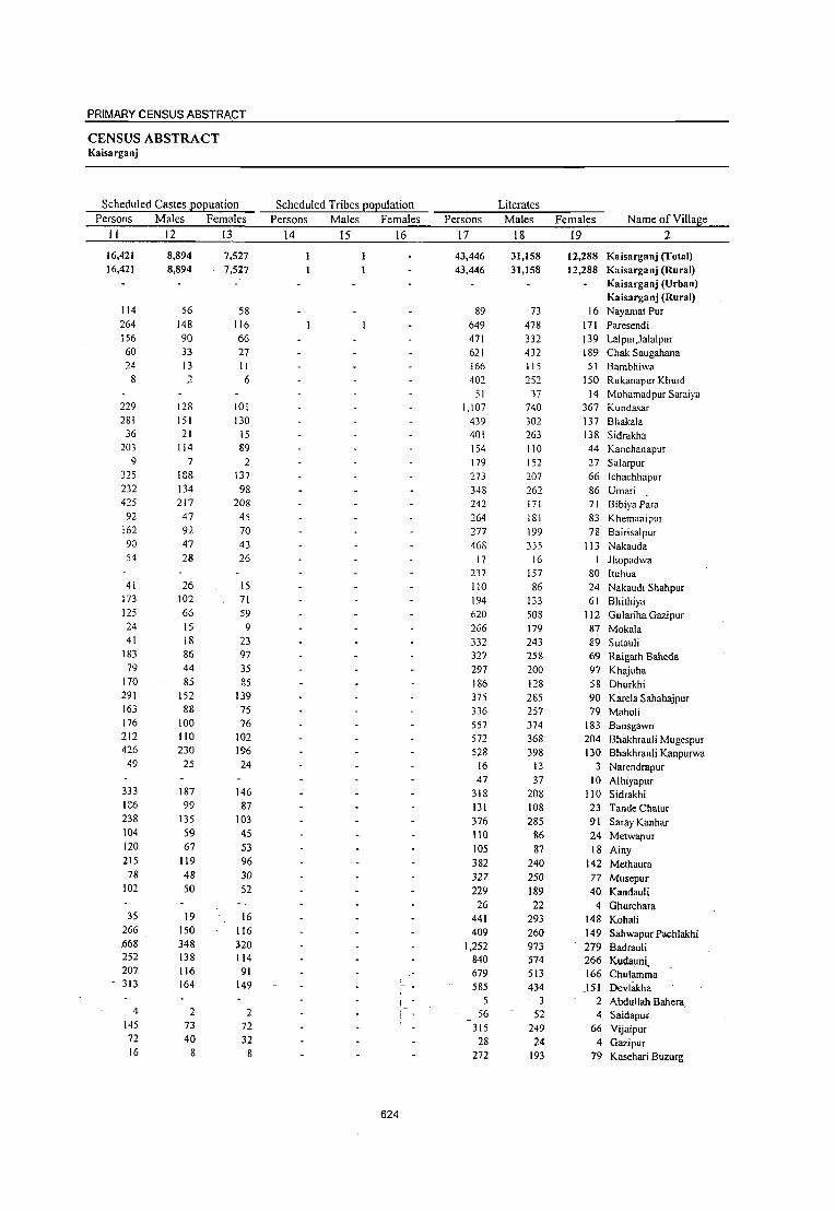
PRIMARY CENSUS ABSTRACT
CENSUS ABSTRACT Kaisarganj
Scheduled Castes EOEuation Scheduled Tribes EOEulation Literates Persons Males Females Persons Males Females Persons Males Females Name of Village
II 12 13 14 15 16 17 18 19 2
16,421 8,894 7,527 43,446 31,158 12,288 Kaisarganj (Total) 16,421 8,894 7,527 43,446 31,158 12,288 Kaisarganj (Rural)
Kaisarganj (Urban) Kaisarganj (Rural)
114 56 58 89 73 16 NayamatPur 264 148 116 649 478 171 Paresendi 156 90 66 471 332 139 Lalpur,Jalalpur 60 33 27 621 432 189 Chak Saugahana 24 13 II 166 115 51 Bambhiwa
8 :1 6 402 252 150 RUkanapur Khurd 51 37 14 Mohamadpur Saraiya
229 128 101 1,107 740 367 Kundasar 281 151 130 439 302 137 Bhakala
36 21 15 401 263 138 Sidrakha 203 114 89 154 110 44 Kanchanapur
9 7 2 179 152 27 Salarpur 325 188 137 273 207 66 IChachhapur 232 134 98 348 262 86 Umari 425 217 208 142 171 71 Bibiya Para
92 47 45 264 181 83 Khemanipur 162 92 70 277 199 7S Bairisalpur 90 47 43 468 355 113 Nakauda 54 18 26 17 16 Jhopadwa
237 157 80 Iluhua 41 26 15 110 86 24 Nakaudi Shahpur
173 102 71 194 133 61 Bhithiya 125 66 59 620 508 112 Gulariha Gazipur 24 15 9 266 179 87 Mokala 41 18 23 332 243 89 Sutauli
183 86 97 327 25& 69 Raigarh Baheda 79 44 35 297 200 97 Khajuha
170 85 85 186 128 58 Dhurkhi 291 152 139 375 285 90 Karela Sahabajpur 163 88 75 336 257 79 Maholi 176 100 76 557 374 183 Bansgawn 212 110 102 572 368 204 Bhakhrauli Mugespur 426 230 196 528 398 130 Bhakhrauli Kanpurwa
49 25 24 16 13 3 Narendrapur 47 37 10 Alhiyapur
333 187 146 318 208 110 Sidrakhi 1G6 99 87 131 108 23 Tande Chatur 238 135 103 376 285 91 Saray Kanhar 104 59 45 110 86 24 Metwapur 120 67 53 105 87 18 Ainy 215 119 96 382 240 142 Methaura
78 48 30 327 250 77 Musepur 102 50 52 229 189 40 Kandauli
26 22 4 Ghurehara 35 19 16 441 293 148 Kohali
266 150 116 409 260 149 Sahwapur Pachlakhi .668 348 320 1,252 973 279 Badrauli 252 138 114 840 574 266 Kudauni, 207 116 91 679 513 166 Chulamma 313 164 149 585 434 151 Devlllkha
! _ - 5 3 2 Abdullah Bahera __ 4 2 2 56 52 4 Saidapm:
145 73 72 315 249 66 Vijaipur· 72 40 32 28 24 4 Gazipur 16 8 8 272 193 79 Kasehari Buzurg
624

DISTRICT CENSUS HANDBOOK: BAHRAICH
VILLAGE PRIMARY CD Block-
Illiterates Total workers Main workers
Location code
number Name of Viii age Persons Males Females Persons Males Females Persons Males Females _ __:_ ____ --=2:...__ ___ ___:2::..::0:...___---=:.2.:..._! __ -=2:=.2 __ -=2=...3 __ -=2~4 __ ...:.2~5 __ -=2~6_ 27 28
0556 Kaisarganj (Total) 0556 Kaisarganj (Rural) 0556 Kaisarganj (Urban)
Kaisarganj (Rural) 06524300 Nayamat Pur 06524400 Paresendi 06524500 Lalpur,Jalalpur 06524600 Chak Saugahana 06524700 Bambhiwa 06524800 Rukanapur Khurd 06524900 Mohamadpur Saraiya 06525000 Kundasar 06525100 Bhakala 06525200 Sidrakha 06525300 Kanchanapur 06525400 Salarpur 06525500 Ichachhapur 06525600 Umari 06525700 Bibiya Para 06525800 Khemanipur 06525900 Bairisalpur 06526000 Nakauda 06526100 Jhopad wa 06526200 Ituhua 06526300 NakaudiShahpur 06526400 Bhithiya 06526500 Gulariha Gazipur 06526600 Mokala 06526700 Sutauli 06526800 Raigarh Baheda 06526900 Khajuha 06527000 Dhurkhi 06527100 Karela Sahabajpur 06527200 Maholi 06527300 Bansgawn 06527400 Bhakhrauli Mugespur 06527500 Bhakhrauli Kanpurwa 06527600 Narendrapur 06527700 Alhiyapur 06527800 Sidrakhi 06527900 Tande Chalur 06528000 Saray Kanhar 06528100 Melwapur 06528200 Ainy 06528300 Methaura 06528400 Musepur 06528500 Kandauli 06528600 Ghurehara 06528700 Kohali 06528800 Sahwapur Pachlakhi 06528900 Badrauli 06529000 Kudauni 06529100 Chulamma 06529200 Deylakha 06529300 Abdullah Bahera 06529400 Saidapur 06529500 Vijaipur 06529600 Gazipur 06529700 Kasehari Buzurg
104,172 104,172
581 1,916 1,333 1,299
415 832 163
1,827
828 359 424
1,117
766 940 661 353 567
1,064 51
290 354 381
2,334 442 508
1,185 331 260 976 807
1,636 919
1,293 33
398 548 503 962 231 315 452 574 816 128 798 606
3,906 1,550 1,459
969 7
--240
1,177 221 565
48,007 48,007
274 894 665 581 197 385
78 825 364 154 203 540 349 440 308 155 277 499
20 114 170 188
1,046 205 229 506 140
95 429 335 758 397 585
12 205 266 221 463
97 144 200 244 380
67 365 299
1,892 700 635 383
4 111 534 109 248
56,165 56,165
307 1,022
668 718 218 447
85 1,002
464 205 221 577 417 500 353 198 290 565
31 176 184 193
1,288 237 279 679 191 165 547 472 878 522 708
21 193
282 282 499 134 171 252 330 436
61 433 307
2,014 850 824 586
3 _ 129
643 112 317
625
54,454 42,165 54,454 42,165
194 187 1,428 761
806 548 705 498 160 148 402 317 102 62
1,226 842 352 235 316 250 364 198 503 358 466 317 548 428 482 311 227 174 470 262 845 548
28 26 155 142 180 150 157 153
1,313 867 295 219 242 241 450 381 199 196 181 118 410 394 302 283 977 619 560 418 957 579
25 14 179 112 293 264 301 169
541 425 171 110 130 109 245 226 273 272 358 355
51 50 462 353 333 287
1,917 1,661 787 623 893 650-601 427
4 . 4
82 82 557 416~ 146 87 513 294
12,289 12,289
7 667 25& 207
12 85 40
384 117 66
166 145 149 120 171 53
208 297
2 13 30 4
446 76
I 69
3 63 16 19
358 142 378
11 67 29
132 116 61 21 19
3 I
109 46
256 164 243 174
141
59 219
41,56" 36,982 41,567 36,982
185 179 870 600 662 461 377 369 160 148 281 244
84 50 827 744 233 224 240 230 356 196 426 330 321 271 394 378 354 303 168 139 244 241
511 464 27 26
154 142 144 138 103 101 934 781 218 218 205 204 321 294 197 194 112 110 399 387 265 264 538 513 414 381 504 476
10 10 177 III 248 242 296 169 SIS 418
90 77 11'1 100 213 210
273 272 358 355
51, 50 313 308 28S 258
1,28S 1,249 721l 596 618 572 507 400
4 4 7·1 74
429 - 380 90 83
158 155
4,585 4,585
6' 270
201 8
12 37 34 83
.9 10
160 96 50 16 51 29
47 I
12 6 2
153
I 27
3
2 12
25 33 28
66 6
127
97 13 14 , 3
I ,3
1 5
27 36.
.132 106 107

PRIMARY CENSUS ABSTRACT
CENSUS ABSTRACT Kaisarganj
Industrial category of main workers
Cultivators Agricultural labourers
Household industry workers Other workers
Persons Males Females Persons Males Females Persons Males Females Persons Males Females Name of Village
29 30 31 32 33 34 35
26,145
26,145
159 510 571 279
52 125 62
349 151 205 339 197 163 340 271
114 240 422
23
118 129 91
521 99
168 253 159 100 297 lSI 438 282 339
9 155 140 153
432 55 75
168 154 339
51 223 153 990. 433 320 237
2 60
280 87
143
23,479 2,666
23,479 2,666
154 397 377 273
49 91 34
306 146 198 190 165 138 332 241 104 238 391 22
110 124 90
432 99
168 234 157 100 286 180 415 264 327
9 95
138 82
365 45
64 168 153 337
50 220 144 969 341 309 211
2 60
235 80
140
113 194
6 3
34 28 43
7 149 32 25
8 30 10
2 31
8
5 1
89
19 2
11
23 18 12
60 2
71
67 10 II
1
2 I 3 9
21 92 II 26
45 7 3
10,506
10,506
19 . 286
80 78 98 33 11
207 48
5 3
201 139 34 70 48
69 4
26
13 9
384 .114
24 40 27
4 94 44
61 69
118
20 S9
134 77
10 25 32
117 13
65 118 136 175 322 197
12 91
2 8
9,034
9,034
18 139 73 77 90 30
6 179 47
3
143 116 30 49 30
56 4
23 12 9
326 114 24 34 26
2 94 44 59 58
108
14 56 78
48 10 23 31
117 12
64 100 126 145
229 121
I 12 88 2 8
1,472 1,472
147 7
8 3 5
28
2 2
58
23 4
21 18
13
3 I
58
6
1 2
2 11 10
6
3 56 29
2
18 10 30 93
;_76
1-, 3
943 943
24
5 23
16
I II
8
7
4 2
I
13
6
7
2 S
6
14
14
3
1 2 2
2
3
34 10
14 --17
I
20
3
626
36 37 38 39 40 2
843
843
5 15
5 23
12
3 1 5 6 5 4 2
I
11
5
7
2 8 6
II 14
2
1
2 2
2
3
34 9
14 16
I
20
3
100 100
9
4
6 2 2
2
3
3,973
3,973
2 50 11 19 5
100 11
255 31 29
3 20 12 16 11 6 3 7
4
2 3
22 5
II 20
5
8 7
40 39 49 33
1 2
46 9 5
24 12 II 2
4
22 14
- 125 110 22 56
2 38
I 4
3,626
3,626
2 49 11 19 4
100 10
247, 28 28
16
12 12 II 5 2
6
4
2 2
16 5
10 18
5 8 6
40 39 48 27
1
2 46 9 5
21
II 9 2 4
21 14
120 101 20 52
2 37
4
347 Kaisarganj (Total)
347 Kaisarganj (Rural)
Kaisarganj (Urban) Kaisarganj (Rural)
NayamatPur Paresendi Lalpur,Jalalpur Chak Saugahana Bambhiwa Rukanapur Khurd Mohamadpur Saraiya
8 Kundasar 3 Bhakala I Sidrakha 3 Kanchanapur 4 Salarpur
lchachhapur 4 Umari
BibiyaPara Khemanipur Bairisalpur Nakauda Jhopadwa !tuhua Nakaudi Shahpur Bhithiya
6 Gulariha Gazipur Mokala Sutauli
2 Raigarh Baheda Khajuha Dhurkhi Karela Sahabajpur Maholi Bansgawn
1 Bhakhrauli Mugespur 6 Bhakhrauli Kanpurwa
Narendrapur Alhiyapur Sidrakhi T ande Chatur Saray Kanhar
3 Metwapur I Ainy 2 Methaura
Musepur Kandauli Ghurehara Kohali Sahwapur Pachlakhi
S Badrauli 9 Kudauni 2 Chulamrna 4 Devlakha
Abdullah Bahera - -Saidapur
Vijaipuf Gazipur Kasehari Buzurg

DISTRICT CENSUS HANDBOOK: BAHRAICH
VILlLAGE PRIMARY CD Block-
________________ Industrial category
Marginal workers Cultivators Agricultural labourers
Location code
number Name of Village Persons Males Females Persons Males Females Persons Males Females __ ~ ________ ~2~~ ____ ~4~1~ __ ~42~ __ ~4~3 ____ ~4~4 ____ ~4~5 ____ ~4~6~ __ ~4~7_ 48 49
0556 Kaisarga nj (Total) 0556 Kaisarganj (Rural) 0556 Kaisarganj (Urban)
Kaisarganj (Rural) 06524300 Nayamat Pur 06524400 Paresendi 06524500 Lalpur,Jalalpur 06524600 Chak Saugahana 06524700 Bambhiwa 06524800 Rukanapur Khurd 06524900 Mohamadpur Saraiya 06525000 Kundasar 06525100 Bhakala 06525200 Sidrakha 06525300 Kanchanapur 06525400 Salarpur 06525500 Ichachhapur 06525600 Umari 06525700 Bibiya Para 06525800 Khemanipur 06525900 Bairisalpur 06526000 Nakauda 06526100 Jhopadwa 06526200 Ituhua 06526300 NakaudiShahpur 06526400 Bhithiya 06526500 Gulariha Gazipur 06526600 Mokala 06526700 Sutauli 06526800 Raigarh Baheda 06526900 Khajuha 06527000 Dhurkhi 06527100 Karela Sahabaj pur 06527200 Maholi 06527300 Bansgawn 06527400 Bhakhrauli Mugespur 06527500 Bhakhrauli Kanpurwa 06527600 Narendrapur 06527700 Alhiyapur 06527800 Sidrakhi 06527900 Tande Chatur 06528000 Saray Kanhar 06528100 Metwapur 06528200 Ainy 06528300 Methaura 06528400 Musepur 06528500 Kandauli 06528600 Ghurehara 06528700 Kahali 06528800 Sahwapur Pachlakhi 06528900 Badrauli 06529000 Kudauni 06529100 Chulamma 06529200 Devlakha
-06529300 -Abdullah Bahera 06529400 Saidapur 06529500 Vijaipur 06529600 Gazipur 06529700 Kasehari Buzurg
12,887 12,887
9 558 144 328
121 18
399 119 76
8 77 15 54 28 59 26 34
I
I 36 54 79 77 37
129 2
69 11 37
439 146 453
15 2
45 5
26 81 16 32
149 48
632 59
215 94
8 128 56
355
5,183 5,183
8 161 87
129
73 12 98 II 20 2
28 46 50
8 35 21 84
12 52 86
I 37 87 2 8 7
19 106 37
103 4
1 22
7 33 9
16
45 29
412 27 78 27
8 36
4 139
7,704 7,704
I 397
57 199
48 6
301 108 56
6 49 99
104 1:20 24
205 250
I I
24 2
293 76
42
61 4
18 333 109 350
11 I
23 5
19 48
7
16
104 19
220 32
137 67
92 52
216
627
4,064 4,064
I 87 15 22
28 10
193 2
69
10 5
17 121
3 23 72
I I
23 3
103
4 19
10 5 4
379 87 35 15 2 8 2 4 6
3 8
26 3
43 16
,37 )3
• : 8 36 54
233
1,315 1,315
37 7
9
7 7
32
20
2 5 4 2
7 27
9 3
30
4 7
3 2 2
87 20 15 4 I 3
5
3
2 2
26 8
19 8
-8_
6
2 68
2,749 2,749
I
50 8
\3
21 3
16\ 2
49
7 3
12 117
I
16 45
I
14
73
12
7 3 2
292 67 20 11 1 5 2 3 I 3 5
24 1
17 8
18 15
30 52
165
7,888 7,888
6 461 129 294
79 5
\86 106
5 3
67 134 \36
7 56
186 257
13 49
269 76 32:
10i' 2
57
26 49 30
390
2-'
:I 22 37 10 23
121) 32
555-
40 168 67
38 2
104
3,286 3,286
6 118 80
109
52 2
53 7
25 39 45
4 33 12 55
3 47 54
1 32 77
2 3 4
II 15 10 78
5
6 12 6
12
41 15
376 17 55 18
28 2
54
4,602 4,602
343 49
185
27 3
\33 99
2 42 95 91 3
23 \74 202
10 2
215 75
30
54. \
15 34 20
312
17
3 16 25
4 11
79 17
. 179
23 113 49
60
50
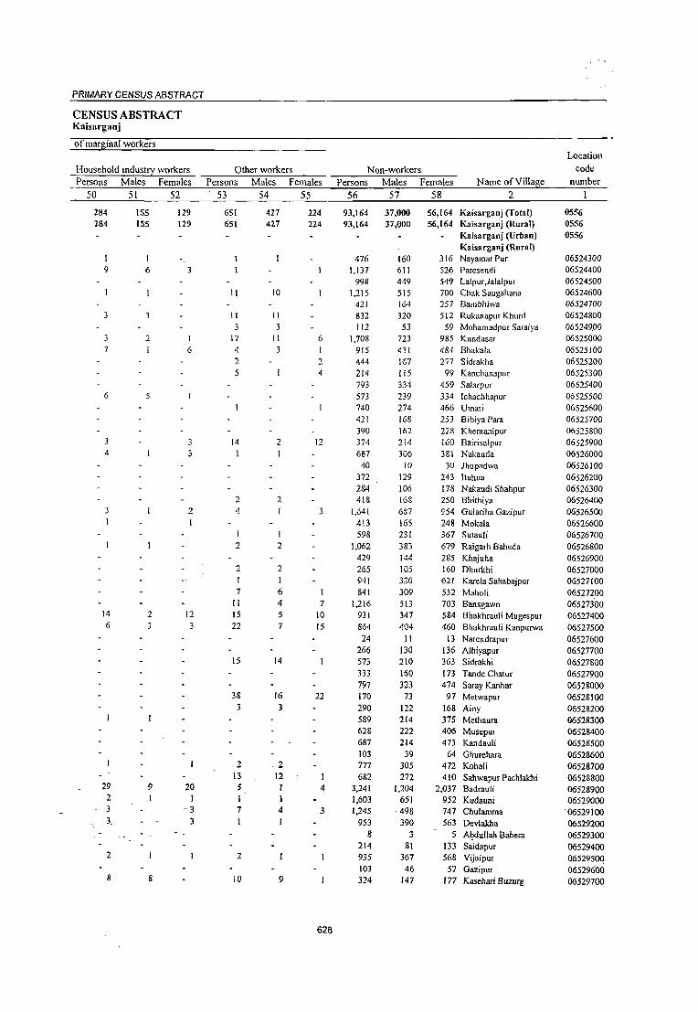
PRIMARY CENSUS ABSTRACT
CENSUS ABSTRACT Kaisarganj
of marginal workers Location
Household indust!1 workers Other workers Non-workers code
Persons Males Females Persons Males Females Persons Males Females Name of Village number
50 51 52 53 54 55 56 57 58 2
284 155 129 651 427 224 93,164 37,000 56,164 Kaisarganj (rotal) 05:56 284 ISS 129 651 427 224 93,164 37,000 56,164 Kaisarganj (Rural) 0556
Kaisarganj (Urban) 0556 Kaisarganj (Rural)
476 160 316 NayamatPur 06524300 9 6 3 1,137 611 526 Paresendi 06524400
998 449 549 Lalpur ,Jalalpur 06524500 II 10 1,215 515 700 Chak Saugahana 06524600
421 164 257 Bambhiwa 06524700 3 II II 832 320 512 Rukanapur Khurd 06524800
3 3 112 53 59 MOhamadpur Saraiya 065249.00 3 2 1 17 11 6 1,708 723 985 Kundasar 06525000 7 6 4 3 915 431 484 Bhakala 06525100
2 2 444 Hi7 277 Sidrakha 06525200 5 4 214 I i5 99 Kanchanapur 06525300
793 334 459 Salarpur 06525400 6 5 573 239 334 Ichachhapur 06525500
740 274 466 Umari 06525600 421 168 253 Bibiya Para 06525700 390 162 228 Khemanipur 06525800
3 14 2 12 374 214 i60 Bairisalpur 06525900 4 3 1 687 306 381 Nakauda 06526000
40 10 30 Jhopadwa 06526100 372 129 243 Ituhua 06526200 284 106 178 Nakaudi Shahpur 06526300
2 2 418 168 250 Bhithiya 06526400 3 2 4 3 1,641 637 954 Gulariha Gazipur 06526500 I I 413 165 248 Mokala 06526600
598 231 367 Sutauli 06526700 2 2 1,062 383 679 Raigarh Baheda 06526800
429 144 285 Khajuha 06526900 2 2 265 105 160 Dhurkhi 06527000
1 941 320 621 Karela Sahabajpur 06527100 7 6 1 841 309 532 Maholi 06527200
II <I 7 1,216 513 703 Bansgawn 06527300 14 2 12 IS 5 10 931 347 584 Bhakhrauli Mugespur 06527400 6 3 3 22 7 15 864 ,W4 460 Bhakhrauli Kanpurwa 06527500
24 II 13 Narendrapur 06527600 266 130 136 Alhiyapur 06527700
15 14 573 210 363 Sidrakhi 06527800 333 160 173 Tande Chatur 06527900 797 323 474 Saray Kanhar 06528000
38 16 22 170 73 97 Metwapur 06528100 3 3 290 122 168 Ainy 06528200
589 214 375 Methaura 06528300 628 222 406 Musepur 06528400 687 214 473 Kandauli 06528500 103 39 64 Ghurehara 06528600
2 .2 777 305 472 Kohali 06528700 13 12 I 682 272 410 Sahwapur Pachlakhi 06528800
29 9 20 5 4 3,241 1,204 2,037 Badrauli 06528900 2 1 1 1,603 651 952 Kudauni 06529000 3 -3 7 4 3 1,245 498 747 Chulamma 06529100 3_ 3 1 953 390 563 Devlakha 06529200
8 3 -5 Al?dullah Bahera 06529300 214 81 133 Saidapur 06529400
2 2 935 367 568 Vijaipur 06529500 103 46 57 Gazipur 06529600
8 8 10 9 324 147 177 Kasehari Buzurg 06529700
628

DISTRICT CENSUS HANDBOOK: BAHRAICH
Total population (including
VILLAGE PRIMARY CD Block-
Location Area of institutional and houseless Population in the
code Village in Number of population) age-group 0-6
_n_;,u_;m.;.;b_;e;:_f __ ;:_N..;.an::.:l.;.;e_;o:.;f_V;_;i;.;,;lI..;.a.l2.ge:;...... _ _;,;h.;:_ec:.;t::.ar:..:;e.;;.s_..:h.:.:o:..::u::;.se::h.:.:o:.::ld::.:s:_-:..-..:.P::-..:::e-:.;;r-s::;:o-::.:n-:::.s-_....!_~~.:.:M~::.a~le~S~~~~F..:::e-:::m-~-a~l,-e;;-s:...._~~P~e;f-s::::o;n;_s:..:::s;<::...5M2:.a::.:I::Jes::""::"-=-F-e-m-a-Ie-s-__ ~ ________ ~2~ ________ ~3~ ____ ~4~ ____ ~5 ______ ~6 ______ ~7 ______ ~8~ 9 10
06529800 Kasehari Khurd 66.0 06529900 Chak Pihani 179.0 06530000 Barkhur Dyarapur 100.0 06530 I 00 Karim Behr 100.0 06530200 Karsar Beraura 366.0 06530300 Guthiya 101.0 06530400 Santha 245.0 06530500 Jhalla 73.0 06530600 Lakhnidaspur 31.0 06530700 Chandidaspur 39.0 06530800 Jalalpur Basahiya Dargahi 162.0 06530900 Shah pur Rasulpur 125.0 06531000 Baira Qazi 157.0 06531100 Bairi Maheshpur 213.0 06531200 Kaharai 136.0 06531300 Tawakkalpur 110.0 06531400 Panchma 103.0 06531500 Hatinsha Shamspur 135.0 06531600 Rukanapur Kalan 101.0 06531700 Nawgaeya 380.0 06531800 Dihawa Sher Bahadur Singh 121.0 06531900 Ainy Hatinsi 323.0 06532000 Pawana 145.0 06532100 Pawani 114.0 06532200 Jamaluddinpur 77.0 06532300 Konari 134.0 06532400 Mirpur 71.0 06532500 Chilawa 109.0 06532600 Firozpur 42.0 06532700 Godahiya No. I To 4 2,025.0 06532800 Baghaiya 413.0 06532900 Danawal 123.0 06533000 Rewali 331.0 06533100 Sohras 273.0 06533200 Marauthi 133.0 06533300 Kandaila 354.0 06533400 Materpur 173.0 06533500 Khurmpur 37.0 06533600 Wisaidha 22.0 06533700 Agapur 181.0 06533800 Hasana Mulai 91.0 06533900 Dadhaila 144.0 06534000 Akbarpur Khurd 65.0 06534100 Patti Taha 49.0
86 190 204
37 468 100 1&6 124 31 46 97
103 421 323 151 102 219 213 153 701 640 613 229
69 83
182 1\3 155 46
3,301 231
92 318 74
325 608 279 42
279 210 138 194 32
136
539 1,196 1,289
209 2,788
718 1,\89
832 205 295 645 700
2,952 2,346 1,098
581 1,444 1,299
921 4,840 4,189 5,241 1,459
383 496
\,189 784 947 228
19,352 1,2\0
524 2,100
392 2,088 4,543 1,627
249 1,811 1,223 1,075 1,256
205 759
297 654 692 117
1,514 368 627 450 1\0 167 352 380
1,563 1,232
564 316 771 654 471
2,526 2,239 2,790
772 225 285 617 393 498 127
10,654 689 263
1,081 216
I,lll 2,368
861 142
1,001 664 578 675 113 415
242 542 597
92 1,274
350 562 382
95 J28 293 320
1,389 1,114
534 265 673 645 450
2,314 \,950 2,451
687 158 211 572 391 449 101
8,698 521 261
1,019 176 977
2,175 766 107 810 559 497 581
92 344
125 273 254 42
639 107 274 223
41 69
161 166 660 534 264 108 326 294 171
1,130 797
\,029 327 65 54
258 206 177 54
3,839 206 \09 487
86 499
1,034 376 59
356 244 201 277
45 139
06534200 Fate Purwa 187.0 ------Un-inhabitedl----
77 157 133 21
330 51
142 110
16 39 87 86
338 255 127 55
160 144 80
546 419 523 177 33 33
132 87 88 25
1,953 110 52
229 41
257 540 188 31
184 122 101 1\6
18 67
48 116 121 21
309 56
132 113 25 30 74 80
322 279
137 53
166 150 91
584 378 506 150 32 21
126 119 89 29
1,886 96 57
258 45
242 494 188 28
172 122 100 \6\ 27 72
06534300 Bajayafat 20.0 36 216 III 105 48 22 26 06534400 Pendari Khurd 5.0 73 399 213 186 108 45 63 06534500 Pawahi 296.0 152 970 521 449 190 102 88 06534600 Salhuwa 115.0 145 797 415 382 195 106 89 06534700 Natthnpur 150.0 138 854 491 363 158 91 67 06534800 . Achehara 66.0 64 383 203 180 92 49 43 06534900 Kodari Chandan 61.0 48 285 157 128 59 .34 25 06535000 HaidarpurNauvbasta 138.0 171 1,160 620 540 277 141 \36 06535100 Budan Pur 194.0 151 758 395 363 115 58· 57
~0~65~3~5~20~0~K~o~d~an~·~N~ew~a~j~is~A~li~ ______ -+:2~~.~0 ________ ~4~5~ __ ~2~0~6 ____ ~1~09~ _____ 9~7~~ __ ~40. __ ~~2~1 __ ----~1~9
629

PRIMARY CENSUS ABSTRACT
CENSUS ABSTRACT Kaisarganj
Scheduled Castes ~oEuation Scheduled Tribes ~oEulation Literates
Persons Males Females Persons Males Females Persons Males Females Name of Village
II 12 13 14 15 16 17 18 19 2
57 32 25 125 98 27 Kasehari Khurd
53 33 20 431 305 126 Chak Pihani
126 67 59 493 354 139 Barkhur Dyarapur
12 8 4 51 44 7 Karim Behr 405 230 175 729 570 159 Karsar Beraura
82 41 41 377 222 155 Guthiya 66 50 16 Santha
6 4 2 117 97 20 Jhalla 25 14 II 34 32 2 Lakhnidaspur
66 56 10 Chandidaspur 191 121 70 Jalalpur Basahiya Dargahi
34 21 13 173 133 40 Shahpur Rasulpur 96 46 50 744 558 186 Baira Qazi 44 20 24 655 443 212 Bairi Maheshpur 47 23 24 263 189 74 Kaharai 99 57 42 140 113 27 Tawakkalpur 60 34 26 491 318 173 Panchma
195 96 99 389 271 118 Hatinsha Shamspur 54 26 28 289 172 117 Rukimapur Kalan
298 161 137 1,816 1,236 580 Nawgaeya 158 86 72 2,257 1,348 909 Dihawa Sher Bahadur Singh 106 56 50 2,037 1,273 764 Ainy Hatinsi 145 76 69 365 276 89 Pawana
31 25 6 124 100 24 Pawani 56 33 23 263 185 78 Jamaluddinpur 35 15 20 542 337 205 Konari 37 18 19 119 82 37 Mirpur
135 72 63 243 161 82 Chilawa 149 77 72 65 49 16 Firozpur
2,486 1,355 1,131 3,954 3,304 650 Godahiya No. ITo 4 88 51 37 347 282 65 Baghaiya
143 67 76 132 101 31 Danawal 285 142 143 740 528 212 Rewali
43 23 25 106 83 18 Sohras 208 114 94 654 433 221 Marauthi 235 124 III 1,555 984 571 Kandaila 389 222 167 359 290 69 Materpur
42 23 19 59 43 16 Khurmpur 458 259 199 524 412 112 Wisaidha 331 180 151 376 192 84 Agapur
78 36 42 300 199 101 Hasana Mulai 45 28 17 240 188 52 Dadhaila 38 20 18 79 55 24 Akbarpur Khurd 29 15 14 164 140 24 Patti Taha
-:--------Un-inhabited---- Fate Purwa 61 48 13 Bajayafat
45 25 20 56 53 3 Pendari Khurd 5 3 2 325 241 84 Pawahi
134 66 68 201 150 51 SllIhuwa 164 99 65 226 179 47 Natthnpur 64 34 30 137 101 36 Achehara 43 24 19 141 102 39 Kodari Chandan IS 6 <) 223 166 57 Haidarpur Nauvbll!>~
105 t5 _ 50 283 203 80 Budan Pur -127 67 60 45 39 6- Kodari Newajis-Ali
,.~ 630

Location
code
number Name ofYillage
2
06529800 Kasehari Khurd 06529900 Chak Pihani
06530000 Barkhur Dyarapur 06530 I 00 Karim Behr 06530200 Karsar Beraura
06530300 Guthiya 06530400 Santha 06530500 Jhalla 06530600 Lakhnidaspur 06530700 Chandidaspur
06530800 Jalalpur Basahiya Dargahi
06530900 Shah pur Rasulpur 06531000 Baira Qazi
06531100 Bairi Maheshpur 06531200 Kaharai 06531300 Tawakkalpur 06531400 Panch rna 06531500 Hatinsha Sharnspur 06531600 Rukanapur Kalan
06531700 Nawgaeya 06531800 Dihawa Sher Bahadur Singh
06531900 Ainy Hatinsi 06532000 Pawana
06532100 Pawani 06532200 Jamaluddinpur
06532300 Konari
06532400 Mirpur 06532500 Chilawa
06532600 Firozpur 06532700 Godahiya No. ITo 4
06532800 Baghaiya 06532900 Danawal
06533000 Rewali 06533100 Sohras
06533200 Marauthi 06533300 Kandaila 06533400 Materpur
06533500 Khurmpur 06533600 Wisaidha 06533700 Agapur 06533800 Hasana Mulai
06533900 Dadhaila 06534000 Akbarpur Khurd
06534100 Patti Taha 06534200 Fate Purwa
06534300 Bajayafat 06534400 Pendari !(hurd
06534500 Pawahi 06534600 Sa1huwa
06534700 Natthnpur 06534800 Achehara 06534900 Kodari Chandan 06535000 Haid~ur Nauvbasta 06535100 Budan Pur -06535200 Kod~ri New_ajis Ali
Illiterates
Persons
20
414 765
796 158
2,059 341
1,123 715 171 229 454
527 2,208
1,691 835 441 953 910 632
3,024 1,932
3,204 1,094
259
233 647 665
704
163 15,398
863
392 1,360
286
1,434 2,988
1,268 190
1,287 847 775
1,016
126
595
155 343 645
596 628 246 144 937 475 161
Males
21
199 349
338 73
944 146
577 353
78 III
231 247
1,005
789 375
203 453 383 299
1,290
891 1,517
496
125 100
280 311
337 78
7,350
407 162 553 \28
678 1,384
571 99
589 372
379 487
58 275
63 160 280 265 312 102 55
454 192
70
Females
22
215 416
458 85
1,115 195
546 362
93 118
223 180
1,203 902 460 2J8 500
527 333
1,734 1,041 1,687
598 134
133 367 354
367
85 8,048
456
230 807 158 756
1,604 697
91 698 475
396 529
68 320
92 183 365 331 316 144
&9 483
283 91
631
DISTRICT CENSUS HANDBOOK: BAHRAICH
VILLAGE PRIMARY· CD Block-
Total workers Main workers
Persons Males Females ~- Males Females
23 24 25 26 27 28
299 529 377
65 894
308 513 259 127 84
124 190
801 807 294 178 367 548 297
1,690 1,194 1,441
689 115 211
260
176 282
64
7,809 507
155 750 lOS 649
1,142
501 66
575 529 582 484 113 279
165 326
345 62
748 224
382 194
73 78
114
183 739 633 282
171 347
370 273
I, 178 1,067 1,335
414 113 166
246 171
263 62
6,052 443
153 597 102
520 1,057
478 65
567 396
333 380
71 265
134 203
32 3
146 84
131 65 54
6 10 7
62 174
12 7
20 178
24
512 127 106 275
2 45 14 5
19 2
1,757 64
2 153
3 129 85 23
8 133 249 104
42 14
___ Un_inhabited ___ _
74 54 20 219 121 98 328 255 73 406 244 162
265 259 6 116
81 354 246
72
100 79
333 233
64
16
2 21 13 8-
249 456
332 61
694 191 348 259
46 84
122 186
693 691 264
165 352 363 266
1,173 1,038 1,299
380
114 168
221 173
258 61
6,134 245 154 535 105
485 1,031
440
66 498 401
304 334
50 248
43 211 229 188 242 98 64
. 323
237 71
137 281 324
60
619 171 334 194
42 78
114 182
674 565 258 164 336
. 353 259
1,101 955
1,223 340 112 150 216 171 255
61 5,181
227 153 518 102 399 991
423 65
492 358
285 329
45 241
43 121 225
169 236
89 64
303 232
63
112 175
8
75 14 14 65
4 6 8 4
19 126
6 I'
16 10
7
n 83 76 40
2 18
5 2
3
953 18
. 1 17
;3 86 40 17
I 6'
43 19
5
5 7
90 4
19 6 9
20
5 8

PRIMARY CENSUS ABSTRACT
CENSUS ABSTRACT Kaisarganj
Industrial category of main workers
Household industry Cultivators Agricultural labourers workers Other workers
Persons Males Females Persons Males Females Persons Males Females Persons Males Females Name of Village
29 30 31 32 33 34 35 36 37 38 39 40 2
192 229 181 28
307 43
127 169 39 24
120 174 428 414 211
76 112 293 118 503 2\0 517 156
41 110 140 121 177 II
4,572 126 75
384 100 153 705 140
40 303 230 235
39 37
201
28 148 205
84 149 79 41
185 196
13
102 125 177 28
278 42
122 133 36 24
112 172 417 313 206
76 108 287 116 459 182 504 131
40 101 138 120 175 II
4,006 121 75
376 97
139 679 139 39
300 214 220
38 35
195
28 87
201 73
145 70
-41
174 191
12
90 104
4
29
5 36
3
8 2
II 101
5
4 6 2
44
28 13 25
I 9 2
2
566 5
8 3
14 26
1 1 3
16 15 I 2 6
61 4
11 4 9
II 5
44 123 122 30
252 5_9
213 87 6
50
5 183 223
34 79
186 54
114 436
112 283 159
67 16
55 52 70 48
1,130 14 73 91
5 247 248 257
20 193
-III 66
274 12 45
27 75
119 29
219 49
208 58
6 44
5 177 201
33 78
179 52
109 411
99 236 148 66 15 54
51 69
48 903
II 72 83 5
186 239 241
20 190 87 62
272 9
44
17 48
3 1
33 10 5
29
6
6 22
I I 7 2 5
25 13 47
11
227 3
8
61 9
16
3 24 4 2 3
5 32
3
36
6
8 I 2
24 15 13 5 6 4
5 36
120 42 23
17 I
107 II
18
21 8
14
5
4
2
16 2
33
2
8
I 24 15 13 5 6 4 5
35 116 39 20
11 1
97 9
18
19 8
14
5
4
2
------Un-inhabited----10 61 14
66 73 l<t
10 2 34 14 58 73 14
19 19 134 128 35 35 58 -- 51
27
8
- 6 -
7
2
34 8 2
2 2
632
2
34 7 2
2
5 16
3
4
4
3 3
6
10 2
2
2
8 72 26
3 99 89 2 3
2
5 58 39 6
5 AS
12 29
198 596
457 42
6 25 25
10 2
325 94 6
42
64 70
29 6 2
55 3
17
3
10 4
12 -3
-4 2_ 4
8 65 26
3 89 86 2 3
2
4
56 36 6
43 10 29
196 558 444
41 6
23 23
10 2
175 86 6
41
55 65 29
6 2
52 3
15
3
10 4
II 3 4
4
Kasehari Khurd 7 Chak Pihani
Barkhuf Dyarapur Karim Behr
10 Karsar Beraura 3 Guthiya
Santha Jhalla Lakhnidaspur Chandidaspur Jalalpur Basahiya Dargahi
I Shahpur Rasulpur 2 BairaQazi 3 Bairi Maheshpur
Kaharai Tawakkalpur
5 Panchma 2 Hatinsha Shamspur
Ru[(anapur Kalan 2 Nawgaeya
38 Dihawa Sher Bahadur Sin, 13 Ainy Hatinsi
Pawana Pawani
2 Jamaluddinpur 2 Konari
Mirpur Chilawa Firozpur
150 Godahiya No. ITo 4 8 Baghaiya
Danawal Rewali Sohras
9 Marauthi Kandaila Materpur Khurmpur Wisaidha
3 Agapur Hasana Mulai
2 Dadhaila Akbarpur Khurd Patti Taha Fate Purwa Bajayafat Pendari Khurd Pawahi Salhuwa Natthnpur Achehara Kodari Chandan
2 Haidarpui- Nauvbasta Bu~Pur
Kodari Newajis Afi

Location code
number Name of Village 2
06529800 Kasehari Khurd
06529900 Chak Pihani
06530000 Barkhur Dyarapur 06530100 Karim Behr
06530200 Karsar Beraura
06530300 Guthiya
06530400 Santha
06530500 Jhalla
06530600 Lakhnidaspur
06530700 Chandidaspur
06530800 Jalalpur Basahiya Dargahi 06530900 Shahpur Rasulpur 06531000 Baira Qazi
0653 I 100 Baid Maheshpur 06531200 Kaharai
06531300 Tawakkalpur 0653 I 400 Panchma
06531500 Hatinsha Shamspur 0653 I 600 Rukanapur Kalan
06531700 Nawgaeya
06531800 Dihawa Sher Bahadur Singh
06531900 Ainy Halinsi
06532000 Pawana
06532100 Pawani
06532200 Jamaluddinpur
06532300 Konari
06532400 Mirpur
06532500 Chilawa
06532600 Firozpur
06532700 Godahiya No.1 To 4
06532800 Baghaiya 06532900 Danawal
06533000 Rewali
06533 100 Sohras
06533200 Marauthi
06533300 Kandaila
06533400 Materpur
06533500 Khurmpur
06533600 Wisaidba
06533700 Agapur
06533800 Hasana Mulai
06533900 Dadhaila
06534000 Akbarpur Khurd
06534100 Patti Taha
06534200 Fate Purwa
06534300 Bajayafat
06534400 Pendari Khurd 06534500 Pawahi
06534600 Salhuwa
06534700 Natthnpur
06534800 Achehara 06534900 Kodari Chandan
06535000 _ Haidarpur Nauvbasta
06535100 Budan Pur
06535200 Kodari Newajis Ali
DISTRICT CENSUS HANDBOOK: BAHRAICH
VILLAGE PRIMARY CD Block-
Industrial category
-;;--_M__;ar:.JOg",:in-,-:a __ l;-w...:o~rk~e:.::r::-s_:-- -::,...-_ __;C:.;;u::-It:o-iv:..;.a:.:.to:..:r..:.s....".._-,-____ A_gricuJtural labourers Persons Males Females Persons Males Females Persons Males Females
41 42 43 44 45 46 47 48 49
50
73
45 4
200
117
165
81
2 4
108 116
30
13 15
185 31
517
156
142
309
43
39
3 24
3 1,675
262 1
215
164
III 61
77
128 278
150 63 31
31 8
99 218 23 18 17 31
9 -1
28 45
21 2
129
47
48
31
I 65 68
24
7
II 17 14
77
112 112 74
1 16
30
8
871
216
79
121 66 55
75
38 48 51 26 24
11
30 7S 23 11 15
30
22 28 24 2
71 70
117
50
2
43
48 6 6 4
168 17
440 44 30
235
27 9 3
16 2
804 46
I
136
43 45
6
2 90
230 99 37
7
633
20
8 69
143
7 2
1 8
26 34
7 4
25
15
29
29
2 3
15 14
12 2 7
158
19
215
39
36
6:!
19
14
I 20
842 99
65
6
26 3
2 62
209
7
15
18
2 2
12
14
II
13
4 5 8
6 12 II 31
26 26
19
1 10
6
6
337 78
21
3 4 3
28 34
4
II 16
5
2 13
1 18
16
2
11 9 4
2 1
146
8 184
13 10 43
9 8
1 14
I 505
21
44
3 22
2 34
175
3 ---Un-inhabited-----
2 1 1
12 22
6 5
3 4
7
9
2 5 2
5 13
4
1 3
17
20
23
155
96
134
49
I
86 96
15 7
3 24
12
284 82
58 235
20
2 4
666 108
I 125
143
58 58
75
55 68
146
59
24
27 8
82 187
13 12 2
28 5
9 14
12
106
28 37
16
55 57 14
3
5 3
35 57 39
46
19
2
452
90
43
107 35
52
75
4 13 51
23 20
8
19
59
13 9 2
28
8 6
11
49
68
97
33
31 39
I
4 3
19 9-
249
15 19
189
I
2
2
214 18
82
36 23
6
51
55 95.
36
4
19 8
63
128
3
5

PRIMARY CENSUS ABSTRACT
CENSUS ABSTRACT Kaisarganj
of marginal workers
Household industry workers Persons Males Females
50 51 52
6 8 9
6
2
3
2
3
4 n
I 10
5 3
51 14
3
5 4
3
8
3 4
3
2
2 3
I 9
7
2 3
35 II
3
2 4
7
3 4 8
3
2
3
3 3
3
3
16 3
3
3
Other workers Persons Males Females
53 54 55
11 6
14 5
5 3 2
5
14 23 4"
2
19 2
116 41
22
10 23
10
I 9 6
8 5
4 3 1 3 5
10 20 46 2
4 2
47 37
12
9 23
6
4 3
2
6
4 3 I
15
69 4
10
4
---Un-inhabited------I 1
4 4 I
10 10
10 8· 2
634
Non-workers Persons Males Females Name of Village
Location code
number
56 57 58 2
240 667 912 144
1,894 410 676 573
78 211 521 510
2,151 1,539
eo4 403
1,077 751 624
3,150 2,995 3,800
770 268 285 929 608 665 164
11,543 703 369
1,350 287
1,439 3,401 1,126
183 1,236
694 493 772 92
480
142 180 642 391 589 267 204 806 512 I:~4
132
328 347
55 766 144 245 256
37 89
238 197 824 599 282 145 424 284 198
l.34? 1,172 1,455
353 1I2 119 371 222 235
65 4,602
246 110 484 114 591
1,311 383
77 434 268 245 295
42 ISO
57 92
266 171 232 103
78 287 162 45
108 Kasehari Khurd
339 Chak Pihani 565 8arkhur Dyarapur
89 Karim 8ehr 1,128 Karsar 8eraura
266 Guthiya
431 Santha
317 Jhalla 41 Lakhnidaspur
122 Chandidaspur 283 Jalalpur 8asahiya Oargahi 313 Shahpur Rasulpur
1,327 8aira Qazi
940 BaiTi Maheshpur 522 Kaharai
258 Tawakkalpur
653 Panchma
06529800 06529900 06530000 06530100 06530200 06530300 06530400 06530500 06530600 06530700 06530800 06530900 06531000 06531100 06531200 06531300 06531400
467 Hatinsha Shamspur 06531500 426 Rukanapur Kalan 06531600
1,802 Nawgaeya 06531700 1,823 Oihawa Sher Bahadur Singh 06531800 2,345 Ainy Hatinsi 06531900
412 Pawana 06532000 156 Pawani
166 Jamaluddinpur
558 Konari 3G6 Mirpur 430 Chilawa
99 Firozpur 6,941 Godahiya No. ITo 4
457 8aghai ya
259 Oanawal
866 Rewali 173 Sohras
&48 Marauthi
2,090 Kandaila 743 Materpur
106 Khurmpur
S02 Wisaidha 426 Agapur
248 Hasana Mulai 477 Dadhaila
50 Akbarpur Khurd
330 Patti Taha
Fate Purwa 85 8ajayafat
88 Pendari Khurd 376 Pawahi 220 Salhuwa
357 Natthnpur 164 Achehara 126 Kodari Chandan 519 Haidarpur Nauvbasta 350 Budan Pur
89 Kodari Newajis Ali
06532100 06532200 06532300 06532400 06532500 06532600 06532700 06532800 06532900 06533000 06533100 06533200 06533300 06533400 06533500 06533600 06533700 06533800 06533900 06534000 06534100 06534200 06534300 06534400 06534500 06534600 06534700 06534800 06534900 06535000 06535100 065:i5200

DISTRICT CENSUS HANDBOOK: BAHRAICH
Total population (including
VILLAGE PRIMARY CD Block-
Location Area of institutional and house less Population in the
code Village in Number of population) age-group 0-6 _;,;Jl.;:;um;;;.::.b.;:;er~_.:.N:.:..::;arn=e.::o:=:f.:.V...:il:.::la::lg;:::e:___...:h:::e:.:c~ta::.:re:::s:__..:h~o~u:;;:s:::;eh~o:::l~ds~......!P~e;!.;rs~o~n:::.s_....!:M:!:a::!l:::es~......!F..!:e~m~a~Je~s~_..!.P~e!.:rs~o:!.!n:!.s __ ;Males Females
2 3 4 5 6 7 8 9 10
0557 Jarwa\ (Total) 0557 Jarwal (Rural) 0557 Jarwa1 (Urban)
Janva1 (Rural) 06535300 Puraini 06535400 Rewliya 06535500 Jhapatpur 06535600 Kataka Marautha 06535700 Khevkar 06535800 Bhikunda 06535900 Sakhauta 06536000 Dosara Para 06536 100 Lakhawapur Bahraucha 06536200 Sunsi 06536300 Harrajpur 06536400 Gaur 06536500 Mirpur Konya 06536600 Ambhapur 06536700 Kanjaya 06536800 Haf\\'a Tand 06536900 Sunsa Daudpur 06537000 Naraunda 06537100 Lalpur Jagdishpur 06537200 Devi Daspur 06537300 Chilauli 06537400 Paina 06537500 Haidarabad 06537600 Birhimpur Belahaura 06537700 Suaia 06537800 Bhopatpur 06537900 Jaisinghpur 06538000 Dhanaoliya 06538100 Airna Jaisinghpur 06538200 Maheri 06538300 Khaprawa 06538400 Dikauli Kala 06538500 Surnerpur 06538600 Pedwa 06538700 Lakhnipur 06538800 Kapurpur 06538900 Bhkhaura Mafi 06539000 Gandara 06539100 Hisarnpur 06539200 Bariya Gothi 06539300 Jamapur 06539400 Pyarepur 06539500 Belnapara 06539600 Hajipur 06539700 Mahuri Kala 06539800 Nandoliya 06539900 Badau1i 0654000Q Kursanda 06540100 Nirnadipur-06540200 Hasanp~r
06540300 ~arnwapur Raghubir Singh 06540400 llhauli 06540500 Ja\a\pur Hardo Patti 06540600 Harana Anaura 06540700 Gobraura
12,883.2 12,883.2
34.5 234,0 148,0 158,0 58,0 50.0
166.0 98.0
564,0 117,0 104,0 208.0
327,0
165,0
253,0
LO 128,0
272
109,0 84,0
no 110,0 307,0 307.0
60,0 65,0
164,0 192,0 57,0
154,0 83.0
68,0
27,153 27,153
627 311
55 542
82 40
264 123 340 215 114 282 345 545
208 39
332 162 185 208
84 290 897
79 146 180 61 32 81 29
127 110 152 60
126 138 767 150 73
125 467 221 95
458 105 627 468 307
40 - 214
193 96
332 73
169,303 169,303
3,947 2,127
478 3,583
496 218
1,701 618
2,701 1,277
647 1,794 2,053 3,201
1,225 317
2,195 1,025 1,211 1,169
589 1,788 5,175
565 929
1,010 288 213 438 205 796 686 966 393 747 946
5,029 1,315
444 803
3,405 1,42i
517 2,611
653 4,367 2,796 1,773
260 1,076 1,118
640 2,097
478
635
90,249 90,249
2,108 1,128
243 1,902
266 108 879 330
1,433 712 353 967
1,099 1,700
79,054 79,054
1,839 999 235
1,681 230 110
822 288
1,268 565 294 827 954
1,501
35,443 35,443
847 421
96 677 III 54
353 127 610 292 138 398 447 720
-----------u n-inhabited------------661 564 172 145
1,178 1,017 554 471 669 623 315 936
2,717 313 497 568 151 116 210 105 445 346 512 195 371 511
2,640 672 237 453
\,832 775 274
1,366 341
2,319 1,460
928 132 602 595 353
1,136 253
542 546 274 852
2,458 252 432 442 137 97
228 100 351 340 454 198 376 435
2,389 643 207 350
1,573 646 243
1,245 312
2,048 1,336
845 128 474 523 287 961 225
282 55
495 202 228 261 129 393
1,166 130 220 173 44 48
108 62
154 140 242 88
165 239
1,081 306
89 173 848 301 101 539 132 928 570 407 - 67
228 260 118 397 105
17,928 17,928
413 207
45 323
63 22
164 62
311 160 68
201 223 357
136
28 256 109 118 127 59
206 604
68 102 86 14 25 46 33 84 66
134 48 72
122 554 155 47 95
458 159 60
282 65
483 281 213
31 122 13 I 67
201 56
17,515 17,515
434 214
51 354 48 32
189 65
299 132
70 197 224 363
146 27
239 93
110 134 70
187 562 62
118 87 30 23 62 29 70 74
108 40 93
117 527 151 42 78
390 142 41
257 67
445 289 194 3~
106 129 51
196 49

PRIMARY CENSUS ABSTRACT
CENSUS ABSTRACT Janval
Scheduled Castes EOEuation Scheduled Tribes EOEulation Literates
Persons Males Females Persons Males Females Persons Males Females Name of Village
II 12 13 14 15 16 17 18 19 2
17,132 9,166 7,966 46,166 33,514 12,652 Jarwal (Total)
17,132 9,166 7,966· 46,166 33,514 12,652 Jarwal (Rural) Janval (Urban) Janval (Rural)
651 367 284 711 557 154 Puraini 296 142 154 631 422 209 Rewliya 52 28 24 127 92 35 Jhapatpur
235 126 109 683 539 144 Kataka Marautha
82 42 40 113 76 37 Khevkar 34 29 5 Bhikunda
128 61 67 317 243 74 Sakhauta 98 51 47 82 75 7 Dosara Para 77 41 36 515 427 88 Lakhawapur Bahraucha
174 87 87 190 171 19 Sunsi 172 tol 71 ·169 124 45 Harrajpur 93 55 38 284 238 46 Gaur
523 273 245 249 202 47 Mirpur Konya 375 205 170 543 398 145 Ambhapur
----------Un-inhabited------ Kanjaya 163 &6 77 112 101 11 HarwaTand
11 9 2 Sunsa Daudpur 153 80 73 413 287 126 Naraunda 40 19 21 189 136 S3 Lalpur Jagdishpur 31 IS 13 224 169 55 Devi Daspur
134 68 66 167 136 31 Chilauli 38 21 17 173 133 40 Paina 24 13 II 426 323 103 Haidarabad
251 132 ! 19 751 633 118 Birhimpur Belahaura 31 15 16 56 45 11 Suaia
113 67 46 293 217 76 Bhopatpur 37 18 19 117 99 18 Jaisinghpur
115 61 54 47 31 16 Dhanaoliya 80 63 17 Aima Jaisinghpur
1<;4 67 77 143 85 58 Maheri 5 4 I 40 32 8 Khaprawa
36 27 9 417 276 141 Dikauli Kala 90 44 46 179 135 44 Sumerpur 78 43 35 270 190 80 Pedwa 18 9 9 93 61 32 Lakhnipur 25 15 10 126 104 22 Kapurpur 88 47 41 115 87 28 Bhkhaura Mafi
218 115 103 1,572 1,045 527 Gandara 542 308 234 Hisampur
110 58 52 113 83 30 Bariya Gothi 132 106 26 Jamapur
1,047 653 394 Pyarepur 75 41 34 213 lSI 62 Belnapara 90 52 38 . 178 122 56 Hajipur
751 401 350 930 631 299 Mahuri Kala 23 13 10 216 146 70 Nandoliya
215 113 102 1,262 864 398 Badauli 425 237 188 810 634 176 Ktirsanda 175 92 - 83 485 330 155 Nimadipur 18 10 8 78 - 46 32 Hasanp~
132~- 65 - 67 295 225 70 RamwapuLRaghubir Sin 150 85 65 435 320 115 Bhauli 1-38 19 19 140 101 39 Jalalpur Bardo Patti
216 124 92 744 576 168 Harana Anaura 29 IS \4 114 95 \9 Gobraura
636

DISTRICT CENSUS HANDBOOK: BAHRAICH
VILLAGE PRIMARY CD Block-
Illiterates Total workers Main workers
Location code
number Name ofYiIlage Persons Males Females Persons Males Females Persons Males Females ____________ ~2 ________ ~2~O ____ ~2~1~ __ _=22~ ____ ~23~ __ _=24~ __ ~2~5 ____ ~26~ __ 27 28
0557 0557
0557
Jarwal (Total) Jarwal (Rural) Jarwal (Urban) Jarwal (Rural)
06535300 Puraini 06535400 Rewliya 06535500 Ihapatpur 06535600 Kataka Marautha 06535700 Khevkar 06535800 Bhikunda 06535900 Sakhauta 06536000 Dosara Para 06536100 Lakhaw.apur Bahraucha 06536200 Sunsi 06536300 Harrajpur 06536400 Gaur 06536500 Mirpur Konya 06536600 Ambhapur 06536700 Kanjaya 06536800 Harwa Tand 06536900 Sunsa Daudpur 06537000 Naraunda 06537100 Lalpur lagdishpur 06537200 Devi Daspur 06537300 Chilauli 06537400 Paina 06537500 Haidarabad 06537600 Birhimpur Belahaura 06537700 Suaia 06537800 Bhopatpur 06537900 laisinghpur 06538000 Dhanaoliya 06538100 AimaJaisinghpur 06538200 Maheri 06538300 Khaprawa 06538400 Dikauli Kala 06538500 Sumerpur 06538600 Pedwa 06538700 Lakhnipur 06538800 Kapurpur 06538900 Bhkhaura Mali 06539000 Gandara 06539100 Hisampur 06539200 Bariya Gothi 06539300 Jamapur 06539400 Pyarepur 06539500 Belnapara 06539600 Hajipur 06539700 Mahuri Kala .06539800 Nartdoliya 06539900 Badauli 06540000 Kursanda 06540100 Nimadipur 06540200 Hasanpur 06540300 Ramwapur Raghubir Singh 06540400 Bhauli 06540500 Jalalpur Hardo Patti 06540600 Harana Anaura 06540700 Gobraura
123,137 123,137
3,236
1,496 351
2,900 383 184
1,384 536
2,186
1,087 478
1,510 1,804
2,658
1,113
306
1,782 836 987
1,002 416
1,362 4,424
509
636 893
241
133 295 165
379 507 696 300
621
831 3,457
773
331 671
2,358 1,208
339 1,681
437 3,105 1,986 1,288
182
781 683 500
1,353 364
56,735
56,735
1,551
706 151
1,363 190
79 636 255
1,006 541 229
729 897
1,302
560
163 891 418 500
487 182
613 2,084
268
280 469
120
53 125 73
169 211
322 134 267 424
1,595 364
154 347
1,179 624 152 735 195
1,455 826 598
86 377
-275 252 560 158
66,402 66,402
1,685
790 200
1,537 193 105 748 281
1,180
546. 249 781
907 1,356
553 143
891 418 487
515 234
749
2,340 241 356 424 121
80 170 92
210 296 374 166
354 407
1,862 409
177
324 1,179
584 187 946 242
1,650 1,160
690
96 404
- 408
248
793 206
637
58,355
58,355
1,771
744 144
1,600 128
71
594 183
1,187
578 307
564 590
1,120
47,615
47,615
1,157
587 144
1,112 119
56 503 167
766 410 197 490
563 1,001
10,740
10,740
614
157
488 9
15 91 16
421
168 110 74
27 119
---------Un-inhabi ted----------643 381 262
97 96 I 625 617 8 310 299 II 531
519 245
711 2,083
182 432 392
115
77 173 53
214 382 458 101 221 390
1,469 361 114 223 974 408 148
1,144 231
1,176 1,229
532 71
278 - 337
217
708 95
366
368 189
446 1,460
178
302 368
106
65 113 49
197 200
238 90
171
270 1,203
340 107 198
796
389 145
753 185
1,131
812 459
71 256 321
209 574
89
165
151 56
265
623 4
130 24
9 12 60
4 17
182 220 II 50
120 266
21
7 25
178 19 3
391 46 45
417 73
22 16 8
134
6
41,873
41,873
1,258
648 134
917 120 55
418 165 702 287 180 279
522 1,052
380
97 623 179 502
323 153
446 1,176
154
298 299
69
75 109 50
198 200
249 87
192 236 859
226
84 161
649 365 148
816 175
1,075 677 411
70. 272 300 169 492
74
39,127
39,127
1,020
511 134 889 118
54 404 161
690 281 128 274
497 975
373
96 616 171 340
321 150
347 1,109
153
294 287
66
65 106 48
194 195
207 79
158 232 789 220
84 159
568
351 145 669 171
1,037
646 402
70 254 -288 -
. 163 454
71
2,746
2,746
238
137
28 2
14 4
12 6
52
5 25 77
7
I 7 8
162
2 3
99 67
I 4
12
3 10 3 '2 4 5
42 8
34
4 70
6
2 81 14 3
147 4
38 31
9
18 12 6
38
3

PRIMARY CENSUS ABSTRACT
CENSUS ABSTRACT Jarwal
Industrial category of main workers Household industry
Cultivators Agricultural labourers workers Other workers Persons Males Females Persons Males Females Persons Males Females Persons Males Females Name of Village
29 30 31 32 33 34 35 36 37 38 39 40 2
27,899 27,899
772 435 127 580 60 16
268 160 574 215 114
265 495 830
357 55
349 173 238 265 128 295
1,054 127 239 279
57 69 95 47
108 25
124 48 89
15 311 145 41 38
190 246
89 383
66 817 446 163
21 255 260 160 385
66
26,550 26,550
679 360 127 559
59 16
266 157 565 213
79 263 471 765
351 55
345
165 227 263 125 227
1,002 126 235 277
SS 59 92
46 105 22 96 45
70 15
292 140 41 37
181 240
86 358
65 795 424 158 21
238 250 154 351 63
1,349 1,349
93 75
21
2 3 9
2 35 2
24 65
6
4 8
II 2 3
68 52
1 4 2 2
10 3 I 3
9,178 9,178
399 188
7
266 58 39
123 3
118 41 48
5 21
197
23 42
269 I
255 28
5 93 90 22 54
I I 6 9 I
65 3 163
28 86 3 26
19 81
118 19 209 5 50
38 82
9 197 6 90
3 32 25 285·
I .104 22 207 22- 182 5 168
4& 17 f5
10 34
6 5 34 102 3 3
8,115 8,115
265 127
7
265 57 38
113 3
115 40 34
2 20
186
1,063 1,063
134 61
10
3
14 3
II
1,085 1,085
26 7
8
9
3 !6 2 7
4 19
926 926
15 7
6
9
3 16
7
4
IS -----------Un-inhabited--------------
22 I 41
266 1
106
28 5
63 77 22 54
6 9 1
64 161
72 23 68
114 175 50 38 82
170 87 32
233 101 192 175 164 4& 14 32 5
99 3
I
3
149
30 J3
2
14 3
13 4
34
27 3
52 3
15 7
4
I 2
3
3 5 9 5 I 3
28 I 3 3
10
4
3 6 7
2 41
36 110
13
2 79 ·2
9 5
18 1
3 2
'638
3 5 7 5 I 3
28 I 3 3
10
4
3 6 6
2
36
35 76 11 2
29 2 9 5
18 1
3
159 159
II
2
2
5
34 2
50
3,711 3,711
61 18
63 2
18 2
7
15 16 2 2 6
2
25 19 55
4 4
2 16
I 24 12 36
7 15
101
298 31
5 5
152 16 2S 69 3
42 44 62
2 6 1 3 4
3,536 3,536
61
17
S9
2
16
7 12 14 2
2 6
2
25
19 54
2 4
2 6
24 12 36 S
14
101
286 30
5
5 141
13
25 49 3
41 42 62
2 6
3 4
175 Jarwal (Total) 175 Jarwal (Rural)
Jarwal (Urban) Jarwal (Rural) Puraini Rew!iya Jhapatpur
4 Kataka Marautha Khevkar Bhikunda
2 Sakhauta Dosara Para Lakhawapur Bahraucha
3 Sunsi 2 Harrajpur
Gaur Mirpur Konya
Ambhapur Kanjaya
Harwa Tand
S uusa Daudpur Naraunda
Lalpur Jagdishpur
Devi Daspur Chilauli
Paina Haidarabad
2 BirhimpuT Belahaura Suaia
BhopatpuT 10 Jaisinghpur
Dhanaoliya
Aima Jaisinghpur Maheri
Khaprawa Dikauli Kala Sumerpur Pedwa
2 Lakhnipur
Kapurpur Bhkhaura Mali
12 Gandara Hisampur
Bariya Gothi
Jamapur 11 Pyarepur
3 Belnapara
Hajipur 20 Mahuri Kala
Nandoliya Badauli
2 Kursanda Nimadipur
Hasanpur Ram\o[apurRaghubir Singh
Bha~1i J alai pur Hardo Patti Harana Anaura
Gobraura

Location
DISTRICT CENSUS HANDBOOK: BAHRAICH
VILLAGE PRIMARY CD Block-
Inc!ustrial category
code Marginal workers Cultivators Agricultural labourers
___:n:.::u~m:.::b:.::e:..._r __ N:...:..=am=e..::o::f_:V_:i:.:.lla::Jgz:e:.___~P~e~r~so:::n~s __ M~a~le::::!s:..__;F~e~m~a~l=:es~~P~e~rs~o~n~s _.!:M~a~le~s~_;F~e~m~a~l.::es~~P~er~s~o~ns~ Males Females
2 41 42 43 44 45 46 47 48 49
0557 Ja rwal (Total) 0557 Jarwal (Rural) 0557 Jarwal (Urban)
Jarwal (Rural) 06535300 Puraini 06535400 Rewliya 06535500 Jhapatpur 06535600 Kataka Marautha 06535700 Khevkar 06535800 Bhikunda 06535900 Sakhauta 06536000 Dosara Para 06536100 Lakhawapur Bahraucha
06536200 Sunsi 06536300 Harrajpur 06536400 Gaur 06536500 Mirpur Konya 06536600 Ambhapur 06536700 Kanjaya 06536800 Harwa Tand
06536900 Sunsa Daudpur 06537000 Naraunda 06537100 Lalpur Jagdishpur 06537200 Devi Daspur
06537300 Chilauli 06537400 Paina 06537500 Haidarabad 06537600 Birhimpur Belahaura 06537700 Suaia 06537800 Bhopatpur 06537900 Jaisinghpur 06538000 Dhanaoliya 06538100 Aima laisinghpur 06538200 Maheri 06538300 Khaprawa 06538400 Dikauli Kala 06538500 Sumerpur
06538600 Pedwa 06538700 Lakhnipur 06538800 Kapurpur 06538900 Bhkhaura Mali 06539000 Gandara
06539100 Hisampur 06539200 Bariya Gothi 06539300 Jamapur 06539400 Pyarepur 06539500 Be1napara 06539600 Hajipur 06539700 Mahuri Kala 06539800 Nandoliya 06539900 Badauli 06540000 Kursanda 06540100 Nimadipur 06540200 Hasanpur _ 06-540300 Ramwapur Raghubir Singh 06540400 Bhauli ~
06540500-~Ja1a1pur Hardo Pani 06540600 Harana Anaura
06540700 Gobraura
16,482 16,482
513 96 10
683 8
16 176
18 485 291 127 285
68 68
263
2 131 29
196 92
265 907
28 134 93 46
2 64
3 16
182 209
14
29 154 610 135
30 62
325 43
328 56
101 552 "121
1 - 6
37 48
216 21
8,488 8,488
137 76 10
223 I
2 99 6
76 129 69
216 66 26
8
128 26 47 39 99
351 25
8 81 40
7
3 5
31 11
13 38
414 120 23 39
228 38
84 14 94
166 57
I 2
33 46
120 18
7,994 7,994
376 20
460 7
14 77 12
409
162 58 69
2 42
255
I 3 3
149 53
166 556
3 126
12 6 2
57 2
13 177 178
3 16
116 196
15 7
23 97
5
244 42
7
386 6-4
4 4 2
96 3
639
4,719 4,719
227 18 1
258
1,503 1,503
35 12 1
47
I 1 9 g
416 16 68 13
19 11 40 10
7 7 4 2
3,216 3,216
192 6
211
397 5
28 3
2 -----------Un-inhabited-----------
253 3 250
2 2 118
27 68
116 12
129
8 7
26 31 11 4
3 3 8 1
46 2 8 6
126
9 175 67 11 12 10 22
237 I 8 "
264 25
6 19 5
65 3
6
4
3 2
10
2 83 60
9 5 6
18
57
5 51 7
2 15 4
12 2
110 20 42 85
1 125
2
42 2 5 4
116
7 92
7
2 7 4 4
180 1 3
213 18
4 4 1
53
10,407 10,407
275 65
9 409
8 15
166 16 39
200 55
268 59 64
10
I 130 27 35 36
190 782
6 4
88 37
1 9
8 174 72 14 27
141 355
30 19 50
144 16
79 54 92
284 61
6 43
151 18
5,978 5,978
98 53 9
160
1 90
6 28 69 26
202 58 24
1 127 24
16 10 67
311 4 4
77 34
2
3 13 11 12 32
263 23 14 34
114 15
21 13 8&
113 24
6 42
10& 16
4,429 4,429
177 12
249 7
14 76 10 11
131 29 66
40
3 3
19 26
123 471
2
11 3
7
8 171 59
3 15
109 92
7
5 16 30
58 41
4 171 37
43 2

PRIMARY CENSUS ABSTRACT
CENSUS ABSTRACT Jarwal
of marginal workers
Location
Household indust!):: workers Other workers Non-workers code
Persons Males Females Persons Males Females Persons Males Females Name of Village number
50 51 52 53 54 55 56 57 58 2
341 167 174 1,015 840 175 110,948 42,634 68,314 Jarwal (Total) 0557 341 167 174 1,015 840 175 110,948 42,634 68,314 Jarwal (Rural) 0557
Jarwal (Urban) 0557 Janval (Rural)
7 2 5 4 2 2 2,176 951 1,225 Puraini 06535300 5 5 8 6 2 1,383 541 842 Rewliya 06535400
334 99 235 Jhapatpur 06535500 16 16 1,983 790 1,193 Kataka Marautha 06535600
368 147 221 Khevkar 06535700 147 52 95 Bhikunda 06535800
1,107 376 731 Sakhauta 06535900 2 2 435 163 272 Dosara Para 06536000
29 29 1,514 667 847 Lakhawapur Bahraucha 06536100 21 8 13 54 41 13 699 302 397 Sunsi 06536200
1 1 3 2 340 156 184 Harrajpur 06536300 2 2 2 2 1,230 477 753 Gaur 06536400 2 1,463 536 927 Mirpur Konya 06536500
2,081 699 1,382 Ambhapur 06536600 -----------Un-inhabited--------- Kanjaya 06536700
582 280 302 Harwa Tand 06536800 220 76 144 Sunsa Daudpur 06536900
1,570 551 1,009 Naraunda 06537000 715 255 460 Lalpur Jagdishpur 06537100 680 303 377 Devi Daspur 06537200
3 2 40 21 19 650 255 395 Chilauli 06537300 2 2 27 20 7 344 126 218 Paina 06537400
7 6 1,077 490 587 Haidarabad 06537500 9 9 3,092 1,257 1,835 Birhimpur Belahaura 06537600
10 10 383 135 2411 Suaia 06537700 497 195 302 Bhopatpur 06537800 618 200 418 Jaisinghpur 06537900 173 45 128 Dhanaoliya 06538000 136 51 85 Aima Jaisinghpur 06538100
9 8 265 97 168 Maheri 06538200 152 56 96 Khaprawa 06538300 582 248 334 Dikauli Kala 06538400
2 2 304 146 158 Sumerpur 06538500 II 8 3 508 274 234 Pedwa 06538600
292 105 187 Lakhnipur 06538700 2 526 200 326 Kapurpur 06538800 4 4 556 241 315 Bhkhaura Mafi 06538900
35 28 7 45 40 5 3,560 1,437 2,123 Gandara 06539000 38 37 954 332 622 Hisampur 06539100
330 130 200 Bariya Gothi 06539200 580 255 325 Jamapur 06539300
63 25 38 108 83 25 2,431 1,036 1,395 Pyarepur 06539400 4 4 1,013 386 627 Belnapara 06539500
369 129 240 Hajipur 06539600 7 2 5 5 4 1,467 613 854 MahuriKala 06539700 I 422 156 266 Nandoliya 06539800
3,191 1,188 2,003 Badauli 06539900 4 2 2- 1,567 648 919 Kursanda 06540000
6 3 3 29 23 6 1,241 469 772 Nimadipur 06540100 1119 61 128 Hasanpur 06540200 79&. 346 452 RaIDwapur i'{aghl!bir Singh 06540300
12 12 781 - 274 507 Bhauli 06540400 423 144 279 Jalalpur Hardo Paut 06540500
1,389 562 827 Harana Anaura 06540600 383 164 219 Gobraura 06540700
640

DISTRICT CENSUS HANDBOOK: BAHRAICH
Total population (including
VILLAIGE PRIMARY CD Block-
Location Area of institutional and houseless Population in the code Village in Number of population) age-group 0-6
__:.nc.:.u-:m:-,-bc.:.e_;r __ N:...::.:a:.:_m:.::e..,:o:::f_;V..,:i.:.:ll:::!ag2.:e=--_..,:h.:.:e:.::c::tar::..e::s:..__;I:.:;lo::.;u::s-=:eh:.:;o::.;i.::d;:_s _....:P...:e:,:;rs:::o::_n:;:s _ __.!.M:.,:;a::!i.::es::___:F:_:e::::m:!;a:::;l::;es::.__--= --::P~e;;;rs;;o;;n:::s-_:::J_2:_.!::..sMales F emaies 2 3 4 5 6 7 8 9 10
06540800 Kunnaura 06540900 Harani Auseri 06541000 Gauspur 06541 100 Bhadauri 06541200 Ari Umari 06541300 Nizampur 06541400 Islamabad 06541500 Dihawa Khurd 06541600 Sahbajpur Bhartha 06541700 Manikapur 06541800 Rasulabad 06541900 Usara 06542000 Chahlar 06542100 Khanehara 06542200 Upadhi 06542300 Bibipur 06541400 Surajana lafar Mehadi 06542500 Baraoliya 06542600 Jarwal(Gramin) 06542700 Basahiya Jagat 06541800 Harchanda 06542900 Kamai 06543000 Dhansari 06543100 Manehara 06543200 Madarpur 06543300 Reti Hata 06543400 Nasir Ganj 06543500 Ahara 06543600 Parsa 06543700 Basahiya Pate 06543800 Anhaisa 06543900 Dhanrajpur 06544000 Mustfabad 06544100 Rasulpur Nijami 06544200 Rodain 06544300 Dhawariya 06544400 Hasanapur 06544500 Khijarapur 06544600 Sapsa 06544700 Jumerpur 06544800 Rithauda 06544900 Khesuwa 06545000 Kannullapur 06545100 Pakri 06545200 Bambhaura 06545300 Ali Nagar 06545400 Para Paras Rampur 06545500 Jotaura 06545600 Prsohar 06545700 Gondaura .06545800 Dikauli Khurd 06545900 Bhadrasi 06546000 Niamatpur Ii 06546100 Mohammadpur Khurd 06546200 Niyamatpur 1 06540300 Bahrampur
. 06546400 Khase P·ur
06546500 Adampur 06546600 Mudya Diha
L2
122.0
80.0 159.0
257.0 115.0 221.0
98.5 89.0
913.0 3,603.0
110.0 119.0
97.0
1.3
40.0
238.1 97.0
242.7
536.0 225.8
277.7 12004
100 171 209 197 222 69 62 35
148 87
107 428 102 201 298 290
31 149 253 260 523 204 277 165 96 30
170 605 322 480 297 161 591
35 207 215 137 49 90 92
165 436 264
81 761 542 201 415 294 365
25 22
266 43 ~2
157 126 352 62
547 937
1,368 1,228 1,277
438 467 226 834 511 613
2,568 626
1,287 2,020 1,831
204 941
1,580 1,569 3,726 1,166 1,646
958 501 142 960
3,531 1,888 3,255 1,656 1,033 3,710
178 1,604 1,238
830 356 648 559
1,067 2.659 1,574
530 4,661 2,542 1,335 2,458 1,855 2,347
137 98
1,629 241 381
·1,M5 769·
2.374 355
641
292 503 720 637 668 243 257 117 419 266 324
1,371 345 680
1,067 994
97 505 831 839
2,009 636 893 516 261
89 506
1.921 1,040 1,760
849 546
2,017 87
859 648 455 187 339 295 562
1.410 850 281
2,501 1,424
744 1,325
982 1,181
59 53
878 133 1~9
551 412
1.253 178
255 434 648 591 609 195 210 109 415 245 289
1,197 281 607 953 837 107 436 749 730
1,717 530 753 441 240
53 454
1,610 848
1,495 807 487
1,693 91
745 590 375 169 309 264 505
1,249 724 249
2.160 1,118
591 1,133
873 1.166
78 45
751 ~ 108
182 494 357
1,121 177
121 162 263 283 286
69 89 46
169 103 119 530 149 250 471 368
55 177 361 337 805 212 331 230 III
18 169 690 370 633 365 218 729
42 292 282 165 46 93
113 193 557 263 98
833 467 258 466 393 502
31 22
415 26 85
239 165 536 108
58 86
115 137 133 40 45 21 92 52 57
258 88
134 238 183 21 81
179-170 390 112 169 120 49 11 80
331 189 347 180 117 380
21 150 135 85 25 37 48 92
282 143 47
458 242 135 213 207 234
14 14
202 13 38
127 98
273 52
63 76
148 146 153 29 44 25 77 51 72
272 61
116 233 185 34 96
182 167 415 100 162 110 62
7 89
359 181 286 185 101 349
21 142 147 80 21 56 65
101 27~
120 51
375 225 123 253 186 268
17 8
213 13 47
112 67
263 56

PRIMARY CENSUS ABSTRACT
CENSUS ABSTRACT Jarwal
Scheduled Castes ~o~uation Scheduled Tribes 20Eulation Literates
Persons Males Females Persons Males Females Persons Males Females Name of Village
II 12 13 14 15 16 17 18 19 2
56 27 29 112 99 13 Kunnaura 69 36 33 347 217 130 Harani Auseri
93 53 40 194 157 37 Gauspur 231 III 120 257 203 54 Bhadauri
98 58 40 302 229 73 Ari Umari 16 9 7 84 71 13 Nizampur 79 47 32 185 124 61 Islamabad 12 6 6 77 51 26 Dihawa Khurd 51 24 27 152 125 27 Sahbajpur Bhartha
119 62 57 162 98 64 Manikapur 131 69 62 263 200 63 Rasulabad 161 94 67 616 480 136 Usara
117 107 10 Chahlar 206 lOS 98 491 359 132 Khanehara 126 60 (,6 691 475 216 Upadhi 270 141 129 460 384 76 Bibipur
38 26 12 Surajana Jafar Mehadi 18 9 9 418 318 100 Baraoliya
297 206 91 Jarwal(Gramin) 226 II S lOS 491 341 150 Basahiya Jagat 1&2 97 85 1,331 963 418 Harchanda ?'~ _~I 123 114 287 230 57 Kanrai 186 99 87 621 490 131 Dhansari 86 46 40 196 150 46 Manehara 87 45 42 143 114 34 Madarpur
22 20 2 Reti Hata 104 57 47 125 102 23 Nasir Ganj 238 128 110 3·19 304, 45 Ahata 345 199 1'16 575 4.:\5 130 Parsa
54 27 27 943 650 293 Basahiya Pate 130 68 62 609 409 200 Atthaisa 386 204 182 353 249 109 Dhanrajpur 250 129 121 1,699 1,175 524 Mustfabad 79 39 40 63 45 18 Rasulpur Nijami
224 107 117 530 369 161 Rodain 338 184 154 245 178 67 Dhawariya
41 20 21 221 150 71 Hasanapur 176 95 81 Khijarapur
41 19 22 362 233 129 Sapsa 29 14 15 97 77 20 Jumerpur 99 60 39 351 266 85 Rithauda
107 58 49 795 600 195 Khesuwa 387 211 176 693 478 215 Karmullapur
59 33 26 160 121 39 Pakri 865 475 390 2,435 1,549 886 Bambhaura 488 280 208 1,145 799 346 Ali Nagar 250 136 114 435 330 105 Para Paras Rampur 329 172 157 885 649 236 JOlaura 263 149 114 436 336 100 Prsohar 110 57 53 865 609 256 Gondaura
19 10 9 Dikauli Khurd 44 24 20 18 13 5 Bhadrasi 89 52 37 _ 244 224 20 Niamatpur Ii 35 19 16 84 73'-- II MOhammadpur Khurd 72- 32 40 63 49_ - 14 Niyamatpur I 63 - -3-3 30 122 IO? 15 Bahrampur 29 15 14 107 96 II Khase Pur
327 175 152 698 536 162 Adampur 22 10 12 61 49 12 MudyaDiha
642

Location
code
number Name of Village
2
06540800 Kurmaura 06540900 Harani Auseri 06541000 Gauspur 06541 100 Bhadaur; 06541200 Ari Umari 06541300 Nizampur 06541400 Islamabad 06541500 Dihawa Khurd 06541600 Sahbajpur Bhartha 06541 700 Man ikapur 06541800 Rasulabad 06541900 Usara 06542000 Chahlar 06542100 Khanehara 06542200 Upadhi 06542300 Bibipur 06542400 Surajana lafar Mehad;
06542500 Baraoliya 065-12600 Jarwal(Gramin) 06542700 Basahiya lagat 06541800 Harchanda 06542900 Kanrai 06543000 Dhansari 06543100 Manehara 06543200 Madarpur 06543300 Reti Hata 06543400 Nasir Ganj 06543500 Ahata 06543600 Parsa 06543700 Basahiya Pate 06543800 Atthaisa 06543900 Dhanrajpur 06544000 Mustfabad 06544100 Rasulpur Nijami 06544200 Rodain 06544300 Dhawariya 06544400 Hasanapur 06544500 Khijarapur 06544600 Sapsa 06544700 Jumerpur 06544800 Rithauda
06544900 Khesuwa 06545000 Karmullapur 06545100 Pakri 06545200 Bambhaura 06545300 Ali Nagar 06545400 Para Paras Rampur
06545500 Jotaura 06545600 Prsohar 06545700 Gon"daura 06545800 Dikauli Khurd 06545900 Bhadrasi 06546000 Niamatpur Ii 06546100 -Mohammadpur Khurd
06546200 Niyarnatpur I 0654630D Bahrampur 06546400 Khase Pur 06546500 Adarnpur 06546600 Mudya Diha
Persons
20
435 590
1,174 971 975 354 282 149 682 349 350
1,952 509 796
1,329 1,371
166 523
1,283 1,078 2,345
879 1,025
762 353 120 835
3,182 1,313 2,312 1,047
675 2,011
115 1,074
993 609 180 286 462 716
1,864 881 370
2,226 1,397
900 1,573 1,419 1,482
118 80
1,385 157 318 923 662
1,676 294
Illiterates
Males
21
193 286
563 434 439 172 133 66
294 168 124 891 238 321 592 610
71 187 625 498
1,046 406 403 366 147 69
404 1,617
595 1,110
440 297 842
42
490 470
305 92
106 218
296 810 372 160 952 625 414 676 646 572
49 40
654 60
150 444 316 717 129
Females
22
242 304
611 537 536 182 149
&3 388 lSI 226
1,061 27\ 475 737 761 95
336 658 580
1,299 473 622 396 206
51 431
1,565 718
1,202 607 378
1,169 73
584 523 304
88 180 244 420
1,054 509 210
1,274 772 486 897 773 910
69 40
731 97
168 479
346 959 165
643
DISTRICT CENSUS HANDBOOK: BAHRAICH
Total workers
Persons Males Females
23 24 25
172 419 450 340 481 156 144 59
233 168 179 837 186 524 500 983
94 332 52::! 645 977 359 535 299 143 57
258 1,399
553 1,077
453
326 1,030
71 468 303 240 104 226 175
297 963 578 224
1,311 773 507
1,076 1,119
777 31 28
452 81--
155 403 282 738
75
167 307 435 325 360 154 142
56 211 161 178 819 183 378 ~62
607
51 264 412 453 905
473 238 138
54 252
1,121 543 909 421 311
1,003 44
422 292 235 103 205 170. 274 836 444 161
1,230 756 462 786 688 658
29 26
431
74
100 306 207 630
72
112 15 15
121 2 2
3 22
7
1 18 3
146
38 376
43 68
110 192 72 16 62 61
5
6 278
10 168 32 15 27 27 46 11
5 1
21
5 23
127 134 63 81 17 45
290 431 119
2 2
21 7
55 97 75
108 3
VILLAGE PRIMARY CD Block-
Maiin workers
Persons Males Females
26 27 28
168 296 277 263 286 155 135 50
153 167 179 822 180
330 396 408 25
253 411 300 721
326 450 249 60 29
131 1,112
254 707 342 310 862 42
266 152 240 103 209 133 240 699 367 155
1,057 662 409 905 547 503
23 27
352 ~3
98 2&3 119
569 5&
163 242 271 256 281 154 133 47
141 160 178
808 179
323 374 369
22 232 398 295 703 321 406 220
59 29
130 1,042
247 659 332 297 &41 39
252 150 235 102 205 130 227
663 342 142
1,010 649 404
737 450 445
23 25
3'37 60 85
275 118 557
57
5 54 6 7 5 I
2 3
12 7
I 14
I 7
:22 39
3 21 \3 5
18 5
44 29
1
1 70
7
48 10 \3 21 3
14 2 5
4 3
13 36 25 13 47 13 5
168 97 5&
2
15 3
13 & I
12

PRIMARY CENSUS ABSTRACT
CENSUS ABSTRACT Jarwal
Industrial category of main workers Household industry
Cultivators Agricultural labourers workers Other workers Persons Males Females Persons Males Females Persons Males Females Persons Males Females Name of Village
29 30 31 32 33 34 35 36 37 38 39 40 2
116 174 260 236
86
154 68 24
114 107 120 719 178 230 212
8
165 65
257 594 300 319
72
23 29
126 95! 242 157 139
274 72!
18
164
122 42 37
125 126 194 590 230
123 324 200 366 552 290
339
23 27
283 44 53
219 105 366
55
111 167 254 229
84 153 68 23
103 102 119 709 177 226 194 267
8 155 62
252 577
296 309
67 23 29
125 8S6 236 152 134
264 712
18
159 121 42 37
124 123 184 567
212 112 310 196 362 467 245 329
23 25
272 41
49 218
104
359 54
5 7 6 7 2
1
II
32 60
6
166
49 22 31
5 56 I 57
10 95
4 37 18 161
21 105
10 52 3 277
21 17 65 4 14
10 120 112
32
4
65 129 6 5 5 390 5 58
10 26 9 40
12 5 29
5 194 61
76
3 3 10 9 23 69 18 43 II 12 14 114
4 56 4 36
85 260 45 237 10 138
2 II 61 3 - 12
4 2 63
I 7 7 94
2
32 37 6
165
47
20 30 54 57 91
36 158 87
41 269
21 65
14 86 95 32
4
125 5
351 58
2-1 38 11 26
5 189
60 74
3 9
56 40 10
105 55 35
180 186
91
57 12 2
56
7 91 2
23
2
2
2
4
17 10 20 11
I
4 6
11
3 1 13
3 11 6 8 1 I
4
34 17
4
4 3 3
39 67 9
2 5 2 30 1 3 12
5
2
13
1 2
3 13 2 9 175
48 1
80 6 51 3 47 4
, - i - 32
7i-I
3 3 3
4
9 10 20 11
6
10
6 10
4
4 1 5
3 3
63 7 4
25
8
1 2
12
172 45
644
6 2 4
24
3 2
8
3
4 2
5
4
3 3
8
16 45
1 7
23 1
18
4
7
16 29
I 7
21 1
18 4
7 4 4
1 1 2 2 2 2
52 51
22 21 15 15 14 14 30 30 58 57 18 18 62 61
8 7 10 10 60 53
5 4
1 29 23
4 3 93 93
136 133 5 5
71 66
12 10 61 59 24 23
4 4
5 5 8 7 3 3
35 32 39 39 81 78
20 20 444 423 358 353
7 7 87 84 17 17 22 21
7 7 7 _ 7
11 - 10
4 4 106 105
Kurmaura 16 Harani Auseri
Gauspur Bhadauri
2 Ari Vmari Nizampur Islamabad Dihawa Khurd Sahbajpur Bhartha Manikapur Rasulabad Usara Chahlar Khanehara Upadhi Bibipur Surajana Jafar Mehadi Baraoliya Jarwal(Gramin) Basahiya Jagat Harchanda Kanrai Dhansari
7 Manehara I Madarpur
Reti Hata NasirGanj Ahata Parsa Basahiya Pate
3 Atthaisa Dhanrajpur
5 Mustfabad 2 Rasulpur Nijami 2 Rodain
Dhawariya Hasanapur Khijarapur Sapsa Jumerpur
3 Rithauda Khesuwa
3 Karmullapur Pakri
21 Bambhaura 5 Ali Nagar
Para Paras Rampur 3 Jotaura
Prsohar Gondaura Dikaoli Khurd Bhadrasi Niamatpur Ii Mohammadpur Khurd NiyaIllatpur I Bahrampur Khase Pur Adampur MudyaDiha

Location
code number Name ofYillage
2
06540800 Kurmaura 06540900 Harani Auseri 06541000 Gauspur 06541 100 Bhadauri 06541200 Ari Umari 06541300 Nizampur 06541400 Islamabad 06541500 Dihawa Khurd 06541600 Sahbajpur Bhartha 06541700 Manikapur 06541800 Rasulabad 06541900 Usara 06542000 Chahlar 06542100 Khanehara 06542200 Upadhi 06542300 Bibipur 06542400 Surajana Jafar Mehadi 06542500 Baraoliya 06542600 Jarwal(Grarnin) 06542700 Basahiya Jagal 06542800 Harchanda 06542900 Kanrai 06543000 Dhansari 06543100 Manehara 06543200 Madarpur 06543300 Reti Hata 06543400 Nasir Ganj 06543500 Ahata 06543600 Parsa 06543700 Basahiya Pate 06543800 Atthaisa 06543900 Dhanrajpur 06544000 Mustfabad 06544100 Rasulpur Nijami 06544200 Rodain 06544300 Dhawariya 06544400 Hasanapur 06544500 Khijarapur 06544600 - Sapsa 06544700 Jumerpur 06544800 Rithauda 06544900 Khesuwa 06545000 Karmullapur 06545100 Pakri 06545200 Bambhaura 06545300 Ali Nagar 06545400 Para Paras Rampur 06545500 Jotaura 06545600 Prsohar 06545700 Gondaura 06545800 Dikauli Khurd 06545900 Bhadrasi 06546000 Niamatpur Ii 06546100 Mohammadpur Khurp _ 06546200 Niyamatpur 1 06546300 Bahrampur 06546400 Khase Pur 06546500 Adampur 06546600 Mudya Diha
Marginal workers Persons Males Females
41 42 43
4 123 173 77
195
9 9
80
15 6
194 104 575 69 79
111 345 256
33 85 50 83 28
127 287 299 370 III
16 168 29
202 151
1 17 42 57
264 211
69 254 III 98
171 572 274
g
100 18 57
no 163 169
17
4 65
164 69 79
9 9
70
II 4
55 88
238 29 32 14
158 202
22 67 18 79 25
122 79
296 250
89 14
162 5
170 142
40 47
173 102
19 220 107 58 49
238 213
6
94 14 15 31 89 73 15
58 9 8
116
10
4 2
139 16
337 40 47 97
187 54 11
18 32
4 3
5 208
3 120 22 2 6
24 32
9
17 2
10 91
109 50 34
4 40
122 334
61 2
6 .4 42
89 74 96
2
645
DISTRICT CENSUS HANDBOOK: BAHRAICH
Cultivators Persons
44
38 10 4 9
9 8
II
126 18
228 7
15 2
89 22
9 8
16 8 I
52 4
92 19 4
7
9 68 4
2
24 73 85 23 41
6 34 89
301 9 2
8 64.
2 3 3
Males Females 45 46
35 6 3 8
9 8
10
4
29 8
91 7
8
30 10
8 3
14 6 I
4 80
5 2 5
64 4
15 58 31
3 32 6 9
27 129
3
5 12 2 3 3
3 4
I
97 10
137
7
59 12
5 2 2
51
12 14 2 2 9 4
2
9 15 54 20 9
25 62
172 6
J -
52
VILLAGE PRIMARY CD Block-
Industrial category
Agricultural labourers Persons Males Females
47 48 49
3 39
161 72
165
48
9 5
64 30
342 61 52
105 249 223
32
70 41 67 20
126 226 294 224
82 II
157 19 48
141
15 41
I 179 119 44
141 55 64 73
268 252
6 I
64 16
6 52
160 141
14
3 27
156 65 50
47
12 5 7
115
6 3 4
23 41 26 4
144 198 22 39 13 39 10 95
123 126 182 41 22 10
53 17 15 26 65 2 19
121 5 74 152
291 3 130 94 75 7 11
154 3 5 14
34 14 132 9
15 39 2
I 105 74 65 54 15 29
121 20 52 3 49 15 18 55
107 161 200 52
5 .~
I 59 _ 5 12 4
5. .15- 37 86 74 55 86 12 2

PRIMARY CENSUS ABSTRACT
CENSUS ABSTRACT Jarwal
ofmarl:',inal workers Location
Household industry workers Other workers Non-workers code
Persons Males Females Persons Males Females Persons Males Females Name of Village number
50 51 52 53 54 55 56 57 58 2
375 125 250 Kurmaura 06540800 2 2 44 I 43 518 196 322 Harani Auseri 06540900
2 2 918 285 633 Gauspur 06541000 888 312 576 Bhadauri 06541100
5 5 16 16 796 308 488 Ari Umari 06541200 282 89 193 Nizampur 06541300 323 115 208 Islamabad 06541400 167 61 106 Dihawa Khurd 06541500
12 4 8 9 9 601 208 393 Sahbajpur Bhartha 06541600 I 343 105 238 Manikapur 06541700
434 146 288 Rasulabad 06541800 1,731 552 1,179 Usara 06541900
440 162 278 Chahlar 06542000 3 2 763 302 461 Khanehara 06542100
56 54 2 1,520 605 915 Upadhi 06542200 4 2 2 I 848 387 461 Bibipur 06542300
110 46 64 Surajana Jafar Mehadi 06542400 II 10 609 241 368 Baraoliya 06542500 3 3 1,058 419 639 Jarwal(Gramin) 06542600
4 2 3 3 924 386 538 Basahiya Jagat 06542700 10 9 2,749 1,104 1,645 Harchanda 06542800
1 S07 ~O' ~/~ 514 Kanrai 06542900 6 6 1,111 420 691 Dhansari 06543000
659 278 381 Manehara 06543100 358 123 235 Madarpur 06543200
85 35 50 Reti Hata 06543300 702 254 448 Nasir Ganj 06543400
9 4 5 2,132 SOO 1,332 Ahata 06543500 1 1 1,335 497 838 Parsa 06543600
15 2 13 39 38 2,178 851 1,327 Basahiya Pate 06543700 9 8 1,203 428 775 Anhaisa 06543800
707 235 472 Dhanrajpur 06543900 2 2 2 2,680 1,014 1,666 Mustfabad 06544000
1 107 43 64 Rasulpur Nijami 06544100 10 2 8 76 70 6 1,136 437 699 Rodain 06544200 2 2 4 4 935 356 579 Dllawariya 06544300
590 220 370 Hasanapur 06544400 252 &4 168 Khijarapur 06544500 422 134 2g8 Sapsa 06544600 384 125 259 Jumerpur 06544700
3 3 29 28 770 288 482 Rithauda 06544800 2 10 9 1,696 574 1,122 Khesuwa 06544900
6 6 996 406 590 Kannullapur 06545000 2 306 120 186 Pakri 06545100
25 24 47 43 4 3,350 1,271 2,079 Bambhaura 06545200 3 3 47 46 1 1,769 668 1,101 Ali Nagar 06545300
828 282 546 Para Paras Rampur 06545400 2 2 7 4 3 1,382 539 843 Jotaura 06545500 I 2 I I 736 294 442 Prsollar 06545600 2 11 9 2 1,570 523 1,047 Gondaura 06545700
106 30 76 Dikauli Khurd 06545800 70 27 43 Bhadrasi 06545900
6 5 29 29 1,177 447 730 Niamatpurtl 06546000 ! I 160 59 101 Moham_madpur Khurd 06546100
40 7 33 _ 3 2 I 226- 99 127 ~iyamatpur I 06546200 - I 3 3- 642 245 3':n -13ahrampur 06546300
487 205 282 Khase Pur 06546400 3 3 22 15 7 1,636 623 1,013 Adampur 06546500
280 106 174 MudyaDilla 06546600
, 646

DISTRICT CENSUS HANDBOOK: BAHRAICH
VILLAGE PRIMARY CD Block-
Total population (including Location Area of institutional and houseless Population in the
code Village in Number of EOEulation) age-grouE 0-6 number Name ofViUage hectares households Persons Males Females Persons Males Females
2 3 4 5 6 7 8 9 10
06546700 Jhukiya 125.4 158 1,089 572 517 233 105 128 06546800 Kasmada 187.4 128 897 480 417 136 67 69 06546900 Gauraya Chak 187.4 77 518 270 248 125 68 57 06547000 Ghuranpur 100 665 345 320 120 56 64 06547100 Atwoa 133 953 497 456 190 87 103 06547200 Rewra 543 3,580 1,956 1,624 759 411 348 06547300 TaEpe Sipah 207.0 768 4,367 2,304 2,063 926 464 462
647

PRIMARY CENSUS ABSTRACT
CENSUS ABSTRACT Jarwal
Scheduled Castes ~o~uation Persons Males Females
11 12 13
248 123 125. 139 77 62 61 32 29
40 18 22 351 189 162 421 221 200
Scheduled Tribes £o~ulation Persons Males Females
14 15 16
648
Literates Persons Males Females Name ofViUage
17 18 19 2
368 274 94 Jhukiya 219 141 78 Kasmada 183 101 82 Gauraya Chak 105 84 21 Ghuranpur 294 225 69 Atwoa
1,006 760 246 Rewra 1,218 936 282 Tappe Sipah

Location code Illiterates
number Name ofVillai:\e Persons Males Females 2 20 21 22
06546700 Jhukiya 721 298 423 06546800 Kasmada 678 339 339 06546900 Gauraya Chak 335 169 166 06547000 Ghuranpur 560 261 299 06547100 Atwoa 659 272 387 06547200 Rewra 2,574 1,196 1,378 06547300 Tappe Sipah 3,149 1,368 1,781
649
DISTRICT CENSUS HAND1300K : BAHRAICH
Total workers Persons Males Females
23 24 25
399 301 98 272 262 10 144 136 8 202 189 13 296 272 24
1,176 876 300 1,269 1,223 46
VILLAGE PRIMARY CD Block-
Main workers Persons Males Females
26 27 28
176 166 10 267 257 10 142 134 8 196 186 10 283 261 22 804 782 22
1,062 1,026 36

PRIMARY CENSUS ABSTRACT
CENSUS ABSTRACT Jarwal
Industrial category of main workers Household industry
Cultivators Agricultural labourers workers Other workers Persons Males Females Persons Males Females Persons Males Females Persons Males Females Name of Village
29 30 31 32 33 34 35 36 37 38 39 40
98 90 8 61 242 236 6 10
85 81 4 43 169 160 9 22 245 231 14 21 617 600 17 119 669 650 19 282
60 9
39 4 21 I 14 7
115 4 271 11
5
13 8
5
12 8
650
12 15 13 5
16 55
103
II 12 13 5
16 55 97
2
Ihukiya 3 Kasmada
Gauraya Chak Ghuranpur Atwoa Rewra
6 Tappe Sipah

DISTRICT CENSUS HANDBOOK: BAHRAICH
VILLAGE PRIMARY CD Block-
Industrial categ0!I Location
code Marginal workers Cultivators Agricultural labourers number Name of Village Persons Males Females Persons Males Females Persons Males Females
I 2 41 42 43 44 45 46 47 48 49
06546700 Jhukiya 223 135 88 21 14 7 199 119 80 06546800 Kasmada 4 4 06546900 Gauraya Chak 2 2 06547000 Ghuranpur 6 3 3 3 2 06547100 Alwoa 13 11 2 10 8 2 06547200 Rewra 372 94 278 101 18 83 262 71 191 06547300 Tappe Sipah 207 197 10 14 11 3 185 179 6
651

PRIMARY CENSUS ABSTRACT
CENSUS ABSTRACT Janval
ofmarginaJ workers
Household industry workers Persons MaJes Females
50 51 52
2
3 2 4 3
Other workers Persons Males Females
53 54 55
2 2 6 4 2 4 4
Location
Non-workers code
Persons Males Females Name of Village number
56 57 58 2
690 271 419 Jhukiya 06546700 625 218 407 Kasmada 06546800 374 134 240 Gauraya Chak 06546900 463 156 307 Ghuranpur 06547000 657 225 432 Atwoa 06547100
2,404 1,080 1,324 Rewra 06547200 3,098 1,081 2,017 Tappe Sipah 06547300
652

Location Area of
code Village in Nurnberof
number Name of Village hectares households
2 3 4
8888 Forest Villages NA 1,478 8888 Forest Villages NA 1,478 8888 Forest Villages 06425100 Katameya Ghat Range 930 06426800 Nishan Gara Range 156 06427800 Kakraha Range 297 06430600 DhannpurfMurtiha 43 06433500 ChakiyafRupaidiha 12 06440100 Abdullah GanjfNanpara 11 06448100 Motipur Range 29
DISTRICT CENSUS HANDBOOK: BAHRAICH
Total population (including institutional and house less
~opulation)
Persons Males Females
5 6 7
7,372 4,188 3,184 7,372 4,188 3,184
4,979 2,708 2,271 484 295 189
1,631 939 692
106 93 13 54 54 39 39 79 60 19
653
VILLA.GE PRIMARY CD Block-
Population in the
age-~rou~ 0-6 Persons Males Females
8 9 10
1,355 675 680 1,355 675 680
1,027 500 527 61 26 35
255 142 113 5 4
7 6

PRIMARY CENSUS ABSTRACT
CENSUS ABSTRACT Forest
Scheduled Castes ~o~uation Scheduled Tribes ~o~ulation Persons Males Females Persons Males Females
I I 12 13 14 15 16
745 425 320 70 42 28 745 425 320 70 42 28
416 228 188 22 13 9 62 36 26 43 24 19
227 132 95 I I 18 II 7 4 4 6 6 2 2
14 10 4
654
Literates Persons Males
17 18
2,499 1,807 2,499 1,807
1,781 1,217 296 215 211 174 79 76 40 40 35 35 57 50
Females 19
692 692
564 81 37 3
7
Name ofViUage 2
Forest Villages Forest Villages Forest Villages Katameya Ghat Range Nishan Gara Range Kakraha Range DharrnpurlMurtiha Chakiya/Rupaidiha Abdullah Ganj/Nanpara Motipur Range

DISTRICT CENSUS HANDBOOK: BAHRAICH
VILLAGE PRIMARY CD Block-
Location
code Illiterates Total workers Main workers number Name of Village Persons Males Females Persons Males Females Persons Males Females
2 20 21 22 23 24 25 26 27 28
8888 Forest Villages 4,873 2,381 2,492 3,424 2,388 1,036 3,143 2,243 900 8888 Forest Villages 4,873 2,381 2,492 3,424 2,388 1,036 3,143 2,243 900 8888 Forest Villages 06425100 Katameya Ghat Range 3,198 1,491 1,707 2,352 1,482 870 2,213 1,389 824 06426800 Nishan Gara Range 188 80 108 209 181 28 160 146 14 06427800 Kakraha Range 1,420 765 655 627 499 128 534 482 52 06430600 DharmpurlMurtiha 27 17 10 89 89 89 89 06433500 ChakiyalRupaidiha 14 14 54 54 54 54 06440100 Abdullah GanjfNanpara 4 4 38 38 38 38 06448100 MOlipur Range 22 10 12 55 45 10 55 45 10·
655

PRIMARY CENSUS ABSTRACT
CENSUS ABSTRACT Forest
Industrial catego!):: of main workers Household industry
Cultivators Agricultural labourers workers Other workers Persons Males Females Persons Males Females Persons Males Females Persons Males Females Name ofYiUage
29 30 31 32 33 34 35 36 37 38 39 40 2
497 428 69 749 529 220 54 16 38 1,843 1,270 573 Forest Villal(es 1,97 428 69 749 529 220 S4 16 38 1,843 1,270 573 Forest Villal(es
Forest Villal(es 71 50 21 674 458 216 50 13 37 1,418 868 550 Katarneya Ghat Range 2 2 8 4 4 149 140 9 Nishan Gara Range
415 367 48 66 66 1 52 48 4 Kakraha Range 9 9 1 2 2 77 77 DharrnpurlMurtiha
54 54 Chakiya/Rupaidiha 38 38 Abdullah Ganj/Nanpara 55 45 10 Motipur Range
656

Location code Marg,inal workers
number Name ofYillage Persons Males Females 2 41 42 43
8888 Forest Villages 281 145 136 8888 Forest Villages 281 145 l36 8888 Forest Villages 06425100 Katarneya Ghat Range 139 93 46 06426800 Nishan Gara Range 49 35 14 06427800 Kakraha Range 93 17 76 06430600 DharmpurlMurtiha 06433500 ChakiyalRupaidiha 06440100 Abdullah GanjlNanpara 06448100 Motipur Range
657
DISTRICT CENSUS HANDBOOK: BAHRAICH
VILLAGE PRIMARY CD BIock-
______________ ___;.I~dustrial categ,ory
Cultivators Ag,ri,:ulturallabourers Persons Males Females Persons Males Females
44 45 46 47 48 49
86 15 71 98 S6 42 86 15 71 98 S6 42
17 13 4 49 28 21 1 1 26 14 12
68 2 66 23 14 9

PRIMARY CENSUS ABSTRACT
CENSUS ABSTRACT Forest
of marginal workers
Household industry workers Persons Males Fern-ales
50 51 52
18 10 8 18 10 8
15 8 7 3 2 I
Other workers Persons Males Females
53 54 55
79 64 15 79 64 15
58 44 14 19 19 2
658
Non-workers Persons Males Females
56 57 58
3,948 1,800 2,148 3,948 1,800 2,148
2,627 1,226 1,401 175 114 161
1,004 440 564 17 4 13
24 15 9
Name of Village 2
Forest Villages Forest Villages Forest Villages Katameya Ghat Range Nishan Gara Range Kakraha Range DhannpurlMurtiha ChakiyaIRupaidiha Abdullah Ganj/Nanpara Motipur Range
Location code
number
8888 8888 8888 06425100 06426800 06427800 06430600 06433500 06440100 06448100


Urbal'! Prip~?lry Census A._,_b._st_ra_ct _______ _
659

Location code
number
Name of Town! Ward
2
45001000 Nanpar. (NPP) 0001 Ward No. I 0002 Ward No.1 0003 Ward No.3 0004 Ward NO.4 0005 Ward NO.5 0006 Ward No.6 0007 Ward NO.7 0008 Ward NO.8 0009 Ward NO.9 0010 Ward No. 10 0011 Ward No. II 0012 Ward No. 12 0013 Ward No. 13
0014 Ward No. 14 0015 Ward No. 15 0016 Ward No. 16 0017 Ward No. 17 0018 \VardNo.18 00\9 Ward No. \9
OO~O Ward No. 20 0021 Ward No. 21 0022 Ward No. 12 0023 Ward No. 23 0024 Ward No. 24 0025 Ward No. 25
45002000 Risia Bazar (NP) 0001 Ward No.1 0002 Ward No.2 0003 Ward No.3 0004 Ward No.4 0005 Ward No.5 0006 Ward No.6 0007 Ward NO.7 0008 Ward NO.8 0009 Ward NO.9 0010 Ward No. 10
45003000 Bahraich (NPP) 0001 Ward No. I 0002 Ward No.2 0003 Ward No.3 0004 Ward No.4 0005 Ward No.5 0006 Ward No.6 0007 Ward No.7 0008 Ward No.8 0009 Ward No.9 0010 Ward No. 10 0011 Ward No. 11 0012 Ward No. 12 0013 Ward No. 13 0014 Ward No. 14 0015 Ward No. 15 0016 Ward No. 16 0017 Ward No. 17 0018 Ward No. 18 0019 Ward No. 19
Area of Town/Ward
in square Kilometre
3
4.23
7.55
13.3
Number of households
4
5,812 161 238 246 257 294 207 164 229 163 245 265 307 200 277 282 186 139 283 2SS 257 234 205 190 246 282
1,701 212 184 169 119 237 141 149 138 184 168
23,951 1,401 1,291 1,601
652 1,216
430 904
1,734 1,460
497 1,187 1,060
629 87& 5)8
1,1 ~8" 602
1,029 981
660
Total population (including institutional and houseless
population)
Persons
5
42,773 1,245 1,884 1,736 1,965 2.233 1,646 1,190 1,548 1,167 1,779 1,588 1,990 1,433 2,164 2,152 1,348 1,065 2,028 \,849
1,961 1,739 1,657 1,655 1,844 1,907
11,122 1,379 1,246 1,136
778 1,290 1,015 1,242
807 1,128 1,101
168,323 9,059 9,836 9,406 5,095 7,808 3,186 7,383
13,582 10,465 3,695 8,992 6,675 4,215 6,047 3,469 7,904 4,472-7,148 6,875
Males
6
22,567 665 933 912
1,051 1,187
854 613 864 657 937 8-10
1,036 773
1,127 1,148
699 558
1,036 953
1.033 917 857 873 989
1,055
5,794 743 660 577 405 678 545 641 411 586 548
89,581 5,004 5,291 5,089 2,686 4,148 1,709 3,925 7,062 5,623 1,995 4,822 3,539 2,202 3,170 1,809 4,110 2,612 3,832 3,609
Females
7
20,206 580 95l 824 914
1,046 792 577 684 510 842 748 954 660
1,037 1,004
649 507 992 896
928 822 800 782 855 852
5,328 636 586 559 373 612 470 601 396 542 553
78,742 4,055 4,545 4,317 2,409 3,660 1,477 3,458 6,520 4,842 1,700 4,170 3,136 2,013 2,877 1,660 3,794 1,860 3,316 3,266
URBAN PRIMARY
Population in the mge-group 0-6
Persons Males Females
8
8,036 293 387 262 377 490 321 234 208 243 225 252 342 165 450 507 321 174 388 29? 340 385 280 363 357 380
2,191 289 270 276 181 212 182 243 112 200 226
26,615 1,724 1,677 1.289
776 1,149
444 1,243 2,180 1,833
532 1,637
879 506 '
934 788
1,129 700 .
1,449 1,036
9
4,126 145 183 124 209 240 156 132 110 133 117 146 167 86
231 254 155 88
188 148
192 212 136 189 194 19!
1,119 154 145 132 97 99
106 121 56
103 106
13,720 891 849 713 428 598 234 633
1,133 924 260 849 448 263 478 . 397 534 404 710 567
10
3,910 148 204 138 168 250 165 102 98
110 108 106 175 79
219 253 166 86
200 144
148 173 144' 174 163 IS9
1,072 135 125 144 84
113 76
122 56 97
120
12,895 833 828 576 348 55! 210. 610
1,047 909 272 788 431 243 456 39! ")95-
. 296
739 469

CENSUS ABSTRACT
Name of Town! Ward
Scheduled Castes population Scheduled Tribes population Literates
Persons Males Females' Persons Males Females Persons Males Females
II 12 13 14 15 16 17 18 19 2
1,782 942 840 6 2 4 20,308 11,594 8,714 Nanpara (NPP) 351 189 162 339 234 105 Ward No, I 239 108 131 805 473 332 Ward No, 2 184 96 88 1,024 586 438 Ward No, 3
987 568 419 Ward No, 4 237 139 98 783 401 382 Ward No, 5 142 68 74 646 392 254 Ward No, 6
5 1 4 732 388 344 Ward No. 7 84 51 33 1,125 669 456 Ward No. 8 38 ?' _.) 15 174 III 63 Ward No. 9
130 63 67 597 353 244 Ward No. 10 34 22 12 920 509 411 Ward No. II
183 100 83 6 2 4 1,134 651 483 Ward No. 12 93 48 45 1,075 608 467 Ward No. 13
8 921 511 410 Ward No. 14 876 522 354 Ward No. 15
18 10 482 280 202 Ward No. 16 643 355 288 Ward No. 17
8 3 5 971 547 424 Ward No. 18 2 1,261 669 592 Ward No. 19
1,085 591 494 Ward No. 20 723 384 339 Ward No. 21
8 5 3 1,029 573 456 Ward No. 22 791 469 322 Ward No. 23 776 458 318 Ward No. 24
17 9 8 409 292 117 Ward No. 25
1,2~7 679 6Gil 5,147 3,110 2,037 Risia Bazar (NP) 287 154 133 509 340 169 Ward No. 1 364 196 168 426 290 136 Ward No. 2 158 79 79 400 256 144 Ward No. 3 142 69 73 279 175 104 Ward No. 4 69 46 23 779 452 327 Ward No. 5
100 55 45 589 343 246 Ward No. 6 418 257 161 Ward No. 7
72 34 38 539 296 243 Ward No. 8 46 23 23 737 425 312 Ward No. 9 49 23 2(> 47\ 276 \95 WardNI). \0
8,244 4,424 3,820 12 6 6 98,198 56,107 42,091 Ballraicll (NPP) \,096 633 463 12 6 6 3,879 2,495 1,384 Ward No. 1
746 397 349 4,111 2,504 1,607 Ward No. 2 1,644 872 772 6,524 3,810 2,714 Ward No. 3
428 224 204 3,316 1,843 1,473 Ward No. 4 422 231 191 4,934 2,814 2,120 Ward No. 5 581 318 263 2,054 1,172 882 Ward No. 6 208 104 104 3,832 2,207 1,625 Ward No. 7 110 51 59 7,476 4,082 3,394 Ward No. 8 249 132 117 5,428 3,172 2,256 Ward No. 9 180 99 81 2,128 1,284 844 Ward No. 10 181 100 81 4,679 2,747 1,932 Ward No. II 592 313 279 4,616 2,629 1,98.7 Ward No. 12
85 46 39 3,197 1,139 1,458 . Ward No .. 13 426
'... - 213 213 3,922 2,205 1,717 WardN~. 14-
52 22 30 1,183 685 . _ 498 WardNI).~15 324 -160 164 5,22Q_ 2,979 2,241 W<,!,dNo.16 172 100 -72 2,331 -1,401 - 930 Ward No. 17 230 132 98 2,705 1,666 1,039 Ward No. 18
80 45 35 4,179 2,278 1,901 Ward No. 19
661

Location code
number
45001000 0001 0002 0003 0004 0005 0006 0007
0008 0009 0010 0011 0012 0013 0014 0015 0016 0017 0018 0019 0020 002l 0022 0023 0024 0025
45002000 0001 0002 0003 0004 0005 0006 0007 0008 0009 0010
45003000 0001 0002 0003 0004 0005 0006 0007 0008 0009 0010 0011 0012 0013 0014 0015 0016 0017 0018 0019
Name ofTowni Ward
2
Nanpar. (NPP)
Ward No. I Ward No.2 Ward NO.3 Ward NO.4 Ward No.5 Ward No.6 Ward NO.7 Ward NO.8 Ward No.9 Ward No. 10 Ward No. 11 Ward No. 12 Ward No. 13 Ward No. 14 Ward No. 15 Ward No. 16 Ward No. 17 Ward No. 18 Ward No. 19 Ward No. 20 Ward No. 21 Ward No. 22 Ward No. 23 Ward No. 24 Ward No. 25
Risia Baza r (NP)
Ward No.1 Ward No. 2 Ward No.3 Ward No. 4 Ward No.5 Ward No.6 Ward No.7 Ward No.8
Ward No. 9 Ward No. 10
Bahraich (NPP)
Ward No.1 Ward No.2 Ward No.3 Ward No.4 Ward NO.5 Ward No.6 Ward No. 7 Ward No. 8 Ward No. 9 Ward No. 10 Ward No. II Ward No. 12 Ward No. 13 Ward No. 14 Ward )'lo. 15 WardN~. 16 Ward No. 17 Ward No, 18 Ward No. 19
URBAN PRIMARY
Illiterates Total workers Main workers
---------- ----------- -----------Persons Males Females Persons Males Females Persons Males Females
20
22,465 906
1,079 712 978
1,450 1,000
458 423 993
1,182 668 856 358
1,243 1,276
866 422
1,057 588 876
1,016 628 864
1,068 1,498
5,975 870 820 736 499 511 426 824 268 391 630
70,125 5,180 5,725 2,882 1,779 2,874 1,132 3,551 6,106 5,037 1,567 4,313 2,059 1,018 2,125 2,286 2,684 2,141 4,443 2,696
21
10,973 431 460 326 483 786 462 225 195 546 584
331 385 165 616 626 419 203 489 284 4~2
533 284 404 531 763
2,684 403 370 321 230 226 202 384 115 161 272
33,474 2,509 2,787 1,279
843 1,334
537 1,718 2,980 2,451
711 ·2,075
910 463 965
~ 1,124 1,131 1,211 2,166 1,331
22
11,492 475 619 386 495 664 538 233 228 447 598 337 471 193 627 650 447 219 568 304 434 483 344 460 537 735
3,291 467 450 415 269 285 224 440 153 230 358
36,651 2,671 2,938 1,603
936 1,540
595 1,833 3,126 2,586
856 2,238 1,149
555 1;160 1,162
1,55~ 930
2,277 1,365
662
23
10,986 309 487 478 544
718 399 306 403 312 332 385 513 386 465 555 305 239 503 432 519 426 442 373 433 722
2,872 339 311 289 182 404 250
292 214 326 265
41,821 2,136 2,504 2,071 1,240 1,988 1,048 1,657 3,216 2,760
908 2,317 1,590
956. 1,555
843 2;183 1,146 1,874 1,678
24
10,025 307 439 451 464 597 362 276 380 305 313 358 478
339 435 494 293 229 471 388 470 416 399 330 416 615
2,679 311 301 278 175 351 241 287 194 300 241
38,575 1,890 2,317 1,914 1,101 1,844
795 1,567 3,051 2,577
850 2,152 1,492
847 1,470
812 _2,Ot5
1,091-1,706 1,551
25
961 2
48 27 80
121 37 30 23
7 19 27 35 47 30 61 12 10 32 44 49 10 43 43 17
107
193 28 10 11 7
53 9 5
20 26 24
3,246 246 187 157 139 144 253
90 165 183 58
165 98
109 85 31_
168 55 .
168 127
26
8,572 81
268 454 388 531 264 265 381 299 305 376 405 313 330 406 299 189 375 353
391 292 3D 275 64'1
2,549 326 307 205 181 314 241 284 213 266 212
37,316 1,502 2,060 2,008 1,1J.4 1,804 1,020 1,457 2,825 2,5118
80S . 2,m . 1,486
.816 1,369
&12 1,882 .1,080 1,311 1,593
27
8,073 81
246 428 380 506 240 245 361 293 288 351 375 292 314 397 291 180 360 319 351 382 260 291 266 576
2,411 305 297 199 174 290
232 282
193 246 193
34,739 1,399 1,945 1,854 1,009 1,667
784 1,378 2,697 2,357
756 2,000 1,395
717 - 1,301
785 1,790 1,028 1,248 1,488
28
499
22 26
8 25 24 20 20 6
17 25 30 21 16 9 8 9
IS 34 21
9 32 22 .
9 71
138 21 10
6 7
24
9 2
20 20 19
2,577 103 115 154 125 137 236 79'
128 161 52
133 91 99 68 27 97 52 63
105

CENSUS ABSTRACT
Industrial category of main workers Name·ofTowni Ward
Cultivators Agricultural labourers Household industry
workers Other workers
Persons Males Females Persons Males Females Persons Males Females Persons Males Females 2
29
172 6
18 2
7 47
4
6 2
2 4
14 ,2
2 4
1 5 7
15 10 12 14 87
4 ,0 .v
92 98 76 21 9
15 85
2 20
1,337 58
117 74 21 30
2 . 23 196 78 4
260 61 17
. 18
4
23 7
84 24
30
151 6
17 2
44
4
6
4
14
2 2 4
1 5
7
!3 10 12 13 76
41)7
87 96 75 20 9
14 85
2 19
1,256 55
117 63 16 27
I 21
194 64
4 244
60 14
- 16
3
·21 j
82 23
31
11
3
2
11
11 5 2
81
3
11 5 3 1 2 2
14
16 1 3 2
2
32 33
131 1 3
199 1 3
24 49
2 14
2 2
[
[
29 7
81
140
36 46 24
1 5 3
15
20 46
2 14
2
2
3
I 29 6
59
139 36 45 24
I 5
15
9 9
679 613 50 48 35 32 69 61
47 43 6 6 4 2 3 3
34 32 108 82
1 150 145 33 33 2 2
19 - II 14 14
I 28 26
3 2
34
31
4 3
I 22
66 2 3 8
4
2
2 26
5
8
2 1
35
179 7
70 7 8
15 9 8
22
8
10 3
10 20
4
12 4
2
3 30 20
H,S 8 8
5
63
3
16 2
1,955 83
125 27 33 66 13 37
283 292
64 112
8
20 72 11
145 12 40 76
36
263 7
67 4 8
15 9 8
20
8 I
10 3
4 10 20
3 11
4
2
3 30 15
86 6 3
5
57
3
12
1,765 67
106 26 30 59
663
7 32
274 258 60 92
8 19 67 II
129 12 35 68
37
16
3 3
2
5
19 2
6
4 2
190
16 19
3 7 6 5 9
34 4
20
1 5
- 16
5 8
38
7,790 67
177 444 380 485 159 251 339 296 294 369 381 307 327 397 2£5
162 362 338 364
373 281 269 224
459
39
7,360 67
159 421 372 464 141 231 321 291 279 344 351 286 311 389
277
153 349 305 344 366 249 247 217 426
1,885 1,779 190 176 155 153 100 95 159 153 237 219 223 215 181 179 213
·247 181
33,345 1,311 1,783 1,838 1,033 1,702 1,001 1,394 2,312 2,040
739 1,611 1,384
777 1,278
1'18 1,705 1,060
1,159 1,490
193
231 165
31,105 1,229 1,690 1,704
920
1,575 774
1,322 2,197 \,953
691 . 1,519 .1,294
.682 1,217
760 1,62§. 1,008
1,105 1,395
40
430 Nanpara (NPP)
Ward No. 1 18 Ward No.2 23 Ward No. 3
8 Ward No. 4
21 Ward No.5 18 Ward No. 6 20 Ward No. 7
18 Ward No. 8 5 Ward No. 9
15 Ward No. 10 25 Ward No. 1 1 30 Ward No. 12 21 Ward No. 13 16 Ward No. 14 8 Ward No. 15
Ward No. 16 9 Ward No. 17
13 Ward No. 1& 33 Ward No. 19
20 Ward No. 20
7 Ward No. 21 32 Ward No. 22 22 Ward No. 23
7 Ward No. 24 33 Ward No. 25
107 Risia Bazar (NPl 14 Ward No. I 2 Ward No.2 5 Ward No. 3 6 Ward No.4
18 Ward No.5 8 Ward No.6 2 Ward No. 7
20 Ward No.8 16 Ward No, 9 16 Ward No. 10
2,240 Bahraich (NPP)
82 Ward No. I 93 Ward No. 2
134 Ward No.3 1 J3 Ward No.4 127 Ward No.5 227 Ward No.6
72 Ward No. 7
115 Ward No.8 87 Ward No.9 48 Ward No. 10 92 Ward No. 11 90 Ward No. 12 95 Ward No. 13 61-Ward No. 14 18 Ward NO. 15 79 Ward No. 16 52 Ward No. 17 54 Ward No. 18 95 Ward No. 19

Location code
number
Name ofTownl Ward
2
45001000 Nanpara (NPP) 0001 Ward No.1 0002 0003 0004 0005 0006 0007 0008 0009 0010 0011 0012 0013 0014 0015 0016 0017 0018 0019
0020 0021 0022 0023 0024 0025
45002000 0001 0002 0003 0004 0005 0006 0007 0008
0009 0010
Ward No.2 Ward NO.3 Ward NO.4 Ward No.5 Ward NO.6 Ward NO.7 Ward NO.8 Ward No.9 Ward No. 10 Ward No. II Ward No. 12 Ward No. 13 Ward No. 14 Ward No. 15 Ward No. 16 Ward No. 17 Ward No. 18 Ward No. 19 Ward No. 20 Ward No. 21 Ward No. 22 Ward No. 23 Ward No. 24 Ward No. 25
Risia Bazar (NP) Ward No.1 Ward No.2 Ward NO.3 Ward NO.4 Ward NO.5 Ward No. 6 Ward NO.7
Ward No. 8 Ward No. 9 Ward No. 10
45003000 Bahraich (NPP) 0001 Ward No.1 0002 Ward No.2 0003 Ward NO.3 0004 0005 0006 0007 0008 0009 0010 0011 0012 0013 0014 OOJ5 0016 0017 0018 0019
Ward NO.4 Ward No. 5 Ward NO.6 Ward No. 7 Ward No. 8 Ward No. 9 Ward No. 10 Ward No. 11 Ward No, 12 Ward No. 13 Ward No. 14.
WlI!dNo.15 __ -Ward No. 16
Ward No. 17 Ward No. 18 Ward No. 19
URBAN PRIMARY
Industrial category
Marginal workers Cultivators Agricultural labourers
Persons Males Females Persons Males Females Persons Males Females
41
2,414 228 219
24 156 187 135 41 22
13 27
9 108 73
135 149
6 50
128 79
147 35
J50
60 158 75
323
13 4
84
I 90
9 8 1
60 53
4,505 634 444
63 106 184 28
200 391 242 100 184 104 140. 186
- 31
296 66
563 85
42
1,952 226 193 23 84 91
122
31 19 12
25 7
103 47
121 97
2 49
111 69
119 34
139 39
150 39
268 6 4
79 I
61 9
5
54 48
3,836 491 372 60 92
177 11
189 354 220
94 152 97
130 169 27
225
63 458
63
43
664
462 2
26
72
96 13 10
2 2
5 26 14 52
4
1 17 10 28
I
II 21
8 36
5S 7
5
29
3
6 5
669 143 72
3 14 7
17 II 37 22 6
32 7
10
17 4
71 3
lOS 22
44
18
4
2
I
5
67
3 4
1
I 5
14 4
I
12
45
14
2
2
1 3
48
3 4
1 I
5 1
6 4
11
46
4
2
19
8
47
130 4
10
29
2
5
2
3
6
4
19 4
40
5S 1
25
17
6
464 32 28
10 7
19 29 8
52 2 4
I 11 6
194 2
48
73
3 10
19 2 5
2
3
3
4
6 4
11
52
25
16
6 3
373 24 26
9 7
15 23 6
42 2 4 I
11 3
144
2
49
57
I
10
3
13
29
3 I
91 8 2
·4 6 2 I
10
50

CENSUS ABSTRACT
of marginal workers
Name of Town! Ward Location Household industry
workers Other workers Non-workers code,
number
Persons Males Females
50
159 4
15
70 10
9
7
6 3
4 1 8 5 5
I 9
36
5
24
3 4
4a9
20 76 2
14 II
67 26
4
12 4
2 23
. 7_
69 27· 21 2
51 52
78 4
14
11 4
9
7
6 3
3
8
2
5
14
5
8
270 12 37
9 9
62 21
3 7 1
.2 17 3
36 2S-7 I
81
59 6
I
3 4
4
I
16
2 4
139 8
39
5 2
5 5
5 3
- 6-4
33 2
14
1
Persons
53
2,107 220 190 24 86
146 133 36 12 i1 20 9
99 70
135 136
5 37
122 74
146 35
149 39
144 29
12 3
54 \
49 9 7
51 45
3,565 582 340 57 78
165 27
180 290 207
95 106 94
134 161
13 214
39 336
81
Males Females
54 55
1,787 219 166 23 73 66
120 26
9 10 18 7
94 44
121 89 2
36 109 68
118 34
138 32
140 25
1-')2 6 3
49 I
37 9 4
47
45
3,t45 455
309 55 70
160 10
173 264 192 91 97 90
124 ISO
13 -
185 38
296 60
320 I
24 I
13 80 13 10
3
2 2 5
26 14 47
3 I
13 6
28 I
II 7 4 4
30 6
5
12
3
4
420 127 31 2 8 5
17 7
26 15 4 9 4
"10
II
29
40 21
Persons Males Females
56 57 58 2
31,787 12,542 936 358
1,397 494 1,258 461 1,421 587 1,515 590 1,247 492
884 337 1,145 484
855 352 1,447 624 1,203 482 1,477 558 1,047 434 1,699 692 1,597 654 1,043 406
826 329 1,525 565 1,417 565 1,442 563 1.313 501 1,215 458 1,282 543 1,411 573 1,185 440
8,250 3,115 1,040 432
935 359 847 299 596 230 886 765 950 593 802 836
126,502 6,923 7,332 7,335 3,855 5,820 2,138 5,726
10,366 7,705 2,787 6,675 5,085 3,259 4,492 2,626
-5,721 3,326 5,274 5,197
327 304 354 217 286
307
51,006 3,114 2,974 3,175 1,585 2,304
914 2,358 4,011 3,046 1,145 2,670 2,047 1,355 1,700
997 2,095 _ 1,521 2,126 2,058
19,245 Nanpara (NPP) 578 Ward No. I 903 Ward No.2 797 Ward No.3 834 Ward No.4 925 Ward No.5 755 Ward NO.6 547 Ward No. 7 661 Ward No.8 503 Ward No.9 823 Ward No. 10
721 Ward No. II 919 Ward 1'10.12 613 Ward No. 13
1,007 Ward No. 14 943 Ward No. 15 637 Ward No. 16 497 Ward No. 17 960 Ward No. 18 852 Ward No. 19 879 Ward No. 20 811 Ward No. 21 757 Ward No. 22 739 Ward No. 23 838 Ward No. 24 745 Ward No. 25
5,135 Risia Bazar (NPl 608 Ward No. I 576 Ward No. 2 548 Ward No. 3 366 Ward No. 4 559 Ward No. 5 461 Ward NO.6 596 Ward No. 7 376 Ward No. 8 516 Ward No.9 529 Ward No. 10
75,496 Bahraich (NPP) 3,809 Ward No. I 4,358 Ward No. 2 4,160 Ward NO.3 2,270 Ward No. 4 3,516 Ward NO.5 1,224 Ward No. 6 3,368 Ward No. 7 6,355 Ward No. 8 4,659 Ward No. 9 1,642 Ward 1'10.10 . 4,005 Ward No. 11 3,038 Ward No. 12 1,904 Ward No. 13
- 2,792 Ward No. 14 I ,629 Ward No. 15 3,626 Ward 1'10.16 1,805 Ward No. 17 3,148 Ward 1'10.18 3,139 Ward 1'10.19
665
45001000 0001 0002 0003 0004 0005 0006 0007 0008 0009 0010 0011 0012 0013 0014 0015 0016 0017 0018 0019 0020 0021 0022 0023 0024 0025
45002000 OOOl 0002 0003 0004 0005 0006 0007 0008 0009 0010
45003000 0001 0002 0003 0004 0005 0006 0007 0008 0009 0010 0011 0012 0013 0014 0015 0016 0017 0018 0019

URBAN PRIMARY
Area of Location Name of Town/ Ward Town/Ward Number of Total population (including Population in the
code in square households institutional and houseless age· group 0-6
number Kilometre population)
Persons Males Females Persons Males Females
2 3 4 5 6 7 8 9 10 0020 Ward No. 20 910 6,713 3,471 3,242 1,222 619 603 0021 Ward No. 21 622 3,787 1,973 1,814 497 268 229 0022 Ward No. 22 940 6,330 3,329 3,001 828 442 386 0023 Ward No. 23 430 2,892 1,511 1,381 418 2\3 205 0024 Ward No. 24 867 7,008 3,771 3,237 1,001 482 519 0025 Ward No. 25 603 3,815 1,994 1,821 486 249 237 0026 Ward No. 26 341 2,466 1,295 1,171 258 134 124
45004000 Jamal (l\"P) 10 2,195 15,780 8,329 7,451 3,532 1,841 1,691 0001 Ward No. I 207 1,384 722 662 281 138 143 0002 Ward No.2 285 1,901 996 905 458 241 217 0003 Ward NO.3 199 1,465 779 686 310 172 138 0004 Ward NO.4 158 1,125 592 533 212 102 110 0005 Ward NO.5 220 1,683 871 812 391 210 181
0006 Ward NO.6 183 1,254 699 555 209 117 92.
0007 Ward No.7 215 1,507 794 713 369 189 180
0008 Ward NO.8 186 1,548 818 DO 414 217 197
0009 Ward NO.9 183 1,364 726 638 315 156 159
0010 Ward No. 10 201 1,402 743 659 297 162 135
0011 Ward No. 11 158 1,147 589 558 276 137 139
666

CENSUS ABSTRACT
Name ofTownl Ward
Scheduled Castes population Scheduled Tribes population Literates
Persons Males Females Persons Males Females Persons Males Females
II 12 13 14 15 16 17 18 19 2 16 8 8 3,261 1,813 1,448 Ward No. 20
133 71 62 2,745 1,480 1,265 Ward No. 21 47 26 21 4,716 2,582 2,134 Ward No. 22 63 33 30 2,126 1,162 964 Ward No. 23 16 \0 6 4,913 2,773 2,140 Ward No. 24 97 50 47 2,879 1,589 1,290 Ward No. 25 66 34 32 1,844 996 848 Ward No. 26
,~93 266 227 5,259 3,381 1,878 Jarwal (NP) 164 88 76 553 339 214 Ward No.1 145 74 71 562 367 195 Ward No.2 135 76 59 576 369 207 Ward No.3 30 16 14 491 298 193 Ward No.4
7 2 452 302 150 Ward No.5 529 359 170 Ward No.6
9 5 4 303 211 92 Ward No.7 412 273 !49 Ward No. 8 482 303 179 Ward No.9 563 349 214 Ward No. 10
1 326 211 115 Ward No. II
667

URBAN PRIMARY
Location Name of Town! Ward
code Illiterates Total workers Main workers
number
Persons Males Females Persons Males Females Persons Males Females
2 20 21 22 23 24 25 26 27 28 0020 Ward No. 20 3,452 1,658 1,794 1,657 1,546 111 1,504 1,403 101 0021 Ward No. 21 1,042 493 549 903 792 III 870 777 93
0022 Ward No. 22 1,614 747 867 1,638 1,553 85 1,563 1,484 79
0023 Ward No. 23 766 349 417 778 726 52 741 700 41
0024 Ward No. 24 2,095 998 1,097 1,561 1,444 117 1,536 1,427 109 0025 Ward No. 25 936 405 531 928 842 86 849 770 79
0026 Ward No. 26 622 299 323 686 630 56 630 580 50
45004000 Jarwa1 (NP) 10,521 4,948 5,573 4,924 3,835 1,089 3,377 3,049 328
0001 Ward No. I 831 383 448 396 331 65 287 268 19
0002 Ward No.2 1,339 629 710 542 436 106 410 356 54
0003 Ward NO.3 889 410 479 505 389 116 344 334 10
0004 Ward NO.4 634 294 340 320 265 55 234 219 15
0005 Ward NO.5 1,231 569 662 488 365 123 145 132 13
0006 Ward No.6 725 340 385 336 319 17 222 214 g
0007 Ward NO.7 1,204 583 621 634 374 260 398 351 47
0008 Ward NO.8 1,126 545 581 440 350 90 349 330 19
0009 Ward NO.9 882 423 459 491 365 126 457 358 99
0010 Ward No. 10 839 394 445 370 339 31 270 253 17
001 I Ward No. 11 821 378 443 402 302 100 261 234 27
668

CENSUS ABSTRACT
Industrial catego!:y of main workers Name of Town! Ward·
Cultivators Agricultural labourers Household industry
Other workers workers
Persons Males Females Persons Males Females Persons Males Females Persons Males Females
29 30 31 32 33 34 35 36 37 38 39 40 2 83 79 4 50 47 3 83 78 5 1,288 1,199 89 Ward No. 20 10 8 2 3 3 34 25 9 823 741 82 Ward No. 21 48 47 159 155 4 1,356 1,282 74 Ward No. 22 49 48 I 6 6 47 45 2 639 601 38 Ward No. 23 29 26 3 9 9 58 49 9 1,440 1,343 97 Ward No. 24 16 15 3 3 32 31 I 798 721 77 Ward No. 25
I 23 22 606 557 49 Ward No. 26
620 531 39 1,024 852 172 114 100 14 1,619 1,516 103 Jarwal (NP) 19 18 9 8 1 3 3 256 239 17 Ward No. I 36 31 5 79 64 15 31 20 II 264 241 23 Ward No.2 34 32 2 157 155 2 31 30 122 117 Ward No.3 43 42 I 26 20 6 I I 164 156 & Ward No.4 24 21 3 18 17 102 93 9 Ward No.5 61 60 5 155 14S 7 Ward No.6
128 114 14 193 163 30 2 2 75 72 3 Ward No.7 110 110 135 119 16 8 g 96 93 3 Ward No.8 76 66 10 185 1 i3 72 17 17 179 162 17 Ward No.9 40 39 123 113 10 19 17 2 88 84 4 Ward No. 10 49 48 94 75 19 118 III 7 Ward No. 11
669

URBAN PRIMARY
Industrial catel:\o!): Location Name ofTownl Ward
code Marginal workers Cultivators Agricultural labourers number
Persons Males Females Persons Males Females Persons Males Females
2 41 42 43 44 45 46 47 48 49 0020 Ward No. 20 153 143 10 4 3 53 49 4 0021 Ward No. 21 33 15 18 I 0022 Ward No. 22 75 69 6 2 2 0023 Ward No. 23 37 26 11 4 0024 Ward No. 24 25 17 8 0025 Ward No. 25 79 72 7 I 0026 Ward No. 26 56 50 6 3 3
45004000 Jarwa1 (NP) 1,547 786 761 91 21 70 823 393 430
0001 Ward No. I 109 63 46 3 2 46 33 13
0002 Ward No.2 132 80 52 90 49 41
0003 Ward No.3 161 55 106 6 3 68 33 35
0004 Ward NO.4 86 46 40 25 18 7
0005 Ward NO.5 343 233 110 2 84 73 11
0006 Ward No.6 114 105 9 2 2 55 50 0007 Ward NO.7 236 23 213 54 8 46 178 14 164
0008 Ward No.8 91 20 71 I 1 86 16 70
0009 Ward NO.9 34 7 17 16 16 15 6 9
0010 Ward No. 10 100 86 14 45 41 4
0011 Ward No. 11 141 68 73 4 131 60 71
670

CENSUS ABSTRACT
of rnarsinal workers Name of Town! Ward Location
Household industry Other workers Non-workers code
workers number
Persons Males Females Persons Males Females Persons Males Females
50 51 52 53 54 55 56 57 58 2 6 6 90 85 5 5,056 1,925 3,131 Ward No. 20 0020 2 2 30 15 15 2,884 1,181 1,703 Ward No. 21 0021 4 3 69 64 5 4,692 1,776 2,916 Ward No. 22 0022 4 4 28 18 10 2,114 785 1,329 Ward No. 23 0023 1 24 16 8 5,447 2,327 3,120 Ward No. 24 0024
3 75 68 7 2,887 1,152 1,735 Ward No. 25 0025 2 2 50 47 3 1,780 665 1,115 Ward No. 26 0026
34 16 18 599 356 243 10,856 4,494 6,352 Jarwa1(NP) 45004000 2 1 58 28 30 988 391 597 Ward No.1 0001
40 30 10 1,359 560 799 Ward No.2 0002 20 7 I3 67 12 55 960 390 570 Ward No.3 0003
1 1 59 27 32 805 327 478 Ward NO.4 0004 257 159 98 1,195 506 689 Ward NO.5 0005 57 53 4 918 380 538 Ward No.6 0006
3 1 2 873 420 453 Ward No.7 0007 4 4 1,108 468 640 Ward No.8 0008
2 873 301 512 Ward No.9 0009 7 7 48 38 10 1,032 404 628 Ward No. 10 0010
5 4 745 287 458 Ward No. 11 0011
671


- -=========" .. "
Ar~NEXURES ~ I TO VIII ~
6'12

ANNEXURE- I
NUMBER OF VILLAGES UNDER EACH GRAM PANCHA YAT
Not provided for this district.
ANNEXURE-II
FERTILITY AND MORTALITY 1991 CENSUS
The three factors affecting the population size of the district are fertility, mortality and migration. These concepts are explained in detail under the caption Census and Non- Census Concepts and Definitions in the Analytical Note portion. One major aspect of consideration under mortality is ini;mt and child mortality. Migration may be perceived as percentage distribution of migrants by place of birth and/or place of last residence.
The child mortality indicators at the 1991 Census in the district and the State was as following:
Child Mortality Indicators in the State and the District
lnd icator Persons/Males/Females UP* Bahraich
ql Persons 99 98 Males 98 72
Females 104 102
q2 Persons 117 105 Males 117 84
Females 118 110
q5 Persons 134 117 Males 135 101 Females 132 121 -
The child mortality by ages 1, 2 and 5 years was lower in the district as against the State, thus child mortality indicators in the district for both male and females shows lower order as compared to the State.
673

Annexure -III
Various Measures of Fertility and Mean Age at Marriage -1991
SI. No. Fertility Measures Person Male Uttar Pradesh Bahraich Female
1 2 3 4 5
CBR 37.2 35.80
2 TFR 5.6 5.6
3 TMFR 6.3 6.0
4 GFR 172 168
5 GMFR 200 185
6 Mean age at marriage (1981-91) 17.3 16.8
7 Number of children ever born per ever married 4.6 4.5 woman aged 15-49 years
8 Child woman ratio 0-4 631 611
5-9 752 745
Measures of fertility is an impOliant component to describe fertility and mortality rate of any area. The table reveals that the Crude Birth Rate (CBR). Which is the ratio of the number of live births in a year to the mid year population, is 35.8 per thousand district. It is below to the state of Uttar Pradesh i.e. of 37.21 percent. In respect of Totai Fertility Rate (TFR), Total Marital Fertility Rate (TMFR), General Fertility Rate (GFR) and General Marital Fertility Rate (GMFR), the district presents all along a lower proportion from the state figures. The conclusion that may be drawn is lower feliility ratio for the district The mean age at marriage during the period 1981-91 has been 17.3years forthe state whereas 16.8 years has been observed for the district. It may be observed that higher age at marriage leads to low rate of fertility in the state and district as well. Similar trend is observed in the number of children born per ever married women in the age group 15-49. The state and district figures are placed as 4.6and 4.5 per thousand respectively;. Number of children in the age group 0-4 and 5-9 years in the age group 15-49 has been calculated to 611 and 745 for the district while in case of the state the corresponding figures are 631 and 752. The various measures of feltility presents that fertility levels as such are below to the state average.
674

Total Migrants
Person Male Female
1 2 3
11580285 2362506 9217779 100.0 100.0 100.0
114321 25523 88798 100.0 100.0 100.0
Annexure -IV
Percentage distribution of Migrants 1991 Census
In-migrants by Place of Birth
From other districts of the From other States lUI's state
Person Male Female Person Male Female
4 5 6 7 8 9 Uttar Pradesh
9417319 1737013 7680306 1870226 493253 1376973 81.3 73.5 83.3 16.2 20.9 14.9
District Bahraich
95211 21193 74018 9300 3140 6160 83.3 83.0 83.4 8.11 12.3 6.9
From other Countries
Person Male Female
10 11 12
292740 132240 160500 2.5 5.6 1.7
9810 1190 8620 8.6 4.7 9.7
In-Migrants by Place of last Residence with duration of Residence 0-9 years.
Total Migrants
P M F
1 2 3
3862338 1074934 2787404
100.0 100.0 100.0
I 32723 8903 23820 100.0 100.0 100.0
Total Migrants
Person I Male I Female
1 1 2 1 3
From other districts of the From other States lUI's state
P M F P M F
4 5 6 7 8 9 Uttar Pradesh
3075049 798639 2276410 728329 249463 478866
79.6 74.3 81.7 18.9 23.2 17.2
District Bahraich
27773 7843 19930 2500 820 1680 84.9 88.1 83.7 7.6 9.2 7.1
Annexure - IV (a)
Percentage distribution of Migarants 2001 Census In-migrants by Place of Birth
From other districts of the state From other States fUI's
From other Countries
P M F
10 11 12
58960 26832 32128
1.5 2.5 1.2
2450 , 240 2210 !
7.5 2.7 9.3
From oth!:r Countries
Person I Male I Female Person I Male I Female Personl Male I Female
4 1 5 1 6 7 1 8 I 9 10 I 11 I 12
Uttar Pradesh
14,580,01512,960,201 II 1,619,814 11,607,90412, 112,07319,495,831 2,807,6801788,99512,018,685 164,43 Ii 59,1331 105,298
100.0 I 100.0 I 100.0 79.6 I 71.3 I 81.7 19.3 I 26.7 I 17.4 l.l I 2.0 I 0.9
District Bahraich 899021 21.2661 68636 721201 172501 54870 124421 35511 8891 53401 4E,51 4875
100.01 100.01 100.0 80.31 81.11 79.9 13.81 16.71 13.0 5.91 221 7.1
In-Migrants by Place of last Residence with duration of Residence 0-9 years.
Total Migrants From other districts of the From other States fUI's From other Countries
state
Person \ Male I Female Person I Male I Female Person I Male I Female Person] MalE! I Female
Uttar Pradesh
4.289,555 II, 175,8661 3,113,689 3,178,3901767,271 12,411,1191,079,0551398,2301680,825 32,1l0 110,3651 21,745
100.0 1 100.0 I 100.0 - 74.1 I· 65.2 I 77.4· 25.2 I 33.9" I 21.9 0.7 I 0.9 1 0.7
District Bahraich ~
235831 058481 17735 185251 4682] ~ 13843 35491 10531 . 2496 15091 - 1'131 1396
1'00.01 100.01 -78.61 . 80.11 15.01 18.01 . . .
6.41 1.91 100.0 78.0 14.1 7.9
675

The annexure presented above shows percentage distribution of in-migrants as per the 1991 and
200 I Census amongst the total migrants in the state and district. There are two type of in-migration in the
district such as in-migration by place of birth (in which a person is enumerated during the census at a place
other than place of birth) and in-migration by place of last residence (a person is enumerated during the
Census at other than his place of last residence). The comparison between 1991 Census and 2001 Census
reveals that among the total migrants the proportion of in-migrants within the state (from other districts of
state) was 81.3 percent and 79.6 percent respectively. The corresponding figure for the district was 83.3 in
1991, while in 200 I it was 80.3 percent respectively. The proportion of in-migrants from other states was
16.2 percent at state level during 1991 Census, whereas it rose to 19.3 percent in 2001. The district level
figure was 8.1 percent and 13.8 percent respectively. This shows in-migration from other states to this
district was quite high in 200 I in comparison to 1991. At district level in-migration from other countries was
8.6 percent in 1991 and 5.9 percent in 200 l. While at state level figures were 2.5 percent and 1.1 percent
during 199\ and 2001 Census respectively.
In respect of in-migrants by place of last residence, it is evident that in-migrants from other districts
of the state amongst total migrants, constituted 79.6 percent in 1991, while it was recorded 74.1 percent in
2001 at state level. District level figures were 84.9 percent and 78.6 percent during 1991 and 2001 Census
respectively. The percentage of in-migrants from other statcs worked out to be 18.9 in 1991 and 25.2 percent
in 200 I at state level, whereas district figures for both the Censuses \vere 7.6 percent and 15.0 percent
respectively. The movement of population from other countries in the district was 7.5 percent in 1991 and
6.4 percent in 2001, while state level figures were 1.5 percent and 0.7 percent respectively.
Annexure - V Brief account of main reliQions in the State/Distt.fTah. as per 1991 Census
Total Religion Population (Percent to total population)
State/DisU.rr ah. Buddhist Christian Hindu Jain Muslim Sikh Other Religion Religions not
Stated 1 2 3 4 5 6 7 8 9 10
Uttar Pradesh 139112287 221433 199575 113712829 176259 24109684 675775 8392 8340 100.0 0.2 0.1 81.7 0.1 17.3 0.5 0.0 0.0
Bahraich District 2763750 3228 2151 1925563 530 827043 5222 13 0 100.0 0.1 0.1 69.7 0.0 29.9 0.2 0.00 0.00
Nanpara Tahsil 916871 2802 526 605522 4 303913 4104 0 0
100.0 0.3 0.1 66.0 0.0 33.2 0.5 0.0 0.0
Bahraich Tahsil 744206 182 843 537409 462 204465 832 13 0 100.0 0.0 0.1 72.2 0.1 27.5 0.1 0.0 0.0
Kaisarganj Tahsil 788540 85. 414 553084 64 234727 166 0 0 100.0 0.0 0.01 70.1 0.0 29.8 0.0 0.0 0.0
Bhinga Tahsil 314133 159 368 229548 0 83938 120 0 0 100.0 0.1 0.11 73.01 0.0 26.7 0.0 0.01 0.0
Source: ..
ReligIon table (C-9)
676

Annexure - V Ca) Brief account of main religions in the State I Distt.! Tahsil as per 2001 Cens,us
Statel Disttl Reliqion (Percent to total population)
Tah Religion
Total Other not Population Buddhist Christian Hindu Jain Muslim Sikh Religions Stated
1 2 3 4 5 6 7 8 9 10 Uttar -
Pradesh State
166197921 302031 212578 133979263 207111 30740158 678059 9281 69440
100.0 0.2 0.1 80.7 0.1 18.5 0.4 0.0 0.0 Bahraich 2381072 3296 2196 1537177 899 829361 7623 31 489 District
100.0 0.1 0.1 64.7 0.0 34.8 0.3 0.0 0.0 Nanpara 969830 2431 1026 625842 57 334502 5833 22 117 Tahsil
100.0 0.3 0.1 64.5 0.0 34.5 0.6 0.0 0.0 Mahasi 422890 297 334 320571 10 101202 362 2 112 Tahsil
100.0 0.1 0.1 75.8 0.0 23.9 0.1 0.0 0.0 Bahraich 352192 219 421 184903 723 164909 973 0 44
Tahsil 100.0 0.1 0.1 52.5 0.2 46.8 0.3 0.0 0.0
Kaiserganj 636160 \ 349 415 Tahsil
405861 109 228748 455 7 216
100.0 0.1 0.1 63.7 0.0 36.0 0.1 0.0 0.0
Annexure-V presents composition based on religions at the state, district and tahsil level. If we
compare the data for 1991 and 200 I Census, we find that demographic pattern based on religions is almost
same in both Censuses at the state level. Hindu religion predominates with 81.7 percent population in 1991
and 80.7 percent in 2001 followed by Muslim which were 17.3 and 18.5 percent respectively. Against this,
district figure for Hindu religion were 69.7 percent in 1991 and 64.7 percent in 2001, while Muslim were
29.9 percent in 1991 and 34.8 percent in 2001. Rest of the four religions i.e. Buddhist, Christian, Jain and
Sikh alongwith combined population of other religion had insignificant proportion which was less than one
percent of total population for each religion. Similar trend is visible for state, district and at tahsil level in
1991 as well as 2001 Census.
677

Annexure - VI I . 1991 C Marita status of popu atlOns asper ensus
Uttar Pradesh
Marital Status
Total Population Never Married Married Widowed
Divorced & Unspecified Separated Status
Age Group Person Male Female Male Female Male Female Male Female Male Female Male Female
1 2 3 4 5 6 7 8 9 10 11 12 13 14
139112287 74036957 65075330 40272592 29883043 31400421 32150734 2222537 2968952 87697 53278 53710 19323 All ages
100.00 100.00 100.00 54.40 45.92 42.41 49.41 3.00 4.56 0.12 0.08 0.07 0.03
39136485 20393831 18742654 20393831 18742654 0 0 0 0 0 0 0 0 0-9
0.00 0.00 100.00 100.00 100.00 100.00 100.00 0.00 0.00 0.00 0.00 0.00 0.00
16937616 9233769 7703847 8925815 7142627 291714 546980 4710 5280 2990 2180 8540 6780 10-14
100.00 100.00 100.00 96.66 92,72 3.16 7.10 0.05 0.07 0.03 0.03 0.09 0.09
12984323 7357772 5626551 6092526 2980513 1243736 2629188 10020 9090 4480 4310 7010 3450 15-19
0.10 0.06 100.00 100.00 10000 82.80 52.97 16.90 46.73 0.14 0.16 0.06 0.08
11359808 5821885 5537923 2432031 450626 3333717 5050825 39327 26512 11090 8800 5720 1160 20-24
100.00 100.00 100.00 41.77 8.14 57.26 91.20 0.68 0.48 0.19 0.16 0.10 0.02
25-29 10250052 5252576 4997476 785349 75405 4382643 4877185 67764 37806 12430 6700 4390 380
100.00 100.00 100.00 14.95 1.51 83.44. 97.59 1.29 0.76 0.24 0.13 0.08 0.01 .-
30-34 8971702 4563374 4408328 301950 31333 4148120 4303209 97938 67096 11506 6310 3860 380
100.00 100.00 100.00 662 0.71 90.90 97.62 2.15 1.52 0.25 0.14 0.08 0.01
/ 35-39 1 78849121 4128962 3755950 163205 12230 38382331 36479881 1142741 906801 9670
1 4942 3580! 110
, I 0.33i
I
2.77[ 2.411 I 100.001 100.00\ tOO.OO' 3.95 92.96\ 97.13' 0.23! 0.13 0.09\ 0.00
40-44 6834007 3719737 3114270 156497 20316 3384885 2927754 167440 161770 8145 4220 2770 210
10000 100.00 100.00 4.21 0.65 91.00 94.01 4.50 5.19 0.22 0.14 0.07 0.01
45-49 5716733 2967067 2749666 111388 16640 2678047 2548106 169204 181747 6028 3040 2400 133
100.00 100.00 100.00 3.75 0.61 90.26 92.67 5.70 6.61 0.20 0.11 0.08 0.00
50-54 5116617 2966928 2149689 105514 12530 2582701 1781099 269983 353009 6490 2881 2240 170
100.00 100.00 100.00 3.56 0.58 87.05 82.85 9.10 16.42 0.22 0.13 0.08 0.01
55-59 3398345 1694107 1704238 51765 3451 1457146 1466080 181216 232937 2930 1710 1050 60
100.00 100.00 100.00 3.06 0.20 86.01 86.03 10.70 13.67 0.17 0.10 0.06 0.00
60-64 3863925 2181123 1682802 74102 11740 1756627 1056469 344814 611728 4130 2775 1450 90
100.00 100.00 100.00 3.40 . 0.70 80.54 62.78 15.81 36.35 0.19 0.16 0.07 0.01
65-69 2079659 1100721 978938 32509 3770 862970 636285 202252 337363 2220 1470 770 50
100.00 100.00 100.00 2.95 0.39 78.40 65.00 18.37 34.46 0.20 0.15 0.07 0.01
70+ 3603359 2060424 1542935 158563 69780 1346308 620281 547955 848804 4588 3450 3010 620
100.00 100.00 100.00 7.70 4.52 65.34 40.20 26.59 55.01 0.22 0.22 0.15 0.04
Age not 974744 594681 380063 487547 309428 93574 59285 5640 5130 1000 490 6920 5730 stated 100.00 100.00 100.00 81.98 81.41 15.74 15.60 0.95 1.35 0.17 0.13 1.16 1.51
678

District Bahraich
Marital Status
Total Population Never Married Married Divorced & Unspecified Widowed
Age Separated Status
Group Person Male Female Male Female Male Female Male Female Male Female Male Female 1 2 3 4 5 6 7 8 9 10 11 12 13 14
All ages 2763750 1501250 1262500 767896 527804 680447 671245 50297 61811 2560 1570 50 70
100.00 100.00 100.00 51.2 41.81 45.33 532 3.35 4.90 0.17 0.12 0.00 0.01
0-9 762647 395589 367058 395589 367058 0 0 0 0 0 0 0 0
100.00 100.00 100.00 100.00 100.00 0.00 0.00 0.00 0.00 0.00 0.00 0.00 0.00 -
10-14 325468 190468 135000 181878 115460 8430 19290 130 150 30 100 0 0
100.00 100.00 100.00 95.49 85.53 4.43 14.29 0.07 0.11 0.02 0.07 0.00 0.00
15-19 235797 141421 94376 103967 30276 36974 63730 320 250 150 '120 10 0
100.00 100.00 100.00 73.52 32.08 26.14 67.53 0.23 0.26 0.11 0.13 0.01 0.00
20-24 209531 110109 99422 36749 3750 71660 94960 1360 482 340 230 0 0
100.00 100.00 100.00 33.38 3.77 65.08 95.51 1.24 0.48 0.31 0.23 0.00 0.00
25-29 210951 110686 100265 16870 2360 91586 96864 1840 851 380 '190 10 0
100.00 100.00 100.00 15.24 2.35 82.74 96.61 1.66 0.85 0.34 0.19 0.G1 0.00
30-34 189126 97648 91478 7210 610 87548 89578 2500 1130 390 160 0 0
100.00 100.00 100.00 7.38 0.67 89.66 97.92 2.56 1.24 0.40 0.17 0.00 0.00
166828 88744 78084 4383 340 81191 75874 2860 1760 310 110 0 0 I 35-39 I 100.00 100.001 100.00 4.94 0.44 91.491 97.17 3.22 2.25 0.35 0141 0.00 0.00 ,
40-44 I 151085 83950' 67135 34001 380 75920' 62855 4400 3860 230 401 0 0
100.00 100.00 100.00 4.05 0.57 90.43 93.62 5.24 5.75 0.27 0.06 0.00 0.00
123054 64924 .58130 2400 530 58234 53730 4110 3760 170 110 10 0 45-49
0.19 0.00 100.00 100.00 100.00 3.70 0.91 89.70 92.43 6.33 6.47 0.26 0.02
112029 65997 46032 2550 330 57010 37292 6317 8310 120 100 0 0 50-54
0.00 100.00 100.00 100.00 3.86 0.72 86.38 81.01 9.57 18.05 0.18 0.22 0.00 -
64282 31930 32352 1010 140 26890 27852 3990 4280 40 80 0 0 55-59
100.00 100.00 100.00 3.16 0.43 84.22 86.09 12.50 13.23 0.13 0.25 0.00 0.00
82034 46034 36000 1500 270 36754 22240 7620 13390 150 '100 10 0 60-64
0.28 0.02 0.00 100.00 100.00 100.00 3.26 0.75 79.84 61.78 16.55 37.19 0.33 -
41060 22370 18690 540 70 17560 11990 4220 6570 50 60 0 0 65-69
0.22 0.32 0.00 0.00 100.00 100.00 100.00 2.41 0.37 78.50 64.15 18.86 35.15
74008 41770 32238 3560 2370 27640 12890 10380 16828 180 150 10 (l 70+
0.43 0.47 0.02 0.00 100.00 100.00 100.00 8.52 7.35 66.17 39.98 24.85 52.20
Age not 15850 9610 6240 6290 3860 3050 2100 250 190 20 20 0 70
stated 100.00 100.00 100.00 65.45 61.86 31.74 33.65 2.60 3.04 0.21 0.32 0.00 1.12
Source: Part - IV (a) table No. - C (I)
679

Annexure· VI (a) Marital Status of Different Age Groups Of Population As Per 2001 Census
Uttar Pradesh
Marital Status Divorced & UnsQecified
ToM' POQuJation Never Married Married Widowed Seoarated Status
Age I I I I I 1 M T F Group P M F M F M F M F M F
1 2 T 3 -1
4 5 1 6 7 T 8 9 1 10 11 \ 12 13 T 14
All ages 166197921 87565369 78632552 50293457 38455809 34854050 36300720 2286618 3763168 131244 112855 a 0
100.0 100.0 100.0 57.5 48.9 39.8 46.2 2.6 4.8 0.1 0.1 0.0 0.0
0-9 45612898 23885961 21726937 23885961 21726937 0 0 0 0 0 0 0 0
100.0 100.0 100.0 100.0 100.0 0.0 0.0 0.0 0.0 0.0 0.0 0.0 0.0
10-14 22310434 11986055 10324379 11822378 9973612 150276 330133 8058 15834 5343 4800 0 0
100.0 100.0 100.0 98.6 96.6 1.3 3.2 0.1 0.2 0.0 0.0 0.0 0.0
15-19 16044841 8976423 7068418 8272060 5129765 690029 1917280 8950 14531 5384 6842 0 0
I 100.0 100.0 100.0 92.1 72.6 7.7 27.1 0.1 0.2 0.1 0.1 0.0 0.0
20-24 13311974 6974638 6337336 3744296 1019787 3181782 5261466 33909 38448 14651 17635 0 a I
100.0 1000 100.0 53.7 16.1 45.6 83.0 0.5 0.6 02 0.3 0.0 0.0
\ 25-29 117924~6 5981334 5811112 1137665 171237 4758194 5562983 65110 59356 20365 17536 0 a
100.0 100.0 1000 19.0 3.0 79.6 957 1.1 1.0 0.3 0.3 0.0 0.0
30-34 10814273 5339396 5474877 363129 53986 4856793 5306215 94806 98423 19668 16253 0 0
100.0 100.0 100.0 6.8 1.0 91.0 96.9 1.8 1.8 0,4 0.3 0.0 0.0
35-39 9808560 5076548 4732012 190645 28721 4747237 4541089 121496 148392 17170 13810 0 0
100.0 100.0 100.0 38 0.6 93.5 96.0 2.4 3.1 03 0.3 0.0 0.0
I .10_4J! 8047.132 ~31.c;OO 3733332 131755 22995 4016181 3493170 152402 205982 13762 11185 0 0
I ! 1000 1000 iOQD 3.1 06 931 935 3.5 5.5 03 03 00 0.0
I .5-49 65)9015 34:"2:212 j1B&8D3 00077 134:)·, 3100529 2920267 160105 245844 9501 72.61 0 ()
100.0 100.0 100.0 2.5 0.5 92.6 91.6 4.6 7.7 0.3 0.2 0.0 0.0
50-54 5334446 3013249 2321197 76820 11263 2710771 1942782 217862 361585 7796 5567 0
100.0 1000 100.0 2.5 0.5 90.0 83.7 7.2 15.6 0.3 0.2 0.0 0.0
55-59 4095223 1982803 2112420 49028 7672 1745863 1800960 1831,66 300796 4446 2992
100.0 100.0 100.0 2.4 0.4 88.1 85.3 9.3 14.2 0.2 0.1 0.0 0.0
60-64 4292319 2263835 2026484 72411 21926 1867889 1334332 31B489 668663 5046 3563 0 0
100.0 100.0 100.0 3.2 1.0 82.5 65.8 14.1 33.0 0.2 0.2 0.0 0.0
65-69 2906703 1467691 1439012 53837 20726 .1158387 923190 252621 493059 2846 21)37 0 0
100.0 100.0 100.0 3.7 1.4 78.9 64.2 17.2 '34.3 0.2 0.1 0.0 0.0
70+ 4450446 2443368 2007076 120893 54754 1655776 649381 662060 1100088 4639 2855
100.0 100.0 100.0 4.9 2.8 67.8 42.3 27.1 54.8 0.2 0.1 0.0 0.0
Age 736911 407756 329155 281502 196997 118343 117472 7264 12167 627 519 0 not
stated 100.0 100.0 100.0 69.0 60.4 29.0 35.7 1.8 3.7 0.2 0.2 0.0 0.0
680

-Annexure - VI (a)
Marital Status of Different Af)e Groups Of Population As Per 2001 Census -
Bahraich
Marital Status Divorced- & Unspecified
Age Total Population Never Married Married Widowed Separated Status
Group P I M I F M I F M I F M I F M I F M I F
1 2 I 3 I 4 5 I 6 7 I 8 9 I 10 11 1 12 13 I 14 All
ages 2381072 1275351 1105721 714470 524406 524221 525269 34077 53850 2583 2196 0 0
100.0 100.0 100.0 56.0 47.4 41.1 47.5 2.7 4.9 0.2 0.2 0.0 0.0
0-9 693246 356440 336806 356440 336806 0 0 0 0 0 0 0 0
100.0 100.0 100.0 100.0 100.0 0.0 0.0 0.0 0.0 0.0 0.0 0.0 0.0
10-14 297530 168574 128956 166424 123200 1977 5496 85 190 88 70 0 0
100.0 100.0 100.0 98.6 95.5 1.2 4.3 0.1 0.1 0.1 0.1 0.0 0.0
15-19 200122 120346 79776 107947 47683 12116 31683 166 212 117 '~98 0 0
100.0 100.0 100.0 89.7 59.8 10.1 39.7 0.1 0.3 0.1 0.2 0.0 0.0
20-24 186918 97626 89292 45943 9042 50769 79157 633 656 281 437 0 0
100.0 100.0 100.0 47.1 10.2 52.0 88.6 0.6 0.7 0.3 0.5 00 0.0
25-29 179119 92890 86229 16749 2042 74421 82830 1298 960 422 :l97 0 0
100.0 100.0 100.0 18.0 2.3 80.1 96.1 1.4 1.1 0.5 0.5 0.0 0.0
30-34 163830 84057 79773 6443 901 75419 77080 1749 1497 446 295 0 0
100.0 100.0 100.0 7.7 1.1 89.7 96.6 2.1 1.9 0.5 0.4 0.0 0.0
35-39 144886 76797 68089 3284 486 70990 65388 2171 1990 352 :225 0 0
100.0 100.0 100.0 4.3 0.8 92.4 96.0 2.8 2.9 0.5 0.3 0.0 0.0
40-44 119418 66498 52920 2208 323 61305 49497 2713 2927 272 173 0 0
100.0 100.0 100.0 3.3 0.7 92.2 93.5 4.1 5.5 0.4 0.3 0.0 0.0 I 45-49 97213 51045 4616B 1273 191 47009 42333 2620 3508 143 136 0 01
100.0 100.0 100.0 2.5 0.4 92.1 91.7 5.1 7.6 0.3 0.3 0.0 0.0
50-54 77783 45675 3210B 1123 lB7 40666 26142 3732 5703 154 76 0 0
100.0 100.0 100.0 2.5 0.6 89.0 81.4 8.2 17.8 0.3 0.2 0.0 0.0
55-59 55854 26553 29301 552 117 23338 24878 2589 4261 74 45 0 0
100.0 100.0 100.0 2.0 0.4 87.9 84.9 9.8 14.5 0.3 0.2 0.0 0.0
60-64 61592 33130 28462 893 341 27387 17545 4746 10524 104 52 0 0
100.0 100.0 100.0 2.7 1.2 82.7 61.6 14.3 37.0 0.3 0.2 0.0 0.0
65-69 38778 19464 19314 673 313 15435 11968 3313 7000 43 33 0 0
100.0 100.0 100.0 3.5 1.6 79.3 62.0 17.0 36.2 0.2 0.2 0.0 0.0
70+ 57539 32074 25465 1508 788 22294 10313 8194 14308 78 56 0 0
100.0 100.0 100.0 4.8 3.1 69.5 40.5 25.5 56.2 0.2 0.2 0.0 0.0
Age 7244 4182 3062 3010 1986 1095 959 68 114 9 3 0 0 not
stated 100.0 100.0 100.0 72.0 64.9 26.2 31.3 1.6 3.7 0.2 0.1 0.0 0.0
Annexure-VI deals with marital status of different age groups of population. On perusal of the annexLlre for state and district for two respective Census in the years 1991 and 2001, it is evident that, for all ages the percentage of never ·married is higher than proportion of married for ,s~ate and at the district level also. Percentage of never married has increased from 54.4 percent male and 45.9 percent fie-male in 1991 to 57.5 percent male and 48.9 percent female in 2001 at state level, while it rose marginally in the district from 51.2 percent male and 41.8 percent female to 56.0 percent male and 47.4 percent female. Percentage of married male and female shows declining trend in comparison to 1991 from 42.4 percent male and 49.4 percent female to 39.8 percent male and 46.2 percent female. Percentage for widowed persons at state level was 3.0 percent male and 4.6 percent female in 1991 and in 200 I it was 2.6 percent male and 4.8 percent female. At district level in 2001 it was 2.7 percent male and 4.9 percent female while it was 3.4 percent male and 4.9 percent female in 1991 Census. Percentage of divorced and Separated remained constant at 0.1 percent for male and female in stafe level during 1991 and 2001. But it was 0~2 in both the Censuses except female during 1991 Census (0. r percent). None person was r<:._corded in t11e category of Unspecified marital
_ status in state and district during 2001 Census. Among the age grouRs, the_proportion is iln the descending order-for never married and ascending order fat widowed. The trend· for married is pyramidal the peak being between 25-29 and 45-49 (years) age-groups.
681

Annexure - VII A S .ge" exan uca Ion In e 5 a e 15 riC d Ed r . th t t {d· t . t 1991 census.
% of illiterate to total Percentage distribution of literates by different level of education
Age Group Total Population population Literate without Matriculation and
educational level Primary Middle above Person I Male I Female Male I Female Male I Female Male I Female Male I Female Male I Female
1 2 I 3 I 4 5 I 6 7 I 8 9 I 10 11 J 12 13 I 14
Uttar Pradesh
All ages 139112287740369576507533040926108520419831465535 449171 79336339346337215543 2420334 9991012 2874456
100,0 100,0 100,0 55.3 80,0 2,0 0,7 10.7 6.1 9,8 3,7 13.5
0-6 2819962314627899135717241462789913571724 0 0 0 0 ° 0 ° 100.0 1000 100,0 1000 100,0 0.0 0,0 0,0 0,0 0,0 0,0 0,0
7-14 278744781499970112874777 5846901 7950935 463197 198530307361115925801144748 590456 104855
100,0 100,0 100,0 39,0 61.8 3,1 1.5 20,5 12,4 7,6 4,6 0.7
15-19 12984323 7357772 5626551 2330724 3452861 121242 37573 952621 546837 1796973 644923 1853616
100,0 100,0 100,0 31.7 61,4 1,7 0,7 13,0 9,7 24,4 11.5 25.2
20-24 11359808 5821885 5537923 2087946 4031669 106028 32388 606314 398841 945648 332867 1880115
100,0 100,0 100,0 35,9 72.8 1.8 0,6 10A 7,2 16,2 6,0 32,3
25-29 10250052 5252576 4997476 2101867 3826974 100760 28830 558013 341547 812500 250163 1496088
100,0 100,0 100,0 40,0 76,6 1,9 0,6 10,6 6,8 15.5 5,0 28.5
I 236906211241207311278548 572651039239151 263694 623401351908 670797 1517584 415282 3079360 I 30-44 100,0 100,0 100,0 46,1 347,9 2,1 0,6 10,9 6,0 12.2 3,7 24,8
! 45-59 ! 14231695 7628102 6603593 4422538 5936165 192156 31909 818018 246342 643997 127914 1182394 1 I 100,0 100,0 100,0 58.0 89,9 2.5 0.5 10.7 3.7 84 1.9 15.5 , I 60+
! 9546943 5342268 4204675 3701473 3946256 157506 18881 499846 97089 315853 43869 335441 i
100,0 100,0 100,0 69.3 93.9 3.0 0,5 9.4 2,3 5,9 1.0 6,3
ANS 974744 594681 380063 80250 86248 60952 38720 73300 40600 38240 14860 59143
100,0 100,0 100,0 13.5 22,7 10,3 10,2 12,3 10,7 6.4 3,9 10,0
District Bahraich
1 2 3 4 5 6 7 8 9 10 11 12 13
All ages 2763750 1501250 1262500 1068087 1155594 15'620 5180 130080 33760 80735 16368 91828
100,00 100,00 100,00 71.15 91.53 1.04 0,41 8,7 2,7 5.4 1.30 6,1
0-6 549777 283529 266248 283529 266248 0 0 ° ° 0 ° 0
100.00 100,00 100,00 100,00 100,00 0,00 0,00 0,00 0,00 0,00 0,00 0,00
7-14 538338 302528 235810 172708 193770 6850 2680 38560 11660 10090 3400 870 100,00 100,00 100,00 57,09 82,17 2,26 1.14 12,75 4,94 3.34 1.44 0,29
15-19 235797 141421 94376 77930 77786 1680 420 18740 5040 18795 4150 16790
100,00 100,00 100,00 55,10 82.42 1.19 0,45 13.25 5,34 13,29 4.40 11.87
20-24 209531 110109 99422 64739 88152 1150 420 11640 3400 11380 2110 16790 100,00 100,00 100,00 58,80 88,66 1.04 0.42 10.57 3.42 10,34 2,12 15.25
25-29 210951 110686 100265 68726 90020 1110 260 11640 3640 10380 1850 14260 100,00 100,00 100,00 62,09 89.78 1,00 0,26 10.52 3,63 9,38 1.85 12,88
30-44 507039 270342 236697 183194 219664 2260 680 27230 6520 17440 3380 29478 100,00 100,00 100,00 67,76 92,80 0,84 0.29 10,07 2.75 6.45 1.43 10,90
45-59 299365 162851 136514 122261 131384 1220 330 13750 2200 8450 900 10390 ~ ..
100,00 100,00 100,00 75.08 96.24 0,75 0,24 8.44' 1.61 5-,19 0,66 6,38
60+ 197102 110174 - 86928 89860 84180 940 -
200 -7670 1030 _ 3760 438 2550 - _-
100:00 100,00· 100,00 81.56 96,84 - 0~85 0,23 6,96 ---1.18 3.41 0,50 2,31
ANS' 15850 9610 6240 5140 4390 410 190 850 270 440 140 700 100.00 100.00 100,00 53.49 ''10,35 4.27 3,04 8,84 4,33 4,58 2.24 7,28
Source:-Note:- Educational status below primary is excluded, Social & Cultural Table Pt IV A (Table # C-2)
682
4.4
° 0,0
63705
0,5
787179
14,0
638014
11.5
456534
9,1
701819
6,2
167296
2.5 I
39609
0,9
20300
5.3
14
18427
1,5
0
0,00
420
0,18
5030
5.33
4000
4,02
3340
3.33
4317
1.82
780
0.57
300
0,35
240
3,85 'Age not stated,

Annexure-VII (a) Age, Sex and Education in the statel district 2001 Census
Population and Percentage distribution of literates by different level of education Total Population Percentage of Literate without Primary Middle Matriculation and
Age Group Person Male Female Male Female Malo Female Male Female Male Female Male Female -1 2 3 4 5 6 7 8 9 10 11 12 13 14 Uttar Pradesh
All ages 166,197,921 87,565,369 78,632,552 38,663,956 51,814,681 1,961,714 1,310,621 11,368,153 7,326,401 9,819,868 4,509,966 14,461,484 5,716,743 100.0 100.0 100.0 44.2 65.9 2.8 2.1 16.0 11.5 13.8 7.1 20.4 9.0 -0-6 31,624,628 16,509,033 15,115,595 16,509,033 15,115,595 0 0 0 0 0 0 0 0 100.0 100.0 100.0 100.0 100.0 0.0 0.0 0.0 0.0 0.0 0.0 0.0 0.0
7-1~ 36,298,704 19,362,983 16,935,721 4,678,913 6,087,372 283,716 227,686 4,406,653 3,072,478 1,273,576 902,318 0 0 100.0 100.0 100.0 24.2 35.9 1.0 1.3 22.8 18.1 6.6 5.3 0.0 0.0
15-19 16,044,841 8,976,423 7,068,418 1,869,289 2,B09,961 175,9B7 135,719 1,584,362 1,039,221 2,443,564 1,22B,966 2,370,804 1,508,3&5 100.0 100.0 100.0 20.8 39.8 2.0 1.9 17.7 14.7 272 17.4 26.4 21.0
20-24 13,311,974 6,974,638 6,337,336 1,679,600 3,462,976 191,666 150,427 872,075 628,316 1,353,384 629,911 2,603,362 1,295,658 100.0 100.0 100.0 2~.1 54.6 3.0 2.4 12.5 9.9 19.4 9.9 37.3 20.0
25-29 11,792,446 5,981,334 5,811,112 1,676,230 3,611,954 189,089 137,648 738,548 547,333 1,068,370 485,184 2,075,081 877,103 100.0 1000 100.0 28.0 62.2 3.0 2.4 12.3 9.4 17.9 8.3 34.7 150/
30-59 44,738,949 23,178,308 21,560,641 8,533.920 15}45,271 779}49 473,046 2,991,138 1,784,271 3,206,989 1,155,870 6,644,639 1,908,852 100.0 100.0 100.0 36.8 73.0 3.0 2.2 12.9 8.3 13.8 5.4 28.7 901
50+ 11,649,468 6,174,894 5,474,574 3,548,275 4,786,100 227,349 115,775 747,588 238,200 449,912 97,057 726,235 111,517 100.0 100.0 100.0 57.5 87.4 4,0 2.1 12.1 4.4 7.3 1.8 11.8 2.0
AUS 736,911 407,756 329,155 168,6%1 195,452 114,158 69,320 27,789 16,582 24,073 10,660 41,363 15,2~
1000 100.0 100.0 4t~ 59.4 28.0 . 21.1 6.8 5.0 5.9 3.2 10.1 501 -District - Bahraich
1 2 3 4 5 I 6 7 8 9 10 11 12 13 14 I 1':"11 ages 2,381,0721 1,275.351 1,105,721 806.8·,5 908,431 41.480 18,060 128,092 1 52,159 73,826 25,022 91,311 32,95;[
100,0 100.0 100.0 63.3 82.2 4.0 2.1 12.5 6.0 7.2 2.9 8.9 3.E,!
0-6 487,118 247,308 239,810 247,308 239,810 0 0 0 0 0 0 0 01 100.0 100.0 100.0 100.0 100.0 0.0 0.0 0.0 0.0 0.0 0.0 0.0 0.0
{-'4 503,658 277,706 225,952 134,211 140,776 6,722 4,142 35,847 19,584 7,783 4,858 0 0/ 100.0 100.0 100.0 48.3 62.3 2.0 1.8 12.9 8.7 2.8 2.2 0.0 0.0
i5-19 200,122 120,346 79,776 56,141 51,901 4,154 1,945 20,088 7,986 16,345 6,169 13,457 7,987
100,0 100.0 100.0 40.6 65.1 3.0 2.4 15.7 10.0 13.6 7.7 11.2 10.0
20-24 186,918 97,626 89,292 49,075 59,158 4,053 2,105 12,496 5,194 10,758 3,548 16,138 7,438
100,0 100.0 100.0 50.3 77.5 4,0 2.4 12.8 5.8 11.0 4.0 16.5 8.0
25-29 179,119 92,890 86,229 50,112 70,397 4,349 1,976 11,333 4,394 8,948 2,795 13,580 5,132
100,0 100.0 100.0 53.9 81.6 5,0 2.3 12.2 5.1 9.6 3.2 14.6 6.0
30-59 658,984 350,625 308,359 206,562 265,788 17,061 6,076 40,667 13,214 26,364 7,035 43,909 1',81~
100.0 100.0 100.0 58.9 86.2 5.0 2,0 11.6 4.3 7,5 2.3 12.5 ~,O
60+ 157,909 84,668 73,241 61,165 68,395 3,857 1,221 7,496 1,712 3,521 589 4,098 545
100.0 100.0 100.0 72.2 93.4 5,0 1.7 8.9 2.3 4.2 0,8 4.8 1.0
ANS 7,244 4,182 3,062 2,241 2,206 1,284 595 165 75 107 28 129 35
, 100.0 100.0 100.0 53.6 72.0 31.0 19,4 3.9 2.4 2,6 O,g 3,1 1.0 -
683

Age and sex wise education in the state and district has been presented in the Annexure - VII. From
the annexure it can be observed that percentage of illiterates has declined from 55.3 percent male and 80.0
percent female in 1991 to 44.2 percent male and 65.9 percent female in 2001 at the state level. Consequently
percentage of literates has increased in all educational levels. Percentage of literates without educational
level was 2.0 percent male and 0.7 percent female in 1991 at state level, which increased to 2.8 percent male
and 2.1 percent female in 2001. Similarly primary level education was 10.7 percent male and 6.1 percent
female in 1991 and percentage for male and female rose to 16.0 and 11.5 respectively in 2001. Middle level
education was 9.8 percent male and 3.7 percent ·female in 1991 which increased to 13.8 percent male and 7.1
percent female in 2001. Matriculation and above level was 13.5 percent male and 4.4 percent female in 1991
which was 20.4 percent male and 9.0 percent female in 2001.
Similar trend can be observed in the district also. miterates were 71.2 percent male and 91.5 percent
female in \991 which declined to 63.3 percent male and 82.2 percent female in 200 l. Primary level
education was 8.7 percent male and 2.7 percent female in 1991, which was 12.5 percent male and 6.0
percent female in 2001. Middle level education was 5.4 percent male and 1.3 percent female in 1991 and 7.2
percent male and 2.9 percent female in 2001. Matriculation and above level of education was achieved by
6.1 percent male and 1.5 percent female in 1991 which was 8.9 percent male and 3.8 percent female in 200 I.
Primary level of education was highest in the age-group 7-14 in 2001·, while middle level education was
highest in 15-19 and the age group that had highest percentage of matriculation and above level of education
was 20-24 (years).
684

Annexure - VIII 0- 'b ' Istn utlon of different mother tongues returne In 1 d - 199 C ensus
Uttar Pradesh Total Hindi Urdu Bhojpuri Garhwali Kumauni Punjabi Awadhi Bengali Bundel- Nepali Jaun-sao Sindhi Sanskrit
Population khandi
1 2 3 4 5 6 7 8 9 10 11 1" L, 13 14
139112287 114240698 12492619 6806047 1829530 1701845 646085 470180 165299 114727 99855 96932 52167 44847 (100,0)_ (82,12) (8,98) (4,89) (1,32) (1,22) (0,46) (0,34) (0,12) (0,08) (0,07) (0,07) (O.D4) (0,03)
Braj Bhasha Marathi Malayalam Tamil Oriya Gujarati Telugu Tibetan Rajas- Bhatia Reang Kash-rnio Oogo Total of thani Other
Mother Tongues
15 16 17 18 19 20 21 22 23 24 25 26 27 28
I 19834 17500 15606 I 15533 14613 11258 10549 8379 7391 7331 6935 5213 4933 206381
(0010) (0,01) (001) I (001) 10,01) (0,01) (0,01) (0,01) (0,01) jO,011 {0,011 (0,004) (0,004) (0,15)
District - Bahraich Total Populalion Hindi
I Urdu
I Awadhi Bhoj-puri Punjabi Arabid Arbi Banjari
I Bengali
I I
I 1 2 3 I 4 5 6 7 8 I 9 I I
2763750 2367948 I 309848 54505 23202 2384 463 326 198
I 100,0 85,7 11.2 1,97 0,8 0,1 0,0 0,1] 0,0 Nepali Sanskrit Marwari Sind hi Malaya-lam Marathi English Oriya Total of Other
Mother Tongues
10 11 12 13 14 15 16 17 18 -134 126 122 101 62 35 29 20 4247
0,0 0,0 0,0 0,0 0,0 0,0 0,0 - 0,0 0.2 Dls/nct Profile Uttar Pradesh - 1991
685

;
i
Annexure - VIII (al
Distribution of different mother ton!:jues returned in 2001 Census
Uttar Pradesh
Total Bundeli/Bundel Population Hindi Urdu 8h<>il>_uri Awadhi Punjabi Nepali BenJlali khandi 8rajbhasha
1 2 3 4 5 6 7 8 9 10
1~G191921 "->1B2:>GCl2 "->272074 1099486:3 2502:3:30 511711 26:3935 181608 174305 127922
100.0 63.1 8.0 6.6 1.5 0.3 0.2 0.1 0.1 0.1
Garhwali Sindhi Chhattisgarhi Malayalam Khan Boli Ony. Tamil Marathi English Kumauni
11 12 13 14 15 16 17 18 19 20
43813 34321 28919 19355 17669 14960 13549 12640 11163 9561
0.0 0.0 0.0 0.0 0.0 0.0 0.0 0.0 0.0 0.0
I
Total Of Other Mother Arabic/Arb; Rajasthani G(Jj~rati Assamese Telvgu Mairhili Sanskrit Marwari Dogri Tongues
21 22 23 24 25 26 27 28 29 30
8493 BOia 7914 7913 7550 7214 7048 5159 4464 75848
0.0 00 0.0 0.0 0.0 0.0 0.0 0.0 0.0 0.0
District - Bahraich I I I ! I
Total Total Of Other Mother Population Hindi Urdu Awadhi 8hojpuri Nepali Punjabi Bengali Gujarati Tongues
1 2 3 4 5 G 7 8 9 10
2381072 2015250 333020 11001 7784 7708 2581 787 391 2550
100.0 84.7 14.0 0.5 0.3 0.3 0.1 0.0 0.0 0.1
Note:-For the state level only first 28 mother tongues and at district level only those mother tongues are shown in the table whose proportion is greater than O.02%. The remaining tongues have been merged in the column oJ" Total oj Other Mother Tongues. "
The above annexure presents distribution of different mother tongue with percentage for the
state and the district. There is identical trend for the highest percentage of the people reporting
Hindi as their mother tongue, both for the state (82.1 percent) and the district (85.7percent).
Percentage of people reporting Urdu as mother tongue is higher for the district (11.21 percent) than
the state (9.0 percent). Punjabi as a mother tongue has lower percentage in the district (0.1 percent)
than the state (0.5 percent). Other mother tongues such as Bengali, Bhojpuri, Sindhi, Nepali,
Malayalam, Marathi, Awadhi, Arabi, Banjari, Sanskrit, Marwari, English, Oriya and other Mother
Tongues are very small in number in the district..
686
! I

Copyright © 2022 FDOKUMEN