District Census Handbook, Zunhebota, Part XIII - Linguistic ...
153
CENSUS OF INDIA 1981 SERIES-15 : NAGALAND DISTRICT CENSUS HANDBOOK PART XIII - A VILLAGE & TOWN DIRECTORY PART XIII - B VILLAGE & TOWN PRIMARY CENSUS ABSTRACT ...A."lt1U SCHEDULED TRIBES PRIMARY CENSUS ABSTRACT ZUNHEBOTO DISTRICT DANIEL KENT of the Indian Frontier Administrative Service DIRECTOR OF CENSUS OPERATroNS NAGALANO
-
Upload
khangminh22 -
Category
Documents
-
view
0 -
download
0
Transcript of District Census Handbook, Zunhebota, Part XIII - Linguistic ...
CENSUS OF INDIA 1981
SERIES-15 : NAGALAND
DISTRICT CENSUS HANDBOOK
PART XIII - A
VILLAGE & TOWN DIRECTORY
.A..~d..
PART XIII - B
VILLAGE & TOWN PRIMARY CENSUS ABSTRACT
...A."lt1U
SCHEDULED TRIBES PRIMARY CENSUS ABSTRACT
ZUNHEBOTO DISTRICT
DANIEL KENT
of the Indian Frontier Administrative Service DIRECTOR OF CENSUS OPERATroNS
NAGALANO

1- Part I
2. Part II-A
Part JI-B
3. Part III-A
Part III-B
4. Part IV-A
Part IV-B
5. Part V-A
Part V-B
6. Part VI-A
Part VI-B
7. Part VII
8. Part VIII-A
Part VIII-B
9. Part IX
1981 CENSUS List of Publications NagaJand
( All the publications of this state will bear series No. 15 )
CENTRAL GOVERNMENT PUBLICA nON
Administration report for office use
General Population Tables (A-series Tables)
General Population Tables
(Primary Census Abstract)
Ge:'1eral Economic Tables (Tables B-1 to B-IO)
General Econom.ic Tables (B-II to B-22)
Social & Cultural Tables (Tables C-1 to C-6)
Social & Cultural Tables (Tables C-7 to C-10)
'-Migration Tables (Tables D-1 to D-4)
Migration Tables (Tables D-5 to D-13)
Fertility Tables (Tables F-l to F-19)
Fertility Tables (Tables F-20 to F-28)
Tables on houses and disabled population (Tables H-l to H-2)
Household Tables (Tables HH-l to HH-16)
Household Tables (Tables HH-17 to HH-17 S. C. HH. S. T.
SPL. Tables on S.C./S. T. (Tables S. T-l to S. T.-9 )
( iii )
Not yet Published
10. Part-X-A
Part X-B
Part-X-C
II. Part XI
12. Part XII
Town directory
Survey reports on Villages and Towns
Survey reports on. selected Villages.
Enthrographic notes and special studies on S. C. and S. T.
Census Atlas
STATE GOVERNMENT PUBLICA nON
Not yet Published
District Census Handbook
13. Part XUI-A
Part XlH-B
Village and town directory
Village wise/urban wardwise Primary Census Abstract.
} combined Present publication for Zunheboto District
Note: Depending on the size there may be sub-parts to some of the parts or some parts may be combined together.
( iv ,
'CONTENTS
1. Foreword
2. Preface
3. Acknowledgement
4. Administrative map of the district
5. Chart showing circle wise distribution of populatioDr:~
6. Chart showing percentage of ,diiferent categories of' "or.kefl., and DOD-workers
7 . Important statistics
8. Analytical note
Definition and conaepts (1) Brief history of the.;districi and District Census
Handbook (4) Physical aspects, highlights on\the changes in jurisdiction of the
district (5) Major characteristics of the district ill relation to economic resources (7)
Brief a.lysis af Inset Tables (10)
9. Inset tables on Village and Town directory.
Table 1;- Distribution of villages according to the availability of different amenities
Table 2 ;- Proportion of rural population served by different amenities
Table 3:- Distribution of villages not having cettain amenities arranged by distance ranges
fro18 tBe places w»ere these are available
Table 4 ;- Distribution of villages according to the distance from tlae nearest town and
ix
xi
xii
xiii
xv
xvi
xvii
1
6
7
7
availability of different amenities ~
Table 5;- Distribution of villages according to population range and amenities available 8
Table 6;- Main ~taplc food in the majority of .villages in each circle 9
Table 7;- Growth, density and sex-ratio of urban population in the district in relation
t8 die date 9
Table S;- New towlls/town declassified in .,1981 Census 20
Tabl= 9;- Per capita receipt and expenditure in ~,towns 20
Table 10;- Schools per ten thousa.{ld population in ,tOWllS 21
( v )
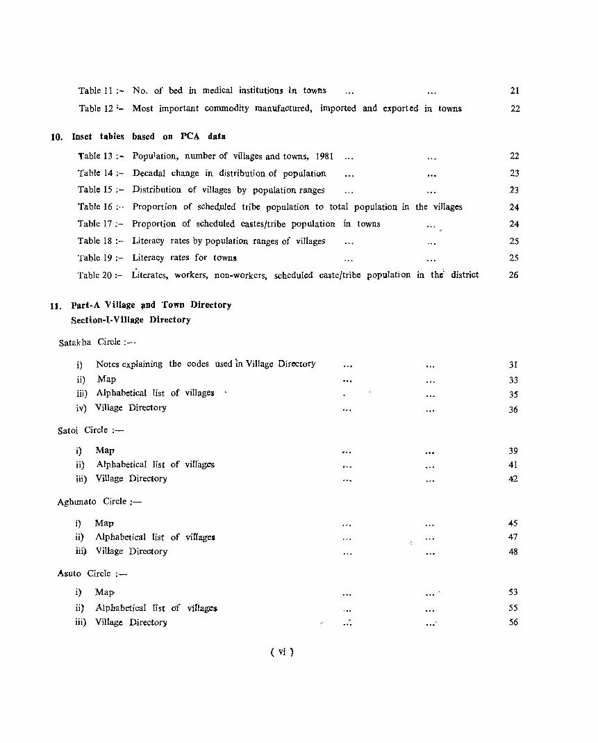
Table 11;- No. of bed in medical institutions }n towns
Table 12:- Most important commodity manufactured, imported and exported in towns
10. Inset tables based on peA data
21
22
Table 13:- Population, number of villages and towns, 1981 22
Table 14;- Decadal change in distribution of population 23
Table 15;- Distribution of villages by population ranges 23
Table 16;- Proportion of sched,uled tribe population to total population in the villages 24
Table 17;- Proportion of scheduled castes/tribe population in towns 24
Table 18;- Literacy rates by population ranges of villages 25
Table 19;- Literacy rates for towns 25
Table 20:- Literates, workers, non-workers, scheduled caste/tribe population in the" district 26
11. Part-A Village ;lDd Town Directory
Section-I-Village Directory
Satakha Circle;-
i) Notes explaining the codes used in Village Directory
ii) Map
iii) Alphabetical list of villages .
iv) Village Directory
Satoi Circle ;-
i) Map
ii} Alphabetical list of villages
iii) Village Directory
Aghunato Circle ;-
i) Map
ii) Alphabetical list of viIIage5
iii) Village Directory
Asuto Circle ;-
i) Map'
ii) Alphabetical Ifst of viflage$
iii) Village Directory
( vi )
31
33
35
36
39
41
42
45
47
48
53
55
56
Suruhoto Circle ;-
i) Map
ii) Alphabetical list of villages
iii) Village Directory
Zunheboto Sadar Circle ;-
i) Map
ii) Alphabetical list of villages
iii) Village Directory
Atoizu Circle ;-
i) Map
ii) Alphabetical list of villages
iii) Village Directory
Akuluto Circle ;-
i) Map
ii) Alphabetical list of villages
iii) Village Directory
V. K. Circle :-
i) Map
ii) Alphabetical list of villages
iii) Village Directory
12. Appendices (I-IV) to the Village Directory:
Appendix 1;
Appendix II ;
Appendix III ;
Appendix IV ;-
Circlewise abstract of educational, medical and other amenities
Land utilisation data in respect of Census towns
List of villages where no amenities available ...
List of villages according to the proportion of scheduled castes/tribes to the total population by ranges
13. Section-II-Town Directory
Notes explaining codes used in Town Directory
Town Directory Statements :-
Statement-I-Status and growth history
Statement-II-Physical aspects and location of towns,. 1979
Statement-III-Municipal Finance, 1978-1979
( vii )
71
73
74
79
:81
~2
90
'92
92
93
97
97
98
98
100
Statement-IV· Civic and .other amenities, 1979
Statement-V-Medical,' Educational. Recreational and Cultural facilities, 1979
Statemet-VI-Trade, Commerce, Industry and Banking, 1979
14. Part.B.Primary Census Abstract
Fly leaf to Primary Census Abstract
District Primary Census Abstraot
Village PCA of Satakha Circle
Village PCA of Satoi Circle
Village PCA of Aghunato Circle
Village PCA of Asuto Circle
Village PCA of Suruhoto Circle
Village PCA of llunheboto Sadar Circle:
Village PCA of Atoizu Circ Ie
Village PCA of Akuluto Circle
Village PCA of V. K. Circle
Urban PCA of Zunheboto Town
Appendix to urban PCA of Zunheboto Towm
District primary PCA for ~cbedt11ed tribe:s
NOTE FOR MAPS
UThe district and circle maps included in this publication are a.ccording to the Deputy Commissioner of Zunheboto District".
( viii)
100
102
102
107 110
112
114
116
118
120
122
124
126
128
130
132
134
FOREWORD
The District Census Handbook (DCH), compiled by the Census Organisation on behalf of the state government, is one of the most valuable products of the Census. The DCH is constantly referred to by 'plaIUlers, administrators, academicians and researchers. It is inter-alia used for delimitation of constituencies, formulation of local level and regional plans and as an aid to district administration. The District Census Handbook is the only publication which provides Primary Census Abstract (PCA) data up to village level for the rural areas and wardwise for each city or town. It also provides data on infrastructure and amenities iIi villages and towns, etc.
The District Census handbook series was initiated during the 1951 Census. ij contained important census tables and PCA for each village and town of the district. During 1961 Census the scope of the DCH was enlarged and it contained a descriptive account of the district, aqministrative statistics, census tables and a village and town directory, including PC,A. The 1971 DCR series was plaMed in three parts. Part-A relates to village and town directory, Part-B to village and. town PCA and Part-C comprised analytical report, administrative rotatistics, district census tables and certain analytical tables base<;l on PCA and amenity data in. respect of villages. However, in some states it was confined to district census tables and in a few cases altogether given up due to delay in compilation and printing.
While designing the format of 1981 DCH series some new features alongwith the restructuring of the formats of village and town directory have been attempted. At the same time, comparabi.lity with the 1971 data has also kept in view. All the amenities except power supply in the village have been brought together in the village directory with the instruction that in case an amenity is not available in the referrent village the distance in broad ranges from the nearest place where the amenity is available may be given. The restructuring of the format of the village directory and incorporating more exhaustive data on infrastructure aspect particularly in relation to amenities and landuse pattern is expected to further meet the need of micro level planning for rural areas. It is expected to help not only in local area planning but regulating the provision of goods and services as well so as to minimise the regional imbalances in the process of development. A few new items of information have also been introduced to meet some of the requirements of the revised Minimum Needs Programme. Such new items of information as adult literacy centres, primary health sub-centres, and community health workers in the village have been introduced in the village directory with this objective in mind. The new item on approach to the village is to have an idea about the villages in the district which are inacessible. A new column, "total popul!ltion and number of households" has been introduced to examine the correlation of the amenities with the population and number of households they served. Addition of two more appendices listing the villages where no amenities are available and according to the proportion of ~cheduled castes scheduled tribes population to the total population has also been made with this view in mind.
The formats of the town directory have also been modified to meet the requirments of Minimum Needs Programme by providing information on a few new items. A few statement on civic and other amenities in slums in Class-I and Class-II towns (Statement-IV-A) has been introduced with this objective in mind. It is expected that this will help the planners to chalk out programmes on provision of civie amenities for the improvement of slums. The columns on scheduled castes and scheduled tribes population in statement-IV relating to civic and other amenities and adult literacy classes/centre under educational
facilities in statement-V are also added inter-alia with this view. A significant addition is class of town in all the seven statements of the town directory. The infrastructure of amenities in urban areas of the country can be best analysed by taking the class of towns into consideration. The addition of the colwnns on civic administration status and population in a few statements also serves this purpose.
The format of primary census abstract for the villages and towns has been formulated in the light of changes in the economic and other questions canvassed through the individual slip of 1981 Census.
In order to avoid delay in publication of 1981 DCH servies it ha3 been so designed that Part-A of the volume contains village and town directory and Part-B the PCA of villages and towns including the scheduled castes and scheduled tribes PCA up to tahsil/town levels. At the beginning of the DCH a detailed analytical note supported by a number of inset tables based on PCA and non census data in relation to the infrastructure has been introduced to enhance its value. The district and tahsil/ police station/C.D. Block etc. level maps depicting the boundaries and other important features have been inserted at appropriate places, to further enhance the value of the publication.
This publication is a jOint venture of the state goverrtment and the census organisation. The data have been collected and compiled in the state under the direction of Shri Daniel Kent, the Director of Census Operations, Nagaland on, behalf of the state government which has borne the cost of printing. The task of planning, designing and co-ordination of this publication was carried out by Shri N. G. Nag, Deputy Registrar General (Social Studies) of my Office. Dr. B. K. Roy, Deputy Registrar General (Map) provided the technical guidance in the preparation of the maps. Data received from Cen..;us Directorates have been scrutinised in the Social Studies Division at the headquarters under the guidance of Shri M. M. Dua, Senior Research Officer. I am thankful to all who have contributed in this project.
New Delhi the 26th April, 1982
( x )
P. PADMANABHA Registrar General, India.
PREFACE.
The District Census Handbooks were introduced for the first time in the 1961 Census in India, but so far as Nagaland is cQncernd the same were brought out in 1971 Census for the first time. The District Census Handbooks in 1971 Census were published in three parts namely, A, B and C. These were found very useful and va!uable source of various information to the planners, researchers, legislators, public bodies and the general public. I have the pleasure· to bring out the District Census Handbooks of 1981 CenSl:lS for all the districts of Nagland one by one, which will serve as a valuable source of information. Part-A and B' are combined in the same volume.
This volume will give the over all picture of the district at a glance under the heading "Important Statjstics". The analytical note contains number of inset tables based on the village directory, town directory and the PCA. Part-A provides the village directory and town directory alongwith the tables on administrative, welfare and developmental statistics of the district. Part-B of this report consists of the Primary Census Abstract of the general popu~ation and scheduled tribe population for the state/district/circle and village, for towns, the PCA is given uP, to the block level and table are based on PCA data.
I am deeply grateful to the ,~tate Government for their overwhelming help and co-operation in bringing out this publication in time. The data incorporated in this volume are mainly collected by the enumerators/supervisors who formed an army of enumeration agency under efficient leadership of the Deputy Commissioners who were notified as Principal Census Officers, and, DPO, Zunheboto as District Census Officer, Add!. Deputy Commissioners ,in charge of sub-divisions and sub-divisional Officers (Civil) as Sub-Divisional Census Offic~rs and Extra Assistant Commissioners and Circle Officers as Charge Officers. I am grateful to Shri Z. abed, LA.S, the then Chief Secreta:y to the Government of Nagaland who showed enthusiatic interest in all the matters relating to Census of 1981.
I express my debt of grat,itud,e t\) the Census Commissioner and the Registrar General, India Shri P. Padmanabha, LA.S, who was a" constant source of guidance and inspiration, The painstaking Deputy Registrar General ( C & T ) Shri K. K. Chakravorty (since retired) also helped us to get all the tables checked with accuracy. The DRG (Map) of Registrar General's Office Dr. B. K. Roy rendered his valuable guidance in preparation of the maps for this publication.
The 1981 Census was organised in this state under the Directorship of Shri Daniel Kent, I. F. A. S, who despite his multifarious responsiblities in the state Government, devoted his whole 'hearted attention in his capacity as an Ex-Officio Director. I am indeed indebted to him for his seasoned guidance to me for sharing the census work with him. My thanks are also due to the then Deputy Directors, Shri A. C. Bal, Shri S. K. Chattopadhyay, Shri N. Thong and the then Assistant Directors, Shri N. C. Sarkar and his successor Shri J. C. Datta who jointly shared the brunt of the field \york to make the 1981 Census a great success in the state of Nagaland.
I shall be failing in my duties if·'j do not 'place on record my sincere thanks to the Station Director, all India Radio, Kohima and his colleagues who helped in making wide pUblicity through this media during the actual operations. My thanks are due to the Controller of Printing and Stationery, Nagaland, Kohima a.lld his colleagues who helped in printing this report by taking personal interest.
Last but not the least my thanks are due to Mrs. E. Peseyie, Tabulation officer who took all the pains to draft and shape this report alongwith her other colleagues in this Directorate under my guidunce.
Dated Kohima, the
16th May, 1984.
G. S. PABLA
Asstt. Director Of Census Operations (T) Nagaiand, Kohima
Data Pro£essing
E. Peseyie (Mrs)
D. C. Pathak
A. Jahan
H. K. Endow
D. Sanna
Z. Nisa
C. Gupta
G. Das (Mrs)
K. G. K. Pillai
Analysis of Data
E. Peseyie (Mrs)
Maps and Diagrams
J. Rai Baruah
1. Tali A.o
Typing
S. Chaudhury (Mrs)
T. Rutsa (Mrs)
Printing Supervision
D. C, Pathak
Proof Reading
D. C. Pathak
Lucy Kent (Miss)
ACKNOWLEDGEMENT
Tabulation Officer
Tabulation Officer
Tabulation Officer
Statistical Asstt.
Statistical Asstt.
Statistical Asstt.
C0-lllputor
Computor
Computor
Tabulation Officer
Sr. Artist
Geographer
Tabulation Officer
Tabulation Officer
Proof Reader
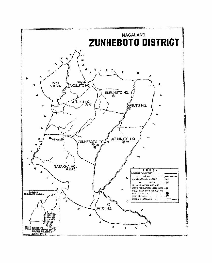
NAGALAND
ZUNHEBOTO DISTRICT
u
4-4 \.
.I
I I ,
I ) I ~
.~ .I ~ - ---':'''-·----·7 I
" """\_
AGHUN :fO HQ./) ,_, '''\',ZUNHEBOT0 TO
. . PO ® . @)PO •
SATAKHA HQ • • @)PO
, I-~NNOA-L.-A-ND----"':'.r:.., ;'."
ZUNIiElIOtO OIStlUCT r."'-( \ .~. ! "',,
I •. i 0' \ d. "., ........
.J'
J'
.JI ~
J.r/ r-S20-UN-OA-R-Y-.~-15N"""TR-~-T-~.-X-.. -. -.~ .. _-.-_-._'_'
; "".i " CIRCLE '" .••
IY ~ HEAOQUAItTERS, DISTRICT '"
A'~ • .,JI
i . j ~.~.
" CiRCLE .•. VILL;'GES HAVING 1000 AND
A&OVE POPULATION WITH NAME ..••
URBAN AREA WITH POPULATION SIZE CLASS V •• , •..•
POSoT OFFICE... .., .:.PO RIVERS .. STREAMS .• , •.. . .. -:;::::::::=--,.1 S' "' .....
". l,; . ""' "'-', i L\} ".
~ i ~.~. i @) '-.
.... ... ,...; If -. I " '1 .
,!' ~~ . !JUNH" 9,! {-._._ . .-._ \~
~ ZUNHEIIO'rO "'-.~-0.~. DISfRICT CARVED OUT OF! MOKOKCHUHG. DISTRICT
.~SATOI HQ. " ,. \.
\.. ~, . ., ,._ ."" . ..-. ....... ...-._ ....... .,.".
o s 1

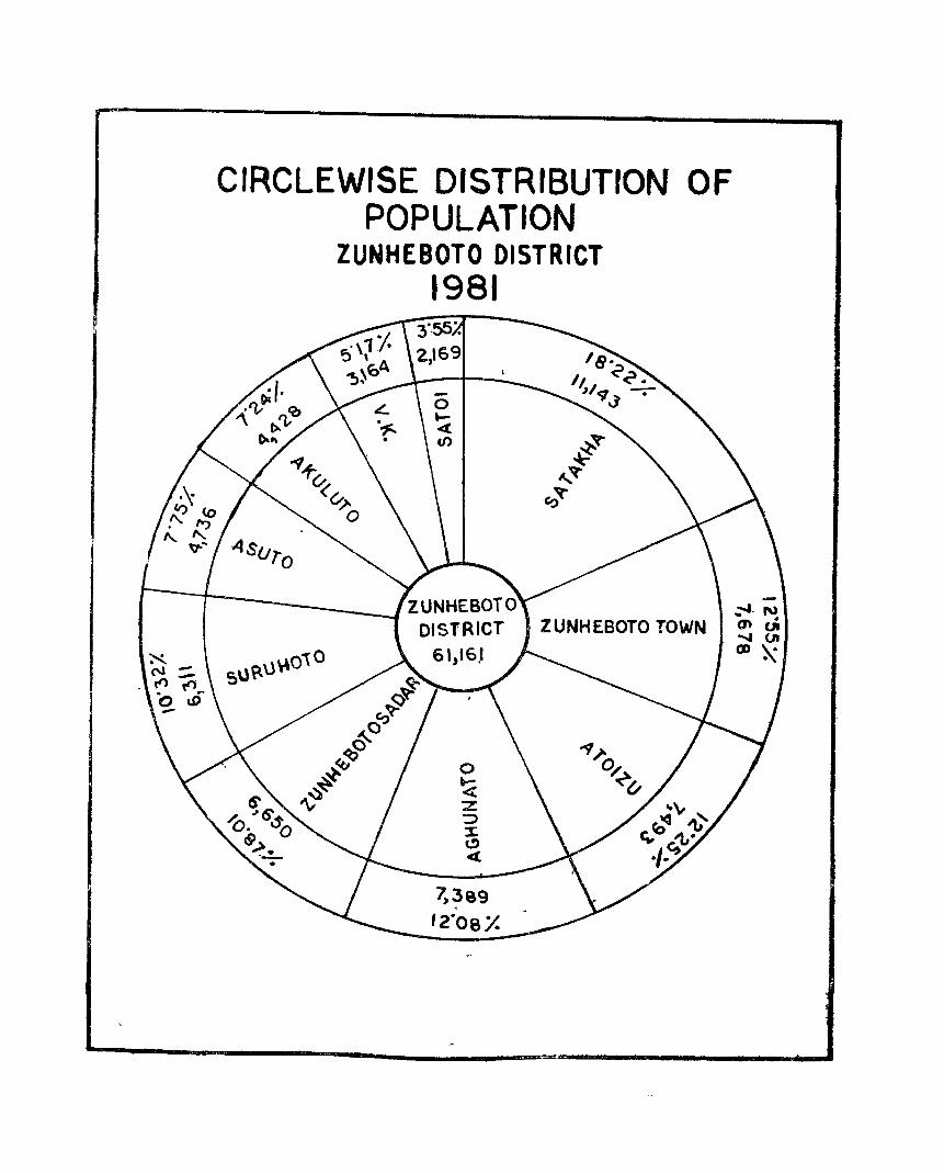
CIRCLEWISE DISTRIBUTION OF POPULATION
ZUNHEBOTO DISTRICT 1981
'., .
. ,
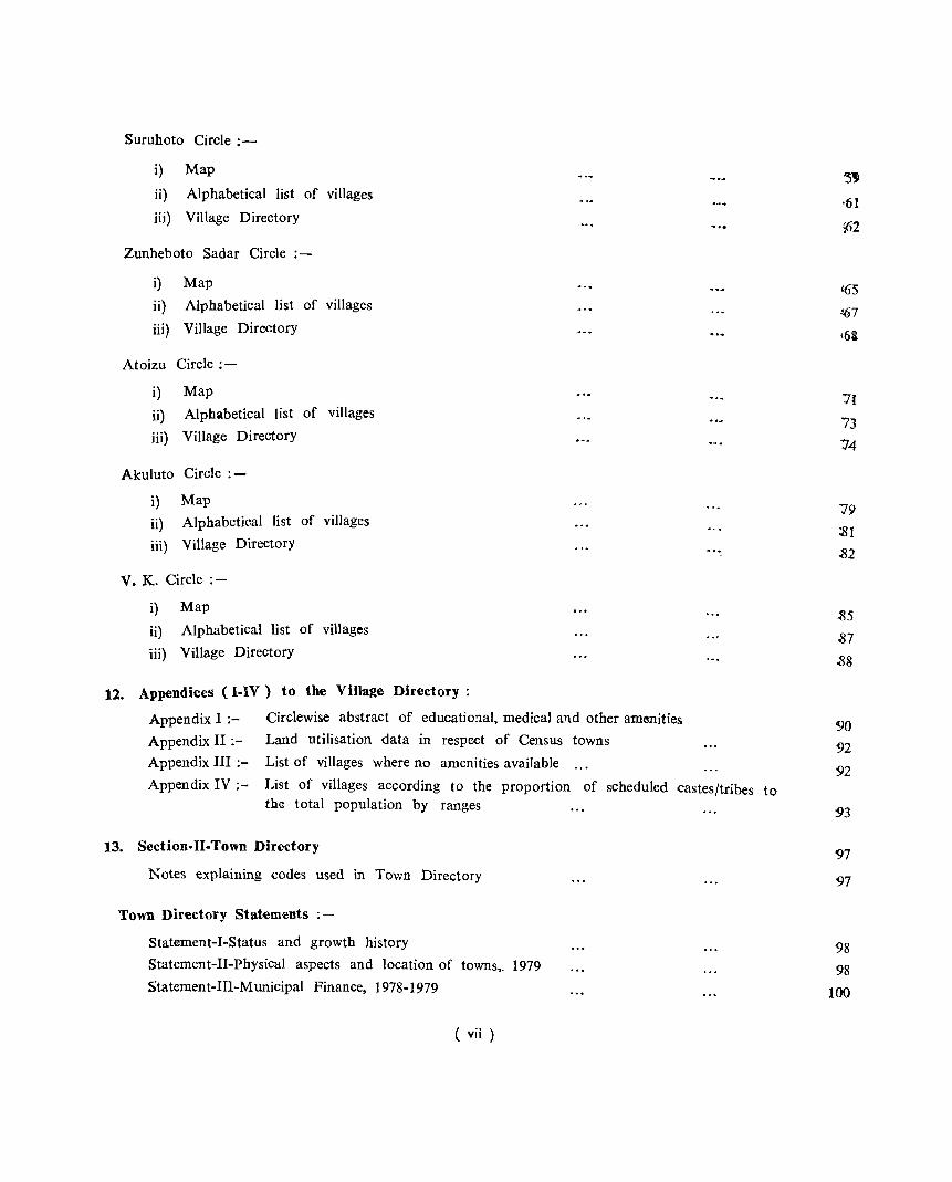
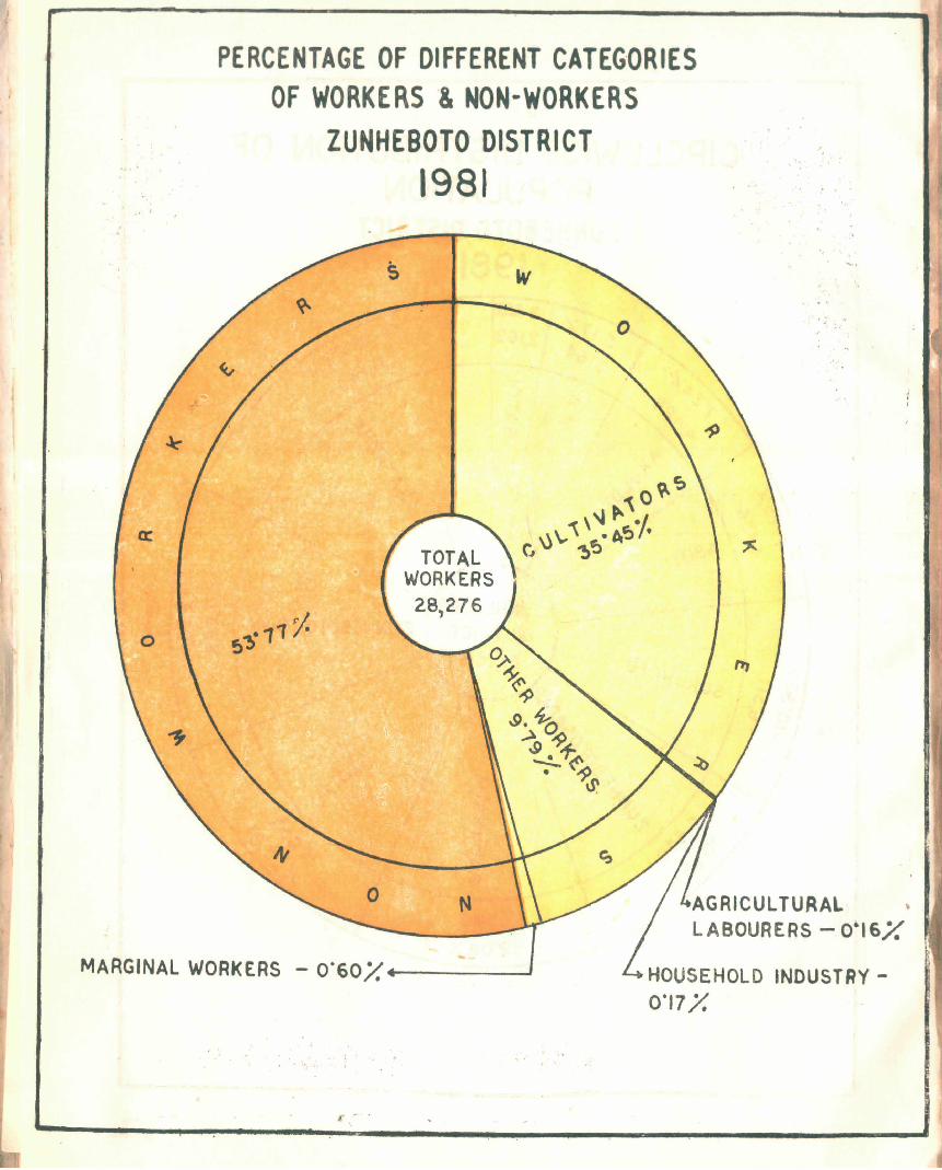
PERCENTAGE OF DIFFERENT CATEG'ORIES OF WORKERS & NON-WORKERS
ZUNHEBOTO DISTRICT 1981 " ..
. .
N AGRICULTURAL LABOURERS - 0·16/.'
MARGINAL WORkERS - O·60X4------J HOUSEHOLD INDUSTRY-0·17/.
.r . - .
IMPORT ANT STATISTICS
State : Nalalaad District: ZunhebotO
POPULATION Total Persons 774,930 61.,161 Males 415,910 31.136 Females 359.020 30.025
Rural Persons 654.696 5~48.l Males 344,699 26,661 F~males 309.997 26,821
Urban Persons 120.234 1 .. 67J1 Males 71,211 4,474 Females 49,023 3,204
DECENNIAL POPULATION GROWTH llATE 1971-1981 +50.05 29.81
AREA '( sq. km) 16.579.00 1,255.00
DENSITY OF POPULA nON (per sq. km) 41 49
SEX RATIO (Number of females per 1000 males) 863 964
LITERACY RATE Persons 42.61 45.59 Males 50.05 52.82 Females 38.89 38.09
PERCENTAGE OF URBAN POPULATION TO TOTAL POPULATION 15.52 12.:55
PERCENTAGE TO TOTAL POPULATION
(i) ~{ain workers Persons 47.53 45.57
Males 51.91 47.30 Females 42.45 43.79
(ii) ~aTginal workers Persons 0.70 Q.66
Males 0.66 0.62
Females 0.75 O.1(}
(iii) Non-workers Persons 51.77 53.77
Males 47.43 52.08
Female!! 56.80 55.51
(xvii)
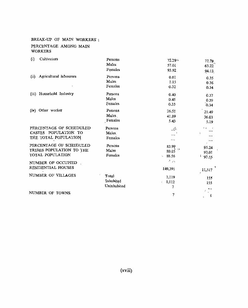
BREAK-UP OF MAIN WORKERS':
PERCENTAGE AMONG MAIN WORKERS
(i) Cultivators Persons 72:29'1 77.79 n Males 57.01 63.22
Females 93.92. ~4.13
(ii) Agricultural labourers Persons 0.81 0.35 Males 1.15 0.36 Females 0.32 0.34
(iii) Household Industry Persons '0.40 0.37 Males 0.45 0.39 J;emales 0.33 " 0.34
(iy) Other worket Persons 26.51 21.49 Males, 41.99 36.03 Females 5.43 5.19
PERCENTAGE OF SCI;IEDULED Persons .. /f..', < ,
CASTES POPULA nON TO Males niE TOTAL POPULATION; Females
PERCENTAGE OF SCHEDULED Persons 83.9~ " 95.24 TRIBES POPULATION TO :rHE Males 80.05 93.01 TOTAL POPULATION Females " 88.56 I '97.5.5
NUMBER OF OCCUPIED ,.1 ,1' ~
RESIDENTIAL HOUSES 149,391 11,517
NUMBER OF VILLAGES Total' 1,119 15~ Inhabi~~d 1,112 155 Uninhabited 7
NUMBER 'OF TOWNS 7 I
(xviii)
ANALYTICAL NOTE
Definition and concepts :- In order to understand the meaning of words used in the analysis of data in this publicatioo,. it would be necessary to briefly explain the census concepts and definitions of various words and phrases used herein:-
Urban area :- The census definition of an urban area is given as below:-
a) All places with a municipality, corporation, cantonment board Or notified area committee, etc. b) All' other places which satisfy the f~llowing criteria:
(i) a minimum population of 5,000, (ii) atleast. 75% of the male working population engaged in. non-agricult~ra~ .pursuit and. (iii) a density of population atleast 400 persons per km2 (i. e. 1000 per sq. mile. )
The class of the town in terms of population. is categorised according to the followin~ procedure :.,.-
1. class I with a 'population of 100,000 and above, 2. . class II with a population from 50,000 to 99,999 3. class III with a population from 20,000 to 49,999 4. class IV with a .population from 10,000 to 19,999 5. class V with a population from 5,000 to 9,999 6. class VI with a population less than 5,000
Rural ;- The cadastrally surveyed village with fixed boundaries is taken as a village for the purpose of census in plain areas. Tn the hill areas, a village is considered to be a collection of houses with eertain boundaries having a separate name traditionally recognised by the villagers.
Censos House :- A "Census House" is a building or part of a building having a separate main entrance from the road or common courtyard or staircase, etc., used or recognised as a separate unit. It may be occupied or vacant, it may be used for a residential or non-residential purpose or both.
Household ;- A household is a group of persons who commonly live together and would take the~r
meals from a common kitchen unless the exigencies' of work prevents any. of them from doing so. There may be a household of persons related by blood or a household of unrelated person or having a mix of both. Example of unrelated households are boarding houses, messes, hostels, rescue homes, jails, etc, which are called "Institutional households". There may be one member households, two member households or multi-member households. For cemus purposes, each one of these types is regarded as a household.
Scheduled Caste/Scbeduled Tribes :- There is no scheduled caste in the state of Nagaland as per the. Constitution (Nagaland) Scheduled Tribe Order 1970. The Scheduled tribes listed in the Constitution which is also adopted in 1981 census are as follows:-
1) Naga. 2) Kuki 3) Kachari 4), Mikir and 5) Garo
It may be noted here that the term 'Naga' is a common name of the community as a whole. As many as sixteen sub-tribes have been recorded in the 1981 census UJl.der the headh~ I'Naga" whicR are listed below;-
i) Angami ix) Makware
ii) Ao x) Phom
Hi) Chakhesang xi) Rengma
iv) Chang xii) Sangtam
v) Chirr xiii) Serna
vi) Khiemnungan xiv) Tikhir
vii) Konyak xv) YimC?hunger
viii) Lotha xvi) Zeliang
Literate ;- A person who can both re!ld fnd wr:!te with. und~rstandi~g in any l~nguage is tak~n,! 1'0 be literate. A person who can merely read Hut can not wnte, IS not hterate. It IS not necessary' tIlat a person who, is literate should have received any f.ormal. education, or should pass; any minimum, educational stautlard. All childre'-~f the age .of 4 years ~r less are .t~ be treated as iIlt.·ter.ate even if the" child is going to school and ,ay have pIcked up readmg and wnt!ng a few odd words.
Workers ;- A worker is a person whose main activity' is participation in any economically productive work physically or mentally. Work involves not only actual work but effective supervi£ion and <iirection of work. The following points are also taken into consideration to treat a person: as a worker during 1981
census ;-
i) A person who normally works but has been absent from work during the reference period (i.e. during the la~t lOUe year prior to ;the: date of enumeration) on accoun,t of illness, .holidays, temporary.closure, strikes, etc .. is treated as engaged in the work he/she would otherwise have been. doing but for his/her' temporary absence.
ii} Persons under training such as apprentices with or without stipends or wages are treated as wO'rkers.
iii) A person who has merely been offered work but has not ac~ually joined yet is a worker.
iv)' A full time' public service or a fulltime political worker, who is also ,actively engaged in furthering the, poHiical activity of his/her party is treated' as a worker.
Workers are further divided into two categories, viz, main workers and marginal workers.
Main Wo'rker"-s ;-. If lit person has done any work at all during the year,. h.e is regarded as a worker. The main worker and\ the marginal worker is iden,tified by the nl.Jmber of days he/she had been engaged' in the economic and productive work during the year. If a person has done such work for 6 months or 183: days or more quring thl? reference period (i.e. during the last one, yea:r prior to· the date of enumeration) he. is. r:egarqed as a. main worker.
The person who is main worker may have worked for six months or 183 days or more in more tha'1 one activity. For example he/she may have worked for 3 months in cultivation. one monfth in gur making and 3 months as an agricultural labourer.
When main activity of a person qualifies him to be treated as a worker be/she is further categoriesed according to the type of work he/she performs viz, cultivator. agricultural labourer. household industry and other work. The terms are explained below ;-
2
Cultivator :- For the purposes of census a person is working as a cultivator if he/she is engaged either as employer, single worker or family worker in cultivation of land owned or held from the Government or held from private person or institutions for payment of money in ki.ad or share. Cultivation includes supervision or direction of cultivation. If a person gives out his land to another person for cultivation for money or share of crops and who does not even supervise or direct cultivation of land is not treated as cultivator.
Agricultural labourer:- A person working in another person's land for wages is not treated as cultivator but he is treated as an agricultural labourer.
Household industry :- A person is said to be engaged in household indu~try if h eJshe is engaged in some productive, processing servicing or repair of articles or goods such as handloom, weaving, dyeing, carpentry, bidi rolling, pottery making, bicycle repairing, blacksmithy, tailoring, etc, and if it is conducted by the head of the household at home or within the village in the rural areas and only within the pricints of the house where the household liv~s in the urban areas. The industry should not be run on a scale of a registered factory.
Other worker :- All workers, i.e., those who have been engaged in some economic activity who are not cultivators or agricultural labourers or engaged in household industry are "other worker".
Marginal worker :- If a persqn has worked any time, but has not worked for the major ,part of the year he 'is treated as a marginal worker. He may be a student or engaged in household duties or, dependent or rentier or beggar or inmate of institution, such as prisoner.
Non-worker :- Non-worker is a person who is not engaged in any economically productive work. Nonworkers are categorised under seven broad heads namely, household duties, students, rentiers and retired persons, dependents, beggars and inmate of institutions.
3
BRIEF HISTORY OF THE DISTRICT AND DISTRICT CENSUS HAND BOOKS
Zunheboto is one of the present seven districts of Nagaland. Formerely Nagaland had only three districts, such as Kohima, Mokokchung and Tuensang. Later, in December 1913) it' was divided into seven-Kohima was divided into two, such ~s. Koh{ma: and Phelc, -Mokokchung into three such as Mokokchung, Wokha a.Il4i- Zunheboto' and Tuensa'ng was divided into two such as ru~ns!lIlg and~Mon. Zunheboto ~- district is 1255',00 square kilometre in area, out, of which. 12.52.00 sq. kIn', is r~ral ~nd 3.00 sq. km. is urban.
Jh~ -populatIon of Zunheb~qto district ,is 61,161 7,678 per~ons live in -the vrban area: of the district. p_ersons ~re 'Scheduled' Tribes,€, ?f:466. persons live in of tht? qistrict.
Oiigin of the name of the district I
out of which 53,483 phsons ,liv~ in rural area and 9ut J of the tbtal pbpuJa:tion' of Ule. dist~ict 58,249
th.e r~ral ~rea :and 5~78'3 persons live in urban area
. After the second 'w~tla wa~ there I was a great' \awakening fOf- education among -the Nagas and 80
also among tb.e Sentas, the major tribe of _the, .distriot:~ Ai a result several primary schools, middle schools, !;... ... ,
were opened all l 9yer .Nag-a Hills' and also schools Were opened in a place which is now known a& I ' ~
Zunhe],oto town. When the schools were set up it was necessary to give a name t~ the pJace.' ~-he peli.>Jple· did not want t~ ,gi,(e;, any old name which might show Jayo,ur\tism,to' any particuli:lf village ,or cl<Plt ,To) avold1 this difficulty they decide4 to name it aft~r the plants whicb grow abundantly there. Tile nam: Qf thl( plant is' "Zuhliebo" 'and, so' the place was \ ~~riied ZunJle,boto, meaning the ~ange of Zunhebo pla,nts .. "Zunhe:bo" .is' a 'kind 'of floweQi1g shrub, bear1{ig flowers dqring winter. 'lts leaf is green on the obveise and ~hitish hairy i~)11 \ th~' re'y~rse. Later; Zunheb~to :wa~ made a sub~divisidn, and in 197;3 it became la "district and .zunheb3to became; th~ name of the district.
'\ L ~ ~. J >. ,'1
: ~heb6to d!strld: .ha,s .9 (nine) \ rural \ cirbles and only one .town. The) name of ~ir<?les -and 'Circle"! . I . - \ 1 1-.. I wise popu a.hon . are given lie ,?W, ; ...
'1.' Satakha 1),i4~ 2. Satoi
,3.·, Aghunato 4.- As'uto 5- ' $lir-ukbti)'
~. Zunheboto 7. Atoizu 8. Akuiuto 9. v. K.
10. Zunheboto
Census in Nagaland
sada:r
town
'" > t
.. '" ~
'"
2,169, 7,389 4,736 6,311 6,650
7,493 4,428 3,164 7,678
The census of 1961 was the tenth decennial ce_nsU$ of India and 2nd after the tnaependfll1e"
The census t(lking >in Nagaland during 1961 census was not smooth but a i'Llcclilsiful fil08. Bl.lt dUl to delay the District census Hand Book could not be published.
The District census Handbooks of three districts were published in 1971 in three parts separatelly such as Parts A, Band C, which were found very useful reference books pertaining to the district for administrators and planners of the state machinery which helped in the developmental purpose in the district.
In 1981 census also efforts have been put in to publish the DCHBs for all the present seven districts in wide range and uniform manner, which wm fulfill the demands of statistical bodies of the state government and the local bodies.
To avoid delay the Parts A and B are being combined in the same volume and publication of DCR Part-C of 1971 census has been omitted in 1981 census. Thus the present volume of DCRB will bring out the village/town Directory in Part-A and town/village Primary Census Abstracts in Part-B.
The scope of Parts A and B are explained briefly below;
Scope of Part-A
The District Census Handbook Part-A contains the village and town directory and numbers of inset tables based on the village and town directory data.
The village directory reveals the general living conditions of peasantry and the over all development that has taken place in the district during the decade. The amenities available within each village in the field of education, medical, drinking water, communication, post and telegraph facilities have been
.given in columns 5 to 10 of this directory. Besides, the informations relating to distance from the nearest town, staple food, power supply, approach to the village by pucca road, etc., are also given in columns 11 to 14. This directory also giv·es the information regarding the land use in hectares. Although the villages in Nagaland are not cadastrally surveyed, the approximate area of different types of landuse in the village are being presented in columns 15-20. All the possible efforts have been made to record the places of religious, historical or archaeological interests, if any, for each village in column 21 of this directory.
Four numbers o( appe:'ldices which have been prepared on the basis of village directory and PCA data are also incorporated in this volumme with brief explanation.
Appendix-I- This appendix shows circlewise abstract of educational, medical and other amenities.
Appendix-II- This appendix deals with the land utilisation data in respect of non-municipal towns (census towns). There is only one town in Zunheboto district whose civic status is C.T. ( Census town ).
Appendix-III- This appendix relates to the list of villages where no amenities are available. There are four villages in Asuto circle where none of the amenities like educatio:,al, medical, drinking water, communication, post and telegraph, approach by pucca road and power supply is available.
Appendix-IV ;- It relates to the list of villages according to the proportion of Scheduled Tribes to the total population by ranges.
Scope of Part-B Physical Aspects: Highligbt on the cbanges in jurisdiction of the district during the decade including its boundaries :-
Zunheboto district was one of the three sub-divisions of Mokokchung district till 1971 Census. But in December 1973 the whole sub-division of Zunheboto, consisting 147 villages, was bifurcated from Mokokchung district and created the new district of Zunheboto alongwith 8 new villages and 1 town.
The total area of the district is 1.255 sq. kms. out -of which 1.252·00 sq. kms. is rural and 3:00 sq. kms. is urban.
5
The district has 155 inhabited villages. There are 9 (nine) rural circles and one town and they are 1. Satakha circle, 2. S:1toi circle, 3. Aghunato circle, 4. Asuto circle, 5) Suruhoto circle, 6. Zunheboto sadar circle, 7. Atoizu circle, 8. Akuluto circle, 9. V. K. circle, and 10. Zunheboto town. Zunheboto district is bounded by Mokokchung district on the north, Tuensallg district on the east, Phek district on the south and W okha district on the west.
The district is hilly. The hills vary from 1000 to 2500 metres and the average height of the district is 1800 metres. Most of the people live between 1500 and 2000 metres of altitude.
River system ;- The most important river of Zunheboto district is Doyang which has originated in Japfu mountain in the south,. in Angami area, and has flows northward Serna area, then southward in Lotha area and has fallen to Dhansiri in Sibsagar district of Assam. Dhansiri has joined Brahmaputra which in turn has joi led Padma in Bangladesh has fallen to the Bay of Bengal. There are two other rivers also one of them is Tiz'J. which has risen in the north in Tuensang district and has flown southward through this district and joined Ti-Ho which has joined C~induin of Burma. The other river is Tita. It has risen in the north-east, and has drained t,he eastern part of the district and joined Tizu.
Flora !- The average altitude of Zunheboto district is 1800 metres. The' temperature is low keeping it cool throughout the year and making it cooler duririg winter.
At this climate, and with the 200 em. of rainfall is quite sufficient for the evergreen vegetation. 'Zunheboto district consists of both deciduous and evergreen forests. The important tree species are Champa, Bonsum, Am8.ri, Sam, Simul, Gamari, Anu, Hallock: Gogra, Walnut, Jamuk, Urium, Bogipoma, KOroi, Khokan, Jia, Poma and Hilikha.
Fauna! - Major part of the district being covered by forests and jungle it is natural that there will be lots of animal life. The following birds and animals are found in the forests ~nd jungles of the district ;-
Birds ;-
Common name 1) White Vulture 2) Black Partridge 3) Grey partridge 4) Common pe:lfowl 5) Common green pigeon 6) Blue rock pigeon 7) SP9tted dove 8) Common babbler
Zoological name Neophon Percnopterus Franfolinus Francolinus pondicerianus Pavo Cristatus Treron phoenicoptera Columba livia Streptopelia chinensi s Turdoides Candatus.
Animals;- (1) Wild Boar, (2) Barking deer, (3) Black bear, (4) Wild goat, (5) Wild Cat, (6) POfCtil'irtef (7) RoyalBengal Tiger, (8) Jackal, (9) Monkey, (10) Leopard, (11) Wolf, (12) Wild dog j (13) Pangolinf etc. etc.
Climate ;- Zunheboto enjoys monsoon climate, winter is cold and summer is rather Cool. In Winter thC$ night temperature comes down to I'c in January and February which are the coldest months and the highest SUm€f temperature is 22'c.
Rainfall is on the average' 2000 rom and faIls for the period of nine months of the yearf hea:V'iest in July and August. Frost falls in Aghunato, Zunheboto town and senral other places but not every. where in the district.
6
Major characteristics of the dis'trict particularly in iefathm fo tlill eco1tomic (resources :_ i·' 'i' J(1 ,
Most of the people in the district are cultivators and those who are not cultivators are,,1 engaged in government services or busi:~ess, but yet they also cultivat,e thp la-\1~ thoqgh not f.or full time. Other industries having not grown up so much most of the works are limd based, ,\hat is ~.!hey are ,either cultivators or agricultural labourers. The cultivators who entirely depend on cultivation for their livelihood .constitute 35.45 percent of the total population.
Zunheboto district does not have many economic resources of its own but the people of the district get the requirements of their livelihood from the following 'local resourcesJ:~) " "ri 1,
'Forest aud forest product:- Forest cover about 30 percent of total area of Z1;;nhebbto' distrilh excluding jhum land.
From the forests, such as u.'lclassified and jhum land, the people get all sorts of bui1diini~aterials such as timber, round wood posts, thatch, bamboo, cane, etc. as well as fire wood, honey, fodder, etc.
The valuable trees grown in the forest of the district are Champa, Bonsum, Amari, Sam~ Hollock, Urium, Bogipoma Khokan and Hilikha which are good for building construction. Some trees which are commercially used for plywood, match boxes, match splint, packing cases, ceUings, toys, planking, etc. ~re Simul, Am, Gogra, Khokan, etc, etc.
Mineral Occuranc,es :-No particular. minerals have yet been diScovered in the district. However, it is believed that like other parts of Nagaland, petroleum and coal may be -available in'j'this district also.
Land aod Landuse pattern :- All the lands belong to the villagers, except a small portion of forest as reserve or protected forests. S'ince the land belongs to the villagers, there 'is nd patta or rawayati system. Individual holding is there and such lands occassionally change hands, but generally remain within the village, because there is a strong opposition from the villagers to sell any land outside the village. Wheh an individual holding passes from one hand to others it, used to be verbally done in presence of responsible witnesses. Nowadays sales are dqne in writing anlil only in case of urb,an and costly property the sales are registered in court.
Agriculture :- As in other hilly places, jhum cultivation is done in this district. Jhunl cultivation is the main form of cultivation. Under the system of Jhum an area selectell for cultivatio:1 is cleared of its shrubs and undergrowth. Then the smaller trees are also feUM, but the big trees' are not. Branches of the trees are slashed so that the trees do not die and can bear fruits for its propagation. This work is done in the month of October and November. The felled trees, slashed branches and cleared shrubs etc. lie there for several months to dry up. When it is dried, fire is set to it. It is done "in the mouths of February to March. As the soil is boggy and loose, because it has been formed by falling 9f leaves and branches, it is good and fertile being, ready for sowing the crops. The field is cultivated once or even two to three years, if it is sufficiently fertile, then it is kept follow for next seven to ten years depending on the fertility of the land and availability of other lands. After that period the same land is cultivated.
The main crops under jhum cultivation are paddy, millet, maize, beans, pumpkin, cucumber, etc. Terrace is the other form of cultivation. The field is spaded and kept ready for making mud as soon as the water is available. Water is brought from nearly stream or falls, of which kind there are
7
many during rainy season. When the soil is ready by turning into a thick mud or dough with the help of spade and human feet, the paddy plants are taken out of the seed bed which are planted earlier in the field.
The water is allowed to stay the whole period of the growth of the plants and sometimes allowed to dry up just before harvesting.
The jmportant agricultural implements used by the cultivators in the district are Dao, Axe, Spade, Hoe, Pick, Scrapers, Sickle, Rake, Mat, Winnowing fan, Basket, Pounding table, etc, etc.
Notable efforts have been made to encourage wet rice has been taken up for distribution of fertilizers. Insects and time to time. People utilise the services of the Agricultural through chemicals which are of great help.
terraced cultivation in the district. Measure pests cause great damage to the crops from Department which uses scientific remedies
Besides, demonstration is done on the use of improved seeds of potato, vegetables, paddy, hybrid maize etc. seedling of orange, pineapple, plum, bear, etc are also provided for distribution on sub.sidy bas!s. Seeds of maize, hybrid paddy are also distributed.
Animal Husbandry:- The people b~ing meat eaters there should have been a great need and demand for scientific animal husbandry. However, though not sCientifically done every house has got a minifarm of poultry and animal husbandry.
Liyestock:- Almost every house has got a few cattle, both cows and bulls. The cows are kept mainly for breeding purpose, because milking is ndt yet so much popular. When it is }l0 longer good for breeding it is slaught~red for its .beef. Bulls are generally kept for beef an" not for any other work since there is no plough or any cart of any type.
Every house has got few- pigs, fowls and ducks which are kept for their meat.
IDdustries:- No organised industry of any size has yet developed in this district. It may be noted that the Nagas are self sufficient in their daily need&.
The only indust·y we can speak of is cottage industry. Of the Cottage industry the important ones are weaving, carpentary, blacksmithy, basket making, wood carving and decorative works and they are discussed below.
Weaving:- In is most common and is found in every house. Weaving is done by woman and every woman has got her weaving apparatus. It is a handloom and is known by the technical term Indonesian Tensian Loom. It is a simple back strap one with a horizontal warp consisting six sticks serving the function of warp beam, lease rod, heald stick, bealing sword and extra-warp beam. In their simple loom they make woman's cloth, loin cloth for men, chadar for both man and woman, neck tie, bags and ceremonial dress, etc.
Since the inception of Directorate of Industries, Government of Nagaland, in 1965, efforts hav.:: been made to boost up industrial training particularly for weaving. To improve and encourage weaving industry the Government of Nagaland distributes yarn at a subsidised rates to the weaving societies and indivisual weavers also.
Carpentry:- Since the time Nagaland was within Assam, carpentry has been taught in the middle schools. Now also it is taught in the middle schdols as well as in the middle schools section of high S<.:hools. Therefore all the educated boys get training in carpentry as a part of their education. Some people also get training in carpentry in the Industrial Training Institute at Kohima and Nagaland Polytechnic at
8
Atoiw. Some self trained carpenters also are there in the district and together they do lot of carpentry works in the district and most of the people in the villages supplement their income by doing off" time carpentry work. These carpenters do the work of house building and make furniture etc.
Blacksmithy:- In every village a few blacksmiths are found who make dao, spade, hoe, scraper, spear etc. The villagers do not only depend on those blacksmiths but also they purchase many of their articles from open market. The smithy is not their .profession, but a pa.rt time vocation to aug_ment their other sources of income.
Basket Making:- Basket commonly known as "Khang" are of various types and shapes,. which depend on the purpose it is meant for. It is used for carrying paddy or other cqreals, water cans, firewood etc, and for each purpose the type is different. Tl:\is basket is made of slit bamboo and occas~o:n,ally
decorated with dtfferent designs on it. It is produced mainly for domestic consumption but now-a-days some are sold to the urban people or to those who cannot make them.
Wood Carving:- The people use a kind of wooden platter for taking food from it. It is made of a single piece of wood and has got four legs. This is most common and important work of wood carving. Other ,works of wood carving are mainly related to decorative worM for doors of the' houses. Some wood carvings are also done to carve ou,t different animals, notably crocodile, tiger, 'bird, mithun (gayal) etc. These are all decorative works and are often coloured.
Decorative Works:- There are other miscellaneous works which come under cottage industry. It includes making of head gear, decorated spear, dao handle, dao holder, ware shield, ivory armlet, etc.
Pottery:- It is the oldest cottage industry. T.he people of ·the villages make pots fot ·cooking which are rough and thick as they do not use any Iand of machine to make these pots but all are made by hand.
Trade and Commerce:- The Semas, inhabitants of this district like all other Nagas for long have been outside the influence of modern civilisation. Their needs were few and they could manage to be self sufficient. Since they produced all their requirements of foodstuff and minimum clothes, they' do not require anything to purchase except salt and hence there was pract"icaily no currency. But gradually with the modern civilisation they felt need of money to purchase salt, pieces 'of iron to make their agricultural equipments, etc.
There was barter system prevailed in this district for trade till recent decade, specially in the villages.
The district being situated in the heart of the hills, the trades used to be carried out through the neighbouring tribes, with the state of Assam. Thei~ needs were few and their exports were fewer and so the volume of trade was also negligible. After opening up of the country by the Britishers the peoples' need increased and they used to t~ade with Mokokchung then a sub-divisional headquarter, which in turn had trade connections with Amguri in the plains of Assam. Since then people are using coins and currency of the rest of the country. Zunheboto, the district he~dquarter is the most important business centre. Then all the administrative outposts such as Satakha, AghlL.'1ato, Atoizu, Suruhoto etc are also business centres.
Road Transport :- The construction of road connecting Mokokchung with Mariani helpd ZU:lheboto to communicate with. the p'lains easily. Now there is. also a road from Mokokchung to Zunheboto, which has been widened and metalled by the Border Road Organisation. ThllS there are two good roads from
9
Z;~n!te~q~o c;me to Mokokchung and other .t9) Kohima ,and both these roa9s are constructed by Border Roa,a ..,_PrganisatIOn. There are many jeepable roads inside the district.
Following the impoved road condition the Government of Nagaland opened state transport bus services in the different routes.in the state.
Administrative developments during the decade:- Zunheboto remained to be one of the sub-divisions of' Mokokchung district till 1971 census. In December 1973. the three sub-divisio:1.s of Mokokchung were turned into three districts. thus Zunheboto became a district in 1973.
For the purpose of administration the district of ZU'1heboto is at present divided into nine units but only one sub-division (sadar). Each of the administrative units or circles is placed under one SDO in the gadar, or Ex.tra Assistant Commissioner (EAC), or Circle Officer (CO), or Area Superintendent (AS). They all administer their respective areas on behalf of the Deputy Commissioner, and are under his control. Of course, the Area superintendent works under the EAC of the area for day to day guidance. All the administrators have got the same duties and functions in respect of the area a~ the .pC has for all the district. The following are the administrative circles and the officers in-charge thereof;-
1) Zunheboto (sadar) 2) Satakha 3) Akuluto 4) Aghunato 5) Satoi 6) Asuto 7) Suruhoto 8) Atoizu 9) V.K.
There are several district level officers of
.'
Sub-Divisional officer. Extra Asstt. Commissioner: E.A.C. E.A. C. Cin?le Officer Circle O'ft'icer Circle Officer Circle Officer Circle Officer
different departments to ·look after. their respective works.
There are several district officers who are' looking afte"r Zunheboto district at present either from Zunheboto itself or from Mokokchung.
There are 4 central offices in Zunheboto and these are as follows:-
1) Subsidiary Inteligence Bureau Branch, 2) Post and Telegraph, 3) State Bank of India, 4) Tele Communication.
Brief Analysis of the Village and Town Directory and peA Data B.ased on Inset 'fables
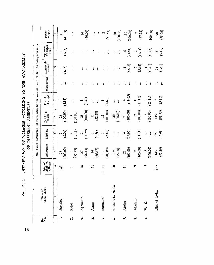
TABLE 1 Table 1 deals with the circ1ewise distribution of vilh.ges according to the availability of different
amenities in 155 inhabited villages in the district, such as educational, medical, drinking water, post and telegraph, communication, approach by pucca road and power supply. This table shows the number of vUlages where the above mentioned amenities are availa.ble with percentages to the total number of villages in each circle. The 100 percent of educational amenity is available in Satakha, Suruhoto, Atoizu, Akuluto and V. K. circle and drinking water facility is 100 percent in all the cir<.rles except in Asuto circle. In Asuto circle only 11 villages out of 21 villages have drinking water facility. and pe:centage of the same is 53.38 to the total number of villages in the circle.
10
Post and telegraph, communication and approach by pucca road facility are very low in percentages in all the circles. Some circles are not having these facilities at all.
In the whole district educational and drinking water facilities are quite notlble which record 92.26 percent and 93.55 percent respectively. Medical facility comprising 9.68%, post & telegraph 5.81%, communication 11.61% and approach by pucca road being 5.16%. 90 villages out of 155 villages in the district have power supply facility comprising 58.06 percent.
Even though the table shows very low per.::e'ltage of ap.t?roa0h by puc;.! roads, every village Ras got the approach by kutcha roads.
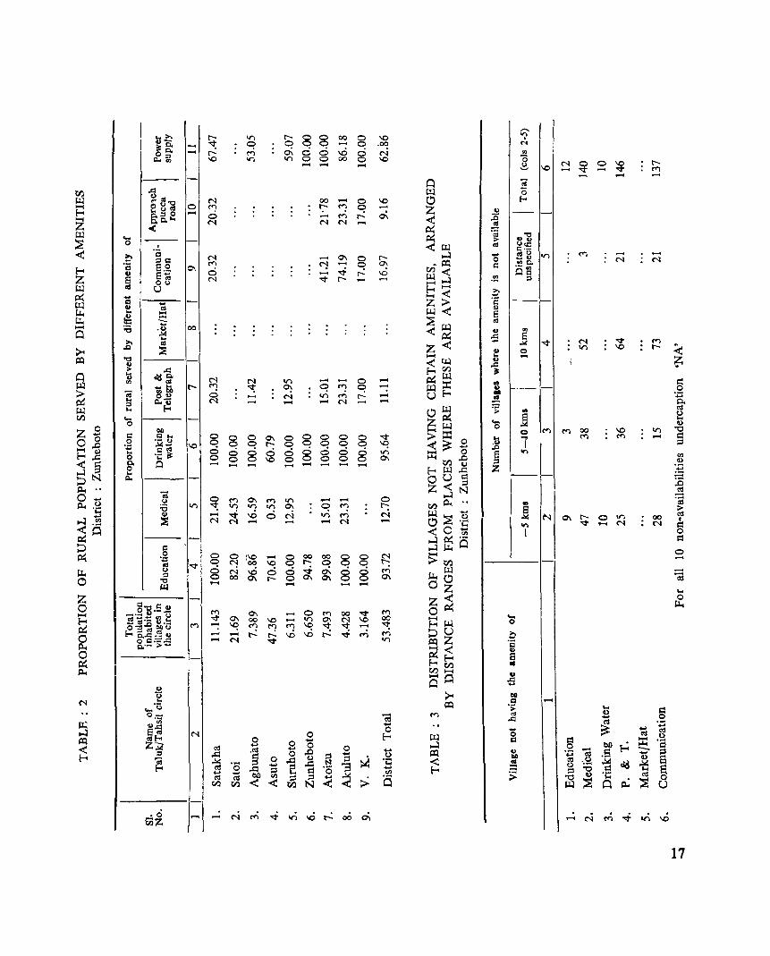
TABLE 2
Table 2 de~ls with the proportion of circlewise rural population served by the different amenities. From this table it appears that large proportion of the rural population are served by educational and drinking water facilities and followed by power supply facilities. Medical, approach by pucca road faci
lities are seen to be lowest in all the circles and also in some circles pucca road facility is nil. But every village has got kutcha road facility.
In Zunheboto district there are 155 villages with 53,483 population. Of th's 143 villages in the district or 92.26 percent of the villages covering total popUlation of 93.72 percent have got· educational facilities of one type or other.
Similarly, another 15 villages in the district or 9.68 percent of the villages covering 12.70 percent of total population have got medical facility, 145 villages in the district or 93.55 percent of the villages
covering 95.64 percent of total rural popUlation are served by drjnking water;, facilities, 9 villages or 5.81 percent of the villages covering 11.11 percent of rural population in the district are served by post and
telegraph facility, 18 villages or 11.61 percent of the total villages covering 16.97 percent. of population are served' by communication facilities, 8 villages of ,5.16 percent oi villages covering 9.16 percent of rural population are served by approach by pucca road and another 90 villages or 58.06 percen,t covering 62.86 percent of the total rural population have got power supply facility in the district.
TABLE 3
Table 3 deals with the distribution of villages not having certain amenities arranged by distance range from the places where thes~ are avai1~ble. As already stated in precceding pages, the district has 155 inhabited Yillages. Out of these 143 villages have got educational facility and other 12 villages do not have such facility within the villages but 9 villages have the facility within less than 5 kms and 3 villages within 5-10 kms.
So also 140 villages which have no medical facilities of any sort in the village itself, out of these 47 villages have the medical facility within the range less than 5 kms, 38 villages have within 5-10 kms, 52 villages above 10 kms and 3 villages have 'o/ithin the distance not specified.
10 villages do not have drinking water facility within. the village but have within the range of le~s than 5 kms. 146 villages do not have post an!i telegraph facilities within the village itself but 25 villages have within the distance range less than 5 kms, 36 villages have the post and telegraph facility within the distance range of 5-10 kms, 64 v.illages have the facility within the distance 10 kms and above and another 21 villages have got the post and telegraph facilities within the distance unspecified.
So also 137 villages which have no cOI!l~unicati.on facilities have within the different distance ra)o:lges a.s shown ;n the table.
11
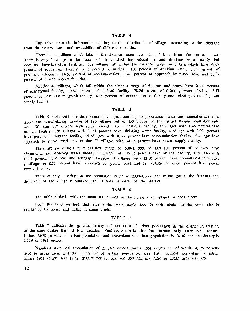
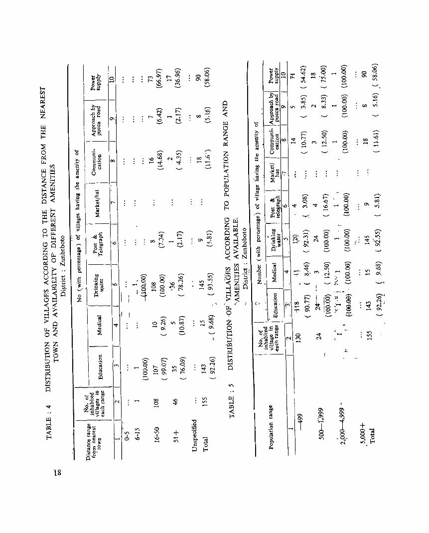
TABLE 4
This table gives the information relating to the distribution of villages according to the distance from the nearest town and availability of different amenities.
There is no village which falls in the distance range less than 5 kms from the nearest town. There is only 1 village in the range 6-15 kms which has educational and drinking water facility but does not have the other facilities. 108 villages fall within the distance range 16-50 kms which have 99.07 percent of educational facility, 9.26 percent of medical, 100 percent of drinking water, 7.34 percent of post and telegraph, 14.68 percent of communication, 6.42 percent of approach by pucca road and 66.97 percent of power supply facilities.
Another 46 villages, which fall within the distance range of 51 kms and above have ~.09 percent of educational facility, 10.87 percent of medical facility, 78.26 percent of drinking water facility, 2.17 percent of post and telegraph facility, 4.35 percent of communication facility and 36.96 percent of power supply facility.
TABLE 5
Table 5 deals with the distribution of villages according to population range and amenities available. There are overwhelming number of 130 villages out of 1§5 villages in the district having population upto 499. Of these 118 villages with 90.77 percent have educational facility. 11 villages with 8.46 percent have medical facility, 120 villages with 92.31 percent have drinking water facility, 4 village with 3.08 percent have post and telegraph facility, 14 villages with 10.77 percent have communication facility. 5 .villages have approach by pucca road and another 71 villages with 54.62 percent have power supply facility.
There are 24 villages in population range of 500-1, 999. of this 100, pecrent of villages have educational and drinking water facility. 3 villages with 12.50 percent have medical facility, 4 villages with 16.67 percent have post and telegraph facilities, 3 villages with 12.50 percent have communication faCility, 2 villages or 8.33 percent have approach by pucca road and 18 villages or 75.00 percent have power supply facility.
There is only I village in the population range of 2000-4, 999 and it has got all the facilities and the name of the village is Satakha Hq. in Satakha circle of the district.
TABLE 6
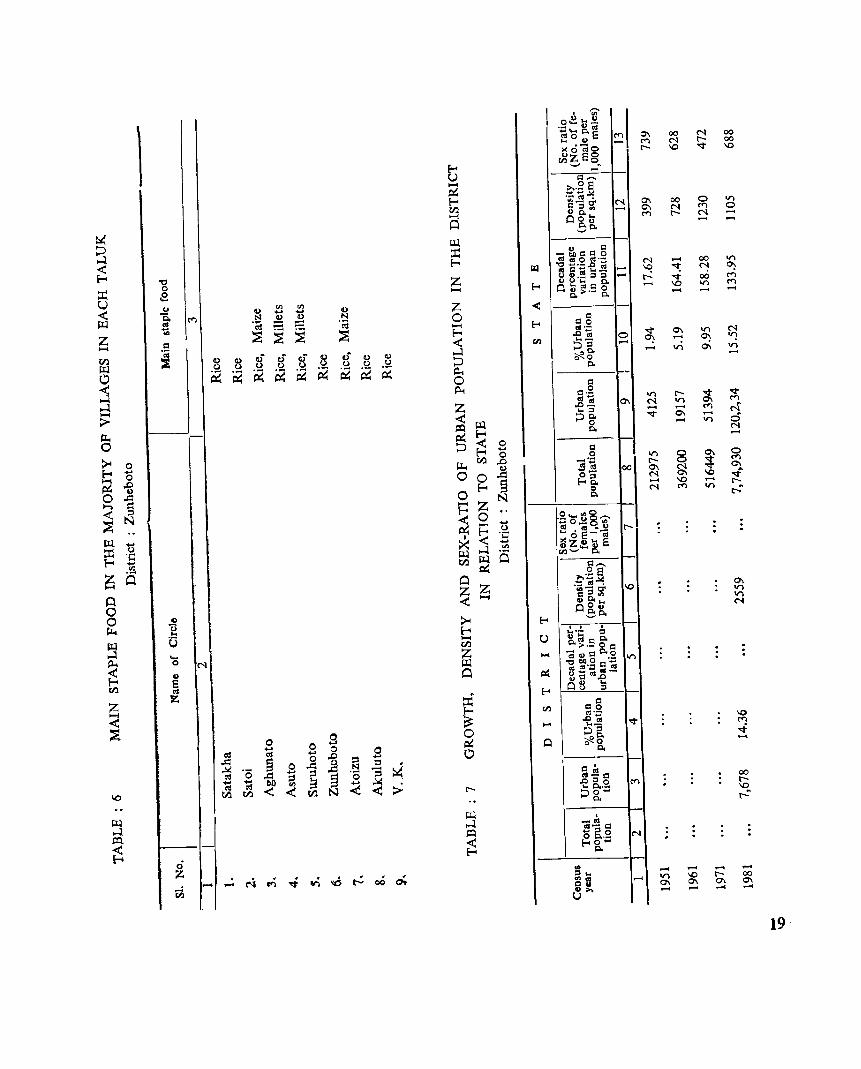
The table 6 deals with the main staple food in the majority of villages in each circle.
From this table we find that rice is the main staple food in each circle but the same also is substituted by maize and millet in some circle.
TABLE 7
Table 7 indicates the growth, density and sex ratio of urban popUlation in the district in relation to the state during the last four decades. Zunheboto district has been created only after 1971 census. It has 7,678 persons of urban population and percentage of urban population is 14.36 and its density js 2,559 in 1981 census.
Nagaland state had a population of 212,975 persons during 1951 census out of which 4,125 persons lived in urban areas and the percentage of urban popUlation was 1.94, decadal percentage variation during 1951 census was 17.62, <\e'nsity per sq. km was 399 and sex ratio in urban area was 739.
12
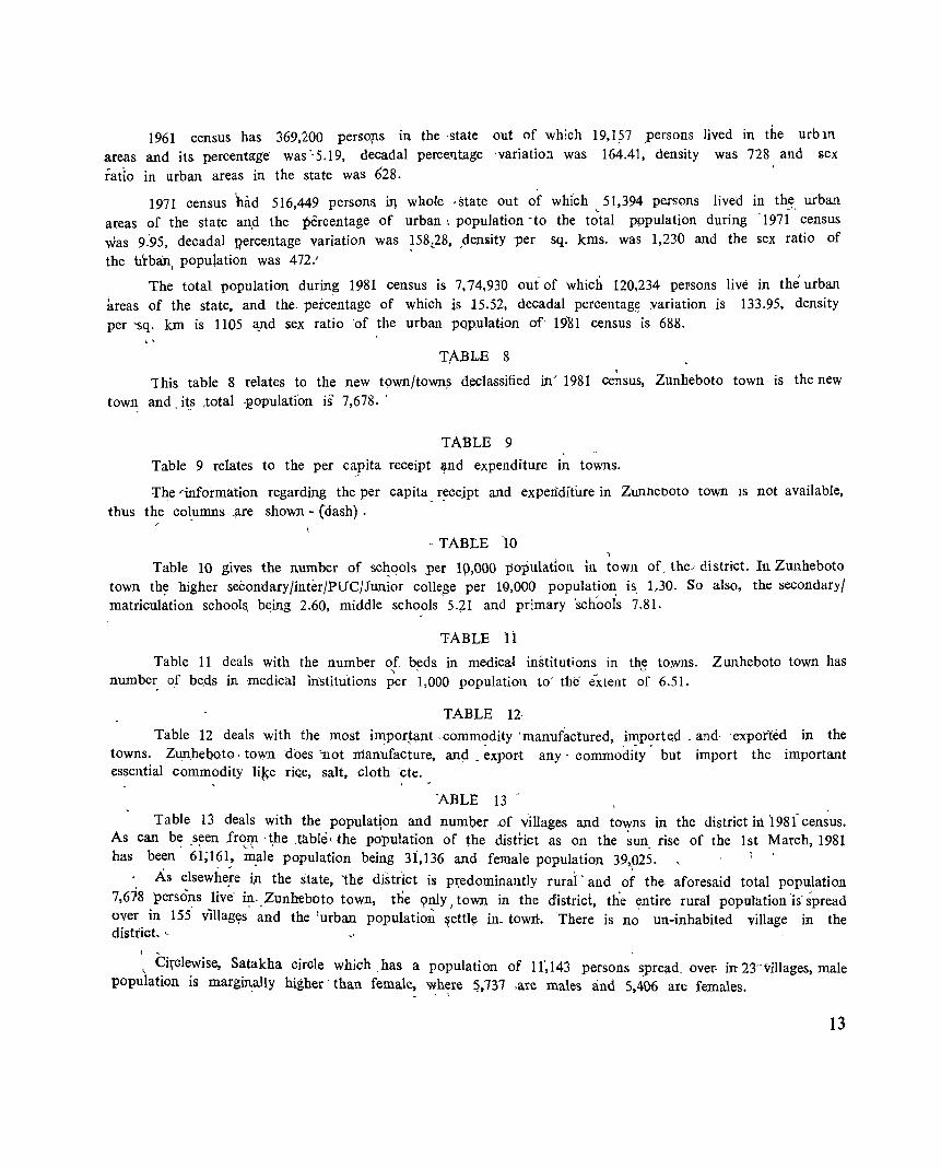
1961 census has 369,200 persolls in the 'state out of which 19,1?7 ,persons lived in the urbm areas and its. percent~ge was "5,19, decadal percentage 'variatio:l was 164.41, density was 728 and sex
ratio in urban areas in the state was 628.
1971 census had 516,449 persons ill whole ,state out of which ~ 51,394 persons lived in th5. urban areas of the state an.d the percentage of urban: population -to the total wpulation during 1971 census was 9:95, decadal l?ercentage variation was ~58t28. ,density per sq. kms. was 1,230 and the sex ratio of
the urban, population was 472.'
The total population during 1981 census is 7,74,930 oui of which 120,234 peFSOllS live in the urban areas of the state, and the. percentage of which is 15.52, decadal percentag~ variation is 133.95, density per 'Sq. km is 1105 ~nd sex ratio 'of the urban PQPulation of' 19'81 census is 688.
TABLE 8
1 his table 8 relates to the new t9wn/town~ declassified in> 198'1 census, Zunheboto town is the new
town and. it,S ,total ,population is 7,678. '
TABLE 9
Table 9 relates to the per capita receipt lllnd expenditure in towns.
:r·he'information regarding the per capita _ r_ecejpt and expenditure in Zunheboto town IS not available,
thus the columns ,are shown - (dash) .
.. TABLE 10
Table 10 gives the number of sc~ools per 10,000 popUlation in town oC theJ district. In Zunheboto town the higher seCondary/inter/PUC/Junior college per 1(;),000 population is. 1..30. So also, the secondary/ matriculrttion school!\ b~ing 2.60, middle scho?ls' 5.71 and pr:mary 'schools 7.81.
TABLE n Table 11 deals with the number of b~ds in medical institutions in th3 towns. Zunheboto town has ,
number of be.ds in -medical in'stitutions per 1,000 population to' the' extent of 6.51.
TABLE 12
Table 12 deals with the most impor~l;l.nt commodity 'manufactured, imported, and 'exported iIi the towns. Zun.heboto. to\Yll does 'not manufacture, and .. ~xpor-t any' commoclity' but import the important essential commodity li~e ri«e, salt, cloth cte.
'ABLE 13"
Table 13 deals with the population and number .of villages and towns in the district in 'I 98 t' census. As can b~ s~en frc~lfl ·~he .table. the p~pulation ~f the distfict as on the ~un. rise of the 1st March, 1981 has been 61;161 .. m.ale population being 31,136 and female popUlation 39,.025.
As elsewhe,re i)l the state, 'the di'strict is p.t:edominantly rurai' and of the aforesaid total popUlation 7,618 persons live' ~. ,Zunheboto town, the <;mly I town in the district, the entire rural popUlation 'is' spread over in 155 v1lIaglts and the lurban popUlation ~ettl~ in- towrl. There is no un-inhabited village in the district. ~
( ~
< CiJ,"clewise, Satakha circle which .has a population of If,143 persons spread. over- in 23" villages, male population is margill:ally higher' than female, where 5,737 ,are males and 5,406 are females.
13
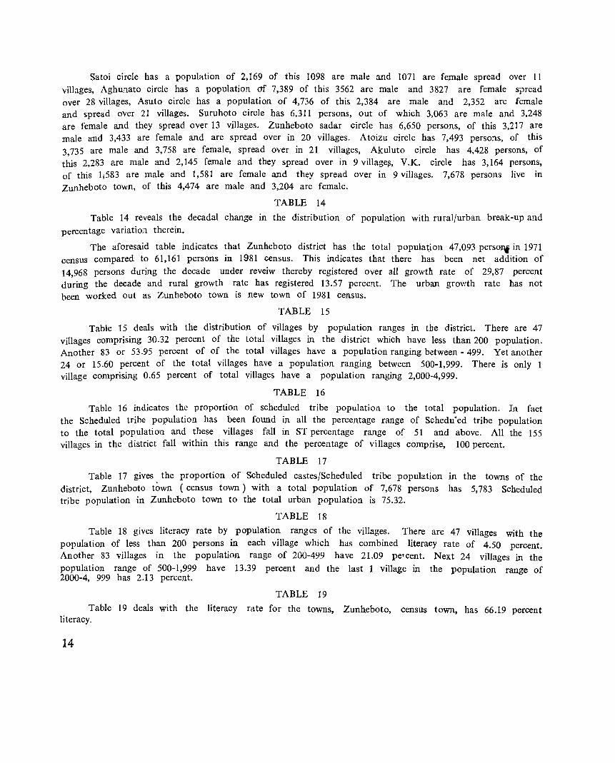
Satoi circle has a population of 2,169 of this 1098 are male and 1071 are female spread over 11 villages, Aghunato circle has a population of 7,389 of this 3562 are male and 3827 are female spread over 28 villages, Asuto circle has a population of 4,736 of this 2,384 are male and 2,352 are female and spread over 21 villages. Suruhoto circle has 6,311 persons, out of which 3,063 are male and 3,248 are female and they spread over 13 villages. Zunheboto sadar circle has 6,650 persons, of this 3,217 are male and 3,433 are female and are spread over in 20 villages. Atoizu circle has 7,493 perso:ls, of this 3,735 are male and 3,758 are female, spread over in 21 villages, Akuluto circle has 4,428 persons, of this 2,283 are male and 2,145 female and they spread over in 9 village~, V.K. circle has 3,164 persons, of this 1;583 are male and 1,581 are female and they spread over in 9 villages. 7,678 persons live in Zunheboto town, of this 4,474 are male and 3,204 are female.
TABLE 14
Table 14 reveals the decadal change in the distribution of population with rural/urban break-up and percentage variation therein.
The aforesaid table indicates that Zunheboto district has the total popula~ion 47,093 persoDf in 1971 census compared to 61,161 persons in 1981 census. This indicates that there has been net addition of 14,968 persons during the decade under reveiw thereby registered over all growth rate of 29,87 percent during the decade and rural growth rate has registered 13.57 percent. The urban growth rate has not been worked out as Zunheboto town is new town of 1981 census.
TABLE 15
Table 15 deals with the distribution of villages by population ranges in tbe district. There are 47 villages comprising 30.32 percent of the total villages in the district which have less than 200 population. Another 83 or 53.95 percent of of the total villages have a population ranging between - 499. Yet another 24 or 15.60 percent of the total villages have a population ranging between 500-1,999. There is only 1 village comprising 0.65 percent of total villages have a popUlation ranging 2,000-4,999.
TABLE 16
Table 16 indicates the proportion of scheduled tribe population to the total population. In fact the Scheduled tribe population has been found in all the percentage range of Schedu'ed tribe population to the total population and these villages fall in ST percentage range of 51 and above. All the 155 villages in the district fall within this range and the percentage of villages comprise, 100 percent.
TABLE 17
Table 17 gives the proportion of Scheduled castes/Scheduled tribe population in the towns of the district, Zunheboto town (census town) with a total population of 7,678 persons has 5,783 Scheduled tribe population in Zunheboto town to the total urban population is 75.32.
TABLE 18
Table 18 gives literacy rate by population ranges of the villages. There are 47 villages with the population of less than 200 persons in each village which has combined literacy rate of 4.50 percent. Another 83 villages in the population range of 200-499 have 21.09 peT cent. Next 24 villages in the population range of 500-1,999 have 13.39 percent and the last 1 village in the popUlation range of 2000-4, 999 has 2.13 percent.
TABLE 19
Table 19 deals with the literacy rate for the towns, Zunheboto, census town, has 66.19 percent literacy.
14
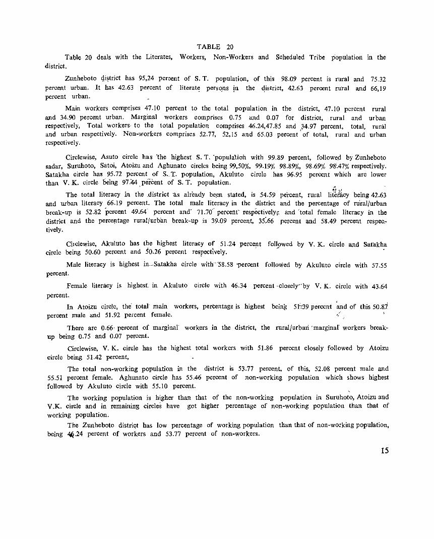
TABLE 20
Table 20 deals with the Literates, Workers, Non-Workers and Scheduled Tribe population in the district.
Zunheboto gi~trict has 95,24 peroent of S. T. population, of this 98.09 percent is rural and 75.32 percent urban. It haf> 42.63 percent of literat~ pers~ns in the qistrict, 42.63 percent r.utal and 66,19 percent urban.
Main workers comprises 47.10 percent to the total population in the district, 47.10 percent rural and 34.90 percent urban. Marginal workers comprises 0.75 and 0.07 for district, rural and urban respectively, Total workers, to the total population comprises 46.24,47.85 and }4.97 percent, total, rural and urban respectively. Non-workers comprises 52.77, 52,15 and 65.03 percent' of total, rural and urban respectively.
Circlewise, Asuto circle has "the highest S. T. 'populalioh with 99.89 percent, followed by Zunheboto sadar, Suruhoto, Satoi, Atoizu and Aghunato circles being 99,50,%, 99.19",,(, 98.89,%, 98.69,% 98'.47'% respectively. Satakha circle has 95.72 percent of S., T. population, Akuluto circle has 96.95 percent which are lower than V. K. circle being 97.44 > percent of S. T. population. .•
The total literacy in the ,district 1I.s already be.en stated, is 54.59 percent, rural liit&cy being 42.63 and urban literacy 66.19 percent. The total male literacy in the district and the percentage of niral/urban break-up is 52,82 'percent 49.64' percent and' 71.70" percent' respectively;: and 'total female literacy in the district and the percep.tage rural/urban break-up is 39.09 percent, 35:66 percent lUld 58.49 percent respec:tively.
Cilclewise, Akuluto ha5 the highest literacy of 51.24 percent followed by V. K. circle and Sat'akha circle being 50.60 percent and 50.26 percent respectively. ' " .
Male literacy is highest in.-·Satakha circle with"'58.58 "percent followed by Akuluto circle with 57.55 percent.
Female literacy is hIghest, in Akuluto circle with 46.34 percent ·closelyFby V. K. circle with 43.64
percent.
In Atoizu circle, the totat main workers, percentage is highest being 5 t:-39 percent percent male and 51.92 percent female.
c ,
and of this 50.8.-1
There are 0.66' percent of marginal workers in the district, the rural/urban 'marginal' workers breakup being 0.75 and 0.07 percent.
Circlewise, V. K. circle has the highest total workers with 51.86 percent closely followed by Atoizu circle being 51.42 percent,
The total non-working popUlation in the district is 53.77 percent, of this, 52.08 percent male and 55.51 percent female. Aghunato circle has 55.46 percent of non-working popUlation which shows highest followed by Akuluto circle with 55.10 percent.
The working population is higher than that of the non-working population in Suruhoto, Atoizu and V.K. circle and in remaining circles have got higher percentage of non-working population than that of working popUlation.
The Zunheboto distri'lt has low percentage of working population than that of non-working popUlation, being ~.24 percent of workers and 53.77 percent of non-workers.
15
.. » 0-:;1:0. .... 00. .... Il.~
....... ....... ......... ........ ....... ....... ....... ........ .... ..... ~
0 00
...... 0
0 8 I' 00
0\ 0 1.0 00 0 or: 0 ...... r-- 0 ~ q ...... 0 N g N g .....: c) r-- ...... IX> ~ on 1.0 I' 0 on ._. ._. ._. ...... .... ........ .... ....... ........ ........ ........ -_
>< !-< ::l H CQ <: ..:I ..... <: >
'" -5!i .~ 'a os (,1'0
0:1«1 0 0 .. 0.0 .... 8 15;>. ... as <..0 .,. s:l -.~ . 0 'a s:l
~ :10 0\ c·_
0 ,~~ oS u
....... --.. ,-. ........ on ..... .... 1.0 ..... ..... It') ex: ..... .... 00 "<i- ..... .... v) ........ N .... .... ........
'-' '-' ._.
<;0 ....... ,-." 1.0 ......
..... on ..... ..... lrl on .... 00 ~ ..... ..... "<i-
N on ..... <r) <r) ..... ..... ._. ...._. .._, .._, ._.
~ .... -0 -;
III :r! F-o
0 !-<
t) Z til H
0 ~ ~ E=: 0 ..... U Z u ~ ~ ::E
~ tll III f-t t) Z ~ ~ ..:I ~ ..:I r.a H ~ > ~ ~ S 0
~
Z 0 0 H !-< ::> CQ -0::: !-< ell 1-4
0
II) ..c: .. ~ 0 0 00 8 ..14 .... .. as 0 ~ II) -c::l ..c: 0 a'do, ~ '" ...... I' ",co "; 0'"
'" Il.~ ..c: ~ -co co ~ *== Soot .;;: ..I4E 1.0 Q .. C) ·c:::=: ..c: ... 0 .... 0 -.-,
& ~ ~ ;a on 4,) 41) (,)
~ ~ 0. --5 s:l 'ii ,9-'-' ~
0 (,) ~ :3
Z '0 III
!--
.... '0 '" o~1I) ._ co .....
ci~~ Z..c:·_ . 9 >
......... <r) ........ ........ ........
......... ..-. ........ 0 ..... ..... ..... <r) r-- 0\ ~ 0\ 0; .... 0; 0\ ex: ..... ..... ..... "1 .... \0 .... "<i- .....:
..... ..... ..... <r) ...... .._, .... ..... ._. ......., .._, ._. ._. ---...-.. ....... ......... ...-.. ...-.. ......... ......... ......... ......... 0 ....... 0 0 0 0 0 0 <r)
0 0 0 00 C? 0 0 C? 0 "1 .... 0\ .... . ..... 0 IX> 0 .... M 0 c)
..... c) 0\ c) on NO .... c) N .... N ..... 0 N N 0 ~ ('<)
0 0 V) 0 0 0 0 0 ..... 0\ ..... 0 ..... - .... .... ..... .... .... ._ ._. .... - .._, ._. .._, - --,....:.... ......... ,...... ....... ....... ....... ,......, 0 00 0\ G' 0\ V) - co
N t-: N N N .... I' 1-4 ~ ~ 0 .... .... V) ~ e 00 "<i- ...f r-- 0\ .... 0\ .... .... .._, .._, ..... ..... ....., - ....., .._, .....,
....... ....... ..-.. ,......, ....... ....... ....... ,......, ,-... 0 ..... ..... r-- 0 0- 0 0 0 \0
..... q 00 t-: r- ~ ~ ~ ..... q 0\ C? .... 0 0\ C? 0\ 0 ('<) N N 0 N .... .... 0 .... N c) 0 c) ~ ~ 0 N 1.0 1.0 0
V) 0 0 0 ....
I' 0\ \0 0\ .... . - - - .... ....... ..... .... .... .._, .._, .._.. "'-' - -
..... ..... IX> .... ..... 0 .... 0\ 0\ V)
N .... N N .... N N V) ..... 1
-.... Ul .:..:l CQ <: f-t
-~.;;; o..c: os of-< 8- N ",..14
Z~ f-<
a.. 0:1
"0 0:1 -ell '" ..... 0 0
0 0 ... f-t - 0 0
'" '" ... .D -oJ
~ .§ 0 ::s - ~ 0
0 '§ 0 ::s ..14 '0 ~ ~ ] .t:;
'" ....
Q '0 .... - ..... < ~ .... '" '" 0:1 ::s ::s ..... > a til til ~ tI) N ~ ~
-.0 .....
ri3Z .... N f"i "<i- .,.; ..0 .....: oe ..
16
... >. 0-~Co oCo Cl.~
---.t:J ~='1j 0°", "'<.)0 !5:g, ... ~ .... ---0 .
t- '0 ::l~
'0 e.~ u e~ e 0<,) til U c; ... u oS ...
t£ ~ ;a .0 ..14
>. ... 01
.&J ::E '0 u
~ .CI .'d Co
'" OS
e tltiJ OU
::s Cl.~ ... .... 0
CO ~ C ... .g ._ U
..14-~01 ... .;;: ~ 0
Co ~ 0 t;:.
C; <.)
:a 0 ~
~ .S ~ <.) ::s
'0 III
c]Co _.9, .-'0 5 ~ . ..: ti.~ O"3.g co <.) (,-<Q..CI~U
o c:;:;".t:J Q.0_ > .....
J
~ ... ,-°0 0:;::
'" U.CI 80S ",E-< Z~
::s C; (,-<
.0 filZ
..... .....
0 .....
0'1
00
~ ....... .....
b g g 00 g .~
~gg~g ~ .......... .....
..... -; ..... .....
t) ·c .... en a
.~
~ '2 --u 8 oS
o -5
.... o
to
~ .,.. I
.....
..... N
00 N
... o ~
17
... >. u-~o. 00. p.,jl
.--. ,-.,. .--. t b .--. ~ .--. .--.
r- \Q '-0 N 8 ~ \0
0 M ~ r- 0- 0 C? iil'o. 0 ~ ~
00 .... ~ 0
- r- \0 ...... \Q 0- 00 00. ..... '<:t
,.,.; 0 00 \0 ~ on p.,~ on r- 0 V')
.._" '-' ..... ......,. .._"
>." .001 ..cO u'" 01 o 01 .... 0 0.0 0.:3 <0.
..... . 0 '2 d
~ :3 0 8,-
'2 8;; ... o u e u <II
4)
-5 tlI) ~ d ~
'S: U '" ..IoiI .c ... as '" :::E ~ ~ ';;
: '6 oct(! .g_ oS
.-.. tn~ Q) 0_ 01) p.,~ cc E
>." - .--. c;:;- ,.-... ~ A
.0", V') 0 'fie 00 M C?
.....
~ ,....... ~ ;z: III <II 0- iii M N 00 .....
8 00 .,.;
r- ~. r- <: g~
0-.....
N 00 OJ') o.::l
..... \0
'-' .._"
.._" .......- ......... ~ '- ~o. C
0 ----. Z ~ 'a d r::' 0' ...-.. ,-..
<: '2 :30 8 .....
Clp '<:t r-: V') ~ ~
Q) e·- N g 00
e £3- ..... 0 C'"l ..... ..... ,-.. ---- '" 0:1 - .... -00 I;) Z u ...... .._, ..... \0 M ~
u ---00 \0 N 00 0 -5 1-- ..,f ..,; ,~
-..... f-; ClIl :2~ <t d
....:t 'S: ... '" r::-'" ..s.e
',:::) '..c:: ::E Po. 4)
0 ~ --- -Po. --- ,-.. ,-....
'S: Od-a ........
r-oo r- 0 -0 .... 01 C? oC1 0 <X?
f-; 0 ... \0 '<:t ..... '<:t \0 ...... 8 0-_bO or) "'0)
.'""' 0- .:!-0 ~
0) p.,~ ....,.,: .._, bO
Z '" ..:I E ...... t:Q 0 --- ,-.. ",...... A ~ co ~
'<t r- <: .... .5 ..... 0- , ",......
0 .... 0 iii
00 M 0- ~ ~ ..:I .0 0) .~~
0'. ('<) '<:t 0 0 V"l iii
\0 N 0. tr)
~ ......
!:::.. tr) 0 -Cl) N N 0 0 ,. '<t "N
.......- __. <: .l:l .;:; iii' ' . U
0- 0 0 ...... 0-
U :> I=: -5 A' ..... .... ~ .~
'-' .......-
<: <: _--1-
8 .... 4)
'" :; tlI)
,S t '~ ..IoiI_
I:: '" '-' '~ :;::-0 A Z
-; u
:0 u
~
---
m I:l .. r-.. .--. ~
,-.,.
m Ll.j .~~. <.>
\0 0 00
---- :~ .... .0 :0 '<:t -. '<:t V') \0
,....... .--. ,-.... t-::o e 00, M N ...... V"l 0\
-8 ~ \0 tr) .... U '"7" 0 -C"! V; Z
.... :3 ~ ....... .,} 0
ICl -d 00 \0 V') <: <J) z .....
0 0 .('1 00 '<t M ..:I (5 J ........ ..._, (. '-' -" Iq 0 r- 0- Ll.j ..... ....J ::E .......- >' d
<: .<2 ,.......
k ,......
p I \0' r- '0 r "
, ;, t;. ~ 00 r- IC? M N,
~ u .... 0 '0 ;- '¢ N'
<? ::l 'T' 0\ I~ r 0-'0
..-.. ......... ....,.. l.1l .:r:.. \0 r- oo
..,.., -'<:t 0 N tr) 00 V') \0 Z ..... ci, 0 0\ 0 ,-~.E ~ ...... - " .._, f.-< 0.::: 0);; iii
0 ~ .....
~ • .0 bO'" N ~ iii
o"'..s.o .....
.t:Q Z-a::: ~ ~ .- :> U ,
d ,2-~ 0 :3
"
.-.. ..-.. ,,-.. ~ 1-'
..::> r- 0'1 til ('<) 0 t- o -q M C"! >-<
0 ci, V'l Cl 0 M \0 '<:t N 0 0- r- 0'1
l.1l ..... --- '-'
V"l
c...... "O.S fsJ O~l'I.)S:: .:0 ~ e
O"'as..c .z..c- u .s~ ~
u ClIl-
1
I:: '" cc~ .... '" 4) U d ..,1::",
~ 52 't; Or
is''::
N 00 \0 V') ~ 0 '<t V'l
t:Q ~ <: c:: 0- 0-
1-' <II 0'1 0'1 0'1 ... 0'1 0'1
"0 0'1 I ~ ..;
.() c:: '<:t ...-<
V') 0 <.t:: .S! I I I + iii ..... II') + '0
I I I () E 0 0 0 ta ...... 0 \0 \0 - p.. <;;
0 0 ~ .... ...... iii '"
::I II') _ 0,..- 0
I=: .... 0. t-< 0 0 N &r\
',:::) E-' p.,
18
\ E-< U ..... et: E-< III ..... 0
~
3 ~ ~
< E-<
i-t "0
0 ° z
a .....
-< ~ u '" '" u Z .... ..... ~
0. r<'l .~ ~ U N 0 '" - ''; <;;, «l :-=
~ ......
Z c:l ~ ~ ~ E--
...... .; -< III ::Il u 8 u u u .2 u u u .-l
~ u u .g u u .~ u ::> Cl ~ pa ~ p:: pa p::; pa p::; pa ~
-< 0 ~
.-l
.-l - ~ ;;> 11..
&:Q III
0 p:: i-t
::> -< E-<
:>-t 0 E-< ..... Il.o
III
0 - ,D 0 0
et: u 0 .a 0
E-<
..... § -< ...... z
~ N ~ 0
r:z:::. -Ill. ....
E-< X -<
~ .g .-l i-t .... Pl
If.) III III
~ is ~
0
A ~ Z ...... 0 0 C>
tL. C3 >< ... III U
E-< ......
.-l III
.... @ p.. ° 'N
-< C)
E-< 6 0
III os
~ z =i
-< ~ ~ 0 S 0
«l ..... 0 0 0
et: CIS ....
~ Cl .a ] 0 ::s ....
~ ~ .a ~
::3
~ '0 .t:I -= «l ;::l
~ '0 ";;l .... Ill) ~ ..>::
«l en ~ :>
\0 III III -< -< fIl N -< I"-
~ Ill. .-l
.-l &:Q_
&:Q
~ -<
0 E-<
Z
~ ~ N Vi .,; .0 lid ~ 00 cit
, ';;;'
~I oe'-'4~ ._ 0 oj
~'O ~e ><0(;0 ~ZEg ._, . -=,-.. :;..g E
._ oj~
~~i N
o go!3 .....
80.
0'1 0'1 r<'l
I-
-t>oc:=§ !Xl
~ !.2_g·~ -«sCt;J..I-~ ~h::::;::1 ~ .....
['-0 o &~.s 8-
N ~ I"-.....
< ['-0 =§ ",._
,o~ 0 en ... .!. p::s .....
~o. o °
"<t ~ .....
0. -r::l
c·8 "'- 0'1 ,o.!. ;;~
°
lrl N ..... "<t
0.
0 ..... 0 ,D u .a
~
I-r::l
° -'_ oj--oj 00 0-['-o~
0 0.
lrl I"-0'1 N ..... N
.....
.g I-< ..... '" is
.2'5 rJ 8'-' ~ ca .. ~ I"-"'08--; ~ze'<lE en--- 0.
c:l,-.. I-
»g~ ::: cS • \0 ",- co c::s", 00. ... 0°0
['-0 .eo.
" , .... _ ::s C,) ~a c 0. .... _ ° C ... d C) r::l 0.0 lrl
~ ~.g c·~ ~ ()-oj.-
..,c:l ,0 0<1> ...
['-0 () ::I
rn c§ Ol'-
.... ~3 V ::>::1
0 ~g. 0.
I I-tl' "'.!!c:l ,0::10 r<'l 1004 Ct ...... ::>0-
0.
I -oj oj- = .... ::so N 00.._
['-00 ..... 0.
<It ::S ... "'oj ..... c:lu ~ ....
00 0 N ('t)
l"- N .....
..... 00
~ ~ "<t 00 \0 V") .....
0'1 lrl
-: 0'1 V") 0:..
I"- ~ V") ..... I"'l 0'1 ..... ..... lrl
g 0'1 "<t
N "<t 0'1 \0 \0 ..... ('t) lrl
00 00 \0
lrl 0 .....
lrl ~ I"'l I"'l .....
N ~ lrl .....
V I"'l
N 0 N .... 0 ('t) 0'1 ..; l"-t-!'
19-
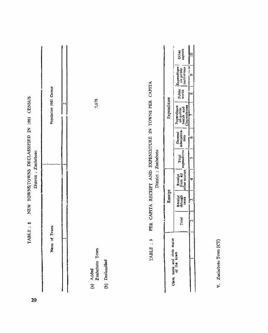
<1.1 ::l <1.1 Cl ..
~ U ...... ~ co
N 0\ ~ .... Z -- r-
Cl ~ .g U ..!!! ...... ::l 0. 00 ~ 0'1 ......
Z --_ ..... 0 UJ ...... ~ ...... til ~ 0 < -...:l 0
.0 U Q)
~ .d 0 §
N ~
o ..... o ~
~ ~ '0 0 ·c ..... e.. en
~ is z ~ 0 Eo-<
~ ~ Z
00
.... p.
.Q o....c fA
I ~ ._ g?o
!~ 80 x Q~!.
I p:;-5
1--"3 N ~ 0 ~ ..
~ ~ 0 ...:l ~ . ~
I---~-
.... .-. ~ 0
0 8 as Z ~
Eo-<
0 "g - ~ 0
'B] '" '" o:S "5 '0 § Q) "0 0 <N
--. <1.1
Eo-< ::l
U B -'" ~
()
·s = 0 ·0 ~
Eo-< 0 ...... 0
"0 ....
.... "'u 0 "'.c: ~
0 .....
§ 8 ... ",0
= N .;;
'" .!!!. ,..... --. .D o:S -- :> u
I I
20
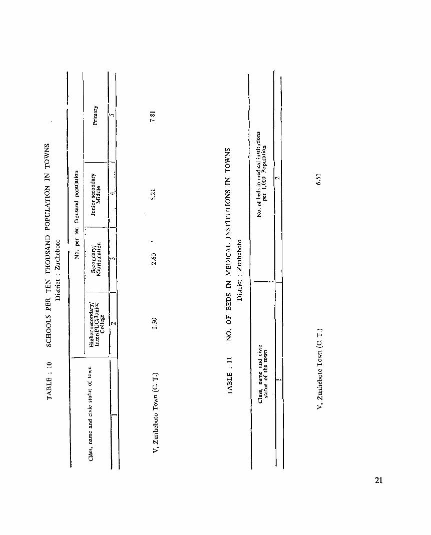
>. .... ttl ...... 8 V) 00
.;:: Il<
t-
'" c:: .S
ell Es:= z tf.l . .::: 0
~ Z ",.-
c::~ ~
. __ 0 _::I E-< 0 0:10.
.'::!. 0 c:: E-< "Oil<
Z 0 >. 0) ...... .~ .... Z .~g . C'l "! ...... ttl S
"0 _, \0 Z au
0. 0_ : ..... tf.l "' ..... 0 0 u"O '<T C"J 1S~ 0. <1>"0 Z ...... "'.- I£) ~o. E-< "0 6~ 0 < c:: ...... 0
....:I 0:1 ·a E-< ci en ::I ::; ::; ::I .... Z 0 E-< ~ -s 0 H E-<
~ ,1:1 tf.l .2 Z
0 .... H
Z 0 <I> c:: 0 .... 0. ....:I .... < 0 -0 0
,D >..- < ,D ell :ci .... -<1) ttl 0:1 0 U <1) ::; ..s:::: Z "0- ..s:::: c::8 !"'l 'c: .... 0 R 0 Q
;::l 0·- C'l ;::l ::r: u .... W N J5~ N E- ::E z .... z ....
0 0 W ·c .... ·c E-< .... ....
CIl CIl
a ell a ~ 0 w -... w >'0 ~ .... - &:Q ttlc:: ell
"O::I u ~ Q .... Of) 0 ....:I 8U.2 C'l «: 0 0 ~::>o ......
0 te:.u " ::r: 0 ~ ~ ... z u Of)~ U .- I:l
tLl ::x:: ..... u .__, :E c:: Q u ~ ~ ..... "OB ...... 0
0 au I:-< a ttI~ 0 ~ ..-.. >il
0 .... .... w B ~ ....:I S .... 0
.... m O ...... ,D ....:I 0 U
&:Q a", <1)
&:Q < viE ..s::::
'" S < ::I ..._, E-< ",ttl
E Q III .... E-< -'" N
'" ~ u u 0 :> .> E-<
.<3 ..... 0 ..... "0 0 a ,D m <1)
<I> ..s:::: S Q
01 ;::l I:l N .n >~ '" <OS a
21
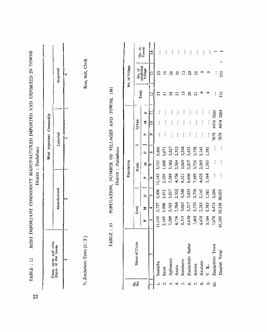
I ...:'" oc:: til ~
""" .... ....
Z o 0
~ ZE-<
.a 0 -0 I-E-< [5 <I)
CIl "0
Z 't:1 ~
'-<1)<1) <I)
_. 0:::: CIl <"'l ....., t: • ..0 '" e
<"'l .... 00 .... 0 .... 0\ 0\ on 0 '<t «l ;> 0"'= N N N N N on
0 Po til .... Z..c::·_ u.:! 8 a;, • 0 .S> E-< .... 0 0 ~ ~ .... Z 0 00 0... 0\ C; <"'l .... 00 <"'l 0 .... 0\ 0\ on >< - 0 N
N .... N N N N on u.:! lZi E-<
0 Z Z - ~ ~ -- 0 '<t '<t
0 .r;. E-< ~ 0 0 N N
u.:! ;a 0 <"'l <"'l
E-< 0 Z c:: ~ '<t '<t p::: 8 oS 0
~ ..0 t"- t"-
O S ... '<t '<t j:l., 0 0 '<t '<t
~ U til
't:1 u.:! Pot 0\ 00 00 ....., 1:: .& 0 t"- t"-
O S ... <'I ~
\0 \0 0 t"- t"-.... Po 14 0 K ~
p::: .§ ll.l ~
~ 0 > 0 \0 .... t"- N 00 <"'l 00 V) ...... .- ..... 0 t"- N V) '<t <"'l V) '<t 00
f-; 0 ... 0 ~ 00 "<:j- q 00 M N "<:j- t"- ...... V)
U .0 '" ~ .0 v) r<)"<'i Ml~ r<)' N <lJ' 0 a;, .... ...... < .a ~ 0 .a ~ ~ ~ c:: t"- oo N "<:j- <"'l t- V) M <"'l
::> ~ ~ ~ .8 e ~ <"'l 0\ \0 00 \0 N M 00 00 N N t"- r- q Vl M 0 t"- N Vl
Z w E ;:s v) <'i r<)' r<)' r<)' <'i ~ -- - ~ ..:: ...... <"'l ......
:::s ;:s
~ ..... ..... Po 0 0 0 M 0\ 0\ \0 ...... 0 <"'l 00 "<:j-'e ::> ·c Pot Pot \0 "<:j- \0 00 <"'l ...... V) 0\ ~ \0
;;:... ..... Z ..... - ...... M t"- ..... \0 "<:j-en '" !-< a (5 - N r-: .:f v:) v:) r-: ..,f M
...... Z ......
0 "0 0 <) 0 \0 .... r- N 00 M 00 V) ...... "<:j- V)
~ .... ...... 0 r-- N V) "<:j- <"'l V) "<:j- 00 0 N ;:s E-< "<:j- q 00 M N "<:j- t"- ...... V) N 0
~ ts ~
~ V) v) r<)' <'i r<)' r<)' r<)' N r<)' 0
~ N - ...... 0 ;:s ~ ..... U
Q ::> t"- oo N "<:j- ..... t"- V) ..... ..... "<:j- \0 oS
~ j:l., c; ..... 0\ \0 00 \0 .... M 00 00 t- M
~ "<:j- t"- q V) ..... 0 N t"- N Vl "<:j- .... E-< 0 0 v) r<)' <'i r<)' r<)' r<)' <'i . .:f . Z j:l., - - ......
E-< ..... ~ ..... 0\ 0\ \0 o· M 00 "<:j- 00 ...... E-< ..... "<:j- \0 00 M ...... V) 0\ N \0 t"- \0 p:; Pot ...... ...... M r-- M \0 -.t "<:j- \0
0 M ...... N t"-" .:f v:) v:) r-: .:f r<)' r-: ...... j:l., - ...... \0
~ ...... u.:! E-< ---- ...:I tI.l ~ ~ 0 Q
~ ~ <I)
~ :~ fn C] .... I=l Q Q .... c<S 3: "O~ (5 '"0
~ C<:! 0 ~ c::.8 3: '- til E-t
'" 0 0 N .... 0
<I) E-< <I) 0 0 E-t N o..c:: .... 8 0 0 ..... .... ....... s- o <IS .... 0 0 0 C<:! .... "' .... .... Z .a o:! 0 .0 ..... .0 -0 c::0 0 § a;, ~ ~ ~ a;,
.0 ..\4 0 .a N ·c 14 '0 .... ;::s .a ~ .a
• ell Q.) C<:! .a ~ 1=\ '0 ~ ....
~ "';:S .a .... .... ... ..\4 '" "'- o:! C<:! bJ) en ;::s ~ .... ;> ;::l i:S ~ '" <IS ~ til til ~ ~ til N ~ ~ N
~ Urn ;:l
N ;;: .0
~ N c<) ...; <ri -.0 r-: 00 ci.. 0 Gi5Z ......
22
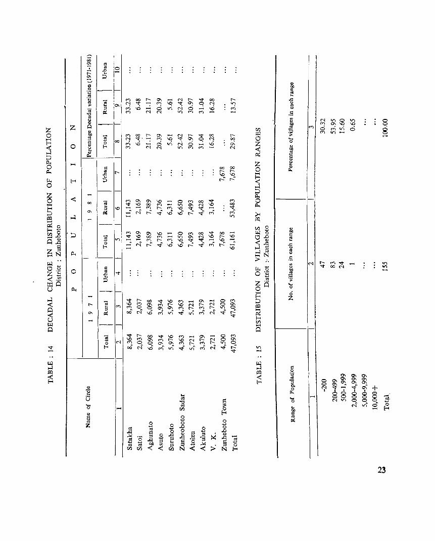
-00
'" c 0 , '" - .D
r-- ... '" ::J
() Ol)
'" ~ ...
~
t:I 02 --~
<"l 00 r-- 0'\ ...... N r-- ..,. 00 r-- ..c f"J ~ .-; <"l ~ ~ 0'\ q f"J v: (.)
0'\ '" <"l \0 ...... ci tn N 0 ...... \0 <"l .,
<"l N N tn M M ...... .5
0;::; -; <II
~ ... :; ;::J
"0 ~
'" N tn 0 tn ~
., ~ M 0:- ~ ~
1:1} M 0 M tn 0 8 III .:;: M tn
M 00 r-- 0'\ ...... ~
r- ..,. 00 r-0 -f"J ~o .-; M ~ 0'\ q f"J OC! ....
00 ci Z 0 <"l \0 ..... tn N 0 ..... \0 0'\ ., <"l N N tn M M N <C Ol) ..
A:: Q
<II U .,
~I z 0 Q) bI)
~ c "0 '
0 Q) Eo-< u ... .,
Po. ()
Z (.) ... 00 00 0
Q)
t-- r- r-- Po. \0 \0 E: t-.:" t-.:" <C
..... C <II
.D ... r-< ::J
...:I
~ <"l 0'\ 0'\ \0 ...... 0 M 00
..,. M 0 ..,. \0 00 M ...... tn 0\ ~ \0 00 tl.t
\0 ...... t'l r-- M \0 ..,. ..,. ..... N ~ ..,; ..0 ..0 ~ ..,f C') C') >< ...... tn
t:Q
, --.... -< 00 -; ...
;::J
'" ~ ...:I ....
--1:1} 0 Q)
III ..... bQ <"l 0\ 0'\ \0 0 M 00 ~ 00 ...... 0 Q ..,. \0 00 M ...... tn 0\ N \0 r- \0 0 .D «I tn ...... 0'". r-- M \0 "<t- ..,. ...... \0
<C <I) ...
..... N ~ ..,f ..0 ..0 t-.:" ..,f C') t-.:" ...... ,.q ..c ..... \0 ,..J ~ (.)
...:I :::I ~ >-J N
oS :> .. '" N r-- M ..,. ..... tn
li.. ..... Q) "<t- oo N VI U 011
V 0 ·c ~ ..... '" os
z a ..... 0 0 ..... 0 r-< z ..,. r-- 00 "<t- \0 M ...... 0\ ...... 0 M ::J \0 M 0\ M r-- \0 N r- N 0 0'\ t:Q <"l <') 0 0 0\ 0\ M r-- <') r- V) 0
00 N ..0 C') or) ..,f C') N ..,f ~ ......
V) A:: ..,. r-< 1:1}
';:J -; "0
Eo-<
tl.t
'" 0 «I .D ... ::J
tl.t --.... r-- d ...
;::J
'" ~
.... -- ...... 0 ..,. r- oo "<t- \0 M ...... 0'\ ...... 0 M
\0 M 0'\ M r-- \0 N r- N 0 0\ N M 0 0 0"- 0). M r-: M r- V) 0
00 N ..0 C') VI ..,f V) c<) N ..,f ~ tn ..,. .-<
-; "0
Eo-<
Ul ,..J c:l t:Q .'2.
0\ <C ~ 0\ 0\ 0\ 0\ 0\ r-< '"3 0 0\ 0). 0'\ 0\ 0 0\ 0. N "<t- ...... ..,f 0\ + 0 I I I I I Po. 0 0 0 0 0 I-< ...... 0 0 0 0 0 -ell ..... ell-
'"0 ~ 0 N V) 0 0 0 ..... cd N or) 0 0 ...... Cf.l 0 \i; .-< r-< Ol) r-< Q
0 «I ..... 0 ~ 0 0 0 +-' ..... .D 0 0 ell cd .....
,.q = 0 0 ::l ..... .D
0 ,.q <I) :::I ~ <I) ,.!>( ·0 :::I ,.q N "S ,.q -o:s ,.q ..... :::I ·0 ell ..... ..... :::I I-< = ~ .....
ell o:s 01) '" :::I :::I ..... ,.!>(
:> ::l 0 1:1} Cf.l <C -< co N -< -< N E-o
II)
C1 ... iJ ..... 0 ;)
S <II
Z
23
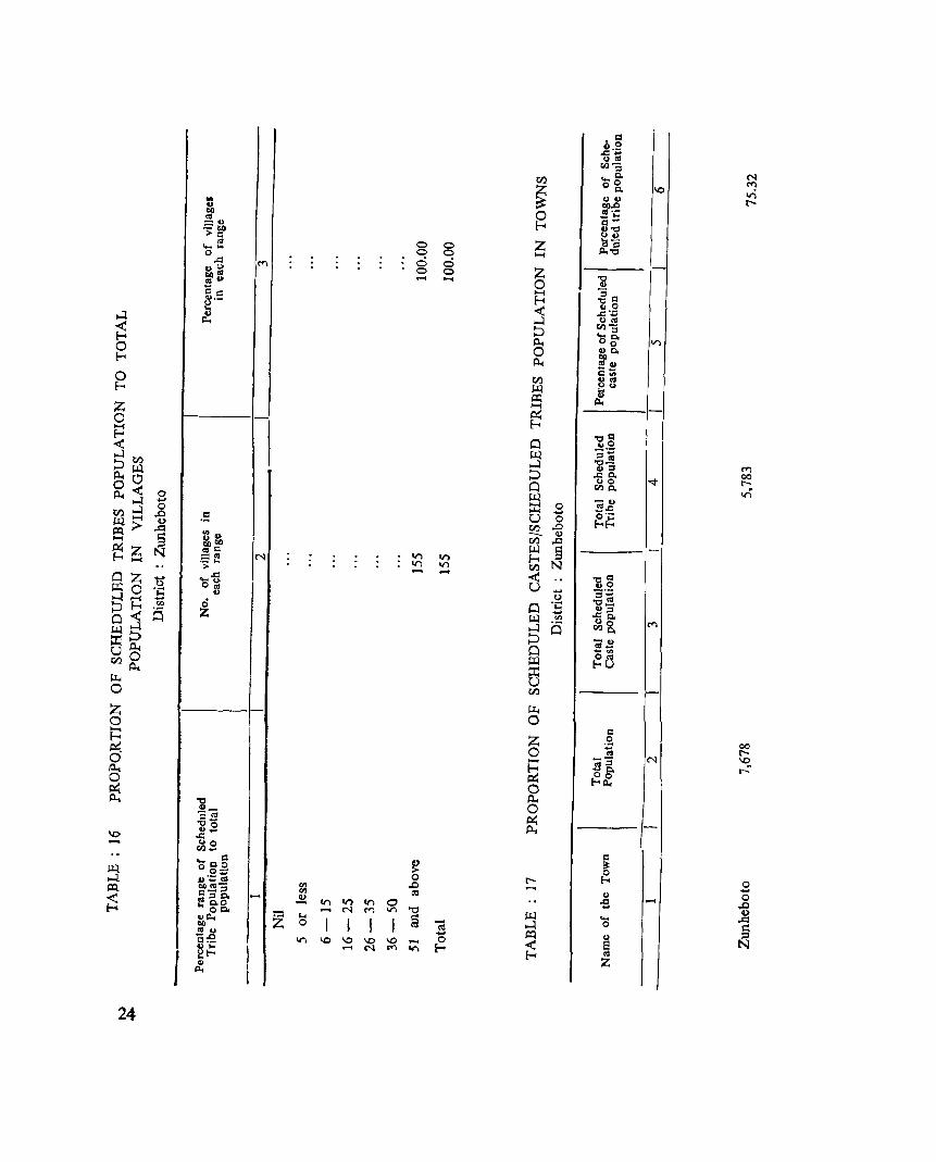
I 24
....
g o o
o o g ....
.... o
8 ~
z
....
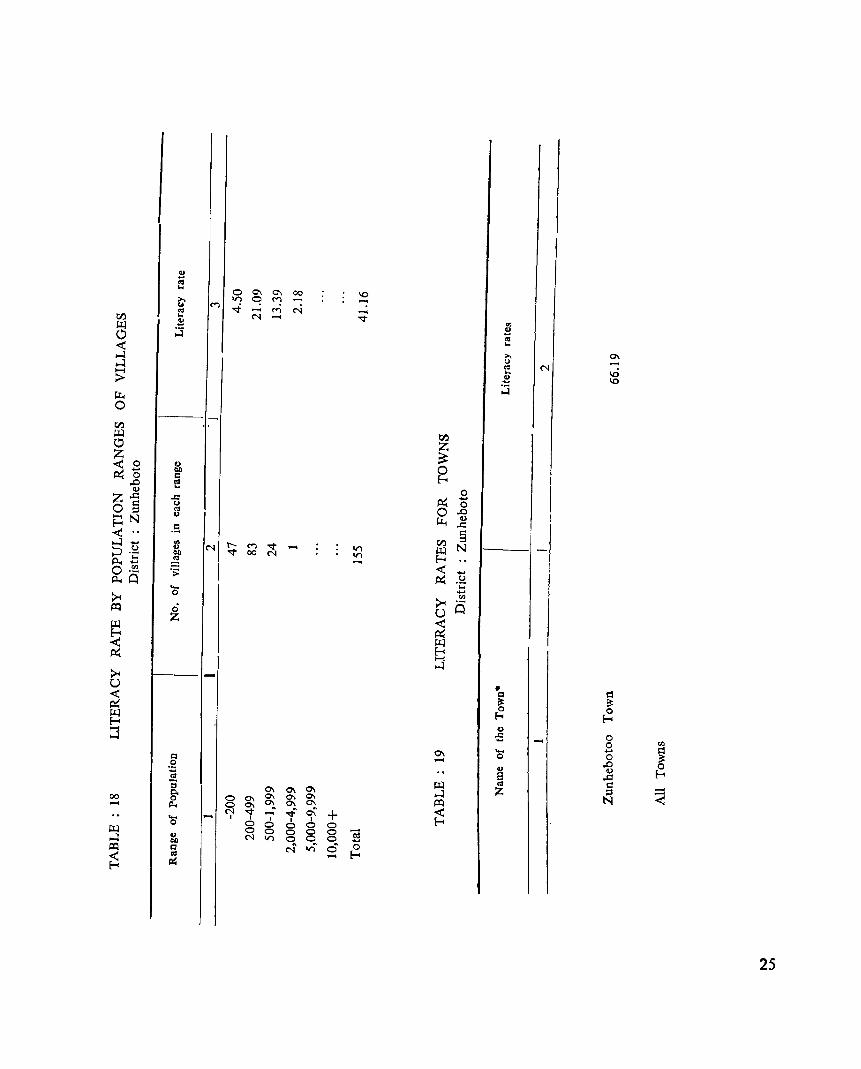
~ ~ 0
0\ -Cl .!2 E
00
:::I
..... g-Il.
0 0\ 0\ 0\
0\ 0\
.... 0 0\ 0\
0\ 0\
~ 0
C'l '<t 0\ 0\
...:l
I I ..... ..f" 0\
I)
0 I +
~
0 I I
CO 0 0
~ Cl
C'l 0 0
0 0
'" V"l 0
0 0
~ N
0 0 ca vi' 0
..... 0 ..... E-<
0 '" .... 0 ~ ,D Q)
,.Q
g N ~
25
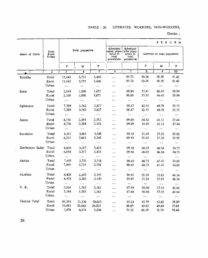
TABLE: 20 LITERATES, WORKERS, NON-WORKERS,
District:
P E R C E N
Total population Scheduled scheduled
Total castes popu- tribe popu-Name of Circle Rural lation to lation to Literates of total population
Urban total total population population
p \
M I F \ I I p \ M
\ F
2 3 4 5 6 7 8 9 10
Satakha Total 11,143 5,737 5,406 95.72 50.26 58.58 41.42
Rural 11,143 5,737 5,406 95.72 50.26 58.58 41.42
Urban
Satoi Total 2,169 1,098 1,071 98.89 37.81 46.45 28.94 Rural 2,169 1,098 1,071 98.89 37.81 46.45 28.94 Urban
Aghunato Total 7,389 3,562 3,827 98.47 42.51 49.78 35.75 Rural 7,389 3,562 3,827 98.47 42.51 49.78 35.75 Urban
Asuto Total 4,736 2,384 2,352 99.89 34.42 41.11 27.64 Rural 4,736 2,384 2,352 99.89 34.42 41.11 27.64 Urban . ~ .
Suruhoto Total 6,311 3,063 3,248 99.19 31.45 37.32 25.92 Rural 6,311 3,063 3,248 99.19 31.45 37.32 25.92 Urban
Zunheboto Sadar Total 6,650 3,217 3,433 99.50 40.65 46.94 34.75 Rural 6,650 3,217 3,433 99.50 40.65 46.94 34.75 Urban
Atoizu Total 7,493 3,735 3,758 98.69 40.73 47.47 34.03 Rural 7,493 3,735 3,758 98.69 40.73 47.47 34.03 Urban
Akuluto Total 4,428 2,283 2,145 96.95 51.24 55.85 46.34 Rural 4,428 2,283 2,145 96.95 51.24 55.85 46.34
Urban
V. K. Total 3,164 1,583 1,581 97.44 50.60 57.55 43.64 Rural 3,164 1,583 1,581 97.44 50.60 57.55 43.64
Urban I ..
District Total Total 61,161 31,136 30,025 95.24 45.59 52.82 38.09 Rural 53,483 26,662 26,821 98.09 42.63 49.64 35.66 Urban 7,678 4,474 3,204 75.32 66.19 71.70 58.49
26
SCHEDULE CASTE1TRIBE POPULATION IN THE DISTRICT
Zunheboto
TAG E 0 F
Main workers to total POpulation Marginal workers to Total workers to total total population population
p 1 M I F P I M I F P I M I F
11 12 13 14 1 15 16 17 18 19
45.06 46.26 43.78 0.11 0.16 0.06 45.17 46.42 43.84 45.06 46.26 43.78 0.11 0.16 0.06 45.1.7 46.42 43.84
45.87 45.26 46.50 3.97 2.92 5.04 49.84 48.18 51.54 45.87 45.26 46.50 3.97 2.92 5.04 49.84 48.18 51.54
44.54 42.62 46.33 44.54 42.62 46.33 44.54 42.62 46.33 44.54 42.62 46.33
46.75 44.67 48.85 46.75 44.67 48.85
46.75 44.67 48.85 46.75 44.67 48.85
49.41 49.98 48.86 0.98 0.26 1.66 50.39 50.24 50.52
49.4] 49.98 48.86 0.98 0.26 1.66 50.39 50.24 50.52
48.90 46.22 51.41 0.87 1.06 0.70 49.77 47.28 52.11
48.90 46.22 51.41 0.87 1.06 0.70 49.77 47.28 52.11
51.39 50.87 51.92 0.03 0.05 51.42 50.87 51.97
51.39 50.87 51.92 0.03 0.05 51.42 50.87 51.97
44.90 47.04 42.61 44.90 47.04 42.61
44.90 47.04 42.61 44.90 47.04 42.61
46.21 48.52 43.90 5.66 6.82 4.49 51.86 55.34 48.39
46.21 48.52 43.90 5.66 6.82 4.49 51.86 55.34 48.39
• 45.57 47.29 43.78 0.66 0.62 0.70 46.24 47.92 44.48
47.10 46.86 47.34 0.75 0.72 0.78 47.85 47.58 48.12
34.90 49.89 13.98 0.07 0.04 0.10 34.97 49.93 14.08
Non-workers to total population
P 1 M 1 F
20 21 22
54.83 53.58 56.16 54.83 53.58 56.16
50.16 51.82 48.46 50.16 51.82 48.46
55.46 57.38 53.67 55.46 57.33 53.67
53.25 55.33 51.15 53.25 55.33 51.15
49.61 49.76 49.48 49.61 49.76 49.48
50.23 52.72 47.89 50.23 52.72 47.89
48.58 49.13 48.03 48.58 49.13 48.03
55.10 52.96 57.39 55.10 52.96 57.39
48.14 44.66 51.61 48.14 44.66 51.61
53.77 52.08 55.51 52.15 52.42 51.88 65.03 50.07 85.92
27

PART-A
VILLAGE AND TOWN DIRECTORY

SECTION - I
VILLAGE DIRECTORY
NOTES ON VILLAGE DIRECTORY
The abbreviations used in the Village Directory are as foIl ow Iii ;-
1. Educational ( amenities)
P - Primary School
M = Middle School
H = High/Matriculation School
Ac = Adult Eteracy Centre
Tr = Training Centre.
2. Medical facility:
D = Dispensary H = Hospital PHC = Primary Health Centre PHS - Primary Health Sub. Centre.
3. Drinking water facility:
T = Tap W = Well TK = Tank R = River S = Spring/fountain N = NullahJothers.
4. Post and Telegraph facility:
P.O. = Post Office
5. Communication: B.S. = Bus stop
6. Approach Road : P.R. = Pucca road K.R. = Kuccha road F.P. - Foot path
7. Power supply : E.D. = Electricity for domestic purpose.
8. Number of items available in the village : N = News paper coming to the village. C - Cars/Jeeps available in the village.
31

SATAKHA CIRCLE
NAGALAND SATAKHA CIRCLE
r
~.
\ CODE NO: 4/1 ZUNHEBOTO DISTRICT
/ (NOTIONAL)
~A TO' 1 U C, R a.-~ .. -·-.-... -.-. __ .
;J SHEr60LD ~I
:./ -j ~.
SAPTIKA AREA SUPDT. HQ. 0+ 7
USUTOMt·
e -SHOIPU · ..
ItOISHE II •
SATAKHA YllL' 2 •
INDEX 1l0UNDARY, DISTRICT •••
., $lIIlDIVISIOh...... ... '"
CiRCLE..... ... ... _. _
IlEADQUARTERS,CIRCLE... ... ... @ YILLAGES WITH POPULATION SIZE:
BELOW 200. 200-499,500-999 ,1000- 4999 .. .0 • • •
POST OFFICE... • _ ... ... ... ... ... PO
HIGH SCHOOL._ ... ... ... ... ._
PRIMARY HEALTH CENTRE, DISPENSARY ...
RIVERS & STREAMS... ... ''_ .••. ._
... s ... @+ ... :::::::;::::>
SATAKHA HQ· fCH\JI(IYE I po@. 12 •• @)s
LUKHAI 13
ICHUlvt • J8
ACHUITO 22 0
ZHUIYE 2Q •
CHUKHUYI 19 •
SUKHAI ·11
VISHEPU • 16
KIVIKHU 15 •

SI. No.
1.
2.
3.
4.
5.
6.
7.
8.
9.
10.
11.
12.
13.
14.
15.
16.
17.
18.
19.
20.
21.
22.
23.
* As in 1971 census
ALPHABETICAL UST OF THE VILLAGES
District : Zunheboto
Circle : Satakh";' ,
Name or the Village
'Aghuito i
Ghukhuyi .. (Ghukiyi)
Hoishe
Khuivi • (Khivi)
Khukiye
Kilo I (Old)
Kivikhu ,
Kiyekhu i
Lukhai -r rr (
Momi
N1Ulmh; (. .
Saptika A.S.H.Q. I .
Satak~a, H. Q. ~
Satakl?-a Village
Shena (New)
Shena (Old) -
Shoipu ,
Soikhe
SUkhaj
Tukun~~ami
Usutomi' .. (l1sukhbmi) I
Vishepu I rr
Zhekiye I r
L,ocation code No. t
~ 3
~ 4fl/2iS }
4/1/19
4Jl/11
4/1-/18
411/11
1jl/14 l' ':-
4/1/15
4Jl/21
4}1113
4}1}15
4}1/19
4}1}7
411/1
4J1J2
4/1j5
4/1/6
4/1/4
4{1.123
1'4/LfI7
4/1/10
4/1/8
4/1Jl6
4/1120
3S
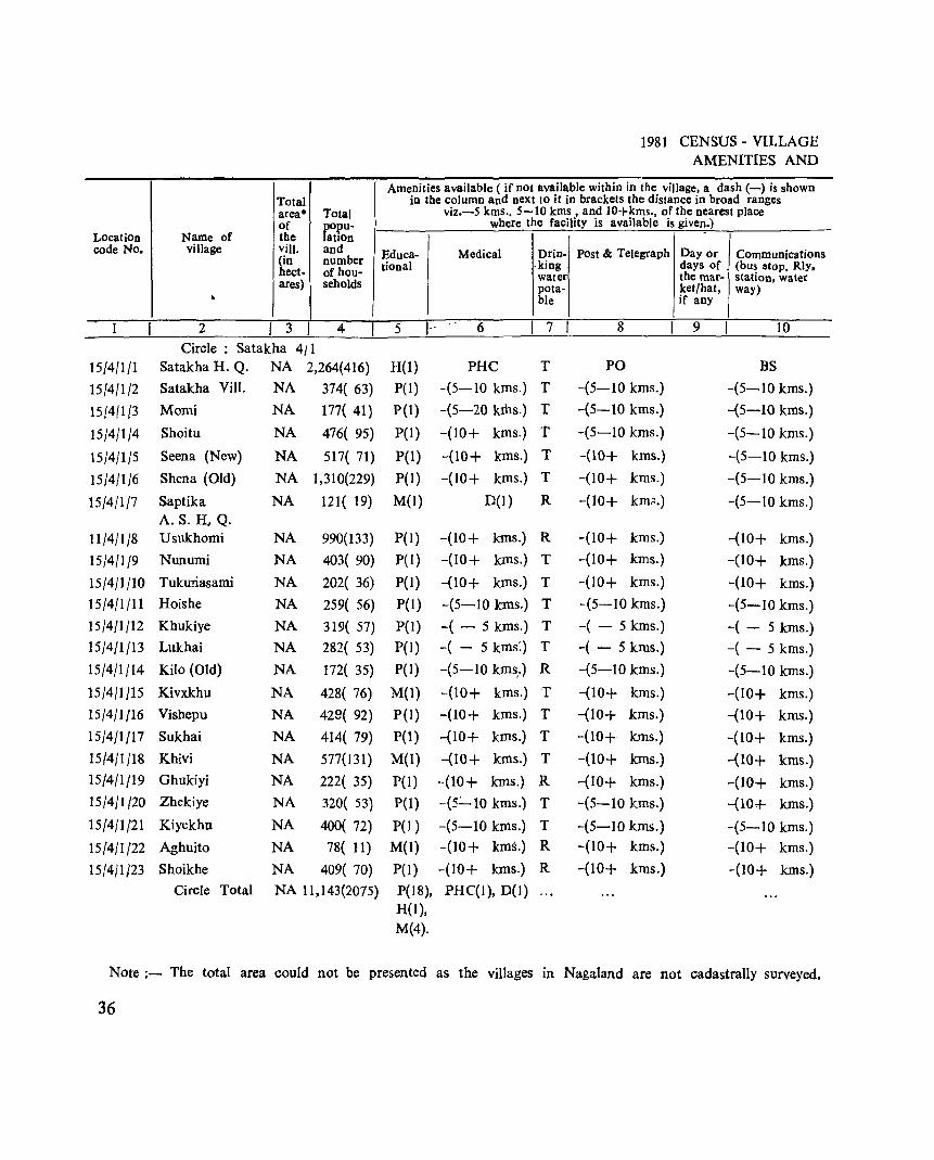
I Total area· Total of popu-
Location Name of the lation code No. village viII. and
gn number ect- of hou-
ares) I seholds
" 2 I 3 I 4
Circle: Satakha 4jl 15/4/1/1 Satakha H. Q. NA 2,264(416)
15/4/1/2 Satakha ViII. NA 374( 63)
15[411/3 Mami NA 177( 41)
15/4/1/4 Shoitu NA 476{ 95)
15/4/1/5 Seena (New) NA 517( 71)
15/4/1/6 Shena (Old) NA ] ,3] 0(229)
15/4/1/7 Saptika NA 121( 19) A.S.H,Q.
11/4/1/8 Usukhomi NA 990(133)
15/4/1/9 Nunumi NA 403( 90)
15/4/1/to Tukuriasami NA 202( 36)
15/4/1/11 Hoishe NA 259{ 56)
15/4/1/12 Khukiye NA 319( 57)
15/4/1/13 Lukhai NA 282( 53)
15/4/1/14 Kilo (Old) NA 172( 35)
15/4/1/15 Kivxkhu NA 428( 76)
15/4/1/16 Vishepu NA 429( 92)
15/4/1/17 Sukhai NA 414( 79)
15{4{1/18 Khivi NA 577(131)
15/4/1/19 Ghukiyi NA 222{ 35)
15/4/1(20 Zhekiye NA 320( 53)
15/4/1/21 Kiyekhu NA 400( 72)
15/4/1/22 Aghuito NA 78{ 11)
15/4/1/23 Shoikhe NA 409( 70)
Circle Total NA 11,143(2075)
1981 CENSUS - VILLAGE AMENITIES AND
Amenities available ( if not available within in the village, a dash (-) is shown in the column and next 10 it in brackets the distance in broad ranges
viz.-S kms .• 5-10 kms , and 10+kms., of the nearest place where the facility is available is given.) -
Educa- Medical Drin- Post & Telegraph Day or Communications tional .king days of (bus stop. Rly.
water the mar- station, water pota- ket/hat, way) ble if any
5 1-- 6 I 7 8 9 10
H(l) PHC T PO BS
P(I) -(5-10 kms.) T -(5-10 kms.) -(5-10 kms.)
P(I) -(5-20 kIDs.) T -(5-10 kms.) -(5-10 kms.)
P(I) -(10+ kms.) t -(5-10 kms.) -(5-10 kms.)
P(I) -(10+ kms.) T -(10+ kms.) -(5-10 kms.)
P(I) -(IO+ kms.) T -(10+ kms.) -(5-10 kms.)
M(I) D(1) R -(10+ km;;.) -(5-10 kms.)
P(l) -(10+ kms.) R -(10+ kms.) -(IO+ kms.)
P(1) -(10+ kms.) T -(10+ kms.) -(10+ kms.)
P(I) -(IO+ kms.) T -(10+ kms.) -(10+ kms.)
P(I) -(5-1O kms.) T -(5-10 kms.) -(5-10 kms.)
P(l) -( - 5 kms.) T -( - 5 kms.) -( - 5 kms.) P(I) -( - 5 kms:) T -( - 5 kms.) -( - 5 kms.)
P(I) -(5-10 kms.) R -(5-10 kms.) -(5-10 kms.) ,
M(I) -(10+ kms.) T -(10+ kms.) -(10+ kms.)
P(I) -(10+ kms.) T -(IO+ kms.) -(10+ kms.)
P(1) -(IO+ kms.) T -(10+ kms.) -(10+ kms.)
M{l) -(10+ kms.) T -(10+ kms.) -(10+ kms.)
P(l) -(IO+ kms.) R -(10+ kms.) -(10+ kms.)
P(I) -(5':"" 10 kms.) T -(5-10 kms.) -(10+ kms.)
P{1 ) -(5-10 kIllS.) T -(5-10 kms.) -(5-10 kms.) M{I) -(IO+ kIlls.) R -(10+ kms.) -(10+ kms.)
P(1) -(10+ kIlls.) R -(10+ kms.) -(10+ kms.)
P(18), PHC(I), D(l) H(l), M(4).
Note;- The total area could not be presented as the villages in Nagaland are not cadastrally surveyed.
36
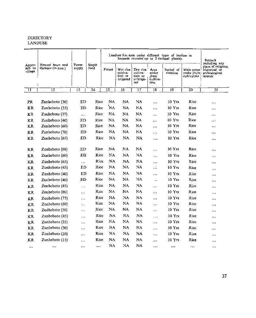
DIRECTORY LANDUSE
Appro- Nearest town and ach to distance (in kms ) villa~e
11 12
PR Zunheboto (30)
KR Zunheboto (35)
KR Zunheboto (37)
KR Zunheboto (40)
KR Zunheboto (60)
KR Zunheboto (70)
KR Zunheboto (65)
KR Zunheboto (60)
KR Zunheboto (60)
KR Zunheboto (65)
KR Zunheboto (45)
KR Zunheboto (40)
KR Zunheboto (40)
KR Zunheboto (45)
KR Zunheboto (80)
KR Zunheboto (75)
KR Zunheboto (60)
KR Zudheboto (50)
KR Zunheboto (45)
KR Zunheboto (25)
KR Zunheboto (30)
KR Zunheboto (20)
KR Zunheboto (15)
Power Staple supply food
13 14
ED Rice
ED Rice
Rice
ED Rice
ED Rice
ED Rice
ED Rice
ED Rice
ED Rice
Rice
ED Rice
ED Rice
ED Rice
Rice
Rice
Rice
Rice
Rice
Rice
Rice
Rice
Rice
Rice
Landuse (i.e. area under different types of landuse in hectares rounded up to 2 decimal places). Remark
including any
Forest Wet rice Dry rice Area Period of p1ace of religious,
Main crops historical or cultiva- cuItiva- under rotation under jhum archealogical tion or tion Or jhum cultivation interest irrigated unirriga- cultiva·
ted tion
15 16 17 18 19 20 21
NA NA NA 10 Yrs Rice . NA NA NA 10 Yrs Rice
NA NA NA 10 Yrs Rice
NA NA NA 10 Yrs Rice
NA NA NA 10 Yrs Rice
NA NA NA 10 Yrs Rice
NA NA NA 10 Yrs Rice
NA NA NA 10 Yrs Rice
NA NA NA 10 Yrs Rice
NA NA NA 10 Yrs Rice NA NA NA 10 Yrs Rice
NA NA NA 10 Yrs Rice NA NA NA 10 Yrs Rice
NA NA NA 10 Yrs Rice
NA NA NA 10 Yrs Rice
NA NA NA 10 Yrs Rice NA NA NA 10 Yrs Rice
NA NA NA 10 Yrs Rice
NA NA NA 10 Yrs Rice NA NA NA 10 Yrs Rice
NA NA NA 10 Yrs Rice
NA NA NA 10 Yrs Rice
NA NA NA 10 Yrs Rice
NA NA NA
37
SATOI CIRCLE
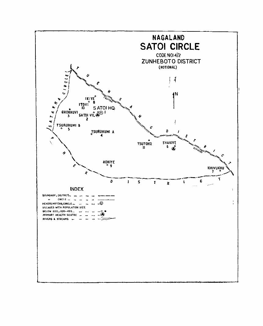
.... -1 &u •
.... 1 <.J I . .~ t-Oo; ~ i .~ ,fI
. 0 ~.~ 'lifo ./ IKIYE su,..
~ / tToVt 8 1f4
--! • 10 SATOI HQ. ~ I GHOKHUVI 0 ~@ I
,.... j 3 SAT~ VIL~
;: r TSURUHUMI &
" 0 S
~". \ \.. ,
~\
TSURUHUMI A o· ..
\. HOKIYE t" ,~......... 0 9 ., .........
NAGALAND SATOI CIRCLE
CODE NO:4Y2 ZUNHEBOTO DISTRICT
(NOTIONAL)
• T5UTOHO
11
I .{ ,
r THAKIYE
6 • @
.t .. ........ ............ _, ___ .-:-- . ..__ . .........".-- ........... _._._..,_...,...-- . .....-
o S T a C
tNDEX eOUNOARY,OISfRIC't_ ... __ _ ... _. __
CIRCLE _. _ .~ ." ... _____ _
HEADQUARTERS/CIRCLE _ __ _ _" _@ VILLAGES WITH POPULATION SI.ZE
BELOW ~OO 1 ~OO-499._.~ _0 •
PRIMARY HEALTH CENTRE _ _ ... @ RIVERS & STREAJ\oIs._ ••• - ... --.~

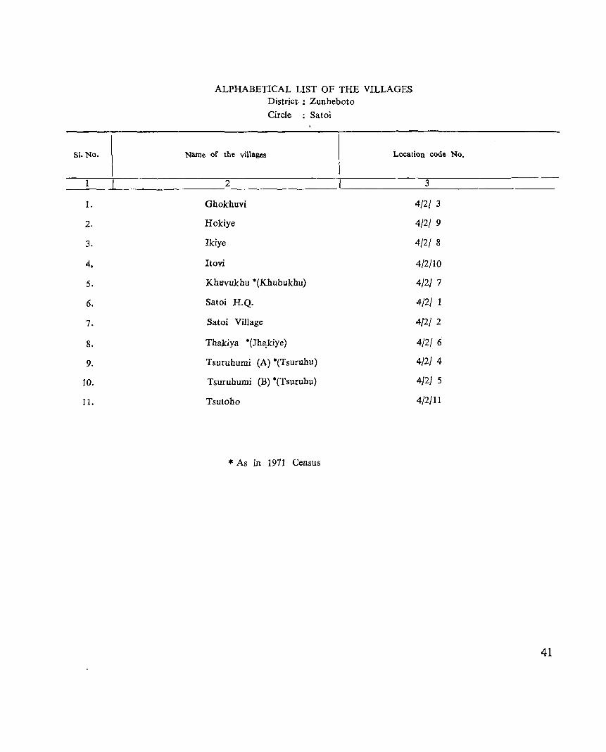
81. No.
1
1.
2.
3.
4,
5.
6.
7.
8.
9.
10.
II.
ALPHABETICAL LIST OF THE VILLAGES District- : Zunheboto Circle : Satoi
Name of the villages Location code No.
2 3
Ghokhuvi 4/2{ 3
Hokiye 4/2/ 9
Ikiye 4/2/ 8
Itovi 4/2/10
Khuvukhu ·(Khubukhu) 4/2/ 7
Satoi H.Q. 4/2/ 1
Satoi Village 4/2/ 2
Thakiya ·(Jh~kiye) 4/2/ 6
Tsuruhumi (A) ·(Tsuruhu) 4/2/ 4
Tsuruhumi (B) ·(Tsuruhu) 4/2/ 5
Tsutoho 4/2/11
* As in 1971 Census
41
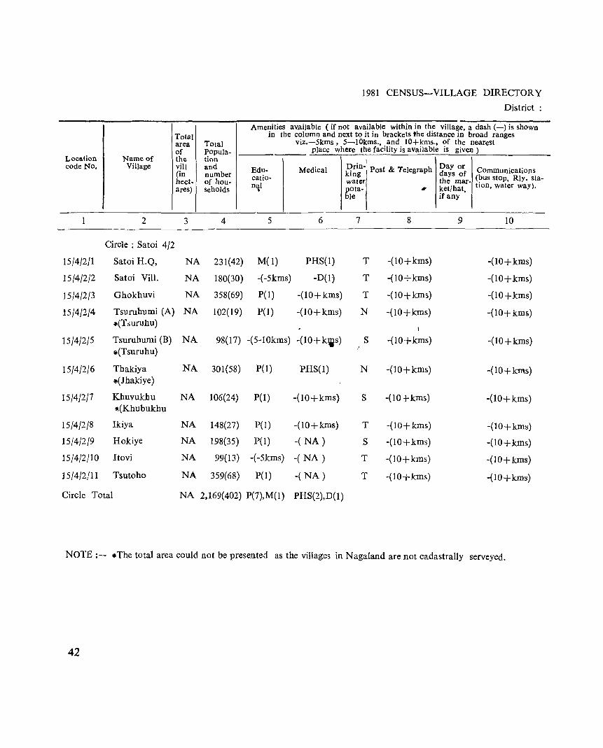
Location Name of code No. Village
1 2
Circle: Satoi 4/2
15/4/2/1 Satoi H.Q,
15/4/2/2 Satoi ViII.
15/4/2/3 Ghokhuvi
15/4/2/4 Tsuruhumi (A) II(T .:iUfuhu)
15/4/2/5 Tsuruhumi (B) *(Tsuruhu)
15/4/2/6 Thakiya *(Jhakiye)
15/4/2/7 Khuvukhu ~(Khubukhu
15/4/2/8 Ikiya
15/4/2/9 Hokiye
15/4/2/10 Itovi
15/4/2/11 Tsutoho
Circle Total
Total area of the viii (in hect-ares)
3
NA
NA
NA
NA
NA
NA
NA
NA
NA
NA
NA
Total Popula-tion and number of hou-seholds
4
231(42)
180(30)
358(69)
102(19)
1981 CENSUS-VILLAGE DIRECTORY
District:
Amenities available (if not available within in the villa ge, a dash (-) is shown in broad ranges in the column and next to it in brackets 'he distance
Edu-catio-n\1
5
M(I)
-(-5kms)
pel)
pel)
viz.-Skms, 5-10kms., and lO+kms., of t he nearest place where the facility is available is given)
• I
Medical prm- Post & Telegraph lng
water pota- ~
ble
6 7 8
PHS(I) T -(10+kms)
-D(I) T -(10-;-kms)
-(10+kms) T -(10+kms)
-(lO+kms) N -(10+kms)
Day or C . t· days the ket!h
of ommUDlca Ions mar- (~us stop, Rly. staat, hon, water way).
ifan y
9 10
-(10+kms)
-(10+kms)
-(lO+kms)
-(10+kms)
98(17) -(5-l0kms) -(10+kws) S -(lO+kms) -(10+kms)
301(58) P(1) PHS(I) N -(10+kms) -(IO+kms)
106(24) pel) -(lO+kms) S -(10 +kms) -(10+kms)
148(27) pel) -(lO+kms) T -(lO+kms) -(lO+kms)
198(35) pel) -( NA) S -(10+kms) -(lO+kms)
99(13) -(-5kms) -( NA) T -(lO+kms) -(10+ kms)
359(68) P(l) -( NA) T -(lO+kms) -(IO+kms)
NA 2,169(402) P(7),M(I) PHS(2),D(I)
NOTE:- .The total area could not be presented as the villages in Nagaland are not cadastrally serveyed.
42
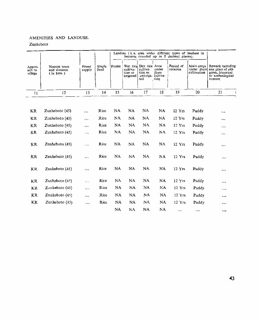
AMENITIES AND LANDUSE.
ZWlheboto
Appro ach to village
-
11
KR
KR
KR
KR
KR
KR
KR
KR
KR
KR
KR
I Nearest town POwer and distance supply C in kms.)
12 13
Zunheboto (45)
Zunheboto (45)
Zunheboto (45)
Zunheboto (45)
Znnheboto (45)
ZWlheboto (45)
Zunheboto (45)
Zunheboto (45)
Zunbeboto (45)
Zunheboto (45)
ZUJlheboto (45)
Staple food
14
Rice
Rice
Rice
Rice
Rice
Rice
Rice
Rice
Rice
Rice
Rice
Landuse (i. e. area under different types of land use in hectares rounded up to 2 decimal places).
-- ---_. I
Forest Wet rice Dry rice Area Period of Main crops Remark including cultiva- cultiva- I under rotation under jhum any place of reli-tion or tion or jhum cultivation gious, historical irrigated unirriga. cuItiva- ~r archeaJogical
ted I tion mterest
15 16 17 18 19 20 21
NA NA NA NA 12 Yrs Paddy
NA NA NA NA 12 Yrs Paddy
NA NA NA NA 12 Yrs Paddy
NA NA NA NA 12 Yrs Paddy
NA NA NA NA 12 Yrs Paddy
NA NA NA NA 12 Yrs Paddy
NA NA NA NA 12 Yrs Paddy
NA NA NA NA 12 Yrs Paddy
NA NA NA NA 12 Yrs Paddy
NA NA NA NA 12 Yrs Paddy
NA NA NA NA 12 Yrs Paddy
NA NA NA NA
43

AGHUNATO CIRCLE
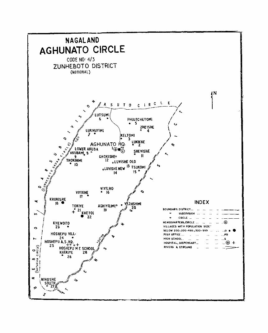
NAGALAND AGHUNATO CIRCLE
CODE NO: 4/3 ZUNHEBOTO DISTRlCT
(NOTIONAL)
'+-A 5
() .-._ ".tI· .
U TOe I R c._~_.~.---../ .-. .__._.-._'- I r
c., i lUTSUMI
" .. -1" 6· ~ f
" I)"" lUKHUYIMI . 1· ~ . .:::
PHUl£CHETOM\ • S
KElTOMI • 3
ZHEISHE o 4
4:'~ AGHUNATO Q. ~ (I" : LOWER AKU B A I Ef).~
lUKIKHE • 2
.I " I
i (j
\ \
/
~ v ,<1:-1 AKU8AM~ 8 0 ~ SHEVISHE ,I' 9 GHOKISHEo ."
c., 'l"t::)'l"4, TH.OK:~IMI 12 0 lUVISHE OLD
// ~ i
_J' "
~ 0"'/' oLUVISHE NEW 13 TSUKOMI ~ ... ~ 14 IS 0 •
~ 1»°4' ; ~r . ,
Q ~h" ./,/ e: VIYllHO U .r VIYIKHE· 16 <:) i' 11 • .#.
oq : I KHUKISHE 18 •
j'
"" ........ ...1 I . KHEWOTO
o I Zl·
TOKIYE ~ 21 + KHETOI
• 22
/ HOSHEPU YILl. if .... f 24· , .. :~!~. ~
HOSHEPU A.S .HO. ...1' ,.....,/ 2S +00+ ,/
o ~ i HOSHEPU M E SCHOOL i c, a: : KHEKIYE 28 §. ul • 26 .
CDc(' // ;;1 .~.~ ~
w~1 / ~: .A·~ I ~
or: :\NIHOSHE l' ~ . SOUTH .- ......
"9 \ .. 0 27 r .. _ .. '- ..... ~
INDEX BOUNDARY, DISTRICT... •.. '" .•.
" SUBDIVISION '" __ ... ., CIRCLE ... ... .•. . ..
HEADQUARTERS,CIRCLE ... ... . ..
VILLAGES WIT H POPULATION SIZE'
BELOW 200,2.00·499,500-999 ..
POST OFFICE ...
HIGH SCHOOL.. . ..
HOSPITAL, DISPENSARY._
RIVERS I. STIlEA~S '"
... ... @
. .. 0 ••
.., ... PO
.., ... s .. , ... Ef) + . .. . .. -:;:::::::::=:-

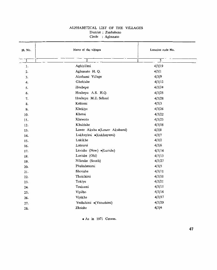
Sl. No.
1
1.
2.
3.
4.
5.
6.
7.
8.
9.
10.
11.
12.
13.
14.
15.
16.
17.
18.
19.
20.
21.
22.
23.
24.
25.
26.
27.
28.
ALPHABETICAL LIST OF THE VILLAGES District : Zunheboto Circle : Aghunato
Name of the villages
2
Aghiyilimi
Aghunato H. Q.
Akubami Village
Ghokishe
Hosbepu
Hosbepu A.S. H.Q.
Hoshepu M.E. School
Keltomi
Khekiye
Khetoi
Khewoto
Khukisbe
Lower Akuba .(Lower Akubami)
Lukhuyimi .(Lukbuyumi)
Lukikbe
Lutsumi
Luvisbe (New) .(Lurishe)
Luvishe (Old)
Nihoshe (South)
Phuleshetomi
Shevishe
Thokihimi
Tokiye
Tsukomi
Viyilho
Viyikhe
Yezhsbimi *(Yezashimi)
Zheishe
• As in 1971 Census.
Location code No.
3
4/3/19
4/3/1
4/3/9
4/3/12
4{3/24
4/3/25
4/3/28
4/3/3
4/3/26
4/3/22
4/3/23
4/3/18
4/3/8
4/3/1
4/3/2
4/3/6
4/3/14
4/3/13
4/3/27
4/3/5
4/3/11
4/3/10
4/3/21
4/3/15
4/3/16
4/3/17
4/3/20
4/3/4
47
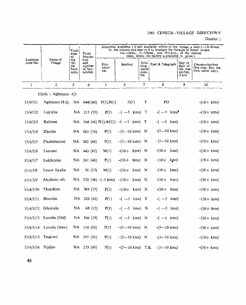
Total area of
Location Name of the code No. Village viII
(in hect-ares)
2 3
Circle : Aghunato 4/3
15/4/3/1 Aghunato H.Q. NA
15/4/3/2 Lukikhe NA
15/4/3/3 Keltorni NA
15/4/3/4 Zheishe NA
15/4/3/5 Phuleshetomi NA
15/4/3/6 Lutsumi NA
15/4/3/7 Lukhuyimi NA
15/4/3/8 Lower Akuba NA
15/4/3/9 Akubami vill. NA
" 15/4/3/10 Thokihimi NA
15/4/3/11 Shevishe NA
15,4/3/12 Ghokishe NA
15/4/3}13 Luvishe (Old) NA
15/4/3/14 Luvishe (New) NA
15/4/3/15 Tsukomi NA
15/4/3/16 Viyilho NA
48
1981 CENSUS-VILLAGE DIRECTORY
District:
Amenities available (if not available within in the village, a dash (-) is shown in the column and next to it in brackets the distance in broad ranges
Total viz.-5kms, 5-10kms., and lO+kms., of the nearest Popula- plaCe where the facility is available is given) tion . \ and Edu- Medical 3~1:-' Post & Telegraph Day or Ie. . number days of OmmUnicatlonS of hou- catio- water the mar- (~us stop, Rly. sta-seholds nal pota- ket/hat'l tlOn, water way).
ble if any
4 5 6 7 8 ~ 10
844(160) P(I),H(I) H(l) T PO -(10+ kms)
215 (35) P(l ) -( -5 kms) T -( -5 kmsf -(10+ kms)
344 (46) P(I),AC(I) -( -5 krns) T -( -5 kms) -(10+ kms)
183 (34) P(1 ) -(5-10 krns) N -(5-10' kms) -(10+ kms)
262 (46) pel) -(5-10 krns) N -(5-10 kms) -(10+ krns)
443 (82) M(l) -(10+ kms) N -(10+ kms) -(10+ kms)
241 (46) P(I) -(10+ kms) N -(10+ k;ns) -(10+ kms)
56 (13) M(I) -(10+ kms) N -(10+ kms) -(10+ kms)
232 (46) -(·-5 Ions) -(10+ kms) N -(10+ kms) -(10+ kms)
369 (72) P(I) -(10+ kms) N -(10+ kms) -(10+ kms)
228 (43) P(I) -( -5 kms) T -( -5 kms) -(10+ kms)
68 (12) P(l) -( -5 kms) N -( -5 kms) -(10+ kms)
104 (19) pel) -( -5 kms) N -( -5 kms) -(10+ krns)
114 (24) P( 1) -(5-10 kms) N -(5-10 kms) -(10+ killS)
297 (51) P(I) -(5-10 kms) N -(5-10 kms) -(10+ kms)
233 (45) P(I) -(5-10 kms) T.K - (5-10 kms) -(10+ kms)
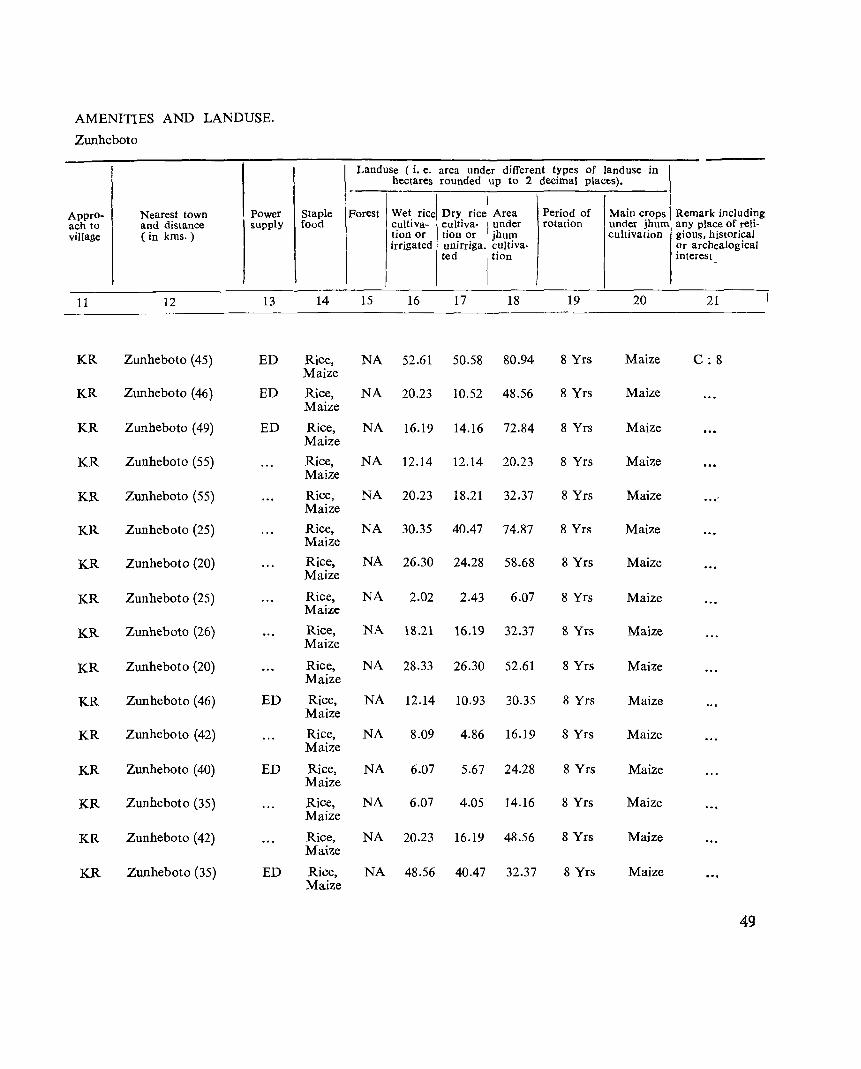
AMENITIES AND LANDUSE.
Zunheboto
Approach to village
I I
KR
KR
KR
KR
KR
KR
KR
KR
KR
KR
KR
KR
KR
KR
KR
KR
Nearest town and distance (in kms.)
12
Zunheboto (45)
Zunheboto (46)
Zunheboto (49)
Zunheboto (55)
Zunheboto (55)
Zunheboto (25)
Zunheboto (20)
Zunheboto (25)
Zunheboto (26)
Zunheboto (20)
Zunheboto (46)
Zunheboto (42)
Zunheboto (40)
Zunheboto (35)
Zunheboto (42)
Zunheboto (35)
Power supply
13
ED
ED
ED
ED
ED
ED
Staple food
I 14
Rice, Maize
Rice, Maize
Rice, Maize
Rice, Maize
Rice, Maize
Rice, Maize
Rice, Maize
Rice, Maize
Rice, Maize
Rice, Maize
Rice, Maize
Rice, Maize
Rice, Maize
Rice, Maize
Rice, Maize
Rice, Maize
Landuse (i. e. area under different types of land use in hectares rounded up to 2 decimal places). -----
I Main crops I Remark including Forest Wet rice Dry rice Area Period of
cuItiva- eultiva- I under rotation under jhum any place of reli-tion or tion or jhum cultivation gious. historical irrigated unirriga. cuJtiva- ~r archealogical
ted I tion mterest
15 16 17 18 19 20 21
NA 52.61 50.58 80.94 8 Yrs Maize C: 8
NA 20.23 10.52 48.56 8 Yrs Maize
NA 16.19 14.16 72.84 8 Yrs Maize
NA 12.14 12.14 20.23 8 Yrs Maize
NA 20.23 18.21 32.37 8 Yrs Maize ... '
NA 30.35 40.47 74.87 8 Yrs Maize
NA 26.30 24.28 58.68 8 Yrs Maize
NA 2.02 2.43 6.07 8 Yrs Maize
NA 18.21 16.19 32.37 8 Yrs Maize
NA 28.33 26.30 52.61 8 Yrs Maize
NA 12.14 10.93 30.35 8 Yrs Maize
NA 8.09 4.86 16.19 8 Yrs Maize
NA 6.07 5.67 24.28 8 Yrs Maize
NA 6.07 4.05 14.16 8 Yrs Maize
NA 20.23 16.19 48.56 8 Yrs Maize
NA 48.56 40.47 32.37 8 Yrs Maize
49
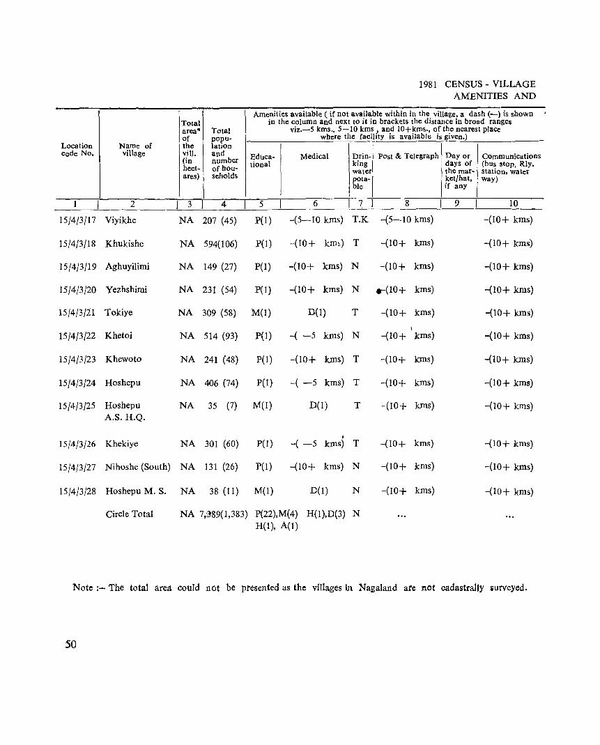
Location Name of code No. village
1 2 I 15/4/3/17 Viyikhe
15/4/3/18 Khukishe
15/4/3/19 Aghuyilimi
15/4/3/20 Yezhshimi
15/4/3/1.1 Tokiye
15/4/3/22 Khetoi
15/4/3/23 Khewoto
15/4/3/24 Hoshepu
15/4/3/25 Hoshepu A.S.H.Q.
15/4/3/26 Khekiye
15/4/3/27 Nihoshe (South)
15/4/3/28 Hoshepu M. S.
Circle Total
l Total area* Total of popu-the lation viII. and (in number hect- of hou-ares) l seholds
3 4
NA 207 (45)
NA 594(106)
NA 149 (27)
NA 231 (54)
NA 309 (58)
NA 514 (93)
NA 241 (48)
NA 406 (74)
NA 35 (7)
NA 301 (60)
NA 131 (26)
NA 38 (11)
1981 CENSUS - VILLAGE AMENITIES AND
Amenities available ( if not available within in the village, a dash (-) is shown in the column and next to it in brackets the distance in broad ranges
viz.-5 kms., 5-10 kms , and lO+kms., of the nearest place where the facility is available is given.)
Educa- Medical Drin- Post & Telegraph Day or Communications lional king days of (bus stop, Rly,
water the mar- station, water pota- ket/hat, way) ble if any
5 6 I 7 I 8 9 10
P(l ) -(5-10 kms) T.K -(5-10 kms) -(10+ kms)
P(l) -(10+ km~) T -(10+ kms) -(10+ kms)
P{l) -(10+ kms) N -(10+ kms) -(10+ kms)
PO) -(10+ kms) N ..... (10+ kms) -(10+ kms)
M(l) 0(1) T -(10+ kms) -(10+ kms)
I
PCl) -( -5 kms) N -(10+ kms) -(10+ kms)
P(I) -(10+ kms) T -(10+ kms) -(10+ kms)
pel) -( -5 kms) T -(10+ kms) -(10+ krns)
M(l) 0(1) T -(10+ krns) -(10+ kms)
I
P(I) -( -5 kIDS) T -(10+ kms) -(10+ kms)
pel) -(10+ kms) N -(10+ kIDS) -(10+ kms)
M(l) D(1) N -(10+ kms) -(10+ kms)
NA 7;389(1,383) P(22),M(4) H(I),D(3) N H(l), A(I)
Note :- The total area could not be presented as the villages in Nagaland are not cadastrally surveyed.
50
-'
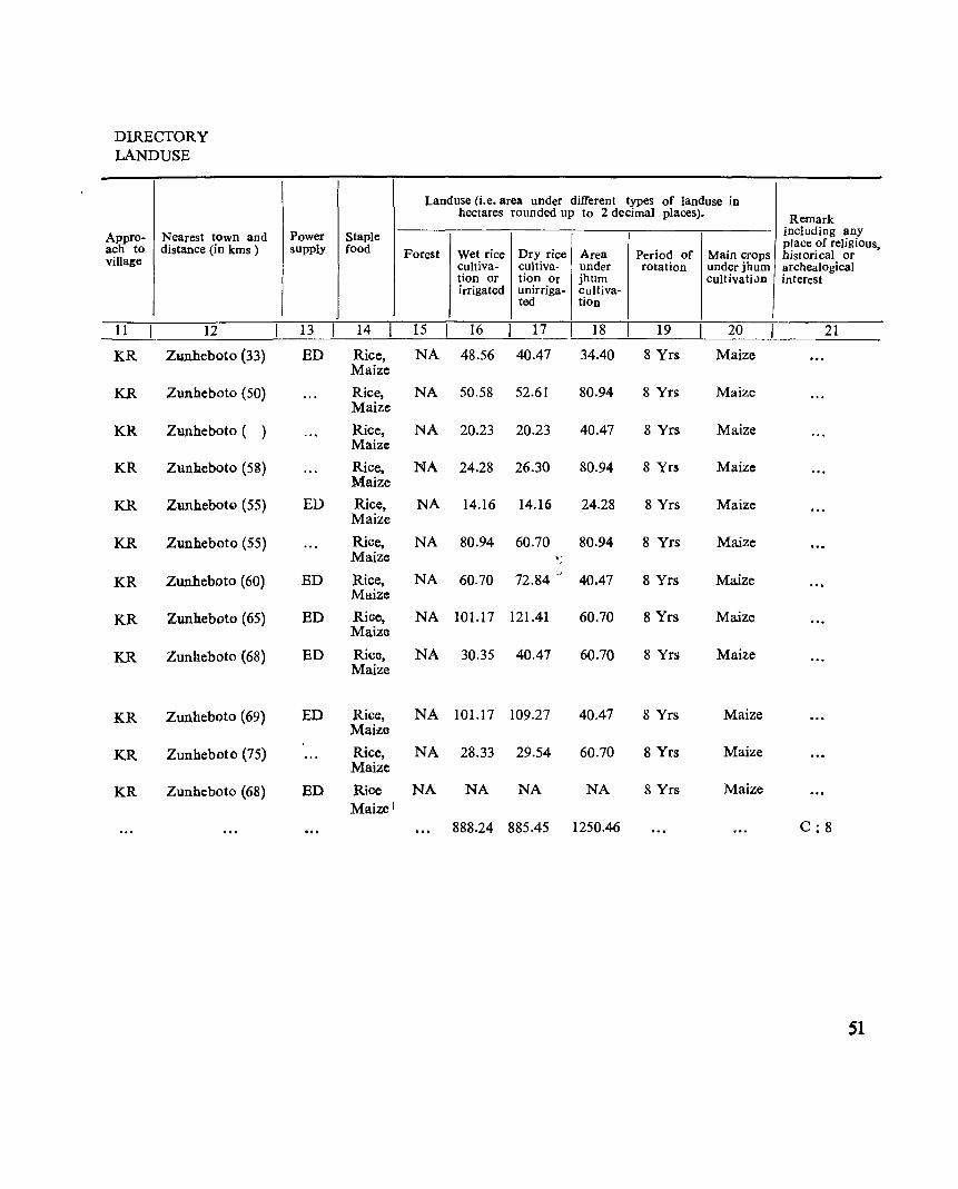
DIRECTORY LANDUSE
Appro- Nearest town and ach to distance (in kms ) village
11 12
KR Zunheboto (33)
KR Zunheboto (50)
KR Zunheboto ( )
KR Zunh.eboto (58)
KR Zunhebotc.l (55)
KR Zunheboto (55)
KR Zunheboto (60)
KR Zunheboto (65)
KR Zunneboto (68)
KR Zunheboto (69)
KR Zunheboto (75)
KR Zunheboto (68)
Power Staple supply food
13 14
ED Rice, Maize
Rice, Maize
Rice, Maize
Rice, Maize
ED Rice, Maize
Rice, Maize
ED Rice, Maize
ED Rice, Maize
ED Rice. Maize
ED Rice, Maize
Rice. Maize
ED Rice Maize l
Land use (i.e. area under different types of land use in hectares rounded up to 2 decimal places). Remark
including any
Forest Wet rice Dry rice Area Period of place of religious,
Main crops historical or cultiva- cUltiva- under rotation under jhum archealogical tion or tion Or jhum cultivati"n interest irrigated unirriga- cultiva-
ted tion
15 16 17 18 19 20 21
NA 48.56 40.47 34.40 8 Yrs Maize
NA 50.58 52.61 80.94- 8 Yrs Maize
NA 20.23 20.23 40.47 8 Yrs Maize
NA 24.28 26.30 80.94 8 Yrs Maize
NA 14.16 14.16 24.28 8 Yrs Maize
NA 80.94 60.70 80.94 8 Yrs Maize 'It ~
NA 60.70 72.84 ", 40.47 8 Yrs Maize
NA 101.17 121.41 60.70 8 Yrs Maize
NA 30.35 40.47 60.70 8 Yrs Maize
NA 101.17 109.27 40.47 8 Yrs Maize
NA 28.33 29.54 60.70 8 Yrs Maize
NA NA NA NA 8 Yrs Maize
888.24 885.45 1250.46 C: 8
51

ASUTO CIRCLE
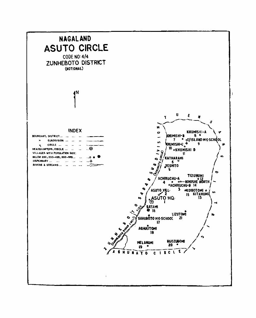
NAGALAND ASUTO CIRCLE
CODE NO: 4/4 ZUNHEBOTO DISTRICT
(NOTIONAL)
r INDEX
BOUNDARY, DISTILICT ... .. SUBDIVISION... ... .. •
~ CIRCLE... ... ... ... ..._._._
HEADQ U AIITtPS, CIRCLt... ... ._ ... @ VILLAGES WITH POPULATION SIZE:
BELOW 200,200-499,500-999... ... • .. 0.. DISPENSARY... ... ... ._ ... ...+ RIVERS & STREAMS... ._ ._. _-:::::::=---..-
, u E It ,..-.......... ......_ ....... "....._. .-........... S
:It \ '\..
o \ ~_ KHUMISHI-A \.., ~~SH~. 8· . i 7 • oT/iSlAND ""['SCH(Ol
'" IHUMISHH: + 9 . '$
; ..... ! 100KHUMIS!U D ) -~j II t
C) !,: KATHARAMI /' en o 6 0
C3II i / JESH1TO . ~ l' S I
CIt ,:j! 0 e.- TlzuttUHI .
, / ACHII(UCHU-A • 12 I : 4 • o"_NIHOSHE NOITH . -
~ / °ACHIKUCHU-S 14 I ~I/ ASUT~Vl..l' l 0I(0180TOMI Q 'j en
'qo • tr 2 IS KtTAHUM1\ ., oASUTO HQ, 13 '\
. @ I -f
() ~ SAlAMI I' .e... 4," .'6 . ,
,-, lIZUTOMl I ~ () it. SAHus3TO fo}('SCHOO( 21 j'
q, ~ n .., .. ~" ACHUtITOMI / "'-
~~ ~ / +/ . ~ ~:J.. . M£UHUMI MGOzueOMI / ~ &9 • 10· /
'" rI A • H 'uil,','O'C-I'R'Clt7' ~

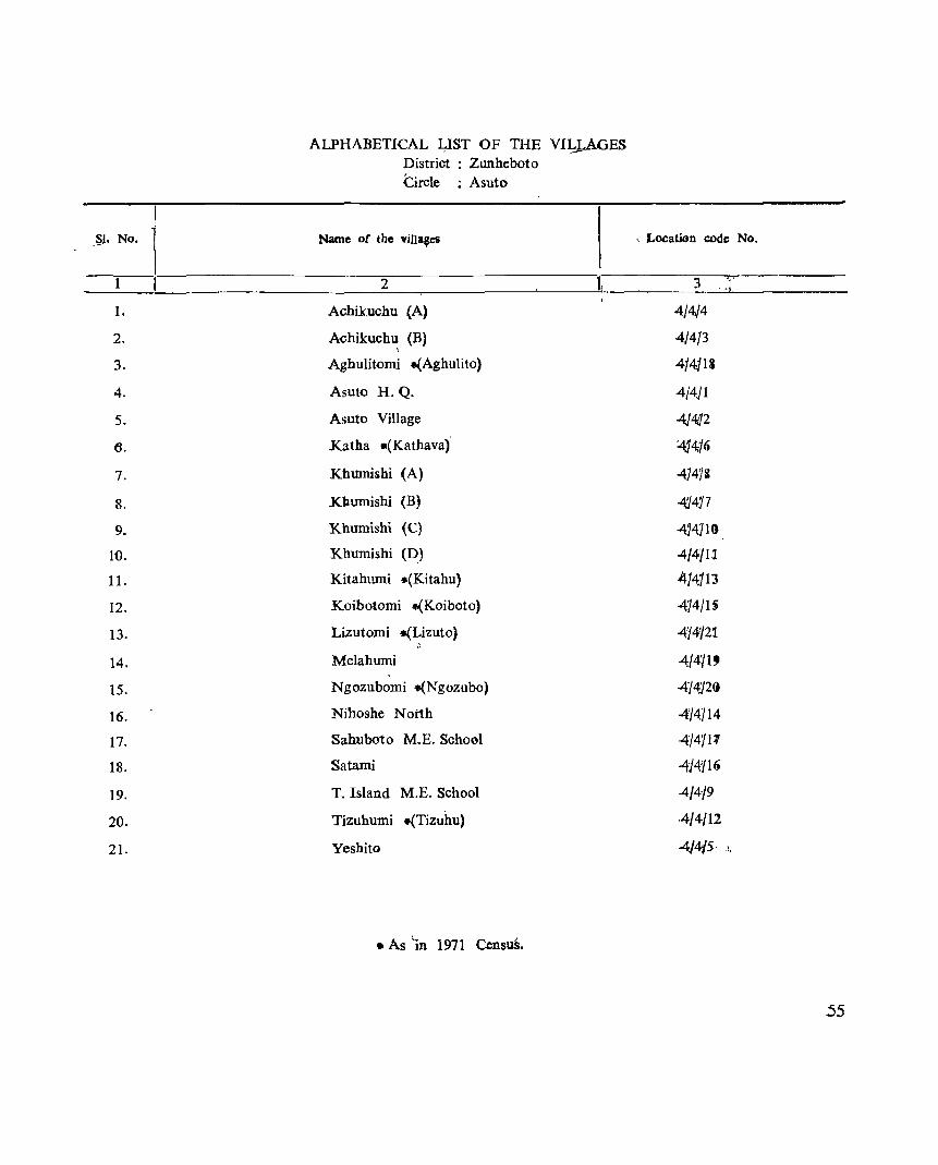
ALPHABETICAL I,JST OF THE VIIJ,.AGES District : Zunheboto Circle : Asuto
Name of the vilJa~es ~. No. j 1 :-----------2=----------1,
1. Achikuchu (A)
2. A<ihikuchu (B)
3.
4.
5.
6.
7.
8.
9.
10.
II.
12.
13.
14.
15.
16.
17.
18.
19.
20.
21.
, Aghulitomi .(Aghulito)
Asuto H. Q.
Asuto Village
Katha .(Kathava)
Khumishi (A)
Kllumishi (B)
Khumishi (C)
Khumishi (D)
Kitahumi .(Kitahu)
Koibotomi .(Koiboto)
Lizutomi -(Lizuto)
Melahumi
Ngozubomi to(Ngozubo)
Nihoshe N oi1h
Sahuboto M.E. School
Satami
T. Island M.E. School
Tizuhumi .(Tizuhu)
Yeshito
• As 'in 1971 CensuS.
. Location code No.
3
4/4J4
4./413
414j13
4/4Jl
4/4J2 414j6
4]473
-4!}4J7
414]1~
4/4/11
4/4J13
474/15
4fJ4i/21
414119
414}2(1
4'/4714
4'/411'1
-414'/19
4/4"/9
4/4/12
4)4/5· ,!,
55
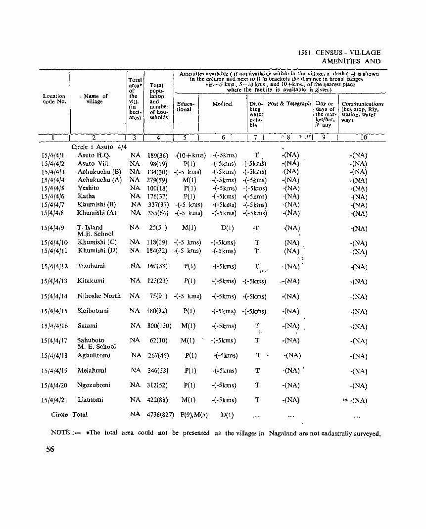
Total area· of
Location . NaIIle of the code No. village viII.
(in hect-
. ares) I 1 ! 2 ! 3 I
Circle : Asuto 4/4 15/4/4/1 Asuto H.Q. NA
IS/4/4/2 Asuto Vilt. NA 15/4/4/3 Achukuchu (B) NA 1514/4(4 Achukuchu (A) NA IS/4/4{5 Yeshito NA lS/4/4/6 Katha NA
IS/4/4/7 Khumisbi (B) NA 15/4/4/8 Khumishi (A) NA
IS/4/4/9 T. Island NA M.E. School
IS/4/4/1O Kbumishi (C) NA
15/4/4/11 Khumishi (D) NA
15/4/4/12 Tizuhumi NA
15/4/4/13 Kitakumi NA
15/4/4/14 Nihosne North NA
1S/4/4/15 Koibotomi NA
15/4/4/16 Satami NA
15/4/4/17 Sahuboto NA M. E. School
15/4/4/18 Aghulitomi NA
15/4(4/19 Melahumi NA
15/4J4/20 Ngozubomi NA
15/4/4/21 Lizutomi NA
Circle Total NA
Total popu-latiOn and number-of hou-seholds
-
4
189(36) 98(19)
134(30) 279(59) 100(18) 176(37) 337(37) 3S5(64)
25(5 )
1l~(19)
184(e2)
160(38)
123(23)
7'5(9 )
180(32)
800(130)
62(10)
267(46)
340(53)
312(52)
422(88)
1981 CENSUS ~ VILLAGE AMENITIES AND
I Amenities available ( if nOt available within in the village. a dash (-) is shown
in the column and next to it in brackets the distance in broad ranges viz.-S kms .• 5-10 kms • and lO+kms., of the nearest place
where the facility is available is given.)
Educa- Medical Drin- post & Telegraph Day or Communications tional king days of (bus SlOp. Rly.
water the mar- station, water pota- ket/hat. way) - ble if any
S I 6 I 7 I .' 8 '] )'-1 9 I 10
-(10 + krns) -(-Skms) T -(NA) \-(NA) P(l) -(-Skms) -(-Sk'm~) -(NA) -(NA)
-(-5 kms) -( -5kms) -(-5kms) -(NA) -(NA) M(I) -(-5kms) -(-SkIDS) -(NA) -(NA) P(I) -(-Skrns) -(-Slans) -{NA) -(N~) pel) -( ~5krns) -(-5kms) ·(NA) -(NA)
+5 Ions) -(-5kms) -(-Skms) -(NA) -(NA) -( -S kms) -(-5krns) -(-5kms) -(NA) -(NA)
M(l) D{l) ·T -{NA) -(NA)
-(-5 kms) -(-Skms) T (NA) _ -(NA) -(-5 kms) -(-5kms) T (NA) -(NA)
;rt ..
P(l) -(-Skms) T -(NA) . -(NA) (':.1·('
P(l) -(-Skms) -(-skms) --(NA) -(NA)
-(-5 kms) -(-5kms) -(-Skrns) -(NA) -(NA)
pel) -( -Skms) -( -Sk:d1s) -(NA) -(NA)
M(l) -(-5kms) T -(NA) -(NA)
M(I) - -(-5kms) T -(NA) -(NA)
P(l) -(-5km~) T .- -(NA) -(NA)
pel) -(-Skms) T -(NA) , -(NA)
P(l) -(-5kms) T -(NA) -(NA)
M(l) -(-5kms) T -(NA) Ii' .-(NA)
4736(827) P(9),M(5) D(l)
NOTE :- .. The total area could 110t be presented as the villages in Nagaland are not cadastrally surveyed,
56
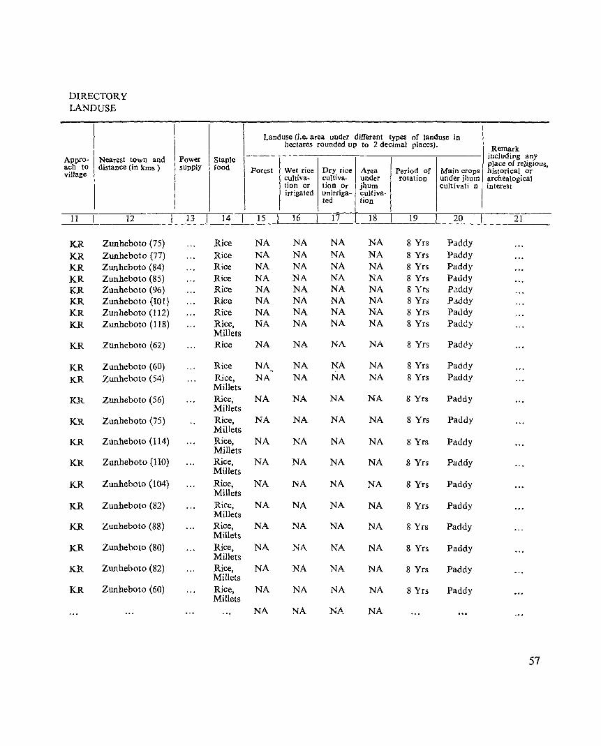
DIRECTORY LANDUSE
Appro- Nearest town and ach to distance (in kms ) village
Power Staple supply food
Landuse (i.e. area under different types of Janduse in hectares rounded up to 2 decimal places).
Forest Wet rice Dry rice Area Period of Main crops cultiva- cultiva- under rotation under jhum tion or tion Or jhum cultivati n irrigated unirriga- cultiva-
ted tion
~1~1 __ ~ __ ~1~2 ____ ~ __ ~13~~~1_4 __ ~~1~5~ ___ 16 __ ~ __ 17 __ L.~1~8~ __ ~1~9 __ ~_20
KR KR KR KR KR KR KR KR
KR
KR KR
KR
KR
KR
KR
KR
KR
KR
KR
KR
KR
Zunheboto (75)
Zunheboto (77) Zunheboto (84) Zunheboto (85) Zunheboto (96) Zunheboto (10 I) Zunheboto (112) Zunheboto (118)
Zunheboto (62)
Zunheboto (60) Zunheboto (54)
Zunheboto (56)
Zunheboto (75)
Zunheboto (ll4)
Zunheboto (110)
Zunheboto (104)
Zunheboto (82)
Zunheboto (88)
Zunheboto (80)
Zunheboto (82)
Zunheboto (60)
Rice NA Rice NA Rice NA Rice NA Rice NA Rice NA Rice NA Rice, NA Millets Rice NA
Rice NA Rice, NA Millets Rice, NA Millets Rice, NA Millets Rice, NA Millets Rice, NA Millets Rice, NA Millets Rice, NA Millets Rice, NA Millets Rice, NA Millets Rice, NA Millets Rice, NA Millets
NA
NA NA NA NA NA NA NA NA
NA
NA NA
NA
NA
NA
NA
NA
NA
NA
NA
NA
NA
NA
NA NA NA NA NA NA NA NA
NA
NA NA
NA
NA
NA
NA
NA
NA
NA
NA
NA
NA
NA
NA NA NA NA NA NA NA NA
NA
NA NA
NA
NA
NA
NA
NA
NA
NA
NA
NA
NA
NA
8 Yrs 8 Yrs 8 Yrs 8 Yrs 8 Yrs 8 Yrs 8 Yrs 8 Yrs
8 Yrs
8 Yrs 8 Yrs
8 Yrs
8 Yrs
8 Yrs
8 Yrs
8 Yrs
8 Yrs
8 Yrs
8 Yrs
8 Yrs
8 Yrs
Paddy Paddy Paddy Pc:lddy P.'.ddy Paddy Paddy Paddy
Paddy
Paddy Paddy
Paddy
Paddy
Paddy
Paddy
Paddy
Paddy
Paddy
Paddy
Paddy
Paddy
Remark includjpg any place of religious, historical or archealogical interest
21
57

SURUHOTO CIRCLE
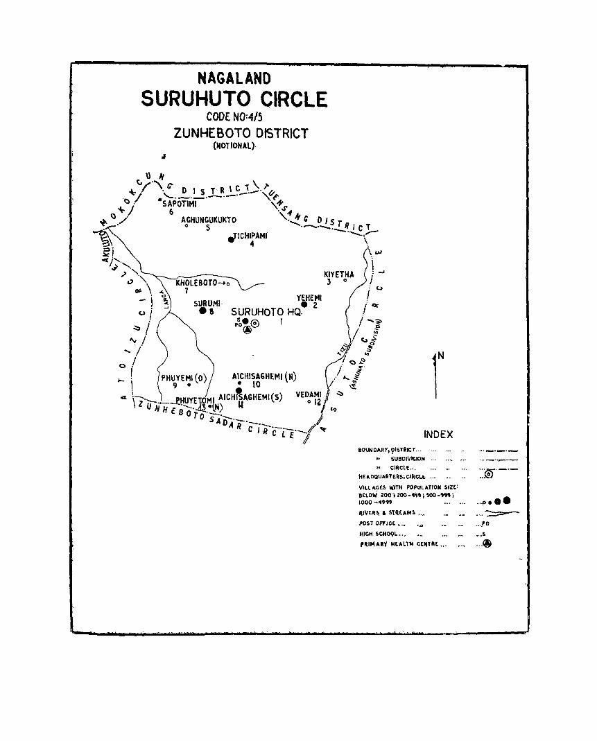
NAGALAND SURUHUTO CIRCLE
CODE NO:4/5
ZUNHEBOTO DISTRICT (NOTIONAL).
\:, \) ,\" \ ~ ./' • C' DIS T' R ..!..~.J.-.)' q
'<:>Jl ·~PonM-1 . __ . '\{+J' ~ 6 . -I
~ ~./ AoGHUN~UKUKTO '.~.!.._~~ T R , C 1 ~ _ ........... ,,,,.-
'3\ .TICH~AMI \.
~i \ uJ
~j', i ~ '-',," KIYETHA " _. ~ V ''\ KHOlEBOTO-+o 3 0
_\ 7 /:u I, YEHEMI
- SURUMI, • 2 .1 cc u i • ! SURUHOTO HQ. .
• p~.1Q'\ I / .... ~ ~/ ®~ / ~
"v j , <.1$ ..... '/' ~~ ~ '" . '" / 70e o.
,_ ! PHUYEMI (0) AICKISAGHEMI (N) /"'/ I 9 • • 10 I ~
4 \-._ PHUYE HI AICHftAGHEMI(S) VEOoAr{7':::' Z U N H'EBo' .~) lot C')
TO SA'o'-'_
r ARc ,'-R .-._. d
C L Ef' INDEX
1I0UNDARY,9ISTRICT,.. ...
.. SUBOIVI$ION... .... • ..
.. 'CI,RCtE ...
HEADQUARTERS. CIRCl.t.... ... . ..
VILLAGES WITH POPULATION Silt: BELOW lOO'HOC-"" i !oOO-''J'J i 1000 -4'1"
RIVtlls .. Slllt.AMS .. ~
pOST OFfICE •• ,
HIGH SCHOOL ...
'RI!'IAKY HULT14 CtIlTII£: ...
"®'-'-
"'0 •••
... ~
.. .I'D
. .. :.
... ~

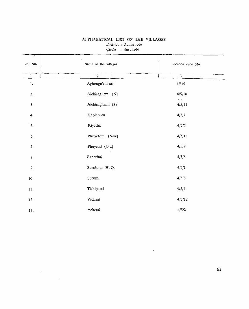
ALPHABETICAL LIST OF THE VILLAGES District : Zunheboto Circle : Suruhoto
Sl. No. Name of the villages Loc,atioJ:l code No.
1 2 3
1- Ag~ungukukuto 4/5/5
2. Aichisaghemi (N) 4/5/10
3. Aichisaghemi (8) 4/5/11
4. Kholeboto 4/5/7
5. Kiyeiha 4/5/3
6. Phuyetomi (New) 4/5/13
7. Phuyemi (Old) 4/5/9
8. Sapotimi 4/5/6
9. Suruhoto H.Q. 4/5/1
10. Surumi 4/5/8
II. Tichipami ~/5!4
12. Vedami .4/5/12
13. Yehemi 4/5/2
61
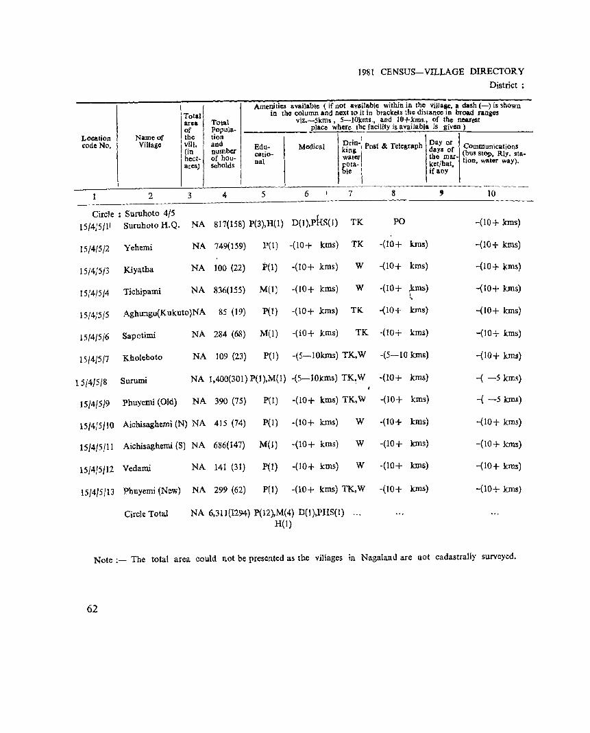
Total area Total of PopuJa-
Location Name of the tion code No. Village viii. and
(in number hect- of hou-ares) seholds
1 2 3 4
1981 CENSUS-VILLAGE DIRECTORY
District;
Amenities available (if not available within in the villaae, a dash (-) is shown in the column and next to it in brackets the distance in broad ranges
viz.-Skms, 5-lOkms., and lO+kms., of the nearest place where the facility is available is given)
Drin-I Edu- Medical
Day or king I Post'" Tele&raph days oC Communications
catio- water the mar- (bus stop, Rly. sta-nal pota- ketjhat. tion, waler way).
ble if any
5 6 7 II , 10
Circle : Suruhoto 4/5 I
15/4}5/11 Suruboto H.Q. NA 817(158) P(3),H(1) D(l ),PHS( I) TK PO -(10+ krns)
15/4/5/2 Yehemi NA 749(159) P(i) -(10+ kms) TK -(10+ kIns) -{1O+ kms)
15/415/3 KiYl\tha NA 100 (22) P(I) -(10+ kms) W -(10+ kms) -(10+ ,terns)
15/4/5/4 Tichipami NA 836(155) M(Il -(10+ kms) W -(10+ fll1s) -{10+ kms) '.
15/4/5/5 Aghungu(Kukuto)NA 85 (19) P(l) -(10+ kms) TK -(10+ kIDs) -(10+ kms)
15/4/5}6 Sapotimi NA 284 (68) M(1) -(10+ kms) TK -(10+ kms) -(10+ kms)
15/4/5/1 Kholeboto NA 109 (23) P(I) -(5-10krns) TK,W -(5-10 kms) -(10+ kms)
15}4/5/8 Surumi NA 1,400(301) P(l),M(l) -(5-IOkrns) TK~W -(10+ kms) -{ -5 kms)
15/4/519 Phuyemi (Old) NA 390 (75) P{l) -(10+ kms) TK,W -(10+ krns) -( -5 lans)
15/4/5/10 Aichisaghemi (N) NA 415 (74) pel) -(10+ kms) W -(10+ kms) -(10+ kms)
15/4/5/11 Aichisaghemi (S) NA 686(141) M(l) -(10+ kms) W -(10+ kIns) -(10+ kms)
15/4!5}12 Vedam.i NA 141 (31) P(I) -(10+ kms) W -(10+ kms) -{10+ kms)
15/4/5!13 Phuyerni (New) NA 299 (62) pel) -(10+ kms) TK,W -(10+ kms) -(10+ kIDS)
Circle Total NA 6,311(1294) P(12),M(4) D(l),PHS(I) H(l)
Note ;- The total area could not be presented as the villages in Nagaland are not cadastrally surveyed.
62
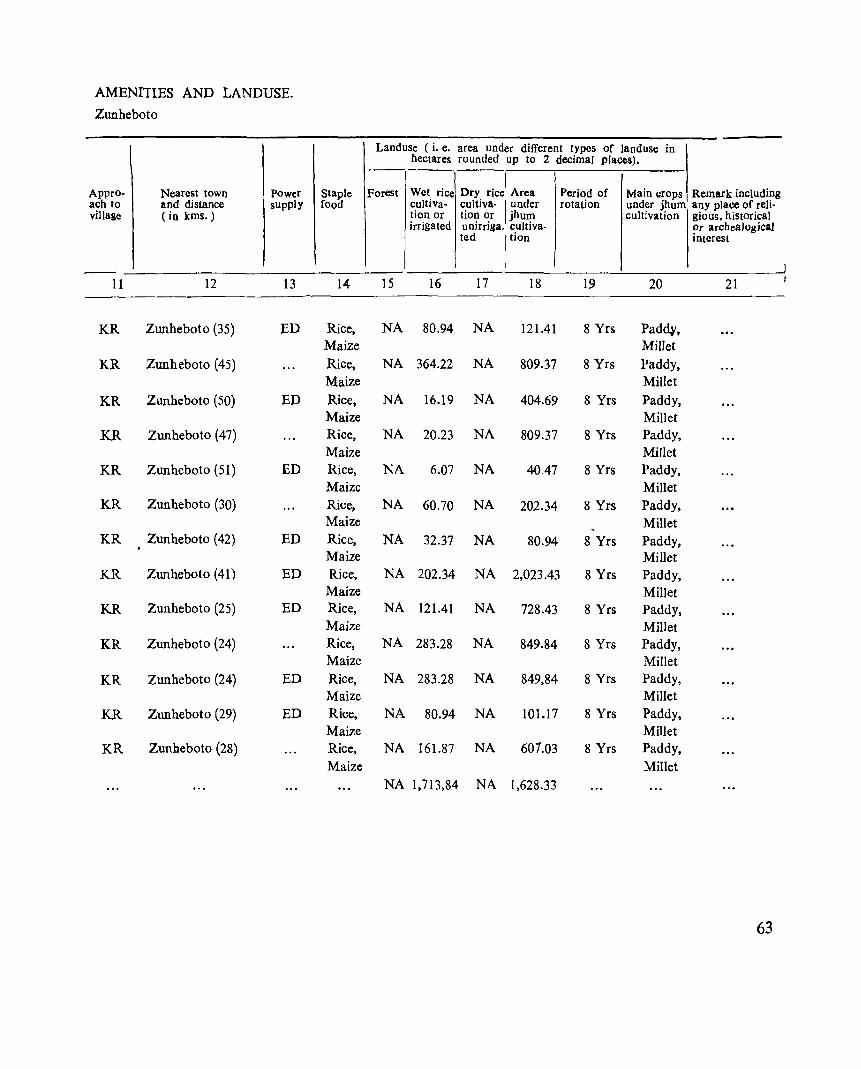
AMENITIES AND LANDUSE.
Zunheboto
Appro ach to village
-
11
KR
KR
KR
KR
KR
KR
KR
KR
KR
KR
KR
KR
KR
Nearest town . Power and distance supply (in kms.)
12 13
Zunheboto (35) ED
Zunheboto (45)
Zunheboto (50) ED
Zunheboto (47)
Zunheboto (51) ED
Zunheboto (30)
Zunheboto (42) ED
Zunheboto (41) ED
Zunheboto (25) ED
Zunheboto (24)
Zunheboto (24) ED
Zunheboto (29) ED
Zunheboto (28)
Staple food
14
Rice, Maize
Rice, Maize
Rice, Maize Rice, Maize Rice, Maize Rice, Maize Rice, Maize Rice, Maize Rice, Maize Rice, Maize
Rice, Maize Rice, Maize Rice,
Maize
Landuse (i. e. area under different types of land use in hectares rounded up to 2 decimal places).
-------I
Forest Wet rice Dry rice Area Period of Main crops Remark including cultiva- cultiva- I under rotation under jhum any place of reli-tion or tion or jhum cultivation gious. hiStorical irrigated unirriga. cultiva- !,r archeaJogical
ted Ition Interest
J 15 16 17 18 19 20 21
NA 80.94 NA 121.41 8 Yrs Padd¥, Millet
NA 364.22 NA 809.37 8 Yrs Paddy, Millet
NA 16.19 NA 404.69 8 Yrs Paddy, Millet
NA 20.23 NA 809.37 8 Yrs Paddy, Millet
NA 6.07 NA 40.47 8 Yrs Paddy, Millet
NA 60.70 NA 202.34 8 Yrs Paddy, Millet
NA 32.37 NA 80.94 8 Yrs Paddy, Millet
NA 202.34 NA 2,023.43 8 Yrs Paddy, Millet
NA 121.41 NA 728.43 8 Yrs Paddy, Millet
NA 283.28 NA 849.84 8 Yrs Paddy, Millet
NA 283.28 NA 849,84 8 Yrs Paddy, Millet
NA 80.94 NA 101.17 8 Yrs Paddy, Millet
NA 161.87 NA 601.03 8 Yrs Paddy,
Millet NA 1,713,84 NA 1,628.33
63
ZUNHEBOTO SADAR CIRC~E ,
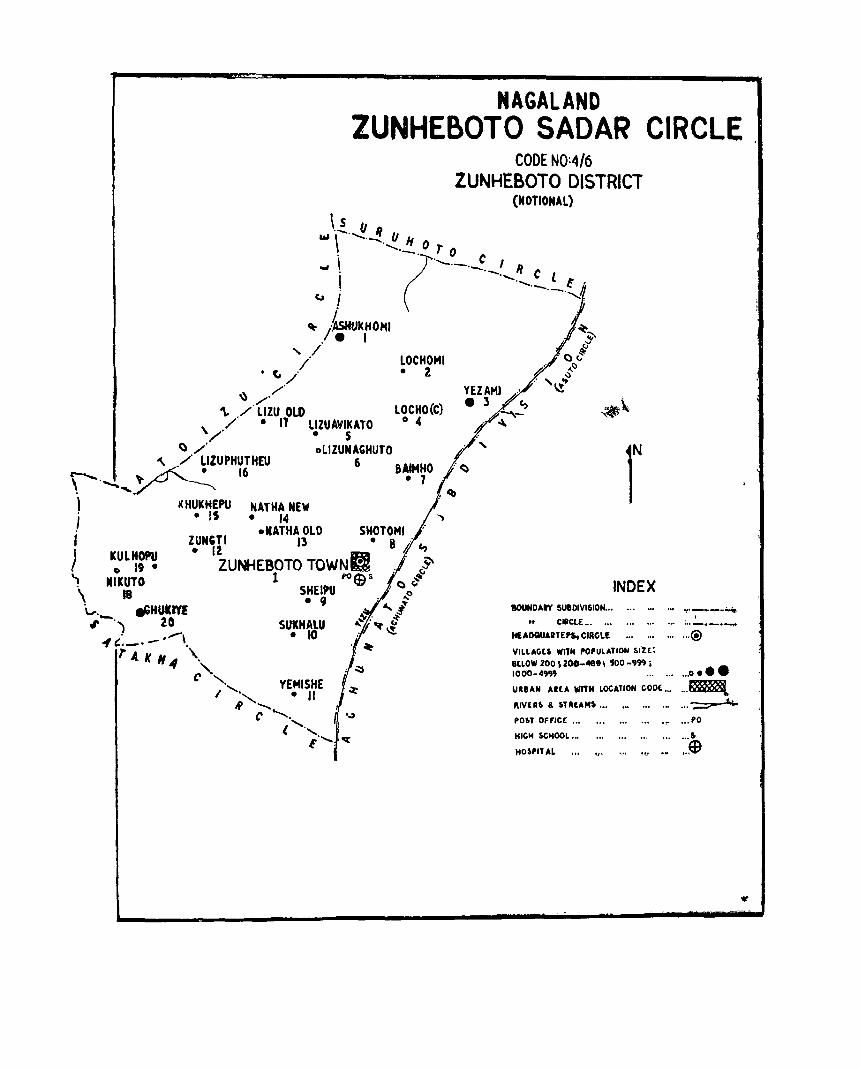
NAGALAND lUNHEBOTO SADAR CIRCLE
\..!_ II Ii
CODE NO:4/6 ZUNHEBOTO DISTRICT
(NOTIONAL)
&II \ ........... _. II H . _._(.0 rOC ~ \ '-'-.-._' II
! ·-,-.:'.~.t ' Col I ~.
~ /'~kHOHI . +. • I ~
, ~ " / . ,...,~ / ' LOCHOMI " v
(, , • 2 # ~() ,/'/ ",,~ ..
~/ '\, ./ L1lU OLD LOCHO(C) -.._'"
\ / • 11 LllUAYlkATO 0 4 ~ /' • 5
a /' oLlZUNACHUTO '\ ,/ ~IZUPHUTHEU 6 &AlHHO
r--, . '" L-f'.....· 16 • 7 \ ....... ,_;,r- ----.... r , KHUKHEPU , • IS I
NATHA NEW • 14 , -HATHA OLD SHorOMI
lUNGTI 13 • 8 i ..... • 12 FE "'7 ) ICULHOPU 019·
'1 MIKUTO \ 18 v. eGHUkrtf: ",-,,) 20
. ........\ -1',---' .
ZUNHEBOTO TOWNe . ~ 1 I'Oths: ~
W . C) ~ SHEIPU . . ...0
• II ',,~T SUKHAlU
• 10 ~: t " ~~
lAtH" \ ,,',. YEMISHE I ......... , ."
N .................. C .
~ ......... ,. t -. oq:
INDEX BOUNDAty SUBDIVISION .. .
CIRCLE .. , ... ... • ..
ItEADQUARTEP5, CIAGL£ .. ' ...
VILLAIiU WITII POPULATION silt: BlLOW 200 , 200-'191 \ SOD -'99 i 1000-4'"
.Of "f'_"-"~ ,
... : .. -.-.~ ... ®
, .. 0 •••
URUN AltA wnM LOCATION coot .,' , .. ~ "IVERS & 'TAtAM' ••• ._ '" . .. ... -::;::;== .l;:.
PO~T OFFice '" .,.PO
HICOH SCHOOL... ,.. .., .. , ... • .. r. HO$,n AL ... ". ... .., •• ..$

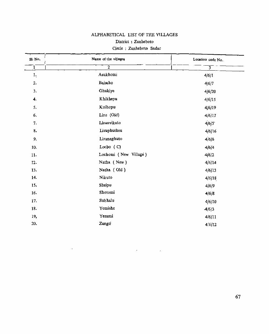
ALPHABETICAL LIST OF THE V1LLAGES
District : Zunheboto
Circle ; Zunheboto Sadar
SI. No. I Name of the vill-ses Location code No.
-1-1 2 3
1. Asukhomi 4/6/1
2. Baimho 4/6/7
3. Ghukiye 4/6/20
4. Khikhcpu 4/6/15
5. Kulhopu 4/6/19
6. Lizu (Old) 4/6/17
7. Lizuavikato 4/6/5-
8. Lizuphutheu 4/6/16
9. Lizunaghuto 4i6/6
10. Loo1,Io (C) 4/6/4
11. Lochomi (New Villag~ ) 4/6/2
12. Natha (New) 4/6/14
13. Natha (Old) 4/6/13
14. Nikuto 4/6/18.
15. Sheipu 4/6/9
16. Shotomi 4/6/8
17. Sukhalu 4/6(10
18. Yemishe 4/6/3
19, Yezami 4/6/11
20. Zungti 4.'6/12
67
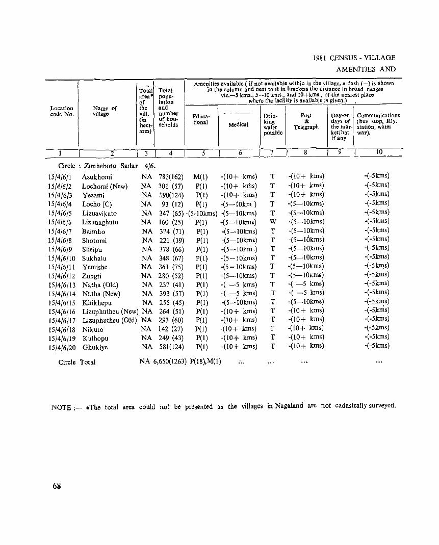
.. Total area· of
Location Name of the code No. village vill.
(in hect-ares)
2 I 3 I Circle : Zunheboto Sadar 4/6.
15/4/6/1 Asukhomi NA
15/4/6/2 Lochomi (New) NA
15/4/6/3 Yezami NA
15/4/~/4 Locho (C) NA
IS/4/6/S Lizuavikato NA
15/4/6/6 Lizunagl)_uto NA
IS/4/6/7 Baimho NA
15/4/6/8 Shotomi NA
15/4/6/9 Sheipu NA
15/4/6/10 Sukhalu NA 15/4/6'/11 Yemishe NA
IS/4/6/f2 Zungti NA
IS/4/6/13 Natha (Old) NA
15/4/6/14 Natha (New) NA
1514/6/15 Khikhepu NA
15/4/6/16 Lizuphutheu (New) NA
15/4/6/17 Lizuphutheu (Old) NA
15/4/6(18 Nikuto NA
151'4/6/19 Kulhopu NA
15/4/6/20 Ghukiye NA
Total popu-lat10n and number of hou-seholds
4
783(162)
301 (57) 590(124) 93 (12)
1981 CENSUS - VILLAGE
AMENITIES AND
Amenities available ( if not available within in the village, a dash (-) is shown In the column and next to it in brackets the distance in broad ranges
viz.-5 kms., 5-10 kms., and IO+kms., of ,I he nearest place where the facility is available is given.) ;
Educa- - --- Orin- Post Day-or Communica tions tional Medical king & days of (bus stop, Rly.
water Telegraph the mar- station, water potable ket/hat way).
ifany
S 6 7 8 9 10
M(l) -(10+ kms) T -(10+ kms) -(-Skms)
pet) -(10+ kms) T -(10+ kms) -( -Skms)
P(l ) -(10+ kms) T -(10+ kIDs) -( -Skms)
P(1) -(5-10km) T -(S-10kIDs) -(-Skms)
347 (65) -(S-10kms) -(5-10kms) T -(S-10kms) -(-Skms)
160 (25) P(I) -(S-10kms) W -(5-1Okms) -(-Skms)
374 (71) P(l) -(S-lOkms) T -(S-lOkms) +Slcms)
221 (39) P(l) -(S-lOkmg) T -(S-l(~kms) -(-SkIns)
378 (66) P(l) -(S-1Okm) T -(S-10kIns) -(-Skms)
348 (67) P(1) -(S-1Okms) T -(5-10kms) -(-Skms)
361 (7S) P{l) -(S-lOkms) T -(S-10kms) -( -SkIl1s)
280 (S2) P(l) -(S-10kms) T -(S-lOKllli) -(-5 kIDS)
237 (41) P{I) -( -5 kIDS) T -( -S kms) -(-Skms)
393 (S7) P{I) -( -c5 kms) T -( -5 kms) -(-Skms)
255 (4S) P(l) -(S-10kms) T -(S-lOkms) -(-5k~s)
264 (51) P{l ) -(10+ kms) T -(10+ kIDS) -( -5kms)
293 (60) P{l) -(10+ kms) T -(10+ kms) -(-5kms)
142 (27) pel) -(10+ kms) T -(10+ kIDS) -(-Skms)
249 (43) P(l) -(10+ kms) T -(10+ kms) -(-Skms)
581(124) P(l) -(10+ kms) T -(10+ kIDs) -(-Skms)
Circle Total NA 6,650(1263) P(18),M(1) ...
NOTE :- .The total area could not be presented as the villages in Nagaland are not cadastrally surveyed.
68
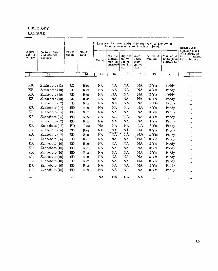
DIRECTORY
LANDUSE
Appro- Nearest town ach to and distance village (in kms.)
11 12
.KR Zunheboto (12) KR Zunheboto (10) KR Zunheboto (10) KR Zunheboto (10) KR Zunheboto ( 7) KR Zunheboto ( 7) KR Zunheboto ( 5) KR Zunheboto ( 6) KR ZlUlheboto ( 7) KR Zunheboto ( 8) KR Zunheboto ( 6) KR Zunheboto ( 7) KR Zunheboto ( 6)
KR Zunheboto (10) KR Zunheboto (10) KR Zunheboto (10) KR Zunheboto (10) KR Zunheboto (10)
KR Zunheboto (10)
KR Zunheboto (10)
Power Staple supply food
13 14
ED Rice ED Rice ED Rice ED Rice ED Rice ED Rice ED Rice
ED Rice ED Rice ED Rice ED Rice ED Rice ED Rice ED Rice ED Rice ED Rice ED Rice ED Rice ED Rice ED Rice
Landuse (i.e. area under different types of land use in hectares rounded upto 2 decimal places). Remark inclu-
ding any place
Wet rice Dry rice Area Period of Main crops of religious, his-torical or archea-
cuJtiva- cultiva- under rotation under jhum logical interest Forest tion Or tion or jhum cultivation irrigated uniniga- cultiva-
ted lion
15 16 I 17 18 19 20 21
NA NA NA NA 8 Yrs Paddy NA NA NA NA 8 Yrs Paddy NA NA NA NA 8 Yrs Paddy NA NA NA NA 8 Yn Paddy NA NA NA NA 8 Yrs Paddy NA NA NA NA S Yrs Paddy NA NA NA NA 8 Yrs Paddy NA NA NA NA 8 Yrs paddy NA NA NA NA 8 Yrs Paddy NA NA NA NA 8 Yrs Paddy NA NA NA' NA 8 Yrs Paddy - ~L.NA·1 -'1 NA NA !,NA' , 8 Yrs Paddy NA NA NA -NA L 8 Yrs Paddy NA NA NA NA 8 Yrs Paddy NA NA NA NA 8-Yrs Paddy NA NA NA NA 8 Yrs Paddy NA NA NA NA 8 Yrs Paddy NA NA NA NA 8 Yrs Paddy NA NA NA NA 8 Yrs Paddy NA NA NA NA 8 Yrs Paddy
NA NA NA NA
69
ATOIZO CIRCLE
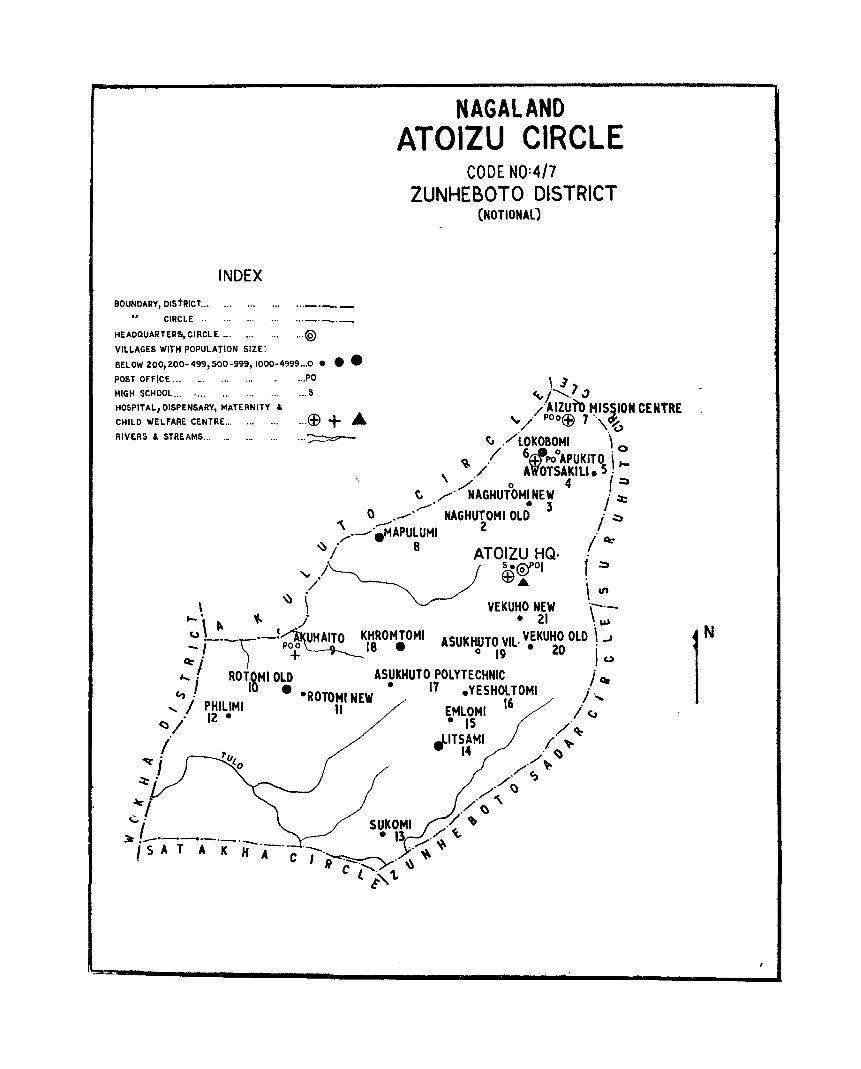
INDEX
BOUNDARY, DiStRICT... ... ...
... CIRCLE ..
NAGALAND ATOIZU CIRCLE
CODE NO:4/7 ZUNHEBOTO DISTRICT
(NOTIONAL)
HEADQUARTER&,CIRCLE... ... ... ...(§) VILLAGES WITH POPULATION SIZE:
BELOW 200,200- 499, 500 -999,1000-4999 ... 0 • •• POST OFFICE... _. ...... ...PO \ ]
~l""? " HIGH SCHOOL... .... ...... • .. 5
HOSPITAL, DISPENSARY, MATERNITY &
CHILD WELFARE CENTRE .. ,
RIVERS & STREAMS... ._ .. , ...
... C£l + .at. . ,.~
/AIZUTo HIS.SION CENTRE " . p00ffi' 7" d'. / w \'6
~ ./lOkOBOMI " 0
~ / 6~pooAPUkITO i \ ./ A'W'OTSAKIU. 5 . t-
../ ° 4 {:;, C ~. NAGHUTOMINEW " ~ /,,' • 3
"\ 0 .,..-"._. NAGHU~OMI OLD i ~ /._..·.MAPULUMI /
~ ;' 8 ATOIZU HQ. . Q:-
/ s·@tol f .:::» / ~A'
• \ VI
\ ~ \ VEKUHO NEW ',--.-..... \ ~ '4- }' • 21 . ~ U ._.\)._t~' UHAITO KHROMTOMI ASUKHUTO VIL. VEKUHO OLD \ ...J - I poo 18 • 0 • 20 I'
Q:- • + 19 0
,....,1 ROTOMIOLD ASUkHUTO POLYTECHNIC j' car [0 • • 17 c., . ·ROTOHI NEW .YESHOLTOMI i· .....
..... / PHllIMI II EMLOMI 16 /' . 12. c;" (:1/ • 15 .
/. "ITSAMI /~ ~
14 . <) 'o:r j /./" ~. / ~
/' .~
./ () "\ SUKOMI .'/ ~
~ ._'~--._._ • 13 .-:: ~ I 5 A T A K H 'A-' C '-'~. "~,,
I R ",.""":--"_ y' \\
c £"i" 1.
r

81. No. -I
1 I I.
2.
3.
4.
5.
6.
7.
8.
9.
10.
II.
12.
13.
14.
15.
16.
17.
18.
19.
23.
21.
ALPHABETICAL UST OF THE VILLAGES
District : Zunheboto
Circle ; Atoizu
Name of the villages
2
Aizuto Mission Centre
Akuhaito
Apukito
Asukhuto Polytechnic
Asukhuto Village
Atoizu H. Q.
Awotsakili • (Aochakilimi)
Emlomi
Khromtomi
Litsami
Lokobomi
Mapulumi
Naghutomi (New) _ (Nagatumi)
Naghutomi (Old)
Philimi
Rotomi (New) ttJRottomi)
Rotomi (Old)
Sukomi
Vekuho (New)
Vekuho (Old)
Yesholtomi
_ As in 1971 Census
Location code No.
3
4/7/7
4/7(9
4/7/5
4/7/17
4/7/19
4/7/1
4/7/4
4/7/15
4/7/18
4/7/14
4/7/6
4/7/8
4/7/3
4/7/2
4/7/12
4/7/11
4/7/10
4/7/13
4/7/21
4/7/20
4/7/16
73
Total Total area'" popu-of lation
Location Name of the and code No. village vill. number
(in of hou-hect- seholds ares)
2 I 3 4
Circle: Atoizu 4/7
15/4/711 Atoizu H.Q_ NA 447(84}
15/4/712 Naghutomi (Old) NA 454(96)
15/4/7/3 Naghutomi (New) NA 140(29}
15/4{7/4 Awotsakili NA 329(59)
15/417/5 Apukito NA 102(14)
15}4/7/6 Lokobomi NA 366(63)
15/4}7/7 Aizuto Mission NA 169(30)
Centre
15}4}7/8 Mapulumi NA 510(99)
15/4/7/9 Akuhaito NA 163(29)
15/4/7/10 Rotomi XOld) NA 706(131)
15/4/7/11 Rotomi (New) NA 295(57)
15/4/7/12 Philimi NA 474(98)
15/411f13 Sukomi NA 323(60)
15/417/14 Litsami NA 668(119)
15/417/15 Emlomi NA 309(55)
15/4/7/16 Yesholtomi NA 414(76)
74
1981 CENSUS - VILLAGE
AMENITIES AND
Amen.~ties available ( if not avail.l\~le within in the village, a dash (-) is shown In the column and Dext to It In brackets the distaDce in broad ranges
viz.-5 kms., 5-10 kms., and W+kms., of the nearest place where the facilit) is available is given.)
Educa- Drin- Post Davor Communications tional Medical king & days of (bus stop. Rly.
water Telegraph the mar- station, water potable ket/hat way)_
if any
5 6 II 7 8 9 10
P(3),H(2) £(l),D(I) T PO BS
P(3) -(-5 kms) T -(-5 kms) BS
P(3) I -(-5 kms) T -(-5 kms) BS
P(3) -(-5 kms) T -(-5 kms) BS
M(2) -(-5 kms) T +5 kms) BS
P(3) H(l) T PO BS
P(3) H(I) T . PO BS
P(3) -(5-10 lcms} T -( '5-10 kms) -(10+kms) ,
M(2) D(l) T PO -(10+ kms)
P(3) -(-5 kms) T -(-5 kms) -(lO+kms)
P(3) -(-5 kms) T -(-5 kms) -(lO+kms)
P(3) -(5-10 kms,) T -(5-10 kms) -(10+kms)
P(3) -(lO+kms) T -(IO+kms) -(lO+kms)
P(3) -(10+kms) T -(lO+kms) -(lO+kms)
P(3) -(IO+kms) T -(lO+kms) -(I 0+ kms)
P(3) -(lO+kms) T -(10+kms) -(lO+kms)
DIRECTORY
LANDUSE
-
Appro- Nearest town ach to and distance village (in kms.)
11 12
KR Zunheboto (25)
KR Zunheboto (35)
KR Zunheboto (35)
KR Zunheboto (30)
PR Zunheboto (32)
PR Zunheboto (31)
PR Zunheboto (31)
KR Zunheboto (45)
KR Zunheboto (40)
KR Zunheboto (48)
KR Zunheboto (48)
KR Zunheboto (50)
KR Zunheboto (35)
KR Zunheboto (33)
KR Zunheboto (30)
KR Zunheboto (28)
power Staple supply food
13 14
ED Rice, Maize
ED Rice, Maize
ED Rice, Maize
ED Rice, Maize
ED Rice, Maize
ED Rice, Maize
ED Rice, Maize
ED Rice, Maize
ED Rice, Maize
ED Rice, Maize
ED Rice, Maize
ED Rice, Maize
ED Rice, Maize
ED Rice, Maize
ED Rice, Maize
ED Rice, Maize
Landuse (i.e. area under different types of land use in hectares rounded upto 2 decimal places).
Remark inclu-ding any place
Wet rice Dry rice Area Period of Main crops of religious, his-torical or archea·
Forest cultiva- cultiva- under rotation under jhum logical interest tion or tion or jhum cultivation irrigated unirriga- cultiva-
ted t10n
15 16 17 18 19 20 21
NA 8.09 60.70 80.94 7 Yrs Rice, Maize
NA 40.47 20.23 404.69 7 Yrs Rice,
Maize NA 10.11 4.05 40.47 7 Yrs Rice,
Maize NA 20.23 6.07 202.34 7 Yrs Rice,
Maize NA 6.48 4.05 101.17 7 Yrs Rice,
Maize NA 40.47 8.09 242.81 7 Yrs Rice,
Maize NA 2.43 1.62 40.47 7 Yrs Rice,
Maize NA 20.23 20.23 80.94 7 Yrs Rice,
Maize NA 4.05 4.05 80.94 7 Yrs Rice,
Maize NA 40.47 8.09 323.75 7 Yrs Rice,
Maize NA 32.37 6.07 141.64 7 Yrs Rice,
Maize NA 10.12 4.05 1618.74 7 Yrs Rice,
Maize NA 11.33 8.09 2023.43 7 Yrs Rice,
Maize NA 12.14 8.09 2832.80 7 Yrs Rice,
Maize NA 8.50 4.05 1214.06 7 Yrs Rice,
Maize NA 12.14 46.54 2023.43 7 Yrs Rice,
Maize
75
Location code No.
1
15/4/7/17
15/4/7/18
15/4/7/i9
15/4/7/20
15{4/7/21
Name of village
2
Asuxhuto Polytechnic Khromtomi
Asukhuto Vill.
Vekuho (Old)
Vekuho (New)
Circle T otaI
I
Total area· Total of the viII. (in hectares)
3 ! I
popu-lation and number of hou-seholds
4
1981 CENSUS - VILLAGE AMENITIES AND
Amenities available ( if no! available within in the village, a dash (-) is shown in the column and next to it in brackets the distance in broad ranges
viz.-5 kms., 5-10 kms , and lO+kms., of the nearest place where the facility is available is given.)
Educa- Medical ,Drin- Post & Telegraph Day or COmmunications tional king days of (bu~ stop, Rly.
water the mar- stauon, water pota- ket/hat, way) ble if any
5 6 I 7 8 9 10
NA 318(77) TR(l),P(3) -(-5 kms) T -(-5 kms) BS
NA 543(99) P(3) '-(10+kms) T (10+kms) -(lO+kms)
NA 69(14) -(NA) -(-5 kms) T -(-5 kms) BS
NA 348(60) P(3) -( -5 kms) T -(-5 kms) i BS
NA 346(63) P(3) -(-5 kms) T -(-5 kms) BS
NA 7,493(1412) P(54),H(2), H(3),D(2) M(4),TR(1)
Note;- .The total area could not be presented as the villages in Nagaland are not cadastrally surveyed'
76
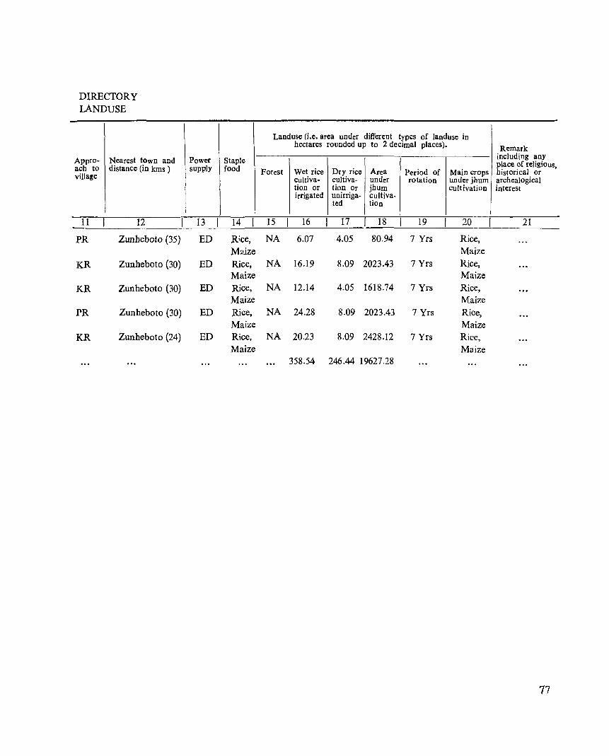
DIRECTORY LANDUSE
Appro- Nearest town and ach to distance (in kms ) viJIa!e
11 12
PR Zunheboto (35)
KR Zuuheboto (30)
KR Zunheboto (30)
PR Zunheboto (30)
KR Zunheboto (24)
Power Staple supply food
13 14
ED Rice, M:J.ize
ED Rice, Maize
ED Rice, Maize
ED Rice, Maize
ED Rice, Maize
Landuse (i.e. area under different types of landllse in hectares rounded up to 2 decimal places). Remark
including any place of religious,
Forest Wet rice Dry rice Area Period of Main crops historical or cultiva- cultiva- under rotation under jhum archealogical tion or tion Or jhum cult ivation interest irrigated unirriga- cultiva-
ted tion
15 16 17 18 19 20 21
NA 6_07 4.05 80.94 7 Yrs Rice, Maize
NA 16.19 8.09 2023.43 7 Yrs Rice, Maize
NA 12.14 4.05 1618.74 7 Yrs Rice, Maize
NA 24.28 8.09 2023.43 7 Yrs Rice, Maize
NA 20.23 8.09 2428.12 7 Yrs Rice, Ma.ize
358.54 246.44 19627.28
77
AKULUTO CIRCLE
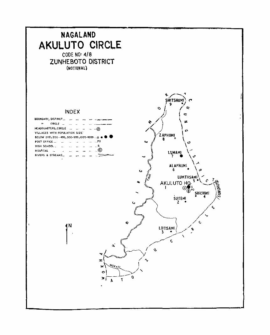
NAGALAND AKULUTO CIRCLE
CODE NO: 4/8 ZUNHEBOTO DISTRICT
(NOTIONAl)
INDEX BOUNDARY/ DISTRICT... ..' .~
Cll?ClE .•. •.. .. ._
HEADQUARTERS, CIRCLE ... _. _ .. , _.@ VILLAGES WITH POPULATION SIZE:
BELOW 200, 200- 499. 500·999.100')-4999 ··.0 •••
POST OFFICE ..• ... .• . .. PO
HIGH SCHOOL .. ... ... ~. _. ._ ... S
H O~PITAL ._ .• - ~. •.. . .. E£> RIVERS & STREAMS_.
r ~'
"-/'_,7 SHITSHUMI\ ~ I 9 ./
~ I / ~ /'/, I c::
~, \-z; /,/ \
~.
'1 lAPHUMI \ G"
8 0 \. 0
\ lUMAMI \ .....
7 • \\1'
ALAPHUMI \\,.,A 6 • ,-P
LUMTHSAMI\ /' AKULUTO HQ, 5 .\~_~\%
I @.~o \~ .~ ffi SHICHIMI j ~
5UTEMI • 4 j~ 2 • • /
/~
/ ./'.."
/~
LOTlSAM1 / 3· ./ ~
,~.--,~ \
_,/'"" C /'
/ \\ ~/
X( ./ "" ~~O/(A.TI I . / 0\ . '-.v
,_.-. '-0 ~I t.. T
I

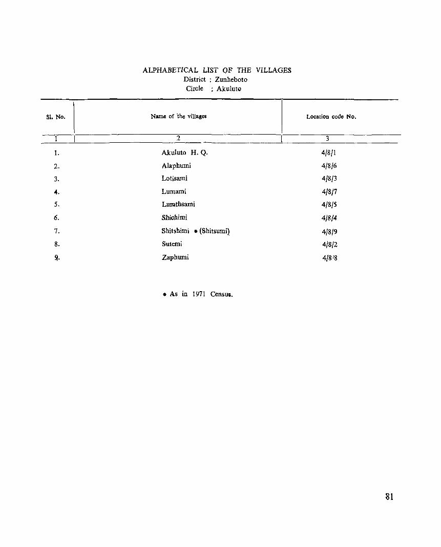
SI. No.
t
1.
2.
3.
4.
5.
6.
7.
8.
~.
ALPHABETICAL LIST OF THE VILLAGES District : Zunheboto Circle : Akulut"
Name of the villages
2
Akuluto H.Q.
Alaphumi
Lotisami
Lumami
Lumthsami
Shichimi
Shitshimi • (Shitsumi)
Sutemi
Zaphumi
• As in 1971 Census.
Location code No.
3
4/8/1
4/8/6
4/8/3
4/8/7
4/8/5
4/814
4/8/9
4/8/2
4/8 /8
81
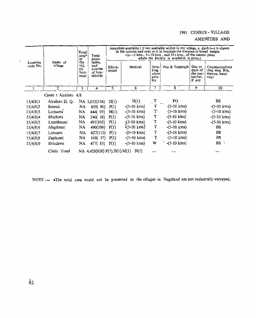
Location Name of code No. village
1 2
Circle : Akuluto
15/4/8/1 Akuluto H. Q. 15/4/8/2 Sutemi
15/4/8/3 Lotisami ,_
15/4/8/4 Shichimi
15/4/8/5 Lumthsami
15/4/8/6 Aiaphumi
15/4/8/7 Lumami
15/4/8/8 Zaphumi
15/4/8/9 Shitshimi
Cfrcle Total
I Total area· Total of popu-the lation viII. and (in number hect- of hou-ares) \ seholds
I 3 I 4
1981 CENSUS - VILLAGE
AMENITIES AND
Amenities available ( if not available within in the village, a dash (-) is shQwn in the column and next to it in brackets the distance in broad ranges
viz.-5 kms .• 5-10 kms. and lO+kms., of the nearest plaCe where the facility is available is given.)
Educa- Medical Drin- POst & Telegraph Day or Communications tional king days of (bus stop. Rly.
water the mar- station, water pota- ket/hat, way) ble if any
5 6 7 8 9 10.
4/8
NA 1,032(156) H(l) H(l) T PO BS NA 459( 90) pel) -(5-10 kms) T -(5-10 kms) -(5-10 kms)
NA 444( 93) M(I) -(5-10 kms) T' -(5-10 kms) -(5-10 kms)
NA 240( 38) P(I) -(5-10 kIDs) T -(5-10 kins) -(5-10 kms) NA 491(105) P(I) -(5-10 km~) T -(5-10 kms) -(5-10 kms) NA 490(106) P(I) 1(5-10 km'sY T -(5-10 kms) BS NA 627(112) P(I) -(5-10 kms) T -(5-10 kms) BS NA 168( 37) P(I) -(5-10 kms) T -(5-10 kms) B3
NA 477( 83) P(I) -(5-10 kms) W . -(5-10 kms) BS .
NA 4,428(820) P(7),H(1),M(1) H(l)
NOTE: - .The total area could not be presented as the villages in Nagaland are not cadastrally surveyed •
. 82
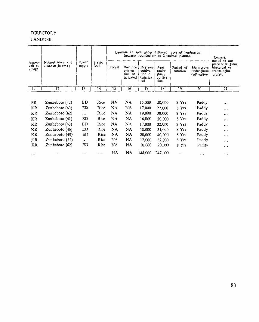
DIRECTORY
LANDUSE
I Appro- Nearest town and ach to distance (in kms ) villa!e
11 12
PR Zunheboto (42)
KR Zunheboto (43) KR Zunheboto (62)
KR Zunheboto (41)
KR Zunheboto (43)
KR Zunheboto (46) l<.R Zunheboto (49)
KR Zunheboto (51)
KR Zunheboto (62)
Power Staple supply food
I J 13 14
ED Rice
ED Rice Rice
ED Rice
ED Rice ED Rice ED Rice
Rice ED Rice
land use (i.e. area under different types of lalildlolse in hectares rounded up fo 2 decimal places). Remark
including any place of religious,
Forest Wet rice Dry rice I Area Period of Main crops historical or cultiva- cuJtiva- under rotatioD under jhum archealogical tion or tion Or jhum cult ivation intereSt irrigated unirriga- cuItiva-
ted tion
15 16 17 18 19 20 21
NA NA 15,000 20,000 8 Yrs Paddy NA NA 17,000 22,000 8 Yrs Paddy NA NA 19,000 30,000 8 Yrs Paddy NA NA 16,000 20,000 8 Yrs Paddy
NA NA 17,000 32,000 8 Yrs Paddy NA NA 18,000 31,000 8 Yrs Paddy NA NA 20,000 40,000 8 Yrs Paddy NA NA 12,000 32,000 8 Yrs Paddy NA NA 10,000 20,000 8 Yrs Paddy
NA NA 144,000 247,000
83
v. K. CIRCLE
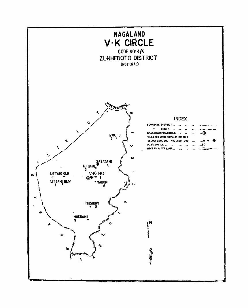
LlTTAMIOLD 2 •
lITTAMI N.EW 7 •
NAGALAND V· K C·IRCLE
CODE NO:4/9 ZUNHEBOTO DISTRICT
(NOTIONAL)
IZHETO 3 0
SASATAMI AJIQAM~. 4
5 • V·K- HQ·
®.f>O I ·MAROMI
6
_,
INDEX BOUNDARY I OIST.IeT ••• _. ._ _
.. CIRCLE '" ••• ._
HEAOQUARTEIS,ClRCLE ._ _. ...
VILLAGES WITH POPULATION SIZE
BELQW 20?, 200-499,500-999 ~.
POST~ OFFICE '" ••• • •• .•• _. RIVERS A STREAMS... .... .., ._
r
.... ---_.-
. .,@
... 0 ••
.,.PO
... ~

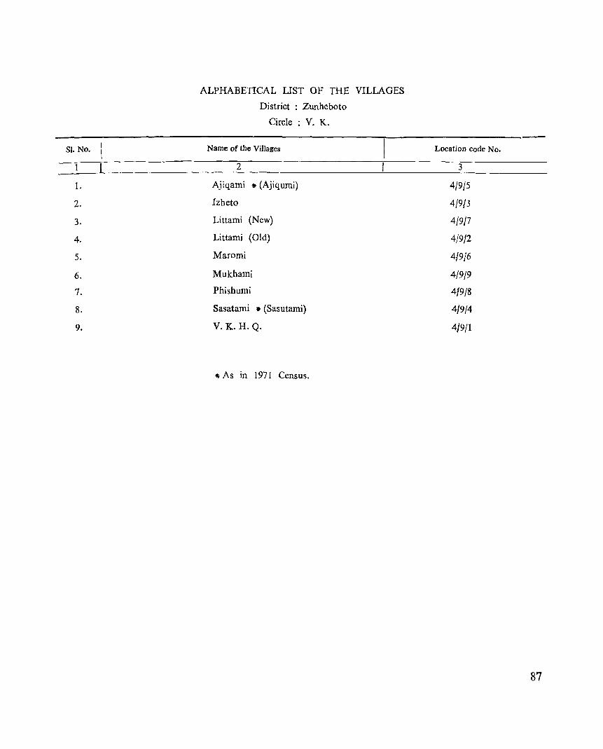
Sl. No.
1-
2.
3.
4.
5.
6.
7.
8.
9.
ALPHABETICAL UST OF THE VILLAGES
District : Zunheboto
Circle : V. K.
Name of the Villages
2
Ajiqami • (Ajiqumi)
Izheto
Littami (New)
Littami (Old)
Maromi
Mukhami
Phishumi
Sasatami * (Sasutami)
V.K.H.Q.
4 As in 1971 Census.
Location code No.
3
4/9/5
4/9/3
4/9/7
4/9/2
4/9j6
4/9/9
419/8
419/4
4/9/1
87
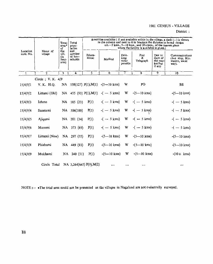
1981 CENSUS· VILLAGE
District:
A.men.ities aVailable ( if not avail.I~lc within in the yillage. a dash (-) is shown Tatal Tolal 10 the column and next to It III brackets the distance in broad ranges area· popu- viz.-5 kms •• 5-10 kms., and lO+kms .• of the nearest place of lat;on where the facility is available is given.)
Location Name of the and code No. village vill. number Educa- Drin- Post Davor Communic3tions (in of hou- tional king & days of (bus stoP. Rly. hect- seholds Medical water Telegraph the mar- station, water ares) potable ket/hat way).
if any
1 2 I 3 I 4 5 6 7 8 9 Ie
Circle: V. K. 4/9
15/4/9/1 V.K. H.Q. NA 538(127) P(1),M(l) -(5-10 kms) W PO BS
15/4/9/2 Littami (Old) NA 455 (93) P(l).M{l) -( - 5 kms) W -(5-10 kms) -(5-10 kms)
15/4/9/3 Izheto NA 105 (23) P(1) -( - 5 kms) W -( - 5 kms) -( - 5 kms)
15/4/9/4 Sasatami NA 506(100) pel) -( - 5 kms) W -( - 5 kro..s) -( - 5 kms) , 15/4/9/5 Ajiqarni NA 201 (34) pel) -( - 5 kms) W -( - 5 kms) -( - 5 kms)
15/4/9/6 Maromi NA 373 (69) pel) -( - 5 kIDs) W -( - 5 kms) -( - 5 kms)
15/4/9/7 Littami (New) NA 297 (55) P(1) -(5-10 kms) W -(5-10 kms) -(5-10 kIDs)
15/4/9/8 Phishumi NA 449 (93) P(1) -(5-10 kms) W -(5-1O kms) -(5-1O kms)
15/4{9/9 Mukhami NA 240 (51) pel) -(5-10 kms) W -(5-10 kms) -(10+ kms)
Circle Total NA 3,264(645) P(9),M{2)
NOTE:- _The total area could not be presented as the villages in Nagaland are not cldastrally surveyed.
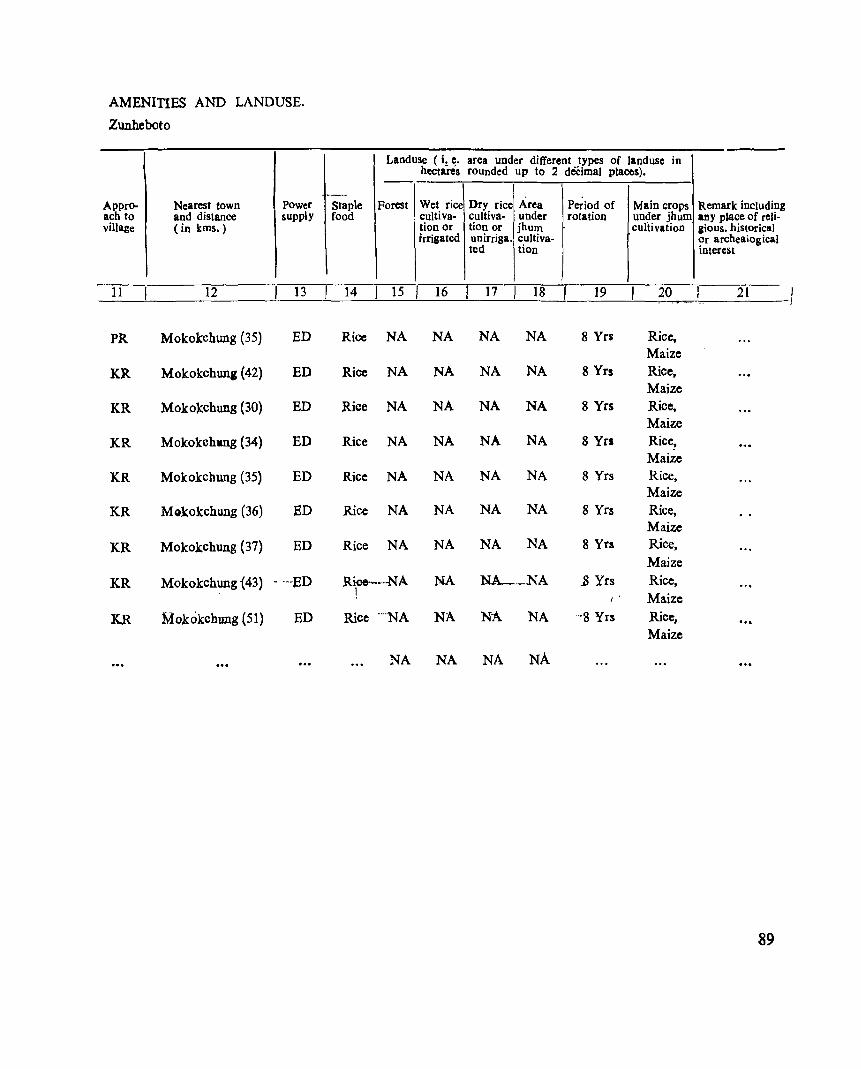
AMENITIES AND LANDUSE.
Zunheboto
ApprO- Nearest town Power ach to and distance supply village (in kms.)
-}-} 12 13
PRo Mokokchung (35) ED
KR Mokokchun, (42) ED
KR Mokokchung (30) ED
KR Mokokcbng (34) ED
KR Mokokchung (35) ED
KR Mokokchung (36) ED
KR Mokokchung (37) ED
KR Mokokchung {43} . '··ED
K.R Mokokchung (51) ED
Landuse (i. e. hectares
--_ .. Staple Forest Wet rice food cultiva-
tion or irrigated
14 I 15 I 16
Rice NA NA
Rice NA NA
Rice NA NA
Rice NA NA
Rice NA NA
Rice NA NA
Rice NA NA
Rice--··-NA NA i
Rice ""NA NA
NA NA
area under different types of landusc in rounded up to 2 decimal places).
Area Dry rice Period of Main crops Remark includin cultiva· under rotation un~er jhum any place of fcli· tion or jhum cultivation gious. historical unirriga. cultiva· Or afchea1ogica) ted tion interest
g
17 18 19 20 21
NA NA 8 Yrs Rice, Maize
NA NA 8 Yrs Rice, Maize
NA NA 8 Yrs Rice, Maize
NA NA 8 Yrs Rice, Maize
NA NA 8 Yrs Rice, Maize
NA NA 8 Yrs Rice, Maize
NA NA 8 Yrs Rice,
Maize NA,__NA .8 Yrs Rice,
Maize NA. NA '·-8 Yrs Rice, ., .
Maize
NA NA
89
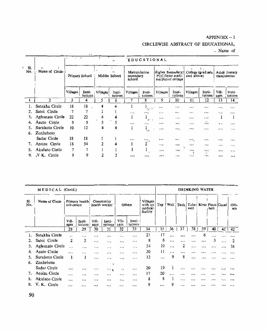
APPENDIX-I
CIRCLEWISE ABSTRACT OF EDU€ATIONAL,
-, Name of , ,
I" 'EDUCATIONAL
SI. , N~me of Ci:cle- \
'~ . ,: 1. No. ' -, Matriculation Higher Secondary I College (graduate Adult literacy
Primary School Middle School secondary PUCJlnter medi- and above) classl centres school atel Junior college
Villages I Vi1lagc,s ( Villages I Vilt- /' n~ti-Insti- Tnsti- Villages I In~ti- I Villages 1 In~ti- Insti-tutions tutions tutJOns tutlOns tutions ages tutIOns
1 2 I 3 I 4 5 6 7 8 9 10 11 12 13 14
L Satakha Circle 18 18 4 4 1 1 2_ Satoi Circle 7 7
~~:
3. Aghunato Circle 22 22 4 4 1 1 1 4. Asuto Circle 9 9 5 5
;:
5. SuruBot0 Circle ~O 12 4 4 1 6. Zunheboto
";,:)
Sadar Circle 18 18 '"
7. Atoizu Circle 18 54 .J
2 4 1 2 8. Akuluto Circle 7 7 1 1 1 ... 9- .V K. Circle 9 9 2 2
I( , J
MEDICAL (Contd.) DRINKING WATER
SI. Name of Circle No.
I Primary health I Community I sub-centre health worker Others
l Villages with nO Tap Well I Tank [TUbe- River Foun lcanal Oth
VilI- Insti- V 1 I ill- I In~ti- VilI-
__ '---_____ -I---'-'-'ag=-.:e::.-s -,;--,t-=-ut~lo::,:n=s.:.,::alles tutlons ages
I 28 I 29 I 30 I 31 I 32 L Satakha Circle 2. Satoi Circle 2 2 3. Aghunato Circle
4. Asuto Circle 5. Suruhoto Circle 1 6. Zunheboto
Sadar Circle '" \
7. Atoizu Circle 8. Akuluto Circle 9. V.K. Circle
90
1 Insti
tutions
I 33 I
medical facility
34
21 8
2·l 20 12
20 17 8
9
35 I 36
17 6
10 II
9
19 1 20
8 1 9
well tain ers
37 38 I 39 I 40 I 41 I 42 6
3 2 2 16
8
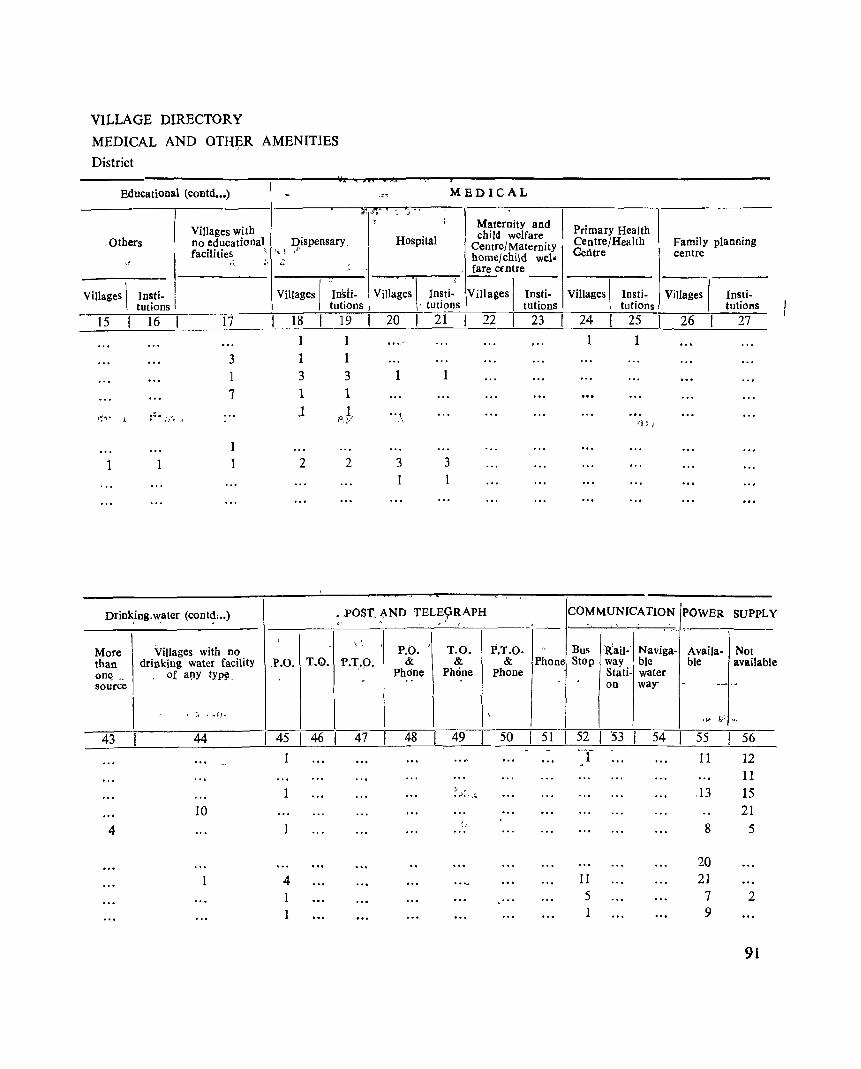
VILLAGE DIRECTORY
MEDICAL AND OTl{~R AMENITIES
District
Educational (coBtd ••• )
I Villages with Others no educational
radii ties, "
-' :'
Villages \ Jnsti· tutions
15 16 17
3
1 7
I~'·, • .! ~ ..... :. ... "t. ~
1
1 1 1
Drink.ing.w.ater (cont~: .. )
More Villages with DO than drinking water facility one; _ of a~y tYPIl source
-~ ;'!"""7 MEDICAL
----
T: " j
I I i Maternity and
Hospital child welfare Primary Health Dispensary. Centre/Health Family planning
',! .t Centre/Maternity Centre centre , home/child weI" ,,' . fare cmtre
Villages I Villages \ In~ti.i Villages I --Villages I Ins!i. Insti· Insti· Villages I Insti·
tutions . tutlons tutions tutions tutions
18 19 20 21 22 23 24 25 26 27
1 1 1 1
1 1
3 3 1 1
1 ,oJ .. ,-\ r:!,;'}
2 2 3 3 1 1
•. POST. AND TELE~RAPH COMMUNICATION POWER SUPPLY , .
P.O. " &
Phdne
T.O. &
Phone
P.T.O. &
Phone
1 I ". I
Stati- water on way- -
P~one ~t~Sp '!:~I- ~:viga- ~~aiIa'j ~~~Iable
______;.__I _,---,-,--,:" "':!'_:--:-::--~I, _1;_ ~I---.-n-i-\'-;: ~-=-+l ~~,"'~~j; ... _
43 44 45 46'~ 48 49 50 51 52 I '53 54 55 56 __ ~_~ ___________ ~ ___ L-__ 2-____ ~ __
1 f 11 12
10
4
1 4 1 1
r· .' •• J •• ~.
11 5 1
.13
8
20 21
7 9
11 15 21
5
2
9l
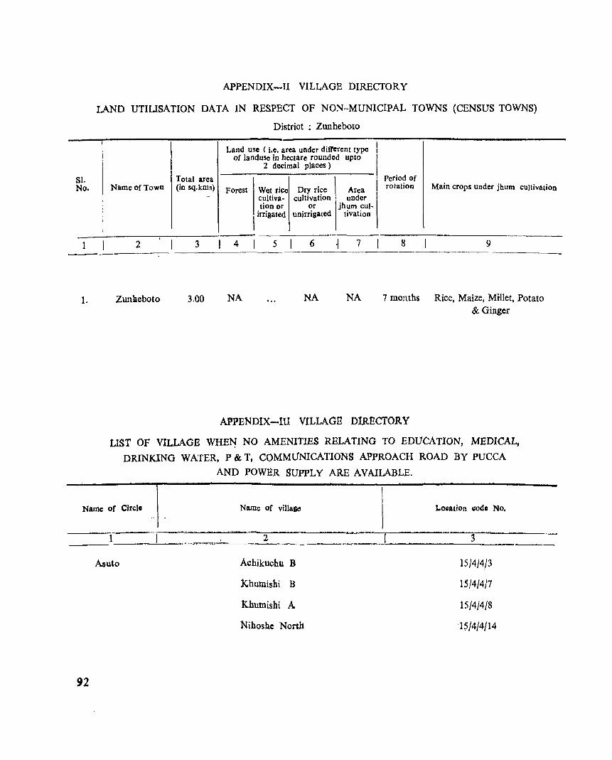
Sl. No.
APPENDIX-TI VILLAGE DIRECTORY
LAND UTlUSATION DATA IN RESPECT OF NON-MUNICIPAL TOWNS (CENSUS TOWNS)
District : Zunheboto
Land usc (i.e. area under diffCrent type I I
of land use in hectare rounded up to
I 2 decimal places)
Total area Period of Name of Town (in sq.kms) Forest Wet rice Dry rice Area I rotation Main crops under jhum cUltivation
.. cultiva- cultivation under tion or or jhum cul-I irrigated unirrigated tivatioD
,
2 3 4 5 6 7 8 9
Zunheboto 3.00 NA NA NA 7 months Rice, Maize, Millet, Potato & Ginger
APPENDIX-Ill VILLAGE DIRECTORY
LIST OF VILLAGE WHE~ NO AMENITIES RELATING TO EDUCATION, MEDICAL,
DRINKING WATER, P & T, COMMUNICATIONS APPROACH ROAD BY PUCCA
AND POWER SUPPLY ARE AVAILABLE.
Name of Circle Name of villa&e LOQation I:ode No.
1 2 3
Asuto A~hikuchll B 15/4/4/3
khutnishi B 15/4/4/1
Khutnishi A 15/4/4/8
Nihoshc Nortb '1~/4/4/14
92
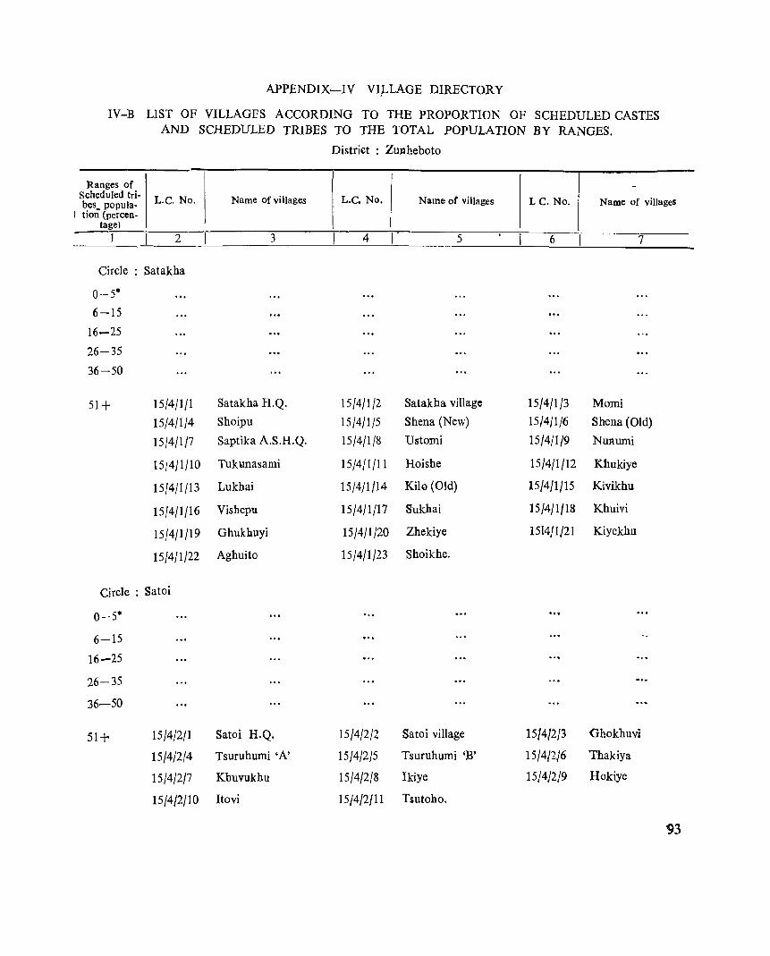
APPENDIX-IV VI_LLAGE DIRECTORY
IV-B LIST OF VILLAGES ACCORDING TO THE PROPORTION OF SCHEDULED CASTES AND SCHEDULED TRIBES TO THE TOTAL POPULATION BY RANGES.
District : Zunheboto
Ranges of -Scheduled tri- L.C. No. Name of villages L.C. No. Name or villages LC. No. Name of villages bes~ popula-
! tion (percen-tage)
2 3 4 5 6 7
Circle : Satakha
0-5*
6-15
16-25
26-35
36-50
51+ 15/4/1/1 Satakha H.Q. 15/4/1/2 Satakha village 15/4/1/3 Morui
15/4/1/4 Shoipu 15/4/1/5 Shena (New) 15/4/1/6 Shena (Old)
15/4/1/7 Saptika A.S.H.Q. 15/4/1/8 Ustomi 15/4/1/9 Nunumi
15/411/10 Tukunasami 15/4/1/11 Hoishe 15/4/1/12 Khukiye
15/4/1/13 Lukhai 15/4/1/14 Kih) (Old) 15/4/1/15 Kivikhu
15/4/1/16 Vishepu 15/4/1/17 Sukhai 15/4/1/18 Khuivi
15/4/1/19 Ghukhuyi 15/4/1/20 Zhekiye 1514/1/21 Kiyekhu
15/4/1/22 Aghuito 15/4/1/23 Shoikhe.
Circle : Satoi
0-5*
6-15
16-25
26-35
36-50
51+ 15/4/2/1 Satoi H.Q. 15/4/2/2 Satoi village 15/4/2/3 Ghokhuvi
15/4/2/4 Tsuruhumi 'A' 15/4/2/5 Tsuruhumi 'B' 15/4/2/6 Thakiya
15/4/2/7 Khuvukhu 15/4/2/8 Ikiye 15}4}2}9 Hokiye
15/4/2/10 Itovi 15/4/2/11 Tsutoho.
93
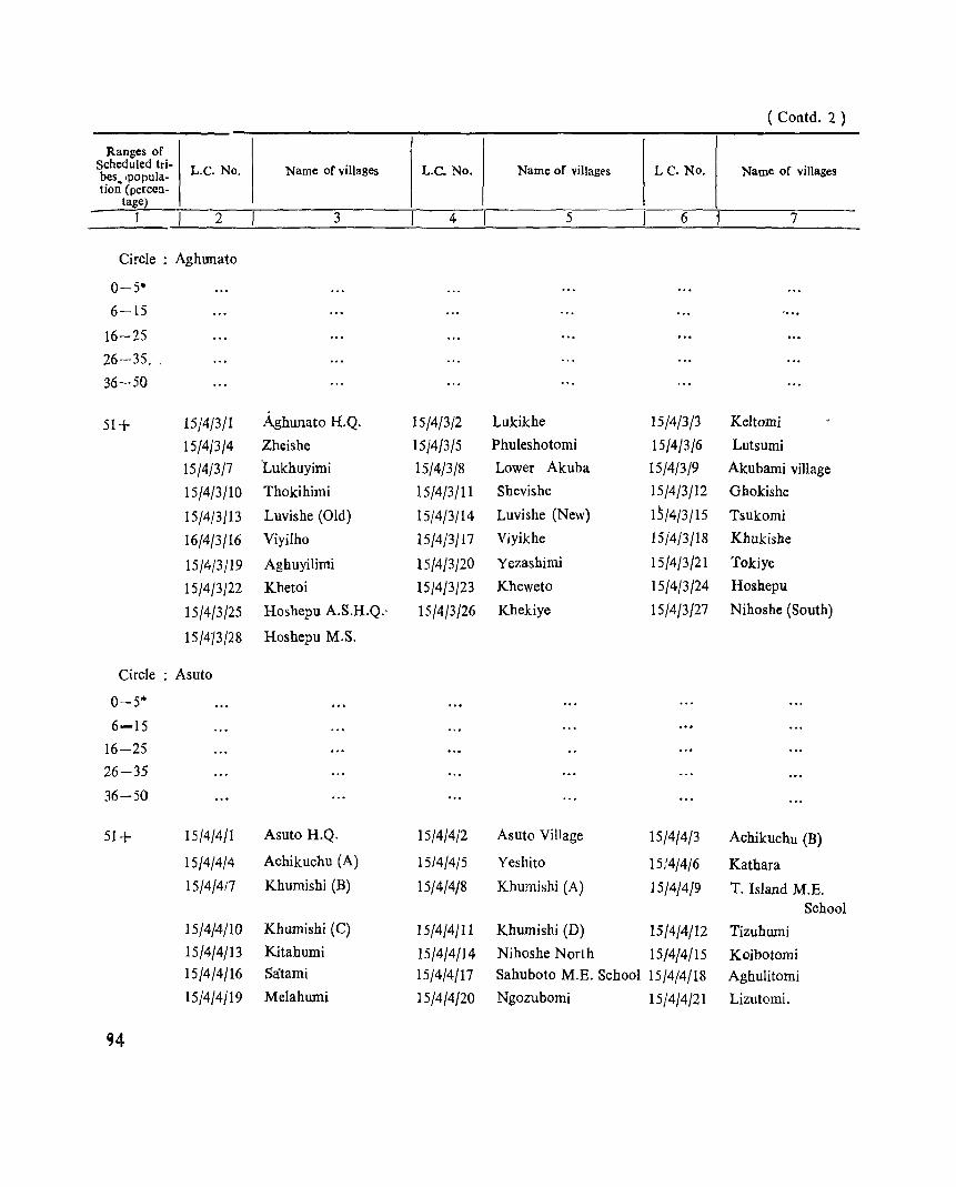
( Contd. 2 )
Ranges of Scheduled tri- L.C. No. Name of viUagcs L.C. No. Name of villages LC. No. Name of villages bes~ ,popula-tion (percen-
tage) 2 3 4 5 6 7
Circle : Aghunato
0-5'"
6-15
16-25
26-35, .
36-50
51+ 15/4/3/1 Aghunato H.Q. 15/4/3/2 Lukikhe 15/4/3/3 Keltomi
15/4/3/4 Zhcishe 15/4/3/5 Phuleshotomi 15/4/3/6 Lutsumi
15/4/3/7 'Lukhuyimi 15/4/3/8 Lower Akuba 15/4/3/9 Akubami village
15/4/3/10 Thokihimi 15/4/3/11 Shevishe 15/4/3/12 Ghokishe
15/4/3/13 Luvishe (Old) 15/4/3/14 Luvishe (New) 15/4/3/15 Tsukomi
16/4/3/16 Viyilho 15/4/3/17 Viyikhe 15/4j3/18 Khukishe
15/4/3/19 Agbuyilimi 15/4/3/20 Yezashimi 15/4/3/21 Tokiye
15/4/3/22 Khetoi 15/4/3/23 Kheweto 15/4/3/24 Hosbepu
15/4/3/25 Hoshepu A.S.H.Q.· 15/4/3/26 Khekiye 15/4/3/27 Nihoshe (South)
15/413/28 Hoshepu M.S.
Circle : Asuto
0-5*
6-15
16-25
26-35
36-50
51+ 15/4/4/1 Asuto H.Q. 15/4/4/2 Asuto Village 15/4/4/3 Achikuchu (B)
15/4/4/4 Achikuchu (A) 15/4/4{5 Yeshito 15/4/4/6 Katbara
15/4/417 Khumishi (B) 15/4/4/8 Khumishi (A) 15/4/4/9 T. Island M.E. School
15/4/4/10 Khumishi (C) 15/4/4/11 Khumishi (D) 15/4/4/12 Tizuhumi
15/4/4/13 Kitahumi 15/4/4/14 Nihoshe North 15/4/4/15 Koibotomi 15/4/4/16 Satami 15/4/4/17 Sahuboto M.E. School 15/4/4/18 Aghulitomi
15/4/4/19 Melahumi 15/4/4/20 Ngozubomi 15/4/4/21 Lizutomi.
~4
(Contd. 3)
Ranges of Scheduled tri- L.C.No. Name of village L.C. No. Name of village L.C. No. Name of viiJage bes popula-tion (percen-
bge) 1 2 3 4 5 6 7
Circle : Suruhoto
0---y5-.
6-15
16-25
26-35
36-50
51+ 15/4/5/1 Suruhoto H.Q. 15/4/5/2 yehemi 1.5/4/~/3 Kiyatha
15/4/5/4 Tichipami 15/4/5/5 Aghungu Kukuto 15/4/5/6 Sapotimi
15/4/5/7 Kholeboto 15/4/5/8 SUfuini 15/4/5/9 Phuyemi.( Old)
15/4/5/10 Aichisaghemi (N) 15/4/5/11 Aichisaghemi (S) 15/4/5/12 Vedami
15/4/5/13 Phuyemi (New)
Circle : Zunheboto Sadar
0-5-
6-15
16-25
26-35
36-50
51+ 15/4/6/1 Asukhomi 15/4/6/2 Lochomi 15/4/6/3 Yezami
15/4/6/4 Locho (C) 15/4/6/5 Lizuavikato 15/4/6/6 Lizu-naghuto
15/4/6/7 Baimho 15/4/6/8 Shotomi 15/4/6/9 ~heipu
15/4/6/10 'Sukhalu 15/4/6/11 Yemishe 15/4/6/12 Zungti
15/4/6/13 Natha (Old) 15/4/6/14 Natha (New) 15/4/6/15 Khukhepu
15/4/6/16 Lizuphutheu (New) 15/4/6/17 Lizuphutheu (Old). 15/4/6/18 Chukiye
15/4/6/19 Kulhopu 15/4/6/20 Nikuto.
Circle : Atoizu "
0-5. ,,'
6-15 ...
16-25 ... '
26-35
36-50
95
(Contd. 4)
Ranges of Scheduled tri- L.C. No. Name of village L.C. No. Name of village L.C. No. Name of village bes popula-tion tpercen-
lag e)
1 2 3 4 5 6 7
51+ 15/4/7/1 Atoi;>;u H.Q. 15/4/7/2 Naghutomi (Old) 15/4/7/3 Naghutomi (New)
15/4/7/4 Awotsakili 15/4/7/5 Apukito 15/4/7/6 Lokobomi
15J4/7/7 Aizuto Missioll Centre 15J4/7J8 Mapulumi 15/4/7/9 Akuhaito
15J4/7/10 Rotomi (Old) 15/4/7/11 Rotomi (New) 15/4/7/12 Philimi
15/4/7/13 Sukomi 15/4/7114 Litsami 15/4/7/15 Emlomi
15/4/7/16 Yesholtomi 15/4/7/17 Asukhuto polytechnic 15/4/7/18 Khromtomi
15/4/7/19 Asukhuto vill::lge 15/4/7120 Vekuho (Old) 15/4/7/21 Vekuho (New).
Circle : Akuluto
0-5*
6-15
16-25
26-35
36-50
50+ 15/4/8/1 Akuluto H.Q. 15/4/8/2 Sutemi 15/4/8/3 Lotisami
15/4/8/4 Sichimi 15/4/8/5 Lumthsami 15/4/8/6 Alapbumi
15/4/8/7 Lumami 15/4/8/8 Zaphumi 15/4/8/9 Shitshumi.
Circle: V. K.
0-5.
6-15
16-25
26-35
36-50
50+ 15/4/9/1 V.K.H.Q. 15/4/9/2 Littam' (OU) 15/4/9/3 Izheto
15/4/9/4 Sasatami 15/4/9/5 Ajiqami ] 5/4/9/6 Maromi
15/4/9/7 Littami (New) 15/4/9/8 Phishumi 15/4/9/9 Mukhami.
Note;- Excludes villagef: with no scheduled tribe population.
96
NOTES ON _TOWN DIRECTOR¥.,
S ECTI.ON - II
TOWN DIRECTORY
The abbreviations used in the Town Directory statement are as follows ;-
1. Statemer.t-I
C.T. = Census Town.
2. Statement-II
C.T. = Census Town.
3. Statement-III
C.T. Census Town.
P.R. Pupca Road.
~.R. ., 'Kutcha Road.
O.S.D. Open Surfaced Drains.
S.T. Septic Tank Latrines.
S. - Sewerage.
T. Tap water.
S~R. - Service Reservoir:
4. Statement-IV
H. - Hospital.
D. = Dispensary.
Sh. type = Shorthand & Type Writing.
97
SI. Class, name and civic ~tioo 1 Area No, administration status of code No. Name of circle (in sq.
town kms)
I
_1_1 3 4 I 5
1. V. Zunheboto (C,T.) 15/4/1 Zunheboto 3.00
PhysIcal aspectS
SI, Class and Temperature
(in centigrade ) No. name of town. 1tainlaIl (in mm )
1
Maximum I Minimum
5 1 I 2 3 4 ~~ ____ =-____ L-____________ ~ __
1. V. Zunheboto NA NA NA
98
TOWN
STATEMENT
STATUS AND
Number of housc- Population and growth rate of the town at the censuses of holds including
houSeleSs house-holds (in 1981
Census) 6
1,396
1981 I 1911 I 1921
7 8 9
STATEMENr
PHYSICAL ASPECTS AND
Na.me Of and road distance (in Kms ) from
State H.QS.
6
Kohima 150.0
District H. QS.
1
Zunheboto
o
Circle H. QS.
8
Zunheboto
o
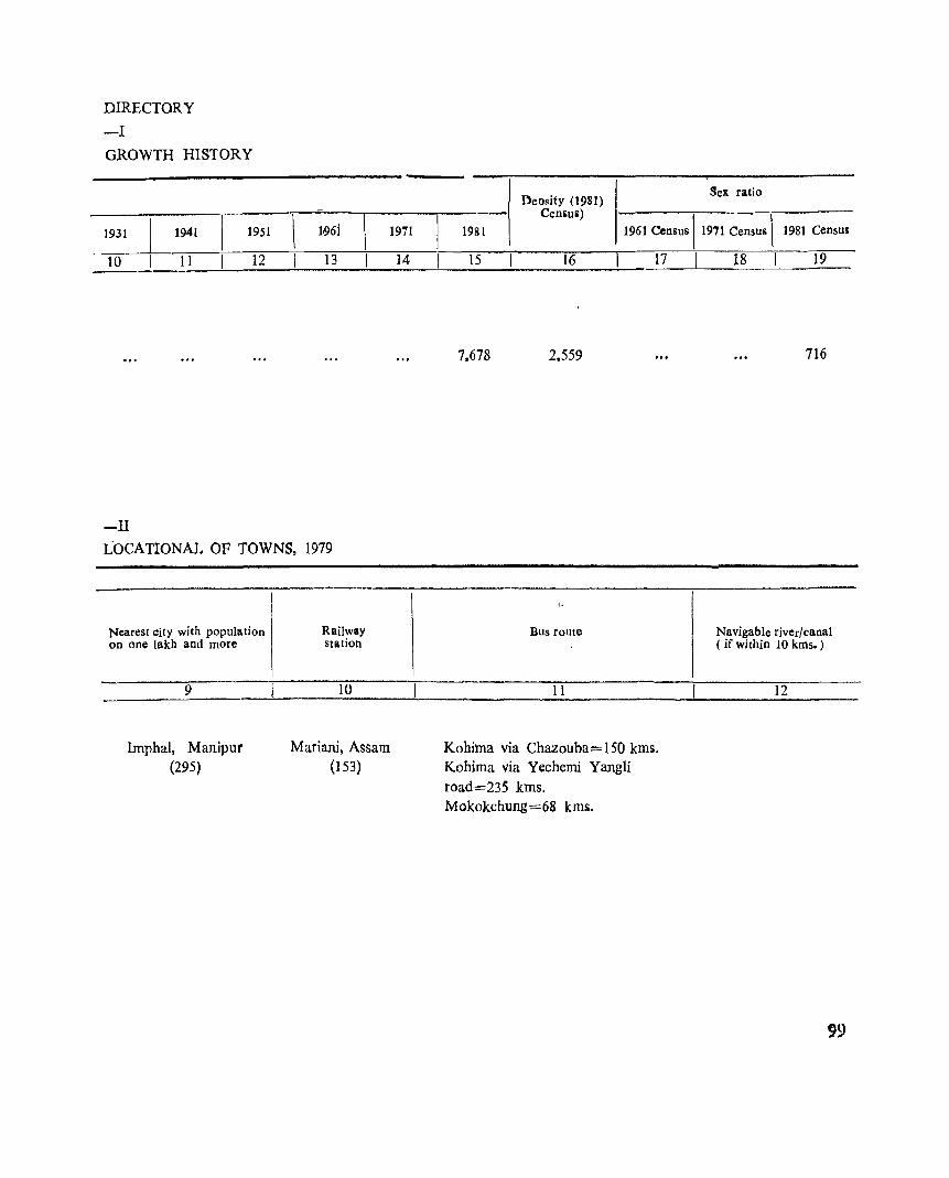
DIRECTORY
-I
GROWTH HISTORY
1931 1941 1951
10 11 12
-II
1.96i
13
LOCATIONAL OF TOWNS, 1979
Nearest city with population on one lakh and more
9
Imphal, Manipur (295)
Railway station
10
Mariani, Assam (153)
1971
14
Density (1981) Sex ratio
Ceniu il)
1961 Census \ 1971 Census \ 1981 1981 Census
15 16 I 17
7.678 2.559
Bus route
11
Kohima via Chazouba<'= 150 kms. Kohima via Yechemi Yangli road=235 kms. Mokokchung=68 kms.
I 18 I 19
716
Navigable river/canal ( if within 10 kms. )
12
99
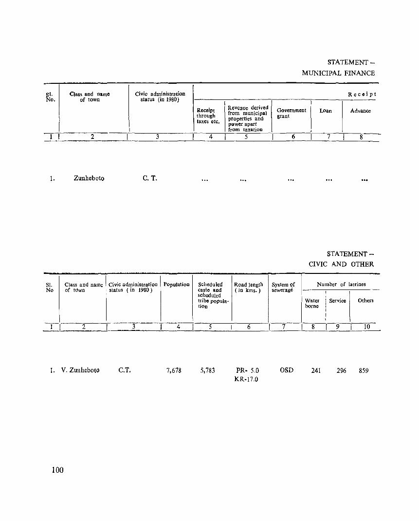
SI. Class and name Civic administration No. of town status (in 1980)
I 2 3
1. Zunheboto C.T.
SI. Class and name Civic administration Population No of tOwn status (in 1980)
--- 2 3 4
1. V. Zunheboto C.T. 7,618
100
Receipt Revenue derived through from municipal
properties and taxes etc. PQwer apart from taxation
4 5
Scheduled Road length caste and (in kms.) scheduled tribe popula-lion
5
5,783
6
PR- 5.0 KR-17.0
STATEMENT
MUNICIPAL FINANCE
Receipt
Government LOan Advance grant
6
System Qf sewerage
7
OSD
7 8
STATEMENT
CIVIC AND OTHER
Number of latrines
Water Service Others borne
8 9 ,
10
241 296 859
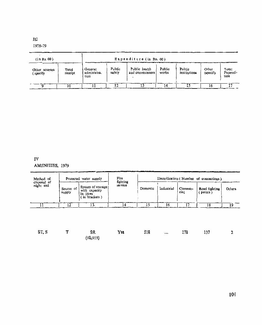
III 1978~79
(i n Rs. 00)
Other sourCeS ( specify
Total General receipt administra.
tiOIl
E Jt pen d i t u r e (in Rs. 00)
Public Public health Public Public Other Total safety and conveniences works institu tionii (specify Fxpendi•
ture
--____ ~9 ____ L-__ l~O~~~ __ 1~1 __ ~ ___ 12 __ ~ _____ 13 ____ ~~14~~ __ ~15 __ _J __ ~1~6 __ ~~17
IV AMENITIES, 1979
Method of Protected water supply disposal of night soil
Source of supply
11 12
ST,S T
System of storage with capacity in litres ( in brackets )
13.
SR (90,919)
I Fire fighting service
14
Yes
Electrification ( Number of connections)
Domestic Industrial Commer- Road lighting Others cial (points)
15 16 17 18 19
SIS 172 137 2
101
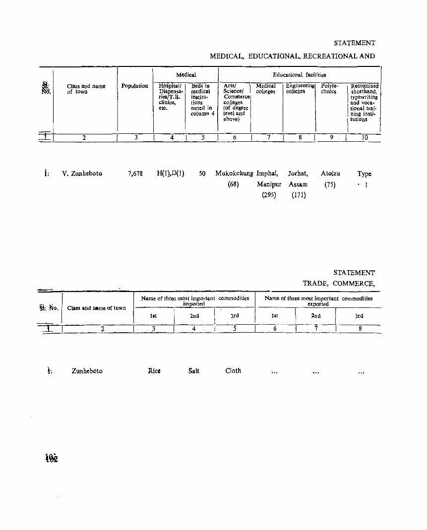
Medical
STATEMENT
MEDICAL, EDUCATIONAL, RECREATIONAL AND
Educational facilitieS
Nb. Class and name Population Hpspitall Beds in Artsl Medical Engineering Polyte- \ Recognised Science/ of town
-:L, 2
I: V. Zunheboto
§\: ~o. Class and name of town
2
Zunheboto
I?is~ensa. medical colleges colleges chnics shorthand, fles T.B. institu· Commerce typewriting clinics, tions colleges and voca-etc. noted in (of degree tional trai·
column 4 level and ning insti· above) tutions
3 4 5 6 7 8 9 10
7,678 H{I),D{l) 50 Mokokcbung Imphal, Jorhat, AtgjZll Type
(68) Manipur Assam (75) • 1
Name of three most important commodities imported
lilt 2nd 3rd
3 4 5
Rice Salt Cloth
(295) (171)
STATEMENT
TRADE, COMMERCE,
Name of three most important commodities exported
1st 2nd 3rd
6 7 8
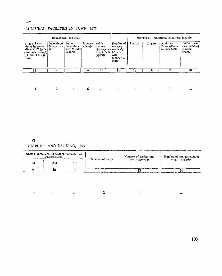
-v CULTURAL FACILITIES IN TOWN, 1979
Educational facilitles
Higher SeCon- Secondary/ Junior Primary dary / Interme- Matricula- Secondary schools diate/PUC (pre- tion and Middle
university college) schools /Junior College level
11 12 13 ]4
1 2 4 6
- VI INDU3TR Y AND BANKING, 1979
Name of three most important commodities manufactured
Adult literacy classes/cen-tres, others (specify
15
Number of Recreational & cultural facilities
Number of Stadiam Cinema Auditorial Public libra-working Drama/Com- ries inCluding women's munity haIls reading hostels rooms with number of seats
16 17 18 19 20
1 1 1
Number of banks Number of agricultural
credit so~ieties Number of non-agricultural
credit societies 1st 2nd 3rd
9 10 11 = 12 13 14
... 1
103

PART-B
PRIMARY CENSUS ABSTRACT

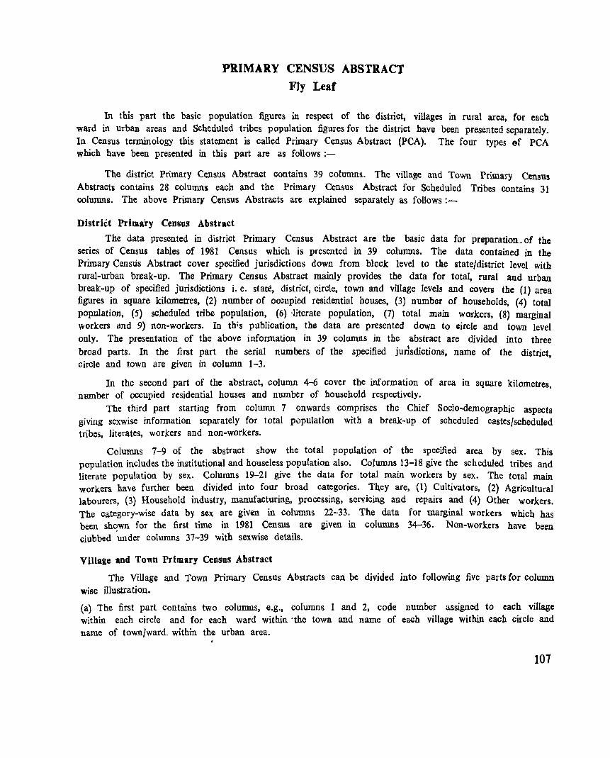
PRIMARY CENSUS ABSTRACT Fly Leaf
In this part the basic population figures in respect of the district, villages in rural area, for each ward in urban areas and Scheduled tribes population figures for the district have been presented separately. In Census terminology this statement is called Primary Census Abstract (PCA). The four types of PCA which have been presented in this part are as follows:-
The district Primary Census Abstra~t contains 39 columns. The village and Town Primary Census Abstracts contains 28 columns each and the Primary Census Abstract for Scheduled Tribes contains 31 columns. The above Primary Census Abstracts are explained separately as follows:-
District Primary Census Abstract
The data presented in district Primary Census Abstract are the basic data for preparation_ of the series of Census tables of 1981 Census which is presented in 39 columns. The data contained in the Primary Censtis Abstract cover specified jurisdictions down from block level to the state/district level with rural-urban break-up. The Primary Census Abstract mainly provides the data for total, rural and urban break-up of specified jurisdictions i. e. state, district, circle, town and village levels and covers the (1) area figures in square kilometres, (2) number of occupied residential houses, (3) number of households, (4) total pop.ulation, (5) scheduled tribe population, (6) -literate population, (7) total main workers, (8) marginal workers and 9) non-workers. In thos publication, the data are presented down to circle and town level only. The presentation of the above information in 39 columns in the abstract are divided into three
broad parts. In the first part the serial numbers of the specified jurisdictions, name of the district, circle and town are given in column 1-3.
In the second part of the abstract, column 4-6 cover the information of area in square kilometres, nwnber of occupied residential houses and number of household respectively.
The third part starting from column 7 onwards comprises the Chief Socio~demographic aspects giving sexwise information separately for total population with a break~up of scheduled castes/scheduled tribes, literates, workers and non-workers.
Columns 7-9 of the abstract show the total population of the specified area by sex. This population includes the institutional and houseless population also. Columns 13-18 give the scheduled tribes and literate population by sex. Columns 19-21 give the data for total main workers by sex. The total main workers have further been divided into four broad categories. Th,ey are, (1) Cultivators, (2) Agricultural labourers, (3) Household industry. manufacturing. pr~ssing, servicing and repairs and (4) Other workers. The category~wise data by sex are given in Columns 22-33. The data for marginal workers which has been shown for the first time in 1981 Census are given in columns 34-36. Non~workers have been ciubbed 'under columns 37-39 with sexwise details.
Village and Town Primary Census Abstract
The Village and Town Primary Census Abstracts can be divided into following five parts for column wise illustration.
(a) The first part contains two columns, e.g., columns 1 and 2, code number assigned to each village within each circle and for each ward within 'the town and name of each village within each circle and name of town/ward. within the urban area.
107
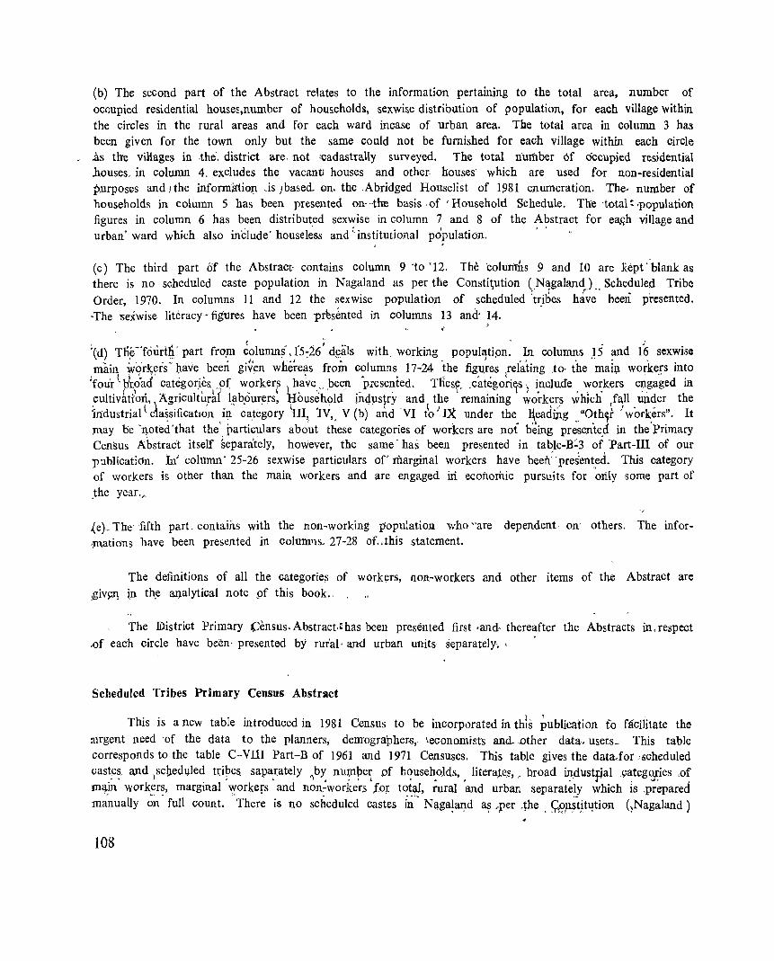
(b) The second part of the Abstract relates to the information pertaining to the total area, number of oc(mpied residential house~,number of households, sexwise distribution of population, for each village within the circles in the rural areas and for each ward incase of urban area. The total area in column 3 has been given for the town only but the same could not be furnished for each village within each circle
~ .as the viRages in -the', district are, not 'cadastrally surveyed. The total number Of Occupied residential houses, in column 4. excludes the vacanti houses and other. houses' which are used for non-residential pllrposes and I the infornllrtio:p. -is) based. Qn. the Abridged Houselist of 1981 enumeration. The, number of households in column 5 has been presented on .. ·tl:re basis .of 'Household Schedule. The ·total ~ .populatioh figures in column 6 has been distribut,ed sexwise in column 7 and 8 of the Abstract for ea,<;h village and urban' wiud which also include' house less and' institutional population.
(c) The third part of the Abstract- contains column 9 'to' 12. The cohitn:lls 9 and 10 are .Ki:pt . 'blank as there is no scheduled caste population in Nagaland as per the Consti~ution (N~galandJ., Scheduled Tribe Order, 1970. In columns 11 and 12 the sexwise population of scheduled ~tribes have been presented. -The 'Sexwise literacy - figures have been -prh~nted in columns l3 and' 14. -,
:(d) Tlie -'four1g' part fropl ~()lumn~' .1'5:26; d~als with working populatipn: In columns 15 and 16 sexwise
i niai~ iv~r~eis' ~av'e,. been giv~n whe~e~s from c?lumns, 17-24 ~he fig,u.~~s lefating .to· the maiJ;1 wo~iceIS in~o four p(?ad categon~sl"o( w,orkerf h.ave .. " been p;ese~ted. Tliesr .. categori1s) i,nclude . wo~kers e~.gaged ill
;ultivat.iorl, \ ~g~iculturat. l.ab.ourers, ¥busehold in4:usfry. and \ t~e remaining work7.~s which ~f~l1. un~er the Industnal \ cla~slficatlOn III ca.tegory III; lV,. V (b) and VI to IX under the l\eadm.g .. "Oth~r workers". It ;may be 'noted'that the' particulars about these categories of workers are not b~ing presented in the'primary Census Abstract itself §eparately, however, the same' has been presented in table-B~3 of Part-III of our 'Publicatidn. In' column' 25-26 sexwise particulars of'marginal workers have been' ·pres:en~~d. This category of workers is other than the main workers and are engaged iri economic pursuits for only some part of ,the year.~
..(e)__, The fifth part contains with the non-working popUlation who "are dependent oll' others. The informations have been presented in columns. 27-28 of .. this statement.
The definitions of all the categorie.s of workers, non-workers and other items of the Abstract are giv~l1 in th.e al).alytical note pf this book., .
The IDistrict Primary Census. Abstract," has been presented first ·and· thereafter the Abstracts in, respect -of each circle have been· presented by rur'aI· aw urban units separately.,
Scheduled Tribes Primary Census Abstract
This is a new table introduced in 1981 Census to be incorporated in this pUblication fa facilitate the rurgent need 'of the data to the planners, demographer~,. leconomists and. other data. users~ This table corresponds to the table C-VIlI Part-B of 1961 and 1971 Censuses, This table gives the data,for soheduled cast.e~_ iOtnd ,sc~ed~Jled U:ipe& sapa,rately "Jb~ nu~pe~ of b~use~oJds" literaJe~, . broad il_ldustfial _categ<y;ies .of m<J:in workers, marginal workers and non:-workers fo~ total, rural and urban separately which lS ,prepared manually ~~. full count. 'There is no scheduled castes ii' Naga~a1).d a~ ~per .~he . 9B,n~tjt~tion (~Nagaland)
108
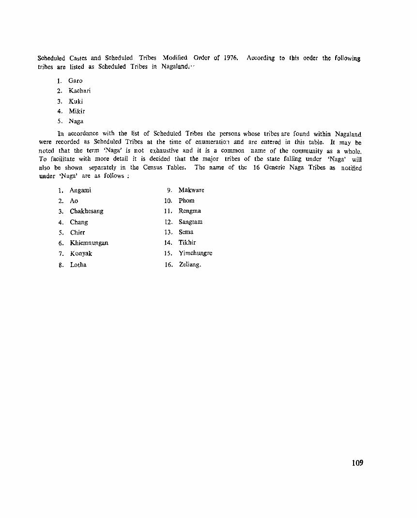
Scheduled Castes and Scheduled Tribes Modified Order of 1976, According to this order the following tribes are listed as Scheduled Tribes in Nagaland;"
I. Gara
2. Kachari
3. Kuki
4. Mikir
5. Naga
In accordance with the list of Scheduled Tribes the persons whose tribes are found within Nagaland were recorded as Scheduled Tribes at the time of enumeratio:1 and are entered in this table. It may be noted that the term 'Naga' is not exhaustive and it is a common name of the community as a whole. To facilitate with more detail it is decided that the major tribes of the state falling under 'l'{aga' will also be shown separately in the Census Tables. The name of the 16 Generic Naga Tribes as notified under 'Naga' are as follows;
1. Angami 9. Makware
2. Ao 10. Phom
3. Chakhesang 11. Rengma
4. Chang 12. Sangtam
5. Chirr 13. Serna
6. Khiemnungan 14. Tikhir
7. Konyak 15. Yimchungre
8. Lotha 16. Zeliang.
109
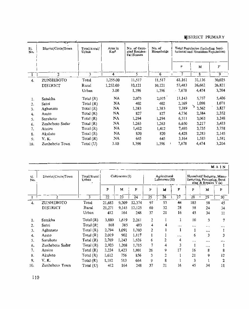
iJ.ISTRI CT PRIMARY -_..
SI. District/Circle/Town Total/Rural/ Area in No. of Occu- No. of Total Population (including Insti-No. Urban Km2 pied Residen- Households tutional and Houseless Population)
tial Houses
p
\ M
\ F
1 2 3 4 5 6 7 8 9
4. ZUNHEBOTO Total 1,255.0Q 11,517 11,517 61,161 31,136 30,025
DISTRICT Rural 1,252.00 10,121 10,121 53,483 26,662 26,821
Urban 3.00 1,396 1,396 . 7,678 4,474 3,204
1. Satakha Total (R) NA 2,075 2,075 11,143 5,737 5,406
2. Satoi Total (R) NA 402 402 2,169 1,098 1,071
3. Aghunato Total (R) NA 1,383 1,383 7,389 '> 3,562 3,827
4. Asuto Total (R) NA 827 827 4,736 2,384 2,352
5. Suruhoto Total (R) NA 1,294 1,294 6,311 3,063 3,248
6. Zunheboto Sadar Total (R) NA 1,263 1,263 6,650 3,217 3,433
7. Atoizu Total (R) NA 1,412 1,412 7,493 3,735 3,758
8. Akuluto Total (R) NA 820 820 4,428 2,283 2,145
9. V. K. Total (R) NA 645 645 3,164 1,583 1,581
10. Zunheboto Town Total (U) 3.00 1,396 1,396 7,678 4,474 3,204
M A IN
SI. District/Circle/Town Total/R ural Cultivators (1) Agricultural Household Industry, Manu-No. Urban Labourers (II) facturing. Procl:ssing, Servi
cing & Repairs V (a)
P M F P M I F P I M F
---1 2 3 22 23 24 25 . 26 27 28 I 29 30
4. ZUNHEBOTO Total 21,683 9,309 12,374 97 53 44- 103 58 45 DISTRICT Rural 21,271 9,145 12,125 60 32 28 58 24 34
Urban 412 164 248 37 21 16 45 34 11
1. Satakha Total (R) 3,880 1.619 2,261 2 10 3 7 2. Satoi Total (R) 868 385 483 4 4
3. Aghunato Total (R) 2,794 1,091 1,703 2 1 1 1 4. Asuto Total (R) 2,019 902 I,ll '7 1 1 6 3 3 5. Suruhoto Total (R) 2,769 1,243 1,526 6 2 4
6. Zunheboto Sadar Total (R) 2,923 1,208 1,715 7 4 3 1 1 7. Atoizu Total (R) 3,224 1,423 1,801 26 9 17 16 8 8 8. Akuluto Total (R) 1,612 756 856 3 2 1 21 9 12 9. V.K. Total (R) 1,182 513 664 9 8 1 3 1 2
10. Zunheboto Town Total (U) 412 164 248 37 21 16 45 34 11
110
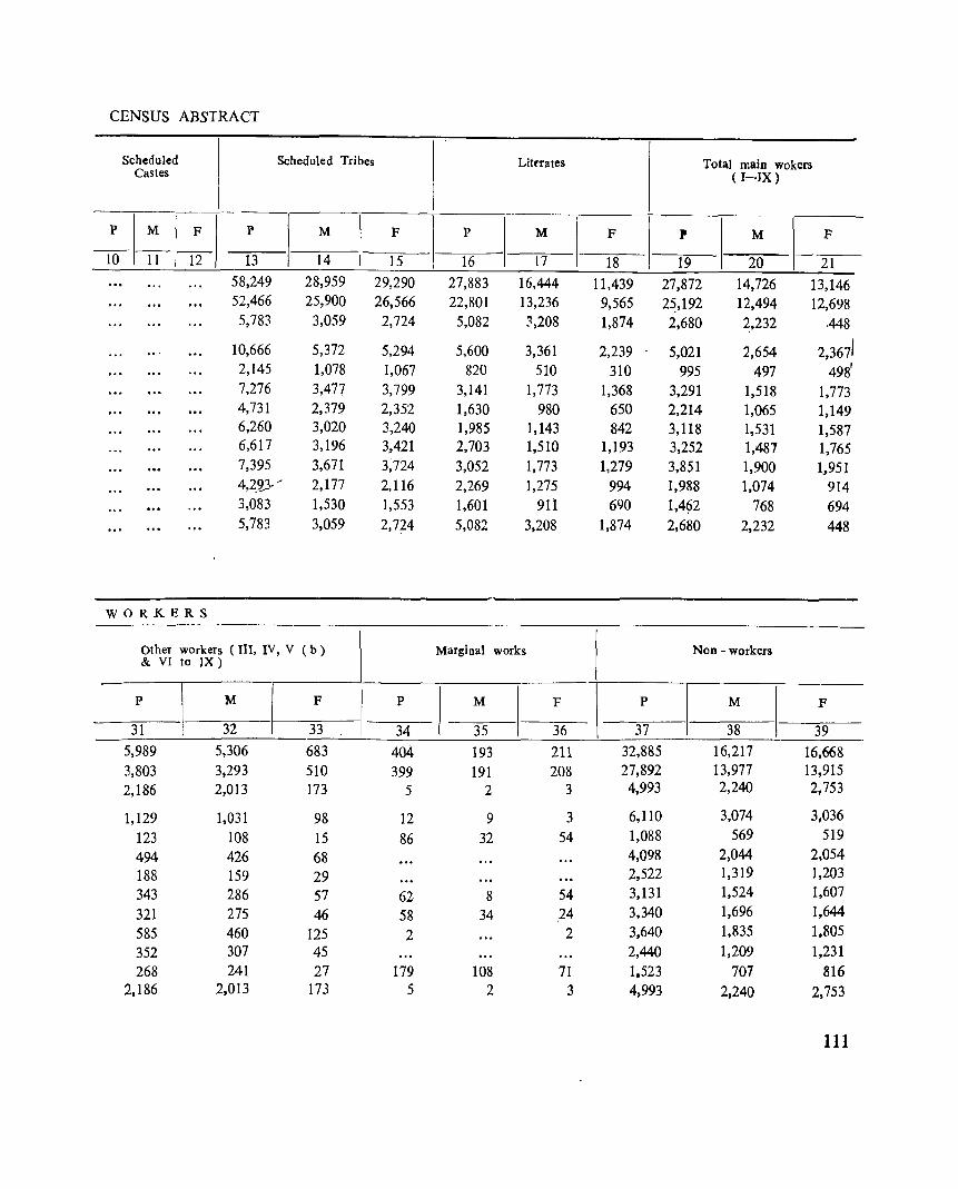
CENSUS ABSTRACT
Scheduled Scheduled Tribes Litffates Total main wokers Castes (I-IX)
P ~I_F_ P M F P M F P M F
IO 11 I 12 13 14 15 16 17 18 19 20 21 58,249 28,959 29,290 27,883 16,444 11,439 27,872 14,726 13,146 52,466 25,900 26,566 22,801 13,236 9,565 2~,192 12,494 12,698 5,783 3,059 2,724 5,082 3,208 1,874 2,680 2,232 .448
10,666 5,372 5,294 5,600 3,361 2,239 5,021 2,654 2,3671 2,145 1,078 1,067 820 510 310 995 497 498' 7,276 3,477 3,799 3,141 1,773 1,368 3,291 1,518 1,773 4,731 2,379 2,352 1,630 980 650 2,214 1,065 1,149 6,260 3,020 3,240 1,985 1,143 842 3,118 1,531 1,587 6,617 3,196 3,421 2,703 1,510 1,193 3,252 1,481 1,765 7,395 3,671 3;724 3,052 1,773 1,279 3,851 1,900 1~951 4,2_23,-" 2,177 2,116 2,269 1,275 994 1,988 1,074 914 3,083 1,530 1,553 1,601 911 690 1,492 768 694 5,783 3,059 2,774 5,082 3,208 1,874 2,680 2,232 448
WORKERS
Other workers (Ill, IV, V (b) Marginal works Non - workers & VI to IX)
P M F P M F P M F
31 32 33 34 35 36 37 38 39
5,989 5,306 683 404 193 211 32,885 16,217 16,668 3,803 3,293 510 399 191 208 27,892 13,977 13,915
2,186 2,013 173 5 2 3 4,993 2,240 2,753
1,129 1,031 98 12 9 3 6,110 3,074 3,036
123 108 15 86 32 54 1,088 569 519
494 426 68 4,098 2,044 2,054
188 159 29 2,522 1,319 1,203
343 286 57 62 8 54 3,131 1,524 1,607
321 275 46 58 34 ,24 3,340 1,696 1,644
585 460 125 2 2 3,640 1,835 1.805
352 307 45 2,440 1,209 1,231
268 241 27 179 108 71 1,523 707 816 2,186 2,013 173 5 2 3 4,993 2,240 2,753
111
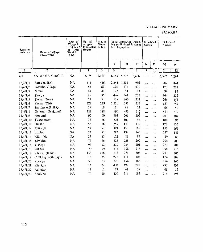
Area of No. of No. of Villase in occupied House-HectareS & Residential holds
Location of Town Houses code No. Name of Village Ward in
Tawn/Ward Km2
2 3 4 5
4/1 SATAKHA CIRCLE NA 2,075 2,075
15/41;1/1 Satakha H.Q. NA 416 416 15/4/1/2 Satakha Village NA 63 63 15/4'11/3 Momi NA 41 41 15/4/1/4 Shoipu NA 95 95 15/4/1/5 Shena (New) NA 71 71 15/4/1/6 Shena (Old) NA 229 229 15/4/1/7 Saptika A.S. H.Q. NA 19 19 15/4/1/8 Ustemi (Usukomi) NA 188 188 15/4/1/9 Nunumi NA 90 90 15/4/1/10 Tukunasami NA 36 36 15/4/1/11 Hoishe NA 56 56 15/4/1/12 Khukiye NA 57 57 15/4/1/13 Lukhai NA 53 53 15/4/1/14 Kilo Old NA 35 35 15/4/1/15 Kivikhu NA 76 76 15/4/1/16 Vishepu NA 92 92 15f4/1Jl7 Sukhai NA 79 79 15/4/1/18 Khuivi (Khivi) NA 138 138 15/4/1/19 Chukhuyi (Ghukiyi) NA 35 35 15/4/1/20 Zhekiye NA 53 53 15/4/1/21 Kiyekhu NA 72 72 15/4/1/22 Aghuito NA 11 11 ] 5/4/1/23 Shoikhe NA 70 70
112
Total Population includ-ing Institutional & House-less Populption
p
\ M I F
6 I 7 8
11,143 5,737 5,406
2,264 1,308 956 374- 173 201 177 94 83 476 244 232 517 266 251
1,310 653 657 121 69 52 990 473 517 403 201 202 202 109 93 259 123 136 319 153 166 282 137 145 172 89 83 428 228 200 429 228 201 414 198 216 577 271 306 222 114 108 320 154 166 400 197 203
78 41 37 409 214 195
VILLAGE PRIMARY
SATAKHA
Scheduled Scheduled Castes Tribes
M IF M I F 9 I 101 11 12
?,372 5,294
987 844 173 201 94 83
244 23~ 266 2?1 653 657 66 52
473 517 201 202 109 93 123 136 153 166 137 145 89 83
194 200 221 201 198 216 27] 306 114 108 154 166 197 203 41 37
214 195
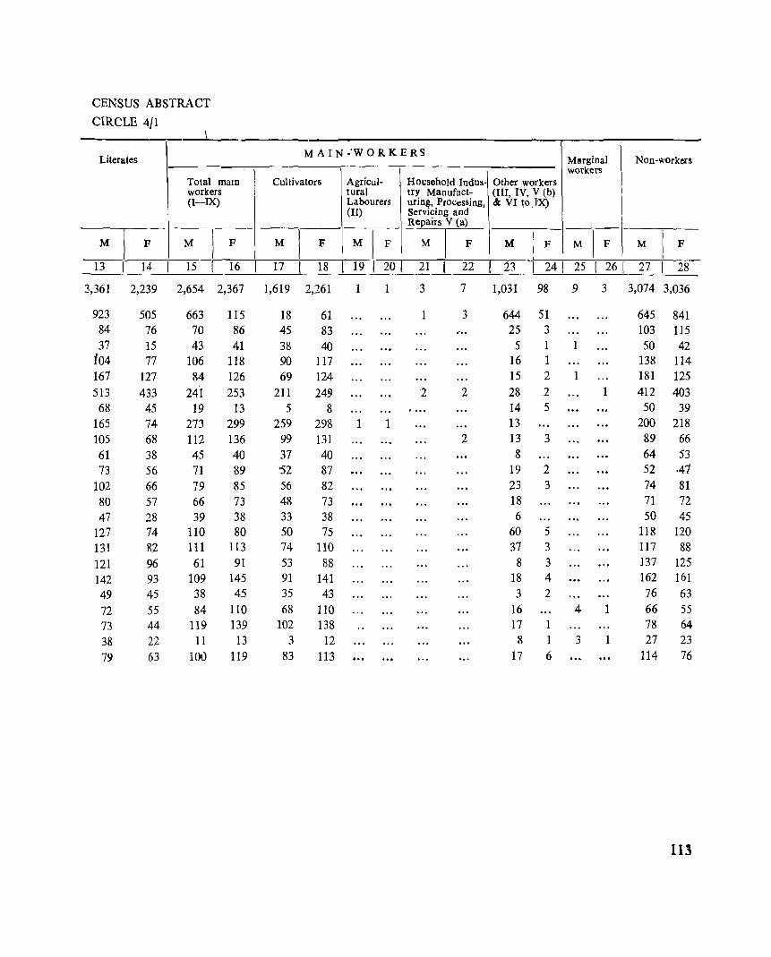
CENSUS ABSTRACT
CIRCLE 4/1 \
Literates M A I N -'W 0 R K E RS
Marginal Non-workers workers
Total maIn Cultivators Agricul- Household Indus- Other workers workers tural try Manufact- (III, IV, V (b) (I-IX) Labourers uring, Processing, & VI ~o .IX)
(II) Servicing and Repairs V (a)
M I F M ) F M I F M I F M I F M I F M I F M I
F
13 14 15 16 17 18 19 20 I 21 22 I 23 1 241 25 I 26 1 27 1 28
3,361 2,239 2,654 2,367 1,619 2,261 1 3 7 1,031 98 9 3 3,074 3,036
923 505 663 115 18 61 3 644 51 645 841 84 76 70 86 45 83 .~ .. 25 3 103 115 37 15 43 41 38 40 5 1 1 50 42
t04 77 106 118 90 117 16 1 138 114 167 127 84 126 69 124 15 2 1 181 125 513 433 241 253 211 24~ 2 2 28 2 1 412 403
68 45 19 13 5 8 14 5 50 39 165 74 273 299 259 298 1 1 13 200 218 105 68 112 136 99 131 2 13 3 89 66 61 38 45 40 37 40 8 64 53 73 56 71 89 '52 87 19 2 52 .41
102 66 79 85 56 82 23 3 74 81 80 57 66 73 48 73 18 71 72 47 28 39 38 33 38 6 50 45
127 74 110 80 50 75 60 5 118 120 131 82 III 113 74 110 37 3 117 88 121 96 61 91 53 88 8 3 137 125 142 93 109 145 91 141 18 4 162 161 49 45 38 45 35 43 3 2 76 63 72 55 84 110 68 110 16 4 1 66 55 73 44 119 139 102 138 17 1 78 64 38 22 11 13 3 12 8 1 3 1 27 23 79 63 lOu 119 83 113 17 6 114 76
113
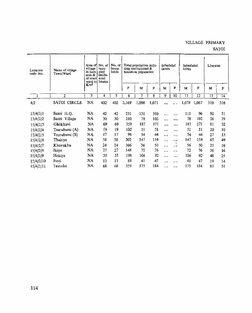
Location code No.
4/2
15/4/2/1 15/4/2/2 15/4/2/3 15/4/2/4 15/4/2/5 15/4/2/6 15/4/2/7 15/4/2/8 15/4/2/9 P/4/2/10 15/4/2/11
114
Name of village Town/Ward
2
SATOI CIRCLE
Satoi H.Q. Satoi Village
Gliokhuvi
Tsuruhumi (A) Tsuruhumi (B) Thakiye
Khuvukhlol Ikiye Ho)dye
Itovi Tsutoho
I i
I
I Area of No. of No. of Total population inclu-village occu- house ding institutional & I in heet pied holds housekss population ares_& reside-of town ntial ward inl houses Km2.
p M F
scheduled castes
I M F
VILLAGE PRIMARY
SATOI
Scheduled Literates tribes
-_ M F M F
3 4 I 5 6 7 I 8 l 9 10 I 11 12 13 14
NA 402 402 2,169 1,098 1,071 1,078 1,067 510 310
NA 42 42 231 131 100 111 96 92 51 NA 30 30 180 78 102 78 102 26 39 NA 69 69 358 187 171 187 171 81 32 NA 1'9 19 102 51 51 51 51 20 10 NA 17 17 98 54 44 54 44 27 13 NA 58 58 301 147 154 147 154 65 49 NA 24 24 106 '56 50
I 56 50 .. ~ 23 10
NA 27 27 148 72 76 72 76 26 16 NA 35 35 198 106 92 106 92 48 25 NA 13 13 88 41 47 41 47 19 14 NA 68 68 359 175 184 175 184 83 51
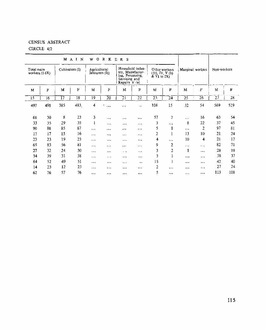
CENSUS ABSTRACT
CIRCLE 4/2
M A I N W 0 R K E R S
Total main Cultivators (I) .:\gricultural Household indus- I Other workers Marginal workers Non-workers workers (I-IX) labourers (II) try, Manufactur- I (III, IV, V lb)
ing, Processing, & VI to IX) Servicing and Repairs V (a) _-
M F M F M F I ~··I-· F M F M F M F
15 16 17 18 19 20 I 21 I 22 2:l 24 .2-5 26 27 28
497 498 385 483. 4 108 15 32 54 569 519
68 30 8 23 3 57 7 16 63 54 33 35 29 35 1 3 8 22 37 45 90 88 85 87 5 1 2 97 81 17 17 15 16 2 1 13 10 21 24 23 23 19 23 4 10 4 21 17 65 83 56 81 9 2 82 71 27 32 24 30 3 2 1 28 18 34 39 31 38 3 1 38 37 64 52 49 51 15 42 40 14 23 12 23 2 27 24
62 76 57 76 5 113 108
115
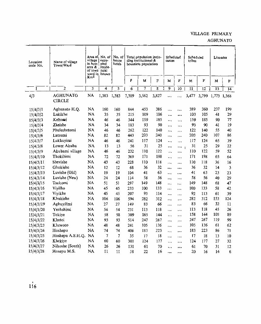
I I
I I
VILLAGE PRIMARY
AGHUNATO
I Area ofl No. of No. of Total population inclu- Scheduled Scheduled Location Name of village village occu· house ding institutional & castes tribes
_c_O_de--,--N-O-.--.--T-o-w-n/-:;:-w-ar-d-----,-1 ~_~--:::~_~-i~i_~e_~f--:-1:_~.__ho-c:ld:-S-.-b-o_=_:'-el-,~;._s _~=-P_"I;: I M I F I~I-F- -M-[--F-Literates
1 2 3 4 I 5 6 7 I 8 I 9 10 I 11 I 12 I 13 I 14
4/3 AGHUNATO NA 1,383 1,383 7,389 3,562 3,827 3,477 3,799 1,773 1,368 CIRCLE
15/4/3/1 15/4/3/2 15/4{3/3 15/4/3/4 15/4(3/5 15/4/3/6 15/4/3/7 15/4/3/8 15/4/3/9 15/4/5/10
15/4/3/11 15/4/3/12 15/4/3/13 15/4/3/14 15/4/3/15 15/4/3/16 15/4/3/17 15/4/3/18
15/4/3/19
15/4/3/20 15/4/3/21 15/4/3/22 15/4/3/23 15(4/3/24 15/4/3/25 15/4/3/26 15/4/3/27 15/4/3/28
, 116
Aghunato H.Q. NA LUkikhe NA Keltomi NA Zlleishe NA Phuleshetomi NA Lutsumi NA Lukhuyimi NA Lower Akuba NA Akueami village NA Thokihimi NA
Shevishe NA
Ghokishe NA Luvishe (Old) NA Luvishe (New) NA Tsukomi NA Viyilho NA Viyikhe NA Khukishe NA
Aghuyilimi NA
Yezhshimi NA Tokiye NA Khetoi NA Khewoto NA Hoshepu NA Hoshepu A.S.H.Q. NA Khekiye NA Nihoshe (South) NA Hosepu M.S. NA
160 35
46 34 46 82
46 13 46
72
43 12 19 24 51 45 45
106
27 54 58 93 48 74
7 60 26 11
160 35
46 34 46 82 46 13 46 72 43 12 19 24 51 45 45
106
27 54 58 93 48 74
7
60 26 11
844 215 344 183 262 443 241
56 232 369 228
68 104 114 297 233 207 594 149 231 309 514 241 406
35 301 131 38
453 109 159 93
122 203
117 31
110 171
110 36 41 58
149 100
93 282
83
113 165 247 105 183 17
124 61 22
386 106 185 90
140 240 124
25 122 198 118 32 63 56
148 133
114 312 66
118 144 267 136 223
18 177 70 16
389 360 103 105
159 185 93 90
122 140 203 240 117 124 31 25
110 122
171 198 110 118 36 32 41 63 58 56
l49 148 100 133 92 113
282 312 83 66
113 118 158 144 247 267 105 136 183 223
17 18 124 177
61 70 20 16
237 199 41 29 90 77 41 19 55 40
107 86
65 39 29 22 59 52 65 64
36 16 14 3 23 23 40 29 68 47 58 42 61 39
153 124 32 11
45 26 103 89 119 99 61 62
86 71 13 10 27 32
31 12 14 6
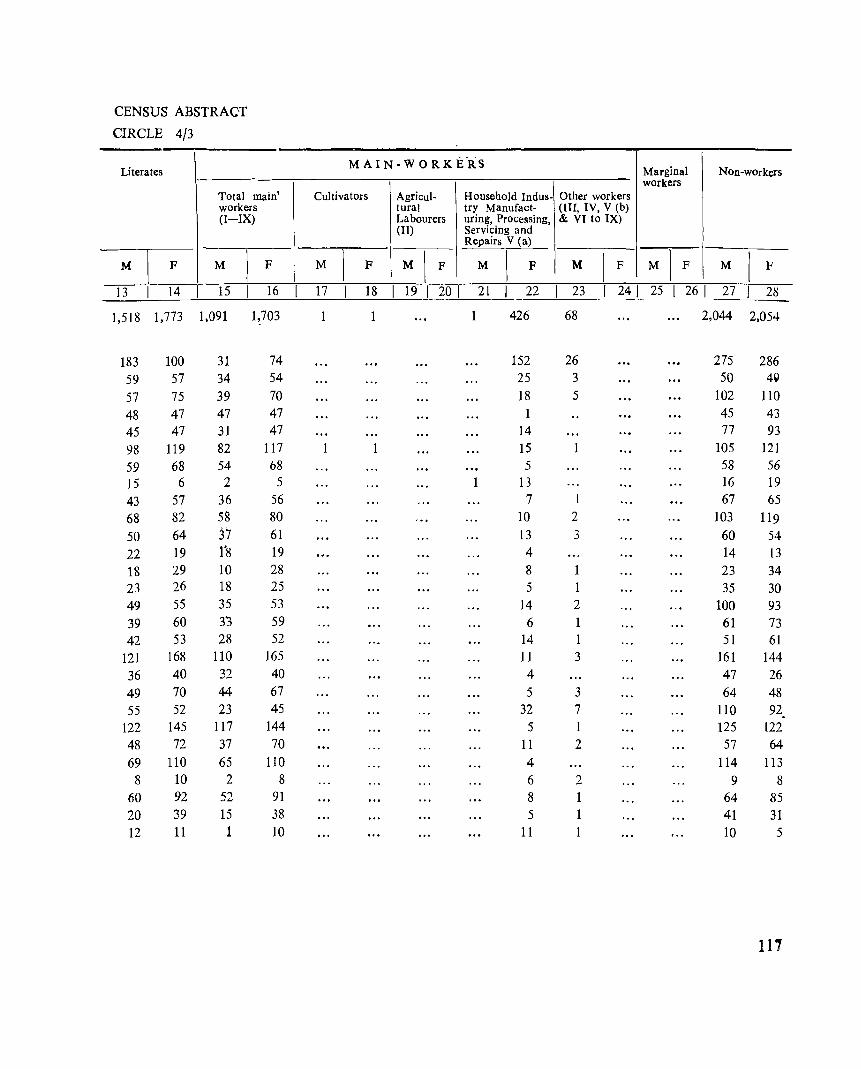
CENSUS ABSTRACT
CIRCLE 4/3
Literates
Total main' workers (I-IX)
M \
F M 1
F
13 14 15 16
1,518 1,773 1,091 1,703
183 100 31 74 59 57 34 54 57 75 39 70 48 47 47 47 45 47 31 47 98 119 82 117 59 68 54 68 15 6 2 5 43 57 36 56 68 82 58 80 50 64 37 61 22 19 1'8 19 18 29 10 28 23 26 1'8 25 49 55 35 53 39 60 33 59 42 53 28 52
121 168 110 165 36 40 32 40 49 70 44 67 55 52 23 45
122 145 117 144 48 72 37 70 69 110 65 110 8 10 2 8
60 92 52 91 20 39 15 38 12 11 1 10
M A IN- W 0 R K E·RS Marginal Non-workers workers
Cultivators Agricul- Household Indus- Other workers lural try Manufact- (III, IV, V (b) Labourers uring, Processing, & VI to IX) (II) Servicing and
Repairs V (a)
M 1
F M I F M \
F M [ F M I F M I F
17 18 19 1 20 1 21 22 1 23 241 25 1 26 1 27 28
1 1 426 68 2,044 2,054
152 26 275 286 25 3 50 49 18 5 102 110
45 43 14 77 93 15 1 105 121 5 58 56
1 13 16 19 7 67 65
10 2 103 119 13 3 60 54 4 14 13 8 23 34 5 35 30
14 2 100 93 6 61 73
14 1 51 61 11 3 161 144 4 47 26 5 3 64 48
32 7 110 92. 5 1 125 122
11 2 57 64 4 114 113 6 2 9 8 8 64 85 5 41 31
11 1 10 5
111
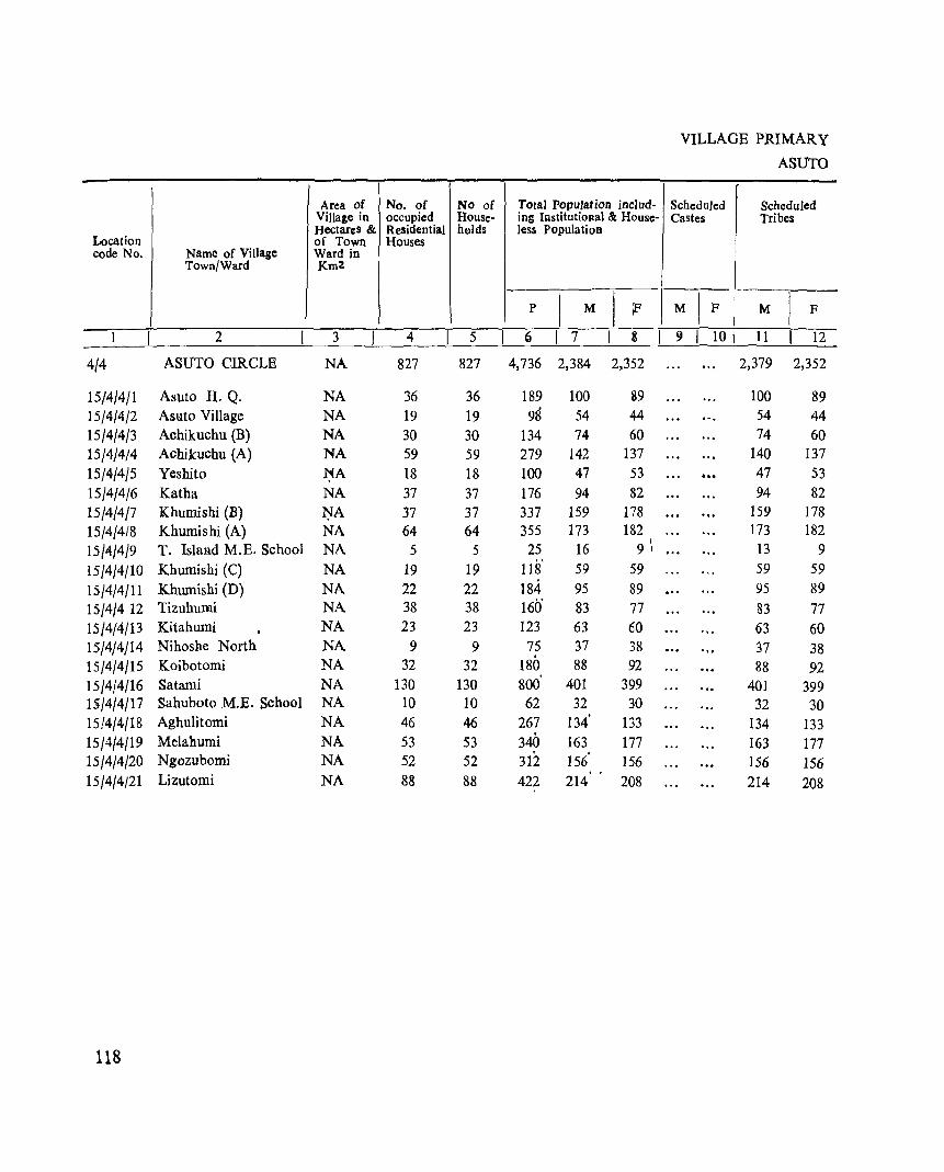
Area of No. of No of Village in occupied House-Hectares & Residential halds
Location of Town Houses code No. Name of Village Ward in
Town/Ward Km2
2 3 4 5
4/4 ASUTO CIRCLE NA 827 827
15/4/4/1 Asuto H. Q. NA 36 36 15/4/4/2 Asuto Village NA 19 19 15/4/4/3 Achikuchu (B) NA 30 30 15/4/4/4 Achikuchu (A) NA 59 59 15/4/4/5 Yeshito 1;{A 18 18 15/4/4/6 Katha NA 37 37 15/4/4/7 Khumishi (B) :r-:;rA 37 37 15/4/4/8 Khumishi (A) NA 64 64 15/4/4/9 T. Island M.E. School NA 5 5 15/4/4/10 Khumishi (C) NA 19 19 15/4/4/11 Khumishi (D) NA 22 22 15/4/4 12 Tizuhu:mi NA 38 38 15/4{4/13 Kitahumi NA 23 23 15/4/4/14 Nihoshe North NA 9 9 15/4/4/15 Koibotomi NA 32 32 15/4/4/16 Satami NA 130 130 15/4/4/17 Sahuboto M.E. School NA 10 10
15/4/4/18 Aghulitomi NA 46 46 15/4/4/19 Melahumi NA 53 53 15/4/4/20 Ngozubomi NA 52 52 15/4/4/21 Lizutomi NA 88 88
118
Total Population includ-ing InstitutioRal & House-less Population
p I
M I iF
(j I 7 3 I 4,736 2,384 2,352
189 100 89 98 54 44
134 74 60 279 142 137 100 47 53 176 94 82 337 159 178 355 173 182
25 16 1
9 1
118' 59 59 184 95 89 160' 83 77 123 63 60
75 37 38 180 88 92 800 401 399 62 32 30
· 267 134 133 340 163 177 · 312 156 156 · . 422 214 208
VILLAGE PRIMARY
ASUTo
Scheduled Scheduled Castes Tribes
M IF M I F 9 I 10 I 11 12
2,379 2,352
100 89 54 44 74 60
140 137 ... 47 53 94 82
159 178 173 182
13 9 59 59 95 89 83 77 63 60 37 38 88 92
401 399 32 30
134 133 163 177 156 156 214 208
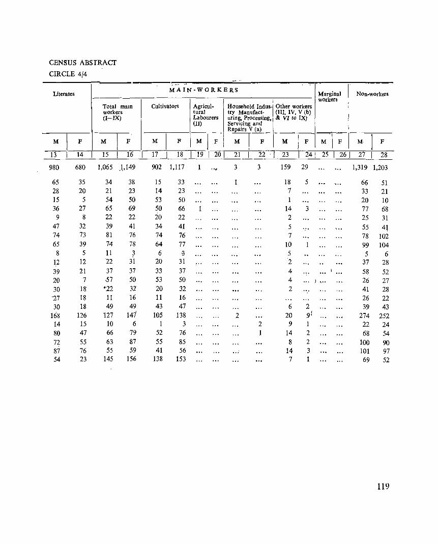
CENSUS ABSTRACT
CIRCLE 4/4
Literates
Total maIn workers (I-IX)
M I F M I F
13 14 15 16
980 680 1,065 ),149
65 35 34 38 28 20 21 23 15 5 54 50 36 27 65 69 9 8 22 22
47 32 39 41 74 73 81 76 65 39 74 78 8 5 11 3
1,2 12 22 31 39 21 37 37 20 7 57 50 30 18 ·22 32 '27 18 11 16 30 18 49 49
1()8 126 127 141 14 15 10 6
80 47 66 79 72 55 63 87 87 76 55 59 54 23 145 156
- -~ -- ~-
MAIN-WORKERS
Cultivators Agricul- Household Indus-tural try Manufact-Labourers uring, Processing, (II) Servicing and
Repairs V (a)
M I F M I F M I F
17 18 19 [ 20 [ 21 22 -I
902 1,117 1 , '~ 3 3
15 33 1 14 23 53 50 50 66 1 20 22 34 41 74 76 64 77 6 ~
20 31 33 37 53 50 20 32 11 16 43 47
105 138 2 1 3 2
52 76 1 55 85 41 56
138 153
Marginal Non-workers workers
Other workers (III, IV, V (b) & VI to IX)
M I F M'I F M' I F
23 1 24[ 25 1 261 27 1 28
159 29 1,319 1,203
18 5 ., . 66 51 7 33 21 1 20 10
14 3 77 68 2 25 31 5 55 4l 7 78 102
10 1 99 104 5 5 6 2 37 28 4 58 52 4 ) , .. 26 27 2 41 28
26 22 6 2 39 43
20 91 274 252 9 1 22 24
14 2 68 54 8 2 100 90
14 3 101 97 7 1 69 52
119
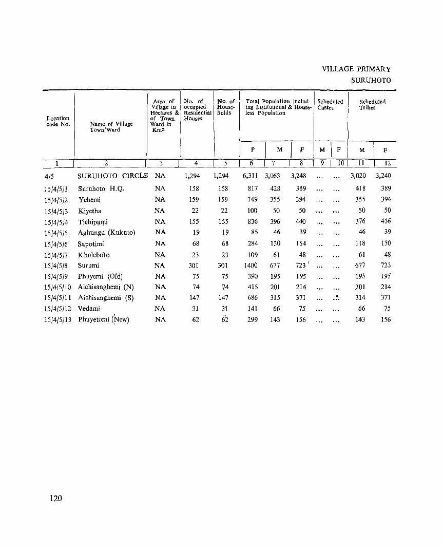
Area of No. of No. of YilIa~e in occupied House-Hectares & Residential holds
Location of Town Houses code No. Name of Village Ward in
TownlWa.rd Km2.
1 2 3 4 5
4/5 SURUHOTO CIRCLB NA 1,294 1,294
15/4/5/1 Suruhoto H.Q. NA 158 158
15/4/5/2 Yehemi NA 159 159
15/4/5/3 Kiyetha NA 22 22
15/4/5/4 TichiNIpi NA 155 155
15/4/5/5 Aghungu (Kukuto) NA 19 19
15}4/5/6 Sapotimi NA 68 68
15}4/5}7 Kbolebo'to NA 23 23 15}4}5}8 8urumi NA 301 301
15/4/5/9 Phuyemi (Old) NA 75 75 15}4/5}10 Aichisanghemi (N) NA 74 74
15/4/5/11 Aichisanghemi (8) NA 147 147
15}4/5/12 Vedami NA 31 31
15/4/5/13 Phuyetomi (~ew) NA 62 62
120
Total Population includ-iog Institutional & House-less Population
p ) M I f
6 I 7 8
6,311 3,063 3,248
817 428 389
749 355 394
100 50 50
836 396 440 85 46 39
284 130 154
109 61 48 1400 677 723 I
390 195 195 415 201 214 686 315 371
141 66 75
299 143 156
I
VILLAGE PRIMARY
SURUHOTO
Scheduled Scheduled Castes Tribes
-M
\ F M I F
9 I 101 11 12
3,020 3,240
418 389
355 394
50 50
376 436 46 39
118 150
61 48 677 723
195 195
201 214 • 314 371 ...
66 75
143 156
CENSUS ABSTRACT
CIRCLE 4/5
Literates
Total maIn workers (I-IX)
M \
F M 1
F
13 14 15 16
1,143 842 1,531 1,587
227 151 172 112
135 94 178 201
13 8 27 24
143 121 190 209
29 10 • 16 21
72 80 65 84
33 21 33 28
196 122 355 422
84 61 93 55
77 51 94 105
67 53 195 223
19 16 38 44
48 54 75 59
MAIN-WORKERS
Cultivators Agricul- Household Indus-tural try Manufact-Labourers uring, Processing, (II) Servicing and
Repairs V Ca)
M 1
F M I F M \
F 17 18 19 201 21 22
1,243 1,526 2 4
46 84
166 200 26 22
150 208
15 21 44 76
25 28
328 413 4
86 53
'19 105 1-73 219
35 42 70 55
Marginal Non-wOrkers workers
Other workers (III, IV. V (b) & VI to IX)
I I
M I F -;-l-F \ M I F
23 1 241 25 1 26 I 27 I 28 286 57 8 54 1,524 1,607
126 28 256 277 12 4 13 173 180 1 \2 23 26
40 1 206 231
1 30 18 20 8 65 70
8 28 20 26 5 322 301 7 2 102 140
15 107 109 22 4 2 11 118 137
3 2 28 31 5 4 2 30 66 67
121
Location code No,
. 1
4/6
15/4/6/1 1~/4/6/2 15/4/6/3 15/4/6/4 15/4/6/5 15/4/6/6 15/4/6/7 15/4/6/8 15/4/6/9 15/4{6/1O 15/4/6/11 15/4/6/12 15/4/6/13 15/4/6/14 15/4/6/15 15/4/6/16 15/4/6/17 15/4/6/18 15/4/6/19 15/4{6/20
122
VILLAGE PRlMAR Y
ZUNHEBOTO SADAR
Name of village Town/Ward
I 'I' ·SChedUled I Area of No. of No. of Total population inclu. Scheduled village oecu, houSe ding institutional & castes tribes
I in hec~ pied holds houseless population
Literates'
"ares & reside, of town nlial ward in' houses 1----.------ __ ~_
Km2 I p I M I F M I F
2
ZUNHEBOTO
SADAR CIRCLE
3 I 4 5 6 I 7 I 8 I 9 I 10
NA 1,263 1,263 6,650 3,217 3,433
Asukhomi NA Ley):lOmi (New) NA Yezami NA Locho (C) NA Lizuavikato NA Lizunaghuto NA Baimho NA
Sh~.t.omi NA Sheipu NA Sukhalu NA Yeii"iishe' NA Zungti NA
Natha Old NA Natha New NA Khikhepu NA Lizu Phutheu NA Lizu Phutheu (Old) NA
Nikoto NA Kulhopu NA Ghukiye NA
162 162 783 57 57 301
124 124 590 12' 12 93 65 65, 347 25 25 160 71 71 374 39 39 221 66 66 378 67 67 348 75 75' 3610 52 52 280 4\ 4~ 237 57 57 393 ". 45 45 255 51 51 264 60 60 29~
27 27 142 43 43 249
124 124 581
373 148
'280
46 PI 63
178 124 170 171 182 138 110 " 200 116 135 134
71 118 289
410 153 310 47
176 97
196 97
208 177 179 142 127 193 139 129 159
71 131 292
I 11 I 12 I 13 I 14
3,196 3,421 1,510 1,193
373 410 214 190 148 153 59 43 279 310 116 64 45 42 27 22
169 175 81 67 63 97 44 47
178 196 52 45 124 97 56 38 170 208 71 59 160 173 96 75 182 179 73 58 138 142 59 43 107 125 45 45, 200 193 106 94 116 139· 68 59 135 129 73 39 131 159 59 50
71 71 27 20 113 131 41 34 i
289 292 143 101
CENSUS ABSTRACT
CIRCLE 4/6
M A I N W 0 R K E R S
Total main Cultivators (1) Agricultural Household indus- Other workers Marginal workers Non-workers workers (I-lX) labourers (II) try. Manufactur- (III. IV, V (b)
ing. Processing. & VI to IX) Servicing and Repairs V (a)
M F M F M F l M I F M F M F M F
15 16 17 18 19 20 I 21 I 22 23 24 25 26 27 28
1,487 1,765 1,208 1,715 4 3 275 46 34 24 1,696 1,644
198 261 131 252 67 9 175 149 61 73 53 71 8 2 33 24 54 56
152 193 148 193 4 128 117 15 18 '8 18 7 31 29 71 72 50, 69 21 3 100 104 34 50 34 50 29 47 80 9:1 70 91 10 2 98 103 46 53 37 51 9 2 78 44 79 105 63 103 16 2 91 103 74 89 61 86 1 12 2 1 96 88 82 93 76 90 6 3 .. -.. 100 86 70 72 't)4 71 6 1 68 70 44 50 28 47 16 3 66 77 72 61 45 51 3 3 24 7 128 132 52 65 45 63 7 2 64 74 56 60 '44 bO 12 79 69 61 77 44 75 17 2 73 82 41 44 34 42 7 2 30 27 64 75 63 74 1 1 54' 56,._;
135 161 110 153 25 3 .1-:1':. 154 .-. 81 ~ ~~~~-.
123
Area of No. of No. of Village in occupIed House-Hectares & Residential holds
Location of Town Houses
code No. Name of Village Ward in Town/Ward Km2
1 2 3 4 5
4/7 ATOIZU CIRCLE NA 1,412 1,412
15/4/7/1 Atoizu ·R. Q. NA 84 84
15/4/7/2 NaghutQmi Old NA 96 96
15/4/7/3 Naghuto:mi New NA 29 29
15/4/7/4 Awotsakili NA 59 59
15/4/1/5 Apukito NA 14. 14
15/4/7/6 Lokobomi NA 63 63.
15/4/717 Aizuto Mission Centres NA 30 30
15/4/7/8 Mapulumi NA 99 99
15/4/7/9 Akuhaito NA 29 29
15/4/1/10 Rotomi Old NA 131 131
15/4/7/11 Rotomi New NA 57 57
15/4/7/12 Philimi NA 98 98
15/4/7/13 Sukomi NA 60 60
15/4/7/14 Litsami NA 119 119
15/4/7/15 Emlomi NA 55 55
15/4/7/16 Yesholtomi NA 76 76
15/4/7/17 Asukhuto Polytechnic NA 77 77
15/4/7/18 . Khromtomi NA 99 99
"'_'151-4)7/19 . Asukhuto Vill. NA 14 14
15/4/7 (i.O·~' .v!;k.:IJ~~ 'Old NA 60 60
15/4/7/21 Vekund New. ._ NA 63 63
124
Total population incJud-ing Institutional & House-less POl'ulation
p \
M I F
6 I 7 8
7,493 3,735 3,758
44~ 222 225 454 226. 228 140 67 73 329 163 166 102. 54 48 366. 182 184 169 77 92 510 249 261 163 85 78
706 342 364
295 15Q 139 474 22~ 251
323. In 151 668 331 337
309 159 150 414 222 192
318 16~ 153 543 270 273
69 33. 36 348 16~ 183 346 172 174
VILLAGE PRIMARY
ATOIZU
r Scheduled Scheduled Castes Tribes
-M
\ F M
\ F
9 I 10 I 11 12
3,671 3,724
220 225 226 228
67 73 162 166
54 48 182 184
74 87 , ... 249 261
85 78 ... 342 364
156 139 223 251 172 151 331 337 159 150 202 189 127 127 270 273
33 36 165 183 172 174
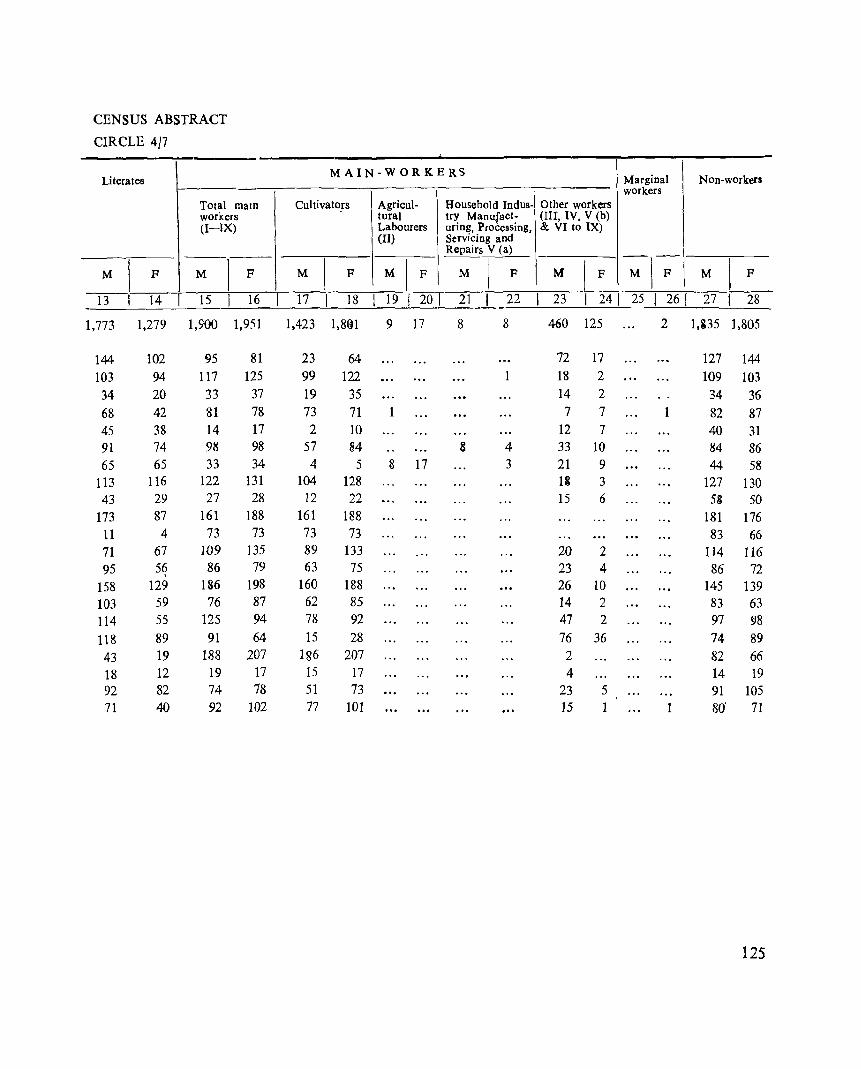
CENSUS ABSTRACT
CIRCLE 4/7
Literates MAIN-WORKERS
Marginal Non-workers workers
Total mam Cultivators Agricul- Household Indus- Other workers workers tural try Manufact- (III, IV. V (b) (I-IX) Labourers uring, Processing, & VI to IX)
(II) Servicing and Repairs V (a)
-;;1--;\ M \
F M 1
F M 1 F MIF M I
F M I F M I F
13 14 15 16 17 18 19 1 201 21 _l_ 22 23 1 241 25 I 261 27 1 28
1,773 1,279 1,900 1,951 1,423 1,8Gl 9 17 8 8 460 125 2 1,135 ],805
144 102 95 81 23 64 72 17 127 144 103 94 117 125 99 122 18 2 109 103
34 20 33 37 19 35 14 2 34 36 68 42 81 78 73 71 7 7 1 82 87 45 38 14 17 2 10 12 7 40 31 91 74 98 98 57 84 8 4 33 10 84 86 65 65 33 34 4 5 8 17 3 21 9 44 58
113 116 122 131 104 128 13 3 127 130 43 29 27 28 12 22 15 6 5* 50
173 87 161 188 161 188 181 176 11 4 73 73 73 73 83 66 n 67 109 135 89 133 20 2 114 116 95 59 86 79 63 75 23 4 86 72
158 129 136 198 160 188 26 10 145 139 103 59 76 87 62 85 14 2 83 63 114 55 125 94 78 92 47 2 97 98 118 89 91 64 15 28 76 36 74 89 43 19 188 207 186 207 2 82 66 18 12 19 17 15 17 4 14 19 92 82 74 78 51 73 23 5 91 105 71 40 92 102 77 101 15 1 1 80' n
125
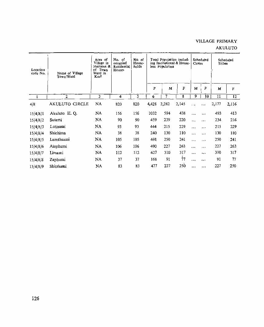
Area of No. of No. of Village in occupied House-Hectares & ReSidential holds
Location of Town Houses code No. Name of Village Ward in
Town/Ward Km2
2 3 4 5
4/8 AKULUTO CIRCLE NA 820 820
15/4/8/1 Akuluto H. Q. NA 156 156
15/4/8/2 Sutemi NA 90 90
15/4/8/3 Lotisa:mi NA 93 93
15/4/8/4 Shichima NA 38 38
15/4/8/5 Lumthsami NA 105 105
15/4/8/6 Alaphumi NA 106 106
15/4/8/7 Limami NA 112 112
15/4/8/8 Zaphumi NA 37 37
15/4/8j9 Shitshami NA 83 83
126
Total Population includ-ing Institutional & House-less Population
p I M I F
g I 7 8 I 4,428 2,282 2,145
1032 594 438
459 239 220
444 215 229 240 130 110
491 250 241
490 227 263 627 310 317
I
168 91 77
477 227 250
VILLAGE PRIMARY
AKULUTO
Scheduled Scheduled Castes Tribes
{
-M I F M I F
9 I 10 I 11 12
2,177 2,116
493 413
234 216
215 229 130 110 250 241
227 263 310 317
91 77
227 250
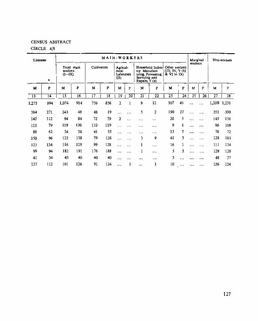
CENSUS ABSTRACT
CIRCLE 4/8
Literates
Total maIO workers (I-IX)
, M I F M
1 F
13 14 15 16
1,275 994 1,074 914
384 271 243 48
142 112 94 84
121 79 119 120
88 62 54 38
150 96 122 138
123 134 1 i6 129
99 94 182 191
41 34 43 40
127 112 101 126
MAIN-WORKERS
Cultivators Agricul- Household Indus-tural try Manufact-Labourers uring, Processing, (II) Servicing and
Repairs V <a>
M 1
F MI F M I F
17 18 19 201 21 22
756 856 2 9 12
48 19 5 2
72 79 2
110 119
41 33 79 126 3 9
99 128 1 -176 188
40 40
91 124 1
Marginal Non-workers workers
Other workers (III, IV, V (b) & VI to IX)
I
M I F M I-F \ M I F
23 1 241 25 I 261 27 1 23
307 45 1,209 1,231
190 27 351 ,390
20 5 145 136
9 1 96 109 13 5 76 72
41 3 128 103
16 1 111 134
5 3 128 '126
3 48 37
lO 126 124
127
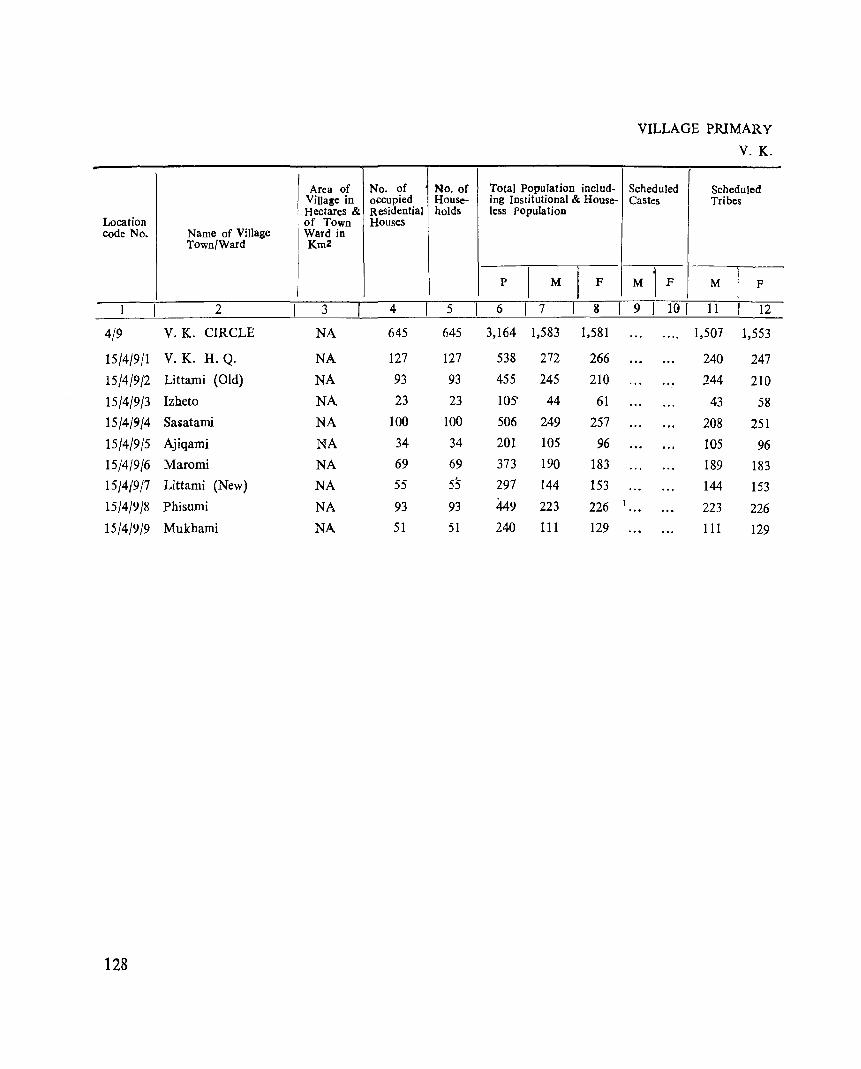
Area of No. of No. of Villa~e in occupied House-HectareS & Residential holds
Location of Town Houses code No. Name of Village Ward in
Town/Ward Km2
1 2 3 4 5
4/9 V.K. CIRCLE NA 645 645
15/4/9/1 V.K. H.Q. NA 127 127
15/4/9/2 Littami (Old) NA 93 93
15/4/9/3 Izheto NA 23 23
15/4/9/4 Sasatami NA 100 100
15/4/9/5 Ajiqami NA 34 34
15/4/9/6 Maromi NA 69 69
15/419/7 Littami (New) NA 55 55
15/4/9/8 Phisumi NA 93 93
15/4/9/9 Mukhami NA 51 51
128
Total Population includ-ing Institutional & House-less Population
p I M I F
6 I 7 3
3,164 1,583 1,581
538 272 266 455 245 210
lOS' 44 61 506 249 257 201 105 96 373 190 183 297 144 153
449 223 226 240 III 129
I
VILLAGE PRIMARY
V. K.
Scheduled Scheduled Castes Tribes
-M 1
F M I F
9 I 10 I 11 12
1,507 1,553
240 247 244 210
43 58 208 251 105 96 189 183 144 153
223 226 III 129
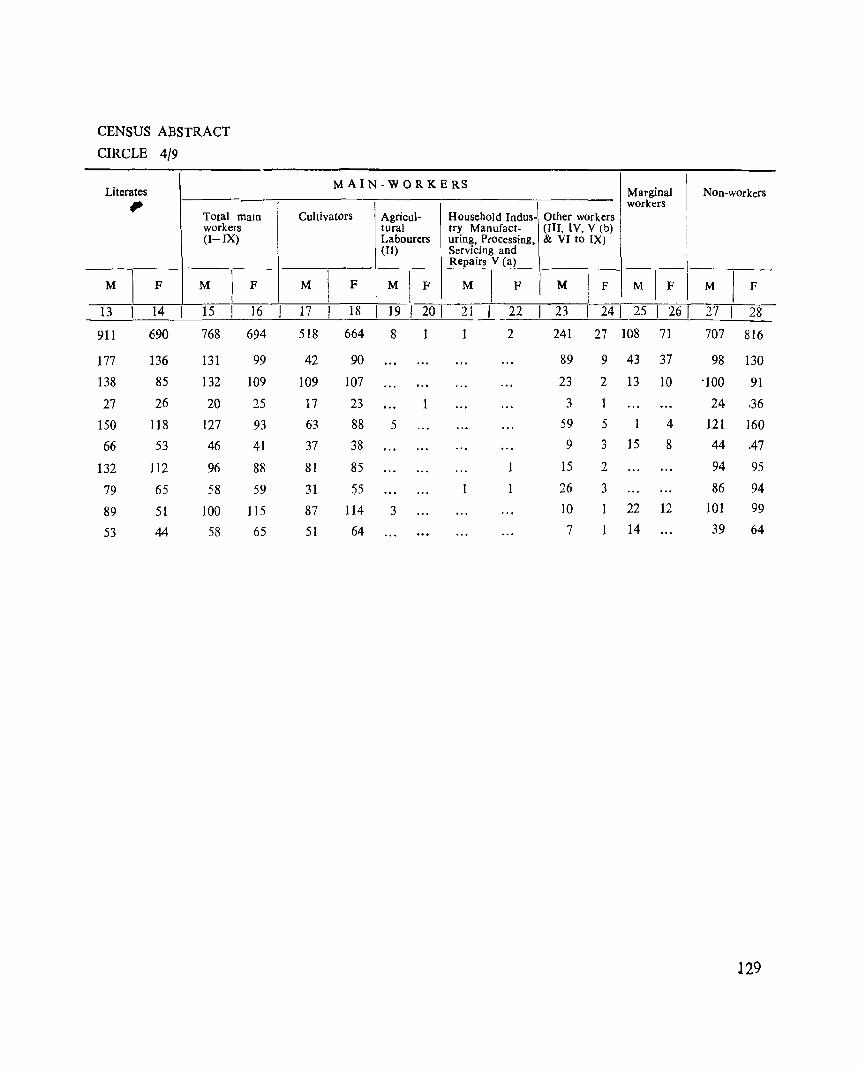
CENSUS ABSTRACT
CIRCLE 4/9
Literates , Total maID workers (I-IX)
M 1
F M ) F
13 14 15 16
911 690 768 694
177 136 131 99
138 85 132 109
27 26 20 25
150 118 127 93
66 53 46 41
132 112 96 88
79 65 58 59
89 51 100 115
53 44 58 65
M A I N - W 0 R K E RS
Cultivators Agricul- Household Indus-tural try Manufact-Labourers uring, Processing, (II) Servicing and
Repairs V (a)
M ) F MI F M I F
17 18 19 20 I 21 _1- 22
518 664 8 2
42 90
109 107
17 23
63 88 5
37 38
81 85
31 55
87 114 3
51 64
Marginal Non-workers workers
Other workers (Ill, IV, V (b) & VI to IX)
--I M I F M I F I M I F
23 I 241 25 I 261 271 28
241 27 108 71 707 816
89 9 43 37 98 130
23 2 13 10 -100 91
3 1 24 .36 59 5 4 121 160 9 3 15 8 44 .47
15 2 94 95
26 3 86 94
10 1 22 12 101 99
7 14 39 64
129
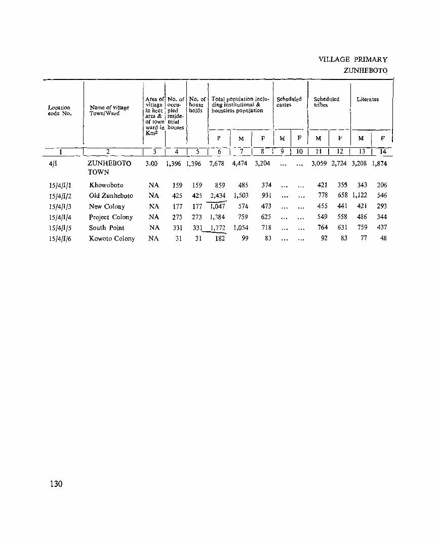
Location eode No.
1
4/1
15/4/1/1
15/4/1/2 15/4/1/3
15/4/1/4
15/4/1/5
15/4/1/6
130
Name of village Town/Ward
2
ZUNHEBOTO TOWN
Khowoboto
Old Zunbeboto
New Colony
Project Colony
South Point
Kowoto Colony
I I
I Area of No. of village occu-
I in heet pied ares & I reside-of town ntial ward in houses
Km2 I
No. of Total population incluhouse ding institutional & holds houseless population
3
3.00
4 5
NA
NA
NA
NA
NA
NA
1,396 1,396 7,678 4,474 3,204
159
425
177
273
331
31
159 859 425 2,434 -' 177 1,047
273
331
31
1,184
1,772
182
485
1,503
574
759
1,054
99
374
931
473
625
718
83
VILLAGE PRIMARY
ZUNHEBOTQ
Scheduled Scheduled Literates castes tribes
3,059 2,724 3,208 1,874
421 778
455
549 764
92
35S 343
658 1,122
441 421
558 486
631
83
759
77
206
546
293
344
437
48
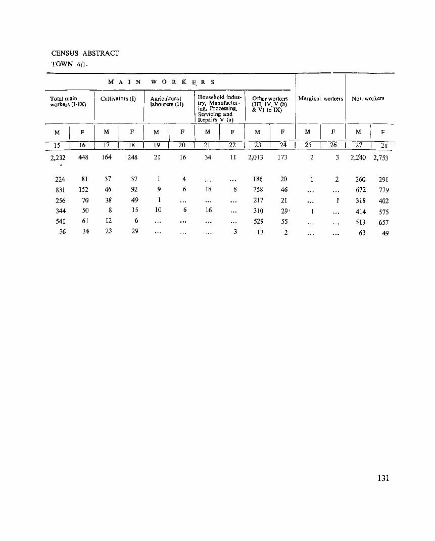
CENSUS ABSTRACT
TOWN 4/1.
M A I
Total main workers (I-IX)
I Cultivators (I)
M \
F I M I F
N W o R K
Agricultural labourers (II)
\ M \ . F
E, R S
Household indus- Other workers Marginal workers Non·workers trY, Manufactur- (III, IV, V (b) ing, Processing, & VI to IX) Servicing and Repairs V (Il)
~-
\ \ 1 I 1
I
M F M F M F M \
F
-15 16 17 18 19 20 21 22 23 24 25 26 2 7 2~ --~~----~----~----~----~----~--~----~----~----~----~----~----~~-
2,232 448 164 248 21 2,240 2,753 16 34 11 2,0l3 173 2 3
224 81 37 57
831 152 46 92 9
256 70 38 49 1
344 50 8 15 10
541 61 12 6
36 34 23 29
4 186 6 18 8 758
217 6 16 310
529 3 13
20 46
21
29' 55
2
1 2
1
1
260 291 672 779
318 402
414 575 513 657
63 49
131
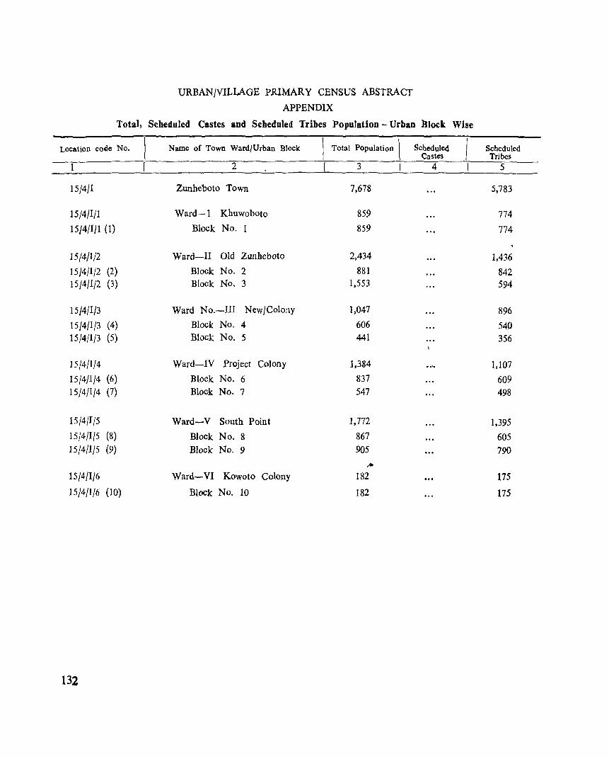
URBANjVILLAGE PRIMARY CENSUS ABSTRACT
APPENDIX
Total, S<!heduJed Castes and Scheduled Tribes PopUlation - Urban lJIock Wise
Location code No. Name of Town Ward/Urban Block Total Population \ Scheduled Scheduled Castes Tribes
1 2 3 I 4 5
15/4/1 Zunheboto Town 7,678 5,783
15/4/1/1 Ward-l Khuwoboto 859 774
15/4/1/1 (1) Block No.1 859 774
15/4/1/2 Ward-II Old Zunheboto 2,434 1,436
15/4/1/2 (2) Block No. 2 881 842 15/4/1/2 (3) Block No. 3 1,553 594
15/4/1/3 Ward No.-lII New/Colony 1,047 896
15/4/1/3 (4) Block No.4 606 540 15/4/1/3 (5) Block. No.5 441 356
15/4/1/4 Ward-IV Project Colony 1,384 •• '0 1,107
15/4/1/4 (6) Block No.6 837 609 15/4/1/4 (7) Block No.7 547 498
15/4/I/5 Ward-V South Point 1,772 1,395
15/4/I{5 (8) Block No.8 867 605 15/4/1/5 (9) Block No.9 905 790
,.. 15/4/1/6 Ward-VI Kowoto Colony 182 175
15/4/1/6 (10) Block No. 10 182 175
132
PRIMARY CENSUS ABSTRACT FOR SCHEDULED TRIBES
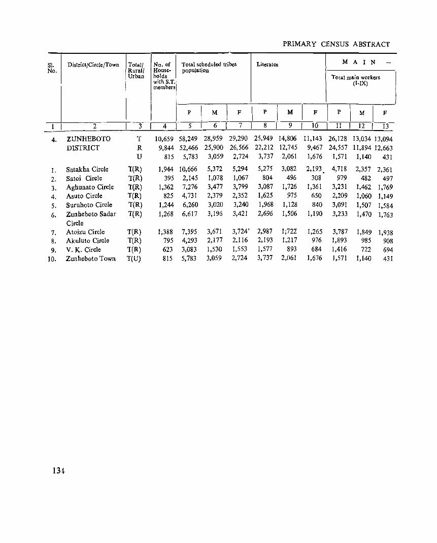
PRIMARY CENSUS ABSTRACT
SI. I District/Circle/Town Total/ No. of Total scheduled tribes Literates M A I N -NO'j Rural/ House- population
Urban holds Total main workers with S.T. (I-IX) members
p \
M 1
F \
p I M 'I F I
p \
M I F
--1 I 2 3 4 5 6 7 I 8 9 10 I 11 I 12 I 13
4. ZUNHEBOTO T 10,659 58,249 28,959 29,290 25,949 14,806 11,143 26,128 13,034 13,094
DISTRICT R 9,844 52,466 25,900 26,566 22,212 12,745 9,467 24,557 11,894 12,663 U 815 5,783 3,059 2,724 3,737 2,061 1,676 1,571 1,140 431
1. Satakha Circle T(R) 1,944 10,666 5,372 5,294 5,275 3,082 2,193 4,'118 2,357 2,361
2. Satoi Circle T(R) 395 2,145 1,078 1,067 804 496 30g 979 482 497
3. Aghunato Circle T(R) 1,362 7,276 3,477 3,799 3,087 1,726 1,361 3,231 1,462 1,769
4. Asuto Circle T(R) 825 4,731 2,379 2,352 1,625 975 650 2,209 1,060 1,149
5. Suruhoto Circle T(R) 1,244 6,260 3,020 3,240 1,968 1,128 840 3,091 1,507 1,584
6. Zunheboto Sadar T(R) 1,268 6,617 3,195 3,421 2,696 1,506 1,190 3,233 1,470 1,763 Circle
7. Atoizu Circle T(R) 1,388 7,395 3,671 3,724' 2,987 1;721 1,265 3,787 1,849 1,938 8. Akuluto Circle T(R) 795 4,293 2,177 2,116 2,193 1,217 976 1,893 985 908
9. V. K. Circle T(R) 623 3,083 1,530 1.553 1,577 893 684 1,416 722 694
10. Zunheboto Town T(U) 815 5,783 3,059 2,724 3,737 2,061 1,676 1,571 1,140 431
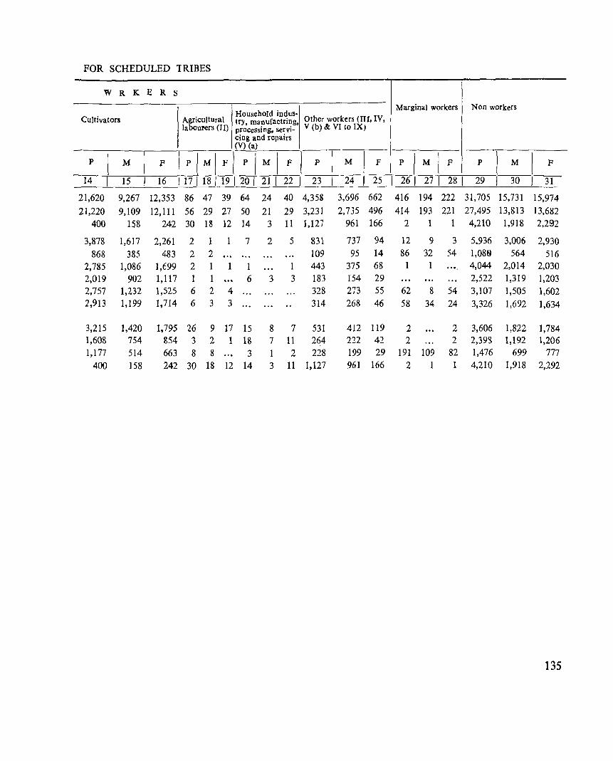
FOR SCHEDULED TRIBES
W R K E R S
Household indus. Marginal workers Non workers
Cultivators Agricultural try, manufactring, Other workers (lTI, IV, laboUFers «(I) processing, servi- V (b) & VI to IX)
cing and repairs (V) (a)
I p I M IF 1 P I I F 1
I
I I M I F I p M P M P M F P P M F I
14 15 16 I 17 I 18 I 19 I 20 I 21 I 22 I 23 I 24 I 25 I 26 I 27 I 28 I 29 30 )31 21,620 9,267 12,353 86 47 39 64 24 40 4,358 3,696 662 416 194 222 31,705 15,731 15,974
21,220 9,109 12,111 56 29 27 50 21 29 3,231 2,735 496 414 193 221 27,495 13,813 13,682
400 158 242 30 13 12 14 3 11 1,127 961 166 2 1 4,210 1,918 2,292
3,878 1,617 2,261 2 1 1 7 2 5 831 737 94 12 9 3 5.936 3,006 2,930
868 385 483 2 2 109 95 14 86 32 54 1,08f) 564 516 2,785 1,086 1,699 2 1 1 443 375 68 1 4,044 2,014 2,030
2,019 902 1,117 1 1 6 3 3 183 154 29 2,522 1,319 1,203 2,757 1,232 1,525 6 2 4 328 273 55 62 8 54 3,107 1,505 1,602 2,913 1,199 1,714 6 3 3 314 268 46 58 34 24 3,326 1,692 1,634
3,215 1,420 1,795 26 9 17 15 8 7 531 412 119 2 2 3,606 1,822 1,784 1,608 754 854 3 2 1 18 7 II 264 222 42 2 2 2,393 1,192 1,206 1,177 514 663 8 8 3 1 2 228 199 29 191 109 82 1,476 699 777
400 158 242 30 18 12 14 3 11 1,127 961 166 2 1 1 4,210 1,918 2,292
135