District Census Handbook, Badgam, Part XIII A & B, Series-8
156
CENSUS OF INDIA 1981 SERIES-8 JAMMU & KASHMIR DISTRICT CENSUS HANDBOOK PARTS XIII-A&B VILLAGE & TOWN DIRECTORY VILLAGE & TOWNWISE PRIMARY -CENSUS ABSTRACT BADGAM DISTRICT A. H. KHAN, Of the Indian Administrative Strvice Director Census 0 Jammu & Kashmir
-
Upload
khangminh22 -
Category
Documents
-
view
1 -
download
0
Transcript of District Census Handbook, Badgam, Part XIII A & B, Series-8
CENSUS OF INDIA 1981
SERIES-8
JAMMU & KASHMIR
DISTRICT CENSUS HANDBOOK
PARTS XIII-A&B
VILLAGE & TOWN DIRECTORY
VILLAGE & TOWNWISE PRIMARY -CENSUS
ABSTRACT
BADGAM DISTRICT
A. H. KHAN, Of the Indian Administrative Strvice
Director ~f Census 0 p~rations Jammu & Kashmir
",'
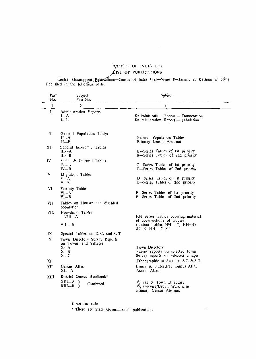
"<tENSeS OF INDIA I()Xl
.I .LIST OF PUBLICATIONS
Central Go.\(erqQ1 .. ;~Ht ~blica'rlons-Census of India 198]-Series 8-Jammu & Kashmir is being Published in the following parts.
Part No.
Subject Part No.
Subject
--------------------------------------------------------------------------------
I
II
III
2
Administration P. '_~ports I-A J-B
General Population Tables II-A II-B
General Economic Tables III-A III-B
IV S0Cilli & Cultur3l Tahles IV--A
V
VI
IV-B Migration Tables V--A V-B
Fertility Tables VI-A VI--B
VII Tables on Houses and di,:::bJrd population
VIII Household Tables '11TI-A
VIII-B
IX Special Tables on S. C. and S. T
X
XI XU
XIII
Town Directory Suney Reports on Towns and Villages X-A X-B X-C
Census Atlas XII-A District Census Haodbook* XIII-A ) XIII-B ) Combined
£ not for sale
3
£Administration Report - Enumeration £Administration Report - Tabulation
General Population Tables Primary Census Abstract
B-Scries Tables of 1st priority B-Series Tables of 2nd priurity
C-Series Tables of 1st priority C-Series Tables of 2nd priority
D-Series Tables of 1st priority D- Series Tables of 2nd priority
F - Series Tables of 1st priority p- Series Tables of 2nd priority
HH Series Tables covering material of constructions of houses Contain Tables HH-17. HH-17 SC & HH--17 ST
Town Directory Survey reports on selected towns Survey reports on selected villages Ethnographic studies on S.C. & S. T. Union & State/U.T. Census Atlas Admn. Atlas
Village & Town Directory Village-wise/Urban Ward-wise Primary Census Abstract
* These are State Governments' publications
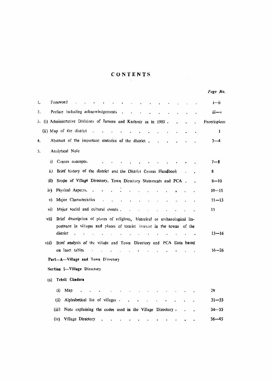
CONTENTS
I. Foreword
2. Preface including acknowledgements
3. (i) Administrative Divisions of Jammu and Kashmir as in 1981
(ii) Map of the district
4. Abstract of the important statistics of the district
5. Analytical Note
i} C~nsus concepts.
ii) Brief history of the district and the District Census Handbook
iii) Scope of Village Directory, Town Directory Statements and PCA
iv) Physical Aspects.
v) Major Characteristics
vi) Major social and cultural events .
vii) Brief descript ion of places of religious, historical or archaeological im
portance in villages and places of tourist interest in the towns of the
district
viii) Brief analysis of the village and Town Directory and PCA Data based
on inset tables
Part-A-VilJage and Town Dirt·ctory
Section I-Village Directory
(a) Tehsil Chadura
(i) Map
(ii) Alphabetical list of villages •
(iii) Note explaining the codes used. in the Village Directory.
(iv) Village Directory
Page No.
i-ii
iii-v
Frontispiece
1
3-4
7-8
8
8-10
10-11
11-13
13
13-16
16-26
29
31-33
34-35
36-45
Tehsil Badg9m
(i) Map
(ii) Alphabetical li~t If villagt's
(iii) Villages Oirector!'
TebsiJ Beerwab
(i) Map
Oi) Alphabetical li~t of villa~e"
(iii) Village Directc)ry
(b) Appendices (!~!V) to tbe Vllill;;" Directory
7. Section II-To~n Directory
(i) Note explaining the codes used in the Town DiJt!ctory
Oi) Town Directory statements (I to VI)
Part B--Primary Census Abstract
(j) District peA
(a) Tehsil-wise Total, RuraL Urban
(ii) lehsil-wise peA
(a) Village-wise
(b) Town-wise (within the town, ward wise)
(iii) Special PCA on Scheduled Caster, (Total, Rural, Urban)
.17
67
69-71
72-85
80-89
92
93-98
100-103
} 104-143
144-145
FOREWORD
The district census handbook (DCH),complicd
by the Census Organisation on behalf of the
State Governments, is one of the most
valuable products of the Census. The DCH is constantly referred to by plann:rs, administrators,
acadenricians and rese~lfchers. It is inter alia used for delimitation of constituencies, formu
lation of local ievel and regional plans and as
an aid to District administration. The district census handbook is the only publication which
provides Primary Census Abstract (PCA) data up~o village level for the rural areas and ward
wise for each city or town. It also provides data on infrastructure and amenities in villages
and towns, etc.
The district census handbook series was
initiated during the 1951 Census. It contained important census tables and PCA for each village
and town of the dis~rict. During 1961 Census the scope of the DCH was enlarged and it contained a descriptive account of the district, administr.ttive statistics, cen~us tables and a village and town directory, including PCA. The 1971
DCH series was planned in thrce parts. Part-A
related to village and town directory, Part-B
to village and town PCA and Part-C comprised
analytical report, administrative statistics, di:,trict census tables and certain analytical tables based on PCA and amenity data in respect of villages.
However, in stllne states it was confined to
district census tables and in a few cases altoge
ther given up due to delay in compilation and
printing.
While designing the format of 1981 DCH ser!es some new features along with the r~s-
tructuring of the formats of village and town
directory have been attempted. At the same
time, comparability with the 1971 data has also
been kept in view. All the amenities except
power supply in the village have been brought
together in the village directory with the instruttiCYll that in case an amcnity is not available
in the referrent village the distance in broad ranges from the nearest place where the amenity is available may be given. The restructuring
of the format of the village directory and in
corporating more exhaustive data on infrastruc
ture aspect particularly in relation to amenities
and land-use pattern is expected to further meet
the need of micro level plannig for rural areas, It is expected to help not only in local area planning but regUlating the provision of goods
and services as well, so as to minimise the regional imbalances in the process of develop
ment. A few new items of information have also been introduced to meet some 0 f the require
ments of the Revised Minimum Needs Prog
ramme. Such new items of information as
adult literacy centres, primary health subcentres
and community health workers in the village have been introduced in the village directory
with this objective in mind. The new item on approach to the village is to have an idea
about the villages in the district which are inaccessible. A new column, "total ,population and number of households" llas been introduc
ed to examine the correlation of the amenitiC5
with the popUlation and number of households
they serve. Addition of two more appendices
listing the villages,' where no amenities are availa
ble and according to the proportion of scheduled caste and scheduled tribe popUlation to the
total population has also been made with this
view in mind.
Tbe formats of the town directory have
also been modified to meet the requirements of the Mjnimum Needs Programme by providing
informatIOn on a few new items. A new statement on civic and other amenities in slums in
Class-I and Class-II towns (statement IV-A) has been introduced with this objective in mind. It is expected that this will help the planners to chalk out progrmmes on provision of civic amenities for the improvement of slums. The columns on Scheduled Castes and S~hedule.d
Tribes population in statement IV relating to
civic and other amenities and adult literacy classesicentres under educational facilities in state
men t V ate also added inter alia with this view.
A significent addition is class of town in all the seven sta tements of the town directory.
The infrastructure of amenities in urban (ireas
of the country can be best analysed by talking
the class of to wns into consideration. The
addition of the columns on civic administration status and population in a few statements also
serves this purpose.
The format of the primary census abstract for the villages and towns has be en formulated
in the light of changes in the economic and
other questions canvassed through the individual slip of 1981 Census.
111 order to avoid delay in publication of
1981 DCH series it has been so designed that
Part-A of tbe volume contains village and town directory and Part-B, the PCA of villages
and towns including the Scheduled Castes and
Schedul~d Tribes PCA upto Tehsil{rown levels,
At the beginning of the DCH a detailed analytical note supported by a number of inset
New Delhi the 26tQ April. 19~2.
(ii)
tables based on PC A and non census data in relation to the infrastructure has been introduced
to enhance its value. The district and TehsilJ Police Station/C.D. Block etc., level maps depic
ting the boundaries and other important features
have been inserted at appropeiatc places, to further enhance the value of the publication.
This publication is a joint venture of the
State Government and the Census Organisation.
The data have been collected and compiled in the State under the direction of Sliri A'. H. Khan, lAS, Director of Census Operations, Jammu and Kashmir on behalf of the State
Government which has borne the cost of
printing. The task of planning, designing and
coordination of this publication was carried out
by Shri N. G. Nag, Deputy Registrar General (Social Studies) of my office. Dr. B. K. Roy
Deputy Registrar General (Map) provided the technical guidance in the preparation of the maps. Data received from Census Directorates have been sfrutinised in the Social Studies Division at tbe headquarters under the guidance of Shri M. M. Dua, Senior Research Officer. I am thankful to all who have contributed in
this project.
P. PADMANABHA REGISTRAR GENERAL, INDIA
PREFACE
The compilation and pUblication of District
Census Handbooks has been a traditional feature of the Indian Census since 19~}' However, in
Jammu and Kashmir State, where ho census was conducted ill 1951 due to the unsettled conditions prevailing then, this work was taken up as a regular feature of census since 1961 with certain improvements and additions in the data con,ent of the publication at the 1971 census, further enhancing its utility for the data users
The 1981 series of the District Census Handbook which we have begun with the district of Punch will contain two parts each. Part A deals with Town and Village Directory and Part B
consjsts of Town and Village Primary Censu<; Abstract. In 1 <)71 census there was also third part of the Handbook, published as a separate volume, compri~ing administrative and census statistics However, in view of the considerable delay experienced then in getting the relevant administrative statistics pertaining to various
departments, compilation of this volume has been given up at the I lJ81 census. It is expectcd that &uch stilti~lics would be avaiJable to the data users in the us U(l J publications of the State Directorat~ of Evaw;"lion and Statistics,
The Town Directory of the Handbook con:mts of seve'} statements which are almost similar to those adopted for the 1971 census except that a few new columns have been added to
facilitate analYbis of the data. A si,gni1jC<1TI1 "dtii
tioll b of class of town in every statement which has been done on the consideration that the infrastructure of amenities and facilities found in urban India C~lTI be~t be analysed with reference
to this specific parameter, The addition or the column on civic administration status in statements III and IV and oopulation in statements IV and V also serves the same purpost vis-a-vis the respective statements. Due consideration has also been given to the M i Ilimum Needs Prog-
ra lUme of the Planning Commission. The column:; on Scheduled Caste population in statement IV and adult literacy classes/centres in statement V are a sequel to this programme,
The Village Directory also follows the same pattern as in ] 971 census except again for a
few additional columns. The column on total popUlation and number of households has been added to facilitate analysis of the other data in the Directory. The column on approach to village is to identify the number of inaccessible villages in the district. The column on number of hou~eholds living in owned houses or poses~ing house sites in the village is again JOtended tD cater to the Minimum Needll Programme of the Planning Commission.
It is hnpeo that with its present content the Handbook would, more than ever, serve as a useful reference publication, particularly for such administrators and data users as havt:: to deal with planniu,!!, implementation and evaluation of development programmes, including the Minimllm Needs Programme, at the grass-roots kvel.
The compilation of the Handbook would
not have been possible but for the cooperation extended by the Revenue, Education, Medical, Public Health and other local authorities of the
District in making relevant uata available, for which we owe them our grateful thanks.
It must be stated here that the task of nnali,in£ and printing the pre~ent volume has f?lllen on me, since Shri A. H. Khan, lAS, Director of Census Operations, Jammu & Kashmir, under whos~ ahle :-tewardship the census operat\ons 0.f IqSI were carried out, retir~d from Government service by the time the volume could be taken up for compilation.
We are grateful to Shri P. Padmanabha, lAS, Registrar General and Census Corumis~ioner of India and Shri N. G. Nag, Deputy Registrar General (Social Studies) whose detailed
instructiom. guidance and advice were available all through.
The (.;redit for compiling this Handbook, including ana lysis of dat 1, belongs to Shri Abdul GanL J oint Director, besides Shri H. L Kalla, Deputy Director, Shri
Shamus-ud-Din, Tabulation Officer & B. A. Shora, Computor who ably assisted the former in this task and deserve appreciation for their respective
contributions.
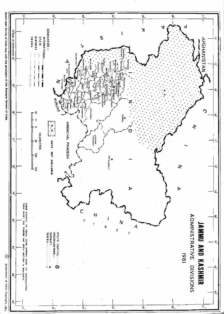
The Handbook has been provided with five
maps, one showing the administrative divisions
Sri nagar, the 15th May, 1987.
(iv)
of Jammu and Kashmir State as in 1981, one
pertaining to Badgam district and rest to its
three constituent tehsils. These were prepared
by the staff of our Cartographic section under
the close and valuable guidance of Dr. B. K. Roy, Deputy Registrar General (Map) of the
office of the Registrar General, India. Their
names along with those of other officials who
rendered valuable assistance in bringing out the volume are mentioned separately in this Handbook.
N. A. KAMILI, lAS
DIRECTOR
(v)
ACKNOWLEDGEMENTS
SH. SHAMUS-UD-DIN, Tabulation Officer General Supervision
SH. G. M. GANAI. Statistical Assistant 1 I
SH. S. K. KACHROQ. Computor ~ Compilation of Village and ;oVvo I Directory data
SH. M. SHARIEF SHAH. Assistant Compiler I
J
SH. MASOOD AHMAD. Cartographer I I I
SH. A. M. SHAGOQ, Artist I I
SH. BASHARAT AHMAD, Computor I ~ Mapping
SH. VIJAY KUMAR PUNJAB!, Draftsman I I
SH. ABDUL QAYOOM. Draftsman I I
SMT. DllSHAD AKHTAR, Draftsman J
SH. B. A. SHORA. Computor l I
SH. V. K. CHEHRA. Computor i i- Proof Reading
SH. S. K. KACHROO, Computor I I
SH. G. M. HAJAM. Computor J
SH. MOHAMMAD RAMZAN BHAT, Lower Division Clerk Typing
l:[EF~~~==;;;;;;; :; too a. .... of' ~ ~ ~. i " , ". 0 ' I~' , ;;: I ~." ~ ~. m ~. I .. • g ~ .
... 0 z I 5" 2. lII_ enZo I ~ c;) % ~ ~ ;;l ~ \ "" ...q .~.:) d .
iil !!! .. -I;U.... S ~ 3. ~_~Zm • ' • , n > 0 ••• ~ J
1
;;:, ~ < ~ ~.,. '>- •. ' ! ~ 5 ..J' .' .. . ~ ~ .~ ~ {~~. ___ .. _~-<:~,. I' '. . ........ , ,» • ~ ," . '. . " • I" . .; ... ..1 i " ...... .' l' ...... . .' , " . '. \ , G> 3 I' ..Q ;:;/'..... '.' '. • ,,'. • • '. '. • '. I J: .' I I ; ~ r'~"'o ~~ .. ~ ,f', :0:.· .... \ r V ·.··'·· . , '.' 'L' i· l> ~ I .' •. ~ U' \ l 1""1 • P' ~ h ". '" '.' .. " '. · .,. :> : 1'1' H (;:"'."':-1" .lif '~ ' oj I·' ·'W" .. ' '. ::: .. I •• In' ... ., ~('" rrH) ;';'.:' . '. . '. .' en l ~ i I' I. ~ ~ [~.~~ ')::t.r)-.(;;t~,.~\ 0/ ·t?i~( - ' .. '. '. .... . ... . .. .' . . .. .( ~ r ' ~ ~ 'J' '" ,_,. "", ',' 'l! i 'C':." . .' .... .' '. \ ~. • _'. r , '\;',~f I' (: )~ .... ~~.'...rk>o ._. • '. .'. 2
\
• 'or'~c / .,.' . ~'" , "~~JUi." • • • .' ~ 't' / .... -;.'.;;.: .... ", j,,; r'0.,' ifl ~\ , '. . . ~ '~ , "i "o~ '." ... ,.:,: .... ' j . . • If\ i '" ....,' no; J ! /0': ;;O, __ ol' ....... -, '" .1 ,/ ." .... ..'~
c::.
t;' ,. b: 0' Q Ii' ::> • v' ...... ~!!'J> ..>' , , • ·.Z .' • ~ 'J' ,," ,1' 01! ',:>" ,_.'. i?'.,,' , . .' • -z. ~,,:; "_, l" ;Z",-.."....o&:'-[' IH --,u: "y.~ '. . . .... ..... l 2. ...., ~ ~'~ ': l!11' )ll ~I ": ®g J.,_' •. ~ ".'_,' '_', •. .'. .... '. ~ .. ,. t, _' ,~z~ ~ • • ' ,. • -.: .,00' ~,.;" , • 0 .·.i Z • .'." ~ 0 "' • ~ L • 'r." 0 • ;,l . .? .. ->" . ..,.,~'1 • j • / • ••••.• .' .'. • i;! " . ,....... '. .
n
,,) o <: iD :; 3 til :::> ~
...., ....,
co o
6~ :E'" z~
~~ :I'" ", ..
• R
.. i'i % .. .. ') ..... ~~ X z :~
r Z ,. Z ~ ~
l:
:::'" "2 z .. :E . ;: :III) =i~ .... .. ... Z ~ Z .l
IJI ::; .. '" > _~z m~ "0 ~ 0 . ~ .,
.... ... 21
'"
._ .... o
,.. 5 s: m -I ;u m en
'" 0 .. ~ I . . ' '.' .' • ,~.
W
.' ", 0 - • • '. . . .. •••• '. • ....
..... \F I : .. ' .. '. ' •. '. I '" " ('" ... ~ l"' '. .... . '. . '. ' ;: .'"\ ')\ ." '. . '. .... .
. . f; ,J.-,{j ). -vI' ,'.. '. . . '. . '. . .... ... ':)'/ J:: f" '. ,/", ~,/ • • • .' • .' .' • .' • .' » ;--' ,,0 '~, j ,,-'~ 0······· . .' . .' j' • -..... ,... . .;i ~: ,r '. ..........• .... .. . ,0 I . '. . .' ..... '" I • ~ , '. .... .,.- ....
o 8
z o -1
» '1--_ ' J '. '. • • ~ ( '~'_, f/ .. ' ..... "'1 (I). ~,.... • •
J::' • • '.~ ~ . .r'.) ~. ,~ ~) E ~ f"o>t) \ ,~ , '" (1.,..-~ l" " ~ A-.J" i
'v" --" '" ' -4 ,; '"" i c
H I r
8
too 0
r
• • '-"._ .) 4 .............. 1
'" "' 0 too "'0
......
o -< (j') -o z (j')
_, .... 0
..... IOu
co
'" .
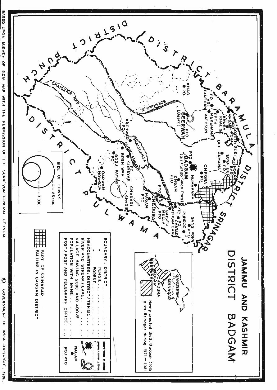
DISTRICT MAP OF BAD GAM
1/1 C :0 < m -< o :0
-G'l m Z m :0 )10 r
o "1'1
z o );
(j'I o < m :0 Z X m 2 -. o "1'1
z o );
8 "0 < :2 (jl :t -. .
..... 8 o
I "1'1"0 )10)10 r;o C ... Z G'\O _ 'TI
Zf/I mXl )IoZ 0)10 CI(jl )10 )00 X;O
a (/I -t :u n -4
... o
N ~ UI Z o 1/1 o o
"0 0 ... 'V ... 0
Z )10 .G'I > ~
o - <-(/) > -f ~ :;0 ~ - C () -i » z
0 CD .~
» )I-
0 (f'
G) :c ~ » -
~ %J
\_:':11 \ ~ :i I ~ .. .
~ .j I
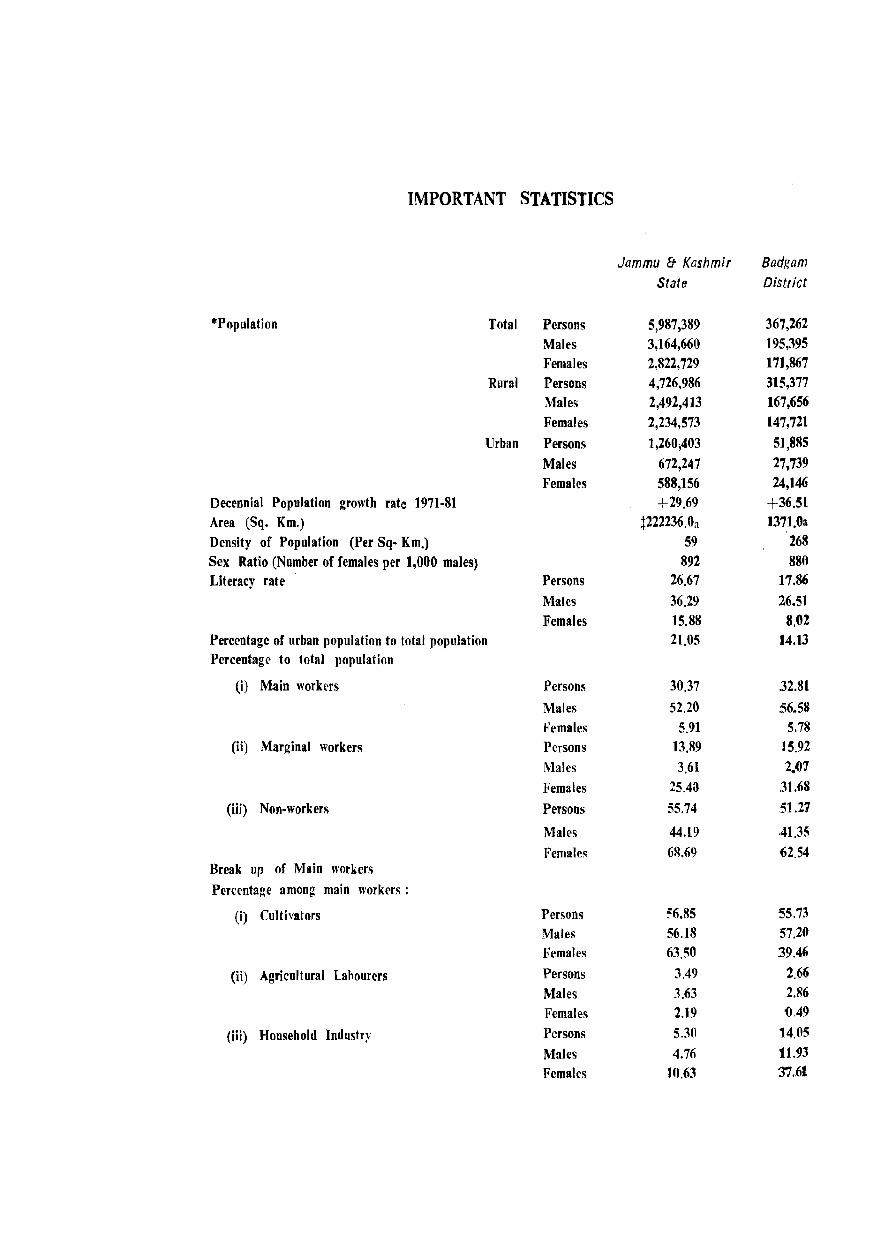
IMPORTANT STATISTICS
Jammu & Kashmir Badgam State District
"'Population Total Persons 5,987,389 367,262 Males 3,164,660 195,395 Females 2,822,729 171,867
Rural Persons 4,726,986 315,377 Males 2,492,4]3 167,656
Females 2,234,573 147,721
Urban Persons 1,260,403 51,885
Males 672,247 27,739 Females 588,156 24,146
Decennial PopUlation growth rate 1971-81 +29.69 +36.51 Area (Sq. Km.) t222236.0a 1371.0a Density of Population (Per Sq- Km.) 59 268
Sex Ratio (Number of females per 1,000 males) 892 880 Literacy rate Persons 26.67 17.86
Males 36.29 26.51 Females 15.88 8.02
Percentage of urban population to total population 21.05 14.13 Percentage to total population
(i) Main worhrs Persons 30.37 32.81
Males 52.20 56.58 Females 5.91 5.78
(ii) Marginal workers Persons 13.89 15.92
Males 3.61 2.~1
Females 25.4a 31.68
(iii) Non-workers Persons 55,74 .51.27
Males 44.19 .41,35
Females 6~.69 62.54 Break up of Main workers
Percentage among main workers:
(i) Cultivators Persons ~6.85 55.73 Males 56.18 57.20 Females 63.50 .39.46
(ii) Agricultural Lahourers Persons 3.49 2.66 Males 3.63 2.86
Females 2.19 '049
(iii) Household Industr)' Persons 5.30 14,05
Males 4.76 tl.93 Females 10.63 37.61
4
(iv) Other Workers Persons 34.36 27.56 Males 35.43 2861
Females 23.68 2244
Percentage of Scheduled castes population to total Population PersODs 8.31 0.01
Males 8.18 0.02 Females 8.45 N
Number of occupied residential houses 819,172 44,274' Number of villages Total @6,758 @496
Inhabited 6,477 475
Uninhabited 281 21 Number of Towns 58 1
NOTE:- * The population figures exclude population of areas under unlawful occupation of Pakistan and China
where census could not be taken.
t Tnclude~ 78114 Sq. Kms· under illegal occupation of Pakistan and 5180 Sq· Kms. illegally handed over
by Pakistan to China and 37555 Sq. Kms. under illegal occupation of China in Leh (Ladakh) District.
@ Excludes 3, 1 & 4 villages of Srinagar, Chadura and Badgam tehsil$ forming out-growths of Srinagar
Urban Agglomeration, 6 vilbges of Jammu t~l1sil forming ouc-growth of Jammu Urban Agglomeration respectively and I village of Udhampur tehsil weated as Census Town.
(a) Provisional

ANALYTICAL NOTE


A description of the various concepts used
at the 1981 Census and a broad appraisal of
the administrative statistics vis-a-vis the history·
of the district, the social and cultural changes
witnessed by the district during tbe last ten years
particularly in relation to economic resources,
social, cultural and developmental activites and
a brief description of the places of historical
and religious importance in the district is given
in the following pages:-
Rural/Urban Classification
For the 1981 census the classification of urban
areas have been based on the following criteria:
a) AU places with a municipality, corporation
or cantonment board or notified town
area committee.
b) All other places which satisfied the following tests;
i) A minimum population of 5000.
ii) At last 75 per cent of male working
popUlation engaged in non-agricultural
(and allied) activity.
iii) A density of population of at I east
400 per Sq. Km. (1000 per sq. mile).
The places which satisfied the criterion
(a) above were treated as statutory towns while
those as were not statutory towns but satisfied
the tests laid down in critertion (b) above
were treated as census towns. All other places
which did not satisfy either of the above two
criteril were classified as rural. Areas which
qualified to be treated as towns under criterion
(a) and (b) above were further classified by
popUlation ranges in the following order :-
Population range
1,00,000 & above
5:) ,000-99,999
20,000-49,999
10,000-19,999
5,000-9,999
Belo",' 5,000
Class
I II III IV V
VI
7
Census House
A Census house was defined as a building or part of a building having a separate main
enterance from the road or common courtyard
or staircase etc. u~ed or recognised as a
separate unit. It may be occupied or vacant.
It may be used for a residential or non-residential
purposes or both.
Census Household
A household for purpose of the 1981 census
has bee» defined as a group of persons who
commonly live together and would take their
meals from a common kitchen unless the
exigencies of work prevented any of them from
doing so. There may be a household of persons
related by blood or a household of unrelated
persons or having a mix of both.
Scheduled Caste/Scheduled Tribe
In Jammu & Kashmir State there are no
scheduled tribes. However, the follOWing 13
castes stand notified as scheduled castes under
the State constitution;-
1. Barwala
2. Basith
3. Chamar or Ramdasia
4. Batwal
5. Chura
6. Dhyar
7. Doom or Mahasha
8. Gardi
9. Jolaba
\0. Megh or Kabirpanthi
11. Ratal
12. Saryara
13. Watal
At the 1981 Census only those persons who
returned themselves as belonging to any of the
13 . castes specified above was treated as schedu-
led caste~

Literacy
For purposes of Census a person was treated
as literate if he/she could read and write in
any language with understanding power. A person who could merely read but was not
able to write was classified as illiterate. For a person to be treated as literate it was not
necessary that he/she should have recdved any
forIllal education or should have pas~ed any
minimum educational standard.
Workers/Non-workers
For the 1981 Census a person was treated maitl1y as a worker if he/she had participated
in any kind of economically productive work during the major part of the reference year ie.
at least 6 months or 18~ days or more prior to the date of enumeration. A person who
clairned to have participated in any kmd of economically productive work for less than six
months prior to the date of enumeration was
treated as marginal worker. However, persons who did not participate in any kind of econo
mically productive work during the whole period of the reference year were treated as non
workers.
Brief history of the di!itrict
Badgam is a newly cOllstituted district which was carved out from Srinagar district on the
basis of administrative lecognisation of districts in 1979. The district derives its name from
onc of its village which is its headquarter. Till the Jast Census heJd in 1941 the area was
known as Sri Partap~inghpora. after the name of J'vIlharaja Partap Singh, one of the Dogra
kings in whose rule it was constituted as a
tehsil for the first time. Prior to 1951, the
tehsil of Badgam including other tehsils of the
present district formed part of the then district of Baramulla.
Brief history of District Census HandboGk
The district Census Handbooks were ·publish.,
ed for the first time in 1951 as a· paEt.~,of. tht Census publication programme in ahn.o.~t ~U States of India except Jammu and Kashmir
8
State where cue to the disturbed conditions
prevailing in the wake of tribal invasion of
1947-48 no census could be undertaken and
as such no data was collected for the decade 1941-1951. The publication of District Census Handbook series fulfilled a long felt need.
These gave out not only the data con
tained ill Primary Census Abstract according to new classifications but included a sufficient
account of the district and its people, and a
vast mal:nitude of other' data covering such
,p,.p,ics as communication, education, public
health etc. in respect of each town and village of the district. Consequently, these have been found to.~be of immense help to all the departments of the State Government for planning
and development at the grossroot') level. With
the introduction of single line administration
at the district level, the utility and importance
of these publications for constant use and reference by District Development Commission
ers has increased enormously. The present
hand-book is proposed to contain even more
comprehensive data than in the past so as to
meet also the requirements of minimum needs
programme set forth by the Planr1ing Commis- :
sion. The publication will besides the basic popUlation data emllnating from the 1981 Census,
contain comprehensive information pertaining to amenities and land-use pattern and other infras
tr~ctural statistics in respect of each village and town of the district so as to serve as a ready reference material for planners and admini,trators for assessment of past achievements and formulation of new programmes of development
at the gross roots level.
Town Direc'ory
The Town Directory covers informHtion at
town level and includes items such as status of administration, growth of populatin, growth patter .. n since 1901, physical aspects and location
civic finances, civic and other amenities, medical
educa~1onal, recreational and cultural facilities,
trade, Jndus!ry and commerce, banking facilities h
etc.
In additIOn, demographic data like sex-ratio, number of households, density of population
and position of civic and other amenities in
notifitd or recognised slums of class I and II
towns have also been introduced. Considerin6 the increasing employment of women in urban areas and the consequent housing need of single working woman, it has been felt necessary to
indicate in the town directory also such infor
mation as the number of working worl\en Ihosd:ls with number of seats.
A broad apprais&l of the data incorporated in the seven statements of the town directory is attempted in the following paragraphs:-
Statement- t gives 'information on civic " administration status as in 1980, growth hbtory , of towns from 1901 to 1981, sc:x-ratio of
towns from 1961 to 1981, density and area
in sq. kmli.
Statement-II gives the phy~ici:ll as well as locational aspects of towns of the dil>trict. Under the physical aspects data on annual rainfall (in ems.) and maximum and minimum tempera
ture (in centigrade) have been highlighted. The statement also gives information on distance of
the town from the nearest city with a population of one lakh and above, distances from the State, district and tehsil Hqrs., from the railway station and bus route. It also provides information on the existence cf river/canal, if any within 10 kms.
Statement-III pre vides the budgetary statements pertaIning to the financial year .1978-79. The statement has been apportioned into the
r~ceipt and expenditure heads. Under the receipt
head, informatIOn has been given on such items as "receipt through taxes, revenue derived from municipal propertIes and power apart from
taxation, Government grants, loans, advances and other sources". Expenditure head shows expenditure on general administration, public s1fety, public he !It~ and convenience's, public works, public insdtutions and others.
Statement-IV depicts civic and other amenities available in the' tQwns of ·Badgam dist.rict; and,
9
gives information on such items as length of the road in the town, system of sewerage, number and type of laterine, method and disposal of night soil, source and capacity of drinking water and
fire fighting services. The statement also highlights tlie pattern of electricity consumed in the town and indicates the number of connections under sub-heads like domestic, industrhl, commercial, road-lighting and others.
StateIJlent-IV-A which is meant to depict civic and other amenities available in {he notified
slums of Class I & II towns has no relevance f,or Badgam district.
Statement-V gives medical, educational, tecreational and cultural facilities as were avail
'able in town in 1979. Under medical facilities .' are, indicated the type of medical institutions
and the number of medical beds available. LIkewise, different types of educational institutions available have been covered under educational facilities. Information regarding the number of cinema houses, stadia, auditoria/drama halls and public libraries have also been incorporated in the statement to bring out the
extent of availability of recreational and cultural facilities. In addition, information about number of working women hostels has also been given
in the statement. If a medical or an educational
facility was not available in the town, the name of the nearest place where it is available has also been ,given in the statement.
Statement-VI gives the facilities of trade , commerce, industry and banking available in the town in 1979. Besides, the number of credit co-operative societies operating the details of
three most important commodities imported, exported and manufactured in the town have also been indicated.
Village Directory
The village directory portion of the handbook depicts particulars of amenities available i!1 ("rich vi11:J!!e of the district in the field of education, medical care, power supply, drinking water, post and telegraph, communication, besides .information about land - use and places of
religious, historical and archaeological importance in the village. In case where a particular amenity is not available within the village, distance at which such a facility is available even in the most modest form has been indicated in three broad ranges viz; -5 kms. 5-10 kms., and IO+kms. If there are composite school~, like middle schools with primary classes or secondary schools with middle classes, these have also been included in [he number of primary and middle schools respectively. For example, if in a village or a town there were two primary schools and one middle school with primary classes, in the village/town have been given as three and that of middle school as one even though there are only three educational institutions. So also in case of secondary schools.
The village directory also carries the following
four appendices:-
Appendix-I It gives the abstract of educational, medical and other amenities available in the tehsils of the district.
Appendix-II It furnishes the land utilisation data in respect of census towns. This appendix, however, is not relevant to Badgam district.
Appendix-Ill This is a list of villages where no amenities other than drink-
ing water like education, medical, post and telegraph, communication, power supply are available.
Appendix-IV It provides a list of villages according to the proportion of scheduled caste popUlation by ranges.
AJI these appendices appear after the main
village directory.
Primary Censos Abstract
The Primary Census Abstract part of the publication is exclusively based on the 1981 census data. It provides information in respect
10
of each village and ward/mohalla of a town at tehsil level in respect of Its area, number of residential houses, number of households, total population, scheduled caste population, literate and educated persons and working population by sex in 4 broad industrial categories viz; (i) cultivators, (ii) agricultural labourers, (iii) household industry, manufacturing, processing servicing and repairs and (iv) other workers be!'jdes non-workers as a ~eparate category.
Special PCA OD Scbeduled Castes
It is for the first time that a Special Primary Census Abstract has been introduced in the DCHBs for the Scheduled Caste population The special PCA provides information pertaining to schedukd castes in respect of number of residential houses and their popufation, literates, main workers c1assified by cultivators, agricultural labourers, workers in the household industry and other workers, marginal workers and nonworkers classified by sex. This PCA is also presented for District, Tehsil and Town levels.
Physical aspects
As stated earlier the district was carved out from Srina,ar district on 1st July, 1979. It is bounded by district Baram'lla in the north and north-west and by Srinagar in the northeast, south dnd south-west. The area of the district is 137Isq. kms. The district blS 501vil1ages, out of which 480 are inhabited and 21 villages are un-inhabited. However, five of the inhabited villages of the ~istrict form outgrowth of Srinagar Urban Agglomeration and have therefore been excluded from the purview of dJscu~sion in this handbook The climate of the district is more or Jess the same as that of Sri nagar except that its higher regions get heavier snowfalls and experience sewre cold in winter. The district extends to both mountainous and plain areas of var)ing heights and has an avera~e height of 5281 feet. The maxil11um rain fall recorded in the year 1980 is 358.4 mm The district, however, experionces adequate rainfall but the 'kandi' areas of the district often receive insuffi_t Tams causing sometimes complete

crop failure. On the other hand, the lowlying areas flanking the left side of the Jehlum are marshy and are often flooded during heavy rains.
Major characteristics
Badgam falls among those backward areas of the State which have suffered neglect in the past. However, after assuming the status of a separate district' and with the introduction of singleline administration,the progress of development process has picked up with a significant impact on the socio-economic life of the people of the district. The need for expansion of public health facilities has been adequately realized and a number of \later supply schemes ha~e been taken in hand. At present 28 such schemes are under completion. It j" envisaged to make available portable drinking water facilities to 200 villages to benefit 2 1akh iuhabitants. Concerted efforts are also being made to cover remoter areas of the district under rural electrification programme. As a result, as against only a few villages electrified in the past, this facility stands extended now to 424 villages of the district. In the remaining villages also the work is in progress to bring them under the network of electrification programme.
During the last few years concerted efforts have as well been made for promotion of education at all levels. Consequently, the enroUment of boys and girls in the age-group of 4-11 in schooh has reached upto a level of 75%. While.a number of~chools have been opened in the district, it is proposed to make school facility available to the inhabitants withm a distance of everyone km. In the year 1981
four new primary schools have been opened whereas ten primary &chools and one high school was upgraded to middle and higher secondary levels respectively. In addition, under the adult lite racy programme, various celitres have been opened which have an enrollment bf about five thousand adult males and females. These centres provide free education with books and 8&ationery. Besides there are about 93 informal ·centres ,in the district where 5S0 boys and 'girls
11
are being given free education, books and uniforms.
The major section of the population of the district is dependent on agriculture. In line with the Government's policy to reduce dependance on food imp;)rts. an intensive agriculture development programme has yielded encouraging results. Modern agricultural practices are being popularised to yield higher production. Farmers are being encouraged to interest themselves in taking to improved agricultural practices which would in the long run not only re~ult
progressive advance in the socio-economic life of its people but also make the district self wfficient in its food requirements. Provision has been made to give incentives for introduction of high yielding variety of seeds, fertilisers and pesti-cides. The State Agricultural Department is paying due attention to develop allied sectors of agriculture in the district. 3708 acres of land in the di trict has been brought under the protection of plants programmes. Demonstration plots have been marked on about 160 kanals of land under several training ·programmes and farmers taken on tour to some other districts of the State where good results of modern agriculture practices are shown and demonstrated for them to use and practice in their holdings. About 300 mushroom production units have been set up in the dhtrJct and during the year 1981-82, mushroom production reached a level of 100 tonnes. During the same year about 150 persons were trained in mushroom growing At the district headquarters the mushroom displaying centre building is un,jer com truction SaffroD production is also picking up and more people are now taking to its farming in the district.
The district has snov.'O a record production of 25000 tonnes of dry and fresh fruits. The cultivation of dry and fresh fruits on 40,000 acres of land in the district provides employ
ment opportunitirs to a number of people. Under horticulture development programme, 24 demonstration plots have been estat-lished in
the district and pesticid.~ ~re givFP to the fruit growers on subsidised rates. To boost . tile production of specific apple variety 'Ambri' in the district, 10 acres of land have been brought under orchards. For this PllPose t~e
plants of the said variety have been di,stributed to orchardists on fifty ,perccmt subs:idy rates as also about twenty thousand almond plan,tll have been planted in th,e various ~reas of tl,le district.
As regards medical institutions functioning in the district, the position is as follows;-
Hospital 1
Primary Health Centre - 7
Family Welfare Centre 19
Dispensaries - 59
Others - 5
This includes the six additional di'lpensaries established during the year 1981-82. About' 6 lakh patients were treated and 6 thousand operations performed during the year 1981 in these institutions whilt!: the construction work on ten-bed hospital at Khansahib block is in progress. Also residential plots have been constructed for the doctors in the existing hospital buildings. Chari Sharief and Beerwah Public Health Centres have also been equipped with an X-Ray plant each while Badgam health centre has been provided with an ambulance. A multipurpose health welfare scheme has been launched in the district since 1981 for which the whole district has been divided into 33 zones. Every zone is almost made up of 5 thousand inhabitants to be looked after by two trained medical workers whose job besides educating people about family welfare schemes is to provi~ them with vitaminised medicines for child-care. For protection of infants against severa] virus diseases, the health department has supplied about 50 thousand medicines of different categories in the district.
In keeping with its potential, the industrial development of the district has also been receiving
12
, possible ~ttention as a result of which the number of industrial unit" has reached 178 in 198, as against 149 in 1979-80.
During the year 1981 three new firewood depots were opened in the district increasing
'the number ot depots to eleven. In Pir Panchal division the forest department has constructed two rest houses at Khag and Tangnar, besides completing a log hut constructed at the height of 8000 feet and 'maintenance of nursery and a park each at Yusmarg and Airport.
Social Welfare activities have also bee'n cCiCeiving inGreasing attention in the district since ] 979. The department provide scholarship opportunities to ] 100 students in vaHous'
. educational institutions upto _ an amount of . Rs. one lakh six thousand. During the year
1980-81 a handicraft centre was set up in the district for training. up girls. jn wood carVing and furniture making,
To provide the vitaminised food to young ones, the department has created 18 such centres during the year 1980-8]. About 850 boys have so far benefitted from the scheme till 1981-82. In addition, housing subsidy has been extended to the Gujjars and Bakerwals of the area for construction of houses. In addition , uniforms and books are also being provided to school children free of cost. The department has also provided 14 sewing machines to widows and disabled persons besides artificial organs and tricycles. Several sewing and knitting training centres in the district have been openeLi for women· During the training period rupees forty per month as scholarship is being given to them. Two special camps were held during the year 198] in the district where women were trained in connection with the child care progratr. meso
For combating the unemployment problem the State Govt. have introduced self employment schemes in the district. During the year 1981-82,
2S industrial and non-industrial ceI!-t~es,. ;were opeaed increasing the number of such units.in the
district to 200. In addition, 115 unemployed youths were regislered for self employment under this programme.
The principal mode of transport in the district as elsewhere in the State is roads. It is therefore, natural that development of roads particularly rural roads as part of the minimum needs programme is commanding attention.
During the last year, 128 schemes of construction of roads were started in the district which are
noW nearing completion. Already 3 kms. of
tarred, 6 kms. of metalled, 19 kms. rough and 7 kms. of jeepable road have been constructed. The Roads and Buildings department is also engaged in the construction of various buildings in the district. About 76 such buildings are under construction. A mini Secretariate at the district headquarter and a district police colony at Ompora are also under construction.
As the main dependance of the majority of population in the district is on agriculture, therefore all concerted efforts are being made to augment irrigation facilities in the district.
So far 1,466 acres of land have been covered
under this facility. Increasing attention has been
given towards the flood protection works in the district and during 1981 the work on about 27 such ~chemes ha~ been completed.
Fisb~fY farming programmes including construction of fish farms for which free technical know· ho iV and other concessions are being provided, has been taken up in hand. Steps
have been taken for the expansion of golden colour trout fish at Nala Sookhnag and Gowhar
Pora. The facility provided to fishermen in the district is showing good results in the production of fish of various varieties.
Social and cultural events
The district of Badgam has the distinctiou
of having given birth to famous writers, poets, sufis and musicians whose rich contribution has lent a discernible dimension to the cultural ethos of the eistrict whil~ the most outstanding amonist them being Hazrat Sheikh Noor-ud-Din
13
Noorani whose resting place at Chrar-i-Sharief
has been the place of attraction for hundreds of thousands of devotees from diverse faiths
through the ages covering last six centuries.
Other high-ranking sufi poets are Shamas Faqir,
Samad Mit and Shah Gaffoor. Abdul Ahad
Azad, the revolutionary poet also claims his descent from the Badgam District only.
Socio-cultural actiVities continue to sustain the intere&t of the people of the district. Diver
sification of such activities in the recent past has added especially to its literary heritage, to which effect emergence of Noorani Cultural Forum, Badran Dramatic Club and Bhagat Theatres of the district, to quote only a few, provide the desired testimony.
Places of religious and historical importance:
Shrine of Alamdar-i-Kasilmir
As alread_:; mentioned, Hazrat Sheikh Noorud-Din Noorani is in the vanguard of local
sufis of Kashmir whose shrine at Chrar-i-Sharief is the source of spiritual inspiration for the people at large. His out-ranking spiritual attain
ments have to be traced to the K ubarvi)'ah Order, (being one of the most famous in the
hierarchy of fourteen Orders of Islamic Sufism) the foundation whereof wa'i laid by Hazrat Sheikh Najam-ud-Din Ahmad-ul-Ku:'ara of Central Asia as far back as 12th century A.C. The Kubarviyah Order spread In the Kashmir
valley through Hazrat Amir-i-Kabir, Mil' Syed Ali Hamdani in the course of his pursuit of
propagation of Islam while heading a 700-strong force of sufis leading to their ultimate migration to Kashmir valley. This mission was later continued by his illustrious son Hazrat Mir Syed
Mohammed Hamdani, the saint who handed down the torch of Kubarviyah Order to Hazrat Sheikh
Noor-ud-Din Noorani, popularly known as Alamdar-i-Kashmir (meaning the spiritual saint who is gifted with the authority to lead the
Kashmiris for salvation especially on the Day of Resurrection) and Sheikh-ul-Alam (meaning a top-ranking saint of the world). He is also
remembered by the pet name of Nund Reshi
representing a distinctive sub-system of Islamic mysticism highlighted by practice of extreme self - abnegation as a way of ridding the self from the worldly and material allurements to realise the super-natural. The restraints exercised by the Resrus covered ~piritual retreat into seclusion best offered by caves in the olden days, so as to scale high levels of spiritual manifestations through concentration and meditation. Re~)his practised lSelf-denial which lay in withdrawal from luxuries of life, lust of power) sex or meterial prosperity and restriction to the minimum levels of sustenance, abstention from taking meat, fish, onions, garlic etc. The cult of RClshis bas its fountain source in the Middle East with Hazrat Owais Karni of Yemen claiming to be the founder of the Order. Sheikh-ul-Alam is the most widely acclaimed leader amongst the sufis of Kashmir especially in the Reshi cult.
Sheikh-ul-Alam sprang up towards the close of 14th century A.C. in village Qaimuh of Tebsil Kulgam having been married at an early age to Zia Ded who bore him two children, namely Hyder and Zoon. In his prime of life, the Sheikh turned his back against the material allurements for the sake of attaining high levels of divine ecstasies which enabled him scale high stations of meditation culminating in the revelation of the Truth to him in a mountain cave and jungle near fJarigam. It is worthwhile to recall here that tt e highest form of realisation of Divine Truth revealed itself to the Prophet of Islam (May peace be on him) in the Cave of Herra frequented by him over a long period culminating in his proclaiming of Prophet-hood. This tradition of withdrawal into seclusion has over the centuries been fol1owed in varying degrees by ardent followers of different Orders.
The passing a way ceremony of Sheikh-ulAlam is celebrated on the 26th of Ramzan (9th lunar month according to Islamic Calendar) synchronizing with the Shabi-Qadar (The Grand Night on which Holy Quran was revealed). This date corresponded then to the month of Poh of Bikrimee era in winter when also his annual
14
Urs is celebrated.
Apart from the days of fe~tivaI when the shrine is visited by hundreds of thousand~ of pilgrims from all parts of the valley, ll:rge
columns of devotees are seen trekking their way to the Shrine for the whole year round. His pithy sayings have become househdd maxims in Kashmiri houses today. A high priest of broad humanism, Sheikh Noor-ud-Din exhorted people to the service of society irrespective of caste or creed in these words: "Feed the hungry, if you can, ask not the naked what his caste or creed is".
Some of his poetical works have survived till date apart from his dicta which enjoy the status of universal truth.
Sheikh-ul-Alam followed in the foot-steps of the Prophet of Islam and was able to realise a vast number of his traditions which any devout Muslim cherishes to strive for. Amongst the prominent traditions the saint inherited, is his bting a man of no letters and yet gifted with a vast reservoir of spiritual knowledge, worldly wisdom and human values which he preached in great measure. Again, his age of 63 years follows the age of the Prophet.
The year of passing away of the saint is derived from the chronogram composed as "Shamas-ul-Aarifeen" (meaning the shining star of high saints) which according to the value ascribed to Arabic alphabets works out to 842 Hijri.
Here it may be pertinent to refer to the sufistic poetry in Kashmiri which is couched in involved language and expressions having acquired variegated dimensions over the past few centuries of its life, with Sham as Faqir, Shah Gaffoor and Samad Mir, among others, hailing from the later generations of sufi poets and claimiDg to enrich the content and style of the Kashmiri poetry abounded in a vast fund of metaphors and sufistic jargon to convey the spiritual messages. These poems especially of Shamas Faqir have a bewitching effect on
the audience especially when sung t. the
beat of tho.: musical instruments. In the recent
times, the sufistic poetry which owes its origin
and diversification largely to the K ubarviyah
Order has acquired vast popularity throughout
the Kashmir valley and other Kashmiri-speaking areaS of Jammu Divi~ion wh~ re in the process
large bands of musicians have now sprung lip claiming as high charges as Rs. 700/- to Rs. 1000/
for a continuous sptll of six hours mostly
from mid-night to dawn when the silence of the night lends the desired environment for
meditation to the musician's audience. Such musical concerts are either in the form of 'sufiana' or 'chhakri', the former claiming the audience largely of those conversant with Persian spiritual
poetry while the latter being popular with those
who may be able to understand only Kashmiri.
Other Shrines
Amongst the other shTines in' the district which hold sway over the people, mention may b. made of Aastana Sharief, Chadura (Badgam)
which is the place of gre::tt attraction for Muslims
of the Shia sect. This Shrine is named after
Mir Shamas-ud-Din-i Iraqi of the Shia sect who
believe this to be his burial place. He migrated
from Iraq and toured widely in the Kashmir valley and beyond upto Tibet influencing many a
people to embrace the Shia sect of Islam.
Imambara Gah, Badgam is yet another
important place, built III 13 J 5 Hijri followed by
the construction of another one in 1349 Hijri.
Thousands of Shia Muslims visit the Imambara on Fridays besides on special occasions for
players.
Institutions
Amongst the institutes in the district is tl-te Jamia of Babul Ilm, implYing gateway to knowledge, founded in 1370 Hijri by the President
of Anjuman-i-Sharie Shiyan The institute has produced a Kashmiri translation of Holy Quran,
the first volume thereof having been published by GUlshan-i-Adab. Badgam. Free boarding and
lodging is provided at this institute to the
15
students hailing from far fiung areas to facilitate
them receive the education.
Yusmarg
The pasture is widely known as a tourist
resort on account of its congenial climate. It
is situated about 30 miles to the south-west
of Srinagar and measures about 4 sq· miles. The State Government have built a tourist house and three huts at this pl;}ce for the convenience of tourists. Gujjars migrate i. n summer to
this pasture along with their cattle for grazing
purposes. It is also a popular camping ground
for trekkers. The place is connected by pucca road with Srinagar.
Tosamarg
This is also known as Tosa Maidan. The
foot-path connecting the valley with Punch passes
through it. Like other pastures Tosa Maidan
also grows a variety of flowers and is famous as a grazing area. The place is connected with Srinagar by road.
Abno Gupta's Cave
This is the only one important cave in
the district. It has been built in the close
vicinity of Beerwah, a village of district Badgam.
According to popular belief, all attempts made
in the past to trace the other end of the cave have friled. It is also' believed that a Sadhu, Anbud by name, entered the cave along with
his twelve dbciples for medItation but none
of them returned.
Watragang
The spring flows from the foet of the mountain in village Magam. Its water is
pure and digestive. Whenever the inhabitants face draught, they immerse the skin of a cow
in the water and this, according to their beHef is invariably followed by heavy rains.
Narayan Nag
This is in village Khag of tehsil Beerwah. It is believed that whenever anyone cal1s out at
the ltpring, the "ater starts moving about. This
16
has not, however, been confirmed.
Sukh Nag
This is in Beerwah tehsil on Zananpather mountain. The water of this spring is said to be very digestive. It has been a place of recreation in the past and many songs have been written by poets in praise of the spring.
Neela Nag
The spring is embosomed in the forest near Nagam. It is a place of tourist interest. The State Government have built two touriit huts for the facility of tourists. The place is connected with motorab1e road with Srinagar via Looli Pora.
It is said that a Brahman-Chander Dev by name was once busy in his worship in a cave when he was taken out by demons and thrown in the spring. The Brahman in spring finds himself in an open area and witnesses a splenoid Mahal. He finds a king in the Mahal and comes before him with folded hands. The king is said to be the 'Nilla Nag' itself. The Brahman reveals the king the excesses of 'demons', who had, it is believed, a predommant position
over Kashmir in ancient days. The king taking pity over the Brahman presents him Nillamat puran and advised him that it must be read
at sacred places and to avoid any harm, offerings be made to demons.
Brief analysis of P.C.A. data
Part-B of tbis publication contains data collected during the 1981 census in respect of each village and ward I mohalla of a town in
the district on such aspects as area, numher of residential houses, number of householdii, total population with sex-wise break-up, scheduled caste population, literate and educated persons and sex-wise break-up of working population categorised into main workers, marginal workers
and non-workers. The information based on the Primary Census Abstract has been summarised in various inset tables giving an insight into the demographic structure of the population of the district at tehsil . level. A brief analysis
of the data incorporated in the tehsils has been attempted hereafter so as to highlight the various demographic changes that have taken place in the rural and urban areas of the district at tehsil lev~l particularly during the decade 1971-81.
The sub-joined table No. I gives an account of the distribution of popUlation at tehsil level :-
TABLE NO. 1
Population, Number of villages and towllS, I ~81
PopUlation
,.------------------------_ .. _------------ --- ---_._-, S. Name of Total RUral Urban )'1:0. of vil1~ges 1'0. of No. Tehsil ,.. ___ .A. ___ -,
roo --"----, r------"------, r----"---~ kwn5 Persons Males Females Persons Males Fcmaks Persons Males Females Total Inhabited
(1) (2) (3) (4) (5) (6) (7) (8) (9) (10) II I) (12) OJ) (14)
1- Chadura 137,973 73,322 64,651 105,411 55,968 49,443 32,562 17,354 15,208 138 131 1
2. Badgam 129,541 68,821 60,722 110,220 58,436 51,784 19,32 J 10,385 8,938 178 169
3· Beerwah 99,746 53,252 46,494 99,746 53,252 46,494 180 175
Total District 367,262 195,395 171,867 315,377 167,656 147,711 51,885 27,739 24,146 496 475 1
Note:- Excludes 1 and 4 villages of Chadura and Badgam tehsils forming outgrowths of Srinagar Urban -tgg/omeration.
It will be seen that LIS a result of the bifurcation of the Srinagar district into two districts viz; Srinagar and Badga m, the 1981 jurisdiction of Badgam district consisted of three tehsils made up of one town and 501 villages of which 21 villages are uninhabited. Of these, however, five villages (one in Chadura and four in Badgam tehsil) have been treated as outgrowths of Srinagar Urban Agglomeration. The total population returned by all the three tehsils of the distnct at the 1981 census is 367,262 persons made up of 195,395 males and 171,867 females. Chadura tehsil tops all other tehsils in the size of population while in respect of number of villages this position has been taken by Beerwah tehsil.
There is no urban component in Beerwah tehsil However the urban population shown in respect of Chadura tehsil includes the population of one constituent town, one village formicg urban outgrowth of Srinagar Urban Agglomeration and the population of urban blocksJmohallas which though within the revenue jurisdiction of Chadura tehsil constitute parts of Srinagar Urban Agglomeration. Similarly the urban component of Badgam tehsil consists of four villages, the population forming outgrowth of Sri nagar Urban Agglomeration and that of the urban blocks/mohallas which though within
the revenue jurisdiction of Badgam tehsil constitute parts of Srinagar Urban Agglomeration.
Table No. 2 below depicts the decennial changes in the distribution of tehsil-wise population in the district:-
Table NO. 2
Decadal change in distribution of population
Populat ion
S. Name of 1971 No. Tehsil r-
..A.. ____ ~ r-
Total Rural Urban (I) (2) (3) (4) (5)
1 Chadura 98,042 90,349 7,693
2. Badgam 92.795 811,630 41,65
3. ll .. erwah 78,196 78,196
Lt, trict 269,033 257,175 11,858
The table reveals that the district has regis
tered growth rate of 36.51 percent in its
population In the decade 1971-81 which is
higher than the growth rate for the State as
a whole which stands at 29.69%. Amongst the
tehsils, however, Beerwah trails behind Chadura
and Badgam tehsils. The growth rate in the
population of urban component is still higher
in these two tehsils due very much to accele
rated pace of expansion of Srinagar city during
the decade.
..A.. _________________________ ~
Total (0)
137,973
129,543
99,746
367,262
Percentege decadal 1981 (1971-81) variation
-, ..A.. _______ -,
Rural Urban Total Rural Urban (7) (8) (9) (10) ( 11)
105,411 32,562 +40.73 +]6.67 +323.27
1 ]0,220 19,323 +39.60 +24.36 +363-94
99,746 +27.56 +27.56
315,377 51,885 +36.51 +22.63 +337.55
Table No. 3 below deals "'ith the distribution of villages with population ranges:-
TABLE NO. 3
Distribution of villages by populathm ranges
Range of No. of villages Percentage of villages population in each range in each range
(1) (2) (3)
- 200 105 22.11 200- 499 156 32.84
500--1,999 ]89 39·79 2,000-4,999 24 5.05 5,000--9,999 0.21
10,900+ Total 475 100.00
From the above table, it is evident that out
of 475 inhabited villalles in the district as many
as 189 villages or 39 79 percent have population
in the range of 500-1999 persons while 32.84
percent have it in the range of 200-499 persons.
Villages with population of less than 200 cons
titute 22. I I percent while those with population
of 2000 or more persons form 5.C5 percent of
the total inhabited vjJIages. There is only one
village baving returned a population of more
than 5000 persons.
Table No 4 below deals with the distri
bution of villages by density range:-
TABLE NO. 4
Distribution of villages by deBsity
Range of Density Total No of Percentage of (per sq. km.) villages in each vill~ge<; in each
density range density range (1) (2) (3)
- 10
11- 20 0.21
21- 50
51--100 2 0.42
101-200 27 5·hl5
201-300 66 11.90
301-500 159 33.47
50H 220 4h.12
Not known
Total 475 100.00
It will be seen that the density ranges of
301-500 and 501 + persons per sq. km. together
claim 379 or 80% of the total villages of the
district. Of the remaining 9f, villages 66 fall
in the density range of 201-300 per sq. km.
The share of lower ranges of density is indeed
negligible.
18
Table No. 5 below shows the proportion of scheduled caste population to the total populatkn in the villages:-
TABLE NO. 5
Proportion of scheduled caste population to total population in the villages:
Percentage range of Scheduled Castes
population to total population
(I)
Nil 5 or less 6-10
11-15 16-20 21-30 31+ Total
No. of villages in each range
(2)
470
5
0475
Percentage of villages in each r2nge
(3)
98.95
1.05
100.00
It will be seen that out of 475 inhabited villages in the district, there are only five villages where scheduled castes constitute an element of the population of the village and 'that also just in the range of 5 percent or less.
Table No.6 below shows the literacy rate: by population ranges of the villages:-
TABLE NO.6
Literacy rates by population ranges o( villages
Range of No. of villages Literacy population in each ranKe rate
(1) (2) (3)
- 200 105 11.38 200- 499 156 14.31
500-1,999 189 14.59
2,000-4,999 24 16.09 5,000-9,999 10.25
10,000+
Total 475 14.63
It will be seen that generally villages in the population ranges of 200-499, 500-1999 and 2000·4999 are better placed in the matter of literacy level than those in the lower range of population. However, considering the fact that the average rural literacy rate for the State as a whole as returned at the 1981 census is 21.63% which itself is no satisfactory level, none of the population ranges can be treated as possessed of a reasonably satisfactory literacy rate. This is alec true for di.strict literacy rate·
19
Table No. 7 below indicates the urban literacy rate in the district:-
Name of town (1)
Chrari·Sharief
All towns
TABLE NO. 7
Literacy rate for towns
Literacy rate (2)
2865
37.49
Note:- Th~ literacy rate fllr the distric.t has been worked out t.kin!! into account the total literates, population uf lhe urban component falling ill Hadgam district. The literacy ,ate show" /0' the constnuellt town do not there/Of't! tally with the total district figures.
It will be seen that on the whole the urban component of the district faJls below the State average urban literacy level of 45.56%. Chrari Sharief town stands even below the district urban literacy rate which is 37.49% only. The literacy rate for the district has been worked out taking into account the total literate population of the urban component falling in Badgam district. The literacy rate ghown for the cLlnstituent town do not therefore tally with lIlt: total district urban fii5ures.
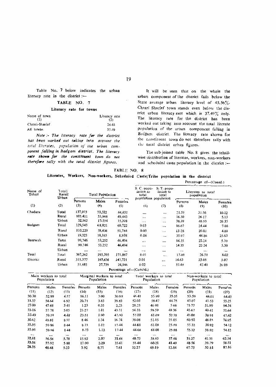
The subjoined table No.8 gives the tehsilwise distribution of literates. workers, non-workers and ~cheduled caste population in the district:-
TABLE NO. 8 Literates, Workers, Non-workers, Scheduled Caste/Tribe population in the district
Percentage of-(Contd.) ,--_. -'"---------, s. c. popu- S. T. popu-
Name of lotal/ lation to lation to Literates to total Tehsil Rural/ Total Population total total population
Urban r- ..A.. ...... population population r- -"'-------: Persons Males Females Persons Males Females
(1) (2) (3) (4) (5) (6) (7) (8) (9) (10)
Chadura Total 137,973 73,322 64,651 21.51 31·56 10.12 Rural 105,411 55,968 49,443 16.30 26.17 5.13 Urban 32,562 17,354 15.:;>08 38.39 48.93 2635
Badgam Total 129,543 68,821 60,722 0.03 16.67 24.44 7·86 Rural 110,220 58,436 51,784 0·03 13·28 20.81 4.80 Urban 19,323 10,385 8,938 0.06 35·97 44.86 25.63
Beerwah Total 99,746 53,252 46,494 14.35 22.24 5.30 Rural 99,746 53,252 46,494 14.35 22.24 5.30 Urban
Total Total 367,262 195,395 171,867 0.Q1 17.86 26.51 8.02 District Rural 315,377 167,656 147,721 0.01 14.63 23.05 5.07
Urban 51.885 27,739 24,146 0.Q2 37.49 47.41 26·09 Percentage of-(Concld.)
--"--- ~---------..
Main workers to total Margina I workers to total Total workers to total Non-workers to total Population Population Population Population
r-----------------' ...... r-- ---, ,---___ ...A... ____ ---. ,-----_.A--__ ....... Persons Males Females Persons Males Females Persons Males Females Persons Males Fema'es
(11) (11) (13) (14) (15) (16) (17) (18) (19) (20) (21) (27) 30.30 52.99 4.57 16.11 3.00 30.98 40.41 55.99 35·55 53.59 44.01 64.45 31.32 54.64 4.92 20.71 3.83 39.83 52.03 58.47 44.75 47.97 41.53 55.25 27.00 47·68 3.41 1.23 0.33 2.25 28.23 48.01 5·66 7J,77 51.99 94.34 33·06 57-78 5.05 21.27 1.81 43.31 54.33 59.59 4&.36 45.67 40.41 51.64 33.49 59.19 4.48 23.51 1.90 47.90 57.00 61.09 52.38 43.00 38·91 47.62 30.62 49.81 8.31 8.46 1.34 16.74 39.08 51.15 25·05 60.92 48·85 74·95 35.95 59·96 8·44 8.73 1.12 17.44 44-68 61-08 25.88 55.32 38.92 74.12 35.95 59.96 8·44 8.73 1.12 17.44 44.68 61.08 25.88 55.32 38.92 74.12
32.81 56.58 5.78 15.92 2.07 31.68 48.73 58.65 37.46 51.27 41.35 62.54 33.54 57-92 5.88 17·90 2.29 35.61 51.44 60.21 41.49 48·56 39.79 58·51 23.35 48.48 5.23 3.92 0.71 7.61 32.27 49·19 12.84 67.73 50.81 87.16
We have already seen that both in the
matter of rural as well as urban literacy the
district has to make a large leeway even to
come up to the level obtaining for tbe State
as a whole. Down at tehsil level the position
is still worse in respect of Badgam and Beerwah
tohsils where the literacy rate has been returned
at 1667% and 14.35% respectively, corresponding
to 17.86% for the district as a whole. Chadura,
which is a bigger tehsil in population is how
ever better placed with both total and runll
literacy being higher than for the district as a
whole. As between the two sexes, male literacy
level outweighs the female literacy level in all
the tehsils. The differential is however, far
greater in rural areas than in urban areas.
Percentage of main workers to total popu
lation as reproduced in col. 11-13 shows that
male work participation rate in urban areas
generally trails behind than that in rural areas.
The differential is however marginal in all the
tehsils. The same position obtains in all cases of
female participation rate for Chadura, but for
Badgam the position is reVerse. Amongst the
tehsils the highest rural participation rate for
males and females has been returned by Beer
wah at 59.96% and 8.44% respectively, corres
ponding to 57.92% and 5.88% for the district.
The urban participation rate in respect of both
sexes is also higher in Badgam tehsil than for
tne district as a whole.
Marginal workers, as will be noticed from
col. 14-16 of the statemerlt, constitute 15.92%
of the total population of the district. At the
tehsil level, this proportion varies from 8.73 in
Beerwah tehsil to 21.27 in Badgam tehsil. It
is, however, significant to note that in all towns
predominant proportion of the marginal workers
is claimed by the female population of the
rural component. It is a traditional feature of
20
rural economy that female felk th0ugh primarily
engaged in household activitit:s contribute theIr
bit by marginal participation in seasonal eco
nomic activities like agricultural operations and
household industries. It will be seen that
proportion of rural marginal female workers
to total female popUlation varies from 17.44
in Beerwah tehsil to 47.90 in Badgam tehsil.
Even in urban areas where marginal Wor kers
claim relatively mueh smaller proportion in both
sexes, the proportion of females outweighs the
male proportion in all the tehsils of the dhtrict.
The proportion of total workers made up
of main wOlkers an-d -marginal workers put
together is brought out in eols. 17-19 of
the table. It will be seen that in the case
of male population the proportion of workers
outstrips the proportion of non-workers buth
in rural and urban areas except Chadura
urban where the proportion of workers stands
at 48.01 corresponding to 51.99% of non~
workers. In the case of fl:mak popul ation
however, the rate of non-wOIkcrs is higher
than that of workers except in Badgam rural
where the proportion of female workers is
52.38 corresponding to 47.62% non-workers.
Analysis of Village Directory data
The data coUeeted from the Revenue and
other Government agencies regarding availabi~
lity of various amenities have been tabul11ted
in the main village directory statement. The
salient features of this data in bro:ld aggregates
is brought out below in the form of jn~et tables.
The position of availability of various ame
nities at district/tehsil level is indicated in the
following table;-
21
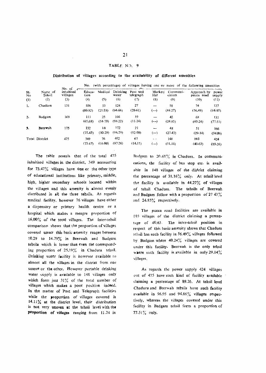
TABLE NO. 9
Distribution of villages according to the availability of different amenities
No. (with percentage) of villages having one or more of the following amenities No· of r-
SJ. Name of inhabited Educa- Medical Drinking No Tehsil villages tion water
(1) (2) (3) (4) (5) (6)
1. Chadura 131 106 33 124
(80.92) (25.19) (94.66)
2. Badgam 169 III 25 166 (65.68) (14.79) (98.22)
3. Beerwah 175 132 18 172
(75.43) (10.29) (98.29)
Total District 475 349 76 462
(73.47) (16.00) (97.26)
The tahle reveals that of the total 475
inhabited villages in the district, 349 accounting
for 73.47% villages have One or the other type
of educational institutions like primary. middle,
high, hi~her secondary schools located within
the villages and this amenity is almost evenly
distributed in alI the three tehsils. As regards
medical facility, however 76 villages have either
a dispensary or primary health centre or a
hospital which makes a meagre proportion of
16.00% of the total villages. The inter-tehsil
comparison shows that the proportion of villages
covered unu\!r this bask: amenity ranges between
10.29 to 14.79% in Beerwah and Badgam
tehsils which is lower than even the correspond
ing proportion of 25.19% in Chadura tehsil.
Drinking water facility is how("ver available to
almost all the villages in the distri£t from one
source or the other. However portable drinking
water supply is available to 148 villages only
which form just 31 % of the total number of villages which makes a poor position indeed.
In the matter of Post and Telegraph faciliti~s
while the proportion of villages covered is 14.11 % at the district level, their distribution is not very uneven at the tehsil level with the
proportion of villages ranging from 11.24 in
..A- ---. Post and Market/ Communi- Approach by power telegraph Hat cation pucca road supply
( 7) (8) (9) (10) (II)
27 58 74 127 (20.61) (-) (44.27) (56.49) (96·95)
J9 42 68 131 (11.24) (-) (24.85) (40·24) (77.51 )
21 48 51 166 (12.00) (-) (27.43) (29.14) (94.86)
67 148 193 424 (14.11) (-) (31.1S) (40.63) (89.26)
Badgam to 2().61 % in Chadura. In communi
cations, the facility of bus stop etc. is avail
abJe in 148 vilJagl!s of the district claiming
the percentage of 31.16% only. At tehsillevel
the facility is available in 44.27% of villages
of tehsil Chadura. The tehsils of Beerwah
and Badgam follow with a proportion of 27.43%
and 24.85% respectively.
The pucca road facilities are available in
193 villages of the district claiming a percen-
tage of 40.63. The inter-tehsil position in
respect of this basic amenity shows that Chadura
teh<;il has such facility in 56.49% villages followed
by Badgam where 40.24% villages are covered
under this facility. Beerwah is the only tehsil
w kere such facility is available in only 29.14 % villages.
As regards the power supply 424 villages
out of 475 have such kind of facility available
claiming a percentage of 89.26. At tehsil level
Chadura and Beerwah tebsils have such facility
available in 96.95 and 94.86% villages respec
tively, whereas the villages covered under this
facility in Badgam tehsil form a proportion of
77.51 % only.
22
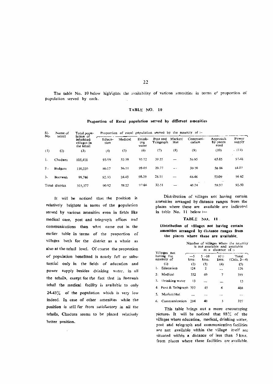
The table No. 10 below highlights the availability of various amenities in terms 0'" proportion of population served by each.
TABLE NO. 10
Proportion of Rural population served by different amenities
SI. Name of Total popu- Proportion of rural population served by the amenity of ;-No. tehsil lation of r-
inhabited Educa- Medical Drink-villages in tion the tehsil
(1 ) (2) (3) (4) (5)
I. Chadura 105,411 93·99 53·59
2. Badgam 110,220 86.17 36.11
3. Beerwah 99,746 92.93 24.43
Total district 315,377 90.92 38.21
It will be noticed that the position is
relatively brighter in terms of the population
served by various amenities even in fields like
medical care, post and telegraph offices and
communications than wh::!t came out in the
earlier table in terms of the proportion of
villages both for the district as a whole as
also at the tehsil level. Of C,)Ufse the proportion
of population benefitted is nearly full or subs
tantial only in the fields of education and
power supply besides drinking water, in all
the tehsils, except for the fact th~t in Beerwah
tehsil the medical facility is available to only
24.43% of the population which is very low
indeed. In case of other amenities while the
position is still far from satisfactory in all the
tehsiJs, Chadura seems to be placed relatively
better position.
ing water
(6)
95.52
99.05
98.39
9766
-----. Post and Market/ Communi- Approach Power
Telegraph Hat cation by pucca supply road
(7) (8) (9) (10) , (II)
39.55 56·95 65,85 97.41
29.77 39.70 58,86 84.07
28.11 48.46 53.09 9662
32.51 48.24 59.37 92.50
Distribution of villages not having certain amenit ies arranged by distance ranges from the places where these are available are indicntf'd in table No. 11 below:-
TABLE NU. 11
Distribution of villages not having certain amenities arranged by db(ance ranges from
the places where these are available.
Number of villages where the amenity is not available and available
at a distance of:-Villages not r-
A.. _______ --...
having the -5 5--10 10+ Total amenity of kms. kms. kms. (Cols.2-4)
(1) (2) (3) (4) (5) 1. Education 124 2 126
2. Medical 352 40 7 399
~. Drinking water 13 13
4. Post & Teregraph 357 45 6 408
5. Market/Hat
6. Communication 284 40 3 327
This table brings out a more encour::J.ging picture. It will be noticed that 88 ~~ of the villages where education, medical, drinking water, post and telegraph and communication facilities are not available. within the village it~eJf are situated within Il distance of less than 5 klT.s. from places where these faCilities are available.

It i~ ':lU, obvio,j'l thit all the basic amenities
arc availlble to most of the rural population of the district within a distance of less than
5 kms. from their village, if not within the village itself. The proportion of population
which has to travel a distance of more than 5 kms. is only 11 %. The number of villages
23
where the said facilities are available at a distance of more than 10 kms. is indeed negligible.
The table No. 12 below gives the distri
bution of villages according to di5tance from
the nearest town and availability of diffaent amenities :-
TABLE NO. 12 Distribution of villages according to the distance from ttl e nearest town and
availability of di.ferent amenities
Distance range No. of No. (with percentage) of from the inhabited ,-nearest town vill~gesin Educa- Medical Drink-(in Kms.) each range tion ing
water (1) (2) (3) (4) (5)
0- 5 19 16 5 17 (84.21) (26.32) (89.47)
6- 15 138 98 24 130 (71.01) (17.39) (94.::0)
16-50 317 234 47 314
(73.82) (14.83) (99.05) 51+ 1 1 1
(100.00) ( ... ) (100.00) Unspecified Total 475 349 76 462
(73.47) (16.00) (97.26)
It will be seen that distance from the nearest town does not seem to have any major effect on the provisions of various amenities in the villages except for communication and approach by pucca road facilities where the
villages placed at a distance of more than 5 kms. seem, for good reasons to have received relatively better attention than those placed
villages having the amenity of"--A-.-_______________ --,
Post Marketl Communi- Approach Power and Hat cation by pucca supply
Telegraph road (6) (7) (8) (9) (10)
4 4 7 19 (21.05) (. .. ) (21.05) (36.84) (100.00)
22 61 81 127 (15.94) ( ... ) (44·20) (58.70) (92.33)
41 82 104 277 (12.93) ( ... ) (25.87) (32.81) (87.38)
1 1 I ( ... ) ( ... ) (100.00) (100.00) (100.00)
67 148 193 424 (14.11) ( ... ) (31.16) (40.63) (89.26)
nearer a town. However the difference in the proportion is not as substantial as one should have expected and thIS might possibly be so due to a relatively less proportion of population inhahiting the more distant villages.
The table No. 13 below gives the distribution of Villages according to population ranges and amenilie.s available;-
TABU! NO. 13 Distribution of villages accordine to population range and amenities available
No. of No. (With percentage) of villages having the amenity of:-Population inhabited
..A.. _____________________ -,
range villages in Edu- Medical Drinking Post and Marketl Communi- Approach Power-each ranie cation water Telegraph Hat cation by pucca supply
road (1) (2) (3) (4) (5) (6) (7) (8) (9) (10)
499 261 141 21 252 7 50 64 222 (54.02) (8.05) (96.55) (2.68) ( ... ) (19.16) (24.52) (85.06)
500-1,999 189 183 39 186 44 81 108 179 (96.83) (20.63) (98,41 ) (23.28) ( ... ) (42.86) (57.14) (94.71)
2,000-4,999 24 24 15 23 15 16 20 22 (100.00) (62.50) (95.83) (62·50) ( .. ) (66.67) (83.33) (91.67)
5,000+ 1 1 1 1 1 1 1
(100.00) (100.00) (100.00) (100.00) ( ... ) (100.00) (100.00) (100.00) Total 475 349 76 462 67 148 193 424
(73.47) (16.00) (97.26) (14.11) ( ... ) (31.16) (40.63) (89.26)
As will be readily observed the population size of the villages has a direct bearing on
determining the position of various amenities with more populated villages expectedly attracting more attention than less populated villages. The highest beneficiaries are obviously the villages with a popUlation of 2,000 and more in the field of practically each basic amenity. The lone village in the population range group of 5,000 and more is fuIly covered jn Te~pt'ct of all the
amenities.
The table No. 14 below indicates the staple Coed of the inhabitants of the majority of
villages in each tehsil:-
TABLE NO. 14
Main staple food in tbe majority of villages in each teltsil
S.No. Name of tehsil Main staple food
(I) (2) (3)
1. Cbadura Rice, Wheat, Maize
2. Badgam Rice, Wheat, Maize
3· Beerwah Rice, Maize
As is evident from the table the main
staple food in majority of viJIages i. all tehsils is rice and maize.
Distri budon of villages according to land use is given is the sub-joined table No. ] 5 :-
24
TABLE NO. t5
Distribution of villagc5 according to land use
S. Name of No. of T0Wl Percen- Presen-No. tehsil inhabited area ta~e cult i- t<l~e of
villages vable area irrigated to total area to area total
cultivable area
(1) (2) (3) (4) (5) (6) 1. Chadura 131 25,965.72 83.49 36.37
Z. Badgam 169 25,123·23 82.14 55.77
3. Bcclwah 175 21,947.22 84.16 60.22
Total district 475 73,036.17 83.23 50.20
As IS clear from the table the perce'ltage
of cultivable area to total area in the three tehsils of the ctilltrict ranges from 82.14% in Badgam to 84.16% in Beerwah. In the matter of irrigated area, out of the tota I cultivable area, Beerwah tehsil stands at top with a percentage of 60.22 foHowed by tchsil Badgam with a percentage of 55.77. Chadura tehsil stands at the bottom with a percentage of 36.37 irrigated area to total area. Brief analysis of town dire\':tory data
Separate data in respect of urban popUlation structure, civic finance and availability of various amenities bas been compiled in the main town directory tables I to VI. For facilitating a brief assessment of the progress made by urban population some of the Important statistics have further been sub-divided in table No. 16 to 21.
The table No. 16 indicates the figures relating to urban populatbn, its percentage variation, density and sex-ratio:-
TABI,E NO. 16
Growtb, density and sex-ratio of urban popUlation in the district in relation to tbe State
District --"------
Census Total Urban %Urban Decadal Density Sex-ratio Year popula- popula- popula- percen- (popula- (No. of
tion tion tion tage varia- tion females tion in per <;q. per 1,00() urhan km.) males)
popul:lti0n (1) (2) (3) (4) (5) (6) (7)
Total population
(8)
Urban popula
tion
(9)
1961 213,918 3,231 1.51
4.41
1,298
803
857 3,560,976 593,315
1971 269,033 11,858 +267.01 882 4,616,632 858,221
1981 367,262 51,885 14.13 +337.55 I 124 R70 *5,987,389 1,260,403
State ___ A,_________ -. %l.lrban Decadal Density Sex-ratio popula- percen- (popula- (No. of tion tage varia- tion females
tion in per sq. per 1000 urban km.) males}
population (10) (11) (12)
16.66 N. A.
18.59
21.05
+44.65
+46.86
N.A.
2146
( 13)
844
860
875
*The population figures exclude population of area under unlawful occupation of Pakistan and China where census cou Id not be taken.
As can be readily seen from the table
Badgam district lags far behind the State <1S
a whole in its progre5s towards urbanisation,
the' position having been consistantly so during
the last three decades with the proportion of
urban population having increased to only
14.13% in 1981 as against 1.51% in 1961. The
correspondin& proportion for the State as a
whole has increased to 21.05 % in 1981 as
against 16.66% in 1961. The pace of urbanisa
tion in the district during the decade 1971-81
bas also been much lower in the district as
compared to the State. As regards density of
population, in the absence of area figures for
the State urban for 1961 and 1971, comparable
picture is available only for 1981 indicating that
urban density of population per sq. km. in
Badiam district is a little more than half of
wbat it is for the State as a whole. In the
matter of urban sex ratio however the district
compares favourably with the State.
25
The table below is ir.tf'nded to identify the towns added or declassified during the
1971-81 decade:-
TABLE NO. 17
New towns added/towns declassified
in 19&1 census
~----------------~ ~ Name of town Population 1981 cen~us
(1) (2) (a) Added
(i) Chrari-Sbarief 6,935
(b) Declassified
It will be seen that Chrari-Sharief is the
only town with a population of 6,935 persons
in the newly created distnct of Badgam. The
othl?r urban components as already highlighted
are tbe urban spread of Srinagar Urban
Agglomeration.
Table No. 18 below indicates the per capita receipt from various resources and per capita expenditure on various amenities in ChrariSharief, the only town of the district:-
TABLE NO. 18
Per capita receipt 14 expenditure in towns
Per capita ~---~ -"--- -
-----------------~ Receipt Expenditure
C1a~s, name & _.------------ _____ ..A... ___ . __________ --.
civic status Total Receipt Receipt Total of the town through from all expen-
taxes other diture sources
(1) (2) (3) (4) (5)
V Chrari-Sharief N.A. 31·71 3·59 2):;·12 5.34
Total 31.71 3.59 28 12 5·34
The table shows that the per capita receipt
in Chrari·Sharief is rupees 31.71. Of this total
receipt, rupees 3.59 come from taxes and rupees
28.12 from other sources. The' total per capita
expenditure in the said town is only rupees
licneral Expenditure Public Expenditure Other adnlinis- on public works on public aspects
tration health and institutions conveniences
(6) (7) ( ~) (9) (10)
2.36 0.10 2.28 0·60
2.36 0·10 2 :'8 0·60
5.34 of which rupees 2.36 are consumed on
general administration and rupees 2.28 on public
works. Surprisingly, the per capita expenditure
on public institutions is nil and on public
health it is only Rs. 0.10.
The sub~joined inset table No. 19 gives the number of educational institutions per 10,000 population in each town of the district:-
TABLE NO. 19
Schools per ten thousand population in towns
Class. name No. per ten thousand population and civic r-
....___ status of Higher Sccon- Sf'c('n- Junior Primary
town dary/lnter/ darYl S,:.:vll-PUC/Junior Matric- dary I college ulation middle
(1) (2) (3) (4) (5)
V Chrari-Sharief 1,44 1,44 1.44 5,77
N.A.
It will be seen from the table that there is obviously predominance of primary schools in the Chrari~Sharief town per 10,Poo populalion
as compared to schools of higher status.
Inset table No. 20 below gives the number of medical institutions per 1,000 population:-
TABLE NO. 20
No. of beds in medkal iostitutions in towns
Class, name and civic status of the town
(1)
V Chrari-Slaarief N ,A,
Total
No, of beds in medical institutions per 1,000 population
(2)
1,44
1.44
26
As is evident from the table there are only 1.44 hospital beds per thousand population in the Chrari-Sharief town which is a low proportion indeed.
The below mentioned inset table highlights the extent of most important commodity manufactured, imported and exported In CbrariSharief town :-
TAlJLE NO. 21
Most important commodity maaufactured, imported and exported in the towns
Class, name and civic status of
the town (1)
Most important commodity ,.-----____ _A...
Manufactu- Eltpor- Imported red ted
_ (1) (3) (4)
V Chrari-Sharief N.A, Fire Pots Fire Pots e.G ,I. sheets
As is clear from the table on the manufacturing side, making of Fire Pots (Kangris) is the chief occupation of people in the town. The same commodity cOllstitute the Chief export of the town while the Chief commodity of import is the C. G. I. sheets.
PART-A
VILLAGE & TOWN DIRECTORY (SECTION-I VILLAGE DIRECTORY)


'IEHSIL MAP
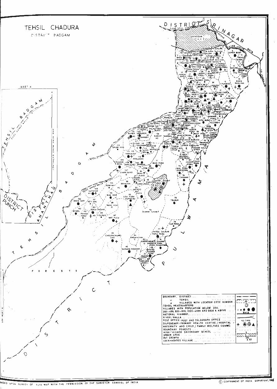
[-
TEHSIL CHADURA E" ADG AM
I NS E T A ---- -- -_
/ ./ r
/
./ . . /
(
/ /
\
I .. SEO U P O ~ S URHV or I N DI A IoI AP WIT H THE P ERM I S SIO N OF THE SU RVEY OR GENERAL OF I NDIA
BOUNDARY , DISTRICT ... ... . . . . .. .. _._.-" TEHSIL .. . ...
~= ~-=-(! -~ ::_J N VILLAGES WITH LOCATION CO DE NUMBER . .
7EHSIl HEADOUARTERS .. . . .. . . . . . © VILLAGES WITH POPULATION BELOW 20 0, •• lOO-U'; SOD - 191; 1000 - 4'" AND SODO • ABOVE ... o. • NATIONAL HIGHWAY . .. . . . " . . . . .. 1I~16
!lIVER I NAlLA . . ' . . , . . . .. . . . .. . . . ... .....c::.. POST OFF ICE i POST AND TEL EG RAPH o FF1 ~ f:. .. .. PO I PTO
DISPENSARY I PRIIiIARY HEA LTH CEN TRE I HOSPITAL + ~~ .. MATERNITY AND CHILD / FUlllV WE L FARE C EN~ . .. .. .. "
BOUNDARY FORESTS .. , . .. .. , ,"
HIGH I HI GHER SECONDARY SCHO Q~ ... ... • URBAN AREA .. .. . . . . ... .. . .. t'\.'\: .1~f'S3 OUT GROWTH ... . . . . ' .. . UNINHA81TED V IL LAGE . ... .. , ... . . . .. ~U
© GOVERN iolENT OF IN DIA 'OPYR'IG HT, 1tef
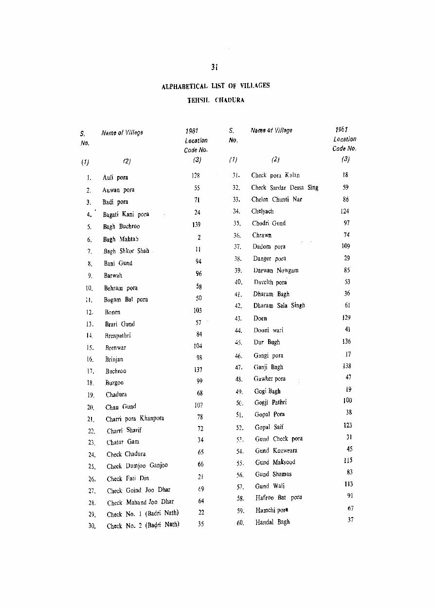
S. No.
(1)
I.
2.
3.
4.
5.
6.
7.
8.
9.
10.
II.
12.
13.
14.
15.
16.
17.
18.
19.
20.
21.
22.
23.
24.
25.
26.
27.
28.
29.
3D,
31
ALPHABETICAL LIST OF VILLAGES
lEHSIL CHlDURA
Nams of Vi/lagfJ 1981 S. Name of Village
Lecation No.
Code No.
(2) (3) (7) (2)
Auli pora 128 31. Check pora K~ran
Auwan para 55 32. Check Sardar Dessa Sing
Badi pora 71 33. Chelen Chunti Nar
Bagati Kani pora 24 34. Chelyach
Bagh Buchroo 139 35. Chodri Gund
Bagh Mahtab 2 36. Chrawn
Bagh Shkof Shah II 37. Dadom pora
Bani Gund 94 38. Danger pora
Barwah 96 39. Darwan Nowgam
Behram pora 58 40. Davelth pora
Bogam Bat pora 50 41. Dharam Bagh
Bonen 103 42. Dharam Sala Singh
Brari Gund 57 43. Doen
Brenpathri 84 44. Dooni wari
Brenwar 104 45. Our Bugh
Brinjan 98 46. Gangi pora
Buchroo 137 47. Ganji Bagh
Buzgoo 99 48. Gawher pora
Chadura 68 49. Gogi Bagb
Chan (jund 107 50. Gogji Pathri
Charri pora Khanpora 78 51. Gopal para
Charri Sharif 72 52. Gopal Saif
Chatar Gam 34 53. Gund Check pora
Check Chadura 65 54. Gund Kozweara
Check Dumjoo Ganjoo 66 55. Gund Maksood
Check Fati Din 21 56. Gund Shamus
Check Goind Joo Dhar 69 57. Gund Wali
Check Mahand Joo Dhar 64 58. Hafroo Bat pora
Check No. 1 (Badri Nath) 22 59. HaIJ1chi porI
Check No. 2 (Baqri Natb) 35 60. Handal Bagh
1981 Location Code No.
(3)
18
59
86
124
97
74
109
29
85
53
36
61
{29
41
136
17
138
47
i9
100
33
123
31
45
115
83
113
91
67
37
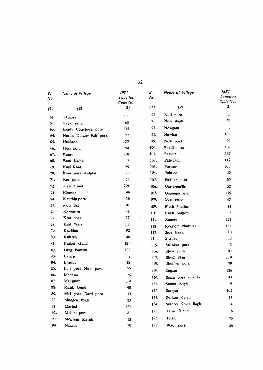
32
s. Name of ViI/age 1981 S. Name of Village 1881
No. Location No. Location'
Code No. eod~ No.
(1) (2) (3) (1 ) (2) (3)
61. Hanjura HI 95. Nati pora
62. Hayat pora 63 96; Now Bugh' 49
63. Hardu Chtichock pora 135 97. Nowgam 5
64. Hardu Dulwan Falti pora 77 98. Nowhar 1:06
65. Hushrco 120 99. Now pora 95
66. Husi pora 54 100 .. Phadi pora' 1'02
67. Kaner IllS 101. P!lnzUn 131'
68. Kani Harna 7 102. Pat'rigam: 117
69. Kani Koat 89 1'03. Porwar' B3
70. Kani pora Kalidar 26 104. Puhroo' 115
71. Kar pora 76 1\05. Pulther poml 8-0'
72. Kaw Gund 108 106 .. Qaisermullilt 52
73. Khando 44 roT. Q'anungo pun' 1<19
74. Khuthip pora 30 lOS: Qazi' porn 62
75. Koti Bal 101 J09: Rakh Sha.Jii:la' 1'4
76. Kozweara 46 llO. RaIth, SUthoo 6 77. Kral pora 27 Ill'. Ranger i21 78. Kral Wari i12
112. Ro@pore Numtihalll 134 79. Kuchloo 92 113. Sear Bagh 10
80. Kultreh 48 114. Shalina 13 81. Kuther Gund 125 115. Shanker pora 3
82. Lang Panzun 132 116. Shew pora 93 83. Lasjan 8 ! 17. Shurn Nag 110
84. Leadun 88 ~.l S. Shunker pora 79 ?5'. Loli pora Hum pora 90 119. Sogam 126 &6. Machwa 25
120. Sonzi pora Khardo 43 87. Mahooor 114
121. Sumer Bogh 9 88. Malik Gund 40
89. Mal pora Dard 122. Sursyar 105
pora 73
90. Mangen Wagi 23 123. Suthoo Kalan 33
91- Marbal 127 124. Suthoo Khatr Bagh 4
92. Mehiod pora 81 125. Tarazi Khud 16
93. Menzam Margh 82 126. TeJsur 75
94. Nagam 70 127. Wadi pora 56
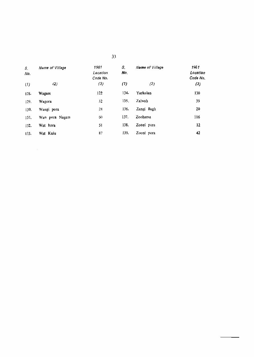
33
S. Name of Village 1981 S. Name of Village 1961
No. Location No. Location Code No. Code No.
(1) (2) (3) (1) (2) (3)
128. Wagam 122 134. Yarkalan 130
129. Wagora 32 135. Zalwah 39
130. Wangi pora 28 136. Zangi Bagh 20
131. Wan pora Nagam 60 137. Zoohama 116
132. Wat hora 51 138. Zooni pora 12
133. Wat Kulu 87 139. Zooni pora 42

34
NOTE EXPLAINING THE CODES USED IN THE VILLAGE DIRECTORY
A number of codes bas been used in the Village Directory.
These are emplified below:
Column No.
(1)
5 (Educational.
Item
(2)
Amenities) Primary or elementary school
Junior secondary or middle
Code
(3)
P
school M
Matriculation or Secondary
Higher (Secondary fIntermidiate( Pre-university I Junior college
College, any college (gradua te level and above) like Arts, Science, Commc:rce, ete.
Industrial school
Training sehool
Adult literacy class / centre
Other educational institutions, These include Sanskrit Pathshala, Senior basic school, Makhtab, etc·
6 (Medical£ Hospital
Amenities) Maternity and Child welf"re Centre
Maternity home
Child welfare centre
Health centre
Primary health centre
Primary health sub centre
Dispensary
Family planning centre
T. B. clinic
NUrsing home
Registered private practitioner
H
PUC
C
I
Tr
Ac
o
H
MCW
MH
(_WC
He
PHC
PHS
D
FPC
TR
NH
RP
Column No.
( 1) Item
(2)
Subsidised medical practitioner
Community health worker
Others
7 (Drinking water Amenities) Tap water
8 (Post & 1'eleit~ap}l
Amenities)
10 (Communications)
Well water
Tank water
Tubewell water
Handpump
River water
Fountain
Canal
Lake
Spring
NaIJah
Others
Information not available
Post office
lelegraph office Post & Telegraph office Telephone Connection
Bu'l
Railway station
Navigable water way (including river, canal, backwaters etc.)
Code
(3)
SMP
CHW
o
T
W
TK
TW
Hp
R
F
C
L
S
N
o
NA
PO
TO PTO Phone
BS
RS
NW
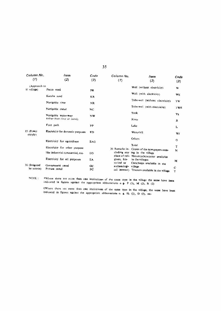
Column No. (1)
(Approach to
Item (2)
11 village) Pucca road
Kaccha road
Navigable river
Navigable canal
Navigable water-way (other than river or canal)
Foot path
Code (3)
PR
KR
NR
NC
NW
FP
13 (Power supply)
Electricity for domestic purposes ED
Electricity for agriculture EAG
Electricity for other purpose
like industrial commerCial, etc.
Electricity for all purposes
16 (Irri&ated Government canal by source) Private canal
EO
EA
GC PC
35
Column No. (1)
Item (2)
Well (without electricity)
Well (with electricity)
Code (3)
w
WE
Tube-well (without electricity) TW
Tube-well (with electricity) TWE
Tank Tk
River R
Lake L
Waterfall Wf
Others o Total T
20 Remarks in- Copies of the newspapers com- N cluding any ing in the village place of reli- Motorcycle/scooter available gious, his- in the villages M torica! or Cars/Jeeps available in the archaeologi. village C cal interest) Tractors available in the village T
NOTE: *Where there are more than one institution~ of the same type in the village the same have bees indicated in figures against the appropriate abbrevations e. g. P (3), M (2). H (2)
£Where there are more than one institutions of the same type in the village, the same have been indicated in figures against the appropriate abbrevations e. 1:. H. (2). D (3). etc.
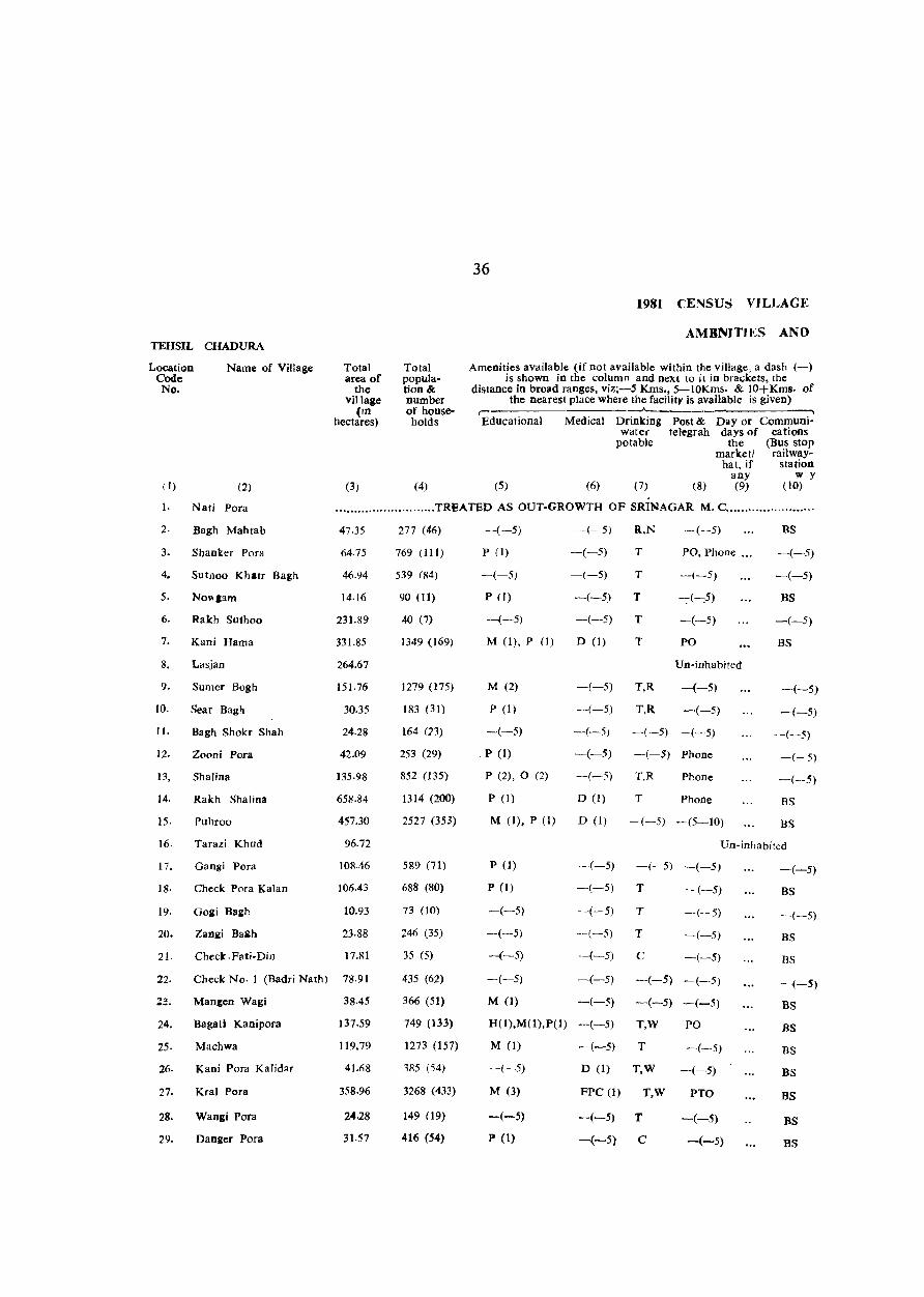
TEHSIL CHADURA
Location Code: No.
Name of Village
(2)
Total area of
the village
(rn hectares)
(3)
Total population&: number of house-holds
(4)
36
1981 CENSUS VILLAGE
AM8NITIES AND
Amenities available (if not available within the village, a dash (-) is shown in the column and next to it in brackets, the
distance in broad ranges, viz;-5 Kms., 5-10Kms. & 10+ Kms. of the nearest place where the facility is available is given)
r---------------------~-------------------~ EdUcational Medical Drinking Post & Day or Communi-
water teJcgrah days of cations potable the (Bus stop
marketl railway-hat, jf station
any w y (5) (6) (7) (8) (9) (10) ill
1. Nati Pora ....•...................... TREATED AS OUT-GROWTH OF SRINAGAR M. C ....................... .
2. Bagh Mahtab
3. Shanker Por~
4. Suthoo Khatr Bagh
5. NO\\lIam
6. Rakh Suthoo
7. Kani Hama
8. Lasjan
9. Sumer Bogh
10. Sear Bagh
II.
12.
13,
14.
15·
8agh Shoh Shah
Zooni Pora
Shalina
Rakh Shalina
Puhroo
16. Tarazi Khud
17. Gangi Pora
18· Check Pora Kalan
19. GOlli Bagh
20. Zan.l1;i Ba&h
21. Check.Fati-Din
47.35
64·75
46·94
14·16
231.89
331.85
264.67
151.76
30.35
24.28
42,09
135.98
658.84
457.30
96.72
108.46
106.43
10.93
23·88
17.81
22. Check No· 1 (Badri Nalh) 78·91
24.
25·
26.
27.
28.
29.
Mangen Wagi 38.45
Bagati Kanipora 137.59
Machwa 119.79
Kani Pora Kalidar
Kral Pora
Wangi Pora
Danger Pora
4),(;8
358.96
24.28
31.57
277 (46)
769 (111)
539 (84)
90 (II)
40 (7)
1349 (169)
1279 (175)
183 (31)
164 (23)
253 (29)
852 (135)
1314 (200)
2527 (353)
589 (71)
688 (80)
73 (10)
246 (35)
35 (5)
435 (62)
366 (51)
749 (133)
1273 (157)
385 (54)
3268 (433)
149 (19)
416 (54)
-(-5) -(-5) R.N -(-5)
P (1) -(-5) T PO, Phone .. ,
-(-5) -(-5) T -(-5)
P (I) -(-5) T -:-(-:5)
-(-5) -(-5) T -(-5)
M (I), P (1) D (I) T PO
Un-inhabited
-(-5) T,R -(-5)
-(-5) T,R -(-5)
M (2)
P(I)
-(-5)
P (I)
-(-5) -(-5) -(-5)
P (2), 0 (2)
pel)
M (I), P (1)
-(-5)
-(-5)
D (1)
D (1)
-(-5) Phone
T,R Phone
T Phone
-(-5) -(5-10)
BS
-(-5)
-(-5)
BS
-(-5)
BS
-(-5)
-(-5)
-(-5)
-(-5)
-(-5)
BS
BS
Un-inhabited
P (1)
P (1)
-(-5)
-(-5)
--(-5)
-(-5) -(-5) -(-5)
-(-5) T -(-5)
-(-5) T -(-5)
--(-5) T -(-5)
-(-5) C -(-5)
-(-5) -(-5) -(-5) -(-·5)
M (I) -(-5) -(-5) -(-5)
H(I),M(I),P(I) -(-5)
M (l) -(-5)
T,W PO
T -(-5)
-(-5)
M (3)
-(-5)
P (1)
D (1) T,W -(-5)
FPC (1) T,W PTO
-(-5) T -(-5)
-(-5) C -(-5)
-(-5)
BS
---(-5)
BS
BS
-(-5)
BS
BS
DS
BS
BS
BS
BS
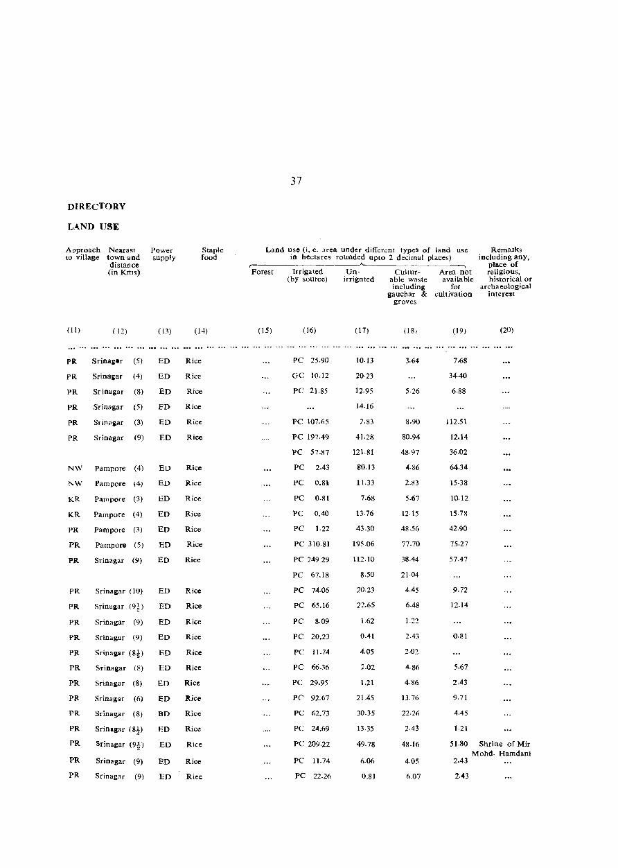
DIRECTORY
L.~ND USE
Approach to village
Nearast town and distal1ce (in Kms)
(II)
PR
PR
PR
PR
PR
PR
( 12)
Srinai.r (5)
Srinaiar (4)
Sr ina gar (8)
Srinagar (5)
Srinagar (3)
Srinagar (9)
NW Pampore (4)
l' W Pam pore (4)
KR Pampore (3)
KR Pampore (4)
PR Pampore (3)
Power supply
( 13)
ED
ED
ED
ED
ED
ED
EO
ED
ED
ED
ED
Staple food
(14)
Rice
Rice
Rice
Rice
Rice
Rice
Rice
Rice
Rice
Rice
Rice
PR
PR
Pampore (5) ED Rice
PR
PR
PR
PR
PR
PR
PR
PR
PR
PR
PR
PR
PR
Srinagar (9) ED Rice
Srinagar (10)
Srinaiar (9.~)
Srinagar (9)
Srinagar (9)
ED
ED
ED
ED
ED
Rice
Rice
Rice
Rice
Rice
Srinaiar (8) ED Rice
Srinagar (8) ED Rice
Srinagar (6)
Srinagar (8)
Srinagar (8!)
Sri nagar (9t)
Srinagar (9)
Srinagar (9)
ED Rice
BD Rice
ED Rice
ED Rice
ED Rice
ED Riee
37
Land use (i, e. area under different types of land use in hectares rounded upto 2 decimal places)
RemaJks includivg any,
place of religious, historical or
r-----------------~ Forest Irrigated Un- Culrur-
(15)
(by source) irrignted able waste
(16)
PC 25.90
GC 10.12
PC 21.85
PC 107.65
PC 197·49
PC 57.87
PC 2.43
PC 0.81
PC 0.81
PC 0.40
PC 1·22
PC 310·81
PC 24929
PC 67.18
PC 74.06
PC 65.16
PC 8·09
PC 20.23
PC 11.74
PC 66.36
PC 29.95
PC 92.67
PC 62.73
PC 24.69
PC 209.22
PC 11.74
PC 22.26
(17)
10·13
20·23
12.95
14.16
2.83
41.28
121.81
80.13
11.33
7.68
13.76
43.30
195.06
112·10
8.50
2023
22.65
1·62
0.41
4.05
2.02
1.21
21.45
30.35
13·35
49.78
6.06
0.81
including gauchar &
groves
(18,
3.64
5·26
8.90
80.94
48·97
4·86
2.83
5.67
12.15
48·56
77·70
38.44
21.04
4.45
6.48
1.22
2.43
2·02
4·86
4.86
J3. 76
22·26
2·43
48.16
4.05
6.07
Area not available
for cultivation
( 19)
7.68
34.40
6·88
112.51
12.14
36.02
64.34
15·38
10.12
15·78
42.90
75.27
57·47
9.72
12·14
0·81
5.67
2.43
9.71
4.45
1·21
archaeological interest
(20)
51.80 Shrine of Mir Mohd. Hamdani
2.43
2.43
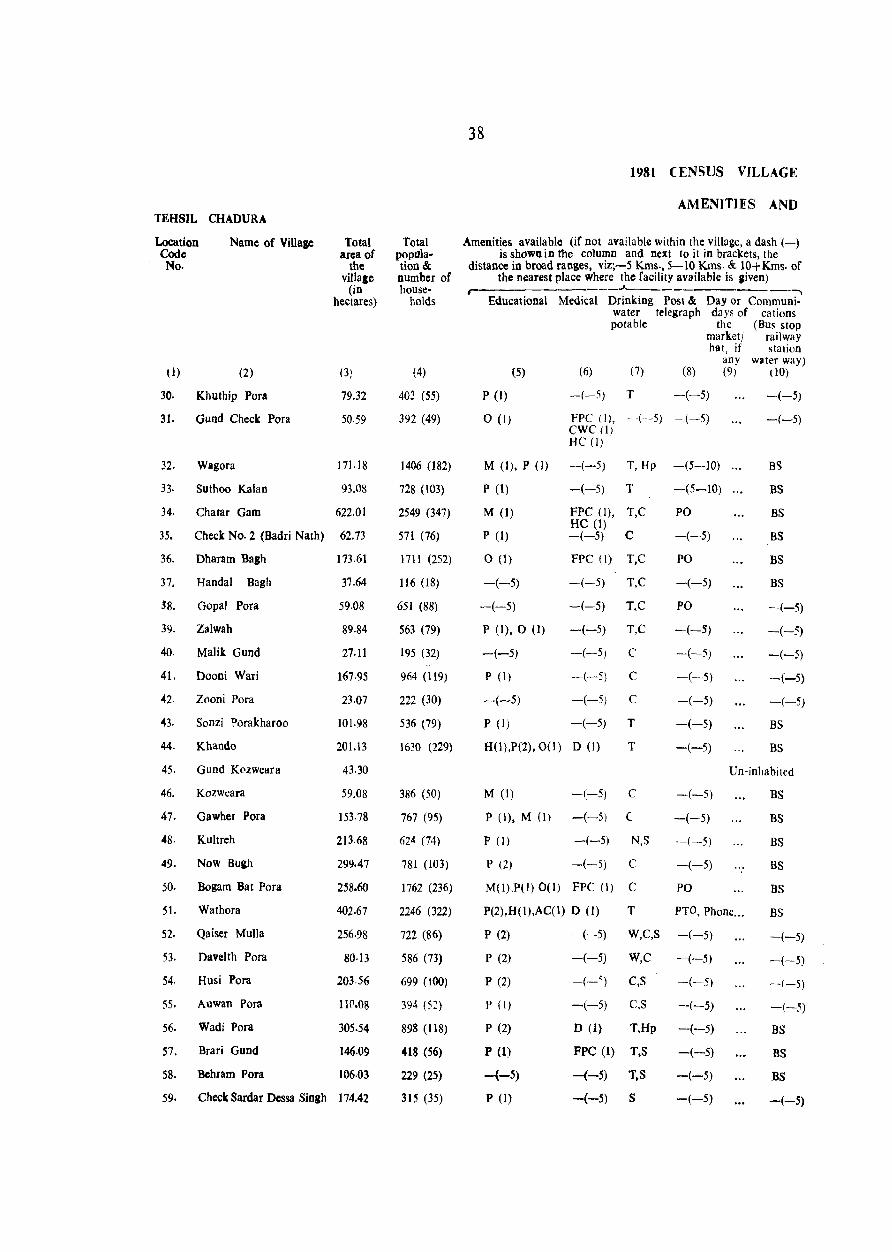
TEHSIL CHADURA
Location Codc No.
( 1)
Name of Village
(2)
30. Khuthip Pora
31. Gund Check Pora
32. Wagora
33. Suthoo Kalan
Chatar Gam
Total area of
the villale
(in hectares)
(3)
79.32
50.59
171.18
93.08
622.01 34.
35. Check No·2 (Badri Nath) 62.73
36. Dharam Bagh
37. Handal Bagh
-'8. Gopal POfa
39. Zalwah
40. Malik Gund
41. Dooni Wari
42. Zooni Pora
43. Sonzi Porakharoo
44. Khando
45. Gund K<'zweara
46. Kozweara
47. Gawher Pora
48. Kultreh
49.
50.
5t.
52.
53.
54.
Now Bugh
Bogam Bat Pora
Wathora
Qaiser Mulla
Davelth Pora
Husi Pora
55. Auwan Pora
56. Wadi Pora
57. Brari Gund
58. Bchram Pora
173.61
37.64
59.08
89·84
27.11
167.95
23.07
101.98
201.13
43.30
59.08
153. 78
213.68
299.47
258.60
402.67
256.98
80·13
203.56
11('.08
305.54
146.09
106.03
59. Check Sardar Dessa Singh 174.42
Total population & number of house-
holds
(4)
403 (55)
392 (49)
1406 (182)
728 (l03)
2549 (347)
571 (76)
1711 (252)
116 (18)
651 (88)
563 (79)
195 (32)
964 (119)
222 (30)
536 (79)
1630 (229)
386 (50)
767 (95)
624 (74)
781 (103)
1762 (236)
2246 (322)
722 (86)
586 (73)
699 (tOO)
394 (52)
898 (118)
418 (56)
229 (25)
315 (35)
38
1981 CENSUS VILLAGE
AMENITIES AND
Amenities available (if not available within the village, a dash (-) is shown in the column and next to it in brackets, the
distance in broad ranges, viz;-5 Kms., 5-10 Kms. & 10+Kms. of the nearest place where the facility available is Jiven)
r- .A.___ __ ._-,
Educational Medical Drink.ing Post & Day or Communiwater telegraph days of cations potable the (Bus stop
marketj railway hat, if station
any water way) (5) (6) (7) (8) (9) (10)
-(-5) T -(-5) P (1)
0(1) FPC (I), -(-5) -(-5) CWC (I) HC(I)
M (I), P (1) -(-5) T, Hp -(5--10)
P (1) -(-5) T -(5-10)
M (1)
p (1)
o (I)
-(-5)
-(-5)
P (1), 0 (1)
-(-5)
FPC (I), T,C HC (1) -(-5) C
FPC (\) T,C
-(-5) T,C
-(-5) T,C
-(-5) T,C
-(-5)
P (1) -(-5)
C
C
C
T
T
-(-5) -(-5)
P (I) -(-5)
H(l),P(2), 0(1) D (1)
M (1) -(-5) C
P (1), M (1) -(-5) (
P (I) -(-5) N,S
P (2) -(-5) C
M(I),P(l) 0(1) FPC (I) C
PO
-(-5)
PO
-(-5)
PO
-(-5)
-(-5)
-(-5)
-(-5)
-(-5)
-(-5)
-(-5)
-(-5)
-(-5)
-(-5)
PO
-(-5)
-(-5)
BS
BS
BS
BS
BS
BS
-(-5)
-(-5)
-(-5)
--(-5)
-(-5)
BS
BS
Un-inhabited
P(2),H(l),AC(1) D (1) T PTO, Phone ...
BS
BS
BS
BS
BS
BS
P (2) -(-5) W,C,S
P (2) -(-5) W,C
P (2) -(-') C,S
P (I)
P (2)
P (1)
-{-5)
P (1)
-(-5) C,S
D (1) T,Hp
FPC (1) T,S
-(-5) T.S
-(-5) S
-(-5)
-(-5)
-(-5)
-(-5)
-(-5)
-(-5)
-(-5)
-(-5)
-(-5)
-(-5)
-,,(-5)
-(-5)
BS
BS
BS
-(-5)
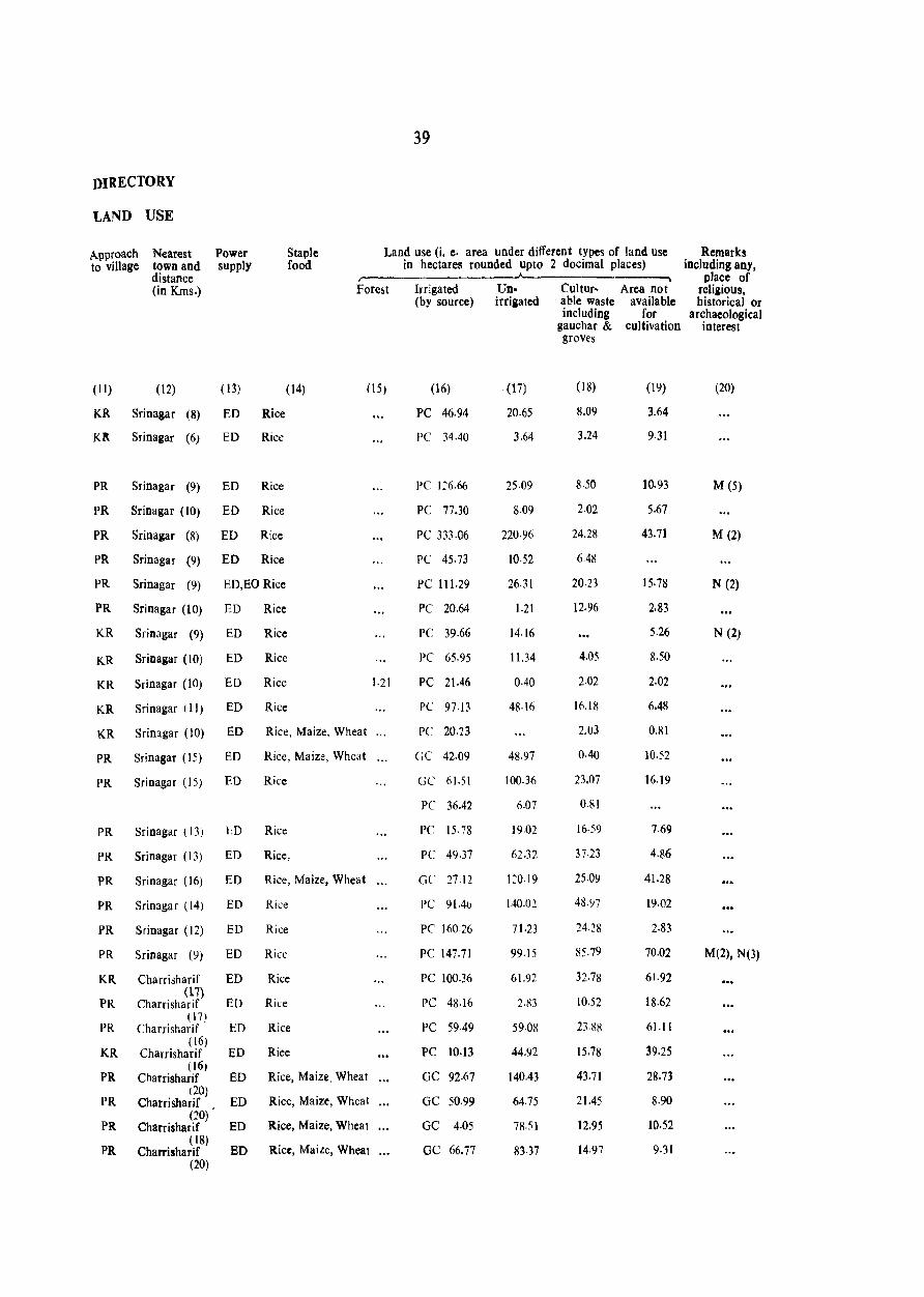
DIRECTORY
LAND USE
Approach to village
Power supply
Staple food
39
Land use 0. e· area under different types of land use in hectares rounded up to 2 docimal places)
Nearest town and distance (in Kms.)
r---- ~.----------~
(11) (12) (13) (14) OS)
KR Srinagar (8) ED Rice
Kit Sri nagar (6) ED Rice
PR Srinagar (9) ED Rice
PR Srinagar (10) ED Rice
PR Sri nagar (8) ED Rice
PR Srinagar (9) ED Rice
PR Sri nagar (9) ED,EO Rice
PR Srinagar (10) ED Rice
KR Srinagar (9) ED Rice
KR Sri nagar (10) ED Rice
KR Srinagar (10) ED Rice
KR Srinagar (11) ED Rice
KR Srinagar (10) ED Rice, Maize. Wheat
PR Sri nagar (15) ED Rice, Maize, Whc~t
PR Srinagar (1S) EO Rice
PR Srinagar (13) l:-:D Rice
PR Srinagar (13) ED Rice,
PR Srinagar (16) ED Rice, Maize, Wheat
PR Srinagar (14) ED Rice
PR Sri nagar (12) ED Rice
PR Srinagar (9) ED Rice
KR
PR
PR
KR
PR
PR
PR
PR
Charrisharif ED Rice (l'7)
Charrisharif ED Rice ( 17)
Charrisharif ED Rice (l6)
Charrisharif ED Rice (16,
Charrisharif ED Rice, Maiz~, Wheat (20)
Charrisharif ED Rice, Maize, Wheat (20)
Charrisharif ED Rice, Maize, Wheat ( 18)
Charrisharif ED Rice, Maize, Wheat (20)
1.21
Irrigated lin- CuItur- Area not (by source) irrigated able waste available
including for
(16)
PC 46.94
PC 34.40
PC 126.66
PC 77.30
PC 333·06
PC 45.73
PC 111.29
PC 20.64
PC 39.66
PC 65.95
PC 21.46
PC 97.13
PC 20.23
GC 42·09
GC 61.51
PC 36.42
PC 15· 78
PC 49.37
GC 27.12
PC 91.4()
PC 160.26
PC 147.71
PC 48.16
PC 59.49
PC 10.13
GC 92.67
GC 50.99
GC 4.05
GC 66.77
(17)
20.65
3.64
25.09
8.09
220·96
10·52
26.31
1.21
14.16
11.34
0-40
48·16
48.97
100.36
6.07
19·02
62.32
1:0·19
140.02
71.23
99·15
61.92
2·83
5908
44.92
14Q.43
64.75
78.51
8137
gauchar & cUltivation groves
(18)
8.09
3.24
8.50
2.02
24.28
6.48
20.23
12.96
4.05
2·02
16.18
2.03
0.40
23.07
0.81
16·59
37·23
25.09
48.97
24.28
85.79
32·78
10.52
23.RR
15.78
43.71
21.45
12.95
14·97
(19)
3.64
9·31
10.93
5.67
43.71
15.78
2.83
5.26
8.50
2·02
6.48
0.81
lo.s2
16.19
7.69
4.86
41.28
19·02
2.83
70.02
61.92
18.62
61.11
39.25
28.73
8.90
10.52
9·31
Remarks including any.
place of reli&ious. historical or
archaeological interest
(20)
M (5)
M (2)
N (2)
N (2)
M(2), N(3)
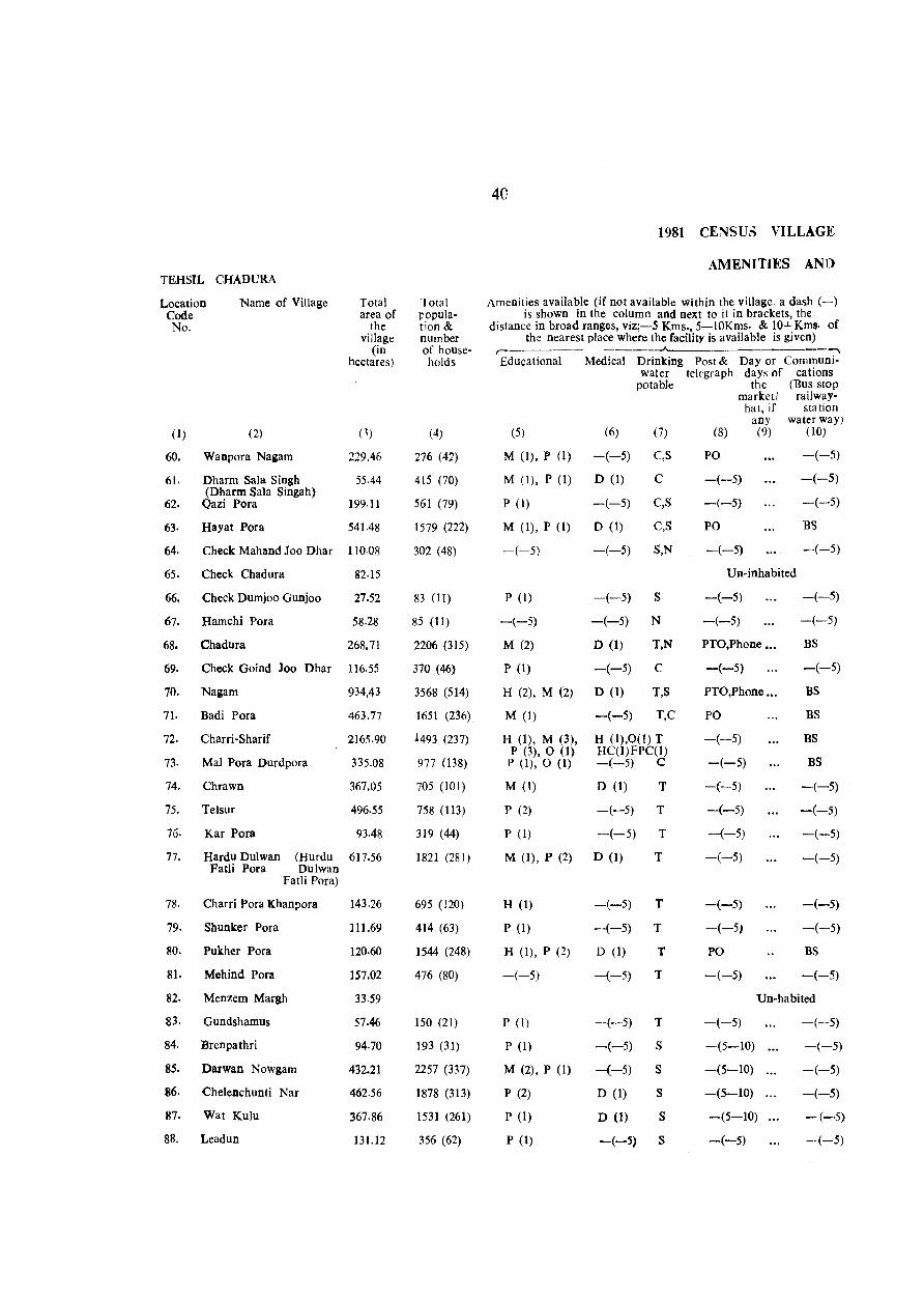
40
1981 CENSU5 VILLAGE
AMENITIES AND TEHSIL CHADURA
Location Name of Village Total Total Amenities available (if not available within the village. a dash (-) Code area of popula- is shown in the column and next to it in brackets, the No. the tion & distance in broad ranges, viz;-5 Kms., 5-IOKms. & 10+ Kms· of
village number the nearest place where the facility is available is given) (in of house- r- ......
hectares) holds Educational Medical Drinking Post & Day or Communi-water telegraph days of cations
potable the (Bus stop market! railway-
hat, if station any water way)
( 1) (2) (1) (4) (5) (6) (7) (8) (9) (10)
60. Wanpora Na&am 229.46 276 (42) M (I), P (1) -(-5) C,S PO -(-5)
61. Dharm Sala Singh 55.44 415 (70) M (I), P (1) D (1) C -(-5) -(-5) (Dbarm Sala Singab)
62. Qazi Pora 199.11 561 (79) P (I) -(-5) C,S -(-5) -(-5)
63· Hayat Pora 541.48 1579 (222) M (1), P (1) D (1) C,S PO BS
64. Check Mahand Joo Dhar 110.08 302 (48) -(-5) -(-5) S,N -(-5) --(-5)
65. Check Chadura 82·15 Un-inhabited
66. Check Dumjoo Gunjoo 27.52 83 (II) P (I) -(-5) S -(-5) -(-5)
67. Hamchi Pora 58.28 85 (11) -(-5) -(-5) N -(-5) -(-5)
68. Chadura 268.71 2206 (315) M (2) D (1) T,N PTO,Phone ... BS
69. Check Goind Joo Dhar 116.55 370 (46) P (1) -(-5) C -(-5) -(-5)
70. Nagam 934,43 3568 (514) H (2), M (2) D (1) T,S PTO,Phone ... BS
71. Badi Pora 463.77 1651 (236) M (1) -(-5) T,C PO BS
n. Charri-Sharif 2165.90 1493 (237) H (1), M (3), H (l).O(l)T -(--5) BS P (3),0 (1) HC(I)FPC(I)
73- Mal Pora Durdpora 335.08 977 (138) P (I), 0 (1) -(-5) C -(-5) BS
74. Chrawn 367.05 705 (101) M (1) D (1) T -(-5) -(-5)
75. Telsur 496.55 758 (113) P (2) -(-5) T -(-5) -(-5)
76· Kar Pora 93,48 319 (44) P (1) -(-5) T -(-5) -(-5)
77. Hardu Dulwan (Hurdu 617.56 1821 (281) M (1), P (2) D (1) T -(--5) -(-5) Patli Pora Dulwan
Fatli Pora)
78. Charri Pora Khanpora 143.26 695 (120) H (1) -(-5) T -(-5) -(-5)
79. Shunker Pora 111.69 414 (63) P (1) -(-5) T -(-5, -(-5)
80. Pukher Pora 120.60 1544 (248) H (1), P (2) D (1) T PO BS
81. Mehind Pora 157.02 476 (80) -(-5) -(-5) T -(-5) -(-5)
82. Menzem Margh 33.59 Un-habited
83. Gundshamus 57.46 150 (21) P (I) -(-5) T -(-5) -(-5)
84. Brenpathri 94.70 193 (31) P (I) -(-5) S -(5-10) -(-5)
85. Darwan Nowgam 432.21 2257 (337) M (2), P (1) -(-5) S -(5-10) -(-5)
86. Chelenchunti Nar 462.56 1878 (313) P (2) D (1) S -(5-10) -(-5)
87. Wat Kulu 367.86 1531 (261) P (1) D (1) S -(5-10) -(-5)
88. Leadun 131.12 356 (62) P (1) -(-5) S -(-5) -(-5)
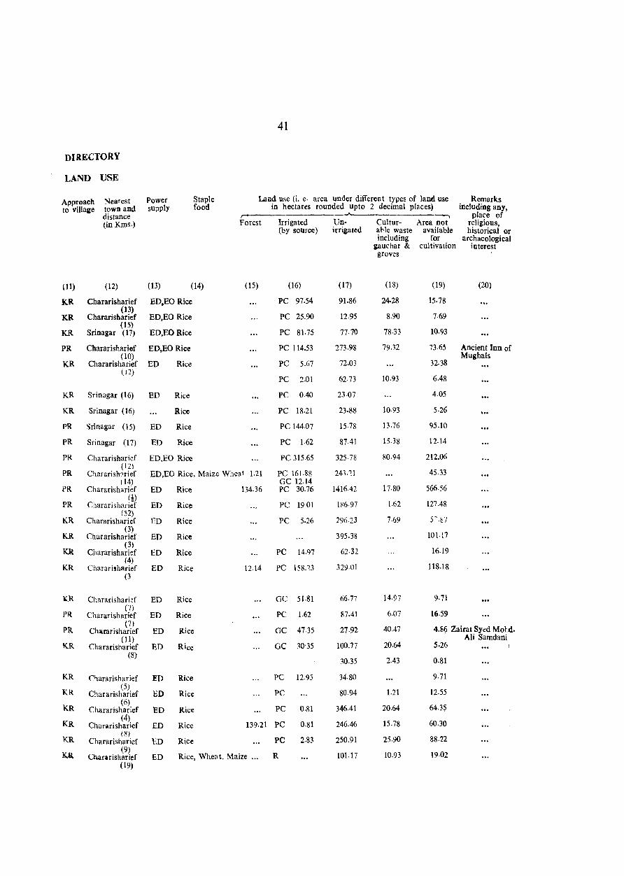
41
DIRECTORY
LAND USE
Approach Nearest Power Staple Land use (i. e· area under different types of land use Remarks to village town and supply food in hectares rounded upto 2 decimal places) including any,
distance ---"-- ---, place of (in Kms.) Forest Irrigated lin- Cultur- Area not religious,
(by source) irrigated a"le waste available historical or including for archaeological
gauchar & cultivation interest groves
(11) (12) (13) (14) (15) (16) (17) (18) (19) (20)
KR Chararisharief ED.EO Rice PC 97.54 91.86 24.28 15.78 (13)
KR Chararisharief ED,EO Rice PC 25.90 12·95 8.90 7·69 (15)
KR Srinagar (17) ED,EORice PC 81.75 77.70 78·33 10·93
PR Chararisharief ED,EORice PC 114.53 273.98 79.32 73.65 Ancient Inn of (10) Mughals
KR Chararisharief ED Rice PC 5.67 72.03 32.38 (12)
PC 2.01 62·73 10.93 6.48
KR Sri nagar (16) ED Rice PC 0.40 23·07 4.05
KR Srinagar (16) Rice PC 18.21 23·88 10·93 5·26
PR Srinagar (15) ED Rice PC 144-07 15.78 13.76 95.10
PR Srinagar (17) ED Rice PC 1·62 87.41 15.38 12.14
PR Chararisharief ED,EO Rice PC 315.65 325· 78 80.94 212.06 (12)
PR ChararishRrief ED,EO Rice, Maize Wheat 1.21 PC 16\.88 243,''lJ 45.33 ( 14) GC 12.\4
PR Chararisharief ED Rice 134.36 PC 30.76 1416.42 17.80 566·56
PR m
Chararisharief ED RiCe PC 1901 1~6·97 1.62 127.48
KR (52)
Chararisharief ED Rice PC 5.26 296.23 7.69 5-.~7
KR (3)
Chararisharief ED Rice 395.38 10\.17
KR (3)
Chararisharief ED Rice PC 14.97 62·32 16.19 (4)
KR Chararisharief ED Rice 1214 PC 158.'23 329.o! 118.18 (3
~R Chararisharkf ED Rice GC 51.81 66.77 14.97 9·71
PR (7)
6.07 Chararisharief ED Rice PC 1.62 87.41 16.59
PR (7)
40.47 4.8~ Zairat Syed Mot.d. Chararisharief ED Rice GC 47.35 27.92 (1) Ali Samdani
KR Chararisharief ED Rice GC 30'35 100.77 20.64 5·26 (8)
30.35 2.43 0.81
KR Chararisharief ED Rice PC 12.95 34.80 9.71
KR (5)
1.21 12.55 Chararisharief ED Rice PC 80.94
KR (6)
346.41 20.64 64.3~ Chararisharief ED Rice PC 0.81
KR (4)
PC 0.81 246.46 15.78 60.30 Chararisharief ED Rice 139.21
KR (8)
250.91 25·90 88.22 Chararisharief ED Rice PC 2.83
Ka. (9)
Rice, Whea t, Maize ... R 101.17 10.93 19·02 Chararisharief ED (19)

42
1981 CENSUS VILL'GE
AMENITIES AND TEH8IL CHADURA
Location Name of Village Total Total Arr.enities available (if not available within the village, a dash (-) Code area of popula- is shown in the column and next to it in brackets, the No. the tion& distance in broad ranges, viz;-5 Kms., 5-10 Krns. & 10+Kms. of
village number of the nearest place where the facility available is liven) (in house-
J.._ ___ , ------, hectares) holds Educational Medical Drinking Post & Day or Communi-
water telegraph da)s of cations potable the (Bus stop
marketl railway hat, if station
any water way) (1) (2) (3) (4) (5) (6) (7) (8) (9) nO)
89· Kani Koat 68.80 95 (13) P (1) -(-5) 8 -(-5) -(-5)
90. Loli Pora Humpora 271.55 986 (162) M (1), P (1) FPC (I) 8 -(-5) -(-5)
9I. Hafroo Bat Pora 472.68 1604 (255) H (1), P (1) D (1) 8,T -(5-10) ... BS
92. Kuchloo 144.07 Un-inhabited
93. Shew Pora 72.44 270 (37) P (1) -(-5) T -(5-10) ... BS
94. Bani Gund 137·19 280 (38) P (I) -(-5) S -(5-10) .•• BS
95. Now Pora 286.52 771 (108) M (1), P (1) -(-5) N,T -(-5) BS
96- Barwah 149.74 609 (91) M (2) -(-5) S,T -(-5) -(-5)
97. Chodri Gund 98·74 287 (42) P (1) -(-5) T -(-5) BS
98. Brinjan 354.91 1077 (l08) P (1) -(-5) T PO -(-5)
99. Buz Goo 328·20 940 (161) M (1) -(-5) T -(-5) -(-5)
100. Gogji Pathri 390.93 2036 (357) M (I), P (2) D (1) S PO -(-5)
}O1. Koti Bal 15·78 159 (30) P (1) -(-5) S -(-5) -(-5)
102· Pahadi Pora 50.18 252 (45) -(-5) -(-5) S -(-5) -(-5)
103. Bo-nen Z38·77 779 (142) P (1) -(-5) 8,0 -(-5) -(-5)
104. Bren War 364.63 2305 (402) M (1), P (3) -(-5) S,N -(-5) -(-5)
105. Sursyar 645.48 2420 (423) M (1), P (2) D (1) S,N PO B8
106. Nowhar 172.80 0430 (65) P (2) -(-5) S,N -(-5) -(-5)
107. ChaD Gnd 45.73 141 (26) -(-5) -(-5) N -(-5) -(-5)
108. Ka", Qund (Khazi Guod) 261.43 7~3 (124) P (2) -(-5) S,N -(-5) -(-5)
109. Dadom pora 467·01 1893 (291) M (1), P (2) D (1) M -(-5) BS
110. Shurn Nag ]60·26 332 (46) P (2) -(-5) N -(-5) -(-5)
ilL Hanjura 184.94 1122 (188) P (1), AC (1) D (1) T PO -(-5)
112. Kralwari 123.43 788 (121) PO), AC (1) -(-5) N -(-5) -(-5)
113. Gund WaH 15.38 207 (32) -(-5) -(-5) N -(-5) BS
114. Mahnoor 31.57 297 (46) M (1) -(-5) S,N -(-5) BS
115. Gund Maksood 37.64 328 (47) -(-5) -(-5) N -(-5) BS (Gund Muk'Jood)
116. Zoohama 159·85 842 (134) H (1), M (2), D (1) T -(-5) BS
117. Patri Gam P (2)
-(-5) 163.09 127 (17) -(-5) -(-5) T,Tw BS
118. Kaner 373.12 1479 (229) M (1), P (1) D (1) T,S,N PO BS
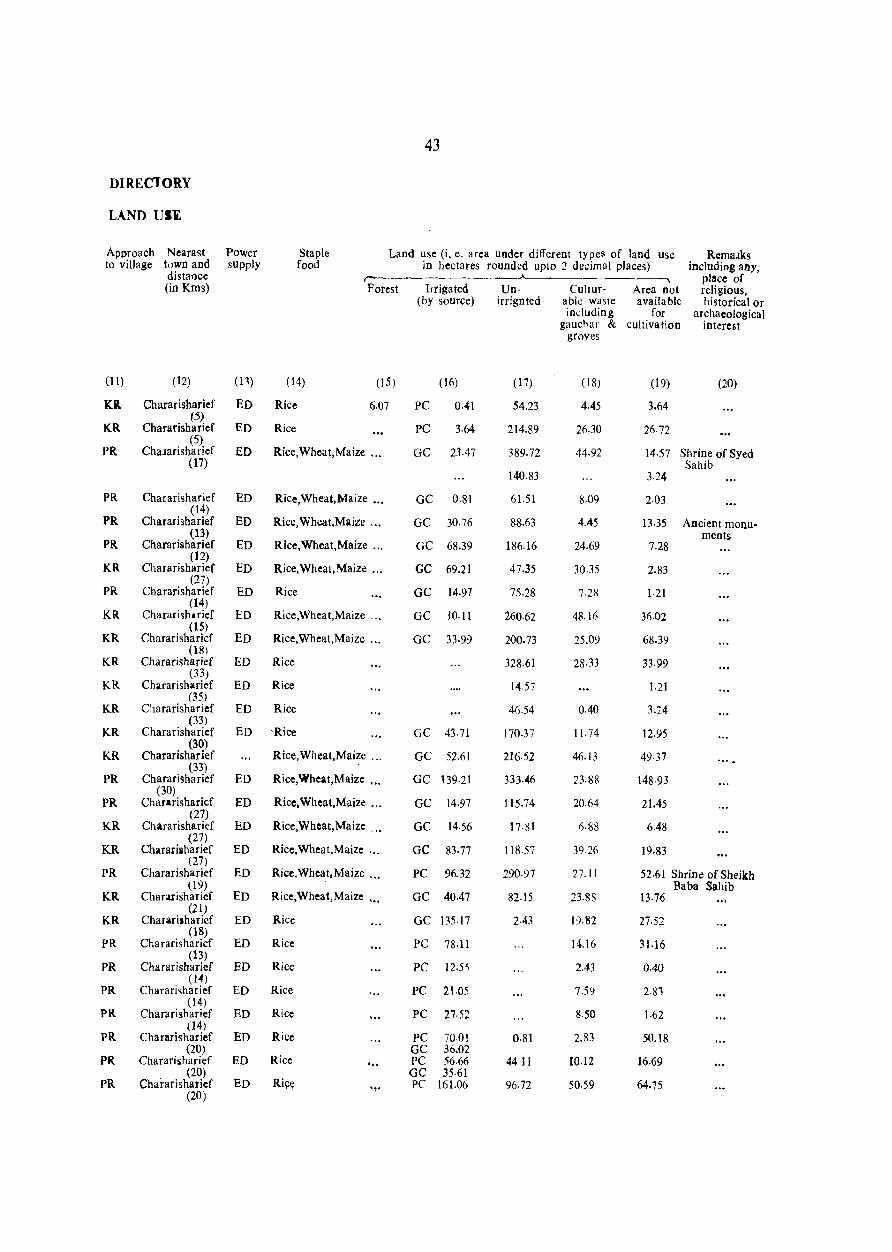
43
DIRECTORY
LAND USI
Approach Nearast Power Staple Land use (i, e. area under different types of land use Rem::uks to village town and supply food in hectares rounded up to 2 decimal places) including any,
distance pillce of (in Kms) Forest Irrigated Un- CulmT- Area not religious,
(by source) irrignted able waste available historical or including for archaeological
gauchar & cult iva lion interest groves
(11) (12) (13) (14) (15) (16) ( 17) ( 18) (19) (20)
KR. Chararisharief ED Rice 6.07 PC 0.41 54.23 4.45 3.64 (5)
KR Chararisharief ED Rice PC 3.64 214.89 26.30 26·72 (5)
PR Chalarisharief ED Rice,Wheat,Maize '" GC 23.47 389.72 44.92 14·57 Shrine of Syed (17) Sahib
140.83 3.24
PR Chararisharief ED Rice,Wheat,Maize ... GC 0.81 61.51 8.09 2·03 (14)
PR Chararisharief ED Rice,Wheat,Maize '" GC 30.76 88.63 4.45 13.35 Ancient monu-(13) ments
PR Chararisharief ED Rice,Wheat,Maize '" GC 68.39 186.16 24.69 7.28 (12)
KR Chararisharief ED Rice,Wheat,Maize '" GC 69.21 47.35 30.35 2.83 (27)
PR Chararisharief ED Rice GC 14.97 75.28 7.28 1·21 (14)
KR Chararisht rief ED Rice,Wheat,Maize ". GC 10.11 260·62 48.16 36.02 (15)
KR Chararisharicf ED Rice,Wheat,Maize '" GC 33·99 200.73 25.09 68.39 (l81
KR Chararisharief ED Rice 328·61 28·33 33.99 (33)
KR Chararishari ef ED Rice 14.57 1.21 (35)
KR Chararisharief ED Rice 46.54 0.40 3.24 (33)
KR Chararisharief ED 'Rice GC 43-71 170.37 11.74 12.95 (30)
KR Chararisharief Rice,Wheat,Maize '" GC 52.61 216-52 46.13 49·37 (33)
PR Chararisharief ED Rice,Wheat,Maize ... GC 139·21 333·046 23.88 148·93 (30)
PR Chararisharicf ED Rice, Wheat, Maize '" GC 14.97 115.74 20.64 21.45 (27)
KR Chara risharief ED Rice,Wheat,Maize ... GC 14.56 17.81 6·88 6.48 (27)
KR Charariiharief ED Rice,Wheat,Maize ' .. GC 83.77 118.57 39·26 19.83 (27)
PR Chararisharief ED Rice, Wheat, Maize ,,' PC 96.32 290.97 27.11 52·61 Shrine of Sheikh (19) Baba Sahib
KR Chararisharief ED Rice,Wheat,Maize ' •. GC 40.47 82.15 23.83 13·76 (21)
KR Chararisharief ED Rice GC 135.17 2.43 19.82 27-52 (18)
PR Chararisharicf ED Rice PC 78·11 14.16 31·16 (13)
PR Chararisharief ED Rice PC l2.55 2.43 0-40 (104)
PR Chararisharief ED Rice PC 2l.05 7.59 2·83 (14)
PR Chararisharief ED Rice PC 27.52 8.50 1.62 (14)
PR Chararisharief ED Rice PC 70.01 0·81 2.83 50.18 (20) GC 36.02
PR Chararisharief ED Rice '" PC 56.66 44 II 10.12 16.69
(20) GC 35·61 PR Charari sharief ED Ri~~ '''!. PC 161.06 96.72 50.59 64.75
(20)
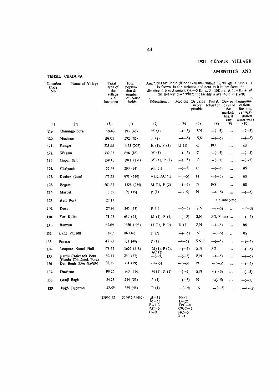
44
1981 CENSUS VILLAGE
AMENITIES AND TEHSIL CHADURA
Location Name of Village Total Total Amenities available (if not available within the village. a dash (-) Code area of popula- . is shown in the column and next to it in brackets, the
No. the tion & distance in broad ranges, viz;-5 Kms., 5-lOKms. & lO+Kms. of village number the nearest place where the facility is available is given)
lin of house- r hectares) holds Educational Medical Drinking Post & Day or Communi-
W,"~er telegraph days of cations potable the (Bus stop
marketl railway-hat, if station
any water waY) (1) (2) (3) (4) (5) (6) (7) (8) (9) (10)
119. Qanungo Pora 59.49 291 (45) M (1) -(-5) S,N -(-5) -(-5)
120. Hushroo 108.05 592 (85) P (2) -(-5) S,N -(-5) -(-5)
12l. Ranger 231.48 1435 (208) H (1), P (1) D (1) C PO BS
122, Wagarn 132.33 686 (86) M (1) -(-5) C -(-5) -(-5)
113. Gopal Saif 159.45 1041 (151) M (1), P (1) -(-5) C -(-5) -(-5)
124. Chelyach 55.44 290 (34) AC (I) -(-5) C -(-5) BS
125. Kuther Gund 175.23 971 (149) MO). AC (I) -(-5) N -(-5) BS
126. Sogam 201.13 1558 (234) M (1), P (2) -(-5) N PO BS
127. Marbal 13·35 108 (15) P (1) -(-5) N -(-5) --(-5)
128. Auli Pora 27.11 Un-inhabited
129. Doen :27.92 245 (33) P (1) -(-5) S,N -(-5) - (-5)
130. Yar Kalan 7123 639 (75) M (I), P (1) -(-5) S,N PO, Phone ." -(-5)
131. Ranzun 162.69 1380 (193) H (I), P (2) D (1) S,N -(-5) BS
132· Lang Panzun 18.62 86 (16) P (2) -(-5) N -(-5) BS
133· Porwar 43.30 301 (40) P (I) -(-5) S,N,C --(-5) -(-5)
134. Roopore Numti Hall 178.47 1629 (218) M (1), P (2), AC (1)
-(-5) S,N PO -(-5)
135. Hardu Chtichock Pora 80·13 350 (37) -(-5) -(-5) S,N -(-5) -(-5) (Hurdu Chitchocl Pora)
136 Dur iugh (Our Baugh) 30.35 314 (39) ~(-5) -(-5) N -(-5) -(-5)
137. Duchroo 90.25 863 (126) M (1), P (1) -(-5) S,N -(-5) -(-5)
138. Ganji Bagh 24.28 214 (33) P (1) -(-5) N -{-5) -(-5)
139· Bash Buchroo 42.49 339 (48) P (1) -(-5) N -(-5) -(-5)
25965·72 l0541l( I 5462) H=ll H=I M=53 D=25
P=113 FPC=8 AC=6 CWC=l 0=9 HC=3
0=1
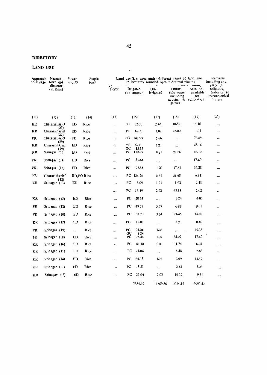
45
DIRECTORY
LAND U~I
Approach Nearest Power Staple Land use (i, e. area under different types of land use Remalks to villa&1 town and supply food in hectares rounded upto 2 decimal places) including any,
distallcl --"--- ---; place of (in Kms) forest Irrigated Un- Cultur- Area not religious,
(by source) irrignted able waste available historical liT
including for archaeological gauchar & cultivation interest
groves
(11) (12) (13) (14) (15) (16) (17) (18) (19) (20)
KR Chararisharief ED Rice PC 32.38 2.43 10.52 14.16
KR (21)
Chararisharief ED Rice PC 62.73 2.02 42.09 1.21
PR (22)
Chararisharicf ED Rice PC 148.93 5.66 76.89 (29)
KR Chararisharief ED Rice PC 69.61 1.21 48.16 (19) GC 13.35
KR Srint Kar (15) ED Rice PC 119.79 0·81 22·66 16.19
PR Srina&ar (14) ED Rice PC 37.64 17.80
PR Srin.&ar (15) ED Rice PC 123.84 1.20 17.81 32.38
PR Chararisharief ED,EO Rice PC 134·76 0.81 58.68 6.88 (12)
ED KR Srina&ar (13) Rice PC 8.09 1.21 1.62 2.43
PC 16.19 2.02 68.88 2.02
KR STinagar (15) ED Rice PC 20.63 3.24 4·05
PR Srintgar (12) ED Rice PC 49·37 5.67 6·88 9·31
PR Srinagar (20) ED Rice PC 103.20 3.24 21.45 34·80
KR Srinaeal (12) ED Rice PC 17.01 1.21 0.40
l>R Srinagar (19) Rice PC 21.04 3.24 15.78 GC 3.2.1,
PR Srinagar (18) ED Ricc PC 125.46 1.21 34.40 17.40
KR Sri nagar (16) ED Rice PC 61.10 0·81 11.74 6.48
KR Srinagar (15) ED Rice PC 21·04 6.48 2·83
KR Srinagar (14) ED Rice PC 64.75 3.24 7.69 14.57
KR Srinagar (17) ED Rice PC 18.21 2.83 3.24
KR Srinagar (13) ED Rice PC 21.04 2·02 10·}2 9·31
7884.19 11569.66 2324.15 3993.52


1EHSIL MAP
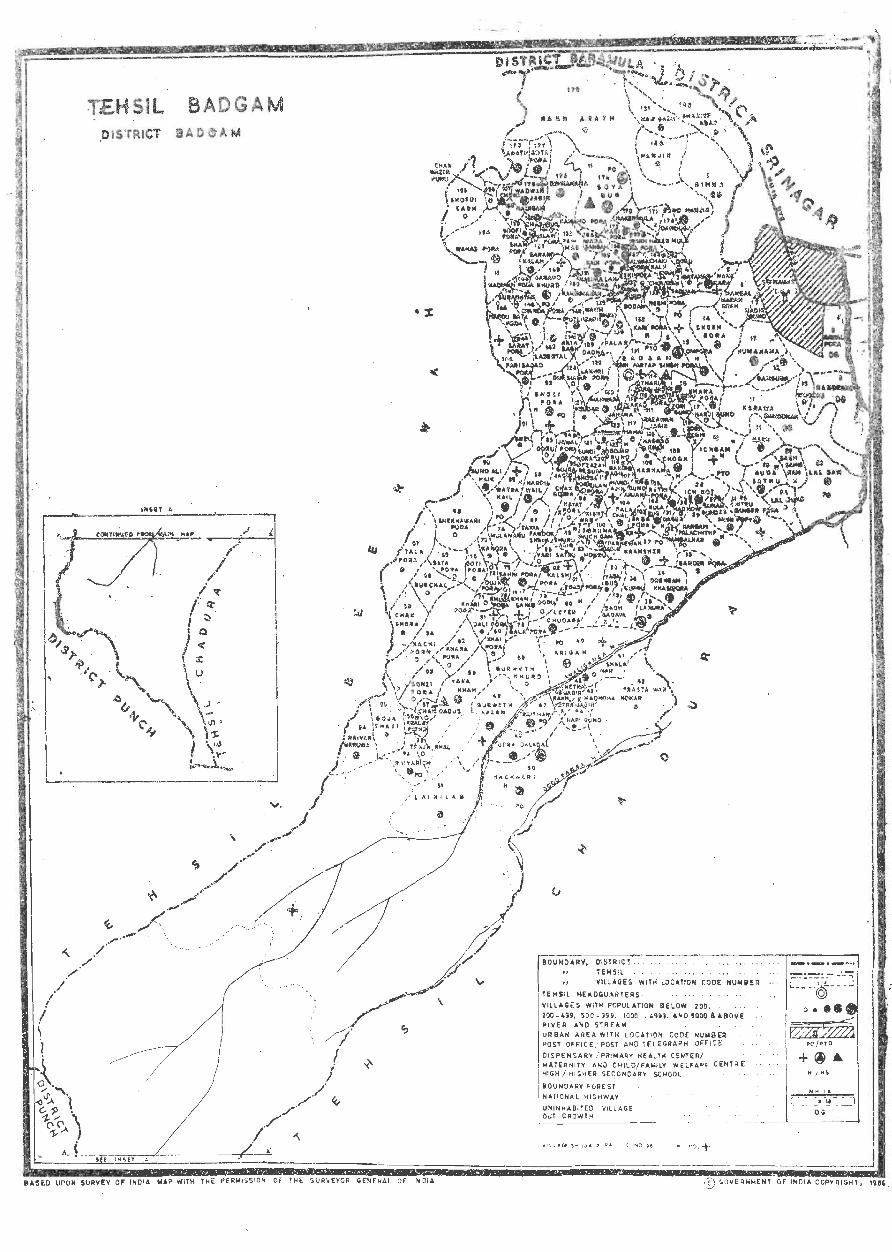
I I \ 1
"\
,/ /
·1 .;v-~ ""'\ 'i. 'P • 00 ..... \ 1- J ~
TEHSiL ,Ols 'rRICT
SURVEY OF INDI A
BADGAM
BOUNDARV, OISTR I CT 1EHSll .. '
lE~ VILLAGE S' ~ I r" .... . . . Sil HE. OC;U"'~ T ;< LOCAflOtj tOOE . . .. •
Ylll,ld;!!S WIT EAS . HIJ.IIIS£~ 20() _ U9 ~O H I'OPUL AlION . . . ~IVER ' C-~9 9. l ilO() a£LOw 200 UReA ' AND STRE .l 1A - 49H. '~D~Oo()'& .
N .... ~EA WI T A80~E P05T OFFICE ' H LOCATION C . DISPENSARy ,. POST ~NO TEltGR~~; ~~"IlER
I ~ATER NIT ( P~'~A~¥ HE r i CE I HIGH / H I .:E~N~E;'H I LO/ F:~;TL~ c;,:w IOU>! . CNDARY sc "FA·· CEHHE
DARY " ORE 5T Hu OL
NATIONA l HIGHWAY '
UNINH"'B I ~ED OuT 'ROWTH VI LL AGE
". "0.+ ._- _j
OF 11oI[;IA . COPVOIGHT, 1985
S.
No.
(1)
1.
2.
3.
4.
5.
6.
7.
8.
9.
10.
11.
12.
13.
14.
15.
16.
17.
18.
19.
20.
21.
22.
23.
24.
25.
26.
27.
28.
29.
30.
Name of Villages
(2)
Alaw pora
Arath
Arigam
Baba pora
49
ALPHABETICAL LIST OF VILLAGES
TEHSIL BADGAM
1981 S. Name of Village Locatien No.
Code No. l3) (I) (2)
162 31. Dadna
178 32. Dali pora
40 33. Dandusa
103 •. 34. Dard pora
Badgam (Sri Partap Sing pora) 131 35. Dehramana
Bagh Baqaya 38 36. Dor pora
Bagh Sahib Ram 22 37. Doru
Bala para 78 38. Doru
Bander pora 33 39. Dregam Khasi
Bandi Bagh 118 40. Dunsunar
Bata Bagh 141 41. Duja pora
Batahar 4 42. Fala ehal
Bata pora 69 43. Frasta War
Bimna 44. Galwan pora
Bodan 135 45. Gallguwa
Brari pora 81 46. Garand Kalan
Brei 91 47. Garand Khurd
Bugchal 66 48. Gojar Gund
Bugru 36 49. Goja Thaji
Chak Gojra 97 50. Gojra Jagir
Chak Kali Khan 168 51. Gota pora
Cbak Qadus 57 52. Goti pora
Chak Shera 65 53. Guda Sathu
Chak Wazir Punu })6 54. Gund Ali Naik
Chanda pora 146 55. Gund Arjan
Chata Bug 160 56. Gund Hanjik
Chewa 157 57. Gurweth Kalan
Chitru Danger pora 25 58. Gurweth Khurd
Choon 109 59. Haji Bagh
Chowderi Ba~h 134 60. Hakermula
198J
Location Code No.
(3)
129
61
170
115
175
138
79
2
pora 14
128
72
104
42
167
12
153
149
122
55
(j: _.)
177
70
20
90
106
171
48
59
lRl
172
50
s. Name of Village 1981 S. N am~ of Vii/age 1981
N •. Location No. Location
Code No. Code No.
(1) (2) (3) rJ) (2) (3)
fi1. Handajin 107 95. Ki~htwar 99
62. Hanjik 180 96. Krala Pathri 56
63. Hardu Bata rora 145 97. Kramsher 37
64. Hardu wail 88 98. Kula Bug 102
65. Hari pora 173 99. Labertal 142
66. Harji Guod 17 100. Lainilab 51
67. Harnow 30 101. Lakhri para 126
68. Hayat pora 98 102. Lal Gam 23
69. Heudar 127 103. La} Gund 24
70. Hooru 113 104. Lanura 35
71. Howru 83 105. Leter Chadura 80
72. Huma-Hama 13 106. Madnoha Nohar 43
73. Ichgam 19 107. Mahwara 125
74. Ich kot 28 108. Mamat 117
75. lahama 124 109. Mira Guod 137
76· Jawal pora 94 110. Mulanaru 74
77. Kachi porn 64 111· Muni Popy 26
78. Kachwari 50 112. Nadigam 158
113. Nadir Guod 7 79. Kadi pora 165
80. Kakin-Maran 114. N adiwan pora 148
150
81. Kalshi pora 115. Nagrad Khah 110
82 116. Nambal Narah Krah 6
82. Kamaho pora 163 117. Nambalhar 32
83. Kanora 73 118. Nara Kara 5 84. Kargam Palachithf 29 119. Nari Guod 44 85. Karhama 108 120. Naru 21 86. Kari pora 132
121- Nasirullah pora 151 87. Karewa Darnodhar 11 122, Nuch Gam 84 88. Ketra Jagir 45
123. Nunar 100 89. Khai pora 60 124. Odru 93 90. Khaoa pora 16 125. Ompora 15
91. Khan Sahib 77 126. Paimas 152 , 92. Khara pora 62 127. Palar 130
93. Khari pora 7] 128. Parisabad pora 144
94. Khuda pora 76 129. ParQjewa Jagir 101
51
S. Name of Villages 1981 S. Nam~ of Village 1981
N9. Locatil'm No. Location Code No. Code No.
(1) (2) (3) (1) (2) (3)
130. Patawaw 123 157. Soya Bug 174
131. Putli Bagh 140 158. Sozoi pora 63
132. Raithan 47 159. Sunar Gund 27 133. Raiyar Beruwa 54 160. Sundi pora 121 134. Raiyarich 53 161. Suran1J.yar 147 135. Rakh Arath 179 162. Takia Farook Shah 87 136. Rakh Haker Mula 169 163. Tala pora 67 137. Rakh Ketra Jagir 46 164. Teki pora 136 138. Rangrand 9 165. Thakur pora Jagir 114 139. Rawal pora 8 166. Tilan pora 119 140. Razawn Jagir III 167. Traja Khal 52 141. Reshi pora 133 168. Utra Dalabal 49 142. Retni pora 105 169. Wad wan Jagir 176 143. Sabdan 3 170. Wager 31 144. Sahni pora 75 171. Wahab pora 154 145. Sarad 116
172. Wara pora 166 146. Sarat pora 143
Wara Sangam 164 173. 147. Shah pora 161
174. Watra Hail 89 148. Shala Nar 41
149. Shadef Abad 182 175. Watra Wani 139
150. Shekhawari pora 68 176. Woocha 10
151. Shekh pora 14 177. Yaga Bug 39
152. Shoga pora 96 178. Yara Khah 58
153. Sholi pora 92 179. Yari Satru 86
154. Shopri Bagh 155 180. Zazah Bug 120
155. Sburu Jagir 85 18I. Zori Bagh 18
156. Soofi pora 159 182. Zori Gund 112
TEHSIL BADGAM
Location Code No.
Name of Vill<lge
(1) (2)
1. Bimna
2. Doru
3. Sabdan
4. Batahar
6. Nambal Narah Krah .
7· Nadir Gund
8. Rawal Para
9. Rangrand
10. Wooeha
l1. Kerawa Damodhar (Karawa Damodhar)
12. Ganguwa (Ganguwe)
13. Humahama
14. Shekh Pora
15. Ompora
16. Khana Pora
17. Harji Gund
18. Zori Bagh
19· Ich,am
20. Guda Sathu
21. Naru
22. Bal!h Sahib Ram
23. Lal Gam
24. Lal Gund
25. Chitru Danger Pora
26. Muni Popy .
27. Sunar Gund
28. leh Kot
29. Kargam Palachithf
30. Harnow
Total afl~a of
the village
(in hectares)
(3)
Total population& number of house-
holds
(4)
52
1981 CENSUS VILLAGE
AMENITIES AND
Amenities available (if not available within the village, a dash (-) is shown in the column and next to it in brackets, the
distance in broad ranges, viz;-5 Kms., 5-10 Kms. & 10+Kms. of the nearest place where the facility available is &iven)
,.----__ ,.A___ ___ . _________ -,
Educational Medical Drinking Post & Dayor Communi-water telegraph days of cations potable the (Bus stop
marketl railway hat, if station
any water way) (5) (6) (7) (8) (9) (10)
........................ '" ......... '" '" Treated as outgrowth of Srinagar M. C. .. ,
54·23
67.58
0.07
183.32
. .p3.57
42.09
66.37
100.36
515 17
15S.xl
47 1.46
llflo!S
50·38
10.93
463.37
140.43
262.24
7·28
87.01
21.45
96·72
115.34
23,07
253.74
167.14
57·87
,(16 (46)
479 (69)
497 (59)
199r: (227)
58 (9)
452 (57)
943 (116)
2096 (279)
610 (79)
3164 (430)
601 (8S)
33 (4)
3595 (561)
1058 (143)
717 (l00)
597 (SI)
100 (1(,)
623 (77)
531 (82)
206 (30)
1319 (I ()9)
863 (145)
344 (52)
-(-5)
M (1)
-(-5)
P(~)O(l)
-(-5)
-(-5) T
-(~5) T
-(-5) T,C
1) (I) T,C
-(-·5) T
-(-5)
-(-5)
-(-5)
-(-5)
Un-Inhabitted
-(-5)
-(-S)
BS
-(-5)
-(-5)
-(-5)
Treated as out-growth of Srinagar M. C.
Treattd as out-growth of Sri nagar M. C.
P (I) -(-5) C -(-5) BS
Treated as out-growth of Srinagar M. C.
P (ll
M (1)
-(-5) T,C
-(-5) T,C
--(-5) -(-5) T
H(I),MO) DO) T
P (2) -(-5) T
-(-5) -(-5) C
H (I), M (2)
H (I), M (2)
M (1)
P (I)
--(---5)
M (1)
M (1)
-(-5)
H (1), M (I)
H (1)
-(--5)
D (1) C
-(-5) C
-(-5) C
-(-5) C
-(-S) C
D (I) C
-(-5) C
-(-5) C
-(-5) C
-(-5) C
-(-5) N,C
-(-5)
-(-5)
-(-5)
PO
-(-5)
-(-5)
Un· Tnhabittcd
-(-5)
BS
-(-5)
BS
-(-5)
-(-5)
PO, Phones ... BS
-(-5) -(-5)
-(--5) -(-5)
Un-Inhabitted
PO
-(-5)
-(-5)
-(-5)
-(-5)
-(-5)
-(-5)
-(-5)
-(-5)
-(-5)
-(-5)
-(-5)
BS
BS
BS
-(-5)
53
DIRECTORY
LAND USE
Approach Nearest Power Staple Land use 0, e. area under different types of land use Remalk.s to village town and supply food in hectares rounded upto 2 decimal places) including any,
distallce , ..... ____A___ place of (in Kms) Forest Irrigated Un- CuHur- Area not religions,
(by source) irrigated able waste available historical or including for archaeological
gauchar & cultivation interest groves
(11) (12) (13) (14) (15) (16) (17) (I8) (19) (20)
KR Srinaaar (8) EA Ric~ PC 44.11 4.86 5·26
KR Sri nagar (8) EA Rice GC 51.80 11.33 4.45
PR Srinagar (9) EA Rice GC 31.57 6.07 2.43
PR Sri.agar (8) EA Rice GC 126.67 47.75 8·90
PC 2.D2 269·12 2·43
PR Srinagar (7) EA Rice PC 8.50 6.07 21.04 6·48
PR Srinagar (6) EA Rice PC 18.62 23.07 22.25 2.43
PR Srinagar (8) EA Rice PC 30·35 25.90 37.23 6.88
PR Sri nagar (8) EA Rice PC 117·36 233·10 104·01 60.70
KR Srim:gar (7) EA Rice GC 46.13 62.73 40.47 6,48
PR Srinagar (8) EA Rice GC 229·05 116.15 109.26 17.00
KR Srinagar (15) EA Riee PC 34.40 44.11 29.95 7.69
KR Srinagar (20) EA Rice PC 9·31 0,40 1.62 4.05
PC 6.48 1.62 2.02 0.81
PR Srinagar (18) EA Rice PC 262.24 38·04 114.53 48.56
PR Srin.gar (22) EA Rice PC 89.03 4.46 22.66 24.28
KR Srin~gar (22) EA Rice PC 43.30 1.21 177.66 <40.07
PC 4.45 1·21 0.81 0.81
PR Srinagar (22) EA Rice PC 34.40 23.88 12.95 15·78
PR Srinagar (22) EA Rice PC 17.81 0.40 3.24
KR Srinagar (4) EA Rice PC 62.32 6·88 15.78 1 I. 74
KR Sri nagar (22) EA Rice PC 85.39 3.24 19.02 7.69
PR Srinagar (20) EA Rice PC 12.14 1.21 6.48 3.24
PR Sri nagar (19) EA Rice PC 139.62 22.66 74,46 17.00
PR Srinagar (23) EA Riec PC 109·68 0.80 40.88 15.78
KR Srinagar (23) EA Rice PC 36.83 1.21 16.19 3.64
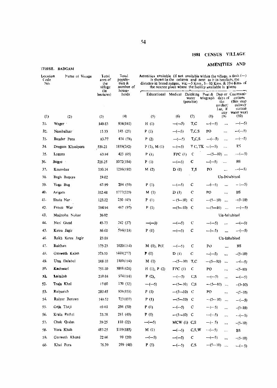
TEHSIL BADGAM
Location Code No.
Name of Village
(1) (2)
31. Wager'
32. Nambalhar'
33. Bander Pora
34. Dregam Khasipora .
35. Lanura
36. Bugru
37. Kramsher
38· Bagh Baqaya
39. Yaga Bug
40. Arigam
41. Shala Nar.
42. Frasta War
43. Madnoha Nohar
44. Nari Gund
45. Ketra Jagir
46. Rakh Ketra Jagir
47. Raithan
4~. Gurweth Kalan
49. Utra Dalabal
s~. Kachwari
'1. Lainilab
52. Traja Khal
53. Raiyarich
54. Raiyar Berllwa
55. Goja Thaji
56. Krala Pathri
57. Chak Qadus
58. Yara Khah
59. Gurweth Khurd
60. Khai Pora
10tal area of
the village
(in hectares)
(3)
140.83
11.33
83.77
536.21
63.94
228.25
150.14
19.02
67.99
352.48
122.22
184.94
36.02
45.73
86.60
23.88
175·23
373.53
188·18
751.10
2}o·S4
17.00
280.45
148·52
69.61
32.78
39·25
487.25
22.66
76,39
lolal population& number of house-
holds
(4)
934(141)
145 (21)
474 (78)
1819(292)
423 (65)
1072(184)
1216(192)
294 (50)
1777(328)
230 (43)
467 (97)
242 (37)
594(118)
1020(194)
1469(277)
1100(194)
3098(626)
974(188)
170 (32)
936(158)
723 (137)
296 (50)
281 (49)
110 (22)
1119(185)
99 (20)
299 (48)
54
1981 CENSUS VILLAGE
AMENITIES AND
Amenities available (if not available within the village, a dash (-) is shown in the column and next to it in brackets, the
distance in broad ranges, viz;-5 Kms., 5-10 Kms. & 10+l{ms. of the nearest place where the facility available is given)
r- .-., Educational Medical Drinking Post & Day or Communi
water telegraph days of cations (potable) the (Bus stop
marketl railway La!, if station
any water way) (5) (6) (7) (8) (9) (10)
H (1) -(-5) T,C -(-5) -(-5)
P (1)
P (2)
PO), M (1)
P (1)
P (1)
M (2)
P (I)
M (1)
P (1)
P (1)
-(-5)
p (1)
M 0), P(t:
l' (I)
M (1)
H (I), P (2)
P (2),
-(-5)
P (1)
P (1)
P (I)
P (1)
-(-5)
M (1)
-(-5)
P (1)
-(-5) T,C,S PO
-(-5) T,e,S -(-5)
-(-5) T C, TK -(-5)
FPC (1) C
-(-5) C
D (1) T,S
-(5-10) ...
-(-5)
PO
-(-:-5)
-(-5)
1'S
-(-5)
as ~(-5)
Un·Inhabitted
-(-5) C
D (I) C
-(5-to) C
-(5-to) C
-(-5)
PO
-(5-10)
-(5-10)
-(-5)
BS
-(5-10)
-(-5)
Un-Inhabited
-(-5) C -(-5) -(-5)
-(-5) e -(-5) -(-5)
Un-Inhabited
-(-5) C
D (1) C
-(5-10) T,C
FPC (1) C
-(-5) C,S
-(5-10) C,S
-(5-10) C
-(5-10) C
-(-5) C
-(5-10) C
MCW (I) C,S
P0
-(-5)
-(5-10)
PO
-(-5)
-(5-10)
PO
-(5-10)
-(-5)
-(-5)
-(-5)
--(-5) e,s,vv -(--5)
-(-5) C -(-5)
-(-5) e,s --(5-10)
:BS
-(5-10)
-(-5)
-(5-10)
-(-5)
-(5-10)
-(5-10)
-(-5)
-(5-10)
-(-5)
-(5-to)
BS
-(5-10)
-(-5)
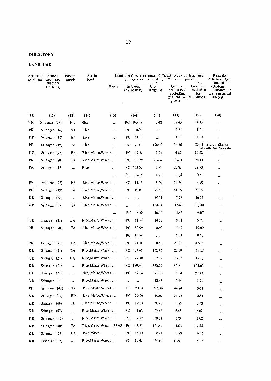
DIRECTORY
LAND USE
Approach to village
Nearest town and distallce (in KIns)
(11) (12)
KR Srinagar (28)
PR Srinagar (16)
KR Srinagar (18)
PR Srinagar (19)
KR Srinagar (25)
PR Srinagar (20)
PR
PR
PR
Srinagaf (17)
Srinagar (25)
Srin gar (19)
KR Srinagar (23)
KR Srinagar (35)
KR Sri nagar (25)
PR Srinagar (20)
PR
KR
KR
Srinagar (21)
Srinagar (22)
Srinagar (22)
KR Srinagar (22)
KR Srinalar P2)
KR Srinagar (43)
Plt Srinagar (48)
KR Srinagar (48)
KR Srinagar (40)
KR Srinagar (43)
KR Srinagar (40)
KR
KR
KR
Srinagar (40)
Srinagar (22)
Srinagar (n)
55
Power supply
Staple food
Land use 0, e. area under different types of land use in hectares rounded upto 2 decimal places)
Remalks including any,
place of religious, historical or
archaeological interest
" Forest
(13) (14) (15)
EA Rice
EA Rice
EA Rice
EA Rice.Maize,Wheat ...
EA R.ice,Maize, Wheat ...
Rice
EA Rice,Maize,Wheat ...
EA Rice,Maize,Wheat '"
Rice,Maize,Wheat ..
EA Rice.Mai1e,Wheat _.
EA Rice,Maize, Wheat
EA Rice,Maize,Wheat ...
EA Rice,Maize,Wheat ...
EA Riee,Maize,Wheat ...
EA Rice,Maize,Wheat '"
Rice,Maize,Wheat '"
Rice, Maize,Wheat ...
Rice,Maize,Whc:.!t ...
ED Rice,Maize,Wheat ...
ED Rice,Maize,WI.eat ...
ED Rice,Maize,Wheat ...
Rice,Maize,Wheat •..
Rice,Maile,Wheat ...
Irrigated (by source)
(16)
PC 100.77
PC 8.91
PC 53-42
PC 174·01
PC 47.35
PC 102.79
PC 105.62
PC 13.35
PC 44.11
PC 140.83
PC 8.50
PC 11.74
PC 50.99
PC 19.84
PC 91.46
PC 103.61
PC 77-30
PC 169.97
PC 82.96
PC 20.64
PC 99.96
PC 19.83
PC 1.62
PC 9.72
EA Rice,Maize,Wheat 196.68 PC 105.23
EA Rice,Wheat PC 15.38
Rice,Maize,Wheat '" PC 21.45
Unirrigated
(17)
6.48
198'30
1.21
63.94
0·81
1.21
3.24
78.51
94.71
150.14
16·59
14.57
8·90
8.50
152.97
62.32
370.29
97·13
12.55
203.56
19-02
40.47
22-66
20.23
131.52
0.41
34.S0
----~
Culturable waste including
gauchar & groves
(18)
19.43
1.21
18.61
74.46
4·86
26.71
23-88
3.64
11·i4
56·25
7.28
17.40
4,86
9·71
7·69
3.24
27·92
25.09
33. 18
87.81
3.64
3.24
46.94
28.73
6·88
6.48
7.28
41.68
0.80
14.97
Area not available
for cultivation
(19)
14.15
1·21
11. 74
(20)
89.44 Ziarat Sheikh Nooru-Din Noorani
10.52
34.81
19.83
0.82
8.90
76·89
20.23
17.40
6.07
9·71
19·02
0.80
47·35
91.86
15.38
123.03
27-11
1.71
9·31
0.81
2.43
2.02
2.02
12.14
6.07
5.67
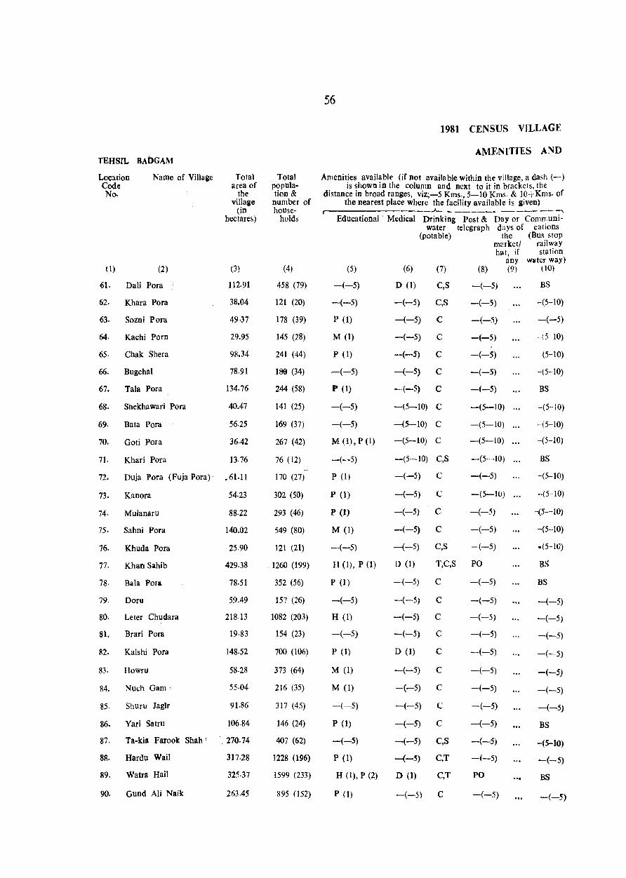
TEHSIL BADGAM
Location Code No.
0)
Name of Village
(2)
61. Dali Pora :
62. Khara Pora
63. Sozni Pora
64. Kachi Porn
65· Chak Shera
66. Bugchal
67. Tala Pora
68. Shekhawari Pora
69. Bata Pora
70. Goti Pora
7I. Khari Pora
Total area of
the village
(in hectares)
(3)
112.91
38.04
49·37
29.95
98.34
78.91
134.76
40.47
56.25
36.42
13.76
72. Duja Pora (Fuja Pora)' .61.11
73. Kanora 54·23
74· Mulanaru 88·22
75. Sahni Pora 140.02
76. Khuda Pora 25.90
n Khan Sahib 429.38
78. Bala Pora 78·51
79. Doru 59.49
80. Leter Chudara 218.13
81. Brari Pora 19.83
82. Kalshi Pora 148.52
83. Howru 58·28
84. Nuch Gam' 55·04
85. Shuru Jaglr 91.86
86. Yari Satru 106.84
87. Ta-kia Farook Shah' , 270.74
88. Hardu Wail 317·28
89. Watra Hail 325.37
90. Gund Ali Naik 263.45
Total population & number of house-
holds
(4)
458 (79)
121 (20)
178 (39)
145 (28)
241 (44)
189 (34)
244 (58)
141 (25)
169 (37)
267 (42)
76 (12)
170 (27)
302 (50)
293 (46)
549 (80)
121 (21)
1260 (199)
352 (56)
157 (26)
1082 (203)
154 (23)
700 (106)
373 (64)
216 (35)
317 (45)
146 (24)
407 (62)
1228 (196)
1599 (233)
895 (152)
56
1981 CENSUS VILLAGIf
AMENITIES AND
Amenities available (if not available within the village, a dash (-) is shown in the column and next to it in brackets, the
distance in broad ranges, viz;-5 Kms., 5-10 Kms. & IO+Kms. of the nearest place where the facility available is given)
Jo-.__ ___ • ---,
Educational' Medical Drinking Post & Day or Comffiuniwater telegraph days or cations
(potable) the (Bus stop
(5)
-(-5)
-(-5)
P (1)
M (1)
P (1)
-(-5)
P (1)
-(-5)
-(-5)
M (1), P (1)
-(-5)
P (1)
P (1)
P (1)
M (I)
-(-5)
H (1), P (1)
P (1)
-(-5)
H (1)
-(-5)
P (1)
M (1)
M (1)
-(-5)
P (1)
-(-5)
P (1)
H (1), P (2)
P (1)
(6)
D (1)
-(-5)
(7)
C,S
C,S
-(-5) C
-(-5) C
-(-5) C
-(-5) C
-(-5) C
-(5-10) C
-(5-10) C
-(5-10) C
-(5-10) C,S
-(-5) C
-(-5) C
-(-5) G
-(-5) C
-(-5) C,S
D (1) T,C,S
-(-5) C
-(-5) C
-(-5) C
-(-5) C
D (1) C
-(-5) C
-(-5) C
-(-5) C
-(-5) C
-(-5) C,S
-(-5) C,T
D (1) C,T
-(-5) C
marketl railway hat, if station
(8)
-(-5)
-(-5)
-(-5)
-(-5)
-(-5)
-(-5)
-(-5)
-(5-10)
-(5-10)
-(5-10)
-(5-10)
-(-5)
-(5-10)
-(-5)
-(-5)
-(-5)
PO
-(-5)
-(-5)
-(-5)
-(-5)
-(-5)
-(-5)
-(-5)
-(-5)
-(-5)
-(-5)
-(-5)
PO
-(-5)
any water way) (9) (10)
BS
-(5-10)
-(-5)
- (5 10)
-(5-10)
-(5-10)
BS
-(5--10)
-(5--10)
-(5-10)
BS
-(5-10)
-(5-10)
-(5--10)
-(5-10)
-(5-10)
BS
BS
-(-5)
-(-5)
-(-5)
-(-5)
-(-5)
-(-5)
--(-5)
BS
-(5-10)
-(-5)
BS
-(-5)
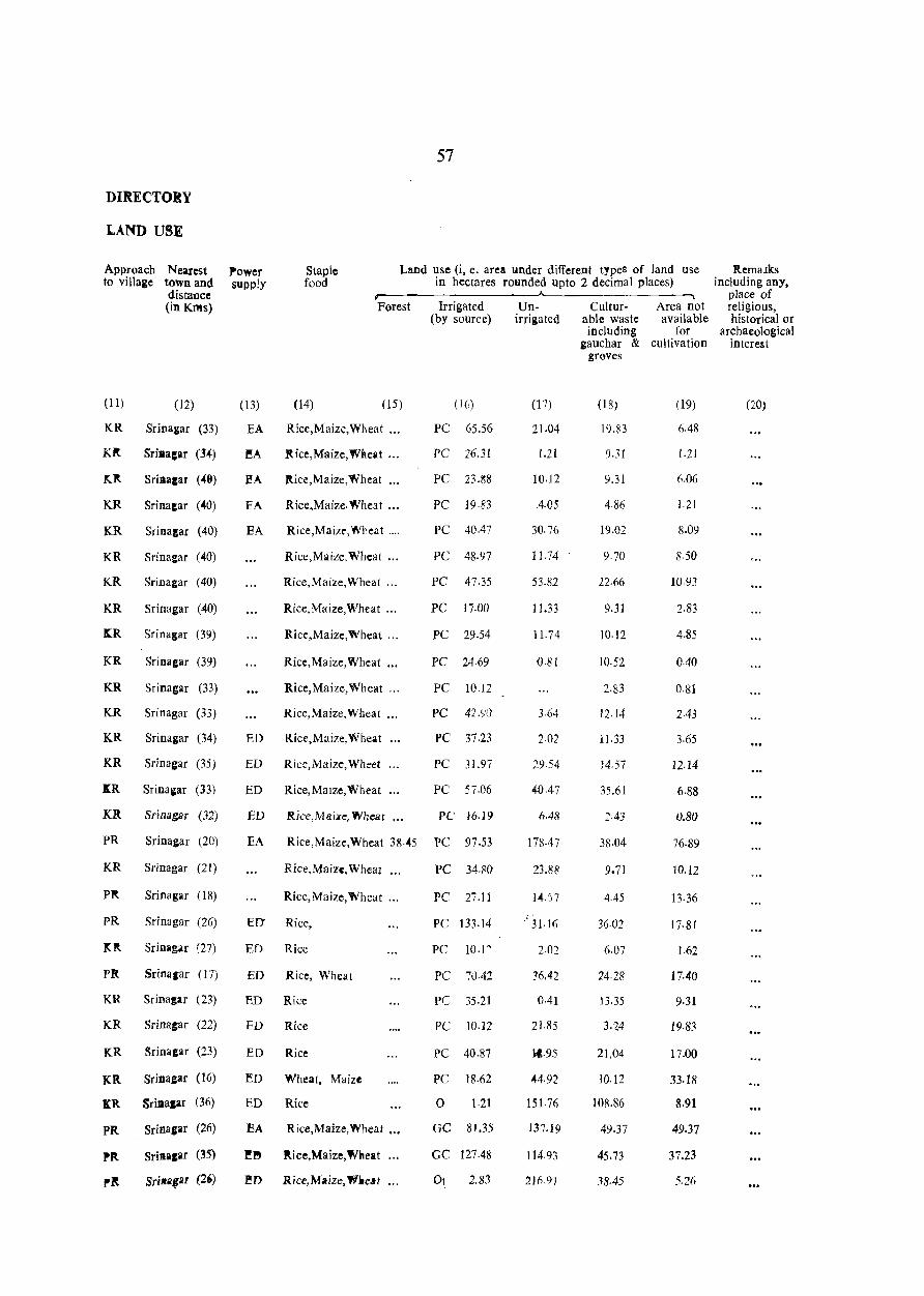
DIRECTORY
LAND USE
Approach to village
Nearest town and distallce (in KIlls)
(11)
KR
Klt
(12)
Sri nagar (33)
Sriucar (34)
~~ Srillacar (40)
KR Srina:ar (40)
KR Srina&ar (40)
KR Srinagar (40)
KR Srinagar (40)
KR Srinagar (40)
~R Sri nagar (39)
KIt
KR
KR
KR
Srinagar (39)
Srinagar (33)
Srinagar (33)
Sri nagar (34)
KR Srinagar (35)
I:R Srinagar (33)
KR
PR
KR
Pit
pR
Srinagar (32)
Srinagar (20)
Srinagar (21)
Srinagar (18)
Srinagar (26)
lClt Sri nagar (27)
PI<. Sri nagar (17)
KR Srinagar (23)
KR Srinagar (22)
KR Srinagar (23)
KR Srinagar (16)
"R Srillalar (36)
PIt Srina,ar (26)
PIt
p~
Sri_agar (35)
SriltliQar (2')
57
Power supply
Staple food
Land use (i, e. area under different types of land use in hectares rounded upto 2 decimal places)
~------------------~---------------~
(13)
EA
l!A
Forest
(14) (15)
Rice,Maizc,Wheat ...
.fit ice, Maize, Wl!.eat ...
EA ltice,Maize,Wheat ...
FA Rice,Maize.Wheat .••
EA Rice,Maize,Wheat ....
Rice,Maize, Wheat ...
Rice,Maize, Wheat ...
Rice,Maize,Wheat '"
Rice,Maize,Wheat '.,
Rice,Maize,Wheat ...
Rice,Maize,Wheat ...
Rice,Maize,Wheat '"
ED Rice,Maize,Wheat ...
ED Rice,Maize, Wheet
ED Rice,MaJze, Wheat
ED Rice,Maize, Wheat •..
Irrigated (by source)
(1(,)
PC 65.56
PC 26.31
PC 23.~8
PC 19.83
PC 40.47
PC 48·97
PC 47.35
PC ]7.00
PC 29.54
PC 24.69
PC 10.12
PC 42.(jO
PC 37.23
PC 31.97
PC 57.06
PC 16.19
EA Rice,Maize, Wheat 38·045 PC 97.53
Rice,Maize, Wheal ...
Rice,Maize,Wheat ...
ED' Rice,
ED Rice
ED Rice, Wheat
ED Rice
ED Rice
ED Rice
ED Wheat, Maize
ED Rice
EA Rice,Maize,Wheat •.•
~" ltice,Maize,Wneat
1!D Rice, Maize, W.eM
PC 34.80
PC 27.11
PC 133.14
PC 10.1"
PC ':\1.42
PC 35.21
PC 10.12
PC 40.87
PC 18·62
o 1·21
GC 81.35
GC 127.48
2.83
Unirrigated
(17)
21.04
1.21
10·12
4·05
30.76
11.74
53.82
11.33
11.74
0.81
3.64
2.02
29.54
40.47
6.48
178·47
23,88
14.')7
, 31·16
36.42
0.41
21,85
}t.95
44·92
151.76
137.19
114,93
2){19)
Culturable waste including
gauchar & groves
(18)
19.B3
9.31
9,31
4.86
9.70
22.66
9.31
10.12
10.52
2·83
12.14
11.33
14.57
35.61
2·43
38.04
9.71
4.45
36.02
6.07
24·28
lJ.35
21.04
10.12
108.86
49.37
45.73
.18.45
Area not available
for cultivation
(19)
6.48
1,21
6.06
1.21
8,09
8·50
10·93
2.83
4.85
0.40
0·81
2.43
3.65
12.14
6.88
0.80
76,89
10.12
13.36
17,81
1.62
17.40
9,31
19.83
17,00
33.18
8.91
49.37
37.23
5.26
Remalks including any,
place of religious, historical or
archaeological interest
(20)

S8
1981 CENSUS VILLAGE
AMEl\ITIES AND TEHSIL BADGAM
Location Name of ViJlage Total Total Amenities available (if not available within the villCige a dash (-) Code area of popuJa- is shown in the column and next to it in brackets the No. the tion & distance in broad ranges, viz;-5 Kms., 5-IOKms. & 10+Kms. of
village number the nearest place where the facility is available is given) (in of house- r- -.
hectares) holds Educational Medical Drinking Post & Day or Communi-water telegraph days of cations
(potable) the (Bus stop market! railway·
hat, if station any water way)
(J) (2) (3) (4) (5) (6) (7) (8) (9) (10)
91. BreI 89.44 342 (53) P (1) -(-5) C,T -(-5) BS
92. ShoH Pora 411.17 1987(275) H(I),P(1) D (1) C,T PO BS
93. Odru 72.84 177 (2~) P (I) -(-5) C,T -(--5) -(-5)
94. Jawal Pora ! 324.16 1340(198) M(I),P(l) D (I) C,T PO -(-5)
95. Gojra Jagir 207.20 419 (65) P (2) -(-5) C,T -(-5) -(-5)
96. Shoga Pora 38.G4 291 (48) H(1),M(I),P(l) D (1) C,T PO BS
97- Chak Gojra 13.35 Un-Inhabited
98. Bayat Pora 49.78 196 (27) P (1) -(-5) , C,T -(-5) BS
99. Kishtwar 175.64 620 (93) M(l),P(l) -(-5) C,T -(-5) BS
100. NUnar 118.98 576 (93) P (I) -(-5) C -(-5) BS
101. Parnewa J agil 258.19 1337(205) M(I),P(l) D (1) C,T -(-5) -(-5)
102. Kula Bug 96·72 629 (&4) P (1) -(-5) C,T -(-5) -(-5)
103. Baba Pora 33·18 114 (20) -(~5) -(-5) C -(-5) -(-5)
104. Fala Chal 158.64 820(111) M(l),P( 1) -(-5) C -(-5) BS
105. Retni Pora 32·38 134 (25) -(-5) -(-5) C -(-5) -(-5) (Reni Pora)
106. Gund Arjan 26.30 193 (34) -(-5) -(-5) C,T -(-5) -(-5
107. Handajin 118.57 379 (61) H (1) D (1) C -(5-10) -(5-10)
108 Karhama 61.92 251 (30) M (1) -(-5) C,T -(5-10) -(5-10)
109. Choom 226.63 1273(145) H(1),M(1) -(-5) C,T -(5-10) -(5-10)
110. Nagrad Khah 50·59 299 (45) -(-5) -(-5) C -(-5) -(-5)
111. Razawn Jrgir 148.93 2"7(145) M(1),P(l) -(-5) C -(-5) -(-5) (Razawan Jagir)
112. Zori Gund 129.50 572 l i!\) M (1) -(-5) C -(-5) -(-5)
113. Hooru 28·33 193 (28) M(l) -(-5) C,T -(-5) -(-5)
114. Thakur Pora Jagir . 25·50 205 (28) -(-5) -(-') C -(-5) -·(-5) (Thukur Pora Jagir)
115. Dard Pora 3t.97 144 (19) --(-5) -(-5) C -(-5) -(-5)
116. Sarad 8·50 Un-Inhabited
117. Mamat 151.76 457 (69) H(l),M(l) -(5-10) C -(5-10) -(-5)
118· Bandi Baga 52.21 278 (51) P (1) -(-5) C,T -(-5) -(-5)
119. Tilan Pora 29.95 142 (29) -(-5) -(-5) C,T -(-5) -(-5)
120· Zazah Bug 110.08 433 (78) P (1) -(-5) C,S,! PO -(-5)
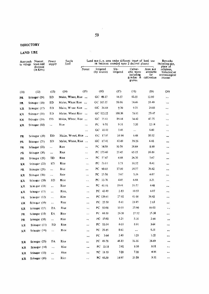
DIRECTORY
LAND USE
Staple food
59
Land use (i, e. area under different types of land use in hectares rounded upto 2 decimal places)
Approach to vill~ge
Nearest town and distance (in Kms)
Power supply
~------------------.~------------------. Forest
(11) (12) (13) (14) (15)
Pa. Sri nagar (24) ED Maize, Wheat, Rice
Pit Sri nagar (18) ED Maize, Whcat Rice
KR Srinagar (17) ED Maize, Wheat Rice
KR Srinagar (18) ED Maize, Wheat Rice
KR Sri nagar (19) ED Maize, Wheat, Rice
KR Srinagar (18) Rice
PR Srinagar (20) ED Maize, Wheat, Rice
PR Srinagar (21) EO Maize, Wheat, Rice
PR Srinagar (22) Rice
PR Sri nagar (30) Rice
PR Srinagar (20) ED Rice
KR Srinagar (22) ED Rice
PR Srinagar (21) Rice
KR Sri nagar (16) Rice
KR Srinasar (20) ED itice
KR SrinClgar (18) Rice
KR Srinagar (13) Rice,
PR Srinagar (12) Rice
KR Srinagar (16) Rice
KR Sri nagar (15) EA Rice
PR Srinagar (15) EA Rice
PR Srinagar (10) Rice
KR Sri nagar (11) ED Rice
KR Srinagar (14) Rice
KR Srinagar (23) EA Rice
KR Sri nagar (14) Rice
KR Srinagar (15) Rice
KR Srinagar (16) Rice
Irrigated Un- Cultur- Area not (by source) irrigated able waste available
(16)
GC 49.37
GC 185·35
GC 34.40
GC 122.22
GC 35.61
PC 9.31
GC 10.12
GC 1?81
GC 87.41
PC 34.80
PC 155.40
PC 57.47
PC 21.0t
PC 90·65
PC 15.38
PC 13.76
PC 61.91
PC 42-49
PC 120.61
PC 25.50
PC 93.08
PC 60.30
PC 19.02
PC l2.14
PC 21.85
PC 3.64
PC 49.78
PC 33.18
PC 11·33
PC 60.30
(17)
14.57
99.96
~.30
100.36
89.44
9·31
2.43
14.94
42.49
50.59
21.45
6·88
1.21
17.00
5.67
4.45
18.61
2·83
27·92
0.41
10.93
26.30
1.21
0·81
0·81
2.43
46.13
2.02
7.28
14·97
including for gauchar & cultivation
groves
(18)
12.55
74.46
9.31
78.11
34.40
7.20
6.48
39.26
24.69
65.15
26.70
10.52
14·57
5.26
6.88
31·57
10.53
4168
21.85
25.90
27·52
5·2.6
8.9\
1.21
31.16
8.50
7.28
25·50
(19)
12.95
51.40
19.83
23.47
47.75
12.14
8.80
10.52
6.48
8.90
16.19
5.67
0.41
36.42
6.07
1.21
6.48
6.07
36.42
283
19.02
15.38
2·84
3.64
9.31
J.22
24.69
8.51
4.86
9·31
Remalks including any,
place of religious, historical or
archaeological interest
(20)
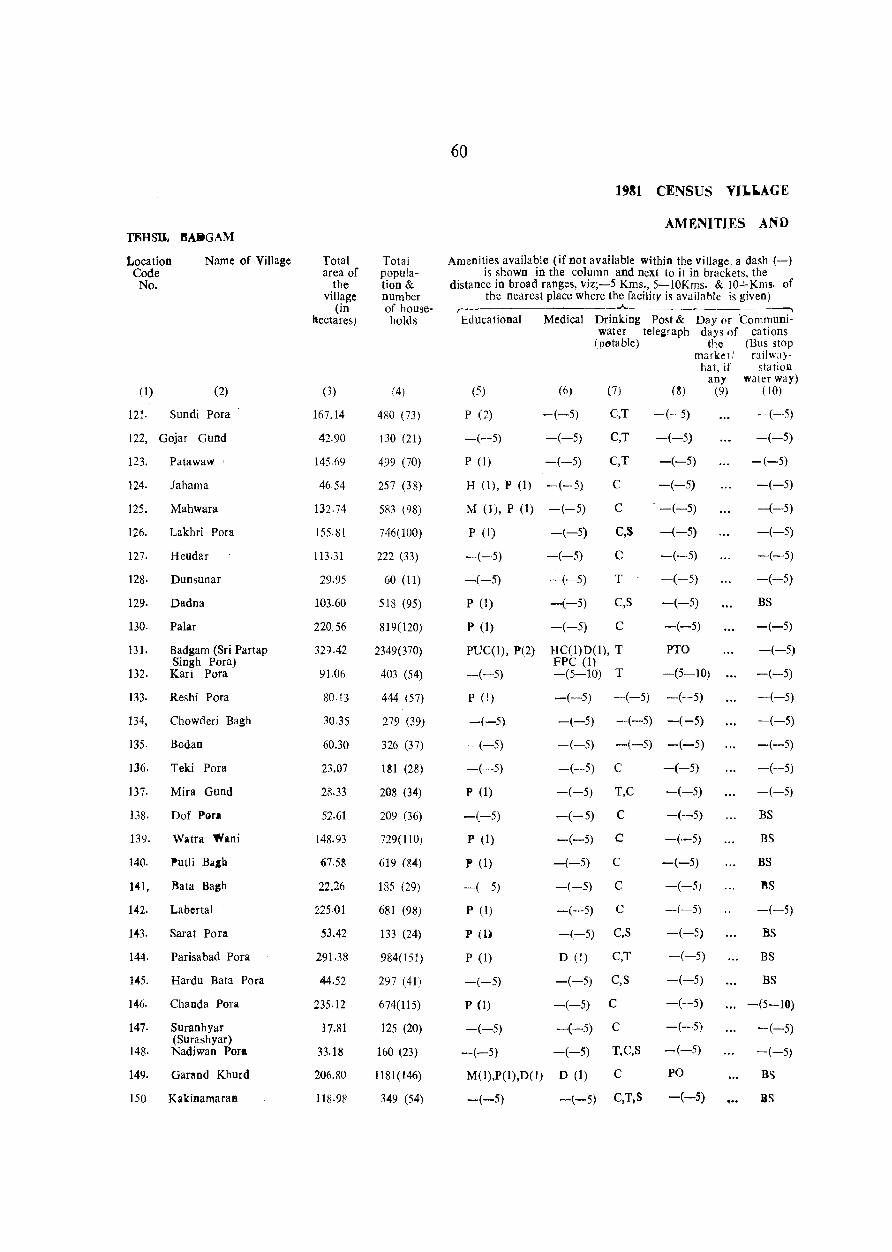
60
1~81 CENSUS YIJ."AGE
AMENITIES AND T8HSlt ftAlitGAM
Location Name of Village Total Total Amenities available (if not available within the village. a dash (-) Code area of popuJa- is shown in the column and next to it in brackets, the No. the tion & distance in broad ranges, viz;-5 Kms., 5-10Kms. & 10+Kms. of
village number the nearest place where the facility is available is given) (in of house-
, _____ ~ ___ .A. ___________ ,
hectares) holds Educational Medical Drinking Post & Day or 'Communi-water telegraph days of cations
(potable) t11e (Bus stop market! railwa)'
hat, if station any water way)
(1) (2) (1) (4) (5) (6) (7) (8) (9) (10)
121. Sundi Pora 167.14 480 (73) P (2) -(-5) C,T -(-5) -(-5)
122, Gojar Gund 42.90 130 (21) -(-5) -(-5) C,T -(-5) -(-5)
123. Patawaw ' 145·(-,9 499 (70) P (1) -(-5) C,T -(-5) -(-5)
124. Jahama 4654 257 (38) H (1), P (1) -(-5) C -(-5) -(-5)
125. Mahwara 132.74 583 (98) M (1), P (1) -(-5) C -(-5) -(-5)
126. Lakhri Pora 155.81 746(100) P (1) -(-5) C,S -(-5) -(-5)
127. Heudar 113.31 222 (33) -(-5) -(-5) C -(-5) -(-5)
128· Dunsunar 29.95 60 (11) -(-5) -(-5) T -(-5) -(-5)
129. Dadna 103.60 518 (95) P (1) -(-5) C,S -(-5) BS
130. Patar 220.56 819(120) P (1) -(-5) C -(-5) -(-5)
131. Badgam (Sri Partap 32().42 2349(370) PUC(I), P(2) HC(1)D(1), T PTO -(-5) Singh Pora) FPC (1)
132. Karl Pora 91.06 403 (54) -(-5) -(5-10) T -(5-10) -(-5)
133. Reshi Pora 80.13 444 (57) P (1) -(-5) -(-5) -(--5) -(-5)
134, Chowderi Bagh 30.35 279 (39) -(-5) -(-5) -(-5) -(-5) -(-5)
135. Bodan 60.30 326 (37) -(-5) -(-5) -(-5) -(-5) -(-5)
136. Teki Pora 23.07 lSI (28) -(-5) -(-5) C -(-5) -(-5)
137. Mira Gund 28.33 208 (34) P (1) -(-5) T,C -(-5) -(-5)
138. Dof Pgra 52.61 209 (36) -(-5) -(-5) C -(-5) BS
139. Watra 'fillni 148.93 729(110) P (1) -(-5) C -(·-5) BS
140. Putli Ball! (;7.58 6]9 (~4) .P(1) -(-5) C -(-5) BS
141, Bata Bagh 22.26 185 (29) -(-5) -(-5) C -(-5) BS
142. Labertal 225·01 681 (98) P (1) -(-5) C -(-5) -(--5)
143. Sarat Pora .53.42 133 (24) pm -(-5) C,S -(-5) BS
144. Pari sa bad Pora 291.38 984(151) P (1) D (1) C,T -(-5) BS
145. Hardu Bata Pora 44.52 297 (41) -(-5) -(-5) C,S -(-5) BS
146. Chanda Pora 235·12 674(115) P (1) -(-5) C -(--5) -(5-10)
147. Suranhyar 17.81 125 (20) -(-5) -(-5) C -(-5) -(-5) (Surashyar)
-(-5) 148· Nadiwan Pora 33.18 160 (23) -(-5) -(-5) T,C,S --(-5)
149. Garand Khurd 206.80 1181(146) M(J),P(I),D(l) D (1) C PO BS
150 Kakinamaran 118.9~ 349 (54) -(-5) -(-5) C,T,S -(-5) ... BS
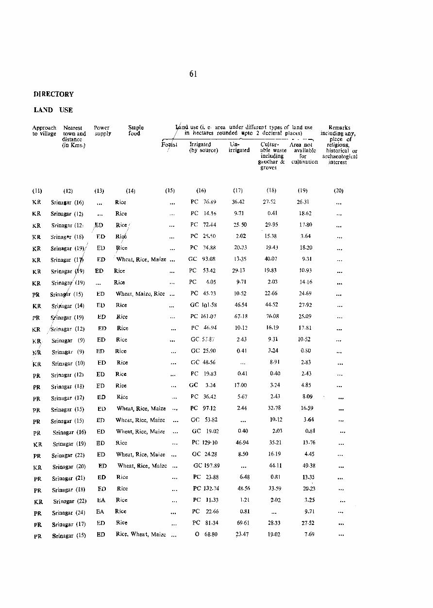
DIRECTORY
LAND USE
Approach to village
(11)
Nearest town and distance (in Kms.)
(12)
KR Srina&ar (16)
KR Srinagar (12)
Power supply
(13)
Staple food
(14)
Rice
Rice
Srinagar (121 lED Rice;, / /
Srinag8 r (18) ED Rir
Fo st !
(15)
KR
KR
KR
KR
KR
KR
PR
KR
PR
Sri nagar (l ED / Wheat, Rice, Maize
SriITagar~ (9) ED !lice
Sri nagar 9) ED Rice /
Srinagal (19) Rice
Srina~ (15) ED Wheat, Maize, Rice
Srif~gar (14) ED Rice
St'inagar (19) ED Rice I
KR /Srinagar (12)
K~ Srinagar (9)
Kti Srinagar (9)
'KR
PR
PR
Sri nagar (10)
Sri nagar (12)
SrinagaI (18)
PR Srinagar (12)
PR Sri nagar (15)
PR Srinagar (15)
ED Rice
ED Rice
ED Rice
ED Rice
ED Rice
ED Rice
ED Rice
ED Wheat, Rice, Maize
ED Wheat, Rice, Maize
pR Srinagar (16) ED Wheat, Rice, Maize
KR Srinagar (19) ED Rice
PR Srinagar (22) ED Wheat, Rice, Maize
KR Srinagar (20) ED Wheat, Rice, Maizc
PR Srinagar (21) ED Rice
PR Srinagar (18) ED Rice
KR Sri nagar (22) EA Rice
PR Srinagar (24) EA Rice
PR Srinagar (17) ED Rice
PR Srinagar (15) ED RiCe, Whea t, Maize
61
nd use (i. e· area under different types of land use in hectares rounded apto 2 decimal places)
---..)..____-------~
Irrigated l.Jn- Cultur- Area not (by source) irrigated able waste available
(16)
PC 76·89
PC 14.16
PC 72.44
PC 25.50
PC 74.88
GC 93.08
PC 53.42
PC 4.05
PC 45.73
GC 101.58
PC 161.07
PC 46.94
GC 57.87
GC 25,90
GC 48.56
PC 19.83
GC 3.24
PC 36.42
PC 97.12
GC 53.82
GC 19.02
PC 129'10
GC 24.28
GC 197.89
PC 23.88
PC 132.74
PC 11.33
PC 22.66
PC 81.34
o 68.80
(17)
36.42
9·71
25.50
2.02
20.23
13.35
29·13
9·71
10·52
46.54
67·18
10.12
2.43
0.41
0.41
17.00
5.67
2.44
0.40
46.94
8.50
6.48
48.56
1.21
0.81
69.61
73.47
including for gauchar & cultivation groves
(18)
27.52
0.41
29.95
15.38
19.43
40.07
19.83
2.03
22·66
44.52
76.08
16.19
9.31
3.24
8·91
0.40
3.24
2.43
32.78
10.12
2.03
35.21
16.19
44.11
0.81
33.59
2.02
28.33
19.02
(19)
26.31
18·62
17.80
3.64
18.20
9.31
10.93
14·16
24.69
27.92
25.09
17.81
10.52
O.SO
2.83
2.43
4.85
8.09
16.59
3.64
0.81
13.76
4.45
49.38
13.35
20.23
3.25
9.71
27·52
7.69
Remarks including allY,
place of religious. historical or
archaeological interest
(20)

61
1981 CENSUS VILLAGE
AMHNITIES AND TEHSIL BADGAM
Location Name of Village Total Total Amenities\{lvailable (if not available within the vill2ge, a dash (-) Code area of popula- is shown in the colUmn and next to it in brackets, the No. the tion& distance in {Voad ranges, viz;-5 Kms., 5-lOKms. & IO+Kms. of
village number the ne'(lrest place where the facility is available is given) (in of house- r-
._J... ~
hectares) holds Educational \ Medical Drinking Post & Day or Communi-\ w~r telegraph days of cations
\ (pot ble) the (Bus stop , market! railway· , hat, if station
any water way) (1) (2) (3) (4) (5) (6) (7) (S) (9) (10)
\ 15!. Nasirullah Pora 163.09 1636(203) M (1), P (1) D to C -(-5) BS
\ 152. Paimas 131.52 832(117) P (1) -(-5) \ c -(-5) -(-5)
\
153. Garand Kalan 248.07 835(117) P (1) -(-5) C -\-5) BS
154. Wahab Pora 321.73 1079(154) H (1) -(-5) 'e,S -(-\5) -(-5)
155. Shopri Bagh" 11·33 94 (l3) -(-5) -(-5) C -(-, -(-5)
156. Chak Wezir Punu 30.76 143 (23) -(-5) -(-5) e -<-5)\", -(-5)
157. Chewa 87.01 615 (70) P (1) -(5-10) e -(-5) ... -(-5)
158. Nadigam 48·16 461 (63) -(-5) -(-5) C -(-5) -(-5)
159. Sooft Pora 32.38 232 (34) -(-5) -(-5) C -(-5) -(-5)
160. Chatabug 56.25 526 (67) P (1) -(-5) C -(-5) -(-5)
161. Shah Pora 10.52 98 (10) -(-5) -(-5) C -(-5)
162· Alaw Pora 1,.5') 141 (21) -(-5) -(-5) C -(-5) -5)
163. Kamaho Pora 24.28 72 (10) -(-5) -(-5) C -(-5) -( 5)
164. Wara Sangam 118.57 417 (54) -(--5) -(-5) C -(-5) -(-~\ 165. Kadi Pora 43.71 428 (51) -(--5) -(-5) C -(-5) -(-5)
166. Wara Pc>ra 26.71 356 (45) -(-5) -(-5) C -(-5) -(-5)
167. Galwan Pora 99.96 1111 (138) P (1) -(-5) C -(-5) -(-5)
168. Chak Kali Khan 47.35 263 (31) -(-5) -(-5) C -(-5) -(-5)
169. Rakh Haker Mula 94.70 438 (48) P (1) -(-5) C -(-5) -(-5)
170. Dandusa 129·10 1019(126) -(-5) -(-5) C -(-5) -(-5)
171. Gund Hanjik 73.65 Un-inhabited
In. HahrmuJa 75.68 530 (69) P (1) -(-5) T -(-5) -(--5)
173. Hari Pora 107.65 667 (74) P (1) -(-5) T,C PO -(-5)
174. Soya Bug 604.20 5042(594) H (1), P (1) He (1), T,C -(-5) BS
175. Dehramana 490.08 2288(266) P (2) FPC (1) -(-5) C PO -(-5)
176. Wadwan Jagir 244.84 1780(239) M (2), P (2), D (1) C -(-5) BS o (1)
C -(-5) BS 177- Gota Pora 164.71 1312(155) -(-5) -(-5)
178. Arath 283.28 1078 (138) P (1) -(-5) e -(-5) -(-5)
179. Rakh Arath - 2109.24 380 (45) -(-5) -(-5) C -(-5) -(-5)
180. Hanjik 156.61 476 (54) -(-5) -(5-10) C -(-5) -(-5}
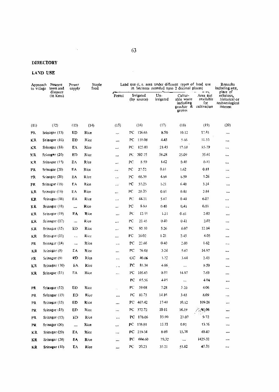
DIRECTORY
LAND USE
Approach to village
(11)
Nearest town and distance (in Kms)
(12)
PR Srinagar (13)
KR Srinagar (16)
KR Sri nagar (IS)
KR Sriuager (20)
KR Srinagar (15)
PR Sri nagar (20)
PR Srinagar (20)
PR Sri nagar (IS)
KR Sri nagar (J 8)
KR Srinagas (16)
KR Sri nagar (IS)
KR Srinagar (19)
KR Srinagar (17)
KR Srinagar (15)
KR Srinagar (13)
PR Srinag:u (14)
KR Srinagar (8)
PR Srinal:ar (9)
KR Srinagar (10)
KR Srinagar (11)
Pllt Sriaa&ar (12)
PR Srinagar (13)
PR Srinagar (15)
PR Srinagar (15)
PR Srinagar (13)
PR Srinagar (20)
KR Srinagar (20)
KR Srinagar (20)
KR Srinagar (10)
Power supply
(13)
Staple food
(14)
ED Rice
ED Rice
EA Rice
ED Rice
EA Rice
EA Rice
EA Rice
EA Rice
EA Rice
EA Rice
Rice
EA Rice
Rice
ED Rice
Rice
Rice
EA Rice
Rice
EA Rice
EA Rice
ED Rice
ED Rice
ED Rice
ED Rice
ED Rice
Rice
EA Rice
EA Rice
EA Rice
63
Land use (i, e. area under different types of land use in hectares rounded upto 2 decimal places)
--------------------~----------------~ Forest
(15)
Irrigated (by source)
(16)
PC 116.(,6
PC 110.08
PC 123·03
PC 202·75
PC 8.50
PC 27·52
PC 68.39
pC 37.23
PC 28.33
PC 44.11
PC 8.99
PC 12.~5
PC 21045
PC 95.10
PC 36.02
PC 22.66
PC 76.08
GC 40.06
PC 81.34
PC 105.63
PC 65.56
PC 59.08
PC 81.75
PC 467.42
PC 372.72
PC 178.06
PC 138.81
PC 219.34
PC 604.60
PC 20.23
Unirrigated
(17)
8.50
4.45
21.45
5S.2S
1.62
0.81
4.86
1.21
O.SI
5.67
0.40
1·21
0.40
5.26
1.21
0.40
3·24
1.22
4.86
0.81
4.05
7.28
14·16
17.40
10.11
33.99
11.33
8.09
79.32
35.21
Culturable waste including
gauchar & groves
(18)
10.12
5.66
17·80
25.09
0.40
1.62
8.50
6.40
0.40
0.40
0.41
0·81
0.41
6.07
2.43
:2.03
5.67
3.64
14.97
5.26
3.65
10.12
16.19
23.07
0.81
15.38
53.82
Area not available
for cultivation
(19)
17.1\ 1
11.33
85·79
35.61
0·81
0.81
5.26
3.24
2.84
6.07
0.81
2.02
2.Q2
12.14
4.05
1.62
14.97
2.43
8·50
7.69
4.04
4.06
8.09
109.26
",9,1.06 ~- ~ . ,;'
9· 72
13.76
40.47
1425.32
47.35
Remalks including any.
place of· religious, historical or
archaeological interest
(20)

TEHSIL BADGAM
Location Code No.
(1)
181. Haji
Name of Village
(2)
Bagh
182. Sharief Abad
Total area of
the village
(in hectares)
(3)
25.50
110.88
25123·23
Total population& number of house-holds
(4)
707 (92)
444 (65)
110220(16401)
64
1981 CENSUS VILLAGE
AMENITIES AND
Amenities available (if not available within the village, a dash (-) is shown in the column and next to it in brackets, the
distance in broad ranges, viz;-5 Kms., 5-lOKms. & lO+Kms. of the nearest place where the facility is availa.ble is given)
r- """I
Educational Medical Drinking P:i)st & Day or Communi-
(5)
P (1)
P (I)
H=18
M=39 P=95 PUC=l
0=3 ?
water telegraph days of cations (potable) the (Bus stop
market! railway-hat, if station
any water way) (6) (7) (8) (9) (10)
-(-5) C -(-5) -(-5)
-(-5)
D=21
HC=2 FPC=4 MCW=l
c -(-5) -(-5)

65
DIRECTORY
LAND USE
Approach Nearest Power Staple Land use (i, e. area under different types of land Use Remalks to village town and supply food in hectares rounded upto 2 decimal places) including any,
distaflce ---, place of (in Kms) Forest Irrigated Un- Cultur- Area not religious,
(by source) irrigated able waste available historica I or inc1udin~ for archaeological
gauchar & cultivation interest groves
(11) (12) (13) (14) (15) (16) (17) (18) (19) (20)
RP Srinagar (10) EA Rice Fe 1·21 6.48 8·50 931
KR Srinagar (22) EA Rice PC 59.88 6.48 16.19 28.33
235.13 11508.64 5187-68 3940.49 4251.29

lEHSIL MAP
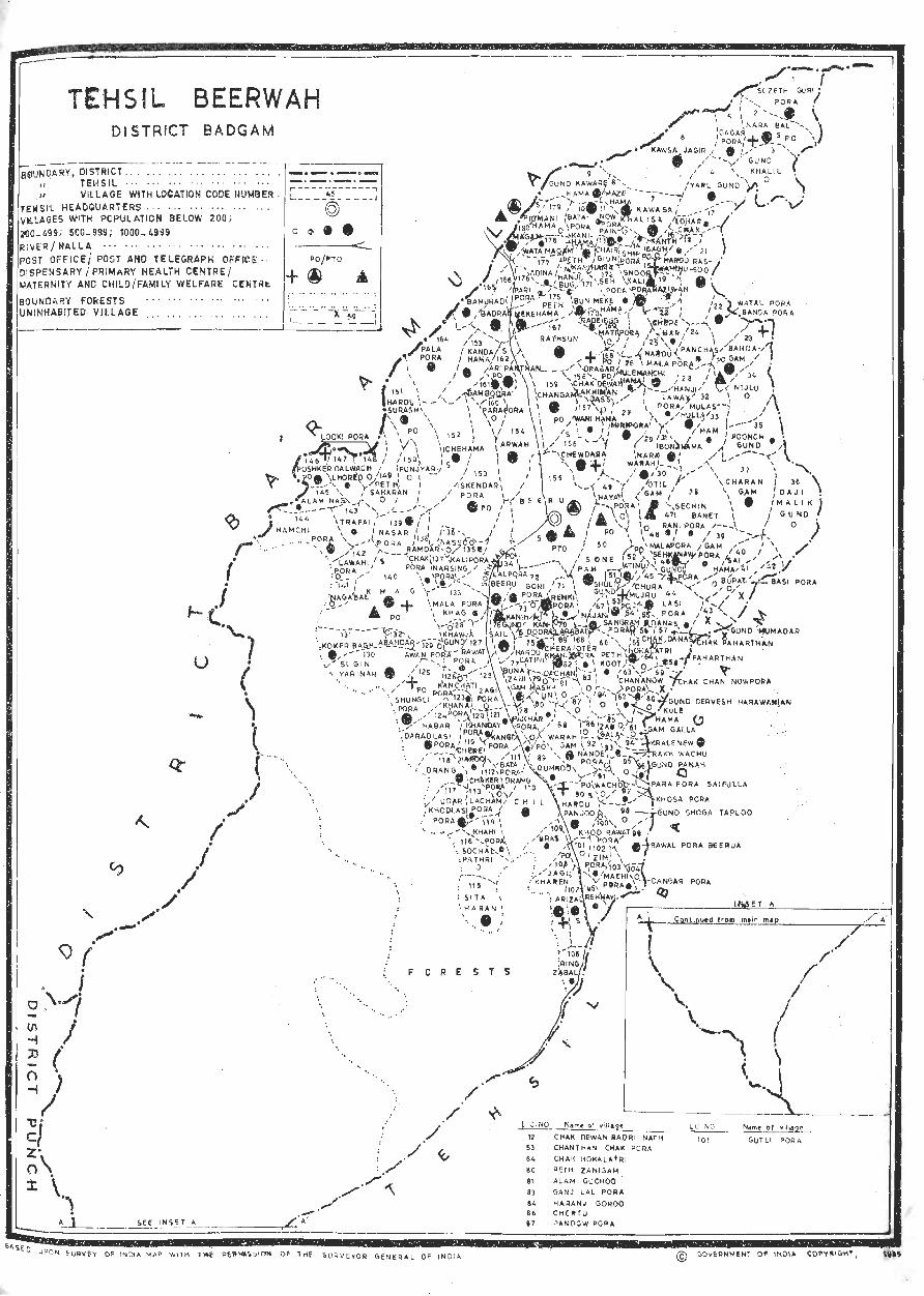
TEHSfL BEERWAH 01 STRteT BADGAM
~NDARY, ClISTJlICT ... . ~'.'~ .-~ ~ ~-.. . - . ~-. '~ .' '.,._._. __ _ " TEHSIL . .. . , ... ' .. '" ... .. . _. _._.-
I" VILLAGE WITH LDeATION CODE WJMSER . I [==-_-~4.f:=_:..-_-_~ TElilSIL HEAOQUARTERS .. , ... I @ VILLAGES WITH PC (>U L ATION BELOW 200 i 2'00-1.99; 500-9S9; 1000~49\)9 0 III ••
~~~~R;~~~~i P~~'T '~~O"T'E~'~~~~~'~~;~E'~': I PO/~TO <_ I !) \SPEN SARY I PRIMARY HEALiH CENTRE ! + ~ ..40
I.;ATERN ITY AND CHIt.D/FAMILY WELFARE Ct)lTiit. . , .. ~ ..... -~. : BOUNDARY FORESTS . . , ... . .. '" ... .. . : . UNINHABITED VIt.LAGE ·:_·~ .. - ··..cX:: .:_ .. -.
I t • • • 1 _ _ __ ~_1
----..... - _.-
u
-
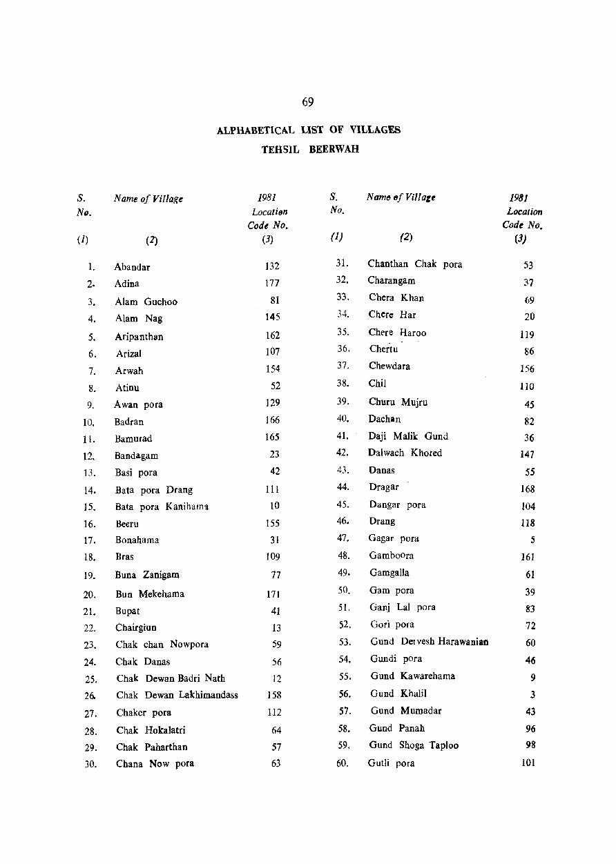
S. NIJ.
(1)
1.
2.
3.
4.
:5.
6.
7.
8.
9.
10.
11.
12.
13.
14.
15.
16.
11.
18.
19.
20.
21.
22.
23.
24.
25.
26-
27.
28.
29.
30.
69
ALPHABETICAL LIST OF VILLAGES
TEHSIL BEERWAH
Name of Village 1981 S. Name 8f Vii! at~ LocatilJn No.
Code No. (2) (3) (1) (2)
Abandar 132 31- Chanthan Chak pora
Adina 117 32. C haran gam
Alam Guchoo 81 33. Chera Khan
Alam Nag 145 34. Chere Har
Aripanthan 162 35. Chere Haroo
Arizal 107 36. Chertu
Arwah 154 37. Chewdara
Atinu 52 38. Chil
Awan pora 129 39. Churu Mujru
Badran 166 40. Dachan
Ramurad 165 41. Daji Malik Gund
Bandagam 23 42. Dalwach Khored
Basi pora 42 43. Danas
Bata pora Drang III 44. Dragar
Bata pora Kanihama 10 45. Dangar pora
Reeru 155 46. Orang
Banahama 31 47. Gagar para
Bras 109 48. Gamboara
Buna Zanigam 71 49. Gamgalla
Bun Mekehama 171 50. Gam para
Bupat 41 51. Ganj Lal para
Cbairgiun 13 52. Gori para
Chak chan Nowpora 59 53. Gund Del vesh Harawanian
Chak Danas 56 54. Gundi para
Chak Dewan Badri Nath 12 55. Gund Kawarehama
Chak Dewan Lakhimandass 158 56. Gund Khalil
Chaker pora 112 57. Gund Mumadar
Chak Hokalatri 64 58. Gund Panah
Chak Paharthan 57 59. Gund Shoga Taploo
Chana Now pora 63 60. Gutli pora
1981 Location
Code No. (3)
53
37
69
20
119
86
156
110
45
82
36
147
5:5
168
104
118
5
161
61
39
83
72
60
46
9
3
43
96
98
101
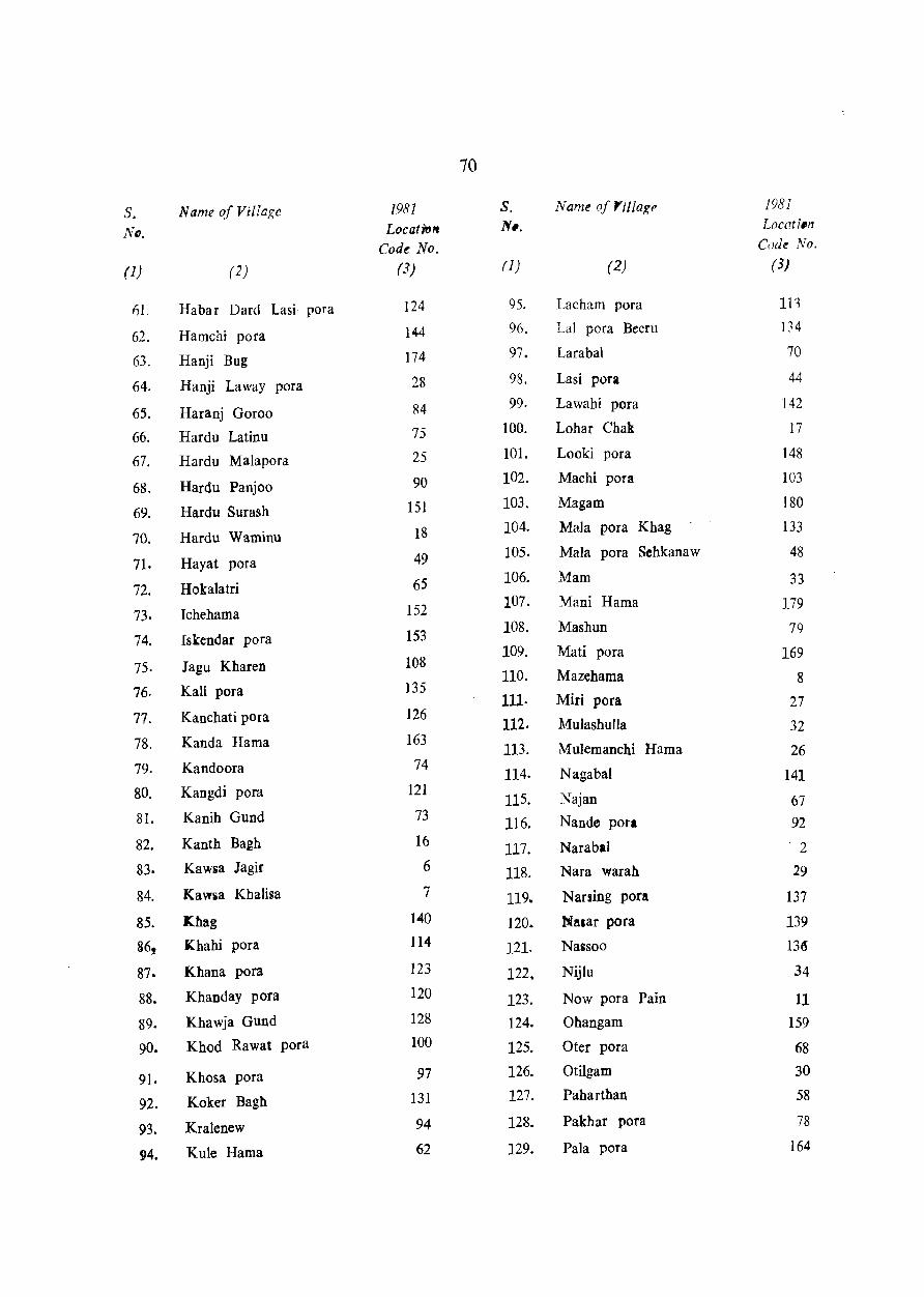
70
s. Name of Vi/iage 1981 S. Name of "t!lage 1981
NtJ. Locati'61t N •. Locati.n
Codt No. Code No.
(1) (2) (3) (J) (2) (3)
1')1. Habar Dard Lasi pora 124 95. Lacham pora In
62. Hamchi pora 144 96. Lal pora Beeru 134
63. Hanji Bug 174 97. Larabal 70
64. Hanji Laway pora 28 98. Lasi pora 44
65. Haranj Goroo 84 99. Lawahi pora 142
66. Hardu Latinu 75 100. Lohar Chak 17
67. Hardu Malapora 25 101. Looki pora 148
68. Hardu Panjoo 90 102. Machi pora 103
69. Hardu Surash 151 103. Magam 180
70. Hardu Waminu 18 104. Mala pora Khag 133
71. Hayat pora 49 105. Mala pora Sehkanaw 48
72. Hokalatri 65 106. Mam 33
73. Ichehama 152 107. Mani Hama 179
74. Iskendar pora 153 108. Mashun 79
75. Jagu Kharen 108 109. Mali pora 169
76. Kali pora )35 110. Mazehama 8
111· Miri pora 27 77. Kanchati pora 126
112. Mulashulla 32 78. Kanda Hama 163
113. Mulemanchi Hama 26 79. Kandoora 74
114. Nagabal 141 80. Kangdi pora 121
115. Najan 67 81. Kanih Gund 73 116. Nande pora 92
82. Kanth Bagh 16 117. Narabal . 2
83. Kaw~a Jagir 6 118. Nara warah 29
84. Kawsa Kbalisa 7 119. N auing pora 137
85. Khag 140 120. Nalar pora 139
36, Khahi pora 114 121. Nassoo 136
87. Khana pora 123 122. Nijlu 34
88. Khanday pora 120 123. Now pora Pain 11 89. Khawja Gund 128 124. Ohangam 159
90. Khod Rawat pora 100 125. Oter pora 68
91. Khosa pora 97 126. Otilgam 30
92. Koker Bagh 131 127. Paharthan 58
93. Kralenew 94 128. Pakhar pora 78
94. Kule Hama 62 129. Pala pora 164
S. Name ofYillage
No.
(1) (2)
130. Panchas
131. Pandow pora
132. Para pora
133. Para pora Saifulla
134. Pari pora
135. Peth Kanihama
136. Peth Koot
137. Peth Mekehama
138. Peth Saharan
139. Peth Zanigam
140. Poonch Gund
141. Poshker
142. Punj Yari
143. Qumroo
144. Rade Bug
145. Rakh Wachu
146. Ramdar Chak pora
147. Rani pora
148. Rasloo
149. Rathiun
150. Rawal pora Beerua
151. Ra wat pora
152. Raziwan
153. Rehhayi
154. Renki pora
155. Ring Zabal
lY81 Location
Code No. (3)
24
87
160
95
176
173
66
175
149
80
3S
146
150
89
170
93
138
47
21
167
99
127 19
105
71
106
71
S. Name of Village
No.
(1) (2)
156. Saibama
157~ Sail
158. Sangram para
159. Sechin Banet
160. Seh pora
161. Ship para
162. Shuli Gund
163. Shungli para
164. Sita Haran
165. Snoor Kali pora
166. Sochal Pathri
167. Sone Pah
168. Sozeth God pora
169. Sugin Yarinar
170. Trapai
171. Udar Khod Lasi pora
172. Wachoo
173. Wani Hama
174. Warahgam
175. Watal para Banda pora
176. Wata Magam
177. Yaru Gund
178. Zabgala
179. Zagi pora
180. Zim pora
1981 Location Cod~ No.
(3)
40
76
54
38
172 14
51
125
115
15
116
50
1
130
143
117
91
157
88
22
178
4
85
122
102
72
1981 CENSUS VILLAGE
AMENITIES AND TEHSIL BEERWAH
Location Name of Village Total Total Amenities available (if Dot available within the village, a dash (-) Code area of popuJa- is shown in the column and next to it in brackets, the No. the tion & distance in broad ranges, viz;-5 Kms., 5-10Kms. & lO+Kms. of
village number the nearest place where the facility is available is given) lin of house- r-
hectares) holds Educational Medical Drinking Post & Day or Communi-water telegraph days of cations
(potable) the (Bus stop market! railway·
hat, if station any water way)
(1) (2) (3) (4) (5) (6) (7) (8) (9) (10)
1. South Guri Pora 318·90 2515(354) P (2) -(-5) T.R -(-5) -(5-10)
2. Nara Bal 155.40 1786(259) H(I),M(I),P(I) D(l) T,R PO BS
3. Guod Khalil 17.00 141 (22) -(-5) -(-5) T -(-5) -(-5)
4. Yaru Gund 58·68 594 (80) P (1) -(-5) T -.(-~) -(-5)
5. Gagar Pora 65.56 763(107) P (1) -(-5) T -(-5) BS
6. Kawsa Jagir 1166.32 1490(202) M (1) -(-5) T -(-5) BS
7. Kawsa Khalisa 269.12 2511(304) M (1), P (2) -(-5) T -(-5) BS
8. Maze Bama 152.16 1436(179) M( 1),P(I),0(l) -(-5) T -(-5) BS
9. Gund Kaware Hama 42.09 840(121) M (1) -(-5) T -(-5) -(-5)
10. Batapora Kani Hama 108.05 1170(157) M (1), P (1) -(-5) T,R -(-5) BS
11. Nowpora Pain 14.57 216 (28) .,......(-5) -(-5) R -(-5) -(-5)
12. Chak Dewan Badri Nath 53.42 257 (35) -(-5) -(-5) T,R -(-5) -(-5)
13. Chair Giun 65.16 605 (81) -(-5) -(-5) T,R -(-5) -(-5)
14. Ship Pora 43.71 255 (35) P (2) -(-5) N -(-5) BS
15. Snoor Kali Pora 210.84 1013(132) M (1) D(l),O{1) S,T PO BS (Snoor Kli Pora)
160 (24) 16. Kanth Bagh 11.74 -(-5) -(-5) N -(-5) -(-5)
17. Lohar Chak 24.28 214 (25) P (1) -(~5) N -(-5) -(-5)
18. Bardu Waminu 34.40 238 (29) P (1) -(-5) C -(-5) BS
19. Raziwan 60.70 352 (45) pel) -(-5) c -(-5) BS
20. Chere Har 67.58 472 (67) P (1) -(-5) C -(-5) -(-5) (Cherie Haroo)
96.32 1117(128) P (1) 21, Rassoo -(-5) C -(-5) -(-5)
22. Watal Pora 78.51 624 (85) Banda Pora
P (1) -(-5) C -(-5) -(-5)
23. Bandagam 213.68 1187(160) M (1) D(l),FPC(l) C PO BS
24. Panch as 73.25 250 (43) -(-5) -(-5) C -(-5) -(-5
25· Hardu Malapora 251·31 647 (97) M (1), 0(1) -(-5) C -(-5) -(-5)
26. Mulemanchi Rama 146.50 202 (33) P (1) -(-5) C -(-5) -(-5)
27. Miripora 240.79 750(116) P (1) -(-5) C -(-5) -(-5)
28. Hanji Laway Pora 56.66 275 (30) P (1) -(-5) C -(-5) -(-5) (Hanji Ranat Pora)
126.26 504 (79) 29. Nara Warah P (1) -(-5)' C -(-5) -(-5)
30' Otil Gam 263.05 746(118) P (I) o (I) C -(-5) BS
DIRECTORY
LAND USE
Approach to village
Nearest town and distance (in Km.)
(1) (12)
PR Srinagar (14)
PR Sri nagar (14)
PR Srill1l!:ar (14)
KR Srinagar (18)
PR Sri&agar (15)
PR Srinagar (15)
PR Sri nagar (17)
PR Srinagar (16)
PR Srinagar (16)
PR Srinagar (21)
KR Srinagar (22)
KR Srinagar (21)
KR Srinagar (25)
PR Sri nagar (15)
PR Srinagar (15)
KR Srinagar (IS)
KR Srinagar (15)
KR Sri nagar (15)
PR Srioagar (IS)
/ KR Srinagar (IS)
KR Srinagar (23)
KR Srinagar (26)
PR Srinagar (24)
KR Srinagar (25)
KR Sri nagar ('20)
KR Srinagar (20)
KR Srinagar (28)
KR
KR
PR
Srinagar (20)
Srinagar (40)
Srinagar (30)
Power supply
Staple food
(13) (14)
ED Rice
ED,EO Rice
ED Rice
ED Rice
ED Rice
ED Rice
ED Rice
ED Rice
ED Rice
EA Rice
bA Rice
EA Rice
EA Rice
EA Rice
EA Rice
EA Rice
EA Rice
EA Rice
EA Rice
EA Rice
EA Rice
EA Rice
EA Rice
EA Rice
EA Rice
EA Rice
EA Rice
EA Rice
EA Rice
EA Rice
73
Land use (i. e· area under different types of land Use in hectares rounded upto 2 decimal places)
~---------------~ Forest Irrigated tin- Cuhur- Area not
(by source) irri&ated
(15) (16)
GC 230.27
GC 116·15
GC }3.76
GC 52.20
GC 52.20
125·89 PC 783.8~
PC 193.04
PC 129.50
PC 33.99
PC 86.60
PC 7.69
PC 38.04
PC 47.75
PC 33.59
PC 68·39
PC 4.86
PC 16·59
PC 22.66
PC 33.18
PC 36.43
PC 74.46
PC 52.61
PC 100·36
PC 47.35
PC 102.79
PC 34.40
PC 110.89
PC 21.46
PC 56.24
PC 157.oz
(17)
2·02
1.21
2-43
33.99
29.14
2.02
4.05
2.02
5.67
2.43
2.43
65.96
2.83
3.64
4.05
13.35
8.09
6.88
6·88
64,76
11.73
71.63
50·99
33.99
14.97
29.95
36.83
able waste available including for
gauchar & cultivation groves
(18)
55.04
23.47
1.62
4.05
4.86
104.80
19.43
7.69
2.03
10.52
1.21
2.43
1t91
2.83
45.73
1.95
1.62
6.07
6.08
2.02
8·91
9.31
31·97
8.50
36.42
14.57
45.73
12.14
8.50
66.77
(19)
31.57
14.57
1.62
2.43
6.07
117.76
27.51
12.95
6.07
6·88
3.65
7·28
6.07
4·86
30.76
2.43
2.43
1.62
8.09
21.04
6.07
9.71
16·59
5.67
40.47
46.54
50.18
8.09
31.57
2.43
Remalks including any.
place of reliiious, historical or
archaeological interest
(20)
TEHSIL Bf:ER W AH
Location Code No.
(1)
Name of Villaie
(2)
31. Bonahama (Banehama)
32. Mulashulla (Mulaseula)
33. Mam
34. Nijlu
35· Poonck Gund
36. Daji Malik Gund
37. Charan Gam
38. Sechin Banet
39. Gam Pora
40. Sai Hama
41. Bupat
42. Basi Pora
43. Gund Mumadar
44. Lasi Pora
45. Churu Mujru
46. Gundi Pora
47. Rani Pora
48. Mllapora SehkaulV
49. Hayat Pora
5.. Sone Fah
51. Shuli Gund
52. Atinu
53. Chanthan Chak Pora
54. Sangram Pora
55. Danas
56. Chak Danas
57. Chak Paharthan
58. Paharthan
59. Cha'k: Chan Nowpora
60. Gund Dervesh Harawanian
Total area of
the village
(in hectares)
(3)
224.20
215.30
97·93
5.5.44
98.74
61.92
100.36
97.13
48.56
46·94
83.37
19.83
IHI
71.!1l
116.15
162.69
35.21
2·08
104.81
271.95
25.50
104·81
133.95
26·71
51.40
2.43
7.28
116.15
1.62
246.05
Total population &.
number of house-
holds
(4)
735(111)
490 (80)
256 (38)
121 (29)
233 (42)
144 (25)
516 (71)
403 (58)
265 (36)
125 (23)
118 (25) ..
117 (15)
403 (04)
566 (87)
911 (12)
203 (35)
96 (14)
196 (23)
1189(170)
139 (19)
606 (89)
575 (81)
77 (12)
247 (36)
315 (35)
481 (88)
74
1981 CENSUS VILLAGE
AMENITIES AND
Amenit!es avail~ble (if not ayaiJable within the village, a dash (-) IS shown In the column and next to it in brackets the
distance in broad ranges, viz;-5 Kms~, 5-10 Kms. & 1O+Kms. of the nearest place where the facility available is liven)
-A-__ __ . ~
Educational Medical Drinking Post & Day or Communiwater tele,raph days of cations
(potable) the (Bus stop
(5)
Mll),P(l)
P (I)
-(-5)
-(-5)
-(-5)
-(-5)
P (1)
P (1)
P (1)
-(-5)
-(-5)
Un-inilabited
-(-5) .
P (I)
P (1)
M (1)
-(-5)
-(-5)
P (I)
M(I),P(l)
pel)
M(l),P(I)
P (1)
-(-5)
-(-5)
Un-inhabited
Un-inhabited
P (1)
Un-inhabited
P (1)
(6)
-(-5)
-(-5)
-(-5)
(7)
-(-5)
T
T
-(-5) T
-(-5) T
-(-5) C
-(-5) T,C
-(-5) C,S.N
-(-5) C,S,N
-(-5) C
-(-5) C
--(-5) T
-(-5) C
-(-5) C
D (1) C
-(-5) C
-(-5) C
-(-5) C
FPC(l) T,C
-(-5) C,N
-(-5) C,T
D (I) S,T
-(-5) C
-(5-10) C
-(-5) T,R,C
-(5-19) C
marketl railway hat, it' station
(8)
-(-5)
-(-5)
-(-5)
-(-5)
-(-5)
-(-5)
-(-5)
-(-5)
-(-5)
-(-5)
-(-5)
-(--5)
-(-5)
-(-5)
-(-5)
-(-5)
-(-5)
-(-5)
PO
-(-5)
PO
PO
-(-5)
-(5-10)
-(-5)
-(5-10)
any water way) (9) (10)
-(- 5)
-(-5)
-(-5)
BS
BS
-(-5)
BS
-(-5)
-(-5)
-(-5)
-(-5)
-(-5)
-(-5)
--(-5)
BS
-(-5)
-(-5)
BS
-(-5)
-(-5)
-(-5)
-(-5)
-(-5)
-(-5)
-(-5)
-(5-10)
DIRIG:TORY
LA~. USE
ApprelCft to villalC
Nearest town and distance (in K.M.)
(II) (12)
KR Srinagar (30)
KR Sri."2ar (28)
KR Srinagar (2~)
KR SrinOigar (27)
KR Srinagar (27)
KR Srinagar (28)
KR Srin.gar (27)
KR Srinagiif (22)
KR Srinagar (2')
KR Srinagar (27)
KR Srina&Olr (25)
Un-inhabited
KR Srina&ar (26)
KR Srina:ar (24)
KR SrinOigar (25)
PR Sriniigar (30)
KR Srinagar (25)
KR Srinagar (28)
PR Srinaiar (28)
PR Srinagar (29)
KR Srinaglr (29)
PR Srinagar (25)
KR Srinagar (29)
KR Srinagar (26)
KR Srinagar (26)
Uninhabited
Un-inhabited
Kit Srinagar (30)
Un-inhabited
KR Srinagar (27)
Power supply
Staple food
(13)
EA
(l4)
Rice
EA Rice
EA Rice
EA Rice
EA Rice
EA Rice
EA Rice
EA Rice
ED Rice
ED Rice
ED Rice
EA Rice
EA Rice
EA Rice
Rice
EA Rice
E.. Rice
EA Rice
EA Rice
EA Rice
EA Rice
EA Rice
EA Rice
EA Rice
EA Rice
Rice
75
La.d use (i. e· area uader different types of land use in hectares roullded upto 2 decimal places)
r---------------------A---Forest
(15)
Irrigated Un-(by source) irrigated
(16)
PC 121·82
PC 80.53
PC 41.68
PC 27.92
PC 45.73
PC 30.76
PC 56.25
PC 48.97
PC 18·21
PC 25.50
PC 51.61
PC 10·93
PC 45.33
PC 73.66
PC 106.84
PC 21.45
PC 13·76
PC 63.13
PC 178.47
PC 14.57
PC 70.82
PC 100.76
PC 11.74
PC 29.55
PC
PC
1.62
4·05
PC 41.68
PC 66.37
(17)
39.25
75.68
1497
12.14
21.f,5
6,48
14.97
1903
728
5.26
3.24
3.23
1·62
1093
13.76
5.26
4.45
17.00
5.67
1.62
6.06
6.88
1·21
4·86
0·81
2.83
44.92
1.62
14002
Cultur- Area not able waste available including for
gauchar &. cultivation groves
(18)
29.95
9.3l
8.50
I], 73
7.28
21.45
14.16
10.83
13.35
14.97
2.43
4.45
18.61
13.76
20.23
5.67
3·64
6.48
67.98
5.67
11.74
16.19
11.74
14.16
0.40
25·91
33.59
(19)
3035
29.14
31·97
6.88
19.43
17.40
7.69
14.97
12·14
2.83
12.55
3.24
0·81
4.04
20.23
21.86
2·83
2.43
18.20
19.83
3.64
16.19
10.12
2.02
2.83
3.64
6.07
Remarks including any.
place of religious. historical or
archaeologi cal interest
(20)
TEHSJL BEERW AH
Location Code No.
Name of Village
(1) (2)
61. Gam Galla
62. Kule Hama
63. Chananow Pora
64. Chak Hokalatri
65. Hokalatri
66. Pethkoot
67. Najan
68. Oler Pora
69. Chera Khan
70. Larabal
71. Renki Pora
72. Gori Pora
73. Kanih Gund
74. Kandoora
75. Hardu Latinu
76. Sail
77. Buna Zanigam
78. Pakhar Pora
79. Mashun
80. Peth Zanigam
81. Alam Guehoo
82. Dachan
83. Ganj Lal Para
84. Haranj Goroo
85. Zabga\a
86. Chertu
87. Pandow Pora
88. Warah Gam
89, Qumroo
90. Hardu Panjoo
T01al area uf
the village
(in hectares)
(3)
42-09
63.13
107.65
26.71
199.11
150.54
101.17
65.16
14.57
27.11
53.01
282.07
23-07
199.92
93.48
199.11
225.01
3 I.I6
23-47
74.06
42.49
106.Q3
25.50
48.97
69.61
31.57
12·14
213.6S
239.58
272.76
Total population & number of house-
holds
(4)
15R (29)
369 (61)
799 (421
41 (7)
741(115)
450 (75)
514 (76)
456 (63)
154 (29)
344 (54)
696( 109)
196 (27)
1208( 191)
560 (91)
1139(182)
R44(139)
SI (13)
129 (22)
417 (63)
169 (30)
505 (81)
154 (24)
191 (32)
124 (24)
]22 (26)
18 (4)
685(117)
362 (71)
767(135)
76
1981 CENSUS VILLAGE
AMENITIES AND
Amenities available (if not available within the village, a dash (-) is shown i D the column and next to it in brackets, the
distance in broad ranges, viz;-5 Kms., 5-10 Kms. & 10+Kms. of the nearest place where the facility available is given)
r A---__ . --~
Educational Medical Drinking Post & Day or Communiwater telegraph days of cations
(potable) the (Bus stop marketl railway hat, if station
any water way) (5). (6) (7) (8) (9) (10)
--(5--10) --(5--10)
P (1) -(5--10)
-(-5) -(5-10)
-(-5) 1-(-5)
P (2) --(5--10)
P (1) -(-5)
M (1), P (1) -(-5)
P (1) -(-5)
Un-inhabitted
C
C
C
C
C
C
C
C
-(5-10)
-(5-10)
-(5-10)
-(5-10)
-(-5)
-(-5)
-(-5)
-(-5)
P (I)
P (2)
P (I)
(P) (1)
-(5-10) C -(-5)
-(5-10) C -(-5)
-(-5) C.S -(-5)
-(5-10) C -(-5)
H (I),P(I) -(5-10) C PO
P (1) -(-5) C,S,N -(5-10)
M (I), P (1) FPC (1) C,S -(-5)
P (1), AC(1) -(5-10) C -(5-10)
-(-5)
P (I)
P (I)
-(-5)
M (1)
P(1)
-(-5)
P (1)
-(-5)
-(-5)
P (I)
P (1)
H (1)
-(5-10) C
-(5-10) C
--(-5) C
-(-5) C
-(-5) C
-(5-10) C
-(-5) C
-(-5) C
-(5-10) C
-(-5) C
-(-5) C
-(-5) C
D (1) C
-(5-10)
-(5-10)
-(-5)
--(-5)
-(-5)
-(-5)
-(-5)
-(-5)
-(5-10)
-(-5)
-(-5)
PO
Po
-(5-10)
-(5-10)
-(5-10)
-(5--10)
-(5-10)
-(5-10)
-(-5)
-(-5)
-(-5)
-(-5)
-(-5)
BS
BS
-(-5)
BS
BS
-(-5)
-(-5)
BS
-(-5)
-(-5)
-(-5)
-(-5)
-( -5)
-(5-10)
-(-5)
-(-5)
BS
BS

DIRECTORY
LAND USE
Approach to village
Nearest town and distance (in Km.)
(11) (12)
KR Srinagar (36)
KR Srinagar (35)
KR Srinagar (33)
KR Srinagar (33)
KR Srinagar (30)
KR Srinagar (42)
KR Sri nagar (40)
KR Sri nagar (36)
Un-inhabited
KR STin 'gar (29)
KR Srinagar (28)
KR
PR
PR
KR
PR
PR
PR
PR
PR
SrinJgar (3~)
Srinagar (38)
Srinagar (;;8)
Srinagar (37)
Srinag.lf (38)
Srinagar (37)
Srinagar (38)
Srinagar (24)
Sri nagar (43)
KR Srinagar (46)
KR Srinagar (46)
KR Srinagar (48)
KR Srinagar (47)
KR Srinagar (45)
KR Sri nagar (46)
KR Srinagar (44)
KR Sri nagar (44)
PR Srinagar (45)
PR Srinagar (47)
Power supply
( 13)
Staple food
(14)
EA Rice
EA Rice
EA Rice
Rice
EA Rice
EA Rice
EA Rice
EA Rice
ED Rice
EA Rice
ED Rice
EA Rice
FA
EA
FA
Rice
Rice
Rice
EA Rice
EA Rice
EA Rice
FA Rice
Rice
EA Rice
EA Rice
EA Rice
EA Rice
EA Rice
EA Rice
EA Rice
EA Rice
EA Rice
77
Land use (i. e· area under different types of land use in hectares rounded upto 2 decimal places)
r---------------~--------------~ Forest
(l5)
Irrigated Un-(by source) irrigated
(16)
PC 22.66
PC 41.68
PC 33.59
PC 18·62
PC 85.79
PC 103.20
PC 69·60
PC 48.56
PC 10.52
PC 18.62
PC 36.02
PC 109.27
PC 14.17
PC 133.15
PC 65.56
PC 9U6
PC 110 89
PC 21·85
PC 17.00
PC 43.71
PC 28.73
PC i8.11
PC 19.43
PC 30·76
PC 47.35
PC 22·66
PC 7.28
PC 146.00
GC 108.86
GC 151.35
(17)
6.48
5.67
43·31
6·48
8.09
4·05
0.81
2.42
1.61
47.35
1·21
1.61
3.64
1.62
2·83
1.62
0.40
4.05
3.04
1·62
1.62
11.75
2-43
5·26
Cultur- Area not able waste available including for
gauchar & cultivation groves
(18)
10.93
6.07
13.35
47.35
29·95
14·57
10.12
3.24
3.64
11·74
72.84
6.88
47.75
14.57
38-45
48·16
7.29
5.26
21.04
7.69
16.59
5.67
9.30
]3.76
4.05
2.D2
40·87
28.33
28.33
(19)
2.02
9·71
17.40
1.61
18.21
9.30
12.95
6.48
2.43
3.64
52.61
2.02
17·81
11·74
68.80
62.32
1.21
7.69
3.24
9.71
4.86
4.86
3.24
1.22
14.97
99.96
87.82
Remarks including any,
place of religious, historical or
archaeological interest
(20)
78
1981 CENSUS VILLAGE
AMENITIES AND TEHSIL BEERWAH
Location Name of Village Total Total Amenitieli available (if not available within the village, a dash (-) Code area of popula- is shown in the column and next to it in brackets, the No· the tion& distance in broad ranges, viz;-5 Kms., 5-10 Kms. & lO+Kms. of
village number of the nearest place where the facility available is &iven) (in house- ------A----. --.,
heetan;s) holds Educational Medical Drinking Post & Day or Communi-water telegraph daj~ of cati(los
(potable) the (8us Iitop markeli railway hat, if station
any water way) ( 1) (2) (3) (4) (5) (6) (7) (8) (9) (10)
91. Wachee 48.16 1&-4 (29) -(-5) -(-5) C -(-5) -(-5)
92. Narde Pora 23.88 88 (16) -(-5) -(-5) C -(-5) -(-5)
93. Rakh Wachu 68·80 255 (46) P (1) -(-5) C -(-5) -(-5)
94. Kralenew 110.89 502 (79) P (1) -(-5) C -(5-10) -(-5)
95. Para Pora Saifullia 26.30 81 (15) -(-5) -(-5) C~ -(-5) -(-5)
96. Gund Panah 70.42 249 (40) -(-5) -(5-10) C -(-5) -(5"':10)
97· Khosa Pora S8.28 207 (32) P (1) -(-5) C -(-5) -(-5)
98. Gund Shoga Taploo 40.87 148 (28) P (1) -(-5} C -(-5) -(-5)
99. Rawal Pora Beerua 152·57 538 (97) M (1) -(-5) C -(-5) -(-5)
100. Khod Raw-at Pora 14.97 113 (21) P (1) -(-5) C -(-5) -(-5)
10}' Gutli Pora 32.38 126 (23) -(-5) -(-5) C -(-5) -(-5)
102. Zimpora 12.03 298 (49) P (l) -(-5) C -(-5) -(-5)
103. Machi Pora 69.61 229 (40) P (1) -(-5) C -(-5) -(-5)
104. Dangar Pora 35.61 80 (20) P (1) -(·-5) C -(-5) -(-·5)
105· Rehhayi 45.73 264 (51) -(-5) -(-5) C --(-5) -(-5)
106. Ringzabal 107.65 187 (65) P (1) -(-5) C -(-5) -(-5)
107. Arizal 133.14 664(126) H (1), P (1) -(-5) C -(-5) BS
108. Jagu Kharen 333.06 1765(312) w: (1) D (1) C PO BS
109. Bru 141.604 ~26 (86) P (1) -(-5) C -(-5) -(-5)
110. Chil 192.63 730(127) P (1) -(-5) C -(-5) -(-5)
111. Bata Poradran& 7851 224 (43) -(-5) -(5-10) C -(5-10) -(-5)
112. Chater Pora 33.59 104 (25) P (1) -(-5) S -(-5) -(-5)
113. Lacham Pora 49.37 201 (33) P (1) -(-5) C -(-5) -(-5)
114. Khahi Pora .94.70 291 (53) -(-5) -(-5) C -(-5) -(-5)
llS. Sita Haran 273.98 1112(194) M(l) -(5-10) S -(5-10) -(-5)
116. Sochal Pathri 29.14 142 (29) M (1) -(-5) C -(-5) -(-5)
117. Udar Khodlasi Pora 91·86 513 (80) P (1) -(-S) S -(-5) -(-S)
118. Drang 200.32 689(131) M (1), P (1) -(-5) C -(-5) BS
119. Chere Haroo 77·70 235 (42) P (1) -(-5) S -(-5) -(-5)
120. Khanday Pora 27.52 260 (47) P (1) -(5-10) C -(5-10) -(-5)
DIRECTORY
LAND USE
Approach to villaae
(11)
Nearest town and di~tance (in Km.)
(12)
KR Srina2ar (46)
fOR Srinagar (34)
KIt Sri nagar (35)
KR Srinagar (30)
KR Srinagar (38)
KR Sri nagar (37)
Power supply
(13)
EA
EA Rice
EA Ric¢
EA Rice
Rice
Rice
KR Sri nagar (36) EA Rice
KR. Srina2ar (27)
KR Srinagar (26)
IC.R. Srinagar (37)
KR Srinagar (28)
EA Rice
EA
EA
Rice
Rice
Rice
KR Srinagar (26) ED Rice
KR Srinagar (29) ED Rice
KR Srinagar (37) ED Rice
KR Srinagar (28) ED Rice
PR Srinagar (13)
KR Srina,ar (28)
KR Srinagar (24)
KR Srinagar (24)
KR Srinagu (25)
KR Srinar;ar (20)
KR Srina,ar (25)
KR Srinagar (25)
KR Srinagar (25)
KR Srinagar (27)
KR Sri nagar (28)
KR Srinagar (26)
KR Sri nagar (37)
KR Srinagar (38)
KR Srinagar (37)
ED
ED
ED
ED
ED
ED
Rice
Rice
Rice
Rice
Rice
Rice
Rice
ED Rice
ED Rice
ED Rice
ED Rice
Rice
ED Rice
liD Rice
ED Rice
Staple food
(14)
79
Land use (i. e· area under different types of land use Remarks including any,
place of religious. historical or
archaeologi cal interest
in hectares rounded upto 2 decimal places) r-Forest
lIS)
2.83
-----------"----Irrigated Un-(by source) irrigated
(lG)
PC 29.95
GC 17.01
GC 44·11
PC 43.30
PC 18.21
PC 30.76
PC 35.61
PC 13.35 GC 11.74 PC 58.28
PC 10.12
GC 20.23
PC 43.30
PC 41.68
PC 23.07
PC 31.57
PC 3.24
PC 045.33
PC 57.47
PC 48·97
PC 80.53
PC 44.11
PC 21.45
PC 3l.57
PC 35.21
(17)
3.64
1.21
3.64
23.88
2.02
19.83
6.07
2·83
48·97
1.21
4.05
2·43
7.28
4.05
1.20
62.73
34.40
137.18
33.18
49·37
8.90 PC 19.43
1.22
3.64
30.76
163.09
19·03
40.06
7.69
2.02 PC 2.02
PC 11.33 GC 17.00 GC 116.14
GC 47.35
PC 15.78
4.86
0.41
....., Cultur- Area not at-·le waste available including for
gauchar & cultivation groves
(18)
12.95
2.02
12.14
29.14
3.24
11.33
11.74
4.45
21.85
1.62
6.88
18·21
14.58
7.28
6.48
19.42
50.99
75.68
6.07
23.07
6.88
3.64
8.09
7.69
56.25
2.83
6.88
21.45
21.85
3.24
(19)
1.62
3.64
8·91
14.57
2.83
8.50
4·86
8·50
23.47
2.02
1.22
8.09
6.07
1.21
6.48
19.43
2.42
62.73
53.42
39.66
25·50
7·28
6.07
21.04-
26.31
3.24
16.59
(20)
55.04 Ancient Ruins known as Pari
3.64 Mahal, Shrine of Syed Sahib
8.09

80
1981 CENSUS VILLAGE
AMENITIES AND TEHSIL BEERWAH
Location Name of Village 'Tota) Total Amenities available (if not available within the village, a dash (-) Code area of popula. is shown in the column and next to it in brackets, the No. the tion& distance in broad ranges, viz;-5 Kms., 5-10 Kms. & 10+Kms. of
village number of the nearest place where the facility available is given) (in house· --"------. -.
hectares) holds Educational Medical Drinking Post & Day or Communi-water telegraph days of cations
(potable) the (Bus stop market/ railway hat, if station
any water way) (I) (2) (3) (4) (5) (6) (7) (R) (9) 110)
121. Kangdi Pora 71.63 329 (49) P (I) -(-5) S -(-5) -(--5)
122, Zagi Pora 47·75 158 (21) -(-5) -(5-10) C -(-5) --(5 10)
123. Khana Pora 98·74 359 (65) M (1) -(5-10) C -(-5) -(-5)
124. Habar D"radlasi Pora 142·05 505 (89) P (1) -(-5) C -(-5) BS
125. Shungli Pora 208.42 1565(297) P (1) D (1), C,S PO BS
126. Kanchati Pora 29·54 105 (17) -(5-10) -(5-10) C -(5-10) - (--5)
127. Rawat Pora ~1.75 253 (42) M (1) -(-5) C -(--5) -(~5)
128. Khawja Gund 21.45 144 (27) -(-5) -(5-10) C -(-5) -(-5)
129. Awan Pora 23.07 92 (17) -(-5) -(-5) C -(-5) ~(-S)
130. SUgin Yarinar 286.12 1479(286) M (1), P (1) --(-5) C,S -(-5) BS
131. Koker Bagh 112·10 568(102) P (1) --(-:) C,S -(-5) BS
132. Abandar 10.52 27 (4) -(-5) --(-5) C,S -(-5) -(-5)
133. M~la Pora Khag 240.79 420 (77) P (1), AC (1) -(-5) C -(--5) -(5-10)
134. Lalpora Beeru 275.59 1222(:02) M(l),P(I),O(l) D (1) C PO -(-5)
135. Kalipora 97.13 207 (44) P (1) -(-5) C -(-5) -(-5)
136. Nassoo 65.56 172 (29) AC (1) -(-5) C -(-5) -(-5)
137. Narsing Pora 58·28 412 (60) P (1) -(-5) C -(-5) -(-5)
138. Ramdar Chakpora 104.01 306 (54) P (1) -(-5) C,1l -(-5) -(-5)
139. Nasar Pora 189.80 651(110) P (1) -(-5) C -(-5) BS
140. Khag 614·72 2477(410) H(l),M(l),P(1) 0(1), C,S PO BS
141. AC(1),OO) FPC(I)
-(-5) Nagabal 31.16 167 (24) P (1) -(-5) C,S -(-5)
142. Lawahi {'ora 29·14 126 (19) -(-5) -(-5) C,S -(-5) -(-5)
143. Trapai 124.64 426 (69) P (1) -(-5) C.S -(-5) -(-5)
144. Hamchi l'ora 247·67 752(137) P (1) AC(l) -(-5) C -(-5) -(-5)
145. Alam Nag 131.52 279 (47) P (1) -(-5) C,S -(-5) -(-5)
146. Poshker 142.05 820(138) M(1),AC(1) D (1) C,S PO -(-5)
147. Dalwach Khored 143.66 429 (88) P (2) -(5-10) C -(-5) -(5-10)
148. Looki Pora 57.06 169 (28) P (1) -(5-10) C -(-5) -(-5)
149. Peth Saharan 37.23 136 (24) P (1) -(-5) C -(-5) -(-5)
150. Punjyari 34·40 123 (19) -(-5) -(-5) C,S -(-5) -(-5)
DIRECTORY
LAND USE
Approach to village
Nearest town and distance (in Km.)
Power supply
Staple food
(11) (12) (13) (14)
KR Srinalar (35) ED Rice
KR Srinagar (38) ED Rice
KR Srinagar (37) ED Rice
,KR Srinagar (30) ED Rice
PR Srina2ar (35) ED Rice
KR SrinajJ(lf 07) ED Rice
KR Srinagar (38) ED Rice
KR Srinagar (36) ED Rice
KR Srinagar (31) ED Rice, Maize
PR Srina~ar (33) ED Rice
PR Srina~ar (34) ED Rice
KR Srin;!gar (31) ED Rice Maize
KR Sri nagar (37) ED Rice
KR Srinag;J[ (39) ED Rice, Maize
KR Srinagar (36) ED Rice Maize
KR Srinag'lf (20) ED Rice Maize
KR Sri nagar (15) ED Rice, Maize
KR Srinagar (36) ED Rice
l'R
pR
Srinagar (31) ED Rice, Maize
Srinaa:ar (30) ED Rice, Maize
KR Srinagar (45) ED Rice
KR Srinagar (45) ED Rice
KR Srinagar (45) ED Rice
KR Srinagar (45) EA Rice
KR. Srinagar (45) EA Rice
KR Srinagar (45) EA Rice
KR Srinagar (34) EA Rice, Maize
KR Srinagar (33) EA Rice, Maize
KR Sri nagar (32) EA Rice
PR Srinagar (31) EA Rice, Maize
81
Land use (i. e· area under different types of land use Remarks including any,
place of religious, historical or
archaeological interest
in hectares rounded upto 2 decimal places) r--------------------A---.--------------~ Forest
(15)
1.22
25.50
5.66
4.85
526
2.Q2
1-21
Irriga ted un-(by source) irrigated
(16)
GC 31.16
PC 26.71
PC 62.73
GC 87.82
PC 102.39
PC 19.43
PC 36.83
PC 13.35
PC 6.07
PC 156.62
PC 78·51
PC 6.07
PC 73.25
PC 93.08
pC 35.21
PC 29.14
PC 39·25
PC 56·25
PC 52.61
PC 21'2.16
PC 6.48
PC 6.88
PC 50.18
PC 80.94
PC 32.38
PC 23.48
PC 54.63
PC 21.85
PC 15.38
PC 6.48
(17)
0.41
1.21
2-43
10.52
55·84
0.40
17.40
3.25
10.52
55.03
4.86
2·83
97.93
111.69
36.42
20·23
1.63
25.50
91,86
218.94
15.78
15· 78
44·52
83·77
64.75
87·41
60.71
27.52
14.56
19.83
Cultur- Area not aNe waste available including for
gauchar & cultivation groves
(18) (19)
33.18
4.05
18.61
(20)
6.88
15.78
14.97
10·12
24·69
33·59 Shrine of Baba Reshi Sahib
4.45
11.33
2·0'2
4.05
32·38
10.52
0·81
31.97
45.73
13.76
9·31
7.69
9.71
7.69
46.54
5.06
0.81
12.54
8.50
12.14
9.31
17.40
5.67
5.67
4.05
25.50
5.26
16.19
2.83
2.43
42-09
18·21
0·81
37.64
25·09
11·74
6.88
9·71
12.55
36.42
101.58
3.24
5.67
17.40
68.80
17.40
16.59
8.90
2.02
1.62
2.83
82
1981 CENSUS VILLAGE
AMENITIES AND TEHSIL BEERWAI-J
Location Name of Village Total Total Amenit!es avail~ble (if not available within the village, a dash (-) Code area of popula- IS showtllD the column and next to it in brackets, the No· the tion& distance in broad ranges, viz;-5 Kms., 5-10 Kms. & IO+Kms. of
village number of the nearest place where the facility available is given) (in house- ""'" hectares) holds Educational Medical Drinking Post & Day or Communi-
water telegraph da),s of cations (potable) the (Bus stop
market/ railway hat, if station
any water way) (1) (2) (3) (4) (5) (6) (7) (8) (9) (10)
151. Hardu Surash 252·53 842(132) M (1), P (I) -(-5) C,S PO BS
152· Ichehama 220.96 812(138) H (1), M(l) -(-5) C,S -(-5) BS
153. Iskendar Pora 447·99 1326(220) M(I),AC(I),P(l) -(-5) C PO BS
154. l\rwah 219.75 1126(167) M (1) -(-5) T,S -(-5) BS
155. Beeru 509.50 2805(447) H(2),M(2),P(I) He(l), T,S' PTO BS FPOI)
156. Chewdara 249.69 1709(246) H (I), M (1) D (I) T,C -(-5) BS
157. Wani Hama 74.06 467 (65) P (1) -(-5) T,C,S -(--5) -(-5)
]58. Chak Dewan Lakhiman 131.93 194 (30) -(-5) -(-5) T,C -(-5) -(-5) Dass
169. Ohangam 224.60 1278(164) P (1) -(-5) T,e PO BS
160. Parapora 20.65 103 (19) -(-5) -(-5) -(-5) -(-5) -(-5)
1~1. Gamboora 130.31 772(130) P (1) -(-5) -(-5) -(-5) -(-5)
162. Ari Panthan 462.56 2547(355}' H(1),M(I),P(2) -(-5) T.S PO BS
163. Kanda Barna 147.31 659(100) M(l), P(l) -(-5) T,Hp,S -(-5) -(-5)
164. Pala Pora 135.17 593 (86) M(l), P(l) -(-5) T,R -(-5) -(-5)
165. Bamurad 110.48 668(111) P (I) -(-5) T,N,S -(-5) -(-5)
166. Badran 203·96 1642(256) MO), P(1) -(-5) T,N,S -(-5) BS
167. Rathsun 444.35 2007(276) M(l), P(I) -(-5) T,C -(-5) BS
168. Dragar 80.94 200 (25) P (1) D (I) 1,S PO BS
169. Mati Pora 22.26 163 (12) P (1) -(10+) C,S -(5-10) -(5-10)
170. Rade Bug 29.14 255 (30) P (1) -(10+) T,S -(10+) BS
171. Bun Meke Rama 231.08 998(134) P(2),AC(I) -(10+) T,S -(10+) -(-5)
172. Sehoora 91.86 421 (55) P (1) -(10+) R,T -(10+) -(5-10)
173. Peth Kanihama 83.37 905(134) M (2) -(-5) T,R,S -(5-10) -(10+ )
174. Hanji Bug 59.89 409 (63) P (1) -(10+) T,8 -(10+) -(10+)
175. Peth Mekehama 220.15 2257(318) M (1) -(10+) R,C -(10+) -(10+)
17(j· Pari Pora 29.14 359 (60) P (1) -(10+) T,R -(10+) -(-5)
In Adina 63.54 446 (55) P (1) -(-5) T,R -(-5) BS
178. Wata Magam 78.91 432 (68) P (1) -(-5) T,C -(-5) BS
DIRECTORY
LAND USE
Approach to village
( 1l)
Nearest town and distance (in Km.)
(12)
Power supply
(13)
Staple food
(14)
PR Sri nagar (30) EA R:cc, M:lize
PR Sri nagar (31) EA Rice
PR Srinagar (32) EA Rice
PR Srinagar (33) EA Rice
PR Srinagar (35) EA Rice
PR Srinagar (27) EA Rice
KR Srinagar (28) FD Rice
KR Srinagar (29) fD Rice
PR Srinagar (27) ED Rice
KR Sri nagar (20) ED Rice
PR Srinagar (20) ED Rice
PR Sri nagar (27) ED Rice
KR Srinagar (20) ED Rice
PR Srinagar (20) ED Rice
KR Srinagar em ED Rice
PR Srinagar (23) En Rice
PR Srinagar (30) ED Rice
KR Sri nagar (30) ED Rice
KR Sri nagar (30) ED Rice
PR Srinagar (29) ED Rice
K R Srinagar (25) ED Rice
KR Srinagar (24) ED Rice
KR Srinagar (26) ED Rice
KR Srinagar (13)
KR Srinagar (13)
KR Srinagar (12)
PR
PR
Sri nagar (11)
Sri nagar (23)
ED Rice
ED Rice
ED Rice
ED Rice
ED Rice
83
Land use (i. e. area under different types of land use in hectares rounded upto 2 decimal places)
(15)
1.21
~--------------~ Irrigated Un-(by source) irrigated
(16)
PC 76·89
PC 78.10
P:C 265.88
PC 65.96 GC 6·07 PC 173.61
PC 155.81
PC 50.58
PC 42.09
PC 146.50
PC 9.71
PC 46.54
PC 329.83
PC 66.77
PC 37.64
PC 49.78
PC 154.19
PC 193.45
PC 6.88
PC 14·16
PC 18.21
PC 65.55
PC 42-90
PC 61·92
PC 42.09
PC 144.46
PC 16.19
PC 45.73
PC 50.69
(17)
134.36
112.10
8.90
71.07
125.45
15.78
1.62
40.87
3.63
4·86
53·83
2M3
47.35
73.25
27.51
3.24
67.58
27·12
2.Q3
2.83
82.S6
27.11
3.24
2.83
1.62
1.62
3.24
6.07
Cultur- Area not able waste available including for
gauchar & cultivation groves
(18)
21:\.33
17.00
121.00
45.33
105.63
28.73
15.38
23.07
49·78
1.63
16.59
55.44
16.19
11.33
9.31
10.51
66.77
13.76
2.83
3.65
31.57
13.35
4·86
4.45
33.99
3.64
2.43
2-43
(19)
12.95
13.76
52.21
24.69
104.81
49.37
6.48
25·90
24·69
4.45
12·14
57.06
17.00
12.95
23.88
36.02
116.)5
33.18
3.24
4.45
51.40
8.50
13.35
10.52
40.06
7.69
12.14
19.82
Remarks including aDY.
place' of religious. historical or
archaeological interest
(20)
...
TEHSIL BEER WAH
Location Code No.
(1)
Name of Village
(2)
179. Mani Hama
180. Magam
Total area of
the village
(in hectares)
(3)
21.45
229.46
21947.22
Total population&: number of house-
holds
(4)
124 (21)
2494(319)
99746(15345)
84
1981 CENSUS VILLAGE
AMENITIES AND
Amenities available (if not available within the village, a dash (-) is shown in the column and next to it in brackets, the
distance in broad ranges, viz;-5 Kros., 5-10 KIns. &: lO+Kms. of the nearest place where the facility available is given)
,-------.:-----"--- -, Educational Medical Drinking Post & Day Or Communi
water telegraph days of cations (potable) the (Bus stop
(5)
--(-5)
(6)
-(-5)
(7)
T,R
marketl railway hat, if station
(8)
-(-5)
any water way) (9) (to)
-(-5)
H(2), M(l), HC(l). T,R PTO Phone BS P (1), 0 (1) FPC(2)
H=12 D=13
M=43 FPC=7
P=118 HC=2 AC=8 0=2
0=5

85
DIRECTORY
LAND USE
Approach Nearest Power Staple Land use (i, e. area under different typeS of land U5e Remalk~
to village town and supply food in hectares rounded upto 2 decimal places) including any,
distallce place of
(in Km.) Forest Irrigated Un- Cuhur- Area nO{ religious, (by source) irrigated able waste available historical or
including for archaeologica I g1uchar & cultivation interest
groves
(11) (12) (13) (14) (15) (16) (17) (18) (19) (20)
KR Srinagar (11) ED Rice PC 12·95 3.24 0.81 4,45
PR Srinagar (22) ED Rice PC 142·85 19.43 17-40 49·78
186.57 11121.37 4159.35 3189.00 2390.93
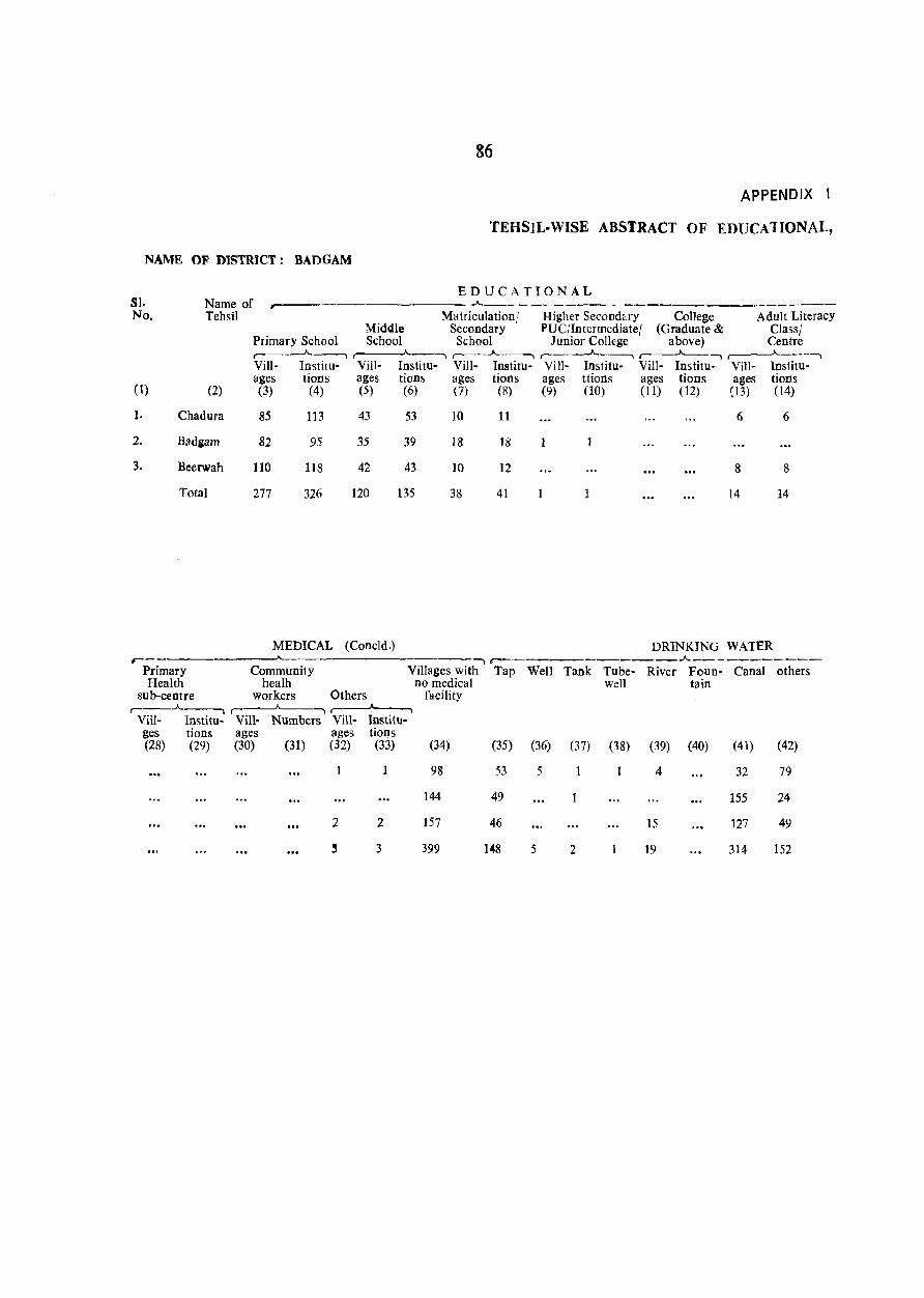
NAME OF DISTRICT: BADGAM
SJ. Name of r'
86
APPENDIX I
TEHSIL-WISE ABSTRACT OF EDUCATIONAL,
EDUCATIONAL .A. _______________ r--_---No. Tebsil Matriculation! Higher Second"ry College Adult Literacy
Middle Secondary PUC/Intermediate! (Graduate & Class} Primary School School School Junior College above) Centre ,--__ .A._--, r---.A.---, ,--__ .A..---, ,--__ __A.---, ,--_..A.._--, ,--__ .A.. ___ .......
Vill- Institu- Vill- Institu- ViII- Institu- Vi 11- Institu- Vill- Institu- Vill- Institu-ages tions ages tion~ ages tions ages ttions ages tions ages tions
( 1) (2) (3) (4) (5) (6) (7) (8) (9) (10) (11) (12) (3) (14)
1. Chadura 85 113 43 53 10 11 6 6
2. Badgam 82 95 35 39 18 18 1
3. Beerwah 110 118 42 43 10 12 8 8
Total 277 326 120 135 38 41 14 14
MEDICAL (Coneld.) DRINKING WATER r-
, ,-----__________ .A. __________ _
Primary Community Villages with Tap Well Tank Tube- River Foun- Canal others Health healh no medical well tain
sub-centre workers Others facility ,--__ .A. __ , ,----"---....... ,--~
ViiI- Institu- Vill- Numbers Vill- Institu-ges tions ages ages tions (28) (29) (30) (31) (32) (33)
2
~
2
3
(34)
98
144
157
399
(35)
53
49
46
148
(36)
5
5
(37) (38)
2
(39)
4
15
19
(40) (41)
32
155
127
314
(42)
79
24
49
152
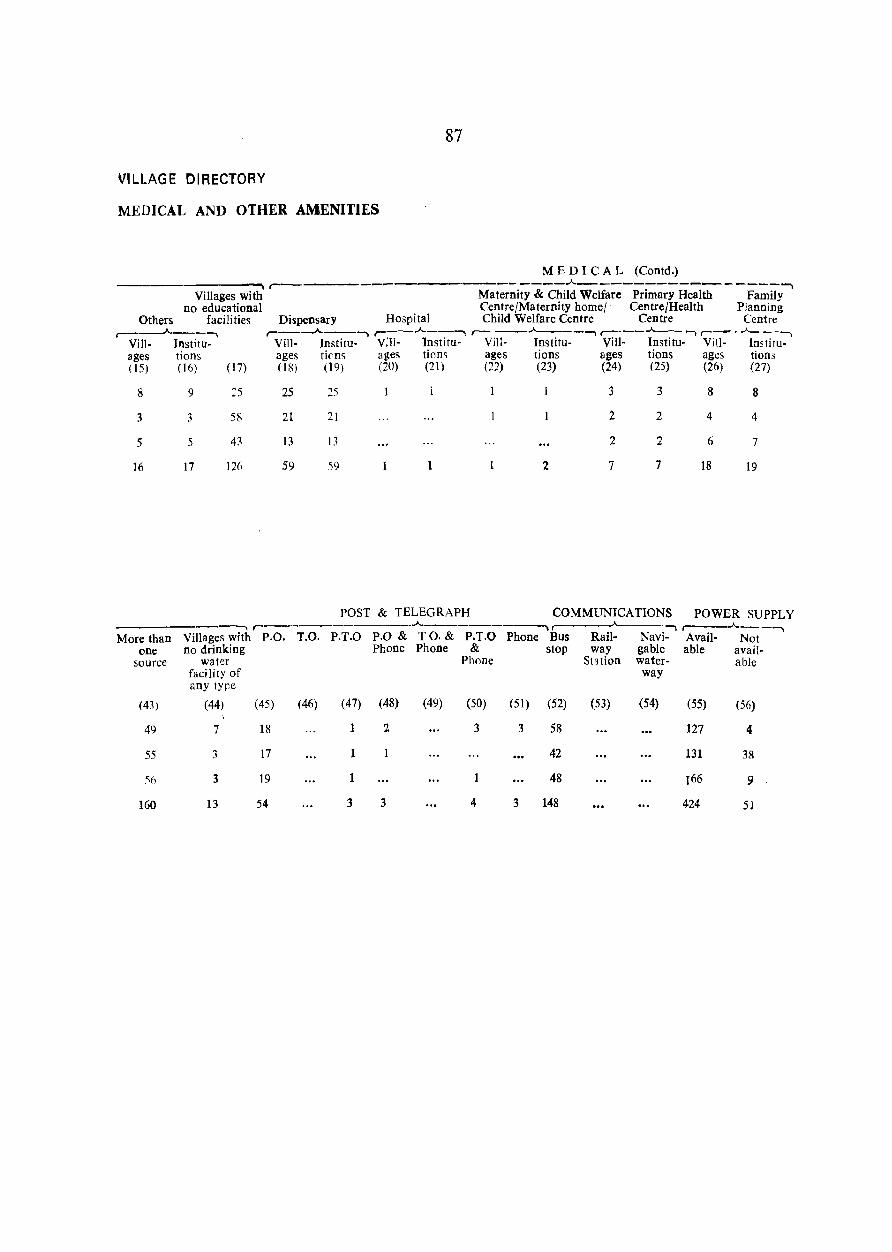
87
VILLAGE DIRECTORY
MEDICAL AND OTHER AMENITIES
M E D I CAL (Contd.) ._--........ r---------------------"-----------------.-., Villages with Maternity & Child Welfare Primary Health Family
no educational Centre/Maternity home/ Centre/Health Planning Others facilities Dispensary Hospital Child Welfare Centre Centre Centre
,.....-----"----, r--.A.--.-., r---"--~ ,----"-------, r----"---- -, ,-- . ..A._ ----,
Vill- Institu- Vill- Institu· V:ll- Institu- ViU- Institu- Vill- Institu- Vill- Imtitu-ages tions ages tiens ages tion~ ages lions ages tions ages lions (15) (16) (17) (l~) (19) (20) (21) (22) (23) (24) (25) (26) (27)
8
3
5
16
More than one
source
(43)
49
55
'\6
160
9
3
5
17
:5
58
43
126
25
21
13
59
25
21
13
59
1
1 2
3
2
2
7
3
2
2
7
POST & TELEGRAPH COMMUNICA nONS --, r---------..A..------~ r A._
Villages with p.O. T.O. P.T.O P.O & TO. & P.T.O Phone Bus Rail- Navi-no drinking Phone Phone & stop way gable
water Phone Station water-facility of way any tyr;e
(44) (45) (46) (47) (48) (49) (50) (51) (52) (53) (54)
7 18 1 2 3 3 58
3 17 42
3 19 1 1 48
13 54 3 3 4 3 148
8
4
6
18
8
4
7
19
POWER SUPPLY r----"------. Avail- Not able avail-
able
(55) (56)
127 4
131 38
r66 9
424 51
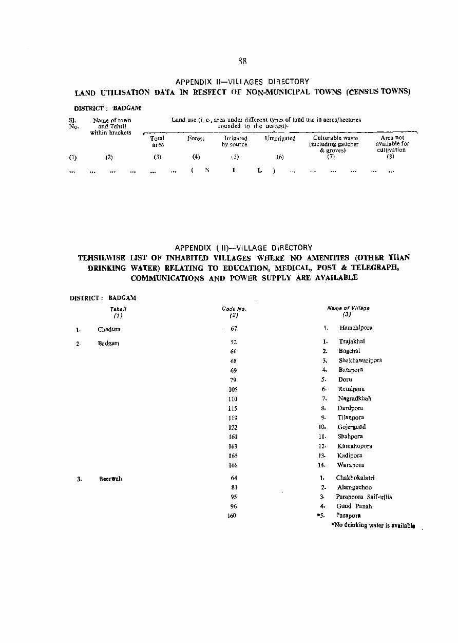
88
APPENDIX II-VILLAGES DIRECTORY LAND UTILISATION DATA IN RESFECT OF NON·MUNICIPAL TOWNS (CENSUS TOWNS)
DISTRICT: . BADGAM
SI. No.
(1)
Name of town and Tehsil
within brackets
(2)
Land use (i, e·, area under different types of land use in aeres/hectares rounded to the nearest).
r ~----------------.--------------~ Total Forest Irrigated Unirrigated Culturab!e waste area by source (including gaucher
& groves) (3) (4) (5) (6) (7)
(N I L
APPENDIX (III)-VILLAGE DIRECTORY
Area not available for cultivation
(8)
TEHSILWISE LIST OF INHABITED VILLAGES WHERE NO AMENITIES (OTHER THAN DRINKING WATER) RELATING TO EDUCATION, MEDICAL, POST & TELEGRAPH,
COMMUNICATIONS AND POWER SUPPLY ARE AVAILABLE
DISTRICT: BADGAM
Tehli/ (1)
1. Chadura
2. Badg~m
3. Beerwah
Code No. (2)
67
52 66 68
69
79 105
110
115
119
122 161
163
165 166
64 81
95
96
160
Name of Village (3)
I. Hamchipora
1. Trajakhal
2. Bugchal
3. Shakhawaripora
4. Batapora
5. Doru
6. Retnipora
7. Nagradkhah
8. Dll.rdpora
9. TiIllnpora
10. Gojergund
11. Shahpora
}2. Kamahopora
13. Kadipora
14. Warapora
1. Chakhokala trl
2. Alamguchoo
3. Parapoora Saif-ullia
4. Gund Panah
*5. Parapor.
·No drinking water is available
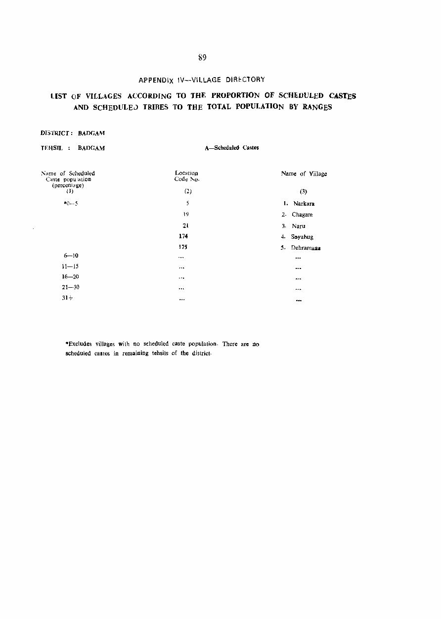
89
APPENDiX IV-VILLAGE DIRl:CTORY
LIST OF VILLAGES ACCORDING TO THE PROPORTION OF SCHEDULED CASTES
AND SCHEDULE0 TRIBES TO THE TOTAL POPULATION BY RANGES
DI.~TRlcr: BADGAM
TEHSIL: BADGAM
Name of Scheduled Caste population
(percent~ge) (I )
·0-5
6-10
11-15
16-20
21-30
31+
Location Code No.
(2)
5
I')
21
174
175
A-Scheduled Castes
·Ex.cludes villages with no scheduled caste population. There arc no
scheduled castes in remaining tehsils of the district.
Name of Village
(3)
l. Narkarlt
2· Chagam
3. Naru
4. Soya bug
5. DehramaJ1&

SECTION-II
TOWN DIRECTORY
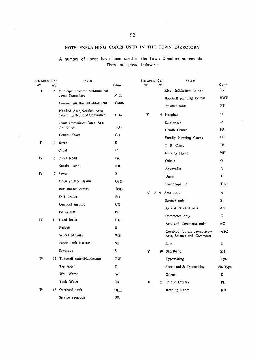
92
NOTE EXPLAINING CODES USED IN THE TOWN DIRECTORY
A number of codes have been used in the Town DirectorY statements.
These are given below:-
St.temtmt Col. It em Statement Col. It e m No, No.
J
n
IV
IV
IV
2 MUnicipal Committee/Municipal Town Committee
Cantonment Board/Cantonment
Notified Area/Notified Area Committee/Notified Committee
Town Committee/Town Area Committee
Census Town
12 River
Canal
6 PUcea Road
Kaccha Road
7 Sewer
Open surface drain~
Box surface drains
Sylk drains
Cesspool method
Pit system
11 Head loads
Code
M.C.
Cantt.
NA.
T.A.
C.T.
R
C
PR
KR
S
OSD
BSD
SD
CD
Pt
No. No.
River infiltration gallery
Borewell pumping system
Pressure tank
v 4 Hospital
Dispemary
Health Centre
Family Plannillg (:enlre
T. B. Clinic
Nursing Home
Others
Ayurvedic
Unani
Homoeopathic
V 6-9 Arts only
Science only
Arts & Science only
Commerce only
Code
IG
BWP
PT
H
HC
FC
TB
NH
o
A
u
Hom
A
S
AS
C HL
B Arts and Commerce only AC
Baskets
Wheel barrows
Septic tank latriaes
Sewerage
IV 12 Tubewell waterjHandpump
Tap water
Well Water
Tank Water
IV 13 Overhead tank
Service retervoir
WB
ST
S
TW
T
W
Tk
OHT
SR
V
V
Combind for all categoriesArts, Science and Commerce
Law
10 Shorthand
Typewriting
Shorthand & Typewriting
Others
20 Public Library
Reading Room
ASC
L
SH
Type
Sh. Type
o
PL
RR
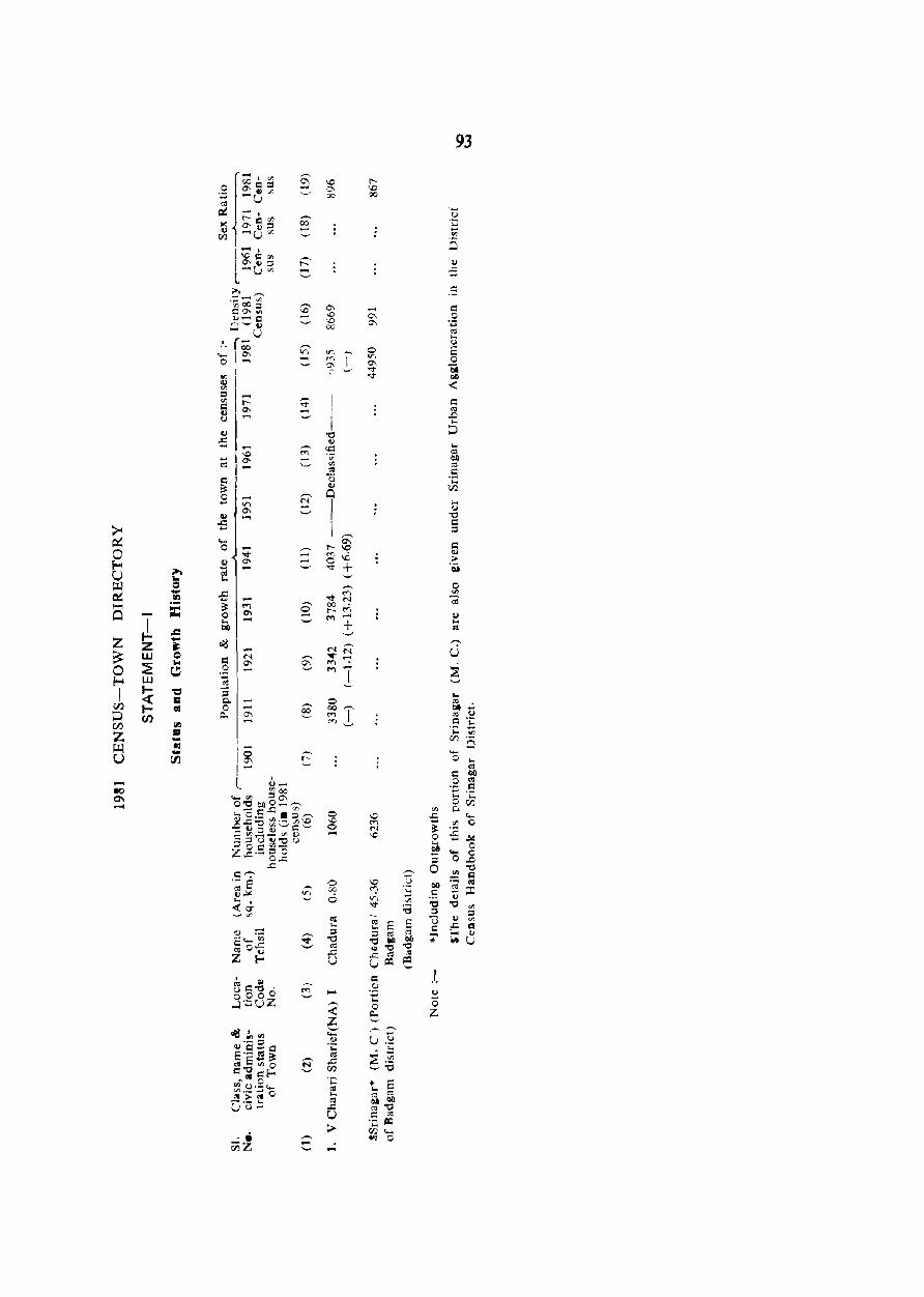
-eo 0\ -
~ z w ~ w Ioe! Ien
III 1'1 -lIS -CIl
c:: QI u C", . 000 0 ....:l·.:;UZ
•• fiiZ
o
'" o -o oc 6
....
l'\0 00
c .~ .... o
Q.
~ o Z
93
u .. '"
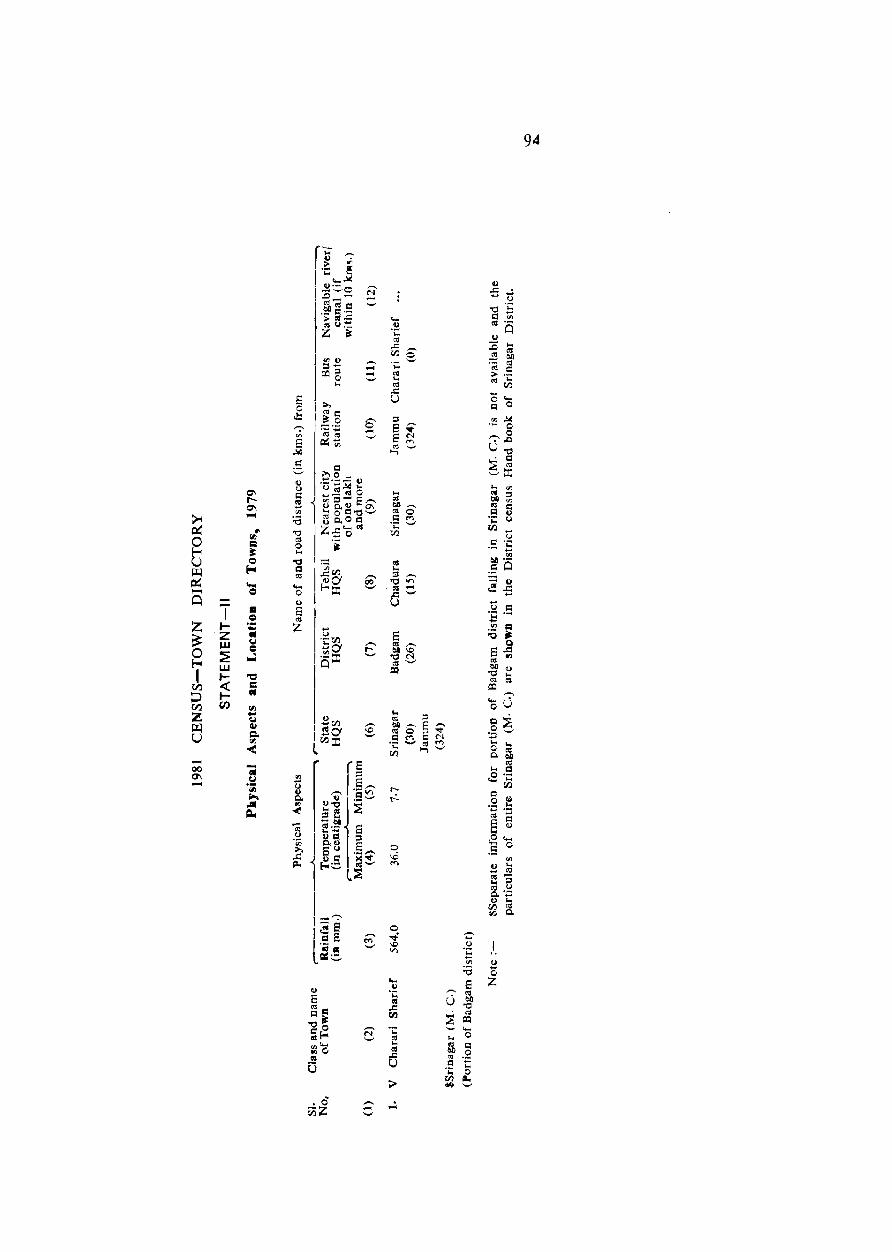
-00 0'1 -
I tZ w :2: w I« lt/)
"C = GIl
.0 r;)Z
----
<U o Z
94
95
r I -QQ) Eo ... -- 0 o 0.;:: t- t-
I r-. ><:::: .., I Q) '0 , ..,~
I jq 1- (.) \2 loCi - .... --I ~ I () ._ I
-- :D3a -.. I()
o ~ ;:1'- 0 -o !l. ~.- ._, <I) • c:: .... ;; I f,) ...... rn j ._ ffJ
'0 tI et:I:O-,! ~ 00 = '5 l::lo - or, ~ = c.. ~ '-' <JJ
:::-1 <!) Q :0 o I .2.-= ~ ~ -. ~ .... i-.I -.,.... U
til I,D-o= e ::l:duQ) ..,
t- !:Il ~ co ~ c.. _g o(l'a ;> = ell.,) ~ co .;::
T~ .... Vl
,-._ 0 ...... r-.. = "'-l ::l«j - 0 c..<J> ._,
'" ..!o' • 0 ,;'!!g ,-., 0 -- v U ,D
~lg - \D '0 - = ~~;': ._, :::; C<I ._, :I: r _----
.... ;J; .. a. 0 4f'\ as ;:I :>-. o'u 0'1 till Vl - co = ~ r-.~ N Q 0
0 .... .;:; u ","""
(/) f-o C'I
111~~ tJ U r- .S C'I "'" '5 JJ.:l .... .... ::I u 0'1 00& ._, QI) '" 0:: J "'~ r::: a .....
0 <!)
3 r- I.,) <!)
I ~ d 00 -;S .... ro
Z ;> '-' '0 I- .. "0 '5 .! ~ z 0 -< w c; -.1 'J)
= 0 :?! = 0 1 = :0 ~ f-o lIS 0 ~ ....... 0 0 w = • J j t- V)
I I- ~ '- t- E ,D
'" ~ ~ll co 00 bI) 0 ;:J - '" .... (J) c 1= ... <II ~ 00 =- = ........ c: ~ Z ._ ~ = as "'" ~ ,-, .y ._, Q) .... ~ ..... U JJ.:l ·s ... 10 5 Q1) 0
U ;:I .~ I 1:1 ~ :t U I I I _ s:; 0 ° ._ 9"d .... 0 .... .... .0 ~,::; iic:~';:: ....
0 CIl C)\ l"Oe_"~Q~ 0. til ...... u2~t3-s~ " I ::1"""-'- 0
.... .S c'O.2 1:: ~ E 0 ....
"'" Vl 0<1)=°°0 »::so.o..;:: c ~)
I ~ E 0 '5 ~~..c; ro c: 1.9<g,oQ:) E <lJ
~ 0\ .... "'" 18o~ ::!- v .8 N 0
l~£~ c cJ) ....
I B ~ rr, (/) ::I
._ :3 ~ c: _ ""'" .... () ._ «10 as E~()(!) -.. 0. ...
"0 .. , '" ~ <I) 01
roo- ~ til 0. u.$2 c Z if;;
:~~~ a ut: Ol I co ..... '0
U ,. U ~ OJ a .;::
! ~ ... 0
"'= as ..... Z ..c:: 0 Q~ .-.. til .... c:~ "Oc ~ .;:::: '" Co ;r-. 01)
«l as '';:: 'i: ",,- ... =
........ 0'" cnO ..c .;: c.. ._ ., U til ._,Q
0 ~
;;.. "":'0 .-. VlZ - ""'
._,
~ 0'\ 0 ...... 0\ E--< .... U
JJ.l ~ ~ II)
~
._ > .... 0 .• J = II)
Z IS ~ z «
LLJ ... 0 ~ ~ E-o w -= .... I I- 0 tI'l ~ ;:::l "CI tZl (/) • z CIS ~ y u .s: .• ..... w 00 0'1 -
f-S ~ -;'? Ou ,-_ el <J>
ol~.1e.o~ 't; I 0 .~.; '0
C () I ex: ._ 0. GO ~ '-'
._ C ~ E I +-" 0 ~~ ~ <.) 0 ~.-
O:= ..... IUt:: u ·c ~ I
~ t i V'l_
2,.c I :::I.~ WE log!: :::I ....
Z • ._., E:.~
lO "" 0:;
..... 0_
"l;! \:l ..... >. 0°0_ -5 Po 0. u.~ ~
:::g"l;! ~
.... u
I" .; ... 0 0..,
::;~ 0 ,.c .;:: .!:! e"" :> =OS t.l Z tI.l
Io-<U <I.l~ -.... til 0
l~.c
E .1 U
2 ..... ~: "'0" .. ::; en
lel :::10 g.,,::: Q..'" ....
.0 ~z
96
~ '" - -,-.. 00 -..... ..... '-"
.-. r- ~ ..... ._., '"
.-. \0 N -_,
.-. r--VI 00 ..... '" ...,
.-. ~ ..... a:i ..... ~
.-. 0 ~ II') ..... --,..., 0 0\ ..... '-
.-. ~
"..., Q r- rIl ._,
0
.,... r-.. IE
.I . .( tC -.-. "':'''0 u
~
6 '-' U'" '0 .~ .... :::a .... z u ._.,cg
.~ ~ cB' ..<:: 01) O._ ._ ...
tI.l tU'" _
·c c ¢i.~ .-. til 'i: D.. Q N .... rIl--._,
..<:: U tit
;:.-
.-. ..:. ..... ._,
>--C!; 0 l-u ~ IX ,_ > 0 I
f-Z Z ?; w
~ 0 w f-. ~ I c;(
CI) ~ ;:.J (/j
V':J
:z: ~ V
00 0-
1;", I" ~,\
.. '" u
'ij ,; ~
-~ ... ~
-; u ';I :I ::
C!l
.2 -~ '"' .. IJ
'"' ~ ,
~1 1': Q ... eo (.J ::
-= iJ4 ~
'i (.J
;a ~
~
..-II
U -<
... ro 00,-., roO 1::«> ._ '-... til
~ 00---. QO c:: '"
'1: ~l
... '" CJl
.S ~ l
V)
o
97
'" r'
~
"0 t:
'" ~
L ~ '0;; .. <:;
'0 (:l
.~
:j
~
... '" 00 oj
.S '" 'J)
.= 1:0 ,S ;§ t; .... '" 0
E oj bI)
-.::l oJ p:J
.... 0
:: .£ t; c 0.
"" <E t:: .g '" E ...
<8 .S ill
~ ro P-()
IZl if!!
.I. II.)
'0 Z
.~ ;:: ",.
0 ... cO ell
'" ,~ .., U1 ,_ c
,.I<: Q 0
.t:J
"" ,;: "" :t
'" ;::l '" Q 0)
U
t '5
V>
'0 '" -s r:l
t:: ~ ':)
,t:! :to
II) ... "" ~
(.)
~ '-
... ~ bI) cc t:l ·c
1ZI
1:! .;: t: OJ
.... 0
'f> ... ro ;i ()
o:: oJ 0.
..... 00 0\ .....
> ~ z w ::;E w
S CIJ
'" -o 0-.., ... ~
-5 o o
..... .., ·c
otI ..<:: tfl
J . .., '0 Z
98
PART-B
PRIMARY CENSUS ABSTRACT
100
DISTRICT PRIMARY
Total Area No. of occupied No. of Total Popularion (including institu· Sl. No. St;,te/Oistrict,'Tehsil; Rural in Residen ti e,l House· tIOna] and j,ouseJess f>opJialion) Town Urban Km2 houses ho'ds r---~----__A__- --___ --_ ~ P M F (I) (2) (3) (4) (5) (6) (7) (8) (9)
Badgam District T 1371.0£ 44.274 54,504 367,262 195,395 171,867
R 1324. ') 38,293 47,~l)8 315,377 167,656 147,721
U 46·1 5.981 7,296 51,885 27,739 24,146
1. Chadura Tehsil T 276.4 16,385 20,130 137,973 73,322 64,651
R 259.7 12,616 15,462 105,411 55,968 49,443
U 16.7 3,769 4,668 32,562 17,554 15,208
Charad Sharief (N .A.) U O.g() 805 1,060 6,935 . 3,657 3,278
SrinaglU Portion U 15.93 2,964 3.608 25,627 13,697 11,930
(i) Srinagar (M.C.) U 15.65 2.907 3,5049 25,199 13,461 11,738 Portion· (ii) Natipora (0. G.). U 0.28 57 59 428 236 192
2. Radian Tehsil T 280.6 15,523 19,029 129,543 68,821 6().722
R 251.2 13,311 16,401 110,220 58,436 51,784
U 29,4 2,212 2,628 19,323 1O,3X5 8,938
Sri nagar Portion U 2943 2,212 2,628 19,823 10,385 8,938
(i) Srinagar (M. G) U 7.(;4 1,514 1,820 13,288 i,219 6,069 Portion* (ii) Bemina (0. G.)* U 4.64 305 362 2,712 1,4J8 1,294
(iii) Rawal Pora (O.G.). U 3.69 316 364 2,758 1,457 1,30]
(Iv) Rangrand (0. G.). U 1.01 35 38 218 118 100 (v) Karawa Domodar U 12.45 42 44 347 173 174 (O.G.}*
3. Beerwah Tehsil T 219.5 12,j66 15,345 99,746 53,252 46,494
R 219.5 12,366 ]5,345 99,746 53,252 46,494
U
101
CENSlJ S ABSTRACT
MAIN WORKERS r------"-------..,
Total Main Scheduled Castes Scheduled Tribes Literates workers (I-IX) r-----..A..------, r----"------., r-----A r-------..A..-_____ ~ p M F p M F P M F p M F (10) (11) (12) (13) (14) (15) (16) (17) (] 8) (19) (20) (21)
39 37 2 65,584 51,800 13,784 120,495 110,551 9,944
28 26 2 46,134 38,f549 7,485 105.786 97,104 8,682
11 11 19,450 13,151 6,299 147,09 13,447 1,262
29,682 23,139 6,543 41,806 38,853 2,953
17,182 14,647 2,535 33,013 30,579 2,434
12,500 8,492 4,008 8,793 8,274 519
1,987 i,SOO 487 1,932 1.791 141
10,513 6,992 3,521 6,861 6,483 378
]0,311 6,877 3,434 6,753 6,380 373
202 115 87 108 103 5
39 37 2 21,592 16,817 4,775 42,830 39,764 3,066
28 26 2 14,642 12,158 2,484 36,914 34,591 2,323
11 11 6,950 4,659 2,291 5,916 5,173 743
11 11 6,950 4,659 2,291 5,916 5,173 743
11 11 5,780 3,795 1,985 4,049 3,483 566
258 196 62 1,024 880 144
697 526 171 697 669 28
156 90 66 61 60
59 52 7 85 81 4
14,310 11,844 2,466 35,859 31,934 3,925
14,310 11,844 2,466 35,859 31,934 3,925
...
102
DISTRICT PRIMARY
MAIN WORKERS (Contd.) ,..--.-,~-.----------"---------------------.,
Household IndustrY, Manufacturing,
SI. No. State/District/Tehsil/ Agricu I tural Processing, Servicing Town Cult iva tors (I) Labourers (II) and Repairs [V (0)]
,-___ ___A.. ___ , ,..-----.----"----, r--- -----"-------., p M F P M F P M F
(22) (23) (:4) (25) (26) <:27) (28) (29) (30)
Badgam District r 67,]55 63,231 3,924 3,20fi 3,157 49 i6,933 13,193 3,740
R 64,662 61,04(, 3,616 2,8GS 2,763 46 15,768 12,300 3,468
U 2,493 2,185 308 397 394 3 1,165 893 272
]. Chadura Tehsil T 20,7.85 19,051 1,234 1,768 1,749 19 4,234 3,301 933
R 19,283 18,072 1,211 J,480 1,463 17 3,487 2,698 789
U ],002 979 23 288 286 2 747 603 144
Charari Sharief (N .A.) U 656 641 15 60 58 2 438 359 79
Srinagar Portion U 346 338 8 228 228 309 24~ 65
(i) Srinagar (M. C.) Portion'"
U 334 327 7 203 203 306 242 64
(ii) Natipora (0. G.) U 12 11 1 25 25 3 2
2. Badgam Tehsil T 24,394 13,429 965 804 788 16 6,386 5,180 1,206
R 22,903 22:223 680 695 680 15 5,968 4,890 1,078
U 1,491 1,206 285 109 108 418 290 128
Srinagar Portion U ],491 1,206 285 109 108 418 290 128
(i) Srinagar (M. C.) U 543 337 206 88 87 1 177 100 77 Portion'"
(ii) Bemina (0. G)* U 652 582 70 171 130 41
(iii) Rawal Pora (0. G.) U 249 243 6 64 56 8
(iv) Rangrand (0. G.)'" U 13 13 1 5 4
(v) Karawa Domodar U 34 31 3 19 19 81 (O.G.)'"
3· Beerwah Tehsil T 22,476 20,751 1.725 634 620 14 6,313 4,712 1,601
R 22,476 20,751 1,725 634 620 14 6,313 4,712 1,601
U
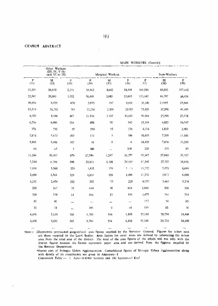
103
CENSUS ABSTRACT
MAIN WORKFRS [Cone/d.) ,_-____ __.A--___________________ _
Other Workers (III, IV, V (b) and VI to IX) Marginal Workers Non-Workers
,_ ___________ .A. _____ --, ,_-____ --A. ________ --, r'-----_-..A---------, P M F P M F P M F
(m (32) (33) (34) (35) (36) (37) (38) (39)
33,201
22,547
10,654
15,519
~,763
6,756
778
5,978
5,910
68
11,246
7,348
3,fi98
3,898
3,241
200
384
42
31
6,436
6,436
30,970
20,995
9,975
14,752
8,346
6,406
733
5,673
5,608
65
10,367
6,798
3,569
3,569
2,959
167
370
42
31
5,851
5,851
2,231
1,552
679
767
417
35u
45
305
302
3
879
550
329
329
282
33
14
585
585
5~,483
56,448
2,035
22,234
21,834
400
2R9
III
11
100
27,546
25,911
1,635
1,63:5
302
644
586
103
8,703
8,703
4,042
3,845
197
2.201
2.143
58
53
5
1,247
1,108
139
139
73
30
27
9
594
594
54,441
52,603
1,838
:=0.033
19,691
342
736
106
6
100
16,299
24,80:1
1,496
229
614
559
')4
8,109
8,109
18~,284
153,143
35,141
73,933
~0,564
23,369
4,714
18,655
18,435
220
~9,167
Ll" ,395
tl,772
11,772
8.937
1,044
1,475
157
159
55,184
55) 184
80,802
66,707
1 l.095
32,268
23,746
9,022
1,813
7,209
7,076
133
27,810
22,737
5,073
3,663
508
761
58
83
:0,724
20, i24
107A82
86,436
21,046
41,665
27,318
14,347
2,901
11,446
11,359
87
3U57
24,658
6,699
6,699
5,274
536
714
99
76
34,460
34,460
Note:- £Represents provisional geographical area figures supplied by the Surveyor General. Figures for urban area are those supplied by the Local Bodies. Area figures for rural areas are derived by subtracting the urban area from the total area of the district. The total of the area figures of the tehsils will not tally with the district figures because the former represents paper area and are derived from the figgures supplied by the Revenu'.~ Department .
• Forms part of Srinagar Urban Agglomeration. Consolidated figures of Sri nagar Urban Agglomeration along with details of its constituents are given in Annexure-I Conversion Table:~ 1 Acre=OA0469 hectares and 100 hectare~= 1 Km2
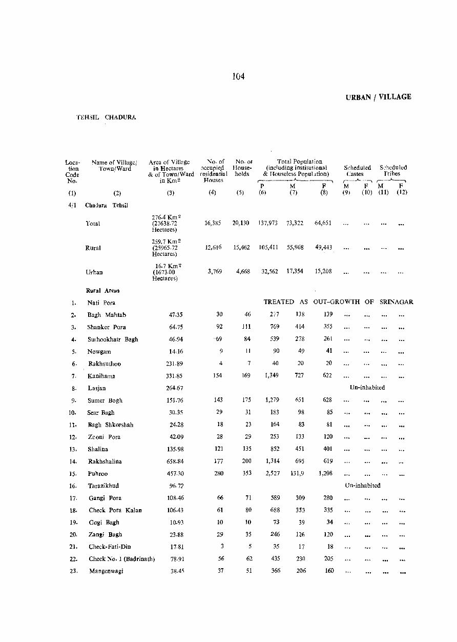
104
URBAN I VILLAGE
'fEHSIL CHADDRA
Loca- Name of Village! Area of Village No. of No.ot Total Population tion Town/Ward in Hectares 'Jccupiep House- (including institu1ional Scheduled S:heduled
Code & of Town/Ward residential holds & Houseless PopuLttion) Castes fribes No. inKm2 Houses
,-. ___ .A- ,_..A-._., ,-._..A-_, P M F M F M F
(1) (2) (3) (4) (5) (6) (7) (8) (9) (10) (11) (12)
4/1 Cbadura Tehsil
276.4 Km 2 Total (27638.72 16,385 20,130 137,973 73,322 64,651
Hectares)
259.7 Km 2 Rural (25965.72 12.616 15,462 105,41 I 55,968 49,443
Hectares)
16.7 Km 2 Urtao (1673.00 3,769 4,668 32,562 17,354 15,208
Hectares)
Rural Areas
1. Nati Pora TREATED AS OUT-GROWTH OF SRINAGAR
2. Bagh Mahtab 47.35 30 46 277 138 139
3. Shanker Para 64.75 92 111 769 414 355
4. Smhookhatr Bagh 46.94 '69 84 539 278 261
5. Nowgam 14,16 9 11 90 49 41
6. Rakhsuthoo 231.89 4 7 40 20 20
7. Kanihama 331·85 154 169 1,349 727 622
8. Lasjan 264.67 Un-inhabited
9. Sumer Bogh 151.76 143 175 1,279 651 628
10. Sea:.- Bagh 30.35 29 31 183 98 85
ll. Bagh Shkorshah 24.28 18 23 164 83 81
12. Zooni Pora 42.09 28 29 253 133 120
13. Shalina 135.98 121 135 852 451 401
14. Rakhshalina 658.84 177 200 1,314 695 619
15. Puhroo 457.30 280 353 2,527 131,9 1,208
16. Tarazikhud 96·72 Un-inhabited
17· Gangi Pora 108.46 66 71 589 309 280
18. Check: Pora Kalan 106.43 61 80 688 353 335
19. Gogi Bagh 10.93 10 10 73 39 34
20. Zan!i Bagh 23,88 29 35 246 126 120
21. Check:-Fati-Din 17-81 3 5 35 17 18
22. Check No.1 (Badrinath) 78.91 56 62 435 230 205
23. Mangenwagi 3il.45 37 51 366 206 160
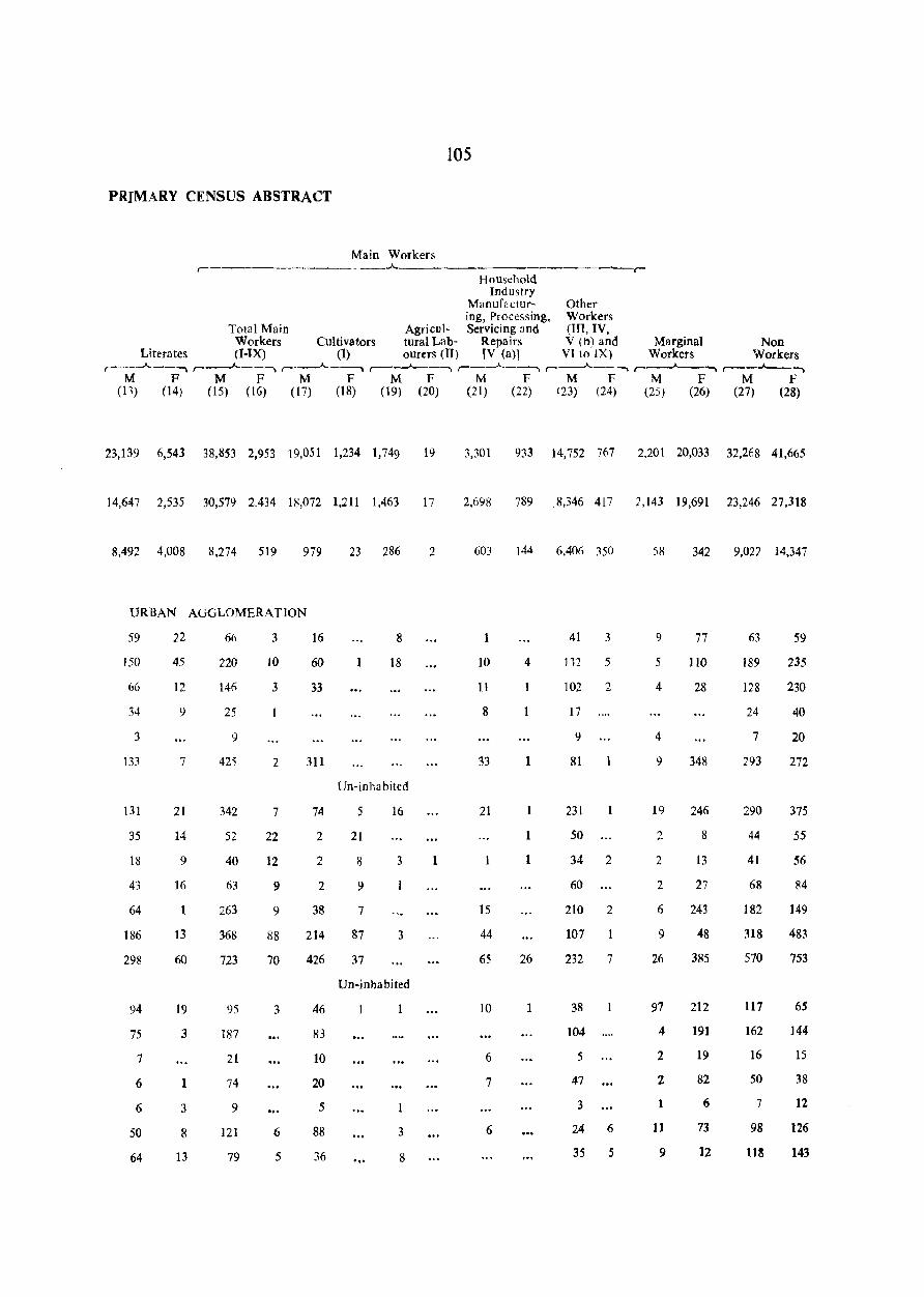
105
PRIMARY CENSUS ABSTRACT
Main Workers _____ A-___ ____________________ ,
Household Industry
Manuf2ctur- Other ing, Processing, Workers
Total Main Agricul- Servicing and (Ill, IV, Workers Cultivators tural Lab- Repairs V (I'l) and Marginal Non
Literates (I-IX) (1) ourtrs (II) [V (a)l VI to IX) Workers Workers r--____.A,,--, r---'---·, r----"------'\ r---A--, r--..A.------, r-_______A.-~.__. r--~__. r----"----,
M F M F M F M F M F M F M F M F (11) (14) (15) (16) (17) (18) (19) (20) (21) (22) (23) (24) (25) (26) (27) (28)
23,139 6,543 38,853 2,953 19,051 1,234 1,749 19
14,647 2,535 30,579 2,434 18,072 1,211 1,463 17
8,492 4,008 8,274 519 979
URBAN AGGLOMERATION
59
150
66
34
3
133
131
35
18
43
64
186
298
94
75
7
6
6
50
64
22
45
]2
9
7
21
14
9
16
1
13
60
19
3
1
3
8
13
6fi
220
146
25
9
425
342
52
40
63
263
368
723
95
187
21
74
9
121
79
3
10
3
2
7
22
]2
9
9
88
70
3
6
5
16
60
33
311
74
2
2
2
38
214
426
46
83
10
20
5
88
36
23 286
8
18
Un-inha bited
5
21
8
9
7
87
37
16
3
3
Un-inhabited
'"
3
8
2
1
3,301 933 14,752 767 2,201 20,033 32,268 41,665
2,698 789 ,8,346 417 1,143 19,691 23,246 27,318
603 144 6,40(> 350
1
10
11
8
33
21
1
15
44
65
10
6
7
6
4
1
1
1
26
1
41 3
112 5
102 2
17
9
81
231
50
34 2
60
210 2
107
232 7
38
104
5
47
3
24 6
35 5
58
9
5
4
4
9
19
2
2
2
6
9
26
97
4
2
2
1
11
9
342 9,022 14,347
77
110
28
348
246
8
13
27
243
48
385
212
191
19
82
6
73
12
63
189
128
24
7
293
290
44
41
68
182
318
570
l17
162
16
50
7
98
W!
59
235
230
40
20
272
375
55
S6
84
149
483
753
65
144
15
38
12
126
143
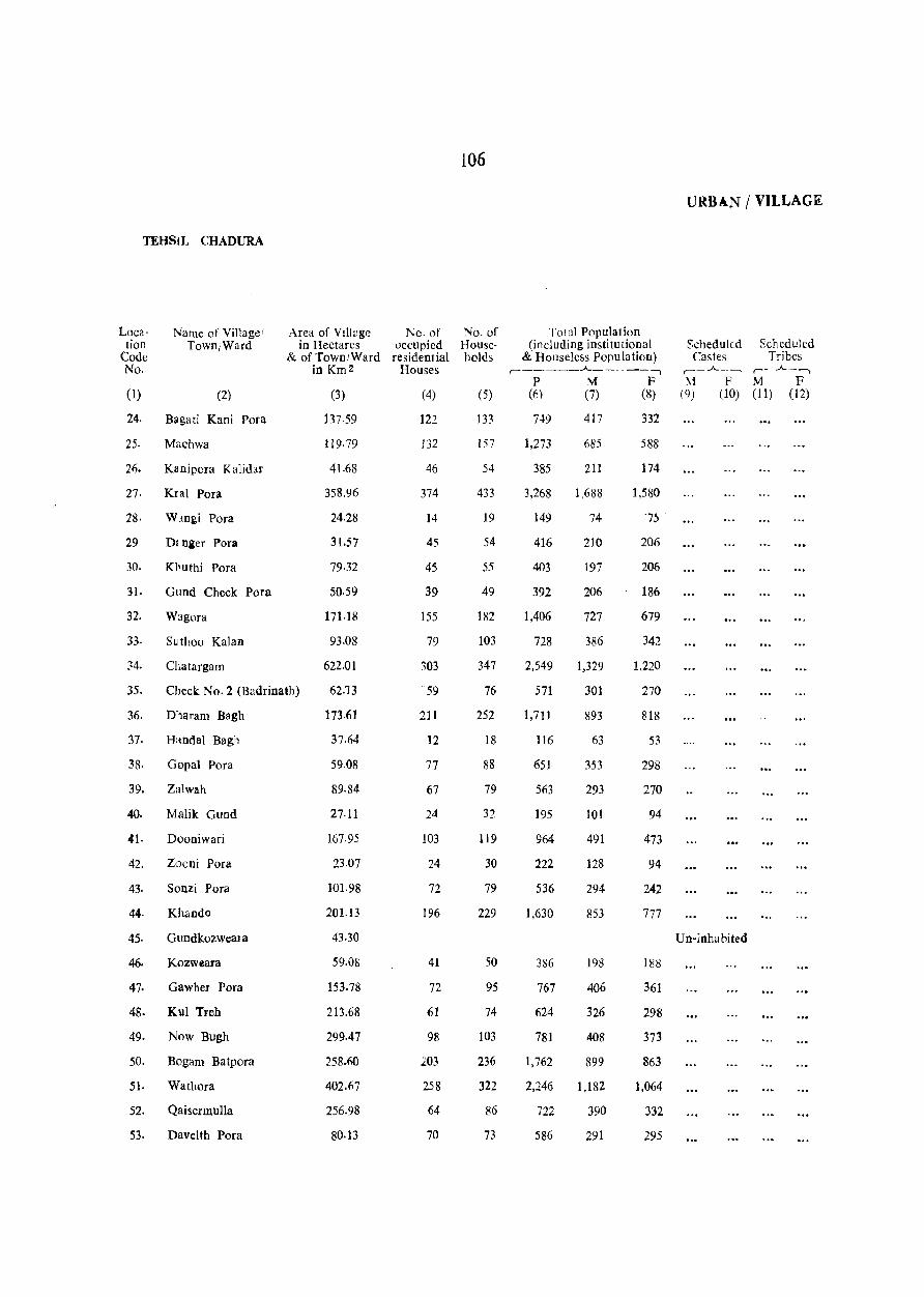
TEHSIL CHADURA
Location
Code No.
Name of Village! TowniWard
(1) (2)
24. Bagati Kani Pora
25. Machwa
26. Ka nipora K alidar
27. KIal Pora
28. Wmgi Pora
29· Dlnier Pora
30. Khuthi Pora
3], Gund Check Pora
32. Wagora
33· s~ thoo Kalan
34. CLatargam
Area of VilJ<~ge No. of in Hectares occupied
& of Town/Ward residential in Km 2 Houses
(3)
137.59
119·79
41.68
358.96
24.28
31.57
79·32
50.59
(4)
122
J32
46
374
14
45
45
39
155
79
303
35. Check No.2 (Badrinath)
171.18
93.08
622.01
62.13 "'59
211
12
77
67
24
103
36. D:1aram Bagh
37. Handal Bagh
38. Gopal Pora
39. Zalwah
40. Malik Guod
41· Dooniwari
42. Zaoni Pora
43· Sonzi Pora
44. Khando
45· Gundkozweal a
46. Kozweara
47. Gawher Pora
48. Kul Treh
49. Now Bugh
50. Bogam Batpora
51. Wathora
52. Qaisermulla
53. Davelth POra
]73.61
37·64
59.08
89.84
27·11
167.95
23.Q7
101.98
201.13
43.30
59.08
153.78
213.68
299.47
258.6()
402.67
256.98
80·13
24
72
196
41
72
61
98
203
258
64
70
106
No. of Households
(5)
133
157
54
433
19
54
55
49
182
103
347
76
252
18
88
79
32
119
30
79
229
50
95
74
103
236
322
86
73
Total Population (including institutional
& Houseless Population) ,. _____ .A. ______ -,
P M F (6) (7) (8)
7~9 417
1,273 685
385 211
3,268 1,688
149 74
416 210
403 197
392 206
1,406 727
728 386
2,549 1,329
571 301
1,711 893
116 63
651 353
563 293
195 101
964 491
222 128
536 294
1,630 853
386 198
767 406
624 326
781 408
1,762 899
2,246 1,182
722 390
586 291
332
588
174
1,580
7;
206
206
186
679
342
1,220
270
818
53
298
270
94
473
94
242
777
188
361
298
373
863
1,064
332
295
URBAN / VILLAGE
SchedulLd Scheduled Castes Tribes
,._.A. __ ...., ,_ .A._..,
~1 F M F (9) (10) (1) (12)
Un-inhabited
107
PRIMARV CENSUS ABSTRACT
Main Workers r--------------"-----------------"'""1
Hou,chold Industry
Manufactur- Other ing, Precessing, Workers
Total Main Agricu:- Servicing and 1m, IV, Workers Cultivators, tural Lab- Repidrs V (b) & Marginal Non-
Literates (I-IX) (I) ourers nI) [V (a)] VI to IX) Workers V/orkers ,--__ .A._-----., ,--__ .A. __ --., ,--__ .A._--., r-~.A.---., ,--.A. __ --., ,-----A...---, r------"---, ,-__ .A._--.,
M F M F M F M F M F M F M F M F (13) (14) (15) (16) (17) (18) (lQ) (20) (21) (n) (23) (:24) (25) (26) (27) (28)
113
307
75
500
20
72
9
78
152
51
324
49
215
21
81
95
14
126
23
26
291
60
158
87
108
220
359
96
91
18
109
22
121
4
15
16
17
8
60
4
43
8
26
20
2
1
44
6
18
7
11
21
72
10
17
224
333
107
904
40
III
122
98
410
202
548
190
395
32
193
151
72
280
74
193
479
96
28
25
5
84
2
11
7
3
13
8
51
8
38
13
19
41
2
26
43
21
229 208
218
479
596
194
155
42
3
14
3
19
177
48
36
283
17
37
114
38
256
147
320
88
70
17
66
70
44
131
56
87
242
39
26
5
6
7
3
7
2
4
6
1
60
2
18
7
60
2
43
2
9
TIn-inhabited
8 3
146 204
, 84
151
434
209
123
117
31
10
2
44
20
2
90
8
9
6
27
24
32
15
49
20
20
14
62
2
89
65
25
11
18
20
19
67
17
18
2
fiO
2
5
5
7
10
3
12
8
18
40
24
27
11
3
4
9
1
19
47 2
279 19
69 3
471 23
15
65
2
60 3
1)6 5
31
194 34
86 5
258 2~
8
47 5
59
14
44
16
15
163 12
29 2
71
40 7
37
24 2
276 4
34 2
17
2
20
7
2
7
44
6
182
10
139
3
23
3
2
4
9
3
22
30
27
34
66
18 6
21
8
3
269
48
69
47
123
79
188
121
265
26
95
29
70
28
125
206
64
18
132
229
51<1-
603
200
78
176
350
103
283
555
166
764 ],227
27
97
68
108
::73
178
599
101
359
31
157
119
26
209
50
92
371
80
177
154
163
386
520
195
130
25
126
152
183
543
255
981
141
515
53
259
156
65
362
64
91
528
103
135
124
143
346
447
129
198
108
URBAN J VILLAGE
'fEHSIL CHADURA
Loea- Name of Village! Area of Village No. of No. 01 Total Population tion Town/Ward in Hectares occupied House- (including institU1 ional Scheduled Scheduled
Code & of Town/Ward residential holds & Houseless Population) Castes Tribes No. inKm2 Houses r- -"---. ----, r--.A..~-, r--~
P M F M F M F (1) (2) (3) (4) (5) (6) (7) (8) (9) (10) (11) (12)
54· Husi Pora 203-56 92 100 65.9 371 328
55· Auwan Pora 110.08 45 52 394 208 186
5'. Wadi Pora 305.54 100 118 898 479 419
57. Brari Gund 146.09 46 56 418 222 196
58· Be!1ram Pora 106.03 18 25 229 118 III
59. Checksar Dar-Dessasingh 174·42 29 35 315 164 151
60· Wanpora Nagam 229-46 39 42 276 135 141
61· Dhar Msala Singh 55·44 64 70 415 229 1K6
62. Qazi Pora 199.11 65 79 561 298 263
63. H~yat Pora 541.48 191 222 1,579 835 744
64. Cteck Mahand Joo Dhar lto.08 43 48 302 161 141
65. Ct'.eck Chadura 82·15 Un-inhabited
66. Ct.eck Dum 100 Gunjoo 27·52 8 11 83 48 35
67· Hamchi Pora 58·28 8 11 85 46 39
68· Chadura 268·71 263 315 2,206 1,199 1,007
69· Check Goind 100 Dhar 116·55 33 46 370 187 183
70· Nagam 934.43 420 514 3,568' 1,903 1,665
71· Badi Pora 463.77 206 236 1,651 8<>2 789
72. Charari Sharief 2165·90 200 237 1,493 827 666
73· Malpora Durd Pora 335.08 114 138 977 512 465
74. Chrawn 367.05 85 101 705 371 334
75. Telsur 496·55 84 113 758 412 346
76. K..rpora 93.48 31 44 319 166 153
71· Hardu Dulwan Fatlipora 617.56 219 281 1,821 970 851
78. Charri Pora Khan Pora 143·26 97 l20 695 366 329
79. Shunke r Pora 111.69 46 63 414 211 203
80. Pukher Pora 120.60 208 248 1,544 850 694
81. Mehind Pora 157.02 68 80 476 247 229
82· Menzcmmargh 33.59 Un-inha bited
83· Guodshamus 57-46 14 21 150 85 65
109
PRIMARY CiENSUS ABSTRACT
Main Workers ._---"---
Household Industry
Manufactur- Otr.er ing, Processing, Workers
Total Main Agricul- Servicing and (III, IV, Workers Cultivators ture1 Lab- Repairs V (h) and Marginal Non
Literates (I-IX) (1) ourers (II) [V (a)] VIto IX) Workers Workers ,---"-_~ r--.A.-----.. ,..-_.A._-----., ,..-_--"---_., ,..-_-"--_" ,..-__ .A.--, ,..-__ ..A._., ,..-__ ..A. ___ -;
M F M ]I! M l' M F M F M F M F M F (13) (14) (15) (16) (17) (18) (19) (20) (21) (22) (23) (24) (25) (26) (27) (28)
113
33
119
57
15
43
IS
161
49
140
11
2
9
,360
52
631
350
63
68
49
56
51
237
87
67
201
22
10
20
2
6
6
3
3
1
89
9
3
54
2
147
107
2
10
2
11
4
9
18
IS8
105
224
106
61
76
75
109
ISS
434
117
28
29
700
118
1067
449
435
234
18ti
250
72
497
144
107
384
97
40
11
2
6
2-
2
1
17
80
8
27
34
12
34
29
49
4
122
74
146
84
30
50
67
26
182
271
61
]7
19
260
62
326
219
361
199
83
n4
56
362
]00
79
2'23
87
36
1
7
7
5
10
65
7
Un-inhabited
33
12
33
29
46
7
12
19
303
11
63
4
56
12
22
19
4
5
5
Un-inhabitw
3
12
3
15
8
2
5
26
40
139
22
160
101
3
18
23
1
2
8
9
9
44
9
1
3
13
35
8
14
9
1
47 2
21 1
58
21
30 3
8
8
81 2
72 1
9 4
4
9
289 12
15
278 11
118 25
8
13
24
13
]2
108
31
14
112
9
4
20
8
40
19
5
27
21
24
200
87
173
104
62
78
54
321
86
9 24
6
348
123
34 1,012
94 461
54
30
35
17
17
84
23
71
12
169
105
183
154
65
384
54
107
104
41
34
163
95
215
97
52
61
60
99
110
377
44
11
17
493
69
802
319
338
248
150
162
77
456
138
81
465
79
33
117
97
246
92
43
73
141
130
261
422
38
11
33
579
52
626
294
485
326
150
192
88
467
246
96
590

'fEHSIL CHADURA
Location
Code No.
Name of Village! Town/Ward
( 1) (2)
84. Brenpathri
85. Darwan Nowgam
86. Chelen Chuntinar
87. Watkulu
88. Leadun
89. Kani Koat
90. Lolipora Hum Pora
9I. Hafroo Batpora
92. Kuchl()o
93. Shew Pora
94. Bani Gund
95. Now Pora
96. Barwah
97. Chodri Gund
98. Brinjan
99. Buz Goo
100. Gogji Pathri
101. Koti Bal
102. Pahadi Pora
103. Bonen
104. Bren War
105. Sursyar
106. Nowhar
107. Chan GlInd
108. Kaw Gund
109. Dadom Pora
110. Shum Nag
111. Hanjura
112. Kralwari
113. Gundwali
Area of Village No. of in Hectares occupied
& of Town/Ward residential in Km2 Houses
(3)
94.70
432·21
462·56
367.86
131.12
68.80
271.55
472.68
144.07
72.44
137·19
286.52
149.74
98.74
354.91
328.20
390.93
15.78
50.18
238.77
364.63
645.48
172.80
45·73
261.43
467.01
160.26
184.94
123.43
15.38
(4)
23
236
256
183
47
9
111
203
28
34
98
73
35
156
109
257
16
32
99
310
329
51
21
100
219
40
148
103
23
110
No.ot Households
(5)
31
337
313
261
62
13
162
255
37
38
108
9]
42
180
161
357
30
45
142
402
423
65
26
124
291
46
188
121
32
Total Population (inctuding institutional
& Houseless Population) r -"----.,
P M F (~) (7) (8)
193 112
2,257 1,200
1,878 1,068
1,531 819
356 202
95 50
986 536
1,604 855
270 144
280 150
771 412
609 339
287 155
1,077 584
940 508
2,036 1,120
159 81
252 141
779 424
2,305 1,256
2,420 1,318
430 222
141 78
788 429
1,893 1,018
332 175
1,122 609
788 431
207 107
81
1,057
810
712
154
45
450
749
126
l30
359
270
132
493
432
916
78
111
355
1.049
1,102
208
63
359
!l75
157
513
357
100
URBAN I VILLAGE
Scheduled Scheduled Castes Tribes
,....._.A.. --., r-~.A..-.,
M F M F (9) (10) (11) (12)
Un-inhabited
PRIMARY CINSUS ABSTRACT
111
Main Workers ~--------------------
Household Industry
Manufactur- Other ing, Processing, Workers
Tolal Main Agricul- Servicing and (In, IV, Workers Cultivators tural Lab- Repairs V (b) and Marginal NOD
Literates (I-1X) (1) GUrers (Il) [V (a)l VI to IX) Workers Workers ,..--~_--., ,-_.A.. __ -., r--.A..-~ ,-__ .A.___--, ,-_.A.._----, ,..-_--"-__ ~_, ,..-__ .A _ _, ,--_ . ....____--,
M F M F M F M F M F M F M F M F (13) (14) (15) (16) (17) (18) (19) (20} (21) (22) 123) (24) (25) (26) (27) (28)
11
198
]00
125
32
24
122
222
38
44
126
127
23
113
116
200
33
36
103
312
226
57
10
88
216
42
242
146
38
26
9
6
12
21
44
5
2
25
32
3
20
8
44
2
7
54
27
4
12
30
6
56
19
10
59
743
615
510
96
33
3~0
422
83
89
243
185
96
1
38
10
7
26
5
1
5
]6
9
10
398 163
309
645
51
85
263
747
918
143
44
288
668
116
2
10
18
32
2
5
12
6
383 129
242 17
46
58
679
592
377
86
24
195
170
36
10
7
6
8
5
85
Un-inhabited
3 77
70
130
2
6
14 1.<3
123
91 10
346 162
224
516
46
82
246
621
780
118
41
227
488
92
2
3
11
32
2
5
241 104
16
9
3
25
19
25
6
51
2
120 23
34
7
3
35
39
79
50
8
3
9
20
4
3
32
10
9
44
9
33
40
13
4
10
6
2
1
6
6
11
15
57
19
90 2
10
9
91 13
88 1
3
5
47
45 2
2
24 1
57
84 5
5
3
7
72
104
15 2
3
52 3
135
15
109 14
26
25
3
37
1
2
53
33
3
4
29
33
59 4
10 24
44
660
346
388
66
20
246
385
79
67
70
182
64
191
285
454
15
53
166
544
707
125
35
241
529
84
82
117
68
52
457
453
283
81
14
205
396
60
61
168
148
59
184
146
442
29
53
157
480
367
79
34
140
350
59
225
185
37
37
396
463
286
78
18
178
359
46
58
273
79
58
139
145
452
63
58
171
473
394
81
28
113
334
67
302
223
32
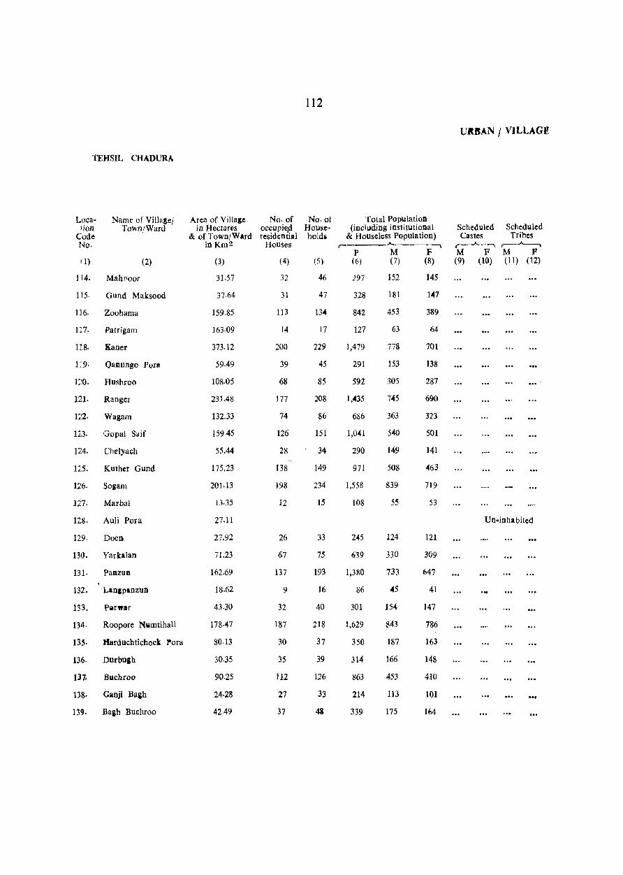
112
UItBAN / VILLAGI!
'fEHSIL CHADURA
Loca- Name of Villa!ej Area of Villale No. of No.ot Total Population tion Town/Ward in Hectares occupied House- (including institutional Scheduled Scheduled
Code & of Town/Ward tesidential holds & Houseless Population) Castes Tribes No. inKm2 Houses r- A. r--..A-- ......... r---~
p M F M F M F 11) (2) (3) (4) (5) (6) (7) (8) (9) (0) (11) (12)
114. Mahnoor 31.57 32 46 297 152 145
115. Gund Maksood 37.64 31 47 328 181 1047
116. Zoohama 159.85 113 1.304 842 453 389
1:7. Patrigam 163-09 14 17 127 63 64
118. Kaner 373.12 200 229 1,479 778 701
1:9· Qallungo POT! 59.49 39 45 291 153 138
1:~0. Hushroo 108.05 68 85 592 305 287 ,--121. Ranger 231.48 177 ;J08 1,0435 7045 690
122. Wagam 132.33 74 86 686 363 323
123. Gopai Saif ]59.45 126 151 1,041 5040 501
124. Chelyach 55.44 28 34 290 149 141
125. Kuther Gund 175.23 138 149 971 508 463
126. SOiam 20}.13 198 234 1,558 839 719
127. Marbal lJ.35 12 15 108 55 53
128· Auli Pora 27.1l Un-inhabited
129· Doen 27.92 26 33 2<4-5 124 121
130. Yarkalan 71.23 67 75 639 330 309
131. Panzun 162.69 137 193 1,380 733 647
132. Lanlpanzun 18.62 9 16 86 45 41
133. Pllrwar 43.30 32 40 301 154 147
134. Roopore Nwmtihall 178·47 187 218 1,629 843 786
135· tlarduchtichock Pora 80.13 30 37 350 187 163
136. Durbugh 30.35 35 39 314 166 148
137. Buchroo 90·25 112 126 863 453 4]0
138. Ganji Baih 24·28 27 33 214 113 101 ... 139. Ba&h Buehroo 41,49 37 48 339 175 164

113
PRIMARY (EN~US ABSTRACT
Main Workers ,~--- ---------~--"-----~- --- ----------- ---,
Hou,ehold Industry
Manufactur- Other iog, Processing, Workers
Total Main Agricul- Sel vicing and (III, IV, Workers Cultivators tural L3b- Repairs V (b) & Marginal Non-
Literates (I-IX) (I) ourers (II) [V (a)] VI to IX) Workers Workers r--.A..---, .----"---, ,---....___-, r-..A..---, ,--_--A._-, r--_.A..--- ... ,--..A..~ r--~
M F M F M F M F M F M F M F M F (13) (14) (15) (16) (17) (1~) (El) (20) (21) (72) (23) (24) (25) (26) (27) (28)
72
66
208
11
246
83
117
292
163
123
44
l36
318
20
21
123
288
54
327
45
18
175
33
73
27
13
47
38
27
40
47
30
8
8
11
40
6
3
17
55
2
76
7
2
37
6
16
70
79
255
42
505
85
162
2
2
33
5
38
7
12
433 135
151
317
87
319
401
23
77
184
342
31
63
6
10
37
61
6
21
46
28
454 119
71
88
240
61
74
14
8
9
48
42
143
18
297
37
90
3
3
205 102
56
182
57
207
191
20
1
10
14
5
16
8
2
2
1
16
81
2
Un-inhabited
32
64
125
31
41
}I6
32
37
87
38
33
10
6
8
4
5
11
14
4
5
4
I
3
33
12
128
11
27
53
3
78
12
55
14
19
32
20
87
19
30
7
2
27
5
35
3
5
:0
10
25
20
6
10
24
6
R9
13
6
2
16 2 2
18 13
78 3
2
72
37 4
43 7
173 12
91 5
56
18
41 2
115 26
25
83 16
186 ,14
22
237 22
16
16
14!Ol 3
16
39
5
6
26
67
20
2
6
9
59
43
27
11
6
2
4
62
80
135
33
55
70
122
294
190
241
84
244
158
25
46
111
225
28
83
388
77
76
125
45
56
80
89
198
21
273
63
137
286
145
222
62
169
436
26
47
137
332
14
90
346
89
67
207
50
97
81
65
221
26
608
61
153
261
127
250
56
182
500
22
54
152
394
13
64
279
72
64
276
55
108
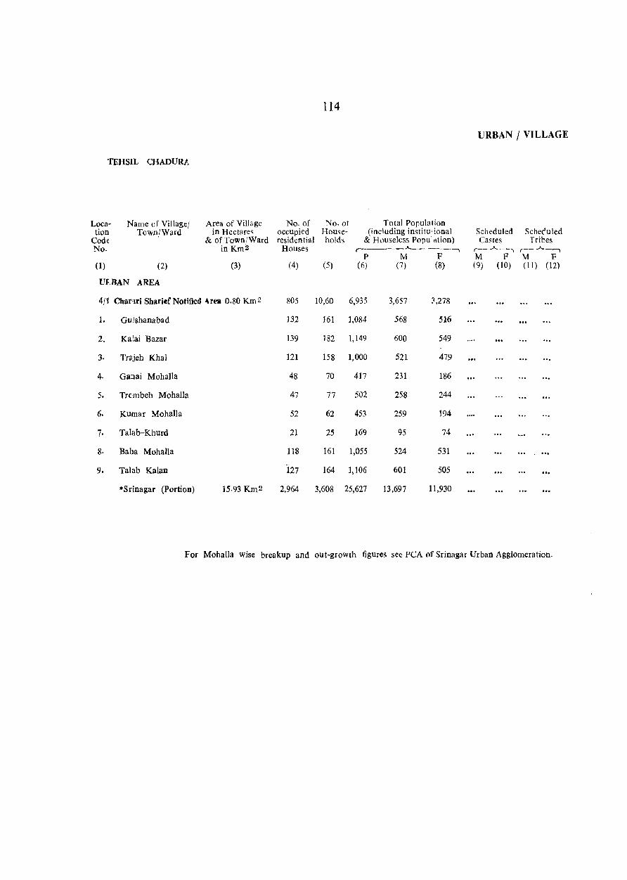
114
URBAN / VILLAGE
'fEHSIL CHAnURA
Loca- Name of Villagel Area of Village No. of No.ot Total Population tion Town/Ward in Hectares occupiql House- (including institu"lonal Scheduled Scheduled
Code & of Town/Ward residential holds & Houseless Popu:dtion) Castes Trices No. in Km2 Houses ... __ -_.A.. _____ ~ ,--_..A-_, r--..A--'""'I
p M F M F M F (1) (2) (3) (4) (5) (6) (7) (8) (9) (10) (II) (12)
m.BAN AREA
4/1 Chamri Sharief Notified -\rell 0.80 Km 2 805 10,60 6,935 3,657 3,278
1. Gulshanabad 132 161 1,084 568 516
2. Ka;ai Bazar 139 182 1,149 600 549
3. Trajeh Khal 121 158 1,000 521 479
4. Ganai Mohalla 48 70 417 231 186
5. Trcmbeh Mohalla 47 77 502 258 244
6. Kumar Mohalla 52 62 453 259 194
7· Talab-Khurd 21 25 169 95 74
8. Baba MohaUa 118 161 1,055 524 531
9. Talab Kalan 127 164 1,106 601 505
"'Srinagar (Portion) 15·93 Km 2 2,964 3,608 25,627 13,697 11,930
For MohalJa wise breakup and out-growth figures see PCA of Srinagar Urban Agglomeration.

115
PRIMARY CENSUS ABSTRACT
Main Workers r- A -,
Household Indu,try
Manufactur- Other ing, Processing, Workers
Total Main Agricul- Servicing and (Ill, IV, Workers Cultivators tural L2 b- Repairs V (b) and Marginal Non
Lihrates (PiX) (1) ourers (n) [V (a)l VI to IX) Workers Workers ,----"---~, r---.A.-----, ,---..)~ _----. ,-_.A---_, ,-_..A._----., (_. __ ..A.. __ , r---J...-, ,--__ ..A--_-.
M F M F M F M F M F M F M F M F (13) (14) (15) (16) ( 17) (18) (9) (20) (21) (22) (23) (24) (25) (26) (27) (28)
1,500 487 1,791 141 641 15 58 2 359 79 733 45 53 236 1,813 2,901
222 66 268 20 g3 21 60 16 94 4 4 296 495
197 69 303 36 118 75 21 109 15 12 57 285 456
190 69 237 7 72 13 71 6 81 14 12 170 460
92 11 135 7 77 4 12 4 42 2 2 94 179
66 4 142 24 84 11 4 9 2 45 10 14 90 102 130
125 27 142 9 4 69 8 69 2 50 115 135
48 11 43 3 6 15 2 22 52 71
280 135 234 21 62 6 40 15 126 5 6 290 504
280 95 287 14 125 :2 9 1 8 5 145 6 5 20 309 471
6.992 3,521 6,483 378 338 8 228 244 65 5,673 305 5 106 7,209 11,446

116
URBA N I VILLAGE
TEHSIL BADGAM
Loca- Name of Village' Area of Village No. of No. of Total Population tion Town/Ward in Hectares occupied House- (including institutional Schedukd Screduled
Code & of Town/Ward residential holds & Houseless Population) Castes Tribes No. in Km2 Houses
,-___ ..A.. ___ , ,----"----, ,_.A.._--.
P M F M F M F (1) (2) (3) (4) (5) (6) (7) (8) (9) (10) (11) (1:)
4/2 Badgam Tebsil
280.6 Km2 Total (28066.23 15,523 19,029 129,543 68,821 60,722 37 2
Hectares)
251.2 Km 2
RUral (25123.23 13.311 16,401 110,220 58,436 51,784 26 2 Hectares)
29.4 Km2 Urban (2943.00 2,212 2,628 19,323 10)85 8,938 11
Hectares)
Rural Areas
1. Bimna TREATED AS OUT-GROWTH OF SRINAGAR
2· Doru 54.13 40 46 416 217 199
3. Sabdan 67.58 62 69 479 263 216
4. Batahar 40.07 47 59 497 251 246
5. Narakara 183.32 175 227 ],998 1,040 958 2 ./
6. Nambal Narahkrah 273.57 Un-inhabited
7. Nadir Gund 42·09 7 9 58 3S 23
8. Rawal Pora TREATED AS OUT-GROWTH OF SRINAGAR
9. Rangrand TREATED AS OUT-GROWTH OF SRINAGAR
10. Woocha 66.37 42 57 452 227 225
11. Kerawa Damodhar TREATED AS OUT-GROWTH OF SRINAGAR
12. Ganguwa 100.36 95 116 943 505 438
13- Humahama 515.17 225 279 2,096.( 1,085 1,011
14. Shekh Pora 155.81 64 79 610 313 297
15. Ompora 471-46 334 430 3,164. 1,677 1,487
16. Khana Pora 116.15 74 88 601 303 298
17. Harji Gund 15.38 2 4 33 18 15
18. Zori Bagh 10.93 Un-inhabited
19. lch Gam 463.37 453 561 3,595 1,914 1,681 3
20. Gudasathu 140.43 97 143 1,058 544 514
21. Naru 262·24 86 100 717 391 326 3 2
22· Bagh Sahibram 7.28 Un-inhabited
23. Lalgam 87.01 64 81 597 308 289
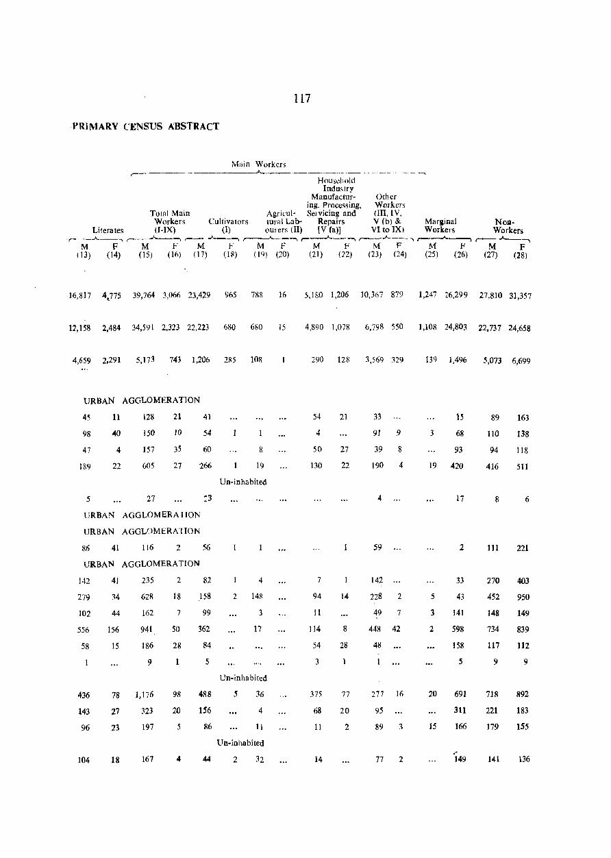
117
PRIMARY CENSUS ABSTRACT
Main Workers ,-"-----_ .. _. __ .. _ . -- - -- ---- -- - --..
Household Industry
Manufactur- Other ing, Processing, Workers
Total Main Agricul- Servicing and OIl, IV, Workers Cultivators tural Lab- Repairs V (b) & Marginal NOD-
Literates (I-IX) (1) ourers (II) [V (a)] VI to IX) Workers Workers .,--__ .A..--, ~-, r--- .A.._-, ,..----A------, r----"-----, r--_.A..._-_ ..... ,---...... _____" r--"""-----,
M F M F M F M F M F M F M F M F (13) (14) (l5) (16) (17) (U~) (lQ) (20) (21) (22) (23) (24) (25) (26) (27) (28)
116,817 4,}75 39,764 3,066 23,4~9 965 788 16 5,180 1,206 10,3117 879 1,247 26,299 27,810 31,357
12,158 2,484 34,591 2,323 22,223 680 680 15 4,890 1,078 6,798 550 1,108 24,803 22,737 24,658
4,659 2,291 5,173 743 1,206 285 108 290 128 3,569 329 139 1,496 5,073 6,699
URBAN AGGLOMERATION
45 11 128 21 41 54 21 33 15 89 163
98 .w 150 10 54 4 91 9 3 68 110 138
47 4 157 35 60 8 50 27 39 8 93 94 118
189 22 605 27 '266 19 130 22 190 4 19 420 416 511
Un-inhabited
5 27 ~3 4 17 8 6
URBAN AGGLOMERA nON
URBAN AGGLOMERA nON
86 41 116 2 56 59 2 111 221
URBAN AGGLOMERATION
142 41 235 2 82 4 7 142 33 270 403
279 34 628 18 158 2 1411 94 14 228 2 5 43 452 950
102 44 162 7 99 3 II 49 7 3 141 148 149 "
556 156 941 50 362 17 114 8 448 42 2 598 734 839
58 15 186 28 84 54 28 48 158 117 112
9 1 5 3 5 9 9
Un-inhabited
436 78 1,176 98 488 5 36 375 77 277 16 20 691 718 892
143 27 323 20 156 4 68 20 95 311 221 183
96 23 197 5 86 11 11 2 89 3 15 166 179 155
Un-inhabited
" 104 18 167 4 44 2 32 14 77 2 149 141 136
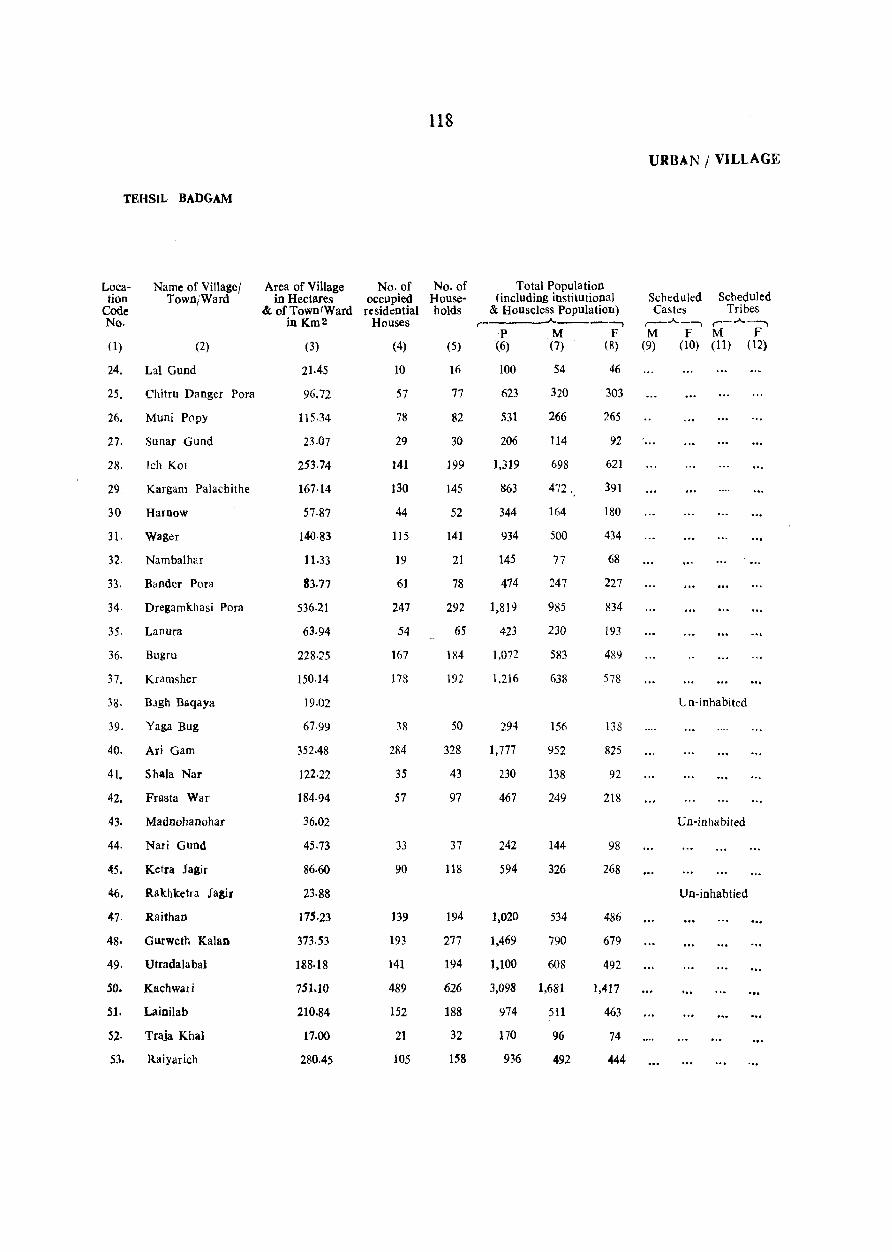
118
URBAN / VILLAGE
TEHSIL BADGAM
Loca- Name of Village! Area of Village No. of No. of Total Population tion Town/Ward in Hectares occupied House- (including institutional Scheduled Scheduled
Code & of Town/Ward re sid ential holds & Houseless Population) Castes Tribes No. inKm2 Houses ,-
.A. ___ -, ,-_.A._-"'I r-.A.-"-I
p M F M F M F 0) (2) (3) (4) (5) (6) (7) (8) (9) (10) (11) (12)
24. Lal Gund 21.45 10 16 100 54 46
25. Chitru Danger Pora 96.72 57 77 623 320 303
26. Muni Popy 115.34 78 82 531 266 265
27. Sunar Gund 23-07 29 30 206 114 92
28. Ich Kot 253.74 141 199 1,319 698 621
29 Kargam Palachithe 167-14 130 145 863 472 . 391
30 Harnow 57·87 44 52 344 164 180
31. Wager 140·83 115 141 934 500 434
32. Nambalhar 11.33 19 21 145 77 68
33. Bander Para 83.77 61 78 474 247 227
34. Dregamkhasi Para 536.21 247 292 1,819 985 834
35. Lanura 63·94 54 65 423 230 193
36. Bugru 228·25 167 184 1,072 583 489
37. Kramsher 150·14 178 192 1,216 638 578
38· BJgh Baqaya 19.02 Un-inhabited
39. Yaga Bug 67.99 38 50 294 156 138
40. Ari Gam 352.48 284 328 1,777 952 825
41. Shala Nar 122.22 35 43 230 138 92
42. Frasta War 184·94 57 97 467 249 218
43. Madnohanohar 36.02 Un-inhabited
44. Nari Gund 45·73 33 37 242 144 98
45. Ketra Jagir 86·60 90 118 594 326 268
46. Rakhketra Ja~r 23·88 Un-inhabtied
47. Raithan 175·23 139 194 1,020 534 486
48· Gurweth Kalan 373.53 193 277 1,469 790 679
49. Utradalabal 188.18 141 194 1,100 608 492
50. Kachwari 751.10 489 626 3,098 1,681 1,417 '"
S1. Lainilab 210.84 152 188 974 511 463
52- Traja Khal 17.00 21 32 170 96 74
53. RaiYarich 280.45 105 158 936 492 444
119
PRIMARY CENSUS ABSTRACT
Main Workers r----------- --"------ --~--------------.
Household Industry
Manufactur- Other ing, Processing, Workers
Total Main Agricul- Servicing and (III, IV, Workers Cultivators tural Lab- Repairs V (b) & Marginal Non-
Literates (I-IX) (I); ourers (II) [V (a)] VI to IX) Workers Workers ,-__ A_, ,-_A_--, ,-__ .A._--, ,----"---, ,-....__..A.. __ , ,-__ J-__ .... ,....--'--, r-___"_~
M F M F M F M F M F M F M F M F (13) (14) (15) (16) (17) (Ill) (19) (20) (21) (22) (23) (24) (25) (26) (27) (28)
19
48
77
19
225
]34
37
113
9
68
2J4
41
163
195
43
243
28
50
25
124
98
64
89
74
62
16
74
2
3
60
30
21
7
3'\
10
10
30
5
77
2
31
22
2
19
33
181
162
47
413
278
107
313
47
141
570
120
313
345
75
570
70
158
82
213
329
489
349
4 1,062
8
13
271
64
271
2
2
57
7
6
49
2
8
18
4
6
25
44
8
10
11
11
4
16
22
21
In
109
27
241
158
73
195
32
93
357
92
219
184
58
416
62
145
47
127
22S
447
259
1,027
238
48
243
37
4
8
5
21
8
2
7
10
2
8
2
7
6
2
3
7
10
3
II
8
45
27
8
36
24
15
68
6
19
91
1(i
26
55
10
40
14
51
3
22
45
2
4
2
2
45
2
5
15
20
9
10
II
3
11
4
17
24
12
129 16
86 5
19 4
49 4
8
27 3
114 3
10 3
61 5
100 4
5
III 31
3
18
34
101 10
19 1
34
35
33
16
28
1
28
3 ]29
4 115
24
5
2
33
18
69
12
30
10
44
9
2
8
6
6
6
54
59
311
220
106
253
39
133
534
126
266
308
73
418
45
117
62
44
279
270
271
888
248
52
249
20
136
100
43
280
194
55
154
29
88
346
98
270
263
71
338
59
91
62
III
197
295
253
613
186
31
221
17
172
150
31
253
lC4
68
132
27
86
287
63
217
245
65
363
39
101
26
213
196
405
205
529
193
22
195
TEHSIL BADGAM
Location
Code No.
Name of Villager Town/Ward
(I) (2)
54. Raiyar Beruwa
55· Goja Thaji
56. Krala Pathri
57· Chak Qadus
58· Yara Khah
59. Gurweth Khurd
60. Khai Pora
61. Dali Pora
62. Khara Pora
63. Sozni Pora
64. Kachi Porn
65. Chak Shern
66. Bugchal
67. Tala Pora
68. Shckhawari Pora
69. Bata Pora
70. Goti Pora
71· Khari Pora
n. Duja Pora
73. Kanora
74. Mulanaru
75. Sahni Pora
76. Khuda POrlt
n Khan Sahib
78. Bala Pora
79. Doru
80. Leter Chud:ua
81. Btari Pora
82. Kalshi Pora
S3. Howru
Area of Village No. of in Hectares occupied
& of TowniWard residential in Km 2 Houses
(3)
148.52
69·61
32·78
39·25
487.25
22.66
76.89
112.91
38·04
49.37
29.95
98.34
78·91
134.76
40.47
56.25
36.42
13.76
61.11
54.23
88.22
140.02
25.90
429.38
78.51
59.49
218.13
19·83
148.52
58.28
(4}
91
38
40
18
152
14
41
55
18
20
28
39
32
44
20
32
35
10
24
41
40
63
16
151
46
20
166
20
86
51
120
No. of Households
(5)
137
50
49
22
185
20
48
79
20
]9
28
44
34
58
25
37
42
12
27
50
46
80
21
199
56
26
203
23
106
64
Total Population (including institutional
& Houseless Population) ,--____ .A. ____ ,
P M F (6) (7) (8)
723
296
281
110
1,119
99
299
458
121
178
145
241
180
244
141
169
267
76
170
302
293
549
121
1,260
352
157
1,082
154
700
373
396
167
154
67
608
50
161
250
70
108
80
137
94
137
79
97
135
43
S36
172
159
281
62
667
199
85
576
82
379
201
327
129
127
43
511
49
138
208
51
70
65
104
86
107
62
72
132
33
84
130
134
268
59
593
153
72
506
72
321
172
URBAN I VILLAGE
Scheduled Scheduled Castes Tribes
,.--.A._----, ,-_..A._-, M F M F
(9) (10) (11) (12)
PRIMARY CENSUS ABSTRACT
Main Workers
121
Household Industry
Manufactur- Other ing, Processing, Workers
Total Main Agricul- Servicing and lUI,IV, Workers Cultivators IUral Lab- Rep~jir~ V (I:» and Marginal Non
Literates (I-IX) (I) ourers Ill) (V la)) VI 10 1X) Workers Workers ,-----"-__ ---. r---.A.-~ -, .. __ ..A.. ______ r----"----.. r----.A.------. r- ---.)\..-~"' r--""""___'" .--__.___...,
M F M F M F M F M F M f M F M F (U) (14) (15) (16) (17) (18) 119) (20) (21) (22) 123) (24) {2S) (26) (27} (28)
11
31
15
10
)00
11
31
70
16
]9
19
12
8
12
4
S
8
(j
9
29
23
25
235
40
13
123
34
4l
58
2
3
2
1
2
37
11
8
g
5
260
111
~4
45
387
33
110
160
44
70
57
92
67
102
55
98
29
54
110
92
171
40
365
133
44
230
50
177
132
8
16
6
7
2
2
18
10
32
19
245
1()6
')0
4-5
332
23
88
114
36
66
52
65
49
76
46
71
77
16
45
108
64
161
22
20S
115
36
125
20
115
50
8
16
2
14
20
5
2
2
2
4
2
5
1
2
12
3
7
2
4
9
13
20
5
19
9
4
7
9
17
5
20
9
20
45
6
4
6
4
9
12
4
23
4)
')
14
44
')
4
III
5
6
4
2
2
4
5
2
16
10
7
141 6
13 1
8
%1
17 3
40 '1
32 lQ
17
5
1
8
217
93
74
34
294
25
77
135
39
49
49
72
2
82
38
56
91
13
46
85
79
163
3 332
116
4
54
.4
105
44
276
42
141
79
136
56
60
22
110
36
S3
9
204 209
17
46
90
26
38
23
45
26
27
24
23
37
13
32
62
67
no 22
299
65
40
23
45
73
12
21
16
32
78
.25
24
16
41
20
38
45
55
105
59
254
46
26
23ll 212
28
148
65
20
148
74
TEHSIL BADGAM
Location
Code No.
()
Name of Villagel Town/Ward
(2)
84. Nuchgam
85. Shuru Jegir
86. Val j Satru
87. Takiafarookshah
88. Hardu Wail
~ 9. Watra Hail
90. Gundali Naik
91. BreI
92. Sholi Ponl
93. Odru
94. Jawa! Porl!
95· Gojrajagir
96. Shoga Pora
97. Chak Gojra
9&. Haya t Pora
99. Kishtwar
100. Nunar
101. J>arnewa Jagir
102. Kula Bug
103. Baba Pora
104. Falachal
)05. R.etu.i Por~
106. Gundarjan
107. Handajin
108. Karhama
109- Choon.
JJlO.· Nagrad Khan
111· Razawnjagir
112. Zorigund
113. Hooru
Area of Village No. of in Hectares occupied
& of Town/Ward resid ntial in Km 2 Houses
(3)
55.04
91.86
106·84
270.74
317.28
325.37
263.45
89.44
411.17
72.84
324.16
207.20
38.04
13·35
49·78
175.64
118.98
258.19
96.72
33.18
158.64
32.38
26.30
118.51
61.92
226.63
50.59
148.93
129.50
Z8.33
(4)
29
44
17
48
162
194
133
37
110
25
185
57
43
26
67
76
172
66
15
82
17
28
57
26
107
35
111
65
24
122
No. 01 Households
(5)
35
45
24
62
196
233
152
53
275
28
198
65
48
27
93
93
205
84
20
III
25
34
61
30
145
45
14.5
78
28
Total Population (including institutiona I
& Houseless Population) r- "'-----.,
p M F (6) (7) (8)
216 115
317 167
146 80
407 246
1,228 685
1,599 812
895 481
342 175
1,987 1,046
177 99
1,340 706
419 229
291 158
196
620
576
],337
629
114
820
134
193
379
251
1,273
299
867
572
193
llO
326
2Q7
703
358
64
418
70
119
195
136
663
159
472
326
118
IJI
150
66
161
543
727
414
167
941
78
634
190
133
86
294
279
634
271
50
402
64
74
184
115
610
140
395
246
75
URBAN / VILLAGE
Scheduled Scheduled CaSTes Tribe::.
r--..A. --., r--"..A...-...... M F M F (9) (10) (1) tI2)
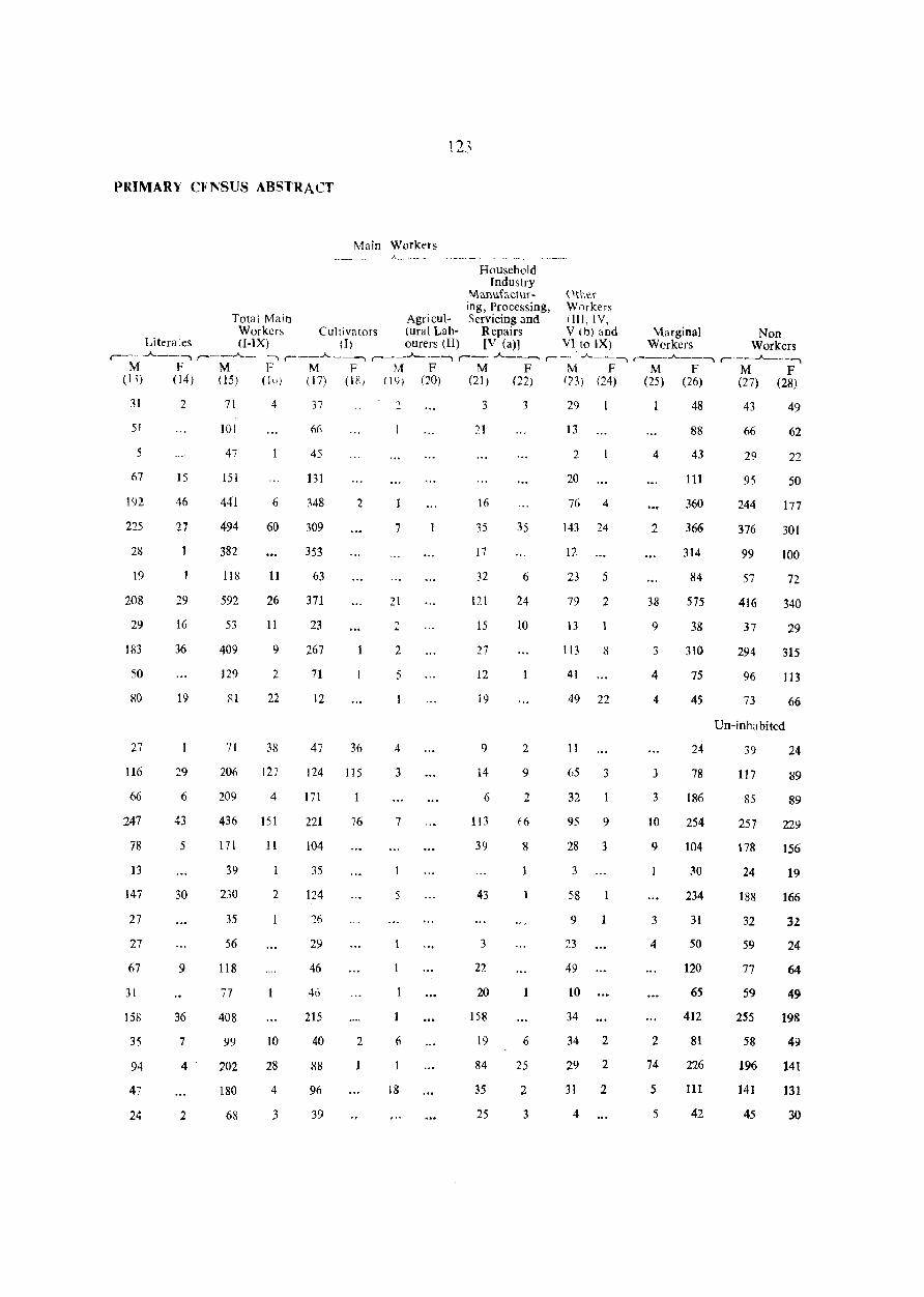
12-'
PRIMARV CFNSUS ABSTRACT
Main Workers _, A, ' ___ '
Household Industry
Mallufactur- Other ing, Processing, Workers
Total Main Agricul- Servicing and (Ill, IV, Workers Cultivators tural Lab- Repairs V (b) and Marginal Non
Literates (I-IX) (1) ourers (II) [V (a)] VI to IX) Workers Workers ,_--A., ___ , ,..-__ .A.. __ -., r-'---"----., , __ .J---_._--, , __ -"----. ,..- ___ ,:.-"-__ --, , __ -"-__ --, , __ -"---__ ..,
M F M F M F rA F M F M F M F M F (11) (14) (15) (1()) (17) (18) 11,)) (20) (21) (22) 123) (24) (25) (26) (27) (28)
31
51
5
67
192
225
2&
19
208
29
183
50
80
27
116
66
247
78
13
147
27
27
67
31
158
35
94
47
24
2
15
46
27
29
16
36
19
29
6
43
5
30
9
36
7
4
2
71
101
47
151
441
494
382
118
592
53
409
129
81
71
206
209
436
171
39
230
35
56
118
77
408
99
202
180
68
4
6
60
11
26
11
9
2
22
38
127
4
151
11
2
1
10
28
4
3
37
66
45
131
348
309
353
63
371
23
267
71
12
47
2
36
124 115
17l
221
104
35
124
?6
29
46
46
215
40
88
96
39
76
2
"
7
21
2
2
5
4
3
7
5
6
18
3
16
35
17
121
15
27
12
i9
9
14
6
113
39
43
3
22
20
158
19
84
35
25
3
35
6
24
10
2
9
2
f6
8
6
25
2
3
29
13
2
20
76 4
143 24
12
23 5
79 2
13
113 8
41
49 22
11
65 3
32
95 9
28 3
3
58
9
23
49
10
34
34 2
29 2
31
4
2
4
2
38
9
3
4
4
3
3
10
9
3
4
2
74
5
5
48
88
43
III
360
366
314
84
575
38
310
75
45
24
78
186
254
104
30
234
31
50
120
65
412
81
226
111
42
43
6Q
29
95
244
376
99
57
416
37
294
96
73
49
62
22
50
177
301
100
72
340
29
315
113
66
Un-inhabited
39
117
85
257
178
24
18B
32
59
77
59
255
58
196
141
45
24
89
89
229
156
19
166
32
24
64
49
198
49
141
131
30
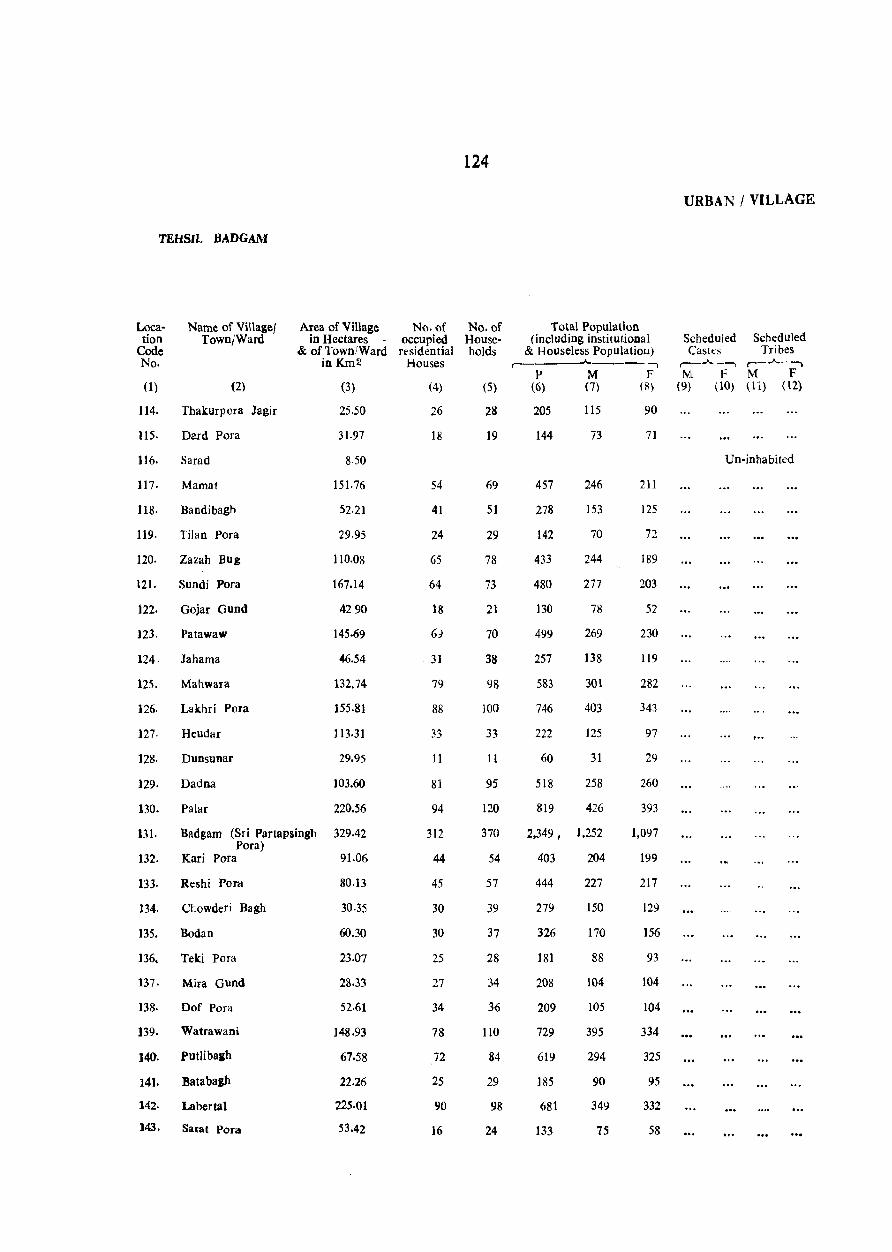
TEHS.L BADGAM
Location
Code No.
Name of Village! Area of Village No. of Town/Ward in Hectares - occupied
& of Town/Ward residential in K.m2 Houses
(1) (2)
114. Thakurpora Jagir
115. Dard Pora
116. Sarad
(3)
25.50
31·97
8.50
117. Mamat 151.76
118. Bandibagh 52·21
119. Tilan POfa 29.95
120. Zazah Bug 110.08
121. Sundi Fora 167.14
122. Gojar Gund 42 90
123. Patawaw 145.69
124· Jahama %.54
125. Mahwara 132.74
126. Lakhri Pvra 155.81
127. Heudar 113.31
128. Dunsunar 29.95
129. Dadna 103.60
130. Palar 220.56
131. Badgarn (Sri Partapsingh 329.42 Pora)
132. Kari Pora 91.06
133. Reshi Pord 80.13
134. Chowderi Bagh 30·35
135. Bodan 60.30
136, Teki Pora 23·07
137. Mira Gund 28.33
138. Dof Pora 52·61
139. Watrawani 148.93
140. PutJibaah 67.58
141. Batabagh 22.26
142. Laber tal 225·01
143. Sarat Pora 53.42
(4)
26
18
54
41
24
65
64
18
6)
31
79
88
33
11
81
94
312
44
45
30
30
25
27
34
78
72
25
90
16
124
No. of Households
(5)
28
19
69
51
29
78
73
21
70
38
98
100
33
11
95
120
370
54
57
39
37
28
34
36
110
84
29
98
24
Total Population (including institutional
& Houseless Populatiou)
P (6)
205
144
M (7)
115
73
-, F
(R)
90
71
457 246 211
278 153 125
142 70 72
433 244 189
480 277 203
130 78 52
499 269 230
257 138 119
583 301 282
746 403 343
222 125 97
60 31 29
518 258 260
819 426 393
2,349 , 1,252 1,097
403 204 199
444 227 217
279 150 129
326 170 156
181 88 93
208 104 104
209 105 104
729 395 334
619 294 325
185 90 95
681 349 332
133 75 58
URBAN I VILLAGE
Scheduled Scheduled Castl::s Tribes
,---"---., ,---"----. M F M F
(9) (10) (11) (12)
Un-inhabited
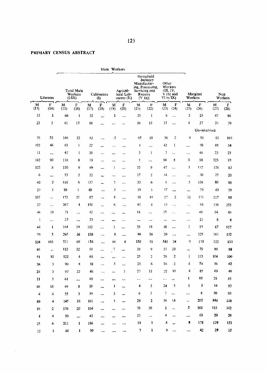
PRIMARY CENSUS ABSTRACT
125
Main Workers ..A. __ _
Household Industry
Manufactur- Other ing, Processing, Workers
Total Main Agricul- Servicing and (Ill, IV, Workers Cultivators tural Lab- Repairs V (b) and Marginal Non
Literates (I-IX) (I) ourers (II) [V (a)] VI to IX) Workers Workers ,......_.._....~ ~ r---.A.----, ,-_---A-----, ,-~ ,-~ ,-~ ,---"""'_--.
M F M F M F M F M F M F M F M F (13) (14) (15) (16) (17) (18) (19) (20) (21) (22) (23) (24) (25) (26) (27) (28)
12
23
76
102
11
162
122
6
60
27
107
22
46
44
:'il
34
28
11
46
4
89
16
4
25
12
1
2
32
46
90
8
2
18
5
163
10
3
3
3
18
4
4
2
4
6
3
66
41
146
65
47
118
150
53
184
89
172
267
71
23
164
265
121
115
122
90
97
61
49
55
247
176
70
211
46
13
12
8
9
2
6
21
4
10
36
89
32
4
8
'22
8
3
16
20
1
1
32
18
62
22
38
19
69
22
137
48
87
186
42
23
112
139
158
59
68
38
48
61
20
39
161
104
43
186
30
. 3
7
5
8
6
9
66
7
3
3
4
25
10
45
2
3
33
17
32
19
50
61
14
33
155
28
25
23
27
4
6
29
70
23
19
7
13
10
9
2
6
19
4
10
36
51
9
2
6
11
5
3
2
20
1
8
13
36 2
42
7
96 S
47
14
8
17
27 2
1·1
15
18
29
342 34
21 23
29 2
26 2
22 10
24 3
7
56 14
2
9
3
3
5
12
7
9
4
4
1
2 5
4
6
9
23
27
47
31
Un-inhahited
96
70
48
98
112
30
138
79
171
~4
49
21
93
225
17$
79
113
59
85
10
3
8
202
163
69
178
42
91
88
23
123
124
25
80
49
117
136
54
8
87
161
522
89
104
56
69
26
54
50
148
113
20
129
2'
66
31
103
54
23
83
82
20
86
39
90
255
48
8
157
132
833
8111
100
62
49
83
93
93
116
142
26
153
15
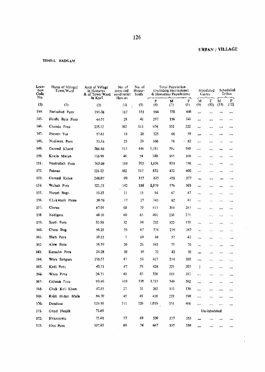
TEHSIL BADGAM
Location
Code No.
Name of Village/ Town/W,Hd
(1) (2)
144. Parisabad Para
145. Hardu 'Bata Para
146. Chanda Pora
147. SUranh Yar
148. Nadiwan Pora
149. Garand Khurd
150. Kakin Maran
151. Nasitullah Pora
152. Paimas
153. Garand Kalan
154. Wf:.hab pora
155. Shopri Bagh
156. Ctakwazir Punu
157. Chewa
158. Nadigam
159. Soori Pora
160. Cha la Bug
161. Shah Pora
162· Alaw Pora
)(;3. KamahQ Pora
164. Wara Sangam
165. Kadi POfa
166. Wara Vora
J67· Galwan POTa
168· Chak: KaJi Khan
169. Rath Haker Mula
170. Dandusa
171· Gund Hanjik
172. Hakermula
173. Hari Pota
Area of Village No. of in Hectares occu:Jied
& of Town/Ward resid l'ntial in K.m2 Hou~es
(3)
291.38
44,yl
235.12
17.81
33.18
206.80
118·98
163·09
131·52
248.07
321,73
11·33
30·76
87.01
48·16
32.38
56.25
10·52
16.59
24.28
118.57
43.71
99.96
47.35
94.7()
129.10
73.65
75.68
107.65
(4)
117
28
102
19
23
113
46
188
102
90
142
11
17
60
60
32
59
7
20
10
47
47
40
110
27
45
III
57
69
126
No. of Households
Total Population (including institutional
& Houseless Populatioh) r-----..Jo,.---~
P M F (5) (6) (7) (8)
151 9S4
41 297
115 674
20 125
23 160
146 1,181
54 349
203 1,636
117 832
117 835
154 1,079
13 94
23 143
70 6]5
63 461
34 232
67 5::,6
10 98
21 141
10 72
54 417
51 428
45 356
13S 1,111
31 263
48 438
126 1.019
69
74
530
667
538
156
352
66
78
59L
185
838
432
458
576
47
82
354
230
122
279
57
71
42
214
221
189
549
133
239
551
277
337
446
141
322
59
82
589
164
798
400
377
503
47
61
2t]
231
110
247
41
70
30
203
207
167
562
130
199
468
253
330
URBAN / VILLAGE
Scheduled Scheduled Castes Tribes
,._,.A._--, r-,.A.--. M F M F
(9) (to) (11) (12)
Un-inhabited
PRIMARY CINSUS ABSTRACT
Main Workers ,-'----------------- ~
127
Household Industry
Manufactur- Other ing, Processing, Workers
Total Main Agricul- Servicing and (Ill, lV, Workers Cultivators tural L~lb- Repilirs V (b) and Marginal NOD
Literates <I-IX) (1) ourers (11) [V {all VI to IX) Workers Workers r______....---, ,----"--- -, r--..A.._---, ,-----'------. r---..A..-----, ,-_--..A-__ -, r--..A..--, r--"'__--,
M F M F M F M F M F M F M F M F (13) (14) (15) (16) (17) (18) (19) (20) (21) (22) (23) (24) (25) (26) (27) (2&)
53
14
24
8
7
165
16
72
26
53
60
2
8
96
20
3
52
1
5
4
15
2
5
39
14
26
41
16
81
23
3
4
2
2
24
2
lZ
7
7
11
2
3
7
7
4
12
2
4
2
3
6
4
18
2
4
25
7
21
338
96
262
42
56
356
WI
526
302
378
36
47
194
158
82
169
36
54
22
152
155
135
336
86
130
272
143
212
29
7
18
71
60
19
13
3
2
5
4
2
3
3
8
13
g
23
10
23
II
29
270
51
158
32
45
192
89
400
IS2
207
328
36
43
177
147
58
153
35
50
19
130
138
91
253
60
83
196
120
91
9
16
11
3
2
5
4
2
3
2
5
12
10
9
8
8
12
4
2
9
2
2
2
3
3
53
13
88
4
5
102
3
49
68
69
3
5
5
21
2
15
43
24
61
5
103
22
2
13
60
27
9
10
3
13
21
15 7
32 5
16 5
(]
6
50
5
77 17
32 10
26
50 2
10
6
3
16
2
3
?2 6
2
1
74 10
25
21
13
16
18
21
2t
2
11
3
11
46
4
5
2
11
30
260
104
185
43
47
174
48
283
230
235
297
34
43
181
175
67
115
29
44
13
99
331
83
61
37
200
39
90
23
22
236
84
312
150
156
198
11
35
136
70
40
99
21
17
17
62
66
43
167
43
104
277
Un-inhabited
50
215
123
95
157
30
119
15
34
344
115
455
151
142
H'3
13
15
78
55
38
128
10
23
14
195
194
60
208
46
128
408
195
81l
128
URBAN I VILLAGE
TEHSIL BADGAM
Loca- Name of Village/ Area of Village No. of No. of Total Population tion Town/Ward in Hectares occupied House- (including institutional Scheduled Scheduled
Code & of Town/Ward residential holds & Houseless Population) Castes Tribes No. inKm2 Houses r- r---"--~ r-~
p M F M F M F (1) (2) (3) (4) (5) (6) (7) (8) (9) (10) (11) (12)
174. Soya Bug 604.20 510 594 ,5,042y 2,597 2,445 9
175. Dehramana 490.08 242 266 2,288 1,211 1,077 9
176. Wadwan Jaair 244.84 210 239 1,780 914 866
In Gota Pora 164.71 107 155 1,312 654 658
178. Arath 283·28 117 138 1,078 574 504-
179. Rakh Ara th 2109.24 39 45 380 181 199
180. Hanjik 156.61 42 54 476 252 224
f81. Haji Bach 25.50 84 92 707 158 349
182. Sharief Abad 110.88 54 6S 444 229 215
URBAN AREA
·Srinagar (Portio.a) 29.43 Km 2 2,.212 2,628 19,323 10,385 8,938 11
• For Mohalla wise breakup and out·arowth figures see PCA of Srina!ar Urbaa AIglomeration.
129
PRIMARY CENSUS ABSTRACT
Main Workers r-- ~~~------..
Household Industry
Manufactur- Other ing, Processing, Worker~
Total Main Agricu)· Servicing and (III, IV, Work.ers Cultivators lural Lab- Repairs V (b) and M;ar¥inal Non
Literates (I-IX) (I) ourers (II) [V (a.)) VI to IX) Workers Workers ,..-----A. __ --., ,.._....____, ,-_.A._~ ,-_--"------., ,-__ .A._---., ,-_.A. __ ---., ,-___ .A.------, ,-__ .A..~ .....
M F M F M F M F M F M F M F M F (B) (14) (15) (\6) 07} (i8) (19) (20) (21) (22) (23) (24) (25) (26) (27) (28)
398 119 ] ,432 88 813 52 22 318 20 279 16 11 983 1,154 1,374
328 91 771 55 584 31 7 48 16 132 7 608 439 414
257 101 492 23 381 13 R 3 102 7 321 421 522
76 41 371 92 297 51 2 72 40 4 188 279 378
126 40 301 14 292 13 9 267 273 223
30 12 96 8 76 7 20 13 84 178
10 7 153 10 139 5 14 5 11 151 88 63
51 12 245 18 129 8 90 9 25 1 13 208 100 123
61 7 ~ 152 25 99 5 3{) 14 23 6 4 141 73 49
4,659 2,291 5,173 743 1,206 285 lOR 290 128 3,569 329 139 1,496 5,073 6.699
130
URBAN / VILLAGE
TEHSIL BEERWAH
Locs- Name of Village/ Area of Village No. of No. or Total Population tion Town/Ward in Hectares occupied House- (including institutional Scheduled Scheduled
Code & of Town/Ward residential holds & Houseless Population) Castes Tribes No. inKm2 Houses r- .A__ ,..-_...A.._., ,..-_...A..----,
P M F M F M F (1) (2) (3) (4) (5) (6) (7) (8) (9) (10) (11 ) (12)
4/3 Tehsll Bfemab
219.5 Km 2
Total (21947.22 12,366 15,345 99,746 53,252 46,494 Hectares)
219.5 Km2 Rural (21947.22 12.366 15.345 99,746 53,252 46,494
Hectares)
Urban
Rural Areas
I. Sozeth Guri Pora 318.90 294 354 2,515 1.287 1,228
2. NarabaI 155.40 227 259 1,786 925 861
3. Gund Khalie noo 15 22 141 71 70
4. Yaru Gund 58.68 59 80 594 300 294
5. Gagar Pora 65.56 92 107 763 4]8 345
6. Kawsa Jagir 1166.32 181 202 1,490 804 686
7. Kawsa Khalisa 269·1, 231 304 2,511 1.308 1,20.1
8· Maze Hama 152.16 148 179 1,436 767 669
9. Gund Kawarehama 42.09 90 121 840 447 393
]0. Bata Pora Kanihama 108.05 92 157 1.170 626 544
11. Nowpora Pain 14.57 17 28 216 117 99
12. Chakdewan Badrinath 53.42 30 35 257 130 127
13· Chair Giun 65.16 68 81 605 3'25 280
14. Ship Pora 43.71 28 35 255 123 132
15. Snoor Kalipora 210.84 107 132 1,013 584 465
16. Kanth Bagh 11.74 21 24 160 93 67
l7. Lohar Chak 24.28 22 25 214 110 104
18. Hardu Waminu 34.40 28 29 238 125 113
19· Raziwan 60.70 35 45 352 191 161
20. Che"ehar 67.58 56 67 472 254 218
21. Rassoo 96.32 113 128 1,117 578 539
22· Watal Pora Banda Pora 78.51 71 85 624 33] 293
23· Bandagam 2n61\ 129 160 1,187 608 579
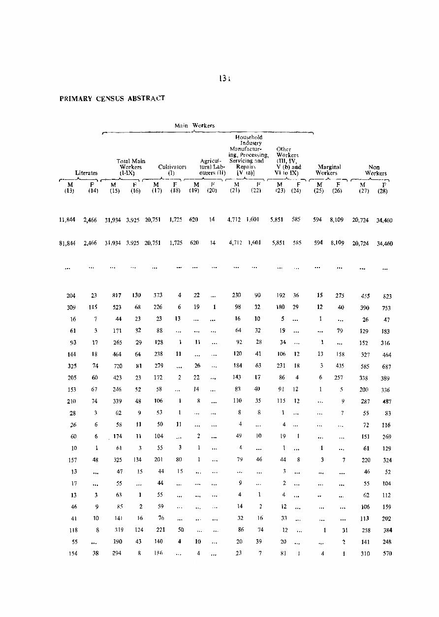
PRIMARY CENSUS ABSTRACT
Main Workers
Household Indus'try
Manufactur- Other iog, Processing, Workers
Total Main Agricul- Servicing and (III, IV, Workers Cultivators tural Lab- Repairs V (b) and Marginal Non
Literates (I-IX) (1) OUIers (II) [V (a)J VI to IX) Workers Workers ,...---"-------"'1 ,...._--.A.--, ,...----A---., ,---__"'__-, ,..-_.A. __ ., ,--_.A. __ , , __ .A._, ,..----"--_ ......
M F M F M F M F M F M F M F M F (13) (14) (15) (16) (17) (18) (19) (20) (21) (22) (23) (24) (25) (26) (27) (28)
11,844 2,466 31,934 3,925 20,751 1,725 620 14
81,844 2,466 31,934 3,925 20,751 1,725 620 14
204
309
16
61
93
144
325
205
153
210
28
26
60
10
157
13
17
13
46
41
118
55
154
23
115
7
3
17
18
74
60
67
74
3
6
6
1
48
3
9
10
8
38
817 130
523 68
44
171
265
464
720
423
246
339
62
58
174
61
325
47
55
63
85
141
23
32
29
64
81
23
52
48
9
11
11
3
134
IS
2
16
319 124
190
294
43
8
373
226
23
88
128
238
279
172
58
106
53
50
104
55
201
44
44
55
59
76
221
140
lR(i
4
6
13
1
11
2
11
3
80
15
50
4
22
19
11
26
22
14
8
2
10
4
4,7i2 1,601 5,851 585
4,712 1,601 5,851 5R5
230
98
16
64
92
120
184
143
83
110
8
4
49
4
79
9
4
14
32
86
20
23
90
32
10
32
28
41
63
17
40
35
8
IO
46
1
2
16
74
39
7
192 36
180 29
5
19
34
106 12
231 18
86 4
91 12
115 12
1
4
19
44 8
3
2
4
12
33
12
20
81
594 8,109 20,724 34,460
594 8,109 20,724 34,460
15
12
1
13
3
6
3
4
275
40
79
158
435
257
5
9
7
7
31
'2
455
390
26
129
152
327
585
338
823
753
47
183
316
464
687
389
200 336
287 0487
55
72
151
61
220
46
55
62
106
113
258
141
310
83
116
269
129
324
52
104
112
159
202
384
24&
570
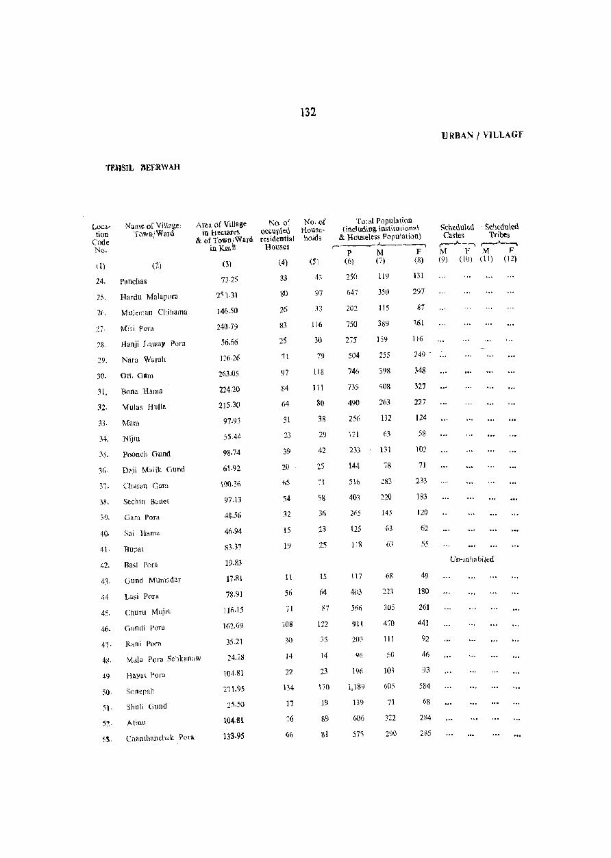
TEHSIL BEERW AH
Location
Code No.
Name of Village} TownjWard
d) (2)
24. Pancha~
25. Hardu Malapora
2(\. Mulemao Chihama
27· Miri Pora
28. Hanji Laway Pora
29. Nara Warah
30. 0111 Gam
~I. Bona Hama
32. Mulas Hulla
:n. Mam
34. Nijiu
35. Paoneh Gund
36· D?)I Malik Gund
37. Char<lu Gllm
38. Sechiu B~net
39. Gam Para
40. Sai Hama
41. Bupat
42. Ba,i Pora
43. Gund Mumadar
44 Lasi Para
45. Churu Mujrll
46. Gundi Pora
47. Rani Pora
Area of Village ]'\0· of in hectare~ occupied
& of Town/Ward residential in Km 2 Houses
(3)
7325
251.31
146.50
24().79
56.66
126.26
263.05
224·20
215.30
97.93
55.44
98.74
61.92
100.36
97.13
48.56
46.94
S3.37
19·83
17-81
78.91
l1(i.15
162.69
35.21
(4)
33
80
26
83
25
11
97
84
64
31
23
39
20
65
54
32
15
19
11
56
71
4;,. Mala Pora Sehbnaw 24.28
108
30
14
22
134
49. HayM f>ora
50. Sane pall
51. Shuli Gund
51. Atinu
104,81
271.95
25.50
104.81
133.95
17
76
132
No, of Householos
(5)
97
33
116
30
79
IlS
111
80
38
29
42
25
58
36
23
25
15
64
87
122
35
14
23
170
19
89
81
Total Population (including institutional
& Houseless Populati()n) r- .A._~---,
P M F (6) (7) (8)
250
647
202
750
275
504
746
735
490
256
121
233
144
516
403
265
125
118
117
403
566
911
20}
196
1,189
139
606
57'S
119
350
US
389
159
255
398
408
263
132
63
131
78
220
145
6R
221
305
4-;0
111
50
103
71
322
290
131
297
87
361
116
249 .
348
327
227
124
58
)02
71
233
lS3
120
62
55
49
180
261
441
92
46
93
584
(\8
284
2\\5
URBAN I VILLAGF
Scheduled Castes ~--, M F (9) (10)
. Scheduled Tribes ~ M F
(11) (12)
Un-inhabited
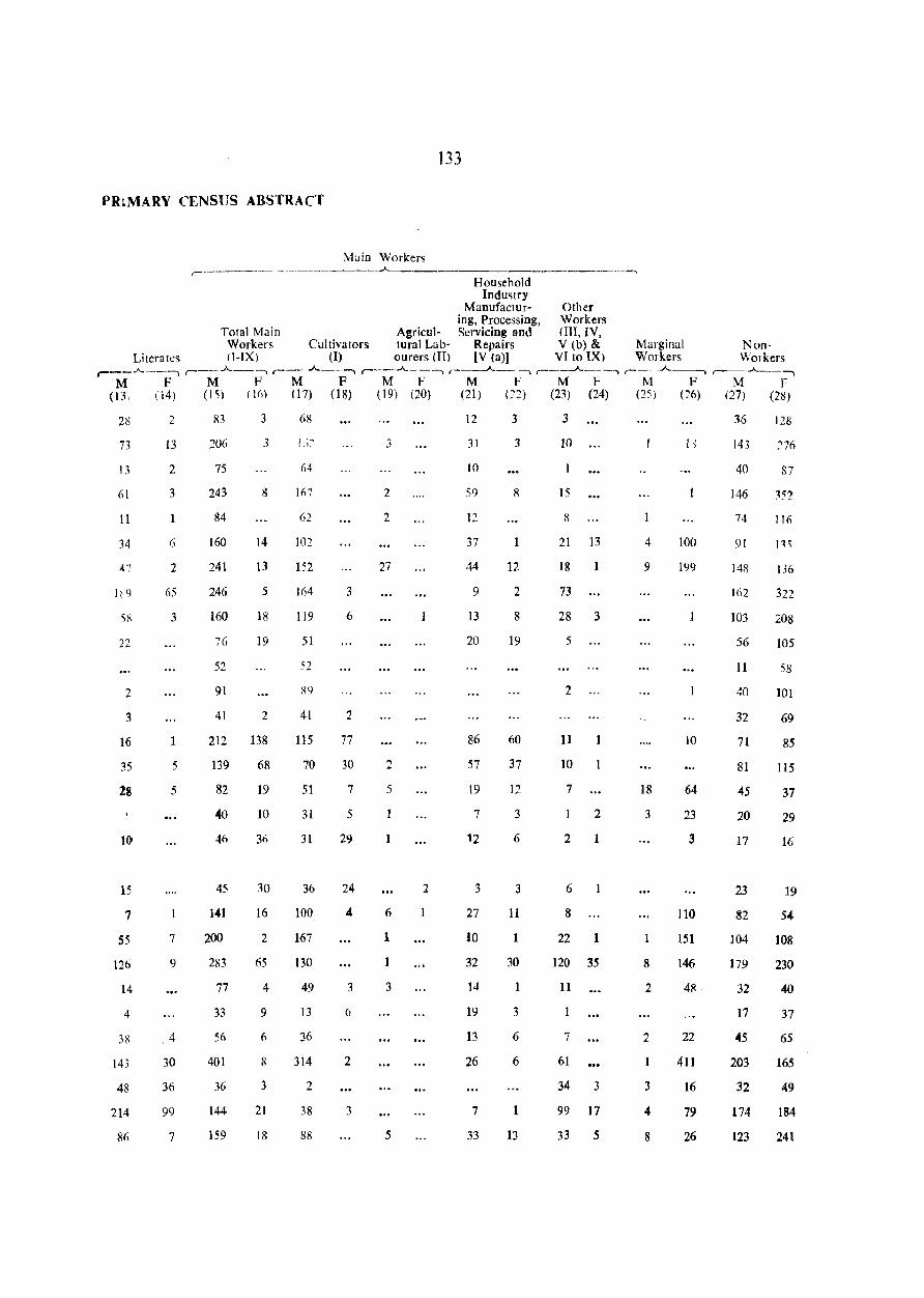
133
PR~MARY CENSUS ABSTRACT
Main Workers ,- __________________ -----. -A-..... _________ • _________ ---,
Household Industry
Manufactur- Other ing, Processing, Workers
Total Main Agricul- Servicing and (III, IV, Workers Cultivators tural Lab- Repairs V (b) & Marginal N on-
Literates cI-IX) (1) ourers (II) [V (a)] VI to IX. Workers Workers r---"------. , __ .A._--, ,- .A._--, ,___._-- --, .--_-A._ --, r---A.----, , __ ...A._-, ,-.A._-"l
M F M F M F M F M F M F M F M F (13, (14) (15) (1(» (17) (18) (19) (20) (21) (22) (23) (24) (25) (26) (27) (28)
28
73
13
(>1
11
34
47
It 9
58
22
2
3
16
35
28
10
15
7
55
126
14
4
38
143
48
214
86
2
13
2
3
1
6
2
65
3
1
5
5
1
7
9
4
30
36
99
7
83
206
75
243
84
160
241
246
160
76
52
91
41
3
3
8
14
13
5
Iii
19
2
212 138
139
82
40
46
45
141
200
283
77
33
56
401
36
144
159
68
19
10
36
30
16
2
65
4
9
6
8
3
21
18
68
64
IIl7
62
102
152
164
119
51
52
R9
41
115
70
51
31
31
36
100
167
130
49
13
36
314
2
38
88
3
6
2
77
30
7
5
29
24
4
3
6
2
3
3
2
2
27
2
:')
1
6
1
1
3
5
2
1
12
31
10
59
12
37
44
9
13
20
86
57
19
7
'2
3
27
10
32
14
19
13
26
7
33
3
3
1
12
2
8
19
60
37
12
3
6
3
11
1
30
1
3
6
6
1
13
3
10
15
8
21 13
18 1
73
28 3
5
2
11 1
10
7
2
2 1
6
8
22 1
120 35
11
7
61
34 3
99 17
33 5
4
9
18
3
8
2
2
3
4
8
100
199
10
64
23
3
110
151
146
48
22
411
16
79
26
36
143
40
146
74
91
148
162
103
56
11
40
32
71
81
45
20
17
23
82
104
179
32
17
45
203
32
174
123
128
27(,
87
IIIl
136
322
208
105
58
101
69
85
115
37
29
16
19
54
108
230
40
37
65
165
49
184
241
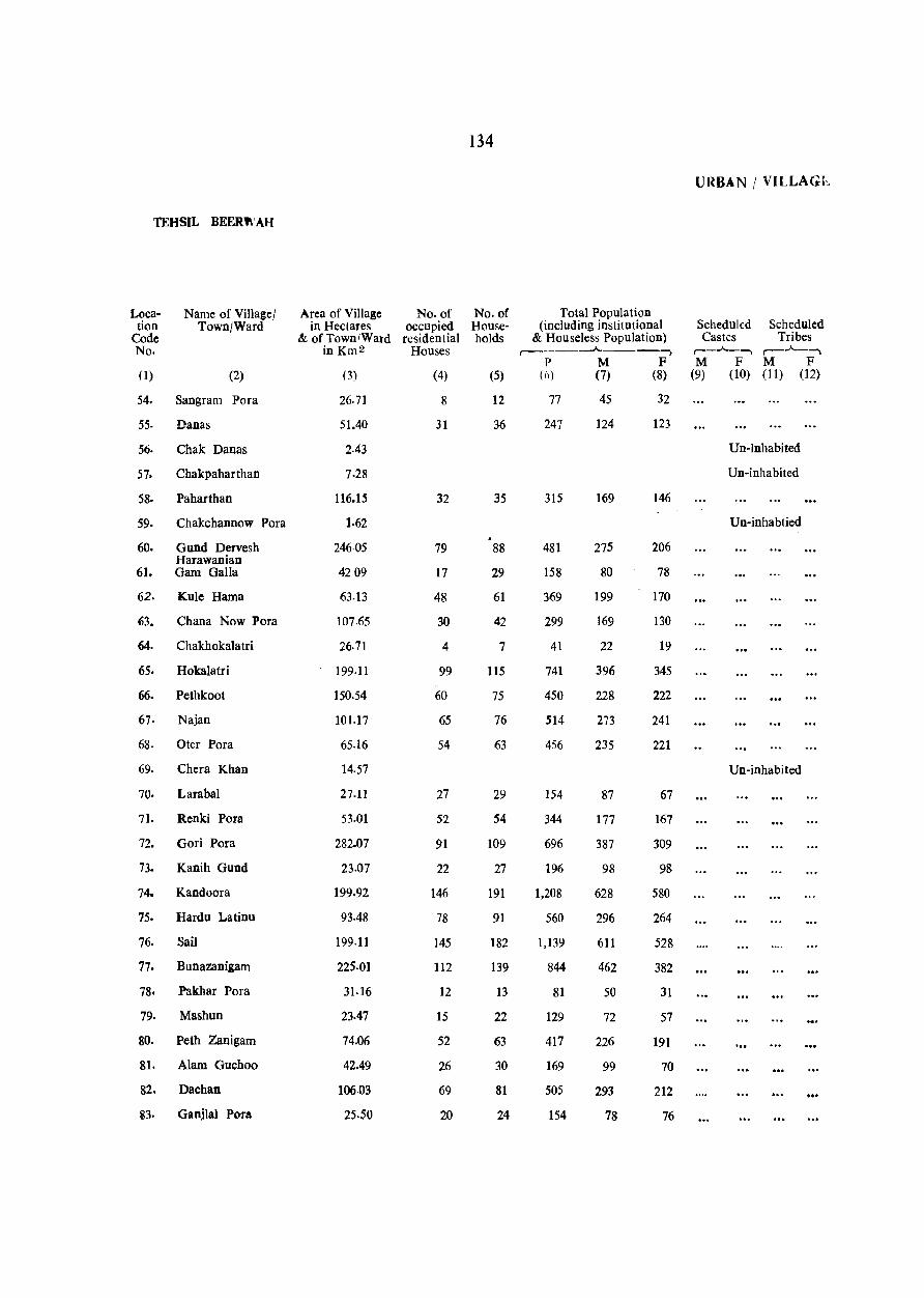
134
URBAN I VILLAGi<..
TEHSIL BEER'" AH
Loca- Name of Village! Area of Village No. of No. of Total Population tion Town/Ward in Hectares occupied House- (including institutional Scheduled Scheduled
Code & of Town/Ward residential holds & Houseless Population) Castes Tribes No. inKm2 Houses
,..-___ --A. ___ --, ,..-_ ....... _, ,--....... --.. P M F M F M F
0) (2) (3) (4) (5) (6) (7) (8) (9) (10) (11) (12)
54. Sangram Pora 26.71 8 12 77 4S 32
55. Danas 51.40 31 36 247 124 123
56. Chak Danas 2.43 Un-inhabited
57. Chakpaharthan 7.28 Un-inhabited
58. Paharthan 116.15 32 35 315 169 146
59. Chakchannow Pora 1.62 Un-inhabtied
60. Gund Dervesh 246·05 79 88 481 275 206 Harawanian
61. Gam Galla 4209 17 29 158 80 78
62. Kule Hama 63.13 48 61 369 199 170
63. Chana Now Pora 107.65 30 42 299 169 130
64. Chakhokalatri 26.71 4 7 41 22 19
65. Hokalatri 199.11 99 115 741 396 345
66. Pethkoot 150.54 60 75 450 228 222
67· Najan 101.17 65 76 514 273 241
68. Oter Pora 65.16 54 63 456 235 221
69. Chera Khan 14.57 Un-inhabited
70. Larabal 27.11 27 29 IS4 87 67
7l. Renki Pora 53.01 52 54 344 177 167
72. Gori Pora 282.07 91 109 696 387 309
73. Kanih Gund 23.07 22 27 196 98 9&
74. Kandoora 199.92 146 191 1,208 628 580
75. Hardu La tinu 93-48 78 91 560 296 264
76. Sail 199.11 145 182 1,139 611 528
77. Bunazanigam 225.01 112 139 844 462 382
78. Pakhar Pora 31.16 12 13 81 SO 31
79. Mashun 23.47 15 22 129 72 57
80. Peth Zanigam 74.06 52 63 417 226 191
81. Alam Guchoo 42.49 26 30 169 99 70
82. Dachan 106.03 69 &1 50S 293 212
83. Ganjlal Pora 25.50 20 24 154 78 76
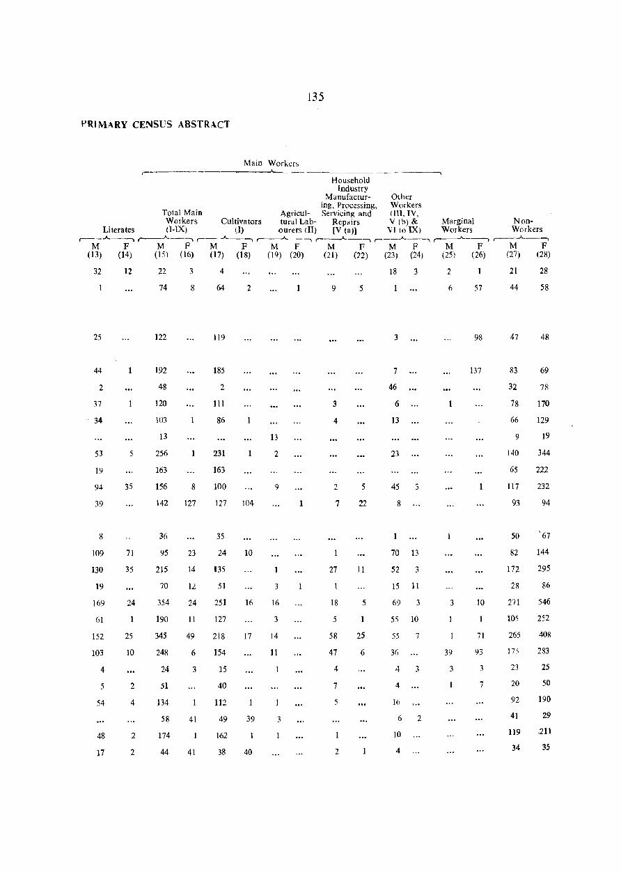
PRIMARY CENSUS ABSTRACT
Main Workers .---~~ -----__;,._____
135
Household Industry
Manufactur- Other ing, Processing, Workers
Total Main Agricui- Servicing and (III, IV, Workers Cultivators turai Lab- Rep~irs V (b) & Marginal N on-
Literates cI-IX) (I) ourers (II) [V (a)) Vito IX) Workers Workers ,-__ ..A.._--, r--.A.---.., ,--- ..A.._--..,,..---..A.. _--.., ,.-_--..A.. __ --.., ,.-__ ..A.. __ ..., ,.----..A..----.., ,-__ ..A.._--..,
M F M F M F M F M F M F M F M F (13) (14) (15) (16) (17) (18) (19) (20) (21) (22) (23) (24) (25) (26) (27) (28)
32
25
44
2
37
34
53
19
94
39
8
109
130
19
169
61
152
103
4
5
54
48
17
12
1
5
35
71
35
24
25
10
2
4
2
2
22
74
122
192
48
120
103
13
256
163
156
142
36
95
215
70
354
190
345
248
24
51
134
58
174
44
3
8
1
8
127
23
14
12
24
11
49
6
3
41
41
4
64
119
185
2
III
86
231
163
100
127
35
24
135
51
251
127
218
154
15
40
112
49
162
38
2
13
2
9
104
10
3
16 16
3
17 14
11
39 3
1
40
18 3
9 5
3
7
46
3 6
4 13
23
2 5 45 3
1 7 22 8
70 13
27 11 52 3
15 11
18 5 69 3
5 55 10
58 25 55 7
47 6 3(i
4 4 3
7 4
5 16
6 2
10
2 4
2
6
3
39
3
57
98
137
10
71
93
3
7
21
44
47
83
32
78
66
9
140
65
117
93
50
82
172
28
211
105
265
17:\
23
20
92
41
119
34
28
58
48
69
78
170
129
19
344
222
232
94
'67
144
295
86
546
252
408
283
25
50
190
29
-211
35
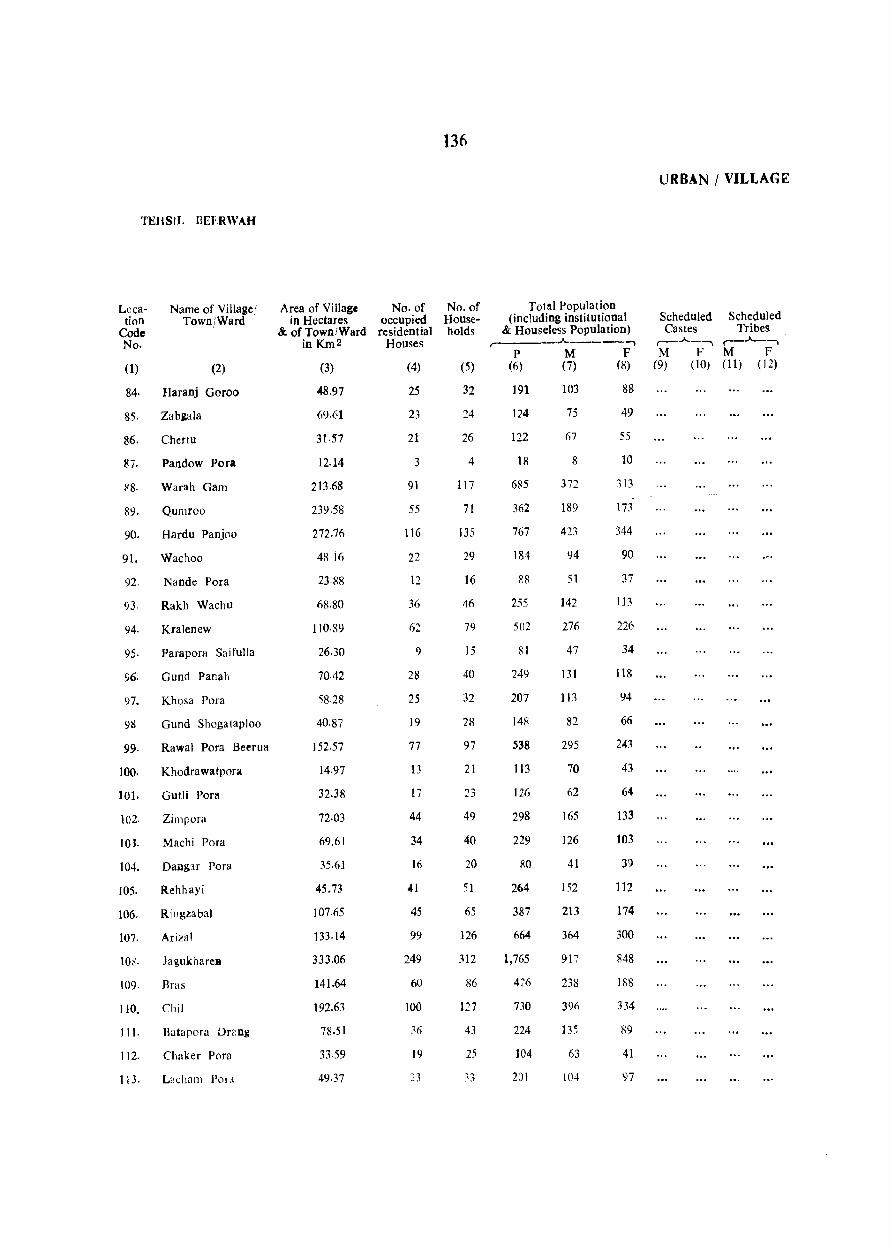
TEHSIL BEERWAH
Location
Code No.
Name of Village I Town/Ward
(I) (2)
84· Haranj Goroo
85. Zabiala
86. Chertu
87. Pandow Pora
)/8. Warah Gam
89. Qumroo
90. Hardu Panj(lo
91. Wachoo
92. Nande Pora
93. Rakh Wachu
94. Kra1enew
95. Parapora Saifulla
96. Gund Panah
97. Khosa Pora
911 Gund Shogataploo
99. Rawal Pora Beerua
100. Khodrawatpora
101. Gutli Pora
102. Zirnpora
10J. Machi Pora
104. Dailg:u Pora
105. Rehhayi
106. RingzabaJ
107. Arizal
10,'. Jagukharell
109. Bras
110. Chi]
11 t. Batapora Drang
112. Chaker Pora
113. L::charn POLl
Area of Village No. of in Hectares occupied
&. of TownlWard residential in Km 2 Houses
(3)
48.97
69.61
31.57
12.14
213.68
239.58
272.76
48 i6
23.88
68.80
110·89
26.30
70.42
58.28
40·87
152.57
14.97
32.38
72·03
69.61
35.61
45.73
107.65
133·14
333.06
141.64
192.63
78.51
33.59
49.37
(4)
25
23
21
3
91
55
116
22
12
36
62
9
28
25
19
77
13
17
44
34
16
41
45
99
249
60
100
:6
19
:.3
136
No. of Households
(5)
32
24
26
4
117
71
135
29
16
46
79
15
40
32
28
97
21
23
49
40
20
51
65
126
312
127
43
25
~3
Total Population (including institutional
& Houseless Population) ,..--. ___ A.
P M (6) (7)
191 103
124
122
18
685
362
767
181
R8
255
502
RI
249
207
148
538
113
126
298
229
80
264
387
664
1,765
4~6
730
224
104
201
75
67
8
3~.,
1-
189
423
94
51
142
276
47
131
113
82
295
70
62
165
126
41
152
213
364
917
238
396
135
63
104
-, F
(8)
88
49
55
10
313
]i3
344
90
37
113
226
34
118
94
66
241
43
64
133
103
39
112
174
300
848
188
334
89
41
97
URBAN / VII.JLAG:E
Scheduled Scheduled Castes Tribes
,......_.A.._......., r-.A..-...., . M F M F
(9) (10) (11) (J2)
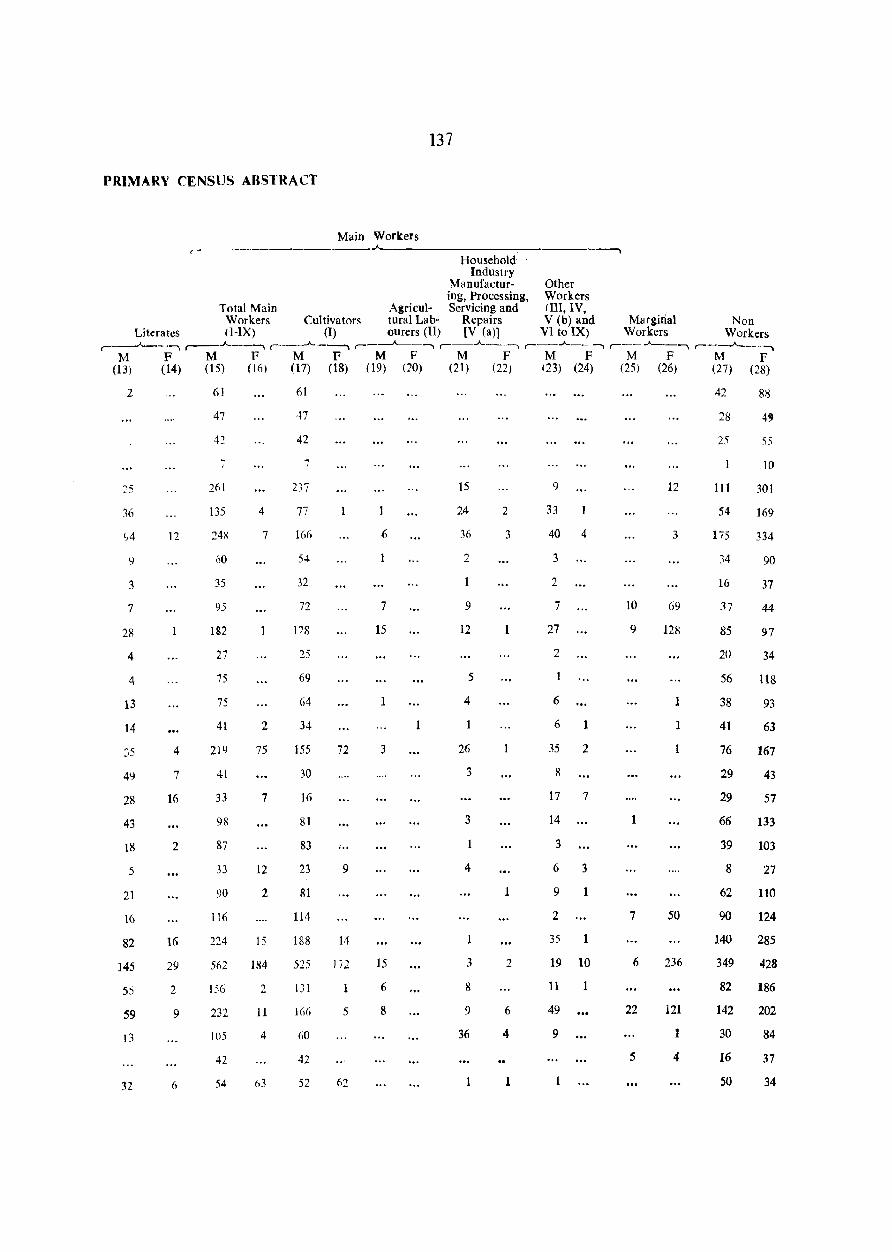
137
PRIMARV CENSUS ABSTRACT
Main Workers .--------~-------------------------~
Household Industry
Manufactur- Other ing, Processing, Workers
Total Main Agricul- Servicing and lIn, IV, Workers Cultivators tural Lab- Repairs V (b) and Marginal Non
Literates (I-IX) (I) ourers (II) [V (a)) VI to IX) Workers Workers ,.__..;....__ ........ ,-_.A._......, r-.A.-~ ,---"---....... ,_.A._......, , __ ..A.. __ ....... , __ . ..A._ ....... ,--..A-..._ ....
11 F M F M F M F M F M F M F M F (13; (14) (15) (10) (17) (18) (19) (20) (21) (22) (23) (24) (25) (26) (27) (28)
2
36
3
7
28
4
4
13
14
35
49
28
43
18
5
21
16
82
145
55
59
)3
32
12
4
7
16
2
16
29
2
9
6
61
47
42
261
135
60
35
95
182
27
75
75
41
219
41
33
9R
87
33
90
116
224
562
156
232
105
42
54
4
7
2
75
7
12
2
15
184
2
11
4
63
61
47
42
7
237
166
54
32
72
178
25
69
64
34
155
30
16
81
83
23
81
114
188
525
131
166
60
42
52
72
~ .. 9
14
172
5
62
1
6
1
7
15
1
3
15
6
8
15
24
30
2
9
12
5
4
26
3
3
4
3
8
9
36
2
3
1
1
2
6
4
1
9
33
40 4
3
2
7
27
2
1
6
6
35
8
1
2
17 7
14
3
6 3
9
2
35
1
1
19 10
11
49
9
10
9
1
7
6
22
5
12
3
69
128
1
1
50
236
121
4
42
28
25
111
54
175
34
16
37
85
20
56
38
41
76
29
29
66
39
8
62
90
140
349
82
142
30
16
50
55
10
301
169
334
90
37
44
rn 34
118
93
63
167
43
57
133
103
27
110
124
285
428
186
202
84
37
34
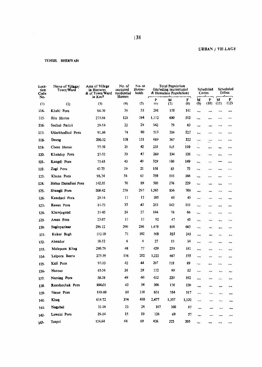
TF.HSIL BEERWAH
Location
Code No.
Name of V~l~eJ Town/Ward
(I) (2)
114. Khahi Pora
115. Sita Haran
116. Sochal Pathri
111· Udarkbodlasi Pora
118. Drang
119. Chere Haroo
120. Khanday Pora
121. Kangdi Pora
122. Zagi Pora
123. Khana Pora
124. Habar Daradlasi Pora
125. Shungli Pora
126. Kanchati Pora
127. Rawat Pora
128. Khawjagund
129. Awan Pora
130. Suginyarillar
131. Koker Bagh
132. Abandar
133. Malapora Khag
134. Lalpora Beeru
13S. Kali Pora
136. Nassoo
137. Narsing Pora
138. Ramdarchak Pora
139. Nasar Pora
140. Khag
141. Nagaba)
142. Lawahi Pora
143. Trapai
Area of Village No. of in Hectares occupied
& of Town/Ward residential in Km 2 Houses
(3)
94.70
273.98
29.14
91.86
200.32
17.70
2].52
71.63
47.75
98.74
142.05
208.42
29.54
81.75
21.45
23.o?
286.12
112.10
10.52
240.79
275.59
97.13
65.56
58.28
104.01
189·80
614.72
31.16
29.14
124.64
(4)
38
129
22
74
118
35
39
43
19
54
70
239
17
37
24
17
200
71
4
68
156
42
24
49
42
80
334
23
15
64
138
No.ot Households
Total Population (including institutional
& Houseless Population) r·-------A -------,
(5) P
(6) M (7)
53 291 150
194 1,112 600
29 142 79
80 513 286
131 689 367
42 235 125
47 260 134
49 329 180
21 158 85
65 359 193
89 505 276
297 1,565 856
17 105 60
42 253 142
27 144 78
17 92 47
286 1,479 816
102 568 323
4 27 13
77 420 239
202 1,222 667
44 207 118
29 172 90
60 412 220
54 306 176
110 651 334
410 2,477 1,357
24 167 100
19 126 69
69 426 223
F (8)
141
512
63
227
322
110
126
149
73
166
229
709
45
111
6b
45
663
245
14
181
555
89
82
192
130
317
1,120
67
57
203
URBAN I VILLAGE
Scheduled Scheduled Castes Tribes
,--..Jo-_-., ,.---~ M F M F (9) (10) (11) (12)
'"
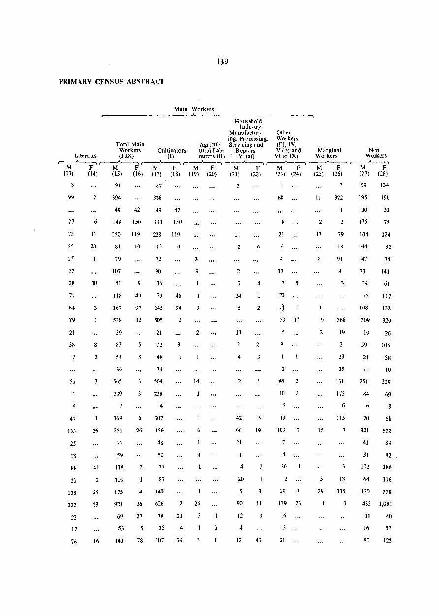
139
PRIMARY CENSUS ABIOITRACT
Main Workers r--------------------~----------
Household Industry
Manufactur- Other iog, Processing, Workers
Total Main Agricul- Savicing and (Ill, IV, Workers Cultivators tural Lab- Repairs V (b) and Marginal Non
Literates (I-IX) (1) ourers (II) . [V (a)] VI to lX) Workers Workers ,..--.A---~ '----"--""""1 r-....... -"""""" r-__"__-, r--....... -----, r---"---' r-..A--- l r--..A---,"""
M F M F M F M F M F M F M F M F (13) (14) (15) (16) (17) (18) (19) (20) (21) (22) 123) (24) (25) (26) (27) (28)
3
99
77
73
25
25
22
28
77
64
79
21
38
7
51
4
47
133
25
18
88
21
138
222
23
17
76
2
6
13
20
10
3
8
2
3
26
44
2
55
23
16
91
394
49 42
87
3'26
49 42
149 150 141 150
250 119 228 119
81
79
107
51
118
167
538
39
83
54
36
565
239
7
169
331
77
59
118
109
175
921
69
53
143
10
9
49
97
12
5
5
3
3
5
26
3
4
36
27
5
78
73
72
90
36
73
145
505
21
72
48
34
504
228
4
107
156
48
50
77
87
140
626
38
35
107
4
48
94
2
3
2
23
4
34
3
3
1
3
2
14
1
6
4
26
3
3
3
2
2
7
24
5
11
2
4
2
42
66
21
4
20
5
90
12
4
12
6
4
2
2
3
5
19
2
3
11
3
43
68
8
22
6
4
12
7 5
20
33 10
5
9
2
145 2
10 3
~
19
103
7
4
36
2
29
7
179 23
16
21
11
2
13
8
9
2
15
3
29
7
322
1
2
79
18
91
8
3
368
19
2
23
35
431
173
6
115
7
3
13
135
3
59
195
30
135
104
44
47
73
34
75
108
309
19
59
24
11
251
84
6
70
321
41
31
102
64
130
134
19(,)
20
124
82
35
141
6}
117
132
329
26
104
38
10
229
69
8
61
522
89
82
]86
116
178
435 1,081
31
16
80
40
52
125
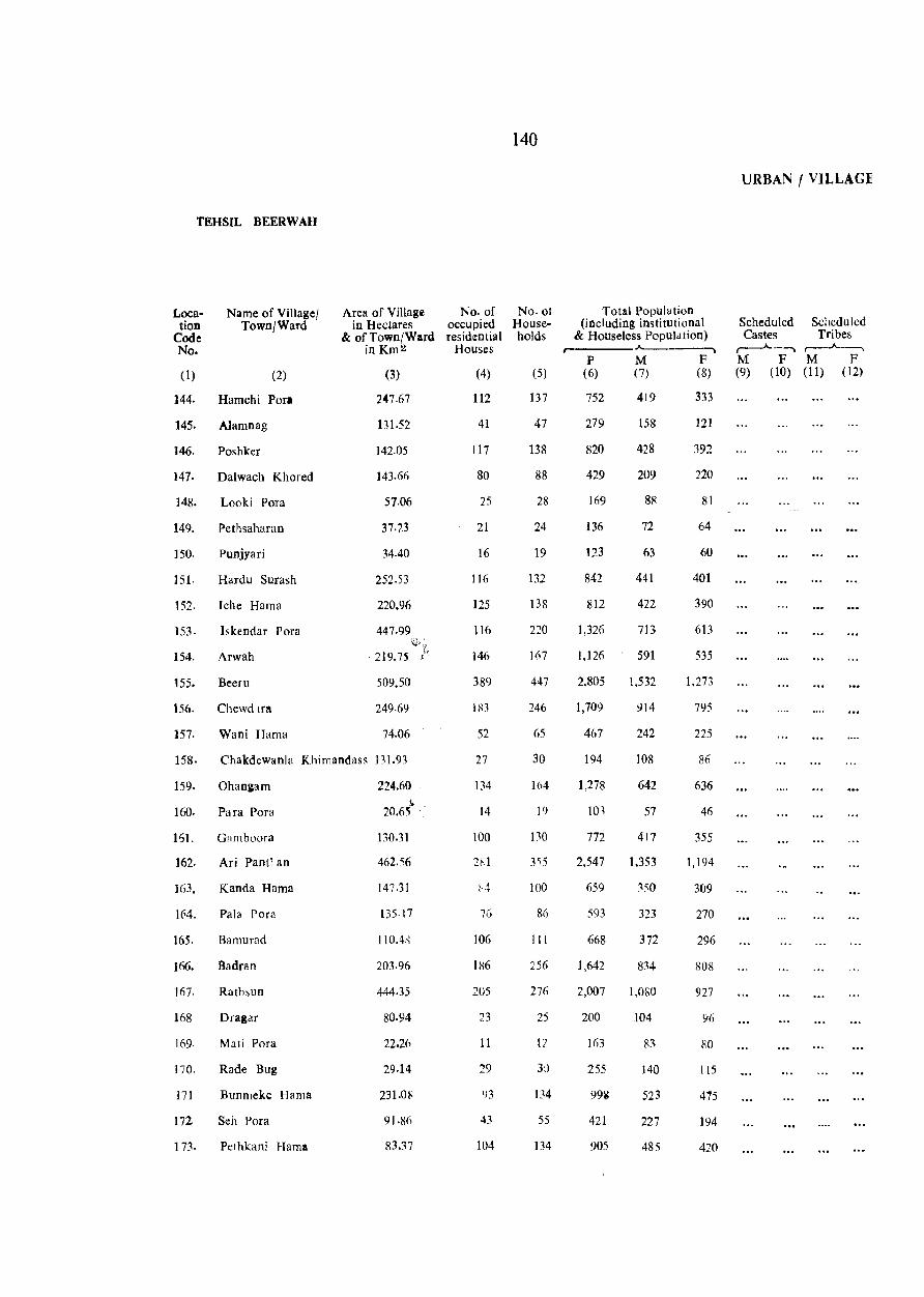
TEHSIL BEER WAH
Location
Code No.
Name of Village/ Town/Ward
(1) (2)
144. Hamchi Pori
145. Alamnag
146. Poshker
147. Dalwach Khored
148. Looki Pora
149. Pethsaharan
ISO. Punjyari
lSI. Hardu Surash
152. Iche Harna
153. Iskendar Pora
154. Arwah
ISS. Beeru
156. Chewd Inl
157. Wani Harna
Area of Village No. of in Hectares occupied
& of Town/Ward residential in Km 2 Houses
(3)
247.67
131.52
142.05
143.66
57.06
37.23
34.40
252.53
220.96
447.99
219.75
509.50
249.69
74.06
(4)
112
41
117
80
25
21
16
116
125
116
146
389
183
52
158. Chakdewanla Khimandass 131.93 27
159. Ohangam
160. Pa fa Pora
151. Gam boora
162. Ari Pantl.an
]63. Kanda Hama
164. Pala Pora
165. Barnurad
166. Badran
167. Rathsun
168 Dragar
169. Mati Pora
170. Rade Bug
171 Bunmeke Harna
172. Seh Pora
173. Pethkani Harna
224.60 j;
20.65
130.31
462.56
147.31
135.17
110.4;{
203.96
444.35
80.94
22.26
29.14
23LOR
91.8(,
83.37
134
14
100
281
76
106
186
205
23
II
29
Y3
43
104
140
No. of Households
(5)
137
47
138
88
28
24
19
132
138
220
167
447
246
65
30
164
19
130
355
100
86
III
256
276
25
12
3L)
134
55
134
Total Population (including institutional
& Houseless Population) • ___ A.
P (6)
M (7)
752 419
279 158
820 428
429 209
169 88
136 72
123 63
842 441
812 422
1,326 713
1,126 591
2,805 1,532
1,709 914
467 242
194 108
1,278 642
101 57
772 417
2,547 1,353
659 350
593 323
668 372
1,642 834
2,007 1,080
200 104
163 83
255 140
99i 523
421 227
905 485
F (8)
333
121
392
220
81
64
60
401
390
613
535
1,273
795
225
86
636
46
355
1,194
309
270
296
808
927
96
gO
115
475
194
420
URBAN I VILLAGE
Scheduled Scheduled Castes Tri bes
r-.A.-"","\ r~ M F M F (9) (10) (11) (12)
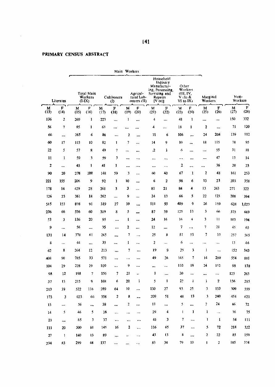
PRIMARY CENSUS ABSTRACT
Main Workers ,--- _.,__,
141
Household Industry
Manufactur- Other ing, Processing, Workers
Total Main Agricul- Servicing and (lIl, IV, Workers Cultivators tural Lab- Repairs V Ib) & Marginal Non-
Literates (I-IX) (I) ourers (ll) [V (a)) VI to IX) Workers Workers ,...--.A.-----'-l .......----"--""""'1 r- .A._, -,,"", ,-------A--~ r-.A.-""""'I r--..A.--, ",.--_.A._~ ,.---~
M F M F M F M F M F M F M F M F (13) (14) (15) (16) (17) (18) (19) (20) (21) (22) (23) (24) (25) (26) (27) (28)
136
56
66
60
22
11
2
90
221
178
126
515
236
53
9
131
8
62
,408
104
9~
57
213
173
13
]4
2]
111
27
234
2
7
17
5
20
155
14
23
153
66
3
14
8
90
29
12
13
39
3
5
20
R3
269
85
265
113
57
59
43
6
10
8
3
1
278 100
206
429
361
878
536
136
56
44
264
785
228
198
215
9
28
18
91
60
20
61
12
33
19
7
9
223
63
86
82
49
59
41
148
92
261
262
319
319
95
35
265
35
213
571
109
156
168
522 116 ?89
623 66 358
56
46
85
300
140
299
5
3
81
13
38
16
37
145
89
44 B7
7
3
1
59
3
27
8
7
(;
64
2
16
2
7
3
10
3
9
39
5
2
7
7
9
21
20
10
8
2
2
4
4
71
14
.2
60
6
81
24
111
87
24
12
25
2
19
49
1
5
130
209
11
29
41
116
43
In
6
9
1
40
2
21
13
55
39
16
9
26
27
51
4
3
65
13
34
41
18
106
10
·6
2
67
98
84
66
1
6
4
5
409 9
125 13
16 4
7
81 53
6
25
165
3
7
110 19
20
93 25
48 13
5
7
37
8
79 10
2
24
]8
2
13
13
22
26
3
3
7
7
14
24
204
]15
55
47
36
48
21
263
123
159
66
II
21
10
2110
l'i2
2
3 133
:3 240
2 24
5 72
2 22
2
150
71
139
78
31
13
20
161
203
271
332
120
182
95
18
14
23
253
358
322
208 '394
628 1,023
375 669
103
45
257
13
194
65
565
46
152 343
554
98
125
156
309
454
46
36
54
218
85
185
881
]38
263
285
559
621
72
75
III
322
159
374
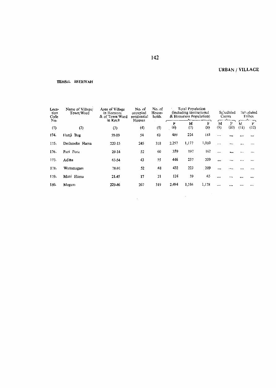
142
URBAN / VILLAGE
TEH81L BEERWAH
Loca- Name of Village! Area of Village No. of No. of Total Population tion Town/Ward in Hectares occupied House- (including institutional Scheduled Scr,cduled
Code & of Town/Ward residential holds & Houseless Population) Castes Tribes No. inKm2 Houses r '. ,.--_.A._-, r-.A.--,
P M F M F M F (1) (2) (3) (4) (5) (6) (7) (8) (9) (10) (11) (12)
174. Banji Bug 59.89 54 63 409 224 185
175. Dethrneke Barna 220.15 245 318 2,257 1,177 1,080
176. Pari Pora 29·14 52 60 359 197 162 -.. In Adina 63.54 43 55 446 237 209
178. Watarnagarn 78.91 52 68 432 223 209
179. Mani Barna 21.45 17 21 124 59 65
180. Magam 229.46 267 319 2,494 1,316 1,178
143
PRIMARY CENSUS ABSTRACT
Main Workers ~
Household Industry
M:mufactur- Other iog, Processing, Workers
Total Main Agricul- Servicing and (In, IV, Workers Cui tiva tors tural Lab- Repairs V (b) and Marginal Non
Literates (I-IX) (I) our~rs (II) [V (a)] VI to IX) Workers Workers ,...---"-__ ---. ... _.A.. __ --, ,...-_.A.._------, ,-_.........A.-------, ,-_-"-__ --, ,-__ .A.. __ --, ,-__ .A.. __ , ,--_--"--_ ..
M F M F M F M F M F M F M F M F (13) (14) (15) (16) (7) (18) (19) (20) (21 ) (22) (23) (24) (25) (26) (27) (28)
56 22 122 3 55 33 2 34 13 57 89 125
299 75 672 73 264 6 9 250 50 149 16 34 184 471 823
56 2 115 15 54 3 2 1 i 2 48 10 4 50 78 97
105 37 115 6 60 2 26 3 28 1 122 203
68 4 127 13 78 2 5 20 5 24 6 96 196
17 43 6 27 6 5 11 16 58
440 82 795 67 238 4 18 276 48 :::63 15 7 3 514 1,108
144
DISTRICT PRIMARY CENSUS ABSTRACT
MAIN WORKERS r-
SI. District/Tc hsil/TowD Total; No. of Total Scheduled Literates Total Main Workers No. Rurall Housr:~ Castes Population II-IX)
Urbas holds with SC members
,.-~ r"--"-P M F P M F P M F
(1) (2) (3) (4) (5) (6) (7) (8) (9) (to) (11) (12) (13)
Badsam District T 15 39 37 2 30 28 2 14 34 R 7 28 26 2 23 21 2 23 23
U 8 11 1l 7 7 11 11
1. Chadura Tehsil T
R
U Charari Shaner (N.A.) 11
$rinagar Portion U (i) Srisagar (M.e.)
Portion· U ... -...
(ii) Natipora (0.0.)- U
2· Badgam Tchsil T 15 39 37 2 30 28 2 34 34 R 7 28 26 2 23 21 2 23 23 U 8 11 11 7 7 11 11
SrinaJ8l' Portion U 8 11 11 7 7 11 11 (i) Srinagar (M.e.) u 8 II 11 7 7 11 11
Portion· (ii) Bemina (O.G.)- U ... .,.
(iii) Rawal Pora (0.0.)- 1l .'., (iv) Ranarand (0.0· u (v) Karawa Oamodar U
(0.0.)· 3. Bcerwah Tchsil T . ..
R
U
145
FOR SCHEDULED CASTES
MAIN WORKERS
-------------------.--------------------~ Cultivators (1) Agricultural
Labourers (II) Household Industry
Manufacturing Processi-ng, Servicing
& repairs V (a)
Other Workers Marginal [III, IV, V (b) workers & VI to IX]
Non-workers
._--A...----,. r---'------, r-----"-PM F PM F PM
....., r------A.-~~ r--.A.----, ,-___ .,___A_______-, F PM F PM F PM F
(14) (15) (16) (17) (18) (19) (20) (21) (22) (23) (24) (25) (26) (27) (28) (29) (30) (31)
34 34
23 23
11 II
34 34
23 23 11 11
11 11
11 11
Note:- • Forms part of Srinagar Urban Agglomeration.
5
5
5
5
3
3
3
3
.....
2
2
2
2
ERRATA
(The following printing mistakes are regretted)
Page No. (1)
Particullirs
(2)-
L. H. S; line 1st
ii L. H. S; line 5th from top
L. H. S: line 8th from top
R. H. S; line 6th from top
7 L. H. S; b (ii) Hne 1st
LRS; para 3rd line 4th
8 R. H. S; para 1st line 11th
R. H. S; para 1st last line
R. H. S; last para, line 3rd
9 R. H. S; para 2nd line 6th
11 1. H. S ; 'para 1st line 13th under Major characteristics
12 1. H. S; line 5th from top
14 L. H. S; line 12th from top
21 1. H. S; para 1st line 9th from bottom
R. H. S; line 5th from top
Col. No. (3)
For
(4)
(DCH), complied
A significent
by talking
at appropeiate
at last
in critertion
gross-roots
gross-roots
of populatin
LIkewise
Portable
pupose
meterial
portable
the facility
23 Table l\;o. 12 against 6-15 10 (92.33)
24 R. H. S; Table No. 15 sub-headir.g above col. 6
32 Against sl. No. 100
34 Under col. No.6 against T. B. clinic
36 Sub-heading
37 Against Code No. 21
40 Against Code No. 82
41 Against Code No. 84
Against Code No. 88
~·2 A~ainst Code Nt), 98
Against Code No. III
43 Against CoJe No. 114
A!!ainst Code Nn. 117
10
13
presentage
Phadi Pora
TR station w y
ED
Un-babited
16 PC .. .
16 R .. .
4 1077 (l08)
5 P (1), AC (1)
J 8 7.59
19 16.69
Read
(5)
(DCH), compiled
A significant
by taking
at appropriate
at least
In criterion
grass~roots
grass-roots
of population
Likewise
Potable
purpose
material
potable
this facility
(92.03)
percentage
Pahadi Pora
TB
station water way
Un-inhabited
1077 (I80)
M (I), AC (1)
7.69
1659